DYSART CONSERVATION AREA APPRAISAL AND MANAGEMENT PLAN DRAFT DOCUMENT DEVELOPMENT SERVICES APRIL 2009

Welcome message from author
This document is posted to help you gain knowledge. Please leave a comment to let me know what you think about it! Share it to your friends and learn new things together.
Transcript

DYSART CONSERVATION AREA APPRAISAL AND MANAGEMENT PLAN DRAFT DOCUMENT
DEVELOPMENT SERVICES APRIL 2009

DRAFT - DYSART CONSERVATION AREA APPRAISAL & MANAGEMENT PLAN
CONTENTS Page 1. Introduction and Purpose
1.1 Conservation Areas 2 1.2 The Purpose of this Document 4
2. Historical Development
2.1 Origins and Development of Settlement 5 2.2 Archaeological and Historical Significance of the Area 8 2.3 Development of the Area 10
3. Townscape Analysis
3.1 Setting 15 3.2 Topography and Street Pattern 15 3.3 Building Styles 19 3.4 Listed Buildings 22 3.5 Building Materials 22 3.6 Trees and Landscape 24 3.7 Activity and Movement 26 3.8 Public Realm 27 3.9 Negative Features 30
4. Character Areas
4.1 The Shore and Harbour 31 4.2 The village centre focused on the Cross and High Street 33 4.3 Peripheral late 19th and 20th century suburban development 34
5. Conservation Management Strategy
5.1 Development and Enhancement Opportunities 35 5.2 Boundary Refinement 37 5.3 Planning Policy 39 5.4 Long Term Management 41 5.5 Supplementary Planning Guidance 41 5.6 Article 4 Directions 42 5.7 Grants and Funding 42 5.8 Monitoring and Review 43 5.9 Further Advice 44 Appendix 1: Conservation Area Boundary Description and
Schedule of Streets within the Conservation Area 45 Appendix 2: Listed Buildings within the Conservation Area 47 Appendix 3: Dysart Article 4 Directions 61
1

DRAFT - DYSART CONSERVATION AREA APPRAISAL & MANAGEMENT PLAN
1. Introduction and Purpose 1.1 Conservation Areas
In accordance with the provisions contained in the Planning (Listed Buildings and Conservation Areas) (Scotland) Act 1997 all planning authorities are obliged to consider the designation of conservation areas from time to time. Dysart Conservation Area is 1 of 48 Conservation Areas located in Fife. These are all areas of particular architectural or historic value, the character or appearance of which it is desirable to preserve or enhance. Fife Council is keen to ensure that the quality of these areas is maintained for the benefit of present and future generations.
High Street – late 19th to early 20th Century
It is not intended to restrict new development within the boundary of a conservation area, but rather to provide a positive service by way of guidance and example so that any new development integrates successfully with the existing landscape and architectural form. A written description of the Dysart Conservation Area Boundaries and a schedule of properties within the boundaries is included in Appendix 1.
2

Conservation Area: Dysart
Based upon the Ordnance Survey mapping with the permission of the Controller of Her Majesty's Stationery Office © Crown copyright.Unauthorised reproduction infringes Crown copyright and may lead to prosecution or civil proceedings. Fife Council LA09035L 1998
Scale 1:10000
Fife Council
N
S
EW
DRAFT - DYSART CONSERVATION AREA APPRAISAL & MANAGEMENT PLAN
1.2 The Purpose of this Document
The purpose of the Dysart Conservation Area Appraisal is: To confirm the importance of the designation of the area and to
review the current conservation area boundaries To highlight the significance of the area in terms of townscape,
architecture and history To identify important issues affecting the area To identify opportunities for development and enhancement To stimulate interest and participation in conservation issues
amongst people living and working in the area To provide a framework for conservation area management
The appraisal also has a vital role to play in helping to secure partnership funding for the area, through the Dysart Townscape Heritage Initiative and the Dysart Conservation Area Renewal Scheme. In addition the appraisal provides a useful tool for assisting Development Services in carrying out its development planning and development control functions in relation to this important historic environment. The original “Plan for Conservation of Dysart” was approved by Kirkcaldy District Council on 11th April 1978 with the designation of Dysart Conservation Area following and coming into effect on 8th May 1978. The original “Plan for Conservation of Dysart” was reviewed in 2006, with a Draft Conservation Area for Dysart being produced. This document supersedes the 2006 Draft Appraisal, providing a more in depth analysis of the area and a section which outlines a ten year Conservation Management Strategy for Dysart.
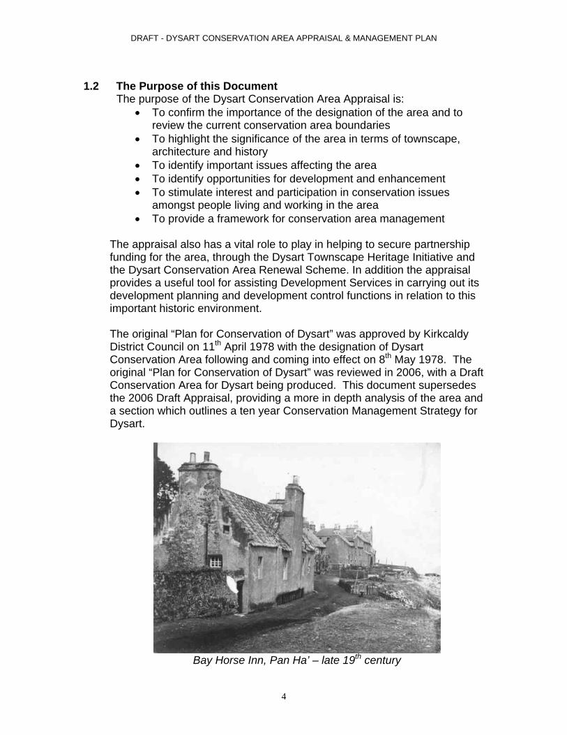
Bay Horse Inn, Pan Ha’ – late 19th century
4

DRAFT - DYSART CONSERVATION AREA APPRAISAL & MANAGEMENT PLAN
2. Historical Development
2.1 Origins and Development of Settlement The earliest Burgh records in existence date back to 1534 when Dysart was a Burgh of Barony with Lord Sinclair the feudal superior. It was then raised to the status of a Royal Burgh by James V and subsequently granted a Charter by James VI in 1587 thereby ‘endowing the sundry tributes of a free Burgh’. Largely as a result of this ‘free status’ Dysart was able to gain an exclusive trading charter with the Low Countries and as a result much of its former wealth appears to have gained by this connection. Coal was exported in exchange for wine, fine cloths and exotic foods and trade grew to such an extent that it was given the nickname ‘Little Holland’.
Illustration of shipbuilding in Dysart Harbour – 19th century
The town appears to have grown gradually, based on the twin industries of coal and salt, both dating back at least to the early 15th century. Sibbald in his “History of Fife” provides the reader with a graphic description of the conditions in the settlement at the time “All the ground on which the town stands had much coal in it … and part of it for many years has been burning and still burns. In high winds the flames are seen in the night, but in the day smoke doth always appear”. Sibbald provides further evidence of the village’s unpleasant environment saying that “steam curled day and night from the saltpans”. While the salt industry gradually declined with the discovery of ‘rock salt’ the coal industry continued to prosper until the Frances Pit closed in 1984.
5

DRAFT - DYSART CONSERVATION AREA APPRAISAL & MANAGEMENT PLAN
With the industrial revolution new crafts and trades began to emerge notably shipbuilding, linen and the spinning industries. Again the key to growth was the coal industry, as power looms required fuel and coal exporters needed new ships. In 1764 the first ship’s carpenter was established and by the turn of the century had constructed no fewer than 31 ships. However, the Rev. D. Murray noted that by the middle of the 19th century ‘The port of Dysart was by far the greatest along the Fife coasts, now, however, there are only a few brigs and slopes’. This industry suffered with the rise of the steam ships and the railway. In 1849 the first loom was introduced into the area weaving napkins ‘which it was particularly famous for’ and fine table linen. The trade was so brisk that a regular ferry service was required for merchants travelling between Leith and Dysart.
Illustration of industry in Dysart from the east – c.1900
As the harbour was the main source of revenue it had to be kept in good repair, which meant constant expenditure. In 1924 the Earl of Rosslyn’s Coal Company – the major user of the harbour – put pressure on Dysart Town Council to deepen the harbour so that it could be used by larger ships. The work cost the town £5000. While the harbour was closed for the work to be carried out, the ships went to Methil and Burntisland docks where they got a quicker turn around – a facility they appreciated so much that they did not return to Dysart afterwards. The whole exercise made the Town Council almost bankrupt. The sad sequence of events continued when it was found to be uneconomic to try to keep the Lady Blanche pit open; and it was closed in 1929, spelling the end of the main coal trade from the harbour. The harbour ceased to have a key commercial function
6
DRAFT - DYSART CONSERVATION AREA APPRAISAL & MANAGEMENT PLAN
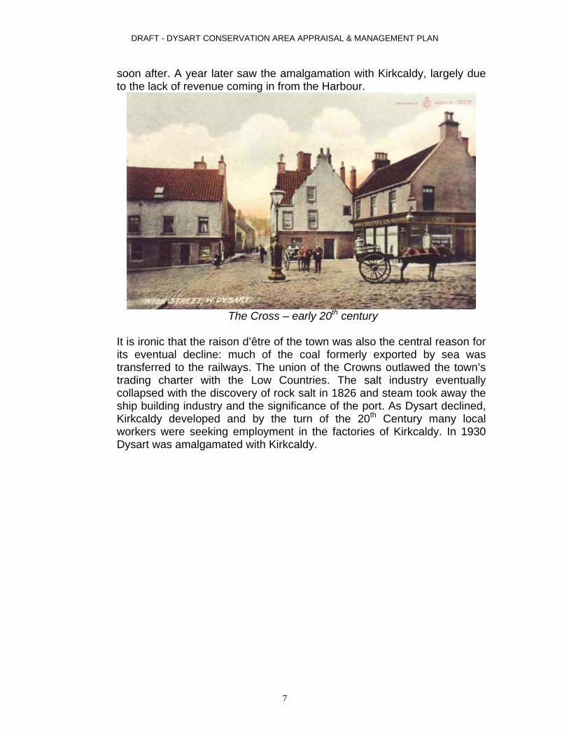
soon after. A year later saw the amalgamation with Kirkcaldy, largely due to the lack of revenue coming in from the Harbour.
The Cross – early 20th century
It is ironic that the raison d’être of the town was also the central reason for its eventual decline: much of the coal formerly exported by sea was transferred to the railways. The union of the Crowns outlawed the town’s trading charter with the Low Countries. The salt industry eventually collapsed with the discovery of rock salt in 1826 and steam took away the ship building industry and the significance of the port. As Dysart declined, Kirkcaldy developed and by the turn of the 20th Century many local workers were seeking employment in the factories of Kirkcaldy. In 1930 Dysart was amalgamated with Kirkcaldy.
7

DRAFT - DYSART CONSERVATION AREA APPRAISAL & MANAGEMENT PLAN
2.2 Archaeological and Historical Significance of the Area As with many old settlements the origin of the place name can be debated. One theory defines its root from the Gaelic meaning ‘temple of the most high’. While another assumes its root from the word Disert, a term once used for the settlement of religious missionaries. In 500 AD a Christian missionary was said to have a fasting place or retreat in a cave on the shore. The cave itself is one of the several sandstone inlets still in existence in the grounds of what was Dysart House, once the home of the Earls of Rosslyn and now a Carmelite Monastery. Of the two the latter seems the more probable considering the legends associated with nearby St. Serf’s Cave and the many documented missions by St. Adrian to the area. Very little has been uncovered of the earliest history, with little or no archaeological records available.
Dysart Tolbooth
8

DRAFT - DYSART CONSERVATION AREA APPRAISAL & MANAGEMENT PLAN
Taken from Dysart OS Plan 1894
Urban form of town centre highlighted in black
9

DRAFT - DYSART CONSERVATION AREA APPRAISAL & MANAGEMENT PLAN
2.3 Development of the Area
Three distinct phases of development are evident within Dysart: Medieval Development Post Medieval to Early Modern Modern Development
An outline of each is provided below.
St Serf’s Church, Shore Road - 2007
Medieval Development - most evident around the harbour, Shore, Pan Ha’ and Hot Pot Wynd where the original street pattern remains largely intact. Fine examples of buildings dating from the period include St Serf’s Church c 1500 and Bay House (1 Pan Ha’) dated 1583. The tidal basin of Dysart Harbour dates to the early 17th century, although later additions are evident right up to the 20th century. Although most of the historic street layout has been lost elsewhere late medieval buildings do survive and are dotted around the town centre, including McDouall Stuart Place with sections dating to 1575 and the Tolbooth, with its lower portion dating to 1576. At 49 East Quality Street survives a house dating from 1610, and at 14 Fitzroy Square St David’s which dates to 1680.
10

DRAFT - DYSART CONSERVATION AREA APPRAISAL & MANAGEMENT PLAN
49 East Quality Street - 2007
The Mechanics Institute – late 19th to early 20th century
11
DRAFT - DYSART CONSERVATION AREA APPRAISAL & MANAGEMENT PLAN
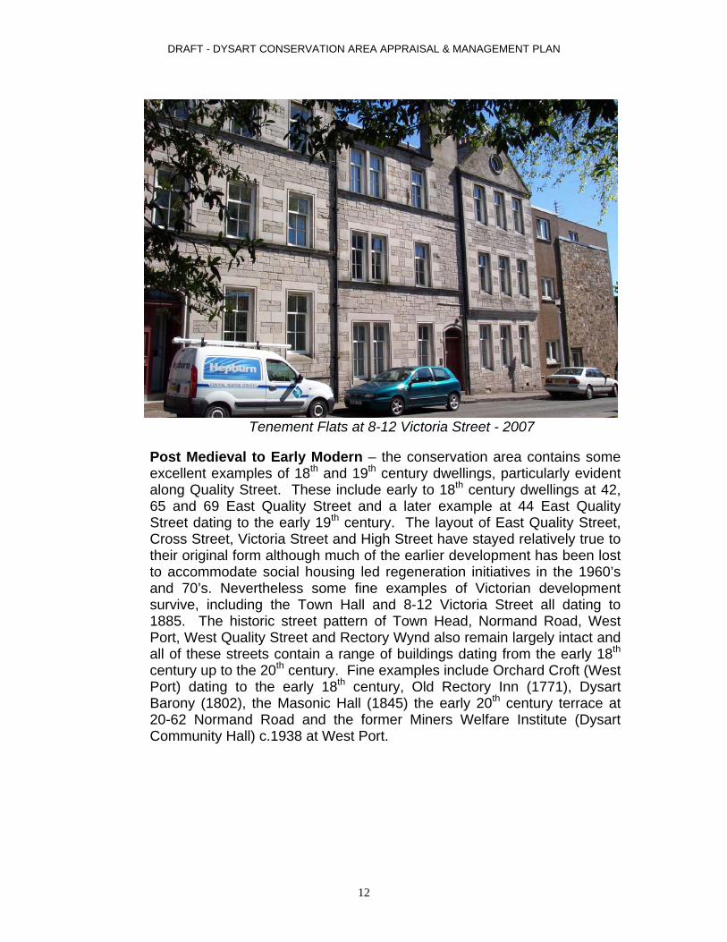
Tenement Flats at 8-12 Victoria Street - 2007
Post Medieval to Early Modern – the conservation area contains some excellent examples of 18th and 19th century dwellings, particularly evident along Quality Street. These include early to 18th century dwellings at 42, 65 and 69 East Quality Street and a later example at 44 East Quality Street dating to the early 19th century. The layout of East Quality Street, Cross Street, Victoria Street and High Street have stayed relatively true to their original form although much of the earlier development has been lost to accommodate social housing led regeneration initiatives in the 1960’s and 70’s. Nevertheless some fine examples of Victorian development survive, including the Town Hall and 8-12 Victoria Street all dating to 1885. The historic street pattern of Town Head, Normand Road, West Port, West Quality Street and Rectory Wynd also remain largely intact and all of these streets contain a range of buildings dating from the early 18th century up to the 20th century. Fine examples include Orchard Croft (West Port) dating to the early 18th century, Old Rectory Inn (1771), Dysart Barony (1802), the Masonic Hall (1845) the early 20th century terrace at 20-62 Normand Road and the former Miners Welfare Institute (Dysart Community Hall) c.1938 at West Port.
12

DRAFT - DYSART CONSERVATION AREA APPRAISAL & MANAGEMENT PLAN
Dysart Community Hall (former Miners Welfare Institute) - 2007
Vacant flats on East Quality Street in 2007, since demolished in 2008.
Modern Development - much of the historic fabric of the town centre gave way to housing led regeneration during the 1960’s and 70’s. This is particularly evident in the centre of the conservation area, where the historic street pattern has been completely replaced to accommodate maisonettes and blocks of flats, many of which are now scheduled for demolition. These include properties along East Quality Street, Fitzroy
13

DRAFT - DYSART CONSERVATION AREA APPRAISAL & MANAGEMENT PLAN
Square, High Street, McDouall Stuart Place and Howard Place. More recent housing redevelopments dating from the late 20th and early 21st century include 1-9 West Quality Street, and to the northern section of the Conservation area at Orchard Place, Meikle Square and Ivy Lane.
New Housing (2006) at Orchard Place - 2007
1-9 St Serf’s Place built in late 1990’s - 2007
14

DRAFT - DYSART CONSERVATION AREA APPRAISAL & MANAGEMENT PLAN
3. Townscape Analysis 3.1 Setting
Dysart is situated on the south-east coast of Fife, between the coastal burghs of Kirkcaldy and West Wemyss, overlooking the Firth of Forth.
3.2 Topography and Street Pattern
The topography of the area is vastly influenced by its coastal location. As in most coastal towns, the main relief of the area slopes towards the coastline. The oldest part of the village is concentrated along the shoreline, with the harbour to the west enclosed by sandstone cliffs which rise to give way to Ravenscraig Park. Pan Ha’ lies to the east on an even area of ground overlooking the foreshore. The ground rises to the north, with streets making a fairly steep and winding decent down towards the harbour and shore.
Dysart foreshore and Pan Ha’ - 2005 The lower parts of the village have narrow cobbled streets, steep hills and attractive crow stepped buildings. The village spread northwards up the hill towards Normand Road and Townhead, giving way primarily to more a more structured grid plan street layout. Unfortunately, towards the village centre much of the historic street pattern was disrupted by extensive redevelopment in the 1960’s. Some outstanding historic buildings survive amongst the 1960’s development and these not only provide a stark architectural contrast but also serve to further punctuate the inappropriate layout of this ill planned development.
15

DRAFT - DYSART CONSERVATION AREA APPRAISAL & MANAGEMENT PLAN
Fitzroy Street late 19th early 20th Century (formerly Coal Gate)
16

DRAFT - DYSART CONSERVATION AREA APPRAISAL & MANAGEMENT PLAN
The inter-relationship of the buildings in their massing is an important townscape feature that adds to the character of the area. For instance, Victoria Street is particularly identified as having a vista controlled by the bulk of housing development on Howard Place.
View down Victoria Street to Howard Place - 2007
The steep, narrow and enclosed Hot Pot Wynd leads down to Dysart’s historic harbour. From the harbour views can be seen across the Forth Estuary as far as East Lothian, Edinburgh and the Pentland Hills on a clear day.
Hot Pot Wynd - 2004
17

DRAFT - DYSART CONSERVATION AREA APPRAISAL & MANAGEMENT PLAN
Significant landmarks within the area include the harbour and the Tolbooth Cross and visually striking buildings along Pan Ha’ and St Serfs Kirk, the Tolbooth and to the North is the Red painted headgear of the Francis Colliery.
View of Pan Ha’ from St Serf’s Tower - 2005
View of Dysart Harbour from St Serf’s Tower - 2005
18

DRAFT - DYSART CONSERVATION AREA APPRAISAL & MANAGEMENT PLAN
3.3 Building Styles
A variety of buildings styles and periods contribute to the character of the area. The conservation area contains some striking examples of municipal architecture as seen at Tolbooth Tower with some parts dating to 1576. The adjoining 2 storey Town Hall by Campbell Douglas and Sellars was added in 1885.
Dysart Tolbooth and Town Hall - 2007
19

DRAFT - DYSART CONSERVATION AREA APPRAISAL & MANAGEMENT PLAN
Dysart Parish Church, West Port - 2007
There are 5 examples of ecclesiastical buildings within the area, three of which are of particular merit. St Serf’s Church dates to c.1500, with its tower rising 22m to give way to a corbelled parapet containing a crowstepped caphouse. Parts of the nave arcade of the church also survive. The now vacant Dysart Barony (former United Free) on Normand Road by James Brown of Glasgow dates to 1865-7, this sombre lancet style building features a broach spired steeple flush with the gable front. Dysart Parish Church at West Port by Campbell Douglas and Sellars dates to 1872-74 and is a version of the medieval St Monans Parish Church. This attractive Romanesque style building with its squat broach spire also features recently discovered murals by the internationally renowned architect and designer Charles Rennie Mackintosh.
St Serfs Church - 1906
20

DRAFT - DYSART CONSERVATION AREA APPRAISAL & MANAGEMENT PLAN
There are some fine examples of vernacular domestic dwellings throughout the area. Although predominantly found along Pan Ha’, other good examples are dotted around the centre of the village as can be seen at 1-5 McDouall Stuart Place, St David’s at Fitzroy Square and The Towers at East Quality Street. These buildings date between the late 16th and 17th centuries, and although they vary in height from single to 3 storeys almost all feature white cement rendering (typical of 1960’s restorations) and have small, multi pane sash windows, crow step gables and predominantly pantile roofs. Many, including those along Pan Ha’, received the National Trust for Scotland’s “Little Houses Improvement Scheme” treatment between 1968 and 1969. The Pan Ha’ also includes some 1960’s pastiche infill developments by W Schomber Scott. Dysart House also lies within the conservation area. This Georgian mansion dates to 1755-6 and features a central bow and an extended west and north section dating to 1808-09 by Alexander Laing. The house is now a Carmelite Monastery. The Old Rectory at Rectory Lane dates to the late 18th century and features an attractive walled garden and Roman Doric doorpiece.
There are also some fine examples of Victorian and early 20th century architecture to be found throughout Dysart. These include Victorian and Edwardian villas along Normand Road and the tenement block at 8-12 Victoria Street. A pair of attractive single storey purpose built shop units can be seen at 30 and 32 Cross Street which retain many original features. The former Miners Welfare Institute, now Dysart Community Hall, dates from the 1930’s and provides an attractive landmark at West Port.
The Cross – 2007
21

DRAFT - DYSART CONSERVATION AREA APPRAISAL & MANAGEMENT PLAN
3.4 Listed Buildings There are a considerable number of listed buildings within the conservation area, surprising when considering the vast areas of historic buildings that were demolished in the 1960’s to make way for public housing throughout the centre of the village. This includes 6 Category A, 26 Category B and 13 Category C(s) listed buildings. The character and form varies greatly, from St Serf’s Tower (1500), which is also the only Ancient Scheduled Monument in the area, through to late Victorian domestic and municipal architecture (Town Hall). A full list and condensed descriptions for all of these buildings is included in Appendix 2.
3.5 Building Materials
The conservation area has a fairly limited variety of building materials. The roofing materials tend to be predominantly red pantile or Scottish slate on the historic buildings, although some roofs have been treated with modern concrete tiles. The modern properties have modern pantile, imported slate or are flat and presumably felt and bitumen clad.
Kirkcaldy Art Club, Hot Pot Wynd - 2007
Chimneys and walls tend to be either random or coursed rubble, or rubble rendered with cement harl. There are some fine ashlar buildings throughout the area. Modern finishes vary from brick to rendered concrete blockwork. There are a variety of cans, ranging from original ornate clay to modern orange clay cans. Many buildings have the cans removed from the stacks and some of these have been replaced by modern metal gas vents.
22

DRAFT - DYSART CONSERVATION AREA APPRAISAL & MANAGEMENT PLAN
Category B listed Buildings - East Quality Street - 2007
Window styles vary from small multi-paned timber sash and case to plate glass and modern double glazed UPVc and aluminium frame. It is unfortunate that many of the historic properties, including listed buildings, have had their original windows removed and replaced with inappropriate modern windows which do not sit well in the elevations. Doors vary from traditional and modern timber panelled to UPVc and glass throughout the area.
Category A listed 43-47 East Quality Street - 2007
Boundary walls again vary from random rubble to fine ashlar. Some historic railings and gates survive. Other historic walls have been
23

DRAFT - DYSART CONSERVATION AREA APPRAISAL & MANAGEMENT PLAN
rendered or rough cast. There are also a number of inappropriate walls completely at odds with the character of the area, these include concrete block work and modern brick boundary treatments. Other boundary treatments include timber panel fences which are neutral to the area.
East Port, rear view of properties on Normand Road - 2006
3.6 Trees and Landscape
There are several areas of public open spaces, the largest of which being the park at the junction of Dysart Road and Townhead. This area is designated as a park and is lined with a large number of mature trees. A reclaimed area of grass by the harbour car park is the second largest area of open space this breaks up the hard landscaped car park and allows the area to be an ideal location to enjoy the views across the Forth Estuary. Other areas within Dysart Conservation Area, which can be construed as public open space, are mainly concentrated in lower Dysart around the shoreline. The cemetery at the back of the YMCA building is a remaining area within the Dysart Conservation Area, which could be construed as being public open space.
The private grounds of Dysart House the Camelite Monastery accounts for a large percentage of the conservation area. The grounds comprise an area of beautifully landscaped terraced gardens and mature trees and woodland.
24

DRAFT - DYSART CONSERVATION AREA APPRAISAL & MANAGEMENT PLAN
Distribution of Open Spaces around Dysart
Open Space along Shore Road - 2005
25

DRAFT - DYSART CONSERVATION AREA APPRAISAL & MANAGEMENT PLAN
3.7 Activity and Movement
There is one main arterial route running through the area along Townhead and Normand Road. This forms part of the Fife Coastal Tourist Route, which links Kirkcaldy to Leven and the surrounding areas.
Road network around Dysart
Roads in lower Dysart are laid mainly to a grid pattern although some historic routes survive creating narrow passageways which reduce traffic speed and promote pedestrian safety and movement. These roads tend to be quiet and are mainly used by residents and visitors to the harbour.
Hie Gait, pedestrian route to Pan Ha’ - 2004
26

DRAFT - DYSART CONSERVATION AREA APPRAISAL & MANAGEMENT PLAN
3.8 Public Realm
It is likely that a period of investment in civic improvements occurred in the
early 19th Century, when important road surfaces were laid in setts, pavements were formed using whin kerbs and surfaced in stone flags, gas lighting was installed and street trees planted in many Fife towns. Photographic evidence of Victorian Dysart shows a mixture of coursed setts and ‘crazy paving’ across the carriageway surrounding a central ornate gas light on the Tolbooth Cross, in the heart of the town. Small unit coursed stone paving also appears to extend to the footpaths here, but just beyond the centre, on West Port, another photograph reveals that the carriageway and footway were laid in graded gravel. This suggests that the use of high quality materials may have been restricted to a small area at the heart of the town.
Surviving whin setts at The Cross - 2007
27
DRAFT - DYSART CONSERVATION AREA APPRAISAL & MANAGEMENT PLAN
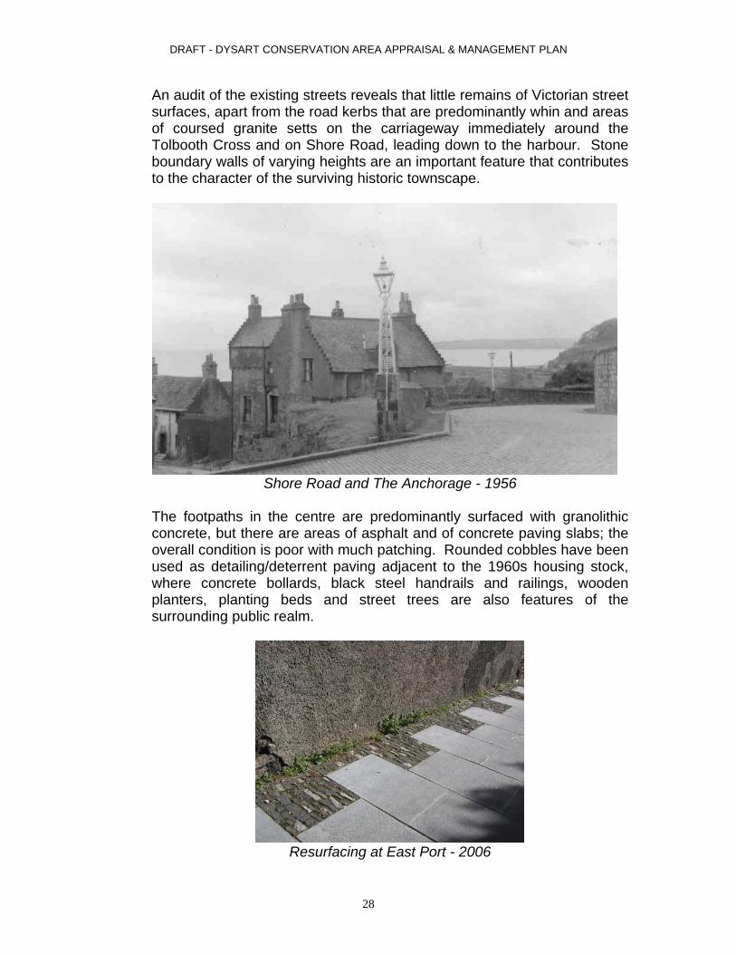
An audit of the existing streets reveals that little remains of Victorian street surfaces, apart from the road kerbs that are predominantly whin and areas of coursed granite setts on the carriageway immediately around the Tolbooth Cross and on Shore Road, leading down to the harbour. Stone boundary walls of varying heights are an important feature that contributes to the character of the surviving historic townscape.
Shore Road and The Anchorage - 1956
The footpaths in the centre are predominantly surfaced with granolithic concrete, but there are areas of asphalt and of concrete paving slabs; the overall condition is poor with much patching. Rounded cobbles have been used as detailing/deterrent paving adjacent to the 1960s housing stock, where concrete bollards, black steel handrails and railings, wooden planters, planting beds and street trees are also features of the surrounding public realm.
Resurfacing at East Port - 2006
28

DRAFT - DYSART CONSERVATION AREA APPRAISAL & MANAGEMENT PLAN
Recent improvements to the East Port footpath link have used reproduction Caithness paving slabs with granite slither horonizing at the edges. Contemporary street lights with stainless steel lighting columns have been installed here, but in earlier public realm improvements – the public garden at the end of the High Street and in Panhall - reproduction Windsor lamps have been used, referencing the original lantern at the Tolbooth.
1980’s public realm works on High Street - 2007
29

DRAFT - DYSART CONSERVATION AREA APPRAISAL & MANAGEMENT PLAN
3.9 Negative Features
There are several buildings within the Conservation Area that are detrimental to the overall quality of the area. These include:
Howard Place (1-59 odds) McDouall Stuart Place (2-12 evens) High Street (2 & 4)
The quality of the public realm has been compromised by the architecture, eroded by the use of inappropriate materials and through the neglect and
vandalism of properties in the last half of the 20th century, particularly in the central area. Much of the historic street pattern was also lost when the central area was redeveloped during the 1960’s and 70’s.
“Private” open space to rear of 1960’s flats - 2004
30
DRAFT - DYSART CONSERVATION AREA APPRAISAL & MANAGEMENT PLAN
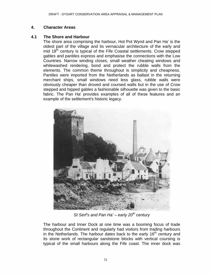
4. Character Areas 4.1 The Shore and Harbour
The shore area comprising the harbour, Hot Pot Wynd and Pan Ha’ is the oldest part of the village and its vernacular architecture of the early and mid 18th century is typical of the Fife Coastal settlements. Crow stepped gables and pantiles express and emphasise the connections with the Low Countries. Narrow winding closes, small weather cheating windows and whitewashed rendering, bond and protect the rubble walls from the elements. The common theme throughout is simplicity and cheapness. Pantiles were imported from the Netherlands as ballast in the returning merchant ships, small windows need less glass, rubble walls were obviously cheaper than droved and coursed walls but in the use of Crow stepped and hipped gables a fashionable silhouette was given to the basic fabric. The Pan Ha' provides examples of all of these features and an example of the settlement's historic legacy.
St Serf’s and Pan Ha’ – early 20th century
The harbour and Inner Dock at one time was a booming focus of trade throughout the Continent and regularly had visitors from trading harbours in the Netherlands. The harbour dates back to the early 16th century and its stone work of rectangular sandstone blocks with vertical coursing is typical of the small harbours along the Fife coast. The inner dock was
31

DRAFT - DYSART CONSERVATION AREA APPRAISAL & MANAGEMENT PLAN
constructed in 1831 to accommodate an ever-increasing demand for berthing facilities showed the ever-increasing capacity and future trading potential. The Lady Blanche Pit also had a direct access route through a tunnel to the harbour, which aided the transportation of coal.
St Serf’s Tower - 2005
Overlooking the harbour and Pan Ha’ are the remains of St. Serf’s Kirk dating back to the 15th century. Originally composed of a nave and chancel with aisles and fortified S.W. tower today all that remains intact are the tower and entrance porch. Immediately adjacent are the grounds of the Carmelite Convent representing the settlement’s continuing connections with the Catholic Church. Originally known as Dysart House and formerly the seat of the St. Clair family this building and its grounds provides an attractive and effective barrier for development to the west of the settlement.
32

DRAFT - DYSART CONSERVATION AREA APPRAISAL & MANAGEMENT PLAN
4.2 The village centre focused on the Cross and High Street
The town centre focuses on the Cross at the junction of the High Street and Cross Street. While the Pan Ha’ exemplifies Fife vernacular architecture of the 17th and 18th century, the town square and its environs express the general style of the 19th century. Although similar features such as crow stepped gables and pantiles are in evidence, the architecture of this area and period of expresses the rising affluence of the burgh and the times in general. The erection of 1960’s and 1970’s Local Authority mono-pitch housing reduced the vision of quality architecture in Dysart, which had been established in the early 19th century. They provided much needed housing stock but greatly affected the outlook of the village centre as the combination of listed buildings and bland social housing does not combine well with Dysart’s history.
The Cross, viewed from Tolbooth steps - 2007
33

DRAFT - DYSART CONSERVATION AREA APPRAISAL & MANAGEMENT PLAN
4.3 Peripheral late 19th and 20th century suburban development
Dash and whitewash gave way to the more elegant dressed and coursed stonework, crude heavy coloured margins were replaced by ornate plaster mouldings, architraves and pediments and cheap slate replaced the traditional pantile. While there is no common theme, such as in Georgian Edinburgh, various styles ranging from Regency to late Victorian have been blended together. Each building or group of buildings, though units in themselves, have through time and repeated alteration blended and unified to form a common identity. This variety of detail further enhances the architectural attractiveness of the area.
Normand Road – 1907
Normand Road - 2007
34

DRAFT - DYSART CONSERVATION AREA APPRAISAL & MANAGEMENT PLAN
5. Conservation Management Plan 5.1 Development and Enhancement Opportunities
Fife Council has an ongoing commitment to reduce disadvantage and exclusion within the local authority’s boundaries. This is being addressed through four major regeneration strategies currently being implemented across Fife. Plans for improvement have been earmarked for Dysart over the last ten years, and it is included within the Kirkcaldy and Dysart Regeneration Initiative Area. In 2001 a regeneration vision and strategy was prepared by the Regeneration Initiative’s Management Group, a multi-agency partnership, for delivery of the Kirkcaldy and Dysart Regeneration Initiative. The intention is to continue with multi-agency urban regeneration – this means additional housing; improvements to townscape, landscape and coastline; and the establishment of Dysart harbour as a tourist/visitor attraction. Annual Environmental Improvement Action Plans are prepared by the partnership to ensure focused delivery of projects. Earlier phases of the Regeneration Initiative have delivered coastal protection works and environmental enhancements along the coastal footpath (2001), the Dysart Gateways environmental improvements (2003-05), Dysart Artworks (2005-06) and the restoration of The Harbour Masters’ House (2006) to provide the headquarters for the Fife Coast and Countryside Trust, a visitor interpretation centre and café.
The Harbour Masters’ House, restored 2006
35

DRAFT - DYSART CONSERVATION AREA APPRAISAL & MANAGEMENT PLAN
The housing regeneration programme continues and involves the demolition of 49 flatted properties in Phase One of blocks on Quality Street, High Street and Fitzroy Square. These are being replaced with new affordable housing which is more sympathetic to the historic setting of the village. Work is due to commence in 2009. The second phase of redevelopment is likely to include further demolitions on Howard Place, McDouall Stuart Place and on High Street.
Map Illustrating Fife Housing Association Redevelopment Sites
Illustration supplied by Sinclair Watt Architects
Blocks of flats demolished in 2008 – Fitzroy Street
36
DRAFT - DYSART CONSERVATION AREA APPRAISAL & MANAGEMENT PLAN
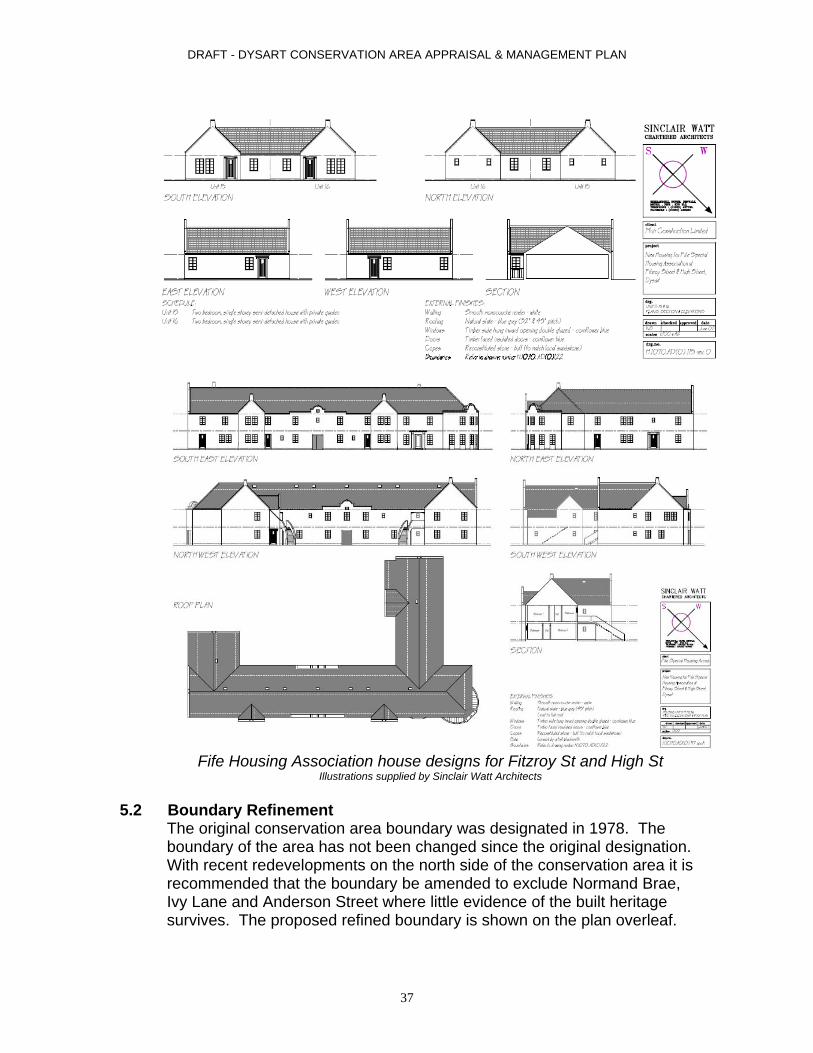
Fife Housing Association house designs for Fitzroy St and High St
Illustrations supplied by Sinclair Watt Architects
5.2 Boundary Refinement The original conservation area boundary was designated in 1978. The
boundary of the area has not been changed since the original designation. With recent redevelopments on the north side of the conservation area it is recommended that the boundary be amended to exclude Normand Brae, Ivy Lane and Anderson Street where little evidence of the built heritage survives. The proposed refined boundary is shown on the plan overleaf.
37

PANHALL
DYSART
Pier
Pipers
Nurseries
Fitzroy
Kirk
Ravenscraig Park
Sand
and S
hingle
St Serf's Place
Ashlar Head
Tunnel
Hie Gait
Institute
Partan Craig
Royal Hotel
Sailo
rs'
Cemetery
Carmelite
Carmelite Monastery
to
4 to 8
1 to 7
2 to 8
Saut Girnal Wynd
Merchant Court
Hall
6 to 36
6 to 16
1 to 9a
Pavilion
Sailor's Walk
11 to 45
11 to 13
El
Bollard
Bolla
rds
15 to 18
12 to 2
4
13 to 3
5
57 to 6
9
26 to 4
0
10 to 14
43 to
47
53 to 5
7 46 to 5
4
36 to
4058
to 62
24 to 28
81 to
8762
to 68
43 to 5
5
18 to 28
30 to 3
8
70 to
7649 to 59
Nursi
ng Ho
me
East Port
UF Church
Pipe Line
Lifesaving Box
PAN HA'
Cave of Dysart
El Sub Sta 144 t
o 160
106 t
o 128
Line
Scatt
ered
Factory
Shingle
Slopin
g
Coastal Slope
IVY LA
NE
Bol
Bols
Path (um)
Scattered Rock
HILL STREET
Slipway
The
Totten
ham Cou
rt
Car Park
Boulders
Giffen Park
Slopin
g mas
onry
Surgery
SP
Normand
Bowling Green
Playground
111
VICTORIA STREET
Car Pk
Memorial
Club
LADY NAIRN AVENUE
St Davids
Graveyard
11
QUALITY S
TREET
and S
hingle
HIGH S
TREE
T
STATION ROAD
WINDMILL ROAD
119
11a
115117
FITZR
OY SQUARE
Halyards
MEIKL
E SQU
ARE
WATT STREET
11.0m
D FnTH
E WA
LK
White Gables
East Cottage
Walk
NETH
ER ST
REET
TERRACE STREET
RECTORY LANE
HOT POT WYND
Sandwell
CROSS STREET
8.0m
22.6m
32.9m
43.3m
34.1m
35.4m
36.3m
51.8m
37.2m
47.2m
38.4m
7.4m
43.9m
42.4m
39.3m
44.5m
49.1m
36.6m
53.0m
55.2m
60.4m
17.1m
31.4m
29.6m
27.1m
25.9m
24.7m
24.4m
23.8m
19.2m
19.4m
21.0m
29.3m
40
7
5042
69
31
61
30
65
59
94
33
107
86
24
12
2527
29
130
41
46
44
133
1
53
43
99
95
13
151
45
164
51
12819
123
163
1a
141
29a
6
32
60a
142
125
34 28
26
92
104
121
143
49
101
23
47124
36
127
37
35
17
55
22
8187
57
140
15
18
9
20
44a
105
14
103
162
64
146
137
10
132
38
62
1b
166
9189
48
97
93
21
2
39
16
60
4
8
MCDOUALL STUART
SCHOOL BRAE
DYSART ROAD
Community
PLAC
E
WEST PORT
ANDERSON STREET
ORCHARD LANE
ORCHARD PLACE
Rock
Bank
MP 28
SHOR
E ROA
D
HOWAR
D PLA
CE
NORMAND BRAE
NORM
AND
ROAD
Manse
Elmbank
Knockando
LB
WEST
TOWN
HEAD
Sand
FB
Museum
PHSD
PC
YMCA
PO
ROAD Ravenscraig Nurseries
LB
2
16
PC
23
132
1
2
Bol
1
1
El Sub Sta
29
30
to
Rock
17
6
28
5
1
9
8
10
40
60
24
23
27
4
17
20
6
22
13
130
8
11
8
Bol
5
12
7
15
11
27
12
2
57
1
8
2
Sand an
d Shin
gle
23
Cemetery
4
8
4
41
11
14
49
7
27
37
141
117
10
1
1
1
8
10
El Sub Sta
10
16
25
16
6
42
42
El Sub Sta
43
46
HOT POT WYND
Sand and Shingle
3
13
22
1
El Sub Sta
3
2
Pier
34
7
27
Shingle
32
23
1
14
3
PH
12
5
Cave of Dysart
20
9
33 2
1
31
1
14
7
9
Bollard
Scattered
Hall
4
3
Tunnel
18
5
10
1
29
15
13
Pier
11
Rock
8
8
11
4
13
10
4
3
25
11
15
14
2
Ravenscraig Park
12
115
20
11
26
69
5
3
2
17
14
Bol
6
31
5
2
2
PC19
39
1
40
44
18
Hall
2
1
11
SP
4
15
3
37
35
7
2
39.3m
7
22Bo
ulders
Bol
5
44
1
2
Hall
El Sub Sta
31
41
51
3
10
7
32
5
9
14
4
St Serf's Church
Tolbooth
Towers
Harbour
Scattered
Shingle
Springs
Scattered Rock
Boulders
Sand
and S
hingle
Mean
High
Wate
r Spri
ngs
Mean
Low W
ater S
pring
s
Rock
Mud
Sand
and Sh
ingle
Mud
Sand and Shingle
Shingle
Scattered
Rock
Mean Low Water Springs
Sand
and Sh
ingle
Sand and Shingle
Braes
Dysart
The Harbourmasters House
Monastery
Square
Anchorage
Town Hall
Adam
Hou
se
Pipe
Sub Sta
EAST Q
UALITY
Road
FITZROY STREET
113
masonry
Harrack L
odge
Ravenscraig
Ravenscraig
14.3m
54
5430
109
4652
44
71
131
26
26
23
23
53
36
79
56
18
9
20
10514
21
58
16
4
SCHOOL BRAE
PLACE
STREET
Rock
SPEN
CER
War
LOUGHBO
ROUGH ROAD
Lodge
House
Sand
TCB
PH
SM
SHORE
ROAD
DW
82
ALEX
ANDE
R STR
EET
Ravenscraig Nurseries
CAMERON DRIVE
Scattered
QUALITY STREET
48
9
41
25
to
22
16
31
Hall
8
9
91
14
4
Bol
89
8
99
10
41
51
20
34
28
15
31
49
5
to
55.2m
9
El Sub Sta
93
48
24
35
HIGH STREET
6
19
to
2
3
119
19 27
and Shingle
4
6
3
18
3
Bol
to
18
Ravenscraig Park
125
to
9
10
3
25
2
39
2
101
4
6
5
1
25
29
to
12
21
7
198
5
Rock
15
2
24
4812
DYSART
2
2
to
1
9
33
29
11
(remains of)
Cross
The
Mean Low Water
MLW
SMH
WS
MHWS
MHW
S
MHWS
Rock
Sand and Shingle
Rock
This map is based upon Ordnance Survey material with the permission of Ordnance Survey on behalf of the controller of Her Majesty's Stationery Office (c) Crown copyright. Unauthorised reproduction infringes Crown copyright and may lead to prosecution or civil proceedings. Fife Council 100023385 (2007).
Dysart Conservation Area-
Proposed Boundary Revision ±Scale DEVELOPMENT SERVICES1:3,500
Area to be Removed from Conservation Area
Date 07.04.09

DRAFT - DYSART CONSERVATION AREA APPRAISAL & MANAGEMENT PLAN
5.3 Planning Policy The policies contained in this management strategy compliment the conservation area appraisal, and comply with:
Planning (Listed Buildings and Conservation Areas)(Scotland) Act 1997
Town and Country Planning (Scotland) Act 2007 Planning etc (Scotland) Act 2006 Historic Buildings and Ancient Monuments Act 1979 Town and Country (General Permitted Development) (Scotland)
Order 1992 Scottish Historic Environmental Policy (SHEP) – October 2008 SPP 23 Planning and the Historic Environment – 2008 Planning Advice Note 71: Conservation Area Management – 2005
The Finalised Fife Structure Plan 2006-2026 – Adopted by Fife Council April 2006
Fife Council Kirkcaldy Area Local Plan – Adopted March 2003 Draft Kirkcaldy and Mid Fife Local Plan – October 2008 Article 4 Directions (Article 4 of the Town and Country (General
Permitted Development) (Scotland) Order 1992) Fife Council Urban Design Guidelines Fife Masterplans Handbook Fife Council Design Guidance Notes - Various
The Fife Structure Plan seeks to safeguard Fife's heritage and natural environment by encouraging the re-use of buildings of historical or architectural interest; prioritising the use of brownfield sites for housing or other appropriate development; and encouraging development which would assist in urban regeneration. Policy SS1: Settlement Development Strategy puts the onus upon Local Plans to focus future development within existing settlements, and amongst other things the policy states that “the Council will have regard to the protection of built heritage or natural environment”. Although the Structure Plan has no specific policy relating to built heritage it does recognise the importance of Fife’s historic environments and for the need to preserve and enhance these environments. Once again the Structure Plan puts the emphasis upon the Local Plan Policies to provide for protection for the built and historic environments and for archaeology. The Kirkcaldy Area Local Plan (March 2003) provides the main policy framework for Dysart, which also falls within the Kirkcaldy Regeneration Initiative Area. The first policy contained in the Plan sets the tone for the document. Policy S1 indicates that Fife Council will ensure that all development proposals are undertaken in a manner which is consistent
39

DRAFT - DYSART CONSERVATION AREA APPRAISAL & MANAGEMENT PLAN
with the principles of sustainability. Among the Council's 10 stated principles of sustainability are elements specifically relevant to regeneration within Dysart Conservation Area. These include:
promoting access to worthwhile and productive jobs; protecting and improving quality of life by meeting people's needs
for amenities and services locally; protecting and enhancing the visual townscape; raising environmental awareness and education; and improving public consultation and participation processes.
The Local Plan provides the framework which will secure, for the long-term, the improvements being made through regeneration initiatives within the area such as the Dysart Townscape Heritage Initiative and Dysart CARS scheme. It is this statutory framework which will ensure, also, that all the improvements are carried out in a fashion most appropriate to the sensitive and imaginative conservation of the area. In summary, this framework is as follows:
Policies BE8 to BE13, covering Conservation Areas, alterations and extensions to listed buildings, demolition of listed buildings, setting of listed buildings, window policies and changes of use of listed buildings;
Proposal 2 directs that Article 4 Directions for Conservation Areas will be updated and revised within the Plan period (Completed in 2005);
Proposal 3 directs that Conservation Area appraisals will be undertaken within the Plan period, leading to Conservation Plans, provide design guidance and draw up a schedule of required improvements for the building stock and streetscape; and
Proposal 4 indicates that the rehabilitation and repair of historic buildings at risk will be promoted.
Having secured improvements to historic areas, enhanced interpretation of important townscape and historic features through the provision of signage, guides and leaflets is advocated by Proposal 5 of the Local Plan. This interpretation provision will be guided by Fife Council's "Fife Interpretation Strategy". While the above Local Plan policy framework provides the Development Control context to secure the ongoing improvement of the area in a sensitive manner, and to secure that improvement in the long-term, the Local Plan also places great importance on the benefits which regeneration initiatives can provide.
40

DRAFT - DYSART CONSERVATION AREA APPRAISAL & MANAGEMENT PLAN
5.4 Long Term Management
The Draft Kirkcaldy Area and Mid-Fife Local Plan issued in October 2008 will be adopted by 2011. This plan will replace the Kirkcaldy Area Local Plan 2003. The policies contained within the replacement plan provide a continuing commitment to regeneration and enhancement of the built heritage up until 2021. The plan contains policies which support ongoing regeneration in Dysart and the surrounding area and a policy specifically tailored to support the development and implementation of the Dysart Townscape Heritage Initiative. A list of relevant policies and proposals is outlined below:
Policy E2 Development Within Town and Village Envelopes Policy E3 Development Quality – Environmental Impact Policy E4 Development Quality – Design Policy E5 Housing Development and Open Space Policy E7 Conservation Areas Policy E8 Listed Buildings Policy E9 Demolition of Listed Buildings Policy E11 Protection of Orchards and Riggs Policy E12 Ancient Monuments and Archaeological Sites Proposal 68: Dysart Conservation Area Regeneration and
Townscape Heritage Initiative Although the plan is designed to cover a 10 year period it will be reviewed after 5 years. Other policies will go beyond the 10 year span of the plan, notably those relating to regeneration initiatives across Fife and to strategic development areas which includes Dysart North and Boreland.
5.5 Supplementary Planning Guidance In addition to the statutory plan framework outlined above, Fife Council has a series of Planning Customer Guidelines that supplement the adopted policy framework and provide general and specific guidance and set design standards for conservation areas. Relevant Planning Customer Guidelines from the series include:
Windows in Listed Buildings and Conservation Areas Display of Advertisements Creating Better Places – The Fife Urban Design Guide
Fife Council also takes enforcement action against unauthorised development. In particular, it has a track record of ensuring that the quality and attractiveness of historic buildings and areas are not eroded by unauthorised or inappropriate development. This is further supplemented by the use of urgent and full repair notices that are most commonly applied under Building Regulations legislation. Where necessary the Council is also committed to the use of Compulsory Purchase to secure the repair or redevelopment of buildings and sites.
41

DRAFT - DYSART CONSERVATION AREA APPRAISAL & MANAGEMENT PLAN
5.6 Article 4 Directions
In order to properly ensure that the character of a conservation area is not affected by inappropriate alteration or development additional controls are generally used by making what is known as Article 4 Directions (Article 4 of the Town and Country (General Permitted Development) Scotland, Order 1992). Article 4 Directions are in place in all existing conservation areas in Fife and they can be varied according to the particular needs and character of an area. Details of the Dysart Conservation Area Article 4 Directions are provided in Appendix 3.
5.7 Grants and Funding The Dysart Townscape Heritage Initiative (THI) was granted Stage One approval in November 2006, a grant of £1,587,000 was provisionally awarded at the time. This was followed by approval of an award of £395,000 match funding towards the Dysart THI from Historic Scotland from their Conservation Area Regeneration Scheme (CARS). Additional match funding towards the Dysart THI includes £1.5m from Fife Council. Stage 2 approval for the Dysart THI was granted in January 2009. The scheme will run for 5 years. The THI aims to deliver some of the key elements of the Dysart Regeneration Initiative. As such it will be firmly based upon the aspirations of the local community which have emerged from a 5 year partnership between the people of Dysart, Fife Council and several key social and economic agencies. The Dysart THI/CARS scheme will be to safeguard and restore Dysart’s built heritage for the benefit of the community, to create a more attractive living environment, stimulate community pride and use each of its historic assets to maximise visitor numbers and restore the tourist potential of Dysart. Fundamental to all projects with the area will be the commitment to creating an ambitious and wide ranging programme of training and job creation for local people. The scheme will compliment wider housing, environmental, economic, community and educational initiatives which are being implemented. Specifically it would focus on the historic core of Dysart in order to both achieve a comprehensive improvement in townscape quality and ensure that each of the key historic buildings are not only repaired and made accessible but together create a co-ordinated visitor experience and an environment which will stimulate inward investment and economic activity.
42
DRAFT - DYSART CONSERVATION AREA APPRAISAL & MANAGEMENT PLAN
A list of the grant eligible projects under the Dysart THI/CARS scheme is outlined below:
Building projects 1. St Serf’s Tower 2. Tolbooth 3. Town Hall 4. McDouall Stuart 5. Barony Church 6. Dysart harbour 7. Small Grants (for private property owners)
Public Realm, focusing on quality resurfacing
and street furniture at High Street and around The Cross
Education and Awareness
Training and Skills Architectural reinstatement
New Build for Gap sites
Bring Historic Floor space back into use
5.8 Monitoring and Review
The conservation area boundaries will be reviewed following the recommendations outlined in Section 5.2 through the local plan process. Policies relating to the conservation area will also be reviewed at 5 year intervals with the production of the Local Plan which covers Dysart. Monitoring of grant aided projects delivered through the Dysart THI/CARS will be done on an annual basis as a condition of these grants.
43

DRAFT - DYSART CONSERVATION AREA APPRAISAL & MANAGEMENT PLAN
5.7 Further Advice
For general advice and advice on grants contact: Planner (Built Heritage) Fife Council Development Services Town House 1 Wemyssfeild Kirkcaldy KY1 1XW Telephone: 08451 555 555 473 742 Historic Scotland Longmore House Salisbury Place Edinburgh EH9 1SH Telephone: 0131 668 8600 For advice on the Dysart THI/CARS scheme and grants: Fife Historic Buildings Trust Kinghorn Town Hall St Leonards Place Kinghorn Telephone: 01592 892 660 e-mail - [email protected]
44

DRAFT - DYSART CONSERVATION AREA APPRAISAL & MANAGEMENT PLAN
APPENDIX 1 Street Index of properties in Conservation Area Townhead – numbers 1-16 (inclusive) only Norman Road – numbers 1-30 and 32 to 58 (even) only Norman Drive – all properties Ivy Lane – all properties Hill Street – numbers 1-8 (inclusive) only West Quality Street – all properties East Quality Street – all properties Quality Street – all properties West Port – numbers 2-8 (inclusive) only Fitzroy Street – all properties Ftizroy Square – all properties Cross Street – all properties High Street – 1-69 (inclusive) only Rectory Lane – all properties McDouall Stuart Place – all properties Hot Pot Wynd – all properties Shore Road – all properties Pan Ha’ – all properties Victoria Street – all properties Dysart Conservation Area Boundaries – 1978 Description Commencing at the junction of the Western pier of Dysart Harbour and the Mean Low Water Mark thence in a northerly direction along the boundary wall of Ravenscraig Park to its junction with West Quality Street and Dysart Road. Then in an easterly direction to the boundary wall of the Bowling Green and the thence along the rear curtilage boundary of the properties abutting Norman Road to its junction with Windmill Road. Turning northwards along the curtilage boundary of Dysart Barony Parish Church and returning to run westwards along the rear boundaries of 1 – 9 Norman Road to its junction with Terrace Street. Continuing eastwards to include the rear boundary of 6 and 8 Terrace Street and 11-27 Normand Road to its junction with Station Road and thence around the Normand Road U.F. Church to return at the junction of Normand Road and Norman Brae. Thence southwards along the centre of Norman Brae to its junction with Anderson Street. Thence southwards down the centre of Anderson Street to its junction with High Street. Thence westwards along the centre of the High Street to the eastern curtilage boundary of 60 High Street and thence southwards along the boundary wall to the rear and eastwards along the boundary of 21-59 Howard Street. Thence southwards at this point and crossing Howard Place and thence north eastwards along the rear curtilage boundaries of 2-44 Howard Place and thence along the centre with Forth Street. Thence south eastwards to this line junction with the Mean Low Water Mark on the east, thence traversing this line
45

DRAFT - DYSART CONSERVATION AREA APPRAISAL & MANAGEMENT PLAN
south westwards to return and terminate at the aforementioned west pier of Dysart Harbour.
46

DRAFT - DYSART CONSERVATION AREA APPRAISAL & MANAGEMENT PLAN
APPENDIX 2 Item No
Address Description Listing Category
45 Carmelite Monastery, St. Serf’s Cave, terraced garden & boundary walls
1726, James Campbell principal contractor: 1808-14 SW and NE wings probably by Alexander Laing and Roger Black, builder. Minor 19th and 20th century alterations including 1900 porch. 2-storey with attic, basement and 3-storey bow, 3-bay, piend-roofed house. 3-story wing with bow to SW and 3-storey return to NE forming U-plan. Squared and snecked rubble, dressed ashlar quoins and margins. Base course and eaves cornice with blocking course to later wings and porch. Continuous hoodmould to porch. Stone mullions. St. Serf’s Cave, pre 1540. Cave with 3 small chambers and natural hollows carved to form seats; ashler doorway and pointed-arch window adjacent cave.
B
46 Dysart, 43-47 East Quality Street, the towers with forecourt wall
Dated 1589; alterations and forecourt wall 18th century; restored 1965. 3-storey, 4-bay, L-plan, corbelled and crowstepped tenement. Harled with painted margins. Tog stage of square stair tower corbelled. Small-pane glazing patterns in timber sash and case windows. Grey slates. Coped harled stacks with cans.
A
47 Dysart, 49 East Quality Street
Dated 1610; renovated late 20th century. 2-storey, 3-bay, stuccoed with painted margins, pantiled, terraced house. 8 and 12-pane glazing patterns in timber sash and case windows. Modern red pantiles.
B
48 Dysart, 65 East Quality Street
18th century. 2-storey with attic, 3-bay house in irregular terrace. Harled with painted margins. Base course. 4 and 12-pane glazing patterns in timber sash and case windows. Red pantiles. Shared
B
47

DRAFT - DYSART CONSERVATION AREA APPRAISAL & MANAGEMENT PLAN
rubble stack. 49 Dysart, 69 East Quality
Street
Circa 1800. 2-storey and attic, 3-bay classical house in irregular terrace to SW. Stone-cleaned droved ashlar with raised quoins and margins; harled to side and rear. Deep base course, 1st floor cill course, fluted frieze with rosettes, eaves cornice and blocking course. 1st floor moulded architraves. Plateglass glazing in modern windows. Graded grey slates. Coped ashler stacks with cans and thackstanes; ashlar-coped skews. Cast-iron downpipe with decorative rainwater hopper and fixings so at SE.
B
50 Dysart, 42 East Quality Street
Circa 1800. 3-storey, 3-bay, rectangular-plan house converted to office. Stone-cleaned ashlar and coursed rubble. Base and eaves courses. Modern glazing. Grey slates. Coped ashlar stacks; ashlar-aoped skews; cast-iron down pipe with decorative rainwater hopper to NW.
B
51 Dysart, 44 East Quality Street with former Coach House
Early 19th century, 3-storey and basement, 3-bay house converted to offices. Stugged ashlar with stone cills, coursed rubble to sides and rear. Eaves cornice. Architraved and corniced doorpiece. Small-pane glazing patterns in timber sash and case windows. Coped ashlar stacks; ashlar-coped skews. Coach House wing now incorporated into foundry.
B
52 Dysart, 46 East Quality Street
18th century. 3-storey and basement, 3-bay, rectangular-plan house. Harled with quoin strips and stone margins, and coursed rubble. Windows blocked, some retain timber sash and case windows. Grey slates. Coped ashlar stacks with thackstanes; ashlar-coped skews.
B
53 Dysart, 14 Fitzroy Square, St David’s with outbuilding and
Late 16th century; raised circa 1680; restored 1980s. Tall 2-storey and attic, 3-bay, L-plan, crowstepped
A
48

DRAFT - DYSART CONSERVATION AREA APPRAISAL & MANAGEMENT PLAN
boundary walls
and pantiled town-house with taller stair tower and cap-house. Corbels; crowstepped and finialled ashlar dormerheads. 12-pane glazing pattern in timber sash and case windows. Traditional pantiles. Coped harled stacks; ashlar-coped skews. The original interior plan of ground floor kitchen with chimney in the gable, and 1st floor hall over, closely resembles that of Bay House and Pan Ha’ (listed separately). St David’s was probably remodelled internally during the last quarter of the 17th century and again early in the 19th century when most window openings were enlarged. The corbel table (to SE) indicates a pentice-roofed wing, and the cap-house was latterly used as dovecote.
54 Dysart, 11 and 13 Fitzroy Square
Circa 1700; reconstructed 1806 and late 20th century, 3 storey, L-plan, pantiled tenement. Harled with stone margins except to SE. The 1806 datestone was probably added during reconstruction.
C(s)
55 Dysart, 2-14 (Even Nos) Fitzroy Street and High Street
Later to late 19th century. 2-storey, 8-bay irregular tenement with crowsteps and pantiles. Squared and snecked rubble with ashlar quoins; harled to N. Deep base course and eaves course. Architraved surrounds and basket-arched doors. 12-pane glazing pattern in timber sash and case windows. Clay pantiles. Coped squared rubble stacks with cans; ashlar crowsteps with beak skewputts. Well-detailed and unaltered 19th century traditional design, prominently sited.
C(s)
56 Dysart Harbour
Early 17th century tidal basin; 1831 wet dock; restored 1967. Roughly U-plan tidal basin with harbour mouth to S (at rounded end) and slipaway to N; W arm with jetties projecting at
B
49

DRAFT - DYSART CONSERVATION AREA APPRAISAL & MANAGEMENT PLAN
W and NW forming mouth to almost rhomboidal-plan wet dock at NW. E pier with high ashlar sea wall to SE. Harbour walls largely ashlar, parts in vertical courses; stone sets to slipaways.
57 40 and 42 High Street with boundary walls
18th century; doorpeice and tripartite window early 19th century. 2-storey, 3-bay, rectangular-plan classical house in irregular terrace; pilastered and corniced doorcase with blocking courcse. Painted render with stone margins. Eaves cornice. Stone mullions. Small-pane glazing patterns in timber sash and case windows. Modern tiles. Coped ashlar and harl stacks (that to SW truncated) with some cans and thackstanes; ashlar-coped skews. High rubble boundary walls.
B
58 Dysart, 54 and 56 High Street
James Aitken, date 1874; 1898 alterations by D Forbes Smith. 2-storey and attic, 5-bay above ground, rectangular-plan, crowstepped restaurant and public house with 1st floor closed, in irregular terrace with Dysart Tolbooth to SW. Painted, stugged ashlar to ground, squared and snecked rubble withpainted margins to 1st floor. Base course, ground floor cornice. Rounded-arched arcade at ground, stone mullions and stop-chamfered arrises. Lying-pane glazing pattern in timber sash and case windows to ground, 1st floor windows blocked. Graded grey slates. Coped ashlar stacks and ashlar-coped skews with moulded skewputts; square-section gutters with decorative brackets and cast-iron downpipes with decorative fixings.
B
59 Dysart, 58 and 60 High Street
18th century; renovated. 2-storey, 2-bay, rectangular-plan house with gable end to street and irregular
B
50

DRAFT - DYSART CONSERVATION AREA APPRAISAL & MANAGEMENT PLAN
terrace to SW. Harled with painted stone margins. 12-pane glazing pattern in timber sash and case windows. Red pantiles. Coped harled stacks with cans; ashlar-coped skews.
60 Dysart, High Street and Victoria Street, Tolbooth and Town Hall
Dated 1576; forestair dated 1617; 3rd stage and belfry rebuild 1743-4. 4-stage, rectangular-plan tolbooth tower with ogee-roofed octagonal belfry. Harled with irregular stone quoins and stepped stringcourses to 1st and 2nd stages quoins strips and band course to 3rd stage, ashlar belfry. Base course and cavetto cornice. Clock faces in stone panels with segmental open pediments breaking cornice; round headed keystoned openings to belfry. Town Hall by Campbell Douglas and Sellars, 1885. Dressed squared and snecked rubble with ashlar quoins. Base course, ground floor cornice, 1st floor cill course, cavetto eaves cornice and deep blocking course. Architraved surrounds, corniced 1st floor door and windows, stone transom and mullions. Tolbooth windows barred. Town Hall with 6-pane glazing pattern in timber sash and case windows. Coped ashlar stack.
A
61 Dysart, High Street, The Cross Jubilee Lamp
1887. Queen Victoria Golden Jubilee commemorative cast-iron lamp at junction of high Street, Cross Street and Victoria Street. Polygonal plinth and ogee-topped shaft with relief portrait bust of Queen Victoria and dates ‘1837’ and ‘1887’ to W face, decorative cornice; narrow 2nd sage with crested lantern and neck brackets.
C(s)
62 Dysart, Hot Pot Wynd, Harbour House
18th century or earlier. 2-storey and basement, 6-bay, rectangular-plan house on ground falling to SE. Coursed rubble with ashlar quoins
B
51

DRAFT - DYSART CONSERVATION AREA APPRAISAL & MANAGEMENT PLAN
and stone margins. Segmantal-heated basement openings. 12-pane glazing pattern in timber sash and case windows. Traditional pantiles. Coped ashlar stacks; ashlar-coped skews.
63 Dysart, 1 and 3 McDouall Stuart Place with Boundary Walls
Dated 1575; extended circa 1700; restored late 20th century. Traditional 2-storey and attic, 4-bay house in irregular terrace. Harled with ashlar margins, and curvilinear gablet, doorway with chamfered reveals. 12-pane glazing pattern in timber sash and case windows. Pantiles with slate eaves easing course. Coped ashlar stacks; ashlar-coped skews with beak skewputts and crowstepped gable to NW
B
64 Dysart, 5 McDouall Stuart Place with boundary walls
18th century, much altered. 2-stroey, 3-bay, crowstepped house in irregular terrace to SE. Harled with stone margins. Small-pane glazing pattern in timber sash and case windows to NE. Pantiles with slate eaveseasing course. Coped harled stack with polygonal cans; ashlar-coped skews with St Andrews’s Cross at skewputt.
B
65 Dysart, McDouall Stuart Place and Rectory Lane, McDouall Stuart Museum with boundary walls
18th century; restored 1977. 2-storey, 3-bay house at end of irregular terrace converted to museum. Harled with stone margins and quoins strips. 12-pane glazing pattern in timber sash and case windows. Grey slates. Coped ashlar stacks; ashlar-coped skews. Coped rubble boundary walls.
B
66 Dysart, 41-55 (odd nos) Norman Road, Berwick Place and 34-46 (even nos) Alexander Street
Possibly William Williamson, earlier 20th century. 2-storey terrace of houses and flatted dwellings, and corner shop with polygonal turret roof. Rock-faced squared and snecked rubble with contrastingred
C(s)
52

DRAFT - DYSART CONSERVATION AREA APPRAISAL & MANAGEMENT PLAN
sandstone ashlar dressings. Base, 1st floor cills and eaves courses. Rounded-arched openings; moulded arrises and stone mullions. 6-pane glazing pattern to upper sashes over 2-pane lower in timber sash and case windows, except to Nos 41 & 43 with uPVC glazing. Grey slates. Coped ashlar stacks with cans and ashlar-coped skews with mitre skewputts; deeply overhanging eaves; cast-iron downpipes with decorative rainwater hoppers and fixings.
67 Dysart, Norman Road, Dysart primary school with boundary walls, gatepipers, gates and railings
William Williamson, 1914-15 with later extension. 17-bay (grouped 2-1-2-7-2-1-2), single, 2-storey and part basement, Queen Anne style school on ground falling steeply to S with weathervane-finialeed cupola. Narrow blocks of bull-faced rubble with contrasting red sandstone dressings. Deep sandstone basecourse and eaves course. Segmental-headed, corniced and pilastered red sandstone doorcase with blocked course and flanking ball finials; keystoned and voussoired round-headed window to centre; channelled pilasters, and cupola. Chamfered arrises. 9-, 16- and 24-pane glazing patterns in timber sash and case windows; decorative astragals to centre W window. Small grey slates. Coped ashlar stacks and ashlar-coped skews.
C(s)
68 Dysart, Normand Road, The Bird House including boundary walls gatepiers, gates and railings
Mid 19th century. Single storey, crowstepped cottage with stone bird finials. Stugged, squared and snecked rubble with dressed quoins. Base course. Shouldered openings, roll-moulded doorway; stone mullions and stop-chamfered arrises. Plate glass glazing in modern timber windows; diamond pattern leaded glazing to gablehead
C(s)
53

DRAFT - DYSART CONSERVATION AREA APPRAISAL & MANAGEMENT PLAN
window at s. Grey slates. Coped ashlar stacks with tall polygonal cans; ashlar-coped skews with moulded skewputts.
69 Dysart, Norman Road United Free Church with boundary walls, gatepipers, gates and railings
James Brown, 1867; hall 1936. Rectangular-plan, plain Gothic style church with 2-stage tower and broach spire. 5-bay nave with buttresses and gabled church hall to W. Narrow blocks of stagged and squared rubble with ashlar quoins and coursed rubble to W. Narrow pointed-arch openings; 2-stage saw-tooth coped angle buttresses; raised centre E window; hoodmoulds to tower. Multi-paneleaded glazing. Ashlar-coped skews with moulded skewputts; stone finials.
C(s)
70 Dysart, 1 Pan Ha, Bay House including boundary walls, gatepipers and gates
Dated 1583; rear wing possibly 18th century; reconstructed 1969 by W Schomberg Scott. 2-storey, 5-bay crowstepped house with corbelled 1st floor to centre S and carved skewputts. Harled. 8- and 12-pane glazing patterns in timber sash and case windows. Pantiles. Coped harled stacks with thackstane; ashlar-coped crowsteps with 3 grotesques skewputts.
A
71 Dysart, 7 Pan Ha, The Girnel with boundary walls
18th century; reconstructed 1969 by W Schomberg Scott. 2-storey, 3-bay traditional pantiled house in irregular terrace to E. Harled with painted margins and quoin strips to unwindowed nepus gable. 12-pane glazing pattern in timber sash and case windows. Pantiles with slates eaves easing course, grey slate to stair tower. Coped harled stacks with thanckstanes; ashlar-coped skews. Coped rubble boundary walls.
B
72 Dysart, 8 Pan Ha, The Covenant House
18th century; reconstructed 1969 by W Schomberg Scott. 2-storey, 4-bay, rectangular-plan vernacular
B
54

DRAFT - DYSART CONSERVATION AREA APPRAISAL & MANAGEMENT PLAN
house in irregular terrace. Harled with painted margins. 12-pane glazing pattern in timber sash and case windows. Pantiles. Harled stacks; ashlar-coped skews, that to E crowstepped.
73 Dysart, 9 Pan Ha, The Tide-waiter’s house with boundary walls
Dated 1750; reconstructed 1969 by W Schomberg Scott. 2-storey and attic, L-plan traditional crowstepped house in terrace to W. Harled with painted margins. Architraved and block banded doorpiece with inscribed stone ‘TS/AH 1750’. 12 pane glazing pattern in timber sash and case windows. Pantiles Harled stacks with thackstanes and ashlar-coped skews. 12-pane glazing pattern in timber sash and case windows. Pantiles. Harled stacks with thackstanes and ashlar-coped skews. Harled and rubble boundary walls.
B
74 Dysart, 10 Pan Ha, The Pilot’s House with boundary walls
18th century. 2-storey, L-plan house on ground falling to S. Harled with pantiled margins. 12-pane glazing pattern in timber sash and case windows. Pantiles. Harled stacks; ashlar-coped skews. Haled boundary walls.
B
75 Dysart, 11 Pan Ha, The Shoremaster’s house
18th century and later. 2-storey, L-plan, crowstepped house on ground falling to S. Harled with painted margins. Part base course. 12-pane glazing pattern in timber sash and case windows. Grey slates. Harled gablehead stacks.
B
76 Dysart, Pan Ha, The Salmon Fisher’s House with boundary walls
Dated 1763. 2-storey and attic, rectangular-plan house on ground falling to S. Rubble with dressed quoins. Small-pane glazing in timber sash and case windows. Pantiles. Coped rubble stack.
B
77 Dysart, Rectory Lane and West Quality Street, Old Rectory Inn with boundary walls,
1771. 2-storey and dormerless attic, 5-bay classical house with Roman Doric-columned doorcase. Squared and coursed rubble with raised
B
55
DRAFT - DYSART CONSERVATION AREA APPRAISAL & MANAGEMENT PLAN
gatepiers and gates ashlar margins and quoin strips; harl to rear. Moulded eaves cornice. Elliptical-arched pend enterance (converted), and pointed-arch attic window. 4- and 12-pane glazing patterns in timber sash and case windows. Graded grey slates. Cavetto-coped, panelled ashlar stacks with full complement of cans; ashlar-coped skews.
78 Dysart, 1 and 2 Shore Road, the anchorage with boundary walls
Dated 1582; reconstructed 1965. 2-storey and basement, L-plan crowstepped house on ground falling to S. Harled with painted margins. Corbelled. 12-pane glazing pattern in timber sash and case windows. Grey slates. Harled stacks with full complement of cans. Coped harled boundary walls.
A
79 Dysart, Shore Road, St Serf’s Kirk, tower graveyard including boundary walls
St Serf’s Kirk: remains of rectangular-plan 6-bay nave with choir of 2 wider bays, S aisle (W bay filled by projecting tower), SW arch of arcade, and 2 NW arches. Squared rubble with ashlar dressing; splayed window margins to S wall. Later roofless burial vault to SE and round-headed opening to SW. Crowstepped W gable with round-arched door and tall pointed arch gablehead window with moulded reveals. E gable (apparently largely rebuilt when this end became burial ground after reformation) with ogee-heated blinded opening. Over N door into church an ogee-headed niche, its corbel base carved with cherub’s head.
Tower: 3-stage (6-storey), rectangular-plan tower with porch, crowstepped cap-house and garret. Ashlar with coursed rubble to 1st stage N. String courses and corbelled parapet. Chamfered arrises, moulded arrises to lancets.
A
56

DRAFT - DYSART CONSERVATION AREA APPRAISAL & MANAGEMENT PLAN
Graveyard and Boundary Walls: small graveyard immediately S of S aisle (closed toward end of 18th century). Predominantly table stones, some with sextant trade emblems. Rubble and ashlar boundary walls, coped in parts.
80 Dysart, Townhead, Dysart Barony, with graveyard and boundary walls.
Alexander Laing, 1802. Hall (not included in this listing) and probably porch added 1932. Classical, aisless, rectangluar-plan former church with gablehead urns. Droved ashlar with polished margins and quoin strips. Base course and moulded eaves cornice. Keystoned, round-headed openings, except to SW. Low ashlar-coped and rubble boundary walls.
B
81 Dysart, Townhead Royal Hotel
Early 19th century. 2- and 3-storey, rectangluar-plan hotel on ground falling to SW. Painted render with stone margins some dressed quoins, painted brick to rear. Base and eaves courses, moulded string courses to 3-storey block. 4-pane and plate glass glazing patterns in timber sash and case windows except to modern window. 3-storey block with purple slates; coped ahlar gablehead stacks and ashlar-coped skews. Modern tiles to lower block.
C(s)
82 Dysart, 8, 10 and 12 Victoria Street
Campbell Douglas & Sellars, 1885, converted to residential 1931. 3-storey, 6-bay tenement with crowstepped gables and adjoining 6-bay tenement to S. Stone-cleaned stugged quared and snecked rubble. 1st and 2nd floor cill courses. Segmental-headed doors and roll-moulded window margins. 6-pane glazing pattern in timber sash and case windows. Grey slates. Coped ashlar stacks and ashlar-coped skews with scroll skewputts; cast-iron downpipes with decorative
C(s)
57

DRAFT - DYSART CONSERVATION AREA APPRAISAL & MANAGEMENT PLAN
rainwater hoppers and fixings. 83 Dysart, 10 West Port
and 2 Townhead 18th century. Single storey and attic, pantiled cottage on ground falling to SE. Colour-washed rubble with painted stone margins. Small-pane glazing to right at SW; plate glass glazing in modern top-opening windows elsewhere. Pantiles with slate eaves easing course to steeply-pitched roof. Coped ashlar and painted stacks with some cans; ashlar-coped skews.
C(s)
84 Dysart, Westport and Townhead, War Memorial with boundary walls.
1920. Obelisk War Memorial. Droved ashlar. Octagonal 3-stepped, base giving way to rusticated plinth and set-back, single stage pedestal with chamfered angles, and bronze ‘Roll of Honour’ plaque to each face, surmounted by inscribed band course ‘these gave their lives for the King and country in the Great War 1914-1919’. Octagonal shafts with moulded base, decorative band and carved cap with ‘Lion of Scotland’ to N and S, Dysart coat-of-arms ‘Tree’ to E and W. Semicircular-coped rubble boundary walls.
C(s)
85 Dysart, West Port and Quality Street, Orchardcroft with outbuilding, boundary walls, gatepipers and gates.
Early 18th century, substantially remodelled late 18th century; altered circa 1900 and converted to one house 1990s. 3-storey, 5-bay, rectangular-plan merchant’s house. Harled with stone margins. Timber-architraved doorway with pulvinated frieze and cornice (possibly 20th century construction in 18th century style). Mianly 12-pane glazing pattern, all in timber sash and case windows. Pantiles with slate eaves easing course. Harled stacks with cans and thackstanes; ashlar-coped skews. Coped rubble boundary walls with stugged ashlar quadrants and pyramidal-coped square-sections gatepiers.
B
86 Dysart, West Port, St Campbell Douglas & Sellars, 1874. B
58
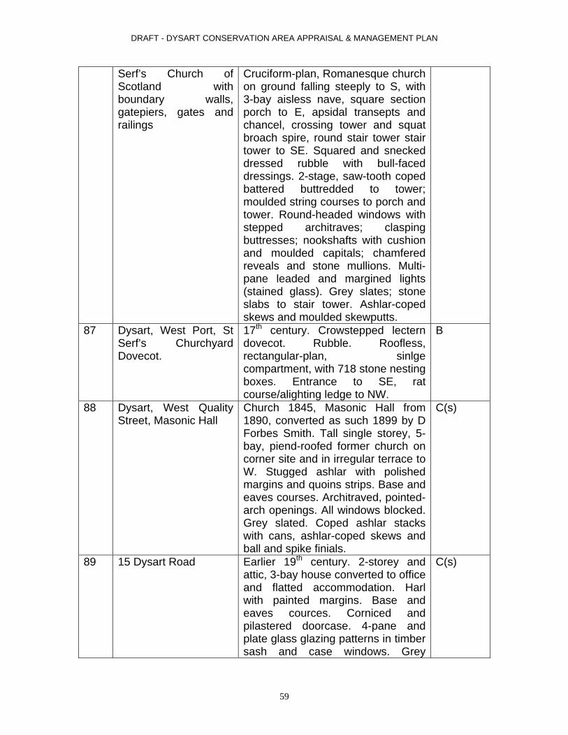
DRAFT - DYSART CONSERVATION AREA APPRAISAL & MANAGEMENT PLAN
Serf’s Church of Scotland with boundary walls, gatepiers, gates and railings
Cruciform-plan, Romanesque church on ground falling steeply to S, with 3-bay aisless nave, square section porch to E, apsidal transepts and chancel, crossing tower and squat broach spire, round stair tower stair tower to SE. Squared and snecked dressed rubble with bull-faced dressings. 2-stage, saw-tooth coped battered buttredded to tower; moulded string courses to porch and tower. Round-headed windows with stepped architraves; clasping buttresses; nookshafts with cushion and moulded capitals; chamfered reveals and stone mullions. Multi-pane leaded and margined lights (stained glass). Grey slates; stone slabs to stair tower. Ashlar-coped skews and moulded skewputts.
87 Dysart, West Port, St Serf’s Churchyard Dovecot.
17th century. Crowstepped lectern dovecot. Rubble. Roofless, rectangular-plan, sinlge compartment, with 718 stone nesting boxes. Entrance to SE, rat course/alighting ledge to NW.
B
88 Dysart, West Quality Street, Masonic Hall
Church 1845, Masonic Hall from 1890, converted as such 1899 by D Forbes Smith. Tall single storey, 5-bay, piend-roofed former church on corner site and in irregular terrace to W. Stugged ashlar with polished margins and quoins strips. Base and eaves courses. Architraved, pointed-arch openings. All windows blocked. Grey slated. Coped ashlar stacks with cans, ashlar-coped skews and ball and spike finials.
C(s)
89 15 Dysart Road Earlier 19th century. 2-storey and attic, 3-bay house converted to office and flatted accommodation. Harl with painted margins. Base and eaves cources. Corniced and pilastered doorcase. 4-pane and plate glass glazing patterns in timber sash and case windows. Grey
C(s)
59

DRAFT - DYSART CONSERVATION AREA APPRAISAL & MANAGEMENT PLAN
60
slates. Coped ashlar stacks with full complement of polygonal cans and thackstanes; ashlar-coped skews. Cast-iron downpipes with decorative rainwater hopper to right

DRAFT - DYSART CONSERVATION AREA APPRAISAL & MANAGEMENT PLAN
APPENDIX 3 DYSART CONSERVATION AREA ARTICLE 4 DIRECTIONS
USE CLASS
SUMMARY DESCRIPTION OF USE CLASS REQUIREMENT FOR USE CLASS WITHIN THE CONSERVATION AREA
Class 1 The enlargement, improvement or other alteration of a dwellinghouse.
To protect the special character, fabric and layout of a historic building and the surrounding area in order to prevent uncontrolled site coverage.
Class 2 Any alterations to the roof of a dwellinghouse including enlargement of a dwellinghouse by way of an alteration to its roof.
To protect the special character, fabric and layout of a historic building and the surrounding area in order to prevent uncontrolled site coverage.
Class 3 The provision within the curtilage of a dwelling house of a dwellinghouse of any building or enclosure, swimming pool or other pool required for a purpose incidental to the enjoyment of a dwellinghouse, or the maintenance, improvement or other alteration of such a building or enclosure.
To protect the historic fabric, special character and visual amenity of the area.
Class 6 The installation, alteration or replacement of a satellite antenna on a dwellinghouse or within the curtilage of a dwellinghouse.
To protect the special character, fabric and layout of a historic building and the surrounding area in order to prevent uncontrolled site coverage.
Class 7 The erection, construction, maintenance, improvement or alteration of a gate, fence, wall or other means of enclosure.
To prevent indiscriminate repair of the historic fabric (boundary walls) through use of inappropriate building methods and materials or inappropriate alterations or new build within garden ground boundaries.
Class 8 The formation, laying out and construction of a means of access to a road which is not a trunk road or classified road, where that access is required in connection with development permitted by any
To prevent unmitigated development and inappropriate alteration and/or development within garden ground.
61

DRAFT - DYSART CONSERVATION AREA APPRAISAL & MANAGEMENT PLAN
class in this schedule other than Class 7. Class 27 The carrying out on land within the boundaries of a
private road or private way of works required for the maintenance or improvement of the road or way.
To prevent unmitigated development and inappropriate alteration and/or development within garden ground.
Class 29 Development authorised by a local or private Act of Parliament. Or an order approved by both Houses of Parliament or any order made under section 14 or 16 of the Harbours Act 1964 (a), which in each case designates specifically the nature of the development authorised and the land upon which it may be carried out.
To protect harbour against development which may compromise its listed status and the adjoining (SSSI) to meet with the EU Birds Directive criteria.
Class 30 The erection or construction and the maintenance, improvement or other alteration by a local authority of certain buildings, works or equipment.
To protect the special character, fabric and layout of a historic building and the surrounding area in order to prevent uncontrolled site coverage.
Class 31 The carrying out by a roads authority on land out with but adjoining the boundary of an existing road or works required for or incidental to the maintenance or improvement of the road.
To protect the historic fabric of the area and ensure the replacement and repair of such areas is carried out sympathetically using appropriate building methods and materials where applicable.
Class 32 Development relating to sewerage being development not above ground level required in connection with the provision, improvement, maintenance or repair of a sewer, out fall pipe or sludge main or associated apparatus.
To protect the historic fabric of the area and ensure the replacement and repair of such areas is carried out sympathetically using appropriate building methods and materials where applicable.
Class 33 The carrying out, within their own district by a planning authority of works for the erection of dwellinghouses. Or any development under the Housing (Scotland) Act 1987 (b). Also any development under any enactment the estimated cost of which does not exceed £100,000 other than development of any of the classes specified in
To protect the special character, fabric and layout of a historic building and the surrounding area in order to prevent uncontrolled site coverage.
62
DRAFT - DYSART CONSERVATION AREA APPRAISAL & MANAGEMENT PLAN
63
Schedule 2 (bad neighbour development), or development which constitutes a material change in the use of any buildings or other land.
Class 35 Development on operational land by statutory undertakers or their lessees in respect of dock, pier, harbour, water transport, or canal or inland navigation undertakings, required for the purposes of shipping. Or in connection with the embarking, disembarking, loading, discharging or transport of passengers, livestock or goods at a dock, pier or harbour, or with the movement of traffic by canal or inland navigation or by any railway forming part of the undertaking.
To protect the harbour against development that may compromise its listed status and the adjoining Site of Special Scientific Interest to meet with the EU Birds Directive criteria
Class 37 The use of any operational land by statutory undertakers in respect of dock, pier, harbour, water transport, canal or inland navigation undertaking for the spreading of any dredged materials.
To protect the harbour against development that may compromise its listed status and the adjoining Site of Special Scientific Interest to meet with the EU Birds Directive criteria
Class 38 Developments for the purpose of water undertakings.
To protect the special character, fabric and layout of a historic building and the surrounding area in order to prevent uncontrolled site coverage.
Class 39 Development for a public gas supplier required for the purposes of its undertaking.
To protect the historic fabric of the area and ensure the replacement and repair of such areas is carried out sympathetically using appropriate building methods and materials where necessary.
Class 40 Development by statutory undertakers for the generation, transmission or supply of electricity for the purpose of their undertaking.
To protect the historic fabric of the area and ensure the replacement and repair of such areas is carried out sympathetically using appropriate building methods and materials where necessary.
Class 41 Tramway or road transport undertakings. To protect the historic fabric of the area and ensure the replacement and repair of such areas is carried

DRAFT - DYSART CONSERVATION AREA APPRAISAL & MANAGEMENT PLAN
64
out sympathetically using appropriate building methods and materials where necessary.
Class 43 Development required for the purposes of the Post Office.
To protect the townscape from indiscriminate installation of boxes, pouches or machines.
Class 43A To allow permitted development rights to the East of Scotland Water for development consisting of the erection, construction and maintenance in relation to their statutory functions.
To protect the townscape from indiscriminate installation of pipelines and equipment and cabins, antennae and other plan machinery or equipment.
Class 67 Development by Telecommunications Code System Operators.
To protect the townscape from indiscriminate installation of pipelines and equipment and cabins, antennae and other plan machinery or equipment.
Made under the Town and Country Planning (General Permitted Development) (Scotland) Order 1992 Effective from 18 November 2005
Related Documents