ISBN 978-93-5067-556-4 DYNAMICS OF GLACIERS IN THE INDIAN HIMALA Y A Science Plan Himalayan Glaciology Technical Report No. 2. SCIENCE AND ENGINEERING RESEARCH BOARD Department of Science and Technology Technology Bhawan, New Delhi-110016 2012

Welcome message from author
This document is posted to help you gain knowledge. Please leave a comment to let me know what you think about it! Share it to your friends and learn new things together.
Transcript


ISBN 978-93-5067-556-4
DYNAMICS OF GLACIERS
IN THE INDIAN HIMALAYA
Science Plan
Himalayan Glaciology Technical Report No. 2.
SCIENCE AND ENGINEERING RESEARCH BOARD
Department of Science and Technology Technology Bhawan, New Delhi-110016
2012

ii
Prepared by: R.K. Midha, Resource Development Centre, New Delhi.
Cover page Photograph: Snow and Glaciers in the Ladakh Himalaya during
September 2011. Photo by Rasik Ravindra, NCAOR, Goa.
Citation: DST (2012). Dynamics of Glaciers in the Indian Himalaya: Science
Plan. Prepared by R.K. Midha. Published by the Science and Engineering Board, Department of Science and Technology, New Delhi, Himalayan Glaciology Technical Report No.2., 125 pp.

Tel. : 26510068 26511439 Fax : 0091-11-26863847 6862418 E-mail : [email protected] , 011- , 0091-11-2
Hkkjr ljdkjfoKku vkSj çkS|ksfxdh ea=ky;foKku vkSj çkS|ksfxdh foHkkx
VsDuksykth Hkou] u;k egjkSyh ekxZ] ubZ fnYyh&110 016GOVERNMENT OF INDIA
MINISTRY OF SCIENCE & TECHNOLOGY
DEPARTMENT OF SCIENCE & TECHNOLOGYTechnology Bhavan, New Mehrauli Road, New Delhi-110 016
Mk-Vh-jkelkehlfpo
Dr. T. RAMASAMISECRETARY
lR;eso t;rs
FOREWORD
Glaciers and glacial environments in the Himalaya are expected to be sensitive to variations in climate forcing. Though the hydrological cycle of the Indian region is influenced by the monsoon systems, the melting of snow and glaciers during summer period provide a key source of water in the major rivers of the region. Scientific study of glaciers and their response to the climate variability, therefore, assume foremost importance to India's sustainable development plans for mountain regions and adjoining plains with regard to hydropower, water supply and environmental quality, having direct bearing on the national growth.
Since 1986, the Department of Science and Technology, under Himalayan Glaciology Programme, supporting campaign mode surveys and extra mural research studies aimed at understanding the physical, chemical and geological processes and responses of these systems using varied approaches and different techniques. The scientific datasets, available with different organizations, are not enough to conclusively relate the past glaciations, recent glacier mass and length changes to the phenomena of climate change. Keeping the above in view, the Indian National Action Plan on Climate Change has strongly emphasized the need for in-depth studies in glaciology to be pursued on a continuous basis to generate the necessary scientific information to devise suitable S&T based interventional strategies.
This report on Dynamics of Glaciers in the Indian Himalaya: Science Plan' synthesizes various observational studies carried out to understand the underlying processes by different organizations, individuals and groups. It provides information on various glacier types, paleo-glaciation, meteorological and morphological features, glacier dynamics, hydrological processes, etc. using multi-dimensional observational techniques and modeling. Also, identify the critical gaps in scientific understanding, thrust areas for future research studies and also suggested broad contours of implementation strategy. I am confident that this science plan could facilitate formulation of action oriented studies by multi-disciplinary scientists interested to work under hostile and difficult environmental conditions and generate critical scientific database on Himalayan glaciers.
The Department is grateful to Dr RK Midha, Consultant, Resource Development Centre, New Delhi for his efforts in collating information from various sources in preparing this status report and Science Plan. I congratulate the Chairman and members of the Expert Committee on `Integrated Programme on Dynamics of the Glaciers in the Himalaya' for conceptualization and guiding the preparation of this technical report. Also, thankful to all the reviewers for crucially examining the contents of the manuscript.
(T RAMASAMI)nd
2 March, 2012
iii

iv
Acknowledgements
I have received support and help from several individual scientists and institutions in the course of preparing this document. I gratefully acknowledge that.
Director, Wadia Institute of Himalayan Geology, scientists of the Glaciology Division and the Centre for Glaciology were particularly helpful in securing several important references from the Institute’s library. I thank Dr. D.P. Dobhal and Dr. R.K. Mazari for their help. Dr. D. Srivastava helped me to source the material from GSI publications. I received many clarifications from him on the GSI data. Dr. B.R. Arora, former Director, WIHG, was very supportive.
Prof.AL. Ramanathan and his colleagues at JNU graciously lent the publications/books secured by them from China. I owe my thanks to them. Dr. R. Thayyen was extremely helpful in providing some basic papers on the Himalayan glaciers which helped me frame my initial ideas about the contents of this document. His comments on the first version of the draft were thought provoking. I have leaned heavily on the work of Dr. Anil Kulkarni. Discussions with him from time to time were productive.
Dr. N. Juyal quickly responded to my requests for reprints/copies of papers. He also provided some internal Notes prepared by him .These inputs helped me to write Chapter 2. His critical comments were very helpful. Prof. M.N. Koul and Prof. R.K. Ganjoo of Jammu University have provided many useful references. Dr. A. Ganju, Director SASE, kindly arranged discussions with his scientists which provided me an appreciation of the application of remote sensing to avalanche studies. I have received important references from Prof. Anil Gupta, Prof. S.K. Dash, Prof. A.K. Gosain, Dr. M. Bhutiyani, Dr. Pratap Singh and Dr..Milap Sharma.
The idea for developing this document was conceived by Dr. M. Prithviraj and Mr. M. Mohanty. They were extremely helpful in resolving some important administrative and technical issues in DST.
I thank the Chairman and members of the Expert Committee on ‘Integrated Programme on Dynamics of the Glaciers in the Himalaya’ for guidance and support. I particularly thank Dr. P. Sanjeeva Rao for critically reviewing and editing the different draft versions of the document. Also, his efforts in arranging the Brainstorming Session at WHG in April, 2011 provided an opportunity to get the document vetted by some leading glaciologists. I thank all the participants of the Brain Storming Session for their suggestions and contributions.
I express my gratitude to the Resource Development Centre, New Delhi, for hosting the project and to the Department of Science & Technology, GOI, for extending financial support for this study.
R.K. Midha Consultant
Resource Development Centre New Delhi.
Email: [email protected]

v
List of Contents No. Description Page
No. Foreword (iii) Acknowledgements (iv) List of Contents (v)‐(vii) List of Figures (viii)‐(ix) List of Tables (x) List of Boxes (xi) Executive Summary 1‐13 1.Introduction 1 2.Quaternary Glaciation 3 3.Climate Change and Himalaya 3 4.Glacier Studies in Indian Himalaya‐Status and
Assessment 5
5. Glacier Research Programme 8 Chapter I Background 14‐28 1.What is a Glacier? 14 2. Why are Glaciers Important? 14 3. Glaciers as Component of Terrestrial Cryosphere 15 4. Classification of Glaciers 16 4.1 Classification by Temperature 16 4.2 Classification by Geophysical Properties 17 4.2.1 Maritime or Monsoon Type 17 4.2.2 Sub‐Continental Glaciers 18 4.2.3 Extreme Continental Type 18 5. Distribution of Glaciers 18 5.1 World and Regional 18 5.2 Indian Himalaya Glaciers 20 6.Himalayan Glaciers and Precipitation System 23 6.1 Precipitation Domains 23 6.2 Spatial Distribution of Glaciers 26 7. Summary‐Research Issues 27
Chapter 2 Past Climate Changes and Quaternary Glaciation 29‐41 1.Introduction 29 2.Long‐term Variations 30 3.The Quaternary Period 31 3.1 Late Quaternary Glaciation in the Himalaya 33 3.1.1 Trans Himalaya Ladakh 34

vi
3.1.2 Lahaul Himalaya, (Himachal Pradesh, Western Himalaya)
35
3.1.3 NW Garhwal, Central Himalaya 36 4. Discussion 37 5. The Regional Perspective 38 6. Future Challenges 40 Chapter 3 Climate Change and the Himalaya 42‐51 1. Climate Change‐Global Context 42 2. Regional Scenario 44 3. Climate Trends in NW Himalaya 45 4. Aerosol Loading 50 5.Discussion 50 6. Research Issues 51 Chapter 4 Glacier Observations 52‐63 1. Introduction 52 2. Mass Balance Measurements 53 3. Comparative Results 56 4.Mass Balance Climate Characterizing Parameters 57 4.1 Equilibrium Line Altitude 57 4.2 Vertical Mass Balance Profile (Mass balance
Gradient Profile, VBP) 58
5. Mass Balance Studies using Remote Sensing 60 6. Glacier Dimensions 61 6.1 Glacier Length 61 6.2 Area Change 63 7. Additional Measurements 63 Chapter 5 Dynamics of Indian Himalaya Glaciers 64‐78 1. Introduction 64 2. Glacier Fluctuations 65 2.1 Glacier Snout Monitoring 65 2.2 Glacier Mass Balance 68 2.2.1 Global Efforts on Mass Balance Studies 68 2.2.2 Mass Balance Data in the Indian Himalaya 71 3. Area and Elevation Changes 75 4. Snow Cover Mapping 76 5. Conclusion 77 Chapter 6 Glaciers and Water Resources 79‐87 1. Introduction 79 2. Glacier/Snow‐Melt Contribution to River Discharge 80

vii
3. Climate Change Scenarios and River Discharge 82 3.1 Field Data 84 4. Discussion 85 Chapter 7 Way Forward‐The Emerging Imperatives 88‐101 1.Introduction 88 2. Glacier Observations 88 2.1 Mass Balance 88 2.1.1 Winter Mass Balance 92 2.1.2 Error Estimates 93 2.2 Glacier Snout Monitoring 93 2.3 Mapping of Snow Cover 94 2.4 Glacier Inventory 94 2.5 Meteorological and Aerosol Measurements 95 3. Geochronological Framework 96 4. Process Modelling and Sensitivity Studies 97 5. Glacier Movement and Thermal Characterization 98 6. Glacier Hydrology 98 7. Remote Sensing and Himalayan Glaciers 99 8. Conclusion 100 References 102‐
116 Annexure 1 List of Existing Glaciers for Long‐Term Monitoring 117 Annexure 2 List of Acronyms 118 Annexure 3 List of Figures taken from published literature 120

viii
List of Figures
Chapter No.
Fig. No.
Caption Page No
1. 1.1 Himalayan Cryosphere‐Land‐Atmosphere interactions 15 1.2 Classifications of Glaciers 17 1.3 Relationship between glaciers and latitude, shown along a line
from Alaska to tip of South America 19
1.4 Macro regions of existing glaciers 19 1.5 Mountain ranges and other physical features of India 21 1.6 Glacierised areas of Upper Indus Basin, J&K based on
Preliminary Glacier Inventory 23
1.7 Distribution of the estimated ELAs of glaciers in the Himalaya along Latitude
27
1.8 Regional disposition of ELAs in the Himalaya 28 2. 2.1 Reconstruction of climate over the last 400,000 years from the
Vostok ice core, Antarctica 29
2.2 Photograph showing lateral moraines of stages I‐III depicting the successive decrease in ice volume
32
2.3 Summary of late Quaternary glaciation in the Himalaya 39 3. 3.1 Atmospheric concentration of important long‐lived green
house gases over the last 2000 years 42
3.2 Global mean temperature trends 43 3.3 Yearly‐mean surface temperature anomalies averaged for
eight high‐elevation sites in the Swiss Alps, ranging in altitude from 569 m to 2500 m above sea level
44
3.4 Dependence of warming on elevation on the Tibetan Plateau 45 3.5 Long‐term trends of mean annual temperature over India. 47 3.6 The four ranges of the Himalaya, A‐Pir Panjal, B‐Shamshawari,
C‐Greater Himalaya, D‐Karakoram and the station locations 48
3.7 Time series of maximum and minimum temperature anomalies over Greater Himalaya) and Karakoram range
49
3.8 Time series of seasonal (November‐April) snow fall over the Western Himalaya.
49
4. 4.1 Glacier change‐processes and linkages 52 5. 5.1 Glacier retreat of some important glaciers 66 5.2 Global mass balance data 69 5.3 Annual mass balance time series data on IHG 73

ix
5.4 Thickness change as a function of altitude, Lahaul Spiti region 76 5.5 Changes in areal extent of snow cover 77 7. 7.1 Looking ahead‐suggested modules 89 7.2 Break‐up of Applied Glaciology module 89 7.3 Elements of Himalayan Glacier Observation & Detection
System (HIMGODS). 90
7.4 Suggested transects for long‐term mass balance studies‐primary network
91
7.5 Steps to success 101

x
List of Tables
Chapter No.
Table No.
Description Page No.
1. 1.1 Some important component mountain systems of High Mountains of Asia
20
2. 2.1 Correlation of glacial history across Ladakh, NW and Central Himalaya
34
5. 5.1 Retreat rates of some glaciers 66 5.2 Retreat of Gangotri glacier (GSI data) 67 5.3 Rates of retreat of Gangotri glacier (Non‐GSI
data). 68
5.4 Mass Balance Data by Glaciological Method 72 5.5 Comparison of mass balance data on IHG with
regional (Tibet and Nepal) and global data. 75
6. 6.1 Estimates of melt contribution to annual discharge
81
6.2 Modeled changes in annual discharge due to temperature rise
82
7. 7.1 Changes in ELA due to changes in environmental factors
97

xi
List of Boxes
Chapter. Box No.
Title Page No.
Executive Summary
2. The Driving Concerns 2
1. Goals of the Programme 4 3. Suggested Enhancements in IHG
Observation System 9
4. Suggested Areas for Major Research Initiatives
12
5. Incentives 13 4. 4.1 Geodetic Measurements 57 5. 5.1 Snout Monitoring 67 7. 7.1 Objectives 88 7.2 Glacier Fluctuation Observations 95


1
Executive Summary
1. Introduction
The Himalaya, through ages, have evoked awe and curiosity. In recent times the growing appreciation about the Himalaya as a storehouse of ice, snow and permafrost, as a tower of fresh water, as a repository of rich biodiversity, as an important modulator of global and local weather systems and as an agent of change and natural disasters has imparted this mountain system an important position in scientific exploration/research and societal relevance. In the last few decades, the issues related to climate change have further brought the Himalayan mountains and the Himalayan cryosphere in the forefront of global debate and discussions (IPCC, 2007a; Raina, 2009; Schiermeier, 2010; Bagla, 2009; Cogley, 2010). Worldwide, there is a deep scientific interest in understanding the processes and interactions operating on this high mountain system and how they would evolve in the developing climatic scenario (Fu et al., 2006).
Due to high altitude, wide expanse and geologic history, the Himalaya serve as a unique natural laboratory for studying the tectonics-climate interactions in a glaciated environment. The extreme difficulties of terrain and weather have, however, impeded the progress of observational studies in the Indian Himalaya. In spite of these constraints, some useful data have been generated over the last three decades through contributions from the national survey agencies, academia and research institutions. The Indian National Action Plan on Climate Change (GOI, 2008) has provided a new sense of urgency to expand the scope and coverage of these studies so that a fuller understanding of the state of Himalayan glaciers emerges. The present document attempts a critical review of the available data, makes an assessment and lays down a plan for future research taking note of the current and emerging priorities. The emphasis is on the study of glacier dynamics.
The Himalayan glaciers, an important component of the global cryosphere, occupy the highest altitudes in the world. The estimated glacier extent outside the Polar regions is ~540 . Out of this, the largest cover, about 116 is in the High Mountains of Asia, comprising of more than 10 major glacier-mountain systems. Himalaya is the dominant mountain range of this system. The other important constituent ranges are the Karakoram, Tien Shan, Pamirs, and Kun Lun etc. (Dyurgerov and Meier, 2005). The glaciers here feed 10 of the largest rivers in Asia, on which some 1.3 billion people depend. Because of the iconic position that glaciers occupy in the mountainous landscape, glaciers have emerged as the most visible component of the cryosphere that gets readily associated with the present debate on climate change (Gore, 2006). There are fears that glaciers in this terrain are melting rapidly and this could impact adversely the resource base of the region

2
(Cruz et al., 2007). Two of the recent International Conferences held in India (UNEP, 2009; AOGS, 2010) have deliberated on the subject.
The intensity of glaciation in the Indian Himalaya is ~17% as compared to about 2.5% in the Alps (Vohra, 1981; Ramakrishnan and Vaidyanathan, 2008). There are about 9575 glaciers with an estimated area of 37,466 Km2 (Kaul, 1999; Raina and Srivastava, 2008; Sangewar and Shukla 2009). The three major glacier-fed river systems, the Indus, the Ganges and the Brahmaputra, provide close to 50% of the annual utilizable surface water resources (690Km3) of the
country (MOWR, 2008), with significant contributions coming from the glacier and seasonal snow melt. Monitoring the behavior of these glaciers is thus of vital importance for managing the river flows, irrigation and power generation, weather forecasting, conserving the biodiversity and verily sustaining the life-livelihood-systems of the Himalayan terrain and the plains below. Hence, the urgency to study these glaciers and understand their behavior.
The glaciers in most parts of the Himalaya, eastern and central, have generally been classified as summer accumulation type (Ageta and Higuchi, 1984; Ageta and Fujita, 1996) implying that accumulation and ablation maxima occur almost simultaneously during the summer. The glaciers are sustained by the Indian summer monsoon system, rooted in the larger atmospheric phenomenon, the Inter-Tropical Convergence Zone (ITCZ) that arises because of the seasonal temperature and pressure differences in the Northern and Southern hemispheres. In particular, the temperature gradient between the Himalaya Tibet massif and the surrounding oceans drives the summer monsoon system. The winter-spring snow cover over the Himalaya-Tibet massif plays an important role in the genesis/attenuation of this thermal contrast.
The extreme western and the Trans-Himalaya regions receive precipitation maxima during the winter months (December-March) due to the westerly disturbances that originate in the Mediterranean, Caspian and Black seas. These varying weather systems give rise to precipitation gradients along and across the Himalaya due to mechanical and thermal forcings. Their relative importance in bringing moisture to the high peaks of the Himalaya and the Trans-Himalaya has played an important role
Box 1
The Driving Concerns
Is the climate in Himalaya changing? What are the forcings-global, regional
and local driving the changes? How is the Indian monsoon system
responding to these changes? How is the Himalayan cryosphere
reacting? Is it resilient? What are the consequences-
hydrological, biological and societal- of these changes?
The possible mitigative measures and adaptive strategies?
How to transfer these findings to decision/policy makers?

3
in defining the spatial and temporal distribution of glaciers in the past and present (Benn and Owen, 1998; Owen et al., 2008).
2. Quaternary Glaciation
The limited geo-chronological data in the Indian Himalaya suggests that the local glacial maxima in the central and western Himalaya were reached at the Marine Isotopic Stage-3/4 (MIS 3/4) transition (70-60 Ka) (Owen et al., 2001, Sharma and Owen, 1996), preceding the Last Glacial Maximum (LGM) timed at 21.5-18 Ka (Singhvi and Kale, 2009). During LGM, the glaciation in the Himalaya was less significant due to a weaker monsoon regime. The relatively drier Trans-Himalaya provide a better opportunity to preserve the relicts of glacial moraines (Owen et al., 2006). Hence the oldest record of glaciation in the region (~ 430 Ka) has been recorded in the glacial moraines of Ladakh (Owen et al., 2006). Following the local glacial maximums, the subsequent stages and advances have successively produced glaciation of decreasing extents (Sharma and Owen, 1996; Juyal et al., 2011). There is a degree of synchronicity in glaciation across the Indian Himalaya modulated by local climatic and topographic gradients. The extent and intensity of glaciation is more dominant in the monsoon influenced central Himalaya than the western and Trans Himalaya. The history of glaciation during the Holocene is complex and varied and needs to be resolved in different segments of the Himalaya. Periods of increased glaciation (e.g. local glacial maxima) have generally been correlated with higher insolation and strengthened monsoon activity (Owen et al., 2008). The contemporary observations indicate raised temperatures, decrease in snowfall precipitation and recession of glaciers.
3. Climate Change and the Himalaya
Warming of the global climate system since about 1750 (post industrialization era), is unequivocal (IPCC, 2007a). Changes in the atmospheric concentration of green house gases (GHG), aerosols and land use alterations, largely attributed to anthropogenic activities, are the possible driving causes (IPCC, 2007b). The linear trend of near-surface global average air temperature increase has risen to 0.74°C /100years for the period (1906-2005) as compared to the corresponding trend of 0.6°C/100 years for the period (1901-2000). The temperature increase has been particularly sharp in the last fifty years with an added acceleration during the last three decades with signs of a climate shift around 1978 (Meier et al., 2003; Cao, 1998). The decade of mid-nineties (1995-2005) has been the warmest since 1850 (IPCC, 2007 a).
The Northern Hemisphere which contains nearly 98% of the seasonal snow cover is witness-ing a long-term decreasing trend (Armstrong and Brodzik, 2001). The snow cover decline has been particularly sharp over Eurasia since 1979, including over

4
southwest Asia and over the Himalaya-Tibetan plateau region (~ 4% from 1997-2003) (Goes et al., 2005)
Observations indicate that the rate of temperature rise increases with elevation (Beniston et al., 1997) making mountain ranges and raised plateaus especially vulnerable to effects of global warming. The Himalaya-Tibet orogen because of the extreme elevation (average elevation ~ 4 Km asl), topographic relief and wide expanse plays a significant role in modulating the local, regional and global climate gradients over different time
scales (Fu et al., 2006). A sharp rise in temperature of about 0.3°C per decade has been observed over the last fifty years on the Tibetan plateau in observatories located above 2000 m asl. The warming increases with elevation (Liu and Chen, 2000). Snow accumulation has decreased (Thompson et al., 2000; Duyan et al., 2006). Similar trends of enhanced temperature rise have been observed in Nepal during the period 1977-2000 (Shreshta et al., 1999) and in northwest China (Shangguan et al., 2009).
In the Indian subcontinent, a number of recent studies have noted changes in the precipitation and temperature distribution patterns over the last five decades (Goswami et al., 2006; Dash and Hunt, 2007, Dash et al., 2009). Dash et al., (2009) discern changes in the frequency of different categories of rain events for the period 1951-2004, suggesting weakening of the summer monsoon circulation over India.
The all India mean annual temperature from 1901-2003 shows an increasing trend of 0.51°C/100 yrs. For the period 1971-2003, the trend is 0.21°C/10 years. The enhanced post 1970 trend is attributed to significant warming over the northern regions and a surge of temperature rise since the mid nineties (Kothwale and Rupa Kumar, 2005). The data from the high altitude mountain meteorology observatories over the last thirty years indicate accelerated warming and decrease in seasonal snowfall in the different rages of north west Himalaya (NWH), except the Karakoram range where the temperature shows a decreasing trend (Shekhar et al., 2010). Bhutiyani et al., (2007, 2009) deduce a significant warming of ~ 1.6°C in NWH in the last century (1901-2000), with winters warming at a faster rate. Warming appears to start from the late sixties and the steepest rise in temperature is witnessed in the last
Box 2
Goals of the Programme
Develop a multi-disciplinary integrated database on the Indian Himalaya Glaciers (IHG).
Map the spatio-temporal distribution of IHG from the late Quaternary to contemporary
Relate past and present changes to the underlying processes of climate change and variability
Quantify the balance of energy, mass and momentum
Model the future changes and their impact

5
two decades. The snowfall component of the precipitation has decreased over the years.
There is thus a convergence from global, regional and sub-continental data indicating that the Indian land mass has been warming at an enhanced rate, particularly during the last three decades with the NW Himalaya (barring Karakoram) showing the highest rise. Ascribing cause to this temperature rise is not straightforward. There could be many forcing factors like the green house gas emissions, land use changes, black carbon and aerosol loading, changes in snow/ice albedo, intrinsic variability and feedback mechanisms. They are all adding in some complex way to produce the resultant anomaly.
It is feared that this temperature-precipitation regime would reduce the snow cover, accelerate melting of glaciers, affect the landscape and slope stability, the water cycle and sediment load in rivers, the sea level and natural hazards far beyond the historical and Holocene variability. This provides a compelling and urgent rationale to study the Himalayan glaciers in all their facets using the latest technologies, conduct research and build models to understand the underlying processes and determine answers to the many concerns that confront the scientists, policy and decision makers and above all the community that is likely to bear the brunt of these developments. The Indian National Action Plan on Climate Change (NAPCC) recognizes these concerns and proposes to strengthen and enlarge the study of Himalayan glaciers as a component of the National Mission for Sustaining the Himalayan Ecosystem (NMSHE) (DST, 2010).
4. Glacier Studies in the Indian Himalaya (IH)-Status and Assessment
Systematic scientific investigations of glaciers took off in the Geological Survey of India (GSI) with the launch of the International Hydrological Decade (IHD) (1965-74). The Department of Science and Technology (DST) assumed the coordinating role in the mid eighties and has since imparted a more holistic, multi-disciplinary and multi-institutional character to the scientific studies of glaciers. During the last 25 years, the studies have included monitoring of glacier snout, snow cover mapping, reconstructing late Quaternary glacial framework, mass balance measurements, glacial hydrology (discharge, quality, sediment load and geochemistry), meteorological measurements, ice flow and ice fabric studies, multi-spectral remote sensing, ground penetrating radar and geophysical surveys. However, all these studies have been confined to limited geographical areas covering short periods of observations during summer months and extended over a few years. Compared to the vast terrain, the total geographical area studied is statistically insignificant. The results are, therefore, patchy and the cause-effect relationship remains obscure. Monitoring the snout of glaciers using in-situ and remote sensing methods has received the bulk of attention. More than 50 glaciers have been monitored over different time periods. In consonance with the global trend, the majority of glaciers in

6
the Indian Himalaya have been retreating since the recording began around the middle of the nineteenth century (Raina, 2009). Karakoram Himalaya is an exception to this trend (Hewitt, 2005; Fowler and Archer, 2006). There are temporal and spatial variations in the rates of retreat, the rates varying from <5 m/year to ~50 m/year (Fig.194, p 205, of Raina and Srivastava, 2008). The retreat was generally around 5-10 m/year till up to late 1950s; the rate of retreat increased during mid seventies, which continued up to mid nineties, touching a value of 25-30 m/year in some glaciers. It is contended by some that there is a general slowing down in the rate of retreat in the late nineties and in the decade of 2000 (Raina, 2009; Bali et. al., 2010). But there is no consensus (Naithani et al., 2001; Bhambri et al., 2011 a). The rates of glacier retreat in Nepal, Tibet and Tien Shan in China too show an increase since mid 1970s with further acceleration in the decades of 1990s and 2000 (Bajracharya and Mool, 2009; Caiping et al., 2009; Wang et al., 2009). The formation and expansion of moraine damned lakes in Nepal and Bhutan due to accelerated glacier retreat has been well documented (Bajracharya et al., 2006). It is increasingly being accepted that glacier length change is only a rough measure of glacier response to climate change. The advance or retreat of glacier tongue involves complex dynamic aspects of ice flow and, hence, is an indirect, delayed and filtered but also enhanced and, therefore, more easily observed signal of climate change (Hoelzle et al., 2003; Solomina et al., 2008; Armstrong et al., 2009). The quantitative relationship between the response of the glacier terminus to climate change is, however, complicated by the time lag between the two which depends on the glacier demensions and its geometry (Johannesson et al., 1989; Venkatesh et al., 2011). Debris cover on the terminal zone further complicates the response function (Scherier et al., 2011). In general, for valley glaciers, the response time is 10-50 years (Oerlemans, 1994). Further, there are indications at the global level that down wasting has become the dominant mode of glacier retreat decoupling the glacier length changes from atmospheric changes (Paul et al., 2007; Solomina et al., 2008). Studies on Indian glaciers need to look for similar changes in the style of glacial retreat (Naithani et al., 2001; Berthier et al., 2007). Thus drawing important conclusions about the status/health of glaciers in the Himalaya, based predominantly on snout monitoring data is considered problematical. On the other hand, mass balance of glaciers is now accepted as a direct undelayed key indicator for assessing the trends of climate changes (Haeberli et al., 1998). The associated parameters like the equilibruim line altitude, area accumulation ratio, mass balance gradient and mass turn over, together help characterise the response of glaciers to climatic pulses.
There is a general interest in conducting long-term mass balance studies because of (1) the intrinsic relationship between mass balance change and climate fluctuations (2) the impact of mass balance change on the melt water release and (3) the link
7
between glacial melt and sea level rise. Through the efforts of the World Glacial Monitoring Service (WGMS), a global system of monitoring glaciers has evolved over the years. The analyses of available global mass balance data undertaken by Dyurgerov and Meier (2005); Kaser et al., (2006) and Braithwaite (2009), among many others, highlight the recent increase (post mid 1970s) in the amplitude of mass balance variations (mass turn over), with values increasing for both the winter and summer mass balance. Incremental ablation exceeds the additional accumulation and hence the net increase in the negative mass balance. While increase in ablation due to the rising temperature regime is expected, the rise in winter accumulation has been quite unexpected (Meier et al., 2003).
In the Indian Himalaya (IH) thirteen glaciers have been studied for multi-year assessment of mass balance by the conventional glaciological method; the time series varying in length from 2 years to 10 years. Data collection is limited to glaciers adding up to about 60 Km2. The average length of time series is less than six years. At present, mass balance studies by the in-situ method are done on four glaciers i.e. Hamta, Chotta Shigri, Dokriani and Chaurabari. Besides the above, mass balance data has been generated over ~ 1000 Km2 using remote sensing methods (Kulkarni, 1992; Kulkarni et al., 2004; Berthier et al., 2007). Starting with near-zero or slightly positive specific mass balance in the mid seventies, the mass balance values fluctuate around -0.45 m/a w.e. up to the mid nineties. After that, there are indications of a step-change occurring somewhere between 1995-2000 with mass balance acquiring values close to -1 m/a w.e. Mass balance data in Tibet and Nepal for a similar period gives values of -1.0 and- 0.72 m/a w.e. Global data for 30 reference glaciers (WGMS, 2009) shows an increase in ice loss from 0.25 m/a w.e. for the period 1986-95 to 0.58 m/a w.e for the period 1996-2005 (Zemp et al., 2009). Thus, the available data on the Indian Himalaya is coherent with the regional and global trends of increased mass losses in the recent decades. Supporting evidence for accelerated depletion of glacier mass comes from the reports of area shrinkage and fragmentation of glaciers (Kulkarni et al., 2007), thinning of glaciers (Berthier et al., 2007), increase in spread of debris cover (Shukla et al., 2009) and cumulative length changes (Bhambri and Bolch, 2009). There is little evidence of the NWH defying global warming.
There is a serious lack of stream discharge data to independently calibrate the ice mass depletion. Both decreases in discharge during the winter season for Sutlej river (Bhutiyani et al., 2008) and increase in winter discharge in Baspa basin (Kulkarni et al., 2002) have been reported. However, these data are very limited and do not indicate definitive trends of change.
At the global level also there is no homogeneous trend relating stream flows to temperature or precipitation changes. In fact it is felt that water resource issues have not been adequately investigated in the climate change analysis and climate policy formulations (Bates et al., 2008). IPCC (2007d) states ‘as these glaciers recede due

8
to global warming, river flows are increased in the short term, but the contribution of glacier melt will decrease over the next few decades’. Shortage of water supplies is feared to affect south Asia by 2050 (IPCC, 2007e). In our context, rising population and increasing pace of economic development will raise demands for water in the scenario of reducing availability of fresh water (Mall et al., 2006).
The present estimates of glacier and snow melt contribution to the discharge of Himalayan rivers have given divergent results. For example, for the Ganges river, the melt contribution (snow and ice) is estimated to be 10% by Immerzeel et al., (2010) and 70% by Arora et al. (2010) on the basis of a regional and a local study respectively. Mauyra et al. (2010) use isotopes of oxygen, hydrogen and electrical conductivity to estimate the different components of Ganga river flow at Rishikesh. The average value of glacier melt is estimated to be 32% for the period of study (July, 2008 to November, 2009). A view has been expressed that in monsoon dominated catchments (warm and wet) the importance of glacier melt as a proportion of total river discharge is less significant as compared to regions where it is warm and dry (Kaser et al., 2010; Thayyen and Gergan, 2010). All these studies, especially those based on hydrological models, are constrained by lack of adequate meteorological and discharge data to calibrate and validate the models. The National Water Mission (NWM) and NMSHE are driven by these concerns and are seized with the task of generating better estimates of snow and glacier melt contribution to the Himalayan rivers and likely changes in these components due to global warming. This would require extensive field data collection and intense modelling efforts.
5. The Glacier Research Programme
At the heart of this overall effort lies the need of setting up a state-of-art Himalayan Glacier Observation and Detection System (HIMGODS) that will combine the strengths of in-situ and remote sensing measurements. The key questions about the climate change in the Himalaya, the different forcings, the feedback mechanisms and their possible impact on the natural and human systems all require to be answered through enhancing the data base and improving the analysis and modelling capabilities. Mass balance studies are central to understanding and modelling the glacier dynamics. The mass balance programme in the Indian Himalaya needs to be enlarged from the present glacier-specific studies to the study of an ensemble of glaciers (glacier basin) so that a regional perspective of the mass balance characteristics emerges. A hierarchical approach is suggested in which glaciers are studied at different levels of intensity. A few ‘Index’ glaciers are identified along and across the Himalayan arc to sample the different precipitation/ topographic zones. These ‘index glaciers’ are intensively

9
studied by the in-situ method to generate long-term data on mass balance and other parameters.
Mass balance data on these glaciers, constituting the ‘primary’ network, is then extended to neighboring areas using the remote sensing methods. The data on the primary network provides a detailed understanding of the physical processes and their temporal changes that control the mass exchange in the region. The less intensively studied glaciers are used to assess the variability of such processes within the region (Fountain et al., 1997).
Some of the other suggested initiatives are:
i. Geodetic method offers a good possibility of extending the mass balance data into the immediate past i.e. about twenty years, the
crucial period in the recent acceleration of global warming. Also, it offers the possibility of estimating mass balance status over large, difficult but important glaciers like the Gangotri. It will be highly advisable to include the option of independent measurements of mass balance by more than one method in the overall programme of monitoring the health of glaciers.
ii. Set up infrastructural facilities for carrying out winter mass balance measurements on some selected glaciers to study the mass turn over and its changes with time. It is important to know if a particular value of annual balance is acquired through high or low mass turn over.
iii. Upgrade the strategy for monitoring glacier length to ultimately develop relations between length and mass balance changes. Also, include DEM
Box 3
Suggested Enhancements in IHG Observation System
• Set up a framework of ‘index glaciers’ along and across the Himalayan arc, initiate long-term mass balance measurements by the in-situ method
• Resume/build interrupted time series • Extend glacier-specific measurements to
neighbouring ensemble of glaciers using remote sensing methods for obtaining a regional perspective of mass balance change
• Set up facilities and support mechanisms for conducting winter mass balance studies on a few glaciers
• Using geodetic method, extend measurements to large, difficult but important glaciers like the Gangotri
• Upgrade and standardize snout monitoring methodology with illustrated guide books.
• Encourage meteorological observation studies for glaciers in coordination with other national efforts
• Create facilities for in-situ measurements of black carbon and other aerosols on selected glaciers
• Promote coordination, data sharing, analysis and modelling

10
differencing to account for vertical thinning, calving and fragmentation in the ablation zone.
iv. Update the glacier inventory taking note of the accelerated glacial dynamics over the last few decades. Include climate characterizing parameters like ELA/ELA0 in the inventory.
v. Facilitate use and analysis of the available data of glacier inventory and old (> 10 years) unpublished field reports of GSI by releasing the same in digital format.
vi. Determine sensitivity parameters and scaling relationships for the Himalayan glaciers.
vii. There is no authentic base line data on the seasonal snow cover on the Himalaya, an essential parameter for estimating the water resource potential and the likely impact of climate change on this critical resource. It is, therefore, important to launch a coordinated project for assessing the snow cover and associated characteristics over the Indian Himalaya and monitoring their spatial and temporal fluctuations.
viii. Study of pro-glacial lakes - mapping and developing models to explain their formation and progression.
ix. Study of debris cover, its delineation and determination of local relationships between debris cover and ablation characteristics.
x. Up-gradation of meteorological network to capture data as close as possible to ELA and quantify the energy exchange processes.
xi. Measurements and modelling of black carbon and other aerosols to quantify their contribution to temperature change and glacier/snow melt.
xii. Quantitative geomorphology to build the chronological framework of glaciation history in different climatological segments of the Himalaya during the late Quaternary. Mapping of landforms and old ELAs will help parameterize the glacial features into corresponding temperature-precipitation variations. Regional variations of glacier ELA0 can be used to determine former precipitation gradients, allowing moisture sources and atmospheric circulation patterns to be reconstructed. Use of high resolution chronometric techniques would be essential to isolate the short and long period signals. More than one method may have to be used to resolve the well known events like the Younger Dryas, 8.2 ka cooling, neo-glaciation and the Little Ice Age (LIA) in the field and determine correlations with monsoon fluctuations. Multi-proxy converging evidence from ice core studies, pro-glacial lakes, peat bogs, tree rings and cave deposits will help reconstruct the past climate variability and determine transfer functions for the contemporary glacier changes.
xiii. A programme of drilling to obtain cores/samples from the accumulation, ablation and pro-glacial zones needs to be established on priority. This will generate a history of past fluctuations in the climate and glaciation and also help to validate the geophysical findings.

11
xiv. Glacier geophysics to understand the thermal, electrical, seismic and micro-seismic characteristics; mapping with GPR and/or other geophysical methods to determine the ice thickness, ice stratigraphy and glacier-bedrock interface geometry.
xv. Basic work on snow and ice properties- physical, chemical and mechanical-their spatial and temporal variations.
xvi. Use of tracer and Isotope techniques in glacier hydrology for determination of accumulation and flow rates of ice, identification of moisture sources for the precipitation, glacier storage characteristics, reconstructing the configuration and dynamics of sub-glacial drainage systems, melt water composition and separation of the different melt components etc. Their application needs to be enlarged and intensified through setting up the necessary laboratory facilities.
xvii. Once considered inert abiotic systems, glaciers are now known to offer suitable biogeochemical environment for biotic life to exist. It is important to study the interface of microbial ecology and geochemistry, focusing on the coupling between microbial, chemical and physical processes occurring in the glacial environment.
xviii. Enhanced capabilities of modelling in all the above disciplines/themes to gain insight into the dependencies and relationships between different components of the system and the underlying processes. Setting up of standardized data sets on glacial parameters on the lines of standard meteorological parameters, if feasible, will help promote inter-comparison of different models.
xix. Evolve suitable adaptation and mitigation strategies, including geo-engineering, to minimize the adverse impact of climate change on the resource base and livelihood of the local hill communities. From the foregoing it is apparent that the primary task is to build an integrated multi disciplinary data base over a statistically significant portion of the Himalayan range covering extended periods of time. This is a huge challenge given the difficulties and hazards of the terrain and weather. Special provisions must thus be made to build the necessary logistic support (preferably, helicopter based), communication and infrastructural back-up so that scientists can conduct the field operations in different seasons with a reasonable assured sense of care and safety. New tools and technologies, many of them based on remote measurements and communicat-ion, make possible gathering of data on a variety of parameters with increasing spatial and time resolution which can be integrated through the improved methods of data analysis and modelling. The utility of new remote sensing platforms for the Himalayan terrain needs to be assessed. Similarly, data platforms like Tropical Rainfall Measuring Mission

12
(TRMM), Moderate Resolution Imaging Spectroradio-meter (MODIS) and Gravity Recovery and Climate Experiment (GRACE) need to be integrated with the conventional observation systems. Research on multi-platform data collection, assimilation and modelling for glacier studies in the Himalaya should thus be a major focus. All the above formulations rest upon one essential pre-requisite is the trained and motivated human resource. This aspect has received less attention in the past. Well thought out new innovative measures need to be evolved and put in practice immediately so that a critical mass of well trained, enthusiastic and committed scientific personnel is available to carry forward the programme. Introduction of an academic programme in glaciology could be a step forward. Provision of the
required incentives in terms of emoluments and career growth for encouraging scientists to adopt and continue with this difficult profession must receive the immediate attention of our policy/ decision makers.
The Himalaya is a highly complex system with linear and non-linear interactions/ feedbacks between the atmosphere, ocean, ice and biota and complex links to the tectonic / orogenic processes originating deep in the earth system. To understand such a complex system, a cross disciplinary approach embracing climate sciences, glaciology, geophysics, geodesy, paleo-climatology, remote sensing and modelling needs to be adopted. However, in most glaciological research, the studies have been pursued in somewhat insular mode with little or no attempt at cross thematic and much less at cross disciplinary integration. This has to change if the programme has to live up to the expectations. There is, therefore, an urgent need to enlarge the scope and ambit of glacier research in the country and evolve a holistic and integrated `Glacier Research Programme(GRP)’ that is more relevant and responsive to the present and emerging demands.
Box 4
Suggested Areas for Major Initiatives
• Investigate the third dimension of selected glaciers through GPR and other geophysical methods
• A complementary effort on ice core drilling and core studies
• High resolution chronometric mapping of glacial moraines/landforms and other proxy indicators
• Hydrological response of glaciated basins to climate change-conventional volumetric approach and isotope studies
• Decipher the accumulation characteristics, sources of moisture and their variation in different segments of the Himalaya
• Update the glacier inventory and revise classification of Himalayan glaciers
• Biogeochemistry of the Himalayan cryosphere
• Data base development, modelling and simulation studies

13
International concerns about global warming and the national initiatives on climate change have provided a fresh momentum to glacier studies. This offers new possibilities to fill the technological gaps, build state-of-art infrastructure and develop manpower resources through international and regional cooperation. The GRP must endeavor to establish an international foot print by building interfaces with international agencies / programmes like the World Glacier Monitoring Service (WGMS) and the different initiatives under the World Climate Research Programme (WCRP) i.e. Climate and Cryosphere (CliC), Global Earth Observing System of Systems (GEOSS), Global Energy
and Water Cycle Experiment (GEWEX) etc. New opportunities like never before are waiting to be seized to meet the emerging challenges and improve our understanding of the Indian Himalayan glaciers through a more effective mode of inter-agency coordination, co-operation and data sharing.
Box 5
Incentives
• Provision of the required incentives in terms of emoluments and opportunities of career growth, for encouraging scientists to adopt and continue with this difficult profession must receive the immediate attention of policy/ decision makers.

14
Chapter 1
Introduction
1. What is a Glacier?
A glacier is a large mass of perennial ice that originates on land, from the accumulation, re-crystallization and progressive compaction/ densification of snow to firn and into ice after the interconnecting air passages between grains are closed off (Paterson, 1994). Glaciers occur where annual snowfall exceeds annual melting; conditions that prevail in high mountains and/or high latitude areas. The ice from such accumulation areas flows down the local slopes to lower altitudes, where it melts (ablation areas). Accumulation areas and ablation areas are separated by the equilibrium line, where gain and loss of mass is zero (Zemp et al., 2008).
By definition:
“̇A glacier is a multi-year accumulation of snowfall in excess of snowmelt on land, resulting in a mass of ice, at least 0.1 Km2 in area that exhibits some evidence of movement in response to gravity” (Meier, 1974).
2. Why are Glaciers Important?
Glaciers carve and transform the surrounding and underlying landscape through erosion, abrasion, plucking, movement and deposition. Like a huge conveyor belt glaciers transport earth material down from the lofty mountains carving valleys and discharging the material along the sides and at the terminal of the glacier. The mountain glaciers normally terminate into a fluvial system which carries the soil, sediments and boulders along the river valleys, depositing and transporting, to ultimately join the oceanic system, thus completing the journey from mountain to sea.
Glaciers are the storehouse of water in solid phase holding about 77% of the world’s fresh water resources. They feed major rivers with unique run-off characteristics, buffering extreme changes in the river flows. Glaciers serve as proxy for weather parameters in areas and locations where direct measurements are not feasible. They also store some unique information about the past climate and atmospheric composition. Landforms and sediments produced by glaciers provide geologic proxies for climate/environmental change. Also, as a source of scenic beauty, glaciers are a major tourist attraction and source of revenue in many countries.
The Himalayan glaciers constituting the dominant component of the High Mountains of Asia, the largest glacier-mountain system outside the Polar regions, occupy the highest altitudes in the world and feed the perennial life-sustaining rivers of north India. Due to their extreme altitude, Himalayan glaciers form and modulate regional

15
and global climate systems on several time and spatial scales. Melt waters from glaciers on reaching the Bay of Bengal alter its salinity and density distribution and thus affect the oceanic-atmospheric circulation patterns. Monitoring, studying and understanding glaciers are, therefore, of vital importance for managing the river flows and power generation, conserving the biodiversity, weather forecasting and sustaining the life-livelihood-systems of the Himalayan terrain and the plains below.
In the context of the global warming and climate change, the fears are that the melting of glaciers will drastically affect the landscape, slope stability, the water cycle, the sediment load in rivers, the sea level and natural hazards far beyond the historical and Holocene variability.
Fig 1.1 Himalayan Cryosphere-Land-Atmosphere interactions (Adapted from Allison et al., 2001)
3. Glaciers as Component of Terrestrial Cryosphere
Glaciers form part of the larger encompassing cryosphere (Fig 1.1). The cryosphere collectively describes the portion of the earth’s surface where water is in solid form and includes sea-, lake-, and river- ice, snow cover, glaciers, ice caps and ice sheets, and frozen ground/permafrost. It is an integral part of the global climate system with important linkages and feedback loops generated through its influence on surface energy and moisture fluxes, clouds, precipitation, hydrology, atmospheric and oceanic circulation (Allison et al., 2001). The cryosphere integrates climate variations over a wide range of spatial and time scales, making it a natural sensor of climate variations and providing a visible expression to climate change. Elements of cryosphere are found at all latitudes enabling a near global assessment of cryosphere-climate relationship. Because of the iconic position that the glaciers
16
occupy in the mountainous landscape, glaciers have emerged as the most visible component of the cryosphere that gets readily associated with issues related to climate change. Glaciers interact with the atmosphere through a positive feedback system and play a major role in the volumetric transfer of water between glacier ice and oceans. The initiative on Climate and Cryosphere (CliC) of the World Climate Research Programme (WRCP) aims to undertake integrated studies on the impact and response of the cryosphere, and the use of cryospheric indicators for climate change detection (Allison et al., 2001).
The discipline of glaciology constituting the scientific study of snow, ice and glaciers has thus to be pursued as a component of the larger domain of cryospheric studies so as to understand the underlying integrative processes, their interactions and inter-dependencies measured over different spatial and time scales.
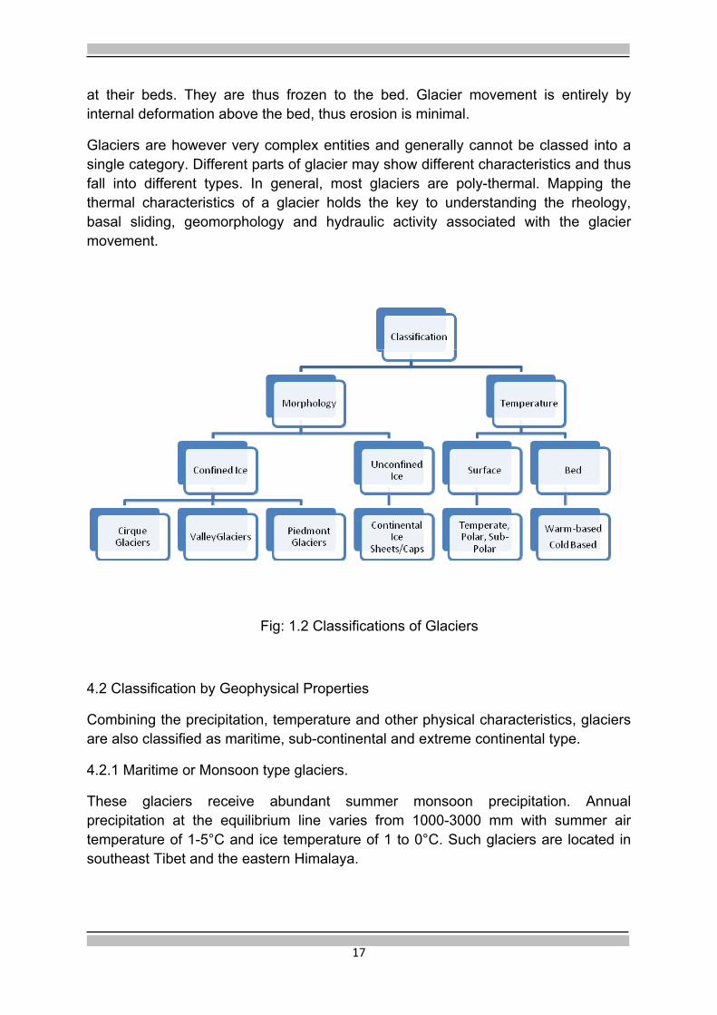
4. Classification of Glaciers
Glaciers are categorized in many ways but principally by their morphology (Fig 1.2) and thermal characteristics. In the morphological classification, there are two main categories, confined and unconfined. Mountain glaciers are confined by topography, Continental glaciers are unconfined. Mountain glaciers that flow down a valley are called valley glaciers. Cirque glaciers are the smallest of mountain glaciers and form in amphitheater like bowls. A piedmont glacier is a valley glacier that spills out into the adjacent flat land.
Unconfined glaciers are usually massive; they can be 1000’s of sq. Km in area and 1000’s of meters thick. Ice sheets, continental in scale (Antarctic and Greenland ice sheets), and ice caps, relatively smaller, are the two sub-categories.
4.1 Classification by Temperature
Glacier temperature is an important factor of the glacial system: melt water, erosion and deposition rates are directly related to thermal characteristics of the glacier, especially of its bed. The three classes of glaciers based on ice surface temperature are temperate, polar and sub-polar. In a temperate glacier, the temperature is at the pressure melting point throughout the entire ice body except for the upper few meters of ice. This layer is subjected to annual temperature fluctuations. A polar glacier is always below the melting point at the surface. These glaciers do not produce any melt water. If they are thin and cold-based, ice movement is minimal. However, as in the case of Antarctic ice sheet, they can be warm-based as well. Sub-polar glaciers warm to the melting point at their surface in summer time and thus produce melt water.
The two classes based on bed temperatures are warm-based and cold-based. Warm-based glaciers are at the pressure melting point at their bed. Heat from the earth and from basal friction provides energy to melt the ice at the bed thus facilitating slip and erosion. Cold-based glaciers are below the pressure melting point

17
at their beds. They are thus frozen to the bed. Glacier movement is entirely by internal deformation above the bed, thus erosion is minimal.
Glaciers are however very complex entities and generally cannot be classed into a single category. Different parts of glacier may show different characteristics and thus fall into different types. In general, most glaciers are poly-thermal. Mapping the thermal characteristics of a glacier holds the key to understanding the rheology, basal sliding, geomorphology and hydraulic activity associated with the glacier movement.
Fig: 1.2 Classifications of Glaciers
4.2 Classification by Geophysical Properties
Combining the precipitation, temperature and other physical characteristics, glaciers are also classified as maritime, sub-continental and extreme continental type.
4.2.1 Maritime or Monsoon type glaciers.
These glaciers receive abundant summer monsoon precipitation. Annual precipitation at the equilibrium line varies from 1000-3000 mm with summer air temperature of 1-5°C and ice temperature of 1 to 0°C. Such glaciers are located in southeast Tibet and the eastern Himalaya.

18
4.2.2 Sub-Continental Glaciers.
Annual precipitation at the equilibrium line varies from 500-1000 mm, annual mean temperature varies from -6°C to -12°C, summer air temperature varies from 0°C to 3°C, and ice temperature at the lower bound of the active layer varies from above -1°C to -10°C. These glaciers are located in the Altay Mountains, Tien Shan Mountains, and the northern slopes of the middle and west Himalaya.
4.2.3. Extreme Continental type Glaciers.
Annual precipitation at the equilibrium line varies from 200 to 500 mm, annual mean air temperature is below -10°C and summer surface ice temperature is below -1°C. These glaciers are located in the middle and west Kunlun Mountains, the east Pamir etc. Indian glaciers lying in the Trans Himalaya could fall in this category.
In the Indian Himalaya, meteorological measurements at higher altitudes are seriously lacking and, therefore, it is difficult to apply the above classification strictly. A popular classification used by Indian glaciologists, based on the precipitation pattern is (Vohra, 1981):
• Dominant monsoon precipitation areas of the eastern Himalaya.
• Equal to sub equal monsoon and winter precipitation- areas of Ganga basin and parts of Himachal Pradesh.
• Dominant winter precipitation, the cold arid areas of Ladakh and Spiti.
In the international literature, the Indian Himalayan glaciers are generally classified as ‘summer accumulation’ type signifying that a major component of accumulation takes place in summer, coincident with the ablation season (Ageta and Higuchi, 1984; Fujita and Ageta, 2000). This classification is largely applicable to glaciers of the eastern Himalaya. For glaciers in the central, west and northwest Himalaya, the accumulation patterns are more varied and complex. It is important to resolve varying accumulation patterns across the Himalayan arc using the available meteorological data of the observational networks and through use of stable isotope techniques to determine a more characterising classification of the Himalayan glaciers based on geophysical properties.
5. Distribution of Glaciers
5.1. World and Regional
Glacier distribution is primarily a function of mean annual air temperature and annual precipitation modified by the local geographical conditions. Latitude and terrain are the major determining factors. Glaciers are thus formed in various locales, from poles to equator, from sea level to the highest mountain ranges, from continental interiors to small oceanic islands depending on suitable combination of meteorological and terrain characteristics. Most of the glaciers found outside the

19
Polar Regions are found in young fold mountains, mountains resulting from collisions between tectonic plates. Glaciers are found in all continents, except the mainland of Australia. Thus, continentality, elevation and latitude determine the spatial distribution of glaciers throughout the world.
90 60 30 0 30 60 90North SouthDegrees
Latitude
0(m)
10002000
30004000
50006000700080009000 HIGHEST SUMMITS
LOWEST SNOWLINE
HIGHEST SNOWLINEH
imala ya
Alaska
Mexico
Ecuador
Argentina
New
Zealand
Chile
Antarctica
Gr ee nla nd
Ellesmere Island
Fig 1.3. Relationship between glaciers and latitude, shown along a line from Alaska to tip of South America (Source: Ives and Barry, 1974).
.
Fig 1.4 Macro regions of existing glaciers (Adapted from Zemp et al., 2008)

20
Glaciers occupy about 10% of the earth's land surface but hold roughly 77% of its fresh water resource; more than 96% of glacier ice lies in the Polar Regions, Antarctica and Greenland. Outside the Polar Regions, the estimated glacier extent is 546 (Dyurgerov and Meier, 2005), the largest cover, about 116 being in the High Mountains of Asia which include ten major glacier-mountain systems. The Himalaya is the dominant range of this system, the major components of which are given in the Table 1.1.
Table.1.1 Some important component mountain systems of High Mountains of Asia (Dyurgerov and Meier, 2005)
Glacier-mountain System
Area (Km2)
Himalaya 33,050 Tibet 1,802 Kun Lun 12,260 Pamirs 12,260 Tien Shan 15,417 Karakoram 16,000
A detailed glacier inventory for the glaciers in Tibet and the other five mountainous regions of China is available (Shi Yafeng, 2008). The total area under glaciers is estimated to be 59,425 Km2 consisting of 46,377 glaciers with mean area per glacier of 1.28 Km2. The number of glaciers in Tibet is estimated to be 22,735 with glacierised area of 29,284 Km2 (Shi Yefang, 2008). Similarly, for India the total area under glacial cover is estimated to be 37,466 Km2 (Raina and Srivastava, 2008). The mismatch between different estimates could arise due to many reasons like the scale and date(s) of maps/imageries used, minimum size (area) of glacier area included and territorial bounds etc. There is an obvious need to research further using the high resolution mapping tools to arrive at up-to-date figures of the glaciated areas.
5.2. Indian Himalaya Glaciers (IHG):
The total spread of the Himalaya lies between Latitudes 250 and 350 N and Longitudes 600 and 1050 E covering an area of 4.6x10⁶ Km2 above 1500 m asl. Out of this, 3.28x10⁶ Km2 lies above 3000 m asl and 0.56x10⁶ Km2 lies above 5400 m asl (Shanker and Srivastava, 2001). In India, the range extends in an arcuate form over a length of about 2500 Km from Pamir (beyond Karakoram Range) in the west to Mishmi Hills in the east with convexity to the south. The width varies between 150 and 400 Km. There are ~14 peaks above 8000 m high and many more over 7000 and 6000 m (Ramakrishnan and Vaidyanathan, 2008). The Himalayan mountain system extends over 12 states in India.

21
Though the main Himalayan range is in India, Nepal and Bhutan, the northern slopes extend into the Tibetan Plateau. Between Tibet in the north and the Indo-Gangetic Plain in the south, the main range can be divided into: Trans Himalaya (Tethys domain-Karakoram range, Ladakh range, Zanskar range, elevation 3K-6k m asl), Great Himalaya (Himadri, elevation 6k-8k m asl), Lesser Himalaya (Pir Panjal, Dhauladhar ranges) and Outer Himalaya (Siwalik, elevation range 100-800 m asl). (Fig 1.5).
Fig 1.5 Mountain ranges and other physical features of India (Adapted from Ramakrishnan and Vaidyanathan, 2008)
This parallel to sub-parallel chain of high mountains has been formed by an intricate matrix of faults, thrusts and folds caused by the collision of the Indian plate with the Asian Plate, initiated ~ 50 Ma, and the resultant orogenic activity. The process of collision is still active and is manifested in various forms of neo-tectonic, geologic and geophysical activities. As the mountain chain gradually rose, glaciers began to emerge on its landscape to eventually become the perennial source of water to the extra peninsular rivers of the Indian subcontinent.

22
The glaciers in the Indian Himalaya have been inventoried on the basis of two first order river basins e.g. the Indus and the Ganga (Kaul,1999; Raina and Srivastava, 2008; Sangewar and Shukla, 2009). These have been further sub-divided up to fifth order basins. On the basis of this inventory, there are 9,575 glaciers in the Indian Himalaya with the Indus Basin having 7,997 (33,679 Km2) and the Ganga Basin, which includes the Brahmaputra basin also, having 1,578 (3,787 Km2) glaciers. The total area under glaciers is estimated to be 37,466 km2.
The glaciers are located in five states namely, Jammu and Kashmir, Himachal Pradesh, Uttarakhand, Sikkim and Arunachal Pradesh. The J & K State has the highest number of glaciers - 3,136 covering nearly 13 % of the State’s territory. Nine per cent of Garhwal Himalaya is covered by 917 glaciers, Sikkim has 450 glaciers spread over 912 km2, Arunachal Pradesh has 162 glaciers covering 228 km2 (Linda, 2008).
Siachin glacier in the Indus basin is the longest glacier (73 Km) having ~542 Km2
area and ~108 Km3 of ice volume. In the Ganga basin, Gangotri glacier is about 30 Km long with an area of ~144 Km2 and ~29 Km3 of ice volume. In the Indus basin, 68% of the glaciers have less than 1 Km2 area; in Ganga and Brahmaputra basins, 42% and 68% of the glaciers respectively have less than 1 Km2 of area. There are 60 glaciers in the Ganga basin, 191 glaciers in the Indus basin and 13 glaciers in the Brahmaputra basin which have area greater than 10 Km2 (Kaul, 1999; Raina and Srivastava, 2008).
The glacier inventory (Kaul, 1999) records the following parameters: coordinates, orientation, elevation (highest elevation, lowest elevation, mean elevation of accumulation area, mean elevation of ablation area, length (maximum length, length of accumulation area, length of ablation area), mean width, area (total-horizontal projection of glacier outline, the accumulation area AC, ablation area, AB), Accumulation Area Ratio (AAR), (ratio of AC to total area), mean depth and volume. However, the Chinese inventory of glaciers contains additional parameters like snow line elevation, snow line accuracy, snow line date, depth accuracy. The first version of the complete Chinese inventory released in digital format in 2002 is already under revision to account for the accelerated glacier dynamics of the last few decades.
A glacier inventory has also been prepared by the Survey of India on 1:1 million scale showing the distribution of glaciers state-wise i.e. J&K and Ladakh Himalaya including Karakoram range, Himachal Pradesh Himalaya, Garhwal and Kumaon Himalaya and Sikkim Himalaya. Kulkarni et al., (1999) have demonstrated the utility of IRS and Landsat satellite imageries (FCC, 1:50,000) for building a glacier inventory and a Glacier Information System for Sutlej Basin which includes the Beas and Spiti sub-basins.

23
Fig 1.6 Glacierised areas of Upper Indus Basin, J&K based on Preliminary Glacier Inventory (Adapted from Kaul, 1999)
The International Centre for Integrated Mountain Development (ICIMOD) in collaboration with its partner institutes has prepared an inventory of glaciers in the Hindukush-Himalayan (HKH) region, including India. Besides the details of glacier parameters on 1:50,000 scale, the inventory also contains information about glacial lakes and potential glacial lake outburst floods (GLOF) (Bajracharya et al., 2006).The inventory is now under revision to take account of the rapid changes that have taken place in the last decade.
The Space Application Centre in collaboration with Ministry of Environment and Forests (SAC, 2010) has recently revised the glacier inventory in the three major river basins of the Himalaya. As per this inventory, there are 32,392 glaciers in the Indus, Ganga and Brahmaputra basins which cover an area of 78,040 sq km.
6. Himalayan Glaciers and Precipitation System
6.1 Precipitation Domains
Glaciers in the Himalaya owe their origin and persistence to the precipitation brought by the Indian Summer Monsoon (ISM) System which forms a major component of the larger Asian Monsoon System. The ISM system (June-September) is rooted in the larger atmospheric phenomenon, the Inter-Tropical Convergence Zone (ITCZ)

24
that arises because of the seasonal temperature and pressure differences in the northern and southern hemispheres. The Indian Ocean, the Western Pacific, the eastern part of the north tropical Pacific and the north tropical Atlantic Ocean participate in a highly complicated pattern of coupled motions, thermal contrasts and interactions leading to the development of the weather systems through exchange of heat and momentum between oceans, atmosphere, land and biosphere (Sikka, 2000).
The temperature gradient between the Indian land mass cum the raised Tibetan Plateau and the surrounding oceans drives the Indian monsoon system. The elevated region acts as a mid tropospheric heat source during the summer and as a heat sink during winter. The winter-spring snow cover over the Himalaya-Tibet massif plays an important role in the genesis/suppression of this thermal contrast. The other important climate forcing is ENSO (El Niño and the Southern Oscillation). Studies have shown a significant simultaneous association between monsoon rainfall over India and ENSO (Krishna Kumar et al., 1999).
The relationship between the Indian summer monsoon and the Himalayan snow cover has been under serious scientific research since Blanford (1884) first suggested the inverse correlation. In recent years numerous studies have re-examined the relationship between Indian summer monsoon rainfall and the snow cover over Himalaya and the larger region i.e. Eurasia (e.g., Hahn and Shukla 1976; Dey and Bhanu Kumar, 1983). These studies have shown that the winter and spring snow cover over western Eurasia (eastern Eurasia) is negatively (positively) correlated to the subsequent summer monsoon. Zhao and Moore (2004) suggest an east-west dipole like pattern in the correlation between snow cover over the Tibetan Plateau and Indian Monsoon which underwent a change of sign around 1985 that is attributed to variability in the Tibetan Plateau Monsoon. Sikka (1999), Das (1999) and Vernekar (1999) present reviews of the influence of Himalayan snow cover on the weather and climate over India with a specific reference to ISM.
The negative correlation between snow and summer monsoon rainfall can be ascribed to: (i) the high albedo due to excessive snow cover reduces the ground temperature during the following spring and summer (ii) a substantial part of solar energy during spring and summer is used in melting of snow cover and evaporating the soil moisture resulting in lesser heating of the surface and lower atmosphere (iii) after the snow has melted, evaporative fluxes come into play and result in forming of clouds. The cloud albedo allows less of solar energy to be available at ground surface for its warming. The net result of all these factors is a reduced land-ocean thermal contrast during excessive snow cover conditions and hence a weaker summer monsoon.
Under the conditions of a normal snow cover, the ocean-land thermal contrast develops and the monsoon wind system is maintained by westward propagation of synoptic scale disturbances generated over the Bay of Bengal and the northward

25
propagation of the oceanic TCZ (Tropical Convergence Zone) from the equatorial Indian Ocean. After the onset of ISM, the latent heat release significantly contributes to maintaining the temperature gradient and the atmospheric weather system.
The propagating monsoon winds advect moisture from the surrounding oceans and transport it land ward. When these humid air masses collide with orographic barriers, heavy convection is initiated that leads to high rainfall amounts in the eastern and the central Himalaya. Studies have revealed two general rainfall gradients in the Himalaya: (1) a decreasing east-west gradient with higher rainfall occurring near the moisture source, the Bay of Bengal and (2) a strong decreasing south-north gradient across the range from its rain drenched southern flank to the semi-arid Tibetan Plateau. The south-north gradient is a consequence of the orographic rainfall, whereby rising topography in the face of prevailing winds causes mechanical lifting of the humid air, cooling of the air column, condensation and precipitation. Heavy precipitation is thus induced on the windward side of the mountain ranges as compared to lee ward side. Some of the highest annual rainfall in the world occurs in the eastern/northeastern regions of India (>5000 mm) while the trans-Himalayan northwest region experiences semi-desert like conditions (<200mm rainfall). The studies of topographic characteristics that modulate rainfall in the Himalaya are important to understand why rainfall becomes spatially focused and causes erosion of mountains (Bookhagen and Burbank, 2006). Some of the highest amount of sediment load is carried by the rivers originating in the Himalayan terrain e.g. Ganga, 329 m/y, Brahamputra, 597 m/y and Indus, 100 m/y (Subramanian, 1993). Because of the high denudation and sediment transfer rates in the monsoon dominated Himalayan terrain, the depositional landforms e.g. the paleo-moraines do not survive more than a few thousand years and hence the difficulty in building the paleo-glacial history (Owen and Sharma, 1998; Barnard et al., 2004).
In the winter months (December-March), the western Himalaya receive precipitation due to the weather systems known as westerly disturbances that originate over Mediterranean Sea/Black Sea/Caspian Sea as extra tropical frontal systems (Hatwar and Yadav, 2005). In these months, these mid-latitude disturbances move to their lowest latitudes and in their pathway travel across the north and central parts of India in a phased manner from west to east, disturbing the normal features of circulation pattern (Yadav et al., 2009) and account for snow in the higher elevations of NW India and winter rainfall in the plains of northern and central India.
The complex precipitation patterns and their interaction with the local geological, topographic and biological systems have produced varied snow climatic zones in the Himalaya (Sharma and Ganju, 2000). Annual winter snowfall varies from 100 to > 1600 cm with the highest snowfall occurring in the Pir Panjal range. Higher ranges receive progressively lesser snowfall (Bhutiyani et al., 2007).
Glaciers in the eastern Himalaya receive most of their precipitation during the summer, SW monsoon months (June-September), coinciding with the melting

26
season. Under the influence of NE monsoon, some precipitation is received in the winter months. The Trans Himalaya experience semi-desert-like conditions. While the ISM is wrenched of most of its moisture in the lower ranges, the westerly disturbance (WD) has limited penetration across the Karakoram Range. This region thus receives small amounts of precipitation in summer, mainly during years of abnormal high monsoon. Most of the precipitation takes place in winter months (November-April) due to the westerly disturbances.
The precipitation gradients caused due to orography, SW monsoon system and westerly disturbances, and their relative importance in bringing moisture to the high peaks of NW Himalaya and Trans Himalaya in the present and in the past, have played an important role in defining the spatial distribution and location of glaciers in the Himalayan terrain and help define a framework for pursuing glacier studies.
6.2 Spatial distribution of glaciers
Depending on the latitude, precipitation pattern and the local climatic gradients, the lowest elevations at which glaciers are found show spatial variations. Glaciers descend to about 3700 m in the eastern Kashmir, 4000 m in the central Himalaya and 4500 m in eastern Nepal and Sikkim (Vohra, 1981). Concentrations of glaciers in the Himalaya occur on high mountain peaks. Some of these are Nanga Parbat, Kolohai, Nun-Kun, the Dibibokri-Chowkhamba-Nanda Devi area, Dhaulagiri-Annapurna-Manasulu area, Everest-Makalu-Kanchenjunga and Namche Barwa areas.
Equilibrium Line Altitude (ELA) marks the lowest elevation at which glaciers can exist; it depicts the regional climatic regime. Its variation over space reflects the combined effect of latitude, precipitation and temperature. On an average, a latitudinal difference of 1° in this terrain leads to 152 m change in ELA (Chaohai et al., 2008).
An attempt has been made to study variations of ELA over the western-eastern Himalayan region using the data available in the glacier inventories of India and Nepal (Karma et al., 2003). Distribution of the estimated ELAs along latitude is shown in Fig. 1.7. The regional disposition of ELAs along the Himalayan range is shown in Fig.1.8. Glaciers at higher latitudes e.g. in Kashmir Himalaya, show lower ELAs than the glaciers at lower latitudes e.g. Garwhal Himalaya. Thus latitudinal position appears to have a dominant effect on the position of ELA. Precipitation and micro climatic factors like aspect, topography and hypsography also have an important influence on the position of the ELA (Sharma and Owen, 1996). Mapping of present and past ELAs is thus an important source of proxy climatic data in mountain regions and allows future response to climate change to be predicted.

27
Fig.1.7 Distribution of the estimated ELAs of glaciers in the Himalaya along Latitude (Adapted from Karma et al., 2003)
7. Summary-Research Issues
The above discussion is summarized in the form of some research issues
• Tectonics and the climate regime, dominated by the south Asian monsoon and the westerlies, their competing and sometimes superposing influences, especially in the north-western and western Himalaya, have determined the spatial and temporal progression of glaciation in the past and present. It is, therefore, important to understand the role of topographic factors that modulate precipitation patterns in the Himalaya focusing it in certain zones, across and along the length of Himalaya? These zones in turn become foci of erosion that supply the sediment load in the out-flowing rivers. Aero- and fluid dynamic forcings need to be evaluated and modeled.
• Is it right to use an omnibus term like the ‘summer accumulation’ to classify the Indian Himalaya glaciers, considering the variability and complexity of precipitation patterns along the Himalayan arc?. Or is the empirical tripartite classification of Vohra (1981) adequate? At this stage when meteorological data from the high altitude observatory network is available, it will be useful to map the precipitation patterns, the sources of moisture, their variability, along and across the Himalaya, and arrive at a more characterising classification of the Himalayan glaciers based on geophysical parameters.
• What is the influence (direct and indirect) of snow cover on the Tibetan Plateau and Northwest Himalaya on the monsoon regime? What are the feedback mechanisms that come into play? In effect, is the Himalaya getting affected by climate change or is the Himalaya also causing climate change?
• What is the regional pattern of ELA distribution along the Himalaya? How do these variations reflect the geographic/climatic controls?

28
Fig 1.8 Regional disposition of ELAs in the Himalaya (Adapted from Chaohai et al., 2008)

29
Chapter 2
Past Climate Changes and Quaternary Glaciation
1. Introduction
The subject of climate has been of abiding interest and enquiry because of its all encompassing influence on the environment and societal development. It is no surprise, therefore, that the most recent episode of climate change, (beginning with industrial age) attributed to increase in GHG concentrations in the atmosphere due to anthropogenic activities (IPCC, 2007a), has become a subject of intense scientific research and global debate. While the extent, magnitude, causes and impact of this phenomenon on the cryosphere, especially on the Himalayan glaciers, is under close scrutiny and assessment (IPCC, 2007c; Schiermeier, 2010; Bagla, 2009; Cogley, 2010), there is a good measure of consensus on the occurrence of historic and geological oscillations in the global climate and their impact on the earth’s ice cover. One such reconstruction of the past climate is given in figure 2.1 (Barnola et al., 1987).
Fig. 2.1. Reconstruction of climate over the last 400,000 years from the Vostok ice core, Antarctica. The three arrows on the central panel, left to right, indicate the pre-industrial level of CO2, Last Glacial Maximum and Previous Interglacial respectively. (Source: http://en.wikipedia.org/wiki/File:vostok.Petit.data.svg downloaded on 10.06.11)

30
Note the high CO2 concentration during the previous inter-glacial period, the low concentration during the LGM and the rise in CO2 concentration at the start of the present interglacial period and the dramatic increase due to industrial activity. It may be noted that prior to the industrial age, the rise and fall in CO2 levels are attributed to natural variations in biogeochemical regimes existing in those times.
2. Long–term Variations
Long period variations in the climate and the glacial history of the earth during the last couple of million years can be attributed to the changes in the earth’s orbital parameters, the Milankovitch periodicities of 100,000 (eccentricity), 41,000 (axial tilt) and 23,000 (precession) years. They essentially result from changes in the solar insolation. Superimposed on these orbital induced fluctuations, long-term climatic changes have also been attributed to changes in thermohaline circulation of the ocean, which will influence atmospheric circulation on a global scale. Higher loading of volcanic aerosols in the atmosphere for the last few thousand years at least, and possibly even earlier during Holocene, would also be an important contributing factor towards changes in the solar insolation. Overall, changes in the earth’s orbit relative to sun, have been the dominant factor controlling the mountain climates over the last million years reflected in the longer glacial cycles (100,000 years’) and much shorter, ~ 10,000 years’ long inter-glacials (Turner et al., 2009). Coherent behavior of glaciers across the globe over the multi-centennial and multi-millennial scale reflects the climate variations due to these natural forcings.
Orbitally driven long-term cycles are superimposed by short-term events, centennial to millennial scale, and are well represented in the ice cores (GRIP members, 1993), marine (Bond et al., 1992) and continental records (Juyal et al., 2009). These events are also intrinsically driven by variations in solar output which influences changes in the nature of North Atlantic Oscillation that in turn affects the pattern and timing of the Asian Monsoon (Gupta et al., 2003; Anderson et al., 2002). Analysis of Holocene glacier fluctuations across the globe have also shown that glaciers advanced during the Younger Dryas, reduced in size in the early to mid Holocene, re-advanced during neo-glacial i.e. after 6 ka BP, and there is contemporary retreat (Solomonia et al., 2008). Several advances, especially in the Alps, cluster around 8.2 Ka which were triggered by the changes in the thermohaline circulation and subsequent cooling. This event has received much attention and it is important to track it in the Himalaya to constrain its climatic effect and project similar events in the future. Study of these past natural variations provides the important background against which the contemporary variations, containing a component of anthropogenic influences, can be assessed for additional causes, and sets out the basis for predicting the future response of glaciers.

31
3. The Quaternary Period
The last and perhaps the most important in this series is the Quaternary Period that commenced about 2.6 million years ago (previously placed at 1.8-2.0 million years). Quaternary is considered to be the period of Ice Ages interspersed by warmer climates. During this period there was a significant increase in the ice cover over the earth’s surface by up to 30%, lowering the snow line in mid-latitudes by up to 1Km and lowering of sea level by over 100 m (Singhvi and Kale, 2009). The last Ice Age culminated 21,500-18,000 years ago with the Last Glacial Maximum (LGM). Since then it has been the inter-glacial, a period of general warming, though short-term cooling excursions have intervened, for example the Younger Dryas cooling during the period 12,800-11,500 years B.P and an early Holocene cooling at 8.2 Ka. Beginning around ~ mid Holocene, a series of glacier advances and retreats took place culminating in the Little Ice Age (LIA) which extended from 14th to 19th centuries (Grove, 1988). Collectively these are termed as ‘neo-glaciation’.
In contrast to the earlier view of four Ice Ages, the present view is that about fifty ice ages and an equal number of intervening warm periods (the interglacial periods) have occurred during the Quaternary (Singhvi and Kale, 2009). This high-resolution differentiation of glacial-inter-glacial periods is derived from the 18O/16O isotopic ratios in the Foraminifera microfossils contained in the sediments of deep oceans. On land, however, especially in the Himalaya, reconstructing the history of Quaternary glaciations and its climatic implications is constrained by the high denudation rates caused due high seismicity and intense monsoon activity (Barnard et al., 2004). Further, due to the intrinsic limitations of the chronometric techniques (time-resolution and accuracy), only 4-5 glacial and an equal number of inter-glacial stages have been resolved (Owen et al., 2008).
Instrumental meteorological records, especially in the high mountainous terrains, are short and limited and, therefore, do not capture all the modes of climate variability. To obtain a perspective of the climate variability over longer periods, resort is taken to different proxy records of the past climate. Glacier moraines, ice cores, sea bed cores, lake sediments, bog sediments, tree cores, tree microfossils and documentary records are all useful proxies with different time resolutions and complementary range of applications (Beniston et al., 1997). The common practice, therefore, is to try out more than one proxy and look for convergence of evidence.
Past ice marginal positions are recorded by moraines and trim lines on valley walls. In ideal situations it may be possible to identify a series of overlapping or nested moraines representing former glacier positions. More commonly, the most recent advance obliterates evidences of older, less extensive advances, leaving an incomplete geomorphic record. However, in many cases temporal reduction in the ice volume of valley glacier leaves behind spectacular trails of lateral moraines (Pant et al., 2006).

32
Fig 2.2 Photograph showing lateral moraines of stages I-III depicting the successive decrease in ice volume (Source: Pant et al., 2006).
Conventionally, chronology of glaciation relied upon radiocarbon dating of organic carbon. However, due to paucity of organic carbon, it had limited applications. In addition to this, sedimentary evidences of past glaciation are generally discontinuous both temporally and spatially. Glacial fed lakes which register the growth and recession of glaciers through increase in silt load input provide more continuous and sometimes annually laminated records of the climate variability caused due to minor changes in glacier dynamics. Pollen and other microfossils in lake sediments or in high altitude peat bogs can be interpreted in terms of former tree-line movements caused due to the expansion and contraction of valley glaciers.
Glacier ice cores provide invaluable information about the paleo-environment. Studies on deep cores in Antarctica, for example, have revealed climatic history of Antarctica up to the last 800 Ka indicating a high degree of responsiveness of the ice sheet to orbitally induced insolation patterns and a close association between atmospheric GHG and temperature (Turner et al., 2009). On mountain glaciers, five high-altitude sites have so far yielded deep ice cores - Queleccaya and Huascaran in Peru, and Dunde, Guliya and Dusapu in Western China. Because of the high accumulation rate on mountain ice caps, high-elevation ice cores can provide high resolution record of recent past, with considerable detail on how climate has varied over the last 1000-2000 years. (Thompson, 1991; Duan et al., 2006)

33
3.1. Late Quaternary Glaciation in the Himalaya
The nature and dynamics of late Quaternary glaciation in the monsoon dominated Indian Himalaya are poorly understood due to paucity of well preserved glacial moraines and other geologic proxies. Rapid rates of erosion and re-sedimentation result in the reworking of the old moraines in a few thousand years. There is the additional difficulty of differentiating the landforms that may be of either glacial or mass movement origin (Owen et al., 2008). The relatively drier Trans-Himalaya, provide a better opportunity to preserve and reconstruct the history of past glaciations through study of moraine stratigraphy (Owen et al., 2006). Hence the oldest record of glaciation in the Himalaya, ~ 430 Ka, has been recorded in the glacial moraines from Ladakh (Owen et al., 2006).
Several attempts have been made to build a chronological history of glaciation in the Himalaya - Tibetan orogen (Owen, 2008). Due to the high altitude and wide expanse, the Himalaya-Tibet system has exerted a profound influence on the regional and global weather and climate systems and thus serves as a natural laboratory for studying the tectonics-climate interactions in a glaciated environment. A key requirement is to date and map the past glacial extents and resolve the time and space relationships. Recent developments in numerical dating techniques are making it feasible. A major difficulty in using the conventional radiocarbon methods on glacial terrains is the non-availability of adequate datable organic carbon. Development of accelerator mass spectrometry (AMS) technique helps to overcome this limitation. In AMS radiocarbon dating, it is possible to measure high precision ages on small (~ few mg) samples by measuring the concentration of C14 directly without waiting for its decay. Short half life of C14 limits its use only up to 40 Ka. Also, there is danger of contamination by the mixing of modern carbon that could give erroneous ages.
Development of numerical dating techniques, such as AMS, Optically Stimulated Luminescence (OSL) and Terrestrial Cosmogenic Nuclide (TCN) surface exposure dating have made possible to overcome the limitations posed by the conventional radio carbon dating techniques. New insights into the past glacial history in the Himalaya have begun to emerge through application of these new chronometric techniques. As a result, an assessment of relative timing of glacial cycles in different segments of Himalaya is becoming feasible. Experience has shown that defining ages of moraines based on relative weathering, soils and/or other proxy data for stratigraphic control / correlation could lead to grossly wrong estimates (Owen et al., 2006). The imperative need of quantitative chronometric measurements in the Himalaya thus cannot be overstressed.
Three regions in the Indian Himalaya, namely Ladakh Himalaya (Owen et al., 2006), Lahaul Himalaya (Owen et al., 2001) and Garhwal Himalaya (Sharma and Owen, 1996) have been studied in some detail to build the history of glacial succession

34
based on the quantitative chronometric study of moraines. The succession developed through these studies for the three regions is compared in the Table 2.1.
MIS Age, ca Ka
Stage Region/Glacial Stage/Glacial Advance
Ladakh Himalaya
Lahaul Himalaya
Garwhal Himalaya
6 Late Holocene
Sonapani I (Historical),LIA
Bhujbas Advance,
LIA
9 Mid Holocene Sonapani II Shivling Advance
MIS 1 11.5 Early Holocene
Khalling Kulti
(11.5-10 Ka)
MIS 2 25 Batal
(15.5-12 Ka)
MIS 3 60 Chandra? (No Age)
MIS 4 100 Bazgo
(74-41Ka)
Bhagirathi Stage
MIS 5 115 Kar
MIS 6 130-200 Leh
>MIS 6
Pleistocene Indus Valley
>430 Ka
Table 2.1 Correlation of glacial history across Ladakh, western and central Himalaya
3.1.1. Trans Himalaya, Ladakh
Building on the available glacial-geological framework, Owen et al. (2006) have tried to construct a quantitative chronology of glaciations in Ladakh using the cosmogenic nuclide concentrations of 10Be, rigorously applying the various corrections for the erosion rates, changes in the paleo-magnetic field and the scaling factors. The following five glacial stages have been identified:
Khalling Glacial Stage Early Holocene,
Bazgo Glacial Stage ca 74-41 Ka, the middle part of the last glacial cycle, MIS3/4
Kar Glacial Stage ca 115 Ka, MIS 5
Leh Glacial stage ca 200-130 Ka, MIS 6
Indus Valley Glacial Stage >430 Ka

35
The extent of glaciation decreased successively over the five glacial cycles, possibly due to the progressive rise of the Himalayan ranges in the south and/or Karakoram mountains to the west, blocking the penetration of the moisture laden monsoon winds and westerlies, respectively. Alternatively, this pattern of glaciation may reflect a trend of progressively less extensive glaciation in mountain regions observed globally through Pleistocene (Owen et al., 2008)
Glacial cycles corresponding to Marine Isotopic Stage-3/4 (MIS 3/4) and early Holocene have been identified in other regions of Himalaya also, suggesting that they were regional in nature. However, the extent of glaciation in Ladakh during the penultimate and last glacial cycles has been comparatively less extensive than the extent of Local Last Glacial Maximum (LGM) defined for other regions in the Himalaya e.g. Garhwal, which are influenced by monsoon; implying that there exist strong topographic and climatic gradients that have controlled the style, extent and preservation of glaciation.
Based on the geomorphology and sedimentary field studies on Quaternary deposits in Ladakh and Karakoram Himalaya, Pant et al. (2005) conclude that the area was extensively glaciated during the Quaternary period. Evidence for at least two glacial advances, the major one during MIS 4, and a less extensive advance, during LGM, has been advanced. However, there are no absolute dates to support the inferences. Ganjoo and Kaul (2009) based on the OSL dating of a moraine located 300-500 m south of the present day Siachin glacier snout, suggested that the glacier was 15-20 m higher than present during the mid-Holocene. More recently, Dortch et al. (2010) have ascertained three major events of glaciations in Nubra and Shyok valleys. These events have been dated using the exposure age dating methods. From younger to older these are Deskit 1 (45 Ka), Deskit 2 (81 Ka), and Deskit 3 (144Ka).
3.1.2. Lahaul Himalaya, (Himachal Pradesh, Western Himalaya)
The region lies at the junction of the monsoon- influenced Pir Panjal Mountains of the Lesser Himalaya and the semi-arid mountains of the Trans-Himalaya. The region receives most of its precipitation as winter snow fall due to the mid-latitude westerlies. Little precipitation falls due to the summer monsoon as the moisture carrying winds are blocked by the Pir Panjal range, except for in the years of exceptionally strong monsoon.
Owen et al. (2001) have ascertained the timing of glaciations in the Lahaul Himalaya using the concentrations of cosmogenic 10Be and 26Al from boulders on moraines and drumlins. Five glacial stages were identified. Cosmogenic ages were obtained on samples representative of the Batal and Kulti glacial cycles. Stratigraphic relationships indicate that Sonapani I and II are younger. No age was obtained for Chandra glacial stage. The stratigraphic relationship is as follows:

36
Sonapani II Historical
Sonapani I Mid Holocene
Kulti Stage 11.4-10 Ka Early Holocene
Batal Stage 15.5-12 Ka-Late glacial Interstadial
Chandra Stage No age
The Late Glacial to early Holocene Batal and Kulti stages, have been attributed to periods of greater insolation and consequent strengthened summer monsoon which extended its influence further north and west than at present, influencing up to west Tibet. The resulting enhancement in summer snowfall at high altitude presumably resulted in positive mass balance and caused glaciers to advance. Thus, there is a positive correlation of the observed glaciations in the Lahaul Himalaya with the intensity of South Asian summer monsoon. This leads them to speculate that in some parts of Himalaya glaciers may grow initially as the monsoon gets intensified due to green house warming. However, this contention does not match with the contemporary meteorological data and glacier field observations.
3.1.3. NW Garhwal, Central Himalaya
Based on morpho-stratigraphy of glaciogenic sediments and multi-parameter relative dating methods supplemented by OSL dating, one major Pleistocene glaciation viz, the Bhagirathi Glacial Stage and two Holocene glacial advances viz, the Shivling and the Bhujbas Glacial Advances have been recognized (Sharma and Owen, 1996.) The following glacial stratigraphy has been determined:
Bhujbas Glacial Advance 300-200 B.P
Shivling Glacial Advance < 5 Ka BP
Bhagirathi Glacial Stage 63-5 Ka BP
The Bhagirathi Stage is represented by extensive glaciation down the Bhagirathi valley up to Jhala, about 40.5 Km from the present position of the snout. OSL dates constrain the Bhagirathi Stage to 63 Ka and 5 Ka BP. The maximum extent of glaciation occurred at ca 63 ka BP, in contrast to the Northern Hemisphere glaciation which peaked during the Last Glacial Maximum (18-21 Ka BP). ELA depression during this Stage was estimated to be around 640 m. The Shivling advance is timed around mid to late Holocene with glaciers extending up to 5 Km beyond the present snout. ELA was depressed by about 60 m. The Bhujbas Advance correlates with the Little Ice Age, glaciers extended up to 2.2 Km from the present snout with ELA depression of about 30m.
Nainwal et al. (2007) have attempted to reconstruct the late Quaternary glaciation history in the Upper Alaknanda Basin based on the study of lateral moraines and

37
other relict periglacial features. Three glacial advances, Alaknanda (Stage I), Alkapuri (Stage II) and Satopanth (Stage III) have been recognized on the basis of geomorphologic mapping and limited OSL dating of the moraine succession. Stage I, predates LGM and was the most extensive. Stage II is coincident with LGM where as the recessional moraine associated with LGM was dated to 12 Ka and Stage III is dated at 4.5 Ka. A moraine deposit close to the present day snout has been correlated with LIA.
Studies in the Shalang basin in the higher central Himalaya (Pant et al., 2006) have again shown evidence of three stage glaciation in the Quaternary. Luminescence dating of glaciogenic sediments suggests that the oldest Stage 1 corresponds to MIS 4, whereas Stages II and III are assigned MIS-2 and LIA, respectively. Past ELAs corresponding to the three glacial stages indicate ELA depression of 600m (Stage I), 300m (Stage II) and 200m (Stage III) as compared to the present ELA at 4700m. Juyal et al. (2011) compare the glacial advances in the central Himalaya during the Late Quaternary
Studies on other proxies like lake sediments, peat bog deposits, tree rings, stalagmites, sometimes supported by date measurements have helped to resolve cold and warm/wet periods over different parts of the Himalaya (e.g. Mazari et al., (1996); Phadatare (2000); Chauhan et al., (2000), Chauhan (2006); Chakraoborty et al., (2007); Bhattacharya et al., (2006); Sinha et al., (2005); Juyal et al., (2004, 2009). Chamyal and Juyal (2008) developed a synthesis of monsoon variability in the late Quaternary from multi-proxy studies in different parts of India.
4. Discussion
Considering the vastness of the Indian Himalayan region, the available numerical chronological data generated by OSL and CRN surface exposure dating of moraines and their associated landforms is very limited. Thus, there are severe limitations in building a reliable account of the extent of glaciation during the several cycles of glaciation during the Quaternary. A few points emerge from the available data:
• The earliest records of glaciation in the Himalaya are found in the Trans Himalaya Ladakh, ~430 Ka. Other parts of the Himalaya, western and central, have not preserved the remnants of glaciations older than the last glacial cycle, probably due to the dominating influence of the monsoon regime and rapid rates of denudation.
• Glacial maxima in Ladakh, Garhwal and Lahaul Himalaya precede the Northern Hemisphere maximum i.e. the LGM, the period between 21.5 and 18 Ka. The limited chronological data from Indian Himalaya suggests that maximum valley glaciation occurred during the early part of the last glacial cycle, i.e. coincident with MIS-4/3 transition. The increased ice cover is attributed to the increased insolation and the resulting strengthened South

38
Asian summer monsoon that could penetrate further north and west in the Himalaya.
• In contrast, during the LGM, lower insolation produced weaker monsoons. The modest advances that took place during this period are attributed to reduced temperatures.
• The correlation of increased insolation with enhanced monsoon strength, however, needs independent validation. Contrary views have also been expressed which state that increase in cloudiness and the resultant decrease in incoming shortwave radiation have been responsible for lowering of temperature and build up of glaciers.
• Following the local glacial maximums, the subsequent stages and advances have successively produced glaciation of decreasing extents. This is probably caused by the rapid tectonic rise of the Himalaya - Pir Panjal and Karakoram ranges in particular, blocking/limiting the northward and eastward influence of monsoon and westerly disturbances respectively. Alternatively, this may reflect a trend of progressively less extensive glaciation in the Himalaya through the Pleistocene, as shown by many mountain regions in the world.
• Glacial advances have occurred during early and mid-Holocene in Lahaul and Garhwal Himalaya. In Ladakh Himalaya a glacial moraine has given an OSL age of mid-Holocene (~5000 yrs). A recent study suggests that glacier ice from Siachin glacier was flowing westward in the Shyok valley towards the Nubra-Shyok confluence around 145 ka. This would imply that the entire (~70 km long) Nubra valley was covered with valley glacier during this period.
• Advances during LIA are recorded in Lahaul and Garwhal Himalaya. However, direct dating of the LIA moraines in Himalaya is still elusive.
• Estimation of past ELAs, their comparison with the current ELAs in Himalaya show possibilities of parameterizing the local climate in terms of the existing temperature and precipitation regimes.
• There is a degree of synchronicity in glaciation across the Indian Himalaya modulated by local climatic and topographic gradients. The extent and intensity of glaciation is more dominant in the monsoon influenced central Himalaya than the western and Trans Himalaya which receive the major part of snow precipitation due to the westerly disturbances in the winter.
5. The Regional Perspective
Late Quaternary glaciation in the Tibetan Plateau and the neighboring regions of Karakoram and West China mountain ranges has long attracted the attention of the international scientific community. The region has exerted a strong influence on the evolution and development of the regional/global climate regime and on the onset and evolution of glaciation in the region. Understanding of the past glacial history is thus likely to provide important leads for unraveling the underlying processes that have shaped the past and present climatic scenarios, thus providing a basis on which prognostic climate models can be formulated. These efforts have resulted in
39
generating a measure of understanding on the extent and timing of the different glacial cycles. The present understanding is based on the strength of quantitative chronological measurements using OSL and CRN dating methods. As of now more than 800 TCN surface exposure ages are published for the Himalayan-Tibet orogen. About 100 luminescence and another 100 radiocarbon ages for glacial deposits and land forms are available. Reviews and consolidation of the available data are provided by Owen, (2008), Owen et al., (2008) and Owen et al., (2002). Barring Karakoram, the overall picture is strikingly similar to the characteristics of the glacial history in the Indian Himalaya. The main points are:
Fig 2.3. Summary of late Quaternary glaciation in the Himalaya (Source: Juyal et al., 2011)
• Significant glaciation took place between 60 and 30 Ka. Glacial advances occurred during early to middle Holocene. Glaciation was much less significant during the LGM. (Fig 2.3). Glaciation in the Himalaya-Tibet orogen has been modulated largely by the temporal and spatial variability of the South Asian Monsoon.
• The extent of glaciation between adjacent regions can vary considerably. These contrasts in the extent of glaciation within short distances highlight the importance of local climate gradients and topographic controls. The history of glacial advances in the late Holocene and neo-glaciation and LIA is complex. The extent and ELA depressions were limited and field evidences have still to be scouted for generating a cohesive chronometric history of the region.
• In Tibet, the fluctuation of Holocene glaciation can be divided into three main stages. Slow regression stage at early Holocene (10,000-8,000 a BP), a quick regression stage at middle Holocene (8000-3000 a BP) and frequent

40
advances and regressions in late Holocene i.e. the Neo-glaciation (3000-0 a BP). Three great advances have been recognized in the Neo-glaciation on the basis of radiocarbon ages (Ben-xing and Shi Ya feng, 2008).
6. Future Challenges
It is apparent from the above discussion that Himalaya-Tibet orogen provides a special challenge for deciphering the past glacial and climatic history. The challenges relate not only to difficulties of access but also about finding reliable signatures of relict glaciation and building the time lines using the modern numerical chronometric techniques. In spite of these constraints, a database of some 1000 dates has been created and some useful insights into the glacier fluctuations during the last ~ 100 ka have emerged. The striking feature has been the indication of a coherent synchronous response across the different domains of Himalaya, signifying a long wavelength input signal modulated by the local physiographic gradients. This is perhaps to be expected as input climatic fluctuations in the past of multi-centennial-millennial scale can be ascribed to natural causes which would have long spatial wavelengths. The scientific challenge is to
• deconvolve the regional to local scale effects from the measured composite response
• isolate the recent anthropogenic induced signatures of change and • build a link between past and historical glacier variations.
For this purpose detailed geomorphologic mapping of the landforms that were created due to the glacier advance and retreat in different segments of the Himalayan terrain extending from NW-NE is required. Use of high resolution chronometric techniques would be essential to isolate the short and long period signals. More than one method may have to be used to achieve the required resolution and accuracy. The history of glacial advances in the late Holocene, neo-glaciation and LIA is complex. The extent and ELA depressions were limited and field evidences have still to be scouted for generating a cohesive chronometric history of the region.
The geomorphic signatures have to be translated into ELA fluctuations which can be modeled in terms of climatic parameters and mass balance fluctuations. Numerical techniques enable modelling of glacier mass balance and corresponding dynamics with a rather well defined climate forcing (Steiner et al., 2005). This will pave the way for relating the past and historical glacier fluctuations to variability in the primary features of ocean-atmosphere circulation and predicting the size, distribution and nature of glaciers in the future.

41
The major issues that deserve attention are:
• Mapping the spatial extent and marking the time relationship of past episodes of glaciations in the different climatological domains of Himalaya i.e. the semi-arid northwest, the west, central and eastern Himalaya.
• Recognising the different glacial events like the Younger Dryas, 8.2 Ka cooling, Neo-glaciation and the Little Ice Age, their correlation with monsoon fluctuations.
• Limitations-accuracy/resolution of chronometric measurements-explains the limited understanding/resolution of the glacial history since 5Ka. How do we compare OSL and CRN dates?
• Relative stratigraphic based correlations - danger in extending such correlations over extended areas.
• The importance and limitations of radiocarbon ages. • Comparison of ages with two different methods. • Characterising the role of intrinsic climate variability on glacier variations. • Relating glacial events, advances and retreats to climatic fluctuations and the
forcing functions thereof.
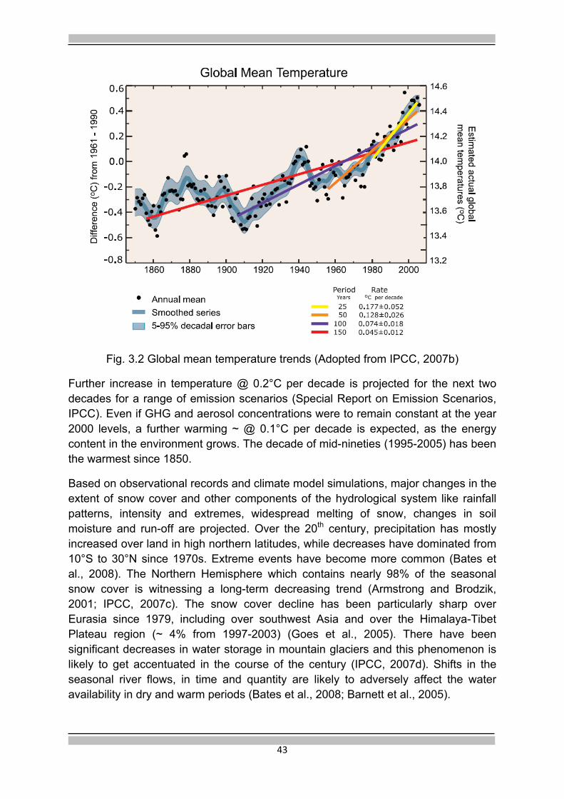
42
Chapter 3
Climate Change and Himalaya
1. Climate Change-Global Context
Propelled by some incontrovertible evidence/ data produced by IPCC reports, it is now generally agreed that the climate system has been warming since about 1750 (post industrialization era), primarily due to increase in the concentration of green house gases (GHG) in the atmosphere. The atmospheric concentrations of CO2 (379 ppm) and CH4 (1774 ppb) in 2005 far exceed the natural range over the last 6,50,000 years.
The increase in GHG concentrations over the pre-industrial time is very likely attributed to anthropogenic activities i.e. burning of fossil fuels, land use changes and agricultural activity. There is very high confidence that the net effect of human activities since 1750 has been one of warming (IPCC, 2007a, b).
Fig 3.1 Atmospheric concentration of important long-lived green house gases over the last 2000 years (Adapted from IPCC, 2007 b)
The linear trend of increase in global average near-surface air temperature has risen to 0.74°C /100years for the period (1906-2005) as compared to the corresponding trend of 0.6°C/100 years for the period (1901-2000). The temperature increase has been particularly sharp in the last fifty years with an added acceleration during the last three decades and signs of a climate shift around 1978 (Fig. 3.2).

43
Fig. 3.2 Global mean temperature trends (Adopted from IPCC, 2007b)
Further increase in temperature @ 0.2°C per decade is projected for the next two decades for a range of emission scenarios (Special Report on Emission Scenarios, IPCC). Even if GHG and aerosol concentrations were to remain constant at the year 2000 levels, a further warming ~ @ 0.1°C per decade is expected, as the energy content in the environment grows. The decade of mid-nineties (1995-2005) has been the warmest since 1850.
Based on observational records and climate model simulations, major changes in the extent of snow cover and other components of the hydrological system like rainfall patterns, intensity and extremes, widespread melting of snow, changes in soil moisture and run-off are projected. Over the 20th century, precipitation has mostly increased over land in high northern latitudes, while decreases have dominated from 10°S to 30°N since 1970s. Extreme events have become more common (Bates et al., 2008). The Northern Hemisphere which contains nearly 98% of the seasonal snow cover is witnessing a long-term decreasing trend (Armstrong and Brodzik, 2001; IPCC, 2007c). The snow cover decline has been particularly sharp over Eurasia since 1979, including over southwest Asia and over the Himalaya-Tibet Plateau region (~ 4% from 1997-2003) (Goes et al., 2005). There have been significant decreases in water storage in mountain glaciers and this phenomenon is likely to get accentuated in the course of the century (IPCC, 2007d). Shifts in the seasonal river flows, in time and quantity are likely to adversely affect the water availability in dry and warm periods (Bates et al., 2008; Barnett et al., 2005).

44
It is now accepted that the rate of temperature rise increases with elevation (Beniston et al., 1997; Liu and Chen, 2000), making mountain ranges and raised plateaus especially vulnerable to effects of global warming. In fact, mountains and raised plateaus have shown two to three times of the average rise in temperatures (Fig. 3.3).
Fig. 3.3. Yearly-mean surface temperature anomalies averaged for eight high-elevation sites in the Swiss Alps, ranging in altitude from 569 m to 2500 m above sea level. The change in global mean temperature anomalies is given for comparison purposes. Data have been smoothed with a five-year filter (Adapted from Beniston et al., 1997).
2. Regional Scenario
While the evidence of climate warming and its impact at the global scale are generally accepted and a measure of understanding of the cause-effect relationship is emerging through Global Circulation Models (GCM), the nature and extent of specific regional changes are uncertain (IPCC, 2007 b). The study of these changes at the regional scale requires high resolution data and corresponding modelling capabilities through downscaling of GCMs to Limited Area Models. In the Himalayan mountain range, part of the larger HKH complex, extreme topographic reliefs exist. The raised Tibetan plateau (average elevation~ 4 Km asl), plays a significant role in modulating the local, regional and global climate gradients. The observational data on this terrain is sparse. Liu and Chen (2000) have examined the available data for 97 stations, above 2000 m asl, from the mid 1930/1950s and conclude that compared with the Northern Hemisphere and global average, the warming of the Tibetan Plateau (TP) occurred earlier (since the mid fifties). The linear rates of temperature increase over TP during the period 1955-1996 are 0.16°C per decade for the annual mean and 0.32°C per decade for the winter mean, which much exceed the Northern Hemisphere and global trends. Further, they also report a

45
tendency for the warming to increase with elevation in TP. TP is one of the most sensitive areas to respond to global climate change (Fig. 3.4).
High resolution ice core studies from Dasuopu glacier (28° 23´N 85° 43´E) in Tibet reveal large-scale plateau–wide 20th century warming that appears to be amplified with elevation (Qiu, 2008; Thompson et al., 2000). Snowfall precipitation has decreased nearly by 500 mm during the period 1920-1995 (Duan et al., 2006).
Fig. 3.4. Dependence of warming on elevation on the Tibetan Plateau (Adapted from Liu and Chen, 2000)
In Nepal, the temperature rise during the period 1977-2000 has been @ 0.6°C/ decade, many times higher than the global average (Shreshta et al., 1999) with indications of temperature rise increasing with elevation. Similarly, there are reports of anomalous temperature increase (0.77±0.16°C/40 yrs) in North West China (Shangguan et al., 2009). Accelerated formation of glacial lakes in Bhutan and Nepal due to the shrinkage of glaciers is well documented (e.g. Bajracharya et al., 2006).
3. Climate Trends in NW Himalaya
Meteorological data in India are mostly collected by the India Meteorological Department (IMD) from observatories located at different altitudes. The meteorological variations at the high altitude are not fully captured in this data base. However, a long time series of data exists from these observatories which lends to some useful deductions of trends.
Goswami et al. (2006) and Dash et al. (2009) have recently examined the changes in the characteristics of the rainfall events in India. While the seasonal mean rainfall

46
does not show a significant trend, Goswami et al. (2006) showed a significant rising trend in the frequency and magnitude of extreme rain events and decreasing trend in the frequency of moderate events over central India during the monsoon seasons from 1951-2000. Dash et al. (2009) in a more comprehensive analysis over the entire country discern changes in the frequencies of different categories of rain events suggesting weakening of the summer monsoon circulation over India.
The temperature data over India (Fig. 3.5) shows some clear trends. Based on IMD network data, Kothawale and Rupa Kumar (2005) have reported on the recent changes in surface temperature trends over India. Using an updated data set up to 2003, they determine:
• A significant warming trend of 0.05°C/decade during the period 1901-2003. This is mainly contributed by significant increase of annual maximum temperature (0.07°C/decade) while the annual mean temperature remains trendless.
• The period 1971-2003 has seen a relatively accelerated warming of 0.22°C/decade, which is contributed by both maximum and minimum temperatures leaving the diurnal temperature range (DTR) almost trendless.
• Dividing the country into seven homogeneous regions i.e. western Himalaya, northwest, north central, northeast, west coast, east coast and interior peninsula, season-wise trend analysis of maximum and minimum temperatures has been carried out. The western Himalaya shows the highest increasing trend (0.84°C/10yr, significant at 5% level) in the maximum temperature for the winter months (DJF) during for the period 1971-2003.
• There is a surge of temperature rise in the last decade.
Over the last 30 years, high altitude meteorological observatories have been established by SASE in the NW Himalaya under the Mountain Meteorology programme. At present the network consists of about 60 surface observatories and 3 upper air stations spread over the western Himalayan region (Shekhar et al., 2010). These data in combination with the data from IMD network are helping to elucidate some recent climatic trends in the higher reaches of the Himalaya (Bhutiyani et al., 2007, 2009; Shekhar et al., 2010; Dimri and Dash, 2010).
Bhutiyani et al., (2007, 2009) have analysed the data from 7 stations of SASE spread in Himachal Pradesh and J&K and the three stations of IMD i.e. Srinagar, Leh and Shimla. The data time series for IMD stations are close to 100 y ears long

47
Fig: 3.5. Long-term trends of mean annual temperature anomalies over India during 1901-2008. (Downloaded from a presentation by D.G., IMD on ‘Climate Change Science’ from the web site of MoEF)
while for SASE observatories the data length varies from 16 years to 22 years. They conclude the following:
• There is a rise of about 1.7°C for the entire country in the last century (1901-1999).
• Warming shows a sharp rising trend around mid sixties with acceleration in the last two decades.
• The gross rise in mean air temperature in the NW Himalaya in the last two decades is about 2.2°C.
• The diurnal temperature range has shown a significant increasing trend with both maximum and minimum temperatures rising with maximum temperatures increasing more rapidly.
• The duration of winter has progressively reduced by 5-6 days per decade and approximately by about two weeks in three decades. Consequently, the amount of snowfall in winters has reduced.
• A larger proportion of winter precipitation now falls as rain instead of snow.
Shekhar et al. (2010) have analysed the data on parameters like maximum, minimum and mean temperature, snowfall, cloudiness, snowfall days and WD
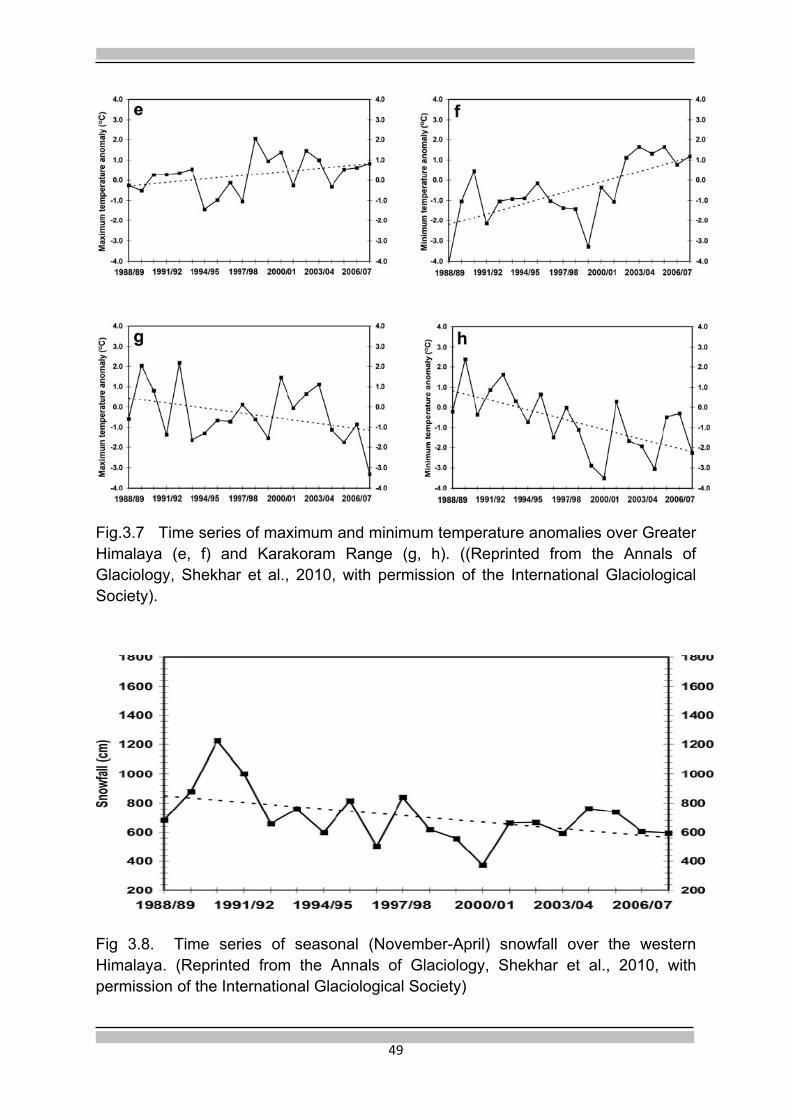
48
occurrences from 18 of the high altitude observatories of SASE located in different ranges of the western Himalaya (Fig. 3.6) for the period mid eighties to 2006-07.
The results show that:
• Seasonal (November-April) mean, maximum and minimum temperatures have increased by about 2°C, 2.8°C and 1°C in about last two decades. Seasonal maximum and minimum temperatures show increasing trend over all the ranges of western Himalaya except the Karakoram Range where a decreasing trend is noticed.
• The temperature maximum is increasing at a greater rate than the temperature minimum on the Pir Panjal and Shamshawari ranges.
• The seasonal snow fall has decreased by 280 cm, 80 cm and 440cm over the Pir Panjal, Shamshawari and Greater Himalaya respectively over the period 1988-89 to 2007-08.
• Also, there is decreasing trend in the number of WDs and in the number of snowfall days during the months, January to March.
The anomalous trends in the Karakoram Range (Fig 3.7 g, h) are consistent with earlier observations on this range where glaciers are known to be growing in some parts (Hewitt, 2005; Fowler and Archer, 2006; Quincey et al., 2009; Ganjoo and Kaul., 2009).
Fig 3.6 The four ranges of the Himalaya, A-Pir Panjal, B-Shamshawari, C-Greater Himalaya, D-Karakoram and the station locations (Reprinted from the Annals of Glaciology, Shekhar et al., 2010, with permission of the International Glaciological Society).

49
Fig.3.7 Time series of maximum and minimum temperature anomalies over Greater Himalaya (e, f) and Karakoram Range (g, h). ((Reprinted from the Annals of Glaciology, Shekhar et al., 2010, with permission of the International Glaciological Society).
Fig 3.8. Time series of seasonal (November-April) snowfall over the western Himalaya. (Reprinted from the Annals of Glaciology, Shekhar et al., 2010, with permission of the International Glaciological Society)

50
4. Aerosol Loading
An important but ill-understood factor is the contribution of black carbon and other aerosols to the temperature rise in the Himalaya-Tibet region and their contribution to glacier melting (Menon et al., 2010, Gautam et al., 2009). The above discussed temperature trends are partly attributable to the forcings by the Atmospheric Brown Clouds (ABC), which are layers of air pollution containing aerosols such as black carbon, organic carbon and dust (Ramanathan et al., 2005). The black carbon and other species in the haze are world- wide phenomena, but more intensely observed in south and east Asia during pre-monsoon months. The black carbon and other species in the haze reduce the average radiative heating of the ocean by as much as 10% and enhance the atmospheric solar radiative heating by 50 to 100% (Ramanathan et al., 2002). These perturbations in the radiative budget significantly impact the rainfall and temperature distribution in the region. The temperature trend attributable to black carbon is comparable to that of GHG and sulfate aerosols. According to Ramanathan et al., (2007) the melting of the Himalayan glaciers is related to BC aerosols and GHGs of 0.25K per decade, from 1950-present, of which BC associated heating is 0.12K per decade.
There are reports of both increasing and decreasing temperature anomalies ascribed to aerosol loading. This is an area of very active field-cum modelling research and is particularly relevant to our region. The Indo-Gangetic plains have high levels of pre-monsoon pollution and dust loading which peak in May (Singh et al., 2004). During the pre-monsoon inflow, dust aerosols are transported from the northwestern deserts into the Ganga plains and get concentrated there because of the barrier posed by the Himalayan range. Due to heavy convection and large scale topographic variations, the aerosols are transported and vertically advected to high altitudes, up to 8 Km, and possibly play an important role in the observed enhancement of the glacier melt in the Indo-Tibet region. The measurements and modelling of these constituents must become an important component of glacier studies in India (MoEF, 2011).
5. Discussion
From the above it is apparent that most of the NW Himalaya, barring the Karakoram Range, has been showing anomalous temperature rise ≥ 0.22°C/decade since the early seventies with signs of further acceleration since 1995. Snowfall precipitation during winter has reduced. Meteorological observations over Tibet and Nepal show similar trends. Global trends based on field data and GCM models are also in conformity. IMD data does not entirely capture the temperature and precipitation anomalies as recorded by the high altitude observatories set up under the Mountain Meteorology programme. Ascribing any cause to this temperature rise is not straightforward. There could be many forcing factors like GHG emissions, land use changes, black carbon and aerosol loading, changes in snow/ice albedo, intrinsic

51
natural variability and feedback mechanisms. They are all adding in some complex way to produce the resultant anomaly.
The recent report of the Indian Network of Climate Change Assessment (INCCA) (http://moef.nic.in/modules/others/event) based on PRECIS model with a resolution of 50 Km 50 Km, forced by A1B scenario of GHG emission, has projected the annual temperature in the Himalayan region to increase in the range of 1.7°C-2.2°C from the baseline of 1970s (average of 1961-1990) to 2030s (average of 2021-2050). The minimum temperatures are projected to rise by 1-5°C and the maximum temperatures may rise by 0.5-2.5°C. Precipitation is projected to increase by 5% to 13%.
It may thus be stated that the orography, the geographic and the climatological set up of the region render the Himalaya particularly vulnerable to effects of global warming. The temperature rise and the precipitation regime, dominated by the monsoon and westerly disturbances, determine the spatial and temporal distribution/ behavior of glaciers. The field observations in this difficult terrain are sparse. Precipitation patterns in particular, and their variability in space and time, are poorly defined. These limitations pose a severe challenge for high resolution climate modelling. Yet, understanding of the interplay of the diverse regional forcings on the global climate is so crucial to decipher the impact of climate change on the Himalayan cryosphere.
6. Research Issues
Some of the major research issues are:
• Is the climate in Himalaya changing? • What are the driving forcings, global, regional and local changes in the
Himalaya? • What are the mutual dependencies and inter-relations between these
different forcings? What are the feedback mechanisms? • What are the precipitation patterns in the higher reaches of the Himalaya?
- The sources, their spatial and temporal variability? How far east does the influence of westerlies extend?
• How is the Himalayan cryosphere responding to these direct and indirect forcings?
• What are the hydrological, biological and social impacts of these changes? • What should be the observational strategies to capture these forcings,
measure changes and build process/prognostic models? • What are the options to mitigate the impact of global warming or local
climate variations to sustain the Himalayan environment?

52
Chapter 4
Glacier Observations 1. Introduction
The natural tendency of a glacier is to acquire a stable state. Disequilibrium implies sustained input of climate forcings that impel the glacier to adjust its positiion and or dimensions according to the changing climate regime. All glaciers respond to signals of climate change either by decreasing or increasing their total mass; changes in mass eventually reflect in the changes of the glacier area and the position of the glacier terminus i.e in its retreat or advance. Relating glacier changes (Fig. 4.1) to climate variability and their impact underlines the need for long-term observations and measurements on mass budget, glacier dimensions, meteorological parameters and stream discharge data.
Fig 4.1 Glacier change-processes and linkages (adapted from Fountain et al.,1997)
The dynamic regulation of dimensions of the glacier and its position, as resulting from the changes in glacial mass is called glacier fluctuation. Mass balance or mass budget, as it really implies, of a glacier integrates the effect of all climatic pulses of different time periods acting over different spatial scales. It is accepted as a more direct and undelayed signal of annual atmospheric conditions (Haeberli et al., 1998) and provides a vital link between climate and glacier dynamics on one hand and between climate and mountain hydrology on the other. The other dimensions of

53
the glacier, particularly the length, also change in response to climate i.e the glacial advance or retreat. However, the advance or retreat of glacier tongue involves complex dynamic aspects of ice flow and, hence, is an indirect, delayed and filtered but also enhanced and more easily observed signal of climate change (Solomina et al., 2008).
The basic measurements of glacier characteristics, as defined for Global Climate Observing System (GCOS, 2003) are length and mass balance. The World Glacier Monitoring Service (WGMS) records and publishes changes in the glacier length and mass balance (annual/seasonal) and the associated parameters. However, a complete depiction of glacier change requires study of glacier area, volume and ice velocity also.
2. Mass Balance Measurements
All the processes which result in mass increase are classified as accumulation and all processes of mass wastage are categorized as ablation. The difference between mass accumulation and mass wastage is termed as mass balance and can be measured either on seasonal or annual basis.
Accumulation can result from snowfall, condensation, frozen rain and snow redistribution such as drifting and avalanching of snow into glacier. Ablation includes the processes of snow and ice melt, followed by run-off, evaporation, sublimation, ice calving and snow drifting out of glacier.
For any point on a glacier, both accumulation (c) and ablation (a) are functions of time and their derivatives with respect to time are called accumulation rate (ċ) and ablation rate ( ) respectively. In practice, the measured accumulation or ablation is integral of ċ or with respect to time interval (t1, t2), i.e
c=
a =
When t1 and t2 are the beginning and end time of a balance year, the measured accumulation and ablation are respectively the annual accumulation (ca) and the annual ablation (aa) of the year,
ca and aa =
The difference between the annual accumulation and annual ablation is the annual mass balance i.e. (by convention both are taken as positive)
ba = ca−aa

54
Similarly, when t1 and t1 are respectively the beginning and end time of winter season, we may have winter accumulation (cw), winter ablation (aw) and winter mass balance (bw). Similarly, if t1 and t2 define the beginning and end timings of the summer season respectively, we will have summer season accumulation (cs), summer season ablation (as) and summer season mass balance (bs).
The integrals of ca and aa with respect to the horizontally projected area (S) of the glacier are called the total annual accumulation (Ca) and total annual ablation(Aa)
Ca= cadx dy
Aa aadx dy
The difference between the total annual accumulation and total annual ablation is called the annual net balance (Bn) , i.e.
Bn= Ca - Aa
Bn is essentially the annual change in the volume of the glacier. When multiplied by the density of ice (taken as 900Kg m-3), it takes the units of m3 we (water equivalent). When Bn is averaged over the area of the glacier, the specific (average) net balance is obtained
bn= Bn/S.
It is expressed in units of m we. Similarly, we can obtain the specific seasonal mass balances bw (winter) and bs (summer). Also,
bn= bw- bs
The annual balance is calculated for fixed dates, e.g., 1st October in the northern hemisphere. The net balance is related to the minimum mass at the end of each summer which coincides with the hydrological year in October. So in our case the two terms, annual and net balance are used synonymously. The above discussion follows Shiyin et al. (2008).
In the direct in-situ glaciological method of measuring mass balance, the measurements of ablation are done in different elevation bands, generally 100m apart, through monitoring a stake network drilled firmly through the glacier surface of the ablation zone. The accumulation is measured by digging pits or undertaking ice coring at selected representative locations in the zone where snow has accumulated in the immediate past (t1 to t2) period of investigation (i.e. seasonal or mass balance year). The density profile is measured to determine snow accumulation in m we units. The above point measurements of ablation and accumulation are then extrapolated over the entire ablation and accumulation areas of the glacier to estimate the mass balance (seasonal/annual) of the glacier in different elevation bands i.e.

55
bn = (1/S) {Σ(bn1s1+ bn2s2 + – – + bnjsj)}
where bn is the specific mass balance for the entire glacier, bn1 ,bn2 , bnj are balances averaged for several sites inside the certain range of elevation (j) with the area sj ; S is the surface area of entire glacier.
The other practical way of measuring mass balance is the geodetic method in which the volume change of the entire glacier is determined by comparing the results of two high-precision surveys at different times giving the elevation change. An assumed value of the density is multiplied by the integrated surface elevation change over the glacier area to determine the mass balance. This method is useful for finding the mass balance changes over long intervals of time (5-10 years time gap).
The changes in surface height can be measured either by conventional surveying tools or preferably by aerial photogrammetric methods. With the advent of satellite remote sensing methods, digital elevation model (DEM) data over different time periods can be secured from imageries of ASTER or SPOT5 to determine elevation changes on a pixel-by-pixel basis (Berthier et al., 2007). Radar and Laser Altimetry, space or air borne, provide possibilities of mapping geodetic changes on the basis of spot heights (e.g.Demuth and Pietroniro,1999). Airborne laser altimetry has been successfully used to estimate the mass balance changes in Alaska (Arendt et al., 2002), Greenland ice sheet and Canadian ice caps etc. In-situ GPS observations can also be utilised for estimating geodetic changes (Bamber and Rivera et al., 2007). Interferometric SAR (INSAR) data can provide topographic information for mapping elevation changes. The shuttle radar topography mission (SRTM) was an InSAR mission flown in February, 2000, with the sole objective of mapping the topography of land surfaces between 60°N and 56°S at a resolution of 30 m for USA and 90 m elsewhere.
The mass balance measurements by the geodetic method do not provide any information on the spatial variability of mass balance. But in many situations of difficult and dangerous terrain (crevassed zones) and large glaciers, it may be the only practical method of securing an estimate of the mass balance.
For some glaciers with a large drainage basin and complicated glacier surface topography, water balance (hydrologic) method can be considered to determine the mass balance. The basic equation is:
w= p+s-e-i-r
where w is the water balance, p is annual precipitation, s is snow drift supply from neighbouring basin, e is annual evaporation, i and r are respectively ground and surface run-off at the gauge site. Due to difficulties of data measurements over the entire glacier basin and the complications posed by the storage characteristics of the glacier, this method has found limited use in practice (Sourco et al., 2009; Bhutiyani, 1999). Of all these above methods, the direct glaciological method is considered to

56
be the most reliable and also the most intensive in terms of human effort and financial inputs. WGMS data base is essentially populated by these measurements.
An abiding issue concerning these measurements is the error in these estimates (Kaser et al., 2003; Funk et al., 1997; Fountain et al., !999). The common sources of error can be identified as stake readings (length of the stake), density measurements, inadequate coverage of the accumulation zone, representativeness of the measured sites, extrapolation scheme chosen and accuracy of the old existing map(s). The small length of stakes (1-3 m), their material and methods of fixing these stakes on the glacier surface using manual augers have proved to be constraints in the initial few years of mass balance studies in India. Of late, steam drills are being utilised to fix long (~7 m) bamboo stakes to improve the accuracy and reproducibility of measurements (Wagnon et al., 2007).
In most of the mass balance studies, as a matter of convenience, glacier area and glacier hypsometry have been taken to be invariant, though in real practice they change with time, cause positive feedbacks, and as a result contribute to the overall error in the mass balance values. Improved measurement methodologies include periodic updating of glacier area and hypsography (Berthier et al., 2007; Sourco et al., 2009).
Another important but rather ill-understood source of error may emanate from internal accumulation when melt water penetrates into cold subsurface layers and refreezes. Internal accumulation can only be measured by drilling/digging deep into the firn layer. Not many studies on mass balance have accounted for this factor.
Point mass balance measurements are assumed to depend only on elevation, although in real practice natural horizontal variability exists which also contributes to error. Thus errors are contributed through both measurements and analysis (Kaser et al., 2006). As to how errors in different components propagate and combine to affect the final derived mass balance value is an area which demands attention and research. In general, accuracy of mass balance data in most cases lies in the decimeter range. In a study on Chhota Shigri glacier, Himachal Pradesh (Wagnon et al., 2007), the accuracy of bn was evaluated as ± 20 cm w.e. Dobhal et al. (2008) estimate an error of ~15 cm w.e. in the accumulation measurements at Dokriani glacier. It is also stated by them that more than 15-20% of the total area, mostly in higher reaches, remains unsampled due to logistics.
3. Comparative Results
On many glaciers both the geodetic and glaciological methods have been tried (Krimmel, 1999). Comparable but not similar values have been obtained But there are exceptions. Kuhn et al. (1999) for example, found that for Hintereisferner glacier in Austria the two methods gave surprisingly similar results. Cogley (2009) compiles all the direct-geodetic measurement pairs to identify the possible biases.

57
Sourco et. al. (2009) report mass balance studies on Zongo Glacier in Bolivia using and compaing the three methods.
It is now generally recommended that on some selected sites both the methods should be tried so that remote sensing based geodetic values can be calibrated against the ground based estimates to enable the mass balance measurements to be extended/ extrapolated to a larger ensemble of glaciers through remote sensing. Geodetic method gives long-term cumulative mass balance changes. It serves as a useful check on the glaciological method. WGMS recommends combining these two measurements.
4. Mass Balance–Climate: Characterising Parameters
Parameterisation of mass balance changes in terms of climatic parameters is best done through measurable parameters like the equilibrium line altitude (ELA), area accumulation ratio (AAR), mass balance gradient, activity index and mass turn over.
4.1. Equilibrium Line Altitude (ELA) marks the position where, over a period of one year, accumulation is exactly balanced by ablation i.e. on the glacier surface, the isoline ba=0 is defined as the annual equilibrium line altitude (ELA). Above the equilibrium line is the accumulation area and below the equilibrium line is the ablation area. Area accumulation ratio (AAR) is the ratio of accumulation area to the total area of the glacier. The period under consideration is generally from October to September (next year) coinciding with the hydrological year in the northern hemisphere.
There is a close association between the ELA and local climate, particularly temperature and precipitation. It rises (falls) in response to increase (decrease) in temperature and decrease (increase) in solid precipitation. For tempetrate glaciers, the transient snow line at the end of ablation season is taken as surrogate to the equilibrium line (Paterson, 1994). The transient snow line plays a significant role in the energy balance of a glacier basin, which in turn controls the timing and amount of glacier melt. Hence for modelling the hydrogical response of glaciers, mapping the position of transient snow line becomes important. The transient snow line is determined through field investigations. It can also be identified through remote sensing because of the radiometric contrast between snow and ice (Benn and Lekhmul, 2000). The line is normally visible as the contrast between the discoloured
Box 4.1 Geodetic measurements
For the Indian Himalaya, using the old available aerial photographs and/or satellite data, geodetic method offers a possibility of extending back the mass balance data and filling time gaps. Also, it enables estimation of mass balance status over large, difficult but important glaciers like the Gangotri. It will be highly advisable to include the option of mass balance measurements by more than one method in the overall programme of glacier monitoring.

58
concentration of dust on firn and the clean snow of the previous winter. Albedo varies from 0.9 for fresh snow to 0.15 for dirty ice.
In contrast to the transient ELA which is based on the annual mass balance, the theoretical concept of steady state ELA i.e. ELA0 represents the mean altitude that the equilibrium line would have had over the whole period if the glacier had been balanced (mass balance = 0). Glaciers never acquire this steady state but in practice, steady state (ELA0) is aproached by observations of glacier mass balance over several years. Construction of former steady state ELAs, therefore, provides a powerful tool for quantifying former climates in regions where other evidence is lacking (Sharma and Owen, 1996). Regional variations of glacier ELA0 can be used to determine former precipitation gradients, allowing moisture sources and atmospheric circulation patterns to be reconstructed. As per WGMS practice, a minimum of six years’ observation data is required to calculate the steady state parameters.
The concepts of AAR and AAR0 are related to ELA and ELA0 respectively and derive their impotance from their intrinsic relationship to glacier-climate response. In common with ELA, AAR for a glacier will vary from year to year depending on specific mass balance. From glacier to glacier AAR will depend on hypsometry, the extent of debris cover in the ablation area and the relative contribution of direct snowfall and avalanching as mechanisms of accumulation. For mid and high latitude glaciers, steady-state AARs may lie in the range of 0.5 to 0.8 (Meier and Post, 1962). For Europeon Alps, the value is 0.67 (Zemp et al., 2007) and for tropical glaciers it is 0.82 (Racoviteanu et al., 2008). For a set of glaciers in the NW Himalaya, Kulkarni (1992) determined values of steady state AAR to lie within 0.45-0.55. Wagnon et al. (2007) and Dhobal et al., (2008) determined AAR0 values of ~ 0.71 and~ 0.73 for Chhota Shigri and Dokriani glaciers respectively.
4.2. Mass Mass Balance Gradient Profile (VBP)
The variation of specific mass balance as a function of altitude, b(z) or VBP, is an important characteristic of a glacier and provides the physical basis for mass balance modelling (Oerlemans and Hoogendorn, 1989; Ohmura et al.,1992; Kaser, 2001). The specific mass balance-elevation gradient relation reflects the climate setting of the glacier which is a combination of widely homogeneous regional atmospheric factors which can be parameterized from variables of free atmosphere, and local factors which are unique to each glacier (e.g hypsography, slope, aspect etc.).
Changes in mass balance gradient from year-to-year indicate the effect of weather variations, and the gradient differences among glaciers reflect influence of the climatic environment and topographic characteristics. The mass balance gradient thus depicts the climatic sensitivity of the glacier. The following important factors contribute to the gradient in the annual balance: (Oerlemans and Hoogendorn,1989)

59
• Precipitation changes with altitude in which orographic influences play a dominant role. Snow drift may affect the gradient significantly in the upper parts of the accumulation zone.
• Reduction in the surface albedo down the glacier causing changes in the absorption of shortwave insolation.
• Air temperature decreases with altitude, reducing the turbulent energy exchange as well as the incoming long wave radiation. An important consequence is that the proportion of precipitation falling as snow increases with altitude.
Besides the above meteorological parameters, in the case of Himalayan glaciers, debris cover exerts a very strong influence on the mass balance gradients. Where the debris cover is thin (~less than 2 cm) or consists of scattered small particles, ablation rates will be higher than clean ice. Because of lower albedo, more radiation energy is absorbed. Where the debris cover is thicker, ablation will be lower than on clean ice, because of the insulating effect of the debris. However, the spatial variation of ablation on debris covered glaciers is very poorly known, due to the extreme complexity of their surfaces, and the range of processes/debris characteristics contributing to glacier wastage. Besides thickness, the thermal and radiometric properties of the debris material will play important roles. It is, therefore, important to generate local relationships between debris cover and ablation characteristics (Nakawo and Rana, 1999).
The steepest mass balance gradient is generally found near the ELA signifying rapid transfer of flux from accumulation zone to the ablation area. The velocity of the glacier is also the highest in this zone. The mass balance gradient near the equilibrium line is often called the ‘activity index’ of glacier. The larger the gradient, the greater the ‘mass turnover’ (α) or the annual amplitude of the mass balance and greater the climate sensitivity of the glacier (Braithwaite and Zhang, 1999).
α = (abs (bw) + abs (bs))/2
VBP characterises the glacier regime and thus determination of realistic mass balance gradients for different mountain ranges in the world is an extremely important area of study. Where field measurements are not available, climate data has been used to estimate the mass balance gradients. For dry continental type glaciers, the estimated value is 0.3-0.5 m w.e./100 m altitude, transitional climates, between 0.6-0.8 m w.e./100 m altitude, and for humid maritime conditions, the gradients vary between 0.9-1.2 m w.e./100 m altitude (Hoelzle et al., 2003). For Alps it has been determined as 0.78 m w.e./100 m with a high range of variation (0.33-1.2 m w.e./100m (Rabatel et al., 2005). Wagnon et al., (2007) have determined mass balance gradient value of 0.69 m w.e./100 m for Chhota Shigri glacier over the period 2002-03 to 2005-06.

60
For glaciers in India, mass balance gradient values have not been normally mentioned in the various publications of GSI. But it is understood that the data were measured and recorded in the unpublished field reports. Getting access to this data from the field reports, many of them more than 10 years old, will add great value to the available mass balance data series, especially in the context of climate change studies.
5. Mass Balance Studies using Remote Sensing
The traditional method of in-situ mass balance measurements is highly cost and time intensive, especially so in the extreme weather and terrain conditions that exist in the Himalaya. This largely explains the very limited availability of mass balance data in the Himalaya as compared to other glaciers in the Northern Hemisphere. Hence a very concerted research effort is required to develop alternative ways of securing this important data. In the preceding section, possibilities of using the geodetic method for estimating the long-term elevation variations (5 years to a decade) and the derived volume changes was discussed. These could be based on the traditional photogram-metric measurements, which are costly, or on the more cost effective modern satellite based data e.g SPOT, ASTER, INSAR etc. Other approaches of deriving mass balance from remote sensing, that require some amount of ground-based measurements, have also been attempted. All these methods essentially rely on determining the end-of-season snow line from remote sensing. This possibility rests on the contrast in albedo between the ice and firn (50% or less) in the ablation zone and the seasonal snow remaing in the accumulation zone (albedo-60 to 90%). Specifically the snow line altitude (SLA) divides the ice facies of the ablation zone from the snow facies of the accumulation zone. If measured at the end of melt season, SLA is approximately coincident with ELA. Snowfall late in the season inhibits the contrast and causes difficulties in demarcating the snow/equilibrium line. The related parameter AAR, gets derived once the ELA is mapped. Mapping the outline of the glacier (glacier boundary) provides the glacier area. Demarcating the glacier boundary from remote sensing is fairly standard, the debris cover though can cause serious complications (Paul et al., 2007; Shukla et al., 2009; Bhambri et al., 2011 b).
ELAs have been determined using various remote sensing platforms, LANDSAT, SAR and AVHR but the most suitable and readily used data comes from the ASTER carried on board the NASA Terra Spacecraft. The GLIMS (Global Land and Ice Measurements from Space) project is mainly using data from ASTER and the Landsat-7 Enhanced Thematic Mapper Plus, to establish the techniques of glacier related measurements from space. ASTER has a spatial resolution of 15m in VNIR bands, has high spectral resolution with 3 VNIR bands, 6 mid-IR bands and 5 TIR bands allowing multi-spectral classification, along-track streoscopic vision, and adjudstable again to help avoid problems related to saturation over bright areas (snow and glaciers). Repeat images are acquired every 16 days (Khalsa et al., 2004).

61
Three variants of ELA-AAR/mass balance approach have been demonstrated (Braithwaite, 1984; Khalsa et al., 2004; Rabatel et al., 2005). They all essentially require estimates of ELA/AAR, mass balance gradient, DEM and hypsometry. Linear relations established for typical glacier(s) based on field measurements are extended, using remote sensing, to neighbouring glacier systems sharing the same climatology. Kulkarni (1992) established a generalised relationship between AAR and mass balance for western Himalaya using the ground based data of GSI for a set of glaciers. Kulkarni et al., (2004) extended this relationship to Baspa basin and determined mass balance for 19 glaciers using IRS data. The validity of this generalised approach has been contested by some workers (Berthier et al., 2007; Mukherjee and Sangewar, 1996) on the grounds that mass balance-ELA/AAR relationships are known to vary from glacier to glacier due to several geometric factors and the influence of debris cover. Building of a general relationship for a diverse terrain like the western Himalaya has been considered untenable.
Bamber and Rivera (2007) present a review of remote sensing methods for mass balance determinations with particular reference to Andean glaciers. Racoviteanu et al. (2008) review the application of remote sensing methods to glacier characteristics with a focus on the Himalaya. Despite some reservations, it is felt that airborne and satellite remote sensing offer the only practical approach for deriving regional assessments of glacier mass balance, particularly over difficult and hazardous terrain of the Himalaya. New remote sensing platforms like ALOS (Advanced Land Observing Satellite), RADARSAT and ICESAT are specially equipped to provide data for mass balance studies. Their utility for the Himalayan terrain needs to be assessed. Application of multi-platform remote sensing data for mass balance estimation should thus be a principal focus of applied glacier research in the Himalaya.
6. Glacier dimensions
The geometry of a glacier, area and length specifically, change in response to mass changes (Fig. 4.1). The changes in the area and length result from the changes in the terminus position. Monitoring the terminus position is thus an important component of glacier observations.
6.1 Glacier length
Change in glacier length is an intutively understood and easily observed parameter to illustrate the impact of climate change (Haeberli et al., 2007). The quantitative relationship between the response of the glacier terminus to climate change is, however, complicated by the time lag between the two. Johannesson et al., (1989), based on theoretical considerations, have proposed a relation for the response time τM is,
τM ~ h/{-b(l)}

62
where h is the thickness scale for the glacier (thickness near the equilibrium line) and b(l) is the mass balance rate (negative) at the terminus. For typical glaciers ( h~ 100-500 m, -b(l)~ 1-10 m/a ), τM is of the order of 10-102 years. For valley glaciers, the response time is in the range of 10-50 years (Oerleman,1994). Response time of glaciers in Alaska has been estimated to be more than 40 years (Arendt, 2002). A response time of 50-60 years is estimated for Storglaciären glacier. In the Indian Himalaya, taking an average value of 200 m for the ice thickness near ELA and ablation mass balance of about - 4 m a-1 w.e in the ablation zone, the response time will be 50 years. The smaller glaciers take lesser time to adjust to the changing climate regime. For small glaciers in the Himalaya (less than 1 Km2), Kulkarni et. al., (2007) roughly estimate the response time to be 4-11 years Venkatesh et al., (2011) have proposed a quantitative model to explain the differential retreat rates of glaciers depending on their length, slope and equilibrium line altitude.
Hoelzle et al., (2003) have compiled length change data of more than 1000 glaciers world wide. They presented data on 90 selected glaciers world wide and 68 glaciers from the Swiss glacier network. They conclude that the ‘dynamic response to climate forcing of glaciers with variable geometry involves striking differences in the recorded curves. Such differences reflect strong effects of size-dependent filtering, smoothing, and enhancing of the delayed tongue response with respect to the undelayed input (mass balance) signal. As a consequence, sometimes still popular straight averaging of annual length change data (annual percentage of advancing/retreating glaciers) destroys essential aspects of the observed signal and must be avoided. The length and slope of a glacier constitute the predominant factors controlling glacier tongue reaction.
Glacier length-climate relationships can be established over multi-decadal time scales (Oerlemans 2005). Oerlemans (1994) was able to derive an estimate of global warming (0.66 K/100yr) from changes in the length of 46 glaciers in 9 regions of the world over the period 1884-1978 in good agreement with observational findings of 0.42-0.53K/100yr. The average length change in relation to temperature was 2 Km change/1 K. Scaling relationships have also been proposed (Bahr, 1997) through the choice of scaling coefficients poses a problem.
In the Himalaya, debris cover on the terminal zone of the glaciers further complicates the response function. Further, there are indications at the global level that down wasting has become the dominant mode of glacier retreat decoupling the glacier length changes from atmospheric changes (Paul et al., 2007; Solomina et al., 2008). Studies on Indian glaciers need to look for similar changes in the style of glacial retreat. Due care thus needs to be exercised when interpreting glacier length changes (snout retreat /advance) in terms of climate change.

63
6.2. Area Change
Observations of changes in the area are important for evaluating the effect of glaciers on water resources and landscape. The fraction of the basin area covered by glacier directly affects run-off. Similarly, the surface elevation of glacier should be mapped to determine changes in the glacier volume and changes in the area-elevation distribution. As compared to measurements on glacier length changes, studies relating to area changes are far few and, therefore, global trends have not been deciphered. However, there is little doubt that there has been consistent loss in glacier areas with acceleration in the recent decades (e.g. Liu Shiyin et al., 2005; Wang et al., 2009; Bajracharya et al., 2006, 2009; Paul et al., 2007)
There are several studies on the Swiss Alps and European Alps (Paul et al., 2011; Kääb et al., 2002) where glacier inventories have been periodically updated under the framework of Global Climate/Global Terrestrial Observing System (GCOS/ GTOS), using the latest remote sensing products (LANDSAT TM, LANDSAT ETM+, SPOT, IRS, ASTER) and new semi-automated image interpretation techniques. This has helped to regularly monitor the glacier cover changes. The results show that glaciers in the Alps have lost about 35% of the area between 1850 and 1975 (-2.8% per decade) and almost 50% by 2000 (-3.3% per decade). The area reduction between 1975 and 2000 is about 22% (-8.8% per decade), mainly occurring after 1985 (-14.5% per decade). The model studies project that a 3°C warming of summer air temperature would reduce the currently existing glacier cover by some 80% (Zemp et al., 2006). There are real fears that Alpine glaciers may disappear within a few decades.
Accelerated depletion of glacier areas and increase in areas of supra-glacial ponds and lakes has been widely reported from China, Tibet, Nepal and Bhutan (Caiping et al., (2009); Wang et al., (2009); Karma et al., (2003); Fujita et al., (2001)). Similarly for India, studies have shown increasing rates of areal shrinkage in the last few decades (Kulkarni et al., (2007); Shukla et al., (2009); Bhambri et al., (2011a)).
7. Additional Measurements
In addition to the above, observations are required on meteorological and hydrological parameters. The variables to be measured are precipitation, air temperature, humidity, wind speed and direction, solar radiation and stream stage/discharge. Supplementary data are preferably measured on glacier bed topography, ice movement, water quality which includes sediment transport and electrical conductivity. Ice cores and thermal characteristics are difficult to obtain but when available, help set up a spatial and temporal framework to model the glacier response on the basis of the above mentioned observational data. Barry (2006) gives a review of research on glaciers and glacier recession Racoviviteanu at al., (2009) discuss the challenges in mapping of glacier parameters from space.

64
Chapter 5
Dynamics of Indian Himalaya Glaciers
1. Introduction
The foregoing discussion on glacier observations is carried forward in this Chapter with special reference to the work done in the Indian Himalaya. Recognizing that the Himalaya -Tibet orogen has had a profound influence on the global climatological set up, reference is drawn to the relevant accounts at the global/regional level so that relationships/dependencies can be assessed.
Glacier observations were pioneered in India by the scientists of the Geological Survey of India (GSI) as early as 1780 A.D. Glacier studies took roots in GSI around the end of the nineteenth century and got strengthened during the International Geophysical Year (1956-57). Glacier investigations were laid on a sounder scientific footing with the launch of the International Hydrological Decade (IHD) (1965-74). Monitoring of glacier snout, geo-morphological mapping, mass balance, glacial hydrology (discharge, quality, sediment load and geochemistry), meteorological measurements, ice flow and ice fabric studies, ice core drilling, thermal profiling and geophysical surveys have gradually been inducted into the range of glacier field investigations pursued in GSI. In the initial years, Survey of India (SOI), IMD and Central Water Commission (CWC) helped GSI in joint expeditions to glaciers. GSI also bears the responsibility of compiling the inventory of Himalayan glaciers as per the international norms (Kaul, 1999). Vohra (1981), Srivastava (2001) and Raina (2005) provide accounts of some of the earlier investigations in GSI. Koul (2009) presents an account of progress of glaciological research in India.
In spite of these laudable efforts of GSI, the number and area of glaciers sampled remained very limited in relation to the total number and extent of the Himalayan glaciers and the national requirement of assessing their status. The Department of Science and Technology (DST) assumed the coordinating role in the mid eighties and has since imparted a more holistic, multi-disciplinary and multi-institutional character to the scientific studies of glaciers. During the last two decades, systematic studies on modern scientific lines have been supported in different research, academic and operational organizations like WIHG, BSIP, SAC, SASE, JNU, IITB, IIT Roorkee, Jammu, Srinagar, Kumaun and Lucknow Universities, G. B. Pant Institute of Himalayan Environment, NIH, SOI and IMD.
Data related to snow cover mapping, meteorological parameters, snout monitoring, mass balance, glacial hydrology, glacier movement using modern techniques like Global Positioning System (GPS), multispectral remote sensing and Geographic Information System (GIS) have helped in providing a basic understanding of the behavior of the Himalayan glaciers. The studies include glacial geomorphology and dating of geo-morphological features to build a Quaternary glacial history of the

65
Himalaya and paleo-climatic reconstruction. Measuring snow/ice thickness using geophysical techniques, bed rock profiling using Ground Penetrating Radar (GPR), characterizing snow/ice using microwave satellite/radar imageries etc. have been some of the latest additions to these scientific efforts. Isotope techniques have been used in glacial hydrology and to estimate the accumulation and flow rates of ice. A modicum of inter-departmental coordination mechanism has also been put in place. A number of research publications, review papers and compiled volumes have emerged from these efforts.
However, all these studies, limited in scope, spatial and temporal coverage, have not led to any consensual denouement on the health of the glaciers. The cause effect relationship remains obscure. The NAPCC takes note of these limitations and commits to continuing and strengthening of the observation and monitoring system for the Himalayan glaciers through existing and appropriate new mechanisms. Understanding and modelling the dynamics of glaciers lies at the heart of this major endeavor.
2. Glacier Fluctuations
2.1 Glacier Snout Monitoring
Monitoring of glacier snouts to a large extent and measurement of glacier mass balance to a lesser extent have been the mainstay of glacier observation studies promoted/ undertaken by DST and GSI. More than 50 glaciers have been monitored for snout fluctuations. The main body of work done in GSI has shown that glaciers in the Indian Himalaya have been retreating since the earliest recording began around the middle of the nineteenth century. Fig 5.1 depicts the retreat pattern of some of the important glaciers for which more than 20 years’ data is available. (Raina and Srivastava, 2008). It may be noted that these are average rates of retreat (averaged over different time periods) of glaciers with different geometries and located in different climatological set ups. The rates of retreat may, therefore, not be inter-comparable.
According to Raina (2009) the annual retreat of the glaciers was generally around 5 m up to late 1950s. The rate of retreat increased many folds in some glaciers in the central and the eastern Himalaya during mid seventies to late eighties, touching a value of 25m-30m/year in some glaciers e.g. the Gangotri glacier.
It is contended by Raina (2009) that the glacial retreat has slowed down in the nineties. In some cases like the Siachen glacier, Machoi glacier, Darung Drung glacier, Gangotri glacier, Satopanth-Bhagirath Kharak glaciers and the Zemu glacier, the rate of retreat has practically come down to zero. Some of the glaciers in the Kumaon Himalaya, like the Pindari glacier, have been exhibiting an annual retreat of 8 -10 m since the first recording was made in 1906.

66
Fig. 5.1. Glacier retreat of some important glaciers (Raina and Srivatava, 2008)
Research groups from WIHG and SAC have also been monitoring the glacier retreat. Some of the results are shown in the Table 5.1. It may be noted that the rates of retreat reported by Kulkarni et al., (2005, 2007), based on R.S studies, are > 50m/yr, both for Parbati and Chotta Shigri glaciers. WIHG, based on ground measurements, reports much lower rates of retreat for Chotta Shigri glacier (Kumar and Dobhal, 1994). It is difficult to assess whether these differences reflect temporal variations (enhancement since 1989?) or involve methodological issues. For Parbati glacier, the reported retreat for the period 1962-1990 is 5991 m (about 214m/yr) (Kulkarni et al., 2005), an alarmingly high rate of retreat. From the above, it would seem that rates of retreat determined by remote sensing are giving higher values than the measurements done by ground based methods. These discrepancies/issues need to be resolved.
Table 5.1. Retreat rates of some glaciers
Name of Glacier
Period Retreat @ (~m/yr)
Total Retreat (~m)
Reference Remarks
1. Dokriani, Garhwal Himalaya
1991-2007 16.9 271 Dobhal and Mehta, (2008)
2. Chotta Shigri, Himachal Pr.
1984-86 1986-87 1986-89 1962-89
2.6 -17.5* ~20 7.5
195
Kumar and Dobhal, (1994)
*glacier advance
3. Chotta Shigri, Himachal Pr.
1988-03 53 800 Kulkarni et al., (2007)
R.S data
4. Parbati,Himachal Pr.
1990-01 1962-90
53 214
578 5991
Kulkarni et al., (2005)
R.S. data
Gangotri glacier has attracted the attention of many scientists and has been under systematic monitoring by GSI since 1935. There are, however, conflicting views on

67
the rate of retreat of the Gangotri glacier. Table 5.2 gives the rates of retreat, as per the measurements conducted by GSI (Srivastava, 2004). It is apparent from the table that the snout of Gangotri glacier has been receding at least for the last 75 years. There was acceleration in the retreat in the mid-seventies and only a marginal slowing down in the nineties. The average rate of retreat since 1956 is ~ 31 m/a. The total retreat from 1935-96 is about 1400 m. According to Raina (2009), the glacier has almost remained static from 2007-09.
Table 5.2 Retreat of Gangotri glacier (GSI data) (Srivastava, 2004)
Period (A.D) Annual Snout Retreat (m/yr)
1935-56 10.16
1956-71 27.33
1971-74 27.34
1974-75 35.00
1975-76 38.00
1976-77 30.00
1977-90 28.08
1990-96 28.33
Average 1956-96 30.58
Several other workers have derived retreat rates for Gangotri glacier using different methods- GPS measurements, geo-morphological evidence and remote sensing. The results are summarized in the Table 5.3. The findings of Kumar et al. (2008) and Naithani et al. (2001) are not in agreement with the results of GSI. Obviously, there are several issues involved in explaining these discrepancies, the methodology of measurement being the most important one. It will be useful to conduct experiments in which the different methods of monitoring the snout are compared on some glaciers to determine the inter-method calibration coefficients.
It must again be reiterated that relating changes in retreat rates to climate/weather fluctuations is problematical in general and particularly in this case as the ablation
Box 5.1 Snout Monitoring
Calibration of remote sensing- based snout monitoring data against the conventional and GPS surveying measurements is considered very important as debris cover can seriously interfere with remote sensing interpretations. At the same time, there is little doubt that remote sensing will find increasing application in snout monitoring studies as new tools with increasing spatial and time resolution become available. Hence the need for evolving standard protocols and illustrated guidebooks for field measurements of glacier snout position using different methods.

68
area of the Gangotri glacier is estimated to have a debris cover ranging in thickness between 0.1 to 2 m (Ahmad and Hasnain, 2004). This would effectively insolate the terminal zone from high frequency meteorological fluctuations and enhance the response time. To understand the phenomena of glacier retreat in a more scientific manner, the measurements have to be made with greater time resolution and must be ultimately related to the driving cause i.e. mass balance variations (Hoelzle et al., 2003).
2.2. Glacier Mass Balance
Regardless of the above noted difficulties, it is accepted that the Himalayan glaciers have been retreating since 1850s and this provides a general sense of the depleting health of glaciers. As discussed earlier, mass balance data provides a more authentic status of the health of glaciers. Mass balance of a glacier integrates the effect of different climatic pulses and responds by recording changes in the ice volume. It provides a vital link between climate and glacier dynamics on one hand and between climate and glacial hydrology on the other hand. Hence, the paramount importance of mass balance in the overall scheme of glacier monitoring and climate change studies.
Table 5.3 Rates of retreat of Gangotri glacier (Non-GSI data).
S.No Period Rate of retreat, m/a
Method Ref
1. 1935-71 1971-04 2004-05
26.5 17.15 13.76
GPS in rapid static mode
Kumar et al., (2008)
2. 1936-96 1971-96 1966-99
~19 ~34 ~22
Geo-morphological field evidence
Naithani et al., (2001)
3. 1985-01 ~23 Remote Sensing Ahmad and Hasnain, (2004)
4. 1962-1990 1990-94 1994-98
46.4 37.5 ~25
Remote Sensing Tangri et al., (2004)
2.2.1 Global Efforts on Mass Balance Studies There is a global interest in conducting long-term mass balance studies because of (1) the intrinsic relationship between mass balance change and climate fluctuations and (2) the impact of mass balance change on the melt water release, and (3) the link between glacial melt and sea level rise. A global system of monitoring glaciers (WGMS) has evolved over the years that is now documenting/consolidating the present wide spread changes in mass balance and retreat of glaciers. The longest uninterrupted record of mass balance observations in the world exists for Storglaciären, Sweden since 1945. In China, Urumqihe glacier in Tien Shan has continuous mass balance data for more than 40 years.

69
The ‘official’ agency for maintaining a data base on mass balance is the World Glacial Monitoring Service (WGMS) of the International Association of Cryospheric Sciences, earlier called the International Commission on Snow and Ice. WGMS is based in the University of Zurich and has been publishing mass balance records since 1967 in the volumes of Fluctuations of Glaciers every five years. Since 1991, WGMS has also been publishing basic records every two years for more than hundred glaciers including detailed results for 10-15 selected glaciers in the Glacier Mass Bulletin. The aim is to collect all data, seasonal and annual that is measured according to the direct glaciological method, ideally in combination with the geodetic method. Six decades of annual (and partially seasonal) data are now available from WGMS (Zemp et al., 2009).
Many scientists maintain their own databases on mass balance. These individual data bases are based on the official database of WGMS but need not be identical. An elaborate discussion based on records of 280 glaciers spread worldwide has been given by Dyurgerov (2002) and Dyurgerov and Meier (2005). Braithwaite (2009) presents a review of the global mass balance data held by him for 318 glaciers for the period 1946-2006. Kaser et al., (2006) have worked on collections of different data sets of more than 300 glaciers to bring out consensus estimates of mass balance for the period 1961-2004. The following summary of the global assessment of glacial mass balance rests on the above reviews.
Fig 5.2 Global mass balance data (Reprinted from the Annals of Glaciology, Braithwaite, 2009, with permission of the International Glaciological Society).
Fig. 5.2 shows the measured mass balance data from 1946-2006. The glacier mass balance is characterized by relatively large year to year fluctuations. Glaciers on Arctic islands have more muted variations than do other glaciers, but both kinds of glaciers show a marked tendency towards more negative mass balances post 1995.

70
The increasing amplitude of glacier mass balance fluctuations, indicative of the enhanced intensity of the hydrological cycle, is a marked feature of the trend.
Dyurgerov (2002) and Dyurgerov and Meier (2005) have undertaken an exhaustive analysis of global mass balance data for the period 1946-1998 but with greater emphasis on the period 1961-1998. For individual glaciers, the lengths of mass balance measurements vary from 1 to 50 years with an average duration of 10 years. The main findings of the analysis are:
• Globally-averaged mass balance (arithmetic mean) has been: -212 mm w.e units for the period 1961-1998, -93 mm for 1961-76, and –294 mm for 1977-98, showing the increasingly negative values post 1977.
• During the period 1977-98, the values of bw were about 7% higher, and about 9% higher for bs, compared to 1961-76 period.
• Overall, there is an increase in the mass turnover beginning late eighties induced by increased heat energy.
• The ELA has increased by about 200 m showing an unexpected sensitivity of ELA to small changes of air temperature.
• AAR decreased from about 60% in 1968 to 50% in 1998. • The vertical mass balance gradient has increased showing an increase in
rate of ablation below ELA and an increase in accumulation above ELA. This will impart higher sensitivity to mass balance from changes in temperature and precipitation
The analyses of global data sets bring out that the recent incremental ablation exceeds the additional accumulation and hence the net increase in the negative mass balance. While increase in ablation due to the rising temperature regime is expected, the rise in winter accumulation reflected by increase in winter balance has been quite unexpected (Dyurgerov and Meier, 2000; Meier et al., 2003, Dyurgerov, 2003). The low altitude meteorological observatories do not adequately capture this change in the winter accumulation (Dyurgerov and Meier, 2005; Ohmura et al., 1992), underscoring the need for winter mass balance measurements to truly reflect the accumulation characteristics of glaciers. There is a measure of consensus emerging from analysis of global data that mass balance was close to zero around 1970 and has become more negative since then as a response to post 1970 global warming with a sudden increase around 1978 (Kaser et al., 2006; Cao, 1998, Dyurgerov and Meier, 2005) and another shift in early-mid nineties (Braithwaite, 2009), strengthened by positive feedbacks, the most important being the mass balance-altitude feed-back and the albedo feedback. The most interesting feature of these global studies has been the simultaneous but differential increase in winter accumulation and summer ablation, the two thus partially compensate each other’s effect on the overall annual mass balance.

71
2.2.2 Mass Balance Data in the Indian Himalaya
Mass balance measurements were initiated by GSI in mid seventies by the conventional glaciological method at Gara glacier, a north facing small valley glacier (31 28’ 30 , 78 25´ 00" E) in J& K State (Raina et al., 1977). More glaciers with different orientations, latitudes and longitudes, representing the varying climatic settings were gradually added from J&K, H.P., Uttarakhand (UK) and Sikkim. Under the sponsorship of DST, the network of mass balance studies was further spread and strengthened by the induction of research organizations like WIHG and academic groups from JNU and Jammu University. The two glaciers, Chhota Shigri (H.P) and Dokriani (UK) have been studied in some detail over different time periods by the participation of a number of scientific groups. So far 13 glaciers (including Chaurabari, Uttarakhand) have been studied for assessment of mass balance by the conventional glaciological method; the time series varying in length from 2 years to 10 years. In some cases for example, Chhota Shigri and Dokriani glaciers, the studies have been of intermittent nature. Multi-year data collection is limited to glaciers adding up to about 60 Sq. Km. The longest time series (10 years) is available for Shaune Gorang glacier. The average length of time series is less than six years. Most of these measurements were made between the years 1974-1990. At present, in-situ mass balance studies are done on four glaciers, namely, Hamta (by GSI), Chhota Shigri (by JNU), Dokriani and Chaurabari (by WIHG). Table 5.4 gives the average mass balance values for the 12 glaciers for which data are available. Fig 5.3 gives the time series of annual mass balance fluctuations of different glaciers. Besides the above data, mass balance data has been generated by remote sensing methods, using ELA/AAR- Mass Balance relations and by monitoring elevation changes. Kulkarni (1992) calibrated the mass balance/ELA and mass balance/AAR linear relationships with the ground-based mass balance data produced by GSI for Gara and Gor Garang (H.P) glaciers and four other glaciers located in J&K and Uttarakhand to determine a general fit for Western Himalaya. He calculated AAR0 value of 0.44 for the western Himalaya. The work was extended to 19 glaciers in Baspa basin covering about 140 Sq. Km using IRS data (Kulkarni et al., 2004). AAR0 of 0.5 and average mass balance values of 0.9 m/a w.e. and 0.78 m/a w.e. were determined for the hydrological years 2001 and 2002 respectively. Berthier et al. (2007) adopted the geodetic method for determining the mass balance in the Lahaul Spiti region of Himachal Pradesh over an area of 915 Km2 which included Chotta Shigri and Bara Shigri glaciers. For Chhota Shigri glacier, ground-based conventional data on mass balance and associated parameters was available (Wagnon et al., 2007). The elevation changes were measured by comparing a November 2004 DEM derived from two SPOT5 satellite images with the February

72
2000 SRTM topography. An ASTER image of September, 2002 in VNIR band was used for updating the glacier boundary.
Table 5.4 Mass Balance Data by Glaciological Method Name of Glacier
Lat (dms)
Long. (dms)
State Period Mean Annual Specific M.B bn m/a w.e
Agency Reference
Rulung 330808 782630 J&K,Ladakh 1980-83 -0.11 GSI GSI(2001) Neh Nar 340850 753130 J&K 1978-84 -0.52 GSI GSI(2001) Gara 312830 782500 HP 1975-82 -0.31 GSI GSI(2001)Gor Garang
312554 782300 HP 1977-85 -0.43 GSI GSI(2001)
Shaune Garang
311730 782022 HP 1982-91 -0.42 GSI GSI(2001)
ChotaShigri 321342 773050 HP 1987-89; 03-06
-0.16 -0.98
WIHG JNU/ IRD, Fr
Dobhal et al., 1995/ Wagnon et al., 2007
Hamtah 321416 772216 HP 2001-06 -1.6 GSI WGMS, (2008)
Naradu 311752 782427 HP 2001-03 -0.4 Jammu Univ.
Koul and Ganjoo, 2009
Dunagiri 303320 795336 Uttarakhand 1985-90 -1.04 GSI GSI(2001)Tipra Bank 310045 792000 Uttarakhand 1982-85
1988 -0.41 GSI GSI(2001)
Dokriani 305140 785000 Uttarakhand 1993-951998-2K
-0.32 WIHG Dobhal et al.,2008
Changme Khangpu
275743 884117 Sikkim 1980-83 -0.34 GSI GSI(2001)
An overall specific mass balance of -0.7 to -0.85 m/a w.e. was obtained for the period 1999-2004, depending on the density that is adopted for snow in the accumulation zone. For Chhota Shigri and Bara Shigri glaciers, the mass balance values are -1.12 m/a w.e and -1.31 m/a w.e. respectively. For Chhota Shigri glacier the values of mass balance determined by remote sensing and the conventional methods are in good agreement (Wagnon et al., 2007).

73
Fig 5.3. Annual mass balance time series data on Indian Himalaya Glaciers. The following observations emerge:
• Most of the glaciers studied for mass balance lie in the NW and Central Himalaya. Changme Khangpu is the only glacier in the NE and Rulung glacier in the Trans Himalaya. (Table 5.4)
• Beginning with a slightly positive mass balance in 1974-75, the mass balance remains negative between 1976-77 and 1998-99 showing inter-annual fluctuations around the mean value of ~ -0.5 m/a w.e. Dunagiri glacier shows consistently higher negative mass balance values. Rulung glacier in Ladakh shows the lowest negative mass balance, -0.11 m/a w.e. Some positive excursions are also noted. (Fig 5.3)
• From the year 2000 (Fig 5.3), the mass balance values for the two glaciers under long-term study, Hamtah and Chhota Shigri, become highly negative ≥ -1 m/a w.e. A slightly positive value (0.1 m/a w.e) is observed for Chhota Shigri glacier for the year 2004-05, which may be anomalous as the regional temperature and precipitation during this year is not significantly different from the other years (Wagnon et al., 2007). The earlier mass balance values for Chhota Shigri (1987-89) are only marginally negative (-0.16 m/a w.e.). The reasons for this wide variation between the two set of values, possibly temporal or methodological are not clear. It will be highly instructive to secure a set of mass balance values for the period, 1987-2002, by the alternative geodetic method to understand the trend of variations and provide an

74
independent check on the field-determined mass balance values on this glacier. Chhota Shigri has continued to give negative values close to -1 m/a w.e for the years 2006-07 and 2007-08 (Ramanathan, 2011).
• Hamtah glacier gives high negative values > -1.2 m/a w.e for all the five years (Fig 5.3). The other glaciers i.e. Chorabari (UK) (Raina, 2009) gives an average value of -0.75 m/a w.e for the period 2003-07 and Naradu (H.P) gives an average value of -0.4 m/a w.e. (Ganjoo and Kaul, 2009). In this context it is important to note that R.S determined regional values of mass balance in Baspa basin (H.P) for the years 2000- 2001 and 2001- 2002 are -0.9 m/a w.e. and -0.78 m/a w.e. respectively (Kulkarni et al.,2004).
• Mass balance data available for Dasuopu Glacier (28°23´N 85°43´E) in Tibet and AX010 glacier in Nepal ( 27°42´N 85°34´E) are given in Table 5.5. These values are compatible with the trend of recent increase in the mass balance loss witnessed in the Indian Himalaya. The degradation of glaciers in Nepal, Bhutan and China evidenced by glacier shrinkage, development of glacial lakes (GLOF) (Bajracharya et al., 2006) and mass loss (Ageta et al., 2001, Fujita et al., 2001) is well documented.
• There has been a global increase in the negative mass balance of glaciers since the beginning of the new century. The 30 glaciers with uninterrupted time series measurements since 1976 show mean annual ice losses of -0.14 m w.e. for the period 1976-1985, -0.25 m w.e for the period 1986-95 and -0.58 m w.e. during the period 1996-2005 (Zemp et al., 2009). ‘The average annual melting rate of mountain glaciers appears to have doubled after the turn of the millennium in comparison with the already accelerated melting rates observed in the two decades before’ (Zemp et al., 2008). Kaser et al., (2006) in arriving at the consensus estimates of global mass balance conclude that mass balance was close to zero around 1970 and has been decreasing since then. As per their analysis, for 2001-04, the global average specific mass balance is -0.51±0.1 m/a w.e.
The above discussion on mass balance is summarized in the Table 5.5.
Temperature rise may be the main driving cause behind the unusual rise in the global mass loss of glaciers. Temperature on the glacier surface is related to radiation balance, turbulent heat exchange and solid/liquid precipitation ratio and thus plays the predominant role in determining the mass/energy balance. Eleven of the last twelve years (1995-2006) rank among the twelve warmest years in the instrumental records of global surface temperature since 1850 (IPCC, 2007a). Temperature changes in the NW Himalaya, Tibet and Nepal, particularly in the last three decades, are in consonance with the global trends of temperature rise with signs of amplification in the Himalaya Tibet orogen.

75
It may be noted that there is an enhancement of temperature rise in the NW Himalaya in the last three decades and a reduction in the snowfall component of the precipitation, acting thus in the same direction and reinforcing each other’s effect on the annual mass balance through a positive feedback. This is in contrast to the global trend where we have witnessed a marginal increase in winter precipitation and a higher increase in summer ablation, thus partially balancing each other’s effect.
3. Area and Elevation Changes
In India work on estimating the areal changes in glacial cover and ice thickness are very limited. Kulkarni et al., (2007) reported their findings on changes in glacial extent for 466 glaciers in Himachal Pradesh covering the basins of Chenab, Parbati and Baspa using a number of IRS data products. The areal extent of these glaciers in 1962, as delineated from SOI topo maps, was 2077 Km2. In 2001-04, the area estimated though R.S. interpretation was 1628 Km2, an overall reduction of 22% (~5.5% /decade). The rate of area loss was found to have an inverse relationship with the size of the glacier. Smaller glaciers with lesser response time adjusted quickly to the changing climate regime and showed the highest change. It should be noted that since there are no intermediate measurements between 1962 and 2001-04, the expected acceleration in glacier changes that would have occurred post mid seventies does not get captured.
Table 5.5 Comparison of mass balance data on IHG with regional (Tibet and Nepal) and global data. Region/Glacier Period Average
bn, m/a w.e Method Reference
IHG 1975-1995 -0.45 Glaciological Fig. 5.3,Table 5.4
IHG 2000-2006 -1.22 Glaciological Fig 5.3,Table 5.4
Baspa Basin, H.P 2001-02 -0.84 VNIR R.S Kulkarni et al., (2007)
Lahaul Spiti, H.P 1999-2004 -0.85 Geodetic Berthier et al., (2007)
Tibet/Dasuopu 1996 -1.0 Snow pit/cores
Thompson et al., (2000)
Nepal/AX010 1996-99 -0.72 Glaciological Ageta et al., (2001)
1976-85 -0.14 Glaciological Zemp et al., (2009)
1986-95 -0.25
Global/30Ref.glaciers (WGMS)
1996-2005 -0.58
Dobhal et al. (2004) using the SOI toposheet of 1962 and the large scale maps on (1:10,000) scale have calculated the changes in the glacierised area and the ice volume on the Dokriani glacier. On Chhota Shigri glacier, Lahaul Spiti region of

76
Himachal Pradesh, elevation changes have been measured independently i.e. not derived from scaling the area changes (Berthier et al., 2007). A clear thinning of glaciers is observed on most glaciers at different elevation ranges (Fig 5.4). At lower altitude, ~ 4000 m, the elevation change is ~ 10 m over the five year period. Even in the high accumulation area, the elevation change is close to 5 m. There is a small group of glaciers which record some thickening in the accumulation zone.
It is important to include measurements on changes of ̇area and elevation in addition to studying changes of glacier length so as to have independent check on the mass balance variations. Most of the studies in Indian Himalaya which report changes in glacier volume (e.g. Kulkarni et al., 2007), do not include independent measurements of elevation. Volume changes are derived from empirical scaling of area and/or length changes and, therefore, do not serve the stated purpose.
Fig 5.4 Thickness change as a function of altitude, Lahaul Spiti region (Berthier et al., 2007)
4. Snow Cover Mapping
The snow cover monitoring has been carried out for 28 basins in the western, central and eastern Himalaya from October to June for the years 2004-05, 2005-06, 2006-07 and 2007-08 (Kulkarni et al., 2010). The distribution of snow cover for the western and central Himalaya, as a percentage of the total basin area, is shown in the figure 5.5. Temporal changes in snow cover during the winter are noteworthy e.g. during 2006-07, reduction in snow cover beyond the peak in December is clear.
Detailed work on Beas and Baspa basins (Kulkarni et al., 2002) and Ravi and Bhaga basins (Kulkarni et al., 2010) confirm that rising temperatures in the winter have reduced the snow cover. Melting of snow has been reported even in winter months of November and December, especially in basins lying at low altitude. In Baspa basin, detailed snow cover monitoring was done during 2000-01 at different altitudes. Snow retreat was observed from November to February in all the altitude zones from

77
Fig. 5.5. Changes in areal extent of snow cover as percentage of total area in relation to total area for western and central Himalaya (Kulkarni et al., 2010)
3000-4800 m. Similar observations were made in Beas basin between 1997-98 and 2001-02. An increase in winter discharge of rivers in the Baspa basin supported the observation of winter melting. In the Ravi basin (altitude range 630-5860 m) located on the south slope of Pir Panjal range, Kulkarni et al. (2010) reported that snow accumulation and melting took place throughout the winter. In the Bhaga basin (altitude range 2860-6352 m) on the other hand, located in the north slope of Pir Panjal range, winter melting was limited and restricted to the early winter months. All these observations though important indicators cover very small periods of time and are not enough to suggest any changes in the long-term trends of snow accumulation and ablation.
Temporal snow cover studies in the Bhagirathi and Alaknanda watersheds of central Himalaya are reported by Tangri (2004) with wide variations in the overall spatial spread of snow cover during peak ablation/accumulation period.
5. Conclusion
The above leads us to conclude that though there is a deficit of observational data on the mass balance of Indian glaciers, yet when the same are seen in conjunction with the regional and global data, the similarity of response in glacier mass loss due to climatic signals cannot be ignored. The notion that the NW Himalaya is defying global warming (Yadav et al., 2004) is not borne out. Data on area shrinkage, loss of ice thickness and indications of glacier fragmentation (Kulkarni et al., 2007) are supportive of the data on mass loss. At the same time, the constraint posed by the availability of limited observational data on meteorological parameters, and near absence of hydrological data makes the present conclusion very preliminary. A platform is available by way of some field data, experience and trained manpower that can be used to good purpose for mounting bigger and more comprehensive initiatives. Glacier monitoring has to become more comprehensive and technology

78
based so that high resolution measurements can be made on glacier length, area, volume, velocity, discharge and other parameters. The goal is to generate:
(i) a better understanding of the state of glaciers through measurements, observations and modeling
(ii) improve understanding of the physics and mechanics of glacial flows (iii) quantification of the effects of climate change on the glacial mass and river
discharge and (iv) ultimately evolve response and mitigation strategies to secure the
environment and ecology of the region to sustain the habitat and livelihood of the local masses.

79
Chapter 6
Glaciers and Water Resources 1. Introduction
In Chapter 3 we have discussed the emerging scenarios on climate change at the global, regional and at the all India level. In particular, we have noted the trends of increasing temperature during the last three decades which get accentuated with rising elevation, rendering the Himalayan glaciers particularly vulnerable to impacts of global warming. Accompanying this temperature change is the trend of decreasing snow precipitation as a proportion of total precipitation. These changes are bound to impact the hydrological cycle, altering the volume and timing of runoff. Increasing temperature could lead to earlier peak in runoff i.e. during spring or even winter and reduced flows in summer and autumn. Decreasing snow precipitation would affect the volume of flows (Barnett et. al., 2005).
At the global level there is no homogeneous trend relating stream flows to temperature or precipitation changes. Both increases and decreases have been reported (IPCC, 2007a, b). In fact it is felt that water resource issues have not been adequately investigated in the climate change analysis and climate policy formulations (Bates et al., 2008). IPCC (2007d) predicts that water supplies from glaciers will decline in the course of the century due to shrinkage in their volume but with possibilities of increased stream flows in the immediate future due to higher glacier melt. Shortage of water supplies is feared to affect South Asia by 2050 (IPCC, 2007e).
In India one of the major concerns about climate change relates to its impact on stream flows in the three major glacier-fed river systems- the Indus, the Ganges and the Brahmaputra which among them provide (320Km3) close to 50% of the total (690 Km3) of the country’s annual utilizable surface water resources (MOWR, 2008). The Himalayan rivers yield almost double of water as compared to an equivalent peninsular river. This is because glaciers and snow contribute important components of flows in these rivers in the years of poor monsoon and during the lean summer and post monsoon months reducing inter annual and inter season variability, sustaining hydropower generation and agricultural production (Thayyen and Gergan, 2010). Climate change may alter these flow patterns. On the other hand rising population and increasing pace of economic development will raise demands for fresh water in the scenario of reducing availability of this resource (Mall et al., 2006). There is thus an urgent need to research the underlying issues. The National Mission for Sustaining the Himalayan Ecosystem and the National Water Mission, included under the Indian National Action Plan on Climate Change, are mandated towards resolving these issues. Generating better estimates of snow and glacier melt contribution to the Himalayan river flows and the likely change in this component due to global warming are two of the major driving concerns.

80
2. Glacier/Snow- Melt Contribution to River Discharge
Field observations on the stream discharge in the Himalayan rivers are very inadequate. Our present understanding of the hydrological characteristics of glaciated basins in the Indian Himalaya, therefore, mainly rests on studies of hydrological models initiated in the early eighties. Initially these studies have concentrated on simulating the snow melt in-flows from the seasonal snow pack based on regression relationships between snow covered area and stream flow (Ramasastri, 1999). A more rigorous multi parametric model, UBC (University of British Columbia) was introduced at the National Institute of Hydrology (NIH) in early nineties. UBC model is designed primarily for mountainous watersheds and calculates the contributions coming from snow melt, glacier melt and rainfall run-off. The maximum and minimum temperature and precipitation data are input to the model.
The other model which has been used extensively in over 100 basins ranging in surface area from 0.8 Km2 to more than 90,000 Km2 in 90 different countries is the SRM model (Surface Run-off) (Martinec, 1975; Martinec et al., 2007). It is a conceptual deterministic hydrologic model used to simulate daily run-off resulting from snowmelt and rainfall in mountainous terrain. Daily temperature, precipitation and snow cover area are the model inputs. It has been modified to determine the impact of climate change on stream flows and include glacial melt (Immerzeel et al., 2009, 2010).
NIH has developed a conceptual hydrological model SNOWMOD (Singh and Bengtsson, 2004) to simulate the melt and rainfall runoff using the inputs of rainfall, temperature and snow covered area (SCA). Model parameters are distributed over different elevation zones, each elevation zone being treated as a separate watershed with its own characteristics. The model calculates runoff from SCA, snow free area and contribution from ground water storage in terms of base flow.
Using the above models, some estimates of the melt contribution to the Himalayan rivers have emerged. Table 6.1 summarises the important results. It may be noted that it is only in a few studies that it has been possible to resolve the glacier melt from the snow melt. The total melt contribution is in the range of 35% to 97%, largely depending on the location of the study site. For the Ganga river, different approaches have been used giving somewhat divergent results. For example, Arora et al., (2010) report an average melt contribution (snow and ice) of ≥ 70% to the annual flows of Bhagirathi and Dhauliganga rivers. Immerzeel et al., (2010) in a regional study of the Ganges basin estimate the melt contribution to Ganga river to be ~ 10%. The considerable variation in these results is to be accounted for by the differences in (i) models used (ii) extent and quality of control data available for calibrating the models and most of all (iii) by the different scale of studies. While the study by Arora et al., (2010) and other similar studies (Table 6.1) are restricted to specific glaciated basins and use the local meteorological and discharge data for

81
calibrating the model (SNOWMOD in most cases), the study by Immerzeel et al., (2010) is regional in scope covering the entire Ganga basin. They have used the Snow Runoff Model (SRM) to estimate the melt contribution and were constrained to use the meteorological data recorded at Lhasa and discharge data at Besham Quila in Pakistan to calibrate the model. Immerzeel et al., (2010) have made estimates of the melt contribution for the Indus and Brahmaputra basins also. For the Indus basin the melt contribution from the upstream portion of the basin (above 2000 m asl) is 151% of the total discharge naturally generated from the downstream areas (below 2000 m asl). For the Brahmaputra river, the melt contribution is 27%. The limited contribution of snow and ice melt to river discharge in the Ganga river is attributed to comparatively large downstream area, limited upstream precipitation, smaller glaciers and/or wet monsoon dominated climate. Kaser et al. (2010) and Thayyen and Gergan (2010) argue that in monsoon dominated Himalayan catchments (warm and wet) the importance of glacier melt as a proportion of total river discharge is less significant as compared to regions where it is warm and dry.
Table 6. 1 Estimates of melt contribution to annual discharge
~% contribution to annual discharge Ref River/ Basin/Glacier
Period of Study
Gauging Site(s)
Glacier Snow Total Melt
Rain
Spiti 87/88-89/90 Basin outlet ? 17 32 49 51 Singh and Kumar, (1997)
Satluj 85/86-90/91,96/97-98/99
Bhakra - - 68 32 Singh & Jain, (2002)
Chenab 1982-92 Akhnoor - - 49 51 Singh et al., (1997)
Beas Pandoh Dam - - 35 65 Kumar et al., (2007)
Dokriani glacier 1997-98 800m downstream of snout
- - 87 13 Singh et al., (2006)
Dokriani glacier 1998-2000 Snout, Gujjar Hut, Tela
3.5-7.5
54-79
57-86 10-26 Thayyen et al., (2007)
Upper Indus basin
2001-05 Besham Qila 32 40 72 28
Immerzeel et al., (2009)
70 16 Bhagirathi river 1999-2002 Maneri
14 (base flow)
Arora et al., 2010
Bhagirathi river, July, 2008-Nov., 2009
Rishikesh 32 - - - Maurya et al., 2010
In another study using the δ18O isotope and electrical conductivity of the river water as tracers, time varying hydrograph separation and precipitation source identification has been attempted for the period 1July, 2008 to 30 November, 2009, resolving the

82
contributions of surface run-off, groundwater discharge and glacial ice melt in the total discharge of river Ganga at Rishikesh (Maurya et al., 2010). The contribution of glacial ice-melt to the stream discharge peaks during the monsoon and reaches a maximum value of ~ 40% with an average value of ~32%. The relative fraction of surface run-off peaks (70-90%) during winter, due to near-zero contribution of glacial ice-melt. The fraction of groundwater discharge varies within a narrow range (15±5%) throughout the year. It is also suggested that the snow melt and ice melt components have significant fractions derived from the mid-latitude westerlies.
Table 6. 2 Modeled changes in annual discharge due to temperature rise
River Period ~ % Change in annual discharge due to temperature rise of 2° C
Reference
Glacier melt
Snow melt
Rainfall Total stream flow
Spiti 1987-90 35 12 - 9 Singh and Kumar, 1997
Satluj 1985/86-90/91 1996/97-98/99
-
-6
-7
-6
Singh and Bengtsson, 2004.
Chenab 1996/97-2001/02
- 28 -`
19 Arora et.el., 2008
3. Climate Change Scenarios and Stream Discharge
Studies to model the impact of climate change have been reported on Spiti basin (Singh and Kumar, 1997), Chenab basin (Singh et al., 1997, Arora et al., 2008), Satluj basin (Singh and Jain, 2002, 2003; Singh and Bengtsson, 2004), and Dokriani glacier (Singh et al., 2006). Immerzeel et al., (2009, 2010) report some results of climate change impact on regional scale.
The studies have simulated the changes to stream flows as a result of some indicative climate change scenarios involving temperature increase, say in the range of T+1 to T+3°C and precipitation changes of ±10%. Barring the study on Spiti basin (Singh and Kumar, 1997) which was done using the UBC model, all other studies emanating from NIH are based on SNOWMOD model. In the study on the high altitude Spiti basin (Spiti river is a tributary of Satluj river) conducted for the period 19987/88-1989/90, it has been possible to resolve the contributions coming from snow and glacier melt to the total stream flow (Singh and Kumar, 1997). The results show that:
• Stream flow increases due to temperature rise. For a projected 2°C rise in air temperature, the glacier melt run-off, snow melt run-off and total annual run-off increase in the range of 33-38%, 4-18% and 6-12% respectively.
• Temperature conditions during the spring i.e. March to May determine the peak response in June-July i.e. higher temperature and higher melting during

83
spring lowers the peak discharge in June-July and may shift the timing of the peak.
• Winter discharge appears to be insensitive to temperature increase. • Overall, the study shows increase (~14%) in the pre-monsoon (April-June)
and (~ 8%) in the monsoon (July-September) stream flow with little changes in post-monsoon and winter flows. Annual discharge shows an increase of ~ 9%.
• Precipitation changes produce proportionate changes in stream flow.
Modelling studies on Satluj river using the SNOWMOD model are presented by Singh and Bengtsson (2004) for the period 1985/86 to 1990/91 and 1996/97 to 1998/99. The results show that under the warmer climate regime (e.g.,T+2°C scenario), the contribution from lower elevation zones which have seasonal snow cover is reduced due to lesser snow covered area. The higher elevation glacierised zones produce enhanced melt and, therefore, compensate to some extent for the reduction from snow melt. For this particular scenario, it is observed that overall, the snowmelt and rainfall run-off contributions to the annual stream flow decrease by ~ 6 % and ~ 7% respectively. The annual flow reduces by 6.5%. Precipitation changes again show proportionate response. Studies on combined effects of temperature and precipitation changes show that an increase in temperature by 1, 2 and 3°C can be compensated by an increase in rainfall of 8%, 12% and 13.5% respectively. It may be noticed that in contrast to the studies on Spiti river which showed an increase in annual discharge due to increased temperature, for Satluj river the annual discharge is shown to decrease.
Climate variability influences on the Chenab basin were examined by Arora et al., (2008), in a manner very similar to the above study on Satluj basin. The study simulates the runoff characteristics of the Chenab river up to the Salal gauging site. The results show consistent linear increase of discharge with temperature in all seasons, including winter, for the years 1996/97 to 2001/2002. For a temperature increase of 2°C rise, the average variation in annual stream flow was computed to be ~ 20% for the period 1996/97 to 2001/2002.
Immerzeel et al., (2009) using the SRM model present a study on the Upper Indus basin. They model the present hydrological characteristics and the likely response to a projected climate corresponding to SRES A2 scenario for 2071-2100. Using the PRECIS regional climate model, the 2001-05 time series (ref) is converted to the climate in 2071-2099 (cc). The glacial extent is assumed to reduce by 50% in the cc scenario. Various remote sensing products were used to determine the relevant parameters for driving the model; for example, the MODIS snow products for snow cover estimation, TRMM for precipitation estimates and the temperature patterns were derived from CRU data set.
For the reference situation, the annual river discharge comprises of snow melt (40%), glacial melt (32%) and rainfall (28%). The proportion of snowfall to total precipitation is estimated as 60%. The PRECIS based scenario for 2071-2099

84
predicts a summer temperature increase of 4.5°C and a winter temperature increase of 4.8°C. Precipitation is projected to increase by 15.7% and 19.7% in summer and winter respectively. The effects of climate change are modeled to be:
• The total precipitation increases by 19%. • The proportion of snowfall to total precipitation reduces to 48% from 60%. • The total stream flow increases by 7% • Rain runoff increases significantly by 53% • Due to increase in overall precipitation, the annual runoff from snow melt
remains almost the same but the peak in snow runoff appears approximately one month earlier and the discharge is more distributed in time.
• Although the glacier extent was assumed to decrease by 50%, total glacier runoff is reduced only by 22%. The temporal distribution remains largely unchanged.
Immerzeel et al. (2010) extend this work to five regional basins i.e. Indus, Ganges, Brahmaputra, Yangtze and Yellow rivers. Future projections using the SRES A1B scenario for the period 2046-2065 against the 2000-2007 reference predicted a modeled change in mean upstream water supply of Upper Indus (-8.46%), Ganges (-17.6%) and Brahmaputra (-19.6%). Although these changes are considerable, they are less than the decrease in melt water production would suggest, because part of the reduction is compensated by increase in upstream rainfall, Indus (+25%), Ganges (+8%) and Brahmaputra (+25%). The authors, however, advise caution in using these results because of the inherent limitations of climate models in simulating the mean monsoon and inter-annual precipitation variation.
3.1 Field Data
Field data on stream discharge variations in the Himalayan rivers is scarce. It is, therefore, not possible to make an assessment of any changes that might have taken place in the last four decades in which the meteorological observations indicate a rise of temperature. Bhutiyani et al. (2008) reported a post 1990 decrease in winter and monsoon discharge in Satluj river despite rising temperature and average monsoon. The decrease in river discharge was ascribed to decreasing contribution of glacier melt due to overall reduction in the volume of glaciers. Kulkarni et al. (2007) on the other hand reported a 75% increase in the discharge of Baspa river in the month of December for the period 1966-92 due to increased melt contribution.
Thayyen and co-workers (Thayyen et al., 2005a, b; 2007; 2010) reported an interesting set of experiments done on the Din Gad catchment containing Dokriani glacier in the Garhwal Himalaya, during the period 1998-2004 (2002 was a gap year). Three manual hydro meteorological stations were set up at Tela (2540 m asl), Gujjar Hut (3483 m asl) and glacier base camp (3763 m asl) and monitored throughout the ablation season (March-October). Mass balance studies by the

85
conventional glaciological method have been done between the years 1992/93-1999/2000 (1995/96 was a gap year). By combining these data sets, an attempt was made to quantify the contributions of melt flow and rainfall run-off to the total stream discharge and understand the hydrological response of the basin to variations in precipitation and temperature during the study period. Monitoring of winter meteorological parameters was intermittently done at the Base Camp station starting from 1998 and at Tela station from 2000. The standing snow depth was monitored periodically along the valley bottom between Gujjar Hut and Base Camp and then extended up to 4700 m asl. The results are as follows:
• On an average, the rainfall, snow melt and glacier melt components of the annual run-off vary from 10-26%, 54-79% and 3.5-7.5%.
• During the period 1998-2004, the highest run-off was observed in 1998 and the lowest in 2004. All the three gauging stations showed synchronous changes with different amplitude of variations. The largest variation is shown at Tela and the lowest at the snout monitoring site, bringing out the buffering effect of the glacier on the seasonal/annual discharge variations.
• Temperature lapse rate between the snout and Gujjar Hut station showed higher daily variations as compared to the lapse rate between Gujjar Hut and Tela stations. Thus, importance of locally determined lapse rates against a global / regional value is emphasized.
• The fluctuations in winter precipitation are thought to be more important for explaining the inter-annual mass balance fluctuations than the temperature changes.
• It is contended that variations in the river discharge in this ‘Himalayan’ catchment are more dominated by changes in summer and winter precipitation than by temperature fluctuations
• Higher annual discharges in the river were correlated with positive mass balance years and vice versa, which could be a characteristic feature of the monsoon precipitation dominated ‘Himalayan’ catchments.
4. Discussion
It is apparent from the above that the snow and glacier melts contribute considerable fraction of the seasonal and annual discharge in the Himalayan rivers. The sensitivity of these components to climate change, particularly temperature, makes the Himalayan rivers very vulnerable. The role of temperature during the spring time in determining the amplitude and timing of the peak run-off in summer/monsoon months, the higher sensitivity of seasonal discharge components as compared to annual discharge are important outcomes of the modelling studies using SNOWMOD. The regional simulation of the projected climate scenario for the Ganges, Indus and Brahamputra basins using SRM, provide important indicators of the present contribution by glaciers and snow and the possible future changes. It

86
must, however, be emphasized that most of these model studies do not take into account the changes that would happen to precipitation characteristics because of changes in the ambient temperature e.g. the changes in the proportion of snowfall to rainfall and changes in the characteristics of snowfall e.g. SWE. The basic model coefficients/parameters are also assumed to remain unchanged despite climate variations. This is obviously a simplification which will not hold true in practice. Also, the limitations of climate models in parameterization of cryospheric elements have to be kept in view. The models, therefore, have to evolve further to capture the climate change scenarios more realistically and provide an acceptable prognosis of future changes. Equally important is to have good quality control data on meteorological and hydrological parameters to calibrate and validate the models.
The studies done on Din Gad catchment are to be backed up with more data collected over longer time periods with statistical quality checks. The estimated glacier melt contribution to river discharge (3.5-7%) seems anomalously low as compared to similar studies in other basins of comparable size. The suggested correlation of positive mass balance with higher river flow and vice versa for ‘Himalayan catchments’ needs to be validated on more glaciers in similar terrain and more importantly by modelling the catchment characteristics. The role and importance of the inter-annual dynamics and variability of glacier behavior needs to be appreciated and accounted for.
As pointed above, the field data analysed by Bhutiyani et al. (2007) for Satluj river showed a significant decrease in discharge in winter season. On the other hand, Kulkarni et al. (2007) reported 75 % increase in winter discharge for Baspa river. The processes involved are highly complex and do not get adequately captured in the limited number of parameters measured over short periods of time. Efforts have to be mounted to collect and access the available data on stream discharge so that any changes that might have taken place over the last 3-4 decades can be ascertained and related to other collateral parameters. The effort, therefore, must be lead to:
1. Strengthening the observational systems to measure meteorological parameters, at higher elevations in the glacier basin. There are no reliable data for the precipitation gradient. On the other hand, the altitudinal temperature lapse rate of 0.65°C/100m is well accepted and used in practice, notwithstanding the importance of local values of the lapse rate in glaciated environment. These measurements must be made over extended number of years and cover the winter period besides the summer season, which is normally done at present.
2. The models best suited for simulating the hydrological response of IHG basins are yet to be determined. Modelling exercises need to multiply many folds, with the initial emphasis being on comparing the different available models.
87
Models which can resolve the different melt components and can integrate with GIS for working on spatially distributed domains will enhance the value and relevance of these efforts.
3. Now that regional climate models like PRECIS are available which can simulate climate change profiles in correspondence with SRES scenarios of IPCC, it will advisable to adopt the same for hydrological modelling.
4. Availability and access to meteorological and hydrological data available with the concerned national agencies have always posed problems due to a variety of considerations. In this context, availability of multi-platform remote sensing data on various terrain and meteorological parameters, on increasing time and spatial resolutions, holds great promise. Their potential and limitations must be studied through well designed research projects.
5. Coordination with other agencies particularly, IMD and SASE who have developed the wherewithal and expertise of generating weather data at high altitudes needs to be expanded and exploited to meet the needs of glaciology studies. Co-location of ‘index’ glaciers with meteorological stations of SASE will be mutually beneficial.
6. Isotope techniques have various applications in glacier hydrology like (i) identification of sources of precipitation (ii) determination of accumulation and flow rates of ice (iii) study of storage characteristics (iv) resolving the different components of stream discharge i.e. glacier melt, snow melt, rain water and ground water, and (v) deciphering the geo-hydrological, hydro-meteorological, climatic and anthropogenic factors affecting the hydrology of a given basin. A programme on ‘hydrological response of glaciated basins to climate change’ should be developed utilizing both volumetric measurements and isotope techniques to model the present and future behavior of Himalayan glaciers.

88
Box 7.1
Objectives
Long‐term observations and measurements of the physical, bio‐geochemical, hydrological and geological parameters of the Himalayan cryosphere in the different climatic regions
Modelling to decipher the various processes operating at land‐glacier‐atmosphere‐ocean interfaces on different time and spatial scales, tele‐connections, the feedback mechanisms and response to climate change
Evolve and implement policies for human resource development
Develop and transfer suitable mitigation and response strategies (including geo‐engineering) to sustain the Himalayan eco‐system.
Chapter 7
Way Forward-The Emerging Imperatives 1. Introduction
The foregoing chapters have brought out our present understanding of the behavior of glaciers in the Indian Himalaya. It has been possible to identify some important unresolved issues under the various themes. Based on this understanding, we will reiterate some of the concerns and try to enlarge the scope and ambit of the current glacier research in the country to evolve an agenda for the Indian Himalaya Glacier Research Programme that is more relevant and responsive to the present and emerging demands. The projected objectives of the programme are given in Box 7.1. Fig. 7.1 presents a possible layout of the different modules for developing an integrated programme. Fig.7.2 presents the break-up of the Applied Glaciology module
At the heart of this effort lies the setting up of a state-of-art Himalayan Glacier Observation and Detection System
(HIMGODS) that will lead to modelling and prognosis of the state of the glacial regime (Fig. 7.3). The System will be configured on the strengths of in-situ and remote sensing measurements.
2. Glacier Observations
2.1 Mass balance
Mass balance is the critical parameter linking the dynamic response of glaciers to weather/climate variability on one hand and with mountain hydrology on the other hand. In the proposed scheme of measurements, mass balance studies are, therefore, central to understanding and modelling the glacier behavior. The available data on mass balance covers a statistically insignificant portion of the Indian Himalaya. The mass balance observations in the Indian Himalaya, therefore, need to be strengthened, up-scaled and made comprehensive by inclusion of the climate-

89
sensitive parameters like ELA, AAR, mass balance gradient and mass turn over. Together these would yield improved understanding of the glacier response to climate change and over course of time lead to glacier response modelling. Specifically, the following actions are suggested:
Figs 7.1 and 7.2 Looking Ahead-Suggested modules for IHGRP (7.1) and break-up of Applied Glaciology module (7.2)

90
Fig 7.3. Elements of Himalayan Glacier Observation and Detection System.
i. The mass balance programme in the Indian Himalaya needs to be enlarged from the present glacier-specific studies to the study of an ensemble of glaciers (glacier basin) to derive a regional perspective of the mass balance variations. Obviously, this cannot be achieved through the conventional glaciological method alone which is highly cost and effort intensive. The remote sensing methods in combination with the conventional method would make it possible. A hierarchical approach is suggested in which glaciers are studied at different levels of intensity. To begin with, three transects longitudinally distributed along the Himalayan arc are selected to sample the three precipitation zones i.e. western, central and the eastern Himalaya (Fig 7.4). At least three ‘Index’ glaciers are identified on each of these transects to sample the increasing S-N orographic gradient across the Himalaya. Mass balance measurements are made by the direct method on these ‘index’ glaciers on a long term basis, establishing the ELA0, AAR0 and values over
course of time. Meteorological and stream flow data are also collected on these glaciers to calibrate the mass balance variations against the driving weather fluctuations and the resultant discharge changes. Data on these glaciers, constituting the primary network, will be collected over long periods of time, almost indefinitely, to provide the basic understanding of the cause-effect relationship between the various physiographic, meteorological and hydrologic variables.

91
ii. The secondary network will consist of a set of glaciers around each ‘index’
glacier which may be studied principally through remote sensing. Using the characteristic values of ELA0, AAR0 and mass balance gradient established for each of the ‘index’ glaciers, mass balance data can be extended regionally by monitoring the ‘end of season’ snow line through remote sensing. The relative changes in snow line can then be converted to mass balance fluctuations. These two levels of monitoring will be mutually supporting and satisfy the dual needs of detailed studies and broad coverage in a cost effective manner.
Fig 7.4 Suggested transects for long-term mass balance studies-primary network
iii. Setting up of the above network will normally be phased and gradual as on-
site experience and resources accrete. But in our case there is a fortuitous circumstance that base data on mass balance with time series of more than six years is available for 6-8 glaciers i.e. Neh Nar (J&K), Gara (H.P), Gor Garang (H.P), Shaune Garang (H.P), Hamtah (H.P), Chhota Shigri (H.P), Dunagiri (UK), Dokriani (UK). We can immediately identify some of these as ‘index’ glaciers and work towards regional extension of mass balance measurements i.e. establishing the secondary network.

92
iv. For many of the above glaciers, mass balance has been measured during the decade of mid-seventies to mid–eighties after which the measurements were discontinued. We may plan to (i) resume and extend the time series of measurements and (ii) fill the time gaps with geodetic method. It will be highly instructive to construct these discontinuous time series and determine if the post mid nineties acceleration of mass loss shown by Chhota Shigri and Hamtah glaciers is a pan Western Himalaya phenomenon.
v. Utilisation of remote sensing data (aerial, satellite) opens new possibilities of mass balance studies. It is considered a good idea to combine two different methods of mass balance measurements, direct glaciological and geodetic, wherever possible. One set of measurements can then be constrained by the other. This is especially important for the Indian Himalaya where logistic difficulties of sampling the accumulation zone in the direct method pose serious constraints. The geodetic method helps minimize this difficulty and may provide a more authentic regional estimate of the long term behavior of the glacier mass balance.
vi. Utilization of this approach will also allow us to expand our measurements to large and difficult glaciers which have been avoided due to several practical constraints. A programme of mass balance studies on Gangotri glacier should be developed using these possibilities. Bara Shigri glacier (H.P) is another prime candidate for studies by the geodetic method.
2.1.1 Winter Mass Balance
Separate winter (bw) and summer mass balance (bs) measurements are required to get an idea of the mass turn-over; a measure of the intensity of the hydrological cycle. The annual mass balance that is conventionally measured on IHG provides the net annual change. It does not resolve the seasonal changes i.e. changes in winter accumulation and summer ablation separately and their influence on glacier behavior. Mass turnover, also called mass balance amplitude, is an important measure of the glacier response to the meteorological environment in which it is placed. It is relatively low in continental (dry, cold) environments and relatively high in maritime (wet, warm) environments. To help understand the issue of the sensitivity of the Himalayan glaciers to precipitation change vis a vis the rise of temperature, conducting winter mass balance measurements on at least a few logistically ‘convenient’ glaciers is considered important. Special transport (preferably helicopter support), communication and camping facilities will need to be provided to enable taking observations towards the end of the accumulation season with a reasonable degree of safety for the personnel and equipment.

93
2.1.2 Error Estimates
Assessment of errors in mass balance studies is a very live and important issue at the international level though it has not received adequate attention in India. Errors in mass balance measurements are contributed by field procedures, analysis and extrapolation schemes used. For example, ignoring changes in area and hypsography, incomplete coverage of accumulation zone, inadequate length and material of stakes used, use of outdated maps etc. are all potential contributors to errors. Many of these aspects can now be taken care of given the technological improvements and better logistics. In the upcoming initiative on long-term monitoring of index glaciers, this aspect should receive due attention. The required support in terms of improved equipment and materials must be provided so that standard methodologies of data collection and analysis can be followed.
2.2 Glacier Snout Monitoring
Considerable effort has been devoted in India to monitor the snout position of glaciers to determine the changes in length. The studies, in general, have grossly shown the retreating behavior of glaciers since 1850. However, considering the episodic nature of measurements and the response times involved (15-50 years for valley glaciers) the results do not readily lend to any climatic inferences. It should be noted that the monitoring of the terminus location of a glacier is neither a complete nor a comprehensive assessment of glacier health. At the same time, monitoring length changes of glaciers is considered to be an important measure of the glacier behavior. The possibility of deriving secular glacier mass balance changes over a period of decades from cumulative glacier length changes has been demonstrated. Volume-area-length scaling methods have also been proposed though the choice of scaling coefficient is problematic. Overall it is felt that (i) the strategy of monitoring the glacier snout position may be upgraded combining new technological inputs in the form of GPS, VNIR/micro wave remote sensing (ii) standard protocols of field procedures may be set up to compare the different methods with illustrated guide books and (iii) the aim should be to secure long- term consistent data on glacier retreat and relate glacier length changes to secular trends in mass balance fluctuations.
Globally there are increasing signs of down-wasting, disintegration and collapse dominating over the active linear retreat of glaciers. There are indications that changes in glacier length are being decoupled from mass balance and short term atmospheric conditions. Studies on Indian glaciers need to look for similar changes in the style of glacial retreat. DEM differencing may help to explain the stated slowing down of linear retreat on Gangotri glacier in the last few years. Hence, drawing important conclusions about the health status of glaciers in the Himalaya, predominantly on the basis of snout monitoring studies, would seem problematic at this stage.

94
2.3. Mapping of Snow Cover
There are global (GLIMS) and regional programs (GlobGlacier for Europe) for monitoring snow and ice cover and regularly updating the glacier inventories. In the Indian Himalaya, studies have been undertaken in different basins like the Baspa, Beas, Ravi, Bhagirathi and Alaknanda on a project mode. Very few studies have attempted to estimate the seasonal snow cover and its variation, over the entire Indian Himalaya. As per a rough estimate, the maximum extent of snow cover is around 100,000 Km2 in February or March which reduces to about 20,000 km2 in October. But there appears to be no authentic base line data on this important parameter- a basic requirement for estimating the water potential of the Himalaya and the likely impact of climate change on this critical resource. Also, snow cover marks a critical input for developing regional weather and hydrological models.
It is, therefore, important to launch a sub-programme for assessing the snow cover and other associated characteristics over the Indian Himalaya and monitoring their spatial and temporal fluctuations. Necessarily, the programme will be founded on the use of satellite remote sensing products from different platforms to obtain the required wide frequency spectrum and appropriate time resolution. This will also entail many research initiatives like developing algorithms for automatic/semi automatic delineation of glacier/snow cover boundaries, snow / ice characterization, study of spatial, radiometric and thermal characteristics of the debris cover and generating high resolution DEMs. This is a huge task but cannot be delayed any further. All resources must be pooled to make it possible.
2.4. Glacier Inventory
Closely coupled with the above is the issue of updating the glacier inventory produced by Geological Survey of India (GSI). Considering that the glaciers have undergone rapid climate induced changes over the last three decades with acceleration in the last decade, it will be advisable to update the glacier inventory using the latest high-resolution satellite products. It will also be appropriate to revise the list of parameters that are recorded in the inventory, giving emphasis to climate-sensitive characteristics. Also, the depth / thickness related data should be included so that the third dimension of the glacier, so crucial an indicator of climate change, also gets incorporated.
Recently, at the behest of Ministry of Environment and Forests (MoEF) the Space Application Centre has prepared an inventory of glaciers on 1: 50,000 scale (SAC, 2010) which shows that there are 32,392 glaciers with glaciated area of 78,040 sq km in the Indus, Ganga and Brahmaputra basins.
The Chinese Glacier inventory is accessible in digital format in GIS mode which encourages analysis and research across scientific disciplines. We too can gain a lot by facilitating access to the inventory data in digital format.

95
2.5 Meteorological and Aerosol Measurements
An important enabling requirement for the success of the glaciological studies is the measurement and availability of meteorological data at various elevations, especially at higher elevations close to ELA, generally > 4500 m in the central and western Himalaya. A thorough knowledge of meteorological parameters at the equilibrium line is very important to understand the relationship between climate change and glacier variations. The present national network of India Meteorological Department (IMD) is not designed to meet these needs. There are large gaps in the present network, particularly in J&K, Himachal Pradesh and Indo Gangetic Plains. Plans are afoot to upgrade the network as per the recommendations of a Committee set up by the Ministry of Earth Sciences. These plans include installation of about 30 snow gauges in the western Himalaya and Sikkim. Similarly, there are plans to extend the mountain meteorology network to the central Himalaya. While these networks will provide useful information, when available, this research programme should encourage and support measuring of meteorological data specific to its needs in coordination with other national efforts. For modeling the glacier response, it is important to know the gradients of temperature, precipitation and albedo. In addition, the measurements should include energy input and output components in different parts of the spectrum to work out the energy budget. Various approaches for energy budgeting on the glacier surface have already been demonstrated elsewhere but such studies are yet to be initiated in the Indian Himalaya.
There is a growing importance for measuring the aerosol, black carbon and other pollutant concentrations on glaciers in the Himalaya to determine their contribution to glacier melt. Suitable instruments for in-situ measurements on glaciers like Aethalometer (aerosol absorption), Nephelometer (total aerosol scattering, condensation particle counter (total aerosol number concentration) and snow chemistry sampling need to be set up in coordination with agencies like MoEF.
Box 7.2
Glacier Fluctuation Observations
• Set up a ‘primary’ framework of ‘index’ glaciers along and across the Himalaya
• Initiate long term measurements with in-situ method
• Making use of remote sensing, extend and set up the ‘secondary’ network in regions without in-situ observations
• Resume interrupted mass balance series and fill time gaps
• Initiate mass balance measurements on large difficult glaciers e.g. Gangotri glacier using the geodetic approach.
• Upgrade and enlarge the strategy for snout monitoring i.e. include changes in area and DEM differencing
• Estimation of errors should be embedded into the observation regime.

96
It is also important to note here that a number of remote sensing platforms like Tropical Rainfall Measuring Mission (TRMM), Clouds and the Earth’s Radiant Energy (CERES), Moderate Resolution Imaging Spectroradiometer (MODIS) are now available which provide geophysical parameters at different time and spatial resolutions. The Indian glaciologists will need to increasingly exploit these data sources to supplement/extend the in-situ measurements for conducting meso/regional scale studies.
3. Geochronological Framework
We have discussed our present understanding of the past glaciation in the Himalaya, particularly since the Quaternary. The drier Trans Himalayan region, more conducive for preserving the past evidences, has shown old glacial moraines dated at ~ 430 Ka. In the western and central Himalaya evidences of significant glaciation between 60 and 30 Ka have been recorded. Glaciation was much less significant during the LGM (~21 Ka). Glacial advances occurred during early to middle Holocene but successively of lesser intensity and extent. Thus glaciation in the Himalaya-Tibet orogen has been modulated by the interplay of the tectonic history of the terrain, the variability of the South Asian monsoon and the influence of the mid-latitude westerlies. The extent of glaciation between adjacent regions can vary considerably.
A detailed geomorphologic mapping of the landforms that were created due to the glacier advance and retreat in different segments of the Himalayan terrain extending from NW-NE is required. Mapping of paleo ELAs will help parameterize the glacial features into corresponding temperature-precipitation variations. Use of high resolution chronometric techniques would be essential to isolate the short and long period signals. Field evidences have still to be scouted for generating a cohesive chronometric history of the different segments of the Himalaya in which the well known events like the Younger Dryas, 8.2 ka cooling, neo-glaciation and LIA are resolved and recognized in the field. Multi-proxy converging evidence from ice core studies, pro-glacial lakes, peat bogs, tree rings and cave deposits will help reconstruct the past climate variability and build transfer functions for quantification of paleo records.
The scientific challenges are to:
(i) deconvolve the regional to local scale effects from the measured composite response
(ii) build a link between paleo and historical glacier variations (iii) isolate the recent anthropogenic induced signatures of climate change and (iv) decipher the oceanic/atmospheric forcing functions that brought about the
changes.
Intensive research in quantitative geomorphology is required for tackling these issues. Limitations of access to standard facilities for geo-chronological dating and availability of trained manpower are holding back the development of this important

97
field. A geo-chronological framework of past glacial history in the Indian Himalaya is thus some distance away. A concerted and focused effort for setting up the laboratory facilities, equipment and trained manpower with matching financial inputs are urgently required.
4. Process Modelling and Sensitivity Studies
Models describing the relationship between glacier behavior and climate changes can be very complicated and complex, in particular those which include the mechanics of glacier flow, driven by the mass balance. These models require detailed input data from various sources. Because of their complexity, they provide a deeper understanding of glacier behavior. But the requirement of large amounts of data limits their applicability to only a few selected glaciers where such data have to be specially generated. The more common and readily applicable approach uses correlations between glacier energy balance, ablation and meteorological parameters.
Using an energy–balance model, the sensitivity of mass balance gradient to environmental factors like cloudiness, temperature, precipitation and albedo have been explored. Table 7.1 shows changes in equilibrium line altitude, ), due to changes in the above factors (mean values for the positive and negative perturbations). The larger sensitivity to temperature as compared to precipitation is apparent. The most critical parameter appears to be albedo in which a change of 0.1 is within the uncertainty of the measurements. This reflects the importance of measuring albedo under different topograhic and meteorological conditions and determining its variability and the causative factors.
Table 7.1 Changes in ELA due to changes in environmental factors (after Oerlemans and Hoogendorn (1989))
Most of the above analyses rest on data from glaciers in Europe and Scandinavia. In the Indian Himalaya, SASE has now generated high-quality meteorological data on high altitudes over the last 30 years. It is important to initiate building of simple models using the available data sets to determine the sensitivity characteristics of glaciers in the Indian Himalaya. A few joint research projects should be setup to determine these possibilities.
Parameter ΔE, m
Air Temperature, 1K 131
Albedo, 0.1 -228
Precipitation, 20% -62 Cloudiness, 0.1 -26

98
5. Glacier Movement and Thermal Characterization
The temperature profile of a glacier, in particular the temperature at the glacier-bedrock interface, defines its movement and erosion characteristics. Because of the difficulties of drilling deep holes on glaciers in the Indian Himalaya, the measured data on geothermal flux is rare. Temperature profile data is available for only one glacier (Gara glacier) up to a depth of 30 m. But considering the tectonic history of the terrain it may be fair to conjecture that the geothermal flux would be 2-3 times the normal. This could be an important contributing factor towards the basal glacier ablation characteristics. Thus we need to determine the temperature gradient profile, estimate the geothermal flux and account for the same in the energy/heat budget studies. While direct measurements in the bore holes provide the most reliable estimates, other geophysical methods like seismic and geo-electromagnetic induction can provide indirect assessment of the thermal regime. Studies on glacier movement through InSAR and surface based GPS networks should receive due attention.
6. Glacier Hydrology
Natural isotopes of oxygen (18O) and hydrogen (2H) are integral parts of water molecule and thus serve as ideal tracers to follow the movement of water in the atmosphere, on surface and in the sub-surface. The heavier and lighter isotopes of oxygen and hydrogen are differentially fractionated between the different phases of water i.e. vapor-water-ice depending on the temperature and relative humidity. This imparts characteristic isotopic composition to water in various hydrological components. Based on the above basics, isotope tracer techniques have found various applications in glacier hydrology like (i) identification of sources of precipitation (SW summer monsoon, western disturbances, NE winter monsoon, local recycling) (Deshpande et al., 2010), (ii) determination of accumulation and flow rates of ice (Nijampurkar and Rao, 1992; Nijampurkar et al., 1993, 2002), (iii) study of storage characteristics. (iv) resolving the different components of stream discharge i.e glacier melt, snow melt, rain water and ground water (Mauyra et al., 2010), (v) deciphering the geo-hydrological, hydro-meteorological, climatic and anthropogenic factors affecting the hydrology of a given basin (Gupta and Deshpande, 2003), and (vi) temperature reconstruction from ice cores (Yao Tandong et al., 2007). Dye tracer techniques have been used for reconstructing the configuration and dynamics of sub-glacial and en-glacial drainage systems. This has been a research focus for glaciologists for some decades (Seaberg et al., 1988). While isotope techniques have found various applications in the study of the hydrosphere, their application in the study of the cryosphere has been limited. Considering the difficulties of making conventional measurements in the Himalayan terrain, the potential of isotope tracers to resolve the different processes operating in the Himalayan cryosphere, make them a very potent tool. This provides a strong

99
rationale to develop a major sub-programme on studying the ‘hydrological response of glaciated basins to climate change’ in which isotope tracer techniques will play a major role in combination with the more conventional volumetric measurements and hydrological modelling.
7. Remote Sensing and Himalayan Glaciers
For poorly surveyed but critical regions like the Himalaya, remote sensing offers a practical option of surveying large inaccessible terrains and measuring spatial and temporal changes. In the foregoing chapters, we have discussed the applications of remote sensing to IHG under different themes. At this stage, we highlight some of the future challenges which deserve to be taken up immediately.
Mapping of glacier boundaries in the Himalaya where most glaciers are covered by debris continues to pose a challenge. Various approaches based on NDSI and by combining collateral data like DEM, geomorphic features and thermal information have shown a degree of success. Attempts to develop protocols for automatic delineation of glacier outlines, now fairly successful for clean glaciers, will require major improvements before they can be extended to debris covered glaciers in the Himalaya. This is perceived as an important requirement to enable mapping and monitoring the snow and ice cover over the entire Himalaya.
Elevation data on a mountain terrain is an important metric for various studies relating to glacier dynamics and natural disasters assessment. While contemporary elevation data can be obtained from SRTM, ASTER etc., the challenge to obtain and match historical data remains.
The requirement of monitoring glaciers of limited extents at time intervals of a decade or shorter will need DEMs of accuracy and resolution higher than that provided by SRTM or ASTER. These can only be provided by aerial photogrammetry and or laser/radar altimetry. Modern digital air cameras have multi spectral capabilities with a few bands in VNIR and SWIR spectrum. Some cameras with hyper-spectral bands are also getting deployed in research mode. Thus aerial photography with enhanced spectral capabilities holds great promise for securing high resolution digital data on glaciers which require frequent monitoring for change detection.
Radar altimetry has been used with great success in Alaska to obtain data on elevation/volume changes on glaciers. Laser air scanning is also being used for generating high resolution DEMs, comparable to aerial photogrammetry.
Satellite based multi-spectra SAR data in C, X and L bands being offered by new platforms like RADARSAT 2, ICESAT, and TerraSAR hold promise of producing high resolution data on snow characteristics, topography, glacier surface motion etc. through the use of InSAR and DInSAR processing techniques. Already, examples of using SAR data in X band for measuring the glacier slope, glacier velocity and

100
developing models for the origin of glacial lakes near the glacier terminus where the gradient is less than 2° and velocity < 5m/a have been demonstrated. There is a great promise and a challenge in exploiting the potential of SAR data for securing in-depth information on glaciers. Though limited studies are in place, the future lies in being able to combine multi-platform, multi-spectral and multi-parametric data in GIS domain to derive time and space variant information on glacier behavior.
8. Conclusion
Himalaya is a highly complex system with linear and non-linear interactions/ feedbacks between the atmosphere, ocean, ice and biota and complex links to the tectonic/orogenic processes originating deep in the earth system. To understand such a complex system, a cross disciplinary approach embracing climate sciences, glaciology, geophysics, geodesy, paleo-climatology, remote sensing etc. is essential. However, in most research, especially in our country, the studies have been pursued in somewhat insular mode with little or no attempt at cross thematic and much less at cross disciplinary integration. Our success in meeting the challenges of the future research will heavily rest on our ability to build multidisciplinary teams, nurture and forge communication and collaboration among individual scientists and groups who are prepared to test new grounds beyond their acquired or preferred areas of specialization, giving priority to exploring quantitative answers to the complex questions about the health and behavior of the Himalayan glaciers (Owen et al., 2009).
The primary task ahead is to build an integrated multi disciplinary data base over a statistically significant portion of the Himalayan range covering extended periods of time. This is a huge challenge given the difficulties and hazards of the terrain and weather. However, new tools and technologies, many of them based on remote measurements and communications, make possible gathering of data on a variety of parameters with increasing spatial and time resolution which can be assimilated and integrated through the new methods of data analysis and modelling. Here lies the hope that future challenges can be met through adaptation and adoption.
Establishing working linkages with the Ministry of Defence, Mountaineering Institute, Indo Tibetan Border Police, IMD, SOI, GSI, NCAOR, SASE, NIH, SAC etc. will be pivotal to the realization of the objectives outlined above.
Adopting a pro-active approach for evolving research initiatives, sustained and systematic efforts to develop human resources, provision of suitable incentives and norms to attract and retain scientists in this difficult profession, up-gradation of field logistic cum communication infrastructure and setting up of laboratory and computing facilities are some of the requisites for successful implementation of this Science Plan. Multi-institutional field campaigns supported for 5-10 years may be the preferred mode of future field studies. Regional and international cooperation can facilitate achieving many of the above objectives and in establishing an international

101
footprint of glacial research programme. Realizing that the Indian Himalaya glaciers are a component of the High Mountains of Asia, which share a common geologic history and climatic regime, a coordinated regional approach, is essential to resolve the dependencies and relationships between the different components of this mega mountain-glacier complex.
Fig. 7.5 Steps to Success
The Science Plan document has tried to focus on our growing concerns about the Himalayan glaciers, ice and snow cover and their relation to the past, present and future climatic regimes. A broad prospective work programme has been laid out drawing strength from some notable achievements of the last four decades. The important themes appear to be (i) a strengthened and redefined sub-programme on mass balance (ii) modeling the hydrological response of glaciated basins and (iii) 3-D glacier studies. A detailed exercise however, needs to be taken up for prioritizing the tasks and scheduling the activities in accordance with the resources available, under the guidance of an Expert Committee. Further, an Apex Committee can much facilitate forging linkages across different Ministries/Departments/Institutions and affecting coordination amongst the various parallel initiatives.

102
References
Ageta,Y., K. Higuchi. "Estimation of mass balance components of a summer‐accumulation type glacier in the Nepal Himalaya." Geografiska Annaler 66A, 1984, 249‐255.
Ageta Y., K. Fujita. "Characteristics of mass balance of summer accumulation type glaciers in the Himalayas and Tibetan Plateau." Z. Gltscherhd Glazialged, 1996, 41‐55.
Ageta,Y., N. Naito, and 5 others. "Study project on the recent rapid shrinkage of summer‐accumulation type glaciers in the Himalayas, 197‐1999." Bulletin of Glaciological Research, 2001, 45‐49.
Ahmad, S., S.I. Hasnain. "Analysis of satellite imageries for characterization of glacio‐morphological features of the Gangotri Glacier, Ganga Headwater, Garhwal Himalaya." Workshop on Gangotri Glacier. Lucknow: Geological Survey of India, 2004, 61‐67.
Allison, I., R.G. Barry, B.E. Goodison. Climate and Cryosphere (CLiC) Project Science and Coordination Plan. WMO, 2001, 76.
Anderson, D.M., J.T. Overpeck, A.K. Gupta. "Increase inthe Asian Southwest Monsoon during the past four centuries." Science, 2002, 596‐599.
Arendt, A., K.A. Echelmeyer, W.D. Harrison, C.S. Lingle, V.B. Valentine. "Rapid wastage of Alaska Glaciers and their contribution to rising sea level." Science, 2002, 382‐385.
Armstrong, R., D. Alford, A. Racovitenau. "Glaciers as indicators of climate change‐the special case of high elevation glaciers of the Nepal Himalaya." Sustainable Mountain Development (ICIMOD), no. 56, 2009, 3.
Armstrong, R.L., M.J. Brodzik. "Recent northern hemisphere snow extent: A comparison of data derived from visible and microwave satellite sensors." Geophysical Research Letters, 2001, 3673‐3676.
Arora, M., P. Singh, N.K. Goel, R.D. Singh. "Climate variability influences on hydrlogical responses of a large Himalayan basin." Water Resource Management, 2008, 1461‐1475.
Arora, M., D.S. Rathore,R.D. Singh,R.Kumar,A.Kumar. "Estimation of melt contribution to total streamflow in river Bhagirathi and river Dhauliganga at Loharinag Pala and Tapovan Vishnugad project sites." J. water Resource and Protection, 2010, 636‐643.
Asia Oceania Geosciences Society, AOGS‐7. Session AS‐10 Asian Snow Glaciers and Climate Change. Hyderabad: AOGS, 2010.
Bagla, P. "No sign yet of Himalayan meltdown." Science, 2009, 924‐925.
Bahr, D., F.M. Meier, S.D. Peckham. "The physical basis of glacier volume‐area scaling." Journal of Geophysical Research, 1997, 20355‐20362.
Bajraacharya, S.R., P. Mool. "Glaciers, glacial lakes and glacial lake outburst floods in the Mount Everest region, Nepal." Annals of Glaciology, 2009, 81‐86.
Bajracharya, R., P.K. Mool, B.R. Shreshtha. "The impact of global warming on the glaciers of the Himalaya." International Symposium on Geo‐disasters, infrastructure management and protection of world heritage sites. Kathmandu, 2006, 231‐242.

103
Bali, R., K.K. Agarwal, S.N. Ali. "Is the recessional pattern of Himalayan glaciers suggestive of anthropogenically induced global warming?" Arab J. Geosciences, 2010.
Bamber, J.L., A. Rivera. "A review of remote sensing methods for glacier mass balance determination." Global and Planetary Change, 2007, 138‐148.
Barnard, P.L., L.A. Owen, M.C. Sharma, R.C. Finkel. "Late Quatenary( Holocene) landscape evolution ofa monsoon‐influenced high Himalayan valley, Gori Ganga, Nanda Devi, NE Garhwal." Geomorphology, 2004, 91‐110.
Barnett, T.P., J.C.Adam, D.P. Lettenmaier. "Potential impacts of a warming climate on water availability in snow‐dominated regions." Nature, 2005, 303‐309.
Barnola, J.M., D. Raynaud, Y.S. Karotkevich, L. Lorius. "Vostok ice core provides 160, 000 year record of atmospheric CO2." Nature, 1987, 408‐418.
Barry, R.G. "The status of research on glaciers and global glacier recession: a review." Progress in Physical Geography 30, no. 3, 2006, 285‐3006.
Bates, B. Z., W. Kundzewicz, S. Wu, J. Palutikof (eds). Climate Change and Water. Technical Paper VI, Geneva: IPCC, 2008, 210.
Beniston, M., H.F. Diaz, R.S Bradley. "Climatic change at high elevation sites: An Overview." Climate Change, 1997, 233‐251.
Benn, D.I., L.A. Owen. "The role of Indian summer monsoon and the mid‐latitude westerlies in the Himalayan glaciation: review and speculative discussion." Journal of the Geological Society of London 155, 1998, 353‐363.
Benn, D.I., F. Lehmkuhl. "Mass balance and equilibrium‐line altitude of glaciers in high ‐mountain environments." Quaternary Internaional, 2000, 15‐29.
Ben‐xing, Z., Shi Yafeng. "Glacial variation sice Late Pleistocene on the Qinghai‐Xizang Plateau." In Collectanea of the Studies on Glaciology,Climate and Environmental Changes in China, by Shi Yafeng, 359‐366. Beijing: China Meteorological Press, 2008.
Berthier, E., Y. Amaud, R.Kumar, S. Ahmad, P.Wagnon, P. Chevallier. "Remote sensing estimates of glacier mass balance in the Himachal Pradesh Western Himalaya, India." Remote Sensing of Environment, 2007, 327‐338.
Bhambri, R., T. Bolch. "Glacier mapping: a review with special reference to the Indian Himalaya." Progress in Physical Geography, 2009, 672‐704.
Bhambri, R., T. Bolch, R.K. Chaujar, S.C. Kulshreshtha. "Glacier changes in the Garhwal Himalaya, India from 1968 to 2006 based on remote sensing." Journal of Glaciology, 2011 a, 543‐556.
Bhambri, R., T. Bolch, R.K. Chaujar. "Mapping of debris‐covered glaciers in the Garhwal Himalayas using ASTER DEMs and thermal data." IJRS, 2011 b, 1‐25.
Bhattacharya, A., S.Shah, V. Chaudhary. "Would tree ring data of Betula Utilis be potential for the analyses of Himalayan glacial fluctuations." Current Science, 2006, 754‐761.
Bhutiyani M.R., V.S. Kale, N.J. Pawar. "Long‐Term trends in maximum, minimum and mean annual air temperature across the Northwestern Himalaya during twentieth century." Climate Change, 2007, 159‐177.

104
Bhutiyani, M.R. "Mass‐balance studies on Saichen Glacier in the Nubra valley, Karakoram Himalaya, India." Journal of Glaciology, 1999, 1112‐1118.
Bhutiyani, M.R., V.S. Kale and N.J. Pawar. "Climate Change and the precipitation variations in the northwestern Himalaya: 1866‐2006." Int.J. Climatol, 2009.
Bhutiyani, M.R., V.S. Kale, N.J. Pawar. "Changing streamflow patterns in the rivers of northwestern Himalaya: Implications of a global warming in the 20th century." Current Science, 2008, 619‐626.
Blanford, H.F. "On the connection of Himalayan snowfall with dry winds and seasons of droughts in India." Proc. Roy. Soc. London, 1884, 3‐22.
Bolch, T. "Climate change and glacier retreat in northern Tien Shan using remote sensing data." Global Planet. Change, 2007, 1‐12.
Bond, G., and 13 others. "Evidence for massive discharges of icebergs into the North Atlantic Ocean during the last glacial period." Nature, 1992, 245‐249.
Bookhagen, B., D. W Burbank. "Topography, relief, and TRMM‐derived rainfall variations along the Himalaya." Geophysical Research Letters, 2006, 1‐5.
Braithwaite, R. G. "After six decades of monitoring glacier mass balance we still need data but it should be richer data." Annals of Glaciology, 2009, 191‐197.
Braithwaite, R., Y. Zhang. "Relationships between interannual variability of glacier mass balance and climate." Journal of Glaciology, 1999, 456‐462.
Braithwaite, R.J. "Can the mass balance of a glacier be estimated from its equilibrium line altitude?" Journal of Glaciology, 1984, 364‐368.
Caiping, Z., Y. Wenbin, WU Liang, LIU Shiyin. "Glacier changes from a new inventory, Nianchu river basin, Tibetan Plateau." Annals of Glaciology, 2009, 87‐92.
Cao, M.S. "Detection of abrupt changes in glacier mass balance in Tien Shan Mountains." Journal of Glaciology, 1998, 352‐358.
Chakraborty, S., S.K. Bhattacharya, P.S. Ranhotra, A. Bhattacharya, R. Bhushan. "Paleoclimatic scenario during Holocene around Sangla valley, Kinnaur nothwest Himalaya based on multiproxy records." Current Science, 2007, 777‐782.
Chamyal, L.S., N.Juyal. "Late Quaternary continental studies in parts of India:Implications for monsoon variability." Journal of Geological Society of India, 2008, 611‐629.
Chaohai, L., S.Yafeng, H. Maohuan, Mi, Deshang. "Glaciers and their distrbution in China." In Glaciers and related environments in China, by Shi Yafeng, Chief Editor, 16‐94. Beijing: Elsevier/Science Press, Beijing, 2008.
Chauhan, M.S. "Late Quaternary vegetation and climate change in the alpine belt of Himachal Pradesh." Current Science, 2006, 1562‐1567.
Chauhan, M.S., R.K. Mazari, G. Rajagopalan. "Vegetation and climate in Upper Spiti region, Himachal Pradesh during late Holocene." Current Science, 2000, 373‐377.
Chinn, T.J.,C. Heydenrych, M. Salinger. "Use of ELA as apractical method of monitoring glacier response to climate in New Zealand's Southern Alps." Journal of Glaciology, 2005, 85‐95.

105
Cogley, J., J.S. Kargel, G. Kaser, C.J. Van Der Veen. "Tracking the source of glacier misinformation." Science 329, 2010, 522.
Cogley, J.G. "Geodetic and direct mass‐balance measurements: comparison and joint analysis." Annals of Glaciology 50, 2009, 96‐100.
Cruz, R.V., and 9 others. Asia. Climate Change, 2007:Impacts, Adaptation and Vulnerability. Contribution of Working Group II to the Fourth Assessment of the Intergovernmental Panel on Climate Change, M.L. Parry, O.E. Canziani, J.P. Palutikof, P.J.van der Linden and C.E. Hanson,Eds. IPCC, Cambridge, U.K.: Cambridge University Press, Cambridge, 2007, 469‐506.
Das, P.K. "The influence of snow cover on the Indian Summer Monsoon." Edited by S.K.Dash, J. Bahadur. The Himalayan Environment. New Delhi: New Age International, 1999, 3‐7.
Das, S.K., D.P. Dobhal, N. Juyal. "Variability of aerosol optical depth and recent recessional trend in Dokriani Glacier, Bhagirathi Valley, Garhwal Himalaya." Current Science, December 2010, 1816‐1821.
Dash, S.K., J.C.R.Hunt. "Variability of climate change in India." Current Science, 2007, 782‐788.
Dash, S.K., M.A. Kulkarni, U.C. Mohanty, K. Prasad. "Changes in the characteristics of rainfall events in India." Journal of Geophysical Research, 2009, 1‐12.
Demuth, M., A. Pietroniro. "Inferring glacier mass balance using Radarsat: Results from Peyto Glacier, Canada." Workshop on Methods of mass balance measurements and modelling. Tarfala, Sweden: Geographika Annaler, 1999, 521‐540.
Department of Science and Technology, GOI. National Mission on Sustaining the Himalayan Eco system (Draft). New Delhi: DST, 2010.
Deshpande, R.D., A.S. Maurya, B.Kumar, A. Sarkar, S.K.Gupta. "Rain‐vapor interaction and vapor source identification using stable isotopes from semiarid western India." J. Geophys. Res., 115, D233311, doi: 10.1029/2010JD014458, 2010.
Dey, B., U. Bhanu Kumar. "Himalayan winter snow cover area and summer monsoon rainfall over India." Journal of Geophysical Research, 1983, 5471‐5474.
Dimri, A.P., S.K. Dash. "Winter temperature and precipitation trends in the Saichen Glacier." Current Science, 2010, 1620‐1625.
Dobhal, D.P., J.T. Gergan, R.J. Thayyen. "Mass balance studies of the Dokriani Glacier from 1992 to 2000, Garhwal Himalaya, India." Bulletin of Glaciological Research, 2008, 9‐17.
Dobhal, D.P., J.T. Gergan, R.J. Thayyen. "Recession and morphogeometrical changes of Dokriani glacier (1962‐1995) Garhwal Himalaya, India." Current Science, 2004, 692‐696.
Dobhal, D.P., M. Mehta. "Snout fluctuation of Dokriani Glacier 1962‐2007) vis‐a vis the impact of climate change." Himalayan Geology, 2008, 23‐25.
Dortch, J.M., L. A Owen, M.W. Caffee. "Quaternary glaciation in the Nubra and Shyok valley confluence, northernmost Ladakh, India." Quaternary Research, 2010, 132‐144.
Duan. K., T.Yao, L.G. Thompson. "Response of monsoon precipitation in the Himalayas to global warming." J. Gephys. Res 111, 2006.
Dyurgerov, M. Glacier mass balance and regime: data, measurements and analysis . Occasional Paper 55, Boulder Colorado: Institute of Arctic and Alpine Research, 2002.
106
Dyurgerov, M. "Mountain and subpolar glaciers show an increase in sensitivity to climate warming and intensification of the water cycle." Journal of Hydrology, 2003, 164‐176.
Dyurgerov, M.B., M.F. Meier. "Twentieth century climate change:Evidence from small glaciers." PNAS, 2000, 1406‐1411.
Dyurgerov, M.B.,M.F. Meier. Glaciers and the Changing Earth System: A 2004 Snapshot . Occasional Research Paper 58, Boulder,Colorado: Institute of Arctic and Alpine Reseach, University of of Colorado, 2005.
Fountain, A.G., P. Jansson, G. Kaser, M. Dyurgerov. "Summary of the Workshop on methods of mass balance measurements and modelling." Workshop on methods of mass balance measurements and modelling. Tarfala, Sweden: Swedish Society for Anthropology and Geography, 1999, 461‐465.
Fountain, A.G.,R.M. Krimmel,D.C. Trabant. A strategy for monitoring glaciers. USGS Contribution 1132, U.S.G.S, 1997.
Fowler, H.J., D.R. Archer. "Conflicting signals of climate change in the Upper Indus Basin." J. Climate, 2006, 4276‐4293.
Fu, C., F.W.T Penning de Vries, Ailikin, C.T.A. Chen, L. Lebel, M.Manton, A.Snidvongs, H. Virji, Eds. Initial Science Plan of the Monsoon Asia Integrated Regional Study, MAIRS‐IPO, IAP‐CAS. Beijing: Chinese Academy of Sciences, 2006.
Fujita, K., T. Kadota, B. Rana, R.B. Kayastha, Y. Ageta. "Shrinkage of of Glacier AX010 in Shrong region, Nepal Himalaya in the 1990s." Bulletin of Glaciological Research, 2001, 51‐54.
Fujita, K., Y. Ageta. "Effect of summer accumulation on glacier mass balance on the Tibetan Plateau revealed by mass‐balance model." Journal of Glaciology, 2000, 244‐252.
Funk, M., R. Morelli, W. Stahei. "Mass balance of Gries gletsher 1961‐1994:different methods of determination." Z. Gletscherkd. Glazialg, 1997, 5‐15.
G.S.I. "Proc. Sym. Snow, Ice and Glaciers‐ A Himalayan Perspective." Special Publication No.53. Lucknow: G.S.I, 2001, 419.
Ganjoo, R.K., M.N. Kaul. "Is the Saichen Glacier melting?" Current Science, 2009, 309‐310.
Gautam, R., N.C. Hsu, K.M. Lau,S. C Tsay M. Kafatos. "Enhanced pre‐monsoon warming over the Himalayan‐Gangetic region from 1979‐2007." Geophysical Research Letters, 2009, 1‐5.
GCOS. The second report on the adequacy of the Global Observing System for Climate in support of UNFCCC. WMTD/No. 1143, Geneva: WMO, 2003.
Goes, J.I., P.G. Thopill, H. Gomes, J.T. Fasullo. "Warming of the Eurasian landmass is making the Arabian Sea more productive." Science, 2005, 545‐547.
Gore, A. An Inconvenient Truth. Rodale, Emmaus, 2006.
Goswami, B.N., V. Venugopal, D. Sengupta, M.S. Madhusoodanan, P.K. Xavier. "Increasing trend of extreme rain events over India in a warming environment." Science, 2006, 1442‐1444.
Government of India, Prime Minister's Council on Climate Change. National Action Plan on Climate Change. New Delhi: GOI, 2008.
107
GRIP Members, Green land Ice‐core Project. "Climate instability during the last interglacial period recorded in the GRIP ice core." Nature, 1993, 203‐207.
Grove, J.M. The Little Ice Age. London: Methuen, 1988.
GSI. Glaciology of Indian Himalaya. Special Publication No. 63. Luckhnow: GSI, 2001, 213.
Gupta, A.K., D.M. Anderson, J.T. Overpeck. "Abrupt changes in the Asian southwest monsoon during the Holocene and their links to the North Atlantic Ocean." Letters to Nature, 2003, 354‐357.
Gupta, S.K., R.D. Deshpande. "Synoptic hydrology of India from the data of isotopes in precipitation." Current Science 85(11), 2003, 1591‐95.
Haeberli, W., M.Hoelzle, F. Paul, M. Zemp. "Integrated monitoring of mountain glaciers as key indicators of global climate change: the European Alps." Annals of Glaciology, 2007, 150‐60.
Haeberli, W., M.Hoelzle, S. Suter ( eds). Into the second century of worldwide glacier monitoring: prospects and strategies. Studies and Reports in Hydrology. Paris: UNESCO, 1998.
Hahn, D.G., J. Shukla. "An apparent relationship between Eurasian snow cover and Indian monsoon rainfall." J. Atmos. Sci., 1976, 2461‐2462.
Hatwar,H.R., B.P.Yadav,Y.V. Rama Rao. "Prediction of western disturbances over Western Himalaya." Current Science, 2005, 913‐20.
Hewitt, K. "The Karakoram Anomaly? Glacier expansion and the 'Elevation Effect' Karakoram Himalaya." Mountain Research and Development, 2005, 332‐340.
Hoelzle. M., W. Haeberli, M. Dischl, W. Peschke. "Secular glacier mass balances derived from cumulative glacier length changes." Global and Planetary Change, 2003, 295‐3006.
Holmes, J.A., E.R. Cook, B. Yang. "Climate Change over the past 2000 years in Western China." Quaternary International, 2009, 91‐107.
Immerzeel, W.W., P. Droogers, S.M. de Jong, M.E.P Bierkens. "Large‐scale monitoring of snow cover and runoff simulation in Himalayan river basins using remote sensing." Remote Sensing of Environment, 2009, 40‐49.
Immerzeel, W.W., L. P.H. van Beek, Marc F. P. Bierkens. "Climate Change will affect Asian water tower." Science, 2010, 1382‐1385.
IPCC, Pachauri, R.K., A. Resinger (Core writing team) (eds). Climate Change 2007 Synthesis Report Contribution of Working Group I,I I and III to the Fourth Assessment Report of the Intergovernmental Panel on Climate Change. Geneva: IPCC, 2007 a, 104.
IPCC, Solomon, S.,D. Quin, M. Manning, Z. Chen, M.Marquis, K.B. Averyt,M.Tignor, H.L. Miller, Editors. The Physical Science Basis. Contribution of Working Group I to the Fourth assessment Report of the Intergovernmental Panel on Climate Change. Cambridge University Press, U.K., 2007 b, 996.
IPCC, Lemke, P., J.Ren, R.B. Alley, I. Allison, J. Carrasco, G. Flato, Y. Fujii, G.Kaser, P. Mote, R.H. Thomas, T. Zhang. Observations: Changes in Snow, Ice and Frozen Ground. In: Climate Change 2007: The Physical Science Basis, Contribution of Working Group I to the Fourth Assessment Report of the Intergovernmental Panel on Climate Change (Solomon, S., D.Qin, and others). Cambridge University Press, U.K., 2007 c.

108
IPCC, Parry, M.L., O.F. Canziani, J.P. Palutikof and Co‐authors. Technical Summary. Climate Change 2007: Impacts, Adaptation and Vulnerability. Contribution of Working Group II to the Fourth Assessment Reoprt. Cambridge University Press, U.K., 2007 d, 23‐78.
IPCC,, Parry, M.L., O.F. Canzini, J.P. Palutikof, P.J. Van der Linden, C.E. Hanson (Eds) Impacts, Adaptation and Vulnerability, Contributions of Working Group II to the Fourth Assessment Report of the Intergovernmental Panel on Climate Change, Cambridge University Press, U.K., 2007 e, 976
Lves, I.D., Barry, R.G.(eds). Arctic and Alpine Environments. 999. London: Methuen, 1974.
Johannesson, T.,C, Raymond., Ed Waddington. "Time‐Scale for adjustment of glaciers to changes in mass balance." Journal of Glaciology, 1989, 355‐369.
Juyal, N., P.S.Thakkar, Y.P.Sundriyal. "Geomorphic evidence of glaciations around Mount Kailash ( Inner Kora): implications to past climate." Current Science, 2011, 535‐541.
Juyal, N., R.K. Pant, N. Basavaiah, R. Bhushan, M. Jain, N.K. Saini, M.G. Yadava, A.K. Singhvi. "Reconstruction of Last Glacial to early Holocene monsoon variability from relict lake sediments of the Higher Central Himalaya, Uttarkhand, India." Journal of Asian Earth Sciences, 2009, 437‐449.
Juyal, N., R.K. Pant,N. Basavaiah,M.G. Yadava, N.K. Saini, A.K. Singhvi. "Climate and seismicity in the Higher Central Himalaya during the last 20 Ka: evidences from Garbyang basin, Uttarnchal, India." Paleogeography Paleoclimatology Paleoecology, 2004, 315‐330.
Kääb A., F. Paul, M. Maisch, M. Hoelzle, W. haeberli. "The new remote sensing derived glacier inventory: II First Results ." Annals. of Glaciology, 2002, 362‐366.
Kääb, A., C. Huggel, L.Fischer, S. Guex, F. Paul, I. Roer and 6 others. "Remote sensing of glacier‐and permafrost‐related hazards in high mountains: an overview." Natural Hazards and Earth System Sciences, 2005, 527‐554.
Kale, A.K., V.S. Singhvi. Paleoclimatic studies inIndia: Last Ice Age to the Present. New Delhi: Indian National Science Academy, 2009.
Kargell, J.S., and 16 others. "Multispectral imaging contribution to global land ice measurements from space." Remote Sensing of Environment, 2005, 187‐219.
Karma, Y. Ageta, N. Naito, S. Iwata, H. Yabuki. "Glacier distribution in the Himalayas and glacier shrinkage from 1963‐1993." Bulletin of Glaciological Research, 2003, 29‐40.
Kaser, G. "Glacier‐climate interaction at low altitudes." Journal of Glaciology, 2001, 195‐204.
Kaser, G., A. Fountain, P. Jansson. A manual for monitoring the mass balance of mountain glaciers. Technical documents in Hydrology No. 59, Paris: UNESCO, 2003.
Kaser, G., J.G. Cogley, M.B. Dyurgerov, M.F. Meier, A. Ohmura. "Mass balance of glaciers and ice caps: Consensus estimates for 1961‐2004." Geophysical Research Letters, 2006, 1‐5.
Kaser, G., M Grofbhauser, B. Marzeion. "Contribution potential of glaciers to water availability in different climate regimes." PNAS, 2010, 20223‐20227.
Kaul, M.K. Inventory of the Himalayan glaciers, Special Publication No. 34. Geological Survey of India, 1999.

109
Khalsa, S.J.S., M.B. Dyurgerov, T. Khromova, B.H. Raup, R.G. Barry. "Space‐Based Mapping of glacier changes using ASTER and GIS tools." IEEE Transactions on Geoscience and Remote Sensing, 2004, 2177‐2183.
Kothwale, D.R., K. Rupa Kumar. "On the recent changes in surface temperature trends over India." Geophysical Research Letters 32, 2005, 1‐4.
Koul, M.N. "Progress of glaciological researches in India." Edited by H.S. Sharma V.S. Kale. Geomorphology in India. Prayag Pustak Bhavan, 2009, 381‐396.
Koul, M.N., R.K. Ganjoo. "Impact of inter‐and intra‐annual variations in weather parameters on mass balance and equilibrium line altitude of Naradu Glacier ( Himachal Pradesh) NW Himalaya, India." Climate Change, 2009, 1‐21.
Krimmel, R. "Analysis and difference between direct and geodetic mass balance measurements at South Cascade Glacier, Washington." Workshop on the methods of mass balance measurements and modelling. Tarfala, Sweden: Geografiska Annaler, 1999, 653‐658.
Krishna Kumar, K., B. Rajagopalan, M.A. Cane. "On the weakening relationship between the Indian Monsoon and ENSO." Science, 1999, 2156‐2159.
Kuhn, M., E. Dreiseitl, S. Hofinger, G. Markl, N. Span, G. Kaser. "Measurements and models of the mass balanance of Hintereisferner." Workshop on methods of mass balance measurements and modelling. Tarfala: Geografiska Annaler, 1999, 659‐670.
Kulkarni, A., B.P.Rathore, S.Mahajan, P.Mathur. "Alarming retreat of Parbati glacier, Beas basin, Himachal Pradesh." Current Science, 2005, 1844‐1850.
Kulkarni, A., G. Philip, V.C. Thakur, R.K. Sood, S.S. Randhawa, Ram Chandra. "Glacial inventory of the Satluj Basin using remote sensing techniques." Himalayan Geology, 1999, 45‐52.
Kulkarni, A., I.M. Bahaguna, B.P. Rathore, S.K.Singh, S.S. Randhawa, R.K. Sood, S. Dhar. "Glacial retreat in Himalaya using Indian Remote Sensing satellite data." Current Science, 2007, 69‐74.
Kulkarni, A., B.P. Rathore, S. Alex. "Monitoring of glacial mass balance using accumulation area ratio method." Current Science, 2004, 185‐190.
Kulkarni, A.V. "Mass balance of Himalayan glaciers using AAR and ELA methods." Journal of Glaciology, 1992, 101‐104.
Kulkarni, A.V., and 5 others. "Effect of global warming on snow ablation pattern in the Himalaya." Current Science, 2002, 120‐123.
Kulkarni, A.V., B.P. Rathore, S.K. Singh, Ajai. "Distribution of seasonal snow cover in central and western Himalaya." Annals of Glaciology, 2010, 1‐6.
Kulkarni, A.V., S.K. Singh, P. Mathur, V.D. Mishra. "Algorithm to monitor snow cover using AWiFS data of RESOURCESAT for the Himalayan region." International Journal of Remote Sensing, 2006, 2449‐2457.
Kumar, K., R.K. Dumka, M.S. Miral, G.S. Satyal, M.Pant. "Estimation of retreat rate of Gangotri Glacier using rapid static and kinematic GPS survey." Current Science, 2008, 258‐262.
Kumar, S., D.P. Dobhal. "Climatic effects and bedrock control on rapid fluctuations of Chhota Shigri glacier, Northwest Himalaya, India." Journal of Glaciology, 1997, 467‐472.

110
Kumar, S., D.P. Dobhal. "Snout fluctuation study of Chhota Shigri Glacier Lahaul and Spiti district, Himachal Pradesh." Journal Geological Society of India, 1994, 581‐585.
Kumar, V., P.Singh, V.Singh. "Snow and glacier melt contribution in the Beas River at Pandoh Dam, Himachal Pradesh, India." Hydrological Sciences Journal, 2007, 376‐388.
Linda, A. "Snow and ice mass budget of Chhota Shigri glacier, Lahaul‐Spiti valley, Himachal Pradesh 2003‐2007. Ph.D thesis, School of Environmental Sciences (SES), Jawaharlal Nehru University (JNU), New Delhi (Unpublished)." 2008.
Liu, X., B.Chen. "Climatic warming in the Tibetan Plateau during recent decades." International Journal of Climatology, 2000, 1729‐1742.
Mall, R.K., A.Gupta, R. Singh, R.S. Singh, L.S. Rathore. "Water resources and climate change: An Indian perspective." Current Science, 2006, 1610‐1626.
Martinec, J. "Snowmelt‐runoff model for stream flow forecasts." Nordic Hydrology, 1975, 145‐154.
Martinec, J., A. Rango, R. Roberts. Snowmelt runoff model: User manual. Las Cruces: New Mexico State University, 2007.
Maurya, A.S., M. Shah, R.D. Deshpande, R.M. Bhardwaj, A.K. Prasad and S.K. Gupta. "Hydrograph separation and precipitation source identification using stable water isotopes and conductivity: River Ganga at Himalayan foothills." Hydrological Processes, 2010.
Mazari, R.K., T.N. Bagati, M.S. Chauhan, G. Rajagopalan. "Paleoclimatic record of last 2000 years in Trans_Himalayan Lahaul‐Spiti region." Paleoclimate and environmental variability in Austrral_Asian Transect during the past 2000 years. Nagoya: IGBP‐PAGES/PEP‐II Symposium, 1996, 262‐269.
Meier, M. F., M.B. Dyurgerov, G.C. McCabe. "The health of glaciers: recent changes in glacier regime." Climate Change, 2003, 123‐135.
Meier, M.F. "Contribution of small glaciers to global sea level." Science 226, 1984, 1418‐1421.
Meier, M.F., A.S. Post. "Recent variations in mass net budgets of glaciers in western North America." Symposium at Obergurgl. International Association of Scientific Hydrology, Publication 58, 1962, 63‐77.
Meir, M.F. Ice Sheets and glaciers. Encyclopedia Britannica, 1974.
Menon, S., D.Koch, G Beig, S. Sahu, J. Fasullo, D. Orlikowski. "Black Carbon aerosols and the third polar ice cap." Journal of Atmosperic Chemistry and Physics, 2010, 4459‐4571.
MoEF, MoST, ISRO. National Carbonaceous Aerosol Programme Science Plan Exexutive Summary. MOEF, 2011, 16.
MoWR. National Water Mission under National Action Plan on Climate Change‐Comprehensive Mission Document Volume II ( Draft). New Delhi: GOI, 2008.
Mukherjee, B.P., C.V. Sangewar. "Correlation of accumulation area ratio and equilibrium line altitude of Gara, Gor Garang and Shaune Garang Glaciers of Himachal Pradesh." Proc. Symp NW Himalaya & Foredeep, Feb.,1995. G.S.I, 1996. 303‐305.
Nainwal, H.C., M. Chaudhary, N. Rana, B.D.S. Negi, R.S. Negi, N. Juyal, A.K. Singhvi. "Chronology of the Late Quaternary glaciation around Badrinath Upper Alaknanda Basin: Preliminary observations." Current Science, 2007, 90‐96.

111
Naithani, A.K., H.C Nainwal, K.K.Sat, C.Prasad. "Geomorphological evidences of retreat of Gangotri glacier and its characteristics." Current Science, 2001, 87‐94.
Nakawo, M., B. Rana. "Estimate of ablation rate of glacier ice under a supraglacial debris cover." Workshop on methods of mass balance mreasurements and modelling. Tarfala, Sweden: Geografiska Annaler, 1999, 695‐701.
Nijampurkar, V., K. Rao, M, Sarin, J. Gergan. "Isotopic study on Dokriani Bamak glacier, Central Himalaya: implications for climatic changes and ice dynamics." Journal of Glaciology, 2002, 81‐86.
Nijampurkar, V.N., D.K. Rao. "Accumulation and flow rates of ice on Chhota Shigri glacier, central Himalaya, using radioactive and stable isotopes." Journal of Glaciology, 1992, 43‐50.
Nijampurkar, V.N., M.M. Sarin, D.K. Rao. "Chemical composition of snow and ice from Chhota Shigri glacier, Central Himalaya." Journal of Hydrology, 1993, 19‐34.
Oerlemans, J. "Extracting a climate signal from 169 glacier records." Science, 2005, 675‐677.
Oerlemans, J. "Quantifying global warming from the retreat of glaciers." Science, 1994, 243‐245.
Oerlemans, J., B.K. Reichert. "Relating glacier mass balance to meteorological data by using a seasonal sensitivity characteristic." Journal of Glaciology, 2000, 1‐6.
Oerlemans, J., J.P.F Fortuin. "Sensitivity of glaciers and small ice caps to green house warming." Science, 1992, 115‐117.
Oerlemans, J., N.C. Hoogendoorn. "Mass‐Balance gradients and climate change." Journal of Glaciology, 1989, 399‐405.
Ohmura, A., P. Kasser, M. Funk. "Climate at the equilibrium line of glaciers." Journal of Glaciology, 1992, 397‐411.
Owen, L., M.W.Caffee, K.R. Bovard, R.C. Finkel, M.C. Sharma. "Terrestrial cosmogenic nuclide surface exposure of the oldest glacial successions in the Himalayan orogen: Ladakh Range, northern India." GSA Bulletin, 2006, 383‐392.
Owen, L.A. "Latest Pleistocene and Holocene glacier fluctuations in the Himalaya and Tibet." Quaternary Science Reviews, 2008, 1‐15.
Owen, L.A., and 7 others. "Integrated research on mountain glaciers: current status, priorities and future prospects." Geomorphology, 2009, 158‐171.
Owen, L.A., L. Gualtieri, R.C. Finkel, M.W. Caffee, D. I. Benn, M.C. Sharma. "Cosmogenic radionuclide dating of glacial landforms in the Lahul Himalaya, northern India: defining the timing of Late Quaternary glaciation." Journal of Quaternary Science, 2001, 555‐563.
Owen, L.A., M.C. Sharma. "Rates and magnitudes of paraglacial fan formation in the Garhwal Himalaya: implications for landscape evolution." Geomorphology, 1998, 171‐184.
Owen, L.A., M.W. Caffee, R.C. Finkel, Y.B. Seong. "Quaternary glaciation of the Himalayan Tibetan orogen." Journal of Quaternary Science, 2008, 513‐531.
Owen, L.A., R.C. Finkel, M.W. Caffee. "A note on the extent of glaciation throughout the Himalaya during the global Last Glacial Maximum." Quaternary Science Reviews, 2002, 147‐157.

112
Pant, R.K., N.R. Phadtare, L.S. Chamyal, N. Juyal. "Quaternary deposits in Ladakh and Karakoram Himalaya: A treasuretrove of the paleoclimatic records." Current Science, 2005, 1789‐1798.
Pant, R.K.,N. Juyal, N. Basavaiah, A.K. Singhvi. "Late Quaternary glaciation and seismicity in the Higher Central Himalaya: evidence from Shalong basin (Goriganga), Uttaranchal." Current Science, 2006, 1500‐1505.
Paterson, W.S.B. The Physics of Glaciers 3rd Edition. Pergamon, 1994.
Paul, F., and 11 others. GlobGlacier Summary Report. ESA, 2011.
Paul, F.,A. Kääb, W. Haeberli. "Recent glacier changes in the Alps observed by satellite:Consequences for future monitoring strategies." Global and Planetary Change, 2007, 111‐122.
Phadtare, N.P. "Sharp increase in summer monsoon strength 4000‐3500 cal yr B.P. in Central Himalaya of India based on pollen evidence from Alpine peat." Quaternary Research, 2000, 122‐129.
Qiu.J. "The Third Pole." Nature, 2008, 393‐396.
Quincey, D.J., L. Copland, C.Meyer, M. Bishop, A.Luckman, M. Belo. "Ice velocity and climatic variations for Baltora Glacier, Pakistan." Journal of Glaciology, 2009, 1061‐1071.
Quincey, D.J., S.D. Richardson, A. Luckman, R.M. Lucas, J.M. Reynolds, M.J. Hambrey, N.F. Glasser. "Early recognition of glacial lake hazards in the Himalaya using remote sensing datasets." Global and Planetary Change, 2007, 137‐152.
Rabatel, A., J. Dedieu, C Vincent. "Using remote‐ sensing data to determine equilibrium‐line altitude and mass‐balance time series:validation on three French glaciers, 1994‐2002 ." Journal of Glaciology, 2005, 539‐546.
Racoviteanu, A.E., F.Paul, B. Raup, S.J.S Khalsa, R. Armstrong. "Challenges and recommendations in mapping of glacier parameters from space: results of the 2008 Global Land Ice Measurements from Space (GLIMS) workshop, Boulder, Colorado, USA." Journal of Glaciology, 2009, 53‐68.
Racoviteanu, A.E., M.W. Williams, R.G. Barry. "Optical remote sensing of glacier characteristics: a review with focus on the Himalaya." Sensors, 2008, 3356‐3383.
Raina, V.K. "Status of glacier studies in India." Himalayan Geology, 2005, 285‐293.
Raina, V.K. A state‐of‐art review of glacial studies, glacial retreat and climate change. Discussion Paper, New Delhi: MOEF, 2009.
Raina, V.K., D. Srivastava. Glacier Atlas of India. Bangalore: Geological Society of India, 2008.
Raina, V.K., M.K. Kaul, S. Singh. "Mass balance of the Gara Glacier for 1974‐75." Journal of Glaciology, 1977, 415‐423.
Ramakrishnan, M., R. Vaidyanathan. Geology of India. Bangalore: Geological Society of India, 2008.
Ramanathan, Al. Status report on Chhota Shigri glacier (Himachal Pradesh), New Delhi: Department of Science and Technology, 2011, 88.
Ramanathan, V., C. Chung,D.Kim, T. Betge, L. Buja, J.T. kiehl, W.M. Washington, Q. Fu, D.R. Sikka, M. Wild. "Atmospheric brown clouds: Impacts on South Asian climate and hydrological cycle." Proc. Natl. Acad. Sci. U.S.A, 2005, 5326‐5333.

113
Ramanathan, V., M.V.Ramana, G. Roberts, D.Kim, C. Corrigan, C. Chung, D. Winker. "Warming trends in Asia amplified by Brown Cloud solar absorption." Nature, 2007, 575‐578.
Ramanathan, V., P.J. Crutzen, A.P. Mitra, D. Sikka. "The Indian Ocean Experiment and the Asian Brown Cloud." Current Science, 2002, 947‐955.
Ramasastri, K.S. "Snow melt modelling studies in India." In The Himalayan Environment, edited by S.K., J. Bahadur Dash, 59‐70. New Delhi: New Age International, 1999.
SAC. Final Technical Report Snow and Glacier Studies. Space Application Centre, 2010, 268.
Sangewar, C.V., S.P.Shukla (Editors). Inventory of the Himalayan Glaciers‐A contribution to International Hydrological Programme. Special Publication No. 34, Geological Survey of India, 2009.
Scherier, D., B. Bookhagen, R. Strecker. "Spatially variable response of Himalayan glaciers to climate change affected by debris cover." Nature Geoscience, 2011, 156‐159.
Schiermeier, Q. "Glacier estimate is on thin ice." Nature 463, 2010, 276‐277.
Seaberg, S.Z., J.Z Seaberg, R.L. Hooke, D.W. Seaberg. "Character of the englacial and subglacial drainage system in the lower part of the ablation area of the Storglaciaren, Sweden as revealed by dye tracer studies." Journal of Glaciology 34, 1988, 217‐227.
Shangguan, D., S. Liu, Y. Ding,L. Ding, L. Xu, L. Jing. "Glacier changes during the last forty years in the Tarim Interior River basin, northwest China." Progress in Natural Science, 2009, 727‐732.
Shanker, R., D.Srivastava. "Glaciated Regime, Environmental Interaction and Himalayan Ecosystem." Proceedings on Snow, Ice and Glaciers‐ A Himalayan Perspective, Special Publication No.53. Lucknow: Geological Survey of India, 2001, 17‐21.
Sharma,M.C., L.A. Owen. "Quaternary glacial history of NW Garhwal, Central Himalayas." Quaternary Science Reviews, 1996, 335‐365.
Sharma, S.S., A. Ganju. "Complexities of avalanche forecasting in Western Himalaya‐an overview." Cold. Reg. Sci. Tech, 2000, 95‐102.
Shekhar, M.S., H. Chand, S. Kumar, K. Srinivasan, A. Ganju. "Climate‐Change studies in the Western Himalaya." Annals of Glaciology, 2010, 105‐112.
Shi, Yafeng, Editor‐in‐Chief. Glaciers and related environment in China. Beijing: Elsevier/Science Press Beijing, 2008.
Shiyin, L., Z. Yinsheng, X. Zichu, K. Ersi, H. Maohuan. "Mass and Energy Balance of Glaciers, Chapter 4." In Glaciers and Related Environments in China, editor‐in Chief Shi Yafeng, 131‐171. Beijing: Elsevier, 2008.
Shiyun, L., S. Wenxin, S. Yongping, LI Gang. "Glacier changes since the Little Ice Age maximum in the western Qilian Shan, northwestern China, and consequences of glacier runoff for water supply." Journal of Glaciology, 2003, 117‐124.
Shreshta, A.B., C.P. Wake, P.A. Mayewski, J. E Dibb. "Maximum temperature trends in the Himalaya and its vicinity: An analysis based on temperature records from Nepal for the period 1971‐94." American Meteorological Society, 1999, 2775‐2785.

114
Shukla, A., R.P. Gupta, M.K. Arora. "Estimation of debris cover and its temporal variation using optical multisensor data: A case study in Chenab basin, Himalaya." Journal of Glaciology, 2009, 444‐452.
Sikka, D.R. Indian Ocean and Climate. Occasional Paper 2, New Delhi: Society for Indian Ocean Studies, 2000.
Sikka, D.R. "Influence of Himalayas and snow cover on the weather and climate of India: A review." Edited by S.K. Dash, J Bahadur. The Himalayan Environment. New Delhi: New Age International, 1999, 37‐52.
Singh, G., V. Kumar, G. Venkataraman, Y.S. Rao, S. Mani. "Snow porosity estimation using advanced synthetic aperture radar signal look complex data analysis and its effect on backscattering coefficient." Journal of Applied Remote Sensing, 2007, 1‐18.
Singh, G., Y. Yamaguchi, S.E.Pak, G. Vekataraman. "Identification of snow using SAR polarimetry techniques." International Archives of Photogrammetry, Remote Sensing and Spatial Information Science, 2010, 146‐149.
Singh, P., M. Arora, N.K. Goel. "Effect of climate change on runoff of a glacierized Himalayan basin." Hydrological Processes, 2006, 1979‐1991.
Singh, P., N. Kumar. "Impact assessment of climate change on the hydrological response ofa snow and glacier melt run‐off dominated Himalayan river." Journal of Hydrology, 1997, 316‐350.
Singh, P., S.K. Jain. "Snow and glacier melt in the Satluj River at Bhakra Dam in the western Himalayan region." Hydrological Sciences, 2002, 93‐106.
Singh, P., S.K. Jain, N. Kumar. "Estimation of snow and glacier‐melt contribution to the Chenab river, Western Himalaya." Mountain Research and Development, 1997, 49‐56.
Singh, P., S.K. Jain. "Modelling of streamflow and its components for a large Himalayan basin with predominant snowmelt yields." Hydrological Sciences, 2003, 257‐276.
Singh, P., l. Bengtsson. "Hydrological sensitivity of a large Himalayan basin to climate change." Hydrological Processes, 2004, 2363‐2385.
Singh, R.P., S. Dey,S.N. Tripathi, V. Tare, H. Holben. "Variability of aerosol parameters over Kanpur, northern India." J. Geophys. Res (D23206, doi10,1029/2004JD004966), no. 109, 2004.
Singhvi, A.K., V.S. Kale. Paleoclimatic studies in India: Last Ice age to the Present. IGBP‐WRCP‐SCOPE Report Series 4, New Delhi: Indian National Science Academy, 2009, 1‐34.
Sinha, A., K.G. Cannariato, L.D. Stott, C.H. Li, C.F. You, H. Cheng, R.L. Edwards, I.B. Singh. "Variability of Southwest Indian summer monsoon precipitation during the BOlling‐AllerOd." Geology, 2005, 813‐816.
Solomina, O., W. Haeberli, C. Kull, G. Wiles. "Historical and Holocene glacier‐climate variations: General concepts and overview." Global and Planetary Change, 2008, 1‐9.
Sourco, A., C. Vincent, B. Francou, P. Ribestein,T. Berger, J.E. Sicart, P.Wagnon,Y. Arnaud, V. Favier, Y. Lejeune. "Mass Balance of Glacier Zongo, Boloivia, betwee 1956 and 2006, using glaciological, hydrological and geodetic methods." Annals of Glaciology, 2009, 1‐8.
Srivastava, D (Ed). Glaciology of Indian Himalaya. Special Publication No. 63, Luckhnow: G.S.I, 2001, 213.

115
Srivastava, D. "Recession of Gangotri Glacier , GSI Special Publication No.80." Edited by Srivastava D, K.R. Gupta and S. Mukerji. Proceedings Workshop on Gangotri Glacier. Lucknow: Geological Survey of India, 2004, 21‐32.
Steiner, D., A. Walter, H.J. Zumbuhl. "The application of a nonlinear backpragation neural network to study the mass balance of Great Aletsch Glacier." Journal of Glaciology, 2005, 313‐323.
Subramanian, V. "Sediment load of Indian rivers." Current Science, 1993, 928‐930.
Tangborn, W. "A mass balance model that uses low‐altitude meteorological observations and the area‐altitude distribution of a glacier." Workshop on Methods of Mass Balance Measurements and Modelling. Tarfala, Sweden: Geografiska Annaler, 1999, 753‐765.
Tangri, A.K. "Monitoring temporal and spatial variations in snow cover in Uttaranchal Himalayas." Workshop on Gangotri Glacier. Lucknow: Geological Survey of India, 2004, 115‐126.
Tangri, A.K.,R. Chandra, S.K.S. Yadav. "Temporal monitoring of the snout, equilibrium line and ablation zone of Gangotri Glacier through remote sensing and G.I.S techniqiues‐ An attempt at deciphering the climate variability." Proceedings Workshop on Gangotri Glacier. Lucknow: Geological Survey of India, 2004, 145‐153.
Thayyen, R., J. T. Gergan, D.P. Dobhal. "Slope lapse rates of temperature in Din Gad (Dokriani Glacier) catchment, Garhwal Himalaya, India." Bulletin of Glaciological Research, 2005 a, 31‐37.
Thayyen, R.J., J.T. Gergan, D.P. Dobhal. "Monsoonal control on glacier discharge and hydrograph characteristics, a case study of Dokriani Glacier, Garhwal Himalaya, India." Journal of Hydrology, 2005 b, 37‐49.
Thayyen, R.J., J.T. Gergan, D.P. Dobhal. "Role of glaciers and snow cover on headwater river hydrology in monsoon regime‐Microscale study of Din Gad catchment, Garhwal Himalaya, India." Current Science, 2007, 376‐382.
Thayyen, R.J., Gergan, J.T. "Role of glaciers in watershed hydrology: A preliminary study of a "Himalayan catchment"." Cryosphere, 2010, 115‐128.
Thompson, L.G. "Ice core records with emphasis on the Global Record of the Last 2000 Years." In Global Changes of the Past, by R.S. (ed) Bradley, 201‐224. Boulder: University Corporation for Atmospheric Researh, 1991.
Thompson, L.G., T. Yao, E. Mosley‐Thompson, M.E. Davis, K.A. Henderson, P. N. Lin. "A high‐resolution Millineal record of the South Asian Monsoon from Himalayan ice cores." Science, 2000, 1916‐1919.
Turner, T., R. Bindschadler, P. Convey, G. di. Prisco, E. Fahrbach, J. Gutt, D. Hodgson, P. Mayewski, C. Summerhayes. Antartic Climate Change and the Environment. Cambridge, U.K: Scientific Committee on Antarctic Research, 2009.
UNEP. Recent trends in melting glaciers, troposheric temperature over the Himalayas and summer monsoon rainfall over India. Nairobi: UNEP, 2009.
Varnekar, A.D. "On the relationship between Eurasian snow cover and Indian Summer Monsoon." Edited by S.K. Dash, J. Bahadur. The Himalayan Environment. New Delhi: New Age International, 1999, 8‐36.

116
Venkatesh, T.N.,A.V. Kulkarni, J. Srinivasan. "Relative effect of slope and equlibrium line altitude on the retreat of Himalayan glaciers." The Cryospere Discussion, 2011, 2571‐2604.
Verbunt, M.,J. Gurtz, K. Jasper, H. Lang, P. Warmerdam, M. Zappa. "The hydrological role of snow and glaciers inalpine river basins and their distributed modelling." Journal of Hydrology, 2003, 36‐55.
Vohra, C.P., "Himalayan Glaciers." Edited by J.S. Lall. The Himalayan aspects of Change. Delhi: Oxford University Press, 1981, 138‐150.
Wagnon, P., A. linda, Y. Arnaud, R. Kumar and 7 others. "Four years of mass balance on Chota Shigri Glacier, Himachal Pradesh, India, a new benchmark glacier in the western Himalaya." Journal of Glaciology, 2007, 603‐611.
Wang, Y., S. Hou, Y. Liu. "Glacier changes in the Karlik Shan, eastern Tien Shan, during 1971/72‐2001/02." Annals of Glaciology, 2009, 39‐45.
Wei, Y., Y. TanDong, Xu BaiQing and 3 others. "Quick ice loss and abrupt retreat of the maritime glaciers in the Kangri Karpo Mountains, southeast Tibetan Plateau." Chinese Science Bulletin, 2008, 2547‐2551.
WGMS‐ 2007, Haeberli, W., M. Zemp, M. Hoelzle ( eds). Glacier Mass Bulletin No. 9 ( 2004‐2005). Mass Bulletin, Zurich: WGMS/ICSU/WMO, 2007.
WGMS. Fluctuations of Glaciers, 2000‐2005, Vol. IX. ICSU‐IUGG‐UNEP‐UNESCO‐WMO, 2008.
WGMS. Glacier Mass Bulletin No.10 (2006‐07). Haeberli, W., I. Hoelzle, M. Paul, M. Zemp (Eds), University of Zurich, 2009.
Yadav, R.K., K. Rupa Kumar, M. Rajeevan. "Out of phase relationship between convection over northwest India and warm pool region during winter seasons." International Journal of Climatology, 2009, 1330‐1338.
Yadav, R.R., Won‐Kyu Park, J. Singh, B. Dubey. "Do the western Himalaya defy global warming?" Geophysical Research Letters, 2004, 1‐5.
Yao Tandong., D. Keqin, L.G. Thompson, W. Ninglian, Tian Lide, Xu Baiqing, W. Youqing. "Temperature variations over the past millenium of the Tibetan Plateau revealed by four ice cores." Annals of Glaciology 47, 2007, 363‐366.
Zemp, M., M. Hoelzle, W. Haeberli. "Distributed modelling of the regional climate euilibrium line altitude of glaciers in the European Alps." Global and Planetary Change, 2007, 83‐100.
Zemp, M., M.Hoelzle, W. Haeberli. "Six decades of glacier mass‐balance observations: a review of the worldwide montoring network." Annals of Glaciology, 2009, 101‐111.
Zemp, M., Roer, I.,Kaab,A.,Hoelzle,M.,Paul,F.,Haeberli,W.(Eds). Global glacier changes: facts and figures. WGMS/UNEP, 2008, 88.
Zemp, M., W. Haeberli. M. Hoelzle, F. Paul. "Alpine glaciers to disappear within decades?" Geophysical Research Letters, 2006, 1‐4.
Zhao, H., G.W.K. Moore. "On the relationship between Tibetan snow cover, the Tibetan Plateau monsoon and the Indian summer monsoon." Geophysical Research Letters, 2004, 1‐4.

117
Annexure 1
Existing List of Glaciers for long‐term monitoring
1. Dokriani, Uttarakhand 2. Chorabari, Uttarakhand 3. Satopath Bhagirath, Uttrakhand 4. Hamta, Himachal Pradesh 5. Chhota Shigri, Himachal Pradesh 6. Patsio, Himachal Pradesh 7. Rulung, Jammu & Kashmir 8. Parkichey, Jammu & Kashmir 9. East Rathong, Sikkim 10. Gorang Chu/ Kurung, Arunachal Pradesh

118
Annexure 2
List of Acronyms
Acronym Expansion ALOS Advanced Land Observing Satellite AMS Accelerator Mass Spectrometry ASTER Advanced Space borne Thermal Emission and Reflection Radiometer AVHRR Advanced Very High Resolution Radiometer BSIP Birbal Sahni Institute of Paleobotany CliC Climate and Cryosphere CRN Cosmogenic Radio Nuclide CRU Climate Research Unit CWC Central Water Commission DEM Digital Elevation Model DIn SAR Differential Interferometric Synthetic Aperture Radar DST Department of Science and Technology, GOI DTR Diurnal temperature Range ELA Equilibrium Line Altitude ETM Enhanced Thematic Mapper FCC False Colour Composite GCM Global Circulation Model GCOS Global Climate Observation System GEOSS Global Earth Observing System of Systems GEWEX Global Energy and Water Cycle Experiment GHG Green House Gas GIS Geographic Information System GLOF Glacial Lake Outburst Flood GOI Government of India GPR Geo‐Penetrating Radar GPS Global Positioning System GRACE Gravity Recovery and Climate Experiment GSI Geological Survey of India GTOS Global Terrestrial Observation System HIMGODS Himalayan Glacier Observation and Detection System HKH Hindu Kush Himalaya ICESAT Ice, Cloud and land Elevation Satellite IHD International Hydrological Decade IHGRP Indian Himalaya Glacier Research Programme IIT B Indian Institute of Technology, Bombay, Mumbai IIT R Indian Institute of Technology, Roorkee IMD India Meteorological Department INCCA Indian Network of Climate Change Assessment InSAR Interferometric Synthetic Aperture Radar IPCC Inter Governmental Panel on Climate Change IRD, F Institut de Recherche pour le Developpement, France IRS Indian Remote Sensing ISM Indian Summer Monsoon ITCZ Inter‐Tropical Convergence Zone
119
JNU Jawaharlal nehru University LGM Last Glacial Maximum LIA Little Ice Age MIS Marine Isotopic Stage MODIS Moderate Resolution Imaging Spectroradiometer MoEF Ministry of Environment and Forests MoST Ministry of Science and Technology MoWR Ministry of Water Resources NCAOR National Centre for Antarctic and Ocean Research NIH National Institute of Hydrology NMSHE National Mission for Sustaining Himalayan Ecosystem NWM National Water Mission OSL Optically Stimulated Luminescence PRECIS Providing Regional Climate for Impact Studies RADARSAT Radar Satellite SAC Space Applications Centre SAR Synthetic Aperture Radar SASE Snow and Avalanche Studies Establishment SCA Snow Covered Area SOI Survey of India SPOT Systeme Probatoire pour l Observation de la Terre SRES Special Report on Emission Scenarios SRM Surface Run Off SRTM Shuttle Radar Topography Mission SWE Snow Water Equivalent SWIR Short Wave Infrared TCN Terrestrial Cosmogenic Radionuclide TERRASAR German Earth Observation Satellite System TIR Thermal Infra Red TM Thermal Mapper TP Tibetan Plateau TRMM Tropical Rainfall Measuring Mission UBC University of British Columbia VNIR Visible Near Infra Red WCRP World Climate Research Programme (WCRP) WGMS World Glacier Monitoring Service WIHG Wadia Institute of Himalayan Geology

120
Annexure 3
List of Figures taken from published references
Chapter No.
Fig. No.
Reference Page No
1. 1.1 Allison, I., R.G. Barry, B.E. Goodison. Climate and Cryosphere (CLiC) Project Science and Coordination Plan. WMO, 2001, 76.
15
1.3 Ives, I.D., Barry, R.G.(eds). Arctic and Alpine Environments. 999. London: Methuen, 1974.
19
1.4 Zemp, M., Roer, I.,Kaab,A.,Hoelzle,M.,Paul,F.,Haeberli,W.(Eds). Global glacier changes: facts and figures. WGMS/UNEP, 2008, 88.
19
1.5 Ramakrishnan, M., R. Vaidyanathan. Geology of India. Bangalore: Geological Society of India, 2008.
21
1.6 Kaul, M.K. Inventory of the Himalayan glaciers, Special Publication No. 34. Geological Survey of India, 1999.
23
1.7 Karma, Y. Ageta, N. Naito, S. Iwata, H. Yabuki. "Glacier distribution in the Himalayas and glacier shrinkage from 1963‐1993." Bulletin of Glaciological Research, 2003: 29‐40.
27
1.8 Chaohai, L.,Shi Yafeng, H. Maohuan, Mi Desheng. "Glaciers and their distribution in China." In Glaciers and related environment in China, by (Ed in Chief) Shi Yafeng, 16‐30. 2008
28
2 2.2 Pant, R.K.,N. Juyal, N. Basavaiah, A.K. Singhvi. "Late Quaternary glaciation and seismicity in the Higher Central Himalaya: evidence from Shalong basin ( Goriganga), Uttaranchal." Current Science, 2006: 1500‐1505.
33
2.3 Juyal, N., P.S.Thakkar, Y.P.Sundriyal. "Geomorphic evidence of glaciations around Mount Kailash ( Inner Kora): implications to past climate." Current Science, 2011: 535‐541.
40
3. 3.1 and
3.2
IPCC, Solomon, S.,D. Quin, M. Manning, Z. Chen, M.Marquis, K.B. Averyt,M.Tignor, H.L. Miller, Editors. The Physical Science Basis. Contribution of Working Group I to the Fourth assessment Report of the Intergovernmental Panel on Climate Change. Cambridge University Press, U.K., 2007 b, 996.
43 44
3.2 Global mean temperature trends 44 3.3 Beniston, M., H.F. Diaz, R.S Bradley. "Climatic change at high
elevation sites: An Overview." Climate Change, 1997: 233‐251. 45
3.4 Liu, X., B.Chen. "Climatic warming in the Tibetan Plateau 46

121
during recent decades." International Journal of Climatology, 2000: 1729‐1742.
3.6 and
3.7 and
3.8
Shekhar, M.S., H. Chand, S. Kumar, K. Srinivasan, A. Ganju. "Climate‐Change studies in the Western Himalaya." Annals of Glaciology, 2010: 105‐112.
50 50 51
4. 4.1 Glacier change‐processes and linkages 54 5. 5.1 Raina, V.K., D. Srivastava. Glacier Atlas of India. Bangalore:
Geological Society of India, 2008. 68
5.2 Braithwaite, R. G. "After six decades of monitoring glacier mass balance we still need data but it should be richer data." Annals of Glaciology, 2009: 191‐197.
72
5.4 Berthier, E., Y. Amaud, R.Kumar, S. Ahmad, P.Wagnon, P. Chevallier. "Remote sensing estimates of glacier mass balance in the Himachal Pradesh Western Himalaya, India." Remote Sensing of Environment, 2007: 327‐338.
79
5.5 Kulkarni, A.V., B.P. Rathore, S.K. Singh, Ajai. "Distribution of seasonal snow cover in central and western Himalaya." Annals of Glaciology, 2010: 1‐6.
80

Related Documents