Dutch Water Defence Lines UNESCO Executive Summary

Welcome message from author
This document is posted to help you gain knowledge. Please leave a comment to let me know what you think about it! Share it to your friends and learn new things together.
Transcript
Dutch Water Defence LinesUNESCO
Executive Summary

5°30'0"E
5°30'0"E
5°0'0"E
5°0'0"E
4°30'0"E
4°30'0"E
52°3
0'0
"N
52°3
0'0
"N
52°0
'0"N
52°0
'0"N
PROVINCIE UTRECHT, LFO - GIS / 08-11-18 / NHW & SVA
BACKGROUND: 2018, DIENST VOOR HET KADASTEREN OPENBARE REGISTERS, APELDOORN
0 10 km
1:500.000 ´
DUTCH WATER DEFENCE LINES
1.3 BOUNDARYDUTCH WATER DEFENCE LINESWITH BUFFERZONE
Boundary World Heritage Site
Bufferzone
Areas to analyse
FORT PANNERDEN
CountryKingdom of the Netherlands
ProvinceProvinces of Noord-Holland, Utrecht, Gelderland, Noord-Brabant, and Zuid-Holland
Name of the World Heritage PropertyDutch Water Defence Lines
Geographical coordinatesEdam: 52.505556, 5.063889IJmuiden: 52.458611, 4.619444Muiden: 52.329167, 5.071389Fort Vechten: 52.058611, 5.168333Woudrichem: 51.812778, 5.000278
Textual description of the World Heritage PropertyThe site consists of the Defence Line of Amsterdam, already a World Heritage Site, extended to include the New Dutch Waterline. The extension mostly consists of a contiguous area stretching from Muiden (in the north) as far as the Biesbosch nature reserve (in the south). Three small separate attributes are also added, in addition to the five separate attributes of the current World Heritage Site: Werk IV in Bussum, Tiel Inundation Canal, and Fort Pannerden.
A4 maps showing the World Heritage PropertyMaps 1.4 – 1.12, 2.1 - 2.5, 4.1 en 5.1
Criteria on the basis of which the World Heritage Site has been nominatedCriteria (ii), (iv), and (v)
3 Executive Summary2 Dutch Water Defence Lines

Statement of Outstanding Universal Value
a) Brief synthesis
The Dutch Water Defence Lines form a complete defence system that extends over 200 km along the edge of the administrative and economic heartland of Holland, consisting of the elongated New Dutch Waterline and the Defence Line of Amsterdam defensive ring. Built between 1815 and 1940, the system consists of an inge-nious network of 96 forts, acting in concert with an intricate system of dikes, sluices, pumping stations, canals and inundation polders, and is a major example of a fortification based on the principle of temporary flooding of the land. Since the 16th century, the people in the Netherlands have used their special knowledge of hydraulic engineering for defence purposes. The polders along the line of fortifications each has its own inundation facilities. The water level was a critical factor in the success of the Dutch Water Defence Lines; the water had to be too deep to wade through and too shallow for boats to sail on.
Because the Dutch Water Defence Lines have continually been adapted to the development of defence techniques and knowledge of hydraulics, they offer a complete and unique insight in a 125-year period of military water management in combination with fortifica-tions. The extraordinary consistency of the Strategically Deployed Landscape, Water Management System, and Military Fortifications is still clearly visible. The New Dutch Waterline contains well-pre-served, extraordinary water management structures, including the first fan sluice, a type of sluice that was later used worldwide. The Defence Line of Amsterdam includes forts that have an important place in the development of military engineering worldwide: They mark the shift from the conspicuous brick/stone casemated forts of the Montalembert tradition, in favour of the steel and concrete structures that were to be brought to their highest level of sophisti-cation in the Maginot and Atlantic Wall fortifications. The combina-tion of fixed positions with the deployment of mobile artillery to the intervals between the forts was also advanced in its application.
b) Justification for the criteria
The Dutch Water Defence Lines are an exceptional example of an extensive integrated European defence system of the modern period which has survived intact and well conserved since it was created from the beginning of the 19th century. It is part of a contin-uum of defensive measures that both anticipated its construction and were later to influence some portions of it immediately before and after World War II.
Criterion (ii)
The Dutch Water Defence Lines are an outstanding example of an extensive and ingenious system of military defence by inunda-tion, that uses features and elements of the country’s landscape. The well-preserved collection of fortifications in the context of the surrounding landscape is unique in the European history of (military) architecture. The forts illustrate the development of military archi-tecture between 1815 and 1940, in particular the transition from brick construction to the use of reinforced concrete in the Defence Line of Amsterdam. This transition, with its experiments in the use of concrete and emphasis on the use of non-reinforced concrete, is an episode in the history of European architecture of which material remains are only rarely preserved.
The Dutch Water Defence Lines form an extraordinary example of the Dutch expertise in landscape design and hydraulic engineering. They are notable for the unique way in which hydraulic engineering has been incorporated into the defences of the administrative and economic heartland of the country, including the nation’s capital city.
c) Statement of integrity
The Dutch Water Defence Lines and their individual attributes are a complete, integrated defence system. The defence system has not been used for military purposes since World War II and is formally out of operation since 1963. The main defence line and inundation fields remain clearly recognisable in the landscape, because many of these attributes also had a civil function. The characteristic open-ness of the inundation fields is preserved integrally in the parts of the Dutch Water Defence Lines where the pressure of spatial devel-opment was low after its military use has ended. Especially in more urbanised areas, policy has been developed to safeguard the visual integrity of the inundation fields and the main defence line. Inunda-tion fields that have lost their visual integrity have not been incorpo-rated in the property. The range of hydraulic works and the military fortifications that supported the inundation system is a complete and intact entity, in mutual connection and in relation to the landscape. The series of forts, batteries and ramparts make up a group of connected buildings in which the consecutive phases of military architecture are clearly recognisable. As the surrounding area of each fort was a restricted military zone for many decades, its setting has been preserved through planning development control, although it could in the future be vulnerable to development pressures.
d) Statement of authenticity
The Dutch Water Defence Lines still are a coherent man-made landscape, one in which natural elements such as water and soil have been incorporated by man into a built system of engineering works, creating a clearly defined military landscape. The military use has been terminated, but the landscape and built attributes are still present. The large majority of fortifications has been preserved
Criterion (iv)
Criterion (v)
5 Executive Summary4 Dutch Water Defence Lines

as they were designed and specified. The Outstanding Universal Value is expressed in the authenticity of the design (the typology of forts, sluices, batteries, line ramparts), of the specific use of building materials (brick, non-reinforced concrete, reinforced concrete), of the workmanship (meticulous construction apparent in its construc-tional condition and flawlessness), and of the structure in its setting (as an interconnected military functional system in the manmade landscape of the polders and the urbanised landscape).
Since the nineties the defence line and its individual attributes are being maintained, restored, made accessible, put to use and exploited sustainably. There have been no major reconstructions, for educational purposes, some attributes have been refurbished and are recognisable as such. A great number of forts now has an edu-cational, economical or recreational function. The military history remains tangible, because the story of the Dutch Water Defence Lines continues to be told in the area and through various media.
e) Protection and management
The national government obliges provinces and municipalities to include the preservation of Outstanding Universal Value in regional and local plans and legislation. The basis for this obligation lies in the Spatial Planning (General Rules) Decree (Besluit algemene regels ruimtelijke ordening, or Barro) and, from 2021, the Environ-ment and Planning Act already adopted. In addition, all structures of the New Dutch Waterline are protected as nationally listed buildings, and the connection with the landscape is also protected through clustering of these structures. A number of built attributes of the Defence Line of Amsterdam are also protected as nationally listed buildings; the remaining built attributes in the Defence Line of Amsterdam are protected as provincially listed buildings. In all these cases, there is a licensing requirement for architectural and spatial planning developments, which is linked to the preservation of the monumental character.
Together, the provinces of Noord-Holland, Utrecht, Gelderland, and Noord-Brabant act as site-holder of the Dutch Water Defence Lines. The administrative portfolio holders of these provinces work together in the Dutch Water Defence Line Committee. Actual implementation is currently in the hands of two project offices, namely the project office for the Defence Line of Amsterdam and the programme office for the New Dutch Waterline. The two man-agement organisations will merge to form one joint executive organisation (starting 1/7/2020), which will be executing the com-prehensive management plan.
The Dutch Water Defence Lines protected the economic and administrative heartland of the Netherlands. The pressure of urban development is great in some parts, in particular where the defence system was constructed a short distance from urban areas. Develop-ments are only permitted if they fall within the planning framework and they have been designed in such a way that they preserve or
reinforce the OUV. This requires of the site-holder and other gov-ernments involved a meticulous consideration and precise assess-ment against the integrity and authenticity of the World Heritage Site. For this, checks and balances have been integrated. Large-scale initiatives with a potentially large impact are subjected to a Heritage Impact Assessment (HIA). A strategic HIA of the relation to the World Heritage Site is carried out in the case of potentially far-reaching developments (such as energy transition). Recommendations from independent experts are structurally enshrined in the process, both on the level of the World Heritage Site (spatial quality advisory team), the provincial level (provincial spatial quality advisor), and the local level (building aesthetics com-mittee and listed buildings committee).
7 Executive Summary6 Dutch Water Defence Lines

Geographical coordinates to the nearest second
ID No Name of Component Part
Region(s)/District(s)
Coordinates of the central point
Area of Nominated component of the Property (ha)
Bufferzone (ha) Map No
759-001 Dutch Water Defence Lines, consisting of exist-ing The Defence Line of Amsterdam and the extension New Dutch Waterline
ID No 759-001: – Fort near Edam (01) – Fort near Marken-
Binnen (08) – Fort near Uithoorn (31) – Muiden West Battery
(41) – Fortified town of
Naarden (47)
Including:ID No 759-004: – Advanced fort near
Vijfhuizen (22)ID No 759-008: – Fort Kijkuit (42)
Extension New Dutch Waterline:ID No 759 Bis – Fort along the Klop
(56) – Fort near Rijnauwen
(68) – Fort Everdingen (80) – Fort near Asperen (82) – Fort Steurgat (94)
Noord-HollandUtrechtGelderlandNoord-BrabantZuid-Holland
52 7 45.14 °N5 1 27.45 °E
Coordinates 01:52 31 4.59 °N5 4 2.84 °ECoordinates 08:52 32 1.62 °N4 46 52.60 °ECoordinates 31:52 13 40.83 °N4 50 16.03 °ECoordinates 41:52 20 9.59 °N5 4 0.74 °ECoordinates 47:52 17 42.24 °N5 9 41.14 °E
Coordinates 22: 52 20 23.73 °N4 39 14.87 °ECoordinates 42:52 14 9.10 °N5 3 32.17 °E
Coordinates 56:52 7 10.49 °N5 5 19.78 °ECoordinates 68:52 4 30.18 °N5 10 37.07 °ECoordinates 80:51 57 43.42 °N5 10 32.40 °ECoordinates 82: 51 52 37.25 °N5 7 14.93 °ECoordinates 94: 51 47 59.58 °N4 52 7.02 °E
54,746.78 ha
Defence Line of Amsterdam 17,559.97 ha.including the MBM of – 536.20 ha.) = 17,023.77 ha
Extension New Dutch Waterline: +37,723.01 ha
191,630.82 ha. 1.4
759-002 Coastal Fort near IJmuiden (15)
Noord-Holland 52 27 53.73 °N4 34 33.60 °E
6.30 ha see bufferzone Main Defence Lines
1.5
759-003 Fort near Heemstede (21)
Noord-Holland 52 20 12.62 °N4 37 56.36 °E
1.52 ha (2.43 ha – 0.91 ha)
see bufferzone Main Defence Lines
1.6
759-005 Works along the IJ before Diemerdam (43)
Noord-Holland 52 20 34.61 °N5 0 49.25 °E
2.30 ha 4.53 ha 1.7
ID No Name of Component Part
Region(s)/District(s)
Coordinates of the central point
Area of Nominated component of the Property (ha)
Bufferzone (ha) Map No
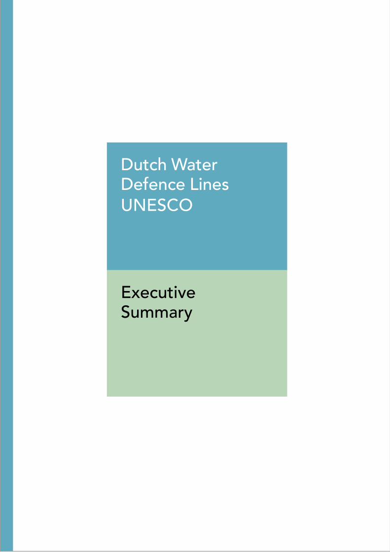
759-006 Fort along the Pampus (44)
Noord-Holland 52 21 53.24 °N5 4 8.18 °E
2.64 ha see bufferzone Main Defence Lines
1.8
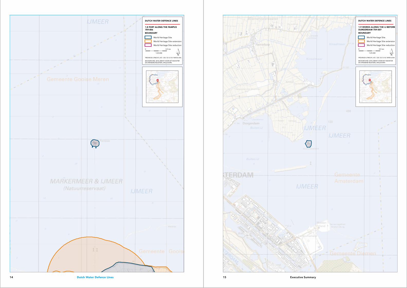
759-007 Works along the IJ before Durgerdam (Vuur-toreneiland; 45)
Noord-Holland 52 22 20.58 °N5 0 49.28 °E
1.81 ha see bufferzone Main Defence Lines
1.9
759-009 Fort Werk IV (48) Noord-Holland 52 16 17.03 °N5 10 33.65 °E
1.13 ha see bufferzone Main Defence Lines
1.10
759-010 Tiel Inundation Canal Gelderland 51 52 35.20 °N5 24 26.17 °E
15.54 ha see bufferzone Main Defence Lines
1.11
759-011 Fort Pannerden (95) Gelderland 51 52 51.33 °E6 1 36.15 °E
1.00 ha 87.29 ha 1.12
Total area 54,779.02 ha 191,722.63 ha
9 Executive Summary8 Dutch Water Defence Lines

5°20'0"E
5°20'0"E
5°10'0"E
5°10'0"E
5°0'0"E
5°0'0"E
4°50'0"E
4°50'0"E
4°40'0"E
4°40'0"E4°30'0"E
52°3
0'0
"N
52°3
0'0
"N
52°2
0'0
"N
52°2
0'0
"N
52°1
0'0
"N
52°1
0'0
"N
52°0
'0"N
52°0
'0"N
51°5
0'0
"N
51°5
0'0
"N
DUTCH WATER DEFENCE LINES
1.4 BOUNDARYDUTCH WATER DEFENCE LINES759-001
PROPOSED BOUNDARY
World Heritage Site
World Heritage Site extension
World Heritage Site reduction
0 10 km
1:400.000
BACKGROUND: 2018, DIENST VOOR HET KADASTEREN OPENBARE REGISTERS, APELDOORN
PROVINCIE UTRECHT, LFO - GIS / 30-11-18 / NHW & SVA
4°36'0"E
4°36'0"E
4°35'0"E
4°35'0"E
4°34'0"E
4°34'0"E
4°33'0"E
4°33'0"E
52°2
9'0
"N
52°2
9'0
"N
52°2
8'0
"N
52°2
8'0
"N
52°2
7'0
"N
52°2
7'0
"N
DUTCH WATER DEFENCE LINES
BACKGROUND: 2018, DIENST VOOR HET KADASTEREN OPENBARE REGISTERS, APELDOORN
PROVINCIE UTRECHT, LFO - GIS / 03-12-18 / NHW & SVA
BOUNDARY
World Heritage Site
World Heritage Site extension
World Heritage Site reduction
1.5 COASTAL FORT NEAR IJMUIDEN759-002
0 0,5 km
1:25.000
11 Executive Summary10 Dutch Water Defence Lines

4°39'0"E
4°39'0"E
4°38'0"E
4°38'0"E
4°37'0"E
4°37'0"E
52°2
1'0
"N
52°2
1'0
"N
52°2
0'0
"N
52°2
0'0
"N
52°1
9'0
"N
52°1
9'0
"N
DUTCH WATER DEFENCE LINES
BACKGROUND: 2018, DIENST VOOR HET KADASTEREN OPENBARE REGISTERS, APELDOORN
PROVINCIE UTRECHT, LFO - GIS / 30-11-18 / NHW & SVA
PROPOSED BOUNDARY
World Heritage Site
World Heritage Site extension
World Heritage Site reduction
1.6 FORT NEAR HEEMSTEDE759-003
0 0,5 km
1:25.000
5°2'0"E
5°2'0"E
5°1'0"E
5°1'0"E
5°0'0"E
5°0'0"E4°59'0"E
52°1
9'0
"N52
°22
'0"N
52°2
2'0
"N
52°2
1'0
"N
52°2
1'0
"N
52°2
0'0
"N
52°2
0'0
"N
DUTCH WATER DEFENCE LINES
BACKGROUND: 2018, DIENST VOOR HET KADASTEREN OPENBARE REGISTERS, APELDOORN
PROVINCIE UTRECHT, LFO - GIS / 03-12-18 / NHW & SVA
BOUNDARY
World Heritage Site
World Heritage Site extension
World Heritage Site reduction
1.7 WORKS ALONG THE IJ BEFOREDIEMERDAM 759-005
0 0,5 km
1:25.000
13 Executive Summary12 Dutch Water Defence Lines
5°5'0"E
5°5'0"E
5°4'0"E
5°4'0"E
5°3'0"E
5°3'0"E
5°6'0"E
52°2
3'0
"N
52°2
3'0
"N
52°2
2'0
"N
52°2
2'0
"N
52°2
1'0
"N
52°2
1'0
"N
DUTCH WATER DEFENCE LINES
BACKGROUND: 2018, DIENST VOOR HET KADASTEREN OPENBARE REGISTERS, APELDOORN
PROVINCIE UTRECHT, LFO - GIS / 03-12-18 / NHW & SVA
BOUNDARY
World Heritage Site
World Heritage Site extension
World Heritage Site reduction
1.8 FORT ALONG THE PAMPUS759-006
0 0,5 km
1:25.000
5°2'0"E
5°2'0"E
5°1'0"E
5°1'0"E
5°0'0"E
5°0'0"E4°59'0"E
52°2
4'0
"N
52°2
3'0
"N
52°2
3'0
"N
52°2
2'0
"N
52°2
2'0
"N
52°2
1'0
"N
52°2
1'0
"N
DUTCH WATER DEFENCE LINES
BACKGROUND: 2018, DIENST VOOR HET KADASTEREN OPENBARE REGISTERS, APELDOORN
PROVINCIE UTRECHT, LFO - GIS / 03-12-18 / NHW & SVA
BOUNDARY
World Heritage Site
World Heritage Site extension
World Heritage Site reduction
1.9 WORKS ALONG THE IJ BEFOREDURGERDAM 759-007
0 0,5 km
1:25.000
15 Executive Summary14 Dutch Water Defence Lines

5°12'0"E
5°12'0"E
5°11'0"E
5°11'0"E
5°10'0"E
5°10'0"E
5°9'0"E
5°9'0"E
52°1
7'0
"N
52°1
7'0
"N
52°1
6'0
"N
52°1
6'0
"N
52°1
5'0
"N
52°1
5'0
"N
DUTCH WATER DEFENCE LINES
BACKGROUND: 2018, DIENST VOOR HET KADASTEREN OPENBARE REGISTERS, APELDOORN
PROVINCIE UTRECHT, LFO - GIS / 03-12-18 / NHW & SVA
PROPOSED BOUNDARY
World Heritage Site
World Heritage Site extension
World Heritage Site reduction
1.10 FORT WERK IV759-009
0 0,5 km
1:25.000
5°26'0"E
5°26'0"E
5°25'0"E
5°25'0"E
5°24'0"E
5°24'0"E
5°23'0"E
5°23'0"E
51°5
4'0
"N
51°5
4'0
"N
51°5
3'0
"N
51°5
3'0
"N
51°5
2'0
"N
51°5
2'0
"N
DUTCH WATER DEFENCE LINES
BACKGROUND: 2018, DIENST VOOR HET KADASTEREN OPENBARE REGISTERS, APELDOORN
PROVINCIE UTRECHT, LFO - GIS / 30-11-18 / NHW & SVA
PROPOSED BOUNDARY
World Heritage Site
World Heritage Site extension
World Heritage Site reduction
1.11 TIEL INUNDATION CANAL759-010
0 0,5 km
1:25.000
17 Executive Summary16 Dutch Water Defence Lines

Name and contact information OrganisationDefence Line of Amsterdam Project Office
Correspondence addressP.O. Box 3007, NL-2001 DA Haarlem, The Netherlands
Visiting addressHoutplein 33, NL-2012 DE Haarlem, The Netherlands
Tel.: +31(0)23 514 31 43Fax: N/aE-mail: [email protected] address: www.stellingvanamsterdam.nl
OrganisationNew Dutch Waterline programme office.
Correspondence addressP.O. Box 406, NL-3500 AK Utrecht, The Netherlands
Visiting addressArchimedeslaan 6, NL-3584 BA Utrecht, The Netherlands
Tel.: +31(0)30 258 36 03Fax: N/aE-mail: [email protected] address: www.programmanieuwehollandsewaterlinie.nl
6°3'0"E
6°3'0"E
6°2'0"E
6°2'0"E
6°1'0"E
6°1'0"E
6°0'0"E
6°0'0"E
51°5
4'0
"N
51°5
4'0
"N
51°5
3'0
"N
51°5
3'0
"N
51°5
2'0
"N
51°5
2'0
"N
DUTCH WATER DEFENCE LINES
BACKGROUND: 2018, DIENST VOOR HET KADASTEREN OPENBARE REGISTERS, APELDOORN
PROVINCIE UTRECHT, LFO - GIS / 30-11-18 / NHW & SVA
PROPOSED BOUNDARY
World Heritage Site
World Heritage Site extension
World Heritage Site reduction
1.12 FORT PANNERDEN 759-011
0 0,5 km
1:25.000
19 Executive Summary18 Dutch Water Defence Lines

Related Documents