r5,CFyLCE1V DuPont Agricultural Products March 15, 2002 Docket No. 03020681 Control No- 13036-3 .?/ 7,' DuPont Agricultural Products Stine-Haskell Research Center Elkton Road, P. 0. Box 30 Newark, DE 19714-0030 L e7 License No. 07-13441-02 Pamela J. Henderson Senior Health Physicist Nuclear Materials Safety Branch 2 Division of Nuclear Safety Region 1 475 Allendale Road King of Prussia, PA 19406-1415 SUBJECT: E. I. DuPont de Nemours and Co., Inc. Response to Environmental Assessment Request for Field Studies at Stine-Haskell Research Center Involving ByProduct Material, Control No. 34W 131/76 Dear Pamela; Enclosed is our Environmental Assessment of our field plot at Stine-Haskell Research Center to renew our Nuclear Regulatory Commission License No. 07-1344!-02. Per your request, we have followed the guidelines in the Sample Environmental Assessment you sent us plus the example reported in the Federal Register: Environmental Documents, April 11, 2001 (Volume 66, Number 70) Nuclear Regulatory Commission [Docket No. 030-32714]. Hopefully, this assessment will satisfy your requirements for preparation of an environmental assessment in accordance with the procedures and criteria in 10 CFR Part 5 1, "Environmental Protection Regulations for Domestic Licensing and Related Regulatory Functions." If there are any questions, please contact the site Radiation Safety Officer, Norman W. Henry at (302-366 5250). Sincerely, seph Montovino V.acilities Manager 'Stine-Haskell Research Center Enclosure: Stine-Haskell Research Center Environmental Assessment /3// 76 Our 2 vSWRSIATERIALS-0 2 E. I. du Pont de Nemours and Company 0 Printed on Recycled Paper SH-44 Rev. 6/95

Welcome message from author
This document is posted to help you gain knowledge. Please leave a comment to let me know what you think about it! Share it to your friends and learn new things together.
Transcript

r5,CFyLCE1V
DuPont Agricultural Products
March 15, 2002
Docket No. 03020681 Control No- 13036-3 .?/ 7,'
DuPont Agricultural Products Stine-Haskell Research Center Elkton Road, P. 0. Box 30 Newark, DE 19714-0030
L e7
License No. 07-13441-02
Pamela J. Henderson Senior Health Physicist Nuclear Materials Safety Branch 2 Division of Nuclear Safety Region 1 475 Allendale Road King of Prussia, PA 19406-1415
SUBJECT: E. I. DuPont de Nemours and Co., Inc. Response to Environmental Assessment Request for Field Studies at Stine-Haskell Research Center Involving ByProduct Material, Control No. 34W
131/76
Dear Pamela;
Enclosed is our Environmental Assessment of our field plot at Stine-Haskell Research Center to renew our Nuclear Regulatory Commission License No. 07-1344!-02. Per your request, we have followed the guidelines in the Sample Environmental Assessment you sent us plus the example reported in the Federal Register: Environmental Documents, April 11, 2001 (Volume 66, Number 70) Nuclear Regulatory Commission [Docket No. 030-32714]. Hopefully, this assessment will satisfy your requirements for preparation of an environmental assessment in accordance with the procedures and criteria in 10 CFR Part 5 1, "Environmental Protection Regulations for Domestic Licensing and Related Regulatory Functions."
If there are any questions, please contact the site Radiation Safety Officer, Norman W. Henry at (302-3665250).
Sincerely,
seph Montovino V.acilities Manager
'Stine-Haskell Research Center
Enclosure: Stine-Haskell Research Center Environmental Assessment/3// 76
Our2 vSWRSIATERIALS-0 2
E. I. du Pont de Nemours and Company0 Printed on Recycled Paper
SH-44 Rev. 6/95

Page I ot'3
Stine Haskell Research Center 3/14/02 RBD
Site Characteristics
The Stine Haskell Research Center (SHRC) is located on Elkton Road, in Newark, Delaware. The SHRC is situated on a five hundred thirty five (535) acre site at approximately 39 degrees and 40 minutes north latitude and 75 degrees and 45 minutes west longitude. Of this, 267 acres of open fields and woodlands are in Cecil County, Maryland, with the remaining 268 acres of fields, woods, and all buildings in New Castle County, Delaware. There are no radiological activities carried out in the portion of the site located in the State of Maryland.
Currently, numerous laboratories and greenhouses are located at the site which are used only for toxicology and safety testing, and research and development of agricultural products and pharmaceuticals. Agricultural fields surround these structures and are used for testing experimental herbicides and pesticides under natural climatic conditions. The site currently employs approximately 800 personnel.
The site is bounded to the east and south by woodlands, homes, light industry, and businesses, and to the north and west by the Baltimore & Ohio Railroad tracks. Topographically, the site is at an approximate elevation of 120 feet above mean sea level, although the western portion of the site rises topographically to an elevation of 170 feet above mean sea level.
The site lies within the drainage basis of the Christina River. Surface drainage patterns at the site are controlled by an unnamed tributary of the West branch of the Christina River, which bisects the site and flows in a southerly direction connecting with the West branch south of the property boundary. The East branch of the Christina River meanders briefly through the northeast corner of the site, flows eastwardly before turning southwardly, joins the West branch and discharges into the Delaware River. Surface-water intake from the Christina River is located near Smalley's Pond, approximately 8 to 10 miles downstream of the site. This intake is operated by the Wilmington Suburban Water Authority as a potable-water source for the nearby communities. Surface drainage patterns are controlled regionally by the Delaware River.
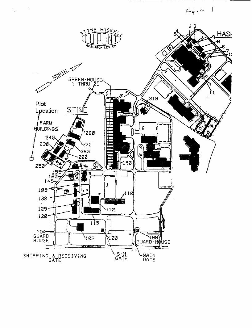
Radiological tests are conducted in a small test plot, 24.2 meters X 30.5 meters, for studies of metabolism, stability, and environmental fate of agricultural chemicals and associated products. The test plot application does not exceed ten (10) milliCurie of byproduct material. The plot is surrounded by a four (4) foot high fence. Figure 1 shows the location of the test plot area within the facility.
Environmental Impacts of the Proposed Action
The location of the closest off-site human dwelling is approximately 182 meters away from the test plot. The maximum radioactivity released in one year is 10 mCi. Using this information, impacts to water supplies and the dose to the maximally exposed individual is calculated. The radiological impact from the performance of field studies with radiolabeled materials at the Center has been calculated using both the EPA's Gaussian Dispersion model, SCREEN 3, and the EPA's COMPLY model.
Page 2 of 3
Impact on Food Chain
The plants grown in radiolabled studies will not be available for incorporation into the food chain. The test area is enclosed by a 4-foot tall chain link fence, and wire mesh or bird netting will be used to restrict bird and small rodent access to the plot. All plant material generated will be used for laboratory research purposes or disposed of as radioactive waste. Soil will be removed from the plot to a level where the soil radioactivity is at background. Removed soil will be disposed of per appropriate regulations. Due to the precautions taken during application, the physical barriers in place to prevent wildlife access, and the removal of all soil and plant materials at the conclusion of the study, it is not reasonable to assume that the radiolabeled plant material will enter the food chain by the ingestion process.
Groundwater Impacts
The procedure for application results in a very low potential for overspray and contamination of soil. For plants in pots, a plastic bag is placed over the entire setup. The spraying is conducted through a slit in the plastic bag. For plots, plastic is wrapped around stakes, which are placed at each corner of the plot. Any drift will be contained by the plastic.
At the conclusion of the testing, all vegetation is removed and disposed. Core soil samples are taken to depths of 18" and analyzed for C-14. Soil is removed from the plot to a level where the soil radioactivity is at background.
Given the application procedure, and the soil testing at the conclusion of the test, it is not
considered likely that the radiolabled material from plot will contaminate the groundwater.
Surface Water Runoff
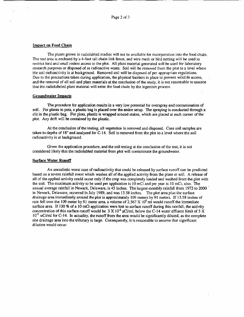
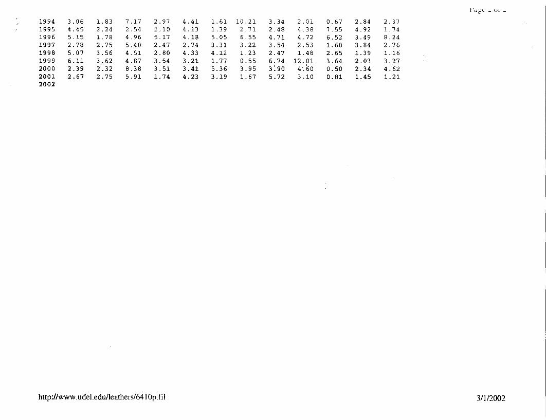
An unrealistic worst case of radioactivity that could be released by surface runoff can be predicted based on a severe rainfall event which washes all of the applied activity from the plant or soil. A release of all of the applied activity could occur only if the crop was completely loaded and washed from the plot with the soil. The maximum activity to be used per application is 10 mCi and per year is 10 mCi, also. The annual average rainfall in Newark, Delaware, is 45 inches. The largest monthly rainfall from 1972 to 2000 in Newark, Delaware, occurred in July 1989, and was 13.58 inches. The plot area plus the surface drainage area immediately around the plot is approximately 109 meters by 91 meters. If 13.58 inches of rain fell over the 109 meter by 91 meter area, a volume of 2.567 X V08 ml would runoff the immediate surface area. If 100 % of a 10 mCi application were lost to surface runoff during this rainfall, the activity concentration of this surface runoff would be 3 X 10.6 uCi/ml, below the C-14 water effluent limit of 3 X l0-5 uCi/nmd for C-14. In actuality, the runoff from the area would be significantly diluted, as the complete site drainage area into the tributary is large. Consequently, it is reasonable to assume that significant dilution would occur.

Page 3 of 3
Dose to Maximally Exposed Individual
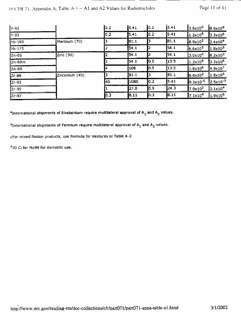
The EPA SCREEN Model employs worst case scenario parameters, including worst case meteorological conditions, to estimate potential concentrations of C- 14 at a specific receptor, the nearest off-site residence, positioned in the downwind direction from the test plot area. In the modeling, it is assumed that the maximum amount of C-14 applied in one year is 10 mCi. The specific activity value for C-14 of 4.5 X 10⁶ uCilgram (from 10 CFR 71, Appendix A, Table A-1) was utilized. Utilizing the SCREEN model, a worst case annual concentration of 4.872 X 10⁻⁷ ug/m3 (2.19 X 10"12 uCi/ml) is predicted for an individual at the nearest off site receptor location (182 meters). This value is a fraction of the 10 CFR Part 20 limit of 3 X 10⁻⁷ uCi/ml.
The COMPLY model was also used to evaluate dose to the general public. This computer simulation calculates the maximum dose to an individual residing outside of the facility and considers dose from all pathways including inhalation, ingestion of contaminated food, immersion, and ground deposition to estimate worst case calculations. With the assumption that 10 mCi of C-14 was released over one year, at a distance of 182 meters to the nearest residence, the COMPLY program, level 2, calculated the maximum effective whole body dose for the maximally exposed individual to be 0.045 mrem/yr, an amount well below and in compliance with the regulatory limit of 100 mrem/yr.
Endangered Species
Due to the precautions taken during application, the physical barriers in place to prevent wildlife access, and the removal of all soil and plant materials at the conclusion of the study, it is considered unlikely that there would be an impact.
Alternatives to the Proposed Action
As required by Section 102(2)(E) of the National Environmental Policy Act (NEPA) [(42 USC 4322(2)(E)], possible alternatives to the final action have been considered. One possible alternative to the field studies is the treatment of greenhouse grown plants with the radiolabled research chemical. However, this alternative is not feasible certain studies required must evaluate the behavior of agricultural chemicals under normal agriculture conditions. Greenhouse studies provide an unnaturally stable environment void of normal weathering field condition, which traditionally leads to non-representative metabolic profiles.

,4.ep4AYx A
3./:W.0c P,- C, z
A
OC, AC4 wAý wars4- cw5e
.2 Y. YmX -34ý,'11,17
-;:ý -7
1±-m-czx yr
e-r-0- 71
OIL
V-ý,4wt,,e 4t, 2.7 3
x - l.ZXjV AX Clý Its "
en eq
X ýy ý- no4-1ýieleWdoe,,ý re-P'4-'&' v//,f w 0 -.es4vný cvjjs&VQ
e2 C- gF-415W jeeSV 144v f In 4w 11 n
1,5 , tC7 9 . Ex-ra ... tA 5 OA- If-fVcVC-0 Vý Llel-5, ý, --? -rn C4-' -- I' .11ý 1-111 3
S
- 7 '>< fr 7ý X/"'ý / 3,'? X 167
3, q, '-X /0
/C70' x if - -9--3

ArrtjeeAs- 4
03/01/02 15 :19:40
SCREEN3 MODEL RUN *** • VERSION DATED 96043 *
Plot
SIMPLE TERRAIN INPUTS: SOURCE TYPE = AREA EMISSION RATE (G/(S-M**2)) = .947900E-13 SOURCE HEIGHT (M) = .0000 LENGTH OF LARGER SIDE (M) = 30.5000 LENGTH OF SMALLER SIDE (M) = 24.4000 RECEPTOR HEIGHT (M) = 2.0000 URBAN/RURAL OPTION = RURAL
THE REGULATORY (DEFAULT) MIXING HEIGHT OPTION WAS SELECTED. THE REGULATORY (DEFAULT) ANEMOMETER HEIGHT OF 10.0 METERS WAS ENTERED.
MODEL ESTIMATES DIRECTION TO MAX CONCENTRATION
BUOY. FLUX = .000 M**4/S**3; MOM. FLUX = .000 M**4/S**2.
FULL METEOROLOGY ***
*** SCREEN DISCRETE DISTANCES ***
*** TERRAIN HEIGHT OF
DIST CONC (M) (UG/M**3)
182. .4872E-06
STAB
6
0. M ABOVE STACK BASE USED FOR FOLLOWING DISTANCES ***
UlOM (M/S)
1.0
USTK (M/S)
1.0
MIX HT (M)
10000.0
PLUME HT (M)
.00
MAX DIR (DEG)
21.
****UMA *O*F*S*CREEN** MODE*L*RESUL***S
*** SUMMARY OF SCREEN MODEL RESULTS ***
CALCULATION MAttON- pST TO TERRAIN PROC EDURE MX() H M
SIMPLE TERRAIN .4872E-066 82.0
**REMEMBER TO( IN D AKGROUND CO NTRATIONS *
IN. DE BQ
DOS z-et -i .4 If 4-r -
9/ C ilpi 3 -233/Id 'kr ;,�x/6
- t3_ t. 79z0 ,.4(,
_ _., ..- •.- | . •
nihF_

6
COMPLY: V1.6. 3/ 1/2002
40 CFR Part 61 National Emission Standards for Hazardous Air Pollutants
REPORT ON COMPLIANCE WITH
THE CLEAN AIR ACT LIMITS FOR RADIONUCLIDE EMISSIONS
FROM THE COMPLY CODE - V1.6.
Prepared by:
DuPont
Rick Drazich (302)-695-9303
Prepared for:
U.S. Environmental Protection Agency Office of Radiation and Indoor Air Washington, DC 20460
3:43

COMPLY: V1.6. 3/ 1/2002 3:43
SHRC Plot
SCREENING LEVEL 2
DATA ENTERED:
Release Rate
Nuclide (curies/YEAR)
C-14 1 1.OOOE-02
Distance from the source to the receptor is 182 meters.
Default mean wind speed used (2.0 m/sec).
NOTES:
Input parameters outside the *normal" range:
None.
RESULTS:
Effective dose equivalent: 4.5E-02 mrem/yr.
*** Comply at level 2.
This facility is in COMPLIANCE.
It may or may not be EXEMPT from reporting to the EPA.
You may contact your regional EPA office for more information.
********** END OF COMPLIANCE REPORT *

Ar~~wvL
;w4-e~ PC
+A,44
Moll
30 /0 Cce
EVTops

Year Jan Feb Mar Apr May Jun Jul Aug
1948 -99.99 -99.99 -99.99 -99.99 -99.99 -99.99 -99.99 3.73 1949 6.23 4.15 2.51 3.03 4.35 1.79 4.80 3.64 1950 2.10 3.28 5.30 1.69 3.35 3.27 3.48 2.20 1951 3.62 3.87 3.49 2.47 4.05 4.33 4.29 2.61 1952 5.31 2.78 5.41 7.17 6.45 2.66 7.60 3.47 1953 5.96 2.87 5.99 4.67 6.13 2.03 4.28 1.87 1954 1.98 1.03 4.30 2.67 2.75 0.56 1.48 3.92 1955 0.41 3.08 4.51 2.91 1.19 6.84 0.23 14.001956 1957 1958 1959 1960 1961 1962 1963 1964 1965 1966 1967 1968 1969 1970
1973 1974 1975 1976 1977 1978 1979 1980 1981 1982 1983 1984 1985 1986 1987 1988
1989 1990 1991 1992 1993
2 .61 1.91 3 .93 2 .15 3 .04 2.25 2 .51 1.93 4.09 2.23 2.91 1 .97 1 .47 1.76 1.06 2.35 2.61 1.55 2 .94 4.49 5.02 1.75 7.81 8.86 2.43 0.56
4.40 2 .15 0.88 1.97 4.25
4.76 1 .50
2.25 4 .81 3.70 1.18 2.83
3.21 2 .13 4.79 1 .87 4.00 3.43 3.76 2.02 2.48 2.81 3.43 1.28 1.09 1.69 1.77 6.32 4.74 3.38 1.54 2.76 1.26 1.12 1.05 5.63 0.77 3.01 2.62 2.93 4.69 2.35
-99.99 1.17 4 .17 3.30 1.86
1.21 1.97 3.25
4.72 2.70 1.83 4.99 8.59 2.23 3.90 1.67 4.27 1.78 6.77 5.30 3.79 5.16 3.38 3.19 2.29 1.44 3.70 8.69 1.42 4.23 5.40 2.25 5.85 3.77 4.60 2.86 4.03 4.09 2.86 4.31 1.80 4.02 2.25 4.46 0.93 -99.99 2.73 1.65 1.63 5.00 0.54 0.72 4.24 3.17 1.96 1.07 1.35 5.33 1.61 3.26 4.70 0.87 3.01 4.07 2.80 3.93 2.51 5.19 5.21 1.97 4.80 1.76 3.34 1.12 2.24 3.63 3.92 7.08 3.20 4.80 1.33 6.82 6.21 2.00 2.06 5.01 3.07 4.21 2.60 5.13 3.45 7.83 2.93 3.70 6.51 5.67 6.33 4.36 3.91 2.91 5.00 3.87 2.43 4.45 2.98 5.08 6.81 7.66 1.36 2.11 4.41 3.74 6.24 5.27 3.54 1.39 4.49 2.84 4.79 1.58 6.64 3.30 5.61 2.06 3.66 4.22 3.06 2.10 5.89 4.25 3.04 4.62 1.54 1.26 3.81 5.55 4.56 2.14 2.17 5.25 4.61 5.18 2.66 6.73 8.91 6.28 3.61 0.58 6.10 3.74 5.14 5.49 8.65 1.83 0.68 4.43 2.75 6.79 1.42 2.56 0.98 2.32 3.69 2.29 3.25 3.79 2.04 4.10 1.93 3.11 7.51 1.10 5.99 4.50 2.99 6.62 7.37 C '8 2.32 3.94 8.63 5.37 5.26 4.69 3.21 1.93 2.70 4.06 4.74 1.62 4.98 4.16 6.06 7.30 5.42 1.64 5.37 2.78
4 .04
2.72 7.90 3.56 5.87 4.02 3.20 3.88 2.59 2.52 1.33
12.42 1.90 2.36 3 .17
9.90
1.08 2.86 6.79 2 .06 2 .56 7 .85 4.61 6.88 2 .02 4.26 3 .85
0 .69
2 .81 3.20
4 .77
2 .17
5.38
2.31 6.47 3 .75 3.78 3.12
http://www.udel.edu/leathers/641Op. fil
I'a Ic i uI -
Sep 2.21 3.10 4.65 1.49 4.05 3 .78 2.51 1.42 3.28 6.67 2.55 3.60 8.16 1.46 3.27 3 .75 2.80 2.23
6.82 2.41 2.76 6.24 1.14 5 .64
2.70
4.47 5.36 6.18 1.91 1.38 1.73 6.78 1.82 4.80 3 .12 2.81 2.71 5.78 1.52 8.46 2 .62
5.42 2.37 4.42 5.46 7.07
Oct Nov 1.86 4.63 3.82 1.18 2.60 2.32 2.68 6.71 0.70 5.74 3.53 1.95 2.47 3.88 4.08 1.34. 3.86 4.73 2.99 3.81 3.64 3.09 4.36 2.96 2.96 1.86 2.24 2.37 1.76 5.40 0.29 4.62 1.27 1.76 2.76 1.26 5.20 1.44 1.93 2.08 3.47 3.54 1.74 1.74 2.13 3.89 6.53 4.90 3.72 7.54 2.21 0.84 2.19 1.25 3.59 2.97 8.50 0.01 4.68 4.48 1.46 2.88 3.89 3.69 4.62 2.77 3.00 0.77 2.04 4.37 5.23 5.55 3.00 2.06 2.13 4.05 3.91 7.10 2.08 4.32 2.13 6.21 5.00 2.19 2.35 2.22 1.39 2.28 1.62 4.33 2.94 3.75
Dec 5.35 3.27 1.98 5.82 3.21 3.88 3 .00 0.17 3 .69 5.90 1.30 4.48 2.42 2.88 2 .64
1.72 5.13 1.25 4 .04 4.96 2 .62 6.16 2.90 1.22 5.37
7.87 5.14 2.15 1.64 6.49 5.41 1.51 0.80 4.05 2.05 8.89 1.98 1.09 6.55 1.66 1.03 0.38 5.56 4.19 4.96 4.23
m 49 ri 4-h /,y
-r-no 54=44
Pe- to-aza
C t I >TLt 4V
3/1/2002
My- ok -
1994 3.06 1.83 7.17 2.97 4.41 1.61 10.21 3.34 2.01 0.67 2.84 2.37 1995 4.45 2.24 2.54 2.10 4.13 1.39 2.71 2.48 4.38 7.55 4.92 1.74 1996 5.15 1.78 4.96 5.17 4.18 5.05 6.55 4.71 4.72 6.52 3.49 8.24 1997 2.78 2.75 5.40 2.47 2.74 3.31 3.22 3.54 2.53 1.60 3.84 2.76 1998 5.07 3.56 4.51 2.80 4.33 4.12 1.23 2.47 1.48 2.65 1.39 1.16 1999 6.11 3.62 4.87 3.54 3.21 1.77 0.55 6.74 12.01 3.64 2.03 3.27 2000 2.39 2.32 8.38 3.51 3.41 5.36 3.95 3190 4.60 0.50 2.34 4.62 2001 2.67 2.75 5.91 1.74 4.23 3.19 1.67 5.72 3.10 0.81 1.45 1.21 2002
http://www. udel.edu/leathers/64 IOp. fil 3/1/2002
Year Jan Feb Mar Apr May Jun Jul Aug Sept Oct Nov Dec Greatest
1894 1.81 4.05 1.35 0.34 2.02 2.15 2.15 0.97 1.91
1895 1.71 3.15 1.50 1.77 0.62 1.26 1.32 1.08 0.39 1.39 0.70 0.67 3.15
1896 1.63 2.67 2.02 0.40 1.26 1.38 1.17 0.34 1.75 0.95 1.04 0.35 2.67
1897 1.25 1.55 0.50 1.34 2.12 0.67 3.02 0.86 0.96 1.10 1.57 1.90 3.02
1898 0.90 2.00 0.58 0.47 1.00 0.89 1.75 1.11 0.79 1.10 1.48 1.12 2.00
1899 1.10 1.38 1.00 0.53 0.72 0.36 1.86 2.52 1.20 1.08 0.62 0.82 2.52
1900 1.96 1.30 0.95 0.80 1.20 1.70 1.30 0.75 1.20 1.05 1.00 1.75 1.96
1901 1.00 0.82 1.25 2.05 0.70 0.80 0.90 3.00 1.37 0.75 2.60 2.30 3.00
1902 2.38 1.90 1.10 2.40 0.90 1.50 1.76 1.00 1.97 2.50 0.90 1.55 2.50
1903 1.35 1.10 0.95 0.95 0.50 0.90 2.79 1.50 0.60 1.70 0.81 1.52 2.79
1904 0.97 1.40 1.15 0.65 0.95 1.33 1.82 2.28 3.48 1.93 1.42 0.40 3.48
1905 1.73 1.08 1.45 1.14 0.70 1.15 1.60 1.40 1.07 1.70 1.10 1.45 1.73
1906 1.04 1.05 2.30 2.55 1.00 1.25 2.48 1.97 0.28 1.67 0.80 1.30 2.55
1907 0.55 0.75 1.10 1.17 2.11 1.80 1.30 1.82 2.50 3.00 3.02 1.32 3.04
1908 1.55 1.23 0.55 0.87 2.07 1.78 3.84 2.20 1.80 0.60 1.00 2.20 3.84
1909 1.05 1.00 1.40 0.88 0.53 0.76 1.56 1.84 1.78 0.34 0.64 2.20 2.20
1910 1.72 0.50 1.13 1.50 0.57 2.25 2.25 1.30 2.95 2.10 1.73 0.99 2.95
1911 0.58 0.95 0.60 1.27 0.85 1.80 1.75 3.95 1.20 1.30 1.83 1.08 3.95
1912 0.45 1.90 2.34 0.55 1.02 1.35 1.90 0.55 2.83 2.55 2.04 1.63 2.83 410"1
1913 0.72 1.00 2.37 1.92 1.47 0.45 1.14 1.93 1.01 1.58 0.90 1.31 2.37
1914 1.74 0.81 0.70 1.84 0.92 0.40 2.50 0.93 0.39 1.80 1.60 1.76 2.50 5'+ O-'¶k •
1915 1.00 2.30 0.90 1.40 1.02 1.87 0.62 1.90 0.16 0.89 0.75 1.10 2.30
1916 0.42 1.00 1.25 0.70 0.75 1.40 1.72 0.20 1.32 1.20 0.93 1.43 1.72
1917 1.22 0.44 1.38 1.51 1.06 1.94 2.60 2.12 2.08 2.89 0.41 1.00 2.89
1918 0.95 0.65 0.54 1.51 1.09 1.59 0.70 1.12 1.61 0.47 1.00 1.09 1.64
1919 1.20 1.30 1.60 2.07 1.57 1.37 3.57 2.75 1.63 0.85 2.73 1.12 3.57
1920 0.60 1.20 2.06 0.90 0.94 2.26 1.97 1.14 1.05 0.40 1.85 1.24 2.26
1921 2.13 1.31 0.81 1.79 1.24 1.06 1.78 1.39 1.40 0.50 0.66 1.17 2.13
1922 1.09 1.23 1.30 0.51 1.10 1.62 0.98 1.19 0.92 0.57 0.30 1.02 1.62
1923 1.23 1.36 0.94 2.25 0.45 0.30 2.12 1.83 1.59 2.72 1.01 1.32 2.72
1924 1.25 2.20 1.00 2.27 1.37 1.34 2.03 1.49 2.42 0.05 1.17 0.96 2.42
1925 1.65 1.30 1.20 0.70 1.37 0.82 2.27 0.63 1.19 1.48 2.05 0.34 2.27
1926 1.03 0.90 0.60 0.67 0.65 0.94 3.19 0.52 1.62 0.88 1.26 1.09 3.19
1927 0.83 0.75 0.88 1.20 0.65 1.57 2.58 2.90 1.99 1.55 2.25 2.10 2.90
1928 1.00 1.35 0.65 1.70 0.72 1.40 4.15 2.38 0.94 0.76 0.40 0.61 4.15
1929 0.81 0.94 1.04 2.35 0.49 1.09 0.58 3.31 1.38 2.02 1.68 1.12 3.31
1930 0.87 1.76 1.80 1.17 1.00 1.20 1.30 0.65 4.38 0.51 0.38 1.80 4.38
1931 0.90 0.70 1.42 0.95 1.55 1.88 2.24 2.05 1.15 0.91 0.36 1.05 2.24
1932 0.96 0.86 2.20 0.70 1.11 2.41 1.10 1.75 1.62 2.37 1.83 0.90 2.41
1933 1.72 0.99 1.25 1.73 1.42 0.43 2.25 3.60 1.06 0.95 0.80 1.12 3.60
1934 0.80 0.90 0.75 1.34 1.38 2.04 0.98 2.18 2.67 1.50 1.28 1.06 2.67
1935 1.50 1.29 1.26 1.17 1.92 1.67 1.91 1.06 2.00 1.24 3.33 0.72 3.33
1936 3.08 1.02 1.80 1.44 1.13 0.79 0.79 2.08 1.35 1.41 0.34 1.94 3.08
1937 0.94 0.97 0.42 2.00 0.78 1.29 0.63 2.03 1.90 1.34 2.04 0.63 2.04
/ 4- C I" et
2/26/2002http://www.udel.edu/leathers/24precip

1938 0.75 0.90 0.61 0.65 0.94 4.77 1.51 2.08 2.49 0.73 0.93 1.33 4.77
1939 1.53 1.40 1.16 2.02 0.26 2.07 0.46 3.95 0.45 1.64 0.52 0.59 3.95
1940 1.07 0.99 2.09 2.61 1.36 0.78 0.94 1.45 1.21 0.89 1.10 0.91 2.61
1941 1.01 0.81 0.72 1.42 0.49 1.11 1.83 0.81 0.55 0.95 0.98 2.12 2.12
1942 1.15 1.38 1.62 0.58 1.15 0.75 2.90 2.20 0.98 1.25 0.90 1.25 2.90
1943 1.15 0.68 1.08 2.03 1.85 1.29 0.75 0.55 0.15 1.78 1.76 1.27 2.03
1944 1.50 0.58 1.38 1.02 0.62 1.85 0.62 3.10 3.21 0.95 2.03 1.05 3.21
1945 1.36 0.73 0.58 0.90 1.06 1.38 1.93 6.53 2.20 0.73 2.25 1.12 6.53
1946 0.46 0.97 1.32 0.65 2.01 2.50 2.32 2.79 2.60 0.67 0.50 1.00 2.79
1947 1.00 0.96 0.82 2.98 4.49 1.28 1.34 1.24 0.53 2.11 3.29 0.76 4.49
1948 1.56 0.76 0.60 1.49 1.83 2.08 0.38 1.48 0.63 0.59 1.47 1.99 2.08
1949 1.26 0.76 1.03 0.69 1.65 0.46 2.32 1.05 1.32 1.13 0.44 0.76 2.32
1950 0.80 0.79 1.30 0.67 0.91 0.93 0.79 1.26 2.29 1.48 2.76 0.64 2.76
1951 1.16 1.03 1.47 0.91 1.40 1.26 1.98 1.77 0.70 1.37 2.32 1.82 2.32
1952 0.93 1.90 1.61 1.16 2.01 1.86 6.24 0.90 1.73 0.35 2.18 1.30 6.24
1953 1.50 1.06 1.29 1.15 1.11 1.07 2.16 1.03 2.11 2.94 1.17 1.47 2.94
1954 0.60 0.87 0.96 0.91 0.74 0.20 0.74 2.05 1.15 1.12 1.53 1.13 2.05
1955 0.23 1.07 1.34 0.89 0.83 2.67 0.13 4.00 0.89 0.82 0.68 0.16 4.00
1956 0.74 1.13 1.65 1.06 0.64 0.78 3.52 1.62 0.87 1.87 3.83 1.18 3.83
1957 0.83 1.51 0.81 1.67 1.43 1.23 0.64 2.36 2.01 0.91 0.59 1.01 2.36
1958 1.12 1.83 2.75 1.91 1.50 2.43 2.51 2.02 1.16 2.01 1.09 0.66 2.75
1959 0.87 0.60 1.16 0.54 1.01 2.44 1.73 3.23 2.19 '1.02 1.46 1.08 3.23
1960 0.80 1.06 0.72 1.34 1.07 0.62 2.47 1.24 5.62 1.43 1.01 1.15 5.62
1961 1.08 1.13 1.17 2.56 0.80 0.80 2.47 1.66 1.70 0.65 0.82 0.87 2.56
1962 1.60 0.92 1.79 1.16 1.23 1.74 0.68 0.52 1.96 0.64 1.46 1.21 1.96
1963 0.67 0.83 1.01 0.81 0.57 1.55 0.97 1.31 1.97 0.21 2.96 0.75 2.96
1964 1.26 1.01 1.42 0.97 0.16 0.72 2.33 0.69 1.42 0.66 1.22 1.53 2.33
1965 0.84 1.18 1.20 0.42 0.58 0.95 2.84 0.56 1.06 0.96 0.27 0.93 2.84
1966 0.80 2.29 0.59 0.89 1.22 0.55 1.32 0.56 3.72 3.88 0.63 1.14 3.88
1967 1.24 0.80 2.63 1.00 1.60 1.66 1.10 3.08 0.96 0.86 0.84 1.61 3.08
1968 1.61 0.97 2.06 0.97 2.35 1.75 0.77 0.82 0.80 1.72 1.12 0.67 2.35
1969 0.50 0.68 0.82 0.51 2.02 1.80 3.21 1.36 5.37 0.64 0.65 2.22 5.37
1970 0.47 0.82 1.18 2.39 0.43 2.23 1.55 1.64 0.53 2.33 1.19 1.23 2.39
1971 1.18 1.76 0.86 1.81 1.62 1.22 2.56 4.11 3.24 3.74 1.84 0.94 4.11
1972 0.69 1.62 0.81 1.19 1.49 4.35 0.98 0.17 0.60 2.21 2.44 1.52 4.35
1973 1.46 2.01 1.98 1.75 1.35 2.21 1.17 1.70 2.08 1.37 0.20 1.82 2.21
1974 0.71 0.33 1.27 1.27 0.85 1.54 0.84 1.77 1.64 1.77 0.40 1.43 1.77
1975 0.81 0.76 2.01 1.60 1.88 2.39 2.71 1.33 2.48 1.68 1.50 1.22 2.71
1976 1.53 0.64 0.66 0.49 2.29 1.33 1.65 1.05 1.06 1.82 0.39 1.13 2.29
1977 1.04 0.96 2.22 1.23 0.55 1.71 0.60 1.92 0.38 1.49 1.65 2.06 2.22
1978 2.12 1.36 3.11 1.42 2.06 0.78 3.94 2.75 1.51 0.64 0.84 1.64 3.94
1979 2.01 2.17 0.90 1.37 0.96 1.15 2.42 2.51 1.96 1.47 1.58 0.49 2.51
1980 1.00 0.40 1.39 1.08 0.66 1.72 1.18 0.47 0.90 2.56 0.96 0.26 2.56
1981 0.24 0.90 0.69 0.80 2.00 1.96 0.76 2.05 1.95 0.74 0.29 1.34 2.05
1982 1.62 1.36 1.05 1.23 2.16 2.45 1.23 2.37 1.04 1.52 1.43 0.91 2.47
1983 1.05 1.62 2.31 2.13 2.06 1.72 1.52 0.84 2.79 1.79 1.74 1.91 2.79
1984 0.04 1.38 1.48 1.22 1.41 0.94 1.17 0.46 0.68 1.19 0.57 0.52 1.48
http://www.udel.edu/leathers/24precip
I � s'.
2/26/2002

1985 0.31 0.85 1986 1.17 0.66 1987 1.13 0.98 1988 0.82 1.18 1989 0.62 0.83 1990 1.31 0.60 1991 1.29 0.26 1992 0.45 0.73 1993 1.32 1.40 1994 1.28 1.26 1995 1.39 0.85 1996 1.54 0.50 1997 0.50 0.54 1998 2.51 1.18 1999 1.44 0.87 2000 0.78 0.78
0.38 0.52 0.49 0.87 1.32 0.88 0.95 1.26 2.27 1.32 1.80 0.85 0.77 1.05 1.70 0.78
0.11 1.26 0.88 0 .97 0.75 0.86 1.55 0 .69
1.35 0.89 0.74 1.38 0.46 1.02 1.06
2.39 0.35 3.02 1.07 2.04 0.88 1.21 0.94 2.38 1.67 1.26 1.45 1.99 1.26
0.91 0.75 1.37 2.66 1.37 1.04 1.13
1.11 0.12 3.08 1.31 1.09 1.41 1.27
1.68 1.00 6.63 0.89 1.81 1.27 0.60
2.72 1.09 2.43 1.97 1.55 0.92 1.25
1.90 2.41 1.78 2.60 2.03 0.76 0.82
2.15 1.20 2.01 0.52 1.96 0.45 0.73
0.40 0.59 2.13 1.02 1.85 0.69 2.02
1.78 1.05 2.57 1.69 0.89 0.54 0.76
0.68 0.40 1.36 1.50 1.39 2.48 1.27
0.60 2.00 1.93 1.27 1.07 1.74 1.28
0.26 0.98 1.38 2.31 0.79 0.75 0.90
0.91 1.90 1.19 1.94 0.67 1.30 0.68
2.23 1.59 0.45 1.79 8.29 1.23 0.69
http://www.udel.edu/leathers/24precip
I i d.A ý ,,
0 .64 1 .87 0 .66 0.31 0 .55 0.77 1.27 1.50 1.22 0.89 0.74 2.09 0.56 0.31 1.15
3 .02 2.38 2.66 3 .08 6.63 2-.43 2.60 2.15 2.27 2.57 2.48 2.09 2.31 2.51 8.29
2/26/2002

WIt'11"1 71,..ppendix A. Table A -I -- A I and A 2 VZa! LICs kw Rad lonI c Ii&"
SiLe_-HlP I $jte 1flnQ• I ContActLUs'J�s
U.S. Nuclear Regulatory Commission
4pt'-7_• , / _I
i - jWjJ Advanced
H Ill i h We Are What We Do Nuclear Nuclear HRadioactive l Public ! Electrc
hme Who R Ractors f Materials Wste Involvement Reading
Home > Electronic Readin > Document Collections > NRC Regulations 1(0 CFR.) > Part index > § 71, Appendix A, Table A-1 and A2 Values for Radionuclides
10 CFR 71,.Appendix A, Table A-1 -- Al and A 2 Values for Radionuclides
Symbol of Element and atomic A 1 (Tlq) A, (Ci) A 2 f A 2 (CI) Specific activity radionuclide number I I (TBq)I (Tbq/g) (Ci/g)
Ac-225 Actinium (89) 0.6 1162 11x0-2 I0270 2. 1x10 3 5.8X10
Ac-227 40 1080 2x10- 5 5.41X[0-4 277.2x10l Ac-228 0.6 16.2 0.4 10.8 4x10⁴ 2.2x06
Ag-l05 Silver (47) 12 54.1 2 1.1x10 3 X10⁴
Ag- 108m 0.6 16.2 0.6 16.219.7x10-1 .601
Ag-1Orm 10.4 I110.8 F4oZ1l 8 xl7xO0 3
IAg-ill 0.5________ 1iX ~ l1 Z ~ 13. 5 .8 o .x
IAI-26 ][Aluminium (13) 0. 0. 1. 0 Am-241 'Americium (95) 2 54. 2X 0-4 x0= •= • " I=
IAm-243 _2 54.1 2x_0-4 5.41,X10-37.4x10- 2.0x10
lAr-37 Argon (18)0 1080 40 1080 3.x,03 9.9x,0 4
IAr-39 120 I II3x1o' IAr-41 0.6 16.2 4.2x10 7
lAr-42 ___________ f.~ i i2 x0 _ _ _ _ _ _ _ _ _ _ _ _ jA rse n ic (3 3 ) 0 .2 15 .4 1 0 .2x 1 0
4s7 40 1[80] 40 1080 8.2x 10² 2.x,4
As-74 ~ ~~1 [27.=0 0.5 L ]371 3 [~0
As-76 0.2 5.41 0.2 5.41
js7[20 1541 1
At211 Astatine (85) 0 11811 2 2111 17.6x,01 4 2.1x10⁶
Au-193 Gold (79) 6 [62 16 1 10 92x105
Au-194 "1 27.0 7 1 27.0 5 10 4.1x10
Au-195 10 270 10 1270 1.4x10² 3.7x10 3
Au-196 2 54.1 2 54.1 4.0x10³ 11.1x10 5
AU-198 3 81.1 0.5 13.5 9.0X10³ 2.4x10 5
AU-199 10 270 0.9 24.3 17.7x10³ 9E2.1xi0,
Ba -131 Barium (56) 2 54.1 2 54.1 I3.1x103 18.4 x10⁴
10 0270 r.9 624.3 2.2x14 ,6.x10s
hi t p://www. nrc.gov/reading-rm/doc-collections/cfr/part07 1 /part07 I -appa-tab lc-a 1. html
Ba-133m
3/I/2002

) (T: 71. Appendix A, Table A-I -- A I and A" Va! LICS fr R Adlonuc idcs
ta- 133
Baa-140
3
0.4
81.1 3 181.1
10.8 0.4 110.8
9.4 12.6xi02
2.7x i03 117.3x10⁴
Be-7 Beryllium (4) 20 541 20 541 111.3xlo4 3.5x10⁵ Be - 10 20 541 ' 10.5 1113.5 18,3xi0-4 2.2xjo-2
Bi-205 Bismuth (83) 0.6 16.2 0.6 J16.2 11.5x10⁻³ 4.2x10⁴
Bi-206 0.3 8.11 0.3 8.11 .8x 1 .X.o
8i_207 0.7 18.9 I10.'7 K18.919 5.2x10
jsi-210m 0.3 18.11 3x10² 8.1xo- ii
Bi-210 0.6 r1o63.5 =05 [ j 14.6x1o3 -14.•xo Bi-212 0.3 0 5.4x10⁵ 1.5×10⁷
Bk-247 Berkelium (97) 2 154.1 2x10- 4 5.41x-33.8x 10⁻² .0
Bk-249 40 1080 8x10⁻² 2.16 6.1x10i 1.6x,0 3
Br-76 Bromine (35) 0.3 8.11 0.3 8.11 9.4x10 4 2.5x,0 6
Br-77 3 81.1 3 81.1 26.x,0 4 7. 1x1 5
B_8 0.4 10.8 0.4 18 4.oxo04 1 .x110 6
C-Il Carbon (6) 1 0.5 335 3 .1x107 8.4xi0 8
114 6x10-F4.5 Cca-41 lcacium (20) 140 1. iII 148 0 1080 I3.1x10-3 8.5x10"2
ICa-45 40 13.5 16.6x,02 1.8x10 4
.Ca-47 _ ___J124.3 0.51j3.52.3x 104 6.1X10 5
Cd-109 Cadmium (48) 27.0 96x101 2.6x,03
lCd-113m 20 18.3 2.2x10 2
Cd-ll5m 0.3 8.11 8.11 9.4x10 2 2.5x10⁴
Cd-115 4 OF.o 05- ] 13.5 .9 104 5.1X10⁵'
Ce-139 Cerium (58) 6 162 5x10² 6.8x03
Ce-141 10 270 0.5 I13 1x10 3 2.8x10 4
Ce-143 0.6 16.2 0.5 1i3.5 .125x,04 6.6xo05
Ce-144 0.2 15.41 o0.2 II5.41 1.2x,0 2 3.2x,0 3
Cf-248 Califormium (98) 30 1811 3x10- 3 18.11X10"2J 58x101 1.6x10 3
Cf-249 2 54.1 2x10- 4 5.41x10- •. x1o- 4.1
Cf-250 5 135 5xI0-4 1.35X10⁻² 4.0 illxlO2
Cf-251 2 54.1 2xiO-4 1•.•x13 xOI
Cf-252 0.1 .70 lxI0-3 2.70x10² 2.0x10i 15xi02
6Cf-253 40J 1080 6,x102 1.62 1 1X3 2..9.... 4
Cf-254 3x10"3 8.11x10 6x 14 6 2 10 2 1x10 2 8.5x10³ 2
CI-36 Chlorine (17) 20 541 ... 13.5 1.2x1O-I 3.3x10⁻²
CI1-38 0.2 5.41 102- 5.41 4.9x10 6 1.3x10 8
Cm-240
Cm-241
Curium (96) 40 1080 2x10⁻² 10.541_________2x 106-2- II
2 54.1 0.9 124.3
7.5x10 2 2.0xlO"
httpU//www.nrc.gov/reading-rm/doc-collections/c fr/part07 I /part07 I-appa-table-a I .html 3/1/2002
III
-, of I I

F • 3of, II1)F("R 71. Appendix A, Table A-I -- A I and A2 Vail tie fr Ratd IIoIt, 1ý"tIIlcN,
II40 11o080 Ix10-2 0.270 I1.2x10 2 3.3x10³
3 181.1 13x10" 4 8. lx10-31 7 9x10⁻³ 5.2x10
4 [108 4x10⁻⁴ 11.08x10 28. lx101
2 54.1 ,2x104 15.,4X10" 6 ,4 x10-3 11.7x10"1
2 52x10-4 5.41X10⁻³ 1.lx10-2 13.1x10-•
2 55.4X10⁻³¹ 9.3x10-
4y1(Y-2 1.08 Sx10� II1.35x103 II1.6x105 114.2x10³
Co-55 Cobalt (27) 13.5 3. 1x10⁶
Co-56 0.3 11 .3 8.11
Co-57 8 216 8 216 1x10 2 8.x
Co-58m 40 1080 40 1080 1[2,2x10s 115.9Xo6
ICo-58 1 27.0-- 1 17.0 1.2x,0 3 3.2x,0 4
Co-60 0.4 10.8 0.4 10.8 4.2x10 1 l.1x1O3
lr-51 Chromium (24) 30 811 30 811 3"4x90 3 92x04
Cs-129 Cesium (55) 108 4 108 12.8x10⁴ 7.6x10⁵
Cs-131 1080 1140 13.8x000 •.oxo
Cs-132 1 127.0 tIi112Z.0 15.0x10³ 1.5x10⁵
Cs-134m 40 1080 l9 243 I3.ox1o0 8.ox106
Cs-134 0.6 16.2 0.5 13.5 4.8x101 1.3x10 3
Cs-135 40 1080 10.9 j24.•3 4.3x1O--5 .2x1
Cs-136 10.5 I13.5 10.5 F 17.3x10 Cs-137 54.1 0 .5 13.5
Cu-64 Copper(29) 5 135 (910.9 24.3 I.4 xlO 3.9X10⁶ cu-67II 9• 243 o.9 24 I.3xo 7•.6xlo! Dy-159 Dysprosium (66) 20 52.7x10³
Dy-165 0.6 16.2 0.5 13.5 113.0x10 5 18.2x06
Dy-166 0.3 8.11. 0._3 18.6x,03 [2:.3:x 10
Er-169 Erbium (68) 40 1080 10.9 ]24.3 113.1xo03 18.3x,0 4
Er-171 0.6 16.2 10.5 13.5 9.0x1o4 2.4x10⁶
Es-253 Einsteinium (99)0 o200 5400 12x02 5.41x10] _ _
1s2530 3L1 IŽ!ii1 i8.ll-2I_____3___ Es-254m F.6 16. 110.4 107.8 II II
Es-255Europium (63) 2 54.1 1.4xlO• 13.7xi0'
0.5 13.5 0.5 13.5 I.OxlO2 1.6x10 4
20 541 2 0 541 3.5x,02 F9.4x03
0.7 118.9 0.7 18.9 6.1x 4
0.6 16.2 10.5 13.5 82xi0 4 2.2x10 6
0.9 24.3 0.9 24.3 16.5
http://www.nrc.gov/reading-rm/doc-collections/cfr/part07 I /part07 I -appa-table-a I htmnl/
CPm-242
Cm -243
ICm-244
1C 25
1C-26 jm27
C m- 94,
Eu-147
Eu-148
Eu-149
Eu-150
Eu-152m
Eu-152
3/1/2002
6. 1 X10² Ill.7x,04
b4. I

l4 ofI' Iioc H'I:R I1, .\ppcrndix A, Table A-I -- AI and A,2 Vatlucs f+r RadIonticlides
11 II 11.8x10 2
0.8 5 9 8I 2.6x10²
20 41 2 54.1 1.8x101 4.9x 10²
Ilv.u Ux-u
F-18 Fluorine (9) 1 27.0 0.5 -I113.5 3.5x10⁶ 9.5x10 7
[Fe-52 Iron (26) 10.2 115.41 "'0.2 15.41 2.7x10 5 7.3x10 6
_-59 .8 121.6_ _8 21_.6 11.8x10 5 I2.ox1o0
FM-255 Fermium (100) 40 11080 80.8 21.6
Fm-e 10 270 8xO- 2.16x1O-1
~Ga-67 Gallium (31) 6 162 6___ =6 .x14 6O1
Ga-68 0.3 8.11 0.3 18.11 1.5x,0 6 4.1x10 7
Ga-72 0.4 10.8 o.4 10.8 1.1x1o0 3..xo06
Gd-146 Gadolinium (64) 0.4 10.8 0.4 10.8 6.9xo02 1.9X10 4
Gd-148 3 81.1 3x10 4 8.11x10 3 1.2 [3.2x10 1
dd-153 10 270 5 135 1.3x,0 2 13.5x10 3
Gd- 159 g 3. 108 0. 54 1.1x10⁶
Ge-68 Germanium (32) 0.3 8.11 10.I 8.1 2.6x10² 117.1x10 3
Ge-71 40 40~o~ l5mo.8x,03 ]1.6x1o
H-3 Hydrogen (1) See T
Hf-172 Hafnium (72) 10.5___ 1113.5 0.3 8.1 4.x0 ~X,03
Hf- 1 7 1 X
Hf182 4 108 3x10⁻² 1.81 18•oX10-6 2.2x 1•- 4
Hg-194 Mercury (80) 1 27.0 1 27.0 ]1.3x10⁻¹ 3.5
Hg-195m 5 135 5 1135 l1.5xO0 14.xo0 5
g-1197m 10 270 [. 2•o . 1.5o0 16.7x10 5
Hg-197 10O 270 10 270 92.x 10.5x
Hg-203 4 108 0.9 124.3 5.1x10² 11.4x10 4
Ho-163 Holmium (67) 40 1080 40 1080 12.7 7.6x101
Ho-166m 0.6 .2 0.3 8.1 6.6xo- 11.8
Ho- 16....11 6___'_'0.37 II I. 0x105
Iodine (53) 6 162o, • .• o. +• ., I ; ,•~o II.x o 0.912 3 10.9 24~.3 1....9.3x,0 3 [2.5x10 5 _
20 [541 2 154.1I674x102- .x0
2 ~ 54.1 0. 714.3 ~2.9x 10³ 8 II
3/1/2002http://www.nrc..gov/reading-rmldoc-collections/cfr/partO7 i/part07 l-appa-table-a I .htrnl
EU- 155 Eu- 155
Eu -156 U.3 jJ. ,.-, - b.bXlU•U.0 IO.L
117.1x10• Ilgxo01-123
1-124 1-125
1-126 1-129

P agc 5 of I [1) ('IR 71, A\ppendix A. l -'hle A-I -- A I MId .A.2 VdIICN, 1'01' R diod O IlIC&,
3 81.1 o.5 13.5 14.6x10O 1.2x 10
0.4 10.8 04 jo18 . 38x1O' 1.oxio7
0.6 162 05 [135 1[42xo 1. 1,x106
0.3 ... o3 E8 27xo1010.6 16.2 0.5 1113.5 1.3x10⁵ 113.5x10⁶
In-Ill jIndium (49) 12 154.11(2 54. 15 0 .xO
IIn-113m 4____ [10 11[8 6.2xI5.011j.j7xl In-114;m 0.3 .1 03 8.11 8.6×122• x2144 In-ll~m __________ 6 r162 Io.9 24122.3i. x105 461xO
I-189 Iridium (77) 6 [77 0oo 2.2xo14
__ _ _ _ __ _ _ _ _E_______ I[27o Ir- 190 0.7 18.9 0.7 18.9 2.3x10 3 6.2x10 4
Ir- 192 1 27.0 0.5 13.5 3.4x10 2 9.2x10 3
Ir-193m 10 270 10 270 2.4x10 3 6.4x10 4
Ir-194 0.2 5.41 0.2 5.41 3.lx10 4 18.4x10S
K-40 Potassium (19) 0.6 16.2 0.6 16.2 2.4x10⁻⁷ 6.4x10"6
1K-42 [0.2 0. 5.41 0,112.2xl0s 16.0X10 6
K-3 10 15 o. 11.2x,05 3.3x,06
,a-8 aKrypton (36) 40 1080 7.8xlO x
1Kr-85m 6 6 6
Mn-53 ~~~~1 Uni-te UniiePniitd nii 163.8xlO-s 18.82xo-6
205• F _=7 0 1 27.0 2.9x10² 13.97X10²
Kr-87 0.2 5.41 0.2 5.41 1.0x10⁶ 2.8x10 7
La-137 Lanthanum (57) 101080 54. 1896x 4x10-3 14.4x1 2
Mo-90 10.4 10.8 10.4 113.5d 12.81X10⁴ 4.8x10⁵
Lu-172 Lutetium (71) 0.5 13.5 0.5 113.5 5.2x,03 1.50
Na-22 Sodium20.5 13.545 2.Ox102 65.3x10³
Lu -174 [8iX 1 216 4110 12301 6.2x,02
Lu -177 ___________ [11 7f0.9J 274.3 1 4.Xo 3 jj.1 XjoS
MP(mixed fission ______________ [1 1_____ ____ ____ L______I_____i ___
-2Magnesium (12) 0.2 5.41 10.2 5=,-1541 3,2x1045.7x106 Mn-52 Manganese (25) 10.3 ]8.11 0.3 118.11 j1,6x1 4X10
Mn -53 [Unlimited U li ted]Unlimted _niied18-3
Mn-54 1 27. 1 27.0 __2.9X102 17.7x,03
M-60.2 [5.41 0.2 1[5.41 [__]8.0x10⁵ 12.2x 10 7
Mo-93 Molybdenum (42) 40 1180 71X10- 2 1.1
Mo -99 0.6 16.2 0.5 13 .5d 1i. 8X10⁴ ]1'Lx.25 N-13 Nitrogen(7) 0.6 16.2 0.5 13.5 541071L 1.5x:10 9
Na-22 Sodium (11) 0.5 135.515 I .x0 6.3x,0 3
Na-24 0.254 02 15.41 j32x0 j8.10
hit p'://www. nrc,.gov/reading-rmldoc-collections/c fr/part07 1 /part07 I -appa-table-a I .html
1-131
1- 132
1-133
1-135
3/1/2002

1j k'I:\ 71 , \lplcndix \, Tablic A -I -- A I and A2 Vluc(,
Niobium (41) 0.7 18.9 110.7 18.9
40 o1080 o 6 162 18.8 2.4xi02
0.6 162 0.6 16.2 1.x, j9x1011 ______________ 270 [1 ~ 2 [~ jJ3.9X104
0.6 16.2 0.5 13.5 19.9x10s i2.7x107
Nd-147 Neodymium (60) 4 108 10.5 13.5 3.0x10³ 8.lx104
_d-149 0.6 16.2 0o5 13.5 .. 4.5X10lO511.2x1O7
INi-59 Nickel (28) 8 130xl10 8#. 2
Ni63 080811 5 .7x10 -Ni-65 10.3 I 8 11 I i .1 .xo . 0
Np-235 Neptunium (93) 40 1080 III7 1080 lx10 1 l.4x1O3
Np-2367 189 1x10 3 2.70x10⁻² 4710-4- 1.3x10⁻²
Np-237 2 54.1 2x10- 4 5,41x10"3 12.6x10⁻⁵ 17.1x10⁻⁴
Np-239 6 162 0.5 13.5 18.6x,0 3 12.3x10s
o1-185 Osmium (76) 1 27.0 1 127.0 2.8x 1o 7.5x10
os-191m 40 1080 1080 14.6x10⁴ 1.3 x10 6
DOS-191 10 27 09 12. ~.x0 .x0
05-193 [0.6 16.2 11. 1. 12O X,4 5. 3x10⁵
lOs-194 5.41____0.2___5.41
IP-32 ~Phosphorus (15) 0.3 . 8.11 10.3 1J178.11xi1
I P-33 1 __________40 1080 0.9 124.3 15.8X,0 3 1.10
Fa- 2730 ]Protactinium (91) [2 fi54.1 0.1 IF 0 7 Pa -231 0.6 16.2 6xl105 11.62x10⁻³ 1.7x10⁻³ 147,2
lPa-233 5__ _1135___ _0.9~~ii~~ 12. 17. 7x,0 102A[X04
Pb-201 Lead (82) 1 127.0 1 112.0I6.2x10ý xl06~Pb -202 [4 _ 1080 2 _,5.1E.
~Pb-203 3 ]81.1 3 181.1 ________
Pb-205 Unlimited Unlimited UnlimitedjU nlimited 1.25x10⁴
Pb- 210 0.6 ]16.2 9X10⁻³ 0,23 1. .x~
!Pb -212 0.3 ]8.11 0.3 81 5. 1X10 4 1l.4x106
Pd - 03 Plaim(46) [40 18 140 100 2.8x,0 3 J7.5X,04
Pd-107 ~ ~ ~ Unlimited Uniie Unimte Unimtd .X0
Pd-l09 Paldu0j.6 16.2 053.5I[72.4I X,06 -l_. 3. X
Pm-143
Pm-144
Pm-145
Pm- 147
Pm-148m
Pm-149
Promethium (61) ll•1, 1 l.5 I ,01.1
0.61162 06 162 192llI2513 30 811 7 189 5.2 11.4 X10²
40 1080 0.9 24.3 3.4x10 1 9.3x10²
0.5 13.5 0.5 13.5 7.9x10 2 2.1x10⁴
0.6 16.2 0.5 13.5 1,5x10 4 14.0x10 - - -
http://www.nrc.gov/reading-rm/doc-collections/cfr/part07 i/part07 I -appa-table-a 1.ihtnl
Nb-92m
Nb-93m
Nb-94
LNb-95Nb-97
115.2xlo' l11.4xlo5
0)IL of Il'ltor R~ldionuIclides
111.3x10"- 13.4XlU•.3
3/1/2002

(I ('TR 7 1. \pp•nudlix A, TabIc A- I -- A I and .A.2 - v"'II ti le,, I t'l()-RclIt ont ') I Ik-
3 81.1 0.5 13.5
Po-208 Polonlum (84) 40 o1080 2x10⁻² 0.541 ii22xi0 [i5.9xio2
Po-209 40 1080 2x10- 2 0. 5 4 1 j6.2xl- [1 7x1 1o Po-210 40 1080 12x10-2 [0.541 1.7x10 2 ]4.5x10 3
Pr- 142 Praseodymium (59) o0.2 5. 41 0. 2 511. I [. 2x,0 6
Pr-143 14 10 0.5 11Y~ 6.7x,04
Pt-188 Platinum (78) 160.26.2 0.6 6.S04 [n-• 19 811• 3 .ii III •.7 xiO• Pt-193m ,,0 1080 9 f4 158x10 3 1
1Pt- 193 01080
Pt-195m 10 270 2 .j416.2x103 1.7x10 5
Pt-197m 10 270 0.9 24.3 3.7xx10 5 1.0X0 7
Pt- 197 20 541 I0. 13,5 3.2x10 4 o 8.7x1o Pu-236 Plutonium 1 7 189 17x- 11.89x0-2 2xo- 15.3xo104
oPu-237 20 541 120 I x- . -.2x0
Pu-238 1218 2,4= 1.x1
[Pu-239 [2 4541 5. 1x3 2.3x10⁻³ I~ g
____________ [2 54.1 2x0 .11 3 84 10.3 x~1O
-241 40 54. 1 110-2 0.270 3.8
Pu-242 2 12x0-5 5.451x10⁻³ 1.5x10⁻⁴
Pu -244 0.3 l;6.7x50 7 [,040
jRa-223 Radium (88) 6~ 5 . xO 2 [7I~19~3 E~i~ IRa -224 0.3 8.11 6x10⁻² ]1i. 115.9xi0• 1.0
lRa-226 ] 0.3 8.1 2x10⁻² 1~i~3x0 0.50
Ra-228 0.6 16.2 4x10⁻² [•'T--I .oxio' .Zxo
R_-81 Rubidium (37) 2 54.1 0.9 I24.3 1.1x10O5 8..x416
Rb-83 1 2 2 54.1 26.8x,02 L.o, [Rb-84 1. 24. 11.x0 1.x0
Rb-86 0.3 8.11 0.3I 8.11 30 OXl03 8.jX
Rb-87 J Unlimited Unl~imited Unimted UnlmitedI321 9 1.x0
[Rb (natural) [ __________ Unlimited IUnlimited ~6x0 [.x0
i-F o. II. llo .. I. • - ox -o -•• o
Re-184m
[Re-184
iRe-186Re- 187
Re- 188
Rhenium (75) 5 135 15 135 113,8x10 2 1.0x10 4
4 108 0 .5 13.5 6.9x10³ 1.9x10⁵
Unlimited Unlimited Unlimited Unlimited I1.4x10 ][3.8x10"8
0.2 5.41 0.2 5.41 3.6x10⁴ .. 9.8x10,
4 108 .5 ,-ý- II
him.p://www.nrc.gov/reading-rm/doc-collections/cfr/partO7 1 /part07 1-appa-table-a I .htni I
Pml- 151
IRe-183
IRe-189
t'Lc 7 k)1' I I
3/1/2002
12.7x 10⁴ 117,3×1os

'H (' -/l<7 , 1Ap•ecndix A, T'able A- I -- A I and A2 ValucI rw foRdiiawiicladcis I );j � S ol II
Re (natural) Unlimited Unlimited Unlimited I Unlimited 2.4x10"8 11
Sr-82
Sr-85m
Sr-85
Strontium (38) 0.2 5.41 0.2 5.41 I 2.3x,03 116.2x10 4
5 s 1.2x1o6 3.3x10 7
2 . 118.8x 10 112.4x1o'ii ii
lintp://www.nrc.gov/reading-rm/doc-collections/c fr/part07 I/partO7 l-appa-tablc-a I .htnI/ 3/1/2002
Rh-99 Rhodium (45) 2 54. 1 2 54.1 3.xo3 18.x1o
Rh-101 4 108 4 108 14. 1X11 1 .lx,0 3
Rh-102m 2 54.1 0.9 24.3 2.3x10 2 6.2x10 3
Rh-loS 10• I7•.o. •• ,.x~, ,.xo Rh-102 [0.5 13.5 0.5 1. 2x 10³ [Rh-103m [40 1080 40 3.3x.0 7
___________ 10________p____ 270 0.9 24.3 3. 1I048.4x1- 5
IRn-22 •Radon (86) 0.2 15.1 4x10³ Io .7xO 1.5x
iRu-97 Ruthenium (44) 44II 108 4Z.ox~oS
Ru- 105 1
Ru- 10610.5.1 02 541.x0 3.,3
S-35 Sulfur (16) 40 1080 2 54.1 1.6x,03 14.3X,04
Sb-122 Antimony (51) 0.3 8.11 0.3 8.11 11.5x,o)4 4.OxlO5
Sb- 124 0.6I16.2x0.5 1.7x,0 4
Sb-125 2 54.1 0.9 24.3 !l3.9xo' I.ox,0 3
-Sb126 0.4 10.8 0.4 110.8 3.1x10³ 8.4x,0 4
Sc-44 Scandium (21) 0.5 13.5 0.5 13.5 6.7x10 5 1.8x10 7
Sc-46 [0.5 13.5 0.5 113.5' 1.4x,o0 3.4xo04
ISc-47 [9 243 0.9 24 3 .x0 8.3x10⁵
Sc-48 10.3 11 0.3 8.11•4. 15.5x,04 1.5x,0 6
ISe-75 Selenium (34) 13r l~ IU I~ 1 .x 0 1.81.1
ISi-31 Silicon (14) 0. 62 05 1. 1.4x,0 6 3.9X10 7
51-32 40 1080 0o.2 5I_.4 14.9 10.1xlo2
Sm-145 Samarium (62) 20 541 20
Sm-147 Unlimited Unlimited Unlimited Unlimited' 8.5x10- 1 2.3x10⁻⁸
Sm-151 40 1080 4 108 [.7x1o-' 2.6x10 1
Sm-153 j4 108 0.5 13.56x,0J4 410
Sn-113 Tn (50) 4 108 4 108 3.x1 0J .0210,
Sn-ll7m 6 162 24 18.2xJ3,0x43 8.210
Sn-119m 40 =080 401 .4xlO2
Sn-121m 140 i1,080 o.71,=I.o [ xloF
Sn-125 0.2 55..4 o l.1xl05
, ,, ,, ,

I. t 7. 7 ,.\ppelndi\ A, Table A- I -- A I and A\2 VA Lisc foir kiLI w,• l, - c I
sr-87/r
Sr-89
Sr-90
Sr-91
3 81.1 3 18 1.1 4.8x10⁵ 11.3x10706 162 05 13[ 5 1. X,03 12.%1o4
-- ____ .1 j_1x0 12 10 0.2 541 0.1 1[2.70 5.1 1•1 02
0.o3.j3 IF11E 13xIo0 136x1o 6
0.8 21.6 0.5 13.5 114.7xloS 1.3x10⁷
T Trltum(l) 40O 1080o !40 1.x,0
Ta-178 Tehantalum (73) 1 127.0 1 27.01 4.2x,06 2.2X10⁴
[c-m0.0l 30 3
T-1 ,0.8 1216 06 L.2xII, 03. Tb-157 Terbium (65)40 1080 io [oo II j.5xo .x
[Tb -158 1 127.0 0.7 1118.9 15.6x10⁻¹ 1.5x101
[Tb -160 0.9 j24.3 0.5 113.5 14.2x,0 2 I1.1X10 4
[Tc-95m echnetlum (43) 2 ~ 54.1 2 54,1 8.3x,0 2 2.2x,0 4
Tc-96m 0.4 10.8 0.4 10. I.4x1o6 3.8x10⁷
[Tc-.96 0.4 j108 .410.8 1.2X10 4 3 .2x 10
Tc-97m 40 1080 5.6x-,0
[Tc -97 Unlrimited ýUnlimited L52l- 14j
[Tc-98 [0.7 .18.7x10-4
[Tc-99m 18 216 8 1 iiiI1.9x S1o -5-.-3x,0 6
[Tc-99 __________40 1080 09 12..6.3X10-4 1.7x10⁻²
Te-118 Tellurum (52) 0.2 5.41 0.2 l1.L I6.8xO0 1.8x0 5
[Te- 121I0 6 .oxl0o
[Te- 121 2m 12.4x803•.xx0.
[Te- 123m 7
3e-1m 30 1.xI11 11[IiI16, .x0o2 1.8xl0 4
ITe-127m 120 J1541 j0.5 13, 13.5x,02 J9.4x103
Te-127 20 1541 o0.5 1[9.98xo4 2.6x,0 6
[Te-129m 0.6 '16.2 10.5 J[1 ii =3 3.0X10 4
[Te- 129 0.6 16.2 0.5 13o.5 2. 1 o . 07
[Te-131m 10.7 18.9 0.5 13.5 [.o1o' 1.Ox1O5
ITe- 132 0.4 10.8 0.4 10 1x10 4 18.0x10S
Th-227 Thorium (90) 9 243 X ][0 12 x10 3 3.1x10 4
Th-228 0.3 8.11 4 3 0x10 1 -. 2410 2
Th-229 0.3 8.1 l811x10- 7.9x10⁻³ 2.1x1001
-ThI230 21135 .1 2x1o4 5.4x1o- I.6x1o- I•.•xo-2
[Th-231 40 1080 0.9 24.3 2.0x10I4 5.3x10 5
Th-232 Unlimited .Unlimited Unlimited Unlimited 4.0x10⁻⁹ 1.1x10⁻⁷
Th-234 0.2 5.41 0.2 5.41 8.6x10² 2.3x,04
Th (natural) UUnlimited Unliimited -ited .1x10"9 2.2x10"7 Unlimted Ulim~Ed 8
II
h tp ://www. n rc. gov/reading-rm/doc-collection s/c fr/part07 1 /part07 I -appa-table-a I. htim l
Sr-92
IJ>,C::"- ") of I t
3/112002

I, ( 1"47 1.. \lipcfItix A, Talble A\-I -- AI and A-'2 VI LICS lhr RiadtI w IIIdc. I I LS
Titanium (22) 10.5}[13.5 0.2 5.41 II6.4 1.7x10²
TI-200 Thallium (81) 0.8 21.6 0.8 1i21.6 2.2x0' "6.0x10s
TI-201 10o270 o 1o 11270 17.9x10 3 12.1xo TI-202 2 54.1 2 1154.1 2.0x10 3 5.3X,04
TI-204 4 108 0 110 13.5 11.7x101 4.6x10 2
Tm-167 Thalium (69) 7 189 ]17 .. 189 13.1x10 3 8.5x10 4
Tm-168 10.8 21.6 1 .8 121.6 13.1x10 2 8.5x10 3
Tm-170 0 .5 13.5 12.2x,0 2 Ix 6.o x,0 3
[Tm-171 I 10 I 4.0x101 1.1x10³
U-230 Uranium (92) 40 1080 xo10 .270 1.0x10 3 2.7x10 4
U-232 3 81.1 3x10- 4 8.11x10- 3 8.3x10- 1 2.2x10 1
U-233 10 270 x10-3 2.70x10- 2 3.6x10⁻⁴ 9.7x10⁻³
U-234 10 270 1x10⁻³ 2.70x10⁻² 2.3x10⁻⁴ 6.2x,0-3
U-235 Unlimited Unlimited Unlimited Unlimited 8.0x10⁻⁸ 2.2xi0-6
U-236 10 270 x10- 3 12.70x10⁻² 2.4x10- 6 6.5x10 5
U-238 Unlimited Unlimited Unlimited Unlimited 1.2x10- 8 3.4x10⁻⁷
U (natural) Unlimited Unlimited Unlimited Unlimited 2.6x10⁻⁸ . o10-7
lU (enriched 5% or UnUnlimite[imited ]Unlimited Unlimited [(See tabl,
U(enriched more than 110 270 x,0-3 2.7OxO-2 (See Tabi
(depleted) Unlimited 11unimitedj 1Unlmited U nlimited jA3(See TabI
IV-48 Vanadium (23) 10• I.J6. 3 x1. ,.7o0
V-493 .40 100 8.; 104 W-178 Tungsten (74) 11 27.0 II1.3xO .4x 8118 30I 10 81• 2I.2x,02 6.0X•0 jW-185 40 1080 10 124.3 9.4x10³
W-187 2 -4 1 17.15
1-188 1.88I_._ 0.2 5.41 3.7x 020
Xe-122 Xenon (54) 0.2 5.4 0.2 51 1.8x1o 4 .3o0
IXe-123 0.2 5.41 0. 1.2x,07
Xe-127 0 108 4 1 0 8 1.ox o03 2. 8x
Xe-131m 4000 40 1080 3.,XO3 8.4x,04
IXe-133 20 I II0.
IXe- 13___ __o 14Ill 1 8IX.ix~o4 II2.6x1o6Yttrium (39) 12 154.1 112 54.1 1.7x10⁴ 114.5x10o
0.4 10.8 o.4 10.8 5.2x10² 1.4x10⁴
0.2 5.41 (0.2 [5.41 2.0X10 4 5.4X10⁵
2 54.1 2 [541 1.5x10 6 4.2x,0 7
0.3 8.11 0.3 8.11 9. 1x10 2 12,5x10⁴
hit p://www. nrc.gov/reaiding-rm/doc-collections/c fr/partO7 1 /part07 I-appa-table-a I. him I
ITi -44
Y-87
Y-88
Y-90
Y-91m
YO-91
M~- t of•l I I
3/1/2002
1() CI:R 71, Appendix A, Table A-I -- Al and A2 Values for Radionuclides
Y-92
"Y-93
0,2
0.2
5.41 0.2 5.41 3.6x10⁵ 9.6x10 6
II -4'- (� - a - i� -5.41 0.2 5.41 1.2x10 5 3.3x10 6
Yb- 169 Yterblum (70) 3 81.1 3 81.1 8.9x10 2 2.4x10 4
Yb-175 2 54.1 2 54.1 6.6x10 3 1.8x10 5
Zn-65 Zinc (30) 2 54.1 2 54.1 3.0x10 2 8.2x10 3
Zn-69m 2 54.1 0.5 13.5 1.2x10⁵ 3.3x10 6
Zn-69 4 108 0.5 13.5 1.8x10 6 4.9x10 7
Zr-88 Zirconium (40) 3 81.1 3 81.1 6.6x10 2 1.8x10 4
Zr-93 40 1080 0.2 5.41 9.3x10- 5 2.5x10⁻³
Zr-95 1 127.0 0.9 24.3 17.9x10 2 2.1x10 4
Zr-97 0.3 8.11 0.3 8.11 7.1x10 4 1.9x10 6
alnternatlonal shipments of Einsteinium require multilateral approval of A1 and A2 values.
bInternational shipments of Fermium require multilateral approval of A1 and A2 values.
cFor mixed fission products, use formula for mixtures or Table A-2
d2 0 Ci for Mo99 for domestic use.
http://www. nrc.gov/reading-rm/doc-collections/cfr/part071/part07 l -appa-table-a l .html 3/1/2002
Page I1I of'll
IStE HAsk¾ý
ou PNM "?eE4RCH CEIOS1k
O4,?CREEN -HOUSE~ ~~2 I THRU 21~j
Plot /~
105'
130-
125
120
SKIPPINGi & RECEIVING GATE
1"
E
ý; 411 -< e^,O I
Related Documents