Geoadria Vol. 9 No. 1 5-32 Zadar, 2004. 5 COASTLINE LENGTHS AND AREAS OF ISLANDS IN THE CROATIAN PART OF THE ADRIATIC SEA DETERMINED FROM THE TOPOGRAPHIC MAPS AT THE SCALE OF 1 : 25 000 TEA DUPLANČIĆ LEDER 1 UDC: 911.3:32](497.5)(210.7) TIN UJEVIĆ 2 Original scientific paper MENDI ČALA 1 Izvorni znanstveni članak 1 Hydrographic Institute of the Republic of Croatia Hrvatski hidrografski institut 2 InfoKARTA, Mažuranićevo šetalište 14, Split Primljeno: 2004-05-09 Received: In this paper, modern definition of island established by the IHO has been accepted, and classification of islands, islets, rocks and rocks awash has been proposed according to their areas. The coastline of the Croatian part of the Adriatic Sea was digitized from topographic maps produced at the scale of 1 : 25 000 (TM 25). Topographic maps used for digitization are more precise than the maps that were used in earlier works and consequently the data on the number of islands and their coastline lengths and areas are more precise. Polygons of islands were closed in GIS package AutoCAD Map 2000, and each was given its name. From the obtained database and classification of islands, islets and rocks, in the coastal sea area of the Republic of Croatia 79 islands, 525 islets, and 642 rocks and rocks awash, or a total of 1246 have been recorded. Furthermore, it has been established that on TM 25 the island of Cres has the largest area (405.70 km 2 ), although in literature so far (including atlases) the island of Krk was most often cited as the largest island in the Adriatic Sea. The island of Pag has the longest coastline length of 302.47 km. Key words: calculation of surfaces and coastline lengths of islands, categorization of islands U ovom članku prihvaćena je suvremena definicija otoka utemeljena na preporukama Međunarodne hidrografske organizacije (IHO) i predložena je klasifikacija otoka, otočića, hridi i grebena prema njihovoj površini. Obalna crta hrvatskog dijela Jadranskog mora digitalizirana je sa topografskih karata mjerila 1 : 25 000 (TK 25). Topografska karta korištena za digitalizaciju je preciznija nego karte koje su korištene u ranijim radovima. Stoga je podatak o broju otoka, otočića, hridi i grebena, njihovoj duljini obalne crte i površini precizniji. Poligoni otoka zatvoreni su u GIS paketu AutoCAD Map 2000, a svakom od njih je dodijeljen naziv. Iz dobivene baze podataka i klasifikacije otoka, otočića, hridi i grebena, u obalnom moru Republike Hrvatske zabilježeno je 79 otoka, 525 otočića i 642 hridi i grebena ili ukupno 1246. Nadalje, ustanovljeno da na TK25 otok Cres ima najveću površinu (405,70 km 2 ), iako je do sada u literaturi otok Krk najčešće navođen (uključujući i atlase) kao najveći otok u Jadranskom moru. Najdulju obalnu crtu ima otok Pag (302,47 km). Ključne riječi: računanje površine i duljine obalne crte otoka, kategorizacija otoka

Welcome message from author
This document is posted to help you gain knowledge. Please leave a comment to let me know what you think about it! Share it to your friends and learn new things together.
Transcript

Geoadria Vol. 9 No. 1 5-32 Zadar, 2004.
5
COASTLINE LENGTHS AND AREAS OF ISLANDS IN THE CROATIAN PART OF THE ADRIATIC SEA
DETERMINED FROM THE TOPOGRAPHIC MAPS AT THE SCALE OF 1 : 25 000
TEA DUPLANČIĆ LEDER1 UDC: 911.3:32](497.5)(210.7) TIN UJEVIĆ2 Original scientific paper MENDI ČALA1 Izvorni znanstveni članak 1Hydrographic Institute of the Republic of Croatia Hrvatski hidrografski institut 2InfoKARTA, Mažuranićevo šetalište 14, Split Primljeno: 2004-05-09 Received:
In this paper, modern definition of island established by the IHO has been accepted, and classification of islands, islets, rocks and rocks awash has been proposed according to their areas. The coastline of the Croatian part of the Adriatic Sea was digitized from topographic maps produced at the scale of 1 : 25 000 (TM 25). Topographic maps used for digitization are more precise than the maps that were used in earlier works and consequently the data on the number of islands and their coastline lengths and areas are more precise. Polygons of islands were closed in GIS package AutoCAD Map 2000, and each was given its name. From the obtained database and classification of islands, islets and rocks, in the coastal sea area of the Republic of Croatia 79 islands, 525 islets, and 642 rocks and rocks awash, or a total of 1246 have been recorded. Furthermore, it has been established that on TM 25 the island of Cres has the largest area (405.70 km2), although in literature so far (including atlases) the island of Krk was most often cited as the largest island in the Adriatic Sea. The island of Pag has the longest coastline length of 302.47 km.
Key words: calculation of surfaces and coastline lengths of islands, categorization of islands
U ovom članku prihvaćena je suvremena definicija otoka utemeljena na preporukama
Međunarodne hidrografske organizacije (IHO) i predložena je klasifikacija otoka, otočića, hridi i grebena prema njihovoj površini. Obalna crta hrvatskog dijela Jadranskog mora digitalizirana je sa topografskih karata mjerila 1 : 25 000 (TK 25). Topografska karta korištena za digitalizaciju je preciznija nego karte koje su korištene u ranijim radovima. Stoga je podatak o broju otoka, otočića, hridi i grebena, njihovoj duljini obalne crte i površini precizniji. Poligoni otoka zatvoreni su u GIS paketu AutoCAD Map 2000, a svakom od njih je dodijeljen naziv. Iz dobivene baze podataka i klasifikacije otoka, otočića, hridi i grebena, u obalnom moru Republike Hrvatske zabilježeno je 79 otoka, 525 otočića i 642 hridi i grebena ili ukupno 1246. Nadalje, ustanovljeno da na TK25 otok Cres ima najveću površinu (405,70 km2), iako je do sada u literaturi otok Krk najčešće navođen (uključujući i atlase) kao najveći otok u Jadranskom moru. Najdulju obalnu crtu ima otok Pag (302,47 km).
Ključne riječi: računanje površine i duljine obalne crte otoka, kategorizacija otoka
T. Duplančić Leder, T. Ujević, M. Čala: Coastline lengths and areas... Geoadria, 9/1, 5-32, 2004.
6
Introduction
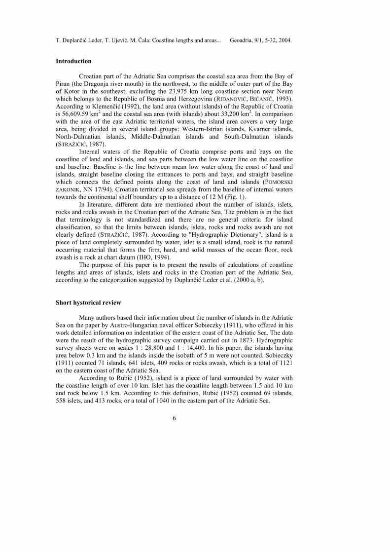
Croatian part of the Adriatic Sea comprises the coastal sea area from the Bay of Piran (the Dragonja river mouth) in the northwest, to the middle of outer part of the Bay of Kotor in the southeast, excluding the 23,975 km long coastline section near Neum which belongs to the Republic of Bosnia and Herzegovina (RIĐANOVIĆ, BIĆANIĆ, 1993). According to Klemenčić (1992), the land area (without islands) of the Republic of Croatia is 56,609.59 km2 and the coastal sea area (with islands) about 33,200 km2. In comparison with the area of the east Adriatic territorial waters, the island area covers a very large area, being divided in several island groups: Western-Istrian islands, Kvarner islands, North-Dalmatian islands, Middle-Dalmatian islands and South-Dalmatian islands (STRAŽIČIĆ, 1987).
Internal waters of the Republic of Croatia comprise ports and bays on the coastline of land and islands, and sea parts between the low water line on the coastline and baseline. Baseline is the line between mean low water along the coast of land and islands, straight baseline closing the entrances to ports and bays, and straight baseline which connects the defined points along the coast of land and islands (POMORSKI ZAKONIK, NN 17/94). Croatian territorial sea spreads from the baseline of internal waters towards the continental shelf boundary up to a distance of 12 M (Fig. 1).
In literature, different data are mentioned about the number of islands, islets, rocks and rocks awash in the Croatian part of the Adriatic Sea. The problem is in the fact that terminology is not standardized and there are no general criteria for island classification, so that the limits between islands, islets, rocks and rocks awash are not clearly defined (STRAŽIČIĆ, 1987). According to "Hydrographic Dictionary", island is a piece of land completely surrounded by water, islet is a small island, rock is the natural occurring material that forms the firm, hard, and solid masses of the ocean floor, rock awash is a rock at chart datum (IHO, 1994).
The purpose of this paper is to present the results of calculations of coastline lengths and areas of islands, islets and rocks in the Croatian part of the Adriatic Sea, according to the categorization suggested by Duplančić Leder et al. (2000 a, b).
Short hystorical review
Many authors based their information about the number of islands in the Adriatic Sea on the paper by Austro-Hungarian naval officer Sobieczky (1911), who offered in his work detailed information on indentation of the eastern coast of the Adriatic Sea. The data were the result of the hydrographic survey campaign carried out in 1873. Hydrographic survey sheets were on scales 1 : 28,800 and 1 : 14,400. In his paper, the islands having area below 0.3 km and the islands inside the isobath of 5 m were not counted. Sobieczky (1911) counted 71 islands, 641 islets, 409 rocks or rocks awash, which is a total of 1121 on the eastern coast of the Adriatic Sea.
According to Rubić (1952), island is a piece of land surrounded by water with the coastline length of over 10 km. Islet has the coastline length between 1.5 and 10 km and rock below 1.5 km. According to this definition, Rubić (1952) counted 69 islands, 558 islets, and 413 rocks, or a total of 1040 in the eastern part of the Adriatic Sea.
T. Duplančić Leder, T. Ujević, M. Čala: Coastline lengths and areas... Geoadria, 9/1, 5-32, 2004.
7
Fig.
1. M
ap o
f the
mar
itim
e te
rrito
rial b
ound
arie
s and
lim
its a
t the
Adr
iatic
Sea
Sl
. 1. K
arta
mor
skih
teri
tori
jaln
ih g
rani
ca J
adra
nsko
g m
ora
T. Duplančić Leder, T. Ujević, M. Čala: Coastline lengths and areas... Geoadria, 9/1, 5-32, 2004.
8
Irić (1955), in the publication of the Hydrographic Institute, systematized earlier results, listed all the islands, islets, rocks and rocks awash, and quoted their dimensions in kilometres and nautical miles. According to Irić, in the Croatian part of the eastern Adriatic there are 66 inhabited islands, 652 uninhabited ones, 389 rocks, and 78 rocks awash, or 1185 in total. In the Montenegrin part of the coastline there are no inhabited islands, 7 uninhabited ones, 37 rocks, and 4 rocks awash, or a total of 48 islands, rocks and rocks awash.
The results of Sobieczky were systematized again by Stražičić (1987), who compared his results with the results of other authors, and counted 60 islands, 653 islets, 438 rocks or rocks awash, or a total of 1151 in the eastern part of the Adriatic Sea.
In 1997 Croatian Ministry of Development and Reconstruction stated the information, not mentioning the authors, according to which in the Croatian part of the Adriatic Sea there are 718 islands, 389 rocks (head above sea level), and 78 rocks awash (head below sea level), or a total of 1185 islands, rocks and rocks awash.
United Nations Convention on the Law of the Sea, Part IV, Article 46 defines the eastern coast of the Adriatic Sea as archipelagic coast (URL 1). This area is a unique location in the Mediterranean area, even in the Earth. Because of that fact it is necessary to categorize islands of this area with special caution. On that basis, Duplančić Leder et al. (2000) proposed the categorisation of islands, islets, rocks and rocks awash as a geographic notion as follows: - Island is a piece of land completely surrounded by the sea, with the area larger than 1 km2. - Islet is a piece of land with the area between 0.01 and 1 km2. - Rock or rock awash is a piece of land with the area below 0.01 km2. The difference between rock and rock awash is that rock is always visible above sea level while rock awash is sometimes submerged below sea level.
Methods The first step was digitization of the coastline of land and islands covering the
Croatian part of the Adriatic Sea on topographic maps at the scale of 1 : 25 000. Topographic maps (edition 1974) were produced by the Military Geographic Institute (VGI) in Belgrade. Transformation of coordinates from the local digitization system in the map projection (5th and 6th zone of Gauss Krüger's projection) was done in ArcInfo 8 software package using Helmert transformation. For this specific purpose, a programme in AutoCAD Map VBA module was made, to project graphic entities of AutoCAD image directly from one projection to another. For easier reference and analysis, the data were then transformed into Gauss Krüger’s conformal transverse cylindrical projection, with the central meridian 16° 30’ E (FRANČULA, 1981). In order to reduce linear distortions, the linear scale 0.9997 was introduced along the central meridian (TUNJIĆ, LAPAINE, 1998). Maximum linear distortion along the bounding meridian is 40 cm per kilometre; the value of area distortion ranges from -0,06% along the central meridian to 0,08% along the bounding meridian (LAPAINE ET AL., 1993).
Polygons of islands were made in GIS software AutoCAD Map 2000, and the base for designing topology was prepared using Map Cleanup. Each polygon was given its name (Fig. 2), and on this basis the polygon topology was made. Polygon areas P on
T. Duplančić Leder, T. Ujević, M. Čala: Coastline lengths and areas... Geoadria, 9/1, 5-32, 2004.
9
(Bessel) ellipsoid were calculated using the methods and formulas published by Štemberger (1986, 1992) and Lapaine et al. (1993):
∑=
++ +−=n
iiiiii pxxyyP
111 /))((
21
(1)
where xi and yi are coordinates of the closed polygon points (x1=xn, y1=yn), pi is the factor of correction for each addend because of the projection.
For Gauss Krüger's projection, with linear scale factor along the central meridian 0,9997, local linear scale in the arbitrarily point is:
)242
1(9997,0 4
4
2
2
Ry
Rym ++= (2)
where R = 6,377,000 m is the mean radius of the ellipsoid in the observed point, so that the local area scale for conformal projection is:
)3
1(9997,0 4
4
2
22
Ry
Ryp ++= (3)
Area accuracy estimation mp can be calculated as:
∑=
−+−+ ++−=n
iiiiiiTP xxyymm
1
211
211
22 )()(81
(4)
where mT is the mean error of each particular point, while coordinates of points are supposed to be uncorrelated and their mean error of abscissa and ordinate to be equal (LAPAINE ET AL., 1994).
Coastline length d can be calculated according formula (5) as the sum of distance di between two adjacent points (LAPAINE, 2004):
∑ ∑= =
++ −+−==n
i
n
iiiiii yyxxdd
1 1
21
21 )()( (5)
Mean square error md of coastline length d:
∑=
+
−
−+
−
−
⎥⎥⎦
⎤
⎢⎢⎣
⎡⎟⎟⎠
⎞⎜⎜⎝
⎛ −−
−+⎟⎟
⎠
⎞⎜⎜⎝
⎛ −−
−=
n
i i
ii
i
ii
i
ii
i
iiTd d
yyd
yyd
xxd
xxmm1
2
1
1
1
2
1
1
122
21
(6)
Area accuracy estimation mp and mean square error of coastline length md will be
object of future study, and will be calculated using formulas (4) and (6).
T. Duplančić Leder, T. Ujević, M. Čala: Coastline lengths and areas... Geoadria, 9/1, 5-32, 2004.
10
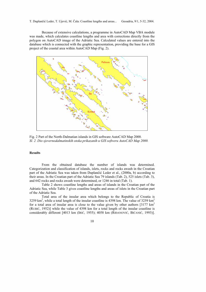
Because of extensive calculations, a programme in AutoCAD Map VBA module was made, which calculates coastline lengths and area with corrections directly from the polygon on AutoCAD image of the Adriatic Sea. Calculated values are entered into the database which is connected with the graphic representation, providing the base for a GIS project of the coastal area within AutoCAD Map (Fig. 2).
Fig. 2 Part of the North-Dalmatian islands in GIS software AutoCAD Map 2000. Sl. 2. Dio sjevernodalmatinskih otoka prikazanih u GIS softveru AutoCAD Map 2000.
Results
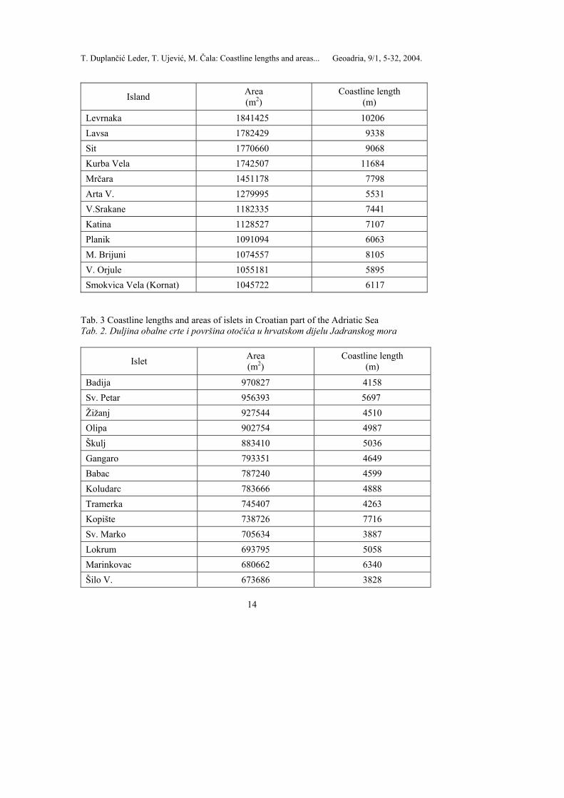
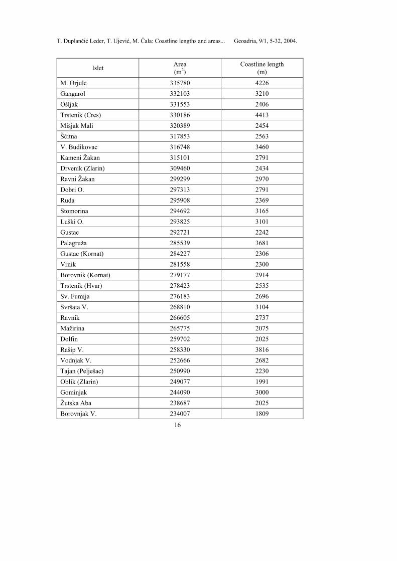
From the obtained database the number of islands was determined. Categorization and classification of islands, islets, rocks and rocks awash in the Croatian part of the Adriatic Sea was taken from Duplančić Leder et al., (2000a, b) according to their areas. In the Croatian part of the Adriatic Sea 79 islands (Tab. 2), 525 islets (Tab. 3), and 642 rocks and rocks awash were determined, or 1246 in total (Tab. 1).
Table 2 shows coastline lengths and areas of islands in the Croatian part of the Adriatic Sea, while Table 3 gives coastline lengths and areas of islets in the Croatian part of the Adriatic Sea.
Total area of the insular area which belongs to the Republic of Croatia is 3259 km2, while a total length of the insular coastline is 4398 km. The value of 3259 km2 for a total area of insular area is close to the value given by other authors [3177 km2 (RUBIĆ, 1952)] while the value of 4398 km for a total length of the insular coastline is considerably different [4013 km (IRIĆ, 1955); 4058 km (RIĐANOVIĆ, BIĆANIĆ, 1993)].

T. Duplančić Leder, T. Ujević, M. Čala: Coastline lengths and areas... Geoadria, 9/1, 5-32, 2004.
11
This fact can probably be explained by different precision of the used maps and methods of geodetic calculation.
Area of islands covers 3195.71 km2, while area of islets covers 62.41 km2, totalling 3258.12 km2. Area of rocks and rocks awash covers 1.44 km2, which together with the area of islands and islets represents the area of islands, islets and rocks of 3259.57 km2.
Coastline length of islands is 3573 km, while coastline length of islets is 717 km, totalling 4398 km. Coastline length of rocks and rocks awash is 107 km, which together with the coastline length of islands and islets represents the coastline length of islands, islets and rocks of 4398 km.
From the obtained results it follows that the largest islands in the Adriatic Sea are Cres with an area of 405.70 km2, and Krk with an area of 405.22 km2. It should be pointed out that in earlier literature, including atlases, Krk was usually cited as the largest island. Only some authors pointed at incorrect calculations of the areas of these two islands (e.g. FRANČULA, 1994; FRANČULA, 2001). Krivičić (1993) hypothesized it might be possible that the two neighbouring islands are identical in area, which would make them unique in the world. The smallest island is Smokvica Vela (Kornati) with an area 1.04 km2.
The island with the longest coastline of 302.47 km is Pag, being the fifth according to area value. The island with the smallest coastline length of 5.8 km is Vele Orjule. The biggest islet is Badija with an area of 0.97 km2, while the smallest one is Galicija covering 0.01 km2. Tab. 1 Number, coastline length and areas of islands, islets, rocks and rocks awash in the Croatian part of the Adriatic Sea Tab. 1. Broj, duljina obaalne crte i površina otoka, otočića, grebena i hridi u hrvatskom dijelu Jadranskog mora
Number Area
(m2) Coastline length
(m) Islands 79 3 195 715 335 3 573 816 Islets 525 62 413 694 717 801 Rocks 642 1 441 694 106 822 Total 1 246 3 259 570 887 4 398 440
Tab. 2 Coastline lengths and areas of islands in Croatian part of the Adriatic Sea Tab. 2. Duljine obalne crte i površine otoka na hrvatskom dijelu Jadranskog mora
Island Area (m2)
Coastline length (m)
Cres 405705293 268205 Krk 405218994 219120 Brač 395438030 180613
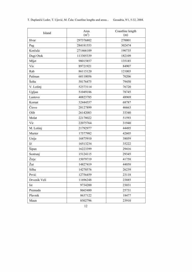
T. Duplančić Leder, T. Ujević, M. Čala: Coastline lengths and areas... Geoadria, 9/1, 5-32, 2004.
12
Island Area (m2)
Coastline length (m)
Hvar 297376802 270001 Pag 284181553 302474 Korčula 271466109 190735 Dugi Otok 113305339 182109 Mljet 98015857 135185 Vis 89721921 84907 Rab 86115120 121003 Pašman 60110056 70206 Šolta 58176475 79450 V. Lošinj 52573114 76720 Ugljan 51049186 78745 Lastovo 40823785 48969 Kornat 32444557 68787 Čiovo 28127899 46663 Olib 26142083 33340 Molat 22178022 51593 Vir 22075764 31940 M. Lošinj 21792977 44495 Murter 17577982 42605 Unije 16875910 38059 Iž 16513234 35222 Šipan 16223399 29416 Sestrunj 15124115 29345 Žirje 15079719 41758 Žut 14827419 44058 Silba 14270576 26239 Prvić 12756459 23118 Drvenik Veli 11696248 23885 Ist 9734200 23031 Premuda 8665480 25731 Plavnik 8637122 18477 Maun 8502796 23910

T. Duplančić Leder, T. Ujević, M. Čala: Coastline lengths and areas... Geoadria, 9/1, 5-32, 2004.
13
Island Area (m2)
Coastline length (m)
Šćedro 8367461 26135 Zlarin 8047620 20236 Kaprije 7119324 25211 Sv. Grgur 6376875 14528 Biševo 5915335 18147 V. Brijuni 5722615 23415 Ilovik 5508490 14091 Sv. Klement 5275844 29891 Dolin 4611518 18541 Goli O. 4538711 14297 Lopud 4377318 14630 Svetac 4193858 11973 Zverinac 4177872 14274 Sušac 4025460 16380 Škarda 3782313 12322 Susak 3771587 12921 Rava 3633862 15995 Rivanj 3615315 10346 Drvenik Mali 3427341 12024 Kakan 3388666 14284 Zmajan 3300754 12273 Jakljan 3066225 14648 Prežba 2809440 14230 Tijat 2779724 10489 Piškera 2665808 10646 Zeča 2549702 9613 Koločep 2439119 12869 Prvć (Šibenik) 2407033 10634 Vrgada 2315344 9188 Lavdara Vela 2272293 9532 Tun Veli 2210428 8406 Škrda 2052868 7177
T. Duplančić Leder, T. Ujević, M. Čala: Coastline lengths and areas... Geoadria, 9/1, 5-32, 2004.
14
Island Area (m2)
Coastline length (m)
Levrnaka 1841425 10206 Lavsa 1782429 9338 Sit 1770660 9068 Kurba Vela 1742507 11684 Mrčara 1451178 7798 Arta V. 1279995 5531 V.Srakane 1182335 7441 Katina 1128527 7107 Planik 1091094 6063 M. Brijuni 1074557 8105 V. Orjule 1055181 5895 Smokvica Vela (Kornat) 1045722 6117
Tab. 3 Coastline lengths and areas of islets in Croatian part of the Adriatic Sea Tab. 2. Duljina obalne crte i površina otočića u hrvatskom dijelu Jadranskog mora
Islet Area (m2)
Coastline length (m)
Badija 970827 4158 Sv. Petar 956393 5697 Žižanj 927544 4510 Olipa 902754 4987 Škulj 883410 5036 Gangaro 793351 4649 Babac 787240 4599 Koludarc 783666 4888 Tramerka 745407 4263 Kopište 738726 7716 Sv. Marko 705634 3887 Lokrum 693795 5058 Marinkovac 680662 6340 Šilo V. 673686 3828

T. Duplančić Leder, T. Ujević, M. Čala: Coastline lengths and areas... Geoadria, 9/1, 5-32, 2004.
15
Islet Area (m2)
Coastline length (m)
Proizd 632042 4908 Češvinica 619091 4706 Stipanska 618785 3377 Murvenjak 609582 4709 Lunga (Kornat) 608995 4375 M.Srakane 605481 3918 Košara 579686 4076 Obonjan 550390 3786 Radelj 540362 3420 Zečevo (Pag) 536319 3692 Kobrava 520811 5453 Kručica 474289 3208 Arkanđel 474010 3352 Kurba M. 423344 3857 Saplun 414592 3224 Glamoč 412582 3076 Mana 409123 4590 Oruda 405646 3018 Zvirinovik 404778 4211 Krknata 391674 3444 Orud 389820 2650 Arta M. 389019 2967 Logorun 386956 4023 Aba D. 385622 3740 Knežak 358459 2361 Oključ 357829 3803 Krapanj 356141 3620 Maslinovik 351201 2739 Mišjak Veli 348666 2658 Tetovišnjak V. 348028 2147 Kasela 345016 3541 Lupac 336302 2239
T. Duplančić Leder, T. Ujević, M. Čala: Coastline lengths and areas... Geoadria, 9/1, 5-32, 2004.
16
Islet Area (m2)
Coastline length (m)
M. Orjule 335780 4226 Gangarol 332103 3210 Ošljak 331553 2406 Trstenik (Cres) 330186 4413 Mišjak Mali 320389 2454 Šćitna 317853 2563 V. Budikovac 316748 3460 Kameni Žakan 315101 2791 Drvenik (Zlarin) 309460 2434 Ravni Žakan 299299 2970 Dobri O. 297313 2791 Ruda 295908 2369 Stomorina 294692 3165 Luški O. 293825 3101 Gustac 292721 2242 Palagruža 285539 3681 Gustac (Kornat) 284227 2306 Vrnik 281558 2300 Borovnik (Kornat) 279177 2914 Trstenik (Hvar) 278423 2535 Sv. Fumija 276183 2696 Svršata V. 268810 3104 Ravnik 266605 2737 Mažirina 265775 2075 Dolfin 259702 2025 Rašip V. 258330 3816 Vodnjak V. 252666 2682 Tajan (Pelješac) 250990 2230 Oblik (Zlarin) 249077 1991 Gominjak 244090 3000 Žutska Aba 238687 2025 Borovnjak V. 234007 1809
T. Duplančić Leder, T. Ujević, M. Čala: Coastline lengths and areas... Geoadria, 9/1, 5-32, 2004.
17
Islet Area (m2)
Coastline length (m)
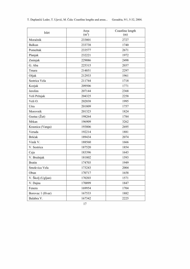
Moračnik 233801 2727 Balkun 233738 1740 Pomeštak 233577 2671 Planjak 232221 1972 Zminjak 229086 2498 G. Aba 225315 2037 Tmara 214851 2297 Ošjak 212933 1961 Sestrica Vela 211744 1718 Kozjak 209506 1771 Jerolim 207144 2368 Veli Pržnjak 204325 2258 Veli O. 202038 1995 Utra 201809 1757 Morovnik 201323 1824 Gustac (Žut) 198264 1784 Mrkan 196909 3262 Krasnica (Vanga) 193806 2695 Veruda 192214 1881 Bršćak 189434 2074 Vinik V. 188560 1666 V. Sestrica 187520 1854 Ceja 183396 1643 V. Brušnjak 181802 1593 Bratin 174703 1949 Smokvica Vela 173243 2004 Obun 170717 1658 V. Školj (Ugljan) 170203 1571 V. Dajna 170099 1847 Fenera 169954 1704 Borovac 1 (Hvar) 167533 1882 Balabra V. 167342 2225
T. Duplančić Leder, T. Ujević, M. Čala: Coastline lengths and areas... Geoadria, 9/1, 5-32, 2004.
18
Islet Area (m2)
Coastline length (m)
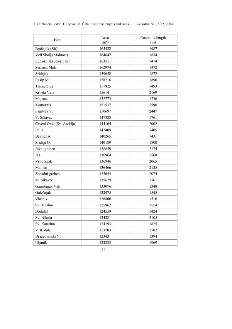
Brušnjak (Sit) 165422 1987 Veli Školj (Molunat) 164647 1834 Lutrošnjak(Strošnjak) 163511 1474 Sestrica Mala 162974 1472 Sridnjak 159658 1872 Rašip M. 158216 1890 Tramerčica 157825 1493 Krbela Vela 156141 2169 Majsan 152773 1736 Komornik 151537 1590 Panitula V. 150697 2447 V. Sikavac 147828 1761 Crveni Otok (Sv. Andrija) 144164 2002 Idula 142409 1405 Bavljenac 140265 1431 Sridnji O. 140189 1800 Južni greben 138859 2174 Jaz 136964 1568 Vrhovnjak 136946 2065 Maman 136466 2135 Zapadni greben 135655 2074 M. Sikavac 135629 1761 Garmenjak Veli 133076 1348 Galešnjak 132475 1545 Vlašnik 126866 1516 Sv. Jerolim 125962 1554 Bodulaš 124559 1424 Sv. Nikola 124281 2105 Sv. Katarina 124193 1825 V. Kotula 123703 1582 Dražemanski V. 123431 1394 Uljanik 123233 1969

T. Duplančić Leder, T. Ujević, M. Čala: Coastline lengths and areas... Geoadria, 9/1, 5-32, 2004.
19
Islet Area (m2)
Coastline length (m)
Tun Mali 122572 1613 Skala V. 122387 1586 Dubovac 120146 1310 Koritnjak 119504 1535 Vodenjak (Ist) 116704 1835 Klobučar 115787 1425 Muntan 115304 1507 Rakitan 115179 1330 Zečevo (Hvar) 113288 1539 Sv. Juraj 112408 1733 Otok (Trogir - stari grad) 112114 1389 Tajan (Jakljan) 110834 1405 Dugo 110408 1502 Frašker 110136 1671 Borovnjak M. 106809 1213 Buč Veli 106623 1489 Ravan 106153 1653 Sr. Sestrica (Rivanj) 104837 1627 Sv. Ivan 102663 1722 Čavlin 101789 1249 Lucmarinjak 101231 1251 Planikovac 100836 1259 Mrtovnjak (Kurba Vela) 100193 1244 Crkvina 99836 1502 Crklica 99249 1321 Sestrica V. (Kornat) 97760 1378 Sutvara 97674 1299 Krknjaš Veli 96961 1321 M. Pržnjak 96610 1120 Brguljski O. 96332 1156 Maškin 95785 1327 Tegina 95464 1146
T. Duplančić Leder, T. Ujević, M. Čala: Coastline lengths and areas... Geoadria, 9/1, 5-32, 2004.
20
Islet Area (m2)
Coastline length (m)
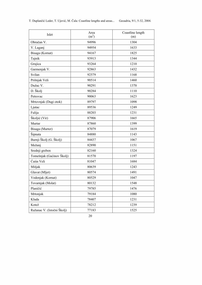
Obručan V. 94996 1304 V. Laganj 94954 1633 Bisaga (Kornat) 94167 1825 Tajnik 93913 1344 Grujica 93264 1210 Garmenjak V. 92863 1432 Svilan 92579 1168 Prišnjak Veli 90514 1460 Dužac V. 90291 1370 D. Školj 90284 1110 Petrovac 90063 1623 Mrtovnjak (Dugi otok) 89797 1098 Ljutac 89536 1249 Fulija 88203 1231 Školjić (Vir) 87906 1665 Murtar 87860 1399 Bisaga (Murter) 87079 1619 Šipnata 84880 1143 Burnji Školj (G. Školj) 84437 1067 Mežanj 82890 1151 Srednji greben 82160 1324 Tomešnjak (Gaćinov Školj) 81570 1197 Ćutin Veli 81047 1684 Mišjak 80639 1243 Glavat (Mljet) 80574 1491 Vodenjak (Kornat) 80529 1047 Tovarnjak (Molat) 80132 1548 Planičić 79785 1476 Mrtonjak 79184 1080 Kluda 78407 1231 Kotež 78212 1239 Ražanac V. (Istočni Školj) 77183 1525
T. Duplančić Leder, T. Ujević, M. Čala: Coastline lengths and areas... Geoadria, 9/1, 5-32, 2004.
21
Islet Area (m2)
Coastline length (m)
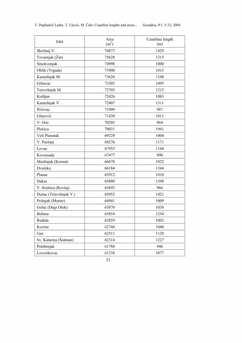
Skrižanj V. 76873 1429 Tovarnjak (Žut) 75628 1315 Smokvenjak 74998 1000 Oblik (Vrgada) 73900 1015 Kamešnjak M. 73626 1108 Grbavac 73305 1095 Tetovišnjak M. 72703 1212 Košljun 72426 1083 Kamešnjak V. 72407 1311 Prčevac 71909 987 Glurović 71430 1011 V. Osir 70203 964 Pločica 70031 1941 Veli Planatak 69229 1004 V. Paržanj 68276 1171 Levan 67955 1160 Koversada 67477 990 Maslinjak (Kornat) 66678 1022 Dvainka 66184 1344 Planac 65912 1010 Daksa 65880 1398 V. Sestrica (Rovinj) 65693 966 Dužac (Tetovišnjak V.) 65052 1421 Prišnjak (Murter) 64941 1009 Golac (Dugi Otok) 63870 1038 Bobara 63854 1254 Rudula 62859 1002 Kozina 62744 1040 Gaz 62511 1128 Sv. Katarina (Šašman) 62314 1227 Polebrnjak 61788 946 Lovorikovac 61338 1077
T. Duplančić Leder, T. Ujević, M. Čala: Coastline lengths and areas... Geoadria, 9/1, 5-32, 2004.
22
Islet Area (m2)
Coastline length (m)
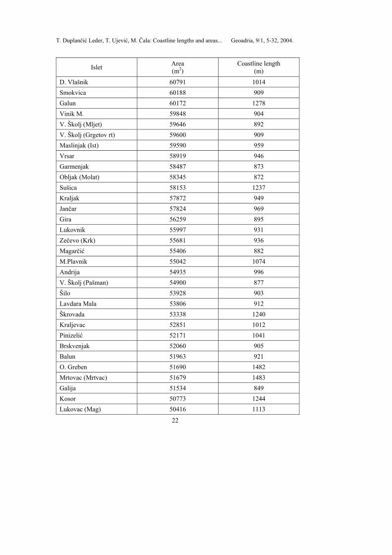
D. Vlašnik 60791 1014 Smokvica 60188 909 Galun 60172 1278 Vinik M. 59848 904 V. Školj (Mljet) 59646 892 V. Školj (Grgetov rt) 59600 909 Maslinjak (Ist) 59590 959 Vrsar 58919 946 Garmenjak 58487 873 Obljak (Molat) 58345 872 Sušica 58153 1237 Kraljak 57872 949 Jančar 57824 969 Gira 56259 895 Lukovnik 55997 931 Zečevo (Krk) 55681 936 Magarčić 55406 882 M.Plavnik 55042 1074 Andrija 54935 996 V. Školj (Pašman) 54900 877 Šilo 53928 903 Lavdara Mala 53806 912 Škrovada 53338 1240 Kraljevac 52851 1012 Pinizelić 52171 1041 Brskvenjak 52060 905 Balun 51963 921 O. Greben 51690 1482 Mrtovac (Mrtvac) 51679 1483 Galija 51534 849 Kosor 50773 1244 Lukovac (Mag) 50416 1113
T. Duplančić Leder, T. Ujević, M. Čala: Coastline lengths and areas... Geoadria, 9/1, 5-32, 2004.
23
Islet Area (m2)
Coastline length (m)
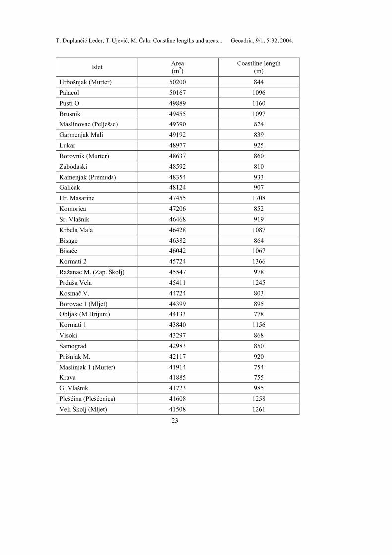
Hrbošnjak (Murter) 50200 844 Palacol 50167 1096 Pusti O. 49889 1160 Brusnik 49455 1097 Maslinovac (Pelješac) 49390 824 Garmenjak Mali 49192 839 Lukar 48977 925 Borovnik (Murter) 48637 860 Zabodaski 48592 810 Kamenjak (Premuda) 48354 933 Galičak 48124 907 Hr. Masarine 47455 1708 Komorica 47206 852 Sr. Vlašnik 46468 919 Krbela Mala 46428 1087 Bisage 46382 864 Bisače 46042 1067 Kormati 2 45724 1366 Ražanac M. (Zap. Školj) 45547 978 Prduša Vela 45411 1245 Kosmač V. 44724 803 Borovac 1 (Mljet) 44399 895 Obljak (M.Brijuni) 44133 778 Kormati 1 43840 1156 Visoki 43297 868 Samograd 42983 850 Prišnjak M. 42117 920 Maslinjak 1 (Murter) 41914 754 Krava 41885 755 G. Vlašnik 41723 985 Plešćina (Plešćenica) 41608 1258 Veli Školj (Mljet) 41508 1261

T. Duplančić Leder, T. Ujević, M. Čala: Coastline lengths and areas... Geoadria, 9/1, 5-32, 2004.
24
Islet Area (m2)
Coastline length (m)
Host 41375 910 M. Brušnjak 40867 805 Gubavac (Korčula) 40856 972 Plitki Kukuljar (Vodnjak) 40294 769 Ravna Sika 40248 742 Otočić 40248 742 Arženjak V. 40165 821 Gojak 40103 834 Obrovanj 40002 751 Tresorka 39953 771 Otoci Salamun 2 39881 773 Tukošćak 39834 758 Paržanj 39529 804 Grmej 38916 723 Kudica 38460 706 Skala M. 38352 849 Supetar 38137 946 Prećski Školj 37876 810 Črnikovac 37764 791 Lukovac (Hvar) 37578 777 Šip 37337 1113 V. Kneža 37235 745 Otočac 37053 717 Bisaga V. (Žut) 37032 834 Kosmerka 36870 787 Grunj 36677 960 Ovrata 36429 1181 Sv. Andrija 36259 1214 Pod Kopište 35835 813 Sparušnjak 35294 705 Arženjak M. 35204 793 V. Paranak 34463 702

T. Duplančić Leder, T. Ujević, M. Čala: Coastline lengths and areas... Geoadria, 9/1, 5-32, 2004.
25
Islet Area (m2)
Coastline length (m)
Borovnik (Sit) 33751 725 Samunćel 33740 665 M. Sestrica (Rivanj) 33732 733 Košarica (Maslinjak) 33722 775 Kamenar 33563 797 Krknjaš Mali 33281 716 Galovac(Školji}) 33259 736 Pučenjak 33224 670 Goljak 33100 686 Artina 32540 797 Runjava Kotula 32382 714 Mrtovnjak (Maćin Školj) 32242 712 Katarina 31883 817 Garmenjak M. 31353 703 Obljak (Korčula) 31307 645 Panitula M. 31194 789 Abica 30875 719 Lukovnjak 30297 640 Artica 30205 634 Stambedar 29945 714 Lunga 29923 826 Mišnjak (Rab) 29829 799 Školjić V. 29826 675 Karantunić 28894 639 Kristović 28747 768 Buć M. 28709 703 Sestrica M. (Kornat) 28692 627 Figarola 28522 751 M. Paranak 28516 613 Smokvica Mala 28230 658 Galičnjak 28034 651 Strižnjak 27838 613
T. Duplančić Leder, T. Ujević, M. Čala: Coastline lengths and areas... Geoadria, 9/1, 5-32, 2004.
26
Islet Area (m2)
Coastline length (m)
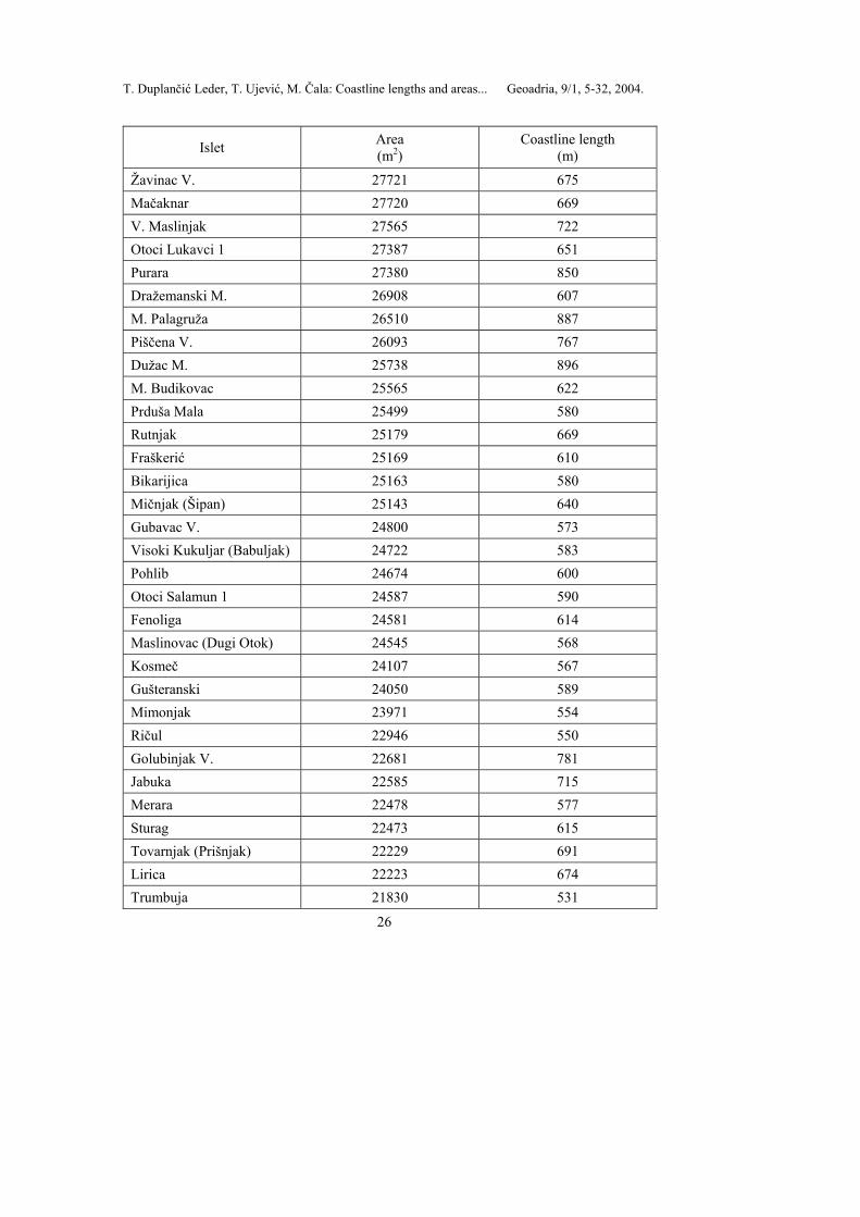
Žavinac V. 27721 675 Mačaknar 27720 669 V. Maslinjak 27565 722 Otoci Lukavci 1 27387 651 Purara 27380 850 Dražemanski M. 26908 607 M. Palagruža 26510 887 Piščena V. 26093 767 Dužac M. 25738 896 M. Budikovac 25565 622 Prduša Mala 25499 580 Rutnjak 25179 669 Fraškerić 25169 610 Bikarijica 25163 580 Mičnjak (Šipan) 25143 640 Gubavac V. 24800 573 Visoki Kukuljar (Babuljak) 24722 583 Pohlib 24674 600 Otoci Salamun 1 24587 590 Fenoliga 24581 614 Maslinovac (Dugi Otok) 24545 568 Kosmeč 24107 567 Gušteranski 24050 589 Mimonjak 23971 554 Ričul 22946 550 Golubinjak V. 22681 781 Jabuka 22585 715 Merara 22478 577 Sturag 22473 615 Tovarnjak (Prišnjak) 22229 691 Lirica 22223 674 Trumbuja 21830 531
T. Duplančić Leder, T. Ujević, M. Čala: Coastline lengths and areas... Geoadria, 9/1, 5-32, 2004.
27
Islet Area (m2)
Coastline length (m)
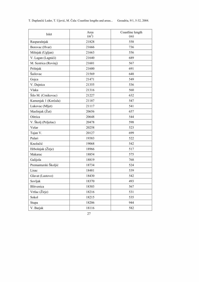
Rasparašnjak 21828 558 Borovac (Hvar) 21666 736 Mišnjak (Ugljan) 21663 556 V. Lagan (Lagnići) 21640 689 M. Sestrica (Rovinj) 21601 567 Prišnjak 21600 691 Šailovac 21569 648 Gojca 21471 549 V. Dajnica 21355 536 Vlaka 21316 560 Šilo M. (Crnikovac) 21227 632 Kamenjak 1 (Korčula) 21187 547 Lukovac (Mljet) 21117 541 Maslinjak (Žut) 20656 657 Oštrica 20648 544 V. Školj (Pelješac) 20478 598 Vešar 20258 523 Tajan V. 20127 699 Pulari 19383 522 Knežačić 19068 542 Hrbošnjak (Žirje) 18966 517 Makarac 18854 575 Galijola 18819 768 Premanturski Školjić 18734 524 Lisac 18481 539 Glavat (Lastovo) 18430 542 Sovljak 18370 493 Blitvenica 18303 567 Vrtlac (Žirje) 18216 531 Sokol 18215 535 Stupa 18206 944 V. Barjak 18116 582
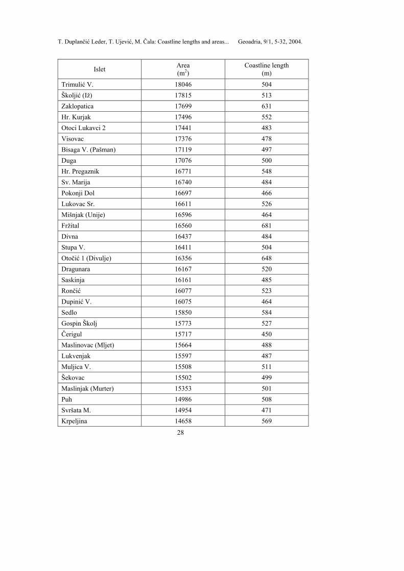
T. Duplančić Leder, T. Ujević, M. Čala: Coastline lengths and areas... Geoadria, 9/1, 5-32, 2004.
28
Islet Area (m2)
Coastline length (m)
Trimulić V. 18046 504 Školjić (Iž) 17815 513 Zaklopatica 17699 631 Hr. Kurjak 17496 552 Otoci Lukavci 2 17441 483 Visovac 17376 478 Bisaga V. (Pašman) 17119 497 Duga 17076 500 Hr. Pregaznik 16771 548 Sv. Marija 16740 484 Pokonji Dol 16697 466 Lukovac Sr. 16611 526 Mišnjak (Unije) 16596 464 Fržital 16560 681 Divna 16437 484 Stupa V. 16411 504 Otočić 1 (Divulje) 16356 648 Dragunara 16167 520 Saskinja 16161 485 Rončić 16077 523 Dupinić V. 16075 464 Sedlo 15850 584 Gospin Školj 15773 527 Čerigul 15717 450 Maslinovac (Mljet) 15664 488 Lukvenjak 15597 487 Muljica V. 15508 511 Šekovac 15502 499 Maslinjak (Murter) 15353 501 Puh 14986 508 Svršata M. 14954 471 Krpeljina 14658 569

T. Duplančić Leder, T. Ujević, M. Čala: Coastline lengths and areas... Geoadria, 9/1, 5-32, 2004.
29
Islet Area (m2)
Coastline length (m)
Gališnik 14612 446 Rogačić 14444 435 Pomerski Školjić 14407 442 M. Kneža 14404 446 Skrižanj M. 14075 463 Supin 13912 456 Veseljuh 13893 533 Brnjestrovac 13793 471 M. Dolfin 13751 469 Hr. Podmrčaru 13514 484 Mali Planatak 13452 464 Hr. Mali Goli (Goli O.) 13410 593 M. Paržanj 13403 448 Dužac (Ist) 13369 493 Kamenjak (Korčula) 13340 439 Sestrice 2 (Ist) 13331 425 Ula (Artica M.) 13313 427 Čavatul 13287 423 Mrduja 13116 417 Rutvenjak V. 12841 448 Vrtlić (Kurba Vela) 12765 424 Gusti Školj 12673 404 Sustipanac 12556 473 Školjić M. 12457 424 Koromašna 12305 471 Sv. Justina 12253 442 Vješala 12180 657 M. Kotula 12107 434 Kamenjak (Ist) 11998 485 Hr. Hripa 11973 645 Sridnjak (Rab) 11938 477 Tužbina 11909 445
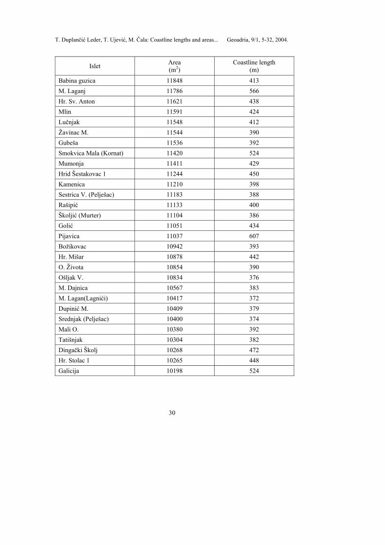
T. Duplančić Leder, T. Ujević, M. Čala: Coastline lengths and areas... Geoadria, 9/1, 5-32, 2004.
30
Islet Area (m2)
Coastline length (m)
Babina guzica 11848 413 M. Laganj 11786 566 Hr. Sv. Anton 11621 438 Mlin 11591 424 Lučnjak 11548 412 Žavinac M. 11544 390 Gubeša 11536 392 Smokvica Mala (Kornat) 11420 524 Mumonja 11411 429 Hrid Šestakovac 1 11244 450 Kamenica 11210 398 Sestrica V. (Pelješac) 11183 388 Rašipić 11133 400 Školjić (Murter) 11104 386 Golić 11051 434 Pijavica 11037 607 Božikovac 10942 393 Hr. Mišar 10878 442 O. Života 10854 390 Ošljak V. 10834 376 M. Dajnica 10567 383 M. Lagan(Lagnići) 10417 372 Dupinić M. 10409 379 Srednjak (Pelješac) 10400 374 Mali O. 10380 392 Tatišnjak 10304 382 Dingački Školj 10268 472 Hr. Stolac 1 10265 448 Galicija 10198 524

T. Duplančić Leder, T. Ujević, M. Čala: Coastline lengths and areas... Geoadria, 9/1, 5-32, 2004.
31
Conclusions
Eastern coast of the Adriatic Sea is one of the best indented coasts and belongs to the so-called archipelagic coast. The number of islands in Croatian part of the Adriatic Sea, as determined in this paper, is greater than it was published earlier in literature: - According to the proposed classification of islands (Duplančić Leder et al., 2000a), in the coastal sea area of the Republic of Croatia 79 islands, 525 islets, and 642 rocks and rocks awash have been recorded, or a total of 1246 on topographic maps produced at the scale of 1 : 25 000 (TM25). - Total area of the insular area which belongs to the Republic of Croatia is 3259 km2, while a total length of the insular coastline is 4398 km. - The largest island in the Adriatic Sea determined from the topographic maps produced at the scale of 1 : 25 000 (TM25) is Cres with an area of 405.70 km2 and the smallest island is Smokvica Vela (Kornati) with an area 1.04 km2. - The island with the longest coastline of 302.47 km on TM25 is Pag, while the smallest coastline length of 5.89 km belongs to Vele Orjule. - The biggest islet on TM25 is Badija with an area of 0.97 km2, while the smallest one is Galicija covering 0.01 km2.
This paper represents the beginning of a systematic analysis of the Croatian insular area, which should encourage scientists and economists, providing them with guidelines for carrying on their studies in this field. The authors propose that determining of coastline lengths and areas of islands, islets and rocks according to the set criteria should be done from larger scale charts, e.g. 1 : 5000, which is an extensive and demanding task. LITERATURE DUPLANČIĆ LEDER, T.; UJEVIĆ, T.; ČALA, M.; VIĐAK, I. (2000a): Categorization and number of islands in the Republic of Croatia, Periodicum Biologorum, Vol 102, Suppl 1, 281-284. DUPLANČIĆ LEDER, T.; UJEVIĆ, T.; ČALA, M.; VIĐAK, I. (2000b): Categorization and number of islands in Adriatic part of the Republic of Croatia, GIS Croatia 2000, 40-44. FRANČULA, N. (1981): Primjena kompjutora u izradi karte SR Hrvatske, Geodetski fakultet Sveučilišta u Zagrebu, Zbornik radova, Series D, Volume 2, pp. 57. FRANČULA, N.; LAPAINE, M.; VUČETIĆ, N. (1994): Procjena srednjih pogrešaka koordinata digitaliziranih točaka, 39 International Annual Gathering KoREMA Proceedings 39, Part 1, 242-245. FRANČULA, N. (2001): Digitalna kartografija, Geodetski fakultet Sveučilišta u Zagrebu, pp. 206. IHO (1994): Hydrographic Dictionary, International Hydrographic Organisation, Monaco, pp. 280. IRIĆ, A. (1955): Razvedenost obale i otoka Jugoslavije, Hidrografski institut JRM, Split, pp. 66. KLEMENČIĆ, M. (1992): Geografski smještaj i položaj Hrvatske, Geografski horizont 2: 7-15. LAPAINE, M.; FRANČULA, N.; VUČETIĆ, N. (1993): Površina hrvatskog mora i otoka, CAD forum, 47-52. LAPAINE, M.; FRANČULA, N.; VUČETIĆ, N. (1994): Procjena točnosti površina određenih na temelju digitaliziranih granica, 39 International Annual Gathering KoREMA Proceedings 39, Part 1, 246-249. LAPAINE, M (2004): Personal communication Ministarstvo razvitka i obnove (1997): Nacionalni program razvoja otoka, Ministarstvo razvitka i obnove, Zagreb, pp. 733. POMORSKI ZAKONIK, 1994, Narodne novine 17/94, 404-503. RIĐANOVIĆ, J.; BIĆANIĆ, Z. (1993): Hrvatski Jadran i novi teritorijalni ustroj, Acta Geogr. Croat. 28, 85-97. RUBIĆ, I. (1952): Naši otoci na Jadranu, Odbor za proslavu desetogodišnjice mornarice, Split, pp. 167.
T. Duplančić Leder, T. Ujević, M. Čala: Coastline lengths and areas... Geoadria, 9/1, 5-32, 2004.
32
SOBIECZKY, A. (1911): Die Künstenentwicklung der öesterreichish-ungarischen Mornarchie, Mitteillungen aus dem Gebiete des Seewesens, Pola, pp. 39. STRAŽIČIĆ, N. (1987): Prirodno-geografske značajke kao poticajni i ograničavajući faktori razvoja jadranskih otoka, Pomorski zbornik 25, 39-55. ŠTEMBERGER, D. (1986): Analiza određivanja veličina večih teritorijalnih jedinica korištenjem suvremenih metoda i postupak sa primjenom na teritoriju SFRJ, Doktorska teza, Građevinski fakultet Univerziteta u Beogradu, pp. 397. ŠTEMBERGER, D. (1992): Računanje površine lika proizvoljnog oblika na elipsoidu, Geodetski list 3, 301-313. TUNJIĆ, I.; LAPAINE, M. (1998): Croatian State Boundary at the Sea, 9th International Conference on Engineering Computer Graphics and Descriptive Geometry, 716-720. URL 1: United Nations Convention on the Low of the Sea, http:/www.un.org/. SAŽETAK
Tea Duplančić Leder, Tin Ujević, Mendi Čala: Duljine obalne crte i površine otoka
na hrvatskom dijelu Jadranskog mora određene sa topografskih kartata mjerila 1 : 25 000 Istočna obala Jadranskog mora jedinstveno je područje na Sredozemlju, možda i na
svijetu, po svojoj razvedenoj obali. Ta obala, prema konvenciji o pravu mora Ujedinjenih naroda (dio IV, članak 46), pripada takozvanim arhipelaškim morima. U ovom članku prihvaćena je suvremena definicija otoka (prema Duplančić Leder i dr., 2000) utemeljena na preporukama Međunarodne hidrografske organizacije (International Hydrographic Organization). Otok je definiran kao dio kopna potpuno okružen morem. Prihvaćena je klasifikacija otoka, otočića, hridi i grebena prema njihovoj površini, predložena od istih autora. Otok je dio kopna okružen morem površine preko 1 km2, otočić je kopno površine od 0,01 do 1 km2, dok je površina hridi i grebena manja od 0,01 km2.
Obalna crta hrvatskog dijela Jadranskog mora digitalizirana je sa topografskih karata mjerila 1:25 000. Topografske karte koje se koriste kao podloge, te metode rada i alati korišteni u ovom radu bolje su i preciznije od dosada korištenih. Stoga se broj otoka na Jadranu, a naročito njihove površine i opsezi mogu smatrati preciznijim od podataka do sada korištenima u literaturi.
Koordinate dobivene digitalizacijom topografskih karata transformirane su iz sustava digitalizatora u 5 i 6 zonu Gauss Kr⎫gerove projekcije. Radi bolje preglednosti i lakšeg računanja podaci su prebačeni u jedinstveni projekcijski sustav: konformnu poprečnu cilindričnu projekciju sa središnjim meridijanom 16° 30’ E i linearnim mjerilom na središnjem meridijanu m=0,9997, uvedenom radi smanjivanja deformacije. Procjena točnosti površina i duljina obalne crte, prema navedenim formulama, biti će predmet budućih istraživanja.
U okviru GIS programskog paketa AutoCAD Map 2000 zatvoreni su poligoni otoka, i svakom od njih dodijeljen je naziv, koji služi kao centroid poligona. Pomoću centroida poligona kreirana je topologija. U AutoCAD programu je napisan podprogram koji računa površine i opsege otoka, otočića i hridi, te ih sprema u Microsoft Acess bazu podataka.
Iz dobivene baze podataka i klasifikacije otoka, otočića, hridi i grebena, u obalnom moru Republike Hrvatske na TK25 zabilježeno je 79 otoka, 525 otočića i 642 hridi i grebena ili ukupno 1246. Nadalje, ustanovljeno da otok Cres ima najveću površinu (405,70 km2), iako je do sada u literaturi otok Krk najčešće navođen (uključujući i atlase) kao najveći otok u Jadranskom moru. Najdulju obalnu crtu ima otok Pag (302,47 km).
Ukupna površina otočnog dijela Jadranskog mora je 3 259 km2, a ukupna duljina obalne crte je 4 398 km.
Rad predstavlja početak sustavne analize cjelokupnog hrvatskog otočnog područja, koji će potstaknuti znanstvenike za njihov daljnji rad i studije na ovom polju.
Related Documents