Michael T. Hill. Dunes sagebrush lizard habitat on NMDGF PCAs, Interim Report. 28 March 2012 1 Dunes sagebrush lizard (Sceloporus arenicolus) habitat delineation on New Mexico Game Commission Prairie Chicken Areas Michael T. Hill 2219 Sea Foam St. NW Albuquerque, New Mexico 87120 [email protected] 505-859-1000 Professional Services Contract #12-516-0000-00023 The dunes sagebrush lizard (Sceloporus arenicolus) is a small Sceloporus that occurs in New Mexico (Chaves, Eddy, Lea and Roosevelt Counties; Degenhardt et al. 1996) and in adjacent west Texas (Andrews, Crane, Gaines, Ward, and Winkler Counties; Dixon 2000). Within that area, their distribution is limited to shinnery oak (Quercus havardii) sand dune depressions called blowouts (Fitzgerald and Painter 2009). The dunes sagebrush lizard is listed as endangered by the New Mexico Department of Game and Fish (NMDGF) and is currently proposed as endangered by the US Fish and Wildlife Service. The NMDGF manages 31 Prairie Chicken Areas (PCA) in Chaves, De Baca, Lea, and Roosevelt Counties (Figure 1). Seventeen of the PCAs were surveyed during the spring and summer months, 2011 (Hill 2011). Dunes sagebrush lizards are known to occur on four of the 31 PCAs (Hill 2011). More surveys are planned for the spring and summer, 2012 on PCAs that were identified as potential habitat during the 2011 survey efforts.

Welcome message from author
This document is posted to help you gain knowledge. Please leave a comment to let me know what you think about it! Share it to your friends and learn new things together.
Transcript

Michael T. Hill. Dunes sagebrush lizard habitat on NMDGF PCAs, Interim Report. 28 March 2012
1
Dunes sagebrush lizard (Sceloporus arenicolus) habitat delineation on New Mexico Game
Commission Prairie Chicken Areas
Michael T. Hill
2219 Sea Foam St. NW
Albuquerque, New Mexico
87120
505-859-1000
Professional Services Contract #12-516-0000-00023
The dunes sagebrush lizard (Sceloporus arenicolus) is a small Sceloporus that occurs in
New Mexico (Chaves, Eddy, Lea and Roosevelt Counties; Degenhardt et al. 1996) and in
adjacent west Texas (Andrews, Crane, Gaines, Ward, and Winkler Counties; Dixon 2000).
Within that area, their distribution is limited to shinnery oak (Quercus havardii) sand dune
depressions called blowouts (Fitzgerald and Painter 2009). The dunes sagebrush lizard is listed
as endangered by the New Mexico Department of Game and Fish (NMDGF) and is currently
proposed as endangered by the US Fish and Wildlife Service.
The NMDGF manages 31 Prairie Chicken Areas (PCA) in Chaves, De Baca, Lea, and
Roosevelt Counties (Figure 1). Seventeen of the PCAs were surveyed during the spring and
summer months, 2011 (Hill 2011). Dunes sagebrush lizards are known to occur on four of the 31
PCAs (Hill 2011). More surveys are planned for the spring and summer, 2012 on PCAs that were
identified as potential habitat during the 2011 survey efforts.

Michael T. Hill. Dunes sagebrush lizard habitat on NMDGF PCAs, Interim Report. 28 March 2012
2
SURVEYS
Pedestrian surveys for dunes sagebrush lizards will be initiated starting during the week
of 15 April 2012. I will be following a protocol very similar to the protocol described in
Fitzgerald et al. (1997). I will spend a maximum of six person hours at each site walking through
suitable habitat searching for dunes sagebrush lizards. Survey efforts will be terminated at a site
if all suitable habitat has been surveyed or I detect dunes sagebrush lizards. If I detect dunes
sagebrush lizards at a site I will survey for a minimum of two person hours to complement past
survey data. All lizard species observed will be counted and I will attempt to capture any dunes
sagebrush lizards using a noose pole. I will photograph any captured dunes sagebrush lizards for
verification of their identification and I will also collect a small tissue sample (e.g. tail tip) for
ongoing genetic studies with Lauren Chan (Duke University) and Lee Fitzgerald (Texas A&M
University). I will collect air and substrate temperatures at the beginning and end of the surveys
as well as UTM coordinates (NAD 83) for the approximate center of the survey area and for
dunes sagebrush lizard observation points. I will also estimate depth and dimensions of sand
dune blowouts where dunes sagebrush lizards are observed/captured.
My surveys will be, primarily, focused on five PCAs; Black Hills (west of NM 206),
Gallina Wells 1a, Marshall, Pitchfork, Sandhills (inclusive of Antelope Flats and Bledsoe), and
South Bluit. As time and conditions permit, I also want to visit Gallina Wells 3, Liberty, and
Pitchfork PCAs. I have not visited Gallina Wells 3 or Liberty PCAs and I only visited Pitchfork
PCA once during suboptimal conditions in 2011.

Michael T. Hill. Dunes sagebrush lizard habitat on NMDGF PCAs, Interim Report. 28 March 2012
3
GIS
I have produced two shapefiles for the PCAs (depicted on individual PCAs in Appendix
1) using Arc Map (version 9.3), digital ortho quarter quads (DOQQs) downloaded from the New
Mexico Resource Geographic Information System (http://rgis.unm.edu/), and a shapefile
depicting PCA boundaries provided by NMDGF.
One shapefile (NMDGF_PCAs_DSL_Blowouts) encompasses the suitable habitat on
PCAs where enough contiguous habitat exists to sustain viable populations of dunes sagebrush
lizards. I drew the blowout polygons around larger (>20 m largest dimension) blowouts and the
surrounding blowout habitat. The surrounding blowouts did not have to be of equal or greater
size, many were <20 m largest dimension. I considered blowout habitat to be a distinct blowout
complex (based on the DOQQs) surrounded by flatter shinnery oak habitat with limited open
sand.
I have taken adjacent, non NMDGF lands, into account while producing these two
shapefiles, when suitable blowout habitat is present off PCA. Although many of the PCAs may
not harbor suitable habitat for resident dunes sagebrush lizards, they may provide suitable
dispersal habitat for adjacent populations (as described in Hill 2011). That possibility is
accounted for with the second shapefile that I have provided, NMDGF_PCAs_DSL_Corridors.
The corridor shapefile has been the most difficult to produce and will require ground-
truthing, particularly on PCAs that I have not visited. At this point, it is my best guess about
where dunes sagebrush lizards may choose to move across the landscape. I generated the
corridor shapefile with the data view of ArcMap set between 1:3,000 and 1:3,500. As the scale of
the data view becomes smaller, more potential corridors become apparent so I chose to limit my

Michael T. Hill. Dunes sagebrush lizard habitat on NMDGF PCAs, Interim Report. 28 March 2012
4
work to that range. Without a great deal of dunes sagebrush lizard movement data it is very
difficult to determine appropriate corridor extents.
I am basing much of this aspect of the project on my previous experience summarized in
Hill and Fitzgerald (2007). I radiotracked female dunes sagebrush lizards during the nesting
season to determine nesting locations which were always located outside of her core home range.
The tracked females occasionally traversed small shinnery oak flats to lay their eggs in blowouts
outside of their core home range. Our understanding of the mechanisms limiting dunes sagebrush
lizard dispersal is currently based on anecdotal information with limited quantified research. I
attempted to be conservative while generating the corridor shapefile based on the current
limitations in our understanding of the fine scale ecology of dunes sagebrush lizards. They
percolate across the landscape at some level but I can only speculate about where they actually
choose to go at this point.
As I refine the two shapefiles, acreages provided (Table 1) will change, particularly those
generated from the corridors shapefile. I did not generate shapefiles for 13 of the PCAs due to
lack of suitable blowout or corridor habitat; or due to their isolation from known, occupied
habitat. This decision can be adjusted as deemed necessary by discussion with NMDGF
personnel or by positive survey results in 2012.
My decision to exclude certain PCAs from this project is based on the extent of known,
occupied habitat (Figure 2) and the extent of available, suitable habitat. Laurencio and Fitzgerald
(2010) presented a polygon that depicts the known range of the dunes sagebrush lizard in New
Mexico which is derived from past survey efforts (e.g. those summarized in Fitzgerald et al.
1997). Shinnery oak sand dune blowout habitat enters Roosevelt and northern Lea Counties from
the west via two bands of sand dune ridges. The northern band extends from west of the caprock

Michael T. Hill. Dunes sagebrush lizard habitat on NMDGF PCAs, Interim Report. 28 March 2012
5
in Chaves County, south of Kenna, eastward past NM 206 in Roosevelt County, north of
Milnesand. The southern band extends from west of the caprock in Chaves County, north of
Wayside PCA, eastward beyond NM 206 in Lea County, south of Crossroads. This sandy ridge
is evident when driving along NM 206 between Crossroads and Tatum.
The shinnery oak sand dune blowout habitat required by dunes sagebrush lizards is
patchy along these two bands of sandy habitat, owing to past management practices and
landscape variability. Dunes sagebrush lizards are found in the larger patches of habitat in both
of the bands (Black Hills, Crossroads 3, and Gallina Wells 2 PCAs). The easternmost known
localities of dunes sagebrush lizards (in this area) are located ~5 mi E of Black Hills PCA (in the
north) and ~8 mi ESE of Crossroads 3 PCA (in the south). The Gallina Wells PCAs are generally
located along the northern band of habitat although the extent of suitable habitat varies among
them. Marshall PCA is also located on the northern band of habitat although there is limited
suitable habitat on this PCA. While these PCAs may not harbor resident populations of dunes
sagebrush lizards, they may serve as important dispersal or nesting areas for adjacent populations
of dunes sagebrush lizard.
My survey efforts will mainly focus on areas that are positioned on or near the two bands
of habitat discussed above. Exceptions to that include Sandhills Prairie Conservation Area
(inclusive of Antelope Flats and Bledsoe PCAs) and Pitchfork PCA. I have not spent enough
time at those areas to exclude them from further investigation although they are well removed
from occupied habitat. In addition, the PCAs that I will survey appear to have relatively large
expanses of suitable dunes sagebrush lizard habitat, as seen from GIS. I have chosen to forgo
further survey efforts at Milnesand PCA due to the extremely patchy nature of the sand dune

Michael T. Hill. Dunes sagebrush lizard habitat on NMDGF PCAs, Interim Report. 28 March 2012
6
blowout habitat on that PCA. While it has sand dune blowouts present, it is not connected to any
large expanses of suitable dunes sagebrush lizard habitat.
The final report for this project will include the results of the upcoming surveys and will
incorporate feedback regarding the preliminary ArcGIS shapefiles that I have produced. At this
time, I have chosen to refrain from altering the preliminary blowout and corridor shapefiles
because I want to evaluate them on the ground prior to making changes.
MANAGEMENT IMPLICATIONS
The goal of this report is to provide NMDGF personnel with information that will help
them in their day to day operations and management of PCAs with occupied or suitable dunes
sagebrush lizard habitat. Typical day to day operations could include fence and watering station
repair and construction, road maintenance, and other low impact activities. I suggest that these
activities would not have a detrimental impact on dunes sagebrush lizards and their habitat as
long as habitat disturbance was kept to a minimum. These activities must continue so the safest
option is to try to lessen the impact to dune structure by avoiding dunes if possible. Wholesale
leveling of shinnery oak sand dune habitat via road and well pad construction should be kept
outside of blowout complexes and also should be placed in a manner that maintains connectivity
between blowout complexes.
I have reported dunes sagebrush lizard occupancy PCA-wide rather than reporting
specific blowout complexes as occupied or unoccupied. I have chosen to present the information
in this manner because dunes sagebrush lizards utilize considerably more habitat than their core
home ranges. Unoccupied, suitable blowouts may serve an important function for reproduction
(i.e. nesting habitat) or population expansion and movement so it is best, from a conservative
Michael T. Hill. Dunes sagebrush lizard habitat on NMDGF PCAs, Interim Report. 28 March 2012
7
standpoint, to treat them as occupied and critical for the maintenance of dunes sagebrush lizard
populations.
LITERATURE CITED
Degenhardt, W.G., C.W. Painter, and A.H. Price. 1996. Amphibians and reptiles of New
Mexico. University of New Mexico Press, Albuquerque. 431 pp.
Dixon, J.R. 2000. Amphibians and reptiles of Texas: with keys, taxonomic synopses,
bibliography, and distribution maps,2nd
edition. Texas A&M University Press,
College Station. 421 pp.
Fitzgerald, L.A. and C.W. Painter. 2009. Dunes sagebrush lizard, pp. 198-201 in Lizards of the
American southwest, L.L.C. Jones and R.E. Lovich (eds.). Rio Nuevo Publishers,
Tucson. 567 pp.
Fitzgerald, L.A., C.W. Painter, D.S. Sias, and H.L. Snell. 1997. The range, distribution and
habitat of Sceloporus arenicolus in New Mexico. Report to New Mexico Department of
Game and Fish. 30 pp.
Hill, M.T. 2011. Dunes sagebrush lizard (Sceloporus arenicolus) surveys on New Mexico
Department of Game and Fish Lesser Prairie Chicken Conservation Areas. Report to
New Mexico Department of Game and Fish. 17 pp.+4 appendices.
Hill, M.T. and L.A. Fitzgerald. 2007. Radiotelemetry and population monitoring of sand dune
lizards (Sceloporus arenicolus) during the nesting season. Report to New Mexico
Department of Game and Fish. 31 pp.
Laurencio, L.R. and L.A. Fitzgerald. 2010. Atlas of distribution and habitat of the dunes
sagebrush lizard (Sceloporus arenicolus) in New Mexico. Texas Cooperative Wildlife

Michael T. Hill. Dunes sagebrush lizard habitat on NMDGF PCAs, Interim Report. 28 March 2012
8
Collection, Department of Wildlife and Fisheries Sciences, Texas A&M University,
College Station, TX. ISBN: 978-0-615-40937-5.

Michael T. Hill. Dunes sagebrush lizard habitat on NMDGF PCAs, Interim Report. 28 March 2012
9
Figure 1. Map (1:450,000) of New Mexico Department of Game and Fish Prairie Chicken Areas
(PCA, indicated by green) in southeastern New Mexico. Gallina Wells and Crossroads PCAs are
abbreviated as GW and CR, respectively. Populated areas are indicated by dots and are labeled,

Michael T. Hill. Dunes sagebrush lizard habitat on NMDGF PCAs, Interim Report. 28 March 2012
10
US Bureau of Land Management lands are indicated by yellow and NM State Land Office lands
are indicated by blue.

Michael T. Hill. Dunes sagebrush lizard habitat on NMDGF PCAs, Interim Report. 28 March 2012
11
Figure 2. Map (1:275,000) of New Mexico Department of Game and Fish Prairie Chicken Areas
(PCA, indicated by green outlines and labeled with gray text) in; Chaves, Lea, and Roosevelt
Counties; New Mexico. Gallina Wells and Crossroads PCAs are abbreviated as GW and CR,
respectively. The distribution of the dunes sagebrush lizard (Sceloporus arenicolus), from
Laurencio and Fitzgerald (2010), is represented by blue shading. Towns and highways are
indicated by black markers and text. Current (2011) digital orthophoto quarter quadrangles were
downloaded from http://rgis.unm.edu.

Michael T. Hill. Dunes sagebrush lizard habitat on NMDGF PCAs, Interim Report. 28 March 2012
12
Table 1. Acreage of suitable dunes sagebrush lizard (Sceloporus arenicolus) habitat (blowout
complexes) and dispersal corridor habitat on 18 New Mexico Department of Game and Fish
Prairie Chicken Areas (PCA) in southeastern New Mexico. Acreages were calculated for the two
habitat types using ArcMap (version 9.3) and digital orthophoto quarter-quadrangles. Known
occupancy of the PCA by dunes sagebrush lizards is also noted.
Prairie Chicken Area Blowouts (acres) Corridors (acres) Occupied
Antelope Flats 33.55 207.52 No
Black Hills 116.45 486.84 Yes
Bledsoe 2.81 40.71 No
Crossroads 2 85.39 96.41 No
Crossroads 3 32.85 39.53 Yes
Crossroads 4 8.26 24.15 No
Crossroads 5 5.58 18.26 No
Gallina Wells 1 15.33 89.75 No
Gallina Wells 1a 17.99 98.14 No
Gallina Wells 2 43.84 99.06 Yes
Gallina Wells 5 14.19 30.96 No
Gallina Wells 6 3.46 90.67 No
Marshall 16.75 64.21 No
North Bluit 43.02 368.88 No
Pitchfork 2.93 5.76 No
Sandhills 190.54 1100.65 No
South Bluit 86.64 106.09 No
Wayside 9.15 0 Yes
TOTAL 728.73 2967.59

Michael T. Hill. Dunes sagebrush lizard habitat on NMDGF PCAs, Interim Report. 28 March 2012
13
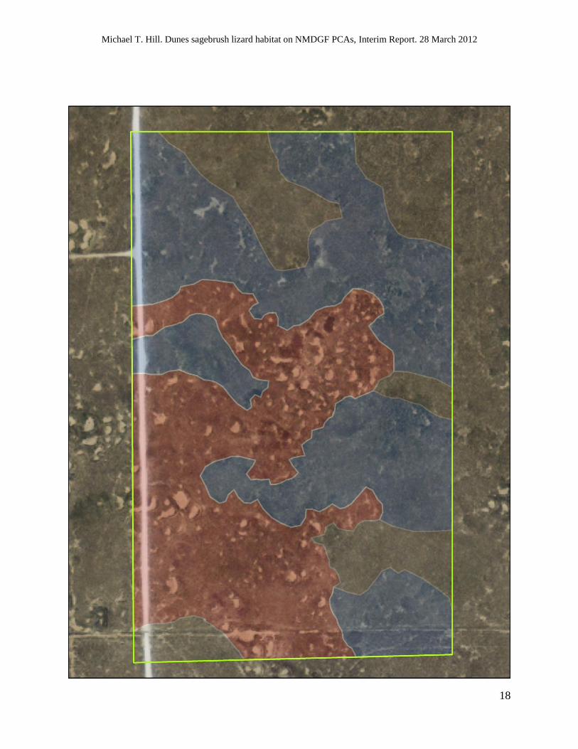
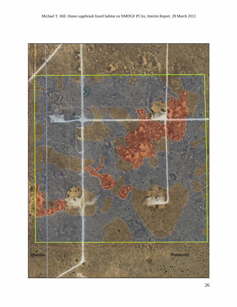
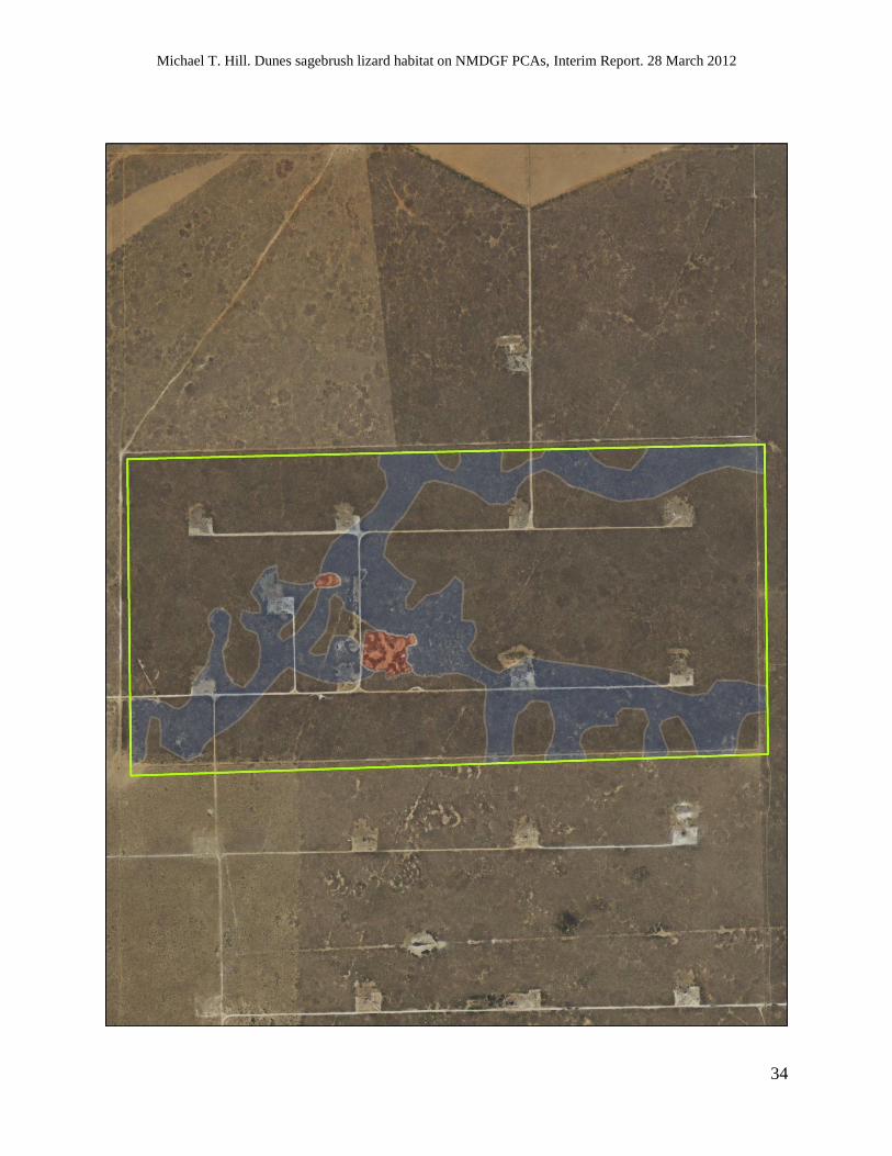
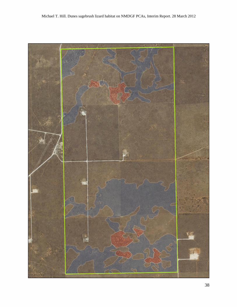
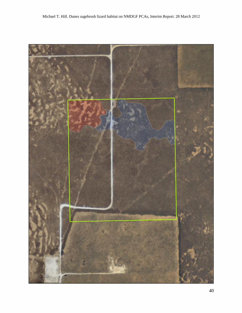
APPENDIX 1. Maps of New Mexico Department of Game and Fish (NMDGF) Prairie Chicken
Areas (PCA) in Chaves, Lea, and Roosevelt Counties, New Mexico that depict estimated core
and corridor habitat for dunes sagebrush lizards (Sceloporus arenicolus). The PCA boundaries
are represented by the green polygons. Dunes sagebrush lizard core habitat is represented by the
red polygons and corridor habitat is represented by the blue polygons. Current (2011) digital
orthophoto quarter quadrangles were downloaded from http://rgis.unm.edu. The PCA boundary
shapefile was provided by NMDGF, and estimated dunes sagebrush lizard habitat polygons were
produced using ArcMap, version 9.3 (ESRI, Redlands, CA).

Michael T. Hill. Dunes sagebrush lizard habitat on NMDGF PCAs, Interim Report. 28 March 2012
14

Michael T. Hill. Dunes sagebrush lizard habitat on NMDGF PCAs, Interim Report. 28 March 2012
15
Black Hills Prairie Chicken Area, Roosevelt County, New Mexico. 1:16,000 scale.

Michael T. Hill. Dunes sagebrush lizard habitat on NMDGF PCAs, Interim Report. 28 March 2012
16

Michael T. Hill. Dunes sagebrush lizard habitat on NMDGF PCAs, Interim Report. 28 March 2012
17
Crossroads 2 Prairie Chicken Area, Lea County, New Mexico. 1:12,000 scale.
Michael T. Hill. Dunes sagebrush lizard habitat on NMDGF PCAs, Interim Report. 28 March 2012
18

Michael T. Hill. Dunes sagebrush lizard habitat on NMDGF PCAs, Interim Report. 28 March 2012
19
Crossroads 3 Prairie Chicken Area, Lea County, New Mexico. 1:3,000 scale.

Michael T. Hill. Dunes sagebrush lizard habitat on NMDGF PCAs, Interim Report. 28 March 2012
20

Michael T. Hill. Dunes sagebrush lizard habitat on NMDGF PCAs, Interim Report. 28 March 2012
21
Crossroads 4 Prairie Chicken Area, Lea County, New Mexico. 1:3,000 scale.

Michael T. Hill. Dunes sagebrush lizard habitat on NMDGF PCAs, Interim Report. 28 March 2012
22

Michael T. Hill. Dunes sagebrush lizard habitat on NMDGF PCAs, Interim Report. 28 March 2012
23
Crossroads 5 Prairie Chicken Area, Roosevelt County, New Mexico. 1:4,000 scale.

Michael T. Hill. Dunes sagebrush lizard habitat on NMDGF PCAs, Interim Report. 28 March 2012
24

Michael T. Hill. Dunes sagebrush lizard habitat on NMDGF PCAs, Interim Report. 28 March 2012
25
Gallina Wells 1 Prairie Chicken Area, Roosevelt County, New Mexico. 1:10,000 scale.
Michael T. Hill. Dunes sagebrush lizard habitat on NMDGF PCAs, Interim Report. 28 March 2012
26

Michael T. Hill. Dunes sagebrush lizard habitat on NMDGF PCAs, Interim Report. 28 March 2012
27
Gallina Wells 1a Prairie Chicken Area, Chaves and Roosevelt Counties, New Mexico. 1:4,000
scale.

Michael T. Hill. Dunes sagebrush lizard habitat on NMDGF PCAs, Interim Report. 28 March 2012
28

Michael T. Hill. Dunes sagebrush lizard habitat on NMDGF PCAs, Interim Report. 28 March 2012
29
Gallina Wells 2 Prairie Chicken Area, Roosevelt County, New Mexico. 1:6,000 scale.

Michael T. Hill. Dunes sagebrush lizard habitat on NMDGF PCAs, Interim Report. 28 March 2012
30

Michael T. Hill. Dunes sagebrush lizard habitat on NMDGF PCAs, Interim Report. 28 March 2012
31
Gallina Wells 5 Prairie Chicken Area, Roosevelt County, New Mexico. 1:12,000 scale. *2009
imagery used for this map to demonstrate the destructiveness of an early 2011 fire.

Michael T. Hill. Dunes sagebrush lizard habitat on NMDGF PCAs, Interim Report. 28 March 2012
32

Michael T. Hill. Dunes sagebrush lizard habitat on NMDGF PCAs, Interim Report. 28 March 2012
33
Gallina Wells 5 Prairie Chicken Area, Roosevelt County, New Mexico. 1:12,000 scale. *2011
imagery, post fire.
Michael T. Hill. Dunes sagebrush lizard habitat on NMDGF PCAs, Interim Report. 28 March 2012
34

Michael T. Hill. Dunes sagebrush lizard habitat on NMDGF PCAs, Interim Report. 28 March 2012
35
Gallina Wells 6 Prairie Chicken Area, Roosevelt County, New Mexico. 1:8,000 scale.

Michael T. Hill. Dunes sagebrush lizard habitat on NMDGF PCAs, Interim Report. 28 March 2012
36

Michael T. Hill. Dunes sagebrush lizard habitat on NMDGF PCAs, Interim Report. 28 March 2012
37
Marshall Prairie Chicken Area, Roosevelt County, New Mexico. 1:8,000 scale.
Michael T. Hill. Dunes sagebrush lizard habitat on NMDGF PCAs, Interim Report. 28 March 2012
38

Michael T. Hill. Dunes sagebrush lizard habitat on NMDGF PCAs, Interim Report. 28 March 2012
39
North Bluit Prairie Chicken Area, Roosevelt County, New Mexico. 1:12,000 scale.
Michael T. Hill. Dunes sagebrush lizard habitat on NMDGF PCAs, Interim Report. 28 March 2012
40

Michael T. Hill. Dunes sagebrush lizard habitat on NMDGF PCAs, Interim Report. 28 March 2012
41
Pitchfork Prairie Chicken Area, Lea County, New Mexico. 1:3,000 scale.

Michael T. Hill. Dunes sagebrush lizard habitat on NMDGF PCAs, Interim Report. 28 March 2012
42
Sandhills Prairie Conservation Area and Antelope Flats Prairie Chicken Area, Lea and Roosevelt

Michael T. Hill. Dunes sagebrush lizard habitat on NMDGF PCAs, Interim Report. 28 March 2012
43
Counties, New Mexico. 1:9,000 scale.

Michael T. Hill. Dunes sagebrush lizard habitat on NMDGF PCAs, Interim Report. 28 March 2012
44
Sandhills Prairie Conservation Area and Bledsoe Prairie Chicken Area, Roosevelt County, New

Michael T. Hill. Dunes sagebrush lizard habitat on NMDGF PCAs, Interim Report. 28 March 2012
45
Mexico. 1:18,000 scale.

Michael T. Hill. Dunes sagebrush lizard habitat on NMDGF PCAs, Interim Report. 28 March 2012
46

Michael T. Hill. Dunes sagebrush lizard habitat on NMDGF PCAs, Interim Report. 28 March 2012
47
South Bluit Prairie Chicken Area, Roosevelt County, New Mexico. 1:8,000 scale.

Michael T. Hill. Dunes sagebrush lizard habitat on NMDGF PCAs, Interim Report. 28 March 2012
48

Michael T. Hill. Dunes sagebrush lizard habitat on NMDGF PCAs, Interim Report. 28 March 2012
49
Wayside Prairie Chicken Area, Chaves County, New Mexico. 1:3,000 scale.
Related Documents