Duarte Station Specific Plan Adopted December 10, 2013 Ordinance 843 Final Amendment Draft November 2019

Welcome message from author
This document is posted to help you gain knowledge. Please leave a comment to let me know what you think about it! Share it to your friends and learn new things together.
Transcript
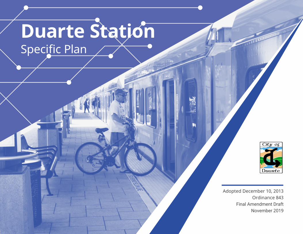
Duarte StationSpecific Plan
Adopted December 10, 2013 Ordinance 843
Final Amendment Draft November 2019

DRAFT Duarte Station Specific Plan Amendment
Adopted December 10, 2013 Ordinance 843
Final Amendment Draft November 2019
Prepared For:
City of Duarte
2013 Specific Plan Prepared By:
RBF Consulting The Dahlin Group
Economic and Planning Solutions
2019 Amendment Prepared By: MIG, Inc.
Fehr & Peers

ACKNOWLEDGEMENTS
2013 Specific Plan City Council
Liz Reilly, Mayor Tzeitel Paras-Caracci, Mayor Pro Tem
John Fasana Margaret Finlay
Sam Kang
Planning Commission William Lawrence, Chairperson Ron Phadnis, Vice Chairperson
Ana Lisa Hernandez Sheryl Lefmann
Shauna Pierce
City Staff Craig Hensley, Community Development Director
Jason Golding, Senior Planner
Metro
2019 Specific Plan Amendment City Council
Tzeitel Paras-Caracci, Mayor Samuel Kang, Mayor Pro Tem John Fasana, Councilmember
Liz Reilly, Councilmember Margaret Finlay, Councilmember
Bryan Urias, Councilmember Toney Lewis, Councilmember
Planning Commission
Paula Watson-Gardner, Chair Tina Heany, Vice-Chair
George K. Farra Sara Vasquez
Wallace J. Wolff
City Staff Craig Hensley, Community Development Director
Jason Golding, Planning Manager
The costs associated with the preparation of the 2013 Duarte Station Specific Plan and Environmental Impact Report (EIR) were funded primarily through a grant from Metro, the Los Angeles County Metropolitan Transportation Authority. The City of Duarte would like to thank Metro and their Staff for approving funding for the creation of the Duarte Station Specific Plan and related EIR through the Transit Oriented Development (TOD) Planning Grant Program. Metro support has been paramount to the success and completion of these land use planning and environmental documents.
Duarte Station Specific Plan
Table of Contents i
TABLE OF CONTENTS
Section 1 - Introduction 1.1 Executive Summary....................................................................................................................................................................................................................................................... 1-1 1.2 Project Setting .................................................................................................................................................................................................................................................................. 1-3
1.2.1 Location ............................................................................................................................................................................................................................................................. 1-3 1.2.2 Surrounding Uses ........................................................................................................................................................................................................................................ 1-3 1.2.3 Baseline Uses (2019) ................................................................................................................................................................................................................................... 1-7 1.2.4 Zoning and General Plan ........................................................................................................................................................................................................................ 1-7 1.2.5 Background ..................................................................................................................................................................................................................................................... 1-9 1.2.6 Relationship to Governing Documents ...................................................................................................................................................................................... 1-10 1.2.7 Required Approvals ................................................................................................................................................................................................................................. 1-11 1.2.8 Specific Plan Organization .................................................................................................................................................................................................................. 1-11
Section 2 - Development Plan
2.1 What Is Transit-Oriented Development? ......................................................................................................................................................................................................... 2-1 2.2 Specific Plan Vision, Goals and Objectives ...................................................................................................................................................................................................... 2-1
2.2.1 Vision Statement .......................................................................................................................................................................................................................................... 2-1 2.3 Sustainable Design ........................................................................................................................................................................................................................................................ 2-3 2.4 Land Use Program ......................................................................................................................................................................................................................................................... 2-4
2.4.1 Context ............................................................................................................................................................................................................................................................... 2-4 2.4.2 Development Concept ............................................................................................................................................................................................................................ 2-5
2.5 Illustrative Site Plan and Planning Principles ................................................................................................................................................................................................. 2-5 2.6 Phasing .............................................................................................................................................................................................................................................................................. 2-11 2.6.1 Phasing Overview ..................................................................................................................................................................................................................................... 2-12 2.6.2 Phase I .............................................................................................................................................................................................................................................................. 2-12 2.6.3 Future Phases .............................................................................................................................................................................................................................................. 2-12
Section 3 - Development Standards and Design Guidelines
3.1 General Provisions .......................................................................................................................................................................................................................................................... 3-1 3.1.1 Applicability .................................................................................................................................................................................................................................................... 3-1 3.1.2 Severability ....................................................................................................................................................................................................................................................... 3-1 3.1.3 Determination of Unlisted Uses .......................................................................................................................................................................................................... 3-1 3.1.4 Definitions ........................................................................................................................................................................................................................................................ 3-1 3.1.5 Interpretation ................................................................................................................................................................................................................................................. 3-2

Duarte Station Specific Plan
ii Table of Contents
3.1.6 Existing Users .................................................................................................................................................................................................................................................. 3-2 3.2 Allowable Land Uses .................................................................................................................................................................................................................................................... 3-2 3.3 General Development Standards ......................................................................................................................................................................................................................... 3-4
3.3.1 Building Setbacks ......................................................................................................................................................................................................................................... 3-4 3.3.2 Building Heights ........................................................................................................................................................................................................................................... 3-4 3.3.3 Ground Floor Design ................................................................................................................................................................................................................................. 3-4 3.3.4 Parking ................................................................................................................................................................................................................................................................ 3-6 3.3.5 Open Space ..................................................................................................................................................................................................................................................... 3-7
3.4 Frontage Standards ....................................................................................................................................................................................................................................................... 3-8 3.4.1 Frontage Class Standards ....................................................................................................................................................................................................................... 3-8 3.4.2 Façade Type Standards ......................................................................................................................................................................................................................... 3-25
3.5 Design Standards and Guidelines ..................................................................................................................................................................................................................... 3-30 3.5.1 Site Planning ................................................................................................................................................................................................................................................ 3-30 3.5.2 General Building Design ....................................................................................................................................................................................................................... 3-32 3.5.3 Design Guidelines by Building Type ............................................................................................................................................................................................. 3-41 3.5.4 Design by Façade Type ......................................................................................................................................................................................................................... 3-47 3.5.5 Adaptive Reuse Design ......................................................................................................................................................................................................................... 3-48 3.5.6 Landscape, Hardscape, Furnishings, and Lighting Design ............................................................................................................................................. 3-51
Section 4 - Infrastructure and Services 4.1 Circulation Plan ................................................................................................................................................................................................................................................................ 4-1
4.1.1 Regional Access ............................................................................................................................................................................................................................................ 4-1 4.1.2 Transit .................................................................................................................................................................................................................................................................. 4-1 4.1.3 Perimeter Roads ........................................................................................................................................................................................................................................... 4-1 4.1.4 Internal Circulation ..................................................................................................................................................................................................................................... 4-2
4.2 Infrastructure Plan .......................................................................................................................................................................................................................................................... 4-4 4.2.1 Domestic Water Service ........................................................................................................................................................................................................................... 4-4 4.2.2 Sanitary Sewer Service .............................................................................................................................................................................................................................. 4-6 4.2.3 Drainage Plan ................................................................................................................................................................................................................................................. 4-8 4.2.4 Grading ........................................................................................................................................................................................................................................................... 4-10 4.2.5 Public Services ............................................................................................................................................................................................................................................ 4-10
Section 5 - Administration and Implementation
5.1 Administration .................................................................................................................................................................................................................................................................. 5-1 5.1.1 Purpose and Overview ............................................................................................................................................................................................................................. 5-1 5.1.2 Applicability .................................................................................................................................................................................................................................................... 5-1
Duarte Station Specific Plan
Table of Contents iii
5.1.3 Adoption ........................................................................................................................................................................................................................................................... 5-1 5.1.4 Enforcement ................................................................................................................................................................................................................................................... 5-1 5.1.5 Interpretation ................................................................................................................................................................................................................................................. 5-1 5.1.6 Appeals .............................................................................................................................................................................................................................................................. 5-2 5.1.7 Specific Plan Modifications and Amendments ......................................................................................................................................................................... 5-2
5.2 Implementation .............................................................................................................................................................................................................................................................. 5-4 5.2.1 Mitigation Monitoring and Reporting Program ....................................................................................................................................................................... 5-4 5.2.2 Implementation Mechanisms .............................................................................................................................................................................................................. 5-4 5.2.3 Subsequent Approvals and Plans ...................................................................................................................................................................................................... 5-6
5.3 Maintenance Responsibility and Project Financing .................................................................................................................................................................................. 5-7 5.3.1 Maintenance Responsibility .................................................................................................................................................................................................................. 5-7 5.3.2 Public Art ........................................................................................................................................................................................................................................................... 5-8 5.3.3 Financing Mechanisms ............................................................................................................................................................................................................................ 5-8
Section 6 - Appendix
6.1 General Plan Consistency Analysis....................................................................................................................................................................................................................... 6-1 6.1.1 Safety Element ............................................................................................................................................................................................................................................... 6-1 6.1.2 Open Space and Conservation Element ....................................................................................................................................................................................... 6-1 6.1.3 Land Use Element ....................................................................................................................................................................................................................................... 6-2 6.1.4 Housing Element ......................................................................................................................................................................................................................................... 6-3 6.1.5 Economic Development Element ..................................................................................................................................................................................................... 6-3 6.1.6 Circulation Element .................................................................................................................................................................................................................................... 6-4
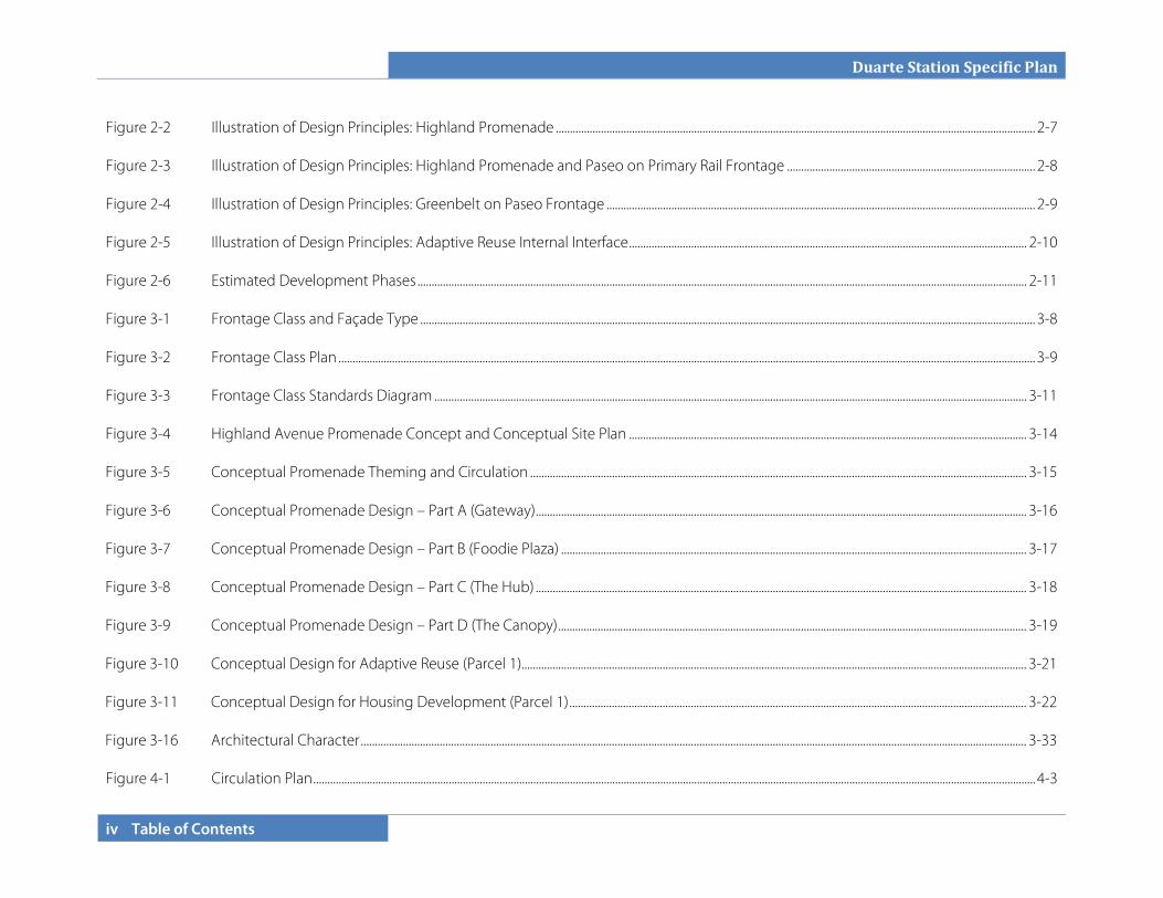
LIST OF FIGURES Figure 1-1 Regional Vicinity .............................................................................................................................................................................................................................................................. 1-2 Figure 1-2 Local Vicinity ...................................................................................................................................................................................................................................................................... 1-4 Figure 1-3 Specific Plan Area ........................................................................................................................................................................................................................................................... 1-8 Figure 2-1 Conceptual Illustrative Site Plan ........................................................................................................................................................................................................................... 2-6
Duarte Station Specific Plan
iv Table of Contents
Figure 2-2 Illustration of Design Principles: Highland Promenade .......................................................................................................................................................................... 2-7 Figure 2-3 Illustration of Design Principles: Highland Promenade and Paseo on Primary Rail Frontage ........................................................................................ 2-8 Figure 2-4 Illustration of Design Principles: Greenbelt on Paseo Frontage ........................................................................................................................................................ 2-9 Figure 2-5 Illustration of Design Principles: Adaptive Reuse Internal Interface ............................................................................................................................................. 2-10 Figure 2-6 Estimated Development Phases ........................................................................................................................................................................................................................ 2-11 Figure 3-1 Frontage Class and Façade Type .......................................................................................................................................................................................................................... 3-8 Figure 3-2 Frontage Class Plan ....................................................................................................................................................................................................................................................... 3-9 Figure 3-3 Frontage Class Standards Diagram .................................................................................................................................................................................................................. 3-11 Figure 3-4 Highland Avenue Promenade Concept and Conceptual Site Plan ............................................................................................................................................. 3-14 Figure 3-5 Conceptual Promenade Theming and Circulation ................................................................................................................................................................................ 3-15 Figure 3-6 Conceptual Promenade Design – Part A (Gateway) .............................................................................................................................................................................. 3-16 Figure 3-7 Conceptual Promenade Design – Part B (Foodie Plaza) ..................................................................................................................................................................... 3-17 Figure 3-8 Conceptual Promenade Design – Part C (The Hub) .............................................................................................................................................................................. 3-18 Figure 3-9 Conceptual Promenade Design – Part D (The Canopy) ...................................................................................................................................................................... 3-19 Figure 3-10 Conceptual Design for Adaptive Reuse (Parcel 1)................................................................................................................................................................................... 3-21 Figure 3-11 Conceptual Design for Housing Development (Parcel 1) .................................................................................................................................................................. 3-22 Figure 3-16 Architectural Character ............................................................................................................................................................................................................................................ 3-33 Figure 4-1 Circulation Plan ................................................................................................................................................................................................................................................................ 4-3

Duarte Station Specific Plan
Table of Contents v
Figure 4-2 Water Plan ........................................................................................................................................................................................................................................................................... 4-5 Figure 4-3 Sewer Infrastructure Plan ........................................................................................................................................................................................................................................... 4-7 Figure 4-4 Stormwater Infrastructure Plan .............................................................................................................................................................................................................................. 4-9
LIST OF TABLES
Table 1-1 Baseline Uses ..................................................................................................................................................................................................................................................................... 1-7 Table 1-2 Approvals .......................................................................................................................................................................................................................................................................... 1-11 Table 3-1 Land Use Regulations .................................................................................................................................................................................................................................................. 3-3 Table 3-2 General Development Standards ......................................................................................................................................................................................................................... 3-5 Table 3-3 Frontage Linear Feet .................................................................................................................................................................................................................................................... 3-9 Table 3-4 Frontage Class Standards ....................................................................................................................................................................................................................................... 3-10 Table 5-1 Specific Plan Consistency Checklist .................................................................................................................................................................................................................... 5-5 Table 5-2 Projected Phasing .......................................................................................................................................................................................................................................................... 5-7 Table 5-3 Federal and State Funding Sources ................................................................................................................................................................................................................. 5-11
Duarte Station Specific Plan
vi Table of Contents
This page intentionally left blank.
Duarte Station Specific Plan
Introduction 1-1
SECTION 1.0 INTRODUCTION
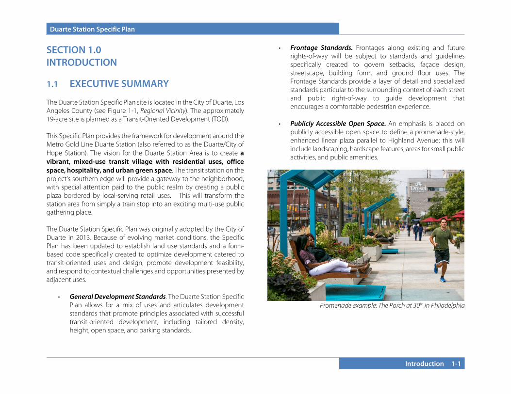
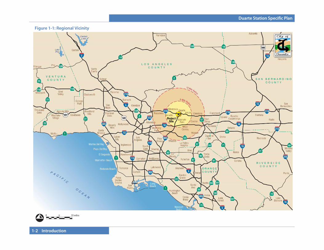
1.1 EXECUTIVE SUMMARY The Duarte Station Specific Plan site is located in the City of Duarte, Los Angeles County (see Figure 1-1, Regional Vicinity). The approximately 19-acre site is planned as a Transit-Oriented Development (TOD). This Specific Plan provides the framework for development around the Metro Gold Line Duarte Station (also referred to as the Duarte/City of Hope Station). The vision for the Duarte Station Area is to create a vibrant, mixed-use transit village with residential uses, office space, hospitality, and urban green space. The transit station on the project’s southern edge will provide a gateway to the neighborhood, with special attention paid to the public realm by creating a public plaza bordered by local-serving retail uses. This will transform the station area from simply a train stop into an exciting multi-use public gathering place. The Duarte Station Specific Plan was originally adopted by the City of Duarte in 2013. Because of evolving market conditions, the Specific Plan has been updated to establish land use standards and a form-based code specifically created to optimize development catered to transit-oriented uses and design, promote development feasibility, and respond to contextual challenges and opportunities presented by adjacent uses.
• General Development Standards. The Duarte Station Specific Plan allows for a mix of uses and articulates development standards that promote principles associated with successful transit-oriented development, including tailored density, height, open space, and parking standards.
• Frontage Standards. Frontages along existing and future rights-of-way will be subject to standards and guidelines specifically created to govern setbacks, façade design, streetscape, building form, and ground floor uses. The Frontage Standards provide a layer of detail and specialized standards particular to the surrounding context of each street and public right-of-way to guide development that encourages a comfortable pedestrian experience.
• Publicly Accessible Open Space. An emphasis is placed on
publicly accessible open space to define a promenade-style, enhanced linear plaza parallel to Highland Avenue; this will include landscaping, hardscape features, areas for small public activities, and public amenities.
Promenade example: The Porch at 30th in Philadelphia
Duarte Station Specific Plan
1-2 Introduction
Figure 1-1: Regional Vicinity
Duarte Station Specific Plan
Introduction 1-3
1.2 PROJECT SETTING
1.2.1 Location
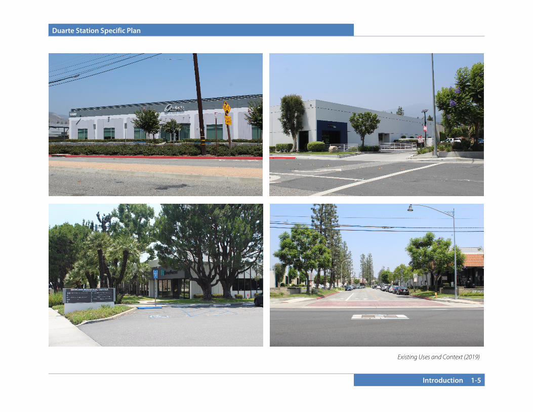
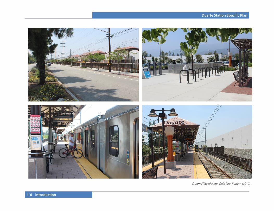
The City of Duarte is located in Los Angeles County east of the City of Monrovia, south of the City of Bradbury, and west of the City of Azusa along Interstate 210. Regional access is provided primarily by the I-210 and I-605 freeways (see Figure 1-1, Regional Vicinity). The Duarte Station Specific Plan area is approximately 19 acres in size and consists of four parcels located at the northwest and southwest corners of Business Center Drive and Highland Avenue (see Figure 1-2, Local Vicinity). Roadways bordering the parcels are Evergreen Street to the north, Highland Avenue to the east, Duarte Road to the south (including the Metro-owned Gold Line tracks), and Denning Avenue and Three Ranch Road to the west. Business Center Drive traverses the Specific Plan area in an east-west direction. Additionally, the Los Angeles County Metropolitan Transportation Authority (Metro)-owned right-of-way borders the Specific Plan area to the south; these tracks are the critical transportation infrastructure driving factor for the Duarte Station Specific Plan.
1.2.2 Surrounding Uses
The project site is surrounded by the following uses:
• North: Evergreen Street and the Foothill Freeway (Interstate 210) immediately bound the site to the north, with single-family residential uses located to the north across Business Center Drive.
• West: A single-family residential neighborhood with approximately 200 homes is located south of Evergreen Street, east of Buena Vista Street, north of Duarte Road, and west of the project site.
• South: The Metro-owned railroad right-of-way is directly adjacent to the project site. The City of Hope medical research campus is immediately south in Duarte. The Santa Fe Dam Recreational Area, owned by the U.S. Army Corps of Engineers and operated by Los Angeles County Department of Parks and Recreation, is located in the City of Irwindale to the south, across Duarte Road.
• East: The Duarte/Lewis Business Center occupies approximately 40 acres to the east, across Highland Avenue, south of I-210 and west of the San Gabriel Freeway (Interstate 605).

Duarte Station Specific Plan
1-4 Introduction
Figure 1-2: Local Vicinity
Duarte Station Specific Plan
Introduction 1-5
Existing Uses and Context (2019)
Duarte Station Specific Plan
1-6 Introduction
Duarte/City of Hope Gold Line Station (2019)
Duarte Station Specific Plan
Introduction 1-7
1.2.3 Baseline Uses (2019)
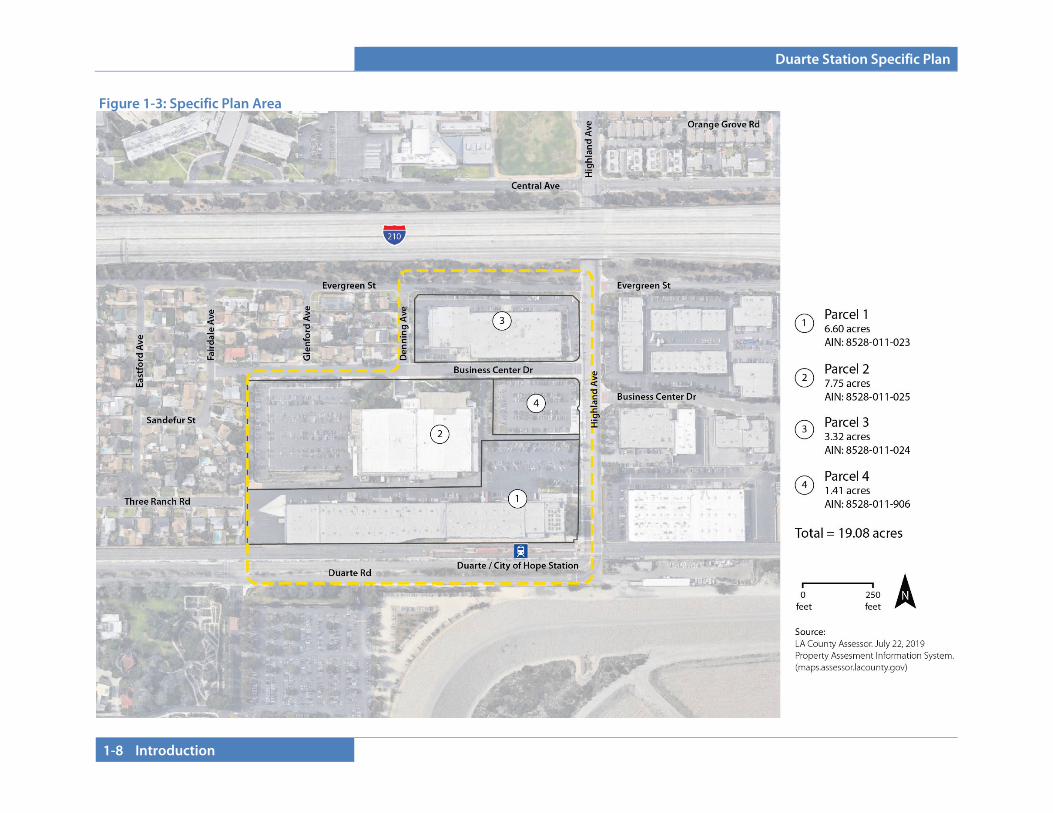
The Specific Plan area consists of four parcels under varying ownership (see Figure 1-3, Specific Plan Area). The parcels are developed with a mix of industrial uses totaling approximately 313,955 square feet (as of 2019). Details on building coverage and area of each parcel are presented in Table 1-1 (Baseline Uses). See Section 3: Development Standards for more information on phasing and allowed development. Table 1-1: Baseline Uses
1.2.4 Zoning and General Plan
1.2.4.A General Plan
The General Plan Land Use Element designates the project area as Duarte Station Specific Plan. The General Plan will be amended in concert with the Specific Plan amendment to achieve consistency with regard to policy language.
The Housing Element identifies the Duarte Station Development Area Specific Plan as an area that would accommodate new residential multifamily units to meet the City’s allotment of regional housing need. The Housing Element (2012 Amendment) states that a minimum of 80 to 100 units will be a part of Phase I of the Duarte Station Specific Plan and suggests that Phase I would be established on Parcels 2 and 4. Details on Phase I, Future Phase, and Subareas are in Section 2 - Development Plan.
The Housing Element was not intended to place a maximum number of units that would be developed in either Area 1 or the balance of the planning area, but to address a minimum number that would allow the City to meet its regional housing need.
1.2.4.B Zoning
The City’s Zoning Map designates the project site as Specific Plan #18.
Parcel Phase Gross
Acreage
Facilities in 2019
(Sq. Ft.)
Parcel 1 Future Phase 6.60 128,466
Parcel 2 Phase I 7.75 114,599
Parcel 3 Future Phase 3.32 70,890
Parcel 4 Phase I 1.41 0
Total (Gross)
- 19.08 313,955
Duarte Station Specific Plan
1-8 Introduction
Figure 1-3: Specific Plan Area

Duarte Station Specific Plan
Introduction 1-9
1.2.5 Background
1.2.5.A Planning History: Metro Gold Line
In 2002, the Metro Gold Line Foothill Extension Construction Authority and the San Gabriel Valley Council of Governments initiated an Alternatives Analysis Study to extend rail service eastward from Pasadena. With the participation of cities along the rail right-of-way, the study was intended to be a screening process where a full range of alternatives were narrowed down to arrive at a locally preferred alternative for more detailed study. The local mode and alignment preference were chosen, which consisted of extending the Light Rail Transit (LRT) from its terminus in Pasadena along the existing heavy rail right-of-way. A general study was prepared that encompassed 13 adjoining cities along Interstate 210 and the railroad right-of-way, between Pasadena to the west and Montclair to the east. The study areas included the cities of Pasadena, Arcadia, Monrovia, Duarte, Irwindale, Azusa, Glendora, San Dimas, La Verne, Pomona, and Claremont in Los Angeles County; Upland and Montclair were included in San Bernardino County. Station locations were chosen through discourse with each city along the proposed route. Meetings with the cities took place during both the Alternatives Analysis process and the EIS/EIR Process. All lands within 1,000 feet on either side of the rail were declared as the study corridor, and an EIR was finalized and certified in February 2007 for the preferred corridor plan shown in Figure 1-4. Metro continues to expand light rail services throughout the region. The Gold Line Foothill Extension reached Duarte in 2016 with service to the Metro Gold Line Duarte Station. As part of a second phase of rail construction, the Foothill Gold Line will extend to Montclair an additional 12.3 miles and add stations in the cities of Glendora, San Dimas, La Verne, Pomona, Claremont, and Montclair. When the regional connector in Downtown Los Angeles is constructed, the Gold Line will transition to become an extension of the Blue Line, linking Montclair to Long Beach in one easy ride.
1.2.5.B TOD Corridor Framework
In 2005, the Metro Gold Line Foothill Extension Construction Authority began working with the City of Duarte to review the preliminary construction plans for the LRT. At that time, the Authority introduced the idea of Transit-Oriented Development (TOD) to cities along the LRT corridor and the benefits it may present to communities. The idea of TOD resonated with the City Council, and the City began to contemplate the integration of TOD into the City’s land use documents. In August 2007, the City Council adopted a comprehensively updated General Plan that included re-designation of approximately 19 acres of industrial land uses near the future Duarte Station as the Duarte Station Specific Plan designation. In 2007 and 2008, the City also participated in a Caltrans Community-based Transportation Grant. The grant was sponsored by the San Gabriel Valley Council of Governments and produced a TOD visioning study for the project site based upon significant public outreach, a joint City Council and Planning Commission workshop with over 150 residents in attendance, and a summary presentation before the City Council in April 2008. A consultant team provided market research, created urban design schemes, researched transportation issues, and provided recommendations for each individual station along the extension. The
Figure 1-4: Metro Gold Line
Duarte Station Specific Plan
1-10 Introduction
study found that the Foothill Extension Corridor presented truly a unique opportunity to accommodate population growth while providing new job centers and thoughtful compact development.
The City requested evaluated the possibilities and feasibility of a village concept north of the proposed station area and south of Interstate 210. The urban concept focused on developing compact mixed uses while providing opportunities for growth in office, retail, and hotel land uses. In 2008, the Duarte Gold Line Station Area Vision Report evaluated the potential for a transit-oriented development on a 20-acre site adjacent to the then-proposed Metro Gold Line Station. The goal of this study was to develop an overall vision and guiding principles for future development within the station area and to illustrate possible options for organization of land uses, building placement, and built form on the site. A market study, community outreach, and a traffic analysis were also undertaken during the conceptual planning effort. All of these efforts served as a catalyst for both the City Council and the community to realize a TOD development at the project site. City staff submitted a Metro Transit-Oriented Development Planning Grant Program. In 2012, the City was awarded Round 1 grant funding that was offered to municipalities along the Expo Line Phases 1 & 2, Crenshaw/LAX corridor, and Gold Line Foothill Extension. The grant award allowed the City to lead the effort to prepare the Duarte Station Specific Plan and EIR. The Specific Plan was adopted in 2013 to reflect then-current development opportunities; this amendment responds to evolving market conditions. 1.2.5.C Specific Plan Amendment (2019)
Between Specific Plan adoption in 2013 and the Specific Plan Amendment in 2019, market forces continued to shift. Statewide, housing production continued to be less than half of the projected need of 180,000 annual new homes, as reported by the California Department of Housing and Community Development. In 2018, the legislature increased incentives and penalties to cities for failing to
meet their housing obligations. At the same time, “creative offices” began to dominate office construction/remodeling market, largely through the reuse and remodeling of existing older (often industrial) buildings. The City Council approved an amendment to the Specific Plan in 2019 to reflect changing market conditions, with revisions to allowed uses, new regulations for adaptive reuse of existing buildings, and a modified open space plan.
1.2.6 Relationship to Governing Documents As discussed above, a comprehensive regional and local planning effort has been undertaken to implement a TOD Specific Plan for the Duarte Station. Thus, the Duarte Station Specific Plan incorporates objectives and visioning and reflects the intent of the TOD Corridor Development Assessment and the Duarte Station Areas Vision studies. The Duarte Station Specific Plan is also intended to implement the City of Duarte’s General Plan. 1.2.6.A Specific Plan Authority
The California Government Code (Title 7, Division 1, Chapter 3, Article 8, Sections 65450 through 65457) provides the authority for a city to adopt a specific plan by ordinance (as a regulatory plan) or resolution (as a policy-driven plan). This Specific Plan is both a regulatory and policy document and therefore must be adopted by ordinance. The California Government Code establishes a minimum set of requirements for specific plans, which include text and diagrams that specify all of the following in detail:
• The distribution, location, and extent of the uses of land, including potential open space, within the specific plan area.
• The proposed distribution, location, extent and intensity of major components of public and private transportation,

Duarte Station Specific Plan
Introduction 1-11
sewage, water, drainage, solid waste disposal, energy, and other essential facilities to be located within the specific plan area and which are needed to support the land uses described in the specific plan.
• Standards and criteria by which development will proceed, and standards for the conservation, development, and utilization of natural resources, where applicable.
• A program of implementation measures including regulations applicable to projects within the specific plan area and financing measures available to carry out the project.
• A statement of the relationship of the specific plan to the General Plan.
1.2.7 Required Approvals
Implementation of the Specific Plan will require several approvals (see Table 1-2). Subsequent approvals will include site plan/design review and subdivision mapping if needed to create individual lots within the Specific Plan boundaries. Table 1-2: Approvals
1.2.8 Specific Plan Organization The Duarte Station Specific Plan is composed of these sections:
• Section 1 – Introduction. This section provides background information about the Specific Plan. Since the Specific Plan will be used by a variety of users (such as property owners, City staff, business owners, residents, and elected and appointed officials), a brief background of the Specific Plan area and project setting are included. This section provides a description of the history, purpose, and function of the Specific Plan; it educates the reader on the information contained within the Specific Plan document in the sections that follow.
• Section 2 – Development Plan. Section 2 identifies the fundamental components of the Specific Plan, including goals and policies that guide the vision for development of the Specific Plan area.
• Section 3 – Development Regulations and Design Guidelines. Section 3 provides development standards and design guidelines for proposed development in the Specific Plan area. These regulations are presented through a hybrid approach that integrates features of a conventional zoning code and a form-based code. Form-based codes regulate land uses based on form and function and are based on a “human-use” scale. This section contains development standards for architecture and building placement, building form, sidewalks and amenity areas, and public spaces. Regulations are further supported by the Design Guidelines embedded in this section of the plan. The purpose of the Design Guidelines is to identify and establish visual themes that are aesthetically pleasing and will result in a cohesiveness to create a “sense of place” for persons who live, work, or visit the Specific Plan area.
Required Permit/Approval Approving Agency
Final EIR Certification City of Duarte City Council General Plan Text Amendment City of Duarte City Council
Specific Plan Adoption City of Duarte City Council
Duarte Station Specific Plan
1-12 Introduction
• Section 4 – Infrastructure and Services Plan. The Infrastructure and Services Plan section discusses existing conditions and proposed improvements to local circulation, parking, sewer, water, and storm drain systems to serve the Specific Plan area at full build-out. Public and private utility providers are also identified.
• Section 5 – Implementation and Administration. The intent of this section is to provide methods for eventual construction and build-out of the Specific Plan. Implementation techniques, tools, and incentives—including efficient entitlement processing standards, phasing, and public and private funding and financing mechanisms—are also addressed.
• Section 6 – Appendix. This section includes the General Plan consistency analysis.

Duarte Station Specific Plan
Development Plan 2-1
SECTION 2.0 DEVELOPMENT PLAN This section of the Duarte Station Specific Plan outlines the vision and conceptual master plan for development of the Specific Plan area.
2.1 WHAT IS TRANSIT-ORIENTED DEVELOPMENT?
Transit-oriented development, or TOD, has many definitions. As defined in the TOD Corridor Development Assessment study prepared by the Metro Gold Line as part of the early planning for the Foothill Extension:
Transit-oriented development is typically defined as compact development containing a mix of uses within easy walking distance (one-quarter to one-half-mile radius) of transit stations. But a prescribed density or mix of uses can’t ensure the success of a transit-oriented development project or guarantee that it will produce more riders for transit. It’s become increasingly clear that TOD cannot be defined by physical form alone, and those high-performing projects – whether performance is judged by financial returns or the number of people who flock there – are best defined by performance criteria that can be used as a planning tool to assess how well a project will function.
TOD is not just development near transit stations; rather, it is development that:
• Increases “location efficiency” so that people can walk, bike,
and take transit
• Boosts transit ridership and minimizes the impacts of traffic through access to site-adjacent transit
• Provides a mixture of land uses
• Provides value for the public and private sectors, and for both new and existing residents
• Creates a sense of community and of place
2.2 SPECIFIC PLAN VISION, GOALS, AND OBJECTIVES
2.2.1 Vision Statement The Duarte Station area will become a vibrant, mixed-use transit village with a focus on residential uses; office uses including creative office, biotech, and research and development; hospitality uses; and urban open spaces. The Metro Gold Line Duarte Station on the project’s southern edge will act as the gateway to the neighborhood, with special attention paid to the public realm in the immediate vicinity. A promenade/public plaza will run the length of Highland Avenue, bordered by local serving retail uses at the ground-floor level and facilitating a local gathering place. A strong emphasis will be placed on walkability through a pleasant sidewalk environment, where buildings frame the street. The following goals and objectives will guide the intent and future development within the Specific Plan area. 1. Goal: A Mixture of Land Uses
a. Objective: Develop a flexible mixed-use land use pattern that
incorporates residential opportunities with options for retail, office, research and development, and hospitality, and that will effectively complement each other and provide maximum land use efficiency, while providing economic and social benefits to users.
b. Objective: Program retail uses that are neighborhood and
transit station serving.
Duarte Station Specific Plan
2-2 Development Plan
2. Goal: An Economically Feasible Development
a. Objective: Provide opportunities for adaptive reuse of existing buildings, and design new nonresidential spaces with flexibility to allow for shifts in market demand and allow options throughout various economic cycles and scenarios.
b. Objective: Create a range of residential unit types that will be
accessible to residents of all income levels.
c. Objective: Provide residential opportunities to assist the City of Duarte in meeting its Regional Housing Needs Allocation (RHNA) objectives.
d. Objective: Encourage the development of a hotel to create
local jobs, support City of Hope lodging needs, provide community meeting space, and increase tax revenues within the community.
3. Goal: Pedestrian-Oriented Development
a. Objective: Create a development pattern that effectively provides for efficient and comfortable pedestrian movement and connectivity throughout the site.
b. Objective: Give precedence to pedestrians, and foster
multimodal transportation with bicycle, pedestrian, and transit access.
c. Objective: Provide supportive commercial uses and an active
street frontage on Highland Avenue that facilitate a pedestrian-friendly experience and link to other centers in the city.
4. Goal: Superior Urban Design
a. Objective: Allow for building types that will achieve desired density ranges to establish a critical mass of residents and employees to support the transit station, maximize transit ridership, and support retail spaces and local employment centers.
b. Objective: Minimize setbacks along secondary frontages to
allow buildings to frame and activate the street.
c. Objective: Use trees, shrubs, and other landscape and hardscape materials along streets to provide shading, screening, and human scale.
d. Objective: Promote high-quality architectural design to
establish a consistent design character that creates an identity in the Duarte Station Specific Plan area.
e. Objective: Establish context-based standards and guidelines that address specific design concerns while also allowing for creativity and flexibility in development projects.
5. Goal: Outdoor Spaces
a. Objective: Provide outdoor spaces—such as an urban green
space, public plaza, promenade, or linear park—that provide a transition between the station and the surrounding transit village uses and that facilitates pedestrian movement and public gathering.
b. Objective: Encourage rooftop open space areas to increase
the amount and quality of open space while taking advantage of quality views from the site.

Duarte Station Specific Plan
Development Plan 2-3
c. Objective: Program outdoor space(s) to accommodate the needs of various user groups, such as residents, employees, commuters, and visitors.
6. Goal: Awareness of Surrounding Development a. Objective: Provide opportunities for new goods and services
uses to support surrounding residents, students, and employees within and around the Duarte Station Specific Plan area.
b. Objective: Provide for appropriate transitions with adjacent
existing lower-intensity residential uses through height limits, setbacks, articulation and modulation requirements, design guidelines, and landscape requirements.
c. Objective: Upgrade the existing streetscape infrastructure and solidify pedestrian connections between the Specific Plan area, Duarte Station, and critical areas of interest around the site.
d. Objective: Consider the future needs of the City of Hope as
part of land use planning. 7. Goal: Sustainable Development Practices
a. Objective: Encourage transit-oriented development that supports multimodal opportunities and adhere to Levels of Sustainable Development Practices, as prescribed in Chapter 19.52 of the City’s Development Code.
b. Objective: Ensure that construction and demolition waste is
disposed of in accordance with all City regulations and standards.
c. Objective: Consider building layout, siting, and building design to not preclude alternative energy production on site.
d. Objective: Maximize energy efficiency through local and state standards, indoor environmental quality, energy-efficient lighting, building orientation, shading, and implementation of LEED principles (or similar) and/or attaining LEED Certification.
e. Objective: Reduce heat island effect through site planning
and selection of landscape and hardscape materials.
f. Objective: Incorporate water-efficient design features such as permeable surfaces, collection devices, biofiltration devices, green rooftops, cisterns, berms and swales, and/or green rooftops.
g. Objective: Include drought-tolerant and climate-appropriate
landscape within the Specific Plan area.
2.3 SUSTAINABLE DESIGN Sustainable design refers to design and construction practices that significantly reduce or eliminate the negative impacts of development on the environment and its inhabitants. The City of Duarte has established sustainable development practices in the Duarte Development Code (DDC) to encourage conservation of natural resources, increased energy efficiency, and the use of sustainable practices in the development process. A sustainable design approach can be defined by a variety of green building practices and the availability of pedestrian-oriented amenities. The essential components that make up a successful sustainable development have been identified by the U.S. Green Building Council (USGBC). The USGBC recognizes that the layout and design of the built environment influences the way residents and visitors experience a neighborhood, and it can impact their quality of life and sense of community.
Duarte Station Specific Plan
2-4 Development Plan
All new construction within the City and this Specific Plan are required to apply sustainable development practices identified in the DDC. The design guidelines and implementation approach provided are aimed at meeting the following objectives:
• Encourage development within and near existing communities or public transportation infrastructure to reduce vehicle trips and induce pedestrian activity.
• Promote neighborhoods that are physically connected to each other to foster community and connectedness beyond the individual project.
• Encourage design of projects that incorporate high levels of internal connectivity and connections to surrounding development to promote a variety of travel options.
• Provide direct and safe connections for pedestrians, bicyclists, and drivers to key components of a project, local destinations, and neighborhood centers.
• Encourage the design and construction of buildings to utilize green building practices.
• Encourage the design and construction of energy efficient buildings to reduce air, water, and land pollution and environmental impacts from energy production and consumption.
• Achieve enhanced energy efficiency by creating the optimum conditions for the use of passive and active solar.
• Use recycled and other environmentally friendly building materials whenever possible.
• Encourage incorporation of low impact development (LID) and best management practices (BMPs) to treat stormwater on site and infiltrate rainwater as much as possible rather than diverting it into storm drains.
• Reduce the impact of heat islands by providing shade structures and trees that can produce large canopies to provide shade. In addition, choose roof paving materials that possess a high level of solar reflectivity.
Development applications are required to identify the level of development (project size) and the corresponding required sustainable development practices. Projects at each level shall comply with the provisions identified in Table 3-20 of the DDC, Chapter 19.52, Sustainable Development Practices.
2.4 LAND USE PROGRAM
2.4.1 Context In evaluating the site for development opportunities, a number of items were considered, including the following:
• Existing conditions related to drainage, circulation, land use, transit, and infrastructure;
• The location and orientation of the Metro Gold Line Duarte/City of Hope Station, as well as Gold Line mitigation requirements from previous environmental analysis;
• Stakeholder input from City of Hope regarding future off-campus needs and from existing landowners;
• Past studies related to the site by Metro and the Duarte Station Area Plan (March 2008), including input from community meetings and area residents;
• Existing market information and development interest; and • Existing General Plan assumptions.
Past community meetings, as part of the 2008 Vision Plan, resulted in the reduction of the Specific Plan area. The reduced (adopted) Plan area no longer includes the existing residential areas surrounding the site. A scoping meeting was held on April 22, 2013 to provide the community with information about the planning process and to solicit comments on the proposed project. In keeping with community input, setbacks and height reductions are required between proposed new uses and existing residential uses, as outlined in the project’s Development Regulations.
Duarte Station Specific Plan
Development Plan 2-5
A scoping meeting was held on Monday, March 25, 2019 to provide information on the proposed Specific Plan Amendment and receive community input.
2.4.2 Development Concept The Specific Plan establishes the general type, parameters, and character of the development to foster an integrated TOD compatible with the surrounding area. The Specific Plan’s proximity to freeways, major streets, and light rail infrastructure makes the Duarte Station Specific Plan an ideal place to expand the types and intensities of uses that support City goals for the area and are consistent with the City’s desire to incentivize economic development in Duarte. The development concept for the Duarte Station Specific Plan provides flexibility for all property owners to respond to market conditions and develop a mixed-use transit village that revitalizes the Specific Plan area through the provision of multiple complementary land uses. Allowable land uses consist of residential, office/research and development, hospitality, and commercial/retail spaces. Circulation and movement through the Specific Plan area are another important component of success. Options to ensure adequate connections include streets, publicly accessible pedestrian mews, promenades, and linear parks. Allowing flexibility among land uses will generate the greatest benefits for the City of Duarte. Office uses could be located within new or existing buildings and will help establish an employment center. Neighborhood retail, service, or restaurant uses will serve the residents and employees of the area. Residential units within walking distance of the station will provide the riders necessary to support the Metro system. Studies have shown that residential units within walking distance of stations provide the greatest number of riders compared to other land uses.
2.5 Illustrative Site Plan and Planning Principles
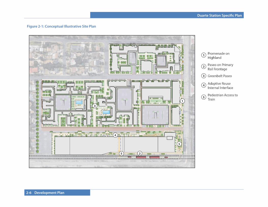
Although there are a number of ways the land use program could be implemented at the site design level of detail, certain elements and principles are required. The following components shall be included in any site plan that implements the requirements of this document:
• Landscaped buffers at existing residential interface • Pedestrian linkages to neighborhoods, services, and the
Duarte Station • Efficient and effective design that prioritizes pedestrians • Public access connections to the station platform linking on-
site sidewalks, Gold Line parking, and station plaza area • Plaza space and open spaces as a transition and gathering
areas • Architectural design that provides visual interest and
placemaking for the Duarte Station Specific Plan area
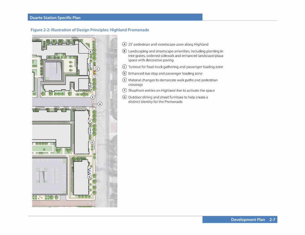
The components of this Specific Plan (Land Use, Development Regulations, and Design Guidelines) include both required elements and encouraged conditions that allow for a broad range of interpretive design solutions intended to guide phased development over the 10+ year period of the Specific Plan. Depending on the development program and market and site conditions, different approaches to satisfying and meeting the Specific Plan criteria will be used. Figure 2-2 illustrates elements that implement some of the key policies in this Plan, with more detail presented in Figures 2-3 through 2-6. The combined examples provided in the illustrations show opportunities for creating a pedestrian-friendly environment. Proper pedestrian circulation, connectivity, location of amenities, and safety will encourage walking and transit use and help the project accomplish the City’s vision for creating a vibrant, mixed-use transit village.
Duarte Station Specific Plan
2-6 Development Plan
Figure 2-1: Conceptual Illustrative Site Plan
Duarte Station Specific Plan
Development Plan 2-7
Figure 2-2: Illustration of Design Principles: Highland Promenade
Duarte Station Specific Plan
2-8 Development Plan
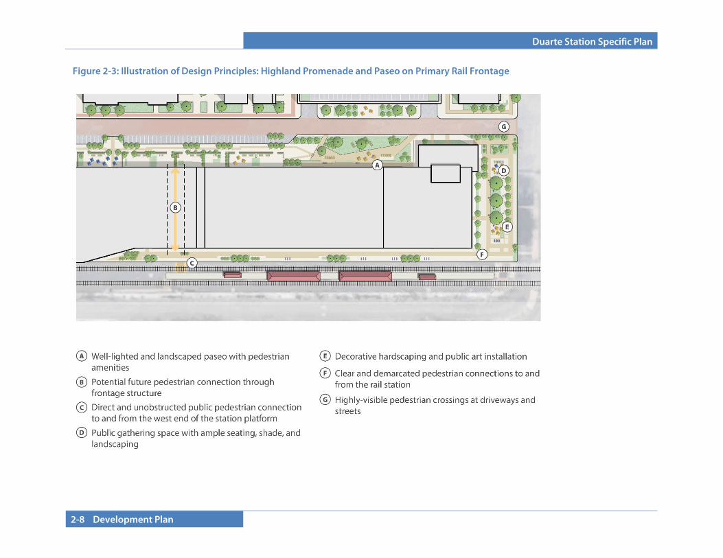
Figure 2-3: Illustration of Design Principles: Highland Promenade and Paseo on Primary Rail Frontage
Duarte Station Specific Plan
Development Plan 2-9
Figure 2-6: Illustration of Design Principles – Station Connections (REPLACE)
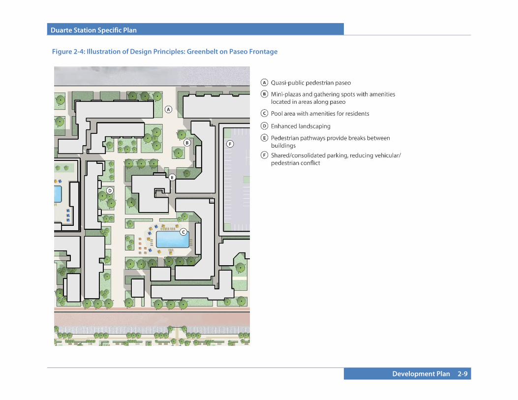
Figure 2-4: Illustration of Design Principles: Greenbelt on Paseo Frontage
Duarte Station Specific Plan
2-10 Development Plan
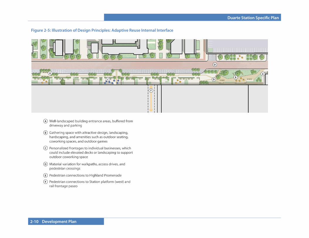
Figure 2-5: Illustration of Design Principles: Adaptive Reuse Internal Interface
Duarte Station Specific Plan
Development Plan 2-11
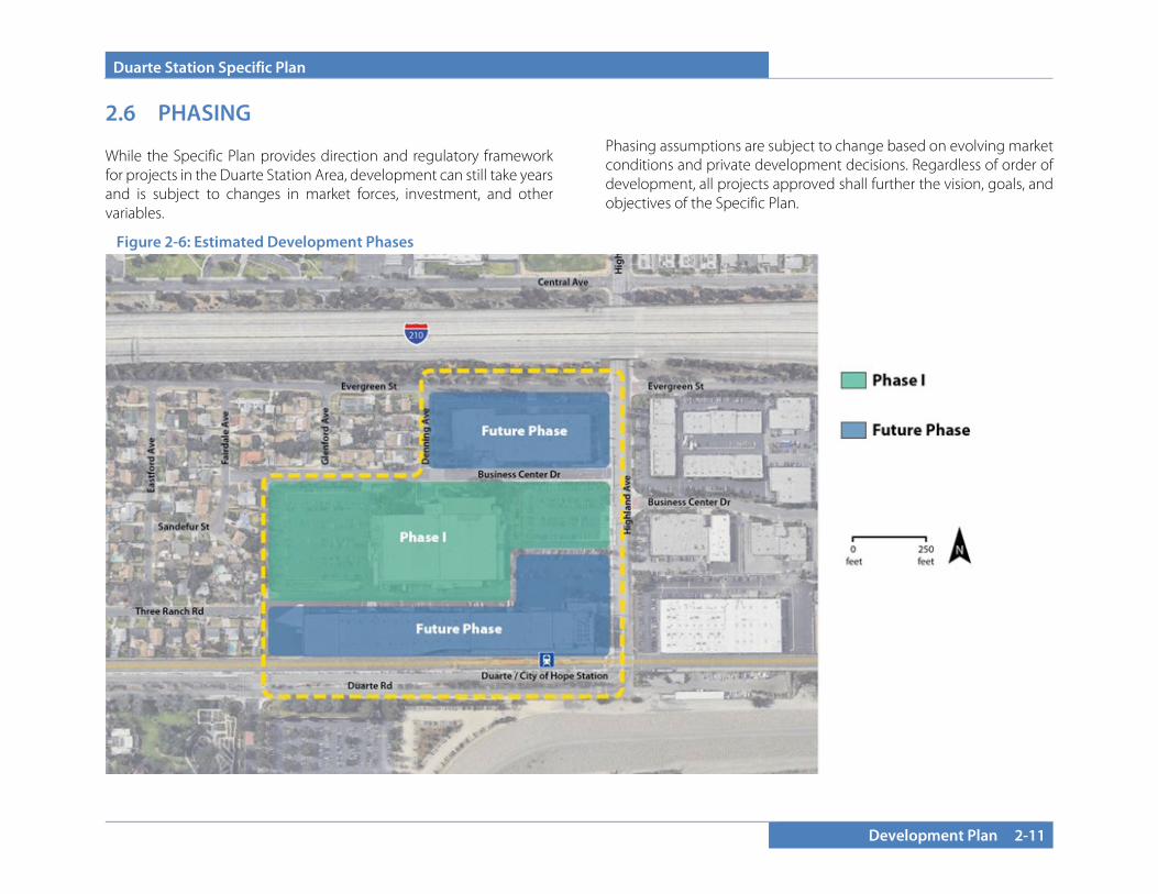
2.6 PHASING While the Specific Plan provides direction and regulatory framework for projects in the Duarte Station Area, development can still take years and is subject to changes in market forces, investment, and other variables.
Phasing assumptions are subject to change based on evolving market conditions and private development decisions. Regardless of order of development, all projects approved shall further the vision, goals, and objectives of the Specific Plan.
Figure 2-6: Estimated Development Phases
Duarte Station Specific Plan
2-12 Development Plan
2.6.1 Phasing Overview Implementation of this Specific Plan is anticipated to be carried out in at least two, and likely three phases. Phase I is anticipated to begin in 2020. Future Phases are anticipated to follow Phase I’s catalytic development. All phases will be subject to overarching objectives of the Specific Plan, and it is critical that development occurring in each phase align with the Specific Plan framework, including the planning, design, and construction of amenities within the public realm that reflect the goals and objects of the Plan.
2.6.2 Phase I Phase I presents the most immediate opportunity for potential development and represents a critical first step in the realization of the Duarte Station Specific Plan. Phase I is sited between the other two subareas within the plan area and has frontage along Highland Ave and significant frontage along neighboring single-family residential neighborhoods west of the site. Business Center Drive runs along the northern boundary of the Phase I area.
Because of its siting and positioning relative to the other parcels, the streetscape along Highland Avenue and proximity to less intense residential uses, Phase I provides ample possibilities to make progress toward fulfilling numerous goals and objectives. The following objectives have been deemed high priority for development within Phase I:
Internal Connectivity and Open Space: Plan and design for a landscaped linear pedestrian greenway corridor that provides accessibility and relief for pedestrians, residents, and patrons.
Urban Design and Site Planning: Establish a streetscape and building configuration pattern that sets the template for future
development and creates a development pattern conducive to walkability and accessibility.
Streetscape Frontages: As the keystone site in the specific plan area, establish design and a framework for the development of safe, attractive, and functional streetscaping along frontages. Establish the Highland Avenue Promenade design concept.
Residential and Commercial Mixed Uses: Offer a mix of housing opportunities and ensure exposure and viability of commercial uses within the project site (with priority positioning on Highland Avenue).
2.6.3 Future Phases The intent for the Future Phase area is to create a great amount of use flexibility to allow for the area to transition over time with a focus on compatibility with early phase buildout. Short term, adaptive reuse to creative office, research and development, biotech office, neighborhood commercial, restaurant and other similar uses are strongly encouraged. Future project phases will be represented by the two remaining parcels within the project area, north and the south of Phase I. Combined, Future Phases make up a significant portion of the frontages along Highland Avenue, the Metro right-of-way, and Evergreen Street. The Evergreen Street frontage is visible from Interstate 210, giving this section of the project area exposure to passing traffic at upper story levels. Future phases may include a variety of uses, including residential, plus modest amounts of supportive commercial, office and/or research and development, and hotel uses. Signage and iconic, eye-catching design align with opportunities to make the Duarte Station Specific Plan area identifiable and impressionable to patrons, passersby, and residents. The following overarching objectives are referenced to ensure the core principles of the Specific Plan are adhered to, as well as ensuring that
Duarte Station Specific Plan
Development Plan 2-13
development that occurs within future phases is compatible and complements the Phase I stage:
Linkages and Open Space: Design pedestrian connections and linkages that align with those built in the Phase I project, and enhance connections to the Metro Gold Line Duarte Station and the Town Center, creating a complete network of open space pockets and walk paths that are logical and functional.
Context: Take cues from and further the development pattern established by Phase I development.
Mix of Uses: A variety of uses are allowed. Where commercial uses are provided, be additive and symbiotic with Phase I uses to appeal to a wide audience of patrons and visitors. Residential uses should offer a mix of housing styles and types. Hospitality uses should consider surrounding uses in site design and development. Office and research and development uses may be located in existing or new structures and should be sensitive to residential uses nearby.
Streetscape Frontages: Further the streetscaping objectives of Phase I, and ensure that safe and functional streetscaping is designed and built, focused especially along highly utilized areas of Highland Avenue and implementing the Highland Avenue Promenade design concept.
Design and Visibility: Capitalize on the high visibility of future phase parcels by utilizing high-quality design, architecture, materials, and signage in construction to create an impressionable experience.
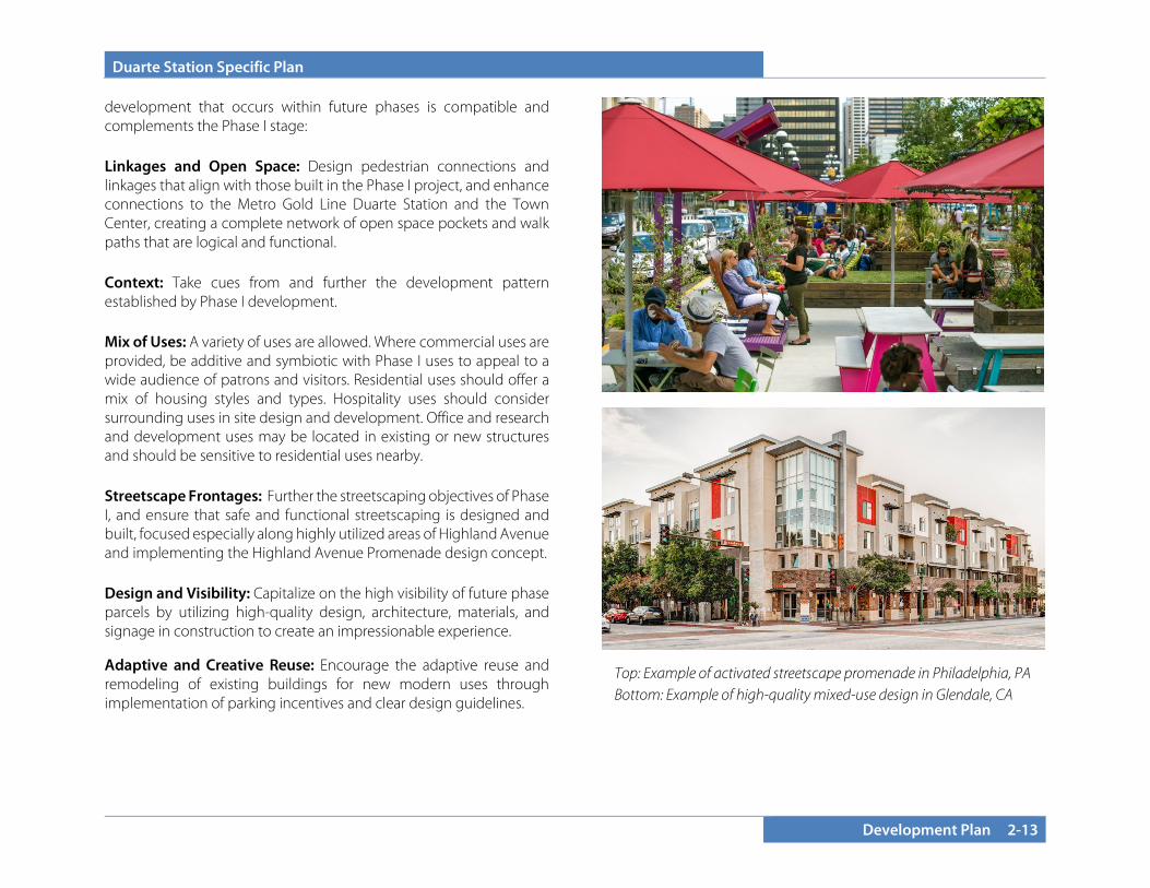
Adaptive and Creative Reuse: Encourage the adaptive reuse and remodeling of existing buildings for new modern uses through implementation of parking incentives and clear design guidelines.
Top: Example of activated streetscape promenade in Philadelphia, PA Bottom: Example of high-quality mixed-use design in Glendale, CA
Duarte Station Specific Plan
2-14 Development Plan
This page intentionally left blank.
Duarte Station Specific Plan
Standards and Guidelines 3-1
SECTION 3.0 DEVELOPMENT STANDARDS AND DESIGN GUIDELINES This Section describes allowed land uses, site planning, and building design standards and guidelines for the Specific Plan area. The regulations are organized by General Development Standards and Frontage Classes, with an additional level of regulation applying to individual Façade Types within Frontage Classes. The organization of these standards and guidelines within these categories provides a tailored approach to ensure building form and design reinforce the vision while allowing for creativity and flexibility in development projects. These regulations govern new construction, as well as alterations, additions, and changes of use. To create a vibrant, thriving, and special community, the Development Standards are “form based” to create a predictable public realm by establishing guidelines and regulations that focus primarily on the physical form of the environment. By addressing the relationships between building façades and the public realm, the form and mass of buildings in relation to one another, and the experience of the pedestrian at the ground floor through an integrated package of requirements for public realm and building design, the Standards and Guidelines help create a unique character for the Specific Plan area. The circulation framework for internal pathways is suggestive; locations may be adjusted, though the pathway should respect and connect to the existing surrounding context. Pathways may consist of streets, publicly accessible pedestrian walkways, or an alley if it best serves the final development program, as long as it meets the intent of the Specific Plan.
3.1 GENERAL PROVISIONS
3.1.1 Applicability Upon adoption by ordinance, this Specific Plan will constitute the zoning for the Duarte Station Specific Plan area. Subsequent development plans or agreements, tract or parcel maps, site plans, or any other action requiring ministerial or discretionary approval must be consistent with the Development Regulations contained in this Chapter.
3.1.2 Severability In the event that any regulation, condition, program, portion, or policy of this Specific Plan or the application thereof to any person or circumstance is held to be invalid or unconstitutional by any court of competent jurisdiction, such portions shall be deemed separate, distinct, and independent provisions and shall not affect the validity of the remaining provisions of this Specific Plan or applications thereof which can be implemented without the invalid provision.
3.1.3 Determination of Unlisted Uses Identification of any land use not specifically covered by the provisions contained herein shall be per the Duarte Development Code (DDC) Section 19.04.040 – Uses not classified.
3.1.4 Definitions Unless otherwise specified below, terms used in this document shall have the same definitions provided in the DDC Chapter 19.160, “Definitions.”
“Live/Work.” A live/work unit is defined as a residential unit consisting of both a commercial/office and a residential component occupied by the same resident. Live/work can also include a development where living and work spaces are divided and work spaces are available for use by residents of the same building.
Duarte Station Specific Plan
3-2 Standards and Guidelines
3.1.5 Interpretation Any ambiguities related to the implementation of this Specific Plan shall be determined as described in the DDC. Such interpretations shall take into account the stated goals and intent of this Specific Plan. Any interpretation made by the Community Development Director or designee may be appealed to the Planning Commission.
3.1.6 Existing Users 3.1.6.A Legacy Uses
Sites within the Specific Plan area that contain uses that are not otherwise consistent with the Specific Plan are deemed “Legacy Sites.” Uses that are currently allowed within the M-1 zoning designation are determined to be Legacy Uses, provided those uses existed at the time of adoption of the Specific Plan (December 10, 2013). Legacy Uses shall be permitted to continue on Legacy Sites until such time as they are abandoned. A Legacy Use on a Legacy Site is deemed abandoned when: (1) any Legacy Use on the Legacy Site has been discontinued for a continuous period of one year or more, (2) when the owner of a Legacy Site affirmatively indicates in writing that it has abandoned Legacy Uses on the Legacy Site, and/or (3) the owner of a Legacy Site redevelops the site with a non-Legacy Use. For a multi-tenant building on a Legacy Site, individual tenant spaces that are vacant for more than one year shall not be deemed a discontinuance under this section.
At any time prior to abandonment, uses in buildings on Legacy Sites may be expanded by an amount not to exceed five percent of the building square footage of the subject Legacy Site that existed as of the date of the original adoption of the Specific Plan (December 10, 2013) 1 . If a Legacy Site is expanded, reconstructed, or repaired in accordance with this paragraph, it shall be subject to site plan and design review as outlined in Section 5 (Administration and
Implementation) of this Specific Plan, and shall be subject to the development standards set forth for properties in the Industrial Zone, as specified in the DDC.
It is the intent of this Specific Plan that Legacy Uses on Legacy Sites be allowed until such time as market conditions cause the property owners to wish to redevelop the Legacy Site with Non-Legacy Uses.
3.1.6.B Adaptive Reuse of Existing Buildings
Buildings existing at the time of adoption of this Specific Plan (December 10, 2013) may be adapted to allow for new uses consistent with Table 3-1 (Allowable Uses). See also Section 3.5.5 (Adaptive Reuse Design Guidelines) for design requirements and incentives for the adaptation of existing structures for new allowed uses.
3.2 ALLOWABLE LAND USES
The Duarte Station Specific Plan allows for a variety of land uses. Uses expressly permitted are identified in Table 3-1 (Allowable Uses). Uses listed as permitted are subject to site plan/design review. Uses listed that require a Conditional Use Permit or Minor Conditional Use Permit require special consideration either due to potential impacts on the neighborhood or design. Certain uses are allowed only on the ground floor along public frontages (indicated with GF in Table 3-1).
A broad range of allowable uses promotes a compact, urban transit-oriented development. To provide flexibility, a variety of uses are allowed, with an additional level of use regulation specified within the Frontage Class Standards in Section 3.3 to encourage a lively pedestrian experience. Additional uses may be allowed, provided they meet the intent and the vision of the Specific Plan, subject to interpretation by the Community Development Director or designee.
1 The Specific Plan was comprehensively amended MONTH DATE, 2019. Existing building square footage of Legacy Uses shall be based on the existing conditions as of adoption of the original Specific Plan in 2013.
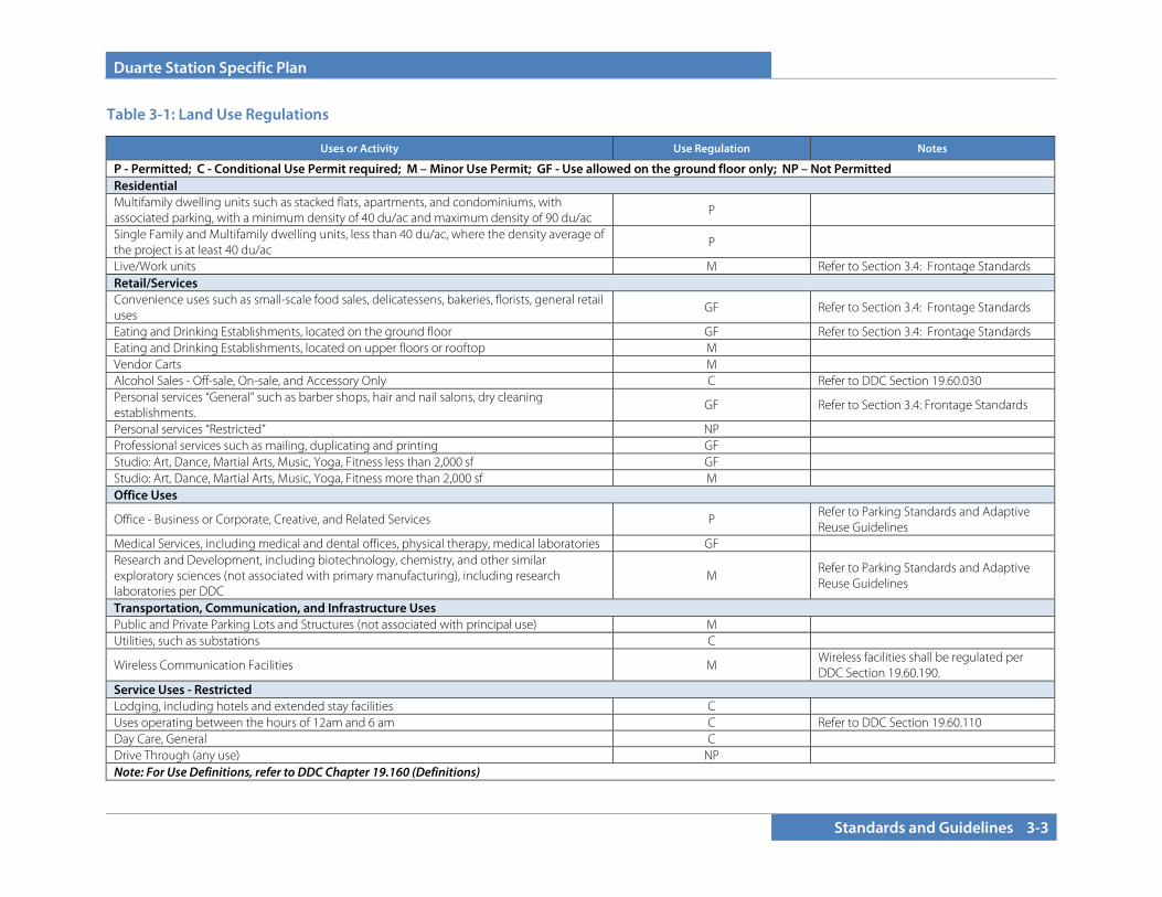
Duarte Station Specific Plan
Standards and Guidelines 3-3
Uses or Activity Use Regulation Notes
P - Permitted; C - Conditional Use Permit required; M – Minor Use Permit; GF - Use allowed on the ground floor only; NP – Not Permitted Residential Multifamily dwelling units such as stacked flats, apartments, and condominiums, with associated parking, with a minimum density of 40 du/ac and maximum density of 90 du/ac
P
Single Family and Multifamily dwelling units, less than 40 du/ac, where the density average of the project is at least 40 du/ac
P
Live/Work units M Refer to Section 3.4: Frontage Standards Retail/Services Convenience uses such as small-scale food sales, delicatessens, bakeries, florists, general retail uses
GF Refer to Section 3.4: Frontage Standards
Eating and Drinking Establishments, located on the ground floor GF Refer to Section 3.4: Frontage Standards Eating and Drinking Establishments, located on upper floors or rooftop M Vendor Carts M Alcohol Sales - Off-sale, On-sale, and Accessory Only C Refer to DDC Section 19.60.030 Personal services “General” such as barber shops, hair and nail salons, dry cleaning establishments.
GF Refer to Section 3.4: Frontage Standards
Personal services “Restricted” NP Professional services such as mailing, duplicating and printing GF Studio: Art, Dance, Martial Arts, Music, Yoga, Fitness less than 2,000 sf GF Studio: Art, Dance, Martial Arts, Music, Yoga, Fitness more than 2,000 sf M Office Uses
Office - Business or Corporate, Creative, and Related Services P Refer to Parking Standards and Adaptive Reuse Guidelines
Medical Services, including medical and dental offices, physical therapy, medical laboratories GF Research and Development, including biotechnology, chemistry, and other similar exploratory sciences (not associated with primary manufacturing), including research laboratories per DDC
M Refer to Parking Standards and Adaptive Reuse Guidelines
Transportation, Communication, and Infrastructure Uses Public and Private Parking Lots and Structures (not associated with principal use) M Utilities, such as substations C
Wireless Communication Facilities M Wireless facilities shall be regulated per DDC Section 19.60.190.
Service Uses - Restricted Lodging, including hotels and extended stay facilities C Uses operating between the hours of 12am and 6 am C Refer to DDC Section 19.60.110 Day Care, General C Drive Through (any use) NP Note: For Use Definitions, refer to DDC Chapter 19.160 (Definitions)
Table 3-1: Land Use Regulations
Duarte Station Specific Plan
3-4 Standards and Guidelines
3.3 GENERAL DEVELOPMENT STANDARDS
The Duarte Station Specific Plan provides a framework to transform the plan area into a vibrant, transit-oriented development district. The development standards and guidelines are tailored specifically to that vision.
Table 3-2 (General Development Standards) outlines development standards for the entire planning area. In addition to stated setback standards, Building and Fire Codes in effect at the time of building permit shall take precedence. Design guidelines (Section 3.4) are also included. Where the Specific Plan is silent, the DDC and Municipal Code shall regulate.
3.3.1 Building Setbacks Building setbacks, along with the façade type and architectural articulation, help define the character of the public realm, especially at the pedestrian level. The required setbacks are designed to take into consideration the streets that the setbacks are adjacent to, the intensity of proposed land uses, proposed building mass and scale, and the surrounding context and edge conditions. The setbacks are measured from the back of the walk, right-of-way, or the property line, whichever is applicable, unless otherwise noted. Building setbacks are regulated by Frontage Type (see Section 3.4).
3.3.2 Building Heights Building heights are designated to take into consideration the proposed intensity and type of development and the surrounding context and edge conditions. Building height shall be measured from the adjacent finished ground level to the top of plate of the uppermost floor.
Portions of the building that extend above the primary building mass, such as dormers, roof-top cupolas, roof deck trellises, gazebos, and other special features, may be allowed to exceed height limits, as indicated in Table 3-2.
3.3.3 Ground Floor Design The design of the ground floor is of utmost importance to provide an attractive and comfortable environment for pedestrians. Good design establishes an attractive image and character for the area that makes it desirable for businesses and residents. Standards are established to ensure that goals for pedestrian scale are achieved (see Section 3.3: Frontage Standards). Principles of ground floor design include: • Buildings must face the street, and primary building entrances
must be oriented towards the street. Side entries from entry plazas are allowed.
• The façades facing major streets shall not have blank walls, service
entrances, or other features that are detrimental to the pedestrian experience. Architectural design, modulation, and interest should be articulated on all sides of the building.
• Special standards and guidelines are established for the design of
buildings with ground floor commercial space along certain frontages. Minimum floor-to-ceiling heights ensure that the space will serve the needs of retail and restaurant uses that may locate in the space during the lifetime of the building.
• Floor elevations of building frontages need to be at the sidewalk
level, and the use of awnings, change in material, and architectural articulation should be used to create a pedestrian-scaled public realm regardless of the overall scale and mass of the building.
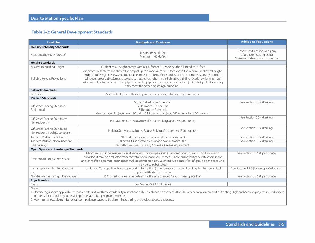
Duarte Station Specific Plan
Standards and Guidelines 3-5
Land Use Standards and Provisions Additional Regulations
Density/Intensity Standards
Residential Density (du/ac)1 Maximum: 90 du/ac Minimum: 40 du/ac
Density limit not including any affordable housing using
State-authorized density bonuses Height Standards Maximum Building Height 120 feet max. height except within 100 feet of R-1 zone height is limited to 90 feet
Building Height Projections
Architectural features are allowed to project up to a maximum of 10 feet above the maximum allowed height, subject to Design Review. Architectural features include rooflines (balustrades, pediments, statuary, dormer windows, cross gables), masts, towers, turrets, eaves, rafters, non-habitable building façade, skylights or roof
windows. Elevator, mechanical equipment, and equipment penthouses are not subject to height limits as long they meet the screening design guidelines.
Setback Standards Setbacks See Table 3-3 for setback requirements, governed by Frontage Standards. Parking Standards
Off Street Parking Standards: Residential
Studio/1-Bedroom: 1 per unit 2-Bedroom: 1.8 per unit 3-Bedroom: 2 per unit
Guest spaces: Projects over 150 units: 0.15 per unit; projects 149 units or less: 0.2 per unit
See Section 3.3.4 (Parking)
Off Street Parking Standards: Nonresidential Per DDC Section 19.38.050 (Off-Street Parking Space Requirements)
See Section 3.3.4 (Parking)
Off Street Parking Standards: Nonresidential Adaptive Reuse
Parking Study and Adaptive Reuse Parking Management Plan required See Section 3.3.4 (Parking)
Tandem Parking: Residential2 Allowed if both spaces are shared by the same unit See Section 3.3.4 (Parking) Tandem Parking: Nonresidential2 Allowed if supported by a Parking Management Plan See Section 3.3.4 (Parking) Bike parking Per California Green Building Code (CalGreen) requirements Open Space and Landscape Standards
Residential Group Open Space
Minimum 200 sf per residential unit required. Private open space is not required for each unit. However, if provided, it may be deducted from the total open space requirement. Each square foot of private open space
and/or rooftop common open space shall be considered equivalent to two square feet of group open space and may be so substituted.
See Section 3.3.5 (Open Space)
Landscape and Lighting Concept Plans
Landscape Concept Plan, Hardscape, and Lighting Plan (ground-mount site and building lighting) submittal required with site plan review.
See Section 3.5.6 (Landscape Guidelines)
Non-Residential Group Open Space 15% of net lot area or as determined by an approved Group Open Space Plan. See Section 3.3.5 (Open Space) Sign Standards Signs See Section 3.5.2.F (Signage) Notes: 1. Density regulations applicable to market-rate units with no affordability restrictions only. To achieve a density of 70 to 90 units per acre on properties fronting Highland Avenue, projects must dedicate
property for the publicly accessible promenade along Highland Avenue. 2. Maximum allowable number of tandem parking spaces to be determined during the project approval process.
Table 3-2: General Development Standards
Duarte Station Specific Plan
3-6 Standards and Guidelines
3.3.4 Parking 3.3.4.A Residential Parking Management Plan
In addition to meeting the minimum parking requirements, all residential and mixed-use projects shall be required to adopt a Residential Parking Management Plan that shall be subject to City approval by the Community Development Director or designee. The plan shall require that the property owner: 1) monitor the number of residents vehicles to ensure that the number of resident vehicles does not exceed the number of available parking spaces; 2) manage the use of guest and all commercial, community, or additional spaces; and 3) annually report compliance with the parking management plan to the Community Development Department.
3.3.4.B Parking Space and Drive Aisle Dimensions
Parking spaces in surface lots shall comply with DDC Section 19.38.110 and Section 19.38.120. Parking lots in structures or underground parking garages shall comply with DDC Section 19.38.110 and Section 19.38.120 with the following exceptions for 90-degree spaces and associated drive aisles:
• 90-degree spaces not located adjacent to a wall: 9 feet by 17 feet
• 90-degree spaces located adjacent to a wall: 10 feet by 17 feet • 90-degree spaces drive aisle: 26 feet minimum • No compact spaces permitted
3.3.4.C Parking for Adaptive Reuse
The development and repurposing of existing structures to adaptive reuse is highly encouraged. As such, parking strategies must be tailored to provide for flexibility across various uses and development types. For adaptive reuse of an existing structure to a new nonresidential use allowed by this Specific Plan, the number of required spaces shall be determined by a parking study prepared or approved by the City, and an Adaptive Reuse Parking Management
Plan shall be required. In general, the required number of parking spaces shall be the same as the number of spaces that existed on the site on MONTH DATE, 2019, and shall be maintained and not reduced unless otherwise supported by a Parking Management Plan. Existing truck loading spaces may be modified for tandem vehicle parking and alternative outdoor amenities, subject to determination via a parking study that adequate parking remains available. Other creative parking strategies and solutions are encouraged to reduce the need for additional parking. The parking requirement shall be determined by the Community Development Director or designee or the final decision-making body if associated with an entitlement package subject to Planning Commission or City Council review.
3.3.4.D Parking for Affordable Housing
Affordable housing often requires less parking than market-rate developments, with many tenants non-drivers, especially in senior housing developments. As such, the number of required parking spaces for affordable housing developments shall be determined on a case-by-case basis to ensure the economic feasibility of affordable housing projects. The parking requirement shall be determined by the Community Development Director or designee or the final decision-making body if associated with an entitlement package subject to Planning Commission or City Council review.
3.3.4.E Parking Determination
An increase or decrease in the parking requirements may be determined by the Community Development Director or designee in particular circumstances where these requirements are inadequate for a specific project. These cases shall be determined through a parking study, subject to the following conditions: The City shall maintain the right to select a consultant, which will be paid for by the applicant; and the study shall have been undertaken and completed by a traffic engineer registered by the State of California and shall bear the stamp of that engineer.

Duarte Station Specific Plan
Standards and Guidelines 3-7
3.3.5 Open Space All new development shall provide open spaces with ample amenities to serve onsite users. Minimum open space requirements may be met through private, common, and/or public and quasi-public open spaces. See Table 3-1 for required open space per residential unit and nonresidential development requirements
3.3.5.A Residential Private Open Space Requirements
Private usable open space located at ground level shall have a minimum area of 100 square feet and a rectangle inscribed within it shall have no dimension less than eight feet. The minimum area of above ground-level space shall be 50 square feet, and a rectangle inscribed within it shall have no dimension less than five feet. Private usable open space shall be adjacent to, and not more than four feet above or below the floor level of the dwelling unit served, or located on a rooftop with private access via the unit. For projects that do not meet the Group Open Space standards, other creative strategies to provide open space and amenities may be considered on a project by project basis, if approved as a Minor Modification with a Substantial Conformance determination (see Section 5.1.7).
3.3.5.B Group Usable Open Space Requirements (Residential and Nonresidential)
Group usable open space shall have a minimum area of 300 square feet, and a rectangle inscribed within it shall have no dimension less than 15 feet. Required usable open space may be located at grade or as rooftop open space. Group open space areas shall not include parking or driveway areas, but may include setback areas provided it provides amenities and is integrated into the overall project design.
3.3.5.C Public and Quasi-Public Open Space
Required open space may be designed to be accessible to the public, such as plazas, courtyards, or other similar publicly accessible open space areas. Public and quasi-public open space shall be accessible and fully visible from the public right-of-way.
Examples of amenities in group open space and public open space areas Top: Bay Meadows Residences in San Mateo, CA Bottom: Boulder, CO Pearl Street Mall promenade
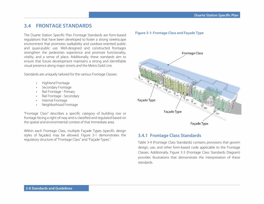
Duarte Station Specific Plan
3-8 Standards and Guidelines
3.4 FRONTAGE STANDARDS
The Duarte Station Specific Plan Frontage Standards are form-based regulations that have been developed to foster a strong streetscape environment that promotes walkability and outdoor-oriented public and quasi-public use. Well-designed and constructed frontages strengthen the pedestrian experience and promote functionality, vitality, and a sense of place. Additionally, these standards aim to ensure that future development maintains a strong and identifiable visual presence along major streets and the Metro Gold Line. Standards are uniquely tailored for the various Frontage Classes:
• Highland Frontage • Secondary Frontage • Rail Frontage - Primary • Rail Frontage - Secondary • Internal Frontage • Neighborhood Frontage
“Frontage Class” describes a specific category of building row or frontage facing a right-of-way and is classified and regulated based on the spatial and environmental context of that immediate area. Within each Frontage Class, multiple Façade Types (specific design styles of façades) may be allowed. Figure 3-1 demonstrates the regulatory structure of “Frontage Class” and “Façade Types.”
Figure 3-2 (Frontage Class Plan) demonstrates the six frontage classes within the project site. Additionally, Table 3-3 (Frontage Linear Feet) presents approximate figures for total length of each frontage class.
3.4.1 Frontage Class Standards Table 3-4 (Frontage Class Standards) contains provisions that govern design, use, and other form-based code applicable to the Frontage Classes. Additionally, Figure 3-3 (Frontage Class Standards Diagram) provides illustrations that demonstrate the interpretation of these standards.
Figure 3-1: Frontage Class and Façade Type
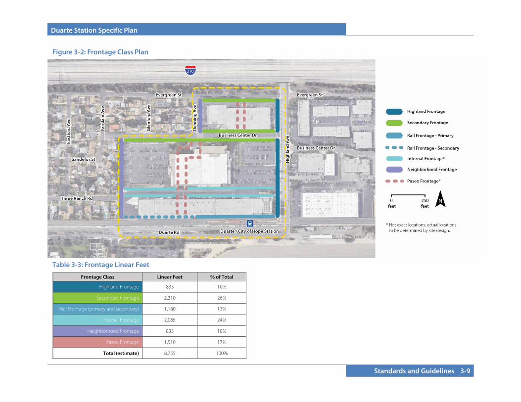
Duarte Station Specific Plan
Standards and Guidelines 3-9
Frontage Class Linear Feet % of Total
Highland Frontage 835 10%
Secondary Frontage 2,310 26%
Rail Frontage (primary and secondary) 1,180 13%
Internal Frontage 2,085 24%
Neighborhood Frontage 835 10%
Paseo Frontage 1,510 17%
Total (estimate) 8,755 100%
Figure 3-2: Frontage Class Plan
Table 3-3: Frontage Linear Feet
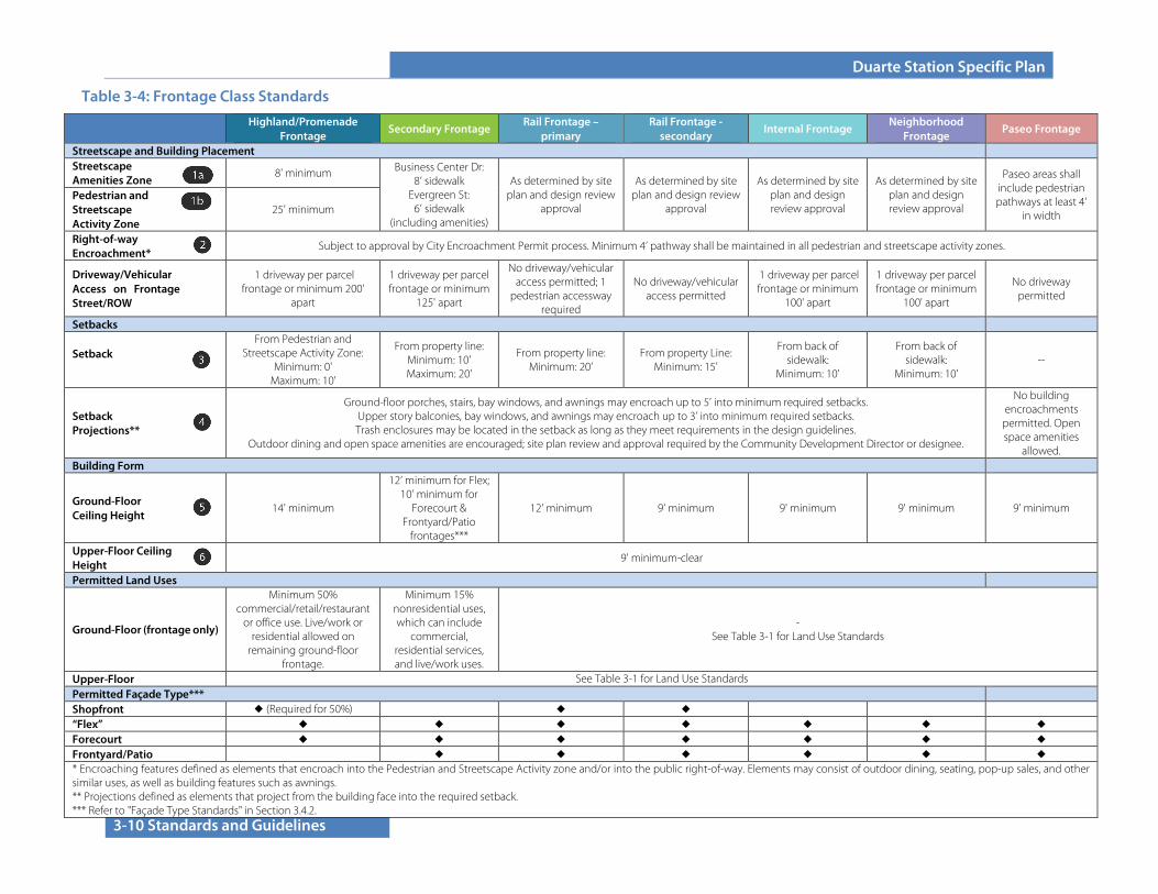
Duarte Station Specific Plan
3-10 Standards and Guidelines
Table 3-4: Frontage Class Standards
Highland/Promenade Frontage
Secondary Frontage Rail Frontage –
primary Rail Frontage -
secondary Internal Frontage
Neighborhood Frontage
Paseo Frontage
Streetscape and Building Placement Streetscape Amenities Zone
8' minimum Business Center Dr: 8’ sidewalk
Evergreen St: 6’ sidewalk
(including amenities)
As determined by site plan and design review
approval
As determined by site plan and design review
approval
As determined by site plan and design review approval
As determined by site plan and design review approval
Paseo areas shall include pedestrian pathways at least 4’
in width
Pedestrian and Streetscape Activity Zone
25' minimum
Right-of-way Encroachment*
Subject to approval by City Encroachment Permit process. Minimum 4’ pathway shall be maintained in all pedestrian and streetscape activity zones.
Driveway/Vehicular Access on Frontage Street/ROW
1 driveway per parcel frontage or minimum 200'
apart
1 driveway per parcel frontage or minimum
125' apart
No driveway/vehicular access permitted; 1
pedestrian accessway required
No driveway/vehicular access permitted
1 driveway per parcel frontage or minimum
100' apart
1 driveway per parcel frontage or minimum
100' apart
No driveway permitted
Setbacks
Setback From Pedestrian and
Streetscape Activity Zone: Minimum: 0'
Maximum: 10'
From property line: Minimum: 10' Maximum: 20'
From property line: Minimum: 20’
From property Line: Minimum: 15'
From back of sidewalk:
Minimum: 10'
From back of sidewalk:
Minimum: 10' --
Setback Projections**
Ground-floor porches, stairs, bay windows, and awnings may encroach up to 5’ into minimum required setbacks. Upper story balconies, bay windows, and awnings may encroach up to 3’ into minimum required setbacks. Trash enclosures may be located in the setback as long as they meet requirements in the design guidelines.
Outdoor dining and open space amenities are encouraged; site plan review and approval required by the Community Development Director or designee.
No building encroachments permitted. Open space amenities
allowed. Building Form
Ground-Floor Ceiling Height
14' minimum
12’ minimum for Flex; 10’ minimum for
Forecourt & Frontyard/Patio
frontages***
12' minimum 9’ minimum 9' minimum 9' minimum 9’ minimum
Upper-Floor Ceiling Height
9' minimum-clear
Permitted Land Uses
Ground-Floor (frontage only)
Minimum 50% commercial/retail/restaurant
or office use. Live/work or residential allowed on
remaining ground-floor frontage.
Minimum 15% nonresidential uses, which can include
commercial, residential services, and live/work uses.
- See Table 3-1 for Land Use Standards
Upper-Floor See Table 3-1 for Land Use Standards Permitted Façade Type*** Shopfront ◆ (Required for 50%) ◆ ◆ “Flex” ◆ ◆ ◆ ◆ ◆ ◆ ◆ Forecourt ◆ ◆ ◆ ◆ ◆ ◆ ◆ Frontyard/Patio ◆ ◆ ◆ ◆ ◆ ◆ * Encroaching features defined as elements that encroach into the Pedestrian and Streetscape Activity zone and/or into the public right-of-way. Elements may consist of outdoor dining, seating, pop-up sales, and other similar uses, as well as building features such as awnings. ** Projections defined as elements that project from the building face into the required setback. *** Refer to "Façade Type Standards" in Section 3.4.2.
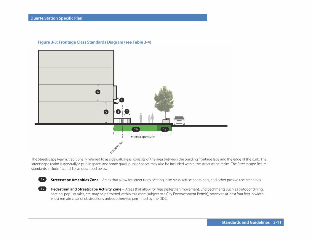
Duarte Station Specific Plan
Standards and Guidelines 3-11
The Streetscape Realm, traditionally referred to as sidewalk areas, consists of the area between the building frontage face and the edge of the curb. The streetscape realm is generally a public space, and some quasi-public spaces may also be included within the streetscape realm. The Streetscape Realm standards include 1a and 1b, as described below:
Streetscape Amenities Zone – Areas that allow for street trees, seating, bike racks, refuse containers, and other passive use amenities.
Pedestrian and Streetscape Activity Zone – Areas that allow for free pedestrian movement. Encroachments such as outdoor dining, seating, pop-up sales, etc. may be permitted within this zone (subject to a City Encroachment Permit); however, at least four feet in width must remain clear of obstructions unless otherwise permitted by the DDC.
Figure 3-3: Frontage Class Standards Diagram (see Table 3-4)

Duarte Station Specific Plan
3-12 Standards and Guidelines
3.4.1.A Highland Frontage
The Highland Frontage applies to Highland Avenue-facing lengths of new development. Standards for this area are calibrated to foster an active streetscape environment and a flexible mix of commercial, retail, restaurant, and residential uses. As indicated in Table 3-4, ground floor nonresidential uses are required along a majority of the Highland frontage. Commercial uses within buildings shall be designed to take access from the Highland Avenue Promenade.
Walkability is the highest priority for this frontage, as Highland Avenue is a valuable pedestrian connector, linking the Duarte/City of Hope Metro Gold Line Station with the planning area, Town Center, and beyond. A linear plaza in the form of a pedestrian promenade will be the key connecting feature. The pedestrian promenade is a hardscape public space with seating and other urban furniture intended to provide opportunities for rest and relaxation, outdoor dining, commerce, social gathering, and events that complement the use of the adjacent buildings and Metro Station.
Highland Avenue Promenade Standards
1. New projects and those that substantially rehabilitate existing buildings shall provide a dedication or easement to add an additional 25 feet of publicly accessible plaza space to the existing eight-foot-wide sidewalk, unless modified or waived through an Minor Modification (see Section 5.1.7: Specific Plan Modifications and Amendments). The promenade shall extend the length of Highland Avenue, from Duarte Road to the I-210 freeway.
The promenade shall be dedicated to the City or owned, operated, and maintained by the project’s developer or property manager in accordance with an approved maintenance plan to be reviewed and approved by the Community Development Director or designee. The promenade shall be located on the ground level and directly accessible from the public sidewalk and be accessible to persons with disabilities. The promenade shall be open to the
public, without charge, each day of the year, except for temporary closures for necessary maintenance or public safety.
Example of a linear plaza/promenade and a pop-up art installation, Favara, Italy.

Duarte Station Specific Plan
Standards and Guidelines 3-13
2. The promenade shall contain at a minimum trees, landscaping, seating, shade structures, and pedestrian-scaled lighting. Special paving is encouraged to increase visibility and identity. Outdoor seating from adjacent retail, restaurant, and service uses is allowed on the plazas to activate the space, subject to site plan review (and encroachment permits as needed). Additional activation such as public art, pop-up installations, and mechanisms that brand the Duarte Station area are encouraged. The promenade should be designed to be a place for community gathering, play, performance, and commerce.
The intent of the promenade is to provide a pedestrian space that is rich with amenities and accessible to rail users, local employees, and residents within and around the Specific Plan area.
A conceptual illustrative for the Highland Avenue Promenade concept is presented in Figure 3-4 as an overall concept. Figures 3-5 through 3-9 provide more detail on the concept, with defined activity areas.
Figure 3-6 depicts the northern gateway to the promenade, which will be enhanced with colorful and artistic lighting and improvements to the I-210 freeway underpass. Progressing to the south, the segment of the Promenade between Evergreen Street and Business Center Drive has the potential to serve as a food truck plaza (as one idea), to serve adjacent local businesses, complemented with shade structures and tables and chairs. South of Business Center Drive, the Promenade should support transit use with the existing bus stop to remain (and additional passenger loading for taxi and rideshares), and should be complemented with on-site amenities such as shade, seating, and playful streetscape elements. Figure 3-9 depicts the most southern section of the Promenade (The Canopy), closest to the Metro Gold Line Duarte Station. This active space could support a retail/food kiosk and provides a unique opportunity for an art installation to enhance local branding. Additional recommendations are presented in Figures 3-6 to 3-9.
See also Section 5.3.1: Maintenance Responsibility for administrative procedures associated with the Promenade.
Top: Example pop-up installation in Minneapolis, MN. Bottom: Example outdoor dining and perimeter landscaping in Paris, France.
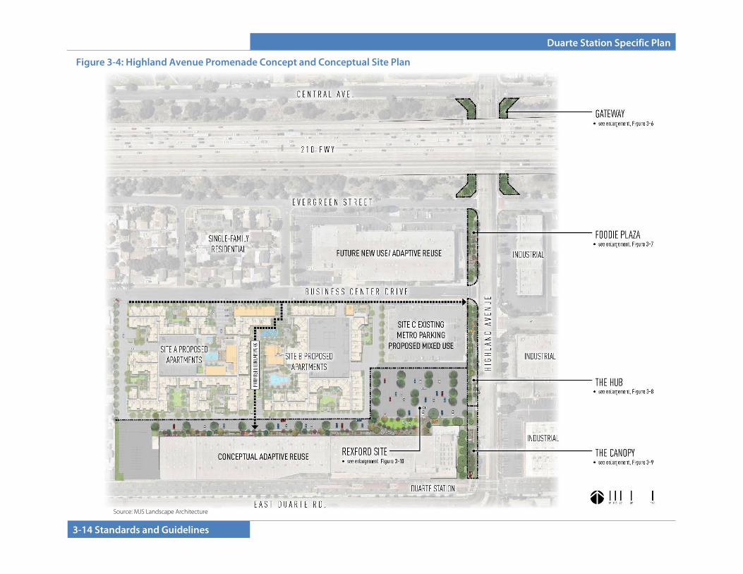
Duarte Station Specific Plan
3-14 Standards and Guidelines
Figure 3-4: Highland Avenue Promenade Concept and Conceptual Site Plan
Source: MJS Landscape Architecture

Duarte Station Specific Plan
Standards and Guidelines 3-15
Figure 3-5: Conceptual Promenade Design and Circulation Figure 3-5: Conceptual Promenade Theming and Circulation
Source: MJS Landscape Architecture

Duarte Station Specific Plan
3-16 Standards and Guidelines
Figure 3-6: Conceptual Promenade Design – Part A (Gateway)
Source: MJS Landscape Architecture
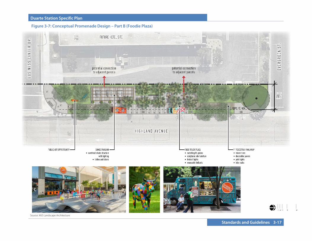
Duarte Station Specific Plan
Standards and Guidelines 3-17
Figure 3-7: Conceptual Promenade Design – Part B (Foodie Plaza)
Source: MJS Landscape Architecture
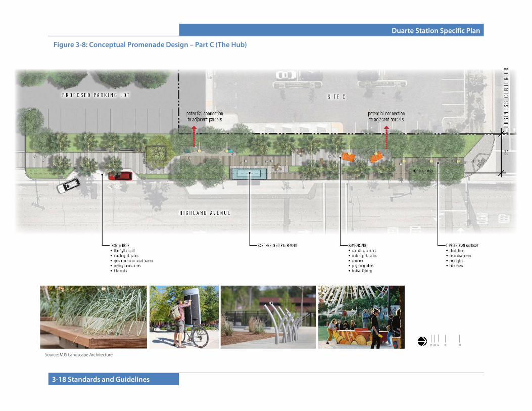
Duarte Station Specific Plan
3-18 Standards and Guidelines
Figure 3-8: Conceptual Promenade Design – Part C (The Hub)
Source: MJS Landscape Architecture
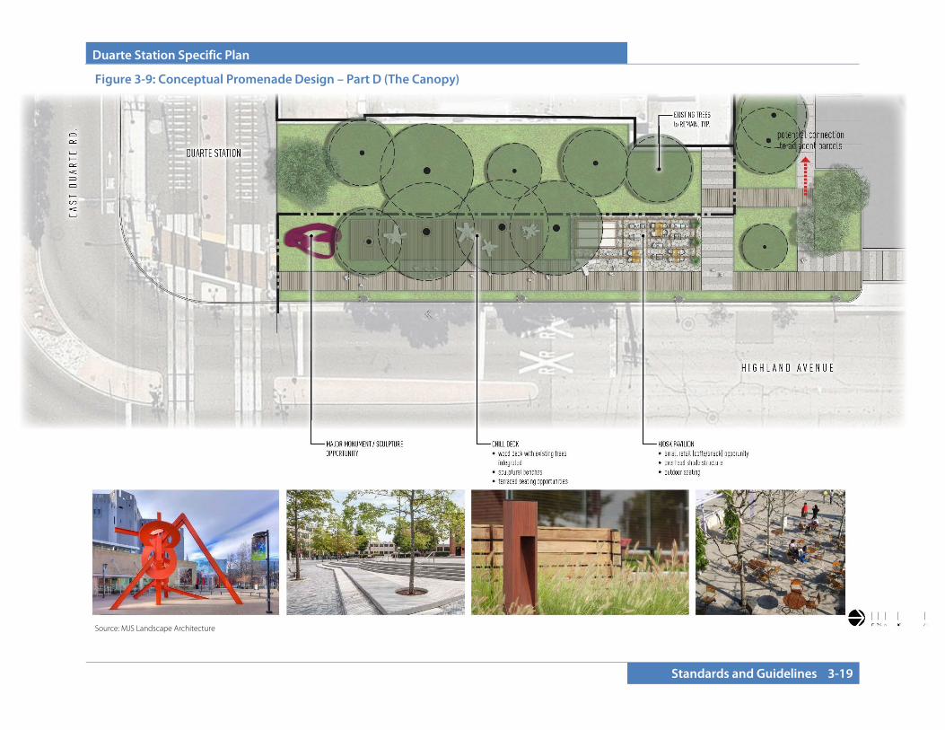
Duarte Station Specific Plan
Standards and Guidelines 3-19
Figure 3-9: Conceptual Promenade Design – Part D (The Canopy)
Source: MJS Landscape Architecture
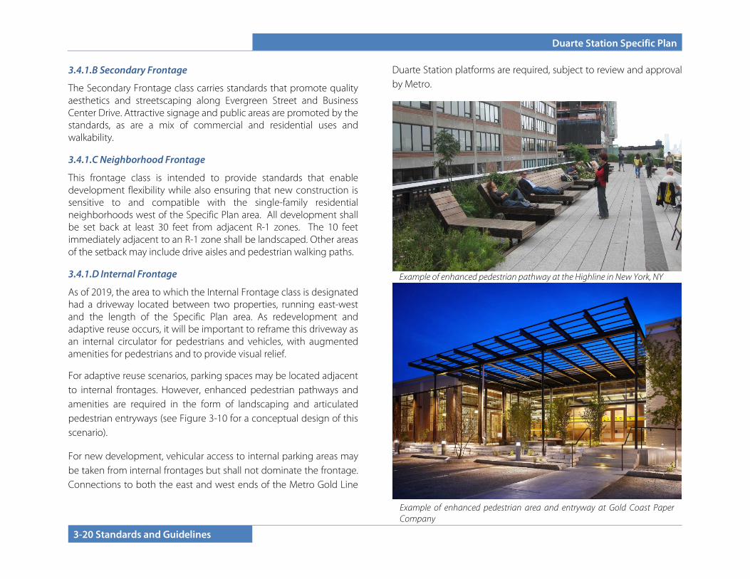
Duarte Station Specific Plan
3-20 Standards and Guidelines
3.4.1.B Secondary Frontage
The Secondary Frontage class carries standards that promote quality aesthetics and streetscaping along Evergreen Street and Business Center Drive. Attractive signage and public areas are promoted by the standards, as are a mix of commercial and residential uses and walkability.
3.4.1.C Neighborhood Frontage
This frontage class is intended to provide standards that enable development flexibility while also ensuring that new construction is sensitive to and compatible with the single-family residential neighborhoods west of the Specific Plan area. All development shall be set back at least 30 feet from adjacent R-1 zones. The 10 feet immediately adjacent to an R-1 zone shall be landscaped. Other areas of the setback may include drive aisles and pedestrian walking paths.
3.4.1.D Internal Frontage
As of 2019, the area to which the Internal Frontage class is designated had a driveway located between two properties, running east-west and the length of the Specific Plan area. As redevelopment and adaptive reuse occurs, it will be important to reframe this driveway as an internal circulator for pedestrians and vehicles, with augmented amenities for pedestrians and to provide visual relief.
For adaptive reuse scenarios, parking spaces may be located adjacent to internal frontages. However, enhanced pedestrian pathways and amenities are required in the form of landscaping and articulated pedestrian entryways (see Figure 3-10 for a conceptual design of this scenario).
For new development, vehicular access to internal parking areas may be taken from internal frontages but shall not dominate the frontage. Connections to both the east and west ends of the Metro Gold Line
Duarte Station platforms are required, subject to review and approval by Metro.
Example of enhanced pedestrian area and entryway at Gold Coast Paper Company
Example of enhanced pedestrian pathway at the Highline in New York, NY
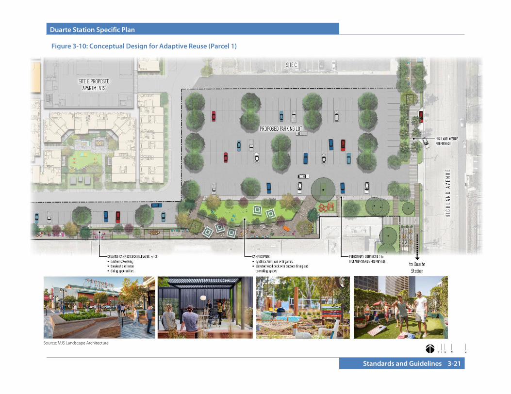
Duarte Station Specific Plan
Standards and Guidelines 3-21
Figure 3-10: Conceptual Design for Adaptive Reuse (Parcel 1)
Source: MJS Landscape Architecture
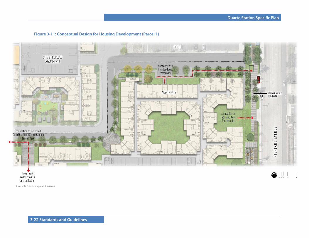
Duarte Station Specific Plan
3-22 Standards and Guidelines
Figure 3-11: Conceptual Design for Housing Development (Parcel 1)
Source: MJS Landscape Architecture
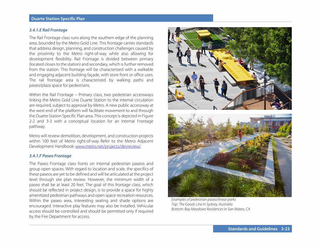
Duarte Station Specific Plan
Standards and Guidelines 3-23
3.4.1.E Rail Frontage
The Rail Frontage class runs along the southern edge of the planning area, bounded by the Metro Gold Line. This frontage carries standards that address design, planning, and construction challenges caused by the proximity to the Metro right-of-way while also allowing for development flexibility. Rail Frontage is divided between primary (located closes to the station) and secondary, which is further removed from the station. This frontage will be characterized with a walkable and engaging adjacent building façade, with store front or office uses. The rail frontage area is characterized by walking paths and paseo/plaza space for pedestrians.
Within the Rail Frontage – Primary class, two pedestrian accessways linking the Metro Gold Line Duarte Station to the internal circulation are required, subject to approval by Metro. A new public accessway at the west end of the platform will facilitate movement to and through the Duarte Station Specific Plan area. This concept is depicted in Figure 2-2 and 3-3 with a conceptual location for an Internal Frontage pathway.
Metro will review demolition, development, and construction projects within 100 feet of Metro right-of-way. Refer to the Metro Adjacent Development Handbook: www.metro.net/projects/devreview/.
3.4.1.F Paseo Frontage
The Paseo Frontage class fronts on internal pedestrian paseos and group open spaces. With regard to location and scale, the specifics of these paseos are yet to be defined and will be articulated at the project level through site plan review. However, the minimum width of a paseo shall be at least 20 feet. The goal of this frontage class, which should be reflected in project design, is to provide a space for highly amenitized pedestrian pathways and open space recreation resources. Within the paseo area, interesting seating and shade options are encouraged. Interactive play features may also be installed. Vehicular access should be controlled and should be permitted only if required by the Fire Department for access.
Examples of pedestrian paseo/linear parks Top: The Goods Line in Sydney, Australia Bottom: Bay Meadows Residences in San Mateo, CA
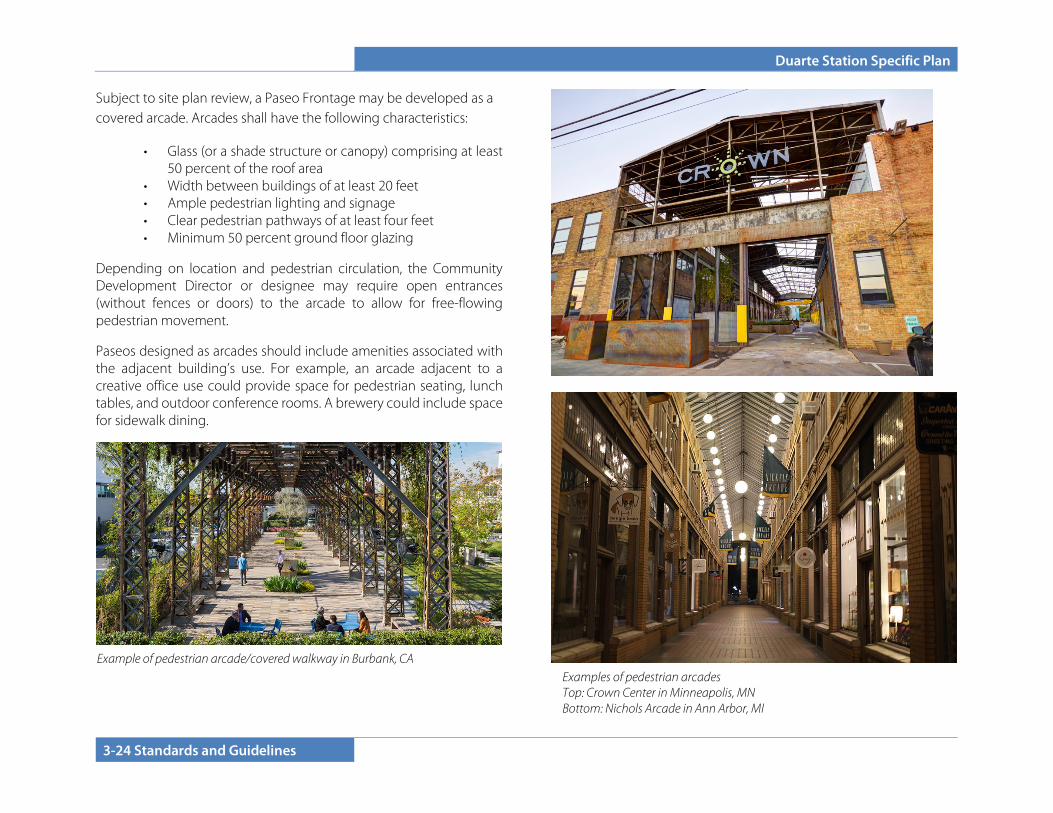
Duarte Station Specific Plan
3-24 Standards and Guidelines
Subject to site plan review, a Paseo Frontage may be developed as a covered arcade. Arcades shall have the following characteristics:
• Glass (or a shade structure or canopy) comprising at least 50 percent of the roof area
• Width between buildings of at least 20 feet • Ample pedestrian lighting and signage • Clear pedestrian pathways of at least four feet • Minimum 50 percent ground floor glazing
Depending on location and pedestrian circulation, the Community Development Director or designee may require open entrances (without fences or doors) to the arcade to allow for free-flowing pedestrian movement.
Paseos designed as arcades should include amenities associated with the adjacent building’s use. For example, an arcade adjacent to a creative office use could provide space for pedestrian seating, lunch tables, and outdoor conference rooms. A brewery could include space for sidewalk dining.
Examples of pedestrian arcades Top: Crown Center in Minneapolis, MN Bottom: Nichols Arcade in Ann Arbor, MI
Example of pedestrian arcade/covered walkway in Burbank, CA
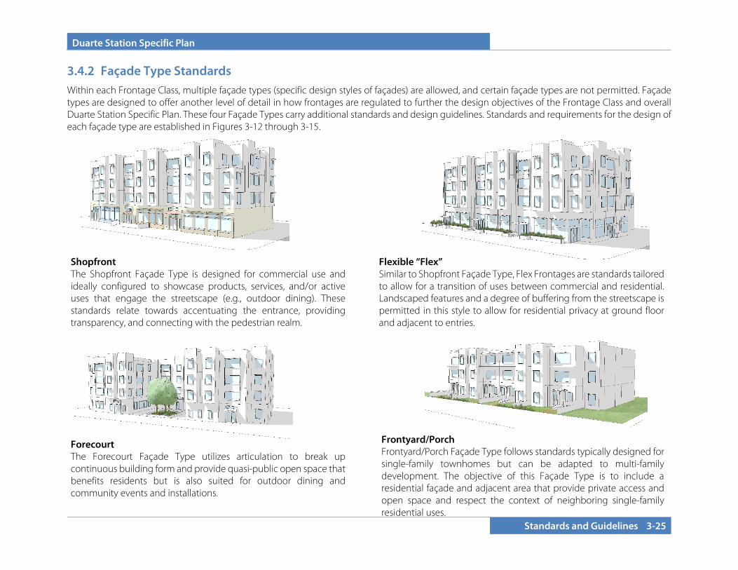
Duarte Station Specific Plan
Standards and Guidelines 3-25
3.4.2 Façade Type Standards Within each Frontage Class, multiple façade types (specific design styles of façades) are allowed, and certain façade types are not permitted. Façade types are designed to offer another level of detail in how frontages are regulated to further the design objectives of the Frontage Class and overall Duarte Station Specific Plan. These four Façade Types carry additional standards and design guidelines. Standards and requirements for the design of each façade type are established in Figures 3-12 through 3-15.
Forecourt The Forecourt Façade Type utilizes articulation to break up continuous building form and provide quasi-public open space that benefits residents but is also suited for outdoor dining and community events and installations.
Shopfront The Shopfront Façade Type is designed for commercial use and ideally configured to showcase products, services, and/or active uses that engage the streetscape (e.g., outdoor dining). These standards relate towards accentuating the entrance, providing transparency, and connecting with the pedestrian realm.
Flexible “Flex” Similar to Shopfront Façade Type, Flex Frontages are standards tailored to allow for a transition of uses between commercial and residential. Landscaped features and a degree of buffering from the streetscape is permitted in this style to allow for residential privacy at ground floor and adjacent to entries.
Frontyard/Porch Frontyard/Porch Façade Type follows standards typically designed for single-family townhomes but can be adapted to multi-family development. The objective of this Façade Type is to include a residential façade and adjacent area that provide private access and open space and respect the context of neighboring single-family residential uses.
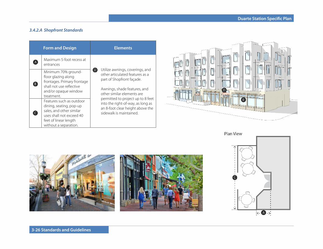
Duarte Station Specific Plan
3-26 Standards and Guidelines
3.4.2.A Shopfront Standards
Form and Design Elements
Maximum 5-foot recess at entrances
• Utilize awnings, coverings, and other articulated features as a part of Shopfront façade. Awnings, shade features, and other similar elements are permitted to project up to 8 feet into the right-of-way, as long as an 8-foot clear height above the sidewalk is maintained.
Minimum 70% ground-floor glazing along frontages. Primary frontage shall not use reflective and/or opaque window treatment.
Features such as outdoor dining, seating, pop-up sales, and other similar uses shall not exceed 40 feet of linear length without a separation.
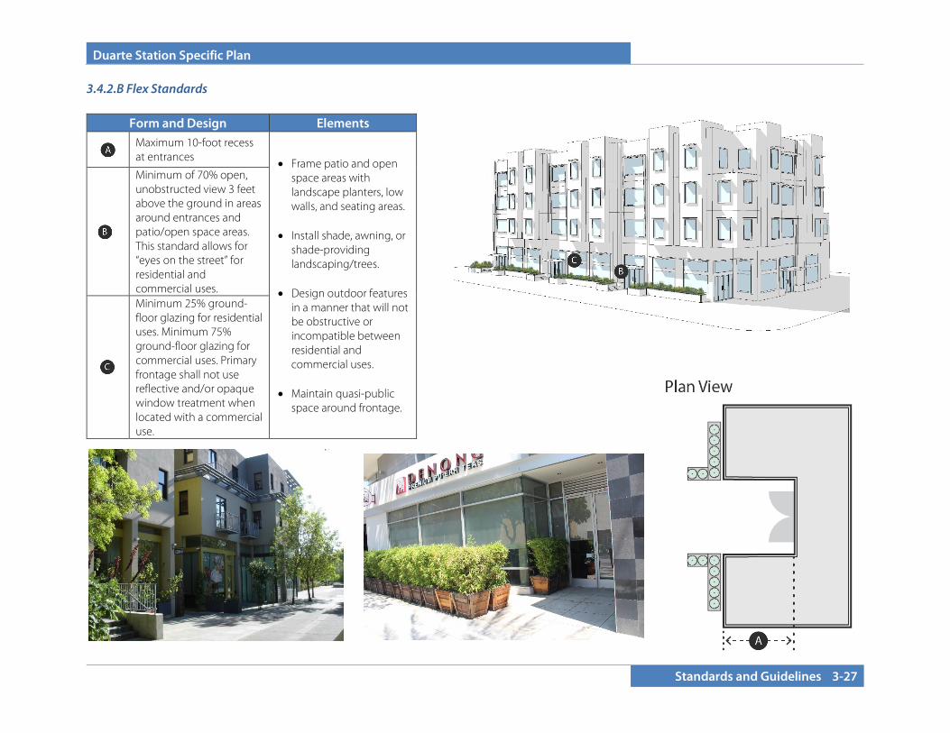
Duarte Station Specific Plan
Standards and Guidelines 3-27
3.4.2.B Flex Standards
Form and Design Elements
Maximum 10-foot recess at entrances • Frame patio and open
space areas with landscape planters, low walls, and seating areas.
• Install shade, awning, or
shade-providing landscaping/trees.
• Design outdoor features
in a manner that will not be obstructive or incompatible between residential and commercial uses.
• Maintain quasi-public
space around frontage.
Minimum of 70% open, unobstructed view 3 feet above the ground in areas around entrances and patio/open space areas. This standard allows for “eyes on the street” for residential and commercial uses.
Minimum 25% ground-floor glazing for residential uses. Minimum 75% ground-floor glazing for commercial uses. Primary frontage shall not use reflective and/or opaque window treatment when located with a commercial use.
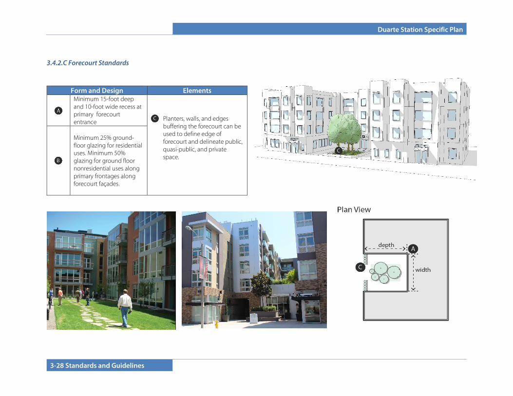
Duarte Station Specific Plan
3-28 Standards and Guidelines
3.4.2.C Forecourt Standards
Form and Design Elements
Minimum 15-foot deep and 10-foot wide recess at primary forecourt entrance • Planters, walls, and edges
buffering the forecourt can be used to define edge of forecourt and delineate public, quasi-public, and private space.
Minimum 25% ground-floor glazing for residential uses. Minimum 50% glazing for ground floor nonresidential uses along primary frontages along forecourt façades.
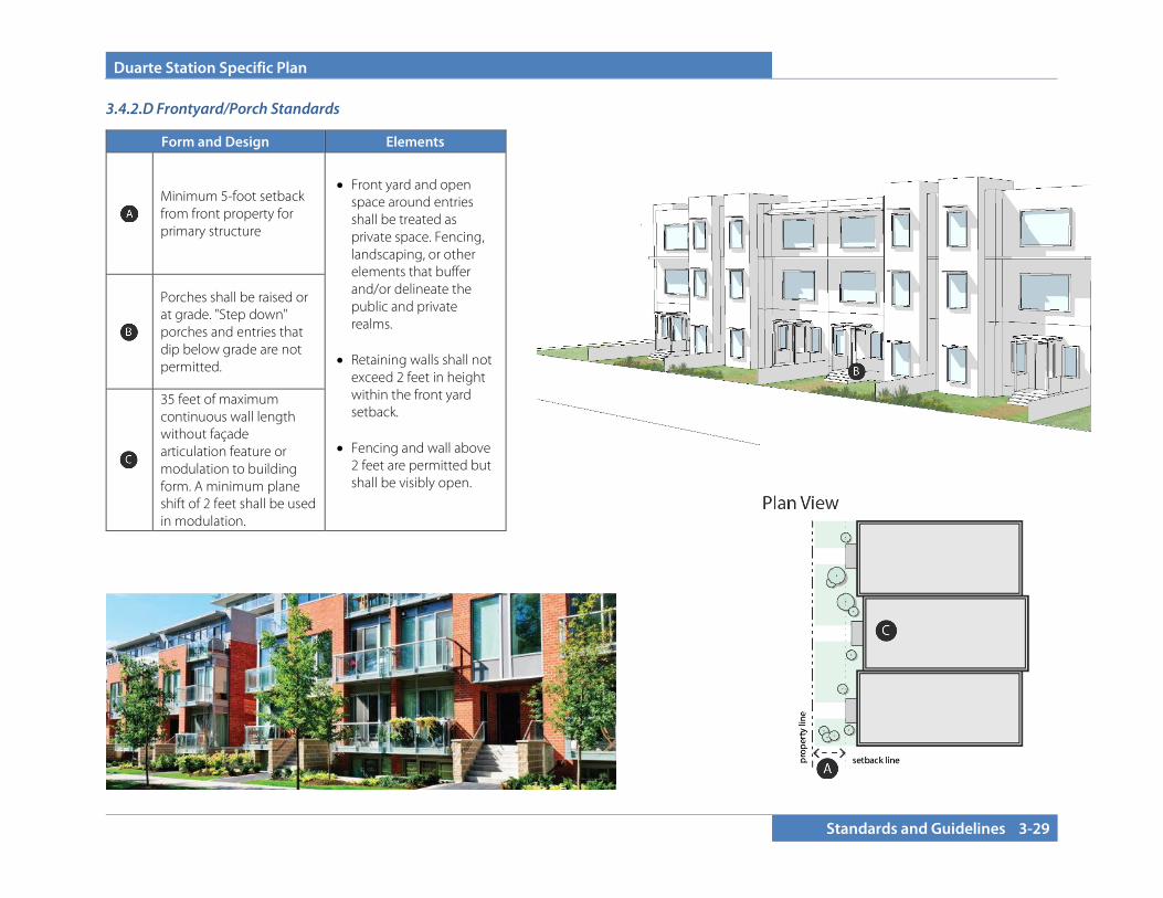
Duarte Station Specific Plan
Standards and Guidelines 3-29
3.4.2.D Frontyard/Porch Standards
Form and Design Elements
Minimum 5-foot setback from front property for primary structure
• Front yard and open space around entries shall be treated as private space. Fencing, landscaping, or other elements that buffer and/or delineate the public and private realms.
• Retaining walls shall not
exceed 2 feet in height within the front yard setback.
• Fencing and wall above
2 feet are permitted but shall be visibly open.
Porches shall be raised or at grade. "Step down" porches and entries that dip below grade are not permitted.
35 feet of maximum continuous wall length without façade articulation feature or modulation to building form. A minimum plane shift of 2 feet shall be used in modulation.

Duarte Station Specific Plan
3-30 Standards and Guidelines
3.5 DESIGN STANDARDS AND GUIDELINES
These Design Guidelines include both mandatory standards (“shall”) and interpretive design guidelines (“should”). The word “should” means that an action is required unless a determination is made that the intent of the Guideline is satisfied by other means. Design Guidelines are intended to guide new construction; adaptive reuse of existing buildings are not subject to these standards but should consider the intent and implement where feasible.
Please note that these Guidelines are minimum requirements, and developers may be required to provide additional amenities to meet Specific Plan goals.
3.5.1 Site Planning
3.5.1.A Circulation
1. The street pattern throughout the Specific Plan area should maximize connectivity throughout the area for vehicles, bicyclists, and pedestrians.
2. There shall be a distinct hierarchy of circulation including streets, pedestrian walks, and alleys. These should be arranged so that visitors and residents use these streets and pedestrian walks for their primary circulation. Alleys should not be used for primary circulation to the building or unit entries, and buildings should not orient to alleys or parking areas.
3. Development that occurs in future phases shall identify and design building, open space, and circulation networks to seamlessly link with existing development. An example of this would be siting buildings and pathways to facilitate visual and physical connections from the southern edge of the Specific Plan area to the linear park and internal circulation associated with Phase I.
Pedestrian walkways between residential buildings
Protected pedestrian walkway between parking aisles
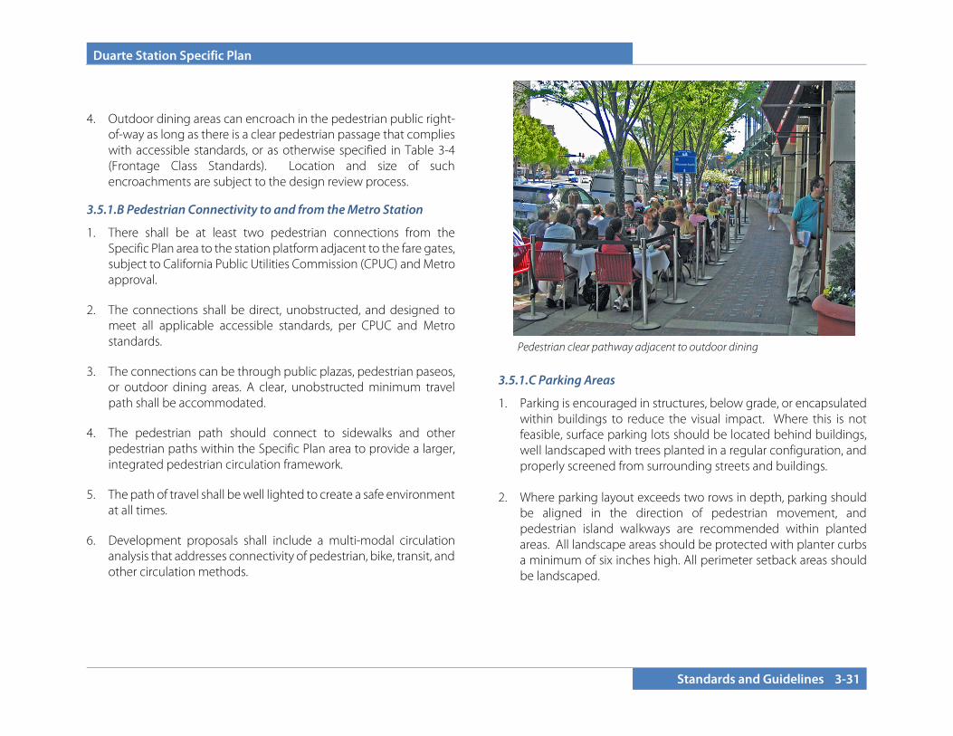
Duarte Station Specific Plan
Standards and Guidelines 3-31
4. Outdoor dining areas can encroach in the pedestrian public right-of-way as long as there is a clear pedestrian passage that complies with accessible standards, or as otherwise specified in Table 3-4 (Frontage Class Standards). Location and size of such encroachments are subject to the design review process.
3.5.1.B Pedestrian Connectivity to and from the Metro Station
1. There shall be at least two pedestrian connections from the Specific Plan area to the station platform adjacent to the fare gates, subject to California Public Utilities Commission (CPUC) and Metro approval.
2. The connections shall be direct, unobstructed, and designed to meet all applicable accessible standards, per CPUC and Metro standards.
3. The connections can be through public plazas, pedestrian paseos, or outdoor dining areas. A clear, unobstructed minimum travel path shall be accommodated.
4. The pedestrian path should connect to sidewalks and other pedestrian paths within the Specific Plan area to provide a larger, integrated pedestrian circulation framework.
5. The path of travel shall be well lighted to create a safe environment at all times.
6. Development proposals shall include a multi-modal circulation analysis that addresses connectivity of pedestrian, bike, transit, and other circulation methods.
3.5.1.C Parking Areas
1. Parking is encouraged in structures, below grade, or encapsulated within buildings to reduce the visual impact. Where this is not feasible, surface parking lots should be located behind buildings, well landscaped with trees planted in a regular configuration, and properly screened from surrounding streets and buildings.
2. Where parking layout exceeds two rows in depth, parking should
be aligned in the direction of pedestrian movement, and pedestrian island walkways are recommended within planted areas. All landscape areas should be protected with planter curbs a minimum of six inches high. All perimeter setback areas should be landscaped.
Pedestrian clear pathway adjacent to outdoor dining
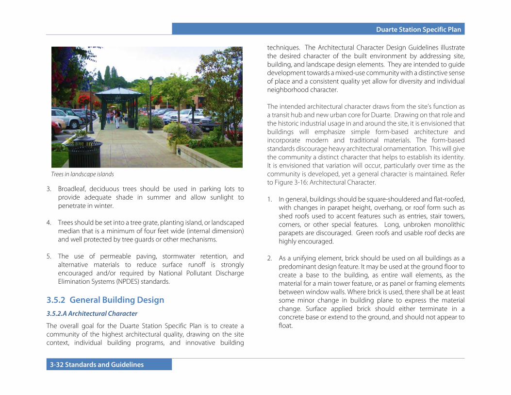
Duarte Station Specific Plan
3-32 Standards and Guidelines
3. Broadleaf, deciduous trees should be used in parking lots to provide adequate shade in summer and allow sunlight to penetrate in winter.
4. Trees should be set into a tree grate, planting island, or landscaped
median that is a minimum of four feet wide (internal dimension) and well protected by tree guards or other mechanisms.
5. The use of permeable paving, stormwater retention, and
alternative materials to reduce surface runoff is strongly encouraged and/or required by National Pollutant Discharge Elimination Systems (NPDES) standards.
3.5.2 General Building Design 3.5.2.A Architectural Character
The overall goal for the Duarte Station Specific Plan is to create a community of the highest architectural quality, drawing on the site context, individual building programs, and innovative building
techniques. The Architectural Character Design Guidelines illustrate the desired character of the built environment by addressing site, building, and landscape design elements. They are intended to guide development towards a mixed-use community with a distinctive sense of place and a consistent quality yet allow for diversity and individual neighborhood character. The intended architectural character draws from the site’s function as a transit hub and new urban core for Duarte. Drawing on that role and the historic industrial usage in and around the site, it is envisioned that buildings will emphasize simple form-based architecture and incorporate modern and traditional materials. The form-based standards discourage heavy architectural ornamentation. This will give the community a distinct character that helps to establish its identity. It is envisioned that variation will occur, particularly over time as the community is developed, yet a general character is maintained. Refer to Figure 3-16: Architectural Character. 1. In general, buildings should be square-shouldered and flat-roofed,
with changes in parapet height, overhang, or roof form such as shed roofs used to accent features such as entries, stair towers, corners, or other special features. Long, unbroken monolithic parapets are discouraged. Green roofs and usable roof decks are highly encouraged.
2. As a unifying element, brick should be used on all buildings as a
predominant design feature. It may be used at the ground floor to create a base to the building, as entire wall elements, as the material for a main tower feature, or as panel or framing elements between window walls. Where brick is used, there shall be at least some minor change in building plane to express the material change. Surface applied brick should either terminate in a concrete base or extend to the ground, and should not appear to float.
Trees in landscape islands

Duarte Station Specific Plan
Standards and Guidelines 3-33
Figure 3-16: Architectural Character

Duarte Station Specific Plan
3-34 Standards and Guidelines
3. In addition to brick as a required material, other façade materials that are encouraged include corrugated metal, metal panels, smooth stucco, and cementitious panels. Detailing should reinforce the industrial aesthetic of the area. Window walls are encouraged both as wall plane and corner accents and a creative approach to window shapes, sizes, and mullion patterns is highly desirable. Accent materials that are encouraged include cut stone, tile, glass block, and well-detailed smooth concrete.
4. Windows should be of a scale and grouping to form portions of
the wall, rather than punched openings within a wall. They shall be steel, aluminum, or clad to have the look of metal. Vinyl windows are strongly discouraged in any buildings over three stories. Windows at the ground floor along public streets should be storefront or give the appearance of storefront glazing.
5. Gates securing structured parking areas should be steel and reflect
the industrial aesthetic, or a custom art piece that enhances the identity of the building of which they are a part.
6. Balconies, decks, and handrails should be steel or other metal and
have industrial-inspired scale and detailing. Exposed steel columns are encouraged.
7. Awnings are encouraged along street frontages and should be
metal or metal and glass. Canvas and fabric awnings are discouraged.
3.5.2.B Building Orientation, Massing and Articulation
1. Buildings shall maintain a strong relationship to the street, with primary building entrances oriented toward the street.
2. Large expanses of blank façade walls are not permitted. Façades
directly facing the street shall be broken into distinct modules or bays along the frontage using three-dimensional surface
modulations that extend the human-scaled architectural character and cadence of more active façade areas. The modulations can be achieved with the use of recesses, projections, change in color or material. The depth of recesses and projections should be a minimum of two feet.
Linear façade broken into shorter lengths with the use of color, recess, and articulations while also incorporating roof height change and vertical planes.
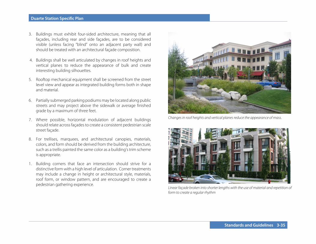
Duarte Station Specific Plan
Standards and Guidelines 3-35
3. Buildings must exhibit four-sided architecture, meaning that all
façades, including rear and side façades, are to be considered visible (unless facing “blind” onto an adjacent party wall) and should be treated with an architectural façade composition.
4. Buildings shall be well articulated by changes in roof heights and
vertical planes to reduce the appearance of bulk and create interesting building silhouettes.
5. Rooftop mechanical equipment shall be screened from the street level view and appear as integrated building forms both in shape and material.
6. Partially submerged parking podiums may be located along public
streets and may project above the sidewalk or average finished grade by a maximum of three feet.
7. Where possible, horizontal modulation of adjacent buildings should relate across façades to create a consistent pedestrian scale street façade.
8. For trellises, marquees, and architectural canopies, materials, colors, and form should be derived from the building architecture, such as a trellis painted the same color as a building’s trim scheme is appropriate.
1. Building corners that face an intersection should strive for a distinctive form with a high level of articulation. Corner treatments may include a change in height or architectural style, materials, roof form, or window pattern, and are encouraged to create a pedestrian gathering experience.
Linear façade broken into shorter lengths with the use of material and repetition of form to create a regular rhythm
Changes in roof heights and vertical planes reduce the appearance of mass.

Duarte Station Specific Plan
3-36 Standards and Guidelines
3.5.2.C Windows and Entries
1. Entries shall be given special attention as a whole system, including door, side windows, and porches. All entries for main buildings and for individual units should be pedestrian scaled.
2. Entries should be inviting from the street with adequate weather
protection. 3. Courtyard doors, gates, or other portals used at building entries
shall be attractively designed as an important architectural feature of the building or development.
4. Main building entries (i.e., those serving multiple units) should be
differentiated from individual street-level unit entries with special detailing, awnings, canopies, or multi-story forms.
5. Individual ground-level unit entries should have a strong
relationship to a fronting street, internal walkway, or courtyard as appropriate to the overall siting concept and housing type.
Tower element at the street corner for a distinctive form
Windows arranged to establish clear and rhythmic patterns appropriate to both the building’s architectural style and scale
Landscaped courtyard serving as common entry for residential units
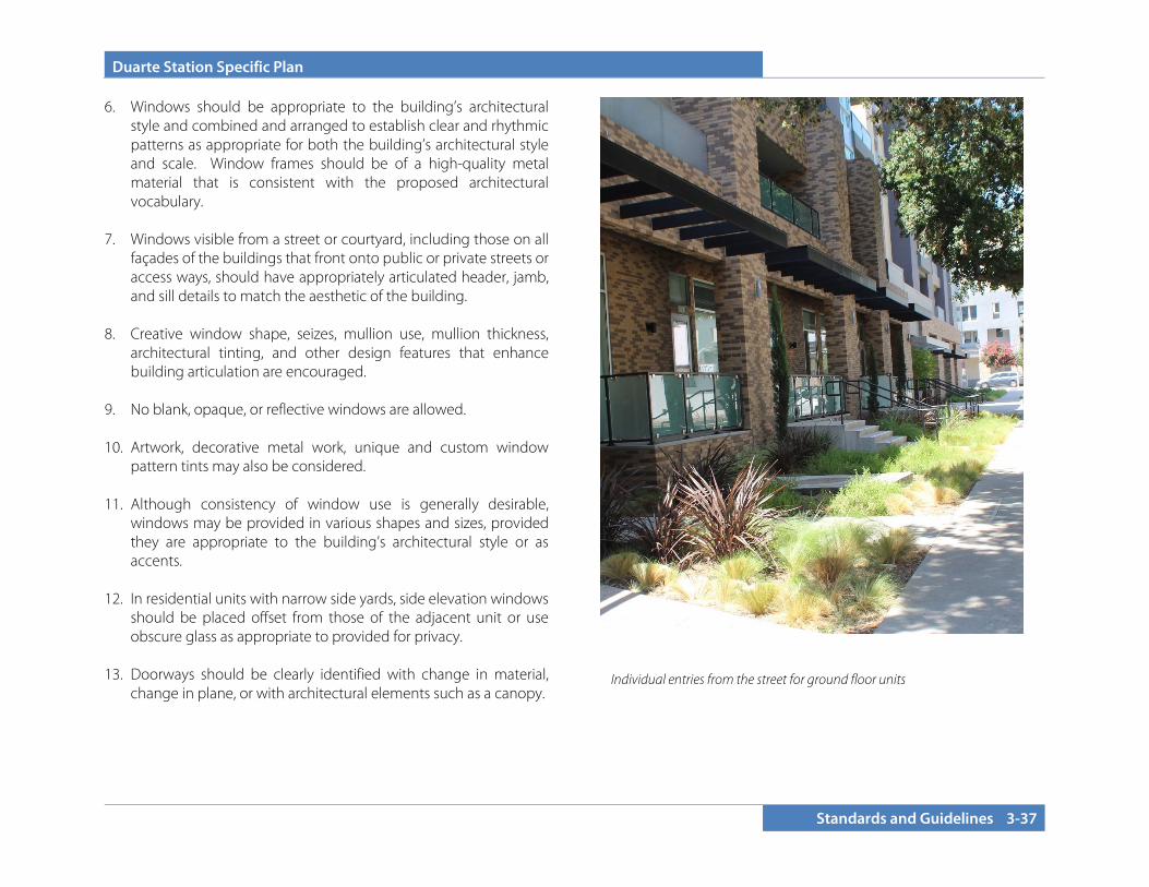
Duarte Station Specific Plan
Standards and Guidelines 3-37
6. Windows should be appropriate to the building’s architectural style and combined and arranged to establish clear and rhythmic patterns as appropriate for both the building’s architectural style and scale. Window frames should be of a high-quality metal material that is consistent with the proposed architectural vocabulary.
7. Windows visible from a street or courtyard, including those on all
façades of the buildings that front onto public or private streets or access ways, should have appropriately articulated header, jamb, and sill details to match the aesthetic of the building.
8. Creative window shape, seizes, mullion use, mullion thickness,
architectural tinting, and other design features that enhance building articulation are encouraged.
9. No blank, opaque, or reflective windows are allowed. 10. Artwork, decorative metal work, unique and custom window
pattern tints may also be considered. 11. Although consistency of window use is generally desirable,
windows may be provided in various shapes and sizes, provided they are appropriate to the building’s architectural style or as accents.
12. In residential units with narrow side yards, side elevation windows
should be placed offset from those of the adjacent unit or use obscure glass as appropriate to provided for privacy.
13. Doorways should be clearly identified with change in material,
change in plane, or with architectural elements such as a canopy.
Individual entries from the street for ground floor units

Duarte Station Specific Plan
3-38 Standards and Guidelines
3.5.2.D Building Materials
1. All materials used should be durable, of high quality, and properly installed.
2. Materials should be attractive, sustainable, low maintenance,
and appropriate to the architectural character.
3. Materials should be incorporated in a manner that they do not appear to be merely surface applications but as an integral component of the architectural style.
4. Change of material to accentuate architectural details or
articulate the elevation is recommended if the material is appropriate to the architectural character.
5. Material changes should not occur at external corners but
should occur at interior corners or with a return of at least six feet from the external corners or other logical terminations.
6. Roof materials should complement the materials and colors of
the façades and provide texture or relief.
7. Rain gutters and down spouts should be integrated into the façade. At a minimum, their color should blend with adjacent surfaces.
8. Partially submerged parking podiums that project above
grade should either be integrated into the architectural character of the building above utilizing cladding or building with materials that extend down from the portions of the building above or be built with contrasting materials of a more substantial and permanent character than the portions of the building above to create a base.
Change of materials to highlight the fenestration
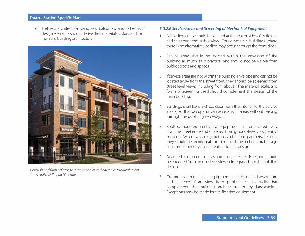
Duarte Station Specific Plan
Standards and Guidelines 3-39
9. Trellises, architectural canopies, balconies, and other such design elements should derive their materials, colors, and form from the building architecture.
3.5.2.E Service Areas and Screening of Mechanical Equipment
1. All loading areas should be located at the rear or sides of buildings and screened from public view. For commercial buildings, where there is no alternative, loading may occur through the front door.
2. Service areas should be located within the envelope of the
building as much as is practical and should not be visible from public streets and spaces.
3. If service areas are not within the building envelope and cannot be
located away from the street front, they should be screened from street level views, including from above. The material, scale, and forms of screening used should complement the design of the main building.
4. Buildings shall have a direct door from the interior to the service
area(s) so that occupants can access such areas without passing through the public right-of-way.
5. Rooftop-mounted mechanical equipment shall be located away
from the street edge and screened from ground-level view behind parapets. Where screening methods other than parapets are used, they should be an integral component of the architectural design or a complimentary accent feature to that design.
6. Attached equipment such as antennas, satellite dishes, etc. should
be screened from ground level view or integrated into the building design.
7. Ground-level mechanical equipment shall be located away from
and screened from view from public areas by walls that complement the building architecture or by landscaping. Exceptions may be made for fire-fighting equipment.
Materials and forms of architectural canopies and balconies to complement the overall building architecture
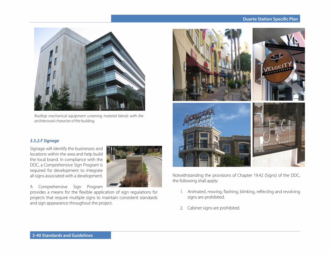
Duarte Station Specific Plan
3-40 Standards and Guidelines
3.5.2.F Signage
Signage will identify the businesses and locations within the area and help build the local brand. In compliance with the DDC, a Comprehensive Sign Program is required for development to integrate all signs associated with a development. A Comprehensive Sign Program provides a means for the flexible application of sign regulations for projects that require multiple signs to maintain consistent standards and sign appearance throughout the project.
Notwithstanding the provisions of Chapter 19.42 (Signs) of the DDC, the following shall apply:
1. Animated, moving, flashing, blinking, reflecting and revolving signs are prohibited.
2. Cabinet signs are prohibited.
Rooftop mechanical equipment screening material blends with the architectural character of the building.

Duarte Station Specific Plan
Standards and Guidelines 3-41
3. Exposed conduit and tubing is prohibited. All transformers and other equipment shall be concealed.
4. A coordinated signage plan shall be included for all multi-
tenant buildings.
5. Freestanding signs are discouraged, except at a single major site entry.
6. Iconic and distinctive signage that establishes the character
and identity for the area and Duarte is encouraged. Roof signs are allowed to accomplish this goal.
7. All signs should be designed to complement the architectural
style and setting of the structure or use it is adjacent to. Building wall and fascia signs should be compatible with the predominant visual elements of the building.
8. The size of signs and sign letters should be proportional to the
space they are located in, with the letters typically between six and 16 inches high.
9. Projecting signs mounted perpendicular to the façade of the
building should be located at least eight feet above the sidewalk. The outside edge should be no more than four feet from the face of the building.
3.5.3 Design by Building Type
3.5.3.A Multi-Family Residential and Mixed-Use
1. Multi-family buildings should be well articulated to break up the building mass. Variations in floor level, façades, roof styles, architectural details, and finishes that break up the appearance of large buildings should be employed.
2. Street-facing façades of residential buildings should include stoops, porches, recessed windows, bay windows, and balconies
to provide visual interest. 3. Porches and balconies that face streets should be incorporated
into the materials and design of the building. Front yard patios can be used or be a part of the entry path or a separate space.
Variation in color, façade break up the building mass
Signage that facilitates a sense of identity for Duarte

Duarte Station Specific Plan
3-42 Standards and Guidelines
4. Storefronts on the ground floor of mixed-use buildings shall be of sufficient depth to support the anticipated use and are encouraged to have a minimum depth of 40 feet.
5. Large display windows (large panes or divided lites) are strongly
encouraged. 6. Clear glass should be used. Colored or reflective glass is not
appropriate. Subtle window tinting may be appropriate if part of a comprehensive design theme.
7. All ground floor units within five feet of finished grade are
encouraged to have their principal entrance from the street, pedestrian walkway, or open space. If individual entries are not provided, then individual private areas such as balconies or decks should be provided that front on to the street, pedestrian walkway, or open space.
8. Common entries should be a
predominant feature of front façades and should have a scale that is in proportion to the size of the building and number of units being accessed. Larger buildings should have a prominent, centralized building entrance.
9. Residential entries should be clearly
identifiable from the retail/service entry.
10. Building sides that face a public street,
drive, or common space should be the first choice for entry location.
11. The use of awnings is encouraged to provide shelter and shade along the sidewalk for mixed-use buildings. Awnings should be no wider than a single storefront or architectural bay (whichever is narrower).
12. Building corners that face an intersection should strive for a
distinctive form with a high level of articulation. Corner treatments could include a change in height, a definition of a public plaza, or a change in architectural style, windows, or materials.
Individual entries for ground floor entries front the street
Front yard patios used as part of the entry to individual units
Common entry for the building is emphasized by change in color and scale.
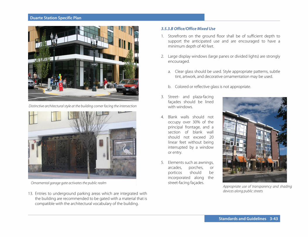
Duarte Station Specific Plan
Standards and Guidelines 3-43
13. Entries to underground parking areas which are integrated with
the building are recommended to be gated with a material that is compatible with the architectural vocabulary of the building.
3.5.3.B Office/Office Mixed Use
1. Storefronts on the ground floor shall be of sufficient depth to support the anticipated use and are encouraged to have a minimum depth of 40 feet.
2. Large display windows (large panes or divided lights) are strongly
encouraged.
a. Clear glass should be used. Style appropriate patterns, subtle tint, artwork, and decorative ornamentation may be used.
b. Colored or reflective glass is not appropriate.
3. Street- and plaza-facing
façades should be lined with windows.
4. Blank walls should not
occupy over 30% of the principal frontage, and a section of blank wall should not exceed 20 linear feet without being interrupted by a window or entry.
5. Elements such as awnings,
arcades, porches, or porticos should be incorporated along the street-facing façades.
Appropriate use of transparency and shading devices along public streets
Ornamental garage gate activates the public realm
Distinctive architectural style at the building corner facing the intersection
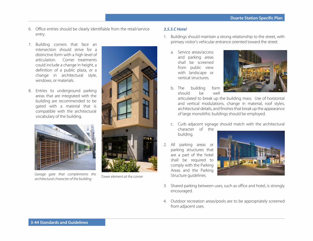
Duarte Station Specific Plan
3-44 Standards and Guidelines
Garage gate that complements the architectural character of the building
6. Office entries should be clearly identifiable from the retail/service entry.
7. Building corners that face an
intersection should strive for a distinctive form with a high level of articulation. Corner treatments could include a change in height, a definition of a public plaza, or a change in architectural style, windows, or materials.
8. Entries to underground parking
areas that are integrated with the building are recommended to be gated with a material that is compatible with the architectural vocabulary of the building.
3.5.3.C Hotel
1. Buildings should maintain a strong relationship to the street, with primary visitor’s vehicular entrance oriented toward the street.
a. Service areas/access
and parking areas shall be screened from public view with landscape or vertical structures.
b. The building form
should be well articulated to break up the building mass. Use of horizontal and vertical modulations, change in material, roof styles, architectural details, and finishes that break up the appearance of large monolithic buildings should be employed.
c. Curb adjacent signage should match with the architectural
character of the building.
2. All parking areas or
parking structures that are a part of the hotel shall be required to comply with the Parking Areas and the Parking Structure guidelines.
3. Shared parking between uses, such as office and hotel, is strongly
encouraged. 4. Outdoor recreation areas/pools are to be appropriately screened
from adjacent uses.
Tower element at the corner

Duarte Station Specific Plan
Standards and Guidelines 3-45
3.5.3.D Stand-alone Retail
1. Buildings should maintain a strong relationship to the street or to a public plaza.
a. Storefronts on the ground floor shall be of sufficient depth to
support the anticipated use and are encouraged to have a minimum depth of 40 feet.
b. Elements such as awnings, arcades, porches, or porticos
should be incorporated along the street/plaza-facing façades.
c. Where the façade of a commercial building is divided into distinct bays (sections defined by vertical architectural elements such as masonry piers), awnings should be placed within the vertical elements rather than overlapping them.
2. The use of low walls, planters, or potted elements to create
outdoor seating areas is encouraged. 3. Building corners that face an intersection should strive for a
distinctive form with a high level of articulation. Corner treatments could include a change in height, a definition of a public plaza, or a change in architectural style, windows, or materials.
Awnings placed within architectural bays
Retail spaces oriented toward a public plaza
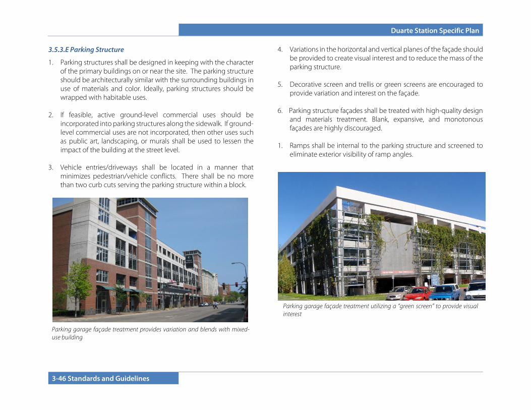
Duarte Station Specific Plan
3-46 Standards and Guidelines
3.5.3.E Parking Structure
1. Parking structures shall be designed in keeping with the character of the primary buildings on or near the site. The parking structure should be architecturally similar with the surrounding buildings in use of materials and color. Ideally, parking structures should be wrapped with habitable uses.
2. If feasible, active ground-level commercial uses should be
incorporated into parking structures along the sidewalk. If ground-level commercial uses are not incorporated, then other uses such as public art, landscaping, or murals shall be used to lessen the impact of the building at the street level.
3. Vehicle entries/driveways shall be located in a manner that
minimizes pedestrian/vehicle conflicts. There shall be no more than two curb cuts serving the parking structure within a block.
4. Variations in the horizontal and vertical planes of the façade should be provided to create visual interest and to reduce the mass of the parking structure.
5. Decorative screen and trellis or green screens are encouraged to
provide variation and interest on the façade. 6. Parking structure façades shall be treated with high-quality design
and materials treatment. Blank, expansive, and monotonous façades are highly discouraged.
1. Ramps shall be internal to the parking structure and screened to
eliminate exterior visibility of ramp angles.
Parking garage façade treatment provides variation and blends with mixed-use building
Parking garage façade treatment utilizing a “green screen” to provide visual interest
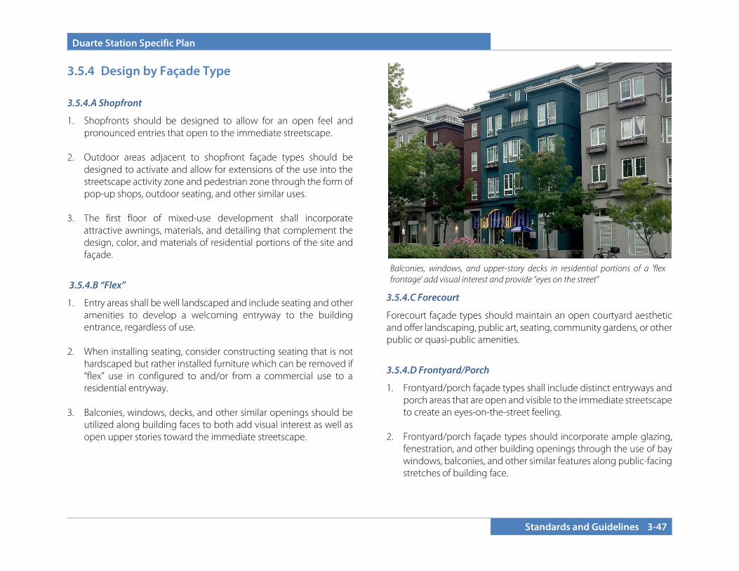
Duarte Station Specific Plan
Standards and Guidelines 3-47
3.5.4 Design by Façade Type 3.5.4.A Shopfront
1. Shopfronts should be designed to allow for an open feel and pronounced entries that open to the immediate streetscape.
2. Outdoor areas adjacent to shopfront façade types should be
designed to activate and allow for extensions of the use into the streetscape activity zone and pedestrian zone through the form of pop-up shops, outdoor seating, and other similar uses.
3. The first floor of mixed-use development shall incorporate
attractive awnings, materials, and detailing that complement the design, color, and materials of residential portions of the site and façade.
3.5.4.B “Flex”
1. Entry areas shall be well landscaped and include seating and other amenities to develop a welcoming entryway to the building entrance, regardless of use.
2. When installing seating, consider constructing seating that is not hardscaped but rather installed furniture which can be removed if “flex” use in configured to and/or from a commercial use to a residential entryway.
3. Balconies, windows, decks, and other similar openings should be
utilized along building faces to both add visual interest as well as open upper stories toward the immediate streetscape.
3.5.4.C Forecourt
Forecourt façade types should maintain an open courtyard aesthetic and offer landscaping, public art, seating, community gardens, or other public or quasi-public amenities.
3.5.4.D Frontyard/Porch
1. Frontyard/porch façade types shall include distinct entryways and porch areas that are open and visible to the immediate streetscape to create an eyes-on-the-street feeling.
2. Frontyard/porch façade types should incorporate ample glazing, fenestration, and other building openings through the use of bay windows, balconies, and other similar features along public-facing stretches of building face.
Balconies, windows, and upper-story decks in residential portions of a ‘flex frontage’ add visual interest and provide “eyes on the street”
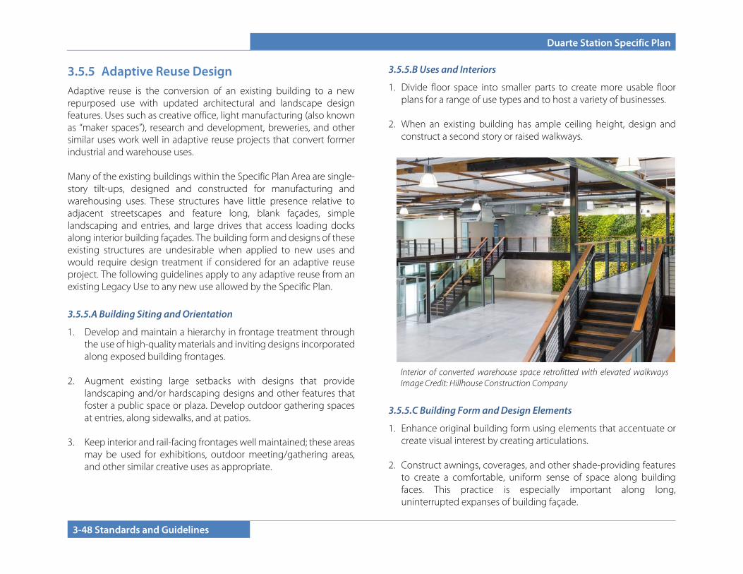
Duarte Station Specific Plan
3-48 Standards and Guidelines
3.5.5 Adaptive Reuse Design Adaptive reuse is the conversion of an existing building to a new repurposed use with updated architectural and landscape design features. Uses such as creative office, light manufacturing (also known as “maker spaces”), research and development, breweries, and other similar uses work well in adaptive reuse projects that convert former industrial and warehouse uses. Many of the existing buildings within the Specific Plan Area are single-story tilt-ups, designed and constructed for manufacturing and warehousing uses. These structures have little presence relative to adjacent streetscapes and feature long, blank façades, simple landscaping and entries, and large drives that access loading docks along interior building façades. The building form and designs of these existing structures are undesirable when applied to new uses and would require design treatment if considered for an adaptive reuse project. The following guidelines apply to any adaptive reuse from an existing Legacy Use to any new use allowed by the Specific Plan.
3.5.5.A Building Siting and Orientation
1. Develop and maintain a hierarchy in frontage treatment through the use of high-quality materials and inviting designs incorporated along exposed building frontages.
2. Augment existing large setbacks with designs that provide
landscaping and/or hardscaping designs and other features that foster a public space or plaza. Develop outdoor gathering spaces at entries, along sidewalks, and at patios.
3. Keep interior and rail-facing frontages well maintained; these areas
may be used for exhibitions, outdoor meeting/gathering areas, and other similar creative uses as appropriate.
3.5.5.B Uses and Interiors
1. Divide floor space into smaller parts to create more usable floor plans for a range of use types and to host a variety of businesses.
2. When an existing building has ample ceiling height, design and construct a second story or raised walkways.
3.5.5.C Building Form and Design Elements
1. Enhance original building form using elements that accentuate or create visual interest by creating articulations.
2. Construct awnings, coverages, and other shade-providing features to create a comfortable, uniform sense of space along building faces. This practice is especially important along long, uninterrupted expanses of building façade.
Interior of converted warehouse space retrofitted with elevated walkways Image Credit: Hillhouse Construction Company
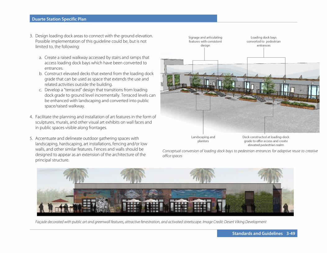
Duarte Station Specific Plan
Standards and Guidelines 3-49
3. Design loading dock areas to connect with the ground elevation.
Possible implementation of this guideline could be, but is not limited to, the following:
a. Create a raised walkway accessed by stairs and ramps that
access loading dock bays which have been converted to entrances.
b. Construct elevated decks that extend from the loading dock grade that can be used as space that extends the use and related activities outside the building.
c. Develop a “terraced” design that transitions from loading dock grade to ground level incrementally. Terraced levels can be enhanced with landscaping and converted into public space/raised walkway.
4. Facilitate the planning and installation of art features in the form of sculptures, murals, and other visual art exhibits on wall faces and in public spaces visible along frontages.
5. Accentuate and delineate outdoor gathering spaces with landscaping, hardscaping, art installations, fencing and/or low walls, and other similar features. Fences and walls should be designed to appear as an extension of the architecture of the principal structure.
Façade decorated with public art and greenwall features, attractive fenestration, and activated streetscape. Image Credit: Desert Viking Development
Conceptual conversion of loading dock bays to pedestrian entrances for adaptive reuse to creative office spaces

Duarte Station Specific Plan
3-50 Standards and Guidelines
6. Incorporate landscaping along long unarticulated building walls, near entries, and within outdoor gathering areas.
7. Consider and plan for signage opportunities on building facies for adaptive uses.
3.5.5.D Entries and Glazing
1. Clearly indicate building entrances using well-placed, attractive signs. Additionally, ensure that signage design, orientation, and placement are consistent along long rows of shopfronts to develop repetition.
2. Incorporate clear glazing along primary frontages. Reflective or tinted windows are highly discouraged.
3. Accentuate entrances with material, plane, and color changes and well-designed lighting patterns. Accentuating elements may expand beyond existing rooflines and planes.
4. Repurpose doorways and loading dock entrances that are not converted to entryways with transparent glazing.
3.5.5.E Design Materials and Colors
1. Refresh building appearance using modern applications of classic building materials that are compatible with development on adjacent sites. Wood, stone, brick, and limited use of metal are encouraged to be incorporated in designs.
2. Use warm lighting with consistent spacing to create repetitive pattern lighting effects along long building faces.
3. Consider using color/material changes to signal different uses and storefronts/shopfronts.
4. Art installations should be unique and do not need to strictly conform to contextual color and material patterns on the site.
Example of a tilt-up structure remodeled to incorporate a more prominent entry with an attractive use of materials, design, and public art. Image Credit: Hillhouse Construction Company
Row of shops in repurposed industrial building. Building façade enhanced with awnings and evenly spaced signage and articulations that establish a shopfront pattern.

Duarte Station Specific Plan
Standards and Guidelines 3-51
3.5.6 LANDSCAPE, HARDSCAPE, FURNISHINGS, AND LIGHTING DESIGN
3.5.6.A Landscape Design Principles
Landscape design gives character and definition to the hierarchy of open spaces within this mixed-use area using the following principles:
• Provide an open space program that includes passive space, streetscapes, and social space. Consideration should be given to the orientation of such areas with regard to sunlight and shade.
• Use plant species and trees at an appropriate scale to define,
identify, separate, and enclose space. • Encourage visual links throughout the plan area. • Create a balance between community landscapes while
considering the needs for commercial visibility. • Use materials to define pedestrian dominated areas.
3.5.6.B Landscape Design
A Landscape Concept Plan for individual developments within the Duarte Station Specific Plan shall be submitted to the City for site plan/design review to provide for a unified concept. General guidelines are as follows:
1. All areas not covered by buildings, walkways, driveways, parking spaces, and service areas should be landscaped with climate-appropriate plantings. Plant materials should favor native and native-compatible plants.
2. Landscaping should enhance the quality of the project by defining edges, framing and softening the appearance of buildings, defining site functions, screening parking and storage areas, and buffering uses and neighboring properties.
3. Landscaping at the base of buildings is encouraged to soften
the transition between building and streets. 4. Landscaped areas should generally incorporate plantings
utilizing a three-tiered system: a) trees, b) shrubs or vines, c) groundcover. Landscaping should be in scale with the adjacent buildings and be of appropriate size at maturity.
5. Placement of landscaping should not interfere with the
lighting of the project area or restrict access to utilities.
Landscape design concept Image credit: The Dahlin Group
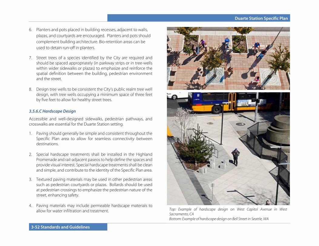
Duarte Station Specific Plan
3-52 Standards and Guidelines
6. Planters and pots placed in building recesses, adjacent to walls, plazas, and courtyards are encouraged. Planters and pots should complement building architecture. Bio-retention areas can be used to detain run-off in planters.
7. Street trees of a species identified by the City are required and should be spaced appropriately (in parkway strips or in tree-wells within wider sidewalks or plazas) to emphasize and reinforce the spatial definition between the building, pedestrian environment and the street.
8. Design tree wells to be consistent the City’s public realm tree well
design, with tree wells occupying a minimum space of three feet by five feet to allow for healthy street trees.
3.5.6.C Hardscape Design
Accessible and well-designed sidewalks, pedestrian pathways, and crosswalks are essential for the Duarte Station setting.
1. Paving should generally be simple and consistent throughout the Specific Plan area to allow for seamless connectivity between destinations.
2. Special hardscape treatments shall be installed in the Highland
Promenade and rail-adjacent paseos to help define the spaces and provide visual interest. Special hardscape treatments shall be clean and simple, and contribute to the identity of the Specific Plan area.
3. Textured paving materials may be used in other pedestrian areas such as pedestrian courtyards or plazas. Bollards should be used at pedestrian crossings to emphasize the pedestrian nature of the street, enhancing safety.
4. Paving materials may include permeable hardscape materials to
allow for water infiltration and treatment.
Top: Example of hardscape design on West Capitol Avenue in West Sacramento, CA Bottom: Example of hardscape design on Bell Street in Seattle, WA
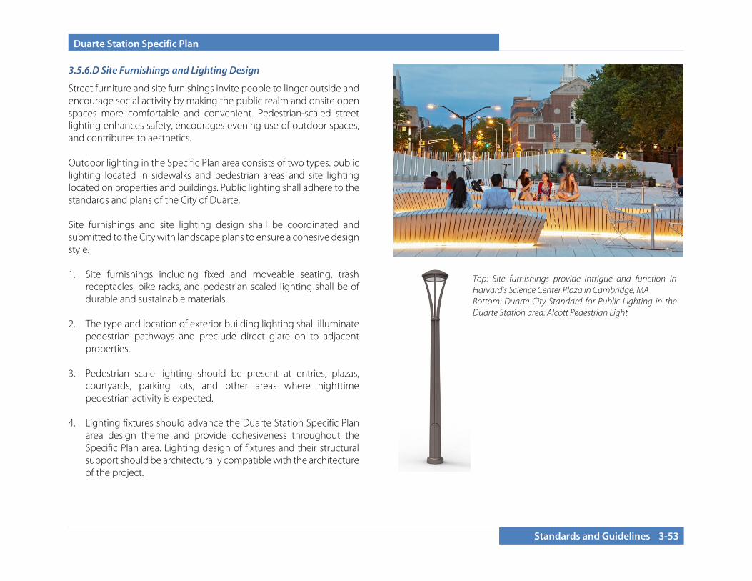
Duarte Station Specific Plan
Standards and Guidelines 3-53
3.5.6.D Site Furnishings and Lighting Design
Street furniture and site furnishings invite people to linger outside and encourage social activity by making the public realm and onsite open spaces more comfortable and convenient. Pedestrian-scaled street lighting enhances safety, encourages evening use of outdoor spaces, and contributes to aesthetics. Outdoor lighting in the Specific Plan area consists of two types: public lighting located in sidewalks and pedestrian areas and site lighting located on properties and buildings. Public lighting shall adhere to the standards and plans of the City of Duarte. Site furnishings and site lighting design shall be coordinated and submitted to the City with landscape plans to ensure a cohesive design style. 1. Site furnishings including fixed and moveable seating, trash
receptacles, bike racks, and pedestrian-scaled lighting shall be of durable and sustainable materials.
2. The type and location of exterior building lighting shall illuminate
pedestrian pathways and preclude direct glare on to adjacent properties.
3. Pedestrian scale lighting should be present at entries, plazas,
courtyards, parking lots, and other areas where nighttime pedestrian activity is expected.
4. Lighting fixtures should advance the Duarte Station Specific Plan
area design theme and provide cohesiveness throughout the Specific Plan area. Lighting design of fixtures and their structural support should be architecturally compatible with the architecture of the project.
Top: Site furnishings provide intrigue and function in Harvard’s Science Center Plaza in Cambridge, MA Bottom: Duarte City Standard for Public Lighting in the Duarte Station area: Alcott Pedestrian Light
Duarte Station Specific Plan
3-54 Standards and Guidelines
This page intentionally left blank.
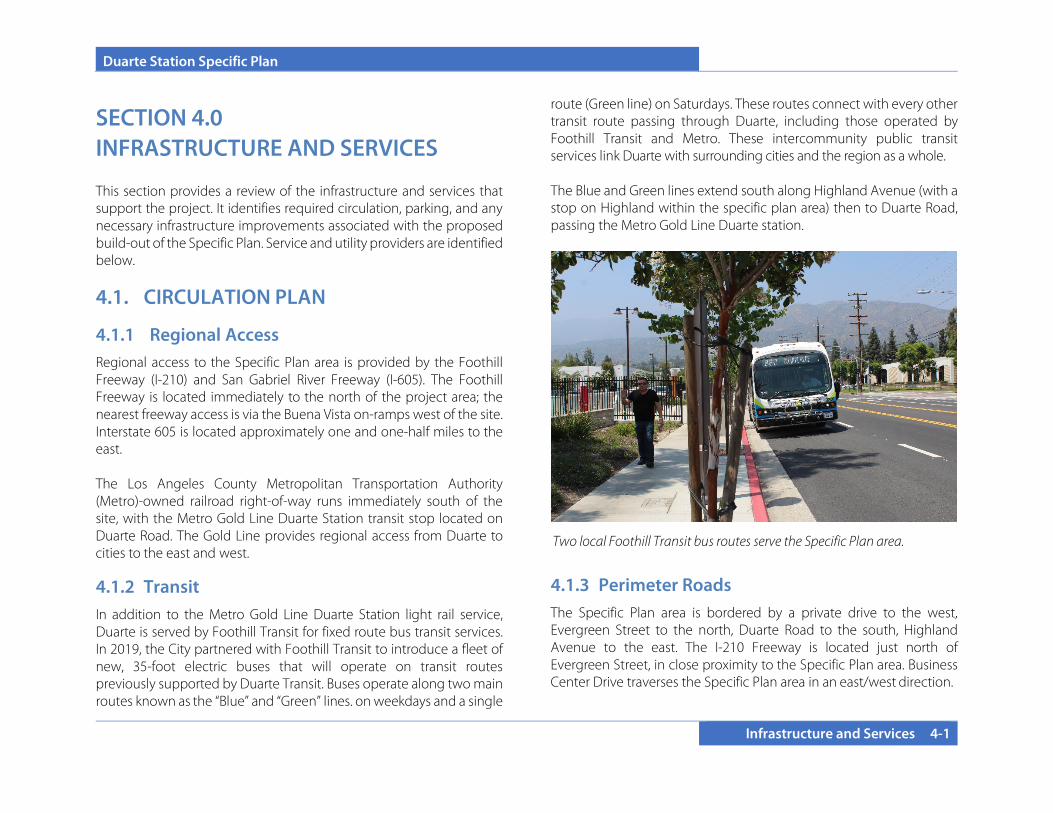
Duarte Station Specific Plan
Infrastructure and Services 4-1
SECTION 4.0 INFRASTRUCTURE AND SERVICES
This section provides a review of the infrastructure and services that support the project. It identifies required circulation, parking, and any necessary infrastructure improvements associated with the proposed build-out of the Specific Plan. Service and utility providers are identified below.
4.1. CIRCULATION PLAN
4.1.1 Regional Access Regional access to the Specific Plan area is provided by the Foothill Freeway (I-210) and San Gabriel River Freeway (I-605). The Foothill Freeway is located immediately to the north of the project area; the nearest freeway access is via the Buena Vista on-ramps west of the site. Interstate 605 is located approximately one and one-half miles to the east. The Los Angeles County Metropolitan Transportation Authority (Metro)-owned railroad right-of-way runs immediately south of the site, with the Metro Gold Line Duarte Station transit stop located on Duarte Road. The Gold Line provides regional access from Duarte to cities to the east and west.
4.1.2 Transit In addition to the Metro Gold Line Duarte Station light rail service, Duarte is served by Foothill Transit for fixed route bus transit services. In 2019, the City partnered with Foothill Transit to introduce a fleet of new, 35-foot electric buses that will operate on transit routes previously supported by Duarte Transit. Buses operate along two main routes known as the “Blue” and “Green” lines. on weekdays and a single
route (Green line) on Saturdays. These routes connect with every other transit route passing through Duarte, including those operated by Foothill Transit and Metro. These intercommunity public transit services link Duarte with surrounding cities and the region as a whole. The Blue and Green lines extend south along Highland Avenue (with a stop on Highland within the specific plan area) then to Duarte Road, passing the Metro Gold Line Duarte station.
4.1.3 Perimeter Roads The Specific Plan area is bordered by a private drive to the west, Evergreen Street to the north, Duarte Road to the south, Highland Avenue to the east. The I-210 Freeway is located just north of Evergreen Street, in close proximity to the Specific Plan area. Business Center Drive traverses the Specific Plan area in an east/west direction.
Two local Foothill Transit bus routes serve the Specific Plan area.
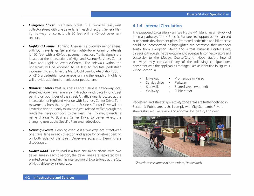
Duarte Station Specific Plan
4-2 Infrastructure and Services
• Evergreen Street. Evergreen Street is a two-way, east/west collector street with one travel lane in each direction. General Plan right-of-way for collectors is 60 feet with a 40-foot pavement section.
• Highland Avenue. Highland Avenue is a two-way minor arterial
with four travel lanes. General Plan right-of-way for minor arterials is 100 feet with a 60-foot pavement section. Traffic signals are located at the intersections of Highland Avenue/Business Center Drive and Highland Avenue/Central. The sidewalk within the underpass will be widened to 14 feet to facilitate pedestrian movement to and from the Metro Gold Line Duarte Station. South of I-210, a pedestrian promenade running the length of Highland will provide additional amenities for pedestrians.
• Business Center Drive. Business Center Drive is a two-way local street with one travel lane in each direction and space for on-street parking on both sides of the street. A traffic signal is located at the intersection of Highland Avenue with Business Center Drive. Turn movements from the project onto Business Center Drive will be limited to right-out only to limit project- related traffic through the residential neighborhoods to the west. The City may consider a name change to Business Center Drive, to better reflect the changing uses as the Specific Plan area redevelops.
• Denning Avenue. Denning Avenue is a two-way local street with one travel lane in each direction and space for on-street parking on both sides of the street. Driveways accessing Denning are discouraged.
• Duarte Road. Duarte road is a four-lane minor arterial with two travel lanes in each direction; the travel lanes are separated by a planted center median. The intersection of Duarte Road at the City of Hope driveway is signalized.
4.1.4 Internal Circulation The proposed Circulation Plan (see Figure 4-1) identifies a network of internal pathways for the Specific Plan area to support pedestrian and bike-centric development plans. Protected pedestrian and bike access could be incorporated or highlighted via pathways that meander south from Evergreen Street and across Business Center Drive, threading through the development to eventually connect visitors and passersby to the Metro’s Duarte/City of Hope station. Internal pathways may consist of any of the following configurations, consistent with the applicable Frontage Class as identified in Figure 3-2 (see Section 3):
• Driveway • Promenade or Paseo • Service drive • Parkway • Sidewalk • Shared street (woonerf) • Walkway • Public street
Pedestrian and streetscape activity zone areas are further defined in Section 3. Public streets shall comply with City Standards. Private streets shall require review and approval by the City Engineer.
Shared street example in Amsterdam, Netherlands
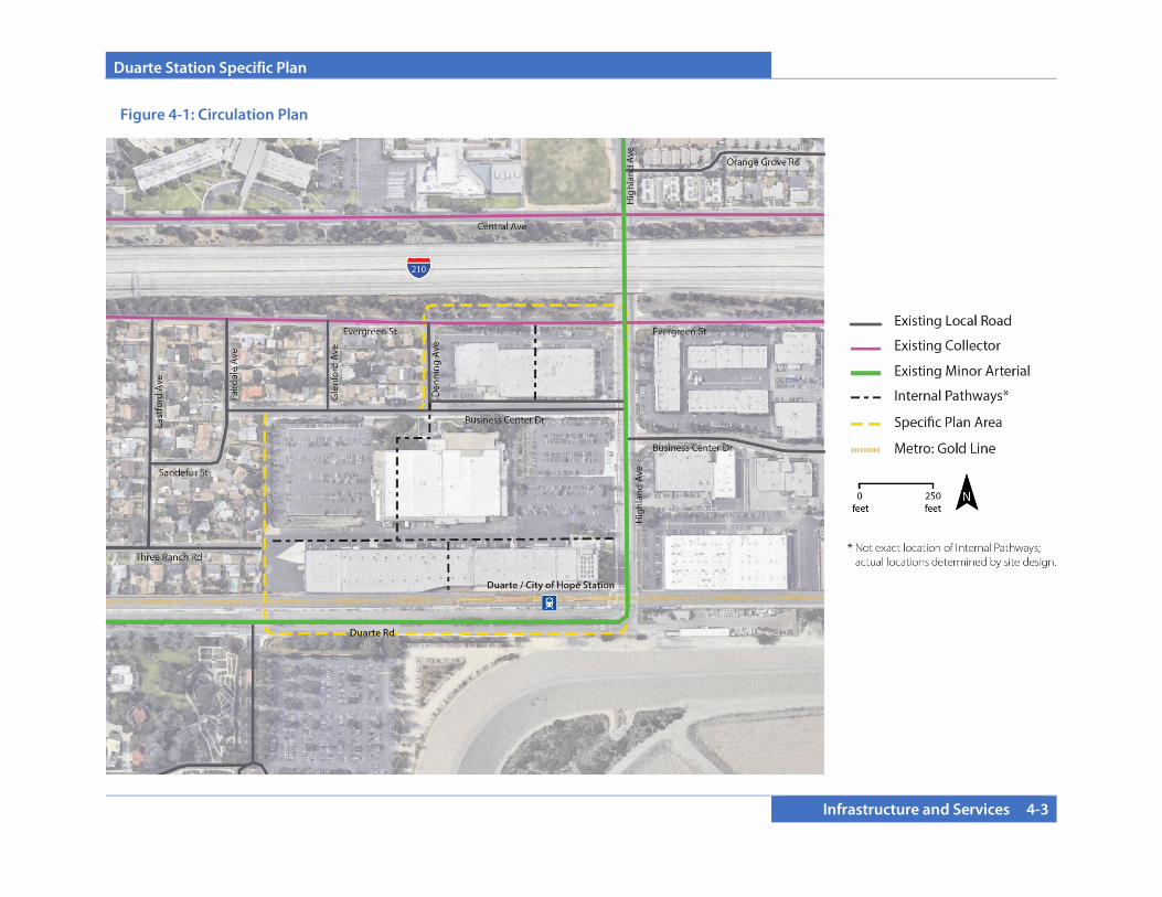
Duarte Station Specific Plan
Infrastructure and Services 4-3
Figure 4-1: Circulation Plan
Duarte Station Specific Plan
4-4 Infrastructure and Services
4.2. INFRASTRUCTURE PLAN
4.2.1 Domestic Water Service The City of Duarte lies within the San Gabriel Groundwater Basin. Water service is provided to the City by California American Water (Cal-Am). Cal-Am operates three division offices. Duarte is located under the Southern Division which incorporates the Los Angeles County District. This district consists of Baldwin Hills, Duarte, and San Marino service areas. Twelve-inch water mains exist in Evergreen Street and Highland Avenue. A 12-inch water main runs below Business Center Drive west of Highland Avenue. Smaller diameter lines (four-inch) are contained within occur Denning Avenue and Glenford Avenue. Proposed new buildings will be served by existing water lines through a series of laterals, estimated to range in diameter between six and 12 inches.
The project area lies within the so-called Scott Pressure Zone, which has a hydraulic gradient line (HGL) of 691 feet. This level is typically the pad elevation of the water reservoir that supplies water storage for the pressure zone. The HGL at the project area was noted as approximately 684 feet due to the pressure losses within the piping distribution system from the reservoir or booster pump station to the site area. The elevations of the site range from 496 to 479 feet. Therefore, pressure ranges between 88 to 81 pounds per square inch (psi).
It is anticipated that private meters and backflow devices would be required for domestic water service and/or separate fire lines. A more refined hydraulic analysis will be coordinated with Cal-Am for future design as individual projects move forward. This would accommodate higher fire flows that may be required for the taller proposed buildings. Upsizing the pipe along Denning Avenue may be required depending on the usage and fire flow need of the tenant in the northernmost parcel within the Specific Plan area (with frontage on Evergreen Street). Fire hydrants are present around the project boundary. Additional hydrants may be conditioned based upon the site layout at the time of site plan review. Fire flow requirements are based upon building size and building construction type. The latest fire regulations require all buildings to be equipped with a fire sprinkler system, including residential homes sites. Fire flow requirements previously provided for the existing structures may need to be increased due to new regulations. Site plans will be submitted to the fire authority in order to obtain a fire flow requirement based upon the tenant type, building size, and building type. The fire authority will also determine the flow and time period requirements based upon building and tenant type.

Duarte Station Specific Plan
Infrastructure and Services 4-5
Figure 4-2: Water Infrastructure Plan

Duarte Station Specific Plan
4-6 Infrastructure and Services
4.2.2 Sanitary Sewer Service Sanitary sewer services within the City are provided by the Los Angeles County Department of Public Works. Local sewer lines within Duarte are owned by the City. The Los Angeles County Department of Public Works (LACDPW) operates and maintains Duarte’s local wastewater conveyance infrastructure, which connects to the County Sanitation Districts of Los Angeles County (CSDLAC) regional trunk sewer lines. Wastewater is conveyed through the CSDLAC’s trunk sewer pipelines to the San Jose Creek Water Reclamation Plant (SJCWRP) located at 1965 Workman Mill Road in unincorporated Los Angeles County (adjacent to the City of Industry), and the Whittier Narrows Water Reclamation Plant (WNWRP) located at 301 North Rosemead Boulevard in the City of South El Monte. New developments are reviewed by the City of Duarte and the LACDPW, at which time an “area study” is conducted to determine the available capacity of local sewer lines that would serve the specific project. The Specific Plan area gradually slopes from northeast to southwest, with elevations of the site ranging from 496 to 479 feet. The following sewer pipelines exist adjacent to the Specific Plan area: • An eight-inch vitrified clay pipe (VCP) sewer line runs underneath
Evergreen Street A minimum slope of 0.4% is noted as the sewer slopes in the direction from east to west from Highland Avenue to Glenford Avenue.
• The eight-inch sewer line in Evergreen Avenue receives flows from the north via an eight-inch line. The sewer line in Evergreen Avenue continues south along Glenford Avenue.
• An eight-inch VCP sewer line within Business Center Drive slopes from east to west. It picks up lines from the north along Denning Avenue, Glenford Avenue, and Fairdale Avenue. It has a minimum slope of 0.64%.
• A County-owned 12-inch sewer line exists in Highland Avenue, the easterly boundary street of the site. The sewer line in Highland Avenue appears to receive flows from the easterly development along Business Center Drive and from the north, across I-210. The sewer grade of the 12-inch line is 0.6%. The 12-inch sewer line in Highland Avenue continues south to the trunk sewer in Duarte Road, where it flows westerly at a grade of 1.208%. The sewer line in Duarte Road is on the south side of the Gold Line tracks.
Sewage from the project area could be transferred to any number of sewer pipelines that surround the project. A preliminary sewer plan is outlined in Figure 4-3, Sanitary Sewer Plan; refined sewer layouts would be submitted as part of site plan submittals for individual development projects. All new developments within the Specific Plan area would be reviewed on a project-by-project basis by the City of Duarte to determine if local sewer lines have sufficient capacity to accommodate effluent from new development. The City may charge new developments a fee to upgrade or extend local sewer lines, which would be necessary to accommodate new developments. In addition, the LACDPW reviews new developments and assesses fees based on the maintenance of local sewer lines, which would be necessary to accommodate the specific project.

Duarte Station Specific Plan
Infrastructure and Services 4-7
Figure 4-3: Sewer Infrastructure Plan
Duarte Station Specific Plan
4-8 Infrastructure and Services
4.2.3 Drainage Plan
As of 2019, the only storm drain immediately adjacent to the site was a 24-inch storm drain in Highland Avenue. Development in the local vicinity drains via surface flow to the existing 30- to 42-inch storm drain which traverses the site. Los Angeles County Flood Control District has an easement for the existing storm drain. In its current (2019) state, site drainage consists of surface runoff flowing in a southwesterly direction to an above-ground swale in the parking area of the southern building. Runoff into the grated swale outlets into an existing 30-inch storm drain pipe that traverses the property from the east (Highland Avenue) towards 3 Ranch Road, the residential local road on the west side of the site. The project is located in Zone X as shown on Flood Insurance Rate Map (FIRM), meaning that the site is not within a designated flood plain. The proposed drainage plan (see Figure 4-4, Drainage Plan) shows the anticipated drainage system. Runoff shall be mitigated so that it supports implementation of implementation of the City's Enhanced Watershed Management Program (EWMP) and meets low-impact development (LID) standards. Excess stormwater flows will be conveyed in existing and proposed streets and driveways towards the existing 30-inch storm drain. Hydrology analysis for the project indicates that stormwater quantities in the build-out condition will be similar to existing quantities; therefore, no significant new drainage facilities must be constructed.
4.2.3.A Water Quality
The project is required to comply with the urban runoff pollution control provisions of Chapter 6.15 of the City’s Municipal Code, which regulates the treatment of stormwater runoff from development projects. Pollutant sources associated with the proposed development may affect the quality stormwater discharge from the site. Typical pollutants include greases and oils from cars and pesticides used in landscaping. New development within the Specific Plan area will utilize a variety of LID site drainage designs to manage stormwater, including but not limited to retention/infiltration basins, trenches, and above ground and/or below ground bio-treatment systems. The following menu of Best Management Practices for stormwater control will be used for each development phase in the development of a Final Water Quality Management Plan or equivalent: • Bioretention • Rainfall harvest and use (e.g. cisterns, rain barrels, planter areas,
permeable surfaces, drywells, French drains, etc.) • Vegetated filter strips • Green roofs • Infiltration trenches • Media filtration • Porous pavement (required) • Permeable surfaces (e.g. porous concrete/asphalt, block pavers,
open cell concrete, reinforced turf, etc.) • Other BMPs that may be approved by the City of Duarte or the
county-wide program in the future to address the 2012 NPDES Permit requirements
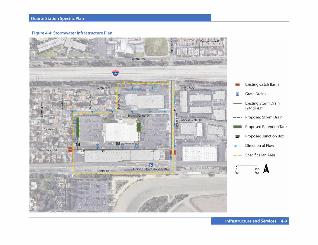
Duarte Station Specific Plan
Infrastructure and Services 4-9
Figure 4-4: Stormwater Infrastructure Plan
Duarte Station Specific Plan
4-10 Infrastructure and Services
4.2.4 Grading The site is generally flat, sloping northeast to southwest with elevations ranging from 496 to 479 feet. On-site parking lots are designed for positive drainage, sloping to parking lot area drains. No natural slopes or landforms are present. Due to the flat nature of the site, grading for the new development will be minor, consisting of demolition of existing buildings and asphalt parking areas, precise grading of the site of planned structures (which will be detailed at the site plan level of plan review once final architecture and site work has been designed), and placement of foundations for proposed new structures. Because of the flat nature of the site, no significant import or export of soil is expected as part of site development. Prior to issuance of a building permit for any of the proposed structures, a site plan approval will be required, including a precise grading plan based on final architectural design.
4.2.5 Public Services
4.2.5.A Schools
The Specific Plan area is within the Duarte Unified School District. Duarte High School and California School of the Arts–San Gabriel Valley Charter School are located in close proximity to the Specific Plan area. School fees will be paid at the time of building permits.
4.2.5.B Fire
Fire protection services are provided to the City by the County of Los Angeles Fire Department (LACFD). LACFD is divided into 22 battalions, each serving a territory or multiple cities in Los Angeles County. Battalion 16 provides service to Duarte, Covina, Baldwin Park, and Azusa. The battalion operates out of eight fire stations located within this service area. Fire Station #44 is located at 1105 S. Highland Avenue, in Duarte, less than 0.5 miles from the Specific Plan area.
4.2.5.C Police
Police protection services are provided to the City by the County of Los Angeles Sheriff’s Department. The Department has a satellite station located at 1042 Huntington Drive, located approximately ¾ miles from the Specific Plan area.
4.2.5.D Library The Duarte Library is operated by the County of Los Angeles Public Library System. The Duarte Library is located at 1301 Buena Vista Street, about ½ miles from the Specific Plan area.
4.2.5.E Solid Waste
Residential and commercial solid waste disposal is provided through a contract with a private waste hauler. The City is divided into several zones that designate when solid waste is collected during various weekdays. The contract hauler provides all residential and commercial customers with containers for solid waste collection.
4.2.5.F Cable, Internet, Telephone Communications infrastructure and service are provided by private telecommunications companies. Tenants and owners will be able to select from available providers.
4.2.5.G Natural Gas and Electricity Natural gas is provided to the City of Duarte by the Southern California Gas Company. Electric power service is provided by Southern California Edison. Both purveyors would provide natural gas and electricity to the site from existing facilities. Property owners and operators also may elect to install on-site electric power generation for their own use (e.g., solar panels).
Duarte Station Specific Plan
Administration 5-1
SECTION 5.0 ADMINISTRATION AND IMPLEMENTATION
5.1 ADMINISTRATION
5.1.1 Purpose and Overview The California Government Code (Title 7, Division 1, Chapter 3, Article 8, Sections 65450 et seq.) grants authority to cities to adopt Specific Plans for purposes of implementing the goals and policies of the City’s General Plan. The City of Duarte Municipal Code Chapters 19.22 and 19.150 establishes the purpose of and adoption procedures for Specific Plans. As with General Plans, the Planning Commission must hold a public hearing to consider and provide a recommendation on a Specific Plan to the City Council. This chapter outlines the steps necessary to implement the Duarte Station Specific Plan and the applicable conditions and regulations in coordination with City departments and other responsible public agencies. Approval of this Specific Plan, certification of CEQA documentation, and adoption of conditions of approval and a Mitigation Monitoring and Reporting Program will ensure that timely mitigation of project impacts and implementation of project conditions of approval occur at appropriate milestones.
5.1.2 Applicability All development within the Duarte Station Specific Plan area shall comply with the requirements and standards set forth in this Specific Plan and the accompanying CEQA documentation, conditions of approval, and Mitigation Monitoring and Reporting Program. Where conflicts exist between the standards in this Specific Plan and
standards in the Municipal Code, the regulations and standards in this Specific Plan shall take precedence. Any area of site development, administration, review procedures, environmental review, landscaping requirements, sustainability, and regulations not expressly addressed by this Specific Plan document shall be subject to the provisions of the City of Duarte Development Code, using the context and objectives of the Specific Plan as a guide. The regulations, development standards, and guidelines in the Specific Plan shall apply in their entirety in the review of development proposals, site plans, and building permits.
5.1.3 Adoption The Duarte Station Specific Plan and any amendments thereto will be approved in a manner consistent with California Government Section 65451, as well as Article 7 and Chapters 19.22 and 19.150 of the City’s Development Code. The Duarte Station Specific Plan will be adopted by ordinance and will serve as zoning for the Specific Plan project area.
5.1.4 Enforcement The Duarte Station Specific Plan implements General Plan policy applicable to the Specific Plan area. The City shall enforce the provisions of the Specific Plan in the same manner that the City enforces the provisions of the General Plan, Municipal Code, and Development Code.
5.1.5 Interpretation Any ambiguity concerning the content or application of the Duarte Station Specific Plan shall be resolved in accordance with the provisions of the Duarte Development Code, Chapter 19.04 (Interpretation). Such interpretations shall take into account the stated goals and intent of the Specific Plan.
Duarte Station Specific Plan
5-2 Administration
5.1.6 Appeals
An appeal of any determination, decision, or requirement of City staff, Community Development Director or designee, or the Planning Commission shall be made in conformance with the procedures established by the Development Code.
5.1.7 Specific Plan Modifications and Amendments
Final development plans for projects within the Specific Plan area may be adjusted or modified based on final design and engineering and the precise development plans of the project developer. Documentation of the proposed project, as modified, to support an implementing map, site plan, or use permit must be submitted for the review and approval of the Community Development Department Director or designee. The Community Development Director or designee shall have the authority to identify and approve, on behalf of the City, minor adjustments or modifications, as defined herein, which substantially conform to the approved Specific Plan.
5.1.7.A Substantial Conformance and Minor Modifications Minor modifications to the Duarte Station Specific Plan shall not require a Specific Plan Amendment and shall be subject to a substantial conformance determination, an administrative mechanism by which minor modifications to the Specific Plan that are consistent with the intent of the Plan shall be permitted without a formal amendment process. The Community Development Director shall make determinations of substantial conformance. Minor modifications that meet the Substantial Conformance determination may be warranted to accommodate changes resulting from final design and engineering that cause adjustments to: Location of utilities or other infrastructure
Development of innovative product design
Modifications to open space standards to facilitate innovative
open space strategies with substantial amenities Density transfers from one development site to another
Modifications to the size of the conceptual Highland Avenue
Promenade public plaza space Other similar modifications deemed to be minor and that
implement the provisions of the plan. Minor modifications or technical adjustments may include, but are not limited to the following: • Modifications necessary to comply with final Conditions of
Approval or mitigation measures • Addition of information to the Specific Plan (including maps
or text) for purposes of clarification that does not change the intent of any plan or regulation, as well as correction of any clerical or grammatical errors
• Adjustments to the alignment, location, and sizing of utilities
and facilities or a change in utility and/or public service provider may be approved by the City’s Engineering or Public Works Department, so long as the adjustments or changes are found to be in compliance with applicable plans and standards of the agency responsible for such utilities and facilities
• An adjustment of any Specific Plan development standard, not
to exceed 20% of that development standard
Duarte Station Specific Plan
Administration 5-3
• Variation in the number and type of dwelling units or square footage of non-residential uses within the Specific Plan that may occur at the time of design, depending on the residential or commercial product identified for development with a particular land use designation
• Minor adjustments to any of the development standards or
regulations, such as modification of wall heights for noise attenuation purposes, modification of allowable encroachments into setbacks, etc. that are specifically allowed under the Development Regulations of this Specific Plan
• Minor changes to the architectural design guidelines, which
guidelines are intended to be conceptual in nature and flexible in implementation
• Modification of any design element in this Specific Plan that
improves circulation, reduces grading, improves drainage, improves infrastructure, or provides similar utility and reduces operations and maintenance costs
The minor modifications described above are not comprehensive. Any modification that is deemed by the Community Development Director to be in substantial conformance with the purpose and intent of the Specific Plan shall be permitted. The documentation of substantial conformance may include text and/or maps that describe the nature of all proposed modifications or adjustments to the Specific Plan. This application of substantial conformance with the adopted Specific Plan shall undergo any necessary technical review by City agencies and the Community Development Director or designee deems necessary to provide for updated conditions of project approval.
5.1.7.B Amendments to the Specific Plan If a project applicant seeks a modification or adjustment to the Specific Plan that is deemed by the Community Development Director to be a substantial modification, the Community Development Director shall have the discretion to refer any such requests to the City’s Planning Commission for review and consideration. Substantial amendments to the Specific Plan require a public hearing before the Planning Commission, which will make a recommendation to the City Council for action. The City Council may approve, deny, or conditionally approve amendments to the Specific Plan.
An amendment to the Specific Plan is required if the following occur:
• Changes to the overall Specific Plan boundaries, including an expansion of the Specific Plan area (changes to frontage class designations within the Specific Plan boundaries are deemed minor as noted above and would not require an amendment)
• A change in any other provision, purpose, or standard of the
Specific Plan which, as determined by the Community Development Director, would significantly alter the basic intent, spirit, identity, or concepts of the Specific Plan
• An increase in the overall development density and height
thresholds within the Specific Plan, except as otherwise allowed for affordable housing
An applicant may request amendments to the Duarte Station Specific Plan at any time pursuant to Section 65453(a) of the Government Code. An amendment to the Specific Plan requires public hearings, a recommendation by the City’s Planning Commission, and approval by the City Council. Specific Plan amendments are governed by California Government Code, Section 65456, and require an application and fee to be submitted to the City’s Community Development Department.

Duarte Station Specific Plan
5-4 Administration
The application shall state in detail the reasons for the proposed amendment. The Duarte Station Specific Plan shall not be amended unless the following findings are made by the Planning Commission and City Council:
• The Specific Plan Amendment implements and is consistent
with the General Plan in compliance with Government Code Section 65454;
• The Specific Plan Amendment allows for a coordinated and
cohesive development; and • The Specific Plan Amendment provides for the construction,
improvement, or extension of transportation facilities, public utilities, and public services required for the long-term needs of the project and/or other area residents and complements the orderly development of the City of Duarte.
5.2 IMPLEMENTATION
5.2.1 Mitigation Monitoring and Reporting Program
The Final EIR and Supplemental EIR prepared for this Specific Plan include a Mitigation Monitoring and Reporting Program that identifies implementing actions for development. The Mitigation Monitoring and Reporting Program is on file with the City and shall be adhered to as part of project implementation.
5.2.2 Implementation Mechanisms
As envisioned in this Specific Plan, any mix of uses are permitted within the Specific Plan area with no subsequent discretionary review other than Site Plan/Design Review and/or Conditional Use Permit approvals or additional environmental review under CEQA, provided that the mix of uses meets the requirements of the Implementation Mechanisms established by this Section. The Implementation Mechanisms control the ultimate buildout of the Specific Plan through development regulations, including allowable uses, building heights, density restrictions, and open space standards. These are summarized in Table 5-1.
Proposed projects will be analyzed in terms of consistency with the allowable uses and required development standards, as outlined in Section 3 of this document. Adjustments to the amount, intensity, or mix of uses may occur if consistent with the Specific Plan, subject to approval by the Community Development Director. 5.2.2.A Compliance with Development Regulations
Proof of compliance with the following regulations (summarized from Section 3) must be submitted as part of any submittal for a project within the Specific Plan area.
• Permitted Uses. The ultimate mixture of uses within the Specific plan area shall consist entirely of land uses permitted or conditionally permitted in Section 3, Development Standards and Design Guidelines of this Specific Plan.
General Development Standards. Building heights, setbacks,
and ground floor design shall be reviewed and approved by the Community Development Department as part of the site plan/design review process. Development must meet the

Duarte Station Specific Plan
Administration 5-5
parking standards established in Section 3, Development Standards and Design Guidelines, or provide a parking study to show actual parking need for a particular project. Parking may be reduced if demand can be shown to be below the parking standards in this Specific Plan and/or demand is decreased by measures such as a car-share or bike-share located on site, transit priority passes, or other measures as determined by the parking study. Development projects must meet the open space and signs standards established in Section 3, Development Standards and Design Guidelines.
• Density Restrictions. Development must not exceed the
density restrictions of 90 dwelling units per acre (not including any affordable units) for all residential uses. Refer to Section 3, Development Standards and Design Guidelines.
• Frontage Class Standards. Based on frontage class/location,
properties have unique requirements to enhance the public realm and provide appropriate building design. Development shall comply with Frontage Class standards and requirements.
• Design Standards and Guidelines. Projects shall comply with
mandatory standards and should comply with guidelines, unless a compelling reason can be made not to comply with a particular guideline and to continue to meet the intent.
• Substantial Conformance. Substantial conformance
determinations may be required. • Subdivisions. As needed, subdivision regulations shall be met.
To ensure that development proposals are consistent with the Implementation Mechanisms described in this section, the following information shall be completed and submitted with proposals for development, along with a table that documents the project data to be retained by the Community Development Department.
Table 5-1: Specific Plan Consistency Checklist
Requirement Description Conformance
1. Permitted Uses Land Uses Permitted or Conditionally Permitted in Section 3, Development Standards and Guidelines.
2. General Development Standards
Building heights, setbacks, ground floor design, parking, open space, and signs shall be reviewed and approved by the Community Development Director as part of the site plan review process.
3. Density
The density of all market-rate residential uses does not exceed 90 dwelling units per gross acre. Refer to Section 3.
4. Frontage Class Standards
Frontage Class standards, as established in Section 3 are met.
5. Façade Type Standards
Façade Type standards, as established in Section 3 are met.
6. Design Standards and Guidelines
Site Planning, General Building Design, Design by Building Type, Adaptive Reuse Design (as applicable) and Landscape, Hardscape, Furnishings, and Lighting Design established in Section 3 are met.
7. Substantial Conformance
Per Section 5.1.7 of this Specific Plan, as needed.
8. Subdivisions Per Section 5.2.3 of this Specific Plan, as needed.
The checklist shall be completed and submitted with the development proposal. Check if the proposed project fully complies with each respective requirement.

Duarte Station Specific Plan
5-6 Administration
5.2.3. Subsequent Approvals and Plans Several levels of subsequent or concurrent approvals are required to implement the project. 5.2.3.A Subdivision Maps
All subdivision maps filed for properties within the Specific Plan area shall be filed and processed in accordance with the Subdivision Map Act and Chapter 19.72 of Article 5 of the City of Duarte Development Code. Tentative maps shall be consistent with the vision and sustainable community design standards of this Specific Plan. These maps, once recorded, will create buildable parcels and road rights-of-way and/or private streets. 5.2.3.B Project Approval Process
1. Project Consistency Determination. Prior to site plan submittal to the Architectural Review Board (ARB), the Community Development Director shall make a finding of project consistency with the Specific Plan. Project consistency shall be determined based on review of (1) the Specific Plan’s land use and design requirements and regulations and (2) development capacities and alternatives analyzed in the Duarte Station Draft Subsequent Environmental Impact Report (EIR) and the California Environmental Quality Act (CEQA) Guidelines applicable at the time of project application.
2. Site Plan and Design Review. Developers within the Specific
Plan are required to submit a completed Site Plan and Design Review application with completed development and architectural plans for all projects to the Planning, Building and Safety, and Public Works/Engineering Divisions of the City of Duarte Community Development Department. Plans may also be required by additional departments such as fire, sheriff,
or any other departments where review is deemed necessary by the City. The standards for approval of the Site Plan and Design Review of projects shall be in accordance with Chapter 19.122.040 D. of the Development Code in addition to the following:
• The project implements the overarching intent of this
Specific Plan; • The project adheres to the land use and development
standards in this Specific Plan; and • The project is in substantial conformance with the site
planning and design guidelines contained in Section 3 of this Specific Plan. Where guidelines or criteria conflict with the Standards of Review in Chapter 19.122.040 D. of the Development Code, the provisions of the Specific Plan shall prevail.
3. Approving Authority. Approving authority for Site
Plan/Design Review shall be as identified in the Duarte Development Code.
4. Conditional Use Permits. The process and requirements for conditional uses shall be in accordance with the Duarte Development Code.
5.2.3.C Phasing
Construction of the Duarte Station Specific Plan, including recordation of final subdivision map(s), site plan and design review, and actual construction of buildings, roads, and infrastructure may occur progressively in stages, provided vehicular access, public facilities, and infrastructure are constructed to adequately service the development,
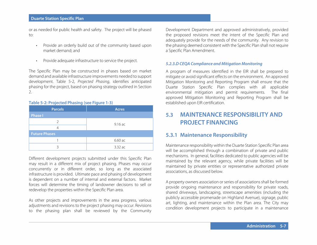
Duarte Station Specific Plan
Administration 5-7
or as needed for public health and safety. The project will be phased to:
• Provide an orderly build out of the community based upon market demand; and
• Provide adequate infrastructure to service the project. The Specific Plan may be constructed in phases based on market demand and available infrastructure improvements needed to support development. Table 5-2, Projected Phasing, identifies anticipated phasing for the project, based on phasing strategy outlined in Section 2. Table 5-2: Projected Phasing (see Figure 1-3)
Different development projects submitted under this Specific Plan may result in a different mix of project phasing. Phases may occur concurrently or in different order, so long as the associated infrastructure is provided. Ultimate pace and phasing of development is dependent on a number of internal and external factors. Market forces will determine the timing of landowner decisions to sell or redevelop the properties within the Specific Plan area. As other projects and improvements in the area progress, various adjustments and revisions to the project phasing may occur. Revisions to the phasing plan shall be reviewed by the Community
Development Department and approved administratively, provided the proposed revisions meet the intent of the Specific Plan and adequately provide for the needs of the community. Any revision to the phasing deemed consistent with the Specific Plan shall not require a Specific Plan Amendment.
5.2.3.D CEQA Compliance and Mitigation Monitoring
A program of measures identified in the EIR shall be prepared to mitigate or avoid significant effects on the environment. An approved Mitigation Monitoring and Reporting Program shall ensure that the Duarte Station Specific Plan complies with all applicable environmental mitigation and permit requirements. The final approved Mitigation Monitoring and Reporting Program shall be established upon EIR certification.
5.3 MAINTENANCE RESPONSIBILITY AND PROJECT FINANCING
5.3.1 Maintenance Responsibility Maintenance responsibility within the Duarte Station Specific Plan area will be accomplished through a combination of private and public mechanisms. In general, facilities dedicated to public agencies will be maintained by the relevant agency, while private facilities will be maintained by private entities or representative authorized private associations, as discussed below. A property owners association or series of associations shall be formed provide ongoing maintenance and responsibility for private roads, shared driveways, landscaping, streetscape amenities (including the publicly accessible promenade on Highland Avenue), signage, public art, lighting, and maintenance within the Plan area. The City may condition development projects to participate in a maintenance
Parcels Acres
Phase I
2 9.16 ac
4
Future Phases
1 6.60 ac
3 3.32 ac
Duarte Station Specific Plan
5-8 Administration
district to address maintenance responsibilities for public areas and amenity spaces such as the Highland Promenade. 5.3.2 Public Art All development projects valued over $1,000,000 shall be subject to a public art fee equal to one quarter of one percent (0.25%) of the total building valuation. In lieu of the public art fee, the project may provide a piece of public art subject to the approval of the City. Public art fees may be used for art pieces, themed project signs, construction of the Highland Promenade, or other similar public amenities focused on creating a sense of place.
5.3.3 Financing Mechanisms It is expected that a range of funding tools will be tapped to finance transit village development, associated infrastructure, and ongoing operation. As noted earlier, responsibility for implementing these tools will fall to the City, other governmental agencies, private entities, and authorized private associations such as homeowners or business associations. The funding sources identified here are examples. A more comprehensive list may be developed over time as new sources come into being or sources listed here are no longer available. The ultimate mix of financing mechanisms will be determined in the implementation process based on final technical analyses of costs, benefits, and burdens, and on deliberations involving City staff, sponsoring entities, property owners, developers, elected officials, bond counsel, underwriters, finance experts, and others. Regardless of the financing mechanisms selected, any approach should seek to align the sources, timing, and scope of financing to the specified uses, as described by the following principles:
• There should be assurances that necessary funding will be available at the time specific infrastructure items are required.
• Financial burdens on development should be kept within
industry standards and market constraints. • The plan should be responsive to expected variations in
timing, location, and type of development.
The financing tools and their applicability fall into three distinct categories discussed below. 5.3.2.A Area-Specific Fees, Dedications, And Exactions
Area Development Impact Fees. Area development impact fees may be enacted by a legislative body (i.e., city or county) through adoption of an ordinance. Such fees do not require a public vote to be enacted, but they do require public hearings. Area development impact fees must be directly related to the benefits received. Specifically, State law requires that impact fees be shown to have a “rational nexus” or relationship between costs and the impact or demand caused by the new development. They do not create a lien against property but must be paid in full as a condition of approval. Fees are established so that owners/developers of these properties pay their fair share at the time the properties are ready to be developed. Benefiting properties may be given the option to finance the fees by entering into an Assessment District (AD) or Mello-Roos Community Facility Districts (CFD). (See description of these financing mechanisms below.) Dedications and Exactions. Under the Subdivision Map Act, developers may be required to dedicate land or make cash payments for public facilities required or affected by their project (e.g., road right-of-way fronting individual properties). Dedications are typically made for road and utility rights-of-way, park sites, and land for other public facilities. Cash contributions may be made for other public facilities

Duarte Station Specific Plan
Administration 5-9
that are directly required by their projects (e.g., payments for a traffic signal). Net New General Fund Revenues. The City of Duarte may elect to use General Fund revenues to help offset the cost of public infrastructure provision. Such a policy might be justified in light of the fact that the proposed Specific Plan area will generate significant fiscal benefits. These benefits may be used to back the issuance of tax-exempt bonds. Joint Development. Metro’s Joint Development Program provides a framework for public-private partnerships that guides how private entities may conduct development on Metro-owned land to further the agency’s goals of increasing ridership and reducing auto use by directly linking Metro’s transportation network with retail, commercial, and housing opportunities. For the Duarte station area, Metro will require land in the Plan Area for surface parking. This land could not only provide additional developable area for commercial and residential uses and increase development density on the site, it could effectively provide—by means of below-market ground rent—a source of assistance to help catalyze further development. 5.3.2.B Assessment and Special Tax-Secured Financing
Infrastructure Financing District and Enhanced Infrastructure Financing District. Qualified entities can create an Infrastructure Financing District (IFD), per the 1990 Infrastructure Financing Act, to pay for the construction of capital facilities that have “communitywide significance and provide significant benefits to an area larger than the area of the district.” Such facilities may include transit, highways, water systems, sewer projects, flood control, childcare facilities, libraries, parks, and solid waste facilities. Broader authority of Enhanced Infrastructure Financing Districts (EIFD) is provided in Government Code Section 53398.50 et seq.
An IFD or EIFD provides funding by diverting a portion of property tax increment revenue for 30 years to secure the issuance of bonds to finance qualifying projects. The IFD increment is defined as total annual property tax revenue within the district, less a base year amount, less the portion allocated to schools, less the portion claimed by agencies that did not voluntarily approve the IFD formation. As such, IFD tax increment is less than that once generated as redevelopment tax increment, possibly significantly less depending on the specific conditions of each IFD approval. In the past, the difficulty in implementing an IFD has limited its use in California. However, in 2014 and 2016, legislation was adopted that updates the 1990 Infrastructure Finance District (IFD) law, approved in 1990, by expanding the types of projects that can be funded with EIFDs and lowering voter approval requirements, making this type of financing a much more viable option. Voter approval is not required to form an EIFD, however there is a 55% requirement to authorize bonds. Where an IFD makes the tax increment available for up to 30 years, the EIFD extends that timeline to 45 years. The City may consider coordinating the Duarte Station Specific Plan with Town Center Specific Plan and City of Hope Master Plan areas for the purpose of infrastructure financing, as the relatively small size of each area alone may constrain the range of financing options. Together, the City of Hope Master Plan, Town Center Specific Plan, and Duarte Station Specific Plan anticipate a substantial growth in the employment and residential bases of the City, which will increase demand for commercial and residential uses and lead to greater area-wide motorized and non-motorized circulation. Coordinated development and financing of supportive infrastructure improvements could allow for cost sharing, implementation scale economies, access to TOD-oriented financing resources, and possibly also the establishment of a tax-increment-secured tool such as an EIFD or a Community Revitalization and Investment Authority (CRIA).

Duarte Station Specific Plan
5-10 Administration
Special Assessment Districts (1911, 1913, 1915 Acts). California law provides procedures to levy assessments against benefiting properties and issue tax-exempt bonds to finance public facilities and infrastructure improvements. Assessment districts, also known as improvement districts, are subject to majority vote of property owners. Votes are weighted according to the amount of the proposed assessment on the parcel to which the ballot pertains. Assessments are distributed in proportion to the benefits received by each property as determined by engineering analysis and form a lien against property. Special assessments are fixed dollar amounts and may be prepaid, although they are typically paid back with interest over time by the assessed property owner. Only public infrastructure improvements with property-specific benefits (e.g., roads, drainage, and sewer and water improvements) may be financed with assessments. In addition, standard public finance underwriting criteria require that the ratio of improved land value to assessment lien be equal to or greater than three to one. Mello-Roos Community Facilities Districts (CFD). California’s Mello-Roos Community Facilities Act of 1982 allows for the creation of a special district authorized to levy a special tax and issue tax-exempt bonds to finance public facilities and services. A CFD may be initiated by the legislative body or by property owner petition and must be approved by a two-thirds majority of either property owners or registered voters (if there are more than 12 registered voters living in the area). Special taxes are collected annually with property taxes and may be prepaid if such provisions are specified in the tax formula. The special tax amount is based upon a special tax lien against the property. There is no requirement that the tax be apportioned on the basis of direct benefit. Because there is no requirement to show direct benefit, Mello-Roos levies may be used to fund improvements of general benefit such as major utilities, fire and police facilities, and libraries and parks, as well as improvements that benefit specific properties. The provision also
allows for the allocation of cost burdens to alleviate burdens on specific classes of development. The potential for a CFD supporting the Duarte Station Specific Plan could be significant if the district boundaries include industrial uses east of the site and City of Hope to the south. 5.3.2.C Federal and State Grants
The City has in the past received funding for public facilities from other levels of government, including regional agencies (e.g., Metro and the Southern California Association of Governments), and the State and Federal governments. Funds from these sources, a selection of which is shown in the following table, may be made available for development in the Plan Area, especially as transit is a preferred public use. The availability, amount, and timing of these funds will need to be further evaluated.
Metro Gold Line Duarte Station, 2019

Duarte Station Specific Plan
Administration 5-11
Table 5-3: Federal and State Funding Sources
Program Description
Transportation Alternatives (TA)
Transportation Alternatives consolidates three separate programs under the prior version of the Federal Aid Highway Program: Transportation Enhancements (TE), Safe Routes to School (SR2S), and the Recreational Trails Program (RTP). Of these, TE and SR2S are particularly relevant to opportunities in the Plan Area. TE funds may be used for the planning, design, and construction of bicycle and pedestrian infrastructure such as bikeways, sidewalks, signaling and signage, traffic management techniques, and improvements designed for ADA compliance. SR2S funds are intended to finance healthy alternative approaches to driving or using the bus to go to school on projects within two miles of primary or middle schools. SR2S funds may be used for a range of engineering, traffic calming, and educational projects.
Surface Transportation Program (STP)
The Surface Transportation Block Grant Program (STP) allocates funds that can be used for a wide range of projects, including road and transit improvements that include bicycle and pedestrian elements. STP provides flexibility to fund improvements that are outside the Federal aid highway system, so many streets near the Plan Area may be eligible.
Congestion Mitigation and Air Quality Improvement (CMAQ) Program
The CMAQ program is designed to provide funding to support surface transportation projects and other related efforts that contribute to air quality improvements and provide congestion relief. Eligible projects are intended to lower emissions of ozone, carbon monoxide, and/or particulate matter.
Transit-Oriented Development Planning Pilot
This pilot program provides funding to advance planning efforts that support transit-oriented development (TOD) associated with new fixed-guideway and core capacity improvement projects. Eligible recipients include State and local government agencies engaged in comprehensive planning that seeks to enhance economic development and ridership by means of increasing multimodal connectivity and accessibility, enhancing access to transit hubs for pedestrian and bicycle traffic, and promoting and enabling mixed-use development.
AB 2766 Clean Air Funds
The South Coast Air Quality Management District (AQMD) administers this program to fund air pollution reduction efforts. Funding is drawn from automobile registration surcharges. A 40 percent portion of annual disbursement is automatically allocated to South Coast District member cities in proportion to population. The remaining 60 percent is allocated through a competitive grant program for projects that improve air quality. Nearly all Plan Area initiatives may potentially be eligible for funding from AB 2766 grants.
Bicycle Transportation Account (BTA)
Caltrans administers the Bicycle Transportation Account (BTA), an annual program providing State funds for city and county projects that improve safety and convenience for bicycle commuters. Cities and counties are eligible to apply for BTA funds. Eligibility is based on pre-adoption of a Bicycle Transportation Plan (BTP) that complies with Streets and Highways Code Section 891.4 that has been pre-approved by the appropriate Metropolitan Planning Organization (MPO) or Regional Transportation Planning Agency (RTPA). Eligible uses for the funding include bikeways and related facilities, planning, safety, and education. The BTA is a reimbursement program, which requires allocated funds to be matched by at minimum 10 percent of the total project cost. BTA funds may also be used to apply for and match Federal grants or loans. Approximately $7.2 million is appropriated annually for the program statewide.

Duarte Station Specific Plan
5-12 Administration
Table 5-3: Federal and State Funding Sources
Program Description
California Transit Oriented Development (TOD) Housing Program
This program, funded by the California Department of Housing and Community Development, makes low-interest loans available as gap financing for rental housing developments that include affordable units, and as mortgage assistance for homeownership developments. Loans and grants are available to qualified public entities for infrastructure improvements supporting TOD residential uses or to enable connections between these developments and the transit station
Community Based Transportation Planning
Caltrans administers a grant program for transportation planning projects to improve mobility and lead to the programming or implementation phase for a community or region. With approximately $9 million in funding distributed through six grant programs annually, the program may offer the City of Duarte additional funding for planning. Each of these six grant programs may be applicable for the Plan Area: Community-Based Transportation Planning, Environmental Justice, Partnership Planning, Statewide or Urban Transit Planning Studies, Rural or Small Urban Transit Planning Studies, and Transit Planning Student Internships.
Environmental Enhancement and Mitigation Program
Caltrans and the California Natural Resources Agency administer the Environmental Enhancement and Mitigation Program, which offers $10 million each year in grants for projects that relate to the environmental impact associated with the modification of an existing transportation facility or construction of a new transportation facility. Of the four grant categories available, two may apply to the Plan Area, area, including grants for Highway Landscaping and Urban Forestry Projects to offset vehicular emissions through planting of trees and other suitable plants, and grants for Mitigation Projects Beyond the Scope of the Lead Agency responsible for assessing the environmental impact of the proposed transportation improvement.
Office of Traffic Safety (OTS)
The California Office of Traffic Safety (OTS) was created to award grant dollars to local and state government departments for development of traffic safety programs. The office is in the state Business, Transportation and Housing Agency, and it functions as a conduit for federal grant money, which it allocates to eight separate program areas, of which two, for Pedestrian and Bicycle Safety and Roadway Safety, may be directly applicable to the Plan Area. City agencies are eligible to apply.
State-Local Transportation Partnership Program
The State-Local Transportation Partnership Program (SLTPP), administered by Caltrans, is intended to help local agencies fund and construct transportation improvement projects both on and off the State Highway System. The SLTPP is funded by the State Highway Account and is allocated to projects that increase transportation capacity, extend service to a new area, or extends a roadway’s useful life.
Transportation Development Act Article 3 Funds
The Transportation Development Act (TDA) includes two separate public transportation funds—Local Transportation Fund (LTF) and the State Transit Assistance fund—designated for development and support of public transportation needs. Funding is allocated to areas of each county based on population, taxable sales and transit performance. TDA funds may be used for many potential expenses that the transit village may generate, including engineering expenses, right-of-way acquisition, construction, improvements to existing pedestrian infrastructure, ADA compliance, and support facilities, such as transit shelters, bicycle parking, and pedestrian amenities.
Better Utilizing Investments to Leverage Development (BUILD)
Originally known as the TIGER Grant program and administered by the Federal Department of Transportation (DOT), this funding program began with American Recovery and Reinvestment Act of 2009 (ARRA). Nearly $7.1 billion in discretionary grant money has been dedicated to build and repair freight and passenger transportation networks.
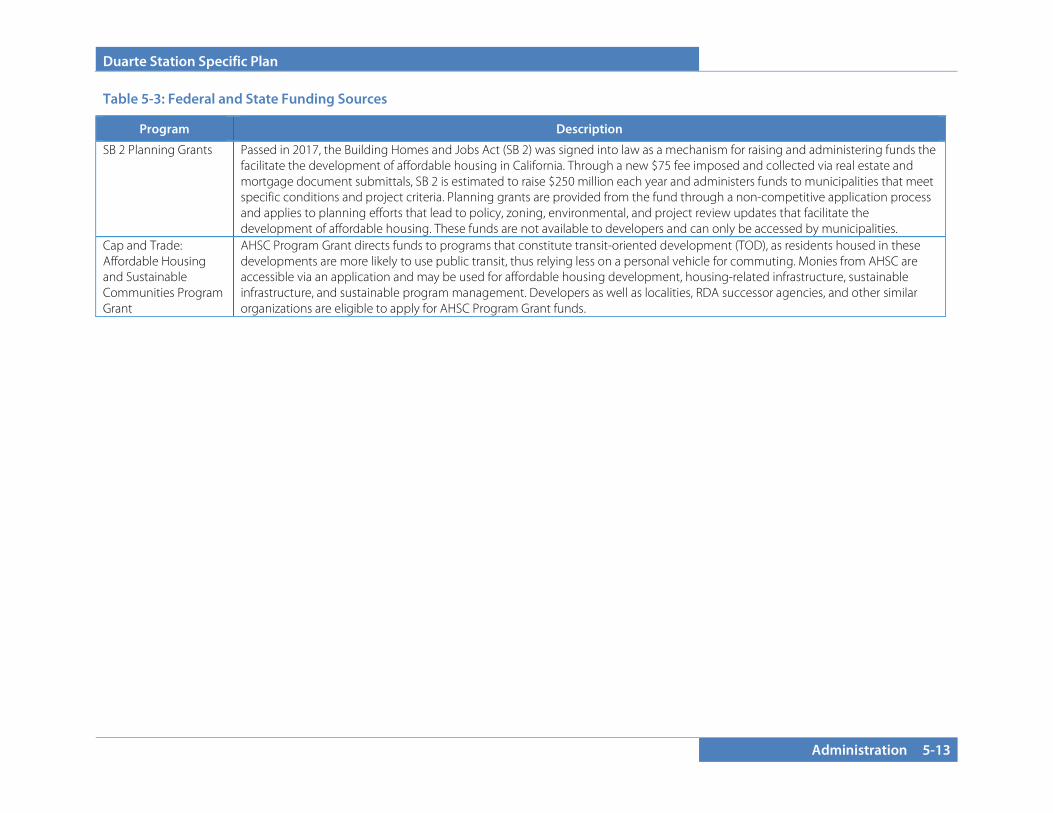
Duarte Station Specific Plan
Administration 5-13
Table 5-3: Federal and State Funding Sources
Program Description
SB 2 Planning Grants Passed in 2017, the Building Homes and Jobs Act (SB 2) was signed into law as a mechanism for raising and administering funds the facilitate the development of affordable housing in California. Through a new $75 fee imposed and collected via real estate and mortgage document submittals, SB 2 is estimated to raise $250 million each year and administers funds to municipalities that meet specific conditions and project criteria. Planning grants are provided from the fund through a non-competitive application process and applies to planning efforts that lead to policy, zoning, environmental, and project review updates that facilitate the development of affordable housing. These funds are not available to developers and can only be accessed by municipalities.
Cap and Trade: Affordable Housing and Sustainable Communities Program Grant
AHSC Program Grant directs funds to programs that constitute transit-oriented development (TOD), as residents housed in these developments are more likely to use public transit, thus relying less on a personal vehicle for commuting. Monies from AHSC are accessible via an application and may be used for affordable housing development, housing-related infrastructure, sustainable infrastructure, and sustainable program management. Developers as well as localities, RDA successor agencies, and other similar organizations are eligible to apply for AHSC Program Grant funds.
Duarte Station Specific Plan
5-14 Administration
This page intentionally left blank.
Duarte Station Specific Plan
Appendix 6-1
SECTION 6.0 APPENDIX
6.1 GENERAL PLAN CONSISTENCY ANALYSIS
6.1.1 Safety Element Safety Goal 4: To minimize the risks to lives and property due to seismic activity.
Consistency Statement: The Duarte Station Specific Plan will directly implement the Safety Goal above. Future construction within the Specific Plan would be performed in accordance with all applicable state and local building regulations, including the 2010 California Building Code and all applicable sections of the Duarte Development Code. Furthermore, each development project would be reviewed by applicable divisions of the Community Development Department as well as any additional necessary City departments prior to construction.
6.1.2 Open Space and Conservation Element Conservation Goal 2: To protect and maintain the local water supply to ensure that the city's growing demand for water can be met.
Conservation Goal 3: To protect Duarte’s environment through proper consideration of the environmental implications of new development in the city.
Open Space Goal 1: Protect and/or enhance Duarte’s Open Space acreage.
Open Space Goal 3: To provide parks throughout the city, on a pedestrian scale as much as possible. Neighborhood parks generally should have a one-half mile service radius.
Air Quality Goal 1: Create Land Use policies that address the relationship between land use and air quality to protect public health and minimize impacts on existing land use patterns and future land use developments.
Policy AQ 1.1.2: Promote and support mixed-use land patterns that allow the integration of retail, office, institutional and residential uses.
Objective 1.2: Reduce mobile source emissions by reducing vehicle trips and vehicle miles traveled associated with land use patterns.
Policy AQ 1.2.1: Establish a Mixed-Use Zoning District that offers incentives for mixed-use developments.
Policy AQ 1.2.2: Create opportunities to receive State transportation funds by adopting incentives (e.g. and expedited review process) for planning and implementation infill development projects that include job centers and clean transportation nodes (e.g. preparation of a “transit village” plan).
Air Quality Goal 2: Reduce air pollution from mobile sources.
Objective 2.1: Reduce motor vehicle trips and vehicle miles traveled.
Duarte Station Specific Plan
6-2 Appendix
Consistency Statement: The Duarte Station Specific Plan will directly implement the Open Space and Conservation Goals, Objectives, and Policies listed above. The Duarte Station Specific Plan would be constructed in accordance with the City’s sustainable practices, which are listed in the City’s Development Code and reflected in the Specific Plan Goals and Objectives in Section 2 of this Specific Plan. Considerations have been taken to fully understand and analyze environmental implications associated with the project, as well as mitigate any adverse impacts to the fullest extent feasible.
A minimum of 200 square feet of open space is required per residential unit (with incentives to provide private open space for units). Nonresidential uses must present a group open space plan. The specific plan encourages amenity-rich open spaces and requires a building setback and dedication/easement to facilitate a 25-foot publicly accessible promenade space along Highland Avenue. These will provide spaces for patrons of the Duarte Station Specific Plan to enjoy passive open spaces. Development regulations governing construction within the Specific Plan area are created to regulate building placement, form, massing, and even aesthetics on a human/pedestrian-oriented scale.
The creation of a “transit village” reduces automobile traffic trips, and therefore reduces air pollution. By centering employment, retail, and travel amenities along a major rail corridor, automobile trips for employees or patrons will be reduced. The Duarte Station Specific Plan integrates a mixture of land uses that complement one another for maximum land use efficiency and yield.
6.1.3 Land Use Element Land Use Goal 1: Maintain a balanced community consisting of various residential housing types and densities, commercial activities, industrial development, mixed use where appropriate, and open space.
Land Use Goal 2: Develop compatible and harmonious land uses by providing a mix of uses consistent with projected future social, environmental and economic conditions.
Policy LU 2.1.1: New infill residential development should be compatible in design, bulk, and height with existing nearby residential development as referenced in Duarte’s Architectural Design Guidelines.
Land Use Goal 3: Provide unique areas to better serve the needs of Duarte residents and businesses.
Objective 3.1: Improve the land use mix in selected areas so that it generates synergies and convenience to patrons and residents.
Policy LU 3.1.1: Develop Specific Plan areas which will provide the flexibility needed to make these places unique.
Policy LU 3.1.4: Create a flexible mixed-use Transit Oriented Development Specific Plan for the current non-residential area north of the Duarte Station.
Consistency Statement: The Duarte Station Specific Plan will directly implement the Land Use Goals, Objectives, and Policies listed above. The Specific Plan proposes a mixture of land uses centered on the Metro Gold Line Duarte Station that will complement one

Duarte Station Specific Plan
Appendix 6-3
another in a transit-oriented development. Future development would be infill in nature and would be compatible with surrounding land uses through application of design guidelines and development regulations which provide for buffer areas and architectural transitions adjacent to existing residential uses. The Duarte Station Specific Plan proposes enhanced land use flexibility and would provide transportation and service amenities to residents, employees, and visitors in the area.
Text amendments to the General Plan Land Use Element are proposed, including updates to Table LU-3 and in the Specific Plan Areas discussion in the Land Use Element. All modifications to the General Plan Land Use Element associated with the Duarte Station Specific Plan would ensure that the Specific Plan is in conformance with and implements the General Plan.
6.1.4 Housing Element Housing Goal 2: Reduce governmental constraints to housing while maintaining community character.
Policy 2.1.2: Support the use of regulatory incentives, such as density bonuses, fee deferrals and parking reductions, to offset or reduce the cost of developing affordable housing while ensuring potential impacts are addressed.
Policy 2.1.3: Provide flexibility in development/design guidelines to accommodate new models and approaches to providing housing, such as mixed use, live/work housing and transit-oriented development.
Housing Goal 5: Provide adequate housing sites through appropriate land use, zoning and specific plan designations to accommodate Duarte's share of regional housing needs.
Policy 1.1.1: Provide site opportunities for development of housing that responds to diverse community needs in terms of housing type, cost and location, emphasizing locations near services and transit that promote walkability.
Consistency Statement: The Duarte Station Specific Plan will directly implement the Housing Element Goals, Objectives, and Policies listed above. The Housing Element identifies the Duarte Station Specific Plan as an area that would accommodate high-density and affordable housing development to meet the regional housing needs. Affordable housing is encouraged in the Specific Plan. Residential uses associated with the Specific Plan would be located in a “mixed use transit village” area, which could minimize overall living expenses for residents because they would have direct access to a regional transit system and a variety of goods and services, as well as employment opportunities.
6.1.5 Economic Development Element Economic Goal 1: Improve the City’s current revenue stream.
Economic Goal 4: Enhance Duarte’s employment base with good paying, high quality jobs.
Economic Goal 5: Create efficient Mixed-Use Transit-Oriented Development in and around the Duarte Station.
Objective 5.1: Reduce vehicle miles traveled, provide transportation options for existing and future workforce and residents around the
Duarte Station Specific Plan
6-4 Appendix
Duarte Station, provide location efficiency, expanded mobility, and provide public/ private financial return and value recaptured.
Policy 5.1.1: Create a flexible mixed-use Transit Oriented Development Specific Plan for the non-residential area north of the Duarte Station.
Consistency Statement: The Duarte Station Specific Plan will directly implement the Goals, Objective and Policy listed above. The Specific Plan aims to incentivize development in the Specific Plan area by eliminating time and uncertainty, which in turn reduces dollar costs for potential developers and investors. Setting up a regulatory land use and entitlement framework results in establishing the “rules” of getting projects approved and built. The Specific Plan will facilitate this. The Specific Plan allows for a variety of uses, including office uses that will contribute to and provide spaces for corporations and businesses such as biotechnology and creative industries, which will result in high-quality, good-paying employment opportunities. The mixed-use approach programmed for the Duarte Station will reduce vehicle miles traveled while providing transportation options for residents, employees, and visitors to the area. The Specific Plan also incorporates a flexible approach so that development products, quantities, and types can be modified to reflect potential changes in market demand.
6.1.6 Circulation Element Circulation Goal 3: To increase the use of alternative modes of transportation for traveling to, from, or through Duarte.
Objective 3.1: Encourage and promote the use of travel modes other than the single occupancy vehicle, such as bus transit, rail transit, carpools, vanpools, bicycling, and walking.
Policy 3.1.1: Continue to promote the development of the MTA Gold Line and a Duarte Station.
Policy 3.1.2: Coordinate Duarte Transit System with MTA, Foothill Transit and to service major destinations within Duarte including City of Hope, Duarte Station and proposed City Center area.
Policy 3.1.3: Promote the linking of local public transit routes with that of adjacent jurisdictions and other transit agencies.
Policy 3.1.5: Provide incentives for appropriate pedestrian and bicycle facilities throughout Duarte, particularly for bike lanes to the Gold Line Station.
Consistency Statement: The Duarte Station Specific Plan will directly implement all Goals, Polices, and Objectives listed above. The Specific Plan is centered on the future Duarte Station, which will increase alternative modes of transportation, including rail transit, bus transit, walking, and bicycling. Coordination with appropriate transportation agencies would occur during Specific Plan Buildout, as well as the City of Hope. The Duarte Station would also serve to connect Duarte to adjacent cities served by the same rail system.
Related Documents


