_____________________________________________________________________________________________________ *Corresponding author: Email: [email protected]; Journal of Geography, Environment and Earth Science International 3(1): 1-11, 2015; Article no.JGEESI.17114 SCIENCEDOMAIN international www.sciencedomain.org Drainage Morphology of Imo Basin in the Anambra – Imo River Basin Area, of Imo State, Southern Nigeria G. T. Amangabara 1* 1 Department of Environmental Technology, Federal University of Technology, Owerri, Nigeria. Author’s contribution The sole author designed, analyzed and interpreted and prepared the manuscript. Article Information DOI: 10.9734/JGEESI/2015/17114 Editor(s): (1) Masum A Patwary, Geography and Environmental Science, Begum Rokeya University, Bangladesh. Reviewers: (1) Anonymous, Institute of Seismological Research, Gujarat, India. (2) Anonymous, Chengdu University of Technology, China. Complete Peer review History: http://sciencedomain.org/review-history/9765 Received 26 th February 2015 Accepted 22 nd May 2015 Published 15 th June 2015 ABSTRACT This study involved the delineation of all the river sub-basins in the Imo Basin of the Anambra-Imo River basin area. It the area drained by measuring all the tributaries and their stream order. This study found out that there are basically five sub-basins in Imo State, viz. Imo River, Upper Orashi, Njaba/Lower Orashi, Otamiri, and Ogechie River sub-basins. All of these rivers and their tributaries cover approximately 5, 493.45 km 2 in Imo State. The Imo River is one of the largest river basin covering (1,322.82 km 2 ) and drained through northeast tilted topographic slope and disappears into the Atlantic Ocean near Opobo estuary; while Orashi and Njaba flows northwest and down south to the Bight of Bonny in the Gulf of Guinea - (is a part of the tropical Atlantic Ocean). Keywords: River basin; catchment; watershed; otamiri; Imo river; stream order; tributaries. 1. INTRODUCTION Conventionally river basin is the portion of land drained by a river and its tributaries. It encompasses the entire land surface dissected and drained by many streams and creeks that flow downhill into one another, and eventually into the Ocean. Essentially it acts as a funnel, collecting water and shunting it into the ocean or into inland lakes and seas. A river basin can be relatively small, or quite large, and in all cases, they are interconnected systems. Political or Original Research Article

Welcome message from author
This document is posted to help you gain knowledge. Please leave a comment to let me know what you think about it! Share it to your friends and learn new things together.
Transcript

_____________________________________________________________________________________________________ *Corresponding author: Email: [email protected];
Journal of Geography, Environment and Earth Science International
3(1): 1-11, 2015; Article no.JGEESI.17114
SCIENCEDOMAIN international
www.sciencedomain.org
Drainage Morphology of Imo Basin in the Anambra – Imo River Basin Area, of Imo State, Southern Nigeria
G. T. Amangabara1*
1Department of Environmental Technology, Federal University of Technology, Owerri, Nigeria.
Author’s contribution
The sole author designed, analyzed and interpreted and prepared the manuscript.
Article Information
DOI: 10.9734/JGEESI/2015/17114
Editor(s): (1) Masum A Patwary, Geography and Environmental Science, Begum Rokeya University, Bangladesh.
Reviewers: (1) Anonymous, Institute of Seismological Research, Gujarat, India.
(2) Anonymous, Chengdu University of Technology, China. Complete Peer review History: http://sciencedomain.org/review-history/9765
Received 26th February 2015 Accepted 22
nd May 2015
Published 15th June 2015
ABSTRACT This study involved the delineation of all the river sub-basins in the Imo Basin of the Anambra-Imo River basin area. It the area drained by measuring all the tributaries and their stream order. This study found out that there are basically five sub-basins in Imo State, viz. Imo River, Upper Orashi, Njaba/Lower Orashi, Otamiri, and Ogechie River sub-basins. All of these rivers and their tributaries cover approximately 5, 493.45 km2 in Imo State. The Imo River is one of the largest river basin covering (1,322.82 km
2) and drained through northeast tilted topographic slope and disappears into
the Atlantic Ocean near Opobo estuary; while Orashi and Njaba flows northwest and down south to the Bight of Bonny in the Gulf of Guinea - (is a part of the tropical Atlantic Ocean).
Keywords: River basin; catchment; watershed; otamiri; Imo river; stream order; tributaries. 1. INTRODUCTION Conventionally river basin is the portion of land drained by a river and its tributaries. It encompasses the entire land surface dissected and drained by many streams and creeks that
flow downhill into one another, and eventually into the Ocean. Essentially it acts as a funnel, collecting water and shunting it into the ocean or into inland lakes and seas. A river basin can be relatively small, or quite large, and in all cases, they are interconnected systems. Political or
Original Research Article

Amangabara; JGEESI, 3(1): 1-11, 2015; Article no.JGEESI.17114
2
administrative boundaries do not determine the direction and flow of rivers, it thus requires the co-operations of States/Countries within the natural hydrological unit of the river basin in protecting and managing the system bringing together all interests upstream and downstream, this is so because drainage basins are a very important part of the world's ecology. Management of river basins can be extremely challenging because they cross regional and national boundaries and especially so when neighboring nations have differing views about the best way to manage the system. Following the 1972-74 drought in Nigeria which many describeas the worst ever experienced in Nigeria, the Supreme Military Council promulgated decree 25 of 1976, as a swift move towards the development of Nigeria’s water resources. Accordingly twelve river basin development authorities, (RBDAs), were created to harness the nation’s water resources and optimize its agricultural resources for food sufficiency. The RBDAs include; Upper Benue Basin, the Lake Chad Basin, Benin-Owena Basin, Sokoto-Rima Basin, Sokoto; Hadejia-Jema’are Basin, Kano; the Lower Benue Basin, Makurdi and the Cross River Basin, Calabar. The others are; Oshun-Ogun Basin, Abeokuta; Anambra-Imo Basin, Owerri; the Upper Niger Basin, Ilorin; Lower Niger River Basin and Niger Delta Basin, Port Harcourt. One way of managing this resource optimally is to have an accurate knowledge of the character of the total drainage systems in a particular river Basin; this may include the area extent, the underlying geology, the total number of streams/rivers and their stream order, bifurcation ratio, time of concentration, discharge etc. The Anambra – Imo River Basin is one of the river basins in Nigeria covering the rivers in Anambra, Imo and Abia States. It has been discovered in literature that knowledge of the rivers and streams in Imo State which make up part of the Anambra – Imo River Basin is sketchy and sometimes faulty. Onweremadu [1] asserted that Otamiri sub-basin is 10,000 km
2 and on an
elevation of 152m Many other authors hold this same view [2-5] Some of these authors ( e.g. 4, 5]also assert that Otamiri flow into the Atlantic Ocean; that Okitankwo River is an offshoot of Imo River, the basis for these conclusions were not well defined. Furthermore, Okoro et al. [5] delineated the rivers in the Imo Basin into five watersheds namely Okigwe watershed, Mbaise/Mbano watershed, Orlu watershed,
Oguta watershed and Owerri watershed. The basis for this categorization was not also explained and is misleading. The objectives of this paper therefore include:
1. Delineation of the sub-basins of Imo State drainage systems.
2. Identification of major rivers and their stream orders.
3. As well as discuss the features of some of the major rivers in this basin to ease effective planning and management. With the hope that this work can serve as a baseline study for further research in the management of water resources as well as the control of flood and erosion
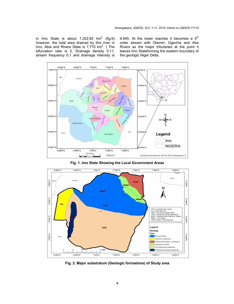
2. STUDY AREA The study area (Imo State) Fig. 1 is located in the Southeastern region of Nigeria and is one of the 36 States of the Federation, with Owerri as its capital and largest city. It lies between latitude 4°45
'N and 5°50
'N, longitude 6°35
'E and 7°30
'E,
and covers approximately 5,529.17 km2 area with a Population of 2,938,708 [6]. The State derives its name from Imo River, which takes its course from the Okigwe/Awka upland. Imo State is located between the lower River Niger and the upper and middle Imo River in the Southeastern part of the country. The climate of Imo State is humid, semi-hot equatorial type. The State experiences heavy rainfall, with an average annual rainfall of 2000-2400 mm/yr and an average number of 152 rain/ days particularly during the rainy seasons (April–October) the superficial rainfall distribution is bimodal, with peaks in July and September and a two weeks break in August. The rainy season begins in March and lasts till October or early November. Rainfall is often at its maximum at night and during the early morning hours. The higher annual rainfall depths and rainfall days encourages large volumes of runoff. However, variations occur in rainfall amount from year to year, usually between 1,990 mm and 2,200 mm [7]. Relative humidity oscillates between 75% and 90% between the Dry and Rainy seasons. Temperatures are similar all over the State; the hottest months are January to March, with the mean annual temperature above 20°C. Imo State is underlain majorly by the sedimentary sequences of the Benin Formation (Miocene to recent), and the Bende-Ameki Formation (Eocene). The Benin Formation is

Amangabara; JGEESI, 3(1): 1-11, 2015; Article no.JGEESI.17114
3
made up of friable sands with minor intercalations of clay. The sand units are mostly coarse –grained, pebbly, poorly sorted, and contain lenses of fine grained sands. In some areas like Okigwe, impermeable layers of clay occur near the surface, while in other areas, the soil consists of lateritic material under a superficial layer of fine grained sand. The thickness of the Benin Formation in this area is about 800 m [8,9]. In terms of relief, Imo State is characterized by three main landform regions: a highland region of elevation of 340 m in the northern sections covering Orlu, Ideato, Okigwe and Ihitte-Uboma local government areas; a moderate elevation of about 175 m which covers midway between the north and the southern sections of the State as well as the river valleys of the streams that rises in the highland regions of the State and the lowland regions in the Southern areas of the State Figs. 2,3,4. 3. MATERIALS AND METHODS The following maps were acquired to serve as base maps these include Administrative map of Imo State (scale 1:1000, 000) from the Imo State Ministry of Land and Survey; Geological Map of Imo State, Dominant Soil Map of Nigeria, Provisional Soil map of Nigeria (simplified) 1952 edition, Soil Map of Eastern Nigeria, Scale 1:1,000.000 and Soil Map of Nigeria Scale 1:5,000.000, Topographic and relief map of Imo State from the Anambra – Imo River Basin Development Authority. From the Regional Centre for Training in Aerospace Survey (RECTAS) Ile Ife, Osun State; SPOT 5 satellite images of Imo State with a resolution of 10 m and Shuttle Radar Topography Mission (SRTM) data with a resolution of 30 m were acquired. The base maps (which were in analogue form) were scanned and converted into raster image and imputed into ArcGIS version 9.3 environment, geo-referenced to a universal transverse Mercator (UTM) grid to allow compatibility and comparison with other data sets to enable the extraction of Imo State from the rest of Nigeria. Various data enhancement techniques such as linear enhancement and image enhancement operations were carried out for better visual interpretation, to reduce noise distortion in the image prior to a multi-band image classification and to detect line features in the satellite image to aid structural interpretation. The watercourses were traced from their source to their mouth (discharge point) including all the
tributaries within a given contour elevation (drainage divide) between two adjacent or opposite contours. Lengths and area measurement was done using the Dot Grid method and compared with on screen measurement on the GIS interface.
4. RESULTS AND DISCUSSION The results generated in the course of this exercise are presented as maps and tables.
4.1 Sub-Basins in Imo State From the output of the GIS, five sub-drainage basins were effectively delineated in Imo State that constitutes the Imo Basin of the Anambra-Imo River Basin Area namely Upper Orashi, Njaba/Lower Orashi, Otamiri, Ogechie and Upper Imo. These five river sub-basins are comprised of about fifty one rivers, and three lakes (Fig. 4 & Table 1). They drain an average area of about 5,493.768 km
2 of Imo State. Each of these
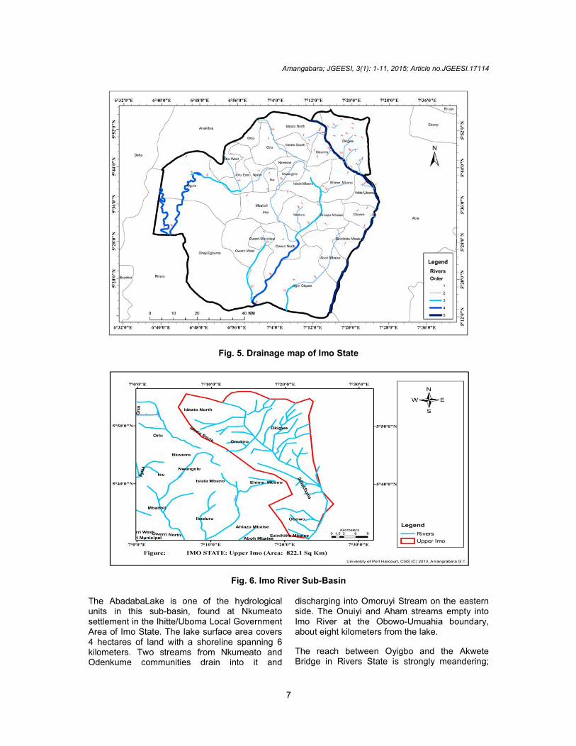
watersheds is of different shape and drainage composition. The largest in terms of area drained is Otamiri, although the number of streams in this watershed is few compared with Imo River. Imo River is an oval shaped watershed; it has more tributaries in Imo State, though the area it drains in Imo State is not as large as Otamiri. The Drainage Density (Dd) of the study area can best be described as medium drainage density (or medium texture) with a Dd of 0.21, while the stream frequency is 0.02 and the drainage intensity is 2.00 (Fig. 5). 4.1.1 Imo river sub-basin (Fig. 6) Imo River drains three States, namely Imo State, Abia State and Rivers State. In Imo State, is the largest (in terms of size and length). It takes its course from the Okigwe/Awka upland and runs through the area underlain by the Imo Shale and the coastal plain sands down to the coast in Rivers State. The source area/tributaries form a trellis pattern. For the purpose of this work, the river was divided into the Upper reaches, middle reaches and lower reaches. The upper and middle reaches are found in Imo State while the lower segment is in Abia and Rivers States. Several first order streams (Iyode stream, Ore River, Abuba River, Ikwe River, Amovi River, Ibu River, Iyeochare River, Law-Law river, Izeh River and Akum) and second order streams (such as Efuro River, Ahumum, Awkwu river) form the major tributaries of Imo river in this segment. The total area drained by Imo River and its tributaries
Amangabara; JGEESI, 3(1): 1-11, 2015; Article no.JGEESI.17114
4
in Imo State is about 1,322.82 km2 (fig.6) however, the total area drained by this river in Imo, Abia and Rivers State is 7,770 km2. ) The bifurcation ratio is 2, Drainage density 0.11, stream frequency 0.1 and drainage intensity is
9.945. At the lower reaches it becomes a 5th order stream with Otamiri, Ogechie and Aba Rivers as the major tributaries at the point it leaves Imo Stateforming the eastern boundary of the geologic Niger Delta.
Fig. 1. Imo State Showing the Local Government Areas
Fig. 2. Major substratum (Geologic formations) of Study area

Amangabara; JGEESI, 3(1): 1-11, 2015; Article no.JGEESI.17114
5
Fig. 3. Relief map of Imo State
Fig. 4. The five major sub-basins in Imo State

Amangabara; JGEESI, 3(1): 1-11, 2015; Article no.JGEESI.17114
6
Table 1. The five sub-basins and their tributaries in Imo State
S/No Sub-Basins Area drains Tributaries Source Area Flows into Stream order 1 Imo 1,322.83 Imo Rv Ideato Atlantic
Ocean 5th
2 Ibi Okigwe Law-law 2nd
3 Ibu Nneafor Law-law 1st 4 Efuru Okigwe Imo River 2
nd
5 Ikwo Okigwe Law-law 2nd 6 Abuba Okigwe-Ideato Imo River 1
st
7 Iyoba Okigwe-Ideato Imo River 1st
8 Idiu Okigwe-Ideato Imo River 1st 9 Ibu Okigwe-Ideato Imo River 1
st
10 Nterere Okigwe-Ideato Imo River 2nd 11 Ife Okigwe-Ideato Imo River 2
nd
12 Izah Okigwe-Ideato Imo River 1st
13 Ndima Okigwe-Ideato Imo River 1st 14 Alum Okigwe-Ideato Imo River 2
nd
15 Uyiri Okigwe-Ideato Imo River 2nd 16 Iyeoachara Okigwe-Ideato Imo River 2
nd
17 Ohia Okigwe-Ideato Imo River 2nd 18 Lawlaw Okigwe-Ideato Imo River 2nd 19 Ugbi Okigwe-Ideato Imo River 2
nd
20 Onyimbo Umunumo Imo River 3rd 21 Biyi IkpaOkoto Imo River 2
nd
22 Upo Afugiri Imo River 2nd 23 Eme Afugiri Imo River 2
nd
24 Obiyi IkpaOkoto Imo River 2nd
25 Nfro Ihitte-Uboma Imo River 2nd 26 Onuiyiri Obowo Imo River 1
st
27 Asa Nsu Imo River 2nd 28 Okuimiri Arondizeogu Imo River 1
st
29 Akworo Osina Imo River 2nd
30 Ahamun Akokwa Imo River 2nd 31 Ore Ntueke Imo River 1
st
32 Iyodo Akokwa Imo River 2nd 33 Awkwa Ntueke Imo River 1
st
34 Abadaba Lake
Ihitte-Uboma Lake
35 Upper Orashi 181.012 EzezeAsa 1st
36 Orashi Dikenafai Oguta Lake 1st 37 EzezeAsa Oguta 1
st
38 Njaba/Lower Orashi
1,600.84 Njaba Nkwerre 3rd
39 Awbana Mgbidi Oguta Lake 40 Eyin Oguta Orashi 1st 41 Utu Oguta 1
st
42 Oguta Lake Oguta Lake Orashi Lake 43 Otamiri 1,719.25 Otamiri Egbu Imo River 4
th
44 Okitankwo Umudi Oramiriukwa 1st
45 Oramiriukwa Abba Isu(Nwangele)
Okitankwo 1st
46 Mbaa Amaraku Oramiriukwa 1st 47 Nwaorie Ohii/Egbeada Otamiri 1
st
48 Ogechie 669.521 Ogechi Umuneke-Ngor
Otamiri 1st
Total 5,493.45
Amangabara; JGEESI, 3(1): 1-11, 2015; Article no.JGEESI.17114
7
Fig. 5. Drainage map of Imo State
Fig. 6. Imo River Sub-Basin The AbadabaLake is one of the hydrological units in this sub-basin, found at Nkumeato settlement in the Ihitte/Uboma Local Government Area of Imo State. The lake surface area covers 4 hectares of land with a shoreline spanning 6 kilometers. Two streams from Nkumeato and Odenkume communities drain into it and
discharging into Omoruyi Stream on the eastern side. The Onuiyi and Aham streams empty into Imo River at the Obowo-Umuahia boundary, about eight kilometers from the lake.
The reach between Oyigbo and the Akwete Bridge in Rivers State is strongly meandering;
Amangabara; JGEESI, 3(1): 1-11, 2015; Article no.JGEESI.17114
8
downstream of the Imo River Bridge the character of the river is gradually affected by the tide with the vegetation changing from fresh-water into the saline mangrove and Nypa palms. The river from the bridge (boundary between Abia and Rivers States) down to the Atlantic coast is seemingly straight with one conspicuous bend off Obete where the course of the river changes from almost east towards a southerly direction. The river width gradually widens from 60m off Oyigbo to over 1,000 m at the estuary. The tidal impact on the discharge of the river can be observed during the rainy season up to 10 km upstream of Obete where the magnitude of the flow varies with the tide; 10 km downstream of Obete the flow is of tidal reversal in nature. Downstream of Ikot Abasi the tidal basin of the Imo River is characterized by mud flats and tidal creeks. Finally, the river discharges the waters of the drainage basin into the Opobo channel, Bight of Bonny (Gulf of Guinea,) off Down-Below fishing village of Opobo Town, about 107 km from Oyigbo.
4.1.2 Upper orashi river sub-basin The area drained by Orashi before it enters Anambra State is regarded as the Upper Orashi River basin. The shape of the basin is like a triangle from the source area to the point it
entered Anambra State, covering an area of 152.4 km
2. The river has three segments. A two
first order stream and a one second order stream comprising a total length of 40,191 m (40.5 km). It has a drainage density of 0.27, stream frequency of 0.02, drainage Intensity of 0.052 from its source in a spring from the mountainous area of Ezeama community in Dikenafai, Ideato-South LGA; The River stretches to Ideato North, terminating in Oguido (the blue lake and Urashi River) and flows northward to Ozubulu in Anambra State, it becomes braided in Anambra State and a part of it turns round in a wide loop and heads Southward into Imo State in the Oguta alluvial/floodplains before heading towards the Bight of Bonny via the Orashi region in Rivers State. The area drained by this river form part of the Awka-Orlu cuesta. According to Nwajide [10], the crest of the cuesta stands at over 340 m and at Isuofia attains a height of 378 m. The dominant geological formation is the Eocene Ameki Sands which is a sequence of unconsolidated or poorly consolidated sand, 305 m thick, underlain by the thick Imo Shale formation of Palaeocene age, and overlain by the lignite-clay seams of the OligocèneOgwashi-Asaba formation. The Ameki
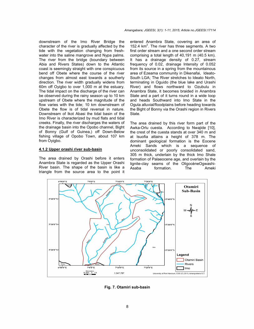
Fig. 7. Otamiri sub-basin

Amangabara; JGEESI, 3(1): 1-11, 2015; Article no.JGEESI.17114
9
Sands are predominantly sandy with thin claystone and siltstone bands, lenses and laminations. The sand is poorly-sorted, cross-bedded and medium to coarse grained. These units, separated by shale-siltstone-fine sand layers, may be as thick as 30m in some places. The deposits also exhibit well developed patterns of alternating cross-bedded sands. The unconsolidated sands are loose, friable and poorly cemented with thin shale layers. The sands are very permeable while the shales are not. Below the water table, these sands and shales are saturated with water which affects their strength. Generally, the topography is undulating making stream flow/surface runoff irregular. The Orashi River is visualized as following a major fracture, trending North-South with elevated ground on both side. 4.1.3 Njaba/lower orashi river sub-basin This watershed has a shape of a clover leaf and it’s comprised of two major sections. The upper region which comprised of Njaba River and River Awbana can be described as the upper course while the lower section which is comprised of Utu Stream, Oguta Lake and the braided section of Orashi River can be described as the floodplain or alluvial section. The total area of the watershed is about 1,600.84 km2 Njaba River is a 35km long tributary of Orashi River and rises at Ihitte located at Isunjaba in Isu Local Government Area of Imo State. It forms a dendritic pattern as it drains the entire Isu and Njaba Local Government Areas, Eziama and Amucha to the North, Amaigbo to the West, Umundugba, Amandugba and Ekwe, Okwudo, Umuaka and Awo-Omama to the South and runs through the rolling hills in a meandering flow and empties into Oguta Lake. As it approaches Oguta Lake it becomes braided. The lake in question is a major hydrological formation, the largest natural lake in Imo State formed from a natural depression. During the dry season the surface area of the lake is about 1.8 km2 while during the rainy season it is about 2.5 km
2. The maximum
depth is about 8.0 m with a mean depth of 5.5 m. The average total length of the shoreline is 10 km. The floodplain is occupied by the lower reaches of Orashi River as it flows in from Anambra State. In this section, it is highly braided and the drainage pattern is trellis. The morphometric characteristics of this watershed reflect the nature of the relief of the area. There are about seven first order stream, one second order stream and two each of third and fourth order streams. Drainage density (Dd) is 0.15
Drainage Intensity (DI) is 0.001 while the stream frequency in this watershed is 0.01. The bifurcation ratio is 2.84. Studies of many stream networks confirm the principle that in a region of uniform climate, rock type and stage of development, the bifurcation ratio tends to remain constant from one order to the next. The closeness of 2.84 to 3 is indicative of the characteristics of streams that have two major sections.
4.1.4 Otamiri river sub-basin
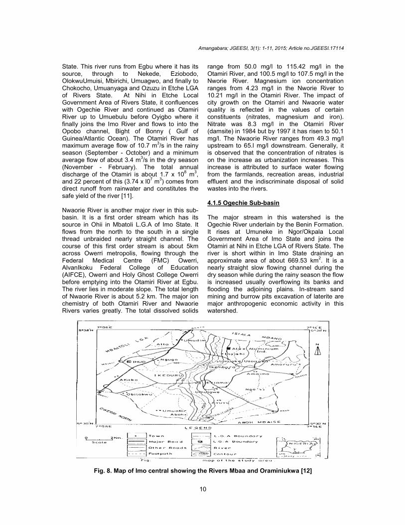
The Otamiri watershed (Fig. 7) covers an approximate area of 1,719.25 km2. The major rivers/stream in this watershed includes Otamiri, Oraminiukwa, Okitankwo, Mbaa, Nwaorie andEfuru etc. The total length of the rivers in the watershed is about 228.3 km. There are in all about eleven first order streams, three second order streams, two third order streams, and one each of fourth and fifth order streams with Bifurcation ratio of 2.04, drainage density of 0.20, stream frequency of 0.02 and drainage intensity of 0.003. It is underlain by the Benin Formation (Coastal Plain sands) which is generally coarse and poorly consolidated with little cement. The Okitankwo River a major stream in this sub-basin is a first order stream that rises from the highlands of the central part of Imo State in Nkwerre flowing down south in a single thread system and joins Inyishi/Mbaa River. The Inyishi/Mbaa River is an ephemeral river system with its source in Ikeduru Local Government Area of Imo State. It is a first order stream, it flows as a single thread channel 7.5 km southwards and joins Okitankwo and flows as Oraminiukwa River. River Oraminiukwa runs approximately a 32km course from its headwaters in Abba Isu (Nwangele LGA) to its discharge into Otamiri River, it starts as a first order stream from its source near Abba lsu in Nwangele local government area of Imo State and flows southwards for about 3.75 km to receive Mbaa, after about 4.1 km from the confluence with Mbaa, Oraminiukwa is joined by the seasonal Okitankwo River at EzialaEmii in Owerri North LGA of Imo State, From Eziala, Oraminiukwa flows southwards for about 5.8 km before discharging into Otamiri River near Nihi (Fig. 8).
The Otamiri River itself starts as a first order stream at its source at Egbu and captures Nwaorie river and flows for about 30 km to confluence with the Oraminiukwa River at Emeabiam. It is a major river that washes through the Ihiagwa autonomous community, in the Owerri West Local Government Area of Imo
Amangabara; JGEESI, 3(1): 1-11, 2015; Article no.JGEESI.17114
10
State. This river runs from Egbu where it has its source, through to Nekede, Eziobodo, OlokwuUmuisi, Mbirichi, Umuagwo, and finally to Chokocho, Umuanyaga and Ozuzu in Etche LGA of Rivers State. At Nihi in Etche Local Government Area of Rivers State, it confluences with Ogechie River and continued as Otamiri River up to Umuebulu before Oyigbo where it finally joins the Imo River and flows to into the Opobo channel, Bight of Bonny ( Gulf of Guinea/Atlantic Ocean). The Otamiri River has maximum average flow of 10.7 m
3/s in the rainy
season (September - October) and a minimum average flow of about 3.4 m
3/s in the dry season
(November - February). The total annual discharge of the Otamiri is about 1.7 x 10
8 m
3,
and 22 percent of this (3.74 x l07 m
3) comes from
direct runoff from rainwater and constitutes the safe yield of the river [11]. Nwaorie River is another major river in this sub-basin. It is a first order stream which has its source in Ohii in Mbatoli L.G.A of Imo State. It flows from the north to the south in a single thread unbraided nearly straight channel. The course of this first order stream is about 5km across Owerri metropolis, flowing through the Federal Medical Centre (FMC) Owerri, AlvanIkoku Federal College of Education (AIFCE), Owerri and Holy Ghost College Owerri before emptying into the Otamiri River at Egbu. The river lies in moderate slope. The total length of Nwaorie River is about 5.2 km. The major ion chemistry of both Otamiri River and Nwaorie Rivers varies greatly. The total dissolved solids
range from 50.0 mg/l to 115.42 mg/l in the Otamiri River, and 100.5 mg/l to 107.5 mg/l in the Nworie River. Magnesium ion concentration ranges from 4.23 mg/l in the Nworie River to 10.21 mg/l in the Otamiri River. The impact of city growth on the Otamiri and Nwaorie water quality is reflected in the values of certain constituents (nitrates, magnesium and iron). Nitrate was 8.3 mg/l in the Otamiri River (damsite) in 1984 but by 1997 it has risen to 50.1 mg/l. The Nwaorie River ranges from 49.3 mg/l upstream to 65.l mg/l downstream. Generally, it is observed that the concentration of nitrates is on the increase as urbanization increases. This increase is attributed to surface water flowing from the farmlands, recreation areas, industrial effluent and the indiscriminate disposal of solid wastes into the rivers. 4.1.5 Ogechie Sub-basin The major stream in this watershed is the Ogechie River underlain by the Benin Formation. It rises at Umuneke in Ngor/Okpala Local Government Area of Imo State and joins the Otamiri at Nihi in Etche LGA of Rivers State. The river is short within in Imo State draining an approximate area of about 669.53 km
2. It is a
nearly straight slow flowing channel during the dry season while during the rainy season the flow is increased usually overflowing its banks and flooding the adjoining plains. In-stream sand mining and burrow pits excavation of laterite are major anthropogenic economic activity in this watershed.
Fig. 8. Map of Imo central showing the Rivers Mbaa and Oraminiukwa [12]
Amangabara; JGEESI, 3(1): 1-11, 2015; Article no.JGEESI.17114
11
5. CONCLUSION
Going by the definitions of watershed, drainage basin or catchment area, this study delineated five sub-basins in Imo State, namely Imo River sub-basin, Upper Orashi sub-basin, Njaba/Lower Orashi sub-basin, Otamiri sub-basin and Ogechie River sub-basin. All of these rivers and their tributaries drain 5,493.45 km2 of Imo State; the delineation adopted by Okoro et al. [5] is faulty as it was not based on the definitions stated above. Furthermore, this study found out that the area drained by Otamiri is 1,719.25 km2contrary to the 10,000 km2 usually stated in literature; obviously, the figures cited are guess works. No doubt there could be some marginal errors in the measurement carried out by this study; however we believe that the approach adopted in this study towards establishing the various hydrological units and the areas drained by them will help in the planning and the development of the Anambra-Imo River Basin water resources.
ACKNOWLEDGEMENTS
Author wish to appreciate the entire Remote Sensing & GIS team led by Okeke Onyedika of RECTAS for their inputs and also the independent reviewers for their constructive criticisms and evaluation of this work to make it suitable for publication.
COMPETING INTERESTS
Author has declared that no competing interests exist.
REFERENCES
1. Onwerenmadu EU. Soil mercury distribution in a forest Savanna mosaic in relation to soil fertility. Research Journal of Environmental Toxicology. 2007;1(4):158-166 DOI: 103923/rjet.2007
2. Umunakwe JE, Nnaji AO. Influence of landuse patterns on Otamiri river, Owerri and urban quality of life. Pakistan Journal of Nutrition. 2011;10(11):1053–1057.
3. Ofulume AB, Amadi MC. Investigating the Otamiri river (Ihiagwa, Imo State, Nigeria) Sands as a possible raw material source for the glass industry. Australian Journal of Basic and Applied Sciences. 2011;5(9): 495-500.
4. Nwachukwu MA, Egwuonwu CC. Linking institutions and neighborhood communities with irrigation; A theoretical framework for sustainable agriculture. Journal of Agricultural Extension and Rural Development. 2012;4(20):548–551.
5. Okoro BC, Uzoukwu RA, Chemezie NM. River basins of Imo State for sustainable water resource management. Journal of Civil and Environmental Engineering. 2014;4(1).
DOI: 104172/2166-784x.1000134
6. IMSG. Zero draft “Imo Tripod vision” State economic empowerment and development strategy. Imo State Planning and Economic Development Commission, Owerri; 2008.
7. Nigeria Meteorological Agency (NIMET), Periodic publication Port Harcourt Station, Port Harcourt International Airport; 2012.
8. Ibe KM, Anyanwu S, Sowa AHO. Anthropogene disturbance of sedimentary equilibrium: Gully erosion and filling up of river beds in selected areas in Southeastern Nigeria. Erosion Research Centre. Federal University of Technology, Owerri; Nigeria; 1991.
9. Onwueme IC, Asiabaka CC. Erosion as an interactive force in the human environment. Erosion Research Centre. Federal University of Technology, Owerri; Nigeria; 1992.
10. Nwajide CS, Hoque M. Gullying processes in Southeastern Nigeria. The Nigerian Field. 1979;44(2):64-74.
11. Egboka BCE, Uma KO. Water resources of Owerri and its environs, Imo State, Nigeria. Journ. Min. Geol. 1985;22:57-62.
12. Iherjirika C. Physico-chemical properties of Mbaa River. Unpublished M.Sc Thesis submitted to the Federal University of Technology, Owerri; 2004.
_________________________________________________________________________________ © 2015 Amangabara; This is an Open Access article distributed under the terms of the Creative Commons Attribution License (http://creativecommons.org/licenses/by/4.0), which permits unrestricted use, distribution, and reproduction in any medium, provided the original work is properly cited.
Peer-review history: The peer review history for this paper can be accessed here:
http://sciencedomain.org/review-history/9765
Related Documents


