Draft Martin Road Feasibility Study Addressing Skagit River Erosion and Fish Passage SKAGIT COUNTY May 17, 2016 Authored by: Natural Resources Division of Skagit County Public Works

Welcome message from author
This document is posted to help you gain knowledge. Please leave a comment to let me know what you think about it! Share it to your friends and learn new things together.
Transcript

Draft Martin Road Feasibility Study
Addressing Skagit River Erosion and Fish Passage
SKAGIT COUNTY
May 17, 2016
Authored by: Natural Resources Division of Skagit County Public Works
Martin Road Feasibility Study Page 1
Table of Contents
1.0 PURPOSE OF STUDY .......................................................................................................................... 1
2.0 BACKGROUND/DESCRIPTION OF STUDY AREA ................................................................................. 3
2.1 Description of Project Area ........................................................................................................... 3
2.2 Background Information ............................................................................................................... 5
2.3 River Erosion Study ....................................................................................................................... 6
3.0 ALTERNATIVES ................................................................................................................................... 6
3.1 No action ....................................................................................................................................... 6
3.2 Abandon Martin Road from Erosion Area to SR530 ..................................................................... 6
3.3 Construct River Bank Hardening ................................................................................................... 7
4.0 ALTERNATIVE ANALYSIS .................................................................................................................. 10
4.1 No Action .................................................................................................................................... 11
4.2 Martin Road Abandonment ........................................................................................................ 12
4.3 Bank Hardening ........................................................................................................................... 12
5.0 CONCLUSION ................................................................................................................................... 14
5.1 Alternative Evaluations and Funding Opportunities ................................................................... 14
5.2 Travel Time Impacts .................................................................................................................... 15
5.3 Construct Alternate Route .......................................................................................................... 16
6.0 RECCOMENDATIONS ....................................................................................................................... 17
APPENDIX A ................................................................................................................................................. 18
APPENDIX B ................................................................................................................................................. 47
REFERNCES .................................................................................................................................................. 49
1.0 PURPOSE OF STUDY
Martin Road Feasibility Study Page 2
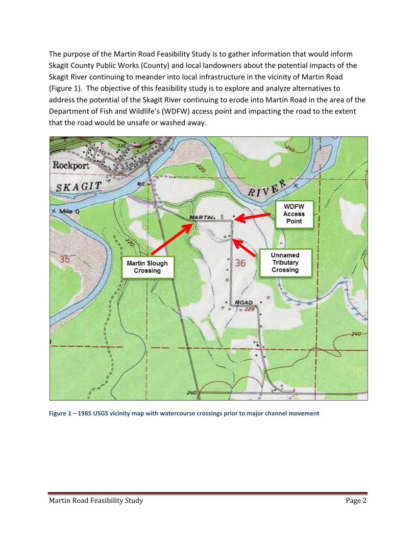
The purpose of the Martin Road Feasibility Study is to gather information that would inform
Skagit County Public Works (County) and local landowners about the potential impacts of the
Skagit River continuing to meander into local infrastructure in the vicinity of Martin Road
(Figure 1). The objective of this feasibility study is to explore and analyze alternatives to
address the potential of the Skagit River continuing to erode into Martin Road in the area of the
Department of Fish and Wildlife’s (WDFW) access point and impacting the road to the extent
that the road would be unsafe or washed away.
Figure 1 – 1985 USGS vicinity map with watercourse crossings prior to major channel movement
Martin Road Feasibility Study Page 3
2.0 BACKGROUND/DESCRIPTION OF STUDY AREA
2.1 Description of Project Area
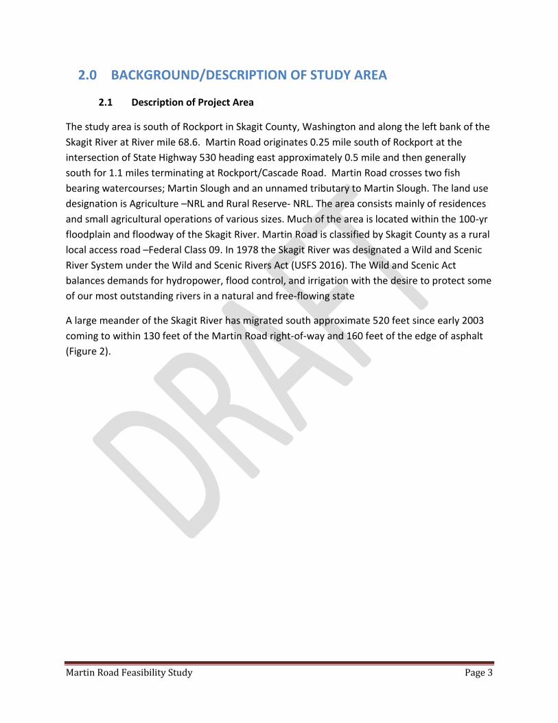
The study area is south of Rockport in Skagit County, Washington and along the left bank of the
Skagit River at River mile 68.6. Martin Road originates 0.25 mile south of Rockport at the
intersection of State Highway 530 heading east approximately 0.5 mile and then generally
south for 1.1 miles terminating at Rockport/Cascade Road. Martin Road crosses two fish
bearing watercourses; Martin Slough and an unnamed tributary to Martin Slough. The land use
designation is Agriculture –NRL and Rural Reserve- NRL. The area consists mainly of residences
and small agricultural operations of various sizes. Much of the area is located within the 100-yr
floodplain and floodway of the Skagit River. Martin Road is classified by Skagit County as a rural
local access road –Federal Class 09. In 1978 the Skagit River was designated a Wild and Scenic
River System under the Wild and Scenic Rivers Act (USFS 2016). The Wild and Scenic Act
balances demands for hydropower, flood control, and irrigation with the desire to protect some
of our most outstanding rivers in a natural and free-flowing state
A large meander of the Skagit River has migrated south approximate 520 feet since early 2003
coming to within 130 feet of the Martin Road right-of-way and 160 feet of the edge of asphalt
(Figure 2).
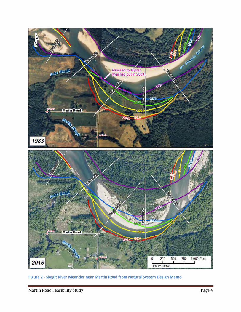
Martin Road Feasibility Study Page 4
Figure 2 - Skagit River Meander near Martin Road from Natural System Design Memo

Martin Road Feasibility Study Page 5
Figure 3 -Erosion Site at WDFW Access Point March 1, 2016
2.2 Background Information
This feasibility study originated with a discussion between Skagit County Public Works and
natural resource agencies related to the fish passage concerns at the road crossings of Martin
Slough and an unnamed tributary. The three foot culvert at the Martin Slough crossing was
referenced in the Habitat Restoration Alternatives Assessment - Barnaby Reach of the Skagit
River (2014) as a barrier to fish passage. The culvert under Martin Road on an unnamed
tributary southeast of Martin Slough is also referenced as a fish barrier (Figure 1). WDFW (2015)
also lists these culverts as fish barriers.
In 2013, the Natural Resources Division of Skagit County Public Works requested grant funding
to design an upgrade of the Martin Slough crossing from a culvert to a bridge. This would allow
unrestricted fish access to 31,000 square feet of habitat above the road crossing. The Salmon
Recovery Funding Board (SRFB) agreed to fund a feasibility study (#14-1264) to determine the
appropriate solution to the fish passage issues along Martin Road in light of the continued
meandering of the Skagit River within this reach. Skagit County staff and the SRFB review team

Martin Road Feasibility Study Page 6
agreed that it would be ineffective to construct a bridge across the slough if the river meander
took out Martin Road less than 0.25 miles away. Martin Road can be accessed from both the
south via (Rockport Cascade Road) and the north via (SR530)) the County’s proposal to
construct a bridge on a road that would not be beneficial to either the traveling public nor
provide access to private property. The estimated cost to construct a bridge at this location is
approximately $1 million.
2.3 River Erosion Study
As part of the feasibility study, Skagit County Natural Resource Division contracted with Natural
System Designs Inc. (NSD) to evaluate the erosion rate and path of the Skagit River meander in
the vicinity of Martin Road. NSD specializes in river morphology and river dynamic. NSD has
been involved, as the principle hydraulic modeler, for the Barnaby Reach Feasibility study (RCO
#09-1440). The NSD report documents the erosion that has occurred at this site over the last 80
years and is included as Appendix A. The NSD memo also attempts to predict the future
erosion rate at the WDFW access point.
3.0 ALTERNATIVES
All the alternatives assume that, at some point in the future, the Skagit River will erode into the
road base of Martin Road. This assumption is based on the NSD report and local observations.
This section will describe each alternative and the estimated cost. Section 4 will provide an
analysis of each alterative.
3.1 No action
This alternative would result in “no action” being taken related to the river erosion near Martin
Road. It is anticipated that if the meander bend reach the road base the road would be closed
for safety concerns and the road signed accordingly. The existing road crossing at Martin
Slough would remain along with the asphalt road base.
3.2 Abandon Martin Road from Erosion Area to SR530
Due to the fact that there are no residences or active access points that currently exist between
SR530, Martin Slough and the site of the river erosion the abandonment of this portion of
Martin Road could be explored. Under this alternative the Martin Slough crossing would be
abandoned and the road structure and the culvert removed. The road base would be removed
along the entire length. The right-of-way would be gated, but still allow for pedestrian traffic.
This would result in additional drive time by landowners who live on the northern Martin road,
since they would have to travel south to the Rockport-Cascade Road to reach SR530. Public

Martin Road Feasibility Study Page 7
access to the Skagit River would be altered as the WDFW access point would not be accessible
by car. A vehicle turnaround would be required if the road is closed or gated.
Figure 4 Martin Road Abandonment Alternative
3.3 Construct River Bank Hardening
This alternative would evaluate hardening the river bank or diverting the river away from the
area of Martin Road. In addition to looking at the meander rate, NSD was also tasked with
looking at what it might take to stop the river from continuing to meander towards Martin
Road. NSD looked at two options or methods to reduce or eliminate the river bank erosion
(Figure 2). The purpose of NSD’s evaluation is to describe the scale of bank protection
treatments necessary to resist the erosive forces of the Skagit River, and to summarize two
alternative approaches:
Alternative 1 - A revetment designed to strengthen the bank and dissipate energy along the
channel margin. The conceptual design for Alternative 1 includes a 2,200 foot long complex
wood revetment to strengthen the bank resistance and yield an overall benefit to habitat-
forming processes. The bank protection constructed upstream at the WSDOT Cascadian Farm
site in 2014 is likely the best reference to consider regarding the construction of a complex
wood revetment at the Martin Road project site. Using WSDOT cost for the Cascadian Farm
project it is estimated construction cost for a similar project at Martin Road would be
$11,000,000. (See Figure 5)
Alternative 2 - Flow in the project reach will be redirected by an array of Engineered Logjams
(ELJs) to reduce the hydraulic forces on the eroding streambank. As opposed to strengthening
the streambank as described by Alternative 1, this alternative goal is to reduce the flow velocity
and shear stress acting on the bank material near Martin Road. The ELJ deflector array would

Martin Road Feasibility Study Page 8
consist of multiple structures that are staggered in the active channel corridor to interrupt the
flow patterns and create additional physical and hydraulic complexity. Estimated construction
cost is $2,250,000. (See Figure 5)
If these projects are successful in controlling river erosion, public access to the Skagit River
could be maintained.

Martin Road Feasibility Study Page 9
Figure 5 Bank Protection alternatives from NSD
Martin Road Feasibility Study Page 10
4.0 ALTERNATIVE ANALYSIS
Between 1998 and 2015 the Skagit River has eroded or meandered approximately 580 feet
towards Martin Road (NSD). This results in an average erosion rate of 34.1 feet per year. A
majority of this erosion, 420 feet, occurred during two flood events in October 2003 and
November 2006. At an average erosion rate of 34.1 feet per year the river channel will be at the
road base in 4.7 years. The results of a large flood event, equal to either of the two events listed
above, would likely result in the WDFW access and part of the County road being eroded away.
Figure 6 shows the potential of where the channel may be in 2020, 2025 and 2035. This
demonstrates the potential of the erosion at this site. The size of the meander predicted in the
year 2025 would be similar in size to the river meander that resulted in Barnaby Slough just
upriver. It is possible that as the meander continues south the channel will eventually short cut
through the peninsula. This is not likely to happen before Martin Road is impacted by the
continued river erosion.

Martin Road Feasibility Study Page 11
Figure 6-Simple predicted erosion assuming an average of 34 feet per year
4.1 No Action
The “No Action” alternative assumes no action will be taken despite the likely continued
meander of the Skagit River. If or when Martin Road becomes unsafe and/or washes away the
road, it would be blocked and the road signed as closed. This would result in additional drive
time by landowners who live on Martin road, since to reach SR530 they would have to travel
south to the Rockport-Cascade Road. If this happens the County would make a decision on the
fate of the road in this area. The establishment of the turnaround may also be required. The
initial cost of the alternative would only be the cost to block the road and provide the necessary
signage. If additional property is needed to establish a turnaround the estimated cost of “no
action” alternaive could be higher.
Estimated Cost: $2,000 -$5,000
Martin Road Feasibility Study Page 12
4.2 Martin Road Abandonment
The potential abandonment of Martin Road is made possible by the fact that Martin Road can
be accessed from both the north and south. Abandonment would not result in any private
landowner losing access to his or her parcel(s). In addition, the segment of Martin Road
proposed to be abandoned only accesses to any parcels other than property currently owned
by Skagit County (P45044,) and the WDFW access point (P45028). Since a branch of Martin
Slough bisects parcel #103551 (Figure 7), and there appears to be no crossing structure the
northern portion of this parcel would be isolated. The current access to this parcel is provided
by an easement located south of the proposed road abandonment.
The property owned by Skagit County was purchased with funding by the State of Washington
as part of salmon recovery efforts. There could be confounding issues related to access to the
WDFW property whereas the County would be required to provide vehicle access to WDFW
property. This access could be maintained by not removing that north/south portion of Martin
Road that would allow continued access from the south. This would be up and until the river
migrates to the road eliminating the need for access as the WDFW property would be part of
the Skagit River. The County will require a turnaround area related to the road closure.
The removal of the culvert and the associated road fill at the Martin Slough crossing would be
part of this alternative and provide the following benefits;
The removal of the fill would eliminate the fish passage barrier concern and provide
unrestricted fish access to an estimated 31,000 square meters of excellent rearing
habitat.
This would also eliminate the need for on-going maintenance by the County of this
culvert crossing. Currently the culvert requires periodic maintenance mainly to address
beaver activity that clogs the culvert.
The removal of the fill at Martin Slough will also allow flood waters held upstream of the
road fill to drain more quickly after a flood event. This will provide quicker relief for local
landowners whose properties are inundated during flood events.
The impacts to local traffic patterns are addressed in Section 5.2.
Estimated Cost: $270,000 -$300,000
4.3 Bank Hardening
Two bank protection alternates are discussed in NSD’s Channel Migration Evaluation memo
(Appendix A). The goal of these two alternatives would be to stabilize the eroding bank and/or
encourage the river to move away thus eliminating or reducing the erosion hazards threatening

Martin Road Feasibility Study Page 13
Martin Road. Both these alternatives are designed to not only reduce or eliminate river
erosion, but also to provide additional fish habitat. These types of designs are more appealing
to permitting agencies.
As described in NSD’s report; alternative 1 would involve a complex wood revetment along the
current bank line. This 2,200 foot long complex wood revetment would strengthen the bank
resistance and yield an overall benefit to habit forming processes. Using wood structures as
opposed to rock rip-rap revetment would likely make permitting easier as wood structures tend
to be viewed as self-mitigating. The potential habitat gains for salmon could be significant.
Figure 7 Parcel numbers and landowners in erosion area
Compounding this alternative is a recorded easement on Parcel #45043 to Untied States
government through the Natural Resource Conservation Services (Figure 7). This “conservation”
easement is intended to protect the natural values of the land. The parcels just downstream of
the WDFW access point (P45044, P45030) are owned by Skagit County. These parcels were
acquired by Skagit County in 1999 with salmon recovery (#99-1719) funding from the State of
Washington for the purpose of protecting habitat for threatened Puget Sound Chinook.
Although not thoroughly investigated, it is likely that these easements or title restriction would
preclude a project on these parcels that would intentionally limit “natural processes” or
channel movement by the Skagit River.
Alternative 2 as outlined by NSD would involve the construction of an array of engineered
logjams (ELJ) with the intent to reduce the flow velocity and shear stress on the eroding bank
Martin Road Feasibility Study Page 14
near Martin Road. Because these ELJs could be built upon dry gravel bars this alternative would
likely be easier to construct than alternative 1. With alternative 2 there is an increased risk of
avulsion of the Skagit River into Bohs Slough (Figure 2). If this occurred it would potentially
impact SR530, as the current crossing of Bohs Slough could not handle the majority of flow of
the Skagit River.
The alternative of constructing hardened bank line along the river, using rip-rap dumped along
the riverbank, would involve simple construction but the likelihood of getting this type of
project through the permitting process would be doubtful without significant mitigation
requirements. Recently Skagit County completed a mitigation project for the repair to its
Cockreham Dike near Lyman. This mitigation project cost approximately $590,000 (Flagan
2016). The U.S. Army Corp of Engineers has a program that could assist local government with
addressing river erosion, but this program has an economic analysis associated with it and it is
unlikely that this project would meet the economic value criteria to make it a fundable project.
If a bank hardening project was successful in stopping the river from eroding into the right-of-
way this would still leave an unresolved fish barrier at Martin Slough and the unnamed
tributary. There would be a continued desire by WDFW and the Tribes for Skagit County to
rectify these fish barriers.
The environmental permitting for bank armoring would be considerable and lengthy. Numerous
permits would be required with uncertain results.
Estimated Cost: $2.5 million to $11 Million
5.0 CONCLUSION
5.1 Alternative Evaluations and Funding Opportunities
The table below provides a comparison which considers the important elements of each
alternative. Attempting to halt the continued erosion of the Skagit River towards Martin Road
by hardening the bankline would be the most expensive alternative and likely would have to be
financed solely by County funds. There is a high likelihood the alternative to abandon and
remove Martin Road would be eligible for grant funding from the Salmon Recovery Funding
Board. This funding would also allow the County to resolve the fish barriers concerns on the
two culverts in the project area. The ability to access the Skagit River by vehicle will be curtailed
in all alternatives except bank hardening. Pedestrian access would continue to be provided to
parcels owned by Skagit County and/or the WDFW access point. The cost to the County for
maintaining over ½ mile of road that includes a culvert that is often blocked by beaver activity
Martin Road Feasibility Study Page 15
would be eliminated under the road abandonment alternative.
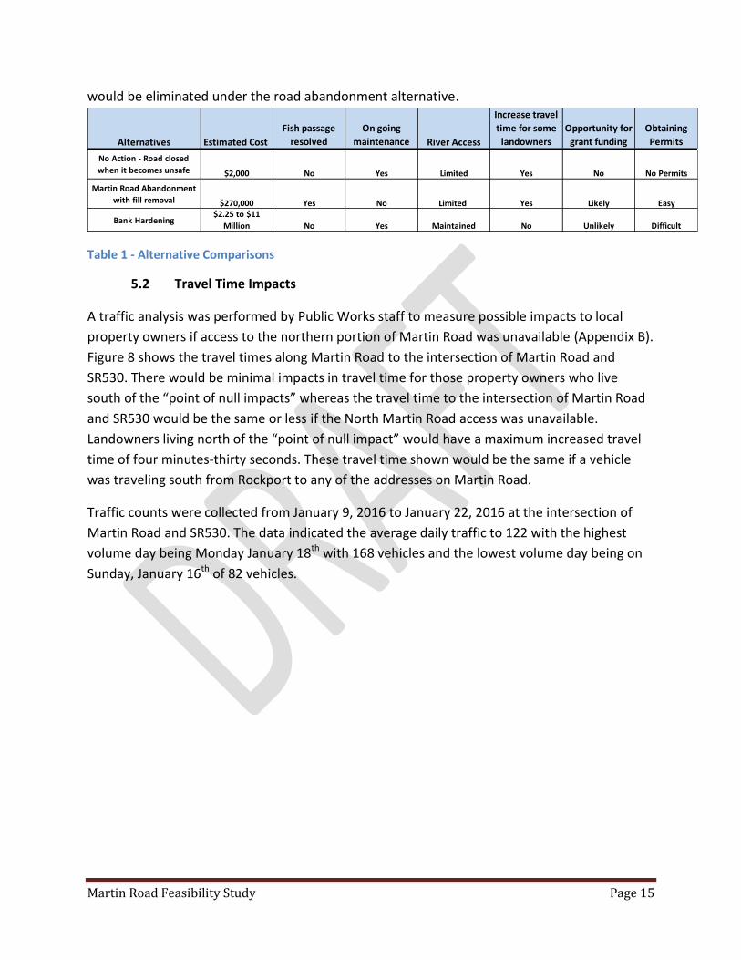
Table 1 - Alternative Comparisons
5.2 Travel Time Impacts
A traffic analysis was performed by Public Works staff to measure possible impacts to local
property owners if access to the northern portion of Martin Road was unavailable (Appendix B).
Figure 8 shows the travel times along Martin Road to the intersection of Martin Road and
SR530. There would be minimal impacts in travel time for those property owners who live
south of the “point of null impacts” whereas the travel time to the intersection of Martin Road
and SR530 would be the same or less if the North Martin Road access was unavailable.
Landowners living north of the “point of null impact” would have a maximum increased travel
time of four minutes-thirty seconds. These travel time shown would be the same if a vehicle
was traveling south from Rockport to any of the addresses on Martin Road.
Traffic counts were collected from January 9, 2016 to January 22, 2016 at the intersection of
Martin Road and SR530. The data indicated the average daily traffic to 122 with the highest
volume day being Monday January 18th with 168 vehicles and the lowest volume day being on
Sunday, January 16th of 82 vehicles.
Alternatives Estimated Cost
Fish passage
resolved
On going
maintenance River Access
Increase travel
time for some
landowners
Opportunity for
grant funding
Obtaining
Permits
No Action - Road closed
when it becomes unsafe $2,000 No Yes Limited Yes No No Permits
Martin Road Abandonment
with fill removal $270,000 Yes No Limited Yes Likely Easy
Bank Hardening $2.25 to $11
Million No Yes Maintained No Unlikely Difficult

Martin Road Feasibility Study Page 16
Figure 8 - Travel Times on Martin Road
5.3 Construct Alternate Route Option
This alternative would provide an alternate route from Martin Road to SR530. This new route would
mitigate the travel time and facilitate access to SR530 if the northern portion of Martin Road was
unavailable because of river erosion or road abandonment. This alternative would be done in concert
with either Alternative 1 or Alternative 2 in order to allow for better access for Martin Road landowners
to SR530. This new route would be positioned approximately midway between SR530 and Rockport
Cascade Road. Ideally, it would be located in an area that would avoid a major watercourse crossing.
This alternative would require the purchase of County road right-of-way and the construction of
approximately 1600 feet of new road. The estimated cost for this new road would be $250,000.
Martin Road Feasibility Study Page 17
6.0 STAFF RECOMMENDATIONS
Recommended actions will be determined after public input.
Possible recommendations:
Continue to monitor the river erosion, and if impacts to the road seem imminent, begin seeking
funding for road abandonment
Apply for grant funding to remove the road. If successful in obtaining funding, plan to remove
road and slough fill. Include funding to compensate local landowner at risk of losing property.
Continue to monitor the river erosion, and if impacts to the road seem imminent, begin seeking
or budgeting funds for a bank hardening project.
Explore providing fish passage at Martin Slough by using other method (short of constructing a
costly bridge).
Close Martin Road just at the Martin Slough crossing to remove the fish barrier(s). Monitor the
river erosion and plan to remove the rest of the road if impacts are imminent.

Martin Road Feasibility Study Page 18
APPENDIX A
Channel Migration Evaluation for the Skagit River at Martin Road (RM 68.5 -69)
Martin Road Feasibility Study Page 19
To: Jeff McGowan, Salmon Habitat Specialist Skagit County Public Works
From: Shawn Higgins, Leif Embertson PE, and Tim Abbe PhD PEG Natural Systems Design, Inc.
Date: April 13, 2016
Re: Channel Migration Evaluation for the Skagit River at Martin Road (RM 68.5-69)
Project Background
Martin Road is a County road providing local access to a rural residential community in the Skagit River Valley near Rockport. The road intersects SR 530 about 900 feet south of the Skagit River Bridge, heads east for a distance of about 0.5 miles, then turns 90 degrees to the south and connects with Rockport-Cascade Road (Figure 1). Martin Slough is an approximately 75 foot wide floodplain channel crossing under Martin Road in two locations via 3-foot diameter culverts upstream and downstream of the 90 degree bend in Martin Road. Both culverts are identified as barriers in the Washington State Fish Passage Inventory (WDFW, 2015). Beavers regularly construct dams in or next to the culverts which further exacerbate local flooding concerns. Freshwater rearing habitats in floodplain areas like Martin Slough have been degraded by historical land use practices and isolation of these floodplain habitats by road crossings or other impairments are currently limiting population sizes of Chinook salmon and other species in the Skagit River Basin (Beamer et al., 2005).
Skagit County Public Works Natural Resources Division (Skagit County) has sponsored the Martin Slough Fish Passage Feasibility and Design Project to restore connectivity to off-channel habitat in the Skagit River floodplain. Skagit County initially proposed replacing the two culverts crossing Martin Road with wider spans to address fish passage issues at Martin Slough. The Salmon Recovery Funding Board (SRFB) review panel expressed concern regarding the long term effectiveness of constructing a replacement culvert or bridge at the downstream site given the probability of continued channel migration toward Martin Road. The County then re-scoped its application as a feasibility study to examine the need for a crossing at Martin Slough and the long term plan for Martin Road given the channel migration hazards.
Natural Systems Design, Inc. (NSD) was contracted to assess the channel migration hazard at Martin Road. The purpose of this memorandum is to synthesize the processes driving streambank erosion at the project site and evaluate conceptual design approaches to bank protection/stabilization. Skagit County will then compare the costs/benefits of bank protection alternatives to an alternative that would consider vacating a portion of Martin Road between the two culvert crossings and enable removal of the road fill obstructing Martin Slough at the downstream crossing. The SRFB review panel supported replacement of the upstream culvert provided that fish passage can be assured at the downstream site.
Two recent publications describing geomorphic processes, flood, and erosion hazards in the project reach preceded this study. The Skagit River System Cooperative (SRSC) and NSD (2014) completed a

Martin Road Feasibility Study Page 20
restoration feasibility level geomorphic assessment and hydraulic analysis of the reach from the SR 530 Bridge at Rockport to the confluence with Illabot Creek. Washington State Department of Transportation produced a subsequent assessment evaluating flood and erosion risks to infrastructure at SR 530 and SR 20 (Shanz, 2015).

Martin Road Feasibility Study Page 21
Figure 9. Reach maps showing 2015 aerial imagery and floodplain topography based on 2005 LiDAR DEM and supplemental topographic survey. Cross-section A-A’ is shown in Figure 3.
Martin Road Feasibility Study Page 22
Site Description and Geomorphic Setting
The project site encompasses the large meander bend in the Skagit River upstream from the inlet to Bohs Slough (Figure 1). The outer (left) bank has rapidly migrated south in recent decades and the bank edge is was about 160 feet from the 90 degree bend in Martin Road in 2015 (Figure 2). Washington Department of Fish and Wildlife (WDFW) owns the parcel extending north and east from the 90 degree bend and previously managed a water access site with parking and a restroom that has since been removed due to the erosion hazard. A gravel access road to the WDFW site has been blocked off; however, the site is still used for viewing bald eagles and other wildlife and is accessed from parking along the road edge. Skagit County owns the parcel north of Martin Road that includes part of the eroding bank between the WDFW access site and Bohs Slough. The parcel including the left bank to the east (upstream) of the WDFW site is in private ownership.
The project reach is located in an unconfined segment of the Skagit River Valley upstream of the confluence with the Sauk River just downstream (west) of SR 530 and the town of Rockport. The broad, alluvial valley ranges between 1.3 and 1.8 miles in width and has been shaped over time by channel migration processes. Meander scars from previous channel alignments create a complex network of backwater sloughs and floodplain channels upstream of Martin Road (Figure 1). The active channel (including the wetted low flow channel and un-vegetated bar surfaces) is approximately 500 feet in width and has a maximum depth of 12 to 15 feet at bankfull stage. The channel has a pool-riffle morphology with an average gradient of 0.002 feet/feet (0.2%).
The watershed upstream of the project reach is a steep, mountainous area encompassing 1,655 square miles with headwaters in the North Cascades and approximately 8,000 feet of vertical relief. The flow and sediment regimes are regulated by three dams upstream of Newhalem and the contributing drainage area upstream of the dams accounts for 70% of the watershed area above Rockport.
The entire project area at Martin Road is within the Special Flood Hazard Area (100-year floodplain) mapped by FEMA as part of the Flood Insurance Study for Skagit County. Flood flows are most common in the period between October and March. Large flood events in recent decades include November 1995, October 2003, and November 2006. The Base Flood Elevation (water surface elevation of the 100-year flood) defined by FEMA is 239 feet NAVD 88 at the 90 degree bend in Martin Road. This flood stage corresponds to an inundation depth of 5 to 9 feet over the floodplain area where ground surface elevations range between 230 and 234 feet (Figure 3).
Bed material in the project reach is characterized by gravel- and cobble-sized sediments and there are active bars developing within dynamic segments of the reach. WSDOT (2007) sampled the bed approximately four miles upstream of the project site for the SR 20/MP 100.7 project and reported a cobble-sized armor layer (D50 = 150 mm, D90 = 300 mm) overlying a gravel-sand substrate (D50 < 5 mm).
The outer bend of the meander near Martin Road has a bank height ranging between 12 and 15 feet and bank material is composed of erodible alluvium. The bank stratigraphy reveals a coarse deposit of gravel- to cobble-sized sediment that is overlain by approximately 5 feet of flood deposited sand and sandy loam. Soils covering the adjacent floodplain area are mapped as Larush silt loam (Klungland and McArthur, 1989). The Larush series consists of very deep, well drained soils formed in mixed alluvium. The surface layer is fine sandy loam or silt loam about 15 inches thick. The subsoil is very fine sandy loam and silt loam about 19 inches thick. The substratum to a depth of 60 inches or more is fine sand and silt loam. The bank near the WDFW access site is capped by a 12- to 18-inch layer

Martin Road Feasibility Study Page 23
of compacted fill that is a remnant from the parking area eroded by recent channel migration.
Figure 10a. Site maps with historical imagery from 1937 and 1956.

Martin Road Feasibility Study Page 24
Martin Road Feasibility Study Page 25
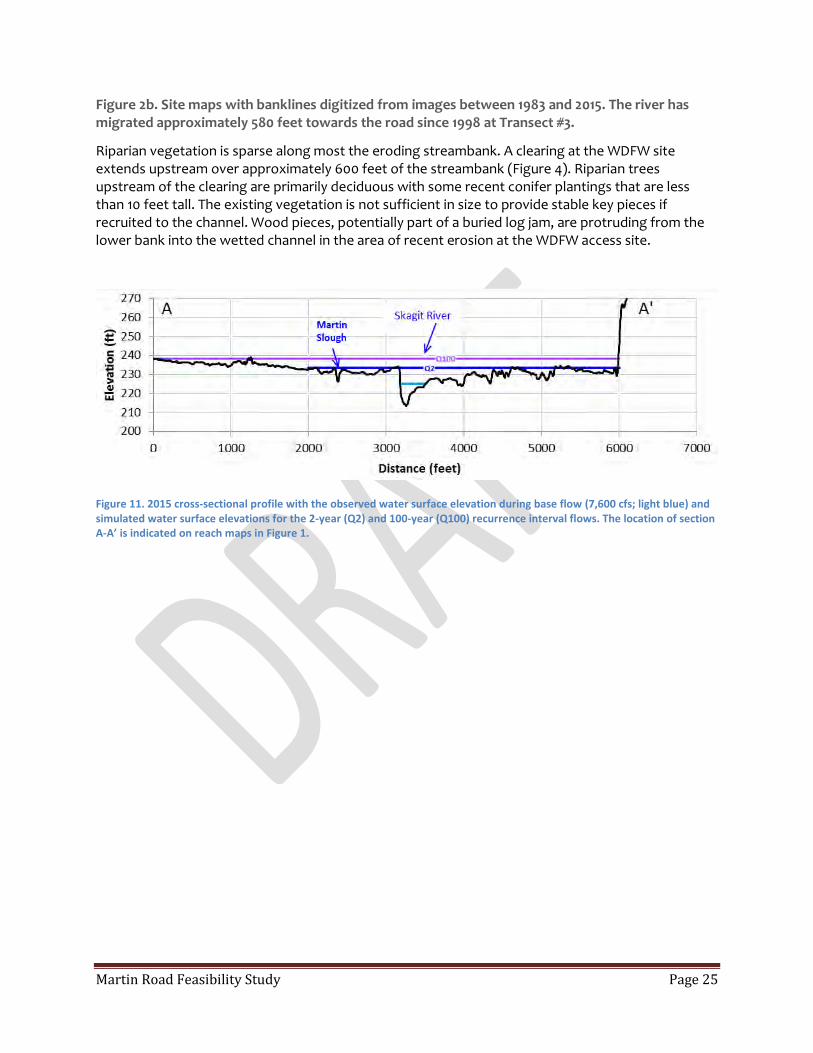
Figure 2b. Site maps with banklines digitized from images between 1983 and 2015. The river has migrated approximately 580 feet towards the road since 1998 at Transect #3.
Riparian vegetation is sparse along most the eroding streambank. A clearing at the WDFW site extends upstream over approximately 600 feet of the streambank (Figure 4). Riparian trees upstream of the clearing are primarily deciduous with some recent conifer plantings that are less than 10 feet tall. The existing vegetation is not sufficient in size to provide stable key pieces if recruited to the channel. Wood pieces, potentially part of a buried log jam, are protruding from the lower bank into the wetted channel in the area of recent erosion at the WDFW access site.
Figure 11. 2015 cross-sectional profile with the observed water surface elevation during base flow (7,600 cfs; light blue) and simulated water surface elevations for the 2-year (Q2) and 100-year (Q100) recurrence interval flows. The location of section A-A’ is indicated on reach maps in Figure 1.

Martin Road Feasibility Study Page 26
Figure 12. Photo looking upstream along eroding (left) bank at the WDFW access site near the 90 degree bend in Martin Road.
Historical records document a complex channel pattern and large abundance of instream wood in the Skagit River that has since decreased due to snagging (wood removal) and timber harvest in the riparian corridor (Collins and Sheikh, 2002). Stable wood jams are an important component of the river corridor that increase the number and depth of pools (Montgomery et al., 1995), form islands by inducing sediment deposition (Abbe and Montgomery, 1996), increase potential for floodplain inundation (Abbe and Montgomery, 1996; Collins et al., 2002; Brummer et. al., 2006), and create an anastomosing channel pattern with perennial secondary channels (Abbe and Montgomery, 2003; Montgomery and Abbe, 2006). Logjams can limit channel migration and reduce meander bend radius of curvature that can contribute to cut-off channels that limit further lateral expansion of the meander (Abbe and Montgomery 2003). Recruitment of key pieces that are large enough to resist entrainment and downstream transport by hydraulic forces is essential to create stable hard points in the floodplain that support development of mature forests which function as future sources of large wood; thus sustaining the floodplain-large wood cycle that maintains physical complexity and habitat diversity in forested alluvial valleys (Collins et al., 2012). Existing riparian conditions include a combination of clearings where forest development is impaired by current land use activities and forested areas that are in various stages of recovery from previous timber harvest.
Hydraulic Analysis
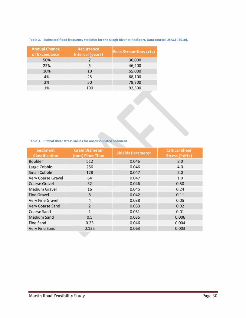
Flood statistics estimated by USACE (2010) for the Skagit River at Rockport (upstream of the Sauk River confluence and representative of the project reach) are summarized below in Table 1. NSD produced 2-Dimensional (2D) hydraulic model simulations that included the project site as part of evaluations completed for the Habitat Restoration Alternatives Assessment in the Barnaby Reach of

Martin Road Feasibility Study Page 27
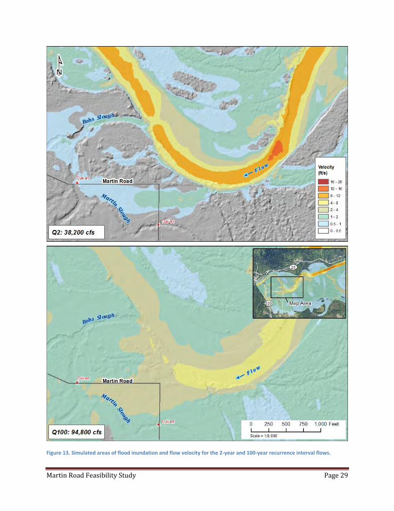
the Skagit River (SRSC and NSD, 2014). Simulated areas of flood inundation and flow velocity in the project area are mapped in Figure 5 for the 2-year (Q2) and 100-year (Q100) floods. The 2-year recurrence interval flow (50% annual chance of exceedance) simulation overtops the left bank and flows westerly across Martin Road into Martin Slough with flow overtopping the road again near the downstream culvert. Maximum flow velocity in the main channel ranges between 10 and 12 feet per second (ft/s) at the apex of the meander near Martin Road. The 100-year recurrence interval flow simulation (1% annual chance of exceedance) inundates a broad floodplain area extending across the valley bottom. Simulated velocities for the 100-year flood are lower than those presented for the 2-year event due to a substantial backwater effect produced by the SR530 highway embankment and bridge crossing just downstream of the project area. The backwater condition during extreme floods lessens the energy gradient of the flow and decreases velocity in the channel. Inundation areas delineated with the 2D hydraulic model are consistent with Base Flood Elevations in Flood Insurance Rate Maps by FEMA.
The prevailing mechanism of bank failure affecting channel migration hazards at Martin Road is toe erosion. Toe erosion is driven by flood flows that mobilize sediment grains from the streambank leading to undercutting and a subsequent collapse of the overlying bank material. Erodible sediment grains are entrained by flow when the effective shear stress exceeds the critical shear stress for grain motion. The total applied shear stress at a given flow is the force exerted by the flowing water per unit area of the bed and, assuming the condition of steady, uniform flow, is calculated as:
𝜏0 = 𝛾𝑅𝑆 (1)
where:
0 = total shear stress (lb/ft2)
= specific weight of water (lb/ft3) R = hydraulic radius (ft) S = energy slope (ft/ft) The total shear stress is partitioned into components characterizing individual roughness elements for a given channel segment such that the effective shear stress available for sediment transport is some fraction of the total applied shear stress at a given location. The relative fraction of total applied shear stress available for sediment transport decreases with increasing amounts of stable wood or other roughness elements in the channel (Manga and Kirchner, 2000).
The critical shear stress for grain motion is derived using a function of the sediment grain size and calculated by a relation developed by Shields (1936) such that:
𝜏𝑐 = 𝜏𝑐∗(𝑠 − 1)𝜌𝑔𝐷 (2)
where:
c = critical shear stress (lb/ft2)
c* = Shields parameter
s = specific gravity of sediment
=density of water (lb/ft3) g = constant for the acceleration due to gravity (ft/s2) D = grain size diameter (ft)
Reference values of critical shear stress for a range of grain size classifications using Wilcock et al.'s (2009) approximation of the Shields curve are summarized below in Table 2.

Martin Road Feasibility Study Page 28
Hydraulic model simulations produce estimates of applied shear stress that can be compared to the critical shear stress values for streambank materials to evaluate sediment mobility at a given flow. Applied shear stress during hydraulic simulations for the 2-year flood exceeds 1 pound per square foot (lb/ft2) in the project reach. Such forces are competent to entrain sediment particles less than 64 millimeters or 2.5 inches in diameter (Table 2). As such, we conclude that relatively frequent, moderate magnitude flood events will continue to mobilize the alluvial sediment at the bank toe and produce additional episodic bank failures that result in additional channel migration toward Martin Road. Localized variation of erosion rates along the meander bend are driven by factors such as bend radius, vegetation, and large woody material.
Spiraling flow patterns (secondary currents) along a bend result in a greater amount of shear stress along the outer bank and the magnitude of shear stress increases with the tightness of the meander. Maximum shear stress in a bend can be up to two times the shear stress acting on the bed or in a comparable straight reach of similar depth and slope. Given the dynamic nature of the Skagit River in the project reach, channel changes in the segment upstream of the project site will alter the attack angle of the approaching flow over time and change the location of maximum shear along the bend.
Woody vegetation along the bank produces localized resistance to erosion through root cohesion and increased flow resistance. Wood accumulations along the bank or in the channel partition shear stress, dissipate energy, and reduce erosion potential (Manga and Kirchner, 2000). On average, erosion rates along agricultural areas or floodplains with immature forests are more than double the erosion rates for floodplains with mature forest vegetation (Abbe, 2000; Micheli et al., 2004). The sparse riparian cover in the project area limits the effect of woody vegetation on bank stability. There are, however, wood pieces exposed in the lower bank at the project site that may be part of a buried logjam. The spatial extent and long-term stability of this buried wood is highly uncertain and would require detailed field investigation to assess. It is possible that the additional resistance produced by this wood will temporarily reduce erosion rates along the project site; however, it is also likely that erosion of adjacent bank materials upstream of the buried wood will undermine the logjam in future flood events, reducing its stabilizing effects.
Martin Road Feasibility Study Page 29
Figure 13. Simulated areas of flood inundation and flow velocity for the 2-year and 100-year recurrence interval flows.
Martin Road Feasibility Study Page 30
Table 2. Estimated flood frequency statistics for the Skagit River at Rockport. Data source: USACE (2010).
Annual Chance of Exceedance
Recurrence Interval (years)
Peak Streamflow (cfs)
50% 2 36,000
25% 5 46,200
10% 10 55,000
4% 25 68,100
2% 50 79,300
1% 100 92,500
Table 3. Critical shear stress values for unconsolidated sediment.
Sediment Classification
Grain Diameter (mm) Finer Than
Shields Parameter Critical Shear Stress (lb/ft2)
Boulder 512 0.046 8.0
Large Cobble 256 0.046 4.0
Small Cobble 128 0.047 2.0
Very Coarse Gravel 64 0.047 1.0
Coarse Gravel 32 0.046 0.50
Medium Gravel 16 0.045 0.24
Fine Gravel 8 0.042 0.11
Very Fine Gravel 4 0.038 0.05
Very Coarse Sand 2 0.033 0.02
Coarse Sand 1 0.031 0.01
Medium Sand 0.5 0.035 0.006
Fine Sand 0.25 0.046 0.004
Very Fine Sand 0.125 0.063 0.003
Martin Road Feasibility Study Page 31
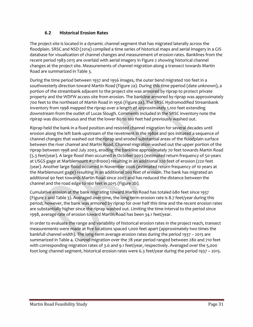
6.2 Historical Erosion Rates
The project site is located in a dynamic channel segment that has migrated laterally across the floodplain. SRSC and NSD (2014) compiled a time series of historical maps and aerial imagery in a GIS database for visualization of channel changes and measurement of erosion rates. Banklines from the recent period 1983-2015 are overlaid with aerial imagery in Figure 2 showing historical channel changes at the project site. Measurements of channel migration along a transect towards Martin Road are summarized in Table 3.
During the time period between 1937 and 1956 images, the outer bend migrated 100 feet in a southwesterly direction toward Martin Road (Figure 2a). During this time pperiod (date unknown), a portion of the streambank adjacent to the project site was armored by riprap to protect private property and the WDFW access site from erosion. The bankline armored by riprap was approximately 700 feet to the northeast of Martin Road in 1956 (Figure 2a). The SRSC Hydromodified Streambank Inventory from 1998 mapped the riprap over a length of approximately 1,100 feet extending downstream from the outlet of Lucas Slough. Comments included in the SRSC inventory note the ripirap was discontinuous and that the lower 80 to 100 feet had previously washed out.
Riprap held the bank in a fixed position and resisted channel migration for several decades until erosion along the left bank upstream of the revetment in the 1980s and 90s initiated a sequence of channel changes that washed out the riprap and eroded substantial areas of the floodplain surface between the river channel and Martin Road. Channel migration washed out the upper portion of the riprap between 1998 and July 2003, eroding the bankline approximately 70 feet towards Martin Road (5.3 feet/year). A large flood then occurred in October 2003 (estimated return frequency of 50-years at USGS gage at Marblemount #12181000) resulting in an additional 220 feet of erosion (220 feet /year). Another large flood occurred in November 2006 (estimated return frequency of 10 years at the Marblemount gage) resulting in an additional 200 feet of erosion. The bank has migrated an additional 90 feet towards Martin Road since 2007 and has reduced the distance between the channel and the road edge to 160 feet in 2015 (Figure 2b).
Cumulative erosion at the bank migrating toward Martin Road has totaled 680 feet since 1937 (Figure 2 and Table 3). Averaged over time, the long-term erosion rate is 8.7 feet/year during this period; however, the bank was armored by riprap for over half this time and the recent erosion rates are substantially higher since the riprap washed out. Limiting the time interval to the period since 1998, average rate of erosion toward Martin Road has been 34.1 feet/year.
In order to evaluate the range and variability of historical erosion rates in the project reach, transect measurements were made at five locations spaced 1,000 feet apart (approximately two times the bankfull channel width). The long-term average erosion rates during the period 1937 – 2015 are summarized in Table 4. Channel migration over the 78 year period ranged between 280 and 710 feet with corresponding migration rates of 3.6 and 9.1 feet/year, respectively. Averaged over the 5,000 foot long channel segment, historical erosion rates were 6.3 feet/year during the period 1937 – 2015.
Martin Road Feasibility Study Page 32
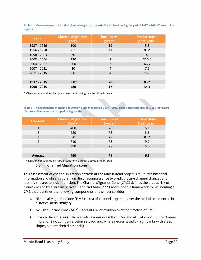
Table 4. Measurements of historical channel migration towards Martin Road during the period 1937 – 2015 (Transect 3 in Figure 2).
Year Channel Migration
(feet) Time Interval
(years) Erosion Rate (feet/year)
1937 - 1956 100 19 5.3
1956 - 1998 0* 42 0.0*
1998 - 2003 70 5 14.0
2003 - 2004 220 1 220.0
2004 - 2007 200 3 66.7
2007 - 2011 30 4 7.5
2011 - 2015 60 4 15.0
1937 - 2015 680* 78 8.7*
1998 - 2015 580 17 34.1
* Migration constrained by riprap revetment during selected time interval
Table 5. Measurements of channel migration during the period 1937 – 2015 along 5 transects spaced 1,000 feet apart (Transect alignments are mapped on Figure 2b).
Transect Channel Migration
(feet) Time Interval
(years) Erosion Rate (feet/year)
1 400 78 5.1
2 280 78 3.6
3 680* 78 8.7*
4 710 78 9.1
5 390 78 5.0
Average 490 78 6.3
* Migration constrained by riprap revetment during selected time interval
6.3 Channel Migration Zone
This assessment of channel migration hazards at the Martin Road project site utilizes historical information and observations from field reconnaissance to predict future channel changes and identify the area at risk of erosion. The Channel Migration Zone (CMZ) defines the area at risk of future erosion by a stream or river. Rapp and Abbe (2003) developed a framework for delineating a CMZ that identifies the following components of the river corridor:
1. Historical Migration Zone (HMZ) –area of channel migration over the period represented in historical aerial imagery;
2. Avulsion Hazard Zone (AHZ) – area at risk of avulsion over the timeline of CMZ;
3. Erosion Hazard Area (EHA) – erodible areas outside of HMZ and AHZ at risk of future channel migration (including an erosion setback and, where necessitated by high banks with steep slopes, a geotechnical setback);

Martin Road Feasibility Study Page 33
4. Disconnected Migration Area (DMA) – portion of CMZ that is isolated by infrastructure that physically limits channel migration.
The collective areas are combined to map the CMZ such that:
CMZ = HMZ + AHZ + EHA – DMA
The HMZ is delineated from overlays of past channel alignments digitized by SRSC from historical imagery. NSD delineated three AHZs flanking the HMZ where existing side channels pose a high risk of future avulsion hazards. The AHZ includes an area crossing over Martin Road between the upstream culvert in Martin Slough and the 90 degree bend in Martin Road. Flood flows overtop the bank in this location and follow a preferential flowpath along a swale connecting the main channel to Martin Slough (Figure 5).
The EHA extends outward from the HMZ and AHZ to represent erodible areas at risk of future erosion. The long-term average erosion rate for the project reach (Table 4) was projected over a 100 year CMZ timeline to yield a 630 foot erosion setback defining the EHA (6.3 ft/yr times 100 years). The preliminary CMZ delineated with this method identifies a corridor greater than 4,000 feet wide in the project area.
The bank of the Skagit River was 160 feet from Martin Road in 2015. Assuming continued channel migration at the long term average erosion rate of 6.3 feet/year, the eroding bank would intersect Martin Road in a period of 25 years. Recent channel movement at the project site has far exceeded the long term average with an erosion rate of 34.1 feet/year since 1998. Should channel migration continue at this more rapid rate, the eroding bank would intersect Martin Road in less than 5 years. Given the trajectory of recent channel adjustments and current meander configuration, erosion will likely continue at some rate between the recent rate and the long term average. As such, a reasonable planning timeline for Martin Road could assume the eroding bank will intersect road edge at some point during the next 5 to 25 years. It possible, however, that erosion from a single event could erode the remaining floodplain area and damage the road given that the remaining distance between the channel and Martin Road (160 feet) is less than the observed erosion from 2003 and 2006 flood events (220 and 200 feet, respectively). Streamflows associated with these recent flood events were not specifically measured in the project reach; however, flood frequency analysis at the USGS gage near Marblemount estimate the 2003 flood as an approximately 50-year event and the 2006 flood as an approximately 10-year event.
There remains an element of uncertainty due to localized variations in shear stress, bank strength, and potential for development of new wood jams that alter flow hydraulics. In general, projections of channel migration are more reliable in the near future and become more uncertain over longer time periods. Both near and longer term channel migration will be dependent on the occurrence and magnitude of flood events, sediment deposition, and occurrence of stable logjams within the project reach.
Continued channel adjustments at the bend upstream of the project site will affect erosion patterns in the project area. The right bank on the bend just upstream and across the river from the project site is migrating westerly (downstream) and altering the meander geometry in the approach section to the bend at Martin Road (Figures 2b and 5). If the channel continues this westward trend of migration, the initial change in channel location would likely steepen the angle of approach into the Martin Road bend, and increase the rates of migration along the left bank toward Martin Road. Over time, however, continued migration of the bend upstream of the project site could intersect older channel features in the floodplain and trigger an avulsion that cuts off the meander bend, decreases

Martin Road Feasibility Study Page 34
shear stress along the outer bend at Martin Road, and reduces erosion rates relative to the recent period when flow has been concentrated along the outer bend. This avulsion could occur in response to formation of a large log jam capable of deflecting flow west and across the interior of the bend (across the channel from Martin Road). This scenario is plausible given that the floodplain area being eroded by this upstream meander contains relic channel scars and side channels that could be re-activated. Given the trajectory of channel migration along the right bank, the nearest floodplain channel likely to capture substantial flow is approximately 450 to 700 feet from the present bankline. The recent channel migration rate at the bank has averaged 15 feet/year since 1998. At this rate, we estimate the process whereby a meander cutoff would occur is in the range of 30-50 years at that location.
Evaluations of climate change impacts on peak flows in the Skagit River basin project increasing flood frequencies and magnitudes over the 21st century in association with warming temperatures and a greater proportion of winter precipitation occurring as rain versus snow (Lee and Hamlet, 2011). Model simulations of future climate with the A1B emissions scenario project a 49% increase in the 100-year flood magnitude upstream of the project site at Ross Dam and 53% increase in the lower Skagit River near Mount Vernon by the 2080s (Hamlet et al., 2010). Future projections of climate change impacts have not yet been incorporated into hydraulic model simulations but will substantially increase flood inundation and sediment transport capacity as well as accelerate channel migration rates in areas of the project reach that lack sufficient resistance, by wood or other material, to partition shear stress and inhibit toe erosion. As such, it is possible that CMZ delineation based on historical migration rates may under-predict the potential area of future erosion and warrant a more detailed evaluation of potential impacts of future changes in hydrology on bank erosion and channel migration processes.
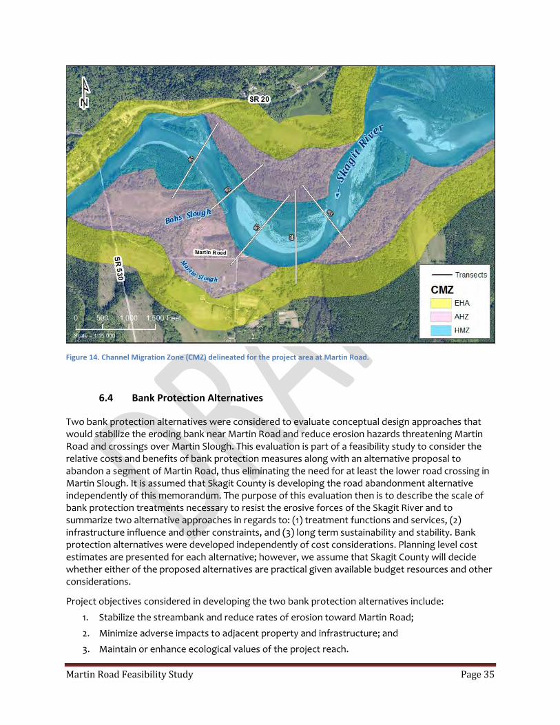
Martin Road Feasibility Study Page 35
Figure 14. Channel Migration Zone (CMZ) delineated for the project area at Martin Road.
6.4 Bank Protection Alternatives
Two bank protection alternatives were considered to evaluate conceptual design approaches that would stabilize the eroding bank near Martin Road and reduce erosion hazards threatening Martin Road and crossings over Martin Slough. This evaluation is part of a feasibility study to consider the relative costs and benefits of bank protection measures along with an alternative proposal to abandon a segment of Martin Road, thus eliminating the need for at least the lower road crossing in Martin Slough. It is assumed that Skagit County is developing the road abandonment alternative independently of this memorandum. The purpose of this evaluation then is to describe the scale of bank protection treatments necessary to resist the erosive forces of the Skagit River and to summarize two alternative approaches in regards to: (1) treatment functions and services, (2) infrastructure influence and other constraints, and (3) long term sustainability and stability. Bank protection alternatives were developed independently of cost considerations. Planning level cost estimates are presented for each alternative; however, we assume that Skagit County will decide whether either of the proposed alternatives are practical given available budget resources and other considerations.
Project objectives considered in developing the two bank protection alternatives include:
1. Stabilize the streambank and reduce rates of erosion toward Martin Road;
2. Minimize adverse impacts to adjacent property and infrastructure; and
3. Maintain or enhance ecological values of the project reach.
Martin Road Feasibility Study Page 36
Two general approaches were considered to differentiate bank protection alternatives:
1. Strengthening the bank and increasing resistance to flow; and
2. Re-directing flow to reduce the hydraulic forces on the eroding streambank.
Conceptual sketches of the two bank protection alternatives are illustrated in Figure 7. Discussion below addresses pros/cons of the two alternatives.
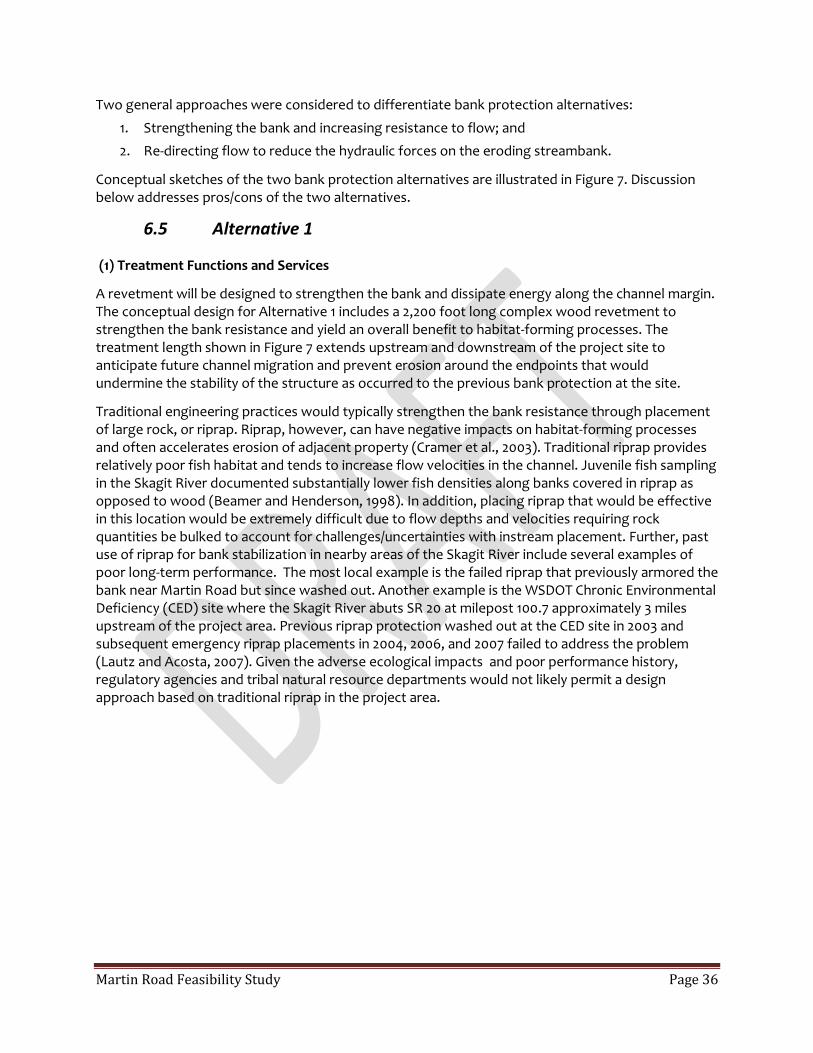
6.5 Alternative 1
(1) Treatment Functions and Services
A revetment will be designed to strengthen the bank and dissipate energy along the channel margin. The conceptual design for Alternative 1 includes a 2,200 foot long complex wood revetment to strengthen the bank resistance and yield an overall benefit to habitat-forming processes. The treatment length shown in Figure 7 extends upstream and downstream of the project site to anticipate future channel migration and prevent erosion around the endpoints that would undermine the stability of the structure as occurred to the previous bank protection at the site.
Traditional engineering practices would typically strengthen the bank resistance through placement of large rock, or riprap. Riprap, however, can have negative impacts on habitat-forming processes and often accelerates erosion of adjacent property (Cramer et al., 2003). Traditional riprap provides relatively poor fish habitat and tends to increase flow velocities in the channel. Juvenile fish sampling in the Skagit River documented substantially lower fish densities along banks covered in riprap as opposed to wood (Beamer and Henderson, 1998). In addition, placing riprap that would be effective in this location would be extremely difficult due to flow depths and velocities requiring rock quantities be bulked to account for challenges/uncertainties with instream placement. Further, past use of riprap for bank stabilization in nearby areas of the Skagit River include several examples of poor long-term performance. The most local example is the failed riprap that previously armored the bank near Martin Road but since washed out. Another example is the WSDOT Chronic Environmental Deficiency (CED) site where the Skagit River abuts SR 20 at milepost 100.7 approximately 3 miles upstream of the project area. Previous riprap protection washed out at the CED site in 2003 and subsequent emergency riprap placements in 2004, 2006, and 2007 failed to address the problem (Lautz and Acosta, 2007). Given the adverse ecological impacts and poor performance history, regulatory agencies and tribal natural resource departments would not likely permit a design approach based on traditional riprap in the project area.

Martin Road Feasibility Study Page 37
Figure 15. Concept sketches for two bank protection alternatives.

Martin Road Feasibility Study Page 38
Given these constraints, a more holistic design approach that protects property and infrastructure from bank erosion while allowing for natural, habitat forming processes to occur is recommended for the project site. The complex wood revetment varies in width to produce a roughened channel margin that reduces flow velocity and shear stress near the bank; shifting the area of maximum velocity and shear away from the bank and towards the center of the channel. Along smooth banks, such as bare soil or traditional riprap, flow velocity is high along the channel margin. Rougher banks increase flow resistance, lower flow velocity, and decrease erosion risk along the channel margin. (Figure 8). Examples of engineered, complex wood revetments recently constructed on the South Fork Nooksack and Skagit Rivers are shown in Figures 9 and 10, respectively.
The Skagit River example constructed at the WSDOT CED site in 2014 is likely the best reference to consider in regards to construction of a complex wood revetment at the Martin Road project site. Similar to the WSDOT site upstream, the thalweg is against the eroding bank near Martin Road and dewatering is not likely feasible given the flow regime of the Skagit River and other constraints. As such, construction will need to be completed with equipment located on the top of bank, as opposed to working in the channel, and material will be placed directly in the wetted channel. Such conditions limit many common construction approaches and the dolo-ballasted structure constructed by WSDOT is the most feasible approach to constructing a long-term stable revetment at the Martin Road site.
Figure 16. Illustration of how rougher banks reduce river velocities near the bank. Traditional bank protection tends to create a smooth bank where high flow velocities hug the bank (solid lines above). Where banks are roughened near-bank velocities are reduced (dashed lines), diminishing the risk of erosion and improving salmon habitat

Martin Road Feasibility Study Page 39
(2) Infrastructure Influence and Other Constraints
The primary concerns regarding risks to infrastructure are increased erosion hazards to Martin Road and to SR 530. Alternative 1 completely removes the erosion hazard at Martin Road by design. The erosion hazard at SR 530 is primarily driven by risk of avulsion towards the SR 530 bridge crossing at Bohs Slough (Shanz 2015). As sketched in Figure 7, the complex wood revetment would terminate just upstream of the inlet connection to Bohs Slough. With Alternative 1, there is no anticipated increase in avulsion risk at Bohs Slough; however, the existing avulsion risk will remain.
The overall footprint of the complex wood revetment for Alternative 1 is relatively small compared to the active flow area. No substantial backwater effect, or increase in flood stage, would be expected under this alternative.
(3) Long Term Sustainability and Stability
The overall stability of the revetment will be driven by the construction approach and anchoring material. The interlocking, concrete dolos used at the WSDOT project upstream are the most stable anchor for use in site conditions similar to the bend at Martin Road. A dolo-ballasted, complex wood revetment would be stable for many decades allowing for riparian restoration activities to mature. Over the long-term, creation of such floodplain hard points support development of mature forests which function as future sources of large wood to increase stability of alluvial channels (Abbe and Montgomery, 1996, 2003; Collins et al., 2012).
(4) Planning-Level Construction Costs
The WSDOT project example upstream treated approximately 1,400 feet of streambank using a combination of bank revetments and Engineered Logjams (ELJs) plus an additional mid-channel ELJ at a total project cost of $7.5 Million. A simplified unit cost per treatment length was developed assuming the mid-channel ELJ added an additional 100 feet for a collective treatment length of 1,500 feet. The proposed treatment length at Martin Road is estimated at 2,200 feet or an additional 47%. Application of the additional treatment length to the WSDOT project cost yields a planning-level construction cost estimate of $11 Million for the complex wood revetment to protect Martin Road.

Martin Road Feasibility Study Page 40
Figure 17. An engineered, complex wood revetment built by the Lummi Nation along the South Fork Nooksack River. The structure is stabilized with timber piles and rock collars creating a rough streambank very different than traditional rock revetments such as riprap.
Figure 18. An engineered, complex wood revetment constructed by WSDOT on the Skagit River to protect SR 20 at milepost 100.7. This structure is stabilized with concrete dolo anchors and ballast due to site constraints. Photo from WSDOT (2014).

Martin Road Feasibility Study Page 41
6.6 Alternative 2
(1) Treatment Functions and Services
Flow in the project reach will be redirected by an array of Engineered Logjams (ELJs) to reduce the hydraulic forces on the eroding streambank. As opposed to strengthening the streambank as described by Alternative 1, this alternative aims to reduce the flow velocity and shear stress acting on the bank material near Martin Road. The ELJ deflector array would consist of multiple structures that are staggered in the active channel corridor to interrupt the flow patterns and create additional physical and hydraulic complexity. In this manner, the ELJs provide complimentary functions of deflecting the primary flow paths away from the bank at Martin Road and concurrently enhancing habitat-forming processes by mimicking the geomorphic effect of large trees and logjams that were historically an important component of the Skagit River (Collins and Sheikh, 2002).
The conceptual design sketch in Figure 7 represents the array as a series of structures, each approximately 80 feet in width. The average bankfull width in this section of the Skagit River is approximately 500 feet. Design of how many ELJs and of what size are required will be determined through additional hydraulic analysis in subsequent design phases. For this planning-level effort, we assume an array that collectively obstructs approximately 50% of the active flow in the treatment area. In addition to the ELJ array, a pilot channel will be excavated across the upper bar surface to encourage the new flowpath to cut off the inside of the bend and thus bypass the eroding bank near Martin Road. An example of a similar approach used in the Quinault River is illustrated in Figure 11.
Alternative 2 will likely be easier to construct than the proposed design for Alternative 1. Many of the Alternative 2 ELJs can be built upon dry gravel bars or shallow water areas as opposed to the channel thalweg. ELJs located within the channel would need to be designed such that they could be assembled in the “wet” similar to the apex ELJ at the WSDOT MP 100.7 project.
(2) Infrastructure Influence and Other Constraints
Some amount of continued bank erosion should be expected with Alternative 2 as the overly steepened bank stabilizes and vegetation is allowed to mature. In addition, it is possible that bank erosion could continue if streamflow velocities exceed threshold for incipient motion of the bank material such that Martin Road is eventually threatened. Similarly completed ELJ arrays have successfully slowed bank erosion but also incorporated a bank strengthening element. If future hydraulic analysis indicated a concern, a bank strengthening element could be implemented similar to Alternative 1 but smaller in scale.
Risk of avulsion hazards at Bohs Slough affecting the SR 530 bridge may be increased by Alternative 2 given how the new channel alignment would be oriented to impact the left bank at a steep angle in line with the inlet to Bohs Slough as opposed to the oblique angle of approach in the current channel configuration.
Additional concerns may be generated by a backwater influence upstream of the ELJ array created by the obstructions and additional channel roughness. The backwater influence is unlikely to affect SR 20 upstream as that section of the highway is elevated well above the floodplain. Most property to be affected by increased flood stages with this alternative are already in conservation ownership. The backwater upstream of the ELJs could steepen the hydraulic gradient along an existing side channel that connects to Lucas Slough; however, and increase risk of an avulsion along this side

Martin Road Feasibility Study Page 42
channel alignment. If such an event were to occur, the avulsion would effectively bypass the ELJ array as drawn and renew erosion along the outer bend at Martin Road.

Martin Road Feasibility Study Page 43
(3) Long Term Sustainability and Stability
The Alternative 2 design plan reduces erosion risk at Martin Road compared to the existing condition; however, stabilization of the eroding bank is less certain relative to the design plan for Alternative 1. ELJ design will be developed with support from hydraulic modeling tools to demonstrate that near bank velocity and shear is less than the critical value for sediment mobilization. Given the dynamic nature of the project reach, future channel changes could result in a different flow pattern that may increase velocity and shear. If hydraulic analysis indicated a concern, a bank strengthening element could be implemented similar to Alternative 1 but smaller in scale.
(4) Planning-Level Construction Costs
The construction approach and materials required to build Alternative 2 are expected to be substantially cheaper in relation to Alternative 1. Construction bids for ELJs of similar size have been on the order of $100,000 per structure. In this planning-level evaluation, we assume an array with 13 to 15 structures would be required for Alternative 2. Assuming a markup of 50% contingency given the magnitude of uncertainty at this stage, we estimate a planning level construction cost of $2.25 Million for Alternative 2.
Figure 19 (next page). Channel migration hazard and bank protection treatments in the Upper Quinault River near South Shore Road. An array of ELJs was constructed in 2013 (phase 1) to deflect flow and enhance habitat-forming processes in the reach. The array of ELJs was expanded in 2015 (Phase 2) to include additional structures.

Martin Road Feasibility Study Page 44
1994
2012
2013
Martin Road Feasibility Study Page 45
6.7 References
Abbe, T. B., and Montgomery, D. R. 1996. Large woody debris jams, channel hydraulics and habitat formation in large rivers. Regulated Rivers Research & Management, 12(23), 201-221.
Abbe, T., 2000. Patterns, mechanics and geomorphic effects of wood debris accumulations in a forest river system. University of Washington, PhD Dissertation, Seattle, WA.
Abbe, T. B., and Montgomery, D. R. 2003. Patterns and processes of wood debris accumulation in the Queets river basin, Washington. Geomorphology, 51(1), 81-107.
Beamer, E., Bernard, R., Hayman, B., Hebner, B., Hinton, S., Hood, G., Kraemer, C., McBride, A., Musslewhite, J., Smith, D., 2005. Skagit Chinook recovery plan. Skagit River System Cooperative and Washington Department of Fish and Wildlife.
Beamer, E. and R. Henderson. 1998. Juvenile Salmonid Use of Natural and Hydromodified Stream Bank Habitat in the Mainstem Skagit River, Northwest Washington. Skagit System Cooperative,
Brummer, C. J., Abbe, T. B., Sampson, J. R., and Montgomery, D. R. 2006. Influence of vertical channel change associated with wood accumulations on delineating channel migration zones, Washington, USA. Geomorphology, 80(3), 295-309.
Collins, B. D., Montgomery, D. R., Fetherston, K. L., and Abbe, T. B. 2012. The floodplain large-wood cycle hypothesis: A mechanism for the physical and biotic structuring of temperate forested alluvial valleys in the North Pacific coastal ecoregion. Geomorphology, 139, 460-470.
Collins, B. D., and Sheikh, A. J. 2002. Methods used to map the historical riverine landscape and habitats of the Skagit River. Report to the Skagit River System Cooperative.
Cramer, M., Bates, K., Miller, D., Boyd, K., Fotherby, L., Skidmore, P., Hoitsma, T., 2002. Integrated streambank protection guidelines. Washington State Aquatic Habitat Guidelines Program.
Hamlet, A.F., P. Carrasco, J. Deems, M.M. Elsner, T. Kamstra, C. Lee, S-Y Lee, G. Mauger, E. P. Salathe, I. Tohver, Binder, L.W., 2010. Final Project Report for the Columbia Basin Climate Change Scenarios Project.
Klungland, M.W., McArthur, M., 1989. Soil survey of Skagit County Area, Washington, Natural Resource Conservation Service.
Lautz, K., Schanz, R.W., Park, J.D., 2004. Site and Reach Assessment, Evaluation of Treatment Alternatives, SR 530/Sauk River Chronic Environmental Deficiency Site, Washington State Department of Transportation.
Lee, Se-Yeun and Hamlet, A.F. 2011. Skagit River Basin Climate Science Report, a summary report prepared for Skagit County and the Envision Skagit Project by the Department of Civil and Environmental Engineering and The Climate Impacts Group at the University of Washington.
Manga, M., Kirchner, J.W., 2000. Stress partitioning in streams by large woody debris. Water Resources Research, 36(8), 2373-2379.
Martin Road Feasibility Study Page 46
Micheli, E., Kirchner, J., Larsen, E., 2004. Quantifying the effect of riparian forest versus agricultural vegetation on river meander migration rates, Central Sacramento River, California, USA. River Research and Applications, 20(5), 537-548.
Montgomery, D. R., and Abbe, T. B. 2006. Influence of logjam-formed hard points on the formation of valley-bottom landforms in an old-growth forest valley, Queets River, Washington, USA. Quaternary Research, 65(1), 147-155.
Montgomery, D. R., Buffington, J. M., Smith, R. D., Schmidt, K. M., and Pess, G. 1995. Pool spacing in forest channels. Water Resources Research, 31(4), 1097-1105.
Rapp, C.F., Abbe, T.B., 2003. A framework for delineating channel migration zones. Washington Department of Ecology Publication #03-06-027.
Shanz, R. 2015. Reach Assessment, SR 530 and 20 near the Skagit River Rockport Bridge. Washington State Department of Transportation.
Shields, A., 1936. Application of similarity principles and turbulence research to bed-load movement, Soil Conservation Service.
Skagit River System Cooperative and Natural Systems Design, Inc. 2014. Habitat Restoration Alternatives Assessment, Barnaby Reach of the Skagit River.
United States Army Corps of Engineers. 2008. Skagit River Basin Sediment Budget and Fluvial Geomorphology. Skagit River Flood Damage Reduction Feasibility Study.
Washington Department of Fish and Wildlife, 2015. Fish Passage and Diversion Screening Inventory Fish Barrier Map. http://wdfw.wa.gov/conservation/habitat/fish_passage/data_maps.html
Washington State Department of Transportation. 2007. Site and Reach Assessment. Evaluation of Treatment Alternatives SR20 MP 100.7 (Skagit River). Environmental and Engineering Services Center. Report under Work Order MT0100.
Washington State Department of Transportation. 2007. Site and Reach Assessment. Evaluation of Treatment Alternatives SR20 MP 100.7 (Skagit River). Environmental and Engineering Services Center. Report under Work Order MT0100.
Washington State Department of Transportation. 2014. Improving Stream Habitat and Protecting Roads. WSDOT CED Program Fiscal Year 2014 Report
Wilcock, P.R., Pitlick, J., Cui, Y., 2009. Sediment transport primer: estimating bed-material transport in gravel-bed rivers.

Martin Road Feasibility Study Page 47
APPENDIX B
Martin Road Traffic Impact Analysis
Martin Road Feasibility Study Page 48
To: Jeff McGowan, DB
From: Torey Nelson, Engineering Technician IV
Prepared by: TN, FJ
Date: 5/20/2016
Re: Martin Road Traffic Impact Analysis
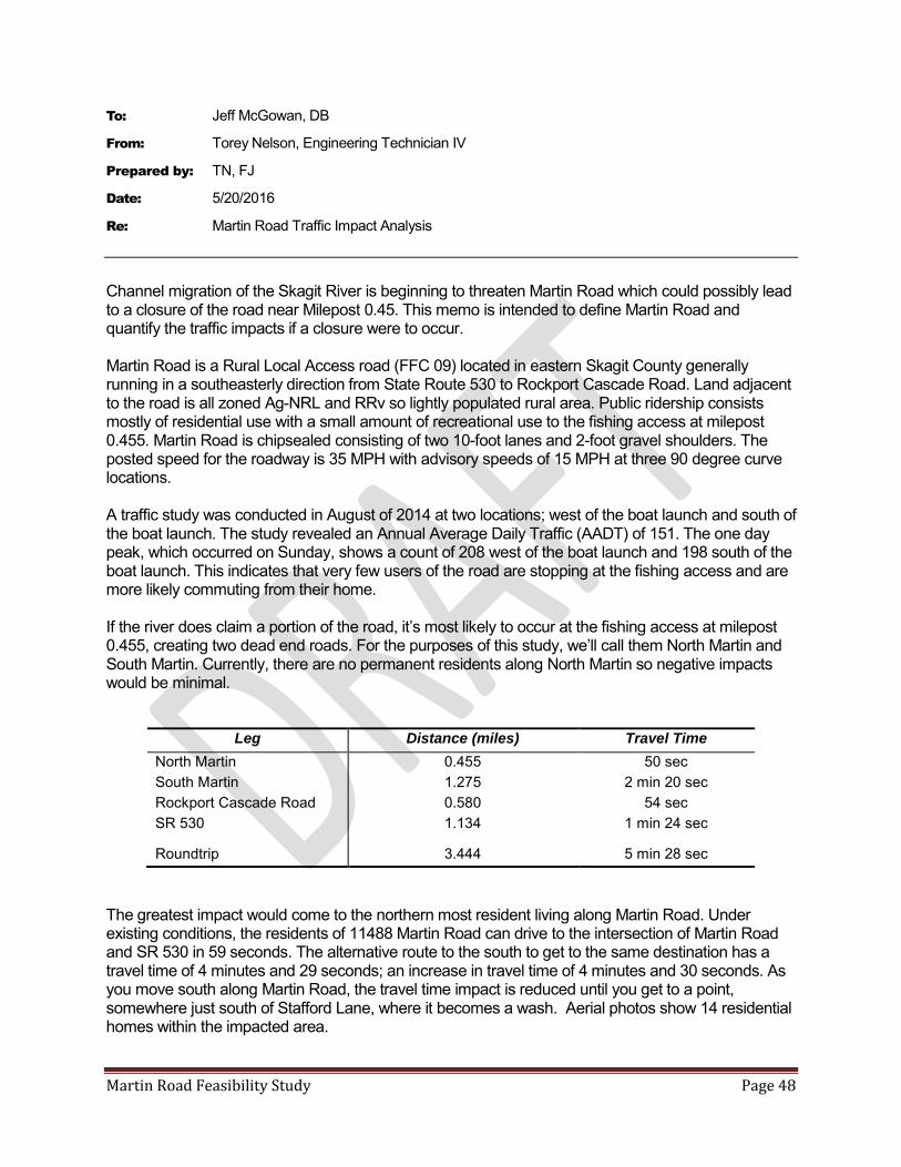
Channel migration of the Skagit River is beginning to threaten Martin Road which could possibly lead to a closure of the road near Milepost 0.45. This memo is intended to define Martin Road and quantify the traffic impacts if a closure were to occur. Martin Road is a Rural Local Access road (FFC 09) located in eastern Skagit County generally running in a southeasterly direction from State Route 530 to Rockport Cascade Road. Land adjacent to the road is all zoned Ag-NRL and RRv so lightly populated rural area. Public ridership consists mostly of residential use with a small amount of recreational use to the fishing access at milepost 0.455. Martin Road is chipsealed consisting of two 10-foot lanes and 2-foot gravel shoulders. The posted speed for the roadway is 35 MPH with advisory speeds of 15 MPH at three 90 degree curve locations. A traffic study was conducted in August of 2014 at two locations; west of the boat launch and south of the boat launch. The study revealed an Annual Average Daily Traffic (AADT) of 151. The one day peak, which occurred on Sunday, shows a count of 208 west of the boat launch and 198 south of the boat launch. This indicates that very few users of the road are stopping at the fishing access and are more likely commuting from their home. If the river does claim a portion of the road, it’s most likely to occur at the fishing access at milepost 0.455, creating two dead end roads. For the purposes of this study, we’ll call them North Martin and South Martin. Currently, there are no permanent residents along North Martin so negative impacts would be minimal.
Leg Distance (miles) Travel Time
North Martin 0.455 50 sec South Martin 1.275 2 min 20 sec Rockport Cascade Road 0.580 54 sec SR 530 1.134 1 min 24 sec Roundtrip 3.444 5 min 28 sec
The greatest impact would come to the northern most resident living along Martin Road. Under existing conditions, the residents of 11488 Martin Road can drive to the intersection of Martin Road and SR 530 in 59 seconds. The alternative route to the south to get to the same destination has a travel time of 4 minutes and 29 seconds; an increase in travel time of 4 minutes and 30 seconds. As you move south along Martin Road, the travel time impact is reduced until you get to a point, somewhere just south of Stafford Lane, where it becomes a wash. Aerial photos show 14 residential homes within the impacted area.

Martin Road Feasibility Study Page 49
REFERENCES
Flagan, Janice 2016. Skagit County Public Works - Personal Communication related to USACOE
Cockreham Island Levee, SKA-06-07
Skagit River System Cooperative and Natural Systems Design, Inc. 2014 Habitat Restoration
Alternatives Assessment - Barnaby Reach of the Skagit River
Washington Department of Fish and Wildlife, 2015. Fish Passage and Diversion Screening Inventory
Fish Barrier Map. http://wdfw.wa.gov/conservation/habitat/fish_passage/data_maps.html
USFS Mt.Baker-Snoqualmie National Forest 2016. Skagit Wild and Scenic River System
http://www.fs.usda.gov/detail/mbs/landmanagement/resourcemanagement/?cid=fsbdev7_001643
Related Documents


