Memphis Shelby County Airport Authority Tree Obstruction Clearing September 2021 Draft Environmental Assessment

Welcome message from author
This document is posted to help you gain knowledge. Please leave a comment to let me know what you think about it! Share it to your friends and learn new things together.
Transcript

Memphis Shelby County Airport Authority
Tree Obstruct ion Clear ing
September 2021
DraftEnvironmental
Assessment


iii | P a g e
EXECUTIVE SUMMARY ES01EXECUTIVE SUMMARY ES02
PURPOSE AND NEED OF THE PROPOSED ACTION ES02
PROPOSED ACTION ES02
NO ACTION ALTERNATIVE ES04
ENVIRONMENTAL ASSESSMENT ES04
IMPACTS ES07
DETERMINATION ES08
FINDING OF NO SIGNIFICANT IMPACT ES08
SECTION 1.0 011.0 INTRODUCTION 02
1.1 PROJECT BACKGROUND 02
1.2 PURPOSE AND NEED 03
1.3 ENVIRONMENTAL ASSESSMENT 03
1.4 AGENCY COORDINATION AND PUBLIC INVOLVEMENT 04
CONTENTS
iv | P a g e
SECTION 2.0 052.0 PROPOSED ACTION AND ALTERNATIVES 06
2.1 PROPOSED ACTION ALTERNATIVE 06
2.2 NO ACTION ALTERNATIVE 07
2.3 ALTERNATIVES CONSIDERED BUT ELIMINATED 07
SECTION 3.0 093.0 AFFECTED ENVIRONMENT AND ENVIRONMENTAL CONSEQUENCES 10
3.1 AIR QUALITY 113.1.1 Regulatory Setting ....................................................................................................................................................................................113.1.2 Affected Environment ..............................................................................................................................................................................123.1.3 Environmental Consequences ..............................................................................................................................................................12 3.1.3.1 Proposed Action ...............................................................................................................................................................................12 3.1.3.2 No Action Alternative .....................................................................................................................................................................153.1.4 Mitigation .....................................................................................................................................................................................................15
3.2 BIOLOGICAL RESOURCES 153.2.1 Regulatory Setting ....................................................................................................................................................................................153.2.2 Affected Environment ..............................................................................................................................................................................163.2.3 Environmental Consequences ..............................................................................................................................................................18 3.2.3.1 Proposed Action ...............................................................................................................................................................................18 3.2.3.2 No Action Alternative .....................................................................................................................................................................193.2.4 Mitigation .....................................................................................................................................................................................................19
3.3 CLIMATE 193.3.1 Regulatory Setting ....................................................................................................................................................................................193.3.2 Affected Environment ..............................................................................................................................................................................203.3.3 Environmental Consequences ..............................................................................................................................................................20 3.3.3.1 Proposed Action ...............................................................................................................................................................................20 3.3.3.2 No Action Alternative .....................................................................................................................................................................21
3.4 COASTAL RESOURCES 233.4.1 Regulatory Setting ....................................................................................................................................................................................233.4.2 Affected Environment ..............................................................................................................................................................................233.4.3 Environmental Consequences ..............................................................................................................................................................23 3.4.3.1 Proposed Action ...............................................................................................................................................................................23 3.4.3.2 No Action Alternative .....................................................................................................................................................................233.4.4 Mitigation .....................................................................................................................................................................................................23
3.5 DEPARTMENT OF TRANSPORTATION ACT, SECTION 4(F) 23
3.5.1 Regulatory Setting ....................................................................................................................................................................................233.5.2 Affected Environment ..............................................................................................................................................................................243.5.3 Environmental Consequences ..............................................................................................................................................................24 3.5.3.1 Proposed Action ...............................................................................................................................................................................24
v | P a g e
3.5.3.2 No Action Alternative .....................................................................................................................................................................243.5.4 Mitigation .....................................................................................................................................................................................................24
Figure 4 - Section 4(F) Resources Map 253.6 FARMLANDS 26
3.6.1 Regulatory Setting ....................................................................................................................................................................................263.6.2 Affected Environment ..............................................................................................................................................................................263.6.3 Environmental Consequences ..............................................................................................................................................................26 3.6.3.1 Proposed Action ...............................................................................................................................................................................26 3.6.3.2 No Action Alternative .....................................................................................................................................................................263.6.4 Mitigation .....................................................................................................................................................................................................26
3.7 HAZARDOUS MATERIALS, SOLID WASTE, AND POLLUTION PREVENTION 283.7.1 Regulatory Setting ....................................................................................................................................................................................283.7.2 Affected Environment ..............................................................................................................................................................................28 3.7.2.1 Identification of Contaminated Sites ........................................................................................................................................29 3.7.2.2 Identification of Solid and Hazardous Waste Disposal Capacity ...................................................................................323.7.3 Environmental Consequences .............................................................................................................................................................32 3.7.3.1 Proposed Action ...............................................................................................................................................................................32 3.7.3.2 No Action Alternative .....................................................................................................................................................................333.7.4 Mitigation .....................................................................................................................................................................................................33
3.8 HISTORICAL, ARCHITECTURAL, ARCHEOLOGICAL, AND CULTURAL RESOURCES 333.8.1 Regulatory Setting ....................................................................................................................................................................................333.8.2 Affected Environment ..............................................................................................................................................................................343.8.3 Environmental Consequences ..............................................................................................................................................................37 3.8.3.1 Proposed Action ...............................................................................................................................................................................37 3.8.3.2 No Action Alternative .....................................................................................................................................................................373.8.4 Mitigation .....................................................................................................................................................................................................37
3.9 LAND USE 373.9.1 Regulatory Setting ....................................................................................................................................................................................373.9.2 Affected Environment ..............................................................................................................................................................................373.9.3 Environmental Consequences ..............................................................................................................................................................38 3.9.3.1 Proposed Action ...............................................................................................................................................................................38 3.9.3.2 No Action Alternative .....................................................................................................................................................................383.9.4 Mitigation .....................................................................................................................................................................................................38
3.10 NATURAL RESOURCES AND ENERGY SUPPLY 383.10.1 Regulatory Setting ..................................................................................................................................................................................383.10.2 Affected Environment ...........................................................................................................................................................................383.10.3 Environmental Consequences ...........................................................................................................................................................40 3.10.3.1 Proposed Action ............................................................................................................................................................................40 3.10.3.2 No Action Alternative ..................................................................................................................................................................403.10.4 Mitigation ..................................................................................................................................................................................................40
3.11 NOISE AND NOISE COMPATIBLE LAND USE 403.11.1 Regulatory Setting ..................................................................................................................................................................................403.11.2 Affected Environment ...........................................................................................................................................................................41
vi | P a g e
3.11.3 Environmental Consequences ...........................................................................................................................................................41 3.11.3.1 Proposed Action ............................................................................................................................................................................41 3.11.3.2 No Action Alternative ..................................................................................................................................................................413.11.4 Mitigation ..................................................................................................................................................................................................42
3.12 SOCIOECONOMICS, ENVIRONMENTAL JUSTICE, AND CHILDREN’S ENVIRONMENTAL HEALTH AND SAFETY RISKS 42
3.12.1 Regulatory Setting ..................................................................................................................................................................................423.12.2 Affected Environment ...........................................................................................................................................................................43 3.12.2.1 Socioeconomics ............................................................................................................................................................................43 3.12.2.2 Environmental Justice ..................................................................................................................................................................44 3.12.2.3 Children’s Environmental Health and Safety Risk .............................................................................................................453.12.3 Environmental Consequences ...........................................................................................................................................................45 3.12.3.1 Socioeconomics .............................................................................................................................................................................45 3.12.3.2 Environmental Justice ..................................................................................................................................................................45 3.12.3.3 Children’s Environmental Health and Safety Risk .............................................................................................................46 3.12.3.4 No Action Alternative ..................................................................................................................................................................473.12.4 Mitigation ..................................................................................................................................................................................................47
3.13 VISUAL EFFECTS 473.13.1 Regulatory Setting ..................................................................................................................................................................................473.13.2 Affected Environment ...........................................................................................................................................................................47 Light Emissions .................................................................................................................................................................................................47 Visual Resources and Visual Character ...................................................................................................................................................473.13.3 Environmental Consequences ...........................................................................................................................................................48 3.13.3.1 Proposed Action ............................................................................................................................................................................48 Light Emissions .................................................................................................................................................................................................48 Visual Character ...............................................................................................................................................................................................48 3.13.3.2 No Action Alternative ..................................................................................................................................................................483.13.4 Mitigation ..................................................................................................................................................................................................48
3.14 WATER RESOURCES 493.14.1 Regulatory Setting ..................................................................................................................................................................................493.14.2 Affected Environment ...........................................................................................................................................................................49 3.14.2.1 Wetlands and Surface Waters ...................................................................................................................................................49 3.14.2.2 Floodplains ......................................................................................................................................................................................52 3.14.2.3 Groundwater ...................................................................................................................................................................................52 3.14.2.4 Wild and Scenic Rivers ................................................................................................................................................................533.14.3 Environmental Consequences ...........................................................................................................................................................53 3.14.3.1 Wetlands and Surface Waters ...................................................................................................................................................53 3.14.3.2 Floodplains .......................................................................................................................................................................................54 3.14.3.3 Groundwater ...................................................................................................................................................................................55 3.14.3.4 Wild and Scenic Rivers ................................................................................................................................................................553.14.4 No Action Alternative............................................................................................................................................................................553.14.5 Mitigation ..................................................................................................................................................................................................55
SECTIONS 4.0 AND 5.0 564.0 CONCLUSIONS 57
5.0 LIST OF PREPARERS 57
vii | P a g e
5.1 LIST OF AGENCIES AND PERSONS CONSULTED 58
SECTION 6.0 596.0 ABBREVIATIONS AND ACRONYMS 60
SECTION 7.0 627.0 REFERENCES 63
ATTACHMENT 1 - Agency Coordination and Scoping Letters Correspondence ............................................................................65ATTACHMENT 2 - Air Quality Information ..................................................................................................................................................117ATTACHMENT 3 - Biological Resources Information ..............................................................................................................................126ATTACHMENT 4 - Farmlands Information ...................................................................................................................................................152ATTACHMENT 5 - Hazardous Materials, Solid Waste, and Pollution Prevention Information ...............................................156ATTACHMENT 6 - Historical Resource Information ................................................................................................................................186ATTACHMENT 7 - Noise Exposure Maps and Supporting Documentation ...................................................................................369ATTACHMENT 8 - EJSCREEN Report ..............................................................................................................................................................374ATTACHMENT 9 - Water Resources Information .....................................................................................................................................383
TABLES AND CHARTSTable 1 - Proposed Action Emission Estimates and De Minimis Thresholds (in Tons per Year) .............................................14Table 2 - Federal/State Threatened, and Endangered or Special Status Species for Shelby County ...................................17Table 3 - Proposed Action Greenhouse Gas Emissions and Carbon Dioxide Equivalent Threshold ...................................22Table 4 - Summary of Socioeconomic Statistics in Affected Environment .....................................................................................44
FIGURESFigure 1 - Site Vicinity Map .................................................................................................................................................................................ES03Figure 2 - Proposed Action - Phase I Map ....................................................................................................................................................ES05Figure 3 - Proposed Action - Phase II Map ...................................................................................................................................................ES06Figure 5 - Soils Map ....................................................................................................................................................................................................27Figure 6 - TDEC Identified Sites Map ...................................................................................................................................................................30Figure 7 - Areas of Potential Effect .......................................................................................................................................................................35Figure 8 - Existing Zoning Map ..............................................................................................................................................................................39Figure 9 - Water Resources Map ............................................................................................................................................................................50

ES01 | P a g e
Draft Environmental AssessmentMemphis Shelby County Airport AuthorityTree Obstruction ClearingSeptember 2021
EXECUTIVE SUMMARY
Draft Environmental AssessmentMemphis Shelby County Airport AuthorityTree Obstruction ClearingSeptember 2021
ES02 | P a g e
EXECUTIVE SUMMARY PURPOSE AND NEED OF THE PROPOSED
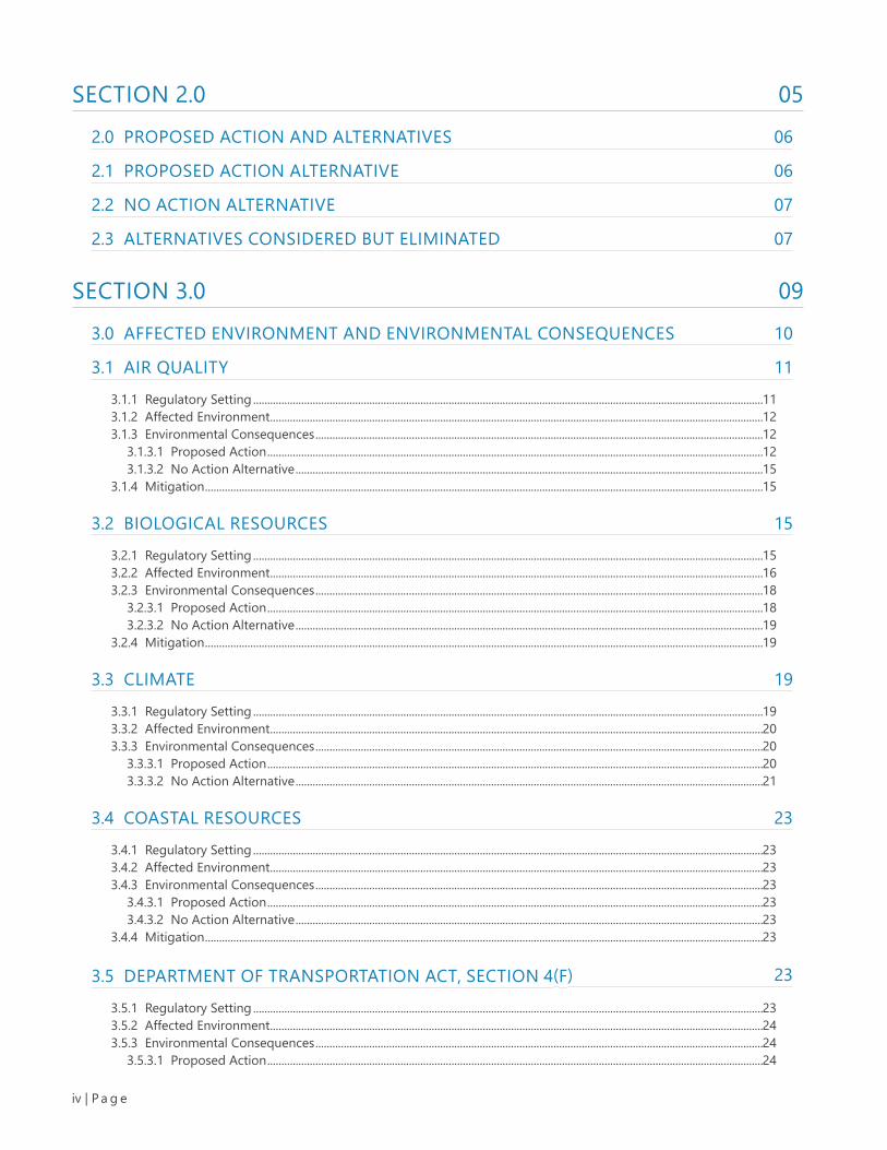
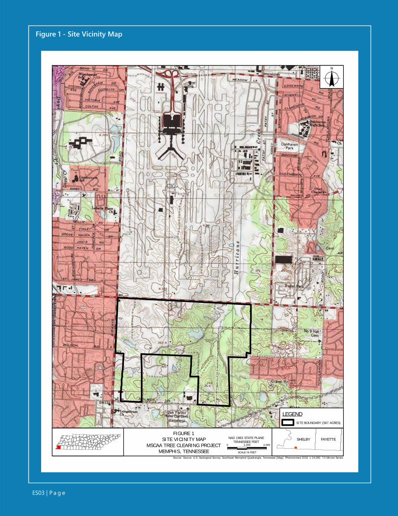
ACTIONThe Proposed Action consists of removal, or selectively topping of trees from the wooded areas within an approx-imately 587-acre Site. The tree removal and tree topping activities would occur within approximately 344 acres of the Site and are proposed in two phases, over a four-year period by the Memphis-Shelby County Airport Authority (MSCAA) in Memphis, Shelby County, Tennessee (Figure 1). The purpose of the Proposed Action is to remove tree obstructions and potential obstructions to the approach surfaces of Memphis International Airport (MEM) runways 36L, 36C, and 36R, and the departure surfaces of runways 18R, 18C, and 18L, to comply with Federal Aviation Admin-istration (FAA) Airport Improvement Program (AIP) Grant Assurance 20 (Hazard Removal and Mitigation) and FAA Code of Federal Regulations (CFR) Chapter 14 Part 139. Se-lect wooded areas at the Site that penetrate the Threshold Siting Surfaces identified by Advisory Circular 150/5300-13A, Airport Design, FAA Order 8260.3E, United States Standard for Terminal Instrument Procedures, the Obstacle Accountability Area (62.5:1) under One-Engine Inoperative conditions identified by Advisory Circular 120-91A, Airport Obstacle Analysis, and CFR 14 Part 77 approach surface represent airspace obstructions. Obstruction removal would improve airport compliance with FAA regulations, enhance the level of safety for the travelling public and en-able the runways to operate without imposed restrictions. Airports developed by or improved with federal funds are federally obligated to reasonably prevent the growth or establishment of obstructions in navigable airspace or ad-verse impacts to Navigational Aids (NAVAIDs).
PROPOSED ACTIONA physical address does not exist for the Site; it is located south of MEM Runways 36L, 36C, and 36R and E. Shelby Drive, east of Airways Boulevard, and north of E. Holmes Road (Figure 1). The Site is contained within the limits of ten parcels which are all owned by the MSCAA. The west-ern portion of the Site has been cleared while the eastern portion of the project area is primarily wooded and largely undisturbed.
ES03 | P a g e
FIGURE 1SITE VICINITY MAP
MSCAA TREE CLEARING PROJECTMEMPHIS, TENNESSEE
LEGENDSITE BOUNDARY (587 ACRES)
0 1,000 2,000
SCALE IN FEET
o
NAD 1983 STATE PLANETENNESSEE FEET SHELBY FAYETTE
Source: Source: U.S. Geological Survey. Southeast Memphisl Quadrangle, Tennessee [Map]. Photorevised 2019. 1:24,000. 7.5 Minute Series.
Figure 1 - Site Vicinity Map
ES04 | P a g e
Draft Environmental AssessmentMemphis Shelby County Airport AuthorityTree Obstruction ClearingSeptember 2021
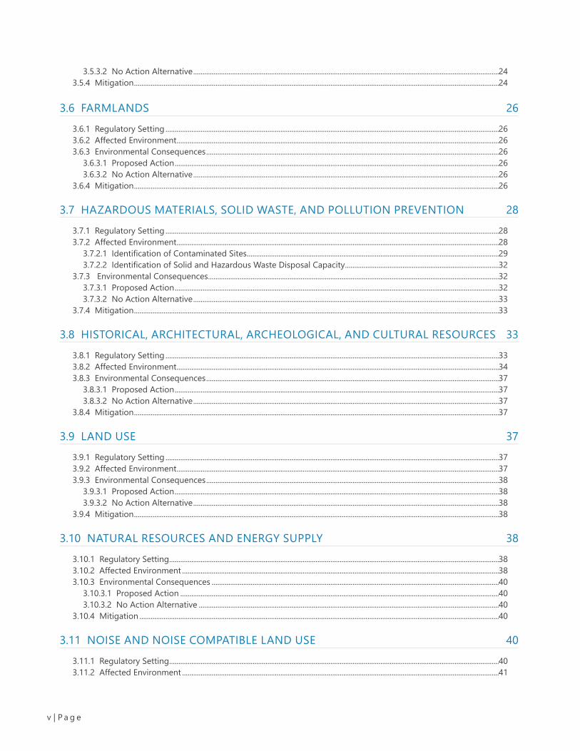
Phase I of the proposed action includes the re-moval of trees, including stumps and roots, with-in approximately 289 acres of upland wooded area (Figure 2). Tree removal under Phase I is proposed using site-clearing machinery. Tree removal activities, and subsequent grading ac-tivities, will be conducted incrementally, in 30-acre sections. The selected contractor would be required to stabilize and grade each 30-acre area prior to moving to additional 30-acre sections. Felled trees are proposed for reuse as harvested timber. Should felled trees be unable to be re-used as timber, they would be burned onsite us-ing Air Curtain Destructor (ACD) burn processes that might include the use of burn pits with burn waste remaining as on-site fill at the location of the ACD or a proprietary above-ground system.
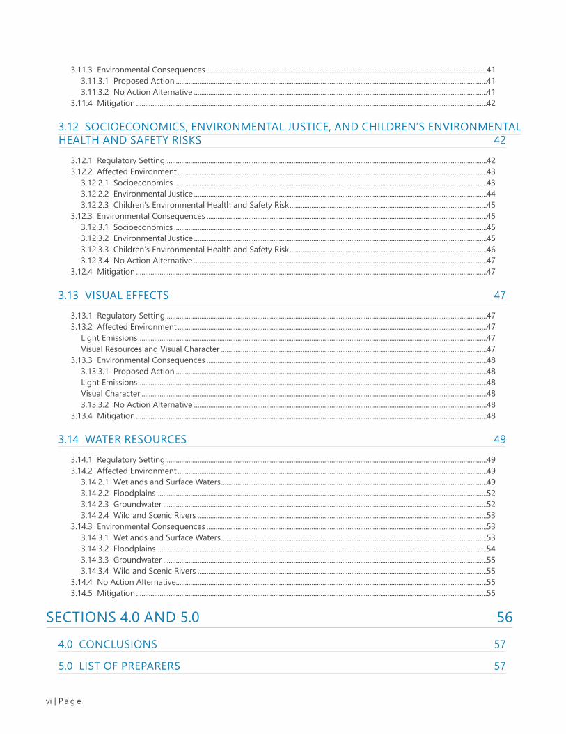
Phase II of a proposed action includes the fell-ing and topping of trees within approximately 55 acres of forested wetlands area (Figure 3). To comply with the Tennessee Department of Envi-ronment and Conservation (TDEC) erosion and sediment controls, natural riparian buffer zones are proposed along onsite stream banks and around onsite wetlands. The natural riparian buffer zones would serve as erosion and sedi-ment controls, as well as mitigate for potential changes in onsite stream water temperature due to tree canopy removal. A natural riparian buf-fer zone of 60 feet (ft) is proposed for streams, measured from the tops of the stream banks. A 30-ft natural riparian buffer zone is proposed around onsite wetlands. Site-clearing machinery is not proposed for Phase II areas. The topping of trees in the Phase II areas would be completed by hand using chain saws.
NO ACTION ALTERNATIVEUnder the No Action Alternative, the MSCAA would not remove, or selectively top trees from the wooded areas within the approximately 587-acre Site. Under the No Action Alternative, the Site would not meet the need of the Proposed Action. Select wooded areas at the Site would
continue to represent an airspace obstruction, under Federal Aviation Regulation (FAR) Section 77.23 - Standards for Determining Obstructions. Conversely, the No Action Alternative would not result in any of the anticipated impacts associated with the Proposed Action.
ENVIRONMENTAL ASSESSMENTThe FAA is the lead federal agency and is preparing this Draft Environmental Assessment (EA) in accor-dance with the National Environmental Policy Act (NEPA); Council on Environmental Quality Regula-tions for Implementing the Procedural Provisions of NEPA (40 CFR Parts 1500- 1508); FAA Order 1050.1F, Environmental Impacts: Policies and Proce-dures; and FAA Order 5050.4B, NEPA Implementing Instructions for Airport Actions.

ES05 | P a g e
36L 36C 36R
LEGEND
SITE BOUNDARY (587 ACRES)PHASE I - MECHANICAL TREE CLEARING AREA(288.85 ACRES). TREES, STUMPS, AND ROOTSTO BE REMOVED AND SITE GRADED. FELLEDIN WETLANDS WILL NOT BE REMOVED.BUFFER VISUAL IMPACTS FR OM ADJACENT PROPERTIES(Armory Buffer = 50 feet)(Residential Buffer/Jackson Pit Road = 75 feet)
Sour ce: Esr i, H ERE, Ga rm in, (c) OpenStr ee tM ap contr ibut or sG oogle Ea r th Pro Im age ry - Da ted 5/31/2020
0 500 1,000
SCALE IN FEET
o
NAD 1983 STATE PLANETENNESSEE FEETFIGURE 2
PROPOSED ACTION - PHASE IMSCAA TREE CLEARING PROJECT
MEMPHIS, TENNESSEE
SHELBY FAYETTE
Figure 2 - Proposed Action - Phase I Map
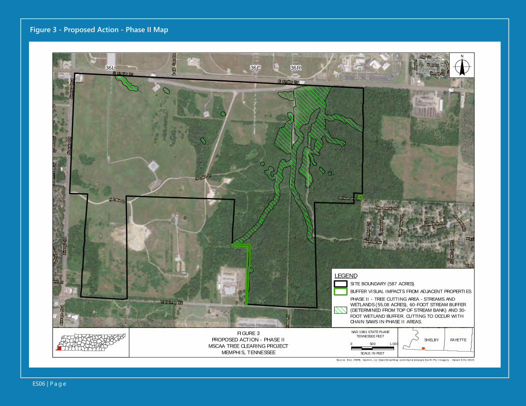
FIGURE 3PROPOSED ACTION - PHASE II
MSCAA TREE CLEARING PROJECTMEMPHIS, TENNESSEE
SHELBY FAYETTE
36L 36C 36R
LEGENDSITE BOUNDARY (587 ACRES)BUFFER VISUAL IMPACTS FROM ADJACENT PROPERTIESPHASE II - TREE CUTTING AREA - STREAMS ANDWETLANDS (55.08 ACRES), 60-FOOT STREAM BUFFER(DETERMINED FROM TOP OF STREAM BANK) AND 30-FOOT WETLAND BUFFER. CUTTING TO OCCUR WITHCHAIN SAWS IN PHASE II AREAS.
Sour ce: Esr i, H ERE, Ga rm in, (c) OpenStr ee tM ap contr ibut or sG oogle Ea r th Pro Im age ry - Da ted 5/31/2020
0 500 1,000
SCALE IN FEET
o
NAD 1983 STATE PLANETENNESSEE FEET
ES06 | P a g e
Figure 3 - Proposed Action - Phase II Map

ES07 | P a g e
Draft Environmental AssessmentMemphis Shelby County Airport AuthorityTree Obstruction ClearingSeptember 2021
IMPACTSThis Draft EA evaluated impacts to each of the resource areas that would be reasonably antici-pated to occur because of the Proposed Action. When compared to the No Action Alternative, the Proposed Action may create short-term (lasting during proposed clearing activities) or long-term (greater than five years) impacts affecting various resource areas. Impacts are also identified as ei-ther adverse or beneficial. This Draft EA uses the following terms in assessing impacts resulting from the Proposed Action.
Negligible Impact: A resource would not be affected, or the im-pacts would be at or below the level of detec-tion (negligible), and changes would not result in any measurable or perceptible consequences.
Minor Short-Term Impact: Impacts on a resource would be detectable for a short period (typically during construction), would be localized, and would be of minor con-sequence to the sustainability of the resource. Mitigation measures, if needed to offset ad-verse short-term effects, would be simple and achievable.
Minor Long-Term Impact: Impacts on a resource would be readily detect-able for a period of more than five years, mea-surable, and associated with the operation of the Proposed Action. Mitigation measures, if need-ed to offset adverse long-term effects, would be achievable but more extensive than those for short-term.
Significant Impact: Impacts on a resource would be obvious, long-term, and would have substantial consequenc-es on a regional scale. Mitigation measures, if needed to offset adverse significant effects, would be extensive. Significant impacts would warrant an Environmental Impact Statement (EIS) to further assess the impacts to affected resources as a result of the Proposed Action.
ES08 | P a g e
Draft Environmental AssessmentMemphis Shelby County Airport AuthorityTree Obstruction ClearingSeptember 2021
DETERMINATIONThis Draft EA describes the following resource ar-eas and assesses the potential for the Proposed Action to affect these resource areas: air quality; biological resources; climate; coastal resourc-es; United States Department of Transportation (U.S. DOT) Act, Section 4(f); farmlands; hazard-ous materials; historical, architectural, and cul-tural resources; land use; natural resources and energy supply; noise and noise-compatible land use; socioeconomics, environmental justice, and children’s environmental health and safety risks; visual effects; and water resources.
Based on the analysis presented in this Draft EA and coordination to date with project stake-holders and regulatory agencies, the Proposed Action would result in negligible, short-term, and long-term impacts to the assessed resources areas, when compared to the No Action Alterna-tive. No significant impacts to any resource area are anticipated through the undertaking of the Proposed Action. As a result of the Proposed Action, the following determinations of impacts were made.
Identified Negligible Impact: The Proposed Action was determined to have a negligible impact on the following resource areas, when compared to the No Action Alternative: biolog-ical resources, coastal resources; Section 4(f) re-sources; farmlands; hazardous materials; histor-ical, architectural, and cultural resources; land use; natural resources and energy supply; noise and noise-compatible land use; environmental justice, and children’s environmental health and safety risks; and water resources.
Identified Minor Long-Term Impacts: Minor, long-term impacts have been identified, when compared to the No Action Alternative in terms of visual effects of the Proposed Action. The viewshed of the Site would be permanently al-tered (obstruction removal).
FINDING OF NO SIGNIFICANT IMPACTImplementation of the Proposed Action as an-alyzed in this Draft EA would not constitute a major federal action that would have significant impact on the human environment, within the meaning of Section 102(2)(C) of the National En-vironmental Policy Act of 1969. The analysis pre-sented in this Draft EA indicates that a Finding of No Significant Impact is appropriate, and that an Environmental Impact Statement is not required.

01 | P a g e
Section 1.0 Introduction
SECTION 1.0

Draft Environmental AssessmentMemphis Shelby County Airport AuthorityTree Obstruction ClearingSeptember 2021
02 | P a g e
1.1 PROJECT BACKGROUNDThe Memphis-Shelby County Airport Authority (MSCAA) proposes to remove and cut trees from upland and for-ested wetlands areas within portions of an approximately 587-acre tract of MSCAA-owned property located south of Memphis International Airport (MEM) in Memphis, Shelby County, Tennessee (the Site) (Figure 1). The MSCAA owns and operates MEM, as well as two general aviation airports. The MSCAA is self-funded and receives no local tax rev-enue. The lead federal agency for the undertaking is the Federal Aviation Authority (FAA).
A physical address does not exist for the Site; it is located south of MEM Runways 36L, 36C, and 36R and E. Shelby Drive, east of Airways Boulevard, and north of E. Holmes Road (Figure 1). The Site is contained within the limits of ten parcels which are all owned by the MSCAA. The west-ern portion of the project area has been cleared and, based on a review of historic aerial photography and U.S. Geolog-ical Survey (USGS) topographic mapping (1965), contained a golf course associated with what was once called McKellar Park - a public park that records indicate was sold to the MSCAA. The eastern portion of the project area is primarily wooded and is largely undisturbed.
The purpose of the Proposed Action is to remove tree ob-structions and potential obstructions to the approach sur-faces of MEM runways 36L, 36C, and 36R, and the departure surfaces of runways 18R, 18C, and 18L, to comply with FAA Airport Improvement Program (AIP) Grant Assurance 20 (Hazard Removal and Mitigation) and FAA Code of Federal Regulations (CFR) Chapter 14 Part 139. Obstruction remov-al would improve airport compliance with FAA regulations, enhance the level of safety for the travelling public, and en-able the runways to operate without imposed restrictions. Tree removal and tree cutting activities would occur within approximately 344 acres of the Site and are proposed in two phases, over a four-year period.
The Proposed Action would meet MSCAA’s need to main-tain compatibility with MEM operations, including aircraft noise. According to the MEM Part 150 Study Update Noise Exposure Maps, the airspace above the Site is located within a main MEM aircraft flight path (MEM 2015). The project would provide a long-term benefit to MEM flight opera-tions and is consistent with the Memphis Airport Area Land Use Study Final Report (Memphis 1992) and the Memphis Aerotropolis Airport City Master Plan (Memphis 2014).
1.0 INTRODUCTION
Draft Environmental AssessmentMemphis Shelby County Airport AuthorityTree Obstruction ClearingSeptember 2021
03 | P a g e
As previously noted, activities associated with Site are estimated to last no more than four years. A reasonably foreseeable connected ac-tion includes future development of this land for purposes consistent with existing and future land use mapping of Shelby County. However, there are no current plans to sell or lease these parcels for development and site developers and/or ten-ants have not been identified at this time.
The Proposed Action triggers the FAA poli-cies and procedures to ensure agency compli-ance with the National Environmental Policy Act (NEPA) (42 United States Code [U.S.C.] §§ 4321-4335), the requirements set forth in the Council on Environmental Quality (CEQ), Title 40, CFR, parts 1500-1508, Regulations for Implementing the Procedural Provisions of the National En-vironmental Policy Act (CEQ Regulations); FAA Order 1050.1F, Environmental Impacts: Policies and Procedures; FAA Order 5050.4B, National En-vironmental Policy Act (NEPA) Implementing In-structions for Airport Actions; and United States Department of Transportation (U.S. DOT) Order 5610.1D, Procedures for Considering Environ-mental Impacts. The following sections provide a detailed analysis of this project in the form of a Draft Environmental Assessment (EA) to assist in determining if this project’s Proposed Action would have significant environmental impacts.
1.2 PURPOSE AND NEEDThe purpose of the Proposed Action is to remove tree obstructions and potential obstructions to the approach surfaces of MEM runways 36L, 36C, and 36R, and the departure surfaces of runways 18R, 18C, and 18L, to comply with FAA AIP Grant Assurance 20 (Hazard Removal and Mitigation) and FAA CFR Chapter 14 Part 139. Select wood-ed areas at the Site that penetrate the Thresh-old Siting Surfaces identified by Advisory Cir-cular 150/5300-13A, Airport Design, FAA Order 8260.3E, United States Standard for Terminal In-strument Procedures, the Obstacle Accountabil-
ity Area (62.5:1) under One-Engine Inoperative conditions identified by Advisory Circular 120-91A, Airport Obstacle Analysis, and CFR 14 Part 77 approach surface represent airspace obstruc-tions. Obstruction removal would improve air-port compliance with FAA regulations, enhance the level of safety for the travelling public and enable the runways to operate without imposed restrictions. Airports developed by or improved with federal funds are federally obligated to rea-sonably prevent the growth or establishment of obstructions in navigable airspace or adverse impacts to Navigational Aids (NAVAIDs).1
Select wooded areas at the Site represent an air-space obstruction under Federal Aviation Reg-ulation (FAR) Section 77.23 - Standards for De-termining Obstructions. Tree removal and tree cutting activities would occur within approxi-mately 344 acres of the Site and are proposed in two phases, over a four-year period.
The need is directly related to MSCAA obligations under Grant Assurance 20 as explained above and needed compliance with grant assurances for MEM. The Proposed Action would help MSCAA better meet its obligations under the state Grant Assurance, while maintaining compatibility with MEM operations.
1.3 ENVIRONMENTAL ASSESSMENTNEPA requires federal agencies to evaluate and consider environmental impacts for projects that utilize federal funding. The level of documen-tation required depends on the level of such environmental impacts. An EA is used to deter-mine if a federal action would result in signifi-cant impact on the human environment. An En-vironmental Impact Statement (EIS) is prepared for federal actions that have been determined through an EA to have significant impact on the human environment. The FAA determined that an EA is the appropriate level of documentation
1 https://www.nh.gov/dot/org/aerorailtransit/aeronautics/documents/grantassurance20training.pdf

Draft Environmental AssessmentMemphis Shelby County Airport AuthorityTree Obstruction ClearingSeptember 2021
04 | P a g e
for the proposed removal and cutting of trees from upland and forested wetlands areas within portions of an approximately 587-acre tract of MSCAA-owned property located south of MEM.
1.4 AGENCY COORDINATION AND PUBLIC INVOLVEMENTA Notice of Availability of the Draft EA was pub-lished in The Commercial Appeal on ______ and in The Memphis Daily News on _______. The public notice was posted on the MEM Facebook page and MEM Twitter account on _______. The Draft EA was also available for download at the MEM website, https://www.flymemphis.com/environ-ment, and is available upon request to facilitate public access. Members of the public were able to comment on the Draft EA within 30 days of the published notice.

Draft Environmental AssessmentMemphis Shelby County Airport AuthorityTree Obstruction ClearingSeptember 2021
05 | P a g e
Section 2.0 Proposed Action and
Alternatives
SECTION 2.0
Draft Environmental AssessmentMemphis Shelby County Airport AuthorityTree Obstruction ClearingSeptember 2021
06 | P a g e
2.0 PROPOSED ACTION AND ALTERNATIVESThis section describes the two alternatives eval-uated in this Draft EA: the Proposed Action Al-ternative and the No Action Alternative. Also included in this section is a discussion of the alternatives considered but eliminated from fur-ther consideration.
2.1 PROPOSED ACTION ALTERNATIVEThe Proposed Action consists of removal, or se-lective topping of trees from the wooded areas within the approximately 587-acre Site. The tree removal and tree topping activities would occur within approximately 344 acres of the Site and are proposed in two phases, over a four-year pe-riod.
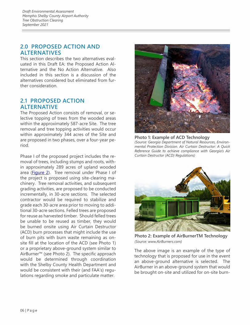
Phase I of the proposed project includes the re-moval of trees, including stumps and roots, with-in approximately 289 acres of upland wooded area (Figure 2). Tree removal under Phase I of the project is proposed using site-clearing ma-chinery. Tree removal activities, and subsequent grading activities, are proposed to be conducted incrementally, in 30-acre sections. The selected contractor would be required to stabilize and grade each 30-acre area prior to moving to addi-tional 30-acre sections. Felled trees are proposed for reuse as harvested timber. Should felled trees be unable to be reused as timber, they would be burned onsite using Air Curtain Destructor (ACD) burn processes that might include the use of burn pits with burn waste remaining as on-site fill at the location of the ACD (see Photo 1) or a proprietary above-ground system similar to AirBurner™ (see Photo 2). The specific approach would be determined through coordination with the Shelby County Health Department and would be consistent with their (and FAA’s) regu-lations regarding smoke and particulate matter.
Photo 1: Example of ACD Technology(Source: Georgia Department of Natural Resources, Environ-mental Protection Division. Air Curtain Destructor: A Quick Reference Guide to achieve compliance with Georgia’s Air Curtain Destructor (ACD) Regulations)
Photo 2: Example of AirBurnerTM Technology(Source: www.AirBurners.com)
The above image is an example of the type of technology that is proposed for use in the event an above-ground alternative is selected. The AirBurner in an above-ground system that would be brought on-site and utilized for on-site burn-
Draft Environmental AssessmentMemphis Shelby County Airport AuthorityTree Obstruction ClearingSeptember 2021
07 | P a g e
Within the 60-ft buffer areas proposed around onsite streams, trees would be topped to comply with FAA glide slope regulations. The tree topping height would vary based on elevation and distance from MEM Runways 36L, 36C and 36R. Tree can-opies would be maintained to the greatest extent possible. Felled trees would be removed by hand and placed within the buffer zone. Trees that fall into streams or that fall outside the 60-ft buffer ar-eas would be removed for offsite transport or us-ing the ACD burn processes previously discussed to ensure FAA and Shelby County Health Depart-ment regulations regarding smoke and particulate matter are met.
2.2 NO ACTION ALTERNATIVEUnder the No Action Alternative, the MSCAA would not remove, or selectively top trees from the wooded areas within the approximately 587-acre Site. Under the No Action Alternative, the Site would not meet the need of the Proposed Action. Select wooded areas at the Site would continue to represent an airspace obstruction, under FAR Section 77.23 - Standards for Determining Ob-structions. Conversely, the No Action Alternative would not result in any of the anticipated impacts associated with the Proposed Action.
2.3 ALTERNATIVES CONSIDERED BUT ELIMINATEDThe MSCAA identified the Proposed Action based on the following criteria:
1. The ability of the Proposed Action to ad-equately address the need – specifically, the ability to remove airspace obstructions within the subject parcels.
2. Consideration of measures that avoid, minimize, and/or reduce impacts to the natural and built environment of the in-volved and adjacent parcels.
ing of debris. The resulting waste would either be utilized as on-site mulch or removed from the site. Such technology would require the moving of the system to more than one location on the Site to minimize distance between the clearing activities and the burn location. These locations would be selected in consultation with FAA and Shelby County Health Department to minimize impacts to adjacent land uses and environmen-tal resources identified within this document (i.e., streams and wetlands). In addition, burn permits would be obtained for each location.
Phase II of the proposed project includes the felling and topping of trees within approximate-ly 55 acres of forested wetlands area (Figure 3). To comply with the Tennessee Department of Environment and Conservation (TDEC) erosion and sediment controls, natural riparian buffer zones are proposed along onsite stream banks and around onsite wetlands. The natural riparian buffer zones would serve as erosion and sedi-ment controls, as well as mitigate for potential changes in onsite stream water temperature due to tree canopy removal. A natural riparian buf-fer zone of 60 feet (ft) is proposed for streams, measured from the tops of the stream banks. A 30-ft natural riparian buffer zone is proposed around onsite wetlands. Site-clearing machinery is not proposed for Phase II areas. The topping of trees in the Phase II areas would be completed by hand using chain saws.
Within the onsite wetlands and 30-ft buffer areas around onsite wetlands, trees are proposed to be cut; however, stumps and tree roots would not be disturbed. Felled trees that fall into onsite wetlands would be left in place, except for man-ual maneuvering to maintain existing drainage. Felled treetops that fall outside the 30-ft buffer areas would be removed for offsite transport or onsite burning using the ACD burn processes previously discussed to ensure FAA and Shelby County Health Department regulations regard-ing smoke and particulate matter are met.
Draft Environmental AssessmentMemphis Shelby County Airport AuthorityTree Obstruction ClearingSeptember 2021
08 | P a g e
3. Post-action conditions that are sustain-able and do not limit the future land use considerations for parcel use.
For example, the MSCAA originally evaluated the clearing of more than 980 acres that would have included a number of large parcels that are cur-rently excluded from the Proposed Action. That footprint was determined unnecessarily large to adequately address the project need and was not carried forward for consideration to reduce the area of potential impacts associated with the Proposed Action. Therefore, this alternative was not carried forward because, while it would adequately address the need for the project, an alternative existed that would better avoid and minimize impacts to the natural and built envi-ronment.
Finally, “clear cut” of the wooded areas would adequately address the need for the Proposed Action. However, that alternative was eliminated from further consideration because of the miti-gation associated with that alternative and be-cause other alternatives existed that were less harmful to the natural and built environment.

Draft Environmental AssessmentMemphis Shelby County Airport AuthorityTree Obstruction ClearingSeptember 2021
09 | P a g e
Affected Environment and
Environmental Consequences
SECTION 3.0
Draft Environmental AssessmentMemphis Shelby County Airport AuthorityTree Obstruction ClearingSeptember 2021
10 | P a g e
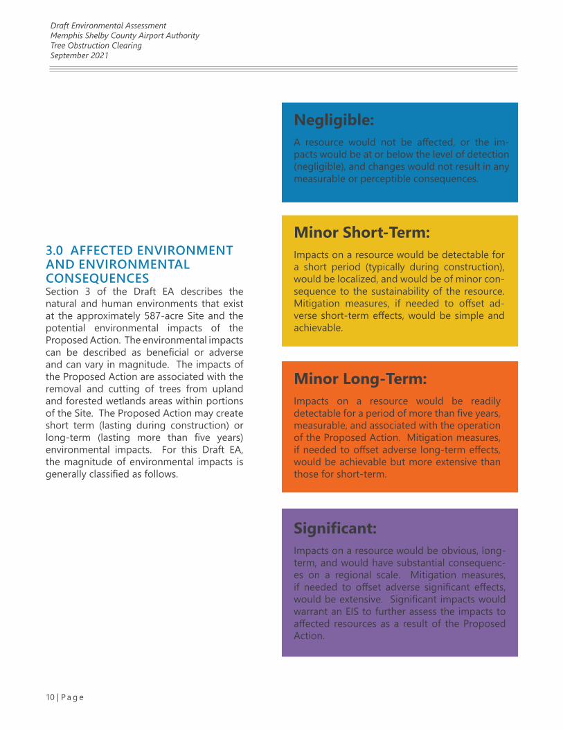
3.0 AFFECTED ENVIRONMENT AND ENVIRONMENTAL CONSEQUENCESSection 3 of the Draft EA describes the natural and human environments that exist at the approximately 587-acre Site and the potential environmental impacts of the Proposed Action. The environmental impacts can be described as beneficial or adverse and can vary in magnitude. The impacts of the Proposed Action are associated with the removal and cutting of trees from upland and forested wetlands areas within portions of the Site. The Proposed Action may create short term (lasting during construction) or long-term (lasting more than five years) environmental impacts. For this Draft EA, the magnitude of environmental impacts is generally classified as follows.
Negligible: A resource would not be affected, or the im-pacts would be at or below the level of detection (negligible), and changes would not result in any measurable or perceptible consequences.
Minor Short-Term: Impacts on a resource would be detectable for a short period (typically during construction), would be localized, and would be of minor con-sequence to the sustainability of the resource. Mitigation measures, if needed to offset ad-verse short-term effects, would be simple and achievable.
Minor Long-Term: Impacts on a resource would be readily detectable for a period of more than five years, measurable, and associated with the operation of the Proposed Action. Mitigation measures, if needed to offset adverse long-term effects, would be achievable but more extensive than those for short-term.
Significant: Impacts on a resource would be obvious, long-term, and would have substantial consequenc-es on a regional scale. Mitigation measures, if needed to offset adverse significant effects, would be extensive. Significant impacts would warrant an EIS to further assess the impacts to affected resources as a result of the Proposed Action.
Draft Environmental AssessmentMemphis Shelby County Airport AuthorityTree Obstruction ClearingSeptember 2021
11 | P a g e
ria air pollutant(s). Maintenance indicates that the air quality within a designated area was pre-viously designated as nonattainment for a crite-ria air pollutant(s) but has been re-designed to attainment status under an approved plan. An unclassified air quality designation means that there is not enough information to classify an area appropriately, so the area is assumed to be in attainment of the NAAQS.
For areas designated as nonattainment or main-tenance status, the CAA requires the adoption of a State Implementation Plan (SIP) to achieve the NAAQS for the criteria air pollutant(s). The FAA is responsible for deciding whether its actions in-volving an airport located in a nonattainment or maintenance area require a general conformity evaluation. The term “general conformity” refers to the process of demonstrating that a federal action conforms to the applicable SIP before the proposed action is undertaken.
Under the CAA, the General Conformity Rule (the Rule) allows for federal agencies to present cat-egories of actions that have been documented to be de minimis and therefore should be ‘‘pre-sumed to conform’’ to the Rule. If the Proposed Action is not specifically exempt or classified as presumed to conform, it is necessary to conduct an emissions inventory as part of the applicabil-ity analysis to determine if emissions are likely to equal or exceed the established screening criteria emission rates known as the “de minimis thresholds.” The U.S. EPA document, De Minimis Tables, is included in Attachment 2.
The U.S. EPA has defined broad categories of exempt actions under 40 CFR 93.153(c)(2) that result in no emissions increase or increases in emissions that are clearly de minimis. These ac-tions are not subject to further analysis for ap-plicability, conformity, or regional significance under the Rule. As part of the FAA’s Federal Register Notice dated February 12, 2007, one such exempted action, relating to the Proposed Action evaluated in this Draft EA Report, is stated
This Draft EA describes the following resource areas and assesses the potential for the Pro-posed Action to affect them: air quality; bio-logical resources; climate; coastal resources; U.S. DOT Act, Section 4(f); farmlands; hazardous ma-terials, solid waste and pollution prevention; his-torical, architectural, and cultural resources; land use; natural resources and energy supply; noise and noise-compatible land use; socioeconomics, environmental justice, and children’s environ-mental health and safety risks; visual effects; and water resources.
3.1 AIR QUALITY3.1.1 REGULATORY SETTINGThe Clean Air Act (CAA) is the primary statute related to the evaluation of air quality consid-ered in this EA. In accordance with the CAA, the United States Environmental Protection Agency (U.S. EPA) has set National Ambient Air Quality Standards (NAAQS) for six criteria air pollutants considered harmful to public health and the en-vironment. The criteria air pollutants are carbon monoxide, lead, nitrogen dioxide, ground-lev-el ozone, sulfur dioxide, and particulate matter. Particulate matter with diameters of less than 10 microns is known as PM10, and particulate matter with a diameter of less than 2.5 microns is known as PM2.5. Volatile organic compounds, nitrogen oxides, and other greenhouse gases (GHG) are also related to air quality and are considered as precursors to ozone formation. A discussion of GHG emissions is included in Section 3.3.
The U.S. EPA classifies air quality according to whether the concentrations of criteria air pollut-ants in ambient air of a designated area exceed set NAAQS. Areas are designated as either in “attainment,” “nonattainment,” “maintenance,” or “unclassified” with respect to NAAQS for cri-teria air pollutant(s). An attainment status in-dicates that the air quality within a designated area is below the respective NAAQS for criteria air pollutant(s). Nonattainment indicates that the air quality exceeds the NAAQS for the crite-
Draft Environmental AssessmentMemphis Shelby County Airport AuthorityTree Obstruction ClearingSeptember 2021
12 | P a g e
as “actions (or portions thereof) associated with transfers of land, facilities, title, and real properties through an enforceable contract or lease agree-ment where the delivery of the deed is required to occur promptly after a specific, reasonable condition is met, and where the federal agency does not retain continuing authority to control emissions associated with the lands, facilities, ti-tle, or real properties are presumed to conform to de minimis thresholds (40 CFR 93.153[c][2][xix]).” However, the Proposed Action also includes the evaluation of environmental impacts associated with the reasonably foreseeable construction and long-term operation of cargo holding or distri-bution facilities. The following sections offer a quantitative analysis of air quality impacts based on the full scope of the Proposed Action, aligning with actions presumed to conform with the Rule.
3.1.2 AFFECTED ENVIRONMENTThe affected environment with respect to air quality is the Greater Memphis Metropolitan area, including Shelby County, Tennessee, and portions of DeSoto County, Mississippi, and Crittenden County, Arkansas. This air quality area is collec-tively termed “Memphis, TN-MS-AR” by the U.S. EPA. and is in maintenance status for the 2008 8-hour ozone and carbon monoxide NAAQS.
The Ambient Air Monitoring Branch of the Shelby County Health Department monitors air quality throughout Shelby County. The Shelby Coun-ty Health Department develops, operates, and maintains a regional air monitoring network of 23 monitors at seven site locations, including one at MEM. Air quality data are reported daily for ground-level ozone, particulate matter, carbon monoxide, sulfur dioxide, and nitrogen dioxide. The U.S. EPA uses the collected air quality data to publish a Air Quality Index (AQI) on the AirNow.gov website.
Annual air quality statistics for 2020 included 248 days where the air quality was classified as good, 114 days were classified as moderate, 3 days were classified as unhealthy for sensitive groups, such
as older adults and children, and one day was classified as unhealthy. There were no days in 2020 classified as very unhealthy for air quality (Attachment 2). A 30-day interval AQI output for 2021 is also included in Attachment 2, showing the daily AQI from March 7 to April 5, 2021. The 30-day AQI output for those dates shows the majority of days classified as good air quality days, 9 days classified as moderate air quality days for Memphis, Tennessee.
The topography of the Site is relatively flat with lower elevations to towards the onsite aquatic features. The physical and meteorological con-ditions at the Site are not anticipated to hinder the dispersal of any potential air emissions.
3.1.3 ENVIRONMENTAL CONSEQUENCES
3.1.3.1 PROPOSED ACTIONUnder the Proposed Action, the MSCAA would remove and cut trees from upland and aquatic wooded areas within approximately 344 acres of MSCAA-owned property located south of Memphis International Airport (MEM) in Mem-phis, Shelby County, Tennessee (the Site) (Figure 1). The Proposed Action would occur over ap-proximately four years and be divided into two phases. The Proposed Action would not increase airside capacity and does not include any aircraft movement or combustion of jet fuel or aviation gasoline. The Proposed Action will result in mi-nor short-term adverse impacts on air quality, when compared to the No Action Alternative. Long-term air quality impacts are not anticipat-ed from the Proposed Action. For the purposes of the air quality analysis, anticipated impacts relate to the generation of fugitive dust and mo-bile source emissions during phased the 4-year tree clearing period.
Phase I of the proposed project includes the re-moval of trees, including stumps and roots, with-in approximately 289 acres of upland wooded area (Figure 2). Tree removal under Phase I is proposed using heavy site-clearing machinery. Felled trees in the Phase I areas are proposed
Draft Environmental AssessmentMemphis Shelby County Airport AuthorityTree Obstruction ClearingSeptember 2021
13 | P a g e
for reuse as harvested timber. However, if reuse cannot be negotiated felled trees are proposed to be burned onsite, in compliance with a burn per-mit from the Shelby County Health Department. Due to the proximity to MEM runways, a propri-ety air curtain destructor (ACD) (Air Burners Inc.) is proposed to minimize smoke associated with tree burning activities. The use of the self-contained ACD, Air Burners blows a continuous sheet of air across the self-contained burning container to in-crease burning efficiency and significantly reduce smoke and fly ash emissions. Coordination with the Shelby County Health Department regarding the potential for onsite burning is included in At-tachment 1. All burning activities would be con-ducted in accordance with a Shelby County Health Department burn permit.
Phase II of the Proposed Action includes the cut-ting of trees within wetlands and wetland buffer areas, and the topping of trees within stream buffer areas. The Phase II area includes approx-imately 55 acres of aquatic wooded area (Figure 3). Tree stumps and roots would remain intact in Phase II areas and tree cutting would be complet-ed by hand using chain saws. Phase II of the Pro-posed Action would not require the use of heavy site-clearing machinery. Felled trees in the wet-land areas would not be removed. As such, the evaluation of impacts to air quality focus on Phase I of the Proposed Action, as described below.
Incremental impacts to air quality resulting from the Proposed Action were modeled using the U.S. EPA Motor Vehicle Emission Simulator (MOVES) emission model. For the air quality impact analy-sis, anticipated emissions from tree clearing activ-ities will be derived from onsite engine-powered construction equipment, worker commutes, and chainsaws. The duration of the tree clearing is di-vided into two phases over 4 years. Phase I onsite diesel-powered grading and logging equipment modeled within MOVES includes the following equipment:
• (4) Excavator
• (2) Grader
• (2) Rubber Tired Loader
• (4) Tractors/Loaders/Backhoes
• (4) Scrapers
• (2) Concrete/Industrial Saws
• (2) Chain Saws > 6 HP
Phase II onsite chainsaw equipment modeled within MOVES includes the following equipment:
• (2) Chain Saws > 6HP
The duration of the project-related construction is assumed to be a total of 49 months. Phase I construction and logging equipment is conser-vatively assumed to operate from October 2021 through September 2023 while Phase II equip-ment would operate from March 2022 through October 2025. It is assumed that tree clearing activity will occur five days each week. For each day of construction activity, it is assumed that 20 construction worker passenger cars and 20 con-struction worker passenger trucks will access the site for Phase I and 2 construction worker pas-senger cars and 2 construction worker passenger trucks for Phase II.
It is assumed that employee vehicles accessing the site would travel 20 miles round trip. Model defaults are utilized to calculate fleet mix inputs for commuting workers. Model defaults include an assumption that 98% of commuting worker passenger vehicles are gasoline-fueled, 1% are diesel-fueled, and 1% are ethanol-fueled. Trip rate assumptions are based on conservative stan-dards for construction worker (CalEEMod 2017).
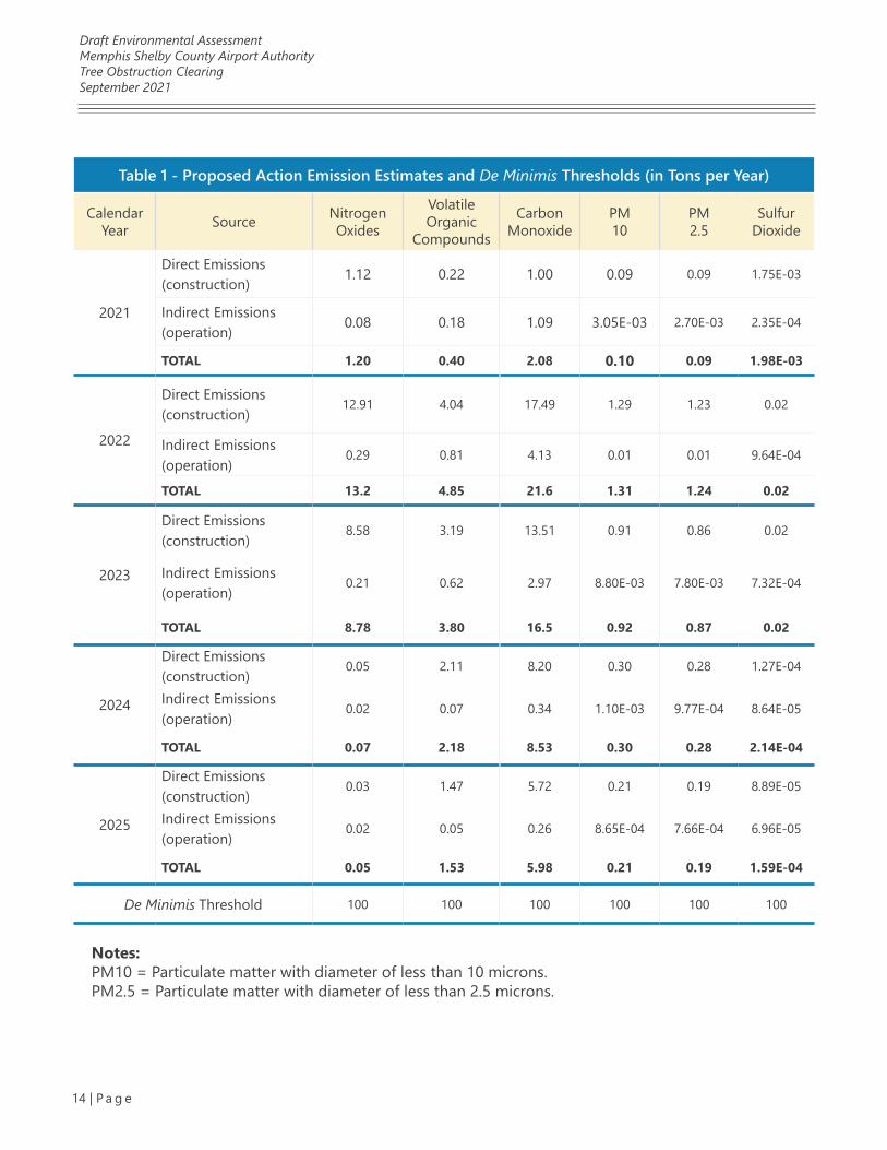
The MOVES output is included in Attachment 2. The emission estimates calculated for the Pro-posed Action are presented in Table 1 and are below applicable de minimis thresholds, and therefore conform to the SIP and the require-ments of The Clean Air Act.
Draft Environmental AssessmentMemphis Shelby County Airport AuthorityTree Obstruction ClearingSeptember 2021
14 | P a g e
Table 1 - Proposed Action Emission Estimates and De Minimis Thresholds (in Tons per Year)
Calendar Year Source Nitrogen
Oxides
VolatileOrganic
Compounds
Carbon Monoxide
PM10
PM2.5
SulfurDioxide
2021
Direct Emissions (construction) 1.12 0.22 1.00 0.09 0.09 1.75E-03
Indirect Emissions (operation) 0.08 0.18 1.09 3.05E-03 2.70E-03 2.35E-04
TOTAL 1.20 0.40 2.08 0.10 0.09 1.98E-03
2022
Direct Emissions (construction)
12.91 4.04 17.49 1.29 1.23 0.02
Indirect Emissions (operation)
0.29 0.81 4.13 0.01 0.01 9.64E-04
TOTAL 13.2 4.85 21.6 1.31 1.24 0.02
2023
Direct Emissions (construction)
8.58 3.19 13.51 0.91 0.86 0.02
Indirect Emissions (operation)
0.21 0.62 2.97 8.80E-03 7.80E-03 7.32E-04
TOTAL 8.78 3.80 16.5 0.92 0.87 0.02
2024
Direct Emissions (construction)
0.05 2.11 8.20 0.30 0.28 1.27E-04
Indirect Emissions (operation)
0.02 0.07 0.34 1.10E-03 9.77E-04 8.64E-05
TOTAL 0.07 2.18 8.53 0.30 0.28 2.14E-04
2025
Direct Emissions (construction)
0.03 1.47 5.72 0.21 0.19 8.89E-05
Indirect Emissions (operation)
0.02 0.05 0.26 8.65E-04 7.66E-04 6.96E-05
TOTAL 0.05 1.53 5.98 0.21 0.19 1.59E-04
De Minimis Threshold 100 100 100 100 100 100
Notes:PM10 = Particulate matter with diameter of less than 10 microns.PM2.5 = Particulate matter with diameter of less than 2.5 microns.
Draft Environmental AssessmentMemphis Shelby County Airport AuthorityTree Obstruction ClearingSeptember 2021
15 | P a g e
The Proposed Action is anticipated to have minor, short-term adverse impacts on air quality, when compared to the No Action Alternative. However, the air quality impacts are not anticipated to ex-ceed applicable de minimis thresholds and will be minimized though compliance with Shelby Coun-ty Health Department regulations and best man-agement practices used to smoke, control fugitive dust and air emissions and minimize minor ad-verse impacts to air quality due to construction of the Proposed Action. Examples of best manage-ment practices include requiring onsite construc-tion equipment be well maintained and equipped with the latest emissions control equipment, use of water sprays, application of cover materials and installation of vehicle wheel washing stations to minimize track-out onto local roadways. The use of natural gas-powered trucks or electric ve-hicles could also offset minor adverse impacts on air quality.
3.1.3.2 NO ACTION ALTERNATIVEThere would be no change in air quality under the No Action Alternative.
3.1.4 MITIGATIONThe Proposed Action would not exceed appli-cable de minimis thresholds and is presumed to conform with the SIP; therefore, mitigation for air quality is not proposed.
3.2 BIOLOGICAL RESOURCES3.2.1 REGULATORY SETTINGAs stated in FAA Order 1050.1F Desk Reference, biological resources are valued for their intrinsic, aesthetic, economic, and recreational qualities, and include fish, wildlife, plants, and their respec-tive habitats (FAA 2020). Typical categories of bi-ological resources include:
• Terrestrial and aquatic plant and animal species
• Game and non-game species
• Special status species (state- or federally listed threatened or endangered species, marine mammals, or species of concern, such as species proposed for listing or migratory birds)
• Environmentally sensitive or critical habi-tats
The primary statutes, regulations, Executive Or-ders, and other guidance related to the evalu-ation of biological resources considered in this Draft EA are as follows:
1. The Bald and Golden Eagle Protection Act
2. The Endangered Species Act
3. Fish and Wildlife Coordination Act
4. Magnuson-Stevens Fishery Conservation and Management Act
5. Marine Mammal Protection Act
6. Migratory Bird Treaty Act
7. Executive Order 13112, Invasive Species
8. Executive Order 13186, Responsibilities of Federal Agencies to Protect Migratory Birds
9. Executive Order 13751, Safeguarding the Nation from Impacts of Invasive Species
10. CEQ, Guidance on Incorporating Biodi-versity Considerations into Environmen-tal Impact Analysis Under the National Environmental Policy Act
As part of the Draft EA, informal consultation with the United States Fish and Wildlife Service (USFWS), TDEC, and the Tennessee Wildlife Re-sources Agency (TWRA) was initiated to deter-mine whether any state-listed, federally-listed or candidate species or designated critical habitat are likely to be adversely affected by the Pro-posed Action. In addition, the USFWS Informa-
Draft Environmental AssessmentMemphis Shelby County Airport AuthorityTree Obstruction ClearingSeptember 2021
16 | P a g e
tion for Planning and Consultation (IPaC) website was reviewed for a list of federally protected spe-cies and migratory birds with the potential to oc-cur in the area. An informal level of consultation with the USFWS and TWRA was determined to be appropriate, based on survey and research of the biological resources at the Proposed Action Site and inspection of the Site conducted by two biologists in May 2017 and January 2021.
3.2.2 AFFECTED ENVIRONMENTThe Site consists of upland and forested wetland areas within portions of an approximately 587-acre tract of MSCAA-owned property located south of MEM in Memphis, Shelby County, Ten-nessee (Figure 1). The Site is located south of MEM Runways 36L, 36C, and 36R and E. Shelby Drive, east of Airways Boulevard, and north of E. Holmes Road (Figure 1). The Site is current-ly vacant and predominantly wooded (Figure 2). Representative photos of the Site are included in Attachment 1.
The principal drainage on the Site is Hurricane Creek, which flows northeasterly into Noncon-nah Creek, and the Nonconnah Creek Watershed located in northwest Mississippi and southwest Tennessee. There are several wetlands, streams, and ponds on the Site. A discussion of water resources is included in Section 3.14.
In 2017, field survey and agency coordination were initiated regarding the proposed project. This effort included a bat mist net survey in July 2017, at the request of the USFWS. The results of that effort were reported in Final Report: Summer 2017 Presence/Probable Absence Survey for the Memphis-Shelby County Airport Authority Shelby County, Tennessee (EnSafe 2017).
Since that time, the Site boundaries have changed to include newly acquired parcels located on the eastern boundary of the Site and the limits of the clearing activity had been modified. Con-sultation with the TDEC and USFWS were again initiated in March 2021 by the FAA to determine
if the previous findings remained consistent with the currently Proposed Action. All documenta-tion associated with this effort is included in At-tachment 3.
During surveys in both May 2017 and Janu-ary 2021, biologists identified herbaceous and aquatic habitat at the Site. The upland tree clearing areas were dominated by hickories (pri-marily Carya glabra), sweetgum (Liquidambar styraciflua), oaks (primarily Quercus alba, Q. ru-bra, and Q. falcata) and beech (Fagus grandifo-lia). The understory ranged from open with few saplings or shrubs to having a dense thicket of Chinese privet (Ligustrum sinense). There were no caves on the Site. There were some snags and shagbark hickory (Carya ovata) trees scat-tered throughout the uplands. The forested wetlands were dominated by black willow (Salix nigra), sweetgum, and red maple (Acer rubrum). Other common species along the wetland edges included willow oak (Quercus phellos) American elm (Ulmus americana), river birch (Betula nigra), eastern hophornbeam (Ostrya virginiana), and American hornbeam (Carpinus caroliniana).
Designated critical habitat is not present at the Site. The USFWS tracks the occurrence of the en-dangered Indiana Bat (Myotis sodalis) and threat-ened Northern Long-Eared Bat (Myotis septentri-onalis) in Tennessee. The USFWS bat occurrence maps included in Attachment 3 indicate the list-ed bat species do not occur in Shelby County. However, due to potentially suitable conditions for bats, a bat mist net survey was conducted at the Site in July 2017, at the request of the USF-WS. The results of the survey did not reveal the presence of the threatened or endangered bat species. In addition, USFWS concurred with the not likely to adversely affect (NLAA) determina-tion for both bat species and concluded that the requirements of the Endangered Species Act of 1973 (the Act), as amended, were fulfilled. The survey report and coordination with the USFWS are included in Attachment 3.
Draft Environmental AssessmentMemphis Shelby County Airport AuthorityTree Obstruction ClearingSeptember 2021
17 | P a g e
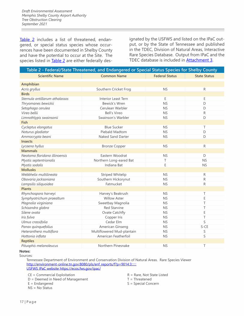
Table 2 includes a list of threatened, endan-gered, or special status species whose occur-rences have been documented in Shelby County and have the potential to occur at the Site. The species listed in Table 2 are either federally des-
Table 2 - Federal/State Threatened, and Endangered or Special Status Species for Shelby CountyScientific Name Common Name Federal Status State Status
AmphibianAcris gryllus Southern Cricket Frog NS RBirdsSternula antillarum athalassos Interior Least Tern E EThryomanes bewickii Bewick’s Wren NS DSetophaga cerulea Cerulean Warbler NS DVireo bellii Bell’s Vireo NS RLimnothlypis swainsonii Swainson’s Warbler NS DFishCycleptus elongatus Blue Sucker NS TNoturus gladiator Piebald Madtom NS DAmmocrypta beani Naked Sand Darter NS DInsectsLycaena hyllus Bronze Copper NS RMammalsNeotoma floridana illinoensis Eastern Woodrat NS DMyotis septentrionalis Northern Long-eared Bat T NSMyotis sodalis Indiana Bat E NSMollusksWebbhelix multilineata Striped Whitelip NS RObovaria jacksoniana Southern Hickorynut NS RLampsilis siliquoidea Fatmucket NS RPlantsRhynchospora harveyi Harvey’s Beakrush NS TSymphyotrichum praealtum Willow Aster NS EMagnolia virginiana Sweetbay Magnolia NS TSchisandra glabra Red Starvine NS TSilene ovata Ovate Catchfly NS EIris fulva Copper Iris NS TUlmus crassifolia Cedar Elm NS SPanax quinquefolius American Ginseng NS S-CEHeteranthera multiflora Multiflowered Mud-plantain NS SHottonia inflata American Featherfoil NS SReptilesPituophis melanoleucus Northern Pinesnake NS T
Notes:Sources:
Tennessee Department of Environment and Conservation Division of Natural Areas. Rare Species Viewer http://environment-online.tn.gov:8080/pls/enf_reports/f?p=9014:3::::::USFWS IPaC website https://ecos.fws.gov/ipac/
CE = Commercial ExploitationD = Deemed in Need of ManagementE = EndangeredNS = No Status
R = Rare, Not State ListedT = ThreatenedS = Special Concern
ignated by the USFWS and listed on the IPaC out-put, or by the State of Tennessee and published in the TDEC, Division of Natural Areas, Interactive Rare Species Database. Output from IPaC and the TDEC database is included in Attachment 3.
Draft Environmental AssessmentMemphis Shelby County Airport AuthorityTree Obstruction ClearingSeptember 2021
18 | P a g e
On August 31, 2017, the USFWS Cookeville Field Office reached a decision regarding potential impacts resulting from the Proposed Action with respect to threatened and endangered species, stating that the proposed tree clearing project was “not likely to adversely affect either of the species.” Follow up coordination was initiated on March 25, 2021, based on a change in tree clear-ing area size. The USFWS Cookeville Field Office provided a response to the 2021 revised coordi-nation on April 30, 2021 indicating, “Based on the project site location and 2017 bat survey results, we maintain our previous position and conclude that federally listed species are not likely to oc-cupy the area of anticipated impact.“ The USFWS correspondence is included in Attachment 3.
Coordination with TWRA regarding the Pro-posed Action was initiated via email on March 25, 2021. The TWRA correspondence is includ-ed in Attachment 3. In their March 29, 2021 re-sponse, the agency states:
“...the project will require the clearing of trees and since we share authority with the [USFWS] on the Indiana Myotis (Myotis so-dalis) and the Northern Long-eared Bat (Myotis septentrionalis), we request that you consult with the USFWS Cookeville, Tennessee Field Office regarding potential impacts to these listed species; and will defer to the opinion of the U.S. Fish and Wildlife Service’s Cookeville Field Office regarding potential impacts to the state and federally endangered bats due to the proposed project. Otherwise, we do not anticipate adverse impacts to state listed species under our authority due to the proposed construction.”
3.2.3 ENVIRONMENTAL CONSEQUENCES
3.2.3.1 PROPOSED ACTIONThe Proposed Action consists of removal, or se-lectively topping of trees from the wooded areas within the approximately 587-acre Site. The tree removal and cutting activities would occur with-in approximately 344 acres of the Site and are proposed in two phases, over a four-year period.
Phase I of the Proposed Action includes the re-moval of trees, including stumps and roots, with-in approximately 289 acres of upland wooded area (Figure 2). Tree removal under Phase I of the project is proposed using site-clearing ma-chinery. Phase II of the Proposed Action includes the removal and topping of trees within approx-imately 55 acres of forested wetland area (Figure 3). To comply with the TDEC erosion and sedi-ment controls, natural riparian buffer zones are proposed along onsite stream banks and around onsite wetlands. Site-clearing machinery is not proposed for Phase II areas and topping of trees in this phase would be completed by hand using chain saws. Impacts to water resources are dis-cussed in Semitone 3.14.
Executive Order 13112 requires the prevention and control of invasive species. It directs feder-al agencies to not authorize, fund, or carry out actions that they believe are likely to cause or promote the introduction or spread of invasive species in the U.S. unless the agency has deter-mined and made public its determination that the benefits of such actions clearly outweigh the potential harm caused by invasive species, and that all feasible and prudent measures to min-imize risk of harm will be taken in conjunction with the actions. The guidelines of Executive Or-der 13112 would be adhered to while conduct-ing tree removal and tree topping activities to control and prevent the spread of any invasive species to the Site.
Draft Environmental AssessmentMemphis Shelby County Airport AuthorityTree Obstruction ClearingSeptember 2021
19 | P a g e
There would be no anticipated impacts on bio-logical resources from the Proposed Action. The context and intensity of any impacts associated with the Proposed Action includes consideration of the urban setting, (i.e., the adjacent roadways of E. Shelby Drive, Airways Boulevard, E. Holmes Road, and Tchulahoma Road), and activities as-sociated with aircraft flight paths. Overall, the potential disturbance to urban wildlife from ad-jacent operational activities is considered negli-gible and would not result in significant adverse impacts to biological resources.
Based on context and intensity indicators for bi-ological resource impacts noted in FAA Order 1050.1F, the Proposed Action would not:
• Adversely impact special status species or their habitats or include a permanent loss of plant or wildlife species
• Adversely impact a species’ reproductive success rate or mortality rate
• Impair a species’ ability to sustain the minimum population levels required for population maintenance
The Proposed Action is anticipated to have no minor, short-term or long-term adverse impacts on biological resources, when compared to the No Action Alternative. The phased clearing ac-tivities proposed would avoid and minimize ef-fects to the aquatic features present at the Site. Best management practices to address erosion and sediment would be implemented and main-tained during tree removal and tree topping ac-tivities. The impacts to biological resources due to the Proposed Action would not result in sig-nificant adverse impacts to biological resources.
3.2.3.2 NO ACTION ALTERNATIVEUnder the No Action Alternative, the Proposed Action would not occur, and no impacts to bio-logical resources would result.
3.2.4 MITIGATIONBased on the lack of significant adverse impacts to biological resources, mitigation is not pro-posed for the Proposed Action.
3.3 CLIMATE3.3.1 REGULATORY SETTINGAs stated in FAA Order 1050.1F Desk Reference, minimizing GHG emissions and identifying po-tential future impacts of climate change are im-portant for a sustainable national airspace sys-tem (FAA 2020). GHGs are defined as carbon dioxide, methane, nitrous oxide, hydrofluoro-carbons, perfluorocarbons, and sulfur hexaflu-oride (FAA 2020). Of the six recognized GHGs, only carbon dioxide is a direct aircraft combus-tion product (FAA 2020). For FAA NEPA evalua-tions, carbon dioxide, measured in metric tons, is considered the most important anthropogenic source for air traffic action or airport operations. Non-aircraft emission sources are typically not affected by airspace and procedural actions (FAA 2020). Potential climate impacts, as indicated by GHG emissions, are evaluated separately from air quality, based on the statutes, regulations, Exec-utive Orders, and guidance listed below.
The primary statutes, regulations, Executive Or-ders, and other guidance related to the evalua-tion of climate considered in this Draft EA Report are as follows:
1. The Clean Air Act of 1970
2. Executive Order 13514, Federal Leadership in Environmental, Energy, and Economic Performance
3. Executive Order 13653, Preparing the United States for the Impacts of Climate Change
4. Executive Order 13693, Planning for Fed-eral Sustainability in the Next Decade
Draft Environmental AssessmentMemphis Shelby County Airport AuthorityTree Obstruction ClearingSeptember 2021
20 | P a g e
5. Executive Order 13807, Establishing Disci-pline and Accountability in the Environmen-tal Review and Permitting Process for Infra-structure Projects
6. CEQ, Federal Greenhouse Gas Accounting and Reporting Guidance
7. CEQ, Final Guidance on Consideration of Greenhouse Gas Emissions and the Effects of Climate Change in NEPA Reviews
3.3.2 AFFECTED ENVIRONMENTThe Proposed Action Site is located in Shelby County, Tennessee, which is in attainment for all criteria air pollutants except the 2008 8-hour ozone and carbon monoxide NAAQS that are considered to be in maintenance status. The Site is maintained as vacant land by the MSCAA. The AQI for Memphis, published daily by the U.S. EPA, is considered satisfactory, and air pollution poses little or no health risk on most days of the year (Attachment 2).
3.3.3 ENVIRONMENTAL CONSEQUENCES
3.3.3.1 PROPOSED ACTIONThe Proposed Action would not increase airside capacity and does not include any aircraft move-ment or combustion of jet fuel or aviation gas-oline. The Proposed Action will result in minor short-term adverse impacts on climate, when compared to the No Action Alternative. The an-ticipated incremental impacts to climate relate to the generation of fugitive dust and mobile source emissions during the phased 4-year tree clearing period.
Incremental impacts to climate resulting from the Proposed Action were modeled using the U.S. MOVES emission model. The MOVES model cal-culates estimates emissions for mobile sources at the national, county, and project level for criteria air pollutants, greenhouse gases, and air toxics. For the climate impact analysis, direct emissions associated with an estimated 4-year tree clearing
period were calculated separately from indirect emissions, associated with the increase in em-ployee vehicle trips. The following paragraphs detail the assumptions used to calculate GHG emissions within MOVES. Model defaults within MOVES were assumed unless otherwise stated. The MOVES output is included in Attachment 2.
Incremental impacts to air quality resulting from the Proposed Action were modeled using the U.S. EPA Motor Vehicle Emission Simulator (MOVES) emission model. For the air quality impact analysis, anticipated emissions from tree clearing activities will be derived from onsite en-gine-powered construction equipment, worker commutes, and chainsaws. The duration of the tree clearing is divided into two phases over 4 years. Phase I onsite diesel-powered grading and logging equipment modeled within MOVES includes the following equipment:
• (4) Excavator
• (2) Grader
• (2) Rubber Tired Loaders
• (4) Tractor/Loaders/Backhoes
• (4) Scrapers
• (2) Concrete/Industrial Saws
• (2) Chain Saws > 6 HP
Phase II onsite chainsaw equipment modeled within MOVES includes the following equipment:
• (2) Chain Saws > 6 HP
The duration of the project-related construction is assumed to be a total of 49 months. Phase I construction and logging equipment is conser-vatively assumed to operate from October 2021 through September 2023 while Phase II equip-ment would operate from March 2022 through October 2025. It is assumed that tree clearing activity will occur five days each week. For each
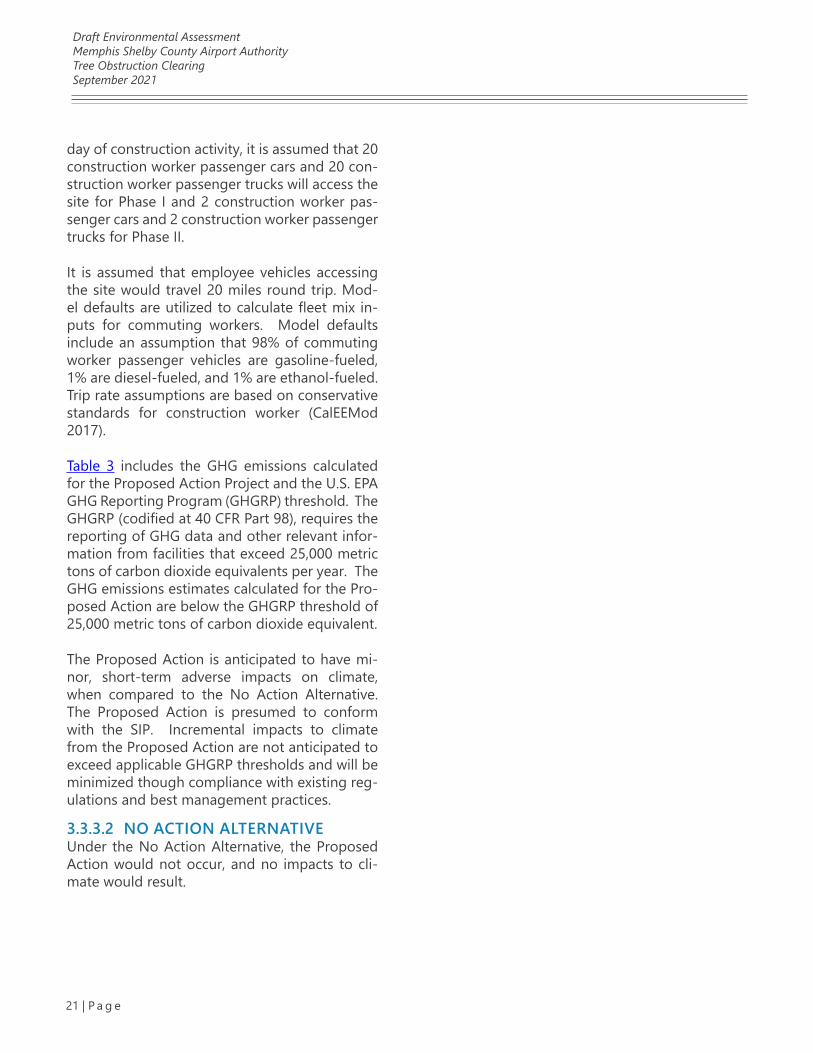
Draft Environmental AssessmentMemphis Shelby County Airport AuthorityTree Obstruction ClearingSeptember 2021
21 | P a g e
day of construction activity, it is assumed that 20 construction worker passenger cars and 20 con-struction worker passenger trucks will access the site for Phase I and 2 construction worker pas-senger cars and 2 construction worker passenger trucks for Phase II.
It is assumed that employee vehicles accessing the site would travel 20 miles round trip. Mod-el defaults are utilized to calculate fleet mix in-puts for commuting workers. Model defaults include an assumption that 98% of commuting worker passenger vehicles are gasoline-fueled, 1% are diesel-fueled, and 1% are ethanol-fueled. Trip rate assumptions are based on conservative standards for construction worker (CalEEMod 2017).
Table 3 includes the GHG emissions calculated for the Proposed Action Project and the U.S. EPA GHG Reporting Program (GHGRP) threshold. The GHGRP (codified at 40 CFR Part 98), requires the reporting of GHG data and other relevant infor-mation from facilities that exceed 25,000 metric tons of carbon dioxide equivalents per year. The GHG emissions estimates calculated for the Pro-posed Action are below the GHGRP threshold of 25,000 metric tons of carbon dioxide equivalent.
The Proposed Action is anticipated to have mi-nor, short-term adverse impacts on climate, when compared to the No Action Alternative. The Proposed Action is presumed to conform with the SIP. Incremental impacts to climate from the Proposed Action are not anticipated to exceed applicable GHGRP thresholds and will be minimized though compliance with existing reg-ulations and best management practices.
3.3.3.2 NO ACTION ALTERNATIVEUnder the No Action Alternative, the Proposed Action would not occur, and no impacts to cli-mate would result.
Draft Environmental AssessmentMemphis Shelby County Airport AuthorityTree Obstruction ClearingSeptember 2021
22 | P a g e
Table 3 - Proposed Action Greenhouse Gas Emissions and Carbon Dioxide Equivalent Threshold (in Metric Tons per Year)
Calendar Year Source Carbon dioxide Methane Nitrous oxide Carbon dioxide
equivalent
2021
Direct Emissions (construction) 559 5.94E-03 0.00 559
Indirect Emissions (operation) 32.5 9.65E-03 4.79E-03 34.2
TOTAL 591 1.56E-02 4.79E-03 593.04
2022
Direct Emissions (construction)
7465 0.11 0.00 7468
Indirect Emissions (operation)
133.6 0.04 0.02 140.5
TOTAL 7599 0.15 0.02 7608
2023
Direct Emissions (construction)
5787 0.08 0.00 5789
Indirect Emissions (operation)
101 0.03 0.02 107
TOTAL 5888 0.11 0.02 5895
Direct Emissions (construction)
19.2 0.03 0.00 20.0
Indirect Emissions (operation)
12.0 2.90E-03 1.68E-03 12.6
TOTAL 31.2 3.61E-02 1.68E-03 32.6
Direct Emissions (construction)
13.4 0.02 0.00 14.0
Indirect Emissions (operation)
9.67 2.15E-03 1.34E-03 10.12
TOTAL 23.1 2.53E-02 1.34E-03 24.1
GHGRP Threshold 25,000 25,000 25,000 25,000
Notes:GHGRP = The U.S. EPA GHG Reporting Program
Draft Environmental AssessmentMemphis Shelby County Airport AuthorityTree Obstruction ClearingSeptember 2021
23 | P a g e
3.4 COASTAL RESOURCES3.4.1 REGULATORY SETTINGAccording to FAA Order 1050.1F Desk Reference, coastal resources include the natural resources occurring within coastal waters and their adjacent shorelands (FAA 2020). Coastal resources include islands, transitional and intertidal areas, salt marshes, wetlands, floodplains, estuaries, beach-es, dunes, barrier islands, and coral reefs, as well as fish and wildlife and their respective habitats within these areas (FAA 2020). Coastal resources include the coastlines of the Atlantic and Pacific Oceans, the Great Lakes, and the Gulf of Mexico.
The primary statutes, regulations, and Executive Orders related to the protection of coastal re-sources considered in this Draft EA are as follows:
1. The Coastal Barrier Resources Act
2. The Coastal Zone Management Act
3. The National Marine Sanctuaries Act
4. Executive Order 13089, Coral Reef Protection
5. Executive Order 13547, Stewardship of the Ocean, Our Coasts, and the Great Lakes
3.4.2 AFFECTED ENVIRONMENTThe Site is located Memphis, Shelby County, Ten-nessee. The Proposed Action does not impact coastlines of the Atlantic and Pacific Oceans, the Great Lakes, or the Gulf of Mexico. Therefore, impacts to coastal resources resulting from the Proposed Action are not reasonably foreseeable.
3.4.3 ENVIRONMENTAL CONSEQUENCES
3.4.3.1 PROPOSED ACTIONThere would be no changes to coastal resources under the Proposed Action.
3.4.3.2 NO ACTION ALTERNATIVEThere would be no changes to coastal resources under the No Action Alternative.
3.4.4 MITIGATIONBased on the location of the Proposed Action, there are no impacts to coastal resources; there-fore, mitigation is not proposed for the Proposed Action.
3.5 DEPARTMENT OF TRANSPORTATION ACT, SECTION 4(F)3.5.1 REGULATORY SETTINGAccording to FAA Order 1050.1F Desk Reference, Section 4(f) of the U.S. DOT Act of 1966 protects significant publicly owned parks, recreational ar-eas, wildlife and waterfowl refuges, and public and private historic sites (FAA 2020). Section 4(f) provides that the Secretary of Transportation may approve a transportation program or project re-quiring the use of publicly owned land of a pub-lic park, recreation area, or wildlife or waterfowl refuge of national, state, or local significance, or land of a historic site of national, state, or local significance, only if there is no feasible and pru-dent alternative to using that land, and the pro-gram or project includes all possible planning to minimize harm resulting from the use (FAA 2020).
A Section 4(f) use can occur under two scenarios: Physical Use or Constructive Use. Physical Use involves the actual physical taking of Section 4(f) property through the purchase of land or a permanent easement, physical occupation of a portion or all of the property, or alteration of structures or facilities on the property (FAA 2020).
Constructive Use refers to the severity of indirect impacts resulting from the Proposed Action on a Section 4(f) property. Constructive Use includes impacts that are so severe that the activities, features, or attributes that qualify the property
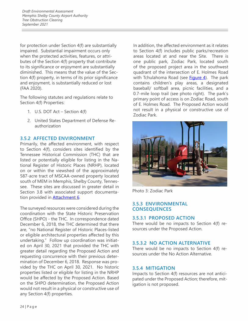
Draft Environmental AssessmentMemphis Shelby County Airport AuthorityTree Obstruction ClearingSeptember 2021
24 | P a g e
for protection under Section 4(f) are substantially impaired. Substantial impairment occurs only when the protected activities, features, or attri-butes of the Section 4(f) property that contribute to its significance or enjoyment are substantially diminished. This means that the value of the Sec-tion 4(f) property, in terms of its prior significance and enjoyment, is substantially reduced or lost (FAA 2020).
The following statutes and regulations relate to Section 4(f) Properties:
1. U.S. DOT Act – Section 4(f)
2. United States Department of Defense Re-authorization
3.5.2 AFFECTED ENVIRONMENTPrimarily, the affected environment, with respect to Section 4(f), considers sites identified by the Tennessee Historical Commission (THC) that are listed or potentially eligible for listing in the Na-tional Register of Historic Places (NRHP), located on or within the viewshed of the approximately 587-acre tract of MSCAA-owned property located south of MEM in Memphis, Shelby County, Tennes-see. These sites are discussed in greater detail in Section 3.8 with associated support documenta-tion provided in Attachment 6.
The surveyed resources were considered during the coordination with the State Historic Preservation Office (SHPO) - the THC. In correspondence dated December 6, 2018, the THC determined that there are, “no National Register of Historic Places-listed or eligible architectural properties affected by this undertaking.” Follow up coordination was initiat-ed on April 30, 2021 that provided the THC with greater detail regarding the Proposed Action and requesting concurrence with their previous deter-mination of December 6, 2018. Response was pro-vided by the THC on April 30, 2021. No historic properties listed or eligible for listing in the NRHP would be affected by the Proposed Action. Based on the SHPO determination, the Proposed Action would not result in a physical or constructive use of any Section 4(f) properties.
Photo 3: Zodiac Park
In addition, the affected environment as it relates to Section 4(f) includes public parks/recreation areas located at and near the Site. There is one public park, Zodiac Park, located south of the proposed project area in the southwest quadrant of the intersection of E. Holmes Road with Tchulahoma Road (see Figure 4). The park contains children’s play areas, a designated baseball/ softball area, picnic facilities, and a 0.7-mile loop trail (see photo right). The park’s primary point of access is on Zodiac Road, south of E. Holmes Road. The Proposed Action would not result in a physical or constructive use of Zodiac Park.
3.5.3 ENVIRONMENTAL CONSEQUENCES
3.5.3.1 PROPOSED ACTIONThere would be no impacts to Section 4(f) re-sources under the Proposed Action.
3.5.3.2 NO ACTION ALTERNATIVEThere would be no impacts to Section 4(f) re-sources under the No Action Alternative.
3.5.4 MITIGATIONImpacts to Section 4(f) resources are not antici-pated under the Proposed Action; therefore, mit-igation is not proposed.
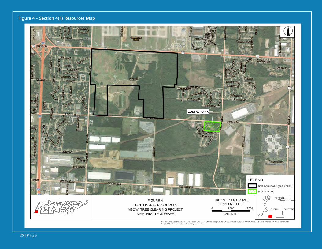
Figure 4 - Section 4(F) Resources Map
Serv ice Layer Credits: Source: Esri, Maxar, GeoEye, Earthstar Geographics, CNES/Airbus DS, USDA, USGS, AeroGRID, IGN, and the GIS User CommunityEsri, HERE, Garmin, (c) OpenStreetMap contributors
LEGENDSITE BOUNDARY (587 ACRES)
ZODIAC PARK
o
0 1,500 3,000
SCALE IN FEET
Serv ic e Lay er Credi ts: S our ce: Es ri , Max ar, G eoEy e, E arths tar Geographic s, CNE S/A ir bus DS , US DA , USG S, Aer oG RID, IGN, and the G IS Us er Comm unityEs ri, HE RE , Garm in, ( c) O penS treetM ap c ontr ibutors
NAD 1983 STATE PLANETENNESSEE FEET
SHELBY FAYETTE
TIPTON
ZODIAC PARK
FIGURE 4SECTION 4(F) RESOURCES
MSCAA TREE CLEARING PROJECTMEMPHIS, TENNESSEE
25 | P a g e
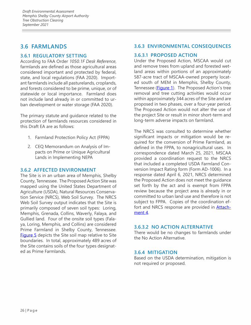
Draft Environmental AssessmentMemphis Shelby County Airport AuthorityTree Obstruction ClearingSeptember 2021
26 | P a g e
3.6 FARMLANDS3.6.1 REGULATORY SETTINGAccording to FAA Order 1050.1F Desk Reference, farmlands are defined as those agricultural areas considered important and protected by federal, state, and local regulations (FAA 2020). Import-ant farmlands include all pasturelands, croplands, and forests considered to be prime, unique, or of statewide or local importance. Farmland does not include land already in or committed to ur-ban development or water storage (FAA 2020).
The primary statute and guidance related to the protection of farmlands resources considered in this Draft EA are as follows:
1. Farmland Protection Policy Act (FPPA)
2. CEQ Memorandum on Analysis of Im-pacts on Prime or Unique Agricultural Lands in Implementing NEPA
3.6.2 AFFECTED ENVIRONMENTThe Site is in an urban area of Memphis, Shelby County, Tennessee. The Proposed Action Site was mapped using the United States Department of Agriculture (USDA), Natural Resources Conserva-tion Service (NRCS), Web Soil Survey. The NRCS Web Soil Survey output indicates that the Site is primarily composed of seven soil types: Loring, Memphis, Grenada, Collins, Waverly, Falaya, and Gullied land. Four of the onsite soil types (Fala-ya, Loring, Memphis, and Collins) are considered Prime Farmland in Shelby County, Tennessee. Figure 5 depicts the Site soil map relative to Site boundaries. In total, approximately 489 acres of the Site contains soils of the four types designat-ed as Prime Farmlands.
3.6.3 ENVIRONMENTAL CONSEQUENCES
3.6.3.1 PROPOSED ACTIONUnder the Proposed Action, MSCAA would cut and remove trees from upland and forested wet-land areas within portions of an approximately 587-acre tract of MSCAA-owned property locat-ed south of MEM in Memphis, Shelby County, Tennessee (Figure 1). The Proposed Action’s tree removal and tree cutting activities would occur within approximately 344 acres of the Site and are proposed in two phases, over a four-year period. The Proposed Action would not alter the use of the project Site or result in minor short-term and long-term adverse impacts on farmland.
The NRCS was consulted to determine whether significant impacts or mitigation would be re-quired for the conversion of Prime Farmland, as defined in the FPPA, to nonagricultural uses. In correspondence dated March 25, 2021, MSCAA provided a coordination request to the NRCS that included a completed USDA Farmland Con-version Impact Rating form (Form AD-1006). In a response dated April 6, 2021, NRCS determined the Proposed Action does not meet the guidance set forth by the act and is exempt from FPPA review because the project area is already in or committed to urban land use and therefore is not subject to FPPA. Copies of the coordination ef-fort and NRCS response are provided in Attach-ment 4.
3.6.3.2 NO ACTION ALTERNATIVEThere would be no changes to farmlands under the No Action Alternative.
3.6.4 MITIGATIONBased on the USDA determination, mitigation is not required or proposed.
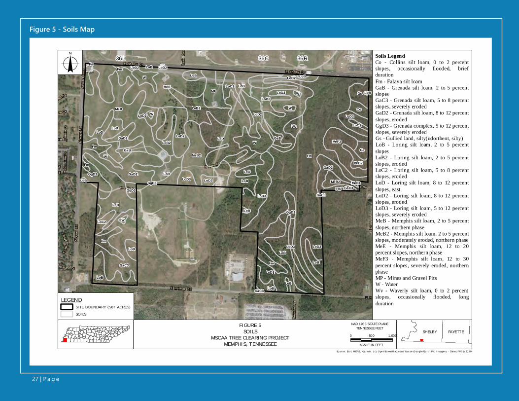
Figure 5 - Soils Map
36L 36C 36R
MeB
W
Fm
LoD
LoD3
LoD3LoD3
LoD3
GaD2
W
LoD2
GaC3
MeF3
MeF3
MP
LoD2
LoC2
MeB2
MeB2LoB
LoB
LoB
LoB
LoB
Gs
GaD2
LoC2
LoD
LoD
LoC2
LoD3
Fm
Fm
LoD3 LoD3
W
LoD2
GgD3
GaC3
LoB
Gs
LoB
Fm
Fm
Fm
MeE
W
LoB2
GaD2LoB2
Co
LoB
LoB
LoB
GgD3
GgD3
W
LoD2
Wv
GaC3
GaC3
LoD2
GaB
LoD3
LoD2
LoB
FmFm
LoB
MeB2W
GgD3
LoB2
GaB
W
LoBLoB
LoB
LoB
LoB
LEGENDSITE BOUNDARY (587 ACRES)
SOILS
Sour ce: Esr i, H ERE, Ga rm in, (c) OpenStr ee tM ap contr ibut or sG oogle Ea r th Pro Im age ry - Da ted 5/31/2020
FIGURE 5SOILS
MSCAA TREE CLEARING PROJECTMEMPHIS, TENNESSEE
SHELBY FAYETTE0 500 1,000
SCALE IN FEET
NAD 1983 STATE PLANETENNESSEE FEET
o Soils LegendCo - Collins silt loam, 0 to 2 percentslopes, occasionally flooded, briefdurationFm - Falaya silt loamGaB - Grenada silt loam, 2 to 5 percentslopesGaC3 - Grenada silt loam, 5 to 8 percentslopes, severely erodedGaD2 - Grenada silt loam, 8 to 12 percentslopes, erodedGgD3 - Grenada complex, 5 to 12 percentslopes, severely erodedGs - Gullied land, silty(udorthent, silty)LoB - Loring silt loam, 2 to 5 percentslopesLoB2 - Loring silt loam, 2 to 5 percentslopes, erodedLoC2 - Loring silt loam, 5 to 8 percentslopes, erodedLoD - Loring silt loam, 8 to 12 percentslopes, eastLoD2 - Loring silt loam, 8 to 12 percentslopes, erodedLoD3 - Loring silt loam, 5 to 12 percentslopes, severely erodedMeB - Memphis silt loam, 2 to 5 percentslopes, northern phaseMeB2 - Memphis silt loam, 2 to 5 percentslopes, moderately eroded, northern phaseMeE - Memphis silt loam, 12 to 20percent slopes, northern phaseMeF3 - Memphis silt loam, 12 to 30percent slopes, severely eroded, northernphaseMP - Mines and Gravel PitsW - WaterWv - Waverly silt loam, 0 to 2 percentslopes, occasionally flooded, longduration
27 | P a g e
Draft Environmental AssessmentMemphis Shelby County Airport AuthorityTree Obstruction ClearingSeptember 2021
28 | P a g e
3.7 HAZARDOUS MATERIALS, SOLID WASTE, AND POLLUTION PREVENTION3.7.1 REGULATORY SETTINGAccording to FAA Order 1050.1F Desk Reference, hazardous materials, solid waste, and pollution prevention as an impact category includes an evaluation of the following:
• Waste streams that would be generated by a project, potential for the wastes to impact environmental resources, and the impacts on waste handling and disposal facilities that would likely receive the wastes
• Potential hazardous materials that could be used during construction and oper-ation of a project, and applicable pollu-tion prevention procedures
• Potential to encounter existing haz-ardous materials at contaminated sites during construction, operation, and decommissioning of a project
• Potential to interfere with any ongoing remediation of existing contaminated sites at the proposed project site or in the immediate vicinity of a project site
The primary statutes, regulations, Executive Or-ders, and other guidance related to the evalu-ation of hazardous materials, solid waste, and pollution prevention considered in this Draft EA are as follows:
1. Comprehensive Environmental Re-sponse, Compensation, and Liability Act (as amended by the Superfund Amend-ments Reauthorization Act of 1986 and the Community Environmental Response Facilitation Act of 1992)
2. Emergency Planning and Community Right-to-Know Act
3. Federal Facilities Compliance Act
4. Hazardous Materials Transportation Act
5. Oil Pollution Act
6. Pollution Prevention Act
7. Resource Conservation and Recovery Act
8. Toxic Substances Control Act
9. Executive Order 12088, Federal Compli-ance with Pollution Control Standards
10. Executive Order 12580, Superfund Im-plementation as amended by Executive Order 13016, as further amended by Executive Order 13308
11. CEQ Memorandum on Pollution Preven-tion and NEPA
12. FAA Orders and Advisory Circulars
13. Tennessee Solid Waste Management Act of 1991
14. Tennessee Department of Environment and Conservation, Solid Waste Man-agement Rule 0400, Chapter 11 for Sol-id Waste and Chapter 12 for Hazardous Waste
3.7.2 AFFECTED ENVIRONMENTThe approximately 587-acre Site is located south of MEM Runways 36L, 36C, and 36R and Shelby Drive, east of Airways Boulevard, and north of E. Holmes Road (Figure 1). The Site is current-ly undeveloped, except for aviation navigational equipment, and includes upland and forested wetlands areas and open, grass covered fields (Figure 2). The affected environment consid-ered for hazardous materials, solid waste, and pollution prevention includes any contaminated sites within or in the immediate vicinity of the Proposed Action area and the nearest receiving waterbody. The principal drainage on the Site is Hurricane Creek, which flows northeasterly into

Draft Environmental AssessmentMemphis Shelby County Airport AuthorityTree Obstruction ClearingSeptember 2021
29 | P a g e
Nonconnah Creek, and the Nonconnah Creek Watershed located in northwest Mississippi and southwest Tennessee. The affected environment for this resource area also includes the local dis-posal capacity for solid and hazardous wastes generated from the Proposed Action. The identi-fication of contaminated sites and solid and haz-ardous waste disposal capacity are discussed in the following subsections.
3.7.2.1 IDENTIFICATION OF CONTAMINATED SITESCoordination with TDEC Division of Remediation (DOR) regarding potential onsite and offsite con-taminated sites revealed two remediation sites and one former underground storage tank, dis-cussed in detail below. The onsite and offsite identified sites are depicted on Figure 6. Coordi-nation correspondence with TDEC DOR is includ-ed in Attachment 1.
TDEC Remediation Site 79682 – Aviation Materials, Inc. FacilityAs shown on Figure 6, TDEC Site 79682 is locat-ed on the Proposed Action Site; however, the site is not located within an area where tree clearing would occur. The site is the current location of the airport’s navigational aid facility, a Very High Fre-quency Omnidirectional Range beacon and TAC-tical Air Navigation system (VORTAC). The DOR was contacted for current information on the site. According to TDEC this location is designated as a non-site and may have been assigned a site number upon initial reporting of an incident, but for unknown reasons it never evolved into a DOR site (see Attachment 5). Because it’s listed as a non-site TDEC had no further information. Based on the site status and location outside of the tree clearing areas, TDEC Site 79682 is not anticipated to impact the Proposed Action.
TDEC Facility 791182 – McKellar Nursery, Former Underground Storage Tank (UST) SystemAs shown on Figure 6, TDEC Facility 791182 is located south of the Proposed Action Site on E. Holmes Road. The former UST system includ-ed one, 1,000-gallon capacity tank containing gasoline. The tank was removed by the City of Memphis in 1990, and soil samples were collect-ed by an independent consulting firm to identify any contaminated soils for removal and dispos-al. TDEC closure of the UST system was achieved on November 5, 1990. Based on the offsite loca-tion and regulatory closure status, TDEC Facility 791182 is not anticipated to impact the Proposed Action Site. Excerpted details regarding TDEC Fa-cility 791182 are included in Attachment 5.
TDEC Remediation Site 79604/79640 – Jackson PitsAs shown on Figure 6, TDEC Site 79604 is located east of the Proposed Action Site 2. TDEC remedia-tion site 79604/79640 was a sand and gravel strip mining facility from approximately the 1930’s to about 1960, and also operated as a legacy dump site for household waste and other refuse by Shelby County from 1954 to 1968. In 1968, the City of Memphis took over operation of the site as a sanitary landfill until 1972, when it was closed by the city and partially covered. During this pe-riod an approximately four acre of the landfill was designated for disposal of highly acidic waste oil sludge. This four-acre area, known as the “Poison Pit” was located on the southwest corner of the landfill, adjacent to Jackson Pit Road.
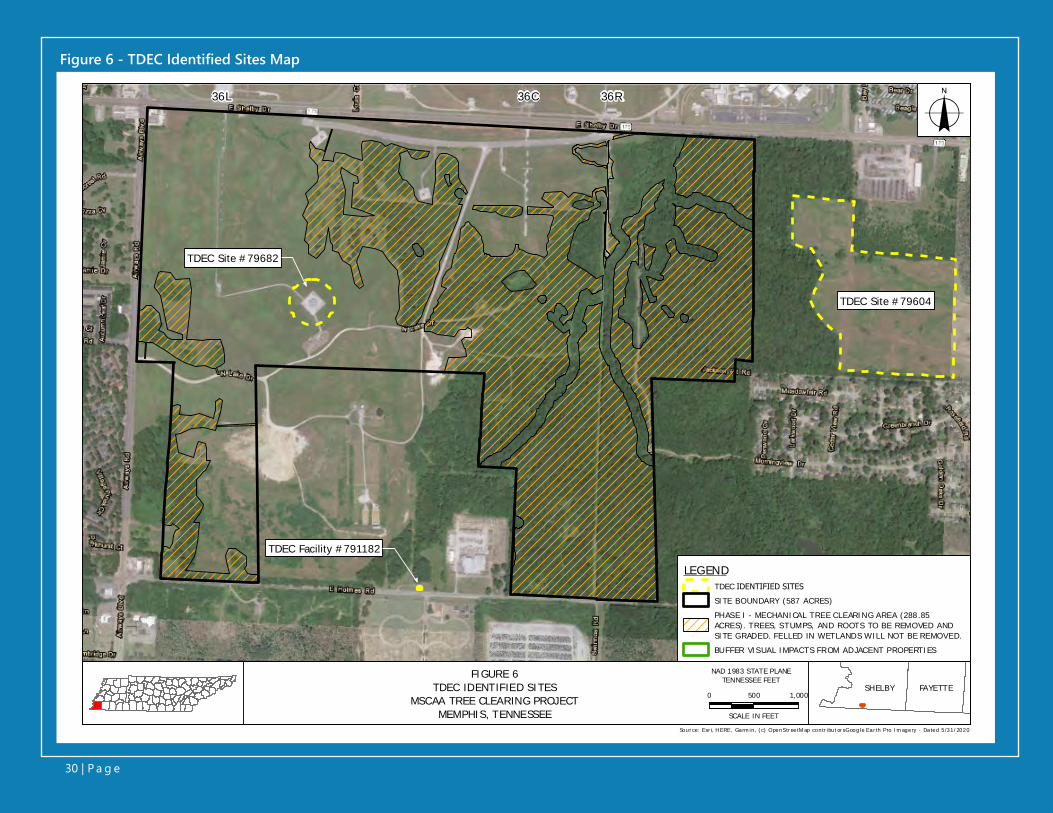
Figure 6 - TDEC Identified Sites Map
36L 36C 36R
TDEC Site #79682
TDEC Site #79604
TDEC Facility #791182
LEGENDTDEC IDENTIFIED SITESSITE BOUNDARY (587 ACRES)PHASE I - MECHANICAL TREE CLEARING AREA (288.85 ACRES). TREES, STUMPS, AND ROOTS TO BE REMOVED AND SITE GRADED. FELLED IN WETLANDS WILL NOT BE REMOVED.BUFFER VISUAL IMPACTS FR OM ADJACENT PROPERTIES
Source: Esr i, H ERE, Ga rm in, (c) OpenStr ee tM ap contr ibut or sG oogle Ea r th Pro Im age ry - Da ted 5/31/2020
0 500 1,000
SCALE IN FEET
o
NAD 1983 STATE PLANETENNESSEE FEETFIGURE 6
TDEC IDENTIFIED SITESMSCAA TREE CLEARING PROJECT
MEMPHIS, TENNESSEE
SHELBY FAYETTE
30 | P a g e

Draft Environmental AssessmentMemphis Shelby County Airport AuthorityTree Obstruction ClearingSeptember 2021
31 | P a g e
review of site files and discussions with the pre-vious project manager there has not been any recent environmental work or monitoring com-pleted for this site, and the information provid-ed in the TDEC records request is the most cur-rent information available (see Attachment 5 for communication records).
Excerpted details from the ROD regarding TDEC Facility 79604 are included in Attachment 5. Based on the offsite location and depth to groundwater, TDEC Facility 79604 is not antici-pated to impact the Proposed Action Site.
The TDEC Division of Solid Waste Management (DSWM) manages legacy solid waste sites pre-dating the Solid Waste Management Program initiated in 1972. The DSWM advises that any wastes unearthed during the project are subject to a hazardous waste determination and must be managed appropriately.
TDEC Remediation Site 790756 – Williams Energy Jet A Fuel Release SiteIn response to TDEC for remediation and hazard-ous waste sites within the Proposed Action Site, as shown on the DOR figure in Attachment 5, this site is shown within the Proposed Action Site, at the southeast corner of East Shelby Drive and Airways Road. The site was the location of a Jet A fuel spill discovered on February 3, 2003. Free product was removed from an unlined stormwa-ter ditch, as well as contaminated soils. How-ever, review of files provided by TDEC revealed the site of the spill to be approximately 1.3 miles further north from where it is indicated on the DOR figure. Investigations conducted during the spill also indicated that groundwater flow in the area of the spill to be to the north. Given the distance and groundwater flow to the north, this site would not impact the Proposed Action Site.
Sampling of the site began in 1979 to charac-terize the site and identify possible contami-nants of concern. Several investigations were conducted at the site to sample site sediments, leachate, abandoned drums, surface soils, sur-face water, and groundwater between 1979 and 1991. Results of this sampling identified met-als and organics in site soils/sediments, surface water, and groundwater in the vicinity of the site. While these early investigations provided some insight to site conditions, contaminants of concern, and exposure pathways, they were not compressive. Therefore, prior to implementation of a proposed remedy for the site, Memphis and Shelby County conducted a comprehensive in-vestigation of the site beginning in 2000 consist-ing of the Jackson Pit Cover Evaluation Report and Preliminary Drainage Plan (August 2000), Site Screen Investigation Report (July 2001), and a Groundwater Solute Transportation Simulation (November 2001). Results of the Site Screen In-vestigation identified semi volatile organic com-pounds, metals, and Polychlorinated biphenyl (PCB) components in surface soil, subsurface soil, surface water, and groundwater. Groundwater flow is generally to the west/northwest, toward Hurricane Creek, which flows through the Site. A clay cap was installed on the site in 2004, and a Record of Decision (ROD) issued by TDEC in 2007.
As part of the stipulations in the ROD, an op-erations and maintenance (O&M) plan should be implemented. A consultant was hired by the City of Memphis in 2014 to provide O&M per the ROD, including collection of groundwater sam-ples every five years from existing on-site moni-toring wells. No current data was provided from requests of TDEC. The TDEC Project Manager, Klarissa Kahill, was contacted for additional and current information about the site. Ms. Kahill re-sponded on April 28, 2021 that after her further
2A second TDEC facility number, 79640, was provided for this same location. A response from the site Project Manager confirmed that these numbers are for the same site (see Attachment 5).
Draft Environmental AssessmentMemphis Shelby County Airport AuthorityTree Obstruction ClearingSeptember 2021
32 | P a g e
3.7.2.2 IDENTIFICATION OF SOLID AND HAZARDOUS WASTE DISPOSAL CAPACITYThe DSWM regulates material recovery facili-ties, transfer stations, and landfills for sanitary or municipal solid waste, industrial waste, farming wastes, and construction and demolition waste. Waste is accepted at the following permitted landfills:
• Class I landfills, which accept non-haz-ardous municipal solid wastes such as household wastes, approved special wastes, and commercial wastes
• Class II landfills, which accept non-haz-ardous industrial wastes, commercial wastes, and fill
• Class III landfills, which accept Class IV wastes plus landscaping, land clearing, and farming wastes
• Class IV landfills, which accept construc-tion/demolition wastes, shredded tires, and waste with characteristics similar to construction/demolition wastes
According to a 2018 Land Use Control Board Staff Report, the landfills that serve the Site have sufficient capacity to receive wastes associated with the construction and operation phases of the Proposed Action through 2055 (see Attach-ment 5). Hazardous waste is not anticipated to be generated by the Proposed Action.
Any wastes associated with the Proposed Action, including but not limited to: materials destined for disposal, unforeseen damages and repairs, cleanup, surface stabilization, and leaks and spills, would be handled in accordance with the TDEC Solid Waste Management Rule 0400, Chap-ter 11 for Solid Waste and Chapter 12 for Haz-ardous Waste.
3.7.3 ENVIRONMENTAL CONSEQUENCES
3.7.3.1 PROPOSED ACTIONThe Proposed Action consists of removal, or se-lectively topping of trees from the wooded areas within the approximately 587-acre Site. The tree removal and tree topping activities would occur within approximately 344 acres of the Site and are proposed in two phases, over a four-year pe-riod.
Phase I of the Proposed Action includes the re-moval of trees, including stumps and roots, with-in approximately 289 acres of upland wooded area (Figure 2). Tree removal under Phase I of the project is proposed using site-clearing ma-chinery. Tree removal activities, and subsequent grading activities, are proposed to be conducted incrementally, in 30-acre sections. The selected contractor for the proposed project would be re-quired to stabilize and grade each 30-acre area prior to moving to additional 30-acre sections.
Groundwater flow direction from TDEC Facility 79604 is toward Hurricane Creek. Therefore, it is anticipated to flow under Phase I areas east of and between the creek and the TDEC site. How-ever, land disturbing activities for tree removal would not impact groundwater, and any con-taminants in groundwater from the TDEC Facility 79604 would not be impacted by tree clearing activities. Heavy construction equipment would be used during this phase of the project, but their use would not generate hazardous mate-rials or waste. Any fueling of heavy equipment would occur outside of the area associated with the Proposed Action area.
Phase II of the Proposed Action includes the felling and topping of trees within approximate-ly 55 acres of forested wetlands area (Figure 3). Site-clearing machinery is not proposed for
Draft Environmental AssessmentMemphis Shelby County Airport AuthorityTree Obstruction ClearingSeptember 2021
33 | P a g e
Phase II areas. The topping of trees in the Phase II areas would be completed by hand using chain saws. Because of the type of equipment used for Phase II activities, tree topping and hand would not result in generation of hazardous materials or waste.
Felled trees are proposed for reuse as harvest-ed timber. Should felled trees be unable to be reused as timber, they would be burned onsite using ACD burn processes that might include the use of burn pits with burn waste remaining as on-site fill at the location of the ACD or a pro-prietary above-ground system. The specific ap-proach would be determined through coordina-tion with the Shelby County Health Department and would be consistent with their (and FAA’s) regulations regarding smoke and particulate matter.
Mr. Tom Word with Memphis Light, Gas, and Water (MLGW) Division was contacted regard-ing power transmission or gas line easements in or near the Action Area. MLGW has restrictions and limitations for working on or near gas line easements. Mr. Word responded to informa-tion requests on April 23, 2021 with mapping showing general locations of underground gas, water, and electric lines located throughout the Proposed Action area. Because of the various underground utilities, the following recommen-dations were provided:
1. Calling TN 1-Call (811) to locate any utilities before any clearing, grading or construction begins
2. The Airport should conduct a title search and have an abstract of title prepared to identify any easements or encumbrances on the property
In addition to this guidance, Mr. Word had pro-vided a response to a similar request for an adjacent project south of E. Holmes Road, and included guidance for proceeding with work
near underground utilities. Mr. Word’s current response, attachments, and guidance from the response to the adjoining project south of E. Holmes Road are included in Attachment 5.
3.7.3.2 NO ACTION ALTERNATIVEThere would be no changes to hazardous mate-rials, solid waste, or pollution prevention under the No Action Alternative.
3.7.4 MITIGATIONMitigation is not proposed based on the lack of significant impacts as a result of hazardous ma-terials use, solid waste generation, and pollu-tion prevention procedures. Because impacts to groundwater are not anticipated from the Pro-posed Action, no mitigation of any groundwater contaminants is required.
3.8 HISTORICAL, ARCHITECTURAL, ARCHEOLOGICAL, AND CULTURAL RESOURCES3.8.1 REGULATORY SETTINGAccording to FAA Order 1050.1F Desk Refer-ence, historical, architectural, archaeological, and cultural resources encompass a range of sites, properties, and physical resources relating to human activities, society, and cultural institu-tions. Such resources include past and present expressions of human culture and history in the physical environment, such as prehistoric and historic archaeological sites, structures, objects, and districts that are considered important to a culture or community. Historical, architectur-al, archaeological, and cultural resources also include aspects of the physical environment, namely natural features and biota, which are a part of traditional ways of life and practices and are associated with community values and insti-tutions (FAA 2020).

Draft Environmental AssessmentMemphis Shelby County Airport AuthorityTree Obstruction ClearingSeptember 2021
34 | P a g e
The primary statutes, regulations, Executive Or-ders, and other requirements related to histori-cal, architectural, archaeological, and cultural re-sources considered in this Draft EA are as follows:
1. American Indian Religious Freedom Act2. Antiquities Act of 19063. Archeological and Historic Preservation
Act4. U.S. DOT Act, Section 4(f)5. Historic Sites Act of 19356. National Historic Preservation Act7. Native American Graves Protection and
Repatriation Act8. Public Building Cooperative Use Act9. Executive Order 11593, Protection and
Enhancement of the Cultural Environment10. Executive Order 13006, Locating Federal
Facilities on Historic Properties in Our Nation’s Central Cities
11. Executive Order 13007, Indian Sacred Sites
12. Executive Order 13175, Consultation and Coordination with Indian Tribal Govern-ments
13. DOT Order 5650.1, Protection and En-hancement of the Cultural Environment
14. Executive Memorandum, Govern-ment-to-Government Relations with Native American Tribal Governments
15. Executive Memorandum on Tribal Con-sultation
3.8.2 AFFECTED ENVIRONMENTThe Site consists of upland and forested wetland areas within portions of an approximately 587-acre tract of MSCAA-owned property located south of MEM in Memphis, Shelby County, Ten-nessee (Figure 1). The Site is located south of MEM Runways 36L, 36C, and 36R and E. Shelby Drive, east of Airways Boulevard, and north of E. Holmes Road.
In 2018 and 2019, coordination with the THC was initiated for the Proposed Action. Prior coordination documentation is included in At-tachment 6 and includes THC correspondence indicating a lack of architectural and archae-ological resources eligible for or listed on the National Register of Historic Places. Part of this effort included field survey and preparation of the Phase I Archaeological Assessment for the Memphis Shelby County Airport Authority Tree Obstruction Clearing, Shelby County, Tennes-see (PanAmerican Consultant, Inc. 2019). Since that time, the Site boundaries have changed to include newly acquired parcels located on the eastern boundary of the Site. Consultation with the SHPO was initiated by the FAA to deter-mine the Areas of Potential Effects (APE). The archaeological APE is limited to areas where ground-disturbing activities would take place (i.e., tree stump removal). As ground-disturb-ing activities are limited to approximately 289 acres of wooded terrain in the uplands, this area is considered the APE.
The recommended APE for architectural and historic resources is limited to the viewshed of the proposed project. This area has been de-fined as approximately 200 feet from the edge of any improvements associated with Phase I of the Proposed Action. All areas designated as Phase II are located within the limits of Phase I locations and, therefore, would be included in any APE boundaries established for the Phase I activities. The locations of these APEs are pro-vided in Figure 7.
There are three locations where this buffer has been modified slightly due to site specific con-ditions. This first is along the western edge of the Site (Airways Boulevard) where, because of the presence of a 5-lane roadway between structures located off-property and the Site, the APE boundary is defined as the centerline of Airways Boulevard.

Figure 7 - Areas of Potential Effect
36L 36C 36R
Wetland 8
Wetland7
Hurrica
ne Cree
k
Pond 3
Stream 1
Strea
m 2
WW
C 3
WWC 2
WWC 1
WWC 4
WWC 1
WWC 6WWC 7
WWC 5
WWC 8 WWC 9Stream 4
WWC 10
Stream 5WWC 12
WWC 11
Stream 3
WWC 17
WW
C 16
WWC 15
WWC 13
WWC 14
WWC 13WWC 13
Stre
am 6
WWC 18WWC 18
Wetland 5Wetland 4
Wetland 9
Wetland 3
Wetland 2
Wetland 6
Wetland 1
Pond 1
Pond 2
Wetland 11
Wetland 12
Wetland 10
TN HISTORICAL COMMISSION SITES
ABOVEGROUND AREA OF POTENTIAL EFFECTPHASE I - MECHANICAL TREE CLEARING AREA (288.85 ACRES). TREES, STUMPS, AND ROOTS TO BE REMOVED AND SITE GRADED. FELLED IN WETLANDS WILL NOT BE REMOVED.PHASE II - TREE CUTTING AREA -STREAMS AND WETLANDS (55.08 ACRES ), 60-FOOT STREAM BUFFER (DETERMINED FROM TOP OF STREAM BANK) AND 30-FOOT WETLAND BUFFER. CUTTING TO OCCUR WITH CHAIN SAWS IN PHASE II AREAS.ABOVEGROUND AREA OF POTENTIAL EFFECT AND VISUAL BUFFER BOUNDARYSITE BOUNDARY (587 ACRES)BUFFER VISUAL IMPACTS FROM ADJACENT PROPERTIES
Source: Esr i, H ERE, Ga rm in, (c) OpenStr ee tM ap contr ibut or sTHCG oogle Ear th Pro Im agery - Dat ed 5/31/2020
FIGURE 7AREAS OF POTENTIAL EFFECT
MSCAA TREE CLEARING PROJECTMEMPHIS, TENNESSEE
SHELBY FAYETTE0 500 1,000
SCALE IN FEET
NAD 1983 STATE PLANETENNESSEE FEET
o
LEGEND
35 | P a g e
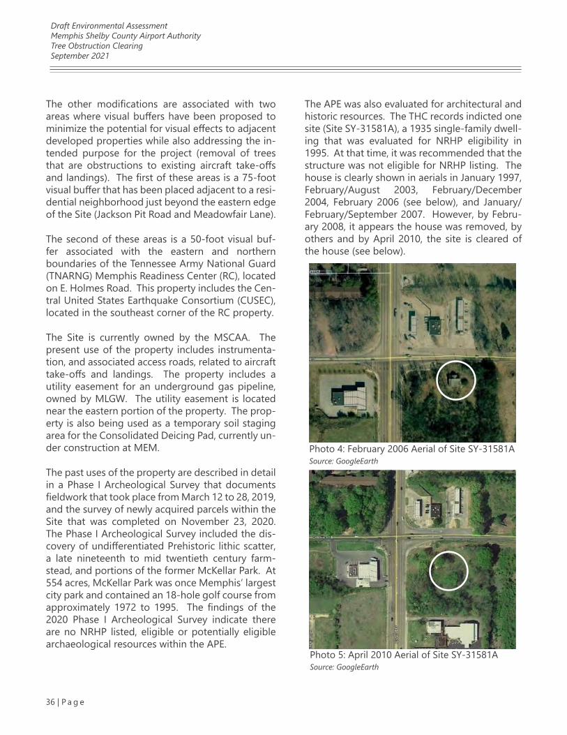
Draft Environmental AssessmentMemphis Shelby County Airport AuthorityTree Obstruction ClearingSeptember 2021
36 | P a g e
The other modifications are associated with two areas where visual buffers have been proposed to minimize the potential for visual effects to adjacent developed properties while also addressing the in-tended purpose for the project (removal of trees that are obstructions to existing aircraft take-offs and landings). The first of these areas is a 75-foot visual buffer that has been placed adjacent to a resi-dential neighborhood just beyond the eastern edge of the Site (Jackson Pit Road and Meadowfair Lane).
The second of these areas is a 50-foot visual buf-fer associated with the eastern and northern boundaries of the Tennessee Army National Guard (TNARNG) Memphis Readiness Center (RC), located on E. Holmes Road. This property includes the Cen-tral United States Earthquake Consortium (CUSEC), located in the southeast corner of the RC property.
The Site is currently owned by the MSCAA. The present use of the property includes instrumenta-tion, and associated access roads, related to aircraft take-offs and landings. The property includes a utility easement for an underground gas pipeline, owned by MLGW. The utility easement is located near the eastern portion of the property. The prop-erty is also being used as a temporary soil staging area for the Consolidated Deicing Pad, currently un-der construction at MEM.
The past uses of the property are described in detail in a Phase I Archeological Survey that documents fieldwork that took place from March 12 to 28, 2019, and the survey of newly acquired parcels within the Site that was completed on November 23, 2020. The Phase I Archeological Survey included the dis-covery of undifferentiated Prehistoric lithic scatter, a late nineteenth to mid twentieth century farm-stead, and portions of the former McKellar Park. At 554 acres, McKellar Park was once Memphis’ largest city park and contained an 18-hole golf course from approximately 1972 to 1995. The findings of the 2020 Phase I Archeological Survey indicate there are no NRHP listed, eligible or potentially eligible archaeological resources within the APE.
The APE was also evaluated for architectural and historic resources. The THC records indicted one site (Site SY-31581A), a 1935 single-family dwell-ing that was evaluated for NRHP eligibility in 1995. At that time, it was recommended that the structure was not eligible for NRHP listing. The house is clearly shown in aerials in January 1997, February/August 2003, February/December 2004, February 2006 (see below), and January/February/September 2007. However, by Febru-ary 2008, it appears the house was removed, by others and by April 2010, the site is cleared of the house (see below).
Photo 4: February 2006 Aerial of Site SY-31581ASource: GoogleEarth
Photo 5: April 2010 Aerial of Site SY-31581ASource: GoogleEarth
Draft Environmental AssessmentMemphis Shelby County Airport AuthorityTree Obstruction ClearingSeptember 2021
37 | P a g e
Through coordination with TNARNG, informa-tion was obtained regarding historic structures on the property previously noted. In the winter of 2019, TNARNG performed a Phase I archae-ological survey for the RC’s 30.07 acres, with the results documented in A Phase I Cultural Resources Survey of 30.07 acres for the Memphis Readiness Center in Memphis, Shelby County, Tennessee. The survey and report did not identi-fy any archaeological sites.
The Memphis RC and the current Field Mainte-nance Shop were both constructed in 1983 and are a part of the current Cold War-Era RC survey that will be completed next year. There is also one historic resource (constructed in the ear-ly 1960’s) – the CUSEC. Due to loss of integrity (landscape now dominated by military activities, incorrect material alterations, lost associations with other residential properties of its time, etc.), this property was not considered eligible for the NRHP. This determination has received SHPO concurrence.
3.8.3 ENVIRONMENTAL CONSEQUENCES
3.8.3.1 PROPOSED ACTIONIn correspondence dated April 30, 2021, the SHPO determined that no historic properties el-igible for listing in the National Register of His-toric Places would be affected by the Proposed Action (Attachment 6).
3.8.3.2 NO ACTION ALTERNATIVEThere would be no changes to historical, archi-tectural, archaeological, or cultural resources un-der the No Action Alternative.
3.8.4 MITIGATIONBased on a lack of identified impacts to histor-ical, architectural, archaeological, or cultural re-sources, mitigation is not proposed.
3.9 LAND USE3.9.1 REGULATORY SETTINGLand Use is discussed and analyzed in this Draft EA with respect to consistency with state and lo-cal plans, as required by the FAA Airport Improve-ment Program. The primary statutes, regulations, Executive Orders, and other requirements related to land use considered in this Draft EA are as fol-lows:
1. Airport and Airway Improvement Act of 1982, and subsequent amendments
2. Airport Improvement Program (see FAA Order 5100.38D)
3. Airport Safety, Protection of Environment, Criteria for Municipal Solid Waste Landfills
4. Memphis 3.0 Comprehensive Plan
5. Memphis and Shelby County Unified De-velopment Code
3.9.2 AFFECTED ENVIRONMENTThe affected environment evaluated for land use is limited to the 587-acre tract of land owned by the MSCAA and the surrounding land uses described in the Memphis Airport Area Land Use Study Final Report, adopted by the City of Memphis and Shel-by County in 1992. The study was the result of a multi-year land use planning effort involving the MSCAA and five local governments: the City of Memphis, Tennessee; Shelby County, Tennessee; the city of Southaven, Mississippi; the city of Horn Lake, Mississippi; and DeSoto County, Mississippi. Public involvement included meetings, workshops, and mailings reaching approximately 15,000 cit-izens within the 90-square-mile study area. The implementation program described in the Mem-phis Airport Area Land Use Study Final Report has been successful to date. The goal of the study was to carry out or facilitate the recommended noise mitigation actions that required the adoption of plans, land use policies, and ordinances by units of local government, including changes in zoning.
Draft Environmental AssessmentMemphis Shelby County Airport AuthorityTree Obstruction ClearingSeptember 2021
38 | P a g e
The Proposed Action Site is primarily zoned Res-idential (R-8) and Conservation Agriculture (CA) (Figure 8). According to the Memphis 3.0 Com-prehensive Plan, the Proposed Action Site is with-in the Oakhaven & Parkway Village Area Planning District and is designated at Public & Quasi-Public Buildings & Uses.
3.9.3 ENVIRONMENTAL CONSEQUENCES
3.9.3.1 PROPOSED ACTIONA change in zoning would not be required for the Site to perform the Proposed Action, which is lim-ited to tree removal and tree cutting activities. In addition, there would not be a change to land use under the Proposed Action.
Preparation of the Site would adhere to the Mem-phis and Shelby County Unified Development Code (Memphis 2010). The Proposed Action is not in conflict with the objectives of federal, regional, state, or local land use plans, policies, or controls for the area.
3.9.3.2 NO ACTION ALTERNATIVEThere would be no changes to land use under the No Action Alternative. Under the No Action Al-ternative, the MSCAA would not remove or selec-tively top trees from the wooded areas within the approximately 587-acre Site. Select wooded areas at the Site would continue to represent an airspace obstruction, under FAR Section 77.23 - Standards for Determining Obstructions. Conversely, the No Action Alternative would not result in any of the anticipated impacts associated with the Proposed Action.
3.9.4 MITIGATIONNo change in land use is proposed as part of the Proposed Action. Therefore, mitigation for a change in land use at the Proposed Action Site is not proposed.
3.10 NATURAL RESOURCES AND ENERGY SUPPLY3.10.1 REGULATORY SETTINGConsumption of natural resources and use of energy supplies may result from the Proposed Action. It is the policy of the FAA to encourage the development of FAA facilities that exemplify the highest standards of design, including sus-tainability principles (FAA 2020). A general dis-cussion of the consumption of natural resources and use of energy supplies by the Proposed Ac-tion is included in this section.
The primary statutes, Executive Orders, and oth-er requirements related to natural resources and energy supply considered in this Draft EA are as follows:
1. Energy Independence and Security Act
2. Energy Policy Act
3. Executive Order 13834, Efficient Federal Operations
3.10.2 AFFECTED ENVIRONMENTThe Site consists of upland and forested wet-land areas within portions of an approximately 587-acre tract of MSCAA-owned property locat-ed south of MEM in Memphis, Shelby County, Tennessee (Figure 1). The affected environment considered for natural resources and energy supply includes the suppliers of Memphis-Shelby County energy resources such as power plants, water supply and sewage disposal utilities, and suppliers of natural gas. In addition, the affected environment for this resource area includes the amount of other consumable resources, such as water, anticipated for the Proposed Action.
The primary energy supplier for the Proposed Action Site is MLGW. MLGW is a multi-service municipal utility, serving more than 429,000
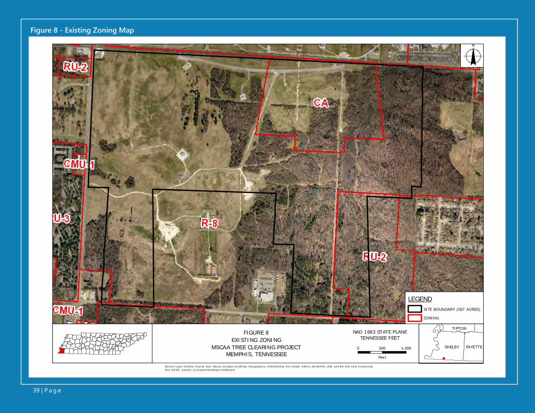
Figure 8 - Existing Zoning Map
LEGENDSITE BOUNDARY (587 ACRES)
ZONING
o
0 500 1,000
Fee t
Serv ic e Lay er Credi ts: S our ce: Es ri , Max ar, G eoEy e, E arths tar Geographic s, CNE S/A ir bus DS , US DA , USG S, Aer oG RID, IGN, and the G IS Us er Comm unityEs ri, HE RE , Garm in, ( c) O penS treetM ap c ontr ibutors
NAD 1983 STATE PLANETENNESSEE FEET
SHELBY FAYETTE
TIPTONFIGURE 8
EXISTING ZONINGMSCAA TREE CLEARING PROJECT
MEMPHIS, TENNESSEE
39 | P a g e
Draft Environmental AssessmentMemphis Shelby County Airport AuthorityTree Obstruction ClearingSeptember 2021
40 | P a g e
Memphis and Shelby County customers by de-livering electricity, natural gas, and potable wa-ter services. MLGW supplies electricity sourced from the Tennessee Valley Authority.
The City of Memphis is the primary provider of sanitary and storm sewer services for the Site. The City of Memphis Public Works Division is re-sponsible for operating and maintaining streets, sanitary sewers, and storm drains. The Environ-mental Engineering Division operates and main-tains two large wastewater treatment facilities that treat over 60 billion gallons of wastewater and dispose of more than 215 million pounds of biosolids annually, in accordance with state and federal water quality regulations.
3.10.3 ENVIRONMENTAL CONSEQUENCES
3.10.3.1 PROPOSED ACTIONThe Proposed Action consists of removal and or selectively topping of trees from the wooded ar-eas within the approximately 587-acre Site. The tree removal and cutting activities would occur within approximately 344 acres of the Site and are proposed in two phases over a four-year pe-riod.
The Proposed Action would result in no minor short-term impacts on natural resources and en-ergy supply, when compared to the No Action Alternative. The MSCAA does not anticipate the need to extend sanitary sewer, water services, gas or electrical services to complete the Pro-posed Action. Nor would any existing services currently supplied to the site be disrupted.
The trees and forested area that would be re-moved or altered do not provide any resource value related to energy supply. The trees and forested areas serve as a buffer to protect stream habitat and as a visual buffer for surrounding land uses. These functions would be maintained by the Proposed Action. In addition, the tree canopy would continue to be maintained long-
term by the MSCAA to comply with the safety standards required for airport operations. There-fore, any impacts on natural resources and ener-gy supplies due to Phase I and II of the Proposed Action are considered negligible. There are no operational (long-term) impacts associated with the Proposed Action.
3.10.3.2 NO ACTION ALTERNATIVEThere would be no changes to natural resources and energy supply under the No Action Alterna-tive.
3.10.4 MITIGATIONBased on the lack of significant adverse impacts to natural resources and energy supply from the Proposed Action, mitigation is not proposed.
3.11 NOISE AND NOISE COMPATIBLE LAND USE3.11.1 REGULATORY SETTINGNoise is considered unwanted sound that can disturb routine activities and can cause annoy-ance (FAA 2020). The compatibility of existing and planned land uses with proposed aviation actions is typically determined in relation to the level of aircraft noise. However, based on a lack of proposed aviation activities, this Draft EA con-siders primary noise sources other than aircraft operations. Per 49 U.S.C. § 47107(a)(10), docu-mentation is provided to demonstrate that the Proposed Action is consistent with the City of Memphis’ existing plans of public agencies for development.
The following statutes, regulations, and guid-ance related to noise and noise-compatible land use considered in this Draft EA are as follows:
1. Airport and Airway Improvement Act of 1982
2. Airport Noise and Capacity Act of 1990
Draft Environmental AssessmentMemphis Shelby County Airport AuthorityTree Obstruction ClearingSeptember 2021
41 | P a g e
3. Aviation Safety and Noise Abatement Act of 1979
4. Section 506 of the FAA Modernization and Reform Act of 2012
5. The Control and Abatement of Aircraft Noise and Sonic Boom Act of 1968
6. The Noise Control Act of 19727. FAA Advisory Circular 150/5020-1, Noise
Control and Compatibility Planning for Airports
3.11.2 AFFECTED ENVIRONMENTThe Site is located south of MEM Runways 36L, 36C, and 36R and E. Shelby Drive, east of Airways Boulevard, and north of E. Holmes Road (Figure 1). The surrounding land uses consist of a mix of vacant, forested land, commercial development, a cemetery (Forest Hill Funeral Home and Me-morial Park, located along the south side of E. Holmes Road), single-family residential, and in-stitutional land uses (i.e., TNARNG’s RC and the CUSEC).
The affected environment is also included as part of the Memphis Airport Area Land Use Study Fi-nal Report, adopted by the City of Memphis and Shelby County in 1992. Excerpted maps from the MEM Part 150 Study Update depicting the Proposed Action Site, with respect to current MEM noise exposure, are included in Attach-ment 7. Much of the Site is located within the 70-decibel noise contour; however, portion of the southern edge of the affected environment are located within the 65-decibel noise contour (Attachment 7).
3.11.3 ENVIRONMENTAL CONSEQUENCES
3.11.3.1 PROPOSED ACTIONThe Proposed Action consists of removal, or se-lectively topping of trees from the wooded areas within the approximately 587-acre Site. The tree removal and tree topping activities would occur
within approximately 344 acres of the Site and are proposed in two phases, over a four-year period.
Phase I of the Proposed Action includes the re-moval of trees, including stumps and roots, with-in approximately 289 acres of upland wooded area (Figure 2). Tree removal under Phase I of the project is proposed using site-clearing ma-chinery. Phase II of the Proposed Action includes the removal and topping of trees within approx-imately 55 acres of forested wetland area (Figure 3). To comply with the TDEC erosion and sedi-ment controls, natural riparian buffer zones are proposed along onsite stream banks and around onsite wetlands. Site-clearing machinery is not proposed for Phase II areas and topping of trees in this phase would be completed by hand using chain saws.
Both phases associated with the Proposed Action are estimated to last no more than four years. The proposed clearing activities are anticipated to oc-cur only during daytime hours. Conventional use of heavy construction vehicles and equipment is anticipated during Phase I of the Proposed Ac-tion. Examples of conventional construction equipment include road graders, dump trucks, loaders, roller-compacters, excavators, backhoes, and bulldozers. During Phase II of the Proposed Action, it is anticipated that no heavy construc-tion vehicles or conventional construction equip-ment would be utilized and that any noise would be limited to the use of chain saws.
Both phases of the Proposed Action are anticipat-ed to result in a negligible increase in noise when compared to the No Action Alternative. The re-sulting noise from both phases of the Proposed Action is considered temporary and would not result in significant impacts to surrounding land uses.
3.11.3.2 NO ACTION ALTERNATIVEThere would be no changes to noise or noise-com-patible land use under the No Action Alternative. Under the No Action Alternative, the MSCAA
Draft Environmental AssessmentMemphis Shelby County Airport AuthorityTree Obstruction ClearingSeptember 2021
42 | P a g e
would not remove or selectively top trees from the wooded areas within the Site and the minor, short-term adverse increases in noise associated with the Proposed Action would not occur.
3.11.4 MITIGATIONBased on a lack of significant, long term noise im-pacts associated with the Proposed Action, mit-igation is not proposed. The proposed clearing activities are anticipated to occur only during day-time hours to minimize the potential effects of any minor, short-term increases in noise associated with the use of the equipment outlined in Section 3.11.3.1.
3.12 SOCIOECONOMICS, ENVIRONMENTAL JUSTICE, AND CHILDREN’S ENVIRONMENTAL HEALTH AND SAFETY RISKS3.12.1 REGULATORY SETTINGSocioeconomics is an umbrella term used to de-scribe aspects of a project that are either social or economic in nature, or a combination of the two. A socioeconomic analysis evaluates how elements of the human environment such as population, employment, housing, and public services might be affected by the Proposed Action (FAA 2020).
The primary FAA statute relating to socioeconom-ic impacts is the Uniform Relocation Assistance and Real Property Acquisitions Policy Act of 1970. This Act sets out requirements, under 49 CFR Part 24, for federal project or projects involving federal funding that acquire real property or involve the displacement of people. Additionally, the Act di-rects FAA, to the fullest extent possible, to observe all state and local laws, regulations, and ordinanc-es concerning zoning, transportation, economic development, housing, etc., when planning, as-sessing, or implementing a Proposed Action.
The FAA cites the U.S. EPA’s definition of environ-mental justice as the fair treatment and meaningful
involvement of all people regardless of race, col-or, national origin, or income with respect to the development, implementation, and enforcement of environmental laws, regulations, and policies. The term “fair treatment” implies that no group of people should bear a disproportionate share of the negative environmental consequences re-sulting from industrial, governmental, and com-mercial operations or policies (FAA 2020).
In addition, FAA Order 1050.1F and U.S. DOT Or-der 5610.2(a) set out requirements for meaning-ful public involvement by minority and low-in-come populations. Should significant impacts resulting from the Proposed Action be identified in any environmental resource category, the po-tential for disproportionately high and adverse effects on minority or low-income populations must be further examined pursuant to U.S. DOT Order 5610.2(a). This Draft EA did not identify significant impacts for any of the environmental resource categories.
Pursuant to Executive Order 13045, the FAA is encouraged to identify and assess environmen-tal health risks and safety risks that the FAA has reason to believe could disproportionately affect children (FAA 2020). Environmental health risks and safety risks include risks to health or safety that are attributable to products or substances that a child is likely to come in contact with or ingest, such as air, food, drinking water, recre-ational waters, and soil, or products they might use or to which they might be exposed. The Task Force on Environmental Health Risks and Safety Risks to Children (Task Force), created by Execu-tive Order 13045, identified four priority areas of impacts to children for attention:
• Asthma • Unintentional injuries • Developmental disorders (including lead
poisoning) • Cancer
Draft Environmental AssessmentMemphis Shelby County Airport AuthorityTree Obstruction ClearingSeptember 2021
43 | P a g e
This Draft EA provides context on whether the Proposed Action would create new or exacerbate existing adverse impacts to children in any of the four priority areas identified by the Task Force.
The following statutes, regulations, Executive Orders, and other guidance related to socioeco-nomics, environmental justice, and children’s en-vironmental health and safety risks considered in this Draft EA are as follows:
1. Uniform Relocation Assistance and Real Property Acquisition Policies Act of 1970
2. Title VI of the Civil Rights Act of 1964, as amended
3. Executive Order 12898, Federal Actions to Address Environmental Justice in Minority Populations and Low-Income Populations
4. Memorandum of Understanding on En-vironmental Justice and Executive Order 12898
5. The Council on Environmental Quality Guidance: Environmental Justice: Guid-ance Under the National Environmental Policy Act
6. U.S. DOT Environmental Justice Strategy
7. U.S. DOT Order 5610.2(a), Environmen-tal Justice in Minority and Low-Income Populations
8. Promising Practices for EJ Methodologies in NEPA Reviews, Report of the Federal Interagency Working Group on Environ-mental Justice & NEPA Committee
9. Executive Order 13045, Protection of Children from Environmental Health Risks and Safety Risks
3.12.2 AFFECTED ENVIRONMENT
3.12.2.1 SOCIOECONOMICS The affected environment for socioeconomics in-cludes a population of 1,403 within a 2.04 square mile area that includes the Proposed Action Site. For the purposes of this analysis, a geographic area was selected that was all parcels located be-tween Airways Boulevard and Tchulahoma Road (west to east) and E. Shelby Drive and E. Holmes Avenue (north to south). The limits of this area are provided in mapping located in Attachment 8. The following sources include the aggregated data for the Site and portions of the surrounding Census Tracts that are within one mile of the Site:
1. The U.S. EPA Environmental Justice Screening and Mapping Tool, EJSCREEN Report
2. The Census Bureau, American Community Survey (ACS) Summary Report for 2014-2018
3. The Census Bureau 2010 Census Summa-ry Report
4. The U.S. EPA NEPAssist Report
The socioeconomic output reports are included in Attachment 8. A summary of the socioeconomic statistics for the affected environment is provide in Table 4.
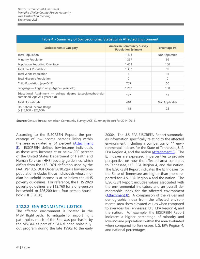
Draft Environmental AssessmentMemphis Shelby County Airport AuthorityTree Obstruction ClearingSeptember 2021
44 | P a g e
2000s. The U.S. EPA EJSCREEN Report summariz-es information specifically relating to the affected environment, including a comparison of 11 envi-ronmental indexes for the State of Tennessee, U.S. EPA Region 4, and the nation (Attachment 8). The EJ Indexes are expressed in percentiles to provide perspective on how the affected area compares to Tennessee, U.S. EPA Region 4, and the nation. The EJSCREEN Report indicates the EJ Indexes for the State of Tennessee are higher than those re-ported for U.S. EPA Region 4 and the nation. The EJSCREEN Report includes values associated with the environmental indicators and an overall de-mographic index for the affected environment (Attachment 8). A comparison of the values and demographic index from the affected environ-mental area show elevated values when compared to averages for Tennessee, U.S. EPA Region 4, and the nation. For example, the EJSCREEN Report indicates a higher percentage of minority and low-income populations within the area evaluated when compared to Tennessee, U.S. EPA Region 4, and national percentages.
According to the EJSCREEN Report, the per-centage of low-income persons living within the area evaluated is 54 percent (Attachment 8). EJSCREEN defines low-income individuals as those with incomes at or below 200 percent of the United States Department of Health and Human Services (HHS) poverty guidelines, which differs from the U.S. DOT definition used by the FAA. Per U.S. DOT Order 5610.2(a), a low-income population includes those individuals whose me-dian household income is at or below the HHS poverty guidelines. For reference, the HHS 2020 poverty guidelines are $12,760 for a one-person household, or $26,200 for a four-person house-hold (HHS 2020).
3.12.2.2 ENVIRONMENTAL JUSTICEThe affected environment is located in the MEM flight path. To mitigate for airport flight path noise, much of the Site was purchased by the MSCAA as part of a FAA-funded noise buy-out program during the late 1990s to the early
Table 4 - Summary of Socioeconomic Statistics in Affected Environment
Socioeconomic Category American Community Survey Population Estimate Percentage (%)
Total Population 1,403 Not ApplicableMinority Population 1,397 99Population Reporting One Race 1,403 100Total Black Population 1,397 99Total White Population 6 <1Total Hispanic Population 0 0Child Population (age 0-17) 703 50Language — English only (Age 5+ years old) 1,262 100
Educational Attainment — college degree (associates/bachelor combined, Age 25+ years old) 127 17
Total Households 418 Not ApplicableHousehold Income Range(<$15,000 - $25,000) 118 28
Source: Census Bureau, American Community Survey (ACS) Summary Report for 2014-2018
Draft Environmental AssessmentMemphis Shelby County Airport AuthorityTree Obstruction ClearingSeptember 2021
45 | P a g e
The EJSCREEN Report does not, by itself, deter-mine the existence or absence of environmental justice concerns. The report output is taken into consideration when evaluating the context and intensity of the overall impacts associated with the Proposed Action.
3.12.2.3 CHILDREN’S ENVIRONMENTAL HEALTH AND SAFETY RISKAccording to the ACS Summary Report for 2014-2018, approximately 37% of the population with-in the affected environment are under the age of 17. According to the Census data reported in the NEPAssist Report, there are no schools located within or adjacent to the Proposed Action Site.
Section 3.12.3.3 includes consideration of wheth-er the Proposed Action creates new or exacer-bates existing adverse impacts to children in any of the four priority areas (asthma, unintentional injuries, developmental disorders, and cancer) identified by the Task Force.
3.12.3 ENVIRONMENTAL CONSEQUENCESThe Proposed Action consists of removal, or se-lectively topping of trees from the wooded areas within the approximately 587-acre Site. The tree removal and cutting activities would occur with-in approximately 344 acres of the Site and are proposed in two phases, over a four-year period. The purpose of the Proposed Action is to remove tree obstructions and potential obstructions to the approach surfaces of MEM runways 36L, 36C, and 36R, and the departure surfaces of runways 18R, 18C, and 18L, to comply with FAA AIP Grant Assurance 20 (Hazard Removal and Mitigation) and FAA CFR Chapter 14 Part 139.
The following subsections include a discussion of impacts to socioeconomics, environmental justice, and children’s environmental health and safety risk resulting from the Proposed Action.
3.12.3.1 SOCIOECONOMICSThe Proposed Action may result in minor short-term beneficial impacts with respect to socioeco-nomics. The beneficial impacts could be realized through an increase in job availability during the short-term duration of the Proposed Action. The Proposed Action would not disrupt or divide the physical arrangement of an established commu-nity and would not result in relocation of local businesses, public services, or housing units.
3.12.3.2 ENVIRONMENTAL JUSTICEAn environmental justice analysis considers the potential of federal actions to cause dispropor-tionately high and adverse effects on low-in-come or minority populations. U.S. DOT Order 5610.2(a) provides the following definition for a “disproportionately high and adverse impact” that was used to assess impacts to environmen-tal justice populations (FAA 2020). Dispropor-tionately high and adverse effects on minority and low-income populations means an adverse effect that:
1. Is predominately borne by a minority population and/or a low-income popu-lation
2. Will be suffered by the minority popula-tion and/or low-income population and is appreciably more severe or greater in magnitude than the adverse effect that will be suffered by the non-minori-ty population and/or non-low-income population
The overall context for the Proposed Action orig-inates in the late 1990s through the acquisition of much of the Site by MSCAA. Disproportion-ately high and adverse effects in the form of un-acceptable aircraft noise impacts were identified at that time. Mitigation, long-range planning, and community outreach involving the Site has occurred since that time.

Draft Environmental AssessmentMemphis Shelby County Airport AuthorityTree Obstruction ClearingSeptember 2021
46 | P a g e
The Site is located in an area with a larger per-centage of minority and low-income populations, when compared to Tennessee, U.S. EPA Region 4, and national percentages. Therefore, identified adverse impacts are further considered through the lens of environmental justice. This Draft EA has identified minor short-term adverse impacts to resources areas, when compared to the No Action Alternative. These impacts are related to the use of heavy equipment on-site as part of Phase I of the project. However, no signifi-cant adverse impacts have been identified in this Draft EA. In addition, measures have been tak-en in the residential area located adjacent to the Proposed Action to minimize the visual impacts associated with the project. As previously noted, a visual buffer would be utilized to minimize the potential for visual effects to adjacent developed properties while also addressing the intended purpose for the project (removal of trees that are obstructions to existing aircraft take-offs and landings). This 75-foot visual buffer would be adjacent to a residential neighborhood just be-yond the eastern edge of the Site (Jackson Pit Road and Meadowfair Lane).
In addition, as part of the early stakeholder en-gagement process, the MSCAA mailed letters to property owners within that neighborhood with properties in close proximity to the Proposed Action. The letter provided general information on the Proposed Action and solicited input. No responses from this effort were received.
The context and intensity of the identified short-term and long-term minor adverse impacts asso-ciated with the Proposed Action have been eval-uated. The Proposed Action is not anticipated to lead to a disproportionately high and adverse impact to an environmental justice population due to significant adverse impacts in resource areas evaluated in this Draft EA or impacts to the physical or natural environment in a way that is unique to the environmental justice population.
3.12.3.3 CHILDREN’S ENVIRONMENTAL HEALTH AND SAFETY RISKEnvironmental health and safety impacts to chil-dren are evaluated as a separate resource area because children may experience the intensity of these impacts differently, when compared to adults exposed to the same Proposed Action. Children are more heavily exposed to toxins in proportion to their body weight and are more likely to exhibit behaviors that put them at a greater risk for exposure to hazards (FAA 2020).
The Site is not located near a school (Attachment 8). It is not anticipated that the Proposed Action would be associated with environmental health risks attributable to substances that a child is likely to come in contact with or ingest, such as toxic products, soil, drinking water, or other rec-reational waters as no such amenities are located with or adjacent to the Site. In addition, air emis-sions associated with the Proposed Action are anticipated to have minor, short-term adverse impacts on air quality, when compared to the No Action Alternative based on mobile source emis-sions related to the clearing activities.
Consideration is also given to pedestrians, cy-clists, and other vehicles in the vicinity of the Site. Again, some negligible impacts could be anticipated due to the movement of heavy trucks and equipment during Phase I of the Proposed action. However, this activity would not signifi-cantly impact these populations.
This Draft EA has identified minor, short-term adverse impacts on air quality that relate to chil-dren’s environmental health and safety risks, when compared to the No Action Alternative. The context and intensity of factors associated with children’s environmental health and safety risks have been evaluated in this Draft EA. The Proposed Action is not anticipated to lead to a disproportionate health or safety risk to children, relating to asthma, unintentional injuries, devel-opmental disorders, or cancer.

Draft Environmental AssessmentMemphis Shelby County Airport AuthorityTree Obstruction ClearingSeptember 2021
47 | P a g e
3.12.3.4 NO ACTION ALTERNATIVEThere would be no changes to socioeconomics, environmental justice, or children’s environmen-tal health and safety under the No Action Alter-native.
3.12.4 MITIGATIONBased on the findings in this Draft EA, mitigation for socioeconomics, environmental justice, and children’s environmental health and safety risks is not proposed.
3.13 VISUAL EFFECTS3.13.1 REGULATORY SETTINGVisual effects deal broadly with the extent to which the Proposed Action would either (1) pro-duce light emissions that create annoyance or interfere with activities or (2) contrast with, or de-tract from, the visual resources and/or the visual character of the existing environment (FAA 2020). Visual effects in this Draft EA are discussed in two categories: (1) light emissions and (2) visual re-sources and visual character.
Light emissions include any light that emanates from a light source into the surrounding environ-ment. Visual resources include buildings, sites, cultural properties, and other natural or man-made landscape features that are visually import-ant or have unique characteristics. Visual char-acter refers to the overall visual makeup of the existing environment where the proposed action is located. For example, areas in close proxim-ity to densely populated areas generally have a visual character that could be defined as urban versus areas having a visual character defined by open grass fields, forests, mountains, or deserts (FAA 2020).
Although there are no federal special purpose laws or requirements specific to light emissions and visual effects, there are special purpose laws and requirements relevant to other resource ar-
eas such as Section 106 of the National Historic Preservation Act, U.S. DOT Act Section 4(f), the Wild and Scenic Rivers Act, and the Coastal Zone Management Act (FAA 2020). In addition, state and local regulations, policies, and zoning ordi-nances apply to visual effects, as discussed below.
3.13.2 AFFECTED ENVIRONMENTThe Site consists of upland and forested wetland areas within portions of an approximately 587-acre tract of MSCAA-owned property located south of MEM in Memphis, Shelby County, Tennessee (Fig-ure 1). The Site is located south of MEM Runways 36L, 36C, and 36R and E. Shelby Drive, east of Air-ways Boulevard, and north of E. Holmes Road (Fig-ure 1). The Site is currently vacant and predomi-nantly wooded (Figure 2). The surrounding land uses consist of a mix of vacant, forested land, com-mercial development, a cemetery (Forest Hill Fu-neral Home and Memorial Park, located along the south side of E. Holmes Road), single-family resi-dential, and institutional land uses (i.e., TNARNG’s RC and the CUSEC).
Light EmissionsThe current level of light emissions at the Site in-cludes glare emanating primarily from adjacent roadways and vehicle lighting along E. Holmes Road, E. Shelby Drive, and Airways Boulevard. Giv-en the Site’s location relative to the flight path of MEM, frequent overhead aircraft traffic also con-tributes to the light emissions at the Site.
Visual Resources and Visual CharacterThe visual character of the Site is characterized by forested areas and open grass covered areas. The streams, wetlands and ponds at the Site are pri-marily located in densely wooded areas. The visu-al character of surrounding land uses is consistent with the mixture of vacant, forest, commercial de-velopment, a cemetery, single-family residential, and institutional land uses.
Draft Environmental AssessmentMemphis Shelby County Airport AuthorityTree Obstruction ClearingSeptember 2021
48 | P a g e
3.13.3 ENVIRONMENTAL CONSEQUENCES
3.13.3.1 PROPOSED ACTIONPortions of the Site would be visible from the adjacent roadways (E. Holmes Road, E. Shelby Drive, and Airways Boulevard). The Proposed Action consists of removal or selectively top-ping of trees from the wooded areas within the approximately 587-acre Site. The tree removal and tree topping activities would occur within approximately 344 acres of the Site and are pro-posed in two phases over a four-year period.
Phase I of the Proposed Action includes the re-moval of trees, including stumps and roots, with-in approximately 289 acres of upland wooded area (Figure 2). Tree removal under Phase I of the project is proposed using site-clearing ma-chinery. Phase II of the Proposed Action includes the removal and topping of trees within approx-imately 55 acres of forested wetland area (Figure 3). To comply with the TDEC erosion and sedi-ment controls, natural riparian buffer zones are proposed along onsite stream banks and around onsite wetlands. Site-clearing machinery is not proposed for Phase II areas and topping of trees in this phase would be completed by hand using chain saws.
Impacts associated with visual character and visual effects from the Proposed Action would be minimized through retention of vegetative buffers at specific locations adjacent to the few developed locations in proximity to the Site (see Figure 2). These vegetative buffers are proposed at two areas to minimize the potential for visual effects to adjacent developed properties while also addressing the intended purpose for the project, which is remove trees that are obstruc-tions to existing aircraft take-offs and landings. The first of these locations is a 75-foot visual buffer that has been placed adjacent to a res-idential neighborhood just beyond the eastern edge of the Site (Jackson Pit Road and Mead-owfair Lane). The second of these areas is a 50-foot visual buffer associated with the eastern and
northern boundaries of the TNARNG RC, located on E. Holmes Road. This property includes the CUSEC, located in the southeast corner of the same property.
Light EmissionsThe Proposed Action would not result in short- or long-term adverse impacts due to light emis-sions when compared to the No Action Alterna-tive. With all clearing activities associated with the Proposed Action occurring during daytime hours, there would be no sources of nighttime light emissions.
Visual CharacterThe Proposed Action would result in minor long-term impacts to visual character when compared to the No Action Alternative. Long-term impacts to visual character relate to the removal of exist-ing trees within the Site. However, those impacts would not be characterized as adverse since the remaining site conditions would be similar in visual character to the open grassed areas that make up approximately 42 percent (approxi-mately 244 acres) of the Site. In addition, visu-al character and visual effect impacts from the Proposed Action would be minimized through retention of vegetative buffers at specific loca-tions adjacent to the few developed locations in proximity to the Site.
3.13.3.2 NO ACTION ALTERNATIVEThere would be no changes to visual effects un-der the No Action Alternative.
3.13.4 MITIGATIONBased on the lack of significant adverse visual ef-fects impacts associated with the Proposed Ac-tion, mitigation is not proposed.
Draft Environmental AssessmentMemphis Shelby County Airport AuthorityTree Obstruction ClearingSeptember 2021
49 | P a g e
3.14 WATER RESOURCES3.14.1 REGULATORY SETTINGAccording to FAA Order 1050.1F, water resourc-es are surface waters and groundwaters that are important in providing drinking water and in supporting recreation, transportation, com-merce, industry, agriculture, and aquatic ecosys-tems (FAA 2020). This Draft EA includes analysis of the potential for disruption of water systems as well as potential impacts to the quality of wa-ter resources (FAA 2020). This section includes analysis of the following: wetlands and surface waters, floodplains, groundwater, and Wild and Scenic Rivers.
The primary statutes, Executive Order, and guid-ance related to the protection of water resources considered in this Draft EA are as follows:
1. Clean Water Act (CWA)
2. Fish and Wildlife Coordination Act
3. Executive Order 11990, Protection of Wetlands
4. The U.S. EPA Navigable Waters Protec-tion Rule
5. U.S. DOT Order 5660.1A, Preservation of the Nation’s Wetlands
6. 2010 Tennessee Code 69-3-108 — Per-mits
3.14.2 AFFECTED ENVIRONMENTThe principal drainage on the approximately 587-acre Site is Hurricane Creek. This creek flows through the Site in a northeasterly direction into Nonconnah Creek and the Nonconnah Creek Watershed, located in northwest Mississippi and southwest Tennessee.
In 2017, field survey and agency coordination were initiated regarding the proposed project. This effort included coordination with TDEC’s Division of Water Resources (DWR) and the U.S. Army Corps of Engineers (USACE) regard-
ing the need for any permitting associated with the Proposed Action. Since that time, the Site boundaries have changed to include newly ac-quired parcels located on the eastern boundary of the Site and the limits of the clearing activity had been modified. Consultation with the TDEC and USACE were again initiated in March 2021 by the FAA to determine if the previous findings remained consistent with the currently Proposed Action. All documentation associated with this effort is included in Attachment 9.
3.14.2.1 WETLANDS AND SURFACE WATERSSix streams, 12 wetlands, 18 wet weather con-veyances (WWC), and three pond aquatic fea-tures were identified at the Site. The locations of these resources relative to the Site are provided in Figure 9.
Six streams are identified on the Site. Stream 1 measured approximately 550 feet in length and was approximately 2 to 3 feet wide. The stream was incised approximately 2 feet and the water depth at the time of the site visit was 2 to 3 inch-es.
Stream 2, also identified as Hurricane Creek, was approximately 5,210 linear feet in length. Stream 2 flows in a northeasterly direction across the eastern half of the Site and is located within the Lower Nonconnah Creek watershed. Aquat-ic features within the Stream 2 drainage on the Proposed Action Site include Streams 3, 4, and 5; Wetlands 4, 5, 6, 7, 8, 9, 10, 11, and 12; WWCs 4, 5, 6, 7, 9, 10, 11, 12, 13, 14, 15, 16 and 17; and Pond 3.
All of the streams, ponds and WWCs within the Hurricane Creek drainage have a surface connec-tion to Hurricane Creek except for Pond 2, WWC 8, and Wetlands 6 and 7. These aquatic features are separated from Stream 2 by a manmade lin-ear hill containing runway landing/takeoff lights.
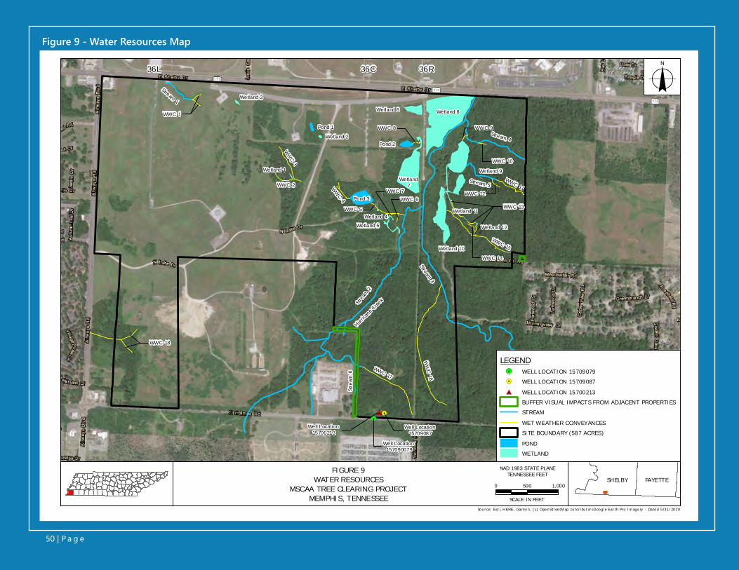
Figure 9 - Water Resources Map
%2!5#0
36L 36C 36R
Wetland 8
Wetland7
Hurrica
ne Cree
k
Pond 3
Stream 1
Strea
m 2
WW
C 3
WWC 2
WWC 1
WWC 4
WWC 1
WWC 6WWC 7
WWC 5
WWC 8 WWC 9Stream 4
WWC 10
Stream 5
WWC 12
WWC 11
Stream 3
WWC 17
WW
C 16
WWC 15
WWC 13
WWC 14
WWC 13WWC 13
Stre
am 6
WWC 18WWC 18
Well Location 15700213
Well Location 15709087
Well Location 157090079
Wetland 5
Wetland 4
Wetland 9
Wetland 3
Wetland 2
Wetland 6
Wetland 1
Pond 1
Pond 2
Wetland 11
Wetland 12
Wetland 10
LEGEND!5 WELL LOCATION 15709079%2 WELL LOCATION 15709087
#0 WELL LOCATION 15700213BUFFER VISUAL IMPACTS FROM ADJACENT PROPERTIESSTREAM
WET WEATHER CONVEYANCESSITE BOUNDARY (587 ACRES)
PONDWETLAND
Source: Esr i, H ERE, Ga rm in, (c) OpenStr ee tM ap contr ibut or sG oogle Ea r th Pro Im age ry - Da ted 5/31/2020
o
FIGURE 9WATER RESOURCES
MSCAA TREE CLEARING PROJECTMEMPHIS, TENNESSEE
SHELBY FAYETTE0 500 1,000
SCALE IN FEET
NAD 1983 STATE PLANETENNESSEE FEET
50 | P a g e
Draft Environmental AssessmentMemphis Shelby County Airport AuthorityTree Obstruction ClearingSeptember 2021
51 | P a g e
Streams 3 and 4 are direct tributaries to Stream 2 (Hurricane Creek). Streams 2 and 3 measured approximately 5,210 and 2,059 linear feet, re-spectively, and are the primary streams within the Site. These perennial streams were approx-imately 15 to 20 feet wide and were incised ap-proximately 6 to 8 feet below the surrounding landscape. During site visits, the water levels were generally less than 8 inches in riffles and runs. Water depth in the pools was 1 to 2 feet. The onsite portion of Stream 4 measured ap-proximately 1,381 linear feet. This stream was incised 4 to 6 feet and the water depth was 3 to 6 inches in riffles and runs and 8 to 12 inches in the pools. Stream 4 receives hydrologic input from Wetland 10. Stream 5 flows west into Wet-land 10 which discharges into Stream 4. Stream 5 had an incised channel, 0 to 3 feet, and a wa-ter depth of 2 to 3 inches at the time of the site visit. WWCs 11 and 12 and Wetland 9 form the headwaters of Stream 5. Stream 6 is located near the southern boundary of the site and flows into Stream 2 (Hurricane Creek) outside of the project area. This stream was incised approximately 1 to 6 feet and water depth averaged 2 to 4 inches.
The western half of the Site is within the Low-er Nonconnah Creek watershed but is not in the Hurricane Creek (i.e., Stream 2) drainage. Aquat-ic resources within this portion of the site are Stream 1 and WWCs 1 and 18.
There are three additional aquatic features (Wet-lands 2 and 3 and Pond 1) in the north central portion of Site. These are isolated aquatic re-sources that have no surface inflow or outflow.
There are 12 wetlands identified on the Pro-posed Action Site, totaling approximately 20.1 acres. The locations of these wetlands are de-picted on Figure 9. Wetland 1 measured ap-proximately 0.04 acres in size and formed at the confluence of WWCs 2 and 3. Wetland 1 and WWCs 2 and 3 were created by previous grad-ing of the area. Wetland 2 measured 0.05 acre
in size and formed in an area previously graded. Wetland 3 measured approximately 0.07 acre in size and is isolated with no inflow or outflow; the area was previously graded. Wetland 4 measured approximately 0.02 acre in size and receives water from Wetland 5. Wetland 4 drains into Stream 2 via WWCs 7 and 5. Wetland 5 measured approx-imately 0.26 acre in size and drains into Wetland 4. Wetland 6 measured approximately 0.67 acre and is isolated (i.e., no surface connection) from Wetland 8. Wetland 7 measures approximately 3.94 acres and receives some outflow from Pond 2; the wetland does not have a surface connection to Stream 2. Wetland 8 measured approximately 9.12 acres and is located adjacent to Stream 2. Wetland 9 measured approximately 0.02 acre in size and is connected to Stream 5 and Wetland 10. Wetland 10 measured approximately 5.89 acres in size and is connected to Stream 2 via Stream 4. Wetland 11 (0.01 acre) and Wetland 12 (0.01 acre) discharge into WWC 13, which flows in Wetland 10.
Eighteen WWCs totaling approximately 10,364 linear feet are identified on the Site. WWCs are not considered jurisdictional by the USACE, nor do they require permits for alteration by TDEC. However, they are regulated under the require-ments of 2010 Tennessee Code Title 69 — Waters, Waterways, Drains and Levees, Chapter 3 Water Pollution Control, Part 1 Water Quality Control Act § 69-3-108(q) which states that:
(1) The alteration of a WWC shall require no no-tice or approval provided that it is done in ac-cordance with all of the following conditions:
(A) The activity may not result in the dis-charge of waste or other substances that may be harmful to humans or wildlife;
(B) Material may not be placed in a location or manner so as to impair surface water flow into or out of any wetland area;
Draft Environmental AssessmentMemphis Shelby County Airport AuthorityTree Obstruction ClearingSeptember 2021
52 | P a g e
(C) Sediment shall be prevented from enter-ing other waters of the state;
(i) Erosion and sediment controls shall be designed according to the size and slope of disturbed or drainage areas to detain runoff and trap sediment and shall be properly selected, installed, and maintained in accordance with the manufacturer’s specifications and good engineering practices;
(ii) Erosion and sediment control mea-sures shall be in place and functional before earth moving operations begin, and shall be constructed and main-tained throughout the construction period. Temporary measures may be removed at the beginning of the work day, but shall be replaced at the end of the work day;
(iii) Checkdams shall be utilized where runoff is concentrated. Clean rock, log, sandbag or straw bale checkdams shall be properly constructed to detain runoff and trap sediment. Checkdams or other erosion control devices are not to be constructed in stream. Clean rock can be of various type and size, depending on the application. Clean rock shall not contain fines, soils or other wastes or contaminants; and
(D) Appropriate steps shall be taken to ensure that petroleum products or other chemical pollutants are prevented from entering waters of the state. All spills shall be reported to the appropriate emergency management agency and to the division. In the event of a spill, measures shall be taken immediately to prevent pollution of waters of the state, including groundwater.
(2) There shall be no additional conditions upon a person’s activity within a wet weather conveyance. This subdivision (q)(2) does not apply to national pollutant discharge elimi-nation system permits.
Three ponds totaling approximately 1.9 acres are identified on the Site. Ponds are not considered jurisdictional by TDEC’s DWR.
3.14.2.2 FLOODPLAINS A review of the Federal Emergency Manage-ment Agency, Flood Insurance Rate Map (Panel 47157C0440F) indicates the Site is in unshaded Zone X, an area of minimal flood hazard. Zone X is an area determined to be outside the 500-year flood and protected by levee from the 100-year flood. A copy of the Flood Insurance Rate Map (Panel 47157C0440F) is included in Attachment 9.
3.14.2.3 GROUNDWATERAgency coordination with TDEC’s DWR (Drinking Water Unit), including a review of the online TN Water Well Desktop Application (https://tdecon-line.tn.gov/tdecwaterwells/) was conducted to identify any water wells in proximity to the Site (see Attachment 9). Three water wells were iden-tified adjacent to the area associated with the Proposed Action. Their locations relative to the Site are provided in Figure 9.
Well Location 15709087 (also referenced as Well SH:K-87 in correspondence) is a farming intend-ed well that was sampled in April 1982. As indi-cated in Figure 9, the well is located inside the limits of the Proposed Action. Well Location 15700213 is a municipal well that was compet-ed in 1964. As indicated in Figure 9, the well is located inside the limits of the Proposed Action. Well Location 15709079 (also referenced as Well SH:K-79 in correspondence) is a municipal well
Draft Environmental AssessmentMemphis Shelby County Airport AuthorityTree Obstruction ClearingSeptember 2021
53 | P a g e
which was sampled in 2015. No additional infor-mation was available from DWR associated with this well. Based on coordinates provided, it ap-pears that this well is located outside the limit of the Proposed Action.
3.14.2.4 WILD AND SCENIC RIVERSBased on a review of the National Park Service, Nationwide Rivers Inventory, there are no wild or scenic rivers in the Memphis, Shelby Coun-ty, Tennessee, area. The Obed River is the only federally designated Wild and Scenic River in Tennessee. The Obed River is part of the Cum-berland Plateau in Tennessee, approximately 350 miles east of the Site. The Proposed Action does not occur in an area that would impact a federal-ly designated Wild and Scenic River.
3.14.3 ENVIRONMENTAL CONSEQUENCESThe Proposed Action would involve removal, or selectively topping of trees from the wooded ar-eas within the approximately 587-acre Site, re-sulting in an area of disturbance of greater than one acre. Overall, approximately 344 acres of the Site would be disturbed. The Proposed Action would require a construction stormwater general permit, issued by the TDEC DWR.
3.14.3.1 WETLANDS AND SURFACE WATERSAs previously noted, the Proposed Action con-sists of removal, or selectively topping of trees from the wooded areas within the approximately 587-acre Site. The tree removal and tree topping activities would occur within approximately 344 acres of the Site and are proposed in two phases, over a four-year period.
Phase I of the Proposed Action includes the re-moval of trees, including stumps and roots, with-in approximately 289 acres of upland wooded area (Figure 2). Tree removal under Phase I of the project is proposed using site-clearing ma-
chinery. Tree removal activities, and subsequent grading activities, are proposed to be conducted incrementally, in 30-acre sections. The selected contractor for the proposed project would be re-quired to stabilize and grade each 30-acre area prior to moving to additional 30-acre sections.
Phase II of the Proposed Action includes the felling and topping of trees within approximate-ly 55 acres of forested wetlands area (Figure 3). To comply with the TDEC erosion and sediment controls, natural riparian buffer zones are pro-posed along onsite stream banks and around onsite wetlands. The natural riparian buffer zones would serve as erosion and sediment con-trols, as well as mitigate for potential changes in onsite stream water temperature due to tree canopy removal. A natural riparian buffer zone of 60 ft is proposed for streams, measured from the tops of the stream banks. A 30-ft natural riparian buffer zone is proposed around onsite wetlands. Site-clearing machinery is not pro-posed for Phase II areas. The topping of trees in the Phase II areas would be completed by hand using chain saws.
Within the onsite wetlands and 30-ft buffer areas around onsite wetlands, trees are proposed to be cut; however, stumps and tree roots would not be disturbed. Felled trees that fall into onsite wetlands would be left in place, except for man-ual maneuvering to maintain existing drainage. Felled treetops that fall outside the 30-ft buffer areas would be removed for offsite transport or burned onsite using ACD burn processes to en-sure FAA and Shelby County Health Department regulations regarding smoke and particulate matter are met.
Within the 60-ft buffer areas proposed around onsite streams, trees would be topped to com-ply with FAA glide slope regulations. The tree topping height would vary based on elevation and distance from MEM Runways 36L, 36C and 36R. Tree canopies would be maintained to the greatest extent possible. Felled trees would be
Draft Environmental AssessmentMemphis Shelby County Airport AuthorityTree Obstruction ClearingSeptember 2021
54 | P a g e
removed by hand and placed within the buffer zone. Trees that fall into streams or that fall out-side the 60-ft buffer areas would be removed for offsite transport, or burned onsite using ACD burn processes to ensure FAA and Shelby County Health Department regulations regarding smoke and particulate matter are met.
Based on the methods to avoid soil disturbance within the identified wetlands and impacts to streams, it is anticipated the tree harvesting does not require a Clean Water Act Section 404 per-mit from the USACE. In 2017, coordination with the USACE’s Memphis District was initiated for the proposed project. Correspondence with the USACE Memphis District regarding the proposed project is included in Attachment 9. In 2017, US-ACE concluded that the proposed project was exempt from regulation under the Clean Water Act if the project complies with the best manage-ment practices (BMPs). Follow up coordination was initiated on March 25, 2021 that provided the USACE with greater detail regarding the Pro-posed Action and requesting concurrence that no Section 404 permit would be required for the project. Response was provided by the USACE on June 30, 2021. In this response, the USACE noted that “After our review of your information, we have determined that the project is not a reg-ulated activity and, therefore does not require a Section 404 permit from our office prior to con-ducting the work” (see Attachment 9).
Similarly, in 2017 the MSCAA coordinated with the TDEC’s Memphis Field Office for the proposed project to determine the need for an Aquatic Re-source Alteration Permit (ARAP). At that time, TDEC concurred that the proposed project would not require an ARAP. The email correspondence dated November 28, 2017 is included in Attach-ment 9. Follow up coordination was initiated on March 25, 2021 that provided TDEC greater de-tail regarding the Proposed Action and seeking reconfirmation that the proposed project would not require an ARAP. Response was provided by the TDEC on March 29, 2021 that stated, “de-
termined that DWR’s stance remains unchanged from the prior conversations we’ve had about this project. As you have mentioned, buffer areas should be retained along streams and wetlands and trees to be cut within these zones should be topped so that the roots can be left intact and in place. Although as proposed, an ARAP may not be needed, [DWR] would remind [MSCAA] that coverage under the Construction General Permit is likely needed since 1 acre of land disturbance will occur.” A copy of the email response is in-cluded in Attachment 9.
The State of Tennessee, under § 69-3-108(q), states that the alteration of a WWC shall require no notice or approval if it is done in accordance with the conditions previously mentioned. The Proposed Action would be subject to the condi-tions laid out in Section 3.14.2.1.
Prior to commencement of activities, a Notice of Intent for Construction Activity Stormwater Discharges would be sent to TDEC DWR. In ad-dition, installation of sediment controls such as filter berms and silt fences would be required to capture and retain mobilized debris and sed-iment during clearing activities associated with the Proposed Action.
It is anticipated that no minor short-term and long-term adverse impacts to water quality are associated with the Proposed Action. The im-pacts to water resources would fully be avoided through utilization of the methodologies out-lined in Section 3.14.3.1 and other appropriate BMPs to minimize the possible impacts.
3.14.3.2 FLOODPLAINSThe Site is not located within a 100-year or 500-year flood zone. Impacts to floodplains are not anticipated by the Proposed Action. Zone X is an area determined to be outside the 500-year flood and protected by levee from a 100-year flood.
Draft Environmental AssessmentMemphis Shelby County Airport AuthorityTree Obstruction ClearingSeptember 2021
55 | P a g e
3.14.3.3 GROUNDWATERImpacts to groundwater are not anticipated by the Proposed Action. Extraction of groundwater for use as irrigation is not proposed and is pro-hibited by Shelby County Groundwater Quality Control Board for potable, irrigation, or other uses (Shelby County 2018). The current con-dition of the wells noted previously in Section 3.14.2.3 is unknown. MSCAA would coordinate with the Memphis-Shelby County Health De-partment prior to work in the vicinity of these wells and, if they have not yet been proper-ly closed (and closure is required), this effort would be addressed at that time.
3.14.3.4 WILD AND SCENIC RIVERSThe Proposed Action does not occur in an area that would impact a federally designated Wild and Scenic River.
3.14.4 NO ACTION ALTERNATIVEThere would be no changes to water resources under the No Action Alternative.
3.14.5 MITIGATIONBased on a lack of impacts to water resources that trigger regulatory thresholds, mitigation is not anticipated for the Proposed Action in its current configuration.

56 | P a g e
Conclusions and Preparers
SECTIONS 4.0 AND 5.0
Aaron Conti, PWS, TN-QHP, EnSafe
Stephen Abille, CPP, EnSafe
Carlos Linares, EnSafe
Nathan Rinehart, GISP, EnSafe
Chris Triplett, PE, PMP, EnSafe
Draft Environmental AssessmentMemphis Shelby County Airport AuthorityTree Obstruction ClearingSeptember 2021
57 | P a g e
4.0 CONCLUSIONSThis Draft EA has been prepared pursuant to NEPA to evaluate the environmental impacts associated with the Proposed Action. The Pro-posed Action consists of the proposed removal and cutting of trees from upland and forested wetlands areas within portions of an approxi-mately 587-acre tract of MSCAA-owned prop-erty located south of MEM in Memphis, Shelby County, Tennessee. The purpose of the Pro-posed Action is to remove tree obstructions and potential obstructions to the approach surfaces of MEM runways 36L, 36C, and 36R, and the de-parture surfaces of runways 18R, 18C, and 18L, to comply with FAA AIP Grant Assurance 20 (Hazard Removal and Mitigation) and FAA CFR Chapter 14 Part 139.
This Draft EA describes the following resource areas and assesses the potential for the Pro-posed Action to affect these resources areas:
air quality; biological resources; climate; coastal resources; U.S. DOT Act, Section 4(f); farmlands; hazardous materials, solid waste and pollution prevention; historical, architectural, and cultural resources; land use; natural resources and ener-gy supply; noise and noise-compatible land use; socioeconomics, environmental justice, and chil-dren’s environmental health and safety risks; vi-sual effects; and water resources. The Proposed Action would result in some negligible minor short-term or minor long-term impacts to re-sources. However, no significant impacts to re-source areas are anticipated.
Based on the analysis presented in this Draft EA and on the coordination to date with project stakeholders and regulatory agencies, the Pro-posed Action is expected to have no significant impacts to the assessed resource areas. This Draft EA concludes an EIS is not required and a Finding of No Significant Impact is appropriate.
Andrew Cleary, GISP, Edwards-Pitman Environmental, Inc.
David Pearce, Edwards-Pitman Environmental, Inc.
Russ Danser, AICP, Edwards-Pitman Environmental, Inc.
Kristin Lehman, CHMM, EnSafe
Lori Morris, PE, MSCAA
5.0 LIST OF PREPARERSIn alphabetical order
Velita Thornton, Q.H.P.-IT, EnSafe
Andrew Buchner, RPA, Panamerican Consultants, Inc.
Josh Earhart, Edwards-Pitman Environmental, Inc.
Heather Edwards, AICP, Edwards-Pitman Environmental, Inc.
Chris Grow, Grow Environmental Solutions, LLC
Susan Thomas, AICP, Edwards-Pitman Environmental, Inc.
Jill Brown, Edwards-Pitman Environmental, Inc.
Draft Environmental AssessmentMemphis Shelby County Airport AuthorityTree Obstruction ClearingSeptember 2021
58 | P a g e
Joellyn BrazileTennessee Department of Environment and ConservationDivision of Water Resources Environmental Program Manager
5.1 LIST OF AGENCIES AND PERSONS CONSULTEDAgency Consultation, in alphabetical order:
E. Patrick McIntyre, Jr. State Historic Preservation OfficerExecutive Director
James M. Elcan (Mitch)Memphis District Corps of EngineersBiologist
Richard W. Rogers V, P.G.Tennessee Department of Environment and ConservationDrinking Water Unit | Division of Water Resources Geologist / Environmental Consultant
Aaron FriendNatural Resources Conservation ServiceUnited States Department of AgricultureState Soil Scientist
Alison HensleyTennessee Department of Environment and ConservationDivision of RemediationEnvironmental Consultant
Robert ToddTennessee Department of Environment and ConservationTennessee Wildlife Resource AgencyFish & Wildlife Environmentalist
Patrick LemonsTennessee Department of Environment and ConservationTennessee Wildlife Resource AgencyWildlife Manager
Teneshia LewisSupervisor of Field ServicesShelby County Health DepartmentAir Pollution Control
Brooke LucasNatural Resources Conservation ServiceUnited States Department of AgricultureLAPSS Contractor – Soil Science Staff
Robbie SykesUnited States Fish and Wildlife ServiceSupervisory Fish and Wildlife Biologist
Reuben G. SmithShelby County Health DepartmentField Service-Pollution ControlTechnical Compliance Specialist/Stage 1
Matthew DentonUnited States Department of Agriculture, Area 1Area Resource Conservationist
Heather MeadorsTennessee Department of Environment and ConservationEnvironmental Scientist, Division of Water Resources
Klarissa KahillTennessee Department of Environment and ConservationEnvironmental Scientist, Division of Remediation
Tom WordMemphis Light, Gas, and Water DivisionUtility Coordinator

59 | P a g e
Abbreviations and Acronyms
SECTION 6.0
Draft Environmental AssessmentMemphis Shelby County Airport AuthorityTree Obstruction ClearingSeptember 2021
60 | P a g e
6.0 ABBREVIATIONS AND ACRONYMS-A-A-
ACD Air Curtain DestructorACS American Community SurveyAIP Airport Improvement ProgramAPE Area of Potential Effects AQI Air Quality Index ARAP Aquatic Resource Alteration Permit
-C-C-CAA Clean Air Act CEQ Council on Environmental Quality CFR Code of Federal Regulations CUSEC Central United States Earthquake ConsortiumCWA Clean Water Act
-D-D-DOR Division of RemediationDSWM Division of Solid Waste ManagementDWR Division of Water Resources
-E-E-EA Environmental Assessment EIS Environmental Impact StatementEJSCREEN U.S. EPA Environmental Justice Screening and Mapping ToolESA Environmental Site Assessment
-F-F-FAA Federal Aviation AdministrationFAR Federal Aviation RegulationFPPA Farmland Protection Policy Actft Feet
-G-G-GHG Greenhouse Gas GHGRP Greenhouse Gas Reporting Program
-H-H-HHS United States Department of Human and Health Services
-I-I-IPaC Information for Planning and Conservation
-M-M-MEM Memphis International AirportMLGW Memphis Light, Gas and Water
Draft Environmental AssessmentMemphis Shelby County Airport AuthorityTree Obstruction ClearingSeptember 2021
61 | P a g e
MOVES Motor Vehicle Emission SimulatorMSCAA Memphis Shelby County Airport Authority
-N-N-NAAQS National Ambient Air Quality Standards NAVAIDs Navigational AidsNEPA National Environmental Policy Act NLAA Not Likely to Adversely AffectNRCS Natural Resources Conservation Service NRHP National Register of Historic Places
-O-O-O&M Operations and Maintenance (O&M) Plan
-P-P-PCB Polychlorinated biphenylPM2.5 Particulate matter less than 2.5 microns in diameterPM10 Particulate matter less than 10 microns in diameter
-R-R-RC Readiness CenterROD Record of Decision
-S-S-SHPO State Historic Preservation Office SIP State Implementation Plan
-T-T-TDEC Tennessee Department of Environment and ConservationTHC Tennessee Historical CommissionTNARNG Tennessee Army National GuardTWRA Tennessee Wildlife Resources Agency
-U-U-USACE United States Army Corps of EngineersU.S.C. United States Code USDA United States Department of AgricultureU.S. DOT United States Department of TransportationU.S. EPA United States Environmental Protection AgencyUSFWS United States Fish and Wildlife Service USGS U.S. Geological SurveyUST Underground Storage Tank
-V-V-VOR VHF Omnidirectional RangeVORTAC Collocated VHF omnidirectional range and tactical air navigation beacon
-W-W-WWC Wet Weather Conveyance

References
SECTION 7.0
62 | P a g e
7.0 REFERENCES
City of Memphis. (website). Division of Planning and Development, Office of Comprehensive Planning. Memphis 3.0 Comprehensive Plan. December 2019. Retrieved from: https://www.memphis3point0.com/
City of Memphis and Shelby County. Memphis Airport Area Land Use Study Final Report. June 1992. Re-trieved from: https://www.shelbycountytn.gov/DocumentCenter/View/33344/Aiport-Plan
Council on Environmental Quality. (website). Final Guidance for Federal Departments and Agencies on Con-sideration of Greenhouse Gas Emissions and the Effects of Climate Change in National Environmental Policy Act Reviews. August 2016. Retrieved from: https://ceq.doe.gov/laws-regulations/regulations.html
Council on Environmental Quality. (website). Title 40, Code of Federal Regulations, parts 1500-1508, Regu-lations for Implementing the Procedural Provisions of the National Environmental Policy Act. Retrieved from: https://ceq.doe.gov/laws-regulations/regulations.html
EnSafe. Final Report: Summer 2017 Presence/Probable Absence Survey for the Memphis-Shelby County Air-port Authority Shelby County, Tennessee. August 2017.
Federal Aviation Administration. (website). National Environmental Policy Act Implementing Instructions for Airport Actions (Order 5050.4B). April 2006. Retrieved from: https://www.faa.gov/airports/resources/publi-cations/orders/environmental_5050_4/media/5050-4B_complete.pdf
Federal Aviation Administration. (website). Policies and Procedures for Considering Environmental Impacts (Order 1050.1F). July 2015. Retrieved from: https://www.faa.gov/documentLibrary/media/Order/FAA_Or-der_1050_1F.pdf
Federal Aviation Administration. (website). 1050.1F Desk Reference, Version 2. February 2020. Retrieved from: https://www.faa.gov/about/office_org/headquarters_offices/apl/environ_policy_guidance/policy/faa_nepa_order/desk_ref/media/desk-ref.pdf
Federal Emergency Management Agency. (website). Online Flood Map Service Center. April 2021. Retrieved from: http://msc.fema.gov/portal/
Interagency Wild and Scenic Rivers Coordinating Council. (website). National Wild and Scenic Rivers Sys-tem. April 2021. Retrieved from: http://www.rivers.gov/map.php
Memphis International Airport. (website). Part 150 Study Update Noise Exposure Maps and Supporting Doc-umentation. September 2015. Retrieved from: https://www.flymemphis.com/Areas/Admin/Images/Up-load_2018053101012.pdf
Natural Resources Conservation Service. (website). Web Soil Survey. March 2021. Retrieved from: https://websoilsurvey.sc.egov.usda.gov/App/WebSoilSurvey.aspx
Draft Environmental AssessmentMemphis Shelby County Airport AuthorityTree Obstruction ClearingSeptember 2021
63 | P a g e

Tennessee Department of Environment and Conservation. (website). Division of Natural Areas. Rare Species Viewer. 2021, March 2021. Retrieved from: http://environment-online.tn.gov:8080/pls/enf_re-ports/f?p=9014:3::::::
Tennessee Department of Environment and Conservation. (website). Division of Solid Waste Management. Hazardous Waste Program. Hazardous Waste Management Chapter 0400-12-01. July 2018. Retrieved from: https://publications.tnsosfiles.com/rules/0400/0400-12/0400-12-01/0400-12-01_TOC_2018.pdf
Tennessee Department of Environment and Conservation. (website). Tennessee Historical Commission Viewer. April 2021. Retrieved from: https://tnmap.tn.gov/historicalcommission/
United States Department of Health and Human Services. (website). U.S. Federal Poverty Guidelines Used to Determine Financial Eligibility for Certain Federal Programs. Guidelines for 2020. Retrieved from: https://aspe.hhs.gov/poverty-guidelines
United States Environmental Protection Agency. (website). Air Quality Index. September 2020. Retrieved from: https://www.airnow.gov/
United States Environmental Protection Agency. (website). Environmental Justice Screening and Mapping Tool (EJSCREEN). April 2021. Retrieved from: http://www.epa.gov/ejscreen
United States Environmental Protection Agency. (website). NEPAssist website. April 2021. Retrieved from: http://nepassisttool.epa.gov/nepassist/entry.aspx
United States Environmental Protection Agency. (website). Nonattainment Areas for Criteria Pollutants (Green Book). July 2020. Retrieved from: https://www.epa.gov/green-book
United States Department of Transportation. (website). Department of Transportation Updated Environmen-tal Justice Order 5610.2(a). Retrieved from: https://www.transportation.gov/sites/dot.gov/files/docs/mis-sion/transportation-policy/environmental-justice/339501/dot56102a.pdf
United States Department of Transportation. (website). Procedures for Considering Environmental Impacts (Order 5610.1D). July 2000. Retrieved from: https://www.transportation.gov/sites/dot.gov/files/docs/DOT%20Order%20%285610.1D%29.pdf
United States Fish and Wildlife Service. (website). Information for Planning and Consultation Website. March 2021. Retrieved from: https://ecos.fws.gov/ipac/
United States Fish and Wildlife Service. (website). Range-Wide Indiana Bat Summer Survey Guidelines. 2020. Retrieved from: https://www.fws.gov/midwest/endangered/mammals/inba/surveys/pdf/FINAL%20Range-wide%20IBat%20Survey%20Guidelines%203.23.20.pdf
Draft Environmental AssessmentMemphis Shelby County Airport AuthorityTree Obstruction ClearingSeptember 2021
64 | P a g e
ATTACHMENT 1 Agency Coordination and Scoping Letters Correspondence
65 | P a g e

BIOLOGICAL RESOURCE
COORDINATION
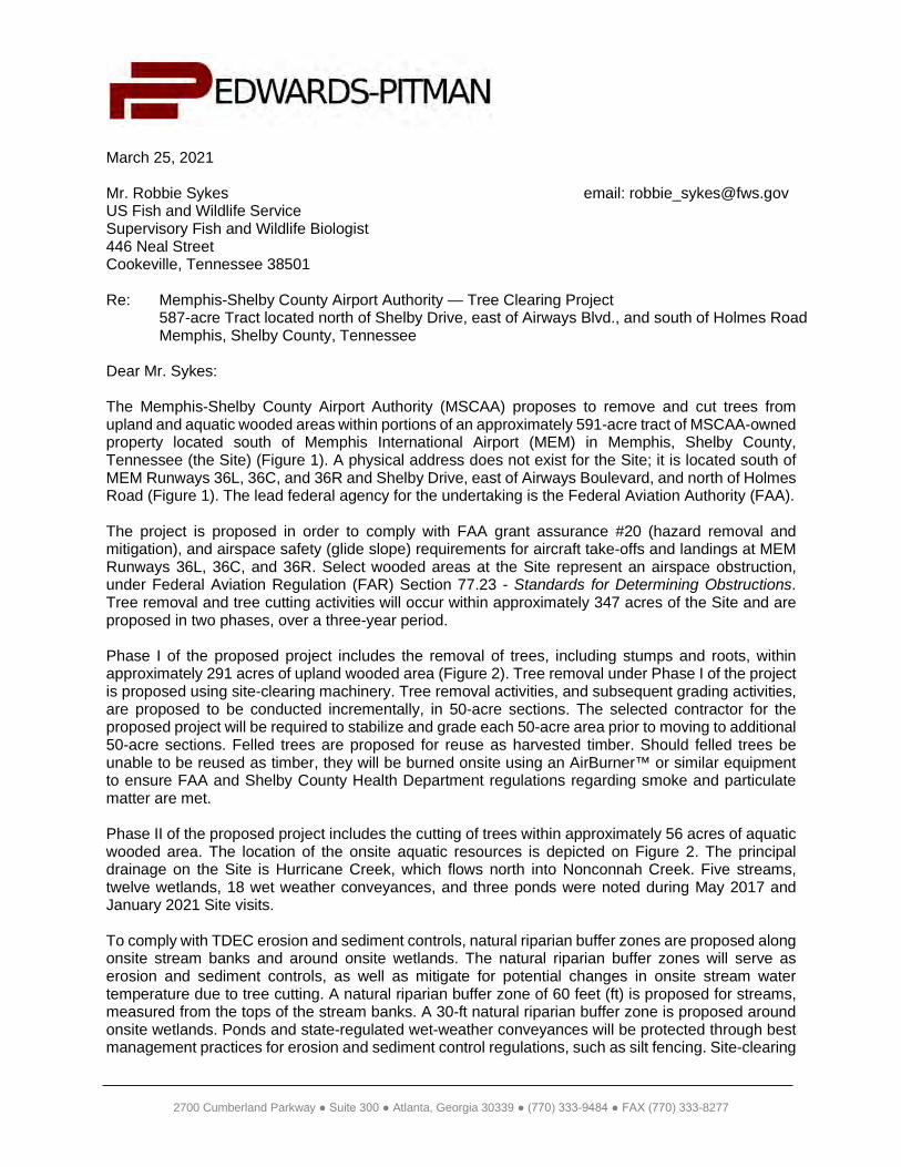
2700 Cumberland Parkway ● Suite 300 ● Atlanta, Georgia 30339 ● (770) 333-9484 ● FAX (770) 333-8277
March 25, 2021
Mr. Robbie Sykes email: [email protected] Fish and Wildlife ServiceSupervisory Fish and Wildlife Biologist446 Neal StreetCookeville, Tennessee 38501
Re: Memphis-Shelby County Airport Authority — Tree Clearing Project587-acre Tract located north of Shelby Drive, east of Airways Blvd., and south of Holmes RoadMemphis, Shelby County, Tennessee
Dear Mr. Sykes:
The Memphis-Shelby County Airport Authority (MSCAA) proposes to remove and cut trees from upland and aquatic wooded areas within portions of an approximately 591-acre tract of MSCAA-owned property located south of Memphis International Airport (MEM) in Memphis, Shelby County, Tennessee (the Site) (Figure 1). A physical address does not exist for the Site; it is located south of MEM Runways 36L, 36C, and 36R and Shelby Drive, east of Airways Boulevard, and north of Holmes Road (Figure 1). The lead federal agency for the undertaking is the Federal Aviation Authority (FAA).
The project is proposed in order to comply with FAA grant assurance #20 (hazard removal and mitigation), and airspace safety (glide slope) requirements for aircraft take-offs and landings at MEM Runways 36L, 36C, and 36R. Select wooded areas at the Site represent an airspace obstruction, under Federal Aviation Regulation (FAR) Section 77.23 - Standards for Determining Obstructions.Tree removal and tree cutting activities will occur within approximately 347 acres of the Site and are proposed in two phases, over a three-year period.
Phase I of the proposed project includes the removal of trees, including stumps and roots, within approximately 291 acres of upland wooded area (Figure 2). Tree removal under Phase I of the project is proposed using site-clearing machinery. Tree removal activities, and subsequent grading activities, are proposed to be conducted incrementally, in 50-acre sections. The selected contractor for the proposed project will be required to stabilize and grade each 50-acre area prior to moving to additional 50-acre sections. Felled trees are proposed for reuse as harvested timber. Should felled trees be unable to be reused as timber, they will be burned onsite using an AirBurner™ or similar equipment to ensure FAA and Shelby County Health Department regulations regarding smoke and particulate matter are met.
Phase II of the proposed project includes the cutting of trees within approximately 56 acres of aquatic wooded area. The location of the onsite aquatic resources is depicted on Figure 2. The principal drainage on the Site is Hurricane Creek, which flows north into Nonconnah Creek. Five streams, twelve wetlands, 18 wet weather conveyances, and three ponds were noted during May 2017 and January 2021 Site visits.
To comply with TDEC erosion and sediment controls, natural riparian buffer zones are proposed along onsite stream banks and around onsite wetlands. The natural riparian buffer zones will serve as erosion and sediment controls, as well as mitigate for potential changes in onsite stream water temperature due to tree cutting. A natural riparian buffer zone of 60 feet (ft) is proposed for streams, measured from the tops of the stream banks. A 30-ft natural riparian buffer zone is proposed around onsite wetlands. Ponds and state-regulated wet-weather conveyances will be protected through best management practices for erosion and sediment control regulations, such as silt fencing. Site-clearing
Mr. SykesMarch 25, 2021
Page 2
2
machinery and ground disturbing activities are not proposed for Phase II areas. The cutting of trees in the Phase II areas will be completed by hand using chain saws. Edwards-Pitman Environmental, Inc. (EPEI) is also coordinating with the United States Army Corps of Engineers regarding aquatic resources at the Site.
Within the onsite wetlands and 30-ft buffer areas around onsite wetlands, trees are proposed to be cut; however, stumps and tree roots will not be disturbed. Felled trees that fall into onsite wetlands will be left in place, except for manual maneuvering to maintain existing drainage. Felled tree tops that fall outside the 30-ft buffer areas will be removed for offsite transport or onsite burning using an AirBurner™ or similar equipment to ensure FAA and Shelby County Health Department regulations regarding smoke and particulate matter are met.
Within the 60-ft buffer areas proposed around onsite streams, trees will be topped to comply with FAA glide slope regulations. The tree topping height will vary based on elevation and distance from MEM Runways 36L, 36C and 36R. Tree foliage within the 60-ft buffer areas will be maintained to the greatest extent possible to mitigate for a potential increase in stream temperature. Felled trees that fall into streams will be removed by hand and placed within the buffer zone. Trees that fall outside the 60-ft buffer areas will be removed for offsite transport, or onsite burning using an AirBurner™ or similar equipment to ensure FAA and Shelby County Health Department regulations regarding smoke and particulate matter are met.
The upland tree clearing areas are dominated by hickories (primarily Carya glabra), sweetgum (Liquidambar styraciflua), oaks (primarily Quercus alba, Q. rubra, and Q. falcata) and beech (Fagus grandifolia). The understory ranges from open with few saplings or shrubs to having a dense thicket of Chinese privet (Ligustrum sinense). There are no caves on the Site. There are some snags and shagbark hickory (Carya ovata) trees scattered throughout the uplands. The wetlands are dominated by black willow (Salix nigra), sweetgum, and red maple (Acer rubrum). Other common species along the wetland edges include willow oak (Quercus phellos) American elm (Ulmus americana), river birch (Betula nigra), eastern hophornbeam (Ostrya virginiana), and American hornbeam (Carpinuscaroliniana).
The United States Fish and Wildlife Service (USFWS), Information for Planning and Consultation (IPaC) website was reviewed for a list of federally protected species and migratory birds with the potential to occur in Shelby County. Output from the IPaC website is included in Attachment 1.
EPEI wildlife biologist David Pearce was present during site visits in May 2017 and January 2021. Nospecies or their habitat was observed for the state listed species on the TDEC Shelby County database. The IPaC data listed two federally protected species: Indiana bat (Myotis sodalist) and northern long-eared bat (Myotis septentrionalis) for Shelby County, TN. MSCAA previously coordinated with the USFWS (Mary Jennings, Field supervisor) regarding potential bats at the Site and conducted mist netting in July 2017. No Indiana bats or northern long-eared bats were caught during the netting activity. The USFWS concurred in a letter dated August 31, 2017 that the proposed tree clearing project “may affect, not likely to adversely affect either of the species.” The correspondence is included as Attachment 2.
Based on the substantial disturbance of the Site and lack of suitable habitat, it is anticipated that no federally protected species or designated critical habitat will be affected by the proposed tree clearing. We request your concurrence of the current property condition and request a finding of no further action regarding state protected fish and wildlife resources. EPEI is also coordinating with the Tennessee Wildlife Resources Agency regarding state protected species.
Mr. SykesMarch 25, 2021
Page 3
3
The activities on the Site will comply with the requirements set forth in the provisions of the National Environmental Policy Act. The USFWS is invited to comment on the proposed project and will have an opportunity to review and comment on a forthcoming Environmental Assessment, addressing how the proposed project would potentially impact economic, social, and environmental resources.
Should you have any comments or questions regarding the proposed action, please contact me via email at [email protected] or by phone at (678) 932-2237.
Sincerely,
Edwards-Pitman Environmental, Inc.
Russ Danser, AICPSenior Environmental Project Manager
Enclosures: Figures:
Figure 1: Site Vicinity MapFigure 2: Site Plan
Attachment 1: USFWS IPaC Database ResultsAttachment 2: Previous USFWS Coordination Documentation

FIGURES
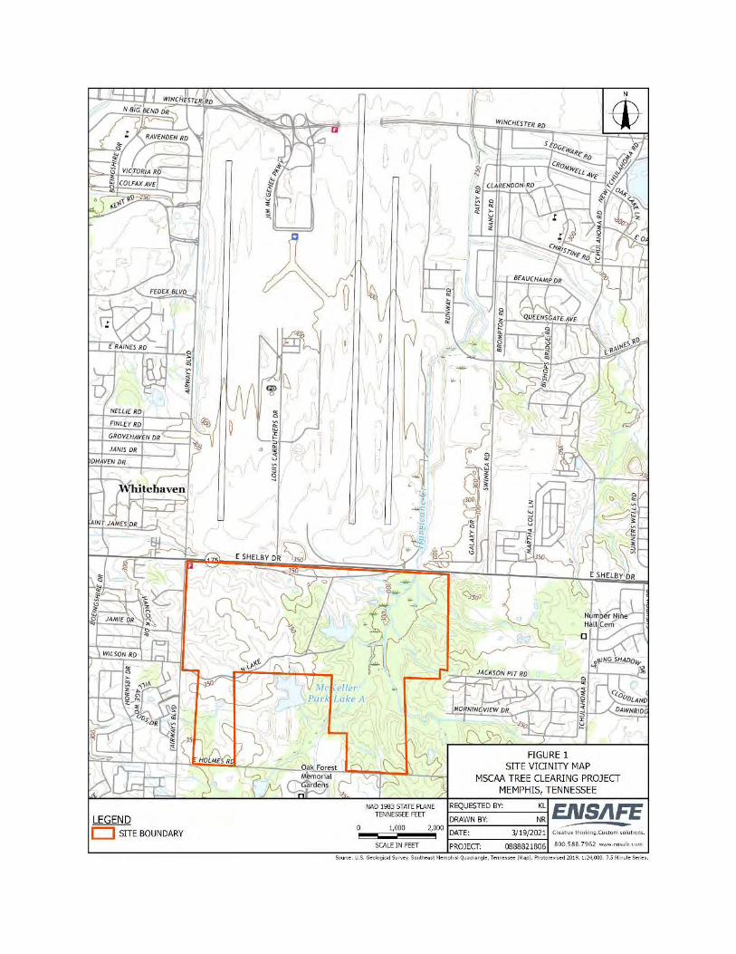
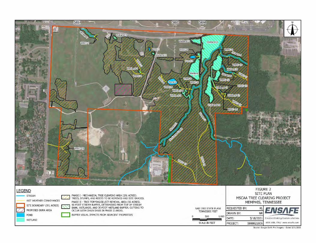
2700 Cumberland Parkway ● Suite 300 ● Atlanta, Georgia 30339 ● (770) 333-9484 ● FAX (770) 333-8277
March 25, 2021
Tennessee Wildlife Resources Agency email: [email protected] ManagerPatrick Lemons200 Lowell Thomas DriveJackson, Tennessee 38301
Re: Memphis-Shelby County Airport Authority — Tree Clearing Project587-acre Tract located north of Shelby Drive, east of Airways Blvd., and south of Holmes RoadMemphis, Shelby County, Tennessee
Dear Mr. Lemons:
The Memphis-Shelby County Airport Authority (MSCAA) proposes to remove and cut trees from upland and aquatic wooded areas within portions of an approximately 591-acre tract of MSCAA-owned property located south of Memphis International Airport (MEM) in Memphis, Shelby County, Tennessee (the Site) (Figure 1). A physical address does not exist for the Site; it is located south of MEM Runways 36L, 36C, and 36R and Shelby Drive, east of Airways Boulevard, and north of Holmes Road (Figure 1). The lead federal agency for the undertaking is the Federal Aviation Authority (FAA).
The project is proposed in order to comply with FAA grant assurance #20 (hazard removal and mitigation), and airspace safety (glide slope) requirements for aircraft take-offs and landings at MEM Runways 36L, 36C, and 36R. Select wooded areas at the Site represent an airspace obstruction, under Federal Aviation Regulation (FAR) Section 77.23 - Standards for Determining Obstructions. Tree removal and tree cutting activities will occur within approximately 347 acres of the Site and are proposed in two phases, over a three-year period.
The Site is located south of Runways 36R and 36C between Shelby Drive, Airways Blvd., and Holmes Road in Memphis, Shelby County, Tennessee (Figure 1). A physical address does not exist for the entire Site. The Site is predominantly wooded; however, the northern and western portions of the Site associated with the former McKellar Park and golf course are grassed and contain lights and other instruments used for aircraft landings and take-offs. There are approximately 24.1 acres of forest wetlands within the Site. Representative Site photos are included in Attachment 1.
Phase I of the proposed project includes the removal of trees, including stumps and roots, within approximately 291 acres of upland wooded area (Figure 2). Tree removal under Phase I of the project is proposed using site-clearing machinery. Tree removal activities, and subsequent grading activities, are proposed to be conducted incrementally, in 50-acre sections. The selected contractor for the proposed project will be required to stabilize and grade each 50-acre area prior to moving to additional 50-acre sections. Felled trees are proposed for reuse as harvested timber. Should felled trees be unable to be reused as timber, they will be burned onsite using an AirBurner™ or similar equipment to ensure FAA and Shelby County Health Department regulations regarding smoke and particulate matter are met.
Phase II of the proposed project includes the cutting of trees within approximately 56 acres of aquatic wooded area. The location of the onsite aquatic resources is depicted on Figure 2. The principal drainage on the Site is Hurricane Creek, which flows north into Nonconnah Creek. Five streams, twelve wetlands, 18 wet weather conveyances, and three ponds were noted during May 2017 and January 2021 Site visits.
Mr. LemonsMarch 25, 2021
Page 2
To comply with TDEC erosion and sediment controls, natural riparian buffer zones are proposed along onsite stream banks and around onsite wetlands. The natural riparian buffer zones will serve as erosion and sediment controls, as well as mitigate for potential changes in onsite stream water temperature due to tree cutting. A natural riparian buffer zone of 60 feet (ft) is proposed for streams, measured from the tops of the stream banks. A 30-ft natural riparian buffer zone is proposed around onsite wetlands. Ponds and state-regulated wet-weather conveyances will be protected through best management practices for erosion and sediment control regulations, such as silt fencing. Site-clearing machinery and ground disturbing activities are not proposed for Phase II areas. The cutting of trees in the Phase II areas will be completed by hand using chain saws. Edwards-Pitman Environmental, Inc. (EPEI) is also coordinating with the United States Army Corps of Engineers regarding aquatic resources at the Site.
Within the onsite wetlands and 30-ft buffer areas around onsite wetlands, trees are proposed to be cut; however, stumps and tree roots will not be disturbed. Felled trees that fall into onsite wetlands will be left in place, except for manual maneuvering to maintain existing drainage. Felled tree tops that fall outside the 30-ft buffer areas will be removed for offsite transport or onsite burning using anAirBurner™ or similar equipment to ensure FAA and Shelby County Health Department regulations regarding smoke and particulate matter are met.
Within the 60-ft buffer areas proposed around onsite streams, trees will be topped to comply with FAA glide slope regulations. The tree topping height will vary based on elevation and distance from MEM Runways 36L, 36C and 36R. Tree foliage within the 60-ft buffer areas will be maintained to the greatest extent possible to mitigate for a potential increase in stream temperature. Felled trees that fall into streams will be removed by hand and placed within the buffer zone. Trees that fall outside the 60-ft buffer areas will be removed for offsite transport, or onsite burning using an AirBurner™ or similar equipment to ensure FAA and Shelby County Health Department regulations regarding smoke and particulate matter are met.
The upland tree clearing areas are dominated by hickories (primarily Carya glabra), sweetgum (Liquidambar styraciflua), oaks (primarily Quercus alba, Q. rubra, and Q. falcata) and beech (Fagus grandifolia). The understory ranges from open with few saplings or shrubs to having a dense thicket of Chinese privet (Ligustrum sinense). There are no caves on the Site. There are some snags and shagbark hickory (Carya ovata) trees scattered throughout the uplands. The wetlands are dominated by black willow (Salix nigra), sweetgum, and red maple (Acer rubrum). Other common species along the wetland edges include willow oak (Quercus phellos) American elm (Ulmus americana), river birch (Betula nigra), eastern hophornbeam (Ostrya virginiana), and American hornbeam (Carpinuscaroliniana).
The TDEC, Division of Natural Areas, Interactive Rare Species Database was reviewed. Output from the TDEC database list is included in Attachment 2. During site visits in May 2017 and January 2021, no species or habitat was observed for the state listed species on the TDEC Shelby County database.
Based on the substantial disturbance of the Site and lack of suitable habitat, it is anticipated that no state protected species will be affected by the proposed tree clearing. We request your concurrence of the current property condition and request a finding of no further action regarding fish and wildlife resources.
Mr. LemonsMarch 25, 2021
Page 3
The activities on the Site will comply with the requirements set forth in the provisions of the National Environmental Policy Act. The TWRA is invited to comment on the proposed project and will have an opportunity to review and comment on a forthcoming Environmental Assessment, addressing how the proposed project would potentially impact economic, social, and environmental resources.
Should you have any comments or questions regarding the proposed action, please contact me via email at [email protected] or by phone at (678) 932-2237.
Sincerely,
Edwards-Pitman Environmental, Inc.
Russ Danser, AICPSenior Environmental Project Manager
Enclosures: Figures:
Figure 1: Site Vicinity MapFigure 2: Site Plan
Attachments:Attachment 1: Representative Site PhotosAttachment 2: TDEC Database Results

REPRESENTATIVE SITE PHOTOS
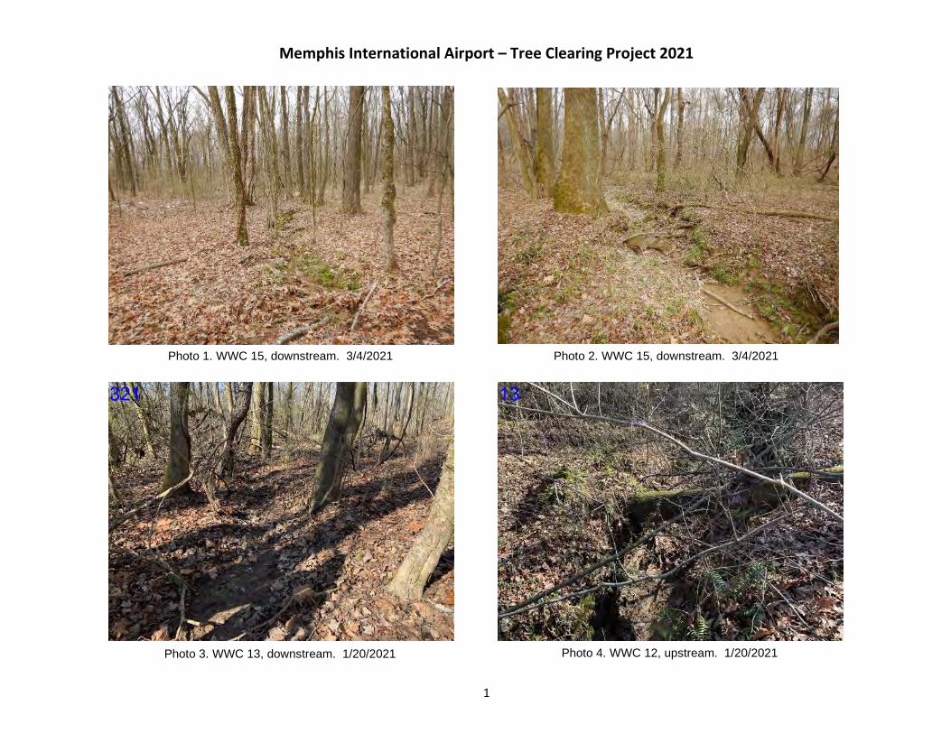
Memphis International Airport – Tree Clearing Project 2021
1
Photo 1. WWC 15, downstream. 3/4/2021 Photo 2. WWC 15, downstream. 3/4/2021
Photo 3. WWC 13, downstream. 1/20/2021 Photo 4. WWC 12, upstream. 1/20/2021
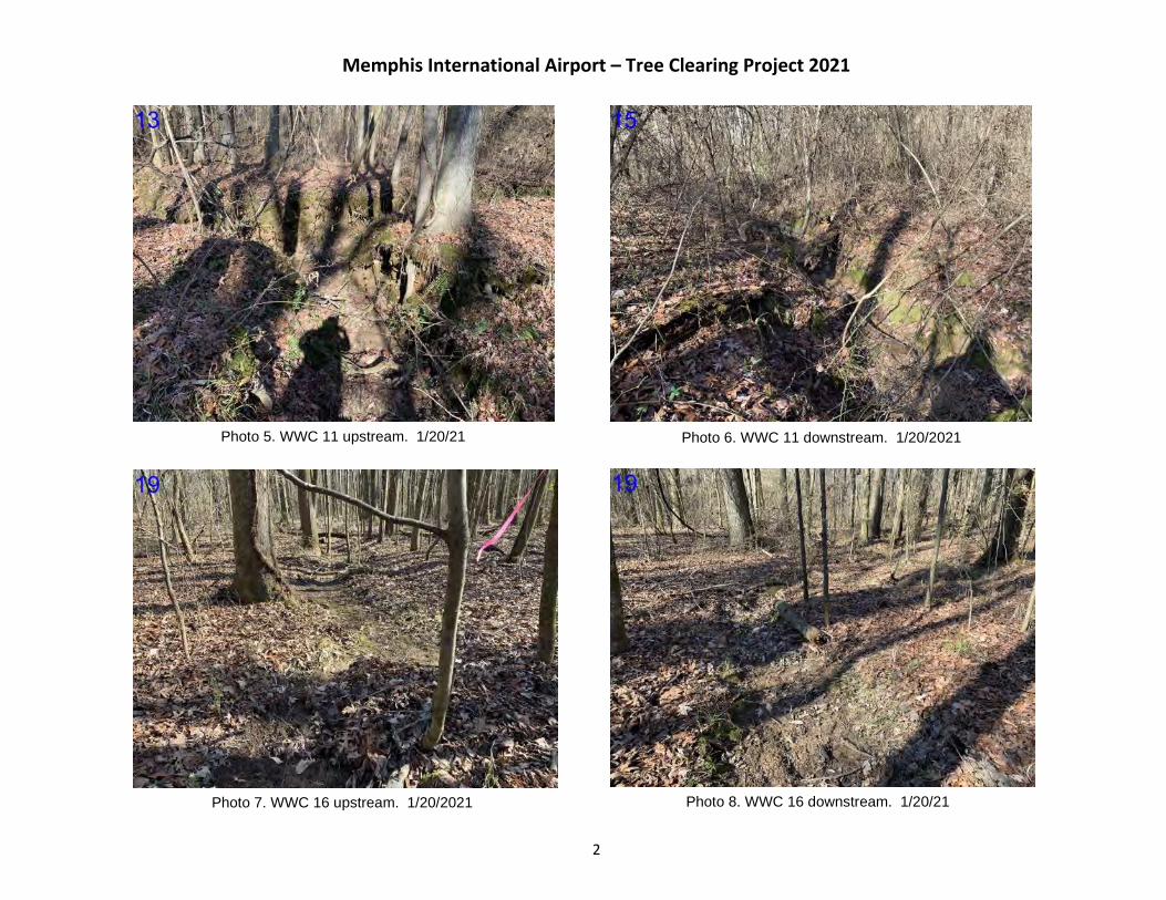
Memphis International Airport – Tree Clearing Project 2021
2
Photo 5. WWC 11 upstream. 1/20/21 Photo 6. WWC 11 downstream. 1/20/2021
Photo 7. WWC 16 upstream. 1/20/2021 Photo 8. WWC 16 downstream. 1/20/21
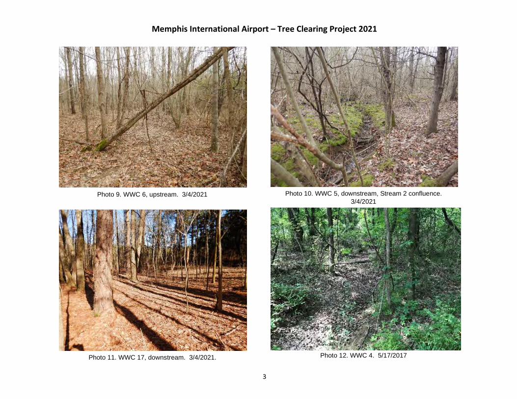
Memphis International Airport – Tree Clearing Project 2021
3
Photo 9. WWC 6, upstream. 3/4/2021 Photo 10. WWC 5, downstream, Stream 2 confluence. 3/4/2021
Photo 12. WWC 4. 5/17/2017Photo 11. WWC 17, downstream. 3/4/2021.
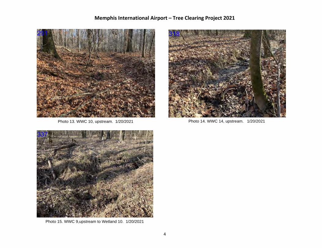
Memphis International Airport – Tree Clearing Project 2021
4
Photo 13. WWC 10, upstream. 1/20/2021 Photo 14. WWC 14, upstream. 1/20/2021
Photo 15. WWC 9,upstream to Wetland 10. 1/20/2021

Memphis International Airport – Tree Clearing Project 2021
5
Photo 17. Stream 3, downstream. 5/17/2017 Photo 18. Stream 2 (Hurricane Creek). 3/4/2021
Photo 16. Stream 1 toward WWC 1. 3/4/2021
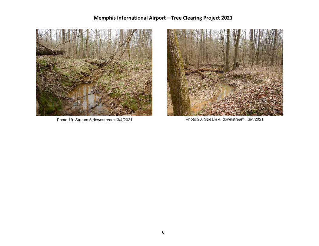
Memphis International Airport – Tree Clearing Project 2021
6
Photo 20. Stream 4, downstream. 3/4/2021Photo 19. Stream 5 downstream. 3/4/2021
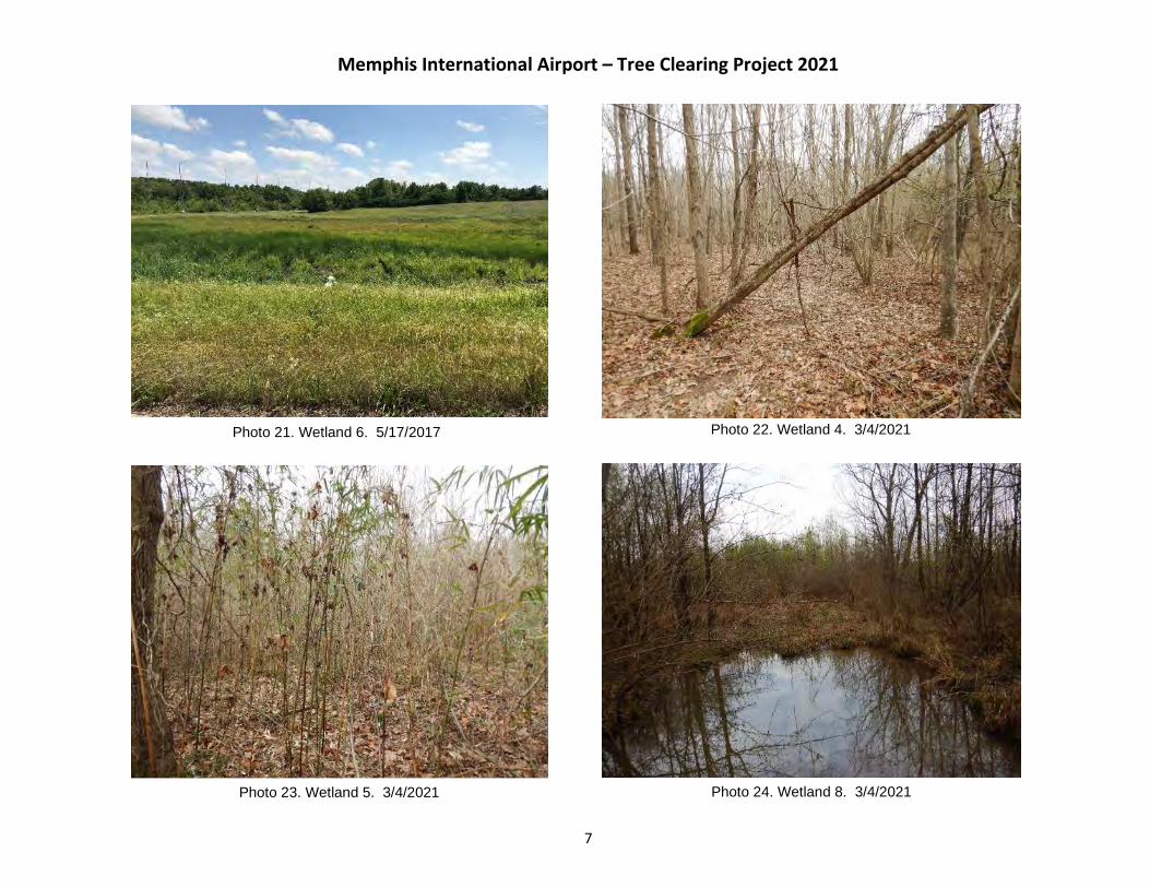
Memphis International Airport – Tree Clearing Project 2021
7
Photo 22. Wetland 4. 3/4/2021Photo 21. Wetland 6. 5/17/2017
Photo 23. Wetland 5. 3/4/2021 Photo 24. Wetland 8. 3/4/2021
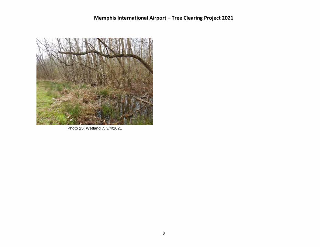
Memphis International Airport – Tree Clearing Project 2021
8
Photo 25. Wetland 7. 3/4/2021

Memphis International Airport – Tree Clearing Project 2021
9
Photo 26. Wetland 9. 1/20/2021 Photo 27. Wetland 10. 1/20/2021
Photo 28. Wetland 11. 1/20/2021 Photo 29. Wetland 12. 1/20/2021

TDEC DATABASE RESULTS
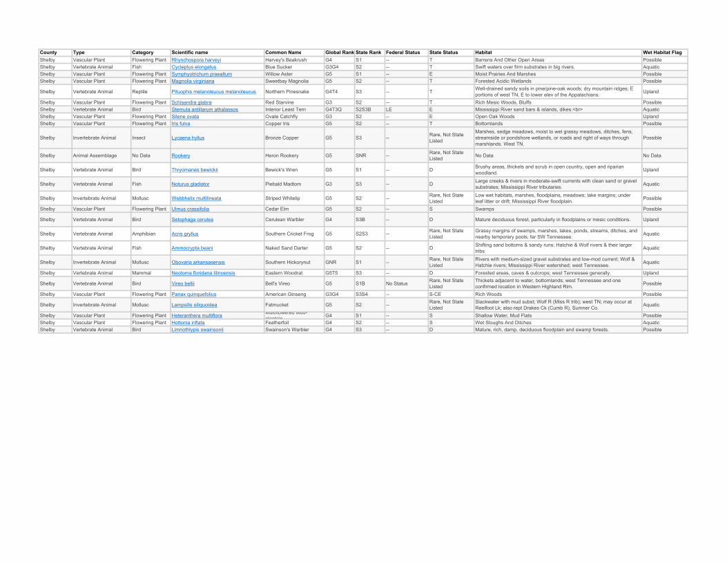
County Type Category Scientific name Common Name Global Rank State Rank Federal Status State Status Habitat Wet Habitat FlagShelby Vascular Plant Flowering Plant Rhynchospora harveyi Harvey's Beakrush G4 S1 -- T Barrens And Other Open Areas PossibleShelby Vertebrate Animal Fish Cycleptus elongatus Blue Sucker G3G4 S2 -- T Swift waters over firm substrates in big rivers. AquaticShelby Vascular Plant Flowering Plant Symphyotrichum praealtum Willow Aster G5 S1 -- E Moist Prairies And Marshes PossibleShelby Vascular Plant Flowering Plant Magnolia virginiana Sweetbay Magnolia G5 S2 -- T Forested Acidic Wetlands Possible
Shelby Vertebrate Animal Reptile Pituophis melanoleucus melanoleucus Northern Pinesnake G4T4 S3 -- T Well-drained sandy soils in pine/pine-oak woods; dry mountain ridges; E portions of west TN, E to lower elev of the Appalachians. Upland
Shelby Vascular Plant Flowering Plant Schisandra glabra Red Starvine G3 S2 -- T Rich Mesic Woods, Bluffs PossibleShelby Vertebrate Animal Bird Sternula antillarum athalassos Interior Least Tern G4T3Q S2S3B LE E Mississippi River sand bars & islands, dikes.<br> AquaticShelby Vascular Plant Flowering Plant Silene ovata Ovate Catchfly G3 S2 -- E Open Oak Woods UplandShelby Vascular Plant Flowering Plant Iris fulva Copper Iris G5 S2 -- T Bottomlands Possible
Shelby Invertebrate Animal Insect Lycaena hyllus Bronze Copper G5 S3 -- Rare, Not State Listed
Marshes, sedge meadows, moist to wet grassy meadows, ditches, fens, streamside or pondshore wetlands, or roads and right of ways through marshlands. West TN.
Possible
Shelby Animal Assemblage No Data Rookery Heron Rookery G5 SNR -- Rare, Not State Listed No Data No Data
Shelby Vertebrate Animal Bird Thryomanes bewickii Bewick's Wren G5 S1 -- D Brushy areas, thickets and scrub in open country, open and riparian woodland. Upland
Shelby Vertebrate Animal Fish Noturus gladiator Piebald Madtom G3 S3 -- D Large creeks & rivers in moderate-swift currents with clean sand or gravel substrates; Mississippi River tributaries. Aquatic
Shelby Invertebrate Animal Mollusc Webbhelix multilineata Striped Whitelip G5 S2 -- Rare, Not State Listed
Low wet habitats, marshes, floodplains, meadows; lake margins; under leaf litter or drift; Mississippi River floodplain. Possible
Shelby Vascular Plant Flowering Plant Ulmus crassifolia Cedar Elm G5 S2 -- S Swamps Possible
Shelby Vertebrate Animal Bird Setophaga cerulea Cerulean Warbler G4 S3B -- D Mature deciduous forest, particularly in floodplains or mesic conditions. Upland
Shelby Vertebrate Animal Amphibian Acris gryllus Southern Cricket Frog G5 S2S3 -- Rare, Not State Listed
Grassy margins of swamps, marshes, lakes, ponds, streams, ditches, and nearby temporary pools; far SW Tennessee. Aquatic
Shelby Vertebrate Animal Fish Ammocrypta beani Naked Sand Darter G5 S2 -- D Shifting sand bottoms & sandy runs; Hatchie & Wolf rivers & their larger tribs. Aquatic
Shelby Invertebrate Animal Mollusc Obovaria arkansasensis Southern Hickorynut GNR S1 -- Rare, Not State Listed
Rivers with medium-sized gravel substrates and low-mod current; Wolf & Hatchie rivers; Mississippi River watershed; west Tennessee. Aquatic
Shelby Vertebrate Animal Mammal Neotoma floridana illinoensis Eastern Woodrat G5T5 S3 -- D Forested areas, caves & outcrops; west Tennessee generally. Upland
Shelby Vertebrate Animal Bird Vireo bellii Bell's Vireo G5 S1B No Status Rare, Not State Listed
Thickets adjacent to water, bottomlands; west Tennessee and one confirmed location in Western Highland Rim. Possible
Shelby Vascular Plant Flowering Plant Panax quinquefolius American Ginseng G3G4 S3S4 -- S-CE Rich Woods Possible
Shelby Invertebrate Animal Mollusc Lampsilis siliquoidea Fatmucket G5 S2 -- Rare, Not State Listed
Slackwater with mud subst; Wolf R (Miss R trib); west TN; may occur at Reelfoot Lk; also rept Drakes Ck (Cumb R), Sumner Co. Aquatic
Shelby Vascular Plant Flowering Plant Heteranthera multiflora Multiflowered Mud-plantain G4 S1 -- S Shallow Water, Mud Flats Possible
Shelby Vascular Plant Flowering Plant Hottonia inflata Featherfoil G4 S2 -- S Wet Sloughs And Ditches AquaticShelby Vertebrate Animal Bird Limnothlypis swainsonii Swainson's Warbler G4 S3 -- D Mature, rich, damp, deciduous floodplain and swamp forests. Possible

FARMLAND COORDINATION

2700 Cumberland Parkway ● Suite 300 ● Atlanta, Georgia 30339 ● (770) 333-9484 ● FAX (770) 333-8277
March 25, 2021
Mr. Matthew Denton Email: matthew.denton@ usda.govState of TennesseeUnited States Department of Agriculture Area 1235 Oil Well Road Jackson, Tennessee 38305-7914
Re: Memphis-Shelby County Airport Authority — Tree Clearing Project591-acre Tract located south of Shelby Drive, east of Airways Blvd., and north of Holmes RoadMemphis, Shelby County, Tennessee
Dear Mr. Denton:
The Memphis-Shelby County Airport Authority (MSCAA) proposes to remove, or selectively top, trees from the wooded areas within an approximately 591-acre tract of MSCAA-owned property located south of Memphis International Airport (MEM) in Memphis, Shelby County, Tennessee (the Site) (Figure 1). A physical address does not exist for the Site; it is located south of MEM Runways 36L, 36C, and 36R and Shelby Drive, east of Airways Boulevard, and north of Holmes Road (Figure 1). The lead federal agency for the undertaking is the Federal Aviation Authority (FAA). On behalf of the MSCAA, Edwards-Pitman Environmental, Inc. (EPEI) seeks concurrence that the project will not impact Prime Farmland, as defined in the Farmland Protection Policy Act.
The project is proposed to comply with FAA grant assurance #20 (hazard removal and mitigation), and airspace safety (glide slope) requirements for aircraft take-offs and landings at MEM Runways 36L 36C, and 36R. Select wooded areas at the Site represent an airspace obstruction, under Federal Aviation Regulation (FAR) Section 77.23 - Standards for Determining Obstructions. Tree removal and tree topping activities will occur within approximately 347 acres of the Site and are proposed in two phases, over a three-year period.
Phase I of the proposed project includes the removal of trees, including stumps and roots, within approximately 291 acres of upland wooded area (Figure 2). Tree removal under Phase I of the project is proposed using site-clearing machinery. Tree removal activities, and subsequent grading activities, are proposed to be conducted incrementally, in 50-acre sections. The selected contractor for the proposed project will be required to stabilize and grade each 50-acre area prior to moving to additional 50-acre sections. Felled trees are proposed for reuse as harvested timber. Should felled trees be unable to be reused as timber, they will be burned onsite using an AirBurner ™ or similar equipment to ensure FAA and Shelby County Health Department regulations regarding smoke and particulate matter are met (Figure 2).
Phase II of the proposed project includes the felling and topping of trees within approximately 56 acres of aquatic wooded area. The location of the onsite aquatic resources is depicted on Figure 2. Representative site photos are included in Attachment 1. To comply with Tennessee Department of Environment and Conservation erosion and sediment controls, natural riparian buffer zones are proposed along onsite stream banks and around onsite wetlands. The natural riparian buffer zones will serve as erosion and sediment controls, as well as mitigate for potential changes in onsite stream water temperature due to tree canopy removal. A natural riparian buffer zone of 60 feet (ft) is proposed for streams, measured from the tops of the stream banks. A 30-ft natural riparian buffer zone is proposed around onsite wetlands. Site-clearing machinery is not proposed for Phase II areas. The topping of trees in the Phase II areas will be completed by hand using chain saws.
Mr. DentonMarch 25, 2021
Page 2
According to the United States Department of Agriculture, Natural Resources Conservation Service, Web Soil Survey, the Site is comprised of six soil types: Loring, Memphis, Grenada, Collins, Waverly, and Gullied land, (Figure 3). Four of the onsite soil types (Falaya, Loring, Memphis, and Collins) are considered Prime Farmland in Shelby County, Tennessee. Attachment 1 depicts the Site soil map overlain on the tree clearing areas. Attachment 2 includes the form AD-1006, for USDA NRCS review.
The proposed project will comply with the requirements set forth in the provisions of the National Environmental Policy Act. The USDA is invited to comment on the proposed project and will have an opportunity to review and comment on a forthcoming Environmental Assessment, addressing how the proposed project would potentially impact economic, social, and environmental resources.
Should you have any comments or questions regarding the proposed action, please contact me via email at [email protected] or by phone at (678) 932-2237.
Sincerely,
Edwards-Pitman Environmental, Inc.
Russ Danser, AICPSenior Environmental Project Manager
Enclosures: Figures:Figure 1: Site Vicinity MapFigure 2: Project Phase InformationFigure 3: Soils Map
Attachments:Attachment 1: Representative Site PhotosAttachment 2: USDA NRCS Form AD-1006

HAZARDOUS MATERIALS
COORDINATION
2700 Cumberland Parkway ● Suite 300 ● Atlanta, Georgia 30339 ● (770) 333-9484 ● FAX (770) 333-8277
April 9, 2021
Alison Hensley email: [email protected] ConsultantDivision of RemediationWilliam R. Snodgrass TN Tower, 14th Floor312 Rosa L. Parks Ave.Nashville, TN 37243
Re: Memphis-Shelby County Airport Authority — Tree Clearing Project591-acre Tract located south of Shelby Drive, east of Airways Blvd., and north of Holmes RoadMemphis, Shelby County, Tennessee
Dear Ms. Hensley:
The Memphis-Shelby County Airport Authority (MSCAA) proposes to remove and cut trees from upland and aquatic wooded areas within portions of an approximately 591-acre tract of MSCAA-owned property located south of Memphis International Airport (MEM) in Memphis, Shelby County, Tennessee (the Site) (Figure 1). A physical address does not exist for the Site; it is located south of MEM Runways 36L, 36C, and 36R and Shelby Drive, east of Airways Boulevard, and north of Holmes Road (Figure 1). The lead federal agency for the undertaking is the Federal Aviation Authority (FAA).
On behalf of the MSCAA, Edwards-Pitman Environmental, Inc. (EPEI) seeks information regarding previously identified remediation sites located in proximity to the proposed project. A brief project description is provided below.
The project is proposed in order to comply with FAA grant assurance #20 (hazard removal and mitigation), and airspace safety (glide slope) requirements for aircraft take-offs and landings at MEM Runways 36L,36C, and 36R. Select wooded areas at the Site represent an airspace obstruction, under Federal Aviation Regulation (FAR) Section 77.23 - Standards for Determining Obstructions. Tree removal and tree cutting activities will occur within approximately 347 acres of the Site and are proposed in two phases, over a three-year period.
Phase I of the proposed project includes the removal of trees, including stumps and roots, within approximately 291 acres of upland wooded area (Figure 2). Tree removal under Phase I of the project is proposed using site-clearing machinery. Tree removal activities, and subsequent grading activities, are proposed to be conducted incrementally, in 50-acre sections. The selected contractor for the proposed project will be required to stabilize and grade each 50-acre area prior to moving to additional 50-acre sections. Felled trees are proposed for reuse as harvested timber. Should felled trees be unable to be reused as timber, they will be burned onsite using an AirBurner ™ or similar equipment to ensure FAA and Shelby County Health Department regulations regarding smoke and particulate matter are met.
Phase II of the proposed project includes the cutting of trees within approximately 56 acres of aquatic wooded area. The location of the onsite aquatic resources is depicted on Figure 2. The principal drainage on the Site is Hurricane Creek, which flows north into Nonconnah Creek.
To comply with TDEC erosion and sediment controls, natural riparian buffer zones are proposed along onsite stream banks and around onsite wetlands. The natural riparian buffer zones will serve as erosion and sediment controls, as well as mitigate for potential changes in onsite stream water temperature due to tree cutting. A natural riparian buffer zone of 60 feet (ft) is proposed for streams, measured from the tops of the stream banks. A 30-ft natural riparian buffer zone is proposed around onsite wetlands. Ponds and state-regulated wet-weather conveyances will be protected through best management practices for erosion and sediment control regulations, such as silt fencing. Site-clearing machinery and ground disturbing activities are not proposed for Phase II areas. The cutting of trees in the Phase II areas will be completed
Ms. HensleyApril 9, 2021
Page 2
by hand using chain saws. EPEI is also coordinating with the United States Army Corps of Engineers regarding aquatic resources at the Site.
Within the onsite wetlands and 30-ft buffer areas around onsite wetlands, trees are proposed to be cut;however, stumps and tree roots will not be disturbed. Felled trees that fall into onsite wetlands will be left in place, except for manual maneuvering to maintain existing drainage. Felled tree tops that fall outside the 30-ft buffer areas will be removed for offsite transport or onsite burning using an AirBurner ™ or similar equipment to ensure FAA and Shelby County Health Department regulations regarding smoke and particulate matter are met.
Within the 60-ft buffer areas proposed around onsite streams, trees will be topped to comply with FAA glide slope regulations. The tree topping height will vary based on elevation and distance from MEM Runways 36L, 36C and 36R. Trees foliage within the 60-ft buffer areas will be maintained to the greatest extent possible to mitigate for a potential increase in stream temperature. Felled trees that fall into streams will be removed by hand and placed within the buffer zone. Trees that fall outside the 60-ft buffer areas will be removed for offsite transport, or onsite burning using an AirBurner ™ or similar equipment to ensure FAA and Shelby County Health Department regulations regarding smoke and particulate matter are met.
A review of the June 2020 Phase I Environmental Site Assessment Report associated with a MSCAAproject proposed in close proximity to this action (Holmes Road Development Project Property Southeast Corner of East Holmes Road and Swinnea Road | Shelby County, Tennessee) contained mapping that indicated two specific sites of interest. The site numbers associated with these locations are 79682 and 79640/79604. We request further coordination regarding efforts associated with those sites as well as any others located in the mapping provided (Figure 1).
The activities on the Site will comply with the requirements set forth in the provisions of the National Environmental Policy Act. TDEC is invited to comment on the proposed project and will have an opportunity to review and comment on a forthcoming Environmental Assessment, addressing how the proposed project would potentially impact economic, social, and environmental resources.
Should you have any comments or questions regarding the proposed action, please contact me via email at [email protected] or by phone at (678) 932-2237.
Sincerely,
Edwards-Pitman Environmental, Inc.
Russ Danser, AICPSenior Environmental Project Manager
Enclosures: Figures:
Figure 1: Site Location MapFigure 2: Site Plan

HISTORY/ARCHAEOLOGY
COORDINATION
Note: Please see Attachment 6 to view the full attachment.

WATERS COORDINATION

2700 Cumberland Parkway ● Suite 300 ● Atlanta, Georgia 30339 ● (770) 333-9484 ● FAX (770) 333-8277
March 25, 2021
Mr. James Elcan email: [email protected] District, US Army USACE167 North Main Street, B-202Memphis, Tennessee 38103
Re: Memphis-Shelby County Airport Authority — Tree Clearing Project591-acre Tract located south of Shelby Drive, east of Airways Blvd., and north of Holmes RoadMemphis, Shelby County, Tennessee
Dear Mr. Elcan:
The Memphis-Shelby County Airport Authority (MSCAA) proposes to remove, or selectively top, trees from the wooded areas within an approximately 591-acre tract of MSCAA-owned property located south of Memphis International Airport (MEM) in Memphis, Shelby County, Tennessee (the Site) (Figure 1). A physical address does not exist for the Site; it is located south of MEM Runways 36L, 36C, and 36R and Shelby Drive, east of Airways Boulevard, and north of Holmes Road (Figure 1). The lead federal agency for the undertaking is the Federal Aviation Authority (FAA).
In 2017, coordination with the US Army Corps of Engineers (USACE) Memphis District was initiated for the proposed project. Correspondence between EnSafe, on behalf of MSCAA, and the USACE Memphis District regarding the proposed project is included in Attachment 1. In 2017, USACE concluded that the proposed project was exempt from regulation under the Clean Water Act as long as the project complies with the best management practices (BMP’s).
The project is proposed to comply with FAA grant assurance #20 (hazard removal and mitigation), and airspace safety (glide slope) requirements for aircraft take-offs and landings at MEM Runways 36L 36C, and 36R. Select wooded areas at the Site represent an airspace obstruction, under Federal Aviation Regulation (FAR) Section 77.23 - Standards for Determining Obstructions. Tree removal and tree toppingactivities will occur within approximately 347 acres of the Site and are proposed in two phases, over a three-year period.
Phase I of the proposed project includes the removal of trees, including stumps and roots, within approximately 291 acres of upland wooded area (Figure 2). Tree removal under Phase I of the project is proposed using site-clearing machinery. Tree removal activities, and subsequent grading activities, are proposed to be conducted incrementally, in 50-acre sections. The selected contractor for the proposed project will be required to stabilize and grade each 50-acre area prior to moving to additional 50-acre sections. Felled trees are proposed for reuse as harvested timber. Should felled trees be unable to be reused as timber, they will be burned onsite using an AirBurner ™ or similar equipment to ensure FAA and Shelby County Health Department regulations regarding smoke and particulate matter are met.Coordination with the Shelby County Health Department regarding the potential for onsite burning has been initiated.
Phase II of the proposed project includes the felling and topping of trees within approximately 56 acres of aquatic wooded area. The location of the onsite aquatic resources is depicted on Figure 2. The principal drainage on the Site is Hurricane Creek, which flows north into Nonconnah Creek. Five streams and twelvewetlands were delineated during May 2017 and January 2021 field efforts. Edwards-Pitman Environmental, Inc. (EPEI) is also coordinating with the Tennessee Department of Environment and Conservation (TDEC) regarding aquatic resources at the Site.
Mr. ElcanMarch 25, 2021
Page 2
To comply with TDEC erosion and sediment controls, natural riparian buffer zones are proposed along onsite stream banks and around onsite wetlands. The natural riparian buffer zones will serve as erosion and sediment controls, as well as mitigate for potential changes in water temperature due to tree canopy removal. A natural riparian buffer zone of 60 feet (ft) is proposed for streams, measured from the tops of the stream banks. A 30-ft natural riparian buffer zone is proposed around onsite wetlands. Site-clearing machinery is not proposed for Phase II areas. The topping of trees in the Phase II areas will be completed by hand using chain saws.
Within the onsite wetlands and 30-ft buffer areas around onsite wetlands, trees are proposed to be cut;however, stumps and tree roots will not be disturbed. Felled trees that fall into onsite wetlands will be left in place, except for manual maneuvering to maintain existing drainage. Felled tree tops that fall outside the 30-ft buffer areas will be removed for offsite transport or onsite burning using an AirBurner™ or similar equipment to ensure FAA and Shelby County Health Department regulations regarding smoke and particulate matter are met.
Within the 60-ft buffer areas proposed around onsite streams, trees will be topped to comply with FAA glide slope regulations. The tree topping height will vary based on elevation and distance from MEM Runways 36L, 36C and 36R. Tree foliage within the 60-ft buffer areas will be maintained to the greatest extent possible to mitigate for a potential increase in onsite stream temperature. Felled trees that fall into streamswill be removed by hand and placed withing the buffer zone. Trees that fall outside the 60-ft buffer areas will be removed for offsite transport, or onsite burning using an AirBurner™ or similar equipment to ensure FAA and Shelby County Health Department regulations regarding smoke and particulate matter are met.
Based on the methods to avoid soil disturbance within the identified wetlands and impacts to streams, it is anticipated the tree harvesting does not require a Section 404 permit. We request your concurrence that no Section 404 permit would be required for the proposed project.
The activities on the Site will comply with the requirements set forth in the provisions of the National Environmental Policy Act. The USACE is invited to comment on the proposed project and will have an opportunity to review and comment on a forthcoming Environmental Assessment, addressing how the proposed project would potentially impact economic, social, and environmental resources.
Should you have any comments or questions regarding the proposed action, please contact me via email at [email protected] or by phone at (678) 932-2237.
Sincerely,
Edwards-Pitman Environmental, Inc.
Russ Danser, AICPSenior Environmental Project Manager
Enclosures: Figures:Figure 1: Site Vicinity MapFigure 2: Site Plan
Attachment:Attachment 1: Previous USACE Coordination Documentation

2700 Cumberland Parkway ● Suite 300 ● Atlanta, Georgia 30339 ● (770) 333-9484 ● FAX (770) 333-8277
March 25, 2021
Joellyn Brazile email:[email protected] Program ManagerDivision of Water ResourcesMemphis Environmental Field Office8383 Wolf Lake DriveBartlett, TN 38133
Re: Memphis-Shelby County Airport Authority — Tree Clearing Project591-acre Tract located south of Shelby Drive, east of Airways Blvd., and north of Holmes RoadMemphis, Shelby County, Tennessee
Dear Ms. Brazile:
The Memphis-Shelby County Airport Authority (MSCAA) proposes to remove and cut trees from upland and aquatic wooded areas within portions of an approximately 591-acre tract of MSCAA-owned property located south of Memphis International Airport (MEM) in Memphis, Shelby County, Tennessee (the Site) (Figure 1). A physical address does not exist for the Site; it is located south of MEM Runways 36L, 36C, and 36R and Shelby Drive, east of Airways Boulevard, and north of Holmes Road (Figure 1). The lead federal agency for the undertaking is the Federal Aviation Authority (FAA).
On behalf of the MSCAA, Edwards-Pitman Environmental, Inc. (EPEI) seeks reconfirmation that theproposed project will not require an Aquatic Resource Alteration Permit (ARAP). In 2017, coordination with the Tennessee Department of Environmental Protection (TDEC) Memphis Field Office was initiated for the proposed project. Correspondence between EnSafe, on behalf of MSCAA, and the TDEC Memphis Field Office regarding the proposed project is included in Attachment 1. In 2017, TDEC concurred that the proposed project would not require an ARAP. The email correspondence dated November 28, 2017 is noted as TDEC’s letter of concurrence for the proposed project. Since that time, the project area has been reduced in acreage from approximately 980 acres to approximately 591 acres (Figure 1). The Site boundary now includes two newly acquired parcels located on the eastern Site boundary. Figure 2 depicts the current project boundaries, with the newly acquired 26 acres identified, and the proposed project phases. Attachment 2 includes photos of the newly acquired parcels, totaling approximately 26 acres. A brief project description is provided below.
The project is proposed in order to comply with FAA grant assurance #20 (hazard removal and mitigation), and airspace safety (glide slope) requirements for aircraft take-offs and landings at MEM Runways 36L,36C, and 36R. Select wooded areas at the Site represent an airspace obstruction, under Federal Aviation Regulation (FAR) Section 77.23 - Standards for Determining Obstructions. Tree removal and tree cutting activities will occur within approximately 347 acres of the Site and are proposed in two phases, over a three-year period.
Phase I of the proposed project includes the removal of trees, including stumps and roots, within approximately 291 acres of upland wooded area (Figure 2). Tree removal under Phase I of the project is proposed using site-clearing machinery. Tree removal activities, and subsequent grading activities, are proposed to be conducted incrementally, in 50-acre sections. The selected contractor for the proposed project will be required to stabilize and grade each 50-acre area prior to moving to additional 50-acre sections. Felled trees are proposed for reuse as harvested timber. Should felled trees be unable to be reused as timber, they will be burned onsite using an AirBurner ™ or similar equipment to ensure FAA and Shelby County Health Department regulations regarding smoke and particulate matter are met.
Phase II of the proposed project includes the cutting of trees within approximately 56 acres of aquatic wooded area. The location of the onsite aquatic resources is depicted on Figure 2. The principal drainage on the Site is Hurricane Creek, which flows north into Nonconnah Creek. Five streams, twelve wetlands,
Ms. BrazileMarch 25, 2021
Page 2
18 wet weather conveyances, and three ponds were noted during May 2017 and January 2021 Site visits.Attachment 2 includes photos of the recently acquired parcels located along the eastern border of the Site.
To comply with TDEC erosion and sediment controls, natural riparian buffer zones are proposed along onsite stream banks and around onsite wetlands. The natural riparian buffer zones will serve as erosion and sediment controls, as well as mitigate for potential changes in onsite stream water temperature due to tree cutting. A natural riparian buffer zone of 60 feet (ft) is proposed for streams, measured from the tops of the stream banks. A 30-ft natural riparian buffer zone is proposed around onsite wetlands. Ponds and state-regulated wet-weather conveyances will be protected through best management practices for erosion and sediment control regulations, such as silt fencing. Site-clearing machinery and ground disturbing activities are not proposed for Phase II areas. The cutting of trees in the Phase II areas will be completed by hand using chain saws. EPEI is also coordinating with the United States Army Corps of Engineers regarding aquatic resources at the Site.
Within the onsite wetlands and 30-ft buffer areas around onsite wetlands, trees are proposed to be cut;however, stumps and tree roots will not be disturbed. Felled trees that fall into onsite wetlands will be left in place, except for manual maneuvering to maintain existing drainage. Felled tree tops that fall outside the 30-ft buffer areas will be removed for offsite transport or onsite burning using an AirBurner ™ or similar equipment to ensure FAA and Shelby County Health Department regulations regarding smoke and particulate matter are met.
Within the 60-ft buffer areas proposed around onsite streams, trees will be topped to comply with FAA glide slope regulations. The tree topping height will vary based on elevation and distance from MEM Runways 36L, 36C and 36R. Trees foliage within the 60-ft buffer areas will be maintained to the greatest extent possible to mitigate for a potential increase in stream temperature. Felled trees that fall into streams will be removed by hand and placed within the buffer zone. Trees that fall outside the 60-ft buffer areas will be removed for offsite transport, or onsite burning using an AirBurner ™ or similar equipment to ensure FAA and Shelby County Health Department regulations regarding smoke and particulate matter are met.
Based on TDEC’s 2017 correspondence and methods to avoid ground disturbance within wetlands andstreams, it is anticipated the proposed project will not require an ARAP permit. We request your concurrence that no ARAP permit would be required for the proposed project.
The activities on the Site will comply with the requirements set forth in the provisions of the National Environmental Policy Act. TDEC is invited to comment on the proposed project and will have an opportunity to review and comment on a forthcoming Environmental Assessment, addressing how the proposed project would potentially impact economic, social, and environmental resources.
Should you have any comments or questions regarding the proposed action, please contact me via email at [email protected] or by phone at (678) 932-2237.
Sincerely,
Edwards-Pitman Environmental, Inc.
Russ Danser, AICPSenior Environmental Project Manager
Enclosures: Figures:
Figure 1: Site Location MapFigure 2: Site Plan
Attachment 1: 2017 TDEC Concurrence Email of No Permit RequiredAttachment 2: Representative Site Photos

2700 Cumberland Parkway ● Suite 300 ● Atlanta, Georgia 30339 ● (770) 333-9484 ● FAX (770) 333-8277
April 12, 2021
Richard W. Rogers V, P.G. email: [email protected] ConsultantDivision of Water ResourcesDrinking Water Unit312 Rosa L. Parks Ave.Nashville, TN 37243
Re: Memphis-Shelby County Airport Authority — Tree Clearing Project591-acre Tract located south of Shelby Drive, east of Airways Blvd., and north of Holmes RoadMemphis, Shelby County, Tennessee
Dear Mr. Rogers:
The Memphis-Shelby County Airport Authority (MSCAA) proposes to remove and cut trees from upland and aquatic wooded areas within portions of an approximately 591-acre tract of MSCAA-owned property located south of Memphis International Airport (MEM) in Memphis, Shelby County, Tennessee (the Site) (Figure 1). A physical address does not exist for the Site; it is located south of MEM Runways 36L, 36C, and 36R and Shelby Drive, east of Airways Boulevard, and north of Holmes Road (Figure 1). The lead federal agency for the undertaking is the Federal Aviation Authority (FAA).
On behalf of the MSCAA, Edwards-Pitman Environmental, Inc. (EPEI) seeks information regarding known water well locations in proximity to the proposed project. A brief project description is provided below.
The project is proposed in order to comply with FAA grant assurance #20 (hazard removal and mitigation), and airspace safety (glide slope) requirements for aircraft take-offs and landings at MEM Runways 36L,36C, and 36R. Select wooded areas at the Site represent an airspace obstruction, under Federal Aviation Regulation (FAR) Section 77.23 - Standards for Determining Obstructions. Tree removal and tree cutting activities will occur within approximately 347 acres of the Site and are proposed in two phases, over a three-year period.
Phase I of the proposed project includes the removal of trees, including stumps and roots, within approximately 291 acres of upland wooded area (Figure 2). Tree removal under Phase I of the project is proposed using site-clearing machinery. Tree removal activities, and subsequent grading activities, are proposed to be conducted incrementally, in 50-acre sections. The selected contractor for the proposed project will be required to stabilize and grade each 50-acre area prior to moving to additional 50-acre sections. Felled trees are proposed for reuse as harvested timber. Should felled trees be unable to be reused as timber, they will be burned onsite using an AirBurner ™ or similar equipment to ensure FAA and Shelby County Health Department regulations regarding smoke and particulate matter are met.
Phase II of the proposed project includes the cutting of trees within approximately 56 acres of aquatic wooded area. The location of the onsite aquatic resources is depicted on Figure 2. The principal drainage on the Site is Hurricane Creek, which flows north into Nonconnah Creek.
To comply with TDEC erosion and sediment controls, natural riparian buffer zones are proposed along onsite stream banks and around onsite wetlands. The natural riparian buffer zones will serve as erosion and sediment controls, as well as mitigate for potential changes in onsite stream water temperature due to tree cutting. A natural riparian buffer zone of 60 feet (ft) is proposed for streams, measured from the tops of the stream banks. A 30-ft natural riparian buffer zone is proposed around onsite wetlands. Ponds and state-regulated wet-weather conveyances will be protected through best management practices for erosion and sediment control regulations, such as silt fencing. Site-clearing machinery and ground disturbing activities are not proposed for Phase II areas. The cutting of trees in the Phase II areas will be completed
Ms. HensleyApril 9, 2021
Page 2
by hand using chain saws. EPEI is also coordinating with the United States Army Corps of Engineers regarding aquatic resources at the Site.
Within the onsite wetlands and 30-ft buffer areas around onsite wetlands, trees are proposed to be cut;however, stumps and tree roots will not be disturbed. Felled trees that fall into onsite wetlands will be left in place, except for manual maneuvering to maintain existing drainage. Felled tree tops that fall outside the 30-ft buffer areas will be removed for offsite transport or onsite burning using an AirBurner ™ or similar equipment to ensure FAA and Shelby County Health Department regulations regarding smoke and particulate matter are met.
Within the 60-ft buffer areas proposed around onsite streams, trees will be topped to comply with FAA glide slope regulations. The tree topping height will vary based on elevation and distance from MEM Runways 36L, 36C and 36R. Trees foliage within the 60-ft buffer areas will be maintained to the greatest extent possible to mitigate for a potential increase in stream temperature. Felled trees that fall into streams will be removed by hand and placed within the buffer zone. Trees that fall outside the 60-ft buffer areas will be removed for offsite transport, or onsite burning using an AirBurner ™ or similar equipment to ensure FAA and Shelby County Health Department regulations regarding smoke and particulate matter are met.
A review of the June 2020 Phase I Environmental Site Assessment Report associated with a MSCAA project proposed in close proximity to this action (Holmes Road Development Project Property Southeast Corner of East Holmes Road and Swinnea Road | Shelby County, Tennessee) contained mapping that indicated two specific sites of interest. The well numbers associated with these locations are 15700703and 15709087. We request further coordination regarding efforts associated with those sites as well as any others located in the mapping provided (Figure 1).
The activities on the Site will comply with the requirements set forth in the provisions of the National Environmental Policy Act. TDEC is invited to comment on the proposed project and will have an opportunity to review and comment on a forthcoming Environmental Assessment, addressing how the proposed project would potentially impact economic, social, and environmental resources.
Should you have any comments or questions regarding the proposed action, please contact me via email at [email protected] or by phone at (678) 932-2237.
Sincerely,
Edwards-Pitman Environmental, Inc.
Russ Danser, AICPSenior Environmental Project Manager
Enclosures: Figures:
Figure 1: Site Location MapFigure 2: Site Plan

ADJACENT PROPERTY OWNER
COORDINATION

Memphis International Airport I General DeWitt Spain Airport I Charles W. Baker Airport
Owned and operated by Memphis Shelby County Airport Authority
March 5, 2021 City of Memphis 220 S. Main Street Memphis, TN 38103 Re: Memphis-Shelby County Airport Authority Tree Obstruction Clearing - Adjacent
Stakeholder Notice To Whom It May Concern: You are receiving this letter regarding the property located at 2545 E. Holmes Road, Memphis, TN. The Memphis-Shelby County Airport Authority (MSCAA) proposes to clear trees on approximately 323-acres of the 625 acres, MSCAA-owned property (the Site). The proposed project consists of removing trees and/or topping trees for safety purposes during aircraft take-offs and landings. A general overview of the proposed project is included herein. The proposed project is located south of E. Shelby Drive, east of Airways Boulevard, and north of north of East Holmes Road in Memphis, Shelby County, Tennessee (Figure 1). The purpose of the proposed project is to meet FAA grant assurance and compliance with glide slope safety requirements for aircraft. Site preparation will include tree removal and site grading activities. Access to the proposed tree clearing site will primarily occur from Airways Boulevard or E. Shelby Drive. However, access to the trees in the northeastern corner of the proposed project area may occur via Jackson Pit Road. The proposed project will meet MSCAA’s need to provide aircraft safety while maintaining compatibility with Memphis International Airport (MEM) operations. The airspace above the Site is located within a main MEM aircraft flight path. The tree clearing project will comply with the requirements set forth in the provisions of the National Environmental Policy Act. The public is invited to comment on the proposed project and will have an opportunity to review and comment on a forthcoming Environmental Assessment, addressing how the proposed project would potentially impact economic, social, and environmental resources. Should you have any comments or questions regarding the proposed action, please contact me via email at [email protected] or by phone at (901) 922-8224. Respectfully submitted,
James A. Hay II, C.M. Director of Development Memphis International Airport

Memphis International Airport I General DeWitt Spain Airport I Charles W. Baker Airport
Owned and operated by Memphis Shelby County Airport Authority
March 5, 2021 Tom Word Email: [email protected] Memphis Light, Gas and Water Division 220 South Main Street Memphis, Tennessee 38103 Re: Memphis-Shelby County Airport Authority Tree Obstruction Clearing - Adjacent Stakeholder
Notice Dear Mr. Word: You are receiving this letter regarding the property located at 2545 E. Holmes Road, Memphis, TN. The Memphis-Shelby County Airport Authority (MSCAA) proposes to clear trees on approximately 323-acres of the 625 acres, MSCAA-owned property (the Site). The proposed project consists of removing trees and/or topping trees for safety purposes during aircraft take-offs and landings. A general overview of the proposed project is included herein. The proposed project is located south of E. Shelby Drive, east of Airways Boulevard, and north of north of East Holmes Road in Memphis, Shelby County, Tennessee (Figure 1). The purpose of the proposed project is to meet FAA grant assurance and compliance with glide slope safety requirements for aircraft. Site preparation will include tree removal and site grading activities. Access to the proposed tree clearing site will primarily occur from Airways Boulevard or E. Shelby Drive. However, access to the trees in the northeastern corner of the proposed project area may occur via Jackson Pit Road. The proposed project will meet MSCAA’s need to provide aircraft safety while maintaining compatibility with Memphis International Airport (MEM) operations. The airspace above the Site is located within a main MEM aircraft flight path. The tree clearing project will comply with the requirements set forth in the provisions of the National Environmental Policy Act. The public is invited to comment on the proposed project and will have an opportunity to review and comment on a forthcoming Environmental Assessment, addressing how the proposed project would potentially impact economic, social, and environmental resources. Additionally, the Airport is aware of its responsibilities for the working conditions and requirements for working within Memphis Light, Gas and Water Division (MLGW) easements that may be within the project site. The conditions were previously provided by you in a letter dated February 15, 2021 for the East Holmes Road Site Preparation project. Should you have any comments or questions regarding the proposed action, please contact me via email at [email protected] or by phone at (901) 922-8224. Respectfully submitted,
James A. Hay II, C.M. Director of Development Memphis International Airport

Memphis International Airport I General DeWitt Spain Airport I Charles W. Baker Airport
Owned and operated by Memphis Shelby County Airport Authority
March 5, 2021 Lakewood/Hamilton Cemetery, LLC. 3600 Horizon Blvd., Suite 100 Trevose, PA 19053 Re: Memphis-Shelby County Airport Authority Tree Obstruction Clearing - Adjacent
Stakeholder Notice Dear Property Owner: You are receiving this letter regarding the property located at 2545 E. Holmes Road, Memphis, TN. The Memphis-Shelby County Airport Authority (MSCAA) proposes to clear trees on approximately 323-acres of the 625 acres, MSCAA-owned property (the Site). The proposed project consists of removing trees and/or topping trees for safety purposes during aircraft take-offs and landings. A general overview of the proposed project is included herein. The proposed project is located south of E. Shelby Drive, east of Airways Boulevard, and north of north of East Holmes Road in Memphis, Shelby County, Tennessee (Figure 1). The purpose of the proposed project is to meet FAA grant assurance and compliance with glide slope safety requirements for aircraft. Site preparation will include tree removal and site grading activities. Access to the proposed tree clearing site will primarily occur from Airways Boulevard or E. Shelby Drive. However, access to the trees in the northeastern corner of the proposed project area may occur via Jackson Pit Road. The proposed project will meet MSCAA’s need to provide aircraft safety while maintaining compatibility with Memphis International Airport (MEM) operations. The airspace above the Site is located within a main MEM aircraft flight path. The tree clearing project will comply with the requirements set forth in the provisions of the National Environmental Policy Act. The public is invited to comment on the proposed project and will have an opportunity to review and comment on a forthcoming Environmental Assessment, addressing how the proposed project would potentially impact economic, social, and environmental resources. Should you have any comments or questions regarding the proposed action, please contact me via email at [email protected] or by phone at (901) 922-8224. Respectfully submitted,
James A. Hay II, C.M. Director of Development Memphis International Airport

Memphis International Airport I General DeWitt Spain Airport I Charles W. Baker Airport
Owned and operated by Memphis Shelby County Airport Authority
March 5, 2021 Calvin Colbert Jr. 2934 Meadowfair Road Memphis, Tennessee 38118 Re: Memphis-Shelby County Airport Authority Tree Obstruction Clearing - Adjacent
Stakeholder Notice Dear Mr. Colbert: You are receiving this letter regarding the property located at 2545 E. Holmes Road, Memphis, TN. The Memphis-Shelby County Airport Authority (MSCAA) proposes to clear trees on approximately 323-acres of the 625 acres, MSCAA-owned property (the Site). The proposed project consists of removing trees and/or topping trees for safety purposes during aircraft take-offs and landings. A general overview of the proposed project is included herein. The proposed project is located south of E. Shelby Drive, east of Airways Boulevard, and north of north of East Holmes Road in Memphis, Shelby County, Tennessee (Figure 1). The purpose of the proposed project is to meet FAA grant assurance and compliance with glide slope safety requirements for aircraft. Site preparation will include tree removal and site grading activities. Access to the proposed tree clearing site will primarily occur from Airways Boulevard or E. Shelby Drive. However, access to the trees in the northeastern corner of the proposed project area may occur via Jackson Pit Road. The proposed project will meet MSCAA’s need to provide aircraft safety while maintaining compatibility with Memphis International Airport (MEM) operations. The airspace above the Site is located within a main MEM aircraft flight path. The tree clearing project will comply with the requirements set forth in the provisions of the National Environmental Policy Act. The public is invited to comment on the proposed project and will have an opportunity to review and comment on a forthcoming Environmental Assessment, addressing how the proposed project would potentially impact economic, social, and environmental resources. Should you have any comments or questions regarding the proposed action, please contact me via email at [email protected] or by phone at (901) 922-8224. Respectfully submitted,
James A. Hay II, C.M. Director of Development Memphis International Airport
Memphis International Airport I General DeWitt Spain Airport I Charles W. Baker Airport
Owned and operated by Memphis Shelby County Airport Authority
March 5, 2021 Copart of Tennessee, Inc. 14185 Dallas Parkway, Suite 300 Dallas, TX 75254 Re: Memphis-Shelby County Airport Authority Tree Obstruction Clearing - Adjacent
Stakeholder Notice To Whom It May Concern: You are receiving this letter regarding the property located at 2545 E. Holmes Road, Memphis, TN. The Memphis-Shelby County Airport Authority (MSCAA) proposes to clear trees on approximately 323-acres of the 625 acres, MSCAA-owned property (the Site). The proposed project consists of removing trees and/or topping trees for safety purposes during aircraft take-offs and landings. A general overview of the proposed project is included herein. The proposed project is located south of E. Shelby Drive, east of Airways Boulevard, and north of north of East Holmes Road in Memphis, Shelby County, Tennessee (Figure 1). The purpose of the proposed project is to meet FAA grant assurance and compliance with glide slope safety requirements for aircraft. Site preparation will include tree removal and site grading activities. Access to the proposed tree clearing site will primarily occur from Airways Boulevard or E. Shelby Drive. However, access to the trees in the northeastern corner of the proposed project area may occur via Jackson Pit Road. The proposed project will meet MSCAA’s need to provide aircraft safety while maintaining compatibility with Memphis International Airport (MEM) operations. The airspace above the Site is located within a main MEM aircraft flight path. The tree clearing project will comply with the requirements set forth in the provisions of the National Environmental Policy Act. The public is invited to comment on the proposed project and will have an opportunity to review and comment on a forthcoming Environmental Assessment, addressing how the proposed project would potentially impact economic, social, and environmental resources. Should you have any comments or questions regarding the proposed action, please contact me via email at [email protected] or by phone at (901) 922-8224. Respectfully submitted,
James A. Hay II, C.M. Director of Development Memphis International Airport
Memphis International Airport I General DeWitt Spain Airport I Charles W. Baker Airport
Owned and operated by Memphis Shelby County Airport Authority
March 5, 2021 Thelma Fleming (Estate of) 2928 Meadowfair Road Memphis, Tennessee 38118 Re: Memphis-Shelby County Airport Authority Tree Obstruction Clearing - Adjacent
Stakeholder Notice To Whom It May Concern: You are receiving this letter regarding the property located at 2545 E. Holmes Road, Memphis, TN. The Memphis-Shelby County Airport Authority (MSCAA) proposes to clear trees on approximately 323-acres of the 625 acres, MSCAA-owned property (the Site). The proposed project consists of removing trees and/or topping trees for safety purposes during aircraft take-offs and landings. A general overview of the proposed project is included herein. The proposed project is located south of E. Shelby Drive, east of Airways Boulevard, and north of north of East Holmes Road in Memphis, Shelby County, Tennessee (Figure 1). The purpose of the proposed project is to meet FAA grant assurance and compliance with glide slope safety requirements for aircraft. Site preparation will include tree removal and site grading activities. Access to the proposed tree clearing site will primarily occur from Airways Boulevard or E. Shelby Drive. However, access to the trees in the northeastern corner of the proposed project area may occur via Jackson Pit Road. The proposed project will meet MSCAA’s need to provide aircraft safety while maintaining compatibility with Memphis International Airport (MEM) operations. The airspace above the Site is located within a main MEM aircraft flight path. The tree clearing project will comply with the requirements set forth in the provisions of the National Environmental Policy Act. The public is invited to comment on the proposed project and will have an opportunity to review and comment on a forthcoming Environmental Assessment, addressing how the proposed project would potentially impact economic, social, and environmental resources. Should you have any comments or questions regarding the proposed action, please contact me via email at [email protected] or by phone at (901) 922-8224. Respectfully submitted,
James A. Hay II, C.M. Director of Development Memphis International Airport
Memphis International Airport I General DeWitt Spain Airport I Charles W. Baker Airport
Owned and operated by Memphis Shelby County Airport Authority
March 5, 2021 Glenzell Jackson 3552 Bishops Bridge Road Memphis, TN 38118 Re: Memphis-Shelby County Airport Authority Tree Obstruction Clearing - Adjacent
Stakeholder Notice To Whom It May Concern: You are receiving this letter regarding the property located at 2545 E. Holmes Road, Memphis, TN. The Memphis-Shelby County Airport Authority (MSCAA) proposes to clear trees on approximately 323-acres of the 625 acres, MSCAA-owned property (the Site). The proposed project consists of removing trees and/or topping trees for safety purposes during aircraft take-offs and landings. A general overview of the proposed project is included herein. The proposed project is located south of E. Shelby Drive, east of Airways Boulevard, and north of north of East Holmes Road in Memphis, Shelby County, Tennessee (Figure 1). The purpose of the proposed project is to meet FAA grant assurance and compliance with glide slope safety requirements for aircraft. Site preparation will include tree removal and site grading activities. Access to the proposed tree clearing site will primarily occur from Airways Boulevard or E. Shelby Drive. However, access to the trees in the northeastern corner of the proposed project area may occur via Jackson Pit Road. The proposed project will meet MSCAA’s need to provide aircraft safety while maintaining compatibility with Memphis International Airport (MEM) operations. The airspace above the Site is located within a main MEM aircraft flight path. The tree clearing project will comply with the requirements set forth in the provisions of the National Environmental Policy Act. The public is invited to comment on the proposed project and will have an opportunity to review and comment on a forthcoming Environmental Assessment, addressing how the proposed project would potentially impact economic, social, and environmental resources. Should you have any comments or questions regarding the proposed action, please contact me via email at [email protected] or by phone at (901) 922-8224. Respectfully submitted,
James A. Hay II, C.M. Director of Development Memphis International Airport

Memphis International Airport I General DeWitt Spain Airport I Charles W. Baker Airport
Owned and operated by Memphis Shelby County Airport Authority
March 5, 2021 Claire Lynn Li 9076 Tahoe Cove Olive Branch, MS 38654 Re: Memphis-Shelby County Airport Authority Tree Obstruction Clearing - Adjacent
Stakeholder Notice Dear Ms. Claire Li: You are receiving this letter regarding the property located at 2545 E. Holmes Road, Memphis, TN. The Memphis-Shelby County Airport Authority (MSCAA) proposes to clear trees on approximately 323-acres of the 625 acres, MSCAA-owned property (the Site). The proposed project consists of removing trees and/or topping trees for safety purposes during aircraft take-offs and landings. A general overview of the proposed project is included herein. The proposed project is located south of E. Shelby Drive, east of Airways Boulevard, and north of north of East Holmes Road in Memphis, Shelby County, Tennessee (Figure 1). The purpose of the proposed project is to meet FAA grant assurance and compliance with glide slope safety requirements for aircraft. Site preparation will include tree removal and site grading activities. Access to the proposed tree clearing site will primarily occur from Airways Boulevard or E. Shelby Drive. However, access to the trees in the northeastern corner of the proposed project area may occur via Jackson Pit Road. The proposed project will meet MSCAA’s need to provide aircraft safety while maintaining compatibility with Memphis International Airport (MEM) operations. The airspace above the Site is located within a main MEM aircraft flight path. The tree clearing project will comply with the requirements set forth in the provisions of the National Environmental Policy Act. The public is invited to comment on the proposed project and will have an opportunity to review and comment on a forthcoming Environmental Assessment, addressing how the proposed project would potentially impact economic, social, and environmental resources. Should you have any comments or questions regarding the proposed action, please contact me via email at [email protected] or by phone at (901) 922-8224. Respectfully submitted,
James A. Hay II, C.M. Director of Development Memphis International Airport

Memphis International Airport I General DeWitt Spain Airport I Charles W. Baker Airport
Owned and operated by Memphis Shelby County Airport Authority
March 5, 2021 Jason Linday 2915 Meadowfair Road Memphis, Tennessee 38118 Re: Memphis-Shelby County Airport Authority Tree Obstruction Clearing - Adjacent
Stakeholder Notice Dear Mr. Linday: You are receiving this letter regarding the property located at 2545 E. Holmes Road, Memphis, TN. The Memphis-Shelby County Airport Authority (MSCAA) proposes to clear trees on approximately 323-acres of the 625 acres, MSCAA-owned property (the Site). The proposed project consists of removing trees and/or topping trees for safety purposes during aircraft take-offs and landings. A general overview of the proposed project is included herein. The proposed project is located south of E. Shelby Drive, east of Airways Boulevard, and north of north of East Holmes Road in Memphis, Shelby County, Tennessee (Figure 1). The purpose of the proposed project is to meet FAA grant assurance and compliance with glide slope safety requirements for aircraft. Site preparation will include tree removal and site grading activities. Access to the proposed tree clearing site will primarily occur from Airways Boulevard or E. Shelby Drive. However, access to the trees in the northeastern corner of the proposed project area may occur via Jackson Pit Road. The proposed project will meet MSCAA’s need to provide aircraft safety while maintaining compatibility with Memphis International Airport (MEM) operations. The airspace above the Site is located within a main MEM aircraft flight path. The tree clearing project will comply with the requirements set forth in the provisions of the National Environmental Policy Act. The public is invited to comment on the proposed project and will have an opportunity to review and comment on a forthcoming Environmental Assessment, addressing how the proposed project would potentially impact economic, social, and environmental resources. Should you have any comments or questions regarding the proposed action, please contact me via email at [email protected] or by phone at (901) 922-8224. Respectfully submitted,
James A. Hay II, C.M. Director of Development Memphis International Airport
Memphis International Airport I General DeWitt Spain Airport I Charles W. Baker Airport
Owned and operated by Memphis Shelby County Airport Authority
March 5, 2021 Morsie Pearson 2922 Meadowfair Road Memphis, Tennessee 38118 Re: Memphis-Shelby County Airport Authority Tree Obstruction Clearing - Adjacent
Stakeholder Notice Dear Morsie Pearson: You are receiving this letter regarding the property located at 2545 E. Holmes Road, Memphis, TN. The Memphis-Shelby County Airport Authority (MSCAA) proposes to clear trees on approximately 323-acres of the 625 acres, MSCAA-owned property (the Site). The proposed project consists of removing trees and/or topping trees for safety purposes during aircraft take-offs and landings. A general overview of the proposed project is included herein. The proposed project is located south of E. Shelby Drive, east of Airways Boulevard, and north of north of East Holmes Road in Memphis, Shelby County, Tennessee (Figure 1). The purpose of the proposed project is to meet FAA grant assurance and compliance with glide slope safety requirements for aircraft. Site preparation will include tree removal and site grading activities. Access to the proposed tree clearing site will primarily occur from Airways Boulevard or E. Shelby Drive. However, access to the trees in the northeastern corner of the proposed project area may occur via Jackson Pit Road. The proposed project will meet MSCAA’s need to provide aircraft safety while maintaining compatibility with Memphis International Airport (MEM) operations. The airspace above the Site is located within a main MEM aircraft flight path. The tree clearing project will comply with the requirements set forth in the provisions of the National Environmental Policy Act. The public is invited to comment on the proposed project and will have an opportunity to review and comment on a forthcoming Environmental Assessment, addressing how the proposed project would potentially impact economic, social, and environmental resources. Should you have any comments or questions regarding the proposed action, please contact me via email at [email protected] or by phone at (901) 922-8224. Respectfully submitted,
James A. Hay II, C.M. Director of Development Memphis International Airport

Memphis International Airport I General DeWitt Spain Airport I Charles W. Baker Airport
Owned and operated by Memphis Shelby County Airport Authority
March 5, 2021 Smart Food and Fuel, LLC 5190 Airways Blvd. Memphis, TN 38109 Re: Memphis-Shelby County Airport Authority Tree Obstruction Clearing - Adjacent
Stakeholder Notice To Whom It May Concern: You are receiving this letter regarding the property located at 2545 E. Holmes Road, Memphis, TN. The Memphis-Shelby County Airport Authority (MSCAA) proposes to clear trees on approximately 323-acres of the 625 acres, MSCAA-owned property (the Site). The proposed project consists of removing trees and/or topping trees for safety purposes during aircraft take-offs and landings. A general overview of the proposed project is included herein. The proposed project is located south of E. Shelby Drive, east of Airways Boulevard, and north of north of East Holmes Road in Memphis, Shelby County, Tennessee (Figure 1). The purpose of the proposed project is to meet FAA grant assurance and compliance with glide slope safety requirements for aircraft. Site preparation will include tree removal and site grading activities. Access to the proposed tree clearing site will primarily occur from Airways Boulevard or E. Shelby Drive. However, access to the trees in the northeastern corner of the proposed project area may occur via Jackson Pit Road. The proposed project will meet MSCAA’s need to provide aircraft safety while maintaining compatibility with Memphis International Airport (MEM) operations. The airspace above the Site is located within a main MEM aircraft flight path. The tree clearing project will comply with the requirements set forth in the provisions of the National Environmental Policy Act. The public is invited to comment on the proposed project and will have an opportunity to review and comment on a forthcoming Environmental Assessment, addressing how the proposed project would potentially impact economic, social, and environmental resources. Should you have any comments or questions regarding the proposed action, please contact me via email at [email protected] or by phone at (901) 922-8224. Respectfully submitted,
James A. Hay II, C.M. Director of Development Memphis International Airport
Memphis International Airport I General DeWitt Spain Airport I Charles W. Baker Airport
Owned and operated by Memphis Shelby County Airport Authority
March 5, 2021 Clifton Summers 2916 Meadowfair Road Memphis, Tennessee 38118 Re: Memphis-Shelby County Airport Authority Tree Obstruction Clearing - Adjacent
Stakeholder Notice Dear Mr. Summers: You are receiving this letter regarding the property located at 2545 E. Holmes Road, Memphis, TN. The Memphis-Shelby County Airport Authority (MSCAA) proposes to clear trees on approximately 323-acres of the 625 acres, MSCAA-owned property (the Site). The proposed project consists of removing trees and/or topping trees for safety purposes during aircraft take-offs and landings. A general overview of the proposed project is included herein. The proposed project is located south of E. Shelby Drive, east of Airways Boulevard, and north of north of East Holmes Road in Memphis, Shelby County, Tennessee (Figure 1). The purpose of the proposed project is to meet FAA grant assurance and compliance with glide slope safety requirements for aircraft. Site preparation will include tree removal and site grading activities. Access to the proposed tree clearing site will primarily occur from Airways Boulevard or E. Shelby Drive. However, access to the trees in the northeastern corner of the proposed project area may occur via Jackson Pit Road. The proposed project will meet MSCAA’s need to provide aircraft safety while maintaining compatibility with Memphis International Airport (MEM) operations. The airspace above the Site is located within a main MEM aircraft flight path. The tree clearing project will comply with the requirements set forth in the provisions of the National Environmental Policy Act. The public is invited to comment on the proposed project and will have an opportunity to review and comment on a forthcoming Environmental Assessment, addressing how the proposed project would potentially impact economic, social, and environmental resources. Should you have any comments or questions regarding the proposed action, please contact me via email at [email protected] or by phone at (901) 922-8224. Respectfully submitted,
James A. Hay II, C.M. Director of Development Memphis International Airport

Memphis International Airport I General DeWitt Spain Airport I Charles W. Baker Airport
Owned and operated by Memphis Shelby County Airport Authority
March 5, 2021 State of Tennessee 170 N. Main Street Memphis, TN 38103 Re: Memphis-Shelby County Airport Authority Tree Obstruction Clearing - Adjacent
Stakeholder Notice To Whom It May Concern: You are receiving this letter regarding the property located at 2545 E. Holmes Road, Memphis, TN. The Memphis-Shelby County Airport Authority (MSCAA) proposes to clear trees on approximately 323-acres of the 625 acres, MSCAA-owned property (the Site). The proposed project consists of removing trees and/or topping trees for safety purposes during aircraft take-offs and landings. A general overview of the proposed project is included herein. The proposed project is located south of E. Shelby Drive, east of Airways Boulevard, and north of north of East Holmes Road in Memphis, Shelby County, Tennessee (Figure 1). The purpose of the proposed project is to meet FAA grant assurance and compliance with glide slope safety requirements for aircraft. Site preparation will include tree removal and site grading activities. Access to the proposed tree clearing site will primarily occur from Airways Boulevard or E. Shelby Drive. However, access to the trees in the northeastern corner of the proposed project area may occur via Jackson Pit Road. The proposed project will meet MSCAA’s need to provide aircraft safety while maintaining compatibility with Memphis International Airport (MEM) operations. The airspace above the Site is located within a main MEM aircraft flight path. The tree clearing project will comply with the requirements set forth in the provisions of the National Environmental Policy Act. The public is invited to comment on the proposed project and will have an opportunity to review and comment on a forthcoming Environmental Assessment, addressing how the proposed project would potentially impact economic, social, and environmental resources. Should you have any comments or questions regarding the proposed action, please contact me via email at [email protected] or by phone at (901) 922-8224. Respectfully submitted,
James A. Hay II, C.M. Director of Development Memphis International Airport
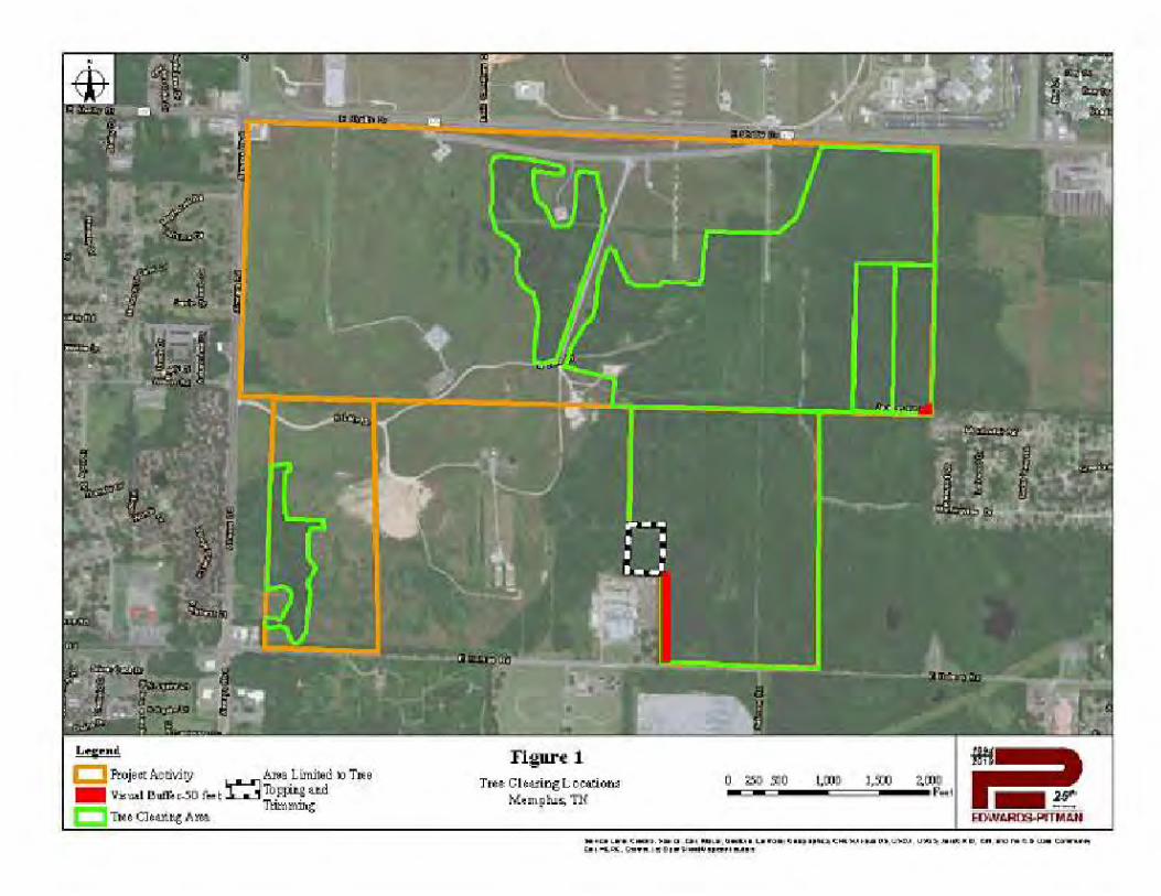
ATTACHMENT 2 Air Quality Information
117 | P a g e
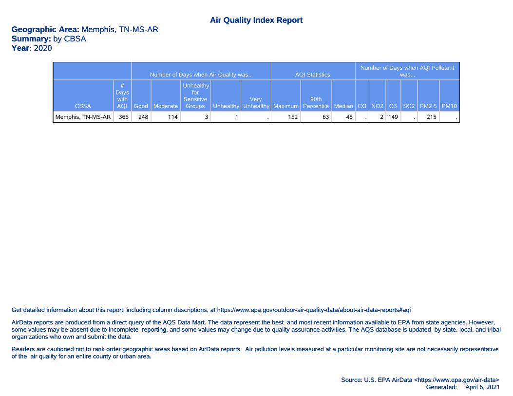
Generated: April 6, 2021Source: U.S. EPA AirData <https://www.epa.gov/air-data>
Readers are cautioned not to rank order geographic areas based on AirData reports. Air pollution levels measured at a particular monitoring site are not necessarily representativeof the air quality for an entire county or urban area.
AirData reports are produced from a direct query of the AQS Data Mart. The data represent the best and most recent information available to EPA from state agencies. However,some values may be absent due to incomplete reporting, and some values may change due to quality assurance activities. The AQS database is updated by state, local, and tribalorganizations who own and submit the data.
Get detailed information about this report, including column descriptions, at https://www.epa.gov/outdoor-air-quality-data/about-air-data-reports#aqi
Air Quality Index ReportGeographic Area: Memphis, TN-MS-ARSummary: by CBSAYear: 2020
Number of Days when Air Quality was... AQI StatisticsNumber of Days when AQI Pollutant
was...
CBSA
#DayswithAQI Good Moderate
Unhealthyfor
SensitiveGroups Unhealthy
VeryUnhealthy Maximum
90thPercentile Median CO NO2 O3 SO2 PM2.5 PM10
Memphis, TN-MS-AR 366 248 114 3 1 . 152 63 45 . 2 149 . 215 .
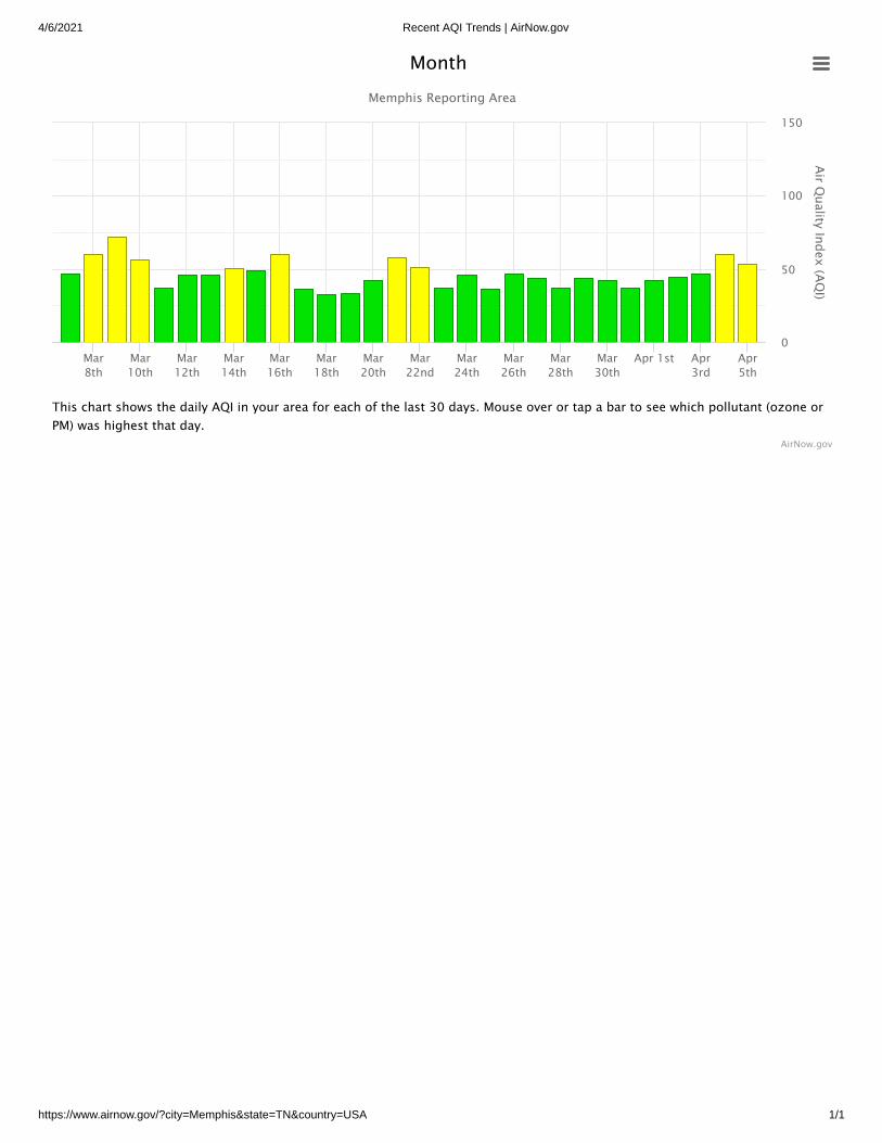
4/6/2021 Recent AQI Trends | AirNow.gov
https://www.airnow.gov/?city=Memphis&state=TN&country=USA 1/1
Air Quality Index (AQ
I)
Memphis Reporting Area
Mar8th
Mar10th
Mar12th
Mar14th
Mar16th
Mar18th
Mar20th
Mar22nd
Mar24th
Mar26th
Mar28th
Mar30th
Apr 1st Apr3rd
Apr5th
0
50
100
150
AirNow.gov
Month
This chart shows the daily AQI in your area for each of the last 30 days. Mouse over or tap a bar to see which pollutant (ozone orPM) was highest that day.
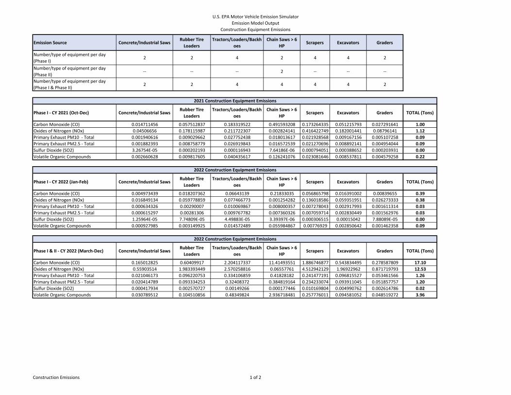
U.S. EPA Motor Vehicle Emission Simulator Emission Model Output
Construction Equipment Emissions
Emission Source Concrete/Industrial SawsRubber Tire Loaders
Tractors/Loaders/Backhoes
Chain Saws > 6 HP
Scrapers Excavators Graders
Number/type of equipment per day (Phase I)
2 2 4 2 4 4 2
Number/type of equipment per day (Phase II)
‐‐ ‐‐ ‐‐ 2 ‐‐ ‐‐ ‐‐
Number/type of equipment per day (Phase I & Phase II)
2 2 4 4 4 4 2
Phase I ‐ CY 2021 (Oct‐Dec) Concrete/Industrial SawsRubber Tire Loaders
Tractors/Loaders/Backhoes
Chain Saws > 6 HP
Scrapers Excavators Graders TOTAL (Tons)
Carbon Monoxide (CO) 0.014711456 0.057512837 0.183319522 0.491593208 0.173264335 0.051215793 0.027291641 1.00Oxides of Nitrogen (NOx) 0.04506656 0.178115987 0.211722307 0.002824141 0.416422749 0.182001441 0.08796141 1.12Primary Exhaust PM10 ‐ Total 0.001940616 0.009029662 0.027752438 0.018013617 0.021928568 0.009167156 0.005107258 0.09Primary Exhaust PM2.5 ‐ Total 0.001882393 0.008758779 0.026919843 0.016572539 0.021270696 0.008892141 0.004954044 0.09Sulfur Dioxide (SO2) 3.26754E‐05 0.000202193 0.000116943 7.64186E‐06 0.000794051 0.000388652 0.000203931 0.00Volatile Organic Compounds 0.002660628 0.009817605 0.040435617 0.126241076 0.023081646 0.008537811 0.004579258 0.22
Phase I ‐ CY 2022 (Jan‐Feb) Concrete/Industrial SawsRubber Tire Loaders
Tractors/Loaders/Backhoes
Chain Saws > 6 HP
Scrapers Excavators Graders TOTAL (Tons)
Carbon Monoxide (CO) 0.004973439 0.018207362 0.06643139 0.21833035 0.056865798 0.016391002 0.00839655 0.39Oxides of Nitrogen (NOx) 0.016849134 0.059778859 0.077466773 0.001254282 0.136018586 0.059351951 0.026273333 0.38Primary Exhaust PM10 ‐ Total 0.000634326 0.00290007 0.010069867 0.008000357 0.007278043 0.002917993 0.001611314 0.03Primary Exhaust PM2.5 ‐ Total 0.000615297 0.00281306 0.009767782 0.007360326 0.007059714 0.002830449 0.001562976 0.03Sulfur Dioxide (SO2) 1.25964E‐05 7.74809E‐05 4.49883E‐05 3.39397E‐06 0.000306515 0.00015042 7.88089E‐05 0.00Volatile Organic Compounds 0.000927985 0.003149925 0.014572489 0.055984867 0.00776929 0.002850642 0.001462358 0.09
Phase I & II ‐ CY 2022 (March‐Dec) Concrete/Industrial SawsRubber Tire Loaders
Tractors/Loaders/Backhoes
Chain Saws > 6 HP
Scrapers Excavators Graders TOTAL (Tons)
Carbon Monoxide (CO) 0.165012825 0.60409917 2.204117337 11.41493551 1.886746877 0.543834495 0.278587809 17.10Oxides of Nitrogen (NOx) 0.55903514 1.983393449 2.570258816 0.06557761 4.512942129 1.96922962 0.871719793 12.53Primary Exhaust PM10 ‐ Total 0.021046173 0.096220753 0.334106859 0.41828182 0.241477191 0.096815527 0.053461566 1.26Primary Exhaust PM2.5 ‐ Total 0.020414789 0.093334253 0.32408372 0.384819164 0.234233074 0.093911045 0.051857757 1.20Sulfur Dioxide (SO2) 0.000417934 0.002570727 0.00149266 0.000177446 0.010169804 0.004990762 0.002614786 0.02Volatile Organic Compounds 0.030789512 0.104510856 0.48349824 2.936718481 0.257776011 0.094581052 0.048519272 3.96
2021 Construction Equipment Emissions
2022 Construction Equipment Emissions
2022 Construction Equipment Emissions
Construction Emissions 1 of 2
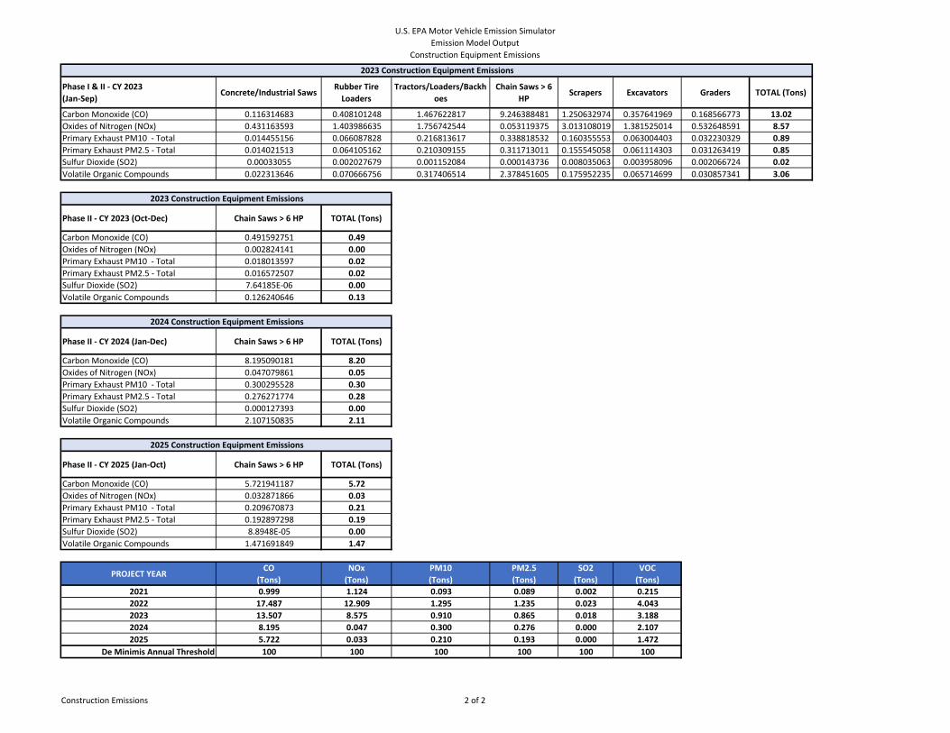
U.S. EPA Motor Vehicle Emission Simulator Emission Model Output
Construction Equipment Emissions
Phase I & II ‐ CY 2023(Jan‐Sep)
Concrete/Industrial SawsRubber Tire Loaders
Tractors/Loaders/Backhoes
Chain Saws > 6 HP
Scrapers Excavators Graders TOTAL (Tons)
Carbon Monoxide (CO) 0.116314683 0.408101248 1.467622817 9.246388481 1.250632974 0.357641969 0.168566773 13.02Oxides of Nitrogen (NOx) 0.431163593 1.403986635 1.756742544 0.053119375 3.013108019 1.381525014 0.532648591 8.57Primary Exhaust PM10 ‐ Total 0.014455156 0.066087828 0.216813617 0.338818532 0.160355553 0.063004403 0.032230329 0.89Primary Exhaust PM2.5 ‐ Total 0.014021513 0.064105162 0.210309155 0.311713011 0.155545058 0.061114303 0.031263419 0.85Sulfur Dioxide (SO2) 0.00033055 0.002027679 0.001152084 0.000143736 0.008035063 0.003958096 0.002066724 0.02Volatile Organic Compounds 0.022313646 0.070666756 0.317406514 2.378451605 0.175952235 0.065714699 0.030857341 3.06
Phase II ‐ CY 2023 (Oct‐Dec) Chain Saws > 6 HP TOTAL (Tons)
Carbon Monoxide (CO) 0.491592751 0.49Oxides of Nitrogen (NOx) 0.002824141 0.00Primary Exhaust PM10 ‐ Total 0.018013597 0.02Primary Exhaust PM2.5 ‐ Total 0.016572507 0.02Sulfur Dioxide (SO2) 7.64185E‐06 0.00Volatile Organic Compounds 0.126240646 0.13
Phase II ‐ CY 2024 (Jan‐Dec) Chain Saws > 6 HP TOTAL (Tons)
Carbon Monoxide (CO) 8.195090181 8.20Oxides of Nitrogen (NOx) 0.047079861 0.05Primary Exhaust PM10 ‐ Total 0.300295528 0.30Primary Exhaust PM2.5 ‐ Total 0.276271774 0.28Sulfur Dioxide (SO2) 0.000127393 0.00Volatile Organic Compounds 2.107150835 2.11
Phase II ‐ CY 2025 (Jan‐Oct) Chain Saws > 6 HP TOTAL (Tons)
Carbon Monoxide (CO) 5.721941187 5.72Oxides of Nitrogen (NOx) 0.032871866 0.03Primary Exhaust PM10 ‐ Total 0.209670873 0.21Primary Exhaust PM2.5 ‐ Total 0.192897298 0.19Sulfur Dioxide (SO2) 8.8948E‐05 0.00Volatile Organic Compounds 1.471691849 1.47
PROJECT YEARCO
(Tons)NOx(Tons)
PM10(Tons)
PM2.5(Tons)
SO2(Tons)
VOC(Tons)
2021 0.999 1.124 0.093 0.089 0.002 0.2152022 17.487 12.909 1.295 1.235 0.023 4.0432023 13.507 8.575 0.910 0.865 0.018 3.1882024 8.195 0.047 0.300 0.276 0.000 2.1072025 5.722 0.033 0.210 0.193 0.000 1.472
De Minimis Annual Threshold 100 100 100 100 100 100
2025 Construction Equipment Emissions
2023 Construction Equipment Emissions
2024 Construction Equipment Emissions
2023 Construction Equipment Emissions
Construction Emissions 2 of 2
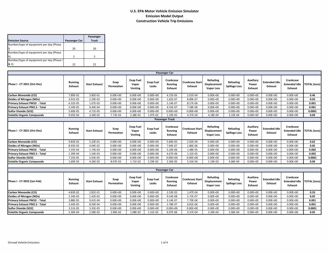
U.S. EPA Motor Vehicle Emission Simulator Emission Model Output
Construction Vehicle Trip Emissions
Emission Source Passenger CarPassenger
TruckNumber/type of equipment per day (Phase I) 20 20Number/type of equipment per day (Phase II) 2 2Number/type of equipment per day (Phase I & II) 22 22
Phase I - CY 2021 (Oct-Dec)Running Exhaust
Start ExhaustEvap
Permeation
Evap Fuel Vapor
Venting
Evap Fuel Leaks
Crankcase Running Exhaust
Crankcase Start Exhaust
Refueling Displacement
Vapor Loss
Refueling Spillage Loss
Auxiliary Power
Exhaust
Extended Idle Exhaust
Crankcase Extended Idle
ExhaustTOTAL (tons)
Carbon Monoxide (CO) 7.89E-02 3.85E-01 0.00E+00 0.00E+00 0.00E+00 4.15E-05 2.01E-04 0.00E+00 0.00E+00 0.00E+00 0.00E+00 0.00E+00 0.46Oxides of Nitrogen (NOx) 3.91E-03 2.20E-02 0.00E+00 0.00E+00 0.00E+00 1.62E-07 8.89E-07 0.00E+00 0.00E+00 0.00E+00 0.00E+00 0.00E+00 0.03Primary Exhaust PM10 - Total 6.32E-05 1.07E-03 0.00E+00 0.00E+00 0.00E+00 5.14E-07 8.57E-06 0.00E+00 0.00E+00 0.00E+00 0.00E+00 0.00E+00 0.001Primary Exhaust PM2.5 - Total 5.59E-05 9.44E-04 0.00E+00 0.00E+00 0.00E+00 4.55E-07 7.58E-06 0.00E+00 0.00E+00 0.00E+00 0.00E+00 0.00E+00 0.001Sulfur Dioxide (SO2) 5.60E-05 4.71E-05 0.00E+00 0.00E+00 0.00E+00 0.00E+00 0.00E+00 0.00E+00 0.00E+00 0.00E+00 0.00E+00 0.00E+00 0.0001Volatile Organic Compounds 9.05E-04 3.34E-02 7.73E-03 2.38E-02 1.97E-02 1.19E-05 4.37E-04 4.18E-04 3.10E-04 0.00E+00 0.00E+00 0.00E+00 0.09
Phase I - CY 2021 (Oct-Dec)Running Exhaust
Start ExhaustEvap
Permeation
Evap Fuel Vapor
Venting
Evap Fuel Leaks
Crankcase Running Exhaust
Crankcase Start Exhaust
Refueling Displacement
Vapor Loss
Refueling Spillage Loss
Auxiliary Power
Exhaust
Extended Idle Exhaust
Crankcase Extended Idle
ExhaustTOTAL (tons)
Carbon Monoxide (CO) 9.83E-02 5.23E-01 0.00E+00 0.00E+00 0.00E+00 5.84E-05 2.92E-04 0.00E+00 0.00E+00 0.00E+00 0.00E+00 0.00E+00 0.62Oxides of Nitrogen (NOx) 8.93E-03 4.04E-02 0.00E+00 0.00E+00 0.00E+00 7.04E-07 1.86E-06 0.00E+00 0.00E+00 0.00E+00 0.00E+00 0.00E+00 0.05Primary Exhaust PM10 - Total 1.55E-04 1.74E-03 0.00E+00 0.00E+00 0.00E+00 5.10E-06 1.48E-05 0.00E+00 0.00E+00 0.00E+00 0.00E+00 0.00E+00 0.002Primary Exhaust PM2.5 - Total 1.39E-04 1.54E-03 0.00E+00 0.00E+00 0.00E+00 4.67E-06 1.31E-05 0.00E+00 0.00E+00 0.00E+00 0.00E+00 0.00E+00 0.002Sulfur Dioxide (SO2) 7.25E-05 5.93E-05 0.00E+00 0.00E+00 0.00E+00 0.00E+00 0.00E+00 0.00E+00 0.00E+00 0.00E+00 0.00E+00 0.00E+00 0.0001Volatile Organic Compounds 1.69E-03 4.26E-02 8.07E-03 1.71E-02 2.29E-02 2.26E-05 5.55E-04 1.19E-03 4.06E-04 0.00E+00 0.00E+00 0.00E+00 0.09
Phase I - CY 2022 (Jan-Feb)Running Exhaust
Start ExhaustEvap
Permeation
Evap Fuel Vapor
Venting
Evap Fuel Leaks
Crankcase Running Exhaust
Crankcase Start Exhaust
Refueling Displacement
Vapor Loss
Refueling Spillage Loss
Auxiliary Power
Exhaust
Extended Idle Exhaust
Crankcase Extended Idle
ExhaustTOTAL (tons)
Carbon Monoxide (CO) 4.83E-02 2.81E-01 0.00E+00 0.00E+00 0.00E+00 2.53E-05 1.47E-04 0.00E+00 0.00E+00 0.00E+00 0.00E+00 0.00E+00 0.33Oxides of Nitrogen (NOx) 2.34E-03 1.42E-02 0.00E+00 0.00E+00 0.00E+00 9.54E-08 5.72E-07 0.00E+00 0.00E+00 0.00E+00 0.00E+00 0.00E+00 0.02Primary Exhaust PM10 - Total 3.88E-05 9.61E-04 0.00E+00 0.00E+00 0.00E+00 3.14E-07 7.70E-06 0.00E+00 0.00E+00 0.00E+00 0.00E+00 0.00E+00 0.001Primary Exhaust PM2.5 - Total 3.44E-05 8.50E-04 0.00E+00 0.00E+00 0.00E+00 2.78E-07 6.81E-06 0.00E+00 0.00E+00 0.00E+00 0.00E+00 0.00E+00 0.001Sulfur Dioxide (SO2) 3.51E-05 3.35E-05 0.00E+00 0.00E+00 0.00E+00 0.00E+00 0.00E+00 0.00E+00 0.00E+00 0.00E+00 0.00E+00 0.00E+00 0.0001Volatile Organic Compounds 5.30E-04 2.58E-02 2.90E-03 1.08E-02 1.31E-02 6.97E-06 3.37E-04 2.26E-04 2.06E-04 0.00E+00 0.00E+00 0.00E+00 0.05
Passenger Car
Passenger Truck
Passenger Car
Onroad Vehicle Emissions 1 of 4
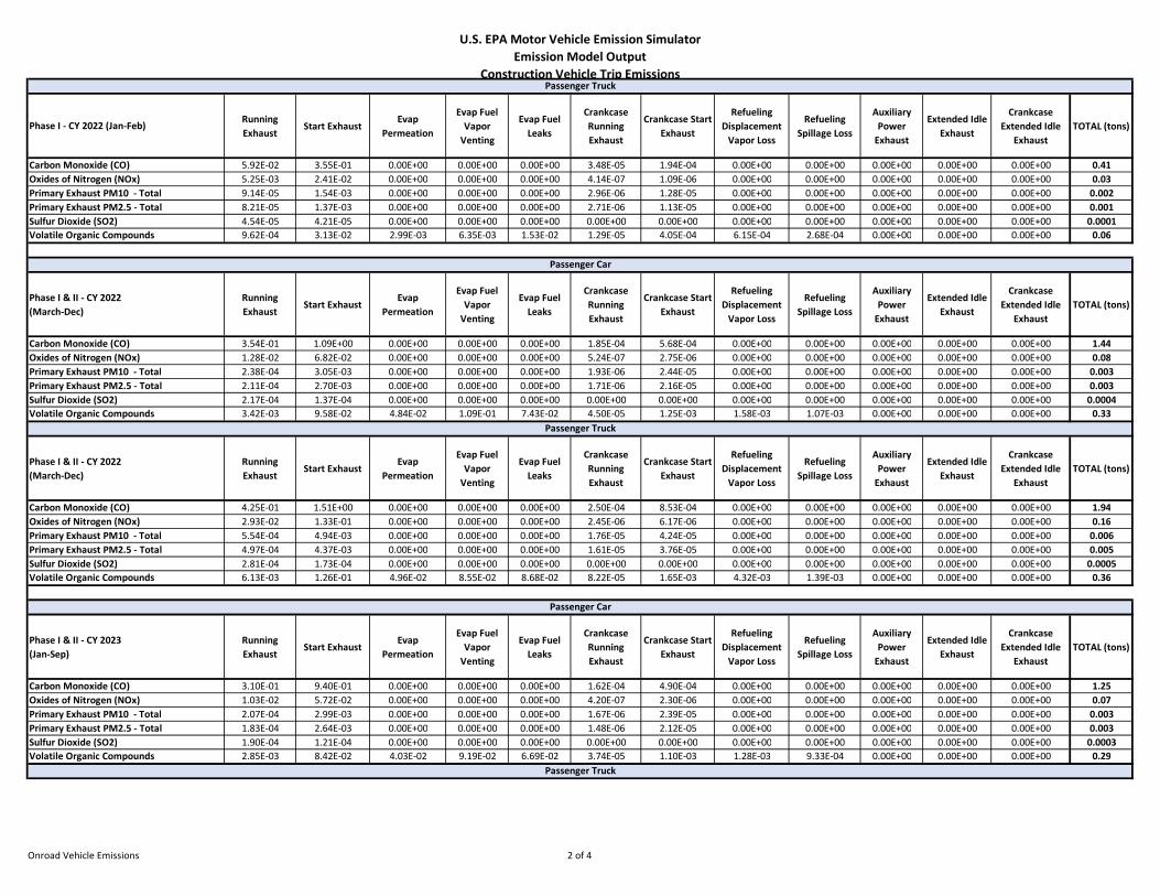
U.S. EPA Motor Vehicle Emission Simulator Emission Model Output
Construction Vehicle Trip Emissions
Phase I - CY 2022 (Jan-Feb)Running Exhaust
Start ExhaustEvap
Permeation
Evap Fuel Vapor
Venting
Evap Fuel Leaks
Crankcase Running Exhaust
Crankcase Start Exhaust
Refueling Displacement
Vapor Loss
Refueling Spillage Loss
Auxiliary Power
Exhaust
Extended Idle Exhaust
Crankcase Extended Idle
ExhaustTOTAL (tons)
Carbon Monoxide (CO) 5.92E-02 3.55E-01 0.00E+00 0.00E+00 0.00E+00 3.48E-05 1.94E-04 0.00E+00 0.00E+00 0.00E+00 0.00E+00 0.00E+00 0.41Oxides of Nitrogen (NOx) 5.25E-03 2.41E-02 0.00E+00 0.00E+00 0.00E+00 4.14E-07 1.09E-06 0.00E+00 0.00E+00 0.00E+00 0.00E+00 0.00E+00 0.03Primary Exhaust PM10 - Total 9.14E-05 1.54E-03 0.00E+00 0.00E+00 0.00E+00 2.96E-06 1.28E-05 0.00E+00 0.00E+00 0.00E+00 0.00E+00 0.00E+00 0.002Primary Exhaust PM2.5 - Total 8.21E-05 1.37E-03 0.00E+00 0.00E+00 0.00E+00 2.71E-06 1.13E-05 0.00E+00 0.00E+00 0.00E+00 0.00E+00 0.00E+00 0.001Sulfur Dioxide (SO2) 4.54E-05 4.21E-05 0.00E+00 0.00E+00 0.00E+00 0.00E+00 0.00E+00 0.00E+00 0.00E+00 0.00E+00 0.00E+00 0.00E+00 0.0001Volatile Organic Compounds 9.62E-04 3.13E-02 2.99E-03 6.35E-03 1.53E-02 1.29E-05 4.05E-04 6.15E-04 2.68E-04 0.00E+00 0.00E+00 0.00E+00 0.06
Phase I & II - CY 2022(March-Dec)
Running Exhaust
Start ExhaustEvap
Permeation
Evap Fuel Vapor
Venting
Evap Fuel Leaks
Crankcase Running Exhaust
Crankcase Start Exhaust
Refueling Displacement
Vapor Loss
Refueling Spillage Loss
Auxiliary Power
Exhaust
Extended Idle Exhaust
Crankcase Extended Idle
ExhaustTOTAL (tons)
Carbon Monoxide (CO) 3.54E-01 1.09E+00 0.00E+00 0.00E+00 0.00E+00 1.85E-04 5.68E-04 0.00E+00 0.00E+00 0.00E+00 0.00E+00 0.00E+00 1.44Oxides of Nitrogen (NOx) 1.28E-02 6.82E-02 0.00E+00 0.00E+00 0.00E+00 5.24E-07 2.75E-06 0.00E+00 0.00E+00 0.00E+00 0.00E+00 0.00E+00 0.08Primary Exhaust PM10 - Total 2.38E-04 3.05E-03 0.00E+00 0.00E+00 0.00E+00 1.93E-06 2.44E-05 0.00E+00 0.00E+00 0.00E+00 0.00E+00 0.00E+00 0.003Primary Exhaust PM2.5 - Total 2.11E-04 2.70E-03 0.00E+00 0.00E+00 0.00E+00 1.71E-06 2.16E-05 0.00E+00 0.00E+00 0.00E+00 0.00E+00 0.00E+00 0.003Sulfur Dioxide (SO2) 2.17E-04 1.37E-04 0.00E+00 0.00E+00 0.00E+00 0.00E+00 0.00E+00 0.00E+00 0.00E+00 0.00E+00 0.00E+00 0.00E+00 0.0004Volatile Organic Compounds 3.42E-03 9.58E-02 4.84E-02 1.09E-01 7.43E-02 4.50E-05 1.25E-03 1.58E-03 1.07E-03 0.00E+00 0.00E+00 0.00E+00 0.33
Phase I & II - CY 2022(March-Dec)
Running Exhaust
Start ExhaustEvap
Permeation
Evap Fuel Vapor
Venting
Evap Fuel Leaks
Crankcase Running Exhaust
Crankcase Start Exhaust
Refueling Displacement
Vapor Loss
Refueling Spillage Loss
Auxiliary Power
Exhaust
Extended Idle Exhaust
Crankcase Extended Idle
ExhaustTOTAL (tons)
Carbon Monoxide (CO) 4.25E-01 1.51E+00 0.00E+00 0.00E+00 0.00E+00 2.50E-04 8.53E-04 0.00E+00 0.00E+00 0.00E+00 0.00E+00 0.00E+00 1.94Oxides of Nitrogen (NOx) 2.93E-02 1.33E-01 0.00E+00 0.00E+00 0.00E+00 2.45E-06 6.17E-06 0.00E+00 0.00E+00 0.00E+00 0.00E+00 0.00E+00 0.16Primary Exhaust PM10 - Total 5.54E-04 4.94E-03 0.00E+00 0.00E+00 0.00E+00 1.76E-05 4.24E-05 0.00E+00 0.00E+00 0.00E+00 0.00E+00 0.00E+00 0.006Primary Exhaust PM2.5 - Total 4.97E-04 4.37E-03 0.00E+00 0.00E+00 0.00E+00 1.61E-05 3.76E-05 0.00E+00 0.00E+00 0.00E+00 0.00E+00 0.00E+00 0.005Sulfur Dioxide (SO2) 2.81E-04 1.73E-04 0.00E+00 0.00E+00 0.00E+00 0.00E+00 0.00E+00 0.00E+00 0.00E+00 0.00E+00 0.00E+00 0.00E+00 0.0005Volatile Organic Compounds 6.13E-03 1.26E-01 4.96E-02 8.55E-02 8.68E-02 8.22E-05 1.65E-03 4.32E-03 1.39E-03 0.00E+00 0.00E+00 0.00E+00 0.36
Phase I & II - CY 2023(Jan-Sep)
Running Exhaust
Start ExhaustEvap
Permeation
Evap Fuel Vapor
Venting
Evap Fuel Leaks
Crankcase Running Exhaust
Crankcase Start Exhaust
Refueling Displacement
Vapor Loss
Refueling Spillage Loss
Auxiliary Power
Exhaust
Extended Idle Exhaust
Crankcase Extended Idle
ExhaustTOTAL (tons)
Carbon Monoxide (CO) 3.10E-01 9.40E-01 0.00E+00 0.00E+00 0.00E+00 1.62E-04 4.90E-04 0.00E+00 0.00E+00 0.00E+00 0.00E+00 0.00E+00 1.25Oxides of Nitrogen (NOx) 1.03E-02 5.72E-02 0.00E+00 0.00E+00 0.00E+00 4.20E-07 2.30E-06 0.00E+00 0.00E+00 0.00E+00 0.00E+00 0.00E+00 0.07Primary Exhaust PM10 - Total 2.07E-04 2.99E-03 0.00E+00 0.00E+00 0.00E+00 1.67E-06 2.39E-05 0.00E+00 0.00E+00 0.00E+00 0.00E+00 0.00E+00 0.003Primary Exhaust PM2.5 - Total 1.83E-04 2.64E-03 0.00E+00 0.00E+00 0.00E+00 1.48E-06 2.12E-05 0.00E+00 0.00E+00 0.00E+00 0.00E+00 0.00E+00 0.003Sulfur Dioxide (SO2) 1.90E-04 1.21E-04 0.00E+00 0.00E+00 0.00E+00 0.00E+00 0.00E+00 0.00E+00 0.00E+00 0.00E+00 0.00E+00 0.00E+00 0.0003Volatile Organic Compounds 2.85E-03 8.42E-02 4.03E-02 9.19E-02 6.69E-02 3.74E-05 1.10E-03 1.28E-03 9.33E-04 0.00E+00 0.00E+00 0.00E+00 0.29
Passenger Truck
Passenger Car
Passenger Truck
Passenger Car
Passenger Truck
Onroad Vehicle Emissions 2 of 4
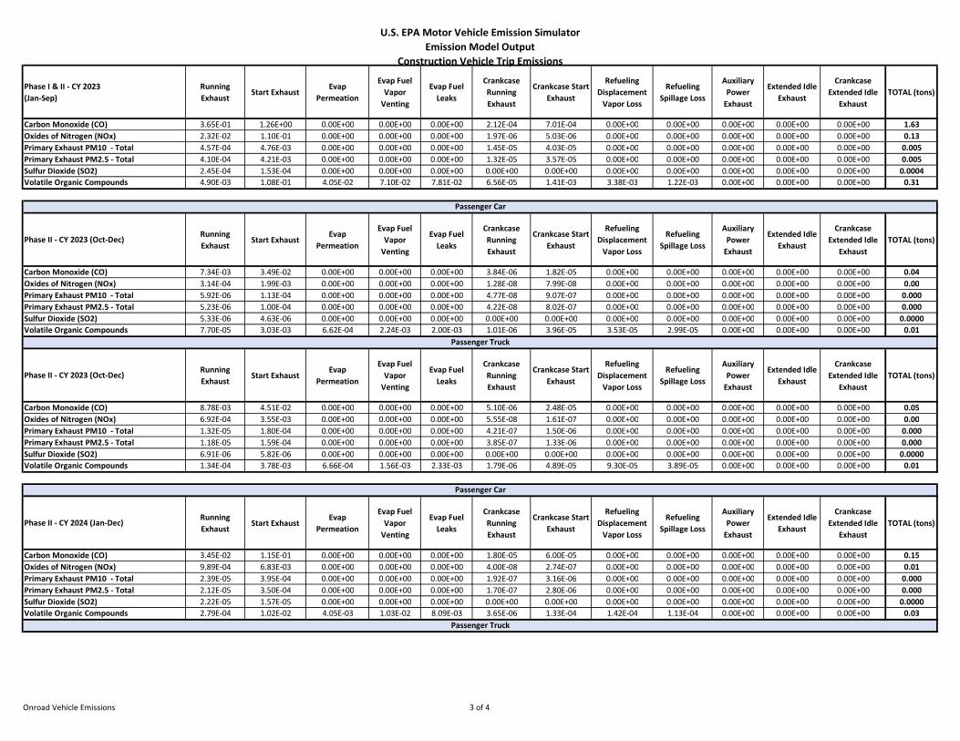
U.S. EPA Motor Vehicle Emission Simulator Emission Model Output
Construction Vehicle Trip Emissions
Phase I & II - CY 2023(Jan-Sep)
Running Exhaust
Start ExhaustEvap
Permeation
Evap Fuel Vapor
Venting
Evap Fuel Leaks
Crankcase Running Exhaust
Crankcase Start Exhaust
Refueling Displacement
Vapor Loss
Refueling Spillage Loss
Auxiliary Power
Exhaust
Extended Idle Exhaust
Crankcase Extended Idle
ExhaustTOTAL (tons)
Carbon Monoxide (CO) 3.65E-01 1.26E+00 0.00E+00 0.00E+00 0.00E+00 2.12E-04 7.01E-04 0.00E+00 0.00E+00 0.00E+00 0.00E+00 0.00E+00 1.63Oxides of Nitrogen (NOx) 2.32E-02 1.10E-01 0.00E+00 0.00E+00 0.00E+00 1.97E-06 5.03E-06 0.00E+00 0.00E+00 0.00E+00 0.00E+00 0.00E+00 0.13Primary Exhaust PM10 - Total 4.57E-04 4.76E-03 0.00E+00 0.00E+00 0.00E+00 1.45E-05 4.03E-05 0.00E+00 0.00E+00 0.00E+00 0.00E+00 0.00E+00 0.005Primary Exhaust PM2.5 - Total 4.10E-04 4.21E-03 0.00E+00 0.00E+00 0.00E+00 1.32E-05 3.57E-05 0.00E+00 0.00E+00 0.00E+00 0.00E+00 0.00E+00 0.005Sulfur Dioxide (SO2) 2.45E-04 1.53E-04 0.00E+00 0.00E+00 0.00E+00 0.00E+00 0.00E+00 0.00E+00 0.00E+00 0.00E+00 0.00E+00 0.00E+00 0.0004Volatile Organic Compounds 4.90E-03 1.08E-01 4.05E-02 7.10E-02 7.81E-02 6.56E-05 1.41E-03 3.38E-03 1.22E-03 0.00E+00 0.00E+00 0.00E+00 0.31
Phase II - CY 2023 (Oct-Dec)Running Exhaust
Start ExhaustEvap
Permeation
Evap Fuel Vapor
Venting
Evap Fuel Leaks
Crankcase Running Exhaust
Crankcase Start Exhaust
Refueling Displacement
Vapor Loss
Refueling Spillage Loss
Auxiliary Power
Exhaust
Extended Idle Exhaust
Crankcase Extended Idle
ExhaustTOTAL (tons)
Carbon Monoxide (CO) 7.34E-03 3.49E-02 0.00E+00 0.00E+00 0.00E+00 3.84E-06 1.82E-05 0.00E+00 0.00E+00 0.00E+00 0.00E+00 0.00E+00 0.04Oxides of Nitrogen (NOx) 3.14E-04 1.99E-03 0.00E+00 0.00E+00 0.00E+00 1.28E-08 7.99E-08 0.00E+00 0.00E+00 0.00E+00 0.00E+00 0.00E+00 0.00Primary Exhaust PM10 - Total 5.92E-06 1.13E-04 0.00E+00 0.00E+00 0.00E+00 4.77E-08 9.07E-07 0.00E+00 0.00E+00 0.00E+00 0.00E+00 0.00E+00 0.000Primary Exhaust PM2.5 - Total 5.23E-06 1.00E-04 0.00E+00 0.00E+00 0.00E+00 4.22E-08 8.02E-07 0.00E+00 0.00E+00 0.00E+00 0.00E+00 0.00E+00 0.000Sulfur Dioxide (SO2) 5.33E-06 4.63E-06 0.00E+00 0.00E+00 0.00E+00 0.00E+00 0.00E+00 0.00E+00 0.00E+00 0.00E+00 0.00E+00 0.00E+00 0.0000Volatile Organic Compounds 7.70E-05 3.03E-03 6.62E-04 2.24E-03 2.00E-03 1.01E-06 3.96E-05 3.53E-05 2.99E-05 0.00E+00 0.00E+00 0.00E+00 0.01
Phase II - CY 2023 (Oct-Dec)Running Exhaust
Start ExhaustEvap
Permeation
Evap Fuel Vapor
Venting
Evap Fuel Leaks
Crankcase Running Exhaust
Crankcase Start Exhaust
Refueling Displacement
Vapor Loss
Refueling Spillage Loss
Auxiliary Power
Exhaust
Extended Idle Exhaust
Crankcase Extended Idle
ExhaustTOTAL (tons)
Carbon Monoxide (CO) 8.78E-03 4.51E-02 0.00E+00 0.00E+00 0.00E+00 5.10E-06 2.48E-05 0.00E+00 0.00E+00 0.00E+00 0.00E+00 0.00E+00 0.05Oxides of Nitrogen (NOx) 6.92E-04 3.55E-03 0.00E+00 0.00E+00 0.00E+00 5.55E-08 1.61E-07 0.00E+00 0.00E+00 0.00E+00 0.00E+00 0.00E+00 0.00Primary Exhaust PM10 - Total 1.32E-05 1.80E-04 0.00E+00 0.00E+00 0.00E+00 4.21E-07 1.50E-06 0.00E+00 0.00E+00 0.00E+00 0.00E+00 0.00E+00 0.000Primary Exhaust PM2.5 - Total 1.18E-05 1.59E-04 0.00E+00 0.00E+00 0.00E+00 3.85E-07 1.33E-06 0.00E+00 0.00E+00 0.00E+00 0.00E+00 0.00E+00 0.000Sulfur Dioxide (SO2) 6.91E-06 5.82E-06 0.00E+00 0.00E+00 0.00E+00 0.00E+00 0.00E+00 0.00E+00 0.00E+00 0.00E+00 0.00E+00 0.00E+00 0.0000Volatile Organic Compounds 1.34E-04 3.78E-03 6.66E-04 1.56E-03 2.33E-03 1.79E-06 4.89E-05 9.30E-05 3.89E-05 0.00E+00 0.00E+00 0.00E+00 0.01
Phase II - CY 2024 (Jan-Dec)Running Exhaust
Start ExhaustEvap
Permeation
Evap Fuel Vapor
Venting
Evap Fuel Leaks
Crankcase Running Exhaust
Crankcase Start Exhaust
Refueling Displacement
Vapor Loss
Refueling Spillage Loss
Auxiliary Power
Exhaust
Extended Idle Exhaust
Crankcase Extended Idle
ExhaustTOTAL (tons)
Carbon Monoxide (CO) 3.45E-02 1.15E-01 0.00E+00 0.00E+00 0.00E+00 1.80E-05 6.00E-05 0.00E+00 0.00E+00 0.00E+00 0.00E+00 0.00E+00 0.15Oxides of Nitrogen (NOx) 9.89E-04 6.83E-03 0.00E+00 0.00E+00 0.00E+00 4.00E-08 2.74E-07 0.00E+00 0.00E+00 0.00E+00 0.00E+00 0.00E+00 0.01Primary Exhaust PM10 - Total 2.39E-05 3.95E-04 0.00E+00 0.00E+00 0.00E+00 1.92E-07 3.16E-06 0.00E+00 0.00E+00 0.00E+00 0.00E+00 0.00E+00 0.000Primary Exhaust PM2.5 - Total 2.12E-05 3.50E-04 0.00E+00 0.00E+00 0.00E+00 1.70E-07 2.80E-06 0.00E+00 0.00E+00 0.00E+00 0.00E+00 0.00E+00 0.000Sulfur Dioxide (SO2) 2.22E-05 1.57E-05 0.00E+00 0.00E+00 0.00E+00 0.00E+00 0.00E+00 0.00E+00 0.00E+00 0.00E+00 0.00E+00 0.00E+00 0.0000Volatile Organic Compounds 2.79E-04 1.02E-02 4.05E-03 1.03E-02 8.09E-03 3.65E-06 1.33E-04 1.42E-04 1.13E-04 0.00E+00 0.00E+00 0.00E+00 0.03
Passenger Truck
Passenger Car
Passenger Truck
Passenger Car
Onroad Vehicle Emissions 3 of 4
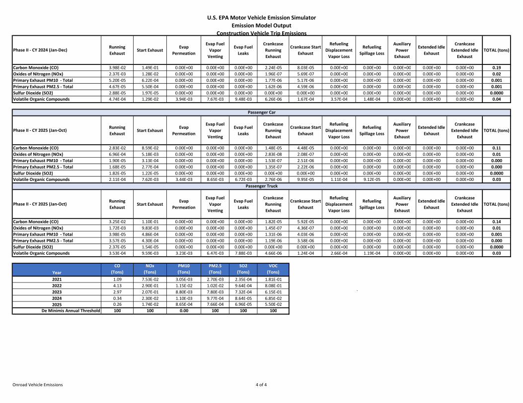
U.S. EPA Motor Vehicle Emission Simulator Emission Model Output
Construction Vehicle Trip Emissions
Phase II - CY 2024 (Jan-Dec)Running Exhaust
Start ExhaustEvap
Permeation
Evap Fuel Vapor
Venting
Evap Fuel Leaks
Crankcase Running Exhaust
Crankcase Start Exhaust
Refueling Displacement
Vapor Loss
Refueling Spillage Loss
Auxiliary Power
Exhaust
Extended Idle Exhaust
Crankcase Extended Idle
ExhaustTOTAL (tons)
Carbon Monoxide (CO) 3.98E-02 1.49E-01 0.00E+00 0.00E+00 0.00E+00 2.24E-05 8.03E-05 0.00E+00 0.00E+00 0.00E+00 0.00E+00 0.00E+00 0.19Oxides of Nitrogen (NOx) 2.37E-03 1.28E-02 0.00E+00 0.00E+00 0.00E+00 1.96E-07 5.69E-07 0.00E+00 0.00E+00 0.00E+00 0.00E+00 0.00E+00 0.02Primary Exhaust PM10 - Total 5.20E-05 6.22E-04 0.00E+00 0.00E+00 0.00E+00 1.77E-06 5.17E-06 0.00E+00 0.00E+00 0.00E+00 0.00E+00 0.00E+00 0.001Primary Exhaust PM2.5 - Total 4.67E-05 5.50E-04 0.00E+00 0.00E+00 0.00E+00 1.62E-06 4.59E-06 0.00E+00 0.00E+00 0.00E+00 0.00E+00 0.00E+00 0.001Sulfur Dioxide (SO2) 2.88E-05 1.97E-05 0.00E+00 0.00E+00 0.00E+00 0.00E+00 0.00E+00 0.00E+00 0.00E+00 0.00E+00 0.00E+00 0.00E+00 0.0000Volatile Organic Compounds 4.74E-04 1.29E-02 3.94E-03 7.67E-03 9.48E-03 6.26E-06 1.67E-04 3.57E-04 1.48E-04 0.00E+00 0.00E+00 0.00E+00 0.04
Phase II - CY 2025 (Jan-Oct)Running Exhaust
Start ExhaustEvap
Permeation
Evap Fuel Vapor
Venting
Evap Fuel Leaks
Crankcase Running Exhaust
Crankcase Start Exhaust
Refueling Displacement
Vapor Loss
Refueling Spillage Loss
Auxiliary Power
Exhaust
Extended Idle Exhaust
Crankcase Extended Idle
ExhaustTOTAL (tons)
Carbon Monoxide (CO) 2.83E-02 8.59E-02 0.00E+00 0.00E+00 0.00E+00 1.48E-05 4.48E-05 0.00E+00 0.00E+00 0.00E+00 0.00E+00 0.00E+00 0.11Oxides of Nitrogen (NOx) 6.96E-04 5.18E-03 0.00E+00 0.00E+00 0.00E+00 2.83E-08 2.08E-07 0.00E+00 0.00E+00 0.00E+00 0.00E+00 0.00E+00 0.01Primary Exhaust PM10 - Total 1.90E-05 3.13E-04 0.00E+00 0.00E+00 0.00E+00 1.53E-07 2.51E-06 0.00E+00 0.00E+00 0.00E+00 0.00E+00 0.00E+00 0.000Primary Exhaust PM2.5 - Total 1.68E-05 2.77E-04 0.00E+00 0.00E+00 0.00E+00 1.35E-07 2.22E-06 0.00E+00 0.00E+00 0.00E+00 0.00E+00 0.00E+00 0.000Sulfur Dioxide (SO2) 1.82E-05 1.22E-05 0.00E+00 0.00E+00 0.00E+00 0.00E+00 0.00E+00 0.00E+00 0.00E+00 0.00E+00 0.00E+00 0.00E+00 0.0000Volatile Organic Compounds 2.11E-04 7.62E-03 3.44E-03 8.65E-03 6.72E-03 2.76E-06 9.95E-05 1.11E-04 9.12E-05 0.00E+00 0.00E+00 0.00E+00 0.03
Phase II - CY 2025 (Jan-Oct)Running Exhaust
Start ExhaustEvap
Permeation
Evap Fuel Vapor
Venting
Evap Fuel Leaks
Crankcase Running Exhaust
Crankcase Start Exhaust
Refueling Displacement
Vapor Loss
Refueling Spillage Loss
Auxiliary Power
Exhaust
Extended Idle Exhaust
Crankcase Extended Idle
ExhaustTOTAL (tons)
Carbon Monoxide (CO) 3.25E-02 1.10E-01 0.00E+00 0.00E+00 0.00E+00 1.82E-05 5.92E-05 0.00E+00 0.00E+00 0.00E+00 0.00E+00 0.00E+00 0.14Oxides of Nitrogen (NOx) 1.72E-03 9.83E-03 0.00E+00 0.00E+00 0.00E+00 1.45E-07 4.36E-07 0.00E+00 0.00E+00 0.00E+00 0.00E+00 0.00E+00 0.01Primary Exhaust PM10 - Total 3.98E-05 4.86E-04 0.00E+00 0.00E+00 0.00E+00 1.31E-06 4.03E-06 0.00E+00 0.00E+00 0.00E+00 0.00E+00 0.00E+00 0.001Primary Exhaust PM2.5 - Total 3.57E-05 4.30E-04 0.00E+00 0.00E+00 0.00E+00 1.19E-06 3.58E-06 0.00E+00 0.00E+00 0.00E+00 0.00E+00 0.00E+00 0.000Sulfur Dioxide (SO2) 2.37E-05 1.54E-05 0.00E+00 0.00E+00 0.00E+00 0.00E+00 0.00E+00 0.00E+00 0.00E+00 0.00E+00 0.00E+00 0.00E+00 0.0000Volatile Organic Compounds 3.53E-04 9.59E-03 3.23E-03 6.47E-03 7.88E-03 4.66E-06 1.24E-04 2.66E-04 1.19E-04 0.00E+00 0.00E+00 0.00E+00 0.03
YearCO
(Tons)NOx
(Tons)PM10(Tons)
PM2.5(Tons)
SO2(Tons)
VOC(Tons)
2021 1.09 7.53E-02 3.05E-03 2.70E-03 2.35E-04 1.81E-012022 4.13 2.90E-01 1.15E-02 1.02E-02 9.64E-04 8.08E-012023 2.97 2.07E-01 8.80E-03 7.80E-03 7.32E-04 6.15E-01 `2024 0.34 2.30E-02 1.10E-03 9.77E-04 8.64E-05 6.85E-022025 0.26 1.74E-02 8.65E-04 7.66E-04 6.96E-05 5.50E-02
De Minimis Annual Threshold 100 100 0.00 100 100 100
Passenger Truck
Passenger Car
Onroad Vehicle Emissions 4 of 4

126 | P a g e
ATTACHMENT 3 Biological Resources Information
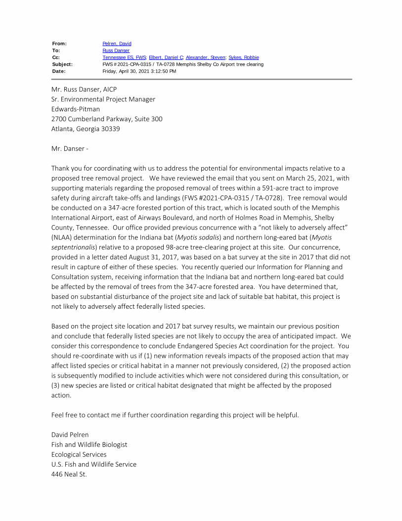
From: Pelren, DavidTo: Russ DanserCc: Tennessee ES, FWS; Elbert, Daniel C; Alexander, Steven; Sykes, RobbieSubject: FWS #2021-CPA-0315 / TA-0728 Memphis Shelby Co Airport tree clearingDate: Friday, April 30, 2021 3:12:50 PM
Mr. Russ Danser, AICPSr. Environmental Project ManagerEdwards-Pitman2700 Cumberland Parkway, Suite 300Atlanta, Georgia 30339 Mr. Danser - Thank you for coordinating with us to address the potential for environmental impacts relative to aproposed tree removal project. We have reviewed the email that you sent on March 25, 2021, withsupporting materials regarding the proposed removal of trees within a 591-acre tract to improvesafety during aircraft take-offs and landings (FWS #2021-CPA-0315 / TA-0728). Tree removal wouldbe conducted on a 347-acre forested portion of this tract, which is located south of the MemphisInternational Airport, east of Airways Boulevard, and north of Holmes Road in Memphis, ShelbyCounty, Tennessee. Our office provided previous concurrence with a “not likely to adversely affect”(NLAA) determination for the Indiana bat (Myotis sodalis) and northern long-eared bat (Myotisseptentrionalis) relative to a proposed 98-acre tree-clearing project at this site. Our concurrence,provided in a letter dated August 31, 2017, was based on a bat survey at the site in 2017 that did notresult in capture of either of these species. You recently queried our Information for Planning andConsultation system, receiving information that the Indiana bat and northern long-eared bat couldbe affected by the removal of trees from the 347-acre forested area. You have determined that,based on substantial disturbance of the project site and lack of suitable bat habitat, this project isnot likely to adversely affect federally listed species. Based on the project site location and 2017 bat survey results, we maintain our previous positionand conclude that federally listed species are not likely to occupy the area of anticipated impact. Weconsider this correspondence to conclude Endangered Species Act coordination for the project. Youshould re-coordinate with us if (1) new information reveals impacts of the proposed action that mayaffect listed species or critical habitat in a manner not previously considered, (2) the proposed actionis subsequently modified to include activities which were not considered during this consultation, or(3) new species are listed or critical habitat designated that might be affected by the proposedaction. Feel free to contact me if further coordination regarding this project will be helpful. David PelrenFish and Wildlife BiologistEcological ServicesU.S. Fish and Wildlife Service446 Neal St.

Cookeville, TN 38501office phone: 931-525-4974mobile phone: 931-261-5844 NOTE: This email correspondence and any attachments to and from this sender are subject to theFreedom of Information Act (FOIA) and may be disclosed to third parties.
From: Rob ToddTo: Russ DanserCc: Patrick Lemons; [email protected]: Agency Coordination Request | Memphis-Shelby County Airport Authority (MSCAA) | Proposed Tree ClearingDate: Monday, March 29, 2021 5:03:23 PM
Mr. Danser: Your review request was referred to me for response. The Tennessee Wildlife Resources Agency hasreviewed the information that you provided regarding the proposed Memphis-Shelby County AirportAuthority proposed tree clearing project and provides the following comments. Since the project willrequire the clearing of trees and since we share authority with the U.S. Fish and Wildlife Service(USFWS) on the Indiana Myotis (Myotis sodalist) and the Northern Long-eared Bat (Myotisseptentrionalis), we request that you consult with the USFWS Cookeville, Tennessee Field Officeregarding potential impacts to these listed species; and will defer to the opinion of the U.S. Fish andWildlife Service’s Cookeville Field Office regarding potential impacts to the state and federallyendangered bats due to the proposed project. Otherwise, we do not anticipate adverse impacts tostate listed species under our authority due to the proposed construction. Thank you for the opportunity to review and comment on this proposed project. If I may be offurther assistance, please contact me. Robert ToddFish & Wildlife EnvironmentalistTennessee Wildlife Resources AgencyEllington Agricultural Center5107 Edmondson PikeNashville, TN 37211Office: 615-781-6572Cell: 931-881-8240Fax: 615-781-6667Email: [email protected]
3/9/2021 IPaC: Explore Location resources
https://ecos.fws.gov/ipac/location/XXZZG7JNBNH5VOCS7VFPFMF3XA/resources 1/11
IPaC resource listThis report is an automatically generated list of species and other resources such as critical habitat(collectively referred to as trust resources) under the U.S. Fish and Wildlife Service's (USFWS)jurisdiction that are known or expected to be on or near the project area referenced below. The listmay also include trust resources that occur outside of the project area, but that could potentially bedirectly or indirectly a�ected by activities in the project area. However, determining the likelihoodand extent of e�ects a project may have on trust resources typically requires gathering additionalsite-speci�c (e.g., vegetation/species surveys) and project-speci�c (e.g., magnitude and timing ofproposed activities) information.
Below is a summary of the project information you provided and contact information for the USFWSo�ce(s) with jurisdiction in the de�ned project area. Please read the introduction to each sectionthat follows (Endangered Species, Migratory Birds, USFWS Facilities, and NWI Wetlands) foradditional information applicable to the trust resources addressed in that section.
LocationShelby County, Tennessee
Local o�ceTennessee Ecological Services Field O�ce
(931) 528-6481 (931) 528-7075
446 Neal StreetCookeville, TN 38501-4027
U.S. Fish & Wildlife ServiceIPaC

3/9/2021 IPaC: Explore Location resources
https://ecos.fws.gov/ipac/location/XXZZG7JNBNH5VOCS7VFPFMF3XA/resources 2/11
Endangered speciesThis resource list is for informational purposes only and does not constitute an analysis ofproject level impacts.
The primary information used to generate this list is the known or expected range of each species.Additional areas of in�uence (AOI) for species are also considered. An AOI includes areas outside ofthe species range if the species could be indirectly a�ected by activities in that area (e.g., placing adam upstream of a �sh population even if that �sh does not occur at the dam site, may indirectlyimpact the species by reducing or eliminating water �ow downstream). Because species can move,and site conditions can change, the species on this list are not guaranteed to be found on or nearthe project area. To fully determine any potential e�ects to species, additional site-speci�c andproject-speci�c information is often required.
Section 7 of the Endangered Species Act requires Federal agencies to "request of the Secretaryinformation whether any species which is listed or proposed to be listed may be present in the areaof such proposed action" for any project that is conducted, permitted, funded, or licensed by anyFederal agency. A letter from the local o�ce and a species list which ful�lls this requirement canonly be obtained by requesting an o�cial species list from either the Regulatory Review section inIPaC (see directions below) or from the local �eld o�ce directly.
For project evaluations that require USFWS concurrence/review, please return to the IPaC websiteand request an o�cial species list by doing the following:
1. Draw the project location and click CONTINUE.2. Click DEFINE PROJECT.3. Log in (if directed to do so).4. Provide a name and description for your project.5. Click REQUEST SPECIES LIST.
Listed species and their critical habitats are managed by the Ecological Services Program of the U.S.Fish and Wildlife Service (USFWS) and the �sheries division of the National Oceanic and AtmosphericAdministration (NOAA Fisheries ).
Species and critical habitats under the sole responsibility of NOAA Fisheries are not shown on thislist. Please contact NOAA Fisheries for species under their jurisdiction.
1. Species listed under the Endangered Species Act are threatened or endangered; IPaC also showsspecies that are candidates, or proposed, for listing. See the listing status page for moreinformation. IPaC only shows species that are regulated by USFWS (see FAQ).
2. NOAA Fisheries, also known as the National Marine Fisheries Service (NMFS), is an o�ce of theNational Oceanic and Atmospheric Administration within the Department of Commerce.
The following species are potentially a�ected by activities in this location:
Mammals
1
2
NAME STATUS
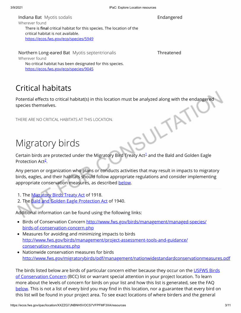
3/9/2021 IPaC: Explore Location resources
https://ecos.fws.gov/ipac/location/XXZZG7JNBNH5VOCS7VFPFMF3XA/resources 3/11
Critical habitatsPotential e�ects to critical habitat(s) in this location must be analyzed along with the endangeredspecies themselves.
THERE ARE NO CRITICAL HABITATS AT THIS LOCATION.
Migratory birds
The birds listed below are birds of particular concern either because they occur on the USFWS Birdsof Conservation Concern (BCC) list or warrant special attention in your project location. To learnmore about the levels of concern for birds on your list and how this list is generated, see the FAQbelow. This is not a list of every bird you may �nd in this location, nor a guarantee that every bird onthis list will be found in your project area. To see exact locations of where birders and the general
Indiana Bat Myotis sodalisWherever found
There is nal critical habitat for this species. The location of thecritical habitat is not available.https://ecos.fws.gov/ecp/species/5949
Endangered
Northern Long-eared Bat Myotis septentrionalisWherever found
No critical habitat has been designated for this species.https://ecos.fws.gov/ecp/species/9045
Threatened
Certain birds are protected under the Migratory Bird Treaty Act and the Bald and Golden EagleProtection Act .
Any person or organization who plans or conducts activities that may result in impacts to migratorybirds, eagles, and their habitats should follow appropriate regulations and consider implementingappropriate conservation measures, as described below.
1. The Migratory Birds Treaty Act of 1918.2. The Bald and Golden Eagle Protection Act of 1940.
Additional information can be found using the following links:
Birds of Conservation Concern http://www.fws.gov/birds/management/managed-species/ birds-of-conservation-concern.phpMeasures for avoiding and minimizing impacts to birdshttp://www.fws.gov/birds/management/project-assessment-tools-and-guidance/ conservation-measures.phpNationwide conservation measures for birdshttp://www.fws.gov/migratorybirds/pdf/management/nationwidestandardconservationmeasures.pdf
1
2

3/9/2021 IPaC: Explore Location resources
https://ecos.fws.gov/ipac/location/XXZZG7JNBNH5VOCS7VFPFMF3XA/resources 4/11
public have sighted birds in and around your project area, visit the E-bird data mapping tool (Tip:enter your location, desired date range and a species on your list). For projects that occur o� theAtlantic Coast, additional maps and models detailing the relative occurrence and abundance of birdspecies on your list are available. Links to additional information about Atlantic Coast birds, andother important information about your migratory bird list, including how to properly interpret anduse your migratory bird report, can be found below.
For guidance on when to schedule activities or implement avoidance and minimization measures toreduce impacts to migratory birds on your list, click on the PROBABILITY OF PRESENCE SUMMARY atthe top of your list to see when these birds are most likely to be present and breeding in yourproject area.
NAME BREEDING SEASON (IF ABREEDING SEASON IS INDICATEDFOR A BIRD ON YOUR LIST, THEBIRD MAY BREED IN YOURPROJECT AREA SOMETIME WITHINTHE TIMEFRAME SPECIFIED,WHICH IS A VERY LIBERALESTIMATE OF THE DATES INSIDEWHICH THE BIRD BREEDSACROSS ITS ENTIRE RANGE."BREEDS ELSEWHERE" INDICATESTHAT THE BIRD DOES NOT LIKELYBREED IN YOUR PROJECT AREA.)
American Golden-plover Pluvialis dominicaThis is a Bird of Conservation Concern (BCC) throughout its range inthe continental USA and Alaska.
Breeds elsewhere
American Kestrel Falco sparverius paulusThis is a Bird of Conservation Concern (BCC) only in particular BirdConservation Regions (BCRs) in the continental USA
Breeds Apr 1 to Aug 31
Bald Eagle Haliaeetus leucocephalusThis is not a Bird of Conservation Concern (BCC) in this area, butwarrants attention because of the Eagle Act or for potentialsusceptibilities in o�shore areas from certain types of developmentor activities.https://ecos.fws.gov/ecp/species/1626
Breeds Sep 1 to Jul 31
Cerulean Warbler Dendroica ceruleaThis is a Bird of Conservation Concern (BCC) throughout its range inthe continental USA and Alaska.https://ecos.fws.gov/ecp/species/2974
Breeds Apr 25 to Jul 20
Dunlin Calidris alpina arcticolaThis is a Bird of Conservation Concern (BCC) only in particular BirdConservation Regions (BCRs) in the continental USA
Breeds elsewhere
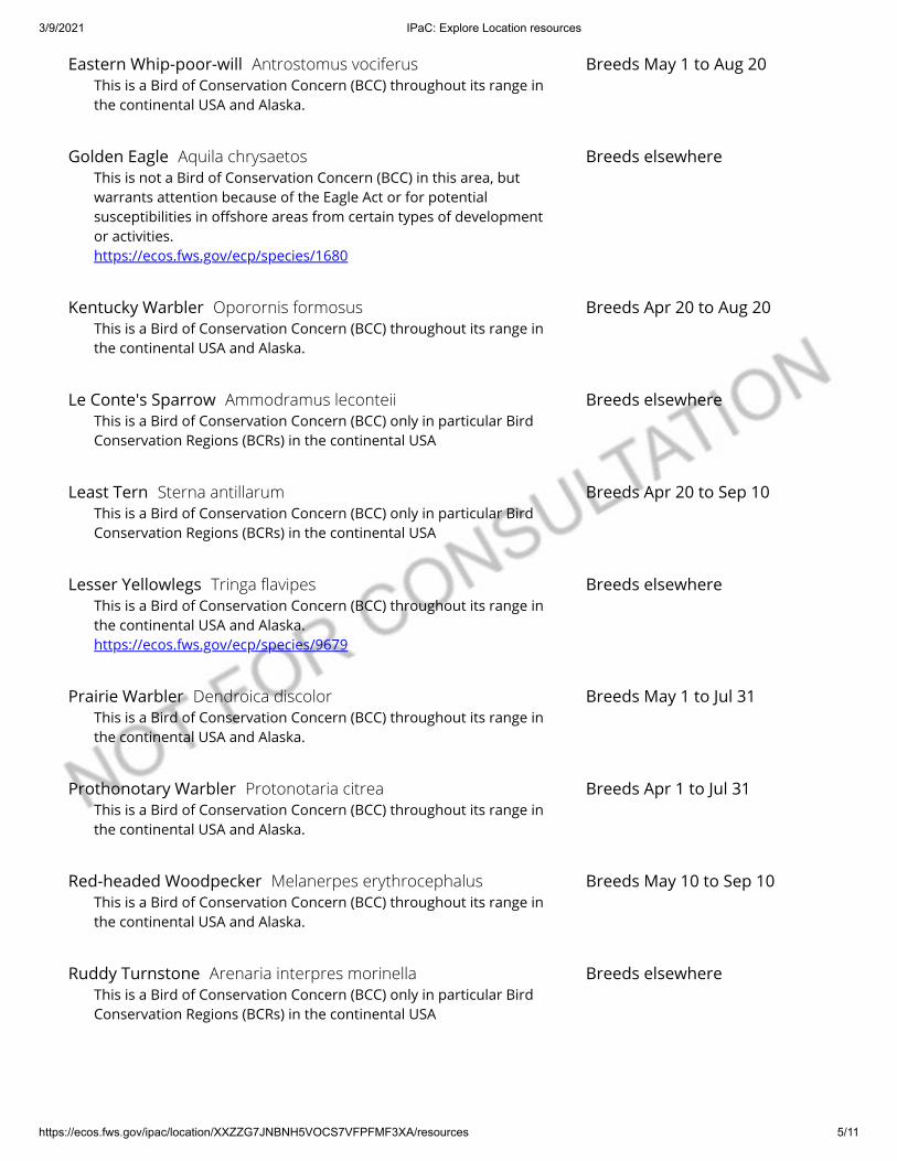
3/9/2021 IPaC: Explore Location resources
https://ecos.fws.gov/ipac/location/XXZZG7JNBNH5VOCS7VFPFMF3XA/resources 5/11
Eastern Whip-poor-will Antrostomus vociferusThis is a Bird of Conservation Concern (BCC) throughout its range inthe continental USA and Alaska.
Breeds May 1 to Aug 20
Golden Eagle Aquila chrysaetosThis is not a Bird of Conservation Concern (BCC) in this area, butwarrants attention because of the Eagle Act or for potentialsusceptibilities in o�shore areas from certain types of developmentor activities.https://ecos.fws.gov/ecp/species/1680
Breeds elsewhere
Kentucky Warbler Oporornis formosusThis is a Bird of Conservation Concern (BCC) throughout its range inthe continental USA and Alaska.
Breeds Apr 20 to Aug 20
Le Conte's Sparrow Ammodramus leconteiiThis is a Bird of Conservation Concern (BCC) only in particular BirdConservation Regions (BCRs) in the continental USA
Breeds elsewhere
Least Tern Sterna antillarumThis is a Bird of Conservation Concern (BCC) only in particular BirdConservation Regions (BCRs) in the continental USA
Breeds Apr 20 to Sep 10
Lesser Yellowlegs Tringa avipesThis is a Bird of Conservation Concern (BCC) throughout its range inthe continental USA and Alaska.https://ecos.fws.gov/ecp/species/9679
Breeds elsewhere
Prairie Warbler Dendroica discolorThis is a Bird of Conservation Concern (BCC) throughout its range inthe continental USA and Alaska.
Breeds May 1 to Jul 31
Prothonotary Warbler Protonotaria citreaThis is a Bird of Conservation Concern (BCC) throughout its range inthe continental USA and Alaska.
Breeds Apr 1 to Jul 31
Red-headed Woodpecker Melanerpes erythrocephalusThis is a Bird of Conservation Concern (BCC) throughout its range inthe continental USA and Alaska.
Breeds May 10 to Sep 10
Ruddy Turnstone Arenaria interpres morinellaThis is a Bird of Conservation Concern (BCC) only in particular BirdConservation Regions (BCRs) in the continental USA
Breeds elsewhere
3/9/2021 IPaC: Explore Location resources
https://ecos.fws.gov/ipac/location/XXZZG7JNBNH5VOCS7VFPFMF3XA/resources 6/11
Probability of Presence SummaryThe graphs below provide our best understanding of when birds of concern are most likely to bepresent in your project area. This information can be used to tailor and schedule your projectactivities to avoid or minimize impacts to birds. Please make sure you read and understand the FAQ"Proper Interpretation and Use of Your Migratory Bird Report" before using or attempting tointerpret this report.
Probability of Presence ( )
Each green bar represents the bird's relative probability of presence in the 10km grid cell(s) yourproject overlaps during a particular week of the year. (A year is represented as 12 4-week months.)A taller bar indicates a higher probability of species presence. The survey e�ort (see below) can beused to establish a level of con�dence in the presence score. One can have higher con�dence in thepresence score if the corresponding survey e�ort is also high.
How is the probability of presence score calculated? The calculation is done in three steps:
1. The probability of presence for each week is calculated as the number of survey events in theweek where the species was detected divided by the total number of survey events for thatweek. For example, if in week 12 there were 20 survey events and the Spotted Towhee wasfound in 5 of them, the probability of presence of the Spotted Towhee in week 12 is 0.25.
2. To properly present the pattern of presence across the year, the relative probability of presenceis calculated. This is the probability of presence divided by the maximum probability of presenceacross all weeks. For example, imagine the probability of presence in week 20 for the SpottedTowhee is 0.05, and that the probability of presence at week 12 (0.25) is the maximum of anyweek of the year. The relative probability of presence on week 12 is 0.25/0.25 = 1; at week 20 it is0.05/0.25 = 0.2.
Rusty Blackbird Euphagus carolinusThis is a Bird of Conservation Concern (BCC) throughout its range inthe continental USA and Alaska.
Breeds elsewhere
Semipalmated Sandpiper Calidris pusillaThis is a Bird of Conservation Concern (BCC) throughout its range inthe continental USA and Alaska.
Breeds elsewhere
Short-billed Dowitcher Limnodromus griseusThis is a Bird of Conservation Concern (BCC) throughout its range inthe continental USA and Alaska.https://ecos.fws.gov/ecp/species/9480
Breeds elsewhere
Willet Tringa semipalmataThis is a Bird of Conservation Concern (BCC) throughout its range inthe continental USA and Alaska.
Breeds Apr 20 to Aug 5
Wood Thrush Hylocichla mustelinaThis is a Bird of Conservation Concern (BCC) throughout its range inthe continental USA and Alaska.
Breeds May 10 to Aug 31

3/9/2021 IPaC: Explore Location resources
https://ecos.fws.gov/ipac/location/XXZZG7JNBNH5VOCS7VFPFMF3XA/resources 7/11
3. The relative probability of presence calculated in the previous step undergoes a statisticalconversion so that all possible values fall between 0 and 10, inclusive. This is the probability ofpresence score.
To see a bar's probability of presence score, simply hover your mouse cursor over the bar.
Breeding Season ( )Yellow bars denote a very liberal estimate of the time-frame inside which the bird breeds across itsentire range. If there are no yellow bars shown for a bird, it does not breed in your project area.
Survey E�ort ( )Vertical black lines superimposed on probability of presence bars indicate the number of surveysperformed for that species in the 10km grid cell(s) your project area overlaps. The number ofsurveys is expressed as a range, for example, 33 to 64 surveys.
To see a bar's survey e�ort range, simply hover your mouse cursor over the bar.
No Data ( )A week is marked as having no data if there were no survey events for that week.
Survey TimeframeSurveys from only the last 10 years are used in order to ensure delivery of currently relevantinformation. The exception to this is areas o� the Atlantic coast, where bird returns are based on allyears of available data, since data in these areas is currently much more sparse.
Tell me more about conservation measures I can implement to avoid or minimize impacts to migratory birds.
Nationwide Conservation Measures describes measures that can help avoid and minimize impacts to all birds atany location year round. Implementation of these measures is particularly important when birds are most likely tooccur in the project area. When birds may be breeding in the area, identifying the locations of any active nests andavoiding their destruction is a very helpful impact minimization measure. To see when birds are most likely tooccur and be breeding in your project area, view the Probability of Presence Summary. Additional measures orpermits may be advisable depending on the type of activity you are conducting and the type of infrastructure orbird species present on your project site.
What does IPaC use to generate the migratory birds potentially occurring in my specied location?
The Migratory Bird Resource List is comprised of USFWS Birds of Conservation Concern (BCC) and other speciesthat may warrant special attention in your project location.
The migratory bird list generated for your project is derived from data provided by the Avian Knowledge Network(AKN). The AKN data is based on a growing collection of survey, banding, and citizen science datasets and isqueried and �ltered to return a list of those birds reported as occurring in the 10km grid cell(s) which your projectintersects, and that have been identi�ed as warranting special attention because they are a BCC species in thatarea, an eagle (Eagle Act requirements may apply), or a species that has a particular vulnerability to o�shoreactivities or development.
Again, the Migratory Bird Resource list includes only a subset of birds that may occur in your project area. It is notrepresentative of all birds that may occur in your project area. To get a list of all birds potentially present in yourproject area, please visit the AKN Phenology Tool.
What does IPaC use to generate the probability of presence graphs for the migratory birds potentiallyoccurring in my specied location?

3/9/2021 IPaC: Explore Location resources
https://ecos.fws.gov/ipac/location/XXZZG7JNBNH5VOCS7VFPFMF3XA/resources 8/11
The probability of presence graphs associated with your migratory bird list are based on data provided by theAvian Knowledge Network (AKN). This data is derived from a growing collection of survey, banding, and citizenscience datasets .
Probability of presence data is continuously being updated as new and better information becomes available. Tolearn more about how the probability of presence graphs are produced and how to interpret them, go theProbability of Presence Summary and then click on the "Tell me about these graphs" link.
How do I know if a bird is breeding, wintering, migrating or present year-round in my project area?
To see what part of a particular bird's range your project area falls within (i.e. breeding, wintering, migrating oryear-round), you may refer to the following resources: The Cornell Lab of Ornithology All About Birds Bird Guide, or(if you are unsuccessful in locating the bird of interest there), the Cornell Lab of Ornithology Neotropical Birdsguide. If a bird on your migratory bird species list has a breeding season associated with it, if that bird does occurin your project area, there may be nests present at some point within the timeframe speci�ed. If "Breedselsewhere" is indicated, then the bird likely does not breed in your project area.
What are the levels of concern for migratory birds?
Migratory birds delivered through IPaC fall into the following distinct categories of concern:
1. "BCC Rangewide" birds are Birds of Conservation Concern (BCC) that are of concern throughout their rangeanywhere within the USA (including Hawaii, the Paci�c Islands, Puerto Rico, and the Virgin Islands);
2. "BCC - BCR" birds are BCCs that are of concern only in particular Bird Conservation Regions (BCRs) in thecontinental USA; and
3. "Non-BCC - Vulnerable" birds are not BCC species in your project area, but appear on your list either because ofthe Eagle Act requirements (for eagles) or (for non-eagles) potential susceptibilities in o�shore areas fromcertain types of development or activities (e.g. o�shore energy development or longline �shing).
Although it is important to try to avoid and minimize impacts to all birds, e�orts should be made, in particular, toavoid and minimize impacts to the birds on this list, especially eagles and BCC species of rangewide concern. Formore information on conservation measures you can implement to help avoid and minimize migratory birdimpacts and requirements for eagles, please see the FAQs for these topics.
Details about birds that are potentially a�ected by o�shore projects
For additional details about the relative occurrence and abundance of both individual bird species and groups ofbird species within your project area o� the Atlantic Coast, please visit the Northeast Ocean Data Portal. The Portalalso o�ers data and information about other taxa besides birds that may be helpful to you in your project review.Alternately, you may download the bird model results �les underlying the portal maps through the NOAA NCCOSIntegrative Statistical Modeling and Predictive Mapping of Marine Bird Distributions and Abundance on the AtlanticOuter Continental Shelf project webpage.
Bird tracking data can also provide additional details about occurrence and habitat use throughout the year,including migration. Models relying on survey data may not include this information. For additional information onmarine bird tracking data, see the Diving Bird Study and the nanotag studies or contact Caleb Spiegel or PamLoring.
What if I have eagles on my list?
If your project has the potential to disturb or kill eagles, you may need to obtain a permit to avoid violating theEagle Act should such impacts occur.
Proper Interpretation and Use of Your Migratory Bird Report

3/9/2021 IPaC: Explore Location resources
https://ecos.fws.gov/ipac/location/XXZZG7JNBNH5VOCS7VFPFMF3XA/resources 9/11
The migratory bird list generated is not a list of all birds in your project area, only a subset of birds of priorityconcern. To learn more about how your list is generated, and see options for identifying what other birds may bein your project area, please see the FAQ "What does IPaC use to generate the migratory birds potentially occurringin my speci�ed location". Please be aware this report provides the "probability of presence" of birds within the 10km grid cell(s) that overlap your project; not your exact project footprint. On the graphs provided, please also lookcarefully at the survey e�ort (indicated by the black vertical bar) and for the existence of the "no data" indicator (ared horizontal bar). A high survey e�ort is the key component. If the survey e�ort is high, then the probability ofpresence score can be viewed as more dependable. In contrast, a low survey e�ort bar or no data bar means a lackof data and, therefore, a lack of certainty about presence of the species. This list is not perfect; it is simply a startingpoint for identifying what birds of concern have the potential to be in your project area, when they might be there,and if they might be breeding (which means nests might be present). The list helps you know what to look for tocon�rm presence, and helps guide you in knowing when to implement conservation measures to avoid orminimize potential impacts from your project activities, should presence be con�rmed. To learn more aboutconservation measures, visit the FAQ "Tell me about conservation measures I can implement to avoid or minimizeimpacts to migratory birds" at the bottom of your migratory bird trust resources page.
Facilities
National Wildlife Refuge landsAny activity proposed on lands managed by the National Wildlife Refuge system must undergo a'Compatibility Determination' conducted by the Refuge. Please contact the individual Refuges todiscuss any questions or concerns.
THERE ARE NO REFUGE LANDS AT THIS LOCATION.
Fish hatcheries
THERE ARE NO FISH HATCHERIES AT THIS LOCATION.
Wetlands in the National Wetlands InventoryImpacts to NWI wetlands and other aquatic habitats may be subject to regulation under Section 404of the Clean Water Act, or other State/Federal statutes.
For more information please contact the Regulatory Program of the local U.S. Army Corps ofEngineers District.
Please note that the NWI data being shown may be out of date. We are currently working to updateour NWI data set. We recommend you verify these results with a site visit to determine the actualextent of wetlands on site.
This location overlaps the following wetlands:
3/9/2021 IPaC: Explore Location resources
https://ecos.fws.gov/ipac/location/XXZZG7JNBNH5VOCS7VFPFMF3XA/resources 10/11
The area of this project is too large for IPaC to load all NWI wetlands in the area. The list belowmay be incomplete. Please contact the local U.S. Fish and Wildlife Service o�ce or visit the NWImap for a full list.
FRESHWATER EMERGENT WETLANDPEM1APEM1CPEM1FxPEM1FPEM1CxPEM1KPEM1AxPEM1FhPEM1/SS1APEM1/USAPEM1ChPEM1CdPEM1FdPEM1AhPEM1/UBFPEM1/SS1CPEM1/UBFhPEM1/SS1F
FRESHWATER FORESTED/SHRUB WETLANDPFO1APFO1/SS1APFO1/EM1CPFO1/2FPFO1/UBF
FRESHWATER PONDPAB4GhPABFPAB/UBHxPABHPABFhPAB4HxPAB3Gx
LAKEL1UBHhL1UBHL1UBHxL2USA
A full description for each wetland code can be found at the National Wetlands Inventory website

3/9/2021 IPaC: Explore Location resources
https://ecos.fws.gov/ipac/location/XXZZG7JNBNH5VOCS7VFPFMF3XA/resources 11/11
Data limitations
The Service's objective of mapping wetlands and deepwater habitats is to produce reconnaissance levelinformation on the location, type and size of these resources. The maps are prepared from the analysis of highaltitude imagery. Wetlands are identi�ed based on vegetation, visible hydrology and geography. A margin of erroris inherent in the use of imagery; thus, detailed on-the-ground inspection of any particular site may result inrevision of the wetland boundaries or classi�cation established through image analysis.
The accuracy of image interpretation depends on the quality of the imagery, the experience of the image analysts,the amount and quality of the collateral data and the amount of ground truth veri�cation work conducted.Metadata should be consulted to determine the date of the source imagery used and any mapping problems.
Wetlands or other mapped features may have changed since the date of the imagery or �eld work. There may beoccasional di�erences in polygon boundaries or classi�cations between the information depicted on the map andthe actual conditions on site.
Data exclusions
Certain wetland habitats are excluded from the National mapping program because of the limitations of aerialimagery as the primary data source used to detect wetlands. These habitats include seagrasses or submergedaquatic vegetation that are found in the intertidal and subtidal zones of estuaries and nearshore coastal waters.Some deepwater reef communities (coral or tuber�cid worm reefs) have also been excluded from the inventory.These habitats, because of their depth, go undetected by aerial imagery.
Data precautions
Federal, state, and local regulatory agencies with jurisdiction over wetlands may de�ne and describe wetlands in adi�erent manner than that used in this inventory. There is no attempt, in either the design or products of thisinventory, to de�ne the limits of proprietary jurisdiction of any Federal, state, or local government or to establishthe geographical scope of the regulatory programs of government agencies. Persons intending to engage inactivities involving modi�cations within or adjacent to wetland areas should seek the advice of appropriate federal,state, or local agencies concerning speci�ed agency regulatory programs and proprietary jurisdictions that maya�ect such activities.

County Type Category Scientific name Common Name Global Rank State Rank Federal Status State Status Habitat Wet Habitat FlagShelby Vascular Plant Flowering Plant Rhynchospora harveyi Harvey's Beakrush G4 S1 -- T Barrens And Other Open Areas PossibleShelby Vertebrate Animal Fish Cycleptus elongatus Blue Sucker G3G4 S2 -- T Swift waters over firm substrates in big rivers. AquaticShelby Vascular Plant Flowering Plant Symphyotrichum praealtum Willow Aster G5 S1 -- E Moist Prairies And Marshes PossibleShelby Vascular Plant Flowering Plant Magnolia virginiana Sweetbay Magnolia G5 S2 -- T Forested Acidic Wetlands Possible
Shelby Vertebrate Animal Reptile Pituophis melanoleucus melanoleucus Northern Pinesnake G4T4 S3 -- T Well-drained sandy soils in pine/pine-oak woods; dry mountain ridges; E portions of west TN, E to lower elev of the Appalachians. Upland
Shelby Vascular Plant Flowering Plant Schisandra glabra Red Starvine G3 S2 -- T Rich Mesic Woods, Bluffs PossibleShelby Vertebrate Animal Bird Sternula antillarum athalassos Interior Least Tern G4T3Q S2S3B LE E Mississippi River sand bars & islands, dikes.<br> AquaticShelby Vascular Plant Flowering Plant Silene ovata Ovate Catchfly G3 S2 -- E Open Oak Woods UplandShelby Vascular Plant Flowering Plant Iris fulva Copper Iris G5 S2 -- T Bottomlands Possible
Shelby Invertebrate Animal Insect Lycaena hyllus Bronze Copper G5 S3 -- Rare, Not State Listed
Marshes, sedge meadows, moist to wet grassy meadows, ditches, fens, streamside or pondshore wetlands, or roads and right of ways through marshlands. West TN.
Possible
Shelby Animal Assemblage No Data Rookery Heron Rookery G5 SNR -- Rare, Not State Listed No Data No Data
Shelby Vertebrate Animal Bird Thryomanes bewickii Bewick's Wren G5 S1 -- D Brushy areas, thickets and scrub in open country, open and riparian woodland. Upland
Shelby Vertebrate Animal Fish Noturus gladiator Piebald Madtom G3 S3 -- D Large creeks & rivers in moderate-swift currents with clean sand or gravel substrates; Mississippi River tributaries. Aquatic
Shelby Invertebrate Animal Mollusc Webbhelix multilineata Striped Whitelip G5 S2 -- Rare, Not State Listed
Low wet habitats, marshes, floodplains, meadows; lake margins; under leaf litter or drift; Mississippi River floodplain. Possible
Shelby Vascular Plant Flowering Plant Ulmus crassifolia Cedar Elm G5 S2 -- S Swamps Possible
Shelby Vertebrate Animal Bird Setophaga cerulea Cerulean Warbler G4 S3B -- D Mature deciduous forest, particularly in floodplains or mesic conditions. Upland
Shelby Vertebrate Animal Amphibian Acris gryllus Southern Cricket Frog G5 S2S3 -- Rare, Not State Listed
Grassy margins of swamps, marshes, lakes, ponds, streams, ditches, and nearby temporary pools; far SW Tennessee. Aquatic
Shelby Vertebrate Animal Fish Ammocrypta beani Naked Sand Darter G5 S2 -- D Shifting sand bottoms & sandy runs; Hatchie & Wolf rivers & their larger tribs. Aquatic
Shelby Invertebrate Animal Mollusc Obovaria arkansasensis Southern Hickorynut GNR S1 -- Rare, Not State Listed
Rivers with medium-sized gravel substrates and low-mod current; Wolf & Hatchie rivers; Mississippi River watershed; west Tennessee. Aquatic
Shelby Vertebrate Animal Mammal Neotoma floridana illinoensis Eastern Woodrat G5T5 S3 -- D Forested areas, caves & outcrops; west Tennessee generally. Upland
Shelby Vertebrate Animal Bird Vireo bellii Bell's Vireo G5 S1B No Status Rare, Not State Listed
Thickets adjacent to water, bottomlands; west Tennessee and one confirmed location in Western Highland Rim. Possible
Shelby Vascular Plant Flowering Plant Panax quinquefolius American Ginseng G3G4 S3S4 -- S-CE Rich Woods Possible
Shelby Invertebrate Animal Mollusc Lampsilis siliquoidea Fatmucket G5 S2 -- Rare, Not State Listed
Slackwater with mud subst; Wolf R (Miss R trib); west TN; may occur at Reelfoot Lk; also rept Drakes Ck (Cumb R), Sumner Co. Aquatic
Shelby Vascular Plant Flowering Plant Heteranthera multiflora Multiflowered Mud-plantain G4 S1 -- S Shallow Water, Mud Flats Possible
Shelby Vascular Plant Flowering Plant Hottonia inflata Featherfoil G4 S2 -- S Wet Sloughs And Ditches AquaticShelby Vertebrate Animal Bird Limnothlypis swainsonii Swainson's Warbler G4 S3 -- D Mature, rich, damp, deciduous floodplain and swamp forests. Possible
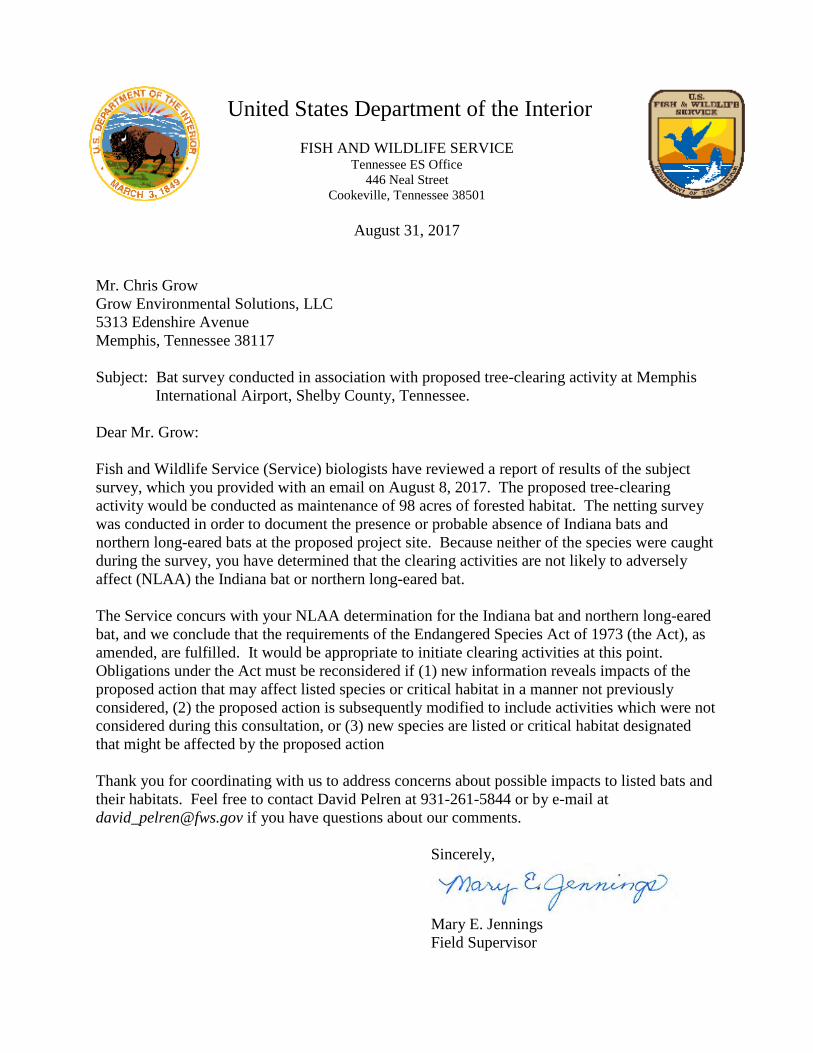
United States Department of the InteriorFISH AND WILDLIFE SERVICE
Tennessee ES Office446 Neal Street
Cookeville, Tennessee 38501
August 31, 2017
Mr. Chris GrowGrow Environmental Solutions, LLC5313 Edenshire AvenueMemphis, Tennessee 38117
Subject: Bat survey conducted in association with proposed tree-clearing activity at Memphis International Airport, Shelby County, Tennessee.
Dear Mr. Grow:
Fish and Wildlife Service (Service) biologists have reviewed a report of results of the subject survey, which you provided with an email on August 8, 2017. The proposed tree-clearing activity would be conducted as maintenance of 98 acres of forested habitat. The netting survey was conducted in order to document the presence or probable absence of Indiana bats and northern long-eared bats at the proposed project site. Because neither of the species were caught during the survey, you have determined that the clearing activities are not likely to adversely affect (NLAA) the Indiana bat or northern long-eared bat.
The Service concurs with your NLAA determination for the Indiana bat and northern long-eared bat, and we conclude that the requirements of the Endangered Species Act of 1973 (the Act), as amended, are fulfilled. It would be appropriate to initiate clearing activities at this point. Obligations under the Act must be reconsidered if (1) new information reveals impacts of the proposed action that may affect listed species or critical habitat in a manner not previously considered, (2) the proposed action is subsequently modified to include activities which were not considered during this consultation, or (3) new species are listed or critical habitat designated that might be affected by the proposed action
Thank you for coordinating with us to address concerns about possible impacts to listed bats and their habitats. Feel free to contact David Pelren at 931-261-5844 or by e-mail at [email protected] if you have questions about our comments.
Sincerely,
Mary E. JenningsField Supervisor
FINAL REPORT
Summer 2017 Presence/Probable Absence Survey for the
Memphis-Shelby County Airport Authority Shelby County, Tennessee
Prepared by:
Christopher Grow, Biologist
for
EnSafe, Inc.
August 7, 2017

SUMMER 2017 PRESENCE/PROBABLE ABSENCE SURVEYMEMPHIS-SHELBY COUNTY AIRPORT AUTHORITY
SHELBY COUNTY, TENNESSEE
ii
TABLE OF CONTENTSINTRODUCTION ....................................................................................................................... 1
METHODS................................................................................................................................. 1
RESULTS.................................................................................................................................. 4CONCLUSIONS ........................................................................................................................ 5
TABLESTable 1. Mist-net site locations for Memphis-Shelby County Airport Authority, Shelby County,
Tennessee. ............................................................................................................................. 1
Table 2. Summary of bat captures for Memphis-Shelby County Airport Authority, Shelby
County, Tennessee................................................................................................................................. 5
FIGURESFigure 1. Site Location Map for Memphis-Shelby County Airport Authority in Shelby County,
Tennessee .............................................................................................................................. 2
Figure 2. Mist-Net Locations for Memphis-Shelby County Airport Authority in Shelby County,
Tennessee .............................................................................................................................. 3
APPENDICESAppendix A: Datasheets
Appendix B: Photos
Appendix C: Permits
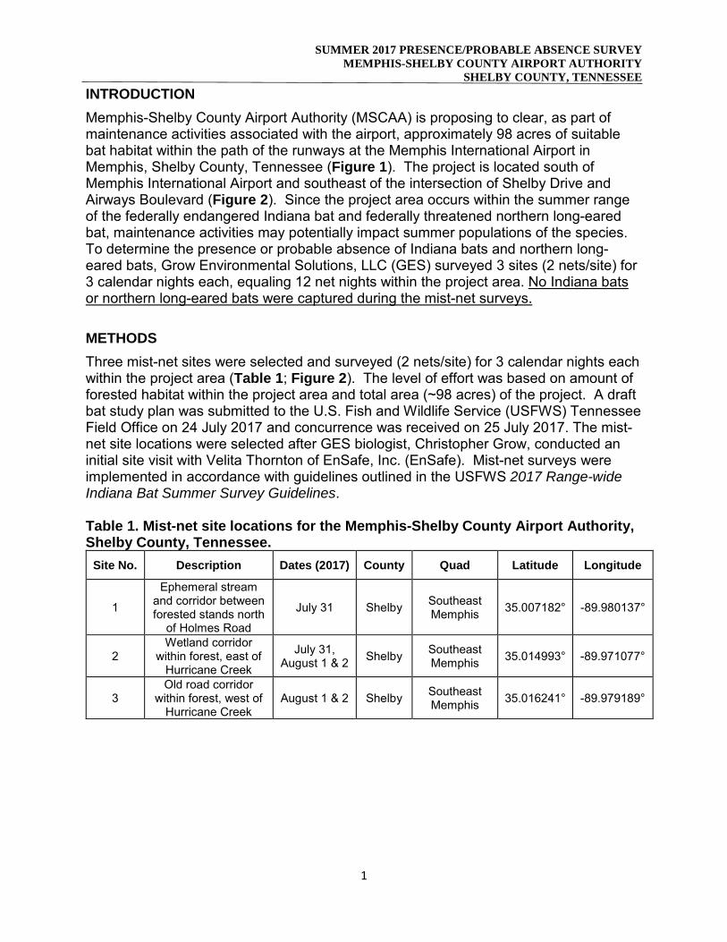
SUMMER 2017 PRESENCE/PROBABLE ABSENCE SURVEYMEMPHIS-SHELBY COUNTY AIRPORT AUTHORITY
SHELBY COUNTY, TENNESSEE
1
INTRODUCTIONMemphis-Shelby County Airport Authority (MSCAA) is proposing to clear, as part of maintenance activities associated with the airport, approximately 98 acres of suitable bat habitat within the path of the runways at the Memphis International Airport in Memphis, Shelby County, Tennessee (Figure 1). The project is located south of Memphis International Airport and southeast of the intersection of Shelby Drive and Airways Boulevard (Figure 2). Since the project area occurs within the summer range of the federally endangered Indiana bat and federally threatened northern long-eared bat, maintenance activities may potentially impact summer populations of the species. To determine the presence or probable absence of Indiana bats and northern long-eared bats, Grow Environmental Solutions, LLC (GES) surveyed 3 sites (2 nets/site) for 3 calendar nights each, equaling 12 net nights within the project area. No Indiana bats or northern long-eared bats were captured during the mist-net surveys.
METHODSThree mist-net sites were selected and surveyed (2 nets/site) for 3 calendar nights each within the project area (Table 1; Figure 2). The level of effort was based on amount of forested habitat within the project area and total area (~98 acres) of the project. A draft bat study plan was submitted to the U.S. Fish and Wildlife Service (USFWS) Tennessee Field Office on 24 July 2017 and concurrence was received on 25 July 2017. The mist-net site locations were selected after GES biologist, Christopher Grow, conducted an initial site visit with Velita Thornton of EnSafe, Inc. (EnSafe). Mist-net surveys were implemented in accordance with guidelines outlined in the USFWS 2017 Range-wide Indiana Bat Summer Survey Guidelines.
Table 1. Mist-net site locations for the Memphis-Shelby County Airport Authority,Shelby County, Tennessee.
Site No. Description Dates (2017) County Quad Latitude Longitude
1
Ephemeral stream and corridor between forested stands north
of Holmes Road
July 31 Shelby Southeast Memphis 35.007182° -89.980137°
2 Wetland corridor
within forest, east of Hurricane Creek
July 31, August 1 & 2 Shelby Southeast
Memphis 35.014993° -89.971077°
3 Old road corridor
within forest, west of Hurricane Creek
August 1 & 2 Shelby Southeast Memphis 35.016241° -89.979189°
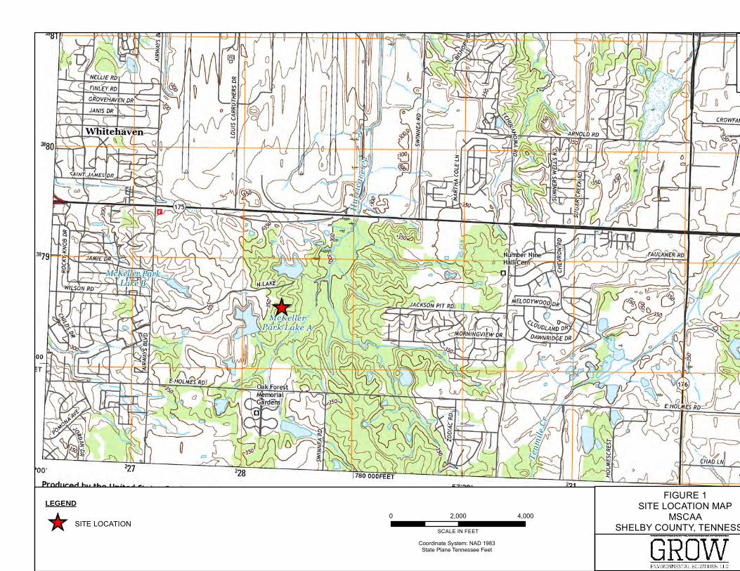
_̂
Data Source: USGS 7.5 MINUTE TOPOGRAHIC MAP (SOUTHEAST MEMPHIS), 2016
±
0 2,000 4,000
SCALE IN FEET
Coordinate System: NAD 1983State Plane Tennessee Feet
FIGURE 1SITE LOCATION MAP
MSCAASHELBY COUNTY, TENNESSEE
GROWEnvironmental
LEGEND
_̂ SITE LOCATION
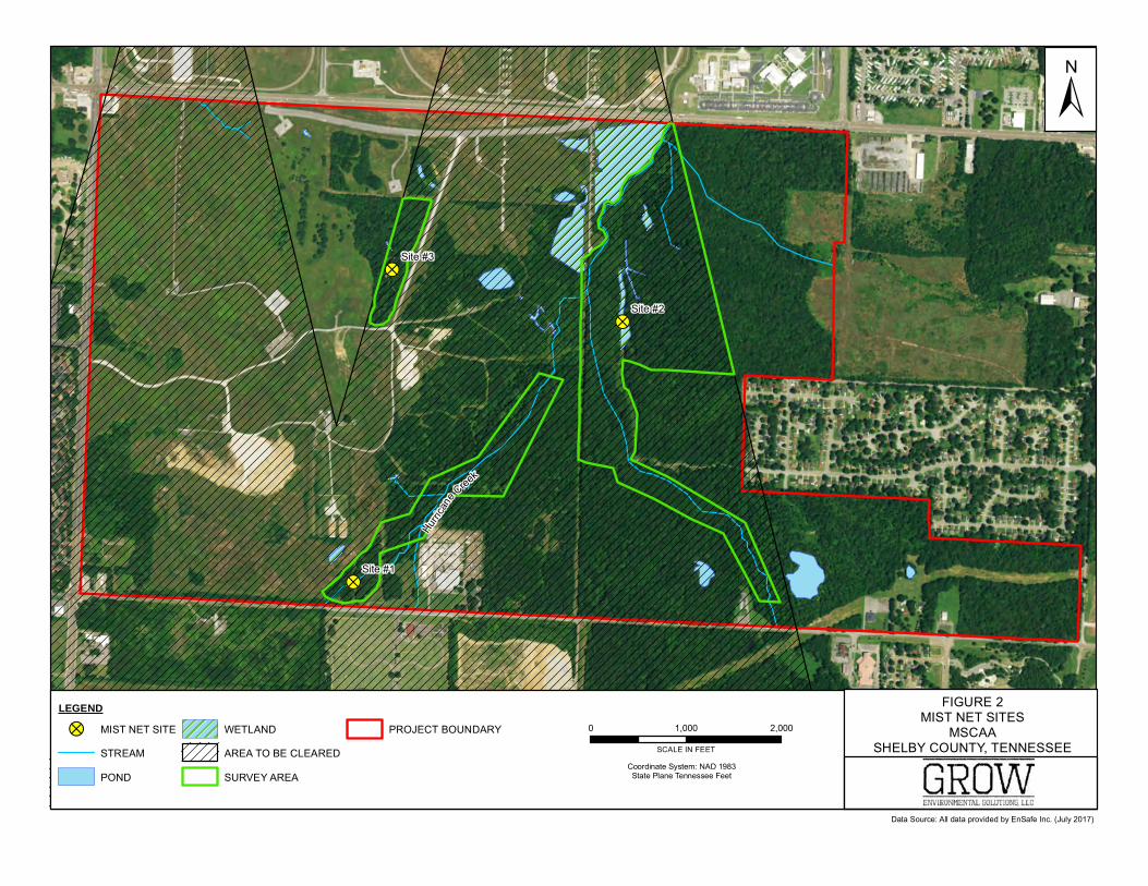
!?
!?
!?
Hurri
cane
Creek
Site #3
Site #2
Site #1
Source: Esri, DigitalGlobe, GeoEye, Earthstar Geographics, CNES/Airbus DS, USDA, USGS, AeroGRID,IGN, and the GIS User Community
Data Source: All data provided by EnSafe Inc. (July 2017)
±
0 1,000 2,000
SCALE IN FEET
Coordinate System: NAD 1983State Plane Tennessee Feet
FIGURE 2MIST NET SITES
MSCAASHELBY COUNTY, TENNESSEE
GROWEnvironmental
LEGEND
!? MIST NET SITE
STREAM
POND
WETLAND
AREA TO BE CLEARED
SURVEY AREA
PROJECT BOUNDARY
SUMMER 2017 PRESENCE/PROBABLE ABSENCE SURVEYMEMPHIS-SHELBY COUNTY AIRPORT AUTHORITY
SHELBY COUNTY, TENNESSEE
4
Survey site locations were recorded using a Bad Elf sub-meter handheld Global Positioning System (GPS) unit. Mist-nets were set prior to sunset and deployed at dusk. Nets were left open for at least five hours after sunset each night and checked every 10 minutes. Disturbance near the nets was kept to a minimum. Weather data, including temperature, relative wind speed, and cloud cover was recorded on an hourly basis to ensure compliance with mist-net survey guidelines (e.g., temperature during survey > 50°F, no rain, etc.). Mist-nets used consisted of 70/2 denier polyester (36mm mesh size) and were of low visibility and high-quality. Nets between 6 and 12 meters (~20 – 40 ft) in length, depending upon the width of the corridor, were used for each net set. Two nets were used per set of poles and constituted a net set covering approximately 6 meters (~20 ft) in height. Site #1 was surveyed for 1 night (2 nets/night), Site #2 was surveyed for 3 nights (2 nets/night), and Site #3 was surveyed for 2 night (2 nets/site/night) to give a total of 12 net nights for the project. Data recorded for bats captured included capture time, species, sex, age (adult or juvenile), reproductive condition (pregnant, lactating, post-lactating, testes descended, nonreproductive), weight (g), forearm length (mm), and Reichard Wing-Damage Index. In addition, the specific net set and height of capture in that specific net set were recorded for each bat. Completed data sheets and photos are provided in Appendix A and Appendix B, respectively. To minimize the transmission of White-Nose Syndrome (WNS), all netting and field activities followed the most up to date guidelines established by USFWS. All hard, non-porous netting equipment was sanitized with a Lysol® IC solution prior to arrival and after each survey night; all other equipment was submersed in hot water (131°F) for a minimum of 20 minutes. Individual bats were kept in unused paper bags while awaiting processing. Disposable nitrile gloves were worn over sanitized handling gloves and changed following the handling of each bat. All non-disposable equipment (i.e. pesola scales, rulers, calipers, etc.) coming into contact with bats were sanitized immediately with Clorox wipes following the handling of each bat.
RESULTSMist-net surveys were conducted 31 July 2017 through 2 August 2017 by qualified biologist, Christopher Grow (Federal Permit #TE37492B-0, TN Permit #164) of GES, as well as field assistants David Hilgeman, Aaron Conti, and Velita Thornton of EnSafe. Mr. Grow was present and available to freely identify bats that were captured at each net. No Indiana bats were captured during surveys. A total of 19 bats representing 3 species were captured during mist-net survey efforts: 16 Lasiurus borealis (LABO), 2 Perimyotis subflavus (PISU), and 1 Nycticeius humeralis (NYHU) (Table 2). Four L. borealis and 1 Nycticeius humeralis were reproductive adult males with all females being non-reproductive. Two L. borealis escaped during handling and additional data besides species could not be recorded. Two P. sublfavus were non-reproductive juvenile males. Captured bats were examined for signs of WNS by using the Reichard Wing-Damage Index. No major traumas were observed on captured bats.
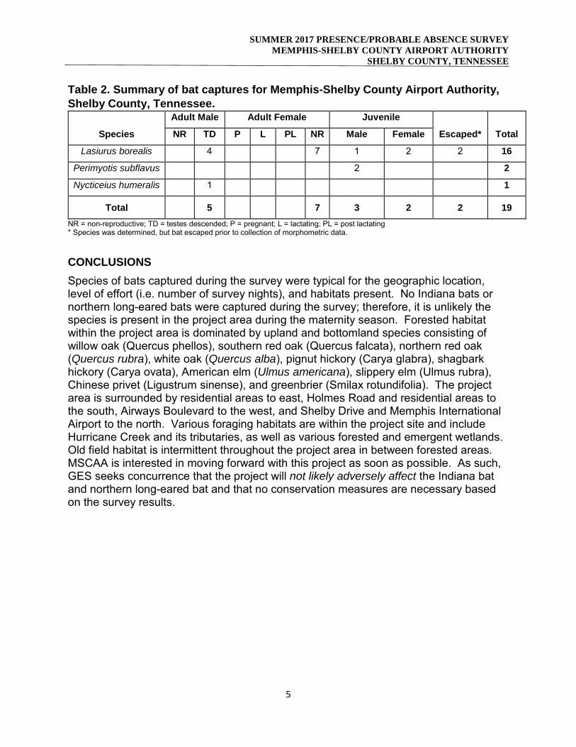
SUMMER 2017 PRESENCE/PROBABLE ABSENCE SURVEYMEMPHIS-SHELBY COUNTY AIRPORT AUTHORITY
SHELBY COUNTY, TENNESSEE
5
Table 2. Summary of bat captures for Memphis-Shelby County Airport Authority,Shelby County, Tennessee.
Species
Adult Male Adult Female Juvenile
Escaped* TotalNR TD P L PL NR Male Female
Lasiurus borealis 4 7 1 2 2 16
Perimyotis subflavus 2 2
Nycticeius humeralis 1 1
Total 5 7 3 2 2 19NR = non-reproductive; TD = testes descended; P = pregnant; L = lactating; PL = post lactating * Species was determined, but bat escaped prior to collection of morphometric data.
CONCLUSIONSSpecies of bats captured during the survey were typical for the geographic location, level of effort (i.e. number of survey nights), and habitats present. No Indiana bats or northern long-eared bats were captured during the survey; therefore, it is unlikely the species is present in the project area during the maternity season. Forested habitat within the project area is dominated by upland and bottomland species consisting of willow oak (Quercus phellos), southern red oak (Quercus falcata), northern red oak (Quercus rubra), white oak (Quercus alba), pignut hickory (Carya glabra), shagbark hickory (Carya ovata), American elm (Ulmus americana), slippery elm (Ulmus rubra), Chinese privet (Ligustrum sinense), and greenbrier (Smilax rotundifolia). The project area is surrounded by residential areas to east, Holmes Road and residential areas to the south, Airways Boulevard to the west, and Shelby Drive and Memphis International Airport to the north. Various foraging habitats are within the project site and include Hurricane Creek and its tributaries, as well as various forested and emergent wetlands. Old field habitat is intermittent throughout the project area in between forested areas. MSCAA is interested in moving forward with this project as soon as possible. As such, GES seeks concurrence that the project will not likely adversely affect the Indiana bat and northern long-eared bat and that no conservation measures are necessary based on the survey results.
Scientific Collection Permit : Issue date: _ Expiration date:
Pursuant to authority of T.C.A. 70-2-213:
_
and the following additional permittees:
are granted permission to take the following species:
_
Restricted to the following locations:
_
Restricted to the following collection methods:
_Subject to the following rules: Wildlife may not be held longer than 24 hours without prior approval. All containers and equipment utilized in the collection of amphibians and reptiles shall be decontaminated and disinfected for ranavirus and other pathogens. This permit is invalid unless accompanied by all applicable federal permits. No species listed by TWRA as endangered, threatened, in need of management, or of greatest conservation need may be taken without approval; release these species immediately. Report the occurance of endangered or threatened species to TWRA within five days. Prior to collecting in the field, you are required to notify the TWRA Regional Dispatcher with the name(s) ofperson(s) doing the collecting, where, when and what species you will be collecting. Contact information is attached.
Executive Director, Tennessee Wildlife Resources Agency Date
The State of Tennessee AN EQUAL OPPORTUNITY EMPLOYER
164 8/2/2017 8/2/2018
None
8/2/2017
Christopher Grow
Statewide depending on contract.
Myotis sodalis, Myotis septentrionalis, Myotis grisescens, Myotis lucifugus, and Perimyotis subflavus. Other species of Vespertilionidaeand Molossoidae have potential to be captured. No take is expected. All species will be released at capture site.
152 | P a g e
ATTACHMENT 4 Farmlands Information
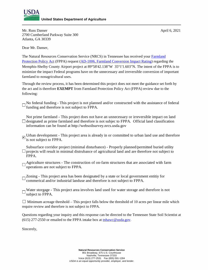
United States Department of Agriculture _________________________________________________________________________________________________________
Natural Resources Conservation Service 801 Broadway, 675 U.S. Courthouse
Nashville, Tennessee 37203 Voice (615) 277-2531 Fax (855) 591-1284
USDA is an equal opportunity provider, employer, and lender.
Mr. Russ Danser April 6, 2021 2700 Cumberland Parkway Suite 300 Atlanta, GA 30339 Dear Mr. Danser, The Natural Resources Conservation Service (NRCS) in Tennessee has received your Farmland Protection Policy Act (FPPA) request (AD-1006, Farmland Conversion Impact Rating) regarding the Memphis-Shelby County Airport project at 89°58'42.138"W 35°1'1.603"N. The intent of the FPPA is to minimize the impact Federal programs have on the unnecessary and irreversible conversion of important farmland to nonagricultural uses.
Through the review process, it has been determined this project does not meet the guidance set forth by the act and is therefore EXEMPT from Farmland Protection Policy Act (FPPA) review due to the following:
No federal funding - This project is not planned and/or constructed with the assistance of federal funding and therefore is not subject to FPPA.
Not prime farmland - This project does not have an unnecessary or irreversible impact on land designated as prime farmland and therefore is not subjec to FPPA. Official land classification information can be found at http://websoilsurvey.nrcs.usda.gov
Urban development - This project area is already in or committed to urban land use and therefore is not subject to FPPA.
Subsurface corridor project (minimal disturbance) - Properly planned/permitted buried utility projects will result in minimal distrubance of agricultural land and are therefore not subject to FPPA.
Agriculture structures - The construction of on-farm structures that are associated with farm operations are not subject to FPPA.
Zoning - This project area has been designated by a state or local government entitiy for commerical and/or industrial landuse and therefore is not subject to FPPA.
Water storgage - This project area involves land used for water storage and therefore is not subject to FPPA.
☐ Minimum acreage threshold – This project falls below the threshold of 10 acres per linear mile which require review and therefore is not subject to FPPA. Questions regarding your inquiry and this response can be directed to the Tennessee State Soil Scientist at (615) 277-2550 or emailed to the FPPA intake box at [email protected]. Sincerely,
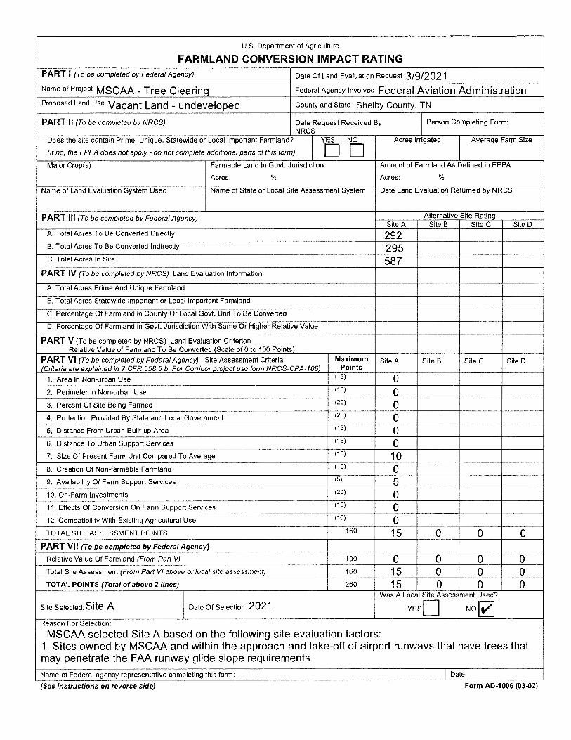
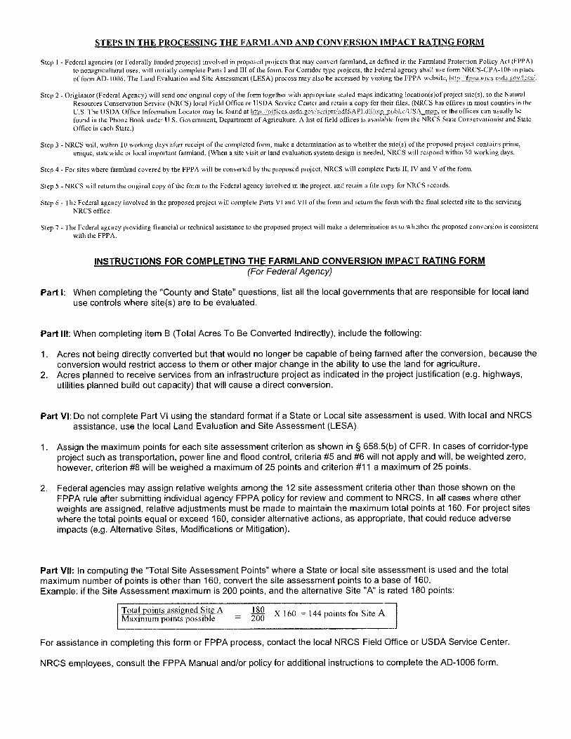
156 | P a g e
ATTACHMENT 5 Hazardous Materials, Solid Waste, and Pollution Prevention Information
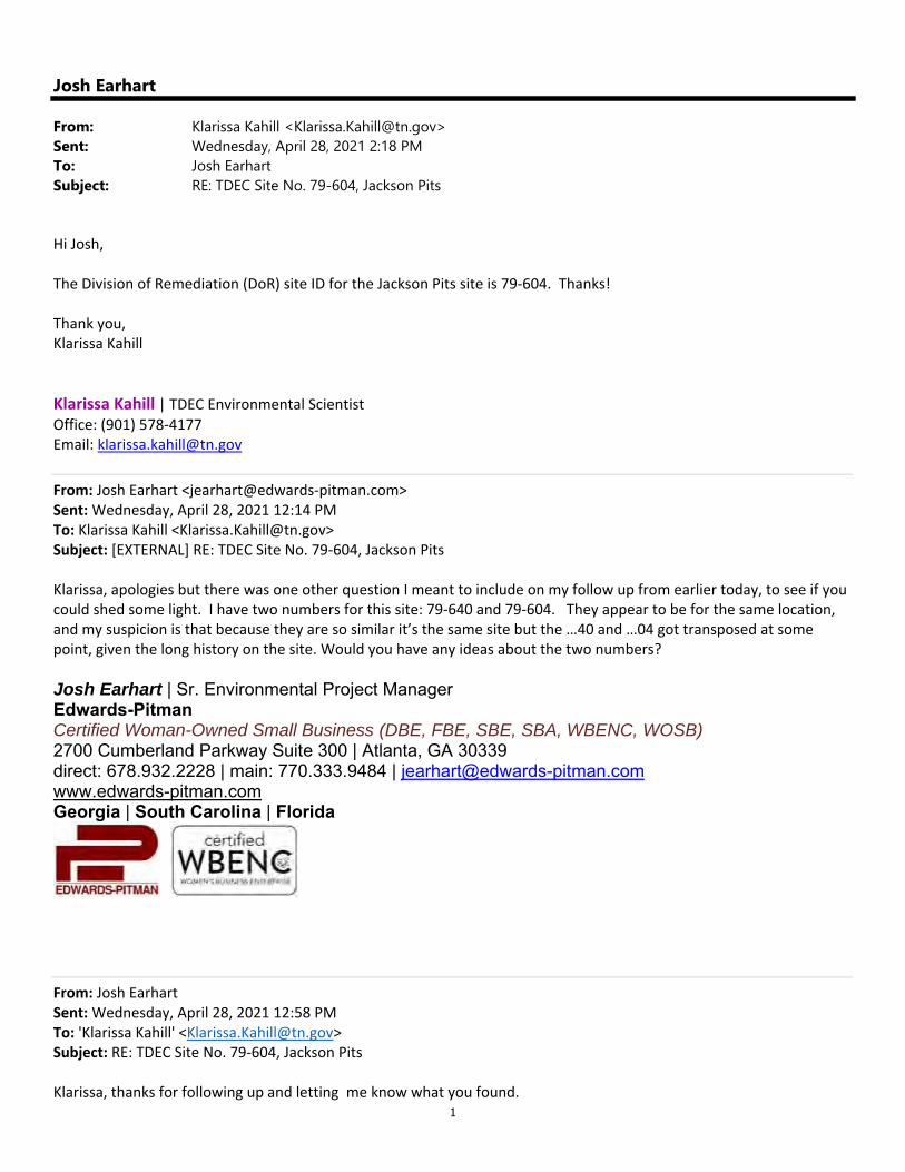
1
Josh Earhart
From: Klarissa Kahill <[email protected]>Sent: Wednesday, April 28, 2021 2:18 PMTo: Josh EarhartSubject: RE: TDEC Site No. 79-604, Jackson Pits
Hi Josh, The Division of Remediation (DoR) site ID for the Jackson Pits site is 79‐604. Thanks! Thank you, Klarissa Kahill
Klarissa Kahill | TDEC Environmental Scientist Office: (901) 578‐4177 Email: [email protected]
From: Josh Earhart <jearhart@edwards‐pitman.com> Sent: Wednesday, April 28, 2021 12:14 PM To: Klarissa Kahill <[email protected]> Subject: [EXTERNAL] RE: TDEC Site No. 79‐604, Jackson Pits Klarissa, apologies but there was one other question I meant to include on my follow up from earlier today, to see if you could shed some light. I have two numbers for this site: 79‐640 and 79‐604. They appear to be for the same location, and my suspicion is that because they are so similar it’s the same site but the …40 and …04 got transposed at some point, given the long history on the site. Would you have any ideas about the two numbers? Josh Earhart | Sr. Environmental Project Manager Edwards-Pitman Certified Woman-Owned Small Business (DBE, FBE, SBE, SBA, WBENC, WOSB) 2700 Cumberland Parkway Suite 300 | Atlanta, GA 30339 direct: 678.932.2228 | main: 770.333.9484 | [email protected] www.edwards-pitman.com Georgia | South Carolina | Florida
From: Josh Earhart Sent: Wednesday, April 28, 2021 12:58 PM To: 'Klarissa Kahill' <[email protected]> Subject: RE: TDEC Site No. 79‐604, Jackson Pits Klarissa, thanks for following up and letting me know what you found.

2
Josh Earhart | Sr. Environmental Project Manager Edwards-Pitman Certified Woman-Owned Small Business (DBE, FBE, SBE, SBA, WBENC, WOSB) 2700 Cumberland Parkway Suite 300 | Atlanta, GA 30339 direct: 678.932.2228 | main: 770.333.9484 | [email protected] www.edwards-pitman.com Georgia | South Carolina | Florida
From: Klarissa Kahill <[email protected]> Sent: Wednesday, April 28, 2021 11:54 AM To: Josh Earhart <jearhart@edwards‐pitman.com> Cc: Russ Danser <rdanser@edwards‐pitman.com>; [email protected] Subject: RE: TDEC Site No. 79‐604, Jackson Pits Good morning Josh, I have checked with the previous project manager and there has not been any recent environmental work or monitoring completed for the Jackson Pits site. The information provided in the file review contains the most current work completed. If you have any additional questions or need further assistance with the site please feel free to contact me any time. Thanks! Thank you, Klarissa Kahill
Klarissa Kahill | TDEC Environmental Scientist Office: (901) 578‐4177 Email: [email protected]
From: Josh Earhart <jearhart@edwards‐pitman.com> Sent: Wednesday, April 28, 2021 8:13 AM To: Klarissa Kahill <[email protected]> Cc: Russ Danser <rdanser@edwards‐pitman.com>; [email protected] Subject: [EXTERNAL] RE: TDEC Site No. 79‐604, Jackson Pits *** This is an EXTERNAL email. Please exercise caution. DO NOT open attachments or click links from unknown senders or unexpected email - STS-Security. ***
Hi Klarissa. Just following up to see if you’ve had an opportunity to follow up with the previous project manager on a current status of information for this site. Thanks in advance for your assistance.

3
Josh Earhart | Sr. Environmental Project Manager Edwards-Pitman Certified Woman-Owned Small Business (DBE, FBE, SBE, SBA, WBENC, WOSB) 2700 Cumberland Parkway Suite 300 | Atlanta, GA 30339 direct: 678.932.2228 | main: 770.333.9484 | [email protected] www.edwards-pitman.com Georgia | South Carolina | Florida
From: Josh Earhart Sent: Thursday, April 22, 2021 3:21 PM To: [email protected] Cc: Russ Danser <rdanser@edwards‐pitman.com>; [email protected] Subject: TDEC Site No. 79‐604, Jackson Pits Klarissa, thanks very much for taking my call and briefly discussing this site with me. As mentioned the Memphis‐Shelby County Airport Authority (MSCAA) proposes to remove and cut trees within portions of an approximately 591‐acre tract of MSCAA‐owned property located south of Memphis International Airport (MEM) in Memphis, Shelby County. The activities on the site will comply with the requirements set forth in the provisions of the National Environmental Policy Act. As a result of a request to TDEC for records of any hazardous waste sites near this area, we were provided files for the Jackson Pits site. However, most of the records were quite dated, and therefore I’m reaching out to you for any additional, or more current, information on the site. The most current piece of information we received was the attached letter from Shelby County Government to a TDEC request for information. In the response letter it states that a consultant had been secured in 2014 to conduct monitoring of the site in accordance with an O&M Plan as part of the a Record of Decision for the site. Thank you in advance, and appreciate any information you can provide about the site. Please call me at your convenience at the direct phone number below. Sincerely, Josh Earhart | Sr. Environmental Project Manager Edwards-Pitman Certified Woman-Owned Small Business (DBE, FBE, SBE, SBA, WBENC, WOSB) 2700 Cumberland Parkway Suite 300 | Atlanta, GA 30339 direct: 678.932.2228 | main: 770.333.9484 | [email protected] www.edwards-pitman.com Georgia | South Carolina | Florida
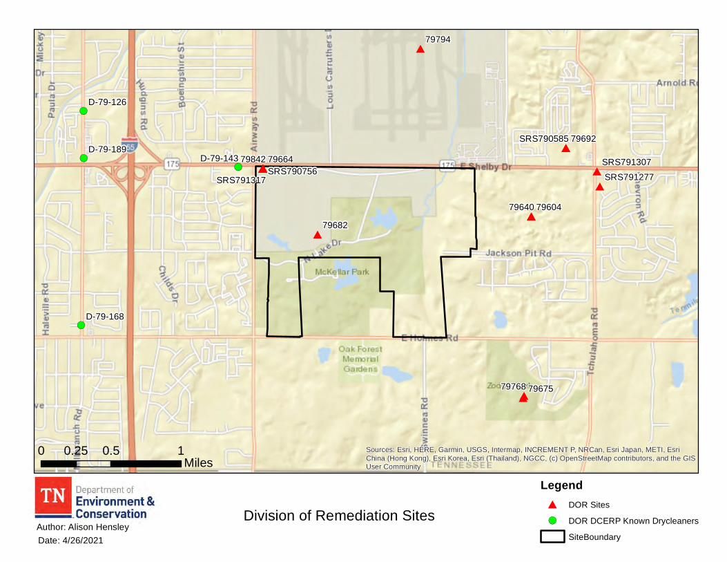
!(!(
!(
!(
#
#
#
#
##
#
#
# ##
#
#
#
##79692
79664
7960479640
79675
79842
79768
79682
79794
SRS790585
SRS791277SRS790756SRS791307
SRS791317
D-79-126
D-79-168
D-79-143D-79-189
Sources: Esri, HERE, Garmin, USGS, Intermap, INCREMENT P, NRCan, Esri Japan, METI, EsriChina (Hong Kong), Esri Korea, Esri (Thailand), NGCC, (c) OpenStreetMap contributors, and the GISUser Community
Division of Remediation Sites
0 0.5 10.25Miles
Date: 4/26/2021Author: Alison Hensley
Legend# DOR Sites
!( DOR DCERP Known Drycleaners
SiteBoundary
1
Josh Earhart
From: Thomas Word <[email protected]>Sent: Friday, April 23, 2021 5:29 PMTo: Josh EarhartCc: Russ DanserSubject: RE: Memphis-Shelby County Airport Authority Tree Obstruction Clearing Attachments: Airport Property Airways Shelby Dr to Holmes Road Existing MLGW Utilities.pdf
Josh: I have attached an outline view of exiting MLGW utilities within the Airport property located along the east side Airways Bvld., between Shelby Drive and Holmes Road. This information is not to scale, and should not be used for construction purposes. A TN 1‐Call (811) should be ordered to locate any utilities ‐ before any clearing, grading or construction begins. Regarding specific easements, the Airport should conduct a title search, and have an abstract of title prepared to identify any easements or encumbrances on the property. The conditions outlined in my previous letter to the Airport also apply to this property and project. Pleas note, I will be out of town next week, and not available next week. Thank you, Tom
From: Josh Earhart <jearhart@edwards‐pitman.com> Sent: Friday, April 23, 2021 2:51 PM To: Thomas Word <[email protected]> Cc: Russ Danser <rdanser@edwards‐pitman.com> Subject: Memphis‐Shelby County Airport Authority Tree Obstruction Clearing Mr. Word, you may have received earlier coordination on the referenced project in the subject line of this email, requesting input on the proposed action. We are preparing the environmental document for this action, and are requesting information on the location of any gas line easements owned or maintained by Memphis Light, Gas, and Water Division. Your response to a previous request for an adjacent project south of Holmes Road included maps of transmission and gas line easements (attached). We are requesting similar mapping and information for our project. We want to be sure we identify any easements within the proposed Action Area for the tree clearing, and include restrictions that MLGW has for working near these easements. Your response to the adjacent project shows a gas line easement running north/south along Swinnea Road, ending at Holmes Road. We want to confirm if this easement continues north or extends east/west along Holmes Road. Also included with this email is a location map for the proposed tree clearing area to assist in orienting any easements to the proposed Action Area. Thank you in advance for your response and assistance with this request.

2
Sincerely, Josh Earhart | Sr. Environmental Project Manager Edwards-Pitman Certified Woman-Owned Small Business (DBE, FBE, SBE, SBA, WBENC, WOSB) 2700 Cumberland Parkway Suite 300 | Atlanta, GA 30339 direct: 678.932.2228 | main: 770.333.9484 | [email protected] www.edwards-pitman.com Georgia | South Carolina | Florida
Download the MLGW App to get information about your account, to find out if there is an outage at your address and other utility‐related information.
To help protect yMicro so ft Office pauto matic downlopicture from the follow us on twitt
To help protect yMicro so ft Office pauto matic downlopicture from the Friend us on face
To help protect yMicro so ft Office pauto matic downlopicture from the Follow our Blog
To help protect yMicro so ft Office pauto matic downlopicture from the Jo in our channel
To help protect yMicro so ft Office pauto matic downlopicture from the Find us on Pinter
To help protect yMicro so ft Office pauto matic downlopicture from the MLGW on Instag
All Information (c) Memphis Light, Gas and Water Division (MLGW). All Rights Reserved. Privacy Policy Feedback This e‐mail and any attachments represent the views and opinions of only the sender and are not necessarily those of Memphis Light, Gas & Water Division, and no such inference should be made.
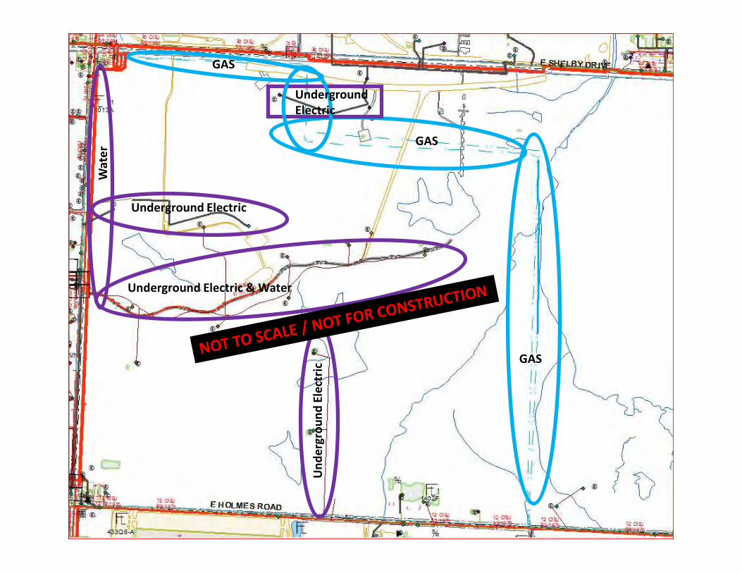
GAS
GAS
GAS
Underground Electric & Water
UndergroundElectric
Underground Electric
Und
ergr
ound
Ele
ctric
Wat
er
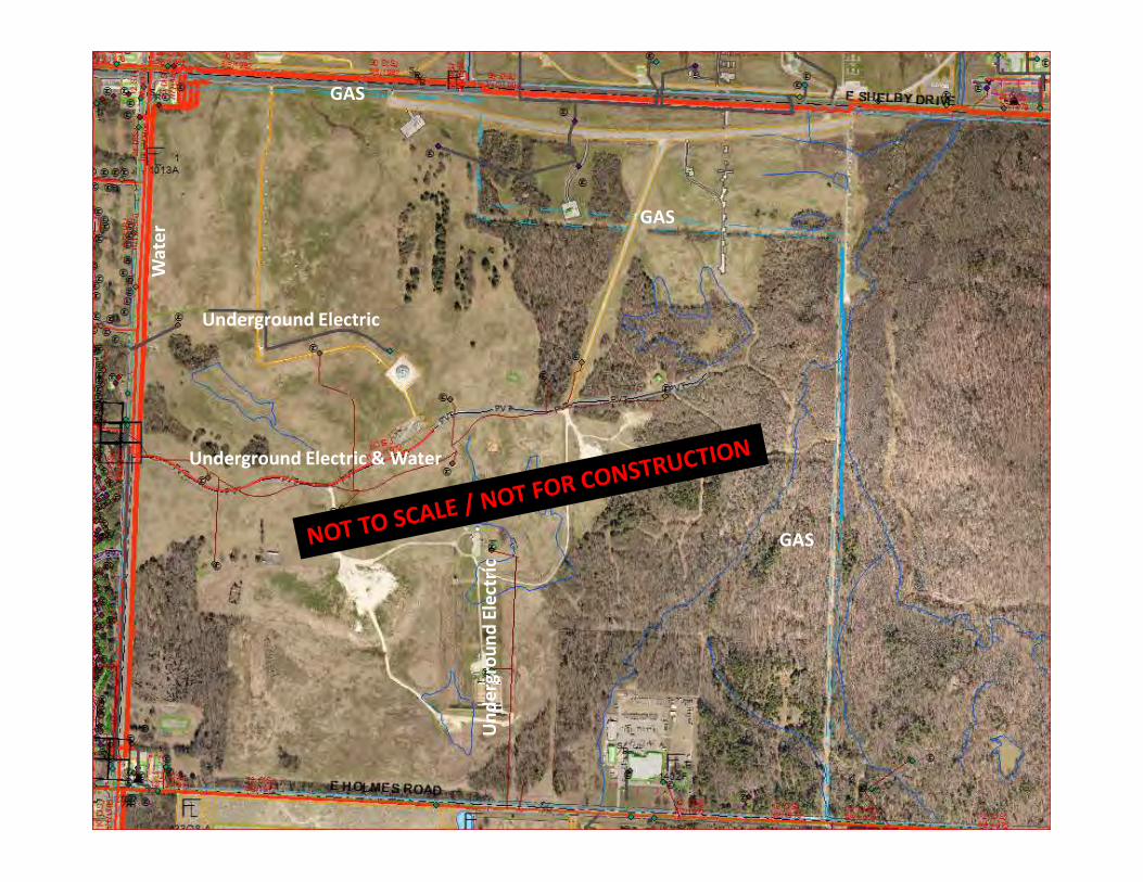
GAS
GAS
GAS
Underground Electric & Water
Underground Electric
Und
ergr
ound
Ele
ctric
Wat
er
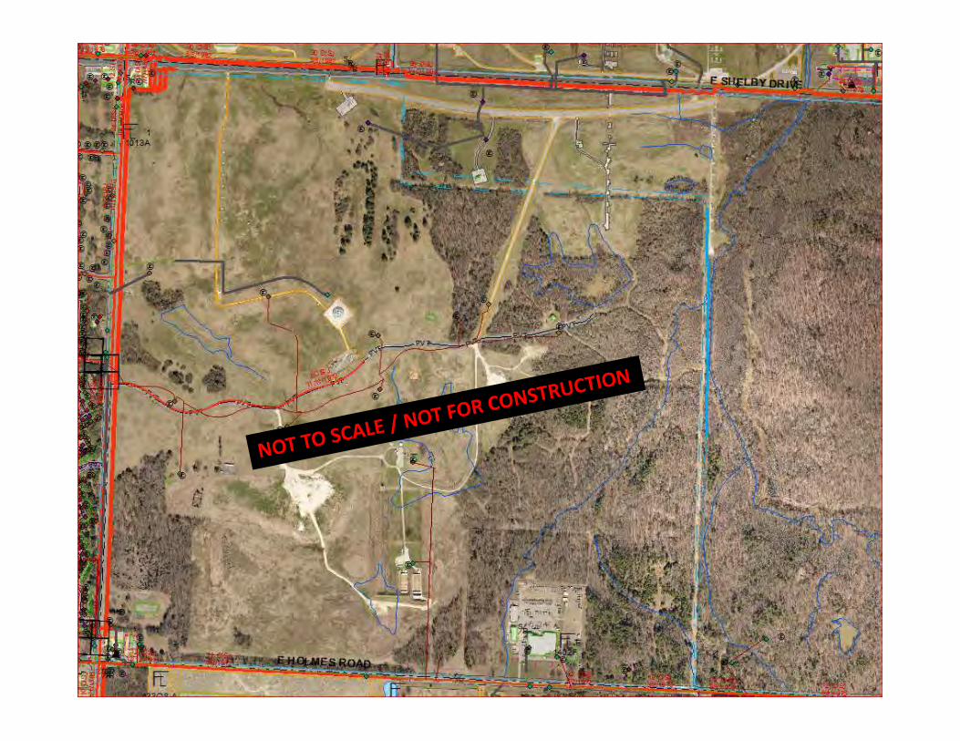
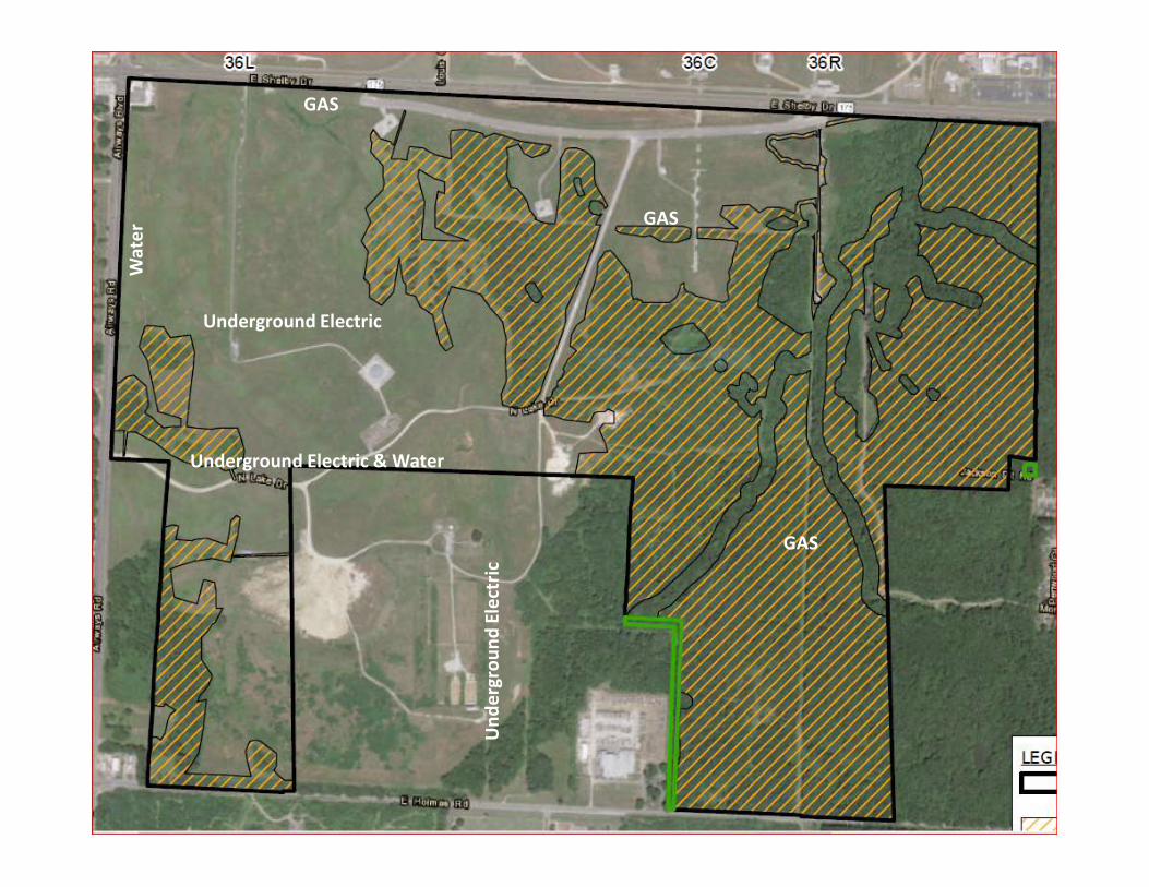
GAS
GAS
GAS
Underground Electric & Water
Underground Electric
Und
ergr
ound
Ele
ctric
Wat
er
1
Josh Earhart
From: Division Remediation <[email protected]>Sent: Friday, April 23, 2021 2:14 PMTo: Josh Earhart; Division RemediationCc: Russ DanserSubject: RE: Agency Coordination Request | Memphis-Shelby County Airport Authority (MSCAA) | Proposed
Tree Clearing
Its listed as a non-site. Occasionally sites are given a number because we may have been given a report for the location or maybe as a place holder, but for whatever reason it never became a DOR site, so it was marked as a non-site. I’m surprised we even had any documents for it. Non-sites generally have no information for them. The only things we have are the two things I sent you earlier dated 1994 and 1997. I didn’t think about it when I asked earlier. Do you happen to have your site boundaries in a ArcGIS layer file (preferred) or an AutoCAD file? It may look better than all the points on a map. If not, no problem. FYI- I may not be able to get this to you until Monday. Our IT group is doing some kind of emergency update on our VPN and it doesn’t let me connect to ArcGIS without it. As soon as I can get it connected, I’ll email you the map. Let me know if I met your expectations by completing the TDEC Customer Survey
Alison Hensley | Environmental Consultant Division of Remediation William R. Snodgrass TN Tower, 14th Floor 312 Rosa L. Parks Ave, Nashville, TN 37243 p. 615-532-0932 f. 615-741-1115 [email protected]
tn.gov/environment/program-areas/rem-remediation.html Request files from TDEC using the TDEC Information Request Form From: Josh Earhart <jearhart@edwards‐pitman.com> Sent: Friday, April 23, 2021 11:49 AM To: Division Remediation <[email protected]> Cc: Russ Danser <rdanser@edwards‐pitman.com> Subject: [EXTERNAL] RE: Agency Coordination Request | Memphis‐Shelby County Airport Authority (MSCAA) | Proposed Tree Clearing Alison, please find a Site map with Lat/Long points. Also, there is one site, 79682, which appears to be the location of a radar site used by the airport. You provided some information, but I wanted to see if there was anything more current, or if the site has been closed. Could you possibly provide a project manager contact and phone number? Thank you.

2
Josh Earhart | Sr. Environmental Project Manager Edwards-Pitman Certified Woman-Owned Small Business (DBE, FBE, SBE, SBA, WBENC, WOSB) 2700 Cumberland Parkway Suite 300 | Atlanta, GA 30339 direct: 678.932.2228 | main: 770.333.9484 | [email protected] www.edwards-pitman.com Georgia | South Carolina | Florida
MEMPHIS LIGHT, GAS AND WATER DIVISION P.O. BOX 430 / MEMPHIS, TENNESSEE 38101-0430 / TELEPHONE (901) 528-4186
February 15, 2021 Mr. James A. Hay II Director of Development Memphis International Airport 2491 Winchester Road, Suite 113 Memphis, TN 38116 RE: East Holmes Road Site Preparation Dear Mr. Hay: Thank you for the advanced notice regarding the proposed site preparation for the East Holmes Road Site. Based on the initial information you provided, coupled with a very preliminary review of our existing MLGW infrastructure, we have identified two (2) significant MLGW utility easements located on the property. MLGW has an existing transmission easement which includes electric lines and a gas pipeline. We also have a gas easement located immediately adjacent to and parallel with the south and west property lines, which includes two (2) pipelines. MLGW will not allow any earth work, i.e., grading, cutting or filling, within the MLGW easement(s) without written approval from MLGW. The grading and drainage plans must be submitted to MLGW for review and approval. Please note, regarding the safety and integrity of our existing gas pipelines, no repetitive, heavy construction equipment traffic will be allowed to cross over the existing MLGW gas pipeline easements. Any repetitive traffic will have to be channeled to one location, and the pipeline will need to be protected with oak matting, as required by MLGW Gas Construction. Please note the following comments below: The subject property is encumbered by an existing utility right of way easement, which may
include overhead and underground facilities. MLGW prohibits any development or improvements within the Easement, except as provided by the MLGW Right of Way Encroachment Policy.
It is the responsibility of the Airport Authority, prior to any development, to contact Keith Ledbury, with MLGW – Property Management @ 901-528-4186 and obtain written approval for any improvements within the Easement(s).

MEMPHIS LIGHT, GAS AND WATER DIVISION P.O. BOX 430 / MEMPHIS, TENNESSEE 38101-0430 / TELEPHONE (901) 528-4186
It is the responsibility of the Airport Authority to identify any utility easements, whether
dedicated or prescriptive (electric, gas, water, CATV, telephone, sewer, drainage, etc.), which may encumber the subject property, including underground and overhead facilities. No permanent structures will be allowed within any utility easements.
It is the responsibility of the Airport Authority to contact TN-1-CALL @ 1.800.351.1111, before digging, and to determine the location of any underground utilities including electric, gas, water, CATV, telephone, etc.
It is the responsibility of the Airport Authority to pay the cost of any work performed by MLGW to install, remove or relocate any facilities to accommodate the proposed development.
It is the responsibility of the Airport Authority to comply with the National Electric Safety Code (NESC) and maintain minimum horizontal/vertical clearances between existing overhead electric facilities and any proposed structures.
Landscaping is prohibited within any MLGW utility easement without prior MLGW approval.
It is the responsibility of the Airport Authority to submit a detailed plan to MLGW Customer Engineering for the purposes of determining the availability and capacity of existing utility services to serve any proposed or future development(s). Please contact MLGW's Builder Services line at 729-8630 to initiate the utility application process.
It is the responsibility of the owner/applicant to pay the cost of any utility system improvements necessary to serve the proposed development with electric, gas or water utilities.
Respectfully Submitted, MEMPHIS LIGHT, GAS and WATER DIVISION
TOM WORD Utility Coordinator [email protected]

Staff Writer: Josh Whitehead E-mail: [email protected]
AGENDA ITEM:
CASE NUMBER: ZTA 18-001 L.U.C.B. MEETING: April 12, 2018
APPLICANT: Memphis and Shelby County Office of Planning and Development
REPRESENTATIVE: Josh Whitehead, Planning Director/Administrator
REQUEST: Adopt Amendments to the Memphis and Shelby County Unified Development Code EXECUTIVE SUMMARY
1. Items 2, 3, 5, 6, 7, 8, 10, 11, 12, 13, 15, 16 and 19 are relatively minor in nature and further explained in
this staff report.
2. Item 1 will require construction debris landfills in the Heavy Industrial zoning districts to obtain a Special Use Permit from the Memphis City Council or Shelby County Board of Commissioners rather than be permitted by right. It will also require a 500-foot separation between landfills and schools and parks.
3. Item 4 will require a public hearing for any change in the controlling interest in ownership of a used car lot that has received a Special Use Permit from the Memphis City Council or Shelby County Board of Commissioners.
4. Item 9 will amend the opening paragraph of the Medical, University and Midtown Overlay Districts to clearly stipulate that the use tables of these districts apply, regardless if there is any new construction.
5. Item 14 will require signs to be posted along the portions of a street subject to a Residential Corridor Deletion application.
6. Item 17 provides that the Planning Director, rather than the Building Official, shall issue written interpretations of the Zoning Code (the UDC). The latter’s focus is primarily on the Building Code.
7. Item 18 will allow an up to 10% increase to a building setback to be processed administratively; currently, only decreases of up to 10% are permitted.
RECOMMENDATION
Approval
Staff Report April 12, 2018 ZTA 18-001 Page 2
2
Proposed language is indicated in bold, underline; deleted language is indicated in strikethrough.
1. 2.5.2 and 2.6.4D(2)(c) (new section): Landfills During the deliberations for the expansion of a construction debris landfill at the corner of Thomas and Stage in Frayser earlier this year (OPD Case No. PD 17-14 for Memphis Wrecking Co.), the applicant’s agent stated he would investigate sites zoned Heavy Industrial in an effort to locate a property that would permit a construction debris landfill “by right” without the need to obtain a zoning entitlement through a public hearing process. This culminated with a public meeting held by the applicant in Hickory Hill where several “by right” sites within that neighborhood were allegedly discussed. This, in turn, resulted in a six-month moratorium passed by both the Memphis City Council and the Shelby County Board of Commissioners that affects any construction debris landfills that would be permitted by right in the Heavy Industrial zoning districts. When the Board of Commissioners passed its version of the moratorium, its members asked for several pieces of information to accompany any ordinance that would be promulgated pursuant to the moratorium. As this zoning text amendment is the ordinance resulting from that moratorium, responses to those inquiries are listed below. a. History of the Zoning Code.
During its deliberations on the landfill moratorium on January 22, 2018, the Board of Commissioners asked for a history of how the zoning code has treated construction debris landfills over the years. See table below; the 1972 Zoning Code made no distinction between construction debris and sanitary landfills and required a Special Use Permit for both in both industrial zoning districts unless operated by a municipal government. In 1981, the Zoning Code was amended to reflect a new type of landfills, construction debris landfills, and permitted them by right in both industrial zoning districts. This was further changed with the current Zoning Code, which allows construction debris landfills by right in only the Heavy Industrial zoning district.
Code Type of Landfill Light Industrial
Zoning District Heavy Industrial Zoning District
1972 Code All Landfills* Not permitted unless operated by a municipality
Special Use Permit
1981 Code Construction Debris Landfills
By Right By Right
1981 Code Sanitary landfills
Special Use Permit Special Use Permit
2018 Code Construction Debris Landfills
Special Use Permit By Right
2018 Code Sanitary Landfills
Special Use Permit Special Use Permit
*The 1972 Zoning Code made no distinction between construction debris landfills and sanitary landfills.
Staff Report April 12, 2018 ZTA 18-001 Page 3
3
b. Location of Heavy Industrial Zoning Districts
The areas shown in red in the map below indicate the location of the Heavy Industrial zoning district in Memphis and unincorporated Shelby County. The significant vacant parcels within these red areas are as follows:
i. Woodstock, just south of the Millington City Limits ii. Woodstock at Fite Road and US 51 iii. Cordova, Macon and Berryhill Roads iv. Cordova, near and around Fisher Steel Road v. Frank Pidgeon Industrial Park
c. Hazardous Waste The Unified Development Code highlights several hazardous uses that require review under the Special Use Permit process, such as radioactive waste storage, waste incineration and others, but the Tennessee Department of Environment and Conservation (TDEC) is the primary government agency that regulates hazardous waste. TDEC has a tiered system for landfills based on the toxicity of the materials being stored at the landfill.
d. Capacity of Existing Landfills The map below shows the landfills that fall under the jurisdiction of the Office of Planning and Development, the Unified Development Code, the Memphis City Council and the Shelby County Board of Commissioners. Below is a list of the names of the landfill, as well as the date they are expected to reach capacity.
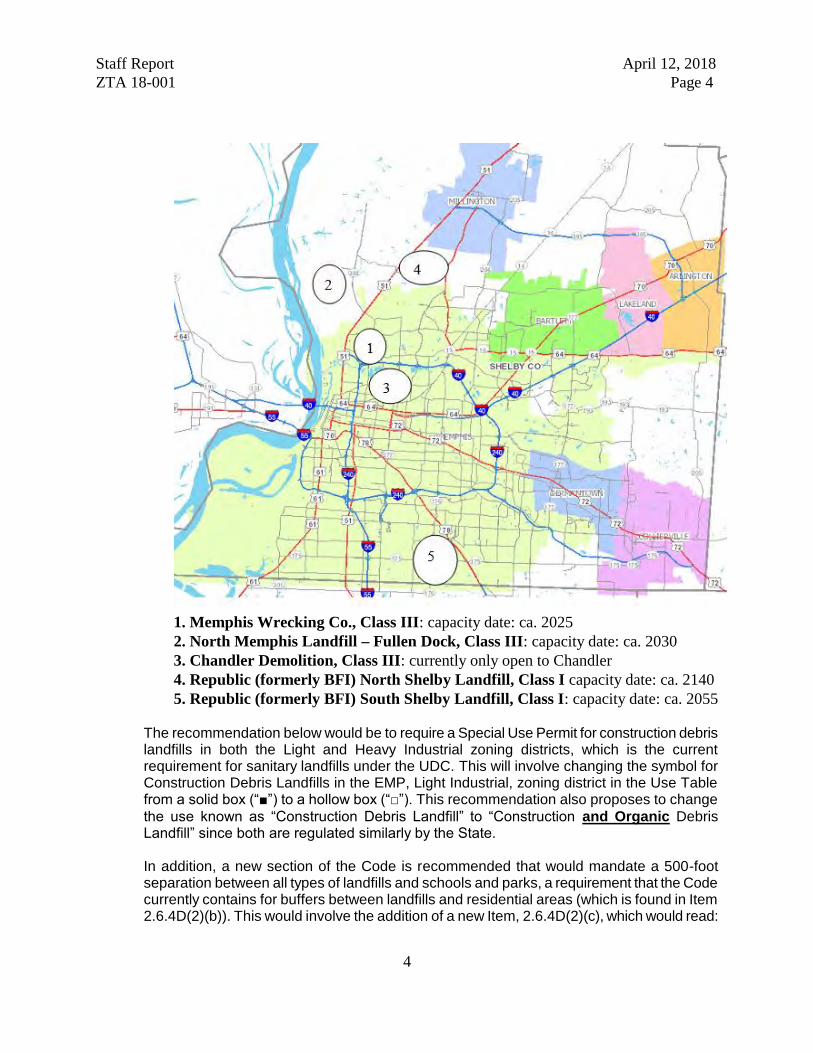
Staff Report April 12, 2018 ZTA 18-001 Page 4
4
1. Memphis Wrecking Co., Class III: capacity date: ca. 2025 2. North Memphis Landfill – Fullen Dock, Class III: capacity date: ca. 2030 3. Chandler Demolition, Class III: currently only open to Chandler 4. Republic (formerly BFI) North Shelby Landfill, Class I capacity date: ca. 2140 5. Republic (formerly BFI) South Shelby Landfill, Class I: capacity date: ca. 2055
The recommendation below would be to require a Special Use Permit for construction debris landfills in both the Light and Heavy Industrial zoning districts, which is the current requirement for sanitary landfills under the UDC. This will involve changing the symbol for Construction Debris Landfills in the EMP, Light Industrial, zoning district in the Use Table from a solid box (“■”) to a hollow box (“□”). This recommendation also proposes to change the use known as “Construction Debris Landfill” to “Construction and Organic Debris Landfill” since both are regulated similarly by the State. In addition, a new section of the Code is recommended that would mandate a 500-foot separation between all types of landfills and schools and parks, a requirement that the Code currently contains for buffers between landfills and residential areas (which is found in Item 2.6.4D(2)(b)). This would involve the addition of a new Item, 2.6.4D(2)(c), which would read:
Staff Report April 12, 2018 ZTA 18-001 Page 5
5
2.6.4D(2)(c): Landfill excavation or filling shall not be located within a minimum of 500 feet of any school or park, as measured from the property line of the landfill excavation or filling site to the property line of the school or park.
2. 2.5.2: Other Items related to the Use Table
Sub-Section 2.9.3I and Section 12.3.1 (the definitions section) includes solar farms in the list of items that fall under the definition of “major utilities.” However, under the Use Table in Section 2.5.2, solar farms are listed as separate uses and permitted by right in many more districts than major utilities. The following corrective action will address this: Minor utilities, except as listed below Major utilities, except as listed below Also, “message therapy” under “retail sales and service” needs to read “massage therapy:”
Hair, nail, tanning, message massage therapy and personal care service, barber shop or beauty salon
3. 2.6.1 and 12.3.1: Manufactured, Modular and Mobile Homes
Sub-Sections 2.6.1C and 2.6.1D contain use standards related to manufactured, modular and mobile homes. Section 12.3.1 contains definitions of these terms. There is some inconsistency between these three sections, particularly with regards to mobile homes, which are described as structures built after 1976 in Sub-Section 2.6.1D and as structures built before 1976 in Section 12.3.1. The following language addresses this inconsistency:
2.6.1C(8) (new section): See Section 12.3.1 for distinctions between manufactured and modular homes.
12.3.1: MOBILE HOME, CONFORMING: see Sub-Section 2.6.1D. 12.3.1: MOBILE HOME, NONCONFORMING: A structure manufactured before June 15, 1976, that is not constructed in accordance with the National Manufactured Home Construction and Safety Standards Act of 1974, (42 U.S.C. § 5401 et seq.). It is a structure that is transportable in one or more sections that in the traveling mode is eight body feet or more in width and 40 body-feet or more in length, or, when erected on site, is 320 or more square feet and that is built on a chassis and designed to be used as a dwelling with or without a permanent foundation when connected to the required utilities and includes any plumbing, heating, air conditioning and electrical systems contained in the structure.
4. 2.6.3P(3)(h) (new section): Ownership of used car lots
Under the current ordinance, any new car lot requires the issuance of a Special Use Permit outside of the industrial zoning districts. However, one concern that the City Council has expressed during its last few reviews of used car lots is the efficacy of the conditions placed on the Special Use Permit when a change in ownership occurs. The language proposed below would require the approval of a Major Modification for any change in ownership of a used car lot:
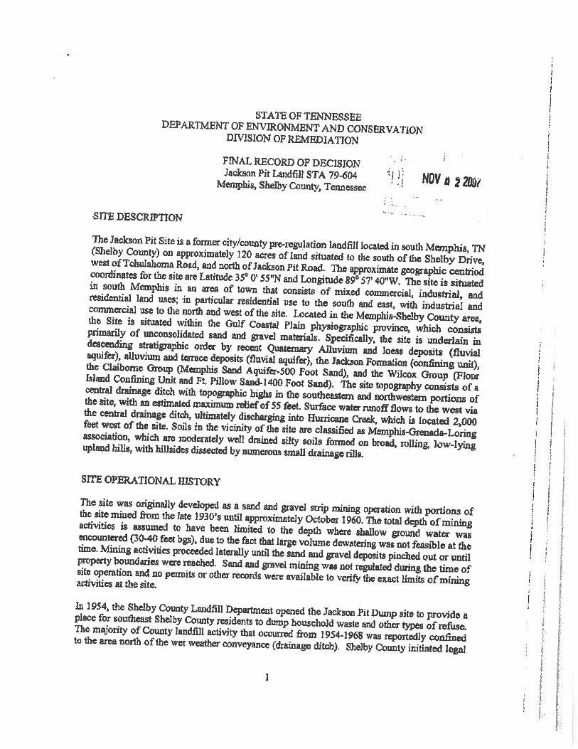


186 | P a g e
ATTACHMENT 6 Historical Resource Information

From: Braswell, Aaron (FAA)To: Lori MorrisCc: Russ Danser; Kristin LehmanSubject: FW: FAA Section 106 Undertaking - Memphis International Airport (MEM) Memphis, TNDate: Friday, April 30, 2021 3:43:42 PMAttachments: image001.png
4.30.21 FAA, Memphis-Shelby County Airport Authority Tree Clearing, Shelby County.pdf
From: Section 106 <[email protected]> Sent: Friday, April 30, 2021 2:13 PMTo: Braswell, Aaron (FAA) <[email protected]>; Section 106 <[email protected]>Subject: RE: FAA Section 106 Undertaking - Memphis International Airport (MEM) Memphis, TN
Attached is your TN State Historic Preservation Office Section 106 review response. Due to Covid-19restrictions, we will be providing our responses via email. Project review requests may be submitted viaemail. In order to facilitate our review process, please follow the following guidelines:
1. The heading of your email must include;a. the County where the project is locatedb. the lead federal agency for the undertakingc. Note whether the request is for above-ground (architectural) review, archaeological review, or
both
2. Please email all documents for review to our Section 106 review email address: [email protected]
3. Archaeological Reports: In accordance with the TN SHPO Standards and Guidelines forArchaeological Resource Management Studies (2018), in addition to emailed PDF formatted copies, youmust mail two (2) printed copies of each archaeological report of investigation via USPS (DO NOT SENDVIA FEDEX OR UPS) directly to Jennifer Barnett at the Tennessee Division of Archaeology (TDOA).
Jennifer Barnett Tennessee Division of Archaeology1216 Foster Ave Cole Building 3 Nashville, Tennessee 37243
4. Cell Tower Archaeological Reports: While we continue to work remotely, printed Hard Copyversions of Cell Tower archaeological reports need only be submitted to the TDOA if new archaeologicalsites were recorded or previously recorded sites were revisited during the investigation. Negative findingscell tower archaeological reports need only be submitted in PDF format.
Our review response letters will be in PDF format, emailed directly to the sender. Follow-up questionsregarding your review may come directly from either Casey Lee, Jennifer Barnett, or the general Section106 email.
Please let us know if you have any questions regarding the Section 106 review.
Jennifer Barnett| Archaeologist SupervisorTennessee Division of Archaeology

1216 Foster AvenueCole Building #3Nashville, TN 37243p. 615-687-4780, f. [email protected]://www.tn.gov/environment/program-areas/arch-archaeology.htmlWe value your feedback! Please complete our customer satisfaction survey.
From: Braswell, Aaron (FAA) <[email protected]> Sent: Friday, April 30, 2021 8:27 AMTo: Section 106 <[email protected]>Subject: [EXTERNAL] FAA Section 106 Undertaking - Memphis International Airport (MEM) Memphis,TN
*** This is an EXTERNAL email. Please exercise caution. DO NOT open attachments or click linksfrom unknown senders or unexpected email - STS-Security. ***
Good morning The FAA is considering an undertaking for the Memphis International Airport (MEM) in Memphis, TNfor the removal of trees. The undertaking seeks to enhance safety and improve airport operationalefficiency by removing trees that obstruct various airspace surfaces, which may become hazards ornegatively affect the airport’s instrument procedures. Details concerning the proposed undertaking,APEs, identification efforts, and previous correspondence are attached. Please contact me if youhave any questions. Sincerely, Aaron BraswellEnvironmental Protection SpecialistFederal Aviation AdministrationMemphis Airports District Office2600 Thousand Oaks BoulevardSuite 2250Memphis, Tennessee [email protected]

TENNESSEE HISTORICAL COMMISSION
STATE HISTORIC PRESERVATION OFFICE2941 LEBANON PIKE
NASHVILLE, TENNESSEE 37243-0442OFFICE: (615) 532-1550
www.tnhistoricalcommission.org
April 30, 2021
Mr. Aaron BraswellFederal Aviation AdministrationMemphis Airports District Office2600 Thousand Oaks Boulevard, Suite 2250Memphis, TN 38118
RE: FAA / Federal Aviation Administration, Memphis-Shelby County Airport Authority Tree Obstruction Clearing, Memphis, Shelby County, TN
Dear Mr. Braswell:
In response to your request, we have reviewed the archaeological resources survey report and accompanying documentation submitted by you regarding the above-referenced undertaking. Our review of and comment on your proposed undertaking are among the requirements of Section 106 of the National Historic Preservation Act. This Act requires federal agencies or applicants for federal assistance to consult with the appropriate State Historic Preservation Office before they carry out their proposed undertakings. The Advisory Council on Historic Preservation has codified procedures for carrying out Section 106 review in 36 CFR 800 (Federal Register, December 12, 2000, 77698-77739).
Considering the information provided, we concur that no historic properties eligible for listing in the National Register of Historic Places will be affected by this undertaking. If project plans are changed or archaeological remains are discovered during project construction, please contact this office to determine what further action, if any, will be necessary to comply with Section 106 of the National Historic Preservation Act. Questions or comments may be directed to Jennifer Barnett (615) 687-4780, [email protected].
Your cooperation is appreciated.
Sincerely,
E. Patrick McIntyre, Jr.Executive Director andState Historic Preservation Officer
EPM/jmb

From: Braswell, Aaron (FAA)To: Lori Morris; Kristin Lehman; Russ DanserSubject: FW: FAA Section 106 Undertaking - Memphis International Airport (MEM) Memphis, TNDate: Friday, April 30, 2021 9:30:17 AMAttachments: MEM 106 FINAL 20210430.pdf
From: Braswell, Aaron (FAA) Sent: Friday, April 30, 2021 8:26 AMTo: '[email protected]' <[email protected]>Subject: FAA Section 106 Undertaking - Memphis International Airport (MEM) Memphis, TN
Good morning
The FAA is considering an undertaking for the Memphis International Airport (MEM) in Memphis, TNfor the removal of trees. The undertaking seeks to enhance safety and improve airport operationalefficiency by removing trees that obstruct various airspace surfaces, which may become hazards ornegatively affect the airport’s instrument procedures. Details concerning the proposed undertaking,APEs, identification efforts, and previous correspondence are attached. Please contact me if youhave any questions.
Sincerely,
Aaron BraswellEnvironmental Protection SpecialistFederal Aviation AdministrationMemphis Airports District Office2600 Thousand Oaks BoulevardSuite 2250Memphis, Tennessee [email protected]
1. A Detailed Project Description
The Memphis-Shelby County Airport Authority (MSCAA) proposes to remove and cut trees from upland and aquatic wooded areas within portions of an approximately 587-acre tract of MSCAA-owned property located south of Memphis International Airport (MEM) in Memphis, Shelby County, Tennessee (the Site) (Figure 1). A physical address does not exist for the Site; it is located south of MEM Runways 36L, 36C, and 36R and Shelby Drive, east of Airways Boulevard, and north of Holmes Road. The lead federal agency for the undertaking is the Federal Aviation Authority (FAA).
The purpose of the Proposed Action is to remove tree obstructions and potential obstructions to the approach surfaces of MEM runways 36L, 36C, and 36R, and the departure surface of runways 18R, 18C, and 18L, to comply with FAA AIP Grant Assurance 20 (Hazard Removal and Mitigation) and FAA Code of Federal Regulations (CFR) Chapter 14 Part 139. Select wooded areas at the Site that penetrate the Threshold Siting Surfaces identified by Advisory Circular 150/5300-13A, Airport Design, FAA Order 8260.3E, United States Standard for Terminal Instrument Procedures, the Obstacle Accountability Area (62.5:1) under One-Engine Inoperative conditions identified by Advisory Circular 120-91A, Airport Obstacle Analysis, and CFR 14 Part 77 approach surface represent airspace obstructions. Obstruction removal will improve airport compliance with FAA regulations, enhance the level of safety for the travelling public and enable the runways to operate without imposed restrictions.
Tree removal and tree cutting activities will occur within approximately 344 acres of the Site and are proposed in two phases, over a three-year period. In 2018 and 2019, coordination with the Tennessee Historical Commission (THC) was initiated for the proposed project. Prior coordination documentation is included in Attachment 1 and includes THC correspondence indicating a lack of architectural and archeological resources eligible for or listed on the National Register of Historic Places. Since that time, the Site boundaries have changed to include newly acquired parcels located on the eastern boundary of the Site. The Phase I Archeological Survey completed for the Site in 2019 was updated in 2020 to include the newly acquired parcels.
Phase I of the proposed project includes the removal of trees, including stumps and roots, within approximately 289 acres of upland wooded area (Figure 2). Tree removal under Phase I of the project is proposed using site-clearing machinery. Ground-disturbing activities such as tree removal, and grading activities, are proposed to be conducted incrementally, in 50-acre sections.
Phase II of the proposed project includes the selective topping and cutting of trees within approximately 55 acres of aquatic wooded area. The location of the onsite aquatic resources is depicted on Figure 2. Ground disturbing activities are not proposed in the Phase II areas. Tree
2
trunks and roots will be left intact. The principal drainage on the Site is Hurricane Creek, which flows north into Nonconnah Creek. EPEI is coordinating with the Tennessee Department of Environment and Conservation (TDEC) and the US Army Corps of Engineers regarding aquatic resources at the Site.
To comply with TDEC erosion and sediment controls, natural riparian buffer zones are proposed along onsite stream banks and around onsite wetlands. The natural riparian buffer zones willserve as erosion and sediment controls, as well as mitigate for potential changes in onsite stream water temperature due to tree canopy removal. A natural riparian buffer zone of 60 feet (ft) is proposed for streams, measured from the tops of the stream banks. A 30-ft natural riparian buffer zone is proposed around onsite wetlands. Site-clearing machinery is not proposed for Phase II areas. The topping of trees in the Phase II areas will be completed by hand using chain saws.
A Phase I Archeological Survey is included as Attachment 2 and includes the fieldwork took place from March 12 to 28, 2019, and the survey of the newly acquired parcels on November 23, 2020. The recommended archaeological Area of Potential Effect (APE) is limited to areas where ground-disturbing activities will take place (i.e., tree stump removal, grubbing, and access road construction). As ground-disturbing activities are limited to 289 acres of wooded terrain in the uplands, this area is considered the APE.
The recommended APE for architectural and historic resources is limited to the viewshed of the proposed project. For the purposes of this evaluation, this area has been defined as approximately 200 feet from the edge of any improvements associated with Phase I of the proposed project. All areas designated as Phase II are located within the limits of Phase I locations and, therefore, would be included in any APE boundaries established for the Phase I activities.
There are three locations where this buffer has been modified slightly due to site specific conditions. This first is along the western edge of the Site (Airways Boulevard) where, because of the presence of a 5-lane roadway between properties off-property and the Site, the APE limit is defined as the centerline of Airways Boulevard. Attachment 3 contains a representative site photo (Photo 2) and a Google Street View example at this location (Photo 13).
The other modifications are associated with two areas where visual buffers have been proposed to minimize the potential for visual affect to adjacent developed properties while also addressing the intended purpose for the project (removal of tress that are obstructions to existing runway take-offs and landings). The first of these areas is a 75-foot visual buffer that has been placed adjacent to a residential neighborhood just beyond the eastern edge of the Site (Jackson Pit
3
Road and Meadowfair Lane). Representative at-grade and aerial photos of this location are provided as Photos 14 and 15, respectively.
The second of these areas is a 50-foot visual buffer associated with the eastern and northern boundaries of the Tennessee Army National Guard (TNARNG) Memphis Readiness Center(RC), located on Holmes Road. This property includes the Central United States Earthquake Consortium (CUSEC), located in the southeast corner of the RC property. Representative at-grade and aerial photos of this location are provided as Photos 16 and 17, respectively.
The limits of the APE are shown in Figure 2 as “Aboveground Area of Potential Effect” and primarily consists of on-airport property.
2. Lead Federal Agency for the Undertaking
U.S. Department of Transportation, Federal Aviation Administration
3. The Exact Location and Boundary of the Proposed Project Depicted on a 1:24000 USGS Topo Map
See Figure 1 for the project boundary.
4. Physical Address for the Undertaking and/or Lat. Long Coordinates
A physical address does not exist for the Site; it is located south of MEM Runways 36L, 36C, and 36R and Shelby Drive, east of Airways Boulevard, and north of Holmes Road. See Figure 1for latitude and longitude coordinates.
5. Recent Photographs of the Project Area, Including Buildings Within a Site Distance of the Project
Recent photographs and a photo log map are provided as Attachment 3 of this document. In addition, the Phase I Archaeological Assessment includes photos and aerial imagery of the Project Area, including remains of the former McKellar Park golf course bathroom/pavilion (Attachment 2, Figure 5-14), and the abandoned McKellar Park Commission nursery structure (Attachment 2, Figure 5-17).
6. Information regarding present and past use of the project’s property
The project site is currently owned by the MSCAA. The present use of the property includes instrumentation, and associated access roads, related to aircraft take-offs and landings. The
4
property includes a utility easement for an underground gas pipeline, owned by the Memphis, Light, Gas and Water utility provider. The utility easement is located near the eastern portion of the property (Figure 2). The property is also being used as a temporary soil staging area for the Consolidated Deicing Pad, currently under construction at MEM.
The past uses of the property are described in detail in the attached Phase I Archeological Assessment and include the discovery of undifferentiated Prehistoric lithic scatter, a late nineteenth to mid twentieth century farmstead, and portions of the former McKellar Park. At 554 acres, McKellar Park was once Memphis’ largest city park and contained an 18-hole golf course from approximately 1972 to 1995. The findings of the 2020 Phase I Archeological Assessment indicate there are no listed, eligible or potentially eligible archaeological resources within the proposed APE.
The APE was also evaluated for architectural and historic resources. THC records indicted one site (Site SY-31581A), a 1935 single-family dwelling that was evaluated for NRHP eligibility in 1995. At that time, it was recommended that the structure was not eligible for NRHP listing. The house is clearly shown in aerials in January 1997, February/August 2003, February/December 2004, February 2006 (see Photo 18, Attachment 3), and January/February/September 2007. However, by February 2008, it appears the house was removed and by April 2010, the site is cleared of the house (see Photo 19, Attachment 3).
Through coordination with TNARNG, information was obtained regarding structures on their property previously noted. In the winter of 2019, TNARNG performed a phase I archaeological survey for the RC’s 30.07 acres, with the results documented in “A Phase I Cultural Resources Survey of 30.07 acres for the Memphis Readiness Center in Memphis, Shelby County, Tennessee.” The survey and report did not identify any archaeological sites.
The Memphis RC (Building #0000A) and the current Field Maintenance Shop (Building #0000F) were both constructed in 1983 and are part of a TNARNG Cold War-Era RC survey that will be completed next year. Given the locations of those sites relative to the property line and their distance from the APE boundary in this location, there is not expected to be any effect to these buildings.
There is also one historic resource (constructed in the early 1960’s) – the CUSEC. Due to loss of integrity (landscape now dominated by military activities, in-correct material alterations, lost associations with other residential properties of its time, etc.), this property was not considered eligible for the NRHP. This determination has received SHPO concurrence.

5
7. Any Known Information Regarding Historic Properties That May Be Present Within the Area of Potential Effects
Based on the findings of the Phase I Archeological Assessment, the proposed APE does not appear to include archeological resources eligible for or listed on the National Register of Historic Places. Similarly, there appear to be no eligible architectural and historic resources located within the proposed APE.
6
REFERENCED FIGURES
Figure 1 | Site Vicinity Map
Figure 2 | Visual APE
Figure 3 | Memphis Readiness Center(Source: Tennessee Army National Guard)
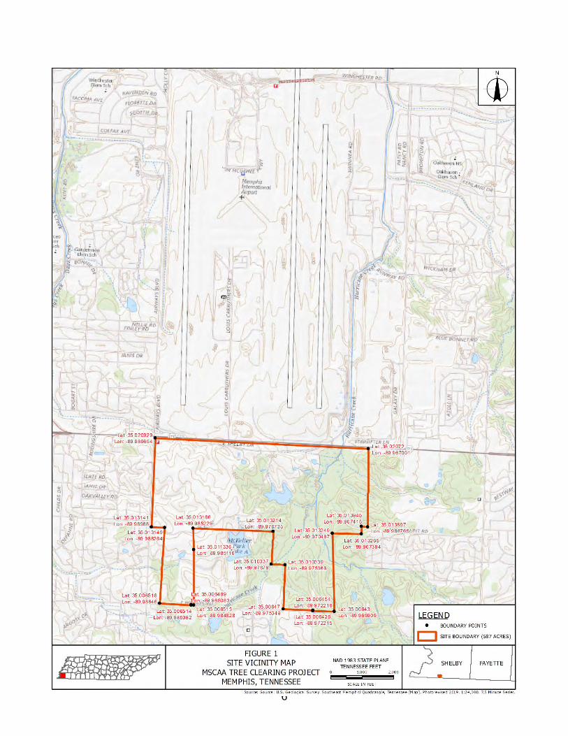
6
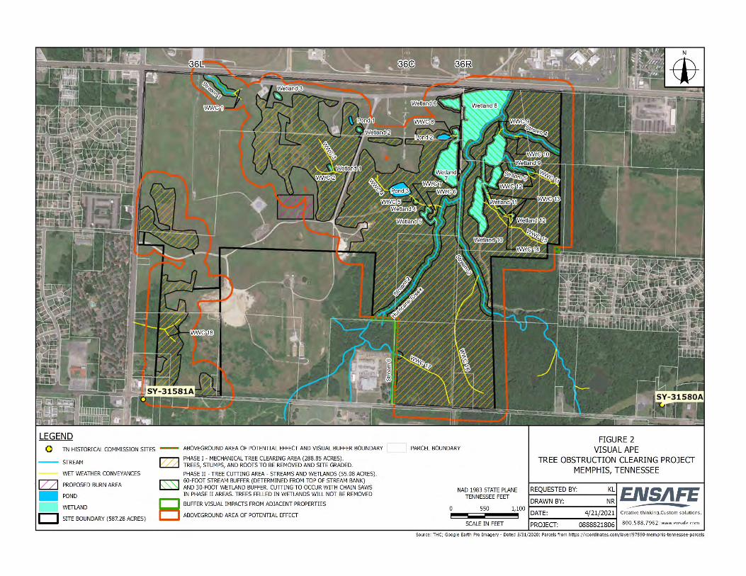

ATTACHMENT 1
Previous Tennessee Historical Commission (THC) Coordination Documentation
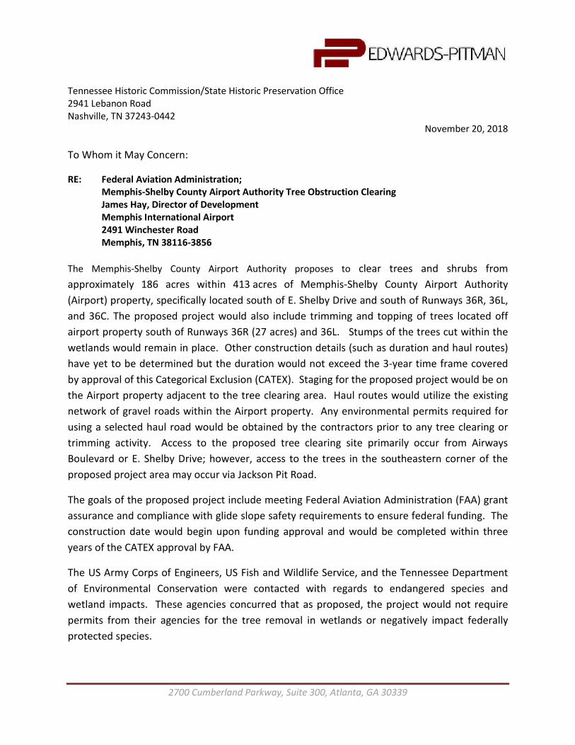
2700 Cumberland Parkway, Suite 300, Atlanta, GA 30339
Tennessee Historic Commission/State Historic Preservation Office 2941 Lebanon Road Nashville, TN 37243-0442
November 20, 2018 To Whom it May Concern:
RE: Federal Aviation Administration; Memphis-Shelby County Airport Authority Tree Obstruction Clearing James Hay, Director of Development Memphis International Airport 2491 Winchester Road Memphis, TN 38116-3856
The Memphis-Shelby County Airport Authority proposes to clear trees and shrubs from approximately 186 acres within 413 acres of Memphis-Shelby County Airport Authority (Airport) property, specifically located south of E. Shelby Drive and south of Runways 36R, 36L, and 36C. The proposed project would also include trimming and topping of trees located off airport property south of Runways 36R (27 acres) and 36L. Stumps of the trees cut within the wetlands would remain in place. Other construction details (such as duration and haul routes) have yet to be determined but the duration would not exceed the 3-year time frame covered by approval of this Categorical Exclusion (CATEX). Staging for the proposed project would be on the Airport property adjacent to the tree clearing area. Haul routes would utilize the existing network of gravel roads within the Airport property. Any environmental permits required for using a selected haul road would be obtained by the contractors prior to any tree clearing or trimming activity. Access to the proposed tree clearing site primarily occur from Airways Boulevard or E. Shelby Drive; however, access to the trees in the southeastern corner of the proposed project area may occur via Jackson Pit Road.
The goals of the proposed project include meeting Federal Aviation Administration (FAA) grant assurance and compliance with glide slope safety requirements to ensure federal funding. The construction date would begin upon funding approval and would be completed within three years of the CATEX approval by FAA.
The US Army Corps of Engineers, US Fish and Wildlife Service, and the Tennessee Department of Environmental Conservation were contacted with regards to endangered species and wetland impacts. These agencies concurred that as proposed, the project would not require permits from their agencies for the tree removal in wetlands or negatively impact federally protected species.

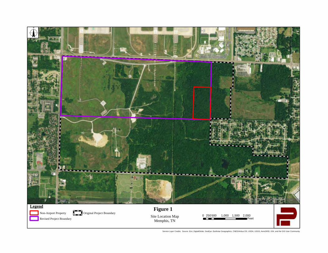
Service Layer Credits: Source: Esri, DigitalGlobe, GeoEye, Earthstar Geographics, CNES/Airbus DS, USDA, USGS, AeroGRID, IGN, and the GIS User Community
Figure 1LegendNon-Airport Property
Revised Project Boundary
Original Project BoundarySite Location Map
Memphis, TN
o
0 500 1,000 1,500 2,000250Feet
Service Layer Credits: Source: Esri, DigitalGlobe, GeoEye, Earthstar Geographics, CNES/Airbus DS, USDA, USGS, AeroGRID, IGN, and the GIS User Community
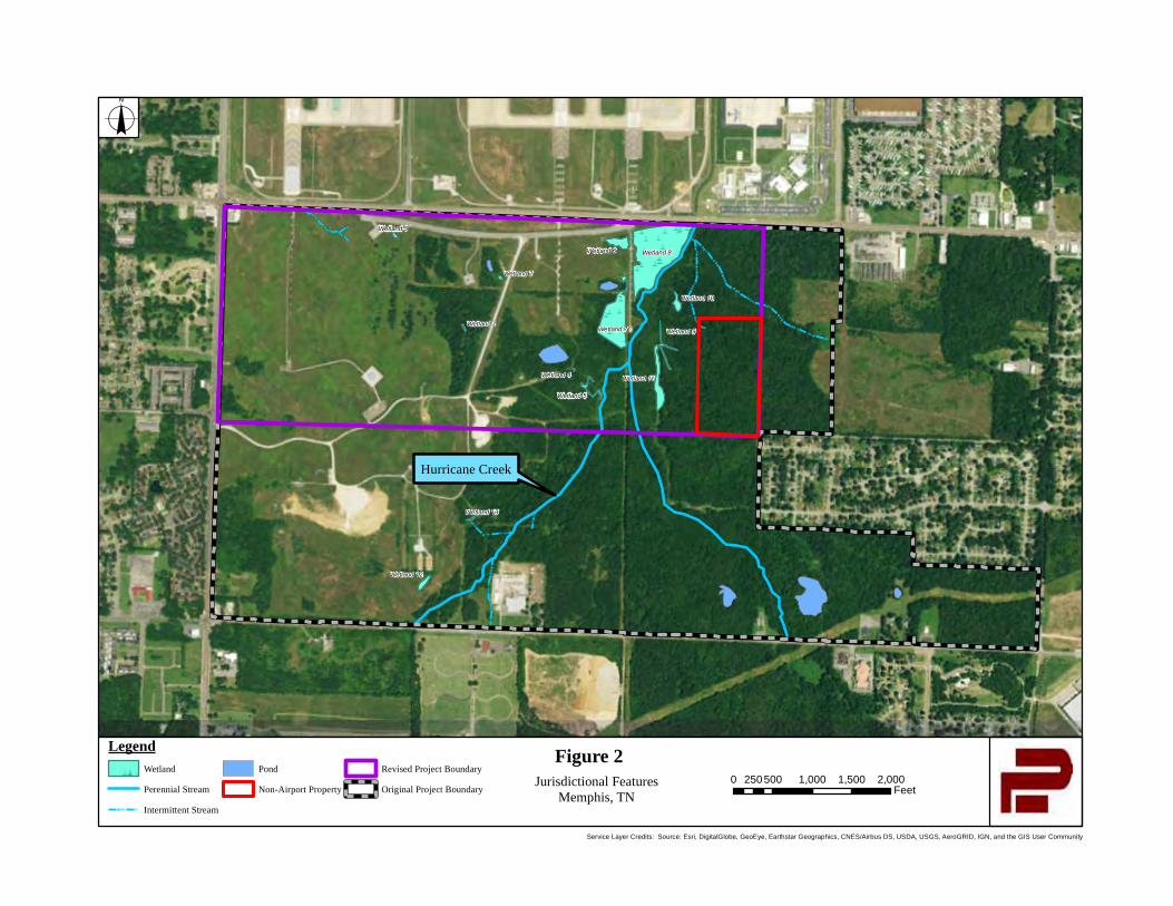
\\
\
\\
\
\
\
\
\
\
\
\
\
\\
\
\\
\
\\
\\
\
\
\
\
\
\
\
\\
\
\
\\
\\
\\
\
\
\
\
\
\
\
\ \\
\
\
\
\
\
\
\
\
\\
\ \
\
\\\
\\
\
\
\
\\
\
\
\
\
\\
\
\
\
\
\
\
\
\
\
\
Wetland 12
Wetland 13
Wetland 1
Wetland 4
Wetland 5
Wetland 11
Wetland 7 Wetland 9
Wetland 10
Wetland 8Wetland 6
Wetland 2
Wetland 3
Hurricane Creek
Service Layer Credits: Source: Esri, DigitalGlobe, GeoEye, Earthstar Geographics, CNES/Airbus DS, USDA, USGS, AeroGRID, IGN, and the GIS User Community
Figure 2Legend\\ \\
Wetland
Perennial Stream
Intermittent Stream
Pond
Non-Airport Property
Revised Project Boundary
Original Project BoundaryJurisdictional Features
Memphis, TN
o
0 500 1,000 1,500 2,000250Feet
Service Layer Credits: Source: Esri, DigitalGlobe, GeoEye, Earthstar Geographics, CNES/Airbus DS, USDA, USGS, AeroGRID, IGN, and the GIS User Community
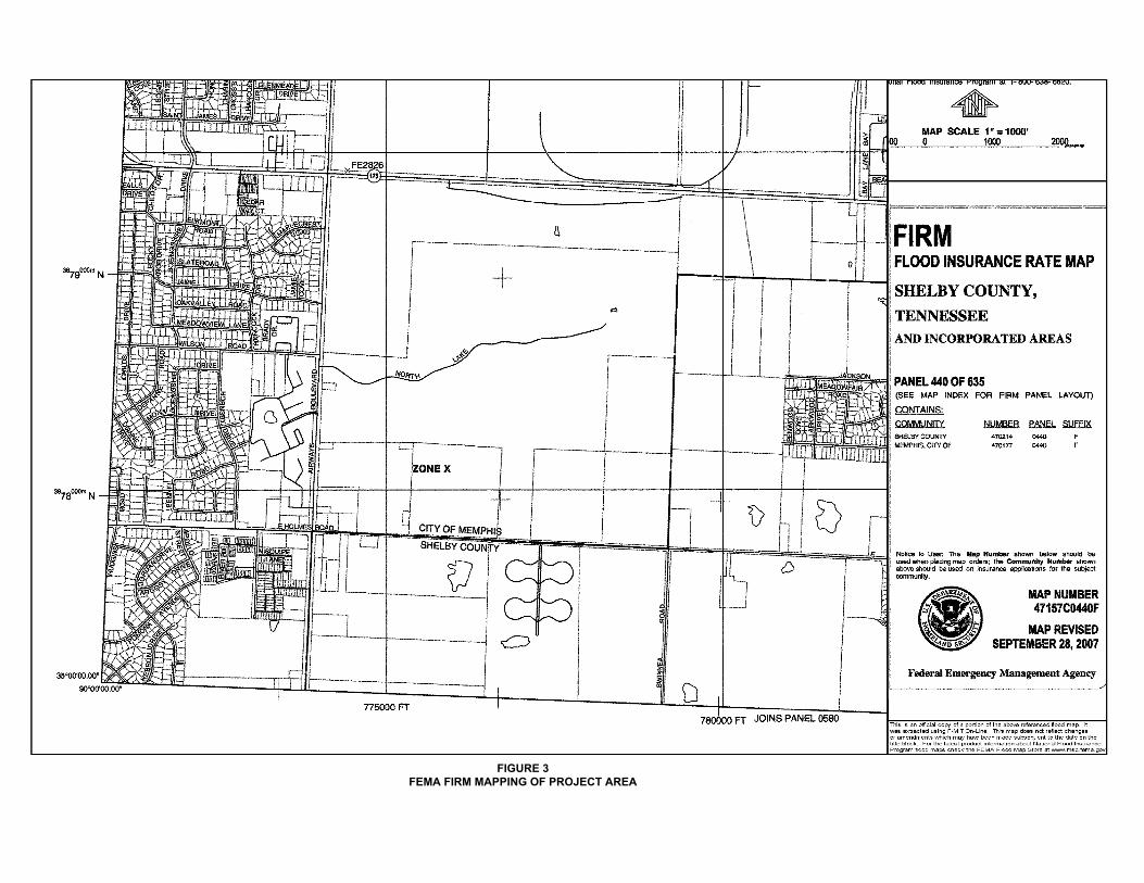
FIGURE 3FEMA FIRM MAPPING OF PROJECT AREA
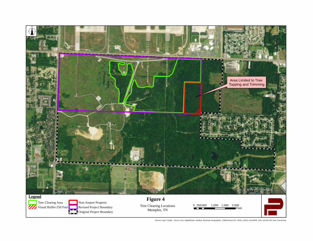
Area Limited to Tree Topping and Trimming
Service Layer Credits: Source: Esri, DigitalGlobe, GeoEye, Earthstar Geographics, CNES/Airbus DS, USDA, USGS, AeroGRID, IGN, and the GIS User Community
Figure 4LegendTree Clearing AreaVisual Buffer-250 Feet
Non-Airport PropertyRevised Project BoundaryOriginal Project Boundary
Tree Clearing LocationsMemphis, TN
o
0 500 1,000 1,500 2,000250Feet
Service Layer Credits: Source: Esri, DigitalGlobe, GeoEye, Earthstar Geographics, CNES/Airbus DS, USDA, USGS, AeroGRID, IGN, and the GIS User Community

8
ATTACHMENT 2
Phase I Archeological Survey
PANAMERICAN CONSULTANTS, INC.
PANAMERICAN REPORT NO. 39019
PHASE I ARCHAEOLOGICAL ASSESSMENT FOR THE MEMPHIS SHELBY COUNTY AIRPORT AUTHORITY
TREE OBSTRUCTION CLEARING, SHELBY COUNTY, TENNESSEE
PREPARED FOR: ENSAFE, INC.
5724 SUMMER TREES DRIVEMEMPHIS, TENNESSEE 38134
PREPARED BY: PANAMERICAN CONSULTANTS, INC.
91 TILLMAN STREETMEMPHIS, TENNESSEE 38111
DRAFT REPORTDECEMBER 2020
DRAFT REPORT
PHASE I ARCHAEOLOGICAL ASSESSMENT FOR THE MEMPHIS SHELBY COUNTY AIRPORT AUTHORITY
TREE OBSTRUCTION CLEARING, SHELBY COUNTY, TENNESSEE
Lead Agency: Federal Aviation Administration
Prepared for: Ensafe, Inc.
5724 Summer Tree Drive Memphis, Tennessee 38134
Prepared by: C. Andrew Buchner and Andrew Saatkamp
Panamerican Consultants, Inc.91 Tillman Street
Memphis, Tennessee 38111 Panamerican Report No. 39019
C. Andrew Buchner, RPAPrincipal Investigator
DECEMBER 2020

i
MANAGEMENT SUMMARY
At the request of Ensafe, Inc. and the Memphis Shelby County Airport Authority, Panamerican Consultants, Inc. performed a Phase I archaeological assessment for the McKellar Park Tree Obstruction Clearing undertaking. The archaeological APE was limited to areas where ground-disturbing activities will take place (i.e., tree stump removal, grubbing, and access road construction), and consisted of 283 ac. (0.4422 mi.2) of non-contiguous forested areas in the uplands south of Runways 36L, 36C and 36R. The APE is located within the former McKellar Park, which at 554 ac. was once Memphis’ largest city park and contained an 18-hole golf course from ca. 1972 to 1995. A literature and records check revealed that there are three previously recorded archaeological sites with McKellar Park, and one is possibly within the APE. During the course of the field work, 1,311 shovel test locations were documented, including nine that were positive for cultural material, 576 that were negative for cultural material, and 726 planned tests that were not dug, mainly due to standing water and steep slopes. During the course of the fieldwork two sites were identified: a low-density undifferentiated Prehistoric lithic scatter (40SY843) and a late nineteenth to mid twentieth century farmstead (40SY844). 40SY843 is interpreted as a peripheral element of 40SY307 (a Poverty Point and Late Woodland site), which otherwise no longer appears to exist.
Sites 40SY843 and 40SY844 are recommended as ineligible for the NRHP. The recommended management action is no further work. As there are no listed, eligible or potentially eligible archaeological resources within the APE, the proposed undertaking will not have an adverse impact on archaeological resources.
ii
ACKNOWLEDGEMENTS
Panamerican Consultants, Inc. appreciates the opportunity to have provided the Ensafe, Inc. with our archaeological services. At Ensafe, Inc., David Helgeman was our primary point of contact, and Aaron Conti assisted during the kick-off meeting.
Lori Morris, with the MSCAA, assisted with access to the property.
At C.H. Nash Museum Chucalissa Indian Village, Melissa Buchner arranged for the 40SY307 collection to be examined, and this lead to a refinement of the site’s chronology.
Panamerican Consultants, Inc. personnel who contributed to the project include the following individuals. Mitch Childress, RPA and Arabela Baer conducted the Tennessee Division of Archaeology facility research. Andrew Saatkamp, RPA served as Field Director, and Hannah Fite served as Crew Chief. Field Technicians included Melissa Constanti, Phillip Geary, and Rebecca Hart, along with Jacob Mabray, Savanna Moore, Alex Derrera and Josh Frizzell. Kate Gilow provided administrative support during all phases of the project.
iii
TABLE OF CONTENTS
MANAGEMENT SUMMARY ................................................................................................................... i
ACKNOWLEDGEMENTS ....................................................................................................................... ii
LIST OF FIGURES ................................................................................................................................... vi
LIST OF TABLES ................................................................................................................................... viii
I. INTRODUCTION .................................................................................................................................. 1PROJECT BACKGROUND............................................................................................................................ 1AREA OF POTENTIAL EFFECT ................................................................................................................... 1PROJECT LOCATION .................................................................................................................................. 1
II. ENVIRONMENTAL SETTING ......................................................................................................... 5GEOLOGY .................................................................................................................................................. 5SOILS......................................................................................................................................................... 5DRAINAGE ................................................................................................................................................ 7FLORA ....................................................................................................................................................... 7FAUNA ...................................................................................................................................................... 8PALEOCLIMATE/VEGETATION .................................................................................................................. 8MODERN CLIMATE ................................................................................................................................... 9
III. CULTURAL BACKGROUND ........................................................................................................ 11PREHISTORIC SEQUENCE ........................................................................................................................ 11
Paleoindian Period ............................................................................................................................ 11Dalton Period ..................................................................................................................................... 11Archaic Period ................................................................................................................................... 12Poverty Point ...................................................................................................................................... 13Woodland Period ................................................................................................................................ 14Mississippian Period .......................................................................................................................... 15Protohistoric Period ........................................................................................................................... 16Historic Aboriginal Period ................................................................................................................. 16
HISTORIC ERA ......................................................................................................................................... 17Colonial Period .................................................................................................................................. 17Antebellum Period .............................................................................................................................. 18Civil War and Reconstruction ............................................................................................................ 19Memphis Urbanization ....................................................................................................................... 21World War II ...................................................................................................................................... 24Late Twentieth Century ...................................................................................................................... 24
IV. LITERATURE AND RECORDS SEARCH ................................................................................... 25ARCHAEOLOGICAL SITES ....................................................................................................................... 25
40SY85 ................................................................................................................................................ 2540SY91 ................................................................................................................................................ 2540SY307 .............................................................................................................................................. 25
iv
Other Sites within 2 km ...................................................................................................................... 25PREVIOUS INVESTIGATIONS .................................................................................................................... 27
Memphis Archaeological and Geological Society ............................................................................. 27Memphis State University ................................................................................................................... 28Malfunction Junction Survey .............................................................................................................. 28Nonconnah Creek Basin Reconnaissance .......................................................................................... 28Nonconnah Creek Survey ................................................................................................................... 28Hurricane Creek Survey ..................................................................................................................... 28FedEx Burials Discovery.................................................................................................................... 29Hildebrand House Phase II and III .................................................................................................... 29Light Rail Corridor Alternates Analysis............................................................................................. 29Providence Baptist Cemetery Removal .............................................................................................. 29Holmes Road Survey .......................................................................................................................... 30Tchulahoma Road Survey ................................................................................................................... 30Shelby & Tchulahoma Cell Tower ..................................................................................................... 30TVA Emission Control Project Survey ............................................................................................... 30TVA Laydown Yards Survey ............................................................................................................... 30Copart Tract Survey ........................................................................................................................... 31Rosenwald Fund Thematic Study ....................................................................................................... 31
MEMPHIS AIRPORT HISTORY .................................................................................................................. 31MCKELLAR PARK HISTORY.................................................................................................................... 32CARTOGRAPHIC REVIEW ........................................................................................................................ 36
1835 GLO Plat Map ........................................................................................................................... 361888 W.T. Williamson Map of Shelby County .................................................................................... 361927 Shelby County Commissioner’s Map......................................................................................... 361939 Highway and Transportation Map ............................................................................................ 361940 Planning Commission Map of Shelby County ........................................................................... 411956 County Engineering Department Map of Shelby County .......................................................... 421965 Quad .......................................................................................................................................... 431975 City Map .................................................................................................................................... 44
SURVEY EXPECTATIONS ......................................................................................................................... 45
V. FIELD INVESTIGATIONS ............................................................................................................... 47METHODS ................................................................................................................................................ 47
Survey Documentation ....................................................................................................................... 47Shovel Test Definition ........................................................................................................................ 47
RESULTS ................................................................................................................................................. 4940SY843 .............................................................................................................................................. 4940SY844 .............................................................................................................................................. 54
NEGATIVE FINDINGS ............................................................................................................................... 59North of Gate 5 ................................................................................................................................... 59South of Gate 5 ................................................................................................................................... 60West of Access Road ........................................................................................................................... 60North of Former Golf Course Road ................................................................................................... 62South of the Former Golf Course Road .............................................................................................. 62Northeast Section ............................................................................................................................... 64

v
Southeastern Section .......................................................................................................................... 64
VI. ARTIFACT ANALYSIS ................................................................................................................... 67HISTORIC ANALYSIS ............................................................................................................................... 67
Kitchen Group .................................................................................................................................... 67Architecture Group............................................................................................................................. 69Personal Group .................................................................................................................................. 73Medicine Group .................................................................................................................................. 73Activity Group .................................................................................................................................... 73Electric Group .................................................................................................................................... 73Miscellaneous Items ........................................................................................................................... 73
LITHIC SORTING METHODS .................................................................................................................... 73LITHIC ANALYSIS RESULTS .................................................................................................................... 75CURATION ............................................................................................................................................... 75C.H. NASH MUSEUM 40SY307 ASSEMBLAGE........................................................................................ 75
VII. SUMMARY AND RECOMMENDATIONS ................................................................................. 79SUMMARY ............................................................................................................................................... 79RECOMMENDATIONS .............................................................................................................................. 80
VIIII. REFERENCES CITED ................................................................................................................ 81
APPENDIX A: SHOVEL TEST DATA
vi
LIST OF FIGURES
Figure 1-01. The APE shown on the 2016 Southeast Memphis 7.5-min. quad. ........................................................... 2 Figure 1-02. A 2016 air photo of showing the APE (map courtesy:). .......................................................................... 3 Figure 2-01. Project location shown on an ecoregions map of Tennessee (Griffith et al. 2004). ................................. 5 Figure 4-01. Previously recorded archaeological sites within 2 km of the APE (map source: 2106 Southeast
Memphis, TN and 2015 Pleasant Hill, MS-TN 7.5-min. quads). .......................................................................26 Figure 4-01. A 1967 photo showing the southern portion of McKellar Park, including the house at 2630 Holmes
Road and the park commission nursery (image source: McEachran 1967). ......................................................33 Figure 4-02. A portion of a March 8, 1973 air photo showing the MSCAA Tree Obstruction Clearing APE (map
courtesy: USGS Earth Explorer image ARIVDF100010147)............................................................................34 Figure 4-03. A portion of a February 21, 1975 air photo showing the MSCAA Tree Obstruction Clearing APE (map
courtesy: USGS Earth Explorer image ARIVDUY00010098). .........................................................................35 Figure 4-04. The 1835 GLO plant map for T1N R7W with the MSCAA tree obstruction APE indicated in Section
18 (map courtesy: BLM web page). ...................................................................................................................37 Figure 4-05. A portion of the 1888 W.T. Williamson Map of Shelby County with the MSCAA tree obstruction APE
overlaid (map courtesy: Library of Congress)....................................................................................................38 Figure 4-06. A portion of the 1927, revised 1932 “Map of Shelby County, Tenn.” by the Shelby County
Commissioner’s and engraved by H.V. Patton Co. with the MSCAA tree obstruction APE indicated (map courtesy: Memphis Room, Benjamin L. Hooks Central Library). .....................................................................39
Figure 4-07. A portion of the 1939 Tennessee State Highway Department “General Highway and Transportation Map, Shelby County, Tennessee” with the MSCAA tree obstruction APE indicated (map courtesy: Memphis Room, Benjamin L. Hooks Central Library)......................................................................................................40
Figure 4-08. A portion of the 1940 “Map of Shelby County, Tennessee” by the Shelby County Planning Commission with the MSCAA tree obstruction APE overlaid (map courtesy: Memphis Room, Benjamin L. Hooks Central Library). .....................................................................................................................................41
Figure 4-09. A portion of the 1956 “Map of Shelby County, Tennessee” prepared by the County Engineering Department with the MSCAA tree obstruction APE overlaid (map courtesy: Memphis Room, Benjamin L. Hooks Central Library). .....................................................................................................................................42
Figure 4-10. A portion of the 1965 Southeast Memphis 7.5-min. quad with the MSCAA tree obstruction APE overlain...............................................................................................................................................................43
Figure 4-11. A portion of the 1975 “Official City Map of Memphis” prepared by the Division of Public Works with the MSCAA tree obstruction APE overlaid (map courtesy: Memphis Room, Benjamin L. Hooks Central Library). .............................................................................................................................................................44
Figure 5-01. Aerial image of the Airport Tree Clearing APE showing shovel test locations (base map: Google Earth).................................................................................................................................................................. 48
Figure 5-02. Quad map locator for Sites 40SY843 and 40SY844 (base maps: SE Memphis and Pleasant Hill 7.5-min quads)..........................................................................................................................................................50
Figure 5-03. Sketch map of Site 40SY843. ................................................................................................................51 Figure 5-04. Site 40SY843, view north from Locus 2 shovel test 30-3 (DSCN1649)................................................52 Figure 5-05. Site 40SY843 old dozer cut at Locus 1, view southeast (P3222587).....................................................52 Figure 5-06. Profile of 40SY843 Locus 2 shovel test N10 E10 (DSCN1651). ..........................................................53 Figure 5-07. Sketch map of Site 40SY844. ................................................................................................................55 Figure 5-08. Site 40SY844, view north from shovel test 43-5 (DSCN4835). ............................................................56 Figure 5-09. Wooded area north of Gate 5 (DSCN4870). ..........................................................................................60
vii
Figure 5-10. Wooded area west of access road, view west from the road (DSCN4802)............................................61 Figure 5-11. Wetlands area in the woods west of the access road, view south (DSCN4805). ...................................61 Figure 5-12. Scattering of trees west of the access road, view south (DSCN4811). ..................................................62 Figure 5-13. Lake north of the golf course road, view southeast (DSCN4780)..........................................................63 Figure 5-14. Remains of golf course bathroom/pavilion, south of the lake, view northeast (DSCN4821). ...............63 Figure 5-15. Northeast corner of the APE, view west from the eastern boundary (DSCN4793). ..............................64 Figure 5-16. Southeast section of the APE, view north (DSCN4853)........................................................................65 Figure 5-17. Abandoned Park Commission nursery structure in the Southern section of the APE, view north
(DSCN4863). .....................................................................................................................................................65 Figure 5-18. Abandoned nursery beds in the Southern section of the APE, view northeast (DSCN4827). ...............66 Figure 6-01. 40SY844 Kitchen Group glass artifacts. ................................................................................................70 Figure 6-02. 40SY844 Kitchen, Personal and Medicine Group artifacts ...................................................................71 Figure 6-03. 40SY844 ceramic artifacts. ....................................................................................................................72 Figure 6-04. Technological attribute key used to identify major chipped-stone and debitage categories ..................74 Figure 6-05. Selected diagnostic projectiles from 40SY307 that are curated at C.H. Nash Museum Chucalissa Indian
Village. ...............................................................................................................................................................77
viii
LIST OF TABLES
Table 2-01. Soil represented within the Area of Potential Effects................................................................................ 6 Table 3-01. Antebellum Census Data for Shelby and Fayette counties......................................................................19 Table 4-01. Previously recorded archaeological sites within a 2-km radius of the APE. ...........................................27 Table 5-01. 40SY843 artifact recovery.......................................................................................................................53 Table 5-02. Site 40SY844 artifact recovery. ..............................................................................................................56 Table 6-01. Artifact recovery by site and group. ........................................................................................................67 Table 6-02. Summary of Memphis State’s 40SY307 assemblage. .............................................................................75 Table 7-01. Recorded resources summary..................................................................................................................80
Introduction
1
I. INTRODUCTION
At the request of Ensafe, Inc. and the Memphis Shelby County Airport Authority (MSCAA), Panamerican Consultants, Inc. (Panamerican) performed a Phase I cultural resources survey of the Area of Potential Effects (APE) associated with the McKellar Park Tree Obstruction Clearing undertaking. The purpose of the survey was to identify any archaeological resource that is listed on, eligible for, or potentially eligible for the National Register of Historic Places (NRHP) present within the APE, and to provide appropriate management recommendations for any such resources identified.
The bulk of the fieldwork took place from March 12 to 28, 2019. The final 13 ac. was surveyedon November 23, 2020. Both phases of field work were conducted under the direction of C. Andrew Buchner, Register of Professional Archaeologist (RPA) and Andrew Saatkamp, RPA with a crew of two to four Archaeological Technicians including a various times: Hannah Fite (Crew Chief), Loren Clark, RPA, Melissa Constanti, Philip Geary, Rebecca Hart, Jacob Mabray, Savanna Moore, Alex Derrera and Josh Frizzell. The principal field method consisted of shovel testing at 30 m intervals.
PROJECT BACKGROUNDThe MSCAA proposes to clear trees and shrubs from Airport property located south of Runways 36R, 36L and 36C to meet Federal Aviation Administration (FAA) requirements. The goals of the project include meeting grant assurance and compliance with glide slope safety requirements to ensure federal funding. Stumps of the trees cut within upland (i.e., non-wetland) areas will be removed after clearing to facilitate future mowing. In contrast, stumps of the trees cut within the wetlands will remain in place.
The Tennessee State Historic Preservation Office (TN-SHPO) reviewed the proposed undertaking and recommended that a “detailed archaeological survey” be conducted within the APE (December 6, 2018 letter to Ms. Heather C. Edwards, Edwards-Pitman).
AREA OF POTENTIAL EFFECT Ms. Jennifer Barnett, the TN-SHPO Federal Programs Archaeologist, indicated that the archaeological APE was limited to areas where ground-disturbing activities will take place (i.e., tree stump removal, grubbing, and access road construction). As ground-disturbing activities are limited to 309 ac. of wooded terrain in the uplands, this area is considered the APE(see red highlighted areas on Figure 1-01 and 1-02).
PROJECT LOCATIONThe APE includes portions of the former McKellar Park, and is located immediately south of East Shelby Drive, east of Airways Blvd., and north of Holmes Road. It can be identified on the U.S. Geological Survey (USGS) Southeast Memphis, 7.5-minute (min.) quadrangle map (409 SE; Figure 1-01). The terrain is hilly and dissected, with elevations ranging from 360 ft. to 300 ft. Drainage is principally to the northeast via Hurricane Creek.
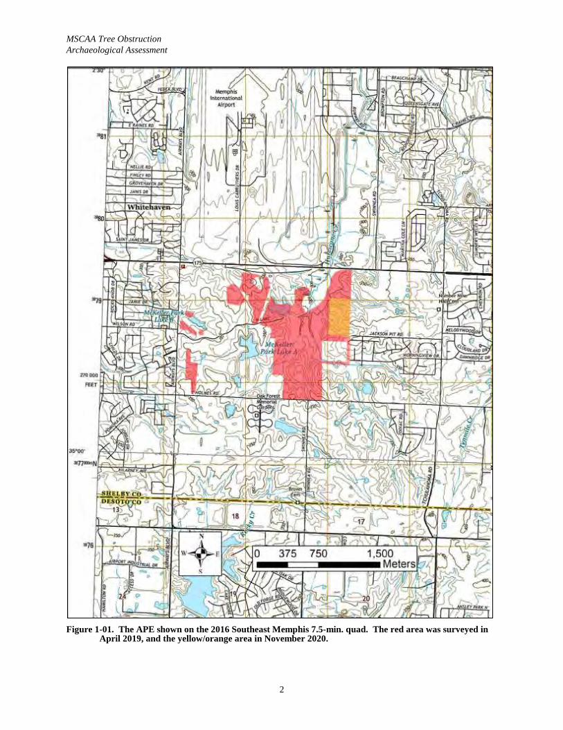
MSCAA Tree Obstruction Archaeological Assessment
2
Figure 1-01. The APE shown on the 2016 Southeast Memphis 7.5-min. quad. The red area was surveyed in April 2019, and the yellow/orange area in November 2020.

Introduction
3
Figure 1-02. A 2016 air photo of showing the APE (map courtesy:). The red area was surveyed in April 2019, and the yellow/orange area in November 2020.

MSCAA Tree Obstruction Archaeological Assessment
4
Page intentionally blank
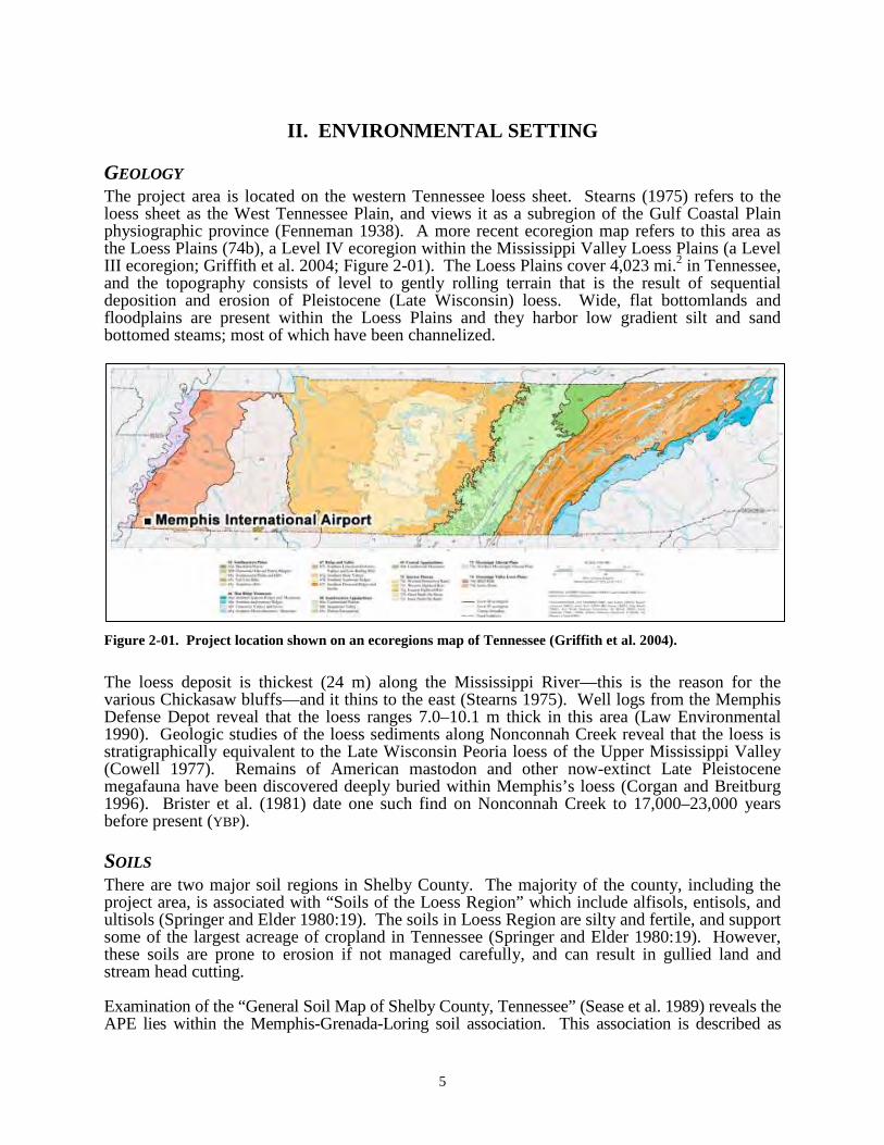
Environmental Setting
5
II. ENVIRONMENTAL SETTING
GEOLOGYThe project area is located on the western Tennessee loess sheet. Stearns (1975) refers to the loess sheet as the West Tennessee Plain, and views it as a subregion of the Gulf Coastal Plain physiographic province (Fenneman 1938). A more recent ecoregion map refers to this area as the Loess Plains (74b), a Level IV ecoregion within the Mississippi Valley Loess Plains (a Level III ecoregion; Griffith et al. 2004; Figure 2-01). The Loess Plains cover 4,023 mi.2 in Tennessee, and the topography consists of level to gently rolling terrain that is the result of sequential deposition and erosion of Pleistocene (Late Wisconsin) loess. Wide, flat bottomlands and floodplains are present within the Loess Plains and they harbor low gradient silt and sand bottomed steams; most of which have been channelized.
Figure 2-01. Project location shown on an ecoregions map of Tennessee (Griffith et al. 2004).
The loess deposit is thickest (24 m) along the Mississippi River—this is the reason for the various Chickasaw bluffs—and it thins to the east (Stearns 1975). Well logs from the Memphis Defense Depot reveal that the loess ranges 7.0–10.1 m thick in this area (Law Environmental 1990). Geologic studies of the loess sediments along Nonconnah Creek reveal that the loess is stratigraphically equivalent to the Late Wisconsin Peoria loess of the Upper Mississippi Valley (Cowell 1977). Remains of American mastodon and other now-extinct Late Pleistocene megafauna have been discovered deeply buried within Memphis’s loess (Corgan and Breitburg1996). Brister et al. (1981) date one such find on Nonconnah Creek to 17,000–23,000 years before present (YBP).
SOILSThere are two major soil regions in Shelby County. The majority of the county, including the project area, is associated with “Soils of the Loess Region” which include alfisols, entisols, and ultisols (Springer and Elder 1980:19). The soils in Loess Region are silty and fertile, and support some of the largest acreage of cropland in Tennessee (Springer and Elder 1980:19). However, these soils are prone to erosion if not managed carefully, and can result in gullied land and stream head cutting.
Examination of the “General Soil Map of Shelby County, Tennessee” (Sease et al. 1989) reveals the APE lies within the Memphis-Grenada-Loring soil association. This association is described as
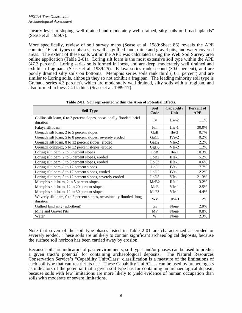
MSCAA Tree Obstruction Archaeological Assessment
6
“nearly level to sloping, well drained and moderately well drained, silty soils on broad uplands” (Sease et al. 1989:7).
More specifically, review of soil survey maps (Sease et al. 1989:Sheet 86) reveals the APE contains 16 soil types or phases, as well as gullied land, mine and gravel pits, and water covered areas. The extent of these soils within the APE was calculated using the Web Soil Survey area online application (Table 2-01). Loring silt loam is the most extensive soil type within the APE (47.3 percent). Loring series soils formed in loess, and are deep, moderately well drained and exhibit a fragipans (Sease et al. 1989:25). Falaya series rank second (30.0 percent), and are poorly drained silty soils on bottoms. Memphis series soils rank third (10.1 percent) and are similar to Loring soils, although they so not exhibit a fragipan. The leading minority soil type is Grenada series 4.3 percnet), which are moderately well drained, silty soils with a fragipan, and also formed in loess >4 ft. thick (Sease et al. 1989:17).
Table 2-01. Soil represented within the Area of Potential Effects.
Soil Type Soil Code
Capability Unit
Percent of APE
Collins silt loam, 0 to 2 percent slopes, occasionally flooded, brief duration Co IIw-2 1.1%
Falaya silt loam Fm IIw-1 30.0%Grenada silt loam, 2 to 5 percent slopes GaB IIe-2 0.7%Grenada silt loam, 5 to 8 percent slopes, severely eroded GaC3 IVe-2 0.2%Grenada silt loam, 8 to 12 percent slopes, eroded GaD2 VIe-2 2.2%Grenada complex, 5 to 12 percent slopes, eroded GgD3 VIe-2 1.2%Loring silt loam, 2 to 5 percent slopes LoB IIe-1 10.3%Loring silt loam, 2 to 5 percent slopes, eroded LoB2 IIIe-1 5.2%Loring silt loam, 5 to 8 percent slopes, eroded LoC2 IIIe-1 0.6%Loring silt loam, 8 to 12 percent slopes LoD IVe-1 7.7%Loring silt loam, 8 to 12 percent slopes, eroded LoD2 IVe-1 2.2%Loring silt loam, 5 to 12 percent slopes, severely eroded LoD3 VIe-1 21.3%Memphis silt loam, 2 to 5 percent slopes MeB2 IIIe-1 3.2%Memphis silt loam, 12 to 20 percent slopes MeE VIe-1 2.5%Memphis silt loam, 12 to 30 percent slopes MeF3 VIe-1 4.4%Waverly silt loam, 0 to 2 percent slopes, occasionally flooded, long duration Wv IIIw-1 1.2%
Gullied land silty (udorthent) Gs None 2.9%Mine and Gravel Pits MP None 0.8%Water W None 2.3%
Note that seven of the soil type-phases listed in Table 2-01 are characterized as eroded or severely eroded. These soils are unlikely to contain significant archaeological deposits, because the surface soil horizon has been carried away by erosion.
Because soils are indicators of past environments, soil types and/or phases can be used to predict a given tract’s potential for containing archaeological deposits. The Natural Resources Conservation Service’s “Capability Unit/Class” classification is a measure of the limitations of each soil type that can restrict its use. These Capability Unit/Class can be used by archeologists as indicators of the potential that a given soil type has for containing an archaeological deposit, because soils with few limitations are more likely to yield evidence of human occupation than soils with moderate or severe limitations.
Environmental Setting
7
From an archaeological standpoint, Capability Units/Classes are evaluated as followed:
Unit/Class I soils have few limitations that restrict their use, and are considered to have a high probability of containing archaeological resources.
Unit/Class II soils have moderate limitations, and are considered to have a moderate probability of containing archaeological resources.
Unit/Class III and IV soils have severe limitations, and are considered to have a low probability of containing archaeological resources.
Unit/Class V through VIII soils have very severe limitations, and are considered to have little to no probability of containing archaeological resources.
A total of 42.1 percent of the APE is composed of Capability Unit II soils and should have a moderate probability of containing archaeological resources; however 30.0 percent of this is associated with Falaya silt loam, which is limited by wetness. Class III and IV soils form 20.3 percent of the project area, and Class VI soils form 31.6 percent of the project area. The latter, which combined covered 51.9 percent of the APE, are considered low probability settings.
DRAINAGEThe principal drainage within the APE is Hurricane Creek, which flows northeasterly out of the APE. It is a short feeder stream—the APE is at essentially at its headwaters—that empties into Nonconnah Creek about 7 km northeast of the APE. The extreme southwestern portion of the APE is drained by a westward flowing unnamed tributary of Days Creek. Days Creek is another short feeder stream that empties into Nonconnah Creek downstream of Hurricane Creek.
Nonconnah Creek is one of the three major tributaries of the Mississippi River in Shelby County (the others being the Wolf and Loosahatchie rivers). The Nonconnah Creek Watershed is located in northwest Mississippi and southwest Tennessee. Nonconnah Creek flows for approximately 56 km (35 mi.) from its headwaters in Marshall County, Mississippi to its mouth at McKellar Lake in Shelby County, Tennessee.
FLORAShelby County is part of the Mississippi Embayment Section of the Western Mesophytic Forest Region as described by Braun (1964:157), and the Tulip-Oak Forest as described by Shelford (1974:35). Oak and Oak-Hickory floral communities predominate in this region along stream and river terraces, with swamp forest species predominating along low-lying floodplain areas. However, much of the modern landscape is so modified that the flora is in no way reflective of a natural setting. Floral species within the former Oak and Oak-Hickory communities include white oak (Quercus alba), southern red oak (Quercus falcata), hickory (Carya sp.), and tuliptree (Liriodendron tulipifera) at higher elevations, with beech (Fagus grandifolia), sugar maple (Acer saccharum), and bald cypress (Taxodium distichum) occurring at only very low elevations such as those immediately abutting local drainages. Undergrowth in these communities is characteristically sparse, with dogwood (Cornus florida), winged elm (Ulmus alata), persimmon (Diospyros virginiana), sassafras (Sassafras albidium), mulberry (Morus sp.), white ash (Fraxinus americana), and holly (Ilex sp.) accounting for the majority of species (Braun 1964:157). In particular, mast-producing species such as the various oaks and hickories represented an important subsistence resource for humans occupying this region.

MSCAA Tree Obstruction Archaeological Assessment
8
FAUNAFaunal species occupying these communities include large mammals such as the white-tailed deer (Odocoileus virginianus) and black bear (Ursus americanus); smaller mammals such as opossum (Didelphis marsupialis), raccoon (Procyon lotor), rabbit (Syvilagus sp.), beaver (Casor canadensis), otter (Lutra canadensis), and squirrel (Sciurus sp.); and large terrestrial birds including wild turkey (Meleagris gallapavo). Migratory waterfowl such as ducks (Anas sp.) and geese (Branta sp.) undoubtedly also frequented these communities on a seasonal basis. Riverine species within these communities would have included fish species such as bass (Micropterus sp.), catfish (Ictalurus sp.), sunfish (Lepomis sp.), drum (Aplodinotus grunniens), and gar (Leisosteus sp.). All the faunal species described immediately above would have offered important subsistence resources for humans occupying the area during prehistoric and historic times.
PALEOCLIMATE/VEGETATIONPaleoenvironmental conditions were substantially different in the late Pleistocene through the middle Holocene. Delcourt et al. (1999) have synthesized current data and mapped vegetation reconstructions for the Central Mississippi Valley. The discussion that follows is drawn from this summary. During the Late Wisconsin full-glacial interval (18,000 YBP) the central Mississippi River valley was covered by boreal forest communities and a Spruce-Willow Forest was on the valley train surfaces that were fed by glacial meltwater from the Ohio River. Post-glacial warming caused jack pine population to collapse about 14,000 YBP, but the area east of Crowley’s Ridge remained a Spruce-Willow Forest. By 12,000 YBP warming temperatures lead to an expansion of Oak-Hickory Forest on abandoned braided steam terraces and the Spruce-Willow Forest became more restricted as the active channel of the Ohio River shifted east.
By 10,000 YBP “the vegetation had become temperate to warm temperate in character” (Delcourt et al. 1999:25). Sweetgum-Elm Forest and Willow-Cane Forest developed along and near the now-meandering Mississippi River, while the Oak-Hickory Forest continued to expand on abandoned braided stream terraces.
At 8,000 YBP the effects of a warm and dry interval referred to as the Hypsithermal begin to be seen in the pollen record. Drought-tolerant species expanded and the Oak-Hickory Forest that formerly covered the valley train to the west of the project area developed into an Oak-Hickory Savannah. However, along and near the Mississippi River, Sweetgum-Elm Forest and Willow-Cane Forest remained and Cypress-Tupelo Forest expanded in the backswamps.
Regionally, the Hypsithermal was most strongly felt around 6,000 YBP and the arid conditions continued until after 4,000 YBP (Delcourt et al. 1999). McNutt (1996) suggests that during 7,500–5,500 YBP the strongest cultural impacts of the Hypsithermal were felt. Willow-Cane Forest and Cypress-Tupelo Forest became “confined to the easternmost portion of the Eastern Lowlands along a relatively narrow meander belt” that would have included the Barnes Ridge area (Delcourt et al. 1999:26). Within the backswamps, mesic lowland forest probably expanded into Cypress-Tupelo Forests because of dropping water tables.
Modern floristic regions developed between 4,000 and 3,000 YBP with a return to wetter conditions. The Sweetgum-Elm Forest re-expanded along drainages and Willow-Cane Forest “occupied a broadening and shifting Mississippi meander belt” (Delcourt et al. 1999:27). Changes in the locations of Willow-Cane, Sweetgum-Elm and Cypress-Tupelo Forests became dependent on shifts in channel morphology.
In discussing the 1,000 YBP environment, Delcourt et al. (1999) note that portions of the Eastern Lowlands would have been covered by Ragweed-Grass Old Field vegetation. This refers to “anthropogenically disturbed landscapes” (Delcourt et al. 1999:28), such as Native American
Environmental Setting
9
(Mississippian period) cornfields with early secessional grassland and thickets for cover. Delcourt et al. (1999:28) state, the “paleoecological ‘signature’ of cultural impact is characterized by occurrence of pollen grains of cereals such as maize; weedy herbs including ragweed, chenopods, and grasses; and spores of old-field ferns, such as bracken.”
MODERN CLIMATEShelby County’s climate is typical of the central Mississippi River valley, with hot summers and mild winters and abundant rainfall. The average annual temperature in Memphis is 62˚ F, although extremes of 106˚ F and -11˚ F were recorded during 1931–1960 (Sease et al. 1989:2). The growing season is long (238 days), extending from late March to mid-November (Sease et al. 1989:3). July is the warmest month, with daily average maximum and minimum temperatures of 92.1˚ F and 71.5˚. January is the coldest month, with daily average maximum and minimum temperatures of 50.6˚ F and 33.4˚ (Sease et al. 1989:Table 1).
Rainfall amounts vary throughout the county, with differences of up to 2 in. per annum recorded between the western and eastern portions (Sease et al. 1989:2). The average precipitation per annum is 49.73 in. (Sease et al. 1989:Table 1). Precipitation is normally heaviest during the winter and early spring months, with January, on average, having 6.07 in. (Sease et al. 1989:Table 1). Fall is the driest season and October, with an average of 2.72 in. of precipitation, is the driest month (Sease et al. 1989:Table 1).

MSCAA Tree Obstruction Archaeological Assessment
10
Page intentionally blank
Cultural Background
11
III. CULTURAL BACKGROUND
The following is a summary of the archaeological cultures of west Tennessee, with a review of Memphis history. Each of these periods is defined by characteristic artifact assemblages and patterns of subsistence and settlement. The prehistoric (or pre-Columbian) period in the southeastern U.S. is traditionally divided into four major periods: Paleoindian, Archaic, Woodland, and Mississippian.
PREHISTORIC SEQUENCE
PALEOINDIAN PERIODPaleoindian occupations represent the first well-accepted occurrence of humans in the Western Hemisphere. These populations are generally thought of as highly adaptive, mobile hunter-gatherers whose recent ancestors were Upper Paleolithic Siberians who migrated across the present Bering Strait during the Late Pleistocene, when sea levels were ca. 60 m lower. During the Late Glacial era, when initial human colonization of the Southeast is postulated (ca. 11,000–8000 B.C.), climatic changes followed the receding of the continental ice sheets, and there was a widespread extinction of megafauna. The environment at this time is usually interpreted to have been spruce and/or pine-dominated boreal forest (Saucier 1978).
Recent research on Paleoindian diagnostics (Anderson et al. 1990) indicates that the period may be subdivided into Early (ca. 9500–9000 B.C.), Middle (ca. 9000–8500 B.C.), and Late (ca. 8500–8000 B.C.) stages, based on changes in hafted biface morphology. No radiocarbon dates are available to confirm independently the accuracy of the subdivision.
Aboriginal groups of the period were likely small, mobile bands dependent upon a hunting-and-gathering economy. Although they may have hunted some of the megafauna that became extinct at the end of the Pleistocene, such as mastodon (Mammut americanum), bison (Bison bison antiquus), and ground sloth (Megalonyx sp.), it is likely that the subsistence base was varied and included a number of plant and animal foods. One of the nearest firm associations of a fluted point with mastodon remains is well north of western Tennessee at the Kimmswick bone bed in Missouri (Graham et al. 1981), although a possible association at Mississippi River Island No. 35 to the south should be noted as well (S. Williams 1957). No artifacts are associated with the Nonconnah Creek Mastodon find (Brister et al. 1981).
DALTON PERIODThe Dalton period is considered a transitional phase between the Paleoindian and Archaic traditions. The key distinguishing feature of the material culture is the unfluted, serrated Dalton point, but the Dalton tool kit includes a number of other diagnostic special-function tools and a woodworking adz (Morse and Morse 1983, 1996). Dalton points recovered from a Forked Deer River context are noted by G.P. Smith (1996:101) as being long, thin forms with only a minimal amount of constriction in the hafting area. Goodyear (1982) suggests that Dalton represents a distinct temporal horizon dating to 8500–7900 B.C. While technologically similar to Paleoindian, Dalton assemblages suggest an adaptive pattern more akin to later Archaic cultures. One of the most important game species from this time to the contact era seems to have been the white-tailed deer (Morse and Morse 1983:71). During the Dalton period, the Mississippi River meander system was established in the lower valley and was working northward, but a braided stream regime still existed.
Dalton components are better represented in northwestern Tennessee than are the preceding Early and Middle Paleoindian diagnostics, although much is yet to be learned about this temporal
MSCAA Tree Obstruction Archaeological Assessment
12
period. Mainfort (1996b:80) notes that the only two examples of Dalton components recovered from the Reelfoot Basin of extreme northwestern Tennessee were collected from predominantly Mississippian-component sites. Sites 40OB123 and 40OB127, approximately 1 mi. apart, have yielded one Dalton artifact each. Mainfort (1996) further notes that a “fairly large Dalton site” has been reported by a local collector in the Reelfoot area, although the location of that site has yet to be determined. In Fayette County, G.P. Smith (1996:101) notes the presence of a Dalton component in a relatively shallow context at 40FY13.
In the 1960s the Ford-Redfield survey project identified a concentration of Dalton components in northeastern Arkansas (Redfield 1971; Redfield and Moselage 1970). Important sites such as Brand (Goodyear 1974), Sloan (Morse 1975), and Lace (Morse and Morse 1983) produced evidence for some of the oldest cemeteries in the New World and revealed other features interpreted as living floors and shelter remains. The distribution of sites and site types along the major drainages has also led to the formulation of competing settlement-pattern models for band-level societies (Morse 1975, 1977, 1997; Price and Krakker 1975; Schiffer 1975), which have been succinctly commented upon by McNutt (1996:191–192).
ARCHAIC PERIODThe Archaic is usually thought of in terms of three subperiods: Early (ca. 8000–5000 B.C.), Middle (5000–3000 B.C.), and Late (3000–1500 B.C.). Temporal divisions of the Archaic are primarily based on the occurrence of distinctive projectile points. Throughout Archaic times a hunter-gatherer lifeway appears to have continued, and it was focused on essentially the same flora and fauna as represented in the natural environment today. The Archaic is perceived as a time of regional “settling in,” when an efficient utilization of the environment was keyed to highly cyclical, repetitive seasonal activities continued by indigenous groups over thousands of years (Caldwell 1958). Some seasonal movement to exploit econiches was probably required, but Archaic populations, compared to Paleoindian, are generally portrayed as being attached to localities, river valleys, or regions. A total of 31 sites with known or probable Archaic components have been recorded in the Reelfoot Basin of extreme northwestern Tennessee (Mainfort 1996:80). Additionally, numerous other sites with Archaic components have been recorded in all the major river valleys in western Tennessee (G.P. Smith 1979). Relatively little is known about this temporal period in this area of the Southeast. In the Central Mississippi Valley, virtually no Archaic sites have been excavated, and indeed these components appear to have been overlooked by archaeologists more concerned with ceramic-period adaptations (McNutt 1996:194; S. Williams 1991).
Concerning the Early Archaic period, McNutt (1996:194) notes that “we can see several projectile points coming into the Valley from the west and north, probably in conjunction with the prairie expansion and dry econiches during the Hypsithermal.” Point forms considered diagnostic for the Early Archaic include Big Sandy, Hardin, Plevna, and Lost Lake (G.P. Smith 1996:101). For northeastern Arkansas, Morse and Morse (1983) proposed a series of horizon markers that grade from classic Early Archaic Corner-Notched forms (ca. 7500–7000 B.C.) into Middle Archaic Basal Notched forms.
The Middle Archaic period was marked by a shift in subsistence modes. This was possibly due to environmental changes caused by a climatic episode called the Hypsithermal which is dated 7000–3000 B.C. (McNutt 1996) or 8000–4000 B.C. (Morse and Morse 1983). This change resulted in restricted deciduous forest occurrence, limiting the availability of certain floral and faunal resources. The cultural impact of this warming trend appears to have been most strongly felt from 5500–3500 B.C. Several settlement models regarding human adaptation during the climatic optimum have been posited. Morse and Morse (1983) propose that the western lowlands of northeastern Arkansas were largely abandoned for the uplands (Ozark Plateau and its escarpment). However, in the lower Tennessee/Cumberland region, populations appear to
Cultural Background
13
have congregated at a limited number of floodplain locations, producing deep middens (Nance 1987). M.J. Higgins (1990) proposed that the drying of the uplands forced people into the floodplain (American Bottom). Cypress Creek II, Eva, and perhaps some side-notched forms are noted as the diagnostic point forms from this temporal period (G.P. Smith 1996:101).
The Late Archaic began at the end of the Hypsithermal climatic episode (ca. 3000 B.C.) and the establishment of the modern climatic regime. The Mississippi River was by then a well-entrenched meander belt-type fluvial system and adapting to this type of environment was critical for human occupation. There is evidence for more sedentary lifeways and possibly limited horticulture was being employed, as sunflower, squash, and other cultivated native starchy seed annuals appear in the archaeobotanical record at this time in the other areas of the Southeast. Late Archaic settlement models typically have a seasonal round aspect, and there is evidence that the substantial “winter” villages, typically located on major streams, were actually occupied year round. Both earthen and shell mounds appear in the archaeological record in the Southeast at this time.
The Late Archaic is characterized by a substantial increase in the number of sites, cultural elaboration, and widespread trade. The period opened with the Benton culture, represented in the diagnostic material record by the Benton projectile point. G.P. Smith (1996:102) notes that two sites in western Tennessee yielded settlement-pattern information regarding Benton culture. Geographical positioning of these sites appears to represent a Benton trend toward the habitation of low stream terraces in western Tennessee. Excavations at 40FY13 and 40GB42 revealed a heavy dependence on mast-bearing species such as the hickory, and 40FY13 further revealed Benton structural remains, interpreted as bent-pole rectilinear to ovate dwellings. Flexed burials at 40GB42 are at present tentatively tied to the Benton component at this site. Subsequent cultures of the Late Archaic in western Tennessee are very poorly understood. Such culturesmay be represented by the Bartlett and Macintire, variety A projectile points as described by G.P. Smith (1979), although little is known about the Late Archaic cultures that produced these lithic artifacts.
POVERTY POINTPoverty Point, or Terminal Late Archaic, components are distinguished by the appearance of large mounds, earthworks, clay balls or “Poverty Point Objects,” microlithics, lapidary work, raw material trade, and specialized manufacturing sites. The Poverty Point period (1500–500 B.C.) is considered one of three cultural “zeniths” in prehistoric Southeastern studies. In other portions of the Southeast, these components are referred to as Gulf Formational (Walthall 1990 [1980]) and include fiber-tempered ceramics as a diagnostic (Morse and Morse 1983:124). In western Tennessee, fiber-tempered ceramics occur only occasionally in the Nonconnah and Lambert complexes of the Terminal Late Archaic, and most likely represent trade items obtained from groups farther to the south (G.P. Smith 1996:104).
Midden mounds and gathering camps appear in the archaeological record at this time and reflect semi-sedentary populations (McNutt 1996; Morse and Morse 1983). G.P. Smith (1996:104) notes the presence of a Lambert complex component at 40FY13, possibly representing a Terminal Late Archaic mast-collection site. Site 40GB42 yielded similar components, although there they are attributable to the Kenton complex of the Terminal Late Archaic.
Clay balls are thought to have been a substitute for boiling stones and have considerable time depth, apparently extending into the early Middle Woodland; thus they cannot be used as exclusively Poverty Point component markers. A variety of stemmed projectile points are characteristic of the period, including Burkett-Etley-Gary forms, similar to Ledbetter-Pickwick-Mulberry Creek points, and the Weems-Wade-Dyroff-McIntire forms, which lead into the Early Woodland.
MSCAA Tree Obstruction Archaeological Assessment
14
G.P. Smith (1979, 1996; G.P. Smith and McNutt 1988) has repeatedly proposed a series of Poverty Point complexes for the interior drainages (loess region) of western Tennessee. The nine complexes he delineates are based primarily on pre-1975 fieldwork. His complexes are spatially discrete and distributed along the terraces of the smaller river bottoms that characterize the region. They are distinguished by variations in baked clay ball and preliminary projectile point types and varieties. The complexes are akin to phases and have been strongly criticized by Mainfort (1994) who remarks “While such a fine-scale typology may be useful, Smith does not demonstrate its value beyond documenting intra-regional variation and even that may be premature considering the fact that most of the data are derived from surface collections” (J.K. Johnson 1993:67).
WOODLAND PERIODDuring the Woodland period, intensification in horticultural methods, construction of earthworks, elaboration of artistic expression, and burial rituals are all thought to be related to the reorganization of social structure. For at least part of the year, a sedentary group was needed to plant, tend, and harvest crops. Sedentism and communal labor efforts promoted territorial circumscription. This period was also characterized by increased variety and use of ceramics. Ceramic types and varieties are thus a primary consideration in interpreting settlement patterns and chronological progression of the Woodland period. Considerable archaeological attention has been focused on these ceramic cultures, and a number of phases and phase sequences have been proposed. However, the reader should be aware that these phase assignments are highly problematic and have received strong criticism in the recent past (Mainfort 1994).
The Early Woodland or Tchula period is viewed by G.P. Smith (1996:104–105) as a continued occupation by the distinct cultural complexes of the previous Poverty Point period. Tchula period diagnostic ceramics, including Tammany Punctated, Cormorant Cord Impressed, Twin Lakes Punctated, and Withers Fabric Impressed, are poorly represented in the archaeological assemblage from western Tennessee and Kentucky (Lewis 1996:51–53; Mainfort 1996b:81–82). According to Mainfort and R.B. Lewis, this poor representation is most likely attributable to the lack of temporally specific research projects aimed at the recovery of data regarding Tchula period occupations.
The most intensively investigated Early Woodland component in western Tennessee is the Fulmer site (40SY527), located on a finger ridge on the margin of the Loosahatchie floodplain near Arlington, Tennessee (Weaver et al. 1996, 1999). Approximately 62 percent of this small, essentially single-component open-habitation site was formally excavated, resulting in detailed data regarding Tchula period site structure. Activity and midden areas in the lee of the prevailing wind around a central hearth were suggested by artifact distributions. Numerous reconstructed vessel sections recovered here revealed that the conoidal bowl/beaker was overwhelmingly the most common vessel form (n=35), followed by medium jars (n=11), large flaring-rim bowls (n=5), and other bowl and jar forms. Fabric impression was the most common surface decoration, but slipped, punctated, and cord-impressed vessels were also manufactured, often with folded rims. Several 14C samples were dated, but the resulting dates (A.D. 970, 980, 1060, 1520, 1750, and 1780; uncalibrated) were considered invalid (i.e., rejected). Most features at the site were heavily disturbed by tree roots, rodent burrowing, and other processes, includingearly twentieth-century plowing, and the radiocarbon dates may date these post-depositional disturbances. Comparative review of the regional literature led the authors to suggest that Fulmer was affiliated with the Turkey Ridge phase of the Lake Cormorant Horizon, with a likely occupation ca. 400–100 B.C.
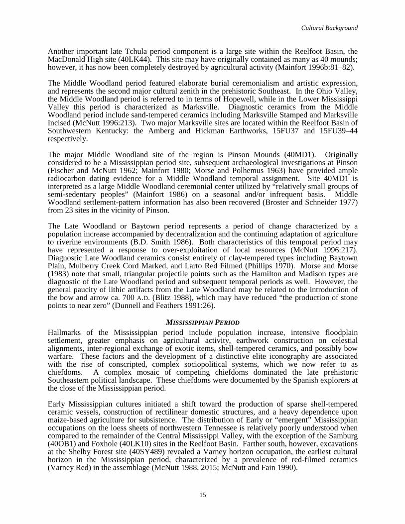
Cultural Background
15
Another important late Tchula period component is a large site within the Reelfoot Basin, the MacDonald High site (40LK44). This site may have originally contained as many as 40 mounds; however, it has now been completely destroyed by agricultural activity (Mainfort 1996b:81–82).
The Middle Woodland period featured elaborate burial ceremonialism and artistic expression, and represents the second major cultural zenith in the prehistoric Southeast. In the Ohio Valley, the Middle Woodland period is referred to in terms of Hopewell, while in the Lower Mississippi Valley this period is characterized as Marksville. Diagnostic ceramics from the Middle Woodland period include sand-tempered ceramics including Marksville Stamped and Marksville Incised (McNutt 1996:213). Two major Marksville sites are located within the Reelfoot Basin of Southwestern Kentucky: the Amberg and Hickman Earthworks, 15FU37 and 15FU39–44 respectively.
The major Middle Woodland site of the region is Pinson Mounds (40MD1). Originally considered to be a Mississippian period site, subsequent archaeological investigations at Pinson (Fischer and McNutt 1962; Mainfort 1980; Morse and Polhemus 1963) have provided ample radiocarbon dating evidence for a Middle Woodland temporal assignment. Site 40MD1 is interpreted as a large Middle Woodland ceremonial center utilized by “relatively small groups of semi-sedentary peoples” (Mainfort 1986) on a seasonal and/or infrequent basis. Middle Woodland settlement-pattern information has also been recovered (Broster and Schneider 1977) from 23 sites in the vicinity of Pinson.
The Late Woodland or Baytown period represents a period of change characterized by a population increase accompanied by decentralization and the continuing adaptation of agriculture to riverine environments (B.D. Smith 1986). Both characteristics of this temporal period may have represented a response to over-exploitation of local resources (McNutt 1996:217). Diagnostic Late Woodland ceramics consist entirely of clay-tempered types including Baytown Plain, Mulberry Creek Cord Marked, and Larto Red Filmed (Phillips 1970). Morse and Morse (1983) note that small, triangular projectile points such as the Hamilton and Madison types are diagnostic of the Late Woodland period and subsequent temporal periods as well. However, the general paucity of lithic artifacts from the Late Woodland may be related to the introduction of the bow and arrow ca. 700 A.D. (Blitz 1988), which may have reduced “the production of stone points to near zero” (Dunnell and Feathers 1991:26).
MISSISSIPPIAN PERIODHallmarks of the Mississippian period include population increase, intensive floodplain settlement, greater emphasis on agricultural activity, earthwork construction on celestial alignments, inter-regional exchange of exotic items, shell-tempered ceramics, and possibly bow warfare. These factors and the development of a distinctive elite iconography are associated with the rise of conscripted, complex sociopolitical systems, which we now refer to as chiefdoms. A complex mosaic of competing chiefdoms dominated the late prehistoric Southeastern political landscape. These chiefdoms were documented by the Spanish explorers at the close of the Mississippian period.
Early Mississippian cultures initiated a shift toward the production of sparse shell-tempered ceramic vessels, construction of rectilinear domestic structures, and a heavy dependence upon maize-based agriculture for subsistence. The distribution of Early or “emergent” Mississippian occupations on the loess sheets of northwestern Tennessee is relatively poorly understood when compared to the remainder of the Central Mississippi Valley, with the exception of the Samburg (40OB1) and Foxhole (40LK10) sites in the Reelfoot Basin. Farther south, however, excavations at the Shelby Forest site (40SY489) revealed a Varney horizon occupation, the earliest cultural horizon in the Mississippian period, characterized by a prevalence of red-filmed ceramics (Varney Red) in the assemblage (McNutt 1988, 2015; McNutt and Fain 1990).
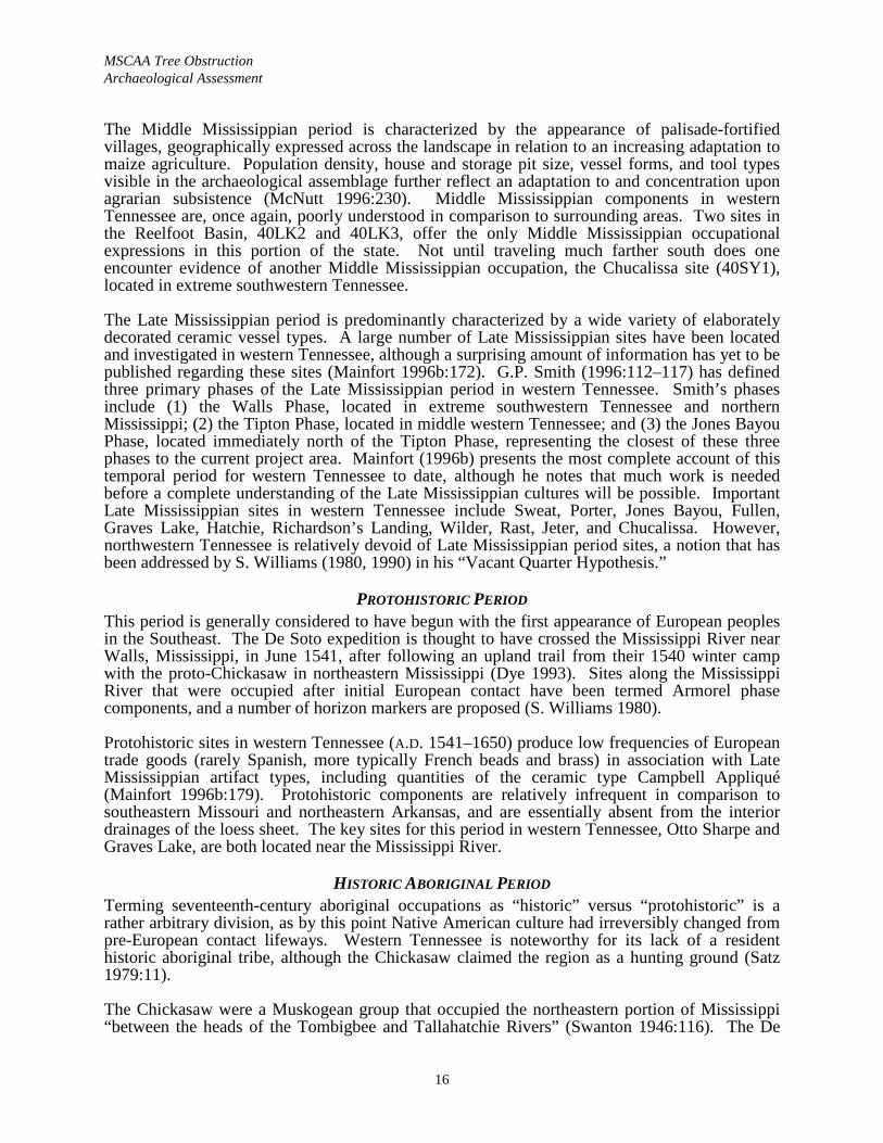
MSCAA Tree Obstruction Archaeological Assessment
16
The Middle Mississippian period is characterized by the appearance of palisade-fortified villages, geographically expressed across the landscape in relation to an increasing adaptation to maize agriculture. Population density, house and storage pit size, vessel forms, and tool types visible in the archaeological assemblage further reflect an adaptation to and concentration upon agrarian subsistence (McNutt 1996:230). Middle Mississippian components in western Tennessee are, once again, poorly understood in comparison to surrounding areas. Two sites in the Reelfoot Basin, 40LK2 and 40LK3, offer the only Middle Mississippian occupational expressions in this portion of the state. Not until traveling much farther south does one encounter evidence of another Middle Mississippian occupation, the Chucalissa site (40SY1), located in extreme southwestern Tennessee.
The Late Mississippian period is predominantly characterized by a wide variety of elaborately decorated ceramic vessel types. A large number of Late Mississippian sites have been located and investigated in western Tennessee, although a surprising amount of information has yet to be published regarding these sites (Mainfort 1996b:172). G.P. Smith (1996:112–117) has defined three primary phases of the Late Mississippian period in western Tennessee. Smith’s phases include (1) the Walls Phase, located in extreme southwestern Tennessee and northern Mississippi; (2) the Tipton Phase, located in middle western Tennessee; and (3) the Jones Bayou Phase, located immediately north of the Tipton Phase, representing the closest of these three phases to the current project area. Mainfort (1996b) presents the most complete account of this temporal period for western Tennessee to date, although he notes that much work is needed before a complete understanding of the Late Mississippian cultures will be possible. Important Late Mississippian sites in western Tennessee include Sweat, Porter, Jones Bayou, Fullen, Graves Lake, Hatchie, Richardson’s Landing, Wilder, Rast, Jeter, and Chucalissa. However, northwestern Tennessee is relatively devoid of Late Mississippian period sites, a notion that has been addressed by S. Williams (1980, 1990) in his “Vacant Quarter Hypothesis.”
PROTOHISTORIC PERIODThis period is generally considered to have begun with the first appearance of European peoples in the Southeast. The De Soto expedition is thought to have crossed the Mississippi River near Walls, Mississippi, in June 1541, after following an upland trail from their 1540 winter camp with the proto-Chickasaw in northeastern Mississippi (Dye 1993). Sites along the Mississippi River that were occupied after initial European contact have been termed Armorel phase components, and a number of horizon markers are proposed (S. Williams 1980).
Protohistoric sites in western Tennessee (A.D. 1541–1650) produce low frequencies of European trade goods (rarely Spanish, more typically French beads and brass) in association with Late Mississippian artifact types, including quantities of the ceramic type Campbell Appliqué (Mainfort 1996b:179). Protohistoric components are relatively infrequent in comparison to southeastern Missouri and northeastern Arkansas, and are essentially absent from the interior drainages of the loess sheet. The key sites for this period in western Tennessee, Otto Sharpe and Graves Lake, are both located near the Mississippi River.
HISTORIC ABORIGINAL PERIODTerming seventeenth-century aboriginal occupations as “historic” versus “protohistoric” is a rather arbitrary division, as by this point Native American culture had irreversibly changed from pre-European contact lifeways. Western Tennessee is noteworthy for its lack of a resident historic aboriginal tribe, although the Chickasaw claimed the region as a hunting ground (Satz 1979:11).
The Chickasaw were a Muskogean group that occupied the northeastern portion of Mississippi “between the heads of the Tombigbee and Tallahatchie Rivers” (Swanton 1946:116). The De
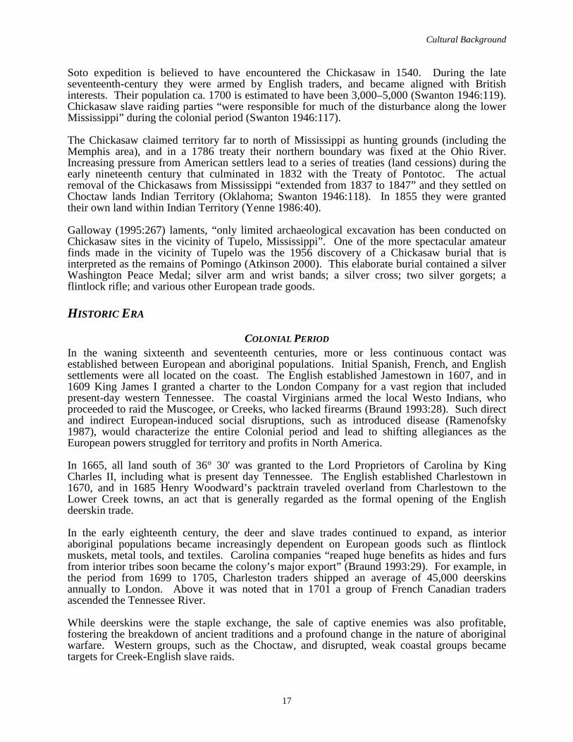
Cultural Background
17
Soto expedition is believed to have encountered the Chickasaw in 1540. During the late seventeenth-century they were armed by English traders, and became aligned with British interests. Their population ca. 1700 is estimated to have been 3,000–5,000 (Swanton 1946:119). Chickasaw slave raiding parties “were responsible for much of the disturbance along the lower Mississippi” during the colonial period (Swanton 1946:117).
The Chickasaw claimed territory far to north of Mississippi as hunting grounds (including the Memphis area), and in a 1786 treaty their northern boundary was fixed at the Ohio River. Increasing pressure from American settlers lead to a series of treaties (land cessions) during the early nineteenth century that culminated in 1832 with the Treaty of Pontotoc. The actual removal of the Chickasaws from Mississippi “extended from 1837 to 1847” and they settled on Choctaw lands Indian Territory (Oklahoma; Swanton 1946:118). In 1855 they were granted their own land within Indian Territory (Yenne 1986:40).
Galloway (1995:267) laments, “only limited archaeological excavation has been conducted on Chickasaw sites in the vicinity of Tupelo, Mississippi”. One of the more spectacular amateur finds made in the vicinity of Tupelo was the 1956 discovery of a Chickasaw burial that is interpreted as the remains of Pomingo (Atkinson 2000). This elaborate burial contained a silver Washington Peace Medal; silver arm and wrist bands; a silver cross; two silver gorgets; aflintlock rifle; and various other European trade goods.
HISTORIC ERA
COLONIAL PERIODIn the waning sixteenth and seventeenth centuries, more or less continuous contact was established between European and aboriginal populations. Initial Spanish, French, and English settlements were all located on the coast. The English established Jamestown in 1607, and in 1609 King James I granted a charter to the London Company for a vast region that included present-day western Tennessee. The coastal Virginians armed the local Westo Indians, who proceeded to raid the Muscogee, or Creeks, who lacked firearms (Braund 1993:28). Such direct and indirect European-induced social disruptions, such as introduced disease (Ramenofsky 1987), would characterize the entire Colonial period and lead to shifting allegiances as the European powers struggled for territory and profits in North America.
In 1665, all land south of 36° 30' was granted to the Lord Proprietors of Carolina by King Charles II, including what is present day Tennessee. The English established Charlestown in 1670, and in 1685 Henry Woodward’s packtrain traveled overland from Charlestown to the Lower Creek towns, an act that is generally regarded as the formal opening of the English deerskin trade.
In the early eighteenth century, the deer and slave trades continued to expand, as interior aboriginal populations became increasingly dependent on European goods such as flintlock muskets, metal tools, and textiles. Carolina companies “reaped huge benefits as hides and furs from interior tribes soon became the colony’s major export” (Braund 1993:29). For example, in the period from 1699 to 1705, Charleston traders shipped an average of 45,000 deerskins annually to London. Above it was noted that in 1701 a group of French Canadian traders ascended the Tennessee River.
While deerskins were the staple exchange, the sale of captive enemies was also profitable, fostering the breakdown of ancient traditions and a profound change in the nature of aboriginal warfare. Western groups, such as the Choctaw, and disrupted, weak coastal groups became targets for Creek-English slave raids.
MSCAA Tree Obstruction Archaeological Assessment
18
During the 1740s tensions between the colonial powers mounted, and alliances with Indians were critical for seizing and holding both territory and deerskin-trading profits. The French launched raids on the Chickasaw during 1736–1740 in retaliation for the Chickasaw raiding of their shipping (primarily Illinois wheat-laden barges) on the Mississippi River. In 1739, Fort Assumption (now Memphis) was built by the French on the Chickasaw Bluffs in an attempt to curb the Chickasaw. Also at about this time the introduction of significant numbers of Negro slaves began along the coast, supplying the colonists with a more stable and controlled supply of labor.
In 1756, the French and Indian War (Seven Years’ War) broke out, partly as a result of French efforts to fortify the Ohio Valley. France was defeated and signed the Treaty of Paris on February 10, 1763, ending the war. However, the English colonists were still forbidden to settle west of the Appalachians. English traders began infiltrating pro-French tribes in Louisiana in the 1770s; for example, in 1773 a Quapaw chief adopted an English trader, and they attended a conference at Pensacola together (Arnold 1991:109).
No significant activity took place in western Tennessee during the American Revolution. The nearest known engagement was the Englishman James Colbert’s attack on Arkansas Post with a Chickasaw war party in April 1783 (Arnold 1991:111–112). This action took place well after Cornwallis surrendered at Yorktown (October 1781), essentially forcing the British to abandon the war effort and sign a preliminary peace treaty at Versailles in November 1782. The peace treaty that ended the American Revolution was formally ratified in Paris on September 3, 1783.
After the American Revolution, significant numbers of settlers from North Carolina and Virginia began to migrate over the Blue Ridge Mountains into Tennessee and Kentucky. Tennessee at this time was still part of North Carolina, as specified in the charter issued by the British Crown. In 1785, there were significant tensions between the settlers in the Cumberland and the legislators in North Carolina; a separate assembly was formed, resulting in the birth of the “Lost State” of Franklin (Gerson 1968:36). In 1790, George Washington established the Territory of the U.S. South of the River Ohio, which provided a formal federal separation. In 1796, Tennessee became a state.
ANTEBELLUM PERIODThe early nineteenth century is better understood and represented in the archaeological record in Middle and East Tennessee, as this is where most settlements were located. In 1812 western Tennessee was rocked by a series of massive earthquakes known as the New Madrid earthquakes (Fuller 1912). The town of New Madrid, Missouri, was destroyed, Reelfoot Lake was formed, and the aftershocks continued for months. After the War of 1812 ended (in 1815) and the British-Creek Confederacy was defeated, immigration increased again.
In 1818, the Jackson Purchase Treaty resulted in the acquisition of western Tennessee from the Chickasaw Indians in Mississippi. Shelby County was created by the Tennessee General Assembly on November 24, 1819. The county is named for Isaac Shelby, one of the Jackson Purchase Treaty commissioners. Neighboring Fayette County was established by the Tennessee Legislature on September 19, 1824, and was named for Marquis de Lafayette, the French general and statesman (Morton 1998). Settlement of the area along the Shelby-Fayette county line began as early as 1820. Memphis, the largest city in Shelby County, was laid out in 1819 and incorporated in 1826.
Early settlements in eastern Shelby County include the following (Davies-Rodgers 1990; Magness 1994; Van West 1998). In 1807, the log house that would later become Davies Manorin Brunswick was built. The Davies did not acquire the eventual plantation until 1851, but the “manor” portion had been added to the log house by 1831. In 1825, Frances Wright founded the
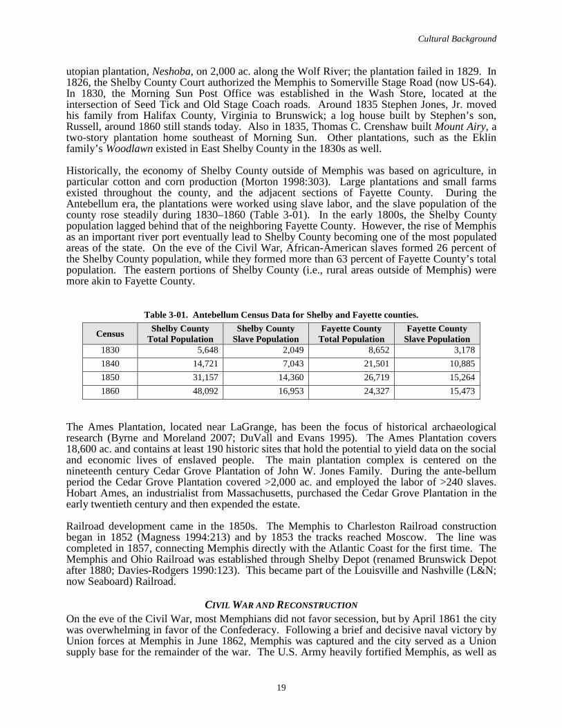
Cultural Background
19
utopian plantation, Neshoba, on 2,000 ac. along the Wolf River; the plantation failed in 1829. In 1826, the Shelby County Court authorized the Memphis to Somerville Stage Road (now US-64).In 1830, the Morning Sun Post Office was established in the Wash Store, located at the intersection of Seed Tick and Old Stage Coach roads. Around 1835 Stephen Jones, Jr. moved his family from Halifax County, Virginia to Brunswick; a log house built by Stephen’s son, Russell, around 1860 still stands today. Also in 1835, Thomas C. Crenshaw built Mount Airy, a two-story plantation home southeast of Morning Sun. Other plantations, such as the Eklin family’s Woodlawn existed in East Shelby County in the 1830s as well.
Historically, the economy of Shelby County outside of Memphis was based on agriculture, in particular cotton and corn production (Morton 1998:303). Large plantations and small farms existed throughout the county, and the adjacent sections of Fayette County. During the Antebellum era, the plantations were worked using slave labor, and the slave population of the county rose steadily during 1830–1860 (Table 3-01). In the early 1800s, the Shelby County population lagged behind that of the neighboring Fayette County. However, the rise of Memphis as an important river port eventually lead to Shelby County becoming one of the most populated areas of the state. On the eve of the Civil War, African-American slaves formed 26 percent of the Shelby County population, while they formed more than 63 percent of Fayette County’s total population. The eastern portions of Shelby County (i.e., rural areas outside of Memphis) were more akin to Fayette County.
Table 3-01. Antebellum Census Data for Shelby and Fayette counties.
Census Shelby CountyTotal Population
Shelby CountySlave Population
Fayette CountyTotal Population
Fayette CountySlave Population
1830 5,648 2,049 8,652 3,1781840 14,721 7,043 21,501 10,8851850 31,157 14,360 26,719 15,2641860 48,092 16,953 24,327 15,473
The Ames Plantation, located near LaGrange, has been the focus of historical archaeological research (Byrne and Moreland 2007; DuVall and Evans 1995). The Ames Plantation covers 18,600 ac. and contains at least 190 historic sites that hold the potential to yield data on the social and economic lives of enslaved people. The main plantation complex is centered on the nineteenth century Cedar Grove Plantation of John W. Jones Family. During the ante-bellum period the Cedar Grove Plantation covered >2,000 ac. and employed the labor of >240 slaves. Hobart Ames, an industrialist from Massachusetts, purchased the Cedar Grove Plantation in the early twentieth century and then expended the estate.
Railroad development came in the 1850s. The Memphis to Charleston Railroad construction began in 1852 (Magness 1994:213) and by 1853 the tracks reached Moscow. The line was completed in 1857, connecting Memphis directly with the Atlantic Coast for the first time. The Memphis and Ohio Railroad was established through Shelby Depot (renamed Brunswick Depot after 1880; Davies-Rodgers 1990:123). This became part of the Louisville and Nashville (L&N; now Seaboard) Railroad.
CIVIL WAR AND RECONSTRUCTIONOn the eve of the Civil War, most Memphians did not favor secession, but by April 1861 the city was overwhelming in favor of the Confederacy. Following a brief and decisive naval victory by Union forces at Memphis in June 1862, Memphis was captured and the city served as a Union supply base for the remainder of the war. The U.S. Army heavily fortified Memphis, as well as
MSCAA Tree Obstruction Archaeological Assessment
20
the railroad lines to the east and number of these fortifications are archaeologically documented (Prouty and Barker 1996). Ft. Pickering was rebuilt as a 2 mi. long fortification that reached from near Beale St. Landing south (Bond and Sherman 2003:52; Davis et al. 1891:269).
During 1992–1993, TDOA conducted a thematic survey to identify Civil War period military sites in west Tennessee (Prouty and Barker 1996). As a result of this survey, 89 sites were identified, and 19 types of archaeological sites were recognized (Prouty and Barker 1996:22). Thirteen Civil War era military sites were identified within Shelby County as a result of this study (40SY5, 40SY515–40SY524, and 40SY532–40SY533), and 18 were identified in Fayette County (40FY214–40SY231). A variety of military sites types are reported in Shelby County, most are associated with the Union Army. The most common site type is “long term encampment” (n=11). The most significant well-preserved Civil War period military sites in Shelby County include Fort Pickering (40SY5) on the bluffs and Fort Germantown (40SY533) (Prouty and Barker 1996; Smith and Nance 2003).
During the Civil War, Memphis “experienced little of the physical destruction but the military occupation and changes in population dramatically altered the social, political, and economic climate in Memphis” (Bond and Sherman 2003:49). For example prior to the war, 17 percent of the population was African-American, while after the war this figure was 39 percent. This increase was due to the migration of thousands of former slaves to the city, who lived in camps and shantytowns seeking the protection of the Union Army and aid societies. Gen. Ulysses S. Grant, who made the Hunt-Phelan House at 533 Beale St. his headquarters, ordered these refugees consolidated into three camps in April 1863: Camps Fiske and Shiloh near Ft. Pickering and Camp Dixie on Presidents Island (Bond and Sherman 2003:54).
After the war many of the freemen who chose to stay in the city “congregated in an area around Beale, Linden, Turley, St. Martin [now S. Second], and Causey [now S. Third] Streets referred to as the ‘Negro Quarter’ by some white Memphians (Bond and Sherman 2003:59). They opened boarding houses, hotels, groceries, and stores that primarily catered to the lower income residents, which included not only African-Americans, but also a significant number of Irish. This proximity bred violence between the ethnic groups, and after the last black Army unit was mustered out in April 1866, a violent racial confrontation, known as the Memphis Race Riot “rocked the city” (Bond and Sherman 2003:58-59). The three-day riot took place in South Memphis (Wards 6 and 7), and left 46 blacks and two whites dead.
Owing to Federal occupation of Memphis, and most of the significant populated areas of the state for most of the war, Reconstruction was a relatively short affair in Tennessee, ending in 1869. W.G. Brownlow was selected as the governor by the military occupation forces (Folmsbee et al. 1969:353). He took office in April 1865 and immediately disenfranchised all former Confederates.
Despite the race riot, Memphis began to economically recover during the late 1860s. Bond and Sherman (2003:61) report that in 1866 over 1,000 houses were under construction. The vernacular architecture of Memphis emphasized frame construction after the war as “dimensioned lumber [provided by saw mills] and machined nails” was widely available (Dekin et al. 1978:37). Frame construction required only limited carpentry skills and could be accomplished by fewer laborers. Vernacular house styles associated with frame construction include the shotgun, the pen and double pen, hall and parlor, Georgian Plan-one story, and southern I-house. Shotguns and pens were abundant in the lower-income neighborhoods of Memphis.
During Reconstruction railroad construction began to open the interior portions of Western Tennessee. During 1855–1950 communication and transportation became dominated by the railroads. The period is “foremost characterized by a drastic reorganization of non-farming
Cultural Background
21
settlement pattern keyed to extremely narrow corridors … ” (Stewart-Abernathy and Watkins 1982:HA18-19). From an archaeological viewpoint the Railroad period is summarized as:
… aside from the increased presence of consumer goods and increased general information level, the Railroad period is reflected by scores of nucleated settlements whose end or beginning date correspond to the coming of the railroad, and by some of the greatest landscape modifications made by people. These modifications take the form of embankments, cuttings, bridges, and support complexes, and exist on an intensive and extensive scale matched only by the construction after 1950 of highways and levees [Stewart-Abernathy and Watkins 1982:HA18-19].
Railroads were critical to the late nineteenth-century development of Memphis as a regional distribution center and transportation hub. Railroad construction boomed after the Civil War, and by 1900 there were 3,131 mi. of track in Tennessee (E.A. Johnson 1998:771). By the 1890s, most of the railroads in Tennessee were consolidated into three major systems: the Southern Railway Security Company (Southern); the L&N; and the Illinois Central (IC).
MEMPHIS URBANIZATION The first local street railroad, the Memphis City Railroad Company, initiated service in 1866 (Adams 1932:1). The first streetcars were single truck models that held about a dozen passengers, and were animal powered. Research suggests that horses were used early on, but as time progressed mule teams were favored (Buchner and Albertson 2003:20). The introduction of animal-drawn streetcars was widely viewed as a tremendous civic improvement by downtown pedestrians who no longer had to use the muddy sidewalks or face high hack (i.e., cab) fares. By 1870, animal powered streetcar lines were in service along Beale St to the east of Mains St., and this service no doubt contributed to the development of the commercial strip on Beale St. This line remained animal powered until ca. 1892.
A series of yellow fever epidemics in 1873, 1878, and 1879 had a grave impact on the city of Memphis (Keating 1879). The social impact of the disease was enormous, killing thousands and resulting in an exodus from the city. Collectively, the impact of yellow fever crippled the city economically, eventually driving the city to bankruptcy and loss of its charter in 1879.
As “taxing district” of the state, Memphis instituted sanitary measures to prevent a recurrence of yellow fever. Gayoso Bayou was frequently cited as one of the sources of the disease, because it was a preferred dumping area for “all kinds of filth, such as the contents of privies, and dead animals, which covered its stagnant pools with a putrid scum that sent forth a deadly miasm” (Vedder 1888:59). In December 1879, the board of health began regular garbage service again (it had ceased for six months during the epidemic), abolished the use of “privy vaults, cesspools and improper” drains (Vedder 1888:59-60). Pipe-laying for a city wide sewer system, designed by Col. Waring, began in January 1880. This system used 6 in. diameter vitrified pipes in streets, and houses were connected to the system using 4 in. vitrified pipes.
During the late 1880s new street railroad companies were incorporated that greatly facilitated the expansion of the city. The first mechanically powered street railroad that was organized was the Memphis, Greenwood and Prospect Park Railroad Company. It was incorporated in the spring of 1887 with the objective of furnishing “facilities for steam transit between the city and its suburbs” (Vedder 1888:209). By 1888, Vedder (1888:209) reports that this line extended 10-mi. “from the city and Prospect Park.” This line utilized unique Baldwin coke-burning stream engines that were designed for urban use until the route was electrified ca. 1892. Real estate developers recognized the popularity and convenience of the new streetcar lines, and new subdivisions were created along the dummy line corridors (Magness 1994:247).
MSCAA Tree Obstruction Archaeological Assessment
22
Plans for converting Memphis’s various streetcar systems to electric power began in October 1890 when a test run was made on Main Street (Commercial Appeal 1926). The CommercialAppeal (1926) reports that the first shipment of new electric cars arrived on August 1, 1891 and that they were put into service on September 22, 1891. The electric streetcars, or trolleys, required a heavy investment in infrastructure. The most significant task was that overhead electric wire had to be strung and a power generation plant had to be built. Additionally, the new trolleys ran on a different type of track than the mule or steam powered streetcars, as their rails required electrical contacts or grounds. The new electric trolleys were serviced at a car barn that is indicated on 1905, 1919, and 1925 maps of Memphis. The so-called “Memphis Street Railway Co. building” at 821 Beale (corner of Beale and Walnut) was placed on the NRHP in 1982 (Ostby and Parrish 1982), but was razed in 1986 (Brettman 1986). The early twentieth-century was the “golden-age” of street railways in Memphis, and period city guide books, such as Polk’s Memphis Directory emphasized use of the trolley system. During the early twentieth century the trolley system expanded in response to the eastward growth of the city and the popularity of the system.
It was during the last two decades of he nineteenth-century that Beale St. emerged as a center of African-American culture and music. Important businesses that opened on Beale St. during this era include Pee Wee’s Saloon, the Hopkins Grans Opera House, the Monarch Saloon, Gallina’s Exchange saloon-restaurant-hotel, the Rosenbaum and Mendel Furniture Co., and the Battier/Pantaze Drug Store (Pietak and Holland 2000:13). Additionally a large new building for the Beale St. Market was opened in 1898 (Raichelson 1994). Saloons were scattered along Beale St. and nearby streets, and these offer places for African-American to socialize, drink, gamble, and dance. Some of these businesses were owned by whites, and some by African-Americans.
By 1890, African-American made up 44 percent of the Memphis population (Bond and Sherman 2003:71). Most black men worked as laborers in the city’s cotton related industries, and black women works as cooks, domestic servants, nurses, and laundresses. Many African-Americans did not live near their employer’s households or businesses, thus they came to depend on the electric street railways for transportation. Jim Crow laws went into effect on Memphis streetcars in 1905 (Bond and Sherman 2003:79-80). The replacement of Memphis’s street railways began in October 1931 when A.D. McWhorter, then superintendent of the Memphis Street Railway Co., had the Lamar line covered to use electric coaches, a.k.a. trackless trolleys (Press Scimitar1931). By 1945, the Beale St. line (Route 8) had been converted to bus service (Sample 1945).
While Beale St. businesses catered to blacks, the area was racially integrated until the early twentieth-century. For example, a three-block area adjacent to Beale St. was found to contain only 40 percent African-American households in 1885 (Weaver 1997). The white population included a number of Italians, and this trend was also documented in the S. Second St. occupation patterns during the Westin Hotel excavations (40SY674) (Buchner and Breitburg 2007). However, by the early twentieth-century, Memphis “was a city divided into clearly identifiable black and white neighborhoods with segregated hospitals, schools, churches, hotels, restaurants, and cemeteries” (Bond and Sherman 2003:71). This was in part due to the enactment of “Jim Crow” segregation laws. Interestingly, a transfer print vessel reading JUMP JIM CROW was recovered from 40SY656 in the Beale St. Historic District (Weaver et al. 2002:36, 40).
Thus by the early 1900s, Beale St. was the “heart of black Memphis.” The so-called “Main Street of Negro America” was the center for businesses, politics, social and religious life (Bond and Sherman 2003:80). The 15 block area on the southern end of downtown Memphis was a mosaic of saloons, pool halls, barber shops, retail stores, theatres, drug stores, gambling halls, hotels, blues and juke joints, and pawn shops. A belt of tenements and boarding houses extended for several blocks south of Beale St.
Cultural Background
23
The leading figure of Beale St. was Robert R. Church, Sr. (1839-1912) a freedman who had purchased real estate in the Beale St. corridor in the late nineteenth-century and made a fortune. Church was known from his support of the black community and in 1899 he responded to the city’s segregation practices by purchasing 6 a. of land to build Church Park and Auditorium (Lovett 1998:53). In 1906 he founded the Solvent Savings Bank & Trust that catered to blacks.
Church hired W.C. Handy as the parks orchestra leader, and Handy later became known as the “Father of the Blues”. It was during Crump’s first campaign for mayor in 1909 that W.C. Handy wrote the “Memphis Blues” at Pee Wee’s Saloon (Sheely 1966). Originally known as “Mr. Crump”, this song was not published until 1912. In 1917, W.C. Handy published the “Beale Street Blues” with the words:
The Seven Wonders of the World I have seenAnd many are the places I have been;Take my advice, folks, and see Beale Street first,You see pretty browns dressed in beautiful gowns, You will see tailor-mades and hand-me-downs;You will meet honest men and pickpockets skilled,You will find that business never closes untilSomebody gets killed.
This song plays on Memphis’s reputation as a “party town,” a reputation that was well deserved during Beale St.’s heyday when it resounded with music and revelry virtually all night long. The city had at least 503 saloons in 1903, hundreds of prostitutes, and was labeled the “murder capital of America” (Bond and Sherman 2003:85). Beale St., including the project area, was at the center of this “sportin” city image. Lt. George Lee, another major Beale St. figure, remarked that “streetwalkers…infested the dark alleys around Hadden Avenue, where the favors of women were offered cheaply” (Lee 1934:106). Hadden (now S. Third) was a center of prostitution, but Mayor Crump’s administration (1909-1916) let it go on as political reward to keep black votes. However, in 1917, a police sweep closed all the brothels, and over 1,000 prostitutes reportedly left the city for St. Louis (Commercial Appeal 1917). After the Prohibition Amendment took effect in 1920, the heyday of Beale St. as a “center of vice” was over, and by 1930s most of the former “female boarding houses” were closed (Lee 1934:118).
The first signs of the decline of the Beale St. began after World War I when numerous southern blacks began to migrate to northern cities, seeking higher paying industrial jobs and relief from discrimination (Katznelson 1973). The agricultural depression of the 1920s also effected Beale St. businesses, as rural farmers who once “jammed Beale St. every Saturday afternoon” could no longer afford to do so (Pietak and Holland 2000:18). Bank failures during the 1920s and the Great Depression in the aftermath of the crash of 1929 left most African-Americans with no money left for entertainment.
Many nineteenth-century examples of shotguns and pens survived into the mid twentieth-century, but in dilapidated condition, and were tenement slums. “Slum clearance” in Memphis began during the 1930s, with the Works Progress Administration (WPA) construction of the Memphis’s first two housing projects: Lauderdale Courts and Dixie Homes. The Memphis Housing Authority was created in 1939 and began construction of Lamar Terrace, the first Memphis low-income housing project built under the United States Housing Authority (Hadskey 2005).
MSCAA Tree Obstruction Archaeological Assessment
24
WORLD WAR IIWhile World War II (WWII) was waged overseas, the war had both immediate and long-term influences on the home front. During WWII, multiple military and industrial facilities were constructed in Tennessee, and these facilities are part of the state’s “Home Front Heritage” (Kelly 2004:40). During World War II, Beale St. revived somewhat, but due to its reputation, it was off limits to military personnel (Pietak and Holland 2000:18).
The TDOA conducted a survey for WWII military sites in Tennessee, and identified five sites in Shelby County: the Memphis General Services Depot (40SY700); Second Army HQ (40SY701); Memphis Naval Air Station (40SY702); the “Wagon Wheel” Airfield (40SY703); Charles W. Baker Field (40SY704); and Kennedy Veterans Hospital (40SY705) (Nance 2007:22). Additionally, Nance (2007:57) identified 16 companies in Shelby County that produced war materials, and 15 of these were in Memphis.
LATE TWENTIETH CENTURY After Martin Luther King was assassinated at the Lorraine Hotel in 1968, only a few blocks south of Beale St., rioting ensued. As a result some of the storefronts on Beale St. were damaged. The riots contributed to a decision by most businessmen and developers to shift their operations from downtown to East Memphis.
In 1969, the City of Memphis began urban renewal projects, including Beale St. I and Beale St. II (Lovett 1998:54). During these urban renewal projects 474 buildings were demolished, leaving a blockwide barrier of empty lots and parking lots between the African-American neighborhoods and Beale St. All remaining standing structures in the project area were razed as a part of this process. The demolition left a commercial strip on Beale St. between S. Second St. and S. Fourth St. that became known as the “Blue Light District” (Lovett 1998:54). Within a decade, the Press-Scimitar stated “urban renewal destroyed Beale Street” (Press Scimitar 1979).
The modern revitalization of Beale St. began in earnest during the 1980s. Today, most Beale St. businesses are again entertainment oriented, but cater to tourists. Key elements in the renewal of South Memphis include the restoration of the Peabody Hotel on Union Av., the installation of the Main St. Trolley in 1993, the founding of National Civil Right Museum at the Lorrane Hotel, the construction of the Peabody Place Mall in 2000, and construction of the FedEx Forum in 2003-2004.
Literature and Records Search
25
IV. LITERATURE AND RECORDS SEARCH
ARCHAEOLOGICAL SITESMitch Childress, RPA and Arebela Baer conducted a standard site files search at the Tennessee Division of Archaeology (TDOA) facility in Nashville for this project on March 5, 2019. Importantly, this revealed that there are three previously recorded archaeological sites located within McKellar Park (40SY85, 40SY91 and 40SY307). Information regarding these sites and their exact locations is somewhat scanty; for example there are no sketch maps.
40SY85 L.R. Kostka recorded Site 40SY85 in February 1963. The site was characterized as a Woodland village. No artifact collection was recovered. Its location was described as 100 yards from the west bank of Hurricane Creek opposite the intersection of Shelby Drive and Swinnea Road. In 1963 the setting was an eroded knoll in a pasture with a stable nearby; today this location is forested and outside the APE.
40SY91 Site 40SY91 is an Archaic and Woodland village that was recorded at an unknown date, and could not be relocated by “A.T.Y.” on October 22, 1966. The only other archaeological data known is that it was a lithic surface scatter; the density is unknown. Its location was described as at the entrance to McKellar Park on Airways Blvd. opposite Wilson Road; today this location is known as GATE AW-5 and the cover is a gravel road and grass, and outside the APE.
40SY307 A former classmate and colleague of ours, Richard Walling, recorded 40SY307 at an unknown date, but most likely it was during the early 1980s. The site was simply described as “washing out of trail in park; probably no midden left” (TDOA site form). Examination of the TDOA quad map suggests 40SY307 is about 300 m southwest of 40SY85, on a knoll or terrace overlooking Hurricane Creek. Work conducted at the site appears to have been limited to the recovery of a surface collection.
Unlike the above two sites, there is a Memphis State University Archaeological Catalogue sheet attached to the 40SY307 site form that lists the material recovered from it, which includes 1,267 Prehistoric artifacts (principally lithic items) and two Historic items. These artifacts were all recovered from the surface, and are curated at C.H. Nash Museum Chucalissa Indian Village. The lead author inspected the 40SY307 assemblage at C.H. Nash Museum (see Table 6-02), and identified Poverty Point, Late Archaic/Early Woodland and Late Woodland diagnostics (see Figure 6-05).
OTHER SITES WITHIN 2 KM Within a 2-km radius of the APE there are 15 additional previously recorded archaeological sites (Table 4-01). The majority are Prehistoric, and the bulk of these (11/13) are of undetermined affiliation; the only identified component is Archaic (40SY87). The local Prehistoric settlement pattern reveals that most sites occur on higher terrain within about 200 to 400 m of Hurricane Creek. The two Historic sites include the Hildebrand House, which was the subject of Phase II and III studies funded by the Memphis Airport, and a rural domestic site at the Copart expansion site.
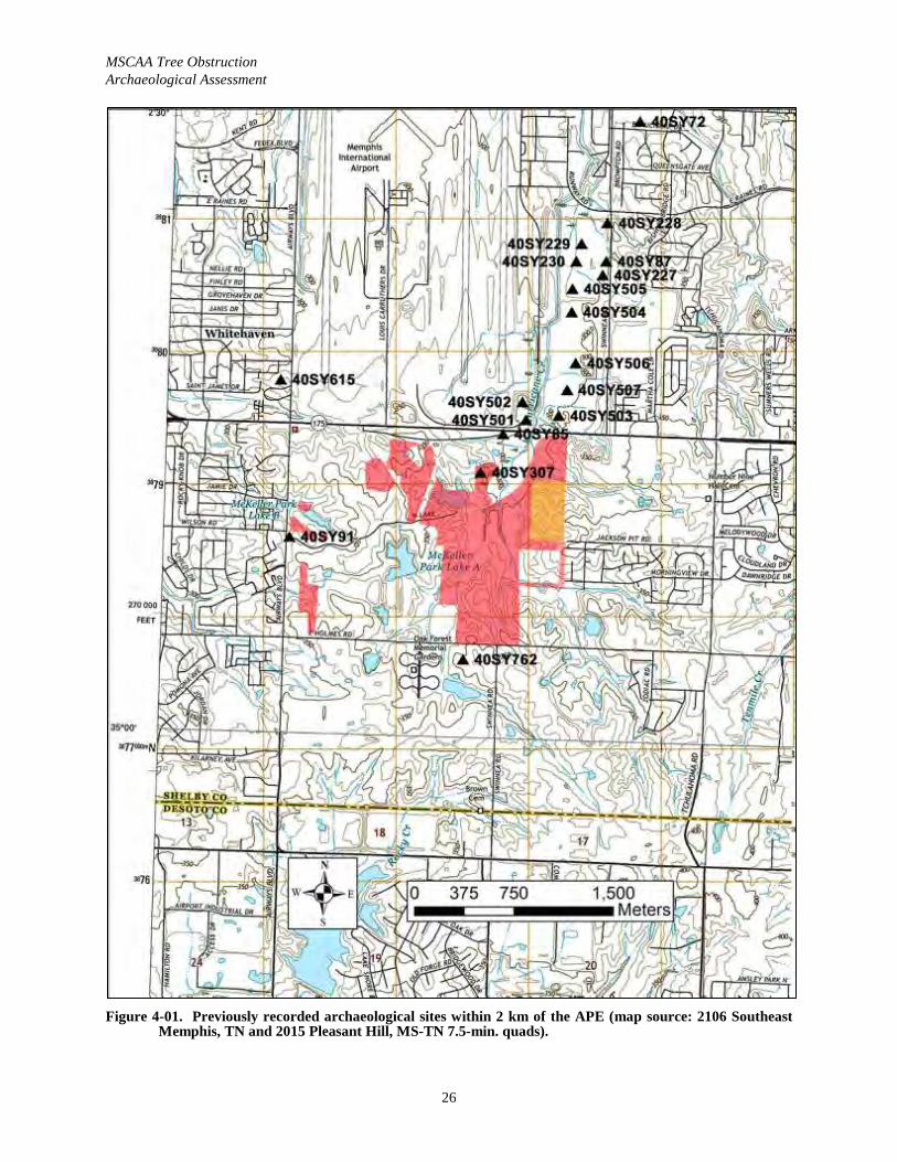
MSCAA Tree Obstruction Archaeological Assessment
26
Figure 4-01. Previously recorded archaeological sites within 2 km of the APE (map source: 2106 Southeast Memphis, TN and 2015 Pleasant Hill, MS-TN 7.5-min. quads).
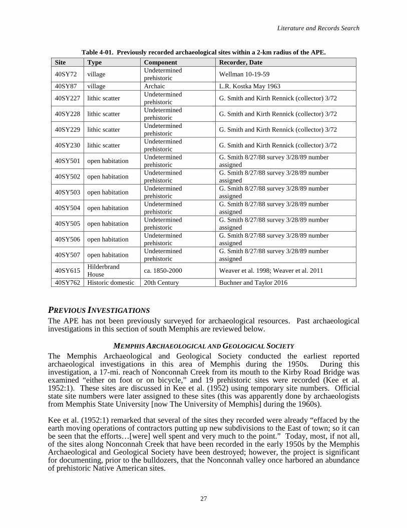
Literature and Records Search
27
Table 4-01. Previously recorded archaeological sites within a 2-km radius of the APE. Site Type Component Recorder, Date
40SY72 village Undetermined prehistoric Wellman 10-19-59
40SY87 village Archaic L.R. Kostka May 1963
40SY227 lithic scatter Undetermined prehistoric G. Smith and Kirth Rennick (collector) 3/72
40SY228 lithic scatter Undetermined prehistoric G. Smith and Kirth Rennick (collector) 3/72
40SY229 lithic scatter Undetermined prehistoric G. Smith and Kirth Rennick (collector) 3/72
40SY230 lithic scatter Undetermined prehistoric G. Smith and Kirth Rennick (collector) 3/72
40SY501 open habitation Undetermined prehistoric
G. Smith 8/27/88 survey 3/28/89 number assigned
40SY502 open habitation Undetermined prehistoric
G. Smith 8/27/88 survey 3/28/89 number assigned
40SY503 open habitation Undetermined prehistoric
G. Smith 8/27/88 survey 3/28/89 number assigned
40SY504 open habitation Undetermined prehistoric
G. Smith 8/27/88 survey 3/28/89 number assigned
40SY505 open habitation Undetermined prehistoric
G. Smith 8/27/88 survey 3/28/89 number assigned
40SY506 open habitation Undetermined prehistoric
G. Smith 8/27/88 survey 3/28/89 number assigned
40SY507 open habitation Undetermined prehistoric
G. Smith 8/27/88 survey 3/28/89 number assigned
40SY615 Hilderbrand House ca. 1850-2000 Weaver et al. 1998; Weaver et al. 2011
40SY762 Historic domestic 20th Century Buchner and Taylor 2016
PREVIOUS INVESTIGATIONSThe APE has not been previously surveyed for archaeological resources. Past archaeological investigations in this section of south Memphis are reviewed below.
MEMPHIS ARCHAEOLOGICAL AND GEOLOGICAL SOCIETYThe Memphis Archaeological and Geological Society conducted the earliest reported archaeological investigations in this area of Memphis during the 1950s. During this investigation, a 17-mi. reach of Nonconnah Creek from its mouth to the Kirby Road Bridge was examined “either on foot or on bicycle,” and 19 prehistoric sites were recorded (Kee et al. 1952:1). These sites are discussed in Kee et al. (1952) using temporary site numbers. Official state site numbers were later assigned to these sites (this was apparently done by archaeologists from Memphis State University [now The University of Memphis] during the 1960s).
Kee et al. (1952:1) remarked that several of the sites they recorded were already “effaced by the earth moving operations of contractors putting up new subdivisions to the East of town; so it can be seen that the efforts…[were] well spent and very much to the point.” Today, most, if not all, of the sites along Nonconnah Creek that have been recorded in the early 1950s by the Memphis Archaeological and Geological Society have been destroyed; however, the project is significant for documenting, prior to the bulldozers, that the Nonconnah valley once harbored an abundance of prehistoric Native American sites.
MSCAA Tree Obstruction Archaeological Assessment
28
MEMPHIS STATE UNIVERSITYDuring the 1960s and early 1970s, archaeologists from Memphis State University (now The University of Memphis) conducted additional reconnaissance level survey work along Nonconnah Creek. During this time, site forms for some of the sites identified by the Memphis Archaeological and Geological Society during the 1950s were completed. Surface inspection was the primary method of site detection, as these investigations were non-intensive and had not been conducted for compliance purposes (i.e., this was research). The site survey forms that were completed (and the accompanying artifact analysis sheets) are the only records that document this effort, since a report had never been prepared. The assemblages from most of the sites identified by the Memphis State University (now The University of Memphis) are curated atChucalissa Indian Village C.H. Nash Museum. Sites 40SY227—40SY230, located along and near Hurricane Creek, southeast of the airport, were recorded during this period.
MALFUNCTION JUNCTION SURVEY During 1980, Tennessee Department of Transportation (TDOT) archaeologists assessed the Interstate 240/Interstate 55 (I-240/I-55) Interchange, better known locally as “Malfunction Junction.” One previously recorded site (40SY35) in the interchange was not relocated and was reported as destroyed (DuVall 1980).
NONCONNAH CREEK BASIN RECONNAISSANCEDuring 1981, Gilbert/Commonwealth conducted an archaeological reconnaissance of selected areas along the Nonconnah Creek Basin for the USACE, Memphis District (Kern 1981). No prehistoric archaeological site was newly recorded during this project, which was largely a literature review.
NONCONNAH CREEK SURVEY During 1987, Coastal Environments, Inc. conducted a cultural resources survey of Nonconnah Creek from its mouth (McKellar Lake) upstream for 18.2 mi. (Smith and Weinstein 1987). This work was conducted for the USACE, Memphis District, prior to the proposed channel-improvements. The survey relied on visual inspection of the creek banks and the shovel testing of intact portions of the floodplains. No newly recorded archaeological site was identified during this project. Smith and Weinstein (1987) reported that they were unable to relocate most of the previously recorded sites along Nonconnah Creek, because the sites were destroyed by commercial developments and the I-240 construction. The report does have one outstanding contribution; a detailed synthesis of the prehistoric archaeology of the Nonconnah Creek basin was prepared (Smith and Weinstein 1987:27-67).
HURRICANE CREEK SURVEY During August 1988, G.P. Smith conducted an archaeological survey along the portion of Hurricane Creek that lies southeast of Memphis International Airport. No report documenting this work could be found on file at the TDOA facility in Nashville, or at the C.H. Nash Museum in Memphis, despite the site survey forms that suggest some type of compliance study was undertaken for MSCAA. Seven prehistoric sites (40SY501—40SY507) were reported, and alllie within the 2-km search radius for this project (see Table 4-01). All are lithic scatters of undetermined cultural affiliation. The TDOA assigned the site numbers several months after the fieldwork, in March 1989. Sites 40SY501—40SY507 were identified in close proximity to four prehistoric sites (40SY227—40SY230) that were recorded by G. Smith and Kirth Rennick, a collector, during March 1972. The latter four sites were recorded as a part of Memphis State University’s additional survey work along Nonconnah Creek, as noted above.
Literature and Records Search
29
FEDEX BURIALS DISCOVERYDuring 1998, a construction crew unearthed two poorly preserved Historic burials in a drainage ditch within the FedEx complex of the Memphis International Airport. Construction was halted and an archaeological removal of the burials, designated as 40SY619, was undertaken by Weaver & Associates, LLC (W&A; Weaver 1998). Archival research suggested that the burials were part of a church cemetery, shown on a 1916 map, that was thought to have been relocated “before or during the 1940s” (Weaver 1998:14). Skeletal analysis by Dr. Symes revealed that Burial 1 was a robust white male 35–45 years of age, and Burial 2 was a gracile, white male fewer than 40 years of age. Beyond fragments of coffin wood (cypress or yellow pine), few artifacts were recovered. An unreported number of 8d cut nails was recovered from both burials (Weaver 1998:12). Two partial shoes were recovered from Burial 1 with “sided lasted and wire nails” (Weaver 1998:13). The type of nails and shoes found suggest that these burials date after 1862 and before 1890. Weaver (2002) suggested that the deceased were yellow fever victims, but later research by Orser et al. (2005) determined the cemetery dated to 1899-1933 (i.e., after the yellow fever epidemic).
HILDEBRAND HOUSE PHASE II AND IIIAlso during 1998, W&A conducted archaeological testing at the Hildebrand House (40SY615), a standing nineteenth-century structure located near the airport at 4571 Airways Boulevard, for the Memphis-Shelby County Airport Authority (Weaver et al. 1998). Magness (1993:167) describes the Hildebrand House as a “plantation-style built of hand-hewn hickory logs pegged together, with a central hall plan and veranda with two-story columns facing east.” Weaver et al. (1998) suggest that the structure was built ca. 1850–1855 to replace an earlier home, in contrast to Magness (1983), who reported that the structure was built in 1838. Test excavations revealed a dense historic midden in the yard surrounding the home. Six related structures or outbuildings were archaeologically identified, including a twentieth-century garage (Structure-2), two twentieth-century barns (Structure-3 and Structure-4), two possible slave quarters (Structure-5 and Structure-6), and a twentieth-century well house (Structure-7). The site was recommended as eligible for National Register of Historic Places (NRHP) nomination, and a data recovery (Phase III) project was conducted in 1999 prior to the demolition of the home (Weaver et al. 2011).
LIGHT RAIL CORRIDOR ALTERNATES ANALYSISDuring 2002–2003, Panamerican conducted a cultural resources alternative analysis of the proposed Memphis Area Transit Authority (MATA) Downtown-Airport Light Rail Corridor alternates (Buchner and Albertson 2003). In addition to assessing the viability of the two primary alternates, this project resulted in the recovery of numerous cartographic sources from the Memphis Room (Special Collections) of the Shelby County Library. The project is also significant for resulting the development of a history of street railways in Memphis.
PROVIDENCE BAPTIST CEMETERY REMOVAL During March 2003, a construction crew working at FedEx Runway C exposed additional burials within a 103-x-103 ft. stripped area in close proximity to the two previously discovered burials (i.e., 40SY619). As a result, W&A conducted an archaeological removal of 65 burials that were aligned in eight rows (Oster et al. 2005). Oster et al. (2005) conducted archival research that revealed the cemetery was associated with the Providence Baptist Church, and was in use from 1899-1933. Runway construction ca. 1939-1940 resulted in a portion of the cemetery being covered and forgotten. Analysis of the casket types and coffin hardware revealed that the western section of the cemetery dated ca. 1899-1915, and these burials were largely unadorned. The later burials in the central portion of the cemetery dated ca. 1915-1933, and exhibited more elaborate mortuary treatment, suggestive of higher socio-economic status. Some of the burials contained associated artifacts (i.e., saucers, bottles) associated with folk beliefs. Osteological
MSCAA Tree Obstruction Archaeological Assessment
30
analysis conducted by the University of Tennessee Knoxville revealed that the remains were African-Americans of various ages.
HOLMES ROAD SURVEY During 2009, Panamerican conducted a Phase I archaeological assessment of a 6.8-km segment of Holmes Road in association with a planned widening project (Clifton 2010). The survey revealed that the majority of the archaeological APE, which lay within a heavily urbanized and industrial portion of the city, had been disturbed extensively. Negative findings were reportedand no further work was recommended.
TCHULAHOMA ROAD SURVEY Also during 2009, TRC conducted a survey of a 4,344 ft. section of Tchulahoma Road that was slate for improvements (Hockersmith 2009). This is the section of Tchulahoma Road that extends south of Holmes Road to the Mississippi state line. Work conducted included a visual inspection; no shovel tests were excavated because the “soils in the project area had been disturbed as a result of the construction of the existing road and commercial and residential development” (Hockersmith 2009:19). Negative findings were reported.
SHELBY & TCHULAHOMA CELL TOWERIn January 2014, Panamerican conducted a survey of the proposed Shelby & Tchulahoma Cell Tower site (Buchner 2014). The survey tract consisted of a 0.22-ac. lot located behind a modern building housing a grocery and vacant liquor store at the Shelby Drive and Tchulahoma Road.Work conducted included the excavation of nine shovel tests at 5-m, 10-m, and 15-m intervals, and a visual survey. Negative findings were reported.
TVA EMISSION CONTROL PROJECT SURVEYDuring May 2014, Tennessee Valley Archaeological Research (TVAR) conducted a survey of a 224 ac. tract and a 13 mi. pipeline corridor for TVA in advance of the construction of a natural gas powered power plant (a combustion turbine/combine cycle [CT/CC] facility) to replace TVA’s aging coal fired Allen Generating Plant (de Gregory et al. 2014).
The western section of the proposed Touritech gas pipeline is located approximately 0.5 mi. south of Holmes Road, and was co-located within an existing underground pipeline easement. de Gregory et al. (2014:10) utilized shovel testing at 30 m intervals as the primary site detection method, and delineated all archaeological finds at 10 m intervals. The locations of all 1,096 excavated shovel tests were recorded using GPS equipment, and maps of the shovel test distributions are provided in the report (de Gregory et al. 2014:Figures 8-34).
The Emission Control survey resulted in the identification of one previously recorded site in the Ensley Bottom (40SY554), four newly recorded sites in the loess uplands (40SY750, 40SY751, 40SY752, and 40SY753), and 14 isolated finds. Isolated finds 1 and 2 were recorded near Airway Blvd. (de Gregory et al. 2014:Figure 8).
TVA LAYDOWN YARDS SURVEY In 2015, Tennessee Valley Archaeological Research conducted a survey of laydown yards and access roads associated with the Tennessee Valley Authority (TVA) Allen Fossil Plant Emission Control Project (Rosenwinkel et al. 2015). Laydown Yard 2 was a 14.47 ac. tract located southwest of the intersection of Airways Blvd. and Shelby Drive. Negative findings were reported.
Literature and Records Search
31
COPART TRACT SURVEY In March 2016, Panamerican conducted a survey of a 44 ac. undeveloped tract located southwest of the Holmes Road and Swinnea Road intersection that was slated for improvements by Copart, a used auto parts company (Buchner and Taylor 2016). During the course of the survey 93 shovel test locations were documented, including three positive, 84 negative, and six no-test location where transect shovel tests were planned, but not excavated. The survey of the Copart tract resulted in the identification of one newly recorded twentieth-century domestic site (40SY762) that was recommended not eligible for the NRHP.
ROSENWALD FUND THEMATIC STUDYDuring 2015-2018, the TDOA conducted a thematic study of Rosenwald Fund facilities in Tennessee that were built for African-Americans (Nance and Eckhardt 2018). Rosenwald Fund constructions in Tennessee included 354 schools, nine teacher homes and ten industrial shops, and Shelby County contained a concentration of these because of its high African-American population. 40SY793 was recorded south of Winchester Road and west of the airport during this study.
MEMPHIS AIRPORT HISTORYThe origin of the Memphis airport dates to 1927, when Mayor Watkins Overton created a municipal Airport Planning Commission (Memphis International Airport 2015). The 200 ac. Ward Farm tract, located 7 mi. south of the city was selected, as the open country would allow for growth.
The Memphis Municipal Airport was dedicated on June 14, 1929, and consisted of three hangers and a sod runway (Memphis International Airport 2015). A modern terminal was added in 1938. During World War II the Army assumed control of the airport.
An Airport Planning Commission was created in 1956 to address the need for a new terminal and facilities to meet the demands of the “Jet Age” (Memphis International Airport 2015). Roy Harrover (1928-2016), of the Memphis firm Mann & Harrover, was the architect of the new terminal that was dedicated in 1963. The Memphis airport was among the first airports to make use of jetways and a two-level system, and is particularly noted for its distinctive “martini glass” shaped columns (Connolly 2016). The new facility was re-named the Memphis Metropolitan Airport. In 1969 the name was changed again to Memphis International Airport (MEM), and the Memphis-Shelby County Airport Authority (MSCAA) was created.
In 1973, Federal Express (now FedEx) was established and made Memphis International Airport their headquarters (Memphis International Airport 2015). This lead to extensive expansion of the airport and FedEx’s package sorting complex, now known as the “Super Hub.” Memphis International Airport was the busiest cargo airport in the world from 1992 to 2009, and is currently the second-busiest cargo airport in the world behind Hong Kong.
The existing Plough Blvd. entrance to the Memphis International Airport was constructed in 1974 (Smith 2009). The road is named for Abe Plough (1892-1984), a legendary Memphis philanthropist who made a fortune in the pharmaceutical industry, after starting the Plough Chemical Company at age sixteen (Lewis 1998).
In 1985, Republic Airlines chose Memphis International Airport as one of its hubs, dramatically boosting commercial passenger service. In 1986, Republic merged with Northwest Airlines, setting into motion a flurry of construction projects as the airport sought to keep up with the resulting increase in traffic and service (Memphis International Airport 2015).
MSCAA Tree Obstruction Archaeological Assessment
32
Also in 1986, the authority completed work on a new master plan for continued development, the key elements of which included building a third parallel north-south runway; extending an existing runway to 11,100 ft. to better accommodate nonstop international flights; improving existing terminal concourses; building a new International Arrivals Facility; creating additional parking; and making roadway improvements (Memphis International Airport 2015).
In September 2004, the Airport Authority negotiated a land swap among the Tennessee Air National Guard (TANG) and FedEx. The land swap provided TANG the space it needed to construct new facilities to accommodate the significantly larger C-5 Galaxy aircraft that the Guard were flying as part of its new mission. TANG’s relocation to the southeast corner of the airport freed space for FedEx to expand and consolidate their operations on the north end of the airport. TANG dedicated its new facilities in September 2008.
In June 2013, Delta Air Lines announced that it would no longer maintain hub operations in Memphis, and MEM began the transition to becoming an origin and destination airport. (Memphis International Airport 2015). Part of this transition involved recruiting new airlines to serve Memphis.
MCKELLAR PARK HISTORY The MSCAA Tree Obstruction Clearing APE is located within the former McKellar Park, which at 554 ac. was once Memphis’ largest city park. McKellar Park had it origins in 1958 when the City Commission opted to purchase the 308 ac. William Cobb tract on the east side of Airways Boulevard, south of the Memphis Metropolitan Airport, for $350,000 (Pritchartt 1958). The park was named for Kenneth Douglas McKellar (1869-1957), a U.S. Senator from Memphis (Coode 1998:588).
It was not until September 8, 1964 that the future McKellar Park area was annexed by the City of Memphis, and tangible plans for the development of the park were proposed, with half of the park being kept “wild” and other half being developed for recreation, including an 18-hole golf course (Porteous 1964). Shortly after annexation, on September 15, 1964, the City Commission agreed to purchase another 23 ac. on Holmes Road for the park (Brown 1964). This tract included the William Clifford Wilson home at 2630 Holmes Road that was proposed to be used as either a golf clubhouse or a residence for the park superintendent. On October 15, 1964 the City Commission formally voted to appropriate $105,327 for the house and the 23 ac. (Press-Scimitar 1964).
However by the summer of 1967 little work had been accomplished, and McKellar Park wascharacterized as “Forgotten” in a dispute among City Commissioners on where to build a new city golf course (McEachran 1967). Indeed, two commissioners stated that thought McKellar Park was still part of unincorporated Shelby County. A Commercial Appeal article characterized McKellar Park in 1967 as “a gently rolling wooded area with four lakes” with one “uncompleted golf hole” as a result of an abandoned neighborhood Youth Corps project (McEachran 1967). Aphoto of the house at 2630 Holmes Road that was purchased in 1964 also shows the small portion of the park that was used by the park commission as a nursery (Figure 4-01).
Two years later, in December 1969, Hal Lewis, the General Superintendent of the Memphis Parks Commission, announced an extensive three-phase development plan for McKellar Park (Hancock 1969). Proposed improvements included an 18-hole golf course, as well as camping facilities, ball fields, tennis courts, rest shelters, a boat dock and picnic areas. The city anticipated spending $800,000 over three years, with play on the golf course expected to commence in early 1972.
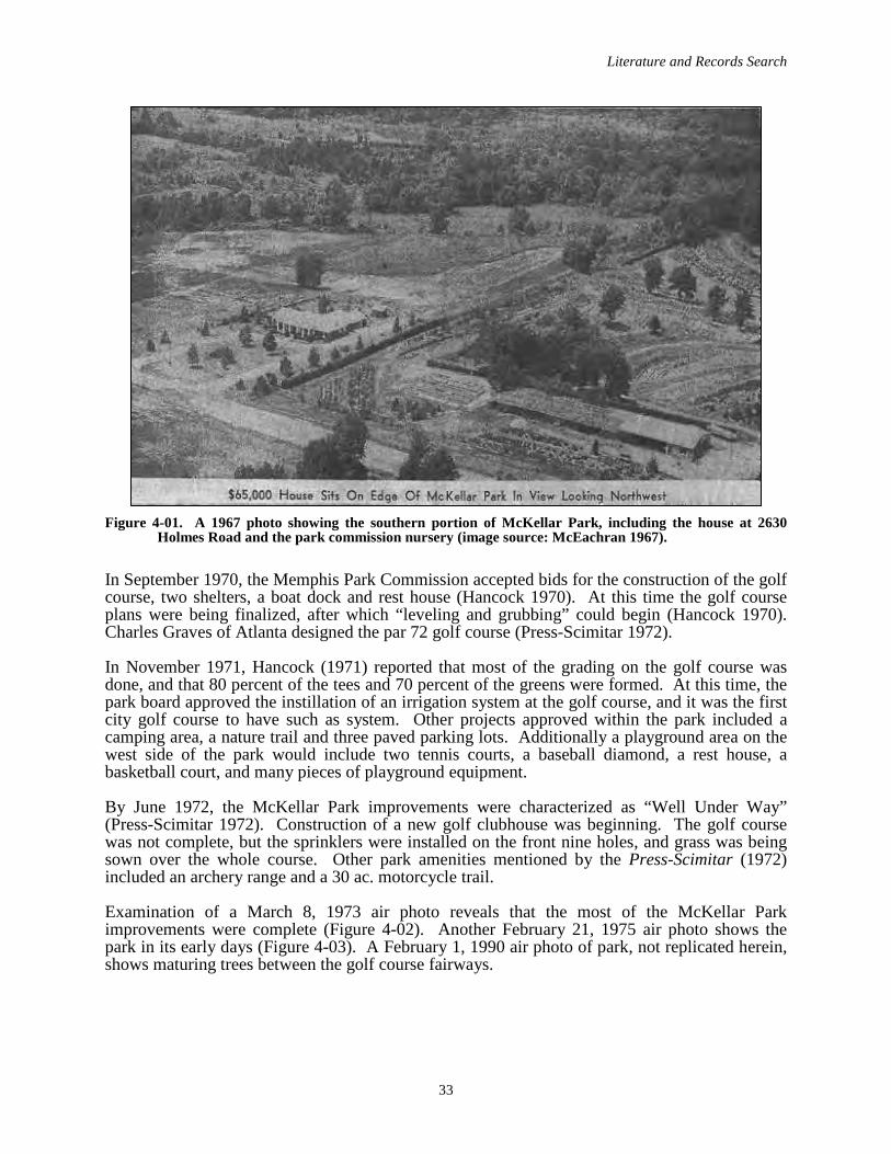
Literature and Records Search
33
Figure 4-01. A 1967 photo showing the southern portion of McKellar Park, including the house at 2630 Holmes Road and the park commission nursery (image source: McEachran 1967).
In September 1970, the Memphis Park Commission accepted bids for the construction of the golf course, two shelters, a boat dock and rest house (Hancock 1970). At this time the golf course plans were being finalized, after which “leveling and grubbing” could begin (Hancock 1970). Charles Graves of Atlanta designed the par 72 golf course (Press-Scimitar 1972).
In November 1971, Hancock (1971) reported that most of the grading on the golf course was done, and that 80 percent of the tees and 70 percent of the greens were formed. At this time, the park board approved the instillation of an irrigation system at the golf course, and it was the first city golf course to have such as system. Other projects approved within the park included a camping area, a nature trail and three paved parking lots. Additionally a playground area on the west side of the park would include two tennis courts, a baseball diamond, a rest house, abasketball court, and many pieces of playground equipment.
By June 1972, the McKellar Park improvements were characterized as “Well Under Way” (Press-Scimitar 1972). Construction of a new golf clubhouse was beginning. The golf coursewas not complete, but the sprinklers were installed on the front nine holes, and grass was being sown over the whole course. Other park amenities mentioned by the Press-Scimitar (1972) included an archery range and a 30 ac. motorcycle trail.
Examination of a March 8, 1973 air photo reveals that the most of the McKellar Park improvements were complete (Figure 4-02). Another February 21, 1975 air photo shows the park in its early days (Figure 4-03). A February 1, 1990 air photo of park, not replicated herein, shows maturing trees between the golf course fairways.
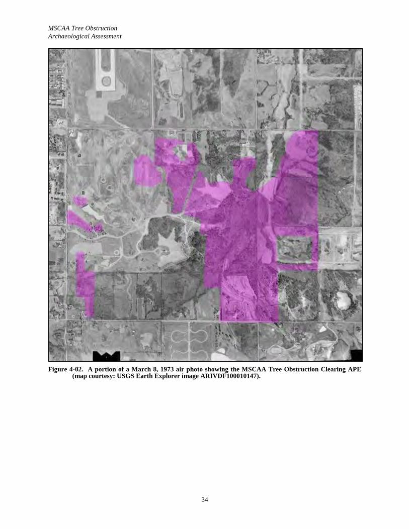
MSCAA Tree Obstruction Archaeological Assessment
34
Figure 4-02. A portion of a March 8, 1973 air photo showing the MSCAA Tree Obstruction Clearing APE (map courtesy: USGS Earth Explorer image ARIVDF100010147).
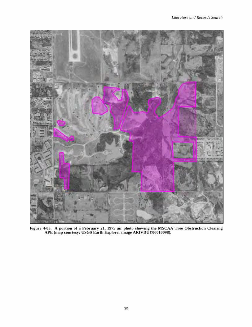
Literature and Records Search
35
Figure 4-03. A portion of a February 21, 1975 air photo showing the MSCAA Tree Obstruction Clearing APE (map courtesy: USGS Earth Explorer image ARIVDUY00010098).

MSCAA Tree Obstruction Archaeological Assessment
36
Unfortunately by early 1995, McKellar Park was “headed for oblivion” due to a planned airport expansion (constructing a third runway and lengthening two existing runways), and the need for more “clear space” for larger planes to take off and land (Gerald 1995). Park Commission Executive Director Bob Brame noted in an interview with the Memphis Flyer that the McKellar Golf Course had declined in popularity over the last several years, principally due to the airplanes that zoomed overhead “so close you’d think you could hit them with your tee shot” (Gerald 1995). Additionally, the commission had not invested much in maintaining and/or upgrading the McKellar Golf Course because they knew its days were numbered. So in 1995, the airport—which by then owned about one-third of the park and two-thirds of the golf course—swallowed up the park.
CARTOGRAPHIC REVIEWBelow various archival maps are reviewed to document the land use patterns and development of the APE prior to the McKellar Park era.
1835 GLO PLAT MAPDue to a surveying mistake, during the early nineteenth century APE tract was part of Mississippi. The 1835 General Land Office (GLO) plat map for T1S R7W of the Chickasaw Meridian reflects this, as the tract is located within Sections 7 and 8 of that township, which was then part of Mississippi (Figure 4-04). No improvements are shown within the APE. Hurricane Creek is shown, but not labeled.
In 1838, the incorrect state line—which conforms to today’s Winchester Road—was resurveyed, and the state line boundary was moved south to its present location. At this time the 1835 GLO plat map of T1S R7W was amended, and “New Tennessee State Line” was added approximately 1 mi. south of the APE (see Figure 4-04).
1888 W.T. WILLIAMSON MAP OF SHELBY COUNTYThe 1888 W.T. Williamson map of Shelby County is an important archival resource because it shows landowners, and property boundaries and acreages (Figure 4-05). Examination of the 1888 map reveals that the majority of the APE is associated with a 520 ac. tract owned by W.H. Nelson. Portions of the APE along Holmes Road are associated with two tracts owned by J.H. Vanhook. The northeastern section of the APE is associated with a 160 ac. tract owned by Wm. Holmes and a 160 ac. tract owned by Andrew Jackson.
1927 SHELBY COUNTY COMMISSIONER’S MAPH.V. Patton Co. produced a “Map of Shelby County, Tenn.” in 1927 for the Shelby County Commissioners. The copy on file at the Memphis room is 1932 revision of the 1927 edition that shows the location of white schools in Memphis and Shelby County, and the school names are hand written on the map; the nearest to the study area is “Whitehaven” (Figure 4-06). The APE can be identified about 2 mi. south of the Municipal Airport to the east of Hollyford Road and north of Holmes Road.
1939 HIGHWAY AND TRANSPORTATION MAPThe 1939 Tennessee State Highway Department “General Highway and Transportation Map, Shelby County, Tennessee” is fairly detailed (Figure 4-07). This map shows the local road network was essentially the same as in 1927/1932 (compare to Figure 4-06). Several residential structures are indicated along the major roads framing the APE.
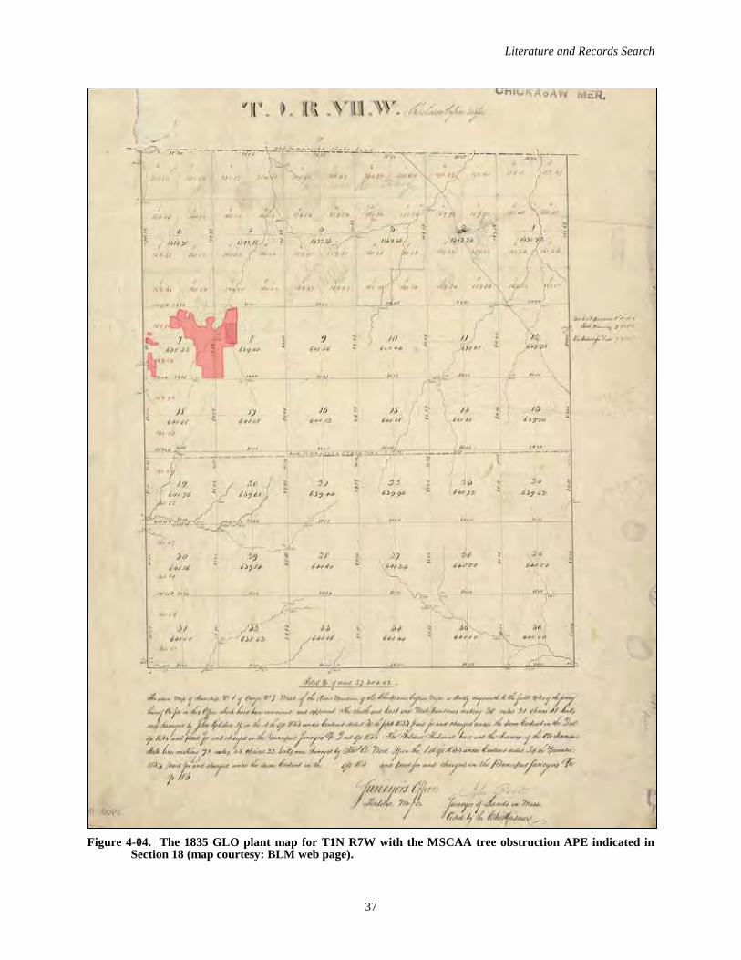
Literature and Records Search
37
Figure 4-04. The 1835 GLO plant map for T1N R7W with the MSCAA tree obstruction APE indicated in Section 18 (map courtesy: BLM web page).

MSCAA Tree Obstruction Archaeological Assessment
38
Figure 4-05. A portion of the 1888 W.T. Williamson Map of Shelby County with the MSCAA tree obstruction APE overlaid (map courtesy: Library of Congress).
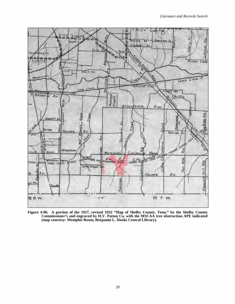
Literature and Records Search
39
Figure 4-06. A portion of the 1927, revised 1932 “Map of Shelby County, Tenn.” by the Shelby County Commissioner’s and engraved by H.V. Patton Co. with the MSCAA tree obstruction APE indicated (map courtesy: Memphis Room, Benjamin L. Hooks Central Library).
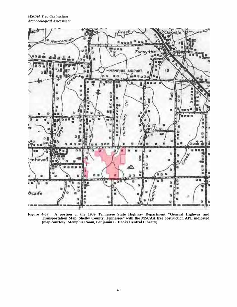
MSCAA Tree Obstruction Archaeological Assessment
40
Figure 4-07. A portion of the 1939 Tennessee State Highway Department “General Highway and Transportation Map, Shelby County, Tennessee” with the MSCAA tree obstruction APE indicated(map courtesy: Memphis Room, Benjamin L. Hooks Central Library).
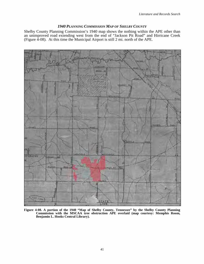
Literature and Records Search
41
1940 PLANNING COMMISSION MAP OF SHELBY COUNTYShelby County Planning Commission’s 1940 map shows the nothing within the APE other than an unimproved road extending west from the end of “Jackson Pit Road” and Hirricane Creek (Figure 4-08). At this time the Municipal Airport is still 2 mi. north of the APE.
Figure 4-08. A portion of the 1940 “Map of Shelby County, Tennessee” by the Shelby County Planning Commission with the MSCAA tree obstruction APE overlaid (map courtesy: Memphis Room, Benjamin L. Hooks Central Library).
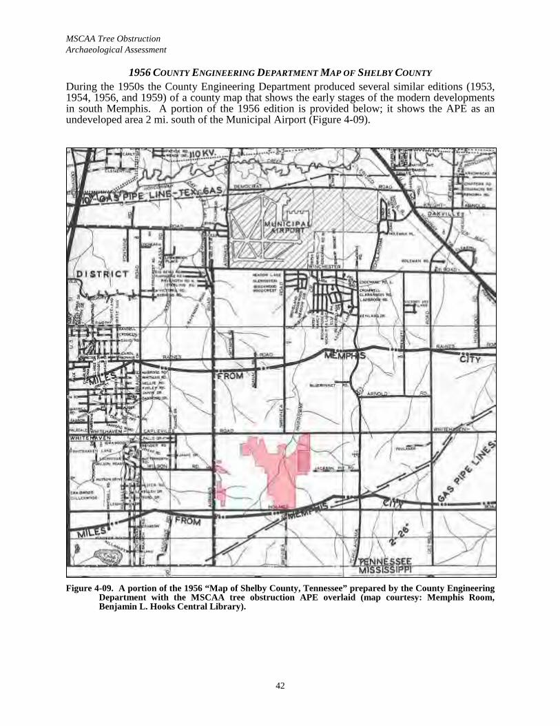
MSCAA Tree Obstruction Archaeological Assessment
42
1956 COUNTY ENGINEERING DEPARTMENT MAP OF SHELBY COUNTYDuring the 1950s the County Engineering Department produced several similar editions (1953, 1954, 1956, and 1959) of a county map that shows the early stages of the modern developments in south Memphis. A portion of the 1956 edition is provided below; it shows the APE as an undeveloped area 2 mi. south of the Municipal Airport (Figure 4-09).
Figure 4-09. A portion of the 1956 “Map of Shelby County, Tennessee” prepared by the County Engineering Department with the MSCAA tree obstruction APE overlaid (map courtesy: Memphis Room, Benjamin L. Hooks Central Library).
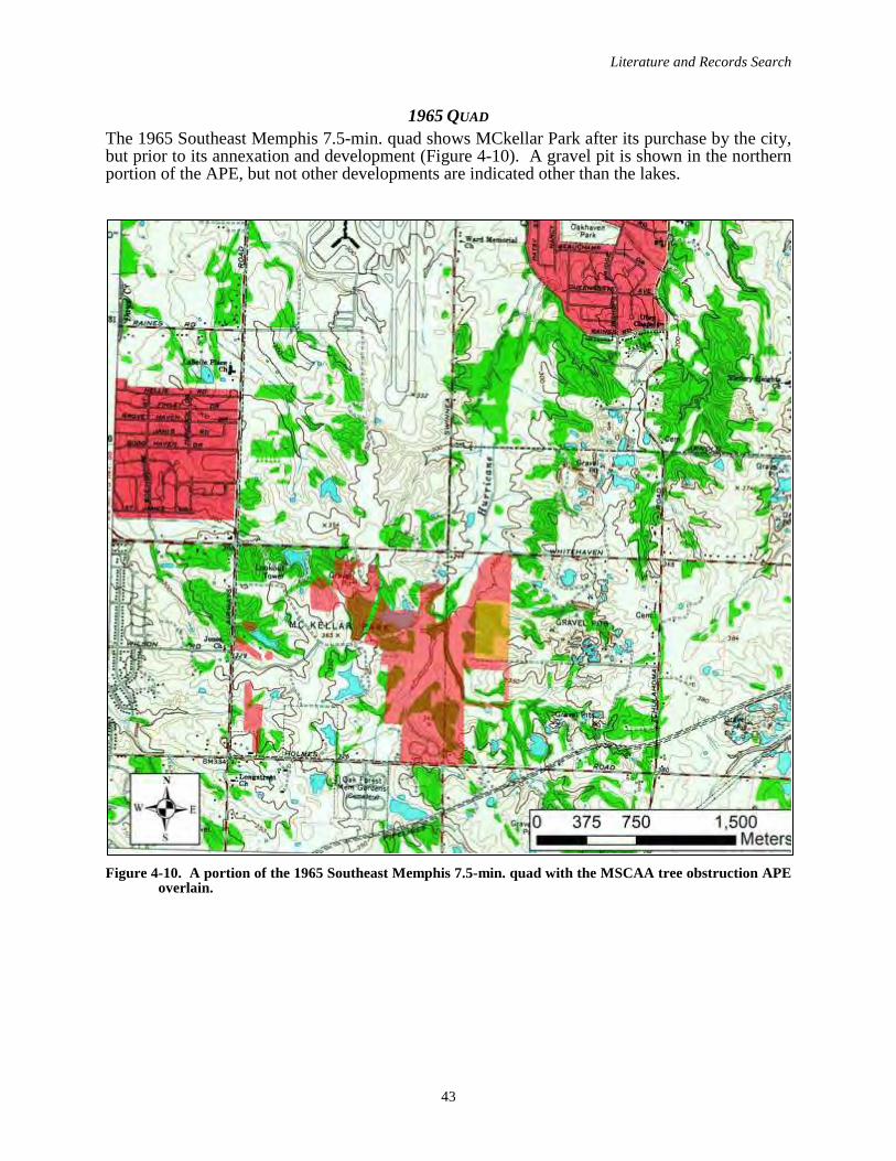
Literature and Records Search
43
1965 QUADThe 1965 Southeast Memphis 7.5-min. quad shows MCkellar Park after its purchase by the city, but prior to its annexation and development (Figure 4-10). A gravel pit is shown in the northern portion of the APE, but not other developments are indicated other than the lakes.
Figure 4-10. A portion of the 1965 Southeast Memphis 7.5-min. quad with the MSCAA tree obstruction APE overlain.
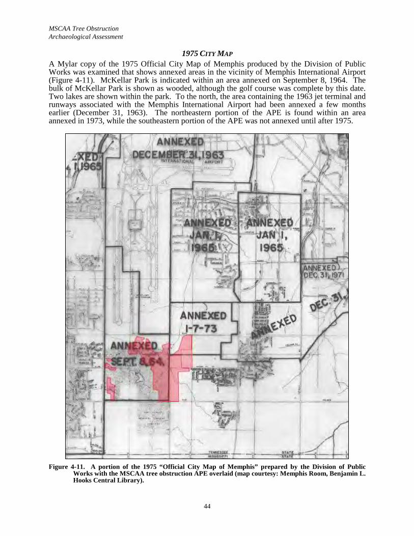
MSCAA Tree Obstruction Archaeological Assessment
44
1975 CITY MAP A Mylar copy of the 1975 Official City Map of Memphis produced by the Division of Public Works was examined that shows annexed areas in the vicinity of Memphis International Airport (Figure 4-11). McKellar Park is indicated within an area annexed on September 8, 1964. The bulk of McKellar Park is shown as wooded, although the golf course was complete by this date. Two lakes are shown within the park. To the north, the area containing the 1963 jet terminal and runways associated with the Memphis International Airport had been annexed a few months earlier (December 31, 1963). The northeastern portion of the APE is found within an area annexed in 1973, while the southeastern portion of the APE was not annexed until after 1975.
Figure 4-11. A portion of the 1975 “Official City Map of Memphis” prepared by the Division of Public Works with the MSCAA tree obstruction APE overlaid (map courtesy: Memphis Room, Benjamin L. Hooks Central Library).
Literature and Records Search
45
SURVEY EXPECTATIONSGiven the above, the following survey expectations can be offered. There are three previously recorded Prehistoric sites within the former McKellar Park that could possibly be within the APE: 40SY85, 40SY91 and 40SY307 (see Figure 4-01). If relocated, they will likely produce more lithic artifacts than ceramic artifacts.
The grading and grubbing during the 1970-1972 construction of the golf course likely destroyed any archaeological sites located in the northwestern section of the park, including Site 40SY91 near GATE AW-5. Much of the remainder of the park was left natural, in particular the easternsection, and these areas were not too significantly impacted by the early 1970s park developments. However it should be noted that Site 40SY307 was characterized as impacted by a park trail and “washed away” by subsequent erosion. The Site 40SY85 location was characterized as being near a stable that can be seen on 1973 and 1975 air photos, and is not within the APE (see Figure 4-01). The 40SY85 location is now heavily developed with arunway light system and a wide road south of Runway 36 R, and this site has likely been destroyed.
The southern section of the APE, along Holmes Road (to the east of the W.C. Wilson home at 2630 Holmes Road and west of a north-south pipeline corridor) was used by the park commission as a nursery, and appears barren and extensively disturbed on 1973 and 1975 air photos (see Figures 4-02 and 4-03).
A review of various archival maps suggests three possible mid twentieth century domestic sites may be located within the APE; these are found near the major roads that frame the former park.
More generally, the environmental setting (uplands) and eroded loess soils across the majority of the APE led us to conclude that, overall, the APE has a moderate to low probability of containing archaeological resources. The local Prehistoric settlement pattern reveals that most known sites occur on higher terrain within about 200 to 400 m of Hurricane Creek, a tributary of Nonconnah Creek. The previously recorded sites located along Hurricane Creek to the east of the 2008 Tennessee Air National Guard (TANG) facility were possibly, if not likely, destroyed during the construction of this facility, because the landscape here has been extensively modified (compare the modern quad [Figure 4-01] to the 1965 quad [Figure 4-10]).
The expected archaeological site density for the APE can be inferred from Peterson’s (1979) sample survey of the Wolf River basin, the next watershed to the north, which is highly similar both ecologically and archaeologically to the Nonconnah Creek basin. During Peterson’s study the Wolf River watershed was stratified into three environmental zones (floodplain, terraces, and uplands) and subdivided into 716 one-minute quadrates. A three percent random sample of the quadrates was surveyed. The results rather dramatically reveal that archaeological sites in the Wolf River watershed—and by inference the Nonconnah Creek basin—are concentrated on terraces, where 3.22 sites were identified per km2. In contrast, uplands yielded only 0.49 sites per km2 and floodplain even less (0.22 site per km2). Since the 309 ac. (1.25 km2) MSCAA Tree Obstruction Clearing APE is principally associated with uplands, the number of expected sites is 2.5 (1.25 km2/0.49 sites per km2).

MSCAA Tree Obstruction Archaeological Assessment
46
Page intentionally blank
Field Investigations
47
V. FIELD INVESTIGATIONS
METHODSMost of the fieldwork was conducted March 12–28, 2019 to by a crew ranging from three to five. The remaining 13 ac. was surveyed on November 23, 2020 by a crew of five. The site detection method consisted of shovel testing at 30 m intervals in areas with restricted surface visibility, which was the entire APE due to its being wooded. Additionally, all sites were delineatedvia shovel testing at 10 m intervals.
The main objectives in conducting the intensive archaeological survey were as follows: (1) to obtain a complete inventory of all significant cultural resources present; and (2) to evaluate all identified resources relative to eligibility criteria of the NRHP (36 CFR 63). No data recovery beyond the constraints of an intensive (shovel test) survey and site boundary delineation was expected. The fieldwork was conducted according to the standards set forth by the Tennessee State Historic Preservation Office (Tennessee SHPO Standards and Guidelines for Archaeological Resource Management Studies, October 2018).
SURVEY DOCUMENTATIONTo ensure appropriate field data management, Panamerican employs a system the company developed for intensive surveys. This system has been successfully implemented for several years and, for example, it has been used successfully during various past projects within Tennessee. Throughout the course of the fieldwork, the crew used specialized forms to individually record the shovel test locations. The status of each shovel test was assessed as positive (n ), negative (o ), or not excavated (Ø). In the case of the latter, which are referred to as “no-test” locations, the reason for not excavating a shovel test is provided on the forms. This allows for a complete inventory of shovel tests to be generated. Shovel test profiles, sediment characteristics, and depths of artifact recovery, if any, were recorded on the forms during the fieldwork. At the end of each field day, this information is collected by the field director and reviewed for content. The shovel test data was later entered into a Microsoft Excel spreadsheet by Panamerican laboratory staff, and a table presenting the information was produced (see Appendix A: Shovel Test Inventory). This table documents the intensity of the survey, and demonstrates the coverage of the non-site areas within survey tracts.
In addition to the individual shovel test results recorded by the archaeological technicians, the field documentation included, but was not limited to, the following: (1) the Field Director’s field notes that outline daily activities and provides a general commentary on the project findings, italso includes any unique or significant findings; (2) the location of each identified cultural resource was recorded on a 7.5-min. quad map; (3) a scale sketch map of each artifact locus was prepared; (4) the survey area and all recorded sites were recorded using photography; and (5) a number of logs or lists were maintained, including ones for artifact bags and photo records.
SHOVEL TEST DEFINITIONA shovel test consisted of the excavation of a four-sided hole at least 30 cm to a side (0.09 m2). Each shovel test was excavated to culturally sterile deposits, unless a disturbance or water seepage halted the excavation. To ensure consistent artifact recovery, all sediment was hand-screened through 0.25-in. mesh hardware cloth. All natural and cultural strata revealed in the individual shovel test profiles were recorded using metric depth measurements, and described in terms of textural class and color (using the Munsell Soil Color Chart). Additional strata descriptions were provided as needed, such as moisture, natural rock content, and number and size of roots. Panamerican employs a specialized shovel test form to insure consistent shovel test

MSCAA Tree ObstructionArchaeological Assessment
48
profile recording. Following recording a shovel test, artifact sample bags (if any) were labeled. All holes were subsequently backfilled as closely as possible to the original condition.
During the course of the field work, 1,311 shovel test locations were documented, including nine that were positive for cultural material, 576 that were negative for cultural material, and 726 planned tests that were not dug, mainly due to standing water and eroded slopes (Figure 5-01; see Appendix A). Additionally some low, water covered areas could not be shoved tested.
Figure 5-01. Aerial image of the Airport Tree Clearing APE showing shovel test locations (base map: Google Earth).
Field Investigations
49
RESULTSDuring the course of the fieldwork two sites were identified: a low-density lithic scatter (40SY843) and a late nineteenth to mid twentieth century farmstead (40SY844) (Figure 5-02).
40SY843 Cultural Affiliation................................................................. Undifferentiated prehistoric; Historic Type ....................................................................................................... Lithic scatter; Isolated findSize .................................................................................................................................... 40-x-30 m Artifact Recovery Total ...................................................................................................................5 Recommended NRHP Status ............................................................................................. Ineligible
Location and Setting Site 40SY843 is Prehistoric lithic scatter and isolated Historic find located in a wooded area east of a man-made lake within the Airport Tree Clearing APE. The setting is an eroded and gulliedterrace edge overlooking an unnamed tributary of Hurricane Creek in a narrow valley about 70 m to the south (Figure 5-03). The site can be found on the SE Memphis 7.5-min. quad. At the time of investigation, the site location was in woods with poor surface visibility (Figures 5-04 and 5-05). An old road is located immediately west of the site, and this road is interpreted as the location where Walling recovered the 40SY307 surface collection during the 1980s. Sease et al. (1989) map this location as Grenada silt loam, 2 to 5 percent slopes (GaB).
Archaeology Site 40SY843 was recorded as Field Sites 1 and 2, which represent positive shovel tests on Transects 29 and 30. These transects started in a low, wet area south of the site and extended upslope (north) onto the terrace where site was identified. The terrain on site is somewhat irregular and gullied, no doubt due to erosion, and there is an old bulldozer cut along the western edge of the site. A lake associated with the former McKellar Park Golf Course is located west of the site.
Site 40SY843 was recorded as two field site (Sites 1 and 2). They were combined as one site due to their proximity, and each field site is considered a locus of the combined site. The site was delineated on two 10-m interval grids, with the two positive transect tests serving as grid origins (Figure 5-03). Three shovel tests were positive for cultural material at 40SY843. The site boundary of 40-x-30 m is based on the extent of the positive shovel tests.
The soils were moderately wet and a typical shovel test at 40SY843 was recorded as follows:Zone I from 0-8 cm 10YR 4/3 silty clay; Zone II from 8-15 cm 10YR 5/4 silty clay; and Zone III 15-25 cm 7.5YR 5/8 clay (Figure 5-06). Artifacts were recovered from Zones I and II; Zone III is sterile loess subsoil.
At Site 40SY843 all recovery was from shovel tests. Among the three positive shovel tests the recovery ranged from one to three artifacts, and the average was 1.66 artifacts per test. The highest yielding tests (29-4) is located near the road where Walling probably recovered the 40SY307 collection (see Table 6-02). Surface inspection of the road and dozer cut failed to recover any additional artifacts.
ArtifactsThe Site 40SY843 assemblage consists of four pieces of debitage and a piece of clear glass (Table 5-01).
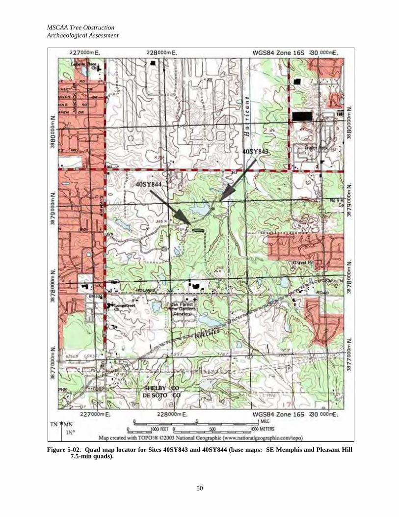
MSCAA Tree ObstructionArchaeological Assessment
50
Figure 5-02. Quad map locator for Sites 40SY843 and 40SY844 (base maps: SE Memphis and Pleasant Hill 7.5-min quads).
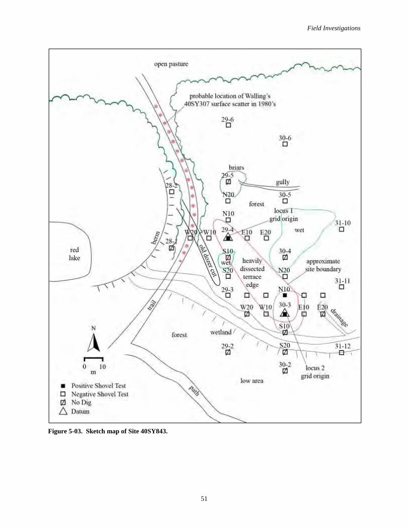
Field Investigations
51
Figure 5-03. Sketch map of Site 40SY843.
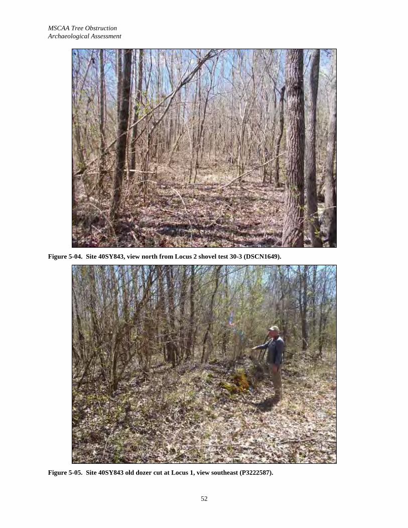
MSCAA Tree ObstructionArchaeological Assessment
52
Figure 5-04. Site 40SY843, view north from Locus 2 shovel test 30-3 (DSCN1649).
Figure 5-05. Site 40SY843 old dozer cut at Locus 1, view southeast (P3222587).
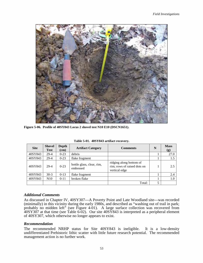
Field Investigations
53
Figure 5-06. Profile of 40SY843 Locus 2 shovel test N10 E10 (DSCN1651).
Table 5-01. 40SY843 artifact recovery.
Site Shovel Test
Depth (cm) Artifact Category Comments N Mass
(g)40SY843 29-4 0-23 debris 1 27.040SY843 29-4 0-23 flake fragment 1 1.5
40SY843 29-4 0-23 bottle glass, clear, rim, embossed
ridging along bottom of rim; rows of raised dots on vertical edge
1 2.5
40SY843 30-3 0-13 flake fragment 1 2.440SY843 N10 0-11 broken flake 1 1.0
Total: 5
Additional CommentsAs discussed in Chapter IV, 40SY307—A Poverty Point and Late Woodland site—was recorded (minimally) in this vicinity during the early 1980s, and described as “washing out of trail in park; probably no midden left” (see Figure 4-01). A large surface collection was recovered from 40SY307 at that time (see Table 6-02). Our site 40SY843 is interpreted as a peripheral element of 40SY307, which otherwise no longer appears to exist.
RecommendationThe recommended NRHP status for Site 40SY843 is ineligible. It is a low-density undifferentiated Prehistoric lithic scatter with little future research potential. The recommended management action is no further work.
MSCAA Tree ObstructionArchaeological Assessment
54
40SY844 Cultural Affiliation............. Late nineteenth to mid twentieth century; Undifferentiated PrehistoricType ............................................................................................................ Farmstead; Isolated find Size .................................................................................................................................. 130-x-30 m Artifact Recovery Total .................................................................................................................47 Recommended NRHP Status ............................................................................................. Ineligible
Location and Setting Site 40SY844 is the remains of a Historic farmstead and an isolated Prehistoric find located north of an access road within the Airport Tree Clearing APE (Figure 5-07). The site is about 100 m east of an area now used as a dump, but is clearly not part of the dump. The site can be can be identified on the SE Memphis 7.5-min. quad (see Figure 5-02). The cover is secondary forest, and some daffodils were present (Figure 5-08). The setting is the edge of terrace, and the terrain falls sharply down to the north. Sease et al. (1989) map this location as Loring silt loam, 2 to 5 percent slopes (LoB).
Archaeology Site 40SY844 was recorded as Field Site 3, and was encountered along Transects 42, 43, 44, and 45 (Figure 5-07). These transects extended north from the access road across the site and into a low wet area below. The site was delineated on a 10-m interval grid with shovel test 43-5 being the grid origin (Figure 5-07). There were six positive shovel tests 40SY844, and recovery ranged from one to nine artifacts per test, with S10 E10 being the most productive.
Recovery was typically from the upper 8 to 14 cm, but shovel test S10 E10, located roughly in the center of the site, produced artifacts from 8-23 cm. The soil profile for shovel test S10 E10 was recorded as follows: Zone I from 0-8 cm 10YR 5/4 silty clay loam; Zone II from 8-23 cm mottled 10YR 4/3 and 10YR 5/4 silty clay, with artifacts; and Zone III 23-33 cm 7.5YR 5/6 silty clay (loess subsoil).
Despite the poor surface visibility, abundant artifacts were observed on the site surface; principally brick fragments, ceramics, glass and metal items. A representative sample consisting 25 artifacts were collected from the surface.
The site size (130-x-30 m) is based on the extent of the positive shovel tests and the surface scatter.
Artifacts The 40SY844 artifact assemblage includes 46 Historic artifacts and one isolated Prehistoric find, a retouched piece (Table 5-02). The Historic assemblage conforms to the Tenant period artifact pattern, as it is principally composed of Kitchen Group (n=22, or 47.8 percent) and Architecture Group (n=10, or 21.7 percent) items with the other functional groups being less well represented: Personal Group (n=5, or 10.9 percent); Medicine group (n=4 or 8.7 percent); Activity Group (n=1, or 2.2 percent); and Electric Group (n=1, or 2.2 percent). Miscellaneous items(unidentified ferrous objects) complete the assemblage (n=3) (see Table 6-01).
The majority of the 40SY844 assemblage dates to the twentieth-century. Figures 6-01, 6-02 and 6-03 illustrate examples of this material. Selected diagnostics include a ca. 1935-1964 whole bottle with a plastic screw cap is embossed with fragments the phrase “HALF PINT/FEDERAL LAW FORBIDS SALE OR REUSE OF THIS BOTTLE” (see Figure 6-02a), a post 1921 vitrified clay pipe was recovered that is embossed …RMINGHA… (see Figure 6-03e), and two medicine bottles with ca. 1929-1954 Owens Illinois glass company marks on their bases.
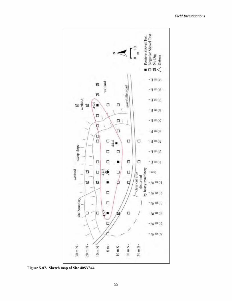
Field Investigations
55
Figure 5-07. Sketch map of Site 40SY844.
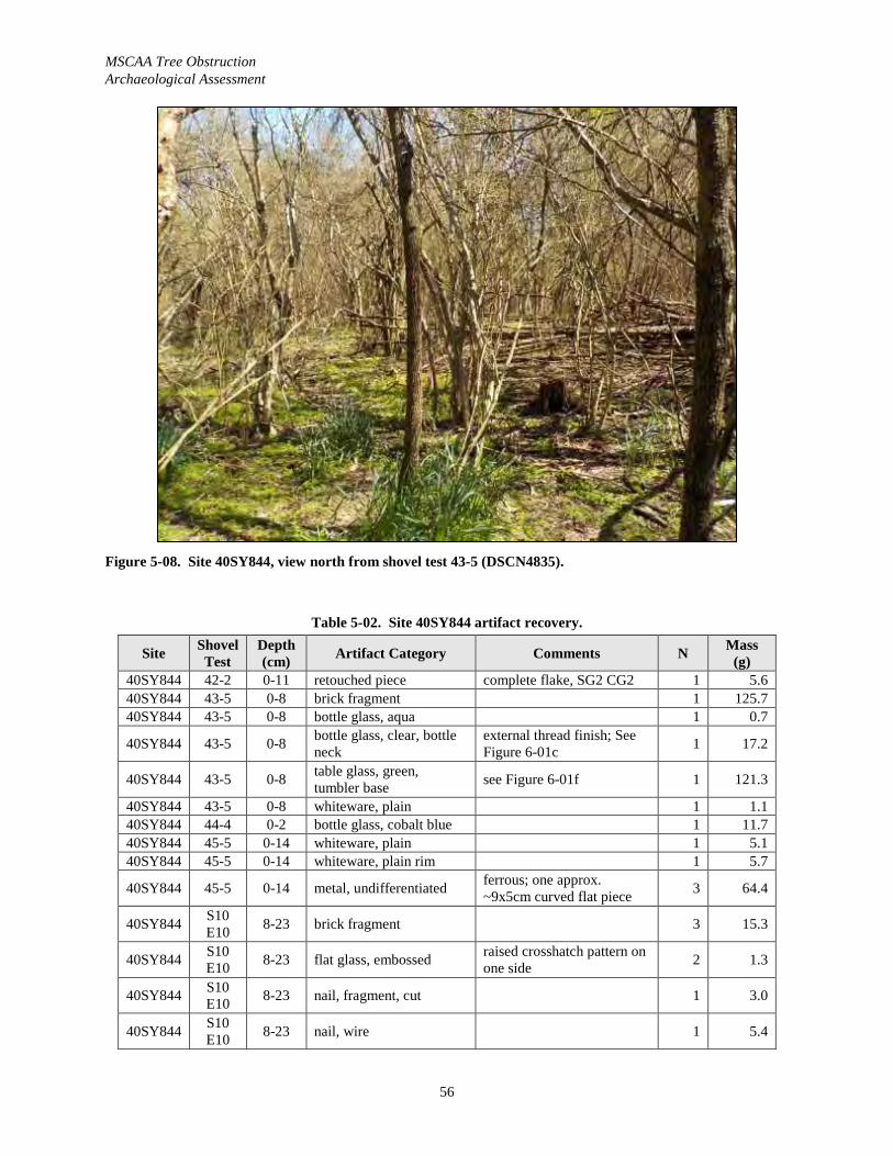
MSCAA Tree ObstructionArchaeological Assessment
56
Figure 5-08. Site 40SY844, view north from shovel test 43-5 (DSCN4835).
Table 5-02. Site 40SY844 artifact recovery.
Site Shovel Test
Depth (cm) Artifact Category Comments N Mass
(g)40SY844 42-2 0-11 retouched piece complete flake, SG2 CG2 1 5.640SY844 43-5 0-8 brick fragment 1 125.740SY844 43-5 0-8 bottle glass, aqua 1 0.7
40SY844 43-5 0-8 bottle glass, clear, bottle neck
external thread finish; See Figure 6-01c 1 17.2
40SY844 43-5 0-8 table glass, green, tumbler base see Figure 6-01f 1 121.3
40SY844 43-5 0-8 whiteware, plain 1 1.140SY844 44-4 0-2 bottle glass, cobalt blue 1 11.740SY844 45-5 0-14 whiteware, plain 1 5.140SY844 45-5 0-14 whiteware, plain rim 1 5.7
40SY844 45-5 0-14 metal, undifferentiated ferrous; one approx. ~9x5cm curved flat piece 3 64.4
40SY844 S10 E10 8-23 brick fragment 3 15.3
40SY844 S10 E10 8-23 flat glass, embossed raised crosshatch pattern on
one side 2 1.3
40SY844 S10 E10 8-23 nail, fragment, cut 1 3.0
40SY844 S10 E10 8-23 nail, wire 1 5.4
Field Investigations
57
Site Shovel Test
Depth (cm) Artifact Category Comments N Mass
(g)
40SY844 S10 E10 8-23 bottle glass, clear 1 2.7
40SY844 S10 E10 8-23 table glass, clear
embossedorange peel texture on one side 1 12.7
40SY844 W10 0-14 whiteware, decal, saucer fragment, base
faded floral decal ware; raised scalloping on upper surface
1 6.2
40SY844 surface tin end cap, rectangularEmbossed "101A"; probable end cap for wood sawhorse
1 142.2
40SY844 surface flat glass, clear 1 54.5
40SY844 surface vitrified clay pipe fragment
embossed "…RMINGHA…"; large diameter pipe section; see Figure 6-03e
1 187.6
40SY844 surface white porcelain insulatorEmbossed "CROSS COUNT(RY)"; see Figure6-03d
1 55.2
40SY844 surface bottle glass, aqua, bottle neck
globular flare finish; see Figure 6-01d 1 37.1
40SY844 surface bottle glass, clear, baseEmbossed "D-9/..7 "C" in diamond 7/M 89 D"; liquor bottle; see Figure 6-01e
1 19.4
40SY844 surface bottle glass, clear, base, molded
orange peel texture on bottom; from carboy; see Figure 6-01b
1 255.3
40SY844 surface bottle glass, clear, bottle neck and handle
jug, external thread finish, finger loop 1 202.1
40SY844 surfacebottle glass, clear, whole bottle, embossed, with cap
external thread finish; embossed "HALF PINT/FEDERAL LAW FORBIDS SALE/OR RE-USE OF THIS BOTTLE" embossed concave side, ; filigree embossed on upper part of convex side; "A-9988/70 D-1 (maker's mark-circle around "A"_ 2 69 3" embossed on base; maker's mark Armstrong Cork Co. ca. 1938-1969; base similar to Buffalo or Philidelphia oval; liquor bottle; 17.6 cm tall (with plastic screw cap), base 8-x-3.4 cm; see Figure 6-02a
1 250.4
40SY844 surface porcelain, blue underglaze
blue leaf design; see Figure 6-03b 2 12.2
40SY844 surfacestoneware, Bristol glazed interior/exterior with blue annular bands
two blue bands painted over outer surface; see Figure 6-03a
1 92.8

MSCAA Tree ObstructionArchaeological Assessment
58
Site Shovel Test
Depth (cm) Artifact Category Comments N Mass
(g)
40SY844 surface stoneware, bristol glazed interior/exterior, fragment see Figure 6-03f 1 76.7
40SY844 surfacetable glass, cobalt blue, base of plate/dish fragment
see Figure 6-01a 1 88.6
40SY844 surface table glass, milk glass, rim, external decoration green painted 1 4.0
40SY844 surface whiteware, sponged, fragment
blue design on one side; see Figure 6-03c 1 7.1
40SY844 surface bottle glass, clear, whole bottle
external thread finish, wide mouth; embossed "A - S/12 (maker's mark-circle over diamond) 9/5"; possible Owens-Illinois maker'smark but "I" is not discernable; round base; medicinal bottle; 6.9 cm tall, dia. 3.5 cm
1 53.0
40SY844 surface bottle glass, clear, whole bottle
Emoissed "865/7 F"; collared ring finish; 4-sided, french square base; possible medicinal bottle; 5.8 cm tall, base 2-x-2 cm
1 24.2
40SY844 surface bottle glass, clear, whole bottle
Embossed "12 (Owens-Illinois maker's mark) 8/10"; external thread finish; 4-sided, french square base; possible medicinal bottle; Owens-Illinois maker's mark ca. 1929-1954; 5.7 cm tall, base 1.9-x-1.8 cm
1 23.2
40SY844 surfacebottle glass, cobalt blue, whole bottle, plus damaged metal casing
bead finish; round base; has damaged ferrous metal casing around base; bottle w/o case: 4.3 cm tall; dia. 3 cm; diameter of metal case 3.5 cm; see Figure 6-02d
1 36.5
40SY844 surface bakelite canister possible lighter 1 134.5
40SY844 surface bottle glass, clear, whole bottle
external thread finish; ridging around bottom of bottle; Embossed "12 (Owens-Illinois diamond mark)…" Owens-Illinois maker's mark, either 1929-1954, or Owens-Illinois Pacific Coast Co. 1932-1943, difficult to see shape of "I"; plain oval base; perfume bottle; 8.7 cm tall, base 3.6-x-2.1 cm; see Figure 6-02g
1 52.1
Field Investigations
59
Site Shovel Test
Depth (cm) Artifact Category Comments N Mass
(g)
40SY844 surface bottle glass, milk glass, lid
lid for cosmetic jar; outer dimensions: 5.2-x-3.3 cm; inner dimensions: 4.5-x-2.2 cm; see Figure 6-02b
1 25.9
40SY844 surface bottle glass, milk glass, whole bottle
external thread finish; "12"; valve mark; 4-sided bottle; cosmetic bottle; 4.7 cm tall, base 3.9-x-3.9 cm; see Figure 6-02c
1 71.4
40SY844 surface metal, cosmetic container ferrous metal 1 6.1Total: 47
Evidence for a late nineteenth century occupation of 40SY844 is present, but weak, and includes a blue sponged whiteware sherd, Bristol glazed stoneware including one with an annular banded decoration (see Figure 6-03a, f), and one cut nail.
The presence of one small white porcelain insulator that is embossed CROSS COUNTY (see Figure 6-03d), suggests the occupation of the site continued after the electrification of this rural area of Shelby County (post ca. 1939).
Additional CommentsThe 40SY844 location is within W.H. Nelson’s 520 ac. tract in 1888 (see Figure 4-05). The 1939 Tennessee State Highway Department “General Highway and Transportation Map, Shelby County, Tennessee” does not show a structure or a road at 40SY844 (see Figure 4-07).However, the 1940 Shelby County Planning Commission does show a road at 40SY844 that appears to be an extension of Jackson Pit Road (see Figure 4-08). The 1965 Southeast Memphis 7.5-min. quad does not show a structure at this location (see Figure 4-10). Most likely the site was abandoned during the 1940s or 1950s.
RecommendationSite 40SY844 is recommended as ineligible for the NRHP. Shovel testing revealed that the archaeological deposit at the site is low-density and relatively shallow. Additional investigations at 40SY844 are unlikely to yield any additional significant archaeological data relevant to our understanding of the Tenant period occupations in west Tennessee. This site example does not meet enough of the criteria for NRHP eligibility established by Wilson (1990) to be considered eligible. As such, the recommended management action is no further work.
NEGATIVE FINDINGS
NORTH OF GATE 5 North of Gate 5 are three small sections of trees (see Figure 5-01). This clump of trees is near what is shown as a small lake on the quad, but which is no longer extant; the vegetation was quite dense in places (Figure 5-09). Transects 95-100A were run through these areas; 34 tests were recorded: 15 were negative and 19 were not dug, mainly due to wetlands and slope. No cultural resources were identified in this area.
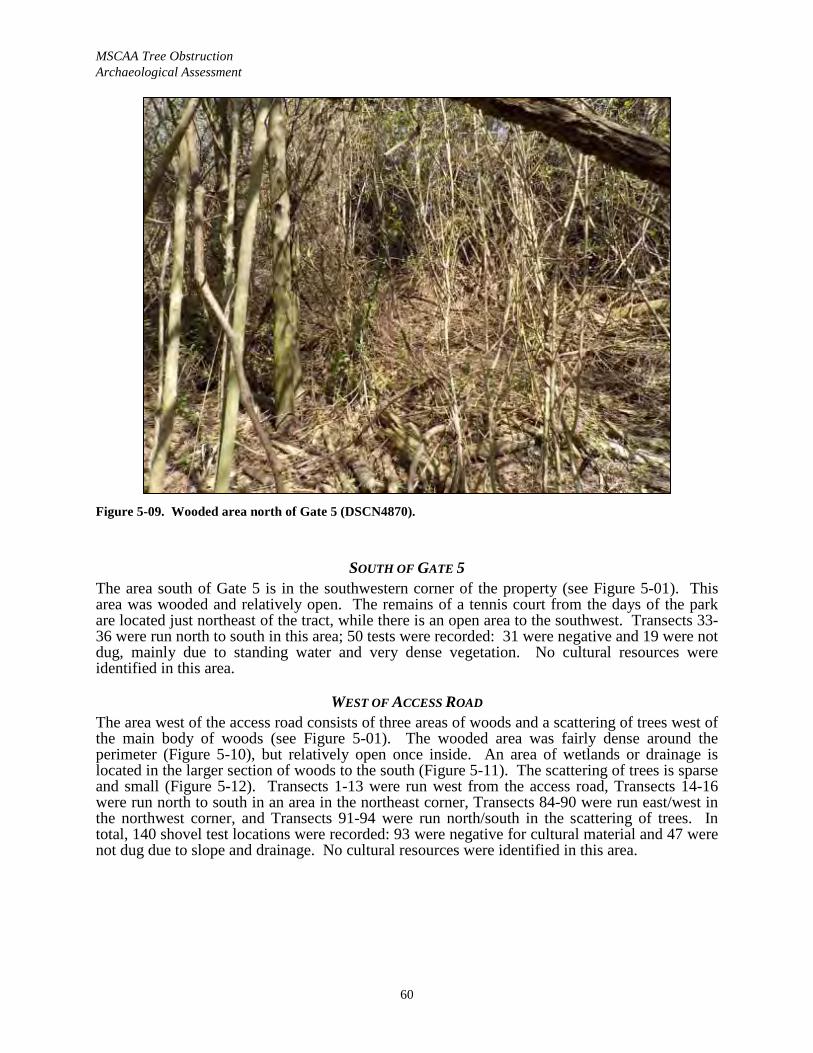
MSCAA Tree ObstructionArchaeological Assessment
60
Figure 5-09. Wooded area north of Gate 5 (DSCN4870).
SOUTH OF GATE 5The area south of Gate 5 is in the southwestern corner of the property (see Figure 5-01). This area was wooded and relatively open. The remains of a tennis court from the days of the park are located just northeast of the tract, while there is an open area to the southwest. Transects 33-36 were run north to south in this area; 50 tests were recorded: 31 were negative and 19 were not dug, mainly due to standing water and very dense vegetation. No cultural resources were identified in this area.
WEST OF ACCESS ROADThe area west of the access road consists of three areas of woods and a scattering of trees west of the main body of woods (see Figure 5-01). The wooded area was fairly dense around the perimeter (Figure 5-10), but relatively open once inside. An area of wetlands or drainage is located in the larger section of woods to the south (Figure 5-11). The scattering of trees is sparse and small (Figure 5-12). Transects 1-13 were run west from the access road, Transects 14-16 were run north to south in an area in the northeast corner, Transects 84-90 were run east/west in the northwest corner, and Transects 91-94 were run north/south in the scattering of trees. In total, 140 shovel test locations were recorded: 93 were negative for cultural material and 47 were not dug due to slope and drainage. No cultural resources were identified in this area.
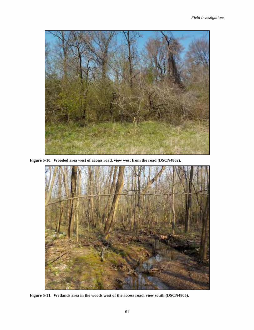
Field Investigations
61
Figure 5-10. Wooded area west of access road, view west from the road (DSCN4802).
Figure 5-11. Wetlands area in the woods west of the access road, view south (DSCN4805).
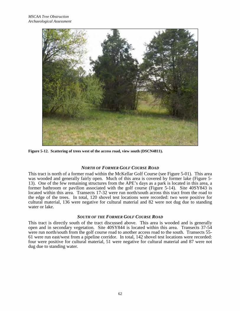
MSCAA Tree ObstructionArchaeological Assessment
62
Figure 5-12. Scattering of trees west of the access road, view south (DSCN4811).
NORTH OF FORMER GOLF COURSE ROADThis tract is north of a former road within the McKellar Golf Course (see Figure 5-01). This area was wooded and generally fairly open. Much of this area is covered by former lake (Figure 5-13). One of the few remaining structures from the APE’s days as a park is located in this area, a former bathroom or pavilion associated with the golf course (Figure 5-14). Site 40SY843 is located within this area. Transects 17-32 were run north/south across this tract from the road to the edge of the trees. In total, 120 shovel test locations were recorded: two were positive for cultural material, 136 were negative for cultural material and 82 were not dug due to standing water or lake.
SOUTH OF THE FORMER GOLF COURSE ROADThis tract is directly south of the tract discussed above. This area is wooded and is generally open and in secondary vegetation. Site 40SY844 is located within this area. Transects 37-54 were run north/south from the golf course road to another access road to the south. Transects 55-61 were run east/west from a pipeline corridor. In total, 142 shovel test locations were recorded: four were positive for cultural material, 51 were negative for cultural material and 87 were not dug due to standing water.
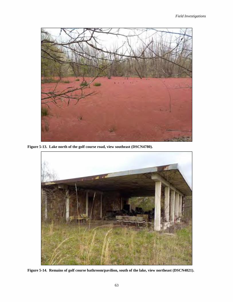
Field Investigations
63
Figure 5-13. Lake north of the golf course road, view southeast (DSCN4780).
Figure 5-14. Remains of golf course bathroom/pavilion, south of the lake, view northeast (DSCN4821).
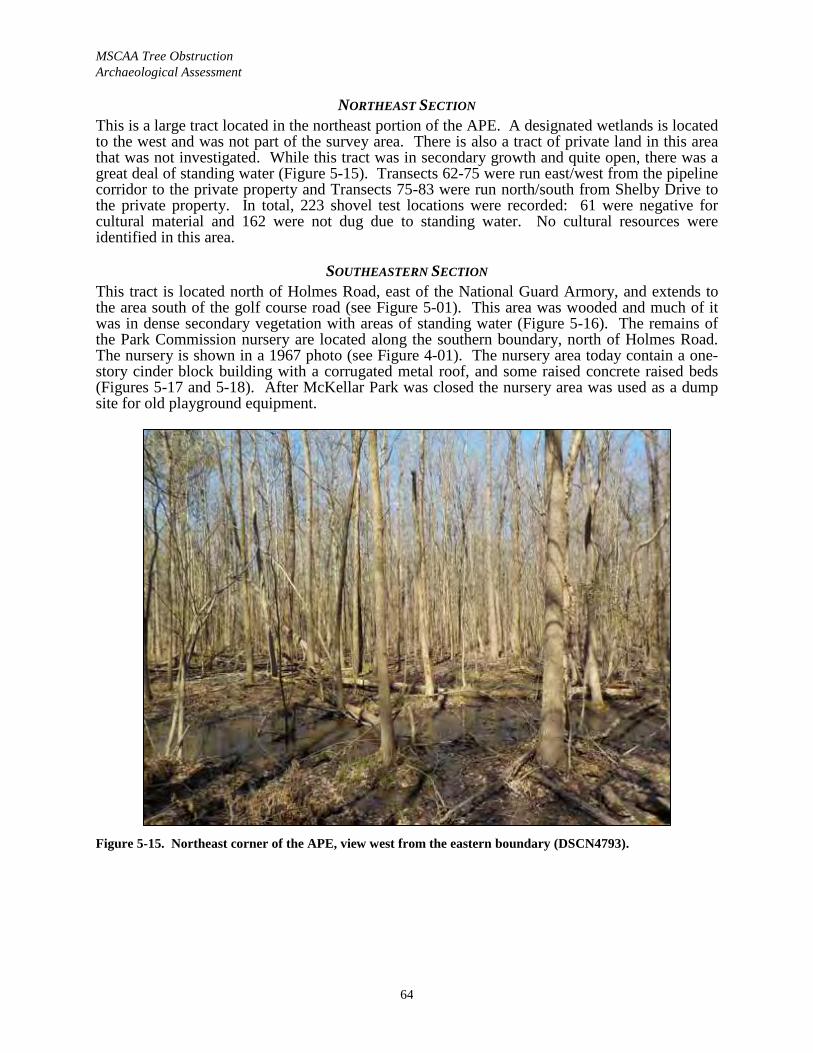
MSCAA Tree ObstructionArchaeological Assessment
64
NORTHEAST SECTIONThis is a large tract located in the northeast portion of the APE. A designated wetlands is located to the west and was not part of the survey area. There is also a tract of private land in this area that was not investigated. While this tract was in secondary growth and quite open, there was a great deal of standing water (Figure 5-15). Transects 62-75 were run east/west from the pipeline corridor to the private property and Transects 75-83 were run north/south from Shelby Drive to the private property. In total, 223 shovel test locations were recorded: 61 were negative for cultural material and 162 were not dug due to standing water. No cultural resources were identified in this area.
SOUTHEASTERN SECTIONThis tract is located north of Holmes Road, east of the National Guard Armory, and extends to the area south of the golf course road (see Figure 5-01). This area was wooded and much of it was in dense secondary vegetation with areas of standing water (Figure 5-16). The remains of the Park Commission nursery are located along the southern boundary, north of Holmes Road. The nursery is shown in a 1967 photo (see Figure 4-01). The nursery area today contain a one-story cinder block building with a corrugated metal roof, and some raised concrete raised beds (Figures 5-17 and 5-18). After McKellar Park was closed the nursery area was used as a dump site for old playground equipment.
Figure 5-15. Northeast corner of the APE, view west from the eastern boundary (DSCN4793).
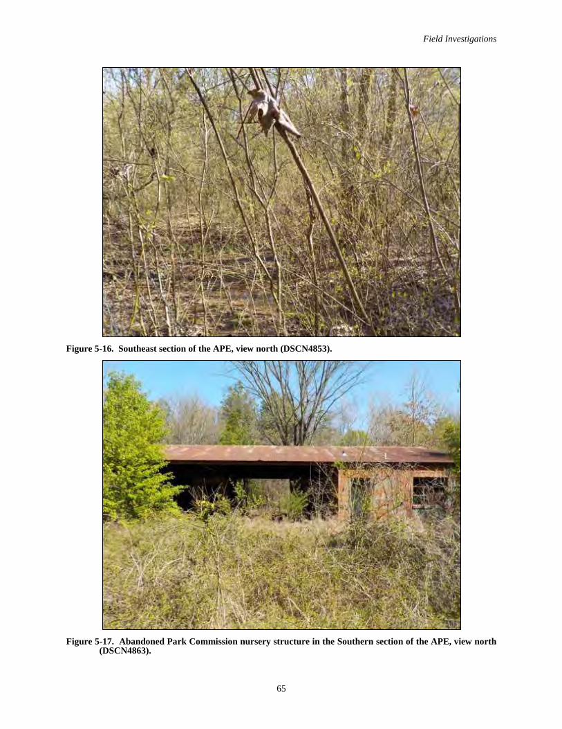
Field Investigations
65
Figure 5-16. Southeast section of the APE, view north (DSCN4853).
Figure 5-17. Abandoned Park Commission nursery structure in the Southern section of the APE, view north (DSCN4863).
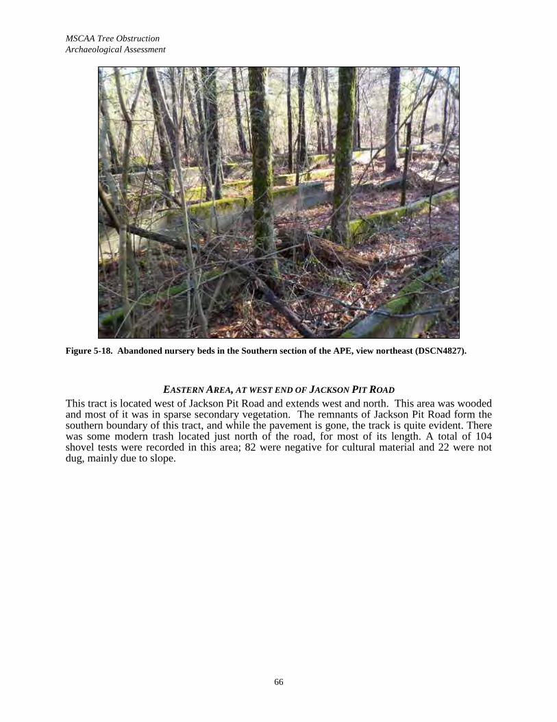
MSCAA Tree ObstructionArchaeological Assessment
66
Figure 5-18. Abandoned nursery beds in the Southern section of the APE, view northeast (DSCN4827).
EASTERN AREA, AT WEST END OF JACKSON PIT ROADThis tract is located west of Jackson Pit Road and extends west and north. This area was wooded and most of it was in sparse secondary vegetation. The remnants of Jackson Pit Road form the southern boundary of this tract, and while the pavement is gone, the track is quite evident. There was some modern trash located just north of the road, for most of its length. A total of 104 shovel tests were recorded in this area; 82 were negative for cultural material and 22 were not dug, mainly due to slope.
67
VI. ARTIFACT ANALYSIS
All artifacts recovered during the survey were transported to Panamerican’s laboratory in Memphis for processing and analysis under the supervision of Laboratory Director Arabela Baer. Analysis proceeded by provenience (unit, level, feature, etc.). Standardized analysis forms and artifact categories were used and the data were keyed into a spreadsheet-type artifact inventory using Excel. All of the artifacts have been cataloged using a system compatible with the requirements of 36 CFR 79.
The recovered assemblage consists of 52 counted artifacts from two sites (Table 6-01). The majority of the recovery is Historic and associated with the late nineteenth to mid twentieth century 40SY844. The small Prehistoric assemblage from Site 40SY843 consists only of debitage and an isolated Historic find. An isolated Prehistoric find was also made at 40SY844. The artifact categories are discussed further below.
Table 6-01. Artifact recovery by site and group.Group 40SY843 40SY844 Totals
Kitchen Group 1 22 23Architecture Group 10 10Personal Group 5 5Medicine Group 4 4Activity Group 1 1Electric Group 1 1Miscellaneous 3 3Prehistoric Lithic Artifacts 4 1 5
Totals: 5 47 52
HISTORIC ANALYSISHistoric artifact groups were formulated and presented following the functional group classification system originally developed by Stanley South (1977). Artifacts were analyzed within a general type-ware-materials-class-group system, with the most detailed analysis performed at the type level and the most generalized analysis at the group level. Each artifact was analyzed largely upon the differences in formal characteristics based on South’s system. Five functional groups are recognized in the recovered assemblage: Kitchen, Architecture,Medicine, Personal and Electric. Artifacts that could not be placed into a functional group are considered miscellaneous items.
KITCHEN GROUPKitchen Group artifacts represent 47.9 percent of the Historic recovery (23/48). Kitchen Group items are those associated with food preparation and consumption, and are typically suggestive of domestic occupations. The classes within the Kitchen Group include: bottle glass (n=9), table glass (n=4) and ceramics (n=9).
Bottle GlassBottle glass color offers some chronological data, thus all bottle glass was sorted by color. Colors recovered include: clear (n=6), aqua (n=2), and cobalt blue (n=1). When possible, bottle glass was further classified based on defining attributes (i.e., bottle fragments, bases, bottleneck, etc.).
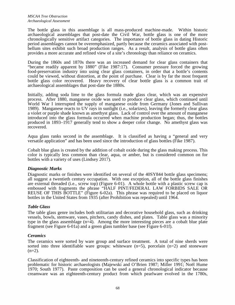
MSCAA Tree Obstruction Archaeological Assessment
68
The bottle glass in this assemblage is all mass-produced machine-made. Within historic archaeological assemblages that post-date the Civil War, bottle glass is one of the more chronologically sensitive artifact categories. The importance of bottle glass in dating Historic period assemblages cannot be overemphasized, partly because the ceramics associated with post-bellum sites exhibit such broad production ranges. As a result, analysis of bottle glass often provides a more accurate and refined view of a site’s chronology than reliance on ceramics.
During the 1860s and 1870s there was an increased demand for clear glass containers that “became readily apparent by 1880” (Fike 1987:17). Consumer pressure forced the growing food-preservation industry into using clear glass containers, in order that a bottle’s contents could be viewed, without distortion, at the point of purchase. Clear is by far the most frequent bottle glass color recovered. Heavy recovery of clear bottle glass is a common trait of archaeological assemblages that post-date the 1880s.
Initially, adding soda lime to the glass formula made glass clear, which was an expensive process. After 1880, manganese oxide was used to produce clear glass, which continued until World War I interrupted the supply of manganese oxide from Germany (Jones and Sullivan 1989). Manganese reacts to UV rays in sunlight (i.e., solarizes), leaving the formerly clear glass a violet or purple shade known as amethyst glass. Lack of control over the amount of manganese introduced into the glass formula occurred when machine production began; thus, the bottles produced in 1893–1917 generally tend to show a deeper color change. No amethyst glass was recovered.
Aqua glass ranks second in the assemblage. It is classified as having a “general and very versatile application” and has been used since the introduction of glass bottles (Fike 1987).
Cobalt blue glass is created by the addition of cobalt oxide during the glass making process. This color is typically less common than clear, aqua, or amber, but is considered common on for bottles with a variety of uses (Lindsey 2017).
Diagnostic Marks Diagnostic marks or finishes were identified on several of the 40SY844 bottle glass specimens;all suggest a twentieth century occupation. With one exception, all of the bottle glass finishes are external threaded (i.e., screw top) (Figure 6-01). A whole bottle with a plastic screw cap is embossed with fragments the phrase “HALF PINT/FEDERAL LAW FORBIDS SALE OR REUSE OF THIS BOTTLE” (Figure 6-02a). This phrase was required to be placed on liquor bottles in the United States from 1935 (after Prohibition was repealed) until 1964.
Table Glass The table glass genre includes both utilitarian and decorative household glass, such as drinking vessels, bowls, stemware, vases, pitchers, candy dishes, and plates. Table glass was a minority type in the glass assemblage (n=4). Among the more interesting pieces are a cobalt blue platefragment (see Figure 6-01a) and a green glass tumbler base (see Figure 6-01f).
CeramicsThe ceramics were sorted by ware group and surface treatment. A total of nine sherds were sorted into three identifiable ware groups: whiteware (n=5), porcelain (n=2) and stoneware (n=2).
Classification of eighteenth- and nineteenth-century refined ceramics into specific types has been problematic for historic archaeologists (Majewski and O’Brien 1987; Miller 1991; Noël Hume 1970; South 1977). Paste composition can be used a general chronological indicator because creamware was an eighteenth-century product from which pearlware evolved in the 1780s,
Artifact Analysis
69
followed by whiteware and ironstone. This evolution in wares resulted in a paste gradient that becomes evident as a problem in the reliable sorting of refined earthenwares into the common typological categories. Miller (1980:2) has remarked that differences between the types often “hinge on personal opinion.” The gradient from whiteware to ironstone probably presents the most significant problem in identification.
WhitewareWhiteware has a buff-colored or whitish paste and a clear or colorless lead glaze and lacks the bluish tint of pearlware. Whiteware began replacing pearlware ca. 1820 and continued production throughout the century (Noël Hume 1982:130-131).
Undecorated whiteware is relatively common on sites in west Tennessee. It is difficult to precisely date plain whiteware due to its long production span; thus the most chronologically sensitive attribute of plain whiteware is the back mark. Three plain white ware sherds were recovered.
Decorated whiteware includes a blue sponged sherd (see Figure 6-03c) and a saucer fragment with a faded floral decal. Sponged treatments were a cheap alternative to transfer print decorations that became popular in 1830, and remained popular through 1860. It has a median ceramic date of 1850 (Esary 1982:186). Decal decorative techniques consist of polychrome decorations made possible through the use of decals (Majewski and O’Brien 1984). Although this type of decoration persists, decal decorations were most popular during 1890–1930s.
StonewareTwo stoneware sherds were recovered. Stoneware was generally made for utilitarian purposes and was manufactured locally throughout the U.S. Per Greer (1981) both examples exhibit aBristol glazed exterior and interior, and one also exhibits blue annular bands (see Figure 6-03a, f). Bristol glaze was the last type of glaze to become popular in the U.S. It is prepared from chemical compounds purchased from a supply company and was designed to result in a smooth, white stoneware glaze (Greer 1981:210). The increasing popularity of the Bristol glaze was tied to an increasing social focus on cleanliness during the Victorian era. This glaze was favored by almost all industrialized potteries in the U.S. after 1884.
PorcelainTwo conjoinable pieces of porcelain were recovered that exhibit a blue underglaze decoration (see Figure 6-03b). Porcelain is characterized by a completely vitrified, glass-like paste. In its original Chinese expression, it was made up of kaolin and feldspar that was fired at temperatures between 1,250–1,400° C, and the resulting “hard paste” displayed no difference between the body and the glaze (Stelle 2006). In contrast, English porcelain has a somewhat softer, slightly translucent, paste and a clear, semi-gloss glaze that frequently appears distinct from the body (Curtis 1988; Cushion and Cushion 1992). Blue underglaze painted porcelain was the most common import in the U.S., and far exceeds the amount of overglaze ware found on archaeological sites (Noël Hume 1970:261). Porcelain was always a more expensive ware and, consequently, less common.
ARCHITECTURE GROUPArchitecture Group artifacts forms 20.8 percent of the Historic recovery (n=10/48). Artifacts in this group include brick fragments (n=4), flat glass (n=3), nails (n=2) and piece of a vitrified clay pipe.

MSCAA Tree Obstruction Archaeological Assessment
70
Figure 6-01. 40SY844 Kitchen Group glass artifacts; all are from surface except f (shovel test 43-5): a-cobalt blue plate section; b-clear glass carboy base; e-crew top jug neck; d-aqua bottle neck with globular flair finish; e-clear glass liquor bottle with unidentified manufacture’s mark; f-green glass tumblerbase.
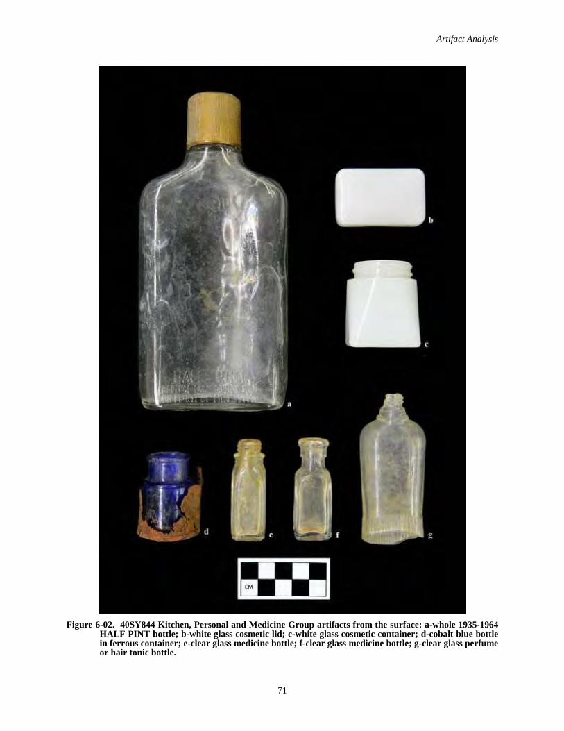
Artifact Analysis
71
Figure 6-02. 40SY844 Kitchen, Personal and Medicine Group artifacts from the surface: a-whole 1935-1964 HALF PINT bottle; b-white glass cosmetic lid; c-white glass cosmetic container; d-cobalt blue bottle in ferrous container; e-clear glass medicine bottle; f-clear glass medicine bottle; g-clear glass perfume or hair tonic bottle.
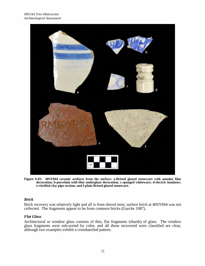
MSCAA Tree Obstruction Archaeological Assessment
72
Figure 6-03. 40SY844 ceramic artifacts from the surface: a-Bristol glazed stoneware with annular blue decoration; b-porcelain with blue underglaze decoration; c-sponged whiteware; d-electric insulator; e-vitrified clay pipe section; and f-plain Bristol glazed stoneware.
BrickBrick recovery was relatively light and all is from shovel tests; surface brick at 40SY844 was notcollected. The fragments appear to be from common bricks (Gurcke 1987).
Flat GlassArchitectural or window glass consists of thin, flat fragments (shards) of glass. The window glass fragments were sub-sorted by color, and all those recovered were classified are clear, although two examples exhibit a crosshatched pattern.

Artifact Analysis
73
NailsNails were sorted into two types based on morphology: wire (n=1) and square or cut (n=1). Machine cut or square nails are cut from flat sheets of metal and feature two tapering edges and two parallel edges. Wire nails are round and are processed from metal cylinders.
During the early 1800s, when the Euro-American settlement of west Tennessee was in its infancy, machine cut nails became available in the Lower Mississippi Valley. Based on research at Millwood Plantation in South Carolina, Orser et al. (1987:549-558) suggest that the relative proportion of cut nails to wire nails can serve as an index to the age of a structure or a site. Sites such as Site 3 that feature a relatively even mixture of wire and cut nails are proposed to date to the period from 1880–1890.
Vitrified Clay PipeA section of a large diameter brown vitrified clay pipe was recovered that is embossed …RMINGHA… (see Figure 6-03e). This is thought to be a mark for the Birmingham Clay Products Company, a business that was incorporated in Alabama during 1921.
PERSONAL GROUPFive artifacts were classified in the Personal Group: two milk (white) glass cosmetic containers (see Figure 6-02b, c), a clear glass screw top perfume or hair tonic bottle, a bakelite canister that is interpreted as a lighter, and a metal tin though to be a cosmetic container.
MEDICINE GROUPThe Medicine Group consists of four small, plain whole bottles; three are clear and one is cobalt blue (see Figure 6-02d, e, and f). Two of the clear specimens exhibit ca. 1929-1954 Owens Illinois glass company marks on their bases (Toulouse 1971). .
ACTIVITY GROUPThis group is limited to one rectangular, heavy-duty tin cap embossed 101A that appears to be an end cap for a sawhorse.
ELECTRIC GROUPThe Electric Group was not created by South, but was devised to avoid having these diagnostic artifacts “buried” within the Activities Group discussion (in larger assemblages). In this assemblage the group is represented by one small white porcelain insulator that is embossed CROSS COUNTY (see Figure 6-03d). Electric power from TVA did not become available in Memphis until 1939 (Bond and Sherman 2003:114), but the city’s streetcar system was electrified during the 1890s.
MISCELLANEOUS ITEMSThe remaining artifacts were all classified as Miscellaneous Items and three unidentified ferrous objects from a shovel test.
LITHIC SORTING METHODSThe chipped-stone analysis is based on the sorting scheme of Sullivan and Rozen (1985; Rozen and Sullivan 1989a, 1989b; Figure 6-04). The proposed Sullivan and Rozen (1985) sorting method offers greater replicability over traditional stage typologies and was formulated specifically for the constraints (time and money) of contract archaeology. Additional commentary regarding the value of interpretative results derived from this scheme has been presented (Amick and Mauldin 1989; Ensor and Roemer 1989; Rozen and Sullivan 1989a,
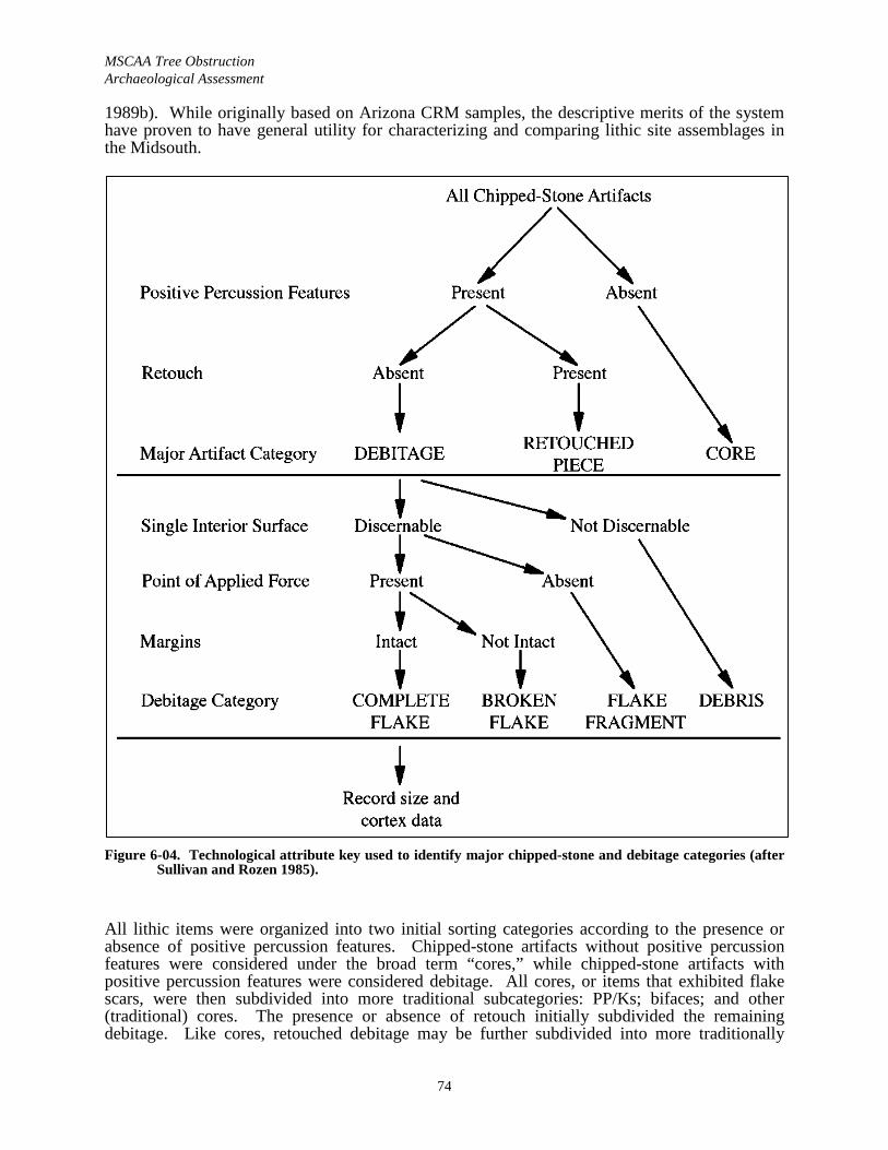
MSCAA Tree Obstruction Archaeological Assessment
74
1989b). While originally based on Arizona CRM samples, the descriptive merits of the system have proven to have general utility for characterizing and comparing lithic site assemblages in the Midsouth.
Figure 6-04. Technological attribute key used to identify major chipped-stone and debitage categories (after Sullivan and Rozen 1985).
All lithic items were organized into two initial sorting categories according to the presence or absence of positive percussion features. Chipped-stone artifacts without positive percussion features were considered under the broad term “cores,” while chipped-stone artifacts with positive percussion features were considered debitage. All cores, or items that exhibited flake scars, were then subdivided into more traditional subcategories: PP/Ks; bifaces; and other (traditional) cores. The presence or absence of retouch initially subdivided the remaining debitage. Like cores, retouched debitage may be further subdivided into more traditionally
Artifact Analysis
75
assumed functional or morphological categories. The identification and classification of retouched pieces can be problematic, given the gradation from formal to expedient “use wear” type retouch. In general, the Sullivan and Rozen (1985) typology initially defines three chipped-stone tool categories: cores; retouched pieces; and debitage.
The classification of debitage is where the scheme varies the most from traditional approaches. Pieces without observable interior faces were considered “debris,” which is similar to “chipping shatter” of traditional approaches. Pieces of debitage with observable interior faces but lacking bulbs of percussion were considered “flake fragments.” Fragments with both observable interior faces and bulbs of percussion were considered either “complete flakes,” if the margins were intact, or “broken flakes,” if the lateral margins were not intact. Complete flakes are typically subjected to further analysis, but no complete flakes were noted from any of the loci.
LITHIC ANALYSIS RESULTSPrehistoric lithic artifacts represent a minority of the project recovery (9.6 percent, or 5/52). The recovery includes four pieces of debitage from 40SY843 (two flake fragments, one broken flake and a piece of debris), and one retouched piece i.e., utilized debitage) from 40SY844. None of these items are diagnostic.
CURATIONThe artifact assemblage is the property of the MSCAA, and is temporarily stored at Panamerican’s lab in Memphis.
C.H. NASH MUSEUM 40SY307 ASSEMBLAGE Memphis State archaeologist Rick Walling recovered an extensive surface collection from 40SY307 during the 1980s that is curated at C.H. Nash Museum Chucalissa Indian Village. The assemblage was sorted into 49 lots, and a summary of the resulting Memphis State University Archaeological Catalogue sheet is provided below (Table 6-02).
Table 6-02. Summary of Memphis State’s 40SY307 assemblage. Lot Nos. Artifact Category Count
1 Pottery 42 Clay ball fragment 1
3-15 Projectile points and fragments 1316-18 Drills and fragments 319-24 Bifaces and fragments 625-31 Flake cores 732-33 Micro-blade core 234-37 Flake cores 4
38 Worked flake 139 Misc. flakes 24340 Micro-blades 441 Utilized flakes 942 Chipping shatter 10043 Fire shatter 62344 Ferruginous siltstone 845 Ferruginous sandstone 1046 Sandstone 4147 Conglomerate 6
MSCAA Tree Obstruction Archaeological Assessment
76
Lot Nos. Artifact Category Count48 Broken rock 18249 Bullets 2
Total: 1,269
Several comments can be offered be offered regarding 40SY307 based on a review of the catalogue sheet data alone. First, the large size of the assemblage hints that a 100 percent collection sample was recovered. Second, nearly half of the collection (49.1 percent) consists of “fire shatter,” or fire-cracked rock, and this suggests that the road or trial that cuts through the site disturbed an earth oven or related feature. The next most frequent artifact class is debitage (non-utilized), which forms 28.1 percent of the assemblage (n=357). The amount of debitage, coupled with the presence of 13 cores, suggests that stone tool manufacture or maintenance took place on site. Also, there was a high frequency of other non-chipped stone items at the site (19.5 percent, or n=247), see Lots 44-48.
From a chronological standpoint, the presence of one clay ball fragment and low frequencies of micro-blade cores and micro-blades is diagnostic for a Poverty Point period occupation. The presence of four pottery sherds is indicative of a post Poverty Point occupation.
In an effort to identify diagnostics and help further refine the site’s chronology, the 40SY307 assemblage was briefly examined at C.H. Nash Museum on March 25, 2019. The collection is housed in three 6-x-6 in. cardboard boxes. Among the projectile points and fragments (i.e., Lots 3-15), several diagnostics were identified including:
A Late Archaic/Early Woodland period Mabin PP/K (Justice 1987:190); Lot 3 upper left Figure 6-05.
A late Poverty Point period Arlington PP/K (G.P. Smith 1979:70); Lot 6 lower left Figure 6-05.
A late Poverty Point period Harris Island PP/K (G.P. Smith 1979:70); Lot 5 lower center Figure 6-05.
A Poverty Point period Lambert PP/K (G.P. Smith 1979:70); Lot 4 lower right Figure 6-05.
A Late Woodland period Flint River Spike (Cambron and Hulse 1986:53); Lot 7 upper center Figure 6-05.
Examination of the four sherds revealed that they are plain clay-tempered, and generally conformable to the type Baytown Plain (Phillips 1970); a type typically considered to be aWoodland diagnostic in the Memphis area.
To summarize, the examination of the C.H. Nash Museum 40SY307 assemblage suggests the primary occupation of the site took place during the Poverty Point period, and then the site was re-occupied during the Late Woodland period. The Poverty Point component at 40SY307 would be part of G.P. Smith’s (1996:103) Nonconnah complex, which is one of only two Poverty Point complexes in west Tennessee that exhibit micro-blade use.
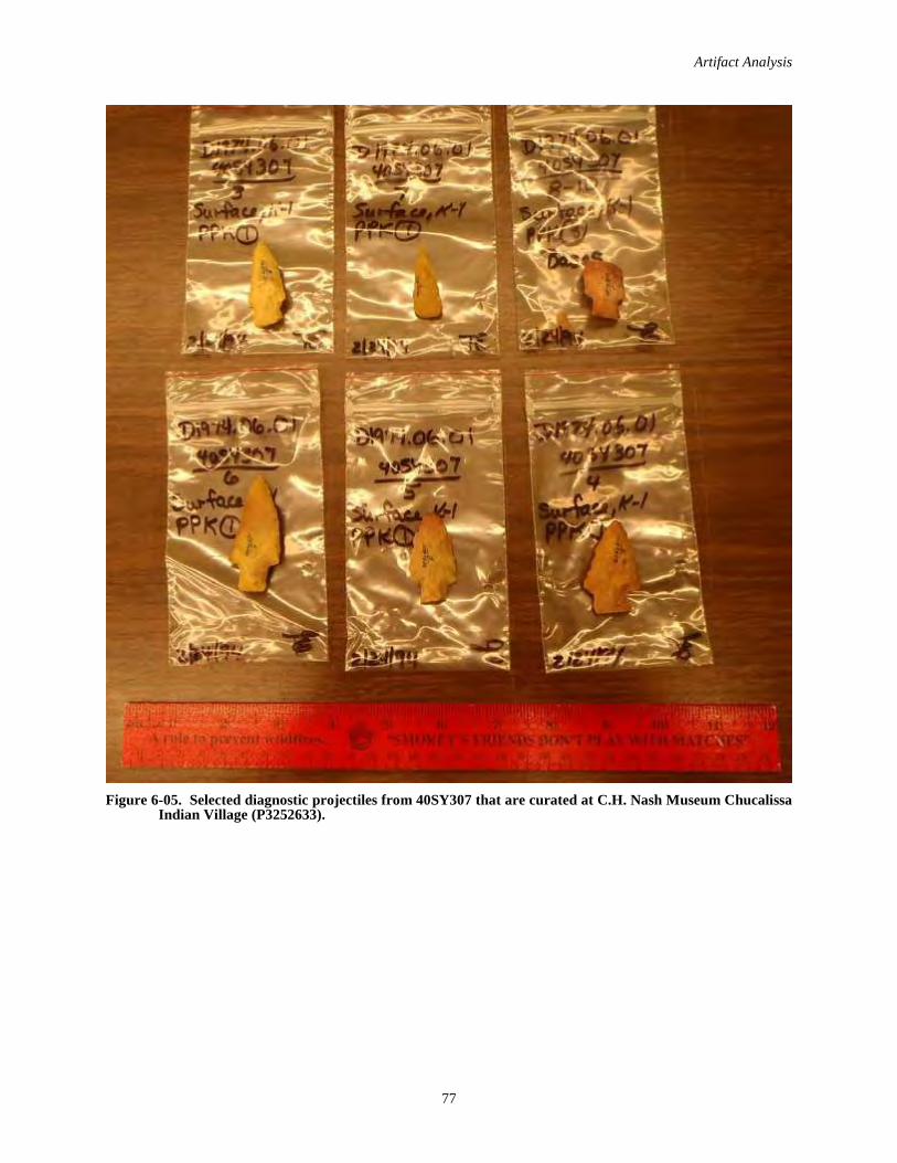
Artifact Analysis
77
Figure 6-05. Selected diagnostic projectiles from 40SY307 that are curated at C.H. Nash Museum Chucalissa Indian Village (P3252633).

MSCAA Tree Obstruction Archaeological Assessment
78
Page intentionally blank
79
VI. SUMMARY AND RECOMMENDATIONS
SUMMARYAt the request of Ensafe, Inc. and the MSCAA, Panamerican performed a Phase I cultural resources survey of the APE associated with the McKellar Park Tree Obstruction Clearing undertaking. The purpose of the survey was to identify any archaeological resource that is listed on, eligible for, or potentially eligible for the NRHP present within the APE, and to provide appropriate management recommendations for any such resources identified.
The MSCAA proposes to clear trees and shrubs from Airport property located south of Runways 36R, 36L and 36C to meet FAA requirements. The goals of the project include meeting grantassurance and compliance with glide slope safety requirements to ensure federal funding. Stumps of the trees cut within upland (i.e., non-wetland) areas will be removed after clearing to facilitate future mowing. In contrast, stumps of the trees cut within the wetlands will remain in place.The TN-SHPO Federal Programs Archaeologist indicated that the archaeological APE was limited to areas where ground-disturbing activities will take place (i.e., tree stump removal, grubbing, and access road construction). As ground-disturbing activities are limited to 309 ac. of wooded terrain in the uplands, this area is considered the APE.
The setting is uplands within the western Tennessee loess sheet, and the terrain is hilly and dissected, with elevations ranging from 300 ft. to 360 ft. Drainage is principally to the northeast via Hurricane Creek, and the APE is part of the Nonconnah Creek basin. Review of soil survey maps (Sease et al. 1989:Sheet 86) reveals the APE contains 16 soil types or phases, as well as gullied land, mine and gravel pits, and water covered areas (see Table 2-01). Importantly, seven of these soil type-phases are characterized as eroded or severely eroded, and are unlikely to contain significant archaeological deposits, because the surface soil horizon has been carried away by erosion.
A standard cultural resources literature and records check was conducted using TDOA, THC and NRHP databases as primary sources. This revealed that there are three previously recorded archaeological sites located within McKellar Park (40SY85, 40SY91 and 40SY307). These sites are minimally documented and their locational data is sketchy; however only 40SY307 appearsto possibly be within the APE. Based on Peterson’s (1979) sample survey of the Wolf River Watershed the APE was expected to exhibit low site density, and the number of expected sites was 2.5 (1.25 km2/0.49 sites per km2). Expected site types included Prehistoric open habitations and Historic domestic sites. It should also be noted that the MSCAA Tree Obstruction Clearing APE is located within the former McKellar Park, which at 554 ac. was once Memphis’ largest city park and contained an 18-hole golf course from ca. 1972 to 1995 (see “McKellar Park History” in Chapter IV).
The bulk of the fieldwork was conducted March 12–28, 2019 and final 13 ac. were surveyed on November 23, 2020. The crew size ranged from three to five. The basic site detection method included shovel testing at 30 m intervals. Additionally all sites delineated at 10 m intervals. During the course of the field work, 1,311 shovel test locations were documented, including nine that were positive for cultural material, 576 that were negative for cultural material, and 726 planned tests that were not dug, mainly due to standing water and eroded slopes (see Figure 5-01; see Appendix A). Additionally some low, water covered areas could not be shoved tested.
The survey resulted in the identification of two archaeological sites (Table 7-01). Site 40SY843 is a 40-x-30 m low-density undifferentiated Prehistoric lithic scatter and isolated Historic find that is interpreted as a peripheral element of 40SY307, which otherwise no longer appears to exist. Site 40SY844 is 130-x-30 m Historic farmstead with an isolated Prehistoric find. No

MSCAA Tree ObstructionArchaeological Assessment
80
archival evidence for a structure here was found despite reviewing a series of maps dating from 1888-1965.
Table 7-01. Recorded resources summary.
Site DescriptionPositive shovel tests
Artifact Recovery
NRHPRec.
Management Action
40SY843 Low-density lithic scatter, and isolated Historic find 3 5 I No further work
40SY844Late 19th to mid 20th century farmstead and isolated Prehistoric find
6 47 I No further work
Key: Rec.=Recommendation; I-Ineligible.
RECOMMENDATIONSPanamerican recommends 40SY843 and 40SY844 as ineligible for the NRHP; reasoning is offered in Chapter V. The recommended management action is no further work.
As there are no listed, eligible or potentially eligible archaeological resources within the APE,the proposed undertaking will not have an adverse impact on archaeological resources.
81
VIII. REFERENCES CITED
Adams, Null 1932 “Trolley Form’s Financial Woes First Began in ’23.” The Evening Appeal, Memphis.
January 7, 1932. Clipping on file at the Memphis Room, Memphis and Shelby County Library and Information Center (Memphis Street Railway Company file).
Amick, D.S., and R.P. Mauldin 1989 Comments on Sullivan and Rozen’s “Debitage Analysis and Archaeological
Interpretation.” American Antiquity 54(1):166-168.
Anderson, D.G., R.J. Ledbetter, and L.D. O’Steen 1990 Paleoindian Period of Georgia. Georgia Archaeological Research Design Paper 6.
Laboratory of Archaeology Series Report 28. University of Georgia, Athens.
Arnold, M.S. 1991 Colonial Arkansas 1686–1804. University of Arkansas Press, Fayetteville.
Atkinson, J.R. 2000 Death of a Chickasaw Leader: The Probable Grave of Piomingo. Mississippi
Archaeology 35(2):124-172.
Blitz, John 1988 The Adoption of the Bow and Arrow in Prehistoric North America. North American
Archaeologist 9(2):123–145.
Bond, Beverly G., and Janann Sherman 2003 Memphis in Black and White. The Making of American Series, Arcadia Publishing.
Braun, E.L. 1964 Deciduous Forests of Eastern North America. Hafner, New York.
Braund, K.E.H. 1993 Deerskins & Duffels. University of Nebraska Press, Lincoln.
Brettman, Allan 1986 “Token lode is struck.” Commercial Appeal, Memphis. October 12, 1986. Clipping
on file at the Memphis Room, Memphis and Shelby County Library and Information Center (Memphis Street Railway Company file).
Brister, R.C., J.W. Armon, and D.H. Dye 1981 American Mastodon Remains and Late Glacial Conditions at Nonconnah Creek,
Memphis, Tennessee. Occasional Papers No. 10. Memphis State University Anthropological Research Center.
Brown, Charles A. 1964 City to Buy Property near McKellar Park. Press-Scimitar September 15, 1964. Copy
on file at the Memphis Room, Memphis Benjamin L. Hooks Central Library.
MSCAA Tree Obstruction Archaeological Assessment
82
Broster, J.B., and L. Schneider 1977 Settlement and Subsistence: An Analysis of Middle Woodland Sites on the South
Fork of the Forked Deer River, West Tennessee. Journal of Alabama Archaeology23(1):59–70.
Buchner, C. Andrew 2014 Phase I Cultural Resources Survey of the Proposed Shelby and Tchulahoma Cell
Tower, Shelby County, Tennessee. Panamerican Consultants, Inc. Report No. 34005. Submitted to Terracon, Inc.
Buchner, C. Andrew, and Eric S. Albertson 2003 Cultural Resources Alternative Analysis for the Proposed MATA Light Rail Corridor,
Memphis, Tennessee. Panamerican Consultants, Inc., Memphis. Revised draft report submitted to Parsons-Brinckerhoff, Nashville, Tennessee.
Buchner, C. Andrew, and Emmanuel Breitburg 2007 Archaeological Data Recovery at the Lee’s Landing Westin Hotel Site (40SY674),
Beale Street Historic District, Memphis, Tennessee. Panamerican Consultants, Inc. Prepared for Senate Hospitality Group.
Buchner, C. Andrew, and Robert Taylor 2016 Cultural Resources Survey of the 44 ac. Copart Expansion Tract, Shelby County,
Tennessee. Panamerican Consultants, Inc. Report No. 36031. Submitted to Brophy-Heineke & Associates, Inc.
Byrne, Ryan and Milton Moreland 2007 The Archaeology of Slavery: Potential Models from the Ames Plantation. Paper
presented to the 2007 Mid-South Archaeological Conference, University of Memphis.
Caldwell, J.R. 1958 Trend and Tradition in the Prehistory of the Eastern United States. Memoirs No. 88.
American Anthropological Association, Menasha, Wisconsin.
Cambron, J.W., and D.C. Hulse 1986 Handbook of Alabama Archaeology: Part I, Point Types (revised edition third
printing). Archaeological Research Association of Alabama, Inc., Moundville.
Clifton, A. 2010 Architectural/Historical Assessment of the Proposed Improvements to Holmes Road,
Shelby County, Tennessee. Panamerican Consultants, Inc., Memphis, Tennessee Report No. 29271. Prepared for Fisher & Arnold, Inc., Memphis, Tennessee.
Commercial Appeal 1917 Police close brothels. Commercial Appeal, 17 July 1917, Memphis, Tennessee.
1926 Bells Put on Mules. Commercial Appeal, December 9, 1926, Memphis, Tennessee. On file, Memphis Room, Memphis Public Library, Memphis Street Railway file.
Connolly, Daniel 2016 Memphis architect Roy Harrover dies. Commercial Appeal, December 16, 2016,
Memphis , Tennessee.
References Cited
83
Coode, Thomas H. 1998 McKellar, Kenneth Douglas entry in The Tennessee Encyclopedia of History &
Culture, C.V. West Editor in Chief. The Tennessee Historical Society.
Corgan, James X., and Emanuel Breitburg 1996 Tennessee’s Prehistoric Vertebrates. Tennessee Division of Geology Bulletin 84.
Cowell, Randy C. 1977 Sedimentology and Scanning Electron Microscope Study of the Loess and Related
Sediments along Nonconnah Creek, Memphis, Tennessee. Master’s thesis, Memphis State University.
Curtis, Julia B. 1988 Perceptions of an Artifact: Chinese Porcelain in Colonial Tidewater Virginia. In
Documentary Archaeology in the New World, Mary C. Beaudry, editor, pp. 20-31. Cambridge University Press, Cambridge, England.
Cushion, John, and Mary Cushion 1992 A Collector’s History of British Porcelain. Antique Collectors’ Club, Ltd.,
Woodbridge, Suffolk.
Daniel, Larry, and Lynn N. Bock 1996 Island No. 10 Struggle for the Mississippi Valley. University of Alabama Press,
Tuscaloosa.
Davies-Rodgers, Ellen 1990 Along the Old Stage-Coach Road. The Plantation Press, Davies Plantation.
Davis, Maj. George B., Leslie J. Perry, and Joseph W. Kirkley 1891 The Official Military Atlas of the Civil War. Reprinted by Barnes and Noble in 2003.
de Gregory, J. Rocco, Scott C. Meeks, Ted Karpynec, Katherine Wright, Meghan Weaver, and Kate Manning
2014 Phase I Cultural Resource Survey of Tennessee Valley Authority’s Allen Fossil Plant Emission Control Project, Shelby County, Tennessee. Tennessee Valley Archaeological Research. Prepared for the Tennessee Valley Authority.
Dekin, Albert, Cecil Brooks, Douglass Edsall, James Mueller, Robert Pasnat, Peter Skirbunt, Sally Tompkins, with Charles LeeDecker, James O'Donnell, Vanessa Patrick, Genevier Poirier and Phyllis Morse, Martin Pociask and Bernard Poirer
1978 Predicting Cultural Resources in the St. Francis Basin, a Research Design. Iroquois Research Institute. Report submitted to the USACE, Memphis District.
Delcourt, Paul A., Hazel R. Delcourt and Roger T. Saucier 1999 Late Quaternary Vegetation Dynamics in the Central Mississippi Valley. In Arkansas
Archaeology, edited by R.C. Mainfort and M.D. Jeter, pp. 15-30. University of Arkansas Press.
Dunnell, R.C., and J.K. Feathers 1991 Late Woodland Manifestations of the Malden Plain, Southeast Missouri. In Stability,
Transformation, and Variation: The Late Woodland Southeast, edited by M.S. Nassaney and C.R. Cobb, pp. 21–45. Plenum Press, New York.

MSCAA Tree Obstruction Archaeological Assessment
84
DuVall, Glyn D. 1980 Memorandum addressed to Ben L. Smith, Administrator of the Environmental
Planning Division, from Tennessee Department of Transportation.
DuVall, Glyn D. and Jamie Evans 1995 A Phase I Historic Archaeological Survey and Limited Testing of Ames Plantation,
Fayette and Hardeman Counties, Tennessee. DuVall & Associates, Inc. Submitted to the Hobart Ames Foundation and the Tennessee Historical Commission.
Dye, David H. 1993 Reconstruction of the de Soto Expedition Route in Arkansas: the Mississippi Alluvial
Plain. In The Expedition of Hernando de Soto West of the Mississippi, 1541–1543,edited by G.A. Young and M.P. Hoffman, pp. 36–57. Proceedings of the de Soto Symposia, 1988 and 1990. University of Arkansas Press, Fayetteville.
Ensor, H.B., and E. Roemer, Jr. 1989 Comments on Sullivan and Rozen’s “Debitage Analysis and Archaeological
Interpretation.” American Antiquity 54(1):175–178.
Esary, Mark Edward 1982 Archaeological Geographical And Historical Comparison: Eleven Nineteenth-
Century Archaeological Sites Near Belleville. Master’s thesis, Illinois State University. Normal, Illinois.
Fenneman, N.M. 1938 The Physiography of the Eastern United States. McGraw-Hill, New York.
Fike, R.E. 1987 The Bottle Book: A Comprehensive Guide to Historic, Embossed Medicine Bottles.
Peregrine Smith, Salt Lake City, Utah.
Fischer, F. W., and C. H. McNutt 1962 Test Excavations at Pinson Mounds, 1961. Tennessee Archaeologist 18(1):1–13.
Folmsbee, S.J., R.E. Corlew, and E.L. Mitchell 1969 Tennessee: A Short History. University of Tennessee Press, Knoxville.
Fuller, M.L. 1912 The New Madrid Earthquake. USGS Bulletin 394. U.S. Government Printing
Office, Washington, D.C.
Galloway, Patricia A. 1995 Choctaw Genesis 1500-1700. University of Nebraska Press, Lincoln.
Gerald, Paul 1995 Last Round Coming up at McKellar Park. Memphis Flyer 310:4, January 26—
February 1, 1995.
Gerson, N.B. 1968 Franklin, America’s “Lost State. ” Crowell-Collier Press, New York.
Goodyear, A.C., III 1974 The Brand Site: A Techno-functional Study of a Dalton Site in Northeast Arkansas.
AAS Research Series 7. Arkansas Archeological Survey, Fayetteville, Arkansas.
References Cited
85
1982 The Chronological Position of the Dalton Horizon in the Southeastern United States. American Antiquity 47:382–395.
Graham, R.W., C.V. Haynes, D.L. Johnson, and M. Kay 1981 Kimmswick: A Clovis-Mastodon Association in Eastern Missouri. Science
213:1115-1117.
Greer, Georgiana H. 1981 American Stonewares, The Art and Craft of Utilitarian Potters. Schiffer Publishing,
Exton, Pennsylvania.
Griffith, Glenn, James Omernik, and Sandra Azevedo 2004 Ecoregions of Tennessee Map. Interagency effort. Available at the U.S.
Environmental protection Agency Western Ecology Division web site http://www.epa.gov/wed/pages/ecoregions/tn_eco.htm.
Gurcke, Karl 1987 Bricks and Brickmaking: A Handbook for Historical Archaeology. University of
Idaho Press, Moscow, Idaho.
Hadskey, Sarah 2005 Lamar Terrace: Then and Now. Web page, visited January 18,
2005. http://www.memphisheritage.org/MHIHost/Keystone-LamarTerrace.html
Hancock, Orville 1969 Development Program Is Set At Memphis’ Largest Park. Press-Scimitar December
16, 1969. Copy on file at the Memphis Room, Memphis Benjamin L. Hooks Central Library.
1970 Work Starts Soon at McKellar Park. Press-Scimitar August 21, 1970. Copy on file at the Memphis Room, Memphis Benjamin L. Hooks Central Library.
1971 Major Gold Work Set at McKellar. Press-Scimitar November 9, 1971. Copy on file at the Memphis Room, Memphis Benjamin L. Hooks Central Library.
Higgins, Michael J. 1990 The Nocta Site: The Early, Middle, and Late Archaic Occupations. American
Bottom Archaeology, FAI-270 Site Reports No. 21, Urbana.
Hockersmith, Kelly 2009 Phase I Archaeological Survey of the Proposed Improvements to Tchulahoma Road,
Shelby County, Tennessee. TRC, Inc. Submitted to Gresham, Smith and Partners.
Holley, Donald 2000 The Second Great Emancipation: The Mechanical Cotton Picker, Black Migration,
and How They Shaped the Modern South. University of Arkansas Press, Fayetteville.
Johnson, Edward A. 1998 Railroads. In the Tennessee Encyclopedia of Culture and History, edited by C.V.
West, pp. 769-773. Tennessee Historical Society, Nashville.
MSCAA Tree Obstruction Archaeological Assessment
86
Johnson, Jay K. 1993 Poverty Point Period Crystal Drill Bits, Microliths, and Social Organization in the
Yazoo Basin, Mississippi. Southeastern Archaeology 12(1):59-64.
Jones, O., and C. Sullivan 1989 The Parks Canada Glossary for the Description of Containers, Tableware, Closures,
and Flat Glass. Studies in Archaeology, Architecture, and History. Minister of the Environment, Ottawa.
Justice, N.D. 1987 Stone Age Spear and Arrow Points of the Midcontinental and Eastern United States.
Indiana University Press, Bloomington.
Katznelson, Ira 1973 Black Men, White Cities: Race, Politics, and Migration in the United States, 1900-
1930. Published for the Institute of Race Relations, Oxford University Press.
Keating, John M. 1879 History of the Yellow Fever Epidemic 1878 in Memphis, Tennessee. Printed by the
Howard Association, Memphis.
Kee, J.W., M. Prichard, and G. Lane, Jr. 1952 Archaeological Explorations on the Lower Reaches of Nonconnah Creek, Shelby
County, Tennessee, 1952. Memphis Archaeological & Geological Society Publication No. 4.
Kelly, R.E. 2004 America’s World War II Home Front Heritage. CRM: The Journal of Heritage
Stewardship 1(2):34-50, Summer 2004. National Park Service, National Center for Cultural Resources.
Kern, John R. 1981 Study of Archaeological, Architectural and Historic Resources within the Memphis
Metropolitan Area; Tennessee, Arkansas and Mississippi: Nonconnah Creek Area.Gilbert-Commonwealth. Submitted to the U.S. Army Corps of Engineers, Memphis District.
Law Environmental 1990 Remedial Investigation Final Report, Appendices. Law Environmental, Inc. Report
submitted to the USACE, Huntsville District.
Lee, George W. 1934 Beale Street, Where the Blues Began. Robert O. Ballau, New York.
Lewis, R. Barry 1996 The Western Kentucky Border and the Cairo Lowland. In Prehistory of the Central
Mississippi Valley, edited by C. H. McNutt, pp. 47–76. University of Alabama Press, Tuscaloosa.
Lewis, Selma 1998 Abe Plough entry in The Tennessee Encyclopedia of History & Culture, Carroll Van
West, Editor in Chief, pp. 737-738. The Tennessee Historical Society.
References Cited
87
Lindsey, B. 2017 Bottle Dating. In Historic Glass Bottle Identification & Information Website.
Electronic document, http://www.sha.org/bottle/dating.htm, accessed February 12, 2019.
Lovett, Boddy L. 1998 Beale Street. In the Tennessee Encyclopedia of History & Culture, edited by Carroll
Van West, pp. 53-54. Tennessee Historical Society.
Magness, Perre 1994 Past Times: Stories of Early Memphis. Parkway Press, LLC, Memphis, Tennessee.
Mainfort, Robert C. 1980 Archaeological Investigations at Fort Pillow State Historic Area: 1976–1978.
Research Series No. 4. Tennessee Division of Archaeology, Nashville.
1986 Pinson Mounds: A Middle Woodland Ceremonial Center. Research Series No. 7. Tennessee Division of Archaeology, Nashville.
1994 Archaeological Investigations in the Obion River Drainage: The West Tennessee Tributaries Project. Research Series No. 10. Tennessee Department of Environment and Conservation, Division of Archaeology, Nashville.
1996 The Reelfoot Lake Basin, Kentucky and Tennessee. In Prehistory of the Central Mississippi Valley, edited by C. H. McNutt, pp. 77–96. University of Alabama Press, Tuscaloosa.
1996b Late Period Chronology in the Central Mississippi Valley: A Western Tennessee Perspective. Southeastern Archaeology 15(2):172–180.
Majewski, T., and M.J. O’Brien 1987 The Use and Misuse of Nineteenth-Century English and American Ceramics in
Archaeological Analysis. Advances in Archaeological Method and Theory 1:97-209. Academic Press, New York.
McEachran, Angus 1967 Forgotten Land Enters Gold Course Feud. Commercial Appeal July 1, 1967. Copy
on file at the Memphis Room, Memphis Benjamin L. Hooks Central Library.
McNutt, Charles H., Sr. 1988 The Shelby Forest Site (40SY489). Paper presented at the 45th Southeastern
Archaeological Conference, New Orleans, Louisiana.
1996 Prehistory of the Central Mississippi Valley. University of Alabama Press, Tuscaloosa.
2015 The Shelby Forest Site in Southwest Tennessee and early Mississippian Rd-Filmed Pottery in the Central Mississippi Valley. Southeastern Archaeology 34(2):136-148.
McNutt, Charles H., Sr. and Edith C. Fain 1990 The Shelby Forest Site (40SY489): Excavations in 1987. Report on file, Tennessee
Division of Archaeology, Nashville.
MSCAA Tree Obstruction Archaeological Assessment
88
Memphis International Airport 2015 Airport History. Memphis International Airport
webpage http://www.flymemphis.com/airport-history accessed November 5, 2018.
Miller, George L. 1980 Classification and Economic Scaling of 19th Century Ceramics. Historical
Archaeology 14:1-41.
1991 A Revised Set of CC Index Values for Classification and Economic Scaling of English Ceramics from 1787 to 1880. Historical Archaeology 25(1):1-25.
Morse, Dan F. 1975 Paleo-Indian in the land of opportunity: Preliminary report on the excavations at the
Sloan site (3GE94). In Cache River archeological project, assembled by Michael Shiffer and John House. Arkansas Archeological Survey Research Series 8:135-143.
1977 Dalton Settlement Pattern: Reply to Schiffer (2). Plains Anthropologist 22:149-158.
1997 Sloan: A Paleoindian Dalton Cemetery in Arkansas. Smithsonian Institution Press, Washington, D.C.
Morse, Dan F., and Phyllis A. Morse 1983 Archaeology of the Central Mississippi Valley. Academic Press, New York.
Morse, Dan F., and J.H. Polhemus 1963 Preliminary Investigations of the Pinson Mounds Site near Jackson, Tennessee.
Submitted to the U. S. National Park Service.
Morton, Dorothy 1998 Fayette County. In The Tennessee Encyclopedia of History and Culture, pp. 303-304,
Carroll Van West, editor in chief. The Tennessee Historical Society..
Nance, Benjamin C. 2007 An Archaeological Survey of World War II Military Sites in Tennessee. Tennessee
Department of Environment and Conservation, Division of Archaeology, Report of Investigations No. 13.
Nance, Benjamin C., and Sarah Levithol Eckhardt 2018 Archaeological Survey of Tennessee’s Rosenwald Schools. Poster presented at the
Current Research in Tennessee Archaeology, 30th Annual Meeting, January 26-27, 2018. Montgomery Bell State Park Conference Center.
Nance, J.D. 1987 The Archaic Sequence in the Lower Tennessee-Cumberland-Ohio Region.
Southeastern Archaeology 6(2):129–139.
Noël Hume, I. 1970 A Guide to Artifacts of Colonial America. Second Printing. Alfred A. Knopf, New
York.
1982 A Guide to Artifacts of Colonial America. 10th printing, Alfred A. Knopf, New York.
References Cited
89
Orser, C.E., Jr., A.M. Nekola, and J.L. Roark 1987 Exploring the Rustic Life: Multidisciplinary Research at Millwood Plantation, A
Large Plantation in Abbeville County, South Carolina and Elbert County, Georgia.Russell Papers 1987, U.S. Army Corps of Engineers, Savannah District. Mid-American Research Center, Loyola University of Chicago. Submitted to the U.S. National Park Service, Interagency Archaeological Services Division, Atlanta.
Ostby, Lloyd, and John Parrish 1982 National Register of Historic Places Inventory—Nomination Form for the Memphis
Street Railway Company Office and Streetcar Complex. On file, Memphis Heritage Office, Memphis.
Oster, Warren J., Guy G. Weaver, Jamison P. Richardson, and Jason M. Wyatt 2005 Archaeological and Osteological Investigations of the Providence Baptist Church
Cemetery (40SY619), Memphis-Shelby County Airport, Memphis, Shelby County, Tennessee. Weaver & Associates, LLC. Submitted to the Memphis-Shelby County Airport Authority.
Peterson, Drexel A., Jr. 1979 An Archaeological Survey and Assessment of the Wolf River Watershed. Report
submitted to the U.S. Department of Agriculture, Soil Conservation Service, Nashville.
Phillips, P. 1970 Archaeological Survey in the Lower Yazoo Basin, Mississippi, 1949–1955. Papers of
the Peabody Museum of American Archaeology and Ethnology Vol. 60. Harvard University, Cambridge.
Pietak, Lynn Marie, and Jeffrey L. Holland 2000 Living near Beale Street in Postbellum Memphis: Data Recovery at 40SY611, Shelby
County, Tennessee. TRC Garrow Associates, Inc., Atlanta. Submitted to Gibson Guitar Corporation, Memphis.
Porteous, Clark 1964 Plans Are Revealed for Developing Huge McKellar Park. Press-Scimitar July 29,
1964. Copy on file at the Memphis Room, Memphis Benjamin L. Hooks Central Library.
Press Scimitar 1931 Rubber Fenders, Door Pads Increase Safety on New Trackless Trolleys. Press
Scimitar, October 13, 1931, Memphis, Tennessee. Article on file at the Memphis Room, Memphis and Shelby County Public Library, Memphis Street Railway file.
1964 $105,327 But For McKellar Gold Course. Press-Scimitar October 15, 1964. Copy on file at the Memphis Room, Memphis Benjamin L. Hooks Central Library.
1972 Work Is Well Under Way At New McKellar Park. Press-Scimitar June 8, 1972. Copy on file at the Memphis Room, Memphis Benjamin L. Hooks Central Library.
1979 Urban Renewal Destroyed Beale Street. Press Scimitar, June 10, 1979, Memphis.
MSCAA Tree Obstruction Archaeological Assessment
90
Price, Cynthia R. 1979 19th Century Ceramics in the Eastern Ozark Border Region. Monograph Series No.
1. Center for Archaeological Research, Southwest Missouri State University, Springfield.
Price, James E., and James J. Krakker 1975 Dalton Occupation of the Ozark Border. Museum Brief No. 20. Museum of
Anthropology, University of Missouri, Columbia.
Pritchartt, Van, Jr. 1958 Memphis to Buy 308-Acre Park. Press-Scimitar April 22, 1958. Copy on file at the
Memphis Room, Memphis Benjamin L. Hooks Central Library.
Prouty, Fred M. and Gary L. Barker 1996 A Survey of Civil War Period Military Sites in West Tennessee. Tennessee
Department of Environment and Conservation, Division of Archaeology, Report of Investigations No. 11.
Raichelson, Richard M. 1994 Beale Street Talks: A Walking Tour Down the Home of the Blues. Published by the
author and printed by Arcadia Records, Memphis.
Ramenofsky, A.F. 1987 Vectors of Death: The Archaeology of European Contact. University of New Mexico
Press, Albuquerque.
Redfield, Alden 1971 Dalton Project Notes, Vol. 1. Museum of Anthropology, University of Missouri,
Columbia.
Redfield, A., and J.H. Moselage 1970 The Lace Place, A Dalton Project Site in the Western Lowland in Eastern Arkansas.
Arkansas Archaeologist 11:21–44.
Rosenwinkel, Heidi, Kate Maning, and Elin Crook 2015 Phase I Archaeological Survey of Laydown Areas and Access Roads Associated with
Tennessee Valley Authority’s Planned Allen Fossil Plant Emission Control project in Shelby County, Tennessee. Tennessee Valley Archaeological Research. Prepared for the Tennessee Valley Authority.
Rozen, K.C., and A.P. Sullivan III 1989a Measurement, Method, and Meaning in Lithic Analysis: Problems with Amick and
Mauldin’s Middle Range Approach. American Antiquity 54(1):169–174.
1989b The Nature of Lithic Reduction and Lithic Analysis: Stage Typologies Revisited. American Antiquity 54(1):179–184.
Sample, H. 1945 The Memphis Street Railway Company routes as of Jan. 1, 1945. On file at the
Memphis Room, Memphis and Shelby County Library (Call number Md45s).
Satz, R.N. 1979 Tennessee’s Indian Peoples. University of Tennessee Press, Knoxville.
References Cited
91
Saucier, R.T. 1978 Sand Dunes and Related Eolian Features of the Lower Mississippi River Alluvial
Valley. Geoscience and Man 19:23–40.
Schiffer, M.B. 1975 An Alternative to Morse’s Dalton Settlement Pattern Hypothesis. Plains
Anthropologist 20:253-266.
Sease, E.C., R.L. Flowers, W.C. Mangrum, and R.K. Moore 1989 Soil Survey of Shelby County, Tennessee. U.S. Department of Agriculture, Soil
Conservation Service, in cooperation with the Tennessee Agricultural Experiment Station. U.S. Government Printing Office, Washington, D.C. Originally issued 1970.
Sheely, Horace J., Jr. 1966 National Register of Historic Places Nomination Form for the Beale St. Historic
District. Completed February 23, 1966. On file at Memphis Heritage, Inc.
Shelford, V.E. 1974 The Ecology of North America. University of Illinois Press, Urbana.
Smith, Bruce D. 1986 The Archaeology of the Southeastern United States: From Dalton to DeSoto, 10,500–
500 B.P. Advances in World Archaeology 5.
Smith, Gerald P. 1979 Archaeological Surveys in the Obion-Forked Deer and Reelfoot-Indian Creek
Drainages: 1966 Through Early 1975. Memphis State University Anthropological Research Center Occasional papers No. 9.
1996 The Mississippi River Drainage of Western Tennessee. In Prehistory of the Central Mississippi Valley, edited by C.H. McNutt, pp. 97–118. University of Alabama Press, Tuscaloosa.
Smith, Gerald P., and C.H. McNutt 1988 Poverty Point in Tennessee. Paper presented at the 45th Annual Meeting of the
Southeastern Archaeological Conference, New Orleans.
Smith, Gerald P., and R.A. Weinstein 1987 Cultural Resources Survey, Without Testing, of the Nonconnah Creek Project, Shelby
County, Tennessee. Coastal Environments, Inc. Baton Rouge, Louisiana. Submitted to U. S. Army Corps of Engineers, Memphis District, Memphis, Tennessee.
Smith, Samuel D., and Benjamin C. Nance 2003 A Survey of Civil War Era Military Sites in Tennessee. Tennessee Department of
Environment and Conservation, Division of Archaeology. Research Series No. 14. Nashville, Tennessee.
South, Stanley 1977 Method and Theory in Historic Archaeology. Academic Press, New York.
Springer, M.E., and J.A. Elder 1980 Soils of Tennessee. University of Tennessee Agricultural Experiment Station,
Knoxville, and USDA Soil Conservation Service, Bulletin 596.
MSCAA Tree Obstruction Archaeological Assessment
92
Stearns, R.G. 1975 Introduction. In Field Trips in West Tennessee, edited by Richard G. Stearns. Report
of Investigations No. 36. Tennessee Division of Geology.
Stelle, Lenville J. 2006 An Archaeological Guide to Historic Artifacts of the Upper Sangamon Basin. Center
For Social Research, Parkland College. Web page last updated Dec. 2006. http://virtual.parkland.edu/lstelle1/len/archguide/documents/arcguide.htm
Stewart-Abernathy, L.C. and B. Watkins 1982 Historic Archeology. In A State Plan for the Conservation of Archeological Resource
in Arkansas, edited by H.A. Davis, pp. HA1-97. Arkansas Archeological Survey Research Series No. 21.
Sullivan, A.P., III, and K.C. Rozen 1985 Debitage Analysis and Archaeological Interpretation. American Antiquity 50:755–779.
Swanton, John R. 1946 The Indians of the Southeastern United States. Bureau of American Ethnology
Bulletin 137. Smithsonian Institution, Washington, D.C.
Toulouse, Julian Harrison 1971 Bottle Makers and Their Marks. Reprinted. Blackburn Press, Caldwell, New Jersey.
Van West, C., editor 1998 The Tennessee Encyclopedia of History and Culture. The Tennessee Historical
Society, Nashville.
Vedder, O.F. 1888 History of the City of Memphis and Shelby County, Tennessee, Volume II. D, Mason
& Co., Publishers. Syracuse, New York. Reprinted by Burke’s Book Store, and Frank and Gennie Myers, Memphis, Tennessee. Limited edition, 300 sets.
Walthall, John A. 1990 Prehistoric Indians of the Southeast: Archaeology of Alabama and the Middle South.
Originally published 1980. University of Alabama Press, Tuscaloosa.
Weaver, Guy G. 1997 Phase I and II Cultural Resource Investigations at Archaeological Sites 40SY610,
40SY611, and 40SY612, Gibson Guitar Corporation Manufacturing and Visitors Center, Memphis, Tennessee. Brockington & Associates, Inc., Memphis. Submitted to Williamson, Halzlip & Pounders, Inc., Memphis.
1998 Archaeological Investigations of an Abandoned Cemetery at the Memphis International Airport, Memphis, Shelby County, Tennessee. Weaver & Associates. Report submitted to Federal Express Corporation and Allen Hoshall.
2002 The Saffron Plague: The Archaeology of the Yellow Fever Epidemic in Memphis. In Proceedings of the 21ST Mid-South Archaeological Conference: Ethnicity in Archaeology, edited by C.A. Buchner, pp. 87-95. Panamerican Consultants, Inc. Special Publication No. 2., Memphis.
References Cited
93
Weaver, G.G., M.R. Childress, C.A. Buchner, and M.E. Starr 1996 Archaeological Investigations at Three Sites near Arlington, State Route 385 (Paul
Barrett Parkway), Shelby County, Tennessee. Garrow & Associates, Inc., Memphis. Submitted to Parsons De Leuw, Inc., Memphis, and the Tennessee Department of Transportation, Nashville.
1999 Archaeological Investigations at Three Sites Near Arlington, State Route 385 (Paul Barrett Parkway), Shelby County, Tennessee. Tennessee Department of Transportation Environmental Planning Office Publications in Archaeology No. 4.
Weaver, G.G., J.L. Hopkins, and M. Oats 1998 Archaeological Testing and Assessment at the Hilderbrand/McTighe House
(40SY615), Memphis, Tennessee. Weaver and Associates, Memphis. Submitted to the Memphis Shelby County Airport Authority, Memphis.
Weaver, Guy G., John H. Hopkins, Marsha R. Oates, Mary E. Starr, Anna Lunn, Emanuel Breitburg, Gary Crites, and Douglas Frink.
2011 The Hilderbrand/McTighe House (40SY615): Archaeological Testing and Data Recovery at a Nineteenth Century Plantation in Memphis, Shelby County, Tennessee.Weaver & Associates, LLC. Submitted to the Memphis-Shelby County Airport Authority.
Weaver, G.G., Richard Raichelson, and Thomas J. Carty 2002 Preliminary Report on Phase I and II Archaeological Testing at Sites 40SY655
(Parcel I) and 40SY656 (Parcel II), New Memphis Arena Project, Memphis, Shelby County, Tennessee. Weaver & Associates. Submitted to the New Memphis Arena Public Building Authority.
Williams, S. 1957 The Island 35 Mastodon. American Antiquity 22:359–372.
1980 Armorel: A Very Late Phase in the Lower Mississippi Valley. Southeastern Archaeological Conference Bulletin 22:105-110.
1990 The Vacant Quarter and Other Late Events in the Lower Valley. In Towns and Temples Along the Mississippi, edited by D.H. Dye and C.A. Cox, pp. 170–180.University of Alabama Press, Tuscaloosa.
1991 Poverty Point North and Some Thoughts on Origins. In The Poverty Point Culture: Local Manifestations, Subsistence Practices, and Trade Networks, edited by Kathleen M. Byrd. Geoscience & Man Vol. 29, Louisiana State University, Baton Rouge.
Wilson, J.S. 1990 We’ve Got Thousands of These! What Makes an Historic Farmstead Significant?
Historic Archaeology 24(2):23–33.
Yenne, B. 1986 The Encyclopedia of North American Indian Tribes. Arch Cape Press, New York.

MSCAA Tree Obstruction Archaeological Assessment
94
Page intentionally blank
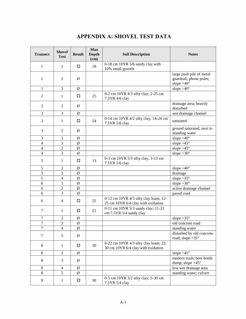
A-1
APPENDIX A: SHOVEL TEST DATA
Transect Shovel Test Result
Max Depth (cm)
Soil Description Notes
1 1 18 0-18 cm 10YR 5/6 sandy clay with 10% small gravels
1 2 Ølarge push pile of metal guardrail; phone poles; slope >40°
1 3 Ø slope >40°
2 1 25 0-2 cm 10YR 4/3 silty clay; 2-25 cm 7.5YR 4/6 clay
2 2 Ø drainage area; heavily disturbed
2 3 Ø wet drainage channel
3 1 24 0-14 cm 10YR 4/2 silty clay; 14-24 cm 7.5YR 5/6 clay saturated
3 2 Ø ground saturated; next to standing water
3 3 Ø slope >40°4 1 Ø slope >45°4 2 Ø slope >45°4 3 Ø slope >30°
5 1 13 0-3 cm 10YR 5/3 silty clay; 3-13 cm 7.5YR 5/6 clay
5 2 Ø slope >40°5 3 Ø drainage5 4 Ø slope >35°6 1 Ø slope >30°6 2 Ø active drainage channel6 3 Ø paved road
6 4 25 0-12 cm 10YR 4/3 silty clay loam; 12-25 cm 10YR 6/4 clay with oxidation
7 1 21 0-11 cm 10YR 5/3 sandy clay; 11-21cm 7.5YR 5/4 sandy clay
7 2 Ø slope >35°7 3 Ø old concrete road7 4 Ø standing water
7 5 Ø disturbed by old concrete road; slope >35°
8 1 30 0-22 cm 10YR 4/3 silty clay loam; 22-30 cm 10YR 6/4 clay with oxidation
8 2 Ø slope >45°
8 3 Ø modern trash; beer bottle dump; slope >45°
8 4 Ø low wet drainage area8 5 Ø standing water; culvert
9 1 30 0-5 cm 10YR 3/2 silty clay; 5-30 cm 7.5YR 5/4 clay

MSCAA Tree Obstruction Archaeological Assessment
A-2
Transect Shovel Test Result
Max Depth (cm)
Soil Description Notes
9 2 250-10 cm 10YR 4/3 silty clay loam; 10-18 cm 10YR 5/4 silty clay; 18-25 cm 7.5YR 5/6 clay
9 3 28 0-13 cm 10YR 4/3 silty clay; 13-28 cm 7.5YR 5/6 clay
9 4 Ø disturbed drainage; standing water
9 5 280-8 cm 10YR 4/3 silty clay loam; 8-15cm 10YR 5/6 silty clay; 15-28 cm 7.5YR 5/4 clay
9 6 Ø sloped drainage
9 7 380-22 cm 10YR 4/3 silty clay loam; 22-30 cm 10YR 5/6 silty clay; 30-38 cm 7.5YR 5/8 clay
10 1 30 0-2 cm 10YR 4/4 silty clay; 2-30 cm 7.5YR 6/4 clay
10 2 30 0-10 cm 10YR 4/4 silty clay; 10-30 cm 7.5YR 6/4 clay
10 3 300-5 cm 10YR 4/3 silty clay loam; 5-20cm 10YR 4/4 silty clay; 20-30 cm 7.5YR 6/4 clay
10 4 300-3 cm 10YR 4/3 silty clay loam; 3-18cm 10YR 4/4 silty clay; 18-30 cm 7.5YR 6/4 clay
10 5 30 0-20 cm 10YR 4/4 silty clay; 20-30 cm 7.5YR 6/4 clay
10 6 30 0-10 cm 10YR 4/4 silty clay; 10-30 cm 7.5YR 6/4 clay
10 7 23 0-13 cm 10YR 4/2 silty clay; 13-23 cm 7.5YR 5/6 clay
11 1 14 0-4 cm 10YR 5/2 sandy clay; 4-14 cm 7.5YR 5/6 clay
11 2 14 0-4 cm 10YR 5/3 sandy clay; 4-14 cm 7.5YR 5/6 clay
11 3 21 0-11 cm 10YR 5/3 silty clay loam; 11-21 cm 7.5YR 5/4 silty clay
11 4 Ø slope >40° to drainage11 5 Ø slope >45°11 6 Ø slope >45°
11 7 23 0-13 cm 10YR 4/2 silty clay loam; 13-23 cm 7.5YR 5/6 silty clay
11 8 13 0-3 cm 10YR 4/2 silty clay; 3-13 cm 7.5YR 5/6 clay
12 1 25 0-2 cm 10YR 4/3 silty clay loam; 2-25cm 7.5YR 5/8 clay
12 2 250-3 cm 10YR 4/3 silty clay loam; 3-25cm mottled 7.5YR 5/8 and 10YR 6/4 clay
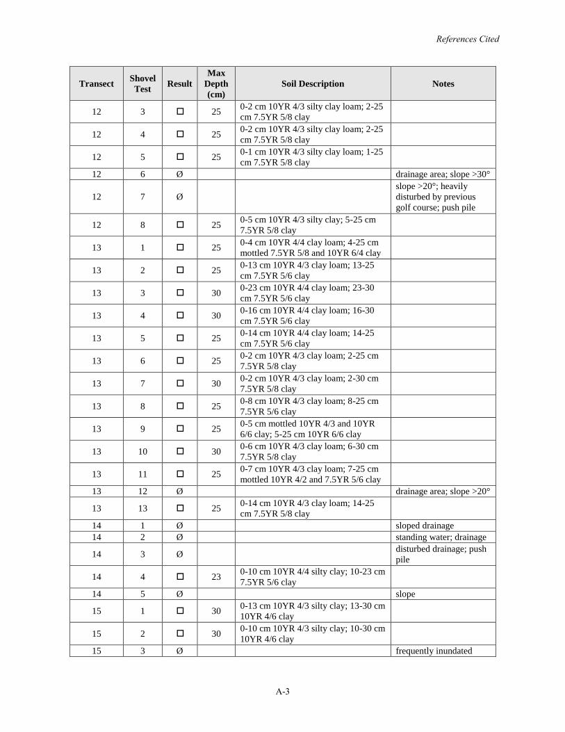
References Cited
A-3
Transect Shovel Test Result
Max Depth (cm)
Soil Description Notes
12 3 25 0-2 cm 10YR 4/3 silty clay loam; 2-25cm 7.5YR 5/8 clay
12 4 25 0-2 cm 10YR 4/3 silty clay loam; 2-25cm 7.5YR 5/8 clay
12 5 25 0-1 cm 10YR 4/3 silty clay loam; 1-25cm 7.5YR 5/8 clay
12 6 Ø drainage area; slope >30°
12 7 Øslope >20°; heavily disturbed by previous golf course; push pile
12 8 25 0-5 cm 10YR 4/3 silty clay; 5-25 cm 7.5YR 5/8 clay
13 1 25 0-4 cm 10YR 4/4 clay loam; 4-25 cm mottled 7.5YR 5/8 and 10YR 6/4 clay
13 2 25 0-13 cm 10YR 4/3 clay loam; 13-25cm 7.5YR 5/6 clay
13 3 30 0-23 cm 10YR 4/4 clay loam; 23-30cm 7.5YR 5/6 clay
13 4 30 0-16 cm 10YR 4/4 clay loam; 16-30cm 7.5YR 5/6 clay
13 5 25 0-14 cm 10YR 4/4 clay loam; 14-25cm 7.5YR 5/6 clay
13 6 25 0-2 cm 10YR 4/3 clay loam; 2-25 cm 7.5YR 5/8 clay
13 7 30 0-2 cm 10YR 4/3 clay loam; 2-30 cm 7.5YR 5/8 clay
13 8 25 0-8 cm 10YR 4/3 clay loam; 8-25 cm 7.5YR 5/6 clay
13 9 25 0-5 cm mottled 10YR 4/3 and 10YR 6/6 clay; 5-25 cm 10YR 6/6 clay
13 10 30 0-6 cm 10YR 4/3 clay loam; 6-30 cm 7.5YR 5/8 clay
13 11 25 0-7 cm 10YR 4/3 clay loam; 7-25 cm mottled 10YR 4/2 and 7.5YR 5/6 clay
13 12 Ø drainage area; slope >20°
13 13 25 0-14 cm 10YR 4/3 clay loam; 14-25cm 7.5YR 5/8 clay
14 1 Ø sloped drainage14 2 Ø standing water; drainage
14 3 Ø disturbed drainage; push pile
14 4 23 0-10 cm 10YR 4/4 silty clay; 10-23 cm 7.5YR 5/6 clay
14 5 Ø slope
15 1 30 0-13 cm 10YR 4/3 silty clay; 13-30 cm 10YR 4/6 clay
15 2 30 0-10 cm 10YR 4/3 silty clay; 10-30 cm 10YR 4/6 clay
15 3 Ø frequently inundated
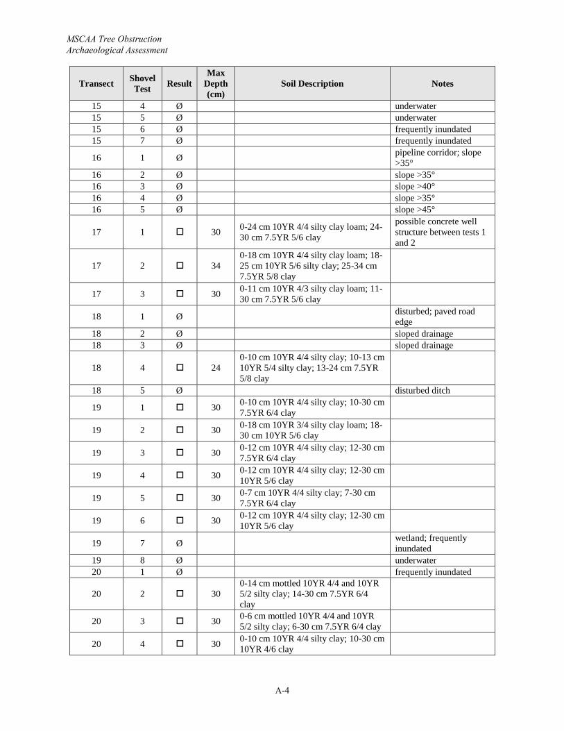
MSCAA Tree Obstruction Archaeological Assessment
A-4
Transect Shovel Test Result
Max Depth (cm)
Soil Description Notes
15 4 Ø underwater15 5 Ø underwater15 6 Ø frequently inundated15 7 Ø frequently inundated
16 1 Ø pipeline corridor; slope >35°
16 2 Ø slope >35°16 3 Ø slope >40°16 4 Ø slope >35°16 5 Ø slope >45°
17 1 30 0-24 cm 10YR 4/4 silty clay loam; 24-30 cm 7.5YR 5/6 clay
possible concrete well structure between tests 1 and 2
17 2 340-18 cm 10YR 4/4 silty clay loam; 18-25 cm 10YR 5/6 silty clay; 25-34 cm 7.5YR 5/8 clay
17 3 30 0-11 cm 10YR 4/3 silty clay loam; 11-30 cm 7.5YR 5/6 clay
18 1 Ø disturbed; paved road edge
18 2 Ø sloped drainage18 3 Ø sloped drainage
18 4 240-10 cm 10YR 4/4 silty clay; 10-13 cm 10YR 5/4 silty clay; 13-24 cm 7.5YR 5/8 clay
18 5 Ø disturbed ditch
19 1 30 0-10 cm 10YR 4/4 silty clay; 10-30 cm 7.5YR 6/4 clay
19 2 30 0-18 cm 10YR 3/4 silty clay loam; 18-30 cm 10YR 5/6 clay
19 3 30 0-12 cm 10YR 4/4 silty clay; 12-30 cm 7.5YR 6/4 clay
19 4 30 0-12 cm 10YR 4/4 silty clay; 12-30 cm 10YR 5/6 clay
19 5 30 0-7 cm 10YR 4/4 silty clay; 7-30 cm 7.5YR 6/4 clay
19 6 30 0-12 cm 10YR 4/4 silty clay; 12-30 cm 10YR 5/6 clay
19 7 Ø wetland; frequently inundated
19 8 Ø underwater20 1 Ø frequently inundated
20 2 300-14 cm mottled 10YR 4/4 and 10YR 5/2 silty clay; 14-30 cm 7.5YR 6/4 clay
20 3 30 0-6 cm mottled 10YR 4/4 and 10YR 5/2 silty clay; 6-30 cm 7.5YR 6/4 clay
20 4 30 0-10 cm 10YR 4/4 silty clay; 10-30 cm 10YR 4/6 clay
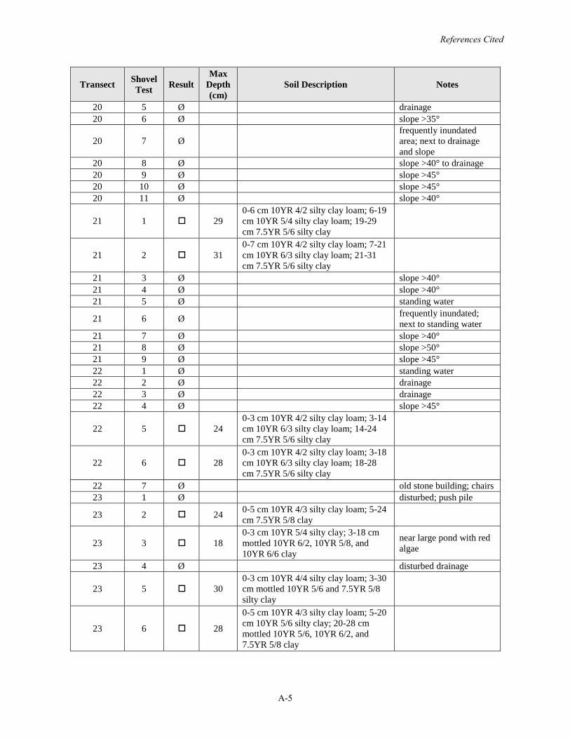
References Cited
A-5
Transect Shovel Test Result
Max Depth (cm)
Soil Description Notes
20 5 Ø drainage20 6 Ø slope >35°
20 7 Øfrequently inundated area; next to drainage and slope
20 8 Ø slope >40° to drainage20 9 Ø slope >45°20 10 Ø slope >45°20 11 Ø slope >40°
21 1 290-6 cm 10YR 4/2 silty clay loam; 6-19cm 10YR 5/4 silty clay loam; 19-29cm 7.5YR 5/6 silty clay
21 2 310-7 cm 10YR 4/2 silty clay loam; 7-21cm 10YR 6/3 silty clay loam; 21-31cm 7.5YR 5/6 silty clay
21 3 Ø slope >40°21 4 Ø slope >40°21 5 Ø standing water
21 6 Ø frequently inundated; next to standing water
21 7 Ø slope >40°21 8 Ø slope >50°21 9 Ø slope >45°22 1 Ø standing water22 2 Ø drainage22 3 Ø drainage22 4 Ø slope >45°
22 5 240-3 cm 10YR 4/2 silty clay loam; 3-14cm 10YR 6/3 silty clay loam; 14-24cm 7.5YR 5/6 silty clay
22 6 280-3 cm 10YR 4/2 silty clay loam; 3-18cm 10YR 6/3 silty clay loam; 18-28cm 7.5YR 5/6 silty clay
22 7 Ø old stone building; chairs23 1 Ø disturbed; push pile
23 2 24 0-5 cm 10YR 4/3 silty clay loam; 5-24cm 7.5YR 5/8 clay
23 3 180-3 cm 10YR 5/4 silty clay; 3-18 cm mottled 10YR 6/2, 10YR 5/8, and 10YR 6/6 clay
near large pond with red algae
23 4 Ø disturbed drainage
23 5 300-3 cm 10YR 4/4 silty clay loam; 3-30cm mottled 10YR 5/6 and 7.5YR 5/8 silty clay
23 6 28
0-5 cm 10YR 4/3 silty clay loam; 5-20cm 10YR 5/6 silty clay; 20-28 cm mottled 10YR 5/6, 10YR 6/2, and 7.5YR 5/8 clay
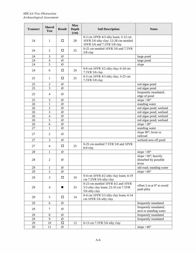
MSCAA Tree Obstruction Archaeological Assessment
A-6
Transect Shovel Test Result
Max Depth (cm)
Soil Description Notes
24 1 280-3 cm 10YR 4/3 silty loam; 3-12 cm 10YR 5/6 silty clay; 12-28 cm mottled 10YR 5/6 and 7.5YR 5/8 clay
24 2 25 0-25 cm mottled 10YR 5/6 and 7.5YR 5/8 clay
24 3 Ø large pond24 4 Ø large pond24 5 Ø slope
24 6 24 0-6 cm 10YR 3/2 silty clay; 6-24 cm 7.5YR 5/6 clay
25 1 25 0-3 cm 10YR 4/3 silty clay; 3-25 cm 7.5YR 5/8 clay
25 2 Ø red algae pond25 3 Ø red algae pond
25 4 Ø frequently inundated; edge of pond
25 5 Ø slope >30°26 1 Ø standing water26 2 Ø red algae pond; wetland26 3 Ø red algae pond; wetland26 4 Ø red algae pond; wetland26 5 Ø red algae pond; wetland26 6 Ø slope >30°27 1 Ø standing water
27 2 Ø slope 90°; levee or railroad
27 3 Ø wetland area off pond
27 4 25 0-25 cm mottled 7.5YR 5/8 and 10YR 6/4 clay
28 1 Ø slope >30°
28 2 Øslope >30°; heavily disturbed by possible levee
29 1 Ø old road; standing water29 2 Ø slope >40°
29 3 19 0-4 cm 10YR 4/2 silty clay loam; 4-19cm 7.5YR 5/6 silty clay
29 4 330-23 cm mottled 10YR 4/2 and 10YR 5/3 silty clay loam; 23-33 cm 7.5YR 5/6 silty clay
offset 2 m at 0° to avoid push piles
29 5 14 0-4 cm 10YR 5/3 silty clay loam; 4-14cm 10YR 5/6 silty clay
29 6 Ø frequently inundated
29 7 Ø frequently inundated; next to standing water
29 8 Ø frequently inundated29 9 Ø frequently inundated29 10 13 0-13 cm 7.5YR 5/6 silty clay29 11 Ø slope >40°
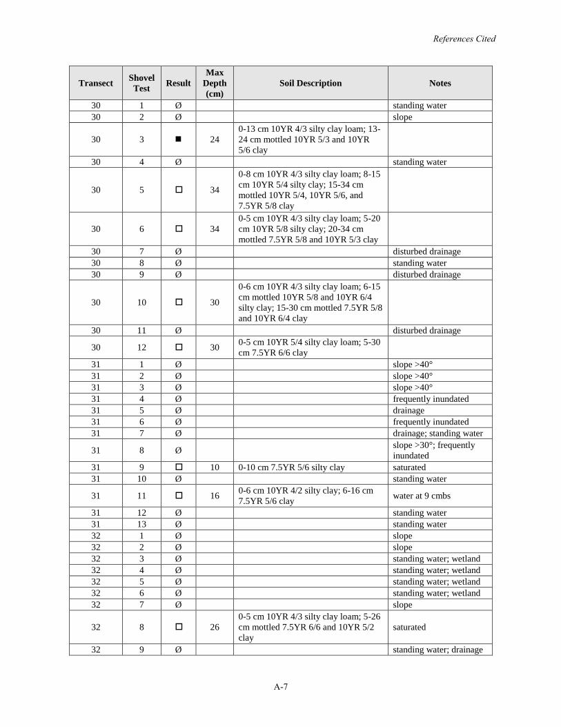
References Cited
A-7
Transect Shovel Test Result
Max Depth (cm)
Soil Description Notes
30 1 Ø standing water30 2 Ø slope
30 3 240-13 cm 10YR 4/3 silty clay loam; 13-24 cm mottled 10YR 5/3 and 10YR 5/6 clay
30 4 Ø standing water
30 5 34
0-8 cm 10YR 4/3 silty clay loam; 8-15cm 10YR 5/4 silty clay; 15-34 cm mottled 10YR 5/4, 10YR 5/6, and 7.5YR 5/8 clay
30 6 340-5 cm 10YR 4/3 silty clay loam; 5-20cm 10YR 5/8 silty clay; 20-34 cm mottled 7.5YR 5/8 and 10YR 5/3 clay
30 7 Ø disturbed drainage30 8 Ø standing water30 9 Ø disturbed drainage
30 10 30
0-6 cm 10YR 4/3 silty clay loam; 6-15cm mottled 10YR 5/8 and 10YR 6/4 silty clay; 15-30 cm mottled 7.5YR 5/8 and 10YR 6/4 clay
30 11 Ø disturbed drainage
30 12 30 0-5 cm 10YR 5/4 silty clay loam; 5-30cm 7.5YR 6/6 clay
31 1 Ø slope >40°31 2 Ø slope >40°31 3 Ø slope >40°31 4 Ø frequently inundated31 5 Ø drainage31 6 Ø frequently inundated31 7 Ø drainage; standing water
31 8 Ø slope >30°; frequently inundated
31 9 10 0-10 cm 7.5YR 5/6 silty clay saturated31 10 Ø standing water
31 11 16 0-6 cm 10YR 4/2 silty clay; 6-16 cm 7.5YR 5/6 clay water at 9 cmbs
31 12 Ø standing water31 13 Ø standing water32 1 Ø slope32 2 Ø slope32 3 Ø standing water; wetland32 4 Ø standing water; wetland32 5 Ø standing water; wetland32 6 Ø standing water; wetland32 7 Ø slope
32 8 260-5 cm 10YR 4/3 silty clay loam; 5-26cm mottled 7.5YR 6/6 and 10YR 5/2 clay
saturated
32 9 Ø standing water; drainage
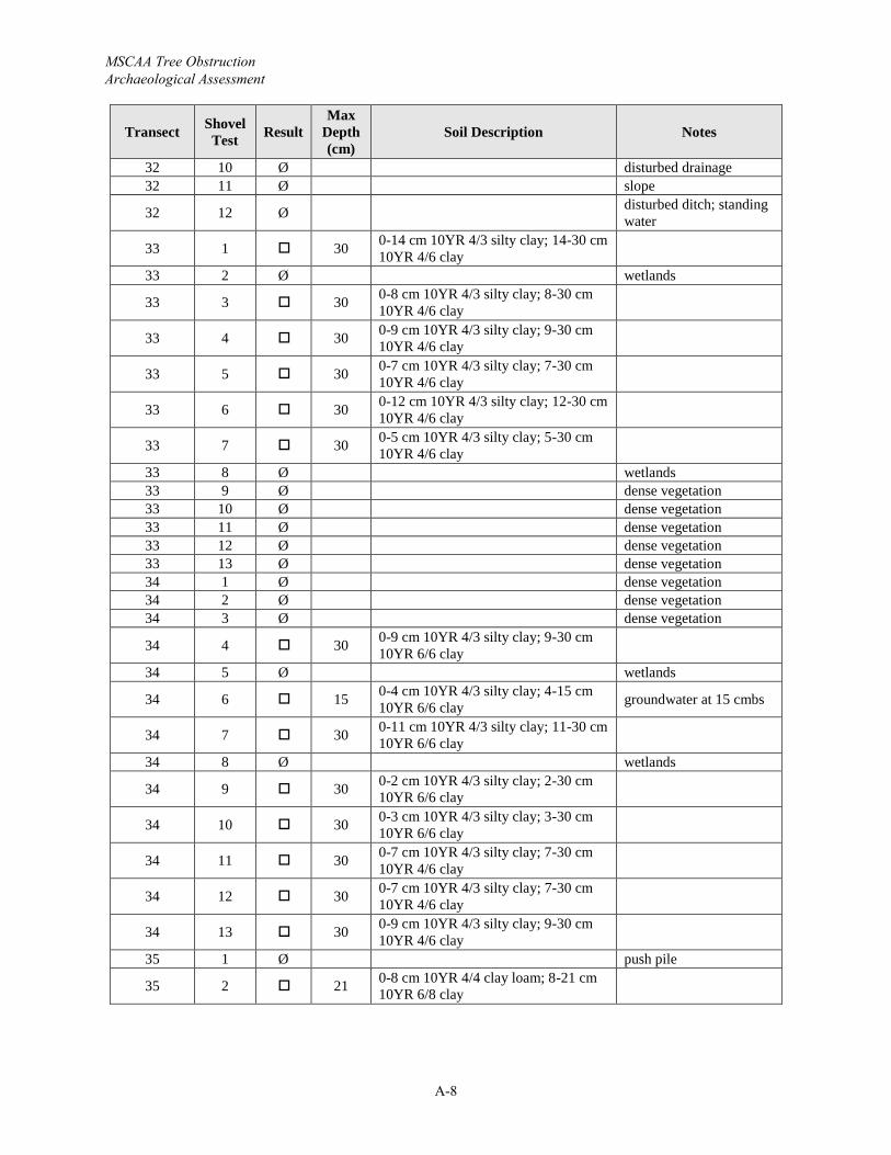
MSCAA Tree Obstruction Archaeological Assessment
A-8
Transect Shovel Test Result
Max Depth (cm)
Soil Description Notes
32 10 Ø disturbed drainage32 11 Ø slope
32 12 Ø disturbed ditch; standing water
33 1 30 0-14 cm 10YR 4/3 silty clay; 14-30 cm 10YR 4/6 clay
33 2 Ø wetlands
33 3 30 0-8 cm 10YR 4/3 silty clay; 8-30 cm 10YR 4/6 clay
33 4 30 0-9 cm 10YR 4/3 silty clay; 9-30 cm 10YR 4/6 clay
33 5 30 0-7 cm 10YR 4/3 silty clay; 7-30 cm 10YR 4/6 clay
33 6 30 0-12 cm 10YR 4/3 silty clay; 12-30 cm 10YR 4/6 clay
33 7 30 0-5 cm 10YR 4/3 silty clay; 5-30 cm 10YR 4/6 clay
33 8 Ø wetlands33 9 Ø dense vegetation33 10 Ø dense vegetation33 11 Ø dense vegetation33 12 Ø dense vegetation33 13 Ø dense vegetation34 1 Ø dense vegetation34 2 Ø dense vegetation34 3 Ø dense vegetation
34 4 30 0-9 cm 10YR 4/3 silty clay; 9-30 cm 10YR 6/6 clay
34 5 Ø wetlands
34 6 15 0-4 cm 10YR 4/3 silty clay; 4-15 cm 10YR 6/6 clay groundwater at 15 cmbs
34 7 30 0-11 cm 10YR 4/3 silty clay; 11-30 cm 10YR 6/6 clay
34 8 Ø wetlands
34 9 30 0-2 cm 10YR 4/3 silty clay; 2-30 cm 10YR 6/6 clay
34 10 30 0-3 cm 10YR 4/3 silty clay; 3-30 cm 10YR 6/6 clay
34 11 30 0-7 cm 10YR 4/3 silty clay; 7-30 cm 10YR 4/6 clay
34 12 30 0-7 cm 10YR 4/3 silty clay; 7-30 cm 10YR 4/6 clay
34 13 30 0-9 cm 10YR 4/3 silty clay; 9-30 cm 10YR 4/6 clay
35 1 Ø push pile
35 2 21 0-8 cm 10YR 4/4 clay loam; 8-21 cm 10YR 6/8 clay
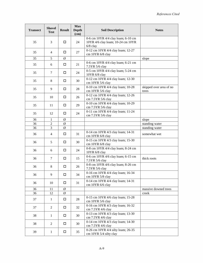
References Cited
A-9
Transect Shovel Test Result
Max Depth (cm)
Soil Description Notes
35 3 240-6 cm 10YR 4/4 clay loam; 6-10 cm 10YR 4/6 clay loam; 10-24 cm 10YR 6/8 clay
35 4 27 0-12 cm 10YR 4/4 clay loam; 12-27cm 10YR 6/8 clay
35 5 Ø slope
35 6 21 0-6 cm 10YR 4/4 clay loam; 6-21 cm 7.5YR 5/6 clay
35 7 24 0-5 cm 10YR 4/4 clay loam; 5-24 cm 10YR 6/8 clay
35 8 30 0-12 cm 10YR 4/4 clay loam; 12-30cm 10YR 5/6 clay
35 9 28 0-10 cm 10YR 4/4 clay loam; 10-28cm 10YR 5/6 clay
skipped over area of no trees
35 10 26 0-12 cm 10YR 4/4 clay loam; 12-26cm 7.5YR 5/6 clay
35 11 29 0-10 cm 10YR 4/4 clay loam; 10-29cm 7.5YR 5/6 clay
35 12 24 0-11 cm 10YR 4/4 clay loam; 11-24cm 7.5YR 5/6 clay
36 1 Ø slope36 2 Ø standing water36 3 Ø standing water
36 4 31 0-14 cm 10YR 4/3 clay loam; 14-31cm 10YR 6/8 clay somewhat wet
36 5 30 0-15 cm 10YR 4/3 clay loam; 15-30cm 10YR 6/8 clay
36 6 24 0-8 cm 10YR 4/4 clay loam; 8-24 cm 10YR 6/8 clay
36 7 15 0-6 cm 10YR 4/6 clay loam; 6-15 cm 7.5YR 5/6 clay thick roots
36 8 26 0-8 cm 10YR 4/6 clay loam; 8-26 cm 7.5YR 5/6 clay
36 9 34 0-16 cm 10YR 4/4 clay loam; 16-34cm 10YR 5/8 clay
36 10 31 0-14 cm 10YR 4/4 clay loam; 14-31cm 10YR 6/6 clay
36 11 Ø massive downed trees36 12 Ø creek
37 1 28 0-15 cm 10YR 4/6 clay loam; 15-28cm 10YR 5/6 clay
37 2 32 0-16 cm 10YR 4/3 clay loam; 16-32cm 7.5YR 4/6 clay
38 1 30 0-13 cm 10YR 4/3 clay loam; 13-30cm 7.5YR 4/6 clay
38 2 30 0-14 cm 10YR 4/3 clay loam; 14-30cm 7.5YR 4/6 clay
39 1 35 0-26 cm 10YR 4/4 silty loam; 26-35cm 10YR 5/4 silty clay
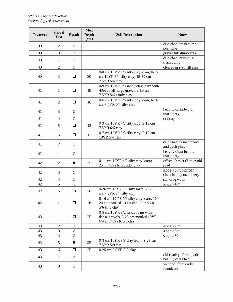
MSCAA Tree Obstruction Archaeological Assessment
A-10
Transect Shovel Test Result
Max Depth (cm)
Soil Description Notes
39 2 Ø disturbed; trash dump; push pile
39 3 Ø gravel fill; dump area
40 1 Ø disturbed; push pile; trash dump
40 2 Ø cleared gravel; fill area
40 3 300-8 cm 10YR 4/3 silty clay loam; 8-15cm 10YR 5/4 silty clay; 15-30 cm 7.5YR 5/6 clay
41 1 190-9 cm 10YR 5/3 sandy clay loam with 40% small-large gravel; 9-19 cm 7.5YR 5/6 sandy clay
41 2 16 0-6 cm 10YR 5/3 silty clay loam; 6-16cm 7.5YR 5/4 silty clay
41 3 Ø heavily disturbed by machinery
41 4 Ø drainage
41 5 13 0-3 cm 10YR 4/2 silty clay; 3-13 cm 7.5YR 6/6 clay
41 6 17 0-7 cm 10YR 5/3 silty clay; 7-17 cm 10YR 5/4 clay
41 7 Ø disturbed by machinery and push piles
42 1 Ø heavily disturbed by machinery
42 2 25 0-11 cm 10YR 4/2 silty clay loam; 11-25 cm 7.5YR 5/6 silty clay
offset 10 m at 0° to avoid road
42 3 Ø slope >30°; old road; disturbed by machinery
42 4 Ø standing water42 5 Ø slope >40°
42 6 36 0-26 cm 10YR 5/3 silty loam; 26-36cm 7.5YR 5/4 silty clay
42 7 260-16 cm 10YR 5/3 silty clay loam; 16-26 cm mottled 10YR 6/2 and 7.5YR 5/6 silty clay
43 1 250-5 cm 10YR 3/2 sandy loam with dense gravels; 5-25 cm mottled 10YR 6/4 and 7.5YR 5/8 clay
43 2 Ø slope >25°43 3 Ø slope >30°43 4 Ø slope >30°
43 5 25 0-8 cm 10YR 3/3 clay loam; 8-25 cm 7.5YR 5/8 clay
43 6 25 0-25 cm 7.5YR 5/8 clay
43 7 Ø old road; golf cart path; heavily disturbed
43 8 Ø wetland; frequently inundated
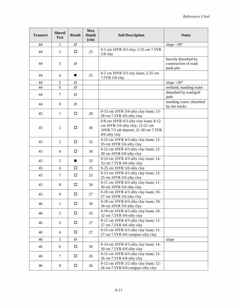
References Cited
A-11
Transect Shovel Test Result
Max Depth (cm)
Soil Description Notes
44 1 Ø slope >30°
44 2 25 0-1 cm 10YR 4/3 clay; 1-25 cm 7.5YR 5/8 clay
44 3 Øheavily disturbed by construction of road; push pile
44 4 25 0-2 cm 10YR 3/3 clay loam; 2-25 cm 7.5YR 5/8 clay
44 5 Ø slope >30°44 6 Ø wetland; standing water
44 7 Ø disturbed by road/golf path
44 8 Ø standing water; disturbed by tire tracks
45 1 28 0-13 cm 10YR 3/4 silty clay loam; 13-28 cm 7.5YR 4/6 silty clay
45 2 30
0-8 cm 10YR 4/3 silty clay loam; 8-12cm 10YR 5/6 silty clay; 12-21 cm 10YR 7/3 silt deposit; 21-30 cm 7.5YR 4/6 silty clay
45 3 35 0-12 cm 10YR 4/3 silty clay loam; 12-35 cm 10YR 5/6 silty clay
45 4 30 0-12 cm 10YR 4/3 silty clay loam; 12-30 cm 10YR 6/8 silty clay
45 5 33 0-14 cm 10YR 4/3 silty clay loam; 14-33 cm 7.5YR 4/6 silty clay
45 6 25 0-25 cm 10YR 5/6 silty clay
45 7 25 0-13 cm 10YR 4/3 silty clay loam; 13-25 cm 10YR 5/6 silty clay
45 8 30 0-11 cm 10YR 4/3 silty clay loam; 11-30 cm 10YR 5/6 silty clay
45 9 27 0-10 cm 10YR 4/3 silty clay loam; 10-27 cm 10YR 5/6 silty clay
46 1 30 0-18 cm 10YR 4/3 silty clay loam; 18-30 cm 10YR 5/6 silty clay
46 2 32 0-18 cm 10YR 4/3 silty clay loam; 18-32 cm 7.5YR 4/6 silty clay
46 3 27 0-12 cm 10YR 4/3 silty clay loam; 12-27 cm 7.5YR 4/6 silty clay
46 4 27 0-15 cm 10YR 4/3 silty clay loam; 15-27 cm 7.5YR 4/6 compact silty clay
46 5 Ø slope
46 6 30 0-14 cm 10YR 4/3 silty clay loam; 14-30 cm 7.5YR 6/8 silty clay
46 7 26 0-15 cm 10YR 4/3 silty clay loam; 15-26 cm 7.5YR 6/8 silty clay
46 8 26 0-12 cm 10YR 3/2 silty clay loam; 12-26 cm 7.5YR 6/8 compact silty clay
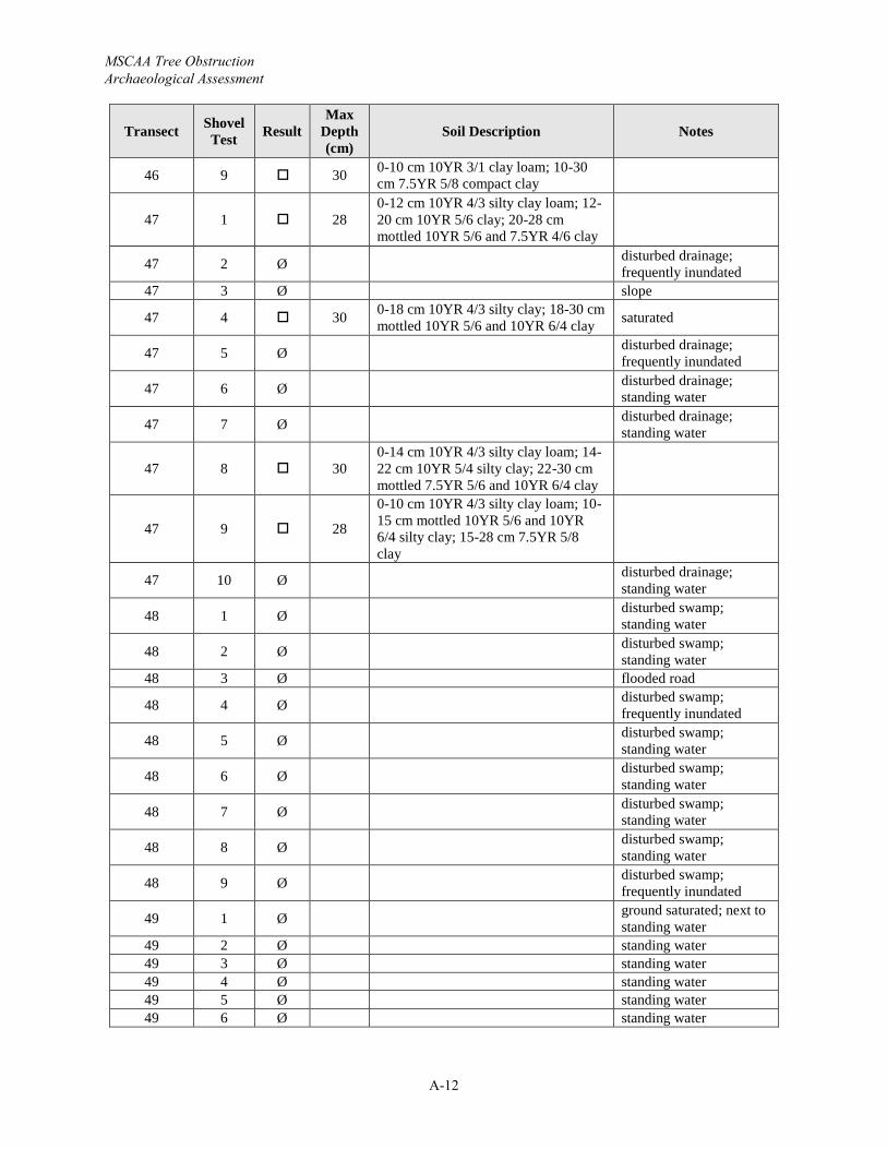
MSCAA Tree Obstruction Archaeological Assessment
A-12
Transect Shovel Test Result
Max Depth (cm)
Soil Description Notes
46 9 30 0-10 cm 10YR 3/1 clay loam; 10-30cm 7.5YR 5/8 compact clay
47 1 280-12 cm 10YR 4/3 silty clay loam; 12-20 cm 10YR 5/6 clay; 20-28 cm mottled 10YR 5/6 and 7.5YR 4/6 clay
47 2 Ø disturbed drainage; frequently inundated
47 3 Ø slope
47 4 30 0-18 cm 10YR 4/3 silty clay; 18-30 cm mottled 10YR 5/6 and 10YR 6/4 clay saturated
47 5 Ø disturbed drainage; frequently inundated
47 6 Ø disturbed drainage; standing water
47 7 Ø disturbed drainage; standing water
47 8 300-14 cm 10YR 4/3 silty clay loam; 14-22 cm 10YR 5/4 silty clay; 22-30 cm mottled 7.5YR 5/6 and 10YR 6/4 clay
47 9 28
0-10 cm 10YR 4/3 silty clay loam; 10-15 cm mottled 10YR 5/6 and 10YR 6/4 silty clay; 15-28 cm 7.5YR 5/8 clay
47 10 Ø disturbed drainage; standing water
48 1 Ø disturbed swamp; standing water
48 2 Ø disturbed swamp; standing water
48 3 Ø flooded road
48 4 Ø disturbed swamp; frequently inundated
48 5 Ø disturbed swamp; standing water
48 6 Ø disturbed swamp; standing water
48 7 Ø disturbed swamp; standing water
48 8 Ø disturbed swamp; standing water
48 9 Ø disturbed swamp; frequently inundated
49 1 Ø ground saturated; next to standing water
49 2 Ø standing water49 3 Ø standing water49 4 Ø standing water49 5 Ø standing water49 6 Ø standing water
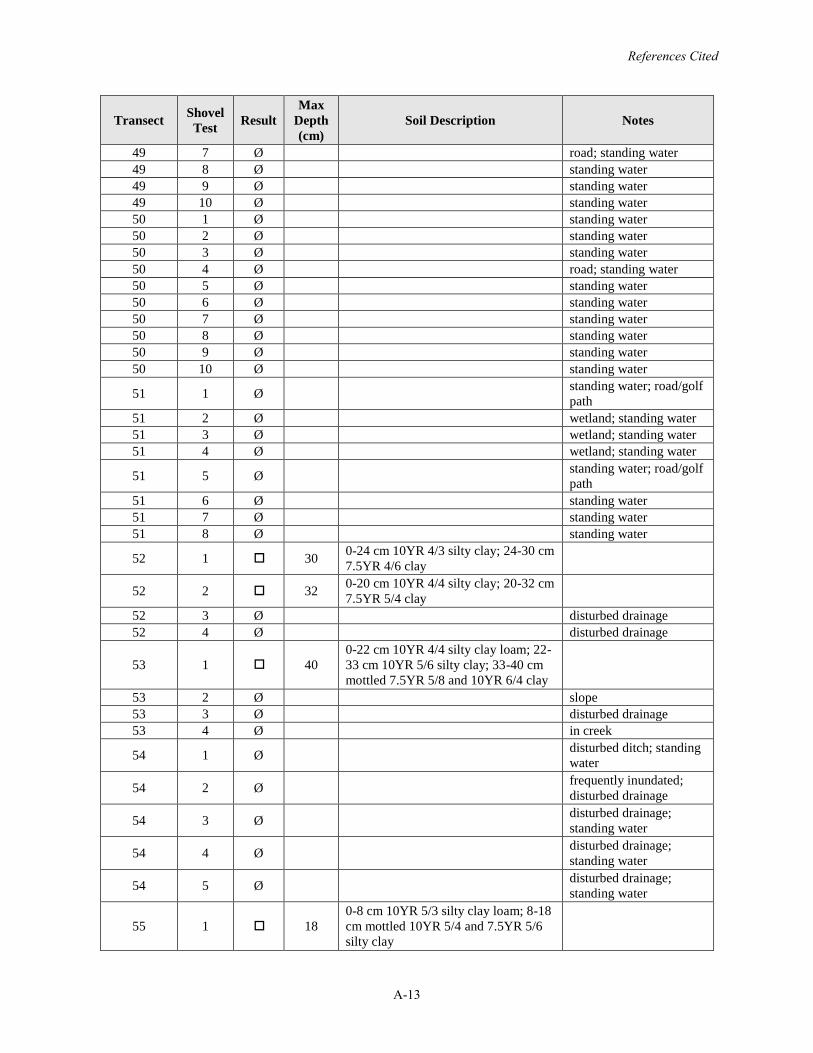
References Cited
A-13
Transect Shovel Test Result
Max Depth (cm)
Soil Description Notes
49 7 Ø road; standing water49 8 Ø standing water49 9 Ø standing water49 10 Ø standing water50 1 Ø standing water50 2 Ø standing water50 3 Ø standing water50 4 Ø road; standing water50 5 Ø standing water50 6 Ø standing water50 7 Ø standing water50 8 Ø standing water50 9 Ø standing water50 10 Ø standing water
51 1 Ø standing water; road/golf path
51 2 Ø wetland; standing water51 3 Ø wetland; standing water51 4 Ø wetland; standing water
51 5 Ø standing water; road/golf path
51 6 Ø standing water51 7 Ø standing water51 8 Ø standing water
52 1 30 0-24 cm 10YR 4/3 silty clay; 24-30 cm 7.5YR 4/6 clay
52 2 32 0-20 cm 10YR 4/4 silty clay; 20-32 cm 7.5YR 5/4 clay
52 3 Ø disturbed drainage52 4 Ø disturbed drainage
53 1 400-22 cm 10YR 4/4 silty clay loam; 22-33 cm 10YR 5/6 silty clay; 33-40 cm mottled 7.5YR 5/8 and 10YR 6/4 clay
53 2 Ø slope53 3 Ø disturbed drainage53 4 Ø in creek
54 1 Ø disturbed ditch; standing water
54 2 Ø frequently inundated; disturbed drainage
54 3 Ø disturbed drainage; standing water
54 4 Ø disturbed drainage; standing water
54 5 Ø disturbed drainage; standing water
55 1 180-8 cm 10YR 5/3 silty clay loam; 8-18cm mottled 10YR 5/4 and 7.5YR 5/6 silty clay
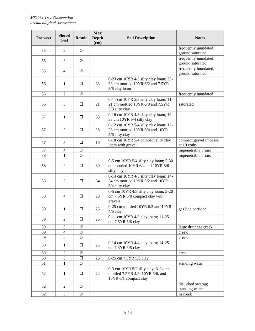
MSCAA Tree Obstruction Archaeological Assessment
A-14
Transect Shovel Test Result
Max Depth (cm)
Soil Description Notes
55 2 Ø frequently inundated; ground saturated
55 3 Ø frequently inundated; ground saturated
55 4 Ø frequently inundated; ground saturated
56 1 330-23 cm 10YR 4/3 silty clay loam; 23-33 cm mottled 10YR 6/2 and 7.5YR 5/6 clay loam
56 2 Ø frequently inundated
56 3 210-11 cm 10YR 5/3 silty clay loam; 11-21 cm mottled 10YR 6/3 and 7.5YR 5/8 silty clay
saturated
57 1 33 0-16 cm 10YR 4/3 silty clay loam; 16-33 cm 10YR 5/4 silty clay
57 2 280-12 cm 10YR 5/4 silty clay loam; 12-28 cm mottled 10YR 6/4 and 10YR 5/6 silty clay
57 3 10 0-10 cm 10YR 5/4 compact silty clay loam with gravel
compact gravel impasse at 10 cmbs
57 4 Ø impenetrable briars58 1 Ø impenetrable briars
58 2 300-5 cm 10YR 5/4 silty clay loam; 5-30cm mottled 10YR 6/4 and 10YR 5/6 silty clay
58 3 340-14 cm 10YR 4/3 silty clay loam; 14-34 cm mottled 10YR 6/2 and 10YR 5/4 silty clay
58 4 200-5 cm 10YR 4/3 silty clay loam; 5-20cm 7.5YR 5/8 compact clay with gravels
59 1 25 0-25 cm mottled 10YR 6/3 and 10YR 4/6 clay gas line corridor
59 2 25 0-11 cm 10YR 4/3 clay loam; 11-25cm 7.5YR 5/8 clay
59 3 Ø large drainage creek59 4 Ø creek59 5 Ø creek
60 1 25 0-14 cm 10YR 4/4 clay loam; 14-25cm 7.5YR 5/8 clay
60 2 Ø creek60 3 25 0-25 cm 7.5YR 5/8 clay61 1 Ø standing water
62 1 240-3 cm 10YR 5/2 silty clay; 3-24 cm mottled 7.5YR 4/6, 10YR 5/6, and 10YR 6/1 compact clay
62 2 Ø disturbed swamp; standing water
62 3 Ø in creek
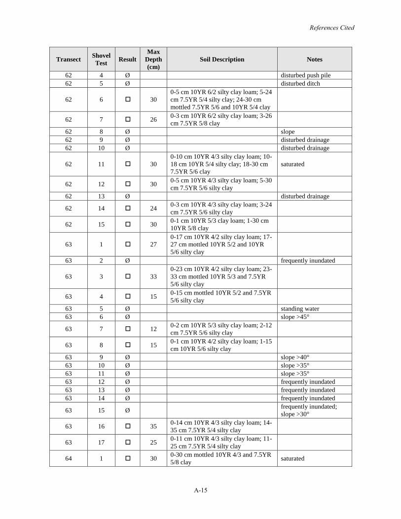
References Cited
A-15
Transect Shovel Test Result
Max Depth (cm)
Soil Description Notes
62 4 Ø disturbed push pile62 5 Ø disturbed ditch
62 6 300-5 cm 10YR 6/2 silty clay loam; 5-24cm 7.5YR 5/4 silty clay; 24-30 cm mottled 7.5YR 5/6 and 10YR 5/4 clay
62 7 26 0-3 cm 10YR 6/2 silty clay loam; 3-26cm 7.5YR 5/8 clay
62 8 Ø slope62 9 Ø disturbed drainage62 10 Ø disturbed drainage
62 11 300-10 cm 10YR 4/3 silty clay loam; 10-18 cm 10YR 5/4 silty clay; 18-30 cm 7.5YR 5/6 clay
saturated
62 12 30 0-5 cm 10YR 4/3 silty clay loam; 5-30cm 7.5YR 5/6 silty clay
62 13 Ø disturbed drainage
62 14 24 0-3 cm 10YR 4/3 silty clay loam; 3-24cm 7.5YR 5/6 silty clay
62 15 30 0-1 cm 10YR 5/3 clay loam; 1-30 cm 10YR 5/8 clay
63 1 270-17 cm 10YR 4/2 silty clay loam; 17-27 cm mottled 10YR 5/2 and 10YR 5/6 silty clay
63 2 Ø frequently inundated
63 3 330-23 cm 10YR 4/2 silty clay loam; 23-33 cm mottled 10YR 5/3 and 7.5YR 5/6 silty clay
63 4 15 0-15 cm mottled 10YR 5/2 and 7.5YR 5/6 silty clay
63 5 Ø standing water63 6 Ø slope >45°
63 7 12 0-2 cm 10YR 5/3 silty clay loam; 2-12cm 7.5YR 5/6 silty clay
63 8 15 0-1 cm 10YR 4/2 silty clay loam; 1-15cm 10YR 5/6 silty clay
63 9 Ø slope >40°63 10 Ø slope >35°63 11 Ø slope >35°63 12 Ø frequently inundated63 13 Ø frequently inundated63 14 Ø frequently inundated
63 15 Ø frequently inundated; slope >30°
63 16 35 0-14 cm 10YR 4/3 silty clay loam; 14-35 cm 7.5YR 5/4 silty clay
63 17 25 0-11 cm 10YR 4/3 silty clay loam; 11-25 cm 7.5YR 5/4 silty clay
64 1 30 0-30 cm mottled 10YR 4/3 and 7.5YR 5/8 clay saturated
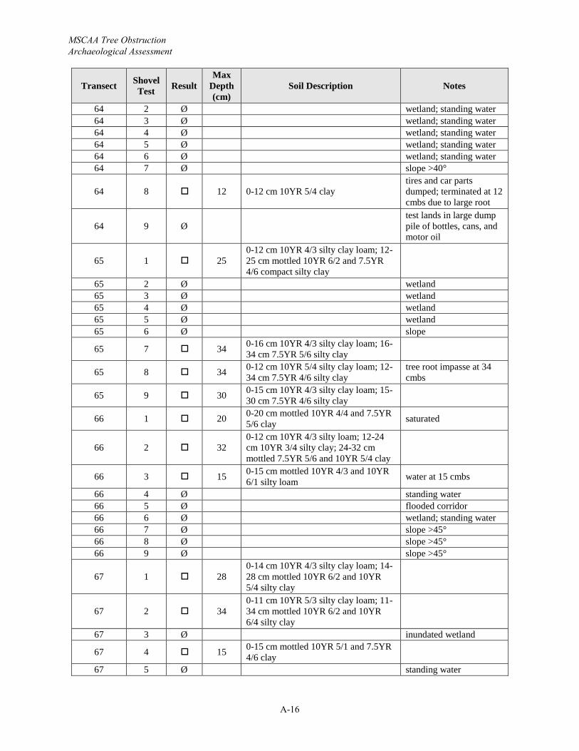
MSCAA Tree Obstruction Archaeological Assessment
A-16
Transect Shovel Test Result
Max Depth (cm)
Soil Description Notes
64 2 Ø wetland; standing water64 3 Ø wetland; standing water64 4 Ø wetland; standing water64 5 Ø wetland; standing water64 6 Ø wetland; standing water64 7 Ø slope >40°
64 8 12 0-12 cm 10YR 5/4 claytires and car parts dumped; terminated at 12 cmbs due to large root
64 9 Øtest lands in large dump pile of bottles, cans, and motor oil
65 1 250-12 cm 10YR 4/3 silty clay loam; 12-25 cm mottled 10YR 6/2 and 7.5YR 4/6 compact silty clay
65 2 Ø wetland65 3 Ø wetland65 4 Ø wetland65 5 Ø wetland65 6 Ø slope
65 7 34 0-16 cm 10YR 4/3 silty clay loam; 16-34 cm 7.5YR 5/6 silty clay
65 8 34 0-12 cm 10YR 5/4 silty clay loam; 12-34 cm 7.5YR 4/6 silty clay
tree root impasse at 34cmbs
65 9 30 0-15 cm 10YR 4/3 silty clay loam; 15-30 cm 7.5YR 4/6 silty clay
66 1 20 0-20 cm mottled 10YR 4/4 and 7.5YR 5/6 clay saturated
66 2 320-12 cm 10YR 4/3 silty loam; 12-24cm 10YR 3/4 silty clay; 24-32 cm mottled 7.5YR 5/6 and 10YR 5/4 clay
66 3 15 0-15 cm mottled 10YR 4/3 and 10YR 6/1 silty loam water at 15 cmbs
66 4 Ø standing water66 5 Ø flooded corridor66 6 Ø wetland; standing water66 7 Ø slope >45°66 8 Ø slope >45°66 9 Ø slope >45°
67 1 280-14 cm 10YR 4/3 silty clay loam; 14-28 cm mottled 10YR 6/2 and 10YR 5/4 silty clay
67 2 340-11 cm 10YR 5/3 silty clay loam; 11-34 cm mottled 10YR 6/2 and 10YR 6/4 silty clay
67 3 Ø inundated wetland
67 4 15 0-15 cm mottled 10YR 5/1 and 7.5YR 4/6 clay
67 5 Ø standing water
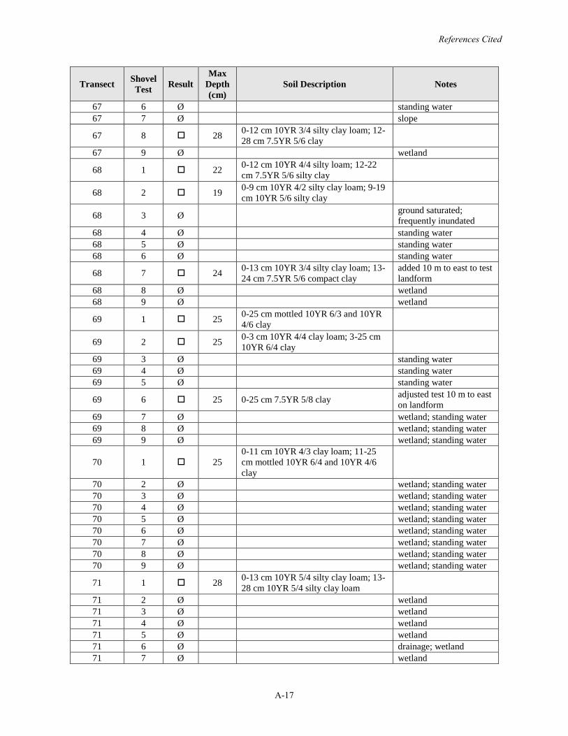
References Cited
A-17
Transect Shovel Test Result
Max Depth (cm)
Soil Description Notes
67 6 Ø standing water67 7 Ø slope
67 8 28 0-12 cm 10YR 3/4 silty clay loam; 12-28 cm 7.5YR 5/6 clay
67 9 Ø wetland
68 1 22 0-12 cm 10YR 4/4 silty loam; 12-22cm 7.5YR 5/6 silty clay
68 2 19 0-9 cm 10YR 4/2 silty clay loam; 9-19cm 10YR 5/6 silty clay
68 3 Ø ground saturated; frequently inundated
68 4 Ø standing water68 5 Ø standing water68 6 Ø standing water
68 7 24 0-13 cm 10YR 3/4 silty clay loam; 13-24 cm 7.5YR 5/6 compact clay
added 10 m to east to test landform
68 8 Ø wetland68 9 Ø wetland
69 1 25 0-25 cm mottled 10YR 6/3 and 10YR 4/6 clay
69 2 25 0-3 cm 10YR 4/4 clay loam; 3-25 cm 10YR 6/4 clay
69 3 Ø standing water69 4 Ø standing water69 5 Ø standing water
69 6 25 0-25 cm 7.5YR 5/8 clay adjusted test 10 m to east on landform
69 7 Ø wetland; standing water69 8 Ø wetland; standing water69 9 Ø wetland; standing water
70 1 250-11 cm 10YR 4/3 clay loam; 11-25cm mottled 10YR 6/4 and 10YR 4/6 clay
70 2 Ø wetland; standing water70 3 Ø wetland; standing water70 4 Ø wetland; standing water70 5 Ø wetland; standing water70 6 Ø wetland; standing water70 7 Ø wetland; standing water70 8 Ø wetland; standing water70 9 Ø wetland; standing water
71 1 28 0-13 cm 10YR 5/4 silty clay loam; 13-28 cm 10YR 5/4 silty clay loam
71 2 Ø wetland71 3 Ø wetland71 4 Ø wetland71 5 Ø wetland71 6 Ø drainage; wetland71 7 Ø wetland
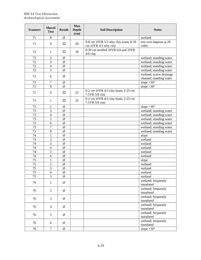
MSCAA Tree Obstruction Archaeological Assessment
A-18
Transect Shovel Test Result
Max Depth (cm)
Soil Description Notes
71 8 Ø wetland
71 9 20 0-8 cm 10YR 5/3 silty clay loam; 8-20cm 10YR 4/3 silty clay
tree root impasse at 20 cmbs
72 1 30 0-30 cm mottled 10YR 6/4 and 10YR 4/6 clay
72 2 Ø wetland; standing water72 3 Ø wetland; standing water72 4 Ø wetland; standing water72 5 Ø wetland; standing water
72 6 Ø wetland; active drainage channel; standing water
72 7 Ø slope >30°72 8 Ø slope >30°
72 9 25 0-2 cm 10YR 4/3 clay loam; 2-25 cm 7.5YR 5/8 clay
73 1 25 0-2 cm 10YR 4/3 clay loam; 2-25 cm 7.5YR 5/8 clay
73 2 Ø slope >30°73 3 Ø wetland; standing water73 4 Ø wetland; standing water73 5 Ø wetland; standing water73 6 Ø wetland; standing water73 7 Ø wetland; standing water73 8 Ø wetland; standing water74 1 Ø slope74 2 Ø wetland74 3 Ø wetland74 4 Ø wetland74 5 Ø wetland74 6 Ø wetland75 1 Ø slope75 2 Ø wetland75 3 Ø wetland75 4 Ø wetland75 5 Ø wetland
76 1 Ø wetland; frequently inundated
76 2 Ø wetland; frequently inundated
76 3 Ø wetland; frequently inundated
76 4 Ø wetland; frequently inundated
76 5 Ø wetland; frequently inundated
76 6 Ø wetland; frequently inundated
76 7 Ø slope >30°
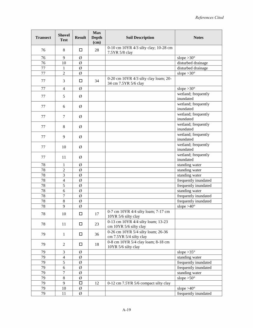
References Cited
A-19
Transect Shovel Test Result
Max Depth (cm)
Soil Description Notes
76 8 28 0-10 cm 10YR 4/3 silty clay; 10-28 cm 7.5YR 5/8 clay
76 9 Ø slope >30°76 10 Ø disturbed drainage77 1 Ø disturbed drainage77 2 Ø slope >30°
77 3 34 0-20 cm 10YR 4/3 silty clay loam; 20-34 cm 7.5YR 5/6 clay
77 4 Ø slope >30°
77 5 Ø wetland; frequently inundated
77 6 Ø wetland; frequently inundated
77 7 Ø wetland; frequently inundated
77 8 Ø wetland; frequently inundated
77 9 Ø wetland; frequently inundated
77 10 Ø wetland; frequently inundated
77 11 Ø wetland; frequently inundated
78 1 Ø standing water78 2 Ø standing water78 3 Ø standing water78 4 Ø frequently inundated78 5 Ø frequently inundated78 6 Ø standing water78 7 Ø frequently inundated78 8 Ø frequently inundated78 9 Ø slope >40°
78 10 17 0-7 cm 10YR 4/4 silty loam; 7-17 cm 10YR 5/6 silty clay
78 11 23 0-13 cm 10YR 4/4 silty loam; 13-23cm 10YR 5/6 silty clay
79 1 36 0-26 cm 10YR 5/4 silty loam; 26-36cm 7.5YR 5/4 silty clay
79 2 18 0-8 cm 10YR 5/4 clay loam; 8-18 cm 10YR 5/6 silty clay
79 3 Ø slope >35°79 4 Ø standing water79 5 Ø frequently inundated79 6 Ø frequently inundated79 7 Ø standing water79 8 Ø slope >50°79 9 12 0-12 cm 7.5YR 5/6 compact silty clay79 10 Ø slope >40°79 11 Ø frequently inundated
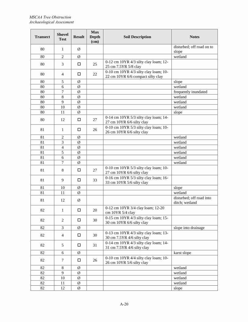
MSCAA Tree Obstruction Archaeological Assessment
A-20
Transect Shovel Test Result
Max Depth (cm)
Soil Description Notes
80 1 Ø disturbed; off road on to slope
80 2 Ø wetland
80 3 25 0-12 cm 10YR 4/3 silty clay loam; 12-25 cm 7.5YR 5/8 clay
80 4 22 0-10 cm 10YR 4/3 silty clay loam; 10-22 cm 10YR 6/6 compact silty clay
80 5 Ø slope80 6 Ø wetland80 7 Ø frequently inundated80 8 Ø wetland80 9 Ø wetland80 10 Ø wetland80 11 Ø slope
80 12 27 0-14 cm 10YR 5/3 silty clay loam; 14-27 cm 10YR 6/6 silty clay
81 1 26 0-10 cm 10YR 5/3 silty clay loam; 10-26 cm 10YR 6/6 silty clay
81 2 Ø wetland81 3 Ø wetland81 4 Ø wetland81 5 Ø wetland81 6 Ø wetland81 7 Ø wetland
81 8 27 0-10 cm 10YR 5/3 silty clay loam; 10-27 cm 10YR 6/6 silty clay
81 9 33 0-16 cm 10YR 5/3 silty clay loam; 16-33 cm 10YR 5/6 silty clay
81 10 Ø slope81 11 Ø wetland
81 12 Ø disturbed; off road into ditch; wetland
82 1 20 0-12 cm 10YR 3/4 clay loam; 12-20cm 10YR 5/4 clay
82 2 30 0-15 cm 10YR 4/3 silty clay loam; 15-30 cm 10YR 6/6 silty clay
82 3 Ø slope into drainage
82 4 30 0-13 cm 10YR 4/3 silty clay loam; 13-30 cm 7.5YR 4/6 silty clay
82 5 31 0-14 cm 10YR 4/3 silty clay loam; 14-31 cm 7.5YR 4/6 silty clay
82 6 Ø karst slope
82 7 26 0-10 cm 10YR 4/4 silty clay loam; 10-26 cm 10YR 5/6 silty clay
82 8 Ø wetland82 9 Ø wetland82 10 Ø wetland82 11 Ø wetland82 12 Ø slope
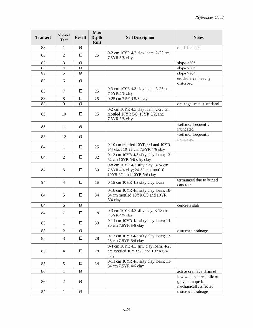
References Cited
A-21
Transect Shovel Test Result
Max Depth (cm)
Soil Description Notes
83 1 Ø road shoulder
83 2 25 0-2 cm 10YR 4/3 clay loam; 2-25 cm 7.5YR 5/8 clay
83 3 Ø slope >30°83 4 Ø slope >30°83 5 Ø slope >30°
83 6 Ø eroded area; heavily disturbed
83 7 25 0-3 cm 10YR 4/3 clay loam; 3-25 cm 7.5YR 5/8 clay
83 8 25 0-25 cm 7.5YR 5/8 clay83 9 Ø drainage area; in wetland
83 10 250-2 cm 10YR 4/3 clay loam; 2-25 cm mottled 10YR 5/6, 10YR 6/2, and 7.5YR 5/8 clay
83 11 Ø wetland; frequently inundated
83 12 Ø wetland; frequently inundated
84 1 25 0-10 cm mottled 10YR 4/4 and 10YR 5/4 clay; 10-25 cm 7.5YR 4/6 clay
84 2 32 0-13 cm 10YR 4/3 silty clay loam; 13-32 cm 10YR 5/8 silty clay
84 3 300-8 cm 10YR 4/3 silty clay; 8-24 cm 7.5YR 4/6 clay; 24-30 cm mottled 10YR 6/1 and 10YR 5/6 clay
84 4 15 0-15 cm 10YR 4/3 silty clay loam terminated due to buried concrete
84 5 340-18 cm 10YR 4/3 silty clay loam; 18-34 cm mottled 10YR 6/3 and 10YR 5/4 clay
84 6 Ø concrete slab
84 7 18 0-3 cm 10YR 4/3 silty clay; 3-18 cm 7.5YR 4/6 clay
85 1 30 0-14 cm 10YR 4/4 silty clay loam; 14-30 cm 7.5YR 5/6 clay
85 2 Ø disturbed drainage
85 3 28 0-13 cm 10YR 4/3 silty clay loam; 13-28 cm 7.5YR 5/6 clay
85 4 280-4 cm 10YR 4/3 silty clay loam; 4-28cm mottled 10YR 5/6 and 10YR 6/4 clay
85 5 34 0-11 cm 10YR 4/3 silty clay loam; 11-34 cm 7.5YR 4/6 clay
86 1 Ø active drainage channel
86 2 Ølow wetland area; pile of gravel dumped; mechanically affected
87 1 Ø disturbed drainage
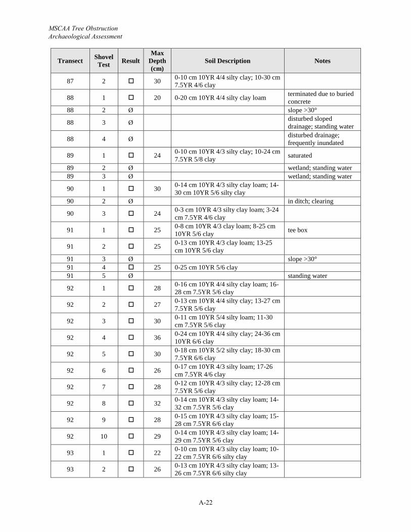
MSCAA Tree Obstruction Archaeological Assessment
A-22
Transect Shovel Test Result
Max Depth (cm)
Soil Description Notes
87 2 30 0-10 cm 10YR 4/4 silty clay; 10-30 cm 7.5YR 4/6 clay
88 1 20 0-20 cm 10YR 4/4 silty clay loam terminated due to buried concrete
88 2 Ø slope >30°
88 3 Ø disturbed sloped drainage; standing water
88 4 Ø disturbed drainage; frequently inundated
89 1 24 0-10 cm 10YR 4/3 silty clay; 10-24 cm 7.5YR 5/8 clay saturated
89 2 Ø wetland; standing water89 3 Ø wetland; standing water
90 1 30 0-14 cm 10YR 4/3 silty clay loam; 14-30 cm 10YR 5/6 silty clay
90 2 Ø in ditch; clearing
90 3 24 0-3 cm 10YR 4/3 silty clay loam; 3-24cm 7.5YR 4/6 clay
91 1 25 0-8 cm 10YR 4/3 clay loam; 8-25 cm 10YR 5/6 clay tee box
91 2 25 0-13 cm 10YR 4/3 clay loam; 13-25cm 10YR 5/6 clay
91 3 Ø slope >30°91 4 25 0-25 cm 10YR 5/6 clay91 5 Ø standing water
92 1 28 0-16 cm 10YR 4/4 silty clay loam; 16-28 cm 7.5YR 5/6 clay
92 2 27 0-13 cm 10YR 4/4 silty clay; 13-27 cm 7.5YR 5/6 clay
92 3 30 0-11 cm 10YR 5/4 silty loam; 11-30cm 7.5YR 5/6 clay
92 4 36 0-24 cm 10YR 4/4 silty clay; 24-36 cm 10YR 6/6 clay
92 5 30 0-18 cm 10YR 5/2 silty clay; 18-30 cm 7.5YR 6/6 clay
92 6 26 0-17 cm 10YR 4/3 silty loam; 17-26cm 7.5YR 4/6 clay
92 7 28 0-12 cm 10YR 4/3 silty clay; 12-28 cm 7.5YR 5/6 clay
92 8 32 0-14 cm 10YR 4/3 silty clay loam; 14-32 cm 7.5YR 5/6 clay
92 9 28 0-15 cm 10YR 4/3 silty clay loam; 15-28 cm 7.5YR 6/6 clay
92 10 29 0-14 cm 10YR 4/3 silty clay loam; 14-29 cm 7.5YR 5/6 clay
93 1 22 0-10 cm 10YR 4/3 silty clay loam; 10-22 cm 7.5YR 6/6 silty clay
93 2 26 0-13 cm 10YR 4/3 silty clay loam; 13-26 cm 7.5YR 6/6 silty clay
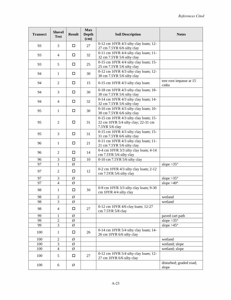
References Cited
A-23
Transect Shovel Test Result
Max Depth (cm)
Soil Description Notes
93 3 27 0-12 cm 10YR 4/3 silty clay loam; 12-27 cm 7.5YR 6/6 silty clay
93 4 32 0-11 cm 10YR 4/4 silty clay loam; 11-32 cm 7.5YR 5/6 silty clay
93 5 25 0-15 cm 10YR 4/4 silty clay loam; 15-25 cm 7.5YR 5/6 silty clay
94 1 30 0-12 cm 10YR 4/3 silty clay loam; 12-30 cm 7.5YR 5/6 silty clay
94 2 15 0-15 cm 10YR 4/3 silty clay loam tree root impasse at 15 cmbs
94 3 30 0-18 cm 10YR 4/3 silty clay loam; 18-30 cm 7.5YR 5/6 silty clay
94 4 32 0-14 cm 10YR 4/3 silty clay loam; 14-32 cm 7.5YR 5/6 silty clay
95 1 30 0-10 cm 10YR 4/3 silty clay loam; 10-30 cm 7.5YR 6/6 silty clay
95 2 310-15 cm 10YR 4/3 silty clay loam; 15-22 cm 10YR 5/4 silty clay; 22-31 cm 7.5YR 5/6 clay
95 3 31 0-15 cm 10YR 4/3 silty clay loam; 15-31 cm 7.5YR 6/6 silty clay
96 1 21 0-11 cm 10YR 4/3 silty clay loam; 11-21 cm 7.5YR 5/6 silty clay
96 2 14 0-4 cm 10YR 3/3 silty clay loam; 4-14cm 7.5YR 5/6 silty clay
96 3 10 0-10 cm 7.5YR 5/6 silty clay97 1 Ø slope >35°
97 2 12 0-2 cm 10YR 4/3 silty clay loam; 2-12cm 7.5YR 5/6 silty clay
97 3 Ø slope >35°97 4 Ø slope >40°
98 1 30 0-9 cm 10YR 3/3 silty clay loam; 9-30cm 10YR 4/4 silty clay
98 2 Ø wetland98 3 Ø wetland
98 4 27 0-12 cm 10YR 4/6 clay loam; 12-27cm 7.5YR 5/8 clay
99 1 Ø paved cart path99 2 Ø slope >35°99 3 Ø slope >45°
100 1 26 0-14 cm 10YR 5/4 silty clay loam; 14-26 cm 10YR 6/6 silty clay
100 2 Ø wetland100 3 Ø wetland; slope100 4 Ø wetland; slope
100 5 27 0-12 cm 10YR 5/4 silty clay loam; 12-27 cm 10YR 6/6 silty clay
100 6 Ø disturbed; graded road; slope
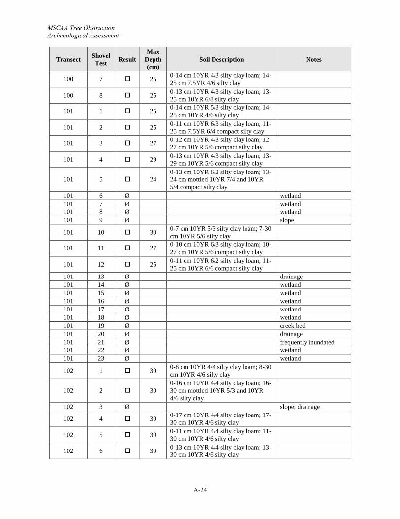
MSCAA Tree Obstruction Archaeological Assessment
A-24
Transect Shovel Test Result
Max Depth (cm)
Soil Description Notes
100 7 25 0-14 cm 10YR 4/3 silty clay loam; 14-25 cm 7.5YR 4/6 silty clay
100 8 25 0-13 cm 10YR 4/3 silty clay loam; 13-25 cm 10YR 6/8 silty clay
101 1 25 0-14 cm 10YR 5/3 silty clay loam; 14-25 cm 10YR 4/6 silty clay
101 2 25 0-11 cm 10YR 6/3 silty clay loam; 11-25 cm 7.5YR 6/4 compact silty clay
101 3 27 0-12 cm 10YR 4/3 silty clay loam; 12-27 cm 10YR 5/6 compact silty clay
101 4 29 0-13 cm 10YR 4/3 silty clay loam; 13-29 cm 10YR 5/6 compact silty clay
101 5 240-13 cm 10YR 6/2 silty clay loam; 13-24 cm mottled 10YR 7/4 and 10YR 5/4 compact silty clay
101 6 Ø wetland101 7 Ø wetland101 8 Ø wetland101 9 Ø slope
101 10 30 0-7 cm 10YR 5/3 silty clay loam; 7-30cm 10YR 5/6 silty clay
101 11 27 0-10 cm 10YR 6/3 silty clay loam; 10-27 cm 10YR 5/6 compact silty clay
101 12 25 0-11 cm 10YR 6/2 silty clay loam; 11-25 cm 10YR 6/6 compact silty clay
101 13 Ø drainage101 14 Ø wetland101 15 Ø wetland101 16 Ø wetland101 17 Ø wetland101 18 Ø wetland101 19 Ø creek bed101 20 Ø drainage101 21 Ø frequently inundated101 22 Ø wetland101 23 Ø wetland
102 1 30 0-8 cm 10YR 4/4 silty clay loam; 8-30cm 10YR 4/6 silty clay
102 2 300-16 cm 10YR 4/4 silty clay loam; 16-30 cm mottled 10YR 5/3 and 10YR 4/6 silty clay
102 3 Ø slope; drainage
102 4 30 0-17 cm 10YR 4/4 silty clay loam; 17-30 cm 10YR 4/6 silty clay
102 5 30 0-11 cm 10YR 4/4 silty clay loam; 11-30 cm 10YR 4/6 silty clay
102 6 30 0-13 cm 10YR 4/4 silty clay loam; 13-30 cm 10YR 4/6 silty clay
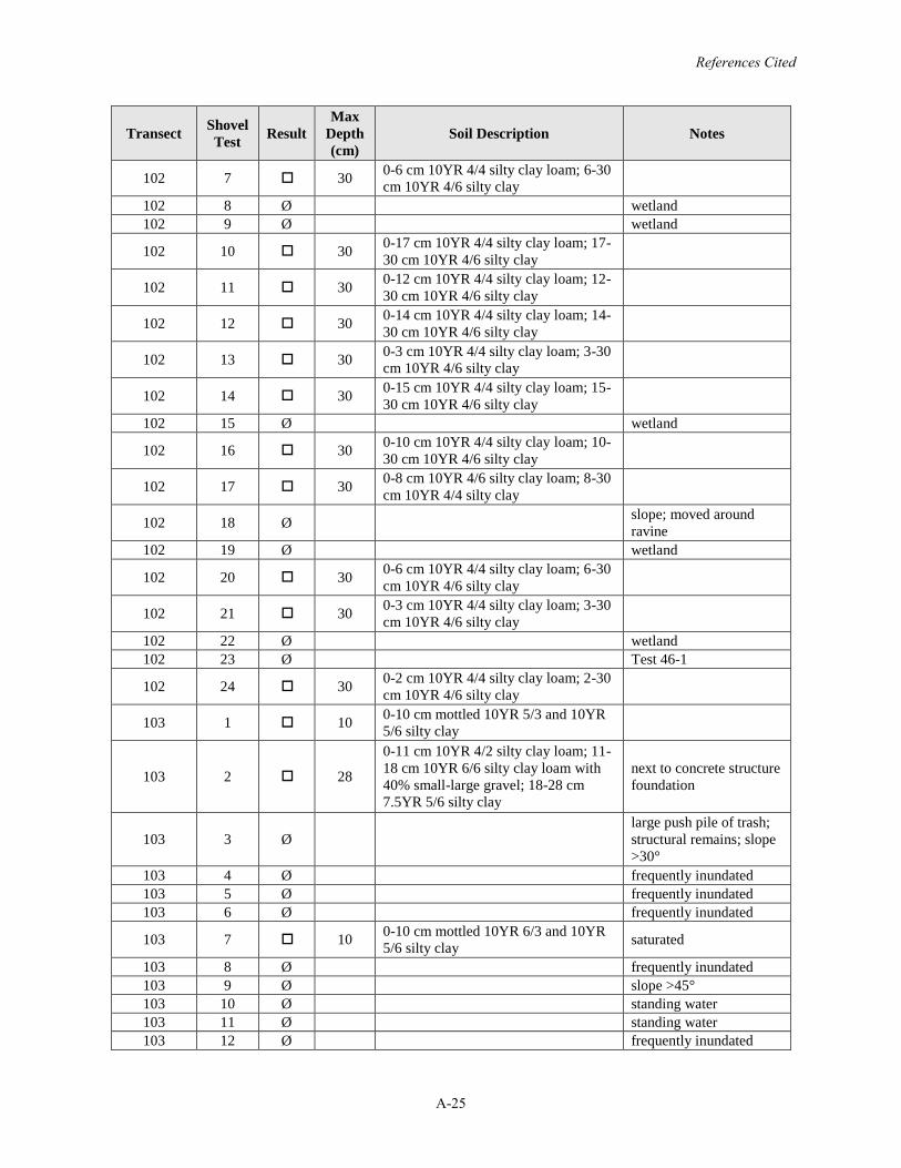
References Cited
A-25
Transect Shovel Test Result
Max Depth (cm)
Soil Description Notes
102 7 30 0-6 cm 10YR 4/4 silty clay loam; 6-30cm 10YR 4/6 silty clay
102 8 Ø wetland102 9 Ø wetland
102 10 30 0-17 cm 10YR 4/4 silty clay loam; 17-30 cm 10YR 4/6 silty clay
102 11 30 0-12 cm 10YR 4/4 silty clay loam; 12-30 cm 10YR 4/6 silty clay
102 12 30 0-14 cm 10YR 4/4 silty clay loam; 14-30 cm 10YR 4/6 silty clay
102 13 30 0-3 cm 10YR 4/4 silty clay loam; 3-30cm 10YR 4/6 silty clay
102 14 30 0-15 cm 10YR 4/4 silty clay loam; 15-30 cm 10YR 4/6 silty clay
102 15 Ø wetland
102 16 30 0-10 cm 10YR 4/4 silty clay loam; 10-30 cm 10YR 4/6 silty clay
102 17 30 0-8 cm 10YR 4/6 silty clay loam; 8-30cm 10YR 4/4 silty clay
102 18 Ø slope; moved around ravine
102 19 Ø wetland
102 20 30 0-6 cm 10YR 4/4 silty clay loam; 6-30cm 10YR 4/6 silty clay
102 21 30 0-3 cm 10YR 4/4 silty clay loam; 3-30cm 10YR 4/6 silty clay
102 22 Ø wetland102 23 Ø Test 46-1
102 24 30 0-2 cm 10YR 4/4 silty clay loam; 2-30cm 10YR 4/6 silty clay
103 1 10 0-10 cm mottled 10YR 5/3 and 10YR 5/6 silty clay
103 2 28
0-11 cm 10YR 4/2 silty clay loam; 11-18 cm 10YR 6/6 silty clay loam with 40% small-large gravel; 18-28 cm 7.5YR 5/6 silty clay
next to concrete structure foundation
103 3 Ølarge push pile of trash; structural remains; slope >30°
103 4 Ø frequently inundated103 5 Ø frequently inundated103 6 Ø frequently inundated
103 7 10 0-10 cm mottled 10YR 6/3 and 10YR 5/6 silty clay saturated
103 8 Ø frequently inundated103 9 Ø slope >45°103 10 Ø standing water103 11 Ø standing water103 12 Ø frequently inundated
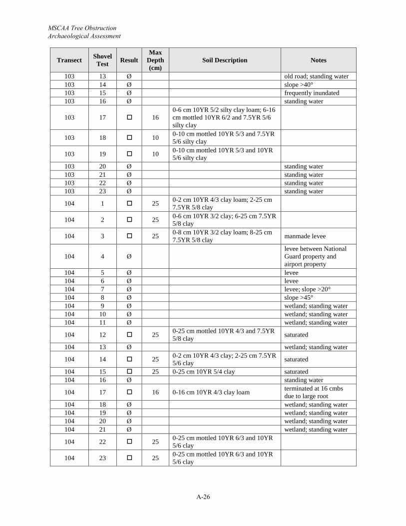
MSCAA Tree Obstruction Archaeological Assessment
A-26
Transect Shovel Test Result
Max Depth (cm)
Soil Description Notes
103 13 Ø old road; standing water103 14 Ø slope >40°103 15 Ø frequently inundated103 16 Ø standing water
103 17 160-6 cm 10YR 5/2 silty clay loam; 6-16cm mottled 10YR 6/2 and 7.5YR 5/6 silty clay
103 18 10 0-10 cm mottled 10YR 5/3 and 7.5YR 5/6 silty clay
103 19 10 0-10 cm mottled 10YR 5/3 and 10YR 5/6 silty clay
103 20 Ø standing water103 21 Ø standing water103 22 Ø standing water103 23 Ø standing water
104 1 25 0-2 cm 10YR 4/3 clay loam; 2-25 cm 7.5YR 5/8 clay
104 2 25 0-6 cm 10YR 3/2 clay; 6-25 cm 7.5YR 5/8 clay
104 3 25 0-8 cm 10YR 3/2 clay loam; 8-25 cm 7.5YR 5/8 clay manmade levee
104 4 Ølevee between National Guard property and airport property
104 5 Ø levee104 6 Ø levee104 7 Ø levee; slope >20°104 8 Ø slope >45°104 9 Ø wetland; standing water104 10 Ø wetland; standing water104 11 Ø wetland; standing water
104 12 25 0-25 cm mottled 10YR 4/3 and 7.5YR 5/8 clay saturated
104 13 Ø wetland; standing water
104 14 25 0-2 cm 10YR 4/3 clay; 2-25 cm 7.5YR 5/6 clay saturated
104 15 25 0-25 cm 10YR 5/4 clay saturated104 16 Ø standing water
104 17 16 0-16 cm 10YR 4/3 clay loam terminated at 16 cmbs due to large root
104 18 Ø wetland; standing water104 19 Ø wetland; standing water104 20 Ø wetland; standing water104 21 Ø wetland; standing water
104 22 25 0-25 cm mottled 10YR 6/3 and 10YR 5/6 clay
104 23 25 0-25 cm mottled 10YR 6/3 and 10YR 5/6 clay
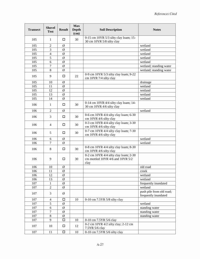
References Cited
A-27
Transect Shovel Test Result
Max Depth (cm)
Soil Description Notes
105 1 30 0-15 cm 10YR 5/3 silty clay loam; 15-30 cm 10YR 5/8 silty clay
105 2 Ø wetland105 3 Ø wetland105 4 Ø wetland105 5 Ø wetland105 6 Ø wetland105 7 Ø wetland; standing water105 8 Ø wetland; standing water
105 9 22 0-9 cm 10YR 5/3 silty clay loam; 9-22cm 10YR 7/4 silty clay
105 10 Ø drainage105 11 Ø wetland105 12 Ø wetland105 13 Ø wetland105 14 Ø wetland
106 1 30 0-14 cm 10YR 4/4 silty clay loam; 14-30 cm 10YR 4/6 silty clay
106 2 Ø wetland
106 3 30 0-6 cm 10YR 4/4 silty clay loam; 6-30cm 10YR 4/6 silty clay
106 4 30 0-3 cm 10YR 4/4 silty clay loam; 3-30cm 10YR 4/6 silty clay
106 5 30 0-7 cm 10YR 4/4 silty clay loam; 7-30cm 10YR 4/6 silty clay
106 6 Ø wetland106 7 Ø wetland
106 8 30 0-8 cm 10YR 4/4 silty clay loam; 8-30cm 10YR 4/6 silty clay
106 9 300-2 cm 10YR 4/4 silty clay loam; 2-30cm mottled 10YR 4/6 and 10YR 5/2 clay
106 10 Ø old road106 11 Ø creek106 12 Ø wetland106 13 Ø wetland107 1 Ø frequently inundated107 2 Ø wetland
107 3 Ø push pile from old road; frequently inundated
107 4 10 0-10 cm 7.5YR 5/8 silty clay107 5 Ø wetland107 6 Ø standing water107 7 Ø standing water107 8 Ø standing water107 9 10 0-10 cm 7.5YR 5/6 clay
107 10 12 0-2 cm 10YR 4/2 silty clay; 2-12 cm 7.5YR 5/6 clay
107 11 10 0-10 cm 7.5YR 5/6 silty clay
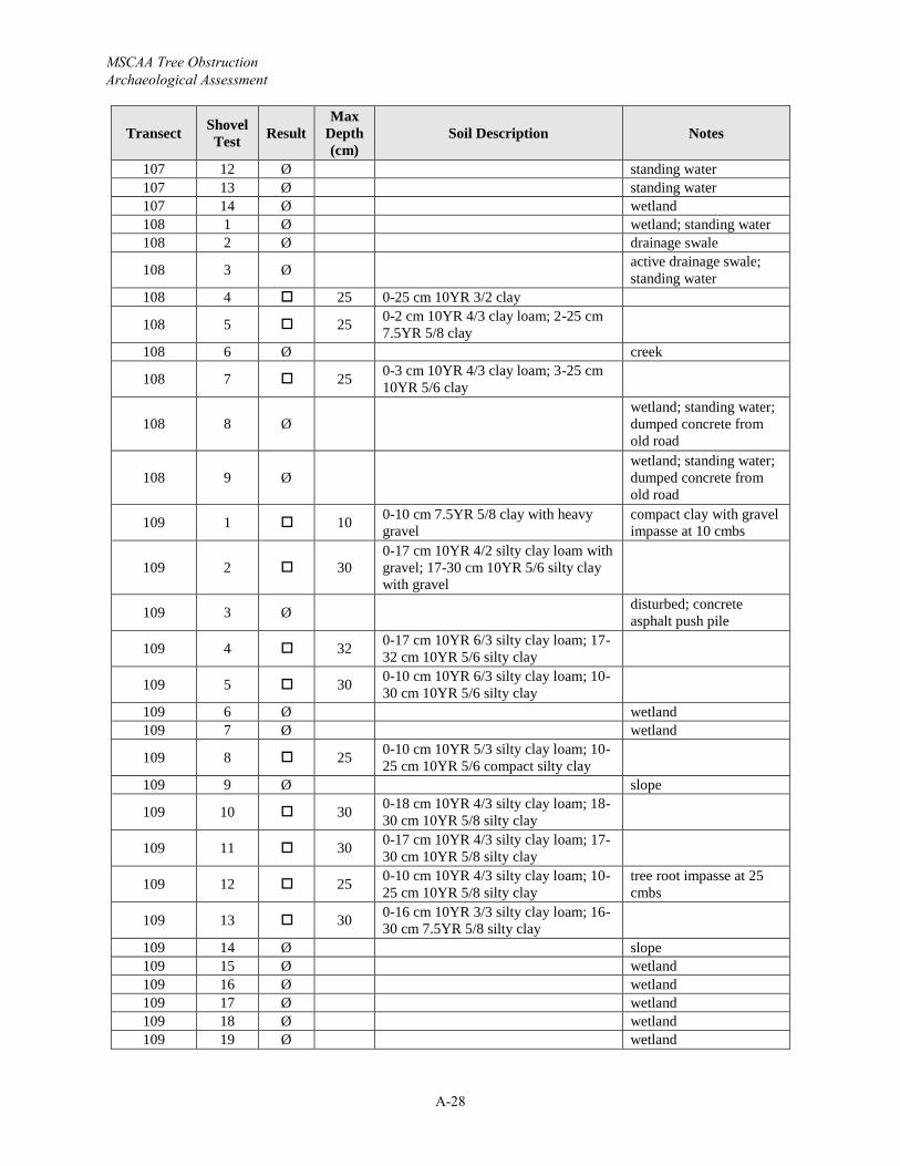
MSCAA Tree Obstruction Archaeological Assessment
A-28
Transect Shovel Test Result
Max Depth (cm)
Soil Description Notes
107 12 Ø standing water107 13 Ø standing water107 14 Ø wetland108 1 Ø wetland; standing water108 2 Ø drainage swale
108 3 Ø active drainage swale; standing water
108 4 25 0-25 cm 10YR 3/2 clay
108 5 25 0-2 cm 10YR 4/3 clay loam; 2-25 cm 7.5YR 5/8 clay
108 6 Ø creek
108 7 25 0-3 cm 10YR 4/3 clay loam; 3-25 cm 10YR 5/6 clay
108 8 Øwetland; standing water; dumped concrete from old road
108 9 Øwetland; standing water; dumped concrete from old road
109 1 10 0-10 cm 7.5YR 5/8 clay with heavy gravel
compact clay with gravel impasse at 10 cmbs
109 2 300-17 cm 10YR 4/2 silty clay loam with gravel; 17-30 cm 10YR 5/6 silty clay with gravel
109 3 Ø disturbed; concrete asphalt push pile
109 4 32 0-17 cm 10YR 6/3 silty clay loam; 17-32 cm 10YR 5/6 silty clay
109 5 30 0-10 cm 10YR 6/3 silty clay loam; 10-30 cm 10YR 5/6 silty clay
109 6 Ø wetland109 7 Ø wetland
109 8 25 0-10 cm 10YR 5/3 silty clay loam; 10-25 cm 10YR 5/6 compact silty clay
109 9 Ø slope
109 10 30 0-18 cm 10YR 4/3 silty clay loam; 18-30 cm 10YR 5/8 silty clay
109 11 30 0-17 cm 10YR 4/3 silty clay loam; 17-30 cm 10YR 5/8 silty clay
109 12 25 0-10 cm 10YR 4/3 silty clay loam; 10-25 cm 10YR 5/8 silty clay
tree root impasse at 25 cmbs
109 13 30 0-16 cm 10YR 3/3 silty clay loam; 16-30 cm 7.5YR 5/8 silty clay
109 14 Ø slope109 15 Ø wetland109 16 Ø wetland109 17 Ø wetland109 18 Ø wetland109 19 Ø wetland
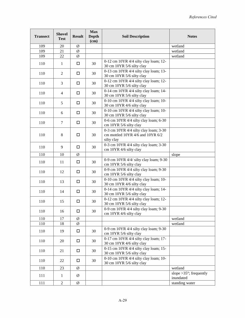
References Cited
A-29
Transect Shovel Test Result
Max Depth (cm)
Soil Description Notes
109 20 Ø wetland109 21 Ø wetland109 22 Ø wetland
110 1 30 0-12 cm 10YR 4/4 silty clay loam; 12-30 cm 10YR 5/6 silty clay
110 2 30 0-13 cm 10YR 4/4 silty clay loam; 13-30 cm 10YR 5/6 silty clay
110 3 30 0-12 cm 10YR 4/4 silty clay loam; 12-30 cm 10YR 5/6 silty clay
110 4 30 0-14 cm 10YR 4/4 silty clay loam; 14-30 cm 10YR 5/6 silty clay
110 5 30 0-10 cm 10YR 4/4 silty clay loam; 10-30 cm 10YR 4/6 silty clay
110 6 30 0-10 cm 10YR 4/4 silty clay loam; 10-30 cm 10YR 5/6 silty clay
110 7 30 0-6 cm 10YR 4/4 silty clay loam; 6-30cm 10YR 5/6 silty clay
110 8 300-3 cm 10YR 4/4 silty clay loam; 3-30cm mottled 10YR 4/6 and 10YR 6/2 silty clay
110 9 30 0-3 cm 10YR 4/4 silty clay loam; 3-30cm 10YR 4/6 silty clay
110 10 Ø slope
110 11 30 0-9 cm 10YR 4/4/ silty clay loam; 9-30cm 10YR 5/6 silty clay
110 12 30 0-9 cm 10YR 4/4 silty clay loam; 9-30cm 10YR 5/6 silty clay
110 13 30 0-10 cm 10YR 4/4 silty clay loam; 10-30 cm 10YR 4/6 silty clay
110 14 30 0-14 cm 10YR 4/4 silty clay loam; 14-30 cm 10YR 5/6 silty clay
110 15 30 0-12 cm 10YR 4/4 silty clay loam; 12-30 cm 10YR 5/6 silty clay
110 16 30 0-9 cm 10YR 4/4 silty clay loam; 9-30cm 10YR 4/6 silty clay
110 17 Ø wetland110 18 Ø wetland
110 19 30 0-9 cm 10YR 4/4 silty clay loam; 9-30cm 10YR 5/6 silty clay
110 20 30 0-17 cm 10YR 4/4 silty clay loam; 17-30 cm 10YR 4/6 silty clay
110 21 30 0-15 cm 10YR 4/4 silty clay loam; 15-30 cm 10YR 5/6 silty clay
110 22 30 0-10 cm 10YR 4/4 silty clay loam; 10-30 cm 10YR 5/6 silty clay
110 23 Ø wetland
111 1 Ø slope >35°; frequently inundated
111 2 Ø standing water
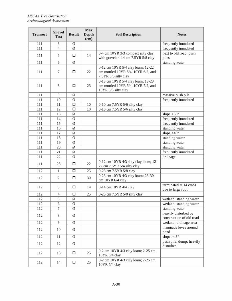
MSCAA Tree Obstruction Archaeological Assessment
A-30
Transect Shovel Test Result
Max Depth (cm)
Soil Description Notes
111 3 Ø frequently inundated111 4 Ø frequently inundated
111 5 14 0-4 cm 10YR 3/3 compact silty clay with gravel; 4-14 cm 7.5YR 5/8 clay
next to old road; push piles
111 6 Ø standing water
111 7 220-12 cm 10YR 5/4 clay loam; 12-22cm mottled 10YR 5/4, 10YR 6/2, and 7.5YR 5/6 silty clay
111 8 230-13 cm 10YR 5/4 clay loam; 13-23cm mottled 10YR 5/4, 10YR 7/2, and 10YR 5/6 silty clay
111 9 Ø massive push pile111 10 Ø frequently inundated111 11 10 0-10 cm 7.5YR 5/6 silty clay111 12 10 0-10 cm 7.5YR 5/6 silty clay111 13 Ø slope >35°111 14 Ø frequently inundated111 15 Ø frequently inundated111 16 Ø standing water111 17 Ø slope >40°111 18 Ø standing water111 19 Ø standing water111 20 Ø standing water111 21 Ø frequently inundated111 22 Ø drainage
111 23 22 0-12 cm 10YR 4/3 silty clay loam; 12-22 cm 7.5YR 5/4 silty clay
112 1 25 0-25 cm 7.5YR 5/8 clay
112 2 30 0-23 cm 10YR 4/3 clay loam; 23-30cm 10YR 6/4 clay
112 3 14 0-14 cm 10YR 4/4 clay terminated at 14 cmbs due to large root
112 4 25 0-25 cm 7.5YR 5/8 silty clay112 5 Ø wetland; standing water112 6 Ø wetland; standing water112 7 Ø standing water
112 8 Ø heavily disturbed by construction of old road
112 9 Ø wetland; drainage area
112 10 Ø manmade levee around pond
112 11 Ø slope >45°
112 12 Ø push pile; dump; heavily disturbed
112 13 25 0-2 cm 10YR 4/3 clay loam; 2-25 cm 10YR 5/4 clay
112 14 25 0-2 cm 10YR 4/3 clay loam; 2-25 cm 10YR 5/4 clay
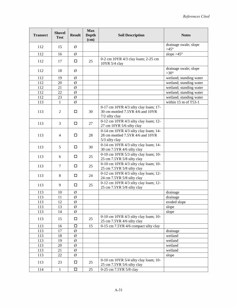
References Cited
A-31
Transect Shovel Test Result
Max Depth (cm)
Soil Description Notes
112 15 Ø drainage swale; slope >45°
112 16 Ø slope >45°
112 17 25 0-2 cm 10YR 4/3 clay loam; 2-25 cm 10YR 5/4 clay
112 18 Ø drainage swale; slope >30°
112 19 Ø wetland; standing water112 20 Ø wetland; standing water112 21 Ø wetland; standing water112 22 Ø wetland; standing water112 23 Ø wetland; standing water113 1 Ø within 15 m of T53-1
113 2 300-17 cm 10YR 4/3 silty clay loam; 17-30 cm mottled 7.5YR 4/6 and 10YR 7/2 silty clay
113 3 27 0-12 cm 10YR 4/3 silty clay loam; 12-27 cm 10YR 5/6 silty clay
113 4 280-14 cm 10YR 4/3 silty clay loam; 14-28 cm mottled 7.5YR 4/6 and 10YR 5/3 silty clay
113 5 30 0-14 cm 10YR 4/3 silty clay loam; 14-30 cm 7.5YR 4/6 silty clay
113 6 25 0-10 cm 10YR 5/3 silty clay loam; 10-25 cm 7.5YR 5/8 silty clay
113 7 25 0-10 cm 10YR 4/3 silty clay loam; 10-25 cm 7.5YR 5/8 silty clay
113 8 24 0-12 cm 10YR 4/3 silty clay loam; 12-24 cm 7.5YR 5/8 silty clay
113 9 25 0-12 cm 10YR 4/3 silty clay loam; 12-25 cm 7.5YR 5/8 silty clay
113 10 Ø drainage113 11 Ø drainage113 12 Ø eroded slope113 13 Ø slope113 14 Ø slope
113 15 25 0-10 cm 10YR 4/3 silty clay loam; 10-25 cm 7.5YR 4/6 silty clay
113 16 15 0-15 cm 7.5YR 4/6 compact silty clay113 17 Ø drainage113 18 Ø wetland113 19 Ø wetland113 20 Ø wetland113 21 Ø wetland113 22 Ø slope
113 23 25 0-10 cm 10YR 5/4 silty clay loam; 10-25 cm 7.5YR 5/6 silty clay
114 1 25 0-25 cm 7.5YR 5/8 clay
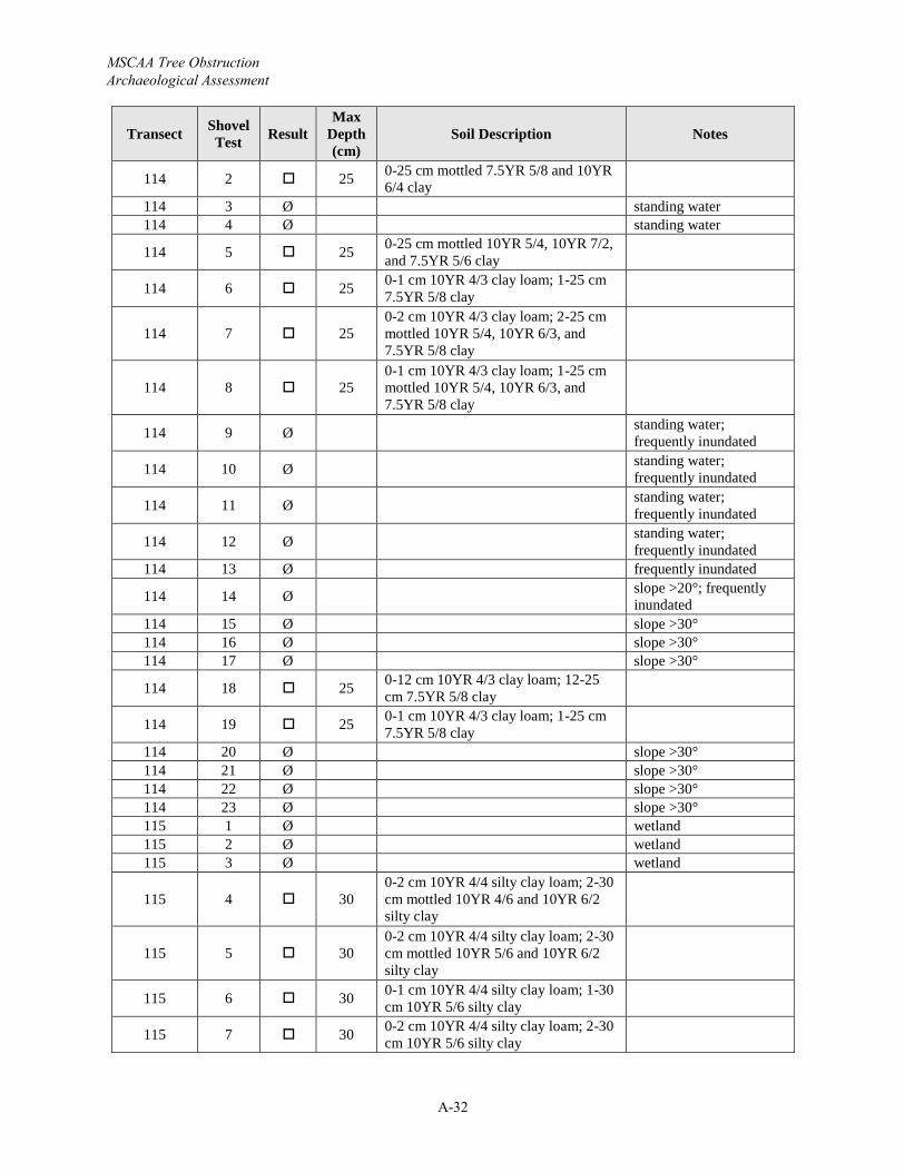
MSCAA Tree Obstruction Archaeological Assessment
A-32
Transect Shovel Test Result
Max Depth (cm)
Soil Description Notes
114 2 25 0-25 cm mottled 7.5YR 5/8 and 10YR 6/4 clay
114 3 Ø standing water114 4 Ø standing water
114 5 25 0-25 cm mottled 10YR 5/4, 10YR 7/2, and 7.5YR 5/6 clay
114 6 25 0-1 cm 10YR 4/3 clay loam; 1-25 cm 7.5YR 5/8 clay
114 7 250-2 cm 10YR 4/3 clay loam; 2-25 cm mottled 10YR 5/4, 10YR 6/3, and 7.5YR 5/8 clay
114 8 250-1 cm 10YR 4/3 clay loam; 1-25 cm mottled 10YR 5/4, 10YR 6/3, and 7.5YR 5/8 clay
114 9 Ø standing water; frequently inundated
114 10 Ø standing water; frequently inundated
114 11 Ø standing water; frequently inundated
114 12 Ø standing water; frequently inundated
114 13 Ø frequently inundated
114 14 Ø slope >20°; frequently inundated
114 15 Ø slope >30°114 16 Ø slope >30°114 17 Ø slope >30°
114 18 25 0-12 cm 10YR 4/3 clay loam; 12-25cm 7.5YR 5/8 clay
114 19 25 0-1 cm 10YR 4/3 clay loam; 1-25 cm 7.5YR 5/8 clay
114 20 Ø slope >30°114 21 Ø slope >30°114 22 Ø slope >30°114 23 Ø slope >30°115 1 Ø wetland115 2 Ø wetland115 3 Ø wetland
115 4 300-2 cm 10YR 4/4 silty clay loam; 2-30cm mottled 10YR 4/6 and 10YR 6/2 silty clay
115 5 300-2 cm 10YR 4/4 silty clay loam; 2-30cm mottled 10YR 5/6 and 10YR 6/2 silty clay
115 6 30 0-1 cm 10YR 4/4 silty clay loam; 1-30cm 10YR 5/6 silty clay
115 7 30 0-2 cm 10YR 4/4 silty clay loam; 2-30cm 10YR 5/6 silty clay
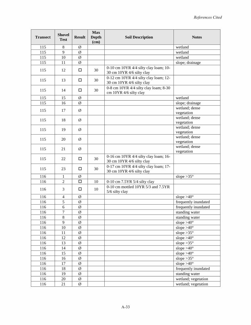
References Cited
A-33
Transect Shovel Test Result
Max Depth (cm)
Soil Description Notes
115 8 Ø wetland115 9 Ø wetland115 10 Ø wetland115 11 Ø slope; drainage
115 12 30 0-10 cm 10YR 4/4 silty clay loam; 10-30 cm 10YR 4/6 silty clay
115 13 30 0-12 cm 10YR 4/4 silty clay loam; 12-30 cm 10YR 4/6 silty clay
115 14 30 0-8 cm 10YR 4/4 silty clay loam; 8-30cm 10YR 4/6 silty clay
115 15 Ø wetland115 16 Ø slope; drainage
115 17 Ø wetland; dense vegetation
115 18 Ø wetland; dense vegetation
115 19 Ø wetland; dense vegetation
115 20 Ø wetland; dense vegetation
115 21 Ø wetland; dense vegetation
115 22 30 0-16 cm 10YR 4/4 silty clay loam; 16-30 cm 10YR 4/6 silty clay
115 23 30 0-17 cm 10YR 4/4 silty clay loam; 17-30 cm 10YR 4/6 silty clay
116 1 Ø slope >35°116 2 10 0-10 cm 7.5YR 5/4 silty clay
116 3 10 0-10 cm mottled 10YR 5/3 and 7.5YR 5/6 silty clay
116 4 Ø slope >40°116 5 Ø frequently inundated116 6 Ø frequently inundated116 7 Ø standing water116 8 Ø standing water116 9 Ø slope >40°116 10 Ø slope >40°116 11 Ø slope >35°116 12 Ø slope >40°116 13 Ø slope >35°116 14 Ø slope >40°116 15 Ø slope >40°116 16 Ø slope >35°116 17 Ø slope >40°116 18 Ø frequently inundated116 19 Ø standing water116 20 Ø wetland; vegetation116 21 Ø wetland; vegetation
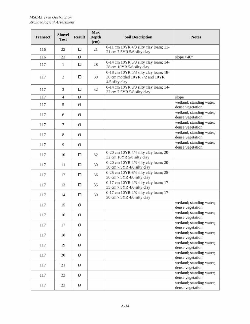
MSCAA Tree Obstruction Archaeological Assessment
A-34
Transect Shovel Test Result
Max Depth (cm)
Soil Description Notes
116 22 21 0-11 cm 10YR 4/3 silty clay loam; 11-21 cm 7.5YR 5/6 silty clay
116 23 Ø slope >40°
117 1 28 0-14 cm 10YR 5/3 silty clay loam; 14-28 cm 10YR 5/6 silty clay
117 2 300-18 cm 10YR 5/3 silty clay loam; 18-30 cm mottled 10YR 7/2 and 10YR 4/6 silty clay
117 3 32 0-14 cm 10YR 3/3 silty clay loam; 14-32 cm 7.5YR 5/8 silty clay
117 4 Ø slope
117 5 Ø wetland; standing water; dense vegetation
117 6 Ø wetland; standing water; dense vegetation
117 7 Ø wetland; standing water; dense vegetation
117 8 Ø wetland; standing water; dense vegetation
117 9 Ø wetland; standing water; dense vegetation
117 10 32 0-20 cm 10YR 4/4 silty clay loam; 20-32 cm 10YR 5/8 silty clay
117 11 30 0-20 cm 10YR 4/3 silty clay loam; 20-30 cm 7.5YR 4/6 silty clay
117 12 36 0-25 cm 10YR 6/4 silty clay loam; 25-36 cm 7.5YR 4/6 silty clay
117 13 35 0-17 cm 10YR 4/3 silty clay loam; 17-35 cm 7.5YR 4/6 silty clay
117 14 30 0-17 cm 10YR 4/3 silty clay loam; 17-30 cm 7.5YR 4/6 silty clay
117 15 Ø wetland; standing water; dense vegetation
117 16 Ø wetland; standing water; dense vegetation
117 17 Ø wetland; standing water; dense vegetation
117 18 Ø wetland; standing water; dense vegetation
117 19 Ø wetland; standing water; dense vegetation
117 20 Ø wetland; standing water; dense vegetation
117 21 Ø wetland; standing water; dense vegetation
117 22 Ø wetland; standing water; dense vegetation
117 23 Ø wetland; standing water; dense vegetation
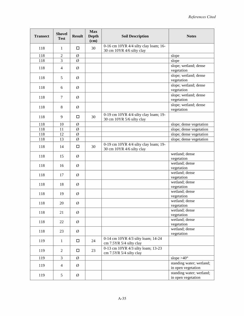
References Cited
A-35
Transect Shovel Test Result
Max Depth (cm)
Soil Description Notes
118 1 30 0-16 cm 10YR 4/4 silty clay loam; 16-30 cm 10YR 4/6 silty clay
118 2 Ø slope118 3 Ø slope
118 4 Ø slope; wetland; dense vegetation
118 5 Ø slope; wetland; dense vegetation
118 6 Ø slope; wetland; dense vegetation
118 7 Ø slope; wetland; dense vegetation
118 8 Ø slope; wetland; dense vegetation
118 9 30 0-19 cm 10YR 4/4 silty clay loam; 19-30 cm 10YR 5/6 silty clay
118 10 Ø slope; dense vegetation118 11 Ø slope; dense vegetation118 12 Ø slope; dense vegetation118 13 Ø slope; dense vegetation
118 14 30 0-19 cm 10YR 4/4 silty clay loam; 19-30 cm 10YR 4/6 silty clay
118 15 Ø wetland; dense vegetation
118 16 Ø wetland; dense vegetation
118 17 Ø wetland; dense vegetation
118 18 Ø wetland; dense vegetation
118 19 Ø wetland; dense vegetation
118 20 Ø wetland; dense vegetation
118 21 Ø wetland; dense vegetation
118 22 Ø wetland; dense vegetation
118 23 Ø wetland; dense vegetation
119 1 24 0-14 cm 10YR 4/3 silty loam; 14-24cm 7.5YR 5/4 silty clay
119 2 23 0-13 cm 10YR 4/3 silty loam; 13-23cm 7.5YR 5/4 silty clay
119 3 Ø slope >40°
119 4 Ø standing water; wetland; in open vegetation
119 5 Ø standing water; wetland; in open vegetation
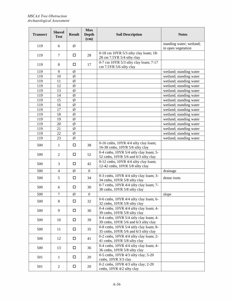
MSCAA Tree Obstruction Archaeological Assessment
A-36
Transect Shovel Test Result
Max Depth (cm)
Soil Description Notes
119 6 Ø standing water; wetland; in open vegetation
119 7 28 0-18 cm 10YR 5/3 silty clay loam; 18-28 cm 7.5YR 5/4 silty clay
119 8 17 0-7 cm 10YR 5/3 silty clay loam; 7-17cm 7.5YR 5/6 silty clay
119 9 Ø wetland; standing water119 10 Ø wetland; standing water119 11 Ø wetland; standing water119 12 Ø wetland; standing water119 13 Ø wetland; standing water119 14 Ø wetland; standing water119 15 Ø wetland; standing water119 16 Ø wetland; standing water119 17 Ø wetland; standing water119 18 Ø wetland; standing water119 19 Ø wetland; standing water119 20 Ø wetland; standing water119 21 Ø wetland; standing water119 22 Ø wetland; standing water119 23 Ø wetland; standing water
500 1 38 0-16 cmbs, 10YR 4/4 silty clay loam; 16-38 cmbs, 10YR 5/6 silty clay
500 2 52 0-4 cmbs, 10YR 5/4 sitly clay loam; 5-52 cmbs, 10YR 5/6 and 6/3 silty clay
500 3 42 0-12 cmbs, 10YR 4/4 silty clay loam; 12-42 cmbs, 10YR 5/8 silty clay
500 4 Ø 0 drainage
500 5 34 0-3 cmbs, 10YR 4/4 silty clay loam; 3-34 cmbs, 10YR 5/8 silty clay dense roots
500 6 30 0-7 cmbs, 10YR 4/4 silty clay loam; 7-38 cmbs, 10YR 5/8 silty clay
500 7 Ø 0 slope
500 8 32 0-6 cmbs, 10YR 4/4 silty clay loam; 6-32 cmbs, 10YR 5/8 silty clay
500 9 36 0-4 cmbs, 10YR 4/4 silty clay loam; 4-39 cmbs, 10YR 5/8 silty clay
500 10 39 0-4 cmbs, 10YR 5/4 sitly clay loam; 4-39 cmbs, 10YR 5/6 and 6/3 silty clay
500 11 35 0-8 cmbs, 10YR 5/4 sitly clay loam; 8-35 cmbs, 10YR 5/6 and 6/3 silty clay
500 12 41 0-2 cmbs, 10YR 4/4 silty clay loam; 2-41 cmbs, 10YR 5/8 silty clay
500 13 36 0-4 cmbs, 10YR 4/4 silty clay loam; 4-36 cmbs, 10YR 5/8 silty clay
501 1 20 0-5 cmbs, 10YR 4/3 silty clay; 5-20cmbs, 10YR 3/3 clay
501 2 20 0-2 cmbs, 10YR 4/3 silty clay; 2-20cmbs, 10YR 4/2 silty clay
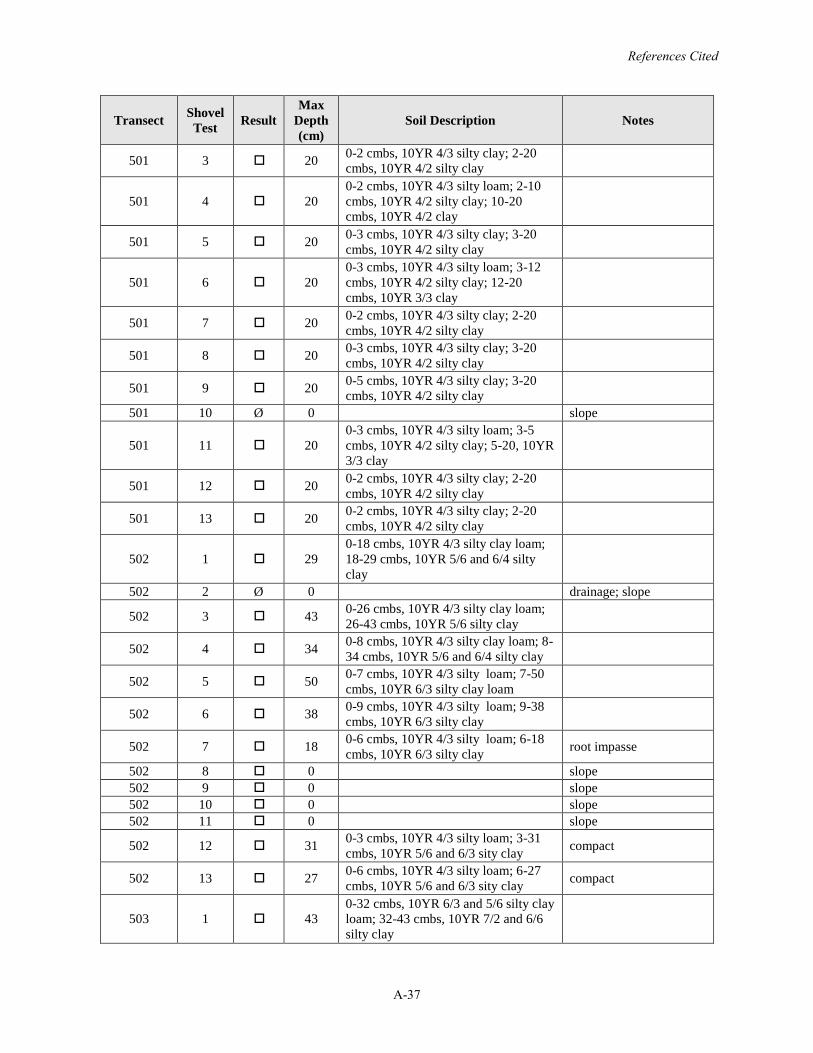
References Cited
A-37
Transect Shovel Test Result
Max Depth (cm)
Soil Description Notes
501 3 20 0-2 cmbs, 10YR 4/3 silty clay; 2-20cmbs, 10YR 4/2 silty clay
501 4 200-2 cmbs, 10YR 4/3 silty loam; 2-10cmbs, 10YR 4/2 silty clay; 10-20cmbs, 10YR 4/2 clay
501 5 20 0-3 cmbs, 10YR 4/3 silty clay; 3-20cmbs, 10YR 4/2 silty clay
501 6 200-3 cmbs, 10YR 4/3 silty loam; 3-12cmbs, 10YR 4/2 silty clay; 12-20cmbs, 10YR 3/3 clay
501 7 20 0-2 cmbs, 10YR 4/3 silty clay; 2-20cmbs, 10YR 4/2 silty clay
501 8 20 0-3 cmbs, 10YR 4/3 silty clay; 3-20cmbs, 10YR 4/2 silty clay
501 9 20 0-5 cmbs, 10YR 4/3 silty clay; 3-20cmbs, 10YR 4/2 silty clay
501 10 Ø 0 slope
501 11 200-3 cmbs, 10YR 4/3 silty loam; 3-5cmbs, 10YR 4/2 silty clay; 5-20, 10YR 3/3 clay
501 12 20 0-2 cmbs, 10YR 4/3 silty clay; 2-20cmbs, 10YR 4/2 silty clay
501 13 20 0-2 cmbs, 10YR 4/3 silty clay; 2-20cmbs, 10YR 4/2 silty clay
502 1 290-18 cmbs, 10YR 4/3 silty clay loam; 18-29 cmbs, 10YR 5/6 and 6/4 silty clay
502 2 Ø 0 drainage; slope
502 3 43 0-26 cmbs, 10YR 4/3 silty clay loam; 26-43 cmbs, 10YR 5/6 silty clay
502 4 34 0-8 cmbs, 10YR 4/3 silty clay loam; 8-34 cmbs, 10YR 5/6 and 6/4 silty clay
502 5 50 0-7 cmbs, 10YR 4/3 silty loam; 7-50cmbs, 10YR 6/3 silty clay loam
502 6 38 0-9 cmbs, 10YR 4/3 silty loam; 9-38cmbs, 10YR 6/3 silty clay
502 7 18 0-6 cmbs, 10YR 4/3 silty loam; 6-18cmbs, 10YR 6/3 silty clay root impasse
502 8 0 slope502 9 0 slope502 10 0 slope502 11 0 slope
502 12 31 0-3 cmbs, 10YR 4/3 silty loam; 3-31cmbs, 10YR 5/6 and 6/3 sity clay compact
502 13 27 0-6 cmbs, 10YR 4/3 silty loam; 6-27cmbs, 10YR 5/6 and 6/3 sity clay compact
503 1 430-32 cmbs, 10YR 6/3 and 5/6 silty clay loam; 32-43 cmbs, 10YR 7/2 and 6/6 silty clay
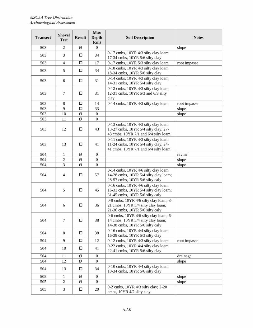
MSCAA Tree Obstruction Archaeological Assessment
A-38
Transect Shovel Test Result
Max Depth (cm)
Soil Description Notes
503 2 Ø 0 slope
503 3 34 0-17 cmbs, 10YR 4/3 silty clay loam; 17-34 cmbs, 10YR 5/6 silty clay
503 4 17 0-17 cmbs, 10YR 5/3 silty clay loam root impasse
503 5 34 0-18 cmbs, 10YR 4/3 silty clay loam; 18-34 cmbs, 10YR 5/6 silty clay
503 6 31 0-14 cmbs, 10YR 4/3 silty clay loam; 14-31 cmbs, 10YR 5/4 silty clay
503 7 310-12 cmbs, 10YR 4/3 silty clay loam; 12-31 cmbs, 10YR 5/3 and 6/3 silty clay
503 8 14 0-14 cmbs, 10YR 4/3 silty clay loam root impasse 503 9 33 slope503 10 Ø 0 slope503 11 Ø 0
503 12 430-13 cmbs, 10YR 4/3 silty clay loam; 13-27 cmbs, 10YR 5/4 silty clay; 27-43 cmbs, 10YR 7/1 and 6/4 silty loam
503 13 410-11 cmbs, 10YR 4/3 silty clay loam; 11-24 cmbs, 10YR 5/4 silty clay; 24-41 cmbs, 10YR 7/1 and 6/4 silty loam
504 1 Ø 0 ravine504 2 Ø 0 slope504 3 Ø 0 slope
504 4 570-14 cmbs, 10YR 4/6 silty clay loam; 14-28 cmbs, 10YR 5/4 silty clay loam; 28-57 cmbs, 10YR 5/6 silty caly
504 5 450-16 cmbs, 10YR 4/6 silty clay loam; 16-31 cmbs, 10YR 5/4 silty clay loam; 31-45 cmbs, 10YR 5/6 silty caly
504 6 360-8 cmbs, 10YR 4/6 silty clay loam; 8-21 cmbs, 10YR 5/4 silty clay loam; 21-36 cmbs, 10YR 5/6 silty caly
504 7 380-6 cmbs, 10YR 4/6 silty clay loam; 6-14 cmbs, 10YR 5/4 silty clay loam; 14-38 cmbs, 10YR 5/6 silty caly
504 8 38 0-16 cmbs, 10YR 4/4 silty clay loam; 16-38 cmbs, 10YR 5/3 silty clay
504 9 12 0-12 cmbs, 10YR 4/3 silty clay loam root impasse
504 10 41 0-22 cmbs, 10YR 4/4 silty clay loam; 22-41 cmbs, 10YR 5/6 silty clay
504 11 Ø 0 drainage504 12 Ø 0 slope
504 13 34 0-10 cmbs, 10YR 4/4 silty clay loam; 10-34 cmbs, 10YR 5/6 silty clay
505 1 Ø 0 slope505 2 Ø 0 slope
505 3 20 0-2 cmbs, 10YR 4/3 silty clay; 2-20cmbs, 10YR 4/2 silty clay
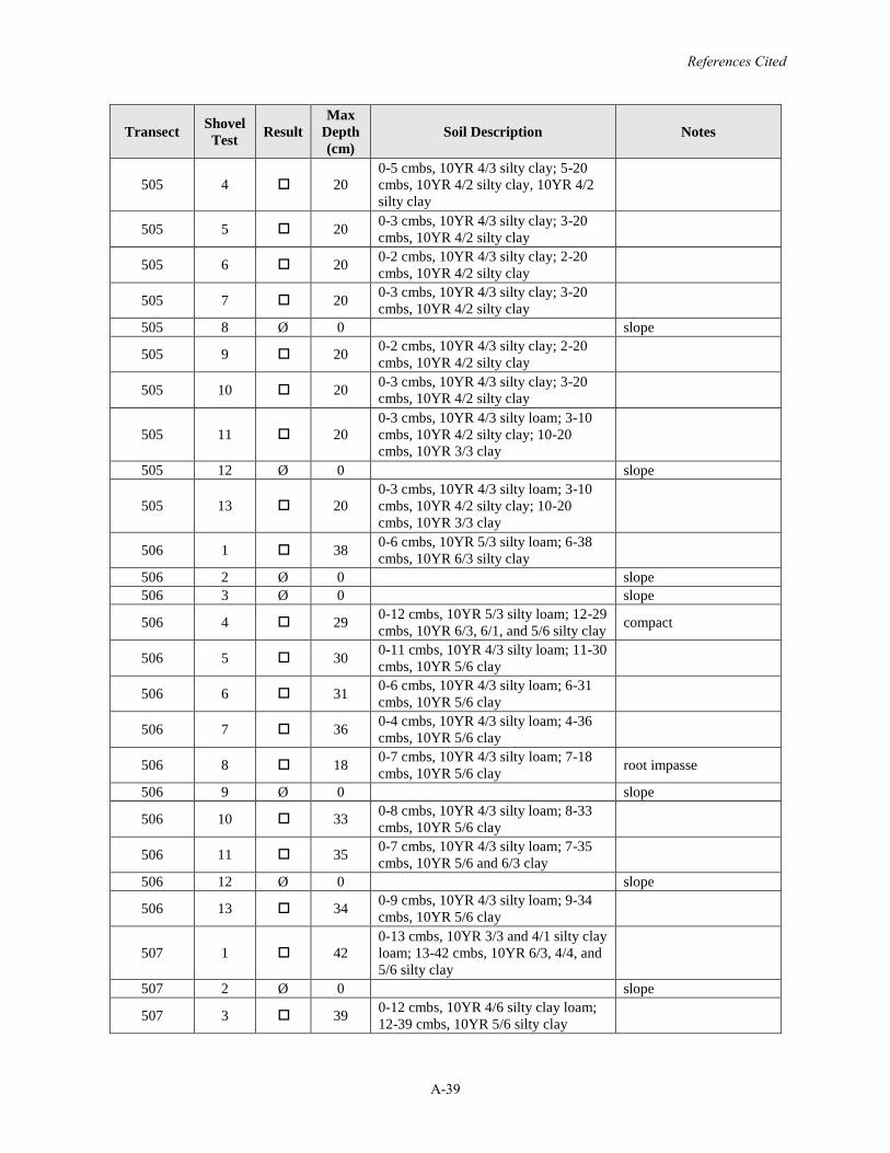
References Cited
A-39
Transect Shovel Test Result
Max Depth (cm)
Soil Description Notes
505 4 200-5 cmbs, 10YR 4/3 silty clay; 5-20cmbs, 10YR 4/2 silty clay, 10YR 4/2 silty clay
505 5 20 0-3 cmbs, 10YR 4/3 silty clay; 3-20cmbs, 10YR 4/2 silty clay
505 6 20 0-2 cmbs, 10YR 4/3 silty clay; 2-20cmbs, 10YR 4/2 silty clay
505 7 20 0-3 cmbs, 10YR 4/3 silty clay; 3-20cmbs, 10YR 4/2 silty clay
505 8 Ø 0 slope
505 9 20 0-2 cmbs, 10YR 4/3 silty clay; 2-20cmbs, 10YR 4/2 silty clay
505 10 20 0-3 cmbs, 10YR 4/3 silty clay; 3-20cmbs, 10YR 4/2 silty clay
505 11 200-3 cmbs, 10YR 4/3 silty loam; 3-10cmbs, 10YR 4/2 silty clay; 10-20cmbs, 10YR 3/3 clay
505 12 Ø 0 slope
505 13 200-3 cmbs, 10YR 4/3 silty loam; 3-10cmbs, 10YR 4/2 silty clay; 10-20cmbs, 10YR 3/3 clay
506 1 38 0-6 cmbs, 10YR 5/3 silty loam; 6-38cmbs, 10YR 6/3 silty clay
506 2 Ø 0 slope506 3 Ø 0 slope
506 4 29 0-12 cmbs, 10YR 5/3 silty loam; 12-29cmbs, 10YR 6/3, 6/1, and 5/6 silty clay compact
506 5 30 0-11 cmbs, 10YR 4/3 silty loam; 11-30cmbs, 10YR 5/6 clay
506 6 31 0-6 cmbs, 10YR 4/3 silty loam; 6-31cmbs, 10YR 5/6 clay
506 7 36 0-4 cmbs, 10YR 4/3 silty loam; 4-36cmbs, 10YR 5/6 clay
506 8 18 0-7 cmbs, 10YR 4/3 silty loam; 7-18cmbs, 10YR 5/6 clay root impasse
506 9 Ø 0 slope
506 10 33 0-8 cmbs, 10YR 4/3 silty loam; 8-33cmbs, 10YR 5/6 clay
506 11 35 0-7 cmbs, 10YR 4/3 silty loam; 7-35cmbs, 10YR 5/6 and 6/3 clay
506 12 Ø 0 slope
506 13 34 0-9 cmbs, 10YR 4/3 silty loam; 9-34cmbs, 10YR 5/6 clay
507 1 420-13 cmbs, 10YR 3/3 and 4/1 silty clay loam; 13-42 cmbs, 10YR 6/3, 4/4, and 5/6 silty clay
507 2 Ø 0 slope
507 3 39 0-12 cmbs, 10YR 4/6 silty clay loam; 12-39 cmbs, 10YR 5/6 silty clay
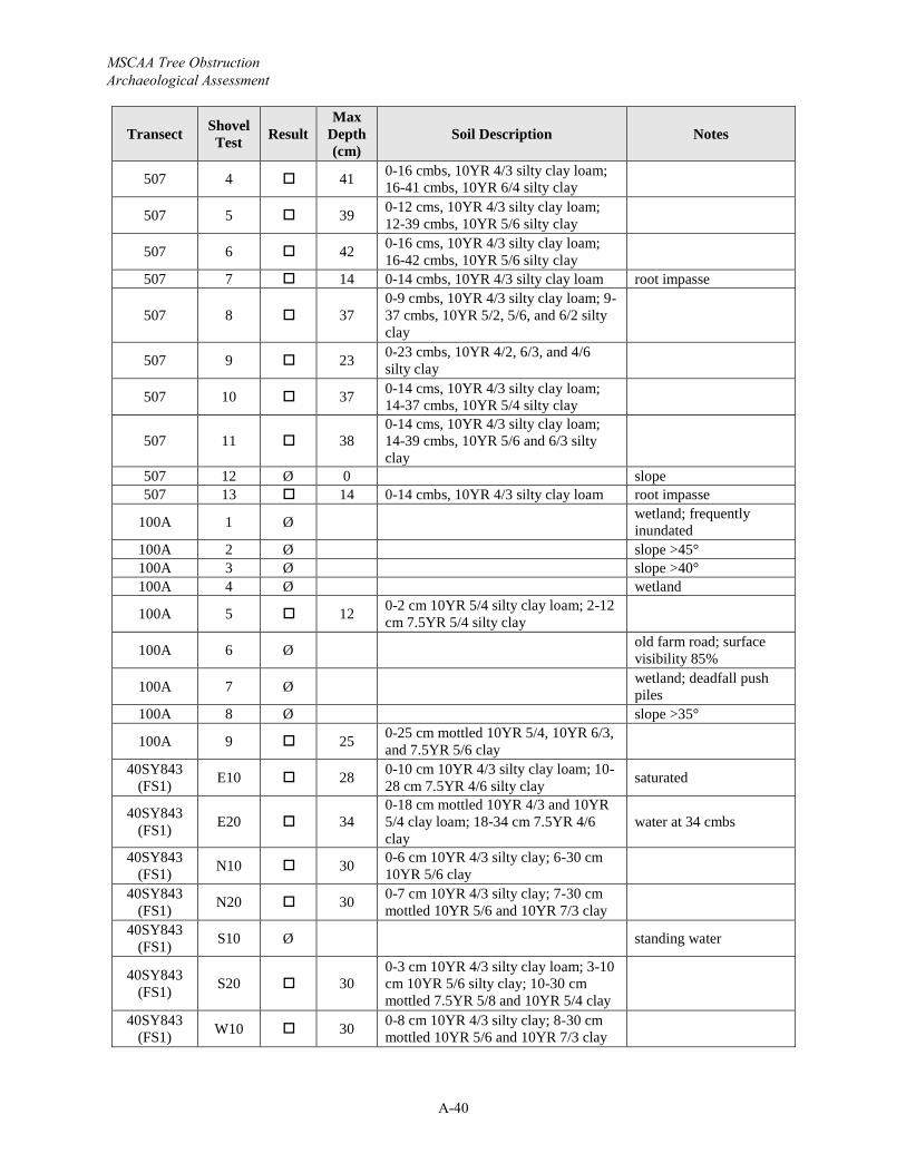
MSCAA Tree Obstruction Archaeological Assessment
A-40
Transect Shovel Test Result
Max Depth (cm)
Soil Description Notes
507 4 41 0-16 cmbs, 10YR 4/3 silty clay loam; 16-41 cmbs, 10YR 6/4 silty clay
507 5 39 0-12 cms, 10YR 4/3 silty clay loam; 12-39 cmbs, 10YR 5/6 silty clay
507 6 42 0-16 cms, 10YR 4/3 silty clay loam; 16-42 cmbs, 10YR 5/6 silty clay
507 7 14 0-14 cmbs, 10YR 4/3 silty clay loam root impasse
507 8 370-9 cmbs, 10YR 4/3 silty clay loam; 9-37 cmbs, 10YR 5/2, 5/6, and 6/2 silty clay
507 9 23 0-23 cmbs, 10YR 4/2, 6/3, and 4/6 silty clay
507 10 37 0-14 cms, 10YR 4/3 silty clay loam; 14-37 cmbs, 10YR 5/4 silty clay
507 11 380-14 cms, 10YR 4/3 silty clay loam; 14-39 cmbs, 10YR 5/6 and 6/3 silty clay
507 12 Ø 0 slope507 13 14 0-14 cmbs, 10YR 4/3 silty clay loam root impasse
100A 1 Ø wetland; frequently inundated
100A 2 Ø slope >45°100A 3 Ø slope >40°100A 4 Ø wetland
100A 5 12 0-2 cm 10YR 5/4 silty clay loam; 2-12cm 7.5YR 5/4 silty clay
100A 6 Ø old farm road; surface visibility 85%
100A 7 Ø wetland; deadfall push piles
100A 8 Ø slope >35°
100A 9 25 0-25 cm mottled 10YR 5/4, 10YR 6/3, and 7.5YR 5/6 clay
40SY843 (FS1) E10 28 0-10 cm 10YR 4/3 silty clay loam; 10-
28 cm 7.5YR 4/6 silty clay saturated
40SY843 (FS1) E20 34
0-18 cm mottled 10YR 4/3 and 10YR 5/4 clay loam; 18-34 cm 7.5YR 4/6 clay
water at 34 cmbs
40SY843 (FS1) N10 30 0-6 cm 10YR 4/3 silty clay; 6-30 cm
10YR 5/6 clay40SY843
(FS1) N20 30 0-7 cm 10YR 4/3 silty clay; 7-30 cm mottled 10YR 5/6 and 10YR 7/3 clay
40SY843 (FS1) S10 Ø standing water
40SY843 (FS1) S20 30
0-3 cm 10YR 4/3 silty clay loam; 3-10cm 10YR 5/6 silty clay; 10-30 cm mottled 7.5YR 5/8 and 10YR 5/4 clay
40SY843 (FS1) W10 30 0-8 cm 10YR 4/3 silty clay; 8-30 cm
mottled 10YR 5/6 and 10YR 7/3 clay
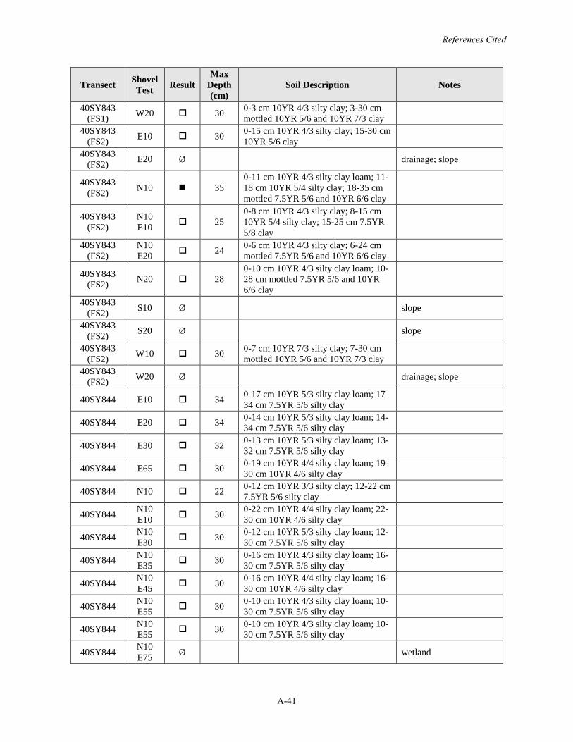
References Cited
A-41
Transect Shovel Test Result
Max Depth (cm)
Soil Description Notes
40SY843 (FS1) W20 30 0-3 cm 10YR 4/3 silty clay; 3-30 cm
mottled 10YR 5/6 and 10YR 7/3 clay40SY843
(FS2) E10 30 0-15 cm 10YR 4/3 silty clay; 15-30 cm 10YR 5/6 clay
40SY843 (FS2) E20 Ø drainage; slope
40SY843 (FS2) N10 35
0-11 cm 10YR 4/3 silty clay loam; 11-18 cm 10YR 5/4 silty clay; 18-35 cm mottled 7.5YR 5/6 and 10YR 6/6 clay
40SY843 (FS2)
N10 E10 25
0-8 cm 10YR 4/3 silty clay; 8-15 cm 10YR 5/4 silty clay; 15-25 cm 7.5YR 5/8 clay
40SY843 (FS2)
N10 E20 24 0-6 cm 10YR 4/3 silty clay; 6-24 cm
mottled 7.5YR 5/6 and 10YR 6/6 clay
40SY843(FS2) N20 28
0-10 cm 10YR 4/3 silty clay loam; 10-28 cm mottled 7.5YR 5/6 and 10YR 6/6 clay
40SY843 (FS2) S10 Ø slope
40SY843 (FS2) S20 Ø slope
40SY843 (FS2) W10 30 0-7 cm 10YR 7/3 silty clay; 7-30 cm
mottled 10YR 5/6 and 10YR 7/3 clay40SY843
(FS2) W20 Ø drainage; slope
40SY844 E10 34 0-17 cm 10YR 5/3 silty clay loam; 17-34 cm 7.5YR 5/6 silty clay
40SY844 E20 34 0-14 cm 10YR 5/3 silty clay loam; 14-34 cm 7.5YR 5/6 silty clay
40SY844 E30 32 0-13 cm 10YR 5/3 silty clay loam; 13-32 cm 7.5YR 5/6 silty clay
40SY844 E65 30 0-19 cm 10YR 4/4 silty clay loam; 19-30 cm 10YR 4/6 silty clay
40SY844 N10 22 0-12 cm 10YR 3/3 silty clay; 12-22 cm 7.5YR 5/6 silty clay
40SY844 N10 E10 30 0-22 cm 10YR 4/4 silty clay loam; 22-
30 cm 10YR 4/6 silty clay
40SY844 N10 E30 30 0-12 cm 10YR 5/3 silty clay loam; 12-
30 cm 7.5YR 5/6 silty clay
40SY844 N10 E35 30 0-16 cm 10YR 4/3 silty clay loam; 16-
30 cm 7.5YR 5/6 silty clay
40SY844 N10 E45 30 0-16 cm 10YR 4/4 silty clay loam; 16-
30 cm 10YR 4/6 silty clay
40SY844 N10 E55 30 0-10 cm 10YR 4/3 silty clay loam; 10-
30 cm 7.5YR 5/6 silty clay
40SY844 N10 E55 30 0-10 cm 10YR 4/3 silty clay loam; 10-
30 cm 7.5YR 5/6 silty clay
40SY844 N10 E75 Ø wetland
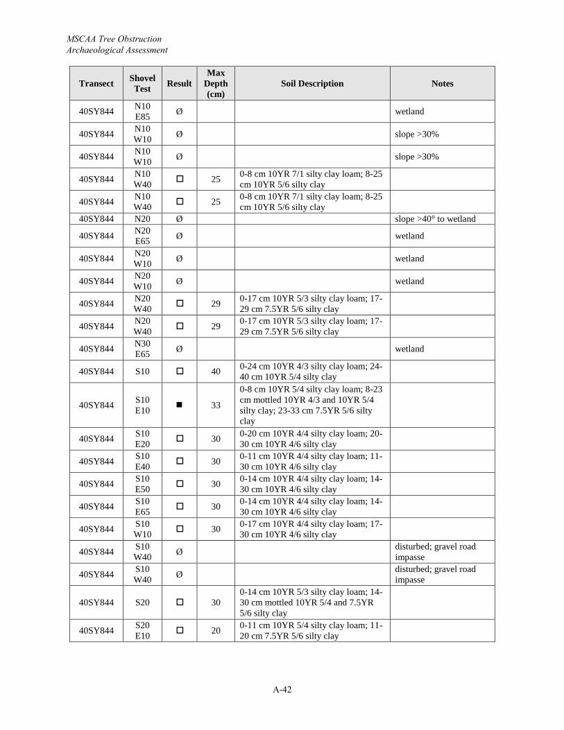
MSCAA Tree Obstruction Archaeological Assessment
A-42
Transect Shovel Test Result
Max Depth (cm)
Soil Description Notes
40SY844 N10 E85 Ø wetland
40SY844 N10 W10 Ø slope >30%
40SY844 N10 W10 Ø slope >30%
40SY844 N10 W40 25 0-8 cm 10YR 7/1 silty clay loam; 8-25
cm 10YR 5/6 silty clay
40SY844 N10 W40 25 0-8 cm 10YR 7/1 silty clay loam; 8-25
cm 10YR 5/6 silty clay40SY844 N20 Ø slope >40° to wetland
40SY844 N20 E65 Ø wetland
40SY844 N20 W10 Ø wetland
40SY844 N20 W10 Ø wetland
40SY844 N20 W40 29 0-17 cm 10YR 5/3 silty clay loam; 17-
29 cm 7.5YR 5/6 silty clay
40SY844 N20 W40 29 0-17 cm 10YR 5/3 silty clay loam; 17-
29 cm 7.5YR 5/6 silty clay
40SY844 N30 E65 Ø wetland
40SY844 S10 40 0-24 cm 10YR 4/3 silty clay loam; 24-40 cm 10YR 5/4 silty clay
40SY844 S10 E10 33
0-8 cm 10YR 5/4 silty clay loam; 8-23cm mottled 10YR 4/3 and 10YR 5/4 silty clay; 23-33 cm 7.5YR 5/6 silty clay
40SY844 S10 E20 30 0-20 cm 10YR 4/4 silty clay loam; 20-
30 cm 10YR 4/6 silty clay
40SY844 S10 E40 30 0-11 cm 10YR 4/4 silty clay loam; 11-
30 cm 10YR 4/6 silty clay
40SY844 S10 E50 30 0-14 cm 10YR 4/4 silty clay loam; 14-
30 cm 10YR 4/6 silty clay
40SY844 S10 E65 30 0-14 cm 10YR 4/4 silty clay loam; 14-
30 cm 10YR 4/6 silty clay
40SY844 S10 W10 30 0-17 cm 10YR 4/4 silty clay loam; 17-
30 cm 10YR 4/6 silty clay
40SY844 S10 W40 Ø disturbed; gravel road
impasse
40SY844 S10 W40 Ø disturbed; gravel road
impasse
40SY844 S20 300-14 cm 10YR 5/3 silty clay loam; 14-30 cm mottled 10YR 5/4 and 7.5YR 5/6 silty clay
40SY844 S20 E10 20 0-11 cm 10YR 5/4 silty clay loam; 11-
20 cm 7.5YR 5/6 silty clay
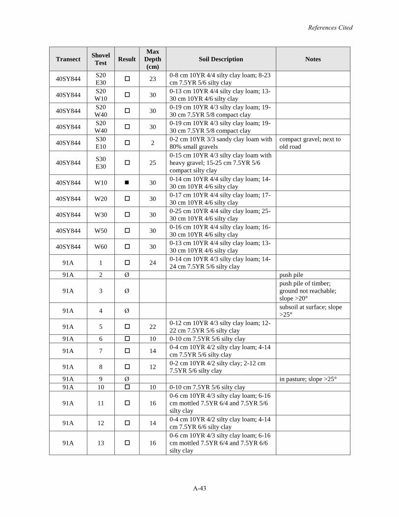
References Cited
A-43
Transect Shovel Test Result
Max Depth (cm)
Soil Description Notes
40SY844 S20 E30 23 0-8 cm 10YR 4/4 silty clay loam; 8-23
cm 7.5YR 5/6 silty clay
40SY844 S20 W10 30 0-13 cm 10YR 4/4 silty clay loam; 13-
30 cm 10YR 4/6 silty clay
40SY844 S20 W40 30 0-19 cm 10YR 4/3 silty clay loam; 19-
30 cm 7.5YR 5/8 compact clay
40SY844 S20 W40 30 0-19 cm 10YR 4/3 silty clay loam; 19-
30 cm 7.5YR 5/8 compact clay
40SY844 S30 E10 2 0-2 cm 10YR 3/3 sandy clay loam with
80% small gravelscompact gravel; next to old road
40SY844 S30 E30 25
0-15 cm 10YR 4/3 silty clay loam with heavy gravel; 15-25 cm 7.5YR 5/6 compact silty clay
40SY844 W10 30 0-14 cm 10YR 4/4 silty clay loam; 14-30 cm 10YR 4/6 silty clay
40SY844 W20 30 0-17 cm 10YR 4/4 silty clay loam; 17-30 cm 10YR 4/6 silty clay
40SY844 W30 30 0-25 cm 10YR 4/4 silty clay loam; 25-30 cm 10YR 4/6 silty clay
40SY844 W50 30 0-16 cm 10YR 4/4 silty clay loam; 16-30 cm 10YR 4/6 silty clay
40SY844 W60 30 0-13 cm 10YR 4/4 silty clay loam; 13-30 cm 10YR 4/6 silty clay
91A 1 24 0-14 cm 10YR 4/3 silty clay loam; 14-24 cm 7.5YR 5/6 silty clay
91A 2 Ø push pile
91A 3 Øpush pile of timber; ground not reachable; slope >20°
91A 4 Ø subsoil at surface; slope >25°
91A 5 22 0-12 cm 10YR 4/3 silty clay loam; 12-22 cm 7.5YR 5/6 silty clay
91A 6 10 0-10 cm 7.5YR 5/6 silty clay
91A 7 14 0-4 cm 10YR 4/2 silty clay loam; 4-14cm 7.5YR 5/6 silty clay
91A 8 12 0-2 cm 10YR 4/2 silty clay; 2-12 cm 7.5YR 5/6 silty clay
91A 9 Ø in pasture; slope >25°91A 10 10 0-10 cm 7.5YR 5/6 silty clay
91A 11 160-6 cm 10YR 4/3 silty clay loam; 6-16cm mottled 7.5YR 6/4 and 7.5YR 5/6 silty clay
91A 12 14 0-4 cm 10YR 4/2 silty clay loam; 4-14cm 7.5YR 6/6 silty clay
91A 13 160-6 cm 10YR 4/3 silty clay loam; 6-16cm mottled 7.5YR 6/4 and 7.5YR 6/6 silty clay
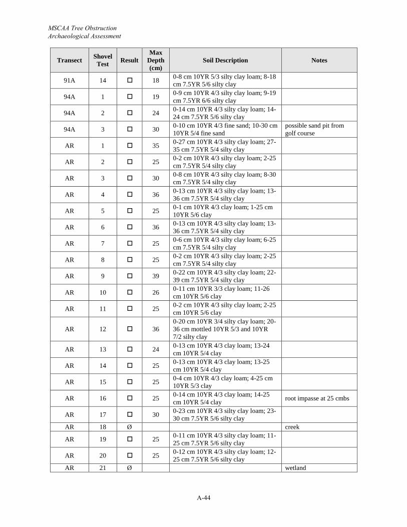
MSCAA Tree Obstruction Archaeological Assessment
A-44
Transect Shovel Test Result
Max Depth (cm)
Soil Description Notes
91A 14 18 0-8 cm 10YR 5/3 silty clay loam; 8-18cm 7.5YR 5/6 silty clay
94A 1 19 0-9 cm 10YR 4/3 silty clay loam; 9-19cm 7.5YR 6/6 silty clay
94A 2 24 0-14 cm 10YR 4/3 silty clay loam; 14-24 cm 7.5YR 5/6 silty clay
94A 3 30 0-10 cm 10YR 4/3 fine sand; 10-30 cm 10YR 5/4 fine sand
possible sand pit from golf course
AR 1 35 0-27 cm 10YR 4/3 silty clay loam; 27-35 cm 7.5YR 5/4 silty clay
AR 2 25 0-2 cm 10YR 4/3 silty clay loam; 2-25cm 7.5YR 5/4 silty clay
AR 3 30 0-8 cm 10YR 4/3 silty clay loam; 8-30cm 7.5YR 5/4 silty clay
AR 4 36 0-13 cm 10YR 4/3 silty clay loam; 13-36 cm 7.5YR 5/4 silty clay
AR 5 25 0-1 cm 10YR 4/3 clay loam; 1-25 cm 10YR 5/6 clay
AR 6 36 0-13 cm 10YR 4/3 silty clay loam; 13-36 cm 7.5YR 5/4 silty clay
AR 7 25 0-6 cm 10YR 4/3 silty clay loam; 6-25cm 7.5YR 5/4 silty clay
AR 8 25 0-2 cm 10YR 4/3 silty clay loam; 2-25cm 7.5YR 5/4 silty clay
AR 9 39 0-22 cm 10YR 4/3 silty clay loam; 22-39 cm 7.5YR 5/4 silty clay
AR 10 26 0-11 cm 10YR 3/3 clay loam; 11-26cm 10YR 5/6 clay
AR 11 25 0-2 cm 10YR 4/3 silty clay loam; 2-25cm 10YR 5/6 clay
AR 12 360-20 cm 10YR 3/4 silty clay loam; 20-36 cm mottled 10YR 5/3 and 10YR 7/2 silty clay
AR 13 24 0-13 cm 10YR 4/3 clay loam; 13-24cm 10YR 5/4 clay
AR 14 25 0-13 cm 10YR 4/3 clay loam; 13-25cm 10YR 5/4 clay
AR 15 25 0-4 cm 10YR 4/3 clay loam; 4-25 cm 10YR 5/3 clay
AR 16 25 0-14 cm 10YR 4/3 clay loam; 14-25cm 10YR 5/4 clay root impasse at 25 cmbs
AR 17 30 0-23 cm 10YR 4/3 silty clay loam; 23-30 cm 7.5YR 5/6 silty clay
AR 18 Ø creek
AR 19 25 0-11 cm 10YR 4/3 silty clay loam; 11-25 cm 7.5YR 5/6 silty clay
AR 20 25 0-12 cm 10YR 4/3 silty clay loam; 12-25 cm 7.5YR 5/6 silty clay
AR 21 Ø wetland

References Cited
A-45
Transect Shovel Test Result
Max Depth (cm)
Soil Description Notes
AR 22 Ø wetland

MSCAA Tree Obstruction Archaeological Assessment
A-46
Page intentionally blank

ATTACHMENT 3
Photo Log

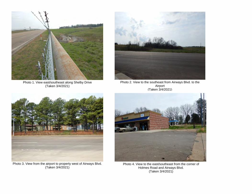
Photo 1. View east/southeast along Shelby Drive (Taken 3/4/2021)
Photo 2. View to the southeast from Airways Blvd. to the Airport
(Taken 3/4/2021)
Photo 3. View from the airport to property west of Airways Blvd.(Taken 3/4/2021)
Photo 4. View to the east/southeast from the corner of Holmes Road and Airways Blvd.
(Taken 3/4/2021)
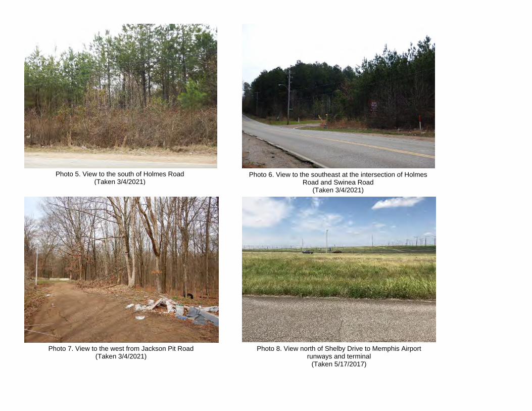
Photo 5. View to the south of Holmes Road(Taken 3/4/2021)
Photo 6. View to the southeast at the intersection of Holmes Road and Swinea Road
(Taken 3/4/2021)
Photo 7. View to the west from Jackson Pit Road(Taken 3/4/2021)
Photo 8. View north of Shelby Drive to Memphis Airport runways and terminal
(Taken 5/17/2017)
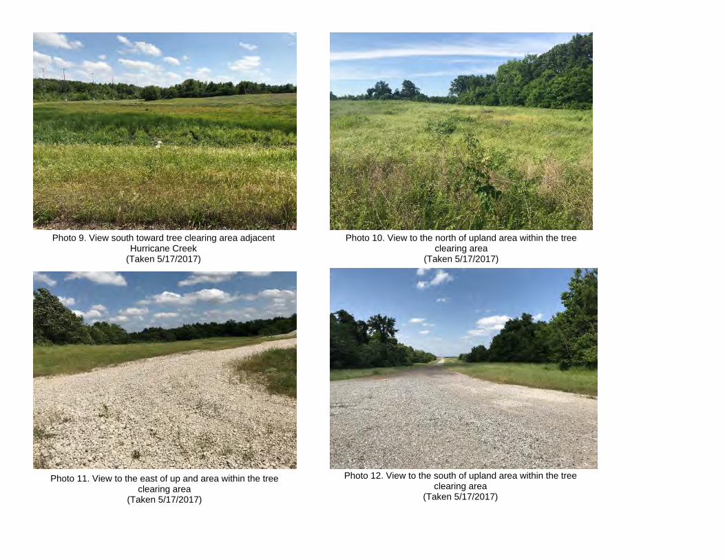
Photo 9. View south toward tree clearing area adjacent Hurricane Creek
(Taken 5/17/2017)
Photo 10. View to the north of upland area within the tree clearing area
(Taken 5/17/2017)
Photo 12. View to the south of upland area within the tree clearing area
(Taken 5/17/2017)
Photo 11. View to the east of up and area within the tree clearing area
(Taken 5/17/2017)

Photo 13. Google Street View of Airways Boulevard, looking north
Photo 14. Google Street View of Jackson Pit Road Area, looking west Photo 15. Google Earth Aerial View of Jackson Pit Road Area
Photo 16. Google Street View of Tennessee Army National Guard (TNARNG) Memphis Readiness Center (left) and Central United States Earthquake Consortium (right), looking north
Photo 17. Google Earth Aerial View of Readiness Center Area
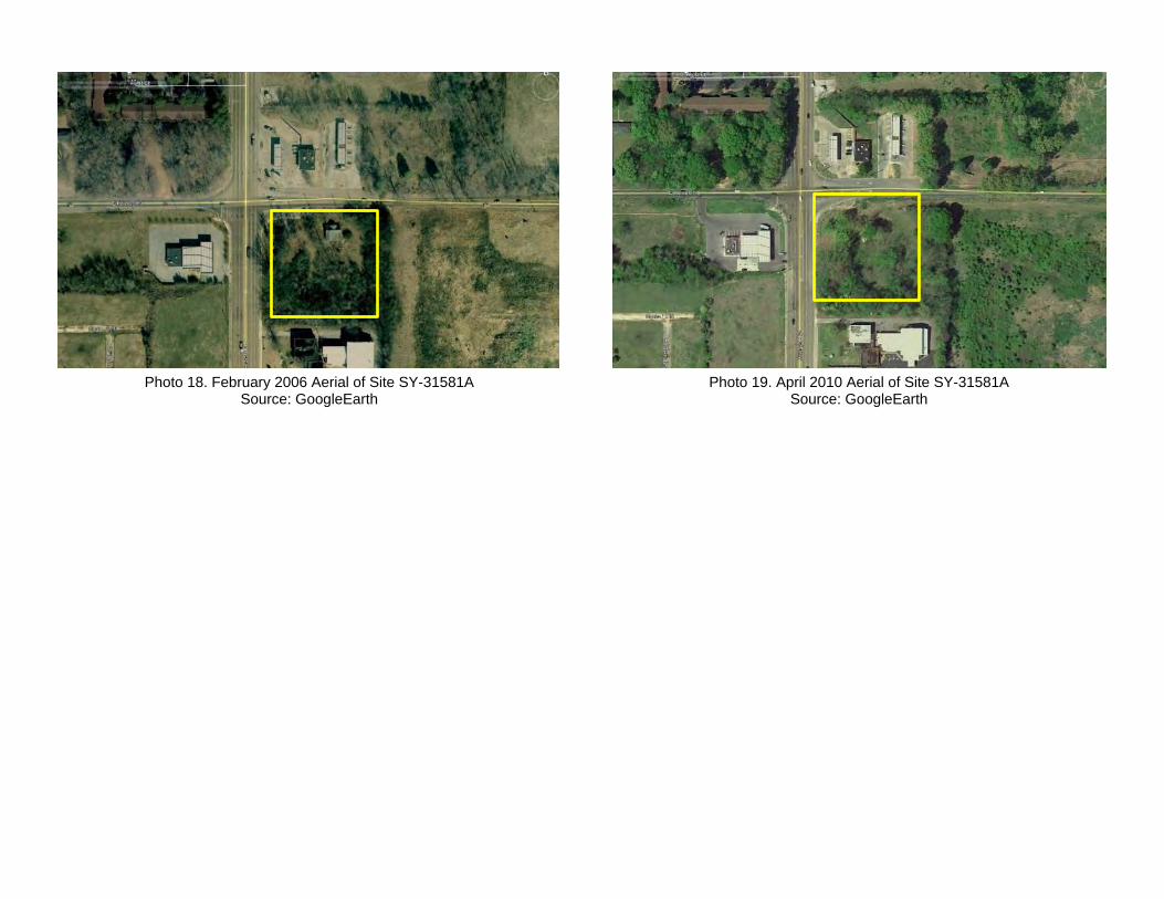
Photo 18. February 2006 Aerial of Site SY-31581ASource: GoogleEarth
Photo 19. April 2010 Aerial of Site SY-31581ASource: GoogleEarth
ATTACHMENT 7 Noise Exposure Maps and Supporting Documentation
369 | P a g e

For Spiral BindingFinished Trim Size: 11” x 9”(trim away 1” each side, and 3” top and bottom)
Accepted by FAAon September 1, 2015
Part 150 Study Update
Memphis International Airport
Noise Exposure Maps (NEMs)and Supporting Documentation
In Association withKB Environmental Sciences, Inc.
VIJ Enterprises, LLCFisher & Arnold, Inc.
Prepared for:
Prepared by:
2020 FUTURE CONDITION NEM WITH NOISE–SENSITIVE SITES
FIG
UR
E ES.10
NORTH / EAST FLOW FLIGHT TRACKS
FIGU
RE
5.2 SO
URCE: PDARS, N
ovember 1 through Decem
ber 31, 2012
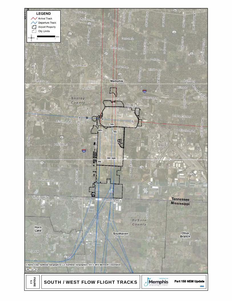
SOUTH / WEST FLOW FLIGHT TRACKS
FIGU
RE
5.3 SO
URCE: PDARS, N
ovember 1 through Decem
ber 31, 2012
374 | P a g e
ATTACHMENT 8 EJSCREEN Report
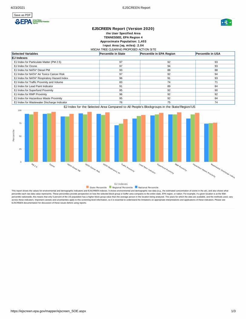
4/23/2021 EJSCREEN Report
https://ejscreen.epa.gov/mapper/ejscreen_SOE.aspx 1/3
Save as PDF
Selected Variables Percentile in State Percentile in EPA Region Percentile in USAEJ Indexes
EJ Index for Particulate Matter (PM 2.5) 97 92 93EJ Index for Ozone 97 94 93EJ Index for NATA* Diesel PM 93 88 88EJ Index for NATA* Air Toxics Cancer Risk 97 92 94EJ Index for NATA* Respiratory Hazard Index 96 91 93EJ Index for Traffic Proximity and Volume 83 74 71EJ Index for Lead Paint Indicator 91 89 84EJ Index for Superfund Proximity 95 92 90EJ Index for RMP Proximity 96 92 92EJ Index for Hazardous Waste Proximity 95 92 84EJ Index for Wastewater Discharge Indicator 76 75 74
EJ Index for the Selected Area Compared to All People's Blockgroups in the State/Region/US
EJ Indexes
PM 2.5Ozone
NATA Diesel PM
NATA Cancer Risk
NATA Respiratory HI
Traffic Proximity
Lead Paint Indicator
Superfund Proximity
RMP Proximity
Hazardous Waste Proximity
Wastewater Discharge Indicat
Perc
entil
e
0
25
50
75
100
State Percentile Regional Percentile National PercentileThis report shows the values for environmental and demographic indicators and EJSCREEN indexes. It shows environmental and demographic raw data (e.g., the estimated concentration of ozone in the air), and also shows whatpercentile each raw data value represents. These percentiles provide perspective on how the selected block group or buffer area compares to the entire state, EPA region, or nation. For example, if a given location is at the 95thpercentile nationwide, this means that only 5 percent of the US population has a higher block group value than the average person in the location being analyzed. The years for which the data are available, and the methods used, varyacross these indicators. Important caveats and uncertainties apply to this screening-level information, so it is essential to understand the limitations on appropriate interpretations and applications of these indicators. Please seeEJSCREEN documentation for discussion of these issues before using reports.
EJSCREEN Report (Version 2020)the User Specified Area
TENNESSEE, EPA Region 4 Approximate Population: 1,403
Input Area (sq. miles): 2.04 MSCAA TREE CLEARING PROPOSED ACTION SITE
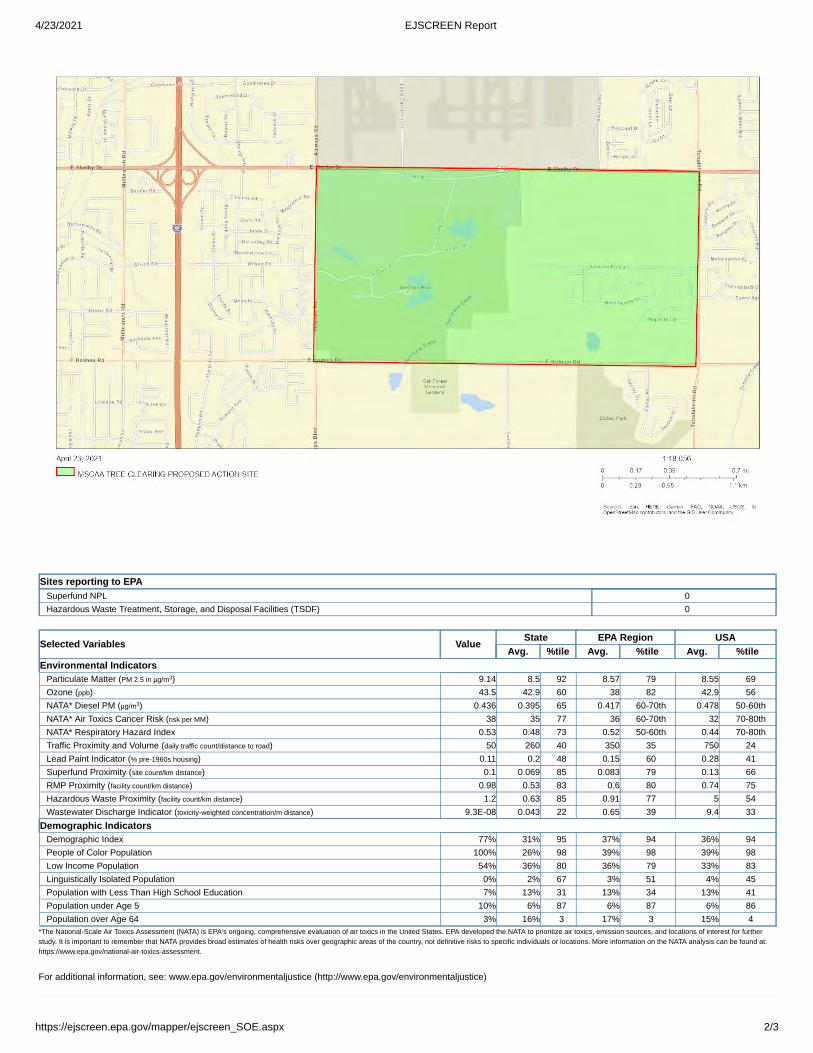
4/23/2021 EJSCREEN Report
https://ejscreen.epa.gov/mapper/ejscreen_SOE.aspx 2/3
Sites reporting to EPASuperfund NPL 0Hazardous Waste Treatment, Storage, and Disposal Facilities (TSDF) 0
Selected Variables Value State EPA Region USAAvg. %tile Avg. %tile Avg. %tile
Environmental IndicatorsParticulate Matter (PM 2.5 in µg/m ) 9.14 8.5 92 8.57 79 8.55 69Ozone (ppb) 43.5 42.9 60 38 82 42.9 56NATA* Diesel PM (µg/m ) 0.436 0.395 65 0.417 60-70th 0.478 50-60thNATA* Air Toxics Cancer Risk (risk per MM) 38 35 77 36 60-70th 32 70-80thNATA* Respiratory Hazard Index 0.53 0.48 73 0.52 50-60th 0.44 70-80thTraffic Proximity and Volume (daily traffic count/distance to road) 50 260 40 350 35 750 24Lead Paint Indicator (% pre-1960s housing) 0.11 0.2 48 0.15 60 0.28 41Superfund Proximity (site count/km distance) 0.1 0.069 85 0.083 79 0.13 66RMP Proximity (facility count/km distance) 0.98 0.53 83 0.6 80 0.74 75Hazardous Waste Proximity (facility count/km distance) 1.2 0.63 85 0.91 77 5 54Wastewater Discharge Indicator (toxicity-weighted concentration/m distance) 9.3E-08 0.043 22 0.65 39 9.4 33
Demographic IndicatorsDemographic Index 77% 31% 95 37% 94 36% 94People of Color Population 100% 26% 98 39% 98 39% 98Low Income Population 54% 36% 80 36% 79 33% 83Linguistically Isolated Population 0% 2% 67 3% 51 4% 45Population with Less Than High School Education 7% 13% 31 13% 34 13% 41Population under Age 5 10% 6% 87 6% 87 6% 86Population over Age 64 3% 16% 3 17% 3 15% 4
*The National-Scale Air Toxics Assessment (NATA) is EPA's ongoing, comprehensive evaluation of air toxics in the United States. EPA developed the NATA to prioritize air toxics, emission sources, and locations of interest for furtherstudy. It is important to remember that NATA provides broad estimates of health risks over geographic areas of the country, not definitive risks to specific individuals or locations. More information on the NATA analysis can be found at:https://www.epa.gov/national-air-toxics-assessment.
For additional information, see: www.epa.gov/environmentaljustice (http://www.epa.gov/environmentaljustice)
3
3
ACS EstimatesPercent MOE (±)
Population by Race
Population Density (per sq. mile)
EJSCREEN ACS Summary Report
Summary of ACS EstimatesPopulation
Population Reporting One Race
People of Color Population % People of Color Population
HouseholdsHousing UnitsHousing Units Built Before 1950 Per Capita IncomeLand Area (sq. miles) (Source: SF1)
% Land AreaWater Area (sq. miles) (Source: SF1)
% Water Area
Total
WhiteBlackAmerican IndianAsian
Population by Sex
Population by Age
American Indian Alone
AsianPacific IslanderSome Other Race
Population Reporting Two or More RacesTotal Hispanic PopulationTotal Non-Hispanic Population
White AloneBlack Alone
Non-Hispanic Asian AlonePacific Islander AloneOther Race AloneTwo or More Races Alone
MaleFemale
Age 0-4Age 0-17Age 18+Age 65+
Data Note: Detail may not sum to totals due to rounding. Hispanic population can be of any race. N/A means not available. Source: U.S. Census Bureau, American Community Survey (ACS) .
1/3
Location:Ring (buffer):
Description:
User-specified polygonal location0-miles radiusMSCAA TREE CLEARING PROPOSED ACTION SITE
2014 - 2018
2014 - 2018
1,403707
1,397100%
418460
014,907
1.9999%0.021%
1,403 4111,403 100% 475
6 0% 151,397 100% 412
0 0% 120 0% 120 0% 120 0% 120 0% 120 0% 12
1,4036 0% 15
1,397 100% 4120 0% 120 0%0 0%
1212
0 0% 12
100%
0 0% 12
700 50% 261703 50% 253
141 10% 137562 40% 233841 60% 244
49 3% 42
April 23, 2021
2014 - 2018
ACS EstimatesPercent MOE (±)
Population 25+ by Educational Attainment
2+3+4Speak English "less than very well"
Non-English at Home1+2+3+4
High School GraduateSome College, No DegreeAssociate Degree
Population Age 5+ Years by Ability to Speak English Total
Speak only English
1Speak English "very well"2Speak English "well"3Speak English "not well"4Speak English "not at all"
3+4Speak English "less than well"
Bachelor's Degree or more
TotalLess than 9th Grade9th - 12th Grade, No Diploma
Occupied Housing Units by Tenure
$50,000 - $75,000$75,000 +
TotalOwner Occupied
Households by Household IncomeHousehold Income Base
< $15,000$15,000 - $25,000$25,000 - $50,000
EJSCREEN ACS Summary Report
2/3
Linguistically Isolated Households* Total
Speak SpanishSpeak Other Indo-European LanguagesSpeak Asian-Pacific Island LanguagesSpeak Other Languages
Location:Ring (buffer):
Description:
In Labor Force Civilian Unemployed in Labor Force Not In Labor Force
Renter OccupiedEmployed Population Age 16+ Years Total
Data Note: Datail may not sum to totals due to rounding. Hispanic population can be of any race.
N/A means not available. Source: U.S. Census Bureau, American Community Survey (ACS) *Households in which no one 14 and over speaks English "very well" or speaks English only.
User-specified polygonal location0-miles radiusMSCAA TREE CLEARING PROPOSED ACTION SITE
2014 - 2018
April 23, 2021
757 100% 2306 1% 18
49 6% 53320 42% 144299 39% 180
43 6% 4284 11% 64
1,262 100% 3411,262 100% 367
0 0% 120 0% 120 0% 120 0% 120 0% 120 0% 120 0% 12
0 0% 120 0% 120 0% 120 0% 120 0% 12
418 100% 10879 19% 7839 9% 64
192 46% 10636 9% 3271 17% 63
418 100% 108271 65% 105147 35% 96
898 100% 261666 74% 24584 9% 86
232 26% 101
ACS EstimatesPercent MOE (±)
EnglishSpanishFrenchFrench CreoleItalianPortugueseGermanYiddishOther West GermanicScandinavianGreekRussianPolishSerbo-CroatianOther SlavicArmenianPersianGujarathiHindiUrduOther IndicOther Indo-EuropeanChineseJapaneseKoreanMon-Khmer, Cambodian HmongThaiLaotianVietnameseOther AsianTagalogOther Pacific IslandNavajoOther Native AmericanHungarianArabicHebrewAfricanOther and non-specifiedTotal Non-English
.Data Note: Detail may not sum to totals due to rounding. Hispanic popultion can be of any race. N/A means not available. Source: U.S. Census Bureau, American Community Survey (ACS)*Population by Language Spoken at Home is available at the census tract summary level and up.
Population by Language Spoken at Home* Total (persons age 5 and above)
EJSCREEN ACS Summary Report
3/3
Location:Ring (buffer):
Description:
User-specified polygonal location0-miles radiusMSCAA TREE CLEARING PROPOSED ACTION SITE
2014 - 2018
April 23, 2021
2014 - 2018
1,718 100% 4901,698 99% 497
20 1% 630 0% 17
N/A N/A N/AN/A N/A N/AN/A N/A N/A
0 0% 17N/A N/A N/AN/A N/A N/AN/A N/A N/AN/A N/A N/AN/A N/A N/AN/A N/A N/AN/A N/A N/AN/A N/A N/AN/A N/A N/AN/A N/A N/AN/A N/A N/AN/A N/A N/AN/A N/A N/AN/A N/A N/A
1717
N/A17
N/AN/AN/AN/A17
0 0%
17
0 0%
17
N/A N/A
N/A
0 0%
N/A
N/A N/A
N/A
N/A N/A
N/A
N/A N/A
17
N/A N/A
N/A
0 0%
N/A
0 0%
17
0 0%
698
N/A N/AN/A N/AN/A N/AN/A N/A
0 0%N/A N/AN/A N/A
0 0%20 1%
Population by Race Number Percent
Population by Sex Number Percent
Population by Age Number Percent
Households by Tenure Number Percent
Owner Occupied
Renter Occupied
Data Note: Detail may not sum to totals due to rounding. Hispanic population can be of any race. Source: U.S. Census Bureau, Census 2010 Summary File 1.
Total
Population Reporting Two or More Races
Pacific Islander
Other Race Alone
Male
Female
Two or More Races Alone
Non-Hispanic Asian Alone
Age 18+
Age 65+
Age 0-17
Age 0-4
Population Density (per sq. mile)
People of Color Population
% People of Color Population
Summary
Population
Some Other Race
White
Black
Pacific Islander Alone
White Alone
Black Alone
American Indian Alone
Total Hispanic Population
Total Non-Hispanic Population
American Indian
Asian
Census 2010
EJSCREEN Census 2010 Summary Report
Population Reporting One Race
Total
Households Housing Units Land Area (sq. miles)
% Land Area Water Area (sq. miles)
% Water Area
Location:Ring (buffer):
Description:
1/1
User-specified polygonal location0-miles radiusMSCAA TREE CLEARING PROPOSED ACTION SITE
1,240624
1,20397%400427
1.9999%0.021%
1,2401,228 99%
39 3%1,183 95%
1 0%1 0%0 0%5 0%
12 1%13 1%
1,227 99%37 3%
1,177 95%1 0%1 0%0 0%1 0%
11 1%
563 45%677 55%
82 7%350 28%890 72%66 5%
400296 74%104 26%
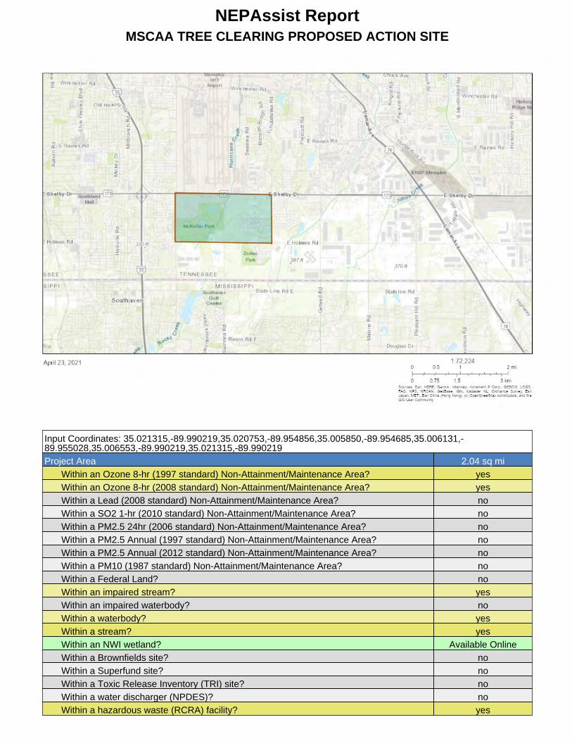
NEPAssist ReportMSCAA TREE CLEARING PROPOSED ACTION SITE
Input Coordinates: 35.021315,-89.990219,35.020753,-89.954856,35.005850,-89.954685,35.006131,-89.955028,35.006553,-89.990219,35.021315,-89.990219Project Area 2.04 sq mi
Within an Ozone 8-hr (1997 standard) Non-Attainment/Maintenance Area? yesWithin an Ozone 8-hr (2008 standard) Non-Attainment/Maintenance Area? yesWithin a Lead (2008 standard) Non-Attainment/Maintenance Area? noWithin a SO2 1-hr (2010 standard) Non-Attainment/Maintenance Area? noWithin a PM2.5 24hr (2006 standard) Non-Attainment/Maintenance Area? noWithin a PM2.5 Annual (1997 standard) Non-Attainment/Maintenance Area? noWithin a PM2.5 Annual (2012 standard) Non-Attainment/Maintenance Area? noWithin a PM10 (1987 standard) Non-Attainment/Maintenance Area? noWithin a Federal Land? noWithin an impaired stream? yesWithin an impaired waterbody? noWithin a waterbody? yesWithin a stream? yesWithin an NWI wetland? Available OnlineWithin a Brownfields site? noWithin a Superfund site? noWithin a Toxic Release Inventory (TRI) site? noWithin a water discharger (NPDES)? noWithin a hazardous waste (RCRA) facility? yes

Within an air emission facility? noWithin a school? noWithin an airport? noWithin a hospital? noWithin a designated sole source aquifer? noWithin a historic property on the National Register of Historic Places? noWithin a Toxic Substances Control Act (TSCA) site? noWithin a Land Cession Boundary? yesWithin a tribal area (lower 48 states)? noWithin the service area of a mitigation or conservation bank? yesWithin the service area of an In-Lieu-Fee Program? yes
Created on: 4/23/2021 6:23:55 AM

383 | P a g e
ATTACHMENT 9 Water Resources Information

AGENCY COORDINATION
RESPONSE DOCUMENTATION
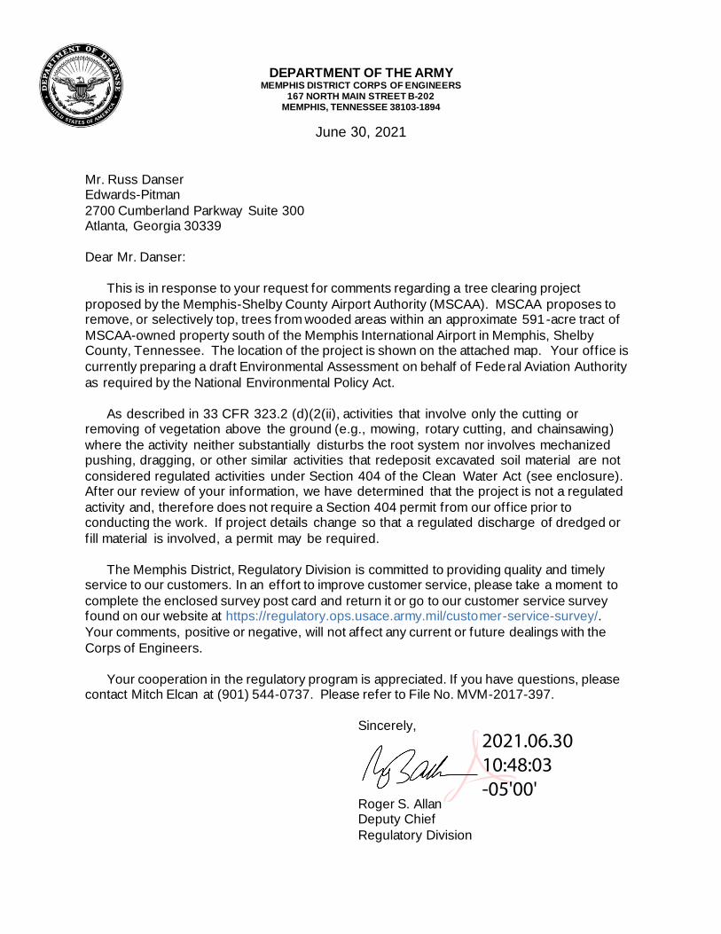
DEPARTMENT OF THE ARMY MEMPHIS DISTRICT CORPS OF ENGINEERS
167 NORTH MAIN STREET B-202MEMPHIS, TENNESSEE 38103-1894
June 30, 2021
Mr. Russ DanserEdwards-Pitman2700 Cumberland Parkway Suite 300Atlanta, Georgia 30339
Dear Mr. Danser:
This is in response to your request for comments regarding a tree clearing project proposed by the Memphis-Shelby County Airport Authority (MSCAA). MSCAA proposes to remove, or selectively top, trees from wooded areas within an approximate 591-acre tract of MSCAA-owned property south of the Memphis International Airport in Memphis, Shelby County, Tennessee. The location of the project is shown on the attached map. Your office is currently preparing a draft Environmental Assessment on behalf of Federal Aviation Authority as required by the National Environmental Policy Act.
As described in 33 CFR 323.2 (d)(2(ii), activities that involve only the cutting or removing of vegetation above the ground (e.g., mowing, rotary cutting, and chainsawing)where the activity neither substantially disturbs the root system nor involves mechanized pushing, dragging, or other similar activities that redeposit excavated soil material are not considered regulated activities under Section 404 of the Clean Water Act (see enclosure).After our review of your information, we have determined that the project is not a regulated activity and, therefore does not require a Section 404 permit from our office prior to conducting the work. If project details change so that a regulated discharge of dredged or fill material is involved, a permit may be required.
The Memphis District, Regulatory Division is committed to providing quality and timely service to our customers. In an effort to improve customer service, please take a moment to complete the enclosed survey post card and return it or go to our customer service survey found on our website at https://regulatory.ops.usace.army.mil/customer-service-survey/.Your comments, positive or negative, will not affect any current or future dealings with the Corps of Engineers.
Your cooperation in the regulatory program is appreciated. If you have questions, please contact Mitch Elcan at (901) 544-0737. Please refer to File No. MVM-2017-397.
Sincerely,
Roger S. AllanDeputy ChiefRegulatory Division
2021.06.30 10:48:03 -05'00'
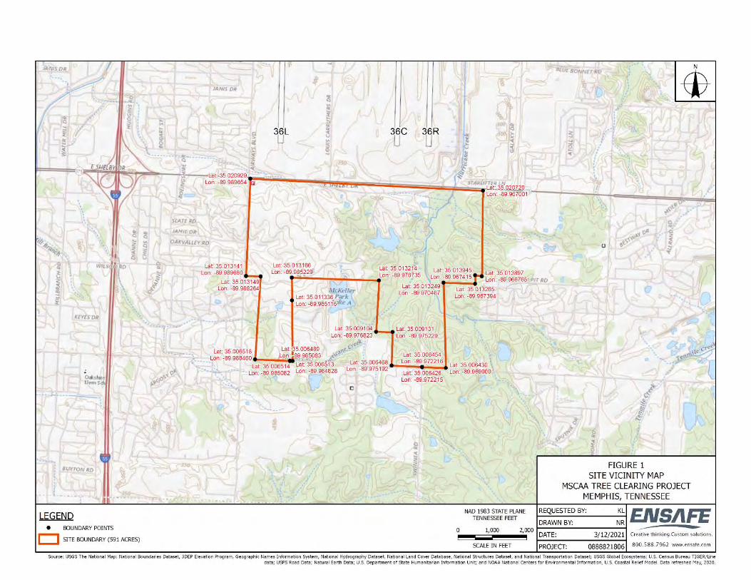
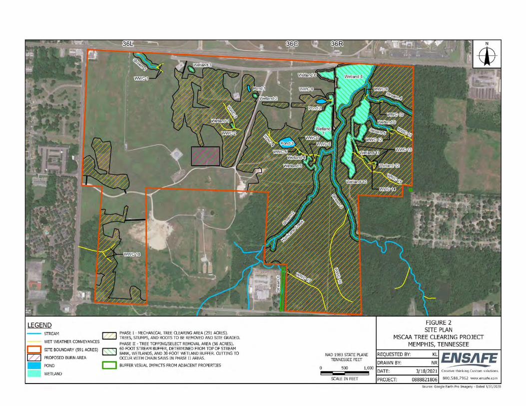

PART 323--PERMITS FOR DISCHARGES OF DREDGED OR FILL MATERIAL INTO WATERS OF THE UNITED STATES AUTHORITY: 33 U.S.C. 1344. SOURCE: 51 FR 41232, Nov. 13, 1986, unless otherwise noted. Sec. 323.1 General. This regulation prescribes, in addition to the general policies of 33 CFR part 320 and procedures of 33 CFR part 325, those special policies, practices, and procedures to be followed by the Corps of Engineers in connection with the review of applications for DA permits to authorize the discharge of dredged or fill material into waters of the United States pursuant to section 404 of the Clean Water Act (CWA) (33 U.S.C. 1344) (hereinafter referred to as section 404). (See 33 CFR320.2(g).) Certain discharges of dredged or fill material into waters of the United States are also regulated under other authorities of the Department of the Army. These include dams and dikes in navigable waters of the United States pursuant to section 9 of the Rivers and Harbors Act of 1899 (33 U.S.C. 401; see 33 CFR part 321) and certain structures or work in or affecting navigable waters of the United States pursuant to section 10 of the Rivers and Harbors Act of 1899 (33 U.S.C. 403; see 33 CFR part 322). A DA permit will also be required under these additional authorities if they are applicable to activities involving discharges of dredged or fill material into waters of the United States. Applicants for DA permits under this part should refer to the other cited authorities and implementing regulations for these additional permit requirements to determine whether they also are applicable to their proposed activities. Sec. 323.2 Definitions. For the purpose of this part, the following terms are defined: (a) The term waters of the United States and all other terms relating to the geographic scope of jurisdiction are defined at 33 CFR part 328. (b) The term lake means a standing body of open water that occurs in a natural depression fed by one or more streams from which a stream may flow, that occurs due to the widening or natural blockage or cutoff of a river or stream, or that occurs in an isolated natural depression that is not a part of a surface river or stream. The term also includes a standing body of open water created by artificially blocking or restricting the flow of a river, stream, or tidal area. As used in this regulation, the term does not include artificial lakes or ponds created by excavating and/or diking dry land to collect and retain water for such purposes as stock watering, irrigation, settling basins, cooling, or rice growing. (c) The term dredged material means material that is excavated or dredged from waters of the United States. (d)(1) Except as provided below in paragraph (d)(3), the term discharge of dredged material means any addition of dredged material into, including redeposit of dredged material other than incidental fallback within, the waters of the United States. The term includes, but is not limited to, the following: (i) The addition of dredged material to a specified discharge site located in waters of the United States; (ii) The runoff or overflow from a contained land or water disposal area; and (iii) Any addition, including redeposit other than incidental fallback, of dredged material, including excavated material, into waters of the United States which is incidental to any activity, including mechanized landclearing, ditching, channelization, or other excavation. (2)(i) The Corps and EPA regard the use of mechanized earth-moving equipment to conduct landclearing, ditching, channelization, in-stream mining or other earth-moving activity in waters of the United States as resulting in a discharge of dredged material unless project-specific evidence shows that the activity results in only incidental fallback. This paragraph (i) does not and is not intended to shift any burden in any administrative or judicial proceeding under the CWA. (ii) Incidental fallback is the redeposit of small volumes of dredged material that is incidental to excavation activity in waters of the United States when such material falls back to substantially the same place as the initial removal. Examples of incidental fallback include soil that is disturbed when dirt is shoveled and the back-spill that comes off a bucket when such small volume of soil or dirt falls into substantially the same place from which it was initially removed. (3) The term discharge of dredged material does not include the following: (i) Discharges of pollutants into waters of the United States resulting from the onshore subsequent processing of dredged material that is extracted for any commercial use (other than fill). These
discharges are subject to section 402 of the Clean Water Act even though the extraction and deposit of such material may require a permit from the Corps or applicable State section 404 program. (ii) Activities that involve only the cutting or removing of vegetation above the ground (e.g., mowing, rotary cutting, and chainsawing) where the activity neither substantially disturbs the root system nor involves mechanized pushing, dragging, or other similar activities that redeposit excavated soil material. (iii) Incidental fallback. (4) Section 404 authorization is not required for the following: (i) Any incidental addition, including redeposit, of dredged material associated with any activity that does not have or would not have the effect of destroying or degrading an area of waters of the United States as defined in paragraphs (d)(5) and (d)(6) of this section; however, this exception does not apply to any person preparing to undertake mechanized landclearing, ditching, channelization and other excavation activity in a water of the United States, which would result in a redeposit of dredged material, unless the person demonstrates to the satisfaction of the Corps, or EPA as appropriate, prior to commencing the activity involving the discharge, that the activity would not have the effect of destroying or degrading any area of waters of the United States, as defined in paragraphs (d)(5) and (d)(6) of this section. The person proposing to undertake mechanized landclearing, ditching, channelization or other excavation activity bears the burden of demonstrating that such activity would not destroy or degrade any area of waters of the United States. (ii) Incidental movement of dredged material occurring during normal dredging operations, defined as dredging for navigation in navigable waters of the United States, as that term is defined in part 329 of this chapter, with proper authorization from the Congress and/or the Corps pursuant to part 322 of this Chapter; however, this exception is not applicable to dredging activities in wetlands, as that term is defined at section 328.3 of this Chapter. (iii) Certain discharges, such as those associated with normal farming, silviculture, and ranching activities, are not prohibited by or otherwise subject to regulation under section 404. See 33 CFR 323.4 for discharges that do not require permits. (5) For purposes of this section, an activity associated with a discharge of dredged material destroys an area of waters of the United States if it alters the area in such a way that it would no longer be a water of the United States. Note: Unauthorized discharges into waters of the United States do not eliminate Clean Water Act jurisdiction, even where such unauthorized discharges have the effect of destroying waters of the United States. (6) For purposes of this section, an activity associated with a discharge of dredged material degrades an area of waters of the United States if it has more than a de minimis (i.e., inconsequential) effect on the area by causing an identifiable individual or cumulative adverse effect on any aquatic function. (e)(1) Except as specified in paragraph (e)(3) of this section, the term fill material means material placed in waters of the United States where the material has the effect of: (i) Replacing any portion of a water of the United States with dry land; or (ii) Changing the bottom elevation of any portion of a water of the United States. (2) Examples of such fill material include, but are not limited to: rock, sand, soil, clay, plastics, construction debris, wood chips, overburden from mining or other excavation activities, and materials used to create any structure or infrastructure in the waters of the United States. (3) The term fill material does not include trash or garbage. (f) The term discharge of fill material means the addition of fill material into waters of the United States. The term generally includes, without limitation, the following activities: Placement of fill that is necessary for the construction of any structure or infrastructure in a water of the United States; the building of any structure, infrastructure, or impoundment requiring rock, sand, dirt, or other material for its construction; site-development fills for recreational, industrial, commercial, residential, or other uses; causeways or road fills; dams and dikes; artificial islands; property protection and/or reclamation devices such as riprap, groins, seawalls, breakwaters, and revetments; beach nourishment; levees; fill for structures such as sewage treatment facilities, intake and outfall pipes associated with power plants and subaqueous utility lines; placement of fill material for construction or maintenance of any liner, berm, or other infrastructure associated with solid waste landfills; placement of overburden, slurry, or tailings or similar mining-related materials; and artificial reefs. The term does not include plowing, cultivating, seeding and harvesting for the production of food, fiber, and forest products (See Sec. 323.4 for the definition of these terms). See Sec. 323.3(c) concerning the regulation of the placement of pilings in waters of the United States. (g) The term individual permit means a Department of the Army authorization that is issued following a case-by-case evaluation of a specific project involving the proposed discharge(s) in accordance with

the procedures of this part and 33 CFR part 325 and a determination that the proposed discharge is in the public interest pursuant to 33 CFR part 320. (h) The term general permit means a Department of the Army authorization that is issued on a nationwide or regional basis for a category or categories of activities when: (1) Those activities are substantially similar in nature and cause only minimal individual and cumulative environmental impacts; or (2) The general permit would result in avoiding unnecessary duplication of regulatory control exercised by another Federal, State, or local agency provided it has been determined that the environmental consequences of the action are individually and cumulatively minimal. (See 33 CFR 325.2(e) and 33 CFR part 330.) [51 FR 41232, Nov. 13, 1986, as amended at 58 FR 45035, Aug. 25, 1993; 58 FR 48424, Sept. 15, 1993; 63 FR 25123, May 10, 1999]

From: Joellyn BrazileTo: Russ DanserCc: Kristin Lehman; Lori Morris; Heather N. SmithSubject: RE: Agency Coordination Request | Memphis-Shelby County Airport Authority (MSCAA) | Proposed Tree ClearingDate: Monday, March 29, 2021 5:36:34 PMAttachments: image003.png
Russ,We’ve reviewed the proposal again as requested and determined that DWR’s stance remainsunchanged from the prior conversations we’ve had about this project. As you have mentioned,buffer areas should be retained along streams and wetlands and trees to be cut within these zonesshould be topped so that the roots can be left intact and in place. Although as proposed, an ARAP may not be needed, I would remind you that coverage under theConstruction General Permit is likely needed since 1 acre of land disturbance will occur. I believe wealso discussed previously the option of an Individual Construction Permit if necessary. Please let me know if you have any further questions or we need to discuss specifics regarding theconstruction permits. Thanks.-Joellyn Joellyn BrazileEnvironmental Program ManagerDivision of Water ResourcesMemphis Environmental Field Office8383 Wolf Lake DriveBartlett, TN 38133901-237-6000-cell
Complete our TDEC Customer Service Survey! Go to: http://tn.gov/environment/article/contact-tdec-
From: Russ Danser <[email protected]> Sent: Thursday, March 25, 2021 12:21 PMTo: Joellyn Brazile <[email protected]>Cc: Kristin Lehman <[email protected]>; Lori Morris <[email protected]>Subject: [EXTERNAL] Agency Coordination Request | Memphis-Shelby County Airport Authority(MSCAA) | Proposed Tree Clearing
*** This is an EXTERNAL email. Please exercise caution. DO NOT open attachments or click links

from unknown senders or unexpected email - STS-Security. ***
Hello.
The Memphis-Shelby County Airport Authority (MSCAA) proposes to remove and cuttrees from upland and aquatic wooded areas within portions of an approximately 591-acre tract of MSCAA-owned property located south of Memphis International Airport(MEM) in Memphis, Shelby County. The activities on the site will comply with therequirements set forth in the provisions of the National Environmental Policy Act. Aspart of this effort, we are providing project-specific information to agencies in hope ofgathering input and feedback associated with resources for which you havejurisdiction.
Attached please find a coordination letter with support documentation. We ask thatyou review the material and provide any requested feedback. If you have anyquestions regarding the materials provided, do not hesitate to contact me. If you wishto discuss the project further with the project team, we welcome the opportunity toschedule a conference call or Microsoft Teams meeting to discuss theinformation/request further.
Thank you for giving this information and request your attention.
Russ Danser, AICP | Sr. Environmental Project ManagerEdwards-PitmanCertified Woman-Owned Small Business (DBE, FBE, SBE, SBA, WBENC, WOSB)2700 Cumberland Parkway Suite 300 | Atlanta, GA 30339direct: 678.932.2237 | main: 770.333.9484 | [email protected] | South Carolina | Florida

From: Richard RogersTo: Russ DanserCc: Kristin Lehman; Josh EarhartSubject: RE: Agency Coordination Request | Memphis-Shelby County Airport Authority (MSCAA) | Proposed Tree ClearingDate: Monday, April 12, 2021 6:03:03 PM
Mr. Danser, Here’s the information that I can share:
We have 2 (possibly 3) wells that map to the property.State Well ID: 15709087; Owner = MEM PARK COM SH:K-87 (Mapped within yourproject boundary)State Well ID: 15700213; Owner = MEMPHIS PARK COMM (Mapped within your projectboundary)State Well ID: 15709079; Owner = MEM PARK COM SH:K-79 (Mapped just south of siteboundary in the road)
Our database has no indication that any of these wells have been properly closed.
After a quick Google search, It is my belief that “MEM PARK COM” or “MEM PARK COMM” stands forMemphis Park Commission. This bit of information (if true) provides further evidence that thesewells are likely associated with the former park located within your project area. If there was aPhase I completed for the property, the investigator will likely have determined what that southeastportion of the property was used for, historically. There could be some information there if thereport is obtainable. You probably read the Water Well Disclaimer language when you opened the water wellapplication. I’ve copied it below for your reference. In general, what it’s saying is that the locationalaccuracy of the datapoint may not be reliable. Given the lack of information that we have in ourdatabase regarding these wells, I cannot ascertain the degree of locational accuracy; however, Ibelieve that these well records is question are likely associated with the historic park that’s withinyour project boundary.I advise that you reach out to MLGW and give them the information that I’ve given you above. Letthem know that the State has these wells mapped within your project property boundary. If theyhave any questions regarding the request, please, feel free to have them call or e-mail me. If you areunable to get in touch with them, please let me know. Contact information for MLGW can be found at:http://environment-online.state.tn.us:8080/DWW/ (I copied the table below from this site)The PWS_ID is TN0000450
Name Job Title Type Phone Address Email
NEWMAN,NICHOLAS
V P, ENG &OPER AC 901-528-
4136
P.O. BOX 430MEMPHIS, TN
Water Well Disclaimer:These data should not be used as an endpoint for decision making purposes in instances such as spill

response or the locating of a well in proximity to other features (e.g., property lines, septic systems,buildings etc.). All well locations should be field verified by the user before decisions are made. Please note, there may be records in the State’s water well database that do not contain reliablelocational information, specifically with respect to the reported latitude and longitude. The databaseincludes entries reported as far back as the 1920s and the accuracy of locational information dependson the type of instruments (e.g., topographic map, address, GPS, etc.) used to record/report thelocation as well as the diligence of the reporting entity. It is suggested that you review the data usingthe provided coordinates, the location/address, and the well owner’s name. Also, municipal well locations and wellhead protection areas are considered confidential under TCA10-7-504 (a) (21) (A) and Rule 0400-01-01-.01(4)(c), so the location of those data have been redactedfrom the records provided. In cases where the requestor has asked for an evaluation of thesefeatures in the area of interest, we will provide information pertaining to the presence or absence ofthese features on the area of interests. If these features are present, the name of the Public WaterSupply (PWS) will be provided so that the user can contact the public water supply for additionalinformation. Please do not hesitate to contact me with any questions. I am happy to help where I can.Richard W. Rogers V., P.G.
Geologist / Environmental ConsultantDrinking Water Unit | Division of Water Resources
Tennessee Tower, 11th Floor312 Rosa L. Parks Ave.Nashville, TN 37243p. (615) [email protected] Water Well Info and Data Access:TDEC Water Well Web PageReport-A-Well FormWater Well Web ApplicationWater Well Web Application (Mobile)Water Well Web Application User ManualList of Licensed Drillers/Installers **NEW** Tell us how we’re doing! Please take 5-10 minutes to complete TDEC’s Customer ServiceSurvey.
From: Russ Danser <[email protected]> Sent: Monday, April 12, 2021 2:01 PM

To: Richard Rogers <[email protected]>Cc: Kristin Lehman <[email protected]>; Josh Earhart <[email protected]>Subject: [EXTERNAL] Agency Coordination Request | Memphis-Shelby County Airport Authority(MSCAA) | Proposed Tree Clearing
*** This is an EXTERNAL email. Please exercise caution. DO NOT open attachments or click linksfrom unknown senders or unexpected email - STS-Security. ***
Hello.
The Memphis-Shelby County Airport Authority (MSCAA) proposes to remove and cuttrees from upland and aquatic wooded areas within portions of an approximately 591-acre tract of MSCAA-owned property located south of Memphis International Airport(MEM) in Memphis, Shelby County. The activities on the site will comply with therequirements set forth in the provisions of the National Environmental Policy Act. Aspart of this effort, we are providing project-specific information to agencies in hope ofgathering input and feedback associated with resources for which you havejurisdiction.
Attached please find a coordination letter with support documentation. We ask thatyou review the material and provide any requested feedback. If you have anyquestions regarding the materials provided, do not hesitate to contact me. If you wishto discuss the project further with the project team, we welcome the opportunity toschedule a conference call or Microsoft Teams meeting to discuss theinformation/request further.
Thank you for giving this information and request your attention.
Russ Danser, AICP | Sr. Environmental Project ManagerEdwards-PitmanCertified Woman-Owned Small Business (DBE, FBE, SBE, SBA, WBENC, WOSB)2700 Cumberland Parkway Suite 300 | Atlanta, GA 30339direct: 678.932.2237 | main: 770.333.9484 | [email protected] | South Carolina | Florida

From: Lori MorrisTo: Russ Danser; Kristin LehmanSubject: FW: MSCAA Proposed Tree Clearing - possible wells?Date: Thursday, April 22, 2021 12:55:42 PMAttachments: pastedImagebase640.png
image.pngOutlook-dti5hgix.pngOutlook-ezamso4t.pngOutlook-dhimydri.png
(See below) This is what I learned from my friend at the Groundwater Institute. I’m going to call the Health Dept. this afternoon and see if they are any help. Thanks Lori MorrisManager of Environmental Service2491 Winchester Road, Suite 113Memphis, TN 38116 -3856P: 901-922-8754flymemphis.com
From: S Schoefernacker (sschfrnc) <[email protected]> Sent: Thursday, April 22, 2021 11:43 AMTo: Lori Morris <[email protected]>Subject: Re: MSCAA Proposed Tree Clearing - possible wells? CAUTION: Sender is from outside MSCAA. Take caution before opening links/attachments or replying with sensitive data. If suspicious, forward to [email protected]
From TDECs database:
Here's SH:K-157 from 2005. Location, id, lat/long, elevation circled in red. This is the one that we were looking for in 2015 and assume to be destroyed. The ID 8T3 shows it to be an MLGW obs well in terrace deposits (shallow aquifer).
USGS NWIS has SH:K-079 which was sampled in 2015. It's a Memphis aq well. SH:K-87 is "located" adjoining to the east of K-79. Another Memphis well sampled once in 1982. You can email Spencer Smith ([email protected]) to see if they still take WLs from that locationand/or if they know where they are. They should have some records filed away.

Hope this helps. Let me know if you have any questions. Scott
From: Lori Morris <[email protected]>Sent: Thursday, April 22, 2021 11:06 AMTo: S Schoefernacker (sschfrnc) <[email protected]>Subject: MSCAA Proposed Tree Clearing - possible wells?
CAUTION: This email originated from outside of the organization. Do not click links or open attachments unless you recognize the sender and trust the content is safe.
Thanks for your help!!!! :
State Well ID: 15709087; Owner = MEM PARK COM SH:K-87 (Mapped within your project boundary)State Well ID: 15700213; Owner = MEMPHIS PARK COMM (Mapped within your project boundary)State Well ID: 15709079; Owner = MEM PARK COM SH:K-79 (Mapped just south of site boundary in the road)
Lori MorrisManager of Environmental Service2491 Winchester Road, Suite 113Memphis, TN 38116 -3856P: 901-922-8754flymemphis.com
Disclaimer For Memphis-Shelby County Airport Authority The information contained in this electronic mail transmission (including any accompanying attachments) is intended solely for the authorized recipient(s). The information is or may beprivileged, confidential and/or exempt from disclosure under applicable law. If you are not an intended recipient, you have received this transmission in error and are hereby notified that you are strictly prohibited from reading, copying,printing, distributing or disclosing any of the information contained in it. If you have received this transmission in error, please immediately contact the person named above by reply e-mail and delete the original and all copies of thistransmission (including any attachments) without reading or saving it in any manner. Thank you for your cooperation.Disclaimer For Memphis-Shelby County Airport Authority The information contained in this electronic mail transmission (including any accompanying attachments) is intended solely for the authorized recipient(s). Theinformation is or may be privileged, confidential and/or exempt from disclosure under applicable law. If you are not an intended recipient, you have received this transmission in error and are hereby notified that you are strictlyprohibited from reading, copying, printing, distributing or disclosing any of the information contained in it. If you have received this transmission in error, please immediately contact the person named above by reply e-mail anddelete the original and all copies of this transmission (including any attachments) without reading or saving it in any manner. Thank you for your cooperation.

FEMA FLOODPLAIN
MAPPING

PREVIOUS COORDINATION
DOCUMENTATION
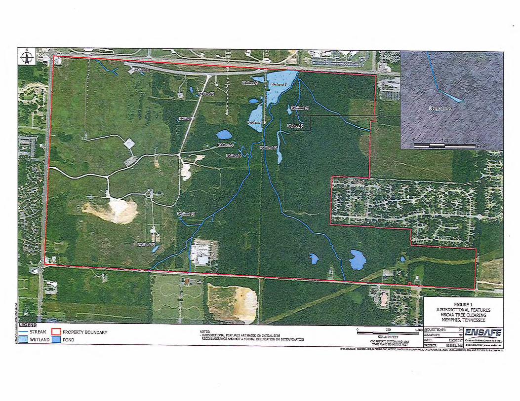
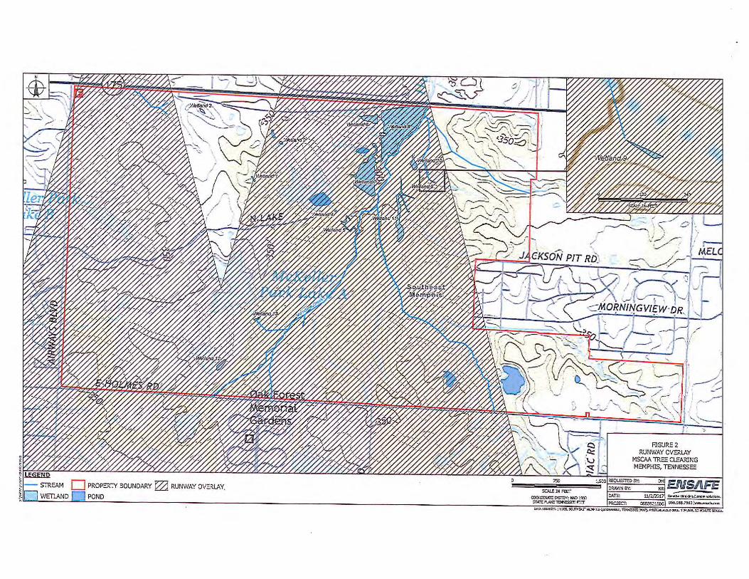
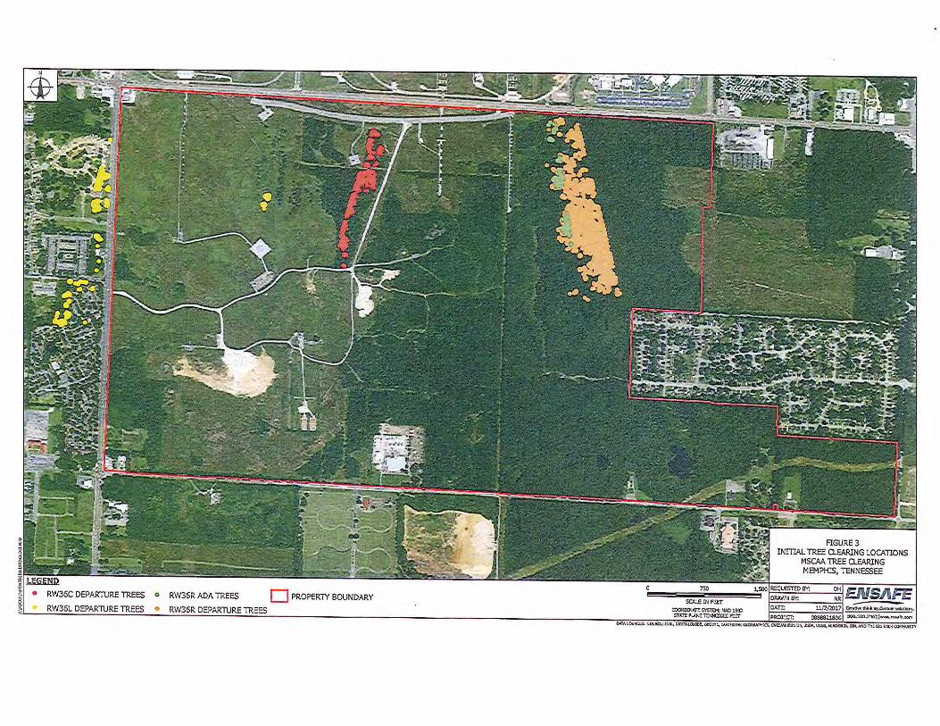
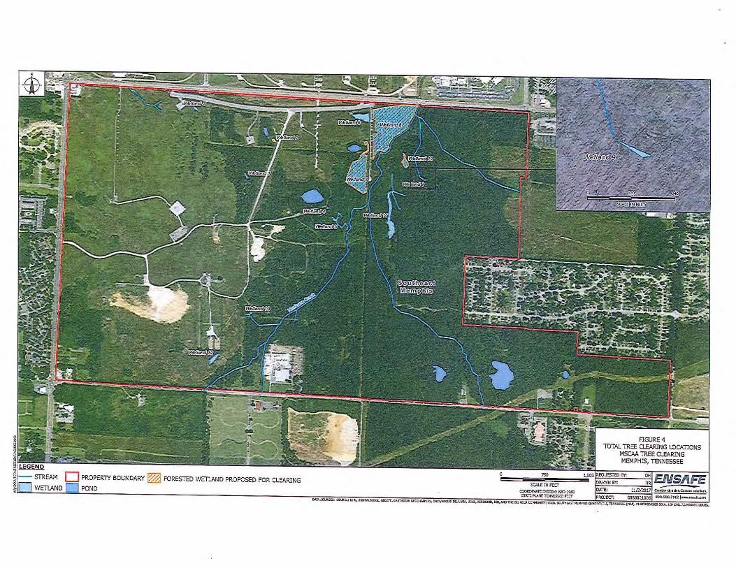
1
David Hilgeman
From: Heather Meadors <[email protected]>Sent: Tuesday, November 28, 2017 1:09 PMTo: David HilgemanSubject: RE: Tree Clearing Inside a Wetland
Hi David, Thank you for your submittal. I do concur that tree clearing by cutting the trees above the base and leaving them in place, as proposed, will not require a permit from TDEC. This email will suffice as a “letter of concurrence” for your records. Please be reminded that if during the process of the work it is determined that portions of the wetland will need to be filled or if vegetation will need to be removed by the roots, an ARAP would need to be obtained before that work could begin. If I can be of assistance in the future, please feel free to contact me. Sincerely, Heather Meadors
Heather Meadors | Environmental Scientist Division of Water Resources Memphis Environmental Field Office 8383 Wolf Lake Drive Bartlett, TN 38133 p. 901-371-3031 f. 901-371-3170
Tell us how we’re doing! Please take 5-10 minutes to complete TDEC’s Customer Service Survey
2
From: David Hilgeman [mailto:[email protected]] Sent: Tuesday, November 14, 2017 8:30 AM To: Heather Meadors Subject: RE: Tree Clearing Inside a Wetland Hi Heather‐ We are submitting a letter request for a no‐permit‐required concurrence. See attached. In addition to the attached, the proposed clearing details are described below. The methodology for tree clearing was designed around our understanding of the regulations and a preliminary conversation with Tennessee Department of Environment and Conservation personnel. The intent is to keep the tree clearing scope under a no‐permit‐required activity. Construction timeline will be spread across several years dependent upon funding availability. All trees in the runway overlay are proposed for clearing, but Figure 3 is included to show areas of immediate concern. Figure 4 identifies all of the forested wetlands (13.42 acres) on the property. Those wetlands not marked as forested are dominated by emergent vegetation. Tree clearing in the forested wetlands will be conducted by cutting the base of the trees and allowing the tree to fall in place. Trees within the wetlands will not be harvested but rather left in place. No roots/stumps will be disturbed. Tree clearing is proposed for warmer months when site hydrology is minimized compared to winter and early spring months. Wetland 8 has sections of freshwater marsh that may be permanently inundated. If inundated areas cannot be avoided when accessing forested wetlands with motorized equipment, trees will be cut by hand with chainsaws. During the logger contracting and bid process, logging areas that need to be cut by hand will be identified and flagged in the field and communicated to potential logging subcontractors. No filling or matting will be placed in jurisdictional waters to allow for access. After review, please let us know of any questions or concerns. We appreciate your help with this project. Thanks. David
From: Heather Meadors [mailto:[email protected]] Sent: Friday, October 20, 2017 8:24 AM To: David Hilgeman <[email protected]> Subject: RE: Tree Clearing Inside a Wetland Hi David, The Division would not require engineer drawings in this scenario. It would be beneficial for the client to submit a narrative of the scope of the activity (cutting trees above the base, leaving roots in place, etc.) along with a boundary map showing what areas of the wetlands the activity will occur. I think recon‐level
3
would be sufficient since the proposed activity would not require an ARAP. We would not have to conduct a site visit. You could just send this information in an email and we would reply in email in lieu of a “no‐permit‐required” type letter. Please let me know if I can answer any further questions or need to clarify any of the information above. Be reminded, that while cutting trees/vegetation above the base in a wetland is allowable without ARAP coverage, certain other activities may need coverage. For example, if it is necessary to clear/fill a portion of the wetland to establish an access road or work area, a permit would be required. But if they can do the work by hand and chainsaw or by laying temporary pads down to establish a work area, this is generally considered de minimus and allowable without a permit. Thanks for contacting me! Heather Meadors
Heather Meadors | Environmental Scientist Division of Water Resources Memphis Environmental Field Office 8383 Wolf Lake Drive Bartlett, TN 38133 p. 901-371-3031 f. 901-371-3170
Tell us how we’re doing! Please take 5-10 minutes to complete TDEC’s Customer Service Survey From: David Hilgeman [mailto:[email protected]]Sent: Thursday, October 19, 2017 3:41 PM To: Heather Meadors Subject: Tree Clearing Inside a Wetland
*** This is an EXTERNAL email. Please exercise caution. DO NOT open attachments or click links from unknown senders or unexpected email - STS-Security. ***
Hi Heather‐ I’m following up about a phone call I made to you in early August about tree clearing within a wetland. I'm trying to determine the scope for requesting a no‐permit‐required letter so I can relay to the client estimated costs. Several questions:

4
Will you require a site visit? Will a transmittal letter, reconnaissance‐level wetland boundary figures, and verbiage describing the cutting be suffice? Do you need an engineering drawing of the actual cutting (above‐ground, leave the cut tree in place)? Thanks. David HilgemanEnvironmental Scientist (901) 568 9823 cell(901) 372 7962 main 5724 Summer Trees Drive(901) 937 4355 direct Memphis, TN 38134
creative thinking | custom solutions

Related Documents