Draft EIA Report for Proposed Onshore Oil and Gas Exploration and Appraisal in AA-ONHP-2017/1 Block, Karbi Anglong and Golaghat Districts of Assam & Wokha district of Nagaland District, Vedanta Limited. (Division Cairn Oil & Gas) September 2019

Welcome message from author
This document is posted to help you gain knowledge. Please leave a comment to let me know what you think about it! Share it to your friends and learn new things together.
Transcript

Draft EIA Report for Proposed Onshore Oil and Gas Exploration and Appraisal in AA-ONHP-2017/1
Block, Karbi Anglong and Golaghat
Districts of Assam & Wokha district
of Nagaland District,
Vedanta Limited. (Division Cairn Oil & Gas) September 2019

Quality information
Prepared/Compiled by Checked by Verified by Approved by
Swagata Mukherjee
Consultant III
Shubhangi Jadav
Sr. Consultant
Avijit Sarkar
Associate Director
Chetan Zaveri
Executive Director
Revision History
Revision Revision date Details Authorized Name Position
01 03.09.2019 Draft EIA Report for Proposed Onshore Oil and Gas Exploration and Appraisal in AA-ONHP-2017/1 Block, Karbi Anglong and Golaghat districts of Assam & Wokha district of Nagaland District
Chetan Zaveri Executive Director
02 24.09.2019 Draft EIA Report for Proposed Onshore Oil and Gas Exploration and Appraisal in AA-ONHP-2017/1 Block, Karbi Anglong and Golaghat districts of Assam & Wokha district of Nagaland District
Distribution List
# Hard Copies PDF Required Association / Company Name

Prepared for:
Vedanta Limited
(Division Cairn Oil & Gas)
DLF Atria, Phase 2, Jacaranda Marg,
DLF City, Gurgaon 122002
Prepared by:
AECOM India Private Limited
19th Floor, Building No.5
Tower C, Cyber City
Gurgaon 122002
Haryana, India
CIN: U74210KA2005PTC037770
T: +91 124 4682700/800
aecom.com
© 2018 AECOM India Private Limited. All Rights Reserved.
This document has been prepared by AECOM India Private Limited (“AECOM”) for sole use of our client (the
“Client”) in accordance with generally accepted consultancy principles, the budget for fees and the AECOMs of
reference agreed between AECOM and the Client. Any information provided by third parties and referred to herein
has not been checked or verified by AECOM, unless otherwise expressly stated in the document. No third party
may rely upon this document without the prior and express written agreement of AECOM.

Table of Contents
1. Introduction .................................................................................................................................................. 1
1.1 Background .................................................................................................................................................. 1
1.2 Objective of the EIA Study ........................................................................................................................... 1
1.3 Project Status .............................................................................................................................................. 1
1.4 Brief Details of The Project .......................................................................................................................... 2
1.5 Scope of The Study ..................................................................................................................................... 2
1.6 Structure of the EIA Report .......................................................................................................................... 2
1.7 Compliance to TOR ..................................................................................................................................... 3
1.8 Limitations .................................................................................................................................................... 6
2. Description of the Project ............................................................................................................................. 7
2.1 Objectives of Proposed Project .................................................................................................................... 7
2.2 Benefits of the Proposed Project.................................................................................................................. 7
2.3 Block Location & Description ....................................................................................................................... 7
2.4 Environmental Settings .............................................................................................................................. 14
2.5 Well Drilling Process .................................................................................................................................. 17
2.6 Early Production......................................................................................................................................... 26
2.7 Completion of Drilling ................................................................................................................................. 30
2.8 Well Decommissioning ............................................................................................................................... 30
2.9 Utilities & Resource Requirements, Associated Facilities .......................................................................... 30
2.10 Project Cost ............................................................................................................................................... 39
3. Description of the Environment .................................................................................................................. 40
3.1 Introduction ................................................................................................................................................ 40
3.2 Study area ................................................................................................................................................. 40
3.3 Physiography and Geology ........................................................................................................................ 40
3.4 Hydrogeology ............................................................................................................................................. 40
3.5 Topography ................................................................................................................................................ 44
3.6 Drainage .................................................................................................................................................... 44
3.7 Vulnerability of the Site .............................................................................................................................. 45
3.8 Land use/Land Cover ................................................................................................................................. 47
3.9 Climate & Meteorology ............................................................................................................................... 48
3.10 Ambient Noise Quality ............................................................................................................................... 59
3.11 Water Environment .................................................................................................................................... 62
3.12 Soil Quality ................................................................................................................................................. 76
3.13 Traffic Survey ............................................................................................................................................. 83
3.14 Ecological Environment ............................................................................................................................. 87
3.14.1 Methodology of the Study .......................................................................................................................... 87
3.15 Socio economic Environment .................................................................................................................. 110
4. Anticipated Environmental Impact and Mitigation Measures .................................................................... 122
4.1 Impact Assessment Methodology ............................................................................................................ 122
4.2 Impact Criteria and Ranking .................................................................................................................... 122
4.3 Impact Significance .................................................................................................................................. 123
4.4 Impact Assessment .................................................................................................................................. 128
4.5 Potential Impact and Mitigation Measures on Visual Environment & Aesthetics ...................................... 128
4.6 Potential Impact and Mitigation Measures on Land Use .......................................................................... 128
4.7 Potential impact and Mitigation Measures on Topography & Drainage .................................................... 129
4.8 Potential Impact and Mitigation Measures on Air Quality ......................................................................... 129
4.9 Potential Impact and Mitigation Measures on Noise Quality .................................................................... 137
4.10 Potential Impact and Mitigation Measures on Surface Water Quality ...................................................... 141
4.11 Potential Impact and Mitigation Measures on Ground Water Resource ................................................... 142
4.12 Potential Impact and Mitigation Measures on Soil Quality ....................................................................... 142

4.13 Potential Impact and Mitigation Measures on Road & Traffic ................................................................... 144
4.14 Potential Impact and mitigation Measures on Terrestrial Ecological Environment ................................... 144
4.15 Potential Impact and Mitigation Measures on Socioeconomic Environment ............................................ 145
4.16 Potential Impact and Mitigation Measures on Occupational Health and Safety ....................................... 146
4.17 Potential Impact and mitigation Measures on Community Health & Safety ............................................. 148
5. Analysis of Alternative .............................................................................................................................. 152
5.1 No Project Scenario ................................................................................................................................. 152
5.2 Alternatives for Project Site ...................................................................................................................... 152
5.3 Alternatives for Well Location................................................................................................................... 152
5.4 Alternative of Technology ......................................................................................................................... 152
5.5 Use of Water and Synthetic Mud ............................................................................................................. 153
5.6 Conclusion ............................................................................................................................................... 153
6. Environmental Monitoring Programme ..................................................................................................... 155
6.1 Object of Monitoring ................................................................................................................................. 155
6.2 Monitoring Schedule ................................................................................................................................ 155
7. ADDITIONAL STUDIES ........................................................................................................................... 157
7.1 Public Hearing and Consultation .............................................................................................................. 157
7.2 Risk Assessment...................................................................................................................................... 157
7.3 Disaster Management Plan ...................................................................................................................... 178
8. PROJECT BENEEFITS ........................................................................................................................... 193
8.1 Revenue Earning of central & State Government .................................................................................... 193
8.2 Employment Potential .............................................................................................................................. 193
8.3 Corporate Social Responsibility ............................................................................................................... 193
8.4 Proposed CER Strategy ........................................................................................................................... 193
9. ENVIRONMENT MANAGEMENT PLAN .................................................................................................. 194
9.1 Organization Structure for HSE Management .......................................................................................... 194
9.2 Air Quality Management Plan: ................................................................................................................. 197
9.3 Waste Management Plan ......................................................................................................................... 198
9.4 Soil Quality Management Plan ................................................................................................................. 199
9.5 Spill / Release Management Plan ............................................................................................................ 199
9.6 Noise quality Management Plan .............................................................................................................. 201
9.7 Surface Water Quality Management ........................................................................................................ 202
9.8 Ground Water Quality Management Plan ................................................................................................ 202
9.9 Storm Water Management Plan ............................................................................................................... 203
9.10 Road Safety & Traffic Management Plan ................................................................................................. 203
9.11 Occupational Health & Safety Management Plan .................................................................................... 203
9.12 Flare & Illumination Management Plan .................................................................................................... 204
9.13 Site Closure Plan ..................................................................................................................................... 204
9.14 EMP BUDGET ......................................................................................................................................... 209
9.15 Corporate Environment Responsibility ..................................................................................................... 210
10. Conclusion and Recommendation ........................................................................................................... 211
11. Disclosure of Consultants ........................................................................................................................ 212
Figures
Figure 1. Block Boundary pillar Coordinates of AA-ONHP-2017/1 .......................................................................... 8 Figure 2. Regional Settings of AA-ONHP-2017/1 ................................................................................................... 9 Figure 3. Block Boundary of AA-ONHP-2017/4 Block on SOI Toposheet ............................................................ 10 Figure 4. Block boundary AA-ONHP-2017/1 Block on Satellite Imagery(Google Earth) ...................................... 11 Figure 5. Accessibility Map of AAONHP-2017/1 Block ......................................................................................... 13 Figure 6. Environmental Settings Map of the Block .............................................................................................. 16 Figure 7. TYPICAL LAYOUT OF DRILLING PAD WITH QPU .............................................................................. 19

Figure 8. Schematic Diagram of A typical Well Pad ............................................................................................. 20 Figure 9. Typical Drilling Rig Configuration .......................................................................................................... 21 Figure 10. Typical Model Onshore Drilling Process .............................................................................................. 22 Figure 11. A Typical View of Drill Cuttings Separation & Treatment System ......................................................... 23 Figure 12. Typical view of Drill Cuttings Separation & Treatment System ............................................................ 24 Figure 13. Blow Out Preventer ............................................................................................................................. 26 Figure 14. Typical View of Camp Site................................................................................................................... 31 Figure 15. Water Balance for Drilling Phase of the Oil and Gas Exploration ........................................................ 35 Figure 16: Hydrogeological Map, Golaghat District .............................................................................................. 42 Figure 17: Hydrogeological Map, Karbi Analnog District ...................................................................................... 43
Figure 18. Elevation Map of the Block AA-ONHP-2017/1. ................................................................................... 44 Figure 19. Drainage Map of the Block AA-ONHP-2017/1 ..................................................................................... 45 Figure 20. Seismic Zone & Flood Zone Map of Assam ......................................................................................... 46 Figure 21 : Land Use Land Cover Profile of the Study Area. ................................................................................. 48 Figure 22. Pie chart for Land use of Block 1 ........................................................................................................ 48 Figure 23. Windrose of Jorhat ............................................................................................................................... 49 Figure 24. Windrose of Bokajan MET station. ...................................................................................................... 51 Figure 25. Ambient Air Quality, Noise quality and Traffic Monitoring Stations in Block AA-ONHP-2017/01 .......... 53 Figure 26. PM 10 Values at the Monitoring Locations. ......................................................................................... 57 Figure 27. PM2.5 Values at the Monitoring Locations. .......................................................................................... 57 Figure 28. NO2 Values at the Monitoring Locations .............................................................................................. 58 Figure 29. SO2 Values at the Monitoring Locations ............................................................................................. 58 Figure 30. Day and Night Time Equivalent Noise Levels. .................................................................................... 60 Figure 31. Ground water, surface water and Soil quality monitoring Locations in Block AA-ONHP-2017/1. ........ 63 Figure 32. Hourly Traffic Profile at NH39 and Jabarjan ........................................................................................ 83 Figure 33. Hourly Traffic Profile at Intersection of Sariajan and Dillai Tinali road ................................................. 84 Figure 34. Hourly Traffic Profile at Intersection of NH39 and Khatkhati ............................................................... 84 Figure 35. Hourly traffic Profile at Sariajaan to Dillai Tinali road ........................................................................... 84 Figure 36. Peak Hour Traffic Composition (Vehicular) NH39 and Jabarjan Road. ............................................... 85 Figure 37. Peak Hour Traffic Composition (Vehicular) NH39 and Sariajan Road. ............................................... 85 Figure 38. Peak Hour Traffic Composition (Vehicular) NH39 and Khatkati road. ................................................. 86 Figure 39. Peak Hour Traffic Composition (Vehicular) Saraijan and Dillai Tinali Road ......................................... 86 Figure 40. Geographic Co-ordinates of Transact Location ................................................................................... 89 Figure 41. Quadrat sampling location maps. ......................................................................................................... 91 Figure 42. Tree species Diversity in Study Area ................................................................................................... 93 Figure 43. Shrub Species diversity in Study Area ................................................................................................ 94 Figure 44. Herbs Species Diversity in Study Area. ............................................................................................... 96 Figure 45. Diversity of Climber Species in study area .......................................................................................... 97 Figure 46. Diversity of Avifauna in Study Area ................................................................................................... 103 Figure 47. PBZ Sampling Location ...................................................................................................................... 105 Figure 48. Primary Productivity Sampling Location ............................................................................................ 109 Figure 49. Number of households in villages within the Study Area Source: Census of India, 2011 (Golaghat and
Karbi Anglong districts) ....................................................................................................................................... 113 Figure 50. Population in Villages within the Block .............................................................................................. 114 Figure 51. No. of Households in the Villages in which Wells are Located .......................................................... 114 Figure 52: Households in the 500m Buffer of Well Locations .............................................................................. 115 Figure 53: Villages located within the study area ................................................................................................ 116 Figure 54. Social Structure of the villages where proposed wells are located .................................................... 116 Figure 55. Social Structure of the villages within 500m buffer of the Proposed Well Locations ......................... 117 Figure 56. Literacy Rate in the Villages in the Study Area ................................................................................. 118 Figure 57. Literacy rate in the Villages in which Proposed Wells are Located ................................................... 118 Figure 58. Literacy Rate in Villages in the 500m Buffer of the Proposed Well Locations ................................... 119 Fiure 59. 24 HOURLY GLCs OF SO2 During Exploration and Drilling stages ................................................... 132 Figure 60. 24 HOURLY GLCs OF NO2 During Exploration and Drilling stages ................................................. 133 Figure 61. HOURLY GLCs OF PM10 During Exploration and Drilling stages .................................................... 134 Figure 62. 24 HOURLY GLCs OF NO2 During the Early production Stage ....................................................... 135 Figure 63. 24 HOURLY GLCs OF SO2 During the Early production Stage........................................................ 136 Figure 64. Predicted Noise Level ....................................................................................................................... 141 Figure 65. Risk Assessment ............................................................................................................................... 158 Figure 66. UK HSE-Individual Risk Criteria ........................................................................................................ 165 Figure 67. UK HSE-Offsite Group Risk Criteria .................................................................................................. 166

Figure 68. FN Curve ........................................................................................................................................... 172 Figure 69. Overall ISO Risk Contour .................................................................................................................. 173 Figure 70. Jet fire Results (1.5/F) – IS-01 -25 mm Leak Size ............................................................................ 176 Figure 71. Flash Fire Result (1.5/F-IS-01-255 mm Leak Size) ........................................................................... 176 Figure 72. Flash Fire Results (%/D0-IS-06-25 mm Leak Size ............................................................................ 177 Figure 73. Pool fire Results (5/D) – IS-06 -25 mm Leak Size ............................................................................. 177 Figure 74. Jet fire Results (5/D) – IS-06 -25 mm Leak Size ............................................................................... 178 Figure 75. Vendanta Limited (Division: Cairn Oil and Gas) HSE organizational structure for implementation of
EMP. .................................................................................................................................................................... 195 Figure 76. HSE Policy of Vedanta Limited ......................................................................................................... 196 Figure 77. QCI-NABET Certificate ..................................................................................................................... 214
Tables
Table 1.1 Content of EIA Report ............................................................................................................................. 2 Table 1.2 ToR Compliance ..................................................................................................................................... 3 Table 2.1 Details of Proposed Well Location ........................................................................................................ 14 Table 2.2 Specification of a Drilling Rig ................................................................................................................ 21 Table 2.3 Details of DG Sets of Onshore Drilling Activity ..................................................................................... 33 Table 2.4 Water Requirement ................................................................................................................................ 33 Table 2.5 Typical Noise Emissions from Construction Machinery ........................................................................ 36 Table 2.6 Drilling Rig and Equipment Noise Level................................................................................................ 36 Table 2.7 Waste Water Generated During Drilling and their Disposal .................................................................. 37 Table 2.8 Waste Water Generated during and Mode of Disposal ......................................................................... 38 Table 3.1 SIGNIFICANT EARTHQUAKES IN ASSAM ......................................................................................... 45 Table 3.2 Flood History in Assam ......................................................................................................................... 46 Table 3.3 Land use Pattern in the study area ....................................................................................................... 47 Table 3.4 Climatology profile of Lumding ............................................................................................................. 49 Table 3.5 Climatological profile of the Study Area ................................................................................................ 50 Table 3.6 Ambient Air Quality Monitoring Stations ................................................................................................ 52 Table 3.7 Ambient Air Quality monitoring result of Block AA-ONHP-2017/1 ........................................................ 54 Table 3.8 Ambient Noise Monitoring Locations .................................................................................................... 59 Table 3.9 Noise level in the Study Area ................................................................................................................ 60 Table 3.10 Ground Water Sampling Locations ..................................................................................................... 62 Table 3.11 . Ground Water Quality Monitoring Result .......................................................................................... 64 Table 3.12 Surface Water Sampling Locations ..................................................................................................... 71 Table 3.13 Surface water quality .......................................................................................................................... 72 Table 3.14 Soil sampling locations ....................................................................................................................... 76 Table 3.15 Soil Quality Result ............................................................................................................................. 77 Table 3.16 Soil Remediation Intervention Values as per Dutch Standards ........................................................... 80 Table 3.17 Standard Soil Classification ................................................................................................................ 80 Table 3.18 Adopted Passenger Car Units ............................................................................................................ 83 Table 3.19 Peak hour traffic at Critical intersection .............................................................................................. 86 Table 3.20 Classified volume Count at Major Intersection .................................................................................... 87 Table 3.21 Details of Sampling Sites ..................................................................................................................... 87 Table 3.22 Geographic co-ordinates of Transact Location ................................................................................... 88 Table 3.23 List of Tree species observed in the study area .................................................................................. 92 Table 3.24 List Shrub Species observed in study area ......................................................................................... 94 Table 3.25 List of Herbs Species observed in Study area .................................................................................... 95 Table 3.26 List of Climbers observed in Study Area ............................................................................................. 96 Table 3.27 List of Trees ........................................................................................................................................ 97 Table 3.28 Phyto sociological Analysis of Shrub Species ..................................................................................... 98 Table 3.29 Phyto sociological Analysis of Herbs Species ..................................................................................... 99 Table 3.30 Quadrat wise Diversity indices .......................................................................................................... 100 Table 3.31 Mammalian Species observed in the Study Area ............................................................................. 101 Table 3.32 List of Avifauna observed in the Study Area ..................................................................................... 101 Table 3.33 List of butterflies observed during the Site Visit ................................................................................ 103 Table 3.34 Geographic Co-ordinates of Plankton and Benthic study location .................................................... 104 Table 3.35 Plankton in the study area ................................................................................................................ 105
Table 3.36 Plankton diversity indices ................................................................................................................. 106 Table 3.37 List of Zoo Plankton .......................................................................................................................... 107 Table 3.38 List of Benthic Organism ................................................................................................................... 107 Table 3.39 Geographic Co-ordinates of primary productivity sampling site ...................................................... 108 Table 3.40 Primary Productivity of Different sites ............................................................................................... 109 Table 3.41 Villages within proposed well area ..................................................................................................... 111 Table 3.42 List of villages located within 500meter Buffer of Proposed Well Location ....................................... 112
Table 3.43 National Health Policy Standards .................................................................................................... 120
Table 4.1 Impact Prediction Criteria ................................................................................................................... 122
Table 4.2 Criteria Based Significance of Impacts ............................................................................................... 123
Table 4.3. Impact Identification Matrix ................................................................................................................. 125
Table 4.4 Input Parameters Considered for Dispersion Modelling ...................................................................... 130
Table 4.5 Resultant Consideration for SO2, NO2 and PM 10 ............................................................................ 131
Table 4.6 Input Parameters Considered for Early production ............................................................................. 131
Table 4.7 Input Data for Noise Modelling ........................................................................................................... 139
Table 4.8 Predicted Noise Levels ....................................................................................................................... 139
Table 4.9 Attenuated Noise Level ....................................................................................................................... 140
Table 4.10 Impact Significance Matrix (with mitigation) ...................................................................................... 149
Table 5.1 Ranks/Comparison of Different Types of Mud ..................................................................................... 153
Table 6.1 Proposed Environmental Monitoring Program ..................................................................................... 155
Table 7.1 Identification the Accident Event in Oil Well Drilling Activity ................................................................ 159 Table 7.2 . Pasquill Stability Class....................................................................................................................... 162 Table 7.3 Representative Weather Class 5D and 1.F ........................................................................................ 162 Table 7.4 Overpressure Criteria .......................................................................................................................... 163 Table 7.5 Population ........................................................................................................................................... 167 Table 7.6 : Pool Fire Results ............................................................................................................................... 168 Table 7.7 Flash Fire Result ................................................................................................................................ 169 Table 7.8 Fireball Result ..................................................................................................................................... 171 Table 7.9. Population .......................................................................................................................................... 172 Table 7.10 Total ISIR Operations/Maintenance Staff .......................................................................................... 173 Table 7.11 Total ISIR Non-Operation/ Maintenance Staff ................................................................................... 173 Table 7.12 Emergency Classification & Response Team ................................................................................... 180 Table 9.1 Environmental Management Plan ....................................................................................................... 206 Table 9.2 Tentative Budget for EMP Implementation for Each Well..................................................................... 209 Table 11.1 EIA Team........................................................................................................................................... 212

Vedanta Limited (Division Cairn Oil & Gas) DRAFT EIA: Onshore Oil and Gas Exploration and Appraisal in AA-ONHP-2017/1 block in Karbi
Anglong and Golaghat districts of Assam & Wokha district of Nagaland
September,2019 AECOM
EX 1
Executive Summary
Introduction
Vedanta Ltd. (Division Cairn Oil & Gas) has been allocated hydro-carbon Block namely AA-ONHP-2017/1 by
Government of India under the Revenue Sharing Contract (RSC) for exploration and exploitation of hydrocarbon.
A Revenue Sharing Contract (RSC) was signed between the Government of India (GoI) and Vedanta Ltd on 1st
October 2018. Vedanta Limited (Division- Cairn Oil and Gas) is currently contributing to more than 20 per cent of
India’s current crude oil production. Block encloses an area of 715 Sq. Km.
Vedanta Limited (Division Cairn Oil and Gas) proposes to carry out exploration and appraisal well drilling and early
production of oil and gas in the Block. In case of a discovery (ies), the exploratory and appraisal well(s) would be
tested for extended duration by flowing hydrocarbons to ascertain the reservoir parameters and assess the quality
and commercial viability. The exploratory and appraisal wells would be drilled to explore the reservoirs in the range
of 1750m to 5000m.
The proposed exploratory and appraisal drilling activities fall under category 1(b) of the EIA Notification, 2006 and
require Environmental Clearance (EC) from the Ministry of Environment and Forests and climate change
(MoEF&CC). The Terms of Reference for the Project have been approved by MoEF vide letter File No.IA-J-
11011/95/2019-IA-II(I) dated 20th April, 2019
AECOM India Private Limited, a NABET-QCI Accredited firm has been entrusted to conduct the Environmental
Impact Assessment (EIA) for the proposed Block AA-ONHP-2017/1. The EIA study comprised of initial scoping,
site visits, environmental monitoring and surveys, conduct of Public Hearing (PH) and the preparation of draft and
final EIA-EMP reports.
Block location and Accessibility
AA-ONHP-2017/1 block is located in Karbi Anglong and Golaghat districts of Assam & Wokha district of Nagaland.
Total area of AA-ONHP-2017/1 block is 715 sq. km. The nearest cities from the block are Dimapur (3 km-in SW
direction). National Highways 39 (Within Block) connects the block to other cities like Jorhat and Bokajan.
Land Requirement
During the site selection process, all legal requirements would be considered and surface location of the exploratory
well would be finalized. Once surface drilling location is finalized, short term lease of the land would be taken from
concerned owners. If well location falls in agricultural lands or other private lands, land and crop compensation
would be provided to the land owner, and in case of govt. land, land allotment from Govt. to be applied. Initially
temporary short-term lease would be taken for 3 - 5 years for exploration purpose and in case of commercially
viable discovery of hydrocarbon resources; the land lease would be converted into long term lease up to life of the
project. The estimated land required per drill site is approximately 9ha. Total 38648 ha, forest area is located within
the AA-ONHP-2017/1 block however none of the proposed well location is located within forest land;
Description of the project
The project includes proposed drilling of 20 onshore exploratory and appraisal wells and Setting up of Early
Production Units (EPUs)/ Quick Production Units (QPUs) for produced well fluid processing and production of up
to 12000 BOPD crude oil and up to 2.4 MMSCFD associated natural gas in AA-ONHP-2017/1 Block located in
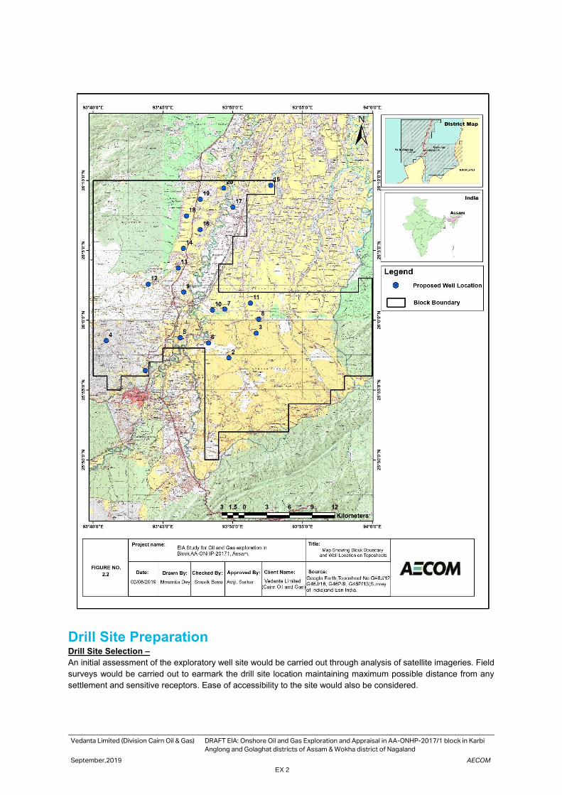
Karbi Anglong and Golaghat districts of Assam& Wokha district of Nagaland. Block Location on SOI Toposheet is
presented below.
Vedanta Limited (Division Cairn Oil & Gas) DRAFT EIA: Onshore Oil and Gas Exploration and Appraisal in AA-ONHP-2017/1 block in Karbi
Anglong and Golaghat districts of Assam & Wokha district of Nagaland
September,2019 AECOM
EX 2
Drill Site Preparation Drill Site Selection –
An initial assessment of the exploratory well site would be carried out through analysis of satellite imageries. Field
surveys would be carried out to earmark the drill site location maintaining maximum possible distance from any
settlement and sensitive receptors. Ease of accessibility to the site would also be considered.

Vedanta Limited (Division Cairn Oil & Gas) DRAFT EIA: Onshore Oil and Gas Exploration and Appraisal in AA-ONHP-2017/1 block in Karbi
Anglong and Golaghat districts of Assam & Wokha district of Nagaland
September,2019 AECOM
EX 3
Site Preparation –
Detailed site surveys would be carried, and the boundary of the drill site earmarked. Site leveling, and excavation
works would be carried out for site preparation. Individual sites would be duly fenced to a height of about 2 m using
jingled wired fencing or Expm fencing. New approach roads to drill sites would be constructed or existing village
roads would be strengthened to provide access for the drilling equipment and machinery. If the earmarked site has
vegetation cover, clearance of vegetation is the first activity that would be undertaken during drill site construction.
Following this, the preparation and construction of drill site would involve top soil scraping and storage for future
use, elevating the drill platform by excavated material from the drill site and authorized quarry area. Reinforced
Cement Concrete (RCC) would be used for the construction of foundation system. For making foundations of the
main rig structure, cast in-situ bored under- reamed piles of specified lengths would also be used.
Rig Mobilization - After completion of the construction activities and with the provision of the basic facilities, drill
rig would be transported to the site. The drill equipments are designed as standard land rig or a “Mobile Land Rig”
type, which facilitates quick mobilization and demobilization. Rig essentially comprises of a Drilling mud system,
Effluent Treatment Plant (ETP), Cuttings disposal, Drill Cementing equipment along with utilities to supply power
(DG sets), water and fuel (HSD).
Drilling Operation A rig would be installed at the potential site of drilling after thorough inspection for its working capability and quality
standards. Well spudding shall be the start of drilling activity. Wells would be drilled in sections, with the diameter
of each section decreasing with increasing depth. Before commencing the actual drilling, large diameter pipe
(Conductor) would be lowered into a hole and cemented/grouted. Top-hole section would be drilled to a desired
depth based on well design. After drilling top-hole section, it would be cased with a pipe called “Casing”. Once each
section of the well is completed, the drill string is lifted, and protective steel pipe or casing lowered into the well and
cemented into place. The lengths and diameters of each section of the well would be determined prior to the starting
of the drilling activities and are dependent on the geological conditions through which the well is to be drilled. This
process of drilling and casing the hole section continues until the final well depth (target) is achieved.
Drill cuttings generated from the drilling activity, would be collected and separated using a solid control system and
temporarily stored on-site in HDPE lined pits. Drilling and wash wastewater generated would also be stored at an
onsite HDPE lined pit. The water would be adequately treated in a mobile ETP to ensure conformance to the S No.
72 A (ii) Schedule I - Standards for Emission or Discharge of Environmental Pollutants from Oil Drilling and Gas
Extraction Industry of CPCB.
Hydraulic Fracturing Activity-
Hydraulic fracking may be conducted in wells with low permeability formation and the wells with low pressure.
Fracking fluid would typically be 99% water and sand (or other granulated material) and approximately 1% gelled
chemicals that would be pumped at a high rate (in excess of 20 bpm) and high pressure (up to 5000 psi) to fracture
the formation and improve the well deliverability. Sites for the wells with more than 2 fracs per well (multi-stage
fracturing) would have provision of additional space for water storage for better continuity of operations.
Well Testing & Flaring-
During the exploration and appraisal drilling, where a hydrocarbon formation is found, initial well tests (generally
about one month of duration) would be carried out to establish flow rates, formation pressure and other parameters.
However, depending on the need, based on nature of the reservoirs, the exploratory and appraisal wells would be
tested for longer/extended durations to ascertain the reservoir parameters.
Associated Facilities –
Each drill site would be provided with facilities such as drilling rig foundation and cellar pit, waste and water storage
pits, chemical storage area including fuel storages, drill cutting disposal pit, flare pit and mobile STPs. The drill
cutting and spent mud disposal pits would be provided with a HDPE lining for temporary storage. Adequate
drainage and wastewater conveyance system also would be installed.
Liquid Mud Plant (LMP)-
The Liquid Mud Plant (LMP) shall be located at suitable locations of the fields to prepare synthetic/ water-based
mud for the drilling operations.
Vedanta Limited (Division Cairn Oil & Gas) DRAFT EIA: Onshore Oil and Gas Exploration and Appraisal in AA-ONHP-2017/1 block in Karbi
Anglong and Golaghat districts of Assam & Wokha district of Nagaland
September,2019 AECOM
EX 4
Appraisal –
When, exploratory drilling is successful, more wells (termed as Appraisal wells) would be drilled to determine the
size and the extent of the field. The technical procedures and activities in appraisal drilling would be the same as
those employed for exploration wells Deviated or directional drilling at an angle from a site adjacent to the original
discovery well may be used to appraise other parts of the reservoir
Quick Production Unit (QPU) –
In case of commercially viable discovery, QPUs would be installed for the processing of produced well fluid
processing and early production of up to 12000 BOPD crude oil and up to 2.4 MMSCFD associated natural gas. A
QPU would be a packaged/ modular mobile unit and would mainly consists of a three-phase separator & production
heater or heater-treater, oil storage tanks, oil tanker loading system, produced water (PW) separation and disposal
system, power generation (GEG or DG), utility systems such as fuel gas, flare & Inst. Air packages, firefighting
equipment, etc. Each QPU capacity would be ~2,000 BFPD (Barrels of Fluid per Day).
Accommodation and Camp Site:
Temporary camp site (porta cabin) for the drilling of exploratory (including) appraisal wells are envisaged, which
would be dismantled after drilling of the wells. At any point of time, it is anticipated that about 50 personnel per shift
would be housed in the campsite during the well drilling campaign.
Well decommissioning After the completion of the drilling activity, partial de-mobilization of the drilling rig and associated infrastructure
would be initiated. As discussed earlier, well testing may be carried out immediately after the drilling is completed.
The complete de-mobilization of the facilities at site would happen once well-testing completed successfully. in
case of commercially viable discovery (s) of hydrocarbons in the Block and having established the size of the
hydrocarbon field (s), proposes to immediately bring the field (s) into production using one or more of the appraisal
wells for the production of crude oil by setting up of QPU (Quick Production Unit). All other equipment, materials,
fuel and wastes would be removed from the drilling site and reused for other drilling activities or disposed as per
the applicable regulatory requirements.
If hydrocarbons are not found, a full abandonment plan would be implemented. All concrete or steel installations
would be removed to at least 1m below ground level, to ensure that there would be no protruding surface structures.
All waste at the site would be removed and the pits would be closed. The drill sites and associated sites (for camps
and liquid mud plant) would be restored to its original conditions or as required by the landowner.
Utilities and Resource Requirement Water – Total of 102 m3 per day fresh water would be required per well. From the total water, 22 m3/day water
would be used for mud preparations, 50 m3/day would be required for drilling activities and 30 m3/day freshwater
would be used for domestic purposes including drinking, washings and domestic use. In case, required water could
not be sourced from locally available approved sources, ground water would be extracted after obtaining
permission from CGWA/ State Govt.
During early production, the installation of typical EPU/QPU unit water requirement for process, domestic
consumption, greenbelt and miscellaneous use would be15-18 m3/day.
Power – For a drill site, the power would be provided through diesel generator (DG) sets (Camp site - 2x350 KVA
(including one as standby), Drilling site - 3x1000 KVA (including one as standby) or 2x1850 KVA (1 Working + 1
Standby) depending on the rig capacity & availability during E&A drilling phase and Radio Room -2x100 KVA
(including one as standby).
For each early production unit power requirement would be met through the State Electricity and or installation of
Diesel/Gas Engine Generator (GEG) of 1 MW output using produced natural gas and a 500 KVA DG would be
used as backup in emergency conditions
Labour– It is anticipated that, at any given time, there would be about 80 - 100 personnel working on site including
technical staff, drilling crew, security staff etc.
Project Cost The cost of the project has been estimated to be about INR 584 Crores.

Vedanta Limited (Division Cairn Oil & Gas) DRAFT EIA: Onshore Oil and Gas Exploration and Appraisal in AA-ONHP-2017/1 block in Karbi
Anglong and Golaghat districts of Assam & Wokha district of Nagaland
September,2019 AECOM
EX 5
Pollution Sources
Air emissions: Point source air emissions would be generated from DG sets. Fugitive emissions would occur from
vehicles involved in the drilling operations and from windblown dust from storage and staging areas within the drill
site.
Noise & Vibrations: Noise and vibration would be generated due to operation of drilling rig, DG sets and vehicles.
Liquid wastes: During the drilling phase, approximately 30-40 m3 per day of waste water would be generated from
the drilling activity and 16-25 m3 per day of domestic waste water would be generated from each drill site.
Drill cuttings & spent mud: Approximately 500-1500 Tons/well of drill cuttings from WBM, 250-500 Tons/well of
drill cuttings from SBM and 250-500 Tons/well of spent mud would be generated per site.
Existing Baseline Environment of the Project Area
Baseline information about the Block was collated by review of other published literature, site surveys, stakeholder
interactions and primary monitoring carried out during the period of March-May 2019 by Mitra S. K. Private Limited
(NABL Accredited Laboratory).
Sub-surface Geology-
The South Assam Shelf is a part of Assam & Assam-Arakan basin and situated in the Dhansiri valley separated
from North Assam shelf by a major E-W trending Jorhat fault. The area represents a part of foreland basin flanked
by NE-SW trending Naga Schuppen belt on the East & Southeast and Mikir Massif in the West. The area is sparsely
exhibiting intra-cratonic graben filling sediments from Permian age to basaltic flows of Early Cretaceous age. The
extensive Late Cretaceous-Oligocene sequence deposited in Passive margin setting witnessed differential erosion
at places and overlain by a thick pile of Miocene to Recent sediments deposited in a foreland setting.
Drainage - The River Brahmaputra flowing in east-west direction in the extreme northern parts of the district and
its tributaries flowing in northerly direction, control the entire drainage system of the district and plays an important
role in the ground water occurrence and control of the district. Important Rivers of the district are Dhansiri and
Dayang. These rivers have meandering courses with abandoned channels in the form of bils and ox-bow lakes
along their courses
Hydrogeology– The entire Karbi Anglong district can be divided into Consolidated formations comprising oldest
granite rock, gneisses etc, semi-consolidated rocks constituting the Tertiary rocks and unconsolidated alluvial
sediments. In the consolidated formation, ground water is confined to the top weathered zone and the fractures
and fissures of the fresh hard rock.
The Golaghat district is underlain by Quaternary formation followed by Archaean group of rocks. The cumulative
thickness of aquifer zones has the tendency to increase towards the north and in the south eastern parts, the
thickness reverses considerably. Hydro-geologically, the district is proved to be very potential. Ground water occurs
under water table to confined conditions.
Groundwater Quality-
Total of 8 ground water samples have been collected and analysed for parameters as per IS: 10500:2012
standards. The colour of the samples was found <1 hazen units and with agreeable odour. The pH of water samples
ranged from 7.05to 8.44. Turbidity of all the samples varied from 3.1 to 18.0 NTU. The TDS in the water samples
varied from 42 mg/l to 318 mg/l. The total alkalinity of the samples varied from 16.0 to 280 mg/l which falls within
their corresponding permissible limit of 600 mg/l. Total hardness of the samples varied from 20 to 130 mg/l and
was within the permissible limit of 600 mg/l. The concentrations of heavy metals such as Aluminium, Manganese,
Iron, Nickel, Copper, Zinc, Arsenic have been found to be below their corresponding permissible limits. Cadmium,
Mercury, Lead and other parameters like Residual Chlorine, Cyanide, Hexavalent Chromium, Phenol, Total
Phosphorus, Free Ammonia, Cyanide, polychlorinated bi-phenyls, PAHs have been found to be below detection
limits.
Climate and Meteorology - As per climatological table of 1971-2000 of Indian Meteorological Department (IMD)
nearest weather station to AA-ONHP_2017/1 is located in Lumding city which is located approximately 54 km in
south west direction of the block. As per the data, temperature reaches around 42.0oC during the month of June.
Summer is generally wet in nature with very humidity in the air. Whereas, winter experience very low temperature.
The lowest temperature recorded in the month of January which reaches up to 2.2oC. Annual mean rainfall of
1239.2 mm throughout the year
Vedanta Limited (Division Cairn Oil & Gas) DRAFT EIA: Onshore Oil and Gas Exploration and Appraisal in AA-ONHP-2017/1 block in Karbi
Anglong and Golaghat districts of Assam & Wokha district of Nagaland
September,2019 AECOM
EX 6
Ambient Air Quality-Ambient air quality was monitored at 8 locations (for a period of 12 week - March to May’19).
PM10 concentration in the study area varied from 79.36 μg/m3 to 84.59 μg/m3. The monitoring location at AAQ 3,
observed the maximum concentration of PM10 i.e 84.59 μg/m3, whereas minimum PM10 concentration was
observed at AAQ 7, i.e 79.36 μg/m3. The PM2.5, NOx, SO2, and NH3, values were in the range of 41.71 μg/m3 to
49.73 µg/m3, 35.52 μg/m3.to 29.45 μg/m3, 8.4 to 7.4 µg/m3 respectively and well within the National Ambient Air
Quality Standards (NAAQS). Other parameters such as lead, CO, Benzene, VOC, HC, Ni, As and [Ba(p)] were
observed to be below their detectable limits.
Ambient Noise Levels - Noise levels were monitored at 8 locations within the study area. The locations for the
noise levels are selected on the basis of locations of sensitive receptors such as health centre, educational centres,
market place etc. The day time noise levels and night time noise levels were found to be higher than the prescribed
standards of 55 and 45 dB respectively during day and night time for rural areas.
Soil Quality -Soil samples were collected from 8 locations. The soil in general indicates saline to slightly alkaline
properties in the study area. Soil texture at all locations was observed to be sandy. pH of the soil samples ranged
from 4.48 to 8.32. The concentrations of heavy metals namely cadmium, mercury, antimony was observed to below
detectable limit. The values for Zinc, Lead, Cadmium, Copper, Nickel were found to be much below soil remediation
intervention values.
Ecology– An Ecology and Biodiversity study of Block AA-ONHP-2017/01, located in Karbi Anglong and Golaghat
district of Assam was conducted for assessment of biological diversity of the area and probable impacts on it due
to development of exploratory as well as appraisal well. The study was carried out in pre-monsoon season during
month of May, 2019. Total 7 transects, 16 quadrats, 5 PBZ locations and 5 primary productivity sampling locations
were selected within the block based on topography, land use, habitat and vegetation pattern. For assessment of
floral species, quadrats of size 10m x 10m for trees, 5m x 5m for shrubs and 1m x 1m for herbs were plotted and
qualitative and quantitative analysis of the same was carried out. Faunal species were assessed by transect
method by traversing a known distance and noting observed faunal species along the length. The different habitats
observed were forest, wetlands, agricultural fields, tea estates. The floral diversity was high, 45 trees, 15 shrubs,
33 herbs, 14 climbers and 6 aquatic plant. Simpson’s and Shannon’s index indicate medium to high biodiversity –
with respect to the flora. The Shannon’s index value varied 2.044 – 3.265, whereas Simpson’s index value varied
from 0.8273- 0.9619. Among trees, Tectona grandis, Streblus asper, Sterculia viollosa and Pongamia pinnata were
found to be the dominant tree species. The phytoplankton diversity of the region is rich; the Shannon’s index value
ranged from 0.78 -0.954, Simpson’s index value ranged from 1.75 - 2.71. Elephant corridors falls within the study
area. Primary productivity in the study area varied from 14.687 to 23.4375 gC.m3.hr-1.
Socio- Economic Conditions- A total number of 27 villages are coming under core zone area, where the
proposed wells are located. According to Census 2011, As per census 2011, the sex ratio of the villages was
found to be 964 whereas that of Golaghat and Karbi Anglong district is 964 and 951 respectively. The sex ratio of
the villages in the block is more than the sex ratio of Assam, i.e, 958. As per Census 2011, 41 villages had more
than 80% ST population, among which 13 had 100% ST population. In contrast, only one village (Samukjan) had
more than 80% SC population.
Impact Assessment and Mitigation Measures
Site Selection & Land Procurement –
Impact
An area of approximately 300m X 300m would be taken on temporary short-term lease basis for the construction
of well pad (drill site) for exploratory and appraisal wells and the Quick Production unit/ Early Production unit. For
the preparation of suitable access roads connecting to well pads, accommodating OHL and other utilities in future,
a width of 30m (approx.) RoU would be required. The drill sites are planned to be located in agricultural land. Their
procurement for project purposes would result in loss of landowner’s income for the lease period. The procurement
of land on lease can lead to moderate impact mainly due to expectations on compensation package.
Mitigation Measures
• During the construction of the access road adequate cross drainage structures to be provided considering the topography of the alignment.
• Consultations to be carried out with land owners for finalizing compensation packages;
• The excavated material from the drill site should be stored (temporarily /permanently) in uncultivated land and should be away from any drainage channel.

Vedanta Limited (Division Cairn Oil & Gas) DRAFT EIA: Onshore Oil and Gas Exploration and Appraisal in AA-ONHP-2017/1 block in Karbi
Anglong and Golaghat districts of Assam & Wokha district of Nagaland
September,2019 AECOM
EX 7
Site Clearance and Grading
Impact
The site preparation works at campsite and drill site may result in clearance of vegetation, dust generation and loss
of topsoil. The earthworks to be carried would typically involve excavation, levelling / grading; and rolling and
compaction.
Mitigation Measures
• Water sprinkling to be carried out, while working in proximity of agricultural fields or settlements/habitations;
• Runoff from drill sites located near ponds
• If any tree felling is involved, permission from the concern department to be undertaken.
Construction of Drill Site
Impact
Construction of cellar pit, water storage pit and drilling waste storage pits would result in excavation of soil from
each site. Noise from construction activity would be generated from bull dozer, DG sets and concrete-mixing plant.
Mitigation Measures
• Temporary storage sheds to be provided for storing of construction material such as cement;
• Excavated soil to be used for construction at other project sites;
• Detailed Health & Safety Plan to be provided to all civil contractors, as part of their contract with Vedanta Limited (Division: Cairn Oil & Gas).
Campsite Installation
Impact
The campsites would be located in the vicinity of the drill site. A typical campsite would require portable cabins to
accommodate about drilling crew and the contractor personnel. Installation of porta-cabins with associated facilities
would involve Health and Safety issues pertaining to transportation, loading - unloading of cabins and installation
of cabins.
Mitigation Measures
• Crane to be is equipped with a legible, durable load chart that shows the manufacturer's recommended load
configurations and maximum load weights; and
• Surface conditions to be examined prior to movement of crane.
Transportation of Drilling Rig and Other Components –
Impact
Transportation of drilling rig, drilling equipment, materials and manpower would involve movement of about trailer
through the use of existing roads till they reach the access road for each well site. The potential impacts may
include congestion of roads, wear and tear of existing roads and oil leaks from vehicle maintenance areas
Mitigation Measures
• Movement of rig & associated machinery to be avoided to the extent possible during peak traffic hours
• All vehicles (light, medium and heavy) to be required to have valid PUC (Pollution under Check) certificate.
• Periodic maintenance of all project vehicles and machinery to be carried out.
Drilling and Well Testing
Impact
During drilling operation Water for WBM preparation would be 600 to 1000 m3/Well, for SBM preparation would be
150 to 300 m3/Well, for drilling water consumption would be 30-50 m3/day/well and water for domestic use would
be 20-30 m3/day/well.
Mitigation Measures
Water requirement for all the project activities would be sourced locally through approved/ authorized sources of
surface water and/ or ground water (e.g. PHD bore wells, privately owned bore wells, Irrigation Dept./ Water
Vedanta Limited (Division Cairn Oil & Gas) DRAFT EIA: Onshore Oil and Gas Exploration and Appraisal in AA-ONHP-2017/1 block in Karbi
Anglong and Golaghat districts of Assam & Wokha district of Nagaland
September,2019 AECOM
EX 8
Resources Dept. of State Govt.). In case, required water could not be sourced from locally available approved
sources, ground water would be extracted after obtaining permission from CGWA/ State Govt.
Handling, transport and storage of Chemicals and wastes
Impact
The drilling operations would involve generation of spent drilling mud, drill cuttings, waste oil, used containers, etc.
The drill site would also involve storage of hazardous chemicals and fuels which has the potential to contaminate
soil and groundwater.
Mitigation Measures
• Separate drill cutting disposal pits to be provided for WBM and SBM
• Drill pits to be provided with HDPE lining on bottom and side surfaces
• The drill cuttings from the drilling operations associated with water-based mud would be used for filling
low lying areas as a sub grade construction material in construction of well pads, etc., after testing for
hazardous characteristics and analysis. Synthetic base mud would be re-used in further drilling activities.
• Used hazardous chemical barrels and waste oil to be sent to SPCB authorized vendors
• Fuel tanks to be provided with secondary containment facilities and maintained as per statutory
requirements.
• All mixing tanks and chemical storage area to be paved and provided with secondary containment.
Air emissions
Impact
The drilling activities would lead to emissions from operation of diesel generator sets and flaring during well testing.
Fugitive dust emissions due to the proposed project would be principally associated with emissions of dust during
the site preparation. The dust generated would be primarily from the handling and transportation of fill material and
re-entrainment of dust during movement of the vehicles on unpaved roads
Mitigation Measures
• DG set emissions shall be as per CPCB standards
• In case of ground flaring to minimize the effects of flaring, the flare pit shall be made of RCC surrounded by a permanent wall of minimum 5m height (with refractory bricks), to reduce the radiation and glaring effects in the adjoining areas.
• In case of elevated flaring system: this would be designed with proper enclosure height;
• Location of the flare stack to be decided at the design stage taking into consideration nearest habitations, vegetation, public amenities or any sensitive locations
• Flaring of crude oil to be avoided, and crude oil to be effectively separated at the drill site and stored in barrels/tankers for transportation to the nearest terminal for management; and
• No cold venting of natural gas would be resorted instead flaring would be done with combustion efficient elevated flare tip; and
• Location of flare stacks to be chosen considering the sensitive receptors adjoining the site
Noise Generation
Impact
The noise generation sources would include DG sets, pumps for rig and other miscellaneous equipment’s.
Mitigation Measures
• Installation of adequate engineering control on equipment and machinery (like mufflers & noise enclosures
for DG sets and mud pumps) to reduce noise levels at source, carrying out proper maintenance and
subjecting them to rigid noise control procedures.
• The DG set would be kept in an acoustic enclosure.
• Providing Personnel Protective Equipment (PPEs) like ear plugs/muffs to workers at site.
• Undertaking periodic maintenance of vehicles to reduce noise levels
Surface water quality
Impact
Site clearance and stripping of top soil during site construction would result in an increase in soil erosion potential
leading to an increased sediment load in the surface run-off during monsoon. Also, surface run off from drilling
Vedanta Limited (Division Cairn Oil & Gas) DRAFT EIA: Onshore Oil and Gas Exploration and Appraisal in AA-ONHP-2017/1 block in Karbi
Anglong and Golaghat districts of Assam & Wokha district of Nagaland
September,2019 AECOM
EX 9
waste (cuttings and drilling mud), hazardous waste (waste oil, used oil etc) and chemical storage areas may lead
to the pollution of receiving water bodies viz. natural drainage channels etc.
Mitigation Measures
• Proper treatment of all wastewater and produced water and any water discharge from well site should comply with CPCB Inland Water Discharge Standards for Oil and Gas Industries
• Waste mud to be stored in the HDPE lined pit
• Drainage and sediment control systems at the well site would be efficiently designed
• All chemical and fuel storage areas, process areas would have proper bunds so that contaminated run-off cannot escape into the storm-water drainage system.
Ground water Impact In absence of supply of surface water resource, the potential impacts on groundwater resource would be due to ground water abstracted for domestic needs and for civil construction activities. Mitigation Measures • All water storages in the drill sites would be kept covered and leakage prevented; Soil Quality Impact During the site preparation stripping of soil would be happened during the construction phase. Site preparatory activities would involve the sourcing of earth-fill from borrow areas. Since in most of the cases efforts would be made to procure the fill material from nearby existing borrow areas. Storage of drill cuttings associated with WBM, spent drilling mud and sludge containing oil and other waste are likely to be generated, would be stored at HDPE lined pit. Fuels, lubricants and chemical used for the drilling operations (especially daily consumption) would be stored at site. Mitigation Measures
• The top soil would be stored properly
• Manage spills of contaminants on soil using spill kits;
• Storage of MSW in designated areas within drill sites/production facilities;
• Adopt best practices e.g. use pumps and dispensing nozzle for transfer of fuel, use drip trays etc. Road and Traffic Impact During various phases of projects like construction, drilling, early production and decommissioning various types of vehicle / equipment movement would be involved. The vehicular movement is expected to be more in construction phase due to movement of machinery & manpower.
Mitigation Measures
• Speed limits would be maintained by vehicles involved in transportation of raw material and drilling rig.
• Regular supervision would be done to control vehicular traffic movement along defined traffic routes.
• Entry of vehicles into the drilling site area is prohibited except for material movement.
• Adequate parking would be provided outside the drilling location.
Terrestrial Ecological environment
Impact
The Potential Impacts on the existing floral and faunal diversity may arise due to following activities 1. Vegetation Clearance.
2. Illimitation from Site.
3. Generation of Noise
Mitigation Measures
• The working area would always be kept minimum.
• For felling of trees prior approval from concern Department shall be obtained;
• Appropriate shading of lights to prevent unwanted scattering.
• Plantation of Local tree plantation should be undertaken;
• Fencing would be done on the camp site to avoid any unfortunate encounter with faunal species.

Vedanta Limited (Division Cairn Oil & Gas) DRAFT EIA: Onshore Oil and Gas Exploration and Appraisal in AA-ONHP-2017/1 block in Karbi
Anglong and Golaghat districts of Assam & Wokha district of Nagaland
September,2019 AECOM
EX 10
Socio economic environment
Impact
Road infrastructure could be damaged due to heavy traffic movement. Influx of population is anticipated in all
stages of the project cycle particularly during exploratory drilling. The drill site would involve the operation of about
50 onsite workers during drilling phase. Interaction between workers with villagers of nearby areas might give rise
to various issues like conflict of workers with the local population, nuisance caused by workers due to improper
sanitation facilities, etc.
Mitigation
• The shortest distance as far as available / feasible would be considered for access road.
• The village road identified for accessing proposed project footprints, would be strengthened and widened as
per requirement.
• Appropriate awareness program on grievance redressal mechanism, would be designed and implemented
for local community around proposed project footprints;
• Concerns of local panchayat regarding any impact on their common property resources (like of use of village
road, water resource etc.) due to project activities, would be proactively identified and addressed;
Occupational Health & Safety Risks
Impact
The health and safety risks associated with drilling operations may include well kick or blow out, crane failure, fire
Hazards and radiation hazard from well logging tool handling and storage.
Mitigation Measures
• Blowout preventers to be provided;
• Flare pit to be placed at a safe distance from the well head and fuel storage areas;
• Fire-fighting measures to be provided.
Operation of Campsites
Impact
It is anticipated that, at any given time, there would be about 80 - 100 personnel working on site including technical
staff, drilling crew, security staff etc. who would be accommodated at each campsite associated with drilling. Water
for domestic use would be 20-30 m3/day/well. Each campsite is anticipated to generate 25-30 kg/day/well of
domestic waste. Inadequate disposal and handling of waste would pollute the surroundings.
Mitigation Measures
• Safe drinking water to be made.
• Segregation of waste at the source of generation to be put in practice.
• Food waste to be collected and disposed appropriately
• The sewage from each porta-cabin to be connected to a mobile STP.
Demobilization and Abandonment
Impact
If hydrocarbons are not found, a full abandonment plan would be implemented. The impacts from decommissioning
of drill sites may include noise generation and soil contamination due to demolition of cutting pits and chemical
storage areas.
Mitigation Measures
• All the wastes to be completely removed from the site and sent to designated authorized disposal facilities prior to commencement of demolition work.
• Prior to commencement of any demolition, a planned programme of site clearance would be formulated. All pits, cellars and holes would be removed, and filled to ground level, any oil or otherwise contaminated soil would be removed and disposed properly.
• Roads and other paving would be removed to sufficient depth to allow soil replacement and revegetation.
• Any remaining topsoil that has been stocked during the site clearance would be re-spread over appropriate portions of the site.

Vedanta Limited (Division Cairn Oil & Gas) DRAFT EIA: Onshore Oil and Gas Exploration and Appraisal in AA-ONHP-2017/1 block in Karbi
Anglong and Golaghat districts of Assam & Wokha district of Nagaland
September,2019 AECOM
EX 11
Environment Management and Monitoring Plan
A comprehensive environmental monitoring plan has been developed for the project. Monitoring of ambient air
quality, noise levels, soil and groundwater quality to be carried out by MoEF&CC/NABL/Assam SPCB recognized
laboratories for pre and post drilling operations to assess the effectiveness of the environment management plan
and adopt appropriate corrective measures if it found that those are not functioning properly.
HSE Organization Structure Vedanta Limited (Division Cairn Oil & gas) has an existing established Health, Safety and Environment (HSE)
management system for its operations. The HSE structure comprises of a corporate HSE team based in Gurgaon
office and an on-site team.
Vedanta Limited (Division: Cairn Oil and Gas) shall ensure that the contractual documentation emphasizes on the
need to comply with all legal requirements and Environment Management and Monitoring Plan (EMMP). Vedanta
Limited (Division: Cairn Oil and Gas) shall either directly or through its contractors, to arrange for periodic trainings
of the project crew on legal requirements and EMMP. Vedanta Limited (Division: Cairn Oil and Gas) shall undertake
regular inspections of the drill and camp sites and document them to ensure compliance to legal requirements and
the EMMP.
Proposed CER (Corporate Environmental Responsibilities) Strategy As per MoEF&CC office memorandum number F. No 22-65/2017-IA-III dated 1st May, 2018, Corporate
Environmental Responsibility requirement would be fulfilled as per the prescribed rate.

Vedanta Limited
(Division Cairn Oil & Gas)
DRAFT EIA: Onshore Oil and Gas Exploration and Appraisal in AA-ONHP-2017/1 block in Karbi Anglong and
Golaghat districts of Assam & Wokha district of Nagaland
September,2019 AECOM
1
1. Introduction India is largely dependent on import of petroleum goods to meet its requirements and imports about 80% of crude
oil demand every year. For the last 3 years including the last financial year of 2018-19, the production figures of
crude oil in India is hovering about 35 MTs against a total demand of 212 MTs in the last year. In addition, the
demand of petroleum products is poised to grow at an annual average rate of 4.8% till year 2022 (13th 5-year plan).
To enhance indigenous production of oil, Government of India has targeted reducing the country’s dependency on
import by 10% by the year 2022. As a lead-up to this intent Government of India has awarded Block AA-ONHP-
2017/01 in Assam to Vedanta Limited (Division: Cairn Oil & Gas) for exploration of hydrocarbons.
1.1 Background Revenue Sharing Contract (RSC) for Block AA-ONHP-2017/01 has been signed between Vedanta Limited and
MoP&NG, Govt of India on 1st October 2018 for the exploration of hydrocarbons resources. Vedanta Limited
(Division Cairn Oil & Gas) proposes to carry out exploration including exploratory and appraisal well drilling and
early production of oil and gas in the above mention Block. In case of any discovery, the exploratory and appraisal
well(s) would be tested for extended duration by flowing hydrocarbons to ascertain the reservoir parameters,
assess the quality and commercial viability for early production.
Vedanta Limited (Division: Cairn Oil & Gas) process to carry out drilling of 20 onshore exploratory and appraisal
wells and setting up of early/quick production facility in AA-ONHP-2017/01.
1.2 Objective of the EIA Study The exploration/development of oil and gas is included under activities specified in Schedule (Activity 1b) of the
EIA Notification dated 14th September 2006 and subsequent amendments categorized as “A” category project
that requires an Environmental Clearance (EC) from the Ministry of Environment, Forests and Climate Change
(MoEF&CC).
AECOM India Pvt Ltd., a NABET-QCI accredited firm has been entrusted with the task of conducting an EIA study
and technically assisting Vedanta Limited (Division Cairn Oil & Gas) for obtaining environmental clearance from
the MoEF&CC.
The main objectives of the EIA study are as follows:
• Establish the prevailing baseline environmental and socio-economic condition of the AA-ONHP-2017/1 Block
and its surroundings along with the compliance needs for environmental approvals to carry out hydrocarbon
exploration.
• Assessing environmental and socioeconomic impacts arising out of the proposed drilling activities;
• Recommend appropriate preventive and mitigation measures to eliminate or minimize pollution,
environmental & social disturbances during the life-cycle of the project, ensuring compliance with
environmental laws and regulations applicable;
• Identifying and proposing alternative actions in terms of technology and practices that may help in abating
environmental or socio-economic impacts due to the project;
Integrating mitigative measures with environmental action plans and management systems so that it can be
implemented, monitored and suitable corrective action can be taken in case of deviations;
1.3 Project Status Vedanta Limited (Division Cairn Oil & Gas) had submitted Form-1 of the EIA Notification, along with a draft Terms
of Reference (ToR) for scoping to MoEF& CC. MoEF&CC has issued an approved ToR vide file No. IA-J-
11011/95/2019-IA-II(I) dated 20th April 2019. The approved ToR is attached as Appendix 1.1.

Vedanta Limited
(Division Cairn Oil & Gas)
DRAFT EIA: Onshore Oil and Gas Exploration and Appraisal in AA-ONHP-2017/1 block in Karbi Anglong and
Golaghat districts of Assam & Wokha district of Nagaland
September,2019 AECOM
2
The baseline monitoring and all primary data collection was conducted for the summer season (March to May) of
2019, as per the requirements of the ToR. Draft EIA report has been prepared for public hearing.
1.4 Brief Details of The Project AA-ONHP-2017/1 Block is located in Karbi Anglong and Golaghat districts of Assam & Wokha district of Nagaland.
Total area of Block is 715 sq. km. Presently Cairn Oil and Gas proposed to carryout drilling of 20 exploratory and
appraisal wells with in the Block. Apart from that setting up of Early Production Units (EPUs)/ Quick Production
Units (QPUs) for produced well fluid processing and production of up to 12000 BOPD crude oil and associated
natural gas 2.4 MMSCFD has also been planned. Total estimated cost of the project is Rs. 584.0 Cr.
1.5 Scope of The Study The scope of the EIA study considers the impact due to drilling of 20 onshore exploratory and appraisal wells and
early/ quick production unit in AA-ONHP-2017/1 on physical, biological and socioeconomic environment of the
surrounding areas in compliance to the approved ToR provide by MoEFCC. The scope of the EIA study includes
the following:
• To establish the prevailing environmental and socio-economic condition of the study area;
• To assess environmental and socioeconomic impacts arising out of the proposed activities;
• To recommend appropriate preventive and mitigation measures to eliminate or minimize pollution;
• To identify and propose management plans in terms of good practices that may help in abating
environmental or socio-economic impacts due to the project.
• To prepare a Disaster Management Plan (DMP) based on Risk Assessment/ studies;
Environmental baseline monitoring has been carried out during March to May 2019 representing summer season
and used to identify potential significant impacts.
1.6 Structure of the EIA Report The overall contents of the EIA report has been prepared as per the generic structure prescribed in the Appendix
III of EIA Notification issued by MoEF&CC, Govt. of India on 14th September 2006 and subsequent amendments.
The report consists of executive summary followed by eleven chapters, the content of which is briefly described
in Table 1.1.
Table 1.1 Content of EIA Report
Sl. No. Section Brief Description
Executive Summary Executive Summary of EIA report.
1. Introduction This section covers project background; scope of the work and
overview of the project.
2. Project Description Presents a Description of the Existing and proposed project.
3. Environmental Baseline Study
Baseline Environment Status: The methodology for assessing
various baseline environmental components in the study area has
been identified in this chapter. The various parameters of present
environmental status are identified under different aspects, which
include location and regional setting of the area, physical aspects
such as land use, land cover and soil quality. Hydrological aspect
consists of area drainage, surface water and ground water quality.
Meteorological aspect contains all the climatic factors and ambient
air quality existing in the study area. Ecological environment
describes the flora and fauna of the region. Human aspect includes
the demographical features, socio-economic environment and
infrastructure facilities of the study area.

Vedanta Limited
(Division Cairn Oil & Gas)
DRAFT EIA: Onshore Oil and Gas Exploration and Appraisal in AA-ONHP-2017/1 block in Karbi Anglong and
Golaghat districts of Assam & Wokha district of Nagaland
September,2019 AECOM
3
Sl. No. Section Brief Description
4. Impact Assessment and
Mitigation Measures
Includes impact identification through scoping, assessment of
impact, mitigation measures and evaluation of significance of
residual impacts.
5. Alternative Analysis
This section includes alternatives analysis with respect to site and
technology
6. Environmental Monitoring
Program
The environmental monitoring would be scheduled during
construction and operation phase is provided
7. Additional studies
A summary of the additional studies/activities conducted as per the
requirements of the ToR is given in this chapter. The additional
studies conducted are Risk Assessment and Disaster Management
Plan. On-site disaster management describing the on-site and off-
site emergencies commands and controls have also described in
this chapter. Stakeholder assessment as per primary consultation
and Public hearing related issues have been also covered in this
chapter.
8. Project Benefits The benefits that would be accrued from the project in the locality in
particular and society in general as well as development would be
identified and described in this chapter.
9. Environmental Management
Plan
This section covers introduction and elements of EMP i.e. planning, implementation, checking and management review.
10. Summary and Conclusion
Presents the overall findings of the EIA study and includes overall justification for implementation of the project and provides explanation of how, adverse effects have been mitigated.
11. Disclosure of Consultants Provides brief information about AECOM and professionals who were engaged for completion of this study.
Source: EIA Notification 2006
1.7 Compliance to TOR An Environment Impact Assessment (EIA) study has been undertaken for the proposed drilling of Exploration and
Appraisal (20 Wells) in AA-ONHP-2017/1 Block, Karbi Analog and Golaghat District of Assam and Wokha district
of Nagaland. The EIA study has been undertaken in accordance with the Standard ToR issued by MoEF&CC vide
File No.IA-J-11011/95/2019-IA-II(I) dated 20th April, 2019.The point wise compliance to ToR is provided in Table
1.2.
Table 1.2 ToR Compliance
Sl. No Condition Reference Section
1. Executive summary of the project Refer to Executive Summary
2. Project description, project objectives
and project benefits
Refer to Chapter 2, section 2.1 and 2.2-Objectives And
Benefits Of Proposed Exploratory, Development And
Testing Activities, section 2.3 and 2.4-Well Locations And
Environmental Settings, section 2.10- Project Activities
And Schedule
3. Cost of project and period of completion Refer to Chapter 2, section 2.10- Project Cost and section
2.10 - Project Activities and Schedule
4. Site details within 1 km of the each
proposed well, any habitation, any other
installation/activity, flora and fauna,
approachability to site, other activities
including agriculture/land, satellite
imagery for 10 km area.
Refer to Chapter 2, section 2.3 and 2.4-Well Locations
and Environmental Settings
Refer to Chapter 3, section 3.8-land use/land cover
5. All the geological details would be
mentioned in the Topo sheet of 1:40000
Refer to Chapter 2, Section 2.1 -Block Location &
Description

Vedanta Limited
(Division Cairn Oil & Gas)
DRAFT EIA: Onshore Oil and Gas Exploration and Appraisal in AA-ONHP-2017/1 block in Karbi Anglong and
Golaghat districts of Assam & Wokha district of Nagaland
September,2019 AECOM
4
Sl. No Condition Reference Section
scale, superimposing the well locations
and other structures of the projects.
6. Topography of the project site. Refer to Chapter 3, section 3.5-Topography
7. Details of sensitive areas such as
National Park, Wildlife sanctuary and
any other eco-sensitive area along with
map indicating distance
Refer chapter 3, section 3.14-Ecological Environment
8. Approval for the forest land from the
State/Central Govt. under Forest
(Conservation) Act, 1980, if applicable.
Forest proposal will be submitted
9. Recommendation of SCZMA/CRZ
clearance as per CRZ Notification dated
6th January, 2011 (if applicable).
Not applicable
10. Distance from nearby critically/severely
polluted area as per Notification, if
applicable. Status of moratorium
imposed on the area.
Not Applicable
11. Does proposal involve rehabilitation and
resettlement? If yes, details thereof.
No rehabilitation and resettlement would be required as
such.
12. Environmental considerations in the
selection of the drilling locations for
which environmental clearance is being
sought. Present any analysis suggested
for minimizing the foot print giving
details of drilling and development
options considered.
Refer Chapter 5- Analysis of Alternatives
13. Baseline data collection for air, water
and soil for one season leaving the
monsoon season in an area of 10 km
radius with centre of Oil Field as its
centre covering the area of all proposed
drilling wells.
Refer Chapter 3, section 3.10-Ambient Air Quality, section
3.11 -Water Environment, section 3.12-Soil Quality
14. Climatology and Meteorology including
wind speed, wind direction, temperature
rainfall relative humidity, etc.
Refer Chapter 3, Section 3.9-Climate and Rainfall,
section 3.9-Meteorology
15. Details of Ambient Air Quality monitoring
at 8 locations for PM2.5, PM10, SO2,
NOx, CO, VOCs, Methane and non-
methane HC.
Refer Chapter 3, section 3.10-Ambient Air Quality,
16. Soil sample analysis (physical and
chemical properties) at the areas
located at 5 locations.
Refer Chapter 3, section 3.11-Soil Quality
17. Ground and surface water quality in the
vicinity of the proposed wells site.
Refer Chapter 3, section 3.11 -Water Environment,
18. Measurement of Noise levels within 1
km radius of the proposed wells.
Refer Chapter 3, section 3.10-Ambient Noise Quality
19. Vegetation and land use; flora/fauna in
the Block area with details of
endangered species, if any.
Refer Chapter 3, section 3.14-Ecological Environment
20. Incremental GLC as a result of DG set
operation, flaring etc.
Refer Chapter 4 Section 4.8 Air Pollution Impact
21. Potential environmental impact
envisaged during various stages of
project activities such as site activation,
development, operation/ maintenance
and decommissioning.
Refer Chapter 4

Vedanta Limited
(Division Cairn Oil & Gas)
DRAFT EIA: Onshore Oil and Gas Exploration and Appraisal in AA-ONHP-2017/1 block in Karbi Anglong and
Golaghat districts of Assam & Wokha district of Nagaland
September,2019 AECOM
5
Sl. No Condition Reference Section
22. Actual source of water and 'Permission'
for the drawl of water from the
Competent Authority.
Detailed water balance, wastewater
generation and discharge.
Refer to Chapter 2, section 2.9-Water Requirement
23. Noise abatement measures and
measures to minimize disturbance due
to light and visual intrusions
Refer Chapter 4 Section 4.9 Noise Impact
24. Details on wastewater generation,
treatment and utilization /discharge for
produced water/ formation water, cooling
waters, other wastewaters, etc. during
all project phases.
Refer to Chapter 2, section 2.8.3-Wastewater
25. Details on solid waste management for
drill cuttings, drilling mud and oil sludge,
produced sand, radio active materials,
other hazardous materials, etc. including
its disposal options during all project
phases.
Refer to Chapter 2, section 2.8.4-Solid and Hazardous
Waste Streams
26. Disposal of spent oil and lube. Refer to Chapter 2, section 2.8.4-Solid and Hazardous
Waste Streams
27. Storage of chemicals and diesel at site.
Hazardous material usage, storage and
accounting
Refer to Chapter 2, section 2.9-Utilities & Resource
Requirements
28. Commitment for the use of water based
mud (WBM) only
Refer to Chapter 2, section 2.5-Drilling Activity
29. Oil spill emergency plans for recovery/
reclamation
Refer Chapter 9, Section 9.5
30. H2S emissions control Refer Chapter 7, Section 7.3
31. Produced oil/gas handling, processing
and storage/transportation
Refer Chapter 2, Section 2.6
32. Details of control of air, water and noise
pollution during production phase
Not Applicable
33. Measures to protect ground water and
shallow aquifers from contamination
Refer to Chapter 4, Section 4.11
34. Whether any burn pits being utilised for
well test operations
Refer to Chapter 2, section 2.5-Drilling Activity
35. Risk assessment and disaster
management plan for independent
reviews of well-designed construction
etc. for prevention of blow out. Blowout
preventer installation.
Refer to Chapter 7, Section 7.2
36. Environmental management plan. Refer to Chapter 9
37. Total capital and recurring cost for
environmental control measures
Refer to Chapter 9, Section 9.14
38. Emergency preparedness plan. Refer to Chapter 7, Section 7.3
39. Decommissioning and restoration plans Refer to Chapter 2, section 2.8-Well Decommissioning
40. Documentary proof of membership of
common disposal facilities, if any
Not Applicable
41. Details of environmental and safety
related documentation within the
company including documentation and
proposed occupational health and safety
Surveillance Safety Programme for all
personnel at site. This would also
Refer to Chapter 6 - Environmental Monitoring
Programme

Vedanta Limited
(Division Cairn Oil & Gas)
DRAFT EIA: Onshore Oil and Gas Exploration and Appraisal in AA-ONHP-2017/1 block in Karbi Anglong and
Golaghat districts of Assam & Wokha district of Nagaland
September,2019 AECOM
6
Sl. No Condition Reference Section
include monitoring programme for the
environmental
42. A copy of Corporate Environment Policy
of the company as per the Ministry's
O.M. No. J-11013/ 41/2006-IA.II(I) dated
26thApril, 2011 available on the
Ministry's website
Refer to Chapter 9, Section 9.15
Source: ToR issued By MOEF&CC
1.8 Limitations This EIA study is based on certain scientific principles and professional judgment to certain facts with resultant
subjective interpretation. Professional judgment expressed herein is based on the available data and information.
This report has been developed based on the project related information provided by Vedanta Limited (Division
Cairn Oil & Gas) with the assumption that the information gathered is representative for the proposed drilling of 20
onshore exploratory and appraisal wells and early production in Karbi Anglong and Golaghat districts of Assam &
Wokha district of Nagaland. If information to the contrary is discovered, the findings in this EIA may need would be
modified accordingly. The impact assessment for the Project is based on the project configuration as described in
Section 2 on Project Description.

Vedanta Limited.
(Division CAIRN Oil & Gas)
DRAFT EIA: Onshore Oil and Gas Exploration and Appraisal in AA-ONHP-2017/1 block in Karbi Anglong and
Golaghat districts of Assam & Wokha district of Nagaland
September,,2019 AECOM
7
2. Description of the Project The proposed project includes drilling of 20 onshore exploratory and appraisal wells and Setting up of Early
Production Units (EPUs)/ Quick Production Units (QPUs) for produced well fluid processing and production of up
to 12000 BOPD crude oil and up to 2.4 MMSCFD associated natural gas in AA-ONHP-2017/1 Block located in
Karbi Anglong and Golaghat districts of Assam& Wokha district of Nagaland.
Vedanta Limited (Division: Cairn Oil & Gas) proposes to carry out drilling of 20 exploratory and appraisal well within
Block area for the period of 10-12 years. In case of a discovery (ies), the exploratory and appraisal well(s) would
be tested for extended duration by flowing hydrocarbons to ascertain the reservoir parameters and assess the
quality and commercial viability. Moreover, in case of commercially viable discovery (s) of hydrocarbons in the
Block and having established the size of the hydrocarbon field (s), field would be immediately brought into early
production of crude oil and associated gas using some of the successful exploratory/ appraisal wells by setting up
of temporary and mobile Early Production Units (EPUs)/ QPUs (Quick Production Units) for the processing of
produced well fluids. Any associated gas would be used for captive power generation.
2.1 Objectives of Proposed Project Specific objectives of the proposed drilling activities are summarized below:
• To develop and produce hydrocarbons safely
• To augment National Production of oil and gas
2.2 Benefits of the Proposed Project The project (in case of commercially viable discovery of oil and gas) would ultimately cater to fulfil the energy
requirement of India. The dependency of India on other countries would be lessened to an extent. Additionally, the
project would benefit people living in neighbouring villages in relation to direct & indirect employment associated
with various project activities and would boost the local economy. The benefits of the project are listed below;
• Provision of direct and indirect royalty to Assam Government and more cess to Govt. of India
• Provision of direct and indirect employment opportunity to local people
• Increase in business opportunity for the local people
• Energy security for the country
2.3 Block Location & Description
Location of Block AA-ONHP-2017/1 block is located in Karbi Anglong and Golaghat districts of Assam & Wokha district of Nagaland.
Total area of Block is 715 sq. km. The coordinates of the block are presented in Figure 1.
. The regional setting of the AA- ONHP-2017/1 Block is shown in Figure 2. The geographic location of the Block is
included within overlaid on the Survey of India’s Topo- Sheet No. G46J/12, G46J/16, G46P/9, G46P/13. The block
location map superimposed on Toposheet and satellite imagery is shown in Figure 3 and Figure 4 respectively.
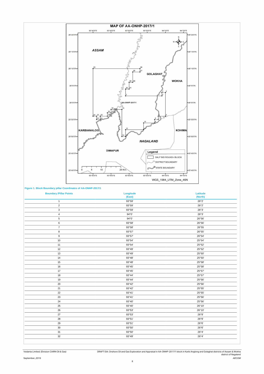
Vedanta Limited. (Division CAIRN Oil & Gas) DRAFT EIA: Onshore Oil and Gas Exploration and Appraisal in AA-ONHP-2017/1 block in Karbi Anglong and Golaghat districts of Assam & Wokha
district of Nagaland
September,,2019 AECOM
8
Figure 1. Block Boundary pillar Coordinates of AA-ONHP-2017/1
Boundary /Pillar Points
Longitude
(East)
Latitude
(North)
1 93°59' 26°2'
2 93°59' 26°2'
3 93°59' 26°3'
4 94°0' 26°3'
5 94°0' 26°56'
6 93°58' 26°56'
7 93°58' 26°55
8 93°57' 26°55'
9 93°57' 26°54'
10 93°54' 25°54'
11 93°54' 25°52'
12 93°49' 25°52'
13 93°49' 25°50'
14 93°48' 25°50'
15 93°48' 25°58'
16 93°45' 25°58'
17 93°45' 25°57'
18 93°44' 25°57'
19 93°44' 25°56'
20 93°42' 25°56'
21 93°42' 25°55'
22 93°41' 25°55'
23 93°41' 25°56'
24 93°40' 25°56'
25 93°40' 26°10'
26 93°53' 26°10'
27 93°53' 26°9’
28 93°51' 26°9’
29 93°51' 26°6’
30 93°50' 26°6’
31 93°50' 26°4'
32 93°49' 26°4'

Vedanta Limited. (Division CAIRN Oil & Gas) DRAFT EIA: Onshore Oil and Gas Exploration and Appraisal in AA-ONHP-2017/1 block in
Karbi Anglong and Golaghat districts of Assam & Wokha district of Nagaland
September,2019 AECOM
9
Figure 2. Regional Settings of AA-ONHP-2017/1

Vedanta Limited. (Division CAIRN Oil & Gas) DRAFT EIA: Onshore Oil and Gas Exploration and Appraisal in AA-ONHP-2017/1 block in
Karbi Anglong and Golaghat districts of Assam & Wokha district of Nagaland
September,2019 AECOM
10
Figure 3. Block Boundary of AA-ONHP-2017/1 Block on SOI Toposheet

Vedanta Limited. (Division CAIRN Oil & Gas) DRAFT EIA: Onshore Oil and Gas Exploration and Appraisal in AA-ONHP-2017/1 block in Karbi Anglong and Golaghat districts of Assam & Wokha district of Nagaland
September,2019 AECOM
11
Figure 4. Block boundary AA-ONHP-2017/1 Block on Satellite Imagery(Google Earth)

Vedanta Limited (Division CAIRN Oil & Gas) DRAFT EIA: Onshore Oil and Gas Exploration and Appraisal in AA-ONHP-2017/1 block in Karbi
Anglong and Golaghat districts of Assam & Wokha district of Nagaland
September,2019 AECOM
12
Block Accessibility Roads
The project location falls in two districts of Assam state, Karbi Anglong and Golaghat. Diphu is the head quarter of
the Karbi Anglong district. The district headquarters are located at Golaghat. Golaghat is one of the largest
subdivisions of Assam and plays a significant role in the tea industry of Assam. Dimapur (Nagaland) is the nearest
airport and 3 km from the block. National Highways 39 (Within Block) connects the block to other cities like Jorhat
and Bokajan.
Railway
Railway lines connecting Guwahati to Dibrugarh runs within the block boundary. Dimapur and Bokajan Railway
station located within Block.
Airport
Dimapur airport is the nearest air connectivity located 3 km (SW) from the Block boundary.
Accessibility map of Block AA-ONHP-2017/1 is presented Figure 5

Vedanta Limited (Division CAIRN Oil & Gas) DRAFT EIA: Onshore Oil and Gas Exploration and Appraisal in AA-ONHP-2017/1 block in Karbi Anglong and Golaghat districts of Assam & Wokha district of Nagaland
September,2019 AECOM
13
Figure 5. Accessibility Map of AAONHP-2017/1 Block

Vedanta Limited (Division CAIRN Oil & Gas) DRAFT EIA: Onshore Oil and Gas Exploration and Appraisal in AA-ONHP-2017/1 block in Karbi
Anglong and Golaghat districts of Assam & Wokha district of Nagaland
September,2019 AECOM
14
2.4 Environmental Settings
AA-ONHP-2017/1 Block • Dhansiri River, Dayang River, Rengma River, Yampar nadi and Zubza river are flowing within the block;
• Total 38648 ha, forest area is located within the AA-ONHP-2017/1 block however none of the proposed well
location is located within forest land;
• There is no wildlife sanctuary and national park located within the 15 kilometres of the block boundary;
• Land use classes with the Block comprise of fellow land and agriculture land;
• Cement industry present in the 2.21 km east from well no 27 .
Location of Wells Vedanta Limited. (Division Cairn Oil & Gas) proposes to drill 20 exploration & appraisal wells within the present
block boundary of AA-ONHP-2017/1. The proposed well sites were selected based primarily on the geological
consideration but the environmental considerations viz. location of sensitive ecological habitats, settlements,
schools/ hospitals, water bodies etc. have also been considered. Care had been taken to locate the wells distantly
from these receptors. In case, well site selection in proximity to sensitive receptors could not be avoided (due to
presence of geological formations), requisite clearance/permission would be obtained required. Proper
environmental and safety measures would be adopted to minimize footprints on these receptors. Proposed well
coordinates are provided in
Table 2.1
Table 2.1 Details of Proposed Well Location
Well no.
Coordinates Present Land Use
Village Administrative Village Name
Tehsil District
1 25°56'35.11"N 93°43'45.83"E
Fallow land Joyram Engleng Silonjan Golaghat
2 25°57'17.040"N, 93°49'43.980"E
Agricultural land
Kiyetho Ambari Sarupathar Golaghat
3 25°59'3.454"N 93°51'41.232"E
Homested plantation
Sunito Da-Gaon No.3
Sarupathar Golaghat
4 25°58'38.82"N 93°41'3.45"E
Agricultural land
Sarthe Killing Diphu Karbi Anglong
5 25°58'43.96"N 93°46'14.57"E
Agricultural land
Christian Basti Diphu Karbi Anglong
6 25°58'21.200"N, 93°48'15.770"E
Agricultural land
Khaghaboto Kai Terang Diphu Karbi Anglong
7 26° 0'46.710"N, 93°49'26.130"E
Agricultural land
M.V.chungajaan Chungazan Hazari Gaon
Sarupathar Golaghat
8 26° 0'3.330"N 93°51'51.513"E
Agricultural land
Kachari Gaon Madhapur Sarupathar Golaghat
9 26° 1'59.81"N 93°46'29.71"E
Agricultural land
Sukhajan Diphu Karbi Anaglong
10 26° 0'42.820"N, 93°48'33.250"E
Agricultural land
M.V.chungajaan Bokajan Diphu Karbi Anglong
11 26° 1'12.252"N 93°51'16.208"E
Agricultural land
Naokhuti Netezu Sarupathar Golaghat
12 26° 2'24.39"N 93°43'52.73"E
Agricultural land
Sukhanjan Diphu Karbi Anglong
13 26° 3'43.52"N 93°46'6.20"E
Agricultural land
Sariajan Diphu Karbi Anglong
14 26° 5'7.39"N 93°46'28.18"E
Agricultural land
Sariajan Diphu Karbi Anglong
15 26° 9'38.27"N 93°52'43.48"E
Agricultural land
Dighalganja NC Sarupathar Golaghat

Vedanta Limited (Division CAIRN Oil & Gas) DRAFT EIA: Onshore Oil and Gas Exploration and Appraisal in AA-ONHP-2017/1 block in Karbi
Anglong and Golaghat districts of Assam & Wokha district of Nagaland
September,2019 AECOM
15
16 26° 6'28.63"N 93°47'40.31"E
Agricultural Land
Dilaojan Diphu Karbi Anglong
17 26° 8'4.62"N 93°50'0.89"E
Agricultural land
No.1 Kori Gaon Sarupathar Golaghat
18 26° 7'26.87"N 93°46'41.36"E
Agricultural land
Dihingia Siloni jan Karbi Anglong
19 26°8'38.65"N 93°47'41.20"E
Agricultural land
Rongagara Siloni jan Karbi Anglong
20 26° 9'26.45"N 93°49'21.87"E
Agricultural land
Jabarajan Siloni jan Karbi Anglong
Environmental settings around 2.5 km radius 1area of each well site was carried out during field survey and the
same has been checked with toposheet and satellite imagery.
Presently all the of proposed well locations are located in agricultural land. Settlements/houses was observed in
vicinity of well locations. Villages roads are also located close to well locations. Well profile including environmental
setting and environmental settings map of each well is given in Appendix 2.3.
1 As per project plan well site may shift 2 kilometer around the prosed well site based on seismic data and geological formation. Considering the fact 2.5 km radius of the proposed well site is considered as the area of influence of the particular well.

Vedanta Limited (Division CAIRN Oil & Gas) DRAFT EIA: Onshore Oil and Gas Exploration and Appraisal in AA-ONHP-2017/1 block in Karbi Anglong and Golaghat districts of Assam & Wokha district of Nagaland
September,2019 AECOM
16
Figure 6. Environmental Settings Map of the Block
Vedanta Limited (Division CAIRN Oil & Gas) DRAFT EIA: Onshore Oil and Gas Exploration and Appraisal in AA-ONHP-2017/1 block in Karbi
Anglong and Golaghat districts of Assam & Wokha district of Nagaland
September,2019 AECOM
17
2.5 Well Drilling Process The lifecycle of project activities for the proposed project has been divided into distinct steps and each is described
in detail in the subsequent sections and would take approximately three months to complete drilling and testing
activity at each well site. Vedanta Limited (Division Cairn Oil and Gas) has planned to carry out the proposed project
activities in the AA-ONHP-2017/1 Block over a period of 10-12 years.
The project lifecycle has been classified into three phases:
Pre-drilling activity
• Site selection
• Land procurement
• Site Preparation
• Site access road and drill site construction
• Pre-drilling activities, mobilization and Rigging up
Drilling activity
• Drilling of wells
• Testing of wells
Early Production- When, exploratory drilling is successful
• Drilling of Appraisal wells to quantify the hydrocarbon reserves
• Setting up of Early Production Units (EPUs)/Quick Production Units (QPUs)
Well decommissioning
• Well abandonment
• Site closure and decommissioning
• Site Restoration
Pre-drilling Activity The pre-drilling phase would involve the following activities:
Site Selection The exploration history of the area exhibits the potential presence of the oil and gas in the region. The seismic
data interpretation of the seismic survey would decide the exact locations of the drilling well. The proposed
exploratory well site have been identified based on the study and interpretation of the stratigraphy and seismic
data. Within the identified location the actual well drilling site have been selected based on the following factors:
• Located at a safe distance from public road.
• Ensure natural drainage channels are avoided or drainage channels rerouted to ensure
• Unhindered flow of rain / flood water. Where necessary adequate erosion control measures would be
provided
Land Procurement An area of approximately 300m X 300m would be taken on temporary short-term lease basis for the construction
of well pad (drill site) for exploratory and appraisal wells. For the preparation of suitable access roads connecting
to well pads, accommodating OHL and other utilities in future, a width of 30m (approx.) RoU would be required.
Site Preparation
Site preparation would involve all activities required to facilitate the operation of the drilling rig Site preparation
would be involve all activities required to facilitate the operation of the drilling rig and associated equipment and
machineries. At the initial stage, the drilling site would be elevated to about 2.0 m from the existing ground level
with minimal clearance of existing ground vegetation. The existing trees would be retained to the extent possible.
All efforts would be made during the design of the drill pad to prevent felling of any mature trees.
The loose top soil would be removed by using mechanical means like bulldozer and saved at a nearby place (away
from the water channels) for later use during site restoration. Levelling and compaction would be done with the
help of graders and mechanical rollers. The land filling materials and rubbles would be required for the purpose for
site preparation in sufficient amount. Subsequently, the proposed well site & campsite would be duly fenced using
chain link and barbed wires.

Vedanta Limited (Division CAIRN Oil & Gas) DRAFT EIA: Onshore Oil and Gas Exploration and Appraisal in AA-ONHP-2017/1 block in Karbi
Anglong and Golaghat districts of Assam & Wokha district of Nagaland
September,2019 AECOM
18
Platforms for drill pad and all other heavy equipment systems or machinery, cast in-situ Reinforced Cement
Concrete (RCC) would be used for the construction of foundation system. The rig foundation would be of 20m X
20m in size and would have an elevation of 0.6 m. For making the foundations of main rig structure, cast in-situ
bored under- reamed piles of specified lengths would also be used. The elevated structures would have proper
garland drains for storm water with sufficient gradient, made of brick masonry, to take care of surface runoff water.
Pit of an impervious HDPE liner would be provided as part of the site development for collection and storage of
drilling waste in the form of spent drilling mud and cuttings etc.
A Campsite, elevated to the height as that of the drilling site (approx.2.0 m), would be set up adjoining the well site.
Local earth and rubble would be used as the fill material. Proper surface gradients and brick masonry drains would
take care of the run-off water, where as separate septic tanks and soak pits would be provided along with the labour
camp for disposal of domestic waste water.
Though the rig and related equipment’s would be directly brought to site, spares, mud preparing chemicals and
other materials would be stored at a warehouse near to the site and would be sent to the site from that intermediate
storage area. The rig equipment would however be transported directly to the drilling site during mobilization and
would be de-mobilized directly from the site. The materials would be intermittently supplied from warehouse to the
drilling site, during the operations - with some stock at the drilling site itself.
A typical layout of drill site with QPU is presented in Figure 7 Error! Reference source not found. and typical drill s
ite without QPU is presented in Figure 8.

Vedanta Limited (Division CAIRN Oil & Gas) DRAFT EIA: Onshore Oil and Gas Exploration and Appraisal in AA-ONHP-2017/1 block in Karbi Anglong and Golaghat districts of Assam & Wokha district of Nagaland
September,2019 AECOM
19
Figure 7. TYPICAL LAYOUT OF DRILLING PAD WITH QPU

Vedanta Limited (Division CAIRN Oil & Gas) DRAFT EIA: Onshore Oil and Gas Exploration and Appraisal in AA-ONHP-2017/1 block in Karbi Anglong and Golaghat districts of Assam & Wokha district of Nagaland
September,2019 AECOM
20
Figure 8. Schematic Diagram of A typical Well Pad

Vedanta Limited
(Division CAIRN Oil & Gas)
DRAFT EIA: Onshore Oil and Gas Exploration and Appraisal in AA-ONHP-2017/1 block in Karbi Anglong and
Golaghat districts of Assam & Wokha district of Nagaland
September, 2019 AECOM
21
Drilling Activity The proposed drilling would be carried out by using a standard land rig or a “Mobile Land Rig” with standard water-
based drilling fluid treatment system. This rig would be suitable for deep drilling up to the desired depth of 6000
meters (TVDSS) as planned for the project. Additionally, there would be other ancillary facilities like Drilling mud
system, ETP, Cuttings separation, Drill Cementing equipment etc. and utilities to supply power (DG sets), water,
fuel (HSD) to the drilling process and would be set up as a part of the Project. The details of the drilling rig is given
in Table 2.2. The typical configuration of a Drilling Rig is shown in the Figure 9.
Table 2.2 Specification of a Drilling Rig
Type of Rig Electrical Rig
Power generator type & nos. AC – SCR Type. (03 Nos.)
Details of solids handling systems on rig Shale Shakers - 1200 GPM Capacity Desander – 1200 GPM
Capacity Desilter – 1200 GPM Capacity
Figure 9. Typical Drilling Rig Configuration
Drilling Operation A rig would be installed at the potential site of drilling after thorough inspection for its working capability and quality
standards. Well spudding shall be the start of drilling activity. Wells would be drilled in sections, with the diameter
of each section decreasing with increasing depth. Before commencing the actual drilling, large diameter pipe
(Conductor) would be lowered into a hole and cemented/grouted. Top-hole section would be drilled to a desired
depth based on well design. After drilling top-hole section, it would be cased with a pipe called “Casing”. Once each
section of the well is completed, the drill string is lifted, and protective steel pipe or casing lowered into the well and
cemented into place. The lengths and diameters of each section of the well would be determined prior to the starting

Vedanta Limited
(Division CAIRN Oil & Gas)
DRAFT EIA: Onshore Oil and Gas Exploration and Appraisal in AA-ONHP-2017/1 block in Karbi Anglong and
Golaghat districts of Assam & Wokha district of Nagaland
September, 2019 AECOM
22
of the drilling activities and are dependent on the geological conditions through which the well is to be drilled. This
process of drilling and casing the hole section continues until the final well depth (target) is achieved. A typical
model of onshore drilling process is presented in Figure 10
Figure 10. Typical Model Onshore Drilling Process
Mud System and Cuttings returns at the drill pipe–casing annulus up to surface back into the circulation system after separation of drill cuttings
/solids through solids control equipment. The primary function of drilling fluid is to ensure that the rock cuttings
generated by the drill bit are continuously removed from the wellbore. The mud must be designed such that it can
carry the cuttings to surface while circulating, suspend the cuttings while not circulating and drop the cuttings out
of suspension at the surface. The drilled solids are removed at the surface by mechanical devices such as shale
shakers, de-sanders and de-silters. The hydrostatic pressure exerted by the mud column prevents influx of
formation fluids into the wellbore. The instability caused by the pressure differential between the borehole and the
pore pressure can be overcome by increasing the mud weight. Hydration of the clays can be overcome by using
non-aqueous based muds, or partially addressed by treating the mud with chemicals which would reduce the ability
of the water in the mud to hydrate the clays in the formation. Water based mud would be used for initial, shallower
sections where massive shales are not encountered. The deeper and difficult to drill formations would be drilled
using synthetic base mud (SBM). Synthetic base mud unlike oil-based mud (OBM) is biodegradable but can be re-
used. At the end of drilling a well almost the entire amount of the SBM is collected for re-use in next drilling
operation. SBM systems promote good hole cleaning and cuttings suspension properties. They also suppress gas
hydrate formation and exhibit improved conditions for well bore stability compared to most WBM. WBM typically
consists of water, bentonite, polymers and barite. Other chemical additives viz. glycols and salts may be used in
conjunction to mitigate potential problems related to hydrate formation. The mud would be used would be
continuously tested for its density, viscosity, yield point, water loss, pH value etc. The mud would be prepared onsite
(drill location) using centrifugal pumps, hoppers and treatment tanks.
During drilling activity, cuttings would be generated due to crushing action of the drill bit. These cuttings would be
removed by pumping drilling fluid into the well via triplex mud pumps. The mud used during such operation would
flush out formation cuttings from the well hole. Cuttings would be then separated from drilling mud using solids-
control equipment. This would comprise a stepped system of processes consisting of linear motion vibrating
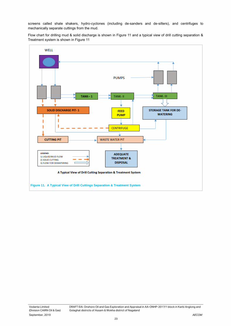
Vedanta Limited
(Division CAIRN Oil & Gas)
DRAFT EIA: Onshore Oil and Gas Exploration and Appraisal in AA-ONHP-2017/1 block in Karbi Anglong and
Golaghat districts of Assam & Wokha district of Nagaland
September, 2019 AECOM
23
screens called shale shakers, hydro-cyclones (including de-sanders and de-silters), and centrifuges to
mechanically separate cuttings from the mud.
Flow chart for drilling mud & solid discharge is shown in Figure 11 and a typical view of drill cutting separation &
Treatment system is shown in Figure 11
Figure 11. A Typical View of Drill Cuttings Separation & Treatment System

Vedanta Limited
(Division CAIRN Oil & Gas)
DRAFT EIA: Onshore Oil and Gas Exploration and Appraisal in AA-ONHP-2017/1 block in Karbi Anglong and
Golaghat districts of Assam & Wokha district of Nagaland
September, 2019 AECOM
24
Figure 12. Typical view of Drill Cuttings Separation & Treatment System
Cementing Cementing is a necessary aspect of exploratory drilling oil and gas wells. Cement is used to fulfil the following
works:
• Secure/support casing strings
• Isolate zones for production purposes
Well Evaluation During the drilling operations for different zones, logging operations would be undertaken to get information on the
potential type and quantities of hydrocarbons present in the target formations. Technicians employed by a specialist
logging Service Company do well logging by different well logging techniques including electric, sonic and
radioactive techniques. Logging instruments (sensors) are attached to the bottom of a wire line and lowered to the
bottom of the well and they are then slowly brought back. No emissions to the environment or any environmental
harm is associated with wire line logging operations. The radioactive source required for well logging operations
would be kept in specially designed container.
A drill-stem test would be frequently performed to evaluate the formation or zone from which the gas show was
observed. A drill-stem test enables the exploration company to obtain a sample of the fluids and gases contained
in the formation or interval being tested as well as pressure information, which is determined by special gauges
within the test tool. The test tool contains a valve which may be opened and closed to allow formation fluids to enter
the test tool and drill string. If there is sufficient fluid and pressure within the zone being tested, the formation fluid
may rise to the surface and flow into special test tanks used for that purpose. If gas is present, it is burned at the
surface as a flare.
Hydraulic Fracturing – for Tight Rock Reservoirs of
Hydrocarbons Hydraulic fracturing is used in tight rock reservoirs with low permeability, such as shale (i.e, the conductivity or
ability of hydrocarbons to flow in the formation is low because of the small pore size in the rock). The goal of
hydraulic fracturing in tight reservoir (shale) formations is to enable a well to produce the resource or to increase
the rate at which a well is able to produce the resource. Hydraulic fracturing may be conducted in wells with low
permeability formation and low pressure. Wells requiring hydraulic fracturing and numbers of stages of hydraulic

Vedanta Limited
(Division CAIRN Oil & Gas)
DRAFT EIA: Onshore Oil and Gas Exploration and Appraisal in AA-ONHP-2017/1 block in Karbi Anglong and
Golaghat districts of Assam & Wokha district of Nagaland
September, 2019 AECOM
25
fracturing per well would depend on seismic data acquired & interpreted and data acquired during the drilling phase
of the project.
Hydraulic fracturing is a common technique used to stimulate the production of oil and natural gas by creating
fractures or cracks that extend from the well hole into the rock formations. This is accomplished by injecting fluid,
which is usually a mixture of water and high viscosity fluid additives, under extremely high pressure. The pressure
of the water would then exceed the strength of the rock, causing fractures to enlarge. After the fractures take place,
a “propping agent” known as proppant (which is usually sand) is injected into the fractures to keep them from
closing. This allows the hydrocarbon to move more efficiently from the rock to the well. A single well may require
up to 15,000 m3 of water which may vary depending on the fracking requirements. For the hydraulic fracturing in a
well, proppant mass of 150,000 – 200,000 lbs per stage and fluid volume of 2500 bbls – 4000 bbls per stage would
be required.
Fracturing effluent generated would be discharged in the HDPE lined pits at the drilling well sites. The effluent
would be treated for disposal and reuse to the extent possible
Well kick situation & Control measures While drilling, if the formation pressure exceeds the hydrostatic pressure exerted by the drilling fluid, formation
fluids break out in to the well bore. This is called kick. Primary means of well control is to have sufficient over-
balance over formation pressure. For some reason if an unexpected over-pressurized formation is encountered
while drilling and if the well control situation arises, rig is equipped with equipment to control this situation. This set
of equipment is called “Blowout Preventers (BOP)”. Blow Out Preventer consists of, “Annular Preventer”, which
can generally close on any size or shape of tubular in the well bore and closes the annular space between drill
string and casing. Another type of blowout preventer is a “Ram Preventer”. Ram preventers are of two types i.e.,
Pipe Rams and Shear Rams. Pipe rams also close the annulus between drill string and casing, but they have a
fixed size. As such a specific pipe rams can be closed on a specific size of pipe. Shear rams are generally the last
choice of preventer would be operated as they shear drill string and shut off the well bore. After determining the
existing formation pressure and other geological complexities from the seismic data, appropriate BOP would be
used as per standard oil field guideline for the same.
All these preventers would be stacked in a sequence and such assembly of preventers is termed as BOP stack. A
typical BOP stack is illustrated in figure 13. Blowout prevention equipment would be installed, tested and operated
according to the well control procedures of Vedanta Limited (Division: Cairn Oil & Gas).

Vedanta Limited
(Division CAIRN Oil & Gas)
DRAFT EIA: Onshore Oil and Gas Exploration and Appraisal in AA-ONHP-2017/1 block in Karbi Anglong and
Golaghat districts of Assam & Wokha district of Nagaland
September, 2019 AECOM
26
Figure 13. Blow Out Preventer
Well Testing & Flaring During the exploration and appraisal drilling, where a hydrocarbon formation is found, initial well tests (generally
about one month of duration) would be carried out to establish flow rates, formation pressure and other parameters.
However, depending on the need, based on nature of the reservoirs, the exploratory and appraisal wells would be
tested for longer/extended durations to ascertain the reservoir parameters. During the well testing, crude oil, natural
gas and produced water could be generated and would be treated and disposed appropriately. Hydrocarbons would
be flared. Efficient test flare burner would be used to minimize incomplete combustion. As an alternative option, if
feasible, crude oil/ slop oil would be transferred to nearby refinery (terminals/depots) for processing or would be
sent to authorized recyclers
2.6 Early Production When, exploratory drilling is successful, more wells (termed as Appraisal wells) would be drilled to determine the
size and the extent of the field. Wells drilled to quantify the hydrocarbon reserves found are called as ‘appraisal’
wells. The appraisal activity would be carried out with an aim to evaluate the size and nature of the reservoir, to
determine the number of confirming or appraisal wells required, and whether any further seismic survey is
necessary. The technical procedures and activities in appraisal drilling would be the same as those employed for
exploration wells. A number of wells may be drilled from a single well pad/ drill site. Deviated or directional drilling

Vedanta Limited
(Division CAIRN Oil & Gas)
DRAFT EIA: Onshore Oil and Gas Exploration and Appraisal in AA-ONHP-2017/1 block in Karbi Anglong and
Golaghat districts of Assam & Wokha district of Nagaland
September, 2019 AECOM
27
at an angle from a site adjacent to the original discovery well may be used to appraise other parts of the reservoir,
in order to reduce the land requirement.
Drilling of Appraisal wells When, exploratory drilling is successful, more wells (termed as Appraisal wells) would be drilled to determine the
size and the extent of the field. Wells drilled to quantify the hydrocarbon reserves found are called as ‘appraisal’
wells. The appraisal activity would be carried out with an aim to evaluate the size and nature of the reservoir, to
determine the number of confirming or appraisal wells required, and whether any further seismic survey is
necessary. The technical procedures and activities in appraisal drilling would be the same as those employed for
exploration wells. A number of wells may be drilled from a single well pad/ drill site. Deviated or directional drilling
at an angle from a site adjacent to the original discovery well may be used to appraise other parts of the reservoir,
in order to reduce the land requirement.
Early Production Units (EPUs)/ Quick Production units (QPUs): Early Production Units (EPUs) or Quick Production Units (QPUs) would be installed for the processing of produced
well fluid. A EPU/ QPU would be a packaged/ modular mobile unit and would mainly consists of a heater-treater
separator or a production heater followed with a three phase separator, electrostatic coalescer, oil storage tanks,
oil tanker loading system, produced water separation and disposal system, power generation (GEG or DG), test
separator skid, utility systems such as fuel gas, flare, Inst. Air package, diesel storage, firefighting equipment, etc.
A QPF would be designed for a capacity of 2,000 BLPD (Barrels of liquid per Day) with water cut variation from 0
– 50 vol%.
Produced well fluid from one or more successful exploratory/ appraisal wells would be gathered & sent to heater-
treater separator skid for primary separation & heating purpose. Gathered produced fluid would be heated &
degassed in heater-treater separator skid operating at ~2.5 – 3 Barg and ~70 – 800C and separated in to gas, oil
and water streams. The separated produced (associated) gas would be either routed to fuel gas system or to flare
depending on the quantity and richness of produced (associated) gas. In case of sufficient quantity of produced
gas, a part of the produced gas would be used for power generation using gas engine generator (GEG), for firing
in heater-treater separator skid and for blanketing & purging purpose. The surplus gas post internal consumption
(if any) would be routed to flare for safe atmospheric discharge.
Separated oil from heater-treater separator skid would be sent to electrostatic coalescer separator (if needed,
based on oil properties) to separate the residual water and achieve BS&W specifications. The treated crude oil
from electrostatic coalescer separator would be sent to oil storage tanks. From oil storage tanks, oil would be
pumped & loaded in to road tanker using the tanker loading facility for evacuation of crude oil to the nearby available
facilities like terminals/ depots of consumers.
Separated produced water (PW) from heater-treater separator skid would be sent to degasser vessel operating at
low pressure. The evolved HC gases from degasser vessel would be routed to flare for safe disposal and the
degassed water sent to PW treatment package.
The PW treatment package would consists of a compact flotation unit or other equivalent gas floatation based de-
oiling (oil removal) system and a filtration system. The treated water from PW treated skid would be stored in PW
storage tanks. The produced water would be treated to achieve MoEF/ CPCB/ SPCB specifications (discharge
standards) and would be disposed off. The treated effluent (i.e. produced water) would be disposed-off using either
a nearby down hole disposal well (by reinjection in abandoned well) or other available and suitable onshore disposal
medium or solar/ mechanical evaporators depending on the quantity and feasibility.
The power requirement would be met through either state electricity grid and/ or installation of Diesel/ Gas Engine
Generator(s) using produced gas. If produced gas is sufficient quantity, then power generation using produced gas
would be preferred.
Along with above processing facility, a well test separator skid would be installed at pad. It would be used for well
testing purpose. Well under testing would be routed to test separator skid. The separated gas, oil & water would
be sent back to inlet of heater-treater separator skid for further processing. Quick production set-up would have
following utility systems & infrastructure for supporting the operations.
• Wells with selected artificial lift and flow lines
• Fuel gas system consisting of filters & a super-heater
• Instrument Air package or Instrument as system

Vedanta Limited
(Division CAIRN Oil & Gas)
DRAFT EIA: Onshore Oil and Gas Exploration and Appraisal in AA-ONHP-2017/1 block in Karbi Anglong and
Golaghat districts of Assam & Wokha district of Nagaland
September, 2019 AECOM
28
• Chemical dosing packages i.e. corrosion inhibitor, de-mulsifier & scale inhibitor etc.
• Elevated flare system or enclosed ground flare or ground flare
• Closed drain system, storm water drain system
• Fresh water storage
• Diesel storage
• Power generation (GEG and / or DG)
• Firefighting equipment
• Domestic sewage treatment facility (STP or septic tank & soak pit system);
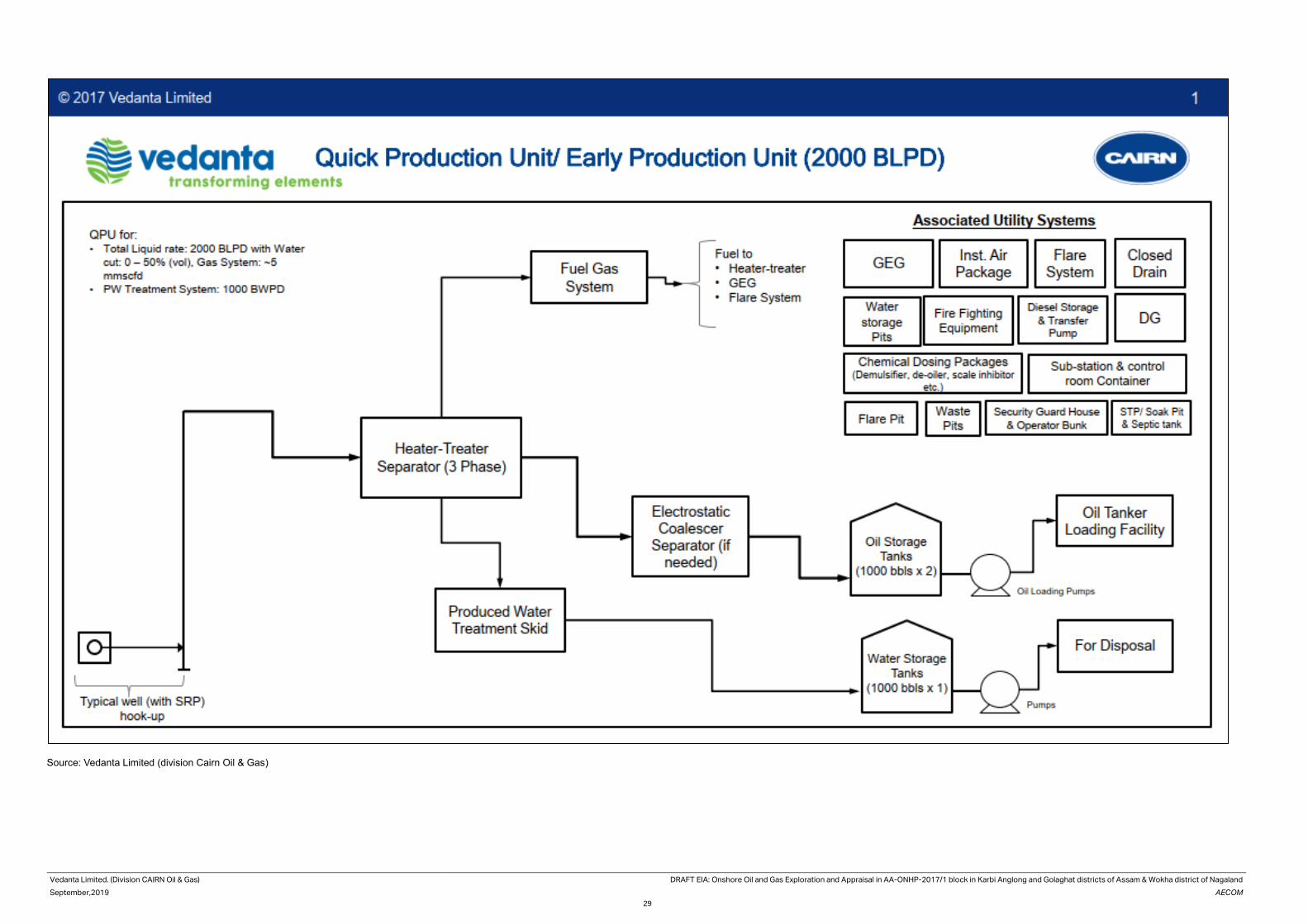
Vedanta Limited. (Division CAIRN Oil & Gas) DRAFT EIA: Onshore Oil and Gas Exploration and Appraisal in AA-ONHP-2017/1 block in Karbi Anglong and Golaghat districts of Assam & Wokha district of Nagaland
September,2019 AECOM
29
Source: Vedanta Limited (division Cairn Oil & Gas)

Vedanta Limited.
(Division CAIRN Oil & Gas)
DRAFT EIA: Onshore Oil and Gas Exploration and Appraisal in AA-ONHP-2017/1 block in Karbi Anglong and
Golaghat districts of Assam & Wokha district of Nagaland
September,2019 AECOM
30
2.7 Completion of Drilling On completion of activities, the well would be either plugged and suspended (if the well evaluations indicate
commercial quantities of hydrocarbons) or would be killed and permanently abandoned. In the event of a decision
to suspend the well, it would be filled with a brine solution containing very small quantities of inhibitors to protect
the well. The well would be sealed with cement plugs and some of the wellhead equipment (Blind Flange) would
be left on the surface (Cellar). If the well is abandoned it would be sealed with a series of cement plugs, all the
wellhead equipment would be removed, by leaving the surface clear of any debris and the site would be restored.
2.8 Well Decommissioning After the completion of the drilling activity, partial de-mobilization of the drilling rig and associated infrastructure
would be initiated. As discussed earlier, well testing may be carried out immediately after the drilling is completed.
The complete de-mobilization of the facilities at site would happen once well-testing completed successfully. This
would involve the dismantling of the rig, all associated equipment and the residential camp, and transporting it out
of the project area. It is expected that demobilization would take approximately 20-25 days and would involve the
trucking away of materials, equipment and other materials from the site to bring it back to its original condition. It is
estimated that about 50 truckloads would be transported out of site during this period. If no indication of any
commercially viable amount of oil or gas is encountered either before or after testing, the well would be declared
dry and accordingly would be plugged of and abandoned, and the site would be restored in line with regulations
and good industry practice.
2.9 Utilities & Resource Requirements, Associated
Facilities
Liquid Mud Plant (LMP) The Liquid Mud Plant (LMP) would be located at suitable locations of the fields to prepare drilling mud for the drilling
operations. It is estimated around 3 – 5 LMP’s would be set-up at any a given point of time for the proposed drilling
operations. All the tanks, equipment’s, civil works, pumps, mud laboratory with testing equipment along with the
mud waste disposal pits would be constructed within a single location.
The entire LMP area would be provided with containment area and with facilities for fork lift movement and
transportation of solid waste skips. The area would be designed to facilitate tanks for SBM mixing/ storage, tanks
of base oil storage and another tanks for brine mixing/storage. These tanks are interconnected with piping and
manifold with mixing hoppers, pumps connections, centrifuges connection with complete mud conditioning set-up,
loading-unloading piping/hoses connections.
The Mud Plant area would be surrounded with a containment boundary wall. All the liquid transferred from the LMP
to the drilling site would be through road tankers. For power supply requirement DG sets would be required with
one operational and one standby.
The LMP would have water storage tanks, bunk houses for operating office and site laboratory, dry chemical
storage area in paved surface, truck loading and unloading area with parking facility, cranes & forklifts maintenance
and parking facility, septic tank with soak pits, DG area, diesel storage area and power distribution panel & facility.
Accommodation & Camp Site Drilling camp sites would be set-up within the vicinity of the drilling sites to allow for easy movement of the crew
between the camp and the drilling sites. The camp site would generally comprise of transportable container cabins
(portable cabin) of 20 feet and 40 feet size to provide accommodation to operational crew. Each cabin would house
2 to 4 persons. A typical view of Vedanta Limited. (Division Cairn Oil & Gas)’s camp site has been presented in
Figure 14 below. Toilet facilities would be built as part of the accommodation unit. The sewage lines from the units
would be connected through a pipeline system to a septic tank and soak pit system. Additionally, there would be
dedicated cabins to serve as kitchen, cold storage, dining area, recreation area, laundry etc.
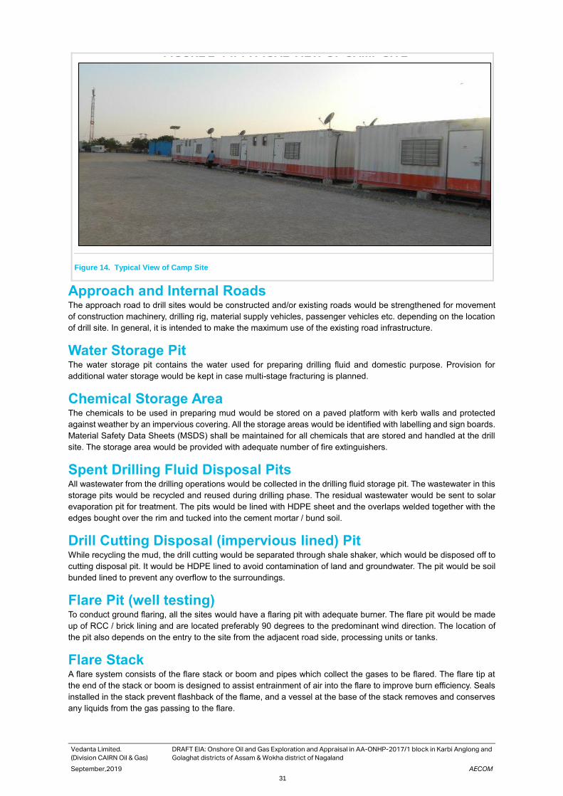
Vedanta Limited.
(Division CAIRN Oil & Gas)
DRAFT EIA: Onshore Oil and Gas Exploration and Appraisal in AA-ONHP-2017/1 block in Karbi Anglong and
Golaghat districts of Assam & Wokha district of Nagaland
September,2019 AECOM
31
Figure 14. Typical View of Camp Site
Approach and Internal Roads The approach road to drill sites would be constructed and/or existing roads would be strengthened for movement
of construction machinery, drilling rig, material supply vehicles, passenger vehicles etc. depending on the location
of drill site. In general, it is intended to make the maximum use of the existing road infrastructure.
Water Storage Pit The water storage pit contains the water used for preparing drilling fluid and domestic purpose. Provision for
additional water storage would be kept in case multi-stage fracturing is planned.
Chemical Storage Area The chemicals to be used in preparing mud would be stored on a paved platform with kerb walls and protected
against weather by an impervious covering. All the storage areas would be identified with labelling and sign boards.
Material Safety Data Sheets (MSDS) shall be maintained for all chemicals that are stored and handled at the drill
site. The storage area would be provided with adequate number of fire extinguishers.
Spent Drilling Fluid Disposal Pits All wastewater from the drilling operations would be collected in the drilling fluid storage pit. The wastewater in this
storage pits would be recycled and reused during drilling phase. The residual wastewater would be sent to solar
evaporation pit for treatment. The pits would be lined with HDPE sheet and the overlaps welded together with the
edges bought over the rim and tucked into the cement mortar / bund soil.
Drill Cutting Disposal (impervious lined) Pit While recycling the mud, the drill cutting would be separated through shale shaker, which would be disposed off to
cutting disposal pit. It would be HDPE lined to avoid contamination of land and groundwater. The pit would be soil
bunded lined to prevent any overflow to the surroundings.
Flare Pit (well testing) To conduct ground flaring, all the sites would have a flaring pit with adequate burner. The flare pit would be made
up of RCC / brick lining and are located preferably 90 degrees to the predominant wind direction. The location of
the pit also depends on the entry to the site from the adjacent road side, processing units or tanks.
Flare Stack A flare system consists of the flare stack or boom and pipes which collect the gases to be flared. The flare tip at
the end of the stack or boom is designed to assist entrainment of air into the flare to improve burn efficiency. Seals
installed in the stack prevent flashback of the flame, and a vessel at the base of the stack removes and conserves
any liquids from the gas passing to the flare.
FIGURE 2-14: TYPICAL VIEW OF CAMP SITE

Vedanta Limited.
(Division CAIRN Oil & Gas)
DRAFT EIA: Onshore Oil and Gas Exploration and Appraisal in AA-ONHP-2017/1 block in Karbi Anglong and
Golaghat districts of Assam & Wokha district of Nagaland
September,2019 AECOM
32
• For effective flaring document “Oil & Gas drilling and extraction industry” June 2006 would be followed.
• Standard flare design - An efficient test flare burner head equipped with a combustion enhancement
system would be selected to minimize incomplete combustion, black smoke, and hydrocarbon fallout.
Volumes of hydrocarbons flared would be recorded.
• Location and height of the flare stack based on maximum ground level concentration criteria & maximum
radiation intensity exposure criteria
• Flare stack- Minimum physical height of stack would be 30 m from ground level. Only in those situations
and or locations where elevated flares are not technical feasible, then ground flaring may be resorted to,
such as when there is a crop cultivation / vegetation in the vicinity of the well pad or / and where flared
gas volume is <0.5 MMSCFD (due to this low volume, sometimes elevated flare gets extinguished in
presence of wind)
Diesel Storage Tank The fuel (diesel) would be received in bulk quantity through tankers and would be stored in above ground steel
diesel tanks. The tank area is generally provided with secondary containment of adequate capacity to control any
accidental leaks.
Waste Storage Hazardous wastes generated from drilling activities such as used oil from pumps and machinery, empty chemical
and fuel barrels, contaminated oil rags and soil etc would be collected and stored in a designated storage area.
The storage area would have paved flooring, containment bund and roof. Waste oil from pumps and machinery
would be collected and stored in used oil barrels and would be kept in a designated storage area. The contaminated
soil and cotton rags would be disposed of at approved secured Land fill as per the legal provision. Used oil would
be disposed off through recyclers/ re-processors registered with the Central Pollution Control Board and authorized
by State Pollution Control Board.
Storm Water Drainage System Adequate drain would be provided all around the drilling site to prevent runoff of any oil containing waste water into
the nearby natural drainage area. The storm water drain shall be provided with oil trap and the collected water shall
be sent to storm water pit.
Sewage Treatment Plant (STP) Mobile Modular STP of capacity 30 m3/day for treatment of sewage and sullage Water generated within the well
pad limits. Each well site and camp site would have toilets which would be provided with septic tanks and soak pit
arrangement. To cater to about people that would stay in the camps site, adequately sized septic tanks and soak
pits would be provided.
Raw Material Requirement Maximum care would be taken for resource optimization, wherever possible with an aim of
• Resource Conservation
• Elimination of Waste Streams
• Minimizing Waste
• Reuse/recycle of Wastes
• The drill cuttings from the drilling operations associated with water-based mud would be used for filling low
lying areas as a sub grade construction material in construction of well pads, etc.
• Synthetic base mud would be re-used in further drilling activities
Raw Material Required for Drilling During drilling activities, materials like HSD, Steel (in the form of casings & tubulars) and chemicals like barite, oil
well cement and bentonite would be required. Other production equipment like tubular (Casing and tubings),
wellhead assembly, packer etc, and chemicals for mud and cementing required for the drilling operations and shall
be procured by the company from within the country and from abroad before the commencement of operations.

Vedanta Limited.
(Division CAIRN Oil & Gas)
DRAFT EIA: Onshore Oil and Gas Exploration and Appraisal in AA-ONHP-2017/1 block in Karbi Anglong and
Golaghat districts of Assam & Wokha district of Nagaland
September,2019 AECOM
33
Water based mud would be used for initial, shallower sections where massive shales are not encountered. The
deeper and difficult to drill formations would be drilled using synthetic base mud (SBM). Synthetic based mud can
be re-used. WBM typically consists of water, bentonite, polymers and barite. Other chemical additives viz. glycols
and salts may be used in conjunction to mitigate potential problems related to hydrate formation.
• Requirement WBM (approx.) 800-1000 m3/well
• Requirement SBM (approx.) 600-800 m3/well
The role of the mud in pressure control is especially important. If the drill bit penetrates a formation containing oil,
gas or water under pressure these fluids are prevented from flowing into the borehole by ensuring that the drilling
mud is of sufficient density to the natural formation pressures. The density of the mud can be increased by the
addition of barite weighting material. Bentonite is employed to improve the theological properties and enable the
drill cuttings to be transported from the hole while drilling and also be suspended in the fluid while the drill bit is
being changed. The barite used in the drilling mud would be as per American Petroleum Institute (API) standard
specifications.
Power Requirement
Drilling Operations The power requirement in the drilling site and the campsites would be provided through diesel generator (DG) sets.
The rated capacity of the DG sets required for onshore drilling site is provided in the Error! Reference source not f
ound..
Table 2.3 Details of DG Sets of Onshore Drilling Activity
S. No. Location DG Capacity
1. Camp site 2x350 KVA (Including one as standby)
2. Drilling site 3x1000 KVA (Including one as standby) or 2x1850 KVA (1
Working + 1 Standby) Depending on the rig capcity &
availability during E&A drilling phase
3. Radio Room 2X 100 KVA (Including one as standby)
Each Early Production Unit
1 Gas Engine Generator (GEG) 1 MW output
2 DG for Emergency purpose 1 x 500 KVA
Source: Vedanta Limited (Division: Cairn Oil & Gas)
Water Requirement
Drilling
Water consumption during drilling and testing of wells would be 102 m3 per day per well. Total 72 m3
per day fresh water would be required for drilling activities and 30 m3 per day freshwater would be used
for domestic purposes including drinking, washings and domestic use. Wells would be drilled either
water-based mud or synthetic based mud. The water requirement in drilling rig is mainly meant for
preparation of drilling mud apart from washing and domestic use. The water requirement for all the
project activities would be sourced locally through approved/authorized sources of surface water and/or
ground water (e.g. PHD bore wells, privately owned bore wells, irrigation Department/water resources
Dept. of State Govt.). In case of unavailability of water from approved sources, required water would be
extracted after obtaining permission from CGWA/State Govt.
Quick production unit/Early production unit
Approximately, 20 m3 per day water would be required for domestic use in each QPU/EPU.
The water requirement per well is shown in Table 2.4. Water balance diagram is presented in figure 15.
Table 2.4 Water Requirement
Description Quantity(m3)/day
Total Water Requirement for Drilling each well drilling 72

Vedanta Limited.
(Division CAIRN Oil & Gas)
DRAFT EIA: Onshore Oil and Gas Exploration and Appraisal in AA-ONHP-2017/1 block in Karbi Anglong and
Golaghat districts of Assam & Wokha district of Nagaland
September,2019 AECOM
34
Description Quantity(m3)/day
Total water Requirement for Domestic Use/well 30
Total Water requirement during early production stage
for each unit
15-18
Source: Vedanta Limited (Division: Cairn Oil & Gas)
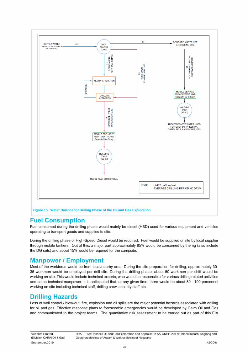
Vedanta Limited.
(Division CAIRN Oil & Gas)
DRAFT EIA: Onshore Oil and Gas Exploration and Appraisal in AA-ONHP-2017/1 block in Karbi Anglong and
Golaghat districts of Assam & Wokha district of Nagaland
September,2019 AECOM
35
Figure 15. Water Balance for Drilling Phase of the Oil and Gas Exploration
Fuel Consumption Fuel consumed during the drilling phase would mainly be diesel (HSD) used for various equipment and vehicles
operating to transport goods and supplies to site.
During the drilling phase of High-Speed Diesel would be required. Fuel would be supplied onsite by local supplier
through mobile tankers. Out of this, a major part approximately 85% would be consumed by the rig (also include
the DG sets) and about 15% would be required for the campsite.
Manpower / Employment Most of the workforce would be from local/nearby area. During the site preparation for drilling, approximately 30-
35 workmen would be employed per drill site. During the drilling phase, about 50 workmen per shift would be
working on site. This would include technical experts, who would be responsible for various drilling related activities
and some technical manpower. It is anticipated that, at any given time, there would be about 80 - 100 personnel
working on site including technical staff, drilling crew, security staff etc.
Drilling Hazards Loss of well control / blow-out, fire, explosion and oil spills are the major potential hazards associated with drilling
for oil and gas. Effective response plans to foreseeable emergencies would be developed by Cairn Oil and Gas
and communicated to the project teams. The quantitative risk assessment to be carried out as part of this EIA

Vedanta Limited.
(Division CAIRN Oil & Gas)
DRAFT EIA: Onshore Oil and Gas Exploration and Appraisal in AA-ONHP-2017/1 block in Karbi Anglong and
Golaghat districts of Assam & Wokha district of Nagaland
September,2019 AECOM
36
would also contribute towards identification of hazards, risks and formulating management plans for emergency
response, blowout, oil spills.
Pollution Sources and Characterization The various types of pollution from the proposed exploratory drilling operations are:
• Noise and Vibration;
• Air Emission;
• Liquid waste and
• Solid and Hazardous waste generation
Exhaust gases from DG sets, noise from the drilling operations, wastewater, drilling wastes are the major types of
the pollutants generated during the proposed drilling operations which is a temporary activity lasting for maximum
of 4- 5 months at each of the well locations.
Noise and Vibrations Noise would be generated during various phases of the project, site preparation, drilling and decommissioning of
wells. The major noise generating operations from the proposed activity are drilling operations, diesel generators,
mud circulation pumps and movement of vehicles. Noise during the site preparatory phase would primarily be
contributed by heavy construction machinery operating on site and vehicular sources. The noise generation work
however is transient and limited to the drilling period only. The diesel generators would be provided with acoustic
enclosures to comply with the regulatory requirements. Average noise emission ranges for different types of
machineries and vehicles is shown in Error! Reference source not found. and Error! Reference source not fo
und. respectively.
As drilling activity is continuous, part of the noise associated with functioning of the rig and ancillaries would be
generated throughout day and night.
Table 2.5 Typical Noise Emissions from Construction Machinery
Equipment Sound Level at Operator (in decibels)
Average Range
Earth Moving Equipment
Front End Loader 88.0 85-91
Back Hoe 86.5 79-89
Bull Dozer 96.0 89-103
Roller 90.0 79-93
Truck 96.0 89-103
Material Handling Equipment
Concrete Mixer <85.0 -
Crane/Hydra <85.0 -
Derrick 100 97-102
Source: British Columbia, “Construction Noise,” Workers Compensation Board of BC
Table 2.6 Drilling Rig and Equipment Noise Level
Equipment Equivalent Noise Level in db (A)
Average Range
Drilling Rig 96.9 88.0-103.0
Mud Pumps 76.9 73.3 -80.5
Diesel Generators 72.7 71.8-73.7
Shale Shakers 76.6 -
Vedanta Limited.
(Division CAIRN Oil & Gas)
DRAFT EIA: Onshore Oil and Gas Exploration and Appraisal in AA-ONHP-2017/1 block in Karbi Anglong and
Golaghat districts of Assam & Wokha district of Nagaland
September,2019 AECOM
37
Air Emissions
Exhaust emissions are expected from diesel generators to be used for the operation of drilling activities. Emissions
are also expected from flaring of gases during testing/extended testing of exploratory and appraisal wells. Vehicular
emissions are likely to occur during the transportation of materials, equipment and workforce. The principal air
pollutants would comprise of Suspended Particulate Matter (SPM), Sulphur and Nitrogen oxides (SO2 and NO2)
and other hydrocarbons (HC).
Additionally, the flaring and burning of oil during the testing of the well would also lead to the release of some
pollutants including un-burnt hydrocarbons to the atmosphere. Some fugitive emissions of dust and air pollutants
from vehicular exhaust would also happen during the project lifecycle, mostly during the operation and
decommissioning activities. Additionally, there would be re-entrainment of dust from the approach road leading to
the site mainly during the dry season.
The following pollution prevention and control measures would be adopted-
• Air emission specifications would be considered during all equipment selection and procurement.
• The associated gas stream would be routed to an efficient flare system.
Liquid Waste
The drilling operation would generate wastewater in the form of wash water due to washing of equipment, string
and cuttings etc. The only other source of wastewater generated from drilling operation is sewage from sanitation
facilities. Around 15 to 25 m3/day/well of wastewater would be generated, which would be treated in modular
Sewage Treatment Plant (STP) and the treated water would be used for dust suppression, green belt, etc. It is
expected that wastewater in the form of Drill cutting washing + Rig washing+ cooling etc shall be generated at an
average rate of around 30 to 40 m3/day/well during the drilling operations from a single well. Waste water would
be discharged in HDPE lined evaporation pit for disposal. The wash water would contain variable quantities of
mineral salts, solids, suspended and dissolved hydrocarbons, and other organic and inorganic components in very
minor quantities. The drilling wash wastewater would be treated prior to discharge to comply with the regulatory
standards. Treated effluent (PW) would be disposed off on the suitable onshore disposal medium or solar/mech.
evaporators depending on feasibility. The quantity of wastewater generation and anticipated disposal methods is
given in Error! Reference source not found..
Table 2.7 Waste Water Generated During Drilling and their Disposal
Wastewater Quantity Disposal
Drilling wash wastewater 30-40 m3/day/well The wastewater would be adequately
treated in an Effluent Treatment Plant
(ETP) to ensure conformance to the
CPCB onshore oil and gas extraction
industry effluent standards or disposal
through solar evaporation.
Domestic Wastewater 15-25 m3/day/well The domestic wastewater would be
treated in mobile Sewage Treatment
Plant and the treated water would be
used for dust suppression, green belt,
etc.
During Early Production
Solid and Hazardous Waste The different solid and hazardous waste water generated during project and their mode of disposal has been
presented in Error! Reference source not found..

Vedanta Limited.
(Division CAIRN Oil & Gas)
DRAFT EIA: Onshore Oil and Gas Exploration and Appraisal in AA-ONHP-2017/1 block in Karbi Anglong and
Golaghat districts of Assam & Wokha district of Nagaland
September,2019 AECOM
38
Table 2.8 Waste Water Generated during and Mode of Disposal
Waste Type Quantity Mode of Disposal
Domestic Waste 25 – 30 kg
per day/well Would be stored in compost pits on daily basis.
Drill Cuttings associated with WBM
250-750 tons/ well
Cuttings would be washed and contained in cuttings disposal area (HDPE lined collection pit) provided per the requirement of HWMHTM, 2016 Rules
Drill Cuttings associated with SBM
500-1500 tons/well
Cuttings would be washed and contained in cuttings disposal area (HDPE lined collection pit) provided per the requirement of HWMHTM, 2016 Rules
Spent/Residual Drilling Mud
250-500 tons/ well The mud would be disposed as per Hazardous Waste Rules, 2016
Sludge containing oil & other drilling wastes
250-500 tons/ well The oil contaminated sludge would dispose as per Hazardous Waste Rules, 2016
Used oil 1-2 tons/wel Used oil would be sent CPCB authorized recyclers.
Non-combustible waste containing metallic residues
1000-1200 kg/well To be analysed for the trace/heavy metals content before disposing suitably
Left over chemicals and materials, scrap metal
250 - 500 kg/well
Scrap metal and recoverable material to the salvages before dispose of balance material through the registered vendors
Cement, grit, blasting and painting wastes
500 - 600 kg/well To be disposed of their registered vendors on periodic basis.
Pollution Prevention Control Measures at Design Stage Vedanta Limited. (Division Cairn Oil & Gas) would include necessary pollution prevention control measures in the
well pad designing stage. Basic provision for pollution prevention control measures would be as follows:
• Liquid Mud Plant - The Mud Plant area would be surrounded with a containment boundary wall. All the liquid
transferred from the LMP to the drilling site would be through road tankers.
• Chemical Storage Area -The chemicals to be used in preparing mud would be stored on a paved platform
with kerb walls and protected against weather by an impervious covering. The storage area would be
provided with adequate number of fire extinguishers.
• Spent Drilling Fluid Disposal Pits - Spent drilling fluid would be recycled and reused during drilling phase.
The residual wastewater would be sent to solar evaporation pit for natural solar drying. The pits would be
lined with HDPE sheet and the overlaps welded together with the edges bought over the rim and tucked into
the cement mortar / bund soil.
• Drill Cutting Disposal -Drill Cuttings would be disposed of in lined pitsto avoid contamination of land and
groundwater. The pit would be soil bunded and HDPE lined to prevent any overflow to the surroundings.
• Flare Pit (well testing) - To conduct ground flaring, all the sites would have a flaring pit with adequate burner.
The flare pit would be made up of RCC / brick lining and are located preferably 90 degrees to the wind
direction.
• Diesel Storage Tank - The tank area would be provided with secondary containment (dykewalls)of adequate
capacity to control any accidental leaks.
• Waste/ Lubricating Oil Storage - The storage area would have paved flooring, containment bund and roof.
Waste oil from pumps and machinery would be collected and stored in used oil barrels and shall be kept in
a designated storage area.

Vedanta Limited.
(Division CAIRN Oil & Gas)
DRAFT EIA: Onshore Oil and Gas Exploration and Appraisal in AA-ONHP-2017/1 block in Karbi Anglong and
Golaghat districts of Assam & Wokha district of Nagaland
September,2019 AECOM
39
• Storm Water Drainage System - A garland drain would be provided all around the drilling site to prevent
runoff of any oil containing waste into the nearby area. The storm water drain shall be provided with oil trap
and the collected water shall be sent to storm water pit.
• Spill Containment System - Containment systems and oil traps would be provided to trap any spillage of oil
at the drilling site. All potential sources of spillage would be equipped with drip pans in order to contain
spills.
• Mobile STP - Each well site and camp site would have toilets which would be provided with modular STP for
treatment of sewage generated within the well facility.
2.10 Project Cost Vedanta Limited (Division Cairn Oil and Gas) has planned to carry out the proposed project activities in the AA-
ONHP-2017/1 Block over a period of 10-12 years. The estimated project cost is Rs. 584.0 Crore.

Vedanta Limited. (Division CAIRN Oil & Gas) DRAFT EIA: Onshore Oil and Gas Exploration and Appraisal in AA-ONHP-2017/1 block in Karbi
Anglong and Golaghat districts of Assam & Wokha district of Nagaland
September, 2019 AECOM
40
3. Description of the Environment
3.1 Introduction
This chapter describes the existing baseline environmental settings in study area including AA-ONHP-2017/1 Block
and its immediate surroundings. This includes the physical environment comprising air, water and land
components, the biological environment, and socio-economic environment. Attributes of the physical environment
like air, water, soil quality and noise level in the surrounding area have been assessed primarily through monitoring
and analysis of samples collected from field. Baseline monitoring has been carried out during Summer season,
2019 (March to May 2019). Information about topography, geology, hydrology prevailing natural hazards risks like
floods, earthquakes etc. have been collected from different available literatures and information from various
government departments. Primary surveys were carried out to understand and record the biological environment
prevailing in the area and the same was verified against published information and literatures. The socio-economic
environment has been studied through consultations with various stakeholders in the villages within the AA-ONHP-
2017/1 Block. Additionally, socio-economic data have been obtained from the Census of India 2011 reports.
3.2 Study area
The study area for determination of environmental, biological and social baseline is the entire AA-ONHP-2017/1
Block and 10km radius area from the Block boundary. The Block AA-ONHP-2017/1 is located in Karbi Anglong and
Golaghat district of Assam and Wortha District of Nagaland. Although, no activity is planned in Nagaland district.
The entire study area is covered by SoI Toposheet no G46J/12, G46J/16, G46P/9, G46P/13.
3.3 Physiography and Geology
Physiography
As already mentioned, the study area is located at the intersection of KarbiAnglong, Golaghat districts of Assam
and Workha District of Nagaland. The physiography of this area is undulating land with elevation of about 100m
above MSL. The area falls in the eastern part of KarbiAnglong district which is in the plain areas of the district while
in Golaghat district the study area falls in the southern part, which has undulating features. The slope of the area
is towards north-east and is gradual.
Geology
The South Assam Shelf is a part of Assam & Assam-Arakan basin and situated in the Dhansiri valley separated
from North Assam shelf by a major E-W trending Jorhat fault. The area represents a part of foreland basin flanked
by NE-SW trending Naga Schuppen belt on the East & Southeast and Mikir Massif in the West. The area is sparsely
exhibiting intra-cratonic graben filling sediments from Permian age to basaltic flows of Early Cretaceous age. The
extensive Late Cretaceous-Oligocene sequence deposited in Passive margin setting witnessed differential erosion
at places and overlain by a thick pile of Miocene to Recent sediments deposited in a foreland setting. The total
sedimentary thickness in the area is of the order of 3500 m. Reservoirs in different stratigraphic levels starting from
fractured Basement to Sylhet, Kopili, Barail, Bokabil, Tipam and Namsang have been charged in different parts of
the basin depending on entrapment and are required to be probed for hydrocarbons.
3.4 Hydrogeology
Karbi Anglong District
As mentioned earlier, the entire Karbi Anglong district can be divided into Consolidated formations comprising
oldest granite rock, gneisses etc, semi-consolidated rocks constituting the Tertiary rocks and unconsolidated
alluvial sediments. In the consolidated formation, ground water is confined to the top weathered zone and the
fractures and fissures of the fresh hard rock. The thickness of the weathered zone depends on compactness and
topography of rock types and other climatic effects. The depth of water level varies from 4 to 6 m in low terraced
zone and 8 to 10 m in high terraced zones. In small valleys within denudational hills, the static water level is 5 to 7
m bgl with water level fluctuation ranging from 2 to 3 m. The depth of the weathered materials generally is from 10
– 20 m. About 13 nos. borewells were drilled in hard rock and yield of the boreholes are limited. The depth to water
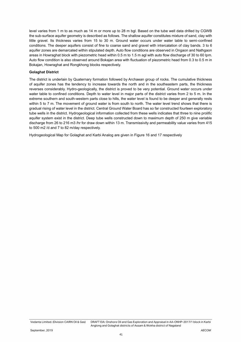
Vedanta Limited. (Division CAIRN Oil & Gas) DRAFT EIA: Onshore Oil and Gas Exploration and Appraisal in AA-ONHP-2017/1 block in Karbi
Anglong and Golaghat districts of Assam & Wokha district of Nagaland
September, 2019 AECOM
41
level varies from 1 m to as much as 14 m or more up to 28 m bgl. Based on the tube well data drilled by CGWB
the sub-surface aquifer geometry is described as follows. The shallow aquifer constitutes mixture of sand, clay with
little gravel. Its thickness varies from 15 to 30 m. Ground water occurs under water table to semi-confined
conditions. The deeper aquifers consist of fine to coarse sand and gravel with intercalation of clay bands. 3 to 6
aquifer zones are demarcated within stipulated depth. Auto flow conditions are observed in Ongaon and Nathgaon
areas in Howraghat block with piezometric head within 0.5 m to 1.5 m agl with auto flow discharge of 30 to 60 lpm.
Auto flow condition is also observed around Bokajan area with fluctuation of piezometric head from 0.3 to 0.5 m in
Bokajan, Howraghat and Rongkhong blocks respectively.
Golaghat District
The district is underlain by Quaternary formation followed by Archaean group of rocks. The cumulative thickness
of aquifer zones has the tendency to increase towards the north and in the southeastern parts, the thickness
reverses considerably. Hydro-geologically, the district is proved to be very potential. Ground water occurs under
water table to confined conditions. Depth to water level in major parts of the district varies from 2 to 5 m. In the
extreme southern and south-western parts close to hills, the water level is found to be deeper and generally rests
within 5 to 7 m. The movement of ground water is from south to north. The water level trend shows that there is
gradual rising of water level in the district. Central Ground Water Board has so far constructed fourteen exploratory
tube wells in the district. Hydrogeological information collected from these wells indicates that three to nine prolific
aquifer system exist in the district. Deep tube wells constructed down to maximum depth of 250 m give variable
discharge from 26 to 216 m3 /hr for draw down within 13 m. Transmissivity and permeability value varies from 415
to 500 m2 /d and 7 to 82 m/day respectively.
Hydrogeological Map for Golaghat and Karbi Analog are given in Figure 16 and 17 respectively
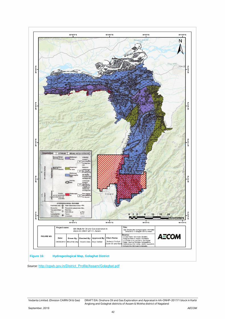
Vedanta Limited. (Division CAIRN Oil & Gas) DRAFT EIA: Onshore Oil and Gas Exploration and Appraisal in AA-ONHP-2017/1 block in Karbi
Anglong and Golaghat districts of Assam & Wokha district of Nagaland
September, 2019 AECOM
42
Figure 16: Hydrogeological Map, Golaghat District
Source: http://cgwb.gov.in/District_Profile/Assam/Golaghat.pdf

Vedanta Limited. (Division CAIRN Oil & Gas) DRAFT EIA: Onshore Oil and Gas Exploration and Appraisal in AA-ONHP-2017/1 block in Karbi
Anglong and Golaghat districts of Assam & Wokha district of Nagaland
September, 2019 AECOM
43
Figure 17: Hydrogeological Map, Karbi Analnog District
Source: http://cgwb.gov.in/District_Profile/Assam/Karbi%20Anglong.pdf

Vedanta Limited. (Division CAIRN Oil & Gas) DRAFT EIA: Onshore Oil and Gas Exploration and Appraisal in AA-ONHP-2017/1 block in Karbi
Anglong and Golaghat districts of Assam & Wokha district of Nagaland
September, 2019 AECOM
44
3.5 Topography
The general topography is plain with undulating terrains in south, south east (Figure 18). Dhansiri River flows
through the block in north south direction of the block and Bakala Nadi flows in the western side, nearest distance
is 406 meters from the proposed block boundary. In general, the elevation of the block ranges between 429-584m
above mean sea level.
Figure 18. Elevation Map of the Block AA-ONHP-2017/1.
3.6 Drainage
The River Brahmaputra flowing in east-west direction in the extreme northern parts of the district and its tributaries
flowing in northerly direction, control the entire drainage system of the district and plays an important role in the
ground water occurrence and control of the district. Important Rivers of the district are Dhansiri and Dayang. These
rivers have meandering courses with abandoned channels in the form of bils and ox-bow lakes along their courses.
The drainage map for Block AA-ONHP-2017/1 is given Figure 19.

Vedanta Limited. (Division CAIRN Oil & Gas) DRAFT EIA: Onshore Oil and Gas Exploration and Appraisal in AA-ONHP-2017/1 block in Karbi
Anglong and Golaghat districts of Assam & Wokha district of Nagaland
September, 2019 AECOM
45
Figure 19. Drainage Map of the Block AA-ONHP-2017/1
3.7 Vulnerability of the Site
A natural disaster during the life cycle of the project can have a significant effect on the functioning of the project
in addition to affecting the local environment in the area and stressing the availability of resources for the project.
Such disasters also sometimes create difficulties in access through disruption of transportation links.
Seismicity
The study area is located in Zone V as shown in the Bureau of Indian Standards (BIS) 2000 seismic zone map is
given in Figure-20. Zone V is defined as region which might encounter earthquakes of maximum intensity.
The region has experienced a large number of earthquakes of tectonic origin. The risk probabilities of earthquake
are less over the entire Brahmaputra valley. Two major earthquakes of magnitude 8.7 (occurred in 1897) and 8.6
(in 1950) causing large scale damage to life and properties in this region. The details of the earthquakes are given
in Table-3.1. and the seismeic zone map.
Table 3.1 SIGNIFICANT EARTHQUAKES IN ASSAM
Date of Earthquake
Location of Epicentre
Remarks
12th June 1897 Near Rangjoli, Assam
Magnitude M 8.7. This was one of the most powerful earthquakes in the Indian sub-
continent. The quake wreaked havoc across the present states of Assam and
Meghalaya. 1500 people were killed and hundreds more hurt.
15th Aug 1950 Indo-China Border Region
Magnitude M 8.6. This "Independence Day" earthquake was the 6th largest earthquake of the 20th century. Though it hit in a mountainous region along India's international border with China, 1500 people were killed and the drainage of the region was greatly affected
Source: Amateur Seismic Centre www.asc-india.org

Vedanta Limited. (Division CAIRN Oil & Gas) DRAFT EIA: Onshore Oil and Gas Exploration and Appraisal in AA-ONHP-2017/1 block in Karbi
Anglong and Golaghat districts of Assam & Wokha district of Nagaland
September, 2019 AECOM
46
Figure 20. Seismic Zone & Flood Zone Map of Assam
Source: Disaster Management, Relief & Civil defence Department, Govt. of Assam
Floods One of the most serious problems of Assam is the occurrence of frequent and widespread floods. The Brahmaputra
and the Barak are the two main rivers, which causes major problem during the monsoon period every year in the
form of floods thereby resulting in bank erosion and drainage congestion. Large areas are inundated by floods
causing heavy loss in terms of life and property; and also cause extensive damage to standing crops thereby
affecting local livelihood. The flood history of Assam is given in Table 3.2.
Table 3.2 Flood History in Assam
Year Affected Area (Lakh ha) Affected Population (Lakh) Total Damage
(in Crores INR)
1990 0.488 1.692 74.56
1991 0.997 5.307 191.15
1992 0.213 0.974 26.56
1993 1.348 5.261 0.215
1994 0.053 0.177 0.20
1998 0.972 4.698 700.00
2000 1.000 3.900 244.06
2001 0.200 0.540 11.14
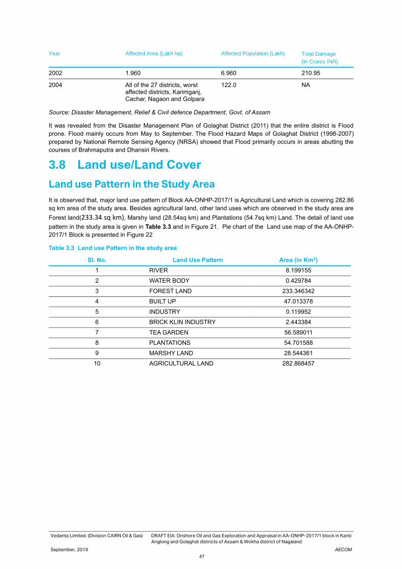
Vedanta Limited. (Division CAIRN Oil & Gas) DRAFT EIA: Onshore Oil and Gas Exploration and Appraisal in AA-ONHP-2017/1 block in Karbi
Anglong and Golaghat districts of Assam & Wokha district of Nagaland
September, 2019 AECOM
47
Year Affected Area (Lakh ha) Affected Population (Lakh) Total Damage
(in Crores INR)
2002 1.960 6.960 210.95
2004 All of the 27 districts, worst affected districts, Karimganj, Cachar, Nagaon and Golpara
122.0 NA
Source: Disaster Management, Relief & Civil defence Department, Govt. of Assam
It was revealed from the Disaster Management Plan of Golaghat District (2011) that the entire district is Flood
prone. Flood mainly occurs from May to September. The Flood Hazard Maps of Golaghat District (1998-2007)
prepared by National Remote Sensing Agency (NRSA) showed that Flood primarily occurs in areas abutting the
courses of Brahmaputra and Dhansiri Rivers.
3.8 Land use/Land Cover
Land use Pattern in the Study Area
It is observed that, major land use pattern of Block AA-ONHP-2017/1 is Agricultural Land which is covering 282.86
sq km area of the study area. Besides agricultural land, other land uses which are observed in the study area are
Forest land(233.34 sq km), Marshy land (28.54sq km) and Plantations (54.7sq km) Land. The detail of land use
pattern in the study area is given in Table 3.3 and in Figure 21. Pie chart of the Land use map of the AA-ONHP-
2017/1 Block is presented in Figure 22
Table 3.3 Land use Pattern in the study area
Sl. No. Land Use Pattern Area (in Km2)
1 RIVER 8.199155
2 WATER BODY 0.429784
3 FOREST LAND 233.346342
4 BUILT UP 47.013378
5 INDUSTRY 0.119952
6 BRICK KLIN INDUSTRY 2.443384
7 TEA GARDEN 56.589011
8 PLANTATIONS 54.701588
9 MARSHY LAND 28.544361
10 AGRICULTURAL LAND 282.868457
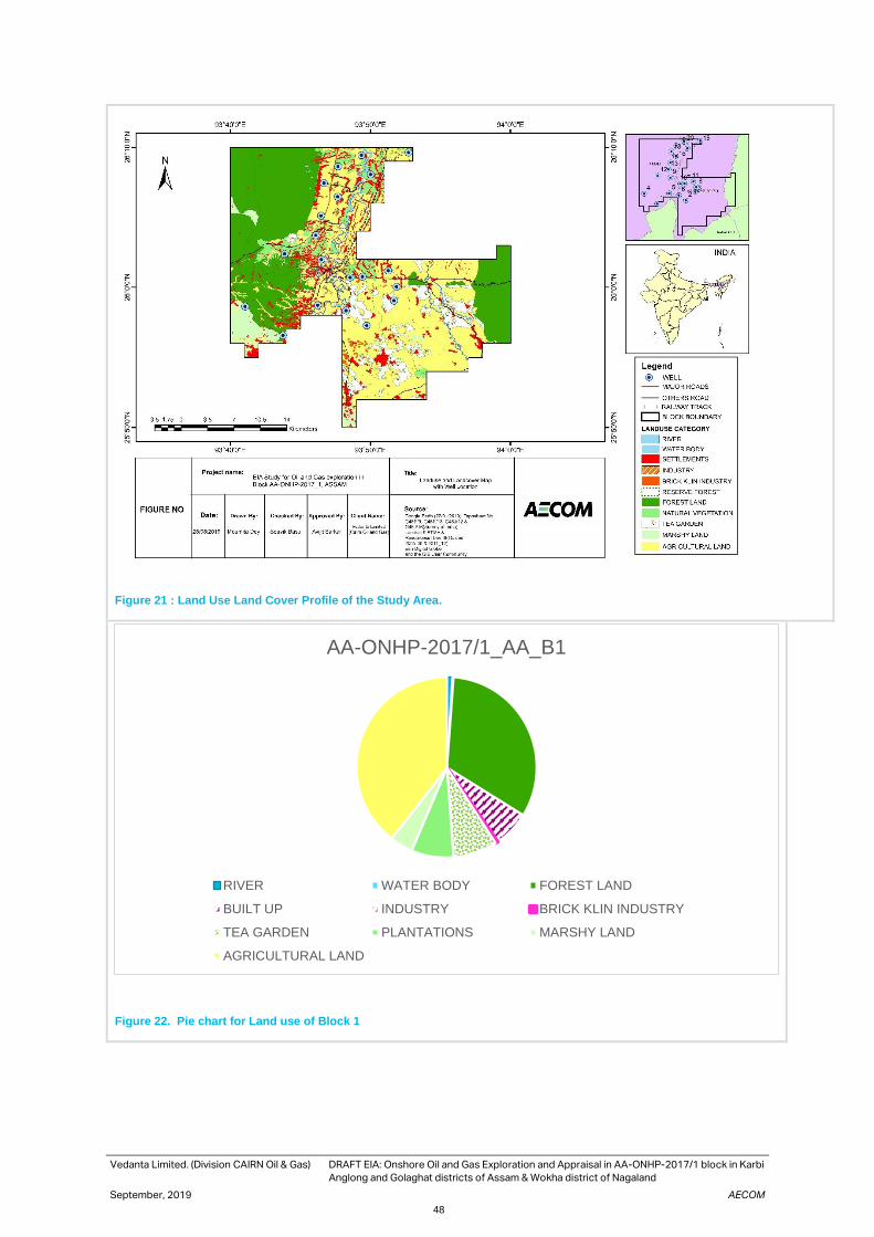
Vedanta Limited. (Division CAIRN Oil & Gas) DRAFT EIA: Onshore Oil and Gas Exploration and Appraisal in AA-ONHP-2017/1 block in Karbi
Anglong and Golaghat districts of Assam & Wokha district of Nagaland
September, 2019 AECOM
48
Figure 21 : Land Use Land Cover Profile of the Study Area.
Figure 22. Pie chart for Land use of Block 1
AA-ONHP-2017/1_AA_B1
RIVER WATER BODY FOREST LAND
BUILT UP INDUSTRY BRICK KLIN INDUSTRY
TEA GARDEN PLANTATIONS MARSHY LAND
AGRICULTURAL LAND

Vedanta Limited. (Division CAIRN Oil & Gas) DRAFT EIA: Onshore Oil and Gas Exploration and Appraisal in AA-ONHP-2017/1 block in Karbi
Anglong and Golaghat districts of Assam & Wokha district of Nagaland
September, 2019 AECOM
49
3.9 Climate & Meteorology
Temperature
As per climatological table of 1971-2000 of Indian Meteorological Department (IMD) nearest weather station to AA-
ONHP_2017/1 is located in Lumding city which is located approximately 54 km in south west direction of the block.
As per the data, temperature reaches around 42.0oC during the month of June. Summer is generally wet in nature
with very humidity in the air. Whereas, winter experience very low temperature. The lowest temperature recorded
in the month of January which reaches up to 2.2oC.
Relative Humidity
As per the Climatological Normal (1981-2010), mean relative humidity in winter, at day time was recorded as 87%,
whereas the mean night time relative humidity was 85%. In summer mean day time relative humidity accounted as
87%.
Rainfall
Lumding has annual mean rainfall of 1239.2 mm throughout the year. Highest rainfall recorded in monsoon.
Wind Speed and Wind Direction
As per the Atlas of Windrose (1971-2000) by Indian Meteorological Department, highest monthly mean wind speed
is 3.2 m/s and lowest monthly mean wind speed is 1.8 m/s in November. Predominant wind direction is NNE
direction.
Source: Windrose Atlas (1971-2000) by Indian Meteorological Department
Figure 23. Windrose of Jorhat
Note: Windrose for Lumding district is not present in IMD Atlas.
Table 3.4 Climatology profile of Lumding
Seasons Temperature (°C) Relative humidity Rainfall (mm)
Maximum Minimum Day time Night time
Winter 89.3 22.7 83 77 158.9
Summer 108.8 43.2 89 86 331.7

Vedanta Limited. (Division CAIRN Oil & Gas) DRAFT EIA: Onshore Oil and Gas Exploration and Appraisal in AA-ONHP-2017/1 block in Karbi
Anglong and Golaghat districts of Assam & Wokha district of Nagaland
September, 2019 AECOM
50
Monsoon 109.0 65.0 90 86 1062
Post Monsoon 101.0 50.0 82 75 303
Source: IMD Meteorological table
Micrometeorological Parameters Block Micrometeorological parameters have been observed to assess the local climatic condition of the study area.
Micrometeorological setup was installed at Bokajan Village. The micro met monitoring stations have been installed
at a height of about 10 m above the ground level, ensuring that there are no obstructions to the free flow of winds.
A three-monthly (March to May 2019) monitoring was conducted, and the prevailing meteorological conditions are
discussed below (Table 3.5).
Meteorological profile of this region characterised by medium temperature with high humidity, with a medium lesser
amount of rainfall. Temperature of this region varies from, 16.9°C to 36.3°C. Relative humidity accounts for 78. 2%,
on an average throughout the monitoring period. Average wind speed was measured as 3.18 metre/second
throughout the study period with predominant wind direction from NE to SW.
Table 3.5 Climatological profile of the Study Area
Station name Temperature(°C) Relative
humidity
Rainfall Wind speed Wind direction
Max Min (Average) (mm) (mph)
Bokajan 36.3 16.9 78.8 60.62mm 3.18 NE to SW
Source: MET station installed at Bokajan

Vedanta Limited. (Division CAIRN Oil & Gas) DRAFT EIA: Onshore Oil and Gas Exploration and Appraisal in AA-ONHP-2017/1 block in Karbi
Anglong and Golaghat districts of Assam & Wokha district of Nagaland
September, 2019 AECOM
51
Figure 24. Windrose of Bokajan MET station.
Source: MET station installed at Bokajan
Ambient Air Quality
The baseline status of the ambient air quality was assessed through a scientifically designed ambient air quality-
monitoring network. The design of monitoring network in the air quality study was based on (i)meteorological
conditions on synoptic basis; (ii) topography of the study area; (iii) representatives of regional background air quality
for obtaining baseline status; (iv) representatives of likely impact areas and (v) location of sensitive receptors in the
study area, (vi) settlement area and (vi) accessibility and availability of infrastructure. Criteria used for designing
the network have been principally governed by pre-dominant wind directions obtained from the wind rose pattern
for the summer season and the accessibility of the selected sites.
Ambient air quality monitoring was conducted for following parameters:(i) Particulate Matter (PM10 & PM 2.5), (ii)
Sulphur Dioxide (SO2), (iii) Nitrogen Dioxide (NO2), (iv) Carbon monoxide (CO),Ozone(O3), Benzene(C6H6), Benzo
alpha pyrene (BaP), Lead(Pb) ,Arsenic(As), Nickel(Ni) , Ammonia(NH3) ,Hydrocarbons(HC)- both methane and
non-methane , Volatile Organic Compounds (VoC). Ambient air quality monitoring was conducted at AA-ONHP-
2017/1 Block in representative locations during pre-monsoon season i.e. March to May 2019.
There are 8 locations have been selected in the study area for ambient air quality monitoring. The air monitoring
activity was conducted as per the approved CPCB guidelines. The monitoring locations have been selected after
considering the upwind, downwind and cross wind direction of the proposed well location within the study area.

Vedanta Limited. (Division CAIRN Oil & Gas) DRAFT EIA: Onshore Oil and Gas Exploration and Appraisal in AA-ONHP-2017/1 block in Karbi
Anglong and Golaghat districts of Assam & Wokha district of Nagaland
September, 2019 AECOM
52
AAQ Monitoring Locations
The ambient air quality monitoring was carried out at eight (8) locations in and around the study area. The
monitoring locations have been selected taking into considerations factors such as predominant up & down wind
directions and cross wind direction of the proposed well location, locations of the sensitive receptors in the Block
area, and, any existing air pollution sources also taken into consideration during selection of monitoring location.
The detail ambient air quality monitoring results is given in Appendix 3-2. The location of the 8 air monitoring
locations is given in Table 3-6
Table 3.6 Ambient Air Quality Monitoring Stations
Locat
ion
Code
Location Coordinate Direction Justification
AAQ1 Nepali Basti,
Balipathar
25°51'41.80"N,
93°48'22.52"E
1.39 km SW from Well no 2 Predominant downwind of
Well 2
AAQ2 Romon Ringtigaon 25°52'5.17"N
93°51'57.04"E
0.81 km SSW from Well no
1
Predominant downwind of
Well 1
AAQ3 Satsang Village 25°57'59.62"N
93°50'11.87"E
2.5km NW from Well no 13 Predominant downwind of
Well 13
AAQ4 Goutam Basti 25°54'27.75"N
93°56'4.79"E
2.0 km SW from Well no 8 Predominant downwind of
Well 8
AAQ5 Ekrani Basti 26° 3'52.87"N
93°46'30.81"E
0.70 km ENE from well no
35
2nd Predominant downwind
of Well 35
AAQ6 Santigaon 25°58'6.49"N
93°42'48.39"E
2.0km NW from well no 11 Upwind of Well 11
AAQ7 Panchlamardgaon 26° 0'35.78"N
93°54'29.95"E
1.62 km SSW from Well no
30
Predominant downwind of
Well 30
AAQ8 Gharialdubi 26° 9'41.93"N
93°46'33.52"E
1.5km NNW from Well no
45
Near Nambar Reserved
Forest
Source: Primary baseline Survey of Air Quality, (March – May 2019)

Vedanta Limited. (Division CAIRN Oil & Gas) DRAFT EIA: Onshore Oil and Gas Exploration and Appraisal in AA-ONHP-2017/1 block in Karbi
Anglong and Golaghat districts of Assam & Wokha district of Nagaland
September, 2019 AECOM
53
Figure 25. Ambient Air Quality, Noise quality and Traffic Monitoring Stations in Block AA-ONHP-2017/01
AAQ monitoring Results
Ambient air quality monitoring was conducted for twice a week 24 hourly for three months at eight (8) locations for
each parameter as listed above in table below. Analysis of ambient air quality monitoring results for March to May’19
is presented in Table 3-7.

Vedanta Limited. (Division CAIRN Oil & Gas) DRAFT EIA: Onshore Oil and Gas Exploration and Appraisal in AA-ONHP-2017/1 block in Karbi Anglong and Golaghat districts of Assam & Wokha district of Nagaland
September, 2019 AECOM
54
Table 3.7 Ambient Air Quality monitoring result of Block AA-ONHP-2017/1
Parameter Results AAQ-1 AAQ-2 AAQ-3 AAQ-4 AAQ-5 AAQ-6 AAQ-7 AAQ-8
PM10 (µg/m3)
NAAQS 100 100 100 100 100 100 100 100
Max 81.3 83.7 87.3 82 80.8 81.8 80 80.4
Min 34.2 31.2 42.2 37.5 34.2 37.5 34.5 37.2
Average 62.6 63.5 65.0 65.3 62.8 62.4 63.5 63.0
98th Percentile 79.92 82.09 84.59 80.95 80.30 81.06 79.36 79.94
PM2.5 (µg/m3)
NAAQS 60 60 60 60 60 60 60 60
Max 51.7 41.8 52.6 48.3 43.3 49.7 44.6 51.8
Min 14.5 14.5 22.9 18.6 16.6 18.5 20.6 24.6
Average 31.9 32.7 33.7 33.8 30.9 32.5 32.0 33.5
98th Percentile 47.37 41.71 51.96 47.06 42.47 49.24 43.54 49.73
SO2 (µg/m3)
NAAQS 80 80 80 80 80 80 80 80
Max 8.1 7.5 7.6 7.7 8.5 8.2 8.2 7.9
Min 6.2 6.2 6.2 6 6 6.1 6.2 6.1
Average 6.9 6.8 7.0 6.7 7.0 6.8 7.1 6.9
98th Percentile 8 7.45 7.6 7.59 8.38 8.00 8.2 7.79
NO2 (µg/m3)
NAAQS 80 80 80 80 80 80 80 80
Max 33.9 31.2 33.9 33.1 36.3 34.1 35.7 29.5
Min 16.5 15.2 16.3 15.2 13.5 12.5 12.2 15.2
Average 22.7 22.6 24.7 23.7 23.9 22.6 23.7 22.8
98th Percentile 31.32 30.97 33.02 32.64 35.59 33.73 33.58 29.45
CO (mg/m3)
NAAQS 4 4 4 4 4 4 4 4
Max 0.64 0.58 0.69 0.75 0.77 0.78 0.77 0.65
Min 0.15 0.19 0.16 0.19 0.16 0.19 0.16 0.19
Average 0.4 0.4 0.4 0.4 0.4 0.4 0.4 0.4
98th Percentile 0.63 0.57 0.67 0.75 0.72 0.77 0.69 0.63
NH3 (µg/m3)
NAAQS 400 400 400 400 400 400 400 400
Max 26.3 19.6 23.3 20.4 26.6 20.2 35.7 24.2
Min 10.2 10.6 11.4 14.4 11.3 11.2 12.2 11.7
Average 16.7 15.4 15.8 17.2 18.3 15.7 23.7 17.1
98th Percentile 26.1 19.45 22.42 20.19 25.69 19.88 33.58 24.00
C6H6 (µg/m3) NAAQS 5 5 5 5 5 5 5 5
Max <4.2 <4.2 <4.2 <4.2 <4.2 <4.2 <4.2 <4.2
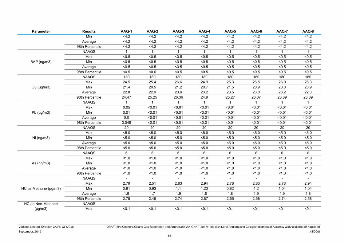
Vedanta Limited. (Division CAIRN Oil & Gas) DRAFT EIA: Onshore Oil and Gas Exploration and Appraisal in AA-ONHP-2017/1 block in Karbi Anglong and Golaghat districts of Assam & Wokha district of Nagaland
September, 2019 AECOM
55
Parameter Results AAQ-1 AAQ-2 AAQ-3 AAQ-4 AAQ-5 AAQ-6 AAQ-7 AAQ-8
Min <4.2 <4.2 <4.2 <4.2 <4.2 <4.2 <4.2 <4.2
Average <4.2 <4.2 <4.2 <4.2 <4.2 <4.2 <4.2 <4.2
98th Percentile <4.2 <4.2 <4.2 <4.2 <4.2 <4.2 <4.2 <4.2
BAP (ng/m3)
NAAQS 1 1 1 1 1 1 1 1
Max <0.5 <0.5 <0.5 <0.5 <0.5 <0.5 <0.5 <0.5
Min <0.5 <0.5 <0.5 <0.5 <0.5 <0.5 <0.5 <0.5
Average <0.5 <0.5 <0.5 <0.5 <0.5 <0.5 <0.5 <0.5
98th Percentile <0.5 <0.6 <0.5 <0.5 <0.5 <0.5 <0.5 <0.5
O3 (µg/m3)
NAAQS 180 180 180 180 180 180 180 180
Max 24.5 25.4 26.6 24.9 25.3 26.5 26.9 26.3
Min 21.4 20.5 21.2 20.7 21.5 20.9 20.8 20.9
Average 22.8 22.9 23.6 23.2 23.5 23.0 23.2 22.3
98th Percentile 24.47 25.25 26.36 24.9 25.27 26.37 26.69 25.89
Pb (µg/m3)
NAAQS 1 1 1 1 1 1 1 1
Max 0.05 <0.01 <0.01 <0.01 <0.01 <0.01 <0.01 <0.01
Min 0.01 <0.01 <0.01 <0.01 <0.01 <0.01 <0.01 <0.01
Average 0.0 <0.01 <0.01 <0.01 <0.01 <0.01 <0.01 <0.01
98th Percentile 0.049 <0.01 <0.01 <0.01 <0.01 <0.01 <0.01 <0.01
Ni (ng/m3)
NAAQS 20 20 20 20 20 20 20 20
Max <5.0 <5.0 <5.0 <5.0 <5.0 <5.0 <5.0 <5.0
Min <5.0 <5.0 <5.0 <5.0 <5.0 <5.0 <5.0 <5.0
Average <5.0 <5.0 <5.0 <5.0 <5.0 <5.0 <5.0 <5.0
98th Percentile <5.0 <5.0 <5.0 <5.0 <5.0 <5.0 <5.0 <5.0
As (ng/m3)
NAAQS 6 6 6 6 6 6 6 6
Max <1.0 <1.0 <1.0 <1.0 <1.0 <1.0 <1.0 <1.0
Min <1.0 <1.0 <1.0 <1.0 <1.0 <1.0 <1.0 <1.0
Average <1.0 <1.0 <1.0 <1.0 <1.0 <1.0 <1.0 <1.0
98th Percentile <1.0 <1.0 <1.0 <1.0 <1.0 <1.0 <1.0 <1.0
HC as Methane (µg/m3)
NAAQS - - - - - - - -
Max 2.79 2.51 2.83 2.94 2.78 2.83 2.78 2.94
Min 0.81 0.93 1.1 1.23 0.82 1.2 1.04 1.04
Average 1.6 1.7 1.9 1.8 1.8 1.9 1.9 1.8
98th Percentile 2.78 2.46 2.74 2.87 2.65 2.68 2.74 2.68
HC as Non-Methane
(µg/m3)
NAAQS - - - - - - - -
Max <0.1 <0.1 <0.1 <0.1 <0.1 <0.1 <0.1 <0.1
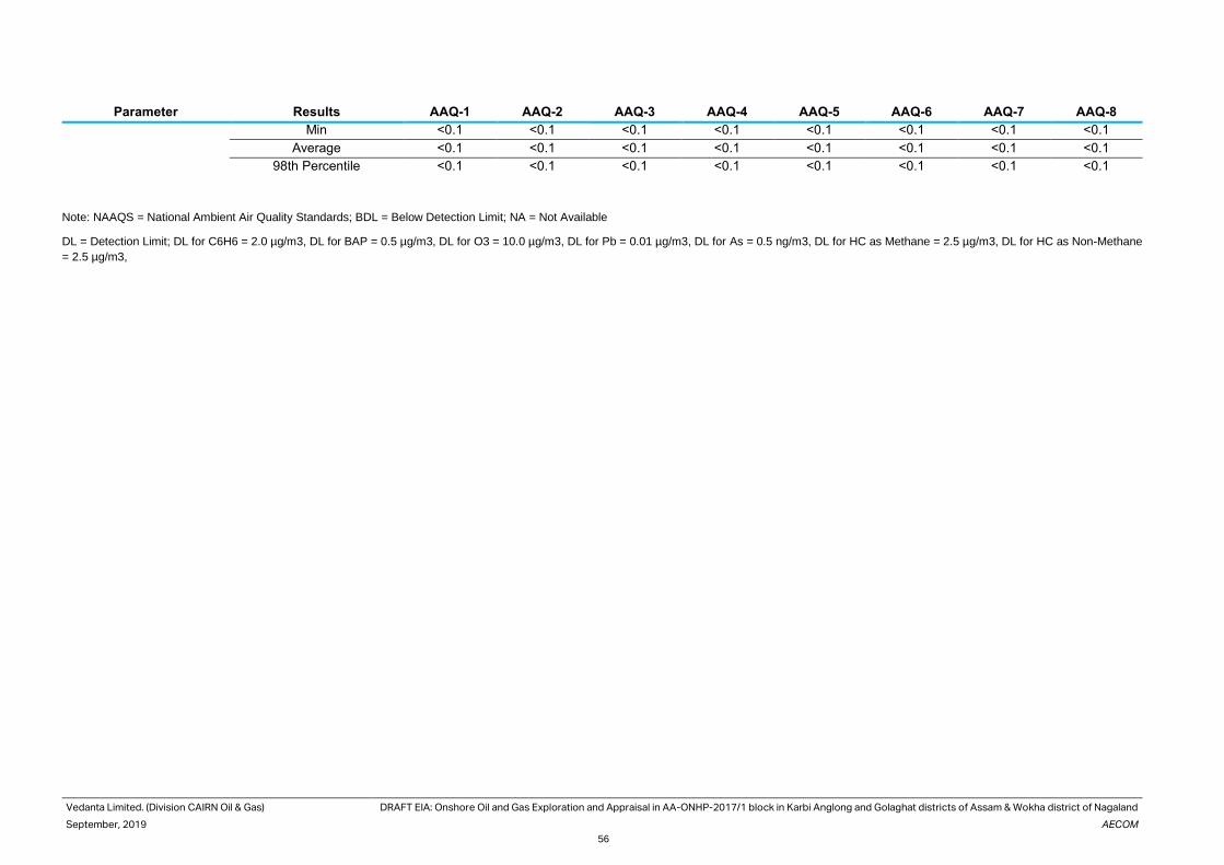
Vedanta Limited. (Division CAIRN Oil & Gas) DRAFT EIA: Onshore Oil and Gas Exploration and Appraisal in AA-ONHP-2017/1 block in Karbi Anglong and Golaghat districts of Assam & Wokha district of Nagaland
September, 2019 AECOM
56
Parameter Results AAQ-1 AAQ-2 AAQ-3 AAQ-4 AAQ-5 AAQ-6 AAQ-7 AAQ-8
Min <0.1 <0.1 <0.1 <0.1 <0.1 <0.1 <0.1 <0.1
Average <0.1 <0.1 <0.1 <0.1 <0.1 <0.1 <0.1 <0.1
98th Percentile <0.1 <0.1 <0.1 <0.1 <0.1 <0.1 <0.1 <0.1
Note: NAAQS = National Ambient Air Quality Standards; BDL = Below Detection Limit; NA = Not Available
DL = Detection Limit; DL for C6H6 = 2.0 µg/m3, DL for BAP = 0.5 µg/m3, DL for O3 = 10.0 µg/m3, DL for Pb = 0.01 µg/m3, DL for As = 0.5 ng/m3, DL for HC as Methane = 2.5 µg/m3, DL for HC as Non-Methane
= 2.5 µg/m3,

Vedanta Limited.
(Division CAIRN Oil & Gas)
DRAFT EIA: Onshore Oil and Gas Exploration and Appraisal in AA-ONHP-2017/1 block in Karbi Anglong and
Golaghat districts of Assam & Wokha district of Nagaland
September, 2019 AECOM
57
Particulate Matter (PM10)
PM10 concentration in the study area varied from 79.36 μg/m3 to 84.59 μg/m3. The monitoring location at AAQ 3,
observed the maximum concentration of PM10 i.e 84.59 μg/m3, whereas minimum PM10 concentration was
observed at AAQ 7, i.e 79.36 μg/m3. Graphical presentation of concentration of PM10 values is given Figure 26
Figure 26. PM 10 Values at the Monitoring Locations.
Particulate Matter (PM2.5)
PM2.5 concentration in the study area varied from 41.71 μg/m3 to 49.73 μg/m3. The highest PM 2.5 concentration
was observed at monitoring location AAQ8 which is 49.73 μg/m3 and the lowest concentration of PM 2.5 is located
at monitoring location AAQ 8 which is 41.71 μg/m3. Graphical presentation of concentration of PM2.5 values is
given Figure 27.
Figure 27. PM2.5 Values at the Monitoring Locations.
Nitrogen Di-Oxide (NO2)
NO2 concentration in the study area varied from 35.52 μg/m3.to 29.45 μg/m3 98th percentile value. The highest
NO2 concentration was observed at monitoring location AAQ5 which is 35.52 μg/m3 and the lowest concentration
of NO2 was recorded at monitoring location AAQ 8 which is 29.45 μg/m3. Graphical presentation of concentration
of NO2 values is given figure 28.
0
20
40
60
80
100
120
AAQ-1 AAQ-2 AAQ-3 AAQ-4 AAQ-5 AAQ-6 AAQ-7 AAQ-8
PM10 (µg/m3) Max PM10 (µg/m3) Min
PM10 (µg/m3) Average PM10 (µg/m3) 98th Percentile
PM10 (µg/m3) NAAQS
0
10
20
30
40
50
60
70
AAQ-1 AAQ-2 AAQ-3 AAQ-4 AAQ-5 AAQ-6 AAQ-7 AAQ-8
PM2.5 (µg/m3) Max PM2.5 (µg/m3) Min
PM2.5 (µg/m3) Average PM2.5 (µg/m3) 98th Percentile
PM2.5 (µg/m3) NAAQS

Vedanta Limited.
(Division CAIRN Oil & Gas)
DRAFT EIA: Onshore Oil and Gas Exploration and Appraisal in AA-ONHP-2017/1 block in Karbi Anglong and
Golaghat districts of Assam & Wokha district of Nagaland
September, 2019 AECOM
58
Figure 28. NO2 Values at the Monitoring Locations
Sulphur Di-Oxide (SO2)
SO2 concentration in the study area varied from 8.4 to 7.4 to μg/m3. The highest SO2 concentration was observed
at monitoring location AAQ 5 which is 8.4 μg/m3 and the lowest concentration of SO2 was recorded at monitoring
location AAQ 2 which is 7.4μg/m3. Graphical presentation of concentration of SO2 values is given Figure 29
Figure 29. SO2 Values at the Monitoring Locations
Other Parameters
The concentrations for CO ranged from 0.57 to 0.77 mg/m3. The concentrations for NH3 ranged from 19.88 to 33.58
μg/m3. The average concentration for Ni ranged <5.0 ng/m3. The seasonal average concentrations for O3 ranged
from 24.47 to 26.69 μg/m3.
Concentration of other parameters i.e. C6H6 (µg/m3), BAP (ng/m3), Pb (µg/m3), As (ng/m3), HC as Methane (µg/m3),
and HC as Non-Methane (µg/m3) have been observed would be below detectable limit at all locations. Currently
there are no ambient air quality standards for HCs (as methane & as non-methane).
The photograph of ambient air quality sampling is shown below.
0
10
20
30
40
50
60
70
80
90
AAQ-1 AAQ-2 AAQ-3 AAQ-4 AAQ-5 AAQ-6 AAQ-7 AAQ-8
NO2 (µg/m3) Max NO2 (µg/m3) Min
NO2 (µg/m3) Average NO2 (µg/m3) 98th Percentile
NO2 (µg/m3) NAAQS
0
10
20
30
40
50
60
70
80
90
AAQ-1 AAQ-2 AAQ-3 AAQ-4 AAQ-5 AAQ-6 AAQ-7 AAQ-8
SO2 (µg/m3) Max SO2 (µg/m3) Min
SO2 (µg/m3) Average SO2 (µg/m3) 98th Percentile
SO2 (µg/m3) NAAQS

Vedanta Limited.
(Division CAIRN Oil & Gas)
DRAFT EIA: Onshore Oil and Gas Exploration and Appraisal in AA-ONHP-2017/1 block in Karbi Anglong and
Golaghat districts of Assam & Wokha district of Nagaland
September, 2019 AECOM
59
Photographs 1: AAQ station at AAQ1 Photographs 2: AAQ station at AAQ2
Photographs 3: AAQ station at AAQ7 Photographs 4: AAQ station at AAQ8
3.10 Ambient Noise Quality
Monitoring of noise levels around the study area has been carried out to assess the existing noise levels generated
due to the existing operations on human settlements. Noise standards have been designed for different types of
land use i.e. residential, commercial industrial areas and silence zones as per ‘The Noise Pollution (Regulation and
Control) Rules, 2000, Notified by Ministry of Environment and Forests, New Delhi, February 14, 2000’.
The ambient noise monitoring was carried out at eight (8) locations during baseline monitoring activity (March to
May 2019). The details of the noise monitoring locations are given in Table 3.7. Sound pressure level (SPL)
measurements in dB (A) have been recorded for every hour continuously for 24 hours at 15 minutes interval for
the monitoring stations and equivalent noise levels in the form of Leq day and Leq night was computed. The day
noise levels have been monitored during 6.00 am to 10.00 pm and night levels during 10.00 pm to 6.00 am at all
the locations. The results obtained have been compared with the standard specified in Schedule III, Rule 3 of
Environmental Protection Rules.
Table 3.8 Ambient Noise Monitoring Locations
Location
Code
Monitoring Location Coordinates Direction
NQ1 Nepali Basti ,Balipathar 26°7'34.57"N, 93°49'31.19"E 11.0 km N from Well no 2
NQ2 Romon Ringtigaon 26°09'32.13"N 93°46'54.90"E 11.1 km SSE from Well no 2
NQ3 Satsang Village 26°03'57.42"N 93°46'54.90"E 1.31 km SE from Well no 2
NQ4 Goutam Basti 25°57'50.58"N, 93°42'41.03"E 10.5 km ENE from Well no 2
NQ5 Ekrani Basti 26°02'08.64"N 93°46'20.62"E 0.5 km S from Well no 13
NQ6 Santigaon 25°57'08.21"N 93°44'45.54"E 2.67 km SE from Well no 4
NQ7 Panchlamardgaon 26°00'38.68"N 93°49'56.95"E 8.13 km NE from Well no 8

Vedanta Limited.
(Division CAIRN Oil & Gas)
DRAFT EIA: Onshore Oil and Gas Exploration and Appraisal in AA-ONHP-2017/1 block in Karbi Anglong and
Golaghat districts of Assam & Wokha district of Nagaland
September, 2019 AECOM
60
Location
Code
Monitoring Location Coordinates Direction
NQ 8 Gharialdubi 25°59'58.75"N 93°46'23.34"E 2.10 km WNW from Well no 19
Map showing Monitoring Locations for Noise in the study area is presented in Figure 30.The details of ambient
noise monitoring result is given in Appendix 3-3. The graphical representation of noise level is present in Figure
30
The summarized results of noise levels are given in Table 39. The noise levels are compared with Ambient Air
Quality Standards in respect of Noise as per The Noise Pollution (Regulation and Control) Rules, 2000 stipulated
for daytime and night time for residential land use
Table 3.9 Noise level in the Study Area
Location
code
Leq Day Time (dBA) Leq Night Time
(dBA)
Applicable Daytime
Standards
Applicable Night-time
Standards
NQ1 52.95 44.6 55 45
NQ2 51.8 44.1 55 45
NQ3 53.9 44.7 55 45
NQ4 53.8 45.0 55 45
NQ5 54.8 45.4 55 45
NQ6 56.4 44.7 55 45
NQ7 51.0 43.0 55 45
NQ 8 56.1 45.0 55 45
Figure 30. Day and Night Time Equivalent Noise Levels.
Leq for day time was found would be exceeding Ambient Air Quality Standards in respect of Noise for day time as
55dB(A) for residential area at all locations except NQ6 and NQ8 due to vehicular movement at night time. Leq for
night time was found would be in the limit of Ambient noise Quality Standards, for night time as 45dB(A) for
residential area at all locations,
0.00
10.00
20.00
30.00
40.00
50.00
60.00
NQ1 NQ2 NQ3 NQ4 NQ5 NQ6 NQ7 NQ 8
Lday Lnight Day Standard Night Standard

Vedanta Limited.
(Division CAIRN Oil & Gas)
DRAFT EIA: Onshore Oil and Gas Exploration and Appraisal in AA-ONHP-2017/1 block in Karbi Anglong and
Golaghat districts of Assam & Wokha district of Nagaland
September, 2019 AECOM
61
Photographs 1: NQ station at NQ8 Photographs 2 : NQ Station at NQ2
Photographs 3: NQ station at NQ4 Photographs 4: NQ at NQ6
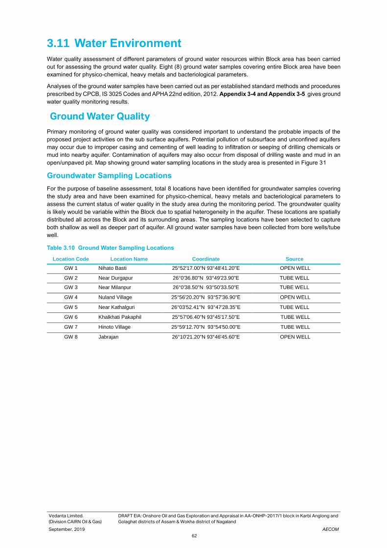
Vedanta Limited.
(Division CAIRN Oil & Gas)
DRAFT EIA: Onshore Oil and Gas Exploration and Appraisal in AA-ONHP-2017/1 block in Karbi Anglong and
Golaghat districts of Assam & Wokha district of Nagaland
September, 2019 AECOM
62
3.11 Water Environment
Water quality assessment of different parameters of ground water resources within Block area has been carried
out for assessing the ground water quality. Eight (8) ground water samples covering entire Block area have been
examined for physico-chemical, heavy metals and bacteriological parameters.
Analyses of the ground water samples have been carried out as per established standard methods and procedures
prescribed by CPCB, IS 3025 Codes and APHA 22nd edition, 2012. Appendix 3-4 and Appendix 3-5 gives ground
water quality monitoring results.
Ground Water Quality
Primary monitoring of ground water quality was considered important to understand the probable impacts of the
proposed project activities on the sub surface aquifers. Potential pollution of subsurface and unconfined aquifers
may occur due to improper casing and cementing of well leading to infiltration or seeping of drilling chemicals or
mud into nearby aquifer. Contamination of aquifers may also occur from disposal of drilling waste and mud in an
open/unpaved pit. Map showing ground water sampling locations in the study area is presented in Figure 31
Groundwater Sampling Locations
For the purpose of baseline assessment, total 8 locations have been identified for groundwater samples covering
the study area and have been examined for physico-chemical, heavy metals and bacteriological parameters to
assess the current status of water quality in the study area during the monitoring period. The groundwater quality
is likely would be variable within the Block due to spatial heterogeneity in the aquifer. These locations are spatially
distributed all across the Block and its surrounding areas. The sampling locations have been selected to capture
both shallow as well as deeper part of aquifer. All ground water samples have been collected from bore wells/tube
well.
Table 3.10 Ground Water Sampling Locations
Location Code Location Name Coordinate Source
GW 1 Nihato Basti 25°52'17.00"N 93°48'41.20"E OPEN WELL
GW 2 Near Durgapur 26°0'36.80"N 93°49'23.90"E TUBE WELL
GW 3 Near Milanpur 26°0'38.50"N 93°50'33.50"E TUBE WELL
GW 4 Nuland Village 25°56'20.20"N 93°57'36.90"E OPEN WELL
GW 5 Near Kathalguri 26°03'52.41"N 93°47'28.35"E TUBE WELL
GW 6 Khalkhati Pakaphil 25°57'06.40"N 93°45'17.50"E TUBE WELL
GW 7 Hinoto Village 25°59'12.70"N 93°54'50.00"E TUBE WELL
GW 8 Jabrajan 26°10'21.20"N 93°46'45.60"E OPEN WELL

Vedanta Limited.
(Division CAIRN Oil & Gas)
DRAFT EIA: Onshore Oil and Gas Exploration and Appraisal in AA-ONHP-2017/1 block in Karbi Anglong and
Golaghat districts of Assam & Wokha district of Nagaland
September, 2019 AECOM
63
Figure 31. Ground water, surface water and Soil quality monitoring Locations in Block AA-ONHP-2017/1.

Vedanta Limited. (Division CAIRN Oil & Gas) DRAFT EIA: Onshore Oil and Gas Exploration and Appraisal in AA-ONHP-2017/1 block in Karbi Anglong and Golaghat districts of Assam & Wokha district of Nagaland
September, 2019 AECOM
64
Table 3.11 . Ground Water Quality Monitoring Result
S.N. Parameter
s
Unit GW1/B1 GW2/B1 GW3/B1 GW4/B1 GW5/B1 GW6/B1 GW7/B1 GW8/B1 Desira
ble
limit
Permi
ssibl
e
limit
1 Colour Hazen <1.0 <1.0 <1.0 <1.0 <1.0 <1.0 <1.0 <1.0 5 15
2 Odour - Unobjecti
onable
Unobjectionable Unobjectionable Unobjectionable Unobjectionable Unobjectionable Unobjectionable Unobjectionable Agreea
ble
Agree
able
3 Taste None Not Done Not Done Not Done Not Done Not Done Not Done Not Done Not Done - -
4 Temperatur
e
Deg C 25 25 25 25 25 25 25 25 - -
5 pH - 7.05 at
25 deg C
7.39 at 25 deg C 8.44 at 25 deg C 7.86 at 25 deg C 7.65 at 25 deg C 8.24 at 25 deg C 7.89 at 25 degC 7.34 at 25 deg C 6.5-8.5 6.5-
8.5
6 Turbidity NTU 11 4.8 3.5 4.4 18 3.8 3.1 3.7 1 5
7 Total
Dissolved
Solids
mg/l 168 186 318 110 170.2 290 42 120 500 2000
8 Electrical
Conductivit
y
µS/Cm 243 286 513 167 257 467 64 181 - -
9 Salinity None 0.14 in
respect
to KCl
equivalen
t salinity
35
0.16 In respect to
KCl equivalent
salinity 35
0.29 In respect to
KCl equivalent
salinity 35
0.09 In respect to
KCl equivalent
salinity 35
0.15 In respect to
KCl equivalent
salinity 35
0.27 In respect to
KCl euivalent
salinity 35
0.04 In respect to
KCl equivalent
salinity 35
0.10 In respect to
KCl equivalent
salinity 35
- -
10 Dissloved
oxygen
mg/l 5.4 5.4 5.4 5.3 5.0 5.2 5.4 5.1 - -
(II) General
Parameters
11 Aluminium(
Al)
mg/l <0.01 <0.01 <0.01 <0.01 <0.01 <0.01 <0.01 <0.01 0.03 0.2
12 Anionic
Detergent
(as MBAS)
mg/l <0.02 <0.02 <0.02 <0.02 <0.02 <0.02 <0.02 <0.02 0.2 0.01

Vedanta Limited. (Division CAIRN Oil & Gas) DRAFT EIA: Onshore Oil and Gas Exploration and Appraisal in AA-ONHP-2017/1 block in Karbi Anglong and Golaghat districts of Assam & Wokha district of Nagaland
September, 2019 AECOM
65
S.N. Parameter
s
Unit GW1/B1 GW2/B1 GW3/B1 GW4/B1 GW5/B1 GW6/B1 GW7/B1 GW8/B1 Desira
ble
limit
Permi
ssibl
e
limit
13 Barium
(Ba)
mg/l <0.05 <0.05 <0.05 <0.05 <0.05 <0.05 <0.05 <0.05 0.7
14 Calcium(Ca
)
mg/l 20 16 16 16 28.0 32 4.80 20.0 75 200
15 Chloramine
s (as Cl2)
mg/l <0.3 <0.3 <0.3 <0.3 <0.3 <0.3 <0.3 <0.3 4
16 Chloride mg/l 20 10 10 15 10 20 10 15 250 1000
17 Copper(Cu) mg/l <0.02 <0.02 <0.02 <0.02 <0.02 <0.02 <0.02 <0.02 0.05 1.5
18 Fluoride as
F
mg/l 0.23 0.24 0.30 0.28 0.29 0.31 0.26 0.28 1 1.5
19 Free
Residual
Chlorine
mg/l <0.1 <0.1 <0.1 <0.1 <0.1 <0.1 <0.1 <0.1 0.2 0.1
20 Iron (Fe) mg/l 0.80 0.28 0.20 0.26 1.3 0.19 0.21 0.20 --- 0.3
21 Maganisiu
m(Mg)
mg/l 7.20 9.60 14.40 4.80 14.40 9.60 1.92 7.20 30 100
22 Manganese
(Mn)
mg/l <0.02 <0.02 <0.02 <0.02 <0.02 <0.02 <0.02 <0.02 0.1 0.3
23 Mineral Oil mg/l <0.01 <0.01 <0.01 <0.01 <0.01 <0.01 <0.01 <0.01 0.5 0.5
24 Nitrate mg/l 19 <0.5 3.9 1.7 7.3 3.6 <0.5 1.7 45 45
25 Phenol mg/l <0.001 <0.001 <0.001 <0.001 <0.001 <0.001 <0.001 <0.001 0.001 0.002
26 Selenium
(Se)
mg/l <0.005 <0.005 <0.005 <0.005 <0.005 <0.005 <0.005 <0.005 0.01 0.01
27 Sulphate mg/l 30 <1.0 2.6 2.3 14.7 3.7 <1.0 2.9 200 400
28 Potassium mg/l 10 9.7 16 5.8 8.6 12 1.2 6.2 - -
29 Total
Phosphoro
us
mg/l 4.58 9.41 7.90 6.78 10.7 8.03 7.20 7.52 - -
30 Sodium mg/l 29.2 29 40 10 28 30 6.3 11 - -

Vedanta Limited. (Division CAIRN Oil & Gas) DRAFT EIA: Onshore Oil and Gas Exploration and Appraisal in AA-ONHP-2017/1 block in Karbi Anglong and Golaghat districts of Assam & Wokha district of Nagaland
September, 2019 AECOM
66
S.N. Parameter
s
Unit GW1/B1 GW2/B1 GW3/B1 GW4/B1 GW5/B1 GW6/B1 GW7/B1 GW8/B1 Desira
ble
limit
Permi
ssibl
e
limit
31 Total
Alakalinity
mg/l 30.0 160 280 80 120 240 16.0 90 200 600
32 Total
Hardness
mg/l 80 80 100 60 130 120 20.0 80 200 600
33 Total
Nitrogen
mg/l 4.4 <0.3 0.9 0.40 1.6 0.83 <0.3 0.84 - -
34 Zinc(Zn) mg/l <0.02 <0.02 <0.02 <0.02 <0.02 <0.02 <0.02 <0.02 5 15
(III) Toxic
Substances
35 Cadmium
(Cd)
mg/l <0.001 <0.005 <0.005 <0.001 <0.001 <0.001 <0.001 <0.001 0.003 0.003
36 Cyanide (
as CN)
mg/l <0.01 <0.01 <0.01 <0.01 <0.01 <0.01 <0.01 <0.01 0.05
37 Lead (Pb) mg/l <0.005 <0.005 <0.005 <0.005 <0.005 <0.005 <0.005 <0.005 0.01 0.01
38 Mercury
(Hg)
mg/l <0.001 <0.001 <0.001 <0.001 <0.001 <0.001 <0.001 <0.001 0.001 0.001
39 Molybdenu
m (as Mo)
mg/l <0.05 <0.05 <0.05 <0.05 <0.05 <0.05 <0.05 <0.05 0.07
40 Nickel (as
Ni )
mg/l <0.02 <0.02 <0.02 <0.02 <0.02 <0.02 <0.02 <0.02 0.02
41 Hexavalent
Chromium(
Cr+6)
mg/l <0.01 <0.01 <0.01 <0.01 <0.01 <0.01 <0.01 <0.01 0.05 0.05
42 Arsenic(As) mg/l <0.005 <0.005 <0.005 <0.005 <0.005 <0.005 <0.005 <0.005 0.01 0.05
(IV) Pesticides
Residues
43 Alchor µg/l <0.02 <0.02 <0.02 <0.02 <0.02 <0.02 <0.02 <0.02 20 20
44 Atrazine µg/l <0.02 <0.02 <0.02 <0.02 <0.02 <0.02 <0.02 <0.02 2 2
45 Aldrin µg/l <0.01 <0.01 <0.01 <0.01 <0.01 <0.01 <0.01 <0.01 0.03 0.03
46 Dialdrin µg/l <0.01 <0.01 <0.01 <0.01 <0.01 <0.01 <0.01 <0.01

Vedanta Limited. (Division CAIRN Oil & Gas) DRAFT EIA: Onshore Oil and Gas Exploration and Appraisal in AA-ONHP-2017/1 block in Karbi Anglong and Golaghat districts of Assam & Wokha district of Nagaland
September, 2019 AECOM
67
S.N. Parameter
s
Unit GW1/B1 GW2/B1 GW3/B1 GW4/B1 GW5/B1 GW6/B1 GW7/B1 GW8/B1 Desira
ble
limit
Permi
ssibl
e
limit
47 α-HCH µg/l <0.01 <0.01 <0.01 <0.01 <0.01 <0.01 <0.01 <0.01 0.01 0.01
48 β-HCH µg/l <0.01 <0.01 <0.01 <0.01 <0.01 <0.01 <0.01 <0.01 0.04 0.04
49 Butachlore µg/l <0.02 <0.02 <0.02 <0.02 <0.02 <0.02 <0.02 <0.02 125 125
50 Chlorpyrifo
s
µg/l <0.02 <0.02 <0.02 <0.02 <0.02 <0.02 <0.02 <0.02 30 30
51 δ-HCH µg/l <0.01 <0.01 <0.01 <0.01 <0.01 <0.01 <0.01 <0.01 2 2
52 2,4
Dichloroph
enoxyacetic
acid
µg/l <0.01 <0.01 <0.01 <0.01 <0.01 <0.01 <0.01 <0.01 30 30
53 p,p DDT µg/l <0.01 <0.01 <0.01 <0.01 <0.01 <0.01 <0.01 <0.01 1 1
54 o,p DDT µg/l <0.01 <0.01 <0.01 <0.01 <0.01 <0.01 <0.01 <0.01 1
55 o,p DDE µg/l <0.01 <0.01 <0.01 <0.01 <0.01 <0.01 <0.01 <0.01 1
56 p,p DDE µg/l <0.01 <0.01 <0.01 <0.01 <0.01 <0.01 <0.01 <0.01 1
57 o,p DDD µg/l <0.01 <0.01 <0.01 <0.01 <0.01 <0.01 <0.01 <0.01 1
58 p,p DDD µg/l <0.01 <0.01 <0.01 <0.01 <0.01 <0.01 <0.01 <0.01 1
59 Endosulpha
n sulphate
µg/l <0.01 <0.01 <0.01 <0.01 <0.01 <0.01 <0.01 <0.01 0.4 0.4
60 Alpha-
Endosulfan
µg/l <0.01 <0.01 <0.01 <0.01 <0.01 <0.01 <0.01 <0.01 0.4
61 Beta-
Endosulfan
µg/l <0.01 <0.01 <0.01 <0.01 <0.01 <0.01 <0.01 <0.01 0.4
62 Ethion µg/l <0.02 <0.02 <0.02 <0.02 <0.02 <0.02 <0.02 <0.02 3 3
63 ƴ-HCH
(Lindane)
µg/l <0.01 <0.01 <0.01 <0.01 <0.01 <0.01 <0.01 <0.01 2 2
64 Iso Protron µg/l <0.02 <0.02 <0.02 <0.02 <0.02 <0.02 <0.02 <0.02 9 9
65 Malathion µg/l <0.02 <0.02 <0.02 <0.02 <0.02 <0.02 <0.02 <0.02 190 190

Vedanta Limited. (Division CAIRN Oil & Gas) DRAFT EIA: Onshore Oil and Gas Exploration and Appraisal in AA-ONHP-2017/1 block in Karbi Anglong and Golaghat districts of Assam & Wokha district of Nagaland
September, 2019 AECOM
68
S.N. Parameter
s
Unit GW1/B1 GW2/B1 GW3/B1 GW4/B1 GW5/B1 GW6/B1 GW7/B1 GW8/B1 Desira
ble
limit
Permi
ssibl
e
limit
66 Methyl
Parathion
µg/l <0.02 <0.02 <0.02 <0.02 <0.02 <0.02 <0.02 <0.02 0.3 0.3
67 Monocrotph
os
µg/l <0.02 <0.02 <0.02 <0.02 <0.02 <0.02 <0.02 <0.02 1 1
68 Phorate µg/l <0.02 <0.02 <0.02 <0.02 <0.02 <0.02 <0.02 <0.02 2 2
69 Pesticides
as Lindane
mg/l <0.001 <0.001 <0.001 <0.001 <0.001 <0.001 <0.001 <0.001 - -
(V) Bacteriologi
cal
Parameters
70 Total
Coliform
MPN/100ml IS 1622 :
1981 (RA
2014)
DETECTED (17
MPN/100 ml)
NOT DETECTED NOT DETECTED DETECTED (14
MPN/100 ml)
NOT DETECTED NOT DETECTED NOT DETECTED DETEC
TED (8
MPN/1
00 ml)
Total
Colifo
rm
MPN/100ml
71 Faecal
Coliform
MPN/100ml IS 1622 :
1981 (RA
2014)
DETECTED (4
MPN/100 ml)
NOT DETECTED NOT DETECTED NOT DETECTED NOT DETECTED NOT DETECTED NOT DETECTED NOT
DETEC
TED
Faeca
l
Colifo
rm
MPN/100ml

Vedanta Limited. (Division CAIRN Oil & Gas) DRAFT EIA: Onshore Oil and Gas Exploration and Appraisal in AA-ONHP-2017/1 block in Karbi
Anglong and Golaghat districts of Assam & Wokha district of Nagaland
September, 2019 AECOM
69
Interpretation of Groundwater Quality Results
Physical Parameters
The colour of the samples was found <1 hazen units and with agreeable odour. The pH of water samples ranged
from 7.05to 8.44. Turbidity of all the samples varied from 3.1 to 18.0 NTU. The TDS in the water samples varied
from 42 mg/l to 318 mg/l.
Inorganic Parameters
The total alkalinity of the samples varied from 16.0 to 280 mg/l which falls within their corresponding permissible
limit of 600 mg/l. Total hardness of the samples varied from 20 to 130 mg/l and was within the permissible limit of
600 mg/l. The concentrations of heavy metals such as Aluminium, Manganese, Iron, Nickel, Copper, Zinc, Arsenic
have been found to be below their corresponding permissible limits. Cadmium, Mercury, Lead and other parameters
like Residual Chlorine, Cyanide, Hexavalent Chromium, Phenol, Total Phosphorus, Free Ammonia, Cyanide,
polychlorinated bi-phenyls, PAHs have been found to be below detection limits.
Coliform
E-coli and Faecal coliform have been found to be absent in all the water samples whereas the total coliform content
was below the detection limit of less than 2 MPN/100 ml.
Other Parameters
Most of the samples are below detectable limits for toxic substances. The groundwater quality have not been found
to be suitable for drinking purposes (without primary and secondary treatment) at locations where their TDS,
hardness are beyond the permissible limits.
Photographs of Ground water sampling is given below.

Vedanta Limited. (Division CAIRN Oil & Gas) DRAFT EIA: Onshore Oil and Gas Exploration and Appraisal in AA-ONHP-2017/1 block in Karbi
Anglong and Golaghat districts of Assam & Wokha district of Nagaland
September, 2019 AECOM
70
Photographs1: GW sampling in GW2 Photographs 2: GW sampling in GW6
Photographs 3: GW sampling in GW4 Photographs 3: GW sampling in GW5
Surface water quality Primary monitoring of surface water quality was given importance during scoping of the EIA study as the effluent
generated during the exploratory and development well drilling operations are likely to be discharged to nearby
surface water bodies/natural drainage channels/rivers after ensuring that it meets prescribed norms of CPCB.
Further, an effort has been made to establish the baseline quality of the existing major watersheds and sub
watersheds (comprising the major drainage of the study area) to identify any possible contamination due to any
current industrial activities.

Vedanta Limited. (Division CAIRN Oil & Gas) DRAFT EIA: Onshore Oil and Gas Exploration and Appraisal in AA-ONHP-2017/1 block in Karbi
Anglong and Golaghat districts of Assam & Wokha district of Nagaland
September, 2019 AECOM
71
Surface Water Quality Monitoring Location A monitoring network consisting of 8 locations for surface water monitoring was selected. Water sampling and
analysis2 was done following CPCB standard guidelines for physical, chemical and bacteriological parameters.
Surface Sampling Location is presented in Figure 31
Table 3.12 Surface Water Sampling Locations
Location Code Sampling Location Coordinate
SW1 Dhansiri River Near Jabrajan 26°10'05.00"N, 93°49'30.00"E
SW2 Dhansiri River Near Kathalguri 26°03'57.20"N, 93°48'00.08"E
SW3 Dhansiri River Near Khalkhati Pakaphil 25°57'02.00"N, 93°45'29.40"E
SW4 Dhansiri River Near Nuland Village 25°54'26.00"N, 93°57'52.80"E
SW5 Dhansiri River Near Rangna Village 26°01'17.60"N, 93°54'06.20"E
SW6 Pond Near Vihokhil Village 25°51'57.80"N, 93°51'19.10"E
SW7 Dhansiri River Near Durgapur Village 26°0'38.60"N, 93°49'19.80"E
SW8 Dhasiri River Near Naga United Village 25°51'54.00"N, 93°46'55.40"E
2http://www.cpcb.nic.in/latest/guidelines-water.doc

Vedanta Limited. (Division CAIRN Oil & Gas) DRAFT EIA: Onshore Oil and Gas Exploration and Appraisal in AA-ONHP-2017/1 block in Karbi Anglong and Golaghat districts of Assam & Wokha district of Nagaland
September, 2019 AECOM
72
Table 3.13 Surface water quality
Parameters Unit SW1/B1 SW2/B1 SW3/B1 SW4/B1 SW5/B1 SW6/B1 SW7/B1 SW8/B1
Colour Hazen <1.0 <1.0 <1.0 <1.0 <1.0 <1.0 <1.0 <1.0
Odour None Unobjectionable Unobjectionable Unobjectionable Unobjectionable Unobjectionable Unobjectionable Unobjectionable Unobjectionable
Taste µg/l Not Done Not Done Not Done Not Done Not Done Not Done Not Done Not Done
Temperature Deg C 25 25 25 25 25 25 25 25
pH value None 7.37 at 25 deg C 7.58 at 25 deg C 7.41 at 25 deg C 7.44 at 25 deg C 7.73 at 25 deg C 7.33 at 25 deg C 7.32 at 25 deg C 7.61 at 25 deg C
Conductivity us/cm 206 221 430 246 265.6 124.5 118.2 144
DO mg/l 6.2 6.3 6.4 6.2 6.4 6.1 6.5 6.2
Turbidity N.T.U. 33 64 37 98 151 42 18 85
Total Dissolved Solids (as TDS)
mg/l 148 164 275 180 176 82 80 240
Biochemical Oxygen Demand (as BOD)
mg/l <2.0 <2.0 <2.0 <2.0 <2.0 3.8 <2.0 2.2
Chemical Oxygen Demand (COD)
mg/l 8 8 <4.0 <4.0 <4.0 24 <4.0 12
Total Hardness (as CaCO3 ) mg/l 56.0 72.0 120 90.0 100 50.0 40.0 60.0
Alkalinity (as CaCO3 ) mg/l 48 64.0 100 80.0 90 30 30 120
Sodium (as Na) mg/l 11 12 20 17 23 2.5 7.6 5.22
Potassium (as K) mg/l 3.6 4.4 5.7 2.5 3.0 2.7 2.5 2.0
Sodium Adsorption Ration (as SAR)
None 0.6 0.6 0.8 0.8 1.0 0.2 0.5 0.3
Free Ammonia mg/l <0.1 <0.1 <0.1 <0.1 <0.1 <0.1 <0.1 <0.1
Phosphorus mg/l 5.54 6.40 6.45 9.28 10.63 4.05 3.26 9.6
Total Nitrogen mg/l 4.0 4.8 4.5 3.36 5.0 2.5 1.7 5.2
Aluminium ( as Al ) mg/l <0.01 <0.01 <0.01 <0.01 <0.01 <0.01 <0.01 <0.01
Anionic Detergents (as MBAS)
mg/l <0.02 <0.02 <0.02 <0.02 <0.02 <0.02 <0.02 <0.02
Barium (as Ba ) mg/l <0.05 <0.05 <0.05 <0.05 <0.05 <0.05 <0.05 <0.05
Calcium (as Ca) mg/l 14.4 16 32.0 28.0 32.0 12.0 12.0 16.0
Chloramines (as Cl2) mg/l <0.3 <0.3 <0.3 <0.3 <0.3 <0.3 <0.3 <0.3
Chloride (as Cl ) mg/l 18.2 8.08 30.29 10.10 10.10 5.05 10.10 20.19
Copper (as Cu) mg/l <0.02 <0.02 <0.02 <0.02 <0.02 <0.02 <0.02 <0.02
Fluoride ( as F ) mg/l 0.22 0.35 0.32 0.25 0.29 0.28 0.84 0.15
Free Residual Chlorine mg/l <0.1 <0.1 <0.1 <0.1 <0.1 <0.1 <0.1 <0.1
Iron (as Fe) mg/l 3.6 12 4.01 11 20 6.8 3.3 5.84
Magnesium (as Mg) mg/l 4.8 7.68 9.60 4.80 4.80 4.80 2.40 4.80
Manganese (as Mn) mg/l <0.02 <0.02 <0.02 <0.02 <0.02 <0.02 <0.02 <0.02
Mineral Oil mg/l <0.01 <0.01 <0.01 <0.01 <0.01 <0.01 <0.01 <0.01
Nitrate (as NO3 ) mg/l 16.04 20.06 19.96 16.20 20.48 8.67 6.21 22
Selenium (as Se) mg/l <0.005 <0.005 <0.005 <0.005 <0.005 <0.005 <0.005 <0.005

Vedanta Limited. (Division CAIRN Oil & Gas) DRAFT EIA: Onshore Oil and Gas Exploration and Appraisal in AA-ONHP-2017/1 block in Karbi Anglong and Golaghat districts of Assam & Wokha district of Nagaland
September, 2019 AECOM
73
Parameters Unit SW1/B1 SW2/B1 SW3/B1 SW4/B1 SW5/B1 SW6/B1 SW7/B1 SW8/B1
Sulphate ( as SO4 ) mg/l 33.84 40.2 42.6 34.26 36.12 16.15 12.12 26.67
Cadmium (as Cd) mg/l <0.001 <0.001 <0.001 <0.001 <0.001 <0.001 <0.001 <0.001
Cyanide ( as CN) mg/l <0.01 <0.01 <0.01 <0.01 <0.01 <0.01 <0.01 <0.01
Lead (as Pb ) mg/l <0.005 <0.005 <0.005 <0.005 <0.005 <0.005 <0.005 <0.005
Mercury (as Hg ) mg/l <0.001 <0.001 <0.001 <0.001 <0.001 <0.001 <0.001 <0.001
Molybdenum (as Mo) mg/l <0.05 <0.05 <0.05 <0.05 <0.05 <0.05 <0.05 <0.05
Arsenic( as As) mg/l <0.005 <0.005 <0.005 <0.005 <0.005 <0.005 <0.005 <0.005
Nickel (as Ni ) mg/l <0.02 <0.02 <0.02 <0.02 <0.02 <0.02 <0.02 <0.02
Zinc (as Zn) mg/l <0.02 <0.02 <0.02 <0.02 <0.02 <0.02 <0.02 <0.02
Hexavalent Chromium (as Cr+6)
mg/l <0.01 <0.01 <0.01 <0.01 <0.01 <0.01 <0.01 <0.01
Salinity None 0.13 In Respect to KCL equivalent salinity 35.
0.14 In respect to KCl equivalent salinity 35
0.25 In respect to KCl equivalent salinity 35
0.14 In respect to KCl equivalent salinity 35.
0.15 In respect to KCl equivalent salinity 35.
0.07 In respect to KCl equivalent salinity 35.
0.07 In respect to KCl equivalent salinity 35
0.08 In respect to KCl equivalent salinity 35
Phenol mg/l <0.001 <0.001 <0.001 <0.001 <0.001 <0.001 <0.001 <0.001
Bromoform µg/l <0.05 <0.05 <0.05 <0.05 <0.05 <0.05 <0.05 <0.05
Dibromochloromethane µg/l <0.05 <0.05 <0.05 <0.05 <0.05 <0.05 <0.05 <0.05
Bromodichloromethane µg/l <0.05 <0.05 <0.05 <0.05 <0.05 <0.05 <0.05 <0.05
Chloroform µg/l <0.05 <0.05 <0.05 <0.05 <0.05 <0.05 <0.05 <0.05
Alachlor µg/l <0.02 <0.02 <0.02 <0.02 <0.02 <0.02 <0.02 <0.02
Atrazine µg/l <0.02 <0.02 <0.02 <0.02 <0.02 <0.02 <0.02 <0.02
Aldrin µg/l <0.01 <0.01 <0.01 <0.01 <0.01 <0.01 <0.01 <0.01
Dieldrin µg/l <0.01 <0.01 <0.01 <0.01 <0.01 <0.01 <0.01 <0.01
Alpha-HCH µg/l <0.01 <0.01 <0.01 <0.01 <0.01 <0.01 <0.01 <0.01
Beta-HCH µg/l <0.01 <0.01 <0.01 <0.01 <0.01 <0.01 <0.01 <0.01
Butachlor µg/l <0.02 <0.02 <0.02 <0.02 <0.02 <0.02 <0.02 <0.02
Chlorpyrifos µg/l <0.02 <0.02 <0.02 <0.02 <0.02 <0.02 <0.02 <0.02
Delta-HCH µg/l <0.01 <0.01 <0.01 <0.01 <0.01 <0.01 <0.01 <0.01
2,4-Dichlorophenoxyacetic acid
µg/l <0.01 <0.01 <0.01 <0.01 <0.01 <0.01 <0.01 <0.01
p,p DDD µg/l <0.01 <0.01 <0.01 <0.01 <0.01 <0.01 <0.01 <0.01
o,p-DDT µg/l <0.01 <0.01 <0.01 <0.01 <0.01 <0.01 <0.01 <0.01
p,p-DDT µg/l <0.01 <0.01 <0.01 <0.01 <0.01 <0.01 <0.01 <0.01
o,p-DDE µg/l <0.01 <0.01 <0.01 <0.01 <0.01 <0.01 <0.01 <0.01
p,p-DDE µg/l <0.01 <0.01 <0.01 <0.01 <0.01 <0.01 <0.01 <0.01
o,p-DDD µg/l <0.01 <0.01 <0.01 <0.01 <0.01 <0.01 <0.01 <0.01
Endosulfan sulfate µg/l <0.01 <0.01 <0.01 <0.01 <0.01 <0.01 <0.01 <0.01
Alpha -endosulfan µg/l <0.01 <0.01 <0.01 <0.01 <0.01 <0.01 <0.01 <0.01
Beta-Endosulfan µg/l <0.01 <0.01 <0.01 <0.01 <0.01 <0.01 <0.01 <0.01
Ethion µg/l <0.02 <0.02 <0.02 <0.02 <0.02 <0.02 <0.02 <0.02
Gama-HCH(Lindane) µg/l <0.01 <0.01 <0.01 <0.01 <0.01 <0.01 <0.01 <0.01

Vedanta Limited. (Division CAIRN Oil & Gas) DRAFT EIA: Onshore Oil and Gas Exploration and Appraisal in AA-ONHP-2017/1 block in Karbi Anglong and Golaghat districts of Assam & Wokha district of Nagaland
September, 2019 AECOM
74
Parameters Unit SW1/B1 SW2/B1 SW3/B1 SW4/B1 SW5/B1 SW6/B1 SW7/B1 SW8/B1
Isoproturon µg/l <0.02 <0.02 <0.02 <0.02 <0.02 <0.02 <0.02 <0.02
Malathion µg/l <0.02 <0.02 <0.02 <0.02 <0.02 <0.02 <0.02 <0.02
Methyl parathion µg/l <0.02 <0.02 <0.02 <0.02 <0.02 <0.02 <0.02 <0.02
Monocrotophos µg/l <0.02 <0.02 <0.02 <0.02 <0.02 <0.02 <0.02 <0.02
Phorate none <0.02 <0.02 <0.02 <0.02 <0.02 <0.02 <0.02 <0.02
Polychlorinated biphenyls (as PCB)
mg/l <0.0001 <0.0001 <0.0001 <0.0001 <0.0001 <0.0001 <0.0001 <0.0001
Polynuclear Aromatic Hydrocarbons ( as PAH )
mg/l <0.0001 <0.0001 <0.0001 <0.0001 <0.0001 <0.0001 <0.0001 <0.0001
Total coliform MPN/100ml
140 110 70 50 90 33 80 130
Faecal coliform /100ml DETECTED (11 MPN/100 ml)
DETECTED (8 MPN/100 ml)
DETECTED (7 MPN/100 ml)
DETECTED (4 MPN/100 ml)
DETECTED (9 MPN/100 ml)
DETECTED (4 MPN/100 ml)
DETECTED (11 MPN/100 ml)
DETECTED (11 MPN/100 ml)

Vedanta Limited.
(Division CAIRN Oil & Gas)
DRAFT EIA: Onshore Oil and Gas Exploration and Appraisal in AA-ONHP-2017/1 block in Karbi Anglong and
Golaghat districts of Assam & Wokha district of Nagaland
September, 2019 AECOM
75
Based on the comparison of observed values of physiochemical & biological parameters of surface water samples
with CPCB surface water quality criteria, surface water for S6 matches with Class A - Drinking water source
without conventional treatment but after disinfection and whereas surface water for SW1, SW2, SW3, SW4, SW5
SW7 and SW8- outdoor bathing.
Photographs for Surface water monitoring
Photographs1: SW sampling in SW1 Photographs 2: SW sampling in SW2
Photographs 3SW sampling in SW6 Photographs 3:SW sampling in SW7
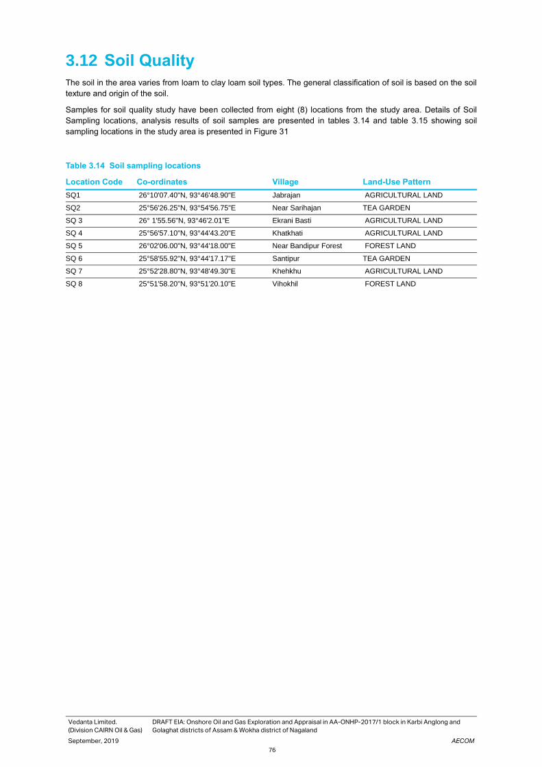
Vedanta Limited.
(Division CAIRN Oil & Gas)
DRAFT EIA: Onshore Oil and Gas Exploration and Appraisal in AA-ONHP-2017/1 block in Karbi Anglong and
Golaghat districts of Assam & Wokha district of Nagaland
September, 2019 AECOM
76
3.12 Soil Quality
The soil in the area varies from loam to clay loam soil types. The general classification of soil is based on the soil
texture and origin of the soil.
Samples for soil quality study have been collected from eight (8) locations from the study area. Details of Soil
Sampling locations, analysis results of soil samples are presented in tables 3.14 and table 3.15 showing soil
sampling locations in the study area is presented in Figure 31
Table 3.14 Soil sampling locations
Location Code Co-ordinates Village Land-Use Pattern
SQ1 26°10'07.40"N, 93°46'48.90"E Jabrajan AGRICULTURAL LAND
SQ2 25°56'26.25"N, 93°54'56.75"E Near Sarihajan TEA GARDEN
SQ 3 26° 1'55.56"N, 93°46'2.01"E Ekrani Basti AGRICULTURAL LAND
SQ 4 25°56'57.10"N, 93°44'43.20"E Khatkhati AGRICULTURAL LAND
SQ 5 26°02'06.00"N, 93°44'18.00"E Near Bandipur Forest FOREST LAND
SQ 6 25°58'55.92"N, 93°44'17.17"E Santipur TEA GARDEN
SQ 7 25°52'28.80"N, 93°48'49.30"E Khehkhu AGRICULTURAL LAND
SQ 8 25°51'58.20"N, 93°51'20.10"E Vihokhil FOREST LAND

Vedanta Limited. (Division CAIRN Oil & Gas) DRAFT EIA: Onshore Oil and Gas Exploration and Appraisal in AA-ONHP-2017/1 block in Karbi Anglong and Golaghat districts of Assam & Wokha district of Nagaland
September ,2019 AECOM
77
Table 3.15 Soil Quality Result
Parameters Unit S1/B1 S2/B1 S3/B1 S4/B1 S5/B1 S6/B1 S7/B1 S8/B1
pH value None 6.12 (1:2.5) at 25 deg C
8.13 (1:2.5) at 25 deg C
6.02 (1:2.5) at 25 deg C
4.48 (1:2.5) at 25 deg C
8.32 (1:2.5) at 25 deg C
5.28 (1:2.5) at 25 deg C
5.68 (1:2.5) at 25 deg C
5.19 (1:2.5) at 25 deg C
Acidity None Nil Nil Nil Nil Nil Nil Nil Nil
Alkalinity (as CaCO3 ) mg/kg 100 480 120 80 480 120 140 100
Antimony (as Sb ) mg/kg <0.25 <0.25 <0.25 <0.25 <0.25 <0.25 <0.25 <0.25
Arsenic( as As) mg/kg <0.25 <0.25 <0.25 <0.25 <0.25 <0.25 <0.25 <0.25
Available Nitrogen (as N)
mg/kg 202 179 218 280 106 330 420 314
Available Phosphorus (as P)
mg/kg 3.2 4.2 3.7 4 3.4 4.5 4.9 3
Available Potassium (as K)
mg/kg 76 100 71 62 285 169 267 99
Barium (as Ba ) mg/kg 55 55 24 51 56 71 51 17
Boron (as B) None 8 15 4 7 15 9 7 3
Bulk Density g/cc 1.11 1.18 1.14 1.25 1.21 1.05 1.03 1.18
Cadmium (as Cd) mg/kg <2 <2 <2 <2 <2 <2 <2 <2
Calcium (as Ca) mg/kg 600 2050 950 450 2750 1500 950 350
Carbonate mg/kg Nil Nil Nil Nil Nil Nil Nil Nil
Cation Exchange Capacity
meq/100 gm
10 25 10 8 25 18 12 8
Chloride (as Cl ) mg/kg 40 40 50 70 40 70 30 30
Cobalt (as Co) mg/kg <2 <2 <2 3 <2 <2 <2 <2
Copper (as Cu) mg/kg 11 17 8 17 17 21 17 4
Cyanide ( as CN) mg/kg <1 <1 <1 <1 <1 <1 <1 <1
Electrical conductivity us/cm 38.7 (1:2) at 25 deg C
202 (1:2) at 25 deg C
56.8 (1:2) at 25 deg C
118 (1:2) at 25 deg C
219 (1:2) at 25 deg C
135 (1:2) at 25 deg C
173 (1:2) at 25 deg C
33.9 (1:2) at 25 deg C
Hexavalent Chromium (as Cr+6)
mg/kg <2 <2 <2 <2 <2 <2 <2 <2
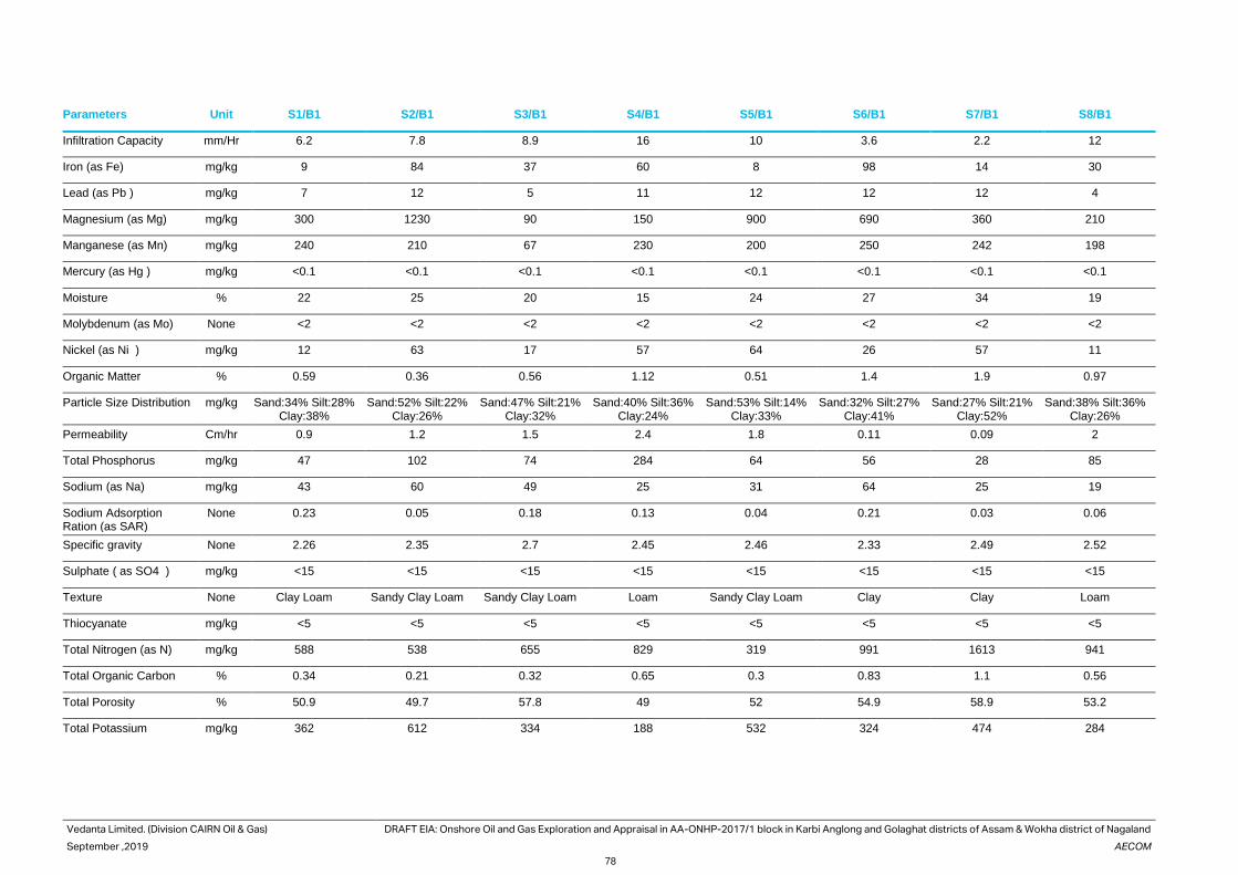
Vedanta Limited. (Division CAIRN Oil & Gas) DRAFT EIA: Onshore Oil and Gas Exploration and Appraisal in AA-ONHP-2017/1 block in Karbi Anglong and Golaghat districts of Assam & Wokha district of Nagaland
September ,2019 AECOM
78
Parameters Unit S1/B1 S2/B1 S3/B1 S4/B1 S5/B1 S6/B1 S7/B1 S8/B1
Infiltration Capacity mm/Hr 6.2 7.8 8.9 16 10 3.6 2.2 12
Iron (as Fe) mg/kg 9 84 37 60 8 98 14 30
Lead (as Pb ) mg/kg 7 12 5 11 12 12 12 4
Magnesium (as Mg) mg/kg 300 1230 90 150 900 690 360 210
Manganese (as Mn) mg/kg 240 210 67 230 200 250 242 198
Mercury (as Hg ) mg/kg <0.1 <0.1 <0.1 <0.1 <0.1 <0.1 <0.1 <0.1
Moisture % 22 25 20 15 24 27 34 19
Molybdenum (as Mo) None <2 <2 <2 <2 <2 <2 <2 <2
Nickel (as Ni ) mg/kg 12 63 17 57 64 26 57 11
Organic Matter % 0.59 0.36 0.56 1.12 0.51 1.4 1.9 0.97
Particle Size Distribution mg/kg Sand:34% Silt:28% Clay:38%
Sand:52% Silt:22% Clay:26%
Sand:47% Silt:21% Clay:32%
Sand:40% Silt:36% Clay:24%
Sand:53% Silt:14% Clay:33%
Sand:32% Silt:27% Clay:41%
Sand:27% Silt:21% Clay:52%
Sand:38% Silt:36% Clay:26%
Permeability Cm/hr 0.9 1.2 1.5 2.4 1.8 0.11 0.09 2
Total Phosphorus mg/kg 47 102 74 284 64 56 28 85
Sodium (as Na) mg/kg 43 60 49 25 31 64 25 19
Sodium Adsorption Ration (as SAR)
None 0.23 0.05 0.18 0.13 0.04 0.21 0.03 0.06
Specific gravity None 2.26 2.35 2.7 2.45 2.46 2.33 2.49 2.52
Sulphate ( as SO4 ) mg/kg <15 <15 <15 <15 <15 <15 <15 <15
Texture None Clay Loam Sandy Clay Loam Sandy Clay Loam Loam Sandy Clay Loam Clay Clay Loam
Thiocyanate mg/kg <5 <5 <5 <5 <5 <5 <5 <5
Total Nitrogen (as N) mg/kg 588 538 655 829 319 991 1613 941
Total Organic Carbon % 0.34 0.21 0.32 0.65 0.3 0.83 1.1 0.56
Total Porosity % 50.9 49.7 57.8 49 52 54.9 58.9 53.2
Total Potassium mg/kg 362 612 334 188 532 324 474 284

Vedanta Limited. (Division CAIRN Oil & Gas) DRAFT EIA: Onshore Oil and Gas Exploration and Appraisal in AA-ONHP-2017/1 block in Karbi Anglong and Golaghat districts of Assam & Wokha district of Nagaland
September ,2019 AECOM
79
Parameters Unit S1/B1 S2/B1 S3/B1 S4/B1 S5/B1 S6/B1 S7/B1 S8/B1
Trivalent Chromium as Cr-III (TCLP)
None <2 <2 <2 <2 <2 <2 <2 <2
Water Holding capacity % 43 40 37 26 33 48 52 30
Zinc (as Zn) mg/kg 9 38 9 37 38 41 36 10
ND = Not Detectable; LDL: Lower detection limit
India does not have any specific concentration-based soil contamination standards. In absence of any existing standards, Dutch standards have been considered for the purpose of analysis.

Vedanta Limited.
(Division CAIRN Oil & Gas)
DRAFT EIA: Onshore Oil and Gas Exploration and Appraisal in AA-ONHP-2017/1 block in Karbi Anglong and
Golaghat districts of Assam & Wokha district of Nagaland
September, 2019 AECOM
80
Table 3.16 Soil Remediation Intervention Values as per Dutch Standards
S. No. Parameter Intervention Values (mg/kg dry
matter)
1 Zinc 720
2 Arsenic 76
3 Lead 530
4 Cadmium 13
5 Copper 190
6 Mercury (inorganic) 36
7 Nickel 100
Source: Soil Remediation Circular 2009, Minister of Housing, Spatial Planning and Environment, Netherlands.
Note: Concentrations are shown for standard soil (10% organic matter and 25% clay)
The physical, chemical and heavy metal concentration of the soil samples determined and compared with the
standard soil classification provided by the Indian Council of Agricultural Research (ICAR) and as given in table
3.17
Table 3.17 Standard Soil Classification
Sl. No. Soil Test Classification
1. pH <4.5 Extremely acidic
4.51- 5.50 Very strongly acidic
5.51-6.0 moderately acidic
6.01-6.50 slightly acidic
6.51-7.30 Neutral
7.31-7.80 slightly alkaline
7.81-8.50 moderately alkaline
8.51-9.0 strongly alkaline
9.01 very strongly alkaline
2 Salinity Electrical Conductivity (mmhos/cm)
(1 ppm = 640 mmho/cm)
Upto 1.00 Average
1.01-2.00 harmful to germination
2.01-3.00 harmful to crops (sensitive to salts)
3 Organic Carbon Upto 0.2: very less
0.21-0.4: less
0.41-0.5 medium,
0.51-0.8: on an average sufficient
0.81-1.00: sufficient
>1.0 more than sufficient
4 Nitrogen (kg/ha) Upto 50 very less
51-100 less
101-150 good
151-300 Better
>300 sufficient
5 Phosphorus (kg/ha) Upto 15 very less
16-30 less
31-50 medium,
51-65 on an average sufficient
66-80 sufficient
>80 more than sufficient
6 Potash (kg/ha) 0 -120 very less

Vedanta Limited.
(Division CAIRN Oil & Gas)
DRAFT EIA: Onshore Oil and Gas Exploration and Appraisal in AA-ONHP-2017/1 block in Karbi Anglong and
Golaghat districts of Assam & Wokha district of Nagaland
September, 2019 AECOM
81
Sl. No. Soil Test Classification
120-180 less
181-240 medium
241-300 average
301-360 better
>360 more than sufficient
Source: Handbook of Agriculture, Indian Council of Agricultural Research, New Delhi
pH
Soil acidity has a correlation with the availability of nutrients in terms of their deficiency and toxicity. A soil having
pH less than 6 is considered as acidic. The soil samples in the study area have been found to be Very strongly
acidic to moderately alkaline as pH ranges from 4.48 to 8.32.
Texture and Electrical Conductivity
Texture is an expression to indicate the coarseness or fineness of the soil as determined by the relative proportion
of the various sized primary particles in the soil mass. The textures of the collected soil samples have been found
to be loam to sandy clay loam in the study area.
EC values for the soils monitored at the study area range between 33.9 and 219.0 µs/cm. For a productive soil,
the electrical conductance (EC) would be < 100000 µs/cm.
Macronutrients and Organic Carbon
Nutrient status of the soil samples can be determined from the concentration of N, P, K and organic carbon in soil
samples. Standard rating chart for soil nutrients is provided in Table 24.
Nitrogen contents in the soil samples ranged between 2163 kg/ha. phosphorus content in the soil samples ranged
between 25 kg/ha and potassium contents ranges between 1367 kg/ha. With comparison to the rating chart,
nutrient status of the soil is high.
Metals
Heavy metals such as copper (4.0 -27.0 mg/kg), lead (4.0 - 12.0 mg/kg) and zinc (9.0- 38.0 mg/kg) have been
found to be detectable in the soil of the study area. The concentration of copper, lead, Zinc and the other heavy
metals in the soil sample was much below the soil remediation intervention values specified in Dutch Soil
Remediation Circular (Refer table3.16).
Sodium Absorption Ratio (SAR)
Sodium absorption ratio for the samples varied between 0.03-0.23.
Conclusion
The soil samples have been found to be loam in nature with sandy clay loam basic in reaction. The macronutrient
contents viz. NPK values of the soil samples have been found to be high. Metal contamination have not been
observed in the analysed soil samples.

Vedanta Limited.
(Division CAIRN Oil & Gas)
DRAFT EIA: Onshore Oil and Gas Exploration and Appraisal in AA-ONHP-2017/1 block in Karbi Anglong and
Golaghat districts of Assam & Wokha district of Nagaland
September, 2019 AECOM
82
Photographs of Soil Quality Monitoring Activity is given below.
Photographs1: Soil sampling in S1 Photographs 2: Soil sampling in S4
Photographs 3: Soil sampling in S6 Photographs 3: Soil sampling in S3

Vedanta Limited.
(Division CAIRN Oil & Gas)
DRAFT EIA: Onshore Oil and Gas Exploration and Appraisal in AA-ONHP-2017/1 block in Karbi Anglong and
Golaghat districts of Assam & Wokha district of Nagaland
September, 2019 AECOM
83
3.13 Traffic Survey
In order to appreciate the traffic and transport system characteristics traffic surveys have been conducted within
the study area. The brief methodology adopted, location, nature and extent of data collected under each of the
above-mentioned surveys is discussed below. The field data collection activities have been carried out in May &
June, 2019.
The main objective of classified traffic volume counts was to assess the traffic characteristics in terms of average
daily traffic, hourly traffic variation, peak hour traffic, traffic composition and directional distribution. The surveys
have been conducted manually, on a normal working day and weekend. The survey has been conducted
continuously for 24 hours. In order to express the intensity of traffic, it would be convenient to express all these
different vehicle types in single unit terms. For this purpose, the PCU factors (IRC 106:1990) have been adopted
and are given in Table 3-18.
Table 3.18 Adopted Passenger Car Units
Mode PCU factor
Heavy Motor Vehicles 4.5
Light Motor Vehicles 1.5
Car 1.0
Three Wheelers 1.0
Two Wheelers 0.5
Source: IRC-106:1990
These roads cater to inter and intra city travel needs of various facilities and population residing in study area.
Other roads provide links connecting to various facilities inside the study area.
The hourly variation of PCUs at above mentioned road intersections are presented below.
Figure 32. Hourly Traffic Profile at NH39 and Jabarjan
0
50
100
150
200
250
300
350Traffic profile of intersection of NH 39 and
JabrajanWeekdays (NH39 -- Jabrajan )Weekdays (Jabrajan-- NH 39)Weekdays total PCUHoliday (NH39 -- Jabrajan )Holiday (Jabrajan-- NH 39)Holiday total PCU

Vedanta Limited.
(Division CAIRN Oil & Gas)
DRAFT EIA: Onshore Oil and Gas Exploration and Appraisal in AA-ONHP-2017/1 block in Karbi Anglong and
Golaghat districts of Assam & Wokha district of Nagaland
September, 2019 AECOM
84
Figure 33. Hourly Traffic Profile at Intersection of Sariajan and Dillai Tinali road
Figure 34. Hourly Traffic Profile at Intersection of NH39 and Khatkhati
Figure 35. Hourly traffic Profile at Sariajaan to Dillai Tinali road
0100200300400
Traffic composition at NH 39 and Khatkhati
Weekdays (NH39 -- Khatkhati ) Weekdays (Khatkhati--NH 39)
Weekdays total PCU Holiday (NH39 -- Khatkhati )
Holiday (Khatkhati-NH 39) Holiday total PCU

Vedanta Limited.
(Division CAIRN Oil & Gas)
DRAFT EIA: Onshore Oil and Gas Exploration and Appraisal in AA-ONHP-2017/1 block in Karbi Anglong and
Golaghat districts of Assam & Wokha district of Nagaland
September, 2019 AECOM
85
Peak Hour Traffic
Peak hour traffic composition at different major intersections are given below.
Figure 36. Peak Hour Traffic Composition (Vehicular) NH39 and Jabarjan Road.
13.86
33.1346.99
6.02
Peak traffic composition of NH 39 and Jabrajan (weekdays)
Heavy Motor Vehicles Light Motor Vehicles Two/Three Wheelers Bi cycle/tri cycle
Figure 37. Peak Hour Traffic Composition (Vehicular) NH39 and Sariajan Road.
6.29
36.36
50.35
6.99
Peak traffic composition of Dillai Tinali and Sariajan (weekdays)
Heavy Motor Vehicles Light Motor Vehicles
Two/Three Wheelers Bi cycle/tri cycle

Vedanta Limited.
(Division CAIRN Oil & Gas)
DRAFT EIA: Onshore Oil and Gas Exploration and Appraisal in AA-ONHP-2017/1 block in Karbi Anglong and
Golaghat districts of Assam & Wokha district of Nagaland
September, 2019 AECOM
86
Figure 38. Peak Hour Traffic Composition (Vehicular) NH39 and Khatkati road.
Figure 39. Peak Hour Traffic Composition (Vehicular) Saraijan and Dillai Tinali Road
The peak hours at various intersections are given in Table 3-19
Table 3.19 Peak hour traffic at Critical intersection
SL No Intersection Peak Time
1 NH39 and Jabranjan road 10:00 – 11:00
2 Sariajan and Dillai Tinali Road 9.00 - 10.00
3 NH39 and Khatkhati road 9.00 - 10.00
4 Sariajan and Dillai Tinali Road 8.00 - 9.00
Source: Traffic survey,2019
5.08
16.95
37.29
40.68
Peak traffic composition of NH 39 and Khakhati(weekdays)
Heavy Motor Vehicles Light Motor Vehicles Two/Three Wheelers Bi cycle/tri cycle
12.31
33.8546.15
7.69
Peak traffic composition of Sariajan to Dillai Tinali Road (weekdays)
Heavy Motor Vehicles Light Motor Vehicles Two/Three Wheelers Bi cycle/tri cycle

Vedanta Limited.
(Division CAIRN Oil & Gas)
DRAFT EIA: Onshore Oil and Gas Exploration and Appraisal in AA-ONHP-2017/1 block in Karbi Anglong and
Golaghat districts of Assam & Wokha district of Nagaland
September, 2019 AECOM
87
Traffic Composition
The composition of vehicles at these Intersections indicates that of the total vehicles observed, a total of 20 %
vehicles are light vehicles, which includes cars, JCBs, two wheelers and auto rickshaws. A total of 28% vehicles
have been found to be heavy vehicles comprising of HMV, 20ft trucks, 40ft trucks, Tractor, Tractor trailor, cranes
etc whereas 29 % vehicles constitutes of two-wheeler and three wheelers.
Table 3.20 Classified volume Count at Major Intersection
SL No Location
Heavy Motor
Vehicles
Light Motor
Vehicles
Two/Three
Wheelers
VEHICLES
1 NH39 and Jabranjan road 23 55 78 10
2 Sariajan and Dillai Tinali Road 9 52 72 10
3 NH39 and Khatkhati road 14 50 72 16
4 Sariajan and Dillai Tinali Road 5 16 20 7
3.14 Ecological Environment
An Ecology and Biodiversity study of Block AA-ONHP-2017/01, located in Karbi Anglong and Golaghat district of
Assam was conducted for assessment of biological diversity of the area and to identify the probable impacts on it
due to development of exploratory as well as appraisal well. The study was carried out in pre-monsoon season
during month of May, 2019. A Total 7 transects, 16 quadrats, 5 PBZ locations and 5 primary productivity sampling
locations were selected within the block based on topography, land use, habitat and vegetation pattern. For
assessment of floral species, quadrats of size 10m x 10m for trees, 5m x 5m for shrubs and 1m x 1m for herbs
were plotted and qualitative and quantitative analysis of the same was carried out. Faunal species were assessed
by transect method by traversing a known distance and noting observed faunal species along the length.
Assessment of faunal species was also done using indirect method, wherein searching for evidences such as
scats, pug marks, prey kills, calls, nests, feathers, skin molts, road-kills etc was done. Secondary data was collected
from RFO office, Bokajan; Freshwater Fish of Peninsular India, Birds of the Indian Sub-continent, Indian Mammals-
A field guide, Indian snakes-A field guide, Book of Indian reptiles and Amphibians and academic publications were
also consulted.
3.14.1 Methodology of the Study
Primary Data
Primary data have been collected at sixteen sampling sites selected by applying the stratified systematic sampling
method. Table 3-21 presents details of the sampling sites, including location code, location coordinates, elevation
above mean sea level (a msl), nearest village or town and habitat-profile of each site.
Table 3.21 Details of Sampling Sites
S.No.. Quadrat Location Nearest well Type of Habitat
1 Quadrat 1 25°58'12.15"N, 93°42'14.34"E
Well 4 Agriculture land
2 Quadrat 2 25°57'57.71"N, 93°42'30.49"E
Well 4 Agriculture land
3 Quadrat 3 25°57'53.81"N, 93°42'37.70"E
Well 4 Agriculture land
4 Quadrat 4 25°57'16.03"N, 93°43'50.08"E
Well 1 Roadside vegetation
5 Quadrat 5 25°57'32.83"N, 93°44'51.78"E
Well 1 Agriculture land
6 Quadrat 6 25°58'21.65"N, 93°45'10.30"E
Well 5 Roadside vegetation

Vedanta Limited.
(Division CAIRN Oil & Gas)
DRAFT EIA: Onshore Oil and Gas Exploration and Appraisal in AA-ONHP-2017/1 block in Karbi Anglong and
Golaghat districts of Assam & Wokha district of Nagaland
September, 2019 AECOM
88
S.No.. Quadrat Location Nearest well Type of Habitat
7 Quadrat 7 26° 2'33.26"N, 93°44'46.34"E
Well 12 Roadside vegetation
8 Quadrat 8 26° 3'1.00"N, 93°44'49.89"E
Well 12 Agriculture land
9 Quadrat 9 26° 3'38.41"N, 93°45'41.38"E
Well 13 Agriculture land
10 Quadrat 10 25°54'14.56"N, 93°50'14.08"E
Well 2 Riverine
11 Quadrat 11 25°54'38.59"N, 93°50'29.07"E
Well 2 Riverine
12 Quadrat 12 25°55'1.40"N, 93°48'28.69"E
Well 2 Agriculture land
13 Quadrat 13 26° 7'24.06"N, 93°47'11.22"E
Well 18 Roadside vegetation
14 Quadrat 14 26° 7'50.27"N, 93°47'17.09"E
Well 19 Roadside vegetation
15 Quadrat 15 26° 1'37.42"N, 93°48'11.02"E
Well 10 Roadside vegetation
16 Quadrat 16 26° 3'6.28"N, 93°48'59.23"E
Well 9 Roadside vegetation
In case of floristic species, qualitative and quantitative data was collected at each sampling site, using the standard
quadrat methodology. Quadrat sizes employed are 10m x 10m for trees, 5m x 5m for shrubs and 1m x 1m for
herbs.
In case of faunal species, qualitative data have been collected mainly at each sampling site. Any species recorded
outside the sampling sites have been ascribed to the nearest sampling site. Faunal records are based on direct
sightings, as well as, indirect evidence, such as calls, burrows, nests, droppings or scats. Only higher faunal
species, namely vertebrates, including mammals, birds, reptiles, amphibians and fishes, have been covered.
Primary data was collected through most of the diurnal period from early morning till late evening.
Faunal Survey Methodology
Faunal species were assessed by transect method by traversing a known distance and noting observed faunal
species along the length. Analysis was done through direct observation or visual encounter techniques and also
through observation of indirect signs such as calls, scat, pug marks and road kills. seven line transects were laid
in the study area. Seven line transects were laid in the study area. GPS locations of transects laid is given in
following table 3.22.
Direct observation (Visual Encounter): In this method, the species of animals observed visually were noted. Also,
a count of each species observed was recorded.
Indirect observation (Searching for signs): Signs such as scat, feeding signs, pug marks, burrows and dens were
recorded as evidence of the presence of mammals. For accuracy, the burrows and dens were checked to confirm
whether they were active or abandoned. Notable behaviours of the bird such as calls, feeding, nesting, or breeding
and the associated habits were also observed and accordingly the recorded Apart from line transects, vantage
point surveys were also conducted along the village ponds for aquatic birds.
Table 3.22 Geographic co-ordinates of Transact Location
Transect Start point End point Nearest Wells
Transect 1 25°58'13.49"N, 93°42'10.81"E 25°57'40.06"N, 93°43'11.40"E Well 1
Transect 2 25°57'12.18"N, 93°43'46.82"E 25°58'22.05"N, 93°45'10.51"E Well 1
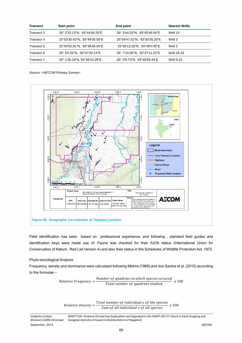
Vedanta Limited.
(Division CAIRN Oil & Gas)
DRAFT EIA: Onshore Oil and Gas Exploration and Appraisal in AA-ONHP-2017/1 block in Karbi Anglong and
Golaghat districts of Assam & Wokha district of Nagaland
September, 2019 AECOM
89
Transect Start point End point Nearest Wells
Transect 3 26° 2'33.13"N, 93°44'46.20"E 26° 3'44.53"N, 93°45'46.54"E Well 13
Transect 4 25°53'30.43"N, 93°49'30.50"E 25°54'47.52"N, 93°50'35.25"E Well 2
Transect 5 25°54'52.81"N, 93°48'34.05"E 25°56'13.20"N, 93°48'0.40"E Well 2
Transect 6 26° 9'0.53"N, 93°47'30.14"E 26° 7'24.06"N, 93°47'11.22"E Well 18,19
Transect 7 26° 1'36.18"N, 93°48'10.28"E 26° 3'6.73"N, 93°48'59.44"E Well 9,10
Source: <AECOM Primary Survey>
Figure 40. Geographic Co-ordinates of Transact Location
Field identification has been based on professional experience, and following , standard field guides and
identification keys were made use of. Fauna was checked for their IUCN status (International Union for
Conservation of Nature , Red List Version 4) and also their status in the Schedules of Wildlife Protection Act, 1972.
Phyto-sociological Analysis
Frequency, density and dominance were calculated following Mishra (1968) and dos Santos et al. (2015) according
to the formulae –
𝑅𝑒𝑙𝑎𝑡𝑖𝑣𝑒 𝐹𝑟𝑒𝑞𝑢𝑒𝑛𝑐𝑦 =𝑁𝑢𝑚𝑏𝑒𝑟 𝑜𝑓 𝑞𝑢𝑎𝑑𝑟𝑎𝑡𝑠 𝑖𝑛 𝑤ℎ𝑖𝑐ℎ 𝑠𝑝𝑒𝑐𝑖𝑒𝑠 𝑜𝑐𝑐𝑢𝑟𝑒𝑑
𝑇𝑜𝑡𝑎𝑙 𝑛𝑢𝑚𝑏𝑒𝑟 𝑜𝑓 𝑞𝑢𝑎𝑑𝑟𝑎𝑡𝑠 𝑠𝑡𝑢𝑑𝑖𝑒𝑑 𝑥 100
𝑅𝑒𝑙𝑎𝑡𝑖𝑣𝑒 𝐷𝑒𝑛𝑠𝑖𝑡𝑦 =𝑇𝑜𝑡𝑎𝑙 𝑛𝑢𝑚𝑏𝑒𝑟 𝑜𝑓 𝑖𝑛𝑑𝑖𝑣𝑖𝑑𝑢𝑎𝑙 𝑠 𝑜𝑓 𝑡ℎ𝑒 𝑠𝑝𝑒𝑐𝑖𝑒𝑠
𝑆𝑢𝑚 𝑜𝑓 𝑎𝑙𝑙 𝑖𝑛𝑑𝑖𝑣𝑖𝑑𝑢𝑎𝑙 𝑠 𝑜𝑓 𝑎𝑙𝑙 𝑠𝑝𝑒𝑐𝑖𝑒𝑠 𝑥 100

Vedanta Limited.
(Division CAIRN Oil & Gas)
DRAFT EIA: Onshore Oil and Gas Exploration and Appraisal in AA-ONHP-2017/1 block in Karbi Anglong and
Golaghat districts of Assam & Wokha district of Nagaland
September, 2019 AECOM
90
𝑅𝑒𝑙𝑎𝑡𝑖𝑣𝑒 𝑑𝑜𝑚𝑖𝑛𝑎𝑛𝑐𝑒 =𝐷𝑜𝑚𝑖𝑛𝑎𝑛𝑐𝑒 𝑜𝑓 𝑔𝑖𝑣𝑒𝑛 𝑠𝑝𝑒𝑐𝑖𝑒𝑠
𝑇𝑜𝑡𝑎𝑙 𝑑𝑜𝑚𝑖𝑛𝑎𝑛𝑐𝑒 𝑜𝑓 𝑎𝑙𝑙 𝑠𝑝𝑒𝑐𝑖𝑒𝑠 𝑥 100
Important value index (IVI) is used to determine the overall importance of each species in the community structure.
It is used to identify the dominance of any given species in the study area which helps in getting an overall
importance of any given species in the community by statistical analysis. It can be calculated by summing the
values of relative frequency, relative density and relative dominance.The IVI of the individual species has been
calculated as the following formula
IVI = Relative frequency + Relative density + Relative dominance
The rationale behind the number of transect and quadrats laid was to ensure thorough and proportionate coverage
of all the habitat types observed in the study area.
Desktop review and Secondary Data Collection
A desktop review has been carried to identify the forest area, land use pattern, Vegetation type etc. information
regarding sensitive ecological habitat such as Biosphere Reserve, National Park, Wild life Sanctuary , Game
reserve, Conservation reserve also collected from sources such as Forest Working Plan of Golaghat and East-
Karbi-Anglong District, different Scientific report published in peer reviewed journals, Government reports, To
identify the different classification of different forest types , report from Forest Survey Of India (SoFR, 2017) was
consulted Stakeholder consultation with forest Department and local villagers was also carried out to gather the
relevant information during field survey..

Vedanta Limited.
(Division CAIRN Oil & Gas)
DRAFT EIA: Onshore Oil and Gas Exploration and Appraisal in AA-ONHP-2017/1 block in Karbi Anglong and
Golaghat districts of Assam & Wokha district of Nagaland
September, 2019 AECOM
91
Figure 41. Quadrat sampling location maps.
Flora of the Study Area
The floristic baseline was carried out after considering the different habitats present in the study area. Forest types
are also identified as per the Champion and Seth Classification, 1967. Forest working Plans of Golaghat and Karbi
Anglong District are also consulted during identification of Forest types.
Forest Types
The Study area falls within the Golaghat and Karbianglong district of Assam. Both of the district receive heavy
rain fall in the monosson season and moderate to light rainfall rest the year which. This type of rainfall helps to
development of forest area. In Karbi District, 76.51 % of the Geographic area comes under forest cover whereas
in Golaghat Dostrict , 18.59 % of geographic area falls in the forest area ( SoFR. 2017). The Major forest types
which are observed in the study area are Moist Semi Evergreen Forest, Moist mixed Deciduous Forest, etc.
Moist semi-evergreen forests (2BC 1/b and 2 BC)
These types of forests have a mixture of the wet evergreen trees and the moist deciduous trees. This type of forest
are widely found in the block area and are covered with trees of commercial importance like Badam, Sopa, Bonsum,
Bhola, Gomari, Ponam, Amari, Cham, etc.
Moist Mixed Deciduous forests (3C/C 3b)
The trees in this category are mostly deciduous with sparkling of few evergreen and semi-evergreen species.
Important species includes Albizia species (Siris, Kala siris, ,), Ficus species (Bot, Bor, Dimoru), Careya arborea
(Kumbhi), Mallotu species (Senduri, Joral, Dudhloti) and Lagerstroemia species (Jarul, Ajar).
Riverain Type
This type of forest occupies the localities with alluvial soil of more recent origin in the vicinity of rivers and
streams of the district. The common species of importance are Khair, Sissoo, Simul, Urium, Kokoli etc.

Vedanta Limited.
(Division CAIRN Oil & Gas)
DRAFT EIA: Onshore Oil and Gas Exploration and Appraisal in AA-ONHP-2017/1 block in Karbi Anglong and
Golaghat districts of Assam & Wokha district of Nagaland
September, 2019 AECOM
92
Miscellaneous type with scattered pure or mixed patches of bamboos
Miscellaneous type of forest comprises of Amari, Sopa, Cham, Bonsum, Bogipoma, Gonsoroi, Dhuna and
Hingori etc.
Floristic Species Recorded
A consolidated list of flora species observed in the study area, prepared on the basis of primary survey has been
provided in following Table 3.23. Orchids such as Cymbidium aloipholium, Dendrobium aphyllum, Rhynchostylis
rhetusa, Aerides rosea, Aerides odorata, Bulbophyllum sp, Papilionanth teres, Dendrobium densiflirum and
Papilionanthe teres were observed in the study area.
Trees
Total 44species of trees have been recorded in the study area. Species belonging to family Moraceae showed
highest diversity followed by Fabaceae and Euphorbiaceae. Species such as Tectona grandis, Streblus asper and
Sterculia viollosa were commonly seen in the study area.
Table 3.23 List of Tree species observed in the study area
Sr.no Botanical name Local Name /Common Name
Family IUCN Status, Ver.4
1 Mangifera indica Aam Anacardiaceae DD
2 Alstonia scholaris Satwan Apocynaceae LC
3 Holarrhena antidysenterica Dhulkari Apocynaceae Not assessed
4 Wrightia tinctoria Dudhi Apocynaceae LC
5 Wrightia tomentosa Atkuri Apocynaceae Not assessed
6 Oroxylum indicum (L.) Kurz Toguna Bignoniaceae Not assessed
7 Bombax ceiba L. Dumboil Bombacaceae Not assessed
8 Cassia fistula Amaltas Fabaceae LC
9 Senna sp. - Fabaceae Not assessed
10 Trema orientalis (L.) Bl. Indian Charcoal Tree Cannabaceae Not assessed
11 Alangium chinense Chinese Alangium Cornaceae Not assessed
12 Croton oblongifolius - Euphorbiaceae Not assessed
13 Euphorbia sp. - Euphorbiaceae Not assessed
14 Mallotus philippensis Kamala tree Euphorbiaceae LC
15 Securinega virosa - Euphorbiaceae Not assessed
16 Trevia nudiflora Many fruited trevia Euphorbiaceae Not assessed
17 Acacia auriculiformis - Fabaceae LC
18 Parkia sp. - Fabaceae Not assessed
19 Pongamia pinnata korosh Fabaceae LC
20 Albizia procera Tantari asing Fabaeae LC
21 Erythrina stricta Dhaul Dhak Fabaceae Not assessed
22 Gmelina arborea Gamhar Lamiaceae LC
23 Delonix regia Flame tree Leguminoceae LC
24 Lagerstroemia speciosa Ejar Lytheraceae Not assessed
25 Garuga pinnata Roxb. Pama Burseraceae Not assessed
26 Melia azadirach Bakain Meliaceae Not assessed
27 Ficus religiosa Ahot Moraceae Not assessed
28 Artocarpus lakoocha Bohot Moraceae Not assessed
29 Ficus hispida Devil fig Moraceae Not assessed

Vedanta Limited.
(Division CAIRN Oil & Gas)
DRAFT EIA: Onshore Oil and Gas Exploration and Appraisal in AA-ONHP-2017/1 block in Karbi Anglong and
Golaghat districts of Assam & Wokha district of Nagaland
September, 2019 AECOM
93
Sr.no Botanical name Local Name /Common Name
Family IUCN Status, Ver.4
30 Streblus asper Khorua Moraceae Not assessed
31 Artocarpus heterophyllus Jackfruit Moraceae Not assessed
32 Morus sp - Moraceae Not assessed
33 Psidium guajava - Myrtaceae Not assessed
34 Glochidion sp. - Phyllanthaceae Not assessed
35 Phyllanthus acidus - Phyllanthaceae Not assessed
36 Bambusa sp. - Poaceae Not assessed
37 Ziziphus jujuba - Rhamnaceae Not assessed
38 Neolamarckia cadamba Kadamb Rubiaceae Not assessed
39 Murraya koenigii Bishahari Rutaceae Not assessed
40 Murraya sp. - Rutaceae Not assessed
41 Sterculia villosa Udal Sterculiaceae Not assessed
42 Grewia multiflora - Tiliaceae Not assessed
43 Tectona grandis Segun Verbenaceae Not assessed
44 Vitex negundo Nirgundi Verbenaceae Not assessed
Source: Primary Survey
Figure 42. Tree species Diversity in Study Area
Shrubs: 15 shrub species have been observed during field survey in study area. Species belonging to Lamiaceae family
were found to be higher in the study area followed by Rubiaceae and Verbenaceae. Species such as Lantana
camara, Solanum torvum, Cassia tora and Clerodendrum viscosum were commonly observed in the study area.
Lantana Camara is an invasive weed.

Vedanta Limited.
(Division CAIRN Oil & Gas)
DRAFT EIA: Onshore Oil and Gas Exploration and Appraisal in AA-ONHP-2017/1 block in Karbi Anglong and
Golaghat districts of Assam & Wokha district of Nagaland
September, 2019 AECOM
94
Table 3.24 List Shrub Species observed in study area
Sr.no Botanical name Common Name/Local Name Family IUCN
1 Licuala peltata Japi Pat Arecaceae Not Assessed
2 Eupatorium odoratum
Motmoti Asteraceae Not Assessed
3 Cassia tora Bon medelua Caesalpinaceae Not Assessed
4 Capparis spinosa - Capparaceae Not Assessed
5 Jatropha curcas Bhenda Euphorbiaceae Not Assessed
6 Clerodendrum viscosum
Bhetita Lamiaceae Not Assessed
7 Clerodendrum sp. - Lamiaceae Not Assessed
8 Hyptis sp - Lamiaceae Not Assessed
9 Melastoma melabathricum
Phutuka Melastomaceae Not Assessed
10 Ixora polyantha Many-Flowered Ixora Rubiaceae Not Assessed
11 Coffea benghalensis
Bengal coffee Rubiaceae Not Assessed
12 Glycosmis pentaphylla
Gin Berry Rutaceae Not Assessed
13 Solanum torvum Bhit tita Solanaceae Not Assessed
14 Stachytarpheta indica
Kariyartharani Verbenaceae Not Assessed
15 Lantana camara Gubon Verbenaceae Not Assessed
Source: <Primary Survey,AECOM>
Figure 43. Shrub Species diversity in Study Area
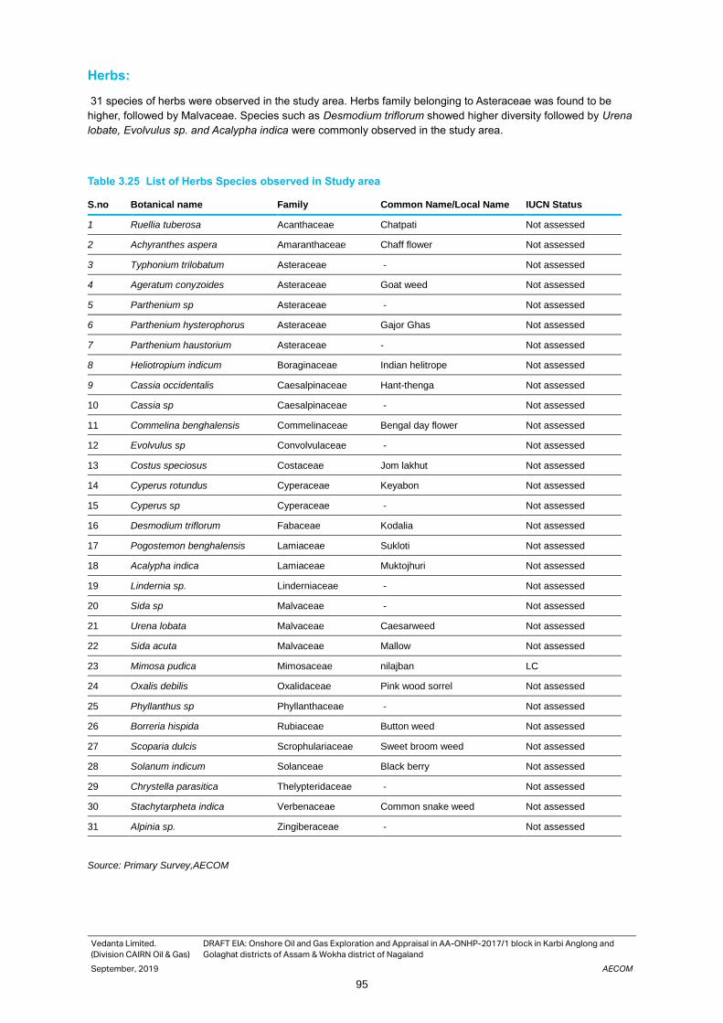
Vedanta Limited.
(Division CAIRN Oil & Gas)
DRAFT EIA: Onshore Oil and Gas Exploration and Appraisal in AA-ONHP-2017/1 block in Karbi Anglong and
Golaghat districts of Assam & Wokha district of Nagaland
September, 2019 AECOM
95
Herbs:
31 species of herbs were observed in the study area. Herbs family belonging to Asteraceae was found to be
higher, followed by Malvaceae. Species such as Desmodium triflorum showed higher diversity followed by Urena
lobate, Evolvulus sp. and Acalypha indica were commonly observed in the study area.
Table 3.25 List of Herbs Species observed in Study area
S.no Botanical name Family Common Name/Local Name IUCN Status
1 Ruellia tuberosa Acanthaceae Chatpati Not assessed
2 Achyranthes aspera Amaranthaceae Chaff flower Not assessed
3 Typhonium trilobatum Asteraceae - Not assessed
4 Ageratum conyzoides Asteraceae Goat weed Not assessed
5 Parthenium sp Asteraceae - Not assessed
6 Parthenium hysterophorus Asteraceae Gajor Ghas Not assessed
7 Parthenium haustorium Asteraceae - Not assessed
8 Heliotropium indicum Boraginaceae Indian helitrope Not assessed
9 Cassia occidentalis Caesalpinaceae Hant-thenga Not assessed
10 Cassia sp Caesalpinaceae - Not assessed
11 Commelina benghalensis Commelinaceae Bengal day flower Not assessed
12 Evolvulus sp Convolvulaceae - Not assessed
13 Costus speciosus Costaceae Jom lakhut Not assessed
14 Cyperus rotundus Cyperaceae Keyabon Not assessed
15 Cyperus sp Cyperaceae - Not assessed
16 Desmodium triflorum Fabaceae Kodalia Not assessed
17 Pogostemon benghalensis Lamiaceae Sukloti Not assessed
18 Acalypha indica Lamiaceae Muktojhuri Not assessed
19 Lindernia sp. Linderniaceae - Not assessed
20 Sida sp Malvaceae - Not assessed
21 Urena lobata Malvaceae Caesarweed Not assessed
22 Sida acuta Malvaceae Mallow Not assessed
23 Mimosa pudica Mimosaceae nilajban LC
24 Oxalis debilis Oxalidaceae Pink wood sorrel Not assessed
25 Phyllanthus sp Phyllanthaceae - Not assessed
26 Borreria hispida Rubiaceae Button weed Not assessed
27 Scoparia dulcis Scrophulariaceae Sweet broom weed Not assessed
28 Solanum indicum Solanceae Black berry Not assessed
29 Chrystella parasitica Thelypteridaceae - Not assessed
30 Stachytarpheta indica Verbenaceae Common snake weed Not assessed
31 Alpinia sp. Zingiberaceae - Not assessed
Source: Primary Survey,AECOM
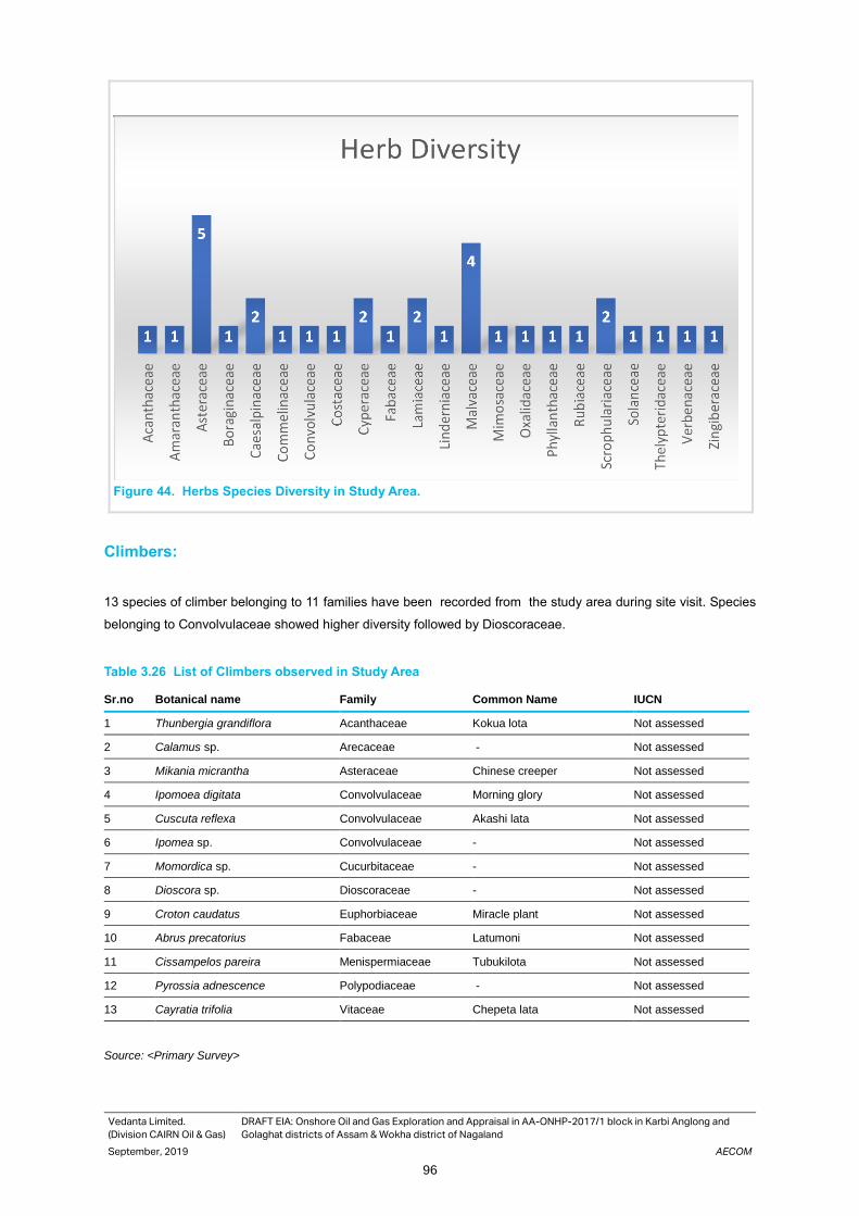
Vedanta Limited.
(Division CAIRN Oil & Gas)
DRAFT EIA: Onshore Oil and Gas Exploration and Appraisal in AA-ONHP-2017/1 block in Karbi Anglong and
Golaghat districts of Assam & Wokha district of Nagaland
September, 2019 AECOM
96
Figure 44. Herbs Species Diversity in Study Area.
Climbers:
13 species of climber belonging to 11 families have been recorded from the study area during site visit. Species
belonging to Convolvulaceae showed higher diversity followed by Dioscoraceae.
Table 3.26 List of Climbers observed in Study Area
Sr.no Botanical name Family Common Name IUCN
1 Thunbergia grandiflora Acanthaceae Kokua lota Not assessed
2 Calamus sp. Arecaceae - Not assessed
3 Mikania micrantha Asteraceae Chinese creeper Not assessed
4 Ipomoea digitata Convolvulaceae Morning glory Not assessed
5 Cuscuta reflexa Convolvulaceae Akashi lata Not assessed
6 Ipomea sp. Convolvulaceae - Not assessed
7 Momordica sp. Cucurbitaceae - Not assessed
8 Dioscora sp. Dioscoraceae - Not assessed
9 Croton caudatus Euphorbiaceae Miracle plant Not assessed
10 Abrus precatorius Fabaceae Latumoni Not assessed
11 Cissampelos pareira Menispermiaceae Tubukilota Not assessed
12 Pyrossia adnescence Polypodiaceae - Not assessed
13 Cayratia trifolia Vitaceae Chepeta lata Not assessed
Source: <Primary Survey>
Fig.6: Herb Species observed in Study Area

Vedanta Limited.
(Division CAIRN Oil & Gas)
DRAFT EIA: Onshore Oil and Gas Exploration and Appraisal in AA-ONHP-2017/1 block in Karbi Anglong and
Golaghat districts of Assam & Wokha district of Nagaland
September, 2019 AECOM
97
Figure 45. Diversity of Climber Species in study area
Phytosociological Analysis`
The phytosociological analysis of the observed floral diversity has been carried out and the frequency, density and
dominance of each observed species is given in following tables 3.27 to 3.29
Trees:
Among trees, Tectona grandis ( IVI 29.162), Streblus asper ( IVI 24.845) and Sterculia viollosa (IVI 22.356) were
found to be dominant in study area.
Table 3.27 List of Trees
Sr.No Botanical Name Relative Frequency Relative Density
Relative dominance IVI
1 Tectona grandis 6.741573 10.79137 11.62875 29.16169
2 Streblus asper 7.865169 9.71223 7.267969 24.84537
3 Sterculia viollosa 2.247191 4.676259 15.43232 22.35577
4 Pongamia pinnata 3.370787 5.035971 9.647556 18.05431
5 Wrightia tinctoria 3.370787 8.633094 3.165604 15.16948
6 Ficus hispida 7.865169 2.877698 4.220806 14.96367
7 Cassia fistula 5.617978 2.877698 6.223535 14.71921
8 Securinega virosa 3.370787 4.316547 2.444945 10.13228
9 Tremma orientalis 2.247191 5.035971 2.411889 9.695051
10 Bambusa sp. 1.123596 7.194245 0.215347 8.533187
11 Mallotus phillipions 1.123596 2.877698 4.220806 8.222099
12 Murraya koenigii 3.370787 4.676259 0.139976 8.187021
13 Garuga pinnata 3.370787 1.438849 3.111767 7.921403
14 Delonix regia 2.247191 1.438849 3.488625 7.174665
15 Gmelina arborea 2.247191 1.079137 2.915263 6.241591

Vedanta Limited.
(Division CAIRN Oil & Gas)
DRAFT EIA: Onshore Oil and Gas Exploration and Appraisal in AA-ONHP-2017/1 block in Karbi Anglong and
Golaghat districts of Assam & Wokha district of Nagaland
September, 2019 AECOM
98
Sr.No Botanical Name Relative Frequency Relative Density
Relative dominance IVI
16 Mangifera indica 1.123596 0.719424 4.220806 6.063826
17 Ziziphus jujuba 3.370787 1.438849 0.689111 5.498747
18 Senna sp. 2.247191 1.798561 1.34592 5.391672
19 Croton oblongifolius 3.370787 1.798561 0.164875 5.334223
20 Erythrina stricta 2.247191 1.438849 1.5505 5.23654
21 Alstonia scholaris 2.247191 1.798561 0.818858 4.86461
22 Trewia nudiflora 2.247191 1.438849 0.527601 4.213641
23 Anthrocephalous cadamba 1.123596 0.719424 1.943509 3.786529
24 Parkia sp. 1.123596 2.517986 0.036932 3.678513
25 Bombax ceiba 1.123596 0.359712 2.110403 3.593711
26 Holarrhena antidysenterica 1.123596 1.798561 0.659501 3.581658
27 Artocarpus heterophyllas 1.123596 0.359712 1.5505 3.033808
28 Artocarpus lackoocha 1.123596 0.359712 1.423984 2.907291
29 Ficus religiosa 1.123596 0.359712 1.423984 2.907291
30 Grewia multiflora 1.123596 0.359712 1.302851 2.786158
31 Glochidion sp. 1.123596 1.079137 0.395701 2.598433
32 Lagerstroemia speciosa 1.123596 0.719424 0.651425 2.494445
33 Albizia procera 1.123596 1.079137 0.201888 2.40462
34 Alangium begoniifolium 1.123596 1.079137 0.156342 2.359074
35 Euphorbia sp. 1.123596 1.079137 0.046515 2.249247
36 Psidium gujava 1.123596 0.719424 0.021535 1.864555
37 Morus 1.123596 0.719424 0.015559 1.858579
38 Murraya sp. 1.123596 0.719424 0.010552 1.853572
39 Acacia auriculiformis 1.123596 0.359712 0.325713 1.80902
40 Spondias pinnata 1.123596 0.359712 0.218039 1.701347
41 Melia azadirach 1.123596 0.359712 0.1319 1.615208
42 Wrightia tomantosa 1.123596 0.359712 0.1319 1.615208
43 Oroxyllum indicum 1.123596 0.359712 0.067296 1.550604
44 Vitex negundo 1.123596 0.359712 0.013029 1.496336
45 Phyllanthus acidus 1.123596 0.359712 0.005276 1.488584
Source: <Primary Survey, >
Shrubs:
Among Shrub, Lantana camara (92.671), Solanum torvum (28.729), Cassia tora (19.926) and Clerodendrum viscosum (16.981) are the dominant species
Table 3.28 Phyto sociological Analysis of Shrub Species
Sr.No Botanical Name Relative Frequency
Relative Density
Relative Dominance
IVI
1 Lantana camara 23.52941 35.38462 55.0667322 113.9808
2 Solanum torvum 17.64706 10 11.2437887 38.89085
3 Cassia tora 5.882353 15.38462 4.84826664 26.11523
Vedanta Limited.
(Division CAIRN Oil & Gas)
DRAFT EIA: Onshore Oil and Gas Exploration and Appraisal in AA-ONHP-2017/1 block in Karbi Anglong and
Golaghat districts of Assam & Wokha district of Nagaland
September, 2019 AECOM
99
Sr.No Botanical Name Relative Frequency
Relative Density
Relative Dominance
IVI
4 Clerodendrum viscosum 11.76471 7.692308 4.30957035 23.76658
5 Glycosmis pentaphylla 5.882353 6.923077 1.31980592 14.12524
6 Licuala peltata 5.882353 2.307692 5.61141972 13.80146
7 Coffea benghalensis 2.941176 6.923077 3.25911257 13.12337
8 Eupatorium odoratum 5.882353 4.615385 1.14921876 11.64696
9 Melastoma melabathricum 2.941176 2.307692 3.95941776 9.208287
10 Jatropha curcus 2.941176 0.769231 3.45962731 7.170035
11 Capparis spinosa 2.941176 1.538462 2.39420575 6.873844
12 Ixora polyantha 2.941176 1.538462 2.39420575 6.873844
13 Hyptis sp. 2.941176 3.076923 0.19153646 6.209636
14 Clerodendrum sp. 2.941176 0.769231 0.43095703 4.141364
15 Croton caudatus 2.941176 0.769231 0.36212362 4.072531
Source: Primary Survey, AECOM
Herbs:
Among herbs, Desmodium triflorum (25.861) showed higher diversity followed by Urena lobate (25.793),
Evolvulus sp. (22.866) and Acalypha indica (18.526) were the dominant species observed in the study area.
Table 3.29 Phyto sociological Analysis of Herbs Species
Sr.No Botanical Name Relative Frequency Relative Density Relative Dominance IVI
1 Desmodium triflorum 8.196721 4.834494 12.98246 26.15028
2 Urena lobata 9.836066 3.810975 12.2807 26.09168
3 Evolvulus sp 6.557377 5.22648 11.22807 23.12122
4 Acalypha indica 1.639344 11.10627 5.964912 18.73785
5 Ruellia tuberosa 1.639344 10.45296 5.614035 17.73366
6 Borreria hispida 6.557377 2.61324 5.614035 14.89394
7 Cassia occidantalis 4.918033 3.70209 5.964912 14.667
8 Typhonium trilobatum 1.639344 7.83972 4.210526 13.71691
9 Sida acuta 1.639344 5.87979 3.157895 10.70435
10 Lindernia sp. 3.278689 3.26655 3.508772 10.10866
11 Cyperus rotundus 1.639344 5.22648 2.807018 9.700164
12 Ageratum conyzoides 3.278689 2.939895 3.157895 9.431123
13 Mimosa pudica 4.918033 1.52439 2.45614 8.98053
14 Stachytarpheta indica 4.918033 1.52439 2.45614 8.98053
15 Achyranthus aspera 4.918033 1.30662 2.105263 8.411883
16 Parthenium sp. 1.639344 3.91986 2.105263 7.69179
17 Chrystela parasitica 1.639344 3.91986 2.105263 7.69179
18 Partherium haustorium 1.639344 3.91986 2.105263 7.69179
19 Scoparia dulcis 3.278689 0.979965 1.052632 5.36593
20 Parthenium hysterophorus 3.278689 0.979965 1.052632 5.36593
21 Pogostemon benghlensis 1.639344 1.95993 1.052632 4.679228
22 Cyperus sp. 1.639344 1.95993 1.052632 4.679228

Vedanta Limited.
(Division CAIRN Oil & Gas)
DRAFT EIA: Onshore Oil and Gas Exploration and Appraisal in AA-ONHP-2017/1 block in Karbi Anglong and
Golaghat districts of Assam & Wokha district of Nagaland
September, 2019 AECOM
100
Sr.No Botanical Name Relative Frequency Relative Density Relative Dominance IVI
23 Cassia sp. 1.639344 1.95993 1.052632 4.679228
24 Sida sp. 1.639344 1.30662 0.701754 3.675041
25 Scoparia dulcis 1.639344 1.30662 0.701754 3.675041
26 Solanum indicum 1.639344 1.30662 0.701754 3.675041
27 Commelina benghalensis 1.639344 1.30662 0.701754 3.675041
28 Costus speciosa 1.639344 0.65331 0.350877 2.670854
29 Sida sp 1.639344 0.65331 0.350877 2.670854
30 Phyllanthus sp 1.639344 0.65331 0.350877 2.670854
31 Helitropium indicum 1.639344 0.65331 0.350877 2.670854
32 Oxalis debilis 1.639344 0.65331 0.350877 2.670854
33 Alpines sp 1.639344 0.65331 0.350877 2.670854
Source: <Primary Survey>
Biodiversity Indices
The diversity measurement reflect as to how many diverse species are present, the density measurement indicates
number of individuals of a species in the study area. Species diversity is the best measure of community structure
and it is sensitive to various environmental stresses. Smaller value of Simpson’s Diversity Index shows healthy
ecosystem and the higher value shows that an ecosystem is under environmental stress. The floral diversity was
found to be medium to high as Shannon’s index value varied from 2.044 - 3.265, whereas Simpson’s indices value
varied from 0.8327 -0.9655. Quadrat wise value of Shannon’s and Simpson’s index is given in following Table 3.30
Table 3.30 Quadrat wise Diversity indices
Sr. no. Quadrat Shannon’s index Simpson’s index
1 Quadrat 1 2.178 0.919
2 Quadrat 2 2.694 0.9619
3 Quadrat 3 2.527 0.9221
4 Quadrat 4 2.381 0.8991
5 Quadrat 5 2.664 0.9413
6 Quadrat 6 2.421 0.9222
7 Quadrat 7 2.722 0.8273
8 Quadrat 8 2.388 0.9134
9 Quadrat 9 2.168 0.8327
10 Quadrat 10 2.655 0.9314
11 Quadrat 11 3.265 0.9582
12 Quadrat 12 3.135 0.9655
13 Quadrat 13 2.437 0.8753
14 Quadrat 14 2.6 0.9289
15 Quadrat 15 2.497 0.9261
16 Quadrat 16 2.044 0.8732
Source: Primary Survey
Fauna of the Study Area
The faunal baseline of the study area is based on the species having recorded ranges that include the study area,
supported by the primary faunal data recorded during field visit The following sub-sections provide details of the
faunal species reported from or recorded in the study area.
Vedanta Limited.
(Division CAIRN Oil & Gas)
DRAFT EIA: Onshore Oil and Gas Exploration and Appraisal in AA-ONHP-2017/1 block in Karbi Anglong and
Golaghat districts of Assam & Wokha district of Nagaland
September, 2019 AECOM
101
Mammals
Among Mammals, only Hoary-bellied squirrel (Callosciurus pygerythrus) was observed in the study area during
field visit. The IUCN stataus of this species is Least concern (LC) and as per Wild life protection Act, 1972, this
species is enlisted in ScheduleHowever, 62 mammalian species have been reported from the Karbi-Anglong and
Golaghat district from different secondary sources such as forest working Plan, peoples Biodiversity registrar,
scientific literatures etc. The list of mammalian species which is observed in the study area is given in table 3.31
And recorded mammalian species from this area are given Appendix 3.8
Table 3.31 Mammalian Species observed in the Study Area
Sr. No. Common Name Scientific Name Family IUCN, 3.1 Status
WPA 1972 Schedule
1 Hoary - bellied Squirrel Callosciurus pygerythrus Sciuridae LC -
Source: Primary Survey, AECOM
Avifauna
49 avian species have been observed in the study area. Among the avian species Alexandrian
parakeet(Psittacula eupatria), Blossom Headed parakeet(Psittacula roseate) and Red Breasted
parakeet(Psittacula alexandri)are Near Threatened species according to IUCN red data Book. No other globally
threatened avian species has been observed in the study area. Detailed checklist of birds observed in the study
area is given in Table 3.32
Table 3.32 List of Avifauna observed in the Study Area
S. No.
Common name Scientific name Order Family IUCN Status
Schedule as per WPA, 1972
1 Oriental Honey buzzard
Pernis ptilorhynchus Accipitriformes Accipitridae LC -
2 Crested Serpent Eagle
Spilornis cheela Accipitriformes Accipitridae LC -
3 Red-wattled lapwing
Vanellus indicus Charadriiformes Charadriidae LC -
4 Common Pigeon Columba livia Columbiformes Columbidae LC -
5 Spotted Dove Stigmatopelia Chinensis Columbiformes Columbidae LC IV
6 Thick billed Green Pigeon
Treron curvirostra Columbiformes Columbidae LC IV
7 Emerald Dove Chalcophaps indica Columbiformes Columbidae LC IV
8 Indian Roller Coracias benghalensis Coraciiformes Coraciidae LC IV
9 White throated Kingfisher
Halcyon smyrnensis Coraciiformes Alcedinidae LC IV
10 Common Hawk Cuckoo
Hierococcyx varius Cuculiformes Cuculidae LC IV
11 White-breasted waterhen
Amaurornis phoenicurus Gruiformes Rallidae LC IV
12 Scarlet Minivet Pericrocotus speciosus Passeriformes Campephagidae
LC IV
13 Long tailed Shrike lanius schach Passeriformes Laniidae LC -
14 Spangled Drongo Dicrurus hottetottus Passeriformes Dicruridae LC IV
15 Black Drongo Dicrurus macrocercus Passeriformes Dicruridae LC IV
16 Black Hooded oriole
Oriolus xanthornus Passeriformes Oriolidae LC IV

Vedanta Limited.
(Division CAIRN Oil & Gas)
DRAFT EIA: Onshore Oil and Gas Exploration and Appraisal in AA-ONHP-2017/1 block in Karbi Anglong and
Golaghat districts of Assam & Wokha district of Nagaland
September, 2019 AECOM
102
S. No.
Common name Scientific name Order Family IUCN Status
Schedule as per WPA, 1972
17 Rufous Treepie Dendrocitta vagabunda Passeriformes Corvidae LC IV
18 Eastern Jungle Crow
Corvus levillantii Passeriformes Corvidae LC IV
19 House Crow Corvus splendens Passeriformes Corvidae LC IV
20 Great Tit Parus major Passeriformes Paridae LC IV
21 Black Creasted Bulbul
Pycnonotus flaviventris Passeriformes Pycnonotidae LC IV
22 Red-whiskered Bulbul
Pycnonotus jocosus Passeriformes Pycnonotidae LC IV
23 Red Vented Bulbul
Pycnonotus cafer Passeriformes Pycnonotidae LC IV
24 Plain Prinia Prinia inornata Passeriformes Cisticolidae LC IV
25 Great Myna Acridotheres grandis Passeriformes Sturnidae LC IV
26 Jungle Myna Acridotheres fuscus Passeriformes Sturnidae LC IV
27 Common Myna Acridotheres tristis Passeriformes Sturnidae LC IV
28 Asian Pied Starling
Gracupica contra Passeriformes Sturnidae LC IV
29 Oriental Magpie Robin
Copsychus saularis Passeriformes Muscicapidae LC IV
30 Black backed Forktail
Enicurus immaculatus Passeriformes Muscicapidae LC IV
31 Golden fronted Leafbird
Chloropsis aurifrons Passeriformes Chloropseidae
LC -
32 Purple Sunbird Cinnyris asiaticus Passeriformes Nectariniidae LC IV
33 Crimson Sunbird Aethopyga siparaja Passeriformes Nectariniidae LC IV
34 House sparrow Passer domesticus Passeriformes Passeridae LC -
35 Eurasian Tree Sparrow
Passer montanus Passeriformes Passeridae LC -
36 Baya Weaver Ploceus philippinus Passeriformes Ploceidae LC IV
37 Chestnut Munia Lonchura malacca Passeriformes Estrildidae LC IV
38 Indian Pond heron
Ardeola grayii Pelecaniformes Ardeidae LC IV
39 Cattle Egret Bubulcus ibis Pelecaniformes Ardeidae LC IV
40 Little Egret Egretta garzetta Pelecaniformes Ardeidae LC IV
41 Lineated Barbet Megalaima lineata Piciformes Megalaimidae LC IV
42 Blue throated Barbet
Megalaima asiatica Piciformes Megalaimidae LC IV
43 Alexandrian parakeet
Psittacula eupatria Psittaciformes Psittacidae NT IV
44 Rose ringed parakeet
Psittacula krameri Psittaciformes Psittacidae LC IV
45 Blossom Headed parakeet
Psittacula roseata Psittaciformes Psittacidae NT IV

Vedanta Limited.
(Division CAIRN Oil & Gas)
DRAFT EIA: Onshore Oil and Gas Exploration and Appraisal in AA-ONHP-2017/1 block in Karbi Anglong and
Golaghat districts of Assam & Wokha district of Nagaland
September, 2019 AECOM
103
S. No.
Common name Scientific name Order Family IUCN Status
Schedule as per WPA, 1972
46 Red Breasted parakeet
Psittacula alexandri Psittaciformes Psittacidae NT IV
47 Asian Barred owlet
Glaucidium cuculoides Strigiformes Strigidae LC IV
48 Spotted owlet Athene brama Strigiformes Strigidae LC IV
49 Asian Palm Swift Cypsiurus balasiensis Strigiformes Apodidae LC IV
Source: Primary Survey, AECOM
Figure 46. Diversity of Avifauna in Study Area
Maximum diversity of birds belonging to order Passeriformes were found in the study area. Passeriformes are also known as
perching birds. These birds are commonly observed in the Study area.
Reptiles
No reptile species observed during the site visit. Although, a list of reptiles species which have reported from the study
area has been given in Appendix 3.10
Amphibians
A list of Amphibians species that are reported from the study area is given in Appendix 3.11
Butterfly Species
Total 7 butterfly species have been observed in the study area during site visit. Detailed list of the butterflies
observed in the area is given in Table 3.33
Table 3.33 List of butterflies observed during the Site Visit
Sr.no Scientific name Common name Family IUCN,3.1 status
1 Euploea core Common Indian Crow Nymphalidae Least Concern
2 Zeltus amasa Fluffy Tit Zeltus amasa -
2 14
2 1 1
26
3 24 3
0
5
10
15
20
25
30
Avian Diversity in study Area

Vedanta Limited.
(Division CAIRN Oil & Gas)
DRAFT EIA: Onshore Oil and Gas Exploration and Appraisal in AA-ONHP-2017/1 block in Karbi Anglong and
Golaghat districts of Assam & Wokha district of Nagaland
September, 2019 AECOM
104
Sr.no Scientific name Common name Family IUCN,3.1 status
3 Moduza procris Commander Nymphalidae -
4 Danaus chrysippus Plain Tiger Nymphalidae Least Concern
5 Danaus genutia Common or Striped Tiger Nymphalidae -
6 Tanaecia lepidea Grey Count Nymphalidae -
7 Catopsilia pomona Common Emigrant Pieridae -
Eco-sensitive Areas
This section highlights Protected Areas and other ecologically sensitive features in and around the study area, to
the proposed project related infrastructure.
Nambor and Nambor-Doigurung Wild Life Sanctuary
Nambor (3,700 ha) wildlife sanctuaries in Karbi Anglong district and the proposed Nambor-Doigrung Wildlife
Sanctuary located in Golaghat district. The Nambor WLS sanctuary is situated at a distance of 22.37 km from the
block boundary in northern direction and Nambor-Doigurung WLS located at a distance of 15.79 km from the project
boundary in northern direction. The plains are the floodplains of the Dhansiri River. The forest type is Tropical Semi-
evergreen with pockets of pure Evergreen, interspersed with small forest marshes. The Nambor forests are
important for the Asian Elephant and Gaur. More than 160 species of birds have been recorded in the area,
including the Endangered White-winged Duck, Near Threatened Great Pied Hornbill and the Lesser Adjutant in the
adjoining fields. This could be a very important IBA for the conservation of White-winged Duck. Besides the Asian
Elephant and the Gaur, there are Tiger, Leopard, Pig-tailed Macaque, Assamese Macaque, Rhesus Macaque, Slow
Loris, Capped Langur and Hoolock Gibbon.
Aquatic Ecology
In an aquatic ecosystem, the environment is water, and all the system's plants and animals live either in or on that
water. Aquatic ecosystems include wetlands, rivers, lakes, and coastal estuaries. Dhansiri river is the major river
in the area providing a huge aquatic habitat in the block. Small canals, ponds were also found in the study area.
Total five locations were selected in the study area for plankton and benthic diversity studies, GPS coordinates of
locations selected for phytoplankton, zooplankton and benthic sampling are given in table 3.34 and Figure 47.
Table 3.34 Geographic Co-ordinates of Plankton and Benthic study location
Sr. no. Sample GPS Coordinate Name of the River Nearest well
1 Sample I 26° 9'47.58"N, 93°49'29.00"E Dhansiri River Well 20
2 Sample II 25°57'2.08"N, 93°45'28.77"E Dhansiri River Well 1
3 Sample III 25°55'40.77"N, 93°47'16.58"E Dhansiri River Well 2
4 Sample IV 25°52'0.07"N, 93°46'58.50"E Dhansiri River Well 2
5 Sample V 26° 1'12.75"N, 93°47'10.46"E Dhansiri River Well 9
Source: Primary Survey,
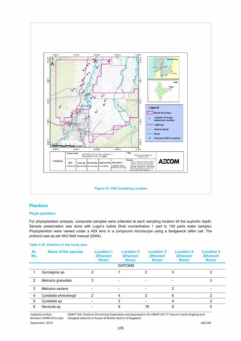
Vedanta Limited.
(Division CAIRN Oil & Gas)
DRAFT EIA: Onshore Oil and Gas Exploration and Appraisal in AA-ONHP-2017/1 block in Karbi Anglong and
Golaghat districts of Assam & Wokha district of Nagaland
September, 2019 AECOM
105
Figure 47. PBZ Sampling Location
Plankton
Phyto plankton
For phytoplankton analysis, composite samples were collected at each sampling location till the euphotic depth.
Sample preservation was done with Lugol’s iodine (final concentration 1 part to 100 parts water sample).
Phytoplankton were viewed under a 40X lens in a compound microscope using a Sedgewick rafter cell. The
protocol was as per NIO field manual (2004).
Table 3.35 Plankton in the study area
Sr. No.
Name of the species Location 1 (Dhansiri
River)
Location 2 (Dhansiri
River)
Location 3 (Dhansiri
River)
Location 4 (Dhansiri
River)
Location 5 (Dhansiri
River)
DIATOMS
1 Gyrosigma sp. 2 1 2 5 2
2 Melosira granulata 3 - - - 3
3 Melosira varians - - - 2 -
4 Cymbella ehrenbergii 2 4 2 6 2
5 Cymbella sp. - 2 - 4 2
6 Navicula sp. - 9 16 8 5

Vedanta Limited.
(Division CAIRN Oil & Gas)
DRAFT EIA: Onshore Oil and Gas Exploration and Appraisal in AA-ONHP-2017/1 block in Karbi Anglong and
Golaghat districts of Assam & Wokha district of Nagaland
September, 2019 AECOM
106
7 Synedra sp. - - - 3 1
8 Synedra ulna - - 1 -
9 Nitzschia sp. - 5 7 4 3
10 Nitzschia linearis 1 - - -
11 Corethron sp. - - - - 2
12 Pinnularia sp. 3 2 3 3 1
13 Surirella sp. - - - 2 -
14 Gomphonema olivaceum - - - 1 -
15 Aulacoseira sp. - - - 1 -
16 Fragilaria sp. 2 5 - - 2
EUGLENOIDS
17 Trachelomonas sp. - - 1 4 -
18 Trachelomonas bacilifera 4 - - - -
19 Euglena agilis 1 - - - 3
20 Euglena gracilis 2 - - - -
21 Euglena acus - - - - 2
22 Planktolyngbya circumcreta 2 - 2 - -
23 Oscillatoria sp. 1 - 3 - 1
24 Pseudanabaena catenata - - 1 - -
25 Dinobryon sp. - - - 4 -
26 Ceratium sp. 1 - - 2 1
Of the 26 species of phytoplankton observed in thestudy area , 16were diatoms. Plankton react rapidly to
ecological changes and are viewed as excellent indicators of water quality and trophic conditions due to their
short time and rapid rate of reproduction.
Euglena gracilis indicates mild organic pollution in lakes (Hosmani 2014). As per another study conducted by
Singh et al. (2013), Microcystis sp., Oscillatoria sp., Fragilaria sp., Navicula cryptocephala, Euglena sp.,
Closterium sp., Gomphonema sp., Nitzschia palea, Synedra ulna, Scenedesmus sp. were reported to be tolerant
to pollution. Surirella robusta, Pinnularia biceps, and Gomphonema sphaerophorum indicate mild pollution, as
per a study conducted in the River Ganges by Dwivedi and Srivastava (2017). Biodiversity indices were
calculated for the phytoplankton details of the same are given in Table 3.36
Table 3.36 Plankton diversity indices
Sr. no. Location Shannon’s Index Simpson’s index
1 Location I (Dhansiri River) 0.954 2.71
2 Location II (Dhansiri River) 0.83 1.75
3 Location III (Dhansiri River) 0.78 1.82
4 Location IV (Dhansiri River) 0.91 2.49
5 Location V (Dhansiri River) 0.95 2.65
Source: <Primary Survey, >
Vedanta Limited.
(Division CAIRN Oil & Gas)
DRAFT EIA: Onshore Oil and Gas Exploration and Appraisal in AA-ONHP-2017/1 block in Karbi Anglong and
Golaghat districts of Assam & Wokha district of Nagaland
September, 2019 AECOM
107
Zoo Plankton
Zoo plankton were sampled using a standard zooplankton net of mesh size 75 µm. The samples were collected
with a horizontal haul. After collection sample was rinsed thoroughly and then concentrated. Fixing was done with
4-5% formalin (1-part formalin and 9 parts sample) within 2-3 minutes of sample collection. 4-5% formalin also work
as preservative. Few drops of Rose Bengal solution were used for sample staining. Zooplankton were viewed
under a 20X lens in a stereo microscope. The protocol was as per NIO field manual (2004).
Table 3.37 List of Zoo Plankton
List of Group
Mayfly Copepod Cladocerans Rotifer Larvae
Larve of Ephemeroptera
Cyclopoida
Calanoida
Nauplius larvae
Sida sp.
Diaphanosoma Sp.
Daphnia sp.
Trichotria sp.
Brachionus calyciforus
Location I - - 3 - - 3 - 2
Location II 2 - - 5 - - - -
Location III - 3 1 - - - 2 - -
Location IV
- 12 - 4 - - 1 - -
Location V 3 - 3 - 1 - 2 -
Zooplanktons belonging to Mayfly, Copepod, Cladocrans and Rotifer group were observed in the study area.
Higher diversity was observed at Location V of the Dhansiri River. More diversity of Calanoida was observed in
the study area.
Benthic Organism
For analysis of benthic organisms, the sediment has been collected using a scoop or grab sampler. The samples
were mixed with water to have a slurry-like consistency and a mesh of size 500µm was used with low pressure
rinsing to ensure sample concentration. Residue were fixed with 4% (v/v) formalin. Benthic biodiversity was viewed
using a hand-held lens as well as under a 20X lens in a stereo microscope. The protocol was as per NIO field
manual (2004).
Table 3.38 List of Benthic Organism
Macrobenthos Meiobenthos
List of Group
Amphipoda
Insecta Gastropoda Cladocera Calanoida Harpacticoida
Cyclopoida
Location May fly Glassworm
Pilla sp.
Paludomus Sp.
Cladocera Calanoida Harpacticoida
Cyclopoida
Location I - 1 - - - Daphnia sp.
Macrocyclops
sp.
Location II - 2 - - 2 - - - 1
Location III 3 - 1 2 - 3 - - 3
Location IV - - - - 1 - - - -
Location V - 4 - 5 - 2 1 - -
Among benthos, three groups of Macrobenthos and four group of meiobenthic were reported in the study area.
Primary Productivity
Primary productivity is a term used to describe the rate at which plants and other photosynthetic organisms produce
organic compounds in an ecosystem. There are two aspects of primary productivity:
Gross productivity is the entire photosynthetic production of organic compounds in an ecosystem.
Net productivity is the organic materials that remain after photosynthetic organisms in the ecosystem have used
some of these compounds for their cellular energy needs (cellular respiration).
Primary productivity will be calculated using Winkler’s light and dark bottle method. The technique developed by
Gaarder and Gran uses variations in the concentration of oxygen under different experimental conditions to infer
gross primary production. Typically, three identical transparent vessels are filled with sample water and stoppered.
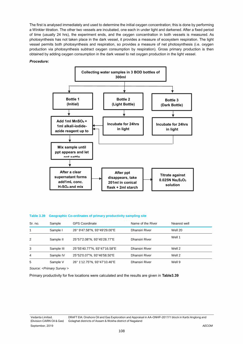
Vedanta Limited.
(Division CAIRN Oil & Gas)
DRAFT EIA: Onshore Oil and Gas Exploration and Appraisal in AA-ONHP-2017/1 block in Karbi Anglong and
Golaghat districts of Assam & Wokha district of Nagaland
September, 2019 AECOM
108
The first is analysed immediately and used to determine the initial oxygen concentration; this is done by performing
a Winkler titration. The other two vessels are incubated, one each in under light and darkened. After a fixed period
of time (usually 24 hrs), the experiment ends, and the oxygen concentration in both vessels is measured. As
photosynthesis has not taken place in the dark vessel, it provides a measure of ecosystem respiration. The light
vessel permits both photosynthesis and respiration, so provides a measure of net photosynthesis (i.e. oxygen
production via photosynthesis subtract oxygen consumption by respiration). Gross primary production is then
obtained by adding oxygen consumption in the dark vessel to net oxygen production in the light vessel.
Procedure:
Table 3.39 Geographic Co-ordinates of primary productivity sampling site
Sr. no. Sample GPS Coordinate Name of the River Nearest well
1 Sample I 26° 9'47.58"N, 93°49'29.00"E Dhansiri River Well 20
2 Sample II 25°57'2.08"N, 93°45'28.77"E Dhansiri River Well 1
3 Sample III 25°55'40.77"N, 93°47'16.58"E Dhansiri River Well 2
4 Sample IV 25°52'0.07"N, 93°46'58.50"E Dhansiri River Well 2
5 Sample V 26° 1'12.75"N, 93°47'10.46"E Dhansiri River Well 9
Source: <Primary Survey >
Primary productivity for five locations were calculated and the results are given in Table3.39
Collecting water samples in 3 BOD bottles of
300ml
Add 1ml MnSO4 +
1ml alkali-iodide-
azide reagent up to
brim
Bottle 1
(Initial)
Bottle 2
(Light Bottle) Bottle 3
(Dark Bottle)
Incubate for 24hrs
in light
Incubate for 24hrs
in light
Mix sample until
ppt appears and let
ppt settle
After a clear
supernatant forms
add1mL conc.
H2SO4 and mix
After ppt
disappears, take
201ml in conical
flask + 2ml starch
Titrate against
0.025N Na2S2O3
solution
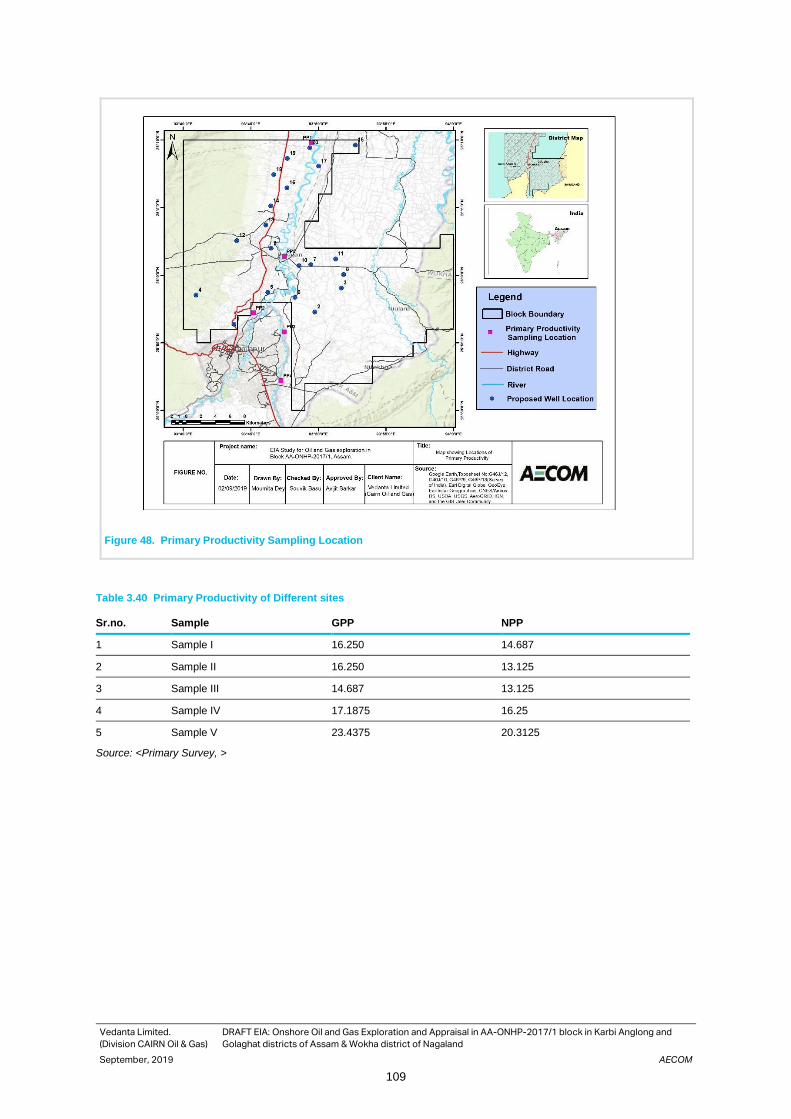
Vedanta Limited.
(Division CAIRN Oil & Gas)
DRAFT EIA: Onshore Oil and Gas Exploration and Appraisal in AA-ONHP-2017/1 block in Karbi Anglong and
Golaghat districts of Assam & Wokha district of Nagaland
September, 2019 AECOM
109
Figure 48. Primary Productivity Sampling Location
Table 3.40 Primary Productivity of Different sites
Sr.no. Sample GPP NPP
1 Sample I 16.250 14.687
2 Sample II 16.250 13.125
3 Sample III 14.687 13.125
4 Sample IV 17.1875 16.25
5 Sample V 23.4375 20.3125
Source: <Primary Survey, >

Vedanta Limited.
(Division CAIRN Oil & Gas)
DRAFT EIA: Onshore Oil and Gas Exploration and Appraisal in AA-ONHP-2017/1 block in Karbi Anglong and
Golaghat districts of Assam & Wokha district of Nagaland
September, 2019 AECOM
110
Photographs1: Forest Ecosystem Photographs 2: Tea Estate
Photographs 3: Aquatic Ecosystem Photographs 4: Costus speciosus
3.15 Socio economic Environment
A socio-economic assessment is a procedure, in which the positive and negative impacts on the people likely would
be directly and indirectly affected by the project was conducted along with other studies during the EIA. The
assessment facilitated an understanding of the needs, demands, preferences, capacities and constraints of the
people in the vicinity of the project operation. It was undertaken primarily to enhance the understanding of other
relevant factors such as social organizations and networks, livelihood patterns, social infrastructure etc. The
assessment attempts to predict and evaluate future impacts of project upon people, their physical and
psychological health and well-being, their economic facilities, cultural heritage, lifestyle and other value system and
helped in prioritizing Vedanta’s commitment towards the CER initiatives. Inputs from the social assessment into
the design phase facilitated in:
• Tracking potential adverse effects over different time frames and different activities
• Reviewing options to eliminate such negative impacts through design changes or mitigate them through specific
social protection or mitigation measures
• Reviewing options to extend or enhance benefits for the population in the vicinity of the project site.

Vedanta Limited.
(Division CAIRN Oil & Gas)
DRAFT EIA: Onshore Oil and Gas Exploration and Appraisal in AA-ONHP-2017/1 block in Karbi Anglong and
Golaghat districts of Assam & Wokha district of Nagaland
September, 2019 AECOM
111
Area of Influence
Study area for present study has been divided in two part i.e. Core area and Buffer Area based on the impact type
direct and indirect. Core area means the area where the local community and villages are mostly impacted both
negative and positive impact. Buffer area is just outside (within 2.5 km radius of the proposed well location) the
core area where local community and villages might be impacted due to spill over of impact outside the core area.
The villages, where the proposed well sites are located are considered as core area, and the villages within 2.5 km
radius of the core zone villages are regarded as buffer area villages, for the present project.
These villages are primarily selected based on reconnaissance surveys, census data information, topo sheet maps,
understanding of the project and professional judgment. The villages falling under the Core area and the Buffer
area for which socio-economic baseline assessment has been undertaken have been mentioned in Table 3.41 and
3.42
Table 3.41 Villages within proposed well area
Villages Well no. Block District
Bali Pathar Well No.12 Bokajan Karbi Anglong
Bokajan Well No.10 Bokajan Karbi Anglong
Chungajan Hazari gaon Well No.7 Golaghat South Golaghat
Dilaojan Well No.16 Bokajan Karbi Anglong
Kai Terang, Habe Timung Well No.5 Bokajan Karbi Anglong
Netezu Well No.11 Golaghat South Golaghat
No. 2 Kori Well No.16 Golaghat South Golaghat
No.2 Panjan Well No.20 Golaghat South Golaghat
Paniram terang Well No.15 Bokajan Karbi Anglong
Rongagara Well No.19 0135 Karbi Anglong
Sariajan Well No.13 0135 Karbi Anglong
Sarthe Killing Well No.4 0135 Karbi Anglong
Sukhanjan Well No.9 Golaghat South Golaghat
Tengatol Basti Well No.3 Golaghat South Golaghat
Assam
33 Districts
Karbi Anglong
(4 Revenue Circles)
Diphu
805 Revenue Villages
Silonijan
372 Revenue Villages
Golaghat
(6 Revenue Circle)
Golaghat
323 Revenue Villages
Bokakhat
112 Revenue Villages
Sarupathar
408 Revenue villages

Vedanta Limited.
(Division CAIRN Oil & Gas)
DRAFT EIA: Onshore Oil and Gas Exploration and Appraisal in AA-ONHP-2017/1 block in Karbi Anglong and
Golaghat districts of Assam & Wokha district of Nagaland
September, 2019 AECOM
112
Table 3.42 List of villages located within 500meter Buffer of Proposed Well Location
Well No.
Villages within 500 m
Exact Dist
Direction
CD Block
District
Well No.1 No Village Found - - - -
Well No.2 No Village Found - - - -
Well No.37 Tengatol Basti 184 m NW Golaghat South Golaghat
Well No 4 Sarthe Killing 300m NE Bokajan Karbi Anglong
Well No.5 Habe Timung 424 m W Bokajan Karbi Anglong
Well No.6 No Village Found - - - -
Well No.7 Chungajan Hazari gaon 200 m NW Golaghat South Golaghat
Well No.8 No village found - - - -
Well No.9 Sukhanjan 350 m W Golaghat South Golaghat
Well No.10 Bokajan 300 m SW Karbi Anglong
Well No.11 Netezu 480 m S Golaghat South Golaghat
Well No.12 Bali Pathar 498 m N Bokajan Karbi Anglong
Well No.13 Sariajan 322m N, S Bokajan Karbi Anglong
Well No.14 No Village Found - - - -
Well No.15 Paniram terang 400 m S Bokajan Karbi Anglong
Well No.16 Dilaojan 423 m E Bokajan Karbi Anglong
Well No.17 No. 2 Kori 100 m E, N , S Golaghat South Golaghat
Well No.18 No Village Found - - - -
Well No.19 Rongagara 230 m S Bokajan Karbi Anglong
Well No.20 No.2 Panjan 460 m E Golaghat South Golaghat
Methodology for Socio-economic Study
The socio-economic assessment was primarily based on the analysis of the secondary data obtained from the
census survey 2011 and Community consultations. Following tools have been used for gathering information and
validating secondary data after considering nature of project operation and understanding the demographic
characteristic of the area.
Secondary Data Analysis
To evaluate socio-economic environment in the study area, secondary information from the 2011 Census handbook
has been referred to and details pertaining to habitations in the study area have been extracted and assessed.
Apart from that district level secondary information has also been collected for district statistical hand book, Year
2011.
Stakeholder Consultation
At the beginning of the EIA process, the AECOM team conducted a preliminary identification of probable
stakeholders. An inventory of potential stakeholders, including local groups and individuals, local institutions like
panchayats which may be directly or indirectly affected by the project or with interest in the development activities
of the region was made at preliminary.
Consultations with community are a continuous process that was carried in the EIA process and would be continued
during the construction and operation phases of the project. Issues like land and resource damage, social
disturbance, severance and increased congestion, noise and air pollution, employment opportunities, need for
development of basic infrastructure, safe drinking water, sanitation facilities in the villages located in 2.5 km
periphery have been discussed during the consultations so that they can be adequately addressed through the
environment management plans. The consultations also helped in developing preliminary understanding of the
requirement of social development initiatives, which are required in the project village and may be undertaken as
part of the Vedanta’s CER activity.

Vedanta Limited.
(Division CAIRN Oil & Gas)
DRAFT EIA: Onshore Oil and Gas Exploration and Appraisal in AA-ONHP-2017/1 block in Karbi Anglong and
Golaghat districts of Assam & Wokha district of Nagaland
September, 2019 AECOM
113
Socio-economic profile
Demographic Profile
Demographic details are details related to statistical and dynamic aspects of a population. Data related to
households, population, sex ratio, caste, literacy rate was obtained from Census, 2011 that is conducted every 10
year since 1872.
Population and Household Population and households are basis units of demography. A population in statistics can be defined as a discrete
group of people that are identical with at least one common characteristic whereas a household is majorly
composed of two or more persons who are occupying a single housing unit. Details of the population and
households was obtained from District Census, 2011 handbook of Golaghat and Karbi Anglong district.
Population and Household Size of Villages in the Study Area As per Census 2011, Dihingia villages had 851 households, whereas Wokha TE had 771. Other villages with more
than 400 households were Hallo Khuwa, Rongagara and Kath Katia. In total, there were 6 villages with 400-800
households, while 33 villages had 100-300 households. As many as 132 villages had less than 100 housholds. In
the study area, as many as 70 vilages had less than 500 population whereas the population of 18 villages was in
the range of 1000-4000. As per census 2011, the sex ratio of the villages was found to be 961 whereas that of
Golaghat and Karbi Anglong district is 964 and 951 respectively. The sex ratio of the villages in the block is more
than the sex ratio of Assam i.e, 958 (Census, 2011).
Figure 49. Number of households in villages within the Study Area Source: Census of India, 2011 (Golaghat and
Karbi Anglong districts)
6
33
132
0
20
40
60
80
100
120
140
400-800 100-300 0-99
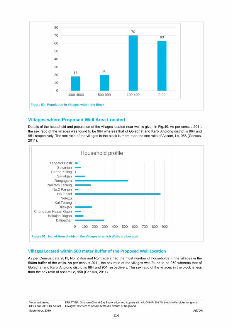
Vedanta Limited.
(Division CAIRN Oil & Gas)
DRAFT EIA: Onshore Oil and Gas Exploration and Appraisal in AA-ONHP-2017/1 block in Karbi Anglong and
Golaghat districts of Assam & Wokha district of Nagaland
September, 2019 AECOM
114
Figure 50. Population in Villages within the Block
Villages where Proposed Well Area Located
Details of the household and population of the villages located near well is given in Fig.49. As per census 2011,
the sex ratio of the villages was found to be 964 whereas that of Golaghat and Karbi Anglong district is 964 and
951 respectively. The sex ratio of the villages in the block is more than the sex ratio of Assam, i.e, 958 (Census,
2011).
Figure 51. No. of Households in the Villages in which Wells are Located
Villages Located within 500 meter Buffer of the Proposed Well Location
As per Census data 2011, No. 2 Kori and Rongagara had the most number of households in the villages in the
500m buffer of the wells. As per census 2011, the sex ratio of the villages was found to be 950 whereas that of
Golaghat and Karbi Anglong district is 964 and 951 respectively. The sex ratio of the villages in the block is less
than the sex ratio of Assam i.e, 958 (Census, 2011).
18 20
70
63
0
10
20
30
40
50
60
70
80
1000-4000 500-999 100-499 0-99
0 100 200 300 400 500 600 700 800 900
Balipathar
Bokajan Bagan
Chungajan Hazari Gaon
Dilawjan
Kai Terang
Netezu
No.2 Kori
No.2 Panjan
Paniram Terang
Rongagara
Sariahjan
Sarthe Killing
Sukanjan
Tengatol Bosti
Household profile

Vedanta Limited.
(Division CAIRN Oil & Gas)
DRAFT EIA: Onshore Oil and Gas Exploration and Appraisal in AA-ONHP-2017/1 block in Karbi Anglong and
Golaghat districts of Assam & Wokha district of Nagaland
September, 2019 AECOM
115
Figure 52: Households in the 500m Buffer of Well Locations
SC and ST Population The Scheduled Castes and Scheduled Tribes are officially designated groups of people who are historically
disadvantaged in India. The terms was derived in the Constitution of India and the groups are designated in one
or other of the categories.
Villages Located within the Study Area As per Census 2011, 41 villages had more than 80% ST population, among which 13 had 100% ST population.
In contrast, only one village (Samukjan) had more than 80% SC population.
0 100 200 300 400 500 600 700 800 900
Balipathar
Bokajan Bagan
Dilawjan
Netezu
No.2 Kori
No.2 Panjan
Paniram Terang
Rongagara
Sariahjan
Sarthe Killing
Sukanjan
Tengatol Bosti
Household profile

Vedanta Limited.
(Division CAIRN Oil & Gas)
DRAFT EIA: Onshore Oil and Gas Exploration and Appraisal in AA-ONHP-2017/1 block in Karbi Anglong and
Golaghat districts of Assam & Wokha district of Nagaland
September, 2019 AECOM
116
Figure 53: Villages located within the study area
As per census 2011, the caste of the villages in the block was found to be 48% ST and 2% SC whereas that of
Golaghat is 5.84% SC and 10.48% ST is and Karbi Anglong district is 15% SC and 52% ST respectively in Assam
State.The SC & ST population of Assam is 7.15% SC and 12.45 % ST(Census, 2011).
Villages where Proposed Wells Are Located 7 villages in among those where the proposed wells are located had more than 80% population of Scheduled
Tribes. Kai Terung had 100% ST population.
Figure 54. Social Structure of the villages where proposed wells are located
2
48
0
10
20
30
40
50
60
More than 50% Population of SC More than 50% Population of ST
0
1
2
3
4
5
more than 50% sc population more than 50% sc population
Vill
age n
um
ber
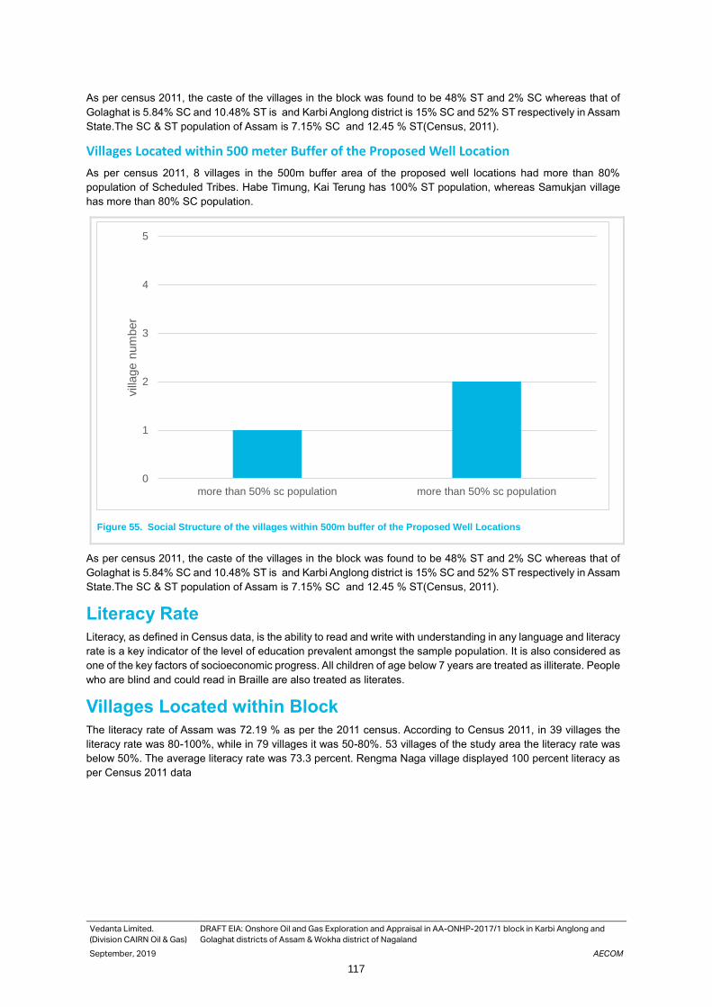
Vedanta Limited.
(Division CAIRN Oil & Gas)
DRAFT EIA: Onshore Oil and Gas Exploration and Appraisal in AA-ONHP-2017/1 block in Karbi Anglong and
Golaghat districts of Assam & Wokha district of Nagaland
September, 2019 AECOM
117
As per census 2011, the caste of the villages in the block was found to be 48% ST and 2% SC whereas that of
Golaghat is 5.84% SC and 10.48% ST is and Karbi Anglong district is 15% SC and 52% ST respectively in Assam
State.The SC & ST population of Assam is 7.15% SC and 12.45 % ST(Census, 2011).
Villages Located within 500 meter Buffer of the Proposed Well Location
As per census 2011, 8 villages in the 500m buffer area of the proposed well locations had more than 80%
population of Scheduled Tribes. Habe Timung, Kai Terung has 100% ST population, whereas Samukjan village
has more than 80% SC population.
Figure 55. Social Structure of the villages within 500m buffer of the Proposed Well Locations
As per census 2011, the caste of the villages in the block was found to be 48% ST and 2% SC whereas that of
Golaghat is 5.84% SC and 10.48% ST is and Karbi Anglong district is 15% SC and 52% ST respectively in Assam
State.The SC & ST population of Assam is 7.15% SC and 12.45 % ST(Census, 2011).
Literacy Rate Literacy, as defined in Census data, is the ability to read and write with understanding in any language and literacy
rate is a key indicator of the level of education prevalent amongst the sample population. It is also considered as
one of the key factors of socioeconomic progress. All children of age below 7 years are treated as illiterate. People
who are blind and could read in Braille are also treated as literates.
Villages Located within Block The literacy rate of Assam was 72.19 % as per the 2011 census. According to Census 2011, in 39 villages the
literacy rate was 80-100%, while in 79 villages it was 50-80%. 53 villages of the study area the literacy rate was
below 50%. The average literacy rate was 73.3 percent. Rengma Naga village displayed 100 percent literacy as
per Census 2011 data
0
1
2
3
4
5
more than 50% sc population more than 50% sc population
vill
age n
um
ber

Vedanta Limited.
(Division CAIRN Oil & Gas)
DRAFT EIA: Onshore Oil and Gas Exploration and Appraisal in AA-ONHP-2017/1 block in Karbi Anglong and
Golaghat districts of Assam & Wokha district of Nagaland
September, 2019 AECOM
118
Figure 56. Literacy Rate in the Villages in the Study Area
Most of the villages in the block has 50- 80% literacy rate whereas average literacy rate in Karbi Anglong District
is 69.25% and in Golaghat District is 77.43%. In Assam state, the literacy rate is 72.19%
Figure 57. Literacy rate in the Villages in which Proposed Wells are Located
Villages Located within 500 meter Buffer of the Proposed Well Location
Sarthe Killing village in the 500m buffer of the study area had more than 90% literacy rate, while Dilawjan Longbui,
Chandra Teron, Samukjan and Dhorampur had more than 80% literate population.
0
20
40
60
80
100
120
10-49% 50-80% literacy 80-100% literacy
0 10 20 30 40 50 60 70 80 90 100
Balipathar
Bokajan Bagan
Chungajan Hazari Gaon
Dilawjan
Kai Terang
Netezu
No.2 Kori
No.2 Panjan
Paniram Terang
Rongagara
Sariahjan
Sarthe Killing
Sukanjan
Tengatol Bosti
Literacy Rate

Vedanta Limited.
(Division CAIRN Oil & Gas)
DRAFT EIA: Onshore Oil and Gas Exploration and Appraisal in AA-ONHP-2017/1 block in Karbi Anglong and
Golaghat districts of Assam & Wokha district of Nagaland
September, 2019 AECOM
119
Figure 58. Literacy Rate in Villages in the 500m Buffer of the Proposed Well Locations
Most of the villages in the block has 50- 80% literacy rate whereas average literacy rate in Karbi Anglong District
is 69.25% and in Golaghat District is 77.43%. In Assam state, the literacy rate is 72.19%.
Villages Located within Block As per census 2011, in 11 of the villages in the study area, the entire working population comprised of main workers, while in 56 villages, more than 70 percent of the workforce were employed for more than six months in a year.
In contrast, there were 14 villages wherein more than 80 percent of the working population comprised of marginal workers. These villages include Sukanjan, Dilawjan Koch Gaon, Longkicho Engti, Sartha Phangcho, Bill Pathar etc.
Villages where Proposed Well Area Located As per census 2011, more than 70 percent of the total workers in 14 of the Villages in which wells were located were comprised of Main Workers. Marginal workers were more than 70 percent in 3 of the villages (Sukanjan, Sarthe Killing and Longkicho Engti).
Villages Located within 500 meter Buffer of the Proposed Well Location As per Census 2011, in nearly 55 percent (n = 18) of the villages in the 500 m buffer area, the proportion of main workers was more than 70 percent. Sukanjan, Sarthe Killing, Longkicho Engti and Joypur were villages in which more than 70 percent of the working population comprised of marginal workers.
Details of Amenities Present in Study Area Villages
Drinking Water
Less than 17 percent of the villages in the block had access to treated tap water, while less than 15 percent
had access to untreated tap water (as per Census of India 2011). Most of the villages in the study area sourced
their drinking water from hand pumps and tube wells. As per Census 2011, treated tap water was available to
less than 10 percent of the villages while untreated tap water reached about 12 percent.
Educational Facility
As per Census 2011, govt primary schools were available in nearly 45 percent of the villages in the study area
whereas government middle school, secondary school and senior secondary schools were not available in most
of the villages (89 percent, 98 percent and 100 percent, respectively). Most of the villages in the 500m buffer had
access to Govt. primary school. There were very few villages with Middle school (about 5 percent) or Secondary
and Senior Secondary schools.
0 10 20 30 40 50 60 70 80 90 100
Balipathar
Bokajan Bagan
Dilawjan
Netezu
No.2 Kori
No.2 Panjan
Paniram Terang
Rongagara
Sariahjan
Sarthe Killing
Sukanjan
Tengatol Bosti
Literacy Rate

Vedanta Limited.
(Division CAIRN Oil & Gas)
DRAFT EIA: Onshore Oil and Gas Exploration and Appraisal in AA-ONHP-2017/1 block in Karbi Anglong and
Golaghat districts of Assam & Wokha district of Nagaland
September, 2019 AECOM
120
Most of the villages in which wells are located had access to Govt. primary school. There were very few villages
with Middle school (about 5 percent) or Secondary and Senior Secondary schools.
Sanitation Condition
As per census 2011, more than 50 percent of the villages in the study area had no access to drainage system,
while 10 percent had open drainage. Only about 17 percent of the villages in the study area were covered under
the Total Sanitation Campaign, and less than 2 percent of the villages had access to a community toilet complex.
Only about 5 percent of the villages in the 500m buffer area were provided drainage facility (closed or open), with
about 40 percent villages without any drainage facility. In about 25 percent villages, the drain was dischagred
directly into water bodies.
As per Census of India 2011, none of the villages in the 500 m buffer area had access to community toilets and
only about 7 percent of the villages were covered under the Total Sanitation Campaign. However, during the
primary survey, better access to private toliets was observed under the Swachh Bharat Abhiyan.
In most of the studied villages, villagers used kachha toilets. New toilet construction was observed under the
Swachh Bharat Abhiyan. There were no formal solid waste management facilities, and villagers tended to burn
their waste. In Bokajan, which is governed by a municipal board, more citizens had access to pukka toilets.
Villages in which Proposed Wells are Located
Only about 4 percent of the villages in which the proposed wells are located were provided draingage facility
(closed or open), with about 30 percent villages without any drainage facility.
As per Census of India 2011, none of the villages in which the proposed wells are located had access to
community toilets and only about 5 percent of the villages were covered under the Total Sanitation Campaign.
However, during the primary survey, better access to private toliets was observed under the Swachh Bharat
Abhiyan.
Health Facility Health is an important aspects concerned with wellbeing of an individual physically and mentally. Health of the people affects socio-economic condition of a community and is also linked with the environment. The healthcare facility is divided into a three-tier system in rural area, which is given as follows:
Sub-centre: The Sub Centre is the most peripheral and first contact point between the primary health care system and the community. The major task sub-centres are assigned are to provide service associated with maternal and child health, nutrition, family welfare, immunization, diarrhoea control and control of various communicable diseases programmes. Primary Health Centre (PHC): PHC is the first point of contact between village community and the medical officers. The Centre was envisaged to provide facilities integrated with curative and preventive health care to the rural population, majorly focusing on various preventive and promotive aspects of health. Community Health Centres (CHCs): CHCs are maintained by the State government under MNP/ BMS programme. As per norms, a CHC is required to be managed by 4 medical specialists (surgeon, physician, gynaecologist and paediatrician) including 21 paramedical and other required staff. It has 30 in-door beds with one OT, X-ray, labour room and laboratory facilities.
The standards set by the national health policy are given below:
Table 3.43 National Health Policy Standards
Population Infrastructure Personnel
3000- 5000 1 Sub-centre 1 ANM (Auxiliary Nurse Midwives)
25,000- 30,000 1 PHC, 6 Beds 2 Medical Officers
1,00,00 Rural Hospital Medical Superintendent

Vedanta Limited.
(Division CAIRN Oil & Gas)
DRAFT EIA: Onshore Oil and Gas Exploration and Appraisal in AA-ONHP-2017/1 block in Karbi Anglong and
Golaghat districts of Assam & Wokha district of Nagaland
September, 2019 AECOM
121
Electricity Villages in the Study Area:
According to Census 2011, in only 9 villages, 99 hours electricity was supplied during summer (April to Sept) and
winter months (Oct to March). These included No. 2 Kori, Sariajan, Dilawjan, Dhorampur etc. and Bokajan.
Although the electricity supply was not regular, most of the villages were connected to the grid, with only 9 villages
getting no electricity. This was as per data obtained from the Census of India, 2011.
Villages in 500m Buffer of the Proposed Wells
According to Census 2011, in 9 villages located in the 500 m buffer of the, 99 hours electricity was supplied in the summer as well as winter months. These villages were Chandra Teron, Dhorampur, Dilawjan, Joypur, No. 2 Kori etc. and Bokajan town. There were 9 villages with no access to electricity.
Villages in which Proposed Wells are Located According to Census 2011, in 8 villages located in the 500 m buffer of the, 99 hours electricity was supplied in the summer as well as winter months. These villages were Chandra Teron, Dhorampur, Dilawjan, Joypur, No. 2 Kori etc. There were 8 villages with no access to electricity.
Photographs of Social Survey conducting during Month of April-May, 2019.
Photographs1: Consultation in Sukhajan village Photographs 2: Consultation in Shantigaon Village(Anganwadi Staff)
Photographs 3: Consultation in discussion in Bokajan Village
Photographs 4: Consultation in Deputy Range Forest offcer – Interaction session

Vedanta Limited.
(Division CAIRN Oil & Gas)
DRAFT EIA: Onshore Oil and Gas Exploration and Appraisal in AA-ONHP-2017/1 block in Karbi Anglong and
Golaghat districts of Assam & Wokha district of Nagaland
September, 2019 AECOM
122
4. Anticipated Environmental Impact and Mitigation Measures
This chapter presents the identified environmental impacts due to the proposed project and outlines alternatives
any mitigation measures for minimizing adverse impacts.
4.1 Impact Assessment Methodology An environmental impact identification matrix has been developed to present an overview of possible interactions
between project aspects and components of the environment which may get affected. The matrix considers
physical, biological and socio-economic components of the environment on one axis (X axis) and activities of the
proposed drilling project on the other side (Y axis). Aspects and impacts on environmental components which would
be relevant to the different phases of the project e.g. pre-drilling activities, drilling, early production
decommissioning have been addressed in the matrix. Environmental and socio-economic components were
identified based on reviewing of applicable legislations project specific features and baseline environment, site
reconnaissance visits, discussions with stakeholders.
Potential environmental impacts that may result from any of the identified project activity has been identified in a
matrix based on activity-component interaction and is presented in table below. The impacts which has been
identified in the matrix have been assessed for its significance based on significance criteria delineated in Table
4.1 and 4.2.
4.2 Impact Criteria and Ranking Once all project environmental aspects were comprehensively identified for the different activities of the project,
the level of impact that may result from each of the activity-component interactions has been assessed based on
subjective criteria.
For this, three key elements have been taken into consideration based on standard environmental assessment
methodologies:
• Severity of Impact: Degree of damage that may be caused to the environmental components concerned;
• Extent of Impact: Geographical spread of impact around project location and corridors of activities; and
• Duration of Impact: Time for which impact lasts taking project life-cycle into account.
These elements have been ranked in three levels viz. 1 (low), 2 (moderate) and 3 (high) based on the following
criteria provided in Table 4.1:
Table 4.1 Impact Prediction Criteria
Impact
Elements Criteria Ranking
Severity • Regional impact resulting in long term and/ or medium damage to the natural
environment.
• Major impact on community and occupational health (e.g. serious injury, loss
of life) on account of accidental events viz. well blow-outs and related
operational activities.
3
• Local scale impact resulting in short term change and / or damage to the natural
environment.
• Temporary loss of land, source of livelihood for affected communities
• Local scale impact on terrestrial habitat, endangered species, drainage pattern
and community resources.
• Moderate impact on occupation and community health &well being (e.g. noise,
light, odour, dust, injuries to individuals)
2
• Limited local scale impact causing temporary loss of some species etc. 1

Vedanta Limited.
(Division CAIRN Oil & Gas)
DRAFT EIA: Onshore Oil and Gas Exploration and Appraisal in AA-ONHP-2017/1 block in Karbi Anglong and
Golaghat districts of Assam & Wokha district of Nagaland
September, 2019 AECOM
123
Impact
Elements Criteria Ranking
• Limited impact on human health and well-being (e.g. occasional dust, odour,
light, and traffic noise).
Extent • Regional scale impact and including impacts to physical, biological and socio-
economic environment of the block
3
• Largely local level impact limited to immediate vicinity of the proposed well sites 2
• Impact not discernible on a local scale and is limited within the boundaries of
the drill site
1
Duration • The impact is always likely to occur during the entire project life cycle . 3
• The impact is likely to occur in some phases of project life under normal
operating conditions.
2
• The impact is very unlikely to occur at all during project life cycle but may occur
in exceptional circumstances.
1
A positive or beneficial impact that may result from this project has not been ranked and has been depicted in the
form of ++.
4.3 Impact Significance The significance of impact has been determined based on a multiplicative factor of three element rankings. Table
4.2 depicts impact significance in a scale of LOW-MEDIUM-HIGH and would be used for delineation of preventive
actions, if any, and management plans for mitigation of impacts.
Impact significance has been determined considering measures which have been factored in the design and
planning phase of the project. Legal issues have been taken into account, wherever appropriate in the criterion
sets, to aid in Cairn Oil & Gas effort to comply with all relevant legislation and project HSE requirements.
Additionally, the results of quantitative impact prediction exercise, wherever undertaken, have also been fed into
the process.
Table 4.2 Criteria Based Significance of Impacts
Severity of Impact
(A) Extent of Impact (B)
Duration of Impact
(C)
Impact Significance
(A X B X C)
1 1 1 1
Low 1 1 2 2
1 2 1 2
1 1 2 2
2 1 2 4
Medium
1 2 2 4
3 1 2 6
1 3 2 6
2 2 2 8
3 2 2 12
High
2 3 2 12
2 2 3 12
3 3 2 18
3 2 3 18
2 3 3 18
3 3 3 27

Vedanta Limited.
(Division CAIRN Oil & Gas)
DRAFT EIA: Onshore Oil and Gas Exploration and Appraisal in AA-ONHP-2017/1 block in Karbi Anglong and
Golaghat districts of Assam & Wokha district of Nagaland
September, 2019 AECOM
124
Severity of Impact
(A) Extent of Impact (B)
Duration of Impact
(C)
Impact Significance
(A X B X C)
- Beneficial Impact - ++ Positive
To assist in determining and presenting significance of an impact, an impact evaluation matrix (Table 4.3) has been
developed based on the one developed for the impact identification exercise. In addition to ranked weights,
significance of impacts has been depicted using colour codes for easy understanding. In case an environmental
component is impacted by more than one project activity or the activity would impact a sensitive receptor e.g.
settlement, school, hospitals, forest etc. a high significance ranking of “>12” has been considered. A second
evaluation matrix presents significance of impacts after considering that proposed mitigation measures would be
implemented
The impacts on each of the environmental components and its significance during the different stages of the project
have been discussed in detail in the following section. This is followed by a point wise outline of mitigation measures
recommended.

Vedanta Limited. (Division CAIRN Oil & Gas) DRAFT EIA: Onshore Oil and Gas Exploration and Appraisal in AA-ONHP-2017/1 block in Karbi Anglong and Golaghat districts of Assam & Wokha district of Nagaland
September,2019 AECOM
125
Table 4.3. Impact Identification Matrix
Environment Activity
Physical Environment Biological Environment Socio-economic Environment
Ae
sth
etics &
Vis
ua
ls
Air
Qua
lity
Nois
e Q
ua
lity
Tra
nspo
rt &
Tra
ffic
La
nd
Use
So
il Q
ualit
y
Lo
cal D
rain
ag
e &
Physio
gra
phy
Su
rfa
ce
Wa
ter
Re
sou
rce
s
Su
rfa
ce
wa
ter
qu
alit
y
Gro
un
d W
ate
r R
eso
urc
es
Gro
un
d w
ate
r q
ua
lity
Flo
ra &
Flo
ral H
abita
t
Wild
life
Ha
bita
t
Fa
un
a
Th
rea
ten
ed &
En
dan
ge
red
sp
ecie
s
Mig
rato
ry c
orr
ido
r &
ro
ut
Aq
ua
tic H
abita
t
Aq
ua
tic F
lora
& F
au
na
Lo
ss o
f L
ive
liho
od
Con
flic
t on
Jo
b o
pp
ort
un
ity
Dis
rup
tio
n o
f In
frastr
uctu
re
Com
mon
Pro
pe
rty R
esou
rce
s
Dust
& N
ois
e D
isco
mfo
rt
Lo
ss o
f A
gricu
ltu
ral P
rod
uctivity
Influx o
f P
op
ula
tio
n
Cultu
ral &
Heri
tag
e S
ite
Jo
b &
Eco
no
mic
Oppo
rtu
nity
Occu
pa
tion
al H
ea
lth
& S
afe
ty
Com
mun
ity H
ealth
& S
afe
ty
A. Pre-Drilling Activities
Site selection and land acquisition x x x x
Site preparation x x x x x x x X x x + x Well site & access road construction x x x x x x x + x x
Sourcing & transportation of borrow material etc x x x x x x x x x x x + x x
Storage and handling of construction debris x x x Transportation of drilling rig and ancillaries x x x x x x x x
Operation of DG set x x
Consumption of water for construction & domestic use for labourer x x Generation of domestic solid waste & disposal x x x x x
Generation of waste water & discharge from x x x x
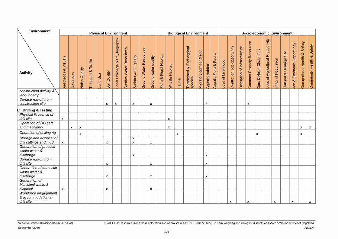
Vedanta Limited. (Division CAIRN Oil & Gas) DRAFT EIA: Onshore Oil and Gas Exploration and Appraisal in AA-ONHP-2017/1 block in Karbi Anglong and Golaghat districts of Assam & Wokha district of Nagaland
September,2019 AECOM
126
Environment Activity
Physical Environment Biological Environment Socio-economic Environment
Ae
sth
etics &
Vis
ua
ls
Air
Qua
lity
Nois
e Q
ua
lity
Tra
nspo
rt &
Tra
ffic
La
nd
Use
So
il Q
ualit
y
Lo
cal D
rain
ag
e &
Physio
gra
phy
Su
rfa
ce
Wa
ter
Re
sou
rce
s
Su
rfa
ce
wa
ter
qu
alit
y
Gro
un
d W
ate
r R
eso
urc
es
Gro
un
d w
ate
r q
ua
lity
Flo
ra &
Flo
ral H
abita
t
Wild
life
Ha
bita
t
Fa
un
a
Th
rea
ten
ed &
En
dan
ge
red
sp
ecie
s
Mig
rato
ry c
orr
ido
r &
ro
ut
Aq
ua
tic H
abita
t
Aq
ua
tic F
lora
& F
au
na
Lo
ss o
f L
ive
liho
od
Con
flic
t on
Jo
b o
pp
ort
un
ity
Dis
rup
tio
n o
f In
frastr
uctu
re
Com
mon
Pro
pe
rty R
esou
rce
s
Dust
& N
ois
e D
isco
mfo
rt
Lo
ss o
f A
gricu
ltu
ral P
rod
uctivity
Influx o
f P
op
ula
tio
n
Cultu
ral &
Heri
tag
e S
ite
Jo
b &
Eco
no
mic
Oppo
rtu
nity
Occu
pa
tion
al H
ea
lth
& S
afe
ty
Com
mun
ity H
ealth
& S
afe
ty
construction activity & labour camp
Surface run-off from construction site x x x x x x
B. Drilling & Testing Physical Presence of drill site x x Operation of DG sets and machinery x x x x x
Operation of drilling rig x x x x
Storage and disposal of drill cuttings and mud x x
x x x
Generation of process waste water & discharge x x Surface run-off from drill site x x x Generation of domestic waste water & discharge x x x Generation of Municipal waste & disposal x x x Workforce engagement & accommodation at drill site x x x + x

Vedanta Limited. (Division CAIRN Oil & Gas) DRAFT EIA: Onshore Oil and Gas Exploration and Appraisal in AA-ONHP-2017/1 block in Karbi Anglong and Golaghat districts of Assam & Wokha district of Nagaland
September,2019 AECOM
127
Environment Activity
Physical Environment Biological Environment Socio-economic Environment
Ae
sth
etics &
Vis
ua
ls
Air
Qua
lity
Nois
e Q
ua
lity
Tra
nspo
rt &
Tra
ffic
La
nd
Use
So
il Q
ualit
y
Lo
cal D
rain
ag
e &
Physio
gra
phy
Su
rfa
ce
Wa
ter
Re
sou
rce
s
Su
rfa
ce
wa
ter
qu
alit
y
Gro
un
d W
ate
r R
eso
urc
es
Gro
un
d w
ate
r q
ua
lity
Flo
ra &
Flo
ral H
abita
t
Wild
life
Ha
bita
t
Fa
un
a
Th
rea
ten
ed &
En
dan
ge
red
sp
ecie
s
Mig
rato
ry c
orr
ido
r &
ro
ut
Aq
ua
tic H
abita
t
Aq
ua
tic F
lora
& F
au
na
Lo
ss o
f L
ive
liho
od
Con
flic
t on
Jo
b o
pp
ort
un
ity
Dis
rup
tio
n o
f In
frastr
uctu
re
Com
mon
Pro
pe
rty R
esou
rce
s
Dust
& N
ois
e D
isco
mfo
rt
Lo
ss o
f A
gricu
ltu
ral P
rod
uctivity
Influx o
f P
op
ula
tio
n
Cultu
ral &
Heri
tag
e S
ite
Jo
b &
Eco
no
mic
Oppo
rtu
nity
Occu
pa
tion
al H
ea
lth
& S
afe
ty
Com
mun
ity H
ealth
& S
afe
ty
Flaring during production testing and process upset x x x x
Accidental events – blow out x x x x x x x x x
Accidental events-spillage of chemical & oil x x x
C. Early Production
Flaring of Gas x x
GEG Emission x
Produced Water x x x x
D. Decommissioning and Reinstatement
Dismantling of rig and associated facilities x x x X
Transportation of drilling rig and ancillaries x x x X
Removal of well site construction materials & disposal x x x

Vedanta Limited.
(Division CAIRN Oil & Gas)
DRAFT EIA: Onshore Oil and Gas Exploration and Appraisal in AA-ONHP-2017/1 block in Karbi Anglong and
Golaghat districts of Assam & Wokha district of Nagaland
September, 2019 AECOM
128
4.4 Impact Assessment This section discusses the impacts of the project activities on the environmental receptors. It discusses probable
impacts during various phases of the project lifecycle on the environmental and socio-economic components.
Rankings for every activity – component interaction is based on the criterion set earlier and resulting environmental
significance with necessary justification that has been recorded below for every set of impacts and the same has
been represented in evaluation matrices. In broader context, it is however important to remember that operations
related to drilling, testing and early production activities also include positive socio-economic impacts in terms of
increase in local business opportunities and on a larger perspective, by providing potential energy security at a
national level.
4.5 Potential Impact and Mitigation Measures on
Visual Environment & Aesthetics Source of Impact: Aesthetics and visual environment impacts due to setting up of the proposed project activity
would be of low scale and temporary in nature. There would be no significant change in landuse. Only the drilling
rig boom with associated facilities including one flare stack and DG sets would be visible from the adjoining road
and settlement area. The land area of disturbance is also very less of the order of 9 Ha and the elevated rig would
be visible from a distance.
Mitigation Measures:
The entire activity of exploration and appraisal would be limited to less than a year. If no hydro-carbon is found
from the well for economic recovery, then same would be closed and all supporting facilities would be demobilized.
The surface of earth after any unsuccessful attempts of oil exploration would be restored back to normalcy in line
with the prevailing landuse status of the area.
4.6 Potential Impact and Mitigation Measures on
Land Use Source of impact: Land would be required for the drilling operations. In case of QPU the same drill site would be
used, and no new area would be procured.
Assessment of Impact
Site preparation
Potential impact on drainage is primarily anticipated in the form of disruption of natural drainage pattern during site
preparation and approach road construction. Since site preparation involves rising of acquired land to about 1 m
from the ground level it may lead to alteration of onsite micro-drainage pattern leading to potential problems of
water logging in the agricultural land and settlements abutting the drill site. This problem is likely to be further
aggravated due to heavy rainfall experienced by Golaghat and Karbi Analog district throughout the year
The access to majority of the drill sites in AA-ONHP-2017/1 is characterized by paved and unpaved rural roads.
Well specific environmental setting study shows that most of the wells can be approached by an existing road.
However, for site approach a road need to be constructed. Widening and strengthening of existing paved/unpaved
road would be required for transportation of drilling rig and heavy equipment to the well site. Widening/ new
construction of roads could result in the alteration of drainage unless proper cross drainage structures are provided
and may lead to water-logging of adjacent lands.
Well Site Restoration
Site restoration would be initiated for well site not indicative of any commercially exploitable hydrocarbon reserves.
Unplanned restoration may lead to the long-term disruption in natural drainage pattern and water logging in
neighbouring agricultural land abutting the site. However, adequate care would be taken by Vedanta Limited.
(Division Cairn Oil & Gas) to restore the site back to its original condition based on the originally existing contours
and predominant slope to prevent any such adverse drainage impacts. The impact is considered to be of medium
significance with onsite drainage being dependent on the proper site restoration.
Severity of Impact 2 Extent of Impact 1 Duration of Impact 2
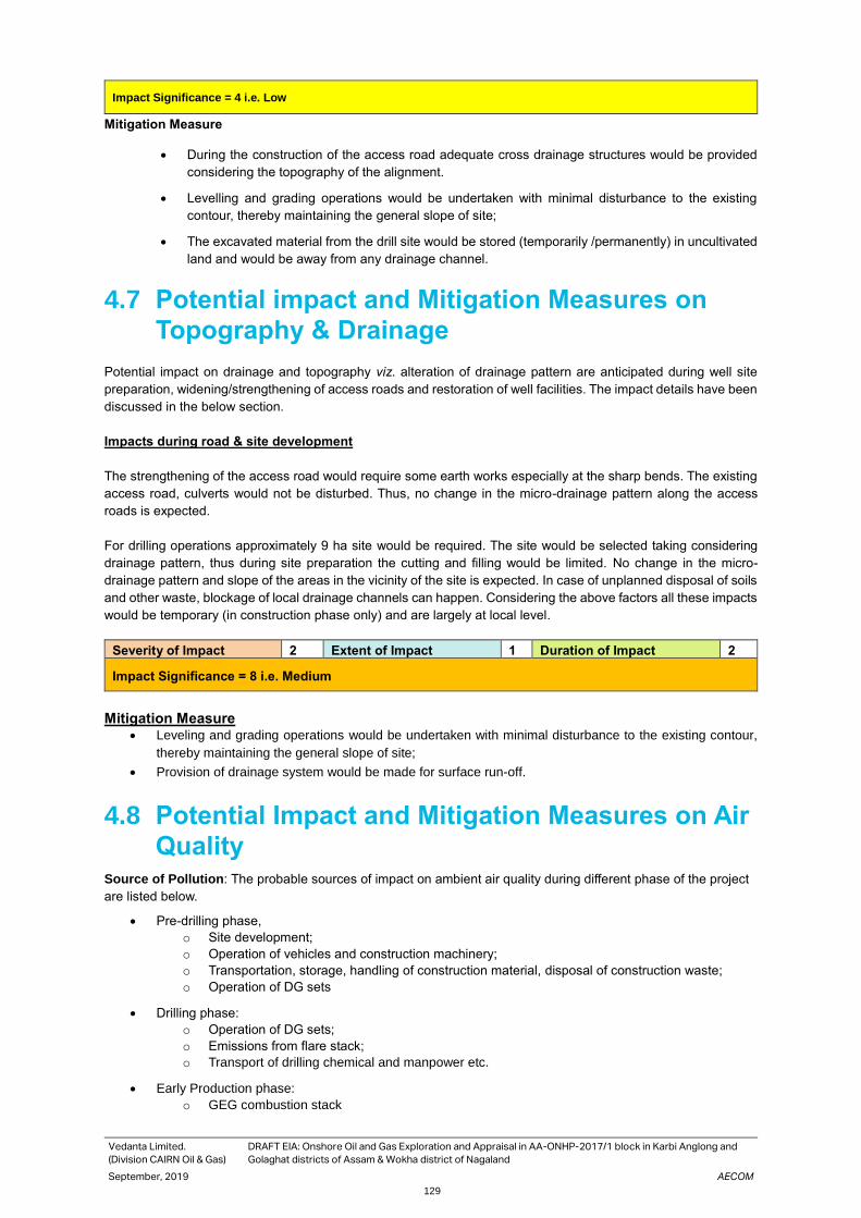
Vedanta Limited.
(Division CAIRN Oil & Gas)
DRAFT EIA: Onshore Oil and Gas Exploration and Appraisal in AA-ONHP-2017/1 block in Karbi Anglong and
Golaghat districts of Assam & Wokha district of Nagaland
September, 2019 AECOM
129
Impact Significance = 4 i.e. Low
Mitigation Measure
• During the construction of the access road adequate cross drainage structures would be provided
considering the topography of the alignment.
• Levelling and grading operations would be undertaken with minimal disturbance to the existing
contour, thereby maintaining the general slope of site;
• The excavated material from the drill site would be stored (temporarily /permanently) in uncultivated
land and would be away from any drainage channel.
4.7 Potential impact and Mitigation Measures on
Topography & Drainage
Potential impact on drainage and topography viz. alteration of drainage pattern are anticipated during well site
preparation, widening/strengthening of access roads and restoration of well facilities. The impact details have been
discussed in the below section.
Impacts during road & site development
The strengthening of the access road would require some earth works especially at the sharp bends. The existing
access road, culverts would not be disturbed. Thus, no change in the micro-drainage pattern along the access
roads is expected.
For drilling operations approximately 9 ha site would be required. The site would be selected taking considering
drainage pattern, thus during site preparation the cutting and filling would be limited. No change in the micro-
drainage pattern and slope of the areas in the vicinity of the site is expected. In case of unplanned disposal of soils
and other waste, blockage of local drainage channels can happen. Considering the above factors all these impacts
would be temporary (in construction phase only) and are largely at local level.
Severity of Impact 2 Extent of Impact 1 Duration of Impact 2
Impact Significance = 8 i.e. Medium
Mitigation Measure • Leveling and grading operations would be undertaken with minimal disturbance to the existing contour,
thereby maintaining the general slope of site;
• Provision of drainage system would be made for surface run-off.
4.8 Potential Impact and Mitigation Measures on Air
Quality Source of Pollution: The probable sources of impact on ambient air quality during different phase of the project
are listed below.
• Pre-drilling phase,
o Site development;
o Operation of vehicles and construction machinery;
o Transportation, storage, handling of construction material, disposal of construction waste;
o Operation of DG sets
• Drilling phase:
o Operation of DG sets;
o Emissions from flare stack;
o Transport of drilling chemical and manpower etc.
• Early Production phase:
o GEG combustion stack

Vedanta Limited.
(Division CAIRN Oil & Gas)
DRAFT EIA: Onshore Oil and Gas Exploration and Appraisal in AA-ONHP-2017/1 block in Karbi Anglong and
Golaghat districts of Assam & Wokha district of Nagaland
September, 2019 AECOM
130
o Flare Stack
• De-commissioning phase:
o Decommissioning of rig and associated facilities;
o Transport of de-mobilised rigs and machineries
Control Measures: Project design stage control measures are as follows:
• Vehicle, equipment and machinery used for drilling would conform to applicable emission norms;
• Drilling chemical and materials would be stored in covered areas to prevent fugitive emissions;
• DG set stacks would have adequate height, as per statutory requirements, would be able to adequately
disperse exhaust gases; and
• Flare stacks of adequate height would be provided.
Assessment of Impact: The potential impact due to above mentioned activities has been discussed in the
following section.
Fugitive emission: Fugitive dust emissions due to the proposed project would be principally associated with
emissions of dust during the site preparation. The dust generated would be primarily from the handling and
transportation of fill material and re-entrainment of dust during movement of the vehicles on unpaved roads. The
generation of such fugitive dust is likely would be governed by micro-meteorological conditions (wind speed and
direction). Effects of dust emissions are heightened by dry weather and high wind speeds and effectively reduced
to zero when soils and/or ambient conditions are wet. However, dust generated from the site development and
construction activity would be generally settle down on the adjacent areas within a short period due to its larger
particle size.
Emissions from Vehicles/Equipment: The pre-drilling, drilling, early production and decommissioning operations
would involve movement of diesel operated vehicles and operation of machineries and equipment. Heavy vehicles
would be particularly intense during site preparation and decommissioning phases. Gaseous pollutants such as
NO2, SO2, are likely would be emitted from operation of vehicles and machineries.
Impacts from Operation of DG sets and Flaring:
Flaring of gases primarily during the drilling testing phase will contribute to additional air pollution. Flaring involves
high temperature oxidation process to burn combustible gases that may be generated from the proposed well sites.
The pollutant of concern from flaring would be NOx and SO2.
For prediction of Ground Level Concentrations (GLCs) at various distances from the sources of the above-
mentioned pollutants, an air modelling exercise has been undertaken which is discussed in the impact prediction
section below.
The input parameters considered in the impact prediction modelling undertaken using AERMOD is given in Table
4.4. Prediction of impacts on air environment has been carried out by AERMOD.
Table 4.4 Input Parameters Considered for Dispersion Modelling
Emission sources
Stack height (m)
Stack dia. (m)
Stack gas temp. (K)
Stack gas velocity m/s)
Emission Rate (g/s)
NO2 SO2 PM10
1000 KVA DG* 10 0.305 573.0 4.52 2.04 0.006 0.07
1000 KVA DG* 10 0.305 573.0 4.52 2.04 0.006 0.07
Flaring Stack (testing)
30 0.078 1273.0 20.0 0.0325 0.00085 -
*Source: DG book
Presentation of Results
The predicted ground level concentrations (GLC) have been estimated at various receptor locations at 500 m
interval in a grid of 20*20 km around the project site. The 24-hrly incremental concentrations have been predicted
for the entire year. The results for SO2, NO2 and PM10 are presented in Table-4.5 The isopleths for SO2, NO2
and PM10 ground level concentrations are depicted in Figure-59,60,61 respectively.
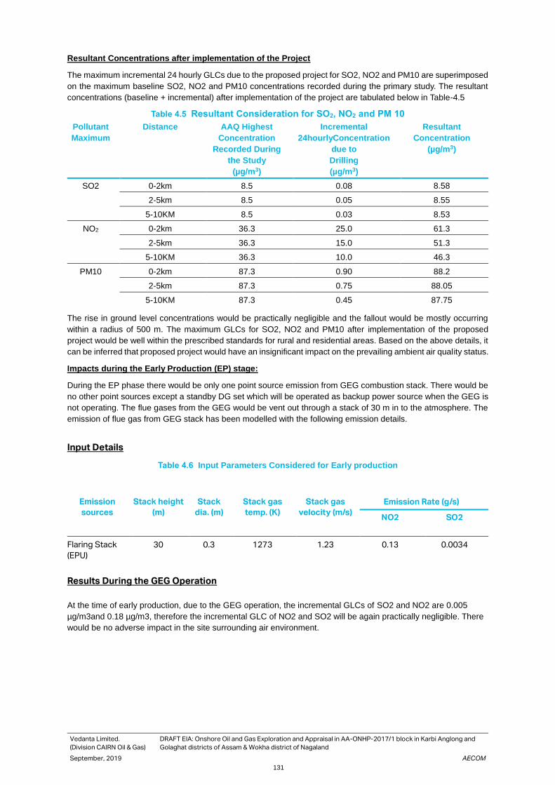
Vedanta Limited.
(Division CAIRN Oil & Gas)
DRAFT EIA: Onshore Oil and Gas Exploration and Appraisal in AA-ONHP-2017/1 block in Karbi Anglong and
Golaghat districts of Assam & Wokha district of Nagaland
September, 2019 AECOM
131
Resultant Concentrations after implementation of the Project
The maximum incremental 24 hourly GLCs due to the proposed project for SO2, NO2 and PM10 are superimposed
on the maximum baseline SO2, NO2 and PM10 concentrations recorded during the primary study. The resultant
concentrations (baseline + incremental) after implementation of the project are tabulated below in Table-4.5
Table 4.5 Resultant Consideration for SO2, NO2 and PM 10
Pollutant
Maximum
Distance AAQ Highest
Concentration
Recorded During
the Study
(µg/m3)
Incremental
24hourlyConcentration
due to
Drilling
(µg/m3)
Resultant
Concentration
(µg/m3)
SO2 0-2km 8.5 0.08 8.58
2-5km 8.5 0.05 8.55
5-10KM 8.5 0.03 8.53
NO2 0-2km 36.3 25.0 61.3
2-5km 36.3 15.0 51.3
5-10KM 36.3 10.0 46.3
PM10 0-2km 87.3 0.90 88.2
2-5km 87.3 0.75 88.05
5-10KM 87.3 0.45 87.75
The rise in ground level concentrations would be practically negligible and the fallout would be mostly occurring
within a radius of 500 m. The maximum GLCs for SO2, NO2 and PM10 after implementation of the proposed
project would be well within the prescribed standards for rural and residential areas. Based on the above details, it
can be inferred that proposed project would have an insignificant impact on the prevailing ambient air quality status.
Impacts during the Early Production (EP) stage:
During the EP phase there would be only one point source emission from GEG combustion stack. There would be
no other point sources except a standby DG set which will be operated as backup power source when the GEG is
not operating. The flue gases from the GEG would be vent out through a stack of 30 m in to the atmosphere. The
emission of flue gas from GEG stack has been modelled with the following emission details.
Input Details
Table 4.6 Input Parameters Considered for Early production
Emission
sources
Stack height
(m)
Stack
dia. (m)
Stack gas
temp. (K)
Stack gas
velocity (m/s)
Emission Rate (g/s)
NO2 SO2
Flaring Stack
(EPU)
30 0.3 1273 1.23 0.13 0.0034
Results During the GEG Operation
At the time of early production, due to the GEG operation, the incremental GLCs of SO2 and NO2 are 0.005
µg/m3and 0.18 µg/m3, therefore the incremental GLC of NO2 and SO2 will be again practically negligible. There
would be no adverse impact in the site surrounding air environment.
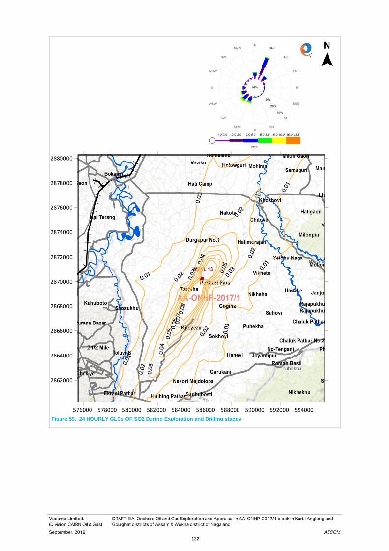
Vedanta Limited.
(Division CAIRN Oil & Gas)
DRAFT EIA: Onshore Oil and Gas Exploration and Appraisal in AA-ONHP-2017/1 block in Karbi Anglong and
Golaghat districts of Assam & Wokha district of Nagaland
September, 2019 AECOM
132
Figure 59. 24 HOURLY GLCs OF SO2 During Exploration and Drilling stages
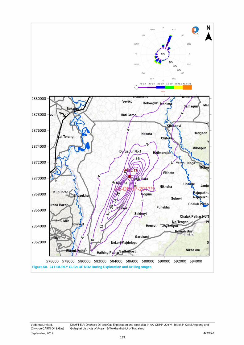
Vedanta Limited.
(Division CAIRN Oil & Gas)
DRAFT EIA: Onshore Oil and Gas Exploration and Appraisal in AA-ONHP-2017/1 block in Karbi Anglong and
Golaghat districts of Assam & Wokha district of Nagaland
September, 2019 AECOM
133
Figure 60. 24 HOURLY GLCs OF NO2 During Exploration and Drilling stages

Vedanta Limited.
(Division CAIRN Oil & Gas)
DRAFT EIA: Onshore Oil and Gas Exploration and Appraisal in AA-ONHP-2017/1 block in Karbi Anglong and
Golaghat districts of Assam & Wokha district of Nagaland
September, 2019 AECOM
134
Figure 61. HOURLY GLCs OF PM10 During Exploration and Drilling stages

Vedanta Limited.
(Division CAIRN Oil & Gas)
DRAFT EIA: Onshore Oil and Gas Exploration and Appraisal in AA-ONHP-2017/1 block in Karbi Anglong and
Golaghat districts of Assam & Wokha district of Nagaland
September, 2019 AECOM
135
Figure 62. 24 HOURLY GLCs OF NO2 During the Early production Stage

Vedanta Limited.
(Division CAIRN Oil & Gas)
DRAFT EIA: Onshore Oil and Gas Exploration and Appraisal in AA-ONHP-2017/1 block in Karbi Anglong and
Golaghat districts of Assam & Wokha district of Nagaland
September, 2019 AECOM
136
Figure 63. 24 HOURLY GLCs OF SO2 During the Early production Stage
Vedanta Limited.
(Division CAIRN Oil & Gas)
DRAFT EIA: Onshore Oil and Gas Exploration and Appraisal in AA-ONHP-2017/1 block in Karbi Anglong and
Golaghat districts of Assam & Wokha district of Nagaland
September, 2019 AECOM
137
Mitigation Measures: The proposed mitigation measures are as follows:
To minimize emission of fugitive dusts the following measures would be adopted:
• Carry out regular water sprinkling at the site during dry season especially during the site preperationand
decommissioning activities;
• During construction, the approach road will be kept clean, free from mud and slurry to prevent any entrainment
of dust;
• Location of construction materials will be away from nearby worker’s camps;
• Proper handling of materials to ensure minimal emission of dust.
To minimise emission from the vehicles, equipment and machinery the following measures
would be adopted:
• Movement of construction vehicles will be minimised and a limited speed of will be enforced along the access
and approach roads;
• All diesel-powered equipment will be regularly maintained, and idling time reduced to minimise emissions;
• Low sulphur diesel will be used in diesel powered equipment and best management practices would be
adhered to;
• Vehicle / equipment exhausts observed emitting significant black smoke in their exhausts would be
serviced/replaced.
To minimise the adverse impacts of flaring the following measures should be adopted:
• Proper engineering controls to ensure complete combustion of gas;
• No cold venting of raw gas will be resorted; instead flaring will be done with combustion efficient elevated flare
tip; and
• Location of flare stacks to be chosen considering the sensitive receptors adjoining the site.
4.9 Potential Impact and Mitigation Measures on
Noise Quality Access road strengthening during well site preparation and operation of drilling rig and ancillary equipment during
drilling operation and Early production.
Source of Impact:
The potential impacts on noise quality may arise out of the following:
• Pre-drilling phase:
─ Site development/preparation ;
─ Operation of vehicles and construction machinery;
─ Transportation, storage, handling of construction material, disposal of construction waste;
─ Operation of DG sets.
• Drilling phase:
─ Operation of DG sets and drilling rig
─ Operation of machineries & equipment;
─ Vehicular traffic.
• Decommissioning phase:
─ Demobilization activity
─ Vehicular traffic.

Vedanta Limited.
(Division CAIRN Oil & Gas)
DRAFT EIA: Onshore Oil and Gas Exploration and Appraisal in AA-ONHP-2017/1 block in Karbi Anglong and
Golaghat districts of Assam & Wokha district of Nagaland
September, 2019 AECOM
138
• Quick/early Production phase:
─ Flaring of the Gas
─ Operation of GEG/ DG sets
Assessment of Noise Impacts due to Site Activities
Driller rotors and the power generators and pumps would be the main sources of noise pollution during the drilling
activity. Noise due to vehicular movement would be intermittent but would also add to the background noise levels.
The well site during excavation phase of the site preparation where heavy earth moving machinery would be in
operation, noise level of the vehicle would not be more than the 90 dB (A).
Typically, the noise generating sources for the onshore drilling activity are provided below (in the immediate vicinity)
• GEG/Diesel Generator: 75 dB(A)
• Pumps at the Rig: 85 to 90 dB(A)
• Mud pumps: 73.3-80.5 dB(A)
• Control Room & Quarters: 50 to 60 dB(A)
• Drilling: 85-90 dB(A)
• Flaring: 86.0 dB(A)
In order to predict ambient noise levels due to the proposed drilling of exploratory wells. The preparative modeling
has been done. For computing the noise levels at various distances with respect to the proposed site, noise levels
are predicted using an user friendly model the details of which is elaborated below.
Mathematical Model for Sound Wave Propagation During Operation
For an approximate estimation of dispersion of noise in the ambient from the source point, a standard
mathematical model for sound wave propagation is used. The sound pressure level generated by noise sources
decreases with increasing distance from the source due to wave divergence. An additional decrease in sound
pressure level with distance from the source is expected due to atmospheric effect or its interaction with objects
in the transmission path.
For hemispherical sound wave propagation through homogenous loss free medium, one can estimate noise
levels at various locations, due to different sources using model based on first principles, as per the following
equat
Lp2 =Lp1-20log (r2 /r1) (1)
Where Lp2 and Lp1 are Sound Pressure Levels (SPLs) at points located at distances r2 and r1 from the source.
The combined effect of all the sources then can be determined at various locations by the following equation.
Lp(total) = 10 x LOG10 (SUM[10^(L1/10) + 10^(L2/10) … (2)
Where, Lp1, Lp2, Lp3 are noise pressure levels at a point due to different sources. Based on the above
equations an user friendly model has been developed. The details of the model are as follows:
Based on the above equations an user friendly model has been developed. The details of the model are as
follows:
• Noise levels can be predicted at any distance specified from the source;
• Model is designed to take topography or flat terrain;
• Coordinates of the sources in meters;
• Maximum and Minimum levels are calculated by the model;
• Output of the model in the form of isopleths; and
• Environmental attenuation factors and machine corrections have not been incorporated in the model but
corrections are made for the measured Leq levels.

Vedanta Limited.
(Division CAIRN Oil & Gas)
DRAFT EIA: Onshore Oil and Gas Exploration and Appraisal in AA-ONHP-2017/1 block in Karbi Anglong and
Golaghat districts of Assam & Wokha district of Nagaland
September, 2019 AECOM
139
Input for the Model
The incremental increase in noise levels due to the operation/ site preperation phase of the exploratory drilling has
been done. Noise levels are mainly generated from DG sets, air compressors, pumps and transformers. The noise
sources have been defined with respect to center of drill site. The input data pertaining to corresponding noise level
are tabulated in Table 4.7
Table 4.7 Input Data for Noise Modelling
Sr. No. Location Noise Levels db(A) at 3m distance from source
1 Diesel Generator ( 2 DG set) 75
2 Pumps at the Rig 85
3 Mud pumps 70
4 Control Room & Quarters 50
5 Drilling 85
6 Flaring 86
Source:
https://www.cpcb.nic.in/displaypdf.php?id=SW5kdXN0cnktU3BlY2lmaWMtU3RhbmRhcmRzL0VmZmx1ZW50LzUwMS5wZGY=
), www.vurup.sk/petroleum-coal
Presentation of Results
The model results are discussed below and are represented through line chart in
Figure 64The predicted noise level at 500 m distance from the boundary of well site is 42.98 dB (A) and are
tabulated in Table 4.8
Table 4.8 Predicted Noise Levels
Name of Source Noise Levels at 3m distance from source L1 [dB(A)]
X (Distance in m) Noise Levels at X distance
L2 [dB(A)]
Diesel Generator 75 50 56
100 50
200 44
500 16
Diesel Generator 75 50 56
100 50
200 44
500 16

Vedanta Limited.
(Division CAIRN Oil & Gas)
DRAFT EIA: Onshore Oil and Gas Exploration and Appraisal in AA-ONHP-2017/1 block in Karbi Anglong and
Golaghat districts of Assam & Wokha district of Nagaland
September, 2019 AECOM
140
Name of Source Noise Levels at 3m distance from source L1 [dB(A)]
X (Distance in m) Noise Levels at X distance
L2 [dB(A)]
Pumps at the Rig 85 50 61
100 55
200 49
500 41
Mud pumps 70 50 46
100 40
200 34
500 26
Control Room & Quarters 50 50 26
100 20
200 14
500 6
Drilling 85 50 61
100 55
200 49
500 41
Flaring 86 50 62
100 56
200 50
500 42
Table 4.9 Attenuated Noise Level
Distance (m) Predicted Noise Levels
dB(A)
Prescribed Noise levels
at Day time of the
Residential Area dB(A)
Prescribed Noise levels
at Night time of the
Residential Area dB(A)
50 62.98 55 45
100 56.96 55 45
200 50.94 55 45
500 42.98 55 45
Distance (m) Predicted Noise Levels
dB(A)
Prescribed Noise levels at
Day time of the Residential
Area dB(A)
Prescribed Noise levels at
Night time of the
Residential Area dB(A)
Further, considering drilling would be a continuous operation, noise generated from aforesaid equipment has the
potential to cause discomfort to the local community residing in proximity of the rig facility. So settlements located
close to majority of the wells would face discomfort due to drilling operation. Vedanta Limited. (Division Cairn Oil &
Gas) would ensure that well location is located as far as possible from the nearest human habitation.
Occupational health and safety impacts viz. Noise Induced Hearing Loss (NIHL) is also anticipated on personnel
working close to such noise generating equipment. However, drilling activities would be undertaken for short
duration and necessary noise prevention and control measures viz. use of acoustic barriers, provisions for proper
PPEs, regular preventive maintenance of equipment etc. would be implemented by the proponent to reduce the
noise impact on the communities residing in proximity to the well sites.

Vedanta Limited.
(Division CAIRN Oil & Gas)
DRAFT EIA: Onshore Oil and Gas Exploration and Appraisal in AA-ONHP-2017/1 block in Karbi Anglong and
Golaghat districts of Assam & Wokha district of Nagaland
September, 2019 AECOM
141
Figure 64. Predicted Noise Level
Severity of Impact 2 Extent of Impact 2 Duration of Impact 1
Impact Significance = 4 i.e. Medium
Mitigation Measures:
Typical mitigation measures for noise would include the following:
• Installation of adequate engineering control on equipment and machinery (like mufflers & noise
enclosures for DG sets and mud pumps) to reduce noise levels at source, carrying out proper
maintenance and subjecting them to rigid noise control procedures.
• Providing Personnel Protective Equipment (PPEs) like ear plugs/muffs to workers at site.
• The DG set would be designed with acoustic enclosure and noise conformance labelling as per CPCB
standards.
• Undertaking preventive maintenance of vehicles to reduce noise levels
4.10 Potential Impact and Mitigation Measures on
Surface Water Quality Surface run-off discharge
Site clearance and stripping of top soil during construction/site preparation would result in an increase in soil erosion
potential leading to an increased sediment load in the surface run-off during monsoon. Also, surface run off from
drilling waste (cuttings and drilling mud), hazardous waste (waste oil, used oil etc) and chemical storage areas may
lead to the pollution of receiving water bodies viz. natural drainage channels etc unless precautionary measures
are adopted. However, taking into account the provision of onsite drainage system, sediment control measures,
provision of oil water separator would aid discharging of surface run off in compliance with the CPCB Inland Water
Discharge Standards, the impact is considered to be of low significance.
Discharge of drilling mud and process wash water
Severity of Impact 2 Extent of Impact 1 Duration of Impact 2
Impact Significance = 4 i.e. Medium

Vedanta Limited.
(Division CAIRN Oil & Gas)
DRAFT EIA: Onshore Oil and Gas Exploration and Appraisal in AA-ONHP-2017/1 block in Karbi Anglong and
Golaghat districts of Assam & Wokha district of Nagaland
September, 2019 AECOM
142
Mitigation Measures
• Adequate treatment of waste water to meet the CTE and CTO condition.
• Waste mud to be stored in the HDPE lined pit
• Drainage and sediment control systems at the well site would be efficiently designed
• All chemical and fuel storage areas, process areas would have proper bunds so that contaminated
run-off cannot escape into the storm-water drainage system.
4.11 Potential Impact and Mitigation Measures on
Ground Water Resource Source of Impact: Potential impacts on groundwater resources would be due to ground water abstracted for
domestic needs and for civil construction activities. Potential impact on ground water resource could arise due to:
• Predrilling phase,
─ Water required for construction of drill sites
• Drilling phase
Embedded Control Measures
• All contractors to follow the protocols as set by Cairn regarding construction water management.
Potential impacts on groundwater resources that could arise as a result of the proposed drilling activities include
the following:
Ground Water Extraction
However, water requirement for all the project activities would be sourced locally through approved/authorized
sources of surface water and/or ground water (e.g. PHD bore wells, privately owned bore wells, irrigation
Dept./Water Resources Dept. of State Govt.). In case, required water could not be sources from locally available
approved sources, ground water would be extracted after obtaining permission from CGWA/State Govt.
Considering drilling to be a temporary activity (approx 90 days) the impact on ground water resource is considered
to be low. In case of QPU the water requirement would reduce and thus the impacts would reduce even though the
duration of the activity would be longer.
Severity of Impact 2 Extent of Impact 2 Duration of Impact 1
Impact Significance = 4 i.e. Medium
Mitigation Measures
• All water stored in the drill sites would be kept covered in leak proof tank ;
4.12 Potential Impact and Mitigation Measures on
Soil Quality Potential impact on soil quality is envisaged in the form of increase in soil erosion and loss of soil fertility resulting
from site clearance and top soil stripping during well site preparation. The impact from accidental spillage resulting
from storage and handling of mud chemicals is also envisaged.
Source of Impact: Soil quality impacts can result from:
• Pre-drilling Phase
─ Removal of top soil from the land procured;
─ Compaction of soil;
─ Disposal of construction waste/ MSW in non-designated area;

Vedanta Limited.
(Division CAIRN Oil & Gas)
DRAFT EIA: Onshore Oil and Gas Exploration and Appraisal in AA-ONHP-2017/1 block in Karbi Anglong and
Golaghat districts of Assam & Wokha district of Nagaland
September, 2019 AECOM
143
─ Spillage of chemical/oil on open soil;
─ Surface runoff from material & waste storage areas and oil spillage area.
• Drilling Phase/Operation of Production facilities:
─ Spillage of chemical, spent mud, hazardous waste, etc.;
─ Surface runoff from waste storage area and spillage area.
• Decommissioning Phase:
─ Disposal of decommissioning waste materials in open soil.
Embedded Control Measures: The project embedded control measures are as follows:
• The drill cuttings and spent drilling mud would be generated at site per well during drilling operations. This
would be stored in well-designed HDPE line pit. And would be disposed as per the guideline of GSR &
HWM rules.
Topsoil would be removed and stored separately Soil quality impacts so identified have been assessed and
evaluated in the section below.
Site clearance and stripping of top soil
As discussed in the baseline section, the soil of AA-ONHP-2017/1 block is characterized by Alluvial and flood plain
s soil. This soil is good in terms of fertility. However, to preserve the topsoil stripping of topsoil has been planned
before the start of construction activity at the drill site. It is estimated that about 1,35,00 m3 of topsoil would be
removed per well site having an area of 9.0 ha considering 15 cm topsoil. However, such impact is considered to
be temporary as the proper reinstatement of site would be undertaken by Vedanta Limited. (Division Cairn Oil &
Gas) in case the wells are not indicative of any commercially exploitable hydrocarbon reserves. Necessary surface
run-off control measures would be adopted by the proponent during construction phase to prevent sediment flow
to abutting agricultural land. Further specific mitigation measures would be implemented by Vedanta Limited.
(Division: Cairn Oil & Gas) to stabilize the topsoil and to preserve their fertility characteristics during site restoration.
The impact is therefore considered to be of medium significance.
Sourcing of borrow material
The drill sites would also be raised. Site preparatory activities would involve the sourcing of earth-fill from borrow
areas. Since in most of the cases efforts would be made to procure the fill material from nearby existing borrow
areas/ quarries the impact is considered to be of low significance.
Storage and disposal of drill cuttings and drilling mud
It is estimated that nearly about 250-750 tons/well of drill cuttings associated with WBM 500 - 1500 tons/well of drill
cuttings associated with SBM, 250 - 500 tons/well of Spent/Residual Drilling Mud, 250 - 500 tons/well of Sludge
containing oil & other drilling wastes are likely to be generated from each well during drilling operation., As an
embedded mitigation measures HDPE lined impervious pits would be constructed at each of the drill sites for
temporary storage of drill cuttings and drilling fluid. The disposal of the drill cuttings and the drilling mud would be
carried out in accordance with “CPCB Oil & Extraction Industry Standard – Guidelines for Disposal of Solid Wastes”
no significant impact to this regard is envisaged.
Storage and handling of fuel and chemicals
Fuels, lubricants and chemical used for the drilling operations (especially daily consumption) would be stored at
site. In addition spent lube, and waste oil would also be stored temporarily at site before it is disposed as per the
regulatory requirements. Improper storage and handling of the chemicals and fuels, spent lubricants can lead to
contamination of soil. Accidentally, spillage of chemicals, oil and lubricants, either during transportation or handling,
on soil may contribute to soil contamination. Considering the accidental nature of the event the impact is considered
to be of low significance.
Embeded controls has been considered in the project design to reduce the impact on soil. Also, most of these
impacts on the soil fertility is reversible as the drill sites would be reinstated after the drilling. The contamination of

Vedanta Limited.
(Division CAIRN Oil & Gas)
DRAFT EIA: Onshore Oil and Gas Exploration and Appraisal in AA-ONHP-2017/1 block in Karbi Anglong and
Golaghat districts of Assam & Wokha district of Nagaland
September, 2019 AECOM
144
soil due to spillage of chemical and fuel is likely to happen only in case of accidents. Thus, the significance of the
impact is medium
Severity of Impact 2 Extent of Impact 2 Duration of Impact 2
Impact Significance = 8 i.e. Medium
Mitigation Measures:
The following mitigation measures are proposed for reducing impact on soil quality:
• The top soil would be stored properly.
• Manage spills of contaminants on soil using oil spill kits;
• Storage of construction waste/ MSW in designated areas within drill sites/production facilities;
• Adopt best practices e.g. use pumps and dispensing nozzle for transfer of fuel, use drip trays etc.
4.13 Potential Impact and Mitigation Measures on
Road & Traffic During various phases of projects like construction, drilling, early production and decommissioning various types
of vehicle / equipment movement would be involved. The vehicular movement is expected to be more in
construction/ site preparation due to movement of machinery & manpower.
Vedanta Limited (Division Cairn Oil & Gas) would ensure that traffic management plan is implemented so that
proper vehicular movement is done with minimal disturbance to nearby communities. The impacts would be for
limited duration. Thus, the impacts are temporary in nature and limited mostly within the drill site.
Severity of Impact 2 Extent of Impact 1 Duration of Impact 2
Impact Significance = 4 i.e. Medium
Mitigation Measures
• Speed limits would be maintained by vehicles involved in transportation of raw material and drilling
rig.
• Road safety awareness programs/campaign would be organized in coordination with concerned
authorities
• Entry of vehicles into the drilling site area is prohibited except for material movement.
• Adequate parking would be provided outside the drilling location.
4.14 Potential Impact and mitigation Measures on
Terrestrial Ecological Environment Potential impact on Ecological environment i.e impacts on existing Floral and faunal diversity is envisaged
particularly during Site preparation phase and operation phase. The potential impacts on terrestrial Ecology in
Site preparation and operational phase is given below.
Source of Impact:
The Potential Impacts on the existing floral and faunal diversity may arise due to following activities
4. Vegetation Clearance.
5. Illimitation from Site.
6. Generation of Noise.
Impact Assessment:
Vegetation Clearance

Vedanta Limited.
(Division CAIRN Oil & Gas)
DRAFT EIA: Onshore Oil and Gas Exploration and Appraisal in AA-ONHP-2017/1 block in Karbi Anglong and
Golaghat districts of Assam & Wokha district of Nagaland
September, 2019 AECOM
145
It is proposed to develop 20 exploratory and appraisal well in Block AA-ONHP-2017/01 which mainly agricultural
land. Besides this some well locations are also located in tea garden. During primary survey, it has been observed
that removal of ground vegetation is required for site preparation.
The vegetation observed in the study area is common to these climatological conditions and no endangered floral
species is observed in the study area. Further the distribution of vegetation is scattered in nature. It is observed
that approximately 3 ha land is required for each drill site and clearance of only shrubs and herbs are required.
Therefore, the scale of Impact can be considered as low, extent of impact within site. The clearance of vegetation
would initiate the change in land use. So, overall impacts would be low.
Generation of Noise and Illumination from site
It is anticipated that noise would be generated particularly during the construction /site preparation period and
various operational activities from the drilling site. It is expected to get attenuated to baseline level of noise within
200-300 m from the proposed drilling locations. It is also found during the field visit and confirmed by the Forest
Department of Government of Assam that there is no ecologically sensitive area such as National Park, Wild Life
Sanctuary within the Block area, the potential impacts on existing wildlife due to generation of noise can be
considered as low.
The drill site would be illuminated during both construction and operational phase as drilling would be conducted
continuously for 24 hrs and thus may cause significant disturbance to local faunal population particularly avifauna.
Severity of Impact 2 Extent of Impact 1 Duration of Impact 2
Impact Significance = 4 i.e. Low
Mitigation Measures
A range of measures would be adopted during construction and drilling phase to mitigate the potential impacts of
terrestrial ecology and biodiversity which are described below:
• The working area always be kept minimum.
• For felling of trees prior approval from concerned department would be obtained;
• Appropriate shading of lights would be ensured to prevent unwanted scattering.
• Plantation of local trees would be undertaken;
• Fencing would be done on the camp site to avoid any unfortunate encounter with faunal species.
4.15 Potential Impact and Mitigation Measures on
Socioeconomic Environment The impacts on the socio-economic environment are both adverse as well as positive in nature. The adverse
impacts are primarily due to: Inconvenience due to dust and noise. Disruption or damage to public infrastructure
due to construction related activities
Assessment of Impact
The impact on different aspects of the socio-economic environment is discussed as under.
Loss of Livelihood
The proposed well sites would be located primarily on temporary fallow and would be at a distance from the well.
Approximately, 9 ha land would be required per well for proposed drilling activity. Even though agricultural land
would be used since the agricultural activities are poor due to scanty rainfall in the region. Thus, the severity of
the impact would be low and loss of livelihood for the locals would be also low.

Vedanta Limited.
(Division CAIRN Oil & Gas)
DRAFT EIA: Onshore Oil and Gas Exploration and Appraisal in AA-ONHP-2017/1 block in Karbi Anglong and
Golaghat districts of Assam & Wokha district of Nagaland
September, 2019 AECOM
146
Addition Demand on Infrastructure
The width of some of the access and approach roads are not wide enough to support the movement of heavy
vehicles to drill site, hence they have to be widened and strengthened. Transportation of drilling rig and associated
facilities to drill and decommissioning of rig and associated structure would increase traffic movement. Increase in
vehicular fleet may cause damage to road infrastructure if not properly maintained. The strengthening and widening
of the existing road would reduce the significance of impact from medium to low.
Influx of Population
Influx of population is anticipated in all stages of the project cycle particularly during exploratory drilling. The drill
site would involve the operation of about 50 onsite workers during drilling phase. Interaction between workers with
villagers of nearby areas might give rise to various issues like conflict of workers with the local population, nuisance
caused by workers due to improper sanitation facilities, etc. However, taking into account that majority of the
unskilled workforce during construction phase is likely to be sourced from local villages chances of such conflicts
are negligible.
Employment opportunities
Project would benefit people living in the neighbouring villages temporarily by creating opportunity for direct &
indirect employment associated with the various project activities . Site preparation phase would involve certain
number of laborers and there is a possibility that local people can be engaged for this purpose. Drilling process
would involve a number of skilled and unskilled workers. Generation of short time employment opportunities during
the project phase would improve the employment scenario of the area.
Cultural & Heritage Site
Impact on cultural environment may occur due to site preparation, operation of drilling rig and also during vehicular
movement with respect to the proposed exploration activities. There is no designated historical or cultural spots
close to the well sites or access roads hence; no impact in this regard is envisaged.
Corporate Social Responsibility
Vedanta Limited (Division Cairn Oil & Gas) has taken up various CSR initiatives in and around present operational areas for the benefit of the residents as per the CSR Act and Rules, Govt. of India.
CSR measures would be taken up by Vedanta Limited. (Division Cairn Oil & Gas) in case of commercially viable
hydrocarbon discovery & further full-fledged development of the fields and production and associated facilities
Mitigation Measures
Agriculture and pasture-land would be avoided to the extent possible in site selection process for proposed
Mitigation Measures
• The shortest distance as far as available/feasible would be considered for access road, with additional care
to avoid division of land parcels into agriculturally unviable fractions;
• The village road identified for accessing proposed project footprints, would be strengthened and widened as
per requirement;
• Appropriate awareness program on grievance redressal mechanism, would be designed and implemented
for local community around proposed project footprints;
Impact Significance = ++ i.e. POSITIVE
4.16 Potential Impact and Mitigation Measures on
Occupational Health and Safety Construction Phase
Source of Impact Occupational health and safety impacts during construction/site preparation phase are
anticipated primarily from:

Vedanta Limited.
(Division CAIRN Oil & Gas)
DRAFT EIA: Onshore Oil and Gas Exploration and Appraisal in AA-ONHP-2017/1 block in Karbi Anglong and
Golaghat districts of Assam & Wokha district of Nagaland
September, 2019 AECOM
147
• Operation of construction machineries/equipment;
• Exposure to high noise generation areas.
Embedded Control Measures The project embedded control measures are as follows:
• Provision of proper PPEs for the contractor workers onsite;
• Provision of drinking water facility, sanitation and cooking facilities.
Assessment of Impact Impact on occupational health and safety of contractor workers is anticipated from exposure to high noise
generated from operation of heavy machinery/equipment and fugitive dust generated from material stockpiles,
earth works and vehicular emission. It is estimated that about 50-60 workers would be deployed by the
contractor at each drill site and 10-20 workers in the production facility. The outstation project workforce would
be housed in labour camp located within the drill site. Continuous exposure of workers to high noise levels and
fugitive dust and inadequate facilities and unhygienic conditions at such camps may lead to adverse health
impacts viz. headache, asthma, allergy, hearing loss etc. indicating a high receptor sensitivity. However, extent
of the impact would be limited to the well site and production facility only hence the impact would be localized
only. Also considering the temporary nature of the construction phase activities, operation of
machinery/equipment would be short term and with provision of proper PPEs and training for the workers scale
of the impact would be low. Hence, the impact magnitude for occupation health and safety due to above
mentioned construction activities have been assessed to be of medium and significance would be moderate.
Operational Phase
Source of Impact: The source of occupational health and safety could arise from:
• Operation of rig and machineries,
• Exposure in high noise generation area.
Embedded control measures: The control measures are as follows:
• All potential occupational health hazards would be identified;
• Permit to work system to be in place;
• Provision of PPEs to all workers.
Assessment of Impact:
Major occupational health hazards encountered in proposed drilling activity would include noise from drilling activity,
operation of heavy vehicles and machinery, handling of chemicals etc. both in drill site and production facility.
Drilling Activity
Continuous exposure of workers involved in drill activity to high noise levels may lead to adverse health impacts
viz. headache, hearing loss etc. which indicates a high receptor sensitivity. It is under stood that extent of the
impact would be limited to the well site only hence the impact would be local. As the drilling activity would be
continuous of maximum period of up to 3 months and intermittent operation of machinery/equipment duration would
be short term and with provision of proper PPEs and training of the workers scale of the impact would be low and
magnitude of the impact would be small. Hence, the impact significance of occupation health and safety due to
above mentioned construction activities is assessed to be moderate
Quick Production Unit/Early Production Unit
Main impact on occupational health safety in production facility would limited to operation of heavy vehicles and
machinery, handing of chemicals etc. However, involved of the personal in a production facility per shift is maximum
up to 10 persons and it is understood that they would be trained. Hence, the resource sensitivity would be medium.
As all the activity of production facility would be carried out within secure premises extent of impact would be local..
As the risk level of a production facility is high as it is handling highly inflammable hydrocarbon embedded control
of any production facility is very strong so the scale of the impact would be medium. Hence, the magnitude of the
impact would be medium and significant of the impact is assessed to be Medium.
Severity of Impact 2 Extent of Impact 2 Duration of Impact 2
Impact Significance = 8 i.e. Medium
Mitigation measures: The mitigation measures are as follows:
• Periodic onsite surveillance to be conducted so that the workers use the designated PPEs all the time;
• Health surveillance would be conducted of personnel working in the aforesaid areas;
• Regular health and safety training to be provided to workers.

Vedanta Limited.
(Division CAIRN Oil & Gas)
DRAFT EIA: Onshore Oil and Gas Exploration and Appraisal in AA-ONHP-2017/1 block in Karbi Anglong and
Golaghat districts of Assam & Wokha district of Nagaland
September, 2019 AECOM
148
• Exposure of workers operating near high noise generating sources would be reduced to the extent possible;
4.17 Potential Impact and mitigation Measures on
Community Health & Safety Community health and safety of inhabitants residing close to the drilling site stands to get affected from frequent
heavy vehicular movement along village access roads and due to noise from drilling rig operations.
Ensuring Public Safety
Since the project involves the movement of heavy vehicles and machinery in the area, the issue of public safety of
the villagers, especially children, is an important concern. During the drilling phase and for the rest of the project
activities proper safety measures would be undertaken both for transportation as well as the other operations. The
drill site would be fenced and gates would be constructed so that the local people are refrained from straying into
the site.
The movement of traffic is also likely to access conditions of the inhabitants residing close to the access road. The
increase in traffic would have implications on their safety too, as well as create congestion, potential delays and
inconvenience for pedestrians.
Health and safety impact arising from technological emergencies viz. well blow outs, explosions would be dealt
separately in the Quantitative Risk Assessment (QRA) section.
Although the aforesaid activities are temporary in nature it may not adversely affect community health and safety
in the long term. Mitigation measures would be taken as outlined in environmental management plan to reduce the
impacts arising out of project activities.
Severity of Impact 2 Extent of Impact 2 Duration of Impact 2
Impact Significance = 8 i.e. Medium
Mitigation Measures:
• Proper hoardings in English and local language would be displayed during construction and operation
phase to prevent people from encroaching the fenced area or to make them aware of the danger associated
with the construction
• Traffic management plan would be developed and implemented at site.
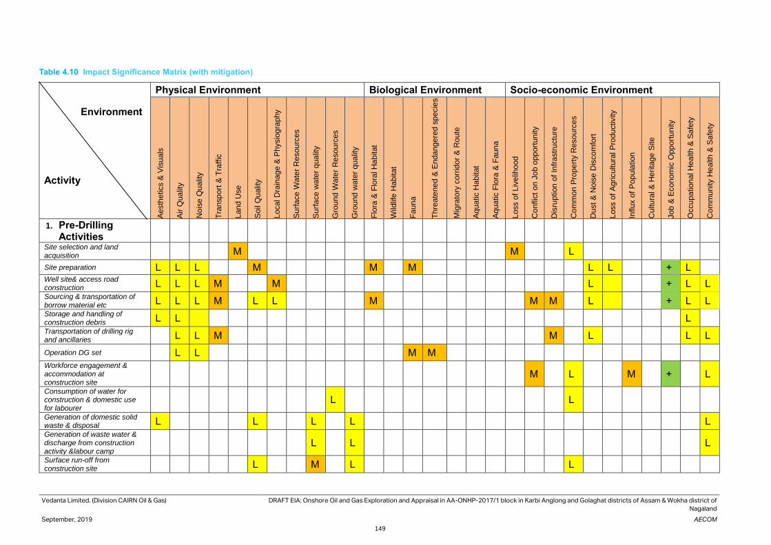
Vedanta Limited. (Division CAIRN Oil & Gas) DRAFT EIA: Onshore Oil and Gas Exploration and Appraisal in AA-ONHP-2017/1 block in Karbi Anglong and Golaghat districts of Assam & Wokha district of
Nagaland
September, 2019 AECOM
149
Table 4.10 Impact Significance Matrix (with mitigation)
Environment
Activity
Physical Environment Biological Environment Socio-economic Environment
Ae
sth
etics &
Vis
uals
Air
Qua
lity
No
ise
Qu
alit
y
Tra
nsp
ort
& T
raffic
Lan
d U
se
So
il Q
ualit
y
Local D
rain
ag
e &
Physio
gra
phy
Su
rfa
ce
Wa
ter
Resou
rces
Su
rfa
ce
wa
ter
qua
lity
Gro
und
Wa
ter
Re
sou
rces
Gro
und
wate
r q
ua
lity
Flo
ra &
Flo
ral H
ab
itat
Wild
life
Hab
itat
Fa
un
a
Th
rea
tened
& E
nda
ng
ere
d s
pecie
s
Mig
rato
ry c
orr
ido
r &
Ro
ute
Aq
ua
tic H
ab
itat
Aq
ua
tic F
lora
& F
aun
a
Loss o
f L
ive
liho
od
Co
nflic
t o
n J
ob o
pp
ort
un
ity
Dis
ruption
of
Infr
astr
uctu
re
Co
mm
on
Pro
pe
rty R
esou
rces
Du
st &
No
ise
Dis
co
mfo
rt
Loss o
f A
gricu
ltura
l P
rodu
ctivity
Influx o
f P
opu
latio
n
Cu
ltu
ral &
He
rita
ge
Site
Job
& E
con
om
ic O
pp
ort
un
ity
Occu
pa
tion
al H
ea
lth
& S
afe
ty
Co
mm
un
ity H
ea
lth &
Sa
fety
1. Pre-Drilling Activities
Site selection and land acquisition
M M L
Site preparation L L L M M M L L + L
Well site& access road construction L L L M M L + L L
Sourcing & transportation of borrow material etc L L L M L L M M M L + L L
Storage and handling of construction debris L L L
Transportation of drilling rig and ancillaries
L L M M L L L
Operation DG set L L M M
Workforce engagement & accommodation at construction site
M L M + L
Consumption of water for construction & domestic use for labourer
L L
Generation of domestic solid waste & disposal L L L L L
Generation of waste water & discharge from construction activity &labour camp
L L L
Surface run-off from construction site
L M L L

Vedanta Limited. (Division CAIRN Oil & Gas) DRAFT EIA: Onshore Oil and Gas Exploration and Appraisal in AA-ONHP-2017/1 block in Karbi Anglong and Golaghat districts of Assam & Wokha district of
Nagaland
September, 2019 AECOM
150
Environment
Activity
Physical Environment Biological Environment Socio-economic Environment
Ae
sth
etics &
Vis
uals
Air
Qua
lity
No
ise
Qu
alit
y
Tra
nsp
ort
& T
raffic
Lan
d U
se
So
il Q
ualit
y
Local D
rain
ag
e &
Physio
gra
phy
Su
rfa
ce
Wa
ter
Resou
rces
Su
rfa
ce
wa
ter
qua
lity
Gro
und
Wa
ter
Re
sou
rces
Gro
und
wate
r q
ua
lity
Flo
ra &
Flo
ral H
ab
itat
Wild
life
Hab
itat
Fa
un
a
Th
rea
tened
& E
nda
ng
ere
d s
pecie
s
Mig
rato
ry c
orr
ido
r &
Ro
ute
Aq
ua
tic H
ab
itat
Aq
ua
tic F
lora
& F
aun
a
Loss o
f L
ive
liho
od
Co
nflic
t o
n J
ob o
pp
ort
un
ity
Dis
ruption
of
Infr
astr
uctu
re
Co
mm
on
Pro
pe
rty R
esou
rces
Du
st &
No
ise
Dis
co
mfo
rt
Loss o
f A
gricu
ltura
l P
rodu
ctivity
Influx o
f P
opu
latio
n
Cu
ltu
ral &
He
rita
ge
Site
Job
& E
con
om
ic O
pp
ort
un
ity
Occu
pa
tion
al H
ea
lth
& S
afe
ty
Co
mm
un
ity H
ea
lth &
Sa
fety
2. Drilling & Testing
Physical Presence at drill site L M M
Operation of DG sets and machinery
L M L L L M M
Operation of drilling rig M L L L M M
Storage and disposal of drill cuttings and mud L L L L
Generation of process waste water & discharge
M L M M
Surface run-off from drill site L L M M
Generation of domestic waste water & discharge
L L L M M
Generation of Municipal waste & disposal L L L L
Workforce engagement & accommodation at drill site
M L M + M
Flaring during well testing L M M L L M M
Accidental events - blow out L M M M M L L M M
Accidental events-spillage of chemical & oil
M M M M M
3. Early Production L L L
4. Decommissioning and Reinstatement

Vedanta Limited. (Division CAIRN Oil & Gas) DRAFT EIA: Onshore Oil and Gas Exploration and Appraisal in AA-ONHP-2017/1 block in Karbi Anglong and Golaghat districts of Assam & Wokha district of
Nagaland
September, 2019 AECOM
151
Environment
Activity
Physical Environment Biological Environment Socio-economic Environment
Ae
sth
etics &
Vis
uals
Air
Qua
lity
No
ise
Qu
alit
y
Tra
nsp
ort
& T
raffic
Lan
d U
se
So
il Q
ualit
y
Local D
rain
ag
e &
Physio
gra
phy
Su
rfa
ce
Wa
ter
Resou
rces
Su
rfa
ce
wa
ter
qua
lity
Gro
und
Wa
ter
Re
sou
rces
Gro
und
wate
r q
ua
lity
Flo
ra &
Flo
ral H
ab
itat
Wild
life
Hab
itat
Fa
un
a
Th
rea
tened
& E
nda
ng
ere
d s
pecie
s
Mig
rato
ry c
orr
ido
r &
Ro
ute
Aq
ua
tic H
ab
itat
Aq
ua
tic F
lora
& F
aun
a
Loss o
f L
ive
liho
od
Co
nflic
t o
n J
ob o
pp
ort
un
ity
Dis
ruption
of
Infr
astr
uctu
re
Co
mm
on
Pro
pe
rty R
esou
rces
Du
st &
No
ise
Dis
co
mfo
rt
Loss o
f A
gricu
ltura
l P
rodu
ctivity
Influx o
f P
opu
latio
n
Cu
ltu
ral &
He
rita
ge
Site
Job
& E
con
om
ic O
pp
ort
un
ity
Occu
pa
tion
al H
ea
lth
& S
afe
ty
Co
mm
un
ity H
ea
lth &
Sa
fety
Dismantling of rig and associated facilities
L L M M
Transportation of drilling rig and ancillaries
L L M M
Removal of well site construction materials & disposal
L L M
Site Restoration + + +

Vedanta Limited.
(Division CAIRN Oil & Gas)
DRAFT EIA: Onshore Oil and Gas Exploration and Appraisal in AA-ONHP-2017/1 block in Karbi Anglong and
Golaghat districts of Assam & Wokha district of Nagaland
September, 2019 AECOM
152
5. Analysis of Alternative Consideration of alternatives to a project proposal is a requirement of the EIA process. During the scoping process,
alternatives to a proposal can be considered or refined, either directly or by reference to the key issues identified.
A comparison of alternatives helps to determine the best method of achieving the project objectives with minimum
environmental impacts or indicate the most environmentally friendly and cost effective options. The consideration
of alternatives is most useful when the EIA is undertaken early in the projects cycle. The type and range of
alternatives open for consideration include:
• Site alternatives (e.g. advantage of proposed site, details of any other sites, if explored, etc)
• Input or supply alternatives (e.g. use of raw materials, sourcing, etc)
• Technology alternatives (e.g. feasibility of different technologies available and advantage of proposed
technology, etc)
After analysis of the various factors the most environmentally compatible alternative is selected. Reference may
be made to available technologies, policy objectives, social attitudes, environmental and site constraints, projects
economic etc.
This section provides an analysis of alternatives in relation to the conception and planning phase of the project.
This includes the following:
5.1 No Project Scenario The no project scenario has been analyzed to understand what would be reasonably expected to occur in the near
future if the proposed development drilling of hydrocarbons and production of hydrocarbon are not conducted in
the area. In such a scenario, there would not be any pressure on use of local resources and infrastructure, and no
adverse effect on local ecology or incremental pollution to baseline environmental components (air, water and noise
levels). At the same time, there would not be any positive impact on socioeconomic status of the area resulting
from direct/ indirect employment and economic benefits that such a project can provide. With no project scenario,
dependence of the country on import of crude oil and demand for foreign exchange would grow.
5.2 Alternatives for Project Site The block is allocated by the Government of India under the Revenue Sharing Contract (RSC). Vedanta Limited.
(Division Cairn Oil & Gas) is the Operator for this block. Drilling locations are proposed based on geo-scientific
information and alternate sites cannot be considered for the proposed project facilities due to the following reasons:
The location is within the existing RSC boundary of the block. The surface locations of wells are selected
considering the drilling configuration (reach to potential reservoirs).
5.3 Alternatives for Well Location The seismic data interpretation of the seismic survey would decide the exact locations of the drilling well. The
proposed exploratory well site have been identified based on the study and interpretation of the stratigraphy and
already available seismic data. Within the identified location the actual well drilling site would be selected based
on the following factors:
• Located as far as possible from the nearest human habitation or sensitive receptors
• Located at a safe distance from public road
• Ensure natural drainage channels are avoided or drainage channels rerouted to ensure unhindered flow of
rain / flood water. Where necessary adequate erosion control measures would be provided
5.4 Alternative of Technology The technical and process related alternatives are discussed in the section.

Vedanta Limited.
(Division CAIRN Oil & Gas)
DRAFT EIA: Onshore Oil and Gas Exploration and Appraisal in AA-ONHP-2017/1 block in Karbi Anglong and
Golaghat districts of Assam & Wokha district of Nagaland
September, 2019 AECOM
153
5.5 Use of Water and Synthetic Mud During drilling operation, drilling mud would be used, which is essential to lubricate and cool drill bits, removal of
drilled rock (i.e. cuttings) from the bottom of the hole and transporting it to the surface and maintaining hydrostatic
head in the well to counter natural formation pressures.
Drilling mud is basically a suspension / mixture of solids suspended in a liquid phase, which is blended with clays,
polymers, salts and weighting agents. The main component/ solvent of drilling fluid are water, oil or synthetic and
accordingly they are called as oil-based, water-based, and synthetic muds (OBMs, WBMs, and SBMs). All the three
types of muds have certain advantages and disadvantages discussed in Table 5.1 .
Though the WBMs is a least cost option and widely used but is not found efficient in high temperature and also for
water sensitive substrata, i.e., shales and mud. To overcome these limitations, OBM and SBM are used and of the
two, SBM is preferred choice and it may be used in different set of environment like high temperatures, hydratable
shales, high-angle, extended-reach wells, high-density mud and drilling through salt.
Table 5.1 Ranks/Comparison of Different Types of Mud
Aspects Water Based Mud Oil Based Mud Synthetic Based Mud
Least Cost 1 2 3
Quantity of Waste discharge 3 2 1
Least Quantity of Water
Required for Preparation
3 2 1
Toxicity 1 3 2
Reduced drill time 3 2 1
Note:- 1: Preferable, 2: Less Preferable, 3: Least Preferable
The WBM produces large quantity of drill waste as the mud is not recyclable. Moreover, the clay in WBM absorbs
water and expands to disperse into the drilling fluid. These fine clay particles increase mud viscosity and inhibit its
upward flow. To lower the mud viscosity, water is added to lower the concentration of fine solids and mud products
are added to give the drilling fluid the correct density and flow properties. As a result, large volumes of mud are
produced to be discharged as waste. On the other hand, the OBM and SBM are recycled several times and only
drill cutting are disposed off.
The water requirement of SBM is highest as compared to OBM and WBM. Though, OBM are considered more
efficient and has wider application in different conditions but recently their use is restricted due to environmental
considerations. OBM are considered toxic due to the use of hydrocarbons as solvents and need a proper disposal
through land fill. The water based muds are considered safest in this regard followed by SBM.
If all the three types of mud are compared on the drill time, SBM is far superior then OBM and WBM. The less drill
time mean shorter operation and hence less emissions from various drilling equipments and limited engagement
of workforce.
The SBMs have the potential to drill wells more quickly and efficiently than WBMs, while avoiding some of the
disposal costs and environmental difficulties associated with OBMs.
Water based mud would be used for initial, shallower sections where massive shales are not encountered. The
deeper and difficult to drill formations would be drilled using synthetic base mud (SBM). Synthetic base mud unlike
oil based mud (OBM) is biodegradable but can be re-used. At the end of drilling a well almost the entire amount of
the SBM is collected for re-use in next drilling operation. SBM systems promote good hole cleaning and cuttings
suspension properties.
5.6 Conclusion This project is of national importance as it helps to achieve energy security. The project would have positive benefits
in terms of revenue generation to state and central government, increase in job opportunity
Site selection would be carried out taking into consideration the nearest habitation, proximity to any sensitive
receptor and natural drainage.

Vedanta Limited.
(Division CAIRN Oil & Gas)
DRAFT EIA: Onshore Oil and Gas Exploration and Appraisal in AA-ONHP-2017/1 block in Karbi Anglong and
Golaghat districts of Assam & Wokha district of Nagaland
September, 2019 AECOM
154
In addition, Vedanta Limited (Division: Cairn Oil & Gas) would ensure that the final site selection is made after due
consideration to all environmental considerations mentioned. Also use of alternate method technology to avoid
sensitive locations would be made to the extent possible. Consideration of these alternatives with strict compliance
to the Environment Management and Monitoring Plans suggested would ensure minimal impact on the
Environment.

Vedanta Limited.
(Division CAIRN Oil & Gas)
DRAFT EIA: Onshore Oil and Gas Exploration and Appraisal in AA-ONHP-2017/1 block in Karbi Anglong and
Golaghat districts of Assam & Wokha district of Nagaland
September, 2019 AECOM
155
6. Environmental Monitoring Programme
Periodic monitoring of environmental parameters is of immense importance to assess the status of environment
during pre-drilling, drilling and post drilling stages. With the knowledge of baseline conditions, the monitoring
programme would serve as an indicator for any deterioration in environmental conditions due to operation of the
project, to enable taking up suitable mitigatory steps in time to safeguard the environment. Monitoring is as
important as that of control of pollution since the efficiency of control measures can only be determined by
monitoring.
Usually, as in the case of the study, an Impact Assessment study is carried over short period of time and the data
cannot bring out all variations induced by the natural or human activities. Therefore, periodic monitoring programme
of the environmental parameters is essential to take into account the seasonal variation and changes in the
environmental quality due to project operations.
6.1 Object of Monitoring The objectives of monitoring are to:
• Verify effectiveness of planning decisions;
• Measure effectiveness of operational procedures;
• Confirm statutory and corporate compliance; and
• Identify unexpected changes.
6.2 Monitoring Schedule Periodic environmental monitoring schedules are prepared covering various phases of project advancement. This
comprises the duration of proposed exploratory drilling as well as post-drilling phase, when the hydrocarbon is
established in the wells and production program is undertaken as well as the Decommissioning/Closure Phase. In
order to assess the extent and nature of impacts on environment due to drilling operations, the monitoring on
various attributes of environment would be carried out during various phases of drilling as under:
Monitoring requirements have been described in the following Table 6.1. Frequency of monitoring and responsibility
of carrying out the monitoring have also been presented in the table below.
Table 6.1 Proposed Environmental Monitoring Program
Monitoring Locations Frequency Parameters
Ambient Air
Quality (AAQ)
monitoring
Adequate number of representative
locations.
Pre-drilling, during drilling
and post-drilling
As per NAAQS and HC,
NMHC, H2S and VOC
D.G. Stack Once during operation As per GSR 771 (E) or as
specified by Consent to
operate issued by State
pollution control board
(SPCB)
Ambient Noise
Level at Fence/
Boundary
Adequate number of representative
locations.
Pre-drilling, during drilling
and post-drilling
Leq (night), Leq (day), Leq
(24 hourly)
Work Place noise
Monitoring
Monitoring at point
sources of
noise emissions
During drilling 8 Hourly (TWA)
Sewage Water Quality
Monitoring
Treated domestic waste water
Once during operation pH, TSS, TDS, BOD, COD,
oil & grease, faecal coliform
(MPN per 100 millilitre,

Vedanta Limited.
(Division CAIRN Oil & Gas)
DRAFT EIA: Onshore Oil and Gas Exploration and Appraisal in AA-ONHP-2017/1 block in Karbi Anglong and
Golaghat districts of Assam & Wokha district of Nagaland
September, 2019 AECOM
156
Monitoring Locations Frequency Parameters
MPN/100ml or as per
CTE/CTO issued by SPCB
Ground water monitoring Adequate number of representative
locations.
Pre-drilling and post-
drilling
As per IS 10500: 2012
Soil Quality Adequate number of representative
locations.
Pre-drilling and post-
drilling
pH, conductivity, texture,
bulk density, Ca, Mg, Na,
K, P, N, organic matter,
organic carbon, Cl, SO4,
sodium absorption ratio,
Al, Fe, Mn, Boron, Zn, Hg
and PAH
Fresh Synthetic Based Mud
(SOBM)
During drilling One sample / well during
drilling
Aromatic content, Toxicity,
(LC50, 96 hours)
Fresh Water Based Mud
(WBM)
During drilling One sample / well during
drilling
(LC50, 96 hours), Mercury
Barite used for mud
preparation
During drilling One sample / well during
drilling
Hg, Cd
Drill cuttings associated with
WBM
During drilling One sample / well during
drilling
Oil and grease, (LC50, 96
hours), Hg and parameters
for disposal of waste
Drill cuttings associated with
SBM
During drilling One sample / well during
drilling
Oil and grease, (LC50, 96
hours), Hg and parameters
for disposal of waste
Spent WBM before disposal During drilling One sample / well during
drilling
(LC50, 96 hours), Hg and
parameters for disposal of
waste

Vedanta Limited.
(Division CAIRN Oil & Gas)
DRAFT EIA: Onshore Oil and Gas Exploration and Appraisal in AA-ONHP-2017/1 block in Karbi Anglong and
Golaghat districts of Assam & Wokha district of Nagaland
September, 2019 AECOM
157
7. ADDITIONAL STUDIES Based on the TOR specified by the Ministry of Environment & Forest and Climate Change (MoEF&CC) issued vide
letter no. F File No.IA-J-11011/95/2019-IA-II(I) dated 20th April, 2019 for preparation of EIA/EMP Report for
proposed Greenfield project, several studies were conducted and planned to be conducted to provide a clear
picture of the project area. The studies and activities suggested in EIA Notification includes: -
• Public Hearing and Consultation
• Risk Assessment Study including Disaster Management Plan
• Disaster Management plan
7.1 Public Hearing and Consultation
Public Hearing This draft EIA report is prepared and submitted to Assam SPCB for conducting public hearing. After completion of
the Public Hearing, the applicant shall address all the environmental concerns expressed during this process and
make appropriate changes in the draft EIA and EMP Report. The final EIA report, so prepared, shall be submitted
by the applicant to MoEF&CC for appraisal.
7.2 Risk Assessment The objective of the RA study is to identify major risk contributing events, demarcate vulnerable zones and
evaluate the nature of risk posed to nearby areas due to proposed drilling activity, in addition to ensure
compliance to statutory rules and regulations. The scope of work for the study is described below:
• Identify potential risk scenarios that may arise from the proposed drilling and other associated activities
• Analyze the possible likelihood and frequency of such risk scenarios by reviewing historical accident related
data.
• Predict the consequences of such potential risk scenarios and if consequences are high, establish the same
by through application of quantitative simulations.
• Recommend feasible preventive and risk mitigation measures as well as provide inputs for drawing up of
Emergency Response Plan (ERP) for the project.
• The assessments to be based on various existing documents including Emergency Response Plan (ERP),
Disaster Management Plan (DMP).
Quantitative Risk Assessment Risk” is defined as the combination of the expected frequency and consequence of accidents that could occur as
a result of an activity. Risk assessment is a formal process of increasing one understands of the risk associated
with an activity. The process of risk assessment includes answering three questions:
• What can go wrong?
• How likely is it?
• What are the impacts?
Qualitative answers to one or more of these questions are often sufficient for making good decisions about the
allocation of resources for safety improvements. But, as managers seek quantitative cost/benefit information upon
which to base their decisions, they increasingly turn their attention to the use of QRA.
QRA is the art and science of developing and understanding numerical estimates of the risk (i.e., combinations of
the expected frequency and consequences of potential accidents) associated with a facility or operation. It uses a
set of highly sophisticated, but approximate tools for acquiring risk understanding. The Overall approach for the
Risk Assessment in brief has been given here with details in the further chapters.
The various steps in the QRA process are described below.
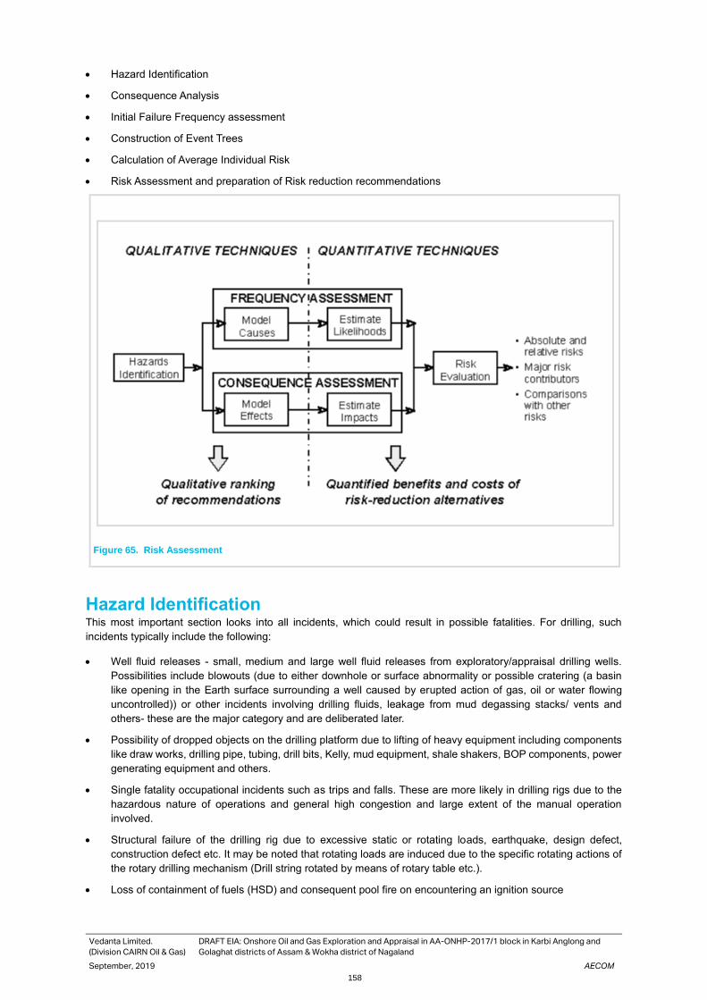
Vedanta Limited.
(Division CAIRN Oil & Gas)
DRAFT EIA: Onshore Oil and Gas Exploration and Appraisal in AA-ONHP-2017/1 block in Karbi Anglong and
Golaghat districts of Assam & Wokha district of Nagaland
September, 2019 AECOM
158
• Hazard Identification
• Consequence Analysis
• Initial Failure Frequency assessment
• Construction of Event Trees
• Calculation of Average Individual Risk
• Risk Assessment and preparation of Risk reduction recommendations
Figure 65. Risk Assessment
Hazard Identification This most important section looks into all incidents, which could result in possible fatalities. For drilling, such
incidents typically include the following:
• Well fluid releases - small, medium and large well fluid releases from exploratory/appraisal drilling wells.
Possibilities include blowouts (due to either downhole or surface abnormality or possible cratering (a basin
like opening in the Earth surface surrounding a well caused by erupted action of gas, oil or water flowing
uncontrolled)) or other incidents involving drilling fluids, leakage from mud degassing stacks/ vents and
others- these are the major category and are deliberated later.
• Possibility of dropped objects on the drilling platform due to lifting of heavy equipment including components
like draw works, drilling pipe, tubing, drill bits, Kelly, mud equipment, shale shakers, BOP components, power
generating equipment and others.
• Single fatality occupational incidents such as trips and falls. These are more likely in drilling rigs due to the
hazardous nature of operations and general high congestion and large extent of the manual operation
involved.
• Structural failure of the drilling rig due to excessive static or rotating loads, earthquake, design defect,
construction defect etc. It may be noted that rotating loads are induced due to the specific rotating actions of
the rotary drilling mechanism (Drill string rotated by means of rotary table etc.).
• Loss of containment of fuels (HSD) and consequent pool fire on encountering an ignition source
Vedanta Limited.
(Division CAIRN Oil & Gas)
DRAFT EIA: Onshore Oil and Gas Exploration and Appraisal in AA-ONHP-2017/1 block in Karbi Anglong and
Golaghat districts of Assam & Wokha district of Nagaland
September, 2019 AECOM
159
The HAZID would select the Scenarios for further modeling in the next sections. The HAZID is derived mainly from
incidents in Similar drilling installations based on worldwide experience and includes generic data sources.
Table 7.1 Identification the Accident Event in Oil Well Drilling Activity
Type of Hazardous Event Specific Accident Events included in QRA
Hydrocarbon Release Uncontrolled Blow out-medium, large, small
Release from diesel tanks- Catastrophic failure, medium and
small risks
Occupational accidents Single fatality accidents such as slips, trips, falls, dropped
objectives etc.
Structural failure Structural collapse of drilling rig due to static or rotating load,
fatigue, construction defect, design defect, earthquakes etc
Source: Cairn
Hydrocarbon Release The events of blowouts during drilling are divided in the databases according to the consequences and well control
success. Such blow outs can be ignited or un-ignited. Blow outs are uncontrolled sudden expulsions of oil, gas,
water or drilling fluids from wells to the surface which result in loss of control of the well.
Sources of hydrocarbon release during the drilling phase include the following:
• Dissolved gas which comes out of solution under reduced pressure often while drilling at near balance or
under balance hydrostatically or as trip gas during a round trip to pull the drill string around from the hole.
Such sources could include releases at bell nipple and around mud return flow line outlet, shale shakers and
active mud pits.
• As a “kick”, which occurs as the down hole formation pressure unexpectedly exceeds the hydrostatic head of
the circulating mud column. Significant releases can occur from the vent lines of the mud /gas separator and
other locations.
• From residual mud on the surface of the drill pipe being racked in the derrick during the round trip, or on
production of coil tubing being withdrawn from the hole, or from core samples laid out for inspection. Usually
any liquid hydrocarbon system entering the down hole under normal circumstances are very much diluted by
the mud system. However, under conditions of under balanced drilling, the proportion of hydrocarbons in mud
returns may be significant with a potential for continuous release.
• Small hydrocarbon release from rotating equipment, pipes and pump work occurring during normal
operations/ maintenance during drilling. These are not likely to be significant in open derrick or mast
structures.
• Possible shallow gas blowout – these may occur at sumps or drainage tanks and be conveyed by vents or
drains to areas of potential ignition sources resulting in fire/ explosion.
• Vapour present in oily drainage systems, vents, and ducting.
• Flammable materials used in drilling operations (oil based drilling fluids)- release points could include high
pressure mud points, mud degassing equipment, shale shaker, mud pits and active tanks etc.
Protection against Blowouts The primary protections against blow outs during drilling are the BOPs or Blow out Preventers. These are used to
shut in and control the well in the event of gas or oil being encountered at pressures higher than those exerted by
the column of mud in the hole.
BOPs typically consist of 2-3 ram preventers designed at high pressures- (ram preventer is basically a double
operated valve with one ram or gate on each side of the bore hole). The BOPs are hydraulically operated with a
second remote control panel situated someway away from the rig for use in emergencies when the rig is
unapproachable. Connected to the side of the ram type preventers (usually below the blind rams) are the kill and
choke lines which are used to control the well in the event of any imbalance between the drilling fluid column
pressure and the formation pressure. Both lines are high pressure 2-3 inch hydraulic pipes, the kill line being
connected to the mud circulation system and the high pressure cement pumps and the choke line leading to a back
pressure control Manifold and the mud degasser unit.
Vedanta Limited.
(Division CAIRN Oil & Gas)
DRAFT EIA: Onshore Oil and Gas Exploration and Appraisal in AA-ONHP-2017/1 block in Karbi Anglong and
Golaghat districts of Assam & Wokha district of Nagaland
September, 2019 AECOM
160
In the event of the high pressure kick with the drill string in the hole, the BOP is closed around the drill pipe and the
mud is circulated down the drill string and back to the mud tanks through the choke line and back pressure manifold.
The manifold consists of a series of valves and chokes - the choke can be adjusted to give the orifice opening
required such as to give a back pressure on the well in order to control it. There would be two chokes in order to
allow maintenance on one.
If a kick or blow out occurs with the drill string out of the hole, the blind rams are closed and heavy mud is pumped
into the well through the kill line. Any gas can be bled off through the choke line and fluids are usually squeezed
back into the formation.
The correct installation of the drilling equipment and the operational reliability of the BOPs are essential for the
safety of well drilling operation. In addition, initial and periodic testing of the BOPs, choke and kill manifolds, high
pressure/ heavy mud system etc. before installation and periodically is absolutely essential. Most important is the
presence of highly trained skilled personnel on the rig! In addition, the use of the correct drilling fluid in the
circulatory system is extremely vital.
• The drilling fluid basically does the following:
• To cool and lubricate the drilling bit and the drill string
• To remove drill solids and allowing the release at their surface.
• To form a gel to suspend the drill cuttings and any fluid material when the column is static
• To control sub surface pressures
• To prevent squeezing and caving if formations
• To plaster the sides of the borehole
• To minimize the damage to any potential production zone.
Pressures associated with the sub surface oil, gas or water can be controlled by increasing the specific gravity of
the fluid and thereby by reducing the hydrostatic head of the drilling fluid column. The squeezing of formations in
the drilled hole can be checked by increasing the hydrostatic head of the drilling fluid. Special additives for the
drilling fluid for controlling viscosity, lubricating properties, gelling properties etc. play an important role in the drilling
fluid integrity. Sealing agents such as cellulose, mica can also be added to make up the drilling fluid loss into the
porous and fractured formations.
The historical records show that the drilling of an exploration well has a higher chance of blow out occurring than
does drilling a development well. A blow out can be expected for about 400 exploration wells drilled. As a well takes
about 20-25 days to drill this equates to one blow out approximately every 50 years if drilling was continuous.
Historically, ignited blowouts have caused an average of three deaths per blow out.
Release of the other flammable material HSD is used in the mobile generators at the drill sites to cater to the power requirement of the drill equipment, area
lighting, etc. The material would be stored in 180 MT vertical cylindrical tank. Spill containment system in the form
of 1.2m high bund wall is envisaged to contain 110% of the tank volume. Storage of fuels would primarily pose fire
hazard. The credible accident scenarios include:
• Catastrophic tank rupture (Large Leak)
• Leak from a 4” pipeline (Medium Leak)
• A 2” leak from the tank/pipe/flange (Small Leak)
The catastrophic Rupture (CR) of the tank would involve a large leak/big hole in the tank or disengagement of a
joint/large leak from a flange sufficient enough to discharge tank inventory in a short time. The spilled material shall
get filled into the dyke area. In presence of an ignition source, it may catch fire and result in Pool fire of the dyke
area.
A 4” leak from a pipeline or a flange shall have similar consequences as to CR, only the time for loss of containment
may be more. Fire being a surface phenomenon, the pool fire in the dyke area would pose similar heat radiation to
the surrounding area.
A 2” leak from the tank or the pipeline would result in the loss of inventory at a much reduced rate. Counter-
measures shall be available to arrest the leak within reasonable time. With a limited loss of inventory, the damage
distances in such case would be less in comparison to the above two cases.

Vedanta Limited.
(Division CAIRN Oil & Gas)
DRAFT EIA: Onshore Oil and Gas Exploration and Appraisal in AA-ONHP-2017/1 block in Karbi Anglong and
Golaghat districts of Assam & Wokha district of Nagaland
September, 2019 AECOM
161
The tank design and construction takes into account the possible stress loads imposed due to exploration and
appraisal activities at the drill site. Dyke with adequate capacity (110%) is being provided to contain the spill, if any.
Standard well area inspection and maintenance procedures of Vedanta Limited (Division: Cairn Oil and Gas) shall
be implemented at the exploratory and appraisal wells to identify any abnormalities.
CONSEQUENCE ANALYSIS/CALCULATIONS Consequence analysis involves the calculation of the initial “release rate” and then predicting the consequence of
the release through computer modeling- it forms an important ingredient in the QRA approach. Consequence
analysis is a complex procedure involving numerous calculations. It must also be noted that a single starting
incident could have numerous outcomes depending upon factors such as escalation, ignition and others.
The various factors of importance in this drilling rig study with respect to consequence analysis are described
below.
Loss of Containment- leak sizes It must be understood that there are an infinite range of possible releases of flammable material on the facilities
For example, a hole could appear at any point in a well, at any time of the year and the hole could have any size
(right from pinhole to catastrophic line guillotine rupture) and also possibly any shape! In order to allow management
of the study, it is per force necessary to divide the infinite range into a number of smaller ranges through
representation as a single event or a failure case.
In the study, only small, medium and large well fluid blowouts were considered.
Hydrocarbon Leaks due to Loss of Containment (Leak during Well Testing) were not taken into consideration since
they are likely to be controlled about 95% of the time. The category includes releases that may be isolated from
the reservoir fluids, typically release from the well testing equipment and mud line.
Inventory Inventory can get discharged to Environment due to Loss of Containment. Inventory Analysis is commonly used in
understanding the relative hazards and short listing of release scenarios and plays an important role in regard to
the potential hazard. The larger the inventory of a vessel or a “system”, the larger the quantity of potential release.
The potential release depends upon the quantity of release, the properties of the materials and the operating
conditions (pressure, temperature etc. described later).
Blowouts A blowout on the topsides may take one of several forms and release locations. Any release not immediately ignited
would give a flammable vapour cloud, which could cause a vapour cloud explosion in the drill floor or the mud pit
areas.
A pressurized jet release could lead to a very large jet fire, producing high levels of thermal radiation. The flame
could impinge on structural members in the derrick. These could then fail as they lose their mechanical properties
at high temperature. This may lead to objects falling from the derrick and causing more damage below, especially
if the derrick has already been weakened by the blast from a vapour cloud explosion. If the fire continues for a long
period (say one to two hours) then the derrick may collapse causing serious damage to surrounding areas.
However, evacuation is expected to have occurred by any available means before this time.
This scenario is a worst-case scenario, which is unlikely to happen in this situation as the bottom hole pressure is
low.
Unburnt oil from a potential blowout would typically form running or evaporating pools, which could create a hazard
from heat and smoke in all areas that the pools reach. If the blow out originates on the drill floor then the burning
oil would run over the side of the drill floor.
Consequence Analysis for Blowouts Blowout release rate is taken as 0.12 kg/s assuming 5 times the normal rate from the well. It is expected that the
uncontrolled release of fluids on the drill floor would ignite almost immediately and that the resulting fire would
engulf the drill floor. Higher ignition probabilities are expected for large releases compared to smaller releases. The
flames are likely to impinge on structural members on the drill floor. These may fail as they lose their mechanical
properties at high temperature. This may lead to objects falling from the derrick and causing more damage below.
If the fire continues for a long period.

Vedanta Limited.
(Division CAIRN Oil & Gas)
DRAFT EIA: Onshore Oil and Gas Exploration and Appraisal in AA-ONHP-2017/1 block in Karbi Anglong and
Golaghat districts of Assam & Wokha district of Nagaland
September, 2019 AECOM
162
Weather Conditions The weather stability class is normally Class D on sunny days and Class F for Night time. The average wind speed
most of the time is 5 m/s for day time and 1.5 m/s. combining this with stability class D and F, consequence modeling
is done for both the weather cases 5 D and 1.5 F. The ambient condition considered in this study is as under:
Average Ambient Temperature = 24˚C
Average Humidity = 80 %
The six representative weather classes on which the analysis is based are detailed in Table 7.2.
Table 7.2 . Pasquill Stability Class
Surface Wind Speed (m/s)
Daytime Conditions Night Sky
Strength of Sunlight
Strong Moderate Slight Thin
Overcast ≥
4/8
Cloudiness**
≤3/8
Cloudiness
< 2 A A-B B E F
2-3 A-B B C E F
3-5 B B-C C D E
5-6 C C-D D D D
> 6 C D D D D
*Applicable to heavy overcast conditions day or night
**Degree of Cloudiness = Fraction of sky above horizon covered by clouds.
A- Extremely Unstable Conditions
B- Moderately Unstable Conditions
C- Slightly Unstable Conditions
D- Neutral Conditions*
E- Slightly Stable Conditions
F- Moderately Stable Conditions
In its original form, the Pasquill system contains seven categories (A to F) but joint categories are also common.
Categories A (Very Unstable), D (Neutral) and F (Very Stable) are discussed next.
Category A (very unstable) occurs typically on a warm sunny day with light winds and almost cloudless skies when
there is a strong solar heating of the ground and the air immediately above the surface. Bubbles of warm air rise
from the ground in thermals. The rate of change (decline) of temperature with height (lapse rate) is very high.
Category D (neutral) occurs in cloudy conditions or whenever there is a strong surface wind to cause vigorous
mechanical mixing of the lower atmosphere.
Category F (very stable) occurs typically on a clear, calm night when there is a strong cooling of the ground and
the lowest layers of the atmosphere by long wave radiation. There is a strong inversion of temperature (i.e. warm
air over cold air).
Table 7.3 Representative Weather Class 5D and 1.F
Weather Class Wind Speed(m/s) Pasquill Stability
I 3 B
II 1.5 D
III 5 D (used for modeling)
IV 9 D
V 5 E
VI 1.5 F (used for Modeling)

Vedanta Limited.
(Division CAIRN Oil & Gas)
DRAFT EIA: Onshore Oil and Gas Exploration and Appraisal in AA-ONHP-2017/1 block in Karbi Anglong and
Golaghat districts of Assam & Wokha district of Nagaland
September, 2019 AECOM
163
Source: Handbook of Chemical Hazard Analysis Procedure by FEMA, USEPA and USDOT
Damage Criteria Jet Fire
The consequence caused by exposure to heat radiation is a function of:
• The radiation energy onto the human body [kW/m2];
• The exposure duration [sec];
• The protection of the skin tissue (clothed or naked body).
It can be assumed that people would be able to find a cover or a shield against thermal radiation in 20 seconds
time. Furthermore, 100% lethality may be assumed for all people suffering from direct contact with flames, such
as the pool fire, a flash fire or a jet flame. The effects due to relatively lesser incident radiation intensity are given
below.
In the study, the following criteria were used for estimation of heat radiation due to fire fatalities:
Heat Radiation Selection Criteria:
• 4.73 kW/m2: Maximum radiant heat intensity in areas where emergency actions lasting 2 min to 3 min can
be required by personnel without shielding but with appropriate clothing. Corresponds to of painful burns
and blistering after 20 second exposure (0% lethality)
• 6.31 kW/m2: Indicative of second degree burns after 20 second exposure (1% fatality)
• 12.5 kW/m2: Indicative of piloted ignition for susceptible structures (50% fatality)
• 37.5 kW/m2: Indicative of total asset loss (100% fatality
Flash Fire Selection Criteria:
The consequence distances would be identified for the following Lower Explosive Limit:
• 50 % Lower Explosive Limit
• 100 % Lower Explosive Limit
Toxic Gas Dispersion Criteria:
No Toxic gas dispersion scenarios envisaged for this project.
Explosion Criteria:
Blast peak overpressure from explosion for buildings would not exceed the following levels provided in Table 7.4.
Internationally recognized and globally accepted TNO Multi energy model was used for the explosion modeling
for this Project.
Table 7.4 Overpressure Criteria
Level of Concern TYPE OF DAMAGE
0.02068 bar "Safe distance" (probability 0.95 of no serious damage1
below this value); projectile limit; some damage to house
ceilings; 10% window glass broken.
0.070 bar General buildings, offices
0.1379 bar Partial collapse of wells, concreate Block wells, not
reinforced, shattered
0.2068 bar
1 bar Range for 1-99% fatalities among exposed population due to
direct blast effects
Source: Report Number : 434 International Association of Oil & Gas Producers (OGP)- March 2010- Table 2.8 and PHL-S-100

Vedanta Limited.
(Division CAIRN Oil & Gas)
DRAFT EIA: Onshore Oil and Gas Exploration and Appraisal in AA-ONHP-2017/1 block in Karbi Anglong and
Golaghat districts of Assam & Wokha district of Nagaland
September, 2019 AECOM
164
Failure Frequency Analysis Selection of Failure Scenarios
Potential release rates for a material from containment depend significantly on the initial operating conditions.
Factors affecting the “release rate” include the initial pressure, temperature, hole size, hole roughness, hole
orientation, gas properties, atmospheric conditions and many other parameters.
Both, the complexity of study and the number of incident outcome cases are affected by the range of initiating
events and incidents covered. This not only reflects the inclusion of accidents and / or non-accident-initiated events,
but also the size of those events. The following four scenarios have been quantitatively evaluated in the study:
• Small and medium size holes - these typically represent failures such as gasket leaks, flange leaks etc. This
scenario has been considered as 2” leak for HSD
• Medium leaks – these typically represent disengagement of flanges, full bore failure of pipelines, large leaks
from flanged joints, etc. This scenario has been considered as a 4” leak of HSD.
• Large holes– these typically represent “catastrophic” or “guillotine” rupture scenarios, possibly on account of
factors such as soil inundation, earthquakes etc. This scenario has been considered as a Catastrophic Failure
of HSD Tank.
• Well Blow out case. This has been considered as Well Blow out scenario involving crude oil
The selection of initiating events and incidents would take into account the goals or objectives of the study. The
main reasons for including release sizes other than the catastrophic are to reduce the conservatism in an analysis
and to better understand the relative contributions to risk of small versus large releases. Only leakage events
leading to possibility of serious injury are considered in the study.
Calculation of Individual & Societal Risk Individual Risk or IR represents the geographical distribution of risk to any individual.
Societal Risk is representing the risk the project poses to society as a whole. The Societal Risk or Group risk (F-
N) curves indicate the cumulative frequency (F) of (N) number of fatalities. Society is typically not woulding to
accept industrial installations that result in many fatalities, even with a low frequency rate!
The estimation of risks in the software is done through estimation of “risks” attributed to each failure case by
determining the impact in terms of fatalities. In this step, the hazard or effect zone information, ignition source,
population distribution, meteorological data and other relevant details are combined to determine risks.
In order to estimate risks (IR or SR), the number of fatalities for each incident outcome case is calculated and the
frequencies of outcomes with equal fatalities summed up.
Comparison to Risk Acceptance Criteria This penultimate step compares the estimated risk with respect to the Company’s internal risk acceptability criteria
or specific legislative or regulatory (as applicable in the country of operation) risk acceptability criteria. In this step,
the risk “band” is determined- typically, the project risk band is determined to be negligible, acceptable, not
acceptable are the risk assessment stage determines whether the risks are “Broadly Acceptable”, “Intolerable” or
“Tolerable if ALARP”.
Vedanta Limited (Division: Cairn Oil & Gas) Risk Acceptability Criteria
Vedanta Limited (Division Cairn Oil & Gas) risk acceptability criteria are derived from interpretation of the risk
acceptability criteria published by UK HSE-92 and is applied when assessing the tolerability of risk to persons for
Vedanta Limited (Division Cairn Oil & Gas) facilities, sites, combined operations or activities. It broadly indicates
as follows:
• Individual risk to any worker above 10-3 per annum shall be considered intolerable and fundamental risk
reduction improvements are required.
• Individual risk below 10-3 for but above 10-6 per annum for any worker shall be considered tolerable if it can
be demonstrated that the risks are As Low As Reasonably Practicable (ALARP).
• Individual risk below 10-6 per annum for any worker shall be considered as broadly acceptable and no further
improvements are considered necessary provided documented control measures are in place and
maintained.

Vedanta Limited.
(Division CAIRN Oil & Gas)
DRAFT EIA: Onshore Oil and Gas Exploration and Appraisal in AA-ONHP-2017/1 block in Karbi Anglong and
Golaghat districts of Assam & Wokha district of Nagaland
September, 2019 AECOM
165
• Individual risk to any member of the general public as a result of Vedanta Limited (Division Cairn Oil & Gas)
Businesses activities shall be considered as intolerable if greater than10-4 per annum, broadly acceptable if
less than 10-6 per annum and shall be reduced to As Low As Reasonably Practicable (ALARP) between these
limits.
• For new facilities, Vedanta Limited (Division Cairn Oil & Gas) shall strive to achieve lower risks compared with
that typical for existing facilities, down at least to an individual risk to any worker of 10-4 per annum, by the
appropriate use of best practice including technology and management techniques.
• For existing facilities, higher risk levels may be tolerated provided that they are As Low As Reasonably
Practicable (ALARP) and meet the minimum standards given herein. As facilities under Vedanta Limited
(Division Cairn Oil & Gas) expansion may be considered as “new” facilities; it is proposed that individual risk
to any worker above 10-4 per annum shall be considered intolerable.
The risk acceptability criteria are indicated in the following pages.
Figure 66. UK HSE-Individual Risk Criteria

Vedanta Limited.
(Division CAIRN Oil & Gas)
DRAFT EIA: Onshore Oil and Gas Exploration and Appraisal in AA-ONHP-2017/1 block in Karbi Anglong and
Golaghat districts of Assam & Wokha district of Nagaland
September, 2019 AECOM
166
Figure 67. UK HSE-Offsite Group Risk Criteria
ALARP Demonstration Wherever risks are found to lie in the ALARP region, this suggests existing risk mitigating measures must be
sustained and Best Industry Practices used. Any specific new risk reduction options may be evaluated through
Cost Benefit Analysis (CBA).
Risk Reduction Recommendations This step analyses the risks estimated, their tolerability with respect to the risk acceptability criteria.
In case risks are found to fall in the “Unacceptable” region, risk reduction recommendations aimed at bringing risks
to within the “Tolerable region if ALARP” are proposed. In such conditions, the Cost Benefit Analysis (CBA) is also
carried out for specific risk reduction measures in order to “quantify” them or any other mitigative measures shall
be recommended.
In case risks have been found to be the ALARP or Broadly Acceptable region, recommendations may still be
suggested for generic risk reduction based on industry best practice. Such risk reduction recommendations are not
“quantified” or mandatory but are nevertheless proposed for safer operation of the facilities.

Vedanta Limited.
(Division CAIRN Oil & Gas)
DRAFT EIA: Onshore Oil and Gas Exploration and Appraisal in AA-ONHP-2017/1 block in Karbi Anglong and
Golaghat districts of Assam & Wokha district of Nagaland
September, 2019 AECOM
167
Software Used The Software, DNV PHAST was used for the study for assessing the Risk and Consequence calculations.
Population Table 7.5 Population
S. No Area Population (Day) Population (Night)
1 Process Area (Heater Treater, Fuel Gas, Coalesing
Fiilter etc.)
25 25
2 Process Area (Oil Storage Area, Instrument Air etc.) 5 5
3 Loading, Unloading Area 2 2
4 Operator Bunker 2 2
5 Diesel Storage Area 2 2
6 Waster Area (Water, SBM etc.) 15 15
7 Toilet Block 2 2
8 Drilling/ Well Area 50 50
Hazard Identification (HAZID), Consequence Analysis and Risk
Results for the Project Hazard Identification is a very important and critical first step in the QRA process. The HAZID identifies process
and non-process hazards affecting the project execution and operational stage. The main objective of the HAZID
is to identify potential major accident events- it is important to ensure scenarios identified in the HAZID are factored
into the QRA.
Shortlisting of Release Scenarios The range of incidents possible in the facility is established through identification of “Isolatable sections”, from
which the different categories of leakages/ releases may occur. The Isolatable Sections comprise those where
Emergency Shutdown Valves are in place isolating the section, even in emergency. Assumption Meeting for the
purpose of identifying such sections and estimating inventories, release rates and other details relevant to the
quantitative analysis. Guideline was utilized for deriving failure scenarios, release rates, inventories etc. Isolatable
Sections are identified as follows:
• The initial step is the identification of sources and their physical location
• Calculation of the hold-up volumes within isolatable sections with respect to fluid within equipment and
associated piping.
The process isolation times, inventory release times etc. for the various leak sizes considered were taken at 5
minutes for small leaks (5 mm), 3 minutes for minor leaks (25 mm)- safe distance can be used for layout purpose
2 minutes for large leaks and 1 minute for catastrophic rupture.
Appendix 7.1 shown provides information on leak sizes, inventories and hazardous chemicals within the isolatable
sections.
Consequence Analysis Results Events originating from within the facility may, depending upon the nature and quantity of hazardous chemical and
the location of accident have the potential of affecting personnel within the installation or at times the general
population in the surrounding area.

Vedanta Limited.
(Division CAIRN Oil & Gas)
DRAFT EIA: Onshore Oil and Gas Exploration and Appraisal in AA-ONHP-2017/1 block in Karbi Anglong and
Golaghat districts of Assam & Wokha district of Nagaland
September, 2019 AECOM
168
Table 7.6 : Pool Fire Results
Jet fire
SECTION LEAK SIZE Weather Class
Incident Heat Radiation (KW/m2)
4.73 6.31 12.5 37.5
Distance in Meter (m)
IS-01 - From Well Fluid from Well to Inlet of Heater Separator
5mm DAY TIME (5/D) 19 18.5 17.4 -
NIGHT TIME (1.5/F) 18.5 17 13.5 -
25mm DAY TIME (5/D) 79 76 71 65
NIGHT TIME (1.5/F) 88 80 65 47
100mm DAY TIME (5/D) 282 270 243 218
NIGHT TIME (1.5/F) 310 232 222 160
CR DAY TIME (5/D) 545 505 455 395
NIGHT TIME (1.5/F) 590 530 415 308
IS-02 Heater Treater Separator – Oil Case 5mm
DAY TIME (5/D) - - - -
NIGHT TIME (1.5/F) - - - -
25mm DAY TIME (5/D) 37 36.5 36 26
NIGHT TIME (1.5/F) 25 24.8 23 11
100 mm DAY TIME (5/D) 96 93 89 83
NIGHT TIME (1.5/F) 72 69 65 59
CR DAY TIME (5/D) 150 145 135 120
NIGHT TIME (1.5/F) 112 110 98 86
IS-03 Heater Treater Separator – Gas Case 5mm
DAY TIME (5/D) - - - -
NIGHT TIME (1.5/F) - - - -
25mm DAY TIME (5/D) - - - -
NIGHT TIME (1.5/F) - - - -
100mm DAY TIME (5/D) 22.1 21.1 17.9 -
NIGHT TIME (1.5/F) 20.4 18.4 14.3 -
CR DAY TIME (5/D) 42 41.2 39 35.2
NIGHT TIME (1.5/F) 38.8 36.2 28.9 13.8
IS-04 Oil from Heater Treater Separator to inlet of Oil Storage Tanks including coaleser separator
5mm DAY TIME (5/D) - - - -
NIGHT TIME (1.5/F) - - - -
25mm DAY TIME (5/D) 32.8 32 31 -
NIGHT TIME (1.5/F) 24.2 23.5 22.5 20.5
100mm DAY TIME (5/D) 95 93 88 83
NIGHT TIME (1.5/F) 70 67 63 58
CR DAY TIME (5/D) 110 107 102 97
NIGHT TIME (1.5/F) 85 81.5 76.5 71
IS-05- From XSV of tank inlet to pump inlet including oil storage tank
5mm DAY TIME (5/D) - - - -
NIGHT TIME (1.5/F) - - - -
25mm DAY TIME (5/D) 30.6 32 30.6 28.4
NIGHT TIME (1.5/F) 23 22 - -
50mm DAY TIME (5/D) 50 49.5 47 43.2
NIGHT TIME (1.5/F) 38 37 35 31.2
CR DAY TIME (5/D) 103 100 96 90

Vedanta Limited.
(Division CAIRN Oil & Gas)
DRAFT EIA: Onshore Oil and Gas Exploration and Appraisal in AA-ONHP-2017/1 block in Karbi Anglong and
Golaghat districts of Assam & Wokha district of Nagaland
September, 2019 AECOM
169
Jet fire
SECTION LEAK SIZE Weather Class
Incident Heat Radiation (KW/m2)
4.73 6.31 12.5 37.5
Distance in Meter (m)
NIGHT TIME (1.5/F) 78 74 70 64
IS-06 From Oil Transfer pump outlet to tanker loading Facility
5mm DAY TIME (5/D) - - - -
NIGHT TIME (1.5/F) - - - -
25mm DAY TIME (5/D) 60 58 55 52
NIGHT TIME (1.5/F) 39.2 37.5 33 23.5
100mm DAY TIME (5/D) 135 132 124 116
NIGHT TIME (1.5/F) 112 107 92 78
IS-07 Tanker Failure CR
DAY TIME (5/D) 60 58 56 55
NIGHT TIME (1.5/F) 46 45 43 41
IS-08 Diesel Storage Tank 5mm
DAY TIME (5/D) - - - -
NIGHT TIME (1.5/F) - - - -
25mm DAY TIME (5/D) - - - -
NIGHT TIME (1.5/F) - - - -
50mm DAY TIME (5/D) 15.7 - - -
NIGHT TIME (1.5/F) - - - -
CR DAY TIME (5/D) 24.3 23.3 - -
NIGHT TIME (1.5/F) 16.2 14.4 - -
IS-09 Fuel Gas System 5mm
DAY TIME (5/D) - - - -
NIGHT TIME (1.5/F) - - - -
25mm DAY TIME (5/D) - - - -
NIGHT TIME (1.5/F) - - - -
100mm DAY TIME (5/D) 22.1 21 17.7 -
NIGHT TIME (1.5/F) 20.4 18.4 14.3 -
CR DAY TIME (5/D) 42.8 41.2 39.1 36.2
NIGHT TIME (1.5/F) 38.9 35.2 29 13.8
IS-10-Flare System 5mm
DAY TIME (5/D) - - - -
NIGHT TIME (1.5/F) - - - -
25mm DAY TIME (5/D) - - - -
NIGHT TIME (1.5/F) - - - -
100mm DAY TIME (5/D) 14.6 - - -
NIGHT TIME (1.5/F) 13.8 12.1 - -
CR DAY TIME (5/D) 31 30.2 28.5 -
NIGHT TIME (1.5/F) 29 26.5 21 -
Table 7.7 Flash Fire Result
FLASH FIRE
Section Leak Size Level of Concern Weather Class
(5/D) (1.5/F)
IS-1 - From Well Fluid from Well to Inlet of
5mm 50% LEL-5102 ppm 12.2 25
100 % LEL- 1.02e+004ppm 8.5 11
25 mm 50% LEL-5102 ppm 145 259

Vedanta Limited.
(Division CAIRN Oil & Gas)
DRAFT EIA: Onshore Oil and Gas Exploration and Appraisal in AA-ONHP-2017/1 block in Karbi Anglong and
Golaghat districts of Assam & Wokha district of Nagaland
September, 2019 AECOM
170
FLASH FIRE
Section Leak Size Level of Concern Weather Class
(5/D) (1.5/F)
Heater Separator
100 % LEL- 1.02e+004ppm 88 100
100 mm 50% LEL-5102 ppm 400 420
100 % LEL- 1.02e+004ppm 320 320
CR 50% LEL-5102 ppm 475 478
100 % LEL- 1.02e+004ppm 390 380
IS-2 - Heater Treater Separator – Oil Case
5mm 50% LEL-3123 ppm 6.5 6.5
100 % LEL- 6245 ppm 5 6.4
25 mm 50% LEL-3123 ppm 20 26
100% LEL- 6245 ppm 19 14
100 mm 50% LEL-3123 ppm 70 65
100 % LEL- 6245 ppm 40 42
CR 50% LEL-3123 ppm 102 90
100 % LEL- 6245 ppm 68 60
IS-03- Heater Treater Separator – Gas Case
5mm 50% LEL-1.769e+004 ppm 1.25 1.72
100% LEL- 3.538e+004 ppm 0.82 0.98
25 mm 50% LEL-1.769e+004 ppm 4.8 6.9
100% LEL- 3.538e+004 ppm 3.3 4.4
100mm 50% LEL-1.769e+004 ppm 14.5 22.2
100% LEL- 3.538e+004 ppm 10 14.4
CR 50% LEL-1.769e+004 ppm 29 43
100% LEL- 3.538e+004 ppm 17.5 27.5
IS-04 - Oil from Heater Treater Separator to inlet of Oil Storage Tanks including coaleser separator
5mm 50% LEL-3123 ppm 6.3 6.6
100 % LEL- 6245 ppm 5 6.4
25 mm 50% LEL-3123 ppm 14 23.9
100% LEL- 6245 ppm 13.9 12.2
100mm 50% LEL-3123 ppm 58 55
100 % LEL- 6245 ppm 27 31
CR 50% LEL-3123 ppm 73 64
100 % LEL- 6245 ppm 44 44
IS-05 - From XSV of tank inlet to pump inlet including Oil Storage Tank
5mm 50% LEL-3123 ppm 7 7.6
100 % LEL- 6245 ppm 5.3 6.9
25 mm 50% LEL-3123 ppm 15.2 21
100 % LEL- 6245 ppm 15 12.3
50 mm 50% LEL-3123 ppm 35 44
100 % LEL- 6245 ppm 15 25.8
CR 50% LEL-3123 ppm 70 64
100% LEL- 6245 ppm 43 46
IS-06 - From Oil Transfer pump outlet to tanker loading Facility
5mm 50% LEL-3123 ppm 9.5 13.2
100% LEL- 6245 ppm 7.2 9.5
25 mm 50% LEL-3123 ppm 58 35
100% LEL- 6245 ppm 44 34.5
100 mm 50% LEL-3123 ppm 73 75
100% LEL- 6245 ppm 71 58
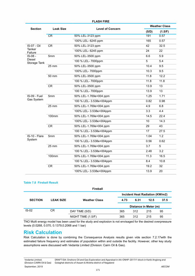
Vedanta Limited.
(Division CAIRN Oil & Gas)
DRAFT EIA: Onshore Oil and Gas Exploration and Appraisal in AA-ONHP-2017/1 block in Karbi Anglong and
Golaghat districts of Assam & Wokha district of Nagaland
September, 2019 AECOM
171
FLASH FIRE
Section Leak Size Level of Concern Weather Class
(5/D) (1.5/F)
CR 50% LEL-3123 ppm 191 0.57
100% LEL- 6245 ppm 165 0.57
IS-07 - Oil Tanker Failure
CR 50% LEL-3123 ppm 42 32.5
100% LEL- 6245 ppm 24 22
IS-08 - Diesel Storage Tank
5mm 50% LEL-3500 ppm 6.6 5.9
100 % LEL- 7000ppm 5 5.4
25 mm 50% LEL-3500 ppm 10.4 9.5
100% LEL- 7000ppm 10.3 9.5
50 mm 50% LEL-3500 ppm 11.8 12.2
100 % LEL- 7000ppm 11.8 11.8
CR 50% LEL-3500 ppm 13.9 13
100 % LEL- 7000ppm 13.9 13
IS-09 - Fuel Gas System
5mm 50% LEL-1.769e+004 ppm 1.25 1.71
100 % LEL- 3.538e+004ppm 0.82 0.98
25 mm 50% LEL-1.769e+004 ppm 4.9 6.8
100% LEL- 3.538e+004ppm 3.3 4.4
100mm 50% LEL-1.769e+004 ppm 14.5 22.4
100% LEL- 3.538e+004ppm 10 14.3
CR 50% LEL-1.769e+004 ppm 29 43
100 % LEL- 3.538e+004ppm 17 27.5
IS-10 - Flare System
5mm 50% LEL-1.769e+004 ppm 1.04 1.2
100 % LEL- 3.538e+004ppm 0.56 0.62
25 mm 50% LEL-1.769e+004 ppm 3.7 5
100 % LEL- 3.538e+004ppm 2.48 3.2
100mm 50% LEL-1.769e+004 ppm 11.3 16.5
100 % LEL- 3.538e+004ppm 8.4 10.8
CR 50% LEL-1.769e+004 ppm 19.2 32
100% LEL- 3.538e+004ppm 13.9 20
Table 7.8 Fireball Result
Fireball
SECTION LEAK SIZE Weather Class
Incident Heat Radiation (KW/m2)
4.73 6.31 12.5 37.5
Distance in Meter (m)
IS-02 CR DAY TIME (5/D) 365 312 215 95
NIGHT TIME (1.5/F) 365 312 215 95
TNO Multi energy model has been used for the study and explosion is not envisaged for the desired overpressure
levels (0.0268, 0.070, 0.1379,0.2068 and 1 bar)
Risk Calculation Risk Calculation is done by combining the Consequence Analysis results given vide section 7.2.17with the
estimated failure frequency and estimates of population within and outside the facility. However, other key study
assumptions were discussed with Vedanta Limited (Division: Cairn Oil & Gas).

Vedanta Limited.
(Division CAIRN Oil & Gas)
DRAFT EIA: Onshore Oil and Gas Exploration and Appraisal in AA-ONHP-2017/1 block in Karbi Anglong and
Golaghat districts of Assam & Wokha district of Nagaland
September, 2019 AECOM
172
Population The following plant population has been assumed for the study: -
Table 7.9. Population
S. No Area Population (Day) Population (Night)
1 Process Area (Heater Treater, Fuel Gas, Coalesing
Fiilter etc.)
25 25
2 Process Area (Oil Storage Area, Instrument Area
etc.)
5 5
3 Loading, Unloading Area 2 2
4 Operator Bunker 2 2
5 Diesel Storage Area 2 2
6 Waster Area (Water, SBM etc.) 15 15
7 Toilet Block 2 2
8 Drilling/ Well Area 50 50
FN Curve The FN Curve drawn for this project is presented Figure 66. The FN Curve represents combined risk (during 5/D
and 1.5 F) covering all the identified scenarios.
Figure 68. FN Curve
From the above F-N Curve, it may be seen that the maximum line starts at 1E-02 and 1E-04 and it is observed that
the integrated risks lie within the 1E-02 and 1E-04, Hence the risk is in “ALARP” range. -this suggests that existing
risk mitigating measures must be sustained and other Best Industry Practices shall be used. Any specific new risk
reduction options may be evaluated through Cost Benefit Analysis (CBA) or any other suitable means.
Location Specific Individual Risk (LSIR) LSIR is the risk for a hypothetical individual who is positioned at that location for 24 hours a day 365 days per year.
Since in reality people do not remain continuously at one location, LSIR is a notional risk measure.
From the Figure 69 (combined during 5/D and 1.5 F) it can be seen that the maximum risk level lies in the band of
1E-003 /Avge year (within the fence) and 1E-004 /Avge year –this risk band extends towards the west for a distance
of approx. 20 meters from the plot boundary. It may be noted that this risk level is on the higher side for public

Vedanta Limited.
(Division CAIRN Oil & Gas)
DRAFT EIA: Onshore Oil and Gas Exploration and Appraisal in AA-ONHP-2017/1 block in Karbi Anglong and
Golaghat districts of Assam & Wokha district of Nagaland
September, 2019 AECOM
173
areas (normally acceptable risk level is 1E-006/Avge year). It is suggested that either heater treater unit, Coalescing
filter skid and Fuel gas unit may be shifted 20 meters towards east to prevent any outside risk or to ensure there
are no vegetating in this area.
Figure 69. Overall ISO Risk Contour
Individual Specific Individual Risk (ISIR) The Location Specific Individual Risk is the risk to a person who is assumed to be at the specific location 365 days
a year and 24 hours a day. A more representative risk measure is the “Individual Specific Individual Risk (ISIR).
This is the risk estimated accounting for the time fraction a person actually spent at a specific location. The
calculation for this is done based on the consideration of Personnel working. An average working period of 12 hours
per day are considered and the results are presented Table 7.10 and Table 7.11.
• ISIR= LSIR×1/2×1/2×Time Spent/12
Table 7.10 Total ISIR Operations/Maintenance Staff
S. No Area LSIR Time Spent in hrs ISIR
1 Coaleser Area 2.12E-03 6 2.65E-04
2 Control Room 1.14E-03 9 2.14E-04
3 DG Area 7.12E-04 1 1.48E-05
4 Diesel Area 3.87E-04 3 2.42E-05
5 Flare Area 1.12E-04 0.5 1.17E-06
6 Heater Treater Area 5.64E-03 6 7.05E-04
7 Loading Area 1.99E-05 2 8.28E-07
8 Oil Storage Area 6.71E-04 5 6.99E-05
9 Well Area 5.86E-03 4 4.88E-04
10 Fuel Gas Area 2.02E-03 5 2.10E-04
Total 3.44E-06
Table 7.11 Total ISIR Non-Operation/ Maintenance Staff
S. No Area LSIR Time Spent in hrs ISIR
1 Fire Water Area 1.29E-08 2 5.38E-10
2 Toilet Block 1.29E-08 1 2.69E-10
3 Security Cabin 1.00E-07 10 2.08E-08
4 Operator Block 1.00E-07 4 8.33E-09
Total 3.00E-08

Vedanta Limited.
(Division CAIRN Oil & Gas)
DRAFT EIA: Onshore Oil and Gas Exploration and Appraisal in AA-ONHP-2017/1 block in Karbi Anglong and
Golaghat districts of Assam & Wokha district of Nagaland
September, 2019 AECOM
174
From the above values it is seen that the operation/maintenance ISIR value is in ALARP range for operation person
and broadly acceptable for Non-operation. The following measures are available to address the same.
▪ Safeguarding of human life is Vedanta Limited (Division: Cairn Oil & Gas) top most priority. To this effect,
Vedanta Limited (Division Cairn Oil & Gas) has issued and implemented a comprehensive HSE POLICY
backed up with appropriate safety management systems and procedures.
▪ Vedanta Limited (Division Cairn Oil & Gas) operating procedures lay a strong focus on hazard identification
and risk assessment covering each and every hazardous operation, procedure and equipment. Risks and
mitigating measures for each are clearly carried out and measures implemented and monitored. This
ensures risk minimisation to the worker group.
▪ The facility is built based on the highest international standards and global best practice. Individual
equipment is of highest quality, certified and of highest safety integrity. This ensures risk minimisation to
the worker group through operational and maintenance periods. In addition, equipment hazard
identification has to be carried out for each of the equipment time to time.
▪ Mock drills would be carried out periodically to ensure the highest state of emergency response in case
of any incident.
Risk Reduction Measures The main conclusions drawn from the Consequence Analysis and Risk calculations are given below- critical
actions for safeguarding against the incidents are also mentioned below: -
• From the F-N Curve, it is observed that the integrated risks lie within the “ALARP” range. -this suggests
existing risk mitigating measures must be sustained and Best Industry Practices be used. Any specific new
risk reduction options may be evaluated through Cost Benefit Analysis (CBA).
• From the figure 43 to figure 47 it can be seen that the maximum risk level lies in the band of 1E-003 /Avge
year (within the fence) and 1E-004 /Avge year –this risk band extends towards the west for a distance of
approx. 20 meters from the plot boundary. It may be noted that this risk level is on the higher side for public
areas (normally acceptable risk level is 1E-006/Avge year). It is suggested that either heater treater unit,
Coalescing filter skid and Fuel gas unit may be shifted 20 meters towards east to prevent any outside risk or
to ensure there are no vegetating in this area.
• It is seen that the control room is falls under 1E-03 /Avge year it advised to shift the Control room to a safe
location.
• Living area are likely to be affected due to large incidents on the Rig Floor, it is essential to ensure the upkeep
of the safety devices (Smoke Detection, Fast Rescue Craft (FRC), escape routes and it must be ensured that
Mock evacuation drills are carried out periodically.
• Escape routes for personnel on the Drill Floor towards the LQ must be properly protected and kept free of
any debris/obstructions etc. to ensure minimum loss of life.
• The correct installation of Safety Critical Equipment and their operational reliability are essential for the safety
of the facility. In addition, initial and periodic testing of the Safety Critical Equipment before installation and
periodically is absolutely essential and the same must be ensured.
• Storage tank enclosures must be drained periodically during the rainy season in particular.
• As hydrocarbon related risks exist at the facility, ignition source control must be ensured during routine and
non routine operations.
• Ensuring that the public in vicinity of the facility is made aware of the hazards and also the hazards of
unplanned and irregular third-party activities- this may be done through frequent safety awareness
programmes, warning signage, explicit display of Do’s and Don’ts etc.
• Emergency Response Drills must be carried out frequently both internally within Vedanta Limited (Division
Cairn Oil & Gas) and also involving external authorities. Lessons learnt must be assimilated and disseminated
to concerned persons.
• The correct installation of the Safety Critical Equipment and their operational reliability are essential for the
safety of the facility. In addition, initial and periodic testing of the Safety Critical Equipment before installation
and periodically is essential and the same must be ensured.
Vedanta Limited.
(Division CAIRN Oil & Gas)
DRAFT EIA: Onshore Oil and Gas Exploration and Appraisal in AA-ONHP-2017/1 block in Karbi Anglong and
Golaghat districts of Assam & Wokha district of Nagaland
September, 2019 AECOM
175
• For Jetfire scenarios for small leaks may be safeguarded against through proper fire protection means (Fire
and gas Detectors, Passive and Active firefighting systems. Proper firefighting system design and
implementation and fire drills, training etc. are essential and must be sustained through the project life cycle.
• The damage distance arises due to the Flash Fire mitigated by ensuring the that the area must be kept free
of ignition sources to the extent possible and the same must be ensured even during maintenance activity.
Non-sparking tools must be used and personnel entering the area must be “de-earthed” before entering. A
hazardous area classification study is suggested for placement of electrical equipment in the classified area.
• The damage distance for pool fire arising due the pool fire for small leaks shall be safeguarded against through
proper fire protection means.
• The Fireball result is provided for Catastrophic rupture case of IS-02.
• Key non-routine activities must be preceded by a Job Safety Analysis and Job or Task Risk Assessment
involving key personnel that would be working on the facility.
• Work Permit System must be implemented during the construction and operational phases of the project to
safeguard against any accidents. It must subsequently also cover the operational phase.
• Trips and falls hazard, electrical hazards etc. must be minimized through periodic safety audits and site
inspections using third party and Internal audit teams. Actions arising out of the audits must be implemented
in a time bound manner and followed up for closure.
• Vedanta Limited (Division Cairn Oil & Gas) must ensure suitable training to all personnel (Company as well
as Contractor personnel) to help prevent incidents/ accidents- such training must be refreshed periodically,
and a list of trained personnel must be maintained by Vedanta Limited (Division Cairn Oil & Gas)
• the facility and connected equipment/ systems must be ensured to minimize failure potential.
• As ignition related risks exist at the facility, ignition source control must be ensured during routine and non-
routine operations.
• Apart from the process risks assessed, another very important category of incidents possible are those
associated with well operations. These risks could include uncontrolled blowouts, incidents associated with
rig movement/rig walk, wireline risks during wireline operations, well bore clean out risks, risks associated
with specific chemicals during drilling/well repair/ activation/other activities.
• On-site personnel are subject to standard occupational risks and Vedanta Limited (Division Cairn Oil & Gas)
must direct effort and resources into reducing these risks. Incidents connected with well operations, dropped
objects, personnel falls from height, electrocution incidents etc. are top priorities which Vedanta Limited
(Division Cairn Oil & Gas) would concentrate significant effort to prevent, prepare for and respond to. This
must be implemented through the Vedanta Limited (Division Cairn Oil & Gas) HSE Management System.
• HAZOP to be done once design is reasonably complete and before start up. In addition, a basic safeguarding
must be in place during the testing/early production phase- well shut/ surface facilities basic shut down must
be possible. A basic functioning F&G system too must be put in place with well shut down incase of F&G
activation. Initial phase well behavior could be unpredictable and necessary safeguarding must be in place-
essentially, the EPS must be equipped with basic shutdown facilities, typically “fit for purpose”. It is also
necessary that initial well operations are manned continuously- this of course, would be the case, since data
logging/monitoring would also be taking place.
• Storage Tank vents to be routed at safe height and location to acvoid toxic/sudden vapour egress with
toxic/flammable hazard.
• Heater Treater BMS to be checked thoroughly before being put on line and necessary leak and performance
tests to be ensured properly. Burner light up sequences would be properly established and necessary site
verification tests etc. carried out
• Choke internals to be of suitable anti abrasive material-= this would be able to cater to possible sanding
issues, well debris etc.
• Specific procedures to address sanding operations/ sand flushout must be in place.
• It must be ensured that Storage Tanks and Road Tankers are NOT overfilled (not more than 80%)- set points/
SOP to capture the same
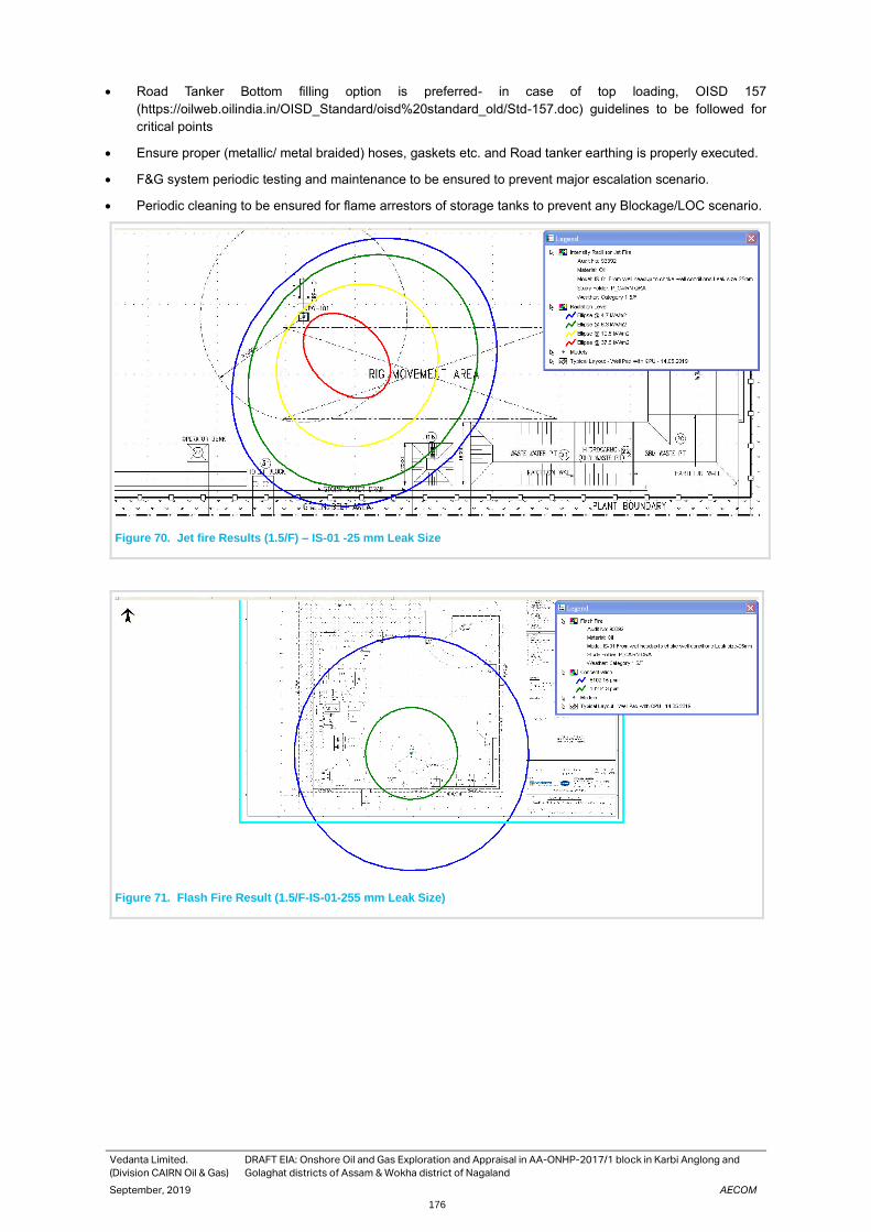
Vedanta Limited.
(Division CAIRN Oil & Gas)
DRAFT EIA: Onshore Oil and Gas Exploration and Appraisal in AA-ONHP-2017/1 block in Karbi Anglong and
Golaghat districts of Assam & Wokha district of Nagaland
September, 2019 AECOM
176
• Road Tanker Bottom filling option is preferred- in case of top loading, OISD 157
(https://oilweb.oilindia.in/OISD_Standard/oisd%20standard_old/Std-157.doc) guidelines to be followed for
critical points
• Ensure proper (metallic/ metal braided) hoses, gaskets etc. and Road tanker earthing is properly executed.
• F&G system periodic testing and maintenance to be ensured to prevent major escalation scenario.
• Periodic cleaning to be ensured for flame arrestors of storage tanks to prevent any Blockage/LOC scenario.
Figure 70. Jet fire Results (1.5/F) – IS-01 -25 mm Leak Size
Figure 71. Flash Fire Result (1.5/F-IS-01-255 mm Leak Size)

Vedanta Limited.
(Division CAIRN Oil & Gas)
DRAFT EIA: Onshore Oil and Gas Exploration and Appraisal in AA-ONHP-2017/1 block in Karbi Anglong and
Golaghat districts of Assam & Wokha district of Nagaland
September, 2019 AECOM
177
Figure 72. Flash Fire Results (%/D0-IS-06-25 mm Leak Size
Figure 73. Pool fire Results (5/D) – IS-06 -25 mm Leak Size

Vedanta Limited.
(Division CAIRN Oil & Gas)
DRAFT EIA: Onshore Oil and Gas Exploration and Appraisal in AA-ONHP-2017/1 block in Karbi Anglong and
Golaghat districts of Assam & Wokha district of Nagaland
September, 2019 AECOM
178
Figure 74. Jet fire Results (5/D) – IS-06 -25 mm Leak Size
7.3 Disaster Management Plan In view of the hazardous nature of products / process handled in the project, Disaster Management Plans (DMPs)
has been prepared. These plans are based on various probable scenarios like Well Blow Out, Fire, Explosion,
Natural Calamities, etc. The consequence arising out of such incidents are accurately predicted with the help of
latest technique available by various Risk Analysis Studies. To minimize the extent of damage consequent to any
disaster and restoration of normalcy is the main purpose of DMP. The on site Emergency Plans would deal with
handling of the emergency within boundary of the plants mainly with the help of industry’s own resources. Also,
when the damage extends to the neighbouring areas, affecting local population beyond boundaries of plant, Off-
site Emergency plans would be put into action in which quick response and services of many agencies are involved
e.g. District Authorities, Fire Services, Civil Defence, Medical, Police, Voluntary Organizations etc.
Objective of DMP The following are the main objective of Disaster Management Plan:
• Safeguarding lives both at installations and in neighbourhood.
• Containing the incident & bringing it under control.
• Minimizing damage to property & environment.
• Resuscitation & treatment of causalities.
• Evacuating people to safe area.
• Identifying persons and to extend necessary welfare assistance to causalities.
• Finally, when situation is controlled, efforts are to be made to return to normal or near normal conditions.
Emergency Identified Typical emergency situations which the Vedanta Ltd. (Cairn Oil & gas) business has identified that could occur
within its field of operations are:
• Well Blowout
• Fire / Explosion

Vedanta Limited.
(Division CAIRN Oil & Gas)
DRAFT EIA: Onshore Oil and Gas Exploration and Appraisal in AA-ONHP-2017/1 block in Karbi Anglong and
Golaghat districts of Assam & Wokha district of Nagaland
September, 2019 AECOM
179
• Gas Leakage (H2S, Natural Gas, etc.)
• Natural disaster such as earthquake, floods, storms, etc.
• Human injuries from accidents, falls, etc.
• Motor vehicle, road incidents
• Security incidents such as hold-ups, kidnapping, bomb threats, etc
Emergency Classification - Tiers of Emergency Response Response strategies shall be commensurate with the nature, scale and associated hazards and risks for relevant
emergency event.
The emergencies are classified as Tier 1, 2 & 3. The examples of Tier 1, 2 and 3 incidents are given in table
Table 7.12.

Vedanta Limited. (Division CAIRN Oil & Gas) DRAFT EIA: Onshore Oil and Gas Exploration and Appraisal in AA-ONHP-2017/1 block in Karbi Anglong and Golaghat districts of Assam & Wokha district of
Nagaland
September,2019 AECOM
180
Table 7.12 Emergency Classification & Response Team
Emergency
Levels
Category Response Health & Safety Environment Security /
Community
Tier 1
Local
Reactive
─ A minor Incident where site / location team requires no external assistance and can control the incident with local resources
─ Incident Controller must notify the leader of the ERT or EMT as applicable
─ Emergency Response Teams
─ (IRT)/(ERT)
─ Minor medical or injury case requiring no external support
─ Equipment damage with loss of production
─ Minor fire with minor injury or plant damage
─ Rescue of trapped and injured personnel
─ Minor oil spill < 100T(700b bls)
─ Onsite environmental Exposure contained with internal efforts e.g. chemical spill
─ Notification of cyclone within 72 hrs
─ Minor security breach
─ Theft from site
─ Local unrest
Tier 2
Tactical
─ Substantial Incident
─ EMT leader decides to activate EMT
─ EMT leader must notify CMT Leader
─ Emergency Management Team
─ (EMT)
─ Any incident requiring additional / external resources
─ Fire or Explosion
─ Injury or illness requires evacuation
─ Traffic accident requires external assistance
─ Well blow out
─ Oil spill from >100T but <1000T (700–7000bbls)
─ Environmental exposure requiring outside help
─ Earthquake
─ Flood or Cyclone warning Yellow alert –within 12 hours
─ Community protest or security breach
─ Major criminal activity
Tier 3
Strategic
─ Crisis situation
─ CMT leader decides to activate CMT CMT leader must notify the Chief Executive Officer
─ Crisis Management Team (CMT)
─ Incident leading to loss of facility
─ Incident leading to significant financial loss
─ Incident leading to multiple injuries or fatality
─ Total loss of marine vessel / vessel hitting platform
─ Helicopter crash
─ Well blowout
─ Incident which could lead to international media interest
─ Major traffic incident with multiple casualties
─ Oil spill more than 1000T (7000bbls)
─ Major Earthquake
─ Terrorist activities /bomb threat
─ Kidnap or extortion /threat
─ Major civil unrest /community protest

Vedanta Limited.
(Division CAIRN Oil & Gas)
DRAFT EIA: Onshore Oil and Gas Exploration and Appraisal in AA-ONHP-2017/1 block in Karbi Anglong and
Golaghat districts of Assam & Wokha district of Nagaland
September ,2019 AECOM
181
On-site Emergency Response Plan The Onsite & Offsite Disaster Management Plan (DMP) and Emergency Response Plan (ERP) are planned for
facilities, which are also extended to proposed activities. The scope of the DMP On-site Emergency Preparedness
Plan is to evaluate the various types of emergencies that can occur at rig installations and processing/production
facilities (Drilling and Production activities) and to formulate emergency plans, procedures that can be implemented
by Vedanta Ltd. (Cairn Oil & Gas) in house. In case the contingency exceed in dimension or geographical coverage
beyond Vedanta Ltd. (Cairn Oil & Gas)’s capability, the offsite Emergency plan shall be activated concurrently with
the help of District administration
Based on the incident classification and response team matrix mentioned above, Incident Response Team,
Emergency Response Team and Emergency Management Team gets involved.
Tier 1 Incident Response Team (IRT):
• The emergency or incident can be effectively and safely managed, and contained within the site, location or
facility by local staff.
• Emergency or incident has no impact outside the site, location or facility. IRT may provide support through
effective interaction with local stakeholders.
• Loss of life or severe environmental damage or material loss of asset or organisation’s reputation is not a
consequence of event / emergency.
Tier 1 incidents are managed by Site IRT, each site has own IRT.
Tier 1 Emergency Response Team (ERT):
• The ERT provide assistance and local support to the IRT’s in relevant area.
• The ERT have access to local outside site / external emergency services.
• For tier 2 emergency events.
Tier 2 Emergency Management Team (EMT)
• The incident cannot be effectively and safely managed or contained at the site location or facility by
operational local staff and additional support is required.
• The incident is having or has potential of impact beyond the site, location or facility and external support
may be required.
• Loss of life or severe environment damage or loss of asset or organisation’s reputation is possible
consequence of event / emergency.
• IRT may provide support through effective interactions with local stakeholders.
• ERT acts as interface between EMT and IRT for Midstream pipeline operations.
Tier 2 EMT is primarily for tactical response to the incident but may on occasions required to act in reactive
mode.
Tier 3 Crisis Management Team (CMT):
• The incident has escalated to a level having potential of loss of life, adverse effect on public or company’s
operations / reputation.
• Incident may have requirement of immediate action / guidance from Top Management.
Tier 3 incidents are incident escalating to the point requiring involvement of CMT
Responsibilities of the Individual Response Organisations The Incident Response Team is responsibility for managing all incidents and emergencies which may occur at or
in close proximity to their operational area. For emergencies where additional / external support is required the
person in charge of the incident response, the Incident Controller at a remote location, site or facility must notify
and request support and assistance from the next level in the emergency management organisation. The ERT /
EMT would be notified of all incidents within 30 minutes of the IRT activation at a remote location, site or facility.
The key role and responsibilities of the IRT Leader would be

Vedanta Limited.
(Division CAIRN Oil & Gas)
DRAFT EIA: Onshore Oil and Gas Exploration and Appraisal in AA-ONHP-2017/1 block in Karbi Anglong and
Golaghat districts of Assam & Wokha district of Nagaland
September ,2019 AECOM
182
• To manage the response to any and all incident or emergencies at the Site, Plant or Field Location
• To Control the incident by preventing escalation and minimizing risk to personnel
• Direct and coordinate the activities of the Incident Control and Forward Response Teams.
• Ensuring sufficient trained and competent personnel are available to support the Response Teams.
• Ensuring the safety of all personnel working at the Site, Plant or Field location
• Evaluate and initiate immediate actions, to contain and mitigate effects of the incident or emergency. Monitor
the situation & determine need for evacuation.
• Establish head count and potential whereabouts of any missing personnel and if necessary prepare search,
rescue and recovery plan.
• Follow Incident Response Plan and if required develop a plan of action to deal with the incident or emergency
and communicating this plan to the IRT members
Emergency Management Team (EMT) – Tactical/Strategic Response
In the event of an incident or emergency the Emergency Management Team Leader would make a decision whether
or not to mobilise the EMT. If the decision is taken to mobilise the EMT then all EMT duty personnel are required
to proceed promptly to the Emergency Management Team Room and manage emergency in accordance with their
role, responsibility and as directed by the duty EMT Leader. DOA shall be nominated for absence.
The EMT organisation has following roles and responsibilities:
• EMT Leader – In overall in-charge / team leader, responsible for Company’s tactical response to all
emergency situations in respective SBU. They are also responsible for reporting incidents to the regulating
authorities.
• Human Resources Coordinator – Responsible for providing HR services advice and support
• Logistics Co-ordinator – Responsible for providing transport and logistics support as required
• Operation and Technical Coordinator – Responsible for providing operational and technical support and
advice
• Finance – Responsible for providing financial support and advice.
• HSE Coordinator – Responsible for providing health, safety, environmental support and response.
• Recorder – Responsible for maintaining a timed log of key events and actions
• Security Coordinator – Responsible for providing security support advice and assisting others as required by
EMT Leader
The above list identifies a number of key EMT roles, following additional supporting roles may be called on when
as and when required, typical roles being:
• Air Medevac Nodal Officer – Responsible for facilitating air medevac.
• IT/Telecommunication Co-ordinator – Responsible for providing the EMT with technical support associated
with the communications hardware and software
• Company Medical Officer – Responsible for providing advice and assistance on health and medical issues.
• Legal – Responsible for providing support on legal / regulatory aspects.
• Public Relation / Corp Com – Responsible for communication with media and external stake holders.
• Contractor’s representatives – who may be called in to assist the EMT would the incident involve members
of their organisation
Crisis Management Team (CMT) Roles
The Crisis Management Team is comprised of small core of senior executives. The CMT would collectively have
responsibility for all major actions taken before; during, and after the crisis situation has occurred.
The role and responsibilities of the CMT would be:
Vedanta Limited.
(Division CAIRN Oil & Gas)
DRAFT EIA: Onshore Oil and Gas Exploration and Appraisal in AA-ONHP-2017/1 block in Karbi Anglong and
Golaghat districts of Assam & Wokha district of Nagaland
September ,2019 AECOM
183
• Select additional specialist resources to join the CMT or to advise the CMT during a crisis, depending on the
nature of the crisis
• Develop and implement crisis management strategy
• Develop and communicate the operating mandate of the CMT to those with responsibility for the on-scene
activities
• Nominate spokesperson to cover media interviews
• Establish contact and communicate with appropriate government or other agencies
• Prepare to coordinate business continuity and recovery strategy
Emergency Response Strategies / Evacuation Plan Emergency response strategies (ERS) are the documented decisions on required emergency response measures
for identified emergencies, based on risk evaluation and assessment process. It shall consider all statutory
requirements applicable to the installations.
The objective of ERS is to identify the means to be used to secure adequate emergency response. It provides
basis for monitoring of the adequacy of the emergency response measures so that they can be modified when
essential. ERS would include appropriate standard of performance for response measures associated with each
type of identified major accident hazard and installation specific factors.
ERS would include the following elements:
• Organisation
• Procedures
• Equipment
• Information
• Competency building measures (Training & refresher courses and Drills & exercises)
• The role of any other measure essential for achieving successful emergency response
Emergency response measures shall consider the available resources as below:
• Installation resources: They are immediately available on the installation and are under control of installation
Manager / In-charge. These include personnel and equipment that can be assigned emergency role.
• Area resources: These resources are available on the installations in the vicinity, within same area and are
not under control of Installation In-charge. The resources may be available within the Vedanta Ltd. (Cairn Oil
& Gas) or available by a mutual aid or cooperation agreement.
• External resources: These resources are available by a mutual aid or cooperation agreement at regional,
national or international level and include organisations, professional bodies and resource persons.
The general requirements as per Vedanta Technical Standard VED/CORP/SUST/TS 13 on Emergency and Crisis
Management are:
• Crisis situations shall be managed centrally by Cairn Oil and Gas business, in accordance with the
requirements outlined in the standard.
• SBU operations shall also have procedures in place to ensure crisis situations are escalated to Cairn Oil and
Gas business and Vedanta Group as appropriate.
• Emergency situations shall be managed by SBU operations and reported to Cairn Oil and Gas business and
Vedanta Group as appropriate.
• Incidents shall be managed at the SBU operation level and reported in accordance with SBU operations,
Cairn Oil and Gas business, Vedanta Group and regulatory reporting requirements. Also refer Management
Standard MS11 on Incident Reporting, Escalation and Investigation.
• Emergency Preparedness and Response Plans shall be developed, implemented and maintained at the SBU
operation, Cairn Oil and Gas business and Group level to deal with incidents, emergencies and crisis
situations.

Vedanta Limited.
(Division CAIRN Oil & Gas)
DRAFT EIA: Onshore Oil and Gas Exploration and Appraisal in AA-ONHP-2017/1 block in Karbi Anglong and
Golaghat districts of Assam & Wokha district of Nagaland
September ,2019 AECOM
184
Additional Vedanta Ltd. (Cairn Oil and Gas) requirements are:
• The objective of emergency response planning is to have clear written procedures for expected actions during
anticipated emergencies. Emergency response plan includes operational and procedural requirements for
various emergency scenarios that are relevant for the installation.
• Ensure that appropriate resources and incident / emergency response plans are prepared, practiced and
available. The procedures shall include provision for emergency arrangements with contractors.
• Critical resources of emergency response would include:
─ Emergency power systems
─ Fire and gas detection systems
─ Active fire protection
─ Passive fire protection
─ Shutdown system
─ Explosion mitigation and protection systems
─ Evacuation, escape and rescue arrangements
• Business continuity and recovery programme (BCP) to be developed, implemented, tested and maintained.
The BCP shall be risk-based, documented and communicated.
• Every Cairn business unit (including projects and offices) shall be covered by trained Incident and Emergency
Management Teams who would manage and execute the emergency plans.
• All members of the emergency organisations would be trained and competent to perform their assigned role
within the incident response (IRT) / emergency response (ERT) / emergency management (EMT).
• Arrangements for emergency medical treatment shall consider injuries to persons as a result of minor
accidents & major accidental events, illness of persons on installation, transportation & evacuation of sick and
injured personnel.
• Controlled medicines shall be stored in a secure place accessible only to those who are trained to administer
these.
• The level of medical facilities and trained personnel provided would be in line with the requirements identified
in emergency response strategy. Key points to be considered is identification of medical facilities / hospitals
• Emergency response plans shall comply with all relevant legislative and regulatory requirements to ensure
emergency capabilities are maintained and achieved.
• Procedure for designing emergency response measures would be based on:
• Integration of emergency response with / into design and operations
• Automatic or remotely operated safety systems to mitigate the effects of an incident
• Emergency response organisation structure
• Wherever applicable offsite emergency response / disaster management plans shall be ensured.
• Essential safety system (such as control stations, temporary refuge, muster areas, fire pumps) shall be
located where they are least likely to be affected by fires and explosions.
• Emergency shut down (ESD) system shall be designed such, that it is capable of fulfilling its function under
the conditions of incident. If installation is in operation, the essential shutdown functions shall be available
during maintenance activities, which affect the operation of the ESD system. ESD system shall contain
facilities for testing of both input / output devices and internal functions.
• Evacuation and escape routes shall be provided from all areas of an installation where personnel may be
expected to be present during their normal activities. Alternative means to allow persons to safely leave the
installation in an emergency shall be provided.
• Evacuation and escape routes shall have adequate illumination with emergency lighting and shall be marked
to ensure that ‘they can be used during emergency conditions’. All escape routes shall be unobstructed
(including vertical clearance) and readily accessible.

Vedanta Limited.
(Division CAIRN Oil & Gas)
DRAFT EIA: Onshore Oil and Gas Exploration and Appraisal in AA-ONHP-2017/1 block in Karbi Anglong and
Golaghat districts of Assam & Wokha district of Nagaland
September ,2019 AECOM
185
• Personal protective equipment for use in major accident hazards would be suitable for the circumstances in
which it may have to be used and the individuals who may have to use it.
• PPE for use in an emergency would be for all persons on the installation for use in condition of fire, heat, gas
release or smoke to enable them to reach muster areas, temporary refuges and evacuation or escape points.
Those with specific emergency duties shall also be provided appropriate PPE for use like fire suits and
breathing apparatus etc.
• During an emergency, security arrangements shall ensure that unauthorised persons do not enter the incident
site by controlling assess and if need arises the area around the site can be evacuated and cordoned to
ensure safety of the persons.
• Environmental emergency response would consider:
─ Oil-pollution control equipment that would be located on the installation
─ Environmental conditions that may be present when the equipment is deployed
─ Capacity of the oil recovery system
─ Characteristics of the oil / emulsion to be recovered
─ Means to identify the extent of the spill
─ Facilities to handle any recovered oil.
• International conventions have introduced the requirements to develop national plans for oil-spill response in
offshore, and Offshore Assets / SBUs / Operations would ensure that their installations’ emergency response
plans are aligned with the national requirements.
Responsibilities of the Employees
The establishment and maintenance of best possible conditions of work is, no doubt, the responsibility of the Project
Management. It is also necessary that each employee follows prescribed safe methods of work. He would take
reasonable care for the health and safety of himself, or his fellow employees and of other persons who may be
affected by his action at work. With this in mind, employees shall be trained to be health and safety conscious in
the following aspects:
Report Potential Hazards
Observe Safety rules, procedures and codes of practice
Use Tools and equipments with all care and responsibility
Participate In safety training course when called upon to do so.
Make Use Of safety suggestion schemes.
Take An active and personal interest in promoting health and safety
Each unit shall identify and document the resources required to ensure the effective implementation of the
emergency and crisis management procedures. Resource requirements shall meet the requirements of the
Vedanta Management Standard MS01 on Leadership, Responsibilities and Resources. The following resources
shall be considered and made available as necessary:
• Trained and competent personnel;
• Equipment and other materials including Personal Protective Equipment (PPE);
• Warning devices;
• Medical services, including personnel trained in first aid, and medical equipment that is appropriate to the
type of operation;
• Emergency services support; and
• Emergency funding, along with an appropriate mechanism for delivering funds.
The capacity of external resources, such as local firefighting capacity, shall be assessed, and additional resources
acquired and maintained at the operation where external resources are deemed insufficient.

Vedanta Limited.
(Division CAIRN Oil & Gas)
DRAFT EIA: Onshore Oil and Gas Exploration and Appraisal in AA-ONHP-2017/1 block in Karbi Anglong and
Golaghat districts of Assam & Wokha district of Nagaland
September ,2019 AECOM
186
The resources identified shall be maintained and tested on a regular basis, and their adequacy reviewed
periodically.
Communication Systems
Emergency response relies upon effective and reliable communication between all personnel involved in response.
Communication systems shall:
• Provide sufficient reliable information / alarm to personnel on the installation to enable them to take the
appropriate emergency actions.
• Provide means for those on the installation to communicate with the person in overall charge.
• Provide reliable arrangements to allow the person in overall charge to communicate with all personnel on the
installation regarding the nature of any emergency and the actions they are required to take.
• Provide reliable means to allow the person in overall charge to communicate with area and external resources
who have a role in emergency response.
• Suitable equipment, information processing and procedures shall be in place to enable effective
communications. The means of communication shall be selected based on the need for communication in
likely scenarios including operational conditions under which they are to function like, noise, ambient
conditions and susceptibility to damage. So far as reasonable, communication arrangements would remain
available throughout the emergency
• Alarm signals used and their meanings would be described in the emergency response plan along with the
procedures to be followed in the event of an alarm. Persons would be provided with adequate information to
allow them to, initiate alarms where necessary, distinguish between alarms and respond to alarms.
• Adequate alarms and warning devices, along with other forms of communication, shall be maintained to
reliably alert persons across the whole site in the event of an emergency.
• Independent secondary / back-up communications systems shall be provided in case the emergency incident
makes the normal communication system inoperable.
• Ensure that the means are in place to alert to the connected installations, the local community / neighboring
businesses in the event of an emergency that has the potential interface with them.
Training and Emergency Response Drills / Mock All persons on the installation or in connected activities (including contractor’s personnel) shall be trained
periodically for emergency response and evacuation procedures. Training for employees having assigned roles in
emergency response shall be completed before they are called upon to perform in real emergencies. Emergency
response organisation structure (IRT/ERT/EMT/CMT) shall ensure command by competent persons, which can be
maintained, so far as is practicable, throughout an emergency.
• Key persons such as the Installation Incharge and Shift Incharge / control room operator shall be assessed
for required competence to perform emergencies duties before assigning of duties. As far as possible,
assessment would be under simulated emergency conditions.
• Competency and training needs shall meet the requirements of the Vedanta management Standard MS06 on
Competency, Training and Awareness
• An emergency response table top exercise / emergency response drill is a focused activity that places the
participants in a simulated situation requiring them to function in the capacity that would be expected of them
in a real event. Its purpose is to ensure preparedness by testing policies and plans and by training personnel.
One objective of an exercise is to be able to identify problem areas for resolution/ corrective action before an
actual emergency occurs.
• The drills need to address the readiness of personnel and their familiarity / proficiency with emergency
equipment and procedures. All personnel on the installation involved including contractor’s employees would
participate in the drills.
• The drills and table top exercises shall be carried out as often as appropriate, against documented schedule.
To be scheduled regularly, at least once a year for full drills and six monthly for desk-based exercises, although
the exact frequency and type of drills may depend on the nature and scale of the operations, and the
associated risks.

Vedanta Limited.
(Division CAIRN Oil & Gas)
DRAFT EIA: Onshore Oil and Gas Exploration and Appraisal in AA-ONHP-2017/1 block in Karbi Anglong and
Golaghat districts of Assam & Wokha district of Nagaland
September ,2019 AECOM
187
• Emergency response plan shall be reviewed and revised as appropriate in line with the findings from drills
and table top exercises.
• Involve external emergency response agencies and other external stakeholders, where appropriate.
Performance Measures • Key elements of functionality, survivability, reliability and availability shall be included in performance
standards. Achievability of performance standards would be validated.
• Effective operations, inspection, testing and maintenance procedures shall be established to ensure that the
functional requirements of the equipment and systems provided for emergency escape, evacuation and
rescue response are maintained.
• A written scheme shall be prepared, detailing the inspection, testing and maintenance routines and
frequencies to be followed. All emergency equipment and systems shall be thoroughly inspected, following
established procedures. Adequate records of the results of the inspection, testing and maintenance shall be
kept and shall be periodically reviewed to confirm that the written scheme is appropriate and is being
adequately implemented.
Monitoring, Evaluation and Review Documented reviews would be carried out after all drills and actual emergency responses to determine the
effectiveness of the Emergency Preparedness and Response Plans, with a full debrief to identify what worked well
and what aspects require improvement.
Lessons learned following exercises or actual emergency situations/incidents shall be documented, and any gaps
in planning and implementation shall be addressed in revised versions of the Emergency Preparedness and
Response Plans. Lessons learned shall be shared across Vedanta’s operations where appropriate.
All Emergency Preparedness and Response Plans shall be reviewed and updated periodically, at least on an
annual basis, to ensure they remain appropriate and relevant. Reviews shall also meet the requirements of the
Vedanta Management Standard MS14 on Management Review and Continual Improvement.
Preventive and Mitigation Measures for Well Blow out Blow-out (uncontrolled gushing of oil & gas) is the worst situation, which may arise at oil wells during drilling, work-
over operations, perforation, and reservoir studies at active wells, etc. or due to some unforeseen reasons.
A blow out, though rare, in a drilling operation is often accompanied by fire and explosion exposing workers to
serious danger to their lives, burns and poisoning. To understand the failure modes resulting to formation of kick
and subsequent blow outs, one has to understand the safety systems installed for blow out prevention.
Prevention of blow outs rests primarily on control of any kick in the well bore. A kick means entry of formation fluids
into well bore in large enough quantity to require shutting in the well under pressure. Once a kick is detected, steps
can be taken to control entry of formation fluids into the well bore by over balancing the expected bottom hole
pressure with properly conditioned mud and operation of safety valves i.e. Blow Out Preventer (BOP), whereby the
space between the drill pipes and the casings can be closed and well itself shut off completely. Several instruments
are provided on a drilling rig for detection of kicks.
Instrumentation in Mud System Continuous monitoring of condition of mud in the well provides information useful for well control. The following
processes are used in the drilling mud system for this purpose:
• A pit level indicator registering increase or decrease in drilling mud volume. It is connected with an audio-
visual alarm near the drillers control panel.
• A trip with float-marking device to accurately measure the volume of mud going in to the well. This is useful
to keep the well fed with required quantity of mud at all times.
• A gas detector or explosive meter installed at the primary shale shaker together with an audio-visual alarm at
the drillers control panel to indicate the well presence of gas-cut mud in the well.
• The kick in the well is prevented by keeping the hydrostatic head of the drilling fluid greater than the formation
pressure. The primary control can be lost in the following situations:
Vedanta Limited.
(Division CAIRN Oil & Gas)
DRAFT EIA: Onshore Oil and Gas Exploration and Appraisal in AA-ONHP-2017/1 block in Karbi Anglong and
Golaghat districts of Assam & Wokha district of Nagaland
September ,2019 AECOM
188
• If there is reduction in hydrostatic pressure in the well due to swabbing, which maybe caused if the drilling
string is pulled out too fast or by a balled-up or clogged bit, which is indicated by insufficient filling of mud.
Preventive Measures for Handling Natural Gas The natural gas is a colourless, odourless, flammable gas, mainly methane which may cause flash fire. Electrostatic
charge may be generated by flow, agitation etc. No occupational exposure limits have been established for natural
gas. The preventive measures to be taken to avoid impact due to leakages are
• Provide local exhaust ventilation system: Ventilation equipment would be explosion-resistant if explosive
concentrations of material are present.
• Gloves: Wear appropriate chemical resistant gloves.
• Respirator: Under conditions of frequent use or heavy exposure, respiratory protection may be needed.
Leakage of H2S Gas Hydrogen sulphide is a colourless, flammable, extremely hazardous gas with “rotten egg” smell. Low
concentrations of H2S irritate the eyes, nose, throat and respiratory system e.g. burning / tearing of eyes, cough,
and shortness of breath. Repeated or prolonged exposures may cause eye inflammation, headache, fatigue,
irritability, insomnia, digestive disturbances and weight loss.
The preventive measures to be taken up in case of leakages are:
• Stop the source of leakage (i.e. close the well)
• Remove victim, if any to fresh air, if breathing, maintain victim at rest & administer oxygen, if available, if
person is not breathing, start artificial respiration immediately or start mechanical/ automatic resuscitator. Call
ambulance and sent victim to hospital or doctor.
• Avoid & extinguish all naked flames
• Pull out all inflammable material i.e. HSD, Gas Cylinders, Chemicals etc. from the premises of well /
installation.
• Pull out all possible equipment to safe distances.
• Call for fire tender and start spraying water on the sources of leakage to dissolve H2S in water.
• Evacuate personnel in 500 mts area from down wind direction.
• Warn nearby inhabitants, if required.
• Cordon off the area & do not allow entry of any unauthorized person.
Vedanta Ltd. (Division Cairn Oil & Gas)’s operations in the Block have indicated that there is no naturally occurring
H2S in the reservoir and therefore release of H2S during drilling operations is not expected.
Preventing Fire and Explosion Hazards Fire is one of the major hazards, related to oil and natural gas well. Fire prevention and code enforcement is the
area of responsibility of the fire service. Safe operating practices reduce the probability of an accidental fire on a
platform. Personnel would understand their duties and responsibilities and be attentive to conditions that might
lead to fire. The following precautions are recommended:
• Fire control cannot be achieved until the source of fuel and ignition is isolated. Fire control cannot be achieved
until the source of fuel and ignition is isolated. An emergency shut down (ESD) system shall be provided to
isolate the installation from the major hydrocarbon inventories within pipelines and reservoirs, which if
released on failure, would pose an intolerable risk to personnel, environment and the equipment / assets.
• There would be provision for safe handling and storage of dirty rags, trash and waste oil. Flammable liquids
and chemicals spilled on platform would be immediately cleaned.
• Containers of paints and HC samples, gas cylinders would be stored properly. Gas cylinders would be
transported in hand-carts
• Cutting and welding operations would be conducted in accordance with safe procedures
• Smoking would be restricted to designated platform areas and “no smoking” areas would be clearly identified
by warning signs

Vedanta Limited.
(Division CAIRN Oil & Gas)
DRAFT EIA: Onshore Oil and Gas Exploration and Appraisal in AA-ONHP-2017/1 block in Karbi Anglong and
Golaghat districts of Assam & Wokha district of Nagaland
September ,2019 AECOM
189
• Platform equipment would be maintained in good operating condition and kept free from external
accumulation of dust and hydrocarbons. Particular attention would be given to crude oil pump, seals, diesel
and gas engines which could be potential source of ignition in the event of a failure
• The Disaster Management Plan would address the issue of a fire event at any location on the well and the
procedure to be adopted in the very unlikely event of this occurring. If a fire starts in any well, that section of
the well would be isolated by closing the section (block) valves, as quickly as possible and surrounding
facilities would be cooled with water.
Off-site Emergency Plan The Off-Site Emergency Plan is a compilation of various emergency scenarios and also includes the probable
impact off-site locations due to emergency and the action plan to combat / mitigate the consequences of a disaster
situation. Emergency is a sudden unexpected event, which can cause serious damage to personnel life, property
and environment as a whole, which necessitate evolving off-site emergency plan to combat any such eventuality.
Emergencies can be handled by an organized multi-disciplinary approach. If it becomes necessary to evacuate
people, then this can be done in orderly way.
Under the Environmental (Protection) Act 1986, the responsibility of preparation of Off-Site Emergency Plan lies
with the State Government. The Collector/ Deputy Collector by virtue of their occupation are normally nominated
by the concerned State Government to plan Off-Site Emergency Plan. The different agencies involved in evacuation
of people are civil administration (both state and central) and police authorities.
Purpose
• To save life and prevent/reduce loss of properties
• To make explicit inter related set of actions to be undertaken in the event of an accident posing hazards to
the community
• To plan for rescue and recuperation of casualties and injuries. To plan for relief and rehabilitation
• To plan for prevention of harms, total loss and recurrence of disaster. It would be ensured that absolute safety
and security is achieved within the shortest time
The activities of the government, Non-Government organizations and concerned personnel involved in off-site
disaster management plan are as follows:
These would include the safety procedures to be followed during emergencies such as posters, talks and mass
media in different languages including local language. Leaflets containing do’s/ don’ts would be circulated to
educate the people in vicinity
Medical Help consisted of doctors and supporting staff for medical help to the injured persons because of disaster
would be formed. Functions and duties of the committee include, providing first Said treatment for injured at the
spot or at some convenient place and shift those to nearby hospitals for further treatment if required
The police would assist in controlling of the accident site, organizing evacuation and shifting of injured people to
nearby hospitals.
The fire brigade shall organize to put out fires other than gas fires and provide assistance as required. Approach
roads to accident site and means of escape would be properly identified. Chief fire officer would co-ordinate entire
fire control measures. Routine training of fire fighting equipment and special rescue equipment would be carried
out. Concerned officer would ensure adequate supply of fire water and fire fighting agents at the site of emergency.
Maintenance of standby equipment / personnel for fire fighting would be ready at any given time.
Mutual Aid
Disaster / emergency / risk, when becomes difficult to control by in house team / management, help from nearby
industries, institutions, etc. can be taken. A group of mutual aid can be formed where emergency control systems
like ambulance, fire fighting equipments, medical & fire-fighting team, etc. can be shared in the event of need.
Post Emergency Relief to the Victims
The Public Liability Insurance (PLI) Act, 1991 provides for the owner who has control over handling hazardous
substances to pay specified amount of money to the victims as interim relief by taking insurance policy for this
purpose. The District Collector has definite role in implementation of this act. After proper assessment of the
incident, he shall invite applications for relief, conduct an enquiry into the claims and arrange payment of the relief
amount to the victims.
Vedanta Limited.
(Division CAIRN Oil & Gas)
DRAFT EIA: Onshore Oil and Gas Exploration and Appraisal in AA-ONHP-2017/1 block in Karbi Anglong and
Golaghat districts of Assam & Wokha district of Nagaland
September ,2019 AECOM
190
General Health and Safety The project would adhere to health & safety norms of The Factories Act, 1948 and Assam Factory Rules, 1950,
as applicable along with Best Industry Practices.
General health and safety issues during various project activities are similar to those of most large infrastructure
and industrial facilities and their prevention and control. These issues include among others, exposure to dust
and hazardous materials, hazardous materials components, and physical hazards associated with the use of
heavy equipment, etc.
Specific health and safety issues primarily include the following:
• Physical hazards
• Chemical hazards
• Confined spaces
Physical Hazards - The main sources of physical hazards are associated with machinery and vehicles. General
electrical equipment safety, working in confined spaces, hot work, high temperature areas are expected to be
present.
Chemical Hazards - workers may be exposed to chemical hazards especially if their work entails direct contact
with fuels or chemicals, flare & DG set emission or depending on the nature of activities. Work with fuels may
present a risk of exposure to volatile organic compounds (VOC) via inhalation or skin contact during normal use
or in the case of spills.
Noise - Noise sources include drilling, DG operations, including vehicular traffic, and boats. In order to evaluate
the impacts of proposed project on the health of workers, baseline health studies would be carried out on every
worker before joining their duties.
The hierarchy of control specific for health & safety (in order of priority):
• Eliminate the use of a harmful product or substance and use a safer one;
• Substituting wherever reasonably practicable, a non-hazardous material which presents no risk to health,
where a hazardous material is used intentionally, i.e. use a safer form of the product;
• Modifying a process to eliminate the use of risk, the production of a hazardous by-product or waste product,
including reducing the quantities of the hazardous material which are used & stored, i.e. change the process
to emit less of the substance;
• Enclose the process so that the product does not escape;
• Extract emissions of the substance near the source;
• Provide personal protective equipment (PPE) such as gloves, coveralls and a respirator. PPE must fit the
wearer.
Personal Protective Equipment Often it is not possible, or practicable, to eliminate exposure to materials hazardous to health completely. In such
cases, operations would consider how to prevent employees being exposed and the prevention of exposure
would be achieved by measures other than the use of PPE or Respiratory Protective Equipment (RPE), which is
the last line of defence.
Situations where PPE/RPE would normally be necessary include:
• where adequate control of exposure cannot be achieved solely by good practice and the application of
operational or engineering measures;
• where new or revised assessment shows that PPE/RPE is necessary until adequate control is achieved by
other means;
• where there is temporary failure to achieve adequate control of the process, e.g. because of plant failure,
and the only practicable solution to maintain adequate control in the time available may be the provision and
use of suitable PPE/RPE; and
• where maintenance operations have to be carried out.

Vedanta Limited.
(Division CAIRN Oil & Gas)
DRAFT EIA: Onshore Oil and Gas Exploration and Appraisal in AA-ONHP-2017/1 block in Karbi Anglong and
Golaghat districts of Assam & Wokha district of Nagaland
September ,2019 AECOM
191
Key personal protective equipments would include:
• Body suit
• Hand gloves
• Helmet
• Safety shoes
• Safety harness
• Breathing apparatus
• Eye shield
• Ear muffs
First Aid Medical services, including personnel trained in first aid, and medical equipment that is appropriate to the type of
operation would be provided at project.
All persons on an installation would have at least basic training in emergency response, basic first aid, use of life
saving appliances and firefighting. Individual competencies shall be periodically tested to identify further
requirement of training and knowledge to perform emergency duties.
It would be ensured that any auxiliary medical teams e.g. nurses and first aid personnel are fully trained and
conversant with their roles and responsibilities.
Contact details & capacities of nearby medical facilities and medical experts would be made available at strategic
locations.
Disaster Management Plan for Natural Hazard
A disaster is an event that causes the sudden disruption to the normal life of a society and causes damage to
property and lives, to such an extent that normal social and economic mechanisms available to the society are
inadequate to restore normalcy. Preparedness for natural disaster alleviates human misery. Though no amount of
preparedness is enough, an attempt is made through this plan to negotiate with all the probable hazards in the
district and their aftermath.
Vulnerability of the Golaghat District towards disasters, both natural and man- made is widely recognized. The
district is vulnerable towards natural disasters like; Earthquakes and floods, and man-made disasters such as fire.
Earthquake
The study area falls in the Earthquake Hazard Zone V (reference Vulnerability Atlas of India; 2nd Edn), which
indicates the highest risks zone that suffers earthquakes of intensity MSK IX or greater. The region has experienced
a large number of earthquakes of tectonic origin. The risk probabilities of earthquake are less over the entire
Brahmaputra valley. The region of Northeast India is seismically very active. Though Golaghat district has not
experienced any major earthquake in recent past causing damage to lives or infrastructure, the possibility can
never be ruled out as it can happen any time. Two major earthquakes have been recorded in the region. The first
is in 1897 of magnitude 8.7 and in 1950 of magnitude 8.6 causing large scale damage of lives and properties in
this region.
Occurrence of earthquakes leads to loss of human life, livestock and infrastructure. The vulnerable areas in the
region are structural damage at town areas and probability of flood in villages near banks of river Brahmaputra &
Dhansiri if damage occurs at embankments or change in river course.
General awareness and wide dissemination of do’s and don’ts through electronic and print media issued by state
disaster management agency would be followed.
Floods
During rainy seasons, all the major rivers in the district carry water which pose potential threat of flood. The heavy rainfall in the catchment areas of the district causes the rising of water level above the danger level. The floods are caused by the runoff of extremely heavy rainfall during the monsoon and high sediment loads from upper watersheds that are geologically unstable and degraded because of deforestation and changing land use. The flood combined with river erosion has significant impacts each year.

Vedanta Limited.
(Division CAIRN Oil & Gas)
DRAFT EIA: Onshore Oil and Gas Exploration and Appraisal in AA-ONHP-2017/1 block in Karbi Anglong and
Golaghat districts of Assam & Wokha district of Nagaland
September ,2019 AECOM
192
IMD and other government department warnings would be monitored and in case of any such warning, relevant
steps as guided by on site disaster management plan would be followed. Instruction given by key departments like
IMD, district disaster management center, etc. to be followed
Storms
Golaghat district is highly vulnerable to storm and is a regular occurance. Storms generally bring in their trail heavy
rains with hailstones causing damage to property and crops. Storms cause heavy damage to crops and
vegetations. Secondary hazards like snapping of electric poles due to uprooting of trees, disruption of
communication links, etc. are also attributed to hailstorms. Frost is a regular feature in many parts of Assam.
Measure like avoiding travelling, clearing of area, etc. would be taken along with on site disaster management plan.
Natural hazards can be minimized by the presence of a well functioning communication / warning system. A well
prepared administration needs to have its communication/early warning system in place to enable precautionary &
mitigation measures on receiving warning for impending disasters and in the process minimise loss of life &
property.
Data from different reliable sources would collected and monitored in real or near real time and analysed to
generate a warning alert in the event of likelihood of a disaster.
• The Indian Meteorological Department (IMD) would be the nodal agency for the monitoring of seismic activity,
flood, etc.
• Tie up / contacts / communication with Assam State Disaster Management Authority (ASDMA), District
Disaster Management Centre would be maintained. There is an office of DDMC at Golaghat who has to be
contacted as part of off-site DMP.
• Local Search and Rescue Team at the local level comprising of retired Army and Police personnel, Civil
Defence and Home Guard, volunteers can be identified and trained to perform initial search and rescue
operations.
• Apart from the above, Community volunteers/ representatives would be identified and trained on search and
rescue operations through Community Based Disaster Management programme.
• Disaster Management and Relief Department website/ communication along with other line departments like
fire, police, health, etc. would be checked

Vedanta Limited.
(Division CAIRN Oil & Gas)
DRAFT EIA: Onshore Oil and Gas Exploration and Appraisal in AA-ONHP-2017/1 block in Karbi Anglong and
Golaghat districts of Assam & Wokha district of Nagaland
September ,2019 AECOM
193
8. PROJECT BENEEFITS The proposed project would establish the potential of hydrocarbons in the Block. The development of the oil Block
would result in considerable growth of service sector and would also generate direct/indirect employment and
business opportunities in the area. The major benefits of the project include reduction of the oil import bill of the
nation as well as reduction of the imbalance in oil production and consumption.
The commercial development would also lead to investment in Assam, bringing oil and gas revenues both to the
State and to the Central Government. The presence of Vedanta Limited (Division: Cairn Oil & Gas) in the region
would substantially improve the socio-economic conditions of the region. Employment opportunity for local people
as contract/daily wages in nearby areas.
8.1 Revenue Earning of central & State Government Vedanta Limited (Division Cairn Oil & Gas) has been alloted with an exploration Block in Assam Basin, namely AA-
ONHP-2017/01 by Government of India under the Revenue Sharing Contract (RSC) for exploration and exploitation
of hydrocarbon. A Revenue Sharing Contract (RSC) was signed between the Government of India (GoI) and
Vedanta Limited on 1st October 2018.
Due to hydrocarbon discovery and then its production, use & sell, central as well as state government would get
benefited.
8.2 Employment Potential The employment of local people in primary and secondary sectors of project shall upgrade the prosperity of the
region. This in-turn would improve the socio-economic conditions of the area.
• In case the hydrocarbon is established in the Block, considerable number of people would be benefited by
provision of services to the residents including hotels, restaurants, transport services etc. Thus, the direct
and indirect employment generation by this project.
8.3 Corporate Social Responsibility • Vedanta Limited (Division Cairn Oil & Gas) has taken up various CSR initiatives in and around its present
operational areas as per the CSR Act and Rules, Govt. of India.
• CSR measures would be taken up by Vedanta Limited. (Division Cairn Oil & Gas) in case of commercially
viable hydrocarbon discovery & further full-fledged development of the hydrocarbon block and production
and associated facilities.
8.4 Proposed CER Strategy The company would comply with the 1st May 2018 OM w.r.t. CER and the cost would be assessed on actual
project capex expenditure of that particular financial year.

Vedanta Limited.
(Division CAIRN Oil & Gas)
DRAFT EIA: Onshore Oil and Gas Exploration and Appraisal in AA-ONHP-2017/1 block in Karbi Anglong and
Golaghat districts of Assam & Wokha district of Nagaland
September ,2019 AECOM
194
9. ENVIRONMENT MANAGEMENT PLAN
This section describes the Environmental Management Plan(EMP) for the proposed project.
• The EMP is aimed at managing the environmental parameters in a sustainable manner. The EMP section is
organized as follows:
• Organizational structure for HSE management– This subsection describes the current HSE organization in
Vedanta Limited (Division Cairn Oil and Gas) which would be responsible for implementing this EMP.
• Proposed Environmental Management Plan – This Plan consists of a detailed description of the positive and
negative environmental impacts anticipated from the proposed project, mitigation/ management measures
and the persons/ parties responsible for ensuring implementation of such measures.
• Additional Plans - Additional plans such as Waste Management Plan, Oil Spill Response Plan have also
been provided.
• EMP implementation review process – This subsection describes the requirements for periodic review and
updating of the EMP to address any new impacts due to change or modification of the project.
• Budgetary allocation for EMP implementation – Provides the details of budget allocation for the various
mitigation measures proposed for the Project.
9.1 Organization Structure for HSE Management Vedanta Limited (Division Cairn Oil & Gas) has formulated a Health, Safety and Environment (HSE) Policy for its
operations. Through the HSE Policy, Vedanta Limited (Division: Cairn Oil and Gas) is committed to protect the
health and safety of everyone involved in its operations, and the sustainability of the environment in which it
operates. Vedanta Limited (Division Cairn Oil & Gas) strives for continual improvement and the adoption of
international codes and standards. Vedanta Limited (Division Cairn Oil & Gas) aims at ensuring that all its
operations comply with applicable health, safety and environmental laws, regulations and other requirements.
Organizational structure and HSE policy of Vedanta Limited (Division Cairn Oil and Gas) is presented in Figure 73
and Figure 75.

Vedanta Limited.
(Division CAIRN Oil & Gas)
DRAFT EIA: Onshore Oil and Gas Exploration and Appraisal in AA-ONHP-2017/1 block in Karbi Anglong and
Golaghat districts of Assam & Wokha district of Nagaland
September ,2019 AECOM
195
Figure 75. Vendanta Limited (Division: Cairn Oil and Gas) HSE organizational structure for implementation of EMP.

Vedanta Limited.
(Division CAIRN Oil & Gas)
DRAFT EIA: Onshore Oil and Gas Exploration and Appraisal in AA-ONHP-2017/1 block in Karbi Anglong and
Golaghat districts of Assam & Wokha district of Nagaland
September ,2019 AECOM
196
Figure 76. HSE Policy of Vedanta Limited
Ensure effective implementation of the Environmental Management Plan (EMP) through review and periodic
updation;

Vedanta Limited.
(Division CAIRN Oil & Gas)
DRAFT EIA: Onshore Oil and Gas Exploration and Appraisal in AA-ONHP-2017/1 block in Karbi Anglong and
Golaghat districts of Assam & Wokha district of Nagaland
September ,2019 AECOM
197
Vedanta Limited (Division: Cairn Oil and Gas) would have the ultimate responsibility of implementing the
environment management plan along with drilling contractor. The drilling contractor would have an HSE
management system, which would be reviewed by Vedanta Limited (Division: Cairn oil and Gas) prior to
implementation.
9.2 Air Quality Management Plan: The Air Quality Management Plan (AQMP) encompasses both constructions, drilling and early production phase
activities for the proposed project that has the potential to adversely affect ambient air quality due to the proposed
project.
The AQMP establishes specific measures and guidelines aimed at effectively addressing and mitigating the air
quality impacts that may arise as result of construction of well sites and Early production, drilling operations,
operation of early production unit and decommissioning/site closure of well sites. The plan also details out roles
and responsibilities of Vedanta Limited (Division: Cairn Oil & Gas) and the contractors to ensure effective
implementation of the plan.
Mitigation Measures: Phase Mitigation Measures
Construction/ drill Site Preparation Designing, Planning & Procurement
• Storage and handling of construction material and
debris to be carefully managed to prevent
generation of fugitive dust;
• All vehicles use in transportation of raw material
and personnel would have valid Pollution under
Control Certificate (PUC). Vehicular exhaust would
be complying with the CPCB specified emission
norms for vehicular Emission;
• The top soil stripped from site preparation activities
would be stored suitably;
• Adequate stack height will be provided to DG sets
in accordance with CPCB standards.
Dust Suppression
• Sprinkling of water on earthworks, material
haulage and transportation routes on a regular
basis, especially in dry season.
Drilling and early production facilities
Operation of Machineries, Vehicle & Drilling Rig
• Exhausts of diesel/Gas generators would be
positioned at a sufficient height to ensure dispersal
of exhaust emissions; engines would not be left
running unnecessarily;
• Vehicles involved in the transportation of project
personnel would have valid PUC Certificate and
would be subjected to periodic preventive
maintenance;
Periodic Maintenance of Machinery and Vehicles
• Preventive maintenance of GEG/DG sets would be
undertaken;
• Flaring would be undertaken in accordance with
the CPCB Guidelines for Gaseous Emissions for
Oil & Gas;

Vedanta Limited.
(Division CAIRN Oil & Gas)
DRAFT EIA: Onshore Oil and Gas Exploration and Appraisal in AA-ONHP-2017/1 block in Karbi Anglong and
Golaghat districts of Assam & Wokha district of Nagaland
September ,2019 AECOM
198
9.3 Waste Management Plan
The Waste Management Plan (WMP) is applicable for all process and non-process waste streams which are
generated during various phases of Vedanta Limited (Division: Cairn Oil & Gas) proposed drilling and testing of
hydrocarbons in this block. The major waste streams covered under this plan includes drill cuttings, waste drilling
mud, drilling wash water, kitchen waste and sewage. In addition, waste oil and lead acid batteries generated from
the proposed project operations have also been dealt in this plan.
The WMP establishes specific measures to ensure proper collection, storage, treatment and disposal of the
identified process and non-process waste streams in accordance with the applicable national regulations and
guidelines and also to ensure compliance with Vedanta Limited (Division: Cairn Oil & Gas) corporate HSE Policy.
The plan also outlines roles and responsibilities of both Vedanta Limited (Division: Cairn Oil & Gas) and the
contractors involved in the implementation of the plan.
Mitigation Measures The following mitigation measures need to be adopted and implemented by Vedanta Limited (Division: Cairn Oil
& Gas) and its contractors for the major waste streams identified in the plan.
Waste Quantity Mitigation Measure
Drill Cuttings Drill cuttings associated with WBM: 250-750 tons/well, Drill Cuttings associated with SBM (500-1500 tons/well)
• Drill cuttings separated from drilling fluid would
be adequately washed and temporarily stored
and disposed in an impervious pit lined by High
Density Poly Ethelyn (HDPE)
• All drill cuttings would be disposed as per
Hazardous and Other Wastes (Management
and Transboundary Movement) Rules, 2016;
Spent WBM 250 – 500 tons/well • The mud would be disposed as per CPCB
standard prescribed for Oil and Gas industry or
as specified by Assam SPCB
Waste oil/ Used oil 1-2 tons/well • Hazardous waste (waste and used oil) would be
managed in accordance with Hazardous Waste
(Management, Handling & Transboundary
Movement) Rules, 2008.
• This oil would be sent to authorized recyclers.
Municipal Solid Waste 25-30 kg/well • The waste would be segregated at source
(organic/inorganic) and disposed accordingly.
• All kinds of waste would be disposed in
accordance with the requirement of
CPCB/Assam SPCB
Sewage 16-25 m3/day per well • Sewage generated from campsite would be
treated through mobile STP.
• Treated waste water would be used for dust
suppression, green belt, landscape, etc
Recyclables viz. paper, plastic, packaging waste etc.
Depending on usage • Proper segregation and storage of recyclable
waste in designated bins.
• Recyclables would be periodically sold to local
waste recyclers.
Non-combustible waste containing metallic residues
1000-1200 kg/well • To be analysed for the trace/heavy metals
content before disposing suitably
Left over chemicals and materials, scrap metal
250 - 500 kg/well
• Scrap metal and recoverable material to the
salvages before dispose of balance material
through the registered vendors
Cement, grit, blasting and painting wastes
500 - 600 kg/well • To be disposed of their registered vendors on
periodic basis.
Vedanta Limited.
(Division CAIRN Oil & Gas)
DRAFT EIA: Onshore Oil and Gas Exploration and Appraisal in AA-ONHP-2017/1 block in Karbi Anglong and
Golaghat districts of Assam & Wokha district of Nagaland
September ,2019 AECOM
199
9.4 Soil Quality Management Plan Soil Quality Management Plan is applicable for construction of well sites, drilling operations, operation of early
production facilities and decommissioning/site closure that has the potential to adversely impact the soil quality.
Mitigation Measures
Project Phase Mitigation measures
Site Preparation • Use appropriate machinery and/or protective
boarding during top soil stripping to ensure
minimum compaction.
• Top soil would be stored properly.
• Drip trays would be used during
vehicular/equipment maintenance and during
refueling operations.
• In case of a spill, the spilled soil is would be
removed and disposed as per rule.
Drilling • Fuel and chemical storage areas would be paved
and properly bunded.
• Spill kits would be made available at all fuel and
chemical storage areas.
• Drip pans/trays would be used in areas identified
having spillage potential but not limited to drill rig
engine; electric generator engine; pumps or other
motors; maintenance areas; fuel transfer areas.
• In case of a spill, the spilled soil is to be removed
• Management of drill cuttings, waste drilling mud,
waste oil and domestic waste would be made in
accordance with “Waste Management Plan”
Decommissioning/Site Closure • Decommissioning at the end of project life/drilling
would have some adverse impacts in terms of
increase in soil erosion and would require
adequate mitigation measures to minimize any
adverse impacts. The mitigation measures would
be similar to those outlined for construction /site
preparation phase activities as discussed earlier.
9.5 Spill / Release Management Plan
Potential spill / release scenarios
The following section details the potential spill scenarios associated with the drilling activities as well as the oil spill
incident responses. Spill incidents from drilling activities can be classified into three types based on the level of
response required. A description of the three types are as follows:
Type 1
A small oil or chemical spill incident which can respond to and can be controlled with the existing resources,
equipment and resources at the site and without any further escalation. Most of the potential drill stage spill risks
are Type 1. As the spill / release incident as the volumes involved are limited due to the extent of hydrocarbons or
chemicals used or stored at site. Such possible incidents are likely to include:
• Diesel spills from refuelling i.e., drill rig ‐ hose leaks, overfilling or connection/disconnection incidents.
• The use of liquid chemicals i.e., during drilling the volumes are limited by the storage containers used,
drums etc.

Vedanta Limited.
(Division CAIRN Oil & Gas)
DRAFT EIA: Onshore Oil and Gas Exploration and Appraisal in AA-ONHP-2017/1 block in Karbi Anglong and
Golaghat districts of Assam & Wokha district of Nagaland
September ,2019 AECOM
200
• Hydraulic oil spill resulting from a split hydraulic hose or failed connector (moderate pressure, low volume
lines).
• Drilling fluid leaks from tanks, pumps or other associated equipment within the closed loop recirculation
system.
Type 2
Type 2 spill / release incidents are those that are beyond capability of the immediate resources on‐site to effectively
manage and contain, requiring additional external resources to assist with the response to the spill incident. Type
2 spill incidents may require initiate Emergency operations and would involve call out of the Fire Service (in the
event of danger to people) and/or regional resources. For such potential spill incidents, the resources of the local
administration or suppliers may be required. Such possible incidents are likely to include:
• Transportation incidents associated with the delivery of diesel or drilling fluids to site i.e., truck rollover or
collision from external suppliers (drilling fluids and diesel).
• Complete failure of an on‐site drilling fluid (base oil) storage tank(s).
Type 3
Type 3 spill / release incidents are significant spill incidents that escalate from a Type 1 or 2 and exceed the
capabilities of the on‐site and local administrative resources to respond, requiring a State /National response. An
uncontrollable well blow out scenario would fall into this category.
Spill / Release Response Strategies
Spill / release response strategies for combating spill / release incidents include:
• Prevent or reduce further spillage.
• Monitoring and evaluation (no active intervention but the spill is under observation).
• Mechanical containment and recovery.
• Any combination of the above strategies.
A brief explanation of these various response strategies is provided in the following sections.
Prevent or reduce a spill / release incident
One of the first response actions, if safe to do so, is the isolation or prevention of the source of the spill / release in
an attempt to limit any further discharge. Such first response actions can involve an emergency shutdown of the
particular equipment, isolation of a valve or line causing the spill or providing some immediate containment to
prevent the further spread of a spill / release. Such measures are only a first immediate response prior to a more
coordinate effort being planned and undertaken.
Monitoring and Evaluation
Knowing the position of spillage / release source and having the ability to forecast its movement or direction is an
essential component of spill response. Monitoring and evaluation is used to:
• Determine the location and movement of the spill / release (if any).
• Describe its appearance.
• Estimate the size and quantity of the spill / release
• Note changes in the appearance and distribution of the spill over time.
• Assess the potential threat to the environment and the resources required to combat the spill / release
(more effective and coordinate response)
Mechanical Containment and Recovery
Mechanical containment and recovery is the restriction of a spill / release movement through the use of booms or
some other form of physical barriers and its subsequent removal using skimmers and other mechanical means.

Vedanta Limited.
(Division CAIRN Oil & Gas)
DRAFT EIA: Onshore Oil and Gas Exploration and Appraisal in AA-ONHP-2017/1 block in Karbi Anglong and
Golaghat districts of Assam & Wokha district of Nagaland
September ,2019 AECOM
201
These operations may be required for large spills or spills / release which may impact environmentally sensitive
areas. This response option would be used if the spill / release:
• Threatens environmental sensitive areas, or
• The spill is unlikely to be removed by natural processes.
The feasibility of a containment and recovery response is dependent upon having surface pollution that is capable
of being contained and recovered and having suitable conditions for equipment deployment. The spill containment
plan shall be addressed in line with the recommendation of QRA analysis as prescribed in chapter 7.
Waste Management
Spill response operations have the potential to generate liquid and solid wastes, if there are clean‐up operations.
The types and quantities of waste material largely depend on the amount of liquid material spilt and the specific
clean‐up methods employed. Disposal options for oily wastewater may include high temperature incineration,
bioremediation or disposal at secured landfill sites. Any disposal option selected would need to comply with the the
Hazardous and Other Wastes (Management and Transboundary Movement) Rules, 2016.
9.6 Noise quality Management Plan The noise control plan is applicable for construction of well sites, early production system, drilling operations and
decommissioning/site closure of well sites.
The noise control plan to ensure specific measures to minimize noise levels in the project site as 75 dB(A) per
CPCB noise rules. The plan also outlines roles and responsibilities of both Vedanta Limited (Division Cairn Oil &
Gas) and the contractors involved in the implementation of the plan.
Mitigation Measures
Project Phase Mitigation measures
Site Preparation • Selection and use of low noise generating
equipment equipped with engineering controls
viz. mufflers, silencers etc.
• All vehicles utilized in transportation of raw
material and personnel would have valid Pollution
under Control (PUC) Certificate
• Periodic preventive maintenance of vehicles
• All high noise generating equipment would be
identified and subjected to periodic preventive
maintenance.
• Engines of vehicles and construction equipment
would be turned off when not in use for long
periods.
Drilling • Siting of drilling rig and facilities at safe distance
from sensitive receptors viz. schools,
settlements etc
• Installing acoustic enclosures and muffler on
engine exhaust of DG sets to ensure compliance
with generator noise limits specified by CPCB.

Vedanta Limited.
(Division CAIRN Oil & Gas)
DRAFT EIA: Onshore Oil and Gas Exploration and Appraisal in AA-ONHP-2017/1 block in Karbi Anglong and
Golaghat districts of Assam & Wokha district of Nagaland
September ,2019 AECOM
202
Project Phase Mitigation measures
Decommissioning/Site Closure • Management measures to address noise
impacts with respect to operation of heavy
equipment/machinery and movement of vehicles
during decommissioning/site closure phase are
similar to those discussed in the “Construction
Phase”/site preparation of this section
9.7 Surface Water Quality Management The Surface Water Quality Management Plan is applicable during construction of well sites, early production
system, drilling operations, operation of early production facilities and decommissioning/site closure of well sites
that has the potential to adversely affect the surface water quality.
The Surface Water Quality Management Plan establishes specific measures and guidelines aimed at addressing
and mitigation of surface water quality impacts that may arise at different phases of the project.
Project Phase Mitigation measures
Site Preparation • During site preparation surface water run-off
would be managed through implementation of
proper drainage system.
Drilling • Drip trays would be used during preventive
maintenance of rig installations, vehicles and
machinery.
• Hazardous chemicals and fuel container would be
stored in bunded and lined area equipped with
proper spill control equipment and secondary
containment.
Decommissioning/Site Closure • No significant impacts to surface water quality
can be associated with activities during
decommissioning/site closure phase. Any
possible impacts that may arise due to surface
run-off would be mitigated in manner similar to
that discussed during construction / site
preparation phase activities.
9.8 Ground Water Quality Management Plan Ground Water Quality Management Plan is applicable for construction of well sites and drilling operations, operation
of early production facilities and decommissioning/site closure of well sites that has the potential to adversely affect
the ground water quality.
Project Phase Mitigation measures
Construction/site preparation • No significant impact on the ground water quality
can be associated with the construction phase/
site preparation activities
Drilling • Proper casing and cementing of well would be
done.
• Periodic monitoring of ground water quality would
be carried out

Vedanta Limited.
(Division CAIRN Oil & Gas)
DRAFT EIA: Onshore Oil and Gas Exploration and Appraisal in AA-ONHP-2017/1 block in Karbi Anglong and
Golaghat districts of Assam & Wokha district of Nagaland
September ,2019 AECOM
203
Project Phase Mitigation measures
• Storage and disposal of drill cutting and waste
mud to be planned in accordance with “Solid &
Hazardous Waste Management Plan”
Decommissioning/Site Closure • No significant impacts to ground water quality can
be associated with activities during
decommissioning/site closure phase
9.9 Storm Water Management Plan The following mitigation measures need to be adopted and implemented by Vedanta Limited (Division Cairn Oil &
Gas) and its contractors in construction, operation and decommissioning phase.
• Necessary measures would be undertaken during construction/ site preparation phase to prevent earth and
stone material from blocking cross drainage structures.
• Periodic cleaning would be undertaken to cross drainage structures and road drainage system to maintain
uninterrupted storm water flow.
9.10 Road Safety & Traffic Management Plan Road Safety & Traffic Management Plan outlines specific measures would adopted and implemented by Vedanta
Limited (Division: Cairn Oil & Gas) to mitigate any potential impact on community health and safety that may arise
out of movement of vehicles and transportation of drilling rig and other heavy equipment during construction, drilling
and decommissioning of well sites.
Mitigation Measures
• Proper signage would be displayed at important traffic junctions along the predefined access routes.
• Traffic flows would be scheduled wherever practicable during period of increased commuter movement;
• Adequate training on traffic and road safety operations would be imparted to the drivers of project vehicles.
9.11 Occupational Health & Safety Management
Plan The Occupation Health & Safety Management Plan (OHSMP) has been formulated to address the occupational
health and safety related impacts that may arise from proposed project activities viz. drilling and testing, operation
of construction machinery/equipment, storage and handling of fuel and chemicals, and decommissioning/site
closure.
Mitigation Measures The following mitigation measure need to be adopted and implemented by Vedanta Limited (Division: Cairn Oil &
Gas) and its contractors in construction, drilling, and early production and decommissioning phase.
• All workers would be provided with proper PPEs viz. safety boots, masks, protected glass etc.
• Provision of ear plugs/ear muffs etc. and rotation of workers operating near high noise generating areas,
would be ensured.
• Hazardous and risk prone areas, installations, materials, safety measures, emergency exits, etc. would be
appropriately marked in every conspicuous location.
• All chemicals and hazardous materials storage container would be properly labeled and marked according
to national and internationally recognized requirements and standards. Materials Safety Data Sheets
(MSDS) or equivalent data/information in an easily understood language must be readily available to
exposed workers and first-aid personnel.
Vedanta Limited.
(Division CAIRN Oil & Gas)
DRAFT EIA: Onshore Oil and Gas Exploration and Appraisal in AA-ONHP-2017/1 block in Karbi Anglong and
Golaghat districts of Assam & Wokha district of Nagaland
September ,2019 AECOM
204
• Workplace to be equipped with fire detectors, alarm systems and fire-fighting equipment as per the
requirement. Equipment shall be periodically inspected and maintained to keep in good working condition.
• Adequate sanitation facilities would be provided.
• Garbage bins would be provided in the camp and regularly removed and the garbage disposed of in a
hygienic manner.
• Training programs would be organized for the operational workforce regarding proper usage of PPEs,
handling and storage of fuels and chemicals etc.
9.12 Flare & Illumination Management Plan The glare from the flare and illumination not only cause visual impacts but also causes ecological impacts.
Work Zone Illumination Low height (less than 8 m), sodium vapour lamp that are most energy efficient can help to reduce the ecological
impacts. Further, illumination would be provided only in required locations and has placed UV filters on lamps.
Such UV filtered lights have been found to be less distractive to migrating birds.
9.13 Site Closure Plan The site closure plan would identify all the activities which would be performed during the restoration of a well site
in case the well is not economically viable, and no further use of that particular well bore is envisaged. Along with
the well site the approach road connecting the well would be restored accordingly.
The following activities would be considered in the closure plan:
• Plugging & Abandonment of well: Close the well head properly to prevent any further leakage
• Decommissioning Phase: Removal of the materials form the site
• Waste/mud pit closure and reclamation
• Reinstatement Phase: regeneration of the land
• Handover Phase : Returning the land to the original owner
Plugging & Abandonment of well As and when the well would be declared as non-productive, plugging of the well would be performed to close and
abandon the well to prevent any leakage of oil or gas.
Decommissioning The decommissioning phase includes activities dismantling and removal of surface facilities from the well site and
storage in the Material Dumping Area. The activities which are envisaged during this phase are:
• Waste Management: clean up the site and remove all waste materials e.g. HDPE liners, any waste material
etc. The waste would be dumped in the designated area as per the guidelines of Assam State pollution control
board.
• Road Restoration: The fill materials would be removed, and the site would be restored to previous conditions
or as per recommendation of administrative department of Tehsil.
Waste and Mud Pit Closure and Reclamation Following decommissioning and abandonment of the well site the waste and mud pits would be subject to closure
through onsite burial of solids in accordance with lease and obligations and with local, state and national
regulations. Reclamation of closed pits or any other temporary retaining pits, including reserve pits, would be
carried out within a period of one year from well closure/abandonment. All such reclamation activities would be
carried out based on the climatic conditions.
Reinstatement The reinstatement phase includes all activities for preparation of the soil for plantation of trees at the concerned
site. The preparation of topsoil and fertility regeneration of topsoil would be same as referred earlier. Site restoration

Vedanta Limited.
(Division CAIRN Oil & Gas)
DRAFT EIA: Onshore Oil and Gas Exploration and Appraisal in AA-ONHP-2017/1 block in Karbi Anglong and
Golaghat districts of Assam & Wokha district of Nagaland
September ,2019 AECOM
205
shall be taken up matching to the surrounding land use pattern. Selection of plants for plantation would be
undertaken based on the species that were cut down at the time of site preparation activities.
Environmental Management plan for proposed project is presented in Table 9.1.

Vedanta Limited ( Division CAIRN Oil & Gas) DRAFT EIA: Onshore Oil and Gas Exploration and Appraisal in AA-ONHP-2017/1 block in Karbi Anglong and Golaghat districts of Assam & Wokha district of Nagaland
September,2019 AECOM
206
Table 9.1 Environmental Management Plan
S.No Activity Potential Impact Management / Mitigation Measures Responsibility
1. Land Procurement • Loss of Income
• Issues pertaining to compensation
• If the identified lands are of private landowners then land lease mode would be applied and in case of govt. land, land allotment from Govt. would be applied. Initially temporary and short-term lease would be taken for 3 - 5 years for exploration purpose and in case of commercially viable discovery of hydrocarbon resources, the land lease would be converted into long term lease up till life of the project. For sites selected are having any settlements, Resettlement & rehabilitation (R&R) plan would be developed and implemented as per the applicable State/ Central Govt. policy. Compensation to affected landowners for any loss of land would be ensured by Vedanta Limited. (Division Cairn Oil & Gas). Vedanta Limited (Division Cairn Oil & Gas) would ensure the livelihood of local community, if any affected by the proposed land take, are identified and compensated through adequate compensation and other livelihood restoration activities directly or indirectly through CSR activities.
• Vedanta Limited (Division: Cairn
Oil & Gas)
2. Site Clearance and
Grading • Dust Generation
• Loss of top soil
• Increased runoff
• Top soil would be properly stored for future use.
• Water sprinkling would be carried out while working in proximity of agricultural fields
or settlements/habitations;
• Vedanta Limited (Division:
Cairn Oil & Gas)
3. Construction of Drill Site • Handling of excess earth material;
• Noise generation
• Increase in traffic volumes
• Health & Safety risks
• Temporary storage sheds would be provided for construction material such as
cement;
• Excavated soil would be used during site preparation;
• Provision and usage of adequate PPEs to workers as applicable and identified for
the respective activity.
• Vedanta Limited (Division:
Cairn Oil & Gas)
• Civil Contractors
4. Constriction Camp of
Site • Crane overturning/Collapse
• Falling Objects
• Health & Safety risks
• Surface conditions would be examined prior to movement of crane;
• Provision and usage of adequate PPEs to workers as applicable and identified for
the respective activity.
• Vedanta Limited (Division:
Cairn Oil & Gas)
• Civil Contractors
5. Transportation of
Drilling Components
and Rig
• Congestion of roads
• Road accidents
• Vehicular emissions
• Damage to road conditions
• Oil leaks
• Only trained drivers with knowledge of on defensive driving would be involved in
the movement of rigs.
• All movement of major equipment would be scheduled in the lee hours keeping
consideration of the traffic movement in the connecting major arterial road.
• Local administration and village administration as applicable would be informed
during movement of rigs through village roads;
•
• Contractor - HSE
• Vedanta Limited (Division: Cairn
Oil & Gas)
6. Drilling and Well Testing • Additional stress on the local water
resources;
• Water would be sourced from the locally approved source or ground water would
be withdrawn prior approval of CGWA
• Vedanta Limited (Division: Cairn
Oil & Gas)

Vedanta Limited ( Division CAIRN Oil & Gas) DRAFT EIA: Onshore Oil and Gas Exploration and Appraisal in AA-ONHP-2017/1 block in Karbi Anglong and Golaghat districts of Assam & Wokha district of Nagaland
September,2019 AECOM
207
S.No Activity Potential Impact Management / Mitigation Measures Responsibility
• Potential for contamination due to
handling, storage and transportation of
wastes
• Two separate Drill cutting disposal pits would be provided for WBM and SBM
cuttings;
• Drill waste pits would be provided with HDPE lining on bottom and side surfaces;
• Used hazardous chemical barrels, used oil and other hazardous waste would be
sent to Assam SPCB authorized recyclers;
• Vedanta Limited (Division: Cairn Oil & Gas) to also explore disposing drill cuttings
containing for co-processing as alternate fuel and or raw material (AFR) in cement
industry based on suitability and availability.
• Vedanta Limited (Division: Cairn
Oil & Gas)
• Drilling contractor- HSE
• Generation of noise • Equipment upkeep and regular maintenance to minimise noise generation from all
rotary equipment;
• PPE’s such as ear plugs, muffs would be provided to workers at site;
• Periodic maintenance of vehicles and machinery would be undertaken;
• DG sets would be provided with acoustic enclosures as per requirements under
CPCB guideline.
• Vedanta Limited (Division:Cairn
Oil & Gas)
• Drilling contractor- HSE
• Air emissions • All the emitting stacks including the flare pit shall be positioned orthogonal direction
to the prevailing wind direction;
• Cold venting of gas not would be carried out.
• Adequate stack heights would be provide for generators, adhering to the CPCB
standards for diesel generators;
• Vedanta Limited (Division: Cairn
Oil & Gas)
• Drilling contractor- HSE
• Influx of migrant labour
• Conflict with local community
• Migrant labour would be sensitized towards customs and traditions of the local
population;
• Vedanta Limited (Division: Cairn
Oil & Gas)
• Drilling contractor- HSE
• Occupational Health & Safety Risks • Blowout preventers would be provided;
• Flare pit would be placed at a safe distance from the well head and fuel storage
areas;
• Firefighting measures would be provided near all welding operations;
• Vedanta Limited (Division: Cairn
Oil & Gas) Project Team
Drilling contractor- HSE
7 Operation of Campsites • Stress on water resources;
• Potential contamination from generation
of biomedical waste
• Wastewater generation
• Waste generation
• Safe drinking water to be provided at campsites;
• All waste would be collected in bins located near each set of porta cabins.
Segregation of waste at the source of generation would be put in practice.
• All hazardous waste would be collected and stored on secure and paved area, and
subsequently sent to authorised recyclers
• Food waste would be stored in a closed container;
• STP would be provided for campsites.
• Waste generation would be separated and disposed of as per the regulatory
requirements.
• Vedanta Limited (Division: Cairn
Oil & Gas)
• Drilling contractor- HSE

Vedanta Limited ( Division CAIRN Oil & Gas) DRAFT EIA: Onshore Oil and Gas Exploration and Appraisal in AA-ONHP-2017/1 block in Karbi Anglong and Golaghat districts of Assam & Wokha district of Nagaland
September,2019 AECOM
208
S.No Activity Potential Impact Management / Mitigation Measures Responsibility
8 Operation of WMB and
SBM mud plant and
warehouses
• Waste generation
• Potential contamination due to mud
preparation
• Dust due to stacking of the materials
• Emission due to the forklifts and crane usages
• Effective stacking of the materials would be followed to protect from the
environmental situations such as wind, rain and sunlight
• If area not paved, then periodic sprinkling shall be carried out
• All diesel operated generators shall have acoustic enclosures and effective stack
heights
• Waste shall be effectively segregated at the source of generation and disposed as
per the waste management plan
• All the vehicles would be operated inside the mud plant and warehouse shall follow
all the HSE requirements to protect environment and have safety operations such
as load test, proper maintenance etc.
• Drilling Warehouse Manager
• Drilling Logistics Manager
9 Decommissioning and
Abandonment • Demolition of drill cutting pits;
• A site restoration approved plan shall be prepared with the detailed checklist;
• All drill cuttings, spent mud, waste oil and other waste would be completely
removed from the site and sent to designated disposal place prior to
commencement of demolition work;
• All concrete or steel installations would be removed to at least 1 m below ground
level, so as to ensure that there would be no protruding surface structures. The
casing wellhead and the top joint of the casings would be cut below the ground
level and capped with a cement plug.
• Prior to commencement of any demolition, a planned programme of site clearance
would be formulated. All pits, cellars and holes would be removed and filled to
ground level, any oil or otherwise contaminated soil would be removed and
disposed to suitably.
• Vedanta Limited (Division: Cairn
Oil & Gas)
• Drilling contractor- HSE
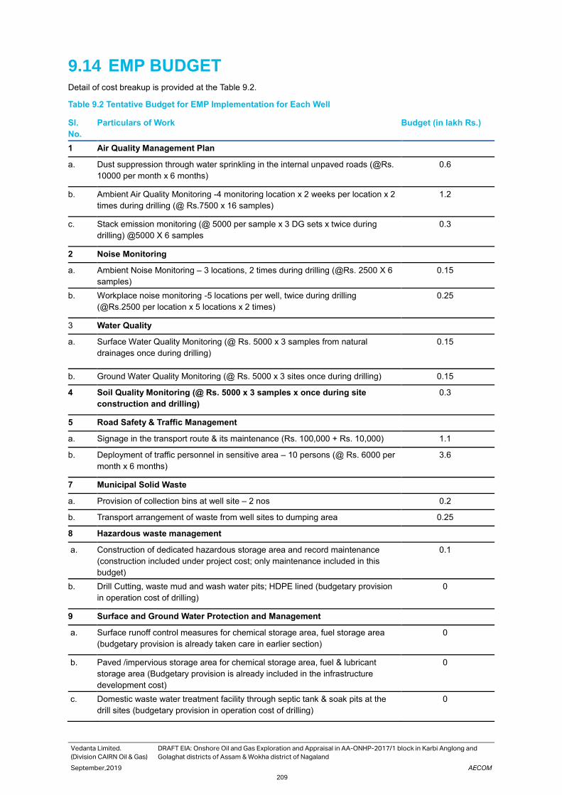
Vedanta Limited.
(Division CAIRN Oil & Gas)
DRAFT EIA: Onshore Oil and Gas Exploration and Appraisal in AA-ONHP-2017/1 block in Karbi Anglong and
Golaghat districts of Assam & Wokha district of Nagaland
September,2019 AECOM
209
9.14 EMP BUDGET Detail of cost breakup is provided at the Table 9.2.
Table 9.2 Tentative Budget for EMP Implementation for Each Well
Sl.
No.
Particulars of Work Budget (in lakh Rs.)
1 Air Quality Management Plan
a. Dust suppression through water sprinkling in the internal unpaved roads (@Rs.
10000 per month x 6 months)
0.6
b. Ambient Air Quality Monitoring -4 monitoring location x 2 weeks per location x 2
times during drilling (@ Rs.7500 x 16 samples)
1.2
c. Stack emission monitoring (@ 5000 per sample x 3 DG sets x twice during
drilling) @5000 X 6 samples
0.3
2 Noise Monitoring
a. Ambient Noise Monitoring – 3 locations, 2 times during drilling (@Rs. 2500 X 6
samples)
0.15
b. Workplace noise monitoring -5 locations per well, twice during drilling
(@Rs.2500 per location x 5 locations x 2 times)
0.25
3 Water Quality
a. Surface Water Quality Monitoring (@ Rs. 5000 x 3 samples from natural
drainages once during drilling)
0.15
b. Ground Water Quality Monitoring (@ Rs. 5000 x 3 sites once during drilling) 0.15
4 Soil Quality Monitoring (@ Rs. 5000 x 3 samples x once during site
construction and drilling)
0.3
5 Road Safety & Traffic Management
a. Signage in the transport route & its maintenance (Rs. 100,000 + Rs. 10,000) 1.1
b. Deployment of traffic personnel in sensitive area – 10 persons (@ Rs. 6000 per
month x 6 months)
3.6
7 Municipal Solid Waste
a. Provision of collection bins at well site – 2 nos 0.2
b. Transport arrangement of waste from well sites to dumping area 0.25
8 Hazardous waste management
a. Construction of dedicated hazardous storage area and record maintenance
(construction included under project cost; only maintenance included in this
budget)
0.1
b. Drill Cutting, waste mud and wash water pits; HDPE lined (budgetary provision
in operation cost of drilling)
0
9 Surface and Ground Water Protection and Management
a. Surface runoff control measures for chemical storage area, fuel storage area
(budgetary provision is already taken care in earlier section)
0
b. Paved /impervious storage area for chemical storage area, fuel & lubricant
storage area (Budgetary provision is already included in the infrastructure
development cost)
0
c. Domestic waste water treatment facility through septic tank & soak pits at the
drill sites (budgetary provision in operation cost of drilling)
0

Vedanta Limited.
(Division CAIRN Oil & Gas)
DRAFT EIA: Onshore Oil and Gas Exploration and Appraisal in AA-ONHP-2017/1 block in Karbi Anglong and
Golaghat districts of Assam & Wokha district of Nagaland
September,2019 AECOM
210
Sl.
No.
Particulars of Work Budget (in lakh Rs.)
10 Occupational Health & Safety Management
a. Provision of appropriate PPE to all workers and its maintenance (budgetary
provision is included in operational cost of drilling)
0
b. Provision of drinking water, sanitation facility for all workers (budgetary
provision is included in operational cost of drilling)
0
c Provision First aid facility (budgetary provision is included in operational cost of
drilling)
0
d Regular occupational health & safety training 0.5
Total Cost of Implementation of EMP 8.85
9.15 Corporate Environment Responsibility The company would comply with the 1st May 2018 OM w.r.t. CER and the cost would be assessed on actual project
capex expenditure of that particular financial year

Vedanta Limited.
(Division CAIRN Oil & Gas)
DRAFT EIA: Onshore Oil and Gas Exploration and Appraisal in AA-ONHP-2017/1 block in Karbi Anglong and
Golaghat districts of Assam & Wokha district of Nagaland
September,2019 AECOM
211
10. Conclusion and Recommendation AA-ONHP-2017/1 block is located in Karbi Anglong and Golaghat districts of Assam & Wokha district of Nagaland.
Total area of block is 715 sq. km. Vedanta Limited (Division: Cairn Oil & Gas division) propose to carry out
Exploration and Appraisal Drilling activities in the Block, wherein 20 new drilling (exploratory and appraisal) wells
are proposed would be drilled over 10-12 years. In case of successful discovery of crude oil, setting up of Early
Production Units (EPUs)/ Quick Production Units (QPUs) for produced well fluid processing and production of up
to 12000 BOPD crude oil and 2.4 MMSCFD of associated natural gas for captive power generation.
ToR has been approved by MoEF&CC dated on 20th April, 2019 and MoEF&CC vide File No. IA-J-11011/95/2019-
IA-II(I). The baseline monitoring and all primary data collection was conducted for the summer season (from March
to May), of 2019, as per the requirements of the ToR. Draft EIA report has been prepared for conducting the public
hearing.
The draft EIA report has assessed the overall significance of environmental impacts likely to arise from drilling of
proposed exploratory and appraisal wells and addressed the concerns and suggestions of the community during
the public hearing. The overall impacts from the individual drilling sites have been assessed and are found to be of
moderate to minor in nature when appropriate mitigation measures would be implemented with proper planning
and design.
To adequately address the impacts, mitigation measures and management plans suggested are as per the best
practices followed in the Oil & Gas exploration Industry. These plans include environmental management plan,
monitoring plan, labour management plan, traffic management plan. Vedanta Limited (Division: Cairn Oil & Gas)
shall put in place a robust mechanism with adequate resources to implement the suggested mitigation measures
and management plans. The measures would help to prevent any deterioration of quality of air, soil, groundwater
and surface water beyond the prevailing status. Adequate safety measures would be adopted along with suitable
emergency response and disaster management plan to safeguard against all man-made and natural disasters.
Environmental monitoring of ambient air quality, noise levels, surface & groundwater etc. would be carried out at
regular intervals to monitor and prevent any deterioration of baseline environmental quality due to the proposed
project.
Compliance to all legal requirements and adherence to the suggested mitigation measures and plans would also
enable Vedanta Limited (Division: Cairn Oil & Gas) in minimizing its impact on environmental and social parameter.
This Report in the final form is being submitted to MoEF&CC for obtaining Environmental Clearance (EC) of the
proposed project before commencement of site activity.

Vedanta Limited.
(Division CAIRN Oil & Gas)
DRAFT EIA: Onshore Oil and Gas Exploration and Appraisal in AA-ONHP-2017/1 block in Karbi Anglong and
Golaghat districts of Assam & Wokha district of Nagaland
September,2019 AECOM
212
11. Disclosure of Consultants AECOM has been accredited as EIA consultant for various sectors including Offshore and Onshore Oil and Gas
Exploration and Development Projects from the National Accreditation Board for Education and Training (NABET)
of Quality Council of India (QCI) under the Accreditation Scheme for EIA Consultant Organisations as per
MoEF&CC requirements.
The following approved consultants and experts were engaged for preparation of the EIA report for the proposed
study. QCI NABET certificate Of AECOM India Private Limited is presented in Figure 77.
Table 11.1 EIA Team
S. No. EIA Coordinator/ Functional
Area
Professionals
Environment
Coordinator/FAE
FAA and Team
Members
Signature
1 EIA Coordinator –Onshore Oil
and Gas Exploration and
Development Projects
Shubhangi Jadav
Core Functional Areas
2 Water Pollution Monitoring,
Prevention & Control (WP)
Avijit Sarkar Swagata
Mukherjee
Aziz Hasan
3 Ecology & Biodiversity (EB) Mainak Majumdar
4 Socio- Economic Aspects (SE) Souvik Basu
Significant functional areas
5 Solid and Hazardous Waste
Management (SHW)
Avijit Sarkar Moudipta Banerjee
6 Meteorology, Air Quality
Modelling & prediction (AQ)
Avijit Sarkar Swagata
Mukherjee
7 Risk and Hazards Management
(RH)
Atul Kumar Debsagar Das

Vedanta Limited.
(Division CAIRN Oil & Gas)
DRAFT EIA: Onshore Oil and Gas Exploration and Appraisal in AA-ONHP-2017/1 block in Karbi Anglong and
Golaghat districts of Assam & Wokha district of Nagaland
September,2019 AECOM
213
S. No. EIA Coordinator/ Functional
Area
Professionals
Environment
Coordinator/FAE
FAA and Team
Members
Signature
8 Air Pollution Monitoring,
Prevention & Control (AP)
Avijit Sarkar Swagata
Mukherjee
Shivnath Chalka
9 Hydrology, Ground Water &
Water Conservation (HG)
Shiv Pratap Unya
10 Noise &Vibration (NV) Atul Kumar Swagata
Mukherjee
11 Land Use (LU) Laxmi Reddy Moumita Dey
12 Soil Conservation (SC) Chetan Zaveri Moumita Dey
.

Vedanta Limited.
(Division CAIRN Oil & Gas)
DRAFT EIA: Onshore Oil and Gas Exploration and Appraisal in AA-ONHP-2017/1 block in Karbi Anglong and
Golaghat districts of Assam & Wokha district of Nagaland
September,2019 AECOM
214
Figure 77. QCI-NABET Certificate

Vedanta Limited.
(Division CAIRN Oil & Gas)
DRAFT EIA: Onshore Oil and Gas Exploration and Appraisal in AA-ONHP-2017/1 block in Karbi Anglong and
Golaghat districts of Assam & Wokha district of Nagaland
September,2019 AECOM
215

APPENDIX

List of Appendix
Appendix 1-1 ToR Letter
Appendix 2-1 Revenue sharing contract
Appendix 2-2 Process flow diagram
Appendix 2-3 Well Wise Environmental Settings
Appendix 2-4 Environment Settings of Well (1km buffer map for each well)
Appendix 2-5 The list of chemicals to be used during drilling
Appendix 3-1 Micro-Meteorological Data
Appendix 3-2 Ambient Air quality Monitoring Results
Appendix 3-3 Ambient Noise Monitoring Results
Appendix 3-4 Ground Water Quality Monitoring Results
Appendix 3-5 Surface Water Quality Monitoring Results
Appendix 3-6 Soil Monitoring Results
Appendix 3-7 Traffic Survey Results
Appendix 3-8 The list of Mammals
Appendix 3-9 The list of Avifauna
Appendix 3-10 The list of Reptiles
Appendix 3-11 The list of Amphibians
Appendix 3-12 The list of Butterflies
Appendix 3-13 The list of Fishes
Appendix 3-14 Demographic profile of the study area
Appendix 3-15 Consultation of the socio Economic
Appendix 7-1 information on leak sizes, inventories and hazardous chemicals within the
isolatable sections.

Appendix 1.1:
ToR Letter

No.IA-J-11011/95/2019-IA-II(I)
Goverment of India
Minister of Enviroment,Forest and Climate Change
Impact Assessment Division
***
Indira Paryavaran Bhavan,
Vayu Wing,3rd Floor,Aliganj,
Jor Bagh Road,New Delhi-110003
20 Apr 2019
To,
M/s Cairn India Limited
Cairn Oil & Gas, Vedanta Limited, DLF Atria, DLF Phase-2, DLF City, Gurgaon, Haryana -
122002Gurgaon,
Gurgaon-122002
Haryana
Tel.No.124-4594176; Email:[email protected]
Sir/Madam,
This has reference to the proposal submitted in the Ministry of Environment, Forest
and Climate Change to prescribe the Terms of Reference (TOR) for undertaking detailed EIA
study for the purpose of obtaining Environmental Clearance in accordance with the provisions of
the EIA Notification, 2006. For this purpose, the proponent had submitted online information in the
prescribed format (Form-1 ) along with a Pre-feasibility Report. The details of the proposal are
given below:
1. Proposal No.: IA/AS/IND2/99665/2019
2. Name of the Proposal:
Onshore Oil and Gas Exploration and Appraisal
in AA-ONHP-2017/1 block in Karbi Anglong and
Golaghat districts of Assam & Wokha district of
Nagaland
3. Category of the Proposal: Industrial Projects - 2
4. Project/Activity applied for: 1(b) Offshore and onshore oil and gas
exploration, development & production
5. Date of submission for TOR: 18 Mar 2019

In this regard, under the provisions of the EIA Notification 2006 as amended, the Standard TOR
for the purpose of preparing environment impact assessment report and environment
management plan for obtaining prior environment clearance is prescribed with public consultation
as follows:

STANDARD TERMS OF REFERENCE (TOR) FOR EIA/EMP REPORT FOR PROJECTS/ACTIVITIES REQUIRING ENVIRONMENT CLEARANCE
1(b):STANDARD TERMS OF REFERENCE FOR CONDUCTING
ENVIRONMENT IMPACT ASSESSMENT STUDY FOR OFFSHORE AND ONSHORE OIL AND GAS EXPLORATION, DEVELOPMENT AND PRODUCTION PROJECTS AND INFORMATION TO BE INCLUDED IN EIA/EMP REPORT
B . STANDARD TOR FOR ONSHORE OIL AND GAS EXPLORATION, DEVELOPMENT
& PRODUCTION
1. Executive summary of a project.
2. Project description, project objectives and project benefits.
3. Cost of project and period of completion.
4. Site details within 1 km of the each proposed well, any habitation, any other installation/activity, flora and fauna, approachability to site, other activities including agriculture/land, satellite imagery for 10 km area. All the geological details shall be mentioned in the Topo sheet of 1:40000 scale, superimposing the well locations and other structures of the projects. Topography of the project site.
5. Details of sensitive areas such as National Park, Wildlife sanctuary and any other eco-sensitive area alongwith map indicating distance.
6. Approval for the forest land from the State/Central Govt. under Forest (Conservation) Act, 1980, if applicable.
7. Recommendation of SCZMA/CRZ clearance as per CRZ Notification dated 6th January, 2011 ( if applicable).
8. Distance from nearby critically/severely polluted area as per Notification, if applicable. Status of moratorium imposed on the area.
9. Does proposal involve rehabilitation and resettlement? If yes, details thereof.
10. Environmental considerations in the selection of the drilling locations for which environmental clearance is being sought. Present any analysis suggested for minimizing the foot print giving details of drilling and development options considered.
11. Baseline data collection for air, water and soil for one season leaving the monsoon season in an area of 10 km radius with centre of Oil Field as its centre covering the area of all proposed drilling wells.
12. Climatology and Meteorology including wind speed, wind direction, temperature rainfall relative humidity etc.
13. Details of Ambient Air Quality monitoring at 8 locations for PM2.5, PM10, SO2, NOx, CO, VOCs, Methane and non-methane HC.
14. Soil sample analysis (physical and chemical properties) at the areas located at 5 locations.
15. Ground and surface water quality in the vicinity of the proposed wells site.
1

STANDARD TERMS OF REFERENCE (TOR) FOR EIA/EMP REPORT FOR PROJECTS/ ACTIVITIES REQUIRING ENVIRONMENT CLEARANCE
16. Measurement of Noise levels within 1 km radius of the proposed wells.
17. Vegetation and land use; flora/fauna in the block area with details of endangered species, if any.
18. Incremental GLC as a result of DG set operation, flaring etc.
19. Potential environmental impact envisaged during various stages of project activities such as site activation, development, operation/ maintenance and decommissioning.
20. Actual source of water and 'Permission' for the drawl of water from the Competent Authority. Detailed water balance, wastewater generation and discharge.
21. Noise abatement measures and measures to minimize disturbance due to light and visual intrusions.
22. Details on wastewater generation, treatment and utilization /discharge for produced water/ formation water, cooling waters, other wastewaters, etc. duringallprojectphases.
23. Details on solid waste management for drill cuttings, drilling mud and oil sludge, produced sand, radio activematerials, other hazardous materials, etc. including its disposal options during all project phases.
24. Disposal of spent oil and lube.
25. Storage of chemicals and diesel at site. Hazardous material usage, storage and accounting.
26. Commitment for the use of water based mud (WBM) only
27. Oil spill emergency plans for recovery/ reclamation.
28. H2S emissions control.
29. Produced oil/gas handling, processing and storage/transportation.
30. Details of control of air, water and noise pollution during production phase.
31. Measures to protect ground water and shallow aquifers from contamination.
32. Whether any burn pits being utilised for well test operations.
33. Risk assessment and disaster management plan for independent reviews of well designed construction etc. for prevention of blow out. Blowout preventer installation.
34. Environmental management plan.
35. Total capital and recurring cost for environmental control measures.
36. Emergency preparedness plan.
37. Decommissioning and restoration plans.
38. Documentary proof of membership of common disposal facilities, if any.
39. Details of environmental and safety related documentation within the company including documentation and proposed occupational health and safety Surveillance Safety Programme for all personnel at site. This shall also include monitoring programme for the environmental.
40. A copy of Corporate Environment Policy of the company as per the Ministry's O.M. No. J-11013/ 41/2006-IA.II(I) dated 26th April, 2011 available on the Ministry's website.
41. Any litigation pending against the project and or any direction/order passed by any court of law against the project. If so details thereof.
***
2

Appendix 2.1:
Revenue Sharing
Contract
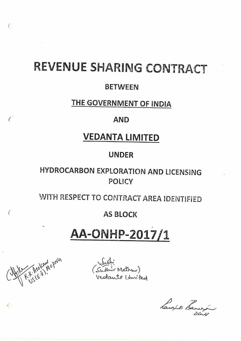


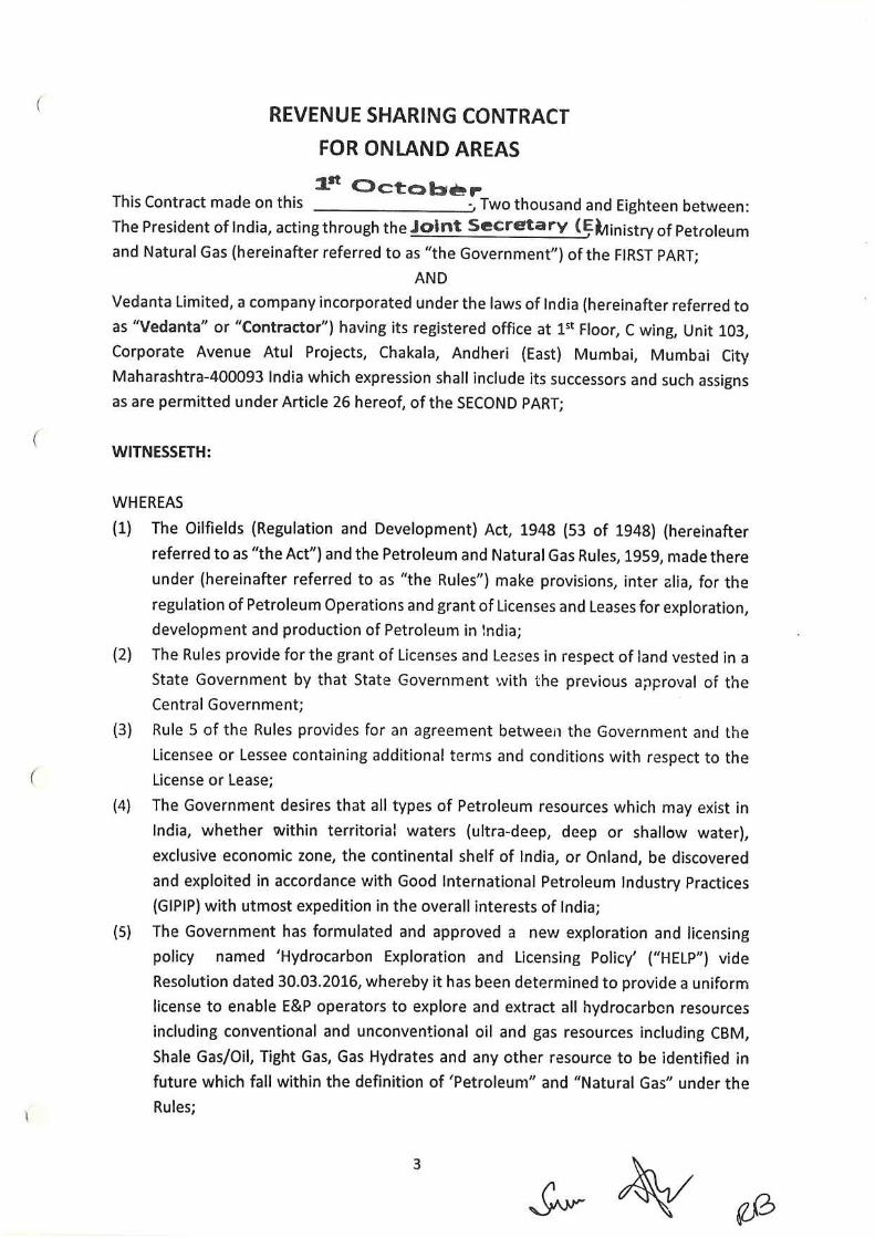


Appendix 2.2:
Process Flow
Diagram

© 2017 Vedanta Limited 1
Quick Production Unit/ Early Production Unit (2000 BLPD)
Heater-Treater
Separator (3 Phase)
Electrostatic
Coalescer
Separator (if
needed)
Produced Water
Treatment Skid
Typical well (with SRP)
hook-up
Oil Storage
Tanks
(1000 bbls x 2)
Fuel Gas
System
GEG
Water Storage
Tanks
(1000 bbls x 1)
Oil Tanker
Loading Facility
For Disposal
Associated Utility Systems
Flare
System
Inst. Air
Package
Fuel to
• Heater-treater
• GEG
• Flare System
Closed
Drain
Fire Fighting
Equipment
Sub-station & control
room Container
DG
Oil Loading Pumps
Pumps
Diesel Storage
& Transfer
Pump
Flare PitWaste
Pits
Security Guard House
& Operator Bunk
STP/ Soak Pit
& Septic tank
Chemical Dosing Packages (Demulsifier, de-oiler, scale inhibitor
etc.)
QPU for:• Total Liquid rate: 2000 BLPD with Water
cut: 0 – 50% (vol), Gas System: ~5
mmscfd
• PW Treatment System: 1000 BWPD
Water
storage
Pits

Appendix 2.3:
Well Wise
Environmental
Settings

Sl.
No
Well
Name
Geographical
Coordinates
H
C
Bl
oc
k
Admiration Setting Existing
Land
cover
of wells
Accessibility
(in approx.)
Environmental
Setting of Wells
Ecological
Sensitivity
Settlement/ School within
1km
Existing
INDUST
RY
Existi
ng
facilit
y
Ma
p
Ref
ere
nce
(An
nex
2.1)
Village
Tehsil
District
Terrain
Type
Stream/
River
Forest WL
S/E
SZ
1 1 25°56'35.11"N 93°43'45.83"E
Joyram
Engleng
Silonj
an
Golagh
at
Fallow
land
An earthen
road is 0.02
km away
from the
well
location,
which is
connected
to the AH 1.
Flat
land
NA A
proposed
reserve
forest is
present
within the
2.5 km
radius of
the well
location.
NA Several clusters of
settlement are present
within the 2.5 km radius of
the well location. The
nearest one is 0.08 km
away from the well
location.
Joyram Engleng, Takajan
Kuki Gaon, Ram nath
Kathar are the villages
present within the 2.5 km
radious of the well
location.
NA NA
2 2 25°57'17.040"N, 93°49'43.980"E
Ambari Sarup
athar
Golagh
at
Agricult
ural
Land
An unnamed
road is
almost 0.85
km away
towards
Flat
land
NA Diphu
reserve
forest is
present,
within 2.5
km radious
NA Nearest settlement is
present at a distance of
0.08 km away from the
well location.
There
are
some
numbe
rs of
NA

Sl.
No
Well
Name
Geographical
Coordinates
H
C
Bl
oc
k
Admiration Setting Existing
Land
cover
of wells
Accessibility
(in approx.)
Environmental
Setting of Wells
Ecological
Sensitivity
Settlement/ School within
1km
Existing
INDUST
RY
Existi
ng
facilit
y
Ma
p
Ref
ere
nce
(An
nex
2.1)
Village
Tehsil
District
Terrain
Type
Stream/
River
Forest WL
S/E
SZ
south west
from the
well
location,
which is
connected
to the
Nuiland
Dimapur
road.
of the well
location. Ambari, Nayanjan Gaon
are the villages present
within the 2.5 km radious
of the well location.
brick
fields
are
presen
t to the
south
from
the
well
locatio
n.
3 3 25°59'3.454"N 93°51'41.232"E
Da Gaon
No. 3
Sarup
athar
Golagh
at
Homes
ted
plantati
on
An unnamed
road is 1.20
km east
from the
well
location,
which is
Flat
land
NA NA NA Some scattered
settlement is present
within .5 km radius of the
well location, towards
north east direction.
NA No
healt
hcare
facilit
y is
prese
nt
withi

Sl.
No
Well
Name
Geographical
Coordinates
H
C
Bl
oc
k
Admiration Setting Existing
Land
cover
of wells
Accessibility
(in approx.)
Environmental
Setting of Wells
Ecological
Sensitivity
Settlement/ School within
1km
Existing
INDUST
RY
Existi
ng
facilit
y
Ma
p
Ref
ere
nce
(An
nex
2.1)
Village
Tehsil
District
Terrain
Type
Stream/
River
Forest WL
S/E
SZ
connected
with NH2.
No school is present
within 2.5 km radius of the
well location.
Tengatol Basti, Rongpur,
Nepali Basti, Lyphian Naga
Basti are the villages found
within 2.5 km radius of the
well location.
n 2.5
km
rdaiu
s of
the
well
locati
on.
4 4 25°58'38.82"N 93°41'3.45"E
Sarthe
Killing
Diphu Karbi
Anglon
g
Agricult
ural
land
An unnamed
road is 2.19
km west
from the
well
location,
which is
connected
with NH 29.
Flat
land
NA NA NA A small patch of
settlement is present 0.68
km south from the well
location.
Sirvomu Lower Primary
school is present 0.63 km
north west from the well
location.
NA No
healt
h
Care
facilit
y is
prese
nt
withi
n 2.5
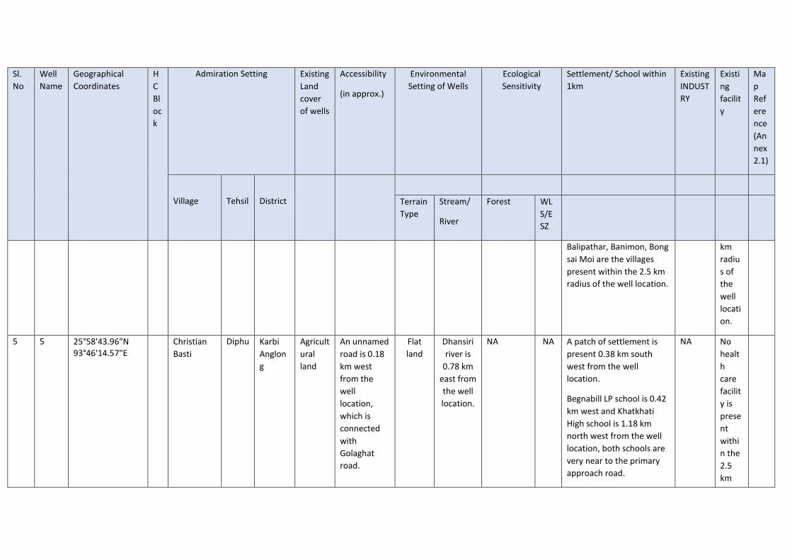
Sl.
No
Well
Name
Geographical
Coordinates
H
C
Bl
oc
k
Admiration Setting Existing
Land
cover
of wells
Accessibility
(in approx.)
Environmental
Setting of Wells
Ecological
Sensitivity
Settlement/ School within
1km
Existing
INDUST
RY
Existi
ng
facilit
y
Ma
p
Ref
ere
nce
(An
nex
2.1)
Village
Tehsil
District
Terrain
Type
Stream/
River
Forest WL
S/E
SZ
Balipathar, Banimon, Bong
sai Moi are the villages
present within the 2.5 km
radius of the well location.
km
radiu
s of
the
well
locati
on.
5 5 25°58'43.96"N 93°46'14.57"E
Christian
Basti
Diphu Karbi
Anglon
g
Agricult
ural
land
An unnamed
road is 0.18
km west
from the
well
location,
which is
connected
with
Golaghat
road.
Flat
land
Dhansiri
river is
0.78 km
east from
the well
location.
NA NA A patch of settlement is
present 0.38 km south
west from the well
location.
Begnabill LP school is 0.42
km west and Khatkhati
High school is 1.18 km
north west from the well
location, both schools are
very near to the primary
approach road.
NA No
healt
h
care
facilit
y is
prese
nt
withi
n the
2.5
km

Sl.
No
Well
Name
Geographical
Coordinates
H
C
Bl
oc
k
Admiration Setting Existing
Land
cover
of wells
Accessibility
(in approx.)
Environmental
Setting of Wells
Ecological
Sensitivity
Settlement/ School within
1km
Existing
INDUST
RY
Existi
ng
facilit
y
Ma
p
Ref
ere
nce
(An
nex
2.1)
Village
Tehsil
District
Terrain
Type
Stream/
River
Forest WL
S/E
SZ
Habe Taimung, Kai Tereng
are the villages present
within the 2.5 km radius of
the well location.
rdaiu
s of
the
ell
locati
on.
6 6 25°58'21.200"N, 93°48'15.770"E
Kai Tereng Diphu Karbi
Anglon
g
Agricult
ural
land
An unnamed
road is 0.26
km east
from the
well
location,
which is
connected
to NH 129.
Flat
land
Dhansiri
river is
within
the .5 km
radius of
the well
location.
NA NA A patch of settlement is
present 0.39 km south
from the well location.
No school is resent within
the 2.5 km radius of the
well location.
Dighir Basti, Kai tereng,
Habe taimung are the
villages within the 2.5 km
radisu of the well location.
NA No
healt
h
care
facilit
y is
prese
nt
withi
n 2.5
km
radiu
s of

Sl.
No
Well
Name
Geographical
Coordinates
H
C
Bl
oc
k
Admiration Setting Existing
Land
cover
of wells
Accessibility
(in approx.)
Environmental
Setting of Wells
Ecological
Sensitivity
Settlement/ School within
1km
Existing
INDUST
RY
Existi
ng
facilit
y
Ma
p
Ref
ere
nce
(An
nex
2.1)
Village
Tehsil
District
Terrain
Type
Stream/
River
Forest WL
S/E
SZ
the
well
locati
on.
7 7 26° 0'46.710"N, 93°49'26.130"E
Chungazan
Hazari
Gaon
Sarup
athar
Golagh
at
Agricult
ural
land
An unnamed
road is 0.08
km east
from the
well
location,
which is
connected
to NH 129.
Flat
land
NA A portion
of Nambar
Reserve
forest is
present
within 2.5
km radius
of the well
location.
NA No such settlement is
present within 2.5 km
radius of the well location.
Changujan ME school is
1.74 km east from the well
location.
Da gaon No.4, Chungajan,
Raiali Matikhola are the
village spresent within 2.5
km radius of the well
location.
NA No
healt
h
care
facilit
y is
prese
nt
withi
n the
2.5
km
rdaiu
s of
the

Sl.
No
Well
Name
Geographical
Coordinates
H
C
Bl
oc
k
Admiration Setting Existing
Land
cover
of wells
Accessibility
(in approx.)
Environmental
Setting of Wells
Ecological
Sensitivity
Settlement/ School within
1km
Existing
INDUST
RY
Existi
ng
facilit
y
Ma
p
Ref
ere
nce
(An
nex
2.1)
Village
Tehsil
District
Terrain
Type
Stream/
River
Forest WL
S/E
SZ
well
locati
on.
8 8 26° 0'3.330"N 93°51'51.513"E
Madhapur Sarup
athar
Golagh
at
Agricult
ural
land
An unnamed
road is 0.11
km north
from the
well
location,
which is
connected
to NH 129.
A patch of
settlement is
present on
the both
side of the
primary
Flat
land
NA The well is
present in
Nambar
reserve
forest.
NA A small patch of
settlement is present 0.21
km east from the well
location.
Chungajan ME school is
present 2.19 km west
from the well location.
Da gaon no 2, Santipur No.
3 are the village spresent
within 2.5 km radius of the
well location.
NA No
healt
h
care
facilit
y is
prese
nt
withi
n 2.5
km
rdaiu
s of
the
well

Sl.
No
Well
Name
Geographical
Coordinates
H
C
Bl
oc
k
Admiration Setting Existing
Land
cover
of wells
Accessibility
(in approx.)
Environmental
Setting of Wells
Ecological
Sensitivity
Settlement/ School within
1km
Existing
INDUST
RY
Existi
ng
facilit
y
Ma
p
Ref
ere
nce
(An
nex
2.1)
Village
Tehsil
District
Terrain
Type
Stream/
River
Forest WL
S/E
SZ
approach
road.
locati
on.
9 9 26° 1'59.81"N 93°46'29.71"E
Sukhajan Diphu Karbi
Anglon
g
Agricult
ural
land
An unnamed
road is 0.05
km awat
from the
well locatin,
which is
connected
to NH 39.
Bokajan
railway
station is
1.68 km
south from
the wel
location.
Flat
land
Dhansiri
river is
0.92 km
east from
the oil
location.
A part of
Namber
forest
reserve is
present
towards
north from
the well
location.
NA A dense patch of
settlement is present
towards east from the well
location.
CCI ME school, Kendriya
Vidyalaya is present 2.21
km east from the well
location.
Koch Gaon, Dilwajan are
the villages present within
2.5 km radius of the well
location.
CCI is
present
2.21
km
east
from
the
well
locatio
n.
CCI
healt
h
centr
e is
prese
nt
2.29
km
east
from
the
well
locati
on.

Sl.
No
Well
Name
Geographical
Coordinates
H
C
Bl
oc
k
Admiration Setting Existing
Land
cover
of wells
Accessibility
(in approx.)
Environmental
Setting of Wells
Ecological
Sensitivity
Settlement/ School within
1km
Existing
INDUST
RY
Existi
ng
facilit
y
Ma
p
Ref
ere
nce
(An
nex
2.1)
Village
Tehsil
District
Terrain
Type
Stream/
River
Forest WL
S/E
SZ
10 10 26° 0'42.820"N, 93°48'33.250"E
Bokajan Diphu Karbi
Anglon
g
Agricult
ural
land
An unnamed
road is
present just
beaside the
well
location, and
connected
to
Chungajan
road.
Flat
land
Dhansiri
river is
0.57 km
north
west
from the
well
location.
A part of
both
Namber
and Diphu
reseve
foreset is
resent
within the
2.5 km
raius of
the well
location.
A moderate patch of
settlement is present on
the both sides of the well
location.
CCI ME school, Kendriya
Vidyalaya is present 2.21
km east from the well
location.
Koch Gaon, Dilwajan are
the villages present within
2.5 km radius of the well
location.
CCI is
present
2.21
km
east
from
the
well
locatio
n.
CCI
healt
h
centr
e is
prese
nt
2.29
km
east
from
the
well
locati
on.

Sl.
No
Well
Name
Geographical
Coordinates
H
C
Bl
oc
k
Admiration Setting Existing
Land
cover
of wells
Accessibility
(in approx.)
Environmental
Setting of Wells
Ecological
Sensitivity
Settlement/ School within
1km
Existing
INDUST
RY
Existi
ng
facilit
y
Ma
p
Ref
ere
nce
(An
nex
2.1)
Village
Tehsil
District
Terrain
Type
Stream/
River
Forest WL
S/E
SZ
11 11 26° 1'12.252"N 93°51'16.208"E
Netezu Sarup
athar
Golagh
at
Agricult
ural
land
Naukhuti
main market
road is 1.57
km south
from the
well
location. A
patch of
settlement is
present on
the both
side of that
road.
Flat
land
NA NA NA A patch of settlement is
present towards east from
the well location, within .5
km radius.
No.1 amguri nepali school
is 1.43 km west from the
well location.
Misamari, Matikhola,
Holowguri are the villages
present within 2.5 km
radius of the well location.
NA Mohi
ma
Healt
h Sub
cente
r is
2.76
km
north
from
the
well
locati
on.
12 12 26° 2'24.39"N 93°43'52.73"E
Sukhanjan Diphu Karbi
Anglon
g
Agricult
ural
land
An unnamed
road is 0.88
km south
from the
well
Flat
land
NA A part of
west
Namber
forest
reserve is
NA No settlements present
within 2.5 km radius of the
well location.
NA NA

Sl.
No
Well
Name
Geographical
Coordinates
H
C
Bl
oc
k
Admiration Setting Existing
Land
cover
of wells
Accessibility
(in approx.)
Environmental
Setting of Wells
Ecological
Sensitivity
Settlement/ School within
1km
Existing
INDUST
RY
Existi
ng
facilit
y
Ma
p
Ref
ere
nce
(An
nex
2.1)
Village
Tehsil
District
Terrain
Type
Stream/
River
Forest WL
S/E
SZ
location,
which is
connected
with NH 129.
present
within 2.5
km radius
of the well
location,
towards
north.
13 13 26° 3'43.52"N 93°46'6.20"E
Sariajan Diphu Karbi
Anglon
g
Agricult
ural
land
Golaghat
road is 0.88
km south
east from
the wel
location
Flat
land
NA A part of
west
Nambar
forest
reserve is
present
within 2.5
km radius
of the well
location.
NA Moderate patch of
settlements is present
within the .5 km radius of
the well location.
Sartha Rongpo, Sartha
Phangcho are the villages
present within the 2.5 km
radius of the well location.
NA NA

Sl.
No
Well
Name
Geographical
Coordinates
H
C
Bl
oc
k
Admiration Setting Existing
Land
cover
of wells
Accessibility
(in approx.)
Environmental
Setting of Wells
Ecological
Sensitivity
Settlement/ School within
1km
Existing
INDUST
RY
Existi
ng
facilit
y
Ma
p
Ref
ere
nce
(An
nex
2.1)
Village
Tehsil
District
Terrain
Type
Stream/
River
Forest WL
S/E
SZ
14 14 26° 5'7.39"N 93°46'28.18"E
Sariajan Diphu Karbi
Anglon
g
Agricult
ure
land
Golaghat
road is 0.41
km east
from the
well
location.
Flat
land
NA A part of
west
namber
reserve
forest is
present
within 2.5
km radius
of the well
location.
NA No such settlement is
present withinthe .5 km
radius of the well location.
Longkicho Engti, Sarthe
rongpi are the villages
found within 2.5 km radius
of the well location.
NA NA
15 15 26° 9'38.27"N 93°52'43.48"E
Dighalganj
a NC
Sarup
athar
Golagh
at
Agricult
ural
land
An unnamed
road is just
beside the
well
location,
which is
connected
to NH 39.
Flat
land
NA NA NA Some scattered
settlement is present
within the .5 km radius of
the well location.
Khonikor, Naga Juri, Pan
Jan are the villages
present within 2.5 km
radius of the well location.
NA NA

Sl.
No
Well
Name
Geographical
Coordinates
H
C
Bl
oc
k
Admiration Setting Existing
Land
cover
of wells
Accessibility
(in approx.)
Environmental
Setting of Wells
Ecological
Sensitivity
Settlement/ School within
1km
Existing
INDUST
RY
Existi
ng
facilit
y
Ma
p
Ref
ere
nce
(An
nex
2.1)
Village
Tehsil
District
Terrain
Type
Stream/
River
Forest WL
S/E
SZ
16 16 26° 6'28.63"N 93°47'40.31"E
Dilaojan Diphu Karbi
Anglon
g
Golaghat
road is 0.41
km east
from the
well
location.
Flat
land
NA A part of
west
namber
reserve
forest is
present
within 2.5
km radius
of the well
location.
NA No such settlement is
present withinthe .5 km
radius of the well location.
Longkicho Engti, Sarthe
rongpi are the villages
found within 2.5 km radius
of the well location.
NA NA
17 17 26° 8'4.62"N 93°50'0.89"E
No.1 Kori
Gaon
Sarup
athar
Golagh
at
Agricult
ure
land
An unnamed
village road
is just beside
the well
location,
which is
connected
to NH 39.
Flat
land
Dhansiri
river is
0.45 km
from the
well
location.
NA NA A patch of settlement is
present within the .5 km
radius of the well location,
towards south.
Nao Jan jatiya Vidyalaya is
present 1.65 km south
from the well location.
NA NA

Sl.
No
Well
Name
Geographical
Coordinates
H
C
Bl
oc
k
Admiration Setting Existing
Land
cover
of wells
Accessibility
(in approx.)
Environmental
Setting of Wells
Ecological
Sensitivity
Settlement/ School within
1km
Existing
INDUST
RY
Existi
ng
facilit
y
Ma
p
Ref
ere
nce
(An
nex
2.1)
Village
Tehsil
District
Terrain
Type
Stream/
River
Forest WL
S/E
SZ
Na gaon
Railway
station is
1.71 km
south from
the well
location.
Bardeka taimung, Moh
Khuti are the villages
present within the 2.5 km
radius of the well location.
18 18 26° 7'26.87"N 93°46'41.36"E
Dihingia Karbi
Anglon
g
Agricult
ural
land
Golaghat
road is 0.41
km east
from the
well
location.
Flat
land
NA A part of
west
namber
reserve
forest is
present
within 2.5
km radius
of the well
location.
NA No such settlement is
present withinthe .5 km
radius of the well location.
Longkicho Engti, Sarthe
rongpi are the villages
found within 2.5 km radius
of the well location.
NA NA

Sl.
No
Well
Name
Geographical
Coordinates
H
C
Bl
oc
k
Admiration Setting Existing
Land
cover
of wells
Accessibility
(in approx.)
Environmental
Setting of Wells
Ecological
Sensitivity
Settlement/ School within
1km
Existing
INDUST
RY
Existi
ng
facilit
y
Ma
p
Ref
ere
nce
(An
nex
2.1)
Village
Tehsil
District
Terrain
Type
Stream/
River
Forest WL
S/E
SZ
19 19 26°8'38.65"N 93°47'41.20"E
Rongagara Siloni
jan
Karbi
Anglon
g
Agricult
ural
land
Golaghat
road is 0.41
km east
from the
well
location.
Flat
land
NA A part of
west
namber
reserve
forest is
present
within 2.5
km radius
of the well
location.
NA No such settlement is
present withinthe .5 km
radius of the well location.
Longkicho Engti, Sarthe
rongpi are the villages
found within 2.5 km radius
of the well location.
NA NA
20 20 26° 9'26.45"N 93°49'21.87"E
Jabarajan Siloni
jan
Karbi
Anglon
g
Agricult
ure
land
An unnamed
village road
is just beside
the well
location,
which is
connected
to NH 39.
Flat
land
Dhansssir
i river is
0.45 km
from the
well
location.
NA NA A patch of settlement is
present within the .5 km
radius of the well location,
towards south.
Nao Jan jatiya Vidyalaya is
present 1.65 km south
from the well location.
NA NA
Sl.
No
Well
Name
Geographical
Coordinates
H
C
Bl
oc
k
Admiration Setting Existing
Land
cover
of wells
Accessibility
(in approx.)
Environmental
Setting of Wells
Ecological
Sensitivity
Settlement/ School within
1km
Existing
INDUST
RY
Existi
ng
facilit
y
Ma
p
Ref
ere
nce
(An
nex
2.1)
Village
Tehsil
District
Terrain
Type
Stream/
River
Forest WL
S/E
SZ
Na gaon
Railway
station is
1.71 km
south from
the well
location.
Bardeka taimung, Moh
Khuti are the villages
present within the 2.5 km
radius of the well location.
Appendix 2.4:
Environment
Settings of Well
(1km buffer map for
each well)


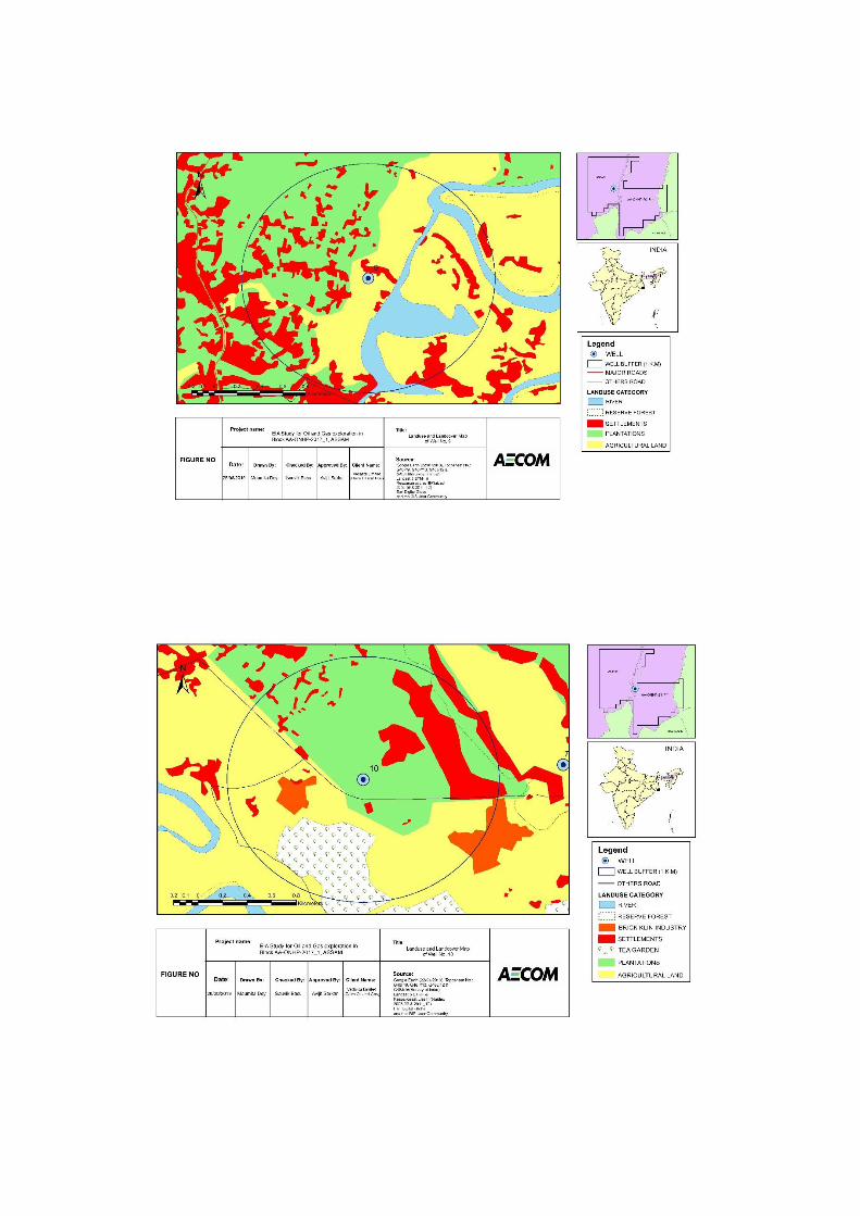


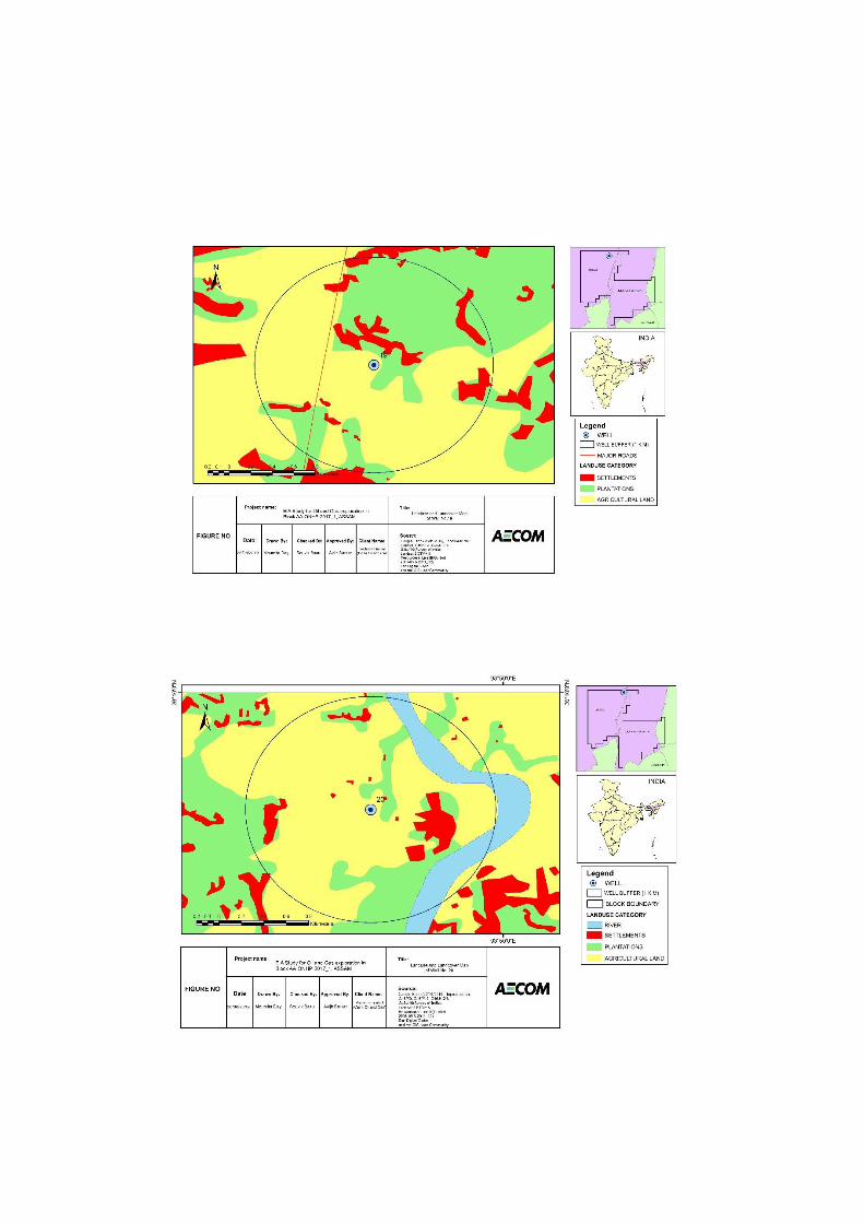

Appendix 2.5:
The List of
Chemicals to be
Used During Drilling

CHEMICAL DETAIL
Function chemicals
A. WBM Formulation
Water /Base fluid
Viscosifier Biopolymer
Fluid Loss Agent Drispac/CMC
Alkalinity Agent Caustic Potash
Salinity Potassium Sulphate
Lubricant Torque Reducer/Blend of vegetable oil, Surfactant and Food Grade Paraffin Oil
Gelling agent Bentonite
Biocide Gluteraldehyde
Weighting Agent Barite
B. SBM Formulation
Base oil/Base Fluid
Synthetic Biodegradable Base Fluid
Water -
Emulsifier Polyamide, Petroleum Distillate, Dipropylene Glycol Methyl Ether
Viscosifier Bentonite
Fluid Loss Agent Gilsonite
Brine Phase Sodium Formate
Alkalinity Calcium Hydroxide
Bridging Agent Calcium Carbonate Graded
Weighting Agent Barite

Appendix 3.1: Micro-
Meteorological Data

Appendix 3.1- Micro meteorology Data
Location - Bokajan
Coordinate-26°01'25.71"N, 93°46'21.79"E
ear Mont
h Day
Hour
Temperature
Reltaive Humidity
Wind Dir
Wind Speed
Rainfall
Cloud Cover
Solar Rad
- - - - (°C) (%) (Deg) (mph) (In) (%)
(wat/m2)
2019 3 10 1 23.1
89.2 231 2 0 0 0
2019 3 10 2 23.1
90.5 231 3 0 0 0
2019 3 10 3 23.1
88.1 231 6 0 0 0
2019 3 10 4 23
90.0 231 5 0 0 0
2019 3 10 5 23
88.9 231 3 0 10 0
2019 3 10 6 23
89.8 231 2 0 0 8
2019 3 10 7 24
90.4 231 0 0 10 103
2019 3 10 8 24
90.0 231 0 0 25 165
2019 3 10 9 24
87.3 231 0 0 0 343
2019 3 10 10 24
77.0 231 2 0 0 464
2019 3 10 11 24
66.1 231 0 0 0 554
2019 3 10 12 24.1
58.8 231 0 0 0 520
2019 3 10 13 24.2
53.1 231 0 0 0 619
2019 3 10 14 23.2
51.9 231 0 0 0 524
2019 3 10 15 25.2
51.8 231 0 0 0 381
2019 3 10 16 25.3
50.1 231 0 0 0 141
2019 3 10 17 25.6
55.7 231 0 0 0 41
2019 3 10 18 25
64.5 231 0 0 30 1
2019 3 10 19 24.6
71.9 231 3 0 30 0

2019 3 10 20 23.6
76.3 231 3 0 30 0
2019 3 10 21 23.3
79.7 231 3 0 30 0
2019 3 10 22 23.1
84.7 231 8 0 30 0
2019 3 10 23 23
88.0 231 6 0 30 0
2019 3 10 24 23
90.1 231 7 0 100 0
2019 3 11 1 23
91.4 231 7 0 100 0
2019 3 11 2 23.1
92.3 231 3 0 100 0
2019 3 11 3 23.4
92.5 231 3 0 100 0
2019 3 11 4 23.6
93.2 231 0 0 100 0
2019 3 11 5 23.8
93.6 231 3 0 100 0
2019 3 11 6 24
93.9 141 5 0 100 11
2019 3 11 7 24
93.6 141 5 0 100 104
2019 3 11 8 22.6
91.9 114 2 0 100 167
2019 3 11 9 24.9
86.1 55 3 0 100 345
2019 3 11 10 26
76.3 79 2 0 100 465
2019 3 11 11 26.9
66.8 49 0 0 74 522
2019 3 11 12 28.2
55.1 223 0 0 15 517
2019 3 11 13 29.6
50.1 265 0 0 25 587
2019 3 11 14 29.9
47.1 244 0 0 30 531
2019 3 11 15 30
46.5 237 0 0 20 377
2019 3 11 16 29.5
45.8 190 0 0 70 147
2019 3 11 17 28.3
47.6 100 0 0 100 44
2019 3 11 18 26.3
57.5 173 2 0 100 5
2019 3 11 19 24.8
70.4 159 2 0 100 0
2019 3 11 20 24
77.5 112 0 0 100 0
2019 3 11 21 22.8
81.1 146 2 0 100 0

2019 3 11 22 22.6
83.3 67 3 0 87 0
2019 3 11 23 21.9
84.2 66 5 0 64 0
2019 3 11 24 21.5
87.4 56 5 0 9 0
2019 3 12 1 20.4
88.8 125 6 0 96 0
2019 3 12 2 19.8
90.7 104 7 0 100 0
2019 3 12 3 20.2
91.0 254 5 0 100 0
2019 3 12 4 19.1
90.6 268 5 0 48 0
2019 3 12 5 18.5
91.3 211 3 0 20 0
2019 3 12 6 19.3
90.5 151 0 0 28 9
2019 3 12 7 20.2
89.9 160 0 0 28 108
2019 3 12 8 22.3
90.6 217 0 0 13 163
2019 3 12 9 24.7
88.8 104 0 0 14 383
2019 3 12 10 26.9
80.3 213 0 0 12 463
2019 3 12 11 29.2
75.8 148 0 0 5 528
2019 3 12 12 30.2
63.4 138 0 0 0 523
2019 3 12 13 32.2
55.3 169 0 0 2 588
2019 3 12 14 32.2
59.7 234 0 0 15 543
2019 3 12 15 33.1
62.5 145 0 0 26 396
2019 3 12 16 33.2
65.1 64 0 0 15 153
2019 3 12 17 31.5
68.8 81 0 0.1 20 38
2019 3 12 18 29.5
71.7 72 0 0 0 35
2019 3 12 19 28.2
74.4 72 2 0.02 0 0
2019 3 12 20 27.8
76.5 64 2 0 0 0
2019 3 12 21 26.7
78.8 69 3 0 0 0
2019 3 12 22 26.1
81.3 72 6 0 15 0
2019 3 12 23 25.3
88.0 66 8 0 10 0

2019 3 12 24 24.3
90.6 69 8 0 0 0
2019 3 13 1 23.2
92.5 79 8 0 0 0
2019 3 13 2 20.8
93.4 83 8 0 0 0
2019 3 13 3 20.3
93.9 83 6 0 0 0
2019 3 13 4 20
93.7 83 6 0 0 0
2019 3 13 5 19.1
92.7 83 3 0 0 0
2019 3 13 6 18.5
93.6 83 0 0 0 14
2019 3 13 7 19.2
94.7 83 0 0 0 94
2019 3 13 8 21.7
91.5 83 0 0 0 171
2019 3 13 9 23.7
84.4 83 0 0 0 351
2019 3 13 10 25.2
76.9 160 0 0 0 471
2019 3 13 11 26.6
66.5 213 0 0 0 431
2019 3 13 12 27.6
55.2 275 0 0 10 535
2019 3 13 13 28.2
46.9 280 0 0.05 9 591
2019 3 13 14 28.5
45.6 254 0 0.05 14 520
2019 3 13 15 28.6
49.8 248 0 0 48 385
2019 3 13 16 28.1
46.0 248 0 0 100 154
2019 3 13 17 26.7
43.7 173 0 0 100 39
2019 3 13 18 24.6
47.7 62 0 0 42 8
2019 3 13 19 23.2
56.7 74 3 0 21 0
2019 3 13 20 22.3
65.2 74 3 0 14 0
2019 3 13 21 21.8
63.0 79 3 0 10 0
2019 3 13 22 20.8
59.7 67 5 0 14 0
2019 3 13 23 20.6
59.5 94 7 0 17 0
2019 3 13 24 20.2
61.6 5 7 0 12 0
2019 3 14 1 20.2
64.0 5 0 0 19 0

2019 3 14 2 20
66.3 9 7 0 29 0
2019 3 14 3 19.1
68.4 114 5 0 47 0
2019 3 14 4 18.8
69.8 230 2 0 22 0
2019 3 14 5 19.5
70.7 333 0 0 32 0
2019 3 14 6 19.1
71.6 221 0 0 31 24
2019 3 14 7 20
72.3 117 0 0 33 111
2019 3 14 8 22
72.8 125 0 0 8 174
2019 3 14 9 23.8
73.7 199 0 0 4 351
2019 3 14 10 25.4
69.3 249 0 0 75 479
2019 3 14 11 27.2
64.6 251 0 0 13 511
2019 3 14 12 27.3
58.7 221 0 0 0 527
2019 3 14 13 28.7
49.4 70 0 0 0 574
2019 3 14 14 29.4
45.7 72 0 0 0 711
2019 3 14 15 29.1
39.1 134 0 0 10 345
2019 3 14 16 28.7
40.1 193 0 0.01 0 131
2019 3 14 17 27.6
46.2 170 0 0.01 2 48
2019 3 14 18 26.1
53.1 122 0 0 100 11
2019 3 14 19 20
61.4 112 0 0 100 0
2019 3 14 20 21.1
64.9 136 2 0 44 0
2019 3 14 21 20.8
69.7 77 3 0 20 0
2019 3 14 22 20.3
70.6 72 5 0 35 0
2019 3 14 23 19.8
69.9 190 5 0 10 0
2019 3 14 24 19.3
69.8 312 6 0 0 0
2019 3 15 1 18.7
70.1 269 7 0 0 0
2019 3 15 2 17.9
70.2 269 6 0 0 0
2019 3 15 3 18.2
70.6 269 7 0 0 0

2019 3 15 4 18.3
70.0 189 3 0 0 0
2019 3 15 5 17.5
70.8 276 3 0 0 0
2019 3 15 6 17.2
71.3 112 0 0 0 11
2019 3 15 7 17.4
71.6 57 0 0 10.2 104
2019 3 15 8 18.5
70.7 57 0 0 12 167
2019 3 15 9 19.5
70.9 57 2 0 10.2 345
2019 3 15 10 20.6
70.6 57 0 0 13.5 465
2019 3 15 11 21.6
70.6 57 0 0.02 12 522
2019 3 15 12 22.2
60.8 57 0 0.01 11.1 517
2019 3 15 13 21.6
59.4 163 0 0 12 587
2019 3 15 14 21.5
53.2 214 5 0.12 10.5 531
2019 3 15 15 21.7
50.8 103 8 0.05 8.1 377
2019 3 15 16 21.5
54.4 79 6 0.15 5.7 147
2019 3 15 17 21
59.3 155 5 0 1.2 44
2019 3 15 18 19.9
64.4 86 6 0.01 9.3 5
2019 3 15 19 19.1
69.9 98 2 0.12 12.6 0
2019 3 15 20 18.1
72.3 138 2 0.05 12.6 0
2019 3 15 21 17.7
73.5 129 5 0 12.6 0
2019 3 15 22 17.5
79.3 76 3 0.26 12.3 0
2019 3 15 23 17.6
81.8 70 3 3.81 30 0
2019 3 15 24 17.4
86.4 70 3 3.47 30 0
2019 3 16 1 17
81.7 70 7 0 30 0
2019 3 16 2 16.7
82.7 70 7 0 100 0
2019 3 16 3 16.4
85.2 70 5 0 100 0
2019 3 16 4 16.3
89.5 124 3 0 100 0
2019 3 16 5 16.6
90.3 152 0 0 100 0

2019 3 16 6 16.7
91.5 152 0 0 100 21
2019 3 16 7 17
91.8 151 0 0.03 95 88
2019 3 16 8 18.3
87.7 152 0 0.04 100 297
2019 3 16 9 20.2
76.0 152 0 0 80 352
2019 3 16 10 21.1
72.8 152 0 0 76 362
2019 3 16 11 22.8
60.5 152 0 0 10 445
2019 3 16 12 24.5
49.2 152 0 0 10 551
2019 3 16 13 25.6
44.6 152 2 0 13 549
2019 3 16 14 26.6
39.8 151 0 0 9 450
2019 3 16 15 25.9
38.8 110 0 0 0.9 308
2019 3 16 16 25.3
39.4 88 3 0 2.7 141
2019 3 16 17 23.7
42.4 110 2 0 100 60
2019 3 16 18 21.7
50.2 100 0 0 91 4
2019 3 16 19 20.8
55.4 81 2 0 92 0
2019 3 16 20 20.3
61.5 72 3 0 100 0
2019 3 16 21 19.9
69.4 74 5 0 100 0
2019 3 16 22 19
80.5 60 3 0 100 0
2019 3 16 23 18.4
84.4 70 3 0 100 0
2019 3 16 24 17.6
86.0 72 3 0 93 0
2019 3 17 1 17.2
87.5 72 6 0 100 0
2019 3 17 2 16.8
86.6 72 3 0 100 0
2019 3 17 3 16.8
84.8 72 6 0 100 0
2019 3 17 4 16.6
87.6 72 5 0 100 0
2019 3 17 5 16.5
87.0 73 3 0 100 0
2019 3 17 6 16.3
86.1 73 0 0 100 15
2019 3 17 7 17.2
88.1 73 0 0 100 80

2019 3 17 8 18.9
86.2 73 2 0 100 274
2019 3 17 9 20.5
82.9 73 0 0 100 401
2019 3 17 10 21.8
76.0 73 0 0 100 584
2019 3 17 11 23.4
69.6 73 2 0 100 716
2019 3 17 12 24.3
65.5 73 2 0 100 672
2019 3 17 13 24.4
59.2 86 0 0 100 671
2019 3 17 14 25.2
57.1 211 0 0 98 434
2019 3 17 15 24.9
55.9 63 3 0 100 430
2019 3 17 16 24.5
54.3 151 0 0 97 230
2019 3 17 17 22.8
55.3 129 0 0 0 85
2019 3 17 18 21.6
63.8 172 0 0 100 4
2019 3 17 19 20.3
78.0 165 3 0 98 0
2019 3 17 20 19.5
85.3 98 3 0 100 0
2019 3 17 21 19.3
88.6 234 3 0 94 0
2019 3 17 22 19
90.6 269 5 0 100 0
2019 3 17 23 18.7
92.1 269 3 0 100 0
2019 3 17 24 18.6
92.9 269 5 0 10 0
2019 3 18 1 18.5
91.8 269 3 0 1.8 0
2019 3 18 2 18.2
92.2 228 30 0 7.8 0
2019 3 18 3 17.2
91.5 238 3 0 30 0
2019 3 18 4 17.1
92.8 224 3 0 36 0
2019 3 18 5 17
91.3 199 3 0 3 0
2019 3 18 6 16.4
91.4 193 2 0 4 11
2019 3 18 7 16.7
92.2 200 2 0 1 117
2019 3 18 8 18.6
90.7 210 2 0 2 303
2019 3 18 9 20.5
86.4 218 0 0 3 486

2019 3 18 10 22.1
74.7 189 0 0 0 637
2019 3 18 11 22.8
71.7 22 2 0 7 727
2019 3 18 12 23.7
61.5 104 2 0 17 751
2019 3 18 13 24.3
55.1 67 2 0 19 720
2019 3 18 14 24.1
49.1 67 0 0 100 605
2019 3 18 15 23.9
46.0 76 0 0 100 428
2019 3 18 16 22.8
49.1 66 0 0 95 243
2019 3 18 17 21.5
55.6 74 0 0 100 83
2019 3 18 18 20.2
59.0 73 3 0 100 4
2019 3 18 19 19.4
65.7 135 3 0 100 0
2019 3 18 20 19
71.6 244 3 0 100 0
2019 3 18 21 18.4
75.4 138 7 0 100 0
2019 3 18 22 18.4
79.2 183 5 0 100 0
2019 3 18 23 18
81.9 183 5 0 100 0
2019 3 18 24 17.7
85.3 183 8 0 0 0
2019 3 19 1 17.5
88.4 183 0 0 3 0
2019 3 19 2 17.2
84.0 214 6 0 100 0
2019 3 19 3 17
85.6 262 6 0 100 0
2019 3 19 4 16.7
82.0 242 3 0 100 0
2019 3 19 5 16.6
83.2 234 0 0 100 0
2019 3 19 6 16.9
88.7 247 0 0 100 10
2019 3 19 7 17.2
87.5 242 0 0 100 101
2019 3 19 8 18
80.2 141 0 0 12 161
2019 3 19 9 19
80.5 59 0 0 100 340
2019 3 19 10 20
80.8 122 0 0 100 459
2019 3 19 11 20.8
81.0 227 0 0 100 541
2019 3 19 12 22
75.8 227 0 0 100 420
2019 3 19 13 22.1
70.7 227 0 0 9 631
2019 3 19 14 23.3
71.2 214 0 0 3 520
2019 3 19 15 23.2
75.7 186 0 0 0 385
2019 3 19 16 23.2
79.6 231 0 0 0 137
2019 3 19 17 22.7
77.8 125 0 0 36 43
2019 3 19 18 21.5
79.6 199 0 0.06 89 1
2019 3 19 19 20.7
84.6 182 3 0.5 100 0
2019 3 19 20 20.2
86.9 232 3 0 88 0
2019 3 19 21 20.1
85.4 218 5 0 18 0
2019 3 19 22 19.6
85.1 247 8 0 19 0
2019 3 19 23 19.6
87.3 288 6 0 5.4 0
2019 3 19 24 18.6
91.4 275 7 0 0 0
2019 3 20 1 18
92.2 275 7 0 0 0
2019 3 20 2 17.7
92.1 275 8 0 0 0
2019 3 20 3 17.6
92.3 275 7 0 0 0
2019 3 20 4 17.2
92.3 275 7 0.03 0 0
2019 3 20 5 16.9
92.0 275 8 0 0 0
2019 3 20 6 16.7
91.3 275 3 0 0 6
2019 3 20 7 17.4
94.5 275 3 0 0 48
2019 3 20 8 19.1
90.3 275 0 0 0 140
2019 3 20 9 21.2
83.2 275 3 0 0 373
2019 3 20 10 23.7
75.8 275 3 0 0 408
2019 3 20 11 25.4
64.9 275 0 0 0 573
2019 3 20 12 26.7
64.8 275 0 0 0 476
2019 3 20 13 27.1
61.8 273 2 0 0 163

2019 3 20 14 27.3
57.1 217 2 0 0 186
2019 3 20 15 27
60.3 148 0 0 0 296
2019 3 20 16 26.6
58.1 201 0 0 0 194
2019 3 20 17 25.8
56.7 148 0 0 0 55
2019 3 20 18 24.4
64.6 162 0 0 0 0
2019 3 20 19 23.7
69.7 112 6 0.07 0 0
2019 3 20 20 22.8
73.9 131 5 0.04 0 0
2019 3 20 21 21.6
71.7 97 6 0 0 0
2019 3 20 22 20.7
73.7 182 5 0.01 0 0
2019 3 20 23 20.5
80.4 341 5 0.01 0 0
2019 3 20 24 20.2
80.1 341 8 0 0 0
2019 3 21 1 19.6
83.5 341 8 0 0 0
2019 3 21 2 18.7
87.0 341 6 0 0 0
2019 3 21 3 18.2
87.9 341 7 0 0 0
2019 3 21 4 17.8
89.1 341 7 0 0 0
2019 3 21 5 17.6
89.1 341 3 0 0.3 0
2019 3 21 6 17.8
88.0 341 6 0 0 7
2019 3 21 7 18.8
91.1 341 3 0 2 69
2019 3 21 8 22.2
89.7 341 3 0 0 242
2019 3 21 9 24.6
82.5 343 0 0 0 403
2019 3 21 10 26.8
77.0 343 2 0 0 415
2019 3 21 11 27.8
73.7 343 0 0 10 560
2019 3 21 12 28.7
63.4 343 0 0 10 701
2019 3 21 13 29.7
56.7 323 2 0 10 699
2019 3 21 14 29.8
54.2 249 2 0 0 509
2019 3 21 15 30.2
52.7 151 2 0 0 335

2019 3 21 16 29.6
50.6 124 3 0 0 241
2019 3 21 17 28.4
52.6 216 0 0 0 85
2019 3 21 18 26.3
60.8 172 0 0 10 3
2019 3 21 19 25.1
62.4 321 2 0 10 0
2019 3 21 20 23.8
66.7 177 3 0 10 0
2019 3 21 21 22.3
75.9 104 5 0.01 10 0
2019 3 21 22 22.1
81.3 94 6 0.03 10 0
2019 3 21 23 20.5
84.8 94 6 0.03 10 0
2019 3 21 24 20
85.2 94 7 0.04 10 0
2019 3 22 1 20.3
88.1 94 7 0 0 0
2019 3 22 2 19.7
80.0 94 7 0 0 0
2019 3 22 3 18.8
79.8 94 6 0 0 0
2019 3 22 4 19.1
84.5 94 5 0 0 0
2019 3 22 5 18.3
87.1 94 7 0 0 0
2019 3 22 6 18
87.7 94 0 0 0 14
2019 3 22 7 19.2
86.6 94 7 0 10 121
2019 3 22 8 22.8
86.6 83 6 0 0 307
2019 3 22 9 24.8
87.4 50 5 0 10 488
2019 3 22 10 26.5
88.6 49 3 0 0 650
2019 3 22 11 28.2
87.8 49 0 0 0 743
2019 3 22 12 29.4
87.1 128 0 0 0 764
2019 3 22 13 30.4
81.7 186 2 0 0 446
2019 3 22 14 30.8
82.4 290 2 0 0 488
2019 3 22 15 31.7
78.0 235 0 0 10 311
2019 3 22 16 30.2
69.8 146 0 0 10 226
2019 3 22 17 28.1
76.2 69 0 0 10 70

2019 3 22 18 23.6
80.4 66 2 0 10 5
2019 3 22 19 22.3
86.2 96 3 0 10 0
2019 3 22 20 21.6
88.4 81 3 0 10 0
2019 3 22 21 20.5
91.3 81 5 0 14.4 0
2019 3 22 22 20.2
92.0 63 5 0 63 0
2019 3 22 23 20
92.0 179 0 0 84 0
2019 3 22 24 20.6
93.4 293 7 0 10 0
2019 3 23 1 20.2
93.8 248 5 0 0 0
2019 3 23 2 19.7
94.3 220 6 0.07 10 0
2019 3 23 3 19.6
94.5 220 7 0.08 10 0
2019 3 23 4 18.5
93.9 220 6 0.01 10 0
2019 3 23 5 18.4
93.9 220 2 0.11 6 0
2019 3 23 6 18.5
91.6 220 2 0.01 100 0
2019 3 23 7 19.2
91.5 232 2 0 100 31
2019 3 23 8 20.6
88.2 241 3 0 100 253
2019 3 23 9 23.3
85.5 241 7 0 100 422
2019 3 23 10 25.5
75.4 241 7 0 100 533
2019 3 23 11 26.8
72.2 241 0 0 100 676
2019 3 23 12 28
68.7 241 0 0 100 598
2019 3 23 13 29.1
66.1 241 8 0 100 612
2019 3 23 14 29.8
68.0 249 0 0 100 492
2019 3 23 15 29.8
64.1 139 0 0 100 397
2019 3 23 16 28.2
64.3 79 0 0 100 240
2019 3 23 17 27.2
66.6 62 8 0 84 85
2019 3 23 18 25.3
74.8 69 8 0 60 4
2019 3 23 19 24.1
86.1 72 6 0 10 0

2019 3 23 20 20.5
86.3 64 3 0 10 0
2019 3 23 21 20.1
89.4 64 3 0 11 0
2019 3 23 22 19.5
90.8 69 5 0.01 95 0
2019 3 23 23 19.5
87.7 90 3 0 96 0
2019 3 23 24 19
90.1 69 3 0 19.2 0
2019 3 24 1 18.8
90.7 70 3 0.02 45 0
2019 3 24 2 18.4
91.4 70 5 0.02 0 0
2019 3 24 3 18.1
93.5 129 0 0 0 0
2019 3 24 4 17.6
93.1 165 2 0 0 0
2019 3 24 5 16.9
94.1 165 3 0 0 0
2019 3 24 6 16.8
94.6 172 3 0 0 13
2019 3 24 7 18.7
95.0 187 3 0 0 81
2019 3 24 8 21.6
91.3 225 7 0 0 178
2019 3 24 9 23.6
80.1 225 6 0 0 263
2019 3 24 10 25.3
71.3 238 8 0 0 244
2019 3 24 11 26.6
64.9 256 7 0 100 305
2019 3 24 12 27.7
58.2 256 5 0 100 355
2019 3 24 13 28.2
54.5 256 8 0 55 407
2019 3 24 14 29
54.1 120 8 0 67 510
2019 3 24 15 29.8
50.0 88 6 0 64 173
2019 3 24 16 30
49.8 69 8 0 85 178
2019 3 24 17 29.2
51.6 80 6 0 98 76
2019 3 24 18 26.4
65.2 91 7 0 100 3
2019 3 24 19 24.2
76.6 69 2 0 100 0
2019 3 24 20 23.6
82.2 76 3 0 0 0
2019 3 24 21 23.1
82.7 74 3 0.02 10 0

2019 3 24 22 22.2
84.4 69 3 0.01 64 0
2019 3 24 23 21.8
83.4 77 3 0 71 0
2019 3 24 24 20.3
88.0 39 3 0 73 0
2019 3 25 1 19.6
90.4 134 3 0 25 0
2019 3 25 2 19.2
91.9 70 2 0 50 0
2019 3 25 3 18.8
91.5 69 3 0 75 0
2019 3 25 4 18.2
92.1 155 2 0 85 0
2019 3 25 5 18
88.2 194 2 0 71 0
2019 3 25 6 18.4
88.3 66 2 0 86 11
2019 3 25 7 19.4
89.2 64 3 0 10 84
2019 3 25 8 22.5
84.8 64 3 0 91 218
2019 3 25 9 25.4
75.1 64 6 0 10 479
2019 3 25 10 27
66.9 66 6 0 10 479
2019 3 25 11 28.7
61.6 80 8 0 10 716
2019 3 25 12 30.3
53.9 52 8 0 10 737
2019 3 25 13 31
50.5 53 8 0 42 637
2019 3 25 14 31.7
46.9 56 6 0 29 434
2019 3 25 15 32.9
42.6 59 5 0 58 245
2019 3 25 16 32.2
41.8 76 5 0 92 118
2019 3 25 17 31
48.4 124 3 0 100 58
2019 3 25 18 29.1
56.3 77 2 0 100 3
2019 3 25 19 26.5
64.9 96 0 0 100 0
2019 3 25 20 25.6
76.5 129 2 0 2 0
2019 3 25 21 24.3
80.4 135 0 0 7.8 0
2019 3 25 22 23.3
84.6 90 0 0 10.2 0
2019 3 25 23 21.7
87.4 46 0 0 0 0

2019 3 25 24 21.4
89.3 70 0 0 0 0
2019 3 26 1 21.4
90.5 70 0 0 0 0
2019 3 26 2 21.3
91.9 70 0 0 0 0
2019 3 26 3 21.6
91.8 70 0 0 25 0
2019 3 26 4 21.4
92.9 70 0 0 0 0
2019 3 26 5 21.5
93.9 70 2 0 0 0
2019 3 26 6 21
93.0 70 2 0 0 16
2019 3 26 7 21.4
92.7 234 3 0 10 127
2019 3 26 8 22.6
88.1 247 3 0 10 306
2019 3 26 9 24
77.9 247 5 0 10 490
2019 3 26 10 26.3
67.8 247 5 0 10 631
2019 3 26 11 28.4
59.0 247 7 0 17 715
2019 3 26 12 29.4
49.4 247 7 0 19 747
2019 3 26 13 29.9
48.6 247 8 0 25 698
2019 3 26 14 30.8
44.7 241 8 0 50 588
2019 3 26 15 30.3
43.4 121 7 0 75 399
2019 3 26 16 29.3
40.3 93 7 0 100 234
2019 3 26 17 28.5
45.7 74 3 0 100 82
2019 3 26 18 26.8
53.6 69 3 0 100 5
2019 3 26 19 25.9
72.8 114 3 0 21.9 0
2019 3 26 20 25
75.2 238 2 0 10 0
2019 3 26 21 23.6
73.4 302 2 0 72 0
2019 3 26 22 23.7
72.7 297 0 0 100 0
2019 3 26 23 23.5
64.8 213 2 0 100 0
2019 3 26 24 22.8
64.0 57 0 0 0 0
2019 3 27 1 22.2
73.2 83 0 0 0 0

2019 3 27 2 22
75.7 84 2 0 5 0
2019 3 27 3 21.8
74.2 84 0 0 48 0
2019 3 27 4 20.8
74.4 84 0 0 79 0
2019 3 27 5 20.3
79.5 149 0 0 10 0
2019 3 27 6 19.9
85.3 145 2 0 10 19
2019 3 27 7 19.6
84.6 194 3 0 10 140
2019 3 27 8 19.7
80.2 190 3 0 10 324
2019 3 27 9 19.8
76.5 166 3 0 12 503
2019 3 27 10 20.6
64.4 168 8 0 10 645
2019 3 27 11 21
54.4 168 0 0 71 729
2019 3 27 12 22.1
44.9 168 7 0 58 739
2019 3 27 13 22.8
39.2 168 7 0 8 683
2019 3 27 14 23
37.3 138 6 0 5 577
2019 3 27 15 22.2
35.3 67 5 0 2 397
2019 3 27 16 21.7
36.4 100 3 0 10 109
2019 3 27 17 19.7
36.3 168 0 0.01 10 7
2019 3 27 18 18.6
46.8 141 3 0.1 10 0
2019 3 27 19 18.6
67.6 165 5 0.01 10 0
2019 3 27 20 18.9
71.6 186 6 0 10 0
2019 3 27 21 18.6
77.5 186 3 0 10 0
2019 3 27 22 18.4
73.7 286 3 0 10 0
2019 3 27 23 18.3
63.0 293 3 0 22 0
2019 3 27 24 18.3
71.0 360 5 0 60 0
2019 3 28 1 18.3
70.1 360 6 0.02 7 0
2019 3 28 2 18.3
73.5 360 8 0.06 5 0
2019 3 28 3 18
74.7 360 5 0 4 0

2019 3 28 4 18
80.7 360 3 0 0 0
2019 3 28 5 18.1
84.9 360 5 0 0 0
2019 3 28 6 18.3
87.0 360 5 0 0 16
2019 3 28 7 18.7
88.1 360 5 0 0 79
2019 3 28 8 20.2
79.7 360 0 0 0 228
2019 3 28 9 21.2
64.6 360 8 0 0 557
2019 3 28 10 22.9
55.7 360 7 0 0 700
2019 3 28 11 23.6
51.6 360 8 0 0 764
2019 3 28 12 24.2
48.1 360 7 0 0 742
2019 3 28 13 24.9
43.8 360 7 0 0 701
2019 3 28 14 25.7
42.2 122 6 0 0 662
2019 3 28 15 25.4
38.4 190 5 0 10 331
2019 3 28 16 24.3
37.8 107 3 0 10 123
2019 3 28 17 23.7
39.9 72 2 0 10 49
2019 3 28 18 23.1
43.8 168 3 0 10 2
2019 3 28 19 22.5
59.9 114 0 0.11 10 0
2019 3 28 20 22
73.3 139 0 0.02 10 0
2019 3 28 21 21.5
77.2 103 8 0.02 10 0
2019 3 28 22 20.8
79.4 87 6 0 38 0
2019 3 28 23 20.5
85.3 280 7 0 10 0
2019 3 28 24 20.1
88.1 307 5 0 10 0
2019 3 29 1 19.8
88.9 307 3 0 7 0
2019 3 29 2 19.7
89.6 307 2 0 0 0
2019 3 29 3 19.9
90.7 307 3 0 11 0
2019 3 29 4 19.3
91.0 307 2 0 10 0
2019 3 29 5 19
91.7 307 3 0 10 0

2019 3 29 6 19
93.5 307 2 0 10 18
2019 3 29 7 20.1
91.0 307 2 0 100 185
2019 3 29 8 22.3
80.9 307 3 0 100 393
2019 3 29 9 23.9
72.6 307 3 0 100 599
2019 3 29 10 25.5
64.0 307 3 0 81 749
2019 3 29 11 26.5
56.2 307 6 0 3 832
2019 3 29 12 27.1
48.3 307 6 0 2 853
2019 3 29 13 27.8
43.0 283 8 0 2 800
2019 3 29 14 28
37.8 269 7 0 0 685
2019 3 29 15 27.6
38.3 168 8 0 5 500
2019 3 29 16 26.3
37.7 151 6 0 54 304
2019 3 29 17 25.3
36.9 266 3 0.01 73 117
2019 3 29 18 23.6
43.1 252 0 0 89 8
2019 3 29 19 22.7
61.3 234 0 0 92 0
2019 3 29 20 22.1
75.8 288 2 0 71 0
2019 3 29 21 19.1
82.6 293 3 0 6 0
2019 3 29 22 18.7
83.1 273 2 0 2 0
2019 3 29 23 18.1
81.7 231 2 0 2 0
2019 3 29 24 18
79.9 234 3 0 100 0
2019 3 30 1 18.1
81.2 217 3 0 100 0
2019 3 30 2 18
86.8 184 3 0 100 0
2019 3 30 3 17.7
88.0 184 2 0 79 0
2019 3 30 4 17.6
90.6 184 2 0 1 0
2019 3 30 5 17.7
90.8 184 0 0 0 0
2019 3 30 6 17.7
89.9 184 2 0 0 21
2019 3 30 7 18.1
89.3 184 3 0 0 134

2019 3 30 8 19.5
83.3 184 3 0 0 361
2019 3 30 9 21.2
76.0 184 6 0 0 567
2019 3 30 10 22.1
65.3 184 7 0 0 707
2019 3 30 11 23.3
53.4 184 6 0 0 766
2019 3 30 12 24.5
45.4 184 6 0 0 812
2019 3 30 13 25.7
45.0 184 6 0 0 763
2019 3 30 14 26.6
41.9 184 6 0 3 646
2019 3 30 15 26.6
42.4 184 5 0 0 479
2019 3 30 16 25.1
41.9 186 5 0 0 277
2019 3 30 17 24.2
43.7 104 3 0 0 104
2019 3 30 18 23.3
62.0 90 0 0 0 7
2019 3 30 19 22.7
73.4 84 2 0 10 0
2019 3 30 20 22.3
75.6 172 0 0 10 0
2019 3 30 21 21.6
76.4 174 3 0 0 0
2019 3 30 22 20.7
79.4 238 3 0 0 0
2019 3 30 23 19.9
81.3 189 3 0 0 0
2019 3 30 24 20.2
86.2 156 3 0 10 0
2019 3 31 1 19.7
87.3 167 2 0 0 0
2019 3 31 2 19.4
88.8 167 2 0 0 0
2019 3 31 3 19.1
90.2 167 0 0 0 0
2019 3 31 4 19.5
85.0 167 0 0 0 0
2019 3 31 5 19.3
88.4 167 2 0 0 0
2019 3 31 6 19.4
89.5 167 0 0 0 14
2019 3 31 7 20.3
86.8 158 2 0 0 63
2019 3 31 8 20.7
85.9 129 2 0 0 86
2019 3 31 9 21.8
92.3 143 3 0 1.5 288

2019 3 31 10 22.8
92.2 163 3 0 30 374
2019 3 31 11 22.3
89.4 148 3 0 30 552
2019 3 31 12 22.1
89.7 145 5 0 30 413
2019 3 31 13 21.7
88.2 143 3 0 45 362
2019 3 31 14 22.1
89.1 163 3 0 50 382
2019 3 31 15 22.2
88.8 101 3 0 87 228
2019 3 31 16 21.8
89.4 142 2 0 100 67
2019 3 31 17 21.2
86.3 235 0 0 100 35
2019 3 31 18 20.2
85.4 299 0 0 100 0
2019 3 31 19 19.7
90.1 86 3 0 100 0
2019 3 31 20 19.4
92.1 131 3 0 100 0
2019 3 31 21 19.5
92.5 163 3 0 84 0
2019 3 31 22 19.2
94.1 182 2 0 100 0
2019 3 31 23 18.7
95.1 196 0 0 100 0
2019 3 31 24 18.5
95.4 118 5 0 100 0
2019 4 1 1 18.5
95.4 149 7 0 75 0
2019 4 1 2 18.5
95.3 194 3 0 5 0
2019 4 1 3 18.4
95.6 217 6 0 0 0
2019 4 1 4 18.5
95.3 141 3 0.01 0 0
2019 4 1 5 18.4
95.0 196 6 0.19 0 0
2019 4 1 6 18.4
95.3 142 8 0.07 0 0
2019 4 1 7 18.5
95.1 194 7 0.09 0 4
2019 4 1 8 19
93.4 220 6 0.05 0 19
2019 4 1 9 20.1
92.4 193 6 0 0 75
2019 4 1 10 21.7
89.3 186 8 0 0 167
2019 4 1 11 23.2
81.1 187 8 0 0 148

2019 4 1 12 25.4
77.7 189 2 0.01 0 480
2019 4 1 13 26.9
76.6 198 3 0 0 412
2019 4 1 14 28.2
77.4 198 2 0 0 318
2019 4 1 15 28.3
75.0 189 0 0.05 0 62
2019 4 1 16 28.2
74.2 184 6 0 0 77
2019 4 1 17 27.3
72.2 131 8 0.04 0 15
2019 4 1 18 24.9
73.2 186 5 0 10 4
2019 4 1 19 23.5
79.2 254 5 0 10 0
2019 4 1 20 22.6
84.0 263 5 0 10 0
2019 4 1 21 22
89.1 172 3 0 10 0
2019 4 1 22 21.3
89.2 155 5 0 0 0
2019 4 1 23 21.5
91.0 180 3 0 0 0
2019 4 1 24 20.7
91.6 107 6 0.01 0 0
2019 4 2 1 20.3
93.3 90 3 0.01 0 0
2019 4 2 2 19.7
94.6 156 3 0 0 0
2019 4 2 3 19.4
95.0 196 3 0 0 0
2019 4 2 4 18.9
95.6 190 2 0 0 0
2019 4 2 5 18.5
93.9 215 3 0.01 0 0
2019 4 2 6 19
93.7 252 3 0 0 11
2019 4 2 7 20.1
95.1 280 5 0 0 93
2019 4 2 8 23.1
91.7 321 3 0 0 209
2019 4 2 9 25.3
88.9 318 3 0 0 282
2019 4 2 10 27.6
81.5 234 5 0 0 424
2019 4 2 11 28.6
73.9 177 8 0 0 544
2019 4 2 12 29.6
65.4 190 0 0 0 630
2019 4 2 13 29.9
66.7 197 8 0 0 550

2019 4 2 14 30.3
65.6 196 0 0 0 514
2019 4 2 15 30.9
67.0 189 0 0 0 330
2019 4 2 16 31.4
66.6 186 8 0 0 111
2019 4 2 17 30
65.5 184 8 0 0 45
2019 4 2 18 27.6
70.7 189 5 0 0 2
2019 4 2 19 26
76.3 180 3 0 0 0
2019 4 2 20 24.6
74.1 194 5 0 0 0
2019 4 2 21 23.7
76.0 194 3 0 0 0
2019 4 2 22 23.8
76.6 203 2 0 0 0
2019 4 2 23 22.7
76.0 196 6 0 0 0
2019 4 2 24 21.5
83.7 162 3 0 0 0
2019 4 3 1 21.5
90.2 162 0 0 0 0
2019 4 3 2 21.5
92.4 210 3 0 0 0
2019 4 3 3 21.2
93.3 324 3 0 0 0
2019 4 3 4 20.8
92.5 143 3 0 0 0
2019 4 3 5 20.3
91.8 143 2 0.01 0 0
2019 4 3 6 20.5
91.7 156 2 0 0 28
2019 4 3 7 21.7
92.3 228 3 0 0 140
2019 4 3 8 22
90.9 234 5 0 0 318
2019 4 3 9 22.1
88.7 232 3 0 0 494
2019 4 3 10 21.2
83.8 153 6 0 0 660
2019 4 3 11 20.5
81.0 165 6 0 0 762
2019 4 3 12 20.5
74.2 160 8 0 0 709
2019 4 3 13 20.8
64.9 167 7 0 0 753
2019 4 3 14 21.1
60.8 182 8 0 0 507
2019 4 3 15 20.5
55.7 193 0 0 0 323

2019 4 3 16 20.1
52.4 191 8 0 0 118
2019 4 3 17 20
52.1 200 8 0 10 66
2019 4 3 18 19.9
58.6 203 0 0 10 1
2019 4 3 19 19.7
71.4 204 7 0 10 0
2019 4 3 20 19.4
79.0 224 8 0.01 10 0
2019 4 3 21 19.3
74.5 111 0 0.07 0 0
2019 4 3 22 19.3
77.7 241 6 0.02 10 0
2019 4 3 23 19.2
86.1 166 5 0 18 0
2019 4 3 24 19
82.7 200 8 0 7 0
2019 4 4 1 19
83.5 213 5 0.01 0 0
2019 4 4 2 19
88.8 213 7 0 0 0
2019 4 4 3 18.9
87.5 214 3 0.02 0 0
2019 4 4 4 18.6
88.6 204 3 0.04 0 0
2019 4 4 5 18.7
92.3 214 6 0 0 0
2019 4 4 6 18.8
92.2 201 8 0 0 18
2019 4 4 7 19.7
91.5 194 7 0.01 0 72
2019 4 4 8 20.6
90.8 200 8 0 0 371
2019 4 4 9 21.1
90.2 198 0 0 0 467
2019 4 4 10 20.6
86.3 187 0 0 0 685
2019 4 4 11 21.1
77.7 197 0 0 0 834
2019 4 4 12 22.7
74.5 200 8 0 0 870
2019 4 4 13 22.6
68.5 200 7 0 0 835
2019 4 4 14 24
63.6 191 7 0 0 710
2019 4 4 15 25.3
72.6 182 8 0 2 478
2019 4 4 16 25.7
76.6 177 8 0 10 195
2019 4 4 17 24.7
77.6 189 6 0 10 68

2019 4 4 18 23.5
78.1 189 3 0 10 5
2019 4 4 19 22.3
78.7 203 3 0 10 0
2019 4 4 20 21.9
83.3 110 6 0.02 10 0
2019 4 4 21 21.7
85.8 35 6 0 10 0
2019 4 4 22 21.9
87.8 38 5 0 69 0
2019 4 4 23 21
88.4 52 0 0 82 0
2019 4 4 24 20.7
88.7 52 0 0 75 0
2019 4 5 1 20.3
91.2 52 0 0 75 0
2019 4 5 2 20.1
93.0 52 0 0 4 0
2019 4 5 3 20.1
91.7 52 0 0 25 0
2019 4 5 4 19.9
92.4 52 0 0 0 0
2019 4 5 5 19.8
93.6 52 0 0 0 0
2019 4 5 6 20.1
93.7 52 0 0 0 21
2019 4 5 7 21.1
93.5 52 0 0 100 95
2019 4 5 8 22.5
92.1 52 0 0 100 153
2019 4 5 9 24.5
87.9 52 0 0 100 289
2019 4 5 10 25.6
87.1 52 0 0 100 254
2019 4 5 11 27.2
82.3 52 2 0 100 145
2019 4 5 12 28.1
69.5 52 3 0 100 130
2019 4 5 13 28.8
60.3 52 3 0 100 100
2019 4 5 14 28.4
57.4 52 7 0 100 166
2019 4 5 15 26.8
57.5 52 3 0 100 113
2019 4 5 16 23.3
54.3 52 2 0 100 86
2019 4 5 17 22.2
52.2 52 3 0 100 44
2019 4 5 18 22
55.3 52 3 0 100 1
2019 4 5 19 21.9
73.2 52 5 0 100 0

2019 4 5 20 21.8
78.5 52 3 0 100 0
2019 4 5 21 21.5
82.8 52 3 0 100 0
2019 4 5 22 20.8
86.5 52 5 0 89 0
2019 4 5 23 20.6
89.6 52 6 0.02 91 0
2019 4 5 24 20.3
91.2 52 5 0.05 5 0
2019 4 6 1 20.1
92.5 52 5 0.02 100 0
2019 4 6 2 20.5
93.6 52 3 0.12 100 0
2019 4 6 3 20.1
94.5 52 3 0 100 0
2019 4 6 4 19.9
95.0 52 0 0.01 100 0
2019 4 6 5 19.8
95.3 52 0 0.04 100 0
2019 4 6 6 19.8
95.5 52 0 0.02 100 5
2019 4 6 7 20.2
94.6 52 0 0 100 27
2019 4 6 8 20.6
83.1 52 2 0 100 111
2019 4 6 9 21.5
74.6 52 0 0 100 217
2019 4 6 10 23
67.5 52 0 0 100 406
2019 4 6 11 25.3
59.1 52 0 0 100 533
2019 4 6 12 26.8
50.3 52 2 0 98 677
2019 4 6 13 28.2
45.2 52 2 0 74 775
2019 4 6 14 28.6
44.0 52 0 0 91 696
2019 4 6 15 29.1
40.3 52 0 0 83 438
2019 4 6 16 28.8
39.7 52 0 0 100 297
2019 4 6 17 28.4
42.5 52 0 0 100 100
2019 4 6 18 26.3
48.2 52 2 0 89 4
2019 4 6 19 24.6
64.4 52 3 0 61 0
2019 4 6 20 23.5
73.8 52 3 0 16 0
2019 4 6 21 22.5
80.4 52 3 0 15 0
2019 4 6 22 22.2
83.0 52 6 0 67 0
2019 4 6 23 21.7
84.3 52 3 0 86 0
2019 4 6 24 20.6
86.6 52 5 0 0 0
2019 4 7 1 20.2
89.6 52 5 0 0 0
2019 4 7 2 20.1
90.1 52 3 0 14 0
2019 4 7 3 19.8
89.8 52 0 0 100 0
2019 4 7 4 19.4
93.2 52 2 0 100 0
2019 4 7 5 18.9
92.2 52 2 0 100 0
2019 4 7 6 19.6
91.9 52 0 0 100 34
2019 4 7 7 22.5
91.9 52 2 0 100 177
2019 4 7 8 23.7
82.4 52 0 0 17 375
2019 4 7 9 26.5
76.7 52 0 0 12 595
2019 4 7 10 28.6
64.0 52 0 0 13 713
2019 4 7 11 29.7
55.4 52 0 0 99 761
2019 4 7 12 31.3
56.6 52 0 0 100 803
2019 4 7 13 31.9
63.6 52 0 0 100 680
2019 4 7 14 32
74.1 52 2 0 100 635
2019 4 7 15 32.1
82.3 52 2 0 22 481
2019 4 7 16 31.8
83.1 52 5 0 100 318
2019 4 7 17 31.2
82.2 52 6 0 100 95
2019 4 7 18 29.2
84.8 52 3 0 100 9
2019 4 7 19 27.1
89.5 52 3 0 68 0
2019 4 7 20 26.3
90.2 52 3 0 14 0
2019 4 7 21 25
91.9 52 5 0 90 0
2019 4 7 22 23.6
92.6 52 5 0 100 0
2019 4 7 23 22.8
92.1 52 3 0 93 0

2019 4 7 24 22.1
91.3 52 3 0 0 0
2019 4 8 1 22
92.7 52 5 0 0 0
2019 4 8 2 21.5
94.1 52 3 0 6 0
2019 4 8 3 21.1
93.6 52 5 0 17 0
2019 4 8 4 20.7
92.4 52 3 0 27 0
2019 4 8 5 20.5
92.8 52 3 0 23 0
2019 4 8 6 21.2
93.5 52 3 0 42 39
2019 4 8 7 23.3
93.9 52 3 0 21 101
2019 4 8 8 26.2
91.2 52 2 0 32 60
2019 4 8 9 27.6
90.1 52 0 0 73 68
2019 4 8 10 29.5
89.4 52 0 0.04 70 248
2019 4 8 11 31
86.4 52 2 0.16 88 61
2019 4 8 12 32.4
75.0 52 3 0.08 100 99
2019 4 8 13 33.3
66.1 52 2 0.01 79 170
2019 4 8 14 33.5
69.2 52 3 0.01 84 115
2019 4 8 15 34.3
66.8 52 0 0.01 87 44
2019 4 8 16 34.2
62.7 52 2 0.02 100 29
2019 4 8 17 32.4
61.9 52 0 0.02 84 12
2019 4 8 18 30.6
63.7 52 3 0 100 1
2019 4 8 19 28.7
73.5 52 3 0 100 0
2019 4 8 20 27.5
80.9 52 3 0 21 0
2019 4 8 21 27.2
83.1 52 3 0 3 0
2019 4 8 22 26.6
88.9 52 0 0 0 0
2019 4 8 23 25.4
91.4 52 0 0 74 0
2019 4 8 24 24.1
92.0 52 2 0 10 0
2019 4 9 1 23.6
92.5 52 0 0 82 0

2019 4 9 2 23.2
93.1 52 0 0 0 0
2019 4 9 3 23
93.9 52 0 0 14 0
2019 4 9 4 23
93.4 52 0 0.01 12 0
2019 4 9 5 22.3
94.0 52 0 0.01 2 0
2019 4 9 6 23.2
93.6 52 0 0 3 24
2019 4 9 7 24.6
92.8 52 0 0 50 109
2019 4 9 8 27.2
88.5 52 0 0 56 159
2019 4 9 9 29
80.8 52 0 0 100 151
2019 4 9 10 30.6
69.4 52 0 0.04 19 138
2019 4 9 11 32.2
60.3 52 0 0 19 240
2019 4 9 12 33
58.4 52 0 0 17 410
2019 4 9 13 33.9
55.0 52 0 0 0 226
2019 4 9 14 34.6
56.1 52 0 0 8 692
2019 4 9 15 35
54.6 52 0 0 100 539
2019 4 9 16 34.1
68.2 52 0 0 100 306
2019 4 9 17 32.7
82.8 52 0 0 100 119
2019 4 9 18 31.3
86.0 52 0 0 100 21
2019 4 9 19 29.3
88.6 52 0 0 100 0
2019 4 9 20 28.8
83.9 52 0 0 62 0
2019 4 9 21 28.1
88.4 52 0 0 81 0
2019 4 9 22 28.3
90.1 52 0 0 100 0
2019 4 9 23 27.5
90.6 52 0 0 100 0
2019 4 9 24 27.4
89.9 52 0 0 95 0
2019 4 10 1 26
91.1 52 0 0 87 0
2019 4 10 2 24.1
94.0 52 0 0 91 0
2019 4 10 3 22.6
94.2 52 0 0 95 0

2019 4 10 4 22.8
94.2 52 0 0 100 0
2019 4 10 5 21.5
95.1 52 0 0 100 0
2019 4 10 6 21.5
94.9 52 0 0 100 23
2019 4 10 7 22.2
91.2 52 0 0 100 119
2019 4 10 8 23.1
80.2 52 0 0 100 305
2019 4 10 9 23.7
73.1 52 0 0 100 455
2019 4 10 10 23.9
67.6 52 0 0 100 485
2019 4 10 11 23.7
64.5 52 0 0 100 661
2019 4 10 12 24.7
62.1 52 0 0 100 664
2019 4 10 13 24.9
60.5 52 0 0 100 628
2019 4 10 14 26.2
57.5 52 0 0 100 389
2019 4 10 15 27.2
56.4 52 0 0.04 100 155
2019 4 10 16 28.6
56.0 52 0 0 100 55
2019 4 10 17 27.4
53.7 52 0 0 100 45
2019 4 10 18 26
55.4 52 0 0 100 0
2019 4 10 19 24.3
68.3 52 0 0 100 0
2019 4 10 20 24
77.7 52 0 0 100 0
2019 4 10 21 23.7
81.9 52 3 0 13 0
2019 4 10 22 23.8
87.0 52 5 0 10 0
2019 4 10 23 23.6
88.9 52 3 0 10 0
2019 4 10 24 23.7
90.5 52 5 0 100 0
2019 4 11 1 23.5
92.7 52 7 0 100 0
2019 4 11 2 23.1
93.1 52 7 0 100 0
2019 4 11 3 22.8
93.0 52 6 0 100 0
2019 4 11 4 22.6
94.5 52 6 0 100 0
2019 4 11 5 22.5
94.0 52 3 0.02 100 0

2019 4 11 6 22.6
93.4 52 3 0.01 100 4
2019 4 11 7 23.4
92.5 52 3 0.02 100 35
2019 4 11 8 23.9
84.9 52 3 0.04 100 102
2019 4 11 9 25.9
75.5 52 5 0.01 100 192
2019 4 11 10 27.1
67.4 52 3 0 100 404
2019 4 11 11 26.8
59.0 52 3 0 100 832
2019 4 11 12 27.8
57.0 52 2 0 100 856
2019 4 11 13 28.3
54.2 52 2 0 100 802
2019 4 11 14 27
50.3 52 0 0 100 732
2019 4 11 15 27.2
46.7 52 2 0 100 552
2019 4 11 16 26.9
44.8 52 3 0 100 332
2019 4 11 17 26.2
45.5 52 3 0 100 138
2019 4 11 18 25.5
46.8 52 3 0 100 9
2019 4 11 19 25
63.0 52 3 0 100 0
2019 4 11 20 24.5
71.7 52 7 0 100 0
2019 4 11 21 24.3
81.3 52 5 0 100 0
2019 4 11 22 23.7
82.9 52 3 0 100 0
2019 4 11 23 23
85.0 52 7 0 100 0
2019 4 11 24 22.3
88.3 52 3 0 100 0
2019 4 12 1 22.1
89.1 52 6 0 100 0
2019 4 12 2 22.3
89.9 52 3 0 4 0
2019 4 12 3 22.3
90.0 52 3 0 9 0
2019 4 12 4 22.3
91.7 52 8 0 12 0
2019 4 12 5 22.3
91.0 52 8 0 17 0
2019 4 12 6 22.4
92.2 52 5 0 17 61
2019 4 12 7 23.1
89.7 52 8 0 21 263

2019 4 12 8 24.2
81.8 52 26 0 29 482
2019 4 12 9 25.3
69.2 52 8 0 28 674
2019 4 12 10 26.5
62.8 52 3 0 18 824
2019 4 12 11 25.1
55.4 52 8 0 100 908
2019 4 12 12 20.3
50.0 52 8 0 100 925
2019 4 12 13 20.7
48.6 52 5 0 40 866
2019 4 12 14 23.2
46.3 52 3 0 1.5 724
2019 4 12 15 25.3
44.3 52 3 0 0.9 545
2019 4 12 16 27.2
42.2 52 3 0 0 335
2019 4 12 17 26.3
41.8 52 3 0 0.6 138
2019 4 12 18 24.1
43.6 52 7 0 1.8 10
2019 4 12 19 23.1
61.1 52 6 0 30 0
2019 4 12 20 22.8
69.1 52 5 0 100 0
2019 4 12 21 22.6
79.5 52 3 0 100 0
2019 4 12 22 22
81.6 52 2 0 100 0
2019 4 12 23 21.7
87.1 52 5 0 100 0
2019 4 12 24 21.6
88.3 52 6 0 100 0
2019 4 13 1 21.5
87.6 52 3 0 100 0
2019 4 13 2 21.3
90.0 52 3 0 100 0
2019 4 13 3 20.9
90.7 52 3 0 100 0
2019 4 13 4 20.8
92.1 52 2 0 100 0
2019 4 13 5 20.9
90.4 52 2 0 100 0
2019 4 13 6 21.2
92.4 52 0 0 100 58
2019 4 13 7 21.3
90.8 52 2 0 100 239
2019 4 13 8 21
82.5 52 2 0 100 452
2019 4 13 9 22
67.9 52 3 0 100 637
2019 4 13 10 22.7
63.5 52 2 0 100 785
2019 4 13 11 24.5
55.0 52 2 0 100 868
2019 4 13 12 26.1
51.9 52 0 0 100 882
2019 4 13 13 27.3
47.1 52 3 0 100 824
2019 4 13 14 28.5
45.6 52 5 0 100 700
2019 4 13 15 29
43.3 52 3 0 100 527
2019 4 13 16 28.6
41.5 52 3 0 100 323
2019 4 13 17 28
42.7 52 2 0 100 132
2019 4 13 18 26.5
46.7 52 6 0 100 11
2019 4 13 19 24.7
63.6 52 3 0 100 0
2019 4 13 20 23.7
73.5 52 3 0 73 0
2019 4 13 21 23.2
79.4 52 3 0 58 0
2019 4 13 22 23
83.1 52 6 0 73 0
2019 4 13 23 22.4
85.0 52 7 0 2 0
2019 4 13 24 21.9
85.7 52 6 0 83 0
2019 4 14 1 21.6
84.7 52 6 0 6 0
2019 4 14 2 21.7
86.3 52 3 0 4 0
2019 4 14 3 21.7
86.5 52 7 0 25 0
2019 4 14 4 21.6
78.1 52 3 0 10 0
2019 4 14 5 21.4
81.9 52 3 0 11 0
2019 4 14 6 21.6
79.4 52 2 0 70 57
2019 4 14 7 23
82.9 52 2 0 94 208
2019 4 14 8 25
82.0 52 2 0 100 424
2019 4 14 9 27.6
79.5 52 2 0 79 605
2019 4 14 10 28.3
78.0 52 3 0 84 758
2019 4 14 11 30
74.8 52 3 0 84 846

2019 4 14 12 30.5
65.8 52 3 0 92 868
2019 4 14 13 31.8
60.7 52 3 0 59 812
2019 4 14 14 32.1
56.2 52 0 0 44 682
2019 4 14 15 31.7
54.2 52 2 0 21 425
2019 4 14 16 31.6
56.0 52 3 0 10 245
2019 4 14 17 30.5
60.8 52 3 0 10 79
2019 4 14 18 29.1
67.1 52 0 0 10 20
2019 4 14 19 27.8
73.2 52 2 0 10 0
2019 4 14 20 26.2
80.5 52 5 0 10 0
2019 4 14 21 25
85.1 52 5 0 10 0
2019 4 14 22 24.5
85.8 52 5 0 10 0
2019 4 14 23 24
88.8 52 7 0 10 0
2019 4 14 24 23.5
89.2 52 5 0 10 0
2019 4 15 1 22.8
90.5 52 6 0 2 0
2019 4 15 2 22.8
92.0 52 7 0.05 44 0
2019 4 15 3 22.6
91.2 52 8 0 25 0
2019 4 15 4 22.2
89.2 52 5 0.05 0 0
2019 4 15 5 22.1
90.1 52 3 0.32 0 0
2019 4 15 6 22.3
90.0 52 3 0 0 9
2019 4 15 7 24.4
90.6 52 5 0 10 124
2019 4 15 8 25.8
88.2 52 6 0 65 131
2019 4 15 9 27.5
83.0 52 6 0 72 164
2019 4 15 10 28.6
74.6 52 2 0.01 81 117
2019 4 15 11 29.6
71.2 52 3 0 89 246
2019 4 15 12 30.9
63.8 52 3 0 100 258
2019 4 15 13 31.3
68.2 52 3 0 75 252

2019 4 15 14 32
75.9 52 7 0 50 385
2019 4 15 15 32.3
65.1 52 6 0 25 461
2019 4 15 16 30.2
60.7 52 2 0 0 291
2019 4 15 17 28.6
69.6 52 3 0 10 67
2019 4 15 18 27.1
73.3 52 3 0 64 11
2019 4 15 19 26.3
74.5 52 5 0 91 0
2019 4 15 20 25.7
78.4 52 6 0 88 0
2019 4 15 21 24.7
81.8 52 8 0 10 0
2019 4 15 22 24.1
81.4 52 6 0 0 0
2019 4 15 23 23.1
81.6 52 7 0 0 0
2019 4 15 24 22.7
84.0 52 5 0 0 0
2019 4 16 1 22.5
84.4 52 3 0 0 0
2019 4 16 2 21.8
85.5 52 3 0 0 0
2019 4 16 3 21.5
89.2 52 6 0 0 0
2019 4 16 4 21.3
90.7 52 6 0 0 0
2019 4 16 5 20.9
90.4 52 2 0 0 0
2019 4 16 6 21.3
91.7 52 3 0 10 28
2019 4 16 7 22.7
91.6 52 5 0 10 75
2019 4 16 8 25
87.2 52 3 0 63 115
2019 4 16 9 26.7
81.4 52 5 0 72 459
2019 4 16 10 28.6
72.9 52 0 0 92 497
2019 4 16 11 29.8
67.0 52 5 0 100 227
2019 4 16 12 31.1
61.5 52 6 0 100 410
2019 4 16 13 31.4
57.3 52 8 0 86 392
2019 4 16 14 29.2
59.9 52 8 0 95 159
2019 4 16 15 28.8
66.1 52 0 0 29 225

2019 4 16 16 29.9
90.1 52 3 0 72 99
2019 4 16 17 27.3
90.8 52 2 0 0 40
2019 4 16 18 26.2
88.7 52 3 0 10 7
2019 4 16 19 24.6
85.8 52 7 0 100 0
2019 4 16 20 23.7
89.1 52 6 0 43 0
2019 4 16 21 23
89.1 52 5 0 10 0
2019 4 16 22 22.1
92.2 52 7 0 80 0
2019 4 16 23 22
92.9 52 3 0 82 0
2019 4 16 24 21.5
92.9 52 8 0 3 0
2019 4 17 1 20.8
93.3 52 5 0 0 0
2019 4 17 2 19.8
94.9 52 0 0 5 0
2019 4 17 3 19.8
94.1 52 8 0 2 0
2019 4 17 4 19.7
93.2 52 0 0 10 0
2019 4 17 5 19.1
93.6 52 0 0 78 2
2019 4 17 6 19.4
93.0 52 3 0 88 26
2019 4 17 7 21.8
91.1 52 2 0 26 81
2019 4 17 8 24.3
87.3 52 2 0 90 194
2019 4 17 9 26
86.6 52 2 0 20 260
2019 4 17 10 28.1
90.7 52 2 0 15 275
2019 4 17 11 29.1
86.8 52 3 0.06 88 85
2019 4 17 12 29.2
77.5 52 3 0.1 97 22
2019 4 17 13 30.6
80.1 52 2 0 10 105
2019 4 17 14 31.4
72.6 52 2 0 0 379
2019 4 17 15 29.8
64.1 52 3 0 56 390
2019 4 17 16 30.5
61.9 52 3 0 70 311
2019 4 17 17 28.8
60.0 52 3 0 2 110

2019 4 17 18 28
65.6 52 2 0 0 7
2019 4 17 19 26.1
75.0 52 3 0.01 0 0
2019 4 17 20 25.1
80.4 52 2 0 0 0
2019 4 17 21 24.7
82.8 52 7 0.12 0 0
2019 4 17 22 23.8
85.6 52 8 0.12 10 0
2019 4 17 23 24
89.8 52 7 0.08 10 0
2019 4 17 24 23.1
92.2 52 5 0.01 100 0
2019 4 18 1 22.8
93.1 52 8 0.01 100 0
2019 4 18 2 22.1
93.2 52 8 0.03 100 0
2019 4 18 3 21.7
93.6 52 6 0.16 100 0
2019 4 18 4 22.1
94.0 52 3 0.68 100 0
2019 4 18 5 21.8
94.4 52 3 0 28 0
2019 4 18 6 22
94.0 52 3 0.01 100 18
2019 4 18 7 22.6
92.5 52 6 0.01 100 27
2019 4 18 8 23.3
90.3 52 0 0 20 27
2019 4 18 9 25.5
87.1 52 0 0 21 164
2019 4 18 10 27.1
83.0 52 6 0 6 288
2019 4 18 11 27
75.5 52 6 0 84 600
2019 4 18 12 27.7
70.9 52 0 0 97 730
2019 4 18 13 28.8
66.5 52 3 0 91 697
2019 4 18 14 30.5
65.8 52 7 0 92 696
2019 4 18 15 29.9
63.5 52 7 0 100 480
2019 4 18 16 29
60.7 52 0 0 11 341
2019 4 18 17 28.7
63.1 52 3 0 26 136
2019 4 18 18 27.9
65.7 52 8 0 3 12
2019 4 18 19 26.5
73.0 52 3 0 74 0

2019 4 18 20 25.1
78.5 52 5 0 0 0
2019 4 18 21 24.8
82.4 52 0 0 10 0
2019 4 18 22 24.1
83.9 52 0 0 10 0
2019 4 18 23 23.7
84.1 52 8 0 10 0
2019 4 18 24 23.5
87.8 52 2 0 10 0
2019 4 19 1 22.7
86.0 52 7 0 10 0
2019 4 19 2 21.8
88.9 52 2 0 100 0
2019 4 19 3 20.9
90.8 52 8 0 74 0
2019 4 19 4 20.1
92.9 52 2 0 15 0
2019 4 19 5 19.7
90.6 52 3 0 100 0
2019 4 19 6 20.1
90.5 52 0 0 100 46
2019 4 19 7 22
91.1 52 6 0 100 157
2019 4 19 8 24.3
85.6 52 6 0 100 305
2019 4 19 9 27.1
75.1 52 5 0 100 529
2019 4 19 10 28.7
67.8 52 5 0 100 571
2019 4 19 11 30
63.0 52 5 0 100 800
2019 4 19 12 30.8
57.0 52 3 0 100 696
2019 4 19 13 31.8
58.0 52 5 0 100 824
2019 4 19 14 32.1
58.4 52 2 0 100 664
2019 4 19 15 32.3
57.1 52 0 0 100 501
2019 4 19 16 31.5
57.6 52 3 0 100 305
2019 4 19 17 30.9
60.9 52 2 0 10 129
2019 4 19 18 29.6
64.7 52 5 0 4 11
2019 4 19 19 27.3
67.2 52 3 0 10 0
2019 4 19 20 26.2
71.0 52 8 0 10 0
2019 4 19 21 25.3
77.6 52 3 0 10 0
2019 4 19 22 24.3
78.5 52 5 0 10 0
2019 4 19 23 23.7
69.2 52 8 0 2 0
2019 4 19 24 23.2
72.0 52 5 0 10 0
2019 4 20 1 22.7
83.8 52 6 0 26 0
2019 4 20 2 22.8
85.2 52 3 0 100 0
2019 4 20 3 22.2
83.9 52 2 0 100 0
2019 4 20 4 21.1
85.5 52 2 0 100 0
2019 4 20 5 21
85.9 52 0 0 100 0
2019 4 20 6 21.5
88.2 52 0 0 100 57
2019 4 20 7 23.7
84.9 52 3 0 10 223
2019 4 20 8 25.8
75.9 52 6 0 23 401
2019 4 20 9 28
62.8 52 2 0 25 508
2019 4 20 10 30.2
60.0 52 0 0 7 666
2019 4 20 11 31.6
59.6 52 0 0 11 795
2019 4 20 12 32.7
58.2 52 0 0 69 828
2019 4 20 13 33.6
54.2 52 0 0 84 634
2019 4 20 14 34.7
52.0 52 0 0 7 686
2019 4 20 15 35.2
51.9 52 0 0 100 519
2019 4 20 16 34.7
51.5 52 2 0 97 121
2019 4 20 17 34.1
54.5 52 2 0 0.3 101
2019 4 20 18 31.2
59.2 52 3 0 10 16
2019 4 20 19 29
67.5 52 3 0 10 0
2019 4 20 20 28.5
72.1 52 3 0 10 0
2019 4 20 21 26.7
73.0 52 6 0 0 0
2019 4 20 22 25.5
71.8 52 5 0 10 0
2019 4 20 23 25
72.9 52 8 0 10 0

2019 4 20 24 23.8
74.7 52 8 0 10 0
2019 4 21 1 23.3
76.2 52 7 0 0 0
2019 4 21 2 23.2
83.4 52 7 0 0 0
2019 4 21 3 22.7
84.9 52 7 0 1.2 0
2019 4 21 4 22
89.7 52 5 0 5 0
2019 4 21 5 21.9
91.3 52 2 0 78 0
2019 4 21 6 22.8
89.8 52 3 0 100 51
2019 4 21 7 24.9
84.4 52 2 0 100 200
2019 4 21 8 26.6
77.5 52 2 0 100 396
2019 4 21 9 29.1
68.7 52 0 0 30 559
2019 4 21 10 31.1
64.0 52 0 0 18 718
2019 4 21 11 33
61.4 52 2 0 94 814
2019 4 21 12 34.1
56.5 52 2 0 56 830
2019 4 21 13 35.2
52.4 52 2 0 88 664
2019 4 21 14 35.9
49.4 52 2 0 100 142
2019 4 21 15 36.2
46.4 52 2 0 100 103
2019 4 21 16 36
43.5 52 0 0 100 186
2019 4 21 17 34.7
43.8 52 2 0 100 42
2019 4 21 18 32.8
46.0 52 3 0 100 7
2019 4 21 19 31.2
61.2 52 3 0 82 0
2019 4 21 20 30.1
75.3 52 5 0 10 0
2019 4 21 21 29.2
75.2 52 5 0 9 0
2019 4 21 22 28.7
79.2 52 6 0 2 0
2019 4 21 23 26.8
84.6 52 7 0 5.7 0
2019 4 21 24 26
86.6 52 0 0 12 0
2019 4 22 1 25.3
87.2 52 3 0 2 0

2019 4 22 2 26
87.3 52 3 0 0 0
2019 4 22 3 25.7
89.4 52 0 0 1.8 0
2019 4 22 4 24.4
91.2 52 3 0 34 0
2019 4 22 5 24.5
93.3 52 2 0 100 0
2019 4 22 6 24.6
91.0 52 5 0 100 72
2019 4 22 7 25.7
87.6 52 7 0 100 264
2019 4 22 8 27.9
80.2 52 5 0 100 489
2019 4 22 9 30.2
71.8 52 5 0 100 591
2019 4 22 10 32.2
62.6 52 3 0 100 779
2019 4 22 11 33.4
57.1 52 3 0 100 806
2019 4 22 12 34.8
56.6 52 5 0 100 397
2019 4 22 13 35.8
53.4 52 3 0 100 714
2019 4 22 14 36.1
54.6 52 2 0 96 599
2019 4 22 15 36.3
51.4 52 8 0 100 273
2019 4 22 16 35.5
51.2 52 3 0 100 186
2019 4 22 17 34.7
54.7 52 0 0 100 71
2019 4 22 18 33
60.0 52 6 0 10 9
2019 4 22 19 30.8
60.8 52 5 0 10 0
2019 4 22 20 29.9
74.7 52 6 0 25 0
2019 4 22 21 26.6
75.3 52 6 0 82 0
2019 4 22 22 25.9
73.9 52 3 0 100 0
2019 4 22 23 26.2
75.7 52 7 0 100 0
2019 4 22 24 26.2
78.0 52 5 0 0 0
2019 4 23 1 25.4
79.1 52 3 0.01 0 0
2019 4 23 2 24.7
81.2 52 3 0.01 4 0
2019 4 23 3 24.3
82.5 52 0 0 27 0

2019 4 23 4 23.5
87.8 52 3 0 29 0
2019 4 23 5 24
89.8 52 3 0 61 0
2019 4 23 6 24.5
90.8 52 3 0 25 17
2019 4 23 7 26.1
88.1 52 5 0 24 53
2019 4 23 8 27.7
80.2 52 6 0 100 218
2019 4 23 9 30
67.7 52 6 0 100 466
2019 4 23 10 29.4
61.1 52 3 0 100 544
2019 4 23 11 25.7
57.6 52 3 0 100 388
2019 4 23 12 25.8
54.6 52 7 0 94 499
2019 4 23 13 26.4
48.9 52 7 0 36 526
2019 4 23 14 26.7
45.3 52 5 0 2 677
2019 4 23 15 27
44.1 52 3 0 80 377
2019 4 23 16 27
43.5 52 3 0 89 194
2019 4 23 17 26.6
44.8 52 3 0 100 114
2019 4 23 18 25.8
48.5 52 3 0 100 17
2019 4 23 19 25.2
61.2 52 3 0 100 0
2019 4 23 20 24.5
77.9 52 3 0 100 0
2019 4 23 21 24.3
79.6 52 5 0 79 0
2019 4 23 22 24.2
85.7 52 0 0 58 0
2019 4 23 23 24.5
86.9 52 8 0 0 0
2019 4 23 24 24.3
90.1 52 7 0 0 0
2019 4 24 1 24
89.9 52 6 0 0 0
2019 4 24 2 23.7
89.7 52 7 0 0 0
2019 4 24 3 23.6
92.2 52 3 0 0 0
2019 4 24 4 23.9
92.6 52 2 0 0 0
2019 4 24 5 23.9
91.8 52 3 0 0 0

2019 4 24 6 23.8
92.7 52 2 0 100 78
2019 4 24 7 24
87.2 52 3 0 100 152
2019 4 24 8 24.4
81.4 52 2 0 100 420
2019 4 24 9 24.3
70.7 52 2 0 100 600
2019 4 24 10 23.9
63.5 52 2 0 100 768
2019 4 24 11 23.6
55.5 52 2 0 100 847
2019 4 24 12 24.4
48.7 52 2 0 100 855
2019 4 24 13 24.5
43.4 52 2 0 100 790
2019 4 24 14 24.7
43.0 52 0 0 4 646
2019 4 24 15 24.8
40.1 52 0 0 99 479
2019 4 24 16 24.2
36.7 52 0 0 96 285
2019 4 24 17 23.8
36.6 52 2 0 100 127
2019 4 24 18 23.5
41.9 52 3 0 100 14
2019 4 24 19 23.2
59.5 52 3 0 81 0
2019 4 24 20 23.3
76.5 52 3 0 0 0
2019 4 24 21 23.1
79.3 52 5 0 0 0
2019 4 24 22 23
80.9 52 7 0 0 0
2019 4 24 23 23
87.1 52 8 0 0 0
2019 4 24 24 22.8
87.7 52 7 0 73 0
2019 4 25 1 22.7
88.6 52 8 0 0 0
2019 4 25 2 22.8
90.9 52 7 0 0 0
2019 4 25 3 22.7
90.6 52 5 0 0 0
2019 4 25 4 22.8
91.2 52 0 0 16 0
2019 4 25 5 22.7
92.5 52 2 0 27 1
2019 4 25 6 22.8
90.7 52 2 0 100 72
2019 4 25 7 23
89.4 52 2 0 100 263

2019 4 25 8 23.1
82.1 52 2 0 38 464
2019 4 25 9 22.8
69.3 52 3 0 33 609
2019 4 25 10 22.5
61.8 52 2 0 20 771
2019 4 25 11 22.4
54.6 52 2 0 7 852
2019 4 25 12 22.8
49.9 52 3 0 2 864
2019 4 25 13 23.2
43.6 52 0 0 14 799
2019 4 25 14 22.7
43.2 52 2 0 0 683
2019 4 25 15 23.7
41.3 52 3 0 80 515
2019 4 25 16 24
39.6 52 0 0 97 319
2019 4 25 17 23.6
38.9 52 0 0 100 134
2019 4 25 18 22.7
42.4 52 3 0 100 8
2019 4 25 19 21.9
57.6 52 3 0 100 0
2019 4 25 20 21.5
71.7 52 3 0 100 0
2019 4 25 21 20.9
77.8 52 3 0 100 0
2019 4 25 22 20.9
83.2 52 5 0 71 0
2019 4 25 23 21
85.7 52 5 0 66 0
2019 4 25 24 20.9
88.6 52 3 0 62 0
2019 4 26 1 20.7
88.8 52 3 0 0 0
2019 4 26 2 20.8
88.0 52 3 0 0 0
2019 4 26 3 20.8
90.5 52 2 0 19 0
2019 4 26 4 20.8
89.5 52 2 0 10 0
2019 4 26 5 21
91.2 52 0 0 78 1
2019 4 26 6 21
92.0 52 0 0 91 68
2019 4 26 7 21.1
88.1 52 2 0 96 240
2019 4 26 8 21.2
81.8 52 3 0 100 436
2019 4 26 9 21.3
70.8 52 2 0 100 589

2019 4 26 10 21.8
64.4 52 2 0 100 756
2019 4 26 11 21.9
58.3 52 2 0 11 831
2019 4 26 12 22.7
58.4 52 5 0 100 844
2019 4 26 13 23.1
51.5 52 6 0 100 790
2019 4 26 14 23
47.9 52 3 0 100 670
2019 4 26 15 22.4
48.0 52 8 0 100 511
2019 4 26 16 22
47.6 52 0 0 21 298
2019 4 26 17 21.5
48.2 52 5 0 81 118
2019 4 26 18 21
50.1 52 5 0 86 11
2019 4 26 19 20.7
61.4 52 5 0 86 0
2019 4 26 20 20.8
72.6 52 3 0 87 0
2019 4 26 21 20.6
80.8 52 3 0 62 0
2019 4 26 22 20.5
85.0 52 3 0 57 0
2019 4 26 23 20.5
86.5 52 6 0 10 0
2019 4 26 24 20.3
86.8 52 5 0 51 0
2019 4 27 1 20.1
87.5 52 3 0 0 0
2019 4 27 2 20.2
89.3 52 8 0 2 0
2019 4 27 3 20.2
89.4 52 0 0 8 0
2019 4 27 4 20.2
92.1 52 5 0 0 0
2019 4 27 5 20.2
90.5 52 7 0 10 0
2019 4 27 6 20.2
90.9 52 3 0 10 50
2019 4 27 7 20.5
88.2 52 5 0 11 181
2019 4 27 8 20.7
81.8 52 2 0 75 357
2019 4 27 9 21.4
75.9 52 3 0 72 481
2019 4 27 10 21.5
63.1 52 8 0 66 618
2019 4 27 11 21.9
57.6 52 6 0 60 695

2019 4 27 12 21.7
58.2 52 3 0 82 772
2019 4 27 13 22.8
55.9 52 3 0 57 729
2019 4 27 14 22.5
55.6 52 3 0 38 626
2019 4 27 15 22.5
59.8 52 3 0 10 455
2019 4 27 16 21.7
65.1 52 6 0 10 269
2019 4 27 17 21.8
91.1 52 3 0 16 115
2019 4 27 18 21.6
92.3 52 2 0 10 14
2019 4 27 19 21.3
90.6 52 2 0 10 0
2019 4 27 20 21.2
89.6 52 3 0 10 0
2019 4 27 21 21.2
88.5 52 6 0 10 0
2019 4 27 22 21.1
91.4 52 8 0 10 0
2019 4 27 23 21.2
91.9 52 5 0 10 0
2019 4 27 24 21.1
91.3 52 8 0 10 0
2019 4 28 1 21.1
93.3 52 8 0 0 0
2019 4 28 2 21
94.2 52 8 0 0 0
2019 4 28 3 21
94.1 52 2 0 24 0
2019 4 28 4 21.1
94.2 52 3 0 0 0
2019 4 28 5 21.1
92.1 52 3 0 0 0
2019 4 28 6 21.2
94.4 52 3 0 0 47
2019 4 28 7 21.7
92.0 52 3 0 0 163
2019 4 28 8 22.7
91.9 52 2 0 10 294
2019 4 28 9 23.6
86.5 52 2 0 0 433
2019 4 28 10 24
81.6 52 0 0 10 149
2019 4 28 11 25.1
72.5 52 8 0 0 122
2019 4 28 12 26.2
68.6 52 3 0 10 152
2019 4 28 13 27.7
73.9 52 6 0 7 133
2019 4 28 14 28.5
76.6 52 3 0 5 177
2019 4 28 15 28
77.8 52 3 0 10 184
2019 4 28 16 27.3
77.7 52 3 0 10 119
2019 4 28 17 25.5
77.7 52 3 0 10 97
2019 4 28 18 24.7
77.6 52 6 0 10 12
2019 4 28 19 24.5
77.5 52 3 0 10 0
2019 4 28 20 24
77.0 52 5 0 10 0
2019 4 28 21 23.6
78.6 52 7 0 10 0
2019 4 28 22 23.6
79.2 52 5 0 10 0
2019 4 28 23 23.5
80.0 52 8 0 10 0
2019 4 28 24 22.6
80.2 52 3 0 10 0
2019 4 29 1 22.6
80.0 52 3 0 0 0
2019 4 29 2 22.5
80.0 52 5 0 0 0
2019 4 29 3 22.4
79.7 52 3 0 4 0
2019 4 29 4 22.2
79.6 52 6 0 0 0
2019 4 29 5 22
79.3 52 7 0 0 0
2019 4 29 6 22.3
78.9 52 7 0 0 19
2019 4 29 7 22.3
79.3 52 8 0 0 39
2019 4 29 8 22.6
79.9 52 0 0 0 54
2019 4 29 9 23.3
80.2 52 0 0.02 0 33
2019 4 29 10 23.7
80.7 52 5 0.24 0 41
2019 4 29 11 25.6
81.9 52 3 0.4 3 79
2019 4 29 12 26.2
82.8 52 6 0.04 16 238
2019 4 29 13 26.5
83.3 52 6 0.02 3 134
2019 4 29 14 27.1
82.4 52 2 0 2 215
2019 4 29 15 26.5
82.1 52 2 0 3 201

2019 4 29 16 26.1
82.1 52 2 0 80 71
2019 4 29 17 25.4
83.3 52 3 0 96 11
2019 4 29 18 25
83.2 52 3 0.5 93 0
2019 4 29 19 24.6
83.0 52 2 0.02 18 0
2019 4 29 20 24.1
82.4 52 5 0.01 0 0
2019 4 29 21 24.1
81.8 52 8 0.01 0 0
2019 4 29 22 24
81.7 52 3 0 0 0
2019 4 29 23 24
81.6 52 7 0 0 0
2019 4 29 24 23.8
81.4 52 7 0 0 0
2019 4 30 1 23.6
81.9 52 5 0 0 0
2019 4 30 2 23.6
82.0 52 5 0 0 0
2019 4 30 3 23.5
82.1 52 8 0 25 0
2019 4 30 4 23.4
82.5 52 3 0 0 0
2019 4 30 5 23.1
83.1 52 3 0 0 0
2019 4 30 6 23.1
83.3 52 3 0 0 25
2019 4 30 7 23.6
83.7 52 3 0 68 23
2019 4 30 8 24.2
83.9 52 2 0 70 52
2019 4 30 9 25.4
84.4 52 7 0.35 10 24
2019 4 30 10 27
85.6 52 7 0.29 67 43
2019 4 30 11 28.3
86.6 52 3 0.12 10 96
2019 4 30 12 28.8
87.7 52 5 0.02 59 108
2019 4 30 13 28.2
84.1 52 3 0 47 125
2019 4 30 14 27.1
84.1 52 3 0 5 133
2019 4 30 15 25.2
84.9 52 0 0 21 264
2019 4 30 16 24.7
86.0 52 2 0 13 199
2019 4 30 17 24.1
85.5 52 0 0 100 91
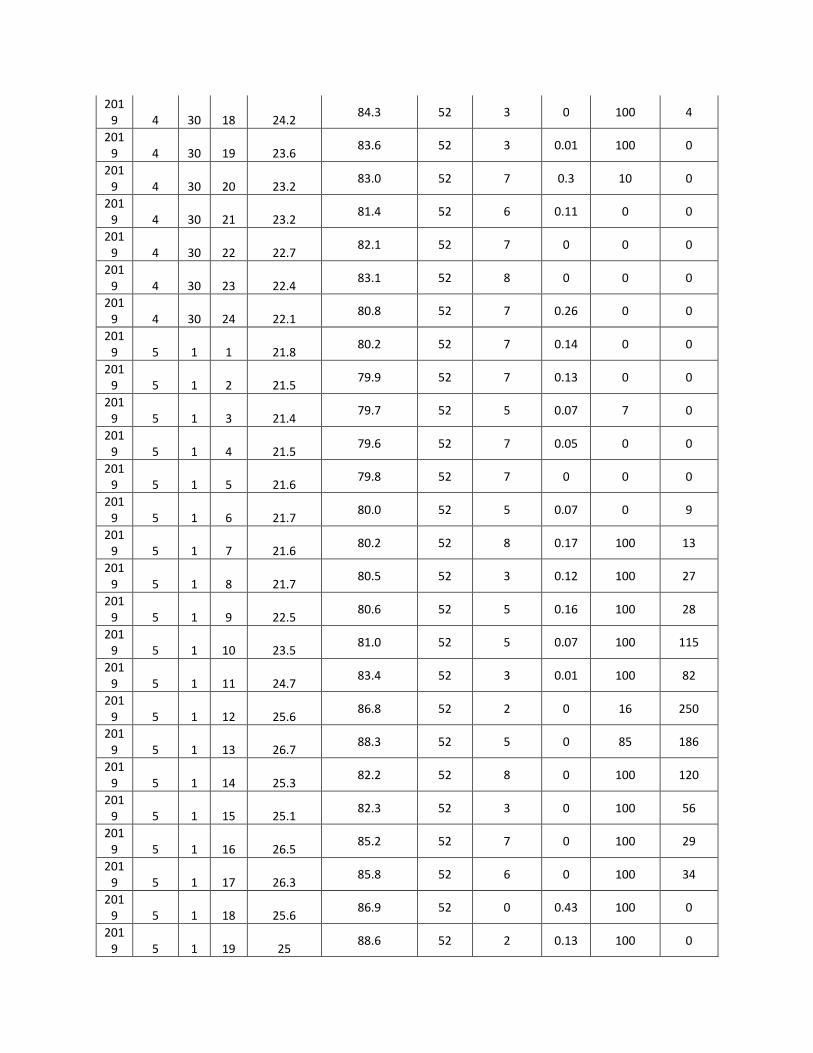
2019 4 30 18 24.2
84.3 52 3 0 100 4
2019 4 30 19 23.6
83.6 52 3 0.01 100 0
2019 4 30 20 23.2
83.0 52 7 0.3 10 0
2019 4 30 21 23.2
81.4 52 6 0.11 0 0
2019 4 30 22 22.7
82.1 52 7 0 0 0
2019 4 30 23 22.4
83.1 52 8 0 0 0
2019 4 30 24 22.1
80.8 52 7 0.26 0 0
2019 5 1 1 21.8
80.2 52 7 0.14 0 0
2019 5 1 2 21.5
79.9 52 7 0.13 0 0
2019 5 1 3 21.4
79.7 52 5 0.07 7 0
2019 5 1 4 21.5
79.6 52 7 0.05 0 0
2019 5 1 5 21.6
79.8 52 7 0 0 0
2019 5 1 6 21.7
80.0 52 5 0.07 0 9
2019 5 1 7 21.6
80.2 52 8 0.17 100 13
2019 5 1 8 21.7
80.5 52 3 0.12 100 27
2019 5 1 9 22.5
80.6 52 5 0.16 100 28
2019 5 1 10 23.5
81.0 52 5 0.07 100 115
2019 5 1 11 24.7
83.4 52 3 0.01 100 82
2019 5 1 12 25.6
86.8 52 2 0 16 250
2019 5 1 13 26.7
88.3 52 5 0 85 186
2019 5 1 14 25.3
82.2 52 8 0 100 120
2019 5 1 15 25.1
82.3 52 3 0 100 56
2019 5 1 16 26.5
85.2 52 7 0 100 29
2019 5 1 17 26.3
85.8 52 6 0 100 34
2019 5 1 18 25.6
86.9 52 0 0.43 100 0
2019 5 1 19 25
88.6 52 2 0.13 100 0

2019 5 1 20 24.6
90.7 52 6 0.13 100 0
2019 5 1 21 24.2
90.6 52 5 0.3 100 0
2019 5 1 22 23.6
87.5 52 3 0 100 0
2019 5 1 23 23.4
85.1 52 3 0.01 100 0
2019 5 1 24 23.1
83.5 52 5 0.05 100 0
2019 5 2 1 23
83.4 52 3 0.08 100 0
2019 5 2 2 22.7
82.6 52 3 0.06 100 0
2019 5 2 3 22.7
82.7 52 3 0 100 0
2019 5 2 4 22.6
82.4 52 3 0.21 100 0
2019 5 2 5 22.6
82.6 52 2 0.02 100 0
2019 5 2 6 22.8
82.8 52 3 0.02 100 19
2019 5 2 7 23.8
82.6 52 2 0.02 100 34
2019 5 2 8 25.1
82.7 52 0 0.02 100 61
2019 5 2 9 26.2
83.3 52 2 0 100 154
2019 5 2 10 27.9
84.4 52 0 0.01 100 120
2019 5 2 11 30
84.5 52 0 0.05 100 238
2019 5 2 12 30
85.0 52 2 0.24 100 176
2019 5 2 13 30.6
85.8 52 2 0 100 257
2019 5 2 14 31.1
86.2 52 2 0.01 100 95
2019 5 2 15 30.5
87.1 52 2 0.03 100 74
2019 5 2 16 29.5
87.8 52 2 0.23 100 26
2019 5 2 17 28.2
86.7 52 0 0.05 100 29
2019 5 2 18 26.6
86.5 52 3 0.01 100 1
2019 5 2 19 25.3
86.4 52 3 0.09 100 0
2019 5 2 20 24.8
85.7 52 5 0.49 100 0
2019 5 2 21 23.9
84.3 52 5 0.02 89 0
2019 5 2 22 23.8
83.6 52 5 0.28 100 0
2019 5 2 23 23.4
84.4 52 5 0.17 100 0
2019 5 2 24 23.1
86.1 52 3 0.19 100 0
2019 5 3 1 22.4
84.1 52 6 0.21 100 0
2019 5 3 2 22.6
82.9 52 6 0.01 100 0
2019 5 3 3 22.7
81.9 52 7 0.05 100 0
2019 5 3 4 21.8
82.0 52 3 0.09 100 0
2019 5 3 5 21.7
81.8 52 2 0.01 100 0
2019 5 3 6 21.6
81.3 52 2 0 100 28
2019 5 3 7 21.7
81.3 52 2 0 100 78
2019 5 3 8 21.5
81.4 52 2 0 100 183
2019 5 3 9 21.6
81.4 52 2 0 100 302
2019 5 3 10 22.5
79.7 52 2 0 100 423
2019 5 3 11 22.5
71.8 52 2 0 100 573
2019 5 3 12 21.8
70.3 52 0 0 100 822
2019 5 3 13 23.3
65.2 52 0 0 100 844
2019 5 3 14 23.6
63.4 52 2 0 100 702
2019 5 3 15 23.8
64.0 52 2 0 100 445
2019 5 3 16 24
63.6 52 2 0.01 100 239
2019 5 3 17 23.7
65.2 52 3 0 100 50
2019 5 3 18 23.2
67.3 52 3 0.01 100 12
2019 5 3 19 22.8
76.9 52 8 0 100 0
2019 5 3 20 22.2
79.6 52 5 0 100 0
2019 5 3 21 21.7
75.0 52 8 0 100 0
2019 5 3 22 21.8
84.2 52 8 0 100 0
2019 5 3 23 21.7
86.8 52 8 0 100 0

2019 5 3 24 21.6
86.3 52 8 0 100 0
2019 5 4 1 21.5
85.2 52 6 0 100 0
2019 5 4 2 21.5
84.4 52 6 0 100 0
2019 5 4 3 21.1
84.2 52 2 0 100 0
2019 5 4 4 21
84.2 52 2 0 100 0
2019 5 4 5 20.9
84.3 52 3 0 100 0
2019 5 4 6 21.1
84.3 52 3 0 100 18
2019 5 4 7 20.9
84.1 52 3 0 100 33
2019 5 4 8 20.6
84.9 52 3 0 100 96
2019 5 4 9 20.8
84.8 52 2 0 44 137
2019 5 4 10 21.1
83.3 52 2 0.01 100 233
2019 5 4 11 21.6
82.3 52 2 0 100 569
2019 5 4 12 22.5
82.5 52 3 0 64 356
2019 5 4 13 22.6
81.3 52 2 0 17 366
2019 5 4 14 23.2
80.3 52 5 0 79 375
2019 5 4 15 23.5
80.4 52 6 0 89 110
2019 5 4 16 23
81.4 52 3 0.01 93 72
2019 5 4 17 22.2
81.7 52 3 0 81 45
2019 5 4 18 21.6
80.9 52 3 0 97 10
2019 5 4 19 21.6
77.6 52 3 0 97 0
2019 5 4 20 21.4
77.9 52 3 0 91 0
2019 5 4 21 21.2
80.7 52 3 0 47 0
2019 5 4 22 21.2
82.1 52 5 0 10 0
2019 5 4 23 21.5
81.5 52 3 0 51 0
2019 5 4 24 21.6
80.8 52 3 0 10 0
2019 5 5 1 20.7
81.3 52 5 0 3 0

2019 5 5 2 20.7
81.3 52 3 0 100 0
2019 5 5 3 20.6
81.0 52 6 0.02 100 0
2019 5 5 4 20.5
81.0 52 3 0.03 100 0
2019 5 5 5 20.5
81.4 52 2 0.01 100 0
2019 5 5 6 20.5
82.0 52 3 0 93 23
2019 5 5 7 20.6
82.6 52 2 0 85 116
2019 5 5 8 20.7
83.6 52 2 0 100 178
2019 5 5 9 20.8
84.2 52 2 0 27 509
2019 5 5 10 21.1
85.1 52 3 0 17 818
2019 5 5 11 21.3
84.8 52 2 0 13 827
2019 5 5 12 22
83.6 52 2 0 8 650
2019 5 5 13 22.8
82.7 52 3 0 5 291
2019 5 5 14 22.8
82.3 52 2 0.05 93 65
2019 5 5 15 23.7
82.7 52 2 0.08 100 42
2019 5 5 16 24
83.2 52 2 0.09 100 29
2019 5 5 17 23.7
83.2 52 3 0.04 100 14
2019 5 5 18 22.7
83.3 52 3 0 80 1
2019 5 5 19 22.1
83.8 52 5 0.01 82 0
2019 5 5 20 22.1
84.5 52 5 0.01 83 0
2019 5 5 21 21.7
85.6 52 7 0.01 69 0
2019 5 5 22 21.5
84.7 52 3 0 68 0
2019 5 5 23 21.2
84.5 52 3 0.17 42 0
2019 5 5 24 21
84.2 52 3 0.22 0 0
2019 5 6 1 20.9
84.2 52 8 0.19 0 0
2019 5 6 2 20.9
84.1 52 8 0.15 0 0
2019 5 6 3 21
84.1 52 3 0.1 0 0

2019 5 6 4 21.1
84.1 52 8 0.15 0 0
2019 5 6 5 21.1
84.0 52 2 0.1 5 0
2019 5 6 6 20.9
83.8 52 3 0.06 0 14
2019 5 6 7 20.7
83.7 52 3 0.06 10 31
2019 5 6 8 20.7
83.3 52 6 0.02 100 78
2019 5 6 9 20.7
84.0 52 7 0 100 145
2019 5 6 10 20.7
85.0 52 3 0 100 277
2019 5 6 11 20.8
85.6 52 3 0 18 463
2019 5 6 12 21
86.2 52 2 0 23 501
2019 5 6 13 22
86.6 52 2 0 0 526
2019 5 6 14 23
86.9 52 2 0.04 0 137
2019 5 6 15 23.7
86.4 52 3 0.03 1 227
2019 5 6 16 23.7
83.4 52 3 0 76 166
2019 5 6 17 22.8
83.9 52 3 0 83 63
2019 5 6 18 22.1
81.8 52 3 0 91 19
2019 5 6 19 21.9
78.0 52 5 0 85 0
2019 5 6 20 21.6
74.7 52 0 0 70 0
2019 5 6 21 21.5
73.2 52 5 0 2 0
2019 5 6 22 21.5
71.5 52 5 0 0 0
2019 5 6 23 21.3
73.9 52 5 0 0 0
2019 5 6 24 21.1
78.1 52 6 0 71 0
2019 5 7 1 21.1
79.4 52 3 0 0 0
2019 5 7 2 20.8
77.7 52 7 0 0 0
2019 5 7 3 20.8
76.8 52 3 0 0 0
2019 5 7 4 21
75.5 52 3 0 0 0
2019 5 7 5 20.8
75.6 52 2 0 0 1

2019 5 7 6 20.8
75.5 52 2 0 0 47
2019 5 7 7 21.3
76.0 52 2 0 0 120
2019 5 7 8 21.8
75.8 52 0 0 35 218
2019 5 7 9 21.6
75.7 52 0 0 100 508
2019 5 7 10 22.2
76.6 52 0 0 100 768
2019 5 7 11 23.4
78.5 52 0 0.01 100 750
2019 5 7 12 24.2
81.4 52 2 0 100 671
2019 5 7 13 24.3
78.2 52 0 0 100 826
2019 5 7 14 23.9
76.4 52 0 0 100 709
2019 5 7 15 23.7
75.8 52 2 0 72 520
2019 5 7 16 23.8
76.0 52 3 0 1 333
2019 5 7 17 23.3
75.8 52 2 0 12 135
2019 5 7 18 22.7
76.2 52 3 0 83 21
2019 5 7 19 22.7
76.5 52 3 0 90 0
2019 5 7 20 22.4
77.0 52 7 0 92 0
2019 5 7 21 21.9
77.3 52 7 0 71 0
2019 5 7 22 22.1
78.5 52 8 0 75 0
2019 5 7 23 22
82.5 52 8 0 65 0
2019 5 7 24 21.8
82.7 52 7 0 49 0
2019 5 8 1 21.5
83.1 52 6 0 0 0
2019 5 8 2 21.3
83.5 52 6 0 0 0
2019 5 8 3 21.1
83.6 52 3 0 0 0
2019 5 8 4 21.2
83.7 52 0 0 0 0
2019 5 8 5 21.1
83.8 52 3 0 0 1
2019 5 8 6 21.5
83.8 52 2 0 0 14
2019 5 8 7 21.7
83.8 52 0 0 100 36

2019 5 8 8 22.6
83.8 52 0 0.03 100 58
2019 5 8 9 23.8
83.7 52 2 0.01 100 110
2019 5 8 10 25
83.7 52 0 0 100 167
2019 5 8 11 25.8
83.4 52 0 0 100 111
2019 5 8 12 27.6
83.4 52 2 0 100 139
2019 5 8 13 28.1
83.3 52 2 0 18 214
2019 5 8 14 28.8
83.3 52 0 0 0 183
2019 5 8 15 29.3
82.6 52 0 0 10 179
2019 5 8 16 29.5
81.7 52 0 0 10 136
2019 5 8 17 28.2
80.5 52 3 0 29 59
2019 5 8 18 27.3
80.5 52 3 0 100 12
2019 5 8 19 26.7
81.3 52 3 0 100 0
2019 5 8 20 25.8
81.7 52 7 0 91 0
2019 5 8 21 25.5
83.3 52 8 0 56 0
2019 5 8 22 24.8
84.1 52 8 0 10 0
2019 5 8 23 24.3
83.3 52 8 0 0 0
2019 5 8 24 24
83.3 52 6 0 100 0
2019 5 9 1 24
82.8 52 7 0 75 0
2019 5 9 2 21.7
82.8 52 3 0.01 6 0
2019 5 9 3 21.9
82.8 52 2 0 0 0
2019 5 9 4 22
82.9 52 0 0 0 0
2019 5 9 5 21.9
83.0 52 2 0 0 0
2019 5 9 6 22.5
83.1 52 0 0.12 0 11
2019 5 9 7 23.6
83.6 52 0 0.39 0 19
2019 5 9 8 24.5
84.1 52 0 0.13 0 31
2019 5 9 9 24.8
84.7 52 0 0.03 2 68

2019 5 9 10 25.6
86.9 52 0 0.31 0 62
2019 5 9 11 27.1
89.5 52 0 0 1 125
2019 5 9 12 28
96.3 52 0 0 13 249
2019 5 9 13 29
90.5 52 0 0.01 75 317
2019 5 9 14 29.5
83.5 52 0 0 79 301
2019 5 9 15 29.8
80.2 52 0 0 100 274
2019 5 9 16 30
77.9 52 2 0 100 180
2019 5 9 17 28.7
76.4 52 0 0 100 65
2019 5 9 18 27.1
76.9 52 3 0 87 11
2019 5 9 19 25.1
76.5 52 3 0 100 0
2019 5 9 20 24.9
93.4 52 3 0 100 0
2019 5 9 21 23.4
95.2 52 3 0 100 0
2019 5 9 22 22.7
96.0 52 8 0 100 0
2019 5 9 23 22.5
96.6 52 7 0 100 0
2019 5 9 24 22.1
96.7 52 8 0 100 0
2019 5 10 1 22.2
96.2 52 6 0.17 78 0
2019 5 10 2 22
96.7 52 7 0 100 0
2019 5 10 3 21.9
96.8 52 3 0 100 0
2019 5 10 4 22.2
97.7 52 2 0.05 14 0
2019 5 10 5 22.4
96.7 52 2 0.01 8 0
2019 5 10 6 22.1
93.6 52 2 0.08 0 11
2019 5 10 7 21.8
94.5 52 3 0.07 4 23
2019 5 10 8 22.3
96.6 52 2 0.21 9 16
2019 5 10 9 23.6
95.5 52 3 0.08 12 28
2019 5 10 10 24.3
95.2 121 0 0.02 8 51
2019 5 10 11 24.2
96.1 220 2 0 11 122

2019 5 10 12 25.2
96.4 220 2 0 10 212
2019 5 10 13 25.1
92.8 220 20 0 16 318
2019 5 10 14 25.3
92.6 220 7 0 92 250
2019 5 10 15 25.6
93.0 220 5 0 98 364
2019 5 10 16 25.6
93.9 220 5 0 100 262
2019 5 10 17 25.2
96.5 220 8 0 100 119
2019 5 10 18 24
93.8 220 3 0 100 16
2019 5 10 19 23.3
93.9 220 3 0 89 0
2019 5 10 20 23.1
93.9 220 3 0 74 0
2019 5 10 21 23
94.6 220 3 0 70 0
2019 5 10 22 22.7
96.5 220 6 0 62 0
2019 5 10 23 22
96.2 220 5 0 82 0
2019 5 10 24 21.5
97.4 220 5 0 100 0
2019 5 11 1 21.3
97.4 220 5 0 75 0
2019 5 11 2 21.7
97.4 220 3 0 50 0
2019 5 11 3 21.8
96.8 220 5 0 25 0
2019 5 11 4 21.8
97.0 220 3 0 0 0
2019 5 11 5 21.7
97.5 220 0 0.01 0 0
2019 5 11 6 21.6
97.0 220 0 0.04 0 3
2019 5 11 7 21.8
97.1 220 0 0.15 0 7
2019 5 11 8 22.7
97.0 220 2 0.22 0 9
2019 5 11 9 23.1
97.1 220 2 0.18 0.6 11
2019 5 11 10 24.2
97.4 220 0 0.03 0.3 79
2019 5 11 11 24.3
95.6 220 2 0 10 98
2019 5 11 12 24.3
92.4 220 0 0 10 204
2019 5 11 13 24.5
95.4 220 0 0 7 232

2019 5 11 14 24.5
95.8 220 3 0 8.1 342
2019 5 11 15 25.6
92.1 220 3 0 12.6 372
2019 5 11 16 26
87.0 220 3 0 10 276
2019 5 11 17 25.5
87.3 220 6 0 10 108
2019 5 11 18 24.6
89.3 220 7 0 18 18
2019 5 11 19 24
93.0 220 5 0 47 0
2019 5 11 20 23.8
92.6 220 6 0 65 0
2019 5 11 21 23.6
92.0 220 7 0 59 0
2019 5 11 22 23.1
93.0 220 7 0 59 0
2019 5 11 23 22.9
94.3 220 8 0 38 0
2019 5 11 24 22.6
94.4 220 5 0.01 52 0
2019 5 12 1 22.6
95.8 220 3 0 39 0
2019 5 12 2 22.5
95.6 220 3 0.07 19 0
2019 5 12 3 22.3
96.3 220 3 0 19 0
2019 5 12 4 22.1
96.8 220 3 0 60 0
2019 5 12 5 22
97.1 220 0 0 91 0
2019 5 12 6 21.9
96.7 220 3 0.07 76 7
2019 5 12 7 23
95.7 220 3 0 63 100
2019 5 12 8 23.8
88.8 220 5 0 53 149
2019 5 12 9 25.3
80.1 220 2 0 32 96
2019 5 12 10 25.7
78.3 220 0 0 4 258
2019 5 12 11 26.7
80.5 220 0 0 65 612
2019 5 12 12 28.2
79.6 220 0 0 100 618
2019 5 12 13 28.1
83.1 220 3 0 69 499
2019 5 12 14 29.1
84.1 220 3 0 42 277
2019 5 12 15 29.8
76.7 220 2 0 89 190

2019 5 12 16 29.8
77.8 220 0 0 100 190
2019 5 12 17 29.1
78.6 220 2 0 85 37
2019 5 12 18 27.9
80.9 220 3 0 94 3
2019 5 12 19 26.3
88.0 220 3 0 93 0
2019 5 12 20 25.6
91.0 220 5 0 100 0
2019 5 12 21 24.8
87.7 220 7 0 62 0
2019 5 12 22 24.4
86.5 220 5 0 0 0
2019 5 12 23 24.1
88.1 220 5 0 0 0
2019 5 12 24 24
89.0 220 25 0 0 0
2019 5 13 1 23.5
90.5 220 0 0 0 0
2019 5 13 2 23.6
90.6 220 5 0.02 0 0
2019 5 13 3 23.5
91.9 220 5 0 0 0
2019 5 13 4 23.4
92.3 220 3 0 0 0
2019 5 13 5 22.7
96.5 220 3 0 0 1
2019 5 13 6 22.7
96.2 220 3 0.01 0 51
2019 5 13 7 23.3
93.8 220 2 0 0 96
2019 5 13 8 24
89.7 220 2 0 0 204
2019 5 13 9 24.5
81.7 220 2 0 0 362
2019 5 13 10 25
78.0 220 2 0 0 466
2019 5 13 11 25
74.8 220 3 0 15 607
2019 5 13 12 26
68.2 220 0 0 100 865
2019 5 13 13 26.3
65.1 220 2 0 75 782
2019 5 13 14 26.9
62.6 220 3 0 50 651
2019 5 13 15 27.3
58.2 220 2 0 87 518
2019 5 13 16 27
54.7 220 2 0 92 320
2019 5 13 17 26
58.9 220 2 0 67 121

2019 5 13 18 25
65.9 220 2 0 78 19
2019 5 13 19 24.2
69.7 220 5 0 79 0
2019 5 13 20 23.9
78.6 220 3 0 75 0
2019 5 13 21 23.7
80.8 220 6 0 64 0
2019 5 13 22 23.2
83.4 220 0 0 79 0
2019 5 13 23 23
86.9 220 0 0 82 0
2019 5 13 24 22.7
87.1 220 8 0 10 0
2019 5 14 1 22.3
91.7 220 3 0 0 0
2019 5 14 2 22.5
93.4 220 3 0.31 0 0
2019 5 14 3 22.6
94.6 220 5 0 0 0
2019 5 14 4 22.5
94.8 220 3 0 0 0
2019 5 14 5 22.1
95.4 220 2 0.01 0 1
2019 5 14 6 22.4
95.6 220 0 0 0 99
2019 5 14 7 22.8
92.8 220 2 0 0 153
2019 5 14 8 23.1
91.9 220 0 0 0 355
2019 5 14 9 23
94.1 220 2 0 0 566
2019 5 14 10 23.6
92.6 220 2 0 0 541
2019 5 14 11 24.1
90.5 220 2 0 0 881
2019 5 14 12 24
82.1 220 2 0 10 916
2019 5 14 13 24.5
78.3 220 2 0 20 805
2019 5 14 14 25.6
80.7 220 0 0 0 690
2019 5 14 15 26.5
83.9 220 3 0 0 519
2019 5 14 16 26.6
84.6 220 3 0 0 327
2019 5 14 17 26.1
88.1 220 3 0 40 90
2019 5 14 18 25.6
90.6 220 3 0.09 60 15
2019 5 14 19 24.5
92.0 220 3 0 30 0
2019 5 14 20 24.3
93.0 220 3 0 10 0
2019 5 14 21 23.7
92.5 220 6 0 10 0
2019 5 14 22 23.6
94.7 220 2 0 0 0
2019 5 14 23 23.6
96.4 220 0 0 0 0
2019 5 14 24 23.3
96.9 220 0 0 0 0
2019 5 15 1 23.1
97.2 220 0 0 0 0
2019 5 15 2 23.1
97.2 220 0 0 0 0
2019 5 15 3 23
97.3 220 8 0 60 0
2019 5 15 4 23.1
97.4 220 7 0 80 0
2019 5 15 5 23.2
97.2 220 3 0.45 100 0
2019 5 15 6 23.2
97.1 220 2 0.08 100 9
2019 5 15 7 23.7
97.0 220 0 0.07 100 27
2019 5 15 8 24.5
94.4 220 0 0.01 80 139
2019 5 15 9 25.3
87.5 220 3 0 60 319
2019 5 15 10 26.6
88.9 220 7 0 50 400
2019 5 15 11 27.8
91.0 220 2 0 10 251
2019 5 15 12 29
86.9 220 3 0 0 507
2019 5 15 13 29.5
81.0 220 3 0 0 453
2019 5 15 14 29.6
80.5 220 5 0 0 476
2019 5 15 15 30.1
80.7 220 2 0 0 433
2019 5 15 16 29.8
80.1 220 2 0 0 357
2019 5 15 17 29.2
79.9 220 7 0 0 159
2019 5 15 18 28.2
81.5 220 3 0 0 23
2019 5 15 19 27.4
87.5 220 8 0 0 0
2019 5 15 20 26.9
90.8 220 5 0 0 0
2019 5 15 21 26
90.7 220 8 0 0 0

2019 5 15 22 25.2
91.6 220 7 0 0 0
2019 5 15 23 24.7
91.5 220 7 0 0 0
2019 5 15 24 24.1
93.1 220 8 0 0 0
2019 5 16 1 23.6
94.9 220 7 0 0 0
2019 5 16 2 23.7
94.3 220 8 0 50 0
2019 5 16 3 23.1
94.9 220 8 0 40 0
2019 5 16 4 21.7
95.5 220 7 0.01 60 0
2019 5 16 5 21.6
96.1 220 5 0.05 70 0
2019 5 16 6 22.8
96.5 220 3 0.1 55 11
2019 5 16 7 23.8
95.8 220 3 0.01 40 59
2019 5 16 8 25
89.4 220 6 0 20 156
2019 5 16 9 24.6
84.6 220 0 0 10 208
2019 5 16 10 26.2
77.0 220 2 0 10 413
2019 5 16 11 27.8
70.4 220 2 0 0 174
2019 5 16 12 28.9
66.3 220 3 0 0 109
2019 5 16 13 29.3
66.4 220 3 0 0 176
2019 5 16 14 29.3
63.7 220 5 0 0 230
2019 5 16 15 30.1
60.4 220 3 0 0 392
2019 5 16 16 29.8
60.3 220 2 0 0 259
2019 5 16 17 28.9
59.9 220 3 0 0 130
2019 5 16 18 27.6
65.7 220 3 0 0 21
2019 5 16 19 26.8
71.9 220 6 0 10 0
2019 5 16 20 26.5
80.9 220 0 0 30 0
2019 5 16 21 26
85.9 220 8 0 40 0
2019 5 16 22 25.5
90.4 220 8 0 0 0
2019 5 16 23 24.7
91.9 220 8 0 0 0

2019 5 16 24 24.3
93.4 220 6 0 0 0
2019 5 17 1 24
94.9 220 8 0.01 60 0
2019 5 17 2 23.6
94.3 220 6 0.03 70 0
2019 5 17 3 23.6
95.7 220 5 0.04 60 0
2019 5 17 4 23.3
96.5 220 8 0.01 55 0
2019 5 17 5 23.4
96.7 220 8 0 40 7
2019 5 17 6 24
96.5 220 3 0 20 57
2019 5 17 7 25.1
93.0 220 7 0 20 230
2019 5 17 8 26.3
89.2 220 7 0 10 139
2019 5 17 9 25.7
87.8 220 6 0 0 468
2019 5 17 10 25.3
88.0 220 2 0 0 314
2019 5 17 11 27.1
86.7 220 3 0 0 606
2019 5 17 12 29.7
87.7 220 2 0 0 756
2019 5 17 13 30.4
89.9 220 3 0 0 549
2019 5 17 14 31.4
91.6 220 2 0 0 543
2019 5 17 15 31.2
92.4 220 2 0 0 400
2019 5 17 16 31.1
92.5 220 3 0 0 296
2019 5 17 17 30.2
90.1 220 3 0 0 172
2019 5 17 18 29
87.9 220 3 0 0 29
2019 5 17 19 27.9
89.5 220 5 0 0 0
2019 5 17 20 27.6
93.0 220 6 0 0 0
2019 5 17 21 27.6
94.3 220 8 0 0 0
2019 5 17 22 26.9
93.0 220 8 0 0 0
2019 5 17 23 26.7
93.3 220 6 0 0 0
2019 5 17 24 26.6
93.1 220 8 0 0 0
2019 5 18 1 23.8
94.4 220 8 0 60 0

2019 5 18 2 23.5
94.9 220 6 0 55 0
2019 5 18 3 23.5
95.6 220 3 0 40 0
2019 5 18 4 23.1
96.1 220 3 0.19 30 0
2019 5 18 5 23
96.4 220 0 0.14 40 0
2019 5 18 6 23.1
96.5 220 3 0 20 26
2019 5 18 7 23.3
94.7 220 3 0 10 90
2019 5 18 8 23.2
93.3 220 0 0 0 153
2019 5 18 9 24.2
92.1 220 0 0 0 233
2019 5 18 10 24.2
88.8 220 0 0 0 311
2019 5 18 11 24.3
88.2 220 2 0 0 242
2019 5 18 12 24.8
86.2 220 2 0 0 383
2019 5 18 13 24.9
82.5 220 0 0 0 399
2019 5 18 14 25.7
80.2 220 2 0 0 457
2019 5 18 15 27
80.1 220 0 0 0 385
2019 5 18 16 26.8
81.1 220 2 0 0 237
2019 5 18 17 25.9
81.2 220 3 0 0 82
2019 5 18 18 25
82.7 220 3 0 0 11
2019 5 18 19 24.2
84.5 220 3 0 0 0
2019 5 18 20 23.8
85.9 220 5 0 0 0
2019 5 18 21 23.5
86.6 220 6 0 0 0
2019 5 18 22 23.2
88.1 220 3 0 0 0
2019 5 18 23 23.1
90.9 220 5 0 0 0
2019 5 18 24 23.1
92.3 220 8 0 0 0
2019 5 19 1 23.1
95.7 220 7 0 0 0
2019 5 19 2 23.1
95.7 220 5 0 0 0
2019 5 19 3 22.9
95.0 220 3 0 0 0
2019 5 19 4 22.6
93.5 220 2 0 40 0
2019 5 19 5 22.4
92.0 220 7 0 20 3
2019 5 19 6 22.5
90.6 220 5 0 30 18
2019 5 19 7 22.7
88.7 220 6 0.01 10 86
2019 5 19 8 23
88.4 220 6 0 20 59
2019 5 19 9 22.6
83.2 220 3 0.08 40 37
2019 5 19 10 22.7
79.9 220 3 0 45 180
2019 5 19 11 24
79.8 220 6 0 50 109
2019 5 19 12 25
70.9 220 8 0.02 30 72
2019 5 19 13 25.2
65.9 220 5 0 10 158
2019 5 19 14 25.7
60.5 220 3 0 10 364
2019 5 19 15 25.6
58.2 220 2 0 0 274
2019 5 19 16 25.4
58.5 220 3 0 0 203
2019 5 19 17 25.3
62.5 220 3 0 30 60
2019 5 19 18 24.7
66.6 220 3 0.05 40 23
2019 5 19 19 24.1
73.8 220 5 0.02 45 0
2019 5 19 20 23.7
82.1 220 7 0 0 0
2019 5 19 21 23.5
88.1 220 8 0 0 0
2019 5 19 22 23.5
87.8 220 8 0 30 0
2019 5 19 23 23.5
88.2 220 5 0 40 0
2019 5 19 24 23.2
83.0 220 5 0 50 0
2019 5 20 1 23.1
85.0 220 5 0.03 45 0
2019 5 20 2 23
88.6 220 6 0 30 0
2019 5 20 3 23.1
87.4 220 6 0 10 0
2019 5 20 4 23
90.2 220 2 0 0 0
2019 5 20 5 22.9
91.5 220 2 0 0 5

2019 5 20 6 22.9
91.7 220 2 0 0 36
2019 5 20 7 23
90.5 220 2 0 0 124
2019 5 20 8 23.3
88.9 220 0 0 0 230
2019 5 20 9 23.8
86.1 220 0 0 0 171
2019 5 20 10 23.8
82.9 220 2 0 0 586
2019 5 20 11 24.8
77.3 220 2 0 0 554
2019 5 20 12 25.6
73.2 220 3 0 0 754
2019 5 20 13 26.5
74.9 220 0 0 0 681
2019 5 20 14 26.7
73.2 220 0 0 0 403
2019 5 20 15 27.8
67.6 220 2 0 0 457
2019 5 20 16 27
71.3 220 3 0 0 321
2019 5 20 17 26.2
69.6 220 2 0 0 148
2019 5 20 18 25.7
73.7 220 2 0 0 29
2019 5 20 19 25.2
79.9 220 3 0 0 0
2019 5 20 20 25
85.8 220 3 0 0 0
2019 5 20 21 24.8
89.8 220 3 0 0 0
2019 5 20 22 24.6
91.7 220 8 0 0 0
2019 5 20 23 24.3
92.3 220 5 0 0 0
2019 5 20 24 24.3
92.8 220 8 0 0 0
2019 5 21 1 24.2
94.2 220 8 0 0 0
2019 5 21 2 24.1
94.5 220 3 0 0 0
2019 5 21 3 23.8
95.1 220 2 0.17 0 0
2019 5 21 4 23.7
95.6 220 0 0 0 0
2019 5 21 5 23.7
95.9 220 0 0 0 6
2019 5 21 6 23.9
96.4 220 2 0 0 122
2019 5 21 7 24.5
95.3 220 0 0.01 0 227

2019 5 21 8 25.1
91.5 220 0 0 0 309
2019 5 21 9 25.7
84.1 220 0 0 0 369
2019 5 21 10 25.7
81.4 220 2 0 0 415
2019 5 21 11 26
79.4 220 0 0 0 566
2019 5 21 12 28.5
74.1 220 2 0 0 839
2019 5 21 13 29.4
65.1 220 0 0 0 821
2019 5 21 14 30.1
55.8 220 0 0 0 579
2019 5 21 15 30
59.3 220 3 0 0 547
2019 5 21 16 29.8
61.7 220 2 0 0 328
2019 5 21 17 28.5
64.9 220 2 0 0 147
2019 5 21 18 27.6
64.3 220 3 0 0 30
2019 5 21 19 27.2
73.3 220 3 0 0 0
2019 5 21 20 27
84.0 220 5 0 0 0
2019 5 21 21 26.8
87.8 220 3 0 0 0
2019 5 21 22 26.2
89.0 220 6 0 0 0
2019 5 21 23 24.6
88.9 220 8 0 0 0
2019 5 21 24 24.4
92.3 220 6 0 0 0
2019 5 22 1 24.5
91.7 220 6 0 0 0
2019 5 22 2 24.2
89.4 220 5 0 0 0
2019 5 22 3 24.2
91.9 220 5 0 0 0
2019 5 22 4 23.9
93.3 220 2 0 0 0
2019 5 22 5 23.4
89.2 220 2 0 0 9
2019 5 22 6 24.4
89.0 220 0 0 0 65
2019 5 22 7 25
91.1 220 0 0 0 271
2019 5 22 8 25.7
89.0 220 0 0 0 439
2019 5 22 9 27
88.6 220 0 0 0 230

2019 5 22 10 29.3
90.8 220 0 0 0 185
2019 5 22 11 25.6
89.5 220 2 0 0 683
2019 5 22 12 27.8
88.5 220 0 0 0 916
2019 5 22 13 29.5
88.2 220 5 0 0 837
2019 5 22 14 31.1
86.3 220 3 0 0 709
2019 5 22 15 32.2
84.2 220 5 0 0 457
2019 5 22 16 32.1
83.4 220 0 0 0 307
2019 5 22 17 31.2
81.8 220 3 0 0 141
2019 5 22 18 29.8
82.1 220 3 0 0 17
2019 5 22 19 28.7
85.7 220 3 0 0 0
2019 5 22 20 28
88.4 220 6 0 0 0
2019 5 22 21 27.3
89.4 220 6 0 70 0
2019 5 22 22 24.1
90.5 220 5 0 45 0
2019 5 22 23 24
92.9 220 5 0 60 0
2019 5 22 24 23.4
94.2 220 7 0 90 0
2019 5 23 1 23
94.5 220 7 0.64 100 0
2019 5 23 2 22.8
94.3 220 6 0.03 100 0
2019 5 23 3 23.1
94.7 220 6 0.27 100 0
2019 5 23 4 23.2
95.3 220 3 0.24 60 0
2019 5 23 5 23.8
95.4 220 3 0.03 40 0
2019 5 23 6 24
94.9 220 3 0 30 30
2019 5 23 7 24.3
95.0 220 8 0.01 45 34
2019 5 23 8 25.2
94.7 220 3 0.01 55 59
2019 5 23 9 26.3
94.6 220 2 0 50 233
2019 5 23 10 26.1
92.4 220 8 0.04 40 110
2019 5 23 11 27
87.4 220 0 0 30 132

2019 5 23 12 27.1
82.1 220 3 0 20 170
2019 5 23 13 28
79.3 220 5 0 20 233
2019 5 23 14 27.1
84.7 220 3 0 0 369
2019 5 23 15 25.9
84.7 220 3 0 0 407
2019 5 23 16 26.1
88.4 220 0 0 0 271
2019 5 23 17 26.5
86.4 220 0 0 0 132
2019 5 23 18 26.5
87.1 220 3 0 0 31
2019 5 23 19 25.6
91.4 220 3 0 0 0
2019 5 23 20 25.2
93.4 220 5 0 0 0
2019 5 23 21 25
91.6 220 6 0 0 0
2019 5 23 22 24.5
91.1 220 5 0 0 0
2019 5 23 23 24.3
91.9 220 0 0 60 0
2019 5 23 24 24
93.9 220 0 0 70 0
2019 5 24 1 24
94.8 220 2 0 100 0
2019 5 24 2 23.8
94.9 220 0 0.18 100 0
2019 5 24 3 23.9
92.3 220 8 0.07 100 0
2019 5 24 4 24
94.0 220 3 0.05 80 0
2019 5 24 5 24
94.1 220 3 0.04 90 0
2019 5 24 6 24.2
94.2 220 3 0.01 80 31
2019 5 24 7 24.6
94.1 220 0 0 70 91
2019 5 24 8 25.2
90.8 220 0 0 60 82
2019 5 24 9 26
85.4 220 0 0.71 40 11
2019 5 24 10 27.3
82.6 220 0 0.05 40 174
2019 5 24 11 29
76.8 220 0 0 20 392
2019 5 24 12 30.2
73.2 220 0 0 10 423
2019 5 24 13 31.2
77.1 220 0 0 10 277

2019 5 24 14 32
82.9 220 0 0 0 286
2019 5 24 15 32.3
78.2 220 3 0 0 198
2019 5 24 16 32
73.6 220 3 0 0 104
2019 5 24 17 31.5
74.7 220 3 0 0 50
2019 5 24 18 30.3
79.3 220 2 0 0 4
2019 5 24 19 28.7
83.3 220 3 0 0 0
2019 5 24 20 27.8
88.1 220 2 0.01 0 0
2019 5 24 21 27.2
86.5 220 0 0 0 0
2019 5 24 22 26.7
85.4 220 3 0 0 0
2019 5 24 23 26.4
88.3 220 3 0 0 0
2019 5 24 24 26.1
86.8 220 3 0 0 0
2019 5 25 1 25.7
87.3 220 5 0 0 0
2019 5 25 2 25.3
89.0 220 3 0 40 0
2019 5 25 3 25
90.5 220 3 0 50 0
2019 5 25 4 24.5
90.5 220 3 0 30 0
2019 5 25 5 24.1
89.3 220 2 0 20 2
2019 5 25 6 25.2
90.4 220 3 0.01 10 17
2019 5 25 7 26.8
87.0 220 0 0 10 59
2019 5 25 8 28.8
81.9 220 6 0 30 105
2019 5 25 9 30.1
73.0 220 2 0.06 40 119
2019 5 25 10 31.3
68.9 220 0 0 20 145
2019 5 25 11 32.6
70.1 220 3 0 10 252
2019 5 25 12 33.3
63.4 220 0 0 0 320
2019 5 25 13 33.1
62.5 220 7 0 0 294
2019 5 25 14 33.4
62.9 220 2 0 0 391
2019 5 25 15 33.8
61.9 220 3 0 0 420

2019 5 25 16 34.2
62.8 220 3 0 0 225
2019 5 25 17 33.3
70.4 220 5 0 0 85
2019 5 25 18 32.6
73.3 220 3 0 0 16
2019 5 25 19 30.9
74.3 220 0 0 0 0
2019 5 25 20 29.3
84.1 220 3 0 0 0
2019 5 25 21 28.7
86.1 220 3 0 0 0
2019 5 25 22 28.8
88.3 220 3 0 0 0
2019 5 25 23 29
88.4 220 7 0 0 0
2019 5 25 24 27.8
91.3 220 5 0 0 0
2019 5 26 1 27.1
91.7 220 8 0 0 0
2019 5 26 2 26.8
91.3 220 7 0 0 0
2019 5 26 3 26.6
93.5 220 8 0 0 0
2019 5 26 4 25.7
93.6 220 3 0 0 0
2019 5 26 5 23.1
93.9 220 2 0 0 3
2019 5 26 6 23.6
94.5 220 0 0 0 32
2019 5 26 7 25.4
92.5 220 0 0 0 113
2019 5 26 8 27.3
90.4 220 0 0 0 151
2019 5 26 9 28.5
86.3 220 3 0 0 216
2019 5 26 10 29.1
85.2 220 3 0 0 152
2019 5 26 11 29.7
81.1 220 3 0 0 214
2019 5 26 12 28.1
71.7 220 2 0 0 504
2019 5 26 13 27.2
71.6 220 2 0 0 557
2019 5 26 14 28.6
66.8 220 0 0 0 508
2019 5 26 15 28.6
71.0 220 0 0 0 450
2019 5 26 16 28.1
72.2 220 0 0 0 307
2019 5 26 17 28.3
69.3 220 2 0 0 86

2019 5 26 18 28.2
72.2 220 3 0 0 16
2019 5 26 19 26.8
78.6 220 2 0 0 0
2019 5 26 20 26.1
82.4 220 3 0 80 0
2019 5 26 21 25.8
84.5 220 5 0 100 0
2019 5 26 22 26.1
85.9 220 5 0.01 100 0
2019 5 26 23 25.7
87.5 220 5 0 100 0
2019 5 26 24 25.6
83.3 220 3 0 80 0
2019 5 27 1 25.5
83.5 220 6 0.01 100 0
2019 5 27 2 24.7
89.2 220 3 0.02 100 0
2019 5 27 3 24.6
92.4 220 3 0.01 100 0
2019 5 27 4 24.9
92.6 220 0 0 50 0
2019 5 27 5 24.7
93.9 220 0 0 30 7
2019 5 27 6 24.5
93.9 220 0 0 45 126
2019 5 27 7 25.2
93.0 220 0 0.01 50 145
2019 5 27 8 25.7
91.2 220 0 0 40 352
2019 5 27 9 26.8
85.8 220 2 0 30 467
2019 5 27 10 26.8
73.0 220 2 0 10 756
2019 5 27 11 23.1
65.0 220 0 0.33 40 234
2019 5 27 12 23.7
60.8 220 0 0 0 581
2019 5 27 13 25.7
56.3 220 0 0 0 744
2019 5 27 14 27
57.2 220 0 0 0 675
2019 5 27 15 27.2
54.6 220 0 0 0 568
2019 5 27 16 26.4
67.0 220 0 0 0 355
2019 5 27 17 25.7
83.6 220 0 0 0 133
2019 5 27 18 25.4
84.9 220 2 0 0 16
2019 5 27 19 25
85.4 220 3 0 0 0

2019 5 27 20 24.7
87.0 220 3 0 45 0
2019 5 27 21 24.4
86.9 220 3 0 50 0
2019 5 27 22 24
87.4 220 7 0.13 10 0
2019 5 27 23 23.6
89.4 220 6 0 10 0
2019 5 27 24 23.6
88.9 220 5 0 0 0
2019 5 28 1 23.3
89.9 220 5 0 0 0
2019 5 28 2 23.1
92.5 220 5 0 0 0
2019 5 28 3 22.8
93.2 220 3 0 0 0
2019 5 28 4 22.6
93.9 220 2 0 0 0
2019 5 28 5 22.6
93.1 220 0 0 0 7
2019 5 28 6 23.6
92.3 220 0 0 0 72
2019 5 28 7 25.5
91.1 220 0 0 0 198
2019 5 28 8 27.2
86.7 220 0 0 0 299
2019 5 28 9 28.4
83.4 220 2 0 0 492
2019 5 28 10 29.8
76.8 220 0 0 45 206
2019 5 28 11 30.5
68.6 220 0 0 30 224
2019 5 28 12 31.9
60.6 220 0 0 55 338
2019 5 28 13 32.7
60.9 220 0 0 60 359
2019 5 28 14 33.8
58.8 220 0 0.02 30 87
2019 5 28 15 33.9
57.4 220 0 0.02 30 53
2019 5 28 16 33
55.9 220 0 0 10 85
2019 5 28 17 32.6
55.0 220 0 0 10 82
2019 5 28 18 31.1
58.5 220 2 0 0 25
2019 5 28 19 29.6
67.1 220 5 0 0 0
2019 5 28 20 28.3
79.4 220 3 0 0 0
2019 5 28 21 28
84.3 220 7 0 0 0

2019 5 28 22 27.3
88.3 220 7 0 0 0
2019 5 28 23 27.2
89.3 220 7 0 0 0
2019 5 28 24 26.3
90.8 220 6 0 40 0
2019 5 29 1 26
92.2 220 7 0 45 0
2019 5 29 2 25.8
91.9 220 3 0 60 0
2019 5 29 3 26
92.9 220 2 0.07 70 0
2019 5 29 4 25.3
90.6 220 0 0.03 30 0
2019 5 29 5 25.1
90.3 220 0 0 20 7
2019 5 29 6 26.2
92.3 220 2 0 10 23
2019 5 29 7 28.2
89.1 220 3 0 10 74
2019 5 29 8 28.9
81.5 220 5 0 0 90
2019 5 29 9 30
72.9 220 2 0 0 228
2019 5 29 10 31.1
65.5 220 3 0 0 578
2019 5 29 11 32.5
58.6 220 3 0 0 865
2019 5 29 12 33.1
60.0 220 3 0 0 892
2019 5 29 13 33.6
58.5 220 2 0 0 836
2019 5 29 14 34.2
56.7 220 3 0 0 719
2019 5 29 15 34.4
55.7 220 6 0 0 523
2019 5 29 16 34.4
53.2 220 2 0 0 315
2019 5 29 17 33.5
55.9 220 3 0 0 128
2019 5 29 18 32.2
59.1 220 8 0 0 27
2019 5 29 19 31.1
65.4 220 8 0 0 0
2019 5 29 20 30.1
73.9 220 8 0 0 0
2019 5 29 21 29.1
82.2 220 8 0 0 0
2019 5 29 22 29.2
86.6 220 0 0 0 0
2019 5 29 23 28.8
87.6 220 5 0 0 0

2019 5 29 24 28.4
88.5 220 6 0 0 0
2019 5 30 1 28.2
85.6 220 6 0 0 0
2019 5 30 2 27.8
89.1 220 5 0 0 0
2019 5 30 3 27.6
90.9 220 0 0 0 0
2019 5 30 4 27.3
91.1 220 0 0 0 0
2019 5 30 5 27.1
90.7 220 0 0 0 9
2019 5 30 6 27
91.4 220 0 0 0 112
2019 5 30 7 26.9
85.2 220 5 0 0 253
2019 5 30 8 27.3
85.9 220 6 0 0 499
2019 5 30 9 25.8
89.7 220 3 0 0 680
2019 5 30 10 27.6
87.6 220 2 0 0 793
2019 5 30 11 30
75.0 220 8 0 0 814
2019 5 30 12 30.5
65.1 220 8 0 0 771
2019 5 30 13 32.6
64.4 220 0 0 0 620
2019 5 30 14 33.2
60.6 220 5 0 0 504
2019 5 30 15 29.6
62.5 220 3 0 0 484
2019 5 30 16 28.5
60.6 220 0 0 0 370
2019 5 30 17 26.5
60.9 220 2 0 0 154
2019 5 30 18 25.8
66.3 220 0 0 0 39
2019 5 30 19 25.7
72.5 220 3 0 0 0
2019 5 30 20 25.7
76.6 220 3 0 0 0
2019 5 30 21 25.5
82.7 220 5 0 0 0
2019 5 30 22 25.5
85.0 220 5 0 0 0
2019 5 30 23 25.4
88.3 220 8 0 0 0
2019 5 30 24 25.1
90.2 220 0 0 0 0
2019 5 31 1 24.8
89.2 220 8 0 30 0

2019 5 31 2 24.8
90.0 220 8 0 20 0
2019 5 31 3 24.6
92.3 220 8 0 40 0
2019 5 31 4 24.3
91.4 220 3 0.32 30 0
2019 5 31 5 24.5
92.7 220 0 0 10 1
2019 5 31 6 24.8
84.6 220 0 0 0 89
2019 5 31 7 24.6
76.5 220 0 0 0 306
2019 5 31 8 25
69.7 220 0 0 0 525
2019 5 31 9 25.8
64.9 220 0 0 0 734
2019 5 31 10 27.7
63.6 220 0 0 0 622
2019 5 31 11 27.2
65.0 220 0 0 0 768
2019 5 31 12 27.2
69.2 220 0 0 0 209
2019 5 31 13 27.1
67.1 220 0 0 0 264
2019 5 31 14 27.5
66.2 220 0 0 0 492
2019 5 31 15 28
70.5 220 0 0 0 214
2019 5 31 16 28.4
73.7 220 0 0 0 111
2019 5 31 17 29.4
70.7 220 0 0 0 88
2019 5 31 18 28.3
70.1 200 3 0 0 35
2019 5 31 19 26.9
75.5 197 2 0 0 0
2019 5 31 20 26.2
84.1 197 5 0 0 0
2019 5 31 21 25.7
88.1 197 5 0 0 0
2019 5 31 22 25.2
90.8 197 6 0 0 0
2019 5 31 23 25.2
90.5 197 5 0 0 0
2019 5 31 24 25
92.2 197 7 0 0 0
2019 6 1 1 24.9
90.2 197 6 0 0 0
2019 6 1 2 24.7
93.3 197 3 0 0 0
2019 6 1 3 24.5
93.4 197 5 0 0 0

2019 6 1 4 24.6
90.5 197 2 0 0 0
2019 6 1 5 24.6
92.2 197 0 0 40 1
2019 6 1 6 25
93.0 197 0 0.01 30 25
2019 6 1 7 25.6
88.0 197 0 0 45 129
2019 6 1 8 24.9
74.1 197 0 0 50 122
2019 6 1 9 24.2
71.0 197 0 0 30 280
2019 6 1 10 25.6
68.3 197 0 0.01 60 122
2019 6 1 11 27.5
61.2 197 0 0.72 70 51
2019 6 1 12 28.9
57.0 197 0 0.03 75 245
2019 6 1 13 29.5
60.0 197 0 0 55 410
2019 6 1 14 30.8
59.2 197 0 0 40 421
2019 6 1 15 32.5
59.0 197 0 0 0 392
2019 6 1 16 32.6
55.7 197 0 0 10 192
2019 6 1 17 32.8
55.4 197 0 0 0 72
2019 6 1 18 30.8
58.5 197 3 0 0 32
2019 6 1 19 29.7
65.8 197 3 0 0 0
2019 6 1 20 29
74.5 197 3 0 0 0
2019 6 1 21 28
79.1 197 3 0 0 0
2019 6 1 22 28.1
85.7 197 6 0 0 0
2019 6 1 23 27.1
88.1 197 5 0 0 0
2019 6 1 24 26.8
89.4 197 3 0 0 0
2019 6 2 1 26.7
89.5 197 3 0 0 0
2019 6 2 2 26.7
91.1 197 3 0 0 0
2019 6 2 3 26.3
92.1 197 0 0 0 0
2019 6 2 4 26.1
90.7 197 0 0 0 0
2019 6 2 5 26.2
91.7 197 0 0 0 15
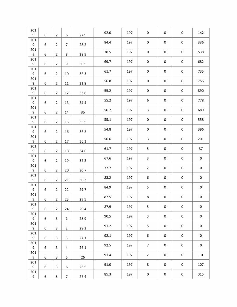
2019 6 2 6 27.9
92.0 197 0 0 0 142
2019 6 2 7 28.2
84.4 197 0 0 0 336
2019 6 2 8 28.5
78.5 197 0 0 0 538
2019 6 2 9 30.5
69.7 197 0 0 0 682
2019 6 2 10 32.3
61.7 197 0 0 0 735
2019 6 2 11 32.8
56.8 197 0 0 0 756
2019 6 2 12 33.8
55.2 197 0 0 0 890
2019 6 2 13 34.4
55.2 197 6 0 0 778
2019 6 2 14 35
56.2 197 3 0 0 689
2019 6 2 15 35.5
55.1 197 0 0 0 558
2019 6 2 16 36.2
54.8 197 0 0 0 396
2019 6 2 17 36.1
56.6 197 3 0 0 201
2019 6 2 18 34.6
61.7 197 5 0 0 37
2019 6 2 19 32.2
67.6 197 3 0 0 0
2019 6 2 20 30.7
77.7 197 2 0 0 0
2019 6 2 21 30.3
83.2 197 6 0 0 0
2019 6 2 22 29.7
84.9 197 5 0 0 0
2019 6 2 23 29.5
87.5 197 8 0 0 0
2019 6 2 24 29.4
87.9 197 3 0 0 0
2019 6 3 1 28.9
90.5 197 3 0 0 0
2019 6 3 2 28.3
91.2 197 5 0 0 0
2019 6 3 3 27.1
92.1 197 6 0 0 0
2019 6 3 4 26.1
92.5 197 7 0 0 0
2019 6 3 5 26
91.4 197 2 0 0 10
2019 6 3 6 26.5
91.0 197 8 0 0 107
2019 6 3 7 27.4
85.3 197 0 0 0 315
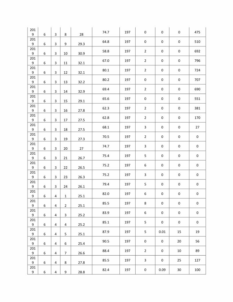
2019 6 3 8 28
74.7 197 0 0 0 475
2019 6 3 9 29.3
64.8 197 0 0 0 510
2019 6 3 10 30.9
58.8 197 2 0 0 692
2019 6 3 11 32.1
67.0 197 2 0 0 796
2019 6 3 12 32.1
80.1 197 2 0 0 724
2019 6 3 13 32.2
80.2 197 0 0 0 707
2019 6 3 14 32.9
69.4 197 2 0 0 690
2019 6 3 15 29.1
65.6 197 0 0 0 551
2019 6 3 16 27.8
62.3 197 2 0 0 381
2019 6 3 17 27.5
62.8 197 2 0 0 170
2019 6 3 18 27.5
68.1 197 3 0 0 27
2019 6 3 19 27.3
70.5 197 2 0 0 0
2019 6 3 20 27
74.7 197 3 0 0 0
2019 6 3 21 26.7
75.4 197 5 0 0 0
2019 6 3 22 26.5
75.2 197 6 0 0 0
2019 6 3 23 26.3
75.2 197 3 0 0 0
2019 6 3 24 26.1
79.4 197 5 0 0 0
2019 6 4 1 25.1
82.0 197 6 0 0 0
2019 6 4 2 25.1
85.5 197 8 0 0 0
2019 6 4 3 25.2
83.9 197 6 0 0 0
2019 6 4 4 25.2
85.1 197 5 0 0 0
2019 6 4 5 25.1
87.9 197 5 0.01 15 19
2019 6 4 6 25.4
90.5 197 0 0 20 56
2019 6 4 7 26.6
88.4 197 2 0 10 89
2019 6 4 8 27.8
85.5 197 3 0 25 127
2019 6 4 9 28.8
82.4 197 0 0.09 30 100

2019 6 4 10 30.2
81.7 197 0 0 10 640
2019 6 4 11 31
78.5 197 2 0 0 945
2019 6 4 12 31.4
73.4 197 3 0 0 865
2019 6 4 13 32.1
69.4 197 0 0 0 875
2019 6 4 14 31.3
66.1 197 0 0 0 650
2019 6 4 15 29.5
65.2 197 0 0 30 168
2019 6 4 16 30.7
61.9 197 0 0 50 39
2019 6 4 17 31.6
61.4 197 3 0.03 40 29
2019 6 4 18 31.7
67.8 197 0 0 0 15
2019 6 4 19 31.5
70.8 197 3 0 0 0
2019 6 4 20 31.2
78.3 197 6 0 0 0
2019 6 4 21 31.1
84.5 197 5 0 0 0
2019 6 4 22 30.8
84.1 197 3 0 0 0
2019 6 4 23 29.2
87.7 197 8 0 30 0
2019 6 4 24 28.5
89.5 197 0 0.01 40 0
2019 6 5 1 27.8
91.0 197 3 0 10 0
2019 6 5 2 27.5
89.2 197 8 0 0 0
2019 6 5 3 27.2
91.3 197 8 0 0 0
2019 6 5 4 26.8
92.2 197 3 0 0 0
2019 6 5 5 26.3
93.0 197 5 0 0 7
2019 6 5 6 26.3
93.4 197 2 0 50 68
2019 6 5 7 26.4
89.3 197 0 0 30 132
2019 6 5 8 26.5
79.2 197 0 0 10 237
2019 6 5 9 26.6
74.4 197 8 0.01 10 409
2019 6 5 10 27.1
69.5 197 2 0 0 623
2019 6 5 11 28.2
65.3 197 2 0 0 283

2019 6 5 12 29.5
60.8 197 0 0 0 225
2019 6 5 13 30.5
58.4 197 0 0 0 214
2019 6 5 14 31.1
56.8 197 2 0 0 355
2019 6 5 15 31.2
68.9 197 3 0 0 297
2019 6 5 16 31.6
73.0 197 3 0 0 289
2019 6 5 17 31.5
69.6 197 0 0 0 232
2019 6 5 18 31.2
64.0 197 0 0 0 38
2019 6 5 19 30.8
71.2 197 3 0 0 0
2019 6 5 20 30.2
80.8 197 3 0 0 0
2019 6 5 21 29.8
84.1 197 8 0 0 0
2019 6 5 22 29.7
81.8 197 3 0 0 0
2019 6 5 23 29.5
82.0 197 7 0 0 0
2019 6 5 24 27.1
84.6 197 8 0 0 0
2019 6 6 1 26.4
88.9 197 6 0 0 0
2019 6 6 2 25.2
87.8 197 3 0 0 0
2019 6 6 3 25
90.2 197 3 0 0 0
2019 6 6 4 25
88.6 197 3 0 0 0
2019 6 6 5 24.9
89.4 197 0 0 5 3
2019 6 6 6 25.2
91.2 197 0 0 20 39
2019 6 6 7 26.4
85.5 197 0 0 30 126
2019 6 6 8 27.6
78.3 197 0 0.14 40 50
2019 6 6 9 28.6
71.4 197 0 0.05 30 172
2019 6 6 10 30
66.4 197 2 0 0 557
2019 6 6 11 30.8
64.7 197 2 0 0 439
2019 6 6 12 31.2
59.7 197 3 0 0 664
2019 6 6 13 31.9
61.8 197 0 0 0 534

2019 6 6 14 31.1
62.1 197 0 0 0 605
2019 6 6 15 29.3
56.9 197 2 0 0 612
2019 6 6 16 30.5
60.9 197 3 0 0 396
2019 6 6 17 31.4
61.5 197 0 0 0 202
2019 6 6 18 31.5
63.2 197 0 0 0 29
2019 6 6 19 31.3
67.0 197 2 0 0 0
2019 6 6 20 30.1
75.1 197 5 0 0 0
2019 6 6 21 28.6
83.5 197 5 0 0 0
2019 6 6 22 27.6
83.3 197 3 0 0 0
2019 6 6 23 26.3
86.9 197 5 0 30 0
2019 6 6 24 25.3
88.4 197 0 0 40 0
2019 6 7 1 24.8
89.5 197 7 0 20 0
2019 6 7 2 24.8
90.7 197 0 0 10 0
2019 6 7 3 24.9
85.5 197 0 0 0 0
2019 6 7 4 24.9
86.8 197 3 0 0 0
2019 6 7 5 24.8
89.4 197 3 0 0 14
2019 6 7 6 25.1
89.6 197 2 0 10 125
2019 6 7 7 26.3
86.5 197 0 0 10 146
2019 6 7 8 27.5
84.4 197 0 0 0 175
2019 6 7 9 28.5
78.3 197 2 0 0 588
2019 6 7 10 29.9
65.7 197 3 0 0 697
2019 6 7 11 30.7
58.8 197 2 0 0 712
2019 6 7 12 31.1
60.3 197 0 0 0 851
2019 6 7 13 31.8
61.1 197 3 0 0 840
2019 6 7 14 31
59.8 197 2 0 0 760
2019 6 7 15 29.2
58.2 197 0 0 0 508

2019 6 7 16 30.4
58.5 197 0 0 0 400
2019 6 7 17 31.3
84.2 197 0 0 0 206
2019 6 7 18 31.4
88.9 197 0 0 0 44
2019 6 7 19 31.2
89.9 197 2 0 0 0
2019 6 7 20 30.9
89.6 197 3 0 30 0
2019 6 7 21 30.8
88.9 197 3 0 20 0
2019 6 7 22 30.5
89.3 197 5 0 10 0
2019 6 7 23 28.9
90.5 197 7 0 30 0
2019 6 7 24 28.2
91.9 197 7 0 50 0
2019 6 8 1 24.8
92.2 197 7 0 40 0
2019 6 8 2 24.8
92.3 197 6 0.01 60 0
2019 6 8 3 24.9
92.4 197 6 0.02 75 0
2019 6 8 4 24.9
93.0 197 3 0.05 80 0
2019 6 8 5 24.8
93.6 197 0 0.01 40 5
2019 6 8 6 25.1
92.7 197 0 0 20 100
2019 6 8 7 26.3
92.4 197 0 0 10 108
2019 6 8 8 27.5
91.9 197 0 0 0 222
2019 6 8 9 28.5
87.4 197 0 0 0 552
2019 6 8 10 29.9
86.7 197 0 0 0 846
2019 6 8 11 30.7
82.8 197 0 0 0 896
2019 6 8 12 31.1
76.6 197 0 0 0 555
2019 6 8 13 31.8
71.1 197 0 0 0 374
2019 6 8 14 31
66.5 197 0 0 0 505
2019 6 8 15 29.2
63.9 197 0 0 0 181
2019 6 8 16 30.4
63.9 197 0 0 0 156
2019 6 8 17 31.3
62.3 197 0 0 0 95

2019 6 8 18 31.4
67.5 197 2 0 0 35
2019 6 8 19 31.2
72.0 197 3 0 0 0
2019 6 8 20 30.9
77.6 197 5 0 30 0
2019 6 8 21 30.8
80.5 197 6 0 35 0
2019 6 8 22 30.5
82.2 197 7 0 40 0
2019 6 8 23 28.9
85.1 197 7 0 45 0
2019 6 8 24 28.2
83.3 197 5 0.03 40 0
2019 6 9 1 24.7
79.6 197 7 0.33 55 0
2019 6 9 2 24.7
81.2 197 7 0 40 0
2019 6 9 3 24.8
84.0 197 3 0 30 0
2019 6 9 4 24.8
86.9 197 3 0.01 60 0
2019 6 9 5 24.7
90.5 197 0 0 40 3
2019 6 9 6 25
91.7 197 0 0 20 54
2019 6 9 7 26.2
91.5 197 0 0 0 204
2019 6 9 8 27.4
88.0 197 0 0 0 345
2019 6 9 9 28.4
79.0 197 0 0 0 407
2019 6 9 10 29.8
74.1 197 0 0 0 670
2019 6 9 11 30.6
72.7 197 0 0 0 641
2019 6 9 12 31
68.4 197 0 0 0 597
2019 6 9 13 31.7
63.5 197 0 0 20 710
2019 6 9 14 30.9
64.6 197 0 0 40 197
2019 6 9 15 29.1
76.1 197 0 0.08 60 172
2019 6 9 16 30.3
86.9 197 0 0 70 97
2019 6 9 17 31.2
82.3 251 0 0.17 55 37
2019 6 9 18 31.3
84.6 293 3 0 40 0
2019 6 9 19 31.1
82.7 293 3 0 60 0

2019 6 9 20 30.8
82.3 293 5 0 45 0
2019 6 9 21 30.7
85.6 293 6 0 60 0
2019 6 9 22 30.4
85.3 290 5 2.05 70 0
2019 6 9 23 28.8
83.7 270 8 19.5 80 0
2019 6 9 24 28.1
82.8 225 8 0.37 100 0
2019 6 10 1 24.6
82.6 225 3 0.11 100 0
2019 6 10 2 24.6
88.2 225 3 0.23 100 0
2019 6 10 3 24.7
92.6 227 5 0.07 100 0
2019 6 10 4 24.7
94.1 227 0 0.01 100 0
2019 6 10 5 24.6
93.1 227 0 0.01 100 1
2019 6 10 6 24.9
92.3 227 3 0.14 100 51
2019 6 10 7 26.1
92.1 227 0 0.6 100 194
2019 6 10 8 27.3
93.0 227 0 0 100 354
2019 6 10 9 28.3
91.9 227 0 0.44 100 411
2019 6 10 10 29.7
87.3 227 0 0.34 100 780
2019 6 10 11 30.5
83.3 227 0 0.47 100 647
2019 6 10 12 30.9
78.8 227 2 0 100 597
2019 6 10 13 31.6
73.5 227 0 0.34 100 714
2019 6 10 14 30.8
70.6 227 2 0.38 100 311
2019 6 10 15 29
68.7 227 0 0.88 100 382
2019 6 10 16 30.2
67.3 227 2 0.31 100 297
2019 6 10 17 31.1
66.7 227 2 0 100 37
2019 6 10 18 31.2
66.8 227 0 0.34 100 0
2019 6 10 19 31
75.9 227 2 0.02 100 0
2019 6 10 20 30.7
82.1 227 2 0.59 100 0
2019 6 10 21 30.6
84.1 227 3 1.02 100 0

2019 6 10 22 30.3
86.0 227 3 0 100 0
2019 6 10 23 28.7
87.7 227 3 0.12 100 0

Appendix 3.2:
Ambient Air quality
Monitoring Results

Appendix 3.2-Air Monitoring Data
AQ1/B1(26° 7'34.57"N, 93°49'31.19"E)
S.N
. Date
PM10 (μg/m3
)
PM2.5 (μg/m3
)
SO2 (μg/m3
)
NO2 (μg/m3
)
O3 (μg/m3
)
NH3 (μg/m3
)
CO (mg/m3
)
As (ng/m3
)
Ni (ng/m3
)
Pb (μg/m3
)
C6H6 (μg/m3
)
BaP (ng/m3
)
HC as methn
e (ppm)
HC as non-
methane
(ppm)
Week 1 1 13/3/2019 65.2 37.2 <6.0 19.6 <20.0 <10.0 0.22 <1.0 <5.0 0.02 <4.2 <0.5 1.46 <0.1
2 16/3/2019 58.4 26.4 <6.0 28.3 <20.0 <10.0 0.45 <1.0 <5.0 <0.01 <4.2 <0.5 0.81 <0.1
Week 2 3 20/3/2019 56.6 24.3 <6.0 22 <20.0 <10.0 0.32 <1.0 <5.0 <0.01 <4.2 <0.5 1.47 <0.1
4 23/3/2019 77.2 40.2 6.4 26.4 <20.0 25.3 0.5 <1.0 <5.0 <0.01 <4.2 <0.5 2.29 <0.1
Week 3 5 27/3/2019 75.3 39.3 <6.0 24.5 24.2 <10.0 0.42 <1.0 <5.0 <0.01 <4.2 <0.5 1.98 <0.1
6 30/3/2019 54.8 29.6 <6.0 16.8 <20.0 26.3 0.27 <1.0 <5.0 0.04 <4.2 <0.5 1.53 <0.1
Week 4 7 1/4/2019 56.8 34.2 <6.0 17.2 <20.0 16.9 0.36 <1.0 <5.0 0.03 <4.2 <0.5 0.94 <0.1
8
03/04/2019 42.5 20.5 <6.0 22.7 21.4 11.2 0.55 <1.0 <5.0 0.02 <4.2 <0.5 2.79 <0.1
Week 5 9
06/04/2019 65.5 32.5 8.1 19.8 <20 <10 0.32 <1.0 <5.0 0.01 <4.2 <0.5 1.36 <0.1
10
10/04/2019 70.9 39.8 7.2 25.2 21.8 10.9 0.15 <1.0 <5.0 <0.01 <4.2 <0.5 1.31 <0.1
Week 6 11
13/04/2019 60.7 33.9 6.6 23.4 <20.0 <10.0 0.49 <1.0 <5.0 <0.01 <4.2 <0.5 2.78 <0.1
12
17/04/2019 58.7 25.8 6.2 17.2 <20.0 <10.0 0.36 <1.0 <5.0 <0.01 <4.2 <0.5 1.41 <0.1
Week 7 13
20/04/2019 78.1 40.7 <6.0 27.6 <20.0 10.2 0.25 <1.0 <5.0 <0.01 <4.2 <0.5 2.4 <0.1
14
24/04/2019 58.4 27.7 6.9 19.8 <20.0 <10.0 0.62 <1.0 <5.0 <0.01 <4.2 <0.5 1.31 <0.1
Week 8 15
27/04/2019 62.8 29.1 <6.0 20.5 <20.0 <10.0 0.33 <1.0 <5.0 <0.01 <4.2 <0.5 1.31 <0.1
16
01/05/2019 69.9 34.5 7.5 27.6 <20.0 10.4 0.47 <1.0 <5.0 0.05 <4.2 <0.5 1.19 <0.1
Week 9 17
04/05/2019 54.5 32.7 <6.0 17.9 <20.0 21.2 0.25 <1.0 <5.0 <0.01 <4.2 <0.5 1.31 <0.1
18
08/05/2019 67.5 42.3 6.5 23.8 <20.0 <10.0 0.36 <1.0 <5.0 <0.01 <4.2 <0.5 1.16 <0.1
Week 10 19
11/05/2019 34.2 14.5 6.2 16.5 <20.0 <10.0 0.45 <1.0 <5.0 <0.01 <4.2 <0.5 1 <0.1

20
15/05/2019 78.3 51.7 7.6 25.6 24.5 19.6 0.58 <1.0 <5.0 <0.01 <4.2 <0.5 1.18 <0.1
Week 11 21
18/05/2019 81.3 36.2 <6.0 33.9 21.4 <10.0 0.64 <1.0 <5.0 <0.01 <4.2 <0.5 1.98 <0.1
22
22/05/2019 68.4 32.6 <6.0 23.5 <20.0 15.4 0.29 <1.0 <5.0 <0.01 <4.2 <0.5 1.6 <0.1
Week 12 23
25/05/2019 48.9 21.4 6.6 18.6 23.7 <10.0 0.18 <1.0 <5.0 <0.01 <4.2 <0.5 1.58 <0.1
24
29/05/2019 57.3 18.5 <6.0 25.2 <20.0 16.6 0.37 <1.0 <5.0 <0.01 <4.2 <0.5 1.8 <0.1
Week 13 25 6/5/2019 42.6 18.7 <6.0 15.2 <20.0 <10.0 0.62 <1.0 <5.0 <0.01 <4.2 <0.5 1.56 <0.1
26 6/8/2019 52.4 30.2 <6.0 26.8 <20.0 18.6 0.33 <1.0 <5.0 <0.01 <4.2 <0.5 1.75 <0.1
AQ2/B1(26°09'32.13"N 93°46'54.90"E)
S.N
. Date
PM10 (μg/m3
)
PM2.5 (μg/m3
)
SO2 (μg/m3
)
NO2 (μg/m3
)
O3 (μg/m3
)
NH3 (μg/m3
)
CO (mg/m3
)
As (ng/m3
)
Ni (ng/m3
)
Pb (μg/m3
)
C6H6 (μg/m3
)
BaP (ng/m3
)
HC as methn
e (ppm)
HC as non-
methane
(ppm)
Week 1 1 10/3/2019 64.2 29.8 <6.0 24.2 <20.0 <10.0 0.28 <1.0 <5.0 <0.01 <4.2 <0.5 1.44 <0.1
2 17/3/2019 71.6 40.2 7.2 22.4 <20.0 <10.0 0.56 <1.0 <5.0 0.03 <4.2 >0.5 2.08 <0.1
Week 2 3 21/3/2019 62.5 36.6 <6.0 19.5 <20.0 <10.0 0.35 <1.0 <5.0 <0.01 <4.2 <0.5 2.38 <0.1
4 24/3/2019 76.8 39.2 7.2 28.2 <20.0 <10.0 0.25 <1.0 5.4 0.05 <4.2 <0.5 0.93 <0.1
Week 3 5 14/3/2019 46.6 22.6 <6.0 20.6 <20.0 <10.0 0.41 <1.0 <5.0 0.01 <4.2 <0.5 1.17 <0.1
6 28/3/2019 56.8 25.4 <6.0 17.2 <20.0 <10.0 0.58 <1.0 <5.0 <0.01 <4.2 <0.5 1.36 <0.1
Week 4 7 31/3/2019 68.2 34.8 6.3 25.2 <20.0 <10.0 0.36 <1.0 <5.0 <0.01 <4.2 <0.5 1.25 <0.1
8
04/04/2019 80.2 41.2 7.2 18.7 <20.0 18.5 0.23 <1.0 <5.0 0.06 <4.2 <0.5 1.1 <0.1
Week 5 9
07/04/2019 59.8 31.2 6.5 17.9 <20.0 <10.0 0.36 <1.0 <5.0 0.03 <4.2 <0.5 2.04 <0.1
10
11/04/2019 62.1 33.4 <6.0 23.8 <20.0 15.3 0.27 <1.0 <5.0 0.07 <4.2 <0.5 1.99 <0.1
Week 6 11
14/04/2019 48.6 21.3 <6.0 20.5 <20.0 <10.0 0.43 <1.0 <5.0 0.05 <4.2 <0.5 2.35 <0.1
12
21/04/2019 49.9 24.1 7.3 23.3 <20.0 11.5 0.57 <1.0 <5.0 0.05 <4.2 <0.5 2.51 <0.1

Week 7 13
23/04/2019 69.9 37.6 <6.0 19.7 <20.0 10.6 0.41 <1.0 <5.0 <0.01 <4.2 <0.5 2.04 <0.1
14
25/04/2019 61.8 30.3 6.3 21.4 22.6 <10.0 0.26 <1.0 <5.0 <0.01 <4.2 <0.5 2.38 <0.1
Week 8 15
28/04/2019 70.5 33.8 6.6 29.3 <20.0 <10.0 0.51 <1.0 <5.0 0.03 <4.2 <0.5 1.2 <0.1
16
02/05/2019 83.7 41.6 <6.0 31.2 <20.0 16.7 0.39 <1.0 <5.0 0.01 <4.2 <0.5 1.52 <0.1
Week 9 17
05/05/2019 69.9 38.6 6.6 19.3 <20.0 <10.0 0.48 <1.0 <5.0 <0.01 <4.2 <0.5 1.8 <0.1
18
09/05/2019 69.9 38.6 6.6 19.3 <20.0 <10.0 0.48 <1.0 <5.0 <0.01 <4.2 <0.5 1.8 <0.1
Week 10 19
12/05/2019 72.2 29.7 <6.0 26.3 <20.0 16.5 0.27 <1.0 <5.0 <0.01 <4.2 <0.5 1.27 <0.1
20
16/05/2019 54.5 33.8 <6.0 18.4 25.4 <10.0 0.19 <1.0 <5.0 <0.01 <4.2 <0.5 1.54 <0.1
Week 11 21
19/05/2019 31.2 14.5 <6.0 23 <20.0 19.6 0.54 <1.0 <5.0 <0.01 <4.2 <0.5 1.05 <0.1
22
23/05/2019 67.3 41.8 6.2 30.7 20.5 <10.0 0.24 <1.0 <5.0 <0.01 <4.2 <0.5 2.14 <0.1
Week 12 23
26/05/2019 75.5 36.2 <6.0 15.2 <20.0 14.5 0.47 <1.0 <5.0 <0.01 <4.2 <0.5 1.16 <0.1
24
30/05/2019 50.2 28.8 7.5 27.4 22.9 <10.0 0.31 <1.0 <5.0 <0.01 <4.2 <0.5 2.41 <0.1
Week 13 25 6/2/2019 32.2 21.3 6.6 16.7 <20.0 <10.0 0.21 <1.0 <5.0 <0.01 <4.2 <0.5 1.33 <0.1
26 6/6/2019 50.3 31.2 <6.0 24..9 <20.0 <10.0 0.54 <1.0 <5.0 <0.01 <4.2 <0.5 2 <0.1
AQ3/B1(26°03'57.42"N 93°46'54.90"E)
S.N
. Date
PM10 (μg/m3
)
PM2.5 (μg/m3
)
SO2 (μg/m3
)
NO2 (μg/m3
)
O3 (μg/m3
)
NH3 (μg/m3
)
CO (mg/m3
)
As (ng/m3
)
Ni (ng/m3
)
Pb (μg/m3
)
C6H6 (μg/m3
)
BaP (ng/m3
)
HC as methn
e (ppm)
HC as non-
methane
(ppm)
Week 1 1 13/3/2019 68.3 33.6 7.4 20.6 <20.0 <10.0 0.31 <1.0 10.2 0.02 <4.2 <0.5 1.2 <0.1
2 16/3/2019 66 30.2 6.9 29.8 21.2 18.9 0.37 <1.0 <5.0 0.03 <4.2 <0.5 1.48 <0.1
Week 2 3 20/3/2019 72 36.3 7.5 24.5 <20.0 <10.0 0.23 <1.0 <5.0 <0.01 <4.2 <0.5 1.1 <0.1
4 23/3/2019 58.6 25.4 6.2 17.6 <20.0 <10.0 0.63 <1.0 <5.0 <0.01 <4.2 <0.5 2.65 <0.1

Week 3 5 27/3/2019 69.3 32.5 7 26.5 <20.0 <10.0 0.34 <1.0 <5.0 <0.01 <4.2 <0.5 2 <0.1
6 30/3/2019 81.4 40.3 7.6 22.5 24.2 23.3 0.47 <1.0 <5.0 <0.01 <4.2 <0.5 1.56 <0.1
Week 4 7
03/04/2019 59.6 27.9 7.3 33.9 23.4 13.8 0.16 <1.0 <5.0 <0.01 <4.2 <0.5 1.94 <0.1
8
06/04/2019 60.8 29.9 6.2 29.3 <20.0 15.7 0.27 <1.0 <5.0 <0.01 <4.2 <0.5 2.83 <0.1
Week 5 9
10/04/2019 81 40.2 <6.0 17.8 <20.0 <10.0 0.69 <1.0 <5.0 <0.01 <4.2 <0.5 2.05 <0.1
10
13/04/2019 63.3 31.5 <6.0 30.3 <20.0 <10.0 0.34 <1.0 <5.0 <0.01 <4.2 <0.5 1.99 <0.1
Week 6 11
17/04/2019 58.6 28.7 6.9 28.6 22.4 11.8 0.55 <1.0 <5.0 <0.01 <4.2 <0.5 1.57 <0.1
12
20/04/2019 50 24.8 7.5 25.4 <20.0 15.1 0.46 <1.0 <5.0 <0.01 <4.2 <0.5 1.58 <0.1
Week 7 13
24/04/2019 47.8 22.9 6.3 16.3 <20.0 <10.0 0.18 <1.0 <5.0 <0.01 <4.2 <0.5 1.79 <0.1
14
27/04/2019 78.4 37.7 7.6 22.1 <20.0 17.6 0.62 <1.0 <5.0 <0.01 <4.2 <0.5 1.99 <0.1
Week 8 15
01/05/2019 70.9 35.5 <6.0 27.2 24.6 <10.0 0.36 <1.0 <5.0 <0.01 <4.2 <0.5 1.86 <0.1
16
04/05/2019 87.3 52.6 <6.0 20.7 23.9 <10.0 0.25 <1.0 <5.0 <0.01 <4.2 <0.5 2.54 <0.1
Week 9 17
08/05/2019 67.1 25.3 6.8 27.2 25.4 11.4 0.34 <1.0 <5.0 <0.01 <4.2 <0.5 2.25 <0.1
18
11/05/2019 53.2 32.4 <6.0 32 21.7 17.6 0.31 <1.0 <5.0 <0.01 <4.2 <0.5 2.03 <0.1
Week 10 19
15/05/2019 46.6 30.2 <6.0 23.4 <20.0 <10.0 0.55 <1.0 <5.0 <0.01 <4.2 <0.5 1.18 <0.1
20
18/05/2019 78.7 46.5 7.3 19.5 24.1 13.5 0.45 <1.0 <5.0 <0.01 <4.2 <0.5 2.04 <0.1
Week 11 21
22/05/2019 61.6 37.6 6.2 25.8 <20.0 <10.0 0.24 <1.0 <5.0 <0.01 <4.2 <0.5 2.02 <0.1
22
25/05/2019 57.1 24.7 <6.0 19.9 26.6 <10.0 0.65 <1.0 <5.0 <0.01 <4.2 <0.5 2.28 <0.1
Week 12 23
29/05/2019 80.8 51.2 6.9 30.1 22.2 14.7 0.27 <1.0 <5.0 <0.01 <4.2 <0.5 1.77 <0.1
24
01/06/2019 42.2 30.4 7.1 22.2 <20.0 <10.0 0.38 <1.0 <5.0 <0.01 <4.2 <0.5 1.81 <0.1
Week 13 25 6/5/2019 36.8 22.5 <6.0 13.1 <20.0 <10.0 0.36 <1.0 <5.0 <0.01 <4.2 <0.5 1.94 <0.1
26 6/8/2019 60.4 26.7 6.2 30.1 <20.0 17.5 0.47 <1.0 <5.0 <0.01 <4.2 <0.5 1.67 <0.1

AQ4/B1(25°57'50.58"N, 93°42'41.03"E)
S.N
. Date
30.1
PM2.5 (μg/m3
)
SO2 (μg/m3
)
NO2 (μg/m3
)
O3 (μg/m3
)
NH3 (μg/m3
)
CO (mg/m3
)
As (ng/m3
)
Ni (ng/m3
)
Pb (μg/m3
)
C6H6 (μg/m3
)
BaP (ng/m3
)
HC as methn
e (ppm)
HC as non-
methane
(ppm)
Week 1 1 11/3/2019
78.2 40.2 6.2 26.4 <20.0 <10.0 0.24 <1.0 <5.0 0.02 <4.2 <0.5 1.23 <0.1
2 15/3/2019
73.5 37.5 6.6 25.4 <20.0 <10.0 0.5 <1.0 <5.0 <0.02 <4.2 <0.5 1.28 <0.1
Week 2 3 18/3/2019
66.3 30.8 <6.0 19.2 <20.0 <10.0 0.34 <1.0 <5.0 0.01 <4.2 <0.5 1.71 <0.1
4 22/3/2019
76.2 36.9 6.3 24.8 20.7 <10.0 0.43 <1.0 <5.0 <0.01 <4.2 <0.5 1.26 <0.1
Week 3 5 25/3/2019
56.9 29.9 <6.0 20.5 <20.0 <10.0 0.32 <1.0 <5.0 <0.01 <4.2 <0.5 1.72 <0.1
6 29/3/2019
71.9 37.1 6.8 28.5 <20.0 <10.0 0.5 <1.0 <5.0 <0.01 <4.2 <0.5 1.78 <0.1
Week 4 7 1/4/2019
55.4 29.2 <6.0 17.4 <20.0 <10.0 0.56 <1.0 <5.0 <0.01 <4.2 <0.5 1.45 <0.1
8
05/04/2019 82 40.1 6.5 21.1 <20.0 18.9 0.19 <1.0 <5.0 <0.01 <4.2 <0.5 1.76 <0.1
Week 5 9
08/04/2019
60.4 28.4 7.1 19.8 <20.0 <10.0 0.34 <1.0 <5.0 <0.01 <4.2 <0.5 1.6 <0.1
10
12/04/2019
61.8 30.6 6.6 31.2 22.2 <10.0 0.45 <1.0 <5.0 <0.01 <4.2 <0.5 2.05 <0.1
Week 6 11
15/04/2019
71.1 34.6 7.7 29.7 <20.0 17.5 0.29 <1.0 <5.0 <0.01 <4.2 <0.5 2.94 <0.1
12
19/04/2019
59.5 29.1 <6.0 15.2 <20.0 <10.0 0.54 <1.0 <5.0 <0.01 <4.2 <0.5 1.79 <0.1
Week 7 13
22/04/2019
73.2 33.7 <6.0 28.8 <20.0 <10.0 0.22 <1.0 <5.0 <0.01 <4.2 <0.5 2.02 <0.1

14
26/04/2019
79.7 37.6 6 33.1 23.7 <10.0 0.36 <1.0 <5.0 <0.01 <4.2 <0.5 1.31 <0.1
Week 8 15
29/04/2019
66.6 30.9 <6.0 20.8 24.9 15.5 0.45 <1.0 <5.0 <0.01 <4.2 <0.5 2.79 <0.1
16
03/05/2019
75.2 45.6 6.6 16.8 <20.0 16.8 0.75 <1.0 <5.0 <0.01 <4.2 <0.5 1.82 <0.1
Week 9 17
06/05/2019
57.6 31.7 7 28.6 <20.0 <10.0 0.33 <1.0 <5.0 <0.01 <4.2 <0.5 1.29 <0.1
18
10/05/2019
57.6 29.7 6.4 19 <20.0 <10.0 0.27 <1.0 <5.0 <0.01 <4.2 <0.5 1.67 <0.1
Week 10 19
13/05/2019
68.2 36.4 <6.0 29.4 <20.0 20.4 0.44 <1.0 <5.0 <0.01 <4.2 <0.5 1.34 <0.1
20
17/05/2019
41.6 28.5 7.3 16.7 24.9 <10.0 0.75 <1.0 <5.0 <0.01 <4.2 <0.5 2.15 <0.1
Week 11 21
20/05/2019
79.1 48.3 <6.0 32.1 21.5 16.8 0.32 <1.0 <5.0 <0.01 <4.2 <0.5 2 <0.1
22
24/05/2019
43.6 21.2 <6.0 17.6 <20.0 14.4 0.39 <1.0 <5.0 <0.01 <4.2 <0.5 1.51 <0.1
Week 12 23
27/05/2019
74.3 44.7 6.1 22.9 <20.0 17.5 0.44 <1.0 <5.0 <0.01 <4.2 <0.5 1.61 <0.1
24
31/05/2019
37.5 18.6 <6.0 24.1 24.8 <10.0 0.25 <1.0 <5.0 <0.01 <4.2 <0.5 2.24 <0.1
Week 13 25 6/3/2019
65.7 29.6 <6.0 20.3 <20.0 19.2 0.48 <1.0 <5.0 <0.01 <4.2 <0.5 2.06 <0.1
26 6/7/2019
30.1 19.4 6.5 14.2 <20.0 <10.0 0.31 <1.0 <5.0 <0.01 <4.2 <0.5 1.89 <0.1
AQ5/B1(26°02'08.64"N 93°46'20.62"E)
S.N
. Date
PM10 (μg/m3
)
PM2.5 (μg/m3
)
SO2 (μg/m3
)
NO2 (μg/m3
)
O3 (μg/m3
)
NH3 (μg/m3
)
CO (mg/m3
)
As (ng/m3
)
Ni (ng/m3
)
Pb (μg/m3
)
C6H6 (μg/m3
)
BaP (ng/m3
)
HC as methn
e (ppm)
HC as non-
methane
(ppm)
Week 1 1 10/3/2019 72.5 36.9 7.2 24.6 21.5 <10.0 0.28 <1.0 <5.0 0.03 <4.2 <0.5 1.42 <0.1
2 14/3/2019 77.3 38.2 8.5 32.2 <20.0 <10.0 0.23 <1.0 <5.0 0.02 <4.2 <0.5 0.82 <0.1
Week 2 3 17/3/2019 76.2 41.5 6.8 16.8 <20.0 <10.0 0.36 <1.0 <5.0 0.02 <4.2 <0.5 1.89 <0.1
4 21/3/2019 78.9 40.2 7.4 29.8 <20.0 <10.0 0.48 <1.0 <5.0 <0.01 <4.2 <0.5 1.14 <0.1
Week 3 5 24/3/2019 55.4 24.2 <6.0 19.3 <20.0 <10.0 0.26 <1.0 <5.0 <0.01 <4.2 <0.5 1.35 <0.1

6 28/3/2019 66 32 6.5 18.5 <20.0 <10.0 0.33 <1.0 <5.0 <0.01 <4.2 <0.5 2.02 <0.1
Week 4 7 31/3/2019 75.8 37.2 6.8 28.8 22.8 26.6 0.25 <1.0 <5.0 <0.01 <4.2 <0.5 1.48 <0.1
8
04/04/2019 48.8 24.8 6.6 34.6 <20.0 <10.0 0.66 <1.0 <5.0 <0.01 <4.2 <0.5 1.31 <0.1
Week 5 9
07/04/2019 80.8 43.3 7.3 22.1 <20.0 18.2 0.36 <1.0 <5.0 <0.01 <4.2 <0.5 1.41 <0.1
10
11/04/2019 56.7 28.7 <6.0 30.6 25.3 <10.0 0.45 <1.0 <5.0 0.05 <4.2 <0.5 1.1 <0.1
Week 6 11
14/04/2019 60.9 30.9 <6.0 36.3 <20.0 <10.0 0.16 <1.0 <5.0 0.03 <4.2 <0.5 1.36 <0.1
12
21/04/2019 72.2 36.7 6.8 21.5 21.6 11.3 0.28 <1.0 <5.0 0.03 <4.2 <0.5 2.06 <0.1
Week 7 13
23/04/2019 51.5 25.4 6 27.7 <20.0 <10.0 0.29 <1.0 <5.0 0.06 <4.2 <0.5 2.51 <0.1
14
25/04/2019 79.7 40.1 <6.0 19.8 24.8 16.6 0.77 <1.0 <5.0 0.05 <4.2 <0.5 2.4 <0.1
Week 8 15
28/04/2019 76 38.9 <6.0 16.2 <20.0 17.3 0.41 <1.0 <5.0 0.02 <4.2 <0.5 2.78 <0.1
16
02/05/2019 55.9 27.6 8.1 23.8 <20.0 <10.0 0.555 <1.0 <5.0 0.05 <4.2 <0.5 2.04 <0.1
Week 9 17
05/05/2019 56.7 32.9 7.2 23.3 <20.0 21.2 0.26 <1.0 <5.0 <0.01 <0.5 <0.5 2.25 <0.1
18
09/05/2019 63.8 26.6 <6.0 18.9 <20.0 <10.0 0.35 <1.0 <5.0 <0.01 <4.2 <0.5 1.77 <0.1
Week 10 19
12/05/2019 34.2 16.6 6.3 21.2 <20.0 19.8 0.28 <1.0 <5.0 <0.01 <4.2 <0.5 2.18 <0.1
20
16/05/2019 34.2 16.6 6.3 21.2 <20.0 19.8 0.28 <1.0 <5.0 <0.01 <4.2 <0.5 2.18 <0.1
Week 11 21
19/05/2019 40.2 26.3 <6.0 13.5 25.1 <10.0 0.33 <1.0 <5.0 <0.01 <4.2 <0.5 1.56 <0.1
22
23/05/2019 68.1 25.7 7.7 19.7 <20.0 12.2 0.54 <1.0 <5.0 <0.01 <4.2 <0.5 1.54 <0.1
Week 12 23
26/05/2019 52.2 20.1 6.6 24.2 24.3 19.6 0.67 <1.0 <5.0 <0.01 <4.2 <0.5 1.96 <0.1
24
30/05/2019 72.4 30.9 <6.0 28.9 22.5 <10.0 0.22 <1.0 <5.0 <0.01 <4.2 <0.5 2.16 <0.1
Week 13 25 6/2/2019 40.5 17.8 6.2 25.5 <20.0 <10.0 0.24 <1.0 <5.0 <0.01 <4.2 <0.5 1.51 <0.1
26 6/6/2019 64.2 36.5 <6.0 16.2 <20.0 <10.0 0.19 <1.0 <5.0 <0.01 <4.2 <0.5 1.55 <0.1

AQ6/B1(25°57'08.21"N 93°44'45.54"E)
S.N
. Date
PM10 (μg/m3
)
PM2.5 (μg/m3
)
SO2 (μg/m3
)
NO2 (μg/m3
)
O3 (μg/m3
)
NH3 (μg/m3
)
CO (mg/m3
)
As (ng/m3
)
Ni (ng/m3
)
Pb (μg/m3
)
C6H6 (μg/m3
)
BaP (ng/m3
)
HC as methn
e (ppm)
HC as non-
methane
(ppm)
Week 1 1 13/3/2019 74.3 39.4 6.8 23.8 <20.0 <10.0 0.19 <1.0 13.7 0.02 <4.2 <0.5 1.22 <0.1
2 20/3/2019 59.3 24.5 <6.0 18.6 <20.0 <10.0 0.34 <1.0 <5.0 0.01 <4.2 <0.5 1.94 <0.1
Week 2 3 23/3/2019 80.2 42.3 7 19.5 <20.0 <10.0 0.43 <1.0 <5.0 <0.01 <4.2 <0.5 2.31 <0.1
4 27/3/2019 64.5 30.9 6.2 18.2 <20.0 <10.0 0.37 <1.0 <5.0 <0.01 <4.2 <0.5 2.01 <0.1
Week 3 5 30/3/2019 62.3 29.4 <6.0 17.5 <20.0 <10.0 0.28 <1.0 <5.0 <0.01 <4.2 <0.5 1.2 <0.1
6 2/4/2019 69.8 32.4 <6.0 16.4 <20.0 <10.0 0.52 <1.0 <5.0 <0.01 <4.2 <0.5 1.91 <0.1
Week 4 7
03/04/2019 59.4 29.3 6.2 28.9 <20.0 11.2 0.26 <1.0 <5.0 0.04 <4.2 <0.5 1.2 <0.1
8
06/04/2019 48.6 24.3 7.4 33.3 21.4 <10.0 0.78 <1.0 <5.0 0.02 <4.2 <0.5 1.52 <0.1
Week 5 9
10/04/2019 76.6 38.8 7 27.6 <20.0 15.3 0.65 <1.0 <5.0 0.03 <4.2 <0.5 1.31 <0.1
10
13/04/2019 71.9 37.6 6.3 13.5 <20.0 14.5 0.45 <1.0 <5.0 0.02 <4.2 <0.5 2.51 <0.1
Week 6 11
17/04/2019 51.6 25.2 <6.0 32.7 25.6 <10.0 0.34 <1.0 <5.0 0.03 <4.2 <0.5 2.04 <0.1
12
20/04/2019 57.8 27.7 <6.0 21.9 <20.0 <10.0 0.29 <1.0 <5.0 0.1 <4.2 <0.5 1.31 <0.1
Week 7 13
24/04/2019 45.9 22.2 6.6 26.7 23.3 <10.0 0.38 <1.0 <5.0 <0.01 <4.2 <0.5 2.04 <0.1
14
27/04/2019 54.4 26.8 <6.0 34.1 <20.0 <10.0 0.42 <1.0 <5.0 0.06 <4.2 <0.5 2.38 <0.1
Week 8 15
01/05/2019 70.7 36.9 7.5 14.2 <20.0 12.7 0.33 <1.0 <5.0 <0.01 <4.2 <0.5 2.83 <0.1
16
04/05/2019 81.8 41.2 6.1 29.8 <20.0 18.2 0.26 <1.0 <5.0 0.05 <4.2 <0.5 1.99 <0.1
Week 9 17
08/05/2019 54.3 33.6 <6.0 15.6 <20.0 <10.0 0.65 <1.0 <5.0 <0.01 <4.2 <0.5 1.63 <0.1
18
11/05/2019 39.4 18.5 6.2 24.5 20.9 16.2 0.27 <1.0 <5.0 <0.01 <4.2 <0.5 1.69 <0.1
Week 10 19
15/05/2019 76.6 48.7 7.1 29.2 21.7 <10.0 0.32 <1.0 <5.0 <0.01 <4.2 <0.5 2.35 <0.1

20
18/05/2019 60.5 29.1 <6.0 23.6 <20.0 <10.0 0.28 <1.0 <5.0 <0.01 <4.2 <0.5 1.78 <0.1
Week 11 21
22/05/2019 78.6 49.7 8.2 15.7 26.5 16.7 0.47 <1.0 <5.0 <0.01 <4.2 <0.5 1.61 <0.1
22
25/05/2019 50.1 22.8 <6.0 28.4 21.5 20.2 0.76 <1.0 <5.0 <0.01 <4.2 <0.5 2.43 <0.1
Week 12 23
29/05/2019 37.5 23.7 6.5 12.5 <20.0 <10.0 0.38 <1.0 <5.0 <0.01 <4.2 <0.5 2.28 <0.1
24
01/06/2019 71.3 44.6 7 16.9 22.7 16.7 0.26 <1.0 <5.0 <0.01 <4.2 <0.5 1.69 <0.1
Week 13 25 6/5/2019 41.9 18.7 6.8 17.3 <20.0 13.6 0.26 <1.0 <5.0 <0.01 <4.2 <0.5 1.46 <0.1
26 6/8/2019 30.1 20.5 <6.0 20.1 <20.0 <10.0 0.34 <1.0 <5.0 <0.01 <4.2 <0.5 1.62 <0.1
AQ7/B1(26°00'38.68"N 93°49'56.95"E)
S.N
. Date
PM10 (μg/m3
)
PM2.5 (μg/m3
)
SO2 (μg/m3
)
NO2 (μg/m3
)
O3 (μg/m3
)
NH3 (μg/m3
)
CO (mg/m3
)
As (ng/m3
)
Ni (ng/m3
)
Pb (μg/m3
)
C6H6 (μg/m3
)
BaP (ng/m3
)
HC as methn
e (ppm)
HC as non-
methane
(ppm)
Week 1 1 11/3/2019 76 38.4 7.2 22.8 21.2 16.3 0.26 <1.0 <5.0 0.02 <4.2 <0.5 1.77 <0.1
2 15/3/2019 60.4 25.8 <6.0 19.2 <20.0 <10.0 0.36 <1.0 <5.0 0.02 <4.2 <0.5 1.71 <0.1
Week 2 3 18/3/2019 78.6 37.5 6.6 29.6 23.3 <10.0 0.26 <1.0 <5.0 0.02 <4.2 <0.5 2.14 <0.1
4 22/3/2019 61.6 26.4 6.2 18.7 <20.0 <10.0 0.36 <1.0 <5.0 <0.01 <4.2 <0.5 2.7 <0.1
Week 3 5 25/3/2019 80 39.6 7.4 28.7 21.8 29.6 0.43 <1.0 <5.0 <0.01 <4.2 <0.5 1.19 <0.1
6 29/3/2019 66.6 30.4 6.3 18.3 <20.0 <10.0 0.34 <1.0 <5.0 <0.01 <4.2 <0.5 2.03 <0.1
Week 4 7 2/4/2019 77 39.3 7.2 28.5 <20.0 23.2 0.23 <1.0 <5.0 <0.01 <4.2 <0.5 1.8 <0.1
8
05/04/2019 59.4 27.4 <6.0 18.8 20.8 <10.0 0.29 <1.0 <5.0 0.04 <4.2 <0.5 1.57 <0.1
Week 5 9
08/04/2019 50.3 28.7 6.4 23.3 23.4 <10.0 0.34 <1.0 <5.0 0.01 <4.2 <0.5 2.38 <0.1
10
12/04/2019 77.7 37.1 7.5 16.7 <20.0 <10.0 0.55 <1.0 <5.0 <0.01 <4.2 <0.5 1.99 <0.1
Week 6 11
15/04/2019 72.3 35.8 <6.0 22.7 <20.0 13.2 0.21 <1.0 <5.0 <0.01 <4.2 <0.5 2.35 <0.1
12
19/04/2019 55.6 23.9 6.9 14.3 <20.0 16.2 0.34 <1.0 <5.0 0.02 <4.2 <0.5 1.99 <0.1

Week 7 13
22/04/2019 58.7 27.6 <6.0 23.5 <20.0 11.2 0.16 <1.0 <5.0 0.01 <4.2 <0.5 2.05 <0.1
14
26/04/2019 60.7 33.9 <6.0 30.1 26.9 18.2 0.27 <1.0 <5.0 0.01 <4.2 <0.5 1.79 <0.1
Week 8 15
29/04/2019 56.1 25.5 8.2 35.7 <20.0 <10.0 0.38 <1.0 <5.0 <0.01 <4.2 <0.5 1.94 <0.1
16
03/05/2019 75.6 38.7 7.1 28.6 <20.0 14.1 0.44 <1.0 <5.0 <0.01 <4.2 <0.5 1.04 <0.1
Week 9 17
06/05/2019 47.7 33.5 6.7 30.7 <20.0 <10.0 0.48 <1.0 <5.0 <0.01 <4.2 <0.5 2.3 <0.1
18
10/05/2019 66.3 27.3 <6.0 26.5 <20.0 17.8 0.36 <1.0 <5.0 <0.01 <4.2 <0.5 2.78 <0.1
Week 10 19
13/05/2019 34.5 22.7 8.2 19.3 <20.0 <10.0 0.77 <1.0 <5.0 <0.01 <4.2 <0.5 1.78 <0.1
20
17/05/2019 69.8 44.6 <6.0 12.2 23.3 <10.0 0.55 <1.0 <5.0 <0.01 <4.2 <0.5 1.81 <0.1
Week 11 21
20/05/2019 44.5 20.6 <6.0 17.9 <20.0 <10.0 0.61 <1.0 <5.0 <0.01 <4.2 <0.5 1.54 <0.1
22
24/05/2019 56.6 31.7 6.8 26.2 25.6 18.5 0.43 <1.0 <5.0 <0.01 <4.2 <0.5 1.71 <0.1
Week 12 23
27/05/2019 63.1 28.6 <6.0 31.1 22.5 <10.0 0.22 <1.0 <5.0 <0.01 <4.2 <0.5 1.9 <0.1
24
31/05/2019 73.9 42.3 7.3 24.9 <20.0 14.7 0.27 <1.0 <5.0 <0.01 <4.2 <0.5 1.95 <0.1
Week 13 25 6/3/2019 39.7 16.8 <6.0 24.3 <20.0 <10.0 0.42 <1.0 <5.0 <0.01 <4.2 <0.5 1.27 <0.1
26 6/7/2019 43.1 26.3 7.5 17.4 <20.0 <10.0 0.28 <1.0 <5.0 <0.01 <4.2 <0.5 1.46 <0.1
AQ8/B1(25°59'58.75"N 93°46'23.34"E)
S.N
. Date
PM10 (μg/m3
)
PM2.5 (μg/m3
)
SO2 (μg/m3
)
NO2 (μg/m3
)
O3 (μg/m3
)
NH3 (μg/m3
)
CO (mg/m3
)
As (ng/m3
)
Ni (ng/m3
)
Pb (μg/m3
)
C6H6 (μg/m3
)
BaP (ng/m3
)
HC as methn
e (ppm)
HC as non-
methane
(ppm)
Week 1 1 10/3/2019 59.6 26.4 6.8 23.6 <20.0 <10.0 0.47 <1.0 <5.0 0.04 <4.2 <0.5 1.04 <0.1
2 AAQ8/B1 69.3 36.6 6.5 26.1 21.9 23.3 0.36 <1.0 <5.0 <0.01 <4.2 <0.5 1.48 <0.1
Week 2 3 AAQ8/B1 62 28.3 <6.0 22.2 <20.0 <10.0 0.26 <1.0 <5.0 <0.01 <4.2 <0.5 1.44 <0.1
4 24/3/2019 74.3 34.9 <6.0 24.5 <20.0 <10.0 0.21 <1.0 7.4 0.09 <4.2 <0.5 2.38 <0.1

Week 3 5 28/3/2019 78.9 39.8 7.4 29.4 <20.0 19.6 0.28 <1.0 <5.0 <0.01 <4.2 <0.5 1.72 <0.1
6 31/3/2019 63.2 30.9 7.1 28.1 <20.0 24.2 0.52 <1.0 <5.0 <0.01 <4.2 <0.5 2.2 <0.1
Week 4 7 2/4/2019 72.4 33.6 6.6 18.7 22.2 <10.0 0.37 <1.0 <5.0 <0.01 <4.2 <0.5 1.96 <0.1
8
04/04/2019 54.3 28.1 <6.0 25.5 <20.0 <10.0 0.45 <1.0 <5.0 <0.01 <4.2 <0.5 2.94 <0.1
Week 5 9
07/04/2019 58.1 30.7 <6.0 15.2 21.4 12.3 0.38 <1.0 <5.0 0.02 <4.2 <0.5 1.79 <0.1
10
11/04/2019 79.4 37.1 7.5 29.5 <20.0 14.7 0.53 <1.0 <5.0 <0.01 <4.2 <0.5 1.76 <0.1
Week 6 11
14/04/2019 80.4 41.7 6.2 21.3 <20.0 16.8 0.22 <1.0 <5.0 <0.01 <4.2 <0.5 2.02 <0.1
12
21/04/2019 53.9 28.1 <6.0 22.2 <20.0 <10.0 0.65 <1.0 <5.0 <0.01 <4.2 <0.5 1.6 <0.1
Week 7 13
23/04/2019 61.2 29.1 <6.0 28.3 <20.0 17.3 0.24 <1.0 <5.0 <0.01 <4.2 <0.5 2.05 <0.1
14
25/04/2019 50.7 26.1 6.6 16.4 <20.0 <10.0 0.19 <1.0 <5.0 <0.01 <4.2 <0.5 1.86 <0.1
Week 8 15
28/04/2019 57.7 27.4 6.1 17.7 21.2 13.1 0.44 <1.0 <5.0 <0.01 <4.2 <0.5 1.58 <0.1
16
02/05/2019 72.7 34.7 7.5 26.1 <20.0 11.7 0.29 <1.0 <5.0 <0.01 <4.2 <0.5 1.99 <0.1
Week 9 17
05/05/2019 64.6 29.6 <6.0 18.5 <20.0 21.2 0.37 <1.0 <5.0 <0.01 <4.2 <0.5 1.59 <0.1
18
09/05/2019 52.4 34.5 <6.0 24.4 <20.0 <10.0 0.21 <1.0 <5.0 <0.01 <4.2 <0.5 1.65 <0.1
Week 10 19
12/05/2019 41.1 27.6 7.9 29.3 <20.0 <10.0 0.42 <1.0 <5.0 <0.01 <4.2 <0.5 1.77 <0.1
20
16/05/2019 75.5 51.8 <6.0 24.8 <20.0 17.2 0.34 <1.0 <5.0 <0.01 <4.2 <0.5 1.67 <0.1
Week 11 21
19/05/2019 58.9 35.2 6.2 16.7 <20.0 <10.0 0.29 <1.0 <5.0 <0.01 <4.2 <0.5 2.35 <0.1
22
23/05/2019 71.8 47.3 7.2 16.6 26.3 <10.0 0.51 <1.0 <5.0 <0.01 <4.2 <0.5 2.06 <0.1
Week 12 23
26/05/2019 37.2 24.6 <6.0 17.9 <20.0 13.5 0.46 <1.0 <5.0 <0.01 <4.2 <0.5 1.62 <0.1
24
30/05/2019 61.7 40.2 6.3 25.3 20.9 <10.0 0.62 <1.0 <5.0 <0.01 <4.2 <0.5 1.81 <0.1
Week 13 25 6/2/2019 40.2 25.3 <6.0 19.3 <20.0 <10.0 0.38 <1.0 <5.0 <0.01 <4.2 <0.5 1.59 <0.1
26 6/6/2019 50.7 21.8 <6.0 27.6 <20.0 <10.0 0.22 <1.0 <5.0 <0.01 <4.2 <0.5 1.53 <0.1


Appendix 3.3:
Ambient Noise
Monitoring Results

Appendix 3.3-Noise Monitoring Data
NQ-1 (NEPALI BASTI
,BALIPATHAR)
NQ-2 (ROMON
RINGTIGAON)
NQ-3 (SATSANG VILLAGE)
NQ-4 (GOUTAM
BASTI)
NQ-5 (EKRANI BASTI)
NQ-6 (SANTIGAON)
NQ-7 (PANCHLAMA
RDGAON)
NQ-8 (GHARIALDUB
I)
Coordinate
26°7'34.57"N,
93°49'31.19"E
26°09'32.13"N
93°46'54.90"E
26°03'57.42"N
93°46'54.90"E
25°57'50.58"N,
93°42'41.03"E
26°02'08.64"N
93°46'20.62"E
25°57'08.21"N
93°44'45.54"E
26°00'38.68"N
93°49'56.95"E
25°59'58.75"N
93°46'23.34"E
Date 28.05.2019 30.05.2019 29.05.2019 31.05.2019 01.06.2019 02.06.2019 03.06.2019 05.06.2019
Day Time
Lday 52.95 51.8 53.9 53.8 54.8 56.4 51.0 56.1
MAX(day)
55.80 56.1 58.7 58.5 58.8 60.7 55.6 60.7
MIN(day)
46.80 44.1 45.1 45.2 46.8 43.9 42.4 46.1
Night Time
Lnight 44.6 44.1 44.7 45.0 45.4 44.7 43.0 45.0
MAX(Night)
47.5 45.8 47.9 49.7 48.9 49.0 46.9 48.7
MIN(Night)
38.9 40.6 41.3 39.9 40.0 40.0 40.1 42.1

Appendix 3.4:
Ground Water
Quality Monitoring
Results

Appendix 3.4-Ground Water Quality Monitoring Data
S.N.
Parameters Unit Method
GW1/B1 25°52'17.0
0"N 93°48'41.2
0"E
GW2/B1 26°0'36.80
"N 93°49'23.9
0"E
GW3/B1 26°0'38.50
"N 93°50'33.5
0"E
GW4/B1 25°56'20.2
0"N 93°57'36.9
0"E
GW5/B1 26°03'52.4
1"N 93°47'28.3
5"E
GW6/B1 25°57'06.4
0"N 93°45'17.5
0"E
GW7/B1 25°59'12.7
0"N 93°54'50.0
0"E
GW8/B1 26°10'21.2
0"N 93°46'45.6
0"E
Dates 15/05/201
9 15/05/201
9 15/05/201
9 15/05/201
9 14/05/201
9 14/05/201
9 15/05/201
9 13/05/201
9
Depth of Groundwater
Whether Tubewell/borewell/dugwell
(OPEN WELL)
(TUBE WELL)
(TUBE WELL)
(OPEN WELL)
(TUBE WELL)
(TUBE WELL)
(TUBE WELL)
(OPEN WELL)
(I) Organolaptic Physical Parameters
1 Colour
Hazen
APHA (23rd
Edition) 2120B, 2017 <1.0 <1.0 <1.0 <1.0 <1.0 <1.0 <1.0 <1.0
2 Odour
-
APHA(23rd
Edition) 2150B, 2017
Unobjectionable
Unobjectionable
Unobjectionable
Unobjectionable
Unobjectionable
Unobjectionable
Unobjectionable
Unobjectionable
3 Taste
None
IS 3025 (Part 8)-
1983 Rffm:201
2 Not Done Not Done Not Done Not Done Not Done Not Done Not Done Not Done
4 Temperature
Deg C
APHA 23rd
EDITION, 2550 B,
2017 25 25 25 25 25 25 25 25
5 pH
-
APHA(23rd
Edition) 4500-H+-B, 2017
7.05 at 25 deg C
7.39 at 25 deg C
8.44 at 25 deg C
7.86 at 25 deg C
7.65 at 25 deg C
8.24 at 25 deg C
7.89 at 25 degC
7.34 at 25 deg C
6 Turbidity
NTU
APHA (23rd
Edition) 2130B, 2017 11 4.8 3.5 4.4 18 3.8 3.1 3.7
7 Total Dissolved Solids
mg/l
APHA(23rd
Edition) 2540C, 2017 168 186 318 110 170.2 290 42 120
8 Electrical Conductivity
µS/Cm
APHA (23rd
Edition) 2510B, 2017 243 286 513 167 257 467 64 181
9 Salinity
None
APHA (23rd
Edition)2520B, 2017
0.14 in respect to
KCl equivalent salinity 35
0.16 In respect to
KCl equivalent salinity 35
0.29 In respect to
KCl equivalent salinity 35
0.09 In respect to
KCl equivalent salinity 35
0.15 In respect to
KCl equivalent salinity 35
0.27 In respect to
KCl euivalent salinity 35
0.04 In respect to
KCl equivalent salinity 35
0.10 In respect to
KCl equivalent salinity 35
10 Dissloved oxygen
mg/l
APHA (23rd
Edition) 4500-O-
C/G, 2017 5.4 5.4 5.4 5.3 5.0 5.2 5.4 5.1
(II)
General Parameters
11 Aluminium(Al) mg/l
APHA (23rd
Edition)3120B 2017 (ICP OES) <0.01 <0.01 <0.01 <0.01 <0.01 <0.01 <0.01 <0.01
12
Anionic Detergent (as MBAS)
mg/l
APHA (23rd
Edition)5540
C,2017 <0.02 <0.02 <0.02 <0.02 <0.02 <0.02 <0.02 <0.02
13
Barium (Ba)
mg/l
APHA (23rd
Edition) <0.05 <0.05 <0.05 <0.05 <0.05 <0.05 <0.05 <0.05

3120B, 2017
14
Calcium(Ca)
mg/l
APHA (23rd
Edition) 3500 Ca B,2017 20 16 16 16 28.0 32 4.80 20.0
15 Chloramines (as Cl2) mg/l
IS 3025 (Part 26)-
1986 <0.3 <0.3 <0.3 <0.3 <0.3 <0.3 <0.3 <0.3
16
Chloride
mg/l
APHA (23rd
Edition)4500-Cl B
2017 20 10 10 15 10 20 10 15
17
Copper(Cu)
mg/l
APHA (23rd
Edition)3120B 2017 (ICP OES) <0.02 <0.02 <0.02 <0.02 <0.02 <0.02 <0.02 <0.02
18
Fluoride as F
mg/l
APHA (23rd
Edition)4500 - F
C/D, 2017 0.23 0.24 0.30 0.28 0.29 0.31 0.26 0.28
19 Free Residual Chlorine mg/l
IS 3025 (Part 26)-
1986 <0.1 <0.1 <0.1 <0.1 <0.1 <0.1 <0.1 <0.1
20
Iron (Fe)
mg/l
APHA (23rd
Edition)3500 Fe B
2017 0.80 0.28 0.20 0.26 1.3 0.19 0.21 0.20
21
Maganisium(Mg)
mg/l
APHA (23rd
Edition) 3500 Mg B,2017 7.20 9.60 14.40 4.80 14.40 9.60 1.92 7.20
22
Manganese(Mn)
mg/l
APHA (23rd
Edition)3120B 2017 (ICP OES) <0.02 <0.02 <0.02 <0.02 <0.02 <0.02 <0.02 <0.02
23
Mineral Oil
mg/l
IS 3025 (Part
39)1991 <0.01 <0.01 <0.01 <0.01 <0.01 <0.01 <0.01 <0.01
24
Nitrate
mg/l
APHA (23rd
Edition) 4500-
NO3-E, 2017 19 <0.5 3.9 1.7 7.3 3.6 <0.5 1.7
25
Phenol
mg/l
APHA (23rd
Edition)5530C 2017
(Chloroform
Extraction) <0.001 <0.001 <0.001 <0.001 <0.001 <0.001 <0.001 <0.001
26
Selenium (Se)
mg/l
APHA (23rd
Edition) 3120 B,
2017 <0.005 <0.005 <0.005 <0.005 <0.005 <0.005 <0.005 <0.005
27
Sulphate
mg/l
APHA (23rd
Edition) 4500-SO4 E 2017 30 <1.0 2.6 2.3 14.7 3.7 <1.0 2.9
28
Potassium
mg/l
APHA (23rd
Edition) 3500 K B
2017 10 9.7 16 5.8 8.6 12 1.2 6.2
29 Total Phosphorous mg/l
APHA (23rd
Edition) 4500- P
B, D 2017 4.58 9.41 7.90 6.78 10.7 8.03 7.20 7.52
30 Sodium mg/l APHA (23rd 29.2 29 40 10 28 30 6.3 11

Edition) 3500 Na B 2017
31
Total Alakalinity
mg/l
APHA (23rd
Edition), 2320B, 2017 30.0 160 280 80 120 240 16.0 90
32
Total Hardness
mg/l
APHA (23rd
Edition) 2340 C 2017 80 80 100 60 130 120 20.0 80
33 Total Nitrogen
mg/l IS 14684 (1999) 4.4 <0.3 0.9 0.40 1.6 0.83 <0.3 0.84
34
Zinc(Zn)
mg/l
APHA (23rd
Edition)3120B 2017 <0.02 <0.02 <0.02 <0.02 <0.02 <0.02 <0.02 <0.02
(III)
Toxic Substances
35 Cadmium (Cd)
mg/l
APHA (23rd
Edition)3120B 2017 <0.001 <0.005 <0.005 <0.001 <0.001 <0.001 <0.001 <0.001
36
Cyanide ( as CN) mg/l
APHA (23rd
Edition)4500 CN- F 2017 <0.01 <0.01 <0.01 <0.01 <0.01 <0.01 <0.01 <0.01
37 Lead (Pb)
mg/l
APHA (23rd
Edition)3120B 2017 <0.005 <0.005 <0.005 <0.005 <0.005 <0.005 <0.005 <0.005
38 Mercury (Hg)
mg/l
IS 3025(Par
t 48)-1994;
Rffm:2014 <0.001 <0.001 <0.001 <0.001 <0.001 <0.001 <0.001 <0.001
39
Molybdenum (as Mo) mg/l
APHA (23rd
Edition), 3120 B,
2017 <0.05 <0.05 <0.05 <0.05 <0.05 <0.05 <0.05 <0.05
40
Nickel (as Ni ) mg/l
APHA (23rd
Edition), 3120 B,
2017 <0.02 <0.02 <0.02 <0.02 <0.02 <0.02 <0.02 <0.02
41 Hexavalent Chromium(Cr+6)
mg/l
APHA 23rd Edtn-2017,
3500 Cr B <0.01 <0.01 <0.01 <0.01 <0.01 <0.01 <0.01 <0.01
42 Arsenic(As)
mg/l
APHA (23rd
Edition)3120B 2017 (ICP OES) <0.005 <0.005 <0.005 <0.005 <0.005 <0.005 <0.005 <0.005
(IV)
Pesticides Residues
43 Alchor µg/l
AOAC 990.06 <0.02 <0.02 <0.02 <0.02 <0.02 <0.02 <0.02 <0.02
44 Atrazine µg/l
AOAC 990.06 <0.02 <0.02 <0.02 <0.02 <0.02 <0.02 <0.02 <0.02
45 Aldrin µg/l
AOAC 990.06 <0.01 <0.01 <0.01 <0.01 <0.01 <0.01 <0.01 <0.01
46 Dialdrin µg/l
AOAC 990.06 <0.01 <0.01 <0.01 <0.01 <0.01 <0.01 <0.01 <0.01
47 α-HCH µg/l
AOAC 990.06 <0.01 <0.01 <0.01 <0.01 <0.01 <0.01 <0.01 <0.01
48 β-HCH µg/l
AOAC 990.06 <0.01 <0.01 <0.01 <0.01 <0.01 <0.01 <0.01 <0.01
49 Butachlore µg/l
AOAC 990.06 <0.02 <0.02 <0.02 <0.02 <0.02 <0.02 <0.02 <0.02
50 Chlorpyrifos µg/l
AOAC 990.06 <0.02 <0.02 <0.02 <0.02 <0.02 <0.02 <0.02 <0.02
51 δ-HCH µg/l
AOAC 990.06 <0.01 <0.01 <0.01 <0.01 <0.01 <0.01 <0.01 <0.01

52 2,4 Dichlorophenoxyacetic acid µg/l
US EPA 515 <0.01 <0.01 <0.01 <0.01 <0.01 <0.01 <0.01 <0.01
53 p,p DDT µg/l AOAC 990.06 <0.01 <0.01 <0.01 <0.01 <0.01 <0.01 <0.01 <0.01
54 o,p DDT µg/l AOAC 990.06 <0.01 <0.01 <0.01 <0.01 <0.01 <0.01 <0.01 <0.01
55 o,p DDE µg/l AOAC 990.06 <0.01 <0.01 <0.01 <0.01 <0.01 <0.01 <0.01 <0.01
56 p,p DDE µg/l AOAC 990.06 <0.01 <0.01 <0.01 <0.01 <0.01 <0.01 <0.01 <0.01
57 o,p DDD µg/l AOAC 990.06 <0.01 <0.01 <0.01 <0.01 <0.01 <0.01 <0.01 <0.01
58 p,p DDD µg/l AOAC 990.06 <0.01 <0.01 <0.01 <0.01 <0.01 <0.01 <0.01 <0.01
59 Endosulphan sulphate µg/l
AOAC 990.06 <0.01 <0.01 <0.01 <0.01 <0.01 <0.01 <0.01 <0.01
60 Alpha-Endosulfan µg/l AOAC 990.06 <0.01 <0.01 <0.01 <0.01 <0.01 <0.01 <0.01 <0.01
61 Beta-Endosulfan µg/l AOAC 990.06 <0.01 <0.01 <0.01 <0.01 <0.01 <0.01 <0.01 <0.01
62 Ethion µg/l
AOAC 990.06 <0.02 <0.02 <0.02 <0.02 <0.02 <0.02 <0.02 <0.02
63 ƴ-HCH (Lindane) µg/l
AOAC 990.06 <0.01 <0.01 <0.01 <0.01 <0.01 <0.01 <0.01 <0.01
64 Iso Protron µg/l
US EPA 532 <0.02 <0.02 <0.02 <0.02 <0.02 <0.02 <0.02 <0.02
65 Malathion µg/l
AOAC 990.06 <0.02 <0.02 <0.02 <0.02 <0.02 <0.02 <0.02 <0.02
66 Methyl Parathion µg/l
AOAC 990.06 <0.02 <0.02 <0.02 <0.02 <0.02 <0.02 <0.02 <0.02
67 Monocrotphos µg/l
AOAC 990.06 <0.02 <0.02 <0.02 <0.02 <0.02 <0.02 <0.02 <0.02
68 Phorate µg/l
AOAC 990.06 <0.02 <0.02 <0.02 <0.02 <0.02 <0.02 <0.02 <0.02
69 Pesticides as Lindane mg/l
AOAC 990.06 <0.001 <0.001 <0.001 <0.001 <0.001 <0.001 <0.001 <0.001
(V)
Bacteriological Parameters
70 Total Coliform MPN/1
00ml
IS 1622 : 1981 (RA
2014) DETECTED NOT
DETECTED NOT
DETECTED DETECTED NOT
DETECTED NOT
DETECTED NOT
DETECTED DETECTED
71
Faecal Coliform MPN/1
00ml
IS 1622 : 1981 (RA
2014) DETECTED NOT
DETECTED NOT
DETECTED NOT
DETECTED NOT
DETECTED NOT
DETECTED NOT
DETECTED NOT
DETECTED

Appendix 3.5:
Surface Water
Quality Monitoring
Results

Appendix 3.5-Surface Water Quality Monitoring Data
S.N.
Parameters Unit Method
SW1/B1 26°10'05.00"N, 93°49'30.00"E
SW2/B1 26°03'57.20"N,
93°48'00.08"E
SW3/B1 25°57'02.00"N,
93°45'29.40"E
SW4/B1 25°54'26.00"N,
93°57'52.80"E
SW5/B1 26°01'17.60"N,
93°54'06.20"E
SW6/B1 25°51'57.80"N,
93°51'19.10"E
SW7/B1 26°0'38.60"N,
93°49'19.80"E
SW8/B1 25°51'54.00"N,
93°46'55.40"E
Dates 13/05/2019 14/05/2019 14/05/2019 15/05/2019 15/05/2019 15/05/2019 15/05/2019 15/05/2019
Whether Tank/pond/lake/river
(RIVER WATER) (RIVER WATER) (RIVER WATER) (RIVER WATER) (RIVER WATER) (POND WATER) (RIVER WATER) (RIVER WATER)
Parameters
1 Colour Hazen
APHA (23rd Edition) 2120B, 2017 <1.0 <1.0 <1.0 <1.0 <1.0 <1.0 <1.0 <1.0
2 Odour Non
e APHA(23rd Edition)
2150B, 2017 Unobjectionable Unobjectionable Unobjectionable Unobjectionable Unobjectionable Unobjectionable Unobjectionable Unobjectionable
3 Taste µg/l IS 3025 (Part 8)-1983
Rffm:2012 Not Done Not Done Not Done Not Done Not Done Not Done Not Done Not Done
4 Temperature Deg C
APHA 23rd EDITION, 2550 B, 2017 25 25 25 25 25 25 25 25
5 pH value Non
e APHA(23rd Edition)
4500-H+-B, 2017 7.37 at 25 deg C 7.58 at 25 deg C 7.41 at 25 deg C 7.44 at 25 deg C 7.73 at 25 deg C 7.33 at 25 deg C 7.32 at 25 deg C 7.61 at 25 deg C
6 Conductivity us/cm
APHA (23rd Edition) 2510B, 2017 206 221 430 246 265.6 124.5 118.2 144
7 DO mg/l
APHA (23rd Edition)-4500-O, 2017 6.2 6.3 6.4 6.2 6.4 6.1 6.5 6.2
8 Turbidity N.T.U.
APHA (23rd Edition) 2130B, 2017 33 64 37 98 151 42 18 85
9 Total Dissolved Solids (as TDS) mg/l
APHA(23rd Edition) 2540C, 20017 148 164 275 180 176 82 80 240
10
Biochemical Oxygen Demand (as BOD) mg/l
APHA (23rd Edition) 5210B, 2017 <2.0 <2.0 <2.0 <2.0 <2.0 3.8 <2.0 2.2
11
Chemical Oxygen Demand (COD) mg/l
APHA (23rd Edition) 5220B, 2017 8 8 <4.0 <4.0 <4.0 24 <4.0 12
12
Total Hardness (as CaCO3 ) mg/l
APHA (23rd Edition) 2340 C, 2017 56.0 72.0 120 90.0 100 50.0 40.0 60.0
13
Alkalinity (as CaCO3 ) mg/l
APHA (23rd Edition) 2320B, 2017 48 64.0 100 80.0 90 30 30 120
14 Sodium (as Na) mg/l
APHA (23rd Edition) 3500 Na B, 2017 11 12 20 17 23 2.5 7.6 5.22
15 Potassium (as K) mg/l
APHA (23rd Edition) 3500 K B, 2017 3.6 4.4 5.7 2.5 3.0 2.7 2.5 2.0
16
Sodium Adsorption Ration (as SAR)
None IS 11624, 1986, RA2015 0.6 0.6 0.8 0.8 1.0 0.2 0.5 0.3
17 Free Ammonia mg/l
APHA (23rd Edition) 4500NH3-B, 2017 <0.1 <0.1 <0.1 <0.1 <0.1 <0.1 <0.1 <0.1
18 Phosphorus mg/l
APHA (23rd Edition), 4500P-D, 2017 5.54 6.40 6.45 9.28 10.63 4.05 3.26 9.6
19 Total Nitrogen mg/l
APHA (23rd Edition) 4500N C, 2017 4.0 4.8 4.5 3.36 5.0 2.5 1.7 5.2
20 Aluminium ( as Al ) mg/l
APHA (23rd Edition)3120B 2017 (ICP
OES) <0.01 <0.01 <0.01 <0.01 <0.01 <0.01 <0.01 <0.01
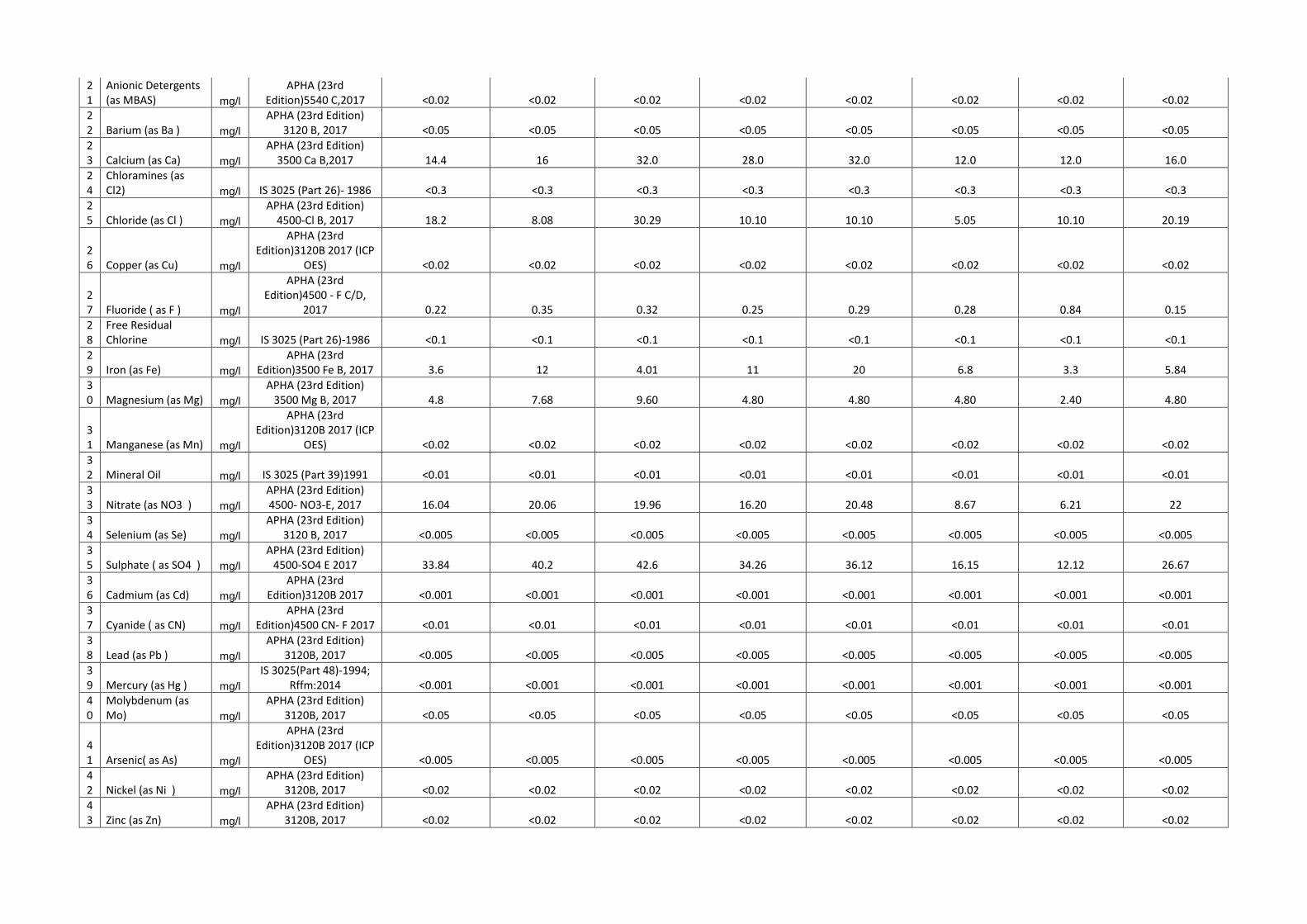
21
Anionic Detergents (as MBAS) mg/l
APHA (23rd Edition)5540 C,2017 <0.02 <0.02 <0.02 <0.02 <0.02 <0.02 <0.02 <0.02
22 Barium (as Ba ) mg/l
APHA (23rd Edition) 3120 B, 2017 <0.05 <0.05 <0.05 <0.05 <0.05 <0.05 <0.05 <0.05
23 Calcium (as Ca) mg/l
APHA (23rd Edition) 3500 Ca B,2017 14.4 16 32.0 28.0 32.0 12.0 12.0 16.0
24
Chloramines (as Cl2) mg/l IS 3025 (Part 26)- 1986 <0.3 <0.3 <0.3 <0.3 <0.3 <0.3 <0.3 <0.3
25 Chloride (as Cl ) mg/l
APHA (23rd Edition) 4500-Cl B, 2017 18.2 8.08 30.29 10.10 10.10 5.05 10.10 20.19
26 Copper (as Cu) mg/l
APHA (23rd Edition)3120B 2017 (ICP
OES) <0.02 <0.02 <0.02 <0.02 <0.02 <0.02 <0.02 <0.02
27 Fluoride ( as F ) mg/l
APHA (23rd Edition)4500 - F C/D,
2017 0.22 0.35 0.32 0.25 0.29 0.28 0.84 0.15
28
Free Residual Chlorine mg/l IS 3025 (Part 26)-1986 <0.1 <0.1 <0.1 <0.1 <0.1 <0.1 <0.1 <0.1
29 Iron (as Fe) mg/l
APHA (23rd Edition)3500 Fe B, 2017 3.6 12 4.01 11 20 6.8 3.3 5.84
30 Magnesium (as Mg) mg/l
APHA (23rd Edition) 3500 Mg B, 2017 4.8 7.68 9.60 4.80 4.80 4.80 2.40 4.80
31 Manganese (as Mn) mg/l
APHA (23rd Edition)3120B 2017 (ICP
OES) <0.02 <0.02 <0.02 <0.02 <0.02 <0.02 <0.02 <0.02
32 Mineral Oil mg/l IS 3025 (Part 39)1991 <0.01 <0.01 <0.01 <0.01 <0.01 <0.01 <0.01 <0.01
33 Nitrate (as NO3 ) mg/l
APHA (23rd Edition) 4500- NO3-E, 2017 16.04 20.06 19.96 16.20 20.48 8.67 6.21 22
34 Selenium (as Se) mg/l
APHA (23rd Edition) 3120 B, 2017 <0.005 <0.005 <0.005 <0.005 <0.005 <0.005 <0.005 <0.005
35 Sulphate ( as SO4 ) mg/l
APHA (23rd Edition) 4500-SO4 E 2017 33.84 40.2 42.6 34.26 36.12 16.15 12.12 26.67
36 Cadmium (as Cd) mg/l
APHA (23rd Edition)3120B 2017 <0.001 <0.001 <0.001 <0.001 <0.001 <0.001 <0.001 <0.001
37 Cyanide ( as CN) mg/l
APHA (23rd Edition)4500 CN- F 2017 <0.01 <0.01 <0.01 <0.01 <0.01 <0.01 <0.01 <0.01
38 Lead (as Pb ) mg/l
APHA (23rd Edition) 3120B, 2017 <0.005 <0.005 <0.005 <0.005 <0.005 <0.005 <0.005 <0.005
39 Mercury (as Hg ) mg/l
IS 3025(Part 48)-1994; Rffm:2014 <0.001 <0.001 <0.001 <0.001 <0.001 <0.001 <0.001 <0.001
40
Molybdenum (as Mo) mg/l
APHA (23rd Edition) 3120B, 2017 <0.05 <0.05 <0.05 <0.05 <0.05 <0.05 <0.05 <0.05
41 Arsenic( as As) mg/l
APHA (23rd Edition)3120B 2017 (ICP
OES) <0.005 <0.005 <0.005 <0.005 <0.005 <0.005 <0.005 <0.005
42 Nickel (as Ni ) mg/l
APHA (23rd Edition) 3120B, 2017 <0.02 <0.02 <0.02 <0.02 <0.02 <0.02 <0.02 <0.02
43 Zinc (as Zn) mg/l
APHA (23rd Edition) 3120B, 2017 <0.02 <0.02 <0.02 <0.02 <0.02 <0.02 <0.02 <0.02

44
Hexavalent Chromium (as Cr+6) mg/l
APHA 23rd Edtn-2017, 3500 Cr B <0.01 <0.01 <0.01 <0.01 <0.01 <0.01 <0.01 <0.01
45 Salinity
None
APHA (23rd Edition) 2520B, 2017
0.13 In Respect to KCL equivalent
salinity 35.
0.14 In respect to KCl equivalent
salinity 35
0.25 In respect to KCl equivalent
salinity 35
0.14 In respect to KCl equivalent
salinity 35.
0.15 In respect to KCl equivalent
salinity 35.
0.07 In respect to KCl equivalent
salinity 35.
0.07 In respect to KCl equivalent
salinity 35
0.08 In respect to KCl equivalent
salinity 35
46 Phenol mg/l
APHA (23rd Edition)5530C 2017
(Chloroform Extraction) <0.001 <0.001 <0.001 <0.001 <0.001 <0.001 <0.001 <0.001
47 Bromoform µg/l
APHA (23rd Edition) 6232 B <0.05 <0.05 <0.05 <0.05 <0.05 <0.05 <0.05 <0.05
48
Dibromochloromethane µg/l
APHA (23rd Edition) 6232 B <0.05 <0.05 <0.05 <0.05 <0.05 <0.05 <0.05 <0.05
49
Bromodichloromethane µg/l
APHA (23rd Edition) 6232 B <0.05 <0.05 <0.05 <0.05 <0.05 <0.05 <0.05 <0.05
50 Chloroform µg/l
APHA (23rd Edition) 6232 B <0.05 <0.05 <0.05 <0.05 <0.05 <0.05 <0.05 <0.05
51 Alachlor µg/l AOAC 990.06 <0.02 <0.02 <0.02 <0.02 <0.02 <0.02 <0.02 <0.02
52 Atrazine µg/l AOAC 990.06 <0.02 <0.02 <0.02 <0.02 <0.02 <0.02 <0.02 <0.02
53 Aldrin µg/l AOAC 990.06 <0.01 <0.01 <0.01 <0.01 <0.01 <0.01 <0.01 <0.01
54 Dieldrin µg/l AOAC 990.06 <0.01 <0.01 <0.01 <0.01 <0.01 <0.01 <0.01 <0.01
55 Alpha-HCH µg/l AOAC 990.06 <0.01 <0.01 <0.01 <0.01 <0.01 <0.01 <0.01 <0.01
56 Beta-HCH µg/l AOAC 990.06 <0.01 <0.01 <0.01 <0.01 <0.01 <0.01 <0.01 <0.01
57 Butachlor µg/l AOAC 990.06 <0.02 <0.02 <0.02 <0.02 <0.02 <0.02 <0.02 <0.02
58 Chlorpyrifos µg/l AOAC 990.06 <0.02 <0.02 <0.02 <0.02 <0.02 <0.02 <0.02 <0.02
59 Delta-HCH µg/l AOAC 990.06 <0.01 <0.01 <0.01 <0.01 <0.01 <0.01 <0.01 <0.01
60
2,4-Dichlorophenoxyacetic acid µg/l US EPA 515 <0.01 <0.01 <0.01 <0.01 <0.01 <0.01 <0.01 <0.01
61 p,p DDD µg/l AOAC 990.06 <0.01 <0.01 <0.01 <0.01 <0.01 <0.01 <0.01 <0.01
62 o,p-DDT µg/l AOAC 990.06 <0.01 <0.01 <0.01 <0.01 <0.01 <0.01 <0.01 <0.01
63 p,p-DDT µg/l AOAC 990.06 <0.01 <0.01 <0.01 <0.01 <0.01 <0.01 <0.01 <0.01
64 o,p-DDE µg/l AOAC 990.06 <0.01 <0.01 <0.01 <0.01 <0.01 <0.01 <0.01 <0.01
65 p,p-DDE µg/l AOAC 990.06 <0.01 <0.01 <0.01 <0.01 <0.01 <0.01 <0.01 <0.01
66 o,p-DDD µg/l AOAC 990.06 <0.01 <0.01 <0.01 <0.01 <0.01 <0.01 <0.01 <0.01
67 Endosulfan sulfate µg/l AOAC 990.06 <0.01 <0.01 <0.01 <0.01 <0.01 <0.01 <0.01 <0.01

68 Alpha -endosulfan µg/l AOAC 990.06 <0.01 <0.01 <0.01 <0.01 <0.01 <0.01 <0.01 <0.01
69 Beta-Endosulfan µg/l AOAC 990.06 <0.01 <0.01 <0.01 <0.01 <0.01 <0.01 <0.01 <0.01
70 Ethion µg/l AOAC 990.06 <0.02 <0.02 <0.02 <0.02 <0.02 <0.02 <0.02 <0.02
71
Gama-HCH(Lindane) µg/l AOAC 990.06 <0.01 <0.01 <0.01 <0.01 <0.01 <0.01 <0.01 <0.01
72 Isoproturon µg/l US EPA 532 <0.02 <0.02 <0.02 <0.02 <0.02 <0.02 <0.02 <0.02
73 Malathion µg/l AOAC 990.06 <0.02 <0.02 <0.02 <0.02 <0.02 <0.02 <0.02 <0.02
74 Methyl parathion µg/l AOAC 990.06 <0.02 <0.02 <0.02 <0.02 <0.02 <0.02 <0.02 <0.02
75 Monocrotophos µg/l AOAC 990.06 <0.02 <0.02 <0.02 <0.02 <0.02 <0.02 <0.02 <0.02
76 Phorate none AOAC 990.06 <0.02 <0.02 <0.02 <0.02 <0.02 <0.02 <0.02 <0.02
77
Polychlorinated biphenyls (as PCB) mg/l US EPA 8082 <0.0001 <0.0001 <0.0001 <0.0001 <0.0001 <0.0001 <0.0001 <0.0001
78
Polynuclear Aromatic Hydrocarbons ( as PAH ) mg/l APHA 6440C <0.0001 <0.0001 <0.0001 <0.0001 <0.0001 <0.0001 <0.0001 <0.0001
79 Total coliform
MPN/100ml
APHA (23rd Edition) 9221 B 140 110 70 50 90 33 80 130
80 Faecal coliform
/100ml
APHA (23rd Edition) 9221 E DETECTED DETECTED DETECTED DETECTED DETECTED DETECTED DETECTED DETECTED
81 Zooplankton /1lit
APHA 23rd Edition, 10200 Absent Absent Present Absent Present Absent Present Absent
I. Cyclops /1lit - - - 2000 - - - - -
II. Keratella /1lit - - - 1000 - - - - -
III.
Bythotrephes longimanus /1lit - - - - - 2000 - 2000 -
IV. Monia /1lit - - - - - - - - -
82 Phytoplankton /1lit
APHA 23rd Edition, 10200 Present Present Present Present Present Present Present Present
I. Synedra /1lit - 3000 - - - - - -
II. Phormidium /1lit - 4000 - - - - - - 3000
III. Oscillatoria /1lit - 3000 - - 3000 - - - -
IV. Zygnema /1lit - - 1000 - - - - - -
V. Closteridium /1lit - - 1000 - - - - - -

VI. Cladophora /1lit - - 2000 - - - 2000 2000 -
VII. Desmium /1lit - - - 2000 - - - - -
VIII. Anabaena /1lit - - - 2000 - 6000 - - -
IX. Phormidium /1lit - - - 2000 - - - - -
X. Spirogyra /1lit - - - 1000 - - - - -
XI. Cladophora /1lit - - - - 5000 - - - -
XII. Navicula /1lit - - - - 2000 - - - -
XIII. Fragilaria /1lit - - - - - 3000 - - 1000
XIV. Ulothrix /1lit - - - - - 2000 4000 4000 -
XV. Microcoleus /1lit - - - - - - 2000 - -
XVI. Hildenbrandia /1lit - - - - - - - - 2000

Appendix 3.6: Soil
Monitoring Results

Appendix 3.6-Soil Monitoring Data
Parameters Unit S1/B1 S2/B1 S3/B1 S4/B1 S5/B1 S6/B1 S7/B1 S8/B1
Dates 13/05/2019 13/05/2019 14/05/2019 14/05/2019 13/05/2019 14/05/2019 15/05/2019 15/05/2019
Coordinate
26°10'07.40"
N,
93°46'48.90"
E
25°56'26.25"
N,
93°54'56.75"
E
26°
1'55.56"N,
93°46'2.01"
E
25°56'57.10
"N,
93°44'43.20
"E
26°02'06.00
"N,
93°44'18.00
"E
25°58'55.92
"N,
93°44'17.17
"E
25°52'28.80
"N,
93°48'49.30
"E
25°51'58.20
"N,
93°51'20.10
"E
If Agriculture what crop is sown
(AGRICULTURAL LAND)
TEA GARDEN
(AGRICULT
URAL LAND)
(AGRICULTURAL LAND)
(FOREST LAND)
TEA GARDEN
(AGRICULTURAL LAND)
(FOREST LAND)
Acidity Non
e Nil Nil Nil Nil Nil Nil Nil Nil
Alkalinity (as CaCO3 )
mg/kg
100 480 120 80 480 120 140 100
Antimony (as Sb )
mg/kg
<0.25 <0.25 <0.25 <0.25 <0.25 <0.25 <0.25 <0.25
Arsenic( as As) mg/k
g <0.25 <0.25 <0.25 <0.25 <0.25 <0.25 <0.25 <0.25
Available Nitrogen (as N)
mg/kg
202 179 218 280 106 330 420 314
Available Phosphorus (as P)
mg/kg
3.2 4.2 3.7 4 3.4 4.5 4.9 3
Available Potassium (as K)
mg/kg
76 100 71 62 285 169 267 99
Barium (as Ba )
mg/kg
55 55 24 51 56 71 51 17
Boron (as B) Non
e 8 15 4 7 15 9 7 3
Bulk Density g/cc 1.11 1.18 1.14 1.25 1.21 1.05 1.03 1.18
Cadmium (as Cd)
mg/kg
<2 <2 <2 <2 <2 <2 <2 <2
Calcium (as Ca)
mg/kg
600 2050 950 450 2750 1500 950 350
Carbonate mg/k
g Nil Nil Nil Nil Nil Nil Nil Nil

Cation Exchange Capacity
meq/100 gm
10 25 10 8 25 18 12 8
Chloride (as Cl )
mg/kg
40 40 50 70 40 70 30 30
Cobalt (as Co) mg/k
g <2 <2 <2 3 <2 <2 <2 <2
Copper (as Cu)
mg/kg
11 17 8 17 17 21 17 4
Cyanide ( as CN)
mg/kg
<1 <1 <1 <1 <1 <1 <1 <1
Electrical conductivity
us/cm
38.7 (1:2) at 25 deg C
202 (1:2) at 25 deg C
56.8 (1:2) at 25 deg C
118 (1:2) at 25 deg C
219 (1:2) at 25 deg C
135 (1:2) at 25 deg C
173 (1:2) at 25 deg C
33.9 (1:2) at 25 deg C
Hexavalent Chromium (as Cr+6)
mg/kg
<2 <2 <2 <2 <2 <2 <2 <2
Infiltration Capacity
mm/Hr
6.2 7.8 8.9 16 10 3.6 2.2 12
Iron (as Fe) mg/k
g 9 84 37 60 8 98 14 30
Lead (as Pb ) mg/k
g 7 12 5 11 12 12 12 4
Magnesium (as Mg)
mg/kg
300 1230 90 150 900 690 360 210
Manganese (as Mn)
mg/kg
240 210 67 230 200 250 242 198
Mercury (as Hg )
mg/kg
<0.1 <0.1 <0.1 <0.1 <0.1 <0.1 <0.1 <0.1
Moisture % 22 25 20 15 24 27 34 19
Molybdenum (as Mo)
None
<2 <2 <2 <2 <2 <2 <2 <2
Nickel (as Ni ) mg/k
g 12 63 17 57 64 26 57 11
Organic Matter % 0.59 0.36 0.56 1.12 0.51 1.4 1.9 0.97
Particle Size Distribution
mg/kg
Sand:34% Silt:28%
Clay:38%
Sand:52% Silt:22%
Clay:26%
Sand:47% Silt:21%
Clay:32%
Sand:40% Silt:36%
Clay:24%
Sand:53% Silt:14%
Clay:33%
Sand:32% Silt:27%
Clay:41%
Sand:27% Silt:21%
Clay:52%
Sand:38% Silt:36%
Clay:26%
Permeability Cm/hr
0.9 1.2 1.5 2.4 1.8 0.11 0.09 2
Total Phosphorus
mg/kg
47 102 74 284 64 56 28 85
Sodium (as Na)
mg/kg
43 60 49 25 31 64 25 19

Sodium Adsorption Ration (as SAR)
None
0.23 0.05 0.18 0.13 0.04 0.21 0.03 0.06
Specific gravity Non
e 2.26 2.35 2.7 2.45 2.46 2.33 2.49 2.52
Sulphate ( as SO4 )
mg/kg
<15 <15 <15 <15 <15 <15 <15 <15
Texture Non
e Clay Loam
Sandy Clay Loam
Sandy Clay Loam
Loam Sandy Clay
Loam Clay Clay Loam
Thiocyanate mg/k
g <5 <5 <5 <5 <5 <5 <5 <5
Total Nitrogen (as N)
mg/kg
588 538 655 829 319 991 1613 941
Total Organic Carbon %
0.34 0.21 0.32 0.65 0.3 0.83 1.1 0.56
Total Porosity % 50.9 49.7 57.8 49 52 54.9 58.9 53.2
Total Potassium
mg/kg
362 612 334 188 532 324 474 284
Trivalent Chromium as Cr-III (TCLP)
None
<2 <2 <2 <2 <2 <2 <2 <2
Water Holding capacity %
43 40 37 26 33 48 52 30
Zinc (as Zn) mg/k
g 9 38 9 37 38 41 36 10
pH value Non
e 6.12 (1:2.5) at
25 deg C 8.13 (1:2.5) at
25 deg C 6.02 (1:2.5) at 25 deg C
4.48 (1:2.5) at 25 deg C
8.32 (1:2.5) at 25 deg C
5.28 (1:2.5) at 25 deg C
5.68 (1:2.5) at 25 deg C
5.19 (1:2.5) at 25 deg C

Appendix 3.7: Traffic
Survey Results

Appendix 3.7- Traffic Data
LOCATION : T1 -NH39 AT JABRAJAN IB(UP) Date of Monitoring :04.06.19
WORKING DAY
S.NO.
TIME
MOTORIZED VEHICLES NON-MOTORIZED
TOTAL
Heavy Motor Vehicles Light Motor Vehicles Two/Three Wheelers VEHICLES
(Hours) (Truck,Bus,Dumper,Tanker,Trailer) (Car,Jeep,Van,Metador,
Tractor,Tempo) (Scooter,M.Cycle,Auto,
Moped) Bicycle, Tricycle NUMBERS
1 09.00-10.00 6 25 35 8 74
2 10.00-11.00 8 30 40 2 80
3 11.00-12.00 12 28 35 6 81
4 12.00-13.00 10 12 36 2 60
5 13.00-14.00 3 15 32 0 50
6 14.00-15.00 6 16 20 0 42
7 15.00-16.00 10 11 22 0 43
8 16.00-17.00 12 15 18 0 45
9 17.00-18.00 10 10 18 0 38
10 18.00-19.00 11 8 20 0 39
11 19.00-20.00 3 5 10 0 18
12 20.00-21.00 4 4 10 0 18
13 21.00-22.00 3 3 8 0 14
14 22.00-23.00 0 2 15 0 17
15 23.00-00.00 0 0 0 0 0
16 00.00-1.00 0 0 0 0 0
17 1.00-2.00 1 0 0 0 1
18 2.00-3.00 0 0 1 0 1
19 3.00-4.00 2 2 5 0 9
20 4.00-5.00 5 3 4 0 12
21 5.00-6.00 3 6 3 0 12
22 6.00-7.00 1 10 10 0 21
23 7.00-8.00 5 12 15 12 44
24 8.00-9.00 6 18 18 3 45
Total Numbers 121 235 375 33 764
LOCATION :T1 -NH39 AT JABRAJAN IB(DN)
Date of Monitoring : 04.06.19
WORKING DAY
S.NO. TIME MOTORIZED VEHICLES NON-MOTORIZED TOTAL
(Hours) Heavy Motor Vehicles Light Motor Vehicles Two/Three Wheelers VEHICLES NUMBERS
(Truck,Bus,Dumper,Tanker,Trailer)
(Car,Jeep,Van,Metador, Tractor,Tempo)
(Scooter,M.Cycle,Auto, Moped)
Bicycle, Tricycle
1 09.00-10.00 12 30 45 3 90
2 10.00-11.00 15 25 38 8 86
3 11.00-12.00 5 20 42 1 68
4 12.00-13.00 8 10 41 3 62
5 13.00-14.00 6 10 44 0 60
6 14.00-15.00 20 20 42 2 84
7 15.00-16.00 10 10 25 0 45
8 16.00-17.00 11 12 20 0 43
9 17.00-18.00 12 14 18 0 44
10 18.00-19.00 13 10 10 0 33
11 19.00-20.00 5 5 20 0 30
12 20.00-21.00 5 3 5 0 13
13 21.00-22.00 2 4 8 0 14
14 22.00-23.00 0 0 4 0 4
15 23.00-00.00 0 0 0 0 0
16 00.00-1.00 0 0 0 0 0
17 1.00-2.00 0 0 0 0 0
18 2.00-3.00 0 0 0 0 0
19 3.00-4.00 0 0 4 0 4
20 4.00-5.00 2 5 3 0 10
21 5.00-6.00 3 8 10 0 21
22 6.00-7.00 1 2 8 0 11
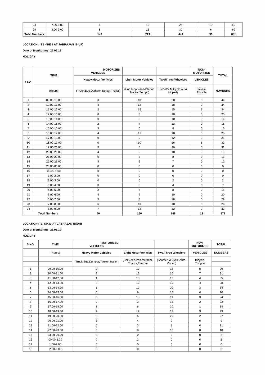
23 7.00-8.00 5 10 25 10 50
24 8.00-9.00 8 25 30 6 69
Total Numbers 143 223 442 33 841
LOCATION : T1 -NH39 AT JABRAJAN IB(UP)
Date of Monitoring : 26.05.19
HOLIDAY
S.NO.
TIME
MOTORIZED VEHICLES
NON-
MOTORIZED TOTAL
Heavy Motor Vehicles Light Motor Vehicles Two/Three Wheelers VEHICLES
(Hours) (Truck,Bus,Dumper,Tanker,Trailer) (Car,Jeep,Van,Metador,
Tractor,Tempo) (Scooter,M.Cycle,Auto,
Moped) Bicycle, Tricycle
NUMBERS
1 09.00-10.00 3 18 20 3 44
2 10.00-11.00 4 12 18 0 34
3 11.00-12.00 2 15 15 2 34
4 12.00-13.00 0 8 18 0 26
5 13.00-14.00 0 6 10 0 16
6 14.00-15.00 2 4 12 0 18
7 15.00-16.00 3 5 8 0 16
8 16.00-17.00 4 11 10 0 25
9 17.00-18.00 0 9 12 0 21
10 18.00-19.00 0 10 16 6 32
11 19.00-20.00 3 8 20 0 31
12 20.00-21.00 4 5 10 0 19
13 21.00-22.00 0 3 8 0 11
14 22.00-23.00 3 2 7 0 12
15 23.00-00.00 0 0 0 0 0
16 00.00-1.00 0 0 0 0 0
17 1.00-2.00 0 0 0 0 0
18 2.00-3.00 0 0 2 0 2
19 3.00-4.00 0 3 4 0 7
20 4.00-5.00 2 5 8 0 15
21 5.00-6.00 4 6 10 0 20
22 6.00-7.00 3 8 18 0 29
23 7.00-8.00 6 10 10 0 26
24 8.00-9.00 7 12 12 2 33
Total Numbers 50 160 248 13 471
LOCATION :T1 -NH39 AT JABRAJAN IB(DN)
Date of Monitoring : 26.05.19
HOLIDAY
S.NO. TIME MOTORIZED
VEHICLES
NON-MOTORIZED
TOTAL
(Hours) Heavy Motor Vehicles Light Motor Vehicles Two/Three Wheelers VEHICLES NUMBERS
(Truck,Bus,Dumper,Tanker,Trailer)
(Car,Jeep,Van,Metador, Tractor,Tempo)
(Scooter,M.Cycle,Auto, Moped)
Bicycle, Tricycle
1 09.00-10.00 2 10 12 5 29
2 10.00-11.00 2 12 10 7 31
3 11.00-12.00 1 18 12 4 35
4 12.00-13.00 2 12 10 4 28
5 13.00-14.00 1 10 20 3 34
6 14.00-15.00 0 6 10 4 20
7 15.00-16.00 0 10 11 3 24
8 16.00-17.00 2 3 15 2 22
9 17.00-18.00 1 6 10 1 18
10 18.00-19.00 2 12 12 3 29
11 19.00-20.00 0 5 20 2 27
12 20.00-21.00 3 4 2 0 9
13 21.00-22.00 0 3 8 0 11
14 22.00-23.00 0 0 10 0 10
15 23.00-00.00 0 0 2 0 2
16 00.00-1.00 0 2 0 0 2
17 1.00-2.00 0 0 0 0 0
18 2.00-3.00 0 0 0 0 0

19 3.00-4.00 0 4 5 0 9
20 4.00-5.00 3 0 6 0 9
21 5.00-6.00 2 6 7 0 15
22 6.00-7.00 0 11 8 2 21
23 7.00-8.00 2 14 12 4 32
24 8.00-9.00 0 18 10 6 34
Total Numbers
23 166 212 50 451
LOCATION :T2 -NH39 AT SARAIJAN (DN)
Date of Monitoring : 05.06.19
WORKING DAY
S.NO. TIME MOTORIZED
VEHICLES
NON-MOTORIZED
TOTAL
(Hours) Heavy Motor Vehicles Light Motor Vehicles Two/Three Wheelers VEHICLES NUMBERS
(Truck,Bus,Dumper,Tanker,Trailer)
(Car,Jeep,Van,Metador, Tractor,Tempo)
(Scooter,M.Cycle,Auto, Moped)
Bicycle, Tricycle
1 09.00-10.00 6 32 42 8 88
2 10.00-11.00 3 33 32 4 72
3 11.00-12.00 7 25 34 6 72
4 12.00-13.00 4 18 20 12 54
5 13.00-14.00 2 22 30 0 54
6 14.00-15.00 10 25 31 3 69
7 15.00-16.00 6 18 40 2 66
8 16.00-17.00 2 12 42 0 56
9 17.00-18.00 1 15 18 0 34
10 18.00-19.00 3 20 16 6 45
11 19.00-20.00 4 10 10 0 24
12 20.00-21.00 3 15 5 0 23
13 21.00-22.00 1 4 3 0 8
14 22.00-23.00 0 4 2 0 6
15 23.00-00.00 0 0 0 0 0
16 00.00-1.00 0 0 0 0 0
17 1.00-2.00 0 0 0 0 0
18 2.00-3.00 0 0 0 0 0
19 3.00-4.00 0 3 4 0 7
20 4.00-5.00 0 2 5 0 7
21 5.00-6.00 3 1 3 0 7
22 6.00-7.00 8 0 10 0 18
23 7.00-8.00 3 8 15 10 36
24 8.00-9.00 2 20 32 8 62
Total Numbers
68 287 394 59 808
LOCATION : T2 -NH39 AT SARAIJAN (UP & DOWN COMBINED)
Date of Monitoring : 05.06.19
WORKING DAY
S.NO.
TIME
MOTORIZED VEHICLES NON-
MOTORIZED TOTAL
Heavy Motor Vehicles Light Motor Vehicles Two/Three Wheelers VEHICLES
(Hours) (Truck,Bus,Dumper,Tanker,Trailer) (Car,Jeep,Van,Metador,
Tractor,Tempo) (Scooter,M.Cycle,Auto,
Moped) Bicycle, Tricycle NUMBERS
1 09.00-10.00 9 52 72 10 143
2 10.00-11.00 7 51 42 7 107
3 11.00-12.00 9 55 54 10 128
4 12.00-13.00 5 33 38 12 88
5 13.00-14.00 4 42 40 0 86
6 14.00-15.00 14 35 52 3 104
7 15.00-16.00 7 38 55 7 107
8 16.00-17.00 4 30 60 10 104
9 17.00-18.00 4 30 40 0 74
10 18.00-19.00 4 30 34 6 74
11 19.00-20.00 6 22 20 0 48
12 20.00-21.00 4 23 13 0 40
13 21.00-22.00 2 8 12 0 22

14 22.00-23.00 0 6 4 0 10
15 23.00-00.00 0 0 4 0 4
16 00.00-1.00 0 0 1 0 1
17 1.00-2.00 0 0 0 0 0
18 2.00-3.00 0 1 0 0 1
19 3.00-4.00 2 5 4 0 11
20 4.00-5.00 3 5 8 0 16
21 5.00-6.00 6 3 5 0 14
22 6.00-7.00 10 8 18 7 43
23 7.00-8.00 5 20 21 12 58
24 8.00-9.00 6 35 48 10 99
Total Numbers 111 532 645 94 1382
LOCATION :T2 -NH39 AT SARAIJAN (DN)
Date of Monitoring : 26.05.19
HOLIDAY
(Hours) Heavy Motor Vehicles Light Motor Vehicles Two/Three Wheelers VEHICLES NUMBERS
(Truck,Bus,Dumper,Tanker,Trailer) (Car,Jeep,Van,Metador,
Tractor,Tempo) (Scooter,M.Cycle,Auto,
Moped) Bicycle, Tricycle
1 09.00-10.00 3 15 10 3 31 58
2 10.00-11.00 2 12 18 2 34 53
3 11.00-12.00 0 18 12 5 35 59
4 12.00-13.00 2 10 6 0 18 30
5 13.00-14.00 4 12 0 0 16 36
6 14.00-15.00 0 10 8 0 18 23
7 15.00-16.00 2 10 10 0 22 34
8 16.00-17.00 0 10 15 0 25 30
9 17.00-18.00 0 12 16 0 28 34
10 18.00-19.00 0 8 5 3 16 29
11 19.00-20.00 3 12 15 0 30 46.5
12 20.00-21.00 2 10 5 0 17 29
13 21.00-22.00 1 3 2 0 6 11
14 22.00-23.00 0 2 0 0 2 3
15 23.00-00.00 0 0 3 0 3 3
16 00.00-1.00 0 0 0 0 0 0
17 1.00-2.00 0 0 0 0 0 0
18 2.00-3.00 0 0 0 0 0 0
19 3.00-4.00 0 3 0 0 3 4.5
20 4.00-5.00 0 2 3 0 5 6
21 5.00-6.00 2 4 7 0 13 22
22 6.00-7.00 0 5 8 0 13 15.5
23 7.00-8.00 3 13 10 3 29 55
24 8.00-9.00 2 15 15 2 34 54.5
Total Numbers
26 186 168 18 398 636
LOCATION : T2 -NH39 AT SARAIJAN (UP & DOWN COMBINED)
Date of Monitoring : 26.05.19
HOLIDAY
S.NO.
TIME
MOTORIZED VEHICLES NON-
MOTORIZED TOTAL
Heavy Motor Vehicles Light Motor Vehicles Two/Three Wheelers VEHICLES
(Hours) (Truck,Bus,Dumper,Tanker,Trailer) (Car,Jeep,Van,Metador,
Tractor,Tempo) (Scooter,M.Cycle,Auto,
Moped) Bicycle, Tricycle NUMBERS
1 09.00-10.00 4 20 20 5 49
2 10.00-11.00 6 22 30 2 60
3 11.00-12.00 0 26 22 5 53
4 12.00-13.00 2 25 24 0 51
5 13.00-14.00 8 22 6 0 36
6 14.00-15.00 0 22 20 0 42
7 15.00-16.00 2 21 22 0 45
8 16.00-17.00 3 15 25 0 43
9 17.00-18.00 0 20 23 0 43
10 18.00-19.00 2 11 15 3 31

11 19.00-20.00 3 26 25 3 57
12 20.00-21.00 2 20 8 0 30
13 21.00-22.00 3 5 4 0 12
14 22.00-23.00 0 5 1 0 6
15 23.00-00.00 0 0 3 0 3
16 00.00-1.00 0 0 0 0 0
17 1.00-2.00 0 0 0 0 0
18 2.00-3.00 0 0 0 0 0
19 3.00-4.00 0 3 0 0 3
20 4.00-5.00 0 2 3 0 5
21 5.00-6.00 5 6 7 0 18
22 6.00-7.00 2 9 11 3 25
23 7.00-8.00 4 23 14 5 46
24 8.00-9.00 3 27 27 3 60
Total Numbers 49 330 310 29 718
LOCATION :T2 -SARAIJAN TO DILLAI TINALI ROAD AT SARAIJAN(DN)
Date of Monitoring : 05.06.19
WORKING DAY
S.NO. TIME MOTORIZED
VEHICLES
NON-MOTORIZED
TOTAL
(Hours) Heavy Motor Vehicles Light Motor Vehicles Two/Three Wheelers VEHICLES NUMBERS
(Truck,Bus,Dumper,Tanker,Trailer)
(Car,Jeep,Van,Metador, Tractor,Tempo)
(Scooter,M.Cycle,Auto, Moped)
Bicycle, Tricycle
1 09.00-10.00 1 9 12 2 24
2 10.00-11.00 0 6 15 3 24
3 11.00-12.00 4 2 10 0 16
4 12.00-13.00 3 6 8 0 17
5 13.00-14.00 2 7 8 0 17
6 14.00-15.00 3 4 7 2 16
7 15.00-16.00 0 3 9 0 12
8 16.00-17.00 2 4 10 0 16
9 17.00-18.00 1 3 12 0 16
10 18.00-19.00 3 4 6 0 13
11 19.00-20.00 1 3 4 0 8
12 20.00-21.00 1 4 3 2 10
13 21.00-22.00 0 3 2 0 5
14 22.00-23.00 0 1 4 0 5
15 23.00-00.00 0 0 0 0 0
16 00.00-1.00 0 0 0 0 0
17 1.00-2.00 0 0 0 0 0
18 2.00-3.00 0 0 0 0 0
19 3.00-4.00 0 0 2 0 2
20 4.00-5.00 0 0 4 0 4
21 5.00-6.00 2 3 3 0 8
22 6.00-7.00 3 2 6 0 11
23 7.00-8.00 4 6 10 2 22
24 8.00-9.00 6 4 12 0 22
Total Numbers
36 74 147 11 268
LOCATION : T2 -SARAIJAN TO DILLAI TINALI ROAD AT SARAIJAN(UP & DOWN COMBINED)
Date of Monitoring : 05.06.19
WORKING DAY
S.NO.
TIME
MOTORIZED VEHICLES NON-
MOTORIZED TOTAL
Heavy Motor Vehicles Light Motor Vehicles Two/Three Wheelers VEHICLES
(Hours) (Truck,Bus,Dumper,Tanker,Trailer) (Car,Jeep,Van,Metador,
Tractor,Tempo) (Scooter,M.Cycle,Auto,
Moped) Bicycle, Tricycle
NUMBERS
1 09.00-10.00 3 15 27 4 49
2 10.00-11.00 2 8 23 3 36
3 11.00-12.00 5 5 15 0 25
4 12.00-13.00 7 10 16 3 36
5 13.00-14.00 2 9 15 0 26

6 14.00-15.00 3 8 9 8 28
7 15.00-16.00 0 5 11 0 16
8 16.00-17.00 4 10 14 0 28
9 17.00-18.00 2 7 15 0 24
10 18.00-19.00 6 7 8 0 21
11 19.00-20.00 2 9 6 0 17
12 20.00-21.00 1 6 4 2 13
13 21.00-22.00 0 5 5 0 10
14 22.00-23.00 2 1 6 0 9
15 23.00-00.00 0 0 0 0 0
16 00.00-1.00 0 0 0 0 0
17 1.00-2.00 0 0 0 0 0
18 2.00-3.00 0 0 0 0 0
19 3.00-4.00 0 0 4 0 4
20 4.00-5.00 0 0 6 0 6
21 5.00-6.00 2 3 3 0 8
22 6.00-7.00 5 5 6 0 16
23 7.00-8.00 5 8 12 2 27
24 8.00-9.00 8 10 15 2 35
Total Numbers 59 131 220 24 434
LOCATION :T1 -SARAIJAN TO DILLAI TINALI ROAD AT SARAIJAN(DN)
Date of Monitoring : 26.05.19
HOLIDAY
(Hours) Heavy Motor Vehicles Light Motor Vehicles Two/Three Wheelers VEHICLES NUMBERS
(Truck,Bus,Dumper,Tanker,Trailer)
(Car,Jeep,Van,Metador, Tractor,Tempo)
(Scooter,M.Cycle,Auto, Moped)
Bicycle, Tricycle
1 09.00-10.00 2 4 5 0 11
2 10.00-11.00 0 3 2 0 5
3 11.00-12.00 0 0 8 3 11
4 12.00-13.00 3 2 7 0 12
5 13.00-14.00 0 1 0 0 1
6 14.00-15.00 0 0 0 0 0
7 15.00-16.00 2 0 5 2 9
8 16.00-17.00 0 0 3 0 3
9 17.00-18.00 0 3 8 0 11
10 18.00-19.00 2 6 10 2 20
11 19.00-20.00 0 2 3 0 5
12 20.00-21.00 0 1 2 0 3
13 21.00-22.00 0 0 4 0 4
14 22.00-23.00 0 0 0 0 0
15 23.00-00.00 0 0 0 0 0
16 00.00-1.00 0 0 0 0 0
17 1.00-2.00 0 0 0 0 0
18 2.00-3.00 0 0 0 0 0
19 3.00-4.00 0 2 0 0 2
20 4.00-5.00 3 3 3 0 9
21 5.00-6.00 2 2 4 0 8
22 6.00-7.00 1 4 3 2 10
23 7.00-8.00 4 7 6 2 19
24 8.00-9.00 2 6 8 1 17
Total Numbers
21 46 81 12 160
LOCATION : T2 -SARAIJAN TO DILLAI TINALI ROAD AT SARAIJAN(UP & DOWN COMBINED)
Date of Monitoring : 26.05.19
HOLIDAY
S.NO.
TIME
MOTORIZED VEHICLES NON-
MOTORIZED TOTAL
Heavy Motor Vehicles Light Motor Vehicles Two/Three Wheelers VEHICLES
(Hours) (Truck,Bus,Dumper,Tanker,Trailer) (Car,Jeep,Van,Metador,
Tractor,Tempo) (Scooter,M.Cycle,Auto,
Moped) Bicycle, Tricycle NUMBERS
1 09.00-10.00 2 4 15 0 21
2 10.00-11.00 0 6 10 0 16

3 11.00-12.00 2 0 15 3 20
4 12.00-13.00 3 8 11 0 22
5 13.00-14.00 0 4 0 3 7
6 14.00-15.00 2 0 6 0 8
7 15.00-16.00 5 3 13 4 25
8 16.00-17.00 0 2 3 0 5
9 17.00-18.00 0 3 14 0 17
10 18.00-19.00 2 10 15 2 29
11 19.00-20.00 0 2 9 0 11
12 20.00-21.00 0 5 5 0 10
13 21.00-22.00 0 0 4 0 4
14 22.00-23.00 0 0 0 0 0
15 23.00-00.00 0 0 0 0 0
16 00.00-1.00 0 0 0 0 0
17 1.00-2.00 0 0 0 0 0
18 2.00-3.00 0 0 0 0 0
19 3.00-4.00 0 2 0 0 2
20 4.00-5.00 5 6 5 0 16
21 5.00-6.00 2 4 8 0 14
22 6.00-7.00 5 11 7 2 25
23 7.00-8.00 7 11 11 4 33
24 8.00-9.00 6 14 18 5 43
Total Numbers 41 95 169 23 328
Appendix 3.8: The
List of Mammals
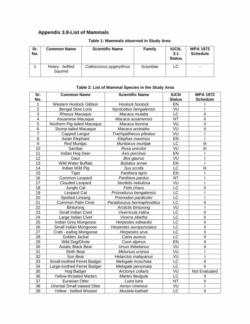
Appendix 3.8-List of Mammals
Table 1: Mammals observed in Study Area
Sr. No.
Common Name Scientific Name Family IUCN, 3.1
Status
WPA 1972 Schedule
1 Hoary - bellied Squirrel
Callosciurus pygerythrus Sciuridae LC -
Table 2: List of Mammal Species in the Study Area
Sr. No.
Common Name Scientific Name IUCN Status
WPA 1972 Schedule
1 Western Hoolock Gibbon Hoolock hoolock EN I
2 Bengal Slow Loris Nycticebus bengalensis VU I
3 Rhesus Macaque Macaca mulatta LC II
4 Assamese Macaque Macaca assamensis NT II
5 Northern Pig-tailed Macaque Macaca leonina VU II
6 Stump-tailed Macaque Macaca arctoides VU II
7 Capped Langur Trachypithecus pileatus VU I
8 Asian Elephant Elephas maximus EN I
9 Red Muntjac Muntiacus muntjak LC III
10 Sambar Rusa unicolor VU III
11 Indian Hog Deer Axis porcinus EN I
12 Gaur Bos gaurus VU I
13 Wild Water Buffalo Bubalus arnee EN I
14 Indian Wild Pig Sus scrofa LC III
15 Tiger Panthera tigris EN I
16 Common Leopard Panthera pardus NT I
17 Clouded Leopard Neofelis nebulosa VU I
18 Jungle Cat Felis chaus LC II
19 Leopard Cat Prionailurus bengalensis LC I
20 Spotted Linsang Prionodon pardicolor LC I
21 Common Palm Civet Paradoxurus hermaphroditus LC II
22 Binturong Arctictis binturong VU I
23 Small Indian Civet Viverricula indica LC II
24 Large Indian Civet Viverra zibetha LC II
25 Indian Grey Mongoose Herpestes edwardsi LC II
26 Small Indian Mongoose Herpestes auropunctatus LC II
27 Crab - eating Mongoose Herpestes urva LC II
28 Golden Jackal Canis aureus LC II
29 Wild Dog/Dhole Cuon alpinus EN II
30 Asiatic Black Bear Ursus thibetanus VU II
31 Sloth Bear Melursus ursinus VU I
32 Sun Bear Helarctos malayanus VU I
33 Small-toothed Ferret Badger Melogale moschata LC II
34 Large-toothed Ferret Badger Melogale personata LC II
35 Hog Badger Arctonyx collaris VU Not Evaluated
36 Yellow-throated Marten Martes flavigula LC II
37 Eurasian Otter Lutra lutra NT II
38 Oriental Small clawed Otter Aonyx cinereus VU I
39 Yellow - bellied Weasel Mustela kathiah LC II

40 Back - striped Weasel Mustela strigidorsa LC II
41 Indian Hare Lepus nigricollis LC IV
42 Forrest’s Pika Ochotona forresti LC Not Evaluated
43 Chinese Pangolin Manis pentadactyla CR I
44 Malay Tree Shrew Tupaia belangeri LC II
4 Asian Grey Shrew Crocidura attenuata LC Not Evaluated
46 House Shrew Suncus murinus LC Not Evaluated
47 Pygmy white - toothed Shrew Suncus etruscus LC Not Evaluated
48 Short - tailed Mole Euroscaptor micrura LC Not Evaluated
49 White - tailed Mole Parascaptor leucura LC Not Evaluated
50 Hodgson’s Porcupine Hystrix brachyura LC II
51 Black Giant Squirrel Ratufa bicolor NT II
52 Red Giant Flying Squirrel Petaurista petaurista LC II
53 Hoary - bellied Squirrel Callosciurus pygerythrus LC II
54 Himalayan Striped Squirrel Tamiops mcclellandii LC II
55 Long - tailed Field Mouse Apodemus sylvaticus LC V
56 House Mouse Mus musculus LC V
57 Bay Bamboo Rat Cannomys badius LC V
58 Hoary Bamboo Rat Rhizomys pruinosus LC V
59 Indian Mole Rat Bandicota bengalensis LC V
60 Black Rat Rattus rattus LC V
61 White - footed Himalayan Rat Rattus nitidus LC V
62 Indian Flying Fox Pteropus giganteus LC V

Appendix 3.9:
The list of Avifauna

Appendix 3.9-List of Avifauna
Sr. no.
Common name Scientific name Order Family IUCN
Status Schedule as per WPA,
1972
1 Oriental Honey buzzard Pernis ptilorhynchus Accipitriformes Accipitridae LC Not Assessed
2 Crested Serpent Eagle Spilornis cheela Accipitriformes Accipitridae LC Not Assessed
3 Red-wattled lapwing Vanellus indicus Charadriiformes Charadriidae LC Not Assessed
4 Common Pigeon Columba livia Columbiformes Columbidae LC Not Assessed
5 Spotted Dove Stigmatopelia Chinensis Columbiformes Columbidae LC IV
6 Thick billed Green Pigeon Treron curvirostra Columbiformes Columbidae LC IV
7 Emerald Dove Chalcophaps indica Columbiformes Columbidae LC IV
8 Indian Roller Coracias benghalensis Coraciiformes Coraciidae LC IV
9 White throated Kingfisher Halcyon smyrnensis Coraciiformes Alcedinidae LC IV
10 Common Hawk Cuckoo Hierococcyx varius Cuculiformes Cuculidae LC IV
11 White-breasted waterhen Amaurornis phoenicurus Gruiformes Rallidae LC Not Assessed
12 Scarlet Minivet Pericrocotus speciosus Passeriformes Campephagidae LC IV
13 Long tailed Shrike lanius schach Passeriformes Laniidae LC Not Assessed
14 Spangled Drongo Dicrurus hottetottus Passeriformes Dicruridae LC IV
15 Black Drongo Dicrurus macrocercus Passeriformes Dicruridae LC IV
16 Black Hooded oriole Oriolus xanthornus Passeriformes Oriolidae LC IV
17 Rufous Treepie Dendrocitta vagabunda Passeriformes Corvidae LC IV
18 Eastern Jungle Crow Corvus levillantii Passeriformes Corvidae LC IV
19 House Crow Corvus splendens Passeriformes Corvidae LC IV
20 Great Tit Parus major Passeriformes Paridae LC IV
21 Black Creasted Bulbul Pycnonotus flaviventris Passeriformes Pycnonotidae LC IV
22 Red-whiskered Bulbul Pycnonotus jocosus Passeriformes Pycnonotidae LC IV
23 Red Vented Bulbul Pycnonotus cafer Passeriformes Pycnonotidae LC IV
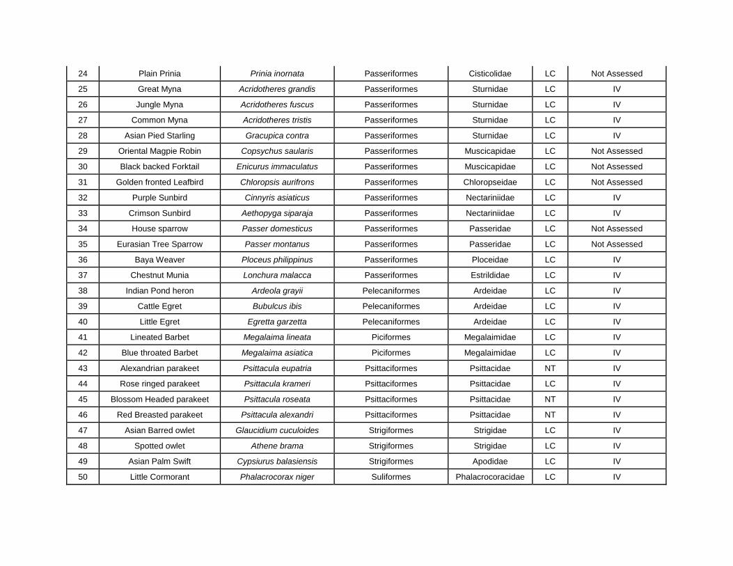
24 Plain Prinia Prinia inornata Passeriformes Cisticolidae LC Not Assessed
25 Great Myna Acridotheres grandis Passeriformes Sturnidae LC IV
26 Jungle Myna Acridotheres fuscus Passeriformes Sturnidae LC IV
27 Common Myna Acridotheres tristis Passeriformes Sturnidae LC IV
28 Asian Pied Starling Gracupica contra Passeriformes Sturnidae LC IV
29 Oriental Magpie Robin Copsychus saularis Passeriformes Muscicapidae LC Not Assessed
30 Black backed Forktail Enicurus immaculatus Passeriformes Muscicapidae LC Not Assessed
31 Golden fronted Leafbird Chloropsis aurifrons Passeriformes Chloropseidae LC Not Assessed
32 Purple Sunbird Cinnyris asiaticus Passeriformes Nectariniidae LC IV
33 Crimson Sunbird Aethopyga siparaja Passeriformes Nectariniidae LC IV
34 House sparrow Passer domesticus Passeriformes Passeridae LC Not Assessed
35 Eurasian Tree Sparrow Passer montanus Passeriformes Passeridae LC Not Assessed
36 Baya Weaver Ploceus philippinus Passeriformes Ploceidae LC IV
37 Chestnut Munia Lonchura malacca Passeriformes Estrildidae LC IV
38 Indian Pond heron Ardeola grayii Pelecaniformes Ardeidae LC IV
39 Cattle Egret Bubulcus ibis Pelecaniformes Ardeidae LC IV
40 Little Egret Egretta garzetta Pelecaniformes Ardeidae LC IV
41 Lineated Barbet Megalaima lineata Piciformes Megalaimidae LC IV
42 Blue throated Barbet Megalaima asiatica Piciformes Megalaimidae LC IV
43 Alexandrian parakeet Psittacula eupatria Psittaciformes Psittacidae NT IV
44 Rose ringed parakeet Psittacula krameri Psittaciformes Psittacidae LC IV
45 Blossom Headed parakeet Psittacula roseata Psittaciformes Psittacidae NT IV
46 Red Breasted parakeet Psittacula alexandri Psittaciformes Psittacidae NT IV
47 Asian Barred owlet Glaucidium cuculoides Strigiformes Strigidae LC IV
48 Spotted owlet Athene brama Strigiformes Strigidae LC IV
49 Asian Palm Swift Cypsiurus balasiensis Strigiformes Apodidae LC IV
50 Little Cormorant Phalacrocorax niger Suliformes Phalacrocoracidae LC IV

Appendix 3.10: The
list of Reptiles

Appendix 3.10-List of Reptiles
Sr. No. Common Name Scientific Name IUCN Status Schedule (as per WPA, 1972)
1 Brahminy Worm Snake Indotyphlops braminus Not Evaluated
IV
2 Common Indian Trinket Snake
Coelognathus helena Not Evaluated
IV
3 Banded Trinket Snake Oreocryptophis porphyraceus
Not Evaluated
IV
4 Green Rat Snake Ptyas nigromarginata Not Evaluated
IV
5 Indian Rat Snake Ptyas mucosa Not Evaluated
II
6 Common Wolf Snake Lycodon capucinus LC IV
7 Checkered Keelback Water Snake
Xenochrophis piscator Not Evaluated
II
8 Buff-striped Keelback Amphiesma stolatum Not Evaluated
IV
9 Ornamental Flying Snake Chrysopelea ornata Not Evaluated
IV
10 Common Indian Cat Snake Boiga trigonata LC IV
11 Common Indian Krait Bungarus caeruleus Not Evaluated
IV
12 King Cobra Ophiophagus hannah VU II
13 Monocellate Cobra Naja kaouthia LC II
14 Russell’s Viper Daboia russelii Not Evaluated
II
15 Flat-tailed House Gecko Hemidactylus platyurus Not Evaluated
Not Evaluated
16 Common House Gecko Hemidactylus frenatus LC Not Evaluated
17 Brooke’s House Gecko/Spotted House Gecko
Hemidactylus brookii Not Evaluated
Not Evaluated
18 Indo –Pacific Gecko Hemidactylus garnotii Not Evaluated
Not Evaluated
19 Khasi Hills Bent-toed Gecko Cyrtodactylus khasiensis Not Evaluated
Not Evaluated
20 Tokay Gecko Gekko gecko LC Not Evaluated
21 Oriental Garden Lizard Calotes versicolor Not Evaluated
Not Evaluated
22 Green Fan- throated Lizard Ptyctolaemus gularis Not Evaluated
Not Evaluated
23 Norvill’s Flying Lizard Draco norvillii Not Evaluated
Not Evaluated

24 White - spotted Supple Skink
Lygosoma albopunctata Not Evaluated
Not Evaluated
25 East Indian Brown Mabuya/Sun Skink
Eutropis multifasciata LC Not Evaluated
26 Spotted Forest Skink Sphenomorphus maculatus
Not Evaluated
Not Evaluated
27 Indian Forest Skink Sphenomorphus indicus Not Evaluated
Not Evaluated
28 Khasi Hills Long -tailed Lizard
Takydromus khasiensis Not Evaluated
Not Evaluated
29 Bengal Monitor Varanus bengalensis LC I
30 Asian Water Monitor Varanus salvator LC I
31 Yellow Monitor Varanus flavescens LC I
32 Brahminy terrapin Hardella thurjii VU Not Evaluated
33 Eastern hill terrapin Melanochelys tricarinata VU Not Evaluated
34 Malayan box turtle Cuora amboinensis VU Not Evaluated
35 Asian leaf turtle
Cyclemys dentata NT Not Evaluated
36 Keeled box turtle Cuora mouhotii EN Not Evaluated
37 Elongated Tortoise Indotestudo elongata CR Not Evaluated
38 Asian Brown tortoise Manouria emys CR Not Evaluated
39 Roofed terrapin Pangshura tecta LC Not Evaluated

Appendix 3.11: The
list of Amphibians
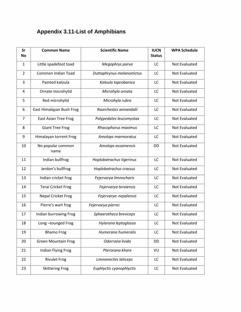
Appendix 3.11-List of Amphibians
Sr No
Common Name Scientific Name IUCN Status
WPA Schedule
1 Little spadefoot toad Megophrys parva LC Not Evaluated
2 Common Indian Toad Duttaphrynus melanostictus LC Not Evaluated
3 Painted kaloula Kaloula taprobanica LC Not Evaluated
4 Ornate microhylid Microhyla ornata LC Not Evaluated
5 Red microhylid Microhyla rubra LC Not Evaluated
6 East Himalqyan Bush Frog Raorchestes annandalii LC Not Evaluated
7 East Asian Tree Frog Polypedates leucomystax LC Not Evaluated
8 Giant Tree Frog Rhacophorus maximus LC Not Evaluated
9 Himalayan torrent Frog Amolops marmoratus LC Not Evaluated
10 No popular common name
Amolops assamensis DD Not Evaluated
11 Indian bullfrog Hoplobatrachus tigerinus LC Not Evaluated
12 Jerdon’s bullfrog Hoplobatrachus crassus LC Not Evaluated
13 Indian cricket frog Fejervarya limnocharis LC Not Evaluated
14 Terai Cricket Frog Fejervarya teraiensis LC Not Evaluated
15 Nepal Cricket Frog Fejervarya nepalensis LC Not Evaluated
16 Pierre's wart frog Fejervarya pierrei LC Not Evaluated
17 Indian burrowing Frog Sphaerotheca breviceps LC Not Evaluated
18 Long –tounged Frog Hylarana leptoglossa LC Not Evaluated
19 Bhamo Frog Humerana humeralis LC Not Evaluated
20 Green Mountain Frog Odorrana livida DD Not Evaluated
21 Indian Flying Frog Pterorana khare VU Not Evaluated
22 Rivulet Frog Limnonectes laticeps LC Not Evaluated
23 Skittering Frog Euphlyctis cyanophlyctis LC Not Evaluated

24 No local name reported Philautus namdaphaensis DD Not Evaluated
25 Terai Tree Frog Polypedates teraiensis DD Not Evaluated
26 Hongkong Whipping Frog Polypedates megacephalus LC Not Evaluated
27 Nepal Flying Frog Rhacophorus maximus LC Not Evaluated
28 Suffry Red webbed Tree Frog
Rhacophorus suffry LC Not Evaluated
29 Pied Warty Frog Theloderma asperum LC Not Evaluated
30 Wuliangshan horned toad Xenophrys wuliangshanensis DD Not Evaluated
31 No popular common name
Xenophrys major LC Not Evaluated

Appendix 3.12: The
list of Butterflies

Appendix 3.12-List of Butterflies
Table 1: List of butterflies observed in the study area
Sr.no Scientific name Common name Family IUCN,3.1 status WPA, 1972
(Schedule)
1 Euploea core Common Indian Crow
Nymphalidae Least Concern Not assessed
2 Zeltus amasa Fluffy Tit Zeltus amasa Not assessed Not assessed
3 Moduza procris Commander Nymphalidae Not assessed Not assessed
4 Danaus chrysippus Plain Tiger Nymphalidae Least Concern Not assessed
5 Danaus genutia Common or Striped Tiger
Nymphalidae Not assessed Not assessed
6 Tanaecia lepidea Grey Count Nymphalidae Not assessed Not assessed
7 Catopsilia pomona Common Emigrant Pieridae Not assessed Not assessed
Table 2: List of Butterflies recorded in the Study Area
Sr.no Scientific name Common name Family
1 Halpe zema Zema Banded Ace Hesperiidae
2 Telicota colon Pale Palm-Dart Hesperiidae
3 Telicota bambusae Dark Palm-Dart Hesperiidae
4 Sarangesa dasahara Common Small Flat Hesperiidae
5 Tapenath waitesi Black Angle Hesperiidae
6 Tagiades litigiosa Water Snow Flat Hesperiidae
7 Tagiades japetus Common Snow Flat Hesperiidae
8 Pseudocoladenia dan Fulvous Pied Flat Hesperiidae
9 Celaenorrhinus leucocera Common Spotted Flat Hesperiidae
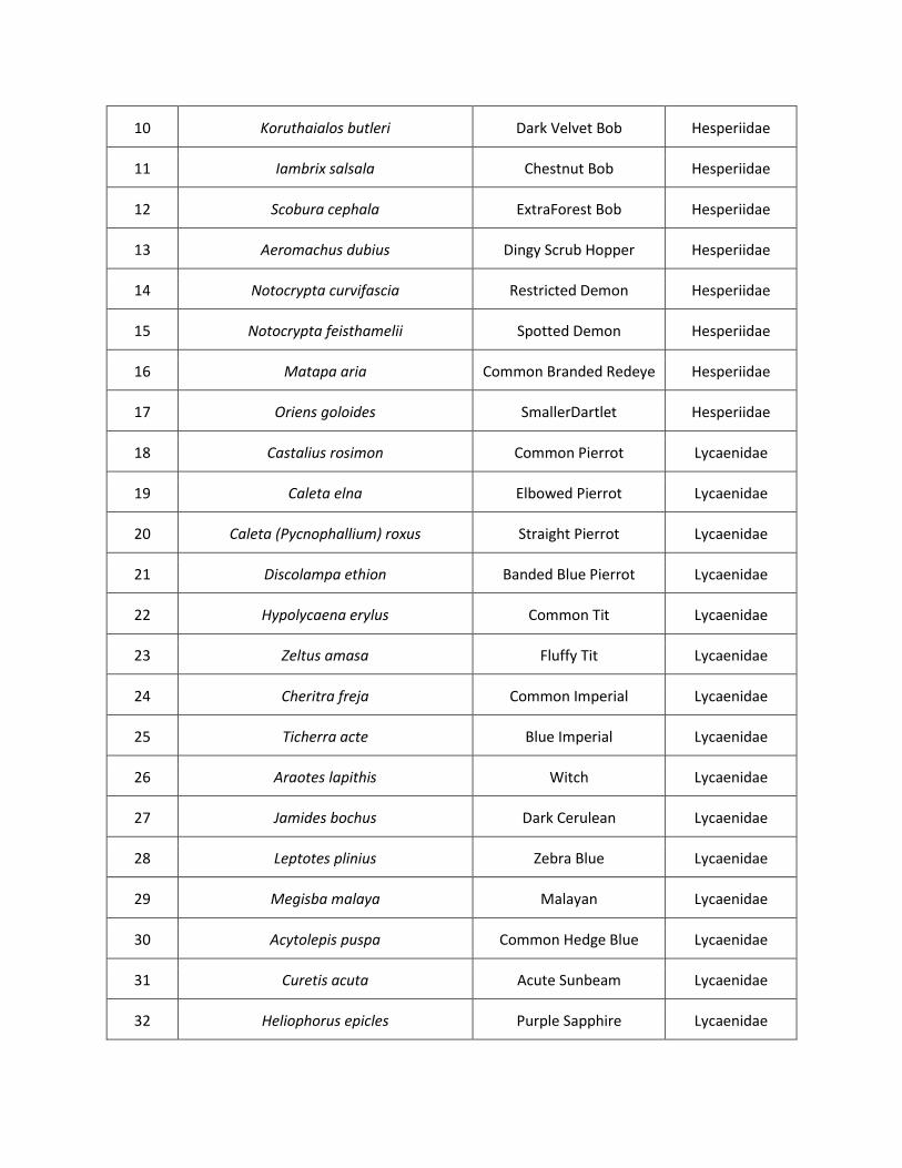
10 Koruthaialos butleri Dark Velvet Bob Hesperiidae
11 Iambrix salsala Chestnut Bob Hesperiidae
12 Scobura cephala ExtraForest Bob Hesperiidae
13 Aeromachus dubius Dingy Scrub Hopper Hesperiidae
14 Notocrypta curvifascia Restricted Demon Hesperiidae
15 Notocrypta feisthamelii Spotted Demon Hesperiidae
16 Matapa aria Common Branded Redeye Hesperiidae
17 Oriens goloides SmallerDartlet Hesperiidae
18 Castalius rosimon Common Pierrot Lycaenidae
19 Caleta elna Elbowed Pierrot Lycaenidae
20 Caleta (Pycnophallium) roxus Straight Pierrot Lycaenidae
21 Discolampa ethion Banded Blue Pierrot Lycaenidae
22 Hypolycaena erylus Common Tit Lycaenidae
23 Zeltus amasa Fluffy Tit Lycaenidae
24 Cheritra freja Common Imperial Lycaenidae
25 Ticherra acte Blue Imperial Lycaenidae
26 Araotes lapithis Witch Lycaenidae
27 Jamides bochus Dark Cerulean Lycaenidae
28 Leptotes plinius Zebra Blue Lycaenidae
29 Megisba malaya Malayan Lycaenidae
30 Acytolepis puspa Common Hedge Blue Lycaenidae
31 Curetis acuta Acute Sunbeam Lycaenidae
32 Heliophorus epicles Purple Sapphire Lycaenidae

33 Anthene emolus Common Ciliate Blue Lycaenidae
34 Zizina otis Lesser Grass Blue Lycaenidae
35 Pseudozizeeria maha Pale Grass Blue Lycaenidae
36 Logania distanti Dark Mottle Lycaenidae
37 Loxura atymnus Yamfly Lycaenidae
38 Abisara echerius Plum Judy Rio44dinidae
39 Zemeros flegyas Punchinello Riodin45idae
40 Cirrochroa aoris Large Yeoman Nymphalidae
41 Vagrans egista Vagrant Nymphalidae
42 Euthaliaa conthea Common Baron Nymphalidae
43 Euthalia monina Powdered Baron Nymphalidae
44 Tanaecia julii Common Earl Nymphalidae
45 Mycalesis perseus Common Bushbrown Nymphalidae
46 Mycalesis malsarida Plain Bushbrown Nymphalidae
47 Melanitis leda Common Evening Brown Nymphalidae
48 Lethe chandica Angled Red Forester Nymphalidae
49 Mycalesis anaxias White-bar Bushbrown Nymphalidae
50 Faunis canens Common Faun Nymphalidae
51 Orsotriaena medus Nigger Nymphalidae
52 Ariadne ariadne Angled Castor Nymphalidae
53 Cupha erymanthis Rustic Nymphalidae
54 Leptosia nina Psyche Nymphalidae
55 Tanaecia lepidea Grey Count Nymphalidae

56 Euripus nyctelius Courtesan Nymphalidae
57 Elymnias hypermnestra Common Palmfly Nymphalidae
58 Junonia atlites Grey Pansy Nymphalidae
59 Junonia lemonias Lemon Pansy Nymphalidae
60 Junonia hierta Yellow Pansy Nymphalidae
61 Moduza procris Commander Nymphalidae
62 Athyma selenophora Staff Sergeant Nymphalidae
63 Athyma inara Colour Sergeant Nymphalidae
64 Athyma perius Common Sergeant Nymphalidae
65 Athyma pravara Unbroken Sergeant Nymphalidae
66 Ypthima huebneri Common Four-ring Nymphalidae
67 Ypthima baldus Common Five-ring Nymphalidae
68 Charaxes bernardus Tawny Rajah Nymphalidae
69 Neptis harita DingiestSailer Nymphalidae
70 Neptis pseudovikasi False DingiSailer Nymphalidae
71 Neptis soma Sullied/CreamySailer Nymphalidae
72 Neptis miah Small Yellow Sailer Nymphalidae
73 Neptis nata Clear Sailer Nymphalidae
74 Danaus chrysippus Plain Tiger Nymphalidae
75 Danaus genutia Common or Striped Tiger Nymphalidae
76 Tirumala limniace Blue Tiger Nymphalidae
77 Parantica aglea Glassy Tiger Nymphalidae
78 Tirumala septentrionis Dark Blue Tiger Nymphalidae

79 Euploea core Common Indian Crow Nymphalidae
80 Euploea mulciber Striped Blue Crow Nymphalidae
81 Euploea radamanthus Magpie Crow Nymphalidae
82 Hypolimnas misippus DanaidEggfly Nymphalidae
83 Lebadea martha Knight Nymphalidae
84 Charaxes athamas Common Nawab Nymphalidae
85 Rhinopalpa polynice Wizard Nymphalidae
86 Charaxes arja Pallid Nawab Nymphalidae
87 Cethosia cyane Leopard Lacewing Nymphalidae
88 Pantoporia hordonia Common Lascar Nymphalidae
89 Troides helena Common Birdwing Papilionidae
90 Graphium sarpedon Common Bluebottle Papilionidae
91 Papilio paris Paris Peacock Papilionidae
92 Papilio memnon Great Mormon Papilionidae
93 Graphium agamemnon Tailed Jay Papilionidae
94 Papilio demoleus Lime Butterfly Papilionidae
95 Papilio nephelus Yellow Helen Papilionidae
96 Catopsilia pyranthe Mottled Emigrant Pieridae
97 Catopsilia pomona Common Emigrant Pieridae
98 Ixias pyrene Yellow Orange-tip Pieridae
99 Hebomoia glaucippe Great Orange-tip Pieridae
100 Appias lyncida Chocolate Albatross Pieridae
101 Delias hyparete Painted Jezebel Pieridae


Appendix 3.13: The
list of Fishes

Appendix 3.13-List of Fishes
Sr. No. Common Name Scientific Name IUCN
Status
WPA, 1972
(Sch.)
Rare/ Endemic
to NE India
1 Rohu Labeo rohita LC Not Evaluated NA
2 Minor Carp Labeo bata LC Not Evaluated
3 Kuria labeo Labeo gonius LC Not Evaluated NA
4 Catla catla NA Not Evaluated NA
5 Ctenopharyngodon idella NA Not Evaluated NA
6 Cirrhinus mrigala LC Not Evaluated
7 Chola Barb Puntius chola LC Not Evaluated NA
8 Spotfin swamp barb
Puntius sophore LC Not Evaluated NA
9 Puntius conchonius LC Not Evaluated NA
10 Puntius ticto LC Not Evaluated NA
11 Golden mahseer Tor putitora EN Not Evaluated Rare, Endemic
12 Tor mahseer Tor tor DD Not Evaluated Rare, Endemic
13 Garra gotyla gotyla NA Not Evaluated NA
14 Barilius barna LC Not Evaluated NA
15 Botia Dario LC Not Evaluated NA
16 Amblypharyngodon mola LC Not Evaluated NA
17 Mystus tengra NA Not Evaluated NA
18 Mystus cavasius LC Not Evaluated Rare, Endemic
19 Mystus vittatus LC Not Evaluated Rare, Endemic
20 Wallago atu NT Not Evaluated

21 Amblyceps apangi LC Not Evaluated Rare, Endemic
22 Clarias batrachus LC Not Evaluated
23 Gangetic ailia
Ailia coila NT Not Evaluated NA
24 Ompok pabda NT Not Evaluated Rare, Endemic
25 Bareye Goby
Glossogobius giuris LC Not Evaluated
26 Spiny eel
Mastacembelus armatus LC Not Evaluated
27 Colisa fasciatus NA Not Evaluated NA
28 Gangetic
mudeel
Monopterus cuchia LC Not Evaluated NA
29 Notopterus notopterus LC Not Evaluated
30 Elongate Glass
Perchlet
Chanda nama LC Not Evaluated NA
31 Channa punctatus NA Not Evaluated NA
32 Channa striatus NA Not Evaluated NA
33 Channa barca DD Not Evaluated NA
34 Indian Mottled
Eel
Anguilla bengalensis NT Not Evaluated
35 Indian River
Shad
Gudusia chapra LC Not Evaluated NA
36 Ganges River
Gizzard Shad
Gonialosa manmina LC Not Evaluated NA
37 Catla Gibelion catla LC Not Evaluated
38 Mrigal
Cirrhinus mrigala LC Not Evaluated
39 Katli Neolissochilus hexagonolepis
NT Not Evaluated NA
40 Rosy barb Pethia conchonius LC Not Evaluated NA
41 Indian glass barb Laubuka laubuca NA Not Evaluated NA
42 Barna Baril Barilius barna LC Not Evaluated NA

43 Flying barb Esomus danrica LC Not Evaluated NA
44 Slender Barb Rasbora daniconius LC Not Evaluated
45 Gangetic mystus NA Not Evaluated NA
46 Striped dwarf cat fish
Mystus vittatus NA Not Evaluated NA
47 Indian butter catfish
Ompok bimaculatus NA Not Evaluated NA
48 Batchwa vacha Eutropiichthys vacha NA Not Evaluated NA
49 Pungas Pangasius pangasius NA Not Evaluated NA
50 Singee Heteropneustes fossilis LC Not Evaluated
51 Blue Panchax Aplocheilus panchax LC Not Evaluated
52 Anabas testudineus DD Not Evaluated NA
53 Dwarf gourami Trichogaster lalius LC Not Evaluated
54 Dwarf
Snakehead
Channa gachua LC Not Evaluated
55 Spotted snake head
Channa aurantimaculata DD Not Evaluated NA
56 Snakehead
Murrel
Channa striata LC Not Evaluated NA
Appendix 3.14:
Demographic
Profile of the Study
Area

Appendix 3.14- Demographic profile
Table 1: Demographic Details of Villages in where proposed Wells are located
Name No of Households
Total
Populatio
Person
HouseholSize
Total
Population
Male
Total
PopulatioFemale
Sex Ratio /
1000 male
Scheduled Castes population Person
%SC Population
Scheduled Tribes population Person
%ST Population
Literates PopulatioPerson
Literacy Rate
Male Literacy Rate
Female Literacy Rate
Ahovi (Itovi) 0 0 0.00 0 0 0 0 0.00 0 0.00 0 0 0 0
Alichiga 203 957 4.71 512 445 869.14 0 0.00 36 3.76 490 61.95 69.12 53.78
Ambari Gaon 16 89 5.56 45 44 977.78 0 0.00 35 39.33 42 58.33 66.67 50.00
Anjok Teron 19 113 5.95 47 66 1404.26 0 0.00 113 100.00 69 70.41 74.42 67.27
Baghgaon 83 372 4.48 194 178 917.53 0 0.00 0 0.00 276 87.90 94.38 81.17
Balipathar 294 1314 4.47 663 651 981.90 0 0.00 693 52.74 871 75.22 80.50 69.63
Bar Deka Timung 62 347 5.60 174 173 994.25 0 0.00 264 76.08 200 66.67 72.67 60.67
Barsewaguri 246 1149 4.67 574 575 1001.74 0 0.00 5 0.44 838 83.72 87.72 79.64
Bill Pathar 37 163 4.41 80 83 1037.50 0 0.00 0 0.00 115 82.73 87.88 78.08
Bokajan Bagan 86 476 5.53 248 228 919.35 0 0.00 0 0.00 320 79.01 86.26 71.13
Bong Sal 17 86 5.06 42 44 1047.62 0 0.00 86 100.00 31 43.06 52.78 33.33
Borholla 122 534 4.38 280 254 907.14 0 0.00 14 2.62 418 89.32 93.44 84.82
Borholla No.2 60 281 4.68 146 135 924.66 0 0.00 0 0.00 200 85.84 90.16 81.08
Borphong Rongpher 10 70 7.00 37 33 891.89 0 0.00 70 100.00 54 90.00 96.77 82.76
Chaluk Pathar No.1 212 1157 5.46 592 565 954.39 0 0.00 6 0.52 750 73.39 79.21 67.14
Chaluk Pathar No.2 99 484 4.89 240 244 1016.67 0 0.00 123 25.41 272 67.33 77.18 57.07
Chandla Chung 0 0 0.00 0 0 0.00 0 0.00 0 0.00 0 0.00 0.00 0.00
Chandra Teron 22 118 5.36 56 62 1107.14 0 0.00 115 97.46 81 84.38 87.50 81.25
Christan Gaon 63 357 5.67 170 187 1100.00 0 0.00 352 98.60 209 71.58 81.29 62.75
Christian Gaon 13 75 5.77 40 35 875.00 0 0.00 75 100.00 42 73.68 90.32 53.85
Christian Gaon 8 41 5.13 19 22 1157.89 0 0.00 40 97.56 16 45.71 46.67 45.00
Chungajan Hazari Gaon 63 293 4.65 156 137 878.21 0 0.00 0 0.00 225 86.54 92.20 79.83
Degholi Khokonguri 135 554 4.10 295 259 877.97 0 0.00 24 4.33 333 73.84 78.05 68.78
Deihari Rangpi 36 190 5.28 95 95 1000.00 0 0.00 188 98.95 111 72.55 84.93 61.25
Dharam Sing Bey 34 187 5.50 98 89 908.16 0 0.00 179 95.72 143 87.73 97.67 76.62
Dharampur 176 832 4.73 412 420 1019.42 0 0.00 239 28.73 597 82.46 91.39 73.63
Dhonia pathar 30 125 4.17 61 64 1049.18 0 0.00 117 93.60 79 74.53 90.91 56.86
Dighalganja Nic 66 370 5.61 206 164 796.12 0 0.00 2 0.54 212 66.67 76.70 54.23
Dighbir Basti 27 119 4.41 65 54 830.77 0 0.00 0 0.00 79 80.61 85.45 74.42

Dihingia 851 3671 4.31 1885 1786 947.48 8 0.22 321 8.74 2231 70.53 78.42 62.23
Dilawjan 169 903 5.34 439 464 1056.95 1 0.11 396 43.85 642 79.55 86.34 73.27
Dilawjan Koch Gaon 96 445 4.64 217 228 1050.69 0 0.00 4 0.90 310 80.10 84.32 76.24
Dilawjan Longbui 35 178 5.09 87 91 1045.98 0 0.00 0 0.00 146 89.57 89.74 89.41
Dilawjan-1 Dubi Gaon 2 42 210 5.00 113 97 858.41 0 0.00 14 6.67 144 75.79 80.58 70.11
Durgapur No.1 56 278 4.96 136 142 1044.12 0 0.00 194 69.78 143 60.59 68.75 53.23
Durgapur No.2 26 138 5.31 68 70 1029.41 0 0.00 117 84.78 70 62.50 75.47 50.85
Gautam Basti 232 1208 5.21 651 557 855.61 0 0.00 156 12.91 960 87.99 91.55 83.77
Ghonivi 0 0 0.00 0 0 0.00 0 0.00 0 0.00 0 0.00 0.00 0.00
Gogiha (Kikhoyi) 0 0 0.00 0 0 0.00 0 0.00 0 0.00 0 0.00 0.00 0.00
Goneshpur 41 191 4.66 93 98 1053.76 0 0.00 191 100.00 132 80.49 90.79 71.59
Habe Timung 9 46 5.11 24 22 916.67 0 0.00 46 100.00 22 57.89 84.21 31.58
Hallo Khuwa 454 2098 4.62 1078 1020 946.20 491 23.40 31 1.48 1287 69.61 78.38 60.38
Hallo Khuwa F.V. 280 1301 4.65 643 658 1023.33 0 0.00 16 1.23 645 57.85 67.75 48.13
Hatimora 124 640 5.16 324 316 975.31 1 0.16 363 56.72 439 79.67 82.80 76.47
Hatimorajan 37 208 5.62 99 109 1101.01 0 0.00 0 0.00 145 77.96 92.22 64.58
Hatovi (S.Hetovi) 0 0 0.00 0 0 0.00 0 0.00 0 0.00 0 0.00 0.00 0.00
Havishe Naga 0 0 0.00 0 0 0.00 0 0.00 0 0.00 0 0.00 0.00 0.00
Heneto 0 0 0.00 0 0 0.00 0 0.00 0 0.00 0 0.00 0.00 0.00
Henevi 0 0 0.00 0 0 0.00 0 0.00 0 0.00 0 0.00 0.00 0.00
Hetio (Hetoi) 0 0 0.00 0 0 0.00 0 0.00 0 0.00 0 0.00 0.00 0.00
Hoito 0 0 0.00 0 0 0.00 0 0.00 0 0.00 0 0.00 0.00 0.00
Holowguri 80 378 4.73 184 194 1054.35 0 0.00 0 0.00 263 79.22 80.38 78.16
Hurhuria 252 1046 4.15 572 474 828.67 292 27.92 189 18.07 565 67.99 76.37 57.75
Jabarajan 374 1886 5.04 978 908 928.43 191 10.13 5 0.27 1373 81.73 86.29 76.77
Janjuri 116 563 4.85 297 266 895.62 63 11.19 191 33.93 389 79.39 89.92 67.67
Jekshe Naga Bosti 0 0 0.00 0 0 0.00 0 0.00 0 0.00 0 0.00 0.00 0.00
Jongjung 25 148 5.92 86 62 720.93 0 0.00 148 100.00 61 50.00 61.64 32.65
Joyantipur 58 274 4.72 127 147 1157.48 0 0.00 268 97.81 139 56.73 61.11 53.28
Joypur 45 254 5.64 121 133 1099.17 0 0.00 0 0.00 176 79.64 85.98 73.68
Kacha Khowa 78 408 5.23 201 207 1029.85 0 0.00 177 43.38 218 64.12 73.94 54.86
Kai Terang 6 48 8.00 28 20 714.29 0 0.00 48 100.00 32 76.19 88.00 58.82
Kara Gaon 34 195 5.74 104 91 875.00 0 0.00 89 45.64 73 46.20 52.94 38.36
Kath Katia 568 2545 4.48 1283 1262 983.63 0 0.00 12 0.47 1760 79.17 84.53 73.81
Kathar Engti 67 413 6.16 213 200 938.97 0 0.00 397 96.13 277 82.69 88.10 77.25

Keyezu 0 0 0.00 0 0 0.00 0 0.00 0 0.00 0 0.00 0.00 0.00
Khai Basti (Khukhayi) 0 0 0.00 0 0 0.00 0 0.00 0 0.00 0 0.00 0.00 0.00
Khetho (Khekhakhu) 0 0 0.00 0 0 0.00 0 0.00 0 0.00 0 0.00 0.00 0.00
Khonikor Gaon 373 1707 4.58 857 850 991.83 77 4.51 0 0.00 1375 89.93 93.54 86.23
Khudi (Khutovi) 0 0 0.00 0 0 0.00 0 0.00 0 0.00 0 0.00 0.00 0.00
Khugovi 0 0 0.00 0 0 0.00 0 0.00 0 0.00 0 0.00 0.00 0.00
Khukeami (Khoaiye) 0 0 0.00 0 0 0.00 0 0.00 0 0.00 0 0.00 0.00 0.00
Kiling Gaon 61 364 5.97 183 181 989.07 2 0.55 362 99.45 179 62.81 70.21 55.56
Koch Gaon 65 284 4.37 138 146 1057.97 0 0.00 137 48.24 198 81.15 85.34 77.34
Kolia Dunga 54 259 4.80 128 131 1023.44 0 0.00 0 0.00 166 74.11 78.57 69.64
Kongkat 18 106 5.89 59 47 796.61 0 0.00 89 83.96 45 53.57 63.64 42.50
L.Vihoto 0 0 0.00 0 0 0.00 0 0.00 0 0.00 0 0.00 0.00 0.00
Labon Kro 17 101 5.94 51 50 980.39 0 0.00 100 99.01 67 78.82 87.50 71.11
Ladansa 0 0 0.00 0 0 0.00 0 0.00 0 0.00 0 0.00 0.00 0.00
Longkicho Engti 32 187 5.84 103 84 815.53 0 0.00 186 99.47 112 74.17 83.54 63.89
Lozhoto 0 0 0.00 0 0 0.00 0 0.00 0 0.00 0 0.00 0.00 0.00
Lozhoto 0 0 0.00 0 0 0.00 0 0.00 0 0.00 0 0.00 0.00 0.00
Lukto Nepali 0 0 0.00 0 0 0.00 0 0.00 0 0.00 0 0.00 0.00 0.00
Lungtuk Engti 28 165 5.89 89 76 853.93 4 2.42 160 96.97 109 81.34 85.90 75.00
Lungtuk Rongpi 8 48 6.00 27 21 777.78 0 0.00 42 87.50 38 95.00 95.65 94.12
Madhyempur 0 0 0.00 0 0 0.00 0 0.00 0 0.00 0 0.00 0.00 0.00
Majgaon 152 771 5.07 388 383 987.11 0 0.00 0 0.00 437 63.70 71.81 55.87
Majgaon 152 771 5.07 388 383 987.11 0 0.00 0 0.00 437 63.70 71.81 55.87
Manikpur 68 407 5.99 195 212 1087.18 0 0.00 6 1.47 262 75.72 83.95 68.48
Milonpur 195 994 5.10 469 525 1119.40 7 0.70 0 0.00 465 55.36 65.13 46.89
Moh Khuti 89 440 4.94 232 208 896.55 0 0.00 4 0.91 222 59.84 63.45 55.75
Mohima 99 468 4.73 258 210 813.95 0 0.00 0 0.00 367 88.01 93.97 80.54
Mohonpur 30 138 4.60 69 69 1000.00 0 0.00 137 99.28 100 81.30 89.47 74.24
Mon Teron 8 44 5.50 25 19 760.00 0 0.00 44 100.00 17 51.52 82.35 18.75
Mon Teron 3 16 5.33 7 9 1285.71 0 0.00 16 100.00 13 92.86 100.00 85.71
Mon Teron 39 208 5.33 107 101 943.93 0 0.00 208 100.00 119 70.41 76.67 63.29
Mugabhi 0 0 0.00 0 0 0.00 0 0.00 0 0.00 0 0.00 0.00 0.00
Naba Bontipur 66 299 4.53 149 150 1006.71 0 0.00 0 0.00 232 91.34 93.02 89.60
Nababetoni No.3 121 497 4.11 234 263 1123.93 0 0.00 6 1.21 378 86.50 90.64 82.91
Nacheri (Kuhoboto) 0 0 0.00 0 0 0.00 0 0.00 0 0.00 0 0.00 0.00 0.00

Naga Juri 203 966 4.76 485 481 991.75 0 0.00 0 0.00 730 84.98 90.09 79.76
Nahorkhona 221 1069 4.84 575 494 859.13 82 7.67 164 15.34 676 73.32 79.22 66.74
Navapur 61 286 4.69 147 139 945.58 16 5.59 269 94.06 212 82.49 85.29 79.34
Nayanjan Gaon 163 776 4.76 363 413 1137.74 0 0.00 203 26.16 507 73.05 84.88 62.70
Nekori Majdolopa 53 356 6.72 174 182 1045.98 0 0.00 344 96.63 127 42.47 46.76 38.75
Neparpeti Baghjan No. 1 & 2 192 961 5.01 481 480 997.92 0 0.00 4 0.42 675 79.69 84.52 74.94
Neparpeti Kachari Gaon 63 280 4.44 153 127 830.07 0 0.00 1 0.36 203 78.68 88.49 67.23
Neparpeti Kathar Gaon 30 155 5.17 69 86 1246.38 0 0.00 7 4.52 98 70.50 80.33 62.82
Netezu 0 0 0.00 0 0 0.00 0 0.00 0 0.00 0 0.00 0.00 0.00
New Subha (Shouba) 0 0 0.00 0 0 0.00 0 0.00 0 0.00 0 0.00 0.00 0.00
Nikheha (Nikighe) 0 0 0.00 0 0 0.00 0 0.00 0 0.00 0 0.00 0.00 0.00
Nikhehoi (Vikhuho) New 0 0 0.00 0 0 0.00 0 0.00 0 0.00 0 0.00 0.00 0.00
Nizhevi 0 0 0.00 0 0 0.00 0 0.00 0 0.00 0 0.00 0.00 0.00
No.1 Dighali Maji Gaon 114 624 5.47 312 312 1000.00 0 0.00 0 0.00 375 68.68 75.91 61.40
No.2 Dighali Maji Gaon 39 203 5.21 107 96 897.20 0 0.00 0 0.00 141 75.81 81.63 69.32
No.2 Kori 857 4380 5.11 2226 2154 967.65 7 0.16 0 0.00 2578 71.93 78.15 65.47
No.2 Panjan 35 180 5.14 99 81 818.18 0 0.00 0 0.00 138 86.79 96.63 74.29
Noloni Pathar 258 1206 4.67 598 608 1016.72 191 15.84 0 0.00 866 81.01 88.58 73.46
Old Ralong Naga Bosti 0 0 0.00 0 0 0.00 0 0.00 0 0.00 0 0.00 0.00 0.00
Old Subha 0 0 0.00 0 0 0.00 0 0.00 0 0.00 0 0.00 0.00 0.00
Ouguri 30 133 4.43 68 65 955.88 0 0.00 40 30.08 53 48.18 54.39 41.51
Pach Ghoria 171 815 4.77 428 387 904.21 0 0.00 5 0.61 623 89.38 93.19 85.15
Paniram Terang 158 774 4.90 397 377 949.62 7 0.90 274 35.40 325 50.78 61.40 39.55
Pishikhu 0 0 0.00 0 0 0.00 0 0.00 0 0.00 0 0.00 0.00 0.00
Puhekha (Pihekhu) 0 0 0.00 0 0 0.00 0 0.00 0 0.00 0 0.00 0.00 0.00
Pukhuri Para 37 190 5.14 93 97 1043.01 0 0.00 189 99.47 125 75.30 79.22 71.91
Rai Pathar 125 540 4.32 280 260 928.57 16 2.96 44 8.15 362 76.69 84.23 68.83
Raiali Matikhola 91 469 5.15 232 237 1021.55 0 0.00 0 0.00 306 73.21 82.09 64.98
Raipur 68 328 4.82 160 168 1050.00 0 0.00 324 98.78 216 75.79 80.99 70.63
Rajapukhuri No.1 60 337 5.62 175 162 925.71 0 0.00 16 4.75 168 57.53 67.52 45.93
Rajapukhuri No.2 56 318 5.68 159 159 1000.00 0 0.00 0 0.00 202 72.92 82.64 62.41
Ram Sing Teron 33 195 5.91 96 99 1031.25 0 0.00 195 100.00 124 75.61 83.72 66.67
Rangmaipur 61 248 4.07 126 122 968.25 0 0.00 205 82.66 167 75.23 85.96 63.89
Rengma Naga/Rengmapani (Hezheto) 1 113 113.00 107 6 56.07 16 14.16 5 4.42 113 100.00 100.00 100.00
Rongagara 531 2817 5.31 1471 1346 915.02 7 0.25 735 26.09 1582 65.81 72.74 58.28

Rongpi Gaon 35 201 5.74 99 102 1030.30 0 0.00 121 60.20 168 97.11 98.78 95.60
Rongpi Gaon 0 0 0.00 0 0 0.00 0 0.00 0 0.00 0 0.00 0.00 0.00
Rongpur 94 455 4.84 243 212 872.43 0 0.00 177 38.90 269 69.15 73.04 64.86
Rupohi 20 96 4.80 46 50 1086.96 0 0.00 95 98.96 62 69.66 79.55 60.00
Samaguri 18 85 4.72 43 42 976.74 0 0.00 79 92.94 60 75.95 76.92 75.00
Samukjan 107 502 4.69 253 249 984.19 423 84.26 11 2.19 350 82.74 90.74 74.40
Santipur 18 88 4.89 44 44 1000.00 0 0.00 48 54.55 71 98.61 97.06 100.00
Santipur 51 249 4.88 126 123 976.19 0 0.00 1 0.40 159 72.27 82.24 62.83
Sardeka (Bardeka) Engti 231 1134 4.91 555 579 1043.24 9 0.79 474 41.80 503 53.23 61.14 45.79
Sardoka Engti 237 1082 4.57 578 504 871.97 11 1.02 370 34.20 778 81.64 86.85 75.83
Sariahjan 99 508 5.13 272 236 867.65 2 0.39 204 40.16 355 80.32 84.19 75.96
Sartha Phangcho 43 252 5.86 124 128 1032.26 0 0.00 252 100.00 153 76.88 87.63 66.67
Sarthe Killing 11 57 5.18 29 28 965.52 1 1.75 56 98.25 44 91.67 100.00 85.19
Sarthe Rongpi (Langmili) 18 87 4.83 43 44 1023.26 0 0.00 86 98.85 44 63.77 78.38 46.88
Satsong R F 141 889 6.30 435 454 1043.68 0 0.00 877 98.65 408 54.99 61.37 48.81
Shanti Bosti 60 290 4.83 146 144 986.30 0 0.00 0 0.00 139 62.61 68.97 55.66
Sokhoyi (Shihoto) 0 0 0.00 0 0 0.00 0 0.00 0 0.00 0 0.00 0.00 0.00
Sonito 0 0 0.00 0 0 0.00 0 0.00 0 0.00 0 0.00 0.00 0.00
Sonowal Gaon 50 246 4.92 138 108 782.61 0 0.00 206 83.74 158 72.81 81.97 61.05
Suhovi (Suhai) 0 0 0.00 0 0 0.00 0 0.00 0 0.00 0 0.00 0.00 0.00
Sukanjan 61 332 5.44 177 155 875.71 0 0.00 0 0.00 187 66.31 78.38 52.99
Suratoni 104 476 4.58 247 229 927.13 11 2.31 20 4.20 308 76.62 79.25 73.68
Tengani Deghali Village No.1 73 354 4.85 179 175 977.65 154 43.50 34 9.60 260 84.97 89.02 80.28
Tengani Golaibosti 0 0 0.00 0 0 0.00 0 0.00 0 0.00 0 0.00 0.00 0.00
Tengatol Bosti 28 168 6.00 84 84 1000.00 112 66.67 4 2.38 99 73.33 87.50 57.14
Tokughe 0 0 0.00 0 0 0.00 0 0.00 0 0.00 0 0.00 0.00 0.00
Tokughe 0 0 0.00 0 0 0.00 0 0.00 0 0.00 0 0.00 0.00 0.00
Toshiha 0 0 0.00 0 0 0.00 0 0.00 0 0.00 0 0.00 0.00 0.00
Uhazhe (Ghazhi) 0 0 0.00 0 0 0.00 0 0.00 0 0.00 0 0.00 0.00 0.00
Uhozhe (Ghakipo) 0 0 0.00 0 0 0.00 0 0.00 0 0.00 0 0.00 0.00 0.00
United Naga Village 0 0 0.00 0 0 0.00 0 0.00 0 0.00 0 0.00 0.00 0.00
Wokha T.E. 771 3694 4.79 1869 1825 976.46 31 0.84 5 0.14 1929 61.24 67.46 54.86
X-Service 14 72 5.14 35 37 1057.14 0 0.00 0 0.00 45 71.43 77.42 65.63
X-Service Selabar 23 124 5.39 59 65 1101.69 0 0.00 120 96.77 54 50.94 54.90 47.27
Yampha Naga Bosti 71 356 5.01 188 168 893.62 21 5.90 201 56.46 107 36.90 47.40 25.00

Zokohi (Yekiye) 0 0 0.00 0 0 0.00 0 0.00 0 0.00 0 0.00 0.00 0.00
Zoshehe (Zuheshe) 0 0 0.00 0 0 0.00 0 0.00 0 0.00 0 0.00 0.00 0.00
Table 2: Demographic Details of Villages in the 500m Buffer of the Wells
Name No of Household Total Population
Person
Household
Size
Total Population
Male
Total
Population
Female
Sex Ratio /
1000 male
Schedule Castes populatioPerson
%SC Populatio
ScheduleTribes populatioPerson
%ST Populatio Literates PopulatioPerson
LiteracRate Male Literacy Rate
Female Literacy Rate
Balipathar 294 1314 4.47 663 651 981.90 0 0.00 693 52.74 871 75.22 80.50 69.63
Bokajan Bagan 86 476 5.53 248 228 919.35 0 0.00 0 0.00 320 79.01 86.26 71.13
Chungajan Hazari Gaon 63 293 4.65 156 137 878.21 0 0.00 0 0.00 225 86.54 92.20 79.83
Dilawjan 169 903 5.34 439 464 1056.95 1 0.11 396 43.85 642 79.55 86.34 73.27
Kai Terang 6 48 8.00 28 20 714.29 0 0.00 48 100.00 32 76.19 88.00 58.82
Netezu 0 0 0.00 0 0 0.00 0 0.00 0 0.00 0 0.00 0.00 0.00
No.2 Kori 857 4380 5.11 2226 2154 967.65 7 0.16 0 0.00 2578 71.93 78.15 65.47
No.2 Panjan 35 180 5.14 99 81 818.18 0 0.00 0 0.00 138 86.79 96.63 74.29
Paniram Terang 158 774 4.90 397 377 949.62 7 0.90 274 35.40 325 50.78 61.40 39.55
Rongagara 531 2817 5.31 1471 1346 915.02 7 0.25 735 26.09 1582 65.81 72.74 58.28
Sariahjan 99 508 5.13 272 236 867.65 2 0.39 204 40.16 355 80.32 84.19 75.96
Sarthe Killing 11 57 5.18 29 28 965.52 1 1.75 56 98.25 44 91.67 100.00 85.19
Sukanjan 61 332 5.44 177 155 875.71 0 0.00 0 0.00 187 66.31 78.38 52.99
Tengatol Bosti 28 168 6.00 84 84 1000.00 112 66.67 4 2.38 99 73.33 87.50 57.14
Table 3: Details of the Working Population in the Villages in the Study Area
Name No of Households
Total
Population
Person
Total Worker%
Main worker%
Marginal Worker %
Non-working Population%
Cultivator % Agricultural Worker (%)
Household workers
Other worker
Ahovi (Itovi) 0 0 0.00 0.00 0.00 0.00 0.00 0.00 0 0
Alichiga 203 957 38.98 98.12 1.88 61.02 50.13 44.24 3 17
Ambari Gaon 16 89 17.98 100.00 0.00 82.02 93.75 0.00 0 1
Anjok Teron 19 113 41.59 48.94 51.06 58.41 95.74 51.06 0 2
Baghgaon 83 372 40.32 74.00 26.00 59.68 82.00 24.67 1 12
Balipathar 294 1314 43.15 65.78 34.22 56.85 25.93 20.46 29 214
Bar Deka Timung 62 347 29.39 83.33 16.67 70.61 56.86 4.90 0 39

Barsewaguri 246 1149 50.74 44.25 55.75 49.26 67.41 39.45 6 96
Bill Pathar 37 163 69.94 5.26 94.74 30.06 66.67 66.67 1 2
Bokajan Bagan 86 476 41.60 99.49 0.51 58.40 23.74 39.39 0 73
Bong Sal 17 86 56.98 100.00 0.00 43.02 97.96 0.00 0 1
Borholla 122 534 55.43 37.84 62.16 44.57 25.68 6.08 31 59
Borholla No.2 60 281 21.71 100.00 0.00 78.29 98.36 0.00 0 1
Borphong Rongpher 10 70 54.29 7.89 92.11 45.71 5.26 5.26 0 6
Chaluk Pathar No.1 212 1157 51.25 16.69 83.31 48.75 72.85 61.89 2 22
Chaluk Pathar No.2 99 484 52.07 84.13 15.87 47.93 58.33 19.05 4 17
Chandla Chung 0 0 0.00 0.00 0.00 0.00 0.00 0.00 0 0
Chandra Teron 22 118 46.61 40.00 60.00 53.39 40.00 1.82 2 5
Christan Gaon 63 357 40.34 47.92 52.08 59.66 39.58 11.81 0 7
Christian Gaon 13 75 45.33 94.12 5.88 54.67 91.18 5.88 0 3
Christian Gaon 8 41 43.90 100.00 0.00 56.10 100.00 0.00 0 0
Chungajan Hazari Gaon 63 293 57.34 48.81 51.19 42.66 88.69 51.19 0 3
Degholi Khokonguri 135 554 32.49 97.22 2.78 67.51 90.00 1.11 1 13
Deihari Rangpi 36 190 30.00 100.00 0.00 70.00 82.46 0.00 0 10
Dharam Sing Bey 34 187 60.96 11.40 88.60 39.04 7.89 6.14 4 16
Dharampur 176 832 70.19 96.92 3.08 29.81 95.72 1.03 1 14
Dhonia pathar 30 125 36.00 73.33 26.67 64.00 66.67 0.00 0 3
Dighalganja Nic 66 370 42.97 72.96 27.04 57.03 66.67 27.04 0 1
Dighbir Basti 27 119 60.50 50.00 50.00 39.50 83.33 45.83 2 7
Dihingia 851 3671 36.34 90.03 9.97 63.66 26.54 22.49 7 667
Dilawjan 169 903 35.55 55.76 44.24 64.45 46.11 11.84 0 47
Dilawjan Koch Gaon 96 445 64.49 2.79 97.21 35.51 91.99 92.33 0 8
Dilawjan Longbui 35 178 27.53 83.67 16.33 72.47 61.22 0.00 0 13
Dilawjan-1 Dubi Gaon 2 42 210 31.43 83.33 16.67 68.57 37.88 42.42 0 5
Durgapur No.1 56 278 55.76 50.97 49.03 44.24 71.61 27.10 11 8
Durgapur No.2 26 138 44.93 62.90 37.10 55.07 46.77 8.06 9 6
Gautam Basti 232 1208 32.20 94.09 5.91 67.80 62.72 14.91 0 86
Ghonivi 0 0 0.00 0.00 0.00 0.00 0.00 0.00 0 0
Gogiha (Kikhoyi) 0 0 0.00 0.00 0.00 0.00 0.00 0.00 0 0
Goneshpur 41 191 70.16 56.72 43.28 29.84 99.25 43.28 0 1
Habe Timung 9 46 65.22 46.67 53.33 34.78 96.67 53.33 0 1
Hallo Khuwa 454 2098 37.85 88.66 11.34 62.15 15.11 49.50 78 180

Hallo Khuwa F.V. 280 1301 46.20 54.74 45.26 53.80 35.94 3.00 44 314
Hatimora 124 640 23.13 89.86 10.14 76.88 77.03 4.73 0 19
Hatimorajan 37 208 62.02 93.02 6.98 37.98 78.29 18.60 0 6
Hatovi (S.Hetovi) 0 0 0.00 0.00 0.00 0.00 0.00 0.00 0 0
Havishe Naga 0 0 0.00 0.00 0.00 0.00 0.00 0.00 0 0
Heneto 0 0 0.00 0.00 0.00 0.00 0.00 0.00 0 0
Henevi 0 0 0.00 0.00 0.00 0.00 0.00 0.00 0 0
Hetio (Hetoi) 0 0 0.00 0.00 0.00 0.00 0.00 0.00 0 0
Hoito 0 0 0.00 0.00 0.00 0.00 0.00 0.00 0 0
Holowguri 80 378 21.16 100.00 0.00 78.84 98.75 0.00 0 1
Hurhuria 252 1046 52.20 48.17 51.83 47.80 90.11 45.24 0 11
Jabarajan 374 1886 40.67 57.50 42.50 59.33 34.42 25.95 24 172
Janjuri 116 563 38.54 64.52 35.48 61.46 76.96 34.56 0 20
Jekshe Naga Bosti 0 0 0.00 0.00 0.00 0.00 0.00 0.00 0 0
Jongjung 25 148 33.11 95.92 4.08 66.89 100.00 4.08 0 0
Joyantipur 58 274 26.28 73.61 26.39 73.72 73.61 0.00 0 0
Joypur 45 254 46.85 37.82 62.18 53.15 38.66 24.37 1 22
Kacha Khowa 78 408 28.43 99.14 0.86 71.57 93.10 2.59 0 4
Kai Terang 6 48 75.00 50.00 50.00 25.00 83.33 50.00 0 6
Kara Gaon 34 195 34.36 100.00 0.00 65.64 46.27 38.81 0 10
Kath Katia 568 2545 37.29 90.73 9.27 62.71 19.49 12.22 35 601
Kathar Engti 67 413 48.18 19.10 80.90 51.82 30.65 19.10 7 23
Keyezu 0 0 0.00 0.00 0.00 0.00 0.00 0.00 0 0
Khai Basti (Khukhayi) 0 0 0.00 0.00 0.00 0.00 0.00 0.00 0 0
Khetho (Khekhakhu) 0 0 0.00 0.00 0.00 0.00 0.00 0.00 0 0
Khonikor Gaon 373 1707 46.22 91.00 9.00 53.78 46.64 9.76 23 343
Khudi (Khutovi) 0 0 0.00 0.00 0.00 0.00 0.00 0.00 0 0
Khugovi 0 0 0.00 0.00 0.00 0.00 0.00 0.00 0 0
Khukeami (Khoaiye) 0 0 0.00 0.00 0.00 0.00 0.00 0.00 0 0
Kiling Gaon 61 364 47.53 53.76 46.24 52.47 45.66 13.29 3 12
Koch Gaon 65 284 27.46 79.49 20.51 72.54 55.13 10.26 1 11
Kolia Dunga 54 259 57.92 44.00 56.00 42.08 42.00 0.00 1 3
Kongkat 18 106 25.47 18.52 81.48 74.53 85.19 74.07 0 4
L.Vihoto 0 0 0.00 0.00 0.00 0.00 0.00 0.00 0 0
Labon Kro 17 101 22.77 95.65 4.35 77.23 65.22 4.35 5 3

Ladansa 0 0 0.00 0.00 0.00 0.00 0.00 0.00 0 0
Longkicho Engti 32 187 43.32 3.70 96.30 56.68 45.68 46.91 0 2
Lozhoto 0 0 0.00 0.00 0.00 0.00 0.00 0.00 0 0
Lozhoto 0 0 0.00 0.00 0.00 0.00 0.00 0.00 0 0
Lukto Nepali 0 0 0.00 0.00 0.00 0.00 0.00 0.00 0 0
Lungtuk Engti 28 165 49.09 7.41 92.59 50.91 33.33 33.33 0 15
Lungtuk Rongpi 8 48 45.83 77.27 22.73 54.17 27.27 4.55 0 15
Madhyempur 0 0 0.00 0.00 0.00 0.00 0.00 0.00 0 0
Majgaon 152 771 37.09 98.60 1.40 62.91 49.30 48.25 1 4
Majgaon 152 771 37.09 98.60 1.40 62.91 49.30 48.25 1 4
Manikpur 68 407 35.14 70.63 29.37 64.86 53.85 9.79 0 30
Milonpur 195 994 59.86 48.91 51.09 40.14 89.41 49.92 1 18
Moh Khuti 89 440 24.32 88.79 11.21 75.68 88.79 2.80 0 3
Mohima 99 468 33.12 97.42 2.58 66.88 90.32 4.52 0 4
Mohonpur 30 138 21.74 100.00 0.00 78.26 93.33 0.00 0 2
Mon Teron 8 44 59.09 100.00 0.00 40.91 100.00 0.00 0 0
Mon Teron 3 16 25.00 50.00 50.00 75.00 100.00 50.00 0 0
Mon Teron 39 208 29.81 19.35 80.65 70.19 74.19 70.97 2 14
Mugabhi 0 0 0.00 0.00 0.00 0.00 0.00 0.00 0 0
Naba Bontipur 66 299 54.18 50.62 49.38 45.82 81.48 49.38 2 5
Nababetoni No.3 121 497 44.67 68.02 31.98 55.33 72.52 36.04 7 42
Nacheri (Kuhoboto) 0 0 0.00 0.00 0.00 0.00 0.00 0.00 0 0
Naga Juri 203 966 46.27 42.95 57.05 53.73 81.88 45.64 6 21
Nahorkhona 221 1069 54.63 46.23 53.77 45.37 85.45 48.12 0 5
Navapur 61 286 25.52 87.67 12.33 74.48 63.01 2.74 2 22
Nayanjan Gaon 163 776 28.87 89.73 10.27 71.13 80.80 3.57 1 29
Nekori Majdolopa 53 356 71.63 47.06 52.94 28.37 27.06 20.00 0 0
Neparpeti Baghjan No. 1 & 2 192 961 58.69 45.21 54.79 41.31 34.57 20.39 2 119
Neparpeti Kachari Gaon 63 280 35.36 98.99 1.01 64.64 57.58 34.34 0 9
Neparpeti Kathar Gaon 30 155 52.90 48.78 51.22 47.10 54.88 45.12 0 19
Netezu 0 0 0.00 0.00 0.00 0.00 0.00 0.00 0 0
New Subha (Shouba) 0 0 0.00 0.00 0.00 0.00 0.00 0.00 0 0
Nikheha (Nikighe) 0 0 0.00 0.00 0.00 0.00 0.00 0.00 0 0
Nikhehoi (Vikhuho) New 0 0 0.00 0.00 0.00 0.00 0.00 0.00 0 0
Nizhevi 0 0 0.00 0.00 0.00 0.00 0.00 0.00 0 0

No.1 Dighali Maji Gaon 114 624 29.81 88.71 11.29 70.19 86.56 2.15 1 5
No.2 Dighali Maji Gaon 39 203 67.49 61.31 38.69 32.51 89.78 39.42 2 8
No.2 Kori 857 4380 37.53 69.22 30.78 62.47 40.51 32.54 23 256
No.2 Panjan 35 180 35.00 100.00 0.00 65.00 65.08 34.92 0 0
Noloni Pathar 258 1206 43.03 58.00 42.00 56.97 42.00 16.76 3 54
Old Ralong Naga Bosti 0 0 0.00 0.00 0.00 0.00 0.00 0.00 0 0
Old Subha 0 0 0.00 0.00 0.00 0.00 0.00 0.00 0 0
Ouguri 30 133 42.11 83.93 16.07 57.89 10.71 10.71 0 48
Pach Ghoria 171 815 36.32 87.50 12.50 63.68 68.58 11.82 7 53
Paniram Terang 158 774 32.30 55.20 44.80 67.70 50.00 4.80 0 8
Pishikhu 0 0 0.00 0.00 0.00 0.00 0.00 0.00 0 0
Puhekha (Pihekhu) 0 0 0.00 0.00 0.00 0.00 0.00 0.00 0 0
Pukhuri Para 37 190 30.53 98.28 1.72 69.47 86.21 1.72 0 8
Rai Pathar 125 540 78.15 62.56 37.44 21.85 26.54 30.57 7 77
Raiali Matikhola 91 469 57.14 47.39 52.61 42.86 44.40 7.09 0 9
Raipur 68 328 28.05 91.30 8.70 71.95 94.57 7.61 0 4
Rajapukhuri No.1 60 337 35.01 74.58 25.42 64.99 79.66 38.98 0 2
Rajapukhuri No.2 56 318 41.19 87.79 12.21 58.81 90.84 9.92 7 2
Ram Sing Teron 33 195 30.77 76.67 23.33 69.23 76.67 13.33 6 7
Rangmaipur 61 248 28.63 7.04 92.96 71.37 33.80 33.80 0 5
Rengma Naga/Rengmapani (Hezheto) 23 113 100.00 99.12 0.88 0.00 0.88 0.00 0 112
Rongagara 531 2817 40.82 74.09 25.91 59.18 57.39 7.48 36 284
Rongpi Gaon 35 201 31.84 76.56 23.44 68.16 60.94 17.19 0 24
Rongpi Gaon 0 0 0.00 0.00 0.00 0.00 0.00 0.00 0 0
Rongpur 94 455 30.99 77.30 22.70 69.01 72.34 7.09 2 1
Rupohi 20 96 26.04 88.00 12.00 73.96 84.00 0.00 0 1
Samaguri 18 85 35.29 73.33 26.67 64.71 60.00 0.00 0 4
Samukjan 107 502 79.88 98.00 2.00 20.12 51.62 34.66 37 14
Santipur 18 88 54.55 83.33 16.67 45.45 33.33 2.08 21 11
Santipur 51 249 22.09 100.00 0.00 77.91 69.09 5.45 0 14
Sardeka (Bardeka) Engti 231 1134 25.84 48.46 51.54 74.16 57.34 22.53 0 98
Sardoka Engti 237 1082 32.35 72.57 27.43 67.65 12.57 11.71 1 299
Sariahjan 99 508 42.13 64.02 35.98 57.87 5.14 23.36 9 121
Sartha Phangcho 43 252 49.60 4.80 95.20 50.40 89.60 89.60 0 6
Sarthe Killing 11 57 52.63 10.00 90.00 47.37 40.00 40.00 1 4

Sarthe Rongpi (Langmili) 18 87 44.83 46.15 53.85 55.17 100.00 53.85 0 0
Satsong R F 141 889 21.37 87.37 12.63 78.63 62.63 11.58 0 56
Shanti Bosti 60 290 30.69 85.39 14.61 69.31 78.65 2.25 0 6
Sokhoyi (Shihoto) 0 0 0.00 0.00 0.00 0.00 0.00 0.00 0 0
Sonito 0 0 0.00 0.00 0.00 0.00 0.00 0.00 0 0
Sonowal Gaon 50 246 26.42 98.46 1.54 73.58 98.46 0.00 1 0
Suhovi (Suhai) 0 0 0.00 0.00 0.00 0.00 0.00 0.00 0 0
Sukanjan 61 332 62.35 24.64 75.36 37.65 95.17 71.98 7 0
Suratoni 104 476 56.72 8.15 91.85 43.28 29.63 23.70 0 2
Tengani Deghali Village No.1 73 354 39.55 92.86 7.14 60.45 99.29 6.43 1 0
Tengani Golaibosti 0 0 0.00 0.00 0.00 0.00 0.00 0.00 0 0
Tengatol Bosti 28 168 64.88 48.62 51.38 35.12 78.90 49.54 0 21
Tokughe 0 0 0.00 0.00 0.00 0.00 0.00 0.00 0 0
Tokughe 0 0 0.00 0.00 0.00 0.00 0.00 0.00 0 0
Toshiha 0 0 0.00 0.00 0.00 0.00 0.00 0.00 0 0
Uhazhe (Ghazhi) 0 0 0.00 0.00 0.00 0.00 0.00 0.00 0 0
Uhozhe (Ghakipo) 0 0 0.00 0.00 0.00 0.00 0.00 0.00 0 0
United Naga Village 0 0 0.00 0.00 0.00 0.00 0.00 0.00 0 0
Wokha T.E. 771 3694 48.29 80.94 19.06 51.71 20.63 11.10 9 1068
X-Service 14 72 40.28 89.66 10.34 59.72 62.07 34.48 0 2
X-Service Selabar 23 124 58.06 45.83 54.17 41.94 100.00 54.17 0 0
Yampha Naga Bosti 71 356 57.58 61.95 38.05 42.42 97.56 37.56 0 1
Zokohi (Yekiye) 0 0 0.00 0.00 0.00 0.00 0.00 0.00 0 0
Zoshehe (Zuheshe) 0 0 0.00 0.00 0.00 0.00 0.00 0.00 0 0
Table 4: Details of the Working Population in the Villages in which Proposed Wells are Located
Name No of Households Total Population
Person
Total Workers
(%)
Main Workers (%)
Marginal Workers (%)
Non workers
(%)
Total Cultivators (%)
Total Agricultural Workers (%)
Household Other
Balipathar 294 1314 43.15 65.78 34.22 56.85 25.93 31.22 29 214
Bokajan Bagan 86 476 41.60 99.49 0.51 58.40 23.74 39.39 0 73
Chungajan Hazari Gaon 63 293 57.34 48.81 51.19 42.66 88.69 9.52 0 3
Dilawjan 169 903 35.55 55.76 44.24 64.45 46.11 39.25 0 47
Kai Terang 6 48 75.00 50.00 50.00 25.00 83.33 0.00 0 6

Netezu 0 0 0.00 0.00 0.00 0.00 0.00 0.00 0 0
No.2 Kori 857 4380 37.53 69.22 30.78 62.47 40.51 42.52 23 256
No.2 Panjan 35 180 35.00 100.00 0.00 65.00 65.08 34.92 0 0
Paniram Terang 158 774 32.30 55.20 44.80 67.70 50.00 46.80 0 8
Rongagara 531 2817 40.82 74.09 25.91 59.18 57.39 14.78 36 284
Sariahjan 99 508 42.13 64.02 35.98 57.87 5.14 34.11 9 121
Sarthe Killing 11 57 52.63 10.00 90.00 47.37 40.00 43.33 1 4
Sukanjan 61 332 62.35 24.64 75.36 37.65 95.17 1.45 7 0
Tengatol Bosti 28 168 64.88 48.62 51.38 35.12 78.90 1.83 0 21
Table 5: Details of the Working Population in the Villages in 500 Buffer of where Proposed Wells are Located
Name No of Households Total Population
Person
Total Workers
(%)
Main Workers (%)
Marginal Workers (%)
Non workers
(%)
Total Cultivators (%)
Total Agricultural Workers (%)
Household Other
Balipathar 294 1314 43.15 65.78 34.22 56.85 25.93 31.22 29 214
Bokajan Bagan 86 476 41.60 99.49 0.51 58.40 23.74 39.39 0 73
Chungajan Hazari Gaon 63 293 57.34 48.81 51.19 42.66 88.69 9.52 0 3
Dilawjan 169 903 35.55 55.76 44.24 64.45 46.11 39.25 0 47
Kai Terang 6 48 75.00 50.00 50.00 25.00 83.33 0.00 0 6
Netezu 0 0 0.00 0.00 0.00 0.00 0.00 0.00 0 0
No.2 Kori 857 4380 37.53 69.22 30.78 62.47 40.51 42.52 23 256
No.2 Panjan 35 180 35.00 100.00 0.00 65.00 65.08 34.92 0 0
Paniram Terang 158 774 32.30 55.20 44.80 67.70 50.00 46.80 0 8
Pishikhu 0 0 0.00 0.00 0.00 0.00 0.00 0.00 0 0
Rongagara 531 2817 40.82 74.09 25.91 59.18 57.39 14.78 36 284
Sariahjan 99 508 42.13 64.02 35.98 57.87 5.14 34.11 9 121
Sarthe Killing 11 57 52.63 10.00 90.00 47.37 40.00 43.33 1 4
Sukanjan 61 332 62.35 24.64 75.36 37.65 95.17 1.45 7 0
Tengatol Bosti 28 168 64.88 48.62 51.38 35.12 78.90 1.83 0 21

Appendix 3.15
Consultation of the
Socio Economic

Consultation with Gaon Burha
A Project Title: Socio-economic studies for studying t h e impact of the upcoming proposed development of exploratory and appraisal wells.
B Stakeholder Title: Gaon Burha
C Basic details: The person is head in the village. He carries out administrative roles and basic document processing
Location: Gautam Basti
Date 17th May 2019
D Attended By
Sr. Name Designation
1. Mr. Ganesh Rongpi (09401851167) Gaon Burha
2. Mr. Utpal Goswami Social Expert
3. Mr. Aziz Hasan Project Lead
E Purpose of Consultation
• To understand the socio-economic condition of the village
• To know basic facilities availed by the people
• To study cultural aspects of the village
• To understand attitude towards any development project
• To understand problems of the villagers and their needs
F Key Points Inferred
• Poor road connectivity and damage to crops by elephants was discussed.
• The Gaon Burha elaborated upon the shyness of the Karbi folk.
• The importance of better transparency in expenditure of govt. scheme funds was also highlighted.
• Bus stop is available.
• Electricity is available most of the time.
• Positive response towards new industry and except to get employment there.

Consultation with Municipality Offcier, Bokajan
A Project Title: Socio-economic studies for studying the impact of the upcoming proposed development of exploratory and appraisal wells
B Stakeholder Title: Junior Assistant, Bokajan Municipal Board
C Basic details: : The Bokajan Municipal Board is the provider of basic amenities in the town and is a reliable source of pertinent information
Location: Bokajan
Date 17th May 2019
D Attended By
Sr. Name Designation
1. Mr. S. Sing Engti (09678766649) Junior Assistant, Bokajan Municipal Board
2. Mr. Utpal Goswami Project Manager/Social Expert
3. Mr. Aziz Hasan Project Lead
E Purpose of Consultation
To understanding the baseline condition of various public amenties and ascertain the gaps
• Any other relevant issue pertaining to the socioeconomic condition of the residents
F Key Points Inferred:
• Mr. S. Sing Engti mentioned that No issues are related to basic facilities like drinking
water, roads, transport, shops and sanitation occur in the region.
• The officer mentioned that presence of cement factory has uplifted the economic
condition of the people.
• Human- elephant conflicts are reported in the region.
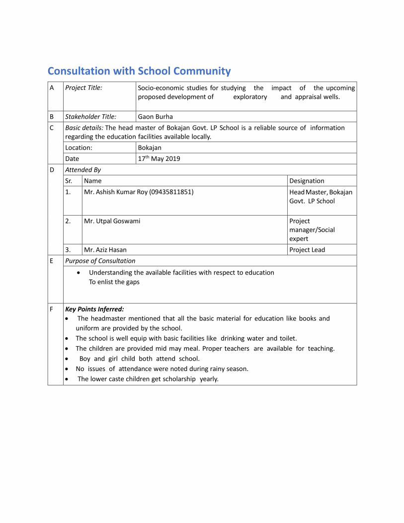
Consultation with School Community
A Project Title: Socio-economic studies for studying the impact of the upcoming proposed development of exploratory and appraisal wells.
B Stakeholder Title: Gaon Burha
C Basic details: The head master of Bokajan Govt. LP School is a reliable source of information regarding the education facilities available locally.
Location: Bokajan
Date 17th May 2019
D Attended By
Sr. Name Designation
1. Mr. Ashish Kumar Roy (09435811851) Head Master, Bokajan Govt. LP School
2. Mr. Utpal Goswami Project manager/Social expert
3. Mr. Aziz Hasan Project Lead
E Purpose of Consultation
• Understanding the available facilities with respect to education
To enlist the gaps
F Key Points Inferred:
• The headmaster mentioned that all the basic material for education like books and
uniform are provided by the school.
• The school is well equip with basic facilities like drinking water and toilet.
• The children are provided mid may meal. Proper teachers are available for teaching.
• Boy and girl child both attend school.
• No issues of attendance were noted during rainy season.
• The lower caste children get scholarship yearly.

Consultation with Bokajan Block Primary Health Centre LHS
A Project Title: A Socio-economic studies for studying the impact of the upcoming proposed development of exploratory and appraisal wells
B Stakeholder Title: Gaon Burha
C Basic details: : The interviewee was a reliable source of information regarding the available health related facilities and the local morbidity pattern
Location: Bokajan
Date 17th May 2019
D Attended By
Sr. Name Designation
1. Ms. Reena Dutta (07086694894) LHS
2. Mr. Utpal Goswami Project Manager
3. Mr. Aziz Hasan Project Lead
E Purpose of Consultation
• To understand the common diseases and morbidity pattern
F Key Points Inferred:
• The hospital has 14 nurses and 3 lab assistants.
• The laboratory tests in the hospital are done free of charge.
• The hospital largely caters to delivery cases. Seasonal fever, cough and cold were
reportedly the major concerns.
• Incidence of TB and malaria was was also reported.
• Skin infections are also common. Occasional cases of elephant injury and other
accidents were reported. Local residents complained of poor air quality, eye and skin
irritation and frequent coughing and lung related problems
• The Cement factory had its own hospital for its staff.

Consultation with Village Community
A Project Title: Socio-economic studies for studying the impact of the upcoming proposed development of exploratory and appraisal wells
B Stakeholder Title: Gaon Burha
C A Basic details: The person is head person in the village. He carries out administrative roles and basic document processing.
Location: Satsong Gaon
Date 18th May 2019
D Attended By
Sr. Name Designation
1. Mr. Jeeten Engti Gaon Burha
2. Mr. Utpal Goswami Project Manager/Socila Expert
3.
E Purpose of Consultation
• To understand the socio-economic condition of the village
• To know basic facilities availed by the people
• To study cultural aspects of the village
• To understand attitude towards any development project
• To understand problems of the villagers and their needs
F Key Points Inferred:
• The Gaon Burha elaborated upon the number of houeholds and social structure in the village.
• He described the availability of basic amenities in the village, but claimed that they were not
adequate.
• He also rued the lack of better roads and drinking water facilities.

Appendix 7.1 Leak
Sizes, Inventories
and Hazardous
Chemicals within
the Isolatable
Sections

Appendix 7.1- information on leak sizes, inventories and hazardous chemicals within the isolatable sections.
Table 1: Inventory used, Time Assumptions, Leak Sizes, & Flow Rate Etc.
S.
No
Isolatable
Section
Line
Size
Flow
rate/Cap
acity
Temper
ature
(deg C)
Pressur
e (bar)
physica
l state
Leak Sizes
(mm)
ESDV closure
time utilized for
inventory (in
min)
Remark
Comments
1 From Well Fluid
from Well to Inlet
of Heater
Separator
200
mm
2000
BOPD
25 55 2
Phase-
Liquid
and Gas
Small Leak : 5
mm
Medium Leak :
25 mm
Large Leak :
100 mm
Catastrophic :
200 mm
5 minute
3 minute
2 minute
1 minute
2 Heater Treater
Separator – Oil
Case
200
mm
2000
BOPD
(10.5 * 6.5
m)
75 3 Liquid Small Leak : 5
mm
Medium Leak :
25 mm
Large Leak :
100 mm
Catastrophic :
200 mm
5 minute
3 minute
2 minute
1 minute
This section
is modelled
(100% as oil)
3 Heater Treater
Separator – Gas
Case
200
mm
5 mmscfd
(10.5 * 6.5
m)
75 3 Gas Small Leak : 5
mm
Medium Leak :
25 mm
Large Leak :
100 mm
Catastrophic :
200 mm
5 minute
3 minute
2 minute
1 minute
1. This
section is
modelled
(100% as
Gas)
2.
Dimensions
are taken
from Layout
Block

S.
No
Isolatable
Section
Line
Size
Flow
rate/Cap
acity
Temper
ature
(deg C)
Pressur
e (bar)
physica
l state
Leak Sizes
(mm)
ESDV closure
time utilized for
inventory (in
min)
Remark
Comments
4 Oil from Heater
Treater
Separator to
inlet of Oil
Storage Tanks
including
coaleser
separator
150 6* 2.5 75 3
Liquid Small Leak : 5
mm
Medium Leak :
25 mm
Large Leak :
100 mm
Catastrophic :
150 mm
5 minute
3 minute
2 minute
1 minute
Dimensions
are taken
from Layout
Block
5 From XSV of
tank inlet to
pump inlet
including Oil
Storage Tank
150 1000
bbls
75 Atm Liquid Small Leak : 5
mm
Medium Leak :
25 mm
Large Leak :
100 mm
Catastrophic :
150 mm
5 minute
3 minute
2 minute
1 minute
6 From Oil Transfer
pump outlet to
tanker loading
Facility
150 1000
bbls
75 10 Liquid Small Leak : 5
mm
Medium Leak :
25 mm
Large Leak :
100 mm
Catastrophic :
150 mm
5 minute
3 minute
2 minute
1 minute
10 bar is
considered
as per best
practice
7 Oil Tanker Failure - 10 KL Amb Atm Liquid Catastrophic
Rupture
-

S.
No
Isolatable
Section
Line
Size
Flow
rate/Cap
acity
Temper
ature
(deg C)
Pressur
e (bar)
physica
l state
Leak Sizes
(mm)
ESDV closure
time utilized for
inventory (in
min)
Remark
Comments
8 Diesel Storage
Tank
100 60 KL Amb Atm Liquid Small Leak : 5
mm
Medium Leak :
25 mm
Large Leak : 50
mm
Catastrophic :
100 mm
5 minute
3 minute
2 minute
1 minute
9 Fuel Gas System 200 5 mmscfd 75 3 Gas Small Leak : 5
mm
Medium Leak :
25 mm
Large Leak :
100 mm
Catastrophic :
200 mm
5 minute
3 minute
2 minute
1 minute
10 Flare System 200 5 mmscfd 75 1.2 Gas Small Leak : 5
mm
Medium Leak :
25 mm
Large Leak :
100 mm
Catastrophic :
200 mm
5 minute
3 minute
2 minute
1 minute

Vedanta Limited.
(Division CAIRN Oil & Gas)
DRAFT EIA: Onshore Oil and Gas Exploration and Appraisal in AA-ONHP-2017/1 block in Karbi Anglong and
Golaghat districts of Assam & Wokha district of Nagaland
September,2019 AECOM
215
Related Documents