1 Earth System Science Organization Ministry of Earth Sciences DRAFT APPROACH PAPER FOR THE 12 TH FIVE YEAR PLAN (2012‐2017) 1. INTRODUCTION The Ministry of Earth Sciences was established in the year 2006 by bringing all the agencies of meteorological and ocean development activities under one umbrella. The sole purpose of the endeavour is to address holistically various aspects relating to earth system processes for improving forecast of the weather, climate and various natural geohazards. The ministry inter alia is primarily responsible for development of technology towards the exploration and exploitation of marine resources in a sustainable way for the socio‐economic benefit of the society by taking into account the global developments in the field of marine environment and to provide a wide range of meteorological services to the Indian public in general and to the various sectors specifically. The MoES area of competence covers a gamut of policies and programmes that contribute to the areas of Weather (General), Weather advisories specific to agriculture, aviation, shipping, sports, etc, Monsoon, Disasters (cyclone, earthquake, tsunami, sea level rise), Living and non‐living resources (fishery advisory, poly‐metallic nodules, gas hydrates, freshwater etc), Coastal and Marine Ecosystems and Climate Change, UT through use ocean science and technology. The Ministry primarily aimed to develop and improve capability to forecast, weather, climate and hazard related phenomena for societal, economic and environmental benefits including addressing climate change science and developing climate services and integrated Himalayan meteorology, secondly, exploring ocean resources for socio‐economic benefit including develop required state‐of‐the art technology for harnessing marine non‐living resources is major mission of the ministry. One of the prerequisites to achieve this is to defining and deploying satellite based, airborne and in‐situ atmospheric, ocean and lithosphere observing systems, which is also a part of the mission. The institutions of the atmosphere sciences, viz. India Meteorological Department (IMD), National Centre for Medium Range Weather Forecasting (NCMRWF) and Indian Institute of Tropical Meteorology (IITM) and Institutions under the Department of Ocean Development (DOD), i.e. National Centre for Antarctic and Ocean Research (NCAOR), National Institute of Ocean Technology (NIOT), Indian National Centre for Ocean Information Services (INCOIS), Centre for Marine Living Resources (CMLRE) and Integrated Coastal and Marine Area Management (ICMAM) were grouped under the MoES. These institutions are under Earth System Science Organization (ESO), managed by the ESO Council. The overarching vision of the ESO is to excel in knowledge and technology enterprise for the earth system science realm towards socio‐economic benefit of the Indian sub‐ continent and in the Indian Ocean region. MoES leadership in Earth System Studies in India has three major components: • Provide scientific and technical support for both academic and applied research in Earth System sciences as a whole comprising the atmosphere, hydrosphere, cryosphere and

Draft Approach12th FiVE YEAR PLAN
Dec 20, 2015
draft approach
Welcome message from author
This document is posted to help you gain knowledge. Please leave a comment to let me know what you think about it! Share it to your friends and learn new things together.
Transcript

1
Earth System Science Organization Ministry of Earth Sciences
DRAFT APPROACH PAPER FOR THE 12TH FIVE YEAR PLAN (2012‐2017)
1. INTRODUCTION
The Ministry of Earth Sciences was established in the year 2006 by bringing all the agencies of meteorological and ocean development activities under one umbrella. The sole purpose of the endeavour is to address holistically various aspects relating to earth system processes for improving forecast of the weather, climate and various natural geohazards. The ministry inter alia is primarily responsible for development of technology towards the exploration and exploitation of marine resources in a sustainable way for the socio‐economic benefit of the society by taking into account the global developments in the field of marine environment and to provide a wide range of meteorological services to the Indian public in general and to the various sectors specifically. The MoES area of competence covers a gamut of policies and programmes that contribute to the areas of Weather (General), Weather advisories specific to agriculture, aviation, shipping, sports, etc, Monsoon, Disasters (cyclone, earthquake, tsunami, sea level rise), Living and non‐living resources (fishery advisory, poly‐metallic nodules, gas hydrates, freshwater etc), Coastal and Marine Ecosystems and Climate Change, UT through use ocean science and technology. The Ministry primarily aimed to develop and improve capability to forecast, weather, climate and hazard related phenomena for societal, economic and environmental benefits including addressing climate change science and developing climate services and integrated Himalayan meteorology, secondly, exploring ocean resources for socio‐economic benefit including develop required state‐of‐the art technology for harnessing marine non‐living resources is major mission of the ministry. One of the prerequisites to achieve this is to defining and deploying satellite based, airborne and in‐situ atmospheric, ocean and lithosphere observing systems, which is also a part of the mission. The institutions of the atmosphere sciences, viz. India Meteorological Department (IMD), National Centre for Medium Range Weather Forecasting (NCMRWF) and Indian Institute of Tropical Meteorology (IITM) and Institutions under the Department of Ocean Development (DOD), i.e. National Centre for Antarctic and Ocean Research (NCAOR), National Institute of Ocean Technology (NIOT), Indian National Centre for Ocean Information Services (INCOIS), Centre for Marine Living Resources (CMLRE) and Integrated Coastal and Marine Area Management (ICMAM) were grouped under the MoES. These institutions are under Earth System Science Organization (ESO), managed by the ESO Council.
The overarching vision of the ESO is to excel in knowledge and technology enterprise for the earth system science realm towards socio‐economic benefit of the Indian sub‐continent and in the Indian Ocean region. MoES leadership in Earth System Studies in India has three major components:
• Provide scientific and technical support for both academic and applied research in Earth
System sciences as a whole comprising the atmosphere, hydrosphere, cryosphere and

2
the geosphere, with particular reference to the Indian sub‐continent and the surrounding oceans as well as the Polar Regions.
• Provide the Nation with the best possible services in forecasting the monsoons and other
weather/climate parameters, ocean state including early warnings to natural disasters like storm surge, earthquakes, tsunamis and other phenomena through well integrated programs.
• Support science and technology development for exploration and exploitation of ocean
resources (living and non‐living), ensuring their sustainable utilization. The goals of the Ministry are being pursued through its Centres viz., autonomous bodies and
subordinate offices as detailed in the organization chart
Ministry of Earth Sciences
Earth Commission
Earth System Science Organization
India Meteorological Department
Centre for Marine Living Resources and Ecology
National Centre for Medium Range Weather Forecasting
Integrated Coastaland Marine Area Management
Indian Institute of Tropical Meteorology
National Centre for Antarctic and Ocean Research
National Institute of Ocean Technology
Indian National Centre for Ocean Information Services
Centre for Climate Research
Advanced Training in School
National Centre for Seismology
2. ACHIEVEMENTS OF THE 11TH FIVE YEAR PLAN (2007‐2012)
The ESO through its various units has been providing operational service in the field of weather and specific services related to aviation, potential fishery advisory, ocean state forecast as well as advisories related to cyclone and floods. The major achievements, , are given below.
2.1 Atmospheric Sciences and Services
Modernisation of IMD Phase‐I: One of the major programs launched by the ministry during 11th Plan is Upgradation of Weather Forecasting in India, which has 4 components viz., Atmospheric Observational network; strengthen the computing facilities, data integration and generation products, dissemination of information. Considerable progress has been achieved in all the areas except in the atmospheric observational networks which are as detailed below
3
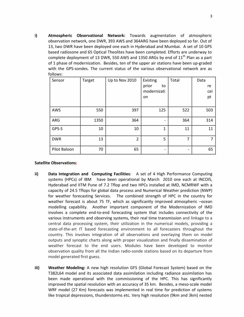
i) Atmospheric Observational Network: Towards augmentation of atmospheric observation network, one DWR, 393 AWS and 364ARG have been deployed so far. Out of 13, two DWR have been deployed one each in Hyderabad and Mumbai. A set of 10 GPS based radiosone and 65 Optical Theolites have been completed. Efforts are underway to complete deployment of 13 DWR, 550 AWS and 1350 ARGs by end of 11th Plan as a part of 1 phase of modernization. Besides, ten of the upper air stations have been up‐graded with the GPS‐sondes. The current status of the various observational network are as follows: Sensor Target Up to Nov 2010 Existing
prior to modernization
Total Data receipt
AWS 550 397 125 522 503
ARG 1350 364 ‐ 364 314
GPS‐S 10 10 1 11 11
DWR 13 2 5 7 7
Pilot Baloon 70 65 ‐ ‐ 65
Satellite Observations: ii) Data Integration and Computing Facilities: A set of 4 High Performance Computing
systems (HPCs) of IBM have been operational by March 2010 one each at INCOIS, Hyderabad and IITM Pune of 7.2 Tflop and two HPCs installed at IMD, NCMRWF with a capacity of 24.5 Tflops for global data process and Numerical Weather prediction (NWP) for weather forecasting Services. The combined strength of HPC in the country for weather forecast is about 75 TF, which as significantly improved atmospheric –ocean modelling capability. Another important component of the Modernization of IMD involves a complete end‐to‐end forecasting system that includes connectivity of the various instruments and observing systems, their real time transmission and linkage to a central data processing system, their utilization in the numerical models, providing a state‐of‐the‐art IT based forecasting environment to all forecasters throughout the country. This involves integration of all observations and overlaying them on model outputs and synoptic charts along with proper visualization and finally dissemination of weather forecast to the end users. Modules have been developed to monitor observation quality from all the Indian radio‐sonde stations based on its departure from model generated first guess.
iii) Weather Modeling: A new high resolution GFS (Global Forecast System) based on the
T382L64 model and its associated data assimilation including radiance assimilation has been made operational with the commissioning of the HPC. This has significantly improved the spatial resolution with an accuracy of 35 km. Besides, a meso‐scale model WRF model (27 Km) forecasts was implemented in real time for prediction of systems like tropical depressions, thunderstorms etc. Very high resolution (9km and 3km) nested
4
WRF runs are done for exclusive case studies of severe weather. NCMRWF was regularly providing NWP guidance in form of its global and regional analysis and forecast products. Global model assimilation utilizing 4D VAR is being done on experimental basis using the new HPC system.
iv) Agricultural Meteorological Services: Based on the weekly forecast of weather
comprising maximum and minimum temperature, rainfall, cloud cover and surface humidity, advisories for farmers have been developed along with Agricultural universities. These services are available in 539 districts. Through this service, farmers receive farm‐based advisories on time of sowing of weather‐sensitive high yield variety of seeds, need‐based application of fertilizer, pesticides, insecticides, efficient irrigation and harvest. The services are also made available through web and mobile. Currently over 8.5 lakhs farmers have subscribed for receiving this information through mobile.
v) Aviation services: These services are provided through a network of four Meteorological
Watch Offices (MWOs) located at the four major international airports at Chennai, Kolkata, Mumbai and New Delhi and other aviation meteorological offices located at other airports in the country. Monitoring system of the weather and visibility conditions within the airport area (especially visibility over runways) has been taken up through the commissioning of state‐of‐the‐art Automatic Weather Observation Systems (AWOSs) with a continuous monitoring of Runway Visibility Range (RVR). The real time RVR conditions, measured at Delhi airport, are uploaded to the IMDs web portal in Delhi during the winter of 2009‐10 along with the fog forecast products. A frame work of dynamical‐statistical models for forecasting the changing visibility conditions for the airports of north India has been firmed up and is implemented at Delhi International Airport.
vi) Sports including Adventure Sports: Customized forecast for mountaineering expeditions
were issued with constant interaction with expedition teams and coordination with their headquarters. The forecast bulletin for mountain expeditions for Mt. Dhaulagiri to Army Adventure Wing and for Mt. Everest to the Nehru Institute of Mountaineering was issued from 20th April. Meteograms for the Mount Satopanth, the Mount Stok Kangri, the Mount Chaukhamba and the Mount Shivling as requested by Army Adventure Wing were provided. For the first time location specific weather forecast and air quality monitoring for Commonwealth Games 2010 was carried out in this country. This system a challenging one was in place in a record time with indigenous capability which received wide appreciation. The initiative named as "System of Air Quality forecasting and Research (SAFAR)". It has been successfully tested during the commonwealth Games 2010 for National Capital Region Delhi. Our vision is to spread the SAFAR to other major cities in India and to put our country in frontiers of Air Quality Forecasting Research. The SAFAR provided location specific information on Air Quality in near real time and its forecast 24 hours in advance. It is complemented by the weather forecasting system designed by IMD, New Delhi. The ultimate objective is to increase the awareness among general public regarding the air quality in their city well in advance so that appropriate mitigation action and systematic measures can be taken up for the betterment of air quality and related health issues. Considering the success of the project, the facility would be extended to other Metro cities of India.
5
vii) Hydrological service: Based on real time daily rainfall data, weekly district wise, sub‐
division wise and state wise/season wise rainfall distribution summaries are prepared in the form of rainfall tables and maps. District wise and subdivision wise rainfall statistics provide important information useful to the agricultural scientists, planners and decision makers. The inputs on rainfall to Central Water Commission (CWC) through 10 Flood Meteorological Offices (FMOs) established in different parts of India for operation Flood Forecasting. Flood, QPF (Quantitative Precipitation Forecast) were issued by FMOs and supplied to Central Water Commission for flood forecasting purposes. A MOS technique is being developed for QPF with a pilot project on Mahanadi basin. Design Storm Studies were conducted to evaluate design storm estimates (rainfall magnitude and time distribution) for various river catchments/ projects in the country, for use as main input for design engineers in estimating design flood for hydraulic structures, irrigation projects, dams etc. on various rivers. During the current year, 49 projects have been completed and results communicated to concerned project authorities.
viii) Environmental Service: The network for Air Pollution Monitoring stations have been set
up at Allahabad, Jodhpur, Kodaikanal, Minicoy, Mohanbari, Nagpur, Port Blair, Pune, Srinagar and Visakhapatnam to collect rain samples for chemical analyses and measurement of atmospheric turbidity with the objective of documenting the long‐term changes in composition of trace species of the atmosphere. These data provide reliable long‐term observations of the chemical composition of the atmosphere and related parameters in order to improve understanding of atmospheric chemistry. Specific services pertaining to environment are rendered to the Ministry of Environment and Forests and other Government agencies in the assessment of likely air pollution impacts arising from thermal power generation, industries and mining activities. Atmospheric diffusion models developed for carrying out air quality impacts of multiple sources located in different climatic and geographical conditions are being utilised for setting up of industries and adoption of air pollution control strategies.
2.2 Disaster Support i) Tsunami Warning System: A state‐of the‐art tsunami warning system was set up in
October 2007 as outlined in the Prime Minister’s twenty‐six thrust areas. The system comprises a network of seismic stations including international stations to compute earthquake parameters, simulated scenarios of travel time and run‐up heights at 1800 coastal locations in the Indian Ocean, observing platforms for sea level variations, both in deep sea and coast, robust communication and dissemination system, data centre and decision support system. In last three years, many earthquakes larger than 7‐ magnitude, which can cause tsunami, did occur. In all such cases necessary advisories were provided to all concerned within 15 minutes. This system is recognized as the Regional Tsunami warning System for the Indian Ocean and provided services to many countries in the Indian Ocean as well.
ii) Earthquake Monitoring, Prediction and Mitigation: A set of 17 broad‐band seismic
stations were set up and networked to estimate earthquake parameters in near real time. The earthquakes are being auto‐located and first information is sent within 15 minutes using both Indian seismic stations and over 364 global seismic stations configured

6
iii) Earthquake Pre‐cursor Studies: During the last two decades, India has been affected by
moderate to large earthquakes not only in the Himalayan region, but also in Peninsular Shield region. The ongoing Seismicity programme is a research driven programme with a long prospective to provide impetus to the studies related to seismology, which provides thrust to the earthquake‐ related studies and also to generate inputs for earthquake disasters mitigation. Efforts are also being made towards generation of long‐term, comprehensive multi‐parametric geophysical observations in seismically active areas, with a view to establish possible relationship between various earthquake precursory phenomenon and the earthquake generation processes. Specific R&D projects are planned to be evolved and supported, covering the following broad themes viz: Geodynamics of Himalayan region and earthquake hazard assessment; Deep crustal structure across the Indian continental margin; Studies of the Andaman subduction zone; Active faults; Climate and tectonics; Seismological studies; Crustal Deformation studies using GPS/ GNNS; Collateral geophysical studies; Earthquake engineering related studies; Setting up of Multi‐parametric Geophysical observatories; To set up Volcanic observatory at Barren Island besides providing support to the ongoing projects and other related aspects
iv) Micro‐zonation studies: Microzonation is a multi‐disciplinary and multi‐institutional
effort, which has direct application in disaster mitigation and management, urban development, planning, design and construction, and risk assessment to existing life & property, defense installations, heavy industry and public utilities and services, etc. During the last few years’ efforts have been made to take up microzonation studies for Delhi, Guwahati, Sikkim and Bangalore. While the microzonation of Guwahati and Sikkim has already been completed on 1:25000 scale, the work related to Delhi on 1:50,000 scale has been completed and the maps are being further refined on 1:10,000 scale
v) Vulnerability Maps: INCOIS has initiated work on cutting edge research areas such as:
(i) Multi‐hazard Vulnerability Mapping, (iii) Real‐time tsunami inundation modeling as well as (iii) 3‐D GIS. The broad scientific methodologies have been established and pilot work has been successfully completed for a few areas. A pilot project on 3 D GIS was undertaken in association with Industry Partners for the coastal stretch between Cuddalore and Nagapattinam. However, there is tremendous amount of work to be done to prepare maps for all the coastal vulnerable areas of the country that can be used by administrators not only for saving lives and property during disasters but for planning purposes as well. The Ministry plans to develop vulnerability maps for all the vulnerable areas of the country that can be used by administrators and risk managers not only for saving lives and property during disasters but for planning purposes in addition to Tsunami warnings. Tsunami hazard maps using mathematical models involving CARTOSAT have been prepared for the coast of Andhra in 1:25000 scales. Preparation of similar maps for the coasts of Andaman & Nicobar, Kerala, West Bengal and Orissa are in progress and shall be completed by 11th plan. Preparation of 1:5000 scale tsunami hazard maps for the coast of Orissa using ALTM data has been initiated and will be completed by the end of 11th plan.
vi) Cyclone Prediction: There has been significant improvement in the forecast of cyclones during the past four year which has been achieved primarily due to implementation of

7
high‐resolution models and augmentation of capability to acquire atmospheric and ocean data. The average operational forecast error for 24 hours track forecast is about 80 km and land fall errors is less 100 km However, continuous efforts are underway to improve the forecasts. This can be achieved through improved scientific understanding, enhanced observation network and improved modeling technique through collaborative research
Climate Change Science i. Centre for Climate Change Research: A dedicated centre for Climate Change Research to
address various scientific issues relating to climate change including impacts on sectors like health, agriculture and water has been set up in IITM, Pune. Extended Range Predictability of Monsoon Intra‐seasonal Variability (Active/ Break Monsoon Spells) is being investigated. Critical role of BSISO (Boreal Summer Intra‐seasonal Oscillations) in modulating the seasonal mean summer monsoon has been seen. Role of Stratiform rainfall in modifying the northward propagation of monsoon intra‐seasonal oscillation is studied. An analysis of daily rainfall over India during 1951‐2007 reveals an increased propensity in the occurrence of ‘monsoon breaks’ over the subcontinent both in the duration and frequency of monsoon breaks over the subcontinent – the causes for which were investigated using in situ, satellite and re‐analysis data products. While noting that the increasing trend of break monsoon condition is consistently related to changes in large sale monsoon circulation and vertically integrated moisture transport, the findings point to the role of sea surface temperature (SST) warming trend (0.015°C per year) in the tropical eastern Indian Ocean in inducing anomalous changes favorable for the increased propensity of monsoon breaks. Characteristics of wet spells (WS) and intervening dry spells (DS) are the most useful information in water‐related sectors. The information assumes greater significance in the wake of global climate change background and climate change scenario projections. There is a tendency for the first WS to start ~6 days earlier across the country and the last WS to end ~2 days earlier but this shift in dates of the rain spells is also mostly not significant.
ii. Climate Services and Climate data Centre: The preliminary climate products were
generated and supplied to the users, which includes real‐time climate monitoring and publication of Climate Diagnostics Bulletins for the Indian region and reporting of major anomalous climate events. Detailed special monsoon reports, High resolution daily gridded rainfall data (1°x1°) & (0.5°x0.5°).,High resolution daily gridded temperature data (1°x1°), High resolution gridded terrestrial climate of India, and Climatological summaries for districts and states are produced.
iii. Cloud Aerosol Interaction and Precipitation Enhancement Experiment (CAIPEEX), one
of the schemes of the 11th Five Year Plan of the IITM as a national experiment being carried out in three phases. Phase I and Phase II of the CAIPEEX have been conducted successfully in the monsoon season of 2009 and 2010 respectively. Phase III will be conducted in the monsoon season of 2011. All the national institutions and universities working in the area of aerosol observations, cloud physics and cloud‐modeling participated in this experiment. IITM is the leading and nodal agency for the CAIPEEX. First time an exhaustive data of cloud microphysics and vertical profiles of aerosol have been collected. The data have been quality controlled and made available to Indian

8
Scientific community within one month of completion of the experiment. The experiment opened a new era in the observational field of the atmospheric sciences in India.
iv. Advanced Training School: Towards human resource development in the field of earth
science, a state of‐the‐art Advanced Training School was established at Pune in 2009. The first batch of students would be out by the year end
2.3 Ocean Resources and Technology i) Poly Metallic Nodules Programme:
Under Survey & Exploration, a total area of 7858.59 sq. km was identified for potential mine site based on detailed chemical analysis, interpretation of the collected samples. . A 3‐Dimensional hydrodynamic sediment plume model was developed for its application to the Central Indian Ocean Basin (CIOB) in the PMN area as a part of Environmental Impact Assessment Studies. A Remotely Operable Artificial nodule laying system was deployed at the test site and artificial nodules were laid on the sea bed and collected crushed and pumped back to ship deck from a distance of 20 m from the sea floor to create nodule carpeted track. Optimization of direct smelting on 4 kg scale, optimization of reduction roasting with Talcher coal as redundant, preparation of Electrolytic Manganese Dioxide (EMD) from manganese cake, Ammonia Recovery from Ammonium Sulphate by electrochemical splitting, High Pressure Acid Leaching of Manganese Nodule .
ii) Comprehensive Swath Bathymetric Survey of EEZ: Swath bathymetric mapping of ~ 5,26,200 Sq Km ( ~28%) of the deep‐water regions of the EEZ beyond 500 M water depth has been completed. Some of the significant observations include the presence of channel‐levée systems between Ninety east Ridge to its west and Andaman Trench in east. 2 Seamounts off Lakshadweep, and pockmarks on the seabed off‐Goa.
iii) Ocean Ridge Minerals: Under Cobalt crust programme, multibeam map has been generated for the Afanasiy‐Nikitin Seamounts in equatorial region covering an area of around 40000 sq. km for the potential Cobalt crust resource. Reconnaissance sampling has yielded few crust samples which indicate co‐enriched crust occurrence in the northern and southern plateau region. Under Hydrothermal Sulphides, Acquisition, analysis and interpretation of high resolution geophysical data, deep CTD observations, water column, deep‐tow, TV‐grab and seabed sampling resulted in the identification of a significant hydrothermal plume over the slow spreading Carlsberg Ridge (CR). The observed prominent plume suggests that an active vent source is close by. Mapping of the rift valley and seabed sampling has been carried out.
iv) Gas Hydrates exploration, Gas hydrates with their abundant resource potential is
emerging as a potential fuel resource. The preliminary assessment of geological condition and limited available seismic data suggests high possibility of occurrence of large quantity of gas hydrates within the EEZ of India. The multi‐channel seismic data collected by various organisations has been evaluated and based on the data, two promising sites of 100 km x 100 km were identified and surveyed in the Krishna‐Godavari (KG) and the Mahanadi basins.. Towards this, a remotely operated Autonomous Coring System (ACS) has been developed which is equipped with tool handling system and cam gate assembly to drill each section of about 3 m

9
[approximately 100m sediment core], retrieve the sample, and store in magazine at the seabed in deep sea operation [3000 m]. The system is first of its kind and it is under development in collaboration with M/s Williamson & Associates (W&A), USA since August 2007. The major works include (i) acquisition of high resolution sparker data has been done in KG Basin (ii) Demarcation of the lateral extension of gas hydrates and free‐gas bearing sediments based on velocity anomalies across the Bottom Simulating Reflectors (BSR) along a seismic line in the Makran accretionary prism, (iii) Estimation of ~35% gas hydrates in the fractured shale in the KG Basin for the first time based on sophisticated effective medium modelling of sonic log data. A total of 6660 line km of coarse grid data (with line spacing of 8 to 12 km) and 1067 km of fine grid seismic reflection data(with line spacing of 500 m) was acquired. In addition, 48 deployments of Ocean Bottom seismometer were carried out with acquisition of 1055 line km of seismic refraction data. The seismic data is expected to provide the sediment profiles revealing signatures of gas hydrates.
v) Delineation of the outer limits of the Extended Continental Shelf: Under the UN Convention on the Law of the Sea, every coastal Nation has sovereign rights to a continental shelf out to 200 nautical miles from its coastal baselines, (or out to a maritime boundary with an adjacent or opposite coastal State) and beyond that distance, if certain criteria are met. Although out to a distance of 200 nautical miles the continental shelf is coincident with the exclusive economic zone (EEZ) of a country, the shelf beyond 200 nautical miles is not an extension of the EEZ. Sovereign rights that apply to the EEZ, such as the rights to the resources of the water column above do not apply to this extended shelf beyond 200 nautical miles. The process of determination of the outer limits of a coastal Nation’s extended continental shelf involves the collection and analysis of data that describe the bathymetry as well as the geophysical characteristics of the seabed and sub‐sea floor. Considering that India’s continental shelf extends beyond the 200 nautical miles from the territorial sea baselines, the Ministry undertook a major multi‐institutional national programme of collecting, processing, analyzing and documenting the requisite scientific and technical information for delineating the outer limits of the continental shelf in the Arabian Sea and the Bay of Bengal including the western offshore areas of the Andaman‐Nicobar Islands. Pursuant to a decision by the Government of India, the first partial submission for an extended continental shelf under the provision of article 76 was made to the UN Commission on the Limits of the Continental Shelf on the 11th May 2009. On the 16 August 2010, a six‐member delegation led by Secretary, MoES made a formal presentation of India’s submission before the Commission on the Limits of the Continental Shelf at the UN Headquarters, New York. A second partial submission for another part of the extended shelf under the provisions of the Statement of Understanding has also been finalised and provided to the MEA for filing before the CLCS. With the anticipated addition of approximately 1.2 million square km of extended continental shelf from the two submissions to the ~2 million sq. km of EEZ, India’s seabed‐sub seabed area would become almost equal its land area of 3.3 million sq. km.
Considering the huge amount of geoscientific data gathered in the course of the programme and its intrinsic and strategic value, a National Marine Geophysical Data Centre has been established at NCAOR with state‐of‐the‐art archival and retrieval

10
facilities of the geoscientific data in a structured database. This datacenter developed through a contractual agreement with a service provider won the 2010 Computer Society of India‐Nihilent e‐Governance Award under Project ‐ G2G Category
vi) Low Temperature Thermal Desalination (LTTD): A LTTD barge‐mounted plant of 1
million litre per day was successfully demonstrated off Chennai (Tamilnadu) in April, 2007. The LTTD technology was also demonstrated using waste heat from Power Plant the North Chennai Power Plant and produced fresh water in Feb 2009. The capacity of the plant is 1 lakh liter per day. The Kavaratti plant has been working since May 2005. Besides, 3 more desalination plants of 1 lakh liter capactity, one each are being setup at Minicoy, Agatti and Androth of the Lakshadweep Islands. Currently, Public‐Private Partnerships are being explored for further development of the technology for up‐scaling to capacities of the order of 10 million lpd offshore plant.
vii) Launch of a Technology Demonstration Vessel‐ Sagar Nidhi: A multi‐purpose vessel was
acquired in December 2007. The vessel equipped with the state‐of‐the art facility. This new facility will also cater to shallow water survey, and act as a supply and support platform for the various coastal and deep ocean activities. This vessel is capable of conducting multi‐disciplinary studies in the sea continuously for 45 days with 30 Scientists onboard the vessel. This is an ice class vessel of 5050 tones, equipped with state‐of‐the‐art facilities for launching and testing various Marine equipment including ROV, AUV and Manned Submersible.
viii) Deep‐sea Technology Development: India has been working to harness ocean mineral
resources. In view of this, collaboration with Russian scientists have developed and tested an instrument to measure sea bed soil properties in‐situ, at a depth of 5200 m. A coring system with 100 m core collecting capability up to 3000m water depth has been developed with the help of foreign partner. It would be demonstrated during 2010. (As a part of technology development for harnessing the Gas Hydrate Technology) The Deep water trials of ROSUB (remotely operable vehicle) were conducted successfully for integration and testing of Launching and Recovery system at a depth of 5289 m in April 2010. The complete hardware and software for the instrumentation and control system was developed by the Indian scientists. India has been elected as Member of council in investor’s category of the International Seabed Authority (ISA) for a period of 5 years beginning 2009. Besides, the deep‐sea Mining System was tested successful in Angria Bank (off coast of Malvan) at 512 m depth after laying artificial nodules during September –October 2010.
2.4 Defining and deploying satellite‐based, airborne and in situ atmospheric, ocean and lithosphere observing systems.
IMD aims to emerge as a transformed and globally competitive organization, fully equipped with modern observational systems and network capable of providing to the Nation knowledge based services hitherto unavailable. Strengthened Atmospheric Observing Systems by completing installation of over 800 systems, including Automatic Weather Station (AWS), Automatic Rain gauge (ARG), Doppler Weather Radar (DWR), GPS sonde, wind profiles, etc. Efforts are underway to complete deployment of 13 DWR, 550 AWS and 1350 ARGs by end of 11th Plan as a part of 1 phase of modernization.

11
Besides, ten of the upper air stations have been up‐graded with the GPS‐sondes. A ground station for reception of INSAT‐3D has been set up with installation of Data Processing software for generating data products. An instrumented air‐craft was chattered during monsoon period to conduct Cloud Aerosol Interaction experiments. Efforts are underway to acquire an aircraft for routine monitoring of atmospheric parameters. Creation of Mesonet for Metros where weather events cause heavy losses are required to be completed in 5 years. In addition to the existing conventional sensors, ground based microwave radiometers which complement for obtaining humidity and temperature profiles are to be established. Ground based radiometers will provide temperature and humidity profiles and complements the sonde observations. This is advance technology, to be developed with priority. Global Positioning System (GPS) based columnar (integrated) water vapour measurement to be implemented, initially for every 100 kms, to be enhanced suitably in a phased manner. Troprosphiric stratospheric (ST) Radars, established on a 500‐500 km grid can provide continuous data as inputs for accurate weather modeling. Boundary layer wind profilers covering the height range of 0.1 to 4 km can operate at relatively high frequencies (915‐1300 mHz) and hence be small and inexpensive enough to cover the country initially approximately on a 200‐200 km. grid, on a 100‐100 km grid in the medium term and eventually on 50‐50km. Grid.
2.5 Polar Science i) Antarctic Expeditions: Four Indian Scientific expeditions to Antarctica (27 to 30) were
successfully undertaken during 2007‐11, while the next (31st) expedition is planned to be launched during October – November 2011. In the course‐of the winter and summer seasons of 2007‐11, scientific data collection pertaining to projects in the disciplines of Earth Science, Glaciology, Atmospheric sciences, Biology, Environmental sciences, Engineering and Communication besides the logistic tasks critical to the expeditions were accomplished.
Some of the highlights of the work carried out in Antarctica are as follows:
• A digital Ionosonde System with two cross Delta antennas were installed at Maitri to
study Short and Long Term Variation of Ionosphere and magnetospheric‐ionospheric coupling between high and low latitudes during space weather events.
• A magnetic observatory was operated at Maitri for monitoring variation in the Earth’s magnetic field.
• Microbiological studies carried out on fresh snow deposits in coastal Antarctica reveal the crucial role of bacteria in the air‐snow biogeochemical cycling in this region. Glaciochemical and microbiological study of snow from coastal Larsemann Hills, East Antarctica reveal that elevated nutrient concentrations in ice cap snow are responsible for the observed high bromide concentration in snow related to the enhanced growth of microalgae in snow and subsequent production of bromo‐carbons.
• Geological Mapping between 20 to 30 east longitudes in Gjelsvikfjella was carried out utilising the Norwegian station Troll (S. Lat. 720 0’ 7” & E. Long. 20 32’ 2”) as a base.
• Delineation of the Land‐Ice‐Sea (LIS) interface (Hinge‐line) around Schirmacher Oasis, central Dronning Maud Land (cDML) was carried out.

12
• Monitoring the variation in the Earth’s magnetic field was taken up and continued with a view to understanding
storm – substorm relationship the global signature in the atmospheric electrical parameters the Decline in Total Magnetic Field ‘F’ observed in southern hemisphere, especially
over Antarctic continent; and the ionospheric TEC, scintillation and tropospheric water vapor content • A major multidisciplinary study to understand the late Quaternary climatic conditions of
East Antarctica was initiated utilising sedimentological, palynological, and geochemical proxy indicators in the lake sediments of Schirmacher Oasis.
ii) South Pole Scientific Expedition: For the first time, India launched a scientific expedition to the South Pole on 13th November 2010 from Maitri. The 8‐member team collected valuable atmospheric aerosol data and several short ice cores in the course of its transect from the Schiramcher Oasis to the South Pole The team reached the South Pole on 22nd November, 2010. and on completion of all the scientific tasks, returned to ‘Maitri’ on 1st December 2010.
iii) Arctic Expedition: India embarked upon the Arctic research by launching First Indian
scientific expedition to Arctic ‐ in the first week of August 2007 using the international research facility at Ny‐Alesund in Spitsbergen island of Norway. Subsequently India has been sending scientific teams every summer and winter for carrying out studies in the Arctic, primarily in the fields of glaciology, hydrochemistry, microbiology, and atmospheric sciences. A station building “HIMADRI” was taken on lease from the International Arctic facilities owned and managed by M/s Kings Bay. The station building with accommodation and work space for a total of 8 scientists, was formally inaugurated on the 1st July 2008 by HMoES. Action has been initiated to equip the station with basic facilities for data acquisition in atmospheric science studies and sample preparation in the field of geological and biological sciences. Already a system for real‐time data transmission in place. An MoU was signed between NCAOR and NPI for collaborative scientific endeavors in the fields of glaciology, microbiology, geology and atmospheric sciences India was unanimously elected as a member of the Ny‐Ålesund Science Managers Committee (NySMAC) at the 29th Meeting of NySMAC held at Brest, France on the 4th and 5th November 2008. A web‐based Arctic portal showcasing the various scientific activities of India in the Arctic has been developed at NCAOR.
iv) Establishment of the Third Indian Antarctic research Base: In pursuance of the
Government initiative to establish a new permanent Indian Base in Antarctica, a Task Force constituted by the Ministry undertook a reconnoitary visit to the Amery Ice shelf ‐Prydz Bay region of East Antarctica during February 2004 and recommended a rocky promontory between Quilty Bay and Thala Fjord in the central part of the Larsemann Hills as the most suitable site for the new Indian base. Following this, special teams were sent during the subsequent the expeditions to initiate collection of baseline environmental data at the proposed site for a Comprehensive Environmental Evaluation as well as to facilitate planning of the station infrastructure. A Draft Comprehensive Environmental Evaluation (CEE) as mandated under the Antarctic Treaty Consultative Meeting (ATCM) was prepared and the CEE was tabled for discussion and approval at the XXX Antarctic Treaty Consultative Meeting in Delhi, during April 2007. Based on the inputs and suggestions received from many member countries, a Cumulative Impact
13
Assessment study was carried out, employing prediction models i.e Industrial Source Complex‐Short Term (ISCST3) for air quality, Noise Prediction Model (Predictor 7810) for noise environment and CORMIX 6, model for dilution and dispersion study of wastewater discharge into sea. Additional data and important information on station design and initial environmental reference have been incorporated in final CEE report including discussions on baseline data.
A conceptual design of the station was obtained through Global Expressions of Interest solicited during the year 2006‐07 for innovative ideas and a consultant architectural firm was appointed. The pre‐construction activities commenced during the austral summer of 2009‐10, when the most critical task of putting in place the infrastructure necessary for the construction of the station was achieved successfully. All the heavy earthmoving / construction material and cargo, ranging from 5 to 47 metric tons were transported from ship to shore either by the two helicopters or by vehicles over the fast ice. A 250 m long road from landing site up to the helipad was also carved out. The Phase I construction activities of the station were initiated during the austral summer of 2010. The work taken up under this phase through a contractual agreement with M/s. Leonhard Nilsen & Sonner AS, Norway, comprises piling for the foundation for the main station building and erection of garage sump and walls, construction of helipad using pre‐cast concrete elements, construction of foundation of fuel farm using pre‐cast concrete elements, laying of pipeline for fuel, fresh and waste water, Site survey and foundation piling for the planned Satellite Ground station etc. The tender for the Phase II construction activities was floated and based on an evaluation of the responses received, M/s Kaefer Construction GmbH of Germany was selected to carry out the tendered work. The work is scheduled to commence during the austral summer of 2011.
v) Southern Ocean Studies
National Centre for Antarctic and Ocean Research, as the Nodal Agency took a lead role in the planning and execution of four multidisciplinary cruises in the Indian sector of the Southern Ocean that would enable a better understanding of the oceanographic processes in this part of the Southern Ocean during XI plan period. The fifth expedition is scheduled to set sail during January 2011.
vi) Acquisition of Ice‐class Research Vessel
Acquisition of Ice‐class Research Vessel with state‐of‐the art scientific equipments/ instrumentation has been approved at the total allocation of Rs. 490 cr. which is scheduled to be completed by March 2013. Consultant has been finalized for concept design and supervision.
2.6 Ocean Science and Services i) Ocean Observing System; Recognizing the importance of systematic ocean observation for the understanding of
structure and dynamics of ocean, to improve the predictability of ocean and climate, for the sustainable development of coastal ecosystem and for the generation of ocean

14
information and advisory services, a comprehensive ocean observation network program had been launched. The ocean observing systems, currently in operation can be broadly classified as (i) in‐situ observation systems that capture the changes in time at specific locations or along the ship tracks, (ii) the satellite based remote sensing systems that capture the spatial and temporal variations, synoptically, as ramified at the surface and sub‐surface. During the period, significant progress has been made in the ocean observing systems, with a mix of in‐situ platforms and satellite systems and concomitant capabilities in retrieval of data. The details of deployment against planned so far the plan period are as follows: Type of Platform Target for XI Plan Commissioned Argo Float 200 126 Drifters 50 43 Moored Buoys 12 7 XBT/XCTD 1000 857 Tide Gauges 45 25
HF Radars 10 10
Current Meter Array 10 7
ADCP 12 12 Tsunami Buoys 12 6 Wave Rider Buoy 8 3 The launch and operationalisation of the IRS satellite series, including Oceansat‐I and Oceansat‐II and the efforts by the Indian Space Research Organisation together with the satellite coastal and oceanographic research (SATCORE) project is making progress in the development of parameter retrievals.
ii) Ocean Modelling and Research:
The major accomplishments under the schemes being implemented through a network of pioneer research institutes in the field of ocean atmospheric modeling during the year are as follows: Established capability to run various global and regional models viz., HyCOM, MOM4, CUPOM, ROMS which has significantly improved ocean forecasting services., One of the major achievements of the Ocean Modeling team at INCOIS is the setting up of the Indian Ocean Forecasting System (IOFS). This is the first of its kind in the country and the set‐up of the system is being developed indigenously at INCOIS. The core of the IOFS is a state‐of‐art ocean general circulation model (OGCM), Regional Ocean Modeling System (ROMS), developed and distributed as open source code by Rugters University, New Jersey, USA. The model is customized to simulate the observed Indian Ocean features realistically by making appropriate changes in the model parameters and source code. At present, the model is forced with the 5‐day forecast data of surface wind fields and atmospheric fluxes from the atmospheric model of National Centre for Medium Range Forecast (NCMRWF), New Delhi. Accordingly, the IOFS also forecasts the oceanographic features for 5 days. The IOFS gives the forecasts on sea surface currents, sea surface temperature, mixed layer depth and the depth of the 20 deg. Isotherm as an indicator of the depth of thermocline. The forecasts are also being validated on a continual basis. A focused research and development approach will continue to support

15
the IOFS to meet the requirements of various users. Based on the feedback from the users and through focused research, the IOFS will be improved further in quality and quantity of services. The availability of High Performance Computing Facility at INCOIS will be extremely helpful in achieving the high goals. Improvement in initial values and position of the tropical cyclone utilizing state‐of‐the‐art 3DVAR data assimilation system of conventional and non‐conventional data sets over data sparse oceanic region including vortex re‐location and initialization including simulation of track and intensity of tropical cyclones through multi‐mesoscale model super ensemble forecasting system. Understanding the links between the variation of the Indian monsoon and the variation of the atmospheric convection over the equatorial Indian Ocean with the analysis of the observations. In the first three weeks of June 2009, there were no northward propagations across the Bay. Also, no low pressure systems were generated over the head Bay and naturally, the westward propagation of such systems across the Indian monsoon zone, which is characteristic of the onset phase of the monsoon, did not occur. Consequently, there was a massive deficit of (48%) in the all India rainfall in June 2009. The El Nino induced Indian Ocean winter warming is significant in the following winter and spring and persists for the summer as well. The basin scale deep warming in the west is associated with the local IOD forcing rather than the remote El Nino forcing. Indian Ocean warming induced anomalous climatic effects in Asia, Africa and NW Pacific.
iii) Ocean Services 1. Potential Fishing Zones (PFZ) Advisories: A unique system of Fishery Advisories based on
identification of potential fishing zones (PFZ) using remote sensing technology has been made operational. The PFZ advisories prepared in local languages and local measurement units are disseminated to over 225 nodes, thrice a week through innovative and novel initiatives such as Electronic Display Boards and Information Kiosks at the fishing harbors, radio, print media, emails and web sites supplementing fax and telephone and mobile. Over 93 electronic Display boards were installed in selected coastal areas for dissemination of the information.
2. Ocean State Forecasting: In January 2009, Indian Ocean Forecasting System (INDOFOS) was launched integrating existing forecasts of ocean wave and the surface and subsurface parameters of the Indian Ocean. The system, at present, provides forecast on wave heights, wave direction, sea surface temperature (SST), surface currents, mixed layer depth (MLD) and depth of 20oC isotherm up to 5‐7 days in advance. This system is operational since January 2010. The beneficiaries of INDOFOS are: traditional and mechanized fishermen, the maritime boards, Indian Navy, Coast Guard, shipping companies and oil and natural gas industries, energy industries and academia.
2.7 Coastal Marine Ecology i) Technology for fattening of Lobsters and mud crabs: A viable technology for fattening
lobsters and mud crabs in cages was successfully developed and disseminated to select beneficiaries in Gulf of Mannar in Tamil Nadu and Andaman Islands, on an experimental basis. There has been a substantial improvement in earnings of coastal fishermen due to implementation of this scheme. The technology for seaweed culture will be extended to

16
100 women beneficiaries in Gulf of Mannar region, 25 women beneficiaries each for lobster fattening in Gulf of Mannar and crab fattening in Andaman & Nicobar Islands.
ii) Island Development activities: Ornamental fish culture was established in 2009
Kavaratti to commercialize in Agatti Island of Lakshadweep. Other activities such as live‐bait culture, pearl culture, biodiversity studies etc of Lakshadweep will be taken up. Black‐pearl production in Andaman will be strengthened by imparting training to local people on nucleus implantation. Development, deployment and testing of open sea cage for open sea cage farming of fin fishes in mainland and A&N island. Mass culture of Micro algae in photobioreactor at Kavaratti Islands, Lakshadweep utilizing Deep ocean water upwelled by the Low Temperature Thermal Desalination plant for extraction of biochemicals. Digitization of island resource information for A & N islands
The Centre for Marine Living Resources and Ecology (CMLRE) has estimated systematically for the first time fish potential in the Indian EEZ of 4.32 MTA, in the Indian EEZ using satellite and insitu data
iii) Drugs from the Sea: In order to harness the bioactive compounds from the marine
organisms for human therapeutic purposes, the Ministry has been implementing with the participation of 14 different R& D Labs including Academia. Over 2,000 extracts of marine samples were screened for wide spectrum bioactivity including anti‐diabetic, anti‐hyperlipidemic, anti‐malarial, anti‐HIV, anti‐cancer, anti‐osteoporosis properties. There were 24 hits identified and from these fractions out of which 8 leads have been found potential. Four products are being developed for the clinical usage and are in the different stages of development. The Phase‐I Clinical Trial of CDR‐134‐D123 for anti‐diabetic property has been completed successfully. However, the CDRI has licensed this compound to M/s. TVC Shy Shop so as to develop the drug on herbal mode through AYUSH for faster track marketing. A database has been developed at CDRI and all the data generated are updated.
\ iv) Integrated Coastal Marine Area Management: Under the programme on Shoreline
management, problems of coastal erosion along the coast of Gopalpur (Orissa), Muthalapozhy, Vadanapally and Trissur (Kerala), Devbagh, Pavindurve and Kundapur kodi (Karnataka) and Gangavaram (Andhra) have been studied with extensive oceanographic data to provide solutions to the respective states. Under the programme on Ecosystem modelling, hydrodynamic modelling of Chilika and Kochi backwaters completed. Field investigations for ecosystem modelling for Sundarbans will be completed during 11th plan. Water quality criteria for copper, cadmium and mercury have been determined and be referred to the Central Pollution Control Board. Over 20 training programmes on hazard mapping, satellite oceanography, and marine pollution have been conducted.
v) Coastal Ocean Monitoring and Prediction System: Extensive monitoring of
marine pollution along the coastal waters was continued at 76 locations and it has been found that the disposal of untreated sewage from towns, cities and villages cause decrease of dissolved oxygen and increase of nitrate and pathogenic bacteria in the sea close to the shore. The data collected revealed that pollution problems are confined up to 1 km in the sea except at Mumbai where the pollution problem prevails up to 3 km in

17
the sea. Model to predict the movement of oil during oil spills has been developed for the coast of Chennai. Works to develop similar models for the coasts of Goa, Kerala and Visakhapatnam shall be completed by the end of 11th plan.
2.8 Outreach Activities: In order to propagate and bring awareness about the programmmes and achievements among the public, student and user communities, an effort to bring awareness among the public, Earth Day 2010 was celebrated on 22nd April across the country in 300 centre since 2008 educational and Science Centers. The film “Science Safari” in regional television channels in local languages on various activities of Ocean and Atmospheric Science and Technology, produced by the National Geography channel was telecast many a times, besides publishing popular article in “Frontline”, “Namaskar” and “Shrishti popular Magazines in English and “Bhugol aur Aap” in Hindi which is being distributed to various central school. Ministry supported participation of Indian students in the International Earth Science Olympiad. Indian team (4 students) bagged one Silver Medal and three Bronze medals at the Olympiad 2010. About 500 events are supported in area of Earth system science to provide platform to Scientists, Engineers, and Technologists. The beneficiaries are Indian Institute of Technology, CSIR labs, Universities, Government bodies, Non Governmental Organizations, etc.
3. STRATEGIES FOR THE 12TH FIVE YEAR PLAN
The Ministry has excelled in many areas of the earth system science, however, there are many areas, both in basic and applied sciences, that need to be organized with focused research to improve services for the society. In order to develop a long term Strategy and Perspective Plan for the Ministry, 4 Expert Committees were established under the chairmanships of distinguished scientists, with pioneer scientists as members in respective areas of specialization. The committees are in the fields of Atmospheric Science and Services, Ocean Science and Services, Cyrosphere/Geoscience, and Technology. Each expert committee has drawn up action plans to develop strategy plans in the respective areas. These committees have been working electronically to address the issues since their formation. Each committee has so far met more than a couple of times to brainstorm and discuss on various issues, taking into account current activities and future direction, for preparation of a draft document. During 21‐23 April 2010, the work of each expert committee was presented to the Earth System Science Organization (ESSO). This is the apex technical forum set up by the Ministry to provide direction to the Earth Commission established by the Government. Currently, the committees are in the process of reviewing the documents. The reports of the committees are expected to be finalized by December 2010 for making recommendations for research to be carried out for next few years. These documents formed basis for developing this approach paper. It is envisaged that this approach will be presented at the National Workshop for further fine‐tuning and decide priorities.
Some of the challenges in the field of earth sciences are being addressed by the on‐going programs. In order to meet the upcoming challenges particularly in the field of climate change, ocean resources, harnessing technology and natural disaster, it may be important to propose a few new initiatives.
The various activities are listed under five major areas.

18
i) Atmospheric and Climate Science Services ii) Ocean Science and resources iii) Polar science iv) Geo‐science and disasters v) Technology
3.1 ATMOSPHERIC & CLIMATE SCIENCE SERVICES
Modernisation of IMD (Phase‐II): 3.1.1 Atmospheric Modeling and Assimilation • Coupled Ocean‐atmospheric models will be the main tool used for seasonal forecasting
and prediction of future climate in the next 10 years. There are, however, several deficiencies in these models. These must be documented in detail. The errors in atmospheric model influence the ocean model and vice‐verse.
• The major deficiency in most atmospheric models is overestimation of deep convective rainfall and the underestimation of strait form rainfall. This deficiency leads to an unrealistic variation of latent heating with height and hence an unrealistic intra‐seasonal variation of winds, rainfall and clouds. This issue must be resolved by examining the sensitive of the model to the value of the various parameters use in the cumulus convection scheme.
• New data from ARGO floats have provided for the first time new information about the vertical profile of temperature and salinity in the oceans. The ability of ocean models to simulate these variations will be the real test of the accuracy of various parameterizations used in these models.
• The impact of aerosols on monsoon has emerged has one of major issues in the past decade. There are two competing hypotheses assumes that soot heats the atmospheric models and intensifies the monsoon. Aerosols must be incorporated in many atmospheric models and coupled models to unravel the impact of aerosols on the Indian monsoon. The role of dust, sulfate and soot on the radiative fluxes and clouds is poorly understood and hence not represented well in climate models.
• During the past decade, statistical models have done marginally better than dynamical models in the prediction of seasonal mean rainfall. There is a need to look for new statistical models for improving the forecast of seasonal mean rainfall. In the area of statistics, Indian mathematicians are renowned worldwide. They have, however, not worked in the area of statistical prediction of monsoon rainfall. Hence it may be worthwhile to encourage frequent interaction between scientists in the Indian statistical Institute and those in the Ministry of Earth Sciences.
• There has been a gradual improvement in the modernization of observation system in India but not all the observations are assimilated in atmospheric and ocean models. Most of the observations today are from satellites and hence it is important to undertake a major training program to teach the techniques radiance assimilation in atmospheric models.
• The prediction of seasonal mean monsoon rainfall alone is not sufficient from the perspective of the users. There is a need to understand intraseasonal variability for farming. For example, prediction of extreme rainfall may be relevant to event managers and sports events. Fertilizers industry needs prediction that can be directly used to predict how to move the fertilizer stocks. Crops insurance has become widespread in

19
India. These insurance companies need to understand the value of short term and long term rainfall prediction. This demands a greater interaction with the user industry.
• Atmospheric models have been shown to simulate the decadal rainfall better than inter‐annual variation of monsoon rainfall. Hence it is necessary to look more closely the accuracy of decadal rainfall prediction and tits value for policy makers.
3.1.2 Atmospheric Observing System • The variation of the vertical profile of humidity is one of the most important indicators of
the onset of an active or break phase of the monsoon. Hence an accurate and frequent measurement of this parameter is absolutely essential for the improvement of the prediction rainfall. This can achieved by both having more radiosonde stations and more measurement of humidity using microwave radiometers. More observation programs such as CAIPEEX must be conducted to ensure that we have an accurate data about the structure of clouds in the Indian region. This will help us to improve the parameterization of clouds in models.
• The Department of Space has proposed many new satellites with meteorological payloads. There is, however, a need for geostationary satellites to carry hyper‐spectral radiometers. This will provide new impetus for radiance assimilation in models.
• During the last decade the Tropical Rainfall Measurement Mission (TRMM) has provided the most valuable data on the nature of tropical convective systems. The ambitious Global Precipitation Mission (GPM) is proposed as a natural successor of TRMM. India should participate actively in this global mission to ensure that it reaps the benefits of this new mission.
• Geostationary Imaging Fourier Transform Spectrometer (GIFTS) and Geostationary Observatory for Microwave Sounding (GOMAS) are new concepts that promise to provide high resolution temporal data from space in both cloudy and clear scenes and This would improve the short term rainfall prediction and seasonal rainfall forecasting. This concepts need to be pursued vigorously.
• India must make long term plans to put parametric radars in space to obtain important data on the nature of clouds and cyclones from space.
• In view of he new challenges posed by global warming, it is essential to monitor greenhouse gases and aerosols’ from space in order to understand the local and global factors that influence climate change.
• During the last decade the impact of sea surface temperature (SST) variations in the Indian Ocean on the Indian monsoon rainfall has been highlighted. Hence it is essential that measurement of SST using passive microwave radiometers is undertaken to understand the interaction between SST and rainfall in the Indian region.
• The recently launched CLOUDSAT satellite has underlined the importance of cloud profiling radar for understanding the cloud microphysics. Hence it important to persuade ISRO to launch a cloud profiling radar in the next 5 year.
• The knowledge of soil moisture is important for both short term rainfall forecasting and as well prediction of crop yield. A microwave sensor similar to that used in SMOS (Soil Moisture and Ocean Salinity) mission will be essential.
• An improvement in the representation of clouds in models will come if and only if we have better data on the nature of clouds over India during the monsoon season. This can be obtained only if there is an instrumented aircraft that probes the clouds and provides information on cloud microphysics and the structure of downdrafts. The number of
20
scientist working in India in the area of cloud modeling is very small and this lacuna must be rectified quickly.
• The impact of aerosols on the mean droplet size in clouds is known but we do not have sufficient data in the Indian region to incorporate the impact of aerosols on clouds in climate models.
• During the past 5 years aircraft and LIDAR data have revealed that variation of aerosols with height can be quite complex. This will have an impact on the radiative fluxes and the information of clouds at various heights. There is a need for well‐calibrated measurements of solar radiation at various stations in India so that the impact of aerosols is known accurately.
• The chemical compositions of aerosols have an impact on the radiative forcing and the formation clouds. Hence there is a need for measure the chemical composition of aerosols in different parts of India.
• In the last few years, there has been a concern about the possible impact of soot on the melting of glaciers. Hence there is a need to make measurement of aerosols and radiative fluxes in a few Himalayan glaciers in a campaign mode.
• A permanent experimental station, similar to the Atmospheric Radiation Measurement (ARM) program of USA, must be set up in India so that all quantities relevant to atmospheric science is measured at a single site.
3.1.3 Cyclones
Global warming will lead to increase in the intensity of cyclones in the tropics. Hence, it is essential to develop models to improve the prediction of track and intensity of cyclones. The average operational forecast error of IMD for 24 hours track forecast is about 80 km. The landfall forecast of cyclones, based on the last five years’ data, the 12 hour and 24 hour landfall forecast errors are comparable with those of other ocean basins. Improvement to the cyclone track and landfall forecasts have been achieved in recent years due to recent technological advancements in respect of space based (advanced satellite sensors ‐ IR and Microwave; scatterometry/altimetry) and land‐ocean based (Automatic Weather Station – AWS Network; Data Buoys; High‐speed wind recorders – HWR Network; Automatic Rain Gauge – ARG Network; Doppler Weather Radar – DWR Network; Coastal Tide Gauge – CTG Network) observational systems. The modernization of the observation system as well as computing facilities in MoES should lead to improvements in the accuracy of cyclones predictions. There is a need to employ aircraft that can provide information on processes inside a cyclone.
3.1.4 Climate Change Services
The impact of climate change on various regions of India needs to be documented. There is some information available with regard to temperature and rainfall but there is a active break cycle, vegetation (from satellites), cloud height, and cloud fraction. The impact of global warming on sea level rise will depend both on sea level rise as well as the natural sinking of land in some areas. This must be documented so that local communities are better prepared for the impact of global warming. There are many policy makers who are seriously contemplating measures to mitigate global warming through geo‐engineering schemes. There is need to develop expertise in India to evaluate the benefits and risks of these schemes. During the past decade many field
21
campaigns have been conducted under the Indian field campaign can be conducted under the Indian Climate Research Program (ICRP). This program must be taken to a higher level so that field campaign can be conducted every year in the next 10 years. The new information obtained for such campaigns will provide the data for improvement of parameterization in climate models. In view of the concerns with regard to rapid retreat of Himalayan glaciers it is essential to undertake an evaluation of the health of the glaciers through satellite and ground observations.
3.1.5 Web based services
The rapid growth in aviation industry in India during the past decade has put new demands on metrological services to be provided to the aviation community. A web based aviation meteorological information dissemination system must be developed. The weather information should be uplinked to the pilot in the aircraft. Since extreme events are expected to increase due to global warming, it will be necessary to install instruments to measure low‐level wind‐shear in some airports to warn aircrafts during landing.
Water Cycle : 3.1.6 National Monsoon Mission
It is essential to work out a Modeling Framework and put it in use to predict seasonal mean climate in India. The Ministry of Earth Sciences (MoES) intends to launch a National Mission on Monsoon Prediction. A working partnership will be built up between the Academic R & D Organizations and the Operational Agency to improve the monsoon forecast skill. Under this mission the computational facilities at various MoES institutes will be made available to academic institutes that will be participating in the national mission. This needs to add the infrastructure beyond the medium range needs. Seasonal Prediction of Monsoon
• Recent studies have demonstrated the possibility of achieving improved skills in
simulating the seasonal mean monsoon rainfall by using ocean‐atmosphere coupled models. This improvement appears to result from more accurate representation of the coupled interactions between the Indian monsoon and the tropical oceans. It is planned to develop a fully coupled ocean‐atmosphere‐land modeling system for dynamical prediction of the seasonal mean monsoon rainfall.
Extended Range Prediction of Active and Break Spells of the Monsoon
• Prediction of active and weak spells of the monsoon even 3 weeks in advance could be
very useful for sowing, harvesting and water resources management. A system to predict the active and break spells 3‐4 weeks in advance has been developed and is being further improved. It involves dynamical coupled models which need high computing power.
i) Airborne Platform

22
The objectives are to acquire an airborne platform as a national facility for airborne observations and cloud seeding, to acquire a suit of appropriate instruments for airborne observations, To take cloud microphysics and aerosol observations during different seasons using the instrumented aircraft. Also, to carry out cloud seeding in some selected regions in the country, whenever required. Cloud Aerosol Interaction and Precipitation Enhancement Experiment (CAIPEEX), one of the schemes of the 11th Five Year Plan of the IITM as a national experiment being carried out in three phases. Phase I and Phase II of the CAIPEEX have been conducted successfully in the monsoon season of 2009 and 2010 respectively. Phase III will be conducted in the monsoon season of 2011. All the national institutions and universities working in the area of aerosol observations, cloud physics and cloud‐modeling participated in this experiment. IITM is the leading and nodal agency for the CAIPEEX. For the Phase I the instrumented aircraft was used to collect the data of aerosols and cloud microphysics. Total 219 hours of flying was done over different parts of the country. The flights were conducted from Pune, Pathankot, Bareilly, Hyderabad, Bangalore and Guwahati during the period 14 May –30 September 2009. For the Phase II, South African Aero Commander aircraft is being used for the research and AYRES Turbo Thrush, an Agricultural seeder for seeding the hygroscopic material in the monsoon season of 2010. The air craft observations of clouds and aerosols have been supplemented by the ground observations at different locations. Special RS/RW flights have been arranged on the air craft‐observation days. First time an exhaustive data of cloud microphysics and vertical profiles of aerosol have been collected. The data have been quality controlled and made available to Indian Scientific community within one month of completion of the experiment. The experiment opened a new era in the observational field of the atmospheric sciences in India. The efficiency with which clouds produce rain at the surface varies greatly. The understanding of these processes is very essential for rain enhancement programmes. The potential for rain enhancement by cloud seeding is strongly dependent on the natural microphysics (size and concentration of water droplets and ice particles inside clouds) and dynamics (forces affecting air motions in and around clouds) of the clouds that are being seeded. The microphysics in turn dependent on background aerosol levels, because it is the aerosol particles that attract water vapour to form cloud droplets, and in cold clouds, ice particles. Furthermore, the types and concentrations of aerosol particles can be influenced by trace gases (i.e., air pollution). It is, therefore, essential to understand atmospheric aerosols and pollution levels, and their effects on the microphysics and dynamics of naturally forming clouds. This will help to effectively design the seeding experiment subsequently. As a first step to partially overcome the lack of aerial measurements, limited number of samples, strong natural variability in the large scale atmospheric conditions etc. a multi institutional national observational program entitled, ‘Cloud Aerosol Interaction and Precipitation Enhancement Experiment (CAIPEEX)’ has been undertaken under the leadership of the IITM as one of its 11th Five Year Plan Schemes. The aircrafts used in the Phase I & II could not accommodate some of the instruments. The space inside was insufficient for working of the scientists. The smaller size of the aircraft put other restrictions on the operations also. Lot of hurdles were experienced in the Phase I & II of the CAIPEEX program like limited response for the tender for hiring the aircraft, due to which we had to compromise with what the supplier is providing, and time and efforts required to be put in getting the permissions of several authorities. The exercise of the permissions has to be repeated every year. For studying the cloud aerosol interaction, there is a need for simultaneous measurements of aerosols and

23
cloud microphysics. This can be done only by airborne platform. The scope and the extent of the subject will increase in future. With the experience of CAIPEEX Phase I & II, it was realized that in order to meet the challenges of the expanding subject and to be at par with other atmospheric science community in the world, India should have its own airborne platform as a national facility for aerosol‐cloud research. The Aircraft will be the national facility and scientific & technical resources in the country will be brought together to focus on the key uncertainties in aerosol distribution and rain formation processes. Special cloud, aerosol observations over different parts of the country will be arranged. A wealth of atmospheric, aerosol and cloud microphysics data will be generated which will be useful to validate the convection and cloud schemes, and for improving the model physics. Also, it will be useful in the research for years to come. Attempts will be done to discover what should be the ideal way to achieve best possible results. A guide lines can be prepared for the state governments and agencies interested in carrying out the precipitation enhancement experiments. The proposed program will be useful in air pollution assessment and associated impacts over India (health, visibility, climate), hydrological and water resources Studies, and enhancement of research infrastructure (human resources and technology).
ii) iii) High Performance Computer‐Upgradation, Maintenance & Data Centre With the increasing scope of research activities at IITM, the computational demand has
increased manifold over the years for undertaking various climate related problems that involve running of coupled models for hundreds of years and utilizing data from the global land, ocean and atmosphere. In addition, ensemble modelling is required for these studies that are computationally exhaustive. It would involve assessing component models, namely, models of the atmosphere and the ocean, coupling strategy, assessment of bias of the coupled model, data assimilation, development of forecast strategy etc. Multi‐century run of the coupled model is required to be carried out to study the dynamics and predictability of monsoon multi‐decadal oscillation. Following are the major activities that involve a large number crunching capability, Centre for Climate Change Research (CCCR), Seasonal Prediction of Monsoon, Extended Range Prediction of Active/Break Spells, National Monsoon Mission, Program for Advanced Training in Earth System Science and Climate. High Performance Computer (HPC) System with 7.2 TF peak power and 1.5 TB Total Memory acquired and installed in the year 2009‐10 is being used for the modeling work for the seasonal prediction and extended range prediction of active/break spells of Indian monsoon rainfall and projections of future climate change scenarios. The existing HPC System is being upgraded to achieve more than 70 TF peak performance and 200 TB total storage. However, this is also not sufficient to run the coupled high resolution models for the desired improvement in forecasts. A high priority has been assigned to the development of climate models for more reliable projection of climate change in the 21st century ‐ with a special focus on the behaviour (frequency and intensity) of extreme events (heat waves, cold spells, severe thunder storms, tropical cyclones, storm surges, severe storms, droughts, etc.) in the near future. Both the development of a coupled modeling strategy as well as to generate a large ensemble of future climate change scenarios using a suite of global and high resolution regional climate models involve a large number crunching capability. This is possible only when a very high performance computing facility is available.

24
iv) Advanced Training in Earth System Science and Climate
The high end computational facilities will be required for the trainees for hands on training of the global numerical models. The routine and special observational programs and campaigns will generate a huge data and also for running the high resolution coupled models for prediction of seasonal and extended range active/break phase of monsoon also for projection of future climate change large data would be downloaded and stored. This would need augmentation of the existing HPC System with a large data storage and retrieval system. The key areas include Centre for Climate Change Research (CCCR), Seasonal Prediction of Monsoon, Extended Range Prediction of Active/Break Spells, National Monsoon Mission, Program for Advanced Training in Earth System Science and Climate . This would improve in prediction of weather, climate and monsoon will have direct impact on the nation’s economy. Improved monsoon prediction will help national policy decisions as the nation’s economy is mainly dependent on seasonal monsoon rainfall. The quantity and quality of agricultural products is totally dependent on spatial and temporal scale monsoon and its active and break spells. The improved weather and climate prediction will also be beneficial in other sectors such as transport, health, insurance, water resources management, etc. The hands on training will be beneficial in capacity building of trained manpower.
3.1.7 F OG KNOWLEDGE & DISPERSAL INCLUDING WEATHER MODIFICATION – The objective is
to conduct experiments for warm fog science generation, dispersal of warm Fog experiments at (a) Indira Gandhi International Airport (IGIA) Delhi and other Airports, (b) Rail routes and (c) Highways affected by warm Fog etc in a limited area in the initial phase of 2 years and subsequently expanding to other places. The project included installation of appropriate instruments for measuring aerosol and meteorological parameters along Rail route and Highways for monitoring the fog formation, advisory etc. The reduced visibility in Dense Fog adversely affects the traffic and causing accidents including injures, loss of life and severe damage to property. Fog is also an hazard for human health which is due to in increasing aerosol pollutants resulted from combustion of fossil fuels by automobiles, construction equipments etc. In this environment high frequency of opportunistic infections during foggy days, affects the transmission and survival of the pathogens on human body. Opportunistic pathogens known as infections agents attack the persons whose immune system is weak, such as AIDS patients and organ transplant recipients etc. However, health worker do not give sufficient importance to this factor due to lack of knowledge. It is necessary to bridge this knowledge between health care worker and environmental Scientist. The deliverable will be 100 locations finalized in‐consultation with Ministry of Railways and National Highway Authority of India on the specified routes for installing appropriate instruments along the Rail routes and Roads as per the requirement of researchers.
3.1.8 CLOUD CHAMBER : The main aim is to establish Cloud Chamber as National facility for various integrated experiments etc and to generate fog under controlled condition for examining this as hazard for transport sector, human health etc. including understand the overall cause and affect beginning with the changing in cosmic rays and ending with observations of perturbed clouds under the influence of many sources of variability in atmosphere and the lack of control on cosmic ray flux and develop techniques for

25
dispersal of fog for transport sector (i) Airports, (ii) Railway routes & (iii) Roads etc. investigate the contributions of bacteria originated from diseases alongwith aerosols on Cloud Condensation Nuclei (CCN) to address the seasonal virus problems with changing bacteria develop possible Engineering solutions for the management of water vapour to address the problems related to controlling heavy rains and floods, to precipitate clouds for more water in catchment and drought areas etc. The frequency of occurrence of cirrus clouds, its microphysical and optical properties, influence of mineral particles of desert dust storms, organic particles and soot particle emitted by aircraft engines, bacteria along with Aerosols etc that have been identified as ice nuclei in Cirrus Clouds in free troposphere need to be understood for the tropical Indian conditions. It is believed that thin and subvisible cirrus clouds are responsible to warm the planet but however, the global of cirrus cloud is fully not understood. A Cloud Chamber of 40 mts height facility would be setup. The major deliverable are generation of knowledge for cold Fog and warm Fog and Technology for spraying the fog dispersal chemicals.
3.2 OCEAN SCIENCE AND SERVICES 3.2.1 Role of the ocean in monsoon climate
The seas around India (the Arabian Sea, the Bay of Bengal, and the rest of the Indian Ocean to at least 10S) have an impact on the Indian Summer Monsoon. While it is not doubted that there exists a coupling between the Indian Ocean and the monsoon, and between phenomena like ENSO (El Nino and the Southern Oscillation) in the Pacific Ocean, Atlantic Decadal Oscillation, Indian Ocean Dipole and the monsoon, the nature of the interactions is still unclear over the vast range of time and space scales involved in the process. Progress in un‐revealing these interactions and building the science base for prediction demands hypotheses that can be tested with observational programs and a modeling strategy.
3.2.2 Routine forecasting of the conditions in the Indian EEZ
Of interest in a forecast of the oceanic conditions in the Indian EEZ are the following phenomena and variables: waves (significant wave height, seas, and swells), currents (both tidal and wind‐forced), temperature and salinity, and biogeochemical variables. Our ability to make such forecasts depends on the current state of the science underlying such forecasts. At present, we have a good understanding of the variability at seasonal time scales, but have a poor knowledge of the variability of even the physical variables at time scales ranging from days to weeks. One of the reasons for poor understanding on these processes is lack of observations that resolve these time scales in the Indian seas. Hence, in order to make forecasts, it is necessary to build first the science underlying such a forecasting system. This science involves both observations and modeling.
• A goal is to develop, validate, and use (for forecasting) a finite‐element tidal model for
the Indian Ocean. This tidal model can be extended to include baroclinic tides. • Estuaries are the backbone of the coastal zone, but remain poorly studied in India. • Of the conditions at sea, the one most important for navigation is the roughness of the
surface: waves. • Currents, temperature, and salinity

26
• The use of sound to study oceanographic parameters and processes (including biological
processes) has been an important tool in the hands of oceanographer all over the world. However, this field is yet to take firm roots in the country. Remote measurement of sea‐state parameters, bottom properties, internal waves, rainfall and many other unknowns is possible through acoustical techniques. SONAR systems are used to remotely sense the interior of the ocean and new types of specialised systems and analytical techniques are being developed.
3.2.3 Biogeochemistry. i) Coastal Ocean Biogeochemistry
It is important to set up at three mooring, on each coast, with real‐time data transfer and disseminate this information to the researchers. Unlike the physical sensors, biogeochemical sensors are prone to drift due to biofouling, which have a major influence on light‐based sensors.
II) Open Ocean Biogeochemistry
Set up one time‐series station in either Bay of Bengal or Arabian Sea with monthly observations at a deep station water depth greater than 2000 m.
ii) Polar ocean biogeochemistry
The Southern Ocean is the most important region on the earth surface with reference to material cycling. This region absorbs, for instance, huge amounts of atmospheric carbon dioxide at the surface and transports it to the deep ocean. Systematic and sustained oceanographic and atmospheric data collection is called for to understand the biogeochemical cycling , especially from the Indian Ocean sector of the Southern Ocean, where such data is lacking, to understand the role of climate change if any, in modulating the absorption capacity of CO2.
3.2.4 Hydrodynamics of the Indian sector of coastal Antarctica
The Antarctic Coastal Current is the southernmost current in the world. It is an important component of the very active air‐sea exchange in this area that leads to deep convection and production of deep ocean water masses. Antarctic Coastal Current is barotropic, banded at many points with countercurrents and is mainly driven mainly by east winds south of 66°S. The eastern part of the Weddell Sea form the left wing of our study area and the Prydz Bay eddy forms the western limb of the study area. The heat transport into the southern Weddell Sea is estimated to be 3.48×10¹³ W. This implies an equivalent heat loss through the sea surface of 19 W m−2. The Antarctic Bottom Water and Antarctic Intermediate Water obtain their fundamental characteristics in the coastal. The coastal hydrodynamics in the vicinity of Antarctica is also as a result of freezing in austral winter and melting of sea ice in austral summer. Melting releases fresh and nutrient rich water, while freezing process rejects brine. These processes promote thermohaline circulations and in presence of strong winds facilitate convective mixing and deepening of mixed

27
layer and warming of the subsurface layer due to convective circulation. The warming of the Southern mid‐latitude ocean over the past decades due to the austral summertime strengthening of the circumpolar westerly winds and a weakening of the mid‐latitude westerlies extending from stratosphere to the surface, have forced the southward shift and spin‐up of the subtropical gyre thereby, advecting more warm water southward and increasing the heat content. To address these important processes we need high spatial resolution hydrographic data in the coastal region that can address many issues not discussed in the literature. Using the cargo ships chartered under the Indian Scientific Expedition to Antarctic, we can address these issues by collected data on year‐to‐year basis. Since the expedition ship sail from South Africa, efforts will be made to sample the choke point between Africa and Antarctica, which is a gateway for Antarctic Circumpolar Current (ACC) that promotes mixing of ACC water with tropical water of Agulhas Current. Synergetic use of ARGO floats and hydrographic data sets supplemented by satellite‐based altimetry products will help compute geostrophic transport, quantify water masses mixing, frontal meandering and mixing, etc. This data set will be combined with other historical CTD casts (ARGO floats, WOCE, climatology, Good Hope XBT line, etc) to compare interannual variations in the transport of ACC fronts and coastal Antarctic fronts, and water masses characterization in relation to melt water from continent.
3.2.5 OCEAN OBSERVING SYSTEM
Indispensable to any forecasting system is an observational system that provides the data needed to build and validate models and provides data that are available in near‐real‐time for assimilation into models.
iii) Deploy sub‐surface moorings, with upward‐looking Acoustic Doppler Current Profilers
(ADCPs), on the shelf and slope at three locations each on the west and east coast of India.
iv) A few intensive hydrographic cruises are needed in select regions off the Indian coast to provide the data to complement the current data from the ADCP moorings;
v) Surface moorings with ADCPs, current meters, thermistor chains, and salinity sensors. vi) AWSs and water‐level recorders. vii) Set up a few waverider buoy stations off the Indian coast to collect the wave data needed
to validate wave models. viii) Augment the current‐meter data on the Indian shelf to assemble a reasonable database
on tidal currents. ix) 20 buoys equipped with sensors for sea surface temperature (SST), surface air pressure,
winds, and surface currents. x) Bottom‐pressure recorders (BPRs). xi) Ship‐borne observational programme. Dedicated research vessels for biogeochemistry.
Dedicated polar research vessel. xii) Real‐time data collection sensors for biogeochemistry xiii) Real‐time data transmission. 3.2.6 Institute for Operational Oceanography

28
The Indian National Centre for Ocean Information Services, Hyderabad is a dedicated centre for operational oceanography and the only institute in Africa and Indian Ocean region providing operational ocean information and advisory services over the past 10 years. The growing dependence of mankind on the ocean for food, energy and recreation demands nowcasting and forecasting the behaviour of oceans. The nowcasting and forecasting of oceans in turn demands the systematic integration of long‐term routine measurements of the seas, oceans and marine atmosphere and rapid interpretations and dissemination of information to end users The main objective is to set up an Institute for Operational Oceanography for training and capacity building in operational oceanography. The operational oceanography has come to an age in the western countries, but is at infancy in the east, especially in African and Asian countries griddling the Indian Ocean. Not many countries, except India has the capability to forecast the state of coastal waters in advance as well as to identify the potential fishery resources using satellite data. Neither have the capability in forewarning and mitigating the natural hazards. At present no training centre, especially in Africa or in the Indian Ocean rim region, is offering training in operational oceanography that will prepare the marine scientists to meet the challenges of nowcasting and forecasting the seas around them for the better management of resources. The operational oceanography integrates the scientific knowledge spread across vast array of disciplines and skills to nowcasting and forecasting the behaviour of oceans. The proposed training centre in operational oceanography mainly envisages the capacity development on how to make measurements using in situ and satellite platforms, how to obtain the data in real time, how to process and use the data in modelling, how to make the nowcasts and forecasts and how to disseminate them to the end users at shortest possible time. Construction of faculty blocks, state‐of–art class rooms, service buildings and an international standard hostel and guest house to accommodate the trainees and guest faculty. The major outcome would be operationalisation of permanent facility for the Institute for Operational Oceanography
3.2.7 Establishment of Drug/ Bio‐chemical Research Centre:
Deep‐sea organisms are known to be the potential candidates for extraction of bioactive Compounds. Further these organism are used world over for production of commercially important products such as prostaglandins (hormone) various enzymes (cellulose, ligase etc), bioactive molecules and products such as chitin, organic glass, Agar‐agar etc. Focus of the research centre during the XIIth Plan period will be: Provide extracts from deep‐sea organisms to CDRI etc to continue with our search for production of news drugs, Develop capabilities for undertaking full fledged research on Drug development, Develop novel compounds / products with market demand and transfer the technology to pvt. Entrepreneurs, Develop culture techniques for deep‐sea microbes and explore the possibility of using them in various fermentation technologies, Undertake DNA manipulation on microbes with a view to produce desired molecules on a commercial scale.
3.2.8 Referral Centre and Museum :
With the mandates on MLR, IndOBIS and CoML, the CMLRE is expected to have a huge number of samples to be accessed and maintained. Further, as the Ministry has already

29
committed setting up of a marine museum as part of the Oceanarium Complex at Kochi. In view of these, it is important for us to construct a full fledged referral centre and Museum of international standards at the new site of CMLRE at Puthuvypin, Kochi. The anticipated cost include providing such facilities, cost towards collection, preservation and upkeep of samples and R&D on developing technologies for preservation of samples and tissues.
Indian Ocean Biogeographic Information System (IndOBIS)
The Intergovernmental Oceanographic Commission has recognized Centre for Marine Living Resources and Ecology (CMLRE), Kochi as the OBIS node for Indian Ocean. The OBIS is an International website dedicated to the representation of the species diversity and abundance in world oceans in a 5°×5° grid resolution. The IndOBIS has at present 48422 record holdings. As per this mandate, the CMLRE have to document the species diversity of the Indian Ocean in 2°×2° grid resolution and provide details on species abundance, shifts in species distribution, if any, and correlate these with environmental data.
Census of Marine Life (CoML)
The Census of Marine Life (CoML), begun in the year 2000, is a scientific worldwide Census campaign to assess and explain the diversity, distribution, and abundance of marine life. Delving in archives, setting out on more than 540 expeditions in all ocean realms, and partnering with other organisations and programmes, the 2700 scientists from more than 80 nations who have become the Census community have assembled, augmented, and organised what is known about life in the oceans. They have drawn baselines for measuring changes of marine life after natural changes and human actions. A public awareness programme on CoML was organized at Kochi on December 1st 2010, where the Chair of the Scientific Committee on CoML presented the achievements of CoML in the last one decade.
3.2.9 Fishery Oceanographic Research Vessel :
FORV Sagar Sampada was commissioned in 1984 and have been the major platform for marine living resources studies undertaken in the last 26 years in India. With the increasing demand for coverage of vast areas of Oceans, it is necessary to plan for a new vessel, as the lead time to commission a vessel is around 4 to 5 years. Proposed new vessel will be >100m OAL, Ice‐class, with speed of 20 knots and fitted with winches and systems for exploration of living resources upto 5000m depths. Sagar Sampada had the limitation of undertaking these studies only upto 1000 – 1500m depths.
3.2.9 Microbial Oceanography
This is a new discipline that draws insights from the basic sciences of marine microbiology, marine ecology and oceanography to understand the role that microorganisms play in biogeochemical dynamics of natural marine ecosystems. Microbial oceanography is a field caught between scales – from micro‐scale to meso‐scale – in order to come to terms with these new challenges. Essentially it means that it is not enough that microbial processes are understood at the scale of individual microorganism rather it
30
involves tracking the microbial processes by studying their cumulative effect on the whole ocean as a biogeochemical system. Many important biogeochemical transformations are carried out by consortia of sometimes unrelated microorganisms or in highly symbiotic associations. Hence studying single species of microorganism is not enough to understand how biogeochemical pathways work. Evolutionary dynamics, biological processes, marine biogeochemical cycles and ocean & atmospheric chemistry are critical to understanding the environment and human activities in it. Microbial oceanography has developed by studying these linkages with new techniques such as genomic studies of microbial communities en masse, in situ ocean monitoring systems, Earth‐orbiting satellites for planetary productivity estimates, etc. Diversity of ocean microbes is assessed by contextualising data through dedicated informatics platforms that help us understand microbial activity w.r.t prevailing ocean conditions. There are three levels of data involved – physicochemical data from the ecosystems, composition of organisms and expressed genes. Miniaturised ecogenomic sensors are installed into advanced ocean observatories to monitor DNA and RNA from diverse microbial communities. All of this implies a systems biology approach and the subsystems involved are monitoring, data management & communication and data modelling. Therefore microbial oceanography involves understanding sea microbes from genomes to biomes, thereby coupling biosystems to ecosystems.
3.2.10 Marine Ecosystems, Biodiversity, Non‐conventional Fishery, Climate Change and Technology Development
The Centre for Marine Living Resources and Ecology (CMLRE), Kochi over the last one decade has been gathering data and information on biodiversity aspects of the seas surrounding India. Systemic samples have been collected from identified stations along 22 transects covering the Indian EEZ from 1998 onwards. The coverage extends from plankton to cetaceans including benthic fauna. Based on this the following major ecosystems (NEASE, SEASE, LIE, NWBE, SWBE, AIE and CASE) have been identified for detailed biogeochemical investigation as the physical, chemical and biological features of these respective ecosystems (N.E/S.E Arabian Sea, Lakshadweep islands, N.W/S.W bay, Andaman islands and C. Arabian Sea) are unique. Under the Census of Marine Life (CoML) programme, the CMLRE is mandated with the development of DNA fingerprints of all the species found in the Indian waters. Non‐conventional fishery is to be studied with major objectives being assessment of deep‐sea fishery resources in the Indian EEZ (200‐1500 m depth), assessment of myctophid resources in the Arabian Sea, assessment of tuna resources in the Central Indian Ocean, and the Southern Ocean Krill programme. Also CMLRE is well equipped to undertake studies on MLR and climate change. Climate change is expected to affect upwelling patterns, surface circulation, regional shifts in fishery, variations in primary production and secondary production (microbial loop becoming more stronger) and changes in the distributional patterns of marine species; all of which have a profound effect on our marine ecosystems. MLR technologies are to be developed for islanders and include commercialisation of ornamentals, black‐lip and pearl culture, live feed culture for supporting tuna fishery, technologies for hatchery products of commercially important gastropod species and for protection & conservation of natural resources of the island ecosystem.

31
3.3 Polar Science
3.3.1 Cryosphere and climate
Changes in the cryosphere can also impact global climate through changing albedo, thawing of permafrost and attendant release of greenhouse gases, changes in sea level, etc. Indian research activities of the cryosphere are concentrated in three major regions:
1) Antarctic region 2) Arctic region 3) Himalayan region 1. ANTARCTIC REGION
Since Antarctica account for nearly 91% of the global cryosphere, and since it is the least understood of all regions, it is necessary to continue to explore the cryospheric processes and climate records from this region. Our knowledge of the functioning of Antarctica within the global system and the spatial and temporal complexity of Antarctic climate is still poor, which is largely due to the limited and the short period of observational and instrumental data on climatic variables. Fundamental questions that remain in this approach include: (a) How typical of Antarctic climatic history are the few decades? (b) Has Antarctica experienced a typical spatial climate pattern over the last few
centuries to thousands of years, as suggested for other regions of the globe? One of the most crucial requirements of climate change study in Antarctica is the availability of ice core‐based proxy records that are long enough (representing at least the last millennium) for decoding the natural and modern variability with at least annual to seasonal time resolution.
As a rational approach to our study in Antarctica, it is essential to carry out integrated studies in spatially distinct regions in the following major aspects: a) Ice dynamics and modelling b) Monitoring the modern accumulation changes and mass balance c) Biogeochemical process measurements in snow/ice d) Proxy based reconstruction of the climate variability of the last millennium
2. ARCTIC REGION
Although the Arctic cryosphere is relatively better studied due to its proximity to the European and American regions, there are still many gaps in our understanding of the region. Moreover, the recent report of the IPCC (2007) clearly indicates that the Arctic ice cover is shrinking dramatically, more so in the summer. Therefore, large amount of efforts are required from the scientific community not only to unlock the hidden information in the region, but also to predict the possible implications on its future. One important research area for the Indian scientific efforts would be to study the modern biogeochemical cycling in the snow packs and sea ice to identify the possible triggers in
32
the seemingly less understood, but crucial linkage in the controlling mechanisms in the response of the ice cover to the warming trend.
3. HIMALAYAN REGION Despite the long history of glaciological studies in Himalaya, our understanding of the Himalayan cryosphere is very limited. The terrain and altitude‐related logistic constraints to undertake large scale studies in this region have led to several knowledge gaps in this region. Indian Himalaya has more than 9000 glaciers of varying sizes. Though GSI has conducted studies on mass balance and glacial dynamics of some of the major glaciers, we do not have long‐term and independently‐ corroborated quantitative data on the multiple variables like environmental, biogeochemical and ecosystem variability during the modern times as well as in the past for most of the glaciers. Thus, some of the key areas that need sustained and immediate focus include the following:
• Snow cover monitoring using satellite data together with field data from observatories for snow research
• Inventory of all Himalayan glaciers • Studies of glacier retreat • Inventory and monitoring of all glacier moraine‐dammed lakes and selected dangerous
lakes • Mass balance studies • Modelling flash flood and peak discharge from moraine‐dammed lakes • Snow and glacier melt runoff modeling including snow and glacier melt runoff models.
3.3.2 Cryosphere Processes And Climate Change (CryoPACC): An integrated study on
glaciology, biogeochemical processes and ice core records to understand the role and response of cryosphere within the climate system and its global linkages
The major objectives of this long‐term multi‐disciplinary program comprise (a) study of the fundamental processes involved in the biogeochemical cycling (measurements of processes and factors influencing the same) within the snow packs as well as during the subsequent transformation to firn and ice in the polar and other region and elsewhere, (b) study of the biotic components in the cryosphere responsible for mediating the exchange processes, (c) understanding the glaciological processes, accumulation patterns and snow layering characteristics for understanding the fundamental processes influencing the temporal records of ice, and (d) reconstruction of the environmental variables like temperature, precipitation, aerosols, and sea ice conditions during the past 200‐2000 years with annual to sub‐annual resolution to better understand the recent climate change in polar /tropical region and their global teleconnections.
In order to achieve the above scientific goals, it is important that carefully selected study regions are selected from Antarctica as well as Arctic and Himalayan cryosphere systems. Considering the fact that Antarctica is the mainstay of the proposed program and based on the available climate information, it is proposed to survey and consider the polar plateaus within the central Dronning Maud Land (cDML) for detailed biogeochemical, glaciological and ice core studies have the required potential for the proposed study. However, studies may be explored in other part of Antarctica depending on the logistic support arrangements. Within the Arctic region, the broad area would be the
33
accumulation sites within the Svalbard Archipelago. In the Himalayan region, it is necessary to identify the possible sites for study as it is considered that many sites within the Indian part of the Himalayas the snow accumulation are uneven and large scale melting is taking place. Therefore, it is important to consider inputs from national/international institutions who are conducting various studies in Himalayan region before conducting field studies. It is therefore proposed to carry out collaborative program with the proposed new institute/ centre for glaciology in near future.
3.3.3 Satellite‐based DEM for monitoring Antarctic surface topography, with special focus on
glaciers Antarctica is a barometer of climate change. A 0.5°C warming has taken place at the peninsular Antarctica and there has been disintegration of ice shelves in that region, which has been monitored using satellites, because access to the remote areas of Antarctica is difficult due to inclement weather and high costs. The southern ocean has warmed by >0.3°C, as a result of which the peripheral continental ice is getting eroded thereby, giving rise to a tipping point for the ice sheets. Remote sensing images from RADARSAT, SAR and other multispectral data are handy to analyse and quantify these changes and provide a warning of the situation that may arise in the near future. With this idea in mind, it is proposed to monitor the surface topography of the ice sheet and glacier at locations which are accessible to us, so as to validate the satellite based Digital Elevation Models with the help of field parties deputed under Indian Scientific Expedition to Antarctica. Seasonal and interannual monitoring will help to identify areas that are prone to faster melting than the other regions in the Indian Antarctic sector.
The basic objectives of this initiative could be summed up as below: Generation of highly accurate DEM’s of Dronning Maud Land in the vicinity of Maitri
station and Larsemann hills using precise SAR, ERS 1 & 2 stereo pairs, CARTOSAT 1 & 2, ICESat/GLAS and ASTER GDEM & RADARSAT;
To quantify and study the trends in surface elevation changes (dh/dt) and surface volume changes (dv/dt) i.e elevation change detection using ICESat satellite altimetry and InSAR DEM;
To quantify interannual, seasonal and annual sea ice elevation changes to predict the approximate volume loss due to ice sheet melting.
To compare the ASTER , ICESAT/GLAS and SAR DEM for accuracy and to validate them using ground survey GPS points
3.3.4 Deployment of a multi‐sensor ocean‐atmosphere mooring in Kongsfjorden, Svalbard for long‐term climate variability studies
Kongsfjorden, an icy archipelago having a length of about 40 km and width ranging from 5 to 10 km, is a glacial fjord in the Arctic (Svalbard). It lies in the northwest coast of Spitsbergen, the main island of Svalbard, and is a site where warmer waters of the Atlantic meet the colder waters of the Arctic. Being an open fjord without sill it is largely influenced by the processes on the adjacent shelf. The Transformed Atlantic Water (TWA) from the west Spitsbergen current and the glacier‐melt freshwater at the inner fjord creates strong temperature and salinity gradients along the length of the fjord. Southerly winds will produce down‐welling at the coast and cause hindrance on exchange processes between the shelf and the fjord, while the northerly winds will move

34
the TWA water below the upper layer towards the coast. The melt water during summer not only stratifies the upper water column but significantly alters the turbidity. This would have profound influence on the seasonality in the phytoplankton biomass and primary production. Thus, an altered interaction between the Atlantic water with the (turbid) melt waters from tidal glaciers on a seasonal to inter‐annual time‐scale is likely to affect the pelagic ecosystem in the fjord. Alternately, the benthic ecosystem is more likely to be affected by long‐term changes in the fjord hydrography and sedimentation.
Against the above backdrop and in pursuance of the Indian scientific endeavors in the Arctic realm, it is proposed to establish a long‐term multi‐institutional program of the physical and biogeochemical parameters that characterize the Kongsfjorden system through deployment of an ocean‐atmosphere mooring at a suitable location in the fjord. The data acquisition is aimed at understanding‐
1. The variability in the Arctic/Atlantic climate signal by understanding the interaction between the freshwater from the glacial run‐off and Atlantic water from the west Spitsbergen current.
2. The effect of interaction between the warm Atlantic water and the cold glacial‐melt fresh water on the biological productivity and phytoplankton species composition and diversity within the fjord.
3. The winter convection and its role in the biogeochemical cycling. 4. The trigger mechanism of spring bloom and its temporal variability and biomass
production. 5. The production and export of organic carbon in the fjord with a view to quantify the CO2
flux.
To achieve the above objectives a two‐pronged measurement strategy is planned:
1. Collection of long‐term time‐series data on oceanographic (currents, temperature, salinity, turbidity) meteorological (air temperature, winds, pressure, humidity, rain/snow fall, solar radiation) and biological parameters (PAR, O2, fluorescence) through deploying an ocean‐atmosphere mooring.
2. Repeat transects to monitor the variability in the physical and biogeochemical parameters on an intra‐seasonal to inter‐annual time scale.
3.3.3 Replacement of Maitri Station
Maitri station was built in 1987‐88, when India’s first station Dakshin Gangotri station had to be abandoned due to excessive snow accumulation over it. Maitri has withstood vagaries of harsh climate and outlived its postulated active life. A team of expert drawn from Structural Engineering Research Centre (SERC) Chennai and Engineers India Limited (EIL) Delhi was deputed to Maitri during 2003‐04 to assess the structural strength of the foundation, environmental systems and give an overall recommendation on the health of the station building. The experts recommended that some of the blocks (Block‐ A and Block‐C) were not in sound health and required to be replaced.

35
A high level delegation headed by Secretary MoES that visited Maitri station in 2009 opined that “Maitri station built in 1887‐88, is an outdated structure that has outlived its useful life and is barely able to cater to the present scientific need and shall be a retarding factor for future growth of science. Maitri occupies a strategic position where logistics procedures are very well established and can go on without any extra efforts. The entire structure needs to be replaced with modern infrastructure facilities” The delegation also recommended that laboratories needed to be relocated and augmented with modern facilities to bring it at par with the modern stations.
It is therefore planned to rebuilt the Maitri station in the 12 FYP period incorporating the modern energy conservation systems i.e. CHP units and integrated power generation through wind energy and solar power, a waste conservation and waste disposal strategy through appropriate redesign of wastewater treatment and disposal system capable to recycle treated water to meet Environmental Protocol, integration of summer camp modules with necessary facilities to act as separate residential units and updating the laboratories facilities along with keeping provision for additional rooms and facilities for unforeseen activities in immediate future.
Budget Estimate: Rs 589 Cr over a period of 5 years
3.4 GEO‐SCIENCE & DISASTER The solid earth is an essential component of the Earth system. Lithospheric processes such as volcanism and orogenic uplift can strongly affect the global climate over the long‐term through energy transfers within and between the various parts of the climate system. It also controls such catastrophic events as earthquakes, landslides, tsunamis and volcanic eruptions. On much shorter time scales, physical and chemical processes affect such characteristics of the soil as moisture availability and run‐off, and the amounts of greenhouse gases and aerosols in the atmosphere and oceans. Understanding the discrete events that shape the various components of the solid earth and from them building a complete picture of our planet’s dynamics, requires a knowledge of the views at local, regional and global scales.
. Besides, the main natural disasters being faced by India are earthquake, flood, drought, Storm surges, and tsunami. Considerable progress has been made by the ministry to strengthen the observation networks required for monitoring these events and models for issue of warnings. One of the limitations issue of warnings are lack of Coastal Vunerability maps, high resolution bathymetry and Microzonation maps. It is important to developed coastal vulnerable areas of the country that can be used by administrators not only for saving lives and property during disasters but for planning purposes as well. The Ministry plans to develop vulnerability maps for all the vulnerable areas of the country that can be used by administrators and risk managers not only for saving lives and property during disasters but for planning purposes in addition to Tsunami warnings. Similarly, work is underway to generate Microzonation maps, which has direct application in disaster mitigation and management, urban development, planning, design and construction, and risk assessment to existing life & property, defense installations, heavy industry and public utilities and services, etc. During the last few years’ efforts have been made to take up microzonation studies for Delhi, Guwahati, Sikkim and

36
Bangalore. While the microzonation of Guwahati and Sikkim has already been completed on 1:25000 scale, the work related to Delhi on 1:50,000 scale has been completed and the maps are being further refined on 1:10,000 scale.
As against the above, the following major scientific themes can be recognized as deserving the highest priority in the coming decade:
i) Earthquake Research • Deep crustal studies across the Indian continental margin and the interior. • Paleo‐seismological studies and kinematics of the Himalayan region. • Andaman subduction zone. • Active faults of India. ii) Exploring the origin of the largest Geoid low on the Earth. iii) Climate change • Climate and Tectonics • Paleo‐perspectives on climate change. iv) Impact of events such as cyclones, floods etc. on the shoreline and the coastal ecosystem 3.4.1 Earthquake Research i) Deep Crustal Studies
Knowledge of the composition and spatial variability of the lithosphere as well as of the deformational and magmatic processes affecting it and of its interaction with the underlying asthenosphere is fundamental to our understanding of the Earth system at all scales. For instance, lithospheric processes such as volcanism and orogenic uplift can strongly affect the global climate over the long term. Similarly, the dynamic processes of the Earth interior shape the Earth’s surface through plate tectonics, giving rise to mountains ranges, oil‐rich sedimentary basins and mineral–rich crust. It also controls such catastrophic events as earth quakes, landslides, tsunamis and volcanic eruptions.
Considering the immense volume of geoscientific data gathered by MoES and other organisations from the continental margin over the years as well as the excellent dataset available from the continental interior, an integrated offshore‐onshore endeavor aimed at investigating the nature, origin and evolution of the continental lithosphere is proposed as a national initiative over the next decade. Broadly on the lines of the North American Continent‐Ocean Transects Program of USGC (1979) and the subsequent Global Geoscience Transects Project of 1985 (under the International Lithosphere Program), this program aims at reconciling the constraints from available geophysical and geological data along a series of transects across the Indian peninsula into a consistent model of the Indian lithosphere.
To begin with, an E‐W corridor across the southern Bay of Bengal through the Udipi‐Kavali seismic transect in the Southern Peninsular India and linking up with the Arabian Sea Basin off the Laccadive Islands is proposed. The high‐quality multichannel seismic reflection, gravity, and magnetic data available from the two offshore regions as well as from the Udipi‐Kavali deep‐transect which cuts across the entire southern peninsula makes this an ideal corridor for study. In addition, the geological information from the
37
two deep sea drilling sites (DSDP 219 and 221) would offer excellent constraints on the geophysical data.
ii) Paleo‐seismology Paleo‐seismology is a useful tool in reconstructing the history of fault zones and it is now being used in assessing the past seismic productivity in many active regions. A relatively young field in earthquake studies, techniques in paleoseismology, combined with advances in dating techniques is leading to better estimates on the timing and size of past earthquakes, and development of recurrence models. Thus, paleo‐seismological investigations, in particular, along the Himalayas and the NE India assume importance as a priority area of earthquake studies. The focus of paleo‐seismological investigations in the Himalaya should be to identify the previous slips and secondary featured and associate them with the faults/seismic source zones and compute the size of the earthquake taking into account the role of decollment and the wedge deformation. Use of balanced cross sections and possibly other geophysical techniques such as shallow reflection should enhance the capability to interpret the subsurface structures, in particularly the geometry of the decollement and ramp structures. The GPS slip models must eventually be integrated with these observations to develop models of slip and earthquake frequency in the Himalaya.
iii) Andaman subduction zone Our understanding about the tectonics and earthquake occurrence process along the Andaman subduction zone is very poor. We need to understand:
(i) Crustal structure of the region, (ii) Earthquake occurrence processes. (iii) Detailed plate motion in the frontal and back arc. (iv) Tsunamis propagation models. (v) Structure safety and public awareness about earthquakes and tsunami Some of the specific programs that need focus in the coming decade include: a. Crustal structure studies: delineation of deep structures by seismological (including
ocean bottom seismometer), seismic, heat flow and gravity methods, and surface or shallow subsurface structures using GPR, shallow seismic, resistivity, geological methods, etc.
b. Earthquake occurrence processes: seismological and geodetic methods, dating of corals and paleotsunami deposits.
c. Geodynamic modelling: structure and thermal modelling using the above information, investigation on relation between earthquake occurrence in the frontal arc and volcanic eruption in the back arc (the Barren volcano), paleo‐reconstruction for arc evolution.
d. Tsunami modelling: development of various scenarios for the island and coastal regions. e. Structural safety and public awareness: Structural engineering research and
improvement in practices, training and public awareness about earthquakes and tsunamis.
iv) Active Faults
The Seismotectonic Atlas of India shows existence of over 66 neotectonic/ active faults of regional extent. The Himalayan belt, extending for 2400 km, is dissected by 15 major active faults, disposed both parallel and transverse to the Himalayan trend. Most of these
38
came into existence during the terminal phase of the Himalayan orogeny and still participate in the strain accumulation and release. The Indo‐Gangetic and Brahmaputra Plains are marked by the presence of 16 tectonically active faults, the traces of which are found generally concealed under a thick mantle of alluvium. The Peninsular India is marked by the presence of about 30 neotectonic faults, confined mostly in the palaeo‐rift systems. The Andaman and Nicobar Group of Islands, falling under Zone V of the Seismic Zoning Map of India, are characterized by the presence of three N‐S trending faults of regional extent and two active faults in the NE Region. The above‐mentioned faults, in addition to some of the hidden ones, govern the seismicity of India. It is, therefore, imperative that a systematic study of these tectonic discontinuities, including their classification and characterization, needs to be taken up under a Mission mode for identification of the seismic source zones and assessment of seismic hazard.
3.4.2 Study of largest Geoid low
Geoid is an equipotential surface of the Earth’s gravity field that best fits the global mean sea level in a least squared sense. Recent gravity models and satellite based observations show that geoid are caused due to subsurface density heterogeneities and long wavelength geoid anomalies are often interpreted as present‐day mantle density heterogeneities which have direct proposition phenomenon like mantle convections, plate tectonics, etc. Thus elucidating large wavelength Geoid anomalies are one of the important global geodynamical problems. Positive long wavelength geoid anomalies are generally concentrated over subduction zones and are understood to have been caused due to responses of deep subducted materials. Association of positive geoid anomalies with hot spots and associated density anomalies, going down to Core‐Mantle Boundary (CMB) are also explained and modeled. However, there is no univocal proposal to explain the sources of geoid lows. One such geoid low, the largest one, is centered around the south of India. Several suggestions have been made to explain this geoidal low. Some researchers think that it is caused due to the depression in the Core‐Mantle boundary, while others propose density heterogeneities in the upper mantle. It has also been proposed that it is produced due relict of earlier subduction. All the studies are, however, in agreement that it is a deep‐seated earth structure. Seismological observations from the deep in the Indian Ocean are thus needed to understand this deep‐seated, globally debated earth structure.
Two kind of seismic arrays can be deployed along with global seismic network (like IRIS): one along of measurements could be along a EW line, along this line of 2500 to 3000 km, OBO can be deployed as every 100‐200 km. The OBOs in the eastern part can also provide additional information about the Andaman‐Sumatra subduction zone.
3.4.3 Climate & Tectonics i) Influence of Tibet on the Indian Monsoon
The Himalaya and Tibet represent the most dramatic examples of mountain building in the recent geologic past, and no topographic feature on the Earth perturbs the atmosphere and affects the climate as much as the Himalayan‐Tibetan Plateau. The influence of this landform on the climate of South Asia is cited as a prime example of climate‐tectonic interactions. Existing interpretations of the evolution of the topography of the Himalaya‐Tibet Plateau are debatable, though certain studies suggest major uplift

39
of much of Tibet in the last few million years (since Eocene or Oligocene). Although much of the exhumation history, as recorded onshore, has subsequently been eroded, the sea floor in the Bay of Bengal has preserved evidence (sediments) of erosion from these elevated peaks. Thus basins surrounding the Himalaya – the Arabian Sea and Bay of Bengal‐ are excellent repositories for studying the relationship between tectonics and climate. Sediments in these basins which are brought by rivers draining through the world’s highest terrain record the history of the world's most spectacular continental collision zone. The integrated Ocean Drilling Programme provides the opportunity to explore these sediment records and reconstruct the history of climatic variations and rate of erosion. The sedimentation records from the Indus and Bengal Fans, both of which can be obtained from IODP cores, should present erosional histories of different parts of the Himalaya. Thus the Indus Fan should serve as an important repository of the information on the uplift history of western Himalaya.
ii) Sea level reconstructions along coastal regions Rich coral colonies and coastal terraces along the Indian coastal regions (Tamil Nadu) as well as the Andaman and Nicobar Islands and the Laccadives offer outstanding records of sea level fluctuations either through natural seal level changes or as outcome of tectonic uplift. Oxygen isotope and minor elements analyses of these corals would help reconstruction of paleo sea surface temperature and salinity records for the Indian region and also interpret the climate and tectonic aspects of coastal evolution
iii) Paleo‐perspectives on climate change The primary objective of this initiative will be to extend our understanding of the natural climate variability that took place in our Earth’s history during the past 20 Kyr especially during the Holocene (past 10,000 years) and to compare it with those from the short instrumental records of the last millennium. Accurate and high precision quantitative estimates of climate variability can now be obtained from paleo‐proxies including tree rings, cave deposits carbonate fossil shell from marine records, lake deposits, ice cores, and geochemical and sedimentologic recorders. These proxies store the evidence of repeated large and regionally extensive changes in atmospheric and oceanic temperatures throughout the past 20 Kyr.
3.4.4 Impact of events such as El Nino, tsunami cyclone, earthquake and landslide on the coastal ecosystem Coastal zones may be represented by a thin film on geographical maps, but re among the most productive on earth. Coral reefs are perhaps one vital ecosystem that are hugely impacted by these perturbations in weather. Considering that coral reefs not only host the biodiversity but are also themselves valuable sources of several natural products from food to drugs, such statistics drive home the imperative need to initiate long tem studies on the effect of weather on the coastal ecology during typical EI Nino years. Large scale damage to these ecosystems particularly mangroves and corals, occurred because of incoming wave, which destroyed them en‐masse. The aspect highlights the need to have a systematic and long‐term study of the ecosystem of the vulnerable areas and their possible responses to such episodic events as tsunamis, cyclones etc.
3.4.5 Deep sea drilling in the Arabian Sea basin through the Integrated Ocean Drilling Program

40
Pursuant to India’s Associate Membership in the international Integrated Ocean Drilling Program (IODP) and the finalization of a Science Plan of Indian activities in IODP, at a meeting of the National Expert Committee on IODP on 27th January 2010 it was decided that India should develop a comprehensive proposal for scientific drilling in the Arabian Sea for submission to the IODP taking into consideration the Guidelines in this regard as well as the deadline (October 2010) for submission to the IODP. This decision was also discussed and endorsed at a meeting organised as a part of the Asia Oceanic Geoscience (AOGS) meeting (05‐09 July 2010) at Hyderabad. The scientific proposal “Deep sea drilling in the Arabian Sea: Discovering the tectono‐climatic unknowns” has since been finalized and submitted to the IODP and is currently under review. The drilling proposal to be taken up during the XII Plan period primarily aims at recovering deep sea cores from five different sites from the Arabian Sea to:
i. Obtain high‐resolution climate records from regions of high pelagic sedimentation in the
Arabian Sea (vs. records of Himalayan erosion in the Indus Fan). ii. Reconstruct the erosion response of the western Himalaya to proposed monsoon
strengthening at 8 Ma. iii. Recover Paleogene sediments from Arabian Sea to understand significant issues
pertaining to the evolutionary history of this region such as offshore extension of Deccan Traps and the Mesozoic sediments beneath them and the nature of crust in the Laxmi basin area of the Arabian Sea.
3.4.5 DEEP BORE HOLES INVESTIGATIONS IN KOYNA –WARNA REGION
The Koyna dam located near the west coast of India is the most significant site for Reservoir Triggered Seismicity (RTS) globally. The largest RTS earthquake of magnitude 6.3 was occurred in Koyna on 11th December 1967. Over the past 43 years, more than 20 earthquakes of magnitude 5 and several thousand small earthquakes have occurred in the same region. The seismicity is confined to a small area of 10 km/20 km.
The role of pore fluid pressure changes for RTS has been underlined through several studies and experiments however due to limited direct observations in the near‐field of triggered earthquakes; our understanding of these issues is mainly dependent on theoretical computations and modeling. Super‐deep borehole investigations at KTB, Kola, SAFOD and several other locations worldwide have significantly increased our understanding of the processes of the deep continental crust and physics of the Earth’s interior. Useful information has been obtained about fault characterization and fault behavior at depth, transition from brittle to ductile behavior in the crust, fluids in the deep crust, lithospheric dynamics and deformation, impact structures and mass extinctions, volcanism, and nature of thermal transport processes in the continental crust.
Considering the importance of deep borehole investigations, it is proposed to undertake a suite of observations in deep borehole(s) in the area of persistent and focused seismicity. The observations will include stress regime, pore fluid pressure and its variations, heat flow and its variation, orientation of faults, study of chemical properties of fluids, before, during and after earthquake. The proposed boreholes will also facilitate i) observation and analysis of data, generated through the operation of borehole for 4‐5
41
year of time, when it is anticipated that a few earthquakes of magnitude ~3 would occur in the immediate vicinity of borehole, ii) continuous observation to study the data in the far and near field of the earthquake and temporal variation w.r.t. occurrence of earthquake and iii) development of a model of RTS mechanism.
Deep borehole investigations in Koyna region would allow direct characterization of the underlying fault geometry, and measurements of rock physical properties, fluid composition, pore fluid chemistry, heat flow, and in‐situ stress to name a few, which may ultimately lead to better understanding of stable continental region earthquakes in general, and Reservoir Triggered Seismicity in particular.
The deep borehole investigations will also provide insight into Deccan volcanism and Mass Extinction; Thermal structure and state of stress in the lithosphere; Geothermal potential of the West Coast Belt as well as Geothermal Record of Climate Change in the region.
3.5 TECHNOLOGY
The Ministry of Earth Sciences has made substantive progress in ocean technologies. The current achievements include: Low temperature thermal desalination demonstration at pilot plant level as well adoption for coastal thermal power plants, remotely operated unmanned submersible vehicles upto depth of 6000m. Shallow bed mining systems, Coastal structures for ports and other installation.
3.5.1 Alternative Energy and Water from the Oceans
In view of the fast depletion of fossil fuels, renewable and non‐renewable energy sources from the ocean are to be captured and converted to usable form. The objective is to develop technology for energy and fresh water from alternate sources like Waves, Thermal Energy, Ocean currents, Algal fuels, Gas hydrates etc. Under 10th & 11th plan Krishna, Godavari and Mahanadi basins have studied and surveyed with multi channel seismic survey for assessment of Gas Hydrates. Data collected will be analyzed for abundance of Gas Hydrates. Geophysical / chemical / biological techniques created in the 11th plan will be used. Development of Turbines and other equipment for harnessing renewable energy and fresh water are under progress. The key priority areas include Gas Hydrates, 10 MLD Floating Desalination. The deliverables are technology development for recovery of Gas Hydrates at KG basi, Floating large capacity offshore desalination plant.
3.5.2 Ocean Climate ‐ Integrated Ocean Observation Program The observation platforms are required for ocean state forecast and weather prediction. Currently in India, real time data transmission from observation systems are made through INMARSAT, it is proposed to bring all the data transmission through Indian satellites. The primary goal is to develop and maintain floating, underwater observation platforms and devices and technologies with acoustic and Indian satellite based communication systems. Operation and maintenance of Moored Buoys and Tsunami Buoy Systems. Study of acoustical techniques, development of sensors and acoustic based systems are under progress. The observations made in the ocean, are processed, analyzed and used for modeling. Acoustic transducers and other systems are being developed and patent has been filed for some. The key priorities are development and

42
demonstration of new platforms, Indian satellite based communication for Ocean Observation Systems. The outcome are establishment and maintenance of long term ocean observation systems in Indian Seas, state of the art calibration facilities, underwater observatory, underwater fuel cell for power generation etc.
3.5.3 Mineral Resources‐ Deep Sea Technology
Ocean is a large depository of the resources like minerals. However reliable technologies and vehicles, suitable for deep water environment, are required for exploring and harnessing these resources. The objective is to develop and demonstrate technologies for exploration and harnessing deep ocean resources. The deep sea mining machine with collector and crusher has been developed and demonstrated at 500 metre water depth. A remotely operable vehicle with a depth rating of 6000 m has been developed and tested successfully. An autonomous coring system that can collect 100 metre core at 3000 m depth has been developed and sea trials are in progress. Also undertaken are the design and development of offshore structures to aid these technologies. Development and demonstration of underwater vehicles, mining systems for deep sea mineral resources, and development of technologies for sequestration of CO2. The Deep Sea Mining Machine, Manned submersible, Polar ROV and technology for sequestration of CO2
3.5.4. Ocean Infrastructure Development 3.5.5 The goal is to develop infrastructure for special requirements like isolated communities,
technology demonstrations. The technologies for harnessing living and non living resources are being developed as part of different programmes. Four vessels are being operated to cater to the field survey, demonstration, deployment and maintenance activities. Sustainable communities need to be created using technologies demonstration being developed for societal benefits. Facilities are required for laboratory and prototype studies in ocean environment along with technology demonstration vessels. Additional vessels are also necessary to meet the growing demand. The key priority areas include Integrated coastal communities using renewable and coastal engineering techniques, facilities and vessels for technology demonstrations and envisages to deliver an Integrated coastal rural and island communities, sea front facility and vessels for Shoreline Management The goal is to develop country wide coastal zone characterization, shoreline management and development of engineering techniques for coastal protection. Technical criteria atlas for coastal engineering design parameters is being developed. Demonstration of shoreline management techniques are being carried out at few locations. Compared to developed countries, the understanding of coastal zone is inadequate for rational engineering applications. There is an urgent need to fill this gap for sustainable utilization of coastal zone. The key priory areas are Coastal zone characterization and engineering. Characterization of the coastal zone by observations and modeling. Development and demonstration of site specific shore protection measures.
3.5.6 Atmospheric Technologies The 11th five year plan sought strengthening of the atmospheric observations system, that was lacking decades behind and practically 50% of the MoES budget allocation has been for IMD instrumentation and forecasting system. The instrumentations for atmospheric observation is totally imported with few indigenization efforts like Doppler Weather Radar by ISRO, Fog Detection System by NAI,

43
etc. This instrumentation is going for sea change and with larger role for synoptic observations through space based platform there is need to have a separate institute for Atmospheric Technologies, on lines with NIOT, but with larger thrust on making use of technology strength in other organizations and R &D labs. It requires a great deal of engineering effort even to interpret data from space based observations like hyper spectral imaging, polarymetric radar, atmospheric sounder, GPS occultation, etc. The Ministry of Earth Sciences proposes to set‐up an institute of atmospheric technology, to develop the capability to develop instrumentation for weather and changing climate observations. The Atmospheric Technology Institute will conduct and coordinate development of instruments calibrate space‐based instruments and provide overall technology support to Atmospheric Sciences. In addition, it will support development of atmospheric services through appropriate technology support.
3.5.7 Centre for Atmospheric Technology
Atmospheric technology is much more science‐driven than any other technology. There is a need of having a mix of atmospheric scientists of highest caliber and engineers with appreciation for the required scientific needs. With higher priority on modernization of meteorology in all aspects, observation systems as recommended by the Sikka Committee, creating modern forecasting environment and connectivity through MFI, acquiring High Performance Computers to run high resolution models, acquiring skills to assimilate data from satellites and other sensors, improvements in model physics and advance techniques like multi ‐ model ensemble, it was a conscious decision to delay the planning of such a Centre. However, a continuous and sustained effort of re‐establishing a modern, scientific and goal‐oriented organization has started showing results. Most of the modernization program is now under implementation and will be in place during remaining period of the 11th five year plan. It is now time to start thinking and planning this center. The National center for Atmospheric Technology should be located away from IMD Headquarters and preferably in the vicinity of a good Institute of Physics and Instrumentation. A close institutional coordination with Space Application Centre could be ensured. There is no dedicated centre existing in the country for Atmospheric Technology related matters. Without such an institutional mechanism in place MOES / IMD has resorted to a short term measure of modernization of the facilities through an XIth plan allocation of Rs. 3500 Crore to catch up with the developed countries in terms of quality and timeliness of the forecasting services. But in order to consolidate, expand and sustain the improvements it is necessary to identify and put in place an overarching agency who can pool‐in the national resources from different government departments, autonomous organizations, universities and even private industrial enterprises; design & develop the prototype technology through research efforts; transfer the technology to industries for mass production. This will ensure that the operational departments like IMD uses the latest and state of the art systems as per international standard to provide forecasting services. Indigenization of mass manufacture items such as AWS, ARG, PDWR, MPAR, RS/RW, Wind Profilers, Space technology components is strategically important from the point of view of self‐sufficiency in the event of natural disasters and preparedness for weather and climate sensitive sectors of the Indian economy. Secondly, lot of Information Technology development effort would be needed to manage, visualize, process and
44
generate custom products for multiple areas of application of forecast products which are not available off – the ‐ shelf.
Calibration, Validation and Testing of Oceansat–II, radar sensors, INSAT‐3D and instruments is normally a user domain expertise and is advisable to be kept independent of technology development center. It will also provide important feedback link to the developing center to know the deficient areas of the technology to improve upon continuously.
3.5.8 Geo Technologies
India has large support system for geo‐services through research institutions like NGRI and service organizations like GSI. GSI has one of the largest pools of geo scientists in the world, however the country has no mechanism to address instrumentation and engineering for this science and service function and every equipment is imported. The large country with so much economic interest in stakes, like mining, Coal gasification, exploration of resources like geothermal energy, including instrumentation for geo‐sciences, can’t and should not remain dependent forever. Appreciating this need, the Ministry proposes to set‐up an institute for Geo‐technologies, integrating of all the scientific and operational bodies and taking new initiatives on merit like finding geo‐technology solutions to serious problem like global warming. The institute will derive its inspiration for a similar institute in Norway, developing new technologies for wide spread application for various explorations, scientific investigations and geo resource exploitation.
I. SETTING UP OF CENTRE FOR GEO‐TECHNOLOGY (CGT) Majority of geosciences related programmes are highly field intensive and requires
different kind of observational and test units. Though our country has one of the largest pools of geo scientists in the world however no mechanism is there to address instrumentation and engineering for this science and service function. For most of our applications, we are depending upon importing necessary equipments. With so much economic interest in stakes, like mining, Coal gasification, exploration of resources like geothermal energy, including instrumentation for geo‐sciences, cannot and should not remain dependent forever.
Though, indigenous development of geo‐instrumentation has been under discussion for quite some time, no significant progress has been made so far. The development and implementation of indigenous cutting‐edge technologies is possible with integration of continued advance research in instrumentation, design and fabrication of state‐of‐the‐art sensors, data acquisition system including digital communication etc. In order to achieve excellence in all major areas of geo‐technology in a reasonable time frame, it requires organized planning and backup of institutions where indigenous development in instrumentation is one of the primary mandates. Most of the existing institutions engaged in earth science activities function as a part of larger inter‐disciplinary consortium, e.g. CSIR that has focused mandate to promote industrial research in all branches of science whereas DST for balanced growth which nurtures both basic and allied research in multi‐disciplinary subjects. It is imperative that any action plan to develop geo‐technologies, which can cater to the current need of instrumentation and

45
can engage in long term expansion projects, should overcome these early impediments in geo‐technology implementation plan.
Appreciating this need, it is proposed to set up a ‘Centre for Geotechnology’ whose primary mandate would be geo‐technology developments to cater national needs. The Centre shall promote advance research, design of geo‐instrumentation and decide priority and time frame for geo‐technology intervention. .
The institute will derive its inspiration for a similar institute in Norway, developing new technologies for wide spread application for various explorations, scientific investigations and geo resource exploitation.
Name of the New Scheme
ONGOING SCHEMES
1 Atmospheric Science & Services2 Ocean Science & Services 3 Cryosphere/ Polar Science 4 Ocean Resources:
• EEZ Mapping • CLCS Programme • IODP
5 Ocean Technology: • Construction & Commissioning of Ice Class Vessel
6 Coastal Marine Ecology 7 Climate Change Science 8 Decision support 9 Extramural component 10 Outreach SUB‐TOTAL NEW INITIATIVES 1 Alternative Energy and Water from the Oceans 2 Ocean Climate ‐ Integrated Ocean Observation Program 3 Mineral Resources‐ Deep Sea Technology Cryosphere & Climate Replacement of Maitri block Deep Crustal Studies Study of the largest Geoid Globe 4 Ocean Infrastructure Development 5 Shoreline Management Solution 6 Institute for Operational Oceanography 7 Establishment of Drug/ Bio‐chemical Research Centre: 8 Referral Centre and Museum :

46
9 Fishery Oceanographic Research Vessel 10 Replacement of ORV Sagar Kanya 11 Marine Biotechnology 12 National Monsoon Mission ‐ Airborne Platforms 13 National Monsoon Mission ‐ HPC 14 Centre for Atmospheric Technology Deep Sea Drilling in the Arabian Sea through IODP
15 Deep bore holes Investigations in Koyna –warna region 16 FOG KNOWLEDGE & DISPERSAL ‐ WEATHER MODIFICATION 17 CLOUD CHAMBER 18 Setting up of Centre for Geo‐technology (CGT) 19 New satellite Payload 20 Modernisation of Phase‐2 21 Integrated Mountain Meteorology 22 Forecast Demonstration Project SUB‐TOTAL
TOTAL (A+B)
*****************
Related Documents