ENV-EP161 TAN 0003 Rev Date Reason for issue Author Checked Approved 0 2/06/13 Issued to N.T. Dept. of Mines and Energy GS LS SW Exploration Permit 161– Tanumbirini 1 Exploration Well Environment Plan Summary

Welcome message from author
This document is posted to help you gain knowledge. Please leave a comment to let me know what you think about it! Share it to your friends and learn new things together.
Transcript

ENV-EP161 TAN 0003
Rev Date Reason for issue Author Checked Approved
0 2/06/13 Issued to N.T. Dept. of Mines and Energy GS LS SW
Exploration Permit 161– Tanumbirini 1 Exploration Well
Environment Plan Summary
Environment Plan Summary for Tanumbirini-1 Exploration Well in Exploration Permit 161 2
Contents
1 INTRODUCTION ...................................................................................................................................... 3
2 PROJECT DESCRIPTION ......................................................................................................................... 5
3 EXISTING ENVIRONMENT....................................................................................................................... 5
4 ENVIRONMENT RISKS AND MANAGEMENT OF PROPOSED ACTIVITY ................................................... 6
5 GROUNDWATER MONITORING ............................................................................................................ 14
6 ENGAGEMENT ...................................................................................................................................... 15

Environment Plan Summary for Tanumbirini-1 Exploration Well in Exploration Permit 161 3
1 INTRODUCTION
NT Exploration Permit (EP) 161 is located in the McArthur Basin in the far north-east of the Northern Territory. EP 161 is centred approximately 350 kilometres south-east of Katherine (refer Figure 1).
Figure 1: Location of EP 161
Santos, as the Operator of EP 161, proposes to drill an exploration well – Tanumbirini 1 - in the Permit to broaden the understanding of the possible extent of the resource. The well is located in Tanumbirini Station, a 5,000 km
2 cattle
grazing property located 420 km south-west of Katherine in the McArthur Basin. Two further wells, Inacumba 1 and Parsons Creek 1, may be drilled in the Permit, but will be subject to further approvals. The location of Tanumbirini 1 and associated civil works is shown on Figure 2.

Environment Plan Summary for Tanumbirini-1 Exploration Well in Exploration Permit 161 4
Figure 2: Tanumbirini 1 and associated civil works.
This Environment Plan does not cover potential hydraulic stimulation activities. Should Santos seek to undertake hydraulic stimulation operations in the future, the company will prepare a separate submission.
The well will be drilled at the following location:
The nominated liaison person for the project is Mr. Matthew Doman, Manager Public Affairs Eastern Australia, Santos Limited ([email protected]).
Location Tanumbirini 1
Permit EP 161 (McArthur Basin)
Approximate Surface Hole Coordinates
Latitude: 16° 23' 56.7" S
Longitude: 134° 42' 13.8" E
Environment Plan Summary for Tanumbirini-1 Exploration Well in Exploration Permit 161 5
2 PROJECT DESCRIPTION
Civil activities will include:
Site preparation for a well pad
New access roads and upgraded access roads
Site preparation for a temporary camp including temporary sewerage treatment plant
Site preparation of laydown areas
Construction of borrow pits, and use of one existing council borrow pit
Construction and equipping of water bores
Dedicated area for equipment storage
Installation of temporary fencing, gates and motor grids
Access tracks for exploration wells may initially be constructed as temporary tracks to minimise environmental impact and reduce restoration requirements should the project not proceed to production stage. Borrow pits will be required for the civil activities listed above, existing facilities will be used in preference to new. New well locations have been chosen with due consideration to the potential for impact on natural drainage patterns (creeks and floodplains), vegetation, and known areas of Aboriginal cultural heritage.
Once the drilling rig is in place on a pre-constructed well pad, drilling will commence and continue for some days. The hole will be progressively deepened while drilling by adding joints of drill pipe to the drill string and drilling ahead by using the transfer of weight to the drilling bit. A combination of drilling fluid and air is used to facilitate the transport of drilled cuttings out of the wellbore, as well as maintaining downhole formation hole stability to ensure well integrity whilst drilling. During the well design process, the Drilling Engineer determines where the surface casing will be set depending on the total depth of the well, the pressures expected, the depth of competent formation to set the casing in, the condition of the hole, the kick tolerance as well as general safety practices. The production casing will be cemented in the hole over the hydrocarbon zones up to surface. After the drilling contractor has drilled the hole to final depth and Santos has evaluated the formations, the production casing will be run into the well bore and cemented in place. A well head will be installed following the cessation of drilling operations and before conducting future completion, planned for 2015. If the results in the well indicate lack of organic-rich shale, the well will be plugged and abandoned in accordance with the Northern Territory well abandonment guidelines.
3 EXISTING ENVIRONMENT
The McArthur Basin covers approximately 180,000 km2 and comprises a mixed carbonate-siliclastic succession with minor volcanic units near the base. Soils in the region are dominated by tenosols, kandosols and vertosols with rudosols associated with rugged rock terrain.
The majority of the catchments within EP 161 drain north-easterly towards the Gulf of Carpentaria. Major rivers include the Limmen Bight River, October Creek and Cox River. The highest flows for these rivers occur during the wet season, predominantly due to cyclones and monsoonal rainfall. In contrast to these larger rivers, smaller streams and drainage lines such as the Lansen, Inacumba, Tanumbirini and Lagoon Creeks are largely ephemeral and usually run dry during the dry season. Ephemeral rivers and streams are subject to short flow duration and high turbidity.
The Sturt Plateau bioregion dominates most of the southern part of EP 161, south of the Carpentaria Highway. It mostly comprises a gently undulating plain on lateritised Cretaceous sandstones. Soils are predominantly neutral sandy red and yellow earths. The most extensive vegetation is eucalypt woodland (dominated by Variable-barked Bloodwood Corymbia dichromophloia) with spinifex understorey, but there are also large areas of Lancewood (Acacia shirleyi) thickets, Bullwaddy (Macropteranthes keckwickii) woodlands, Acacia shrub lands on deep sands, and eucalypt open forests (dominated by a range of species including Darwin Stringybark Eucalyptus tetrodonta) over tussock grass understorey.
Vegetation types within EP 161 include woodland, open woodland, open forest, tussock grassland and hummock grasslands. The dominant species within the vegetation communities present include Darwin Stringybark Eucalyptus tetrodonta and Variable-barked Bloodwood C. dichromophloia with spinifex understorey, and woodland dominated by Kullingal Eucalyptus pruinosa or Melaleuca spp. with tussock grass understorey. There are also large areas of Lancewood (Acacia shirleyi) thickets, Bullwaddy (Macropteranthes keckwickii) woodlands and Acacia shrub lands on deep sands.

Environment Plan Summary for Tanumbirini-1 Exploration Well in Exploration Permit 161 6
The region supports a diverse range of fauna. Over 435 vertebrate species have been recorded from the Gulf Falls and Uplands bioregion, including 24 species that are rare or threatened. The sandstone ranges and stony hills of the region support a number of endemic species, including Carpentarian Rock Gecko Gehyra borroloola, Hosmer's Skink Egernia hosmeri and the Carpentarian Grass-wren Amytornis dorotheae. Major river systems are important environments for many species because of the much lower annual rainfall than the more northern savannas, and the very high summer temperatures. Birds such as the vulnerable Purple-crowned Fairy-wren Malurus coronatus live in the canegrass fringing the rivers.
The EP 161 lease overlays two Local Government Areas; Barkly Shire to the south, and Roper Gulf Shire to the north. The closest towns to the proposed Program area include Borroloola (approximately 100 km to the east) and Daly Waters (approximately 120 km to the west). The closest significant population centre is Katherine located approximately 350 km to the north-west.
The works detailed in this Environment Plan Summary are not proposed within either section of the National Park. The Bullwaddy Conservation Area is west of and outside the EP 161 permit area.
4 ENVIRONMENT RISKS AND MANAGEMENT OF PROPOSED ACTIVITY
Activities (or elements of activities) that have the potential for environment impact have been identified and assessed for the EP 161 Tanumbirini exploration well in accordance with EHSMS 09 – Hazard Identification, Risk Assessment and Control. The methodology described in EHSMS09 is based upon the risk management process described in AS/NZ ISO 31000, and is depicted in Figure 3. This approach aligns with the EP process as required by the Environmental Plan (EP) Requirements Guideline. The risk assessment process defined under EHSMS 09 includes:
Identification of environmental hazards associated with the Program activities;
Consideration of the mode of impact upon the environment of each hazard and the potential maximum consequence if no control measures are implemented;
Consideration of controls that are appropriate and implemented to manage each hazard;
Consideration of the likelihood (probability) of the consequence occurring with these controls in place;
Re-consideration of the final maximum consequence that is credible;
Calculation of the environmental risk using the Santos Group Risk Matrix; and
Assessment to determine if the risk is as-low-as-reasonably–practicable (ALARP). If it is not, then consideration of further risk control measures to be implemented to reduce the risk to ALARP, or to an otherwise acceptable risk level.
Figure 3: Risk assessment process

Environment Plan Summary for Tanumbirini-1 Exploration Well in Exploration Permit 161 7
Significant hazards and risks are summarised in a Significant Hazard Risk Register (SHRR), which is prepared and risk management measures implemented in accordance with EHSMS09. The SHRR is reviewed periodically. The Santos environmental risk assessment matrix considers the likelihood and consequences of environmental risks that may occur during the exploration well program, while the severity of consequence is dependent on the receiving environment. However, in most cases this does not alter the risk matrix outcome.
Environmental hazards and management measures relevant to the Program are summarised on an activity basis. The following activities are addressed:
Road, track and lease construction, maintenance and access
Drilling and petroleum engineering operations (including completions and workover)
Well bore management
Water supply establishment and use
Well operations
Fuel and chemical management
Waste management
The environmental hazards are identified as:
Importation of weeds on rig move (truck and equipment)
Blow out
Explosion or fire
Equipment or tubular failure
Loss of radioactive source down hole
Emissions vented from drill stem testing and production testing
Accidental spills or leaks associated with drilling procedures or storage of oil, fuels and chemicals
Accidental spills from storage and disposal of drilling and completion fluids
Loss of well integrity (aquifer crossflow)
For each activity, the following information is summarised in Table 2:
Environmental hazards and potential consequences
Hazard management measures
Relevant Santos EHSMS Standards and/or Procedures
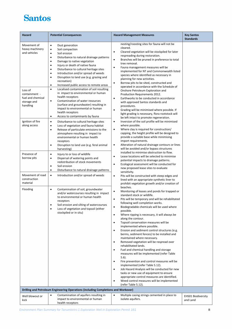
Table 2 – Environmental hazards, potential consequences and management measures
Hazard Potential Consequences Hazard Management Measures Key Santos Standards
Civil Works
Earthworks Disturbance to cultural heritage sites
Impeded fauna movement through construction zone
Injury or death of fauna in construction zone
Damage to native vegetation and loss of visual amenity
Introduction and / or spread of weeds
Disturbance to natural drainage patterns/impeding flow
Inversion of soil profile
Soil erosion and silting of watercourses
Dust generation
Soil compaction
Personnel access to the site only following a formal pre disturbance induction which includes risk management measures and consequences of non-compliance.
Consideration given to avoidance and preservation of obvious fauna pathways and tracks during scout process.
Activities to be planned to minimise new land disturbance and make use of existing disturbance (where possible).
Site selection surveys to be undertaken prior to on ground disturbance.
Works to commence only once regulatory (including DME) and stakeholder (including NLC) approvals are obtained where required.
Vegetation clearance to be avoided except where consent has been obtained from NLC and other applicable stakeholders (where required).
Mature trees selected for preservation are to be flagged to ensure their protection.
Hollow timber/trees that may be
EHS01 Biodiversity and Land Disturbance
EHS04 Waste
EHS05 Air Emissions
EHS09 Pest Plants and Animals
EHS11 Cultural Heritage
Vegetation clearing
Impeded fauna movement through construction zone
Loss of vegetation and fauna habitat
Damage to native vegetation
Disturbance to cultural heritage sites
Soil erosion and silting of watercourses
Short to medium term loss of visual amenity
Environment Plan Summary for Tanumbirini-1 Exploration Well in Exploration Permit 161 8
Hazard Potential Consequences Hazard Management Measures Key Santos Standards
Movement of heavy machinery and vehicles
Dust generation
Soil compaction
Soil erosion
Disturbance to natural drainage patterns
Damage to native vegetation
Injury or death of native fauna
Disturbance to cultural heritage sites
Introduction and/or spread of weeds
Disruption to land use (e.g. grazing and recreation)
Increased public access to remote areas
nesting/roosting sites for fauna will not be cleared.
Cleared vegetation will be stockpiled for later respreading during restoration.
Branches will be pruned in preference to total tree removal.
Fauna management measures will be implemented for NT and Commonwealth listed species where identified as necessary in planning for new activities.
Borrow pits to be sited, constructed and operated in accordance with the Schedule of Onshore Petroleum Exploration and Production Requirements 2012.
Earthworks to be conducted in accordance with approved Santos standards and procedures.
Grading will be minimised where possible. If light grading is necessary, flora rootstock will be left intact to promote regeneration.
Inversion of the soil profile will be minimised where possible.
Where clay is required for construction/ capping, the height profile will be designed to provide a suitable base while minimising import requirements.
Alteration of natural drainage contours or lines will be avoided and/or bypass structures installed to minimise obstruction to flow.
Lease locations will be selected to minimise potential impacts to drainage patterns.
Ecological assessment will be conducted for new proposed lease sites to evaluate sensitivity.
Pits will be constructed with steep edges and lined with an appropriate synthetic liner to prohibit vegetation growth and/or creation of beaches.
Monitoring of leases and ponds for trapped or standard stock or wildlife.
Pits will be temporary and will be rehabilitated following well completion works.
Biodegradable chemicals will be used where possible.
Where ripping is necessary, it will always be along the contour.
Topsoil conservation measures will be implemented where possible.
Erosion and sediment control structures (e.g. berms, sediment fences) to be installed and maintained where necessary.
Removed vegetation will be respread over rehabilitated lands.
Fuel and chemical handling and storage measures will be implemented (refer Table 5.6).
Fire prevention and control measures will be implemented (refer Table 5.12).
Job Hazard Analysis will be conducted for new tasks or new use of equipment to ensure appropriate control measures are identified.
Weed control measures will be implemented (refer Table 5.12).
Loss of containment - fuel and chemical storage and handling
Localised contamination of soil resulting in impact to environmental or human health receptors
Contamination of water resources (surface and groundwater) resulting in impact to environmental or human health receptors
Access to contaminants by fauna
Ignition of fire along access
Disturbance to cultural heritage sites
Loss of vegetation and fauna habitat
Release of particulate emissions to the atmosphere resulting in impact to environmental or human health receptors
Disruption to land use (e.g. feral animal harvesting)
Presence of borrow pits
Injury to or loss of wildlife
Dispersal of watering points and redistribution of stock movements
Soil erosion
Disturbance to natural drainage patterns
Movement of road construction material
Introduction and/or spread of weeds
Flooding Contamination of soil, groundwater and/or watercourses resulting in impact to environmental or human health receptors
Soil erosion and silting of watercourses
Loss of vegetation and topsoil (either stockpiled or in situ)
Drilling and Petroleum Engineering Operations (including Completions and Workover)
Well blowout or kick
Contamination of aquifers resulting in impact to environmental or human health receptors
Multiple casing strings cemented in place to isolate aquifers.
EHS01 Biodiversity and Land

Environment Plan Summary for Tanumbirini-1 Exploration Well in Exploration Permit 161 9
Hazard Potential Consequences Hazard Management Measures Key Santos Standards
Loss of aquifer pressure
Uncontrolled release of hydrocarbon (liquid or gas) to surface
Contamination of soil resulting in impact to environmental or human health receptors
Contamination of watercourses resulting in impact to environmental or human health receptors
Injury to or loss of wildlife
Generation of greenhouse gas emissions, reduction in air quality
Loss of habitat, injury or death of stock/wildlife
Casing string designed by qualified & competent engineers & confirmed by senior engineers or external consultants where necessary.
Cased hole cement bond logs to confirm quality of cement job in the production casing string.
New casing and wellhead installed on every new drill.
Drilling operations planned to address down-hole pressures / environment.
Pits will be lined to reduce the potential for loss of fluid due to seepage.
Drilling and completions operations to be conducted in accordance with DMS-M-04 Santos Drilling Operations Manual.
Blow-out preventers (BOPs) and related well control equipment to be installed, maintained and routinely tested on drilling and workover rigs.
Chemical storage and handling to be in accordance with Santos HSHS08.
Emergency spill response procedures and kits to be in place.
Trained personnel for handling of chemicals and materials, including re-fuelling and clean-up procedures to be onsite.
Appropriate bunding and secondary containment will be used.
Materials awaiting transport to a licenced waste facility will be appropriately stored.
Construction of pits will be quality controlled, including above ground earthen bunds to prevent surface water ingress.
A minimum pond freeboard of 300 mm will be maintained.
Pit walls will be regularly inspected and repairs undertaken when and where required.
Lines will be routinely inspected.
High pressure equipment rated and trip systems will be in place to prevent operations above design limits.
Emergency shutdown systems will be in place.
Spills and leaks will be cleaned up and remediated; fencing will be installed to prevent stock and wildlife access.
Chemical utilisation will be restricted to the minimum amount required for achieving the required outcome.
Where feasible and desired outcomes can be achieved, alternative lower toxicity chemicals will be used.
Fauna management measures to be implemented.
Weed control measures to be implemented (refer Table 5.12).
Fuel and chemical handling and storage measures will be implemented (refer Table 5.6).
Fire prevention and control measures will be implemented (refer Table 5.12).
Job Hazard Analysis (JHA) to be conducted for new tasks or new use of equipment to ensure appropriate control measures are identified.
Traffic is maintained on authorised disturbance areas only.
Disturbance
EHS02 Underground Storage Tanks and Bunds
EHS04 Waste
EHS05 Air Emissions
EHS07 Energy Efficiency
EHS08 Contaminated Sites
EHS09 Pest Plants and Animals
EHS10 Water Resources
EHS12 Noise Emissions
EHSMS18 Sustainability
Fluid handling equipment failure
Uncontrolled release of saline fluids / chemically treated water, or fluids containing hydrocarbons
Contamination of soil, shallow groundwater and/or watercourses resulting in impact to environmental or human health receptors
Loss of habitat, injury or death of stock/wildlife
Casing failure (sub-surface)
Aquifer contamination by cross-flow of oil or gas from exposed formations resulting in impact to environmental or human health receptors
Loss of aquifer pressure
Explosion or fire on lease (during operations)
Air emissions
Loss of vegetation and fauna habitat
Uncontrolled release or spill of saline workover fluids / chemically treated water, or oil laden fluids
Contamination of soil, shallow groundwater and/or watercourses resulting in impact to environmental or human health receptors
Loss of habitat, injury or death of stock/wildlife
Cement failure (sub-surface)
Impact to environmental or human health receptors by cross-flow of oil or gas from exposed formations
Loss of aquifer pressure and fluid release
Generation of greenhouse gas emissions, reduction in air quality
Tubing or drill pipe failure at drill floor
Temporary restricted control over well fluids and circulation system leading to low volume uncontrolled release of saline workover fluids/ chemically treated water, or fluids containing hydrocarbons
Loss of containment of gas or oil while testing
Contamination of soil, shallow groundwater and/or watercourses resulting in impact to environmental or human health receptors
Injury to or loss of wildlife
Generation of greenhouse gas emissions, reduction in air quality
Spill or leak of drilling, completion, and workover fluids, diesel, fuel, oils and chemicals (transportation, handling and
Contamination of soil, shallow groundwater and /or watercourses resulting in impact to environmental or human health receptors
Loss of habitat, injury or death of stock/wildlife
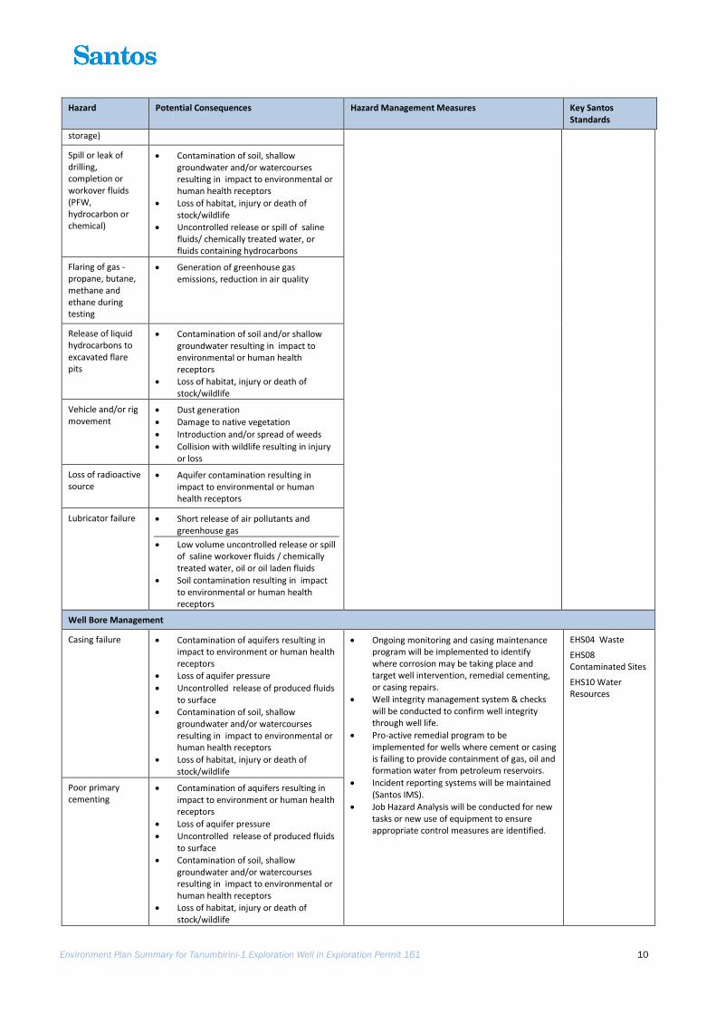
Environment Plan Summary for Tanumbirini-1 Exploration Well in Exploration Permit 161 10
Hazard Potential Consequences Hazard Management Measures Key Santos Standards
storage)
Spill or leak of drilling, completion or workover fluids (PFW, hydrocarbon or chemical)
Contamination of soil, shallow groundwater and/or watercourses resulting in impact to environmental or human health receptors
Loss of habitat, injury or death of stock/wildlife
Uncontrolled release or spill of saline fluids/ chemically treated water, or fluids containing hydrocarbons
Flaring of gas - propane, butane, methane and ethane during testing
Generation of greenhouse gas emissions, reduction in air quality
Release of liquid hydrocarbons to excavated flare pits
Contamination of soil and/or shallow groundwater resulting in impact to environmental or human health receptors
Loss of habitat, injury or death of stock/wildlife
Vehicle and/or rig movement
Dust generation
Damage to native vegetation
Introduction and/or spread of weeds
Collision with wildlife resulting in injury or loss
Loss of radioactive source
Aquifer contamination resulting in impact to environmental or human health receptors
Lubricator failure Short release of air pollutants and greenhouse gas
Low volume uncontrolled release or spill of saline workover fluids / chemically treated water, oil or oil laden fluids
Soil contamination resulting in impact to environmental or human health receptors
Well Bore Management
Casing failure Contamination of aquifers resulting in impact to environment or human health receptors
Loss of aquifer pressure
Uncontrolled release of produced fluids to surface
Contamination of soil, shallow groundwater and/or watercourses resulting in impact to environmental or human health receptors
Loss of habitat, injury or death of stock/wildlife
Ongoing monitoring and casing maintenance program will be implemented to identify where corrosion may be taking place and target well intervention, remedial cementing, or casing repairs.
Well integrity management system & checks will be conducted to confirm well integrity through well life.
Pro-active remedial program to be implemented for wells where cement or casing is failing to provide containment of gas, oil and formation water from petroleum reservoirs.
Incident reporting systems will be maintained (Santos IMS).
Job Hazard Analysis will be conducted for new tasks or new use of equipment to ensure appropriate control measures are identified.
EHS04 Waste
EHS08 Contaminated Sites
EHS10 Water Resources
Poor primary cementing
Contamination of aquifers resulting in impact to environment or human health receptors
Loss of aquifer pressure
Uncontrolled release of produced fluids to surface
Contamination of soil, shallow groundwater and/or watercourses resulting in impact to environmental or human health receptors
Loss of habitat, injury or death of stock/wildlife
Environment Plan Summary for Tanumbirini-1 Exploration Well in Exploration Permit 161 11
Hazard Potential Consequences Hazard Management Measures Key Santos Standards
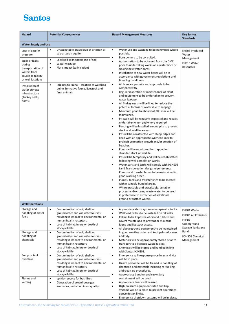
Water Supply and Use
Loss of aquifer pressure
Unacceptable drawdown of artesian or sub-artesian aquifer
Water use and wastage to be minimised where possible.
Bore owners to be consulted.
Authorisation to be obtained from the DME prior to undertaking works on a water bore or sinking new water bores.
Installation of new water bores will be in accordance with government regulations and licencing conditions.
All licences, permits and approvals to be complied with.
Regular inspection of maintenance of plant and equipment to be undertaken to prevent water leakage.
All Turkey nests will be lined to reduce the potential for loss of water due to seepage.
Minimum pond freeboard of 300 mm will be maintained.
Pit walls will be regularly inspected and repairs undertaken when and where required.
Fencing will be installed around pits to prevent stock and wildlife access.
Pits will be constructed with steep edges and lined with an appropriate synthetic liner to prohibit vegetation growth and/or creation of beaches.
Ponds will be monitored for trapped or stranded stock or wildlife.
Pits will be temporary and will be rehabilitated following well completion works.
Water carts and tanks will comply with HSHS02 Land Transportation design requirements. Pumps and transfer hoses to be maintained in good working order.
Pumps, tanks and transfer lines to be located within suitably bunded areas.
Where possible and practicable, suitable process and/or camp waste water to be used in preference to extraction of additional ground or surface waters.
EHS03 Produced Water Management
EHS10 Water Resources
Spills or leaks during transportation of waters from source to facility or well locations
Localised salinisation and of soil
Water wastage
Flora impact (salinisation)
Installation of water storage infrastructure (Turkey nests, dams)
Impacts to fauna – creation of watering points for native fauna, livestock and feral animals
Well Operations
Storage and handling of diesel fuels
Contamination of soil, shallow groundwater and /or watercourses resulting in impact to environmental or human health receptors
Loss of habitat, injury or death of stock/wildlife
Appropriate alarm systems on separator tanks.
Wellhead cellars to be installed on oil wells.
Cellars to be kept free of oil and rubbish and covers maintained to prevent or minimise fauna and livestock access.
All above ground equipment to be maintained in good working order and kept painted, clean and tidy.
Materials will be appropriately stored prior to transport to a licenced waste facility.
Chemicals will be stored and handled in line with Santos HSHS08.
Emergency spill response procedures and kits will be in place.
Onsite personnel will be trained in handling of chemicals and materials including re-fuelling and clean-up procedures.
Appropriate bunding and secondary containment will be used.
Appropriate liners will be used.
High pressure equipment rated and trip systems will be in place to prevent operations above design limits.
Emergency shutdown systems will be in place.
EHS04 Waste
EHS05 Air Emissions
EHS02 Underground Storage Tanks and Bund
HSHS08 Chemical Management
Storage and handling of chemicals
Contamination of soil, shallow groundwater and /or watercourses resulting in impact to environmental or human health receptors
Loss of habitat, injury or death of stock/wildlife
Sump or tank overflow
Contamination of soil, shallow groundwater and /or watercourses resulting in impact to environmental or human health receptors
Loss of habitat, injury or death of stock/wildlife
Flaring and venting
Ignition source for bushfires
Generation of greenhouse gas emissions, reduction in air quality

Environment Plan Summary for Tanumbirini-1 Exploration Well in Exploration Permit 161 12
Hazard Potential Consequences Hazard Management Measures Key Santos Standards
Spills and leaks will be cleaned up and remediated.
Fencing will be installed to prevent stock and wildlife access.
Chemical utilisation will be restricted to the minimum amount required for achieving the required outcome.
Where feasible and the desired outcome can be achieved, alternative lower toxicity chemicals will be employed.
Site and access to the site to be kept free of rubbish and suitable containers to be used for collection of rubbish for periodic removal.
Weed and vegetation control will be implemented around flares to prevent bushfires.
Gas venting to atmosphere and flaring will be minimised.
Periodic operator checks and scheduled maintenance will be undertaken.
Suspended and non-producing wells will be inspected monthly including tubing and annulus pressures and evidence of communication.
Job Hazard Analysis will be conducted for new tasks or new use of equipment to ensure appropriate control measures are identified.
Fuel and Chemical Management
Leaks or releases to land or water associated with transport of fuels and chemicals (via truck)
Contamination of soil, shallow groundwater and /or watercourses resulting in impact to environmental or human health receptors
Loss of habitat, injury or death of stock/wildlife
Segregated and contained or bunded storage areas will be in place.
Hazardous goods register will be maintained.
All hazardous goods will be handled, stored and otherwise managed in accordance with relevant Australian Standards and Codes of Practice.
MSDS and handling procedures for hazardous chemicals and materials will be provided on-site.
Chemwatch database (advisory database on correct storage, handling and disposal) access shall be maintained.
Emergency shutdown valves, fire protection, detection and control systems will be regularly tested and monitored to ensure that protection levels are adequate.
All fittings and equipment will be routinely checked and maintained.
Any spillage, leaks or points of excessive wear will be reported (into the Santos EHS Toolbox) and the necessary maintenance work and control measures undertaken without delay.
Spills and leaks will be cleaned up and remediated.
Emergency spill response procedures and kits will be in place.
Appropriate licences for the possession, conveyance and disposal of dangerous goods will be obtained and maintained.
Waste management contractors with appropriate licenses shall be employed.
Santos’ Incident Management System (IMS) shall be used to record EHS incidents.
Fire prevention and control measures will be implemented (refer Table 5.12).
Conduct Job Hazard Analysis for new tasks or new use of equipment to ensure appropriate control measures are identified.
EHS02 Underground Storage Tanks and Bunds
EHS04 Waste
EHS05 Air Emissions
EHS08 Contaminated Sites
HSHS08 Chemical Management and Dangerous Goods
Leaks or releases associated with chemical and fuel storage and handling
Contamination of soil, shallow groundwater and /or watercourses resulting in impact to environmental or human health receptors
Loss of habitat, injury or death of stock/wildlife
Bulk chemical and fuel storage
Contamination of soil, shallow groundwater and /or watercourses resulting in impact to environmental or human health receptors
Loss of habitat, injury or death of stock/wildlife
Fire or explosion

Environment Plan Summary for Tanumbirini-1 Exploration Well in Exploration Permit 161 13
Hazard Potential Consequences Hazard Management Measures Key Santos Standards
Waste Management
Radioactive waste disposal
Incorrect handling and disposal of naturally occurring radioactive materials (NORMS)
Waste materials generated from activities will be managed in accordance with activity-specific waste management plans or procedures.
Waste management areas will be suitably positioned and constructed to minimise the potential for off-site contamination.
Waste will be segregated to maximise recycling and to appropriately store (within bunded areas, etc.) hazardous goods.
Necessary approvals from regulatory authorities for specific waste-stream disposal needs/methods (i.e. disposal of NORMS, chemical wastes, interstate transport) will be obtained and maintained.
Regulated waste will be removed from the Program area by an authorised person and records of regulated waste movements made from the Program area will be kept.
Pest/scavenger access to wastes will be minimised through use of animal-proof covered skips.
Waste will be disposed of in appropriately licenced facilities.
Appropriate housekeeping standards will be maintained and the site will be maintained free of rubbish.
Santos Drilling Operations Manual DMS-M-04 will be implemented in relation to drill cuttings and mud disposal.
Fire prevention and control measures will be implemented (refer Table 5.12).
EHS02 Underground Storage Tanks and Bunds
EHS04 Waste
EHS05 Air Emissions
EHS08 Contaminated Sites
EHS09 Pest Plants and Animals
HSHS08 Chemical Management and Dangerous Goods
HSHS09 Radiation
Storage and transportation of waste materials
Scavenging by native and pest species
Pest outbreaks
Contamination of soil, shallow groundwater and /or watercourses resulting in impact to environmental or human health receptors
Loss of habitat, injury or death of stock/wildlife
Disposal of drill cuttings and muds to excavated sumps
Contamination of soil, shallow groundwater and /or watercourses resulting in impact to environmental or human health receptors
Loss of habitat, injury or death of stock/wildlife Access to contaminants by wildlife
Disposal of chemical waste to approved disposal facility
Contamination of soil, shallow groundwater and /or watercourses resulting in impact to environmental or human health receptors
Spills or leaks associated with sewage treatment unit chemical storage and handling
Contamination of soil and/or watercourse resulting in impact to environmental or human health receptors
Access to contaminants by wildlife
Spills or leaks associated with the treatment and disposal of sewage
Contamination of soil, shallow groundwater and /or watercourses resulting in impact to environmental or human health receptors
Access to contaminants by wildlife
Sewage sludge storage and disposal
Contamination of soil, shallow groundwater and /or watercourses resulting in impact to environmental or human health receptors
Waste segregation Loss of recyclable resources
Hazardous wastes Contamination of soil, shallow groundwater and /or watercourses resulting in impact to environmental or human health receptors
Fire, explosion
In addition, activities to be undertaken have been assessed for potential environmental consequences. The environmental values that will be protected through management and controls are as follows.
Activities Environmental Values to be Protected
Civil Works Air quality
Community - Cultural Heritage sites
Fauna & Flora - native vegetation, absence of weeds
Water – drainage patterns, watercourses
Land – soil profiles, topography, visual amenity
Noise- Amenity
Drilling Water – groundwater quality, aquifer pressure, watercourses
Land - soil quality and profile
Air quality
Flora & Fauna
Noise- Amenity
Camps Land - soil quality and profile
Flora & Fauna - native vegetation
Noise- Amenity

Environment Plan Summary for Tanumbirini-1 Exploration Well in Exploration Permit 161 14
5 GROUNDWATER MONITORING
Under the NT Department of Mines and Energy (DME) Guideline Applications for Drilling or Workover Rig Activities (DME, 2012), Project Applications may require a Baseline Water Study, in particular for projects that require “stimulation”. Fracture stimulation is not currently proposed in EP 161. However, Santos will engage a third party to implement the plan and assess groundwater conditions prior to exploration drilling to provide a benchmark against which any future variations in quality can be objectively measured. A Baseline Sampling and Analysis Plan (SAP) has been developed for the EP 161 Tanumbirini exploration well program. The SAP has taken into account a desktop hydrogeological review of the region, existing guideline documents (DEHP, 2011) and previously approved analysis suites for the groundwater baseline sampling and analysis plan from the 2013 Santos Mereenie drilling program. The baseline groundwater data willprovide a benchmark against which any future variations can be objectively measured. The data may then be used to assess potential groundwater impacts (if any) of future petroleum exploration and/or production activities (including the 2014 EP 161 exploration well program). Subject to landholder, Northern Land Council and Aboriginal Areas Protection Authority approvals (where required), up to 13 existing groundwater bores are proposed to be visited:
all existing and operating bores within a 5km radius of the proposed exploration well
new bores (if any) associated with the Project. Groundwater samples will be collected using existing bore infrastructure (where available) in accordance with Australian/New Zealand Standards: 5667.1:1998 Part 1: Guidance on the design of sampling programs, sampling techniques and the preservation and handling of samples and 5667.11:1998 Part 11 Guidance on sampling of ground waters. Samples will be collected following purging of either three casing volumes or stabilisation of field water quality parameters. Accessible bores with adequate infrastructure within a 5km radius (or 10km radius, if an insufficient number of bores are present) will be sampled. Santos proposes a suite of analytes to assess the pH, electrical conductivity and composition of the groundwater systems (including hydrocarbons and other non-biodegradable by-products of the hydraulic fracturing and drilling process). This suite includes parameters that are typical for similar projects and has considered MSDSs for chemicals that may be used in the Project. Samples will be collected in laboratory-provided bottles and jars. Following completion of the field sampling, a Baseline Groundwater Assessment Report will be prepared and submitted to DME. In the event that fracture stimulation is proposed, additional sampling will be considered.

Environment Plan Summary for Tanumbirini-1 Exploration Well in Exploration Permit 161 15
6 ENGAGEMENT
Santos has engaged with key stakeholders to ensure that they are aware of the components of the proposed exploration program in EP161. The purpose of this engagement has been to:
Educate and inform key stakeholders of the elements of the McArthur Basin Exploration Program for EP 161 and possible future production
Build and maintain stakeholder confidence through key relationships
Gain trust and acceptance in the local communities as a responsible member of society
Listen to and address concerns or queries
Educate the community, landholders, business operators and Traditional Owners on why and how Santos operates
The engagement activity is undertaken by senior Santos employees accompanied by technical experts. In general, the information provided will seek to address key issues including, but not limited to:
Environmental disturbance and the use of chemicals;
Cultural heritage issues;
Impact on the ground water & aquifers;
Water use and management, including techniques and strategies;
Impact to roads through increased traffic;
Impact of fly-in fly-out operations;
Hydraulic fracture stimulation activity;
Well integrity including ongoing monitoring of ‘abandoned’ wells;
Economic benefits for the region from increased activity including local employment and training, funding sponsorships and capacity building for local businesses;
Local procurement of goods and services; and/or
Employment and training opportunities specifically for local Aboriginal people, especially jobs on country.
The key components of the engagement program have been:
Briefing sessions – face-to-face with key individuals and groups with timely feedback on issues and concerns
Distribution of key information via media engagement, websites, social media and letter writing
Community capacity building through employment (local and aboriginal), contracts and procurement
Santos also participated in the information roadshow conducted by APPEA and the DME throughout the Northern Territory. This included information sessions at Katherine and Mataranka.
Santos has submitted Work Program Applications to the Northern Land Council and Aboriginal Areas Protection Authority to notify both organisations of the proposed EP 161 Exploration Program. Formal approval and associated conditions will be received from both organisations prior to the commencement of on-ground activities.
Related Documents


![Untitled-2 [] · 2017. 8. 14. · GODFREY PHILLIPS Ficosa Ltda Ltda future smP INTERNATIONAL K KKK KICK KICK ICICICICICICICKKKKKKKK KKK tskinskinskinskin KICK KICK KICK KICK K Casting](https://static.cupdf.com/doc/110x72/5fd95d8b62328d41b567cbf3/untitled-2-2017-8-14-godfrey-phillips-ficosa-ltda-ltda-future-smp-international.jpg)


