www.insidegnss.com FALL 2008 InsideGNSS 33 D uring last 10 years, the GNSS panorama has changed rap- idly, bringing new pressure on product designers and system developers to adopt new approaches to their efforts. Let’s take a look at some of these changes. In the consumer mass market, low- cost GPS terminals and car naviga- tion systems are widely available, and their integration on “smart-phones” is mature. For commercial and institutional applications, however, some issues are still on the table. In particular, institu- tional users are asking for GNSS solu- tions that offer high configurability, reliability, precision, service guarantees, authentication, security, and anti-jam- ming — and, by definition, the availabil- ity of open and standard solutions. High-accuracy terminals or other GNSS equipment with demanding requirements are oſten based on pro- A Soft Touch Sogei’s GPS/Galileo Software Receiver and Institutional GNSS Applications in Italy Hardware GNSS receivers can sometimes be hard on users — especially those faced with demanding commercial and institutional applications, such as customs enforcement. Evolving requirements and the need for special features and functionality — such things as high configurability, reliability, precision, service guarantees, authentication, security, and anti- jamming — can make proprietary solutions expensive and short-lived. That situation led Sogei, a government-owned Italian company, to come up with a software-based solution of its own. ROBERTO CAPUA SOGEI MIRKO ANTONINI UNIVERSITY OF ROME “TOR VERGATA” Photos: (left) ©iStockphoto.com/Lukasz Fus; (center and right) Sogei

Welcome message from author
This document is posted to help you gain knowledge. Please leave a comment to let me know what you think about it! Share it to your friends and learn new things together.
Transcript
www.insidegnss.com f a l l 2 0 0 8 InsideGNSS 33
During last 10 years, the GNSS panorama has changed rap-idly, bringing new pressure on product designers and system
developers to adopt new approaches to their efforts. Let’s take a look at some of these changes.
In the consumer mass market, low-cost GPS terminals and car naviga-tion systems are widely available, and their integration on “smart-phones” is mature.
For commercial and institutional applications, however, some issues are still on the table. In particular, institu-tional users are asking for GNSS solu-tions that offer high configurability, reliability, precision, service guarantees, authentication, security, and anti-jam-ming — and, by definition, the availabil-ity of open and standard solutions.
High-accuracy terminals or other GNSS equipment with demanding requirements are often based on pro-
a Soft Touch Sogei’s GPS/Galileo Software Receiver and Institutional GNSS applications in Italy
Hardware GNSS receivers can sometimes be hard on users — especially those faced with demanding commercial and institutional applications, such as customs enforcement. Evolving requirements and the need for special features and functionality — such things as high configurability, reliability, precision, service guarantees, authentication, security, and anti-jamming — can make proprietary solutions expensive and short-lived. That situation led Sogei, a government-owned Italian company, to come up with a software-based solution of its own.
RobeRTo CaPuaSogei MIRko aNToNINIUniverSity of rome “tor vergata”
Photos: (left) ©iStockphoto.com/Lukasz Fus; (center and right) Sogei
34 InsideGNSS f a l l 2 0 0 8 www.insidegnss.com
prietary and expensive solutions. At the same time, in some countries high-accuracy GNSS augmentation services are the exclusive initiatives of a single private provider or local public agen-cy.
Meanwhile, standards and regula-tions are changing for almost every application. Therefore, in the near future a user terminal should be expected to support numerous standards and pro-tocols. Furthermore, today’s technologi-cally skilled GNSS user is always asking for more advanced solutions in terms of accuracy — just as evolving demands for mobile communications required ever more bandwidth.
Systems and services are converging. Information and communication tech-nologies (ICT) are ever more frequently providing integrated hardware/software solutions for navigation and communi-cations. Integration of GNSS with iner-tial sensors, communication systems (e.g., WiFi) and assisted (AGNSS) solu-tions are, of course, essential for pro-viding higher continuity of service in a range of indoor situations.
In the near future, guaranteed and augmented solutions (in terms of preci-sion and integrity) will be necessary not only for geodetic and surveying applica-tions, but also for mass market applica-
tions such as advanced driver assistance systems (e.g., automatic lane keeping). figure 1 illustrates some of these near-term applications.
Backward compatibility with respect to legacy systems also has to be assured for a real exploitation of institutional market. An example of such an applica-tion is introduction of GNSS/RFID tech-nology for implementing well-consoli-dated customs operational procedures and regulations. However, that applica-tion will require a complete and trans-parent integration of new freight “loca-tion” reporting systems within existing tracking systems.
Introducing a new “black box” sys-tem for this purpose (despite its efficien-cy), leading to a complete revolution for institutional freight tracking, will not be accepted by the institutional customer. Similar considerations appear in con-sidering the application of innovative high-accuracy technologies in cadastral surveying operations.
The availability of new GNSS con-stellations and multi-frequency solutions (e.g., TCAR, three carrier ambiguity res-olution) will change the scenario within a few years, leading to the need for quick front-end and firmware upgrades in GNSS receivers. New long-range real-time kinematic (RTK) solutions are also
coming, based on innovative ionospheric modelling.
In this technological and business environment, embedded systems offer a near-future path to providing tightly integrated navigation and communica-tion solutions with low-cost, accurate, portable, and highly reconfigurable receivers.
A concurrent technological advance, GNSS software receivers (referred to hereinafter as SDR, for software defined radio), will allow developers to provide code/phase solutions and the process-ing of signals from satellite-based aug-mentation systems (SBAS) and regional GNSS reference networks in an open environment.
Furthermore, through a suitably flex-ible front-end, adapting SDR solutions to emerging navigation constellations will be easily implemented. This approach seems like an ideal solution for institu-tional applications.
A side effect of the development of such solutions may be the ability to implement low-cost GNSS SDR-based augmentation networks, overcoming the usual problems related to high installa-tion costs and the need for continual firmware upgrades.
This article will describe the activi-ties of Sogei, in cooperation with the University of Tor Vergata in Rome, to develop an open SDR GNSS receiver for such applications.
SogeiR&DactivitiesSogei is an Italian company owned by the Ministry of Economy and Finance of Italy charged with developing ICT solu-tions for national institutions. Among other responsibilities, Sogei manages the Italian system for updating cadastral maps as well as the information system of for Italian Customs.
To support such missions, Sogei is continuously carrying out extensive R&D activities on GNSS state-of-the-art solutions. In 2007, Sogei signed a collab-oration agreement with the University of Tor Vergata, as part of its Master of Science degree program in “Advanced Communications and Navigation Satel-lite Systems” (MasterSpazio). The main
GovernmentalFleets
MappingSurveying
3G-4GA-GNSS
Customs
Alarm
IndoorPseudolite
Wi-Fi
Reti GNSS
RTK
WARTK
SDR GNSS
SDR GNSS SDR GNSS
SDR GNSS
SDR GNSS
FIGURE 1 Future GNSS Applications Scenario
aSofttouch
www.insidegnss.com f a l l 2 0 0 8 InsideGNSS 35
topic of this agreement is the R&D on innovative GNSS SDR and Augmenta-tion solutions.
R&D activities are focusing on two reference applications: cadastral sur-veying and mapping that requires high accuracy (< 10 centimeters), reliable RTK and static GNSS solutions, and integra-tion with topographic sensors (see the sidebar article, “Building a GNSS Refer-ence Network.”); and customs operations such as freight tracing and tracking, anti-fraud, and risk management, that require medium accuracy (two-three meters), high reliability, service guar-antees, and anti-jamming capability.
PlatformarchitectureandResultsDevelopment of Sogei’s GNSS SDR plat-form has been carried out using a pop-ular simulation, modelling, and design software suite for rapid prototyping. Furthermore, we avoided any reliance on proprietary libraries and integrated our own C-code modules within the platform. Following this approach, our development platform is based on a bi-processor workstation, equipped with Windows OS, commercial software packages as well as free C compilers. Concerning hardware implementation and high performances, we are testing our code on an advanced DSP/FPGA SDR development platform.
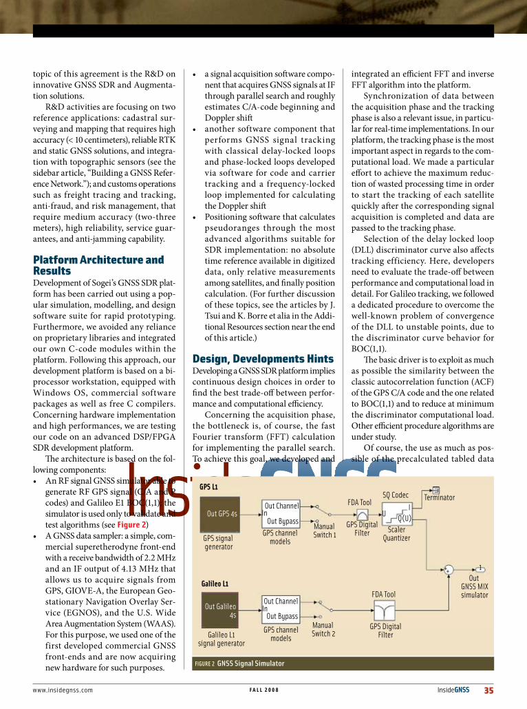
The architecture is based on the fol-lowing components:• An RF signal GNSS simulator able to
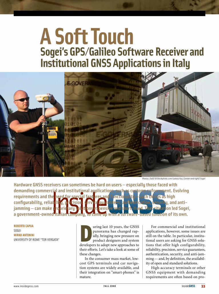
generate RF GPS signal (C/A and P codes) and Galileo E1 BOC(1,1); the simulator is used only to validate and test algorithms (see figure 2)
• A GNSS data sampler: a simple, com-mercial superetherodyne front-end with a receive bandwidth of 2.2 MHz and an IF output of 4.13 MHz that allows us to acquire signals from GPS, GIOVE-A, the European Geo-stationary Navigation Overlay Ser-vice (EGNOS), and the U.S. Wide Area Augmentation System (WAAS). For this purpose, we used one of the first developed commercial GNSS front-ends and are now acquiring new hardware for such purposes.
• a signal acquisition software compo-nent that acquires GNSS signals at IF through parallel search and roughly estimates C/A-code beginning and Doppler shift
• another software component that performs GNSS signal tracking with classical delay-locked loops and phase-locked loops developed via software for code and carrier tracking and a frequency-locked loop implemented for calculating the Doppler shift
• Positioning software that calculates pseudoranges through the most advanced algorithms suitable for SDR implementation: no absolute time reference available in digitized data, only relative measurements among satellites, and finally position calculation. (For further discussion of these topics, see the articles by J. Tsui and K. Borre et alia in the Addi-tional Resources section near the end of this article.)
Design,DevelopmentshintsDeveloping a GNSS SDR platform implies continuous design choices in order to find the best trade-off between perfor-mance and computational efficiency.
Concerning the acquisition phase, the bottleneck is, of course, the fast Fourier transform (FFT) calculation for implementing the parallel search. To achieve this goal, we developed and
integrated an efficient FFT and inverse FFT algorithm into the platform.
Synchronization of data between the acquisition phase and the tracking phase is also a relevant issue, in particu-lar for real-time implementations. In our platform, the tracking phase is the most important aspect in regards to the com-putational load. We made a particular effort to achieve the maximum reduc-tion of wasted processing time in order to start the tracking of each satellite quickly after the corresponding signal acquisition is completed and data are passed to the tracking phase.
Selection of the delay locked loop (DLL) discriminator curve also affects tracking efficiency. Here, developers need to evaluate the trade-off between performance and computational load in detail. For Galileo tracking, we followed a dedicated procedure to overcome the well-known problem of convergence of the DLL to unstable points, due to the discriminator curve behavior for BOC(1,1).
The basic driver is to exploit as much as possible the similarity between the classic autocorrelation function (ACF) of the GPS C/A code and the one related to BOC(1,1) and to reduce at minimum the discriminator computational load. Other efficient procedure algorithms are under study.
Of course, the use as much as pos-sible of the precalculated tabled data
FIGURE 2 GNSS Signal Simulator
GPS L1
Galileo L1
GPS signal generator
Galileo L1signal generator
GPS channelmodels
GPS channelmodels
Manual Switch 1
Manual Switch 2
Out GPS 4s
Out Galileo4s
In
In
UI
1++
Q(U)
FDA Tool
FDA Tool
GPS DigitalFilter
GPS DigitalFilter
ScalerQuantizer
Out GNSS MIXsimulator
SQ Codec TerminatorOut Channel
Out Channel
Out Bypass
Out Bypass
36 InsideGNSS f a l l 2 0 0 8 www.insidegnss.com
instead of running software procedures (having a high computational processing load) is mandatory for real-time achieve-ments. Tabled data are, apart from sine and cosine functions, C/A code samples and relevant “early” and “late” samples to be used respectively in the acquisi-tion phase for code generation and in the tracking phase for DLL implemen-tation.
Sogei’s SDR platform is currently running for testing purposes on portable PCs and desktop computers equipped with the needed suitable RAM and HD sizing, on which the GNSS data sampler, its patch antenna, and the SDR software are installed. We are working on imple-mentations for digital signal processors (DSPs) and field programmable gate arrays (FPGAs).
The use of computer-aided tools allows fast design and prototyping, but in moving from the design to the imple-mentation phase, classical development problems rise. This is particularly true if commercial SDR development environ-ments are used.
The most relevant considerations for open GNSS developers are:• Availability of low-cost processors
with real-time operation systems (RTOSs) equipped with all relevant
hardware application programming interfaces (APIs) and drivers. All such costs together amount to about three or four time the cost of the needed hardware for SDR implementation.
• Availability of FPGA/DSP drivers• Dependence on proprietary libraries
implementing the interface between the prototyping environment and the hardware to be used. Toward this goal, Sogei used as much as possible open RTOS and developments inde-pendent from external libraries.
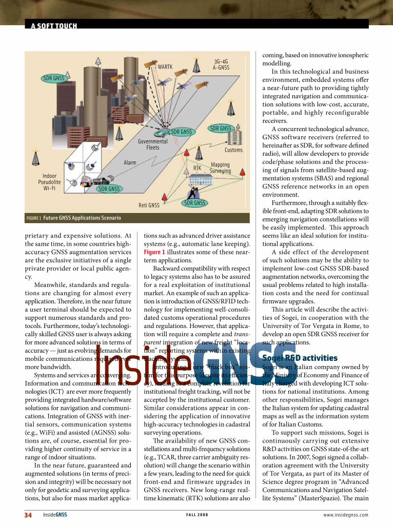
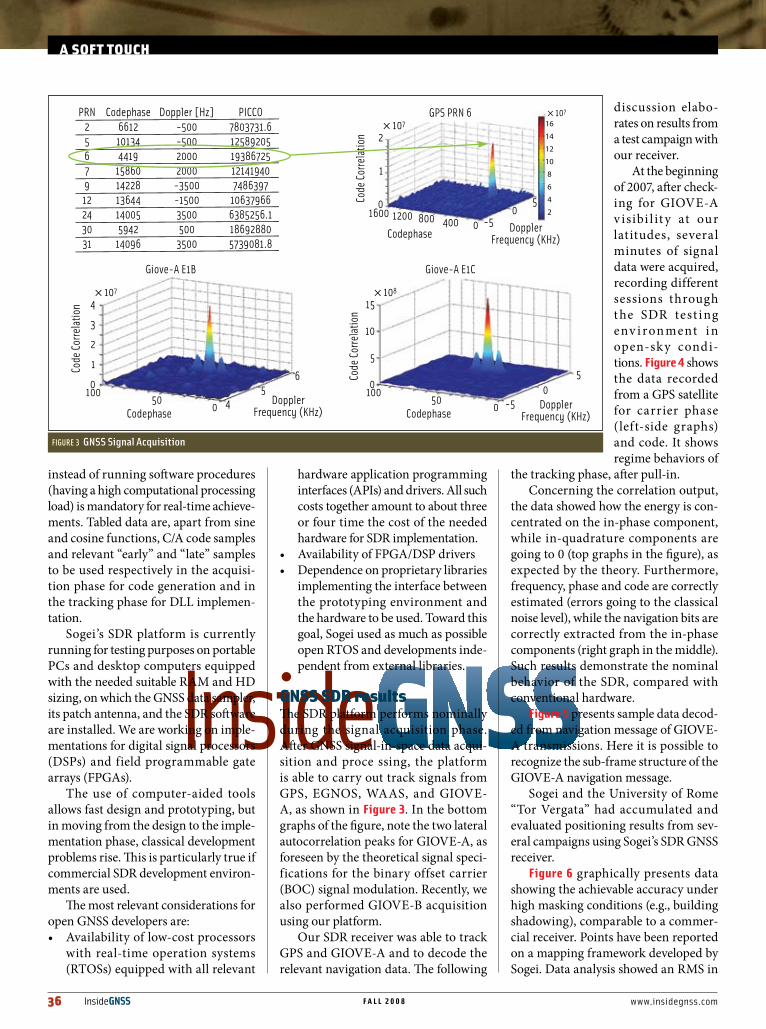
GNSSSDRresultsThe SDR platform performs nominally during the signal acquisition phase. After GNSS signal-in-space data acqui-sition and proce ssing, the platform is able to carry out track signals from GPS, EGNOS, WAAS, and GIOVE-A, as shown in figure 3. In the bottom graphs of the figure, note the two lateral autocorrelation peaks for GIOVE-A, as foreseen by the theoretical signal speci-fications for the binary offset carrier (BOC) signal modulation. Recently, we also performed GIOVE-B acquisition using our platform.
Our SDR receiver was able to track GPS and GIOVE-A and to decode the relevant navigation data. The following
discussion elabo-rates on results from a test campaign with our receiver.
At the beginning of 2007, after check-ing for GIOVE-A v isibi l it y at our latitudes, several minutes of signal data were acquired, recording different sessions through t he SDR test ing env i ron ment i n open-sky condi-tions. figure 4 shows the data recorded from a GPS satellite for carrier phase (left-side graphs) and code. It shows regime behaviors of
the tracking phase, after pull-in. Concerning the correlation output,
the data showed how the energy is con-centrated on the in-phase component, while in-quadrature components are going to 0 (top graphs in the figure), as expected by the theory. Furthermore, frequency, phase and code are correctly estimated (errors going to the classical noise level), while the navigation bits are correctly extracted from the in-phase components (right graph in the middle). Such results demonstrate the nominal behavior of the SDR, compared with conventional hardware.
figure 5 presents sample data decod-ed from navigation message of GIOVE-A transmissions. Here it is possible to recognize the sub-frame structure of the GIOVE-A navigation message.
Sogei and the University of Rome “Tor Vergata” had accumulated and evaluated positioning results from sev-eral campaigns using Sogei’s SDR GNSS receiver.
figure 6 graphically presents data showing the achievable accuracy under high masking conditions (e.g., building shadowing), comparable to a commer-cial receiver. Points have been reported on a mapping framework developed by Sogei. Data analysis showed an RMS in
PRN2567912243031
Codephase6612101344419
158601422813644140055942
14096
Doppler [Hz]-500-50020002000
-3500-15003500500
3500
PICCO7803731.61258920519386725121419407486397
106379666385256.1186928805739081.8
Giove-A E1B
Codephase4
1000
505
6
4
3
2
1
0
× 107
Giove-A E1C
Codephase-5
1000
500
5
15
10
5
0
× 108
GPS PRN 6
Codephase
Code
Corre
latio
nCo
de Co
rrela
tion
Code
Corre
latio
n
DopplerFrequency (KHz)
DopplerFrequency (KHz)
DopplerFrequency (KHz)
-5040080012001600 05
2
1
0
× 107× 107
16
14
12
10
8
6
4
2
FIGURE 3 GNSS Signal Acquisition
aSofttouch

www.insidegnss.com f a l l 2 0 0 8 InsideGNSS 37
the order of 7–8 meters in latitude and lon-gitude and 15 meters in height.
futurePerspectivesWorldwide, the implementation of a real-time GNSS SDR receiver is typically based on the integration of the code in a FPGA or DSP platform, and the subsequent imple-mentation in dedicated chips (ASICs). Creating a truly open and reconfigurable solution for institutional applications, however, depends in such case on the use of such kind of devices. The integration of SDR within a commercial PDA or laptop is currently limited by the usual problems of power consumption and computational load problems.
Computational Load limitations (espe-cially for the tracking phase) could be overcome in a few years by the continuous progress in commercial processor imple-
mentations (increasing MIPS, transistor size reduction, cost reduction, multiple-core implementations, in accordance with Moore’s Law).
Power consumption could remain a burden for a while, but the use of AGNSS techniques and technological progress may allow these limitations to be overcome in the future.
Given this state of our GNSS SDR development, Sogei’s R&D activities are currently focused in the following areas:• Integration of the SDR code on a DSP/FPGA platform with-
out relying on external libraries introduced by the develop-ment platforms,
• Integration of the SDR code within advanced commercial laptops for customs tracing and tracking applications,• Implementation of SBAS capabilities
Sub-
Fram
es
0
100
200
300
400
500
600
Bits
Packets 5-8
Packets 1-4
Packets 5-8
Carrier Status Nav Data Health
Frame startPackets 1-4
Bits0 0 20 40 60 80 100 12050 100
FIGURE 5 GIOVE A navigation data (January 18, 2008)
FIGURE 6 GNSS Positioning (high masking environment)
Time (ms)
Corre
latio
n
0 0.5 1 1.5 2 2.5 3× 10⁴
3
2
1
0
Time (ms)
Freq
uenc
y (H
z)
0 0.5 1 1.5 2 2.5 3× 10⁴
380360340320300380
Time (ms)
Phas
e Erro
r (°)
0 0.5 1 1.5 2 2.5 3× 10⁴
500
-50
× 107
I2
I2
I2
Prompt
Late
Early
Time (ms)
Corre
latio
n
0 0.5 1 1.5 2 2.5 3× 10⁴
3
2
1
0
Time (ms)
Ampl
itude
0 0.5 1 1.5 2 2.5 3× 10⁴
5000
0
5000
Time (ms)
Code
Erro
r (ch
ips)
0 0.5 1 1.5 2 2.5 3× 10⁴
10.5
0-0.5
-1
× 107
Q2
Q2
Q2
Prompt
Late
Early
FIGURE 4 GPS Tracking Performances (SV 6)
38 InsideGNSS f a l l 2 0 0 8 www.insidegnss.com
In2003,Sogeidevelopeda referenceGNSSnetworkincentralItaly(seeFigure 7),withintheframeworkoftheinstitutionalR&DprogramforpublicadministrationandincollaborationwiththeItalianLandAgen-cy.WenamedthisNetworkGRDNET(GNSSResearchandDevelopmentNet).
Usingmulti-referencestation/virtualreferencestation(MRS/VRS)technology,thenetworkarchitectureisbasedonthefollowingcomponents:
• Reference Stations (RS):currentlysixgeodeticGNSSstationswithaninter-dis-tanceof40-80kilometersinstalledontheroofsoflandagencyofficesintheregionandconnectedtoareferencenetworkcon-trolcenterthroughahighqualityofservice,publicadministrationwideareanetwork;
• Network Control Center (NCC):locatedinSogei, it calculates geodetic solutions(ITRF05,IGb00,IGS05),providesreal-timekinematic(RTK)servicesandgeneratesVRSRINEXfilesthroughanMRSapproach
• User:mustbeequippedwithacommercialsurveyingGNSSreceiver,withintegratedTCP/IPconnectioncapability(e.g.,GPRS/UMTS)foraccessingRTKservices.
• Network Website: a dedicated website,accessiblebyauthenticatedusers,allows
themtoobtaina VRS RINEXfileforapointpositionwithinthenetwork,toacquire refer-ence stationscoordinatesandancillarydata,andtoperformqualitychecks.
DesignandDevelopmenthintsTheGNSSreferencenetworkiscurrentlydevotedtolandadministrationtasks,suchaslocalcadas-tralreferencesystemupdates,in-fieldtests,andtraining.Inordertoassurehighconfigurabilityandadaptationtocustomerrequests,theNCCsoftwarehasbeendevelopedwithoutusingcom-merciallyavailablepackets.
Avarietyofreceivermodelshavebeenusedfordevelopmentandtestingpurposes.Followingtheopenstrategydescribedearlier,variousGNSSgeodeticreceiversfromseveralmanufacturersaregoingtobeinstalledandintegratedintotheGNSSNetworkFurthermore,coordinatetransfor-mationbetweentheInternationalTerrestrialRef-erenceFrame(ITRF)andItaly’snationalreferencesystem(IGM95),aswellastheincomingETRF00,havebeencarriedoutinordertoguaranteethe
usabilityoffieldsolutionsinthecadastralworld.
Concerningnetwork-RTKimplementation, standardinterfaceshavebeendevelopedforreal-timecommunicationbetween the reference sta-tionsandtheNCC(BINEX)andbetweentheNCCandtheuserreceivers(RTCM2.xand3.x).
Inourexperience,theuseofBINEXalsohasthecollateralbenefitofpossiblyreducinguseofnetworkbandwidthbyaboutone-fifthcomparedtocommer-cialformats.Correctionsbroad-castsareimplementedthroughthestandardNTRIPprotocol.Qualitychecksareperformedusing teqc (Translate/Edit/QualityCheck)preprocessingsoftwaredevelopedbytheUni-versityNavstarConsortium.
Onthepostprocessingside,geodeticsolutionshavebeencarriedoutusingtraditionalscientificpackages(e.g.,Ber-
nese).WehaveimplementeddedicatedRINEXdatadownloadingandstorage,usinganauto-maticintegritystoragesystem.Todate,abouttwoterrabytesofdatahavebeencollectedandprocessed.
GNSSNetworkPerformanceSogei’sGNSSNetworkallowsuserstoachieveaccuraciesoflessthan10centimetersacrosstheentirepolygondefinedbyreferencestationsandupto10–20kilometersoutsideofitsborders.Theaveragetimetofixambiguities(TTFA)islessthan30seconds.Anextensivetestcampaignhasbeencarriedout,comparingtheachievedresultswithIGM95monographicdata.
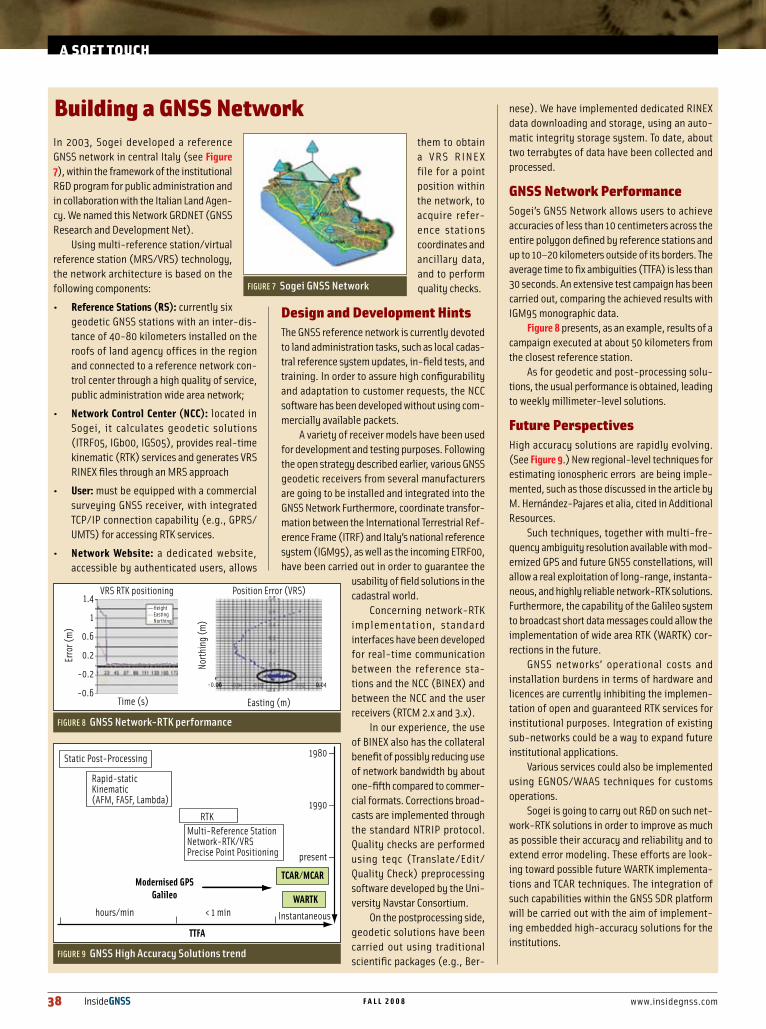
Figure 8 presents,asanexample,resultsofacampaignexecutedatabout50kilometersfromtheclosestreferencestation.
Asforgeodeticandpost-processingsolu-tions,theusualperformanceisobtained,leadingtoweeklymillimeter-levelsolutions.
futurePerspectivesHighaccuracysolutionsarerapidlyevolving.(SeeFigure 9.)Newregional-leveltechniquesforestimatingionosphericerrorsarebeingimple-mented,suchasthosediscussedinthearticlebyM.Hernández-Pajaresetalia,citedinAdditionalResources.
Suchtechniques,togetherwithmulti-fre-quencyambiguityresolutionavailablewithmod-ernizedGPSandfutureGNSSconstellations,willallowarealexploitationoflong-range,instanta-neous,andhighlyreliablenetwork-RTKsolutions.Furthermore,thecapabilityoftheGalileosystemtobroadcastshortdatamessagescouldallowtheimplementationofwideareaRTK(WARTK)cor-rectionsinthefuture.
GNSS networks’ operational costs andinstallationburdensintermsofhardwareandlicencesarecurrentlyinhibitingtheimplemen-tationofopenandguaranteedRTKservicesforinstitutionalpurposes.Integrationofexistingsub-networkscouldbeawaytoexpandfutureinstitutionalapplications.
VariousservicescouldalsobeimplementedusingEGNOS/WAAStechniquesforcustomsoperations.
SogeiisgoingtocarryoutR&Donsuchnet-work-RTKsolutionsinordertoimproveasmuchaspossibletheiraccuracyandreliabilityandtoextenderrormodeling.Theseeffortsarelook-ingtowardpossiblefutureWARTKimplementa-tionsandTCARtechniques.TheintegrationofsuchcapabilitieswithintheGNSSSDRplatformwillbecarriedoutwiththeaimofimplement-ingembeddedhigh-accuracysolutionsfortheinstitutions.
BuildingaGNSSNetwork
FIGURE 7 Sogei GNSS Network
FIGURE 8 GNSS Network-RTK performance
Erro
r (m
)
1.4
1
0.6
0.2
-0.2
-0.6Time (s)
HeightEastingNorthing
North
ing
(m)
Easting (m)
VRS RTK positioning Position Error (VRS)
0.04-0.06
FIGURE 9 GNSS High Accuracy Solutions trend
Static Post-Processing
hours/min < 1 min Instantaneous
Modernised GPSGalileo
Rapid-staticKinematic(AFM, FASF, Lambda)
RTKMulti-Reference StationNetwork-RTK/VRSPrecise Point Positioning
1980 —
1990 —
present —
TTFA
TCAR/MCAR
WARTK
aSofttouch
www.insidegnss.com f a l l 2 0 0 8 InsideGNSS 39
• Implementation of phase process-ing and RTK capabilities — through relevant RTCM V3.x standards and Networked Transport of RTCM via Internet Protocol (NTRIP) —for sur-veying
conclusionsGNSS civil and institutional applica-tions will be of great relevance for future GNSS applications developments.
GNSS software receiver technolo-gies offer the possibility to implement open and reconfigurable navigation and communication systems to be embedded in a PDA or Laptop. As a side benefit, low-cost terminals will be available for the user. Sogei R&D activities, in col-laboration with the University of Rome “Tor Vergata”, allowed the possibility to implement an initial GNSS SDR plat-form able to work in a multiple constel-lation environment.
Meanwhile, the development of a network-RTK solution in the center of Italy, enabled users to achieve sub-deci-meter accuracy with a reduced TTFA using complete standard protocols and interfaces. Modernized GPS and Galileo will allow the implementation of instan-taneous and reliable high-accuracy services. RTK capabilities and TCAR processing within an open GNSS SDR environment could therefore provide a solution for future surveying and high-accuracy transport applications.
acknowledgmentsAll the R&D activities described in the present paper have been developed within Sogei. A particular reference is here given to M. Torrisi and Andrea Properzi, working respectively on SDR development and GNSS network inter-faces within the framework of the Mas-terspazio initiative of the University of Rome “Tor Vergata”.
ManufacturersSogei used the Matlab Simulink software from MathWorks, Natick, Massachu-setts, United States, in its SDR develop-ment. The mapping framework used to create Figure 6 is GEOPOI (geocoding points of interest) from Sogei, S.p.A.,
Rome, Italy. The DSP/FPGA hardware development platform for SDR is based on the Small Form Factor (SFF) Software Defined Radio (SDR) Development Plat-form platform and the relevant software programming interface tool, Code Com-poser Studio, from Texas Instruments, Dallas, Texas, USA. The GNSS front-end data sampler was the SE4110L from SiGe Semiconductor, Ottawa, Canada. The GRDNet currently incorporates the Thales Navigation Internet-Enabled Continuous Geodetic Reference Station (iCGRS) from Thales Navigation (now Magellan GPS, Santa Clara, California, USA, and Carquefou, France) and NetRS from Trimble Navigation, Sunnyvale, California, USA.
additionalResources[1]Borre,K.,andD.M.Akos,N.Bertelsen,P.Rind-er,andS.H.Jensen,A Software-Defined GPS and Galileo Receiver: A Single-Frequency Approach,Birkhäuser,Boston,Massachusetts,USA,2007
[2]Hernández-Pajares,M.,andJ.-M.Juan,J.Sanz,R.Orús,A.García-Rodríguez,andO.Colombo,“WideAreaRealTimeKinematicswithGalileoandGPSSignals,”Proceedings ION GNSS 2004,LongBeach,California,September21-24,2004,pp.2541–2554
[3]Tsui,J.B-Y.,Fundamentals of Global Posi-tioning System Receivers – A Software Approach,WileyInterScience,JohnWiley&Sons,Hoboken,NewJersey,USA.,2004
authorsRoberto Capuaisrespon-sible for GNSS R&D-topographyatSogeiS.p.A.Heisalsoresponsi-ble for EC FrameworkProjectstasksforGalileoapplicationsandserves
asadelegatetotheGalileoServicesconsortium.Hisareasofactivityincludeadvancedhigh-accu-racyGNSSandaugmentationsystems,GNSSSDR,andGNSSsurveying.
Mirko Antonini is thecoordinatoroftheMas-terofScienceprograminAdvancedCommuni-cationsandNavigationSatelliteSystemsattheUniversityofRome“Tor
Vergata.”Hisareasofactivityincludefuturetrendsinsatellitenavigation,location-basedservices,infomobility/telematics,andintegratednavigation/telecommunications.
Related Documents