Welcome message from author
This document is posted to help you gain knowledge. Please leave a comment to let me know what you think about it! Share it to your friends and learn new things together.
Transcript
UNESCO World Heritage Convention World Heritage Committee
2011 Addendum Evaluations of Nominations of Cultural and Mixed Properties ICOMOS report for the World Heritage Committee, 35th ordinary session UNESCO, June 2011

Secrétariat ICOMOS International 49-51 rue de la Fédération 75015 Paris France Tel : 33 (0)1 45 67 67 70 Fax : 33 (0)1 45 66 06 22
World Heritage List Nominations received by 1st February 2011 V Mixed properties
A Asia - Pacific Minor modifications to the boundaries
Australia [N/C 147ter] Kakadu National Park 1
VI Cultural properties
A Africa
Properties referred back by previous sessions of the World Heritage Committee Ethiopia [C 1333rev] The Konso Cultural Landscape 2 Kenya [C 1295rev] Fort Jesus, Mombasa 16 Minor modifications to the boundaries
Mauritius [C 1259] Le Morne Cultural Landscape 29
B Arab States
Creation of buffer zone Syrian Arab Republic [C 20]
Ancient City of Damascus 30
C Asia - Pacific
Minor modifications to the boundaries
Malaysia [C 1223] Melaka and George Town, Historic Cities of the Straits of Malacca 32
D Europe
Properties referred back by previous sessions of the World Heritage Committee France [C 1153rev] The Causses and the Cévennes, Mediterranean agro-pastoral Cultural Landscape 34 France, Argentina, Belgium, Germany, Japan, Switzerland [C 1321rev]
The architectural work of Le Corbusier, an outstanding contribution to the Modern Movement 47 Israel [C 1105rev] The Triple-arch Gate at Dan 72
Minor modifications to the boundaries
Cyprus [C 848] Choirokoitia 83
Italy [C 726] Historic Centre of Naples 85
Spain [C 522rev] Renaissance Monumental Ensembles of Úbeda and Baeza 87
Creation of buffer zone Germany [C 271] Pilgrimage Church of Wies 89 Germany [C 515rev] Abbey and Altenmünster of Lorsch 90
E Latin America and the Caribbean Minor modifications to the boundaries
Chile [C 1178] Humberstone and Santa Laura Saltpeter Works 92
Creation of buffer zone Honduras [C 129]
Maya Site of Copan 94
1
Kakadu National Park (Australia) No 147ter
1 Basic data State Party Australia Name of property Kakadu National Park Location Northern territory Inscription 1981, 1998, 1992 Brief description This unique archaeological and ethnological reserve, located in the Northern Territory, has been inhabited continuously for more than 40,000 years. The cave paintings, rock carvings and archaeological sites record the skills and way of life of the region’s inhabitants, from the hunter-gatherers of prehistoric times to the Aboriginal people still living there. It is a unique example of a complex of ecosystems, including tidal flats, floodplains, lowlands and plateaux, and provides a habitat for a wide range of rare or endemic species of plants and animals. Date of ICOMOS approval of this report 10 March 2011
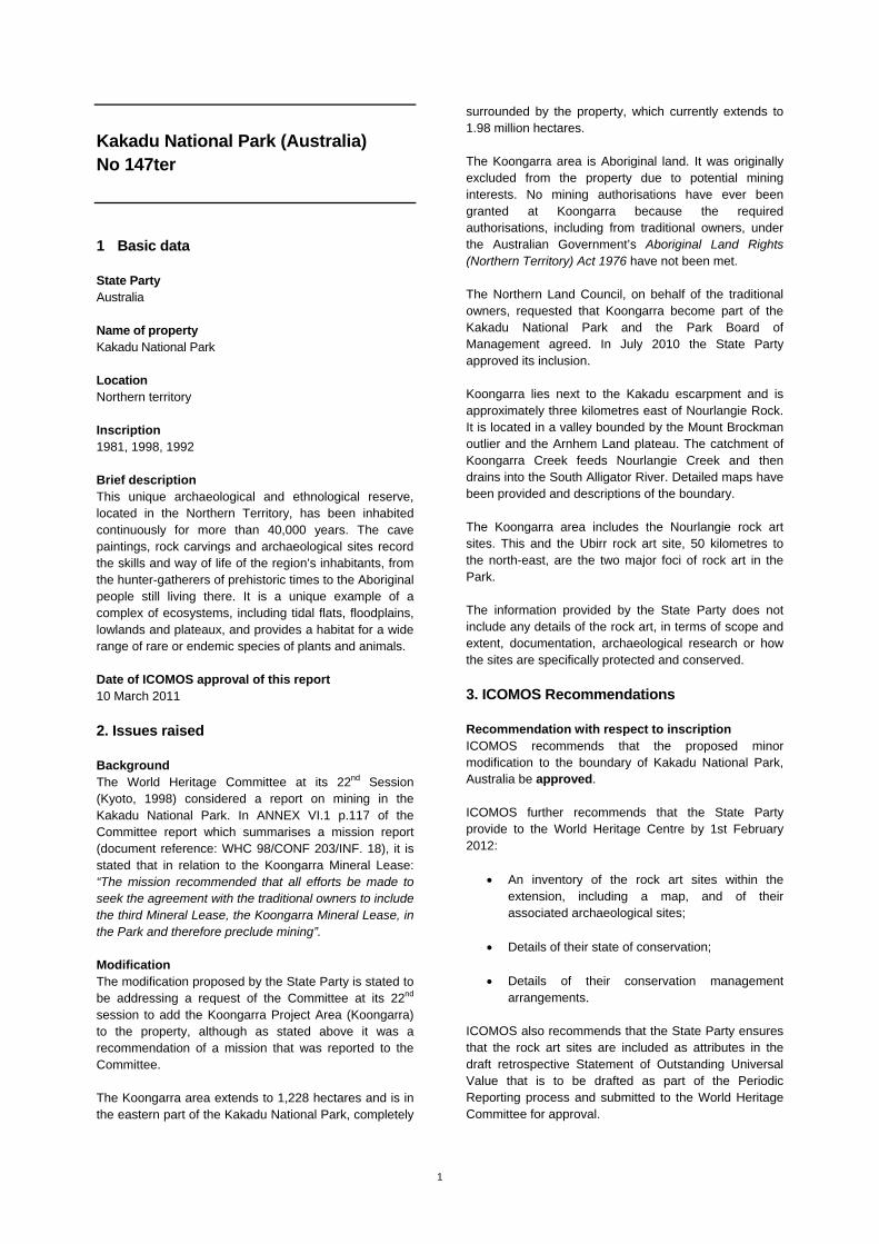
2. Issues raised Background The World Heritage Committee at its 22nd Session (Kyoto, 1998) considered a report on mining in the Kakadu National Park. In ANNEX VI.1 p.117 of the Committee report which summarises a mission report (document reference: WHC 98/CONF 203/INF. 18), it is stated that in relation to the Koongarra Mineral Lease: “The mission recommended that all efforts be made to seek the agreement with the traditional owners to include the third Mineral Lease, the Koongarra Mineral Lease, in the Park and therefore preclude mining”. Modification The modification proposed by the State Party is stated to be addressing a request of the Committee at its 22nd session to add the Koongarra Project Area (Koongarra) to the property, although as stated above it was a recommendation of a mission that was reported to the Committee. The Koongarra area extends to 1,228 hectares and is in the eastern part of the Kakadu National Park, completely
surrounded by the property, which currently extends to 1.98 million hectares. The Koongarra area is Aboriginal land. It was originally excluded from the property due to potential mining interests. No mining authorisations have ever been granted at Koongarra because the required authorisations, including from traditional owners, under the Australian Government’s Aboriginal Land Rights (Northern Territory) Act 1976 have not been met. The Northern Land Council, on behalf of the traditional owners, requested that Koongarra become part of the Kakadu National Park and the Park Board of Management agreed. In July 2010 the State Party approved its inclusion. Koongarra lies next to the Kakadu escarpment and is approximately three kilometres east of Nourlangie Rock. It is located in a valley bounded by the Mount Brockman outlier and the Arnhem Land plateau. The catchment of Koongarra Creek feeds Nourlangie Creek and then drains into the South Alligator River. Detailed maps have been provided and descriptions of the boundary. The Koongarra area includes the Nourlangie rock art sites. This and the Ubirr rock art site, 50 kilometres to the north-east, are the two major foci of rock art in the Park. The information provided by the State Party does not include any details of the rock art, in terms of scope and extent, documentation, archaeological research or how the sites are specifically protected and conserved.
3. ICOMOS Recommendations Recommendation with respect to inscription ICOMOS recommends that the proposed minor modification to the boundary of Kakadu National Park, Australia be approved. ICOMOS further recommends that the State Party provide to the World Heritage Centre by 1st February 2012:
An inventory of the rock art sites within the extension, including a map, and of their associated archaeological sites;
Details of their state of conservation; Details of their conservation management
arrangements.
ICOMOS also recommends that the State Party ensures that the rock art sites are included as attributes in the draft retrospective Statement of Outstanding Universal Value that is to be drafted as part of the Periodic Reporting process and submitted to the World Heritage Committee for approval.
Map showing the revised boundaries of the property
2
Konso (Ethiopia) No 1333rev Official name as proposed by the State Party The Konso Cultural Landscape Location Konso Administrative District, Southern Nations, Nationalities and Peoples Regional State (SNNPRS), Federal Democratic Republic of Ethiopia Brief description At the end of the Ethiopian arm of the Great Rift Valley, lie the intensively terraced, steep, arid Konso highlands, rising to around 2,000 metres and overlooking plains on all sides. The nominated area extends to 55 sq kilometres. Lying on the eastern slopes, the property encloses the upper reaches of three high level valleys, two draining to the south-east and one to the north. The stone walled terraces, some rising to five metres in height, support fields of millet and corn, and are part of an intense, communally organised and finely balanced agricultural system which incorporates water-management systems that ensure that water seeps from one terrace to another in order that the greatest number of fields make use of the available water. Within the terraced landscape, are stone-walled settlements (paletas) crowing the summit of hills. They are variously encircled by between one and six defensive dry stone walls. Each of the settlements has several large open communal and ceremonial spaces (moras), with large round thatch-roofed structures (paftas), used for meetings, games etc, and bachelors' dormitory. The mainly thatched roofed domestic and agricultural buildings are arranged around fenced compounds. The Konso are notable for the erection of wakas, memorial statues to a dead man. These stylised wooden carvings are arranged in groups, representing the man, his wives and heroic events such as the killing of an enemy or an animal such as a lion or a leopard. Category of property In terms of categories of cultural property set out in Article 1 of the 1972 World Heritage Convention, this is a site. In terms of the Operational Guidelines for the Implementation of the World Heritage Convention (January 2008) paragraph 47, it is also a cultural landscape.
1 Basic data Included in the Tentative List 30 September 1997 International Assistance from the World Heritage Fund for preparing the Nomination 1998 Date received by the World Heritage Centre 27 January 2009 31 January 2011 Background This is a referred back nomination (34 COM, Brasilia, 2010). A first nomination dossier for the Konso Cultural Landscape was examined by the World Heritage Committee at its 34th session (Brasilia, 2010). At the time, ICOMOS recommended that the nomination be deferred in order to allow the State Party to:
Undertake and provide a more detailed inventory of the key attributes such as town walls, paftas, shrines;
Re-define the boundary to reflect the key attributes of the property, the geo-morphology of the area, and social and cultural units, and in particular consider the interface between Dokatu towns and Karat;
Augment the comparative analysis; Define and put in place a buffer zone to protect
the property from urban development; Strengthen and augment structures and
regulations to ensure support for customary systems;
Strengthen the planning processes to ensure that the spatial planning of the towns is conserved;
Ensure more active involvement of regional and national authorities in the management and conservation.
ICOMOS considered that any revised nomination with revised boundaries would need to be considered by an expert mission to the site. Furthermore, ICOMOS considered that the international community should be invited to support this extraordinary landscape to ensure that its communities can meet the challenge of establishing a sustainable future. The World Heritage Committee adopted the following decision: Decision 34 COM 8B.11: The World Heritage Committee,
3
1. Having examined Documents WHC-10/34.COM/8B and WHC-10/34.COM/INF.8B1, 2. Refers the examination of the nomination on the basis of cultural criteria of Konso Cultural Landscape, Ethiopia, back to the State Party to allow it to:
a) Undertake and provide a more detailed inventory of the key attributes such as town walls, paftas, shrines; b) Re-define the boundary to reflect the key attributes of the property, the geo-morphology of the area, and social and cultural units, and in particular consider the interface between Dokatu towns and Karat; c) Augment the comparative analysis; d) Define and put in place a buffer zone to protect the property from urban development; e) Strengthen and augment structures and regulations to ensure support for customary systems; f) Strengthen the planning processes to ensure that the spatial planning of the towns is conserved; g) Ensure more active involvement of regional and national authorities in the management and conservation;
3. Also considers that the international community should be invited to support this extraordinary landscape to ensure that its communities can meet the challenge of establishing a sustainable future. In response to this decision, the State Party has supplied the following new information to supplement the original nomination dossier:
Executive summary and revised nomination file, January 2011
Management plan, January 2011 Konso proclamation, April 2010 Maps showing revised boundaries Photos and note on photos, 2011
The revised nomination is for a much enlarged area, some four times the area of the first nomination and includes some settlements as well as extensive terraced landscapes. It also includes further walled towns. Consultations ICOMOS consulted its International Scientific Committee on Cultural Landscapes and several independents experts. Comments on the first ICOMOS assessment of this cultural landscape were received from IUCN on 18 February 2010 and were related to the following issues:
Boundaries Protection and Management
The information was carefully considered by ICOMOS in reaching the final decision and recommendation in March 2010, and IUCN has also reviewed the presentation of its comments as included in ICOMOS’s first report. Literature consulted (selection) Amborn, H., ‘Agricultural Intensification in the Burji-Konso Cluster of South-Western Ethiopia’, Azania: Journal of the British Institute in Eastern Africa XXIV, 1989. Hallpike, C.R., The Konso of South Western Ethiopia: A Study of the Values of a Cushitic People, 1972. Shinohora, T., ‘The Symbolic Meaning of the Pot on the Roof. A case study of the Konso in Southern Ethiopia’, in Nilo-Ethiopian Studies, 1, Kyoto, 1993. Watson, E., Living Terraces, 2009. Watson, E.E., ‘Agricultural Intensification and Social Stratification: Konso contrasted with Marakwet’, in Mats Widgren and John Sutton, eds., Islands of Intensification, 2004.
Technical Evaluation Mission An ICOMOS technical evaluation mission visited the property from 19 October to 1st November 2009. As this is a referred nomination, ICOMOS has not been able to undertake a second mission to consider the revised boundaries, or to view the new areas. Additional information requested and received from the State Party None Date of ICOMOS approval of this report 10 March 2011
2 The property Description The revised nominated area extends to 230 sq kilometres or 23,000 ha, about 10% of the overall Konso hills. This is just over four times the area of the first nomination. The revised boundaries, as understood from the maps provided, now follow recognisable geographical features and encompass coherent geo-physical areas. The much enlarged area extends the property slightly to the north, east and south and substantially to the west. It brings in eight more walled towns near the original twelve and extensive terraced hills in the west that display very different settlement pattern of scattered unfortified, small villages with rectangular houses. The dry and rugged Konso range of mountains rise out of the Ethiopian arm of the Great Rift Valley in south-west Ethiopia. The area is home to the Konso speaking people who live in stone walled settlements on the summit of hills, facing high level valleys that drain to the surrounding plains. All slopes of the mountains display
4
steep stone-revetted terraces that make agriculture possible in this area of low and unpredictable rainfall through sophisticated soil and water conservation measures, many carried out communally, and encompassing rain-water harvesting, leaf fodder, intercropping and agro-forestry. The first nomination covered land lying on the eastern slopes of the hills enclosing the upper reaches of three high level valleys, two draining to the south-east and one to the north. The much enlarged nomination extends the boundaries to cover the western parts of the Konso hills and so also includes the valleys draining to the west. In the north-east of the nominated area is the modern urban area of Karat and this has been excluded. Within the original nominated area were 12 fortified settlements, 3 associated sacred forests, used for ritual and medicinal purposes plants, and shrines. The enlarged area has encompassed as far as ICOMOS can understand, eight more fortified settlements in the east and an unknown number of unfortified settlements scattered over the western valleys. No details have been provided for these additional settlements, apart from some data on two in an Annex. The various aspects of the landscape are considered separately. Terraced Landscape The Konso area has the highest degree of uncertainty regarding rainfall due to its position at the southern extremity of the highlands. The problem is not usually an absence of rain but an abundant discharge in a short time, hence the use of terracing to collect the maximum amount water and to discharge any excess in a regulated way.. In those years when rain is scarce, the terraces similarly optimise the collection of water. The terraces prevent soil erosion and maximise water retention. Crops are grown in rotation throughout the year. Coffee, cotton and chat are cash crops. Twenty-four different varieties of millet are grown as well as wheat, barley, sorghum, maize, peas, beans, potatoes, banana, cotton and coffee. The descriptions provided relate to the terraces in the area covered by the original nomination. Terraces can be up to 8m high and the width depends upon the steepness of the slope. They are made where the soil is cut away to make a perpendicular face and a stone wall built against it. Foundations are usually small (10 – 25cm). Stone is moved from above and used to level the lower area. Men and women work together in building and maintaining the terraces, although stonework is the job of men. Women use tomas (long wooden bowls carved from trees) to move earth.
Bends in the wall are reinforced by turrets. Turrets seldom rise more than 2m above the field. They are used as platforms to protect crops from birds and animals. For further support, flanking walls are built to cross the terraces perpendicularly, approximately 50m apart. These are up to 1.5m high and serve as pathways. To protect the fields, the Konso maintain their cattle, sheep and goats in stalls and feed them by hand or supervise their grazing. The revised nomination has provided a map of the overall nominated area showing the percentage of the land area that is under terraced cultivation. Apart from the river valleys, the coverage of the hillsides by terraces varies between around 50% to over 80 % depending on the steepness of the slopes. The newly nominated western terraces extend the no0minaiotn beyond the regions of Fasha and parts of Karate (within the Konso wereda or administrative area) into parts of the Kulme region. Although the new boundaries follow geographical features, it is not clear what the relation is for the new boundaries in terms of cultural units. Fortified Settlements - paletas In the north, eastern and southern part of the nominated area the settlements are walled and fortified. Known as paletas, these towns are all on flat or mainly flat land on or near the summits of hills. There are enclosed by between one and six concentric walls of basalt boulders. The nominated area contains the following walled towns. The first twelve were in the original nominations, the last eight have been added in the revised nomination (as shown on the new maps) and some details have been provided for only two of these: Gamole, 3 walls Gocha, 1wall Mechelo, 3 walls Lower Dokatu, 6 walls Burquda,1wall Hulme, 1wall Dara, 6 walls Olantu, 4 walls Mecheke, 1 wall Burjo, 1 wall Gaho, 1wall Busso,-1 wall Nalaya Segen, number of walls not known Jarso, number of walls not known, but multiple Lehaite, number of walls not known Gume, number of walls not known Gera, number of walls not known Un-named town south-west of Gera, not known Gesergio, not known Un-named town in south–east, not known
5
The walls reflect it seems a response to population increase, with the inner walls being the oldest, and in most case the highest, reaching up to 4 metres in heigth and in places 2.5 metres wide. It is stated that the most heavily fortified towns with multiple rings of heavily built stone walls. (e.g., Doketu, Gamole, Derra, Jarso, Olanta, Gamole) are considered to be the oldest but also furthest to the east of the nominated area, while towns with only one wall are further west (e.g., Mecheke, Burjo, and Gaho) and may have been developed later. The outer walls of each of the towns have two or more exit gates leading to water sources, farms or markets. Each town is governed by an autonomous council of elders and divided into smaller administrative neighbourhoods or wards known as kantas. Each member of the community will belong to one of the kantas. Within the towns, the Konso live in individual compounds surrounded by wood and stone fencing. The compound is divided into two halves: the upper part for people and the lower for animals and storage. Usually there are 5 or 6 thatched structures, including the house, stores and granary, a grinding space with a stone mortar, often in the lower part of the granary, and a cattle kraal. Within each of the towns are several moras, large open communal and ceremonial spaces. There can be up to seventeen moras in a paleta, located at the centre of the main central wall and at different locations within the towns. There might be one or two outside of the walls. Paths lead from gates to moras. Paths also connect one mora to another. Some moras have tall round thatch-roofed structures, known as paftas. These are larger and more ornate versions of ordinary houses, with stone slab seating areas and thatched roofs supported by stout juniper posts. They are the practical and ceremonial centres of daily life. They are used for meetings, games etc, and used to be as bachelors' dormitories, associated with ceremonies related to the transfer of power to the younger age groups but this ceremony now only takes place in Doketu. These paftas are a reflection of communal pride and serve as the show-pieces in each village. They may be surrounded by ‘generation’ trees, ulahitas dead junipers up to 40 feet high transported from the forests, monolithic stone stele, daga-hela, reflecting the success of warriors, oath taking stones and ritual spear sharpening stones. Within each town, one or two central moras occupy the highest status. These have higher stone walls, larger paftas, larger and more generation trees, and up to 5 or 6 stele.
In the original documentation provided it was not clear how many paftas existed or where they were. Annotated maps have been provided for each of the towns originally nominated which show the position of the paftas. The fortified settlements once contained all the houses within their walls which were accessed by two or more main gates. Today these gates no longer need to be guarded or actively defended (and side entrances through the outer wall may now substitute), and the distinction between the enclosed, densely settled 'town' and the surrounding terraced cultivation has been blurred in several instances, as families are preferring to site their homes outside the enclosing wall or along the road. There is also a growing tendency for households in the walled paletas (and those who have built outside the walls) to reconstruct their dwelling houses in rectangular shape convenient for roofing with corrugated metal sheets. These metal roofs catch the eye from afar. However, in those compounds where metal roofing has been introduced, it is usually confined to the main house alone, and the layout and function of the other structures and spaces has not been radically affected. The individual paletas for which information is provided are as follows: Gamole Gamole walled town has three dry stone walls with the outer wall approximately 1,300 metres long. The inner wall is the oldest and encloses what is believed to be the original settlement. Gamole has eight Moras. The dina woodland around the town is mostly destroyed due to population and development pressures. Gocha Gocha has one stone wall around 1,700 metres long with five gates. The walls are, however, mostly destroyed and few families live in the town. There are five moras within the town and one outside. Outside the line of the walls is a small dina, with decaying wakas (burials). In recent years the community has failed to maintain this area. Mechelo Mechelo is considered with Gamole and Gocha to be one of the oldest walled towns. It has three walls, the external walls covering around 1,700 metres. The average height of the inner wall in nearly two metres but it rises to just over four metres in places. Mechello has seventeen Moras. These have Daga-dirumas and Olayta trees rather than paftas. Mechelo is one of the few towns to keep part of its dina. Around 2,500 sq metres survive with thirteen grave markers. Dokatu Dokatu is the collective name for three walled towns, Lower Dokatu, Burquda and Hulme. The main Konso-
6
Jinka road passes between Burquda and Hulme and all three are near the growing urban area of Karat. Generally the towns of the Dokatu cluster collaborate together during rituals and to combat fire accidents. Lower Dokatu has six walls with an outer length of around 1,600 metres. In contrast to other towns, the outermost walls are the highest rising to just over 3.5metres. The town is large covering 158,293 sq. metres.There are 6 gates and 19 moras. Its two sister towns have their own moras too. Nevertheless, some of the moras in the three towns provide services to all three communities during common rituals such as the Kara ceremony. No descriptive details are given for Burquda and Hulme. Each has one wall. Dara Dara has six walls with the outer wall extending to just over a 1,000metres. Some of the walls reach to 4.5metres in height. There are four gates and nine moras, one being outside the walls. Olanta Olanta has four walls, the outer around 1,000 metres in length. There are three gates and 15 moras with nine paftas. Mecheke Mecheke has one wall running to 1,300 metres. There are five gates and eleven moras. Burjo Burjo is a small town with a single wall, around 800 metres long. There are four gates and four moras. Gaho Gaho also has a single wall extending to around 800 metres. There are six gates and nine moras with paftas. In both Burjo and Gaho the walls are lower than in other towns – perhaps reflecting their central position which might be associated with fewer threats. In the two towns there is a tradition of supporting small storage buildings on a single vertical log. Busso Busso is not fully encircled by a wall as it is protected by natural terrain and walls were only constructed on the flat areas. There are six gates and sixteen moras. There are 31 erected stones outside the main gate. There were formerly many wakas but these have been stolen or are decayed. The following eight towns have been included in the revised nomination – for these there is no description and no plan is provided to show the walls, but statistics for the height of walls and numbers of moras and paftas have been given for Jarso. Nalaya Segen
This town is said to be one of the earlier ones with multiple walls but the number is not given. Jarso This town is said to be one the earlier ones with multiple walls but the number is not given. However the walls are said to rise to a height of 5.6 metres – which must make them the highest. It has eight moras and eight paftas. Lehaite (not marked on map but mentioned in Annex) Gume Gera Un-named town south-west of Gera Gesergio Un-named town in south –east Unfortified settlements An extensive area of terraced landscape in the west of the enlarged property contains scattered settlements. No details have been provided of these other than that none of these are as large as the towns in the east and none are fortified. However it is not clear whether they contain similar round thatched houses to the fortified towns. It is said that moras are located in central spaces that are easy to access for all, and sometimes on major tracks. Daga-hela stone stele The Konso people have an age grading system through which every generation takes responsibility to protect the well being of its community. This system is linked with a tradition of erecting a generation marking stone called Daga-hela. This is freshly quarried piece of columnar basalt reaching some three metres in height and transported and erected through a ritual process called Kara .Generations who have served the community well, based on the views of their elders could have the honour of having their generation marker stone Daga-Hela erected near the most prestigious Mora, as a witness for their good work. Less successful generations have their stones erected elsewhere in the town or outside the walls. The latter are usually smaller in size. Forests There are three main sacred Poqolla forests in the Konso areas, Kala (196,430sqm), Bamale (105,338sqm) and Kufa (45,066sqm). The generation trees erected in the moras are cut from these forests. Kala is the best preserved and most actively used. Priests reside near this forest and are buried within them with elaborate wakas erected beneath shelters of wood and thatch. It contains several ritual spots such as the Shila Genda or ritual mourning stone, a large basalt block next to two open spaces. One, Kenota, is where young males stay for two months during initiation before they go back in to the Gamole walled town to get married. The other space called Koltoma is reserved for young females. The initiation takes place only once every 18 years. Another block of basalt, called Shila Saga, is where the Fora or ritual fight dance takes place.
7
The scarification for the harvest and conflicts are also arbitrated at Shila Saga and at a nearby block for different communities. The Bamale sacred forest covers an area of 105,338 square metres. The ritual leader holds the same name, Bamale and lives near the forest with his family. The graves of the earlier Bamales are located at the center of the forest. Unlike the Kala, there are no Wakas placed in the forest. Formerly the trees were mainly Juniperus, but the Derg Government (1974 until 1987) cut much of them for timber. Eucalyptus has since been re-planted. However, since 1991 there has been some regeneration of indigenous species. The Kufa sacred forest covers an area of 45,066 square metres. The Poqola or priest resides near the forest but there are no recent wakas in the forest. There are ancient graves of ancestors of the present Poqola at the centre of the forest. Near many of the towns there is a dense grove of euphorbia and finger cactus between the towns and the fields. Known as dina, these woods provide firewood and were also used as a burial ground for the towns’ artisans who did not have their own land. In spite of their social and cultural functions, many of these areas are now neglected and partly deforested. Waka (wooden statue) and Daga-diruma (erected stone) Burial markers The Konso are notable for the erection of wakas, memorial statues to respected members of the community. These large, stylised anthropomorphic statues, usually made of juniper wood, are arranged in groups, representing the man, his wives and particularly heroic events. Formerly these were erected near the mora or near the gates. Latterly they have been put up beside major paths. Many are now neglected. Farmers were buried in their farms and simpler wakas erected, while artisans without land were buried in the dinas. Hardas These are water reservoirs located within or near forests. They are also found close to every walled town and dispersed in the landscape and dispersed. They collected rain water for cattle. Some hardas are as long as 60 metres and their retaining walls can be up to 13 metres in height. The Dokatu Harda at an altitude of 1,420 meters is among the oldest water reservoir still in use. The number and location of these are not provided. History and development Knowledge of the history of the Konso landscape comes from oral traditions and linguistic analysis and some limited archaeological investigations of a few
settlements, but so far no reliable dates have been obtained. Oral traditions suggest that the Konso migrated to the present area from the east and north around 21 generations ago – approximately 400 years ago. This is approximately confirmed by the number of incised rings on the generation batons erected on the tombs of the Poquola of the Kala, the earliest ritual chief, the first Kala lived 21 generations ago. In the management plan more details are provided and it is suggested that the Konso originally came from the east and the west. The eastern group constitutes those who migrated mainly from Liben (Borena) and also those from the Burji areas. People in the western group, reportedly came from the highlands of Dirashe, Mashile, Gewada, and from the Tsemay area etc. Almost all of the local informants agree that migrants from the east were the first settlers of the Konso land. They also confirm that people from the west reached the area shortly after the former, but at almost the same time. There appears to be no oral traditions associated with the building of the terraces. The compact village tradition and the agricultural system, and also the history of the internal developments which must have occurred century by century, deserve testing through surveys and possible archaeological excavations. Abandoned plots within the existing villages, and more particularly villages long deserted, several of which remain recognisable in the farmland, their walls now modified as cultivated terraces, could be investigated. Research along such lines would bring a new understanding to Konso and its culture. ICOMOS notes that the nomination dossier acknowledges this need. Until the incorporation of Konso land into the Ethiopian empire by Menelik II towards the end of the 19th century, each Konso traditional town enjoyed an autonomous status and used to be administered by traditional institutions. Councils of elders were placed on top of these institutions and although some resistances was reported in Jarso, Guyle and Dokatu, this resistance came to an end with the fall and destruction of Dokatu town. Until the 1970s, Konso was administrated within the Gamo-Gofa Region, and before the end of the 1980s, under Semen (Northern) Omo Administrative Region. Currently, under the country’s federal structure, it has become one of the Special Woredas (districts) under the South Nations, Nationalities and Peoples’ Regional State (SNNPRS). Its capital is Karat (formerly Bekawile).
8
3 Outstanding Universal Value, integrity and authenticity
Comparative analysis The comparative analysis does not systematically compare the Konso landscape with other inscribed landscapes in order to show whether there is room for it on the World Heritage List. It mentions Sukur Cultural Landscape, Nigeria (1999, criteria (iii), (v) and (vi)) and the Rice Terraces of the Philippine Cordilleras, Philippines (1995, criteria (iii), (iv) and (v)), both of which are said to be comparable to Konso. Comparisons are also made with other inscribed ‘megalithic’ sites, such as Stone Circles of Senegambia, Senegal – Gambia (2006, criteria (i) and (iii)), and sites that demonstrate clan structures, such as the Sacred Mijikenda Kaya Forests, Kenya (2008, criteria (iii), (v) and (vi)). ICOMOS considers that a case could have been made for consideration of the property on the List had any comparison been made between the overall attributes of the Konso landscape – that are considered to give Outstanding Universal Value – and other sites on the List. This would have shown that the combination of extensive terraces and fortified towns is not otherwise represented on the World Heritage list; even though there are terraced landscapes such as the Sukur Cultural Landscape in Nigeria on the List, these do not demonstrate the complexity of settlement patterns. Furthermore, in respect of the second part of the comparative analysis which should show whether there are other similar sites that could be nominated, ICOMOS considers that, although there are examples of intensive and highly specialised agricultural communities, both existing and archaeological, in Ethiopia and those mentioned include the Burji and Amaro regions to the east of Konso, the Zala in Gamo country to the north, and elsewhere in eastern Africa, and in part of West Africa. None of these other landscapes exhibits the degree of continuity, or the visual impact offered by Konso, nor particularly the combination of terraces and fortified towns that reflect a very specific response to environmental and social constructs. The combination of terraces and complex walled towns is not paralleled elsewhere. Within Ethiopia, in Dawro country, there are extensive stone walls in multiple rows remaining from the 18th century post-mediaeval Dawro state and these are reported to reach 176km in length – but these linear fortifications are quite different from those of Konso. Within the Konso area, there are more walled towns that those in the area nominated. The nomination dossier mentions, for instance, that some of the earliest towns are Patangalto, Idigile and Gandma, not in the nominated area. However no comparisons are offered between these and the nominated towns.
ICOMOS considers that the comparative analysis as set out justifies consideration of part of this property for inscription on the World Heritage List – that part that contains the walled towns and associated terraces but not the terraces on their own. However what has not been fully justified is which walled towns should be included within the boundaries.
Justification of Outstanding Universal Value The nominated property is considered by the State Party to be of Outstanding Universal Value as a cultural property for the following reasons: The Konso landscape is an extraordinary cultural
landscape that reflects a combination of unique architecture, land use, space planning and management, resource mobilization, and ritual practices, in an otherwise hostile environment.
The compact walled towns with their multi-layered defensive systems, hundreds of thousands of kilometres of long dry stone terraces that are engineered to manage rain water and control soil erosion and that extend over virtually the whole landscape of the Konso hills, bear a striking witness to an intense resilient land use forged by very specific communal social and cultural systems that were an extraordinary response to the area’s aridity and unpredictable rainfall.
In this restricted landscape of rugged mountains and hostile environment, the people of Konso for 500 years have come to learn, understand, appreciate and utilize the available resources to a maximum degree but within a sustainable way and manner.
The Konso Cultural landscape is therefore, an outstanding example of the human urge to understand and appreciate his environment, whatever constraints it may pose and to use it to the best of his knowledge and capacity applying good practice.
ICOMOS agrees with this statement but stresses that it is the combination of walled towns and terraces that makes the landscape exceptional. Integrity and authenticity Integrity
In the first nomination the proposed boundaries set out to contain the key tangible attributes of terraces, walled settlements, sacred groves and shrines, but excluded some areas that appeared to share similar attributes. The boundaries also did not define geo-cultural units, they cut across the landscape, did not relate to the coherent cultural or social units that sustain the communal farming activities, and did not relate to recognised visual features. The revised boundaries have addressed these issues. The new boundaries coincide with natural features such as rivers, or roads, or are mark the edge of the densely terraced landscape. A map showing the intensity of
9
terracing in the Konso areas, based on multiple transects of the area has helped to define the new limits. However very few details have been provided of the extensive new areas and in particular the terraces and settlements. And in the absence of a mission, no condition report is available. It is therefore not known whether any of these areas are vulnerable or under any specific threats. Nor is it clear how they relate to the landscape of terraces and fortified towns. In terms of known threats to the area of the original nomination, the greatest threat to integrity is the dispersal of fortified settlements, with houses being built outside the town walls, thus breaking down the clear, distinctive, landscape patterns of settlements, farmland and forest. Other attributes such as the sacred forests, dina woodland, traditional house-building techniques, are also to a degree vulnerable. Authenticity
In terms of the original nominated area, the pattern of the overall landscape and what it reveals of the way it has developed over time, in terms of the arrangement of settlements, terraces, forests and shrines is without doubt authentic. As are the continuing, agricultural, social and cultural processes that maintain and sustain this landscape. ICOMOS cannot comment on the extensive new areas that have been included in the revised nomination. ICOMOS considers that some attributes of the landscape in the original area are vulnerable from lack of maintenance such as forests, woods and grave markers. Others are vulnerable to the changes in materials, or developmental threats (see below) that interrupt the relationship between the walled towns and their landscape. These vulnerabilities could increase unless further structures are put in place and could impact adversely on the overall authenticity of the property.
ICOMOS considers the condition of integrity appears to have been met in terms of the boundary encompassing all the key attributes of walled towns and terraces, although it is not clear how the extensive new area contributes to the attributes. ICOMOS cannot comment on the vulnerability of the extensive landscape that has been included within the enlarged boundary of the revised nomination. The condition of authenticity has been met for the original area but this has a degree of vulnerability that needs to be addressed, if the overall landscape is to be sustainable. ICOMOS cannot comment on the authenticity of the large area of landscape that is included in the revised boundaries.
Criteria under which inscription is proposed The property is nominated on the basis of cultural criteria (iii), (v) and (vi).
Criterion (iii): bear a unique or at least exceptional testimony to a cultural tradition or to a civilization which is living or which has disappeared; This criterion is justified by the State Party on the grounds that the Konso landscape is constituted by the most spectacularly executed dry stone terrace works in the world which are still actively in use by the people who created it. This extraordinary terrace work is a witness of the struggle of man to harness a hostile environment and is today a major human achievement. The landscape also demonstrates the megalithic tradition of stele erection which together with the funerary system that involves the tradition of mummification of their ritual leaders and the carving and erection of anthropomorphic wooden statues represents an exceptional living testimony to traditions that are on the verge of disappearance. ICOMOS considers that what is being nominated is the overall Konso cultural landscape, and the issue is how this reflects a specific cultural tradition in an exceptional way. ICOMOS considers that the dominant aspects of the landscape that have been nominated are the stone terraces and the fortified towns in their midst. The funerary traditions are an integral part of the cultural traditions associated with the settlements. ICOMOS considers that it is the associations between terraces and the fortified towns that make this landscape so exceptional. In the first nomination the boundary of the landscape that was nominated did not adequately respect the terrace formation and cut across the cultural and geographical features. The boundaries do now respect geographical features but, from the information provided, ICOMOS is not able to say how far the new boundaries can be said to aligned with the cultural traditions that created the towns. Further assessment is needed of the proposed revised boundaries which unfortunately ICOMOS has not been able to undertake in the absence of a mission.
ICOMOS considers that this criterion has not been justified at this stage.
Criterion (v): be an outstanding example of a traditional human settlement, land-use, or sea-use which is representative of a culture (or cultures), or human interaction with the environment especially when it has become vulnerable under the impact of irreversible change; This criterion is justified by the State Party on the grounds that the dry stone walls demonstrate an adaptive strategy to the dry environment and that the overall landscape of terraces and the highly organised towns with multiple defence systems demonstrate a strong tradition of common values, social cohesion and engineering knowledge.
10
ICOMOS considers that the overall Konso landscape, particularly its terraces and associated walled towns, can be seen as an outstanding example of a resilient land use, forged by very specific social and cultural systems that were an extraordinary response to the area’s aridity and unpredictable rainfall. In the first evaluation, ICOMOS considered that the attributes (both physical features and processes) of that system need to be better defined and more carefully mapped in order to set out more appropriate boundaries that respect the morphology of the area and its cultural and social units. The current revised nomination has greatly increased the boundaries to include an expansive area of terraces in the west. This area has perhaps the greatest concentration of terraces but does not have walled towns. ICOMOS has not had the opportunity to assess this area that increases the size of the nominated areas fourfold. However it notes that is has changed the emphasis away from the dominance of the walled towns. ICOMOS considers that this criterion could be justified for a smaller coherent area that reflects the extraordinary conjunction between terraces and walled towns.
ICOMOS considers that this criterion has not been justified at this stage.
Criterion (vi): be directly or tangibly associated with events or living traditions, with ideas, or with beliefs, with artistic and literary works of outstanding universal significance; This criterion is justified by the State Party on the grounds that the Konso belief system, social organisation, rituals and art (wakas) are testimony to traditions of megalithic societies. ICOMOS considers that the justification provided does not demonstrate how these beliefs are of universal significance in relation to megalithic societies in general, or how the overall cultural landscape reflects these beliefs in an outstanding way.
ICOMOS considers that this criterion has not been justified.
ICOMOS does not consider that the criteria and Outstanding Universal Value have been justified at this stage.
4 Factors affecting the property Development pressures
One of the main trends identified by the State Party is for new houses to be built outside the enclosing town walls and for old plots to be left abandoned. This trend is not yet undermining the social fabric and functioning of the
villages; but if the process of moving out and leaving abandoned plots continues, this could have a detrimental impact on the value of the spatial organisation and overall social structures of the towns. There is also pressure for schools, clinics, flour mills, churches and modern burials. There appear to be no policies or planning currently that can control these processes adequately so that new buildings respect the patterns of the landscape. In several villages, the positioning of the water tanks, standpipes and latrine blocks in front of the main entrance, or original gate seems to have been chosen without necessary consultation. To the north-east, the boundary encircles Karat town, which is an exclusion zone. The population of Karat has doubled in the past ten years and the town is undergoing rapid infrastructural development. To the east and west are the three towns that collectively are called Dokatu. All three are right up against the property boundary with the threat of development in Karat immediately outside. Measures have been now taken to control this interface - see below. The expansion of the town of Bekawle (the Konso administrative center), had also threatened the terraces that lie in Dokatu, Hulmie, Olanta, and Dara territories. But it is now accepted that the town can only expand toward NE and E directions, outside of the nominated area. Currently electricity is not connected to all the villages. If the lines continue from those in the existing towns, this could lead to a plethora of overhead lines in the landscape. ICOMOS notes that there has not so far been consideration of whether this can be avoided and how consultation might take place. It is noted new road constructions has cut across the terraces Lack of development The lack of water supplies and of adequate sewage disposal is a negative factor in terms of encouraging families to stay in the towns and villages. Dams To the south-west of Konso there are projects, apparently going ahead, for a series of dams on the Omo river to supply hydroelectricity to the country's grid (and maybe adjacent countries too). It appears that the approved route for the high-voltage power line is not parallel with the tarmac road through the middle of Konso, but to the east of the nominated area. ICOMOS considers that assurances need to be given on this point. Changing agricultural practice Sufficient availability of labour for the myriad of tasks necessary to keep the overall agricultural terrace system
11
functioning is absolutely crucial. Traditionally many of these were apportioned to youths or children, such as promptly repairing damage to walls and drains after storms or scaring birds and monkeys from the ripening grain. Now, with a weakening of the age-grade institutions and communal obligations, strains in maintaining the agricultural cycle are likely to manifest themselves. Demographic changes Only around 20% of Konso people now live in the heart land of Konso country – that is the nominated villages. It appears that many families have moved to lower ground where it is easier to farm and there are less social constraints. Although they keep links with their ancestral villages, there must be a danger that, unless farmers in the nominated areas can in some way add value to their produce, they will become marginalised and the fortified villages the residences of older people. Tourism pressures
There is clearly a wish to increase tourism but there is also a risk that this could lead to a museumification. The newly inaugurated Konso Museum could play a central role, liaising with other museums and institutions and scholars generally, in providing more sophisticated information (rather than on the traditional terraces and town walls) of the persistent and resilient agricultural and cultural systems and raise awareness within the community, as well as with visitors, of the dynamic social and cultural landscape. One of the main current adverse impacts of tourism is a rash of lodges, some labelled 'eco-lodges', on prominent sites, directly overlooking villages. The lodges are thatched imitating authentic Konso style – but in entirely unauthentic situations. It is not clear how permission for these was given but ICOMOS understands that the aim is to provide clearer scrutiny of such proposals in the future. Theft There is particular concern for the safety of the carved funerary effigies, wakas, commemorating senior clan-heads and heroes, since they are subject to decay (as they always were) but also, having acquired some fame and monetary value in the ethno-art world, and are thus now vulnerable to theft. In some villages action has been taken to move wakas from their original grave-marking positions to safer ones inside the walls, and to protect them from the elements by erecting shelters of metal sheeting. Others are said to be hidden away and are expected to reappear soon in the safe refuge of the new Konso Museum where there will be suitable conditions (and treatment facilities) for permanent conservation. Environmental pressures
Building materials Customary materials and labour for repairing terraces, town walls and houses, are increasingly being seen as
having a price. The nomination dossier mentioned the cost of thatching grass, for the paftas as well as for individual homes, indicating the scarcity of grass in this intensively cultivated landscape, as well as the continuing need for fodder for the stalled cattle. These factors are exacerbated by the pressure of an increasing population upon all natural resources (and perhaps the reluctance of people to fulfil customary obligations without payment). Where roofs have been changed from thatch to tin, although this change of style requires an outlay of cash, it may prove in the long run cheaper in terms of the labour (and reciprocity obligations thereby incurred) than obtaining thatching grass and regularly maintaining the roof. Any policy to sustain traditional roofing will have to find a solution to the scarcity (and expense) of thatching grass. Forestry IUCN notes that: ‘The natural values of the landscape have been heavily degraded and little is left of the original vegetation across much of the area. The sacred forests, which provide some protection to forest remnants, continue to be degraded and cut down. These forests, while small, preserve some natural values, as well as having sacred significance in a number of cases. There has been replacement of some species with exotic Eucalyptus which is reported to exacerbate problems of water management. The implementation of a reforestation programme, initially for firewood, could be considered priority in the property. Protecting the last remnant natural forests and restoring them is more difficult, but should be attempted in order to retain natural values within the landscape’. Natural disasters
The property has a degree of vulnerability to earthquakes and to storms which produce flash floods that could inflict considerable damage on the terraces. Impact of climate change
The landscape is clearly vulnerable to changes in rainfall patterns, although during past famines the areas has managed better than other parts of the region. IUCN notes: ‘In an already dry environment, climate change is a threat to the values of the landscape and mitigation and adaptation measures should be important components of site management’.
ICOMOS considers that the main threats to the property are changes in traditional practices, related to building construction and forestry, community obligations, resources, a potential over-reliance on tourism, and development pressures from Karat.
12
5 Protection, conservation and management
Boundaries of the nominated property and buffer zone The area within the boundary covers approximately 230 sq. Km. The original boundaries were somewhat arbitrary with long straight lengths cutting across the landscape and not coinciding either with recognisable landscape features or cultural or administrative units. The revised boundaries follow natural and cultural landscape features and include the upper watersheds that feed the irrigation systems. No buffer zone has been designated as it is stated that the wider landscape is also managed by traditional law. ICOMOS considers that the larger nominated area gives much more effective protection to the west but the landscape near the cluster of walled towns to the east is still vulnerable to what happens immediately outside the boundary in Karat town and its environs. This landscape does need protection from some form of buffer zone.
ICOMOS considers that the boundary of the nominated property as revised relate it more clearly to topography and cultural and social units and in so far as it can judge without a site visit, are adequate from the point of view of protection; however either a buffer zone needs to be put in place or planning policies that protect visually contiguous areas that form the setting of the property in the north and east.
Ownership All land is owned by the State as is the case throughout Ethiopia. Terraces are owned by individual members of the community. The forests are ‘owned’ by the Poqolla and members of their family, a status that is defined by traditional law. The walled towns are collectively owned by the community members. Protection Legal Protection
The regional Konso proclamation, which came into force in 2010, gives protection by the Southern Nations, Nationalities and Peoples Government to the nominated area and specifically to the area and attributes of the 12 walled towns of the original nomination which are listed. The boundaries of these towns are set out. Specific protection is also given to the towns adjoining Karat. The legislation has placed posts as the limits of the traditional towns, and no construction is to be conducted within the 50 metres space outside the external walls of the traditional towns. ICOMOS notes that the nomination dossier makes reference to existing Federal Law No. 209/2000
governing the protection of archaeological, ethnographic and cultural sites and artefacts. it is not clear how under decentralisation, specific enforcement under federal law, and prosecution where necessary, will be initiated. The Rural Land Administration and Utilization Proclamation No.53/2003 makes provision for customary laws and communal protection and this provides the framework within which the Konso proclamation has been drafted.
Traditional Protection
Almost the entire management, maintenance and conservation of the nominated property is carried out by traditional measures. These are supported by the Proclamation mentioned above. Effectiveness of protection measures
However effective traditional practice is, it has the capacity to be highly vulnerable to demographic and social pressures. ICOMOS considers that traditional management needs to be supported through legal protection or planning measures and encouraged though incentives if it is to survive. These constraints and incentives need to be robust enough to support the living communities of the Konso area in a sustainable way, allowing them opportunities for improved standards of living based on the economy of the terraces rather than from an over-reliance on tourism. IUCN also notes that: ‘The basis for protection of the area is customary law. IUCN questions whether this will be sufficient to guarantee the protection of the nominated property, especially the natural values, over time. It is also of concern that the management plan for the site does not carry legal weight and may not be entirely consistent with customary law. Ideally, governance set-ups integrate customary and formal protection and management in a complementary and consistent fashion.’
ICOMOS considers that the legal protection in place is has now been strengthened through the Konso Declaration. Although the traditional protection arrangements currently in operation are admirable, they need active support and constraints to ensure they are resilient in response to social and economic changes. ICOMOS considers that the current protective measures for the property need to be augmented and strengthened to support the communities in their massive conservation responsibilities.
Conservation Inventories, recording, research
As part of the nomination process, community members have participated in data collection and have led a
13
mapping process within their respective territory, supported in part by external funding. As a result, town stone walls have been measured, the moras have also been measured, their use and related data recorded, and sketch drawings prepared for two representative moras. Sample homesteads have been documented; data on the extent of terraces has been collected through car and foot transects; and a sample terrace area measured systematically. Three major traditionally protected forests and associated cultural manifestations have been documented. The nomination dossier has however not provided details of all the evidence collected. For instance there are no specific details of the town walls, apart from their plan, nor details of numbers and locations of the moras. Several of the villages, with ward boundaries, moras and wall configurations plotted, would serve as an excellent base for more revealing surveys – involving student teams, say – undertaken homestead by homestead (both occupied and abandoned), wherever that can be undertaken without undue intrusion. Present state of conservation
The structures of the landscape that need conservation are extensive: the town walls, wood-and-thatch houses, granaries, stock-stalls within the compounds, the paftas in the mora spaces, as well as the footpaths, walls, surviving gates etc of every town, and outside, the dina woods, graveyards, sacred forests, stone reservoirs, hardas, and the vast extent of stone-walled terracing. Some variation from traditional practice has been noted, in particular the substitution of metal sheets for roofing of houses and the overall positioning of new buildings. Overall the state of conservation of the town walls is fair although some gates are no longer maintained. Some of the pafta buildings have been restored with outside funding. There is a problematic lack of maintenance of the dinas and wakas and thus their state of conservation is poor. There are difficulties with the conservation of the sacred forests where much of the original juniper stands were felled, where there has been replanting with eucalyptus and there is currently little regeneration. The conservation of the field terraces is good and reflects the need for these terraces as a vital part of the Konso subsistence economy. Features such as the harda reservoirs could suffer from neglect if they are rendered redundant by new water supplies. Active Conservation measures
Conservation is governed, up to a point, by local traditional practices and sanctions; but in view of modernising pressures, there is no guarantee that traditional work will continue. ICOMOS notes that this is acknowledged in the nomination dossier.
In recent years, partly in tandem with the preparation of the nomination dossier, some financial support for conservation has been forthcoming (in particular from the Christensen Fund in USA) through local NGOs. This has brought some valuable results, in particular for the maintenance of village walls, repairing of moras and their paftas with necessary re-thatching, protective measures for surviving tracts of forest (with appropriate emphasis on the virtue of biodiversity), and reviving of communal cultural events. The success of this will depend not only on agreement to certain standards but the viability of the overall economic system. It is difficult to say whether this conservation work would continue if the moral encouragement of a modicum of funding were to be lacking. The surviving pockets of traditional forests need active conservation. ICOMOS understood that the team preparing the nomination dossier has made special efforts to strengthen or revive the traditional control and management of these forest relicts, and to raise public awareness of the importance of their conservation in the villages around. But if these efforts are to be effective and lasting, ICOMOS considers that a system of constant vigilance, at district as well as local village level, will be essential. Maintenance
Maintenance cannot be separated from conservation in terms of the elements of the Konso landscape. Effectiveness of conservation measures
There is a great reliance on the strengths of the traditional community system with its complex obligations. ICOMOS is concerned that this system is not resilient enough to counter the social and economic forces for change, to the extent that key attributes are conserved, and considers that more proactive engagement is needed at regional and national level.
ICOMOS considers that conservation approaches need to be better supported at regional and national level.
Management Management structures and processes, including traditional management processes
The Konso area is a wereda or single administrative unit within the Southern Nations, Nationalities and Peoples Regionloa State. As a nationality, the Konso have the right to make their own policies. The nominated area include some of the Konso wereda – the Fasha region in the centre, a small part of Karate to the east, including Karat town the main urban area, and part of Kulme region to the west.
14
The management of the property is based on traditional structures. These are set out in detail in the management plan in terms of Clans, Age and Priestly groups, their sub-groups and functions. A Management Committee has been agreed at the regional level to include concerned governmental administrative offices, community members including traditional leaders, youth and women representatives. Committees have also been formed at the community level. Although no details are provided as to the responsibilities of these committees. The involvement of regional and national authorities is confined to inspection. The Konso Office of Culture and Administration inspects the property on a quarterly basis. They can then take any necessary enforcement action. The representatives of the regional government conduct two monitoring missions each year. Both of these are reactive rather than pro-active measures. The national Authority for Research and Conservation of Cultural Heritage (ARCCH) has no officer of its own in the district. There is also the issue of potential conflicts between conservation and income from new development and tourism projects. Policy framework: management plans and arrangements, including visitor management and presentation
A management plan was submitted with the Nomination. This, as outlined above, sets out the current structures and explains how the Konso community, through its recognised village committees and the district management committee, will endeavour to ensure the necessary standards of conservation and handle contraventions. It also sets out the activities of the partners but does not suggest any polices or action plans. There is a need for the plan to address the presentation of the property, generally and through the new museum, and an overall strategy for visitor management. Risk preparedness
There is no modern system of risk preparedness in place. Nevertheless, the Konso traditional system has its way of dealing with natural disasters. The terraces, ponds, walls and communally owned properties are conserved by the community work groups. The community members of the generation in power are alert and sleep together, at night, in the Pafta within the Mora space to put out fires. Every walled town plants euphorbia and finger cactus in the Dina that they use to extinguish fires.
Involvement of the local communities
Local communities underpin this nomination and are at the centre of the management of the area. Resources, including staffing levels, expertise and training
Overall resources are lacking, as noted in the nomination dossier. All the Agencies are trying to provide support but what is available is considered to be insufficient. Some limited funds are available to support tourism projects. External support from NGOs in recent years has been used to foster community engagement on the repair of features such as walls, moras and paftas. Whether the level of effort in conservation could be maintained if, for some reason, the external source of these modest funds were to be withdrawn, and if the local organizations dependent on them for core finance and salaries were to suffer as a result it is difficult to ascertain. There appears to be an unarticulated assumption that revenue from increased tourism will come in after inscription to fill any gaps. This may be related to the setting up of a World Tourism Organization Konso Information office. Overall there is a need for supportive funds, perhaps through international cooperation with other similar properties. Effectiveness of current management
The management of this complex cultural landscape needs resources and skilled people to support the commitment and skills provided by local communities. Currently this management support is not in place to a degree that would ensure that the values of the property are sustained over time. For the property to be sustainable, there will be a need to foster ways for farmers to ‘add value’ to their produce and for them to benefit from visitors.
ICOMOS considers that a major effort is needed to bring in support for the traditional management of the property to ensure that it is robust and resilient enough to provide long term conservation.
6 Monitoring Various monitoring mechanisms have been put in place to capture the work that needs undertaking such as terraces and walls that need maintenance, degradation of wakas, houses that need conservation. However there is currently little response that can be put in place to these needs. The monitoring is effective in identifying need rather than the effectiveness of conservation measures. The monitoring also needs to be related to
15
more detailed inventories or documentation of the key attributes.
ICOMOS considers that the monitoring is identifying problems but without any real resources to address those problems.
7 Conclusions The compact walled towns, with their multi-layered defensive systems, and the maintained terraced fields, extending over the surrounding landscape of the Konso hills, bear striking visual witness to an intense, resilient land-use forged by very specific communal, social and cultural systems that were an extraordinary response to the area’s aridity and unpredictable rainfall. The nomination is to be commended for the way it has been developed from community level and harnessed the resources of the community to undertake surveys and provide documentation for the dossier. What has been nominated in the revised nomination dossier is a vast area encompassing the heart of the Konso area, within which the terraces are at their most dense and the traditions of walled towns most prominent, and a much large area to the west with terraces and scattered unfortified villages. ICOMOS has not been able to visit and view the large new area that extends the original nomination some four-fold. This very extensive area of terracing is in many ways quite distinct from the area around the walled towns, in terms of its settlement patterns and organisational structure. However few details have been provided of its landscape or its settlements. It is not clear what the rationale is for the new boundaries in cultural terms as they cut across the Kulme region. In the original evaluation, ICOMOS considered that management of this terraced landscape would present challenges in terms of sustaining traditional practices and managing the interface with development needs. This challenge is multiplied four-fold with the new boundaries. ICOMOS considers that a great effort has been made to re-consider the boundaries of the re-nominated area in order that they reflect geographical features and to put in place through the Konso declaration a measure of protection for the nominated area and particularly for the original twelve walled towns. Unfortunately in the very short time since the Committee considered this nomination, it has not been possible to augment the nomination file to reflect the additional 175 sq kilometres now added within the boundaries, or to fully justify the new boundaries in terms of how they relate to the walled towns.
It is a highly ambitious project to revise the boundaries in this extensive way. However, the original nominated area had coherence in terms of encompassing the areas of Konso where the walled towns, set within their terraced landscape were the most dense. Also in terms of the Outstanding Universal Value, ICOMOS considered that the combination of terraces and walled towns were not paralleled elsewhere. With the newly extended boundaries, the emphasis has shifted towards the overall terraced landscape and terraced landscapes on their own are found in several other areas. ICOMOS reluctantly considers that it is not possible to evaluate adequately the very large additional area included i n the revised nomination without more details being provided of the landscape, settlements, additional walled towns, and without a mission to consider the state of conservation of this very extensive and potentially highly vulnerable terraced landscape and how it will be managed. However on the basis of the information provided, it does appear that the large western extension does not add to the attributes of potential outstanding universal value. Recommendations with respect to inscription ICOMOS recommends that the examination of the nomination of the Konso Cultural Landscape, Ethiopia, to the World Heritage List be deferred in order to allow the State Party to: Re-consider the boundaries to reflect the exceptional
combination of walled towns and terraces within a coherent area;
Augment the nomination dossier to include details of
the eight extra walled towns, including their conservation;
Provide details on how the whole nominated area will
be managed; Define and put in place a buffer zone to protect the
property from urban development around Karat town; Strengthen the planning processes to ensure that the
spatial planning of the walled towns is conserved; Ensure more active involvement of regional and
national authorities in the management and conservation.
ICOMOS considers that any revised nomination would need to be considered by an expert mission to the site.
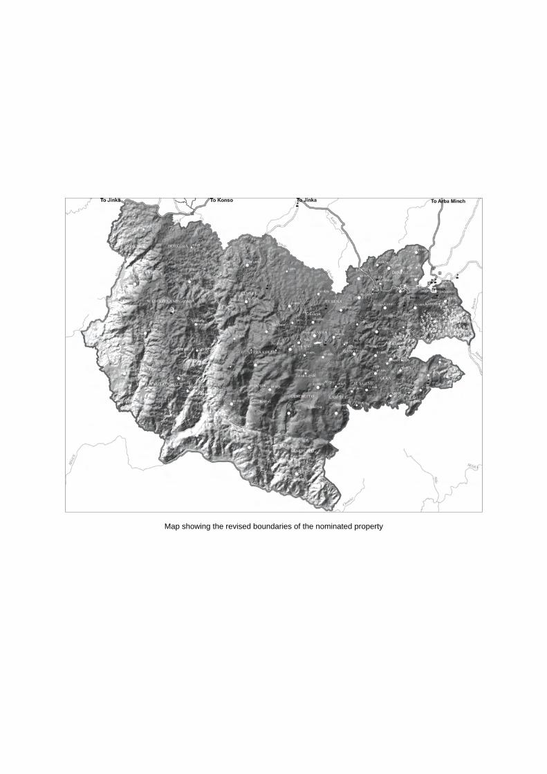
Map showing the revised boundaries of the nominated property
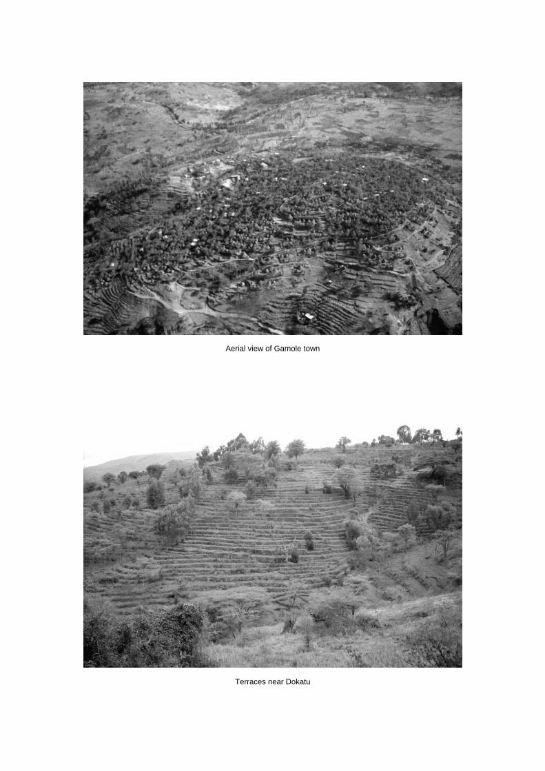
Aerial view of Gamole town
Terraces near Dokatu
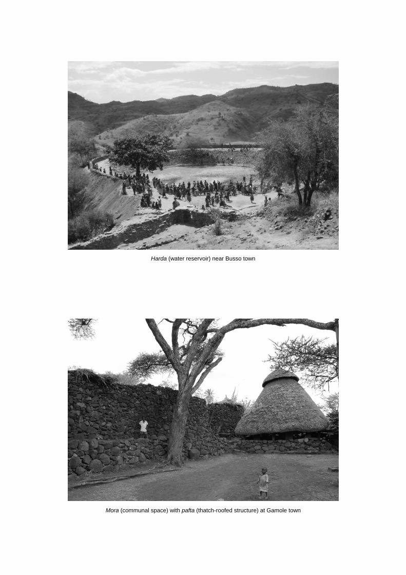
Harda (water reservoir) near Busso town
Mora (communal space) with pafta (thatch-roofed structure) at Gamole town

ERRATUM – Addendum – English version
2011
Addendum
Evaluations of Nominations of Cultural and Mixed Properties
ICOMOS report for the World Heritage Committee, 35th ordinary session
UNESCO, June 2011
WHC-11/35.COM/INF.8B1.Add
Page 22, Fort Jesus, Mombasa (Kenya), No 1295rev
2nd
column, lines 14 to 20: “ICOMOS considers that the nominated property meets [...] for purpose of
unambiguous physical demarcation.” should be read as follows:
“ICOMOS considers that the nominated property could have the capacity to meet the conditions of
integrity and authenticity."
Page 47, The architectural work of Le Corbusier: an outstanding contribution to the Modern
Movement, (France, Argentina, Belgium, Germany, Japan, Switzerland), No 1321rev
1st column, Brief description should be read as follows:
“The nineteen sites reflect the architect Le Corbusier’s work over his entire career between the 1910s
and the 1960s.”
§§§§§§§§§§§§§§§§§§§§§§§§§§§§§§§§§§§§§§§§§§§§§§§§§§§§§§§§§§§§§§§§§§§§§§§§§§§§§§§§
ERRATUM – Addendum – Version française
2011
Addendum
Évaluations des propositions d’inscription de biens culturels et mixtes
Rapport de l’ICOMOS pour le Comité du patrimoine mondial,
35e session ordinaire, UNESCO, juin 2011
WHC-11/35.COM/INF.8B1.Add
Page 26, Fort Jésus, Mombasa (Kenya), No 1295rev
1ère
colonne, les lignes 3 à 10 : « L’ICOMOS considère que le bien proposé pour inscription […] afin
de garantir une démarcation physique claire et sans ambigüité » doivent se lire de la façon suivante :
« L’ICOMOS considère que le bien proposé pour inscription pourrait avoir la capacité de remplir les
conditions d’authenticité et d’intégrité. »
Page 56, L’œuvre architecturale de Le Corbusier : une contribution exceptionnelle au Mouvement
Moderne, (France, Allemagne, Argentine, Belgique, japon, Suisse), No 1321rev
1ère
colonne, la brève description doit se lire de la façon suivante :
« Les dix-neuf sites reflètent l’œuvre de l’architecte Le Corbusier sur l’ensemble de sa carrière, des
années 1910 aux années 1960. »
Page 72, 2ème
colonne, les lignes 40 à 45 : « L’ICOMOS considère que, bien que […] l’inclusion de
tous les éléments associés. » doivent se lire de la façon suivante :
« L’ICOMOS considère que les délimitations et les zones tampons sont appropriées pour la plupart
des biens mais les environs à l’est du Musée national des Beaux-Arts de l’Occident, Établissement
principal, Tokyo, doivent faire l’objet de mesures renforcées et la zone tampon des maisons Jaoul
(actuellement une zone de protection de 500 m) devrait être reconsidérée pour coïncider avec la
topographie de ses environs. »
16
Fort Jesus, Mombasa (Kenya) No 1295rev Official name as proposed by the State Party Fort Jesus, Mombasa Location City of Mombasa Coast Province Kenya Brief description Fort Jesus, Mombasa, was built by the Portuguese in 1593 as part of a system of coastal forts to exploit African resources and transcontinental trade, at a time of political and economic domination by the West. The refined layout and structure of Fort Jesus, Mombasa, reflect the characteristics of Renaissance military architectural theory, and its basic design and structure have remained intact, despite frequent bombardment and several changes of ownership. Fort Jesus, Mombasa, controlled a larger area than most of the coastal forts - the East African Coast, including the Arabian Peninsula, and the Far East. Category of property In terms of categories of cultural property set out in Article 1 of the 1972 World Heritage Convention, this is a monument.
1 Basic data Included in the Tentative List 25 June 1997 International Assistance from the World Heritage Fund for preparing the Nomination 2004 Date received by the World Heritage Centre 28 January 2009 31 January 2011 Background This is a referred back nomination (34 COM, Brasilia, 2010). A first nomination dossier for Fort Jesus, Mombasa was examined by the World Heritage Committee at its 34th Session (Brasilia, 2010). At the time, ICOMOS recommended to defer the examination of the nomination. The World Heritage Committee adopted the following decision:
Decision 34 COM 8B.12: The World Heritage Committee, 1. Having examined Documents WHC-10/34.COM/8B and WHC-10/34.COM/INF.8B1, 2. Refers the examination of the nomination on the basis of cultural criteria of Fort Jesus, Mombasa, Kenya, back to the State Party to allow it to:
a) Further develop the nomination to demonstrate that the nominated property possesses outstanding universal value;
b) Expand the comparative analysis to include other relevant fortresses and go beyond the Portuguese context;
c) Amend the designation notice so as to eliminate the discrepancy between the sizes of the conservation area and the buffer zone;
d) Include the guidelines for the conservation of the Old Town (1990 Conservation Plan) in the bylaw so as to strengthen protection and facilitate management;
e) Revive the Mombasa Old Town Planning Commission and provide means for its functioning;
f) Reinforce the Mombasa Old Town Conservation Office (MOTCO) in terms of human resources and clarify its role;
g) Establish a holistic management structure for the Old Town that involves all the stakeholders, and, in particular the local community, the municipal council, and the managers of the nominated property;
h) Establish rigorous monitoring of the erosion of the coral rock that forms the foundations of the Fort;
i) Consider the inclusion of the underwater archaeological remains in the nominated property;
3. Recommends that the State Party give consideration to the following:
a) Relocating the car/bus parking area for visitors outside the moat for reasons of visual and functional integrity and authenticity;
b) Adding maintenance concerns to the Management Plan, including regular documenting of the state of conservation of the Fort.
The State Party supplied on February 2011 the following new information: A revised nomination dossier, with an expanded
comparative analysis; Copy of the revised Management Plan for Fort
Jesus, dated January 2010; two maps:
o the revised boundaries for the nominated
17
property and its buffer zone, expanded to include part of the seawaters in front of Fort Jesus and Mombasa Old Town;
o the extract from the Survey of Kenya Map sheet 201/9/9NE1, scale 1:2,500, with boundary outline of Fort Jesus.
two articles from the newspapers. The additional information provided has been carefully considered by ICOMOS in the relevant sections of this report. Consultations ICOMOS has consulted its International Scientific Committees on Fortifications and Military Heritage and on Shared Built Heritage. ICOMOS consulted also independent experts. Literature consulted (selection) Boxer, C.R., and de Azevedo, C., A fortaleza de Jesus e os Portugueses em Mombaça 1593-1729, Centro de Estudos Historicos Ultramarino, 1960 Lisbon. Freeman-Grenville, G.S.P., The Portuguese on the Swahili Coast: buildings and language, in Studia N° 49, pp. 235-53, 1989, Lisbon. Hinawi Mbarak Ali, Al Akida and Fort Jesus, Mombasa, East African Literature Bureau, 1950, Nairobi, Kenya. Kirkman, J., Fort Jesus: a Portuguese fortress on the East African coast, Oxford University Press, 1974, London. Nelson, W.A., Fort Jesus of Mombasa, Canongate Press, 1994, Edinburgh. Pearson, M.N., Port cities and intruders: the Swahili Coast, India and Portugal in the Early Modern Era, The Johns Hopkins University Press, 1998, Baltimore and London.
Technical Evaluation Mission An ICOMOS technical evaluation mission visited the property from 17 to 21 August 2009. As this is a referred back nomination, no further mission has been undertaken. Additional information requested and received from the State Party None Date of ICOMOS approval of this report 10 March 2011
2 The property Description Fort Jesus, Mombasa, is situated in the town of Mombasa, a port city on the east coast of Kenya. The nominated property covers 2.36ha. It includes the Fort, the rock on which it stands, the immediate area surrounding it, including the moat, and an area to the south with archaeological material uncovered during
recent archaeological research. Mombasa Old Town forms the buffer zone to the Fort, occupying a further 31ha. Fort Jesus, Mombasa, lies at the southern edge of Mombasa Old Town, close to the coastline, its main gate opening towards the main road of Mombasa Old Town. Because of its strategic location, Mombasa grew in importance over the centuries and soon became a major trading port and a military strongpoint, along with other city- states, i.e. Lamu, Malindi, Pate, Kilwa, Zanzibar. The town was renowned from the 13th-14th centuries onwards and the beauty of its architecture was described by the Arab traveller Ibn Battuta, who visited East Africa in 1331 and gave vivid accounts in his writings of the towns of this region. Fort Jesus, Mombasa, was erected in 1593-96 to the designs of Giovanni Battista Cairati by the Portuguese when they gained control over Mombasa, to protect its port, which became a stop-over along the trade routes throughout the Indian Ocean. Cairati was an Italian military architect and engineer who designed several fortresses for the Portuguese colonies in Asia. However, Cairati apparently never went to Mombasa: he only produced the drawings for the fortress and sent them to the master builder in Mombasa. The Fort was given a form that was roughly human, inspired by the architectural theories of the Renaissance which were developed one century before the construction of the nominated property, in 15th century, by, among others, Filarete or Francesco di Giorgio Martini and expressed in several anthropomorphic sketches of architectural elements and buildings. In addition to the influence of Renaissance architectural theories, and in the light of the fact that the founders belonged to the Order of Christ, the image of the martyred Christ has also been read in the plan of the fort. The Fort is organized around a central courtyard with four bastions, one at each corner, while the side towards the sea is interrupted by a rectangular gun platform. The landward bastions (São Filipe and São Alberto) were built with re-entrant angles facing one another in order to provide gun positions, whilst the seaward bastions (São Matias and São Mateus) were square in plan, although today São Matias also has one slightly re-entrant angle for protecting the Main Gate. A wooden bridge (now filled with sand to create a causeway) ran across the ditch to connect the gate with the exterior. Above it is the gatehouse, with upper and lower rooms. Two subsidiary gates, used to receive goods delivered by boat, open out from the projecting structure towards the sea. These were connected to the inner court by a sloping passage and a staircase. Other features of the Fort are the parapet walks, firesteps, watchtowers and gun ports, barrack rooms on
18
both north and south sides, and guardrooms leading off the main gate. The fortress included facilities such as a chapel, a cistern, a well, and the Captain’s house, but among these only the cistern and an L-shaped building survive. The base of the defences is solid coral cut back to the line of the walls. On the landward side the walls were 4.27m thick with a parapet 2.75m wide and 1m high, backed by a wall walk and firestep. A dry moat encircles the three landward sides of the Fort, to ensure that it could not be attacked from the rising slope beyond the landward bastions. The height of the scarp, including the 5m deep and wide moat, is c 17m. The Fort is well above sea level and the moat provided protection during a retreat. The original construction materials of the Fort were coral, lime, sand, and clay. The facades are finished with a pigmented yellow ochre plaster. History and development The East African coast between Somalia and Mozambique has been inhabited by different peoples over several centuries. The location and geomorphology of this part of the African coast was favourable for independent city states to flourish, trading in gold, silk, ivory, and skins with merchants from as far away as Persia, Arabia, Syria, India, and China. Kilwa, Mombasa, Malindi, Lamu, and Pate were all in competition with one another to gain supremacy over the area and the trade routes. Portugal succeeded in opening up a sea route to the East Indies at the end of the 15th century, when Vasco de Gama sailed around the Cape of Good Hope to reach India and visited several prosperous port towns in Mozambique, Tanzania, Kenya, and Somalia. These cities were capable of providing good intermediate bases for ships sailing to and from India, and for this reason Portugal sought to gain control over the area. The Portuguese were obliged to compete with established groups such as the Omani Arabs, and domination over towns such as Mombasa or Malindi was not secured without ruthless clashes. By 1509 the Portuguese controlled tracts of the East African coast between Sofala in Mozambique to the south and Socrata to the north. Nevertheless, control of the area continued to be contested by other groups, who tried repeatedly to replace the Portuguese in dominating the area. The Turks, for example, succeeded in building a fort in Mombasa by the sea during a brief period of control over the entire coastal region at the end of the 16th century. The Portuguese reaction was not long in coming and by 1596 a new fortress, more strategically positioned and designed according the most advanced principles for constructing fortifications, was completed only three years from when work began and was named Fort Jesus, Mombasa.
The Fort became the new Portuguese headquarters on the East African coast, with a permanent garrison of a hundred soldiers. Smaller supporting forts were built on the island, the ruins of some of which are still visible at Mama Ngina Drive Heritage Site, about 1.5km south of the Fort, and at Makupa, 3km to the west. The building of the fortress attracted Portuguese settlers and traders in large numbers and the Fort expresses the Portuguese’s successful attempt to stamp its authority on an area that had formerly been under the influence of eastern civilisations. Portuguese control of the area was challenged in particular by the Omani and the Turks, who encouraged the local population to revolt against the occupiers, as well as by other European powers, which had, by the end of the 16th century, made their appearance in the competition to obtain their share of the Indian Ocean trade. This restless history is reflected by the numerous transformations that Fort Jesus, Mombasa, has witnessed over its existence. The first improvements to the Fort date back to 1634-39 when, following a revolt, curtain walls were built on the landward side, and new walls were built on top of three of the bastions (São Filipe, São Alberto, and São Matias) and provided with new gun-ports, the curtain wall to the west was strengthened and the gaps were filled in to protect the foundations of the bastions on the coral reef, the main gate was protected by adding an elliptical bastion to the existing one and creating an additional gate connected to the first one by a covered passage. Two gun platforms were built, one to cover São Mateus bastion and the other to protect São Alberto bastion and the south curtain wall. Turrets were built to protect the projection located on the seaward side. Having become aware of declining Portuguese control, the Omani raided their possessions on the East African coast from 1652 onwards and repeated attacks were launched until 1696 when the Omani Arabs besieged Fort Jesus, Mombasa, and eventually drove out the Portuguese. Further modifications were then made to repair and reinforce the damaged fortress. They filled in the outer rooms to create a larger platform at the level of the Portuguese walls and protected it with musket slits and gun-ports. Despite repeated attempts, it was not until 1728 that the Portuguese reoccupied the Fort, and then only for 18 months. Apparently, although the 18th and 19th centuries are not fully documented in the nomination dossier, the Omani Arabs maintained control over the coastal settlements until the area was colonized by the British in 19th century. Under British rule, in 1895, the Fort was converted to a prison until 1958. In this period additional buildings were built inside, such as the kitchen and a gallows up against
19
the re-entrant angle. In 1958 Fort Jesus, Mombasa, was declared a National Park, and in 1960 it was restored, a site museum, a conservation laboratory, and an administration block were built on the foundations of the former barracks. The new status of the Fort led to archaeological excavations and research which yielded a great deal of information about the construction phases, as well as a number of artefacts that were housed in the museum.
3 Outstanding Universal Value, integrity and authenticity
Comparative analysis The comparative analysis made by the State Party in the revised nomination dossier expands the previous analysis presented in 2010 and includes also examples from other geo-cultural regions, although for the most part related to the Portuguese presence throughout the world. The analysis aims to highlight the specificity of the nominated property within a selected group of fortresses that, although erected according to the Renaissance military architectural principles, were built in non European contexts. The rationale of the comparison is based on the reasons underlying the construction of these forts (control of the coast or the hinterland and of trade routes), similarities in planning and in the building materials, retention of the initial design, history of the nominated property and its buffer zone, and the present state of conservation. The properties examined in this comparative study are principally World Heritage Sites: the Fortress of the Portuguese City of Mazagan - El Jadida (Morocco, 2004, (ii), (iv)), the Forts in Elmina, part of the serial World Heritage property of Forts and Castles, Volta, Greater Accra, Central and Western Regions, Ghana (1979, criterion (vi)), which are among the earliest example of fortified buildings in the tropics. They also influenced the design of later fortifications, such as James Island and Related Sites, Gambia (2003, criteria (iii), (vi)), the Fortaleza de São Sebastião in the World Heritage fortified city of the Island of Mozambique (1991, criteria (iv), (vi)), the Ruins of Kilwa Kisiwani in Tanzania (1981, criterion (iii)), the Red Fort Complex (India, 2007, (ii), (iii), (vi)) and the City of Valletta (Malta, 1980, (i), (vi)). Among properties inscribed on the tentative lists of the State Parties, the State Party has selected for comparison the Fortress Kambambe (Angola). Further properties reputed relevant for the comparison were the Forte dos Reis Magos (Fortress of three Wise Men, Brazil), the fort of Mannar (Sri Lanka) and Fort Aguada, in India Fort Jesus, Mombasa, is considered to be more intact than the Fortress of Mazagan in that it has lost one of its five bastions, whilst the nominated property has retained all its parts, thanks to its superior design as a military
structure. Additionally the nominated property is said to have been built to control a larger area and along its history more powers contended to take over the fort. In respect to the Forts in Elmina, Fort Jesus was built to control the sea trade, whereas the Forts in Elmina were created in order to oversee routes in the interior, and also because it has retained its original design over the centuries while the design of the Forts in Elmina has been overlaid by the subsequent Dutch modifications. The Fort on James Island was only partially stone-built, the utility buildings being of wood and thatch. After a long period of turmoil it was restored in the 18th century, when its initial design was substantially altered. The Fortaleza de São Sebastião is said to be similar in a number of ways to Fort Jesus in terms of design, but it is less regular than the nominated property and the construction is reputed not to follow fully the principles prescribed for achieving the highest level of defence. The Fort was built not only to defend the trade routes to India but also to secure inland routes to gold mines. The Fortaleza de São Sebastião has been restored several times and has also suffered from heavy cyclone damage. However, it is worth mentioning that both Elmina and São Sebastião forts have been built before Fort Jesus, Mombasa and predated this fort. Kilwa Kisiwani was built before Fort Jesus, Mombasa, but they share a similar history, since they both were built by Portuguese power and were subsequently taken over by Omani Arabs. Kilwa Kisiwani, however, was mostly destroyed by the Portuguese when they abandoned the fort only a few years after it was built, and so today only a fraction of the Portuguese fortress survives. The Red Fort is said to be different from Fort Jesus for a number of reasons: the civilization that built it – the Moghul in the Indian subcontinent, the cultural influences that may be found in its fabric - Islamic, Timurid and Hindu - and the functions for which it was built, residential instead of military. The city of Valletta and Fort Jesus are said to share several similarities. Both were erected according to architectural Renaissance principles, both are associated to religious orders (the former to the Military Order of the Knights of St. John, the latter to the Order of the Knights of Christ). However, differently from Fort Jesus, the fortress of Valletta was part of a system of fortifications around the town that were functional to the effective defence of Valletta. On the other hand, Fort Jesus is said to have been built as the main stronghold to protect itself, the surrounding town of Gavanna (today Mombasa Old Town) and the Indian Ocean trade routes. This would demonstrate the different role played by Fort Jesus. The Fort of Mannar in Sri Lanka is said to differ from Fort Jesus for two reasons: it was smaller in size and re-built completely by the Dutch when they superseded the
20
Portuguese in the control over Sri Lanka. Forte dos Reis Magos, Brazil would share a number of similarities with Fort Jesus: both were built on the top of a coral reef promontory, both had five bastions, but the nominated property is reputed to have a superior design, that allowed the Portuguese to maintain control over the fort and their economic interest in the Indian Ocean. Fortress Kambambe is considered different from Fort Jesus, in that the first was built mainly to control the Portuguese penetration into the Angolan inland and as a base for the slave trade and goods storage, whereas the nominated property was meant purely for defensive reasons, to secure the coast and the Indian Ocean trade routes. Finally, Kambambe fell in ruins, whilst Fort Jesus is still intact. Fort Aguada (India) was built at the beginning of the 17th century in Goa and is reputed one of the best examples of the Portuguese forts in this town. Fort Aguada is located, like Fort Jesus, Mombasa, on a rocky cliff but today it is almost in ruins. In summary, according to the State Party, the comparison would show that Fort Jesus is an outstanding witness of the new principles and conception for military architecture, applied in a particular geo-cultural and historic context, as well as of the exchanges of influences among European, African, Arabian and Asian cultures. Thanks to its design, it has preserved its original design and structures, despite several changes of control. ICOMOS observes that, although expanded, the comparative analysis has failed to consider vital examples for the comparison. Even when limiting the analysis to the Portuguese colonial context e.g. the Fortresses of São Miguel in Luanda, Angola, which is still an imposing and still standing fort, or the Fortress of the World Heritage Site of Cidade Velha, (Capo Verde, 2009 (ii), (iii), (vi)), should have been included. Further relevant examples against which to compare the nominated property and not examined by the State Party are Muxima, and Massanganu in Angola, the Fort of the Wise Men in Goa and the Fortress of São Sebastião of Baçaim (India), and the Fortresses of Ormuz (Bahrain), and of Muscat (Oman), as well as the Fort of São Filipe de Setúbal (Portugal). ICOMOS further notes that the revolution in the conception and design of military architecture in the 16th century, following advances in weapon technology and in military strategy, as well as the application of certain architectural design principles derived from the Renaissance, were a general phenomenon that touched all European powers and so, for a robust comparative analysis, fortifications built not only by the Portuguese but also by other European powers could have been examined. Additionally, ICOMOS observes that the expanded
comparative analysis has focussed only on typological aspects of the fortification and, in this regard, the comparison has not made a systematic use of the shared reference criteria adopted for studying fortifications, i.e., size, plan, layout, articulation of the bastions, location, etc.. On the other hand, the comparison has overlooked the cultural interchange witnessed and reflected by the nominated property and other similar properties. In this regard, ICOMOS underlines that almost all fortresses that have been used for comparison and are inscribed on the World Heritage List are part of larger properties comprising the towns or settlements that are associated to them and contribute to reflect and convey the intercultural exchange values that were claimed for sustaining their inscription. This is true, i.e., for the Portuguese City of Mazagan - El Jadida, fortified city of the Island of Mozambique, the City of Valletta, Cidade Velha. In summary, ICOMOS considers that the comparative analysis, as it has been expanded by the State Party, has not been able to support the values that are claimed for the nominated property. At the same time, the new comparison provided has limited its scope to one set of values claimed for the property, overlooking the cultural interchange dimension of Fort Jesus, Mombasa.
ICOMOS considers that the comparative analysis does not justify consideration of this property for the World Heritage List at this stage.
Justification of Outstanding Universal Value The nominated property is considered by the State Party to be of Outstanding Universal Value as a cultural property for the following reasons: Built in a period and in a region, which were at the
centre of the emerging political, commercial and cultural globalisation, Fort Jesus, with its imposing structure, is an exceptional witness to the first successful attempt by the western civilisations to control the east-west maritime routes and to the interchange of cultural values among peoples of African, Arab, Turkish, Persian and European origin.
Fort Jesus, Mombasa, exemplifies a new type of fortification, resulted from the innovations in the military and weapon technology occurred in the 15th and 16th centuries. It also bears testimony to the philosophical debate that underlay the Renaissance architectural theory. Its layout granted Fort Jesus a complete protection from attacks and contributed to the retention of its original design throughout the centuries and several changes of hands and uses. Fort Jesus is reputed to represent the best surviving example of 16th century Portuguese military fortification of its kind in the world.
ICOMOS observes that the cultural interchange among
21
the different civilisations that came in contact and fought to dominate the region and the Indian Ocean commercial routes was undeniably witnessed by Fort Jesus, Mombasa but this argument has been mainly stated and only meagrely articulated in the nomination dossier. Struggle, conflicts and contestation to gain control over them, is the common destiny of most fortifications, as demonstrated by the comparative analysis, whilst the cultural interchange that occurred in the nominated property, and its significance, would be better understood and its relevance assessed, when posed in relation to its buffer zone, Mombasa Old Town, and to the regional pattern of development of coastal settlements of East Africa. This aspect of Fort Jesus’ significance would need to be strengthened through a more detailed argumentation robustly related to its history and its subsequent transformations and framed within the larger geo-historical context of the Indian Ocean trade routes. On the other hand, the claim of the importance of Fort Jesus, Mombasa, as one of the finest examples of military architecture reflecting the innovations in weapon technology and warfare strategies and embodying Renaissance architectural theories has not been substantiated by the expanded comparative analysis proposed by the State Party. Integrity and authenticity Integrity
The State Party holds that the boundaries of the nominated property have been selected to ensure that the functional and visual integrity of Fort Jesus is retained. The boundaries have been delineated so as to include the underwater archaeological remains adjacent to Fort Jesus that are integral to its historical context. The property is said to be in good conditions and not encroached upon. Minor changes inside the fort bear witness to its history and do not threaten its integrity. The State Party has informed that the car park that occupied part of the moat has been relocated in another place, outside the nominated property. ICOMOS observes that the boundaries for the nominated property as redefined in the revised documents include the elements strictly necessary to express its value as a fortification built following Renaissance architectural design principles in a remote context, as a stronghold for exploration and territorial control, as several other cases documented in Africa. ICOMOS notes that the State Party has included the area where the underwater archaeological remains lie in the nominated property and in the buffer zone. However, it is not understandable the rationale of the development of the expanded boundaries in the sea area, nor is it clear how the boundaries can be physically traced and identifiable in their marine side.
In this regard, ICOMOS recommends modify the perimeter of the boundaries of the marine area, to facilitate demarcation, in absence of physiografic features, according to straight lines that might be marked through buoys. ICOMOS considers that the fabric of the nominated property is in relatively good condition, it is well maintained, and it is not encroached upon by permanent structures. Minor changes to the building and its uses reflect its turbulent history. These alterations are well explained in the documented history and cannot be said to have damaged its integrity. ICOMOS notes that the State Party has mentioned the relocation of the car/bus parking area for visitors to a site outside the nominated property. ICOMOS expresses its satisfaction for this decision; however, it would be important to know whether and how this part of the moat has been reclaimed after the removal of the park. Authenticity
The State Party considers that, on the basis of archival and published records, Fort Jesus, Mombasa, still conforms with its original design. The nominated property retains its initial architectural and aesthetic values. The ramparts, for instance, or the surrounding moat have not been changed and the same materials used by the Portuguese in building the Fort have been used in subsequent developments, which for their part have not altered the overall shape of the initial fortress. The function of the Fort, although it is no longer a military installation, respects its aesthetic form and value and the modifications that have been made necessary by the current use do not diminish its unity, form, and original layout. ICOMOS considers that Fort Jesus, Mombasa, has retained its form, design, and construction materials, despite a number of modifications, which in fact bear witness to the turbulent history of the nominated property. Changes of use and function over time have not damaged the important elements of its fabric nor have they introduced incompatible materials or techniques.
ICOMOS considers that the nominated property could have the capacity to meet the conditions of authenticity and integrity if further work is done to better justify the proposed outstanding universal value and the selected criteria, strengthen the comparative analysis in order to justify the proposed Outstanding Universal Value.
Criteria under which inscription is proposed The property is nominated on the basis of cultural criteria (ii) and (iv). Criterion (ii): exhibit an important interchange of human values, over a span of time or within a cultural area of
22
the world, on developments in architecture or technology, monumental arts, town-planning or landscape design; This criterion is justified by the State Party on the grounds that the Fort marked a milestone in 16th century fortress design, as a stronghold for the safeguard of Portuguese interests not only on the East African coast but also along the trans-Indian Ocean trade. The successful design of Fort Jesus, Mombasa, led to the adoption of some of its strategic aspects to improve other forts in Africa. Fort Jesus, Mombasa, is also said to symbolize the struggle for freedom, as it became a field for resistance against domination by any power. The Fort is also claimed to be a landmark of social cohesion as it is used by people of diverse cultures while still retaining the characteristics of its previous functions. ICOMOS considers that the interchange of human values and cultures as well as the struggle over the Fort between local and foreign powers is illustrative not only of the history of Fort Jesus but also of all East Africa, as it is demonstrated by several forts and fortified settlements scattered along the coast of this side and in general of all Africa. This interchange is, however, only sparingly reflected in Fort Jesus’ spatial and architectural expression over time, as its initial concept has proved to be so strong that any modifications remain subordinate. The cultural interchange of the nominated property could be better understood when it is considered in close relation to its buffer zone, Mombasa Old Town, which clearly reflects in its urban and built fabric its multi-cultural past and with the other fortresses and fortified settlements that punctuate the African coast. Similarly, the claim that Fort Jesus is a landmark of social cohesion is not sufficiently articulated in the nomination dossier in relation to either the history of the fort or its physical fabric. The expanded comparative analysis has not scrutinized the selected properties with reference to the set of values related to this criterion but has limited its scope only to the architectural and typological aspects.
ICOMOS considers that this criterion has not been demonstrated at this stage.
Criterion (iv): be an outstanding example of a type of building, architectural or technological ensemble or landscape which illustrates (a) significant stage(s) in human history; This criterion is justified by the State Party on the grounds that Fort Jesus, Mombasa, is held to be the best surviving 16th century Portuguese military fortification in the world, which in its layout and form reflected the Renaissance ideal that perfect proportions and geometric harmony are to be found in the proportions of the human body, while at the same time meeting the functional needs of a modern and well defended fortification. No other fortress is said to
illustrate better than the nominated property reference to the human body as the model for its layout. This layout, though simple, ensured the complete protection of the Fort and allowed it to survive almost unchanged over centuries of continued occupations and reoccupations. ICOMOS considers that the articulation of the justification for this criterion has not been developed sufficiently to substantiate the State Party’s claims. The expanded comparative analysis has not been able to support the claims that have been put forth by the State Party to demonstrate this criterion.
ICOMOS considers that this criterion has not been demonstrated at this stage.
ICOMOS considers that the nominated property meets the conditions authenticity, while the conditions of integrity will be met when the rationale for the delimitation of the boundaries will be made clear. In this regard ICOMOS suggests that the delineation of this part of the boundaries be revised along straight lines, for purpose of unambiguous physical demarcation. ICOMOS does not consider that the criteria and Outstanding Universal Value have been demonstrated at this stage.
4 Factors affecting the property Development pressures
The State Party states that no development pressures affect the nominated property, since it is a designated national monument and its buffer zone is a conservation area. ICOMOS considers that development pressure does not affect the nominated property. However, it does concern the buffer zone, Mombasa Old Town and it is likely to increase in case of inscription on the List, as this is a common trend, due to various factors (i.e., increase of tourism, of land and property values). ICOMOS therefore notes that the consequences of an increased pressure may lead to social tensions in the short term and a loss of the qualities of the Old town due to foreseeable increase of tourism and related urban transformations. Uncontrolled development in Mombasa Old Town may also nullify the additional protection that the buffer zone is meant to give to the nominated property. In Mombasa Old Town land values have increased and this may encourage local inhabitants to sell, leave, or redevelop their properties, despite the protective measures in place. ICOMOS also recommends that the infrastructure of the town should be upgraded, in order to improve the living conditions in the Old Town.
23
Tourism pressures
The State Party estimates that 70% of the tourists visiting the coast of Kenya go to Fort Jesus, making it one of the most visited cultural sites in the country. A visitor management system has been put in place. ICOMOS considers that these pressures are well managed through a visitor-management strategy that takes account of carrying capacity and the distribution of visitors across various trails and sites. Although, in the buffer zone tourism pressures may be more serious in its final effects and difficult to hold down, resulting in uncontrolled transformation. Environmental pressures
In the section of the nomination dossier relating to environmental pressures the State Party discusses the consequences of climate change. ICOMOS considers that unpredictable weather events and floods might be included among the environmental pressures related to climate change. Natural disasters
The State Party considers that the Fort site is not at risk from fire or flooding. The staff is well trained and equipped to respond to fire, and recent drainage works have further reduced the risk of flooding. The site is not in an earthquake zone. ICOMOS considers that the measures in place to counteract the threat from fire are adequate and that the efforts undertaken to improve the drainage system and its maintenance are helpful in addressing the issue of flooding within the nominated property. Impact of climate change
The State Party is of the opinion that, owing to the global environmental changes that have caused a general rise in sea levels, tidal currents have been damaging the coral rock base of the Fort. This may over time undermine the built fabric of the nominated property. ICOMOS considers that erosion of the coral rock on which the Fort is built is the principal threat. In 2008 a small section of rock on the northern section of the seashore collapsed. ICOMOS recommends that the highest priority be given to rigorous monitoring of this phenomenon and measures undertaken to address this issue as soon as possible.
ICOMOS considers that the main threats to the property are possible future development pressures on the urban buffer zone and the erosion of the Fort’s coral rock foundations.
5 Protection, conservation and management
Boundaries of the nominated property and buffer zone Care has been taken in the definition of the boundaries of the nominated property so as to include the Fort, the moat, an adjacent area for potential archaeological research as well as the area where underwater archaeological remains are located. The terrestrial boundaries coincide with distinct physical limits, such as the road to the north, the hill to west and south, and the sea to the east. The buffer zone includes the Old Town and the old administrative area, designated a Conservation Area in 1990, because of its concentration of high-quality 18th century buildings and its historic and social links to the Fort. It is delimited for the most part by main roads, except on the north, where ICOMOS considers that markers for clarification to the public are needed. Also the boundaries of the buffer zone have been expanded to include the marine area where underwater archaeological relicts have been detected. ICOMOS observes that no information has been provided by the State Party about the amendment to the Gazette notice required by the World Heritage Committee to eliminate the discrepancy in the size of the designated Conservation Area (13ha) compared with the size of the buffer zone (31ha) – which are stated to be the same. The State Party has provided the text of the Gazette notice n.2092 (1990) through which Mombasa Old Town has been protected as a conservation area but the map attached to the Gazette Notice (ref Map 537/6) has not been provided by the State Party. At this stage, it is not clear whether the buffer zone in its entirety is covered by a layer of protection or not, as required by paragraph 104 of the Operational Guidelines for the implementation of the World Heritage Convention. ICOMOS recalls its previous recommendation that the designation notice be amended as soon as possible in order to eliminate this mismatch and ensure that the entire buffer zone is granted the restrictions necessary to provide an added layer of protection to the nominated property, which, in this specific case, is particularly relevant considering that Mombasa Old Town possesses a cultural significance that is integral to the nominated property. ICOMOS also notes that figures of the nominated property and its buffer zone sizes provided by the State Party in the nomination dossier has not been updated according to their expansion to include the underwater archaeological relicts. The figures provided are actually the same as those exposed in the 2010 Nomination Dossier.
24
Additionally, it is not clear the reason for the articulated boundaries delimiting the nominated property and the buffer zone in the sea area, nor is it explained how they will be identified or physically materialised. In this regard, ICOMOS suggests that the delineation of this part of the boundaries be revised along straight lines, for purpose of unambiguous physical demarcation.
ICOMOS considers that the terrestrial boundaries of the nominated property and of the buffer zone are adequate, but recalls its previous recommendation to amend the gazette notice so as to eliminate the discrepancy between the size of the designated conservation area and that of the buffer zone. ICOMOS also recommends that markers are installed to clearly identify the northern as well as the marine boundaries of the buffer zone.
Ownership The property is owned by the Government of Kenya through the National Museums of Kenya (NMK). Protection Legal Protection
Fort Jesus, Mombasa, was originally designated a National Park in 1958 to protect the Fort and a 100m strip around it. Today it is protected under the National Museums and Heritage Act 2006. This Act clearly defines the functions and powers of the NMK, along with measures for the protection of designated areas. The NMK keeps collections and individual items of scientific, cultural, technological and human interest, conducts research and disseminates knowledge in these fields, identifies, protects, and conserves the cultural and natural heritage of Kenya, and promotes the cultural resources of the country. To accomplish its objectives, the NMK can acquire and exchange movable and immovable property for purposes connected with those of the NMK, erect or upgrade buildings, obtain revenue through the properties in their ownership, accept donations and bequests, establish and maintain research institutions, conduct environmental impact assessments, and enter into associations with other bodies or organizations in order to achieve its institutional goals and functions. Areas protected under the National Museums and Heritage Act may be set aside or their use restricted in order to ensure that any monument or property is not damaged. These areas may be put under the control of the NMK and steps to ensure their maintenance can be taken by the NMK. Monuments are inspected, documented, and repaired by NMK staff or by persons authorized by the NMK. The Environmental Management and Coordination Act (EMCA) 1999 and the National Museums and Heritage Act 2006 ensure that ‘Environmental Impact Assessments are undertaken on sites earmarked for
development projects and whose implementation threatens the survival of heritage resources of some kind among other components of the environment.’ The proposed buffer zone was declared a Conservation Area in 1990 and confirmed by designation in 1991. Today it is protected by the National Museums and Heritage Act 2006. Mombasa Old Town was protected because of its high concentration of 18th century buildings and the quality of its architecture and urban fabric, and also because it is historically and socially linked to the development of Fort Jesus, Mombasa. A Conservation Plan for Mombasa Old Town has been developed since 1990 and the Agency responsible for its implementation is the Mombasa Old Town Conservation Office (MOTCO), a department of the NMK. At the municipal level exists the Mombasa Old Town Planning Commission which cooperates with the NMK. Additional information provided by the State Party on February 2011 explains that the Commission has been in operation since it has been gazetted in 2009 (gazette notice n. 2660). It includes members of the Municipal Council, interest groups from the local community, special interest groups and the NMK, providing technical expertise. The revised nomination dossier reports that by-laws subject the area to development control measures, which are drawn from the conservation guidelines for Mombasa Old Town, namely buildings are not allowed to be built with more than three storeys; all buildings must retain their historical character and features, in particular with reference to doors and windows as well as their design and proportions; advertising signs should use hand-carved boards. As part of its development strategy, the Government has produced a medium-term Development Plan for Mombasa District for the period 2008-2012. ICOMOS considers that the existing legal provisions to ensure the protection of the nominated property and its buffer zone are adequate. ICOMOS however stresses its previous recommendation concerning the issue of the discrepancy between the size of the conservation area and of the buffer zone and recommends that is resolved as soon as possible. Traditional Protection
Traditional material and local craftsmen are used for all repairs. Effectiveness of protection measures
The nominated property is under the responsibility of the NMK. Any project concerning the Fort is developed by the Site Manager and then reviewed internally, final authorization being given by the Head of the Department responsible for sites and monuments.
25
In Mombasa Old Town all construction projects need authorization at the municipal council level and are subject to restrictions in terms of size and appearance. Signage must also be in accordance with the character of the town. Furthermore, development projects within Mombasa Old Town must be approved by the NMK, on the basis of the bylaws establishing building regulations. The Mombasa Old Town Conservation Office (MOTCO) has been set up to monitor and control urban development and thus to protect the Fort from uncontrolled development or neglect. Additional information provided by the State Party on February 2011 explains the internal structure of MOTCO, which includes a head of the office, an office messenger, a secretary, a community education officer, two building inspectors and a draft man. In 2010, ICOMOS observed that, although MOTCO cooperates with the Municipal Planning Office, the Mombasa Old Town Planning Commission had ceased functioning since 2007. The additional information provided by the State Party regarding the reactivation of the Commission is reassuring, although it would be important to know how it has been functioning after its legal establishment in 2009 (i.e., their responsibilities and tasks, periodicity of meetings, etc.). Consultation among the bodies responsible for the Old Town is indispensable to grant coordination in issuing building permits, thereby reducing the time necessary to the authorities in dealing with undesirable situations and focus on assisting the community to conserve the Old Town better. ICOMOS considers that, although the existing administrative structure may ideally ensure effective protection, it would be important to understand how the Mombasa Old Town Planning Commission actually functions and to give it the means to function properly thus ensuring better coordination between MOTCO and the municipal planning office. Furthermore, MOTCO should be strengthened in terms of human resources.
ICOMOS considers that the existing legal protection for the nominated property is appropriate, whilst, at this stage, it is not clear whether the buffer zone is entirely covered by a layer of protection, as require by paragraph 104 of the Operational Guidelines. ICOMOS recommends that the State Party provides a clear description with maps of the areas subjected to formal legal protection, as well as with a description and explanation of the functioning of Mombasa Old Town Planning Commission. ICOMOS also recommends that the Commission be given the means to allow it to function properly. Furthermore, Mombasa Old Town Conservation Office (MOTCO) should be strengthened in terms of human resources.
Conservation Fort Jesus, Mombasa, underwent a substantial intervention in 2000-2001. The works included the complete replastering of the external walls, where much plaster had fallen off, and landscaping of the immediate surroundings of the Fort. Conservation for this property therefore relates principally to regular maintenance, with occasional special projects. ICOMOS considers that the efforts of the NMK in preserving the nominated property have been successful, but that there is a need to ensure ongoing maintenance in order to avoid rapid deterioration of the structures. ICOMOS observes also that the NMK, together with the general respect and concern of the community for the conservation of the special landscape of Mombasa Old Town, has ensured, until present, the retention of the general skyline and urban layout of the historic town. Nevertheless, there is a need to focus the initiatives of local stakeholders, which may be done through the establishment of the holistic management of pilot interventions carried out with the joint technical support of the municipality and MOTCO. Inventories, recording, research
The most recent records and inventories date back to 2001. The inventory, records, and archives are held at the National Museums of Kenya in Nairobi, in Fort Jesus Museum in Mombasa, and in the National Archives and Documentation Centre in Nairobi. Present state of conservation
Fort Jesus, Mombasa, is in a fairly good state of conservation and is benefiting from recent efforts, starting in 2001, to improve its state of conservation and ensure regular maintenance. Marked improvements were noted on site in 2009 when compared with the state of conservation in 2001 in the management plan attached to the nomination. On the other hand, the 2003 survey of the Old Town stated that 25% of the urban fabric is in a bad condition. Additionally, there is a tendency to rebuild and renovate rather than to maintain and repair the existing heritage fabric. This is threatening the significance of Mombasa Old Town and undermines the ability of the buffer zone to contribute to the understanding of the nominated property and its values and to provide it an additional layer of protection. ICOMOS recommends that MOTCO make an additional effort to sensitize and inform the community and the municipal technical officers about the conservation guidelines and ensure their effective implementation. ICOMOS further recommends that waste-management and sanitation should be improved.
26
Active Conservation measures
A project includes the plastering of the curtain wall. Maintenance
The nominated property is maintained regularly. The foreman inspects daily and reports to the chief curator for action if necessary. Traditional materials and local craftsmen are used for all repairs. There is a team on site (masons, carpenters, electricians, etc) for daily maintenance. ICOMOS considers that there is an overall approach to maintenance. Funds are secured and skills are available, trained, and promoted. The revised Management Plan includes a Maintenance Plan for the period 2009-2019 with a detailed articulation of the needs for each building component of the Fort. Effectiveness of conservation measures
The existing conservation measures for the nominated property are effective, whilst the measures for the buffer zone need reinforcement in implementation in order to ensure that the buffer zone continues to provide a meaningful additional layer of protection to the nominated property.
ICOMOS considers that the nominated property’s state of conservation and current maintenance practices are satisfactory, but notes that the current trends in the buffer zone may in the medium term undermine the additional protection that Mombasa Old Town is meant to provide to the nominated property. ICOMOS therefore recommends that MOTCO make an additional effort to sensitize and inform the community and the municipal technical officers about the conservation guidelines and ensure their effective implementation. ICOMOS also recommends that waste management and sanitation should be improved.
Management Management structures and processes, including traditional management processes
The Fort is managed by a chief curator, who heads the departments of public programmes, collections, administration, finance, and sites. He also administers the Mombasa Old Town Conservation Office, coastal archaeology, coastal sites and monuments, the Swahili cultural centre, and some additional south coast sites. The buffer zone is managed by the municipality through its technical offices but, since it is a designated protected area, the NMK has to approve all developments. The Conservation Plan of Mombasa Old Town implements the guidelines for the management and development of the designated conservation area. The Mombasa Old Town Conservation Office is responsible for its implementation.
Policy framework: management plans and arrangements, including visitor management and presentation
The 2010 revised Fort Jesus Management Plan is based on the plan developed in 2001 on the occasion of the 3rd Africa 2009 regional course on the conservation of immovable cultural heritage and is extended to 2014. The Plan lays down strategies to improve the conservation and management of the property over a ten-year period and has been revised, including consultations with stakeholders. The Management Plan contains a description of the management framework, identifies a set of guiding principles and the main areas of interest of the Plan: legal and management framework, management resources, state of conservation, interpretation and presentation. The plan contains a SWOT analysis which identifies a number of fields of action and specific short, medium and long term objectives. The five key areas to be tackled with are the following: establishing a sustainable funding system, site presentation and interpretation, conservation works, promotion and tourism, education and research and for each area specific objectives are identified. The 2010-2014 Action Plan select the priority objectives in the five areas, articulated in short (2010-2011) and long term (2010-2014). The action plan relates to general goals identified for the National Museums of Kenya, namely, developing an institutional marketing and development strategy, and to local ones, i.e., addressing the conservation issues related to the decay caused by salty air and by tidal currents, and elaborating a presentation/ interpretation of the nominated property. An interpretation plan for the Fort is being prepared, starting in 2009, to present it as a military landscape and to improve understanding of its significance through better signage, better presentation of movable and immovable heritage, and enhanced surroundings with various trails. The immediate surroundings of the Fort were refurbished in 2008 with parking, benches, and access to the sea. Parking was moved to free the main entrance to the Fort. Future plans will reorganize the access to Fort Jesus and the Old Town, create new facilities, and transfer the parking lot to a site beside the Swahili cultural centre. Visitor management in the Old Town began in 2009, with a brochure, maps, and information panels on significant buildings. Guides have been trained - interns in the Fort and twenty guides from the community in workshops - to provide information on Fort Jesus, for customer care, and for internal organization.
27
To balance visitor and handling capacities, alternative trails are planned within the Fort, in its immediate surroundings, in the Old Town, and in the coastal region. Visitors are redirected to other major heritage coastal sites. Collaboration with the French Embassy has produced brochures on coastal trails and these are distributed to travel agencies, hotels, and tour operators. ICOMOS considers that the revised Management Plan has identified the guiding principles for the care and the stewardship of the nominated property, as well as the issues, the weaknesses and the opportunities for the nominated property. The key areas of the management plan appear appropriate and the specific objectives identified coherently reflect the problems that need ot be addressed, although ICOMOS recommends to give priority to programmed maintenance over restoration, based on the 2009-2019 Maintenance Plan included in the Management Plan. ICOMOS finally recommends that the presentation of the archaeological features illustrating the occupation of the Fort should be improved so as to show how different occupying cultural groups have left indications of their influence on the Fort and to include in the presentation all facets of the rich history of the property. Risk preparedness
The State Party asserts that the Fort is equipped to deal with any fire disaster and the staff is trained in fire fighting as well as in reactions to possible flooding. ICOMOS considers that any risk-preparedness plan and training should also take into account the buffer zone, which is densely inhabited (300,000 persons in 31ha). Involvement of the local communities
The community has a direct impact on the management, conservation, and presentation of the Fort. The National Museums of Kenya (NMK) ensures participation in management, through regular stakeholder meetings at which they present details of planning for the Fort (e.g. during preparation of the nomination and the interpretation plan). The NMK wishes to ensure indirect benefits for the surrounding community. The new presentation plan addresses the training and management of community guides. The NMK, through MOTCO, seeks to improve the presentation of the Old Town to the public and to create opportunities for the community. Resources, including staffing levels, expertise and training
The Fort employs a staff of 104, of whom seven are professionals and eleven technicians in the fields of architecture, conservation, archaeology, musicology, and management. The remainder is engaged in maintenance. Four education officers prepare school and community programmes.
Fort Jesus generates funds for maintenance of the Fort through entrance fees. Part of this revenue is for daily maintenance and part for planned major works (e.g. plastering the curtain wall, to be done in 2009). It also receives a small annual government grant. External funding has made various projects possible in the past, such as the financing of the restoration of the Fort and establishment of the museum in 1960 by the Calouste Gulbenkian Foundation or the 1990s excavation funded by the Omani Government, with restoration of a house in the Fort to house an exhibition of the cultural traditions of the Omani people. Effectiveness of current management
Fort Jesus, Mombasa is managed by the National Museums of Kenya as a museum site. ICOMOS considers that the management framework, the plan, and actions developed or programmed are all moving in the right direction. However, ICOMOS considers that effective management of the nominated property cannot ignore the management weaknesses of the buffer zone, Mombasa Old Town, since their negative consequences will affect also Fort Jesus and its significance.
ICOMOS considers that the management system for the nominated property is at present adequate for the protection, conservation, and presentation of the nominated property. However, to ensure the effectiveness of the added layer of protection that the buffer zone is meant to provide to the nominated property, ICOMOS recommends that the Mombasa Old Town Planning Commission be provided with the financial, institutional resources and conditions to function properly, that a holistic management structure for the Old Town be developed, that close cooperation among MOTCO and the municipal council and technical offices be established, and that the role of MOTCO be clarified and its staff increased.
6 Monitoring The Directorate of Museums, Sites and Monuments is responsible for monitoring the condition of the property and the Department of Coastal Sites and Monuments monitors archaeological material found in its vicinity. In 2010 ICOMOS observed that the key indicators identified (lintels, timber frames, wall plaster, and mould on walls) do not include erosion of the coral rock, which has been identified as the most dangerous threat to the property. Additional information provided by the State party informs that the coral rock – monitoring issue has been addressed.
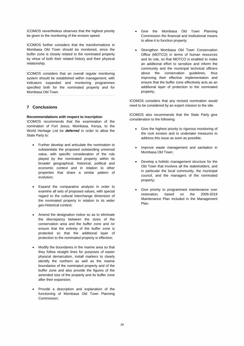
28
ICOMOS nevertheless observes that the highest priority be given to the monitoring of the erosion speed. ICOMOS further considers that the transformations in Mombasa Old Town should be monitored, since the buffer zone is closely related to the nominated property by virtue of both their related history and their physical relationship.
ICOMOS considers that an overall regular monitoring system should be established within management, with indicators expanded and monitoring programmes specified both for the nominated property and for Mombasa Old Town.
7 Conclusions Recommendations with respect to inscription ICOMOS recommends that the examination of the nomination of Fort Jesus, Mombasa, Kenya, to the World Heritage List be deferred in order to allow the State Party to:
Further develop and articulate the nomination to substantiate the proposed outstanding universal value, with specific consideration of the role played by the nominated property within its broader geographical, historical, political and economic context and in relation to other properties that share a similar pattern of evolution;
Expand the comparative analysis in order to
examine all sets of proposed values, with special regard to the cultural interchange dimension of the nominated property in relation to its wider geo-historical context;
Amend the designation notice so as to eliminate
the discrepancy between the sizes of the conservation area and the buffer zone and /or ensure that the entirety of the buffer zone is protected so that the additional layer of protection to the nominated property is effective;
Modify the boundaries in the marine area so that
they follow straight lines for purposes of easier physical demarcation, install markers to clearly identify the northern as well as the marine boundaries of the nominated property and of the buffer zone and also provide the figures of the amended size of the property and its buffer zone after their expansion;
Provide a description and explanation of the
functioning of Mombasa Old Town Planning Commission;
Give the Mombasa Old Town Planning Commission the financial and institutional means to allow it to function properly;
Strengthen Mombasa Old Town Conservation
Office (MOTCO) in terms of human resources and its role, so that MOTCO is enabled to make an additional effort to sensitize and inform the community and the municipal technical officers about the conservation guidelines, thus improving their effective implementation and ensure that the buffer zone effectively acts as an additional layer of protection to the nominated property;
ICOMOS considers that any revised nomination would need to be considered by an expert mission to the site. ICOMOS also recommends that the State Party give consideration to the following:
Give the highest priority to rigorous monitoring of
the rock erosion and to undertake measures to address this issue as soon as possible;
Improve waste management and sanitation in
Mombasa Old Town; Develop a holistic management structure for the
Old Town that involves all the stakeholders, and in particular the local community, the municipal council, and the managers of the nominated property;
Give priority to programmed maintenance over
restoration, based on the 2009-2019 Maintenance Plan included in the Management Plan.

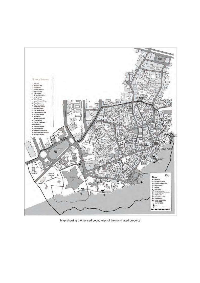
Map showing the revised boundaries of the nominated property
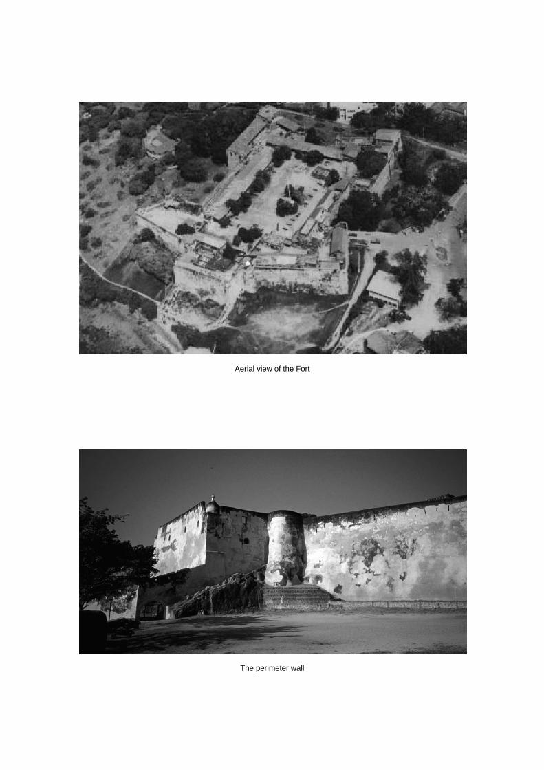
Aerial view of the Fort
The perimeter wall
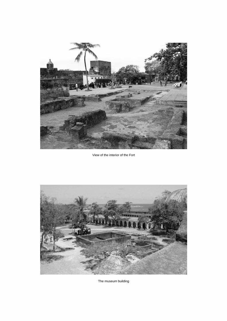
View of the interior of the Fort
The museum building

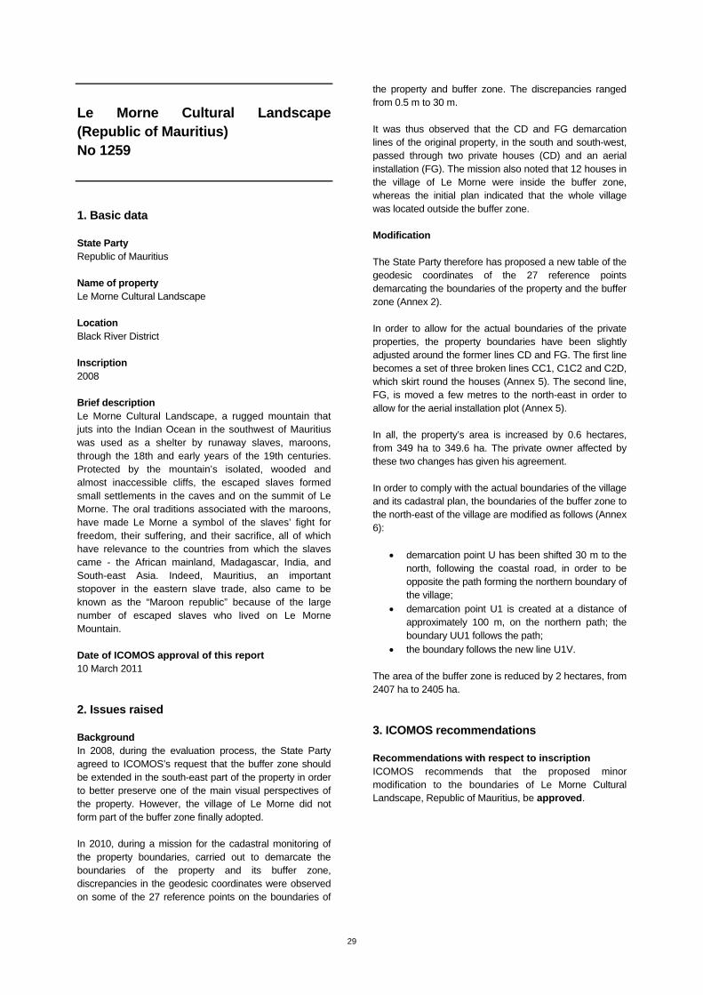
29
Le Morne Cultural Landscape (Republic of Mauritius) No 1259
1. Basic data State Party Republic of Mauritius Name of property Le Morne Cultural Landscape Location Black River District Inscription 2008 Brief description Le Morne Cultural Landscape, a rugged mountain that juts into the Indian Ocean in the southwest of Mauritius was used as a shelter by runaway slaves, maroons, through the 18th and early years of the 19th centuries. Protected by the mountain’s isolated, wooded and almost inaccessible cliffs, the escaped slaves formed small settlements in the caves and on the summit of Le Morne. The oral traditions associated with the maroons, have made Le Morne a symbol of the slaves’ fight for freedom, their suffering, and their sacrifice, all of which have relevance to the countries from which the slaves came - the African mainland, Madagascar, India, and South-east Asia. Indeed, Mauritius, an important stopover in the eastern slave trade, also came to be known as the “Maroon republic” because of the large number of escaped slaves who lived on Le Morne Mountain. Date of ICOMOS approval of this report 10 March 2011
2. Issues raised Background In 2008, during the evaluation process, the State Party agreed to ICOMOS’s request that the buffer zone should be extended in the south-east part of the property in order to better preserve one of the main visual perspectives of the property. However, the village of Le Morne did not form part of the buffer zone finally adopted. In 2010, during a mission for the cadastral monitoring of the property boundaries, carried out to demarcate the boundaries of the property and its buffer zone, discrepancies in the geodesic coordinates were observed on some of the 27 reference points on the boundaries of
the property and buffer zone. The discrepancies ranged from 0.5 m to 30 m. It was thus observed that the CD and FG demarcation lines of the original property, in the south and south-west, passed through two private houses (CD) and an aerial installation (FG). The mission also noted that 12 houses in the village of Le Morne were inside the buffer zone, whereas the initial plan indicated that the whole village was located outside the buffer zone. Modification The State Party therefore has proposed a new table of the geodesic coordinates of the 27 reference points demarcating the boundaries of the property and the buffer zone (Annex 2). In order to allow for the actual boundaries of the private properties, the property boundaries have been slightly adjusted around the former lines CD and FG. The first line becomes a set of three broken lines CC1, C1C2 and C2D, which skirt round the houses (Annex 5). The second line, FG, is moved a few metres to the north-east in order to allow for the aerial installation plot (Annex 5). In all, the property’s area is increased by 0.6 hectares, from 349 ha to 349.6 ha. The private owner affected by these two changes has given his agreement. In order to comply with the actual boundaries of the village and its cadastral plan, the boundaries of the buffer zone to the north-east of the village are modified as follows (Annex 6):
demarcation point U has been shifted 30 m to the north, following the coastal road, in order to be opposite the path forming the northern boundary of the village;
demarcation point U1 is created at a distance of approximately 100 m, on the northern path; the boundary UU1 follows the path;
the boundary follows the new line U1V.
The area of the buffer zone is reduced by 2 hectares, from 2407 ha to 2405 ha.
3. ICOMOS recommendations Recommendations with respect to inscription ICOMOS recommends that the proposed minor modification to the boundaries of Le Morne Cultural Landscape, Republic of Mauritius, be approved.

Maop showing the revised boundaries of the property

30
Ancient City of Damascus (Syria) No 20
1. Basic data State Party Syrian Arab Republic Name of property Ancient City of Damascus Location Damascus Inscription 1979 Brief description Founded in the 3rd millennium B.C., Damascus is one of the oldest cities in the Middle East. In the Middle Ages, it was the centre of a flourishing craft industry, specialising in swords and lace. The city has some 125 monuments from different periods of its history – one of the most spectacular is the 8th-century Great Mosque of the Umayyads, built on the site of an Assyrian sanctuary. Date of ICOMOS approval of this report 10 March 2011
2. Issues raised Background In cycle (I) of the periodic reporting, carried out in 2000, the buffer zone issue of the Ancient City of Damascus is referred to twice. Firstly, the State Party indicates that buffer zones have been introduced “in regions where there are not yet any buildings”, but without providing any mapping or administrative details; secondly, the State Party recognises the importance of protecting the view from the outside of the ancient city’s historic ramparts, which mark the limits of the property. Lastly, there are several ancient quarters which are situated extramuros, and thus outside the property, but which are extremely important in historic terms. During the decade which began in 2000, the various mission reports and reporting records refer on a number of occasions to the need to geographically delineate an overall buffer zone, and to define specific regulations for it, in view of urban development pressure. Decision 31COM 7B.58 (Christchurch, 2007) included a request that the State Party should “define the boundaries of the proposed buffer zone and (...) officially provide a map of this zone to the World Heritage Centre for approval by the Committee”. Meanwhile, the development of a
major urban planning project, near the city wall in the north, made this measure particularly urgent. The joint UNESCO/ICOMOS mission, sent out in 2008, noted the lack of any effective buffer zone, and the undesirable impact this was having on the management of the property’s urban environment. The importance of the ancient historic quarters and the important need to precisely defining the buffer zone boundaries were reasserted in decision 32COM 7B.63 (Quebec City, 2008). In 2008, the State Party set up a Conservation Committee to set up concertation between stakeholders, study urban planning projects and carry out a thorough study to define the various parts of the buffer zone and the appropriate forms of regulation. The suggestions were submitted to the city’s governor, and were approved on 28 January 2009. The World Heritage Committee decision 33COM 7B.63 (Seville, 2009) reiterated its request to the State Party to “complete the establishment of the buffer zone to be submitted for approval to the World Heritage Committee”. Modification The state of conservation report sent by the State Party in January 2011 refers to decision n° 37A of 26 January 2010 concerning the definition and regulation of the buffer zone. Its boundaries are defined by the blue line on the map provided in the annex. The management of the zone includes several levels of regulation linked to the situations of various parts of the city outside the city walls: The historic districts to the north and west of the
property (violet zones) are protected by the Antiquities Law, and as such benefit from the same level of protection as the property itself intramuros, particularly as regards any restorations.
The historic monuments (red) will be studied individually by the Protection Committee and specific regulation will be defined for each one, depending on its individual context.
Zones A and B (green), which are directly linked to the southern and south-eastern parts of the city walls, will be specifically studied with the assistance of the Antiquities Authority.
The other parts of the buffer zone (white) ensure that protection is continuous over the whole length of the city walls of the ancient city. Their regulation depended up to now on the general provisions of the city’s Urban Plan. The development plans will be reviewed quarter by quarter, and they will now be subjected to the stricter general regulation applying in the buffer zone. New constructions may be authorised in these areas, but their height must not exceed three stories, and their architectural design must offer a high degree of compatibility with the values of the property and its landscapes, under the control of the Antiquities Authority.
31
The River Barada and its natural environment will be covered by a specific programme, with the assistance of the Antiquities Authority.
The buffer zone thus defined by the General Directorate of Antiquities and Museums was approved by ministerial decision n° 27 of 26 June 2010. The property has an area of 82.13 ha, and the buffer zone has an area of 42.60 ha.
3. ICOMOS recommendations ICOMOS considers the fact that a duly mapped buffer zone has been officially approved by the State Party is a positive step. The buffer zone includes protective elements which refer explicitly to the outstanding universal value of the property and the importance of its conservation. The general provisions are supplemented by the announcement of projects affecting specific quarters or zones. ICOMOS considers that the World Heritage Committee should be kept regularly informed about the progress of such projects. While the whole of the city walls which define the limits of the property are now surrounded by a clearly defined buffer zone, a significant proportion of the historic quarters outside the walls are not included in the zone, even though the Committee has on many occasions drawn the State Party’s attention to their importance, and to the need to link them with the property itself. ICOMOS therefore considers that the proposed buffer zone is an important step in the protection of the immediate environment of the property and its landscapes, but that the State Party must continue its efforts and reflection in this matter. Recommendations with respect to inscription ICOMOS recommends that the proposed buffer zone for the Ancient City of Damascus, Syrian Arab Republic, be approved. ICOMOS further recommends that the State Party give consideration to the following points: Consider extending the buffer zone as currently
defined so as to ensure a better connection between the historic quarters of the ancient city and the inscribed property;
Continue the regulation and control efforts, either currently under way or announced, for the various parts of the buffer zone, and to keep the World Heritage Committee up to date with progress in this matter.
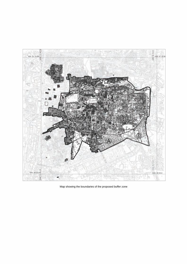
Map showing the boundaries of the proposed buffer zone

32
Melaka and George Town (Malaysia) No 1223
1. Basic data State Party Malaysia Name of property Melaka and George Town, Historic Cities of the Straits of Malacca Location Melaka, State of Melaka George Town, State of Penang Inscription 2008 Brief description The historic cities of Melaka and George Town have developed over 500 years of trading and cultural exchanges between East and West in the Straits of Malacca. The influences of Asia and Europe have endowed the towns with a specific multicultural heritage that is both tangible and intangible. With its government buildings, churches, squares and fortifications, Melaka demonstrates the early stages of this history, originating in the 15th-century Malay sultanate and the Portuguese and Dutch periods beginning in the early 16th century. Featuring residential and commercial buildings, George Town represents the British era from the end of the 18th century. The two towns constitute a unique architectural and cultural townscape without parallel anywhere in East and Southeast Asia. Date of ICOMOS approval of this report 10 March 2011
2. Issues raised Background In the evaluation of 2008, when the property was inscribed, the ICOMOS report recommended a revision of the buffer zone boundaries at Melaka to include the Butik China cemetery zone. The inscription decision 32 COM 8B.25 (Quebec City, 2008) asked the State Party to “submit a comprehensive conservation plan dealing with all the buildings and its schedule for implementation in both cities”. Decision 33 COM 7B.78 (Seville, 2009) requested that the State Party should submit to the World Heritage Centre, by 1st February 2011, a report on the progress made in the
implementation of the recommendations and the drawing up of a conservation management plan. Modification In the general context of the measures taken by the State Party in order to meet the various recommendations concerning the management, protection and conservation of the property, a series of minor modifications are proposed for the urban property of the City of Melaka and its buffer zone. They form chapter 2 of the report on the state of conservation of the property and chapter 2 of the property conservation management plan submitted by the State Party at the end of January 2011. With respect to the boundaries of the property, the proposal is that they should be brought into line with clearly identified cadastral boundaries in the case of six situations which up to now have been somewhat confused; in five cases, they correspond to an extension of the property, and in one case a reduction. The proposals are as follows: N° 8, Melaka Tengah Police Station district, western
zone of Jalan Kota: until now, the property has consisted only of the main buildings; it is proposed that the property should be extended up to the district boundaries.
N° 9, Melaka Tengah Police Station district, eastern zone of Jalan Banda Kaba: this zone, where the former Portuguese fort is located, was mapped very approximately; it is proposed that the property should be extended up to the district boundaries. The whole of the Melaka Tengah Police Station district will be included in the property.
N° 10, Kampung Ketek is a residential zone with homogeneous morphological characteristics, of which only one part was inside the property; it is proposed that the property should be extended to include the whole of this quarter, by following the main streets which mark its boundary, and to include a street of shops, Jalan Kampung Hulu.
N° 11, Kubu Fire Station is adjacent to the previous quarter, on the west side; a simplification of the boundaries is proposed, consisting of extending them up to the main streets which mark the boundary of the quarter, in continuity with the previous quarter.
N° 12, Dataran Pahlawan Mall; the property included part of the Mall, and cut through various plots; it is reduced to the cadastral boundaries to the north of the Mall, which is excluded from the property.
N° 13, Jalan Laksamana 5; this is the south-west boundary of a traditional trading zone, Jalan Tun Tan Cheng Lock, in which attempts had been made to establish the boundaries of the plots of individual properties; this definition has turned out to be inoperative, as a result in changes in land ownership; it is proposed that the property should be extended up to the boundary of the street Jalan Laksamana 5.
For the boundaries of the buffer zone, the proposed modifications are of two types: substantial extensions for purposes of better protection (N° 1 and N° 2) and
33
rectifications to follow clearly identified cadastral lines, which means limited extensions of area in some cases (N° 3 and N° 4) and limited reductions in other cases (N° 5, N°6 and N°7). N° 1, Bukit China cemetery forms a large zone in the
north-east of the property which is proposed as an extension, in accordance with the ICOMOS recommendation of 2008.
N° 2, in front of the outlet of the Melaka river estuary into the straits, an extension is proposed; it forms an angle which extends the buffer zone in a seaward direction, over a distance of 1 km; the aim is to protect the vision cone of the entry of the estuary from the straits, and the view of the straits from the property, against any possible programmes to extend artificial land or construct new buildings.
N° 3, the buffer zone is extended to include all the land of Malacca High School, following the detection of an error in the cadastral record.
N° 4, the boundary in the Jalan Tangkera quarter is extended to the north-west so as to include the whole district.
N° 5, the buffer zone boundary near Hang Tuah stadium and the University of Technology is moved to come into line with the cadastral boundaries, which means the exclusion of a strip of land.
N° 6, following the cadastral boundaries in the Jalan Merdeka quarter results in the exclusion of a strip of land.
N° 7, following the cadastral boundaries in the Jalan Munshi Abdullah quarter results in the exclusion of a strip of land.
As a result of these changes, the area of the property is increased from an initial 38.6 hectares to 45.3ha; the buffer zone area is increased from an initial 134.0ha to 242.8ha.
3. ICOMOS recommendations ICOMOS considers that all the proposed modifications to the boundary of the property, and most of the proposed modifications to the boundary of the buffer zone, are adjustments of limited scope, intended to correct imprecise definitions of boundaries or small mapping errors, and make sure the cadastral boundaries are simple and suitably identified. The substantial modifications (N° 1 and N° 2) of the buffer zone consist of two fully justified extension proposals: the first takes into account a space with significant cultural value, and the second ensures visual protection when viewed from the sea, at the entrance to the estuary.
Recommendations with respect to inscription ICOMOS recommends that the proposed minor modification to the boundary of Melaka and George Town, Historic Cities of the Straits of Malacca, Malaysia, be approved.
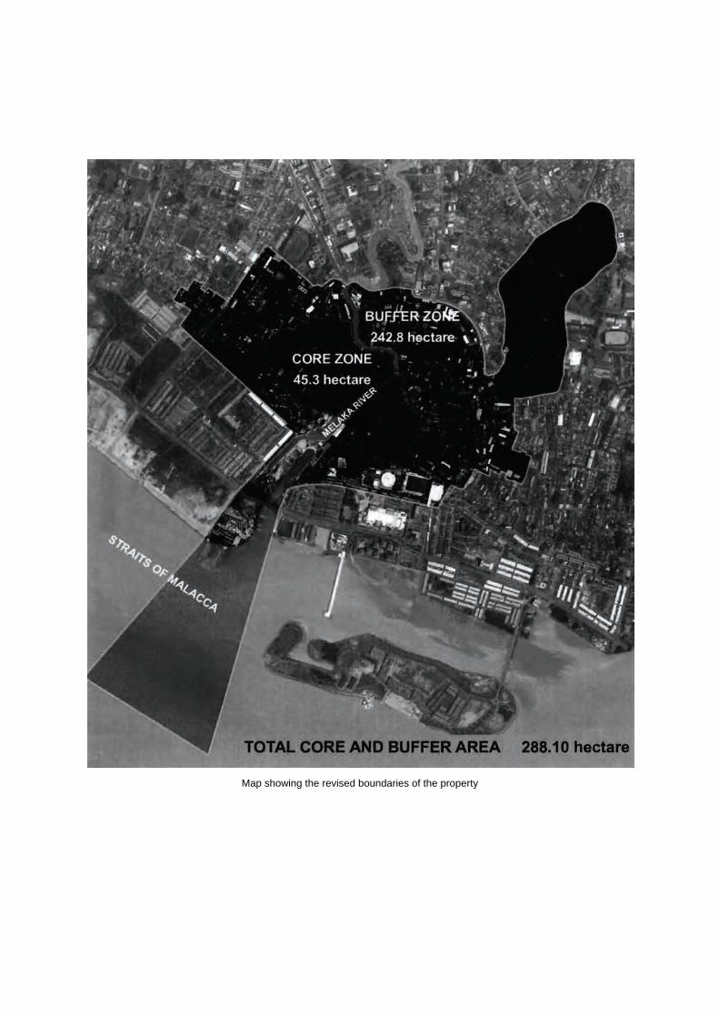
Map showing the revised boundaries of the property

34
Causses and Cévennes (France) No 1153rev Official name as proposed by the State Party The Causses and the Cévennes, Mediterranean agro-pastoral Cultural Landscape Location Gard, Hérault and Lozère departments Languedoc-Roussillon Region Aveyron department, Midi-Pyrénées Region Brief description The shale and granite Cévennes mountain chain, interspersed by wide deep valleys, rises above the plains of Languedoc and the Mediterranean and is the southern end of the Massif Central. Its dispersed farms on the mountain slopes, oases of green set amidst deep terraces and thick woodlands of chestnut and pine, are linked by high level tracks across the undulating plateaux of the mountain summits. In distinct contrast are the limestone uplands of the Causses to the west and granite uplands of Mont Lozère to the north. Both are open almost treeless expanses of grazed grassland supporting scattered farms, the limestone areas dissected by deep gorges which carry the torrents of the western Cévennes down to the Mediterranean. Category of property In terms of the categories of cultural property set out in Article 1 of the 1972 World Heritage Convention, this is a site. In terms of the Operational Guidelines for the Implementation of the World Heritage Convention (January 2008) paragraph 47, it is also a cultural landscape.
1 Basic data Included in the Tentative List 1st February 2002 International Assistance from the World Heritage Fund for preparing the Nomination None Date received by the World Heritage Centre 25 January 2005 27 January 2009 31 January 2011
Background This is a referred back nomination (30 COM, Vilnius, 2006 and 33 COM, Seville, 2009). The original nomination was submitted in 2005 and considered by the Committee at its 30th session in 2006. At that time ICOMOS recommended that “the examination of The Causses and the Cévennes, France, be deferred to the World Heritage List to allow the State Party to consider further the qualities of the property.” The World Heritage Committee chose to refer the nomination back to the State Party without any recommendation and adopted the following decision: Decision 30 COM 8B.44: The World Heritage Committee, 1. Having examined Documents WHC-06/30.COM/8B and WHC-06/30.COM/INF.8B.1, 2. Refers the nomination of The Causses and the Cévennes, France, back to the State Party. A supplementary nomination was submitted by the State Party on 27 January 2009. This related to the same boundaries as the original nomination, but set out a new justification based on a new comparative analysis. ICOMOS recommended that the examination of the nomination of The Causses and the Cévennes, France, to the World Heritage List be deferred in order to allow the State Party to provide:
A more detailed inventory of the attributes of the property that relate to agro-pastoralism, in order to:
o Justify the boundary of the property; o Provide a basis for managing and
sustaining the attributes, including processes and practices, that relate to agro-pastoralism.
Provide an overall nomination dossier that
reflects the revised focus on agro-pastoralism and its manifestations.
ICOMOS considered that any revised nomination would need to be considered by a mission to the site. The World Heritage committee adopted the following decision: Decision 33 COM 8B.32: The World Heritage Committee, 1. Having examined Documents WHC-09/33.COM/8B and WHC-09/33.COM/INF.8B1.Add,
35
2. Refers the nomination of The Causses and the Cévennes, France, back to the State Party in order to allow it to:
a) Provide a more detailed inventory of the attributes of the property that relate to agro-pastoralism, in order to:
i) Justify the boundary of the property; ii) Provide a basis for managing and sustaining the attributes, including processes and practices, that relate to agro-pastoralism;
b) Provide a nomination dossier that reflects the revised focus on agro-pastoralism and its manifestations;
Consultations ICOMOS has consulted its International Scientific Committee on Cultural Landscapes. Literature consulted (selection) Extensive literature on many aspects of the landscape such as transhumance, archaeology, history, the Templars, vernacular buildings, silk production etc; Transhumance and Biodiversity in European Mountains. Report from the EU-FP5 project Transhumount. Edited by R.G.H.Bunce, M. Pérez Soba, R.H.G. Jongman, A. Gómez Sal, F. Herzog and I. Austad.
Technical Evaluation Mission A joint ICOMOS/IUCN mission visited the property from 18 to 23 September 2005. As this is a referred back nomination, no further missions have been undertaken. Additional information requested and received from the State Party None Date of ICOMOS approval of this report 10 March 2011
2 The property Background In its evaluation of the 2005 nomination, ICOMOS noted that the nominated area was large and diverse and its three natural units have led to the development of quite different traditional practices, reflected in grasslands shaped by agro-pastoralism and wooded valleys shaped by chestnut and mulberry cultivation. It further noted that the area was an interesting example of where there is great local support for sustaining the landscape and trying to reverse the trend in movement of farmers away from the area. ICOMOS considered that what had not emerged clearly from the nomination was the rationale for nominating the area as a whole and how the property might be perceived as an entity nor why it should be considered to have outstanding universal value.
In its evaluation of the 2009 nomination dossier, ICOMOS noted that the supplementary information provided had re-focused the justification for inscription on the persistence of agro-pastoralism and the way this has shaped the landscape. ICOMOS supported this new approach and considered that agro-pastoralism was the force that binds together the quite different faces of the overall mountain areas – the north-west facing shale and granite and the south-eastern limestone uplands. Moreover this system has been shown as an outstanding example of a regional variant of Mediterranean pastoralism, through the workshop organised by the State Party on agro-pastoralism in the Mediterranean area and in the revised comparative analysis. ICOMOS did not consider that the manifestations of this agro-pastoral system on the landscape had been sufficiently clearly identified in terms of specific features and attributes in the large and diverse nominated area. Many other features besides those associated with agro-pastoralism – such as those associated with silk and chestnut production and semi-urban areas that have not been shown to have tight associations with agro-pastoralism - were evident in parts of the landscape.
ICOMOS considered that there was a need to define more clearly the attributes of agro-pastoralism and to relate these to the boundary and to management. The original nomination dossier had been supplemented with new information on the agro-pastoralism aspects of the landscape but without withdrawing any of the initial information. ICOMOS considered that there was a need for an overall coherent nomination dossier that sets out in more detail the manifestations of agro-pastoralism and provided a clear focus on its history, development and attributes. The State Party submitted a revised nomination dossier on 31st January 2011. This changes the name to: The Causses and the Cévennes, Mediterranean agro-pastoral Cultural Landscape, and defines a smaller area within new boundaries. Description The Causses and Cévennes, together form a large upland region in the southeast of the French Massif Central. The area is made up of two opposites: the north-western granite and shale slopes that face towards the Atlantic to which their water drains, and the southeast limestone slopes of the same uplands that face towards Mediterranean. Yet the development of these areas has been marked by ceaseless relations between these two slopes, based on a system of agro-pastoralism that slowly shaped the unity of the Causses and Cévennes landscape over the last millennium. The uplands with their farming culture are now quite distinctive from the surrounding comparatively
36
urbanised plains. Nevertheless the uplands and the lowlands still have a symbiotic relationship with cattle and sheep moving up into the grazed uplands in the summer months along drailles or drove roads that criss-cross the area. The smaller nominated area has been defined to encompass that part of the Causses-Cévennes where landscapes are the most highly representative of the relationship between the various agro-pastoral systems and the local biophysical environment and where the attributes of the agro-pastoral system are most dense, including the drailles or drove roads. The new boundaries reflect detailed ground surveys. The nominated area covers parts of the Parc national des Cévennes (PNC), the Parc naturel régional des Grands Causses (PNR), and the Causses méridionaux and Centre permanent d’initiatives pour l’Environnement des Causses méridionaux (CPIE), in all an area of 302, 319 hectares with a buffer zone of 312, 425 hectares. The nature of the precipitation in the uplands – much in winter and a shortage in summer led to the need to collect and store water. A mastery of water management was a pre-condition of settled agriculture and this is reflected in a range of different solutions and complex solutions for channelling and storing water. High level roads passing along the summits of the mountains mark out the drove roads that in many cases followed even more ancient track ways. The shale and granite Cévennes mountain chain, interspersed by wide deep valleys, rises above the plains of Languedoc to the south and is clothed in dense woodlands of chestnut and pine. The villages and substantial stone farmhouses perched on deep terraces midway down the valleys reflect the organisation of the large abbeys of Languedoc and Ardèche from the 11th century, particularly in water irrigation, and the later prosperity brought by intensive chestnut and then silk cultivation, between the 16th and early 19th centuries. To the north around Mont Lozère the more open granite landscape supports cattle and sheep farming and is one of the last places where summer transhumance is still practiced. In contrast the Causses to the west is a high altitude grazed grassland steppe of karst limestone, one of the largest expanses in Europe. The area is sharply dissected by steep often wooded valley with Gorges that channel the water from the western Cévennes to the Mediterranean Coast. On the grasslands, substantial stone-built farm complexes support sheep farming, their sitting and boundaries reflecting the development of large-scale agro-pastoralism by the Knights Templars and then the Hospitalers between the 12th and 14th centuries, made possible as in the Cévennes by the control of water. The Causses became the centre of trade between the Mediterranean and the flat lands to the north.
Both the Cévennes and the Causses landscapes reflect wars, pestilence, periods of high level prosperity followed by rapid decline and most markedly the migration of people away from the hills in the 19th and 20th centuries. Between 1846 and 1975 the area lost two thirds of its inhabitants. Like many uplands areas of Europe, the Cévennes and Causses were discovered in the 19th century first by scientists, in this case geologists and geographers recording distinctive gorges, ‘swallow-holes’ and caves, and then by writers and tourists appreciating picturesque features. Robert Louis Stevenson’s book of his travels with a donkey at the end of the 19th century brought the Cévennes landscape to wide attention. In detail the nominated property consists of the following: Structures related to water collection and management
The influence of Abbeys which controlled many valleys of the Cévennes in the 11th and 12th centuries transformed the landscape from small-scale, isolated, subsistence farmers into a well ordered and structured landscape of mixed farms with irrigated terraces growing grain, hay and chestnuts, and with chickens, goats, sheep and cattle grazed on the high pastures and pigs and bees kept in the forests. The water flowing off the mountains was directed into conduits or underground mined channels, which when they reached the farm branched into feeder channels for steep stone walled terraces. Below the farmhouse these terraces were used for grain and hay; above for chestnut trees, pollarded to keep them to a manageable height. The summits of the mountains above the tree line were grazed by sheep and cattle. In the Causses the Knights Templars provided the organisational impetus for the development of agro-pastoralism in the 12th century, systematically exploiting the resources of the areas over which they gained control. Huge quantities of grain were produced, in stone walled fields, and then stored in towers such as at Tour du Viala du Pas de Jaux. Water resources were organised for large farms – roof cisterns and ponds - and for the vast flocks of sheep which moved to into the Causses pastures in the summer months from the plains and traversed back again on the autumn along drailles or drove roads. Drailles or Drove roads
The northern part of the Cévennes National Park encompasses the grazed granite uplands around Mont Lozère. Here year round cattle farming is supplemented on the good summer grazing by large flocks of sheep travelling north from farms to the south of the National Park in Languedoc near the coast, a system of transhumance that has persisted since the 12th century and is still worked by a few farmers today.
37
300 kilometres of drove roads criss-cross the area. These high level routes are said to be related to early high level Bronze Age tracks, which later were developed into an extensive network linked to monastic establishments in mediaeval times. There is now a somewhat simplified network based on three main drove roads: Aubrac, Margeride and Gévaudan, which link together subsidiary routes for 28 major mountain pastures and are used by 125 stockbreeders and their 25,000 ewes when they move to summer pastures. Sheep housing
The vast flocks of sheep keep on the Causses were in the winter housed in long low stone buildings known as les Jasses. Often more than 10 metres in length and containing water tanks and hay stores, they have come to be seen as the emblematic buildings of the Causses. Milk from the sheep goes largely to the making of Roquefort cheese – outside the nominated area to the west. Forest
The grazed areas have been created over millennia through the clearing of forests. In the east of the area, remnants of beech forest survive as well as considerable areas related to chestnuts and later mulberry cultivation. Some areas in the Cévennes landscape reflect the impact of recent small plantations of exotic species. In other areas indigenous species have been planted over larger areas, resulting in an incongruous monoculture. In recent years attempts have been made to introduce mixed-species planting in order to achieve landscapes that are closer to the natural forest cover in appearance and species diversity. In the 20th century, there has been limited reforestation of the Causses. In the Causse Méjean, in particular, there are stark, rectilinear plantations of conifers. Farmhouses
The traditional buildings of the southern Cévennes are characterised by dry rubble shale stone construction plastered on the inside and sometimes on the outside too. Roofs are of shell-shaped slates with rows of slates interlocking to protect the ridge. To the north around Mont Lozère the granite buildings are built of shaped square stones and are much squatter in character. Barley straw was widely used on roofs until the 17th century when it was replaced by slate. The wide open Causses landscape has some remarkable examples of fine stone farmhouses such as the farm complexes of Les Monziols. Farmhouses and farm buildings were built of dry limestone blocks plastered both inside and outside. They are characterised by dressed stone lintels and door jambs and by the use of fine stone arches over doors and to support roofs in houses. The vaulted ground floors of houses often contained water storage cisterns.
Villages
Villages in the Cévennes reflect their founders: many names begin with Saint reflecting the various Abbeys that owned land in the 12th and 13th centuries. The houses cluster together along narrow streets. The limestone of the Causses has resulted in the impressive medieval military architecture of the Templar and Hospitaler towns such as La Cavalerie, La Couvertoirade, and Sainte-Eulalie de Cernon. Chestnuts cultivation
In the 16th century a rapid expansion of chestnut farming led to the creation of many new terraces rising up the hillsides sometimes at considerable distances from their farms. Trade in chestnuts contributed to an increasing prosperity in the area, reflected in the re-building of more substantial farmhouses and two-storey buildings for drying the shelled nuts. For around 150 years, chestnuts where the main cash crop. The creation of new terraces, the improvements to farmhouses and the creation of buildings for processing the chestnuts all contributed to establishing the bones of the Cévennes landscape as they exist today. Silk cultivation
After a particularly severe winter in 1709 which decimated many of the chestnut trees, many farmers change to growing silk worms and planted their terraces with mulberries, particularly in the warmer valleys that faced south to the Mediterranean Sea. Mulberries where the last addition to the landscape, together with the large multi storey buildings, magnaneries, with regular rows of windows and many chimneys constructed to grow and process the silk worms. These were often built as extensions to the existing farm complexes. History and development During the Bronze Age there appears to have been large-scale clearance of the forest to create pastures for sheep and cattle. Roman rule touched the areas comparatively lightly. The Romans did not impose social organisation on the small scale farmers. However the landscape was exploited for its resources, minerals and particularly timber and the breeding of cattle and sheep. During Roman rule much of the Causses was cleared of its pine trees. Pliny mentions cheeses from the area being marketed through Nîmes along trade routes across the summits of the hills, probably of much earlier origin and which have by and large persisted to the present day. The end of Roman rule heralded hostile incursions from Visigoths and then the Franks in the 6th and 7th centuries which seem to have prompted the development of settlements in areas that could be defended readily. The fundamental changes to the landscape that can still be perceived today took place between the 12th and 14th centuries when several monastic orders, including
38
Benedictines, Hospitalers and Knights Templars gained control of extensive lands and put in place strong social systems in order to harness water supplies and exploit more systematically the forests and particularly grazing lands. In the Causses, the landscape structures put in place in the 12th and 13th centuries are still reflected in the commune boundaries of today. By the 16th century trade in sheep and cloth put the area at the centre of trade between the plains to the south and north. The golden age of the Cévennes economy, was between the 16th and 18th centuries when prosperity first from chestnuts and sheep and then later also silk fostered the building of large farmhouses and established trade and permanent relations with the plains, the valley of the Rhone and the Mediterranean. In the 1840s the longest railway line of the time connected Grand Combe to Beaucaire. Silk production brought another boom era at the end of the 18th and beginning of the 19th centuries. By 1810 the number of peoples living in the region reached its apogee. The re-distribution of land after the Revolution of 1789 to the farmers added to the economic impetus: new techniques were introduced and successful farms absorbed others, leading to the demise of many smallholdings. Boom was quickly followed by decline: disease amongst the silk worms in the mid 19th century started migration away from the mountains to the towns. Between 1856 and 1914, Cévennes lost 40% of its population to the urban centres and the mines. The war of 1914-1918 accentuated the demographic loss and this continued after the armistice. 20% of the men and 25% of the women between 20 and 40 years old left the area to find work in the cities. Sericulture and silk production finally came to an end in the 1950s. By 1975, at the end one hundred twenty-five years of decline, only around 11,500 inhabitants remained - a loss of two thirds, the losses being most strong on the Atlantic slopes. Ruins invaded the territory, and many hamlets died. Gradually the trend is reversing: in the last thirty years people have slowly begun to move back to some areas and reclaim the lands. The traditional transhumance of vast flocks of sheep seasonally from the plains of Languedoc to the uplands of the Causses and the Cévennes has now dwindled drastically. However there is now a determined move to support agro-pastoralism which is beginning to have a marked effect on its revival.
3 Outstanding Universal Value, integrity and authenticity
Comparative analysis The property is compared with three inscribed properties: The Laponian Area, (Sweden, 1996) Pyrénées - Mont Perdu, (France, Spain, 1999), and the Orkhon Valley Cultural Landscape (Mongolia, 2004). These properties are all considered to be examples of pastoralism, rather than agro-pastoralism and thus none compare with Causses and Cévennes. The nominated property is then compared with sites representative of agro-pastoralism around the Mediterranean – none of which are inscribed. These are groups into four areas: South-west Europe with sites in Spain, France, Andorra, and Italy; the Balkan Peninsula with sites in Croatia, Bosnia, Montenegro, Kosovo, Albania, Greece, and Turkey; the Eastern Mediterranean with sites in Turkey, Syria, and Libya; and fourthly the Maghreb with sites in Tunisia, Algeria and Morocco. The comparison covers climate, religion, aspects of agro-pastoralism and the vitality of the systems. In terms of agro-pastoralism, the Causses and Cévennes are seen to cover all the various types of agro-pastoralism present around the Mediterranean apart from nomadic pastoralism. Furthermore the property still has active transhumance and a landscape that reflects – visibly and through its organisational structures - both ancient agro-pastoralism (from relict aspects of the landscape) and what is called the traditional agro-pastoralism that has evolved over the past millennium. Comparing this to what persists in the other areas and regions, it is suggested that in the Maghreb, the pastoralism was defined more by nomadic and semi-nomadic systems with more recently integration with agriculturalists. The area has been subject to intense population pressure since the 19th century and although the mobility of the pastoral system has survived, it is highly vulnerable. In Albania, where livestock and pastoral practices date back to Roman times, there are similarities with the landscape and systems of the Causses and Cévennes. However in Albania the system was dislocated by the Soviet practice of collectivisation and although pastoralism has recovered, there is a loss of traditions and memory and the system is not supported by government policies. By contrast, the Causses and Cévennes have not been subject to population pressure, they have resisted invasion, and agro-pastoralism is still flourishing. It is therefore considered that the property constitutes and exceptional reflection of Mediterranean agro-pastoralism.
39
ICOMOS notes that these comparisons are based on the conclusion of expert meetings on agro-pastoralist cultural landscapes of the Mediterranean region held at the property in September 2007 and in Albania in 2009. These meeting defined a Mediterranean agro-pastoralism as a discrete system of land management based on the Mediterranean climate, (dry summer with very dry, soft winter cold); soil of relatively low productivity, changes in altitude that allowed transhumance, proximity to the sea; system largely based on sheep but also associated with cattle and in place camels and other animals, and shaped by monotheistic religions and the common use of resources. The system has high immaterial values and delivers high environmental values. It also has considerable diversity within different areas. The analysis suggested that Mediterranean agro-pastoralism is one of the great agro-pastoral systems of the world, the others being: the nomadism of the tundra, based on reindeer; the civilizations of Central Asia, which have
domesticated the horse; transhumance in semi-arid context of the
Mediterranean basin and the Middle-East; Bedouin civilization of the Saharan desert and Arabia
based on the camel; the nomadism of sub-Saharan Africa; Short transhumance such as in the Alps, the Pyrenees,
Tatras, Carpathians; Andean pastoralism; Ranching of the New World, e.g. US, Australia, New
Zealand; Small scale distinctive pastoralism in discrete areas e.g.
Scotland; Hungary or with distinctive animals such as the two-humped camel.
The Causses and the Cévennes is seen as part of the southwest of Europe which includes areas of Spain, North Africa, France and Italy. In comparison with other areas, the landscape of the Causses and the Cévennes, shows well the evolution of the system, there is a vitality to the agro-pastoral system in comparison to many other areas, local sheep breeds persists, the architectural legacy is well represented in drove roads, water management, buildings, etc. The landscape also has aesthetic qualities that are highly valued. Currently there are no sites inscribed on the List that reflect large-scale agro-pastoralism of the Mediterranean region. ICOMOS considers that the comparative analysis sets out well the rationale for considering Mediterranean agro-pastoralism as a major type of pastoralism within which there are significant variations. It also shows that in many parts this agro-pastoralism is extremely vulnerable. The Causses and the Cévennes can be seen to represent one specific response. It is a response that is still viable and crucially is reflected in the landscape.
On the issue of other sites that might be nominated in the future, ICOMOS considers that there would be room on the List for other properties that might be exemplars of other variations of Mediterranean pastoralism - which reflect distinctive and outstanding cultural responses.
For these reasons, ICOMOS considers that the comparative analysis justifies consideration of this property for the World Heritage List.
Justification of Outstanding Universal Value The nominated property is considered by the State Party to be of Outstanding Universal Value as a cultural property for the following reasons: The upland landscapes of the Causes have been
shaped by agro-pastoralism over three millennia. In the Middle Ages, the development of cities in the surrounding Mediterranean plains, and especially the growth of religious institutions, prompted the evolution of a land structure based on agro-pastoralism, the basis of which is still in place today.
Too poor to host cities, too rich to be abandoned, the landscape of Causses and Cévennes are the result of the modification of the natural environment n by agro-pastoral systems over a millennium.
The Causses and Cévennes demonstrate almost every type of pastoral organisation to be found around the Mediterranean (agro-pastoralism, silvi-pastoralism, transhumance and sedentary pastoralism). The area has by a remarkable vitality as a result of active renewal of the agro-pastoral systems.
This area is a major and viable example of Mediterranean agro-pastoralism. Its preservation is necessary to deal with threats from environmental, economic and social issues that such cultural landscapes are facing globally.
On a historical note, the Causses and the Cévennes retain numerous testimonies of the evolution over several centuries of its pastoral societies. Its important built heritage, landscape characteristics and intangible associations that reflect traditional pastoralism will be preserved by the contemporary revival of agro-pastoralism.
ICOMOS supports this justification of the cultural landscape forming an exceptional testimony to Mediterranean agro-pastoral systems within the structure of water management and building traditions put in place by the monasteries in the late Middles Ages. Integrity and authenticity The revised nomination dossier provides a single section for both Integrity and Authenticity and the concepts are not separated. Integrity
In terms of how the boundaries encompass all the attributes necessary to demonstrate outstanding universal value, ICOMOS can only comment from the
40
point of view of studying the maps provided. As this is a referred nomination, no further mission has been possible and thus ICOMOS has not been able to study the new boundaries on the ground. Since the previous nomination considerable effort has been made to indentify the attributes of agro-pastoralism and to identify those areas where the system is most highly represented and the attributes most dense. The boundaries have now been reduced with the towns around the edge being excluded and the area included being the heartland of the upland areas. This is still a comparatively large area, but more coherent than the previous territory that encompassed areas where agro-pastoralism was not the dominant activity. The wholeness or intactness of the cultural landscape is related to the survival of the forces that shaped the landscape as well as to the symptoms that those forces produced. The aim is to maintain these through the perpetuation of traditional activities and the support of those activities through Park staff and external grants. In many places the landscape is almost relict – particularly the terraces in the Cévennes, where only a fraction are actively managed. In some place, the systems of transhumance along drove roads barely survives – only a few flocks make the long journeys each year and many of the tracks are beginning to be covered with scrub. However there is now increasing attention being paid to supporting and reviving these processes. The water systems that once were the lifeblood of the fields and bergeries are now only maintained in places. Where integrity has been compromised is in the peripheral areas of the PNC, where new building has impacted on the farmed landscape and it is these areas that have now been removed from the revised boundaries. Authenticity
The key structures of the landscape: buildings, terraces, walls and watercourses retain a high degree of authenticity in terms of their built fabric, but many particularly the terraces need conservation. Less of these are now within the nominated area of the Cévennes. As for the authenticity of the agro-pastoral processes that shaped the landscape, these are surviving, and although vulnerable, and in the hands of very few farmers (no more than 100) are the subject of a renaissance through the combined of local and national authorities and local communities.
ICOMOS considers that the conditions of integrity and authenticity have been met.
Criteria under which inscription is proposed The property is nominated on the basis of cultural criteria (iii) and (v). Criterion (iii): bear a unique or at least exceptional testimony to a cultural tradition or to a civilization which is living or which has disappeared; This criterion is justified by the State Party on the grounds that the traditions of agro-pastoralism over thousands of years have generated a landscape in the Causses and Cévennes whose structure and attributes reflect a mastery of agronomic practices that have had a role in history and reflect a particular religious, scholarly and popular culture. ICOMOS considers this the nominated areas of the Causses and the Cévennes, manifest, an outstanding example of one type of Mediterranean agro-pastoralism. This cultural tradition, based on distinctive social structures and local breeds of sheep, is reflected in the structure of the landscape, especially the patterns of farms, settlements, fields, water management, drailles and open grazed common land and what it reveals of the way this has evolved, in particular since the 12th century. The agro-pastoral tradition is still living and has been re-vitalised in recent decades.
ICOMOS considers that this criterion has been justified.
Criterion (v): be an outstanding example of a traditional human settlement, land-use, or sea-use which is representative of a culture (or cultures), or human interaction with the environment especially when it has become vulnerable under the impact of irreversible change; This criterion is justified by the State Party on the grounds that living cultural landscape of the Causses and Cévennes is an outstanding example of the "combined works of man and nature" that has endured for three millennia with its ability to adapt to its natural environment, and to political, economic and social development. The distinctive and still dynamic landscape is an exceptional response to contemporary changes recorded in south-west Europe. Encompassing in large part a biosphere reserve and a national park, Causses and Cévennes show that pastoral activity is a factor in maintaining biodiversity, and a fine example of sustainable development. ICOMOS considers that the Causses and the Cévennes, can be seen as an exemplar of Mediterranean agro-pastoralism and specifically to represent a response common to the south-west of Europe. The nominated areas of the landscape manifest exceptional responses to the way the system has developed over time and particularly over the past millennia.
ICOMOS considers that this criterion has been justified.
41
ICOMOS considers that the nominated property meets criteria (iii) and (v) and conditions of authenticity and integrity and that Outstanding Universal Value has been fully demonstrated.
4 Factors affecting the property Development pressures
Construction The area has recently come under greater pressure for development as a result of the greater access permitted by the construction of a “meridian” highway, the A75. Farming regression The farming community has declined over the past half century, particularly in the Cévennes area. Many properties are now only inhabited in summer months as holiday homes. Some farmers are moving back but the long-term stability of farms is in question. The income of many farmers has been supplemented by grants for landscape maintenance. The wide ‘morale’ support demonstrated currently by the different authorities might not be sufficient in the future to ensure the maintenance of activities which sustain the cultural landscape with its richness and diversity. In the Causses farming depends on the existence of cheese making companies (Roquefort, Feta, etc) which collect the milk from more than 1,600 family farms. The dependence on a few big external (to the region) owned and commercially orientated companies constitutes also a risk; a slight change in the marketing condition could lead to a large scale abandonment of the traditional activities with severe consequences for the landscape and the rich biodiversity. In the Causses, the sheep farmers still manage to survive largely through supplying ewes’ milk for Roquefort cheese production. There has however been a marked increase in the size of farms needed to create viable units and this means there are many less people per hectare to manage buildings and the landscape generally. In places in the Causses, some land is turning back to scrub and trees where transhumance paths are no longer use or the land has been acquired for hunting. As with the Cévennes, the economy of sheep farmers is fragile. The nomination of the property for World Heritage status is seen as a way to boost tourism particularly in the Causses. It is also seen as a way to strengthen the resolve to sustain the agro-pastoral traditions. The transhumance system involves animals coming from outside the area into the Causses and Mont Lozère in the summer months and then heading back to the southern plains of Languedoc in the winter. This system is therefore to a degree outside the control of those working in the nominated area. There is also the movement of sheep within the nominated areas, particularly in the north, up to summer pastures.
Afforestation In certain areas extensive planting of exotic species by private landowners has introduced a discordant note. In others indigenous species have been planted over large areas, resulting in an incongruous monoculture. In recent years attempts have been made to introduce mixed-species planting in order to achieve landscapes that are closer to the natural forest cover in appearance and species diversity. The more limited reforestation of the Causses, has followed a similar development. The Causse Méjean, in particular, with its stark, rectilinear plantations of conifers, is less pleasing aesthetically and equally unacceptable in terms of biodiversity. Wind energy Threats from large-scale windfarms have been identified in the supplementary information. Tourism pressures
World Heritage recognition might lead to a significant increase of visitors in some parts of the sites which are already overcrowded in summer for instance St Guilhem, Gorges du Tarn, etc.). Measures might need to be taken to control car and visitor flows, which might prove to be quite unpopular. The public transportation system is almost non existent within the site, and this has not been addressed in the nomination file. Natural disasters
Forest fires are a threat to all parts of the nominated area, but particularly the coniferous plantations in the Cévennes. The large areas of chestnut trees that are no longer maintained and thus cleared at ground level are also vulnerable. Since 1995 a fire prevention plan has been put in place to minimise fires and contain those that do break out.
ICOMOS considers that the main threat to the property is farming regression, but there is a concerted effort to encourage and support farming activities through a structured approach.
5 Protection, conservation and management
Boundaries of the nominated property and buffer zone The precise boundaries for the revised t nomination have been defined as a result of detailed studies on the attributes of agro-pastoralism and with the benefit of site surveys of the landscape. It now follows clearly defined geographical features and is a logical reflection of the way the land is worked.
ICOMOS considers that the boundaries of the nominated area and buffer zone are satisfactory.
42
Ownership Around three-quarters of the property is in private ownership. The rest is in the public domain. Protection Legal Protection
The whole of the nominated areas is protected either for natural or cultural heritage but only the core of the Cévennes National Park is protected for both. This is a weakness as outside the core area of the park there is less control over changes to buildings and new development. The totality of the nominated area is protected in a variety of different forms, but only part is protected for cultural attributes. The Parc national des Cévennes (PNC), with its headquarters at Florac, is a public national administrative body (établissement public national à caractère administratif) created in September 1970 under the provisions of the Law of 22 July 1960. There are 117 communes within its 321,380ha. It has been a biosphere reserve as part of the UNESCO Man and the Biosphere programme since 1985. In the core area of the park, cultural property is protected and no new building is allowed. In the peripheral area there is no protection for cultural property. The Parc naturel régional des Grands Causses (PNR) was founded in 1995 under the provisions of the Law of 5 July 1972 which established the category of Regional Natural Parks. At 315,949ha and covering 94 communes it is almost as large as the PNC. Its status and powers are broadly comparable with those of a national park. Its policies are determined by a Syndicat de collectivités, a public body which brings together communes and other entities with the objective of carrying out works and providing services for the communities involved. The park exists to protect natural attributes. The Centre permanent d’initiatives pour l’Environnement des Causses méridionaux (CPIE), set up in accordance with 1901 legislation and representing 28 communes in the Départements of Gard and Hérault, is a body which enables these collectivities to prepare and implement policies and activities of common interest. These regulations do not extend to all private property, which represents some three-quarters of the area nominated for World Heritage inscription. Landowners in France have virtually absolute rights over the development and management of their own properties, unless these are covered by specific legal instruments such as the classement of historic monuments which override the rights of private landowners The Gorges du Tarn and de la Jonte, which extend over some 29,000ha, were classified as protected sites on 29 March 2002, as a result of which any proposed changes in their condition or character must be approved by the relevant Minister or by the Prefect of Aveyron. At the
present time active consideration is being given to the designation of this site as one of the Grands Sites de France. This initiative has three objectives – the creation of a sustainable and autonomous management policy, restoration from the ecological and landscape point of view, and ensuring that any measures that are adopted will benefit local development. This designation would supplement existing ones. In addition, a large number of historic buildings and architectural ensembles are protected under the provisions of the 1913 historic monuments legislation. (these are listed in the revised nomination dossier.) A number of architectural groups and small villages are designated as Zones de protection du patrimoine architectural, urbain et paysager (ZPPAUP). There are also a considerable number of measures for the protection of areas of special natural interest. The supplementary information acknowledges the need for tighter protection for the overall landscape in response to the shift in emphasis of the nomination and the identified threats and sets out a range of complementary measures to coordinate and strengthen existing protection. This will be put in place by 2015.
ICOMOS considers that the legal protection in place is weak in parts in terms of protecting the cultural attributes. This is acknowledged by the State Party who has initiated complementary protective measures for the property to be put in place over the next 6 years.
Conservation Inventories, recording, research
The property is well researched from the point of view of stock-breeding. It is acknowledged that more research is needed on physical aspects of the landscape such as prehistoric remains in the Cévennes and also field structures in order to have more precise understanding of landscape history. The Strategic Plan (see below) sets out a programme to record the material and immaterial attributes of the agro-pastoral system. The Cévennes National Park and Regional Park Causses have undertaken a program of inventorying the drailles or drove roads. Present state of conservation
As ICOMOS has not undertaken a mission to the property since 2005 and as then it was considering a much larger area than is now nominated, it cannot comment on the present state of conservation of the property that is now nominated. The following is what is presented in the revised nomination.
43
The Causses and the Cévennes constitutes the largest area of semi-natural grassland in France. This managed grassland – managed by grazing – is rich in biodiversity. Within the National Park, some 90% lie within 22.5% of the area – that is the grassland, rocks and wetlands. The state of conservation of the grassland is said to be good, although the areas of grazing has decreased by 2,000 ha between 1988 and 2000. In its previous evaluation, ICOMOS commented that with the gradual disappearance of transhumance many of the ancient driveways (drailles) are now barely visible, but certain stretches that are still in seasonal use are well cared for. In the revised nomination, the main draille paths are said to be in good condition and also used by hikers. For the Cévennes terraces, ICOMOS noted in its previous evaluation that the decline of population has led to the decline in traditional active management of terraces, watercourse and chestnut trees. Many of the terraces are now not maintained at all: walls are beginning to crumble, water course channels are little maintained and the chestnut trees suffering from lack of pruning. As a result of this, and the resulting natural processes of recolonization, terrace systems are difficult to discern, except where they have been brought back into active use for growing chestnut trees and in the few green areas around farmhouses where some are used for hay and grazing. Maintenance of the terraces presents a huge conservation problem. The active encouragement given to farmers to return to this area has helped with the maintenance of the landscape associated with the farms still farmed, but this is a very small proportion of the whole. Sustaining the traditional farming practices with so few people and with comparatively low prices being paid for farm products makes maintaining the landscape increasingly difficult to achieve. In the revised nomination it is stated that although the terraces were largely abandoned in the 20th century, the chestnuts are beginning to be conserved as part of a habitat directive, while there are initiatives to encourage re-use and repair of the stone terraces – for instance 30 farmers are growing sweet onions. No details are provided in the revised nomination for the state of conservation of buildings or structures associated with water management. On the more open, flatter Causses, field boundaries dating back to the Middle Ages (and in some cases even earlier) are well maintained and still in use. Similarly, the ancient pools known as lavognes (some natural, some man-made) used for watering stock are for the most part kept in excellent condition by local communities working collectively or by individual landowners. Many of the medieval and early modern buildings and settlements within the nominated site have been
maintained or conserved with care and respect for their historic values. There have been some new recent interventions in this area and also notably along the Gorges du Tarn, where tourism over the past half-century has led to the appearance of hotels, restaurants, and the like along the roads linking the small towns and villages. Steps are being taken in parts of the proposed site: for example, the Conseil d’Architecture, d’Urbanisme et de l’Environnement du Gard (CAUE 30) selected the Rieutord Valley in 2000 as a case-study for developing detailed practical recommendations regarding the conservation of the architecture and the landscape. Active Conservation measures
The conservation of the landscape is encouraged through support for the farmers who are its custodians. Maintenance
Maintenance of drove roads, water storage ponds, walls etc is largely the responsibility of farmers. In the case of protected buildings, grant aid is available for some aspects of their repair. More details on materials and methods of maintenance need to be collected – as envisaged in the Strategic Plan – see below. Effectiveness of conservation measures
The effectiveness of the conservation measures is difficult to comment on without a mission. At the time of the first mission there was no detailed inventory of attitudes associated with pastoralism. More details are now available but ICOMOS has not been able to view the property to allow an understanding of their current conservation or how they are being conserved. It appears that several initiatives have flourished since the previous mission in 2005 but it has not been possible to assess their impact. The nomination dossier states that the 30 000 hectares of land in the high Cévennes owned by the State is a major conservation challenge – but no details are provided as to how this will be addressed.
In its previous evaluation, ICOMOS commented that the overall conservation of the agro-pastoral landscape relies almost entirely on the farming community and that its effectiveness and targeted support need to be more clearly defined and monitored in more detail. This revised nomination provides this definition, and the basis for monitoring.
Management Management structures and processes, including traditional management processes
With the objective of preparing the nomination to the World Heritage List, and following the successful
44
precedent established by the Val de Loire in 2001, an ad hoc structure was set up, known as the Conférence Territorial, to oversee the preparation of the nomination. Under the chairmanship of the Préfet of La Lozère (the Préfet coordonnateur), its membership consisted of the presidents of the relevant Conseils généraux and régionaux, the presidents of the PNC and the PNR des Grands Causses, and representatives of the CPIE, the Grands Sites, the association of mayors, and the four villes portes. Specialist advice was provided by the Comité d’Orientation, made up of experts in a wide variety of fields, whilst the Préfet coordonnateur headed the mission responsible for setting up the partnerships and contracts between the different stakeholders. The PNC is governed by a Conseil d’Administration of 52 people (civil servants, representatives of local administrations, and specialists). It employs some sixty staff, working either from its Florac headquarters or around the Park. The PNR is governed by a Syndicat Mixte made up of representatives of collectivities, the state, and private property owners. Its management team is divided into six sections, including heritage and landscape, maintenance of the rural environment, and socio-economic development. Analogous but smaller structures exist for the CPIE and the Grands Sites. All these bodies have structure plans of some kind governing their actions in the short and medium term. While these three main authorities (PNC, PNR, CPIE) have a very good collaboration, they have a limited power on land use and even cultural heritage conservation, most of the land being private property. Even on nationally owned land, the Park has not been able to prevent re-forestation with exotic species for wood production. In some areas, particularly the outer zone of the national Park in the nominated area there is evidence of development with houses being constructed on former fields for tourism purposes. Many of the key built features of the landscape such as buildings terraces, stone walls and the water distribution systems, based on numerous dams and lengthy underground channels (known as béals) need continuous maintenance and reconstruction, and this work is carried out not by a central authority but by the communities whose needs they serve. As the communities are now much reduced from their numbers a century ago, it is not possible to maintain more than part of what remains. The same applies to many of the natural aspects of the landscape such as chestnut trees. The management structure put in place is a collaborative one bringing together the key main players from all the main organisations to allow coordination and shared aims and objectives.
The management structure is as follows: A local conference, a decision-making organ that defines the site’s management guidelines based on a commitment charter. Its recommendations rely on the advice of a steering committee, a consultative body in which all the players-elected officials, professionals, technicians, scientists, grass-roots organisations and government agencies-can express themselves. A technical mission is in charge of leading the partnership created in the Causses and Cévennes by implementing the operational action plan developed by all the players. This structuring of shared responsibilities in coordination with local governments and State services takes advantage of the presence of an active network of experienced players throughout the area: Cévennes National Park, the organisation that manages the national park and the biosphere reserve; Grands Causses Regional Natural Park (RNP); the Permanent Centre of Initiatives for the Environment of the Southern Causses (CPIE); the joint association for the Grand Site of the Tarn, Jonte and Causses Gorges; and the joint association for the Grand Site of Navacelles. French law gives these various structures an effective role as operator and manager. For example, Cévennes National Park implements local agro-environmental measures involving the European common agricultural policy within its boundaries. Lastly, the Association de Valorisation de l’espace Causses et Cévennes (Association for the Improvement of the Causses and Cévennes Area, AVECC), by putting forth the nomination of the Causses and Cévennes for inclusion on the World Heritage List, is implementing the information and awareness-raising actions necessary for sharing the property’s values with the various players. Policy framework: management plans and arrangements, including visitor management and presentation
A management plan was drawn up for the original nomination with the support of the five principal stakeholders and with the agreement of the others. This has the following main objectives:
Conservation, restoration, and management of the cultural and natural heritage;
Making this heritage available for the benefit of the general public;
Contributing to the social and economic development of the area;
Coordination of the work of the various authorities involved in the management of the area;
Creating a management structure for this purpose.
45
For the revised nomination this has been supplemented to identify the characteristics of the pastoral landscape. These are seen as:
Valley and gorges Landscapes of the high plateau Landscapes of the peaks and summits
However these are only defined in very general, visual terms rather than in relation to how the agro-pastoral system, in a specific way, has shaped these areas and thus what needs to be managed in physical terms as well as through sustaining the agro-pastoral way of life. Risk preparedness
The threats are said to be: pressure of construction and installation; demise of agricultural and pastoral life; development of new energy landscapes. The response to these threats is through the structures listed above: no detailed action plan has been provided but an action plan for 2006-8 sets out the progress so far. However a Strategy for 2007-2013 has been drawn up which encompasses key themes related to improving and sharing knowledge, promoting an understanding of the living landscape and encouraging the participation of all the key players. The Strategy includes completing an atlas of the landscape, drawing up an inventory of attributes of the landscape; developing knowledge of the landscape; acquiring a common language for the landscape; developing a decision-making tool for the restoration and the management of the landscapes; and identifying emblematic sites of the cultural landscape. This Strategy should deliver, through the necessary research, the much needed detailed knowledge of the agro-pastoral landscape, its structures and intangible heritage, as a basis for defining the boundary, for restoration and protection, and for monitoring this large complex, and in some respects vulnerable, landscape to ensure its value is being sustained. Involvement of the local communities
There is huge involvement and support of the local farming communities in sustaining the agro-pastoral landscape. Resources, including staffing levels, expertise and training
The Strategy for 2007-2013 anticipates EU support funding of up to 7 million Euros over its five years duration. Training and research take place within the nominated area or nearby. For example, Montpellier SupAgro (an agricultural grande école and research centre) manages
the Domaine de la Fichade, located in Florac, an experimental teaching farm growing crops and breeding livestock in the context of sustainable agriculture, experimentation and the hosting of trainees, students and researchers. Effectiveness of current management
|Implementation of the Strategy is urgently needed to underpin the whole rationale for identification, protection and management of the agro-pastoral landscape.
ICOMOS considers that currently the management system for the property lacks the level of knowledge necessary to define clearly what needs to be protected, managed and monitored. Such knowledge will emerge from the Strategy and this should form the basis for a more targeted management system.
6 Monitoring Major projects that might impact on the project are monitored by a coordination service established under the local authority of Lozère. No detailed monitoring indicators are set out for the agro-pastoral attributes of the landscape and these needs to be put in place.
ICOMOS considers that more detailed monitoring needs to be developed based on inventories of the attributes.
7 Conclusions The revised nomination addresses the concerns of the Committee at its 33rd session and has provided a more detailed inventory of the attributes of the property that relate to agro-pastoralism, as a basis for revising the boundary to encompass a smaller area where those attributes are at their strongest; and has revised the nomination dossier to reflect a focus on agro-pastoralism and its manifestations. ICOMOS applauds the work that the State Party has undertaken to re-focus this nomination, on the basis of two international workshops convened to consider agro-pastoralism in the Mediterranean region, and to continue to support the revival of agro-pastoralism in the Causses and Cévennes. As this is a referred nomination, ICOMOS has not had the opportunity to carry out a mission to allow it to consider the logic of the new boundaries or the state of conservation of the property. As it last visited the property in 2005, it does not consider that it has an up to date view on its conservation. It should also be pointed out that on its first mission, ICOMOS was considering a much larger area and one nominated for different value.
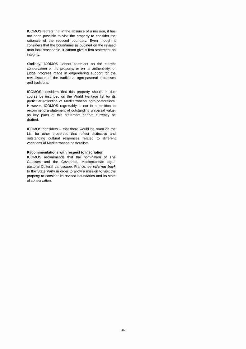
46
ICOMOS regrets that in the absence of a mission, it has not been possible to visit the property to consider the rationale of the reduced boundary. Even though it considers that the boundaries as outlined on the revised map look reasonable, it cannot give a firm statement on integrity. Similarly, ICOMOS cannot comment on the current conservation of the property, or on its authenticity, or judge progress made in engendering support for the revitalisation of the traditional agro-pastoral processes and traditions. ICOMOS considers that this property should in due course be inscribed on the World Heritage list for its particular reflection of Mediterranean agro-pastoralism. However, ICOMOS regrettably is not in a position to recommend a statement of outstanding universal value, as key parts of this statement cannot currently be drafted. ICOMOS considers – that there would be room on the List for other properties that reflect distinctive and outstanding cultural responses related to different variations of Mediterranean pastoralism. Recommendations with respect to inscription ICOMOS recommends that the nomination of The Causses and the Cévennes, Mediterranean agro-pastoral Cultural Landscape, France, be referred back to the State Party in order to allow a mission to visit the property to consider its revised boundaries and its state of conservation.

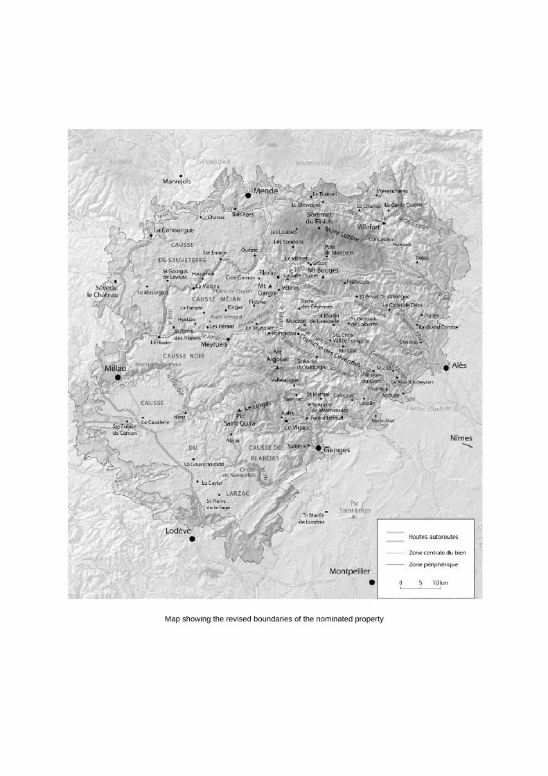
Map showing the revised boundaries of the nominated property
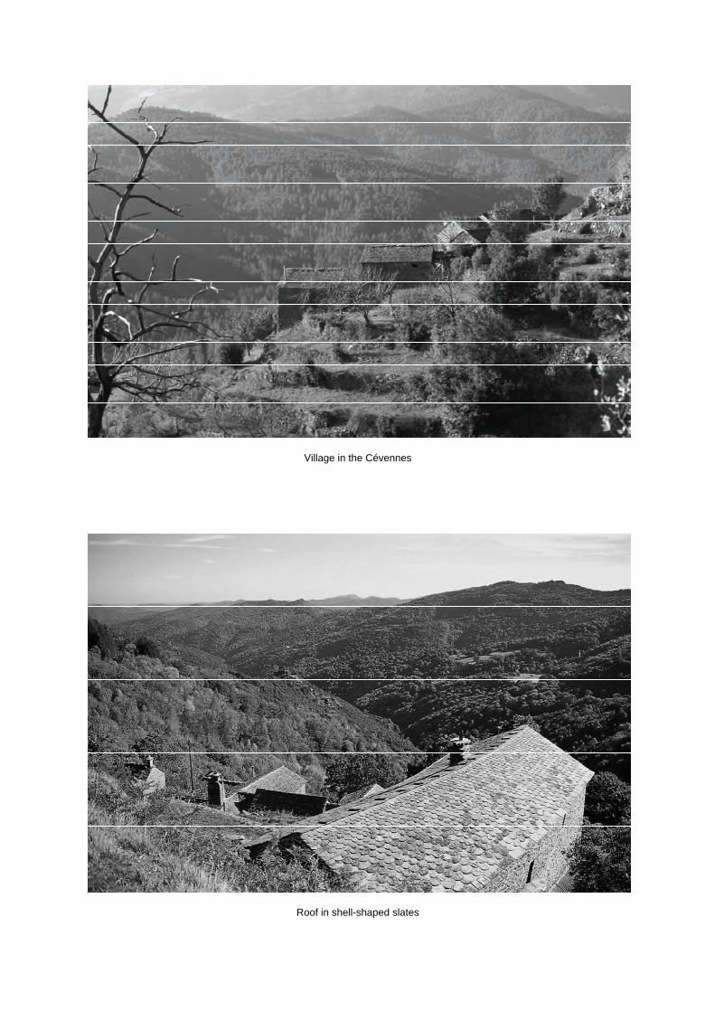
Village in the Cévennes
Roof in shell-shaped slates
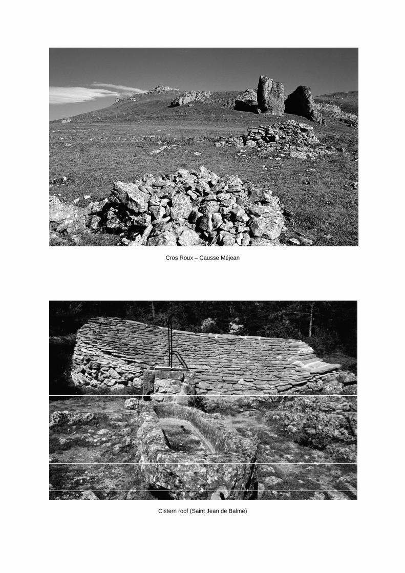
Cros Roux – Causse Méjean
Cistern roof (Saint Jean de Balme)


ERRATUM – Addendum – English version
2011
Addendum
Evaluations of Nominations of Cultural and Mixed Properties
ICOMOS report for the World Heritage Committee, 35th ordinary session
UNESCO, June 2011
WHC-11/35.COM/INF.8B1.Add
Page 22, Fort Jesus, Mombasa (Kenya), No 1295rev
2nd
column, lines 14 to 20: “ICOMOS considers that the nominated property meets [...] for purpose of
unambiguous physical demarcation.” should be read as follows:
“ICOMOS considers that the nominated property could have the capacity to meet the conditions of
integrity and authenticity."
Page 47, The architectural work of Le Corbusier: an outstanding contribution to the Modern
Movement, (France, Argentina, Belgium, Germany, Japan, Switzerland), No 1321rev
1st column, Brief description should be read as follows:
“The nineteen sites reflect the architect Le Corbusier’s work over his entire career between the 1910s
and the 1960s.”
§§§§§§§§§§§§§§§§§§§§§§§§§§§§§§§§§§§§§§§§§§§§§§§§§§§§§§§§§§§§§§§§§§§§§§§§§§§§§§§§
ERRATUM – Addendum – Version française
2011
Addendum
Évaluations des propositions d’inscription de biens culturels et mixtes
Rapport de l’ICOMOS pour le Comité du patrimoine mondial,
35e session ordinaire, UNESCO, juin 2011
WHC-11/35.COM/INF.8B1.Add
Page 26, Fort Jésus, Mombasa (Kenya), No 1295rev
1ère
colonne, les lignes 3 à 10 : « L’ICOMOS considère que le bien proposé pour inscription […] afin
de garantir une démarcation physique claire et sans ambigüité » doivent se lire de la façon suivante :
« L’ICOMOS considère que le bien proposé pour inscription pourrait avoir la capacité de remplir les
conditions d’authenticité et d’intégrité. »
Page 56, L’œuvre architecturale de Le Corbusier : une contribution exceptionnelle au Mouvement
Moderne, (France, Allemagne, Argentine, Belgique, japon, Suisse), No 1321rev
1ère
colonne, la brève description doit se lire de la façon suivante :
« Les dix-neuf sites reflètent l’œuvre de l’architecte Le Corbusier sur l’ensemble de sa carrière, des
années 1910 aux années 1960. »
Page 72, 2ème
colonne, les lignes 40 à 45 : « L’ICOMOS considère que, bien que […] l’inclusion de
tous les éléments associés. » doivent se lire de la façon suivante :
« L’ICOMOS considère que les délimitations et les zones tampons sont appropriées pour la plupart
des biens mais les environs à l’est du Musée national des Beaux-Arts de l’Occident, Établissement
principal, Tokyo, doivent faire l’objet de mesures renforcées et la zone tampon des maisons Jaoul
(actuellement une zone de protection de 500 m) devrait être reconsidérée pour coïncider avec la
topographie de ses environs. »
47
The architectural work of Le Corbusier (France, Argentina, Belgium, Germany, Japan, Switzerland) No 1321 Official name as proposed by the States Parties The architectural work of Le Corbusier: an outstanding contribution to the Modern Movement Location Stuttgart (Germany) La Plata (Argentina) Antwerp (Belgium) Éveux-sur-Arbresle Firminy, Marseille Neuilly-sur-Seine Paris, Pessac, Poissy Ronchamp Roquebrune-Cap-Martin Saint-Dié (France) Tokyo (Japan) Corseaux, Geneva La Chaux-de-Fonds (Switzerland) Brief description The nineteen sites reflect the architect Le Corbusier’s work over his entire career between the 1910s and the 1960s and cover six of the eight different functional types of building with which he was associated:
the artist's residence and studio the individual house the standardised house the apartment block religious architecture large standardised buildings
The nominated sites are located in six countries and three continents. They have been chosen to represent the whole of Le Corbusier’s output, and to be exemplars of his creative genius. Each site is seen to have a supra-national dimension and together they are said to provide, in terms of architecture and urban planning, a complete and coherent answer of global dimensions to the challenges of the new world of the 20th century. Category of property In terms of categories of cultural property set out in Article I of the 1972 World Heritage Convention, this is a serial nomination of 11 monuments and 8 sites.
1 Basic data Included in the Tentative List Argentina: 1 June 2007 Belgium: 4 April 2005 France: 31 January 2006 Germany: 1 February 2007 Japan: 14 September 2007 Switzerland: 28 December 2004 International Assistance from the World Heritage Fund for preparing the Nomination None Date received by the World Heritage Centre 1 February 2008 31 January 2011 Background This is a referred back nomination (33 COM, Seville, 2009). A first nomination dossier for The Architectural and Urban Works of Le Corbusier was examined by the World Heritage Committee at its 33rd session (Seville, 2009). At the time, ICOMOS recommended that the nomination be deferred in order to allow the State Party to: Reconsider the basis of the nomination in order to
focus attention primarily on the buildings and urban plans rather than their architect;
Consider nomination of a limited selection of individual buildings, rather than a large global serial nomination, that could be said to be outstanding in terms of architectural form and their influence or inspiration as part of the Modern Movement;
Improve the delineation of buffer zones in relation to topography and visual parameters, and provide adequate protection;
Put in place management systems and/or management plans to give greater guidance to owners and to draw local authorities and local communities into the management processes.
ICOMOS would also like to encourage the States Parties to continue work on the global coordination mechanism between the sites associated with Le Corbusier, as being beneficial whether or not these sites are inscribed on the World Heritage List. ICOMOS considers that any revised nomination with revised boundaries would need to be considered by a mission to the site. The World Heritage Committee adopted the following decision: Decision 33 COM 8B.19: The World Heritage Committee,
48
1. Having examined Documents WHC-09/33.COM/8B and WHC-09/33.COM/INF.8B1, 2. Refers the nomination of The Architectural and Urban Work of Le Corbusier, Argentina, Belgium, France, Germany, Japan, and Switzerland, back to the States Parties in order to allow them to:
a) Strengthen the justification of the Outstanding Universal Value to demonstrate the influence of the works of Le Corbusier on the architecture of the 20th century and the Modern movement, b) Improve the delineation of buffer zones in relation to topography and visual parameters, and provide adequate protection, c) Put in place management systems and/or management plans to give greater guidance to owners and to draw local authorities and local communities into the management process;
3. Considers that a revised nomination need not include all 22 of the component parts currently proposed, however, inclusion of any additional component parts in the series would require a new nomination; 4. Invites the States Parties to strengthen cooperation in order to ensure appropriate protection and management of the property by focusing attention on the buildings and urban ensembles; 5. Encourages the States Parties to continue work on the global coordination mechanism between the sites associated with Le Corbusier, as being beneficial whether or not these sites are inscribed on the World Heritage List. Consultations ICOMOS consulted its International Scientific Committee on 20th Century Heritage and DoCoMoMo. Literature consulted (selection) Baltanas, J., Le Corbusier, parcours, Parenthèses, Marseille, 2005. Benton, T., The Villas of Le Corbusier, 1920-1930, 2007. Cantacuzino, S., Great Modern Architecture, 1966. Cohen, J.-L., Le Corbusier, la planète comme chantier, Zoé, Paris, 2005. Evenson, N., Le Corbusier: The Machine and the Grand Design (Planning Cities), 1969. Gans, D., The Le Corbusier Guide, 2006. Janson, A. & Krohn C.: Unité d’habitation, Marseille, 2008. Jenger, J., Le Corbusier Architect of a New Age, 1996. Le Corbusier, Vers une architecture, 1923. Monnier, G., Le Corbusier, qui suis-je ?, Éditions de la Manufacture, Lyon, 1987.
Pauly, D., The Chapel at Ronchamp, 2008. Ruegg, A., and Spechtenhauser K. (eds.), Maison Blanche: Charles-Edouard Jeanneret / Le Corbusier, 2007. Samuel, F. Le Corbusier in Detail, 2007. Sbriglio, J., The Villa Savoye, 2008. Vedrenne, É., Le Corbusier, Paris, Assouline, 1999. Vegesack, A. von (ed.), Le Corbusier, The Art of Architecture, 2008.
Technical Evaluation Mission 20–23 August 2008 / 2–12 September 2008 / 3–6, 8–9, 11 September 2008 / 22–26 September 2008 / 22–26 October 2008. As this is a referred back nomination, no further missions have been undertaken. Additional information requested and received from the States Parties During the evaluation of the original nomination, ICOMOS sent letters to the States Parties on 16 October 2008, 23 October 2008, and 19 December 2008. The first letter raised the issue of the basis of the selection of the sites that comprise the serial nomination and the extent of additional sites to be nominated in future years, if the property is inscribed. The second and third letters were related to two new projects planned within the nominated area of the site of Chapel of Notre-Dame-du-Haut, Ronchamp. Information amounting to 140 pages was received from the States Parties on 27 February 2009 in relation to management, new projects at Ronchamp, alterations to the boundaries of the museum in Tokyo, future proposals for restoration and better protection of a number of sites in the serial nomination. Considerable extra material on the description and justification for Firminy-Vert was also submitted. Date of ICOMOS approval of this report 10 March 2011
2 The property The revised nomination
This is a large (around 1,600 pages), and virtually new nomination, as the way the sites are presented has changed since the first nomination. The justification for outstanding universal value has been re-worked, as have the considerations of integrity and authenticity and the comparative analysis. In brief, the differences between the original nomination and the new material submitted by the States Parties are as follows:
49
The name of the serial property has been changed to "The architectural work of Le Corbusier: an outstanding contribution to the Modern Movement“;
The number of sites has been reduced from 22 to 19 (Maison Schwob, La Chaux-de-Fonds, Switzerland, Maison Cook, Boulogne-Billancourt, France, and Cité de refuge de l’Armée du Salut, Paris, France have been omitted), and some parts have been excluded from the site of Firminy;
The urban planning dimension of Le Corbusier’s work has been omitted;
The component sites that comprise the nominated series are no longer classified according to seven themes but are submitted in chronological order, to demonstrate the evolution of Le Corbusier’s work;
The comparative analysis has been expanded to cover comparisons with the whole series not just individual sites;
The buffer zones have been improved; and, The local management plans have been reviewed
and action plans at international, national and local levels have been established.
This evaluation considers these revisions in the light of the World Heritage Committee’s decision at its 33rd session. History and development Charles-Édouard Jeanneret-Gris, better known as Le Corbusier (a pseudonym he used from 1920 onwards), was born at La Chaux-de-Fonds in Switzerland in 1887 and died at Roquebrune-Cap-Martin in France in 1965. Self-taught after his studies at the art school of his native town, he was an architect and town planner, an architectural theoretician, and a writer on subjects including town planning, painting, the decorative arts, furniture, and land-use planning (he wrote some forty books), and was also a painter, sculptor, and creator of furniture and tapestries. His career can be divided into four phases:
1 Initiation (1887–1917) When only 17 years old, Le Corbusier worked with the architect René Chapallaz (1881–1975) on the design of the Villa Fallet at La Chaux-de-Fonds in 1906–1907. The next ten years were devoted to travel in Central Europe, Greece, and Turkey, together with spells in Paris, Vienna, and Berlin, where he met architects including Tony Garnier and Josef Hoffmann, and was active in the workshops of Auguste Perret and Peter Behrens. In the construction of the Maison Schwob (1916) he applied the DOM-INO principle, a concrete construction system consisting of a simple framework of posts supporting the floors, based on cubic foundations, the framework of which permits the free composition of facades and plans. 2 The development of a new architectural language (1917–28) After moving to Paris, Le Corbusier met in 1918 the painter Amédée Ozenfant (1886–1966) who initiated him into Purism. He applied the aesthetic principles of
Purism, combined with the DOM-INO system, in the Ozenfant residence and studio (Paris, 1922). He began to write articles and books about architecture, setting out his conception of a new architectural language. In 1922 he opened a workshop and formed an association with his cousin Pierre; together they designed and built a series of individual houses and artist’s residences in and around Paris, and also outside France, including the Maison La Roche and the Maison Jeanneret (Paris), the Maison Guiette (Antwerp), the house of their parents on Lake Geneva, the Villa Savoye (Poissy), and the Maison Cook (Boulogne-Billancourt). They designed the theoretical project of the Maison Citrohan (a reference to the name of the car manufacturer André Citroën), designed as a machine for living, by analogy with industrial production. Their ideas were put into practice in the Pessac houses (1924–27) and the Weissenhof houses (Stuttgart, 1927). Le Corbusier then published The Five Points of Modern Architecture (pilotis or columns, roof garden, free plan, strip windows, free facade), the founding text of architectural modernism. The Utopian project of a city of three million inhabitants was presented at the Salon d’Automne in 1922, and the ‘Voisin’ plan for Paris in 1925, sparking off controversy and debate. More than 200 trainees worked successively in Le Corbusier’s workshop from 1922 up to his death, in addition to several collaborators, who helped disseminate the architect’s thought and expanded the international influence of his work. 3 International recognition (1928–40) In 1930 Le Corbusier opted for French nationality and married. His reputation led to public commissions: the Centrosoyuz building (Moscow, 1928), the Cité de refuge de l’Armée du Salut (Paris, 1929), the Pavillon Suisse at the Cité Universitaire (Paris, 1930), and the Immeuble Clarté condominium (Geneva, 1930). He gave lectures outside France and published new books on architecture, including the first volumes in the series of his complete works. His unsuccessful participation in the competition for the design of the League of Nations centre resulted in him assuming the role of spokesman for modernism against academicism. In 1928 he founded the CIAM (International Congresses of Modern Architecture), and in 1933 drew up the Athens Charter town-planning manifesto (living, working, recreation, circulation). Many town planning projects that were never constructed but were nonetheless influential date from this period. World War II interrupted Le Corbusier’s work in association with his cousin. 4 Large standardised buildings (1944–65) In 1944 Le Corbusier chaired the Urbanism Commission of the Front national des architectes, a body which originated from the Resistance movement. In 1945 he was awarded the commission for an apartment block (Unité d’habitation) for Marseille, La Cité radieuse, which was completed in 1952 and the prototype of a series: the apartments are provided with collective facilities (a ‘street’ with shops, a school, a gymnasium, and amenities in the roof area). During the period of reconstruction, he drew up plans for La Rochelle-La
50
Pallice, for Saint-Dié and for the extension of Saint-Gaudens. None of these plans was realised as a result in some cases of opposition from residents and local authorities. It was at Chandigarh in India that his theories were confronted with reality, from 1950 until his death, with the construction of the new capital of the Punjab and particularly three major buildings – the Palace of Justice (1952), the Secretariat (1953), and the Palace of the Assembly (1955). In demand all over the world for his designs, conferences, and consultations, he sometimes neglected the follow-up of his projects. During this period, he built the House of Dr Curutchet in Argentina (1949), the Musée National des Beaux-Arts de l’Occident in Tokyo (1957), two houses, the Palais des Filateurs (Millowners Building) and the Town Museum at Ahmedabad (1951), the Carpenter Center for Visual Arts at Harvard, Cambridge (1961), and an exhibition pavilion in Zürich. In France, he built a factory at Saint-Dié (1946–50) and the two Maisons Jaoul at Neuilly (1951), which illustrate a new movement known as Brutalism. Religious buildings date from this period: the Notre-Dame-du-Haut Chapel at Ronchamp (1950), the Sainte-Marie-de-la-Tourette Monastery near Lyon (1953), and the design of the Church of Firminy, which was built after the architect’s death. Also at Firminy, he built the Maison de la Culture and the Stadium (1956). Le Corbusier created sculptures from 1946 onwards, and tapestry patterns from 1948 onwards. A new system of proportions and measurements, the Modulor, was developed after 1945; applied to the Unité d’habitation in Marseille, its theory was set out in 1950. After the death of his wife in 1957, Le Corbusier made many designs, including a computer centre for Olivetti, the Palais des Congrès in Strasbourg, the French Embassy in Brasilia, and the Venice Hospital in 1965. Several construction projects underway when Le Corbusier died in 1965 were completed by collaborators, and other projects were constructed, such as the Pavillon de Zürich in Switzerland (1963–67) and the Church of Firminy, which was completed in 2006. Today, most of the buildings he designed have retained their original function. Some are now devoted to the memory of his work. Description of the Serial Nomination The initial nomination of 22 properties was based on a typological approach: artist’s residence and studio individual house standardised house apartment block religious architecture large standardised buildings
town planning. In the revised nomination of 19 sites, the typological approach has been replaced by a chronological justification for the selection of the sites. The analysis specifically omits consideration of the town planning works of Le Corbusier, and three previously included sites have been excluded: 1916 Maison Schwob, La Chaux-de-Fonds, Switzerland 1926 Maison Cook, Boulogne-Billancourt, France 1929 Cité de refuge de l’Armée du Salut, Paris, France The 19 sites included in the new submission are proposed chronologically, for what they contributed toward the architect’s development. These are: 1912 Villa Jeanneret-Perret, La Chaux-de-Fonds, Switzerland 1923 Maisons La Roche et Jeanneret, Paris, France 1923 Petite Villa au bord du lac Léman, Corseaux, Switzerland 1924 Cité Frugès, Pessac, France 1926 Maison Guiette, Antwerp, Belgium 1927 Maisons de la Weissenhof-Siedlung, Stuttgart, Germany 1928 Villa Savoye and gardener’s House, Poissy, France 1930 Immeuble Clarté, Geneva, Switzerland 1930 Pavillon Suisse à la Cité universitaire, Paris, France 1931 Immeuble locatif à la Porte Molitor, Appartement L.C., Paris, France 1945 Unité d’habitation, Marseille, France 1946 Manufacture à Saint-Dié, Saint-Dié, France 1949 Maison du docteur Curutchet, La Plata, Argentina 1950 Chapelle Notre-Dame-du-Haut, Ronchamp, France 1951 Maisons Jaoul, Neuilly-sur-Seine, France 1951 Cabanon de Le Corbusier, Roquebrune-Cap- Martin, France 1953 Couvent Sainte-Marie-de-la-Tourette, Eveux- sur-Arbresle, France 1954–59 National Museum of Western Art, Main Building, Tokyo, Japan 1953–65 Centre de recréation du corps et de l’esprit de Firminy-Vert, Firminy, France Selection of the serial nomination
The nominated sites have been chosen to represent the whole of Le Corbusier’s output, and to reflect the way his work developed during his lifetime, with sites chosen as prototypes of architectural ideas, or as the first of a series of replications. These two approaches are to a degree contradictory.
51
1912 Villa Jeanneret-Perret, La Chaux-de-Fonds, Switzerland The Villa Jeanneret-Perret, La Chaux-de-Fonds, Switzerland, was the first building to be completed by Le Corbusier when he was still known as Charles-Edouard Jeanneret. Also called the White House, this small house in the form of a compact cube with a hipped roof displays neo-classical details in contrast to later work. It was built in six months in 1912 for his parents. Set on sloping ground against a forest, it has broad views over the town. It allowed the architect to test all his architectural ideas when built and with the modifications made up to 1919 when the house was sold. It was restored between 2004 and 2005. 1923 Maisons La Roche et Jeanneret, Paris, France The Maisons La Roche et Jeanneret, Paris, France, are a pair of semi-detached houses built at the same time in 1923 at right-angles to one another. The normal domestic arrangements are turned upside down, with the garden on the roof, living rooms on the top floor, and bedrooms beneath. Their construction reveals the full potential of the DOM-INO system, with fenestration running the length of the frontages. Within, the plans were open and fluid and the surfaces decorated with a range of strong colours, punctuated by black and complemented by white, which underlined the sequences of the ‘architectural walk’. Since 1968 the two houses have belonged to, and been the centre of, the Foundation Corbusier. They have been the subject of many restorations in the intervening years. Most recently the original colours have been restored and some managed public access arranged. 1923 Petite Villa au bord du lac Léman, Corseaux, Switzerland The Petite Villa au bord du lac Léman, Corseaux, Switzerland, is a small, narrow one-storey house, built for the architect’s mother in 1923. Constructed partly of roughcast breeze blocks, the front facing the lake and the Alps beyond has a window running its whole length. Within, the space is organised to meet precisely the needs of its inhabitants in a minimalist way, as a small ‘machine to live in’. In 1931 one side was clad with zinc-coated sheets; subsequently in the 1950s when the house was repaired, the southern elevation was clad with aluminium sheets. The house was lived in by the family until 1972, when it was acquired by the Foundation Corbusier which restored it in 1975. It is now a museum. 1924 Cité Frugès, Pessac, France The Cité Frugès, Pessac, France, was the result of a commission from the Bordeaux industrialist, Henry Frugès, for a garden city in Pessac, comprising 130–150 houses with shops. The aim was to show the relevance of prefabrication and of a certain form of standardisation. At Cité Frugès de Pessac, Le Corbusier started with a basic module of 5 square metres and developed four different ways of grouping them and many individual variations. One of the most striking features of the Cité
Frugès was the use of polychromy on the exterior facades in order to, in Le Corbusier's own words, ‘sculpt the space through the physical quality of colour – bring forward some volumes while making others recede. In short, compose with colour in the same way as we have composed with form. This is how architecture is transformed into urbanism.’ After many technical and financial difficulties, the work was completed in 1926, but the houses remained empty until 1929. Their new owners immediately began modifying them. The city was damaged by bombs in World War II and suffered from lack of maintenance until 1973, when restoration work was started. After many years of research and a combination of public and private interventions, a coherent management framework was put in place in 1998. One house is now a museum and the rest are lived in; around half retain their original colours. 1926 Maison Guiette, Antwerp, Belgium The Maison Guiette, Antwerp, Belgium, was built in 1926 on a long narrow plot, typical of the urban grain of Belgium. Together with its neighbouring Weissenhof- Siedlung villas, it was considered to be amongst the first innovative expressions of a new architectural language, where Le Corbusier applied his five points of architecture. The Maison Guiette is thus seen to reveal an emblematic phase in the development of the Modern Movement in Belgium, where it is Le Corbusier's only building. Maison Guiette is still lived in as a house and there is no public access. 1927 Maisons de la Weissenhof-Siedlung, Stuttgart, Germany The Maisons de la Weissenhof-Siedlung, Stuttgart, Germany, were constructed as part of an estate of working class housing created for the Deutscher Werkbund exhibition of 1927. Its 33 buildings comprising 63 dwellings were designed by seventeen architects, under the artistic direction of Mies van der Rohe. The exhibition was seen as the first architectural manifestation of what was to become known as the International Style. Although the estate was said to be a blueprint for future workers’ housing, the budget was far beyond the reach of most workers. Le Corbusier built three houses at the edge of the city. The house at Bruckmannweg is in strictly cubist form, on piles and with a roof terrace. The pair of symmetrical semi-detached houses at Rathenaustrasse were conceived on the model of the 'transformable house' with great flexibility in the interior spaces. Sliding doors and bed cupboards allowed the bedroom space to be incorporated into the living space during the day. At the end of the exhibition the houses were let to tenants and the semi-detached ones were considerably modified. Parts of the estate were bombed in World War II, but Le Corbusier's buildings survived. In the 1980s the houses were restored and many of the main alterations were reversed. In 2002 the Municipality acquired the semi-detached houses and they now house a museum.
52
1928 Villa Savoye and gardener’s House, Poissy, France The Villa Savoye, Poissy, France, is an exact counterpart of the proposal for minimum housing made by Le Corbusier and Pierre Jeanneret at the second congress of the CIAM (Congrès internationaux d’architecture moderne) in Frankfurt in 1929. Raised on piles, the villa sits in a large meadow originally surrounded by trees and overlooking the River Seine. It demonstrates all of Le Corbusier's five points: piles, long horizontal windows, freely designed facade, roof terrace, and fluid interior spaces unencumbered by load-bearing walls. It is seen as emblematic of his work at this date and demonstrates what might be called 'radical purism'. The flat roof caused problems from an early date. By the end of World War II the house had fallen into ruin. In 1965 it was saved from destruction by a public campaign. Since then there have been three restoration programmes. The exterior is now painted white, although originally it may have been tinted in several colours. In the revised dossier it is stated that further research will be carried out between 2011–2015 on the polychrome walls, with the aim of partial restitution. Nearby is a small gardener house built contemporaneously and this reflects the standard plan for minimum housing displayed at the CIAM exhibition. Le Corbusier saw the two houses as reflecting a 'certain common bond between the dwelling of the rich person and that of the poor.' The two houses belong to the French State and the Villa Savoye is open to the public. 1930 Immeuble Clarté, Geneva, Switzerland The Immeuble Clarté, Geneva, Switzerland, constructed in 1930, is a nine-storey block of 50 apartments, constructed for rental as middle-class housing. It is seen as Le Corbusier’s most important work in Switzerland. The apartments have balconies – for the 1st, 3rd, and 5th floors on the south side and for the 2nd, 4th, and 6th floors on the north side. In order to maintain the unity of the elevations, tenants were obliged to have standard curtains. The construction was based on ‘dry’ construction around metal frames. Threatened with abandonment in 1970, the block was purchased and repaired by two architects between 1975 and 1977. 1930 Pavillon Suisse à la Cité universitaire, Paris, France The Pavillon Suisse à la Cité universitaire, Paris, France, was constructed in 1930 as a hall of residence at the University City, which had been founded for foreign students. The Pavillon was endowed by the Swiss community. Like other halls it provided cheap minimal housing for the students. The four-storey main building is raised on piles – not slender like the Villa Savoye, but robust with a figure-of-eight cross-section to withstand wind. Adjoining the main block at four points there is a curved building sitting on the ground, the stairs lit by large areas of glass blocks. It accommodated the public spaces. The whole hall was conceived as an industrial unit as opposed to the artisanal quality of the Villa
Savoye. It tested the idea of a ‘house box’ constructed as ‘bottles in a wine rack’. In 1953 the south front was remodelled by Pierre Jeanneret to provide blinds and double glazing and to blank out the lower part of the glazing. Le Corbusier re-designed the interior polychromy in 1957 in sharper colours. Restoration has been carried out in stages since 1976. 1931 Immeuble locatif à la Porte Molitor, Appartement L.C., Paris, France The Immeuble locatif Porte Molitor apartments, Paris, France, were constructed for middle-class clients in 1931 on an exceptional site on the Bois de Boulogne. Restricted by the restrained pale stone buildings of the neighbourhood which it adjoins, the building, with its narrow 13m frontage of iron, concrete, and glass bricks, does not set out to shock. On the top floors Le Corbusier built a studio apartment for himself which was his Paris base until his death. While Le Corbusier was still alive, the building suffered from water ingress. 1945 Unité d’habitation, Marseille, France After World War II, with Europe's housing problems worse than ever, Le Corbusier put his urban theories into practice with the construction in 1945 of the Unité d'habitation, Marseille, France, a synthesis of four decades of his thinking on collective living. Seventeen storeys high and designed to house 1,600 people, the Unité incorporates various types of apartment, as well as shops and communal rooms, all connected by raised 'streets.' It is now a popular address for Marseille's middle-class professionals. The Unité was designed as a prototype intended for mass production. Convinced of the urgency to answer the question of how to house the greatest number, Le Corbusier designed and built ten apartment blocks for clients with varied social profiles – social housing, emergency housing, residences for students, and residences for the upper middle-class. He brought original thinking based on the idea that to achieve a successful collective apartment block, each individual cell had to be perfectly designed. His huge apartment block, Unité d’habitation, Marseille, built in 1945, was seen as the culmination of four decades of thinking and became a model that was copied around the world. Ultimately this form of mass housing was to gain a notoriety that was without precedent. 1946 Manufacture à Saint-Dié, Saint-Dié, France The Manufacture à Saint-Dié, Saint-Dié, France, is the only factory to be built by Le Corbusier. He was invited in 1946 to design a new factory for a hosiery business, the old one having been partially destroyed in World War II. Completed in 1950, the factory was based entirely on modular lines. Consisting of three storeys raised on piles, it resembles externally an apartment block with windows shielded by sun-screens. The factory was designed as a ‘green’ factory where workers could experience ‘harmony’ as opposed to the unsatisfactory
53
working conditions of old ‘black’ factories. It is the only example of his work where the new building adjoins existing structures, in this case the remains of the old factory. The building is still in use as a textile factory. Windows and some structural elements are in need of restoration. 1949 Maison du docteur Curutchet, La Plata, Argentina The Maison du docteur Curutchet, La Plata, Argentina, is set on a narrow plot on an avenue that forms one of the monumental axes of La Plata. The three-storey building, built in 1949, provided domestic space and consulting rooms for the doctor. The house demonstrates the five points and also includes curved walls, a ramp between the different levels of the two distinct blocks, and elements reflecting adaptation to the local environment such as brise-soleil. Le Corbusier did not visit the site and oversaw the work through letters. This created difficulties and towards the end of 1951, he was replaced by Simón Ungar, who completed the work introducing some modifications. The house was lived in for only a short time and then declined for almost thirty years. It was restored in 1987 and is now rented by the Order of Architects of the Province of Buenos Aires, which uses it for cultural events. It is open to visitors. 1950 Chapelle Notre-Dame-du-Haut, Ronchamp, France The Chapelle Notre-Dame-du-Haut, Ronchamp, France, is quite unlike any other of Le Corbusier’s work in terms of its sculptural quality – the billowing roof, inspired by a crab carapace, surmounting thick, curved walls pierced with tiny windows that bring patterns of light into the interior. The enthusiasm of Le Corbusier for the dramatic site on Ronchamp hill, which had housed a church since at least the 13th century, and the freedom the commission gave him, all contributed to create the ideal conditions for his work, which combined all his talents as architect, painter, sculptor, and engineer. As well as the church, Le Corbusier also built two other low buildings, a house for the guardian, and a house for pilgrims which included a restaurant and two dormitories. The work was completed in 1950. 1951 Maisons Jaoul, Neuilly-sur-Seine, France The Maisons Jaoul, Neuilly-sur-Seine, France, are two small family houses, built in 1951, adjoining at right-angles, with one fronting the street and entrances off a shared patio. Their accommodation is conventionally laid out with living rooms on the ground floor, and a garage below ground level. Three load-bearing brick walls support brick ‘Catalan’ vaults and concrete beams. The bricks and concrete beams are left exposed on the exterior, making these buildings an early example of Brutalist architecture of the 1950s. The houses were restored in 1991. They are privately owned and not open to the public.
1951 Cabanon de Le Corbusier, Roquebrune-Cap- Martin, France The Cabanon, Roquebrune-Cap-Martin, France, is a very small cottage at the edge of the sea, extending to no more than 15m2 and lit solely by two windows. Built in 1951, Le Corbusier used it for holidays. It was laid out to reflect the minimum standardised dwelling. Both the walls and the furniture were constructed of prefabricated pieces. 1953 Couvent Sainte-Marie-de-la-Tourette, Eveux- sur-Arbresle, France The Couvent Sainte-Marie-de-la-Tourette, Éveux-sur-Arbresle, France, was inspired directly by Cistercian models. Sited on a steep slope, it has three above-ground storeys and two below ground, and provides a church and domestic buildings for the monastic community, including 104 cells. 1954–59 National Museum of Western Art, Main Building, Tokyo, Japan The National Museum of Western Art, Main Building, Tokyo, Japan, was built in 1954–59 to house the Matsukata collection, 370 works of art restored to Japan after World War II. The two-storey building on piles has a flat roof, ramps between floors, and plenty of natural light. The Tokyo museum is one of three realisations of the concept of the 'museum of unlimited growth' (the other two are in Chandigarh and Ahmedabad, India) developed by Le Corbusier which featured growth portals where new wings could be added. It is the only one characterised by a spiral circulation route within a rectangular plan. To the west, set back from the main façade, was an auditorium building, part of Le Corbusier’s designs but not realised until 1964–65. This has since been demolished, to be replaced in 1979 by a large new extension which wraps round the building to the north and west. A second extension has also been added. Neither is linked to the growth portals. The terrace, stairs, and forecourt have been largely reconstructed, but still maintain their original form and function. A restoration programme for the museum is being developed. 1953–65 Centre de recréation du corps et de l’esprit de Firminy-Vert, Firminy, France Le Corbusier was a friend of the Mayor of Firminy, a small industrial and mining town in the Loire valley. The Mayor developed plans to modernise the city through the creation of a new area of residences and parks. These plans were inspired by Le Corbusier’s ideas but designed by other architects. The scheme was realised in part between 1953 and 1965 when the city was renamed Firminy-Vert to signal its move away from what had been called its ‘black’ past. In the first nomination, the town planning elements were included. The revised nomination includes only the House of Culture, the Municipal Stadium, St. Peter's Church, a theatre and an outdoor swimming pool with
54
which Le Corbusier was involved to varying degrees. The House of Culture (1955–69) was designed and mainly built by Le Corbusier; the Municipal Stadium (1955–68) was designed by Le Corbusier and building started before his death in 1965 and was continued afterwards by his collaborators; the Church of Saint-Pierre (1960–65 and 1968–2006) was designed by Le Corbusier (only as sketches) and built entirely after his death by his successor; and the Swimming Pool (1966–69) was designed in the spirit of Le Corbusier by André Wogensky.
3 Outstanding Universal Value, integrity and authenticity
Comparative analysis The initial nomination proposed sites as exemplars of seven of the eight functional categories of Le Corbusier’s work. Overall the series was said to reflect the way Le Corbusier provided, in terms of architecture and town planning, a complete and coherent answer of global dimensions to the challenges of the new world of the 20th century. The revised material by contrast suggests that the slightly smaller series of sites is an exceptional contribution to the Modern Movement as it reflects the work of the principal founder of the Modern Movement, and represents the entire course of Le Corbusier’s work. It recognises that the formation of the Modern Movement is not the act of one man and involved a few dozen mainly European architects, of whom, the major figures include Alvar Aalto, Walter Gropius, Le Corbusier, Adolf Loos, Ludwig Mies van der Rohe and Frank Lloyd Wright. However, it suggests that the architectural work of Le Corbusier occupies a special place because it covers the different phases of development of this movement over fifty years. The comparative analysis needs to determine first whether such a combination of value and attributes is already represented on the World Heritage List; and, if not, whether other comparable series might be nominated in the future. As a serial nomination, it also needs to justify the selection of sites. Comparison with inscribed sites The initial nomination only provided comparisons for individual sites under various typologies. The revised nomination does consider the idea of comparing the whole series with other properties whether on the World Heritage List or not. The conclusion, however, is that the property covers three continents and six countries as Le Corbusier was the first architect to have reached this dimension in the history of mankind, and his output was without equal. The analysis also compares aspects of the series such as standardisation and industrialisation. It suggests that
while Le Corbusier's approach in this area is substantially the same as that of his colleagues, the nominated series is characterised by obsession and renewed attempts (to overcome setbacks). Le Corbusier also aimed to define types of projects or standard buildings that might be replicated. It is suggested that neither of these facets is represented on the World Heritage List, where, particularly for the 20th century, inscriptions have reflected unique and singular sites, unrelated to their potential for reproduction over time. Overall, it is suggested that the series has no comparators on the World Heritage List. ICOMOS notes that while the ideas behind some of the nominated buildings were subject to replication, such as in the factory and apartment blocks, others were not, such as those associated with Ronchamp and some of his early work. Furthermore, the idea of replication or replicability has not been put forward as part of the nominated outstanding universal value. ICOMOS also considers that there are similarities between the approach of Le Corbusier in defining standards that could be applied widely, and the work of the Bauhaus, which aimed to revolutionise architectural and aesthetic concepts and practices. Similarly, Mies van der Rohe’s Tugendhat Villa was seen not just as an isolated creation, but was part of the overall Modern Movement and the diffusion of ideas on the use of industrial materials. It was not copied directly but it inspired other architects. Like Le Corbusier’s buildings, it had a profound impact around the world. ICOMOS considers that replication is only part of the overall influence of a building or series of buildings that needs to be considered in relation to its value. Many modern movement buildings were influential even though they were not directly copied. The comparative analysis also compares the series to 33 properties on Tentative Lists. It suggests that the series is really comparable in nature, if not in the precise way it contributes to the Modern Movement, to the series on the work of Frank Lloyd Wright, currently on the US Tentative List. The analysis also considers other individual sites reflecting the architectural heritage of the 20th century. The revised nomination sets out in tabular form which of Le Corbusier’s buildings were considered and which were rejected. The sites excluded were those considered not to be exceptional or to be lacking adequate protection, authenticity, or conservation. Thus of the two other museums of unlimited growth, the one in Ahmedabad, India, was seen to be exceptional, but not to have adequate protection. In its original evaluation, ICOMOS requested further comparisons between the museum in Japan and these two others but this has not been provided.
55
It can be questioned whether the works designed in Le Corbusier’s formative years such as the villa Jeanneret-Perret (before he decided to call himself Le Corbusier) can be considered essential for the representation of his overall work. A further question arises at the other end of his professional career as to whether projects completed after his death, such as the Church of Saint-Pierre, part of Firminy-Vert, could be considered as essential for the series or not. The comparative analysis demonstrates that there is room on the World Heritage List for sites that are exceptional representatives of the influence and creative genius of the Modern Movement. However it does not justify how the series of 19 sites by Le Corbusier can be seen as a unique testimony to the Modern Movement rather than a smaller number of his individual buildings, considered one by one, or by buildings from other architects. Nor does it fully justify how the series can be seen to demonstrate that the entire course of Le Corbusier’s work is somehow exceptional over and above the exceptional influence that a few of his buildings had individually. ICOMOS considers that the comparative analysis suggests that there are three buildings within the nominated series that stand out as being incomparable: the Unité d’habitation, Marseille, the Villa Savoye, and the Ronchamp chapel.
The Unité d’habitation, Marseille as a manifestation of concept, was – for better or worse – hugely influential in shaping apartments in towns and cities around the world.
The iconic Purist Villa Savoye, although not directly copied, was nevertheless a piece of architecture that came to be seen as inspirational in the same way as Mies van der Rohe’s Tugendhat Villa.
The Ronchamp chapel can only be described as outstanding as a sculptural piece of architecture that achieved a dynamic synthesis between art, architecture, and landscape. It has no parallel, but it did prove inspirational in encouraging other Modern Movement architects to design religious buildings.
The National Museum of Western Art, Tokyo, is said to have been hugely inspirational in terms of impact on Japanese post-war architectural development. However, in the revised nomination dossier, no further material has been presented for this site to demonstrate its influence beyond Japan or to show more detailed comparisons with the two museums in India designed by Le Corbusier.
ICOMOS considers that the comparative analysis does not justify consideration of this serial property for the World Heritage List, but does justify consideration of three individual buildings as reflecting different aspects of the influence of the Modern Movement.
Justification of Outstanding Universal Value According to the States Parties, the 19 nominated sites illustrate the profound transformation of contemporary architecture and the architectural profession in the twentieth century. They belong to the same historico-cultural group, the Movement Modern, which was avant-garde in the first three decades of the twentieth century, before establishing itself as the dominant architecture of the second half of the century. The architectural work of Le Corbusier is directly associated with this revolution of ideas, in terms of shapes, spaces and technology, which has had an outstanding universal influence that is still felt today. Almost all of the sites:
Attest to the ability of Le Corbusier to invent a new aesthetic and a new architectural language;
Reflect research and innovation including the use of colour and technical innovation;
Are innovative and radical proposals to meet the challenges of standardization, and building industrialization;
Reflect the issue of housing rights as a fundamental social issue of contemporary society;
Ensure balance between people and the community; Illustrate the exceptional Utopia of the Modern
Movement in terms of improving the human condition.
ICOMOS notes that this Justification is not quite the same as stated on other parts of the dossier which is related to the way the individual sites in the series are chosen to reflect ‘‘a unique contribution to the Modern Movement’s values and to represent the entire course of the architect’s work’, nor is it totally consistent with the proposed justification for the criteria. ICOMOS considers that the Justification is very general in terms of associating the series with various facets of the Modern Movement in general and could be applied to the work of other architects of the Modern Movement: it is not specific to this series. Integrity and authenticity Integrity
As a world-wide serial nomination, integrity refers to whether the component parts of the nomination sufficiently cover the attributes needed to demonstrate the outstanding universal value suggested by the States Parties. Integrity thus relates to the ability of the 19 selected sites to represent not the ‘whole of Le Corbusier’s creative work’, as in the first nomination, but ‘a unique contribution to the Modern Movement’s values and to represent the entire course of the architect’s work’. The overall conceptual interpretation needs examination to see how far this has been achieved.
56
ICOMOS considers that the significance of the sites that are included in the series is highly variable in terms of their contribution to 20th century architecture, and in comparison with works by Le Corbusier that are not included in the nomination, and with the works of other Modern Movement architects. Although the nomination sets out to represent the milestones in the chronological development of Le Corbusier’s architectural work, it omits what might be considered significant buildings designed by Le Corbusier, such as the Centrosoyuz office building in Moscow and his work in countries such as India, the USA, and Tunisia. The States Parties have suggested that the serial nomination could be extended in the future to cover more of the architect’s buildings. This raises questions about the existing selection of the series, and ultimately, how many buildings might be needed to ‘represent’ the creativity and influence of one architect. Given the large number of sites that could ultimately be included, and the precedent that this might create for future nominations, ICOMOS considers that the choice of sites should be much more selective, and provided strong advice to the World Heritage Committee in this respect when the original series was evaluated. This is further discussed under Comparative analysis above. ICOMOS considers that the integrity of the series as a whole has not been demonstrated because the selection of sites does not sufficiently support the justification of the outstanding universal value of the series as proposed by the States Parties in response to the World Heritage Committee’s earlier decision. First, if the series were adequately to reflect the contributions to the Modern Movement it would need to include the work of other notable architects who equally played fundamental parts in this movement. Further, ICOMOS notes that the Modern Movement spanned at least half a century and many countries, and considers that the nomination does not adequately explain why such an important movement should be represented on the World Heritage List by a single serial nomination of the works of one architect. Second, ICOMOS considers the objective of reflecting the entire course of an architect’s work to be problematic within the context of the World Heritage List and its threshold of Outstanding Universal Value (as discussed below). However, even if this approach was to be supported, the series would need to include other work of Le Corbusier, such as those associated with his urban planning. There appears to be a fundamental incompatibility between the two justifications put forward: how the series can represent a unique contribution to the achievements of the Modern Movement (and thus be an
outstanding contribution to it) while at the same time demonstrating how Le Corbusier evolved as an architect. Integrity of specific sites For each individual site, integrity relates to the completeness and coherence of sites in relation to their ability to display their contribution to the nominated value. For most of the sites that comprise the nominated series, the integrity is good. The sites where there is some loss of integrity are as follows: La Tourette Monastery: not all attributes significant for expressing the value of the property have been included in the property boundary, such as the monastic cemetery (in the south-west direction), the main entrance alley, and the planning axis (Allée Cavalière). Cité Frugès, Pessac: new buildings on the site of three destroyed standardised houses by Le Corbusier within the nominated property are inconsistent with the architect’s concepts. In the revised nomination it is stated that one of them has already was bought by the municipality, and the other two are in an area of pre-emption. The goal is for these three houses to be bought and for them to be managed to ‘enhance the authenticity and integrity of the City’. Villa Savoye and the adjacent gardener’s house: integrity is partly compromised by the Lycée and sports fields built on three sides of the original meadow that surrounded the villa in the 1950s. High trees form a visual barrier between the Lycée to the west and the villa, but the upper parts of the new building are visible from the terrace of the villa. A sports field now lies immediately behind the villa on the side facing the River Seine. Identifying common values between the nominated sites in terms of their association with Le Corbusier’s ideas has in a few instances meant that the full values of the sites are not reflected. This is the case for Ronchamp, where Le Corbusier’s structure overlaid a centuries-old pilgrimage site. The integrity of the site relates to a wider area than the one nominated and should take in the pilgrim path and gate. A major project for a new visitor centre and nunnery near the chapel (see below) presents risks to the integrity of the site through irreversible interventions that could impact on the values of the site (including its spiritual value). National Museum of Western Art, Main Building, Tokyo, Japan: There is insufficient clarity about how development of the land to the east of the NMWA will be managed and this presents a risk to the site’s integrity. Integrity of context and setting is an issue for the Maisons de la Weissenhof-Siedlung, Stuttgart. Owing to war-time destruction and post-war reconstruction, the collective integrity of the model settlement is affected by the loss of ten houses out of twenty-one.
57
There is an overall need to provide much stronger management for the settings of many of the properties in order to ensure high buildings or other new constructions do not impact adversely on the setting.
ICOMOS considers that the integrity of the whole series has not been justified; and that the integrity of the individual sites that comprise the series is good in most cases, but with some losses and vulnerability.
Authenticity
Authenticity of the whole serial property relates to the ability of the sites as a group to convey the outstanding universal value as nominated. Authenticity of the individual sites relates to their ability to exhibit their initial design and conception in terms of their built form, setting, and use in relation to the overall outstanding universal value. The key issue is how far the series as a whole can be said to convey a unique contribution to the Modern Movement’s values, by its principal founder, and represent the entire course of Le Corbusier’s work’. As set out above under Comparative analysis, the series includes some buildings that individually might be seen as outstanding examples of the Modern Movement but each of these reflects different aspects of that movement. What is not clear is how these buildings along with the others nominated can be said to convey a ‘unique contribution’ to the movement – as this contribution is not defined in a way that allows understanding of how each of the sites contributes. The series as a whole does not appear to demonstrate more than the individual contributions of the most significant buildings do on their own. Moreover the series does not clearly show how Le Corbusier was the ‘principal founder’ of the Modern Movement, as the series spans his whole life’s work and it has not been shown how he kept the initiative, over and above other architects, throughout his whole life. In terms of whether the series represents the entire course of Le Corbusier's work, the series contain some milestones in the development of the architect’s work, but not all, and some works of genius, for which he has come to be known the world over. However the series by no means conveys the .whole picture of Le Corbusier’s work as it excludes his urban planning work and what are seen as seminal buildings in the Russian Federation and other countries. Furthermore many of the architectural works attributed to Le Corbusier are the result of collaboration with others, (in addition to his cousin and practice partner Pierre Jeanneret), who were often involved as supervisors on the construction site. In other cases the buildings were significantly modified from their original designs, either at the time they were built or later. For example, in the case of the Weissenhof-Siedlung at Stuttgart, Le Corbusier’s contribution was only one in an essentially collective
demonstration of the New Building or Modern Movement in architecture in which fifteen other architects played an equally important role in the other related buildings. Other examples of this problem are discussed below. Because the series is comprised of some works of undisputed ‘genius’, together with lesser works and works that involved other architects,; and because the selection omits other buildings that could be considered more favourably (in countries not presently involved in the transnational cooperation), and some entire facets of Le Corbusier’s work, ICOMOS considers that the authenticity of the series as presented by the States Parties in the revised material submitted in 2011 is problematic in relation to how they convey the entire course of Le Corbusier’s work. ICOMOS also considers that the series is problematic in terms of how it might be seen to convey a unique contribution to the Modern Movement that is greater than the individual contributions of the three most outstanding buildings. Authenticity of individual sites For each individual site, authenticity relates to how well the attributes of the site can be said to reflect the overall outstanding universal value of the series. For most of the sites, the authenticity is good. The sites where there is some problem with authenticity are the following. In the case of Firminy-Vert, of the three nominated buildings within the town, only one, the House of Culture, was designed and mainly built by the architect. In terms of reflecting the entire course of Le Corbusier’s work, authenticity is also an issue for those individual houses where there was significant input from others such as Maison du docteur Curutchet, or where the original designs were significantly modified either when they were built or subsequently, such as the Cité Frugès. A third problematic category is the buildings substantially built or substantially altered after the architect’s death. For example, the Church of Saint-Pierre has a long and complicated building history and there is insufficient documentary evidence for the authorship and clear attribution of this structure to Le Corbusier’s work. The issue of authenticity for the plan and structure of some individual buildings is also problematic, because many have been restored and partly reconstructed in recent years, after previous stages of neglect or disfigurement. In some cases changes have been reversed, in other cases they have not. However, comparing the nominated houses to other inscribed 20th century houses (the Masters’ houses of Kandinsky/Klee at Dessau (Germany), the Villa Tugendhat at Brno (Czech Republic), Rietveld Schröder House in Utrecht (The Netherlands)) reveals that these also share the partly diminished levels of authenticity.
58
Although many of the nominated sites are still used for their original purposes (contributing positively to their authenticity), in some cases, such long-term use can exert an impact on interior details and lead to more fundamental changes. Authenticity of materials is an issue raised in the nomination dossier. Modern architecture is technically difficult to maintain in terms of some specific details, such as single glass panes in finely profiled steel frames, which can be susceptible to steel corrosion or the cracking of large sheets of glass. New windows have been inserted in many of the buildings (often with double-glazed panes and sometimes new profiles) although most of these are close to the original details. The exterior cladding of many of the buildings has caused problems of moisture and dampness, and, in some instances, such as Maison Guiette, the new surface is finished with white plaster which is slightly different from the original. The Villa Savoye suffered a roof collapse because of structural problems and modifications had to be made to keep the overall form. In a number of buildings, evidence for their original exterior colours is lacking, such as the Villa Savoye. In the case of the Immeuble Clarté, Geneva, the building is currently undergoing restoration to repair defective details and to reverse previous damaging interventions. Uncertainty about the details and final appearance, in particular the original transparency of the elongated window strips that provided the name Clarté, hinders a final judgment about authenticity of the exterior.
ICOMOS considers that the authenticity of the overall series has not been fully demonstrated, and that while significant challenges have been identified by the States Parties, the authenticity has been demonstrated for most of the individual sites.
ICOMOS considers that the conditions of integrity and authenticity for the series have not been fully justified; and for individual sites, the conditions of authenticity and integrity have been partly met.
Criteria under which inscription is proposed The property as a whole is nominated on the basis of cultural criteria (i), (ii), and (vi). Criterion (i): represent a masterpiece of human creative genius;
This criterion is justified by the States Parties on the grounds that the architectural work of Le Corbusier, is a masterpiece of human creative genius because he demonstrates its ability to transcend reality, to deny precedents, and to liberate artistic conventions from several centuries of creation. It is a work of research and innovation. It marks a break with architecture styles of previous centuries. Although it belongs to the Modern Movement with its innovative
forms that will revolutionize architectural forms, the architectural work of Le Corbusier is a unique creation. ICOMOS considers that criterion (i) must be applied to sites not people. However innovative Le Corbusier’s ideas undoubtedly were, in World Heritage terms they need to be judged by how they are manifest in sites, and whether these individually or collectively can be said to be works of genius. ICOMOS considers that some of the sites that comprise the nominated series, such as the Villa Savoye and Ronchamp, justify criterion (i) as works of creative genius, but hesitates to consider that the wide range of buildings nominated can collectively manifest this creativity to the same required level. Criterion (i) is generally used sparingly for those properties that undoubtedly manifest themselves as being masterpieces of human creative genius. ICOMOS does not consider that the application of Le Corbusier’s principles across such a wide canvas can be said to deliver in all the nominated properties outstanding creativity.
ICOMOS considers that this criterion has not been justified for the whole series but could be individually justified for two parts.
Criterion (ii): exhibit an important interchange of human values, over a span of time or within a cultural area of the world, on developments in architecture or technology, monumental arts, town planning or landscape design;
This criterion is justified by the States Parties on the grounds that the architectural work of Le Corbusier was the source of considerable interchanges of influences across the globe for half a century. It made an outstanding contribution to the way the Modern Movement met the major challenges of the twentieth century such as through the invention of a new architectural language, standardization and industrialization of buildings, housing for a modern society, and the balance between the rights of private spaces and technology placed at the service of society in the process of globalization. Through projects, writings and lectures, Le Corbusier became the spokesperson for this new architecture, its achievements and for the transmission around the world of utopian ideas to reform society through architecture. ICOMOS considers that it is the property that needs to manifest the interchange of ideas rather than the architect. Le Corbusier was undoubtedly one of the key figures of the Modern Movement and probably its most influential spokesperson, although his was not the only voice. Within the framework of the World Heritage Convention, the key issue is how his buildings demonstrate these ideas in an exceptional way and reflect the way that the ideas have since been adopted around the world.
59
ICOMOS considers that some of Le Corbusier’s key buildings could justify this criterion individually, as exemplifying in an exceptional way the key aspects of his work that had the most lasting influence. These are the Villa Savoye and the Unité d’habitation, Marseille. The National Museum of Western Art in Japan might also have the potential to demonstrate substantial influence, although the submitted material has yet to demonstrate this adequately (as discussed in Comparative Analysis). ICOMOS does not consider that all 19 nominated sites, and possible others that might be nominated later, can be said to demonstrate as a series an outstanding interchange of ideas, as they cannot as a group be seen as demonstrating the Modern Movement in an exceptional way. The buildings are interesting essays that allow us to understand the architect and how his thinking developed, but they cannot be said as a series to have reached the threshold of exceptionality required for inclusion in the World Heritage List,
ICOMOS considers that this criterion has not been justified for the whole series, but could be individually justified for two sites and possibly a third.
Criterion (vi): be directly or tangibly associated with events or living traditions, with ideas, or with beliefs, with artistic and literary works of outstanding universal significance;
This criterion is justified by the States Parties on the grounds that the architectural work of Le Corbusier is an essential contribution to the Modern Movement, whose ideas and achievements have outstanding universal significance. The property embodies a new spirit that reflects the intersection of architecture, painting, and sculpture. The transnational series gives built form to the revolutionary proposals of the International Congresses of Modern Architecture (CIAM), as well as the ideas of Le Corbusier himself through his many books, read worldwide, and his extensive travels and lectures around the globe. ICOMOS notes the CIAM, held in Switzerland in 1928 – later than four of the buildings in this series – was over the years it existed until 1959 highly influential. However this influence stemmed not just from Le Corbusier’s ideas but from the collective thoughts of many of the notable names of the Modern Movement, and its influence covered not just architecture but also urban planning. ICOMOS considers that the Modern Movement, through the work of CIAM and in many other ways did promote ideas of universal significance. Le Corbusier’s ideas, alongside those of other proponents of the Modern Movement, contributed to that global spread of ideas. The key issue is how far this influence was generated by his writings or by his buildings, and which buildings manifest and demonstrate that influence to an outstanding degree.
ICOMOS considers that the Villa Savoye and the Unité d’habitation, Marseille, and possibly the National Museum of Western Art manifest Le Corbusier’s fundamental thoughts or ideas that became most widespread to an outstanding level. The remaining sites can be perceived as some of the stepping stones on the way (some of his early houses), or incomplete creations (buildings completed by others after his death or his only partly realised town planning schemes), or, in the case of Ronchamp, a spectacular individual buildings that paid respect to the Modern Movement but was not part of the mainstream.
ICOMOS considers that this criterion has not been justified for the whole series but could be justified for two parts and possibly a third.
ICOMOS considers that the serial approach and the selection of the series have not been justified.
ICOMOS does not consider that the criteria and the Outstanding Universal Value have been demonstrated for the series at this stage.
4 Factors affecting the property There are no generic factors facing all elements of the nomination. The factors are specific to individual sites. As ICOMOS has not been able to undertake missions to the sites, following the submission of the revised nomination in 2011, it has not been able to update fully this section. In the revised dossier, it is stated that at five sites -Cabanon, Maison Guiette, Villa Savoye, Molitor and Ronchamp - there are projects in the sites or their settings, which could have an impact on their integrity, but that these were the subject of studies, dialogue, debate, or interventions that have reduced considerably, or even eliminated, any negative impact. Development pressures
In the first evaluation, it was noted that the most substantial and imminent proposed development was at Ronchamp where there are designs by the architect Renzo Piano for two major projects constructed within the Bourlémont hill on which the Chapelle Notre-Dame-du-Haut stands, and thus within the nominated site. These will provide a new entrance facility with auditorium/exhibition space, a new nunnery for nine nuns, and an oratory for thirty people at the western edge of the hill. There will also be a new paved road for cars. These projects are commissioned by the proprietor association with the aim of improving the reception facilities for visitors and reinforcing the spiritual atmosphere around the whole site by providing accommodation for pilgrims.
60
Currently the site is only equipped with very basic facilities, and proceeding on foot uphill towards the chapel is part of the spiritual experience, taking in the scenic qualities of the place and the overwhelming effect of Le Corbusier’s creation. The revised dossier explains how the owners of Ronchamp sold part of the site the Association of Friends of St. Colette, owners of the Monastery of St. Claire Besançon, in order to develop the nunnery. Although two of the new structures will be invisible, constructed into the hill, they do come to within 60 meters of the chapel. Large new buildings in such close proximity, even if they are subterranean to a considerable extent and designed by a distinguished architect, will create a tension with the delicate atmosphere of the Chapel and its surroundings simply because of their presence and the activities that will take place there. The architectural language of the proposed units is defined by orthogonality, repetition, flat roofs, and a combination of steel, glass, zinc, and wood. There have been many objections to the scheme, including from the Corbusier Foundation, on the grounds that there is not room on this sensitive site for more than one architectural statement, that the interventions will be ‘felt’ even if not seen, and that the proposed structures should be located much further away from the Chapel. In the first evaluation, ICOMOS considered that modified plans, although scaled down from the original, and with some vertical elements removed, would still impact adversely on the integrity of the site, and that the proposed buildings need to be at a greater distance away from the Chapel than is currently projected. ICOMOS communicated these continuing concerns about the proposal to the State Party in a letter sent on 19 December 2008. The proposals were given permission in March 2008 and in the original dossier it was said that this permission remains valid for two years. The plans were also said to have been approved by the French Ministry of Culture on 5 February 2009. In the revised dossier it is stated that the new constructions are part of the ‘programme Ronchamp ‘2008-2010‘ – but the status of the project was not made clear. However, press reports and photographs show clearly that the project is under construction. ICOMOS considers that this is greatly regrettable. In the original evaluation it was noted that at the Villa Savoye, Poissy, France, an extension of the A104 road to connect Roissy and Saint-Quentin-en-Yvelines will pass within 800m of the Villa, in a small valley to the west, before crossing the Seine to the north-west by a 800m viaduct. An impact assessment has concluded that there should be no visual impact on the villa, or on views from the villa which look more towards the Plaine de Carrières than the Vallée de Villennes where the viaduct will be sited.
In the original evaluation, it was stated that a new visitor reception building is being considered for the villa but it is acknowledged that it could be difficult to construct a new building without creating a ‘tension’ with the work of Le Corbusier. In the revised dossier it is stated that work on a new building of around 500 sq metres is still being planned in order to allow all the rooms in the Villa and gardener’s House to be viewed by the public. No details are provided as to where this might be sited. ICOMOS considers that such a project needs to be considered in principle before the design stage, as the surroundings of the villa have already been compromised by a lycée and a sports field. In the first evaluation it was stated that a sports stadium located opposite the Pavillon Suisse à la Cité universitaire, Paris, France, that existed in 1925 is to be completely redeveloped to double the number of spectators to 20,000. The demolition of the current installations was planned for the end of 2009. It was stated that the setting of the Pavillon will be respected in terms of the height of the new building and uses of the spaces at ground level. No further information has been provided, although it is stated that the site is not under any development threat. A new Master Plan has been prepared for the site that is integrated into the local PLU Paris plan. In the first evaluation it was stated that at the Maison Guiette, Antwerp, Belgium, there are proposals for the extension of a tram line and associated park and ride car park and access road. This will impact on the park next to the house. A study is being undertaken to minimise the impacts. In the revised nomination it is stated that this will go ahead and that the tram will impact on the side and front of the house. In the first evaluation it was stated that the principal threat to the Maison du docteur Curutchet, La Plata, Argentina, is the pressure of the dynamic urban context. Many of traditional houses have been replaced with new high buildings, especially downtown. A further danger is the lack of engaged owners. The Curutchet descendants are the owners of the house, but they seem to lack a strong awareness or interest in the building’s heritage significance. The present tenant, the Association of Architects of Buenos Aires Province, rents the house for two years at a time and thus has no security of tenure and is not encouraged to maintain the building. Although there are no immediate risks to the Petite Villa au bord du lac Léman, Corseaux, Switzerland, the site could be threatened by future development in the vicinity. In the first evaluation it was stated that there was a risk that there will be insufficient money to complete the full restoration of Le condominium Clarté, Geneva, and there are concerns about the forced sale of some units (partly forced by bankruptcy), without any conservation
61
constraints being in place. In the revised dossier it is stated that the restoration has been completed. Tourism pressures
The existence of architectural guidebooks, websites, and guided tours indicate that there is already great professional, educational, and tourist interest in visiting the architectural achievements of Le Corbusier. The numbers of visitors are increasing, but the tourism pressure varies from site to site. This depends on the accessibility of the interiors for the general public, and not all properties are open to visitors, and some only very occasionally. For instance, the Maisons Jaoul are only open on Monuments Day. Public buildings are the Villa Savoye (open to the public since 1997), the apartment of Le Corbusier and the Maisons La Roche and Jeanneret, both owned by the Le Corbusier Foundation. The Pavillon Suisse is also open daily and the interiors that can be visited are the entrance hall, the salon, and the studio preserved in its original state. There is a need for the number of visitors to be monitored and managed and for there to be shared approaches to the servicing of visitors, as part of the overall management system. At the Villa Savoye the increase in visitor numbers has meant that certain parts of the house have to be repainted more frequently. Some type of visitor control is needed and a need for a new building to help with this process has been identified, although its siting is problematic. Currently, tourism management seems to be a matter for individual sites. At Ronchamp there is clearly a view that the community could benefit from increased numbers of visitors, but there is not yet in place a plan for sustainable conservation of the whole site in combination with spatial and infrastructural development, and the promotion of cultural tourism. There is a need for a visitor management plan to be included in the overall comprehensive management plan for the whole property (which is still to be prepared) to address issues of access and visitor management. Environmental pressures
No adverse environmental factors have been identified. Impact of climate change
No implications of climate change have been identified.
ICOMOS considers that the main threats to the property are development pressures. There is currently no overall coordinated response to these types of pressures across the property – see below.
5 Protection, conservation and management
Boundaries of the nominated property and buffer zone France In the first dossier, generally speaking, the boundaries of each of the nominated sites in France followed those of existing protected zones or areas. Each of the six nominated sites had buffer zones. These were of two types: a. Boundaries defined by 500m zone(s) of protection around designated Historic Monument(s): l’Unité d’habitation, Marseille; Cabanon de Le Corbusier; Monastery of Sainte-Marie-de-la-Tourette; Ronchamp Chapel; Maisons La Roche et Jeanneret; Villa Savoye, Maison Cook, Maisons Jaoul, and Saint-Dié Manufacture. b. Boundaries of the buffer zone defined on the basis of ZPPAUP protection zone (Zone de protection du patrimoine architectural, urbain et paysager): Firminy-Vert, Cité Frugès. The first type does not respect topography and is in places inflexible as a means of protection, cutting across buildings, road networks, parks, etc. The second type of buffer zone is drawn in relation to the topography and other features of the environment in which each site is located. ICOMOS considered that it would be very desirable to establish ZPPAUP protection for all sites. In the revised dossier, some properties have been provided with extended buffer zones defined to reflect their protection needs, these are Villa Savoye, Pavilion Suisse, Maisons La Roche et Jeanneret L’Unité d’habitation, Marseille, Cabanon de Le Corbusier, Maisons, Jaoul (although for limited extent between 4 and 12 metres), Pavilion Suisse, Immeuble locatif à la Porte Molitor, Manufacture a Saint-Dié, Ronchamp Chapel, and Monastery of Sainte-Marie-de-la-Tourette. However within these enlarged buffer zones, national protection only extends to the 500m perimeter. Beyond that the buffer zones are protected by planning mechanisms in local plans. In the case of Villa Savoye, the buffer zone is currently partly protected by a 500m zone and partly by a ZPPAUP protection zone and there are proposals to extend the latter. Only Maisons Jaoul now has a 500m zone of protection. In the revised nomination the boundary of Firminy-Vert has been reduced and now only includes buildings in the central zone (Centre civique) with the Stadium, House of Culture, and Church of Saint-Pierre, and excludes the zone of the Unité d’habitation. The central zone corresponds to the initial Le Corbusier project.
62
The site of the Manufacture à Saint-Dié includes all elements related to the value of this industrial property, including several old industrial buildings, although these are not protected and their status is therefore unclear. ICOMOS considers that the extent of the boundaries is satisfactory. The Cité Frugès includes 51 elements of four different types of standardised housing, but also three buildings that have been redeveloped and have nothing in common with the architect’s principles. ICOMOS considers that, as this site is proposed to reflect housing rather than urban planning, the boundaries could be altered to exclude buildings not associated with Le Corbusier. The nominated area of the Villa Savoye and gardener House covers the plot of land on which the two buildings stand (1038ha) and a 500m buffer zone. In the revised dossier, it is stated that a modification of the buffer zone beyond the 500m has been put in place that extends across the river, in order to create better protection for views from the property – such as might allow the restoration of views towards the Seine. This addresses concerns by ICOMOS in the first evaluation. Switzerland In the original dossier, the three sites in Switzerland all had buffer zones of 100m radius and are given national protection as the settings of protected monuments. These did not respect local topography. In the revised dossier, extended buffer zones have been delineated to take account of the points made by ICOMOS in the original evaluation. Beyond the 100m radius, the revised buffer zones have local protection. Belgium In the original dossier, ICOMOS considered that the circular buffer zone around the Maison Guiette with a radius of 100m should be reconfigured. The revised dossier shows an enlarged buffer zone but the protection given to this extended area is not set out. Germany ICOMOS considers that the boundaries of the Maisons de la Weissenhof-Siedlung and their buffer zone are well considered and clearly defined. This zoning has proven to be effective for the control of development on the former Messe site opposite the Weissenhof-Siedlung. Argentina The boundary of Maison du docteur Curutchet only includes the house and not the adjoining buildings. In the original dossier, ICOMOS considered that the buffer should be amended to consider views to and from the house to the park and avenues which were part of the concept for the house. This has been proposed in the revised dossier and has been given specific local protection in a law of 2009.
Japan In the original nomination dossier for the National Museum of Western Art, Main Building, Tokyo, the nominated site was only the building and not its adjoining terrace, stairs, and forecourt, which have been reconstructed. In the revised nomination dossier, the site has been extended to include these and thus respect the whole ensemble. In the revised dossier it is stated that the buffer zone has been established on the basis of visual analysis and it is protected by planning regulations. The buffer zone is however the same as in the first dossier and extends to the north, west and south of the site, but only a short way to the east, where potential development, such as at the Ueno Railway station, could impact on the property. This area to the east is subject to agreement to preserve a quality environment between the State Agency for Cultural Affairs, the Metropolitan District of Tokyo, Taito-ku district of the company and JR East (East Japan Railway Company), and guidance and advice has been provided. The visual analysis from three viewpoints is incorporated as an annex of the revised dossier. No analysis is provided of the important inward views to the site from the park entry near the station. There is still a lack of clarity about how development of the land to the east of the site will be managed and thus there is a risk to the integrity of the nominated site.
ICOMOS considers that the boundaries and buffer zones are adequate for most of the properties but the setting to the east of the Museum of Western Art, Main Building, Tokyo, needs strengthening and the buffer zone of Maisons Jaoul (currently a 500m zone of protection) should be reconsidered to relate to the topography of its setting.
Ownership Most of the nominated properties are privately owned. Three belong to the Foundation Le Corbusier (Maisons La Roche and Jeanneret in Paris, House on Lake Geneva, Le Corbusier’s apartment in Paris). The Villa Savoye at Poissy, the Weissenhof houses in Stuttgart, the Cabanon at Roquebrune, the Museum in Tokyo, and elements of the site at Firminy belong to the respective States Parties or to public authorities. Protection Legal Protection
France As set out above under boundaries, where the buffer zones have been extended they have a combination of national and local protection. The Maisons La Roche and Jeanneret are both protected according to the Historic Monuments Act
63
(classement), including the exterior and interiors. The national protection includes a buffer zone of 500m. The Villa Savoye and gardener House are both protected according to the Historic Monuments Act (classement), including the exteriors and interiors. The national protection includes the surrounding garden and a buffer zone of 500m. The areas facing the River Seine are protected as Sites et Monuments Naturels by the decision of the Ministry of Environment. The exteriors of the two Maisons Jaoul, including the facades and the roof, are protected according to the Historic Monuments Act (inscrit. The protection includes a buffer zone of 500m. The interiors are not protected, but it is indicated that inscription would provide the opportunity to extend protection to the interiors. The Pavillon Suisse à la Cité Universitaire is protected according to the Historic Monuments Act (classement). The national protection includes a buffer zone of 500m. The Cité Universitaire is also a protected site. The exterior (facade and roof) and the public spaces of the Immeuble locatif à la Porte Molitor-Appartement Le Corbusier are protected according to the Historic Monuments Act (inscrit). The apartment of Le Corbusier is protected (classement). The protection includes a buffer zone of 500m. It is indicated that protection of the interior will be considered. The Unité d’habitation, Marseille, is protected according to the Historic Monuments Act (classement) for the facade, upper terrace, and entrance porch, parts of the inner communications, entrance hall, elevators’ lobby, and apartments 643 and 50 (with its total original design and buffer zone). The Cabanon de Le Corbusier, Roquebrune Cap-Martin, is protected according to the Historic Monuments Act (classement) for the nominated property and buffer zone. Firminy-Vert is protected according to the Historic Monuments Act (classement), including the House of Culture and Stadium, and the Church of Saint-Pierre. The Monastery of Sainte-Marie-de-la-Tourette is protected according to the Historic Monuments Act (classement). The land surrounding the monastery is only nationally protected up to the 500m zone of protection. The Manufacture à Saint-Dié is protected according to the Historic Monuments Act (classement), including the facades, upper terrace including structural concrete elements, the office, and the buffer zone. The Cité Frugès, Pessac, is protected according to the Historic Monuments Act (classement). Ten individual buildings are being considered for protection.
At Ronchamp, the Chapelle Notre-Dame-du-Haut, the pilgrims’ house and concrete tables, chaplain’s house, commemorative pyramid, cave, and campanile are all listed and nationally protected as historic monuments. Each of the monuments is surrounded by a 500m zone of national protection which acts as the buffer zone. No indication has been provided of specific land-use plans (or other measures of spatial/environmental planning) existing or envisaged, that reinforce the protection of visual, functional, cultural, historical, and scenic relations between the hill and the key sites for pilgrimage, or the surrounding panorama of the ‘four horizons’. In general it is recommended for all the nominated sites in France that the monuments now registered only as inscrit should be protected as classé in order to provide protection for interiors as well as exteriors. Switzerland The Villa Jeanneret-Perret, with its garden and interior, is protected as a historic monument under the Cantonal law of Neuchâtel. The property is also protected under the Federal law on the protection of nature and landscape. The Petite Villa au bord du lac Léman, with its garden and interior, is protected as a historic monument under the Cantonal law of Vaud and is also protected under the Federal law on the protection of nature and landscape. The Condominium Clarté, Geneva, is protected as a historic monument under the Cantonal law of Geneva and also the Cantonal law on the protection of nature and landscape. In the revised nomination dossier the property it is stated that the property is also now protected by Federal law. Belgium The Maison Guiette is protected as a historic monument and monitored by the administration of the Flemish Community, both for its exterior and its interior. Germany The Weissenhof-Siedlung, Stuttgart, are protected as historic monuments of special value and as parts of an ensemble (Sachgesamtheit) of special value, together with the eleven other remaining houses of the Weissenhof-Siedlung, under the law of Baden-Württemberg. At the local level, a protective land-use plan controls spatial and functional developments in the settlement in such a way that the special site values (buildings, views, green, etc.) will remain recognisable or reinforced. Argentina Maison du Docteur Curutchet is protected as a National Monument. Only part of the buffer zone is protected as a national monument. As set out above, the rest of the buffer zone has local protection. Japan The National Museum of Modern Art, Main Building, Tokyo, is protected as an Important Cultural Property,
64
Class A. Procedures have been initiated under the Law of Cultural Property to extend this protection to cover the enlarged site (to include terrace, stairs, and forecourt). This was confirmed in the revised nomination dossier. The buffer zone is mainly protected as ‘park’ under urban design legislation. There is an absence of clarity about how development of the land to the east of the Museum will be protected and managed. Effectiveness of protection measures
Given the importance of detail and setting for these 20th
century buildings, it is crucial that their protection should be sufficiently encompassing and sensitive to allow for protection of interiors, exteriors, context and setting. In only a few cases does ICOMOS consider that this complete protection is in place.
ICOMOS considers that the protective measures for the property are adequate.
Conservation Inventories, recording, research
The work of Le Corbusier has been a subject of university research and scientific publications over more than half a century. The personal archives of Le Corbusier (35,000 plans and 500,000 written documents, in addition to thousands of photographs) are an exceptionally useful source. The Bibliothèque de la Ville de La Chaux-de-Fonds holds papers relating to the early work of the architect – before 1917, while the Foundation mostly holds documents for after 1917. Present state of conservation
Site visits during ICOMOS evaluation missions in 2008 revealed some conservation problems related to corroded or rotten window frames; water penetration of roof terraces (especially in Saint-Dié, La Tourette); and some problems of control over interior residential spaces; and management of service infrastructure. However, in all cases these issues are being addressed or are part of future plans. The state of conservation varies from site to site, but is generally fair to good for those with recent restorations that are all documented. Sites undergoing restoration are the Condominium Clarté and the Maison La Roche; sites with planned restoration are the gardener’s House, Villa Savoye. Sites where restoration is needed are the Pavillon Suisse à la Cité universitaire. In the original dossier it was stated that inscription would provide the opportunity to accelerate programmes for restoration work at this last site. In the revised dossier it is reported that at Villa Savoye between 2012-2015 a scientific survey will be undertaken to assess the state of structures, coatings, and services. Also in 2012 a study will continue on the terraces to
establish their original condition and their water penetration to inform possible remedial work. Active Conservation measures
In most of the sites, conservation measures are appropriate and are based on long-standing conservation experience and methodology. Conservation work is programmed and entrusted to specialists with high levels of skill and expertise. Conservation treatment is combined with regular maintenance, including the involvement of inhabitants, local communities, and public associations. In the case of the Condominium Clarté, where a major restoration project was completed in 2010, there is uncertainty over whether conservation guidelines for the occupants of the apartments and other units will be implemented. For the National Museum of Western Art, Japan, more details are needed as to how the aim to ‘return the building to a more original condition in order to highlight Le Corbusier’s work’ will be translated into action. Materials pathology research is under way concerning buildings from the Brutalist phase, using bare concrete. Some restoration projects are useful in providing an experimental laboratory.
ICOMOS considers that generally the state of conservation is fair to good, and several restoration projects are on-going or planned. However these would benefit from a coherent approach to conservation on matters such as intervention, materials, and replacement of features as part of the overall management system.
Management Management structures and processes, including traditional management processes
For serial nominations within one country, the Operational Guidelines, paragraph 114, specifies that ‘a management system or mechanisms for ensuring the co-ordinated management of the separate components is essential and should be documented in the nomination’. For transnational serial nominations, (paragraph 135), ‘it is highly recommended that the States Parties concerned establish a joint management committee or similar body to oversee the management of the whole of a transnational property’. A paper on serial nominations (WHC-08/32.COM/10B) to the 32nd session of the Committee underlined these points and set out that for effective management, the following needed to be in place:
65
An agreed concept of management as a coordinated system based on common principles and management objectives (e.g. to share common vision and practices of conservation, development of tourism with a similar approach, share the same environmental management approach, the same idea of sustainable development);
Effective arrangements for bilateral and multilateral collaboration for the joint control, protection, management and monitoring of the state of conservation of the components forming the serial property, scientific development and knowledge management via the institutions that are linked to the proposed properties (e.g. cooperation of educational and research entities, interpretation centres and museums linked to the properties).There is still not an active structured overall management of the 19 nominated sites in six countries. In the revised nomination file there is a proposal for the establishment of a Permanent Conference. The aim of the conference would be to take into consideration both the individual monuments and the whole serial property. The revised nomination dossier provides information on the establishment of a Joint Action Plan by the Standing Conference responsible for coordinating management;
Establishment of a common vision by States Parties with respect to the approach to conservation and restoration;
Establishment of management plans for each site; the implementation of these management plans has been coordinated by the Foundation Le Corbusier and the Association of Sites of Le Corbusier. A meeting of a group of international experts, elected by the participating States Parties convened with the Le Corbusier Foundation on 2 February 2009 and agreed to establish an International Conference as a tool for international coordination in order to develop common approaches to protection, conservation and management as well as to diffuse good practice.
The Conference will be made up of a delegation for each State Party and will have a rotating Presidency. The Le Corbusier Foundation will act as the secretariat. The Conference may meet once a year and will be funded by participating States Parties. It is intended to bring this Conference into being four months after the serial transnational property is inscribed on the World Heritage List. The Action Plan which will be developed by the States Parties for 2011-2014 consists of: Updating the management plan, Joint Monitoring, General Meetings, Web Platform, Concept Joint Communications, Mediation / Conflict Management, and Assessment of the Standing Conference. For the sites in France and Switzerland coordinating committees have been set up to oversee the sites in those countries.
Since 2003 the Le Corbusier Foundation has tried to build closer contacts between owners of Le Corbusier’s buildings. The Foundation also has a large archive concerning recent world-wide correspondence with private property owners and governmental organisations. The nomination process has strengthened the exchange of information between partners involved. In the supplementary information provided by the States Parties, the intention to employ a full-time architect is indicated as well as planned improvements to the Foundation’s data collection to form an observatory. The proposed establishment of the International Committee and the French and Swiss National Committees, both in collaboration with the Le Corbusier Foundation, are very helpful first steps. However, given the extreme complexities of managing 19 sites in six countries on three continents as a single property, ICOMOS is concerned that management structures have not been active at a much earlier stage and certainly before the nomination was submitted. In order to manage the nominated 19 sites as a single entity in any meaningful way, there would need to be in place a much more complex management system than is currently planned, which could encompass amongst other things an urgently needed agreed approach to conservation, restoration, use of materials, reversing previous interventions, and establishing limits of change (see below). Such a system would require much greater collaborative efforts and resources than are currently being envisaged. Policy framework: management plans and arrangements, including visitor management and presentation
The revised nomination provides details of basic management plans that have been put in place for some of the nominated sites. These have been instigated with the support of the Le Corbusier Foundation. These set out all the basic details for the sites, including the key management partners and the sources of advice and funding. What is lacking in the Plans is the use of the attributes of Outstanding Universal Value as the starting point. It is said that indicators for monitoring will be developed once the Standing Conference is operational. But there is a clear need to show how these plans will be sustaining the value of the sites. These Management Plans are a very good step forward. However given the complexities of the conservation tasks that face most of the sites, in terms of materials and their urban environment, there is a need for much more structured approach to conservation, restoration, use of materials, reversing previous interventions, or establishing the limits of change. Given the very difficult choices that have to be made in dealing with many of these buildings, in relation to replacing materials, repairing structures that are defective in some way,
66
deciding on how to update interiors, or reacting to development proposals in their settings, all of which might impact on authenticity and/or integrity, there is an urgent need to provide stronger overall guidance. It is therefore very important to develop an overall management plan/approach as well as clear statements about how agreed overall approaches are respected for each site. The exception is the National Museum of Western Art, Japan, where a plan has been prepared and submitted. A new Plan of Conservation and Management 2010 is incorporated in the revised dossier which appears to establish mechanisms to check and balance proposals for works. The revised dossier notes that organisational responsibilities for this work still need to be established to consider and arbitrate on solutions. At Firminy-Vert a specific plan of management is under development, and a steering committee will be created to implement the plan, while for Ronchamp the supplementary information provided by the State Party details the intention to create a management plan which will include defining a buffer zone and protected views and visitor management issues. Elsewhere management is in the hands of owners and the system is not documented. In Belgium/Flanders, France, Germany/Baden-Württemberg, and the Cantons of Switzerland the general rule is that the private owners of legally protected historic buildings have primary responsibility for maintenance and conservation, while the national or regional authorities have overall control and are obliged to ask for permission for intended alterations. Involvement of the local communities
Almost no involvement of local communities is mentioned in the revised nomination dossier. Resources, including staffing levels, expertise and training
Very little information is provided on this.
ICOMOS considers that the management system for the overall serial property is still inadequate, given the high complexity of the large serial property. Consideration must be given to putting in place a shared management approach across all sites that provides clear guidance about how the outstanding universal value will be sustained. ICOMOS also considers that management plans and systems need to be strengthened at almost all of the individual properties so that management is based on a clear understanding of the attributes that relate to value.
6 Monitoring Monitoring will be developed by the Standing conference when this becomes fully functional.
ICOMOS considers detailed indicators linked to value need to be developed. ICOMOS also considers that the responsibility for monitoring will require coordination and recommends that this aspect be directly addressed.
7 Conclusions The States Parties have produced a very substantial and detailed new dossier in response to the World Heritage Committee’s decision at its 33rd session to refer back the previously nominated series of sites associated with Le Corbusier. In response to the initial nomination and evaluation by ICOMOS the Committee requested the State Party to address these issues through strengthening the justification of Outstanding Universal Value in order to demonstrate the influence of the works of Le Corbusier on the architecture of the 20th century and the Modern Movement. The revised nomination has been evaluated by ICOMOS in the context of the Committee’s decision. In the view of ICOMOS, the key issues in considering this new material are: i) how the Modern Movement that evolved over eighty years and became a global phenomenon can be represented on the World Heritage List; ii) how the role of individual architects such as Le Corbusier might be represented as being part of that movement, and (iii) how the ensemble of Le Corbusier’s work relates to the contributions of other Modern Movement architects. The revised nomination has excluded urban structures – of which there was only one in the first nomination, Firminy, and has shifted the focus of Le Corbusier’s work from his ‘Architectural and Urban Works’ to simply his ‘Architectural Works’. As discussed further below, ICOMOS considers that this necessarily constrains the ability of the series to represent the entire course of Le Corbusier’s work, as proposed by the States Parties. The Committee’s decision indicated that the series might comprise a smaller number of sites, and the States Parties have submitted new material to justify the inclusion of 19 rather than the original 22 nominated sites. However, ICOMOS considers that the States Parties have provided insufficient justification for the selected buildings.
67
In the original nomination the sites were selected and justified within a thematic/typological framework with each of the sites seen to contribute to a type of building that the architect worked on. In response to the discussions of the World Heritage Committee, the States Parties have revised the basis of the selection of sites from the typological approach to one that is essentially chronological, reflecting the sequence of development of Le Corbusier’s work. However, ICOMOS considers that this approach has resulted in the selection of buildings which are unexceptional, other than in their association with their architect. This undermines the justification of the serial approach. According to the States Parties, the justification for the selection of the sites comprising the series, and for its outstanding universal value is that the ensemble of Le Corbusier’s work is a ‘unique contribution to the Modern Movement’s values and represents the entire course of the architect’s work’. However, as the nomination acknowledges, there is no founding date, nor is there a single founder of the Modern Movement. The birth of the Modern Movement was a long process that had its roots in the late 19th century and acquired its attributes in the early 20th century. As an approach to architecture, based on research and innovation, it continued to evolve and diversify into the 1970s. The nomination dossier also recognises that the formation of the Modern Movement is not the act of one man; rather it involves a few dozen, mainly European, architects, of whom the major figures are Alvar Aalto, Walter Gropius, Le Corbusier, Adolf Loos, Ludwig Mies van der Rohe and Frank Lloyd Wright. The revised material suggests that the architectural work of Le Corbusier occupies a special place in the evolution of the Modern Movement because it covers the different phases of development of this movement over fifty years: born in 1887 and dying in 1965, Le Corbusier lived through the genesis and development of the Movement. ICOMOS considers this to be insufficient basis for the nomination of this serial property to the World Heritage List. The revised nomination has provided further comparative analysis – comparing the series as a whole which had not been done in the first nomination - and considering the contribution of what are seen as the major architects of the Modern Movement, as listed above. However, ICOMOS notes that what has not been set out are the key characteristics of the Modern Movement and how it came to be so influential (and how the series as a whole contributed to that influence, rather than the personality and chronology of the life of Le Corbusier). In terms of the Modern Movement as an approach to architecture, ICOMOS considers that the influence of that approach cannot be limited to individual buildings – urban planning and ideas of urbanism were inseparable
from ideas for individual buildings as components of urbanism, in the scope of the Modern Movement and in its influence. It is difficult to comprehend the influence of the movement – both good and bad – without this urban dimension. Any nomination that sets out to encapsulate the influence of the Modern Movement ought to encompass this dimension, particularly as outstanding exemplars do survive such as Chandigarh (India). If urban works are excluded, then the scope is limited to individual buildings, houses, factories, apartment blocks and churches. ICOMOS does not consider that such an ensemble of different types of buildings can adequately provide an outstanding reflection of the Modern Movement. The selection of buildings in the revised material submitted for this serial nomination has been chosen not necessarily on the basis that they are individually exceptional, or that each had a major impact in steering the course of the Modern Movement but rather that as a series they represent the entire course of Le Corbusier’s output, and reflect the way his work developed, with individual sites being seen as prototypes of architectural ideas, or the earliest example of a type that was later replicated. The chronological approach adopted in the revised nomination has anchored the sites to stages in the architect’s career. It has therefore strengthened the link between the buildings and their architect. However, what has not been set out is a justification for the nominated series of Le Corbusier’s work alone being considered as an outstanding reflection of the Modern Movement, why the 19 sites might comprise that reflection of the movement, and why all 19 sites are needed. ICOMOS would like to recall, as set out in its first evaluation, that the World Heritage Committee has on several occasions (for instance, at the time of inscription of the Rietveld Schröder House and the Sydney Opera House) stressed the need for properties relating to 20th century architecture to be inscribed rather than their architects and for the properties to clearly manifest how they are outstanding, whether as masterpieces, or for certain specific characteristics that were influential, etc. ICOMOS does not therefore consider that the only link between the sites in a series can be an architect. The individual buildings, combined as a series, need to be able to convey architectural attributes that collectively can be seen as outstanding, separate from the architect that created them but reflecting his association. The series needs to show how these buildings are collectively, an outstanding manifestation of the Modern Movement. ICOMOS does not consider that this case has been made for the series, despite the very substantial efforts that have been made by the States Parties to re-work the justification for this series.
68
Within the World Heritage context, it is buildings or sites that can proclaim ideas, or influence. In the case of Le Corbusier, it is a question of how his buildings might be seen as proclaiming ideas that encapsulate their influence on the Modern Movement or their influence as part of the Modern Movement in an exceptional way. ICOMOS considers that one of the difficulties lies in the fact that it was the ideas, knowledge, creative or intellectual capital of Le Corbusier that were so important and that did in fact change the world in notable ways, and these, are encapsulated in a few of his buildings, but not in his entire opus, nor in buildings that reflect stages on a journey. Le Corbusier was not alone; other architects of the Modern Movement could be raised to the same level too. Indeed it was perhaps the combined influence of so many architects all working within the context of industrial production, and all with profound ideas not only on individual buildings but on the wider urban environment, that allowed the movement to deliver such a global impact. ICOMOS also considers that, in the case of Le Corbusier, there are individual buildings that he designed that can be said to be exceptional, but each is exceptional in a slightly different way. In this sense, ICOMOS considers that a number of Le Corbusier’s buildings undoubtedly meet this standard of Outstanding Universal Value individually. The issue is whether a serial nomination of these along with a dozen or so others that are clearly not exceptional, as they serve as milestones on an architectural journey can be seen as an ensemble that merits inscription on the List. ICOMOS considers that the masterpieces that Le Corbusier created, that can truly be seen as exemplars deserve inscription on the World Heritage List on their own rather than part of a serial property. The key buildings that ICOMOS identified in its first evaluation – Villa Savoye, Unité d’habitation, Marseille, and Chapelle Notre-Dame-du-Haut, Ronchamp, (and possibly the National Museum of Western Art, Main Building in Tokyo), are such exemplars, and influential in quite different ways. ICOMOS appreciates the enormous effort that has gone into preparing this revised nomination of over 1,600 pages, as well as the detailed work in the original nomination. ICOMOS notes that the issues identified by the World Heritage Committee concerning the buffer zones and management of the nominated sites have been addressed by the States Parties and appreciates the substantial commitment and coordination required to propose a serial property comprised of sites in six countries and three continents. Nevertheless, ICOMOS considers that this nomination presents issues in relation to serial properties that need resolution in order to allow a clear way forward for the
nomination of other 20th century properties that are currently being considered on Tentative Lists. ICOMOS considers that as this is a key strategic issue, and the decisions taken will have a bearing on the way future nominations are submitted. There is a need for greater reflection on the way 20th century buildings are acknowledged on the World Heritage List. For example, the nomination of the Paimio Hospital, Finland, by Alvar Aalto raised similar issues. After it was withdrawn by the State Party, an international meeting was convened to begin a debate on this issue. Recommendations with respect to inscription In formulating its recommendations, ICOMOS has examined the new material received from the States Parties in light of the previous Committee decision. ICOMOS commends the efforts to date by the States Parties for improving the protection of the settings, the management of the individual sites, and the coordination of the overall series. While ICOMOS notes that the number of sites that comprise the series has been reduced from 22 to 19, it is considered that the justification of the serial approach has not been demonstrated. For the reasons explained above, ICOMOS considers that: The revised nomination dossier has not sufficiently strengthened the justification of the series of 19 sites for it to be seen as an exceptional manifestation of the influence of Le Corbusier on the architecture of the 20th century and the Modern Movement; Nor does ICOMOS consider that the series has demonstrated Outstanding Universal Value as a representation of the ‘entire course of Le Corbusier’s work’. ICOMOS recommends that the architectural work of Le Corbusier: an outstanding contribution to the Modern Movement, France, Argentina, Belgium, Germany, Japan, Switzerland, should not be inscribed on the World Heritage List as a series according to the approaches proposed by the States Parties (in either this revised nomination or the original nomination). ICOMOS considered the possibility of recommending inscription of three of the sites as individual properties:
Villa Savoye and gardener’s House, Poissy, France on the basis of criteria (i), (ii) and (vi);
Unité d’habitation, Marseille, France, on the basis of criteria (ii) and (vi);
Chapelle Notre-Dame-du-Haut, Ronchamp, France, on the basis of criterion (i);
but without prejudice to other individual sites from the series being considered for nomination in the future,
69
subject to further research and comparative analysis that might support justification of their outstanding universal value. However, the World Heritage Centre has advised that such recommendation would not comply with the Operational Guidelines for the Implementation of the World Heritage Convention. ICOMOS thus encourages the State Party of France to consider submitting individual nominations for Villa Savoye and gardener’s House, Poissy, Unité d’habitation, Marseille, and Chapelle Notre-Dame-du-Haut, Ronchamp. ICOMOS further recommends that the State Party of France give consideration to the following:
Submit details of proposals to develop a visitor service building at Villa Savoye to the World Heritage Centre for evaluation by ICOMOS and consideration by the World Heritage Committee before any approvals are given, in conformity with Paragraph 172 of the Operational Guidelines for the Implementation of the World Heritage Convention;
Improve the visual relationship between Villa Savoye and the river landscape;
Submit details of the landscaping plan
associated with the development of monastic cells, oratory and visitor centre at Chapelle Notre-Dame-du-Haut, to the World Heritage Centre for review by ICOMOS and consideration by the World Heritage Committee before any commitment is made, in conformity with Paragraph 172 of the Operational Guidelines for the Implementation of the World Heritage Convention;
Put in place a Conservation Plan for each of the
three properties that sets out the overall approach for the conservation of the fabric and the evidence on what this is based;
Strengthen the three Management Plans so that
they are underpinned by attributes of Outstanding Universal Value, and put in place monitoring indicators.


Map showing the location of the nominated properties
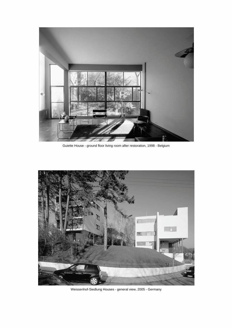
Guiette House - ground floor living room after restoration, 1998 - Belgium
Weissenhof-Siedlung Houses - general view, 2005 - Germany
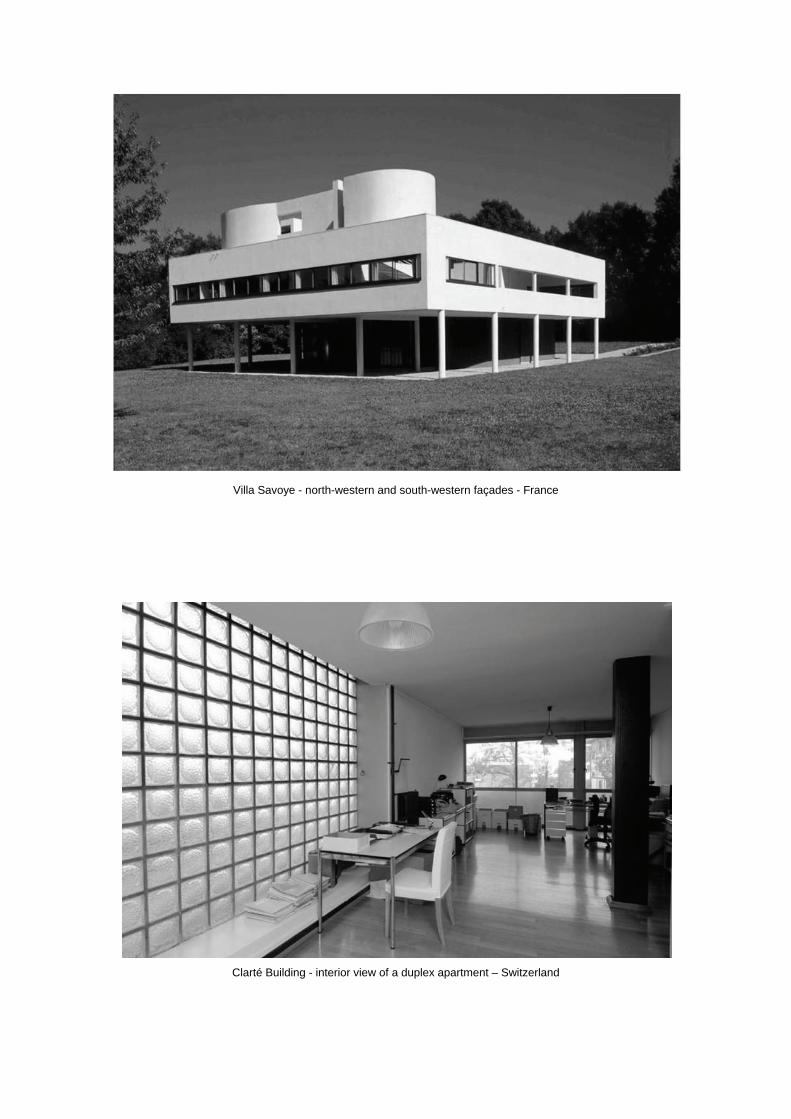
Villa Savoye - north-western and south-western façades - France
Clarté Building - interior view of a duplex apartment – Switzerland
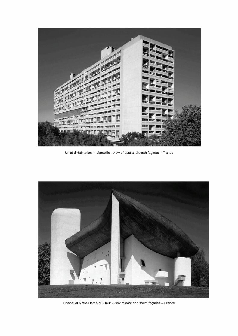
Unité d’Habitation in Marseille - view of east and south façades - France
Chapel of Notre-Dame-du-Haut - view of east and south façades – France
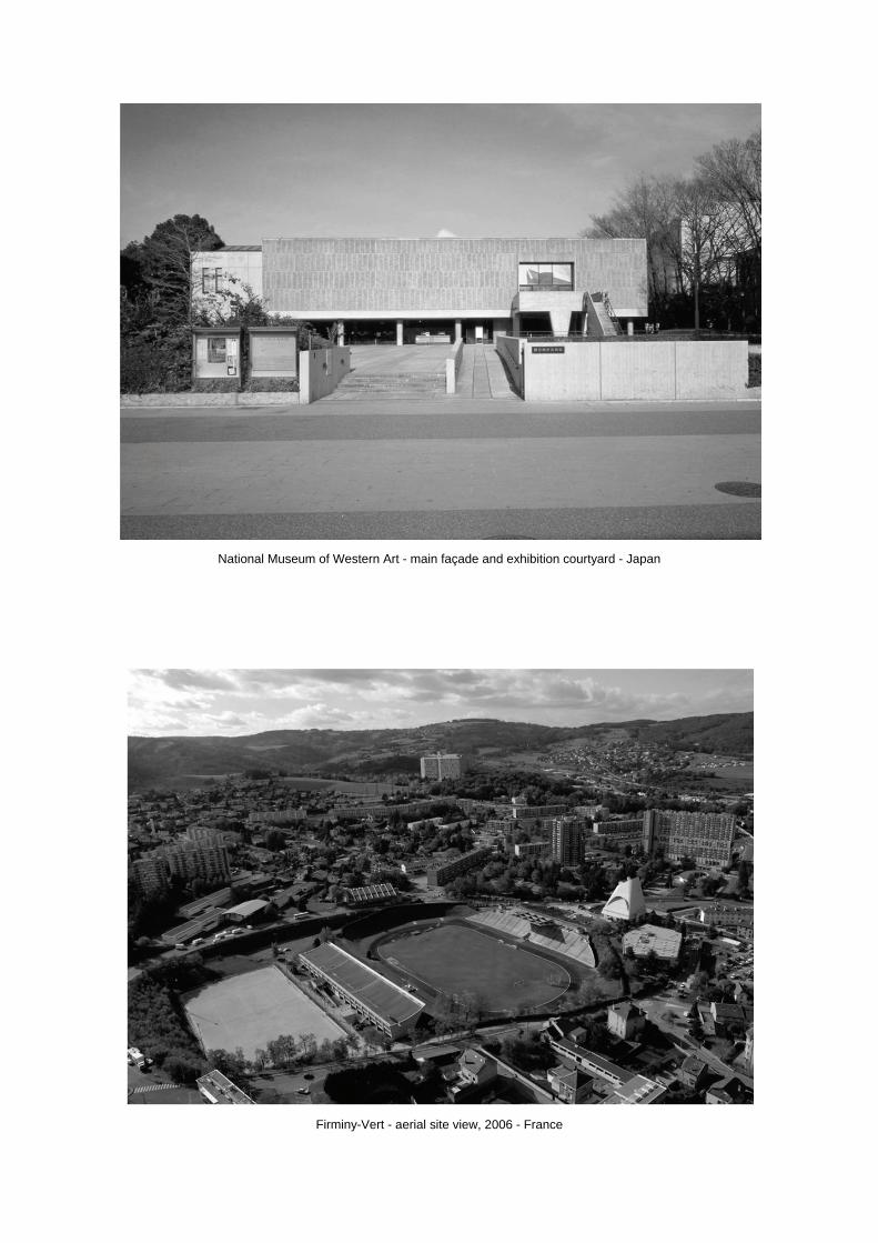
National Museum of Western Art - main façade and exhibition courtyard - Japan
Firminy-Vert - aerial site view, 2006 - France

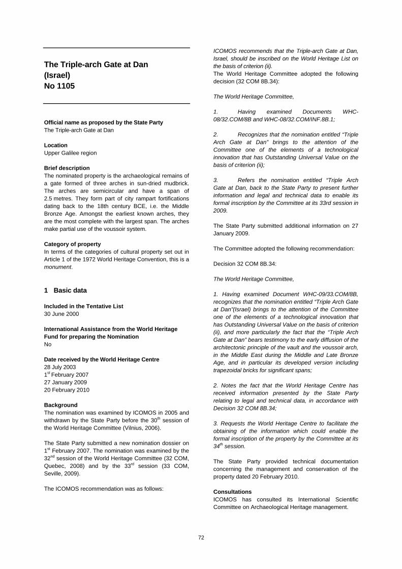
72
The Triple-arch Gate at Dan (Israel) No 1105 Official name as proposed by the State Party The Triple-arch Gate at Dan Location Upper Galilee region Brief description The nominated property is the archaeological remains of a gate formed of three arches in sun-dried mudbrick. The arches are semicircular and have a span of 2.5 metres. They form part of city rampart fortifications dating back to the 18th century BCE, i.e. the Middle Bronze Age. Amongst the earliest known arches, they are the most complete with the largest span. The arches make partial use of the voussoir system. Category of property In terms of the categories of cultural property set out in Article 1 of the 1972 World Heritage Convention, this is a monument.
1 Basic data Included in the Tentative List 30 June 2000 International Assistance from the World Heritage Fund for preparing the Nomination No Date received by the World Heritage Centre 28 July 2003 1st February 2007 27 January 2009 20 February 2010 Background The nomination was examined by ICOMOS in 2005 and withdrawn by the State Party before the 30th session of the World Heritage Committee (Vilnius, 2006). The State Party submitted a new nomination dossier on 1st February 2007. The nomination was examined by the 32nd session of the World Heritage Committee (32 COM, Quebec, 2008) and by the 33rd session (33 COM, Seville, 2009). The ICOMOS recommendation was as follows:
ICOMOS recommends that the Triple-arch Gate at Dan, Israel, should be inscribed on the World Heritage List on the basis of criterion (ii). The World Heritage Committee adopted the following decision (32 COM 8B.34): The World Heritage Committee, 1. Having examined Documents WHC-08/32.COM/8B and WHC-08/32.COM/INF.8B.1; 2. Recognizes that the nomination entitled “Triple Arch Gate at Dan” brings to the attention of the Committee one of the elements of a technological innovation that has Outstanding Universal Value on the basis of criterion (ii); 3. Refers the nomination entitled “Triple Arch Gate at Dan, back to the State Party to present further information and legal and technical data to enable its formal inscription by the Committee at its 33rd session in 2009. The State Party submitted additional information on 27 January 2009. The Committee adopted the following recommendation: Decision 32 COM 8B.34: The World Heritage Committee, 1. Having examined Document WHC-09/33.COM/8B, recognizes that the nomination entitled “Triple Arch Gate at Dan”(Israel) brings to the attention of the Committee one of the elements of a technological innovation that has Outstanding Universal Value on the basis of criterion (ii), and more particularly the fact that the “Triple Arch Gate at Dan” bears testimony to the early diffusion of the architectonic principle of the vault and the voussoir arch, in the Middle East during the Middle and Late Bronze Age, and in particular its developed version including trapezoidal bricks for significant spans; 2. Notes the fact that the World Heritage Centre has received information presented by the State Party relating to legal and technical data, in accordance with Decision 32 COM 8B.34; 3. Requests the World Heritage Centre to facilitate the obtaining of the information which could enable the formal inscription of the property by the Committee at its 34th session. The State Party provided technical documentation concerning the management and conservation of the property dated 20 February 2010. Consultations ICOMOS has consulted its International Scientific Committee on Archaeological Heritage management.
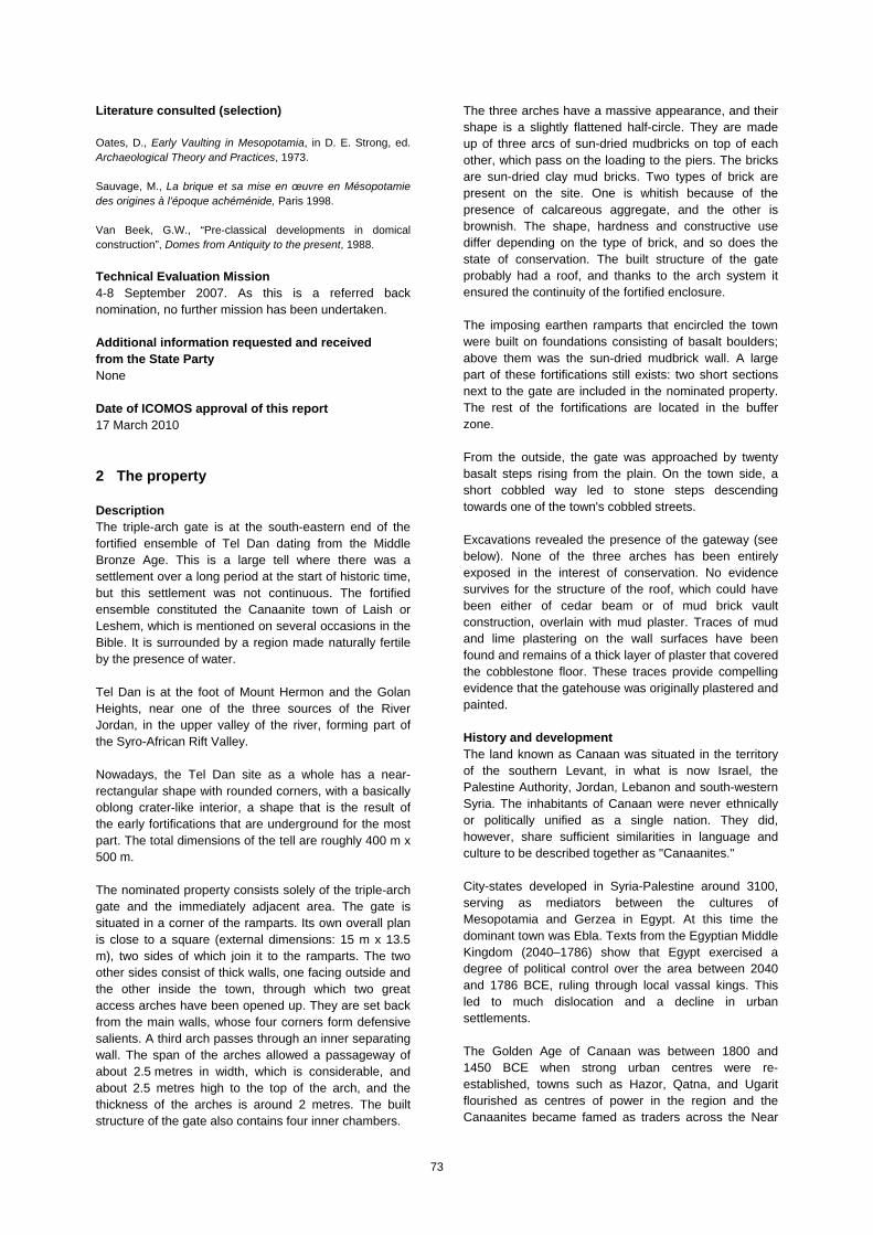
73
Literature consulted (selection) Oates, D., Early Vaulting in Mesopotamia, in D. E. Strong, ed. Archaeological Theory and Practices, 1973. Sauvage, M., La brique et sa mise en œuvre en Mésopotamie des origines à l’époque achéménide, Paris 1998. Van Beek, G.W., “Pre-classical developments in domical construction”, Domes from Antiquity to the present, 1988.
Technical Evaluation Mission 4-8 September 2007. As this is a referred back nomination, no further mission has been undertaken. Additional information requested and received from the State Party None Date of ICOMOS approval of this report 17 March 2010
2 The property Description The triple-arch gate is at the south-eastern end of the fortified ensemble of Tel Dan dating from the Middle Bronze Age. This is a large tell where there was a settlement over a long period at the start of historic time, but this settlement was not continuous. The fortified ensemble constituted the Canaanite town of Laish or Leshem, which is mentioned on several occasions in the Bible. It is surrounded by a region made naturally fertile by the presence of water. Tel Dan is at the foot of Mount Hermon and the Golan Heights, near one of the three sources of the River Jordan, in the upper valley of the river, forming part of the Syro-African Rift Valley. Nowadays, the Tel Dan site as a whole has a near-rectangular shape with rounded corners, with a basically oblong crater-like interior, a shape that is the result of the early fortifications that are underground for the most part. The total dimensions of the tell are roughly 400 m x 500 m. The nominated property consists solely of the triple-arch gate and the immediately adjacent area. The gate is situated in a corner of the ramparts. Its own overall plan is close to a square (external dimensions: 15 m x 13.5 m), two sides of which join it to the ramparts. The two other sides consist of thick walls, one facing outside and the other inside the town, through which two great access arches have been opened up. They are set back from the main walls, whose four corners form defensive salients. A third arch passes through an inner separating wall. The span of the arches allowed a passageway of about 2.5 metres in width, which is considerable, and about 2.5 metres high to the top of the arch, and the thickness of the arches is around 2 metres. The built structure of the gate also contains four inner chambers.
The three arches have a massive appearance, and their shape is a slightly flattened half-circle. They are made up of three arcs of sun-dried mudbricks on top of each other, which pass on the loading to the piers. The bricks are sun-dried clay mud bricks. Two types of brick are present on the site. One is whitish because of the presence of calcareous aggregate, and the other is brownish. The shape, hardness and constructive use differ depending on the type of brick, and so does the state of conservation. The built structure of the gate probably had a roof, and thanks to the arch system it ensured the continuity of the fortified enclosure. The imposing earthen ramparts that encircled the town were built on foundations consisting of basalt boulders; above them was the sun-dried mudbrick wall. A large part of these fortifications still exists: two short sections next to the gate are included in the nominated property. The rest of the fortifications are located in the buffer zone. From the outside, the gate was approached by twenty basalt steps rising from the plain. On the town side, a short cobbled way led to stone steps descending towards one of the town's cobbled streets. Excavations revealed the presence of the gateway (see below). None of the three arches has been entirely exposed in the interest of conservation. No evidence survives for the structure of the roof, which could have been either of cedar beam or of mud brick vault construction, overlain with mud plaster. Traces of mud and lime plastering on the wall surfaces have been found and remains of a thick layer of plaster that covered the cobblestone floor. These traces provide compelling evidence that the gatehouse was originally plastered and painted. History and development The land known as Canaan was situated in the territory of the southern Levant, in what is now Israel, the Palestine Authority, Jordan, Lebanon and south-western Syria. The inhabitants of Canaan were never ethnically or politically unified as a single nation. They did, however, share sufficient similarities in language and culture to be described together as "Canaanites." City-states developed in Syria-Palestine around 3100, serving as mediators between the cultures of Mesopotamia and Gerzea in Egypt. At this time the dominant town was Ebla. Texts from the Egyptian Middle Kingdom (2040–1786) show that Egypt exercised a degree of political control over the area between 2040 and 1786 BCE, ruling through local vassal kings. This led to much dislocation and a decline in urban settlements. The Golden Age of Canaan was between 1800 and 1450 BCE when strong urban centres were re-established, towns such as Hazor, Qatna, and Ugarit flourished as centres of power in the region and the Canaanites became famed as traders across the Near
74
East, particularly for purple dye obtained from sea-molluscs found along the Mediterranean coast. The gate and ramparts of Tel Dan were constructed, it is now believed, in the 18th century BCE, when Canaan was at the height of its power and influence. A second period of Egyptian control between 1450 and 1365 BCE preceded the break-up of the Egyptian Empire that enabled the Hebrew invasion into the land of Canaan around the 12th century BCE and, in time, the creation of the ancient Kingdom of Israel. According to Biblical evidence, Laish was conquered and renamed by the Hebrew tribe of Dan. Tel Dan flourished as the northernmost city of ancient Israel and is mentioned many times in the Old Testament. Excavations have been carried out on the northerly part of the site. Laish (Dan) was strategically situated on the road from Damascus, in Syria, to Tyre on the coast of the Mediterranean Sea. The north-south route from Hazor to Lebanon passed through Abel-beth-maachah, just west of Dan. At the northern end of the upper Jordan Valley, Dan was sited in one of the most productive parts of the region where there is abundant rainfall. At the foot of the tell mound are extensive springs that represent one of the sources of the River Jordan. Tel Dan was destroyed when the city was captured by Tiglath Pileser, king of Assyria, in 732 BCE. It was partially restored, but never regained its former importance. By the 4th century BCE it was described by Eusebius as being a village (Onomasticon 369). Rescue excavations began at Tel Dan in 1966 by the Israeli Department of Antiquities and Museums, as there was a potential threat from military activities because of proximity to the Syrian frontier. Excavations in the south-east sector did not begin until 1977, and the top of the first arch was discovered in 1979. The two other arches, and then the passageways were uncovered in the ensuing years. The excavations were then developed into a full research project, which continued until 1999, covering both the gate of the Canaanite town and the later "Biblical" city. After more than 30 years of work, less than 10% of the site has been excavated. The digs were interrupted in 2006 because of the war between Israel and Lebanon. They were scheduled to restart in 2008.
3 Outstanding Universal Value, integrity and authenticity
Comparative analysis The key elements at the heart of the nomination are the three arches of the gate, which constitute a very ancient and technically accomplished example of the true arch. These are the rationale for the nomination. The true arch differs from corbel arches and other older types of arches in that its arch-shaped structure converts
the naturally downward pressure of gravity of the upper built structure into lateral thrust against the piers, solely by compression exerted on the construction elements. The oldest examples of primitive vaults and arches appeared in the 4th millennium BCE in Mesopotamia during the Uruk period (Tepe Gawra about 3300 BCE). They are also present in the first dynasty in Egypt, c. 3000 BCE and under the fourth dynasty, c. 2580-2560 BCE. The true arch was found in the development of the city states of the Middle East during the 3rd millennium, for openings, vaulted ceilings, tombs, etc. A move towards a more accomplished architectural form, the true semi-circular vault, took place as early as the 3rd millennium ceramic relief in Tell Asmar, period Ur I). Vaults and arches made of square or rectangular hewn brick, with mortar in the extrados, were quite widely present at the start of the 2nd millennium in the Middle East (Tell el-Rimah). Simultaneously, the semicircular arch was improved by the voussoir system (trapezoidal bricks made to fit together); this is sometimes referred to as the true radial vault. The first genuinely accomplished vaults and arches of this type have spans of 0.8 m to 1 m, and the function of supporting the weight of the superstructure is fully expressed. Some authors (Heinrich, for example) consider that true arches were built over gates from the end of the first dynasties in Egypt, and above the gates of cities and temples from ancient times in Babylonia. The construction technology of the three large arches at Tel Dan is relatively sophisticated and expert, rather than experimental. The openings and elevations are large. This suggests the existence at the same period of other arches, probably in a relatively large perimeter from Mesopotamia to Egypt, which have either been destroyed or are as yet undiscovered. One similar arch does exist at Ashkelon, Israel, from the same period (Middle Bronze Age IIA), but this is damaged and less complete. It also forms part of a fortification system, and was rebuilt twice during the Middle Bronze Age. No absolute dating has been achieved for the Dan arches or for the Ashkelon arch, but the arches at both sites appear to be very close in period. In the case of Dan, the gatehouse is linked to the city's 18th century BCE defence system. Two arch gateways, built of brick and forming part of a fortification system, also exist at Mumbaqat in Syria. They too date from the Middle Bronze Age, but their construction technique is slightly different. ICOMOS considers that, in the light of the above, the arches of Tel Dan do not represent the earliest example of the true radial arch or the earliest example of the brick voussoir type arch. However, in the current state of archaeological excavations, the Tel Dan arches are the
75
largest early arches and demonstrate an early use of the voussoir type arch.
ICOMOS considers that the comparative information known about vestiges of the earliest true radial arches and vaults justify consideration of the inscription of the property as an outstanding example of the diffusion and flourishing of a construction technique at the start of the 2nd millennium.
Justification of Outstanding Universal Value The nominated property is considered by the State Party to have outstanding universal value as a cultural property for the following reasons: The three arches of the gate at Tel Dan are the
only complete arches forming part of a fortification system known at the present time for the Middle Bronze Age (18th century BCE).
They bear witness to a knowledge of the principles of construction of true radial vaults at the period in question in the Middle East.
Their span is exceptionally large (2.5 metres). They bear witness to the apogee of the art of
massive earthen fortifications during the Middle Bronze Age II, including sophisticated gateways with arches, and to the urban development of this period.
ICOMOS considers that the Triple Arch Gate at Dan bears testimony to great mastery of the technique of the true radial vault and arch, using sun-dried mudbrick. Fragile from a conservation viewpoint, it is at present the unique testimony of the diffusion of this type of highly innovative construction during the Middle Bronze Age in the Middle East. Integrity and authenticity Integrity
The built part of the gate is complete. It includes in particular the three true arches on which its value is founded. Despite the lack of superstructure, even in the form of archaeological traces, the gate's overall integrity has been maintained, both in terms of its architectural plan and elevation views. Sun-dried mudbrick constructions are furthermore relatively fragile over time, and a process of deterioration of the immediate built environment of the arches (spandrel and side walls) has begun since they were uncovered by the excavations. For about 25 years now this has raised significant conservation problems. The integrity of the construction has been affected at certain points, as the natural elements (water, wind, sun) have removed portions of material and made the structure fragile to the north-east. (See 5, conservation). With regard to the integrity, in the sense of completeness, of the nominated property, a question is also raised concerning the relationship of the gate to its
environment of fortifications; the fortifications are in the buffer zone but not in the nominated property zone. ICOMOS recommends that the State Party should give due consideration to this aspect, particularly bearing in mind that another later gate exists inside the archaeological ensemble included in the buffer zone. In its additional documentation of 20 February 2010, the State Party declares that it has examined this recommendation, and has reached a negative conclusion for the time being. Firstly, the other parts of the fortifications linked to the triple arch gate are of less interest and have no direct link to the technological value of the nominated property, and secondly, they are under the natural protection of the layers of earth which it considers it is preferable not to remove. Finally, they are under the legal protection of the buffer zone which guarantees their conservation and their monitoring. Authenticity
The authenticity of the excavated arches is not in doubt. However the precise dating of the gate is based on indirect elements. Many vestiges have been found in the excavations of the tell settlement area, near to the gate. They provide evidence of dates going back to the 18th century BCE. Furthermore, the use as an urban passageway gate of the three arches seems to have been limited in time. The gate was blocked up with earth, to ensure the continuity of the ramparts, which in fact ensured its conservation up until the contemporary excavations. Furthermore, for the arches to be fully authentic, their immediate architectural environment must also be fully authentic, which again raises the issue of the recent process of decay and how to overcome it. Elements of reinforcement for the structures undergoing decay have been applied, taking care to ensure reversibility. Elements of restoration have also been considered. The main challenges in the future will be to keep interventions to a minimum, without any significant reconstruction, to ensure the authenticity of the gate and the arches. In its documentation of 20 February 2010, the State Party provided information about the permanent monitoring of decay in the built environment close to the triple arch and about the measures taken to keep the processes of decay under control (see Conservation).
ICOMOS considers that the conditions of integrity and authenticity have been met.
Criteria under which inscription is proposed The property is nominated on the basis of cultural criteria (i), (ii) and (iv).
76
Criterion (i): represent a masterpiece of human creative genius. For the State Party, although the three arches of the gate at Tel Dan are not the earliest known examples, they are the first example of a complete true arch. They meet all the criteria of this principle of construction. They are an exemplary representation of human creative genius in the technical and architectural mastery of the true radial vault and arch. ICOMOS considers that the three arches of Tel Dan demonstrate complete mastery of the true arch technique, using the combined method of rectangular bricks and trapezoidal bricks, in the context of massive fortifications and the urban development of the Middle Bronze Age or slightly later. The three arches of Tel Dan demonstrate how man adapts to his environment by the use of sun-dried bricks, made of mud and clay. However, this technical expertise is neither unique at the time nor the earliest known. Clearly the earliest examples of voussoir arches were built earlier than at Tel Dan, in the 3rd and 4th millennia, in Egypt and in Mesopotamia. It seems that the arches of Tel Dan are not the oldest example of a complete true radial arch, nor the oldest example of a voussoir arch. The dating of the Tel Dan gate moreover is indirect, and its monumental and defensive use seems to have been of short duration.
ICOMOS considers that this criterion has not been justified.
Criterion (ii): exhibit an important interchange of human values, over a span of time or within a cultural area of the world, on developments in architecture or technology, monumental arts, town-planning or landscape design. For the State Party, the three arches of Tel Dan represent a new architectural principle originating from Mesopotamia and largely disseminated in the Mediterranean and the Middle East. As there is no complete architectural example in Mesopotamia, it is the Tel Dan site which is the most significant example of mastery of this architectural principle and its dissemination. More generally, most mudbrick arches collapsed and disappeared as early as the Iron Age. Since this initial dissemination of which Tel Dan is an example, the architectural principle of the true radial arch has been widely adopted in the Mediterranean world and in Western civilisation. ICOMOS considers that Tel Dan bears witness to the early diffusion of the architectonic principle of the vault and the voussoir arch, in the Middle East during the Middle and Late Bronze Age, and in particular its
developed version including trapezoidal bricks for significant spans. The integrity of the arches is however threatened by the intrinsic difficulty of conserving sun-dried mudbrick architecture for future generations, particularly for a structure as elaborate as an arch. The initial excavation periods, which re-exposed the edifice to the elements, did not fully allow for this consideration and have compromised chances for conservation in the long term. In its additional documentation of 20 February 2010, the State Party presents an overview of conservation efforts made since the discovery of the triple-arch gate, focusing on the results achieved. The results suggest that the efforts should enable the long-term conservation of the property (see Conservation).
ICOMOS considers that this criterion has been justified.
Criterion (iv): be an outstanding example of a type of building, architectural or technological ensemble or landscape which illustrates (a) significant stage(s) in human history. In the view of the State Party the Tel Dan gate is the only conserved example of gates of massive fortifications, a defensive system that was used during the development of the civilisation of the city-states of the Middle Bronze Age. It is a unique example of a very important feature of civilisation, which is widely encountered in the Middle East. In the view of ICOMOS, the nominated property is the triple-arch gate alone; the fortified ensemble is not nominated and its outstanding universal value does not seem to be justified. The nominated property does not present all the characteristics of the feature of civilisation referred to, i.e. the flourishing of fortified city states in the Middle Bronze Age in the Middle East.
ICOMOS considers that this criterion has not been justified.
ICOMOS considers that the nominated property meets criterion (ii) and that outstanding universal value has been demonstrated.
Description of the attributes The Triple-arch Gate at Dan bears witness to
great mastery of the technique of building a true arch with a significant span (2.5 metres) during the Middle Bronze Age or slightly later.
It was built using sun-dried mudbricks, with the arch bricks making partial but unquestionable use of the innovative voussoir system.
In the current state of archaeological knowledge, it constitutes a unique example of a gate with three complete arches, each with three
77
successive arcs of brick, both for its early date and its state of conservation.
Through its integration in massive fortifications, it bears witness to the importance of the move towards urbanisation in the Middle Bronze Age and to its technical advances.
4 Factors affecting the property Development pressures
Economic development is not exerting any pressure on the Tel Dan site. All projects must moreover be authorised by INPA, the Israeli Nature and Parks Authority. There are no inhabitants either in the nominated property zone or in the buffer zone. In response to the request by ICOMOS, the State Party has given guarantees that the area (about 6 hectares) of the buffer zone that does not form part of the natural reserve will be used exclusively for agricultural purposes. Military risk Situated close to the border with Lebanon and the border with Syria, the Tel Dan region could be affected by war risk. Tourism
Up to now tourism has been kept well under control, and relatively limited numbers of tourists have visited the three-arch gate itself. Tourism could grow significantly inside the Reserve, without posing a particular threat to the archaeological site. Any risks of vandalism are prevented by the presence of wardens on the archaeological site and the physical protection of fragile or dangerous archaeological elements. Routes inside the Reserve are indicated and signs are installed to encourage good behaviour. The real quantitative limit at the moment is the capacity of the parking area (up to 1,000 visitors at any one time). The annual average number of visitors for the Reserve is around 200,000, but only 80 days a year are considered to be peak days for visits. Natural factors and impact of climate change
The main natural risk threatening the nominated property is torrential rainfall. There is also a certain degree of earthquake risk in this zone. In view of the dominant vegetation cover, a brush fire could, in the dry season, spread as far as the site. It is not however directly exposed to this risk as vegetation is cleared away on the approaches to the site. There is no pollution in the site environment, and there are no climatic particularities.
ICOMOS considers that the main threats to the property are torrential rainfall, possibly combined with the action of the wind and sun.
5 Protection, conservation and management
Boundaries of the nominated property and buffer zone Nominated area: The nominated property consists of the triple-arch gate and its immediate surroundings: the connections to the north and south-west rampart wall, and the external and internal gate access staircases. The property boundary is a rectangle of approximately 4,800 sq.m. around the gate. Buffer zone: The Tel Dan archaeological site forms part of a protected nature reserve that represents the bulk of the buffer zone. Since the 2005 nomination and the ensuing recommendations, the buffer zone has been extended to the south-east beyond the nature reserve zone, to include an agricultural zone belonging to the Snir kibbutz, to a depth of at least 150 metres. The total area of the buffer zone is 37.2 hectares.
ICOMOS considers that the boundaries of the nominated property are adequate. ICOMOS considers that the revised buffer zone boundaries are adequate.
Ownership The nominated property is owned by the State of Israel. It is situated in the nature reserve of Tel Dan. It therefore has the legal status of a nature reserve and an archaeological site. Protection Legal Protection
The nominated property is defined and protected by the following legal texts: - The Israel Lands Administration Law of 1960. - The 1965 Planning and Building Law and its amendments. - The 1978 Antiquities Law and the 1989 Antiquities Authority Law (IAA). - The 1963 National Parks, Nature Reserves, National Sites and Memorial Sites Law, amended in 1992. Under the law of 1960, the property is governed by the powers of the state vested in the Nature Reserves Authority (Act of 18 September 1987), and the confirmation of a 49-year transfer of rights dated 7 May 2006. Buffer zone: Most of the buffer zone (84%) is under the protection of the natural reserve. The rest is a zone exclusively reserved for open-field agricultural activities. All requests for a waiver from this allocation rule (e.g. for a building)
78
have been made impossible in view of the guidelines for the implementation of land use planning. ICOMOS considers that the buffer zone protection measures are adequate. Effectiveness of protection measures
The legal measures taken to protect the nominated property seem to be adequate.
ICOMOS considers that the legal protection in place is adequate.
Conservation Inventories, recording, research
The archaeological study has been underway since the late 1970s. The archaeological documentation thus gathered on the site is considerable. It consists of several types of documents:
- Excavation reports for each campaign. - The Tel Dan reserve annual report, published since 2001. This is a sort of log book compilation of all actions and observations on the site. - The site dossier, which brings together all basic documents, plans and decision relating to the site. It is regularly updated.
The IAA/Getty Report provides an in-depth study of the archaeological situation of the property and any changes in its state of conservation since the property was uncovered at the start of the 1980s. It provides a solid technical basis for the updating and improving of the property's conservation plan. Present state of conservation
This monument is made of sun-dried mudbricks, which by their very nature are fragile, and the state of conservation of the arches and the mural elements of the gate confirm that constant attention is essential. Its survival since its creation was only possible because the site was buried quite rapidly, probably in the 8th century BCE. Once the structure was uncovered, in around 1980, it began to deteriorate because of the nature of its material of construction. Recent excavations show the very probable presence of plastering on the surface of the joints between the bricks, and perhaps over the whole of the facades. This again attests that this construction was sophisticated and well mastered, rather than being a still experimental construction. Active conservation measures
Following the uncovering of the gate in the late 1970s and early 1980s, an initial shelter was constructed above the gate in 1982. This protection however turned out to be only partial and inadequate. From 1985 to 1988
moreover, the protective roof deteriorated, and water penetrated into the north-east tower. In 1992 the western facade and the interior of the gate were filled in, as a preventive conservation measure. A new and more complete roof was built in 1993, and another layer of protective fill was added. From 1997 to 1999, the IAA (Israeli Antiquities Authority) and the Getty Conservation Institute drew up documentation of the archaeological structure, and analysed its conservation. Their report was completed in 2000. It provides a detailed chronology of the deterioration, with some examples of serious losses on the north-east tower. The report draws a distinction between intrinsic factors (linked to materials and construction technology) and extrinsic factors (recent preservation history). This report is comprehensive, and provides a thorough analysis of the causes and rates of deterioration of the monument. The report suggested some reburying, some areas filled with sandbags to prevent access, some parts to be covered with geo-fabric textile, and basalt stones to provide support in some places. In response to this report, in 2000-2005, discrete structural support elements were designed, in accordance with international reversibility standards, as appropriate for a monument of such fragility. Some structurally supportive reconstruction in limited areas, especially to the East tower or the gate, was undertaken. Discussions are under way about the replacement of the present shelter structure with a more minimal one, and then by a complete system in future years. This programme however illustrates the current difficulties, at an international level, of recommending long-term conservation methods for sun-dried mudbrick structures. In its additional documentation of 20 February 2010, the State Party reports on the results recently obtained in the conservation of the most fragile elements of the structure. It refers to the restoration of the upper parts of the edifice, where the traditional techniques used have produced a result which is historically authentic and a stabilisation which appears to be solid and lasting. The detachment of the east wall, which had threatened to collapse, has been dealt with using a gradual mechanical process put in place in 2008. Today completed, it has resulted in a return to the original position and a re-attachment which is considered to be both satisfactory and lasting. Furthermore, roofs are currently being extended or modified, particularly on the east side, for more extensive and effective protection against rainwater. Work on sun protection structures is also under way. Processes of deterioration by damp have been halted. A long-term conservation plan has been put in place, in line with the recommendations made in the ICOMOS
79
evaluation of 2008. It brings together the efforts of two national authorities: the parks authority (INPA), which manages the property, and the antiquities authority (IAA). It also brings together the expertise of well-known international institutions (Getty, CRATerre) and independent experts in the field of earthen architecture conservation. In addition to observation of the state of the property, the everyday surveillance of the site by guards involves the checking of water drainage during rainy weather, and the action of the protective roof. ICOMOS, in its 2005 evaluation, stated that the conservation measures undertaken at the time were inadequate. The technical appraisal mission in 2007 indicates that substantial progress has been made in this area. Work is in progress to put in place structural support and stabilising elements; the work is carried out with great care, paying attention to issues of quality and possible reversibility. ICOMOS, in its 2008 evaluation, recommended that a very stringent conservation plan should be put in place, in line with the best international standards for the preservation of sun-dried mudbrick architecture. The changes occurring in the structure remain however partly unpredictable, and call for a flexible and adaptable action plan, without sacrificing scientific rigour. ICOMOS considers that recent efforts concerning the scientific and technical management of the processes of decay of the sun-dried mudbrick architecture of the nominated property have been substantial, and in some cases exemplary. In addition, scientific monitoring and a long-term conservation plan are today in place and functioning, and the results obtained suggest that the long-term conservation of the property can thus be ensured.
ICOMOS considers that the conservation of the property has steadily improved since 2005, and has today reached a satisfactory level.
Management Management structures and processes, including traditional management processes
The three-arch gate of Tel Dan is managed as part of the Natural and Archaeological Reserve of Tel Dan. It is the responsibility of the Israeli Nature and Parks Authority (INPA), in accordance with its hierarchical organisation chart: national directorate, professional divisions, Northern District and Golan Region, and finally the Tel Dan Reserve echelon. The site is managed in accordance with several national plans and programmes. As a result funding and personnel are allocated to the Nature Reserve.
The Israeli Council for the Preservation of Monuments and Archaeological Sites is also involved, and cooperates with the management authority. All projects for site management and archaeological works are supervised by the IAA (Israeli Antiquities Authority) from a scientific viewpoint. Policy framework: management plans and arrangements, including visitor management and presentation
Conservation plan: A master research plan for the conservation of the archaeological site was requested when the 2005 nomination was examined. It was presented in 2006 under the name "Conservation Plan". It was to be based on the IAA/Getty evaluation report and on experience gathered during recent work. It will take over from the existing conservation measures, which have moreover improved markedly over the last two years (see Conservation). The plan must however retain a degree of flexibility in order to deal with the unpredictability of changes in the condition of the structure. Archaeological excavation and visitor presentation plan: After a two-year break in excavations, a master plan for future excavations is to be started up in 2008. It will complement and assist the conservation plan. It has been drawn up by the Gluek School of Biblical Archaeology, in conjunction with the Reserve and the INPA. It also concerns other elements of the fortification wall and the interior of the town. It involves work both for conservation and for presenting the site to visitors. The Natural and Archaeological Reserve management plan: it manages the organisation of the site and the facilities for accommodating the public, including:
- Daily inspection of the site, - Annual drainage system maintenance work, - Seasonal cleaning of vegetation and prevention of bird nesting.
A detailed plan indicating the roads and access paths, the car park and the reception facilities has been provided in response to the request made by ICOMOS. ICOMOS considers that a detailed site conservation management plan is necessary, while considering that this plan must remain flexible in order to be adaptable to changes in the structure and improvements in conservation techniques (See Conservation). Following the ICOMOS request in 2008 suggesting that consideration should be given to presenting the three-arch gate in a way more closely linked to the rest of the fortifications and the urban centre of Tel Dan, the State Party examined this proposal. In its reply of 20 February 2010, it indicated that the nearby fortification elements are of limited archaeological interest and have no direct relationship to the essentially technological and
80
architectural value of the property; furthermore, they are for the most part covered by a layer of earth which protects and conserves them. It therefore seems advisable to maintain the existing situation of the three-arch gate in respect of presentation and value preservation. The three-arch gate is located in a nature reserve that receives a relative large number of visits and is popular in Israel, but its entrances are strictly controlled. The Reserve is entirely fenced in, and the archaeological site of the gate has an additional protection, with an access gateway. The archaeological site is only accessible to a limited number of visitors at any one time, but this point is basically positive in view of the current state of conservation, excavations and work on the site. It is not however possible for people with disabilities to access to the site. Routes are proposed to visitors, together with large numbers of signs and interpretation points, with the following objectives:
- Presentation and interpretation of the site's major features; - Encouragement of good visitor behaviour and protection of the site itself; - Visitor guidance and safety.
The signs and information are in three languages: Hebrew, English and Arabic. They were completely renewed in 2004, but on the basis of the visit plan drawn up in 1995. Involvement of local communities
There is no institutional programme with local or regional communities. However, the Tel Dan local authority is active in that it organises regular educational visits for school groups, and provides information to the population about the archaeological and natural site. Archaeological research partnerships As regards the excavations, various educational institutions are in regular contact with the site: the Nelson Glueck School of Biblical Archaeology, the Hebrew Union College of Jerusalem. These institutions play a substantial role in funding excavations and publishing their results. ICOMOS notes that no management plan is proposed with regard to the nominated property. However, ICOMOS considers that the property is included in the larger context of a Natural and Archaeological Reserve whose management rules are long-established and well-defined. The measures in place are those of a state organisation whose operation has been tried and tested. They are under the scientific control of the IAA.
Resources, including staffing levels, expertise and training
The Natural and Archaeological Reserve currently has eight full-time employees. Their activities however range over the whole spectrum of tasks required in managing a nature reserve receiving a significant number of visitors, in which the nominated property is only one part among others. Personnel are all recruited following appropriate academic training. They are given short complementary training at INPA and they are only taken on definitively after a two-year trial period. Temporary employees are hired during periods of high frequentation. Workers and contractors are required for maintenance and cleaning work. At regional and national level INPA has a number of professionals specialising in the various questions that arise in the management and conservation of the site: a scientific director for the site, specialist archaeologists and architects. Furthermore, the site can call on the national specialists of the IAA. The IAA provides a 2-year course to professionals recruited by the INPA, who are then put in charge of monitoring sites such as Tel Dan. As far as earthen architecture conservation is concerned, the IAA specialists have taken international courses at the Getty Institute of Conservation and CRATerre in Grenoble (France). Depending on the difficulties encountered, external institutes and consultants are called in, as was the case of the Getty Institute to evaluate the structure in the late 1990s. Architects and conservators specialising in the devising and conservation of architectural vestiges intervene on the site. The reproduction of sun-dried mudbricks was undertaken in this way. The excavations are guided by archaeologists of national and international reputation, both from the INPA and from the Hebrew Union College (HUC). ICOMOS considers the training of the personnel with scientific responsibilities to be of a good level, in line with international standards for the subject concerned. ICOMOS recommends however the stepping up of continuing education of the other INPA personnel working in fields related to the nominated property, on the conservation and preservation issues with which they are specifically concerned.
81
In the documentation it submitted on 20 February 2010, the State Party indicates the levels of competence of its personnel, and the training courses they have taken.
ICOMOS commends the measures in place constituting the management plan, and considers that the management system for the nominated property is adequate. ICOMOS recommends that the continuing education of personnel should be extended.
6 Monitoring The visual monitoring of the condition of the nominated property takes place at least once a day, and often twice a day, by the Reserve personnel. The personnel is trained for this purpose, as part of the overall surveillance of the site. The basic monitoring indicators are as follows:
- Observe the appearance of brick debris at the foot of the arches. - Very rapidly locate incipient signs of damage to the arch surface to prevent them from becoming irreversible.
Under the conservation plan, the INPA team of professionals carries out regular scientific monitoring of the site. This monitoring includes systematic photographs of the gate from fixed points, and regular comparison of the photographs taken. The conservation plan monitoring reports are approved by the INPA and the IAA. Site water drainage and cleanliness are monitored annually. In the documentation it submitted on 20 February 2010, the State Party indicates that it has given consideration to the ICOMOS recommendation made in 2008: “In view of the fragility of the property and the speed of changes that can occur, monitoring could be improved by permanent surveillance using a laser theodolite and 3D digital display.” A system of this type has been set up with the collaboration of a specialised company. Initial results are currently being considered and methodology is at the development stage.
ICOMOS considers that the monitoring of the property is adequate.
7 Conclusions ICOMOS recognises the Outstanding Universal Value of the Triple-arch Gate at Dan. ICOMOS considers that the changes made since the property was first nominated for the World Heritage List in 2005, and since the 2008 evaluation, have been positive, particularly with regard to the enlargement of
the buffer zone and the marked improvements in property conservation work and in the monitoring of the property. Recommendations with respect to inscription ICOMOS recommends that the Triple-arch Gate at Dan, Israel, should be inscribed on the World Heritage List on the basis of criterion (ii). Recommended Statement of Outstanding Universal Value Brief synthesis
The three-arch gate of the Triple-arch Gate at Dan has outstanding universal value: It bears witness to great mastery of the technique
of building a true arch with a significant span (2.5 metres) during the Middle Bronze Age or slightly later.
It was built using sun-dried mudbricks, with the
arch bricks making partial but unquestionable use of the innovative voussoir system.
In the current state of archaeological knowledge,
it constitutes a unique example of a gate with three complete arches, each with three successive arcs of brick, both for its early date and its state of conservation.
Through its integration in massive fortifications, it
bears witness to the importance of the move towards urbanisation in the Middle Bronze Age and to its technical advances.
Criterion (ii): The Triple-arch Gate at Dan bears witness to the early diffusion of the architectonic principle of the true radial arch, in the Middle East during the Middle and Late Bronze Ages, particularly in its most complete version, including voussoir bricks, for wide spans. Integrity and authenticity
The authenticity of the Triple-arch Gate at Dan is proven. However, the integrity of its sun-dried mudbrick structure raises considerable conservation problems with regard to the presentation of its outstanding universal value in a long-term perspective. A substantial conservation effort has been planned and begun by the State Party to achieve this aim. It must be continued with great determination, in view of the still imperfect state of expertise in the conservation of such constructions. Protection and management requirements
The legal protection in place is adequate. The site is managed by the authority of the Natural reserve of the Tel Dan Park, which is attached to the governmental organisation for nature and parks (INPA). Conservation management is conducted under the authority of the governmental antiquities organisation (IAA). The set of
82
measures presented forms a satisfactory management plan for the expression of the property's outstanding universal value. ICOMOS recommends that the State Party should give consideration to the following point: Make sure that an exacting conservation
management plan, in accordance with the best international standards for the preservation of sun-dried mudbrick architecture, is implemented.
ICOMOS also recommends that: The continuing education of the non-scientific
INPA personnel working on the nominated property should be stepped up on the conservation and preservation matters with which they are specifically concerned.
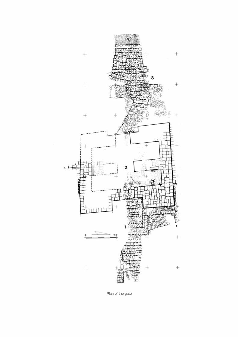
Plan of the gate
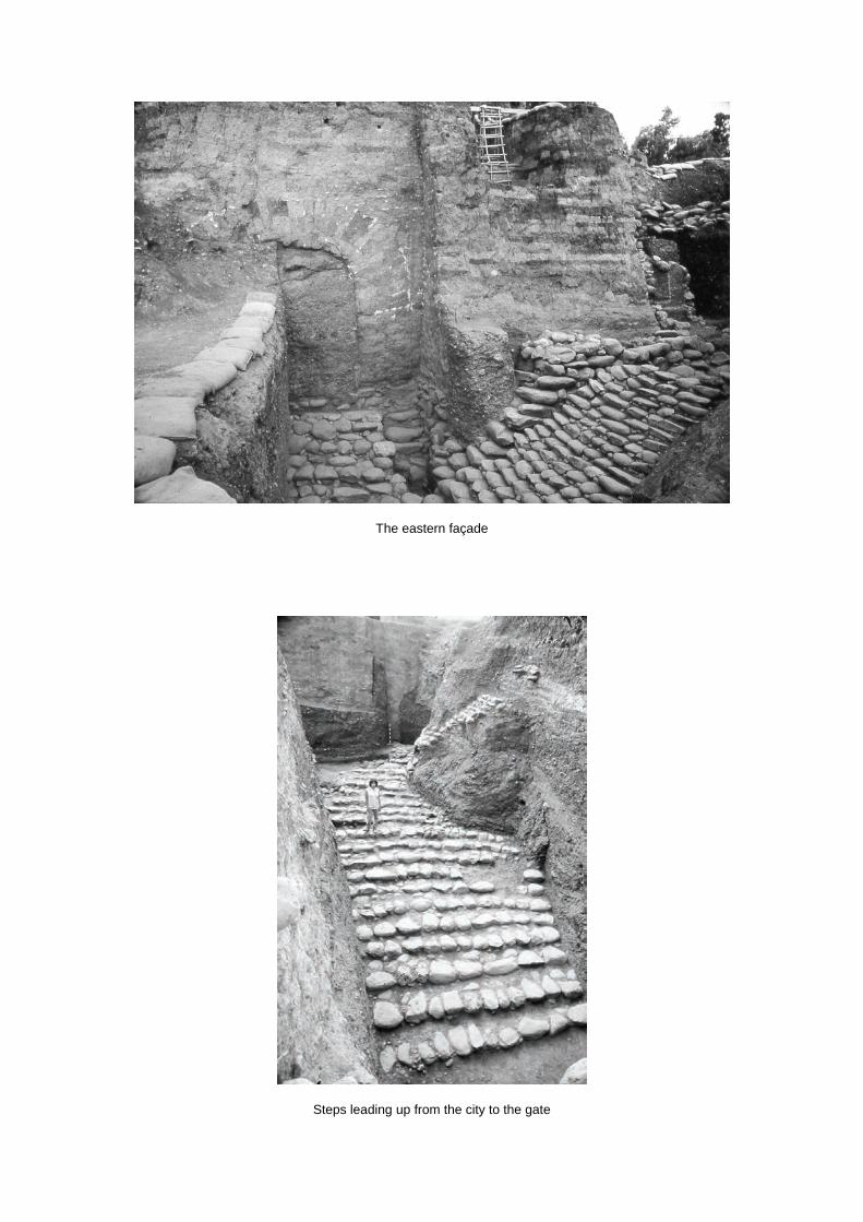
The eastern façade
Steps leading up from the city to the gate

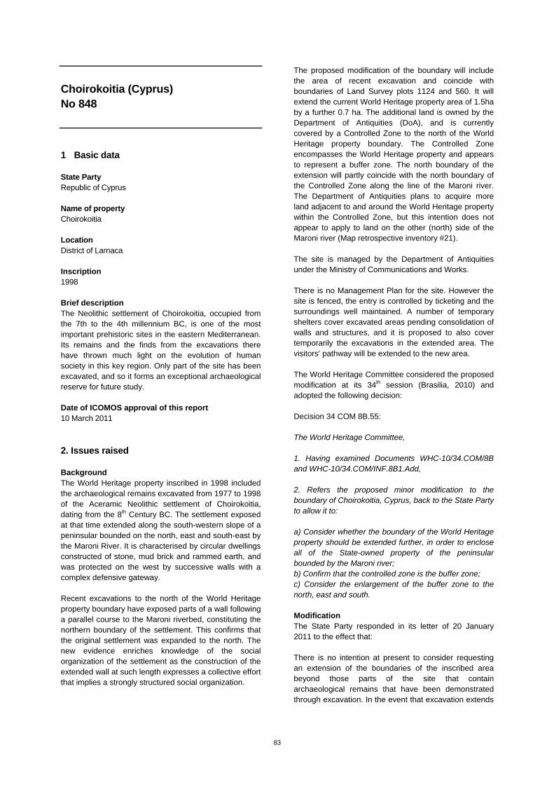
83
Choirokoitia (Cyprus) No 848
1 Basic data State Party Republic of Cyprus Name of property Choirokoitia Location District of Larnaca Inscription 1998 Brief description The Neolithic settlement of Choirokoitia, occupied from the 7th to the 4th millennium BC, is one of the most important prehistoric sites in the eastern Mediterranean. Its remains and the finds from the excavations there have thrown much light on the evolution of human society in this key region. Only part of the site has been excavated, and so it forms an exceptional archaeological reserve for future study. Date of ICOMOS approval of this report 10 March 2011
2. Issues raised Background The World Heritage property inscribed in 1998 included the archaeological remains excavated from 1977 to 1998 of the Aceramic Neolithic settlement of Choirokoitia, dating from the 8th Century BC. The settlement exposed at that time extended along the south-western slope of a peninsular bounded on the north, east and south-east by the Maroni River. It is characterised by circular dwellings constructed of stone, mud brick and rammed earth, and was protected on the west by successive walls with a complex defensive gateway. Recent excavations to the north of the World Heritage property boundary have exposed parts of a wall following a parallel course to the Maroni riverbed, constituting the northern boundary of the settlement. This confirms that the original settlement was expanded to the north. The new evidence enriches knowledge of the social organization of the settlement as the construction of the extended wall at such length expresses a collective effort that implies a strongly structured social organization.
The proposed modification of the boundary will include the area of recent excavation and coincide with boundaries of Land Survey plots 1124 and 560. It will extend the current World Heritage property area of 1.5ha by a further 0.7 ha. The additional land is owned by the Department of Antiquities (DoA), and is currently covered by a Controlled Zone to the north of the World Heritage property boundary. The Controlled Zone encompasses the World Heritage property and appears to represent a buffer zone. The north boundary of the extension will partly coincide with the north boundary of the Controlled Zone along the line of the Maroni river. The Department of Antiquities plans to acquire more land adjacent to and around the World Heritage property within the Controlled Zone, but this intention does not appear to apply to land on the other (north) side of the Maroni river (Map retrospective inventory #21). The site is managed by the Department of Antiquities under the Ministry of Communications and Works. There is no Management Plan for the site. However the site is fenced, the entry is controlled by ticketing and the surroundings well maintained. A number of temporary shelters cover excavated areas pending consolidation of walls and structures, and it is proposed to also cover temporarily the excavations in the extended area. The visitors’ pathway will be extended to the new area. The World Heritage Committee considered the proposed modification at its 34th session (Brasilia, 2010) and adopted the following decision: Decision 34 COM 8B.55: The World Heritage Committee, 1. Having examined Documents WHC-10/34.COM/8B and WHC-10/34.COM/INF.8B1.Add, 2. Refers the proposed minor modification to the boundary of Choirokoitia, Cyprus, back to the State Party to allow it to: a) Consider whether the boundary of the World Heritage property should be extended further, in order to enclose all of the State-owned property of the peninsular bounded by the Maroni river; b) Confirm that the controlled zone is the buffer zone; c) Consider the enlargement of the buffer zone to the north, east and south. Modification The State Party responded in its letter of 20 January 2011 to the effect that: There is no intention at present to consider requesting an extension of the boundaries of the inscribed area beyond those parts of the site that contain archaeological remains that have been demonstrated through excavation. In the event that excavation extends
84
to adjacent plots in the future, similar modification requests will be made. The Antiquities Law does not allow for ‘buffer zones’. However the Controlled Zone and the plots declared as Ancient Monuments are subject to strict controls on development and are in effect equivalent to a buffer zone. The Department of Antiquities is considering the extension of the Controlled Area to north, east and south in collaboration with other government departments. ICOMOS considers that the State Party’s approach as outlined in (a) above is not in accordance with paragraph 100 of the Operational Guidelines for the Implementation of the World Heritage Convention, which states that property boundaries should include those areas which in the light of future research possibilities offer potential to contribute to and enhance understanding of the Outstanding Universal Value of the property. However ICOMOS notes that while the current intention of the State Party is to extend the boundary of the World Heritage property only to those parts of the site that have been exposed by recent excavation, the State Party will request future boundary modifications to cover any future excavations. ICOMOS considers that this is an unsatisfactory, piecemeal approach, giving no certainty for future planning in the surrounding area. Therefore ICOMOS suggests that the State Party should be encouraged to identify the full extent of the site through field survey and geophysics, in conjunction with strategic excavation if necessary. ICOMOS considers that the future expropriation of additional plots to strengthen the de facto buffer zone will be welcome, together with the proposed extension of the Controlled Area. Therefore ICOMOS suggests that approval of the boundary of the de facto buffer zone should await the result of the State Party’s deliberations on the Controlled Area.
3. ICOMOS Recommendations Recommendation with respect to inscription ICOMOS recommends that the examination of the proposed minor modification to the boundary of Choirokoitia, Cyprus, be referred back to the State Party in order to allow it to:
Extend the boundary of the World Heritage property in order to enclose all of the State-owned property of the peninsular bounded by the Maroni river;
Identify the full extent of the site through field
survey and geophysics, and strategic excavation if necessary, as prescribed by paragraph 100 of the Operational Guidelines for the Implementation of the World Heritage Convention and amend the boundary of the World Heritage property accordingly;
Enlarge the buffer zone to the north, east and south and complete negotiations on the final extent of the Controlled Zone.
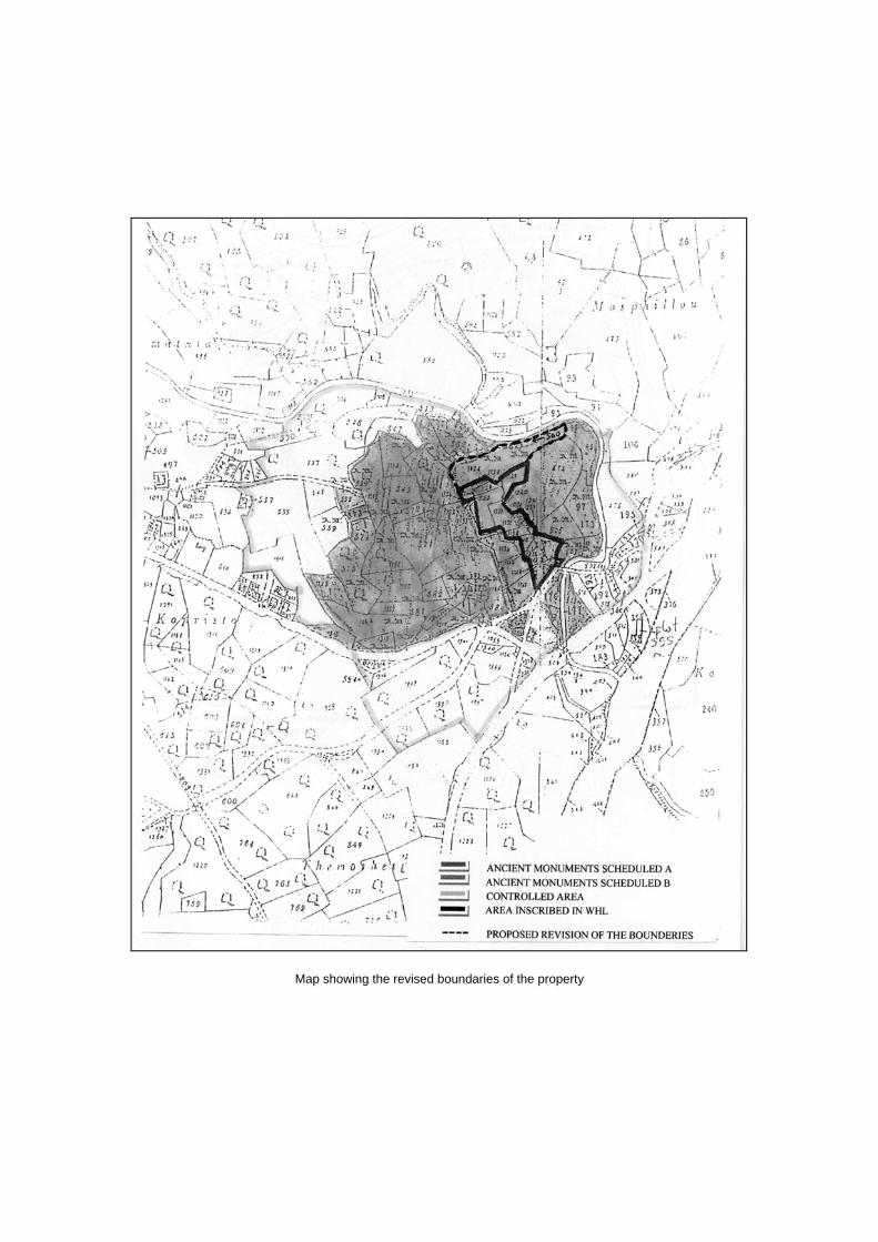
Map showing the revised boundaries of the property

85
Historic centre of Naples (Italy) No 726
1. Basic data State Party Italy Name of property Historic centre of Naples Location Campania, City of Naples Inscription 1995 Brief description Much of the significance of the Historic Centre of Naples stems from its urban fabric, which represents twenty-five centuries of growth, from the Greek town until Italian unification in 1860. One of the most ancient cities in Europe, Naples retains in its street pattern the many facets of its long history. The original centre contains Greek and Roman remains, testimony to the religious and military edifices of the Norman period, and heritage from the Renaissance and classical periods, while the steady growth of the suburbs has led to the addition of other secular and religious buildings. The current plan of the city perfectly illustrates the relationships between the different zones, and the existence of quarters specifically occupied by people of a given nationality, social level or activity. The port and the city, nestling along the Bay of Naples, have a value which is reinforced by their influence on many parts of Europe and beyond. Date of ICOMOS approval of this report 10 March 2011
2. Issues raised Background The Historic Centre of Naples was inscribed in 1995 as a group of buildings, and a serial property consisting of five elements, with no buffer zone. A buffer zone was created at national level after the inscription, but has never been officially submitted to the World Heritage Committee. In 2005 and 2006, reports on the state of conservation of the property were sent to the World Heritage Centre. A map was submitted, but it was considered to be insufficiently detailed. In September 2007, in the framework of the retrospective inventory, the State Party was requested to provide a detailed map, and information to enable the delineation of
clear boundaries for the property, an indication of the area of each part in hectares, and an official presentation of the buffer zone. No reply was received either to the original request, or to the reiterations of the request made in March and October 2008. In December 2008, an UNESCO/ICOMOS advisory mission was invited by the State Party. The mission issued a report which was examined at the 33rd session of the World Heritage Committee (Seville, 2009). The advisory mission of December 2008 set out recommendations in thirteen points. In particular, in point 5, the mission urged “the delivery of formal clarifications to the World Heritage Committee, concerning the delimitation of the property, a correct map, an indication of the surface area of each component of the inscribed property in hectares and an official presentation of the recently approved buffer zone as a minor boundary modification.” In its decision 33 COM 7B.110 (Seville, 2009), the World Heritage Committee, after examining the report, requested the State Party “to consider the conclusions of the advisory mission and to take into account the detailed recommendations.” Modification In response to decision 33COM 7B.110, in February 2011, the State Party submitted to the World Heritage Centre a report including a request for a minor modification to the property boundaries, and a buffer zone proposal. The request complies with the directives set out for this type of contact, and contains the answers required. The minor modification requested results in a 20% increase in area, with an increase from 810 hectares to 1021 hectares. The modification consists of two groupings, either of elements which were previously separate, or of new elements which were not included in the original boundaries of the property. The first grouping concerns the main element “Historic centre of Naples” (numbered 726-001). The “Villa Emma” element (formerly numbered 721-006) is integrated into it. To it have been added five other zones (marked a, b, c, e, f) containing outstanding built structures which were not taken into consideration when the property was inscribed in 1995. The second grouping concerns the elements formerly numbered 726-004 and 726-005, and which now form a single element numbered 726-004. As a result, the new composition proposed is organised around four elements, and reflects the clear objective of making the property’s boundaries more coherent, ensuring better boundary continuity, and strengthening boundary protection. The example of the historic villages of the Casale and Santo Strato districts, which have strong
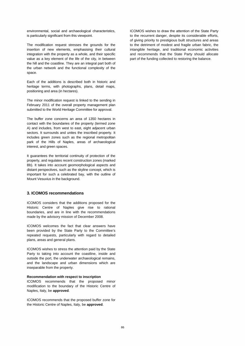
86
environmental, social and archaeological characteristics, is particularly significant from this viewpoint. The modification request stresses the grounds for the insertion of new elements, emphasising their cultural integration with the property as a whole, and their specific value as a key element of the life of the city, in between the hill and the coastline. They are an integral part both of the urban network and the functional complexity of the space. Each of the additions is described both in historic and heritage terms, with photographs, plans, detail maps, positioning and area (in hectares). The minor modification request is linked to the sending in February 2011 of the overall property management plan submitted to the World Heritage Committee for approval. The buffer zone concerns an area of 1350 hectares in contact with the boundaries of the property (termed zone A) and includes, from west to east, eight adjacent urban sectors. It surrounds and unites the inscribed property. It includes green zones such as the regional metropolitan park of the Hills of Naples, areas of archaeological interest, and green spaces. It guarantees the territorial continuity of protection of the property, and regulates recent construction zones (marked Bb). It takes into account geomorphological aspects and distant perspectives, such as the skyline concept, which is important for such a celebrated bay, with the outline of Mount Vesuvius in the background.
3. ICOMOS recommendations ICOMOS considers that the additions proposed for the Historic Centre of Naples give rise to rational boundaries, and are in line with the recommendations made by the advisory mission of December 2008. ICOMOS welcomes the fact that clear answers have been provided by the State Party to the Committee’s repeated requests, particularly with regard to detailed plans, areas and general plans. ICOMOS wishes to stress the attention paid by the State Party to taking into account the coastline, inside and outside the port, the underwater archaeological remains, and the landscape and urban dimensions which are inseparable from the property. Recommendation with respect to inscription ICOMOS recommends that the proposed minor modification to the boundary of the Historic Centre of Naples, Italy, be approved. ICOMOS recommends that the proposed buffer zone for the Historic Centre of Naples, Italy, be approved.
ICOMOS wishes to draw the attention of the State Party to the recurrent danger, despite its considerable efforts, of giving priority to prestigious built structures and areas to the detriment of modest and fragile urban fabric, the intangible heritage, and traditional economic activities and recommends that the State Party should allocate part of the funding collected to restoring the balance.
Map showing the revised boundaries of the property and the proposed buffer zone

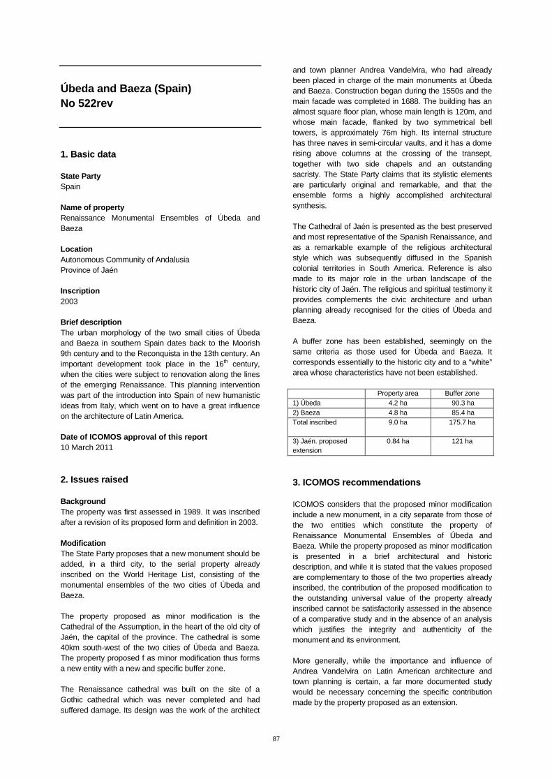
87
Úbeda and Baeza (Spain) No 522rev
1. Basic data State Party Spain Name of property Renaissance Monumental Ensembles of Úbeda and Baeza Location Autonomous Community of Andalusia Province of Jaén Inscription 2003 Brief description The urban morphology of the two small cities of Úbeda and Baeza in southern Spain dates back to the Moorish 9th century and to the Reconquista in the 13th century. An important development took place in the 16th century, when the cities were subject to renovation along the lines of the emerging Renaissance. This planning intervention was part of the introduction into Spain of new humanistic ideas from Italy, which went on to have a great influence on the architecture of Latin America. Date of ICOMOS approval of this report 10 March 2011
2. Issues raised Background The property was first assessed in 1989. It was inscribed after a revision of its proposed form and definition in 2003. Modification The State Party proposes that a new monument should be added, in a third city, to the serial property already inscribed on the World Heritage List, consisting of the monumental ensembles of the two cities of Úbeda and Baeza. The property proposed as minor modification is the Cathedral of the Assumption, in the heart of the old city of Jaén, the capital of the province. The cathedral is some 40km south-west of the two cities of Úbeda and Baeza. The property proposed f as minor modification thus forms a new entity with a new and specific buffer zone. The Renaissance cathedral was built on the site of a Gothic cathedral which was never completed and had suffered damage. Its design was the work of the architect
and town planner Andrea Vandelvira, who had already been placed in charge of the main monuments at Úbeda and Baeza. Construction began during the 1550s and the main facade was completed in 1688. The building has an almost square floor plan, whose main length is 120m, and whose main facade, flanked by two symmetrical bell towers, is approximately 76m high. Its internal structure has three naves in semi-circular vaults, and it has a dome rising above columns at the crossing of the transept, together with two side chapels and an outstanding sacristy. The State Party claims that its stylistic elements are particularly original and remarkable, and that the ensemble forms a highly accomplished architectural synthesis. The Cathedral of Jaén is presented as the best preserved and most representative of the Spanish Renaissance, and as a remarkable example of the religious architectural style which was subsequently diffused in the Spanish colonial territories in South America. Reference is also made to its major role in the urban landscape of the historic city of Jaén. The religious and spiritual testimony it provides complements the civic architecture and urban planning already recognised for the cities of Úbeda and Baeza. A buffer zone has been established, seemingly on the same criteria as those used for Úbeda and Baeza. It corresponds essentially to the historic city and to a “white” area whose characteristics have not been established. Property area Buffer zone 1) Úbeda 4.2 ha 90.3 ha 2) Baeza 4.8 ha 85.4 ha Total inscribed
9.0 ha 175.7 ha
3) Jaén. proposed extension
0.84 ha 121 ha
3. ICOMOS recommendations ICOMOS considers that the proposed minor modification include a new monument, in a city separate from those of the two entities which constitute the property of Renaissance Monumental Ensembles of Úbeda and Baeza. While the property proposed as minor modification is presented in a brief architectural and historic description, and while it is stated that the values proposed are complementary to those of the two properties already inscribed, the contribution of the proposed modification to the outstanding universal value of the property already inscribed cannot be satisfactorily assessed in the absence of a comparative study and in the absence of an analysis which justifies the integrity and authenticity of the monument and its environment. More generally, while the importance and influence of Andrea Vandelvira on Latin American architecture and town planning is certain, a far more documented study would be necessary concerning the specific contribution made by the property proposed as an extension.

88
The request does not contain any description of the property’s urban and landscape environment, or of its buffer zone, and provides no indication of management arrangements. lCOMOS considers that this is not merely a minor modification to the boundary of the property, but this is a proposal for an extension which means that a new dossier is necessary, together with a clearly established management system and an expert appraisal mission. Recommendations with respect to inscription ICOMOS recommends that the proposed minor modification to the boundary of Renaissance Monumental Ensembles of Úbeda and Baeza, Spain, should not be approved.
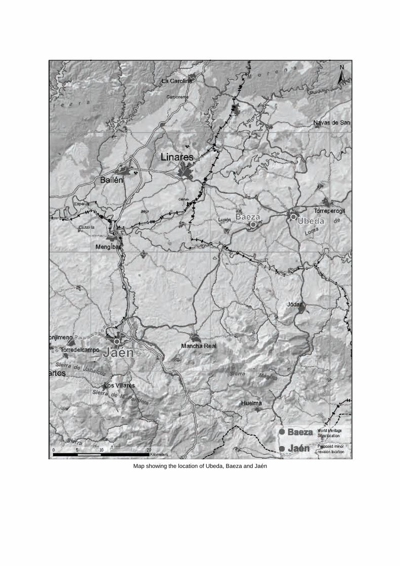
Map showing the location of Ubeda, Baeza and Jaén

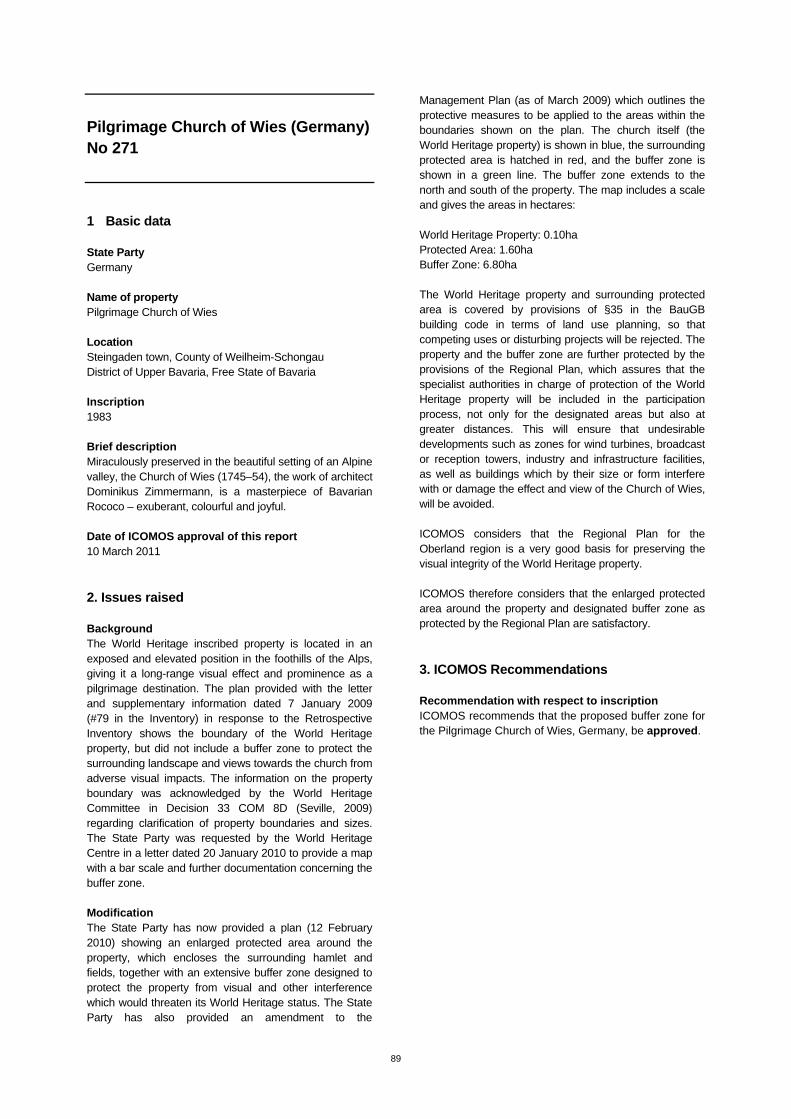
89
Pilgrimage Church of Wies (Germany) No 271
1 Basic data State Party Germany Name of property Pilgrimage Church of Wies Location Steingaden town, County of Weilheim-Schongau District of Upper Bavaria, Free State of Bavaria Inscription 1983 Brief description Miraculously preserved in the beautiful setting of an Alpine valley, the Church of Wies (1745–54), the work of architect Dominikus Zimmermann, is a masterpiece of Bavarian Rococo – exuberant, colourful and joyful. Date of ICOMOS approval of this report 10 March 2011
2. Issues raised Background The World Heritage inscribed property is located in an exposed and elevated position in the foothills of the Alps, giving it a long-range visual effect and prominence as a pilgrimage destination. The plan provided with the letter and supplementary information dated 7 January 2009 (#79 in the Inventory) in response to the Retrospective Inventory shows the boundary of the World Heritage property, but did not include a buffer zone to protect the surrounding landscape and views towards the church from adverse visual impacts. The information on the property boundary was acknowledged by the World Heritage Committee in Decision 33 COM 8D (Seville, 2009) regarding clarification of property boundaries and sizes. The State Party was requested by the World Heritage Centre in a letter dated 20 January 2010 to provide a map with a bar scale and further documentation concerning the buffer zone. Modification The State Party has now provided a plan (12 February 2010) showing an enlarged protected area around the property, which encloses the surrounding hamlet and fields, together with an extensive buffer zone designed to protect the property from visual and other interference which would threaten its World Heritage status. The State Party has also provided an amendment to the
Management Plan (as of March 2009) which outlines the protective measures to be applied to the areas within the boundaries shown on the plan. The church itself (the World Heritage property) is shown in blue, the surrounding protected area is hatched in red, and the buffer zone is shown in a green line. The buffer zone extends to the north and south of the property. The map includes a scale and gives the areas in hectares: World Heritage Property: 0.10ha Protected Area: 1.60ha Buffer Zone: 6.80ha The World Heritage property and surrounding protected area is covered by provisions of §35 in the BauGB building code in terms of land use planning, so that competing uses or disturbing projects will be rejected. The property and the buffer zone are further protected by the provisions of the Regional Plan, which assures that the specialist authorities in charge of protection of the World Heritage property will be included in the participation process, not only for the designated areas but also at greater distances. This will ensure that undesirable developments such as zones for wind turbines, broadcast or reception towers, industry and infrastructure facilities, as well as buildings which by their size or form interfere with or damage the effect and view of the Church of Wies, will be avoided. ICOMOS considers that the Regional Plan for the Oberland region is a very good basis for preserving the visual integrity of the World Heritage property. ICOMOS therefore considers that the enlarged protected area around the property and designated buffer zone as protected by the Regional Plan are satisfactory.
3. ICOMOS Recommendations Recommendation with respect to inscription ICOMOS recommends that the proposed buffer zone for the Pilgrimage Church of Wies, Germany, be approved.

Map showing the boundaries of the proposed buffer zone

90
Abbey and Altenmünster of Lorsch (Germany) No 515
1 Basic data State Party Germany Name of property Abbey and Altenmünster of Lorsch Location District of Bergstrasse, State of Hesse (Hessen) Inscription 1991 Brief description The abbey, together with its monumental entrance, the famous 'Torhall', are rare architectural vestiges of the Carolingian era. The sculptures and paintings from this period are still in remarkably good condition. Date of ICOMOS approval of this report 10 March 2011
2. Issues raised Background The World Heritage inscribed property is in two parts: the site and remains of the first monastery founded on the River Weschnitz in 764AD and the site and remains of the second, much larger monastery including the Torhalle, founded 650 metres to the west on higher ground (the dune) only three years later and consecrated in 774AD. The extent of the original area of the first monastery (the Altenmünster) has not been established. The original area of the second monastic enclosure, taken as being the area enclosed within the remaining Abbey wall and its traceable line, has been reduced by about one third with the construction of a road (Nibelungenstrasse) and residential development across its northern part. The Periodic Report of 2004 noted that the status of the boundary of the World Heritage property was inadequate and that no buffer zone had been defined. Subsequently a cadastral map showing the boundaries of the two parts of the World Heritage property was provided in 2005. This does not include the area of the Abbey site originally enclosed by the Abbey wall and now built over, to the north of Nibelungenstrasse. It encompasses the State-owned Abbey site south of Nibelungenstrasse and municipality-owned green land around it to the east and
south, extending beyond the Abbey wall to cover possible remains of ditch or moat. The Altenmünster site is covered to the extent of the municipality-owned cadastral lot 100/1, encompassing known archaeological remains. No buffer zone was shown. The Abbey and Altenmünster of Lorsch Management Plan of 2009 proposes a buffer zone surrounding and uniting the two parts of the World Heritage inscribed property and including the area of the former Abbey site to the north. The proposed buffer zone will encompass the known area of the second Abbey, including the area of the monastic enclosure now built over, to the north of Nibelungenstrasse. It will then extend north-east along the north side of Nibelungenstrasse and its continuation until it crosses the Weschnitz River (now canalized). It then follows the east bank of the Weschnitz canal, crossing back south of the Atenmünster nominated area along the south-east boundaries of cadastral districts 106 and 77, west along the northern boundaries of cadastral lots 185-7 running due west until it meets the footpath 424/4 when it turns south to Karolingerstrasse, then west along that street, including the built properties along the southern boundary of the Abbey nominated area, to the corner with Römerstrasse. From there it runs north along Römerstrasse to the Marktplatz, including the built properties to the west of the Abbey nominated area, across Nibelungenstrasse and north to proceed around the northern boundary of the original monastic enclosure. The World Heritage Property and the proposed buffer zone are protected by the Monument Protection Act of the State of Hesse, administered by the Departments of Monument Preservation and Archaeology/Palaeontology and the State Administration of Palaces and Parks of Hesse, and the planning provisions of the Municipality of Lorsch. The Abbey site is partly owned by the State of Hesse and partly by the Municipality of Lorsch; the site of the Altenmünster is owned by the Municipality of Lorsch. The concerns of ICOMOS have revolved around the need for protection of the archaeological remains of the area of the Abbey site north of Nibelungenstrasse, which was originally included within the Abbey walls, and the need to link the two areas of the property. These concerns are met by the extent of the proposed buffer zone, which also covers a considerable area around the Altenmünster property. ICOMOS also considered that protection was needed for the important approach view of the Torhalle from the west and for views and the land formerly associated with the abbey in the vicinity of the axis between the Torhalle and the Altenmünster. ICOMOS considered that the red line boundary on figure 8.15 ‘Protected Areas and Buildings’
91
in the Management Plan (p.63) would be more appropriate in the latter respect. The proposed modification was considered at the 34th session of the World Heritage Committee (Brasilia, 2010) and the Committee adopted the following decision: Decision 34 COM 8B.56: The World Heritage Committee, 1. Having examined Documents WHC-10/34.COM/8B and WHC-10/34.COM/INF.8B1.Add, 2. Refers the proposed buffer zone for the Abbey and Altenmünster of Lorsch, Germany, back to the State Party to allow it to: a) Consider whether the boundary of the proposed buffer zone could be extended to the west of the World Heritage property to protect the important approach view of the Torhall and include Marktplatz and Benedikterstrasse, or whether this view could be protected by other means; b) Consider whether the boundary of the proposed buffer zone could be extended further to the north to protect the line of the central axis connecting the Altenmünster site and the Lorsch Abbey site and enclose the Klosterfeld area on the north side of Alte Bensheimer Strasse; 3. Encourages the State Party to keep the World Heritage Committee informed of any development project concerning the property, its buffer zone, and wider setting in conformity with Paragraph 172 of the Operational Guidelines for the Implementation of the World Heritage Convention. Modification In its response of 14 December 2010, the State Party has stated: (a) The buffer zone will be extended to the west to protect the important approach view of the Torhalle and include the Marktplatz as well as the Benediktinerstrasse and the buildings surrounding both places. The area is protected by the Monument Protection Act of the State of Hesse as well as by a municipal development plan. The Management Plan will be amended to declare the boundary accordingly. (b) The central axis connecting the two parts of the Abbey site is not the Alte Bensheimer Strasse as might be misleadingly indicated by the plan, but is within the eastern part of the proposed buffer zone. Therefore it will be protected in accordance with the Management Plan. ICOMOS welcomes the extension of the buffer zone to the west as proposed in point (a). In relation to point (b) ICOMOS notes that the proposed revised buffer zone boundary has been extended to the south-east but not at all to the north of Alte Bensheimer Strasse. It does not follow the red line boundary on
figure 8.15 ‘Protected Areas and Buildings’ in the Management Plan (p.63) which extends the northern boundary of the original monastic enclosure to run parallel to the north side of Nibelungenstrasse/Alte Bensheimer Strasse. ICOMOS considers that the piece of land extending along the north-east extension of Nibelungenstrasse from the northern boundary of the original monastic enclosure to meet Alte Bensheimer Strasse needs to be protected from development that might impact on the view of the Torhalle as approached along Alte Bensheimer Strasse from the north-east. This is shown as protected within the red line boundary on figure 8.15 ‘Protected Areas and Buildings’ Buildings’ in the Management Plan (p.63). ICOMOS considers that this piece at least should be included in the buffer zone. The State Party also provided information on the proposed open air museum to be located outside the buffer zone on agricultural land on the north side of Alte Bensheimer Strasse, shown as Land-use Plan 53 on the buffer zone plan provided with the State Party’s letter.
3. ICOMOS Recommendations Recommendation with respect to inscription ICOMOS recommends that the proposed buffer zone for the Abbey and Altenmünster of Lorsch, Germany, be approved. ICOMOS further recommends that the State Party give consideration to the inclusion of the piece of land extending along the north-east extension of Nibelungenstrasse from the northern boundary of the original monastic enclosure to meet Alte Bensheimer Strasse, in order to protect the view of the Torhalle as approached along Alte Bensheimer Strasse from the north-east. ICOMOS encourages the State Party to keep the World Heritage Committee informed of the open air museum project in conformity with Paragraph 172 of the Operational Guidelines for the Implementation of the World Heritage Convention.
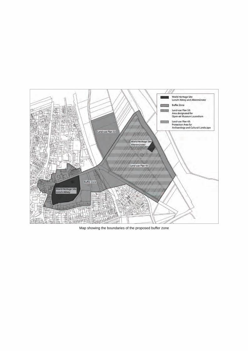
Map showing the boundaries of the proposed buffer zone

92
Humberstone and Santa Laura Saltpeter Works (Chile) No 1178
1 Basic data State Party Chile Name of property Humberstone and Santa Laura Saltpeter Works Location Tarapaca Region, Iquique Province Inscription 2005 Brief description Humberstone and Santa Laura works contain over 200 former saltpeter works where workers from Chile, Peru and Bolivia lived in company towns and forged a distinctive communal Pampinos culture. That culture is manifest in their rich language, creativity, and solidarity, and, above all, in their pioneering struggle for social justice, which had a profound impact on social history. Situated in the remote Pampas, one of the driest deserts on Earth, thousands of Pampinos lived and worked in this hostile environment for over 60 years, from 1880, to process the largest deposit of saltpeter in the world, producing the fertilizer sodium nitrate that was to transform agricultural lands in North and South America, and in Europe, and produced great wealth for Chile. Because of the vulnerability of the structures and the impact of a recent earthquake, the site was also placed on the List of World Heritage in Danger to help mobilize resources for its conservation. Date of ICOMOS approval of this report 10 March 2011
2. Issues raised Background Lying in the Tamarugal (Pampa) area and containing multiple former saltpeter works, the boundary of the inscribed property encloses an area of 647.28ha (nominated area), with a surrounding buffer zone of 12,055ha. At the time of inscription, the boundary of the property intentionally coincided with that of the National Monument that bears the same name and encompasses the same site. Now, as very particular situation, the two abandoned main saltpeter works (Humberstone and
Santa Laura) have long been physically separated by existing Route A-16 (a high traffic national road that links the regional capital of Iquique with the country´s main Panamerican highway). This situation is detrimental to the property as it creates a divorce between the two works, and generates interpretation, presentation, and safety problems. Among other issues, in its decision 30 COM 7A.31 (Vilnius, 2006), the World Heritage Committee noted with great concern that the Route A-16 phenomena was unaddressed by the State Party and, thus, urged the latter to look for an alternate deviation proposal. The World Heritage Committee requested, among other issues, in decision 33 COM 7A.28 (Seville, 2009) that: “the State Party submit the required documentation for boundary modifications, including appropriate cartography, for approval by the World Heritage Committee” (this being related to the Route A-16 issue). The World Heritage Committee reiterated its request in decision 34 COM 7A.29 (Brasilia, 2010), to submit the required documentation for boundary modifications. Modification As a result of the World Heritage Committee´s recommendations, and after analyzing at least two possible alternatives, the State Party, through its Ministry of Public Works, proposed to solve the problem by deviating Route A-16 through the southern portion of the property, a proposal known as the “South Layout Option”. The southern proposal is also supported by the National Monuments Council (NMC - national authority with legal jurisdiction over heritage sites) and by the Saltpeter Museum Corporation (SMC - local entity in charge of the management and administration the property). Furthermore, the boundaries of the National Monument have already been modified, and locally approved by the NMC and the SMC, in order to adjust themselves to the proposed revision. In light of all the above, the State Party submitted in January 2011 a request for a minor modification to the boundaries of the property to allow the re-routed A-16 Road to be excluded from the boundary. Since the Route A-16 will now run down and parallel to the south boundary, it is logical to move this boundary slightly upwards, so as to leave the Route A-16 outside the property, thus forming a single compact polygon. Therefore, the nominated area will be slightly reduced from 647.28ha, down to 573.48ha (a small reduction of 73.80ha, or 11.40%). ICOMOS considers a map needs to be provided showing the proposed slightly revised boundary and the slightly amended buffer zone.
93
3. ICOMOS Recommendations ICOMOS considers that the proposed minor boundary modification of the property is a direct and logical consequence of the Route A-16 deviation proposal and is appropriate. Its approval however depends on the agreement of the World Heritage Committee on the new line of Route A-16 that should be dealt with in the document WHC.11/35.COM/7A on the State of conservation. Recommendation with respect to inscription ICOMOS recommends that, if the World Heritage Committee agrees on the new line of Route A-16 under item 7A, the proposed minor modification to the boundary of Humberstone and Santa Laura Saltpeter Works, Chile, be approved. ICOMOS further recommends that the State Party provide a map showing the revised boundary and buffer zone. This could be done in a series of 2 maps, using different scales.
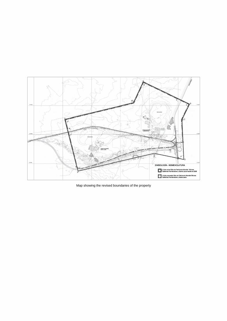
Map showing the revised boundaries of the property

94
Maya Site of Copán (Honduras) No 129
1 Basic data State Party Honduras Name of property Maya Site of Copán Location Copán Inscription 1980 Brief description Discovered in 1570 by Diego García de Palacio, the ruins of Copán, one of the most important sites of the Mayan civilization, were not excavated until the 19th century. The ruined citadel and imposing public squares reveal the three main stages of development before the city was abandoned in the early 10th century, A.D. Date of ICOMOS approval of this report 10 March 2011
2. Issues raised Background Copán with its temples, plazas and terraces, comprises a type of architectural complex among the most characteristic of the Mayan civilization. The lengthy inscription on its Hieroglyphic Stairway Plaza is of considerable historical significance. This Mayan city is composed of a main complex of ruins with several secondary complexes encircling it. Also, its complex consists of the Acropolis and important plazas. During the period when Mayan civilization spread across Central America, Copán was the largest and most influential city in the south-eastern sector. The property (58.95ha in size) was originally defined to coincide with Copán Archaeological Park. However, a proper map of the inscribed property has been lacking since the time of its inscription. Also the precise delineation and area of the buffer zone was also pending since the time of the inscription. Since inscription, the Copán Archaeological Park has been increased from 58.95ha to 85ha, (a 44% increase) in order to help with the protection and the management of the property. By doing this, the State Party added the
following relevant areas to the Park: (1) two minor extensions to the eastern side of main core; (2) the Sepulturas Residential Area and (3) the Regional Centre for Archaeological Research. Although these areas are not part of the nominated property, they have long been perceived as if they were, both by local people and by all outside visitors and so, they have been managed, administered and protected accordingly. In decision 33 COM 7B.137 (Sevilla, 2009), the World Heritage Committee urged the State Party, among other issues, to: “officially submit the limits of the World Heritage property and its potential buffer zone, in light of the requirements of the retrospective inventory”. Modification The State Party has submitted in the 2011 SOC report a map of the inscribed property (map No. 1) and a map showing the buffer zone (map No. 3). The buffer zone will include the area of the Archaeological Park beyond the property boundary and further land beyond. However, some relevant issues remain uncertain and/or unsolved. The map of the inscribed property and the proposed buffer zone map are missing relevant information and the specific area of the buffer zone remains unknown. No thorough justification of its actual size and delineation has been provided. For instance no justification is provided as to why the buffer zone does not extend across the river to the south. Additionally, information on the provisions of management and regulatory measures is lacking. While land use is subject to the Honduran Institute of Anthropology and History (IHAH) approval, no information is provided, except that the State Party allows “low impact” practices within buffer zone. ICOMOS notes that within the buffer zone, land is mainly pastoral (northern & western side) and agricultural (eastern side and between Site and Sepulturas) and, on the southern side, Copán river provides a natural boundary. Nevertheless, the IHAH monitors land use 500 meters inside past the river, which is mainly agricultural land. Beyond the buffer zone, the IHAH monitors potential landscape contamination (mostly causes by commercial communication antennae) on a case by case basis.
3. ICOMOS Recommendations ICOMOS considers that the proposed buffer zone will provide important tools for management and protection of the property as well as for the safeguarding and control of landscape and archaeological remains in its setting.
95
ICOMOS however does consider that some relevant issues remain uncertain and/or unsolved. The technical information in the maps is insufficient, incomplete and unclear. The information regarding management and regulatory measures for the buffer zone is not sufficient. Recommendation with respect to inscription ICOMOS recommends that the examination of the proposed buffer zone for the Maya Site of Copán, Honduras, be referred back to the State Party in order to allow it to:
Re-submit map No. 1 showing the nominated property and its immediate surroundings. This map should be either topographic or cadastral, presented at a scale which is appropriate to the size in hectares of the property, include title and legend in English and bear a labelled coordinate grid;
Re-submit map No. 3 showing the proposed buffer
zone and the nominated area with the same standards as the ones required for map No. 1.
Provide justification for the extent of the buffer
zone, its delineation and its exact area; Provide information on regulatory measures for
the protection and management of the property and its buffer zone.
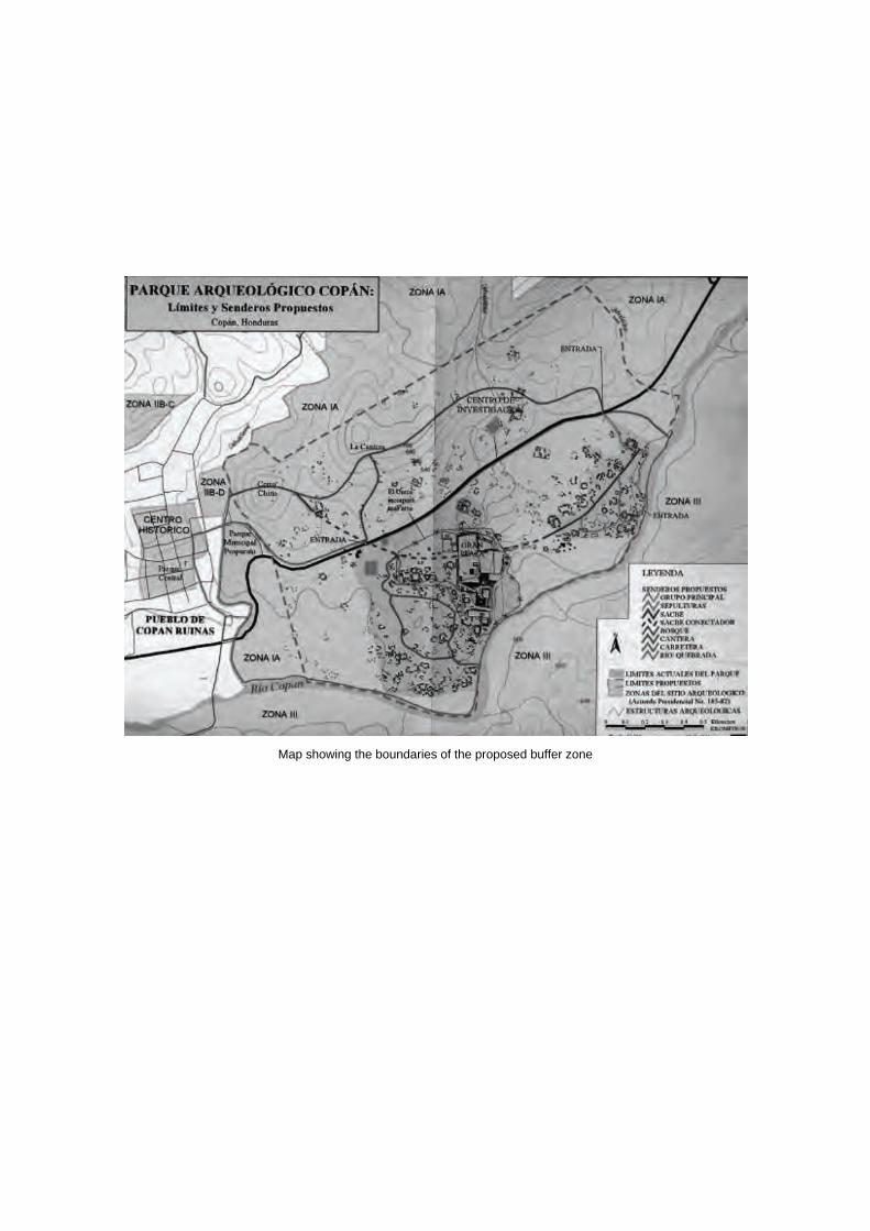
Map showing the boundaries of the proposed buffer zone

Related Documents