Douglas County Water Conveyance Advisory Committee Public Meeting Notice and Agenda Monday, May 2, 2022 4:00 PM Minden Inn 1594 Esmeralda Ave Minden, NV 89423 Written public comment: To offer public comment before the meeting, members of the public may submit public comments by email to [email protected]. Please make sure to state your name, item number and position on the item. Public comment during the meeting: Members of the public may attend the meeting in person. Members of the public may call the Planning Department at 775-782-6217 to obtain help making public comment prior to the meeting. Members of the public may request an electronic copy of the agenda or the supporting materials by contacting the planning department at 775-782-6217 or by email [email protected]. Electronic copies of the agenda and supporting materials are also available at the following websites: • State of Nevada Public Notices website: https://notice.nv.gov/ • Douglas County Meeting website: https://douglascountynv.granicus.com/ViewPublisher.php?view_id=1 It is the intent of the Water Conveyance Advisory Committee to protect the dignity of citizens who wish to comment before the Panel. It is also the members' wish to provide the citizens of Douglas County with an environment that upholds the highest professional standards. Citizens should have the ability to freely comment on items and/or projects that are brought before the Commission for action without interference. Notice to Persons with Disabilities: Members of the public who are disabled or require special assistance or accommodations are requested to notify the Planning Department in writing at P.O. Box 218, Minden, Nevada 89423 or by calling 782-6217 at least 20 hours in advance. Douglas County Water Conveyance Advisory Committee May 2, 2022 1

Welcome message from author
This document is posted to help you gain knowledge. Please leave a comment to let me know what you think about it! Share it to your friends and learn new things together.
Transcript
Douglas County
Water Conveyance AdvisoryCommittee
Public Meeting Noticeand Agenda
Monday, May 2, 2022 4:00 PM Minden Inn1594 Esmeralda Ave
Minden, NV 89423
Written public comment: To offer public comment before the meeting, members of the public may submit public comments by email [email protected]. Please make sure to state your name, item number and position on the item.
Public comment during the meeting:Members of the public may attend the meeting in person.
Members of the public may call the Planning Department at 775-782-6217 to obtain help making public commentprior to the meeting.
Members of the public may request an electronic copy of the agenda or the supporting materials by contacting the planningdepartment at 775-782-6217 or by email [email protected]. Electronic copies of the agenda and supporting materialsare also available at the following websites:
• State of Nevada Public Notices website: https://notice.nv.gov/ • Douglas County Meeting website: https://douglascountynv.granicus.com/ViewPublisher.php?view_id=1
It is the intent of the Water Conveyance Advisory Committee to protect the dignity of citizens who wish to commentbefore the Panel. It is also the members' wish to provide the citizens of Douglas County with an environment that upholdsthe highest professional standards. Citizens should have the ability to freely comment on items and/or projects that arebrought before the Commission for action without interference.
Notice to Persons with Disabilities: Members of the public who are disabled or require special assistance oraccommodations are requested to notify the Planning Department in writing at P.O. Box 218, Minden, Nevada 89423 orby calling 782-6217 at least 20 hours in advance.
Douglas County Water Conveyance Advisory Committee May 2, 2022
1
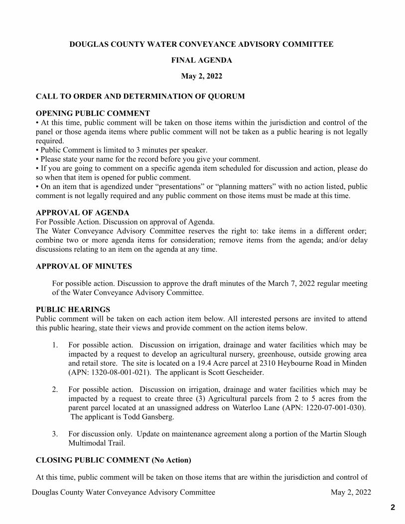
1. For possible action. Discussion on irrigation, drainage and water facilities which may beimpacted by a request to develop an agricultural nursery, greenhouse, outside growing areaand retail store. The site is located on a 19.4 Acre parcel at 2310 Heybourne Road in Minden(APN: 1320-08-001-021). The applicant is Scott Gescheider.
2. For possible action. Discussion on irrigation, drainage and water facilities which may beimpacted by a request to create three (3) Agricultural parcels from 2 to 5 acres from theparent parcel located at an unassigned address on Waterloo Lane (APN: 1220-07-001-030). The applicant is Todd Gansberg.
3. For discussion only. Update on maintenance agreement along a portion of the Martin SloughMultimodal Trail.
DOUGLAS COUNTY WATER CONVEYANCE ADVISORY COMMITTEE
FINAL AGENDA
May 2, 2022
CALL TO ORDER AND DETERMINATION OF QUORUM
OPENING PUBLIC COMMENT• At this time, public comment will be taken on those items within the jurisdiction and control of thepanel or those agenda items where public comment will not be taken as a public hearing is not legallyrequired. • Public Comment is limited to 3 minutes per speaker. • Please state your name for the record before you give your comment.• If you are going to comment on a specific agenda item scheduled for discussion and action, please doso when that item is opened for public comment. • On an item that is agendized under “presentations” or “planning matters” with no action listed, publiccomment is not legally required and any public comment on those items must be made at this time.
APPROVAL OF AGENDAFor Possible Action. Discussion on approval of Agenda.The Water Conveyance Advisory Committee reserves the right to: take items in a different order;combine two or more agenda items for consideration; remove items from the agenda; and/or delaydiscussions relating to an item on the agenda at any time.
APPROVAL OF MINUTES
For possible action. Discussion to approve the draft minutes of the March 7, 2022 regular meetingof the Water Conveyance Advisory Committee.
PUBLIC HEARINGSPublic comment will be taken on each action item below. All interested persons are invited to attendthis public hearing, state their views and provide comment on the action items below.
CLOSING PUBLIC COMMENT (No Action)
At this time, public comment will be taken on those items that are within the jurisdiction and control of
Douglas County Water Conveyance Advisory Committee May 2, 2022
2
the Water Conveyance Advisory Committee or those agenda items where public comment has notalready been taken.
ADJOURNMENT
Douglas County Water Conveyance Advisory Committee May 2, 2022
3
MEETING DATE: May 2, 2022
TIME REQUIRED: 5 minute presentation (approximate).
AGENDA: APPROVAL OF MINUTES
WATER CONVEYANCE ADVISORY COMMITTEE AGENDA ITEMCOVER PAGE
TITLE:For possible action. Discussion to approve the draft minutes of the March 7, 2022 regular meeting ofthe Water Conveyance Advisory Committee. RECOMMENDED MOTION:Approve the minutes of the March 7, 2022 regular meeting of the Water Conveyance AdvisoryCommittee as presented. FINANCIAL IMPACT:None BACKGROUND: ATTACHMENTS:WCAC draft minutes 3-7-22.pdf
4
1
Water Conveyance Advisory Committee 1594 Esmeralda Avenue, Ste 306
Minden, NV 89423 [email protected]
Draft Minutes
The Regular Meeting of the Water Conveyance Advisory Committee was held on Monday, March 7, 2022 beginning at 4:00 pm.
WCAC Members Present: Staff Present: Public: Frank Godecke Jeremy Hutchings David King Russell Scossa Sam Taylor Gary Aiazzi Charlie Hone Coleen Thran-Zepeda Rob Anderson David Hussman Micah Laack
CALL TO ORDER AND DETERMINATION OF QUORUM:
Frank Godecke: I'm going to go ahead and call the meeting to order. I’m going to start with public comment.
PUBLIC COMMENT:
David King: 1461 orchard road. I was just looking at possible action potential impact irrigation drainage and water facilities on the sawmill mini storage. My question is, is there any complications anticipated or known now, at this point that would impact surface water distribution to the Allerman Ditch Association members in the orchard road and surrounding fields that could decrease the allotment or use of water to these fields, except drought conditions. I understand drought conditions.
Frank Godecke: Well, I don't know we can answer that question for you at this time. That is an agendized item. You could talk to us on that item once we've had the discussion on that. I’m not going to be the chairman so it's going to be up to whoever is going to be the chairman after me. Is there any other public comment? Seeing no other public comment, I will bring it back to the agenda.
ELECTION OF CHAIR AND VICE-CHAIR
We have the election of chair and vice chair and I’ve already served for two consecutive years, so I can't serve again.
Russell Scossa: How about you David?
5
2
David Hussman: I don’t mind. Russell Scossa: I will nominate David. Charles Hone: Second. Frank Godecke: All in favor say Aye. Charles Hone: Aye Russell Scossa: Aye David Hussman: Aye Frank Godecke: Aye. David Hussman: Nomination for Vice-Chair? Russell Scossa: I nominate Fred Stodieck. Frank Godecke: Second. David Hussman: All in favor say Aye. Charles Hone: Aye Russell Scossa: Aye David Hussman: Aye Frank Godecke: Aye.
APPROVAL OF AGENDA
David Hussman: Moving on to the next item, approval is the agenda. Russell Scossa: I move we approve the agenda as written. Frank Godecke: Second. David Hussman: All in favor say Aye. Charles Hone: Aye Russell Scossa: Aye David Hussman: Aye Frank Godecke: Aye.
APPROVAL OF MINUTES
David Hussman: Approval of minutes. Discussion to approve the draft minutes to December 6 2021 regular meeting of the water convenience advisory committee.
Frank Godecke: I looked it over and a I guess I don’t enunciate well enough. There was a lot of problems last time but on page 6 of our whole packet, page 2 of the minutes down about the fifth line and says Frank Godecke we approve the August minutes with David moving and Barbara seconding and it was an anonymous vote. So, I think that meant unanimous vote. At the very end of the whole thing
6
3
when I said no other no other public comments, so I will go ahead and turn to me, and I think it meant adjourn the meeting. So, those are the only two things that I could find there, but like I say I must not do very good job of enunciating my words.
Russell Scossa: I move, we approve the Minutes as mailed, with the corrections. Charles Hone: Second. David Hussman: All in favor say Aye. Charles Hone: Aye Russell Scossa: Aye David Hussman: Aye Frank Godecke: Aye. David Hussman: I'd like to welcome our new Member to the committee, Charlie Hone, has graciously agreed to serve in Barbara’s place.
PUBLIC HEARINGS
1. For possible action. DP 22-0029 Sawmill Mini Storage. Discussion and possible action on the potential impact to irrigation, drainage and water facilities by a request to develop a portion of an existing 79.24 Acre parcel for use as a recreational vehicle (RV) self-storage facility. Indoor and outdoor RV storage is proposed. The site is located at 1100 Sawmill Road in Gardnerville (APN: 1220-11-001-075). The applicants are Dennis McDuffee and Ray Van Winkle and they are represented by Micah Laack from Lumos and Associates.
Item #1 was read into record.
Jeremy, do you want to lead us off on this one?
Jeremy Hutchings: Yes, you guys have the conditions in the staff report, which I am sure you have read. Micah is here, maybe he wants to come up and give us a presentation on the project. I can call up a site plan unless Micah has something else he wants to show us.
Micah Laack: I was able to meet with the Allerman Canal Board to get their letter of approval, previously, but the project really has very little effect onto the Allerman Canal. It’s adjacent to it off of Sawmill at the intersection of Pinenut Road. We're maintaining a minimum 50-foot setback from the bank and will be outside of all the easement of the canal. There will be two separate detention areas where stormwater runoff will come off, be detained, treated and then outflowed into the Allerman Canal as it drains in existing conditions.
David Hussman: To be clear, this is the Upper Allerman that we are speaking of?
7
4
Micah Laack: Yes.
Frank Godecke: So, you did mention something about the treating of it, and that was one of the items that I noticed had been flagged as does not satisfy that requirement. Item #3.
Russell Scossa: What did you mean by that Jeremy?
Jeremy Hutchings: Well, just at this stage with the final report and improvement plans, it’s pretty conceptual in nature, right now, so it’s hard to tell if it specifically complies. That's all. He is showing the detention here, and he could show mechanical treatment that’s not required with the drainage report at the design review stage. With the final improvement plans they can show more detail and staff can review that to make sure it's compliant with our code for water quality.
Charles Hone: Are you talking sand oil separators?
Jeremy Hutchings: Typically, sand oil separators. But, in general, that's really what I meant. It’s at a conceptual stage.
Russell Scossa: What did you mean by 4B, then?
Frank Godecke: It was about the elevation, I guess, of the outlet pipes from the detention ponds daylighting at the flow line of the existing year again.
Jeremy Hutchings: Right, so if the ditch is full of water they might want to come up higher so it's not backing up water out of the slough. Again it's just a concept to kind of show the pipe cutting out across the middle of the ditch and if you're trying to clean the ditch you're going to dig up the pipe and they don't want that you certainly don't want that so with the final design they can just bring it up and maybe come in with more at the top of the ditch so it has free outfall into your ditch and I see Gary is in the audience nodding. The here with conditions is that it's approvable, but at this stage they're not really obligated to give every last design detail.
Micah Laack: Yes, to clarify, we will be out letting as far away from the ditch as possible while still being able to daylight the pipe.
Charles Hone: Ok, then in the event of a big storm event or flood there's no way of any discharge off that parking lot and you can get into the canal.
Micah Laack: No, all the drainage, the way that it is drained is coming into the detention areas.
Jeremy Hutchings: Most of it is on the local watershed. The floodplain as you can see is the side so it's isolated from upstream flows.
Russell Scossa: But actually, the answer Charlie’s question, these are designed for what, a 25-year event?
Jeremy Hutchings: Design storm is 25, emergency is 100.
8
5
Russell Scossa: So, if you do ever have a big rainstorm it could put more there. They only designed to a certain level.
Frank Godecke: Right and they are only designed for the property itself. It's not designed for anything coming off adjacent properties or properties above it that might contribute water to the systems, but they’re designing for the actual parcel itself.
David Hussman: Other comments or questions from the Committee?
Russell Scossa: You talked to the Allerman Ditch Committee already and they approved everything?
Micah Laack: Yes.
Russell Scossa: If the ditch users are happy with it, I can go on with it.
David Hussman: Is there any public comment?
David King: My question is, is there any complications or known complications or anticipation that would impact any surface water distribution to the Allerman Virginia Ditch Association? Members in the Orchard Road and surrounding fields that could decrease the allotment or release of water through those fields, except for drought, of course.
Frank Godecke: As a member of the board of the Allerman Ditch Company, we discussed this and basically, it's an issue of somebody who's actually going to be draining water into our system, they are not going to be taking water out of the system. Of course, we asked about the mechanical treatment issues that might affect water quality going into our ditches. As a matter of history that Upper Allerman has not been used for irrigation purposes in almost 20 years now. There is still an easement for irrigation use on that ditch that has been in existence since 1978-1979. And, so it could still be used for irrigation purposes, if necessary, but like I say it has not been used for almost 20 years now, and so they're going to put their detention basin drainage into that ditch. Usually, when you have issues with that that's going to be when you have a lot of precipitation.
David King: Is the runoff from groundwater surfaces which potentially could have oil because of just oil, natural oil. What are you doing to make sure that that rainbow effect or won’t have any effect on the water into the fields.
Micah Laack: So, the condition listed to approve the project requires mechanical treatment, the most common there's multiple options on that the most common one, is the sand oil separator so all the runoff from the site will be routed through a sand oil separator before entering.
David Hussman: Further public comment; seeing none I will close public comment. That does bring up the question of maintenance for the sand oil separators.
Micah Laack: It will be owned and maintained by the operator on site.
9
6
David Hussman: Anything further questions from the committee?
Frank Godecke: This is going to go for Design Review approval and at that point in time that's when you're going to determine the mechanical treatment and the conditions and everything.
Jeremy Hutchings: So, assuming if you guys approve it with conditions 7 & 8, engineering staff at the time of permit will review and make sure it's compliant with those conditions.
Frank Godecke: Okay. So, I will move that we accept the proposed project with the conditions that Jeremy has listed under the staff recommendations.
Russell Scossa: I will second it.
David Hussman: All in favor say Aye.
Charles Hone: Aye Russell Scossa: Aye David Hussman: Aye Frank Godecke: Aye. David Hussman: Opposed Nay? Motion carries unanimously,
2. For possible action. DP 22-0030 Red Barn Car Wash. Discussion and possible action on the potential
impact to irrigation, drainage and water facilities by a request to improve the existing access to the Red Barn Car Wash on an existing 0.97 Acre parcel by piping the existing ditch along the north boundary of the parcel in order to enhance vehicle turning movements. The site is located at 1362 US Hwy 395 in Gardnerville (APN: 1220-03 -310-045) . The applicant is Michael Amaya and is represented by Robert O. Anderson, PE from RO. Anderson Engineering, Inc.
Item #2 was read into record.
Jeremy Hutchings: You’ve read my conditions in the staff report. I think the main one here is mostly water quality. It’s a little uncertain if there's actually any active irrigation water coming down through here that require easements. Maybe you guys could tell us. A couple of things I will just point out. Similar to the last project, some of the sections, if there are active water rights the come down through here they are extending the ditch. One of the larger culverts that Mr. Anderson here can speak about is it does take kind of a hard 90 degree turn in a pretty shallow ditch. You’ve read my conditions I’m sure, and I will turn it over to Mr. Anderson.
Rob Anderson: What are your conditions, Jeremy?
[Conditions were displayed on the screen in the room]
10
7
Rob Anderson: I’ve talked to David about this and Frank heard it at the Allerman Upper Virginia Irrigation meeting. Mike Kumbaya acquired the carwash, he calls it the Red Barn Car Wash, from Chuck Kriss before Chuck passed away a few months ago. Chuck Kriss had been working on this for some time to improve the circulation to get into that car wash. He had acquired through boundary line adjustment with ultimately the Gardnerville Water Company that additional piece that’s North there from where it had been historically. They adjusted the boundary to give them a little more radius to get into that car wash. So, because of the expansion of it there's an existing ditch there that runs on the South side of what used to be the Herbig property. Herbig’s interestingly granted a drainage easement there to Crestmore Village Townhomes back in, I think, the 90’s. There was not an irrigation ditch there, and furthermore upstream on where they're building those apartments right now, or those buildings, behind where it used to be Coast to Coast or Ace Hardware now, sorry aged a little bit. No irrigation easement was required up they're either. I did go, as I mentioned to the Allerman Upper Virginia Irrigation Company and they did review it at their Board meeting on February 4th and indicated that there were no irrigation facilities through that ditch. There is one right and that is owned by the gentleman who now owns the piece south of the AM/PM. Used to be the old Herbig property. They have not used or called for that water in a long, long time.
Charlie Hone: Is there an actual culvert under 395?
Rob Anderson: Yes, it's just a little bit North and cuts across. Water can get there and I think the bottom line is by for us to do the storm drainage, we end up with a pipe so large that if he ever ended up calling for his water at least by us, putting this 30-inch pipe in there for drainage purposes, he could still get his irrigation water through there. So, it’s kind of becomes a moot point, other than I understand the formality and importance of water quality, so we'll address it in the catch basins and go from there. So, with that Condition #1 is fine. I don't think #2 is necessary because there is no historic use of the ditch beyond just storm drainage each. I would request #3 be removed and we understand #4. So, #2 and #3 I would like removed if you would please.
Jeremy Hutchings: Rob, do you have any concern about that 90 degree turn if you do have drainage coming down?
Rob Anderson: Jeremy, I did go out and look at it. I think the bigger concern is nobody's maintained that ditch decades.
Charlie Hone: Does anyone know that last time anybody used it?
Rob Anderson: Other than for storm drain, Charlie, I don’t. In talking with Gary it's been a long time since any irrigation water, and I have a vague recollection of Rudy McTee and a couple of those guys further down in Industrial Park, David you might remember, when they were developing the back half of a couple of those parcels they may have stuck a pipe out there, and so there might be some storm drain water coming out of the old Carson Valley Industrial Park that discharges there, but I have not seen water flow there probably since we had a big storm.
11
8
David Hussman: I think Domingo was probably the last person that irrigated that piece. He leased that whole thing from Herbig.
[Discussion between the group]
Frank Godecke: What is your take on his proposal to delete items 2 and 3, Jeremy? You were going to address that.
Jeremy Hutchings: Yeah, if you're not getting water down I don’t think the section projects into that shallow ditch a little bit. I don’t think it matters a whole lot one way or another. If you if there's no water getting run down through there I don't think he’d need to encumber the property any further than it is.
Then it just becomes a matter of water quality for downstream users.
Sam Taylor: What's the likelihood of use in future?
Frank Godecke: Is there already an existing easement that is recorded for the drainage? As he indicated.
Rob Anderson: Yes.
Jeremy Hutchings: I did not see that there was anything.
Frank Godecke: I think that is something that needs to be proved that there is an existing easement for the drainage, I mean that'll be sufficient.
Jeremy Hutchings: So, the way their condition reads Rob, or show evidence that their existing easement is in place.
Frank Godecke: For the minimum requirement.
Rob Anderson: I don't mind the storm drainage, I just don't want to put in the irrigation.
Russell Scossa: You mean you don’t want to put this big of an easement on there, is that correct? Because if there is still an irrigation right with that property, even though nobody's exercising it, I feel that we shouldn't do away with an irrigation easement because then the guy might have a fight on his hand if somebody shows up and wants to do something there. There should be something said about irrigation, even though it's going to fit in the width of the drainage, the 20-foot easement it's going to comply, I think we should leave irrigation wording on it. It might not ever be used but what happens if the owner of this carwash decides not to let him irrigate someday.
Rob Anderson: Well, they could do that if he got really upset about having to do a whole bunch of paperwork for nothing.
Frank Godecke: Under the federal decree they could still call for their water.
12
9
Rob Anderson: And there is a ditch there, and there is an easement for a drainage ditch it's not explicit for irrigation so um I tried to avoid coming, to be honest with you and I did so primarily because I don't think anybody's used it practically but secondarily nobody upstream of here came to you guys and asked for it so departments that are under construction or what some of my legal friends might call Open and Notorious. None of them, those guys didn't come, so you don't have this guy doesn't any water from up above you can't get it from the Company down to us that I know. The old Herbig piece is now being developed with apartments and nobody went to it, so you know he's a new guy in town, we're here, you know. It was requested that we come. We're here, but I'm not cheap, as some of you might say. To come and represent these things, and if we now do some legal paperwork to create an easement. It’s going to be a separate document, go to an attorney and all of this is for someday if the guy wanted water, but the guy upstream didn't do it, that's my objection.
Charlie Hone: Well, but if we set a precedent as things develop it can become more and more difficult. If we let this easement go, so to speak, and become more and more difficult for people in the future that way want to irrigate to have to deal with these kinds of things so that's kind of where I’m looking at there being a problem with this is if there's an easement for the ditch, we need to accommodate.
Rob Anderson: There isn’t an easement for the ditch, Charlie, other then a drainage easement.
Frank Godecke: What is entailed in a drainage easement? What’s the parameters?
Sam Taylor: I would need to see the language of the easement.
Rob Anderson: It is listed on a map as a 20’ drainage easement. Nothing else. It doesn’t say who the beneficiary is. It doesn't say any parameters.
Sam Taylor: Is there a document reference thought?
Rob Anderson: No. It was a 20 foot that was granted with map. 20-foot drainage.
Russell Scossa: The person that owns the property now was he notified? The downstream user?
Rob Anderson: Yes, he was notified.
David Hussman: Did you have something else, Sam, you wanted to add?
Sam Taylor: Yes, just in general. One of the things that this Board was created to do is make sure that downstream users didn't have their rights abdicated. Whatever their rights might be. So, to the extent that you're examining somebody’s rights, if you eliminate the drainage easement which probably extensively could be used as an irrigation easement in any event. In other words, is somebody going to complain about the water saying it's being used for different purpose.
Rob Anderson: I can’t imagine that but again I'm not suggesting we're going to eliminate the existing drainage ditch. That one's there. We're going to observe it and pipe it through our property. But going to the next step to add another easement on top of it for irrigation is going to, you know, run up some
13
10
money, and if you say it's necessary then I will tell my client that its necessary. Do I think it's necessary you know in a practical purpose, because the guy a) didn't show up and he got noticed, b) he hasn't called for it, and although he's a relatively new owner, there is always a prospect that someday somebody that buys that property in the future could ask for the water but they haven't today and I think, using your word extensively the drainage easement accomplishes the purpose of this Board.
Russell Scossa: And it would be too hard to put irrigation and drainage easement?
Rob Anderson: It's not too hard, Russell, just expensive, and I guess the question is, is it necessary?
Sam Taylor: There might be an alternative, if I may. I would recommend perhaps there be a condition, that instead of mandating they change the drainage easement to an irrigation easement just make it clear that one of the conditions is the drainage easement can be used for irrigation purposes. So, in other words, you don’t have to create the irrigation easement but it's still going to use for the same purpose.
Rob Anderson: We wouldn't object to that as a condition, but if you tell me we need to create a new easement, we will create a new easement. I think it is form over substance to be honest with you and it's expensive.
Russell Scossa: Well, I would go along with what Sam just said. At least the wording is there.
Rob Anderson: But to do that on a record so it's a recorded document.
Sam Taylor: No, I'm not talking about to record a document. I'm saying, for the purposes of approval of this it's a condition that exists in these documents that makes it clear the intent of this Board was to allow the person to be able to use the drainage easement for irrigation purposes should the need arise.
Rob Anderson: Thank you.
Russell Scossa: Does that drainage pipe go directly to that property after it leaves the carwash?
Charlie Hone: Theoretically if there was enough water draining off of there, it could get there.
Jeremy Hutchings: That’s what our mapping shows.
Russell Scossa: So, take the problem in reverse. Somebody does something on that side blocks off the culvert and says ‘Hey we don't have an irrigation so there shouldn't be a culvert coming here.’ Then you’d have a problem with your drainage. I think, Sam gave us a solution that I’m willing to go along with it and it’s not going to cost you anymore. It's going to make this thing go away and it's like I say the biggest thing that we have is we're not going to ever give away somebody’s right unless it's really a great reason for it.
14
11
Charlie Hone: That right has value, when the guy purchased the property. We have to protect that as well. If there's no way that he could use that right then he could lose the water right, so I mean that's we got to make sure none of that gets infringed. I think, even though they haven't used it it's still there.
Rob Anderson: So, under the decree because it's a decreed right, they can’t lose it. That land would have a right until they transferred it.
Jeremy Hutchings: Playing devil's advocate but I don't see how making this part of the record gets that guy legal right to irrigate across there in the future. The code is pretty clear. If you come in for development and there’s no easement there, you record the easement for irrigation, this is for drainage, but you're the lawyer. I don’t see how that carries weight in the future.
Sam Taylor: Well, you can require them to have an irrigation easement then if that’s the way you want it.
Jeremy Hutchings: You’re the lawyer. Is that binding, this motion?
Sam Taylor: I think it is for the purposes of the use. In other words, let me go back here. The easement that exists there, right, it says drainage easement. It’s unspecified. It doesn’t say who it benefits, correct? That’s why I went along this route. It’s an unspecified sort of ditch. In other words, what’s the purpose of the ditch? The issue is, can you put water through it for the purposes of irrigation if you retain the existing easement, existing ditch? That’s the point. In other words, the property is already burdened by an easement. The question then becomes, what is the source of the water? Right? If you got a 20’ wide easement for the purposes of a drainage ditch. Can you go clean out a drainage ditch the same way you can an irrigation ditch and 20 feet wide enough to do that? Yeah. Mentioning on this record makes it clear what the intent of this Board is with respect to the use of that easement.
Frank Godecke: If we have to we can list the APN of the property rather than having to tie it to a specific property owner.
Sam Taylor: Yes, but let me be clear gentlemen. What Jeremy is suggesting is the ideal. That is technically the uber correct way to go.
Jeremy Hutchings: I would argue it’s just the correct way to go. You may irrigate the drainage but you call for water. That can be diverted and routed. That's irrigation it's not drainage. That's just my opinion. I think it's pretty minor. Rob’s case is that nobody uses this. It's unlikely they will use it, but there is a guy downstream that has a right to irrigation, not drainage.
Sam Taylor: And if he calls for water will Rob will be able to take that drainage easement and block it off, or Rob’s client? The answer is no, because the easement still exists.
Jeremy Hutchings: For drainage.
15
12
Sam Taylor: Right but, but if it goes through, for irrigation is the guy going to know the source of the water?
Charlie Hone: I guess the technicality is when the water hits the drainage easement, will it drain?
Rob Anderson: Yes, it's a pretty good little slope on that drain so either way. If you guys aren’t comfortable with it, Mike’s a big guy he can go spend the money and have an attorney draw the easement. We don't have a map, you know a lot of times it's easy to do it on a map or something like that. We make an irrigation and specify the width. Even on those we don’t specify who the down stream users are.
Sam Taylor: There is one thing that I will note with doing what I suggest that is because in the absence of the doc saying who the beneficial use is for, it doesn't designate who the property user is downstream right so that might actually be an issue sometime in the future.
David Hussman: Can we go to public comment at this point?
Gary Aiazzi: I worked for the Allerman Virginia Irrigation Company. I'm very familiar with this situation and what we need to consider is the Alpine decree. The wording in the Alpine decree states “whatever is historic and customary”. Now it may have been years since that has been irrigated, but that was historic at one point in time and customary to bring water out of the Company Ditch down that ditch and piped through to this point, past this point to that 6.6 acres on the other side 395. That all came from the Company Ditch. These drainage easements that he's talking about it came after the historic and customary use. The reason there's not an irrigation easement on that ditch right now is because it was on private ground when they developed that ditch and since have sold it and then put an easement on it. What happened with Dangberg’s is all of those ditches were on private ground and when the ranch sold in 1978 they came out with that document 20648 that lists all of the ditches within the Dangberg Ranch and they placed an easement on it. This particular ranch did not place an easement on that ditch. It was an irrigation ditch to begin with, then it became a drainage ditch and tomorrow if he calls for water it’s back to an irrigation ditch.
Rob Anderson: Based on the historic customs.
Mr. Aiazzi: Correct.
Russell Scossa: The way I am looking at it is, it’s a prescriptive easement historically but if you go for 20 or 30 years and don't use it you basically, somebody can prove you’ve lost your prescriptive easement to that, right?
Sam Taylor: No, it depends on the nature sort of what existed previously and because it relates to the decree, which basically is a court order, right? You can't undo the court order. The court order stays in effect until the Court says it doesn’t.
16
13
Russell Scossa: So, if it was a prescriptive use and they haven't used it for 30 years, somebody built a bunch of houses across it, how are you going get the customary and historic use back to it?
Sam Taylor: You would sue whoever built something over the top of it [INAUDIBLE]. You still have the right to irrigation water. It doesn't go away. The point is, you have to leave it there until such time as a Court says no, there's no longer customary use necessary for his property, in other words, if they developed the property into say, for example, high rise condo whatever Okay, then you got a pretty good argument is that there's no longer a use associated with that property.
[DISCUSSION BETWEEN THE GROUP – DISCUSSING GIS VIEWER ON SCREEN]
Jeremy Hutchings: May I suggest this, how about an irrigation easement 20 feet in width, center of the ditch and the pipe and then it's not that onerous but it's a little bit onerous, because he's going to make the easement and then you don't have to worry about it that is drainage or irrigation.
Rob Anderson: So, he definitely does not want to pipe the whole ditch.
Frank Godecke: Even if it's open ditch it's just going to be a straight 20 feet all the way down the whole thing, whether it's open, piped or whatever.
David Hussman: Does that include access? That’s the other point. An irrigation easement is also for access. So, what access does somebody have to maintain that?
Rob Anderson: They can start right there at Hwy 395 and head right.
Jeremy Hutchings: Or, they can start in the subdivision and go through the back yard of all the houses.
David Hussman: Well, because there is a fence now on the old property line that is south of the ditch. Is that going to be moved? Where are you granting access from the North?
Rob Anderson: We are not proposing to grant an easement.
David Hussman: An irrigation easement is for access and maintenance. So, if we're granting an irrigation easement and we're calling it an irrigation easement on top of this drainage easement, were just going to ignore the access part?
Rob Anderson: So, I haven’t heard we were granting one. I hear Jeremy advocated for that, if what you're telling me is yes, we are going to do one then I guess I could grant you access to the parking lot. You see how ludicrous you can start getting? Do I need to really describe it all the way back to the driveway?
David Hussman: If the code says so.
Charlie Hone: Isn’t that part of the parking lot where he has all his vacuums?
Rob Anderson: Yes.
17
14
Charlie Hone: How are we going to drive a backhoe through there?
Rob Anderson: I don’t think the vacuums go all the way through there, Charlie.
[DISCUSSION BETWEEN THE GROUP – DISCUSSING GIS VIEWER ON SCREEN]
David Hussman: Is there further public comment? We will close public comment.
Sam Taylor: I will point out this, it says in no event shall the right-of-way be less than 20 feet in width. Minimum 20-foot right-of-way must be provided in cases where the irrigation the drainage is placed in an underground convenience.
[DISCUSSION BETWEEN THE GROUP – DISCUSSING GIS VIEWER ON SCREEN]
Frank Godecke: We get back to the Alpine decree which drives everything, which basically says that 1) the water stays pertinent to the property for perpetuity and 2) there is nothing that we can do to inhibit the delivery of that water.
Sam Taylor: Yeah and that's really what the Board is charged to make sure that those rights are maintained.
David Hussman: I see more public comments so we'll open it back up.
Mr. Aiazzi: If someone were to buy that water right off of that 6.5 acres then your problem goes away. It transfers the water off.
Sam Taylor: That's something else, I think the Board might want to take into account just for future purposes, I mean, you shouldn't diminish any existing right, but you should also examine the likelihood that that property will be developed for a different purpose in the future. So, it's up to the Board.
Russell Scossa: Well yeah, I can see the avenue here, where we can recognize that there's an irrigation right according to the Alpine Decree, but the likelihood of it being used again isn't that much so I'm sure that the 20-foot-wide ditch that's going through his property would take the irrigation and be sufficient. I think that's the only way to do it without requiring a lot of… still keeping the fact that we're trying to maintain an irrigation thing but we've got to look at the fact that that property is, you know, theoretically Herbig should have put an easement on it when they sold the property. Or they should have put an easement on it when he sold the other property.
Rob Anderson: I don’t remember the discussion on that one but it's likely that because of the drainage easement and this known history that this gentleman has in or whoever the owner wasn't going to use it or hadn't used it probably went away at that time. Herbig’s parceling was since the Water Conveyance Advisory Committee was you know put in place.
Russell Scossa: When do you think they parceled it?
Rob Anderson: I don’t remember, after Walt, I bet it was the mid 90’s.
18
15
Russell Scossa: We were just getting started.
Sam Taylor: There’s a little blurb that exists in the back here that you might find helpful for this subsection 20.100.070 subsection A4. It says as part of a plan a ditch may be redesigned or upgraded, no I’m sorry it’s “B”. It says no development may interfere with the historic customs and use of water adjacent to upstream/downstream from the development. So, the customary use was irrigation but it became a drainage ditch, That, that is, as far as I can tell you, the only means for providing irrigation water to that location, and it was a traditional method of providing water to that location. So, again I'm still comfortable with-it being drainage, as long as the water can still flow through the property and is not being restricted.
David Hussman: Is there further public comment? I should close public comment.
I’ve been going back and forth on this thing and there's already a drainage easement on the ditch. Now we are being asked to not call it irrigation or not do the full 32 feet. I'm okay with that because I don't think it's setting a big precedent that's going to come back and bite us because we're only talking about an existing drainage easement that we're trying to put something on top of. I don't know how often that's going to come up but. To me, I'm Okay, with what Sam is suggesting so what is the pleasure of the Board?
Frank Godecke: And that suggesting, is that the original suggestion of Sam that said that we're going to just put some wording into the thing that says it's a drainage easement that can be used for irrigation purposes. Do we specify that process particular APN number?
Sam Taylor: Yeah, that would be helpful. For the benefit of that APN. Reference who is the beneficiary of this language and then reference the decree.
Charlie Hone: And that property is the terminus of the ditch.
Frank Godecke: Not necessarily the terminus but the only righted water user of that ditch.
Sam Taylor: Which is all you're concerned about that.
David Hussman: Historically we have always said these easements run for the benefit of the downstream user so that we didn’t have to specify.
[DISCUSSION BETWEEN THE GROUP]
Frank Godecke: I will move to approve the project as presented with the staff recommendations being that Item number three would not be dedicating an irrigation easement but to put the language in that there is an existing drainage easement that needs to be identified because we haven't seen the identification of that and that it could be used for irrigation purposes for all of the downstream users, the historic downstream users. And then we're eliminating item two was requested by, I don't know if there was any discussion on that. Adjust the storm drain pipe from SDDI.
19
16
David Hussman: Maybe we should get a definition of that one as to why we want to eliminate it and because I don't even know what SDDI number one is.
Rob Anderson: Storm Drain Drop Inlet.
[DISCUSSION BETWEEN THE GROUP]
Frank Godecke: We won’t eliminate #2 then. Ok, so all of the staff recommendations with the modification to Item 3 that is previously stated.
Russell Scossa: Can you read item 3 again?
Frank Godecke: Item 3 was that we recognize and he has to show that there is a dedicated drainage easement because we have not seen that there is a dedicated drainage easement that there has to be a dedicated drainage easement that's shown and that we recognize that there is an irrigation right through that dedicated drainage easement for the downstream users, the historic downstream users.
Russell Scossa: Are we fine with the 20-foot easement across there?
Frank Godecke: Yes. The entire easement shall be no less than 20 feet.
Sam Taylor: May I make a suggestion to add to that? In the event that this drainage easement does not exist, we can’t prove it exists that they will be required to put in an irrigation easement but no wider than 20 feet.
Frank Godecke: Yes, Okay, I can go ahead and add that to the language. If it cannot be demonstrated that there is a drainage easement in place on this ditch that an irrigation easement will be placed on this open ditch as well as pipe ditch of a minimum width of 20 feet.
Russell Scossa: I will second it.
David Hussman: All in favor say Aye.
Charles Hone: Aye Russell Scossa: Aye David Hussman: Aye Frank Godecke: Aye. David Hussman: Opposed Nay? Motion carries 4-0, 1 absent.
3. For possible action. DP 22-0031 A & S Metals. Discussion and possible action on the potential impact to irrigation, drainage and water facilities by a request to improve a portion of an existing the existing 9.98 Acre parcel for use as a full service recycling facility. The site is an unaddressed parcel in located along Heybourne Road just south of the intersection with Airport Road (APN: 1320-08-401-004). The applicant is Stan Silva and is represented by Robert O. Anderson, PE from RO. Anderson Engineering, Inc.
20
17
Item #3 was read into record.
Jeremy Hutchings: You see my staff report, the main concern I have here is the plan that I was shown shows a screen wall which part of the conditions of approval for the special use permit, but I guess my main concern is the screen wall is shown going across the ditch twice and basically walling off a section of that ditch if I’m understanding it right. I just think it makes more sense to move the ditch further back where I’m kind of showing here [pointing to display on screen] on the red line.
Rob Anderson: The ditch or the wall?
Jeremy Hutchings: The wall. My recommendation would be having them move the wall from here, where it’s black [referencing the plans] and then to the red roughly not exactly and then, if you need to maintain your ditch you don't go into the fortress. You'd be walled off. I think it's gated and locked. That’s my main concern with that design and I got other recommendations in there that are pretty much standard, but now I’m confused about what is an irrigation or drainage easement. Rob is welcome to rebut.
Rob Anderson: No problem with the wall. We are not proposing the wall at is time. That drawing that Jeremy showed was prepared as part of the Special Use Permit that the application processed themselves. We did prepare the drawing but the intent is that they would, well, excuse me, they would like to have the wall at the property line, which is the right-of-way line and then leave a gate or leave a fence, so the irrigation ditch easement is clear and open rather than…I'm not frankly sure if there's even an irrigation easement on this property but anyways the wall is not the purpose of why I’m here today. I’m here for the driveway crossing. I do have to submit a set of improvement plans for the site improvement which we intend to do on behalf of the client, but with the irrigation season coming, we submitted an application to be here, so we could talk about the culvert size, they're prepared to get it in before the irrigation season started. They've got the contractor lined up, we've submitted an encroachment permit application to the County which we think is consistent with all the requirements. We did go to the Allerman Upper Virginia Irrigation District. We have a unanimous support there for proceeding so that's why I’m here today. I’m happy to entertain anything you want to talk about on the wall. Mr. Silva is a very accommodating guy so if you've got something you think you want to share with me, before I design a wall that's great, but my goal today is to get permission to build this culvert underneath his proposed driveway.
Frank Godecke: What is the size of the proposed culvert?
Rob Anderson: So, when we met and I presented it to the Allerman Upper Virginia Irrigation Committee, I proposed two sizes, one being either a 5 x 3.5 or a 4 x 4. That sizing was based on a discussion I had with Matt McKinney about how much water is needed downstream here at Airport Road. Matt instructed me and I spoke to him in a context, not of this project, but of his project on the 80 acres for his industrial park. His explanation to me was that this ditch that comes down and serves part of his property, but also those people [discussion referring to GIS viewer on screen]; West of
21
18
Witt’s and Matt’s comment to me was maybe 15 CFS goes down that ditch parallel Airport and he said, if we had 40 CFS going north, maybe 45 CFS going north to the Heybourne, what I would consider the Heybourne track, that would be satisfying. So, that's 60 CFS. I bumped it up from there I added 50% more or less and that's how I, as I explained to him, I know how I came to 83 CFS I think actually he told me 40 and 15 so that's 55. 50% on 55 gets 83. So, I sized those culverts for 83 CFS those two and I used a slope of .3%. On Friday I got the letter, thank you, Frank, by the way, on this one and I texted Matt and said “Hey What about the letter for this one?” and he said, oh no, no Frank said you didn't ask for one which, maybe I didn't. So, it doesn't matter, but he said “hey, we need to make sure we have the same capacity going through, as we have inside the ditch system”. So, I've been hustling just a little bit because I wanted to be able to verify and confirm it. So, there are in this proximity, so this is Meridian Boulevard where it comes back out to the Airport Road today, this is the proposed culvert. There is what I would call the West access gate is here, and of course there's Airport Road there, so this is an 8 x 4 box right here. It has 16 inches of sediment in it for the whole thing. Make no mistake it's 16 inches and you don't have enough water to run a head through there to get that 16 inches out of there. It is tight and there are 16 inches. I don't know whoever put it in there, put it in too low, but there are 16 inches of sand in the bottom of that culvert. This culvert is a about a 10 x 5 box here and then there is the irrigation diversion structure that's just downstream of it. If you this calculation from that invert elevation on top of the sand here to the flat concrete there, the slope of this ditch is about .15 is all. Pretty flat, so going back through my calculations which I've done and I will distribute to everybody. So, that existing in gray are the two culverts that I just described to you. The 8 x 4 is really an 8 x 2.67 because of the 16 inches of sediment. It has full flow capacity of 88 CFS, meaning that, if there are no boards in the box down here north of Airport it flows freely, you can pass at 88 CFS through this culvert. Okay. The culvert at Airport Road would have a capacity of about 240 CFS. There's actually probably about, I'm betting 3-foot-wide maybe 4-foot-wide by 2-foot-high bunch of sediment stuck on the east side of that box. It appears to be immovable.
Sam Taylor: What is this water for? Is this irrigation?
Rob Anderson: Irrigation.
Sam Taylor: And who are the downstream users?
Rob Anderson: Everybody in the Heybourne track. Everybody down all the way to Johnson Lane and a little bit further.
Charlie Hone: Does it hit Settelmeyer’s too?
Rob Anderson: Yes, it does. So, my calculations show that again this big box has 240 CFS. You can’t get 240 CFS to this one there would be water running all over. That is no head on these box culverts. So that is just full flow, not putting a 1.5 foot on top of it. It is just flowing through there. So, in doing that that's about what to have and at 88 CFS we can achieve that with either a 6 x 3.5 or 5 x 4. We prefer to do a 6 x 3.5 only because the trucks he brings in there are kind of tall, can be loaded up pretty high and
22
19
he would like as much height as he can get above that those trucks underneath those power lines. We went through the calculations and I think I can prove that most water can get past this culvert at about 88 CFS. Now, I would tell you, though, if you start putting boards in and we've had this discussion before on others, the capacity of this ditch, the conveyance capacity drops precipitously. So, you have one 2 x 8 it’s something less than 88. If you put 2 it’s something less. Again, if you put 3 boards in there and your conveyance capacity you're stacking it up to run water down one ditch the conveyance capacity of this ditch goes down.
Frank Godecke: What is the conveyance if those culverts were completely clean? Because let's recognize the fact that because they backwater up at the North part of Heybourne, that irrigation structure, that does mitigate what causes the sediment to build up in the bottom of those culverts and technically culverts well, for example, the Meridian, I believe, is a Douglas County responsibility for them to clean that culvert. We have gone through and cleaned the ditch recently, I mean you can see where the ditch has been cleaned and so technically if those culverts were completely wide open what would be the capacity of a 4 x 8 culvert? I think you have that calculation and all done well.
Rob Anderson: I did at one point but I don't here with me today, but I would tell you I think this culvert is low.
Frank Godecke: It could be.
Rob Anderson: When we take a shot upstream of it and take a shot down here that I think this culvert is low.
Frank Godecke: They sunk the bottom down.
Rob Anderson: Exactly and as a result, what occurs is the whole thing is sediment and you go out there and look at it and you guys did do a nice job cleaning it. It's a pretty even smooth, I mean it looks good through here, you know it meanders. The picture that Jeremy had up shows you it’s kind of meanders through there. But I don't have that calculation with Frank.
[DISCUSSION BETWEEN THE GROUP]
Frank Godecke: There was an obvious reason why they put those size culverts in at Airport Road. The ditch has the capacity.
Rob Anderson: The earth and ditch has a lot of capacity, the crossings do not. Even if you went South further, I think, on to Matt’s down further south on Heybourne, I believe those culverts what’s under there not all of them are going to convey this volume of water.
Charlie Hone: Taking into account, you know, what you're talking to Matt about water to that particular irrigator chooses to send their… at let's say everybody there were before the 1/3 - 2/3 split and 200 CFS and they're calling for water, everybody on the Heybourne track how much water needs to be able to be conveyed to hit them all.
23
20
David Hussman: Any public comment?
Gary Aiazzi: The normal flow for irrigation purposes around 50-55 feet down there until we hit that 200 CFS and then the only water I have down there is for Bently’s. Everybody else is cut off. So, the irrigation flow at that time is probably getting me closer to 30-40 CFS, maybe. We just have small users down on Johnson Lane that take the other 15 feet of water. The bigger problem is the storm drainage, that is the big problem and not only from Buckeye creek, but that storm drainage, the project you were just looking at for Lumus. Pinenut Road hits the Upper Allerman and flows around the reservoir, if the people that own property haven't cut it and sent it into the [INAUBDIBLE], it goes around the reservoir into Buckeye Creek, it catches the water coming out of mouth of Buckeye Creek and when you get to that scale house at 12 o'clock at night with a flash flood coming down there it's nothing to see 600 feet of water coming down here. Then there’s three of us that start running and splitting that water down the line and start spreading it out across 395 to dissipate. Otherwise its down here in your shopping centers.
Sam Taylor: The good news is Douglas County is working on a long-term plan to hopefully mitigate this stuff.
Charlie Hone: Is that under the purview of this Committee?
Sam Taylor: No. The purview of the committee though I think would be limited to what size capacity other culverts have and can distribute as opposed to like say, for example, flood events which has …
Gary Aiazzi: That’s what culverts do is they sand up. That’s why they are 4 x 8 culverts.
Sam Taylor: There should be an understanding though that the culverts should be clean.
Chalie Hone: I just want to make sure that even though the irrigators choose at this time to put 45 feet in or whatever Matt’s talking about there's a possibility they may want more and there's water available for them. Do we have enough capacity in these new culverts to serve them?
Gary Aiazzi: Service wise we're in pretty good shape.
Charlie Hone: Okay.
Frank Godecke: The one thing when I read these reports, of course, we get back to the sizing of the culverts is dependent on the capacity of the ditch. So, we haven’t determined what the capacity of the ditch is, we just determined what the irrigation use or the historic irrigation use on the ditch is. The capacity of the ditch could be 200 cubic feet per second. And so, if we size the culverts according to the capacity of the ditch that's where we have to be with culvert size, not what irrigation water going down.
Rob Anderson: I would respectfully suggest you that nobody does that. NDOT doesn't do it. There's not a bridge in this, and you guys know better than I do, there's not a bridge in this County that passes the
24
21
100-year event. There isn't one. There's not a row here that doesn't get over top in a 100-year event. We don't do that. That's not been the policy. I understand and obviously, Frank, you know I respect you greatly, but we have not done that as a Community, and you know Buckeye Creek has lots and lots of capacity and that culvert under East valley Road, it can take about a third of it. It can’t even take that. It can take about 10% of it. We just don't do that, and partly because it's expensive to build. But, and they oftentimes go unmaintained like this 8’ x 4’ box.
Frank Godecke: But obviously somebody tried to do that by putting a 4’ x 8’ on the upside of this project and putting a 5’ x 10’ on the bottom side.
[DISCUSSION BETWEEN THE GROUP]
Rob Anderson: What are your conditions, Jeremy?
Frank Godecke: Page 52 is our conditions.
David Hussman: Number one is good. It's logical that the maintenance has been done from Heybourne roadside. My opinion only.
Frank Godecke: There is an easement on that ditch.
Mr. Aiazzi: 50 foot on the side [INAUDIBLE]
Rob Anderson: Did Dangberg own this property?
Frank Godecke: Yep. There are varying degrees of easements going down that Heybourne Ditch. It can go from 100 feet wide down to, I believe, like 75 or 50 feet.
Rob Anderson: If it exists, we’ll document it.
Mr. Aiazzi: Hutchings: The easement changes at Airport Road to 42 feet, because of the new Heybourne Road, then down at Johnson Lane it narrows down to 32 feet, but on the South side of Airport Road it is 50 feet on each side of the center line.
Frank Godecke: Do you have the document number for that?
Mr. Aiazzi: Yes, #20648.
David Hussman: So, if we have existing 50’ either side of Center line would that include the 32 feet, plus the top width?
Mr. Aiazzi: Yes.
Frank Godecke: They just have to demonstrate the existing easements are already in place.
[DISCUSSION BETWEEN THE GROUP]
David Hussman: Further Public Comment?
25
22
Mr. Aiazzi: Yes, the problem is with cable, not the power wire. It's way too low, so I think you are better off trying to move that up.
Rob Anderson: They are going to move it up. He wanted to maintain as much clearance as he could. If you want me to match the upstream one, I will match the upstream one. I think its silly to match the downstream one.
David Hussman: Are we ready for a motion. I should close public comment.
Rob Anderson: If I do it at 8’ x 4’ does that satisfy the Irrigation Company?
Frank Godecke: Yep.
Robert Anderson: I’m good on #2 and I’ll do the easements.
Frank Godecke: I move we accept the proposed project DP 20-0031 as proposed with the following staff recommendations that the proposed screen wall shall be located west of the Heybourne Ditch to allow direct access from Heybourne Road without having to enter a gated facility. Upon the approval of the Allerman Upper Virginia Irrigation Company, the sizing of the culvert shall be 4’ high x 8’ wide. There's already an existing easement. We just have to show that is existing and Gary provide that information to the Jeremy. So, subject to those conditions I move that we approve this.
Charlie Hone: I’ll second.
David Hussman: All in favor say Aye.
Charles Hone: Aye Russell Scossa: Aye David Hussman: Aye Frank Godecke: Aye. David Hussman: Opposed Nay? Motion carries 4-0, 1 absent.
CLOSING PUBLIC COMMENT
David Hussman: Is there any closing public comment? Seeing none, we will stand adjourned.
Respectfully submitted, ________________________ David Hussman Chair ________________________ Coleen Thran-Zepeda Development Coordinator
26
MEETING DATE: May 2, 2022
TIME REQUIRED: 10
AGENDA: PUBLIC HEARINGS
AGENDA ITEM NO. 1.
WATER CONVEYANCE ADVISORY COMMITTEE AGENDA ITEMCOVER PAGE
TITLE:For possible action. Discussion on irrigation, drainage and water facilities which may be impacted by arequest to develop an agricultural nursery, greenhouse, outside growing area and retail store. The site islocated on a 19.4 Acre parcel at 2310 Heybourne Road in Minden (APN: 1320-08-001-021). Theapplicant is Scott Gescheider. RECOMMENDED MOTION:Approve DP 22-0035 Moana Nursery subject to the conditions in the staff report. FINANCIAL IMPACT:None BACKGROUND:See attached staff report and application. ATTACHMENTS:DP 22-0035 Moana Nursery - WCAC Staff Report.pdf
27
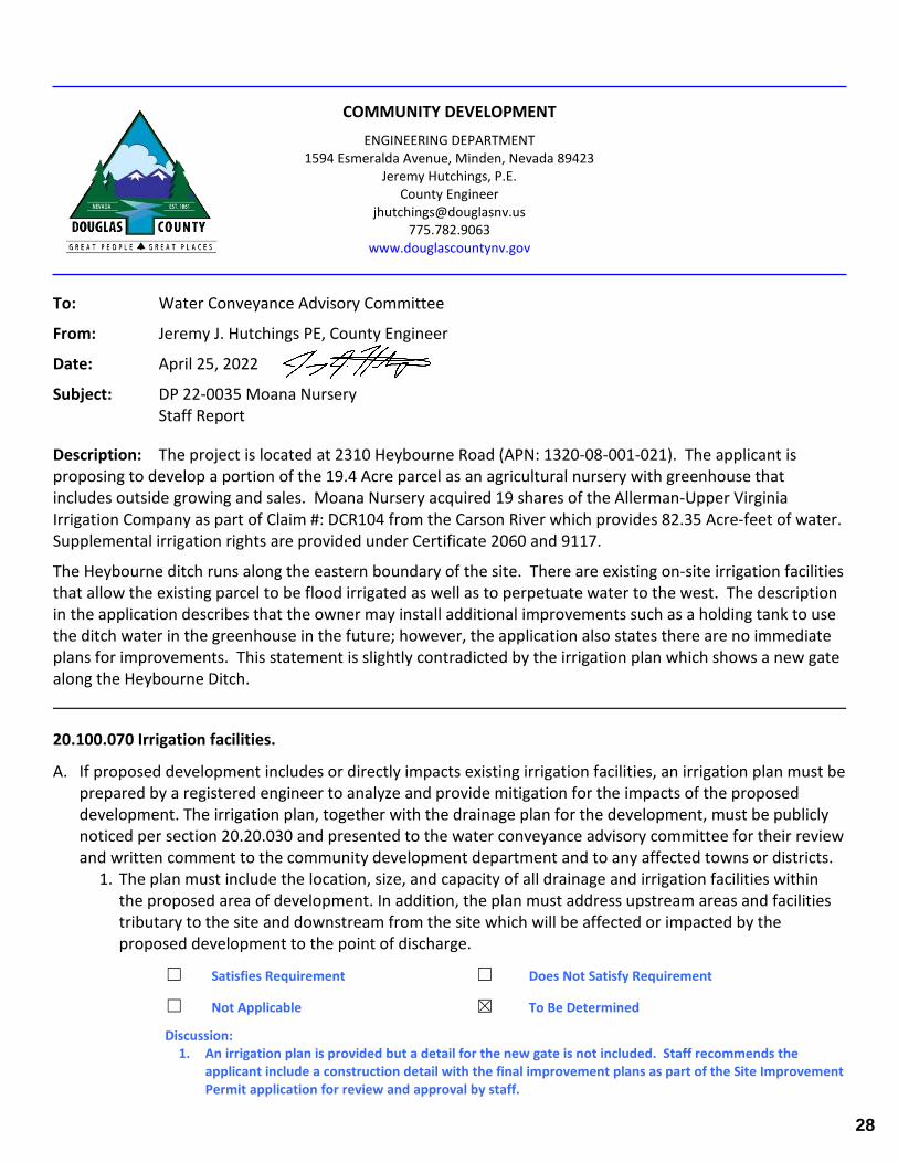
COMMUNITY DEVELOPMENT
ENGINEERING DEPARTMENT 1594 Esmeralda Avenue, Minden, Nevada 89423
Jeremy Hutchings, P.E. County Engineer
[email protected] 775.782.9063
www.douglascountynv.gov
To: Water Conveyance Advisory Committee
From: Jeremy J. Hutchings PE, County Engineer
Date: April 25, 2022
Subject: DP 22-0035 Moana Nursery Staff Report
Description: The project is located at 2310 Heybourne Road (APN: 1320-08-001-021). The applicant is proposing to develop a portion of the 19.4 Acre parcel as an agricultural nursery with greenhouse that includes outside growing and sales. Moana Nursery acquired 19 shares of the Allerman-Upper Virginia Irrigation Company as part of Claim #: DCR104 from the Carson River which provides 82.35 Acre-feet of water. Supplemental irrigation rights are provided under Certificate 2060 and 9117.
The Heybourne ditch runs along the eastern boundary of the site. There are existing on-site irrigation facilities that allow the existing parcel to be flood irrigated as well as to perpetuate water to the west. The description in the application describes that the owner may install additional improvements such as a holding tank to use the ditch water in the greenhouse in the future; however, the application also states there are no immediate plans for improvements. This statement is slightly contradicted by the irrigation plan which shows a new gate along the Heybourne Ditch.
20.100.070 Irrigation facilities.
A. If proposed development includes or directly impacts existing irrigation facilities, an irrigation plan must be prepared by a registered engineer to analyze and provide mitigation for the impacts of the proposed development. The irrigation plan, together with the drainage plan for the development, must be publicly noticed per section 20.20.030 and presented to the water conveyance advisory committee for their review and written comment to the community development department and to any affected towns or districts.
1. The plan must include the location, size, and capacity of all drainage and irrigation facilities within the proposed area of development. In addition, the plan must address upstream areas and facilities tributary to the site and downstream from the site which will be affected or impacted by the proposed development to the point of discharge.
☐ Satisfies Requirement ☐ Does Not Satisfy Requirement
☐ Not Applicable ☒ To Be Determined
Discussion: 1. An irrigation plan is provided but a detail for the new gate is not included. Staff recommends the
applicant include a construction detail with the final improvement plans as part of the Site Improvement Permit application for review and approval by staff.
28
2 | P a g e
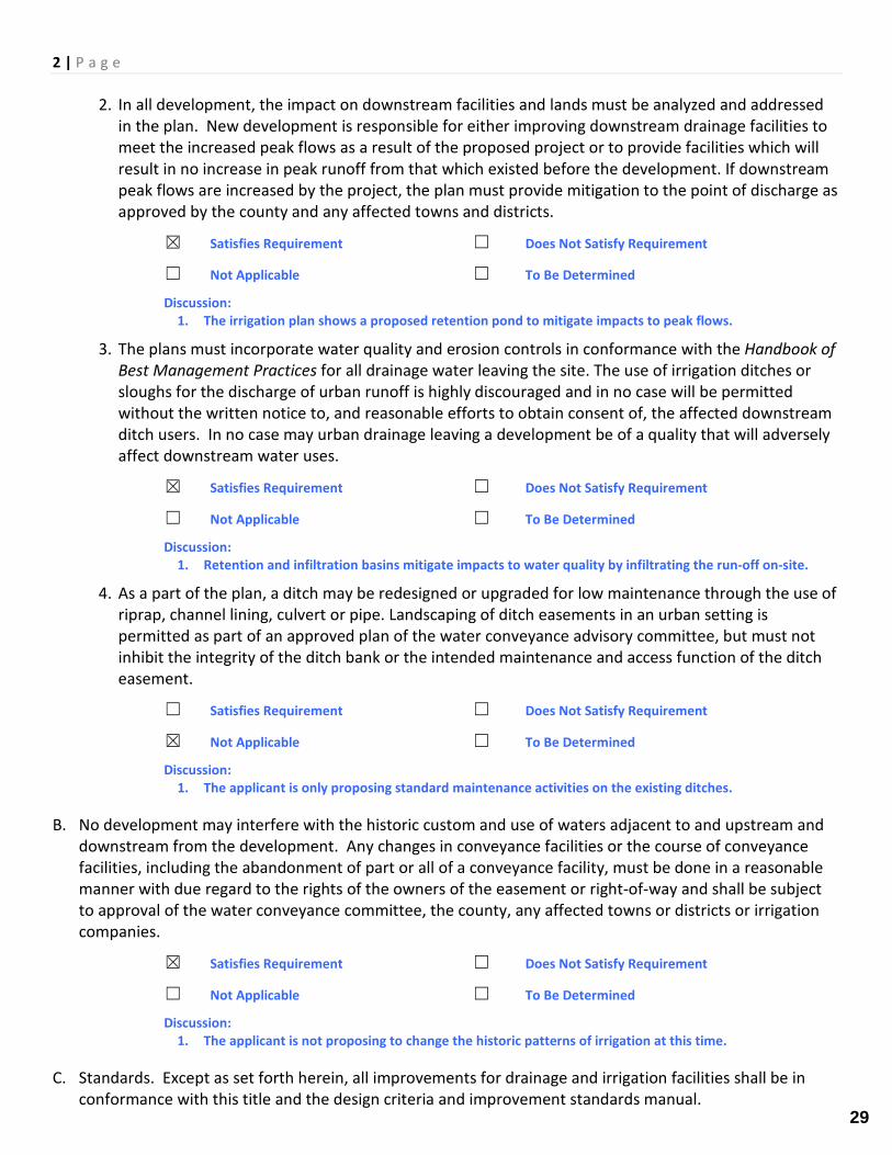
2. In all development, the impact on downstream facilities and lands must be analyzed and addressed in the plan. New development is responsible for either improving downstream drainage facilities to meet the increased peak flows as a result of the proposed project or to provide facilities which will result in no increase in peak runoff from that which existed before the development. If downstream peak flows are increased by the project, the plan must provide mitigation to the point of discharge as approved by the county and any affected towns and districts.
☒ Satisfies Requirement ☐ Does Not Satisfy Requirement
☐ Not Applicable ☐ To Be Determined
Discussion: 1. The irrigation plan shows a proposed retention pond to mitigate impacts to peak flows.
3. The plans must incorporate water quality and erosion controls in conformance with the Handbook of Best Management Practices for all drainage water leaving the site. The use of irrigation ditches or sloughs for the discharge of urban runoff is highly discouraged and in no case will be permitted without the written notice to, and reasonable efforts to obtain consent of, the affected downstream ditch users. In no case may urban drainage leaving a development be of a quality that will adversely affect downstream water uses.
☒ Satisfies Requirement ☐ Does Not Satisfy Requirement
☐ Not Applicable ☐ To Be Determined
Discussion: 1. Retention and infiltration basins mitigate impacts to water quality by infiltrating the run-off on-site.
4. As a part of the plan, a ditch may be redesigned or upgraded for low maintenance through the use of riprap, channel lining, culvert or pipe. Landscaping of ditch easements in an urban setting is permitted as part of an approved plan of the water conveyance advisory committee, but must not inhibit the integrity of the ditch bank or the intended maintenance and access function of the ditch easement.
☐ Satisfies Requirement ☐ Does Not Satisfy Requirement
☒ Not Applicable ☐ To Be Determined
Discussion: 1. The applicant is only proposing standard maintenance activities on the existing ditches.
B. No development may interfere with the historic custom and use of waters adjacent to and upstream and downstream from the development. Any changes in conveyance facilities or the course of conveyance facilities, including the abandonment of part or all of a conveyance facility, must be done in a reasonable manner with due regard to the rights of the owners of the easement or right-of-way and shall be subject to approval of the water conveyance committee, the county, any affected towns or districts or irrigation companies.
☒ Satisfies Requirement ☐ Does Not Satisfy Requirement
☐ Not Applicable ☐ To Be Determined
Discussion: 1. The applicant is not proposing to change the historic patterns of irrigation at this time.
C. Standards. Except as set forth herein, all improvements for drainage and irrigation facilities shall be in conformance with this title and the design criteria and improvement standards manual.
29
3 | P a g e
☒ Satisfies Requirement ☐ Does Not Satisfy Requirement
☐ Not Applicable ☐ To Be Determined
Discussion: 1. None.
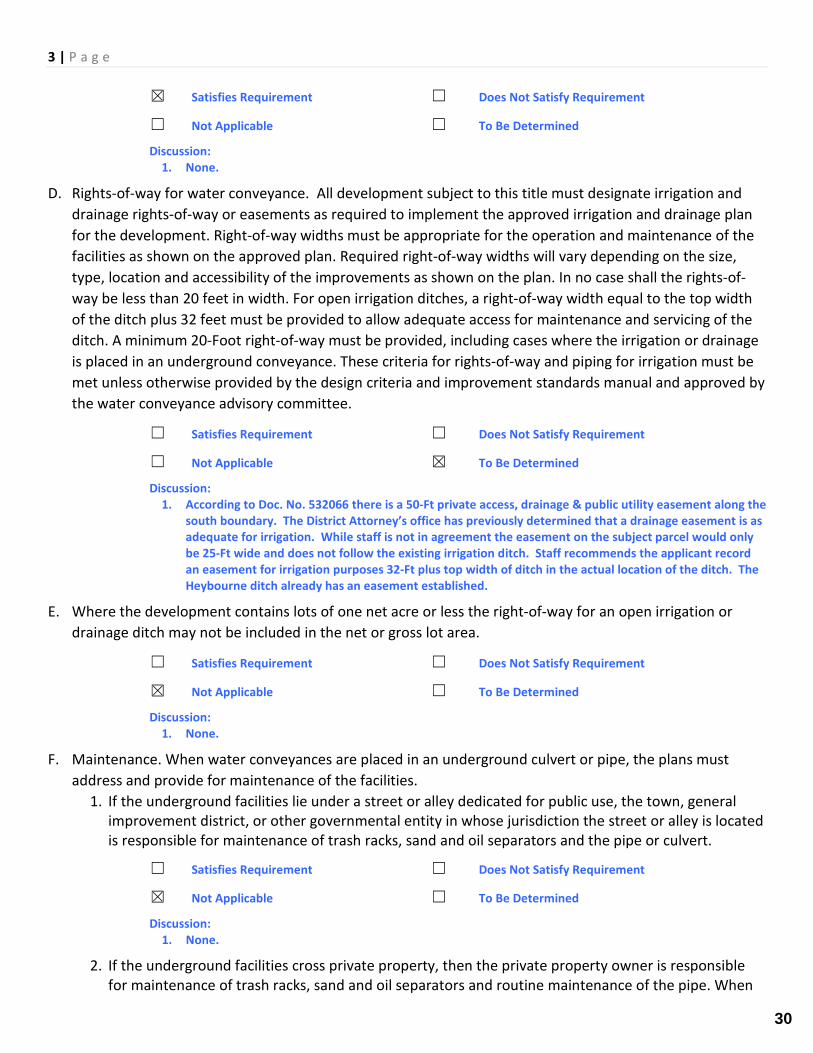
D. Rights-of-way for water conveyance. All development subject to this title must designate irrigation and drainage rights-of-way or easements as required to implement the approved irrigation and drainage plan for the development. Right-of-way widths must be appropriate for the operation and maintenance of the facilities as shown on the approved plan. Required right-of-way widths will vary depending on the size, type, location and accessibility of the improvements as shown on the plan. In no case shall the rights-of-way be less than 20 feet in width. For open irrigation ditches, a right-of-way width equal to the top width of the ditch plus 32 feet must be provided to allow adequate access for maintenance and servicing of the ditch. A minimum 20-Foot right-of-way must be provided, including cases where the irrigation or drainage is placed in an underground conveyance. These criteria for rights-of-way and piping for irrigation must be met unless otherwise provided by the design criteria and improvement standards manual and approved by the water conveyance advisory committee.
☐ Satisfies Requirement ☐ Does Not Satisfy Requirement
☐ Not Applicable ☒ To Be Determined
Discussion: 1. According to Doc. No. 532066 there is a 50-Ft private access, drainage & public utility easement along the
south boundary. The District Attorney’s office has previously determined that a drainage easement is as adequate for irrigation. While staff is not in agreement the easement on the subject parcel would only be 25-Ft wide and does not follow the existing irrigation ditch. Staff recommends the applicant record an easement for irrigation purposes 32-Ft plus top width of ditch in the actual location of the ditch. The Heybourne ditch already has an easement established.
E. Where the development contains lots of one net acre or less the right-of-way for an open irrigation or drainage ditch may not be included in the net or gross lot area.
☐ Satisfies Requirement ☐ Does Not Satisfy Requirement
☒ Not Applicable ☐ To Be Determined
Discussion: 1. None.
F. Maintenance. When water conveyances are placed in an underground culvert or pipe, the plans must address and provide for maintenance of the facilities.
1. If the underground facilities lie under a street or alley dedicated for public use, the town, general improvement district, or other governmental entity in whose jurisdiction the street or alley is located is responsible for maintenance of trash racks, sand and oil separators and the pipe or culvert.
☐ Satisfies Requirement ☐ Does Not Satisfy Requirement
☒ Not Applicable ☐ To Be Determined
Discussion: 1. None.
2. If the underground facilities cross private property, then the private property owner is responsible for maintenance of trash racks, sand and oil separators and routine maintenance of the pipe. When
30
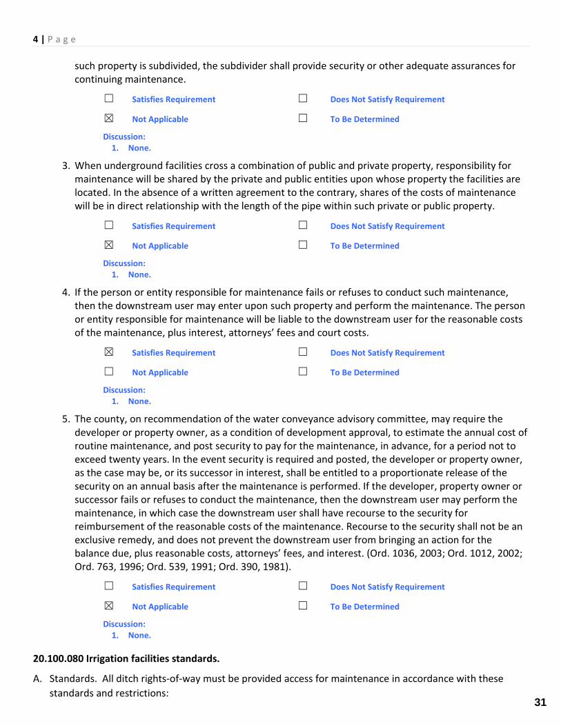
4 | P a g e
such property is subdivided, the subdivider shall provide security or other adequate assurances for continuing maintenance.
☐ Satisfies Requirement ☐ Does Not Satisfy Requirement
☒ Not Applicable ☐ To Be Determined
Discussion: 1. None.
3. When underground facilities cross a combination of public and private property, responsibility for maintenance will be shared by the private and public entities upon whose property the facilities are located. In the absence of a written agreement to the contrary, shares of the costs of maintenance will be in direct relationship with the length of the pipe within such private or public property.
☐ Satisfies Requirement ☐ Does Not Satisfy Requirement
☒ Not Applicable ☐ To Be Determined
Discussion: 1. None.
4. If the person or entity responsible for maintenance fails or refuses to conduct such maintenance, then the downstream user may enter upon such property and perform the maintenance. The person or entity responsible for maintenance will be liable to the downstream user for the reasonable costs of the maintenance, plus interest, attorneys’ fees and court costs.
☒ Satisfies Requirement ☐ Does Not Satisfy Requirement
☐ Not Applicable ☐ To Be Determined
Discussion: 1. None.
5. The county, on recommendation of the water conveyance advisory committee, may require the developer or property owner, as a condition of development approval, to estimate the annual cost of routine maintenance, and post security to pay for the maintenance, in advance, for a period not to exceed twenty years. In the event security is required and posted, the developer or property owner, as the case may be, or its successor in interest, shall be entitled to a proportionate release of the security on an annual basis after the maintenance is performed. If the developer, property owner or successor fails or refuses to conduct the maintenance, then the downstream user may perform the maintenance, in which case the downstream user shall have recourse to the security for reimbursement of the reasonable costs of the maintenance. Recourse to the security shall not be an exclusive remedy, and does not prevent the downstream user from bringing an action for the balance due, plus reasonable costs, attorneys’ fees, and interest. (Ord. 1036, 2003; Ord. 1012, 2002; Ord. 763, 1996; Ord. 539, 1991; Ord. 390, 1981).
☐ Satisfies Requirement ☐ Does Not Satisfy Requirement
☒ Not Applicable ☐ To Be Determined
Discussion: 1. None.
20.100.080 Irrigation facilities standards.
A. Standards. All ditch rights-of-way must be provided access for maintenance in accordance with these standards and restrictions:
31
5 | P a g e
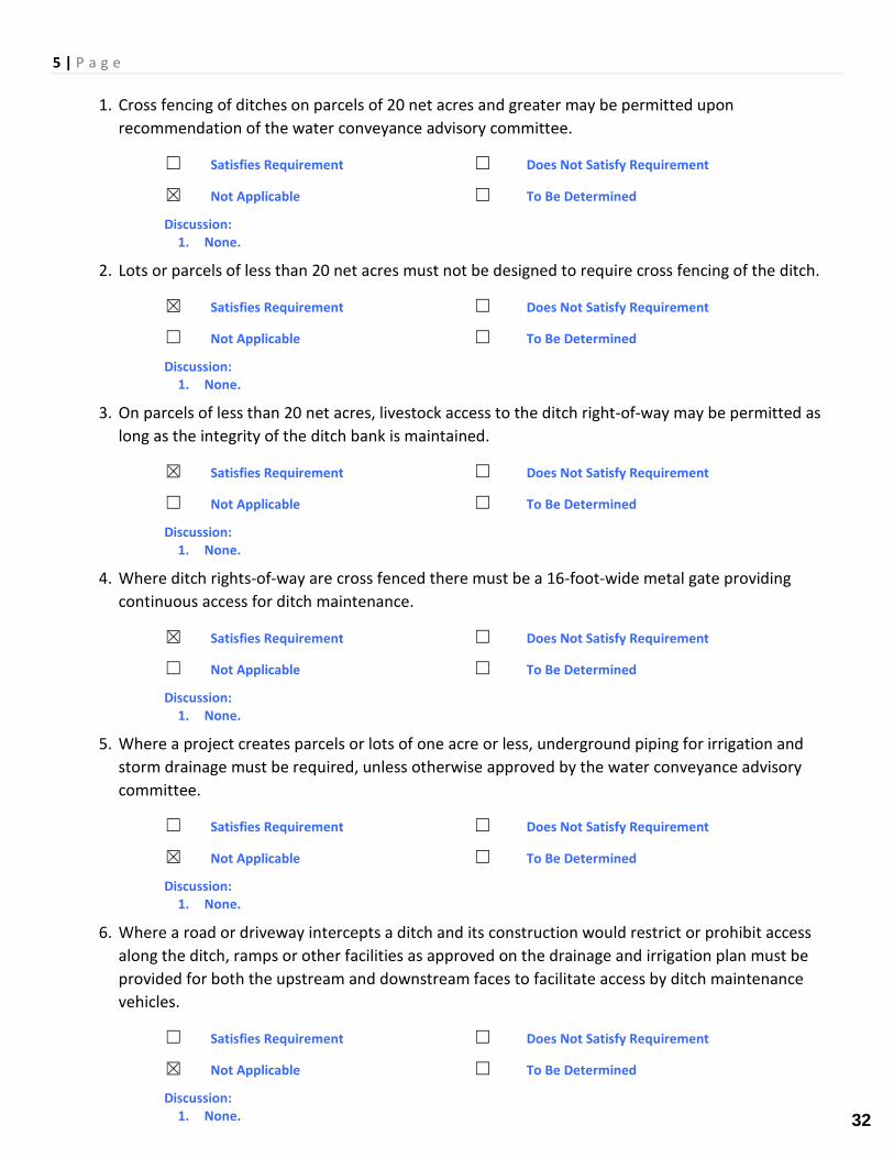
1. Cross fencing of ditches on parcels of 20 net acres and greater may be permitted upon recommendation of the water conveyance advisory committee.
☐ Satisfies Requirement ☐ Does Not Satisfy Requirement
☒ Not Applicable ☐ To Be Determined
Discussion: 1. None.
2. Lots or parcels of less than 20 net acres must not be designed to require cross fencing of the ditch.
☒ Satisfies Requirement ☐ Does Not Satisfy Requirement
☐ Not Applicable ☐ To Be Determined
Discussion: 1. None.
3. On parcels of less than 20 net acres, livestock access to the ditch right-of-way may be permitted as long as the integrity of the ditch bank is maintained.
☒ Satisfies Requirement ☐ Does Not Satisfy Requirement
☐ Not Applicable ☐ To Be Determined
Discussion: 1. None.
4. Where ditch rights-of-way are cross fenced there must be a 16-foot-wide metal gate providing continuous access for ditch maintenance.
☒ Satisfies Requirement ☐ Does Not Satisfy Requirement
☐ Not Applicable ☐ To Be Determined
Discussion: 1. None.
5. Where a project creates parcels or lots of one acre or less, underground piping for irrigation and storm drainage must be required, unless otherwise approved by the water conveyance advisory committee.
☐ Satisfies Requirement ☐ Does Not Satisfy Requirement
☒ Not Applicable ☐ To Be Determined
Discussion: 1. None.
6. Where a road or driveway intercepts a ditch and its construction would restrict or prohibit access along the ditch, ramps or other facilities as approved on the drainage and irrigation plan must be provided for both the upstream and downstream faces to facilitate access by ditch maintenance vehicles.
☐ Satisfies Requirement ☐ Does Not Satisfy Requirement
☒ Not Applicable ☐ To Be Determined
Discussion: 1. None. 32
6 | P a g e
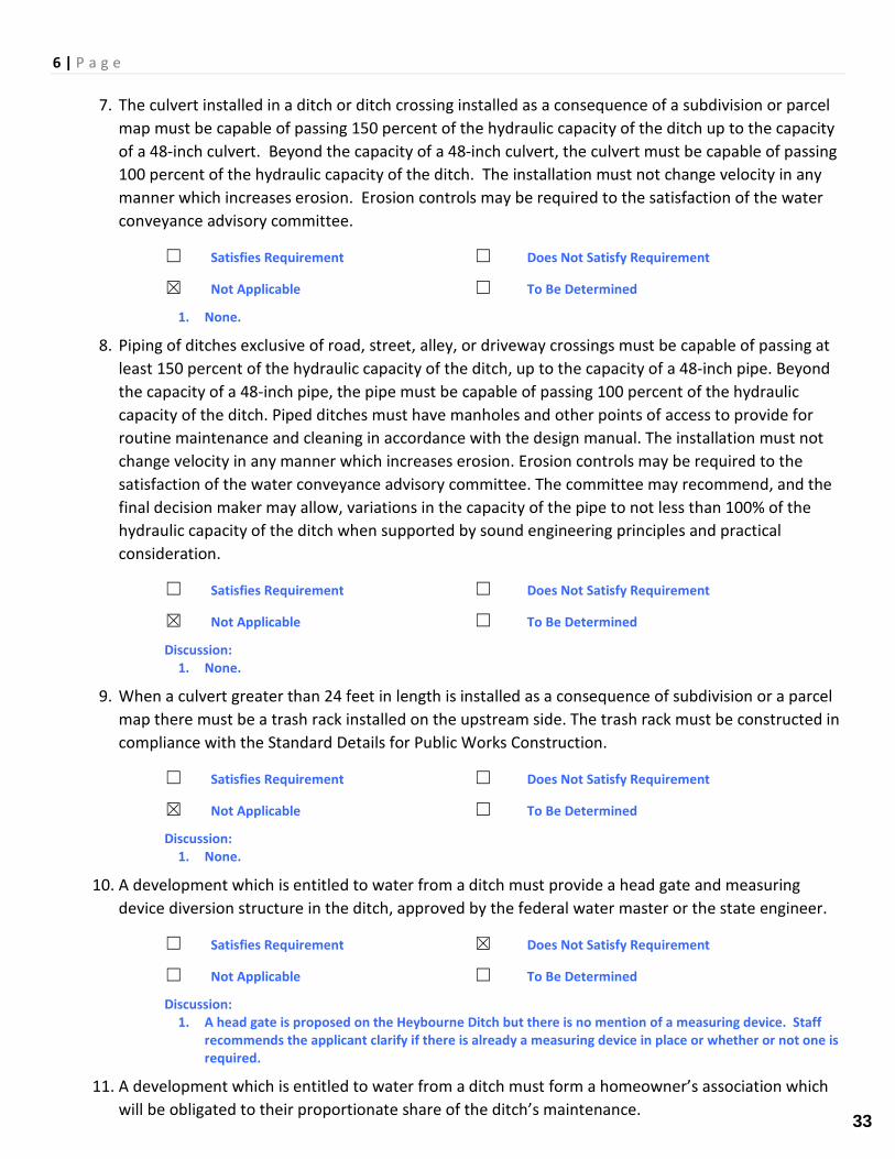
7. The culvert installed in a ditch or ditch crossing installed as a consequence of a subdivision or parcel map must be capable of passing 150 percent of the hydraulic capacity of the ditch up to the capacity of a 48-inch culvert. Beyond the capacity of a 48-inch culvert, the culvert must be capable of passing 100 percent of the hydraulic capacity of the ditch. The installation must not change velocity in any manner which increases erosion. Erosion controls may be required to the satisfaction of the water conveyance advisory committee.
☐ Satisfies Requirement ☐ Does Not Satisfy Requirement
☒ Not Applicable ☐ To Be Determined
1. None.
8. Piping of ditches exclusive of road, street, alley, or driveway crossings must be capable of passing at least 150 percent of the hydraulic capacity of the ditch, up to the capacity of a 48-inch pipe. Beyond the capacity of a 48-inch pipe, the pipe must be capable of passing 100 percent of the hydraulic capacity of the ditch. Piped ditches must have manholes and other points of access to provide for routine maintenance and cleaning in accordance with the design manual. The installation must not change velocity in any manner which increases erosion. Erosion controls may be required to the satisfaction of the water conveyance advisory committee. The committee may recommend, and the final decision maker may allow, variations in the capacity of the pipe to not less than 100% of the hydraulic capacity of the ditch when supported by sound engineering principles and practical consideration.
☐ Satisfies Requirement ☐ Does Not Satisfy Requirement
☒ Not Applicable ☐ To Be Determined
Discussion: 1. None.
9. When a culvert greater than 24 feet in length is installed as a consequence of subdivision or a parcel map there must be a trash rack installed on the upstream side. The trash rack must be constructed in compliance with the Standard Details for Public Works Construction.
☐ Satisfies Requirement ☐ Does Not Satisfy Requirement
☒ Not Applicable ☐ To Be Determined
Discussion: 1. None.
10. A development which is entitled to water from a ditch must provide a head gate and measuring device diversion structure in the ditch, approved by the federal water master or the state engineer.
☐ Satisfies Requirement ☒ Does Not Satisfy Requirement
☐ Not Applicable ☐ To Be Determined
Discussion: 1. A head gate is proposed on the Heybourne Ditch but there is no mention of a measuring device. Staff
recommends the applicant clarify if there is already a measuring device in place or whether or not one is required.
11. A development which is entitled to water from a ditch must form a homeowner’s association which will be obligated to their proportionate share of the ditch’s maintenance.
33
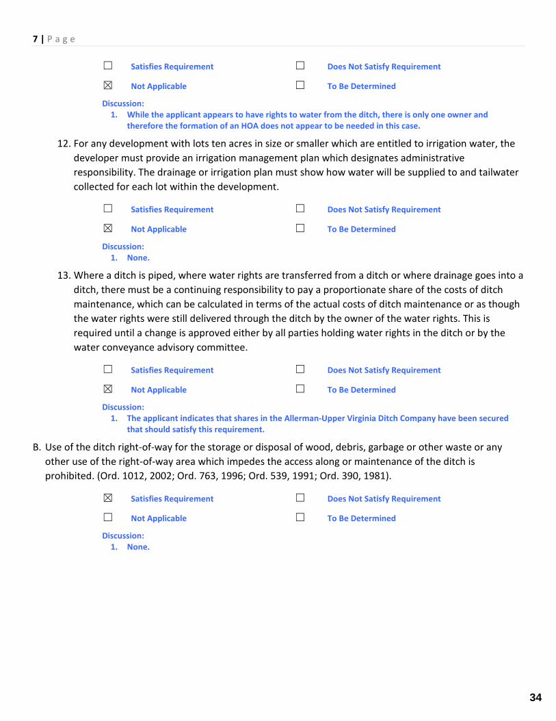
7 | P a g e
☐ Satisfies Requirement ☐ Does Not Satisfy Requirement
☒ Not Applicable ☐ To Be Determined
Discussion: 1. While the applicant appears to have rights to water from the ditch, there is only one owner and
therefore the formation of an HOA does not appear to be needed in this case.
12. For any development with lots ten acres in size or smaller which are entitled to irrigation water, the developer must provide an irrigation management plan which designates administrative responsibility. The drainage or irrigation plan must show how water will be supplied to and tailwater collected for each lot within the development.
☐ Satisfies Requirement ☐ Does Not Satisfy Requirement
☒ Not Applicable ☐ To Be Determined
Discussion: 1. None.
13. Where a ditch is piped, where water rights are transferred from a ditch or where drainage goes into a ditch, there must be a continuing responsibility to pay a proportionate share of the costs of ditch maintenance, which can be calculated in terms of the actual costs of ditch maintenance or as though the water rights were still delivered through the ditch by the owner of the water rights. This is required until a change is approved either by all parties holding water rights in the ditch or by the water conveyance advisory committee.
☐ Satisfies Requirement ☐ Does Not Satisfy Requirement
☒ Not Applicable ☐ To Be Determined
Discussion: 1. The applicant indicates that shares in the Allerman-Upper Virginia Ditch Company have been secured
that should satisfy this requirement.
B. Use of the ditch right-of-way for the storage or disposal of wood, debris, garbage or other waste or any other use of the right-of-way area which impedes the access along or maintenance of the ditch is prohibited. (Ord. 1012, 2002; Ord. 763, 1996; Ord. 539, 1991; Ord. 390, 1981).
☒ Satisfies Requirement ☐ Does Not Satisfy Requirement
☐ Not Applicable ☐ To Be Determined
Discussion: 1. None.
34
8 | P a g e STAFF RECOMMENDATION:
Staff recommends approval of DP 22-0035 as proposed, subject to the following conditions:
1. The applicant shall include construction details for the new head gate with the Site Improvement Permit plans for the project.
2. Future facilities such as the holding tank and diversion structure into the tank shall come back to the WCAC for review and approval.
3. Applicant shall dedicate easements over all irrigation improvements serving downstream users as noted below.
a. Open ditch. Easement width shall be a minimum of 32-Ft plus the top width of ditch. b. Underground conveyance. Easement width shall be a minimum of 20-Ft.
4. Applicant to clarify whether not there is a flow measuring device on the ditch. If not, board should discuss whether or not such a device is necessary.
35
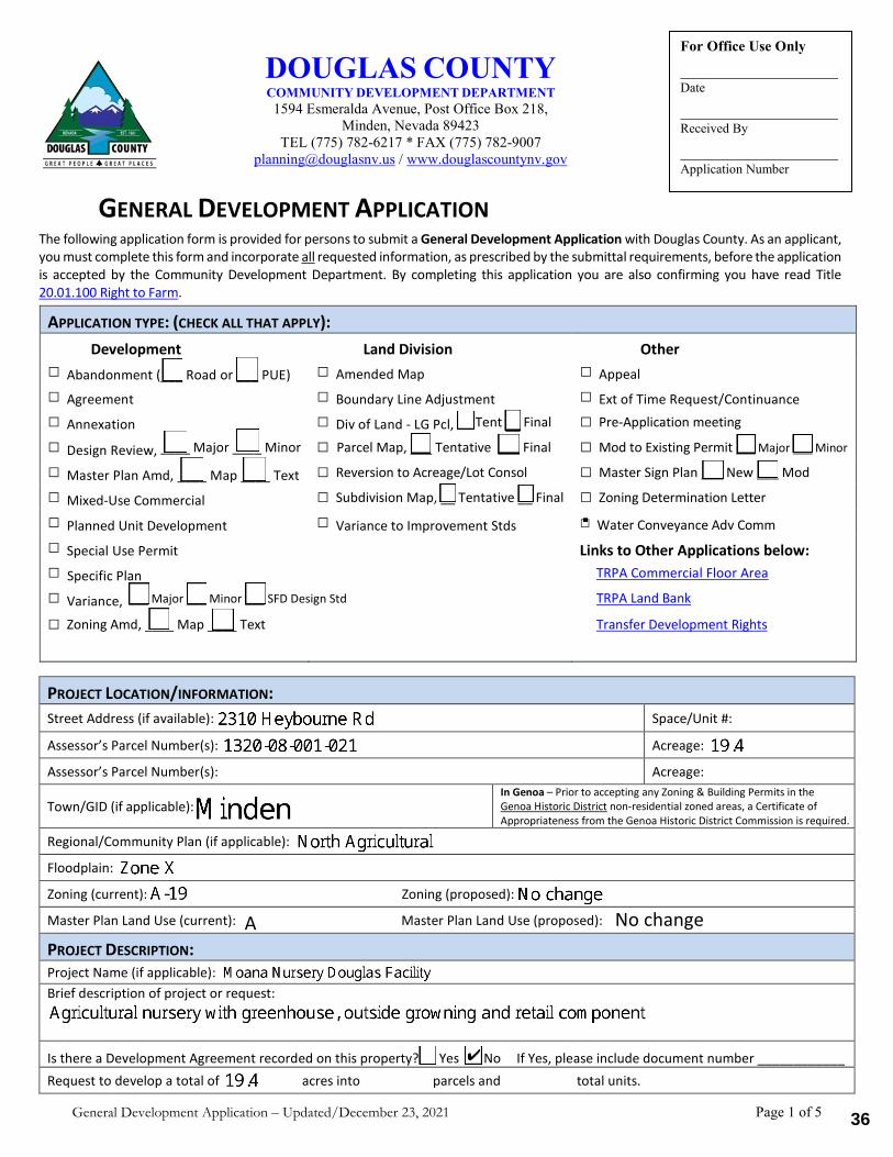
General Development Application – Updated/December 23, 2021 Page 1 of 5
GENERAL DEVELOPMENT APPLICATION The following application form is provided for persons to submit a General Development Application with Douglas County. As an applicant, you must complete this form and incorporate all requested information, as prescribed by the submittal requirements, before the application is accepted by the Community Development Department. By completing this application you are also confirming you have read Title 20.01.100 Right to Farm.
APPLICATION TYPE: (CHECK ALL THAT APPLY): Development Land Division Other
□ Abandonment (___ Road or ___ PUE) □ Amended Map □ Appeal□ Agreement □ Boundary Line Adjustment □ Ext of Time Request/Continuance□ Annexation □ Div of Land - LG Pcl, __ Tent __ Final □ Pre-Application meeting
□ Design Review, ____ Major ____ Minor □ Parcel Map, ___ Tentative ___ Final □ Mod to Existing Permit ___ Major ___ Minor
□ Master Plan Amd, ____ Map ____ Text □ Reversion to Acreage/Lot Consol □ Master Sign Plan ___ New ___ Mod
□ Mixed-Use Commercial □ Subdivision Map, __ Tentative __ Final □ Zoning Determination Letter
□ Planned Unit Development □ Variance to Improvement Stds □ Water Conveyance Adv Comm□ Special Use Permit Links to Other Applications below:□ Specific Plan TRPA Commercial Floor Area □ Variance, ___ Major ___ Minor ___ SFD Design Std TRPA Land Bank
□ Zoning Amd, ____ Map ____ Text Transfer Development Rights
PROJECT LOCATION/INFORMATION: Street Address (if available): Space/Unit #:
Assessor’s Parcel Number(s): Acreage:
Assessor’s Parcel Number(s): Acreage:
Town/GID (if applicable): In Genoa – Prior to accepting any Zoning & Building Permits in the Genoa Historic District non-residential zoned areas, a Certificate of Appropriateness from the Genoa Historic District Commission is required.
Regional/Community Plan (if applicable):
Floodplain:
Zoning (current): Zoning (proposed):
Master Plan Land Use (current): Master Plan Land Use (proposed):
PROJECT DESCRIPTION: Project Name (if applicable): Brief description of project or request:
Is there a Development Agreement recorded on this property? □ Yes □ No If Yes, please include document number ____________Request to develop a total of acres into parcels and total units.
DOUGLAS COUNTY COMMUNITY DEVELOPMENT DEPARTMENT 1594 Esmeralda Avenue, Post Office Box 218,
Minden, Nevada 89423 TEL (775) 782-6217 * FAX (775) 782-9007
[email protected] / www.douglascountynv.gov
For Office Use Only
Date
Received By
Application Number
A No change
36
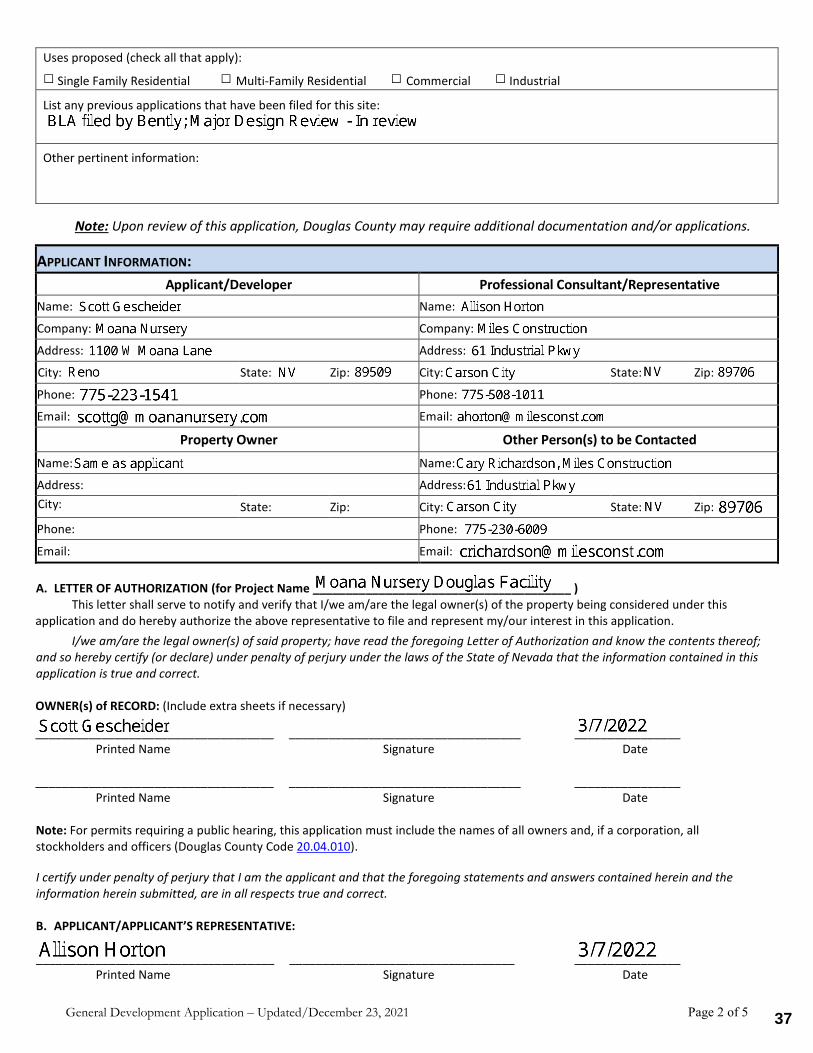
General Development Application – Updated/December 23, 2021 Page 2 of 5
Uses proposed (check all that apply):
□ Single Family Residential □ Multi-Family Residential □ Commercial □ Industrial
List any previous applications that have been filed for this site:
Other pertinent information:
Note: Upon review of this application, Douglas County may require additional documentation and/or applications.
APPLICANT INFORMATION:Applicant/Developer Professional Consultant/Representative
Name: Name:
Company: Company:
Address: Address:
City: State: Zip: City: State: Zip:
Phone: Phone:
Email: Email:
Property Owner Other Person(s) to be Contacted Name: Name:
Address: Address: City: State: Zip: City: State: Zip:
Phone: Phone:
Email: Email:
A. LETTER OF AUTHORIZATION (for Project Name _______________________________________ )This letter shall serve to notify and verify that I/we am/are the legal owner(s) of the property being considered under this
application and do hereby authorize the above representative to file and represent my/our interest in this application. I/we am/are the legal owner(s) of said property; have read the foregoing Letter of Authorization and know the contents thereof;
and so hereby certify (or declare) under penalty of perjury under the laws of the State of Nevada that the information contained in this application is true and correct.
OWNER(s) of RECORD: (Include extra sheets if necessary)
____________________________________ ___________________________________ ________________ Printed Name Signature Date
____________________________________ ___________________________________ ________________ Printed Name Signature Date
Note: For permits requiring a public hearing, this application must include the names of all owners and, if a corporation, all stockholders and officers (Douglas County Code 20.04.010).
I certify under penalty of perjury that I am the applicant and that the foregoing statements and answers contained herein and the information herein submitted, are in all respects true and correct.
B. APPLICANT/APPLICANT’S REPRESENTATIVE:
____________________________________ __________________________________ ________________ Printed Name Signature Date
37
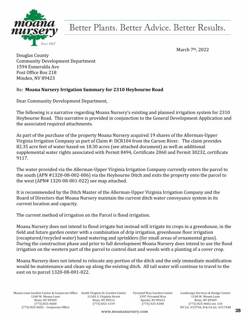
Moana Lane Garden Center & Corporate Office South Virginia St. Garden Center Pyramid Way Garden Center Landscape Services & Design Center 1100 W. Moana Lane 11301 S. Virginia Street 3397 Pyramid Way 1190 W. Moana Lane Reno, NV 89509 Reno, NV 89511 Sparks, NV 89431 Reno, NV 89509 (775) 825-0600 (775) 853-1319 (775) 425-4300 (775) 825-0602 ext. 134 (775) 825-0602 – Corporate Office NV Lic. #3379A, D & CA Lic. #317448
www.moananursery.com
March 7th, 2022 Douglas County Community Development Department 1594 Esmeralda Ave Post Office Box 218 Minden, NV 89423 Re: Moana Nursery Irrigation Summary for 2310 Heybourne Road Dear Community Development Department, The following is a narrative regarding Moana Nursery’s existing and planned irrigation system for 2310 Heybourne Road. This narrative is provided in conjunction to the General Development Application and the associated required attachments. As part of the purchase of the property Moana Nursery acquired 19 shares of the Allerman-Upper Virginia Irrigation Company as part of Claim #: DCR104 from the Carson River. The claim provides 82.35 acre feet of water based on 18.30 acres (see attached document) as well as additional supplemental water rights associated with Permit 8494, Certificate 2060 and Permit 30232, certificate 9117. The water provided via the Allerman-Upper Virginia Irrigation Company currently enters the parcel to the south (APN #1320-08-002-006) via the Heybourne Ditch and exits the property onto the parcel to the west (APN# 1320-08-001-022) see map attached. It is recommended by the Ditch Master of the Allerman-Upper Virginia Irrigation Company and the Board of Directors that Moana Nursery maintain the current ditch water conveyance system in its current location and capacity. The current method of irrigation on the Parcel is flood irrigation. Moana Nursery does not intend to flood irrigate but instead will irrigate its crops in a greenhouse, in the field and future garden center with a combination of drip irrigation, greenhouse floor irrigation (recaptured/recycled water) hand watering and sprinklers (for small areas of ornamental grass). During the construction phase and prior to full development Moana Nursery does intend to use the flood irrigation on the western part of the parcel to control dust and weeds with a planting of a cover crop. Moana Nursery does not intend to relocate any portion of the ditch and the only immediate modification would be maintenance and clean-up along the existing ditch. All tail water will continue to travel to the east on to parcel 1320-08-001-022.
38
Moana Lane Garden Center & Corporate Office South Virginia St. Garden Center Pyramid Way Garden Center Landscape Services & Design Center 1100 W. Moana Lane 11301 S. Virginia Street 3397 Pyramid Way 1190 W. Moana Lane Reno, NV 89509 Reno, NV 89511 Sparks, NV 89431 Reno, NV 89509 (775) 825-0600 (775) 853-1319 (775) 425-4300 (775) 825-0602 ext. 134 (775) 825-0602 – Corporate Office NV Lic. #3379A, D & CA Lic. #317448
www.moananursery.com
Moana Nursery does intend to have a holding tank to convert the ditch water and any associated runoff water from the property into future irrigation that will be used in the greenhouse, at the future garden center, in the landscaping and for any exterior growing. The supplemental water rights will be utilized via a proposed well when the Department of Water Resources approves our pending permit. See Attached. We understand how important water efficient landscapes are to our region and this growing facility will be no exception. We intend to recapture, reuse and efficiently irrigate the property using the latest technology and best practices. If you have additional questions, please let us know. Sincerely,
Scott L Gescheider President [email protected] 775-825-0602 ext. 125
39
40
MEETING DATE: May 2, 2022
TIME REQUIRED: 10
AGENDA: PUBLIC HEARINGS
AGENDA ITEM NO. 2.
WATER CONVEYANCE ADVISORY COMMITTEE AGENDA ITEMCOVER PAGE
TITLE:For possible action. Discussion on irrigation, drainage and water facilities which may be impacted by arequest to create three (3) Agricultural parcels from 2 to 5 acres from the parent parcel located at anunassigned address on Waterloo Lane (APN: 1220-07-001-030). The applicant is Todd Gansberg. RECOMMENDED MOTION:Approve DP 22-0084 Gansberg Tentative Parcel Map subject to the conditions in the staff report. Eventhough the irrigation plan provided was schematic in nature, Staff recommends allowing the applicant towork through the specifications with the County Engineer and conditionally approve as noted in thestaff report. FINANCIAL IMPACT:None BACKGROUND:See attached staff report and application. ATTACHMENTS:DP 22-0084 Gansberg - WCAC Staff Report.pdf
41
COMMUNITY DEVELOPMENT
ENGINEERING DEPARTMENT 1594 Esmeralda Avenue, Minden, Nevada 89423
Jeremy Hutchings, P.E. County Engineer
[email protected] 775.782.9063
www.douglascountynv.gov
To: Water Conveyance Advisory Committee
From: Jeremy J. Hutchings PE, County Engineer
Date: April 27, 2022
Subject: DP 22-0085 Gansberg Tentative Parcel Map Staff Report
Description: The project is located on an unaddressed parcel on Waterloo lane (APN: 1220-07-001-030). The applicant is proposing to divide the existing 27 Acre± parcel into four parcels identified as Parcels 1 – 4 on the irrigation plan.
The applicant is proposing two crossings of the existing ditch along Waterloo Lane are proposed and the remainder parcel will utilize existing access to Waterloo Lane. These culverts are shown to have head gates, presumably to allow flood irrigation of Parcels 1 – 3.
The applicant is also proposing a new ditch and head gates. While not well defined on the irrigation plan provided, this infrastructure presumably will allow irrigation of Parcel 4.
20.100.070 Irrigation facilities.
A. If proposed development includes or directly impacts existing irrigation facilities, an irrigation plan must be prepared by a registered engineer to analyze and provide mitigation for the impacts of the proposed development. The irrigation plan, together with the drainage plan for the development, must be publicly noticed per section 20.20.030 and presented to the water conveyance advisory committee for their review and written comment to the community development department and to any affected towns or districts.
1. The plan must include the location, size, and capacity of all drainage and irrigation facilities within the proposed area of development. In addition, the plan must address upstream areas and facilities tributary to the site and downstream from the site which will be affected or impacted by the proposed development to the point of discharge.
☐ Satisfies Requirement ☒ Does Not Satisfy Requirement
☐ Not Applicable ☐ To Be Determined
Discussion: 1. An irrigation plan has been provided; however, it does not appear to be compliant with Title
20.100.070.A.1 which requires the plan to describe the location, size and capacity of all drainage and irrigation facilities.
2. In all development, the impact on downstream facilities and lands must be analyzed and addressed in the plan. New development is responsible for either improving downstream drainage facilities to meet the increased peak flows as a result of the proposed project or to provide facilities which will
42
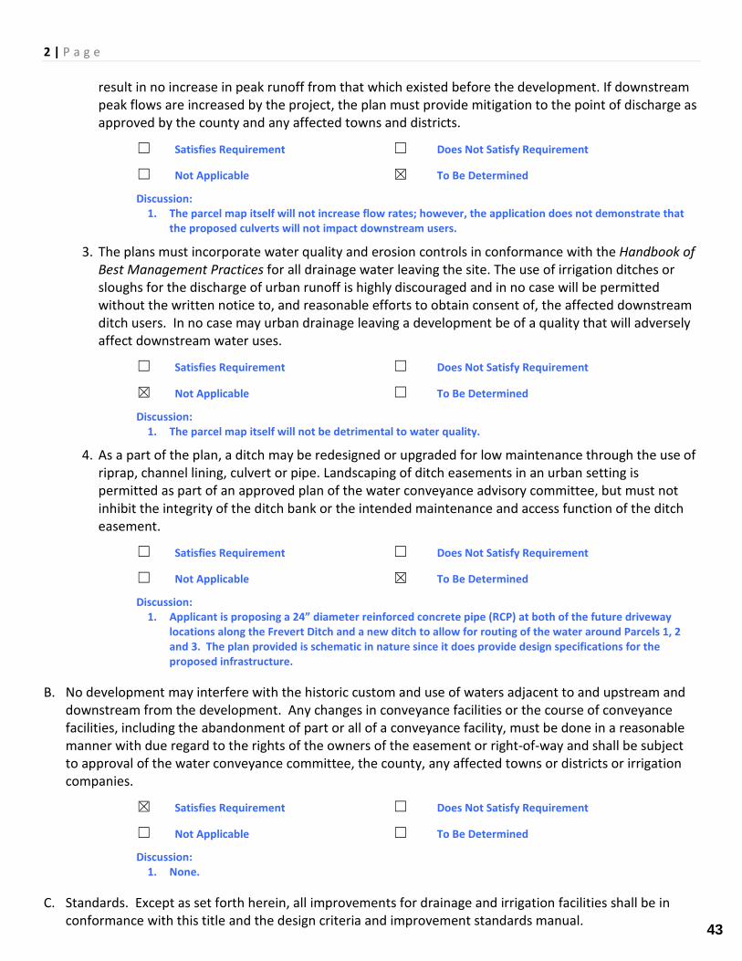
2 | P a g e
result in no increase in peak runoff from that which existed before the development. If downstream peak flows are increased by the project, the plan must provide mitigation to the point of discharge as approved by the county and any affected towns and districts.
☐ Satisfies Requirement ☐ Does Not Satisfy Requirement
☐ Not Applicable ☒ To Be Determined
Discussion: 1. The parcel map itself will not increase flow rates; however, the application does not demonstrate that
the proposed culverts will not impact downstream users.
3. The plans must incorporate water quality and erosion controls in conformance with the Handbook of Best Management Practices for all drainage water leaving the site. The use of irrigation ditches or sloughs for the discharge of urban runoff is highly discouraged and in no case will be permitted without the written notice to, and reasonable efforts to obtain consent of, the affected downstream ditch users. In no case may urban drainage leaving a development be of a quality that will adversely affect downstream water uses.
☐ Satisfies Requirement ☐ Does Not Satisfy Requirement
☒ Not Applicable ☐ To Be Determined
Discussion: 1. The parcel map itself will not be detrimental to water quality.
4. As a part of the plan, a ditch may be redesigned or upgraded for low maintenance through the use of riprap, channel lining, culvert or pipe. Landscaping of ditch easements in an urban setting is permitted as part of an approved plan of the water conveyance advisory committee, but must not inhibit the integrity of the ditch bank or the intended maintenance and access function of the ditch easement.
☐ Satisfies Requirement ☐ Does Not Satisfy Requirement
☐ Not Applicable ☒ To Be Determined
Discussion: 1. Applicant is proposing a 24” diameter reinforced concrete pipe (RCP) at both of the future driveway
locations along the Frevert Ditch and a new ditch to allow for routing of the water around Parcels 1, 2 and 3. The plan provided is schematic in nature since it does provide design specifications for the proposed infrastructure.
B. No development may interfere with the historic custom and use of waters adjacent to and upstream and downstream from the development. Any changes in conveyance facilities or the course of conveyance facilities, including the abandonment of part or all of a conveyance facility, must be done in a reasonable manner with due regard to the rights of the owners of the easement or right-of-way and shall be subject to approval of the water conveyance committee, the county, any affected towns or districts or irrigation companies.
☒ Satisfies Requirement ☐ Does Not Satisfy Requirement
☐ Not Applicable ☐ To Be Determined
Discussion: 1. None.
C. Standards. Except as set forth herein, all improvements for drainage and irrigation facilities shall be in conformance with this title and the design criteria and improvement standards manual.
43
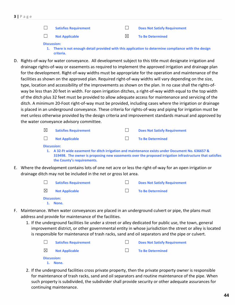
3 | P a g e
☐ Satisfies Requirement ☐ Does Not Satisfy Requirement
☐ Not Applicable ☒ To Be Determined
Discussion: 1. There is not enough detail provided with this application to determine compliance with the design
criteria.
D. Rights-of-way for water conveyance. All development subject to this title must designate irrigation and drainage rights-of-way or easements as required to implement the approved irrigation and drainage plan for the development. Right-of-way widths must be appropriate for the operation and maintenance of the facilities as shown on the approved plan. Required right-of-way widths will vary depending on the size, type, location and accessibility of the improvements as shown on the plan. In no case shall the rights-of-way be less than 20 feet in width. For open irrigation ditches, a right-of-way width equal to the top width of the ditch plus 32 feet must be provided to allow adequate access for maintenance and servicing of the ditch. A minimum 20-Foot right-of-way must be provided, including cases where the irrigation or drainage is placed in an underground conveyance. These criteria for rights-of-way and piping for irrigation must be met unless otherwise provided by the design criteria and improvement standards manual and approved by the water conveyance advisory committee.
☒ Satisfies Requirement ☐ Does Not Satisfy Requirement
☐ Not Applicable ☐ To Be Determined
Discussion: 1. A 32-Ft wide easement for ditch irrigation and maintenance exists under Document No. 636657 &
319498. The owner is proposing new easements over the proposed irrigation infrastructure that satisfies the County’s requirements.
E. Where the development contains lots of one net acre or less the right-of-way for an open irrigation or drainage ditch may not be included in the net or gross lot area.
☐ Satisfies Requirement ☐ Does Not Satisfy Requirement
☒ Not Applicable ☐ To Be Determined
Discussion: 1. None.
F. Maintenance. When water conveyances are placed in an underground culvert or pipe, the plans must address and provide for maintenance of the facilities.
1. If the underground facilities lie under a street or alley dedicated for public use, the town, general improvement district, or other governmental entity in whose jurisdiction the street or alley is located is responsible for maintenance of trash racks, sand and oil separators and the pipe or culvert.
☐ Satisfies Requirement ☐ Does Not Satisfy Requirement
☒ Not Applicable ☐ To Be Determined
Discussion: 1. None.
2. If the underground facilities cross private property, then the private property owner is responsible for maintenance of trash racks, sand and oil separators and routine maintenance of the pipe. When such property is subdivided, the subdivider shall provide security or other adequate assurances for continuing maintenance.
44
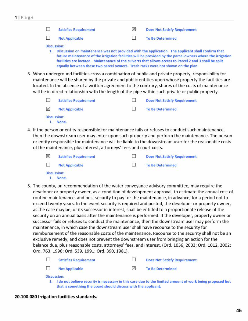
4 | P a g e
☐ Satisfies Requirement ☒ Does Not Satisfy Requirement
☐ Not Applicable ☐ To Be Determined
Discussion: 1. Discussion on maintenance was not provided with the application. The applicant shall confirm that
future maintenance of the irrigation facilities will be provided by the parcel owners where the irrigation facilities are located. Maintenance of the culverts that allows access to Parcel 2 and 3 shall be split equally between these two parcel owners. Trash racks were not shown on the plan.
3. When underground facilities cross a combination of public and private property, responsibility for maintenance will be shared by the private and public entities upon whose property the facilities are located. In the absence of a written agreement to the contrary, shares of the costs of maintenance will be in direct relationship with the length of the pipe within such private or public property.
☐ Satisfies Requirement ☐ Does Not Satisfy Requirement
☒ Not Applicable ☐ To Be Determined
Discussion: 1. None.
4. If the person or entity responsible for maintenance fails or refuses to conduct such maintenance, then the downstream user may enter upon such property and perform the maintenance. The person or entity responsible for maintenance will be liable to the downstream user for the reasonable costs of the maintenance, plus interest, attorneys’ fees and court costs.
☒ Satisfies Requirement ☐ Does Not Satisfy Requirement
☐ Not Applicable ☐ To Be Determined
Discussion: 1. None.
5. The county, on recommendation of the water conveyance advisory committee, may require the developer or property owner, as a condition of development approval, to estimate the annual cost of routine maintenance, and post security to pay for the maintenance, in advance, for a period not to exceed twenty years. In the event security is required and posted, the developer or property owner, as the case may be, or its successor in interest, shall be entitled to a proportionate release of the security on an annual basis after the maintenance is performed. If the developer, property owner or successor fails or refuses to conduct the maintenance, then the downstream user may perform the maintenance, in which case the downstream user shall have recourse to the security for reimbursement of the reasonable costs of the maintenance. Recourse to the security shall not be an exclusive remedy, and does not prevent the downstream user from bringing an action for the balance due, plus reasonable costs, attorneys’ fees, and interest. (Ord. 1036, 2003; Ord. 1012, 2002; Ord. 763, 1996; Ord. 539, 1991; Ord. 390, 1981).
☐ Satisfies Requirement ☐ Does Not Satisfy Requirement
☐ Not Applicable ☒ To Be Determined
Discussion: 1. I do not believe security is necessary in this case due to the limited amount of work being proposed but
that is something the board should discuss with the applicant.
20.100.080 Irrigation facilities standards.
45
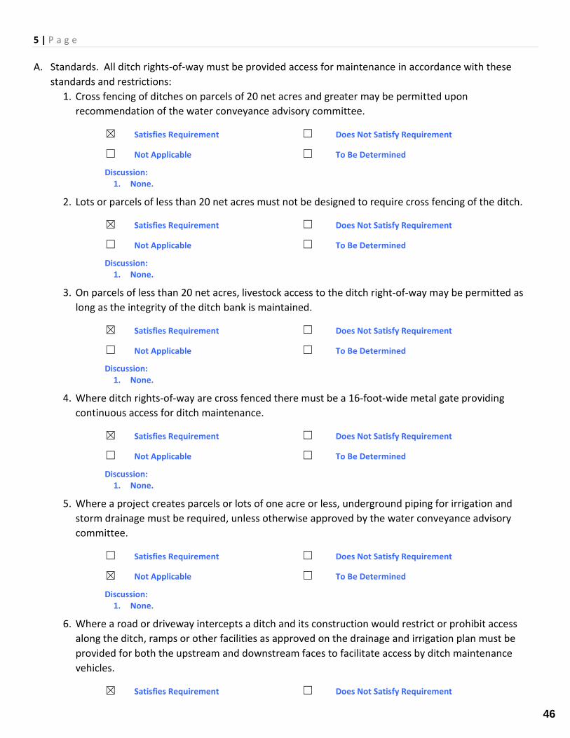
5 | P a g e A. Standards. All ditch rights-of-way must be provided access for maintenance in accordance with these
standards and restrictions: 1. Cross fencing of ditches on parcels of 20 net acres and greater may be permitted upon
recommendation of the water conveyance advisory committee.
☒ Satisfies Requirement ☐ Does Not Satisfy Requirement
☐ Not Applicable ☐ To Be Determined
Discussion: 1. None.
2. Lots or parcels of less than 20 net acres must not be designed to require cross fencing of the ditch.
☒ Satisfies Requirement ☐ Does Not Satisfy Requirement
☐ Not Applicable ☐ To Be Determined
Discussion: 1. None.
3. On parcels of less than 20 net acres, livestock access to the ditch right-of-way may be permitted as long as the integrity of the ditch bank is maintained.
☒ Satisfies Requirement ☐ Does Not Satisfy Requirement
☐ Not Applicable ☐ To Be Determined
Discussion: 1. None.
4. Where ditch rights-of-way are cross fenced there must be a 16-foot-wide metal gate providing continuous access for ditch maintenance.
☒ Satisfies Requirement ☐ Does Not Satisfy Requirement
☐ Not Applicable ☐ To Be Determined
Discussion: 1. None.
5. Where a project creates parcels or lots of one acre or less, underground piping for irrigation and storm drainage must be required, unless otherwise approved by the water conveyance advisory committee.
☐ Satisfies Requirement ☐ Does Not Satisfy Requirement
☒ Not Applicable ☐ To Be Determined
Discussion: 1. None.
6. Where a road or driveway intercepts a ditch and its construction would restrict or prohibit access along the ditch, ramps or other facilities as approved on the drainage and irrigation plan must be provided for both the upstream and downstream faces to facilitate access by ditch maintenance vehicles.
☒ Satisfies Requirement ☐ Does Not Satisfy Requirement
46
6 | P a g e
☐ Not Applicable ☐ To Be Determined
Discussion: 1. None.
7. The culvert installed in a ditch or ditch crossing installed as a consequence of a subdivision or parcel map must be capable of passing 150 percent of the hydraulic capacity of the ditch up to the capacity of a 48-inch culvert. Beyond the capacity of a 48-inch culvert, the culvert must be capable of passing 100 percent of the hydraulic capacity of the ditch. The installation must not change velocity in any manner which increases erosion. Erosion controls may be required to the satisfaction of the water conveyance advisory committee.
☐ Satisfies Requirement ☐ Does Not Satisfy Requirement
☐ Not Applicable ☒ To Be Determined
1. There were no calculations provided with the application that would demonstrate compliance with this condition. Staff recommendations placing a condition of approval requiring the applicant to demonstrate compliance with this requirement with the submittal of a Site Improvement Permit for the work.
8. Piping of ditches exclusive of road, street, alley, or driveway crossings must be capable of passing at least 150 percent of the hydraulic capacity of the ditch, up to the capacity of a 48-inch pipe. Beyond the capacity of a 48-inch pipe, the pipe must be capable of passing 100 percent of the hydraulic capacity of the ditch. Piped ditches must have manholes and other points of access to provide for routine maintenance and cleaning in accordance with the design manual. The installation must not change velocity in any manner which increases erosion. Erosion controls may be required to the satisfaction of the water conveyance advisory committee. The committee may recommend, and the final decision maker may allow, variations in the capacity of the pipe to not less than 100% of the hydraulic capacity of the ditch when supported by sound engineering principles and practical consideration.
☐ Satisfies Requirement ☐ Does Not Satisfy Requirement
☐ Not Applicable ☒ To Be Determined
Discussion: 1. There were no calculations provided with the application that would demonstrate compliance with this
condition. Staff recommendations placing a condition of approval requiring the applicant to demonstrate compliance with this requirement with the submittal of a Site Improvement Permit for the work.
9. When a culvert greater than 24 feet in length is installed as a consequence of subdivision or a parcel map there must be a trash rack installed on the upstream side. The trash rack must be constructed in compliance with the Standard Details for Public Works Construction.
☐ Satisfies Requirement ☒ Does Not Satisfy Requirement
☐ Not Applicable ☐ To Be Determined
Discussion: 1. The culverts are approximately 45-Ft in length and propose head gates but do not mention trash racks.
Staff recommends final improvement plans to include trash racks.
10. A development which is entitled to water from a ditch must provide a head gate and measuring device diversion structure in the ditch, approved by the federal water master or the state engineer.
47
7 | P a g e
☐ Satisfies Requirement ☐ Does Not Satisfy Requirement
☐ Not Applicable ☒ To Be Determined
Discussion: 1. Head are provided by measuring devices are not. Staff recommends that the board discuss with
applicant whether or not measuring devices should be installed.
11. A development which is entitled to water from a ditch must form a homeowner’s association which will be obligated to their proportionate share of the ditch’s maintenance.
☐ Satisfies Requirement ☒ Does Not Satisfy Requirement
☐ Not Applicable ☐ To Be Determined
Discussion: 1. The development appears entitled to water from a ditch but the application does not provide evidence
of an HOA or discuss maintenance costs of the ditch.
12. For any development with lots ten acres in size or smaller which are entitled to irrigation water, the developer must provide an irrigation management plan which designates administrative responsibility. The drainage or irrigation plan must show how water will be supplied to and tailwater collected for each lot within the development.
☐ Satisfies Requirement ☒ Does Not Satisfy Requirement
☐ Not Applicable ☐ To Be Determined
Discussion: 1. Parcels 1-3 are less than 10-Acres in size and appear will be irrigated; however, an irrigation
management plan was not provided which designates administrative responsibility. Staff recommends the applicant provide additional detail on this item at the board meeting.
13. Where a ditch is piped, where water rights are transferred from a ditch or where drainage goes into a ditch, there must be a continuing responsibility to pay a proportionate share of the costs of ditch maintenance, which can be calculated in terms of the actual costs of ditch maintenance or as though the water rights were still delivered through the ditch by the owner of the water rights. This is required until a change is approved either by all parties holding water rights in the ditch or by the water conveyance advisory committee.
☐ Satisfies Requirement ☒ Does Not Satisfy Requirement
☐ Not Applicable ☐ To Be Determined
Discussion: 1. Maintenance of the ditch was not discussed in the application.
B. Use of the ditch right-of-way for the storage or disposal of wood, debris, garbage or other waste or any other use of the right-of-way area which impedes the access along or maintenance of the ditch is prohibited. (Ord. 1012, 2002; Ord. 763, 1996; Ord. 539, 1991; Ord. 390, 1981).
☐ Satisfies Requirement ☐ Does Not Satisfy Requirement
☒ Not Applicable ☐ To Be Determined
Discussion: 1. None.
48
8 | P a g e STAFF RECOMMENDATION:
Several required code sections have been noted as either “To Be Determined” or “Does Not Satisfy Requirement.” Staff recommends the board discuss whether or not this agenda item should be continued until a future board meeting so the applicant can include the information required by Title 20.100.070 and 20.100.080 which would allow staff to make a complete review of the application.
Recognizing the applicant and the application are closely tied to the agricultural community, Staff would encourage the board to work with the applicant to keep the project on its current track. In this case, Staff recommends approval of DP 22-0084 as proposed, subject to the following conditions that would be reviewed by the County Engineer in an effort to avoid another appearance at the WCAC board meeting:
1. Applicant shall prepare a Site Improvement Permit for the proposed irrigation facilities. a. The plans and supporting calculations shall comply with the requirements of Title 20.100.070 and
20.100.080 demonstrating the adequacy of the proposed improvements to the satisfaction of the County Engineer.
2. Applicant shall submit a maintenance plan for the proposed irrigation facilities. 3. Trash racks shall be installed on the upstream side of all culverts that are tributary to downstream
users. 4. Applicant shall provide evidence that a Home Owner’s Association has been formed that is obligated to
their proportionate share of the ditch’s maintenance. 5. The applicant shall provide an irrigation management plan. 6. Applicant shall dedicate easements over all irrigation improvements serving downstream users that do
not currently have easements in place as noted below. a. Open ditch. Easement width shall be a minimum of 32-Ft plus the top width of ditch. b. Underground conveyance. Easement width shall be a minimum of 20-Ft.
49
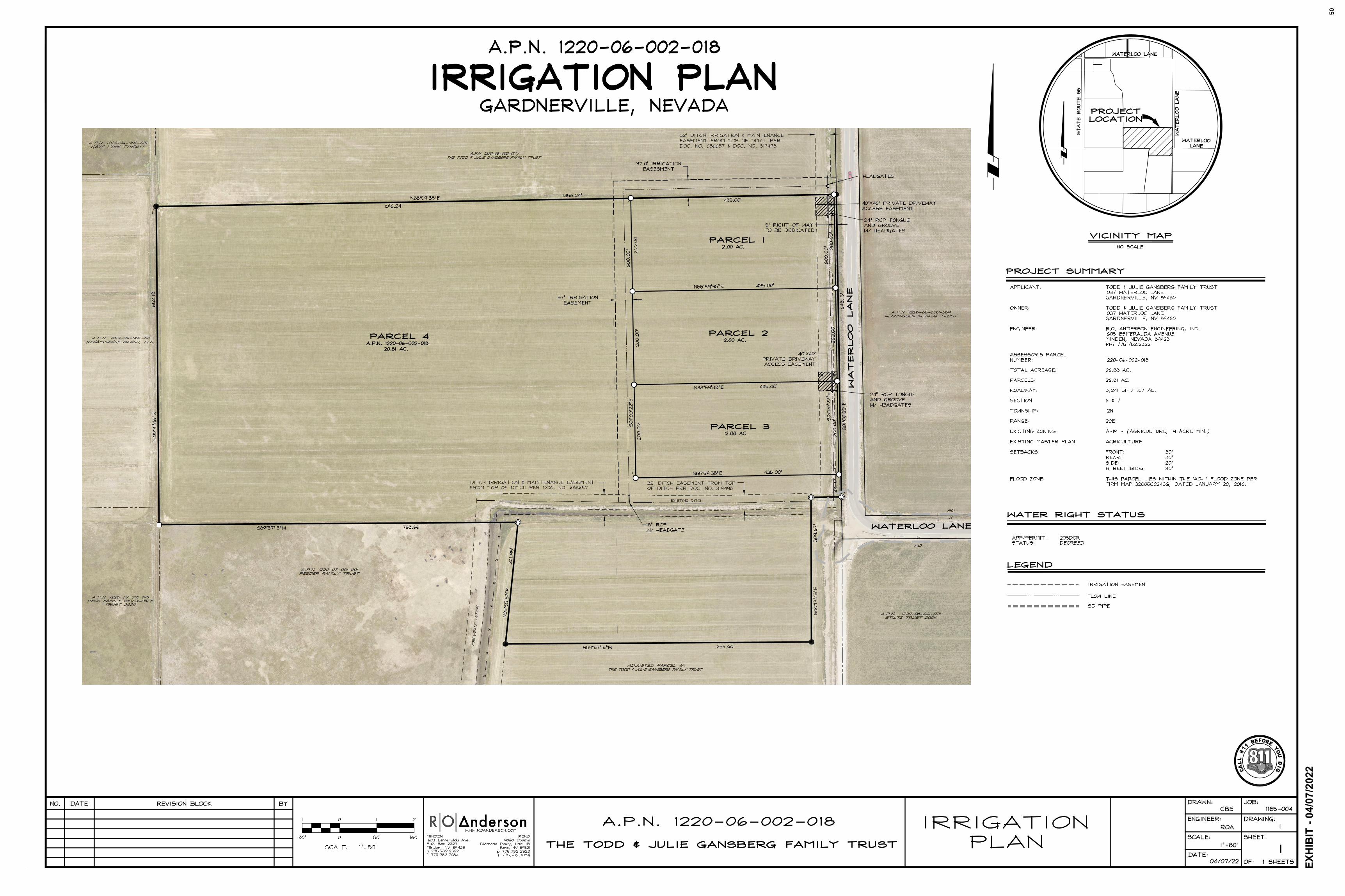
C
A
LL
8
1
1
B
E
FO
R
E
Y
O
U
D
I
G
EX
HIB
IT
- 0
4/0
7/2
02
2
50
AutoCAD SHX Text
ADJUSTED PARCEL 4A THE TODD & JULIE GANGBERG FAMILY TRUST
AutoCAD SHX Text
PARCEL 4 A.P.N. 1220-06-002-018 20.81 AC.
AutoCAD SHX Text
A.P.N. 1220-06-002-017) THE TODD & JULIE GANGBERG FAMILY TRUST
AutoCAD SHX Text
WATERLOO LANE
AutoCAD SHX Text
FREVERT DITCH
AutoCAD SHX Text
32' DITCH EASEMENT FROM TOP OF DITCH PER DOC. NO. 319498
AutoCAD SHX Text
DITCH IRRIGATION & MAINTENANCE EASEMENT FROM TOP OF DITCH PER DOC. NO. 636657
AutoCAD SHX Text
32' DITCH IRRIGATION & MAINTENANCE EASEMENT FROM TOP OF DITCH PER DOC. NO. 636657 & DOC. NO. 319498
AutoCAD SHX Text
EXISTING DITCH
AutoCAD SHX Text
A.P.N. 1220-08-001-021 STILTZ TRUST 2004
AutoCAD SHX Text
A.P.N. 1220-05-000-004 HENNINGSEN NEVADA TRUST
AutoCAD SHX Text
A.P.N. 1220-06-002-015 GAYE LYNN TYNDALL
AutoCAD SHX Text
A.P.N. 1220-06-002-011 1220-06-002-011 RENAISSANCE RANCH, LLC
AutoCAD SHX Text
A.P.N. 1220-07-001-015 PECK FAMILY REVOCABLE TRUST 2020
AutoCAD SHX Text
A.P.N. 1220-07-001-001 REEDER FAMILY TRUST
AutoCAD SHX Text
X AO
AutoCAD SHX Text
WATERLOO LANE
AutoCAD SHX Text
PARCEL 1 2.00 AC.
AutoCAD SHX Text
PARCEL 2 2.00 AC.
AutoCAD SHX Text
PARCEL 3 2.00 AC.
AutoCAD SHX Text
5' RIGHT-OF-WAY TO BE DEDICATED
AutoCAD SHX Text
N88°59'38"E 1456.24'
AutoCAD SHX Text
S89°37'13"W 768.66'
AutoCAD SHX Text
N05°55'59"E 261.98'
AutoCAD SHX Text
S89°37'13"W 655.60'
AutoCAD SHX Text
N88°59'38"E 435.00'
AutoCAD SHX Text
200.00'
AutoCAD SHX Text
200.00'
AutoCAD SHX Text
200.00'
AutoCAD SHX Text
200.00'
AutoCAD SHX Text
200.00'
AutoCAD SHX Text
200.00'
AutoCAD SHX Text
435.00'
AutoCAD SHX Text
1016.24'
AutoCAD SHX Text
S01°00'22"E 648.15'
AutoCAD SHX Text
S01°00'22"E 600.00'
AutoCAD SHX Text
N88°59'38"E 435.00'
AutoCAD SHX Text
N88°59'38"E 435.00'
AutoCAD SHX Text
S01°00'22"E 600.00'
AutoCAD SHX Text
N00°31'06"W 682.18'
AutoCAD SHX Text
48.15'
AutoCAD SHX Text
AO X
AutoCAD SHX Text
40'X40' PRIVATE DRIVEWAY ACCESS EASEMENT
AutoCAD SHX Text
40'X40' PRIVATE DRIVEWAY ACCESS EASEMENT
AutoCAD SHX Text
S00°13'43"E 309.67'
AutoCAD SHX Text
24" RCP TONGUE AND GROOVE W/ HEADGATES
AutoCAD SHX Text
18" RCP W/ HEADGATE
AutoCAD SHX Text
24" RCP TONGUE AND GROOVE W/ HEADGATES
AutoCAD SHX Text
HEADGATES
AutoCAD SHX Text
A.P.N. 1220-06-002-018
AutoCAD SHX Text
IRRIGATION PLAN
AutoCAD SHX Text
GARDNERVILLE, NEVADA
AutoCAD SHX Text
APPLICANT: TODD & JULIE GANSBERG FAMILY TRUST TODD & JULIE GANSBERG FAMILY TRUST 1037 WATERLOO LANE GARDNERVILLE, NV 89460 OWNER: TODD & JULIE GANSBERG FAMILY TRUST TODD & JULIE GANSBERG FAMILY TRUST 1037 WATERLOO LANE GARDNERVILLE, NV 89460 ENGINEER: R.O. ANDERSON ENGINEERING, INC. R.O. ANDERSON ENGINEERING, INC. 1603 ESMERALDA AVENUE MINDEN, NEVADA 89423 PH: 775.782.2322 ASSESSOR'S PARCEL NUMBER: 1220-06-002-018 1220-06-002-018 TOTAL ACREAGE: 26.88 AC. 26.88 AC. PARCELS: 26.81 AC. 26.81 AC. ROADWAY: 3,241 SF / .07 AC. 3,241 SF / .07 AC. SECTION: 6 & 7 6 & 7 TOWNSHIP: 12N 12N RANGE: 20E 20E EXISTING ZONING: A-19 - (AGRICULTURE, 19 ACRE MIN.) A-19 - (AGRICULTURE, 19 ACRE MIN.) EXISTING MASTER PLAN: AGRICULTURE AGRICULTURE AGRICULTURE SETBACKS: FRONT: 30' FRONT: 30' 30' REAR: 30' 30' SIDE: 20' 20' STREET SIDE: 30' 30' FLOOD ZONE: THIS PARCEL LIES WITHIN THE 'AO-1' FLOOD ZONE PER THIS PARCEL LIES WITHIN THE 'AO-1' FLOOD ZONE PER FIRM MAP 32005C0245G, DATED JANUARY 20, 2010.
AutoCAD SHX Text
PROJECT SUMMARY
AutoCAD SHX Text
NO SCALE
AutoCAD SHX Text
VICINITY MAP
AutoCAD SHX Text
WATERLOO LANE
AutoCAD SHX Text
WATERLOO LANE
AutoCAD SHX Text
WATERLOO LANE
AutoCAD SHX Text
STATE ROUTE 88
AutoCAD SHX Text
PROJECT LOCATION
AutoCAD SHX Text
WATER RIGHT STATUS
AutoCAD SHX Text
LEGEND
AutoCAD SHX Text
FLOW LINE
AutoCAD SHX Text
SD PIPE
AutoCAD SHX Text
IRRIGATION EASEMENT
AutoCAD SHX Text
APP/PERMIT: 203DCR 203DCR STATUS: DECREED DECREED
AutoCAD SHX Text
DATE
AutoCAD SHX Text
NO.
AutoCAD SHX Text
REVISION BLOCK
AutoCAD SHX Text
SCALE:
AutoCAD SHX Text
BY
AutoCAD SHX Text
1
AutoCAD SHX Text
0
AutoCAD SHX Text
0
AutoCAD SHX Text
1
AutoCAD SHX Text
2
AutoCAD SHX Text
1 SHEETS
AutoCAD SHX Text
DATE:
AutoCAD SHX Text
SCALE:
AutoCAD SHX Text
DRAWN:
AutoCAD SHX Text
ENGINEER:
AutoCAD SHX Text
SHEET:
AutoCAD SHX Text
OF:
AutoCAD SHX Text
JOB:
AutoCAD SHX Text
DRAWING:
AutoCAD SHX Text
RENO 9060 Double Diamond Pkwy, Unit 1B Reno, NV 89521 p 775.782.2322 f 775.782.7084
AutoCAD SHX Text
MINDEN 1603 Esmeralda Ave P.O. Box 2229 Minden, NV 89423 p 775.782.2322 f 775.782.7084
AutoCAD SHX Text
WWW.ROANDERSON.COM
AutoCAD SHX Text
160'
AutoCAD SHX Text
80'
AutoCAD SHX Text
80'
AutoCAD SHX Text
1"=80'
AutoCAD SHX Text
1
AutoCAD SHX Text
IRRIGATION PLAN
AutoCAD SHX Text
A.P.N. 1220-06-002-018 1220-06-002-018
AutoCAD SHX Text
THE TODD & JULIE GANSBERG FAMILY TRUST
AutoCAD SHX Text
CBE
AutoCAD SHX Text
ROA
AutoCAD SHX Text
1"=80'
AutoCAD SHX Text
04/07/22
AutoCAD SHX Text
1185-004
AutoCAD SHX Text
1
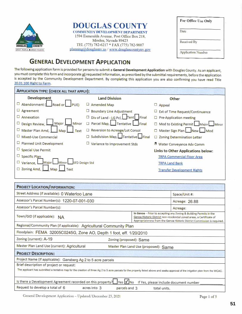
51
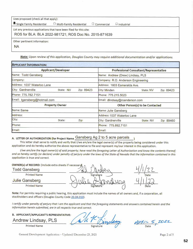
52
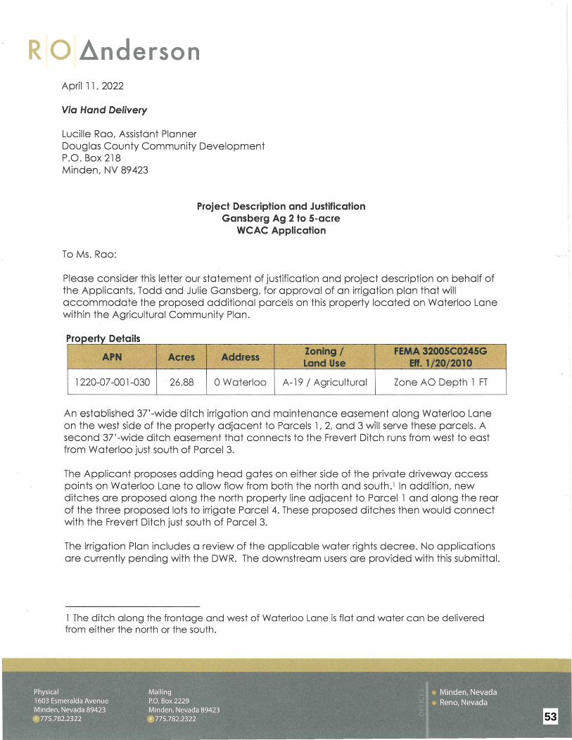
RO ~nderson April 11, 2022
Via Hand Delivery
Lucille Rao, Assistant Planner Douglas County Community Development P.O. Box 218 Minden, NV 89423
To Ms. Rao:
Project Description and Justification Gansberg Ag 2 to 5-acre
WCAC Application
Please consider this letter our statement of justification and project description on behalf of the Applicants, Todd and Julie Gansberg, for approval of an irrigation plan that will accommodate the proposed additional parcels on this property located on Waterloo Lane within the Agricultural Community Plan.
Property Details
APN Acres Address Zoning/ FEMA 32005C0245G Land Use Eff. 1/20/2010
1 220-07-001-030 26.88 0 Waterloo A-19 / Agricultural Zone AO Depth 1 FT
An established 37'-wide ditch irrigation and maintenance easement along Waterloo Lane on the west side of the property adjacent to Parcels 1, 2, and 3 will serve these parcels. A second 37 '-wide ditch easement that connects to the Frevert Ditch runs from west to east from Waterloo just south of Parcel 3.
The Applicant proposes adding head gates on either side of the private driveway access points on Waterloo Lane to allow flow from both the north and south.1 In addition, new ditches are proposed along the north property line adjacent to Parcel 1 and along the rear of the three proposed lots to irrigate Parcel 4. These proposed ditches then would connect with the Frevert Ditch just south of Parcel 3.
The Irrigation Plan includes a review of the applicable water rights decree. No applications are currently pending with the DWR. The downstream users are provided with this submittal.
1 The ditch along the frontage and west of Waterloo Lane is flat and water can be delivered from either the north or the south.
53
RO Anderson
Lucille Rao, Assistant Planner Douglas County Planning April 11, 2022 Page 2 of 2
At this time, we respectfully request your review and approval.
Sincerely,
I I RS Principal Engineer
54
MEETING DATE: May 2, 2022
TIME REQUIRED: 10
AGENDA: PUBLIC HEARINGS
AGENDA ITEM NO. 3.
WATER CONVEYANCE ADVISORY COMMITTEE AGENDA ITEMCOVER PAGE
TITLE:For discussion only. Update on maintenance agreement along a portion of the Martin SloughMultimodal Trail. RECOMMENDED MOTION:For discussion only. FINANCIAL IMPACT:None BACKGROUND:Update on maintenance agreement along a portion of the Martin Slough Multimodal Trail. ATTACHMENTS:
55
Related Documents