Northern Natural Gas Company Docket No. CP18-534-000 Northern Lights 2019 Expansion/ Rochester Projects Environmental Assessment Cooperating Agency Washington, DC 20426 November 2018 Federal Energy Regulatory Commission Office of Energy Projects

Welcome message from author
This document is posted to help you gain knowledge. Please leave a comment to let me know what you think about it! Share it to your friends and learn new things together.
Transcript
Northern Natural Gas Company Docket No. CP18-534-000
Northern Lights 2019 Expansion/ Rochester Projects
Environmental Assessment
Cooperating Agency
Washington, DC 20426
November 2018 Fe
dera
l Ene
rgy
Reg
ulato
ry
C
ommiss
ion
Office of Energy Projects

FEDERAL ENERGY REGULATORY COMMISSION WASHINGTON, D.C. 20426
OFFICE OF ENERGY PROJECTS In Reply Refer To:
OEP/DG2E/Gas 4 Northern Natural Gas Company
Northern Lights 2019 Expansion/Rochester Projects
Docket No. CP18-534-000
TO THE INTERESTED PARTY:
The staff of the Federal Energy Regulatory Commission (FERC or Commission) has prepared an environmental assessment (EA) for the Northern Lights 2019 Expansion Project and the Rochester Project, proposed by Northern Natural Gas Company (Northern) in the above-referenced docket. Northern requests authorization to construct, operate, and maintain new natural gas facilities in Carver, Freeborn, Hennepin, Le Sueur, Morrison, Mower, Olmsted, Rice, Steele, and Wright Counties, Minnesota, and to uprate the maximum allowable operating pressure (MAOP) of a line segment. The projects would allow Northern to provide 138,504 dekatherms per day of new firm natural gas transportation service to serve increased markets for industrial, commercial, and residential uses.
The EA assesses the potential environmental effects of the construction and operation of the projects in accordance with the requirements of the National Environmental Policy Act of 1969 (NEPA). The FERC staff concludes that approval of the proposed projects, with appropriate mitigating measures, would not constitute a major federal action significantly affecting the quality of the human environment.
The Minnesota Pollution Control Agency participated as a cooperating agency in the preparation of the EA. A cooperating agency has jurisdiction by law or special expertise regarding environmental impacts involved with the proposal, and is involved in the NEPA analysis.
The proposed projects include the following facilities (all located in Minnesota):
Rochester Project
approximately 12.6 miles of new 16-inch-diameter pipeline in Olmsted County (Rochester Greenfield Lateral);
increase of MAOP on an existing 8-mile-long segment of 16-inch-diameter pipeline in Freeborn and Mower Counties (La Crosse Branch Line MAOP Uprate);
a new town border station [TBS] with receiver in Olmsted County (Rochester TBS); relocation of a regulator from Freeborn to Mower County (MAOP Regulator); and
FEDERAL ENERGY REGULATORY COMMISSION WASHINGTON, D.C. 20426
OFFICE OF ENERGY PROJECTS In Reply Refer To:
OEP/DG2E/Gas 4 Northern Natural Gas Company
Northern Lights 2019 Expansion/Rochester Projects
Docket No. CP18-534-000
TO THE INTERESTED PARTY:
The staff of the Federal Energy Regulatory Commission (FERC or Commission) has prepared an environmental assessment (EA) for the Northern Lights 2019 Expansion Project and the Rochester Project, proposed by Northern Natural Gas Company (Northern) in the above-referenced docket. Northern requests authorization to construct, operate, and maintain new natural gas facilities in Carver, Freeborn, Hennepin, Le Sueur, Morrison, Mower, Olmsted, Rice, Steele, and Wright Counties, Minnesota, and to uprate the maximum allowable operating pressure (MAOP) of a line segment. The projects would allow Northern to provide 138,504 dekatherms per day of new firm natural gas transportation service to serve increased markets for industrial, commercial, and residential uses.
The EA assesses the potential environmental effects of the construction and operation of the projects in accordance with the requirements of the National Environmental Policy Act of 1969 (NEPA). The FERC staff concludes that approval of the proposed projects, with appropriate mitigating measures, would not constitute a major federal action significantly affecting the quality of the human environment.
The Minnesota Pollution Control Agency participated as a cooperating agency in the preparation of the EA. A cooperating agency has jurisdiction by law or special expertise regarding environmental impacts involved with the proposal, and is involved in the NEPA analysis.
The proposed projects include the following facilities (all located in Minnesota):
Rochester Project
• approximately 12.6 miles of new 16-inch-diameter pipeline in Olmsted County (Rochester Greenfield Lateral);
• increase of MAOP on an existing 8-mile-long segment of 16-inch-diameter pipeline in Freeborn and Mower Counties (La Crosse Branch Line MAOP Uprate);
• a new town border station [TBS] with receiver in Olmsted County (Rochester TBS); • relocation of a regulator from Freeborn to Mower County (MAOP Regulator); and
-2-
• appurtenant facilities including two valves and a pig launcher at milepost (MP) 0.0 of the Rochester Greenfield Lateral.
Northern Lights 2019 Project
• approximately 10.0 miles of new 24-inch-diameter pipeline in Hennepin and Wright Counties (Rockford to Buffalo Greenfield Lateral);
• approximately 4.3 miles of new 8-inch-diameter pipeline loop extension in Morrison County (Alexandria Branch Line Loop Extension);
• approximately 1.6 miles of new 6-inch-diameter pipeline looping in Le Sueur County (New Prague Branch Line Loop);
• approximately 3.1 miles of new 24-inch-diameter pipeline extension in Carver County (Willmar C-line Extension);
• a new 11,153-horsepower (hp) compressor station in Carver County (Carver Compressor Station);
• an additional 15,900 hp of compression at the existing Faribault Compressor Station in Rice County;
• an additional 15,900 hp of compression at the existing Owatonna Compressor Station in Steele County; and
• appurtenant facilities including valves, pig launchers, and pig receivers.
The Commission mailed a copy of the Notice of Availability for the EA to federal, state, and local government representatives and agencies; elected officials; environmental and public interest groups; Native American tribes; potentially affected landowners and other interested individuals and groups; and newspapers and libraries in the project areas. The EA is only available in electronic format. It may be viewed and downloaded from the FERC’s website (www.ferc.gov), on the Environmental Documents page (http://www.ferc.gov/industries/gas/enviro/eis.asp). In addition, the EA may be accessed by using the eLibrary link on the FERC’s website. Click on the eLibrary link (https://www.ferc.gov/docs-filing/elibrary.asp), click on General Search, and enter the docket number in the “Docket Number” field, excluding the last three digits (i.e. CP18-534). Be sure you have selected an appropriate date range. For assistance, please contact FERC Online Support at: [email protected] or toll free at (866) 208-3676, or for TTY, contact (202) 502-8659.
Any person wishing to comment on the EA may do so. Your comments should focus on the potential environmental effects, reasonable alternatives, and measures to avoid or lessen environmental impacts. The more specific your comments, the more useful they will be. To ensure that the Commission has the opportunity to consider your comments prior to making its decision on the projects, it is important that the Commission receive your comments on or before 5:00 p.m. Eastern Time on December 21, 2018.
For your convenience, there are three methods you can use to file your comments with the Commission. In all instances, please reference the project docket number (CP18-534-000) with your submission. The Commission encourages electronic filing of comments and has expert staff available to assist you at 866) 208-3676 or [email protected].
-3-
(1) You can file your comments electronically using the eComment feature located on the Commission's website (www.ferc.gov) under the link to Documents and Filings. This is an easy method for submitting brief, text-only comments on a Project;
(2) You can also file your comments electronically using the eFiling feature on the Commission's website (www.ferc.gov) under the link to Documents and Filings. With eFiling, you can provide comments in a variety of formats by attaching them as a file with your submission. New eFiling users must first create an account by clicking on “eRegister.” You must select the type of filing you are making. If you are filing a comment on a particular project, please select “Comment on a Filing” as the filing type; or
(3) You can file a paper copy of your comments by mailing them to the following address. Be sure to reference the projects docket number (CP18-534-000) with your submission: Kimberly D. Bose, Secretary, Federal Energy Regulatory Commission, 888 First Street NE, Room 1A, Washington, DC 20426
Any person seeking to become a party to the proceeding must file a motion to intervene
pursuant to Rule 214 of the Commission’s Rules of Practice and Procedures (18 CFR 385.214). Motions to intervene are more fully described at https://www.ferc.gov/resources/guides/how-to/intervene.asp. Only intervenors have the right to seek rehearing or judicial review of the Commission’s decision. The Commission may grant affected landowners and others with environmental concerns intervenor status upon showing good cause by stating that they have a clear and direct interest in this proceeding which no other party can adequately represent. Simply filing environmental comments will not give you intervenor status, but you do not need intervenor status to have your comments considered.
Additional information about the projects is available from the Commission’s Office of External Affairs, at (866) 208-FERC, or on the FERC website (www.ferc.gov) using the eLibrary link. The eLibrary link also provides access to the texts of formal documents issued by the Commission, such as orders, notices, and rulemakings.
In addition, the Commission offers a free service called eSubscription which allows you to keep track of all formal issuances and submittals in specific dockets. This can reduce the amount of time you spend researching proceedings by automatically providing you with notification of these filings, document summaries, and direct links to the documents. Go to http://www.ferc.gov/docs-filing/esubscription.asp.
Table of Contents
i
TABLE OF CONTENTS
Page
SECTION A – PROPOSED ACTION .........................................................................................1
A.1 INTRODUCTION..............................................................................................................1
A.2 PROJECT PURPOSE AND NEED .................................................................................2
A.3 SCOPE OF THIS ENVIRONMENTAL ASSESSMENT ..............................................3
A.4 PUBLIC REVIEW AND COMMENT ............................................................................3
A.5 PROPOSED FACILITIES ................................................................................................5
A.6 LAND REQUIREMENTS ................................................................................................9
A.7 CONSTRUCTION SCHEDULE ....................................................................................14
A.8 CONSTRUCTION, OPERATION, AND MAINTENANCE PROCEDURES ..........15 A.8.1 Conventional Pipeline Construction Sequence ......................................................17 A.8.2 Special Pipeline Construction Procedures .............................................................18 A.8.3 Aboveground Facilities Construction ....................................................................27 A.8.4 Operations and Maintenance..................................................................................29
A.9 NON-JURISDICTIONAL FACILITIES ......................................................................29
A.10 PERMITS, APPROVALS, AND REGULATORY CONSULTATIONS ...................30
SECTION B – ENVIRONMENTAL ANALYSIS ....................................................................33
B.1 GEOLOGY .......................................................................................................................33 B.1.1 Physiographic Settings and Geologic Conditions ..................................................33 B.1.2 Mineral Resources .................................................................................................34 B.1.3 Paleontological Resources .....................................................................................35 B.1.4 Geologic Hazards ...................................................................................................35
B.2 SOILS 37 B.2.1 Existing Characteristics .........................................................................................37 B.2.2 Prime Farmland ......................................................................................................38 B.2.3 Erosion ...................................................................................................................38 B.2.4 Compaction ............................................................................................................40 B.2.5 Shallow Bedrock ....................................................................................................41 B.2.6 Revegetation Potential ...........................................................................................41 B.2.7 Soil Contamination ................................................................................................42
B.3 WATER RESOURCES AND WETLANDS .................................................................42 B.3.1 Groundwater ..........................................................................................................42
Table of Contents
ii
B.3.2 Surface Waters .......................................................................................................48 B.3.3 Wetlands ................................................................................................................53 B.3.4 Hydrostatic Testing and Water Use .......................................................................64 B.3.5 Requested Modifications to FERC Procedures......................................................66
B.4 FISHERIES, VEGETATION, AND WILDLIFE .........................................................69 B.4.1 Fisheries .................................................................................................................69 B.4.2 Vegetation ..............................................................................................................70 B.4.3 Wildlife and Migratory Birds.................................................................................79 B.4.4 Threatened, Endangered, and Special Status Species ............................................85
B.5 LAND USE, RECREATION, AND VISUAL RESOURCES ......................................96 B.5.1 Land Use ................................................................................................................96 B.5.2 Planned Developments and Zoning .....................................................................106 B.5.3 Recreation and Special Use Areas .......................................................................106 B.5.4 Visual Resources ..................................................................................................107
B.6 CULTURAL RESOURCES ..........................................................................................108 B.6.1 Survey Results .....................................................................................................109 B.6.2 Native American Consultations ...........................................................................111 B.6.3 Unanticipated Discoveries Plan ...........................................................................113
B.7 SOCIOECONOMICS....................................................................................................113 B.7.1 Population, Housing, and Employment ...............................................................113 B.7.2 Public Services, Infrastructure, and Traffic .........................................................114 B.7.3 Property Value and Tax Revenue ........................................................................116 B.7.4 Environmental Justice and Sensitive Receptors .....................................................116
B.8 AIR QUALITY...............................................................................................................120 B.8.1 Existing Air Quality .............................................................................................120 B.8.2 Permitting/Regulatory Requirements...................................................................120 B.8.3 Construction Emissions .......................................................................................121 B.8.4 Operational Emissions .........................................................................................125
B.9 NOISE .............................................................................................................................129 B.9.1 Regulations ..........................................................................................................130 B.9.1 Construction Noise...............................................................................................130 B.9.2 Operational Noise ................................................................................................139
B.10 RELIABILITY AND SAFETY ....................................................................................142 B.10.1 Safety Standards...................................................................................................142 B.10.2 Pipeline Accident Data ........................................................................................145 B.10.3 Impact on Public Safety .......................................................................................147
B.11 CUMULATIVE IMPACTS AND CLIMATE CHANGE ..........................................150 B.11.1 Cumulative Impacts..............................................................................................150 B.11.2 Climate Change ....................................................................................................162 B.11.3 Conclusions on Cumulative Impacts ....................................................................164
Table of Contents
iii
SECTION C – ALTERNATIVES ............................................................................................165
C.1 NO-ACTION ALTERNATIVE ....................................................................................165
C.2 SYSTEM ALTERNATIVES.........................................................................................165
C.3 ROUTE ALTERNATIVES and variations .................................................................166
C.4 ABOVEGROUND FACILITY SITE ALTERNATIVES ..........................................168
SECTION D – STAFF’S CONCLUSIONS AND RECOMMENDATIONS .......................170
SECTION E – LIST OF PREPARERS ...................................................................................176
SECTION F – REFERENCES .................................................................................................177
LIST OF TABLES
Table A.4-1 Environmental Issues Identified During the Public Scoping Process ......................4
Table A.6.1-1 Land Requirements for the Rochester Project .........................................................9
Table A.6.1-2 Land Requirements for the NL 2019 Project .........................................................11
Table A.8.2-1 Proposed HDD Locations for the Rochester Project .............................................20
Table A.8.2-2 Proposed HDD Locations for the NL 2019 Project ...............................................21
Table A.8.2-3 Road Crossings Associated with the Rochester Project ........................................22
Table A.8.2-4 Road and Railroad Crossings Associated with the NL 2019 Project.....................23
Table A.10-1 Permits, Approvals, and Consultations for the Rochester and NL 2019 Projects .30
Table B.1.2-1 Sand/Gravel Pits within 0.25 mile of the Rochester Project ..................................34
Table B.3.1-1 Water Supply Wells and Springs within 1,000 feet of Rochester Project Construction Work Areas ......................................................................................44
Table B.3.1-2 Water Supply Wells and Springs within 150 feet of NL 2019 Project Construction Work Areas ............................................................................................................45
Table B.3.2-1 Waterbodies Crossed by the Rochester Project .....................................................49
Table B.3.2-2 Waterbodies Crossed by the NL 2019 Project .......................................................50
Table B.3.4-1 Total Water Use for Construction of the Rochester Project ..................................65
Table of Contents
iv
Table B.3.4-2 Total Water Use for Construction of the NL 2019 Project ....................................66
Table B.3.5-1 Requested Modification to the FERC Procedures for the Rochester Project ........67
Table B.3.5-2 Requested Modifications to the FERC Procedures for the NL 2019 Project ........67
Table B.4.2-1 Construction and Operation Impacts on Vegetation Cover Types in the Rochester Project Area ..........................................................................................................72
Table B.4.2-2 Construction and Operation Impacts on Vegetation Cover Types in the NL 2019 Project Area ..........................................................................................................75
Table B.4.2-3 Noxious Weed Species Observed – NL 2019 Project ...........................................77
Table B.4.3-1 Birds of Conservation Concern that May Occur within the Rochester Project Area ........................................................................................................................82
Table B.4.3-2 Birds of Conservation Concern that May Occur within the NL 2019 Project Area ........................................................................................................................83
Table B.4.4-1 Federally and State-listed Species Potentially Occurring in the Rochester Project Area ........................................................................................................................86
Table B.4.4-2 Federally and State-listed Species Potentially Occurring in the NL 2019 Project Area ........................................................................................................................93
Table B.5.1-1 Acreage Affected by Construction and Operation of the Rochester Project .........98
Table B.5.1-2 Acreage Affected by Construction and Operation of the NL 2019 Project .........100
Table B.7.1-1 Existing Socioeconomic Conditions in the NL 2019 and Rochester Project Areas ....................................................................................................................114
Table B.7.2-1 Public Services in the NL 2019 and Rochester Project Areas .............................115
Table B.7.4-1 Demographics and Low Income Populations in the Rochester Project Area ......117
Table B.7.4-2 Demographics and Low Income Populations in the NL 2019 Project Area ........119
Table B.8.3-1 Construction Emissions Summary for the Rochester Project ............................1233
Table B.8.3-2 Construction Emissions Summary for the NL 2019 Project ................................124
Table B.8.4-1 Operational Emissions Summary for the New Carver Compressor Station ........126
Table B.8.4-2 Operational Emissions Summary for the Expanded Faribault Compressor Station ..................................................................................................................126
Table of Contents
v
Table B.8.4-3 Operational Emissions Summary for the Expanded Owatonna Compressor Station ..................................................................................................................127
Table B.8.4-4 Compressor Station Modeling Parameters...........................................................128
Table B.8.4-5 Compressor Station Modeling Results – New Carver Compressor Station ........128
Table B.8.4-6 Compressor Station Modeling Results – Expanded Faribault Compressor Station ..................................................................................................................129
Table B.8.4-7 Compressor Station Modeling Results – Expanded Owatonna Compressor Station ..................................................................................................................129
Table B.9.1-1 Estimated Noise Levels for Potential Night-time Drilling at NSAs for HDDs – Rochester Project .................................................................................................133
Table B.9.1-2 Estimated Noise Levels for Potential Night-time Drilling at NSAs for HDDs – NL 2019 Project .........................................................................................................135
Table B.9.2-1 Estimated Noise Impacts for the NL 2019 Project Compressor Stations ............141
Table B.10.2-1 Natural Gas Transmission Pipeline Significant Incidents by Cause...................146
Table B.10.2-2 Outside Force Incidents by Cause ......................................................................147
Table B.10.3-1 Injuries and Fatalities - Natural Gas Transmission Pipelines .............................148
Table B.10.3-2 Nationwide Accidental Deaths ...........................................................................149
Table B.11.1-1 Resource-Specific Geographic Regions for Determining Cumulative Impacts of the Projects ...........................................................................................................151
Table B.11.1-2 Watersheds Crossed by NL 2019 and Rochester Project Components ..............153
Table B.11.1-3 Details of other Actions with Potential Cumulative Impacts on Resources within the Geographic and Temporal Scope Considered ................................................155
Table of Contents
vi
LIST OF FIGURES
Figure A.5-1 Rochester Project Overview ....................................................................................7
Figure A.5-2 NL 2019 Project Overview ......................................................................................8
Figure A.8.1-1 Typical Construction Sequence ............................................................................17
Figure B.11.1-1 Other Actions Considered in the Cumulative Impacts Analysis for the Rochester and NL 2019 Projects...........................................................................................154
Figure C.4-1 Carver Compressor Station Site Alternatives ......................................................169
APPENDICES
Appendix A Rochester Project Figures
Appendix B NL 2019 Project Figures
Appendix C Typical Right-of-Way Cross Sections – Rochester and NL 2019 Projects
Appendix D Additional Temporary Workspace and Staging Areas Tables – Rochester and NL 2019 Projects
Appendix E NSA Maps – NL 2019 Project Compressor Stations
Abbreviations and Acronyms
vii
ABBREVIATIONS AND ACRONYMS
AIMP ATWS
Agricultural Impact Mitigation Plan additional temporary workspace
BMP best management practice Certificate Certificate of Public Convenience and Necessity CFR Code of Federal Regulations Commission Federal Energy Regulatory Commission CT Census tract CWA Clean Water Act dB decibel dBA decibels on the A-weighted frequency scale DOT United States Department of Transportation EA environmental assessment EAB Emerald Ash Borer EI environmental inspector EPA United States Environmental Protection Agency ESA Endangered Species Act FEMA Federal Emergency Management Agency FERC Federal Energy Regulatory Commission GHG greenhouse gases HAP Hazardous Air Pollutant HCA High Consequence Area HDD horizontal directional drill hp horsepower HUC Hydrologic Unit Code MAOP maximum allowable operating pressure MBTA Migratory Bird Treaty Act MERC Minnesota Energy Resources Corporation MGS Minnesota Geological Survey MIAC Minnesota Indian Affairs Council MNDA Minnesota Department of Agriculture MNDH Minnesota Department of Health MNDNR Minnesota Department of Natural Resources MNPCA Minnesota Pollution Control Agency MP milepost NAAQS National Ambient Air Quality Standards NEPA National Environmental Policy Act NESHAP National Emissions Standards for Hazardous Air Pollutants NGA Natural Gas Act NHIS Natural Heritage Information System NL 2019 Project Northern Lights 2019 Expansion Project NLEB Northern long-eared bat NNSR Non-attainable New Source Review
Abbreviations and Acronyms
viii
NOI Notice of Intent to Prepare an Environmental Assessment for the Planned Northern Lights 2019 Expansion Project and Request for Comments on Environmental Issues
Northern Northern Natural Gas Company NPDES National Pollutant Discharge Elimination System NRCS Natural Resources Conservation Service NRHP National Register of Historic Places NSA noise sensitive area NSPS New Source Performance Standards NSR New Source Review NWI National Wetlands Inventory OEP Office of Energy Projects ORVW Outstanding Resource Value Waters PEM palustrine emergent wetland PFO palustrine forested wetland PHMSA Pipeline and Hazardous Materials Safety Administration Plan Upland Erosion Control, Revegetation, and Maintenance Plan Procedures Wetland and Waterbody Construction and Mitigation Procedures PSD Prevention of Significant Deterioration psig pounds per square inch gauge PSS palustrine scrub-shrub wetland RSEA Regionally Significant Ecological Area SHPO State Historic Preservation Office SPCC Plan Spill Prevention Control and Countermeasure Plan SSURGO Soil Survey Geographic Database SWA source water assessment SWPPP Stormwater Pollution Prevention Plan TBS Town Border Station TMDL total maximum daily load tpy tons per year TWS temporary workspace USACE United States Army Corps of Engineers USC United States Code USDA United States Department of Agriculture USGCRP United States Global Change Research Group USGS United States Geological Survey USFWS United States Fish and Wildlife Service WHPA Wellhead Protection Area WMA Wildlife Management Area
1
SECTION A – PROPOSED ACTION
A.1 INTRODUCTION
The staff of the Federal Energy Regulatory Commission (Commission or FERC) prepared this environmental assessment (EA) to assess the environmental impacts of two discrete projects, the Northern Lights 2019 Expansion Project (NL 2019 Project) and the Rochester Project. These two projects have separate purposes and independent utility (see section A.2, below); however, Northern Natural Gas Company (Northern) combined the two projects into a single application for a Certificate of Public Convenience and Necessity (Certificate). Combining the projects into a single environmental review is an efficient way to assess impacts, given that the two projects would be built at the same time, and many of Northern’s construction techniques and proposed mitigation measures would be similar for each project.
On July 27, 2018, Northern filed an application with the Commission (Docket No. CP18-534-000) pursuant to Section 7 of the Natural Gas Act (NGA), as amended, seeking authorization to develop, construct, operate, and maintain the pipeline and compression facilities (including pressure uprates) associated with the NL 2019 and Rochester Projects, as presented in more detail below in section A.5. Together, the projects would allow Northern to provide 138,504 dekatherms per day of new firm natural gas transportation service to serve increased markets for industrial, commercial, and residential uses: 37,093 Dth/day for the Rochester Project and 101,411 Dth/day for the NL 2019 Project. Prior to filing its application, Northern participated in the Commission’s pre-filing process for these projects under Docket No. PF18-1-000.
We1 prepared this EA in compliance with the requirements of the National Environmental Policy Act of 1969 (NEPA), the Council on Environmental Quality regulations for implementing NEPA (Title 40 of the Code of Federal Regulations Parts 1500-1508 [40 CFR 1500-1508]) and the Commission’s implementing regulations under 18 CFR 380.
The assessment of environmental impacts is an integral part of the Commission’s decision-making process on whether to issue Northern a Certificate to construct and operate the proposed facilities. Approval may be granted if, after consideration of both environmental and non-environmental issues, the Commission finds that the projects are in the public convenience and necessity. As such, we prepared this EA to assess the environmental impacts that would likely occur as a result of the proposed construction of each project. Our principal purposes in preparing this EA are to:
• identify and assess potential impacts on the natural and human environment that would result from the implementation of the proposed action;
• assess reasonable alternatives to the proposed action that would avoid or minimize adverse effects to the environment;
• identify and recommend specific mitigation measures, as necessary, to minimize environmental impacts; and
1 “We,” “us,” and “our” refers to environmental staff of the Commission’s Office of Energy Projects.
Proposed Action
2
• facilitate public involvement in the environmental review process.
Northern has requested a Certificate by January 17, 2019 in order to begin construction in spring 2019 and place the projects into service by November 1, 2019.
A.2 PROJECT PURPOSE AND NEED
Under Section 7 of the NGA, the Commission determines whether interstate natural gas transportation facilities are in the public convenience and necessity and, if so, grants a Certificate to construct and operate them. The FERC’s Certificate Policy Statement provides guidance as to how the Commission evaluates proposals for new construction, and establishes criteria for determining whether there is a need for a proposed project and whether it would serve the public interest. The Commission bases its decision on technical competence, financing, rates, market demand, gas supply, environmental impact, long-term feasibility, and other issues concerning a proposed project.
Rochester Project
According to Northern, the proposed Rochester Project facilities are necessary to provide additional natural gas for customers associated with increased energy needs in Minnesota that cannot be met by Northern’s existing infrastructure. Northern held an open season in 2015 to affirm and quantify market growth opportunities, to solicit interest for firm transportation service, and to identify the need to construct facilities necessary to provide firm transportation service on Northern’s system commencing on or after November 1, 2017. The 2015 Open Season resulted in the need for Northern’s proposed Rochester Project facilities in and near Rochester, Minnesota, which are necessary to meet growth requirements of a customer, Minnesota Energy Resources Corporation (MERC), in the Rochester area beginning in 2018, and growing to a peak volume in 2019. MERC began upgrading its natural gas infrastructure by constructing approximately 13 miles of natural gas distribution pipeline (which is not FERC-regulated) around the south and west sides of Rochester. Construction on the MERC Project began in summer 2017 and is expected to continue in stages through 2022. Northern’s Rochester Project would support Northern’s agreement to provide upstream firm natural gas transportation service for the MERC project.
NL 2019 Project
According to Northern, the proposed NL 2019 Project facilities are necessary to provide additional natural gas for customers associated with increased energy needs in Minnesota that cannot be met by Northern’s existing infrastructure. Northern held an open season in 2017 to affirm and quantify market growth opportunities, to solicit interest for firm transportation service, and to identify the need to construct facilities necessary to provide firm transportation service on Northern’s system commencing on or after November 1, 2019. From the open season, Northern identified firm load requirements for Xcel Energy and CenterPoint Energy, two local distribution companies, to support expansion projects, such as the existing Mankato Energy Center and other projects proposed for meeting commercial and residential needs in the greater Minnesota and Twin Cities area. Northern states that the NL 2019 Project would provide firm natural gas transportation service to these local distribution companies’ customers.
Proposed Action
3
A.3 SCOPE OF THIS ENVIRONMENTAL ASSESSMENT
The topics addressed in section B of this EA include geology and soils; groundwater, surface water, and wetlands; fisheries, vegetation, wildlife, and special status species; land use, recreation, and visual resources; cultural resources; socioeconomics; air quality and noise; reliability and safety; and cumulative impacts. The EA also assesses the no-action alternative, several system and route alternatives, and site alternatives for the Carver Compressor Station (see section C). The EA describes the affected environment as it currently exists, discusses the environmental consequences of the proposed projects, identifies measures proposed by Northern to reduce impacts, and presents our additional recommended mitigation measures, which are summarized in section D.
The environmental consequences of constructing and operating the projects would vary in duration and significance. Four levels of impact duration were considered: temporary, short-term, long-term, and permanent. Temporary impacts generally occur during construction with the resource returning to preconstruction condition immediately after restoration or within a few months. Short-term impacts could continue for up to 3 years following construction. Long-term impacts would last more than 3 years, but the affected resource would eventually recover to preconstruction conditions. Permanent impacts could occur as a result of any activity that modifies a resource to the extent that it would not return to preconstruction conditions during the life of the projects, such as the construction of aboveground facilities or permanent removal of forest vegetation. An impact would be considered significant if it would result in a substantial adverse change in the physical environment.
As the lead federal agency for the NEPA review of these projects, FERC is required to comply with Section 7 of the Endangered Species Act, as amended (ESA) and Section 106 of the National Historic Preservation Act. These statutes have been considered in the preparation of this EA. In addition to FERC, other federal, state, and local agencies may use this EA in approving or issuing any authorizations required for all or part of the proposed projects. Permits, approvals, and consultations for the projects are discussed in section A.10 of this EA.
The Minnesota Pollution Control Agency (MNPCA) is participating as a cooperating agency in the preparation of this EA because they have jurisdiction by law and special expertise with respect to impacts on water quality associated with the proposals.
A.4 PUBLIC REVIEW AND COMMENT
On October 16, 2017, the FERC's Director of the Office of Energy Projects (OEP) granted Northern’s request to utilize our Pre-filing Process. This review process was established to facilitate and encourage early involvement by citizens, governmental entities, non-governmental organizations, and other interested parties. As part of this process, the FERC assigned the project an individual pre-filing Docket No. PF18-1-000. During the Pre-filing Process, we worked with Northern and stakeholders to identify and resolve issues, where possible, prior to Northern’s filing of a formal application with the FERC.
On February 6, 2018, we issued in Docket No. PF18-1-000 a Notice of Intent to Prepare an Environmental Assessment for the Planned Northern Lights 2019 Expansion Project and Request for Comments on Environmental Issues (NOI). The NOI addresses both the NL 2019
Proposed Action
4
Project and the Rochester Project; therefore, public comments addressed one or both projects. The NOI was mailed to approximately 685 entities including affected landowners (as defined in the Commission’s regulations); federal, state, and local officials; Native American groups; agency representatives; environmental and public interest groups; and local libraries and newspapers.
Between October 2017 and July 2018, the Commission received about 20 comment letters. Written comments were submitted by three federal agencies (the U.S. Fish and Wildlife Service [USFWS], U.S. Department of Agriculture [USDA], and U.S. Environmental Protection Agency [EPA]); three state agencies (the Minnesota Department of Natural Resources [MNDNR], MNPCA, and the Minnesota State Historic Preservation Office [SHPO]); one Native American tribe; one public interest group; and several landowners.
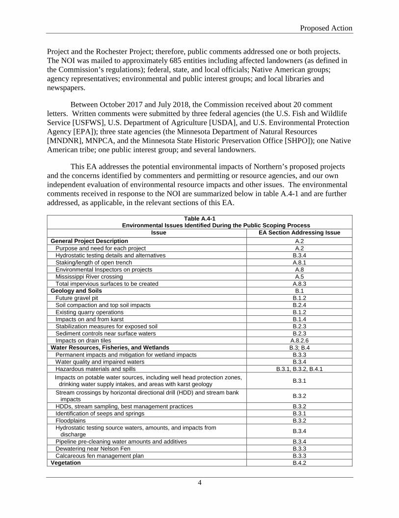
This EA addresses the potential environmental impacts of Northern’s proposed projects and the concerns identified by commenters and permitting or resource agencies, and our own independent evaluation of environmental resource impacts and other issues. The environmental comments received in response to the NOI are summarized below in table A.4-1 and are further addressed, as applicable, in the relevant sections of this EA.
Table A.4-1 Environmental Issues Identified During the Public Scoping Process
Issue EA Section Addressing Issue General Project Description A.2 Purpose and need for each project A.2 Hydrostatic testing details and alternatives B.3.4 Staking/length of open trench A.8.1 Environmental Inspectors on projects A.8 Mississippi River crossing A.5 Total impervious surfaces to be created A.8.3 Geology and Soils B.1 Future gravel pit B.1.2 Soil compaction and top soil impacts B.2.4 Existing quarry operations B.1.2 Impacts on and from karst B.1.4 Stabilization measures for exposed soil B.2.3 Sediment controls near surface waters B.2.3 Impacts on drain tiles A.8.2.6 Water Resources, Fisheries, and Wetlands B.3; B.4 Permanent impacts and mitigation for wetland impacts B.3.3 Water quality and impaired waters B.3.4 Hazardous materials and spills B.3.1, B.3.2, B.4.1 Impacts on potable water sources, including well head protection zones, drinking water supply intakes, and areas with karst geology B.3.1
Stream crossings by horizontal directional drill (HDD) and stream bank impacts B.3.2
HDDs, stream sampling, best management practices B.3.2 Identification of seeps and springs B.3.1 Floodplains B.3.2 Hydrostatic testing source waters, amounts, and impacts from discharge B.3.4
Pipeline pre-cleaning water amounts and additives B.3.4 Dewatering near Nelson Fen B.3.3 Calcareous fen management plan B.3.3 Vegetation B.4.2
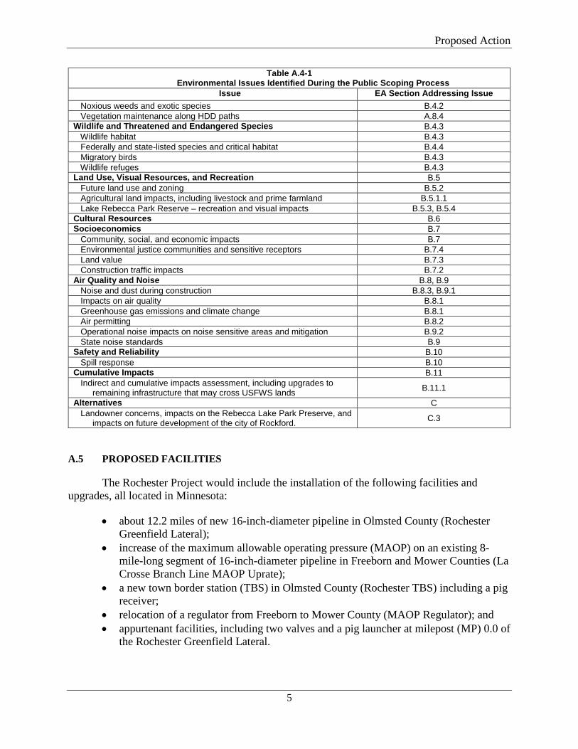
Proposed Action
5
Table A.4-1 Environmental Issues Identified During the Public Scoping Process
Issue EA Section Addressing Issue Noxious weeds and exotic species B.4.2 Vegetation maintenance along HDD paths A.8.4 Wildlife and Threatened and Endangered Species B.4.3 Wildlife habitat B.4.3 Federally and state-listed species and critical habitat B.4.4 Migratory birds B.4.3 Wildlife refuges B.4.3 Land Use, Visual Resources, and Recreation B.5 Future land use and zoning B.5.2 Agricultural land impacts, including livestock and prime farmland B.5.1.1 Lake Rebecca Park Reserve – recreation and visual impacts B.5.3, B.5.4 Cultural Resources B.6 Socioeconomics B.7 Community, social, and economic impacts B.7 Environmental justice communities and sensitive receptors B.7.4 Land value B.7.3 Construction traffic impacts B.7.2 Air Quality and Noise B.8, B.9 Noise and dust during construction B.8.3, B.9.1 Impacts on air quality B.8.1 Greenhouse gas emissions and climate change B.8.1 Air permitting B.8.2 Operational noise impacts on noise sensitive areas and mitigation B.9.2 State noise standards B.9 Safety and Reliability B.10 Spill response B.10 Cumulative Impacts B.11
Indirect and cumulative impacts assessment, including upgrades to remaining infrastructure that may cross USFWS lands B.11.1
Alternatives C Landowner concerns, impacts on the Rebecca Lake Park Preserve, and impacts on future development of the city of Rockford. C.3
A.5 PROPOSED FACILITIES
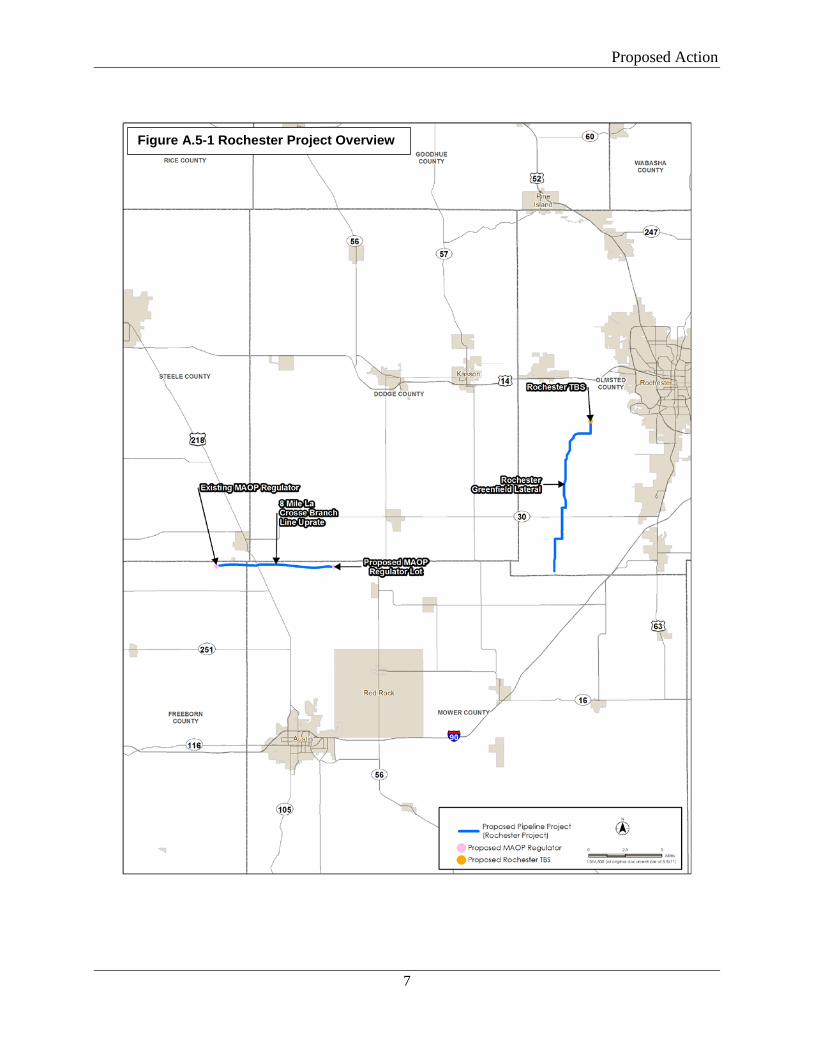
The Rochester Project would include the installation of the following facilities and upgrades, all located in Minnesota:
• about 12.2 miles of new 16-inch-diameter pipeline in Olmsted County (Rochester Greenfield Lateral);
• increase of the maximum allowable operating pressure (MAOP) on an existing 8-mile-long segment of 16-inch-diameter pipeline in Freeborn and Mower Counties (La Crosse Branch Line MAOP Uprate);
• a new town border station (TBS) in Olmsted County (Rochester TBS) including a pig receiver;
• relocation of a regulator from Freeborn to Mower County (MAOP Regulator); and • appurtenant facilities, including two valves and a pig launcher at milepost (MP) 0.0 of
the Rochester Greenfield Lateral.
Proposed Action
6
Additionally, Northern proposes to use 7 temporary access roads, 3 permanent driveways, and 11 staging areas to support construction and operation of the Rochester Project. The general location of the Rochester Project is shown in figure A.5-1, and U.S. Geological Survey (USGS) 7.5-minute quadrangle topographic maps are included in appendix A.
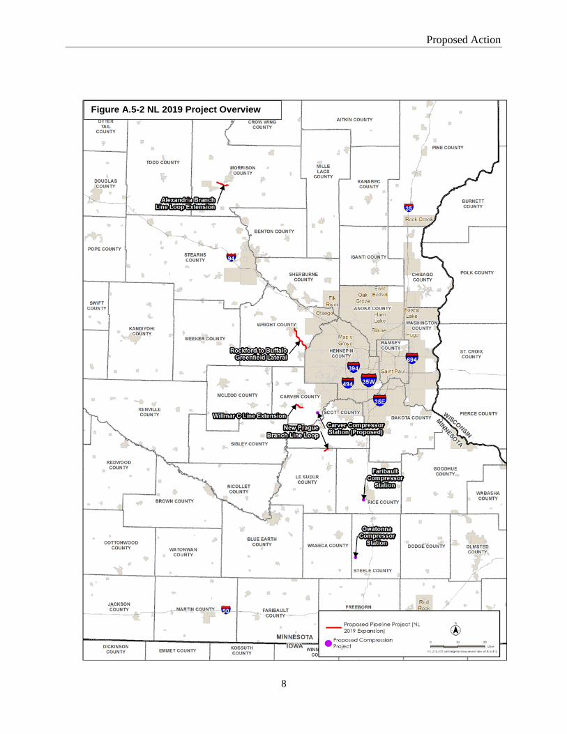
The NL 2019 Project would include the construction of the following facilities, all located in Minnesota:
• about 10.0 miles of new 24-inch-diameter pipeline in Hennepin and Wright Counties (Rockford to Buffalo Greenfield Lateral);
• about 4.3 miles of new 8-inch-diameter pipeline loop extension in Morrison County (Alexandria Branch Line Loop Extension);
• about 1.6 miles of new 6-inch-diameter pipeline looping in Le Sueur County (New Prague Branch Line Loop);
• about 3.1 miles of new 24-inch-diameter pipeline extension in Carver County (Willmar C-line Extension);
• a new 11,153-horsepower (hp) compressor station in Carver County (Carver Compressor Station);
• an additional 15,900 hp of compression at the existing Faribault Compressor Station in Rice County;
• an additional 15,900 hp of compression at the existing Owatonna Compressor Station in Steele County; and
• appurtenant facilities, including valves, pig launchers, and pig receivers in Hennepin, Wright, Morrison, Le Sueur, and Carver Counties (along the Rockford to Buffalo Greenfield Lateral, Alexandria Branch Line Loop Extension, New Prague Branch Loop, and Willmar C-line Extension).
Additionally, Northern proposes to use 23 temporary access roads, 6 permanent driveways, and 19 staging areas during construction of the NL 2019 Project. The general location of the NL 2019 Project is shown in figure A.5-2, and USGS 7.5-minute quadrangle topographic maps are included in appendix B.
In its FERC application, Northern also identified various ancillary facilities it plans on constructing or installing at its existing facilities in Minnesota, as allowed under its blanket certificate and under 18 CFR 2.55(a). These include various regulator settings, valve modifications, and heater and station piping modifications.2 None of these facilities are dependent on the proposed projects, and, according to Northern, will be installed regardless of the outcome of the current application before FERC.
2 Descriptions of these facilities can be accessed via FERC’s eLibrary at Accession no. 20180727-5220.
Proposed Action
7
Figure A.5-1 Rochester Project Overview
Figure A.5-1 Rochester Project Overview
Proposed Action
8
A.5-2 NL 2019 Project Overview
Figure A.5-2 NL 2019 Project Overview
Proposed Action
9
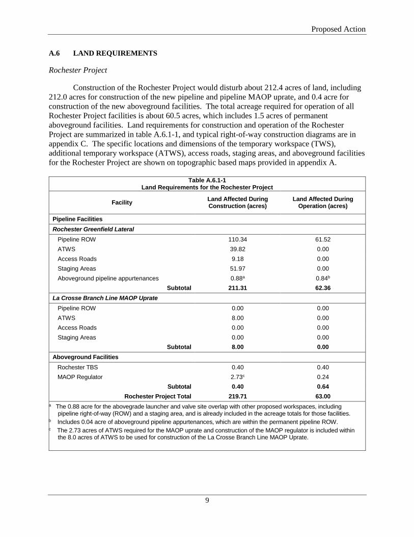
A.6 LAND REQUIREMENTS
Rochester Project
Construction of the Rochester Project would disturb about 212.4 acres of land, including 212.0 acres for construction of the new pipeline and pipeline MAOP uprate, and 0.4 acre for construction of the new aboveground facilities. The total acreage required for operation of all Rochester Project facilities is about 60.5 acres, which includes 1.5 acres of permanent aboveground facilities. Land requirements for construction and operation of the Rochester Project are summarized in table A.6.1-1, and typical right-of-way construction diagrams are in appendix C. The specific locations and dimensions of the temporary workspace (TWS), additional temporary workspace (ATWS), access roads, staging areas, and aboveground facilities for the Rochester Project are shown on topographic based maps provided in appendix A.
Table A.6.1-1
Land Requirements for the Rochester Project
Facility Land Affected During Construction (acres)
Land Affected During Operation (acres)
Pipeline Facilities Rochester Greenfield Lateral Pipeline ROW 110.34 61.52 ATWS 39.82 0.00 Access Roads 9.18 0.00 Staging Areas 51.97 0.00 Aboveground pipeline appurtenances 0.88a 0.84b
Subtotal 211.31 62.36 La Crosse Branch Line MAOP Uprate
Pipeline ROW 0.00 0.00 ATWS 8.00 0.00 Access Roads 0.00 0.00 Staging Areas 0.00 0.00
Subtotal 8.00 0.00 Aboveground Facilities Rochester TBS 0.40 0.40 MAOP Regulator 2.73c 0.24
Subtotal 0.40 0.64 Rochester Project Total 219.71 63.00
a The 0.88 acre for the abovegrade launcher and valve site overlap with other proposed workspaces, including pipeline right-of-way (ROW) and a staging area, and is already included in the acreage totals for those facilities.
b Includes 0.04 acre of aboveground pipeline appurtenances, which are within the permanent pipeline ROW. c The 2.73 acres of ATWS required for the MAOP uprate and construction of the MAOP regulator is included within
the 8.0 acres of ATWS to be used for construction of the La Crosse Branch Line MAOP Uprate.
Proposed Action
10
Pipeline Facilities
The land disturbed by construction of the Rochester Project pipeline facilities and pipeline MAOP uprate would include the permanent right-of-way, as well as TWS needed for typical pipeline construction procedures; ATWS for specialized construction procedures; construction staging areas; and access roads.
Northern would use a 90-foot-wide construction right-of-way along the Rochester Greenfield Lateral, except across wetlands where Northern would use a 75-foot-wide construction right-of-way. The permanent right-of-way would be 50 feet wide in uplands and 10 feet wide in wetlands.
ATWS of varying widths would be required adjacent to the TWS in certain locations for specialized construction methods such as horizontal directional drill (HDD), wetland, and waterbody crossing locations; at the beginning and end of each pipeline segment; pipeline crossovers; and for road crossings. Approximately 9.2 miles (73 percent) of the Rochester Project would be installed using open-cut methods, while 3.4 miles (27 percent) would be installed using HDD. ATWS of varying widths also would be used along the 8-mile-long segment of the La Crosse Branch Line to facilitate the MAOP uprate. In addition, 11 staging areas of various sizes would be used adjacent to the TWS and ATWS for pipe and equipment storage, staging of crews and equipment parking. TWS, ATWS, and staging areas would be restored to pre-construction conditions to the extent practicable after construction.
Temporary access roads would be needed to access the construction right-of-way and ATWS. A total of eight existing roads (shown on the maps in appendix A) would be used for site access during construction, and would be restored to pre-construction conditions or better after construction use. These roads generally originate at existing public roads. Three new permanent driveways would be constructed to access the Rochester Greenfield valve/launcher, TBS site, and MAOP regulator.
Locations, dimensions, and existing land use for ATWS and staging areas are provided in appendix D. Although Northern has identified areas where extra workspace would be required, additional or alternative areas, as well a minor route realignments, additional access roads, or modification to construction methods could be identified in the future due to unforeseen conditions in the field or construction contractor planning requirements. The Commission has established a variance procedure for such circumstances (see recommended condition 1 in Section D of this EA). In general, Northern’s biological and cultural resources surveys used a survey corridor larger than that necessary to construct the facilities. This would facilitate Northern’s use of the variance procedure (and staff’s review of any such requests), as most new workspace locations would be within the previously surveyed area.
Aboveground Facilities
The new Rochester TBS would be located at the terminus of the Rochester Greenfield Lateral, on a 0.4-acre-site within the MERC facility. Northern would construct a pig launcher and valve site at MP 0.0 of the Rochester Greenfield Lateral, which would permanently impact about 0.9 acre of land.
Proposed Action
11
Relocation of the MAOP regulator from MP 15.57 on Northern’s La Crosse Branch Line in Freeborn County to MP 23.61 in Mower County would require 0.2 acre for construction and operation, including a new 100-foot by 100-foot gravel facility and permanent driveway. Northern would remove the building and regulator setting from the existing MAOP regulator site at MP 15.57. The existing 50-foot by 65-foot gravel footprint of the existing site would not be altered, and a valve setting would remain in service at the existing regulator site.
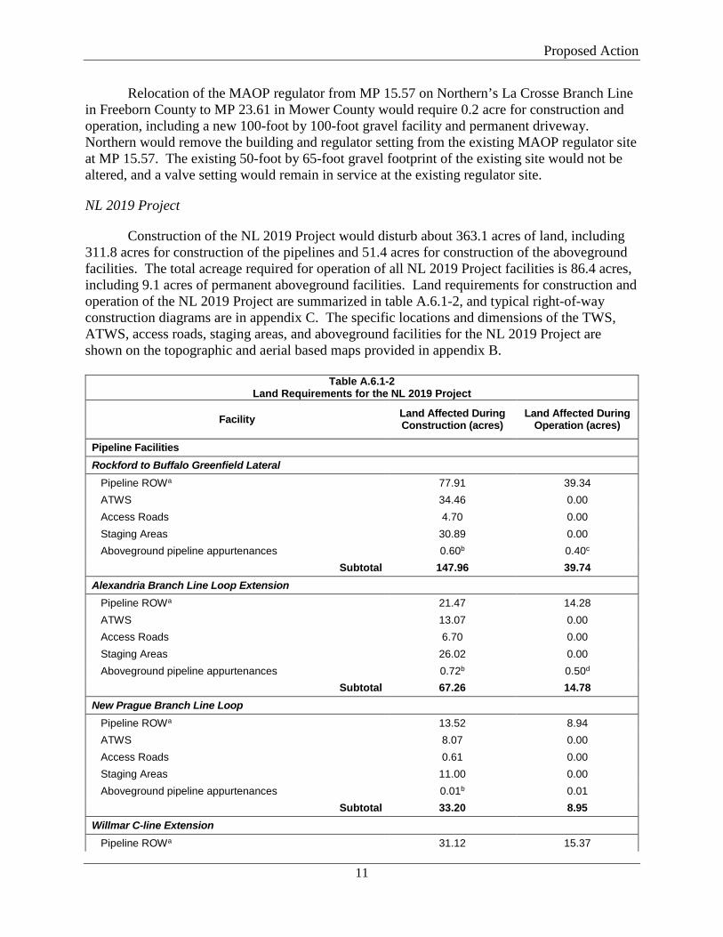
NL 2019 Project
Construction of the NL 2019 Project would disturb about 363.1 acres of land, including 311.8 acres for construction of the pipelines and 51.4 acres for construction of the aboveground facilities. The total acreage required for operation of all NL 2019 Project facilities is 86.4 acres, including 9.1 acres of permanent aboveground facilities. Land requirements for construction and operation of the NL 2019 Project are summarized in table A.6.1-2, and typical right-of-way construction diagrams are in appendix C. The specific locations and dimensions of the TWS, ATWS, access roads, staging areas, and aboveground facilities for the NL 2019 Project are shown on the topographic and aerial based maps provided in appendix B.
Table A.6.1-2
Land Requirements for the NL 2019 Project
Facility Land Affected During Construction (acres)
Land Affected During Operation (acres)
Pipeline Facilities Rockford to Buffalo Greenfield Lateral Pipeline ROWa 77.91 39.34 ATWS 34.46 0.00 Access Roads 4.70 0.00 Staging Areas 30.89 0.00 Aboveground pipeline appurtenances 0.60b 0.40c
Subtotal 147.96 39.74 Alexandria Branch Line Loop Extension Pipeline ROWa 21.47 14.28 ATWS 13.07 0.00 Access Roads 6.70 0.00 Staging Areas 26.02 0.00 Aboveground pipeline appurtenances 0.72b 0.50d
Subtotal 67.26 14.78 New Prague Branch Line Loop Pipeline ROWa 13.52 8.94 ATWS 8.07 0.00 Access Roads 0.61 0.00 Staging Areas 11.00 0.00 Aboveground pipeline appurtenances 0.01b 0.01
Subtotal 33.20 8.95 Willmar C-line Extension Pipeline ROWa 31.12 15.37
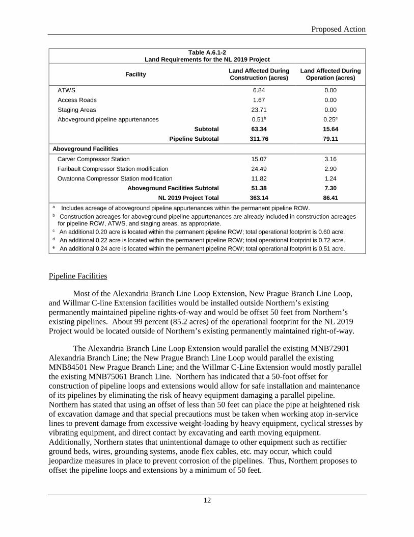
Proposed Action
12
Table A.6.1-2 Land Requirements for the NL 2019 Project
Facility Land Affected During Construction (acres)
Land Affected During Operation (acres)
ATWS 6.84 0.00 Access Roads 1.67 0.00 Staging Areas 23.71 0.00 Aboveground pipeline appurtenances 0.51b 0.25e
Subtotal 63.34 15.64 Pipeline Subtotal 311.76 79.11
Aboveground Facilities Carver Compressor Station 15.07 3.16 Faribault Compressor Station modification 24.49 2.90 Owatonna Compressor Station modification 11.82 1.24
Aboveground Facilities Subtotal 51.38 7.30 NL 2019 Project Total 363.14 86.41
a Includes acreage of aboveground pipeline appurtenances within the permanent pipeline ROW. b Construction acreages for aboveground pipeline appurtenances are already included in construction acreages
for pipeline ROW, ATWS, and staging areas, as appropriate. c An additional 0.20 acre is located within the permanent pipeline ROW; total operational footprint is 0.60 acre. d An additional 0.22 acre is located within the permanent pipeline ROW; total operational footprint is 0.72 acre. e An additional 0.24 acre is located within the permanent pipeline ROW; total operational footprint is 0.51 acre.
Pipeline Facilities
Most of the Alexandria Branch Line Loop Extension, New Prague Branch Line Loop, and Willmar C-line Extension facilities would be installed outside Northern’s existing permanently maintained pipeline rights-of-way and would be offset 50 feet from Northern’s existing pipelines. About 99 percent (85.2 acres) of the operational footprint for the NL 2019 Project would be located outside of Northern’s existing permanently maintained right-of-way.
The Alexandria Branch Line Loop Extension would parallel the existing MNB72901 Alexandria Branch Line; the New Prague Branch Line Loop would parallel the existing MNB84501 New Prague Branch Line; and the Willmar C-Line Extension would mostly parallel the existing MNB75061 Branch Line. Northern has indicated that a 50-foot offset for construction of pipeline loops and extensions would allow for safe installation and maintenance of its pipelines by eliminating the risk of heavy equipment damaging a parallel pipeline. Northern has stated that using an offset of less than 50 feet can place the pipe at heightened risk of excavation damage and that special precautions must be taken when working atop in-service lines to prevent damage from excessive weight-loading by heavy equipment, cyclical stresses by vibrating equipment, and direct contact by excavating and earth moving equipment. Additionally, Northern states that unintentional damage to other equipment such as rectifier ground beds, wires, grounding systems, anode flex cables, etc. may occur, which could jeopardize measures in place to prevent corrosion of the pipelines. Thus, Northern proposes to offset the pipeline loops and extensions by a minimum of 50 feet.
Proposed Action
13
Industry practice has typically used an offset of 25 feet when a company is installing loops and loop extensions that are co-located with one of their existing pipelines. This provides several advantages in terms of utilizing previously disturbed right-of-way for construction workspace and reducing the width of the new permanent right-of-way; both of which reduce impacts on landowners, land use, and environmental resources during construction and operation of the facilities. We generally do not see requests for a 50-foot offset when applicants are co-locating with an applicant-owned adjacent pipeline, particularly for smaller diameter pipelines ( e.g. 6- and 8-inch-diameter) such as those proposed in this application by Northern. In considering the resources that would be impacted by Northern’s proposed 50-foot offset, we recognize that the majority of the land use impacted by the Alexandria Branch Line Loop Extension, New Prague Branch Line Loop, and the Willmar C-Line Extension would be agricultural. Forests and wetlands make up a very small percentage of the land use impacted by this project, and Northern would cross forest resources and wetlands with natural vegetation or native plant communities via HDD to avoid or minimize impacts on these resources. However, the 50-foot offset would expand the easement encumbrance on landowners and Northern has not identified any unique construction conditions that necessitate a larger trench, or topography/land use issues that necessitate a larger easement to operate and maintain the pipeline. Based on our experience and review of similar looping projects, as well as our understanding of pipeline operations and maintenance procedures, we find that a 25-foot offset is sufficient to safely and efficiently operate large-diameter natural gas pipelines, and is more appropriate to minimize impacts on resources (i.e., forests, wetlands, etc.) and land use. Therefore, we recommend that:
• Northern should reduce the offset of its Alexandria Branch Line Loop Extension, New Prague Branch Line Loop, and Willmar C-Line Extension in all locations where the pipelines are immediately adjacent to its existing operational right-of-way and restrict the new permanent right-of-way width along these locations to a maximum of 25 feet immediately adjacent to its existing operation right-of-way.
Northern would use a 100-foot-wide construction right-of-way along the Rockford to Buffalo Greenfield Lateral and Willmar C-line Extension, except across wetlands where Northern would use a 75-foot-wide construction right-of-way. Northern would use a 75-foot-wide construction right-of-way along the Alexandria Branch Line Loop Extension and New Prague Branch Line Loop, including across wetlands that cannot be avoided by use of HDD. Approximately 7.5 miles (39 percent) of the NL 2019 Project would be installed using HDD, including 4.2 miles (42 percent) of the Rockford to Buffalo Greenfield Lateral, 2.4 miles (56 percent) of the Alexandria Branch Line Loop Extension, 0.2 mile (13 percent) of the New Prague Branch Line Loop, and 0.7 mile (23 percent) of the Willmar C-Line Extension. Northern has proposed the permanent right-of-way for all pipeline facilities to be 50 feet wide in uplands and 10 feet wide in wetlands; however, as noted above, we are recommending a reduction in permanent right-of-way width for the co-located loop lines and extensions.
ATWS of varying widths would be required adjacent to the TWS in certain locations for specialized construction methods such as HDD, wetland, and waterbody crossing locations; at the beginning and end of each pipeline segment; pipeline crossovers; and for road crossings. In addition, 19 staging areas of various sizes would be used adjacent to the TWS and ATWS for pipe and equipment storage, staging of crews, and equipment parking. Such areas would be restored to pre-construction conditions to the extent practicable after construction. Locations,
Proposed Action
14
dimensions, and existing land use for ATWS and staging areas are provided in appendix D. Although Northern has identified areas where extra workspace would be required, additional or alternative areas could be identified in the future due to changes in site-specific construction requirements. Northern would be required to file information on each of those areas for our review and approval prior to use, in accordance with the variance process discussed above.
Northern would use temporary access roads to access the construction right-of-way and ATWS. A total of 23 new and existing temporary access roads would be used during construction (13 for the Rockford to Buffalo Greenfield Lateral, 5 for the Alexandria Branch Line Loop Extension, 1 for the New Prague Branch Line Loop, and 4 for the Willmar C-Line Extension). These roads would generally originate at existing public roads, and would be restored to pre-construction conditions or better after construction use. Five permanent driveways would be constructed to access the Rockford launcher, Alexandria valve lot and pig launcher (125th Street), Alexandria valve lot (110th Street), and the Willmar C-Line launcher site. An existing permanent driveway at the Willmar C-Line receiver site would be expanded.
Aboveground Facilities
Construction of the Carver Compressor Station would require a total of 15.1 acres of ATWS, including an existing 1.1-acre TBS currently owned by Northern and 14 acres of private land. The compressor station would encompass a total of 3.16 acres during operation. A new 20-foot-wide permanent gravel driveway would be constructed to access the facility during construction and operation.
Northern’s existing 8.4-acre Faribault Compressor Station is within a 19.3-acre site owned by Northern; expansion of the compressor station would require 24.5 acres of ATWS. Operation of new facilities would require a 2.9-acre permanent facility expansion. To accommodate the facility expansion, Northern is negotiating the purchase of 1.6 acres of land on the north side of its existing facility site. The remaining 1.3 acres of the expansion would be on land owned by Northern. The expanded compressor station would total 11.3 acres.
Northern’s existing 4.6-acre Owatonna Compressor Station is within a 19.9-acre site owned by Northern; expansion of the compressor station would require 11.8 acres of ATWS. Operation of new facilities would require a 1.2-acre permanent facility expansion. To accommodate the facility expansion, Northern is negotiating the purchase of 4.1 acres of land on the north side of its existing facility site. The expanded compressor station would total 5.8 acres.
Construction of the new launcher/receiver and valve sites would occur wholly within the pipeline TWS; therefore, activities at these aboveground facilities would not increase the amount of land required for construction. Operation of these aboveground pipeline appurtenances would require about 1.9 acre of land.
A.7 CONSTRUCTION SCHEDULE
Northern proposes to begin construction in spring 2019 to place the projects into service by November 1, 2019. Revegetation and restoration measures would be employed as soon as possible following construction per federal and state permit conditions, and disturbed areas would be stabilized and reclaimed, weather permitting, by December 2019. Northern would
Proposed Action
15
monitor the success of revegetation for up to 3 years following construction, or until revegetation is successful.
Northern anticipates using a total of six to eight construction spreads3 for both projects. Construction of the pipeline components of each project would take about 3 to 5 months to complete; the compressor stations would take 8 to 9 months each to complete. Although the two projects are separate and would proceed at their own pace/schedule, Northern may coordinate sequencing to increase certain construction efficiencies.
Pipeline construction would generally take place Monday through Saturday during daylight hours, from 7 a.m. to 7 p.m.; however, Northern states that certain activities, including longer HDDs and the installation of tie-ins, may extend beyond normal construction hours and into Sunday, as necessary. In particular, the HDD crossings may be conducted continuously (24 hours per day) at critical times, such as during pullback of the pipe into the drill hole on the longer drills and when pipe sections would need to be welded during pullback (see further discussion in section A.8.2.1, below). If HDD activities need to take place outside normal daytime working hours, noise mitigation measures would be implemented as described in section B.9.1.
A.8 CONSTRUCTION, OPERATION, AND MAINTENANCE PROCEDURES
The projects would be designed, constructed, operated, and maintained in accordance with the U.S. Department of Transportation (DOT) Minimum Federal Safety Standards in 49 CFR 192. Project facilities would be marked and identified in accordance with applicable regulations. In accordance with 49 CFR 192, the pipeline would be inspected for leakage as part of scheduled operations and maintenance. Northern also would participate in the local One Call system. These standards are in accordance with the National Pipeline Safety Act of 1968, as amended.
Northern would adopt the FERC’s Upland Erosion Control, Revegetation, and Maintenance Plan (Plan) and Wetland and Waterbody Construction and Mitigation Procedures (Procedures)4 for the projects, with modifications to the Procedures as described in tables B.3.5-1 and B.3.5-2, in section B.3-5, below. Northern has not identified the need for any project-specific modifications from the requirements in the FERC’s Plan.
3 A “spread” is an individual segment of the overall project staffed by its own labor and equipment.
4 The FERC Plan and Procedures are a set of construction and mitigation measures that were developed minimize the potential environmental impacts of the construction of pipeline projects in general. The FERC Plan and Procedures can be viewed on the FERC Internet website at www.ferc.gov/industries/gas/enviro/plan.pdf and http://www.ferc.gov/industries/gas/enviro/procedures.pdf.
Proposed Action
16
In order to minimize potential environmental impacts, Northern has developed the following project-specific construction and reclamation plans for each project,5 which we have reviewed and find acceptable:
• HDD Plans and Profiles; • Agricultural Impact Mitigation Plan (AIMP); • Plan for Inadvertent Release of Drilling Mud; • Wetland Restoration Plan; • Spill Prevention, Control, and Countermeasures Plan (SPCC Plan); • Noxious Weed Plan; and • Unanticipated Discovery Plan for Cultural Resources and Human Remains.
Northern has also developed draft project-specific Stormwater Pollution Prevention Plans (SWPPP) that would incorporate the requirements and best management practices from federal and state permits and the FERC’s Plan and Procedures. A final SWPPP would be submitted for each project in conjunction with Northern’s application for construction storm water permits prior to the commencement of construction activities.
Northern would employ at least two environmental inspectors (EIs) each for the Rochester Greenfield Lateral and Rockford to Buffalo Greenfield Lateral. Northern would use at least one EI each for the Alexandria Branch Line Loop Extension, New Prague Branch Line Loop, Willmar C-line Extension, MAOP Uprate, and the three compressor stations. The EIs would be on site during construction to ensure Northern’s compliance with the measures outlined in the Plan and Procedures, the FERC Certificate, and all other environmental permit requirements from construction through restoration. The EIs would have the authority to stop activities that are not in compliance with agency requirements until corrective action has been taken.
Northern would conduct environmental training sessions in advance of construction to ensure that all individuals working on the projects are familiar with the environmental mitigation measures appropriate to their jobs and the EI’s authority. Northern has established an Environmental Complaint Resolution Procedure that provides landowners whose properties are crossed by the projects with directions for identifying and resolving their environmental mitigation problems or concerns. Prior to construction, Northern would provide the resolution procedure, including Northern’s toll-free telephone number (888-367-6671), to each landowner whose property is crossed by the projects, with instructions on lodging a complaint or asking questions. Northern’s resolution procedure also includes the FERC’s Enforcement Hotline telephone number for landowners to call in the event the landowner is not satisfied with the response using Northern’s established environmental complaint resolution process.
5 Copies of Northern’s Project-specific construction and reclamation plans have been filed with the Commission and can be viewed on eLibrary at http://www.ferc.gov/docs-filing/elibrary.asp under this docket.
Proposed Action
17
A.8.1 Conventional Pipeline Construction Sequence
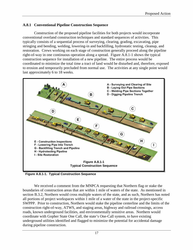
Construction of the proposed pipeline facilities for both projects would incorporate conventional overland construction techniques and standard sequences of activities. This typically consists of a sequential process of surveying, clearing, grading, excavating, pipe stringing and bending, welding, lowering-in and backfilling, hydrostatic testing, cleanup, and restoration. Crews working on each stage of construction generally proceed along the pipeline right-of-way in one continuous operation along a spread. Figure A.8.1-1 shows the typical construction sequence for installation of a new pipeline. The entire process would be coordinated to minimize the total time a tract of land would be disturbed and, therefore, exposed to erosion and temporarily precluded from normal use. The activities at any single point would last approximately 6 to 18 weeks.
Figure A.8.1-1. Typical Construction Sequence
We received a comment from the MNPCA requesting that Northern flag or stake the
boundaries of construction areas that are within 1 mile of waters of the state. As mentioned in section B.3.2, Northern would cross multiple waters of the state, and as such, Northern has noted all portions of project workspaces within 1 mile of a water of the state in the project-specific SWPPP. Prior to construction, Northern would stake the pipeline centerline and the limits of the construction right-of-way, ATWS, and staging areas, highway and railroad crossings, access roads, known underground facilities, and environmentally sensitive areas. Northern would coordinate with Gopher State One Call, the state’s One-Call system, to have existing underground utilities identified and flagged to minimize the potential for accidental damage during pipeline construction.
Figure A.8.1-1 Typical Construction Sequence
Proposed Action
18
Northern would install temporary soil erosion and sedimentation control devices, as needed, in accordance with the project SWPPPs prior to grading near wetlands and waterbodies and in the 100-year floodplain, and immediately after initial soil disturbance in all other areas. Redundant sedimentation controls would be installed within 50 feet of wetlands and waterbodies per MNPCA permit requirements. These erosion and sediment controls would be inspected and maintained throughout construction and restoration of the projects by personnel trained in accordance with MNPCA requirements.
In addition, the MNPCA commented that its Section 401 Water Quality Certification would limit the amount of open trench to less than 5,280 linear feet at any one time. Northern would adhere to this limit per project component and has identified open-trench segments in the draft SWPPP figures. The open trench, which would not exceed 1 mile, would proceed sequentially along the centerline as the pipe is installed. Following trenching, pipe lowering, and backfilling, all disturbed areas would be final-graded and restored as closely as possible to preconstruction contours. In accordance with our Plan, weather and season permitting, Northern would complete final cleanup (including replacement of topsoil where applicable, final grading, and installation of permanent erosion control devices) within 20 days after the trench is backfilled. In residential areas, cleanup and restoration would occur within 10 days of backfilling. Construction debris, trash, surplus materials, and temporary structures would be removed from the construction right-of-way and disposed of in accordance with applicable federal, state, and local regulations.
A.8.2 Special Pipeline Construction Procedures
In addition to the standard pipeline construction method discussed above, Northern would implement special construction procedures where warranted by site-specific conditions, as discussed below.
A.8.2.1 Horizontal Directional Drill
The HDD method involves drilling a small-diameter pilot hole under the area to be crossed and enlarging the hole through successive reaming until it is large enough to accommodate a prefabricated segment of pipe. A slurry of drilling mud is circulated through the drilling tools to lubricate the drill bit, remove drill cuttings, and promote borehole stability during drilling and/or the reaming process. Drilling mud primarily consists of bentonite, a non-toxic, naturally occurring sedimentary clay mixed with water. Northern would restrict the use of drilling additives to those on the Minnesota Department of Health (MNDH) approved list of drilling fluids and additives, and further limit use of additives which contain polyacrylamides and well-drilling foamers to upland areas only. The MNDH list is more restrictive than the NSF International/American National Standards Institute (NSF/ANSI) Standard 60, and only includes chemicals that are certified with conformance with the environmental specifications. The actual additives, which are proprietary, would be determined based on the need of each site-specific HDD and driller experience.
The position of the drill head is electronically monitored, and directional corrections are made if needed to maintain the desired alignment. Pipe sections are generally staged and welded within a TWS area on the opposite side of the crossing and then pulled through the drilled hole.
Proposed Action
19
During drilling, the pilot hole and other pre-ream efforts can be shut down at the end of each day; however, the pullback would likely be done in one continuous effort, which could extend after normal working hours. The pullback for some of the shorter crossings can likely be done in one daytime shift (e.g., 10 hours); however, for the longer crossings and those involving multiple pullback (welding) sections, the pullback would likely extend beyond a daytime shift into the nighttime. When nighttime activities are needed to complete an HDD, Northern would use noise mitigation measures to limit noise. The majority of the workday (e.g., 8-12 hours) for welding the pullback sections would be spent welding/inspecting/sleeving the next segment to be pulled. During this time, non-essential equipment may be idled until pullback is reinitiated. This may reduce impacts on nearby noise sensitive areas (NSA; e.g., residences, schools, churches, hospitals), when pullback efforts extend into the night. The potential noise impacts on NSAs and mitigation measures Northern would implement to reduce noise at NSAs during drilling are discussed in section B.9.1.
A 5-foot-wide travel lane or two 3-foot-wide travel lanes would be utilized between the HDD entry and exit points to follow the drill head and monitor for inadvertent releases of drilling mud. Minimal hand-clearing of vegetation could occur within the travel lane.
The HDDs identified on the Rochester Project are listed in table A.8.2-1 below. The HDDs identified on the NL 2019 Project are listed in table A.8.2-2. Northern has indicated that two HDDs on the Rochester Project and five HDDs on the NL 2019 Project have the highest potential to require work into nighttime hours because they are over 2,000 feet in length, which is generally the length of pipe the HDD contractors can pull back through the reamed drill hole in a 12-hour day.
The City of Rockford and Rockford Township prohibit utility work between 9 p.m. and 7 a.m. and on Sundays and holidays. The City of Buffalo and Buffalo Township prohibit construction work during the hours of 10 p.m. to 7 a.m. and on Sundays and holidays. Northern would apply for a conditional use permit with the appropriate local agency for HDDs with a high potential for nighttime work. The conditional use permit follows a notification process and, if approved by the local authorities, would allow Northern to construct into nighttime in specific instances. No noise ordinances were identified in areas crossed by the Rochester Project.
Temporary impacts from the HDD would primarily result from the TWS at the entry and exit of each crossing and at workspace for the pull-back pipeline assembly and stringing. If an inadvertent release of drilling mud to the ground surface occurs, Northern would implement measures prescribed in its Plan for Inadvertent Release of Drilling Mud, which describes how Northern would monitor for, respond to, and report an inadvertent release of drilling mud. We have reviewed the content of this plan and find it acceptable.
Rochester Project The HDD method would be used at 15 locations to minimize impacts on roads, wetlands,
waterbodies, and wooded lots by avoiding ground surface disturbance between the drill entry and exit points. Activity between the HDD entry and exit points would be limited to foot travel and minimal hand clearing by construction personnel to deploy directional cables that guide the drilling head and to monitor for inadvertent release of drilling mud. Table A.8.2-1 lists the specific features that would be avoided by each crossing, crossing locations, length, approximate
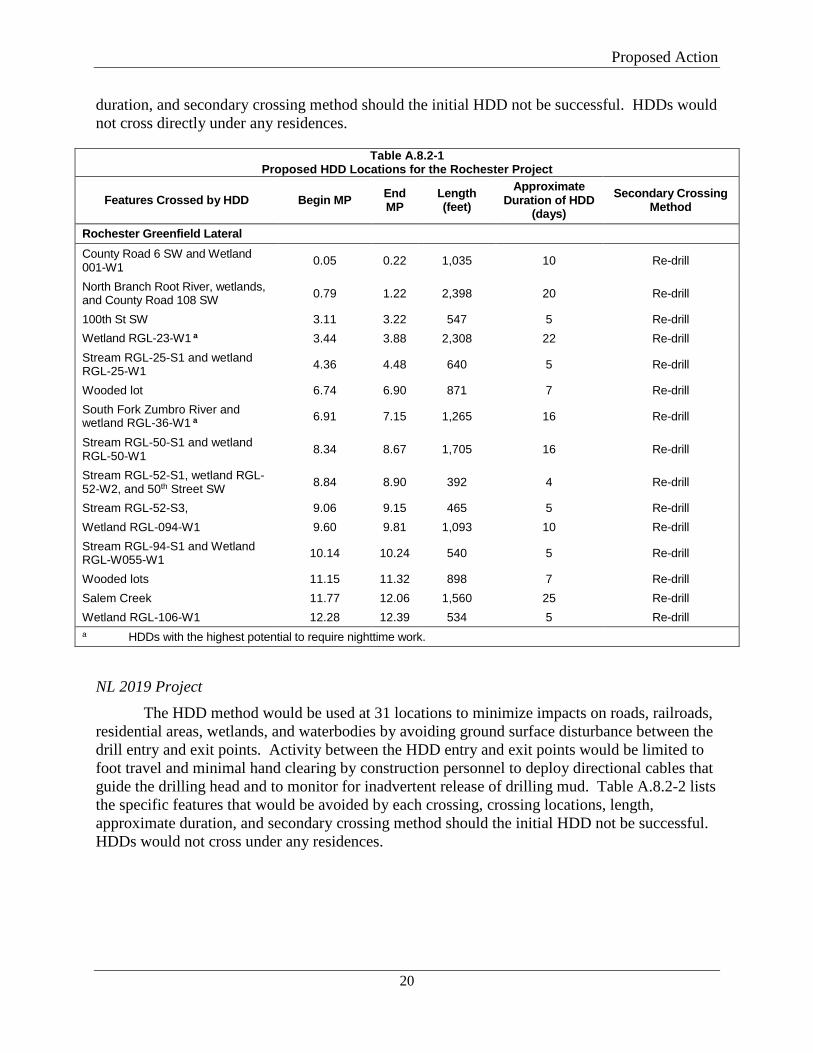
Proposed Action
20
duration, and secondary crossing method should the initial HDD not be successful. HDDs would not cross directly under any residences.
Table A.8.2-1 Proposed HDD Locations for the Rochester Project
Features Crossed by HDD Begin MP End MP
Length (feet)
Approximate Duration of HDD
(days) Secondary Crossing
Method
Rochester Greenfield Lateral County Road 6 SW and Wetland 001-W1 0.05 0.22 1,035 10 Re-drill
North Branch Root River, wetlands, and County Road 108 SW 0.79 1.22 2,398 20 Re-drill
100th St SW 3.11 3.22 547 5 Re-drill Wetland RGL-23-W1 a 3.44 3.88 2,308 22 Re-drill Stream RGL-25-S1 and wetland RGL-25-W1 4.36 4.48 640 5 Re-drill
Wooded lot 6.74 6.90 871 7 Re-drill South Fork Zumbro River and wetland RGL-36-W1 a 6.91 7.15 1,265 16 Re-drill
Stream RGL-50-S1 and wetland RGL-50-W1 8.34 8.67 1,705 16 Re-drill
Stream RGL-52-S1, wetland RGL-52-W2, and 50th Street SW 8.84 8.90 392 4 Re-drill
Stream RGL-52-S3, 9.06 9.15 465 5 Re-drill Wetland RGL-094-W1 9.60 9.81 1,093 10 Re-drill Stream RGL-94-S1 and Wetland RGL-W055-W1 10.14 10.24 540 5 Re-drill
Wooded lots 11.15 11.32 898 7 Re-drill Salem Creek 11.77 12.06 1,560 25 Re-drill Wetland RGL-106-W1 12.28 12.39 534 5 Re-drill a HDDs with the highest potential to require nighttime work.
NL 2019 Project
The HDD method would be used at 31 locations to minimize impacts on roads, railroads, residential areas, wetlands, and waterbodies by avoiding ground surface disturbance between the drill entry and exit points. Activity between the HDD entry and exit points would be limited to foot travel and minimal hand clearing by construction personnel to deploy directional cables that guide the drilling head and to monitor for inadvertent release of drilling mud. Table A.8.2-2 lists the specific features that would be avoided by each crossing, crossing locations, length, approximate duration, and secondary crossing method should the initial HDD not be successful. HDDs would not cross under any residences.
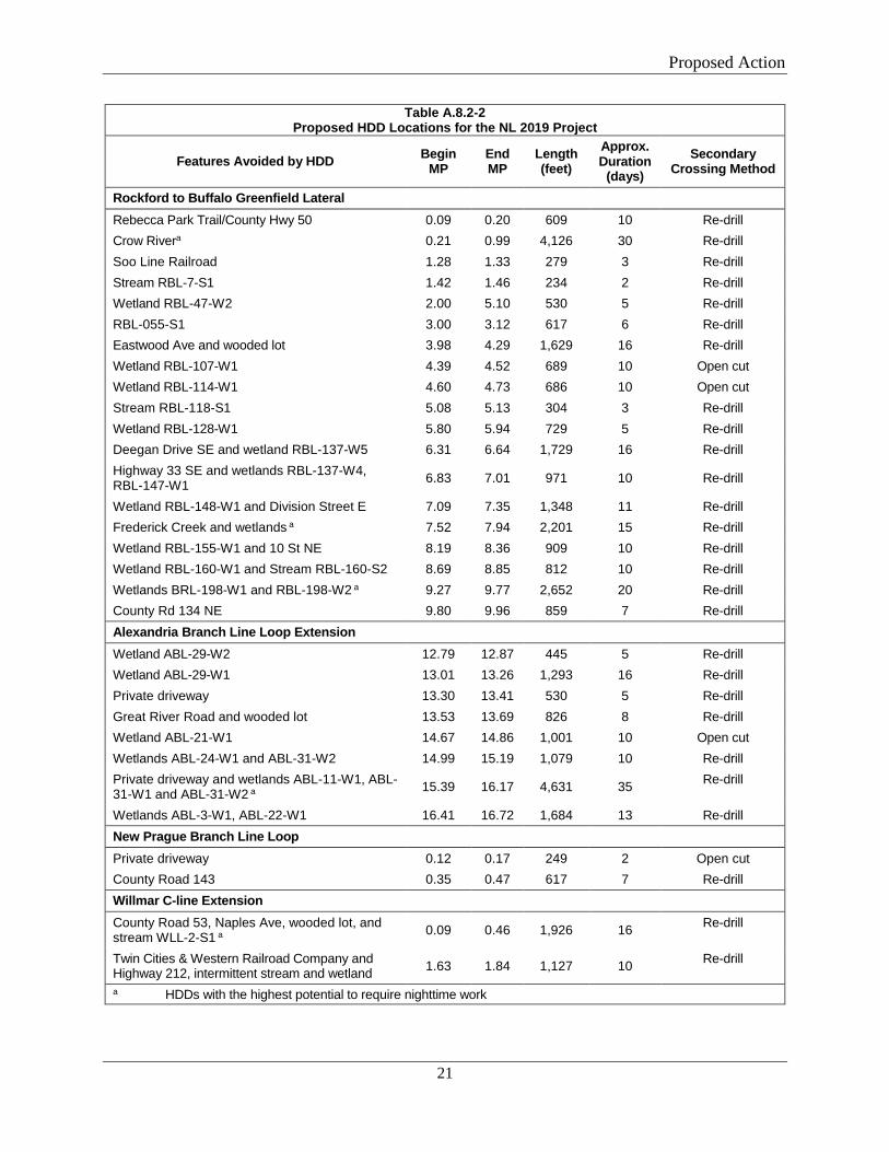
Proposed Action
21
Table A.8.2-2 Proposed HDD Locations for the NL 2019 Project
Features Avoided by HDD Begin MP
End MP
Length (feet)
Approx. Duration
(days) Secondary
Crossing Method
Rockford to Buffalo Greenfield Lateral Rebecca Park Trail/County Hwy 50 0.09 0.20 609 10 Re-drill Crow Rivera 0.21 0.99 4,126 30 Re-drill Soo Line Railroad 1.28 1.33 279 3 Re-drill Stream RBL-7-S1 1.42 1.46 234 2 Re-drill Wetland RBL-47-W2 2.00 5.10 530 5 Re-drill RBL-055-S1 3.00 3.12 617 6 Re-drill Eastwood Ave and wooded lot 3.98 4.29 1,629 16 Re-drill Wetland RBL-107-W1 4.39 4.52 689 10 Open cut Wetland RBL-114-W1 4.60 4.73 686 10 Open cut Stream RBL-118-S1 5.08 5.13 304 3 Re-drill Wetland RBL-128-W1 5.80 5.94 729 5 Re-drill Deegan Drive SE and wetland RBL-137-W5 6.31 6.64 1,729 16 Re-drill Highway 33 SE and wetlands RBL-137-W4, RBL-147-W1 6.83 7.01 971 10 Re-drill
Wetland RBL-148-W1 and Division Street E 7.09 7.35 1,348 11 Re-drill Frederick Creek and wetlands a 7.52 7.94 2,201 15 Re-drill Wetland RBL-155-W1 and 10 St NE 8.19 8.36 909 10 Re-drill Wetland RBL-160-W1 and Stream RBL-160-S2 8.69 8.85 812 10 Re-drill Wetlands BRL-198-W1 and RBL-198-W2 a 9.27 9.77 2,652 20 Re-drill County Rd 134 NE 9.80 9.96 859 7 Re-drill Alexandria Branch Line Loop Extension Wetland ABL-29-W2 12.79 12.87 445 5 Re-drill Wetland ABL-29-W1 13.01 13.26 1,293 16 Re-drill Private driveway 13.30 13.41 530 5 Re-drill Great River Road and wooded lot 13.53 13.69 826 8 Re-drill Wetland ABL-21-W1 14.67 14.86 1,001 10 Open cut Wetlands ABL-24-W1 and ABL-31-W2 14.99 15.19 1,079 10 Re-drill Private driveway and wetlands ABL-11-W1, ABL-31-W1 and ABL-31-W2 a 15.39 16.17 4,631 35 Re-drill
Wetlands ABL-3-W1, ABL-22-W1 16.41 16.72 1,684 13 Re-drill New Prague Branch Line Loop Private driveway 0.12 0.17 249 2 Open cut County Road 143 0.35 0.47 617 7 Re-drill Willmar C-line Extension County Road 53, Naples Ave, wooded lot, and stream WLL-2-S1 a 0.09 0.46 1,926 16 Re-drill
Twin Cities & Western Railroad Company and Highway 212, intermittent stream and wetland 1.63 1.84 1,127 10 Re-drill
a HDDs with the highest potential to require nighttime work
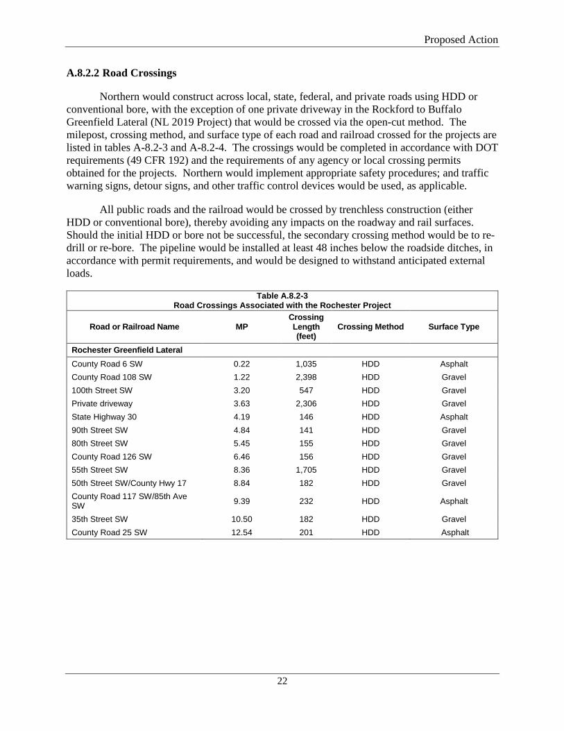
Proposed Action
22
A.8.2.2 Road Crossings
Northern would construct across local, state, federal, and private roads using HDD or conventional bore, with the exception of one private driveway in the Rockford to Buffalo Greenfield Lateral (NL 2019 Project) that would be crossed via the open-cut method. The milepost, crossing method, and surface type of each road and railroad crossed for the projects are listed in tables A-8.2-3 and A-8.2-4. The crossings would be completed in accordance with DOT requirements (49 CFR 192) and the requirements of any agency or local crossing permits obtained for the projects. Northern would implement appropriate safety procedures; and traffic warning signs, detour signs, and other traffic control devices would be used, as applicable.
All public roads and the railroad would be crossed by trenchless construction (either HDD or conventional bore), thereby avoiding any impacts on the roadway and rail surfaces. Should the initial HDD or bore not be successful, the secondary crossing method would be to re-drill or re-bore. The pipeline would be installed at least 48 inches below the roadside ditches, in accordance with permit requirements, and would be designed to withstand anticipated external loads.
Table A.8.2-3 Road Crossings Associated with the Rochester Project
Road or Railroad Name MP Crossing Length (feet)
Crossing Method Surface Type
Rochester Greenfield Lateral County Road 6 SW 0.22 1,035 HDD Asphalt County Road 108 SW 1.22 2,398 HDD Gravel 100th Street SW 3.20 547 HDD Gravel Private driveway 3.63 2,306 HDD Gravel State Highway 30 4.19 146 HDD Asphalt 90th Street SW 4.84 141 HDD Gravel 80th Street SW 5.45 155 HDD Gravel County Road 126 SW 6.46 156 HDD Gravel 55th Street SW 8.36 1,705 HDD Gravel 50th Street SW/County Hwy 17 8.84 182 HDD Gravel County Road 117 SW/85th Ave SW 9.39 232 HDD Asphalt
35th Street SW 10.50 182 HDD Gravel County Road 25 SW 12.54 201 HDD Asphalt
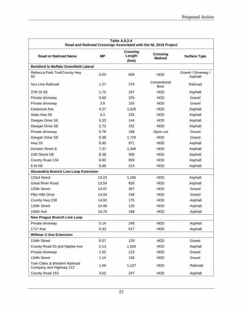
Proposed Action
23
Table A.8.2-4 Road and Railroad Crossings Associated with the NL 2019 Project
Road or Railroad Name MP Crossing Length (feet)
Crossing Method Surface Type
Rockford to Buffalo Greenfield Lateral Rebecca Park Trail/County Hwy 50 0.03 609 HDD Gravel / Driveway /
Asphalt
Soo Line Railroad 1.27 279 Conventional Bore Railroad
37th St SE 1.72 197 HDD Asphalt Private driveway 3.60 376 HDD Gravel Private driveway 3.8 155 HDD Gravel Eastwood Ave 4.27 1,629 HDD Asphalt State Hwy 55 4.3 225 HDD Asphalt Deegan Drive SE 5.33 144 HDD Asphalt Deegan Drive SE 5.72 152 HDD Asphalt Private driveway 5.78 168 Open cut Gravel Deegan Drive SE 6.38 1,729 HDD Gravel Hwy 33 6.95 971 HDD Asphalt Division Street E 7.37 1,348 HDD Asphalt 10th Street NE 8.38 909 HDD Asphalt County Road 134 9.93 859 HDD Asphalt 8 St NE 9.98 214 HDD Asphalt Alexandria Branch Line Loop Extension 123rd Street 13.23 1,290 HDD Asphalt Great River Road 13.54 826 HDD Asphalt 125th Street 13.97 367 HDD Gravel Pike Hills Drive 14.04 248 HDD Gravel County Hwy 238 14.60 175 HDD Asphalt 130th Street 14.98 130 HDD Asphalt 100th Ave 16.79 188 HDD Asphalt New Prague Branch Line Loop Private driveway 0.14 249 HDD Asphalt 171st Ave 0.43 617 HDD Asphalt Willmar C-line Extension 134th Street 0.07 129 HDD Gravel County Road 53 and Naples Ave 0.13 1,926 HDD Asphalt Private driveway 1.02 123 HDD Gravel 134th Street 1.14 135 HDD Gravel Twin Cities & Western Railroad Company and Highway 212 1.66 1,127 HDD Railroad
County Road 153 3.02 247 HDD Asphalt
Proposed Action
24
A.8.2.3 Waterbody Crossings
Northern’s pipeline facilities would cross all waterbodies using the HDD method as described in section A.8.2.1 and in accordance with the measures specified in the FERC’s Procedures, U.S. Army Corps of Engineers (USACE) permit conditions, and Northern’s construction plans. Northern does not plan any instream work; therefore, no instream best management practices (BMPs) would be required. HDDs would be designed by a qualified crossing engineer. An on-site engineer or EI would inspect all waterbody crossings during construction to document compliance with design criteria and permit conditions.
Rochester Project
The Rochester Project would cross 7 waterbodies, with multiple crossings of some waterbodies (10 crossings total). The North Branch of the Root River is crossed three times due to the meandering nature of the waterbody. Northern would cross the North Branch of the Root River via one HDD to minimize potential impacts on the waterbody and limit the duration of the crossing. Northern proposes to use the HDD method for all waterbody crossings for the Rochester Project. Further details regarding waterbody crossing impacts and mitigation for this project are discussed in section B.3.2.
NL 2019 Project
Northern proposes to use the HDD method for all 10 waterbody crossings for the NL 2019 Project. Further details regarding waterbody crossing impacts and mitigation for this project are discussed in section B.3.2.
A.8.2.4 Wetland Crossings
Northern’s pipeline facilities would cross wetlands using the HDD method as described in section A.8.2.1 and the open-cut method described below. Crossing of wetlands would be completed in accordance with the measures specified in our Procedures, USACE permit conditions, and Northern’s construction plans.
Wetlands crossed via HDD would require no removal of vegetation or result in direct impact from construction equipment. Sediment barriers would be installed between the edges of the construction workspace and the wetland boundaries.
In open cutting wetlands, the clearing of vegetation would be limited to trees and shrubs, which would be cut flush with the surface of the ground and removed from the wetland. Stump removal, grading, topsoil segregation, and excavation would be limited to the area immediately over the trench line. During clearing, sediment barriers, such as silt fence and staked straw bales, would be installed and maintained adjacent to wetlands and within ATWS as necessary to minimize the potential for sediment runoff. Sediment barriers would be installed across the full width of the construction right-of-way at the base of slopes adjacent to wetland boundaries. Silt fence or straw bales installed across the working side of the right-of-way may be removed during the day when vehicle traffic is present and would be replaced each night. Sediment barriers would also be installed within wetlands along the edge of the right-of-way, where necessary, to minimize the potential for sediment to run off the construction right-of-way and into wetland or
Proposed Action
25
other sensitive areas outside the construction work area. If trench dewatering is necessary in wetlands, the trench water would be discharged in stable, vegetated, upland areas and/or through a filter bag or siltation barrier. No heavily silt-laden water would be allowed to flow into a wetland.
Construction equipment working in wetlands would be limited to that essential for right-of-way clearing, excavating the trench, fabricating and installing the pipeline, backfilling the trench, and restoring the right-of-way. In areas of saturated soils or standing water, low-ground-weight construction equipment and/or timber riprap, prefabricated equipment mats, or terra mats would be used to reduce rutting and the mixing of topsoil and subsoil. In unsaturated wetlands, the top layer of topsoil, up to 12 inches, would be stripped from the trench line and stored separately from the subsoil. Topsoil segregation generally would not be possible in saturated soils due to the difficulty of such operations.
Where wetland soils are saturated and/or inundated, the pipeline may be installed using the push-pull technique. This technique generally involves stringing and welding the pipeline outside of the wetland and excavating the trench through the wetland using a backhoe supported by equipment mats. The water that seeps into the trench can be used to “float” the pipeline into place together with a winch and flotation devices attached to the pipe. After the pipeline is floated into place, the floats are removed and the pipeline allowed to sink into place. Pipe installed in saturated wetlands is typically coated with concrete or equipped with set-on weights to provide negative buoyancy. After the pipeline sinks to the bottom of the trench, a trackhoe working on equipment mats backfills the trench and completes cleanup.
Prior to backfilling, Northern would install trench breakers where necessary to prevent the subsurface drainage of water from wetlands. Where topsoil has been segregated from subsoil, the subsoil would be backfilled first followed by the topsoil. Equipment mats, terra mats, and timber riprap would be removed from wetlands following backfilling.
Rochester Project
The Rochester Project would cross 13 wetlands via open cut or HDD. Further details regarding wetland impacts and mitigation for this project are discussed in section B.3.3.
NL 2019 Project
The NL 2019 Project would cross 36 wetlands via open cut or HDD. Further details regarding wetland impacts and mitigation for this project are discussed in section B.3.3.
A.8.2.5 Residential Areas
Northern would implement several measures to minimize inconvenience to property owners where residences are located near the edge of the projects’ workspace. These measures include reducing the width of the workspace as practicable, installing safety fencing and other safety-related measures, and performing clean-up thoroughly and promptly as soon as construction is complete. The specific steps to be taken to reduce potential impacts in residential areas include the measures described below:
Proposed Action
26
• Where open-cut trenching occurs, safety fencing would be installed along the construction corridor in residential areas to discourage children, pets, and non-workers from entering the area. At a minimum, fencing would be installed on the edge of the construction right-of-way for a distance of 100 feet on either side of the residence on the residence side of the construction corridor.
• The trench would be secured with safety fencing each day as construction activities within residential areas come to a close.
• In areas where construction equipment could affect local traffic, flagmen or signage would be stationed on either side of road crossings to direct traffic during construction across roadways. Northern proposes to drill under all public roadways.
• Generally, construction in residential areas would occur Monday through Saturday from 7 a.m. to 7 p.m., with the exception of the HDDs identified in section A.8.2.1 and tie-ins where nighttime construction may be necessary. HDD noise impacts on nearby NSAs is described further in section B.9.1.
No residences are within 25 feet of proposed construction workspaces. One residence at MP 1.8 of the Rockford to Buffalo Greenfield Lateral and one residence near MP 13.5 of the Alexandria Branch Line Loop Extension are within 50 feet of a proposed NL 2019 Project workspace. See section B.5.1.5 for additional discussion on residential impacts.
A.8.2.6 Active Cropland
Construction in agricultural areas would be conducted in accordance with our Plan and Procedures and Northern’s AIMP. To conserve topsoil, full right-of-way topsoil removal would be conducted in cultivated and rotated cropland and managed pasture. A maximum of 12 inches of topsoil would be segregated. Where the existing topsoil is less than 12 inches, Northern would remove and segregate the actual depth of the topsoil to the extent practicable. The topsoil and subsoil would be stored in separate windrows on the construction right-of-way and would not be allowed to mix. Also, following construction, Northern would remove excess rock in cultivated cropland, pastures, and hayfields and would test topsoil and subsoil for compaction. Further information regarding soils and agricultural land is provided in sections B.2 and B.5.1.1.
Pursuant to the conditions of its AIMP, Northern would consult with landowners in agricultural areas prior to construction in an effort to identify any known drain tile locations. Known drain tiles would be noted on the alignment sheets and marked with highly visible flagging at each right-of-way edge and the centerline of the pipe, where applicable. Previously undocumented drain tiles discovered during grading or trenching would also be flagged at each right-of-way edge, and survey data would be collected at the location of any broken tiles. Northern has committed to repair damaged or broken drain tiles caused by construction. Drain tile repairs would be made by a qualified drain tile specialist, the landowner, or a landowner’s representative. The quality, size, and flow of replacement tile would equal or exceed that of the damaged tile.
Following construction, topsoil and subsoil would be tested for compaction in agricultural areas. As applicable, the contractor would plow subsoil in accordance with the soil compaction mitigation procedures described in our Plan. Compaction testing would be conducted to verify compaction is relieved to a level equal to or better than adjacent undisturbed
Proposed Action
27
areas. Once plowing of the subsoil is complete, the segregated topsoil would be returned to the right-of-way. The restoration activity would be considered complete once the topsoil has been disked and raked to near pre-construction conditions. Northern would remove excess rock from at least the top 12 inches of soil in all cultivated or rotated cropland, managed pastures, hayfields, and residential areas, as well as other areas at the landowner’s request such that the size, density, and distribution of rock on the construction work area shall be similar to adjacent areas not disturbed by construction.
If construction requires the removal of private property features, such as gates or fences, they would be repaired following construction. Northern would implement its project-specific Noxious Weed Plan to prevent, mitigate, and control the spread of noxious weeds during construction and operation of both projects.
A.8.2.7 Blasting
No blasting is anticipated in association with the projects. If an area of unrippable shallow bedrock is encountered and blasting becomes necessary, Northern would develop a site-specific Blasting Plan and comply with any required permits.
A.8.2.8 MAOP Uprate
As part of the Rochester Project, Northern would increase the MAOP on approximately 8 miles of the La Crosse Branch Line from 800 pounds per square inch gauge (psig) to 1,000 psig. The uprate would require four workspaces; one ATWS for removal of the existing MAOP regulator, one ATWS at the MAOP regulator installation site, and two ATWS for hydrostatic testing. During the hydrostatic test, Northern would conduct leak surveys, as needed, via pedestrian foot survey. Temporary test headers would be installed to facilitate testing.
A.8.3 Aboveground Facilities Construction
Construction of the aboveground facilities would include general activities such as clearing and grading, foundation installation, erection of aboveground facilities, installation of piping equipment, testing of equipment, and timely clean-up and restoration of the project areas. Construction activity and storage of construction material would be limited to the ATWS areas, and waste materials would be disposed of in a manner consistent with state and local regulations.
Prior to ground-disturbing activities, erosion and sediment control devices would be installed in accordance with Northern’s individual SWPPPs. After site preparation is complete at each aboveground facility, excavation would be performed, as necessary, to accommodate the new concrete foundations. Forms would be set, rebar installed, and the concrete poured and cured in accordance with minimum strength requirements. Backfill would be compacted in place, and excess soil would be evenly spread within the station yard or hauled off for proper disposal.
The aboveground compression units (i.e., turbines) would be installed after foundations are completed. The buildings would be constructed and equipment and control systems installed in compliance with applicable local, state, and federal code requirements. Non-screwed piping would be welded using procedures in accordance with American Petroleum Institute standards
Proposed Action
28
(API 1999). Aboveground piping would be cleaned and painted according to Northern’s specifications and in accordance with regulatory requirements.
Prior to placing the project facilities in service, all controls and safety equipment and systems, such as emergency shutdown systems, relief valves, gas and fire detection, and other protection equipment would be tested. Pressure testing would be conducted on piping, in accordance with the requirements of DOT pipeline safety regulations (49 CFR 192), Northern’s testing specifications and applicable permits. Testing would follow all applicable federal, state, and local requirements.
Upon completion, the project areas would be cleaned and restored in accordance with applicable state and federal permits and plans. Final grading would be completed, gravel surfaces refreshed (as needed), and grass or appropriate vegetation seeded per specifications. Compliance with the individual project SWPPPs and other permanent mitigation measures would be verified in accordance with applicable permits.
The Rochester Project aboveground facilities and appurtenances would create a total of 1.6 acres of impervious surface, including 0.9 acre at the Rochester Greenfield Lateral launcher/receiver site, 0.4 acre at the Rochester TBS, and 0.2 acre at the MAOP Regulator site. The Rochester Project aboveground facilities would not require permanent stormwater management, as the net increase in impervious surface for each individual component would be less than 1 acre and the sites would be geographically separated.6
The NL 2019 Project aboveground pipeline appurtenances would create a total of 1.9 acres of impervious surface, as follows:
• 0.4 acre at the Rockford to Buffalo Greenfield Lateral launcher/valve site; • 0.2 acre at the Rockford to Buffalo Greenfield Lateral receiver/valve site; • <0.1 acre at the Alexandria Branch Line Loop Extension valve site; • 0.3 acre at the Alexandria Branch Line Loop Extension launcher/valve site; • 0.4 acre at the Alexandria Branch Line Loop Extension receiver/valve site; • <0.1 acre at the New Prague Branch Line Loop valves/launcher and receiver; • 0.2 acre at the Willmar C-Line Extension launcher/valve site; and • 0.3 acre at the Willmar C-Line Extension receiver/valve site.
These aboveground appurtenances would not require permanent stormwater management, as the net increase impervious surface for each individual component would be less than 1 acre and the sites would be geographically separated.
6 In Minnesota, a National Pollutant Discharge Elimination System (NPDES)/State Disposal System (SDS) Construction Stormwater General Permit is required for any construction activity disturbing 1 acre or more of soil; less than 1 acre of soil if the activity is part of a “larger common plan of development or sale” that is greater than 1 acre; or less than 1 acre of soil, but the MNPCA determines that the activity poses a risk to water resources.
Proposed Action
29
The new impervious surface for the proposed Carver Compressor Station would be over 1 acre. The net increase in impervious surface for the proposed expansions of the existing Faribault and Owatonna compressor stations would also be greater than 1 acre at each location. Northern would apply for coverage under MNR100001 (National Pollutant Discharge Elimination System (NPDES)/State Disposal System (SDS) Construction Stormwater General Permit) for the three compressor stations and the application(s) would include post-construction stormwater modeling information and design of permanent stormwater management BMPs.
A.8.4 Operations and Maintenance
Each project would be designed, constructed, tested, operated, and maintained in accordance with the DOT Minimum Federal Safety Standards in 49 CFR 192, FERC regulations in 18 CFR 380.15, and maintenance requirements in FERC’s Plan and Procedures. All project facilities would be marked and identified in accordance with applicable regulations.
The pipelines would be inspected on a routine basis, which would provide information on possible leaks, third-party construction activities, erosion, encroachment, and other potential problems that may affect the safety and operation of the pipelines. Cathodic protection facilities installed along the pipeline would be regularly monitored and inspected periodically to ensure proper and adequate corrosion protection.
Routine vegetation maintenance along the permanent right-of-way would be conducted periodically in accordance with the FERC’s Plan and Procedures. Routine vegetation maintenance in uplands would not be conducted more frequently than every 3 years, with the exception of a 10-foot-wide corridor centered on the pipeline that would be maintained more frequently in an herbaceous state to allow for periodic corrosion and leak surveys. Northern would not conduct any routine vegetation mowing or clearing in wetlands that are between HDD entry and exit points. Routine vegetation maintenance would not be conducted between April 15 and August 1.
Northern would also perform regular operation and maintenance activities on equipment at the aboveground facilities associated with the projects. Such activities include calibration, inspection, and scheduled routine maintenance.
A.9 NON-JURISDICTIONAL FACILITIES
Under section 7 of the NGA, and as part of its decision regarding whether or not to approve the facilities under its jurisdiction, the Commission is required to consider all factors bearing on the public convenience and necessity. Occasionally, proposed projects have associated facilities that do not come under the jurisdiction of the FERC. These non-jurisdictional facilities may be integral to a project (for instance, a natural gas-fueled power plant at the end of a jurisdictional pipeline) or they may be minor, non-integral components of the jurisdictional facilities that would be constructed and operated because of a project.
Rochester Project
As the sole customer for the Rochester Project, MERC is planning an expansion of its natural gas distribution system around Rochester, Minnesota to serve existing loads and future
Proposed Action
30
market requirements. The MERC project is subject to state and local permitting requirements. While the MERC expansion does not fall under FERC jurisdiction, we consider the cumulative impacts of this expansion in our cumulative impacts assessment in section B.11 of this EA.
NL 2019 Project
Xcel Energy, as a customer of the NL 2019 Project, is requesting increased natural gas capacity to what it currently receives. This increased capacity would support a number of users, including the existing Mankato Energy Center. The Mankato Energy Center is subject to state and local permitting requirements. While the Mankato Energy Center does not fall under FERC jurisdiction, we consider the cumulative impacts of this facility in our cumulative impacts assessment in section B.11 of this EA.
The new Carver Compressor Station would require the installation of an electric powerline and a communication line, which would be installed by the local utilities company. The construction of these utility lines within the compressor station boundaries is included in our impact assessment for the compressor station. The impacts associated with construction of the utility lines outside of the compressor station boundaries are included in our cumulative impacts analysis (section B.11).
A.10 PERMITS, APPROVALS, AND REGULATORY CONSULTATIONS
Table A.10-1 lists the major federal, state, and local permits, approvals, and consultations for construction and operation of the projects and provides the current status. Northern would be responsible for obtaining and abiding by all permits and approvals required for construction and operation of the projects regardless of whether they appear in the table or not.
Table A.10-1 Permits, Approvals, and Consultations for the Rochester and NL 2019 Projects
Administering Agency Permit or Approval Status Federal Federal Energy Regulatory Commission
Certificate for construction and operation of interstate natural gas transmission pipeline facilities
Section 7 application filed July 27, 2018.
U.S. Environmental Protection Agency
Clean Air Act permits and approvals Delegated to the state (Minnesota Pollution Control Agency [MNPCA]).
Clean Water Act (CWA) Section 401 Water Quality Certification
Delegated to the state (MNPCA).
CWA Section 402 permits for wastewater or stormwater discharges
Delegated to the state (MNPCA).
U.S. Army Corps of Engineers (USACE), St. Paul District
CWA Section 404 – Dredge and Fill Utility Regional General Permit, and Section 10 Rivers and Harbors Act
Informal Consultation initiated October 2017. Utility Regional General Permit notification and Joint Permit Application submitted on August 22, 2018 9 (file number MVP- 2018-00149-MJB). Additional submittals to the USACE project manager on October 12 and November 2, 2018.
Proposed Action
31
Table A.10-1 Permits, Approvals, and Consultations for the Rochester and NL 2019 Projects
Administering Agency Permit or Approval Status U.S. Fish and Wildlife Service, Region 3, Twin Cities Ecological Service Field Office
Section 7 Endangered Species Act, Bald and Golden Eagle Protection Act, and Migratory Bird Treaty Act.
Informal consultation initiated October 2017. Project information submitted on April 5, 2018. Additional coordination on May 14, 2018. Supplemental habitat assessment information and Northern’s recommendation on avoidance/mitigation protocols submitted on August 13, 2018. Follow-up with USFWS staff on August 21, 2018.
U.S. Department of Agriculture • Natural Resource
Conservation Service (NRCS)
• Farm Service Agency
Conservation Easement Program and seeding recommendations; Conservation Reserve Program
No permit required - consultation for right-of-way restoration and seeding recommendations initiated October 2017. Responses received March 2018. No other responses pending.
Native American Tribes National Historic Preservation Act (NHPA), Section 106 Consultation to determine impacts on Traditional Cultural Properties
Contact with tribes initiated September 6 and November 17, 2017. Submittal of cultural resource report and unanticipated discoveries plan to interested tribes on May 9 and 10, 2018. Follow up contact in July 2018. Copies of the supplemental cultural resource reports were submitted to tribes on August 30, 2018.
State MNPCA
Section 401 CWA Water Quality Certification
Authorization concurrent with USACE Section 404 Approval. No individual 401 certification required.
For the Faribault compressor station, Clean Air Act, Prevention of Significant Deterioration Minor Construction/Title V Major Air Operations Permit. For the Carver and Owatonna compressor stations, Clean Air Act, Prevention of Significant Deterioration Minor Construction/Title V Minor Air Operation Permit
Informal consultation initiated October 2017. Permit applications submitted on September 28, 2018.
National Pollutant Discharge Elimination System (NPDES) Stormwater Permit NPDES/SDS Program (MNR100001)
Informal consultation initiated October 2017. Anticipated submission of application in February 2019.
NPDES Hydrostatic Test Water Discharge Permit NPDES/SDS Program (MNR100001)
Informal consultation initiated October 2017. Anticipated submission of application in February 2019.
NPDES Trench Water Discharge Permit NPDES/SDS Program (MNR100001)
Informal consultation initiated October 2017 Anticipated submission of application in February 2019.
Minnesota Department of Natural Resources (MNDNR)
State Licenses to Cross Public Lands and Waters
Informal consultation initiated October 2017 Permit applications anticipated to be submitted November/December 2018.
State Protected Species Consultations
Informal consultation initiated October 2017 and March 2018. Preliminary consultation information submitted April 5, 2018. Received communication from MNDNR May 2018. Supplemental habitat
Proposed Action
32
Table A.10-1 Permits, Approvals, and Consultations for the Rochester and NL 2019 Projects
Administering Agency Permit or Approval Status assessment information and Northern’s recommendation on avoidance/mitigation protocols submitted on August 14, 2018.
Water Appropriation Permit General Permit 1997-0005
Informal consultation initiated October 2017. Permit applications to be submitted November/December 2018.
Terrestrial Invasive Species Noxious Weed Control Plan and AIMP submitted May 8, 2018, for review.
Minnesota Department of Agriculture
Noxious Weed Program Noxious Weed Control Plan and AIMP submitted May 8, 2018, for review.
Minnesota Indian Affairs Council (MIAC)
THPO Consultation Submittal of cultural resource report and unanticipated discoveries plan (UDP) to interested tribes on May 14, 2018. Submittal of additional cultural resource information completed August 24, 2018.
Minnesota State Historic Preservation Office (SHPO)
Section 106 Consultation, NHPA Informal consultation initiated October 2017. Literature review initiated October/ November 2017. Phase I cultural resource report and UDP submitted April 5, 2018. In-person meeting at SHPO office June 7, 2018. Submittal of additional cultural resource information completed August 24, 2018. SHPO comments September 27, 2018.
Local Carver County Conditional Use Permit Will be obtained prior to the start of
construction. Township Cooperative Planning Association-Olmsted County
Grading permit Will be obtained prior to the start of construction.
Soil and Water Conservation District-Olmsted County
Grading permit/wetland permit Will be obtained prior to the start of construction.
Hennepin County Floodplain disturbance permit Will be obtained prior to the start of construction.
Pioneer-Sarah Creek Watershed Management Commission
Wetland permit Will be obtained prior to the start of construction.
Olmsted County Soil and Water Conservation District
Wetland delineation concurrence for the Rochester Project
USACE is coordinating wetland delineation reviews. Northern submitted electronic information to Olmsted County on October 29, 2018.
Wright County Soil and Water Conservation District
Wetland delineation concurrence for the NL 2019 Project
USACE is coordinating wetland delineation reviews. Northern submitted electronic information to Wright County on October 29, 2018.
33
SECTION B – ENVIRONMENTAL ANALYSIS
In this section, we discuss the affected environment, general construction and operational impacts, and proposed mitigation to minimize or avoid impacts for each resource.7 Northern, as part of its proposal, agreed to implement certain measures to reduce impacts on environmental resources. We evaluated Northern’s proposed mitigation measures to determine whether additional measures would be necessary to reduce impacts. Where we identify the need for additional mitigation, our recommended measures appear as bulleted, boldfaced paragraphs in the text. We will recommend that these measures be included as specific conditions to any authorization that the Commission may issue to Northern. Conclusions in this EA are based on our analysis of the environmental impact and the following assumptions:
• Northern would comply with all applicable federal laws and regulations; • the proposed facilities would be constructed as described in section A of this document;
and • Northern would implement the mitigation measures included in its application and
supplemental filings to the FERC.
B.1 GEOLOGY
B.1.1 Physiographic Settings and Geologic Conditions
Surficial geology at the project facilities is characterized by unconsolidated deposits from Pleistocene Epoch of the Quaternary Period of more than 100 feet thick with the exception of the Rochester Greenfield Lateral and the Alexandria Branch Line Loop Extension, which have shallow bedrock with substantially less unconsolidated material. The majority of both project areas are within level to gently rolling terrain, with occasional valleys formed by flowing water. The Rochester Greenfield Lateral has the greatest topographic relief, with a maximum difference in elevation of 300 feet. Topography within the other Rochester Project facilities, as well as the NL 2019 Project facilities, exhibits less than 100 feet of relief between maximum and minimum elevations.
The rock of the Precambrian era is some of the oldest rock on the face of the earth. Precambrian rock ranges in age from 600 million years to as much as four billion years and constitutes the basement rock present beneath both project areas (MGS 1994). During the early Paleozoic Era, beginning about 545 million years ago, shallow marine seas filled a depression in the Precambrian basement rock in the southeast corner of Minnesota, known as the Hollandale Embayment. As the seas advanced and retreated several times, thin layers of sandstone, shale, and carbonates were deposited over the Precambrian basement rock, resulting in the Paleozoic bedrock formations present in the southeast part of the state (MGS 2000). The Alexandria Branch Line Loop Extension of the NL 2019 Project is underlain by Precambrian basement rocks, while the remainder of the facilities for the projects are underlain by Paleozoic bedrock.
7 The analysis which follows assumes that Northern constructs and operates its facilities as described in its application. If the Commission adopts the recommended condition presented in section A.6 regarding right-of-way width, there may be a slight reduction in impacts during operation and maintenance of the loop lines.
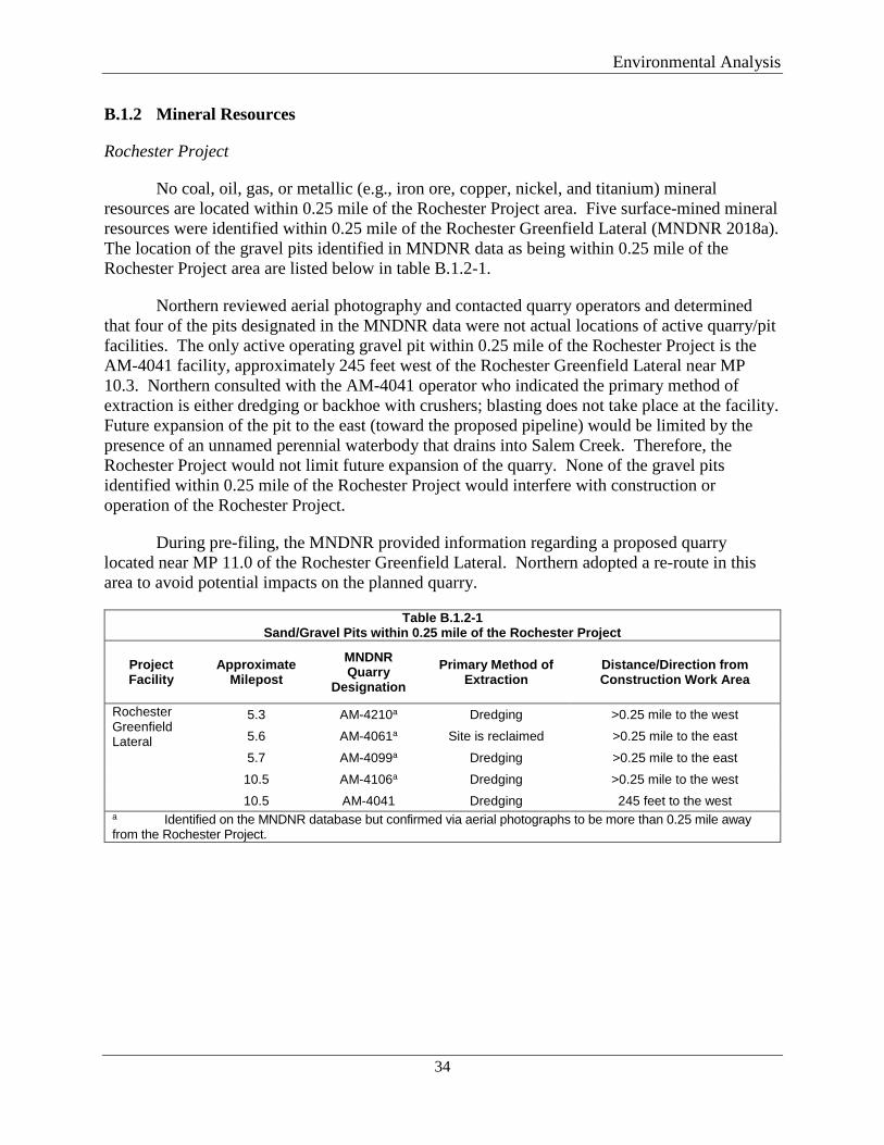
Environmental Analysis
34
B.1.2 Mineral Resources
Rochester Project
No coal, oil, gas, or metallic (e.g., iron ore, copper, nickel, and titanium) mineral resources are located within 0.25 mile of the Rochester Project area. Five surface-mined mineral resources were identified within 0.25 mile of the Rochester Greenfield Lateral (MNDNR 2018a). The location of the gravel pits identified in MNDNR data as being within 0.25 mile of the Rochester Project area are listed below in table B.1.2-1.
Northern reviewed aerial photography and contacted quarry operators and determined that four of the pits designated in the MNDNR data were not actual locations of active quarry/pit facilities. The only active operating gravel pit within 0.25 mile of the Rochester Project is the AM-4041 facility, approximately 245 feet west of the Rochester Greenfield Lateral near MP 10.3. Northern consulted with the AM-4041 operator who indicated the primary method of extraction is either dredging or backhoe with crushers; blasting does not take place at the facility. Future expansion of the pit to the east (toward the proposed pipeline) would be limited by the presence of an unnamed perennial waterbody that drains into Salem Creek. Therefore, the Rochester Project would not limit future expansion of the quarry. None of the gravel pits identified within 0.25 mile of the Rochester Project would interfere with construction or operation of the Rochester Project.
During pre-filing, the MNDNR provided information regarding a proposed quarry located near MP 11.0 of the Rochester Greenfield Lateral. Northern adopted a re-route in this area to avoid potential impacts on the planned quarry.
Table B.1.2-1 Sand/Gravel Pits within 0.25 mile of the Rochester Project
Project Facility
Approximate Milepost
MNDNR Quarry
Designation Primary Method of
Extraction Distance/Direction from Construction Work Area
Rochester Greenfield Lateral
5.3 AM-4210a Dredging >0.25 mile to the west 5.6 AM-4061a Site is reclaimed >0.25 mile to the east
5.7 AM-4099a Dredging >0.25 mile to the east 10.5 AM-4106a Dredging >0.25 mile to the west 10.5 AM-4041 Dredging 245 feet to the west
a Identified on the MNDNR database but confirmed via aerial photographs to be more than 0.25 mile away from the Rochester Project.
Environmental Analysis
35
NL 2019 Project
No coal, oil, gas, or metallic (e.g., iron ore, copper, nickel, and titanium) mineral resources are located within 0.25 mile of the NL 2019 Project area. One gravel pit was identified about 700 feet south of the Carver Compressor Station in Carver County, Minnesota (MNDNR 2018a).
Northern consulted with the quarry operator to determine the primary methods of extracting rock and gravel and determined that blasting does not occur at the gravel pit. The pit undergoes dredging as the only method of excavation. The quarry operator plans to expand the quarry footprint to the north. Since Northern’s existing pipelines are located south of the proposed Carver Compressor Station, construction of the station would not limit future expansion of the pit, as northern expansion is already limited by the existing pipelines and Northern’s easements.
B.1.3 Paleontological Resources
While fossils may be found throughout the state, unique paleontological resources are not known to exist within the proposed locations of either project (MNDNR 2018a). The projects would have the potential to encounter paleontological resources; however, unique and/or significant paleontological resources would likely not be encountered. Therefore, we conclude the projects would not adversely affect paleontological resources.
B.1.4 Geologic Hazards
Geologic hazards are natural, physical conditions that can result in damage to land and structures or injury to people. Such hazards typically are seismic-related, including earthquakes, surface faulting, and soil liquefaction or landslides, flooding, and karst or ground subsidence.
Based on a review of the USGS Peak Ground Acceleration Map (USGS 2018a), the risk for seismic ground motion (earthquakes) to cause damage to structures in either project area is low. Review of USGS fault mapping indicates that there are no active faults within the project areas (USGS 2018b). Minnesota is one of the least seismically active areas in the United States. In addition, given the low potential for earthquakes to occur in the vicinity of the projects, the potential for soil liquefaction to occur in either project area is low. Therefore, no seismic-related geologic hazards are anticipated.
USGS landslide incidence and susceptibility mapping within both project areas indicates that the projects are in areas of low landslide incidence and low landslide susceptibility (USGS 2018c).
Review of Federal Emergency Management Agency (FEMA 2016) flood maps indicates that the Rockford to Buffalo Greenfield Lateral (NL 2019 Project) crosses an area that is within a 100-year flood zone. The remaining facilities of either project would not be in a flood hazard area or would be located in areas not mapped by FEMA. Although the likelihood of flooding in any given year is small, in the event that flooding should occur, it is not expected to have an effect on the pipelines. Potential effects associated with high rainfall events during construction would be mitigated by implementing measures in the Plan and Procedures. The
Environmental Analysis
36
pipelines would not cause additional flooding because they would be buried and the surface restored to pre-construction contours to the extent practicable. Aboveground facilities would be constructed outside of any known flood hazard zones. Construction or operational impacts due to flooding are not anticipated.
Ground subsidence, involving the localized or regional lowering of the ground surface, may be caused by karst dissolution, sediment compaction, oil and gas extraction, underground mines, and groundwater pumping. Portions of the Rochester Project (Rochester Greenfield Lateral and Rochester TBS) have potential for karst development as indicated by the presence of carbonate rocks beneath the glacial drift (Adams and Barry 2016) and nearby mapped karst features (MGS 1988). The NL 2019 Project is in an area of low probability for karst features.
Northern completed a geotechnical investigation for the Rochester Greenfield Lateral in the areas of potential karst. Northern also completed geophysical investigations at the HDDs proposed under the North Branch of the Root River, South Fork of the Zumbro River, Salem Creek, a MNDNR-classified wetland, and under the tributary to Goose Creek near the Nelson Fen. The geophysical investigations were used to identify voids in the bedrock, indicating the potential for karst features. Based on the investigations, Northern modified the HDD alignments at the North Branch Root River and the South Fork Zumbro River crossing locations to minimize impacts on potential karst features. If karst features are encountered during HDD operations, Northern would implement mitigation measures such as surface water control measures and installation of thicker wall pipe and below-grade pipe racks. Northern proposed the following karst mitigation measures:
• Lost circulation materials may be used to attempt to seal the conduit and restore drilling fluid returns to the entry and exit pits. Examples of these materials include wood fibers, cotton seed husks, ground nut shells, or other natural, environmentally inert materials. Special polymers, from the MNDH-approved list, that swell to several times their size when wet may be used. Grout or concrete plugs may also be used to fill subsurface voids or fissures. Concrete grout typically hardens quickly and would have limited impact on groundwater flow or quality. These materials would be determined on a site-specific basis.
• Mitigation of surface runoff would be performed by use of silt fence, silt traps, sediment basins, and lined ditches where appropriate. Siltation of sinkholes, especially those to remain open after construction, would be avoided.
• If karst is encountered during open-cut trenching, Northern could utilize thicker-wall pipe to span sinkholes or karst features encountered during excavation. Northern may construct below-grade pipe racks to support longer spans of sinkholes or other karst features.
• Construction supervisors and EIs would be provided awareness training for identifying karst features and the potential signs of karst formation during construction. The presence of existing, or signs of new, features within or immediately adjacent to the Rochester Greenfield Lateral would be clearly marked and a buffer zone established. Karst features would be protected from stormwater runoff at the work zones in accordance with the FERC Plan. In addition, excavation and restoration activities would be designed to minimize alteration of the existing grade and stormwater runoff to karst features.
Environmental Analysis
37
• Northern would not discharge hydrostatic test water between MPs 3.7 and 4.8 of the Rochester Greenfield Lateral. When water is discharged, the water would be directed downgradient of karst features to prevent the introduction of large amounts of water that could contribute to acceleration of karst dissolution or reactivation of surface water migrating to the subsurface. Surface BMPs, which include diversion dikes, straw bales, and channels, would be utilized to direct hydrostatic test water away from sensitive features like karst, wetlands, or fens.
Northern incorporated the results of the investigations into crossing-specific HDD contingency plans and feasibility reports. The plans describe procedures to be used to monitor, contain, and clean up any inadvertent releases of drilling fluid and also identifies contingency measures to be implemented in the event that an HDD is unsuccessful.
B.2 SOILS
B.2.1 Existing Characteristics
Soil characteristics in both project areas were identified and assessed using the Natural Resource Conservation Service (NRCS), Soil Survey Geographic Database (NRCS 2018), which is a digital version of the original county soil surveys developed by the NRCS for use with a geographic information system.
Soils were evaluated for characteristics that could affect construction or increase the potential for soil impacts during construction. These characteristics include prime farmland, compaction-prone soils, highly erodible soils, the presence of shallow bedrock, and revegetation potential. A description of these soil characteristics within both project areas including impacts and mitigation measures are described below. With implementation of these mitigation measures, we conclude that construction and operation of the projects would have negligible impacts on soils.
Rochester Project
About 65 percent of soils crossed by the Rochester Project range from moderately well drained to excessively drained, with the remaining soils classified as somewhat poorly drained to very poorly drained. Predominate textures at the surface include loam (25 percent) and silt loam (50 percent). Permeability ranges from moderately high to very high. The primary soil limitations identified in the Rochester Project area are prime farmland and soils that are compaction prone.
NL 2019 Project
About 65 percent of soils crossed by the NL 2019 Project range from moderately well drained to excessively drained, with the remaining soils classified as somewhat poorly drained to very poorly drained. The predominate texture at the surface is loam (45 percent). Permeability ranges from moderately high to high. The primary soil limitations identified in the NL 2019 Project area are prime farmland, low revegetation potential, and being compaction prone.
Environmental Analysis
38
B.2.2 Prime Farmland
Prime farmland soils are classified as those best suited for production of food, feed, fiber, and oilseed crops. These soils generate the highest yields with the least amount of expenditure. Farmland of statewide importance generally includes areas of soils that nearly meet the requirements for prime farmland and that economically produce high yields of crops when treated and managed according to acceptable farming methods.
Rochester Project
During construction of the Rochester Project, about 184.6 acres of prime farmland and 16.9 acres of farmland of statewide importance would be temporarily affected. About 1.5 acres of prime farmland would be permanently converted to non-agricultural use for operation of the Rochester TBS, MAOP Regulator, and the Rochester Greenfield Lateral valves/launcher. Construction and operation impacts on active agricultural land are further discussed in Section B.5.1.1.
NL 2019 Project
During construction of the NL 2019 Project, about 250.8 acres of prime farmland and 47.3 acres of farmland of statewide importance would be temporarily affected. About 8.2 acres of prime farmland would be permanently converted to non-agricultural use for operation of the aboveground facilities. Construction and operation impacts on active agricultural land are further discussed in Section B.5.1.1.
Construction and Operation Impacts and Mitigation Measures
Potential impacts on agricultural soils associated with both projects would be minimized and mitigated in accordance with the Plan and the special construction procedures described in section A.8.2.6. Northern would also implement the measures described in its AIMP, which includes additional restoration and mitigation measures specific to both projects. These include measures to conserve and segregate topsoil, alleviate soil compaction, protect and maintain existing drainage tile and irrigation systems, and replace fencing that is damaged. Implementation of proper topsoil segregation, soil decompaction, drainage, and weed control would help ensure post-construction revegetation success and productivity, thereby minimizing the potential for long-term impacts on agricultural lands. Following construction, agricultural activities would be allowed to resume without restrictions except where aboveground facilities are present.
Northern would conduct full right-of-way topsoil removal in agricultural land, and staging areas and ATWS in agricultural land would also undergo topsoil removal prior to construction. Topsoil would not be removed from existing improved farm roads.
B.2.3 Erosion
Soil erosion potential is affected by the soil lithology, including mineralogy, grain size, texture, and organic content. Soil erosion potential is influenced by slope and exposure to erosion mechanisms. Soil erosion increases in inverse proportion to the effectiveness of
Environmental Analysis
39
vegetation cover (i.e., soils with denser vegetation cover are less susceptible to erosion). Removal of vegetation associated with construction activities, whether by direct stripping or by other mechanical means, greatly increases erosion potential. The classification of a soil as highly erodible by the NRCS is directly related to the soil’s susceptibility to erosion by water or wind.
Rochester Project
Approximately 0.4 acre of soil within the Rochester TBS footprint is classified as highly erodible. None of the soils crossed by the remaining Rochester Project components are classified as erodible.
NL 2019 Project
None of the soils crossed by the NL 2019 Project are classified as highly erodible.
Construction and Operation Impacts and Mitigation Measures
To minimize any potential for soil erosion from wind and water, Northern would implement the following measures, as specified in the Plan, the SWPPPs, Northern’s AIMP, and applicable permits:
• minimize the quantity and duration of soil exposure; • limit the amount of open trench per project component to 5,280 feet at any one time; • install mulch, temporary seeding, or other protection measures on topsoil and subsoil
piles to prevent soil loss; • install silt fence around topsoil and subsoil stockpiles per MNPCA permit requirements; • implement dust mitigation practices; • reduce the velocity of run-off water and redirecting run off, as appropriate; • install and maintain erosion and sediment control measures during construction; • install redundant sedimentation controls within 50 feet of wetlands and waterbodies per
MNPCA permit requirements; • establish vegetation following final grading; and • inspect the right-of-way and maintain erosion and sediment control as needed until final
stabilization is achieved.
Temporary erosion control measures, including interceptor diversions (e.g., slope breakers) and sediment filter devices (e.g., straw bales, silt fence, or sediment basins), would be installed immediately following initial ground disturbance. As required, temporary trench breakers would be installed immediately following ditch excavation to reduce runoff velocities in the trench during construction. Mulch or other wildlife-suitable erosion control matting may be used on slopes to prevent erosion during construction. BMPs, such as spraying water as needed, would be implemented to limit wind erosion. The temporary erosion control devices would be inspected on a regular basis by Northern and after each rainfall event of 0.5 inch or greater to ensure controls function properly. Permanent erosion control devices (e.g., trench breakers, flexible channel liners, turf-reinforcement mats, and slope breakers) would be monitored by Northern during the long-term operation and maintenance of the projects.
Environmental Analysis
40
B.2.4 Compaction
Soil compaction can occur by the repeated movement of heavy machinery across soils with the potential for compaction, particularly soils with high shrink-swell potential and poor drainage characteristics (e.g., soils with high clay content). These impacts can result in an increase in agricultural operating and labor costs, decreased productivity, and damage to field equipment.
Rochester Project
About 37.66 acres (17 percent) of the soils that would be affected by construction of the Rochester Project are classified as highly compaction prone. The amounts of compaction-prone soil in the construction footprints of each Rochester Project component are: 34 acres (16 percent of the total acreage) of the Rochester Greenfield Lateral; 2.9 acres (36 percent) of the La Crosse Branch Line MAOP Uprate; 0.35 acre (88 percent) of the Rochester TBS; and 0.24 acre (100 percent) of the MAOP Regulator.
NL 2019 Project
About 111 acres (31 percent) of the soils that would be affected by construction of the NL 2019 Project are classified as highly compaction prone. The amounts of compaction-prone soil in the construction footprints of each NL 2019 Project component are: 26.1 acres (18 percent) of the Rockford to Buffalo Greenfield Lateral; 13.2 acres (20 percent) of the Alexandria Branch Line Loop Extension; 26.5 acre (80 percent) of the New Prague Branch Line Loop; 26.6 acres (42 percent) of the Willmar C-line Extension; 11.6 acres (48 percent) of the Faribault Compressor Station; and 7.0 acres (59 percent) of the Owatonna Compressor Station. None of the soils within the Carver Compressor Station site are classified as highly compaction prone.
Construction and Operation Impacts and Mitigation Measures
In an effort to avoid or minimize impacts that could result from soil compaction, Northern would de-compact subsoil in accordance with the soil compaction mitigation procedures described in the Plan. In agricultural land, these measures include using appropriate deep-tillage equipment such as a paraplow or chisel plow. In agricultural and residential lands, testing would be conducted to verify compaction is relieved to a level equal to or better than adjacent undisturbed areas. Once decompaction of the subsoil is complete, the segregated topsoil would be returned to the right-of-way. Decompaction would be completed on the restored topsoil using shallow-ripping tools. Northern would perform soil compaction mitigation in severely compacted residential areas based on coordination with landowners.
In order to minimize rutting, Northern would stabilize access roads using gravel or timber equipment mats. If rutting of 6 inches or greater occurs during construction along ungraded portions of the project areas, Northern would immediately limit construction activities in that area or implement protective measures (e.g., install timber equipment mats) to prevent additional rutting. If rutting occurs along access roads, Northern would require its construction contractor(s) to provide maintenance equipment to repair the ruts to pre-construction conditions or better as soon as ground conditions permit.
Environmental Analysis
41
B.2.5 Shallow Bedrock
Shallow and hard bedrock can restrict excavation and may require special mechanical means or possibly blasting to achieve required design depths. No blasting is currently anticipated for either project due to the nature of the bedrock (weathered limestone, dolomite, and sandstone). Blasting is further discussed in section A.8.2.7.
Rochester Project
Approximately 33 percent of the Rochester Greenfield Lateral area contains soils with the potential for shallow bedrock. The depth to bedrock is greater than 60 inches for the remaining soils within the Rochester Project area. Northern plans to use mechanical removal (backhoe or jackhammer) to remove any shallow bedrock encountered.
NL 2019 Project
Less than 1 percent of the NL 2019 Project area contains soils with the potential for shallow bedrock. The depth to bedrock is greater than 60 inches for the remaining soils within the NL 2019 Project area. Northern plans to use mechanical removal (backhoe or jackhammer) to remove any shallow bedrock encountered.
Construction and Operation Impacts and Mitigation Measures
To prevent incorporation of rock into the topsoil, Northern would segregate topsoil at excavations and dispose of excess rock fragments in an approved manner so as not to incorporate rock fragments into topsoil layers. Rock encountered during excavation would be removed using conventional excavation with a backhoe, ripping with a bulldozer followed by backhoe excavation, or hammering with a pointed backhoe attachment or a pneumatic rock hammer followed by backhoe excavation. The technique selected would be dependent on relative hardness, fracture susceptibility, expected volume, and location. Excess rock that cannot be returned to the existing rock profile within excavated areas would be hauled from both project areas and disposed of in an approved landfill or recycling facility unless approved for use as slope stabilization, windrowing, or for some other use on the construction work areas as approved by the landowner(s).
B.2.6 Revegetation Potential
Revegetation is part of the final restoration required for the projects. Revegetation would be required on all land except active croplands and portions of aboveground facility sites permanently converted to natural gas use. Revegetation would be required to terminate the erosion control permits obtained for the projects. The revegetation potential of soils that would be disturbed by the projects is based on the potential for seed mortality.
Environmental Analysis
42
Rochester Project
Approximately 17 percent, or 37.39 acres, of soils within the Rochester Project area exhibit low revegetation potential.
NL 2019 Project
Approximately 36 percent, or 131.8 acres, of soils within the NL 2019 Project area exhibit low revegetation potential.
Construction and Operation Impacts and Mitigation Measures
Northern would re-seed temporary workspaces in accordance with individual landowner requirements, the SWPPPs, and/or NRCS recommendations. Graded areas and other disturbed areas requiring revegetation would be seeded to establish a permanent vegetation cover. Depending on site conditions, revegetation could include soil amendments such as lime, fertilizing, seeding, and mulching. Seedbed preparation would not be undertaken when excessively wet soil conditions exist. After a relatively smooth seedbed has been prepared, seed would be applied to all areas with exposed soils using a broadcast spreader or a seed drill. Northern would use seed mixes and seeding rates recommended by state and local agencies. Mulch would be applied as needed.
B.2.7 Soil Contamination
No known areas of soil contamination were identified within the Rochester Project area (EPA 2016; MNDH 2017; MNPCA 2013, 2018). Two known sites with potential for contamination were identified within 500 feet of the NL 2019 workspaces and are discussed below in section B.3.1. Project-related soil contamination resulting from spills or leaks of fuels, lubricants, and coolant from construction equipment would be minimized by Northern’s adherence to its SPCC Plan, which specifies clean-up procedures in the event of spills or leaks of hazardous materials. Should a spill occur, Northern and its contractors would follow the SPCC Plan to contain the spill of any material that may contaminate soils and to ensure that the spill area is cleaned up, reported, and the materials are disposed of in an appropriate manner. Northern would also follow the procedures outlined in its SPCC Plan in the event contaminated soils are encountered during construction. Given the project areas’ soil characteristics, and the impact minimization and mitigation measures described in Northern’s SPCC Plan and the FERC Plan, we conclude that soils would not be significantly affected by project construction and operation.
B.3 WATER RESOURCES AND WETLANDS
B.3.1 Groundwater
Rochester Project
The bedrock aquifers underlying the Rochester Project area are Paleozoic in age and occur within a basin known as the Hollandale Embayment (Woodward 1986). The Rochester Project area is underlain by the Upper Carbonate aquifer, an unconfined aquifer near the surface.
Environmental Analysis
43
The Upper Carbonate aquifer is composed of karst dolomite or limestone, which stores groundwater in a network of complex pathways and solution-widened fractures. Although water moves quickly through the network of pathways, water is slow to move through bedrock, and the distinctly different hydrologic characteristics of the bedrock versus the network of pathways makes well-yield estimates difficult. The Upper Carbonate aquifer is located near the surface and frequently feeds surface waters through springs where waterways have cut into the aquifer. The Upper Carbonate aquifer supplies private and other low-capacity wells but is not well suited for high-capacity wells. This aquifer is vulnerable to contamination owing to its high permeability and shallow depth.
The St. Peter/Prairie Du Chien/Jordan aquifer is a confined bedrock aquifer, separated from the Upper Carbonate aquifer by the approximately 80-foot-thick confining layer composed of dense shale and limestone formations. This aquifer is composed of three sedimentary bedrock features. All three layers of the aquifer are hydrologically connected and have a high yield potential (greater than 1,500 gallons per minute).
The EPA defines a sole-source aquifer as one where the aquifer supplies at least 50 percent of the drinking water for its service area, and one for which there are no reasonably available alternative drinking water sources should the aquifer become contaminated. There are currently no EPA-designated Sole Source Aquifers crossed by the Rochester Project (EPA 2018).
Due to the potential presence of karst features and proposed use of HDD, wells and springs were identified within 1,000 feet of the Rochester Greenfield Lateral workspaces. Based on review of the Minnesota County Well Index (MGS 2018), 18 private water wells are within 1,000 feet of the Rochester Project area. The MNDNR maintains a record of springs and spring locations in Minnesota. A search of the Minnesota Spring Inventory identified three springs within 1,000 feet of the Rochester Greenfield Lateral (MNDNR 2018b). No known public or private water wells or springs were identified within 150 feet of the La Crosse Branch Line MAOP Uprate workspaces or the MAOP regulator. Table B.3.1-1 lists the location and type of identified wells and springs.
Public and non-public community water supply source-water protection in Minnesota is administered by the MNDH through the Wellhead Protection program. Wellhead Protection Areas (WHPA) for public and community water-supply wells are available through a database maintained by the MNDH (2014). Review of this database indicates that the Rochester Project does not cross a known Wellhead Protection Area. Northern conducted a search using publicly available state and federal databases to identify the potential for and/or actual sources of groundwater contamination within 500 feet of the Rochester Project construction workspaces. No sites were identified (EPA 2016; MNDH 2017; MNPCA 2013, 2018).
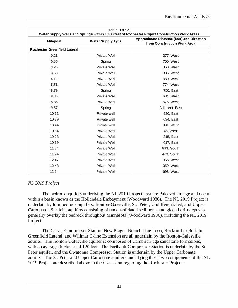
Environmental Analysis
44
Table B.3.1-1 Water Supply Wells and Springs within 1,000 feet of Rochester Project Construction Work Areas
Milepost Water Supply Type Approximate Distance (feet) and Direction from Construction Work Area
Rochester Greenfield Lateral
0.21 Private Well 377, West 0.85 Spring 700, West 3.26 Private Well 360, West 3.58 Private Well 835, West 4.12 Private Well 330, West
5.51 Private Well 774, West 8.79 Spring 750, East 8.85 Private Well 634, West 8.85 Private Well 576, West 9.57 Spring Adjacent, East
10.32 Private well 936, East
10.39 Private well 634, East 10.44 Private well 991, West 10.84 Private Well 48, West 10.98 Private Well 315, East 10.99 Private Well 617, East
11.74 Private Well 993, South 11.74 Private Well 463, South 12.47 Private Well 355, West 12.48 Private Well 359, West 12.54 Private Well 693, West
NL 2019 Project
The bedrock aquifers underlying the NL 2019 Project area are Paleozoic in age and occur within a basin known as the Hollandale Embayment (Woodward 1986). The NL 2019 Project is underlain by four bedrock aquifers: Ironton-Galesville, St. Peter, Undifferentiated, and Upper Carbonate. Surficial aquifers consisting of unconsolidated sediments and glacial drift deposits generally overlay the bedrock throughout Minnesota (Woodward 1986), including the NL 2019 Project.
The Carver Compressor Station, New Prague Branch Line Loop, Rockford to Buffalo Greenfield Lateral, and Willmar C-line Extension are all underlain by the Ironton-Galesville aquifer. The Ironton-Galesville aquifer is composed of Cambrian-age sandstone formations, with an average thickness of 120 feet. The Faribault Compressor Station is underlain by the St. Peter aquifer, and the Owatonna Compressor Station is underlain by the Upper Carbonate aquifer. The St. Peter and Upper Carbonate aquifers underlying these two components of the NL 2019 Project are described above in the discussion regarding the Rochester Project.
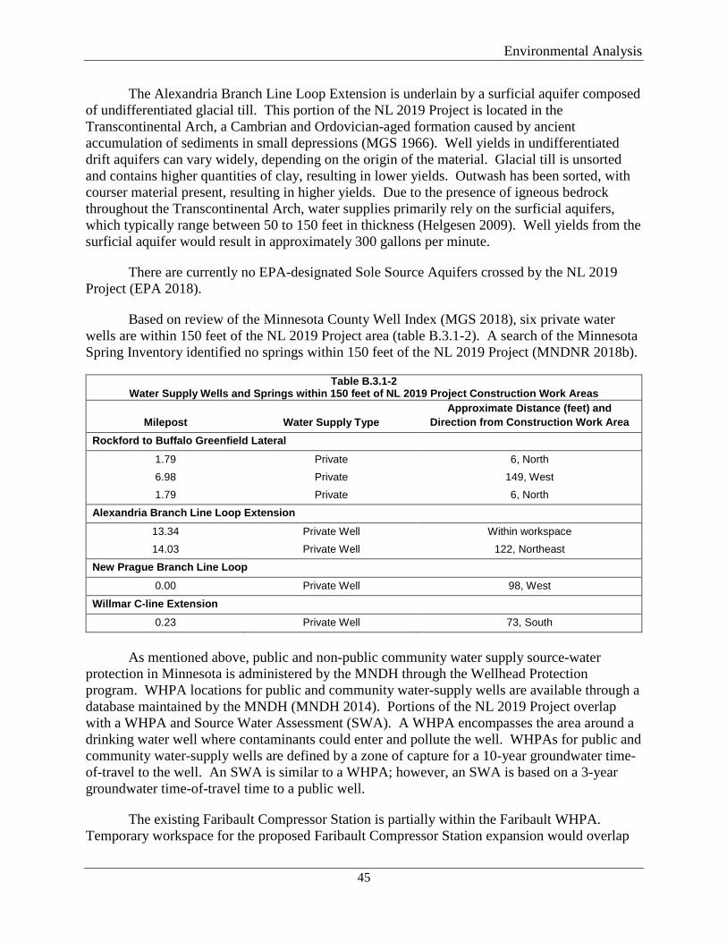
Environmental Analysis
45
The Alexandria Branch Line Loop Extension is underlain by a surficial aquifer composed of undifferentiated glacial till. This portion of the NL 2019 Project is located in the Transcontinental Arch, a Cambrian and Ordovician-aged formation caused by ancient accumulation of sediments in small depressions (MGS 1966). Well yields in undifferentiated drift aquifers can vary widely, depending on the origin of the material. Glacial till is unsorted and contains higher quantities of clay, resulting in lower yields. Outwash has been sorted, with courser material present, resulting in higher yields. Due to the presence of igneous bedrock throughout the Transcontinental Arch, water supplies primarily rely on the surficial aquifers, which typically range between 50 to 150 feet in thickness (Helgesen 2009). Well yields from the surficial aquifer would result in approximately 300 gallons per minute.
There are currently no EPA-designated Sole Source Aquifers crossed by the NL 2019 Project (EPA 2018).
Based on review of the Minnesota County Well Index (MGS 2018), six private water wells are within 150 feet of the NL 2019 Project area (table B.3.1-2). A search of the Minnesota Spring Inventory identified no springs within 150 feet of the NL 2019 Project (MNDNR 2018b).
Table B.3.1-2 Water Supply Wells and Springs within 150 feet of NL 2019 Project Construction Work Areas
Milepost Water Supply Type Approximate Distance (feet) and
Direction from Construction Work Area Rockford to Buffalo Greenfield Lateral
1.79 Private 6, North 6.98 Private 149, West 1.79 Private 6, North
Alexandria Branch Line Loop Extension
13.34 Private Well Within workspace 14.03 Private Well 122, Northeast
New Prague Branch Line Loop 0.00 Private Well 98, West
Willmar C-line Extension 0.23 Private Well 73, South
As mentioned above, public and non-public community water supply source-water
protection in Minnesota is administered by the MNDH through the Wellhead Protection program. WHPA locations for public and community water-supply wells are available through a database maintained by the MNDH (MNDH 2014). Portions of the NL 2019 Project overlap with a WHPA and Source Water Assessment (SWA). A WHPA encompasses the area around a drinking water well where contaminants could enter and pollute the well. WHPAs for public and community water-supply wells are defined by a zone of capture for a 10-year groundwater time-of-travel to the well. An SWA is similar to a WHPA; however, an SWA is based on a 3-year groundwater time-of-travel time to a public well.
The existing Faribault Compressor Station is partially within the Faribault WHPA. Temporary workspace for the proposed Faribault Compressor Station expansion would overlap
Environmental Analysis
46
about 750 feet of the Faribault WHPA; however, the permanent expansion footprint of the compressor station would be located outside of the Faribault WHPA. Northern consulted with the City of Faribault, which indicated there are no permit requirements for the expansion of the Faribault Compressor Station.
Temporary workspace near MP 1.96 of the Willmar C-line Extension would be located 300 feet east of an SWA area associated with Carver County Public Works Headquarters Well 1. Northern consulted with the Carver County Land Management Department, who indicated there are no construction setback or permitting requirements for construction specific to county-managed wells.
Northern conducted a search using publicly available state and federal databases to identify the potential for and/or actual sources of groundwater contamination within 500 feet of the NL 2019 Project construction workspaces (EPA 2016; MNDH 2017; MNPCA 2013, 2018). Two known sites with potential for contamination were identified within 500 feet of the NL 2019 workspaces. An unleaded gasoline leak is located about 500 feet east of MP 1.8 on the New Prague Branch Line Loop, and a leaking gasoline tank is about 100 feet east of the Rockford to Buffalo Greenfield Lateral at MP 1.2.
Site reports from the MNPCA indicate that the unleaded gasoline leak near the New Prague Branch Line Loop was closed in February 2001 after limited soil excavation. No further soil or groundwater investigation was required. Site reports from the MNPCA on the site located near the Rockford to Buffalo Greenfield Lateral indicated that site was closed in May 2006 after limited soil investigation and excavation of contaminated soil was performed. Based on the age of both sites and the closure status, soil or groundwater contamination from the site is not expected to impact the construction workspace. No further spread of the two existing contaminated areas is anticipated due to construction of the proposed NL 2019 Project.
Construction and Operation Impacts and Mitigation
The pipelines would be buried 30 to 48 inches below the ground surface utilizing standard open trench construction methods. Typical water-bearing bedrock aquifers are at least 50 feet below grade, creating a significant vertical separation. Northern would avoid or further minimize potential impacts by using construction techniques described in the Plan, such as temporary and permanent trench plugs and interceptor dikes for pipelines.
HDD methods planned for the projects would likely penetrate below the water table. However, the drilling fluid would be composed of water, bentonite, and additives on the MNDH-approved list of additives, which is more restrictive than the NSF/ANSI Standard 60 (Drinking Water Treatment Chemicals — Health Effects). Northern would further limit the use of additives that contain polyacrylamides and well-drilling foamers to only uplands areas. Therefore, HDD crossings are not expected to adversely impact groundwater quality. Long-term water quality would not be affected by pipeline construction or subsequent operations as the pipe is free of chemicals when installed. By implementing the protective measures set forth in the SPCC plan and Plan for Inadvertent Release of Drilling Mud, groundwater contamination due to construction activities is not anticipated. Drilling would not affect groundwater quality, levels, or groundwater flow directions.
Environmental Analysis
47
An inadvertent spill or release of fuel or hazardous materials during construction could affect groundwater if not cleaned up appropriately. To minimize the risk of potential fuel or hazardous materials spills, Northern would implement its SPCC Plan, which includes preventive measures such as personnel training for proper handling of fuel and hazardous materials, equipment inspection, and refueling procedures to reduce the likelihood of spills. The SPCC Plan also includes mitigation measures to reduce potential impacts should a spill occur. If contaminated soil or groundwater is encountered during construction, Northern would notify the affected landowner and coordinate with the appropriate federal and state agencies as applicable.
Specific BMPs that Northern would implement to prevent impacts on groundwater resources including conducting refueling and storage of hazardous materials greater than 200 feet from a private well, installing protective fencing around all wellheads in or adjacent to the construction work areas, prohibiting overnight parking near wellheads, and prohibiting construction within 50 feet of springs and their associated aquatic features. Northern would also implement its SWPPPs in accordance with MNPCA requirements. The final SWPPPs would submitted in concurrence with the NPDES permit application process to address and mitigate potential pollutants at their sources associated with construction activities.
A private well is present within the Alexandria Branch Line Loop extension workspace. Northern would install protective fencing around this well and post adjacent signs to prohibit overnight parking of equipment. No refueling or storage of hazardous liquids would be allowed within a 200-foot radius of the private well or any other private well. Additionally, no refueling or storage of hazardous liquids would be allowed within 400 feet of community or municipal water wells, if identified.
With landowner approval, Northern would conduct pre- and post-construction well testing for wells within 150 feet of the construction work areas for water quality, recharge, and depth to water. In areas of the Rochester Project potentially underlain by karst bedrock, pre- and post-construction testing would be done for wells within 500 feet of the construction work areas and within 1,000 feet of HDDs. The tests would be used to determine whether any construction-related impacts occurred. If a well does not have appropriate sample ports, Northern would coordinate with landowners to sample the nearest available yard hydrant or outside hose bib. In the event the results indicate the well water quality or yield has been adversely impacted as a result of project construction, Northern would provide a clean water source to the landowner until a permanent solution is found. The damaged well would be restored to its former capacity and quality to the extent practical. If a previously unknown well is discovered within the construction right-of-way, Northern would seal the wells in accordance with MNDH requirements and landowner authorization.
The MNDNR-confirmed spring would be monitored by the onsite EI during the HDD under wetland RGL-094-W1. General observations on water flow and turbidity would be recorded during the HDD. If the HDD drilling fluid affects the spring, the pilot hole would be abandoned and a new pilot hole would be started at an alternate depth.
We find that by implementing the measures discussed above, Northern’s SPCC Plan, and the Plan and Procedures, construction activities are unlikely to result in significant impacts on groundwater resources.
Environmental Analysis
48
B.3.2 Surface Waters
Northern completed an assessment of surface water resources in both project areas through field reconnaissance conducted by qualified wetland scientists from September to December 2017 and in June 2018; and through a review of USGS topographic maps, USGS National Hydrography Dataset, National Wetlands Inventory (NWI) data, and Minnesota Public Waters Inventory data. Waterways on parcels where landowners have not granted survey access were confirmed, as practicable, from nearby properties and roads. To date, surveys are complete on 81 percent of the Rochester Project and 87 percent of the NL 2019 Project.
Rochester Project
Surface water resources within the Rochester Project area are located within the Upper Mississippi and Iowa River drainage basins. The Rochester Greenfield Lateral would require 11 crossings of 8 waterbodies, including 3 perennial and 4 intermittent streams. No waterbodies are located within workspaces for the MAOP Uprate, Rochester TBS, or MAOP Regulator. Table B.3-2-1 lists the waterbodies crossed including approximate milepost, waterbody name, flow regime, crossing length, state water quality use designation, fishery type, and proposed crossing method.
The MNDNR requested that the number of crossings of the North Branch Root River be minimized. Northern evaluated an alternative route further to the east which would have avoided multiple crossings of the river; however, it would have impacted a greater acreage of wetlands. Northern consulted with the landowner regarding this alternative and the landowner expressed a strong preference for the proposed route. Northern would cross the three sections of the North Branch Root River area with one HDD, which would minimize impacts on the resource.
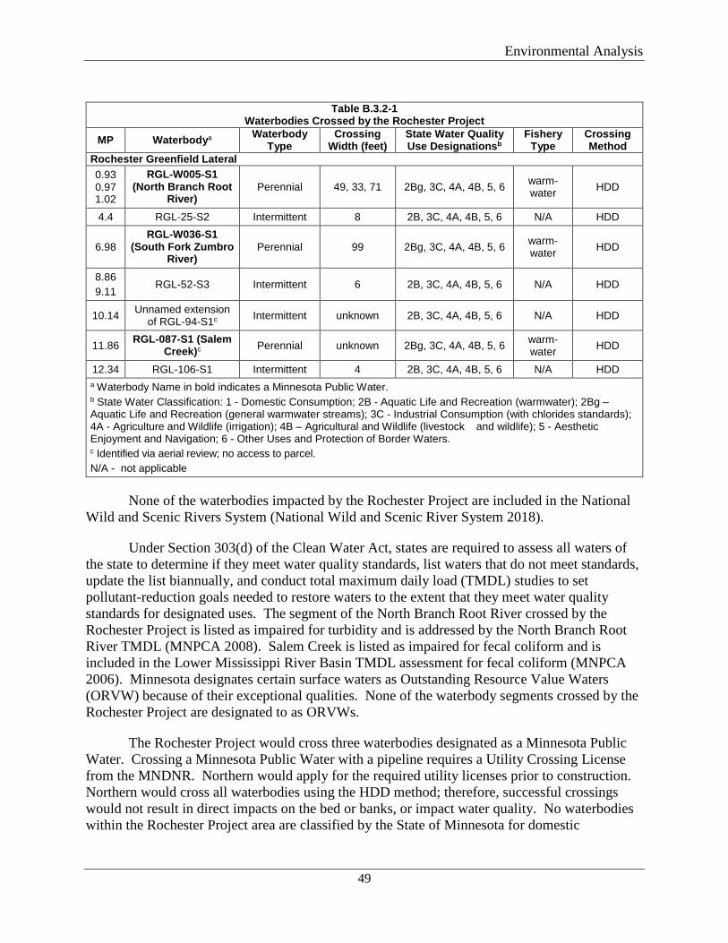
Environmental Analysis
49
Table B.3.2-1
Waterbodies Crossed by the Rochester Project MP Waterbodya Waterbody
Type Crossing
Width (feet) State Water Quality Use Designationsb
Fishery Type
Crossing Method
Rochester Greenfield Lateral 0.93 0.97 1.02
RGL-W005-S1 (North Branch Root
River) Perennial 49, 33, 71 2Bg, 3C, 4A, 4B, 5, 6 warm-
water HDD
4.4 RGL-25-S2 Intermittent 8 2B, 3C, 4A, 4B, 5, 6 N/A HDD
6.98 RGL-W036-S1
(South Fork Zumbro River)
Perennial 99 2Bg, 3C, 4A, 4B, 5, 6 warm- water HDD
8.86 9.11
RGL-52-S3 Intermittent 6 2B, 3C, 4A, 4B, 5, 6 N/A HDD
10.14 Unnamed extension of RGL-94-S1c Intermittent unknown 2B, 3C, 4A, 4B, 5, 6 N/A HDD
11.86 RGL-087-S1 (Salem Creek)c Perennial unknown 2Bg, 3C, 4A, 4B, 5, 6 warm-
water HDD
12.34 RGL-106-S1 Intermittent 4 2B, 3C, 4A, 4B, 5, 6 N/A HDD a Waterbody Name in bold indicates a Minnesota Public Water. b State Water Classification: 1 - Domestic Consumption; 2B - Aquatic Life and Recreation (warmwater); 2Bg – Aquatic Life and Recreation (general warmwater streams); 3C - Industrial Consumption (with chlorides standards); 4A - Agriculture and Wildlife (irrigation); 4B – Agricultural and Wildlife (livestock and wildlife); 5 - Aesthetic Enjoyment and Navigation; 6 - Other Uses and Protection of Border Waters. c Identified via aerial review; no access to parcel. N/A - not applicable
None of the waterbodies impacted by the Rochester Project are included in the National
Wild and Scenic Rivers System (National Wild and Scenic River System 2018).
Under Section 303(d) of the Clean Water Act, states are required to assess all waters of the state to determine if they meet water quality standards, list waters that do not meet standards, update the list biannually, and conduct total maximum daily load (TMDL) studies to set pollutant-reduction goals needed to restore waters to the extent that they meet water quality standards for designated uses. The segment of the North Branch Root River crossed by the Rochester Project is listed as impaired for turbidity and is addressed by the North Branch Root River TMDL (MNPCA 2008). Salem Creek is listed as impaired for fecal coliform and is included in the Lower Mississippi River Basin TMDL assessment for fecal coliform (MNPCA 2006). Minnesota designates certain surface waters as Outstanding Resource Value Waters (ORVW) because of their exceptional qualities. None of the waterbody segments crossed by the Rochester Project are designated to as ORVWs.
The Rochester Project would cross three waterbodies designated as a Minnesota Public Water. Crossing a Minnesota Public Water with a pipeline requires a Utility Crossing License from the MNDNR. Northern would apply for the required utility licenses prior to construction. Northern would cross all waterbodies using the HDD method; therefore, successful crossings would not result in direct impacts on the bed or banks, or impact water quality. No waterbodies within the Rochester Project area are classified by the State of Minnesota for domestic
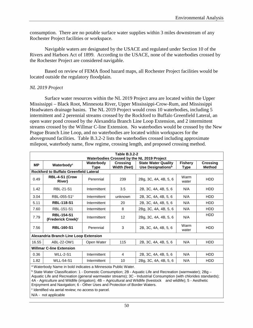
Environmental Analysis
50
consumption. There are no potable surface water supplies within 3 miles downstream of any Rochester Project facilities or workspace.
Navigable waters are designated by the USACE and regulated under Section 10 of the Rivers and Harbors Act of 1899. According to the USACE, none of the waterbodies crossed by the Rochester Project are considered navigable.
Based on review of FEMA flood hazard maps, all Rochester Project facilities would be located outside the regulatory floodplain.
NL 2019 Project
Surface water resources within the NL 2019 Project area are located within the Upper Mississippi – Black Root, Minnesota River, Upper Mississippi-Crow-Rum, and Mississippi Headwaters drainage basins. The NL 2019 Project would cross 10 waterbodies, including 5 intermittent and 2 perennial streams crossed by the Rockford to Buffalo Greenfield Lateral, an open water pond crossed by the Alexandria Branch Line Loop Extension, and 2 intermittent streams crossed by the Willmar C-line Extension. No waterbodies would be crossed by the New Prague Branch Line Loop, and no waterbodies are located within workspaces for the aboveground facilities. Table B.3.2-2 lists the waterbodies crossed including approximate milepost, waterbody name, flow regime, crossing length, and proposed crossing method.
Table B.3.2-2 Waterbodies Crossed by the NL 2019 Project
MP Waterbodya Waterbody Type
Crossing Width (feet)
State Water Quality Use Designationsb
Fishery Type
Crossing Method
Rockford to Buffalo Greenfield Lateral
0.49 RBL-4-S1 (Crow River) Perennial 239 2Bg, 3C, 4A, 4B, 5, 6 Warm
water HDD
1.42 RBL-21-S1 Intermittent 3.5 2B, 3C, 4A, 4B, 5, 6 N/A HDD
3.04 RBL-055-S1c Intermittent unknown 2B, 3C, 4A, 4B, 5, 6 N/A HDD 5.11 RBL-118-S1 Intermittent 20 2B, 3C, 4A, 4B, 5, 6 N/A HDD 7.60 RBL-151-S1 Intermittent 8 2Bg, 3C, 4A, 4B, 5, 6 N/A HDD
7.79 RBL-154-S1 (Frederick Creek)c Intermittent 12 2Bg, 3C, 4A, 4B, 5, 6 N/A HDD
7.56 RBL-160-S1 Perennial 3 2B, 3C, 4A, 4B, 5, 6 Warm water HDD
Alexandria Branch Line Loop Extension 16.55 ABL-22-OW1 Open Water 115 2B, 3C, 4A, 4B, 5, 6 N/A HDD Willmar C-line Extension 0.36 WLL-2-S1 Intermittent 4 2B, 3C, 4A, 4B, 5, 6 N/A HDD 1.82 WLL-54-S1 Intermittent 10 2Bg, 3C, 4A, 4B, 5, 6 N/A HDD
a Waterbody Name in bold indicates a Minnesota Public Water. b State Water Classification: 1 - Domestic Consumption; 2B - Aquatic Life and Recreation (warmwater); 2Bg – Aquatic Life and Recreation (general warmwater streams); 3C - Industrial Consumption (with chlorides standards); 4A - Agriculture and Wildlife (irrigation); 4B – Agricultural and Wildlife (livestock and wildlife); 5 - Aesthetic Enjoyment and Navigation; 6 - Other Uses and Protection of Border Waters. c Identified via aerial review; no access to parcel. N/A - not applicable
Environmental Analysis
51
None of the waterbodies impacted by the NL 2019 Project are included in the National Wild and Scenic Rivers System (National Wild and Scenic River System 2018), and none are designated by the state of Minnesota as ORVWs. Crow River is listed as impaired for turbidity and fecal coliform and is included in North Fork Crow and Lower Crow TMDL (Wenk Associates 2013). Northern proposes to cross the Crow River by HDD.
The NL 2019 Project would cross four waterbodies designated as a Minnesota Public Water. Northern would apply for the required utility licenses prior to construction. Northern proposed to cross all waterbodies using the HDD method; therefore, successful crossings would not result in direct impacts on the bed or banks, or impact water quality. A Minnesota public water basin was identified at MP 9.90 of the Rockford to Buffalo Greenfield Lateral; however, the water basin was not found during field surveys.
The Crow River is capable of providing potable surface water. The NL 2019 Project would cross the Crow River about 1.3 miles from the City of Rockford, Minnesota; however, the city provides drinking water to its residents from a groundwater source (City of Rockford 2016). There are no potable surface water supplies within 3 miles downstream of any NL 2019 Project waterbody crossing. According to the USACE, none of the waterbodies crossed by the NL 2019 Project are considered navigable.
Based on review of FEMA flood hazard maps, the Rockford to Buffalo Greenfield Lateral would cross regulatory floodplains (i.e., the 100-year or base flood) associated with the Crow and North Fork Crow Rivers from MP 0.05 to MP 0.2 and from MP 0.3 to MP 1.05. The pipeline would be buried in those locations and not be exposed to flooding conditions during operations. The City of Rockford has adopted floodplain management ordinances and would review any floodplain impacts. Hennepin County Public Works would require floodplain disturbance and grading permits for the construction in Hennepin County for the Rockford to Buffalo Greenfield Lateral. Northern would obtain the permit approvals prior to the start of construction.
A portion of the Owatonna Compressor Station expansion would be located within the floodplain of an unnamed tributary; however, the permanent compressor station footprint would be located outside of the floodplain, and no floodplain permit would be required by Steele County. Steele County floodplain rules prohibit the storage of flammable, explosive, or hazardous materials in any temporary construction workspace located in the floodplain. Other equipment may be temporarily stored in the floodplain as long as it can be readily moved if there is a flood event. Northern would designate the floodplain on its construction drawings and comply with the requirement to avoid storage of flammable, explosive, or hazardous materials in the floodplain. The remaining NL 2019 Project facilities are located outside the regulatory floodplain.
Construction and Operation Impacts and Mitigation
Construction of the projects across or near waterbodies has the potential to result in short-term and minor direct impact on waterbodies from construction adjacent to stream channels, the clearing and grading of adjacent lands and streambanks, trench dewatering, and from the unanticipated releases of drilling mud or chemical contaminants including fuels and lubricants.
Environmental Analysis
52
These construction activities could result in temporary modification of aquatic habitats through indirect impacts such as increased erosion, sedimentation and/or turbidity, and decreased dissolved oxygen concentrations.
Construction practices would follow FERC’s Plan and Procedures as well as the project SWPPPs, which contain BMPs intended to reduce ground disturbance, minimize erosion and sediment run off, and promote revegetation within the construction area (BMPs are noted in section B.2.3). Northern’s EIs would document that all construction workspace along with the waterbody boundaries are staked by a civil survey firm prior to the start of construction. The refueling setback at each waterbody would also be demarcated with signs placed by Northern’s EIs. Northern would install redundant sedimentation controls within 50 feet of waterbodies per MNPCA permit requirements. Additional erosion and sediment controls are discussed in section B.2.3.
As mentioned above, waterbody crossings would be completed using the HDD method (see section A.8.2.1), which would generally avoid and greatly minimize the potential for surface water impacts resulting from erosion, sedimentation, and/or excess turbidity by avoiding ground surface disturbance in and immediately adjacent to the waterbody. An HDD would also avoid disturbance to the bed and banks of waterbodies and would minimize ground disturbance to streams and the land surface between the entry and exit points of the crossing. ATWS would be located on either side of the waterbody feature to accommodate the entry and exit locations of the HDDs. Vegetation between the HDD entry and exit pits would not be cleared. One 5-foot-wide travel lane or two 3-foot-wide travel lanes would be used to follow the tracer wire during HDD installation. Activity within these travel lanes would be limited to foot traffic. Minor vegetation removal (tree/shrub limb removal) may be required along with travel lanes but would be limited to clearing with hand tools. ATWS would be located on either side of the waterbody feature to accommodate the entry and exit locations of the HDDs. In addition, during operations, Northern would not complete routine vegetation maintenance between the HDD entry or exit points.
The execution of the HDD method requires the use of drilling mud under pressure, and the potential exists for an inadvertent release of drilling mud. Northern has prepared a Plan for Inadvertent Release of Drilling Mud that outlines specific procedures and methods for addressing an inadvertent release of drilling mud.8 This plan includes procedures for monitoring, detection, isolating, stopping, and clean-up of inadvertent releases, as well as making necessary agency notifications. Northern would stage BMPs, including boats, silt curtains, coffer dams, straw bales, silt fence, shovels and rakes, near each HDD waterbody crossing. The BMPs would be deployed in the event an inadvertent release occurs in the waterbody. In addition, BMPs would be in place prior to the start of each HDD to limit sediment run-off from graded construction workspaces into nearby waterbodies. We have reviewed the Plan for Inadvertent Release of Drilling Mud and find that impacts on waterbodies due to an inadvertent release would be minimized to the extent practicable.
8 Northern’s Plan for Inadvertent Release of Drilling Mud can be found in Resource Report 1, Appendix 1A, accessed via FERC’s eLibrary at Accession no. 20180727-5220.
Environmental Analysis
53
A release of fuel or hazardous material into a waterbody may impact aquatic organisms and wildlife that use the waterbody. In order to prevent the introduction of fuels and/or hazardous materials into waterbodies, Northern has developed an SPCC Plan to prevent, contain, and clean up spills and address necessary precautions during material storage. As part of the SPCC Plan, fuel storage and refueling of equipment would not be allowed within 100 feet of waterbody boundaries, unless otherwise requested by Northern and approved by the FERC (see EA sections A.8 and B.3.5). Based on these measures, we find the potential for a release of fuel or hazardous material into a waterbody would be minimized to the extent practicable, and impacts would not be significant.
Precipitation and/or the seepage of groundwater can necessitate the dewatering of trenches and other excavated areas. During dewatering, water would be pumped from the trench or excavated area, discharged into a well-vegetated upland area, and filtered through a geotextile sediment filter bag or straw bale dewatering structure, as outlined in the Procedures in order to prevent sediments from entering waterbodies
Northern would construct its facilities in accordance with the regulations and requirements of applicable permits such as USACE authorizations under Section 404 of the Clean Water Act, the MNDNR Utility Crossing License, and NPDES stormwater discharge permit. Northern submitted its Joint Permit Application to the USACE for review in August 22, 2018, and has indicated the MNDNR Utility Crossing License applications would be submitted November/December 2018.
Based on these measures we conclude impacts on waterbodies would be minimized to the extent practical and would not be significant.
B.3.3 Wetlands
Northern completed an assessment of wetlands in both project areas through field surveys conducted by qualified wetland scientists during October and November 2017 and June 2018, and through a review of NWI data, NRCS soils information, and aerial orthophotography. Field surveys were completed using the Routine On-Site Determination Method defined in the USACE Wetland Delineation Manual (USACE 1987), subsequent guidance documents (USACE 1991 and 1992), and two Regional Supplements to the Corps of Engineers Wetland Delineation Manual: Northcentral and Northeast (USACE 2010) Midwest Region (USACE 2011). On parcels with no access, aerial wetland boundaries were delineated based on aerial imagery and confirmed from nearby properties, as practicable. To date, wetland surveys are complete on 81 percent of the Rochester Project and 87 percent of the NL 2019 Project.
Construction and Operation Impacts
Rochester Project
Two classes of palustrine (freshwater) wetland systems are present in the Rochester Project area. These classes include palustrine emergent (PEM) wetlands, characterized by erect, rooted, herbaceous vegetation; and palustrine forested (PFO) wetlands, characterized by woody vegetation that is about 20 feet tall or taller and normally includes an overstory of trees, an understory of young trees or shrubs, and an herbaceous layer.
Environmental Analysis
54
About 0.5 acre of PEM wetland would be temporarily impacted by construction of the Rochester Project, and less than 0.1 acre of PEM wetland would be impacted by operations. No scrub-shrub (PSS) or PFO wetlands would be impacted, due to use of the HDD construction method. Table B-3.3-1 provides a complete list of all wetlands that would be crossed by the Rochester Project, including milepost, NWI classification, crossing length, anticipated crossing method, and construction and operation impact acreages. In addition, the MNPCA requested information on wetland setting, wetland function, and aquatic resources supported by a given wetland. The table identifies all wetlands, regardless of jurisdictional status, that would be crossed by the Rochester Project.
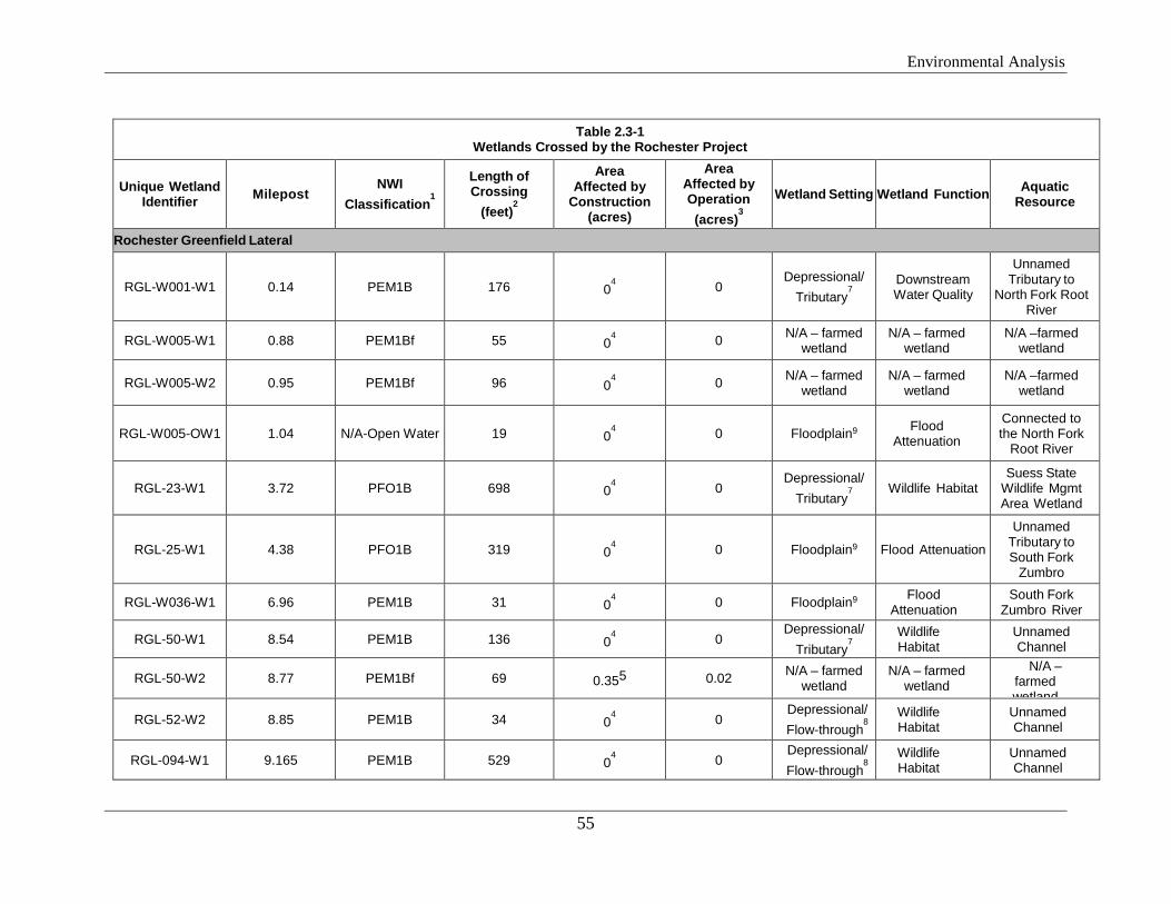
Environmental Analysis
55
Table 2.3-1 Wetlands Crossed by the Rochester Project
Unique Wetland Identifier Milepost
NWI Classification
1
Length of Crossing
(feet)2
Area Affected by
Construction (acres)
Area Affected by Operation (acres)
3
Wetland Setting Wetland Function Aquatic Resource
Rochester Greenfield Lateral
RGL-W001-W1 0.14 PEM1B 176 04 0
Depressional/ Tributary
7
Downstream Water Quality
Unnamed Tributary to
North Fork Root River
RGL-W005-W1 0.88 PEM1Bf 55 04 0 N/A – farmed
wetland N/A – farmed
wetland N/A –farmed
wetland
RGL-W005-W2 0.95 PEM1Bf 96 04 0 N/A – farmed
wetland N/A – farmed
wetland N/A –farmed
wetland
RGL-W005-OW1 1.04 N/A-Open Water 19 04 0 Floodplain9 Flood
Attenuation
Connected to the North Fork
Root River
RGL-23-W1 3.72 PFO1B 698 04 0
Depressional/ Tributary
7
Wildlife Habitat Suess State
Wildlife Mgmt Area Wetland
RGL-25-W1 4.38 PFO1B 319 04 0 Floodplain9 Flood Attenuation
Unnamed Tributary to South Fork
Zumbro
RGL-W036-W1 6.96 PEM1B 31 04 0 Floodplain9 Flood
Attenuation South Fork
Zumbro River
RGL-50-W1 8.54 PEM1B 136 04 0
Depressional/ Tributary
7
Wildlife Habitat
Unnamed Channel
RGL-50-W2 8.77 PEM1Bf 69 0.355 0.02 N/A – farmed wetland
N/A – farmed wetland
N/A – farmed wetland
RGL-52-W2 8.85 PEM1B 34 04 0
Depressional/ Flow-through
8
Wildlife Habitat
Unnamed Channel
RGL-094-W1 9.165 PEM1B 529 04 0
Depressional/ Flow-through
8
Wildlife Habitat
Unnamed Channel
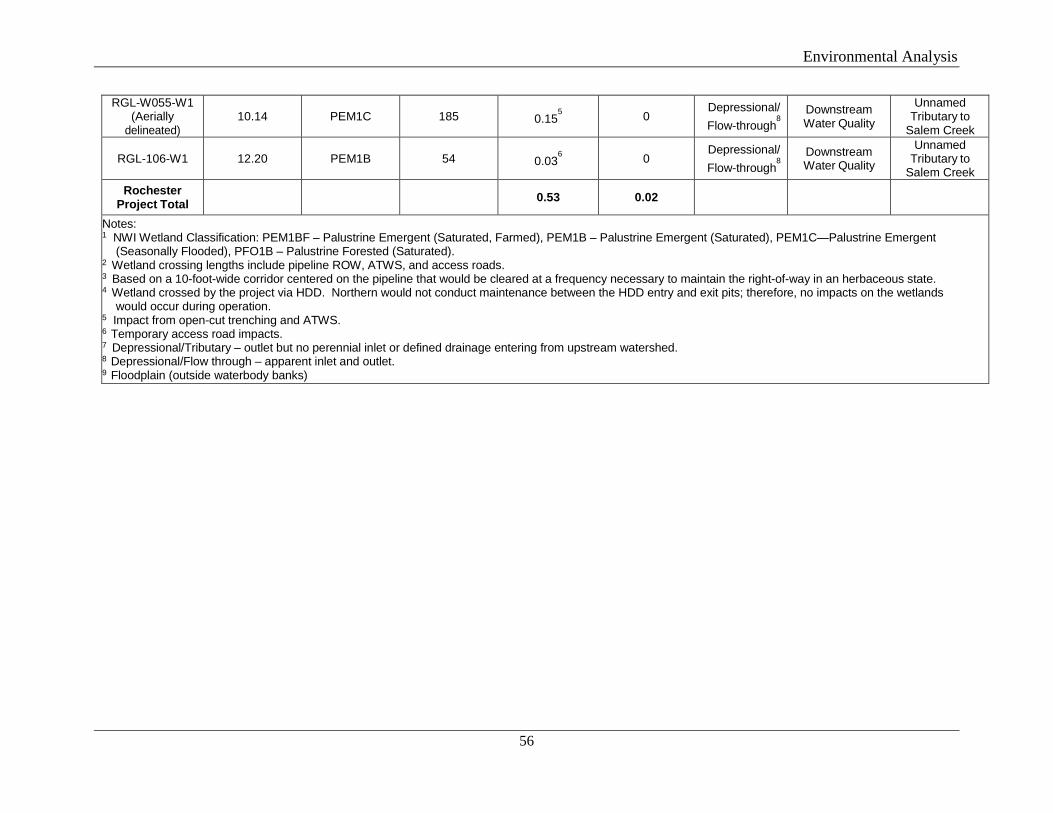
Environmental Analysis
56
RGL-W055-W1 (Aerially
delineated) 10.14 PEM1C 185 0.15
5 0
Depressional/ Flow-through
8
Downstream Water Quality
Unnamed Tributary to
Salem Creek
RGL-106-W1 12.20 PEM1B 54 0.036 0
Depressional/ Flow-through
8
Downstream Water Quality
Unnamed Tributary to
Salem Creek Rochester
Project Total 0.53 0.02
Notes: 1 NWI Wetland Classification: PEM1BF – Palustrine Emergent (Saturated, Farmed), PEM1B – Palustrine Emergent (Saturated), PEM1C—Palustrine Emergent
(Seasonally Flooded), PFO1B – Palustrine Forested (Saturated). 2 Wetland crossing lengths include pipeline ROW, ATWS, and access roads. 3 Based on a 10-foot-wide corridor centered on the pipeline that would be cleared at a frequency necessary to maintain the right-of-way in an herbaceous state. 4 Wetland crossed by the project via HDD. Northern would not conduct maintenance between the HDD entry and exit pits; therefore, no impacts on the wetlands
would occur during operation. 5 Impact from open-cut trenching and ATWS. 6 Temporary access road impacts. 7 Depressional/Tributary – outlet but no perennial inlet or defined drainage entering from upstream watershed. 8 Depressional/Flow through – apparent inlet and outlet. 9 Floodplain (outside waterbody banks)
Environmental Analysis
57
Between MPs 3.72 and 3.85 of the Rochester Greenfield Lateral, the Minnesota Biological Survey has mapped a Site of Moderate Biodiversity Significance. The site contains a seepage meadow/carr, tussock sedge native plant community and is classified as a rare wetland. Northern’s delineation classified this wetland as PFO with a PSS fringe. This wetland would be crossed via HDD.
We received comments from the MNPCA regarding impacts on fens located near the Rochester Project. No calcareous fens were identified within or adjacent to proposed Rochester Project workspaces. The Nelson Fen, located in the Nelson Fen Wildlife Management Area (WMA), is about 0.2 mile west of the Rochester Greenfield Lateral. Additional information on the Nelson Fen is discussed in the Wetland Impact Minimization and Mitigation section below.
NL 2019 Project
Three classes of palustrine (freshwater) wetland systems are present in the NL 2019 Project area. These classes include PEM wetlands, PSS wetlands (dominated by woody vegetation less than 20 feet in height), and PFO wetlands.
About 1.7 acres of PEM wetland and 0.26 acre of PEM/PSS wetland would be temporarily impacted by construction of the NL 2019 Project, and 0.2 acre of PEM wetland would be impacted by operations. No PFO wetlands would be impacted due to use of the HDD construction method. Table B.3.3-2 provides a complete list of all wetlands that would be crossed by the NL 2019 Project, including milepost, wetland ID, NWI classification, crossing length, anticipated crossing method, and construction and operation impact acreages. In addition, the MNPCA requested information on wetland setting, wetland function, and aquatic resources supported by a given wetland. The table identifies all wetlands, regardless of jurisdictional status, that would be crossed by the NL 2019 Project.
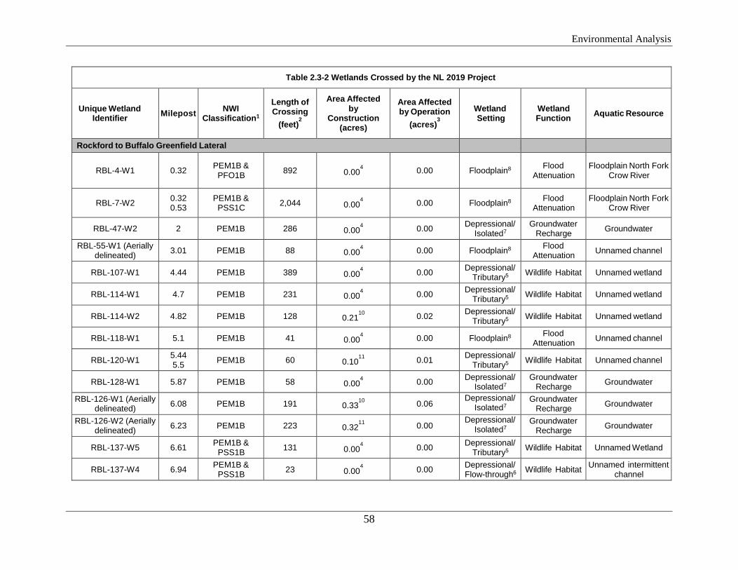
Environmental Analysis
58
Table 2.3-2 Wetlands Crossed by the NL 2019 Project
Unique Wetland Identifier Milepost NWI
Classification1
Length of Crossing
(feet)2
Area Affected by
Construction (acres)
Area Affected by Operation
(acres)3
Wetland Setting
Wetland Function Aquatic Resource
Rockford to Buffalo Greenfield Lateral
RBL-4-W1 0.32 PEM1B & PFO1B 892 0.00
4 0.00 Floodplain8 Flood
Attenuation Floodplain North Fork
Crow River
RBL-7-W2 0.32 0.53
PEM1B & PSS1C 2,044 0.00
4 0.00 Floodplain8 Flood
Attenuation Floodplain North Fork
Crow River
RBL-47-W2 2 PEM1B 286 0.004 0.00 Depressional/
Isolated7 Groundwater
Recharge Groundwater
RBL-55-W1 (Aerially delineated) 3.01 PEM1B 88 0.00
4 0.00 Floodplain8 Flood
Attenuation Unnamed channel
RBL-107-W1 4.44 PEM1B 389 0.004 0.00 Depressional/
Tributary5 Wildlife Habitat Unnamed wetland
RBL-114-W1 4.7 PEM1B 231 0.004 0.00 Depressional/
Tributary5 Wildlife Habitat Unnamed wetland
RBL-114-W2 4.82 PEM1B 128 0.2110
0.02 Depressional/ Tributary5 Wildlife Habitat Unnamed wetland
RBL-118-W1 5.1 PEM1B 41 0.004 0.00 Floodplain8 Flood
Attenuation Unnamed channel
RBL-120-W1 5.44 5.5 PEM1B 60 0.10
11 0.01 Depressional/
Tributary5 Wildlife Habitat Unnamed channel
RBL-128-W1 5.87 PEM1B 58 0.004 0.00 Depressional/
Isolated7 Groundwater
Recharge Groundwater
RBL-126-W1 (Aerially delineated) 6.08 PEM1B 191 0.33
10 0.06
Depressional/ Isolated7
Groundwater Recharge Groundwater
RBL-126-W2 (Aerially delineated) 6.23 PEM1B 223 0.32
11 0.00
Depressional/ Isolated7
Groundwater Recharge Groundwater
RBL-137-W5 6.61 PEM1B & PSS1B 131 0.00
4 0.00 Depressional/
Tributary5 Wildlife Habitat Unnamed Wetland
RBL-137-W4 6.94 PEM1B & PSS1B 23 0.00
4 0.00 Depressional/
Flow-through6 Wildlife Habitat Unnamed intermittent channel
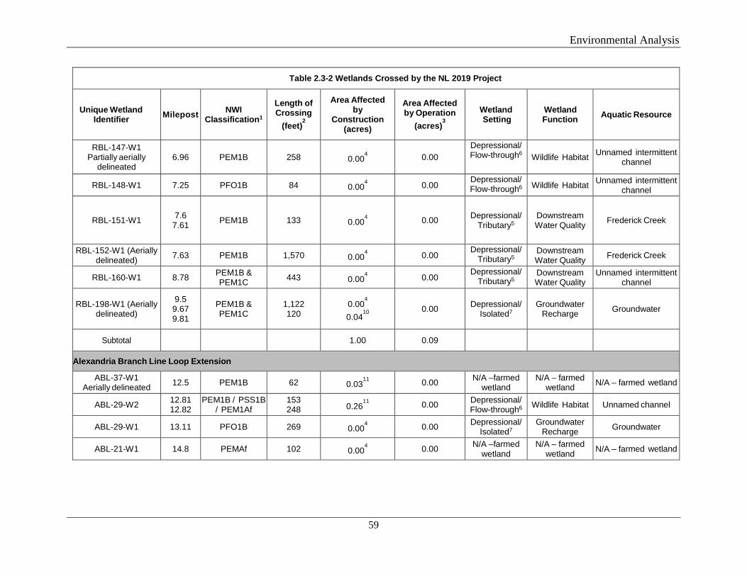
Environmental Analysis
59
Table 2.3-2 Wetlands Crossed by the NL 2019 Project
Unique Wetland Identifier Milepost NWI
Classification1
Length of Crossing
(feet)2
Area Affected by
Construction (acres)
Area Affected by Operation
(acres)3
Wetland Setting
Wetland Function Aquatic Resource
RBL-147-W1 Partially aerially
delineated 6.96 PEM1B 258 0.00
4 0.00
Depressional/ Flow-through6 Wildlife Habitat Unnamed intermittent
channel
RBL-148-W1 7.25 PFO1B 84 0.004 0.00 Depressional/
Flow-through6 Wildlife Habitat Unnamed intermittent channel
RBL-151-W1 7.6 7.61 PEM1B 133 0.00
4 0.00 Depressional/
Tributary5 Downstream Water Quality Frederick Creek
RBL-152-W1 (Aerially delineated) 7.63 PEM1B 1,570 0.00
4 0.00
Depressional/ Tributary5
Downstream Water Quality Frederick Creek
RBL-160-W1 8.78 PEM1B & PEM1C 443 0.00
4 0.00
Depressional/ Tributary5
Downstream Water Quality
Unnamed intermittent channel
RBL-198-W1 (Aerially delineated)
9.5 9.67 9.81
PEM1B & PEM1C
1,122 120
0.004
0.0410
0.00 Depressional/
Isolated7 Groundwater
Recharge Groundwater
Subtotal 1.00 0.09
Alexandria Branch Line Loop Extension
ABL-37-W1 Aerially delineated 12.5 PEM1B 62 0.03
11 0.00 N/A –farmed
wetland N/A – farmed
wetland N/A – farmed wetland
ABL-29-W2 12.81 12.82
PEM1B / PSS1B / PEM1Af
153 248 0.26
11 0.00 Depressional/
Flow-through6 Wildlife Habitat Unnamed channel
ABL-29-W1 13.11 PFO1B 269 0.004 0.00 Depressional/
Isolated7 Groundwater
Recharge Groundwater
ABL-21-W1 14.8 PEMAf 102 0.004 0.00 N/A –farmed
wetland N/A – farmed
wetland N/A – farmed wetland
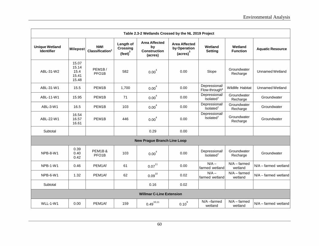
Environmental Analysis
60
Table 2.3-2 Wetlands Crossed by the NL 2019 Project
Unique Wetland Identifier Milepost NWI
Classification1
Length of Crossing
(feet)2
Area Affected by
Construction (acres)
Area Affected by Operation
(acres)3
Wetland Setting
Wetland Function Aquatic Resource
ABL-31-W2
15.07 15.14 15.4
15.41 15.48
PEM1B / PFO1B 582 0.00
4 0.00 Slope Groundwater
Recharge Unnamed Wetland
ABL-31-W1 15.5 PEM1B 1,700 0.004 0.00 Depressional/
Flow-through6 Wildlife Habitat Unnamed Wetland
ABL-11-W1 15.95 PEM1B 71 0.004 0.00
Depressional/ Isolated7
Groundwater Recharge Groundwater
ABL-3-W1 16.5 PEM1B 103 0.004 0.00
Depressional/ Isolated7
Groundwater Recharge Groundwater
ABL-22-W1 16.54 16.57 16.61
PEM1B 446 0.004 0.00
Depressional/ Isolated7 Groundwater
Recharge Groundwater
Subtotal 0.29 0.00
New Prague Branch Line Loop
NPB-8-W1 0.39 0.40 0.42
PEM1B & PFO1B 103 0.00
4 0.00 Depressional/
Isolated7 Groundwater
Recharge Groundwater
NPB-1-W1 0.46 PEM1Af 61 0.0711
0.00 N/A – farmed wetland
N/A – farmed wetland N/A – farmed wetland
NPB-6-W1 1.32 PEM1Af 62 0.0910
0.02 N/A – farmed wetland
N/A – farmed wetland N/A – farmed wetland
Subtotal 0.16 0.02
Willmar C-Line Extension
WLL-1-W1 0.00 PEM1Af 159 0.4910,11 0.10
9
N/A –farmed wetland
N/A – farmed wetland N/A – farmed wetland
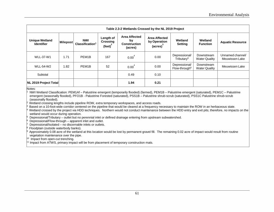
Environmental Analysis
61
Table 2.3-2 Wetlands Crossed by the NL 2019 Project
Unique Wetland Identifier Milepost NWI
Classification1
Length of Crossing
(feet)2
Area Affected by
Construction (acres)
Area Affected by Operation
(acres)3
Wetland Setting
Wetland Function Aquatic Resource
WLL-37-W1 1.71 PEM1B 167 0.004 0.00 Depressional/
Tributary5 Downstream Water Quality
Unnamed channel/ Meuwissen Lake
WLL-54-W2 1.82 PEM1B 52 0.004 0.00 Depressional/
Flow-through6 Downstream Water Quality Meuwissen Lake
Subtotal 0.49 0.10
NL 2019 Project Total 1.94 0.21
Notes: 1 NWI Wetland Classification: PEM1Af – Palustrine emergent (temporarily flooded) (farmed), PEM1B – Palustrine emergent (saturated), PEM1C – Palustrine
emergent (seasonally flooded), PFO1B - Palustrine Forested (saturated), PSS1B – Palustrine shrub-scrub (saturated), PSS1C Palustrine shrub-scrub (seasonally flooded).
2 Wetland crossing lengths include pipeline ROW, extra temporary workspaces, and access roads. 3 Based on a 10-foot-wide corridor centered on the pipeline that would be cleared at a frequency necessary to maintain the ROW in an herbaceous state. 4 Wetland crossed by the project via HDD techniques. Northern would not conduct maintenance between the HDD entry and exit pits; therefore, no impacts on the
wetland would occur during operation. 5 Depressional/Tributary – outlet but no perennial inlet or defined drainage entering from upstream subwatershed. 6 Depressional/Flow-through – apparent inlet and outlet. 7 Depressional/Isolated – no discernable inlets or outlets. 8 Floodplain (outside waterbody banks). 9 Approximately 0.08 acre of the wetland at this location would be lost by permanent gravel fill. The remaining 0.02 acre of impact would result from routine
vegetation maintenance over the pipe. 10 Impact from open-cut trenching. 11 Impact from ATWS, primary impact will be from placement of temporary construction mats.
Environmental Analysis
62
Temporary impacts on the wetland at MP 0.0 of the Willmar C-Line Extension would result as the valves for Northern’s existing pipelines are in the wetland. Excavation is required to complete the tie-in to these existing valves, requiring ATWS in the wetland. Northern reduced the workspace in this wetland to the smallest footprint feasible to safely complete the work.
Permanent loss of 0.08 acre of PEM wetland is currently proposed for the Willmar C-line Extension for the location of a launcher/valve site. The site cannot be moved further south and out of the wetland due to the proximity of two adjacent public roads.
Wetland Impact Minimization and Mitigation
Wetlands would be crossed by either HDD or open-cut installation. Generally, wetlands crossed by open-cut methods would be those in agricultural lands. Wetlands with natural vegetation, rare wetland types, or native plant communities are being proposed for HDD crossings. In accordance with the Procedures, Northern would limit impacts within the open-cut PEM wetlands to a 75-foot-wide construction corridor; the corridor would be used to clear the vegetation, dig the trench, install the pipeline, and restore contours. Redundant sediment barriers would be installed around wetland boundaries prior to the start of earth-disturbing activities to limit sedimentation in the wetlands.
Wetland crossings completed using the HDD method would generally avoid and minimize the potential for wetland impacts resulting from erosion, sedimentation, and/or excess turbidity by avoiding surface disturbance in and immediately adjacent to the wetlands. However, as described above, the potential for accidental releases of drilling mud exists. Impacts from an inadvertent release would be minimized by implementation of Northern’s Plan for Inadvertent Release of Drilling Mud, which includes procedures for monitoring, detection, isolating, stopping, and clean-up of inadvertent releases, as well as making necessary agency notifications.
In wetlands that are crossed via HDD, minimal hand-clearing of vegetation could occur within the travel lanes. During operation, Northern would not conduct routine removal of vegetation along the HDD drill paths; therefore, no conversion or permanent impact on PEM, PSS, or PFO wetlands crossed by HDD are anticipated.
Construction activities in nearby uplands can disturb surface soils and cause subsequent sedimentation from disturbed areas into wetlands. To minimize the potential for sedimentation of wetlands from construction activities, redundant erosion and sediment control measures would be installed prior to or immediately following initial ground disturbance. The erosion control devices would be installed within 50 feet of wetland boundaries, maintained in working condition throughout construction, and would remain in place until the adjacent upland areas are successfully revegetated. The MNPCA 401 Water Quality Certification requires a minimum of two EIs at each construction location. Northern proposes to utilize at least one EI per project component and potentially more than one EI depending on the length and activities at the component. MNPCA concurred with this level of EI support.
Compaction of wetland soils and rutting within wetlands due to equipment operation can affect wetland hydrology and revegetation. Compaction would be minimized by limiting
Environmental Analysis
63
equipment operation in wetlands and installing temporary equipment mats, as necessary. Soil characteristics also can be changed during construction because of inadvertent mixing of topsoil and subsoil during grubbing and trenching. To prevent such mixing in unsaturated wetlands, topsoil would be removed from directly over the trench and stockpiled for restoration as close as feasible to its original horizon. No topsoil segregation would be attempted in saturated wetlands.
Permanent changes in surface and subsurface hydrology through a wetland can have a long-term impact on the habitat type and quality. Trench plugs would be installed at the entrance and exit of the pipeline trench through the wetland to ensure that the wetland is not drained along the pipeline. Any confining layers that are breached during construction would be restored during backfilling. Restoration of each wetland would involve returning contours to pre-construction levels and removing temporary erosion control measures.
Permanent erosion control devices would be installed during restoration and may include slope breakers, interceptor diversion devices, and/or vegetation cover in adjacent upland areas to minimize long-term sedimentation into the wetlands. Energy dissipation devices may be installed at the down-slope end of surface water diversion devices to prevent erosion off the right-of-way into wetlands.
Northern’s SPCC Plan provides restrictions and mitigation measures to limit potential impacts associated with the release of fuels, lubricants, or other potentially toxic materials used during routine construction. For spills greater than 5 gallons, the MNPCA recommended that Northern immediately contact the Minnesota State Duty Officer. After initial spill response plans have been implemented, Northern would also contact the MNDNR and MNPCA to determine appropriate clean-up and/or mitigation measures to address any possible impacts on wetlands resulting from drilling fluids.
Refueling and storage of hazardous materials would be prohibited within 100 feet of wetlands during construction, unless otherwise requested by Northern and approved by the FERC (see section B.3.5). Based on these measures, we find the potential for a release of fuel or hazardous material into a wetland would be minimized to the extent practicable.
After the completion of construction, wetland areas would be allowed to revegetate naturally. PEM wetlands, dominated primarily by low-growing sedges, rushes, and other herbaceous vegetation, and PSS wetlands, dominated by low woody vegetation, would revert to pre-existing conditions within one to three growing seasons following construction, resulting in no permanent impacts on these wetland types. In accordance with the Procedures, wetlands would be monitored for up to 3 years after the completion of construction, or until we conclude revegetation is successful. In addition, temporary access roads in wetlands would be underlain with a geotextile fabric. Following construction, Northern would remove the gravel and geotextile fabric from any temporary access roads in wetlands that required placement of new gravel.
Northern would avoid direct impacts on a Site of Moderate Biodiversity Significance identified between MPs 3.7 and 3.9 of the Rochester Greenfield Lateral. Northern proposes to complete an HDD under this resource; therefore, no mechanized vegetation removal, grading, or other ground disturbance would occur in this wetland. Northern’s contractor and EI would use a
Environmental Analysis
64
travel lane(s) limited to foot traffic only to monitor the progress of the HDD. If an inadvertent release of drilling fluids occurs in this wetland, Northern would contact the MNDNR and MNPCA to determine the appropriate clean-up measures.
Northern conducted an evaluation of the geology and groundwater flow in the vicinity of the Nelson Fen, and coordinated with the MNDNR regarding potential impacts on the unique hydrology associated with fens. In the area nearest to the Nelson Fen, a tributary would separate the Rochester Greenfield Lateral pipeline from the Nelson Fen. Elevations along the pipeline route in this area range between 1,230 to 1,240 feet. The average depth of the trench required to install the pipeline is expected to be 6 feet below the ground surface. Several small, discrete areas could be trenched to a depth of 10 to 12 feet to allow for tie-ins at road crossings and other features. The creek should act as a local point of hydraulic separation between the proposed pipeline and the Nelson Fen. North of MP 4.4, the creek would not separate the proposed pipeline from the fen; however, the pipeline would not be located directly downgradient or upgradient of the groundwater flow direction recharging or discharging from the fen. Therefore, Northern determined that open-cut construction techniques to install the pipeline would not impact the hydrology of the Nelson Fen, and we agree.
Additionally, to prevent the pipeline (and its associated trench) from creating a preferential pathway for groundwater flow and drainage, Northern would install permanent trench breakers in the vicinity of the Nelson Fen between MPs 3.9 and 4.8 of the Rochester Greenfield Lateral. In workspace with slopes of less than 5 percent, permanent trench breakers would be installed in the pipeline trench at 500-foot intervals. Trench breakers would be installed at more frequent intervals in areas of steep slopes as described in the Plan. In addition, Northern would compact backfill in the trench to eliminate void spaces and reduce the possibility of subsurface flow along the trench.
The MNDNR requested that Northern review additional sources of non-public information and provide updates to mapping. The MNDNR also indicated that a final decision on whether a fen management plan would be necessary would be made after agency review of the full geotechnical report and the geophysical survey. Northern anticipates providing a supplemental document to the MNDNR, including the geophysical survey report, in the fall of 2018.
If trench dewatering is required during construction along the Rochester Greenfield Lateral between MPs 3.5 and 4.7, Northern would coordinate with MNDNR to develop a dewatering plan for construction activities near the Nelson Fen. Northern would file with the FERC any such plans or updated information, once finalized.
We conclude that impacts on wetlands would not be significant.
B.3.4 Hydrostatic Testing and Water Use
Rochester Project
As required by 49 CFR 192, Northern would conduct hydrostatic pressure testing of the new pipeline facilities prior to placing them into service. Northern would use municipal supplies and would require about 1,110,000 gallons of water to test the new Rochester Project pipeline
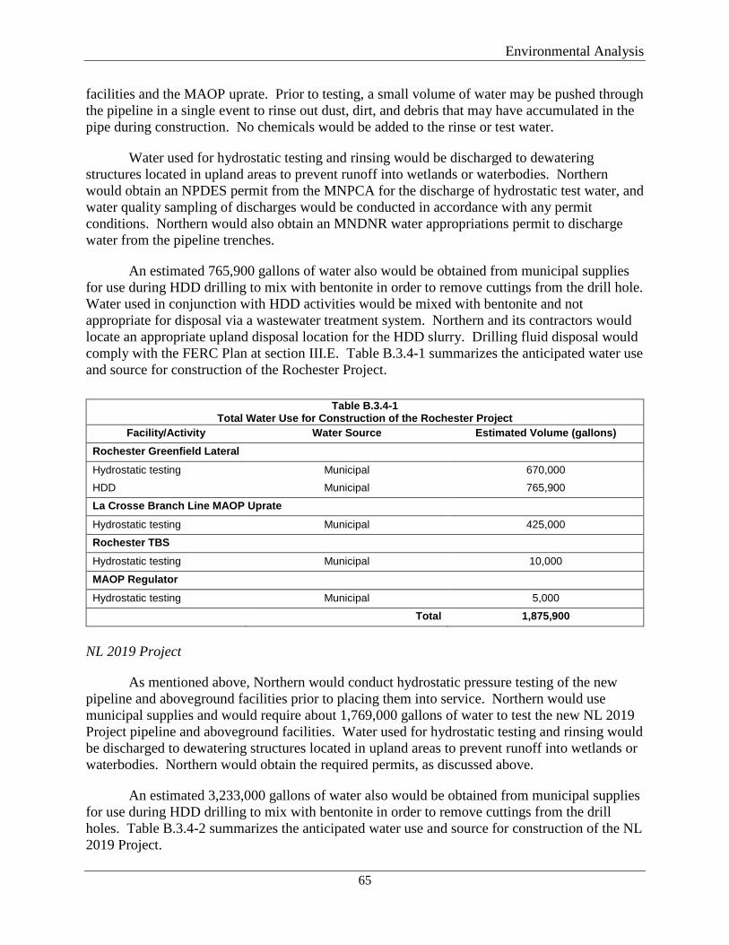
Environmental Analysis
65
facilities and the MAOP uprate. Prior to testing, a small volume of water may be pushed through the pipeline in a single event to rinse out dust, dirt, and debris that may have accumulated in the pipe during construction. No chemicals would be added to the rinse or test water.
Water used for hydrostatic testing and rinsing would be discharged to dewatering structures located in upland areas to prevent runoff into wetlands or waterbodies. Northern would obtain an NPDES permit from the MNPCA for the discharge of hydrostatic test water, and water quality sampling of discharges would be conducted in accordance with any permit conditions. Northern would also obtain an MNDNR water appropriations permit to discharge water from the pipeline trenches.
An estimated 765,900 gallons of water also would be obtained from municipal supplies for use during HDD drilling to mix with bentonite in order to remove cuttings from the drill hole. Water used in conjunction with HDD activities would be mixed with bentonite and not appropriate for disposal via a wastewater treatment system. Northern and its contractors would locate an appropriate upland disposal location for the HDD slurry. Drilling fluid disposal would comply with the FERC Plan at section III.E. Table B.3.4-1 summarizes the anticipated water use and source for construction of the Rochester Project.
Table B.3.4-1
Total Water Use for Construction of the Rochester Project Facility/Activity Water Source Estimated Volume (gallons)
Rochester Greenfield Lateral
Hydrostatic testing Municipal 670,000 HDD Municipal 765,900
La Crosse Branch Line MAOP Uprate
Hydrostatic testing Municipal 425,000
Rochester TBS Hydrostatic testing Municipal 10,000
MAOP Regulator Hydrostatic testing Municipal 5,000
Total 1,875,900
NL 2019 Project
As mentioned above, Northern would conduct hydrostatic pressure testing of the new pipeline and aboveground facilities prior to placing them into service. Northern would use municipal supplies and would require about 1,769,000 gallons of water to test the new NL 2019 Project pipeline and aboveground facilities. Water used for hydrostatic testing and rinsing would be discharged to dewatering structures located in upland areas to prevent runoff into wetlands or waterbodies. Northern would obtain the required permits, as discussed above.
An estimated 3,233,000 gallons of water also would be obtained from municipal supplies for use during HDD drilling to mix with bentonite in order to remove cuttings from the drill holes. Table B.3.4-2 summarizes the anticipated water use and source for construction of the NL 2019 Project.
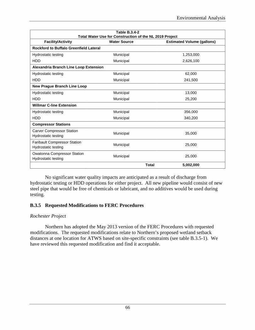
Environmental Analysis
66
Table B.3.4-2 Total Water Use for Construction of the NL 2019 Project
Facility/Activity Water Source Estimated Volume (gallons) Rockford to Buffalo Greenfield Lateral
Hydrostatic testing Municipal 1,253,000 HDD Municipal 2,626,100
Alexandria Branch Line Loop Extension Hydrostatic testing Municipal 62,000
HDD Municipal 241,500
New Prague Branch Line Loop Hydrostatic testing Municipal 13,000 HDD Municipal 25,200
Willmar C-line Extension Hydrostatic testing Municipal 356,000 HDD Municipal 340,200
Compressor Stations Carver Compressor Station Hydrostatic testing Municipal 35,000
Faribault Compressor Station Hydrostatic testing Municipal 25,000
Owatonna Compressor Station Hydrostatic testing Municipal 25,000
Total 5,002,000
No significant water quality impacts are anticipated as a result of discharge from
hydrostatic testing or HDD operations for either project. All new pipeline would consist of new steel pipe that would be free of chemicals or lubricant, and no additives would be used during testing.
B.3.5 Requested Modifications to FERC Procedures
Rochester Project
Northern has adopted the May 2013 version of the FERC Procedures with requested modifications. The requested modifications relate to Northern’s proposed wetland setback distances at one location for ATWS based on site-specific constraints (see table B.3.5-1). We have reviewed this requested modification and find it acceptable.
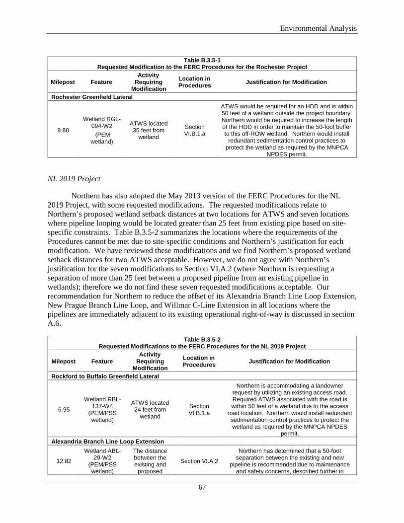
Environmental Analysis
67
Table B.3.5-1
Requested Modification to the FERC Procedures for the Rochester Project
Milepost Feature Activity
Requiring Modification
Location in Procedures Justification for Modification
Rochester Greenfield Lateral
9.80
Wetland RGL-094-W2 (PEM
wetland)
ATWS located 35 feet from
wetland
Section VI.B.1.a
ATWS would be required for an HDD and is within 50 feet of a wetland outside the project boundary. Northern would be required to increase the length of the HDD in order to maintain the 50-foot buffer to this off-ROW wetland. Northern would install
redundant sedimentation control practices to protect the wetland as required by the MNPCA
NPDES permit.
NL 2019 Project
Northern has also adopted the May 2013 version of the FERC Procedures for the NL 2019 Project, with some requested modifications. The requested modifications relate to Northern’s proposed wetland setback distances at two locations for ATWS and seven locations where pipeline looping would be located greater than 25 feet from existing pipe based on site-specific constraints. Table B.3.5-2 summarizes the locations where the requirements of the Procedures cannot be met due to site-specific conditions and Northern’s justification for each modification. We have reviewed these modifications and we find Northern’s proposed wetland setback distances for two ATWS acceptable. However, we do not agree with Northern’s justification for the seven modifications to Section VI.A.2 (where Northern is requesting a separation of more than 25 feet between a proposed pipeline from an existing pipeline in wetlands); therefore we do not find these seven requested modifications acceptable. Our recommendation for Northern to reduce the offset of its Alexandria Branch Line Loop Extension, New Prague Branch Line Loop, and Willmar C-Line Extension in all locations where the pipelines are immediately adjacent to its existing operational right-of-way is discussed in section A.6.
Table B.3.5-2 Requested Modifications to the FERC Procedures for the NL 2019 Project
Milepost Feature Activity
Requiring Modification
Location in Procedures Justification for Modification
Rockford to Buffalo Greenfield Lateral
6.95
Wetland RBL-137-W4
(PEM/PSS wetland)
ATWS located 24 feet from
wetland
Section VI.B.1.a
Northern is accommodating a landowner request by utilizing an existing access road. Required ATWS associated with the road is within 50 feet of a wetland due to the access
road location. Northern would install redundant sedimentation control practices to protect the wetland as required by the MNPCA NPDES
permit. Alexandria Branch Line Loop Extension
12.82
Wetland ABL-29-W2
(PEM/PSS wetland)
The distance between the existing and
proposed
Section VI.A.2
Northern has determined that a 50-foot separation between the existing and new
pipeline is recommended due to maintenance and safety concerns, described further in
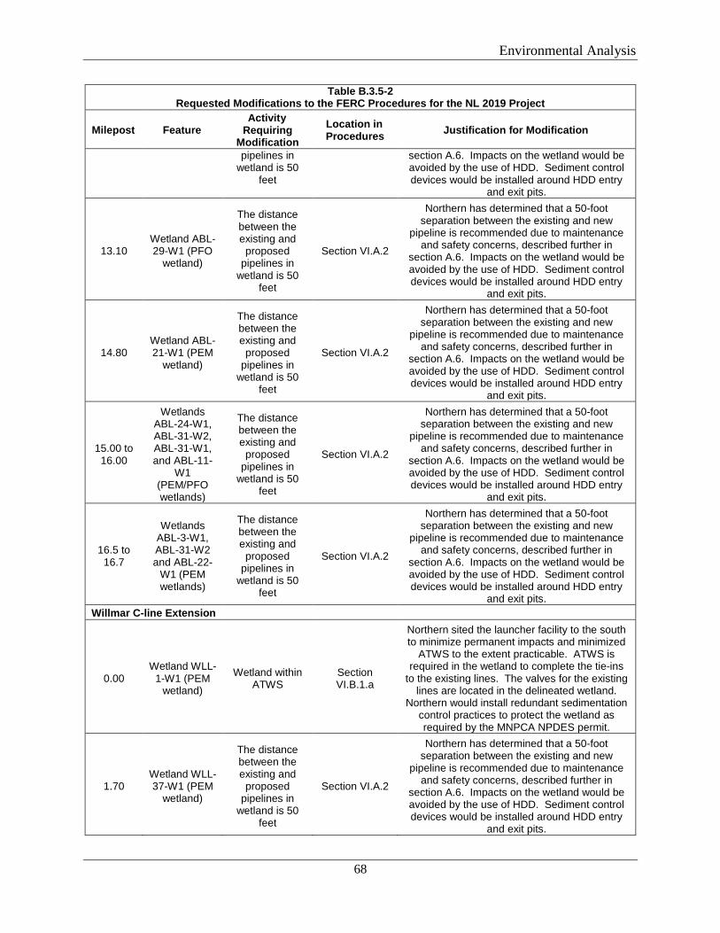
Environmental Analysis
68
Table B.3.5-2 Requested Modifications to the FERC Procedures for the NL 2019 Project
Milepost Feature Activity
Requiring Modification
Location in Procedures Justification for Modification
pipelines in wetland is 50
feet
section A.6. Impacts on the wetland would be avoided by the use of HDD. Sediment control devices would be installed around HDD entry
and exit pits.
13.10 Wetland ABL-29-W1 (PFO
wetland)
The distance between the existing and
proposed pipelines in
wetland is 50 feet
Section VI.A.2
Northern has determined that a 50-foot separation between the existing and new
pipeline is recommended due to maintenance and safety concerns, described further in
section A.6. Impacts on the wetland would be avoided by the use of HDD. Sediment control devices would be installed around HDD entry
and exit pits.
14.80 Wetland ABL-21-W1 (PEM
wetland)
The distance between the existing and
proposed pipelines in
wetland is 50 feet
Section VI.A.2
Northern has determined that a 50-foot separation between the existing and new
pipeline is recommended due to maintenance and safety concerns, described further in
section A.6. Impacts on the wetland would be avoided by the use of HDD. Sediment control devices would be installed around HDD entry
and exit pits.
15.00 to 16.00
Wetlands ABL-24-W1, ABL-31-W2, ABL-31-W1, and ABL-11-
W1 (PEM/PFO wetlands)
The distance between the existing and
proposed pipelines in
wetland is 50 feet
Section VI.A.2
Northern has determined that a 50-foot separation between the existing and new
pipeline is recommended due to maintenance and safety concerns, described further in
section A.6. Impacts on the wetland would be avoided by the use of HDD. Sediment control devices would be installed around HDD entry
and exit pits.
16.5 to 16.7
Wetlands ABL-3-W1, ABL-31-W2 and ABL-22-
W1 (PEM wetlands)
The distance between the existing and
proposed pipelines in
wetland is 50 feet
Section VI.A.2
Northern has determined that a 50-foot separation between the existing and new
pipeline is recommended due to maintenance and safety concerns, described further in
section A.6. Impacts on the wetland would be avoided by the use of HDD. Sediment control devices would be installed around HDD entry
and exit pits. Willmar C-line Extension
0.00 Wetland WLL-
1-W1 (PEM wetland)
Wetland within ATWS
Section VI.B.1.a
Northern sited the launcher facility to the south to minimize permanent impacts and minimized
ATWS to the extent practicable. ATWS is required in the wetland to complete the tie-ins
to the existing lines. The valves for the existing lines are located in the delineated wetland.
Northern would install redundant sedimentation control practices to protect the wetland as required by the MNPCA NPDES permit.
1.70 Wetland WLL-37-W1 (PEM
wetland)
The distance between the existing and
proposed pipelines in
wetland is 50 feet
Section VI.A.2
Northern has determined that a 50-foot separation between the existing and new
pipeline is recommended due to maintenance and safety concerns, described further in
section A.6. Impacts on the wetland would be avoided by the use of HDD. Sediment control devices would be installed around HDD entry
and exit pits.
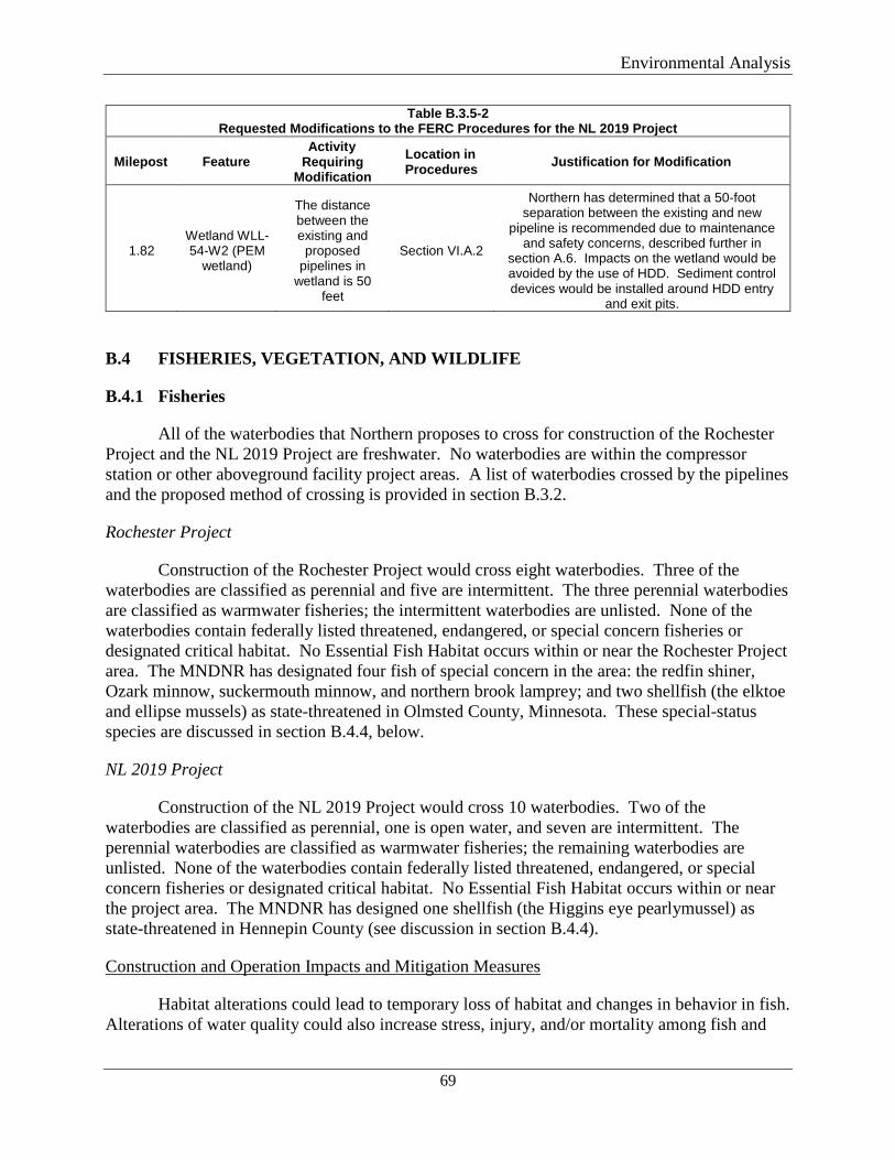
Environmental Analysis
69
Table B.3.5-2 Requested Modifications to the FERC Procedures for the NL 2019 Project
Milepost Feature Activity
Requiring Modification
Location in Procedures Justification for Modification
1.82 Wetland WLL-54-W2 (PEM
wetland)
The distance between the existing and
proposed pipelines in
wetland is 50 feet
Section VI.A.2
Northern has determined that a 50-foot separation between the existing and new
pipeline is recommended due to maintenance and safety concerns, described further in
section A.6. Impacts on the wetland would be avoided by the use of HDD. Sediment control devices would be installed around HDD entry
and exit pits.
B.4 FISHERIES, VEGETATION, AND WILDLIFE
B.4.1 Fisheries
All of the waterbodies that Northern proposes to cross for construction of the Rochester Project and the NL 2019 Project are freshwater. No waterbodies are within the compressor station or other aboveground facility project areas. A list of waterbodies crossed by the pipelines and the proposed method of crossing is provided in section B.3.2.
Rochester Project
Construction of the Rochester Project would cross eight waterbodies. Three of the waterbodies are classified as perennial and five are intermittent. The three perennial waterbodies are classified as warmwater fisheries; the intermittent waterbodies are unlisted. None of the waterbodies contain federally listed threatened, endangered, or special concern fisheries or designated critical habitat. No Essential Fish Habitat occurs within or near the Rochester Project area. The MNDNR has designated four fish of special concern in the area: the redfin shiner, Ozark minnow, suckermouth minnow, and northern brook lamprey; and two shellfish (the elktoe and ellipse mussels) as state-threatened in Olmsted County, Minnesota. These special-status species are discussed in section B.4.4, below.
NL 2019 Project
Construction of the NL 2019 Project would cross 10 waterbodies. Two of the waterbodies are classified as perennial, one is open water, and seven are intermittent. The perennial waterbodies are classified as warmwater fisheries; the remaining waterbodies are unlisted. None of the waterbodies contain federally listed threatened, endangered, or special concern fisheries or designated critical habitat. No Essential Fish Habitat occurs within or near the project area. The MNDNR has designed one shellfish (the Higgins eye pearlymussel) as state-threatened in Hennepin County (see discussion in section B.4.4).
Construction and Operation Impacts and Mitigation Measures
Habitat alterations could lead to temporary loss of habitat and changes in behavior in fish. Alterations of water quality could also increase stress, injury, and/or mortality among fish and
Environmental Analysis
70
other aquatic species. However, Northern would follow the FERC’s Plan and Procedures to control erosion and sedimentation and to minimize impacts on waterbodies. Northern would also use the HDD method for installing the pipelines across all waterbodies, therefore avoiding direct impacts on the waterbodies and their beds and banks.
An inadvertent release of drilling fluid or a spill of fuel or equipment-related fluids could impact water quality and consequentially impact fisheries. To minimize the potential for an inadvertent release of drilling fluid to impact fisheries, Northern would implement its Plan for Inadvertent Release of Drilling Mud that includes procedures for monitoring, detection, isolating, stopping, and restoring inadvertent releases, and would make all necessary agency notifications. During construction, Northern would ensure its contractors have sufficient spill containment material and supplies needed to contain any inadvertent release of drilling mud that occurs near a waterbody. The contractor would assign personnel to continuously monitor the HDD activities, including walking the HDD path between entry and exit points and visually inspecting for a release. If the drill operator notes the loss of drilling mud or other indicators of a release, the HDD would be temporarily suspended to allow the contractor and/or Northern’s EI time to locate the release. If the release is in or adjacent to a waterway, Northern would deploy the BMPs that were previously staged by each waterbody to contain the drilling fluid.
Northern would adhere to its SPCC Plan which includes preventive measures to minimize potential impacts should a spill occur. These measures include personnel training, equipment inspection, and refueling procedures, as well as measures for containment and clean-up of a spill if it occurs.
Northern consulted with USFWS staff May 14, 2018. The USFWS stated that none of the project components cross waters with federally listed aquatic shellfish or amphibians. The USFWS agreed with Northern’s assessment that risk to aquatic and semi-aquatic species is minimized by the use of HDD at each crossing location. The USFWS indicated it would defer to the MNDNR since the species of concern are state listed. On June 22, 2018, the MNDNR reviewed Northern’s Plan for Inadvertent Release of Drilling Mud and concurred that the measures outlined would minimize impacts on aquatic species, including fish and mussels. We agree that fisheries would not be significantly affected.
B.4.2 Vegetation
The vegetation cover types impacted by the projects include:
• Agriculture – active farmed cropland (mainly corn and soybean); • Forested upland – hardwood forest, mixed hardwood conifer forest, and pine plantation; • Open land – non-forested rangeland, non-agricultural fields, and other disturbed areas
that are dominated by a mixture of mid-grass or short-grass species, introduced grass species, and annual species; and
• Wetlands – emergent, scrub-shrub, and forested wetland.
Environmental Analysis
71
Rochester Project
Northern identified the dominant vegetation of each cover type during field surveys for the Rochester Project. Agricultural land was found to consist of primarily corn and soybeans. Forested uplands are composed of American elm, box elder, green ash, oaks, and pine. Common species observed in open land areas include smooth brome, Canada goldenrod, reed canary grass, and Kentucky bluegrass. Emergent wetlands in the area include farmed wetlands and wet meadows consisting of row crops and hydrophytic species such as reed canary grass, prairie cordgrass, and Kentucky bluegrass. Forested wetlands are dominated by silver maple, green ash, boxelder, and common buckthorn.
The primary vegetation cover types affected by construction of the Rochester Project would be agriculture. The Rochester Project area consists of about 209.9 acres of agriculture, 1.0 acres of forested habitat, 0.4 acre of wetland, and 2.6 acres of open land. The forested areas that would be impacted by temporary workspace for the Rochester Greenfield Lateral consist of about 0.3 acre of hardwood forest and 0.9 acre of mixed hardwood forest; no pine plantations would be impacted.
The Rochester Greenfield Lateral and Rochester TBS are located inside the emerald ash borer (EAB) county quarantine area as mapped by the Minnesota Department of Agriculture (MNDA) (MNDA 2018a). The proposed workspaces would be located outside the generally infested area and area of biocontrol. The Rochester Project is also within the oak-wilt infected area mapped by the MNDNR (MNDNR 2018c). Oak wilt is caused by an invasive fungus that may affect and kill all species of oak trees.
As discussed in section B.3.3, a Site of Moderate Biodiversity Significance is located between MPs 3.72 and 3.85 of the Rochester Greenfield Lateral. The site contains a seepage meadow/carr and tussock sedge native plant community and is classified as a rare wetland, which was delineated and classified as a PFO wetland with a PSS fringe. The area of wetland that would be within the proposed construction footprint contained dominant species such as box elder, green ash, sandbar willow, and jewelweed. Northern would construct the pipeline via HDD under this resource; therefore, no mechanized vegetation removal, grading, or other ground disturbance would occur in the site. There are no other known unique or sensitive vegetation types affected by the Rochester Project.
A total of 61.1 acres of vegetated land would be maintained as permanent right-of-way for the Rochester Project. In addition, about 1.4 acres of agricultural land would be converted to industrial land for operation of the aboveground appurtenances, Rochester TBS, and MAOP Regulator. Table B.4.2-1 lists the amount of each cover type that would be impacted by construction and operation of the Rochester Project.
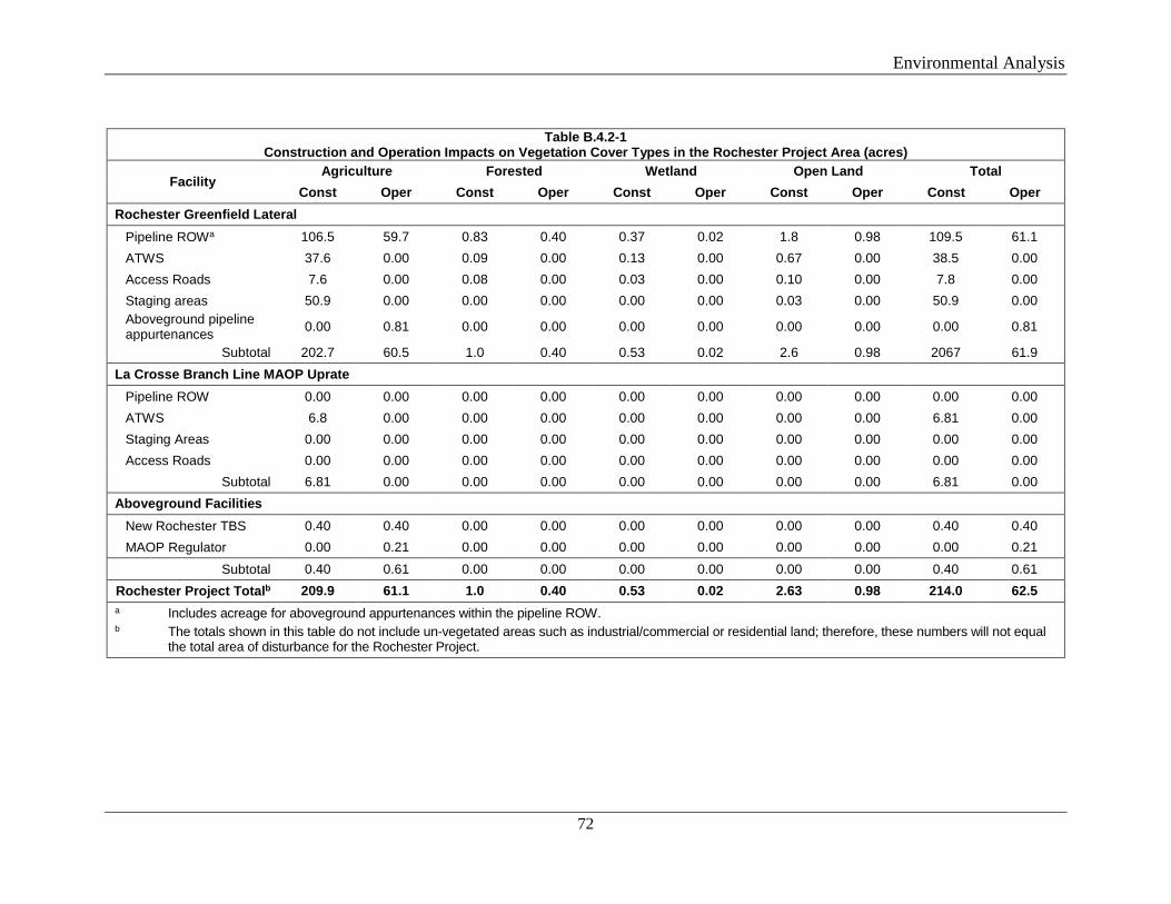
Environmental Analysis
72
Table B.4.2-1
Construction and Operation Impacts on Vegetation Cover Types in the Rochester Project Area (acres)
Facility Agriculture Forested Wetland Open Land Total
Const Oper Const Oper Const Oper Const Oper Const Oper Rochester Greenfield Lateral
Pipeline ROWa 106.5 59.7 0.83 0.40 0.37 0.02 1.8 0.98 109.5 61.1 ATWS 37.6 0.00 0.09 0.00 0.13 0.00 0.67 0.00 38.5 0.00 Access Roads 7.6 0.00 0.08 0.00 0.03 0.00 0.10 0.00 7.8 0.00 Staging areas 50.9 0.00 0.00 0.00 0.00 0.00 0.03 0.00 50.9 0.00 Aboveground pipeline appurtenances 0.00 0.81 0.00 0.00 0.00 0.00 0.00 0.00 0.00 0.81
Subtotal 202.7 60.5 1.0 0.40 0.53 0.02 2.6 0.98 2067 61.9 La Crosse Branch Line MAOP Uprate
Pipeline ROW 0.00 0.00 0.00 0.00 0.00 0.00 0.00 0.00 0.00 0.00 ATWS 6.8 0.00 0.00 0.00 0.00 0.00 0.00 0.00 6.81 0.00 Staging Areas 0.00 0.00 0.00 0.00 0.00 0.00 0.00 0.00 0.00 0.00 Access Roads 0.00 0.00 0.00 0.00 0.00 0.00 0.00 0.00 0.00 0.00
Subtotal 6.81 0.00 0.00 0.00 0.00 0.00 0.00 0.00 6.81 0.00 Aboveground Facilities
New Rochester TBS 0.40 0.40 0.00 0.00 0.00 0.00 0.00 0.00 0.40 0.40 MAOP Regulator 0.00 0.21 0.00 0.00 0.00 0.00 0.00 0.00 0.00 0.21
Subtotal 0.40 0.61 0.00 0.00 0.00 0.00 0.00 0.00 0.40 0.61 Rochester Project Totalb 209.9 61.1 1.0 0.40 0.53 0.02 2.63 0.98 214.0 62.5 a Includes acreage for aboveground appurtenances within the pipeline ROW. b The totals shown in this table do not include un-vegetated areas such as industrial/commercial or residential land; therefore, these numbers will not equal the total area of disturbance for the Rochester Project.
Environmental Analysis
73
Northern obtained lists of noxious and invasive weeds that could be present from the USDA’s Introduced, Invasive and Noxious Plants database (USDA 2018a, 2018b) and the Minnesota Department of Agriculture (MNDA 2018b), and also conducted field surveys for noxious and invasive weeds. One noxious weed species, wild parsnip, was identified within the Rochester Project area at MPs 0.13 and 1.12.
NL 2019 Project
Northern identified the dominant vegetation of each cover type during field surveys for the NL 2019 Project. Agricultural land was found to consist of primarily corn and soybeans. Forested uplands are composed of American elm, box elder, green ash, oaks, and pine. Common species observed in open land areas include smooth brome, Canada goldenrod, reed canary grass, and Kentucky bluegrass. Emergent wetlands in the area include farmed wetlands and wet meadows consisting of row crops and hydrophytic species such as reed canary grass, prairie cordgrass, and Kentucky bluegrass. Shrub-scrub wetlands were dominated by red osier dogwood, Bebb’s willow, black willow, ash, and box elder. Forested wetlands are dominated by silver maple, green ash, boxelder, and common buckthorn.
The primary vegetation cover type affected by construction of the NL 2019 Project would be agriculture. The NL 2019 Project area consists of about 293.9 acres of agriculture, 8.6 acres of forested habitat, 1.9 acres of wetland, and 24.2 acres of open land. The forested areas that would be impacted by temporary workspace for the NL 2019 Project consist of about 2.8 acres of hardwood forest, 4.7 acres of mixed hardwood forest, and 1.1 acres of pine plantation.
Four Regionally Significant Ecological Areas (RSEA) were mapped within the NL 2019 Project area. RSEAs are given a score by the MNDNR of 1, 2, or 3, with 3 as the highest possible score. Three of the RSEAs were given an ecological score of 1; the fourth was given a score of 2. Scores are based on how well continuous natural areas meet standards for size, shape, connectivity, adjacent land use, and species diversity. A score of ‘1’ is for areas that are smaller in size; may have less diversity of vegetation cover types; may have more adjacent cover types or land uses that could adversely affect the area; or may be an isolated native plant community mapped and given a score of moderate biodiversity significance by the Minnesota County Biological Survey. A score of ‘2’ is for areas that are moderate in size and/or with more adjacent land cover types or land uses that could adversely affect the area; may have less diversity of vegetation cover types; or may be an isolated native plant community mapped and given a score of moderate biodiversity significance by the Minnesota County Biological Survey. The RSEAs are discussed further in section B.4.3. There are no other known unique or sensitive vegetation types affected by the NL 2019 Project.
The portion of the Rockford to Buffalo Greenfield Lateral between MPs 0.0 and 0.5 is within the EAB county quarantine area as mapped by the MNDA (MNDA 2018a). The proposed workspaces would be located outside the generally infested area. The NL 2019 Project is also within the oak-wilt infected area mapped by the MNDNR (MNDNR 2018c).

Environmental Analysis
74
A total of about 75.7 acres of vegetated land would be maintained as permanent right-of-way for the NL 2019 Project pipelines. In addition, about 6.3 acres of vegetated land would be converted to industrial land for operation of the aboveground appurtenances and compressor stations. Table B.4.2-2 lists the amount of each cover type that would be impacted by construction and operation of the NL 2019 Project.
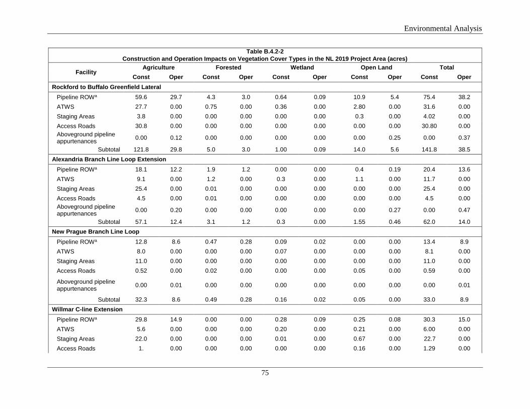
Environmental Analysis
75
Table B.4.2-2 Construction and Operation Impacts on Vegetation Cover Types in the NL 2019 Project Area (acres)
Facility Agriculture Forested Wetland Open Land Total
Const Oper Const Oper Const Oper Const Oper Const Oper Rockford to Buffalo Greenfield Lateral
Pipeline ROWa 59.6 29.7 4.3 3.0 0.64 0.09 10.9 5.4 75.4 38.2 ATWS 27.7 0.00 0.75 0.00 0.36 0.00 2.80 0.00 31.6 0.00 Staging Areas 3.8 0.00 0.00 0.00 0.00 0.00 0.3 0.00 4.02 0.00 Access Roads 30.8 0.00 0.00 0.00 0.00 0.00 0.00 0.00 30.80 0.00 Aboveground pipeline appurtenances 0.00 0.12 0.00 0.00 0.00 0.00 0.00 0.25 0.00 0.37
Subtotal 121.8 29.8 5.0 3.0 1.00 0.09 14.0 5.6 141.8 38.5 Alexandria Branch Line Loop Extension
Pipeline ROWa 18.1 12.2 1.9 1.2 0.00 0.00 0.4 0.19 20.4 13.6 ATWS 9.1 0.00 1.2 0.00 0.3 0.00 1.1 0.00 11.7 0.00 Staging Areas 25.4 0.00 0.01 0.00 0.00 0.00 0.00 0.00 25.4 0.00 Access Roads 4.5 0.00 0.01 0.00 0.00 0.00 0.00 0.00 4.5 0.00 Aboveground pipeline appurtenances 0.00 0.20 0.00 0.00 0.00 0.00 0.00 0.27 0.00 0.47
Subtotal 57.1 12.4 3.1 1.2 0.3 0.00 1.55 0.46 62.0 14.0 New Prague Branch Line Loop
Pipeline ROWa 12.8 8.6 0.47 0.28 0.09 0.02 0.00 0.00 13.4 8.9 ATWS 8.0 0.00 0.00 0.00 0.07 0.00 0.00 0.00 8.1 0.00 Staging Areas 11.0 0.00 0.00 0.00 0.00 0.00 0.00 0.00 11.0 0.00 Access Roads 0.52 0.00 0.02 0.00 0.00 0.00 0.05 0.00 0.59 0.00
Aboveground pipeline appurtenances 0.00 0.01 0.00 0.00 0.00 0.00 0.00 0.00 0.00 0.01
Subtotal 32.3 8.6 0.49 0.28 0.16 0.02 0.05 0.00 33.0 8.9 Willmar C-line Extension
Pipeline ROWa 29.8 14.9 0.00 0.00 0.28 0.09 0.25 0.08 30.3 15.0 ATWS 5.6 0.00 0.00 0.00 0.20 0.00 0.21 0.00 6.00 0.00 Staging Areas 22.0 0.00 0.00 0.00 0.01 0.00 0.67 0.00 22.7 0.00 Access Roads 1. 0.00 0.00 0.00 0.00 0.00 0.16 0.00 1.29 0.00
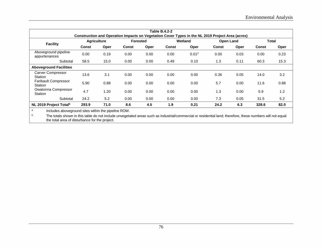
Environmental Analysis
76
Table B.4.2-2 Construction and Operation Impacts on Vegetation Cover Types in the NL 2019 Project Area (acres)
Facility Agriculture Forested Wetland Open Land Total
Const Oper Const Oper Const Oper Const Oper Const Oper Aboveground pipeline appurtenances 0.00 0.19 0.00 0.00 0.00 0.013 0.00 0.03 0.00 0.23
Subtotal 58.5 15.0 0.00 0.00 0.49 0.10 1.3 0.11 60.3 15.3 Aboveground Facilities
Carver Compressor Station 13.6 3.1 0.00 0.00 0.00 0.00 0.36 0.05 14.0 3.2
Faribault Compressor Station 5.90 0.88 0.00 0.00 0.00 0.00 5.7 0.00 11.6 0.88
Owatonna Compressor Station 4.7 1.20 0.00 0.00 0.00 0.00 1.3 0.00 5.9 1.2
Subtotal 24.2 5.2 0.00 0.00 0.00 0.00 7.3 0.05 31.5 5.2 NL 2019 Project Totalb 293.9 71.0 8.6 4.5 1.9 0.21 24.2 6.3 328.6 82.0 a Includes aboveground sites within the pipeline ROW. b The totals shown in this table do not include unvegetated areas such as industrial/commercial or residential land; therefore, these numbers will not equal
the total area of disturbance for the project.
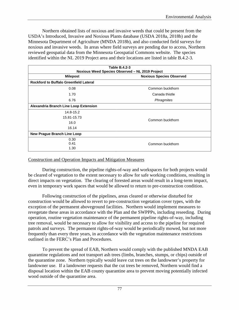
Environmental Analysis
77
Northern obtained lists of noxious and invasive weeds that could be present from the USDA’s Introduced, Invasive and Noxious Plants database (USDA 2018a, 2018b) and the Minnesota Department of Agriculture (MNDA 2018b), and also conducted field surveys for noxious and invasive weeds. In areas where field surveys are pending due to access, Northern reviewed geospatial data from the Minnesota Geospatial Commons website. The species identified within the NL 2019 Project area and their locations are listed in table B.4.2-3.
Table B.4.2-3 Noxious Weed Species Observed – NL 2019 Project
Milepost Noxious Species Observed Rockford to Buffalo Greenfield Lateral
0.08 Common buckthorn
1.70 Canada thistle 6.76 Phragmites
Alexandria Branch Line Loop Extension
14.8-15.2 15.81-15.73
16.0 16.14
Common buckthorn
New Prague Branch Line Loop 0.30 0.41 1.30
Common buckthorn
Construction and Operation Impacts and Mitigation Measures
During construction, the pipeline rights-of-way and workspaces for both projects would be cleared of vegetation to the extent necessary to allow for safe working conditions, resulting in direct impacts on vegetation. The clearing of forested areas would result in a long-term impact, even in temporary work spaces that would be allowed to return to pre-construction condition.
Following construction of the pipelines, areas cleared or otherwise disturbed for construction would be allowed to revert to pre-construction vegetation cover types, with the exception of the permanent aboveground facilities. Northern would implement measures to revegetate these areas in accordance with the Plan and the SWPPPs, including reseeding. During operation, routine vegetation maintenance of the permanent pipeline rights-of-way, including tree removal, would be necessary to allow for visibility and access to the pipeline for required patrols and surveys. The permanent rights-of-way would be periodically mowed, but not more frequently than every three years, in accordance with the vegetation maintenance restrictions outlined in the FERC’s Plan and Procedures.
To prevent the spread of EAB, Northern would comply with the published MNDA EAB quarantine regulations and not transport ash trees (limbs, branches, stumps, or chips) outside of the quarantine zone. Northern typically would leave cut trees on the landowner’s property for landowner use. If a landowner requests that the cut trees be removed, Northern would find a disposal location within the EAB county quarantine area to prevent moving potentially infected wood outside of the quarantine area.
Environmental Analysis
78
The high-risk time when oaks are most susceptible to oak wilt infection is from April 1 through July 15 in the southern half of Minnesota, and from April 15 through July 15 in the northern half of Minnesota. Northern would attempt to limit disturbance to oak stands during the critical time; however, avoidance of all oak removal may not be possible. If oaks are removed between April 15 and July 15, Northern would comply with published MNDNR recommendations to immediately apply water-based paint or shellac to the cuts. If an infected oak tree is cut, Northern would not remove it from the property but instead burn or tarp the infected tree to prevent the spread of the disease.
The MNDA also recognizes Dutch elm disease as a fungus that can kill elm trees and other species (MNDA 2018c). The MNDA does not have regulations or quarantine zones for Dutch elm disease but has published BMPs including limiting removal and disposal of elm trees. Northern would not transport cut elm trees outside of the counties where they originated. Further, if a tree is suspected to be infected, Northern would follow MNDNR recommendations and chip, burn, or bury the tree.
Northern has developed a project-specific Noxious Weed Plan to prevent, mitigate, and control the spread of noxious weeds during project construction and operation. Northern consulted with the MNDNR and MNDA regarding the Noxious Weed Plan; the MNDA provided Northern with a seed list for Steele County and information regarding the state seed law. Northern’s primary mitigation method to address noxious weeds would be to install a layer of geotextile fabric or a functional equivalent in the mapped noxious weed areas to limit construction equipment contact with the noxious weeds. Timber mats would be installed on top of the geotextile fabric as additional protection. If needed, Northern would establish cleaning stations at each end of the noxious weed areas. Equipment traveling out of noxious weed areas would be cleaned until free of soil and plant debris prior to proceeding into an area without invasive plants. Water from the cleaning stations would be collected and transported off-site to an appropriate disposal facility. All equipment entering or leaving the noxious weed areas would be logged with the date and time of entry/exit and confirmation that it was cleaned. We have reviewed Northern’s Noxious Weed Plan and find these measures, as well as Northern’s adherence to the Plan, adequate to minimize the potential for weeds to be introduced or spread due to the projects.
In general, the majority of impacts on vegetation types, such as agricultural, open lands, and wetlands, would be short-term, as these areas would be expected to return to preconstruction conditions within one or two growing seasons after restoration is complete. Forested impacts, however, represent a long-term impact, as vegetation would take longer to return to pre-construction conditions in forested areas. About 9.8 acres of forested land would be impacted during construction of both projects, and 5.0 acres would be impacted by operation. Northern has designed the projects to utilize HDDs to the extent practicable to avoid surface impacts on forested lands.
In conclusion, construction and operation of the projects would result in short- and long-term impacts on vegetation. These impacts are expected to be minor since the majority of areas impacted are agricultural lands. Additionally, with the implementation of restoration methods outlined in the FERC Plan and Procedures and Northern’s SPCC Plan, impacts on vegetation would not be significant.
Environmental Analysis
79
B.4.3 Wildlife and Migratory Birds
Both project areas’ wildlife habitat types are based on vegetation types and include primarily agricultural land, with small amounts of open land, forested upland, and wetlands. Agricultural land provides foraging and resting habitat for numerous habitat generalists. Forested upland habitat provides food, cover, and nesting habitat for a variety of wildlife species and migratory birds.
Common game species found in Minnesota include white-tailed deer, wild turkey, rabbit, squirrel, pheasant, ruffed grouse, and furbearers such as raccoon, red fox, gray fox, and coyote. Migratory waterfowl species common to the area include ducks and geese. Non-game mammals such as opossum, badger, groundhog, and various rodents also may be present within both project areas. River otter and beavers can inhabit larger waterbodies. Dense grass, shrubs, and small trees provide nesting habitat and seed production for a variety of songbirds such as warblers and sparrows. Predatory birds such as red-tailed hawk, broad-winged hawk, and owls utilize upland meadows for hunting songbirds and small mammals (e.g., cottontail rabbits, voles, and shrews). Bald eagle and osprey may utilize riparian areas along large rivers for fishing and nesting. Several species of snakes, turtles, frogs, and toads may also be found in the riverine habitat adjacent to waterbodies located within both project areas.
Rochester Project
A Site of Moderate Biodiversity Significance is located between MPs 3.7 and 3.9 on the Rochester Greenfield Lateral. This site is further discussed in section B.4.2. Three WMAs are located in the vicinity of the Rochester Project: Nelson Fen WMA, High Forest WMA, and Seuss WMA. Construction would not occur within any of the WMAs.
No Minnesota RSEAs, National Park Service Wilderness Areas, National Wild and Scenic Rivers, National Forests, or USFWS conservation easements are crossed by the Rochester Project.
NL 2019 Project
Four RSEAs were mapped within the NL 2019 Project area. The Rockford to Buffalo Greenfield Lateral crosses through two RSEAs at MP 0.1 and between MPs 4.7 and 4.9. The RSEA at MP 0.1 is an undeveloped area within Rebecca Lake Park Reserve. Construction activities in this area would include open-cut excavation, HDD, and installation of the Rockford to Buffalo Greenfield Lateral pig launcher and valve site. Other than the pig launcher/valve site, impacts on this RSEA would be minor and short-term. Northern would restore its workspaces to preconstruction condition. In accordance with its agreement with the park, Northern would provide compensation to the park district for tree planting and other visual screening around the above-grade facility. The RSEA between MPs 4.7 and 4.9 is mapped in the vicinity of wetlands RBL-114-W1 and RGL-114-W2; however, these wetlands would be avoided by use of HDD. Land use in the upland portion of the RSEA is primarily agricultural row crops. Northern would return the workspaces to pre-construction conditions; therefore, this RSEA would not be impacted by the Rochester Project.

Environmental Analysis
80
The Alexandria Branch Line Loop Extension would cross RSEAs at MPs 13.57 and 15.7. The RSEA located between MPs 13.57 and 13.7 consists of wooded land in proximity to the Mississippi River. Northern would utilize the HDD method to cross under the wooded parcel; the HDD entry and exit pits would be located in open or agricultural land. No tree clearing would be required within this RSEA during construction or operation; therefore, the RSEA would not be affected by construction or operation of the NL 2019 Project. The RSEA located between MPs 15.7 and 16.0 overlaps two field-delineated wetlands ABL-11-W1 and ABL-31-WL and a wooded/scrub-shrub upland tract. Northern would utilize the HDD method to cross under the wooded parcel and wetlands; the HDD entry and exit pits would be sited in agricultural land. No tree clearing would be required within the RSEA during construction or operation; therefore, the RSEA would not be affected by the NL 2019 Project.
No National Park Service Wilderness Areas, National Wild and Scenic Rivers, National Forests, or USFWS conservation easements or management areas are crossed by the NL 2019 Project.
Construction and Operation Impacts and Mitigation Measures
Construction of the projects would have minor and localized impacts on wildlife habitat and wildlife populations. Construction activities may result in mortality of less mobile forms of wildlife such as small rodents and reptiles. In addition, construction activities may cause the temporary loss of habitat and the displacement of wildlife from the immediate vicinity of the projects, which could increase stress on wildlife adjacent to the project areas.
Northern would HDD under a majority of the wetlands, forested areas, RSEAs, and all waterbodies within the project areas to minimize habitat disturbance. No federal wildlife management areas are present within either project area. Northern coordinated with the MNDNR regarding significant and sensitive wildlife habitats (e.g., large tracts of contiguous forest, migration routes, and protected state or private wildlife management areas). The MNDNR indicated it had no concerns regarding the WMAs that are in proximity to the Rochester Project. Per an MNDNR request, Northern’s EI would monitor the WMAs for inadvertent releases during HDD activities. In addition, the MNDNR stated on September 14, 2018, that impacts on RSEAs would be minimized.
Following construction, workspaces outside the permanent right-of-way would be allowed to revert to pre-construction conditions in accordance with the FERC’s Plan and Procedures. Effects on non-forested upland and wetland habitats disturbed by construction would be temporary and are expected to return to pre-construction conditions within one or two growing seasons after construction is completed. Based on the minimal amount of forest clearing, the presence of similar habitats adjacent to and in the vicinity of construction activities, and the implementation of the FERC’s Plan and Procedures, we conclude that construction and operation of the projects would not significantly impact wildlife.
Migratory Birds
Migratory birds are protected under the Migratory Bird Treaty Act (MBTA) (16 United States Code [USC] Sections 703-711), which prohibits the intentional taking of any migratory
Environmental Analysis
81
bird, or a part, nest, or eggs of any such bird, except under the terms of a valid permit issued pursuant to federal regulations. Bald and Golden Eagles are additionally protected under the Bald and Golden Eagle Protection Act (16 USC Sections 668-668d).
Executive Order 13186 (66 Federal Register 3853) directs federal agencies to identify where unintentional take is likely to have a measurable negative effect on migratory bird populations and to avoid or minimize adverse effects on migratory birds through enhanced collaboration with the USFWS. Executive Order 13186 states that emphasis should be placed on species of concern, priority habitats, and key risk factors and that particular focus should be given to addressing population-level impacts. On March 30, 2011, the USFWS and the Commission entered into a Memorandum of Understanding that focuses on avoiding or minimizing adverse effects on migratory birds and strengthening migratory bird conservation through enhanced collaboration between the two agencies. In accordance with the executive order and the Memorandum of Understanding, Northern identified Birds of Conservation Concern in the project areas using the USFWS Information for Planning and Conservation tool and consulted with the USFWS concerning potential project-related migratory bird impacts.
The Rochester Project would be located in the Eastern Tallgrass Prairie Bird Conservation Region. This region includes what was formerly the tallest and lushest grasslands of the Great Plains. The modern landscape of the Eastern Tallgrass Prairie is dominated by agriculture. High priority grassland birds that persist in some areas include the greater prairie-chicken and Henslow’s sparrow. Cerulean warblers are in some wooded areas, and red-headed woodpecker leads the list of savanna specialists (NABCI 2018). A list of migratory birds of conservation concern that may be affected by the Rochester Project is provided in table B.4.3-1.
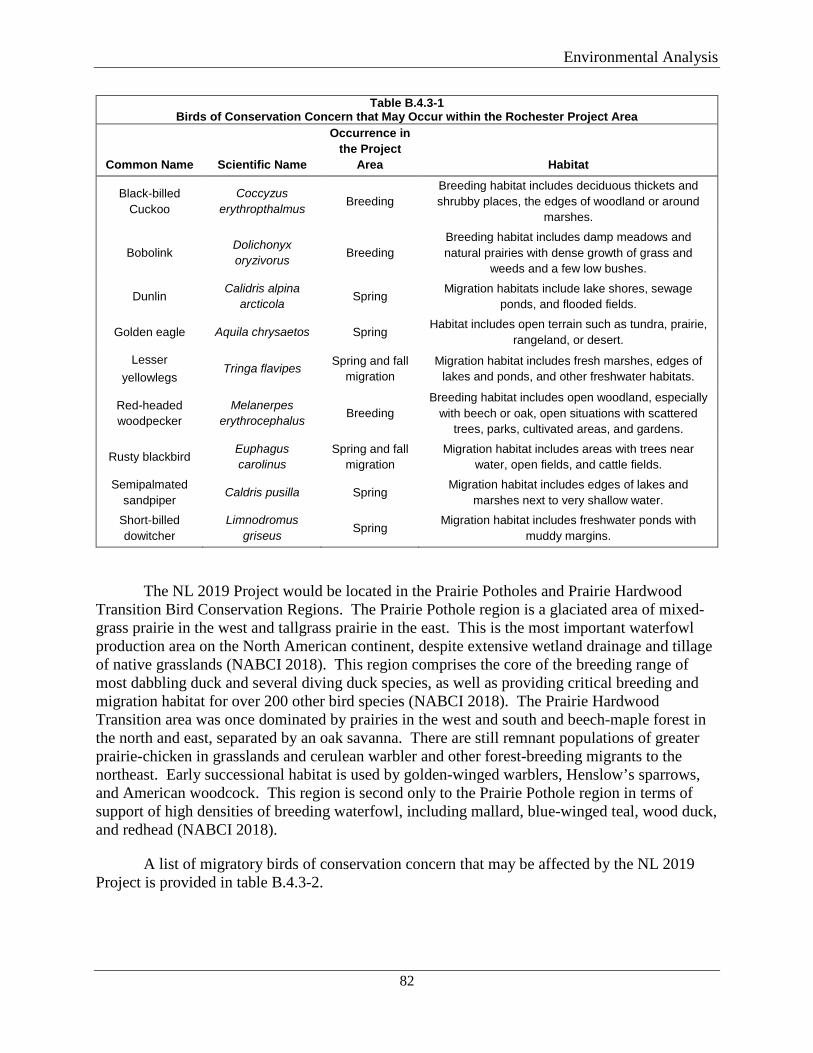
Environmental Analysis
82
Table B.4.3-1 Birds of Conservation Concern that May Occur within the Rochester Project Area
Common Name Scientific Name
Occurrence in the Project
Area Habitat
Black-billed Cuckoo
Coccyzus erythropthalmus Breeding
Breeding habitat includes deciduous thickets and shrubby places, the edges of woodland or around
marshes.
Bobolink Dolichonyx oryzivorus Breeding
Breeding habitat includes damp meadows and natural prairies with dense growth of grass and
weeds and a few low bushes.
Dunlin Calidris alpina
arcticola Spring Migration habitats include lake shores, sewage ponds, and flooded fields.
Golden eagle Aquila chrysaetos Spring Habitat includes open terrain such as tundra, prairie,
rangeland, or desert. Lesser
yellowlegs Tringa flavipes Spring and fall
migration Migration habitat includes fresh marshes, edges of
lakes and ponds, and other freshwater habitats.
Red-headed woodpecker
Melanerpes erythrocephalus Breeding
Breeding habitat includes open woodland, especially with beech or oak, open situations with scattered
trees, parks, cultivated areas, and gardens.
Rusty blackbird Euphagus carolinus
Spring and fall migration
Migration habitat includes areas with trees near water, open fields, and cattle fields.
Semipalmated sandpiper
Caldris pusilla Spring Migration habitat includes edges of lakes and
marshes next to very shallow water. Short-billed dowitcher
Limnodromus griseus Spring
Migration habitat includes freshwater ponds with muddy margins.
The NL 2019 Project would be located in the Prairie Potholes and Prairie Hardwood Transition Bird Conservation Regions. The Prairie Pothole region is a glaciated area of mixed-grass prairie in the west and tallgrass prairie in the east. This is the most important waterfowl production area on the North American continent, despite extensive wetland drainage and tillage of native grasslands (NABCI 2018). This region comprises the core of the breeding range of most dabbling duck and several diving duck species, as well as providing critical breeding and migration habitat for over 200 other bird species (NABCI 2018). The Prairie Hardwood Transition area was once dominated by prairies in the west and south and beech-maple forest in the north and east, separated by an oak savanna. There are still remnant populations of greater prairie-chicken in grasslands and cerulean warbler and other forest-breeding migrants to the northeast. Early successional habitat is used by golden-winged warblers, Henslow’s sparrows, and American woodcock. This region is second only to the Prairie Pothole region in terms of support of high densities of breeding waterfowl, including mallard, blue-winged teal, wood duck, and redhead (NABCI 2018).
A list of migratory birds of conservation concern that may be affected by the NL 2019 Project is provided in table B.4.3-2.
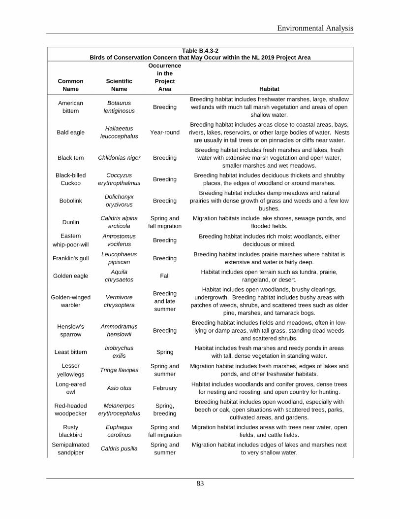
Environmental Analysis
83
Table B.4.3-2 Birds of Conservation Concern that May Occur within the NL 2019 Project Area
Common Name
Scientific Name
Occurrence in the
Project Area Habitat
American bittern
Botaurus lentiginosus Breeding
Breeding habitat includes freshwater marshes, large, shallow wetlands with much tall marsh vegetation and areas of open
shallow water.
Bald eagle Haliaeetus
leucocephalus Year-round Breeding habitat includes areas close to coastal areas, bays, rivers, lakes, reservoirs, or other large bodies of water. Nests
are usually in tall trees or on pinnacles or cliffs near water.
Black tern Chlidonias niger Breeding Breeding habitat includes fresh marshes and lakes, fresh water with extensive marsh vegetation and open water,
smaller marshes and wet meadows. Black-billed
Cuckoo Coccyzus
erythropthalmus Breeding Breeding habitat includes deciduous thickets and shrubby
places, the edges of woodland or around marshes.
Bobolink Dolichonyx oryzivorus Breeding
Breeding habitat includes damp meadows and natural prairies with dense growth of grass and weeds and a few low
bushes.
Dunlin Calidris alpina
arcticola Spring and
fall migration Migration habitats include lake shores, sewage ponds, and
flooded fields.
Eastern whip-poor-will
Antrostomus vociferus Breeding Breeding habitat includes rich moist woodlands, either
deciduous or mixed.
Franklin’s gull Leucophaeus
pipixcan Breeding Breeding habitat includes prairie marshes where habitat is
extensive and water is fairly deep.
Golden eagle Aquila
chrysaetos Fall Habitat includes open terrain such as tundra, prairie, rangeland, or desert.
Golden-winged warbler
Vermivore chrysoptera
Breeding and late summer
Habitat includes open woodlands, brushy clearings, undergrowth. Breeding habitat includes bushy areas with
patches of weeds, shrubs, and scattered trees such as older pine, marshes, and tamarack bogs.
Henslow’s sparrow
Ammodramus henslowii Breeding
Breeding habitat includes fields and meadows, often in low-lying or damp areas, with tall grass, standing dead weeds
and scattered shrubs.
Least bittern Ixobrychus
exilis Spring Habitat includes fresh marshes and reedy ponds in areas
with tall, dense vegetation in standing water.
Lesser yellowlegs
Tringa flavipes Spring and summer
Migration habitat includes fresh marshes, edges of lakes and ponds, and other freshwater habitats.
Long-eared owl
Asio otus February Habitat includes woodlands and conifer groves, dense trees for nesting and roosting, and open country for hunting.
Red-headed woodpecker
Melanerpes erythrocephalus
Spring, breeding
Breeding habitat includes open woodland, especially with beech or oak, open situations with scattered trees, parks,
cultivated areas, and gardens.
Rusty blackbird
Euphagus carolinus
Spring and fall migration
Migration habitat includes areas with trees near water, open fields, and cattle fields.
Semipalmated sandpiper
Caldris pusilla Spring and summer
Migration habitat includes edges of lakes and marshes next to very shallow water.
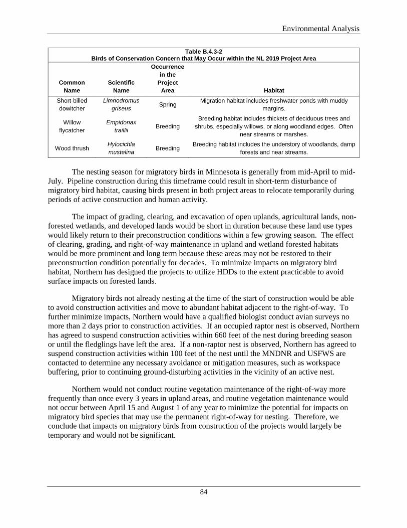
Environmental Analysis
84
Table B.4.3-2 Birds of Conservation Concern that May Occur within the NL 2019 Project Area
Common Name
Scientific Name
Occurrence in the
Project Area Habitat
Short-billed dowitcher
Limnodromus griseus Spring Migration habitat includes freshwater ponds with muddy
margins.
Willow flycatcher
Empidonax traillii Breeding
Breeding habitat includes thickets of deciduous trees and shrubs, especially willows, or along woodland edges. Often
near streams or marshes.
Wood thrush Hylocichla mustelina Breeding
Breeding habitat includes the understory of woodlands, damp forests and near streams.
The nesting season for migratory birds in Minnesota is generally from mid-April to mid-
July. Pipeline construction during this timeframe could result in short-term disturbance of migratory bird habitat, causing birds present in both project areas to relocate temporarily during periods of active construction and human activity.
The impact of grading, clearing, and excavation of open uplands, agricultural lands, non-forested wetlands, and developed lands would be short in duration because these land use types would likely return to their preconstruction conditions within a few growing season. The effect of clearing, grading, and right-of-way maintenance in upland and wetland forested habitats would be more prominent and long term because these areas may not be restored to their preconstruction condition potentially for decades. To minimize impacts on migratory bird habitat, Northern has designed the projects to utilize HDDs to the extent practicable to avoid surface impacts on forested lands.
Migratory birds not already nesting at the time of the start of construction would be able to avoid construction activities and move to abundant habitat adjacent to the right-of-way. To further minimize impacts, Northern would have a qualified biologist conduct avian surveys no more than 2 days prior to construction activities. If an occupied raptor nest is observed, Northern has agreed to suspend construction activities within 660 feet of the nest during breeding season or until the fledglings have left the area. If a non-raptor nest is observed, Northern has agreed to suspend construction activities within 100 feet of the nest until the MNDNR and USFWS are contacted to determine any necessary avoidance or mitigation measures, such as workspace buffering, prior to continuing ground-disturbing activities in the vicinity of an active nest.
Northern would not conduct routine vegetation maintenance of the right-of-way more frequently than once every 3 years in upland areas, and routine vegetation maintenance would not occur between April 15 and August 1 of any year to minimize the potential for impacts on migratory bird species that may use the permanent right-of-way for nesting. Therefore, we conclude that impacts on migratory birds from construction of the projects would largely be temporary and would not be significant.
Environmental Analysis
85
B.4.4 Threatened, Endangered, and Special Status Species
Special status species are those species for which state or federal agencies afford an additional level of protection by law, regulation, or policy. Included in this category are federally listed species that are protected under the Endangered Species Act of 1973, as amended (ESA), and those species that are state endangered or threatened. Section 7 of the ESA requires the lead federal agency (in this case, FERC) to ensure that any action authorized, funded, or carried out by the agency does not jeopardize the continued existence of a federally listed endangered or threatened species, or result in the destruction or adverse modification of the designated critical habitat of a federally listed species. The agency is required to consult with the USFWS to determine whether any federally listed endangered or threatened species or any of their designated critical habitat are located in the vicinity of a proposed project and to determine the proposed action’s potential effects on those species or critical habitats.
Northern, acting as our non-federal representative for the purpose of complying with Section 7(a)(2) of the ESA, initiated informal consultation with the USFWS and the MNDNR regarding federal and state-listed species with the potential to be affected by the projects.
Rochester Project
Table B.4.4-1 lists the federally listed and state-listed threatened and endangered species and special concern species that may occur in the Rochester Project area, as well as potential county of occurrence, habitat requirements, and the facilities where suitable habitat could be present.
Northern conducted field surveys October through December 2017 and in June 2018 in areas with landowner access, to identify potential habitat for sensitive species. Surveys are complete on 81 percent of the Rochester Greenfield Lateral and 100 percent of the La Crosse Branch Line MAOP Uprate. The habitat assessments indicated that habitat for a majority of the federally listed and state-listed or sensitive species does not exist within the Rochester Project area. Species-specific discussions are provided in the following subsections.
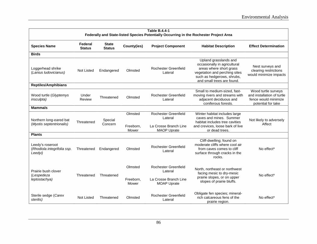
Environmental Analysis
86
Table B.4.4-1 Federally and State-listed Species Potentially Occurring in the Rochester Project Area
Species Name Federal Status
State Status County(ies) Project Component Habitat Description Effect Determination
Birds
Loggerhead shrike (Lanius ludovicianus) Not Listed Endangered Olmsted Rochester Greenfield
Lateral
Upland grasslands and occasionally in agricultural areas where short grass
vegetation and perching sites such as hedgerows, shrubs, and small trees are found.
Nest surveys and clearing restrictions
would minimize impacts
Reptiles/Amphibians
Wood turtle (Glyptemys insculpta)
Under Review Threatened Olmsted Rochester Greenfield
Lateral
Small to medium-sized, fast-moving rivers and streams with
adjacent deciduous and coniferous forests.
Wood turtle surveys and installation of turtle fence would minimize
potential for take Mammals
Northern long-eared bat (Myotis septentrionalis) Threatened Special
Concern
Olmsted
Freeborn, Mower
Rochester Greenfield Lateral
La Crosse Branch Line
MAOP Uprate
Winter habitat includes large caves and mines. Summer habitat includes tree cavities
and crevices, loose bark of live or dead trees.
Not likely to adversely Affect
Plants
Leedy’s roseroot (Rhodiola integrifolia ssp. Leedyi)
Threatened Endangered Olmsted Rochester Greenfield Lateral
Cliff-dwelling; found on moderate cliffs where cool air
from caves comes to cliff surface through cracks in the
rocks.
No effecta
Prairie bush clover (Lespedeza leptostachya)
Threatened Threatened
Olmsted
Freeborn, Mower
Rochester Greenfield Lateral
La Crosse Branch Line
MOAP Uprate
North, northeast or northwest facing mesic to dry-mesic prairie slopes, or on upper
slopes of prairie bluffs.
No effecta
Sterile sedge (Carex sterilis) Not Listed Threatened Olmsted Rochester Greenfield
Lateral
Obligate fen species; mineral-rich calcareous fens of the
prairie region. No effecta
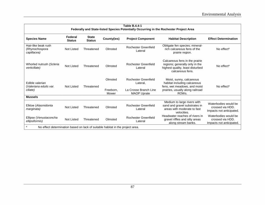
Environmental Analysis
87
Table B.4.4-1 Federally and State-listed Species Potentially Occurring in the Rochester Project Area
Species Name Federal Status
State Status County(ies) Project Component Habitat Description Effect Determination
Hair-like beak rush (Rhynochospora capillacea)
Not Listed Threatened Olmsted Rochester Greenfield Lateral
Obligate fen species; mineral-rich calcareous fens of the
prairie region. No effecta
Whorled nutrush (Scleria verticillate) Not Listed Threatened Olmsted Rochester Greenfield
Lateral
Calcareous fens in the prairie regions; generally only in the
highest quality, least disturbed calcareous fens.
No effecta
Edible valerian (Valeriana edulis var. ciliate)
Not Listed Threatened
Olmsted
Freeborn, Mower
Rochester Greenfield Lateral,
La Crosse Branch Line
MAOP Uprate
Moist, sunny, calcareous habitat including calcareous
fens, wet meadows, and moist prairies, usually along railroad
ROWs.
No effecta
Mussels
Elktoe (Alasmidonta marginata) Not Listed Threatened Olmsted Rochester Greenfield
Lateral
Medium to large rivers with sand and gravel substrates in areas with moderate to fast
velocities.
Waterbodies would be crossed via HDD.
Impacts not anticipated.
Ellipse (Venustaconcha ellipsiformis) Not Listed Threatened Olmsted Rochester Greenfield
Lateral
Headwater reaches of rivers in gravel riffles and silty areas
along stream banks.
Waterbodies would be crossed via HDD.
Impacts not anticipated. a No effect determination based on lack of suitable habitat in the project area.
Environmental Analysis
88
Federally Listed Species
The federally listed species that are known to occur or potentially occur within the Rochester Project area include the northern long-eared bat (NLEB), Leedy’s roseroot, and prairie bush clover.
Northern consulted with USFWS staff May 14, 2018. USFWS stated that none of the project components cross waters with federally listed aquatic shellfish or amphibians. As noted on a phone log, on May 14, 2018, the USFWS agreed with Northern’s assessment that risk to aquatic and semi-aquatic species is minimized by the use of HDD. Northern submitted an addendum with the results of the June 2018 survey to the USFWS on August 13, 2018. No further correspondence has been received.
Northern Long-eared Bat
The NLEB, also known as the northern myotis or northern long-eared myotis, was federally listed as threatened by the USFWS on April 2, 2015, due to dramatic population declines attributed to white-nose syndrome. The bat is medium sized with a body length of 3 to 3.7 inches and a wingspan of 9 to 10 inches. During winter, NLEBs use large caves and mines that have large passages and entrances, constant temperatures, and high humidity with no air currents. In the summer, NLEBs roost underneath bark, in cavities, and in crevices of live and dead trees that either retain their bark or provide suitable cavities or crevices.
Tree clearing within the Rochester Greenfield Lateral is proposed, and the project area is within the area affected by white-nose syndrome. According to the USFWS Final 4(d) Rule, incidental take is prohibited if it occurs within a hibernaculum, if it results from tree removal activities within 0.25 mile of a known hibernaculum, or if it results from removal of a known occupied maternity roost or trees within 150 feet of the maternity roost during the pup season (June 1 through July 31).
MNDNR Natural Heritage Information System (NHIS) database information indicated the Rochester Greenfield Lateral is not within 0.25 mile of a known, occupied hibernaculum, or within 150 feet of known, occupied maternity roost trees. Northern submitted the NLEB 4(d) Rule Streamlined Consultation Form on August 13, 2018. Per the USFWS’s streamlined consultation process, after 30 days of no response, Section 7 consultation for the ESA is considered complete. No additional consultation or response from the USFWS was received. As such, we have determined that the Rochester Project is not likely to adversely affect the NLEB and that the project is compliant with the 4(d) rule, and any incidental take resulting from the project is not prohibited under Section 4(d) of the ESA.
Leedy’s Roseroot
Leedy’s roseroot is a cliff-dwelling wildflower found on maderate cliffs, where cool air from caves comes to the cliff surface through cracks in the rocks. Potentially suitable habitat is not present within the Rochester Project area. In its April 5, 2018 Habitat Assessment Report to the USFWS, Northern determined that the Rochester Project would have no effect on the Leedy’s roseroot. We have reviewed the information and agree that the Rochester Project would have no effect on the Leedy’s roseroot. Thus, Section 7 consultation is complete for this species.
Environmental Analysis
89
Prairie Bush Clover
Prairie bush clover is a federally threatened prairie plant. In Minnesota, most populations occur on dry-mesic prairies on north or northwest-facing slopes of 10 to 15 degrees with well-drained soils. Populations are primarily restricted to remnant prairies that have persisted despite widespread conversion to cropland. Based on field surveys, no remnant native prairie is present within the Rochester Project area. In its April 5, 2018 Habitat Assessment Report to the USFWS, Northern determined that the Rochester Project would have no effect on the prairie bush clover. We have reviewed the information and agree that the Rochester Project would have no effect on the prairie bush clover. Thus, Section 7 consultation is complete for this species.
State-Listed Species
Northern submitted an initial habitat assessment review for the Rochester Project to the MNDNR NHIS Program on April 5, 2018. On May 15, 2018, Northern provided its Plan for Inadvertent Release of drilling mud along with the HDD plan and profiles for the river crossings. On May 29, 2018, the MNDNR stated it had reviewed the plans and concurred that the proposed HDDs would minimize impacts on the four state-listed fish of concern. However, the MNDNR requested additional information on the four state-listed fish of concern, as well as for the rare wetland between MPs 3.7 and 3.9 of the Rochester Greenfield Lateral, results of the 2018 habitat assessment, discussion of HDDs and all avoidance, proposed methods for any species-specific surveys, and identification of potential impacts and how Northern would avoid or minimize these impacts. Northern submitted the requested information to the MNDNR on August 14, 2018; agency response is pending.
Ten state-listed species are known to occur or potentially occur within the Rochester Project area. Leedy’s roseroot and prairie bush clover are discussed above. The remaining state-listed species and their habitats are described below.
Loggerhead shrike
Loggerhead shrikes live in areas of upland grasslands and sometimes in agricultural areas where short grass vegetation and perching sites such as hedgerows, shrubs, and small trees are found. They may occur in both native and non-native grasslands, including native prairie, pastures, old fields, shelterbelts, farmyards, and cemeteries.
Construction would temporarily impact potential habitat by removing vegetation cover and fence rows during construction. Northern would limit removal of vegetation in accordance with MNDNR requirements within suitable shrike habitat during April through July. Northern would restore fence rows and replant vegetation in late 2019 or early 2020. The Rochester Greenfield Lateral may temporarily impact shrike habitat; however, Northern would implement mitigation measures to minimize adverse effects. Northern would restrict work within the MNDNR NHIS required setback of any active loggerhead shrike nest until the fledglings have left the nest. Additionally, Northern would conduct nest surveys for migratory birds, including the shrike, prior to any clearing or construction activity. Based on these mitigation measures, we believe the Rochester Project would not significantly impact the loggerhead shrike.
Environmental Analysis
90
Wood turtle
The wood turtle is largely aquatic, preferring small- to medium-sized, fast-moving rivers and streams with adjacent deciduous and coniferous forests. The substrates of preferred streams typically consist of sand or gravel. Wood turtles will occupy adjacent alder thickets, forest, and grassland habitat for basking and foraging, typically staying within 0.25 mile of the river.
According to MNDNR NHIS records, one waterway within the Rochester Greenfield Lateral, the Zumbro River, has the potential to provide wood turtle habitat. Northern would cross the Zumbro River via HDD. Northern would install silt fencing (turtle fence) around workspace in potential turtle habitat, and a qualified biologist would conduct turtle surveys in the vicinity of the South Fork Zumbro River prior to construction. Based on prior project experience in Minnesota, Northern has proposed the following mitigation measures for the wood turtle:
• Turtles that are in imminent danger should be moved, by hand, out of the project area; • Turtles that are not in imminent danger should be left undisturbed; • No nests should be disturbed; • Silt fencing should be used to keep turtles out of construction areas, where necessary, and
removed after the area has been revegetated; • No dredging, deepening, or filling of wetlands should occur; • Wetlands should be protected from pollutants such as fuels and lubricants; • Erosion and sediment control devices should be used to prevent silt and sediment from
reaching wetlands and waterbodies; • Erosion control mesh, if used, should be limited to wildlife-friendly materials; • Trenches should be checked for turtles prior to being backfilled and the sites should be
returned to original grade; • Culverts under access roads crossing wetland areas, between wetland areas, or between
wetland and nesting areas should be at least 36 inches in diameter and flat-bottomed or elliptical; and
• Construction areas should be returned to preconstruction conditions.
Based on these mitigation measures, we believe the Rochester Project would not significantly impact the wood turtle.
Sterile sedge
Sterile sedge is an obligate fen species in Minnesota. Most populations are found in the mineral-rich calcareous fens of the prairie region. A calcareous fen is a special kind of peatland that is maintained by the surface discharge of cold, oxygen-poor, calcium-rich groundwater. No fens were observed within the immediate Rochester Project area. However, the Nelson Fen WMA, which contains a calcareous fen, is approximately 0.25 mile from The Rochester Project. Vegetation removal would not occur in the Nelson Fen. Sterile sedge was not observed during the field habitat assessment; therefore, Northern determined that the Rochester Project would have no effect on sterile sedge. We have reviewed the information and agree that the Rochester Project would not significantly impact the sterile sedge.
Environmental Analysis
91
Hair-like beak rush
Hair-like beak rush is an obligate fen species in Minnesota. Most populations are found in the mineral-rich calcareous fens of the prairie region. As described above, no fens were identified within the Rochester Project. Hair-like beak rush was not observed during the field habitat assessment; therefore, Northern determined that the Rochester Project would have no effect on this species. We have reviewed the information and agree that the Rochester Project would not significantly impact the hair-like beak rush.
Whorled nutrush
Whorled nutrush is entirely restricted to calcareous fens in the prairie regions of Minnesota, and generally occurs only in the highest quality, least disturbed examples of this unique plant community. As described above, no fens were identified within the Rochester Project. Whorled nutrush was not observed during the field habitat assessment; therefore, Northern determined that the Rochester Project would have no effect on whorled nutrush. We have reviewed the information and agree that the Rochester Project would not significantly impact the whorled nutrush.
Edible valerian
Edible valerian occurs in moist, sunny, calcareous habitat, including calcareous fens, wet meadows, and moist prairies. Many of these habitats are found along railroad rights-of-way. No calcareous habitats were observed within the Rochester Project area, and edible valerian was not observed during the field habitat assessment. We have reviewed the information and agree that the Rochester Project would not result in significant impacts on the edible valerian.
Elktoe
The elktoe mussel occurs in medium to large rivers. Suitable habitats include sand and gravel substrates in areas with moderate to fast velocities. Potential suitable habitat exists within the Rochester Greenfield Lateral (North Branch Root River and Salem Creek, Zumbro River). Northern would cross these waterbodies via HDD, which would minimize potential impacts on aquatic species. In the event of an inadvertent return, Northern would adhere to the measures in its Plan for Inadvertent Release of Drilling Mud. The MNDNR reviewed this plan and concurred that the measures to contain a spill would minimize impacts on aquatic species, including fish and mussels. We agree that these measures would minimize impacts on elktoe.
Ellipse
The ellipse mussel occurs primarily in the headwater reaches of rivers in gravel riffles and silty areas along stream banks. Potential suitable habitat exists within the Rochester Greenfield Lateral (North Branch Root River and Salem Creek, Zumbro River). As described above, Northern would cross these waters via HDD and would adhere to the measures in its Plan for Inadvertent Release of Drilling Mud; therefore, we agree that the Rochester Project would not affect the ellipse.
Environmental Analysis
92
NL 2019 Project
Table B.4.4-2 lists the federally listed and state-listed threatened and endangered species and special concern species that may occur in the NL 2019 Project area, as well as potential county of occurrence, habitat requirements, and the facilities where suitable habitat could be present.
Northern conducted field surveys October through December 2017 and in June 2018 in areas with landowner access, to identify potential habitat for sensitive species. Surveys are complete on 81 percent of the Rockford to Buffalo Greenfield Lateral, 84 percent of the Alexandria Branch Line Loop Extension, 85 percent of the Willmar C-Line Extension, and 100 percent of the New Prague Branch Line Loop and compressor station sites. The habitat assessments indicated that habitat for a majority of the federally listed and state-listed or sensitive species does not exist within the NL 2019 Project area. Species-specific discussions are provided in the following subsections.
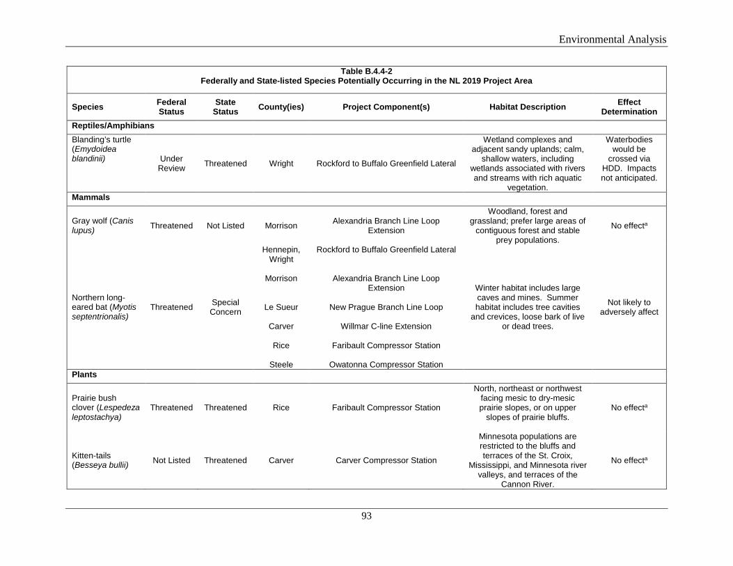
Environmental Analysis
93
Table B.4.4-2 Federally and State-listed Species Potentially Occurring in the NL 2019 Project Area
Species Federal Status
State Status County(ies) Project Component(s) Habitat Description Effect
Determination Reptiles/Amphibians Blanding’s turtle (Emydoidea blandinii) Under
Review Threatened Wright Rockford to Buffalo Greenfield Lateral
Wetland complexes and adjacent sandy uplands; calm,
shallow waters, including wetlands associated with rivers and streams with rich aquatic
vegetation.
Waterbodies would be
crossed via HDD. Impacts not anticipated.
Mammals
Gray wolf (Canis lupus) Threatened Not Listed Morrison Alexandria Branch Line Loop
Extension
Woodland, forest and grassland; prefer large areas of
contiguous forest and stable prey populations.
No effecta
Northern long-eared bat (Myotis septentrionalis)
Threatened Special Concern
Hennepin, Wright
Morrison
Le Sueur
Carver
Rice
Steele
Rockford to Buffalo Greenfield Lateral
Alexandria Branch Line Loop Extension
New Prague Branch Line Loop
Willmar C-line Extension
Faribault Compressor Station
Owatonna Compressor Station
Winter habitat includes large caves and mines. Summer habitat includes tree cavities
and crevices, loose bark of live or dead trees.
Not likely to adversely affect
Plants
Prairie bush clover (Lespedeza leptostachya)
Threatened Threatened Rice Faribault Compressor Station
North, northeast or northwest facing mesic to dry-mesic prairie slopes, or on upper
slopes of prairie bluffs.
No effecta
Kitten-tails (Besseya bullii) Not Listed Threatened Carver Carver Compressor Station
Minnesota populations are restricted to the bluffs and terraces of the St. Croix,
Mississippi, and Minnesota river valleys, and terraces of the
Cannon River.
No effecta
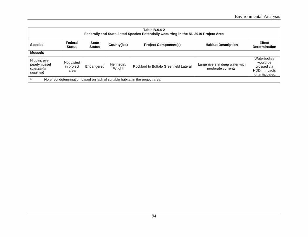
Environmental Analysis
94
Table B.4.4-2 Federally and State-listed Species Potentially Occurring in the NL 2019 Project Area
Species Federal Status
State Status County(ies) Project Component(s) Habitat Description Effect
Determination Mussels
Higgins eye pearlymussel (Lampsilis higginsii)
Not Listed in project
area Endangered Hennepin,
Wright Rockford to Buffalo Greenfield Lateral Large rivers in deep water with moderate currents.
Waterbodies would be
crossed via HDD. Impacts not anticipated.
a No effect determination based on lack of suitable habitat in the project area.
Environmental Analysis
95
Federally Listed Species
The federally listed species that are known to occur or potentially occur within the NL 2019 Project area are the gray wolf, NLEB, and prairie bush clover. Northern initially consulted with USFWS staff on May 14, 2018. Northern submitted an addendum with the results of the June 2018 survey to the USFWS on August 13, 2018.
Gray wolf
The gray wolf is a large canine species that is federally listed as threatened in Minnesota due to habitat destruction, human interference, and overhunting. The gray wolf can use a variety of habitats, including woodland, forest, and grassland. Wolves prefer large areas of contiguous forest and stable prey populations. The NL 2019 Project area consists of agricultural and fallow fields, pine plantation, wetlands, maintained pipeline right-of-way, and residential properties. There are no large, contiguous forested areas within the NL 2019 Project area. Based on the proximity of the NL 2019 Project area to human activity (e.g., active agricultural fields, residential properties, and developed areas), and the lack of suitable wolf habitat within or adjacent to the project area, the long-term presence of wolves is extremely unlikely to occur in proximity to the project area. In its April 5, 2018 Habitat Assessment Report to the USFWS, Northern determined that the NL 2019 Project would have no effect on the gray wolf. We have reviewed the information and agree that the NL 2019 Project would have no effect on the gray wolf. Thus, Section 7 consultation for this species is complete.
Northern Long-eared Bat
Tree clearing within the NL 2019 Project area is proposed, and the project area is within the white-nose syndrome buffer zone. However, the MNDNR NHIS database information indicated the NL 2019 Project is not within 0.25 mile of a known, occupied hibernaculum, or within 150 feet of known, occupied maternity roost trees. Northern submitted the NLEB 4(d) Rule Streamlined Consultation Form in August 2018. As mentioned above, per the USFWS streamlined consultation process, after 30 days of no response, Section 7 consultation for the ESA is considered complete. As such, we have determined that the project is not likely to adversely affect the NLEB and that the project is compliant with the 4(d) rule, and any incidental take resulting from the project is not prohibited under Section 4(d) of the ESA.
Prairie Bush clover
Prairie bush clover is described above. Based on field surveys, no remnant native prairie is present within the NL 2019 Project area. In its April 5, 2018 Habitat Assessment Report to the USFWS, Northern determined that the NL 2019 Project would have no effect on the prairie bush clover. We agree. Thus, Section 7 consultation is complete for this species.
Higgins eye pearlymussel
This freshwater mussel is found in larger rivers in deep water with moderate currents. The NL 2019 Project workspace crosses the Crow River, which was previously listed as known Higgins eye pearlymussel habitat. On July 10, 2018, Northern received an updated Official Species List from the USFWS; the Higgins eye pearlymussel is no longer listed within the NL
Environmental Analysis
96
2019 Project area. For the purposes of the Section 7 consultation, the NL 2019 Project would have no effect on the Higgins eye pearlymussel. Section 7 consultation for this species is complete.
State-Listed Species
Northern consulted with the MNDNR for the NL 2019 Project, similar to as described above for the Rochester Project. Four state-listed species known to occur or potentially occur within the NL 2019 Project area. These are the Higgins eye pearlymussel and prairie bush clover (both discussed above), as well as Blanding’s turtle and kitten-tails, discussed below.
Blanding’s turtle
Wetland complexes and adjacent sandy uplands are necessary to support viable populations of Blanding’s turtles. Calm, shallow waters, including wetlands associated with rivers and streams with rich aquatic vegetation, are especially preferred. In Minnesota, this species appears fairly adaptable, utilizing a wide variety of wetland types and riverine habitats in different regions of the state (MNDNR, 2008). In southeastern Minnesota, Blanding’s turtles use open marshes and bottomland wetlands for summer and winter habitat, ephemeral wetlands in spring and early summer, and deeper marshes and backwater pools in both the summer and winter.
Northern has proposed a number of mitigation measures for the wood turtle (discussed above), which would also be applied to the Blanding’s turtle, as applicable. These measures are based on MNDNR recommendations for previous Northern projects in Minnesota. Northern would also provide training to construction personnel regarding identification of the Blanding’s turtle and the proper implementation of the MNDNR recommendations. Based on these measures and the use of HDD to cross wetlands and waterbodies, we conclude the NL 2019 Project would not significantly impact the Blanding’s turtle.
Kitten-tails
Kitten-tails is a plant species, primarily found in oak savanna communities, though it also occurs in dry prairies and oak woodlands. The Minnesota populations are largely restricted to the bluffs and terraces of the St. Croix, Mississippi, and Minnesota River valleys. Terraces of the Cannon River also support populations of kitten-tails. Plants show a preference for partial to open light and upper slopes; some populations exhibit a preference for less xeric north-facing slopes in prairie habitats. No suitable habitat for kitten-tails is present in the NL 2019 Project area; therefore, the NL 2019 Project would not affect kitten-tails.
B.5 LAND USE, RECREATION, AND VISUAL RESOURCES
B.5.1 Land Use
Rochester Project
Land use categories were identified in the Rochester Project area using field observations conducted in 2017 and interpretations of 2016 and 2017 aerial imagery, and consist of

Environmental Analysis
97
agriculture, open land, open water, forest/woodland, wetland, residential, and industrial/commercial lands. The total acreage to be disturbed for construction of all Rochester Project facilities is about 219.7 acres, including 211.3 acres for construction of the new pipeline and pipeline uprate, and 0.4 acre for construction of the aboveground facilities. The total acreage required for operation of all Rochester Project facilities is 63.0 acres. A summary of the land use categories affected by construction and operation of the Rochester Project is provided in table B.5.1-1.
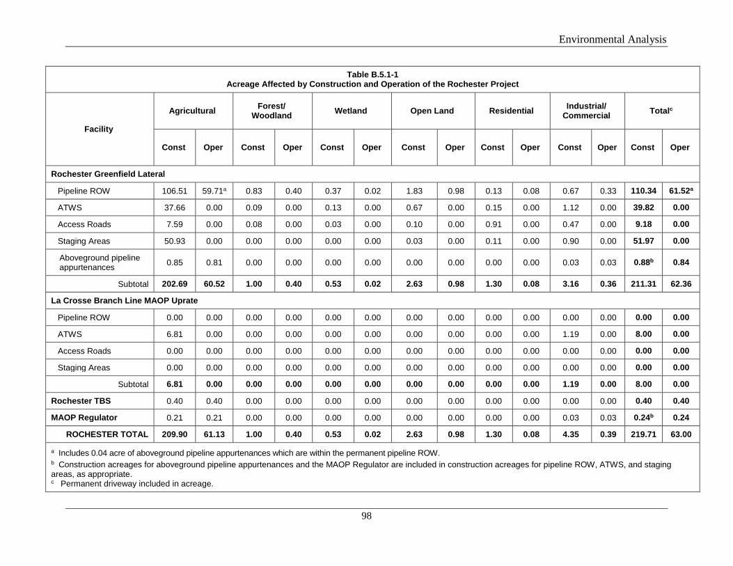
Environmental Analysis
98
Table B.5.1-1 Acreage Affected by Construction and Operation of the Rochester Project
Facility
Agricultural Forest/ Woodland Wetland Open Land Residential Industrial/
Commercial Totalc
Const Oper Const Oper Const Oper Const Oper Const Oper Const Oper Const Oper
Rochester Greenfield Lateral
Pipeline ROW 106.51 59.71a 0.83 0.40 0.37 0.02 1.83 0.98 0.13 0.08 0.67 0.33 110.34 61.52a
ATWS 37.66 0.00 0.09 0.00 0.13 0.00 0.67 0.00 0.15 0.00 1.12 0.00 39.82 0.00
Access Roads 7.59 0.00 0.08 0.00 0.03 0.00 0.10 0.00 0.91 0.00 0.47 0.00 9.18 0.00
Staging Areas 50.93 0.00 0.00 0.00 0.00 0.00 0.03 0.00 0.11 0.00 0.90 0.00 51.97 0.00
Aboveground pipeline appurtenances 0.85 0.81 0.00 0.00 0.00 0.00 0.00 0.00 0.00 0.00 0.03 0.03 0.88b 0.84
Subtotal 202.69 60.52 1.00 0.40 0.53 0.02 2.63 0.98 1.30 0.08 3.16 0.36 211.31 62.36
La Crosse Branch Line MAOP Uprate
Pipeline ROW 0.00 0.00 0.00 0.00 0.00 0.00 0.00 0.00 0.00 0.00 0.00 0.00 0.00 0.00
ATWS 6.81 0.00 0.00 0.00 0.00 0.00 0.00 0.00 0.00 0.00 1.19 0.00 8.00 0.00
Access Roads 0.00 0.00 0.00 0.00 0.00 0.00 0.00 0.00 0.00 0.00 0.00 0.00 0.00 0.00
Staging Areas 0.00 0.00 0.00 0.00 0.00 0.00 0.00 0.00 0.00 0.00 0.00 0.00 0.00 0.00
Subtotal 6.81 0.00 0.00 0.00 0.00 0.00 0.00 0.00 0.00 0.00 1.19 0.00 8.00 0.00
Rochester TBS 0.40 0.40 0.00 0.00 0.00 0.00 0.00 0.00 0.00 0.00 0.00 0.00 0.40 0.40
MAOP Regulator 0.21 0.21 0.00 0.00 0.00 0.00 0.00 0.00 0.00 0.00 0.03 0.03 0.24b 0.24
ROCHESTER TOTAL 209.90 61.13 1.00 0.40 0.53 0.02 2.63 0.98 1.30 0.08 4.35 0.39 219.71 63.00
a Includes 0.04 acre of aboveground pipeline appurtenances which are within the permanent pipeline ROW. b Construction acreages for aboveground pipeline appurtenances and the MAOP Regulator are included in construction acreages for pipeline ROW, ATWS, and staging areas, as appropriate. c Permanent driveway included in acreage.
Environmental Analysis
99
NL 2019 Project
Land use categories were identified in the NL 2019 Project area using field observations conducted in 2017 and interpretation of 2016 and 2017 aerial imagery, and consist of agriculture, open land, open water, forest/woodland, wetland, residential, and industrial/commercial lands. The total acreage to be disturbed for construction of all NL 2019 Project facilities is about 363.2 acres, including 311.8 acres for construction of the new pipelines and 51.4 acres for construction of the new and expanded compressor stations. The total acreage required for operation of all NL 2019 Project facilities is 86.4 acres. A summary of the land use categories affected by construction and operation of the NL 2019 Project is provided in table B.5.1-2.
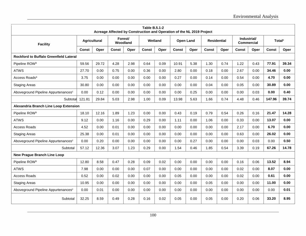
Environmental Analysis
100
Table B.5.1-2 Acreage Affected by Construction and Operation of the NL 2019 Project
Facility Agricultural Forest/
Woodland Wetland Open Land Residential Industrial/ Commercial Totalc
Const Oper Const Oper Const Oper Const Oper Const Oper Const Oper Const Oper
Rockford to Buffalo Greenfield Lateral
Pipeline ROWb 59.56 29.72 4.28 2.98 0.64 0.09 10.91 5.38 1.30 0.74 1.22 0.43 77.91 39.34
ATWS 27.70 0.00 0.75 0.00 0.36 0.00 2.80 0.00 0.18 0.00 2.67 0.00 34.46 0.00
Access Roadsa 3.75 0.00 0.00 0.00 0.00 0.00 0.27 0.00 0.14 0.00 0.54 0.00 4.70 0.00
Staging Areas 30.80 0.00 0.00 0.00 0.00 0.00 0.00 0.00 0.04 0.00 0.05 0.00 30.89 0.00
Aboveground Pipeline Appurtenancesc 0.00 0.12 0.00 0.00 0.00 0.00 0.00 0.25 0.00 0.00 0.00 0.03 0.00 0.40
Subtotal 121.81 29.84 5.03 2.98 1.00 0.09 13.98 5.63 1.66 0.74 4.48 0.46 147.96 39.74
Alexandria Branch Line Loop Extension
Pipeline ROWb 18.10 12.16 1.89 1.23 0.00 0.00 0.43 0.19 0.79 0.54 0.26 0.16 21.47 14.28
ATWS 9.12 0.00 1.16 0.00 0.29 0.00 1.11 0.00 1.06 0.00 0.33 0.00 13.07 0.00
Access Roads 4.52 0.00 0.01 0.00 0.00 0.00 0.00 0.00 0.00 0.00 2.17 0.00 6.70 0.00
Staging Areas 25.38 0.00 0.01 0.00 0.00 0.00 0.00 0.00 0.00 0.00 0.63 0.00 26.02 0.00
Aboveground Pipeline Appurtenancesc 0.00 0.20 0.00 0.00 0.00 0.00 0.00 0.27 0.00 0.00 0.00 0.03 0.00 0.50
Subtotal 57.12 12.36 3.07 1.23 0.29 0.00 1.54 0.46 1.85 0.54 3.39 0.19 67.26 14.78
New Prague Branch Line Loop
Pipeline ROWb 12.80 8.58 0.47 0.28 0.09 0.02 0.00 0.00 0.00 0.00 0.16 0.06 13.52 8.94
ATWS 7.98 0.00 0.00 0.00 0.07 0.00 0.00 0.00 0.00 0.00 0.02 0.00 8.07 0.00
Access Roads 0.52 0.00 0.02 0.00 0.00 0.00 0.05 0.00 0.00 0.00 0.02 0.00 0.61 0.00
Staging Areas 10.95 0.00 0.00 0.00 0.00 0.00 0.00 0.00 0.05 0.00 0.00 0.00 11.00 0.00
Aboveground Pipeline Appurtenancesc 0.00 0.01 0.00 0.00 0.00 0.00 0.00 0.00 0.00 0.00 0.00 0.00 0.00 0.01
Subtotal 32.25 8.59 0.49 0.28 0.16 0.02 0.05 0.00 0.05 0.00 0.20 0.06 33.20 8.95
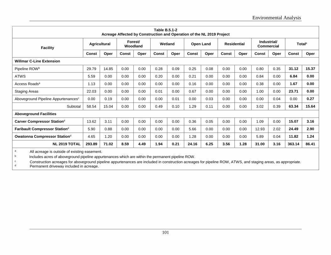
Environmental Analysis
101
Table B.5.1-2 Acreage Affected by Construction and Operation of the NL 2019 Project
Facility Agricultural Forest/
Woodland Wetland Open Land Residential Industrial/ Commercial Totalc
Const Oper Const Oper Const Oper Const Oper Const Oper Const Oper Const Oper
Willmar C-Line Extension
Pipeline ROWb 29.79 14.85 0.00 0.00 0.28 0.09 0.25 0.08 0.00 0.00 0.80 0.35 31.12 15.37
ATWS 5.59 0.00 0.00 0.00 0.20 0.00 0.21 0.00 0.00 0.00 0.84 0.00 6.84 0.00
Access Roadsa 1.13 0.00 0.00 0.00 0.00 0.00 0.16 0.00 0.00 0.00 0.38 0.00 1.67 0.00
Staging Areas 22.03 0.00 0.00 0.00 0.01 0.00 0.67 0.00 0.00 0.00 1.00 0.00 23.71 0.00
Aboveground Pipeline Appurtenancesc 0.00 0.19 0.00 0.00 0.00 0.01 0.00 0.03 0.00 0.00 0.00 0.04 0.00 0.27
Subtotal 58.54 15.04 0.00 0.00 0.49 0.10 1.29 0.11 0.00 0.00 3.02 0.39 63.34 15.64
Aboveground Facilities
Carver Compressor Stationd 13.62 3.11 0.00 0.00 0.00 0.00 0.36 0.05 0.00 0.00 1.09 0.00 15.07 3.16
Faribault Compressor Stationd 5.90 0.88 0.00 0.00 0.00 0.00 5.66 0.00 0.00 0.00 12.93 2.02 24.49 2.90
Owatonna Compressor Stationd 4.65 1.20 0.00 0.00 0.00 0.00 1.28 0.00 0.00 0.00 5.89 0.04 11.82 1.24
NL 2019 TOTAL 293.89 71.02 8.59 4.49 1.94 0.21 24.16 6.25 3.56 1.28 31.00 3.16 363.14 86.41 a All acreage is outside of existing easement. b Includes acres of aboveground pipeline appurtenances which are within the permanent pipeline ROW. c Construction acreages for aboveground pipeline appurtenances are included in construction acreages for pipeline ROW, ATWS, and staging areas, as appropriate. d Permanent driveway included in acreage.
Environmental Analysis
102
B.5.1.1 Agricultural Land
Rochester Project
Agriculture is the dominant land use that would be impacted by the Rochester Project. A total of 209.9 acres of agricultural land would be impacted by construction activities. Approximately 61.13 acres of agricultural land would be affected by the permanent operation of the pipeline and aboveground facilities. Of the areas affected by operations, 0.61 acre would be permanently converted from agricultural land to aboveground facilities. With the exception of a white pine stand at MP 7.1 of the Rochester Greenfield Lateral, no specialty crops, including nurseries, vineyards, orchards, citrus groves, dairies, and aquaculture or tree farms, were identified near Rochester Project facilities. Northern would construct the pipeline along the west edge of the white pine stand using HDD; therefore, no impacts on the stand would occur.
Agricultural activities would be allowed to continue over the permanent pipeline right-of-way following restoration.
NL 2019 Project
Agriculture is the dominant land use that would be impacted by the NL 2019 Project. A total of 293.9 acres of agricultural land would be impacted by construction activities. Approximately 71.02 acres of agricultural land would be affected by the permanent operation of the pipeline and aboveground facilities. No specialty crops, including nurseries, vineyards, orchards, citrus groves, dairies, and aquaculture or tree farms were identified near NL 2019 Project facilities. Agricultural activities would be allowed to continue over the permanent pipeline right-of-way following restoration.
Construction and Operation Impacts and Mitigation
The primary impacts on agricultural land during construction would include temporary reductions in agricultural production in areas of cultivated cropland and potential reduced yields of future crops. Crop production on some agricultural lands would be temporarily interrupted for one growing season while pipeline facilities are constructed. Landowners would be compensated for any temporary or permanent crop loss resulting from construction and operation of the projects. Northern would employ the erosion and sediment control and restoration measures (e.g., soil stabilization, topsoil segregation, compaction avoidance) detailed in the Plan to minimize and mitigate impacts on agricultural lands. Northern would also implement the mitigation measures described in its AIMP. Additional description of the construction methods and mitigation measures Northern would implement on agricultural lands, including drain tiles, is provided in section A.8.2.6. Based on these measures, we conclude impacts on agricultural areas would be minimized to the extent practical.
Environmental Analysis
103
B.5.1.2 Forest/Woodland
Rochester Project
Approximately 1.0 acre of upland forest would be temporarily impacted by the construction of the Rochester Project. A total of 0.4 acre of forested land would be maintained in an herbaceous state during operation of the pipelines. No forested land would be impacted by the operation of the Rochester Project aboveground facilities.
NL 2019 Project
Approximately 8.6 acres of upland forest would be temporarily impacted by the construction of the NL 2019 Project, including 5.0 acres for the Rockford to Buffalo Greenfield Lateral, 3.1 acres for the Alexandria Branch Line Loop Extension, and 0.5 acre for the New Prague Branch Line Loop. No temporary impacts on forested land are anticipated from the Willmar C-line Extension or aboveground facilities. A total of 4.5 acres of forested land would be maintained in an herbaceous state during operation of the pipelines. No forested land would be impacted by the operation of the NL 2019 Project aboveground facilities.
Construction and Operation Impacts and Mitigation
Where trees would be cleared within the construction footprint to provide an adequate and safe work surface, the woody vegetation would be allowed to regrow following completion of construction. Forest land crossed by HDD would not be permanently impacted since Northern does not plan to conduct routine vegetation maintenance between the HDD entry and exit pits. Based on these measures, we conclude that impacts on forest/woodland areas would be minimized to the extent practical and would not be significant.
B.5.1.3 Open Land
Rochester Project
Construction of the Rochester Project would temporarily impact approximately 2.6 acres of open land, of which 1 acre would be affected by operation of the pipeline.
NL 2019 Project
A total of 24.2 acres of open land would be impacted by construction of the NL 2019 Project. Approximately 6.3 acres of open land would be affected by the permanent operation of the pipeline and aboveground facilities.
Construction and Operation Impacts and Mitigation
Temporary impacts on open land are expected during grading, trenching, backfilling, and restoration. However, Northern’s use of its SWPPPs and our Plan would minimize impacts on open land crossed by the projects. Temporary workspace and ATWS would be allowed to revert to open land use after completion of construction. In upland areas, routine vegetation maintenance would be conducted within a 50-foot-wide strip of the permanent right-of-way with
Environmental Analysis
104
a frequency of not more than once every three years. In addition, a 10-foot-wide strip over the pipeline could be maintained in an herbaceous state by mowing, cutting, and trimming on an annual basis. The projects’ impacts on open land would not be significant.
B.5.1.4 Industrial/Commercial Land
Rochester Project
The Rochester Project’s direct impacts on industrial/commercial land types include impacts within the property lines of existing Northern facilities and existing roads and road rights-of-way during project construction. Construction would temporarily affect 4.4 acres of industrial land and 0.4 acre of industrial land would be affected by operation of the Rochester Project. Road crossings would be completed using HDD, which would avoid impacts on the road and road rights-of-way. Industrial land used for ATWS and access roads would be restored to pre-construction condition and use. The majority of impacts on industrial/commercial land would be temporary and minor.
NL 2019 Project
The NL 2019 Project’s direct impacts on industrial/commercial/roads land types include impacts within the property lines of existing Northern facilities and existing roads/railroads and road rights-of-way during project construction. Construction of the NL 2019 Project would temporarily affect 31.0 acres of industrial land, and operation would permanently impact 3.2 acres of industrial land. Road crossings would be completed using HDD, which would avoid impacts on the road and road rights-of-way. Industrial land used for ATWS and access roads would be restored to pre-construction condition and use. The majority of impacts on industrial/commercial land would be temporary and minor.
B.5.1.5 Residential Land
Rochester Project
Approximately 1.3 acres of residential land would be temporarily impacted by construction of the Rochester Project, and 0.1 acre would be maintained within the permanent right-of-way. No residences are within 50 feet of Rochester Project construction workspaces.
NL 2019 Project
Approximately 3.6 acres of residential land would be temporarily impacted by construction of the NL 2019 Project, and 1.3 acres would be affected by project operation. Two residences are within 50 feet of NL 2019 Project construction workspaces, at MP 1.8 of the Rockford to Buffalo Greenfield Lateral and at MP 13.5 of the Alexandria Branch Line Loop Extension. These residences are 30 feet and 43 feet from the construction area, respectively.
Construction and Operation Impacts and Mitigation
Impacts on residences from the NL 2019 Project would be minimized by Northern’s use of the following measures:
Environmental Analysis
105
• Notify landowners 10 days in advance of construction by phone call or certified mailing; • Minimize the duration of open trench and construction disturbance time near the
residences (anticipate 1 to 2 weeks); • Secure the trench within residential areas with safety fencing at the end of each day of
construction; • Restrict vehicle speeds on the right-of-way to 10 miles per hour in the vicinity of the
residences; • Restrict work hours to 7 a.m. to 7 p.m. within 500 feet of each residence; • Fence the edge of the construction workspace with safety fencing extending a minimum
of 100 feet either side of the residence and keep fencing in place until final cleanup is complete;
• Regularly water the construction workspace to control fugitive dust emissions; • Maintain unrestricted access to residences throughout construction; • Locate residential utilities prior to construction and maintain all utility services
throughout construction; • Segregate topsoil from areas to be excavated or graded and stockpiled for redistribution
during restoration; • No mature trees or landscaping would be removed from within the edge of the
construction workspace unless necessary for the safe operation of construction equipment or as specified in landowner agreement; and
• Restore all lawn and landscape areas in the construction workspace immediately after cleanup operations, or as specified in landowner agreements, consistent with the requirements of the Plan.
Based on these measures, we conclude impacts on residential areas would be minimized to the extent practical and not be significant.
B.5.1.6 Open Water
Open water along both projects would be crossed via HDD; therefore, no impacts on open water are anticipated. Discussion of potential impacts on waterbodies due to construction and operation of the projects, as well as impact minimization measures, are provided in sections A.8.2.3 and B.3.2.
B.5.1.7 Wetland
Rochester Project
Approximately 0.5 acre of wetland would be temporarily impacted by construction of the Rochester Project, and less than 0.1 acre would be maintained within the permanent right-of-way. Impacts on wetlands in the Rochester Project area are discussed in more detail in section B.3.3.
NL 2019 Project
Approximately 1.9 acres of wetland would be temporarily impacted by construction of the NL 2019 Project. About 0.2 acre of wetland would be affected by operation of the project
Environmental Analysis
106
facilities, including a permanent loss of less than 0.1 acre of emergent wetland. Impacts on wetlands in the NL 2019 Project area are discussed in more detail in section B.3.3.
B.5.2 Planned Developments and Zoning
Rochester Project
We received comments regarding zoning and future land use. No planned residential or commercial areas were identified in the vicinity of the Rochester Project. A planned quarry was documented and is discussed further in section B.1.2.
NL 2019 Project
We received comments regarding zoning and future land use. The City of Rockford requested Northern avoid two proposed developments (West Industrial Park and a Preliminary Wagner Lot) near the Rockford to Buffalo Greenfield Lateral. During project pre-filing review, Northern redesigned the route to accommodate this request and limit future impacts on the development of these tracts. In addition, a planned gas station (Casey’s General Store) was identified along the Rockford to Greenfield Lateral route. Northern adopted an alternate route to avoid conflicting with this future development. Construction of the Rockford to Buffalo Greenfield Lateral would not restrict growth in the cities of Rockford or Buffalo, Minnesota, nor development in Hennepin or Wright Counties.
The Alexandria Branch Line Loop Extension, New Prague Branch Line Loop, Willmar C-Line Extension, Carver Compressor Station, and Owatonna Compressor Station are located in areas zoned as rural residential and agricultural. The Faribault Compressor Station expansion site is in a rural area zoned as urban reserve, which is defined as areas extending 1 mile from municipal boundaries that limit development until incorporated into municipal limits. The expansion of the existing Faribault Compressor Station facility would not restrict planned growth in Rice County. No planned residential or commercial developments were identified in the vicinity of these project components; construction would not restrict growth in these areas.
B.5.3 Recreation and Special Use Areas
Rochester Project
Based on a review of USGS topographic maps, aerial photographs, and agency websites, the Rochester Project would not cross any public lands managed by the local, state or federal agencies; wildlife management areas; conservation lands; parks; trails; or designated natural or scenic areas.
NL 2019 Project
The Rockford to Buffalo Greenfield Lateral would cross the Lake Rebecca Park Reserve, from about MPs 0.0 to 0.2. The reserve is managed by the Three Rivers Park District and is used by the public for a variety of outdoor recreation activities. Existing access to the reserve would be maintained throughout construction, and all recreational uses of the area, including hiking and biking trails, would be accessible.
Environmental Analysis
107
Planned construction on the park land includes pipeline installation via HDD, temporary access roads, and installation of a pig launcher. Northern coordinated with the Three Rivers Park District and incorporated requested design changes to avoid any impact on newly planted trees. The Park District staff would design and implement its own landscaping plan for the pig launcher facility; Northern would provide compensation for the landscaping.
The Rockford to Buffalo Greenfield Lateral would cross the North Fork Crow River State Water Trail. The pipeline would be constructed across the river via HDD; therefore, no impacts on the North Fork Crow River State Water Trails are anticipated. Northern would consult with the MNDNR regarding the state water trail during the license to cross public waters application process.
A portion of the temporary workspace for the Carver Compressor Station is currently included in a Minnesota Agricultural Land Preservation Program. The current landowners entered the property into the preservation program in April 2011 and filed the expiration at the same time; the property will come out of the program in April 2019. The property owner has indicated to Northern that the easement will not be renewed. At the start of construction in May 2019, the property would no longer be covered by an agricultural preservation easement.
Based on a review of USGS topographic maps, aerial photographs, and agency websites, the NL 2019 Project would not cross any other public lands managed by the local, state, or federal agencies; wildlife management areas; conservation lands; parks; trails; or designated natural or scenic areas.
B.5.4 Visual Resources
Rochester Project
No special or unique features or viewsheds are present in or near the Rochester Project area. Lands crossed by the project are relatively flat areas with rural development, numerous roadways, and utility rights-of-way and facilities.
Visual impacts would be greatest during construction, with both heavy equipment and disturbed soils present along the right-of-way. Most impacts would be short-term and temporary and would be reversed once post-construction restoration and revegetation have been completed. Permanent visual changes would involve cleared permanent pipeline right-of-way in wooded areas, the installation of pipeline markers, and the permanent aboveground facilities along the pipeline right-of-way. Therefore, visual impacts are expected to be both temporary and permanent, but minor.
The Rochester TBS would occupy a portion of a larger facility being constructed by MERC. The MAOP regulator would consist of aboveground facilities and a small building less than 12 feet in height. The proposed valve and launcher/receiver sites would occupy a small footprint with no aboveground structures exceeding 10 feet in height. Based on the land use, topography and scattered tree lines, visual impacts from these facilities would be limited.
Environmental Analysis
108
NL 2019 Project
No special or unique features or viewsheds are present in or near the NL 2019 Project area. Lands crossed by the project are relatively flat areas with rural development, numerous roadways, and utility rights-of-way and facilities.
Visual impacts associated with the NL 2019 Project pipelines would be greatest during construction, with both heavy equipment and disturbed soils present along the right-of-way. Most impacts would be short-term and temporary and would be reversed once post-construction restoration and revegetation have been completed. Permanent visual changes would involve cleared permanent pipeline right-of-way in wooded areas, the installation of pipeline markers, and the permanent aboveground facilities along the pipeline right-of-way. Northern coordinated with the Three Rivers Park District to minimize the visual impact of the pig launcher located within the Lake Rebecca Park. Northern and the Three Rivers Park District agreed for District staff to design and implement a landscaping plan, where Northern would provide compensation for the landscaping. Therefore, visual impacts are expected to be both temporary and permanent, but minor.
Construction of the new Carver Compressor Station would not create a substantial change in the long-term visible impact of the site, which is located in a rural area adjacent to an operating quarry. Nearby residences and buildings are surrounded by trees that would provide a visual buffer for residents from the new facility. Carver Compressor Station buildings and infrastructure would be painted neutral colors and be less than 50 feet tall to minimize visibility on the landscape. Therefore, visual impacts associated with the construction and operation of the Carver Compressor Station are expected to be minor.
The expansion of the Faribault and Owatonna Compressor Stations would not create a substantial change in the long-term visible impact of the sites, which are already an existing feature of the landscape. Additional buildings and infrastructure would be painted to match existing facilities and surrounded by new fencing that ties into the existing fence line. Based on the co-location with the existing compressor stations, no significant impact on visual resources would occur due to the proposed Faribault and Owatonna Compressor Station expansion facilities.
The proposed valve and launcher/receiver sites would occupy a small footprint with no aboveground structures exceeding 10 feet in height. Based on the land use, topography, and scattered tree lines, visual impacts from these facilities would be limited.
B.6 CULTURAL RESOURCES
Section 106 of the NHPA, as amended, requires the FERC to take into account the effect of its undertakings on properties listed, or eligible for listing, on the National Register of Historic Places (NRHP), and to afford the Advisory Council on Historic Preservation an opportunity to comment. Northern, as a non-federal party, is assisting the FERC in meeting our obligations under Section 106 and its implementing regulations at 36 CFR 800.
Environmental Analysis
109
B.6.1 Survey Results
Rochester Project
Northern conducted a cultural resource survey for the Rochester Project and provided the resulting Phase I Archaeological and Cultural Resource Investigation Results report (Hodgson and Hernandez 2018a) and the supplemental report (Hodgson 2018b) to the FERC and Minnesota State Historic Preservation Office (SHPO). The survey included both archaeological and architectural resources and covered a total of 1,603.2 acres. A 300- to 600-foot-wide corridor was surveyed for the pipeline, as well as ATWS, staging areas, and access roads. Areas within 500 feet of the aboveground facilities were investigated for architectural resources. The archaeological surveys were augmented with 1,640 shovel test units and numerous probes. No archaeological resources were observed during the field investigations. The architectural survey did not identify any structural resources 50 years or older within or adjacent to the Rochester Project or within the study area. In a letter dated September 27, 2018, the SHPO agreed with the results of the surveys to date, and indicated no historic properties would be affected by the La Crosse Branch Line MAOP Uprate, Rochester TBS, or MAOP Regulator components of the Rochester Project, and no archaeological sites or architectural properties have been identified to date on the Rochester Greenfield Lateral. We agree with the SHPO.
To date, Northern has not been granted access to survey approximately 39 acres for the Rochester Greenfield Lateral. Northern would complete the cultural resources surveys once survey permission is obtained, and would submit an addendum report to the FERC and Minnesota SHPO for review and comment.
NL 2019 Project
Northern conducted a cultural resource survey for the NL 2019 Project and provided the resulting Phase I Archaeological and Cultural Resource Investigation Results report (Hodgson and Hernandez 2018a) and the supplemental reports (Hodgson 2018b and 2018c) to the FERC and the Minnesota SHPO. The survey included both archaeological and architectural resources and covered a total of 941.2 acres. A 300- to 600-foot-wide corridor was surveyed for the pipelines, as well as ATWS, staging areas, compressor station sites, and access roads. Areas within 500 feet of the minor aboveground facilities (e.g., pig launchers/receivers) and 1,000 feet of compressor stations were investigated for architectural resources. The archaeological surveys were augmented with 1,160 shovel test units and numerous probes. To date, no archaeological resources were observed during the field investigations for the New Prague Branch Line Loop, Willmar C-line Extension, or the compressor stations. No architectural resources were identified for the Rockford to Buffalo Greenfield Lateral, Alexandria Branch Line Loop Extension, Willmar C-Line Extension, and Owatonna Compressor Station.
Portions of two previously recorded archaeological sites (21-WR-0142 and 21-WR-0143) were confirmed in the field within the Rockford to Buffalo survey area. Site 21-WR-0142 was a pre-contact lithic scatter of indeterminate date. The site is approximately 100 feet from the project construction workspace and would be avoided. Site 21-WR-0143 consists of a surface scatter of historic period artifacts. These artifacts are likely associated with an early-20th century farmstead that appears from historical maps to have been active from at least 1901
Environmental Analysis
110
through 1953. No building foundations or evidence of a cabin or homestead are evident within the survey area. Northern recommended that site 21-WR-0143 was not eligible for the NRHP. In its September 27, 2018 letter, the SHPO agreed that site 21-WR-0143 was not eligible for the NRHP, and that site 21-WR-0142 (which would not be crossed or otherwise affected by the project) should be considered NRHP-eligible. We agree.
Two previously reported archaeological sites (21MO0120 and 21MO0196) were located within the Alexandria Branch Line Loop Extension survey area. Site 21MO0120 (the Lindberg Site) consists of two geographically separated parcels; the Alexandria Branch Line Loop Extension would be located within the southern parcel. No artifacts or other cultural materials were observed in the recorded area of the southern parcel of site 21MO0120. The Minnesota SHPO indicated the archaeological site was likely reported and recorded based on the former boundaries of land owned by the Lindbergh family; known archaeological resources are limited to the northern parcel where fieldwork has been completed. The northern parcel of the Lindbergh Site is located outside of the Alexandria Branch Line Loop Extension project area, and construction would not physically disturb areas of the actual archaeological site. Northern concluded the southern parcel was incorrectly recorded as an archaeological site. Northern indicated it would complete additional field surveys of the site when access is granted. Site 21MO0196 is an Archaic Period campsite. Northern would use HDD to install the pipe under the identified archaeological site 21MO0196. The HDD would be a minimum of 25 feet below grade under the site. Based on this avoidance method, Northern does not intend to pursue any further investigation or classification of the identified archaeological site 21MO0196. In its September 27, 2018 letter, the SHPO indicated that site 21MO0196 should be considered NRHP-eligible, but that the project would have no adverse effect due to the proposed HDD. We agree with the SHPO.
The architectural survey identified one historic house within the study area for the New Prague Branch Line Loop (the John Petrinka House – LE-NPC-064); one historic farmstead within the study area for the Faribault Compressor Station (the Otto Krantz Farmstead – RC-WAR-020); and one ca.1950s house (CR-DHL-059) and a farmstead (CR-DHL-060) in the study area for the Carver Compressor Station. All of these resources were recommended as not eligible for the NRHP under criterion C. In addition, the NRHP-listed King Oscar’s Settlement, was identified approximately 1,065 feet from the survey boundary of the Carver Compressor Station site. Because of the distance and existing screening vegetation, Northern recommended that the project would not adversely affect this resource. In its September 27, 2018 letter, the SHPO agreed with the results of the surveys to date; determined that CR-DHL-056, CR-DHL-060, LE-NPC-064, and RC-WAR-020 were not eligible for the NRHP; indicated the project would have no adverse effect on King Oscar’s Settlement; and indicated that no historic properties would be affected by the New Prague Branch Line Loop, Faribault Compressor Station, and Owatonna Compressor Station components of the project. We agree with the SHPO.
To date, Northern has not been granted access to survey 57.3 acres within the NL 2019 Project area, including 37.2 acres of the Rockford to Buffalo Greenfield Lateral, 10.5 acres of the Alexandria Branch Line Loop Extension, and 9.6 acres of the Willmar C-Line Extension.
Environmental Analysis
111
Northern would complete the cultural resources survey for both projects once survey permission is obtained and would submit an addendum report to the FERC and the Minnesota SHPO for review and comment. Therefore, we recommend that:
• Northern should not begin construction of the Rochester or the NL 2019 Project facilities, including use of staging, storage, or temporary work areas and new or to-be-improved access roads until: a. Northern files with the Secretary of the Commission (Secretary):
i. remaining cultural resources survey report(s) and addendum(s); ii. site evaluation report(s) and avoidance/treatment plan(s), as required; and iii. the Minnesota SHPO’s comments on the cultural resources reports,
addendums, and plans.
b. the Advisory Council on Historic Preservation is afforded an opportunity to comment if historic properties would be adversely affected; and
c. the FERC staff reviews and the Director of OEP approves the cultural resources reports and plans and notifies Northern in writing that treatment plans/mitigation measures (including archaeological data recovery) may be implemented and/or construction may proceed.
All materials filed with the Commission containing location, character, and ownership information about cultural resources must have the cover and any relevant pages therein clearly labeled in bold lettering: “CUI//PRIV - DO NOT RELEASE.”
B.6.2 Native American Consultations
Northern contacted 25 federally recognized Native American tribes regarding the projects, providing a project description and mapping for the Rochester Project and NL 2019 Project. The letters requested any information or concerns regarding places of traditional or cultural significance. Follow-up phone calls were made in July 2018. The tribes contacted included: the Apache Tribe of Oklahoma; Bad River Band of the Lake Superior Tribe of Chippewa Indians; Cheyenne and Arapaho Tribes, Oklahoma; Flandreau Santee Sioux Tribe; Fond du Lac Band of the Minnesota Chippewa Tribe; Fort Belknap Indian Community; Grand Portage Band of the Minnesota Chippewa Tribe; Iowa Tribe of Kansas and Nebraska; Keweenaw Bay Indian Community; Lac du Flambeau Band of Lake Superior Chippewa Indians; Lac Vieux Desert Band of Lake Superior Chippewa Indians; Leech Lake Band of the Ojibwe; Lower Sioux Indian Community; Menominee Indian Tribe of Wisconsin; Mille Lacs Band of Ojibwe; Minnesota Chippewa Tribe; Prairie Island Indian Community; Red Cliff Band of Lake Superior Chippewa Indians; Santee Sioux Nation; Shakopee Mdewakanton Sioux Community; Sisseton-Wahpeton Oyate of the Lake Traverse Reservation; Sokaogon Chippewa Community; Spirit Lake Tribe; Upper Sioux Community; and White Earth Band of Minnesota Chippewa Tribe.
Environmental Analysis
112
We sent our NOI and follow-up letters to these same 25 tribes. No comments from the tribes have been received in response to our NOI or letters. Responses to Northern are described below.
Rochester Project
The Cheyenne and Arapaho Tribes responded to Northern stating that the Rochester Greenfield Lateral would be categorized as “no properties.” The Flandreau Santee Sioux Tribe responded that the Rochester Project would have no adverse effect on historic properties. The Shakopee Mdewakanton Sioux Community requested electronic mapping files and additional information, which Northern has provided. The Leech Lake Band of the Ojibwe responded that no known recorded sites of religious or cultural importance are within the areas of either project, and requested notification if human remains or culturally affiliated objects are discovered during construction. The Upper Sioux Community requested additional information on the projects, including a shapefile, which Northern sent. The Upper Sioux Community also stated its major interest in the Rochester Project is the new ground disturbance associated with the Rochester Greenfield Lateral. The Lower Sioux Indian Community responded that it will communicate questions or concerns directly to FERC staff. The Bad River Band of the Lake Superior Tribe of Chippewa Indians indicated it may request a meeting regarding both projects. The Lac du Flambeau Band of Lake Superior Chippewa Indians stated it has no comments or concerns. The Mille Lacs Band of Ojibwe requested notification if human remains or culturally affiliated objects are discovered.
Northern submitted results of the cultural resources investigations completed to date to the tribes on May 7 and 8, and August 30, 2018.
NL 2019 Project
The Cheyenne and Arapaho Tribes responded to Northern stating that they have no interest in the NL 2019 Project. The Flandreau Santee Sioux Tribe responded that the NL 2019 Project would have no adverse effect on historic properties. The Shakopee Mdewakanton Sioux Community requested electronic mapping files and additional information, which Northern has provided. In addition, the Shakopee Mdewakanton Sioux Community recommended that Northern contact the Minnesota Indian Affairs Council (MIAC) when construction begins on the Carver Compressor Station. The Upper Sioux Community requested additional information on the projects, including a shapefile; recommended that Northern contact the MIAC when construction begins on the Carver Compressor Station; and stated that the Upper Sioux Community’s primary interest in the NL 2019 Project is the new ground disturbance associated with the Rockford to Buffalo Greenfield Lateral. The Lower Sioux Indian Community responded that it will communicate questions or concerns directly to FERC staff. The Bad River Band of the Lake Superior Tribe of Chippewa Indians indicated it may request a meeting regarding both projects. The Lac du Flambeau Band of Lake Superior Chippewa Indians stated it has no comments or concerns. The Mille Lacs Band of Ojibwe requested notification if human remains or culturally affiliated objects are discovered.
Northern submitted of the results of the cultural resources investigations completed to date to the tribes on May 7 and 8, 2018. Northern submitted the results of the cultural
Environmental Analysis
113
investigation completed to date to the MIAC on May 14, and August 30, 2018. Northern submitted the supplemental survey report to the tribes on August 30, 2018.
B.6.3 Unanticipated Discoveries Plan
Northern provided a plan to address the unanticipated discovery of cultural resources and human remains during construction. The plan describes the process of notifying interested parties, including federally recognized Native American tribes who request notification, in the event of any discovery. Northern submitted the plan to the Minnesota SHPO on May 23, 2018; to interested tribes on May 9, 2018; and to the MIAC on May 14, 2018. The Minnesota SHPO found the plan to be acceptable. We have reviewed the plan and found it acceptable.
B.7 SOCIOECONOMICS
The socioeconomic impact associated with construction of the projects would be short-term and localized primarily because of the relatively short construction period (no more than 9 months total, including 6 to 18 weeks at pipeline spreads and 8 to 9 months at compressor stations sites) for installation of the facilities. Population (worker) influx as a result of construction would be divided over both project areas, which would limit the local impact on housing, public services, and infrastructure (fire, medical, education, police, transportation). Some beneficial economic impact would be realized through local and non-local construction payroll expenditures, purchases of construction goods and materials, and increased tax revenues in the various counties.
B.7.1 Population, Housing, and Employment
Table B.7.1-1 provides a summary of selected demographic and socioeconomic conditions by county for the project areas. Population estimates in the project areas range from 27,600 in Le Sueur County to 1,262,500 in Hennepin County. The current unemployment rate for Minnesota is 3.6 percent, while the unemployment rates in the counties crossed by the projects range from 2.8 percent in Olmsted County to 5.5 percent in Morrison County. Wright County has the lowest rental vacancy rate (1.4 percent), and Hennepin and Freeborn Counties have the highest at 8.3 percent.
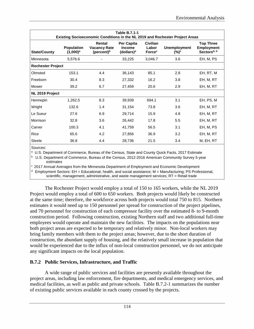
Environmental Analysis
114
Table B.7.1-1 Existing Socioeconomic Conditions in the NL 2019 and Rochester Project Areas
State/County Population
(1,000)a
Rental Vacancy Rate
(percent)b
Per Capita Income
(dollars)a
Civilian Labor Forcec
Unemployment (%)c
Top Three Employment
Sectorsb, d
Minnesota 5,576.6 - 33,225 3,046.7 3.6 EH, M, PS
Rochester Project
Olmsted 153.1 4.4 36,143 85.1 2.8 EH, RT, M
Freeborn 30.4 8.3 27,332 16.2 3.8 EH, M, RT
Mower 39.2 6.7 27,459 20.6 2.9 EH, M, RT
NL 2019 Project
Hennepin 1,262.5 8.3 39,939 694.1 3.1 EH, PS, M
Wright 132.6 1.4 31,154 73.8 3.6 EH, M, RT
Le Sueur 27.6 6.9 29,714 15.9 4.8 EH, M, RT
Morrison 32.8 3.6 26,442 17.8 5.5 EH, M, RT
Carver 100.3 4.1 41,759 56.5 3.1 EH, M, PS
Rice 65.6 4.2 27,856 36.9 3.2 EH, M, RT
Steele 36.8 4.4 28,736 21.5 3.4 M, EH, RT
Sources: a U.S. Department of Commerce, Bureau of the Census, State and County Quick Facts, 2017 Estimate b U.S. Department of Commerce, Bureau of the Census, 2012-2016 American Community Survey 5-year
estimates c 2017 Annual Averages from the Minnesota Department of Employment and Economic Development d Employment Sectors: EH = Educational, health, and social assistance; M = Manufacturing; PS Professional,
scientific, management, administrative, and waste management services; RT = Retail trade
The Rochester Project would employ a total of 150 to 165 workers, while the NL 2019
Project would employ a total of 600 to 650 workers. Both projects would likely be constructed at the same time; therefore, the workforce across both projects would total 750 to 815. Northern estimates it would need up to 150 personnel per spread for construction of the project pipelines, and 70 personnel for construction of each compressor facility over the estimated 8- to 9-month construction period. Following construction, existing Northern staff and two additional full-time employees would operate and maintain the new facilities. The impacts on the populations near both project areas are expected to be temporary and relatively minor. Non-local workers may bring family members with them to the project areas; however, due to the short duration of construction, the abundant supply of housing, and the relatively small increase in population that would be experienced due to the influx of non-local construction personnel, we do not anticipate any significant impacts on the local population.
B.7.2 Public Services, Infrastructure, and Traffic
A wide range of public services and facilities are presently available throughout the project areas, including law enforcement, fire departments, and medical emergency services, and medical facilities, as well as public and private schools. Table B.7.2-1 summarizes the number of existing public services available in each county crossed by the projects.
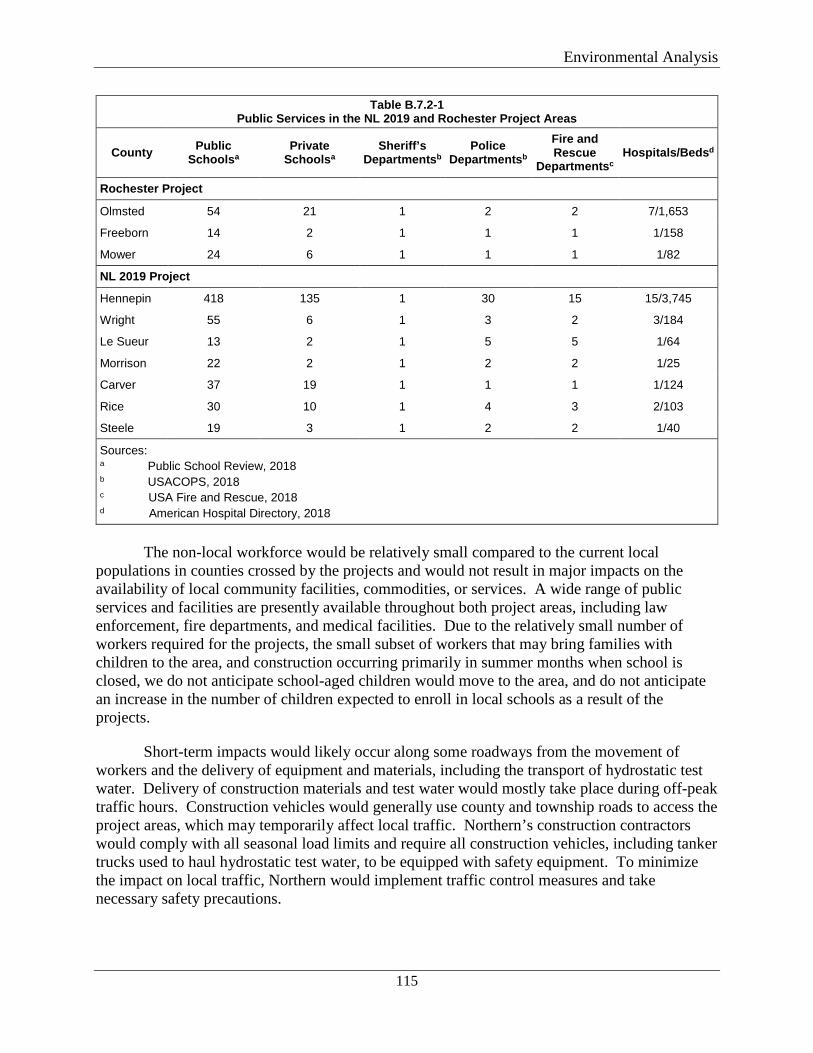
Environmental Analysis
115
Table B.7.2-1 Public Services in the NL 2019 and Rochester Project Areas
County Public Schoolsa
Private Schoolsa
Sheriff’s Departmentsb
Police Departmentsb
Fire and Rescue
Departmentsc Hospitals/Bedsd
Rochester Project
Olmsted 54 21 1 2 2 7/1,653
Freeborn 14 2 1 1 1 1/158
Mower 24 6 1 1 1 1/82
NL 2019 Project
Hennepin 418 135 1 30 15 15/3,745
Wright 55 6 1 3 2 3/184
Le Sueur 13 2 1 5 5 1/64
Morrison 22 2 1 2 2 1/25
Carver 37 19 1 1 1 1/124
Rice 30 10 1 4 3 2/103
Steele 19 3 1 2 2 1/40
Sources: a Public School Review, 2018 b USACOPS, 2018
c USA Fire and Rescue, 2018 d American Hospital Directory, 2018
The non-local workforce would be relatively small compared to the current local
populations in counties crossed by the projects and would not result in major impacts on the availability of local community facilities, commodities, or services. A wide range of public services and facilities are presently available throughout both project areas, including law enforcement, fire departments, and medical facilities. Due to the relatively small number of workers required for the projects, the small subset of workers that may bring families with children to the area, and construction occurring primarily in summer months when school is closed, we do not anticipate school-aged children would move to the area, and do not anticipate an increase in the number of children expected to enroll in local schools as a result of the projects.
Short-term impacts would likely occur along some roadways from the movement of workers and the delivery of equipment and materials, including the transport of hydrostatic test water. Delivery of construction materials and test water would mostly take place during off-peak traffic hours. Construction vehicles would generally use county and township roads to access the project areas, which may temporarily affect local traffic. Northern’s construction contractors would comply with all seasonal load limits and require all construction vehicles, including tanker trucks used to haul hydrostatic test water, to be equipped with safety equipment. To minimize the impact on local traffic, Northern would implement traffic control measures and take necessary safety precautions.
Environmental Analysis
116
B.7.3 Property Value and Tax Revenue
We received comments from a number of landowners who are concerned that the projects would reduce their property values. The effect that a pipeline easement may have on property value is a damage-related issue that would be negotiated between the parties during the easement acquisition process. The easement acquisition process is designed to provide fair compensation to the landowner for the right to use the property for pipeline construction and operation. Appraisal methods used to value land are typically based on objective characteristics of the property and any improvements.
The impact a pipeline could have on a property’s value would depend on many factors including the size of the tract, the values of adjacent properties, the presence of other utilities, the current value of the land, and the current land use. Subjective valuation is generally not considered in appraisals. If the presence of a pipeline renders a planned use infeasible, it is possible that a potential purchaser would decide not to purchase the property; however, each potential purchaser has different criteria and differing capabilities to purchase land.
A number of studies have been conducted since the early 1990s on the effects of proximity to pipelines on property values. In a few of the studies, advanced statistical techniques have been applied to evaluate transaction sales data before and after the construction of a pipeline. A literature review of these studies can be found in Wilde et al. (2012). The paper concludes that natural gas pipeline facilities have no statistically significant impact on the values of nearby properties.
The construction and operation of the projects would result in increased tax revenues to the State of Minnesota, counties crossed by the projects, and other local taxing authorities. Construction activities would result in additional state and local tax revenues related to retail sales and payroll. Nonlocal construction workers would spend money on housing, transportation, food, and entertainment. Once in operation, Northern would pay ad valorem taxes based on the assessed value of the pipeline and compressor station facilities. This would result in a minor increase in the amount of taxes paid to all counties crossed by the projects, which could result in a net benefit to the counties.
B.7.4 Environmental Justice and Sensitive Receptors
For projects with major aboveground facilities, FERC regulations (18 CFR 380.12(g)(1)) direct us to consider the impacts on human health or the environment of the local populations, including impacts that would be disproportionately high and adverse for minority and low-income populations. Additionally, during project scoping, we received comments from the EPA recommending that we identify and evaluate impacts on low-income and/or minority populations.9
Below, we address the potential for disproportionately high and adverse health or environmental effects of the projects on minority and low-income populations. Minority
9 The EPA’s Environmental Justice Policies are directed, in part, by Executive Order 12898: Federal Action to Address Environmental Justice in Minority Populations and Low-Income Populations.
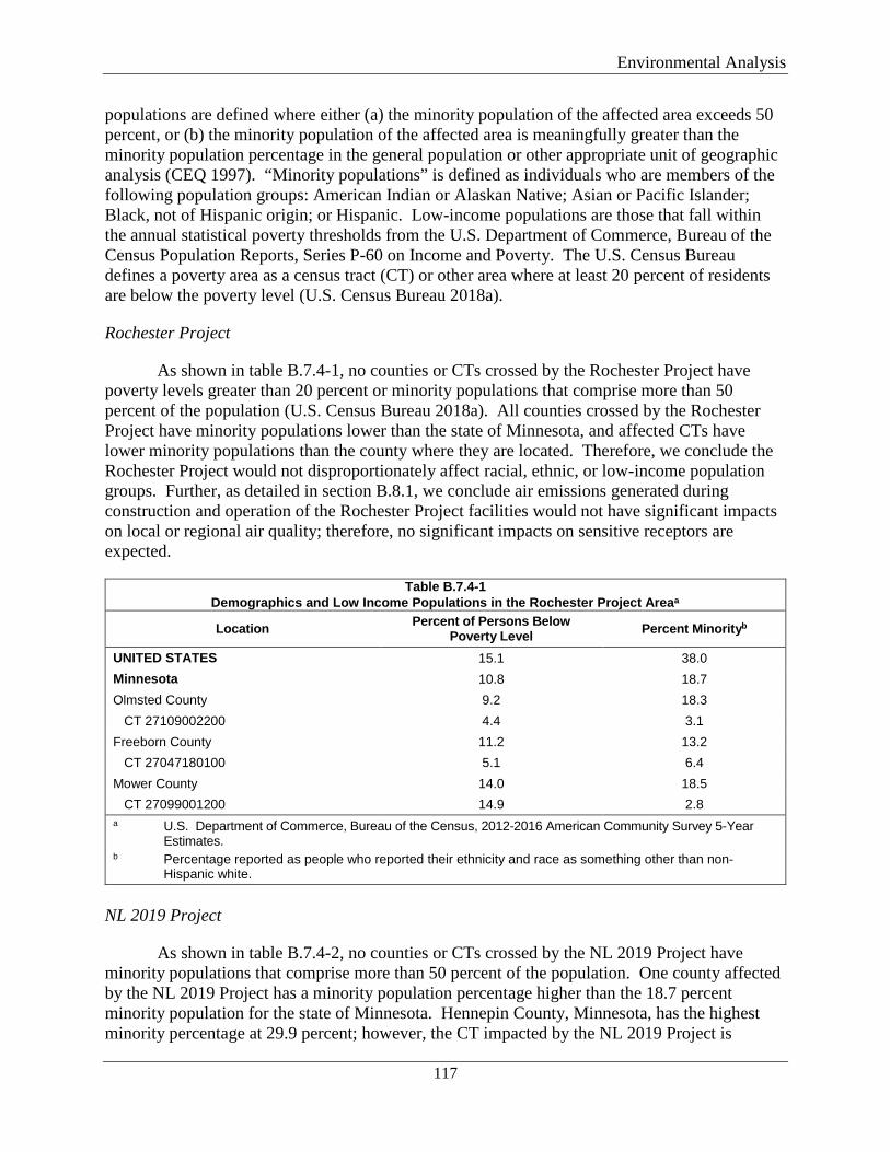
Environmental Analysis
117
populations are defined where either (a) the minority population of the affected area exceeds 50 percent, or (b) the minority population of the affected area is meaningfully greater than the minority population percentage in the general population or other appropriate unit of geographic analysis (CEQ 1997). “Minority populations” is defined as individuals who are members of the following population groups: American Indian or Alaskan Native; Asian or Pacific Islander; Black, not of Hispanic origin; or Hispanic. Low-income populations are those that fall within the annual statistical poverty thresholds from the U.S. Department of Commerce, Bureau of the Census Population Reports, Series P-60 on Income and Poverty. The U.S. Census Bureau defines a poverty area as a census tract (CT) or other area where at least 20 percent of residents are below the poverty level (U.S. Census Bureau 2018a).
Rochester Project
As shown in table B.7.4-1, no counties or CTs crossed by the Rochester Project have poverty levels greater than 20 percent or minority populations that comprise more than 50 percent of the population (U.S. Census Bureau 2018a). All counties crossed by the Rochester Project have minority populations lower than the state of Minnesota, and affected CTs have lower minority populations than the county where they are located. Therefore, we conclude the Rochester Project would not disproportionately affect racial, ethnic, or low-income population groups. Further, as detailed in section B.8.1, we conclude air emissions generated during construction and operation of the Rochester Project facilities would not have significant impacts on local or regional air quality; therefore, no significant impacts on sensitive receptors are expected.
Table B.7.4-1 Demographics and Low Income Populations in the Rochester Project Areaa
Location Percent of Persons Below Poverty Level Percent Minorityb
UNITED STATES 15.1 38.0 Minnesota 10.8 18.7 Olmsted County 9.2 18.3 CT 27109002200 4.4 3.1 Freeborn County 11.2 13.2 CT 27047180100 5.1 6.4 Mower County 14.0 18.5 CT 27099001200 14.9 2.8 a U.S. Department of Commerce, Bureau of the Census, 2012-2016 American Community Survey 5-Year
Estimates. b Percentage reported as people who reported their ethnicity and race as something other than non-
Hispanic white.
NL 2019 Project
As shown in table B.7.4-2, no counties or CTs crossed by the NL 2019 Project have minority populations that comprise more than 50 percent of the population. One county affected by the NL 2019 Project has a minority population percentage higher than the 18.7 percent minority population for the state of Minnesota. Hennepin County, Minnesota, has the highest minority percentage at 29.9 percent; however, the CT impacted by the NL 2019 Project is
Environmental Analysis
118
located in a rural area in western Hennepin County and has a total minority population of 2.0 percent. CT 27097780600 in Morrison County has a minority percentage of more than double the minority percentage in Morrison County. However, the NL 2019 Project would only cross Block Group 1 within this CT, which has a minority percent of 0.0; therefore, a minority population would not be crossed by the NL 2019 Project in CT 27097780600. All other counties affected by the NL 2019 Project have a lower total minority population than the state of Minnesota, and all other CTs have a minority population percentage that is not meaningfully greater than their corresponding county.
CT 27097780600 in Morrison County would be crossed by the Alexandria Branch Line Loop Extension and has a poverty level greater than 20 percent (U.S. Census Bureau 2018b). Of the five block groups within CT 27097780600, the Alexandria Branch Line Loop Extension originates in and crosses Block Group 1 and has a poverty population of 20.7 percent of the households. Block Group 1 is adjacent to Block Groups 2 and 3, with poverty populations of 23.6 percent and 37.7 percent respectively. CT 27097780600 Block Group 1 has a lower poverty level than the adjacent block groups. The Alexandria Branch Line Loop Extension route was not sited based on socioeconomic conditions of local populations, but rather selected based on Northern’s existing utility infrastructure and sited parallel to existing pipeline right-of-way.
Therefore, we conclude the NL 2019 Project would not disproportionately affect racial, ethnic, or low-income population groups. Further, as detailed in section B.8.1, we conclude air emissions generated during construction and operation of the NL 2019 Project facilities would not have significant impacts on local or regional air quality; therefore, no significant impacts on sensitive receptors are expected.
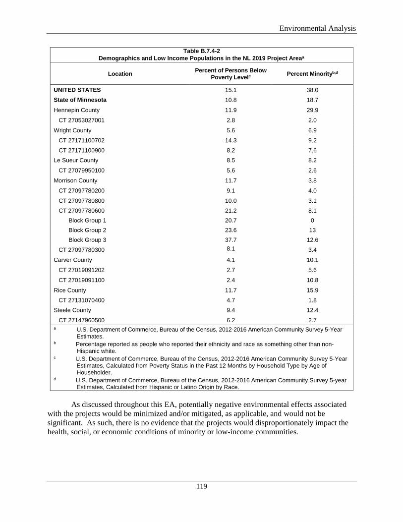
Environmental Analysis
119
Table B.7.4-2 Demographics and Low Income Populations in the NL 2019 Project Areaa
Location Percent of Persons Below Poverty Levelc Percent Minorityb,d
UNITED STATES 15.1 38.0 State of Minnesota 10.8 18.7
Hennepin County 11.9 29.9
CT 27053027001 2.8 2.0
Wright County 5.6 6.9
CT 27171100702 14.3 9.2
CT 27171100900 8.2 7.6
Le Sueur County 8.5 8.2
CT 27079950100 5.6 2.6
Morrison County 11.7 3.8
CT 27097780200 9.1 4.0
CT 27097780800 10.0 3.1
CT 27097780600 21.2 8.1 Block Group 1 20.7 0 Block Group 2 23.6 13 Block Group 3 37.7 12.6
CT 27097780300 8.1 3.4
Carver County 4.1 10.1
CT 27019091202 2.7 5.6
CT 27019091100 2.4 10.8
Rice County 11.7 15.9
CT 27131070400 4.7 1.8
Steele County 9.4 12.4
CT 27147960500 6.2 2.7 a U.S. Department of Commerce, Bureau of the Census, 2012-2016 American Community Survey 5-Year
Estimates. b Percentage reported as people who reported their ethnicity and race as something other than non-
Hispanic white. c U.S. Department of Commerce, Bureau of the Census, 2012-2016 American Community Survey 5-Year
Estimates, Calculated from Poverty Status in the Past 12 Months by Household Type by Age of Householder.
d U.S. Department of Commerce, Bureau of the Census, 2012-2016 American Community Survey 5-year Estimates, Calculated from Hispanic or Latino Origin by Race.
As discussed throughout this EA, potentially negative environmental effects associated
with the projects would be minimized and/or mitigated, as applicable, and would not be significant. As such, there is no evidence that the projects would disproportionately impact the health, social, or economic conditions of minority or low-income communities.
Environmental Analysis
120
B.8 AIR QUALITY
Both the Rochester Project and NL 2019 Project would result in temporary impacts on regional air quality through the short-term construction activities associated with each project; the NL 2019 Project would result in permanent impacts associated with long-term operation of the compressor stations.
B.8.1 Existing Air Quality
Construction and operation of the projects would affect local and regional air quality. Federal and state air quality standards are designed to protect human health and the environment from airborne pollutants. The EPA has developed National Ambient Air Quality Standards (NAAQS) for criteria air pollutants such as nitrogen oxides (NOx) and carbon monoxide (CO), ozone, sulfur dioxide (SO2), and inhalable particulate matter (PM2.5 and PM10). PM2.5 includes particles with an aerodynamic diameter less than or equal to 2.5 microns, and PM10 includes particles with an aerodynamic diameter less than or equal to 10 microns. The Clean Air Act identifies two class types of NAAQS: primary standards and secondary standards. Primary standards are limits set to protect the public health of the most sensitive populations, such as asthmatics, children, and the elderly. Secondary standards are limits set to protect public welfare, such as protection against visibility impairment or damage to vegetation, wildlife, and structures.
Greenhouse gases (GHG), the most common of which are carbon dioxide (CO2), methane (CH4), nitrous oxide (N2O), ozone, hydrofluorocarbons, and perfluorocarbons, are naturally occurring pollutants in the atmosphere and products of human activities, including burning fossil fuels. Fossil fuel combustion emits CO2, CH4, and N2O. GHG emissions are generally calculated in terms of carbon dioxide equivalents (CO2e) where the atmospheric heating potential of each gas is expressed as a multiple of the atmospheric heating potential of CO2.
The EPA designates the attainment status of an area on a pollutant-specific basis based on whether an area meets the NAAQS. Areas that meet the NAAQS are termed “attainment areas.” Areas that do not meet the NAAQS are termed “nonattainment areas.” Areas for which insufficient data are available to determine attainment status are termed “unclassifiable areas.” Areas formerly designated as nonattainment areas that have subsequently reached attainment are termed “maintenance areas.” Both projects are in attainment areas.
B.8.2 Permitting/Regulatory Requirements
Rochester Project
Air emissions from the Rochester Project would not require federal or state air permits.
NL 2019 Project
The Clean Air Act of 1970, 42 USC Section 7401 et seq., amended in 1977 and 1990, is the basic federal statute governing air quality. In addition to the NAAQS, air emissions and equipment would be subject to various other federal and state air quality regulations. The federal
Environmental Analysis
121
air quality requirements are contained in 40 CFR Parts 50 through 99, including the following which apply to the project:
• State and Title V Operating Permit Programs; • New Source Performance Standards; and • National Emission Standards for Hazardous Air Pollutants.
New Source Review, including Prevention of Significant Deterioration (PSD) permitting program and the nonattainment area NSR (NNSR) permitting program, does not apply to the NL 2019 Project.
The Title V permit program in 40 CFR 70 requires major sources of air pollutants to obtain operating permits if they exceed thresholds for criteria pollutants or HAPs. Stationary sources are not required to obtain a Title V permit on the sole basis of GHG emissions levels (i.e., exceeding the Title V major source threshold for GHG only). The Carver Compressor Station would not be considered a major stationary source and would not require a Title V or Part 70 air operation permit. The NOx and CO emissions rates from the expanded Faribault Compressor Station would exceed the Part 70 emission thresholds of 100 tons per year (tpy); however, Northern would convert its current operation permit to a Title V air operation major source permit. The NOx and CO emissions from the expanded Owatonna Compressor Station would be capped below the Part 70 emission threshold of 100 tpy. The expanded Owatonna Compressor Station would not be considered a major stationary source and would not require a Title V or Part 70 air operation major source permit.
New Source Performance Standards (NSPS) in 40 CFR 60 regulate certain emissions from specific source categories. Subpart JJJJ (Standards of Performance for Stationary Spark Ignition Internal Combustion Engines) would apply to the emergency generators at the Carver and Owatonna Compressor Stations. The emissions standards in Subpart KKKK (Standards of Performance for Stationary Combustion Turbines) would apply to the new turbines at the three compressor stations. Subpart OOOOa (Standards of Performance for Crude Oil and Natural Gas Production, Transmission and Distribution) would apply to all three compressor stations.
The National Emission Standards for Hazardous Air Pollutants (NESHAP) for Stationary Reciprocating Internal Combustion Engines, Subpart ZZZZ, would apply to the emergency generators at the Carver and Owatonna Compressor Stations. By complying with Subpart JJJJ, the applicable provisions of Subpart ZZZZ of the NESHAP rules (Part 63) are met. Northern would comply with the requirements of Subpart JJJJ.
Minnesota requires that stationary sources subject to NSPS or NESHAP requirements must obtain a state permit under Minnesota Rule 7007.0250. This regulation applies to all three compressor stations. Air permit applications for operation of these new and modified compressor stations were submitted to the MNPCA on September 28, 2018.
B.8.3 Construction Emissions
Construction of both projects would result in intermittent and temporary emissions of criteria pollutants. These emissions generally include fugitive dust (PM10 and PM2.5) generated
Environmental Analysis
122
from soil-disturbing activities, such as earthmoving and wind erosion of disturbed areas, and vehicle traffic during construction. The amount of dust generated during construction would be a function of precipitation, vehicle numbers and types, vehicle speeds, and roadway characteristics. Dust emissions would be greater during dry periods and in areas of fine-textured soils.
Construction results in combustion emissions from diesel- and gasoline-fueled vehicles used in various construction activities. Combustion-related emissions would include nitrogen oxides (NOx), CO, VOC, SO2, PM, small amounts of HAPs, and GHGs. The EPA requires manufacturers of on- and off-road engines to certify their products to engine emission standards based on the year of manufacture. For diesel engines, the emission standards have been phased in over the past two decades in four steps, referred to as Tier 1 to Tier 4. The engine must comply with the emission standards throughout its life. In 2010, the EPA required the sulfur concentration in diesel fuels be lowered from historical concentration of 500 parts per million to 15 parts per million (ultra-low sulfur diesel fuel), which allows diesel engines to meet current Tier 4 emission requirements. Proper maintenance of construction equipment and use of low-sulfur diesel fuel would reduce engine emissions during construction of the projects. To reduce emissions from internal combustion engines, idling of construction vehicles would be limited.
Construction activities would generally take place during daylight hours (7 a.m. to 7 p.m.). This schedule would allow equipment operators to assess the presence of fugitive emissions and to implement abatement measures, as needed. Northern would employ dust control measures such as watering access roads, storage piles, and disturbed surfaces during construction and restoration. Additional measures that would be implemented include imposing a vehicle speed restriction on unpaved roads, using gravel tracking pads at egress points to remove dirt from tires and tracks, and restoring disturbed areas following construction.
Rochester Project
Table B.8.3-1 summarizes the estimated emissions of criteria pollutants, total HAPs, and GHGs from construction equipment and material deliveries. The GHG emissions associated with Rochester Project construction are principally from CO2.
Construction-related emission estimates are based on typical diesel-fueled construction equipment, hours of operation, and vehicle miles traveled by the construction equipment and supporting vehicles for each construction spread. Through the implementation of the work practices described above and given the short duration of the construction activities, the temporary emissions during construction of the Rochester Project would be minor, and the impact of these emissions would be localized. Therefore, we conclude these emissions would not have a significant impact on regional air quality.
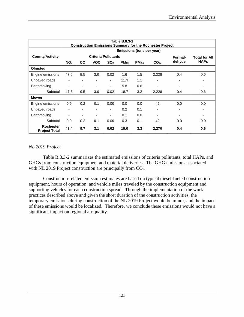
Environmental Analysis
123
Table B.8.3-1 Construction Emissions Summary for the Rochester Project
County/Activity Emissions (tons per year)
Criteria Pollutants CO2e
Formal-dehyde
Total for All HAPs NOx CO VOC SO2 PM10 PM2.5
Olmsted Engine emissions 47.5 9.5 3.0 0.02 1.6 1.5 2,228 0.4 0.6 Unpaved roads - - - - 11.3 1.1 - - - Earthmoving - - - - 5.8 0.6 - - -
Subtotal 47.5 9.5 3.0 0.02 18.7 3.2 2,228 0.4 0.6 Mower Engine emissions 0.9 0.2 0.1 0.00 0.0 0.0 42 0.0 0.0 Unpaved roads - - - - 0.2 0.1 - - - Earthmoving - - - - 0.1 0.0 - - -
Subtotal 0.9 0.2 0.1 0.00 0.3 0.1 42 0.0 0.0 Rochester
Project Total 48.4 9.7 3.1 0.02 19.0 3.3 2,270 0.4 0.6
NL 2019 Project
Table B.8.3-2 summarizes the estimated emissions of criteria pollutants, total HAPs, and GHGs from construction equipment and material deliveries. The GHG emissions associated with NL 2019 Project construction are principally from CO2.
Construction-related emission estimates are based on typical diesel-fueled construction equipment, hours of operation, and vehicle miles traveled by the construction equipment and supporting vehicles for each construction spread. Through the implementation of the work practices described above and given the short duration of the construction activities, the temporary emissions during construction of the NL 2019 Project would be minor, and the impact of these emissions would be localized. Therefore, we conclude these emissions would not have a significant impact on regional air quality.
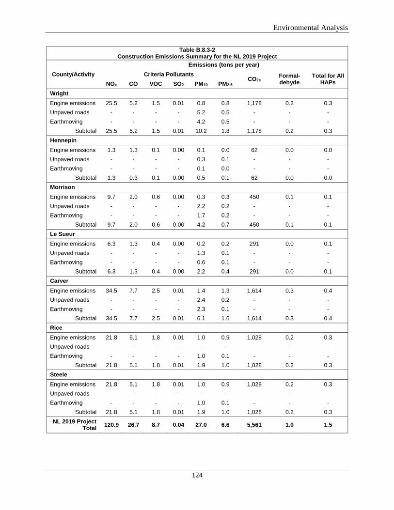
Environmental Analysis
124
Table B.8.3-2 Construction Emissions Summary for the NL 2019 Project
County/Activity Emissions (tons per year)
Criteria Pollutants CO2e Formal-
dehyde Total for All
HAPs NOx CO VOC SO2 PM10 PM2.5 Wright Engine emissions 25.5 5.2 1.5 0.01 0.8 0.8 1,178 0.2 0.3 Unpaved roads - - - - 5.2 0.5 - - - Earthmoving - - - - 4.2 0.5 - - -
Subtotal 25.5 5.2 1.5 0.01 10.2 1.8 1,178 0.2 0.3 Hennepin Engine emissions 1.3 1.3 0.1 0.00 0.1 0.0 62 0.0 0.0 Unpaved roads - - - - 0.3 0.1 - - - Earthmoving - - - - 0.1 0.0 - - -
Subtotal 1.3 0.3 0.1 0.00 0.5 0.1 62 0.0 0.0 Morrison Engine emissions 9.7 2.0 0.6 0.00 0.3 0.3 450 0.1 0.1 Unpaved roads - - - - 2.2 0.2 - - - Earthmoving - - - - 1.7 0.2 - - -
Subtotal 9.7 2.0 0.6 0.00 4.2 0.7 450 0.1 0.1 Le Sueur Engine emissions 6.3 1.3 0.4 0.00 0.2 0.2 291 0.0 0.1 Unpaved roads - - - - 1.3 0.1 - - - Earthmoving - - - - 0.6 0.1 - - -
Subtotal 6.3 1.3 0.4 0.00 2.2 0.4 291 0.0 0.1 Carver Engine emissions 34.5 7.7 2.5 0.01 1.4 1.3 1,614 0.3 0.4 Unpaved roads - - - - 2.4 0.2 - - - Earthmoving - - - - 2.3 0.1 - - -
Subtotal 34.5 7.7 2.5 0.01 6.1 1.6 1,614 0.3 0.4 Rice Engine emissions 21.8 5.1 1.8 0.01 1.0 0.9 1,028 0.2 0.3 Unpaved roads - - - - - - - - - Earthmoving - - - - 1.0 0.1 - - -
Subtotal 21.8 5.1 1.8 0.01 1.9 1.0 1,028 0.2 0.3 Steele Engine emissions 21.8 5.1 1.8 0.01 1.0 0.9 1,028 0.2 0.3 Unpaved roads - - - - - - - - - Earthmoving - - - - 1.0 0.1 - - -
Subtotal 21.8 5.1 1.8 0.01 1.9 1.0 1,028 0.2 0.3 NL 2019 Project
Total 120.9 26.7 8.7 0.04 27.0 6.6 5,561 1.0 1.5
Environmental Analysis
125
B.8.4 Operational Emissions
Operation of the Project would result in emissions associated with combustion of natural gas at the new and modified compressor stations to operate the compressor units; namely the criteria air pollutants NOx, CO, VOCs, SO2, PM10, and PM2.5. There would also be leaks or “fugitive emissions” of natural gas along the pipeline (e.g., MLVs) and at aboveground facilities, as well as venting of natural gas from blowdown activities, both of which emit VOCs and methane (a GHG).
Rochester Project
Northern does not propose any new compression or changes to compressor stations or operating emission sources as part of the Rochester project; therefore, no permitting actions are required. Northern calculated operational methane emission estimates associated with leaks and releases from the Rochester Project including valves, flanges, relief valves, and pig launchers/receivers. Annual methane emissions from Rochester Project pipelines and appurtenances are estimated to average 20 tpy as a CO2e. Pig launch events, which would occur about every seven years, would contribute an additional 3 tpy of CO2e emissions. Methane emissions during operation of the Rochester Project would be minor; therefore, we conclude these emissions would not have a significant impact on regional air quality.
NL 2019 Project
The NL 2019 Project would include construction of a new compressor station (Carver Compressor Station) and modifications to the existing Faribault and Owatonna Compressor Stations. Northern calculated operational methane emission estimates associated with leaks and releases from the NL 2019 Project aboveground pipeline appurtenances including valves, flanges, relief valves, and pig launchers/receivers. Annual methane emissions from NL 2019 Project pipelines and appurtenances are estimated to average 91.5 tpy as a CO2e. Pig launch events, which would occur about every seven years, would contribute an additional 6.5 tpy of CO2e emissions.
The operational sources of air emissions at the Carver Compressor Station would include one ISO-rated 11,153-HP Solar Taurus 70-108202S natural gas-fired turbine; a 0.3-MMBtu per hour natural gas-fired fuel gas heating skid, a 630-kW (850-HP) EPA-certified natural gas-fired backup electric generator, and facility fugitive VOC emissions, including blowdown events. During normal operation of the compressor station, a unit shutdown event would occur about 20 times per year, resulting in about 10 blowdown events per year. Northern estimates 29,500 standard cubic feet of natural gas would be vented per blowdown event. Emission estimates of criteria pollutants and HAPs for the Carver Compressor Station, per year of operation, are presented below in table B.8.4-1. Total annual HAPs emissions for the Carver Compressor Station, in aggregate, would be about 0.6 tpy.
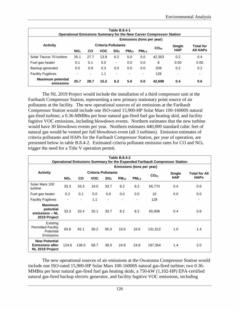
Environmental Analysis
126
Table B.8.4-1 Operational Emissions Summary for the New Carver Compressor Station
Activity Emissions (tons per year)
Criteria Pollutants CO2e Single
HAP Total for All HAPs NOx CO VOC SO2 PM10 PM2.5
Solar Taurus 70 turbine 25.1 27.7 13.8 6.2 5.0 5.0 42,353 0.2 0.4 Fuel gas heater 0.1 0.1 0.0 - 0.0 0.0 8 0.00 0.00 Backup generator 0.5 0.9 0.3 0.0 0.0 0.0 209 0.2 0.2 Facility Fugitives - - 1.1 - - - 128 - -
Maximum potential emissions 25.7 28.7 15.2 6.2 5.0 5.0 42,698 0.4 0.6
The NL 2019 Project would include the installation of a third compressor unit at the
Faribault Compressor Station, representing a new primary stationary point source of air pollutants at the facility. The new operational sources of air emissions at the Faribault Compressor Station would include one ISO-rated 15,900-HP Solar Mars 100-16000S natural gas-fired turbine; a 0.36-MMBtu per hour natural gas-fired fuel gas heating skid, and facility fugitive VOC emissions, including blowdown events. Northern estimates that the new turbine would have 30 blowdown events per year. Northern estimates 440,000 standard cubic feet of natural gas would be vented per full blowdown event (all 3 turbines). Emission estimates of criteria pollutants and HAPs for the Faribault Compressor Station, per year of operation, are presented below in table B.8.4-2. Estimated criteria pollutant emission rates for CO and NOx trigger the need for a Title V operation permit.
Table B.8.4-2 Operational Emissions Summary for the Expanded Faribault Compressor Station
Activity Emissions (tons per year)
Criteria Pollutants CO2e Single
HAP Total for All
HAPs NOx CO VOC SO2 PM10 PM2.5 Solar Mars 100 turbine 33.3 33.3 19.0 33.7 8.2 8.2 65,770 0.4 0.6
Fuel gas heater 0.2 0.1 0.0 0.0 0.0 0.0 10 0.0 0.0 Facility Fugitives - - 1.1 - - - 128 - -
Maximum potential
emissions – NL 2019 Project
33.3 33.4 20.1 33.7 8.2 8.2 65,908 0.4 0.6
Existing Permitted Facility
Potential Emissions
93.8 92.1 39.2 95.0 16.6 16.6 131,512 1.0 1.4
New Potential Emissions after NL 2019 Project
124.6 136.0 58.7 38.0 24.8 24.8 197,354 1.4 2.0
The new operational sources of air emissions at the Owatonna Compressor Station would
include one ISO-rated 15,900-HP Solar Mars 100-16000S natural gas-fired turbine; two 0.36-MMBtu per hour natural gas-fired fuel gas heating skids, a 750-kW (1,102-HP) EPA-certified natural gas-fired backup electric generator, and facility fugitive VOC emissions, including
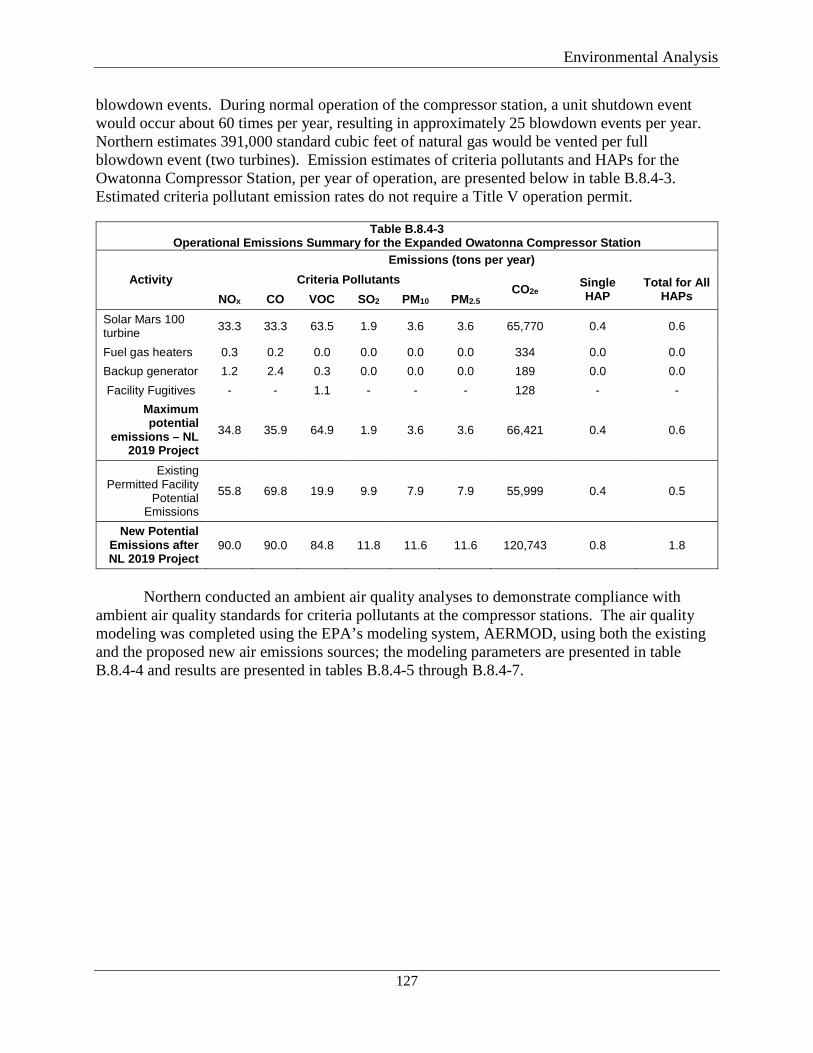
Environmental Analysis
127
blowdown events. During normal operation of the compressor station, a unit shutdown event would occur about 60 times per year, resulting in approximately 25 blowdown events per year. Northern estimates 391,000 standard cubic feet of natural gas would be vented per full blowdown event (two turbines). Emission estimates of criteria pollutants and HAPs for the Owatonna Compressor Station, per year of operation, are presented below in table B.8.4-3. Estimated criteria pollutant emission rates do not require a Title V operation permit.
Table B.8.4-3 Operational Emissions Summary for the Expanded Owatonna Compressor Station
Activity Emissions (tons per year)
Criteria Pollutants CO2e Single
HAP Total for All
HAPs NOx CO VOC SO2 PM10 PM2.5 Solar Mars 100 turbine 33.3 33.3 63.5 1.9 3.6 3.6 65,770 0.4 0.6
Fuel gas heaters 0.3 0.2 0.0 0.0 0.0 0.0 334 0.0 0.0 Backup generator 1.2 2.4 0.3 0.0 0.0 0.0 189 0.0 0.0 Facility Fugitives - - 1.1 - - - 128 - -
Maximum potential
emissions – NL 2019 Project
34.8 35.9 64.9 1.9 3.6 3.6 66,421 0.4 0.6
Existing Permitted Facility
Potential Emissions
55.8 69.8 19.9 9.9 7.9 7.9 55,999 0.4 0.5
New Potential Emissions after NL 2019 Project
90.0 90.0 84.8 11.8 11.6 11.6 120,743 0.8 1.8
Northern conducted an ambient air quality analyses to demonstrate compliance with
ambient air quality standards for criteria pollutants at the compressor stations. The air quality modeling was completed using the EPA’s modeling system, AERMOD, using both the existing and the proposed new air emissions sources; the modeling parameters are presented in table B.8.4-4 and results are presented in tables B.8.4-5 through B.8.4-7.
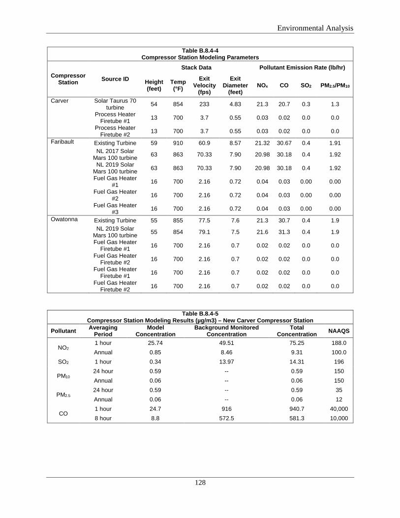
Environmental Analysis
128
Table B.8.4-4 Compressor Station Modeling Parameters
Compressor Station Source ID
Stack Data Pollutant Emission Rate (lb/hr)
Height (feet)
Temp (°F)
Exit Velocity
(fps)
Exit Diameter
(feet) NOx CO SO2 PM2.5/PM10
Carver Solar Taurus 70 turbine 54 854 233 4.83 21.3 20.7 0.3 1.3
Process Heater Firetube #1 13 700 3.7 0.55 0.03 0.02 0.0 0.0
Process Heater Firetube #2 13 700 3.7 0.55 0.03 0.02 0.0 0.0
Faribault Existing Turbine 59 910 60.9 8.57 21.32 30.67 0.4 1.91 NL 2017 Solar
Mars 100 turbine 63 863 70.33 7.90 20.98 30.18 0.4 1.92
NL 2019 Solar Mars 100 turbine 63 863 70.33 7.90 20.98 30.18 0.4 1.92
Fuel Gas Heater #1 16 700 2.16 0.72 0.04 0.03 0.00 0.00
Fuel Gas Heater #2 16 700 2.16 0.72 0.04 0.03 0.00 0.00
Fuel Gas Heater #3 16 700 2.16 0.72 0.04 0.03 0.00 0.00
Owatonna Existing Turbine 55 855 77.5 7.6 21.3 30.7 0.4 1.9 NL 2019 Solar
Mars 100 turbine 55 854 79.1 7.5 21.6 31.3 0.4 1.9
Fuel Gas Heater Firetube #1 16 700 2.16 0.7 0.02 0.02 0.0 0.0
Fuel Gas Heater Firetube #2 16 700 2.16 0.7 0.02 0.02 0.0 0.0
Fuel Gas Heater Firetube #1 16 700 2.16 0.7 0.02 0.02 0.0 0.0
Fuel Gas Heater Firetube #2 16 700 2.16 0.7 0.02 0.02 0.0 0.0
Table B.8.4-5 Compressor Station Modeling Results (µg/m3) – New Carver Compressor Station
Pollutant Averaging Period
Model Concentration
Background Monitored Concentration
Total Concentration NAAQS
NO2 1 hour 25.74 49.51 75.25 188.0 Annual 0.85 8.46 9.31 100.0
SO2 1 hour 0.34 13.97 14.31 196
PM10 24 hour 0.59 -- 0.59 150 Annual 0.06 -- 0.06 150
PM2.5 24 hour 0.59 -- 0.59 35 Annual 0.06 -- 0.06 12
CO 1 hour 24.7 916 940.7 40,000 8 hour 8.8 572.5 581.3 10,000
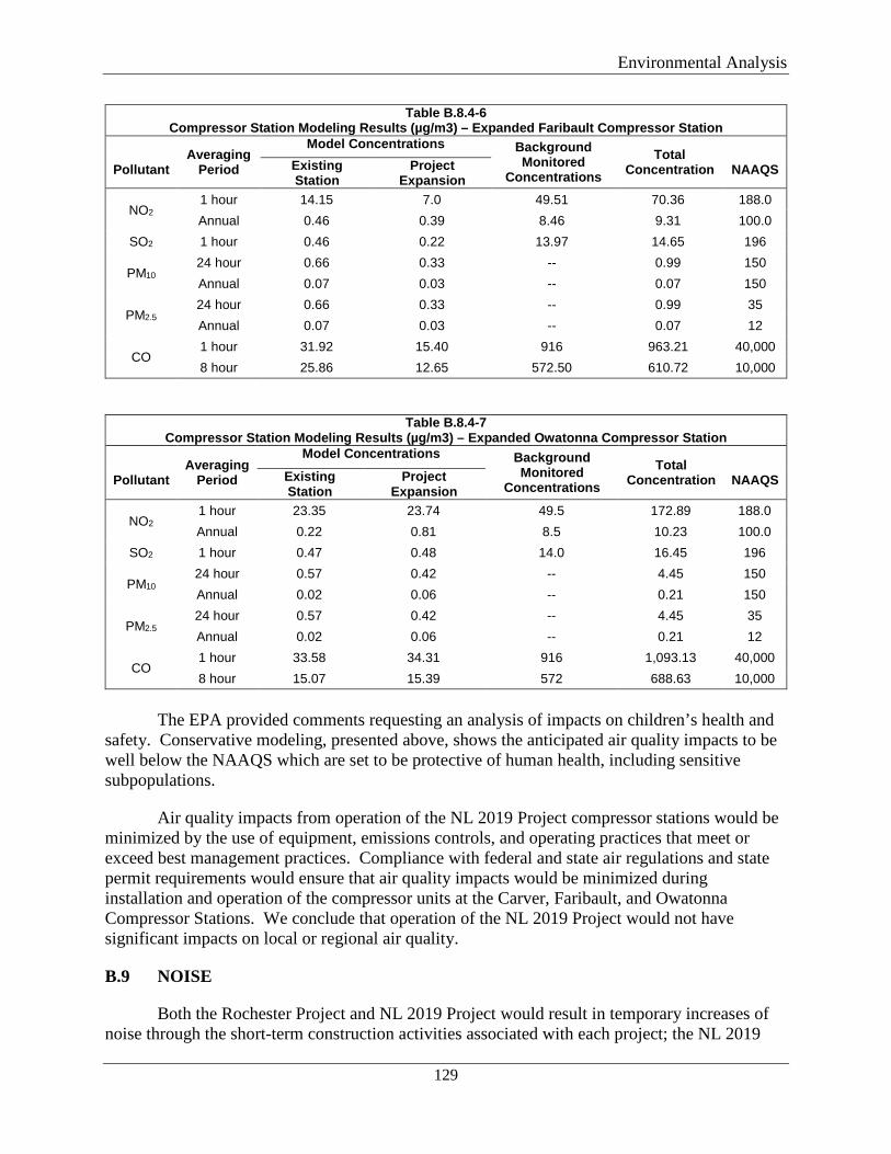
Environmental Analysis
129
Table B.8.4-6 Compressor Station Modeling Results (µg/m3) – Expanded Faribault Compressor Station
Pollutant
Averaging Period
Model Concentrations Background Monitored
Concentrations Total
Concentration
NAAQS Existing Station
Project Expansion
NO2 1 hour 14.15 7.0 49.51 70.36 188.0 Annual 0.46 0.39 8.46 9.31 100.0
SO2 1 hour 0.46 0.22 13.97 14.65 196
PM10 24 hour 0.66 0.33 -- 0.99 150 Annual 0.07 0.03 -- 0.07 150
PM2.5 24 hour 0.66 0.33 -- 0.99 35 Annual 0.07 0.03 -- 0.07 12
CO 1 hour 31.92 15.40 916 963.21 40,000 8 hour 25.86 12.65 572.50 610.72 10,000
Table B.8.4-7 Compressor Station Modeling Results (µg/m3) – Expanded Owatonna Compressor Station
Pollutant
Averaging Period
Model Concentrations Background Monitored
Concentrations Total
Concentration
NAAQS Existing Station
Project Expansion
NO2 1 hour 23.35 23.74 49.5 172.89 188.0 Annual 0.22 0.81 8.5 10.23 100.0
SO2 1 hour 0.47 0.48 14.0 16.45 196
PM10 24 hour 0.57 0.42 -- 4.45 150 Annual 0.02 0.06 -- 0.21 150
PM2.5 24 hour 0.57 0.42 -- 4.45 35 Annual 0.02 0.06 -- 0.21 12
CO 1 hour 33.58 34.31 916 1,093.13 40,000 8 hour 15.07 15.39 572 688.63 10,000
The EPA provided comments requesting an analysis of impacts on children’s health and
safety. Conservative modeling, presented above, shows the anticipated air quality impacts to be well below the NAAQS which are set to be protective of human health, including sensitive subpopulations.
Air quality impacts from operation of the NL 2019 Project compressor stations would be minimized by the use of equipment, emissions controls, and operating practices that meet or exceed best management practices. Compliance with federal and state air regulations and state permit requirements would ensure that air quality impacts would be minimized during installation and operation of the compressor units at the Carver, Faribault, and Owatonna Compressor Stations. We conclude that operation of the NL 2019 Project would not have significant impacts on local or regional air quality.
B.9 NOISE
Both the Rochester Project and NL 2019 Project would result in temporary increases of noise through the short-term construction activities associated with each project; the NL 2019
Environmental Analysis
130
Project would also result in permanent (ongoing) noise impacts associated with operation of the aboveground facilities.
B.9.1 Regulations
Two measurements used by some federal agencies to relate the time-varying quality of environmental noise to its known effects on people are the equivalent sound level (Leq) and the day-night sound level (Ldn). The Leq is a sound level over a specific time period corresponding to the same sound energy as measured for an instantaneous sound level assuming it is a constant noise source. Sound levels are perceived differently, depending on the length of exposure and time of day. The Ldn takes into account the time of day and duration the noise is encountered. Specifically, in calculation of the Ldn, late night and early morning (10:00 p.m. to 7:00 a.m.) noise exposures are increased by 10 dBA to account for people’s greater sensitivity to sound during nighttime hours. Due to the 10 dBA nighttime penalty added prior to calculation of the Ldn, for a facility to meet the 55 dBA Ldn limit established by the EPA to protect the public from indoor and outdoor activity interference, the facility must be designed such that the constant 24-hour noise level does not exceed an Leq of 48.6 dBA at any NSA. The A-weighted scale is used because human hearing is less sensitive to low and high frequencies than mid-range frequencies.
The State of Minnesota established noise rules at Minnesota Administrative Rule Section 7030.0040. No local noise ordinances were identified for the counties or townships crossed by the Rochester Project. The cities of Buffalo, Rockford, New Prague, and Cologne, and the Townships of Buffalo and Rockford have local noise ordinances that restrict the hours for construction activities.
B.9.1 Construction Noise
Construction of the projects would create noise impacts, typically associated with heavy equipment operation, including HDD rigs. These impacts would be temporary. In order to limit noise impacts associated with the projects, construction activities generally would be conducted during the daytime (7 a.m. to 7 p.m.), except for certain activities, including longer HDDs and tie-ins, which may extend beyond normal construction hours. In particular, HDDs may be conducted continuously (24 hours per day) at critical times, such as during pullback of the pipe into the drill hole and when pipe sections are being welded during pullback.
Northern obtained noise ratings for HDD rigs and supporting equipment (mud pumps, bentonite mixing systems, and excavators) from equipment manufacturer’s specification sheets for each piece of equipment or comparable class of equipment. Northern also solicited historical noise ratings for HDD rigs from Michel’s Corporation. Michel’s provided a summary of noise emissions measured from numerous past projects. A noise reading of 91 dB was taken adjacent to the loudest piece of equipment – the hydraulic power unit, which corresponds to the noise specifications presented by the HDD suppliers.
Northern determined the distance between the entry and exit pits for the proposed HDDs to the nearest NSAs for each component of the projects. The cumulative acoustical impact of the HDD operations at the pit entry and exit was evaluated at each of the identified NSAs. The noise impacts were calculated with and without active noise mitigation measures, such as the usage of
Environmental Analysis
131
sound barriers. The impacts also considered the usage factor for the various pieces of equipment. Using this information, Northern has modeled the noise impacts from HDD operations on the nearest NSAs.
The analysis of the noise impacts from the installation of HDD borings assumes the following work practices will be performed throughout the term of these projects:
• Northern would inform nearby residents of the projects and the upcoming construction
activities, including HDD operation, and would respond to and investigate concerns. • Northern’s contractor would position equipment so noise propagates away from the
nearest NSAs, and position non-noise generating equipment between the drilling operation and the nearby NSAs, where possible, to provide shielding.
• Northern would restrict on-site vehicle idle time while in the construction area for all equipment and vehicles that are not using their engines to operate a loading, unloading, or processing device (e.g., concrete mixing trucks) or are otherwise required for the proper operation of the engine.
• Contractors would be required to use sound control devices no less effective than those provided by the manufacturer and to maintain equipment in accordance with manufacturer’s recommendations. No equipment would have un-muffled exhausts.
• When possible, Northern would use construction equipment specifically designed for low noise emissions (e.g. equipment such as generators with noise enclosures).
• Northern would prepare the layout of the construction activities with the goal of reducing noise from back-up alarms (alarms that signal vehicle travel in reverse).
Rochester Project
Northern completed modeling of noise impacts from HDDs for 13 locations on the Rochester Project. Northern identified NSAs within 0.5 mile of each HDD and assumed the HDD pit nearest to each NSA would be the entry pit; therefore, the maximum potential noise impact was modeled for each NSA. Table B.9.1-1 provides the unmitigated and mitigated noise levels at the nearest NSAs for each of the drill entry/exit points, with the exception of the HDD crossing the stream and wetland and 50th Street SW between about MPs 8.84 and 8.90 (4 days) and the HDD crossing the stream from about MPS 9.06 to 9.15 (5 days), as there are not any nearby NSAs. HDD operations, including drilling and pullback, would typically occur during daytime hours (7 a.m. to 7 p.m.), but may extend into nighttime hours as described above. HDD locations on the Rochester Project with the highest potential for nighttime construction include the crossing at the wetland at milepost 3.44, and the South Fork Zumbro River and wetland at milepost 6.91.
The HDD noise level estimates are outlined in table B.9.1-1, with the exception of the HDDs crossing Stream RBL-7-S1 (2 days), Wetland RBL-47-W2 (5 days), RBL-055-S1 (6 days). Unmitigated noise levels could exceed 55 dBa Ldn at some NSA locations, which are mostly residences. In the event that HDD operations would extend into nighttime hours (7 p.m. to 7 a.m.), Northern committed to reduce noise impacts on the NSA to below 55 dBA Ldn between the hours of 10 p.m. and 7 a.m. Noise mitigation options may include, but are not limited to: positioning equipment so noise propagates away from the NSA, the installation of temporary sound barriers (12 to 25 feet tall) between the HDD sites and nearby residences, or
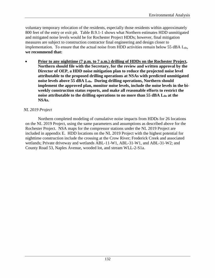
Environmental Analysis
132
voluntary temporary relocation of the residents, especially those residents within approximately 800 feet of the entry or exit pit. Table B.9.1-1 shows what Northern estimates HDD unmitigated and mitigated noise levels would be for Rochester Project HDDs; however, final mitigation measures are subject to construction contractor final engineering and design closer to implementation. To ensure that the actual noise from HDD activities remain below 55 dBA Ldn, we recommend that:
• Prior to any nighttime (7 p.m. to 7 a.m.) drilling of HDDs on the Rochester Project, Northern should file with the Secretary, for the review and written approval by the Director of OEP, a HDD noise mitigation plan to reduce the projected noise level attributable to the proposed drilling operations at NSAs with predicted unmitigated noise levels above 55 dBA Ldn. During drilling operations, Northern should implement the approved plan, monitor noise levels, include the noise levels in the bi-weekly construction status reports, and make all reasonable efforts to restrict the noise attributable to the drilling operations to no more than 55 dBA Ldn at the NSAs.
NL 2019 Project
Northern completed modeling of cumulative noise impacts from HDDs for 26 locations on the NL 2019 Project, using the same parameters and assumptions as described above for the Rochester Project. NSA maps for the compressor stations under the NL 2019 Project are included in appendix E. HDD locations on the NL 2019 Project with the highest potential for nighttime construction include the crossing at the Crow River; Frederick Creek and associated wetlands; Private driveway and wetlands ABL-11-W1, ABL-31-W1, and ABL-31-W2; and County Road 53, Naples Avenue, wooded lot, and stream WLL-2-S1a.
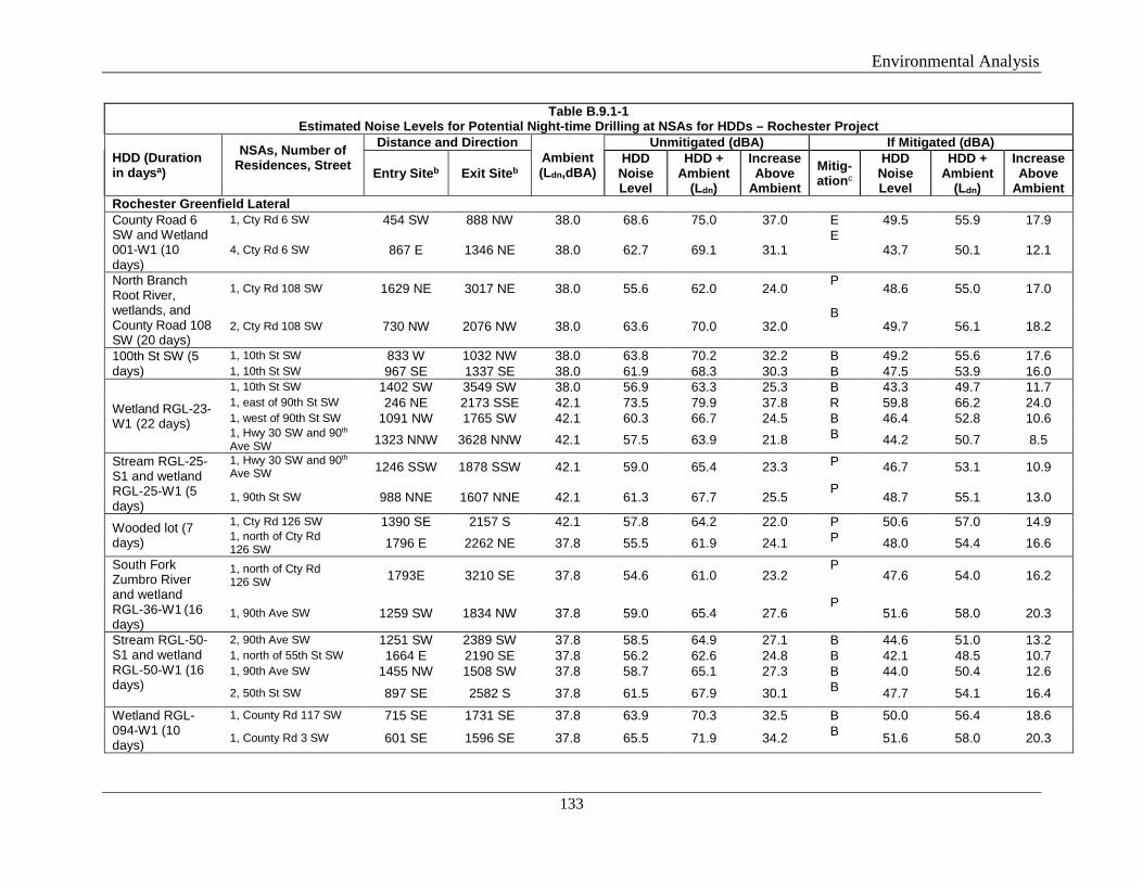
Environmental Analysis
133
Table B.9.1-1 Estimated Noise Levels for Potential Night-time Drilling at NSAs for HDDs – Rochester Project
HDD (Duration in daysa)
NSAs, Number of Residences, Street
Distance and Direction Ambient (Ldn,dBA)
Unmitigated (dBA) If Mitigated (dBA)
Entry Siteb Exit Siteb HDD
Noise Level
HDD + Ambient
(Ldn)
Increase Above
Ambient Mitig-ationc
HDD Noise Level
HDD + Ambient
(Ldn)
Increase Above
Ambient Rochester Greenfield Lateral County Road 6 SW and Wetland 001-W1 (10 days)
1, Cty Rd 6 SW 454 SW 888 NW 38.0 68.6 75.0 37.0 E 49.5 55.9 17.9
4, Cty Rd 6 SW 867 E 1346 NE 38.0 62.7 69.1 31.1 E
43.7 50.1 12.1
North Branch Root River, wetlands, and County Road 108 SW (20 days)
1, Cty Rd 108 SW 1629 NE 3017 NE 38.0 55.6 62.0 24.0 P 48.6 55.0 17.0
2, Cty Rd 108 SW 730 NW 2076 NW 38.0 63.6 70.0 32.0 B
49.7 56.1 18.2
100th St SW (5 days)
1, 10th St SW 833 W 1032 NW 38.0 63.8 70.2 32.2 B 49.2 55.6 17.6 1, 10th St SW 967 SE 1337 SE 38.0 61.9 68.3 30.3 B 47.5 53.9 16.0
Wetland RGL-23-W1 (22 days)
1, 10th St SW 1402 SW 3549 SW 38.0 56.9 63.3 25.3 B 43.3 49.7 11.7 1, east of 90th St SW 246 NE 2173 SSE 42.1 73.5 79.9 37.8 R 59.8 66.2 24.0 1, west of 90th St SW 1091 NW 1765 SW 42.1 60.3 66.7 24.5 B 46.4 52.8 10.6 1, Hwy 30 SW and 90th Ave SW 1323 NNW 3628 NNW 42.1 57.5 63.9 21.8 B 44.2 50.7 8.5
Stream RGL-25-S1 and wetland RGL-25-W1 (5 days)
1, Hwy 30 SW and 90th Ave SW 1246 SSW 1878 SSW 42.1 59.0 65.4 23.3 P 46.7 53.1 10.9
1, 90th St SW 988 NNE 1607 NNE 42.1 61.3 67.7 25.5 P
48.7 55.1 13.0
Wooded lot (7 days)
1, Cty Rd 126 SW 1390 SE 2157 S 42.1 57.8 64.2 22.0 P 50.6 57.0 14.9 1, north of Cty Rd 126 SW 1796 E 2262 NE 37.8 55.5 61.9 24.1 P 48.0 54.4 16.6
South Fork Zumbro River and wetland RGL-36-W1 (16 days)
1, north of Cty Rd 126 SW 1793E 3210 SE 37.8 54.6 61.0 23.2
P 47.6 54.0 16.2
1, 90th Ave SW 1259 SW 1834 NW 37.8 59.0 65.4 27.6 P
51.6 58.0 20.3
Stream RGL-50-S1 and wetland RGL-50-W1 (16 days)
2, 90th Ave SW 1251 SW 2389 SW 37.8 58.5 64.9 27.1 B 44.6 51.0 13.2 1, north of 55th St SW 1664 E 2190 SE 37.8 56.2 62.6 24.8 B 42.1 48.5 10.7 1, 90th Ave SW 1455 NW 1508 SW 37.8 58.7 65.1 27.3 B 44.0 50.4 12.6 2, 50th St SW 897 SE 2582 S 37.8 61.5 67.9 30.1 B 47.7 54.1 16.4
Wetland RGL-094-W1 (10 days)
1, County Rd 117 SW 715 SE 1731 SE 37.8 63.9 70.3 32.5 B 50.0 56.4 18.6
1, County Rd 3 SW 601 SE 1596 SE 37.8 65.5 71.9 34.2 B 51.6 58.0 20.3
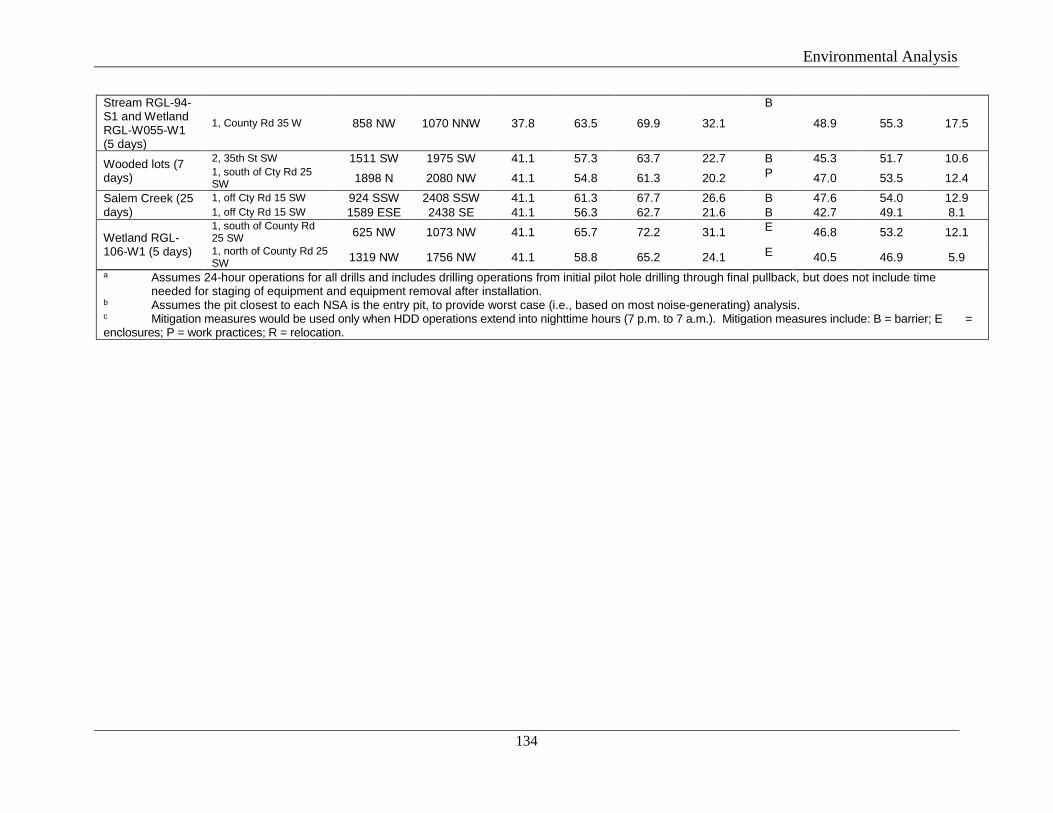
Environmental Analysis
134
Stream RGL-94-S1 and Wetland RGL-W055-W1 (5 days)
1, County Rd 35 W 858 NW 1070 NNW 37.8 63.5 69.9 32.1
B
48.9 55.3 17.5
Wooded lots (7 days)
2, 35th St SW 1511 SW 1975 SW 41.1 57.3 63.7 22.7 B 45.3 51.7 10.6 1, south of Cty Rd 25 SW 1898 N 2080 NW 41.1 54.8 61.3 20.2 P 47.0 53.5 12.4
Salem Creek (25 days)
1, off Cty Rd 15 SW 924 SSW 2408 SSW 41.1 61.3 67.7 26.6 B 47.6 54.0 12.9 1, off Cty Rd 15 SW 1589 ESE 2438 SE 41.1 56.3 62.7 21.6 B 42.7 49.1 8.1
Wetland RGL-106-W1 (5 days)
1, south of County Rd 25 SW 625 NW 1073 NW 41.1 65.7 72.2 31.1 E 46.8 53.2 12.1 1, north of County Rd 25 SW 1319 NW 1756 NW 41.1 58.8 65.2 24.1 E 40.5 46.9 5.9
a Assumes 24-hour operations for all drills and includes drilling operations from initial pilot hole drilling through final pullback, but does not include time needed for staging of equipment and equipment removal after installation. b Assumes the pit closest to each NSA is the entry pit, to provide worst case (i.e., based on most noise-generating) analysis. c Mitigation measures would be used only when HDD operations extend into nighttime hours (7 p.m. to 7 a.m.). Mitigation measures include: B = barrier; E = enclosures; P = work practices; R = relocation.
Environmental Analysis
135
Table B.9.1-2 Estimated Noise Levels for Potential Night-time Drilling at NSAs for HDDs – NL 2019 Project
HDD (Duration in daysa)
NSAs, Number of Residences, Street
Distance, Direction Ambient (Ldn, dBA)
Unmitigated (dBA) If Mitigated (dBA)
Entry Siteb
Exit Siteb
HDD Noise Level
HDD + Ambient (Ldn,)
Increase Above Ambient
Mitig-ationc
HDD Noise Level
HDD + Ambient (Ldn,dBA)
Increase Above Ambient
Rockford to Buffalo Greenfield Lateral Rebecca Park Trail/County Hwy 50 (10 days)
2, Rebecca Park Trail 461 WSW 658 NW 38.3 69.1 75.5 37.2 E 49.7 56.1 17.8
1, Maple St 1233 N 1830 N 38.3 59.2 65.6 27.2 E 40.5 46.9 8.5
Crow River a (30 days)
2, Rebecca Park Trail 466 SW 4031 SSE 38.3 67.6 74.0 35.7 E 49.0 55.4 17.1
1, Maple St 1216 N 2890 SE 38.3 58.5 64.9 26.6 B 45.3 51.7 13.4 Subdiv., Greenwood Ave 1003 NE 4042 N 44.3 60.2 66.6 22.3 B 47.1 53.5 9.2
4, 45th Court SE 1824 SW 4380 NW 44.3 54.1 60.5 16.1 P 47.6 54.0 9.6
Soo Line Railroad (3 days)
1, St Hwy 55 SE 936 E 1034 NE 44.3 63.0 69.4 25.1 B 48.6 55.0 10.6 2, Gabler Ave SE 674 N 950 N 44.3 65.5 71.9 27.5 E 47.7 54.1 9.7 1, north of 37th St SE 858 NW 1087 NW 44.3 63.4 69.8 25.5 E 45.9 52.3 8.0 1, north of 37th St SE 1034 NW 1138 NW 44.3 62.0 68.4 24.1 B 47.7 54.1 9.7
Eastwood Ave and wooded lot (16 days)
4, Eaton Ave SE 691 NW 1110 NE 67.2 66.3 72.7 5.6 W 67.2 67.3 0.1
1, Deegan Dr SE 701 SW 2288 WSW 67.2 65.6 72.0 4.8 W 67.2 67.3 0.1
3, Eaton Ave SE and 23rd St SE 894 N 1701 NE 67.2 64.0 70.4 3.2 W 67.2 67.2 0.1
Wetland RBL-107-W1 (10 days)
4, Eaton Ave SE 1008 E 1590 SSE 67.2 64.0 70.4 3.2 W 67.2 67.2 0.1
1, Deegan Dr SE 1047 SW 1253 SSW 67.2 64.2 70.6 3.4 W 67.2 67.2 0.1
3, Eaton Ave SE and 23rd St SE 1156 NE 1605 E 67.2 63.4 69.8 2.7 W 67.2 67.2 0.0
Wetland RBL-114-W1 (10 days)
3, Eaton Ave SE and 23rd St SE 1678 SE 1950 SE 67.2 62.2 68.6 1.4 W 67.2 67.2 0.0
Wetland RBL-128-W1 (5 days)
3, Deegan Dr SE 364 N 866 NE 36.9 70.4 76.8 39.9 R 49.6 57.8 20.9 1, south of Deegan Dr SE 828 SSW 1101 SE 36.9 63.6 70.0 33.1 B 47.4 55.5 18.7
Deegan Drive SE and wetland RBL-137-W5 (16 days)
2, Deegan Dr and Chamberlain Ave SE 315 N 1455 SE 36.9 71.3 77.7 40.9 R 50.8 59.1 22.2
2, Deegan Dr SE 933 E 2270 SE 36.9 61.2 67.6 30.8 B 46.4 54.4 17.5 Highway 33 SE and wetlands RBL-137-W4,
1, Chamberlain Ave SE 581 W 986 SW 36.9 66.5 72.9 36.0 E 46.5 54.5 17.7
1, County Rd 33 SE 471 SE 670 NE 36.9 68.9 75.3 38.4 R 47.8 55.9 19.0
Environmental Analysis
136
Table B.9.1-2 Estimated Noise Levels for Potential Night-time Drilling at NSAs for HDDs – NL 2019 Project
HDD (Duration in daysa)
NSAs, Number of Residences, Street
Distance, Direction Ambient (Ldn, dBA)
Unmitigated (dBA) If Mitigated (dBA)
Entry Siteb
Exit Siteb
HDD Noise Level
HDD + Ambient (Ldn,)
Increase Above Ambient
Mitig-ationc
HDD Noise Level
HDD + Ambient (Ldn,dBA)
Increase Above Ambient
RBL-147-W1 (10 days)
Wetland RBL-148-W1 and Division Street E (11 days)
1, County Rd 33 SE 862 SE 2169 SSE 36.9 62.0 68.4 31.5 B 46.5 54.6 17.7
1, Division St E 1134 WSW 1578 NW 36.9 60.2 66.6 29.8 B 46.2 54.2 17.3
Frederick Creek and wetlands a (15 days)
2, Carling Avenue NE 1244 W 2316 SW 47.7 58.6 65.1 17.3 B 49.1 53.3 5.6 4, Dague Avenue NE 1259 SE 1617 NE 47.7 59.4 65.8 18.1 B 49.6 54.4 6.7 1, east of Carling Ave NE 211 W 2131 N 47.7 74.9 81.3 33.5 R 55.1 62.8 15.0
Wetland RBL-155-W1 and 10 St NE (10 days)
1, south of 10th St NE 648 NE 785 SE 47.7 66.3 72.8 25.0 E 49.5 54.2 6.4 5, along 10th St NE 1151 SW 1246 NW 47.7 61.0 67.4 19.7 B 49.3 53.8 6.0 4, along 21st Avenue S 1485 NW 1589 SW 47.7 58.4 64.8 17.1 B 49.4 53.9 6.2
Wetland RBL-160-W1 and Stream RBL-160-S2 (10 days)
5, along 10th St NE 1429 SSW 1448 S 47.7 59.0 65.5 17.7 B 49.6 54.5 6.8
1, north of 10th St NE 1002 SW 1754 SW 47.7 61.0 67.4 19.7 B 49.5 54.3 6.5
Wetlands BRL-198-W1 and RBL-198-W2 (20 days)
11, 16th Avenue NE 1170 NW 1793 SW 46.8 59.7 66.1 19.3 B 48.9 54.2 7.4 5, County 20 Hwy 134 & 6th St SE 843 SW 2221 NW 46.8 62.2 68.6 21.9 B 49.5 55.3 8.6
Church, County Hwy 134 843 SW 2243 NW 46.8 62.2 68.6 21.8 B 49.5 55.3 8.6
County Rd 134 NE (7 days)
Church, County Hwy 134 714 SSE 923 SSW 46.8 63.5 71.6 24.8 E 48.9 54.2 7.4
Alexandria Branch Line Loop Extension
Wetland ABL-29-W2 (5 days)
3, 123rd St & 140th Ave 1477 SE 1900 SE 41.1 57.6 64.0 22.9 B 45.6 52.0 10.9
1, 123rd Street 998 SW 1195 SW 41.1 62.1 68.5 27.4 B 47.6 54.0 12.9
Wetland ABL-29-W1 (16 days)
1, 123rd Street 1055 SW 1317 E 41.1 61.3 67.8 26.6 B 47.0 53.4 12.3 2, north of 123rd St 302 N 1149 SW 41.1 71.8 78.2 37.1 R 53.0 59.4 18.3 2, south of 123rd St 338 E 1190 SW 41.1 70.8 77.2 36.1 R 52.0 58.4 17.3 1, south of 123rd St 614 WSW 1824 SW 41.1 65.2 71.6 30.5 E 46.6 53.0 11.9
Private driveway (5 days)
2, north of 123rd St 376 NE 784 NE 41.1 70.3 76.7 35.6 R 51.2 57.7 16.5 2, south of 123rd St 576 E 1099 E 41.1 66.3 72.8 31.6 E 47.4 53.8 12.7 1, south of 123rd St 207 SW 360 SE 41.1 76.0 82.4 41.3 R 56.8 63.2 22.1 1, north of 123rd St 587 NW 998 NW 41.1 66.4 72.8 31.7 E 47.4 53.8 12.7
Environmental Analysis
137
Table B.9.1-2 Estimated Noise Levels for Potential Night-time Drilling at NSAs for HDDs – NL 2019 Project
HDD (Duration in daysa)
NSAs, Number of Residences, Street
Distance, Direction Ambient (Ldn, dBA)
Unmitigated (dBA) If Mitigated (dBA)
Entry Siteb
Exit Siteb
HDD Noise Level
HDD + Ambient (Ldn,)
Increase Above Ambient
Mitig-ationc
HDD Noise Level
HDD + Ambient (Ldn,dBA)
Increase Above Ambient
Neighborhood, Hilton Rd & 123rd Street 608 SW 1133 SW 41.1 65.9 72.3 31.2 E 47.0 53.4 12.3
Great River Road and wooded lot (8 days)
3, Pike Hills Dr 287 NW 689 NE 30.9 72.6 79.0 48.1 R 53.6 60.0 29.1
8, Great River Rd 669 NNW 910 NE 30.9 65.6 72.1 41.2 E 46.2 52.6 21.7
Wetland ABL-21-W1 (10 days)
1, 130th St and Hwy 238 741 NE 1548 NE 30.9 63.7 70.1 39.3 E 44.7 51.1 20.2
1, south on Hwy 238 932 SE 1881 SE 30.9 61.5 67.9 37.0 B 47.4 53.8 23.0
1, south of 130th 859 WSW 1706 WSW 30.9 62.3 68.7 37.9 B 48.3 54.7 23.8
Wetlands ABL-24-W1 and ABL-31-W2 (10 days)
1, south of 130th 620 SW 847 SE 30.9 66.4 72.8 41.9 E 46.9 53.3 22.4
Private driveway and wetlands ABL-11-W1, ABL-31-W1 and ABL-31-W2 (35 days)
1, south of 130th 1287 SE 5280 SE 30.9 57.6 64.0 33.1 W 50.8 57.2 26.4 1, north of 130th 1458 NW 3353 E 30.9 56.5 62.9 32.1 W 49.6 56.0 25.2
1, north of 130th 1330 SE 3340 WNW 30.9 57.5 63.9 33.0 W 50.6 57.0 26.1
Wetlands ABL-3-W1, ABL-22-W1 (13 days)
1, east of 100th Ave 432 N 1906 NW 30.9 68.4 74.8 43.9 E 49.6 56.0 25.2
1, west of 100th Ave 800 W 2467 NW 30.9 62.6 69.0 38.1 B 49.1 55.5 24.6
New Prague Branch Line Loop
Private driveway (duration unknown)
(NSA not defined) 1175 W 1387 W 44.0 60.4 66.8 22.9 B 46.3 52.7 8.8 1, west of 171st Ave 218 NW 300 N 44.0 76.1 82.5 38.5 R 56.6 63.0 19.1 1, on 290th St 400 SE 463 SE 44.0 71.1 77.5 33.5 R 51.5 57.9 13.9 1, intersection of 171st Ave & 290th St 899 SE 1156 SE 44.0 62.9 69.3 25.3 B 48.6 55.1 11.1
County Road 143 (7 days)
1, on 290th St 916 SW 1383 SW 44.0 62.2 68.6 24.7 B 48.2 54.7 10.7 1, intersection of 171st Ave & 290th St 899 SE 1279 S 44.0 62.6 69.0 25.0 B 48.5 54.9 10.9
1, east of 171st Ave 545 SE 565 S 44.0 68.6 75.0 31.0 R 49.0 55.4 11.4 1, east of 171st Ave 396 SE 904 NE 44.0 69.7 76.1 32.1 R 50.8 57.2 13.3
Willmar C-Line Extension
County Road 53, Naples Ave, wooded lot, and
1, 134th Street 993 E 2912 E 51.4 54.9 61.3 9.9 E 53.3 59.7 8.2 1, south off of 134th St 776 SW 1216 E 51.4 56.4 62.8 11.4 E 53.5 60.0 8.5 1, south of Naples Ave 712 S 2155 SW 51.4 56.4 62.8 11.4 E 53.6 60.0 8.6 Cologne Academy 1098 NE 1242 NW 51.4 55.2 61.6 10.2 E 53.3 59.7 8.2
Environmental Analysis
138
Table B.9.1-2 Estimated Noise Levels for Potential Night-time Drilling at NSAs for HDDs – NL 2019 Project
HDD (Duration in daysa)
NSAs, Number of Residences, Street
Distance, Direction Ambient (Ldn, dBA)
Unmitigated (dBA) If Mitigated (dBA)
Entry Siteb
Exit Siteb
HDD Noise Level
HDD + Ambient (Ldn,)
Increase Above Ambient
Mitig-ationc
HDD Noise Level
HDD + Ambient (Ldn,dBA)
Increase Above Ambient
stream WLL-2-S1 (16 days)
Neighborhood, Silver Leaf Trail & Naples Ave
384 NNW 1972 NW 51.4 60.4 66.8 15.3 R 55.0 61.4 10.0
Twin Cities & Western Railroad Company and Highway 212 (10 days)
1, East of Carver County Parks 1037 NE 1299 NE 65.9 61.3 67.8 1.9 W 61.7 68.1 2.2
a Assumes 24-hour operations for all drills and includes drilling operations from initial pilot hole drilling through final pullback, but does not include time needed for staging of equipment and equipment removal after installation.
b Assumes the pit closest to each NSA is the entry pit, to provide worst case (i.e., based on most noise-generating) analysis. c Mitigation measures would be used only when HDD operations extend into nighttime hours (7 p.m. to 7 a.m.). Mitigation measures include: B = barrier; E = enclosures; P = work practices; R = relocation.
Environmental Analysis
139
As shown in table B.9.1-2, the unmitigated HDD noise levels for the NL 2019 Project could exceed 55 dBa Ldn at the majority of NSA locations, which are all residences. In the event that HDD operations would extend into nighttime hours (7 p.m. to 7 a.m.), Northern commits to reduce noise impacts on the NSA to below 55 dBA Ldn between the hours of 10 p.m. and 7 a.m. Noise mitigation options may include, but are not limited to: positioning equipment so noise propagates away from the NSA, the installation of temporary sound barriers (12 to 25 feet tall) between the HDD sites and nearby residences, or voluntary temporary relocation of the residents, especially those residents within approximately 800 feet of the entry or exit pit. Table B.9.1-2 shows what Northern estimates HDD unmitigated and mitigated noise levels would be for the NL 2019 Project; however, final mitigation measures are subject to construction contractor final engineering and design closer to implementation. To ensure that the actual noise from HDD activities remain below 55 dBA Ldn, we recommend that:
• Prior to any nighttime (7 p.m. to 7 a.m.) drilling of HDDs on the NL 2019 Project, Northern should file with the Secretary, for the review and written approval by the Director of OEP, a HDD noise mitigation plan to reduce the projected noise level attributable to the proposed drilling operations at NSAs with predicted unmitigated noise levels above 55 dBA Ldn. During drilling operations, Northern should implement the approved plan, monitor noise levels, include the noise levels in the biweekly construction status reports, and make all reasonable efforts to restrict the noise attributable to the drilling operations to no more than 55 dBA Ldn at the NSAs.
Construction noise for both projects would be short-term and temporary, and any night-
time HDD noise would be mitigated to reduce impacts. Additionally, Northern has committed to minimize engine idling and other non-essential noise impacts and ensuring that all engine-driven machinery is equipped with mufflers. Based on Northern’s proposed mitigation measures and our recommendations, we conclude that construction noise resulting from the Rochester and NL 2019 Projects would not be significant.
B.9.2 Operational Noise
Rochester Project
The Rochester Project would include a new town border station in Olmsted County (Rochester TBS) and the relocation of a regulator from Freeborn to Mower County (MAOP Regulator). No new or additional compression is proposed as part of the Rochester Project and no other sources of operational noise are anticipated on the Rochester Project.
There are four NSAs within a 0.5 mile of the Rochester TBS, the closest of which is 674 feet to the east on Salem Road NW. Operation of the pressure control valves in the MAOP Regulator may increase noise at these nearby NSAs. Northern proposes to install a building to house the control valves to reduce noise and commits to ensuring noise attributable to the station does not exceed 55 dBA Ldn at the NSAs.
There are three NSAs within a 0.5 mile of the newly located MAOP Regulator, with the closest being 650 feet to the east on 560th Ave. Similarly, operation of the pressure control
Environmental Analysis
140
valves in the MAOP Regulator may increase noise at these nearby NSAs, and Northern proposes to install a building to house the control valves to reduce noise. Northern commits to ensuring noise attributable to the facility does not exceed 55 dBA Ldn at the NSAs.
To ensure that noise levels due to operation of these minor aboveground facilities do not significantly impact nearby NSAs, we recommend that:
• Northern should file a noise survey with the Secretary no later than 60 days after placing the Rochester TBS and MAOP Regulator each into service. If a full load condition noise surveys are not possible, Northern should provide an interim survey at the maximum possible horsepower load and provide the full load survey within 6 months. If the noise attributable to the operation of either of these facilities at any load exceeds an Ldn of 55 dBA at any nearby NSAs, Northern should file a report on what changes are needed and install additional noise controls to meet that level within 1 year of the facility’s in-service date. Northern should confirm compliance with the Ldn of 55 dBA requirement by filing a second noise survey with the Secretary no later than 60 days after it installs the additional noise controls.
Based on Northern’s proposed mitigation measures and our recommendation, we conclude that operational noise resulting from the Rochester Project would not be significant.
NL 2019 Project
Northern conducted ambient sound surveys and acoustical analysis for the nearest NSAs to the proposed new Carver Compressor Station and the expanded Faribault and Owatonna Compressor Stations. Table B.9.2-1 summarizes the estimated noise impacts at the nearest NSAs during operations. NSA maps for the NL 2019 Project are included in appendix F.
Mitigation measures that Northern proposes include acoustically insulated compressor buildings; air inlet and exhaust silencers; a unit blowdown silencer; insulated, self-closing, and well-sealed access doors; and, if necessary, acoustical pipe insulation on aboveground outdoor piping.
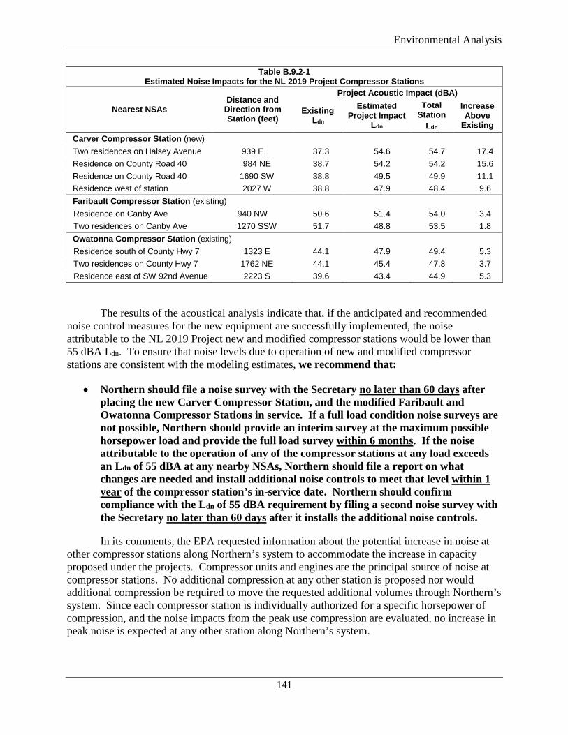
Environmental Analysis
141
Table B.9.2-1 Estimated Noise Impacts for the NL 2019 Project Compressor Stations
Nearest NSAs Distance and
Direction from Station (feet)
Project Acoustic Impact (dBA)
Existing Ldn
Estimated Project Impact
Ldn
Total Station
Ldn
Increase Above
Existing Carver Compressor Station (new) Two residences on Halsey Avenue 939 E 37.3 54.6 54.7 17.4 Residence on County Road 40 984 NE 38.7 54.2 54.2 15.6 Residence on County Road 40 1690 SW 38.8 49.5 49.9 11.1 Residence west of station 2027 W 38.8 47.9 48.4 9.6 Faribault Compressor Station (existing) Residence on Canby Ave 940 NW 50.6 51.4 54.0 3.4 Two residences on Canby Ave 1270 SSW 51.7 48.8 53.5 1.8 Owatonna Compressor Station (existing) Residence south of County Hwy 7 1323 E 44.1 47.9 49.4 5.3 Two residences on County Hwy 7 1762 NE 44.1 45.4 47.8 3.7 Residence east of SW 92nd Avenue 2223 S 39.6 43.4 44.9 5.3
The results of the acoustical analysis indicate that, if the anticipated and recommended noise control measures for the new equipment are successfully implemented, the noise attributable to the NL 2019 Project new and modified compressor stations would be lower than 55 dBA Ldn. To ensure that noise levels due to operation of new and modified compressor stations are consistent with the modeling estimates, we recommend that:
• Northern should file a noise survey with the Secretary no later than 60 days after placing the new Carver Compressor Station, and the modified Faribault and Owatonna Compressor Stations in service. If a full load condition noise surveys are not possible, Northern should provide an interim survey at the maximum possible horsepower load and provide the full load survey within 6 months. If the noise attributable to the operation of any of the compressor stations at any load exceeds an Ldn of 55 dBA at any nearby NSAs, Northern should file a report on what changes are needed and install additional noise controls to meet that level within 1 year of the compressor station’s in-service date. Northern should confirm compliance with the Ldn of 55 dBA requirement by filing a second noise survey with the Secretary no later than 60 days after it installs the additional noise controls.
In its comments, the EPA requested information about the potential increase in noise at other compressor stations along Northern’s system to accommodate the increase in capacity proposed under the projects. Compressor units and engines are the principal source of noise at compressor stations. No additional compression at any other station is proposed nor would additional compression be required to move the requested additional volumes through Northern’s system. Since each compressor station is individually authorized for a specific horsepower of compression, and the noise impacts from the peak use compression are evaluated, no increase in peak noise is expected at any other station along Northern’s system.
Environmental Analysis
142
Based on Northern’s proposed mitigation measures and our recommendation, we conclude that operational noise resulting from the NL 2019 Project would not be significant.
B.10 RELIABILITY AND SAFETY
The transportation of natural gas by pipeline involves some incremental risk to the public due to the potential for accidental release of natural gas. The greatest hazard is a fire or explosion following a major pipeline rupture.
Methane, the primary component of natural gas, is colorless, odorless, and tasteless. Methane is not toxic, but is classified as a simple asphyxiate, possessing a slight inhalation hazard. If breathed in high concentration, oxygen deficiency can result in serious injury or death. Methane has an auto-ignition temperature of 1,000 oF and is flammable at concentrations between 5.0 percent and 15.0 percent in air. An unconfined mixture of methane and air is not explosive; however, it may ignite and burn if there is an ignition source. A flammable concentration within an enclosed space in the presence of an ignition source can explode. Methane is buoyant at atmospheric temperatures and disperses rapidly in air.
B.10.1 Safety Standards
The DOT is mandated to provide pipeline safety under 49 USC Chapter 601. The DOT’s Pipeline and Hazardous Materials Safety Administration (PHMSA) administers the national regulatory program to ensure the safe transportation of natural gas and other hazardous materials by pipeline. PHMSA develops safety regulations and other approaches to risk management that ensure safety in the design, construction, testing, operation, maintenance, and emergency response of pipeline facilities. Many of the regulations are written as performance standards which set the level of safety to be attained and allow the pipeline operator to use various technologies to achieve safety. PHMSA ensures that people and the environment are protected from the risk of pipeline incidents. This work is shared with state agency partners and others at the federal, state, and local level.
Section 5(a) of the Natural Gas Pipeline Safety Act provides for a state agency to assume all aspects of the safety program for intrastate facilities by adoption and enforcing the federal standards, while Section 5(b) permits a state agency that does not qualify under Section 5(a) to perform certain inspection and monitoring functions. A state may also act as DOT's agent to inspect interstate facilities within its boundaries; however, the DOT is responsible for enforcement actions. Minnesota is authorized by PHMSA under 5(a) to assume all aspects of the safety program for intrastate, but not interstate, facilities.
The DOT pipeline standards are published in Parts 190-199 of Title 49 of the CFR. Part 192 specifically addresses natural gas pipeline safety issues. Under a Memorandum of Understanding on Natural Gas Transportation Facilities (Memorandum) dated January 15, 1993, between the DOT and the FERC, the DOT has the exclusive authority to promulgate federal safety standards used in the transportation of natural gas. Section 157.14(a)(9)(vi) of the FERC’s regulations require that an applicant certify that it will design, install, inspect, test, construct, operate, replace, and maintain the facility for which a Certificate is requested in accordance with federal safety standards and plans for maintenance and inspection. Alternatively, an applicant
Environmental Analysis
143
must certify that it has been granted a waiver of the requirements of the safety standards by the DOT in accordance with section 3(e) of the Natural Gas Pipeline Safety Act. The FERC accepts this certification and does not impose additional safety standards. If the Commission becomes aware of an existing or potential safety problem, there is a provision in the Memorandum to promptly alert the DOT. The Memorandum also provides for referring complaints and inquiries made by state and local governments and the general public involving safety matters related to pipelines under the Commission’s jurisdiction.
The FERC also participates as a member of the DOT’s Technical Pipeline Safety Standards Committee, which determines if proposed safety regulations are reasonable, feasible, and practicable.
The pipeline and aboveground facilities associated with the projects must be designed, constructed, operated, and maintained in accordance with the DOT Minimum Federal Safety Standards in 49 CFR 192. The regulations are intended to ensure adequate protection for the public and to prevent natural gas facility accidents and failures. The DOT specifies material selection and qualification; minimum design requirements; and protection from internal, external, and atmospheric corrosion.
The DOT also defines area classifications, based on population density in the vicinity of the pipeline, and specifies more rigorous safety requirements for populated areas. The class location unit is an area that extends 220 yards on either side of the centerline of any continuous 1-mile length of pipeline. The four area classifications are defined below:
Class 1 Location with 10 or fewer buildings intended for human occupancy.
Class 2 Location with more than 10 but less than 46 buildings intended for human occupancy.
Class 3 Location with 46 or more buildings intended for human occupancy or where the pipeline lies within 100 yards of any building, or small well-defined outside area occupied by 20 or more people on at least 5 days a week for 10 weeks in any 12-month period.
Class 4 Location where buildings with four or more stories aboveground are prevalent.
Class locations representing more populated areas require higher safety factors in pipeline design, testing, and operation. For instance, pipelines constructed on land in Class 1 locations must be installed with a minimum depth of cover of 30 inches in normal soil and 18 inches in consolidated rock. Class 2, 3, and 4 locations, as well as drainage ditches of public roads and railroad crossings, require a minimum cover of 36 inches in normal soil and 24 inches in consolidated rock.
Class locations also specify the maximum distance to a sectionalizing block valve (e.g., 10.0 miles in Class 1; 7.5 miles in Class 2; 4.0 miles in Class 3; and 2.5 miles in Class 4). Pipe wall thickness and pipeline design pressures; hydrostatic test pressures; MAOP; inspection and testing of welds; and frequency of pipeline patrols and leak surveys must also conform to higher standards in more populated areas.
Environmental Analysis
144
The two projects would be constructed through Class 1 and 2 areas. Changes in population density near the proposed facilities would be monitored to document that the new facilities meet the appropriate design criteria and safety standards where class locations change. When changes in population density occur, Northern may replace sections of pipe, reduce the operating pressure in the line, or take other similar safety measures to comply with DOT requirements. Northern has designed the projects to Class 2 and Class 3 standards to protect against future class location changes.
The DOT Pipeline Safety Regulations require operators to develop and follow a written integrity management program that contain all the elements described in 49 CFR 192.911 and address the risks on each transmission pipeline segment. The rule establishes an integrity management program which applies to all high consequence areas (HCA).
The DOT has published rules that define HCAs where a natural gas pipeline accident could do considerable harm to people and their property, and requires an integrity management program to minimize the potential for an accident. This definition satisfies, in part, the Congressional mandate for the DOT to prescribe standards that establish criteria for identifying each gas pipeline facility in a high-density population area.
The HCAs may be defined in one of two ways. In the first method an HCA includes:
• current class 3 and 4 locations; • any area in Class 1 or 2 where the potential impact radius10 is greater than 660 feet and
there are 20 or more buildings intended for human occupancy within the potential impact circle11; or
• any area in Class 1 or 2 where the potential impact circle includes an identified site.
An identified site is an outside area or open structure that is occupied by 20 or more persons on at least 50 days in any 12-month period; a building that is occupied by 20 or more persons on at least 5 days a week for any 10 weeks in any 12-month period; or a facility that is occupied by persons who are confined, are of impaired mobility, or would be difficult to evacuate.
In the second method, an HCA includes any area within a potential impact circle which contains:
• 20 or more buildings intended for human occupancy, or • an identified site.
Once a pipeline operator has determined the HCAs along its pipeline, it must apply the elements of its integrity management program to those segments of the pipeline within HCAs.
10 The potential impact radius is calculated as the product of 0.69 and the square root of: the MAOP of the pipeline in psig multiplied by the square of the pipeline diameter in inches.
11 The potential impact circle is a circle of radius equal to the potential impact radius.
Environmental Analysis
145
The DOT regulations specify the requirements for the integrity management plan at section 192.911.
Based on preliminary designs and available aerial imagery, Northern has identified one potential HCA along the NL 2019 Project route, between MPs 1.86 and 2.13 of the Willmar C-line Extension. The Rochester Project would not cross any HCAs. Should the proposed projects be granted a Certificate and analysis confirms the HCA, it would be added to Northern’s Integrity Management Plan. The pipeline integrity management rule for HCAs requires inspection of the pipeline HCAs every 7 years.
The DOT prescribes the minimum standards for operating and maintaining pipeline facilities, including the requirement to establish a written plan governing these activities. Each pipeline operator is required to establish an emergency plan that includes procedures to minimize the hazards of a natural gas pipeline emergency. Key elements of the plan include procedures for:
• receiving, identifying, and classifying emergency events, gas leakage, fires, explosions, and natural disasters;
• establishing and maintaining communications with local fire, police, and public officials, and coordinating emergency response;
• emergency system shutdown and safe restoration of service; • making personnel, equipment, tools, and materials available at the scene of an
emergency; and • protecting people first and then property, and making them safe from actual or potential
hazards.
The DOT requires that each operator establish and maintain liaison with appropriate fire, police, and public officials to learn the resources and responsibilities of each organization that may respond to a natural gas pipeline emergency, and to coordinate mutual assistance. The operator must also establish a continuing education program to enable customers, the public, government officials, and those engaged in excavation activities to recognize a gas pipeline emergency and report it to appropriate public officials. Northern would provide the appropriate training to local emergency service personnel before the projects are placed in service.
B.10.2 Pipeline Accident Data
The DOT requires all operators of natural gas transmission pipelines to notify the DOT of any significant incident and to submit a report within 20 days. Significant incidents are defined as any leaks that:
• caused a death or personal injury requiring hospitalization; or • involve property damage of more than $50,000 (1984 dollars).
During the 20-year period from 1998 through 2015, a total of 1,310 significant incidents were reported on the more than 300,000 total miles of natural gas transmission pipelines nationwide. Additional insight into the nature of service incidents may be found by examining
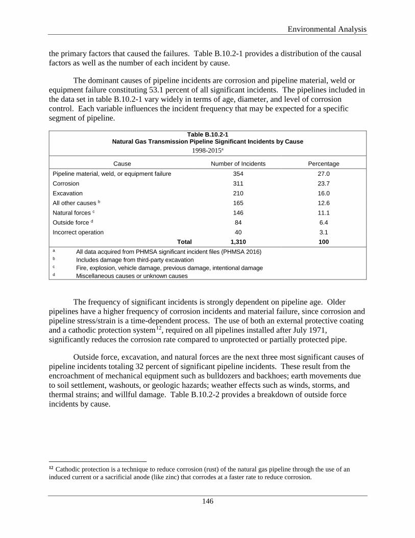
Environmental Analysis
146
the primary factors that caused the failures. Table B.10.2-1 provides a distribution of the causal factors as well as the number of each incident by cause.
The dominant causes of pipeline incidents are corrosion and pipeline material, weld or equipment failure constituting 53.1 percent of all significant incidents. The pipelines included in the data set in table B.10.2-1 vary widely in terms of age, diameter, and level of corrosion control. Each variable influences the incident frequency that may be expected for a specific segment of pipeline.
Table B.10.2-1 Natural Gas Transmission Pipeline Significant Incidents by Cause
1998-2015a
Cause Number of Incidents Percentage Pipeline material, weld, or equipment failure 354 27.0 Corrosion 311 23.7 Excavation 210 16.0 All other causes b 165 12.6 Natural forces c 146 11.1 Outside force d 84 6.4 Incorrect operation 40 3.1
Total 1,310 100 a All data acquired from PHMSA significant incident files (PHMSA 2016) b Includes damage from third-party excavation c Fire, explosion, vehicle damage, previous damage, intentional damage d Miscellaneous causes or unknown causes
The frequency of significant incidents is strongly dependent on pipeline age. Older pipelines have a higher frequency of corrosion incidents and material failure, since corrosion and pipeline stress/strain is a time-dependent process. The use of both an external protective coating and a cathodic protection system12, required on all pipelines installed after July 1971, significantly reduces the corrosion rate compared to unprotected or partially protected pipe.
Outside force, excavation, and natural forces are the next three most significant causes of pipeline incidents totaling 32 percent of significant pipeline incidents. These result from the encroachment of mechanical equipment such as bulldozers and backhoes; earth movements due to soil settlement, washouts, or geologic hazards; weather effects such as winds, storms, and thermal strains; and willful damage. Table B.10.2-2 provides a breakdown of outside force incidents by cause.
12 Cathodic protection is a technique to reduce corrosion (rust) of the natural gas pipeline through the use of an induced current or a sacrificial anode (like zinc) that corrodes at a faster rate to reduce corrosion.
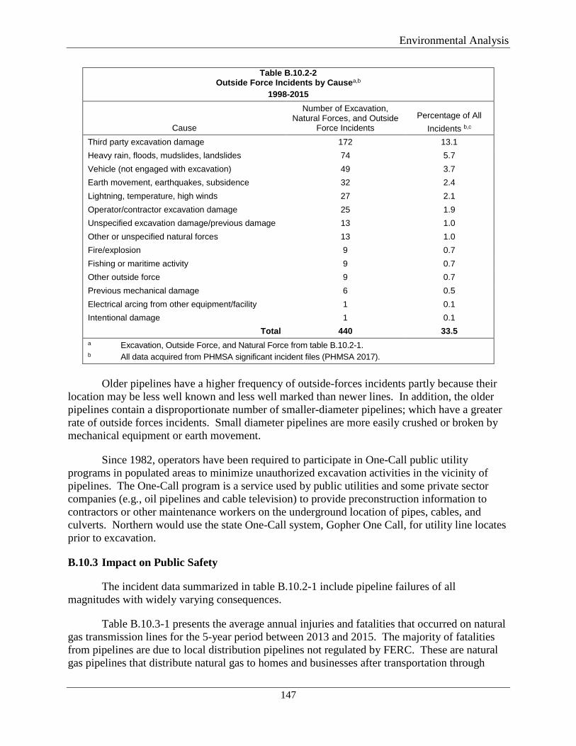
Environmental Analysis
147
Table B.10.2-2 Outside Force Incidents by Causea,b
1998-2015
Cause
Number of Excavation, Natural Forces, and Outside
Force Incidents Percentage of All
Incidents b,c Third party excavation damage 172 13.1 Heavy rain, floods, mudslides, landslides 74 5.7 Vehicle (not engaged with excavation) 49 3.7 Earth movement, earthquakes, subsidence 32 2.4 Lightning, temperature, high winds 27 2.1 Operator/contractor excavation damage 25 1.9 Unspecified excavation damage/previous damage 13 1.0 Other or unspecified natural forces 13 1.0 Fire/explosion 9 0.7 Fishing or maritime activity 9 0.7 Other outside force 9 0.7 Previous mechanical damage 6 0.5 Electrical arcing from other equipment/facility 1 0.1 Intentional damage 1 0.1
Total 440 33.5 a Excavation, Outside Force, and Natural Force from table B.10.2-1. b All data acquired from PHMSA significant incident files (PHMSA 2017).
Older pipelines have a higher frequency of outside-forces incidents partly because their
location may be less well known and less well marked than newer lines. In addition, the older pipelines contain a disproportionate number of smaller-diameter pipelines; which have a greater rate of outside forces incidents. Small diameter pipelines are more easily crushed or broken by mechanical equipment or earth movement.
Since 1982, operators have been required to participate in One-Call public utility programs in populated areas to minimize unauthorized excavation activities in the vicinity of pipelines. The One-Call program is a service used by public utilities and some private sector companies (e.g., oil pipelines and cable television) to provide preconstruction information to contractors or other maintenance workers on the underground location of pipes, cables, and culverts. Northern would use the state One-Call system, Gopher One Call, for utility line locates prior to excavation.
B.10.3 Impact on Public Safety
The incident data summarized in table B.10.2-1 include pipeline failures of all magnitudes with widely varying consequences.
Table B.10.3-1 presents the average annual injuries and fatalities that occurred on natural gas transmission lines for the 5-year period between 2013 and 2015. The majority of fatalities from pipelines are due to local distribution pipelines not regulated by FERC. These are natural gas pipelines that distribute natural gas to homes and businesses after transportation through
Environmental Analysis
148
interstate natural gas transmission pipelines. In general, these distribution lines are smaller diameter pipes and/or plastic pipes which are more susceptible to damage. Local distribution systems do not have large rights-of-way and pipeline markers common to the FERC regulated natural gas transmission pipelines.
Table B.10.3-1 Injuries and Fatalities - Natural Gas Transmission Pipelines a
Year Injuries Fatalities
2013 2 0 2014 1 1 2015 16 6 a All data acquired from PHMSA significant incident files (PHMSA 2016)
The nationwide totals of accidental fatalities from various anthropogenic and natural
hazards are listed in table B.10.3-2 in order to provide a relative measure of the industry-wide safety of natural gas transmission pipelines. Direct comparisons between accident categories should be made cautiously, however, because individual exposures to hazards are not uniform among all categories. The data nonetheless indicate a low risk of death due to incidents involving natural gas transmission pipelines compared to the other categories. Furthermore, the fatality rate is much lower than the fatalities from natural hazards such as lightning, tornadoes, or floods.
Environmental Analysis
149
Table B.10.3-2 Nationwide Accidental Deathsa
Cause Annual Number of Deaths
All accidents 117,809 Motor Vehicle 45,343 Poisoning 23,618 Falls 19,656 Injury at work 5,113 Drowning 3,582 Fire, smoke inhalation, burns 3,197 Floodsb 81 Lightningb 49 Tornadob 72 Tractor Turnover 62 Natural gas distribution linesc 14 Natural gas transmission pipelinesd 2 a All data, unless otherwise noted, reflect 2005 statistics from U.S. Census Bureau, Statistical Abstract of
the United States: 2010 (129th Edition) Washington, DC, 2009. b NOAA National Weather Service, Office of Climate, Water and Weather Services, 30-year average (1985-
2014) http://www.weather.gov/om/hazstats.shtml. c Bureau of Labor Statistics, 2007 Census of Occupational Injuries. d PHMSA significant incident files (PHMSA 2017).
The available data show that natural gas transmission pipelines continue to be a safe, reliable means of energy transportation. From 1996 to 2015, there were an average of 65 significant incidents, 9 injuries, and 2 fatalities per year. The number of significant incidents over the more than 303,000 miles of natural gas transmission lines indicates the risk is low for an incident at any given location. The operation of the projects would represent a slight increase in risk to the nearby public.
Environmental Analysis
150
B.11 CUMULATIVE IMPACTS AND CLIMATE CHANGE
B.11.1 Cumulative Impacts
In accordance with NEPA and FERC policy, we evaluated the potential for cumulative impacts of the NL 2019 Project and Rochester Project. Cumulative impacts were assessed for the proposed projects when added to each other and for each project compared to other past, present, and reasonably foreseeable future activities. The CEQ regulations define cumulative impact as “the impact on the environment which results from the incremental impact of the action [being studied] when added to other past, present, and reasonably foreseeable future actions. Cumulative impacts can result from individually minor, but collectively significant, actions taking place over a period of time.” This cumulative impacts analysis includes actions meeting the following three criteria:
• the action impacts a resource area also potentially impacted by the proposed projects; • the action causes the impacts within all or part of the project area; and • the action causes this impact within all or part of the time span for the potential impacts
from the projects.
As described in section B of this EA, constructing and operating the projects would temporarily and permanently impact the environment. The projects would affect geology and soils, water resources and wetlands, vegetation and wildlife, land use, visual resources, air quality, and noise. However, we conclude that these impacts would not be significant. The proposed facilities could contribute to cumulative impacts on each of these resources; however, Northern would minimize adverse impacts associated with both projects by implementing mitigation measures identified in section B of this EA.
The NL 2019 Project and Rochester Project are located in predominantly rural and agricultural areas in central and southeastern Minnesota. Components of the NL 2019 Project are located near the cities of Rockford, Buffalo, Little Falls, and New Prague, Minnesota. The Rochester Project is located near the city of Rochester, Minnesota. Additional project facilities are located in rural areas that have not had significant residential or industrial development. As the populations of these cities and towns have grown, the natural environment of the areas surrounding them have undergone development and urbanization, which we are considering as part of the environmental baseline.
We defined resource-specific geographic boundaries that were used to conduct our analysis. These are summarized in Table B-11.1-1, below and the justification for each resource-specific boundary. Actions outside of these boundaries are not evaluated because their potential to contribute to a cumulative impact diminishes with increasing distance from the projects. In addition to the geographic scope, the temporal relationship between the projects and other activities in the areas was evaluated. Since both projects would be constructed in 2019, the majority of projects’’ direct impacts are anticipated to occur the same year with restoration quickly following construction. Therefore, short-term (construction-related) cumulative impacts were considered for other actions in the geographic scope and same temporal scope. Operational impacts were evaluated on a long-term basis.
Environmental Analysis
151
In assessing the two projects together, we note that the nearly all of the components of the Rochester Project and the NL 2019 Project are separated by at least 50 kilometers, with the exception of the Owatonna Compressor Station (NL 2019 Project), which is within 50 kilometers of the La Crosse Branch Line MAOP Uprate (Rochester Project).
As such, our cumulative impacts assessment between these two projects focuses on potential interactions from these project components.
Table B.11.1-1 Resource-Specific Geographic Regions for Determining Cumulative Impacts of the Projects
Resource(s) Cumulative Impact Geographic Scope Justification for Geographic Scope Temporal Scope
Geology and Soils
Area of disturbance of the projects and other activities that would be overlapping or abutting each other
Project impacts on geology and soils would be highly localized and limited to the footprints during active construction. Cumulative impacts on geology and soils would only occur if construction of other projects were geographically overlapping or abutting Northern’s projects.
Construction through revegetation
Surface Water Hydrologic Unit Code (HUC)-12 watershed boundary
Impacts on surface waters can result in downstream contamination or turbidity; therefore, the geographic scope we used to assess cumulative impacts on waterbodies is the HUC-12 subwatershed crossed by the projects. We believe this scope would be the reasonable scope in which cumulative impacts could occur on surface waterbodies based on both project areas. However, neither project would directly affect a stream.
Construction through revegetation
Wetlands and Groundwater
Hydrologic Unit Code (HUC)-12 watershed boundary
For similar reasons as stated above in Surface Water, contributions towards cumulative impact on wetlands and groundwater were assessed within the HUC-12 subwatershed.
Construction through revegetation; except areas of permanent conversion of wetlands/ vegetation (including permanent tree clearing)
Vegetation and Wildlife
Hydrologic Unit Code (HUC)-12 watershed boundary
For similar reasons as stated above in Surface Water, contributions towards cumulative impact on vegetation and wildlife were assessed within the HUC-12 subwatershed.
Construction through revegetation; except areas of permanent conversion of vegetation (including permanent tree clearing)
Cultural Resources
Project footprint for direct effects; within 500-1000’ for indirect effects
Project impacts on cultural resources would be highly localized and limited to the footprints during active construction.
Limited to construction duration unless unanticipated permanent impacts on cultural resources (buried or visual) occur
Land Use and Recreation
1.0 mile from the project workspaces
Project impacts on general land uses would be restricted to the construction workspaces. Land use in the project areas is mainly agricultural and open land. Therefore, we considered a 1.0-mile distance from the projects for the
Limited to construction except for areas of permanent land use conversion
Environmental Analysis
152
Table B.11.1-1 Resource-Specific Geographic Regions for Determining Cumulative Impacts of the Projects
Resource(s) Cumulative Impact Geographic Scope Justification for Geographic Scope Temporal Scope
geographic scope because this would cover any land use/recreational impacts, which could be incremental to the projects.
Visual Impacts 0.25 mile from pipelines and 0.50 mile from the aboveground facilities
The geographic scope for assessing cumulative impacts on viewshed includes the surrounding area where a new facility would be visible. Three compressor stations and appurtenant facilities within Northern’s rights-of-way would be constructed. The geographic scope would be limited to areas where clearing of mature trees would occur. Because the area is generally flat to gentle rolling hills, we considered a distance of about 0.5 mile appropriate.
Long term, through operational duration of projects
Socioeconomics and Traffic
Affected county Due to the projects’ limited scope and the short construction duration, the geographic scope for assessing contributions to cumulative impacts on socioeconomics and traffic were evaluated on a county-wide basis.
Limited to construction duration
Air Quality – Construction
0.25 mile from all active construction (pipeline, road crossing, aboveground facilities)
Since construction emissions are localized, the geographic scope used to assess potential cumulative impacts on air from construction activities was set at 0.25 mile from either project area.
Limited to construction duration
Air Quality - Operation
50 km (31 miles) radius from aboveground compression facilities
A conservative geographic scope for the purpose of identifying other projects with the potential to contribute to air quality impacts within 50 km
Long term, through operational duration of projects
Noise – Construction
NSAs within 0.25 mile of conventional construction activities and 0.5 mile of HDD activities.
The geographic scope for assessing potential cumulative impacts on construction noise was determined to be areas within proximity to the construction activities.
Limited to construction duration
Noise-- Operation
1.0 mile surrounding aboveground facilities
The geographic scope identifies other projects that would affect the same NSAs within 1 mile of the compressor stations.
Long term, through operational duration of projects
A summary of the counties and HUC-12 for each NL 2019 and Rochester Project component is included in Table B.11.1-2.
Environmental Analysis
153
Table B.11.1-2 Watersheds Crossed by NL 2019 and Rochester Project Components
Resource(s) County HUC-12 Watershed(s)
Rochester Project
Rochester Greenfield Lateral Olmsted
City of Rochester-South Fork Zumbro River (70400040108)
Town of Rock Dell-South Fork Zumbro River (70400040102)
Town of High Forest - North Branch Root River (70400080104)
Salem Creek (70400040103)
La Crosse Branch Line MAOP Uprate
Freeborn and Mower
Deer Creek (70802010101) Green Valley Ditch - Cedar River (70802010204)
Headwaters Cedar River (70802010201) Town of Litomysl (70400020302)
Rochester TBS Olmsted City of Rochester-South Fork Zumbro River (70400040108)
MAOP Regulator Mower Headwaters Cedar River (70802010201) NL 2019 Project
Rockford to Buffalo Greenfield Lateral
Hennepin and Wright
City of Rockford-Crow River (70102040701) Mill Creek (70102040606)
North Fork Crow River (70102040609) South Fork Crow River (70102050705)
Alexandria Branch Line Loop Extension Morrison
City of Little Falls-Mississippi River (70101040906) Pike Creek (70101040905) Swan River (70101040805)
Zebulon Pike Lake-Mississippi River (70102010703) New Prague Branch Line Loop Le Sueur East Branch Raven Stream (70200120803)
Willmar C-Line Extension Carver Lower Bevens Creek (70200120704) Upper Carver Creek (70200121001)
Carver Compressor Station Carver Lower Bevens Creek (70200120704) Lower Carver Creek (70200121004)
Faribault Compressor Station Rice Cannon Lake-Cannon River (70400020109) Owatonna Compressor Station Steele County Ditch No 27-Le Sueur River (70200110103)
Table B.11.1-3 identifies past, present, and reasonably foreseeable projects or actions that occur within the geographic scope of each resource area. These projects were identified through conversations with local planning and zoning officials, research of publicly available information, and review of aerial and satellite imagery. Maps of the other actions considered in the cumulative impacts analysis for the Rochester and NL 2019 Projects are shown on figure B.11.1-1.
Environmental Analysis
154
Figure B.11.1-1 Other Actions Considered in the Cumulative Impacts Analysis for the Rochester and NL 2019 Projects
Environmental Analysis
155
Table B.11.1-3 Details of other Actions with Potential Cumulative Impacts on Resources within the Geographic and Temporal Scope Considered
Project County / State
Distance and Direction from Proposed Project
Description & Resources Impacted
Approximate Size of Project Footprint
and approximate acreage affected
by Project
Land use
Anticipated Date of
Construction/ Project Status
Resources Considered
PAST AND PRESENT PROJECTS
MERC Project Olmsted County, MN
Abutting the Rochester Greenfield Lateral (Rochester Project at approximate MP 13.5; shares HUC-12 (70400040108)
Three phases of an approximate 13-mile natural gas distribution pipeline around the south and west sides of the City of Rochester. Impacts on soils, surface water, vegetation, cultural, visual, air, and noise resources.
Construction impact of 158.8 acres. Permanent impact of 79.5 acres.
Land uses crossed are predominantly agricultural, but the project also crosses residential, and commercial zoned areas.
Summer 2017 - 2022
Geology, soils, land use and recreation, water resources, vegetation, socioeconomics and traffic, air quality - construction, noise
Water Treatment Building
Carver County, MN
~0.6 mile north of and shares HUC-12 (70200121001) with a portion of the Willmar C-Line extension (NL 2019 Project)
Construction of a new water treatment plant expansion adjacent to existing facility. Potential impacts on land use and water resources.
< 20 acres Open and industrial land. The expansion is located adjacent to the current water treatment plant so limited impact on land use would occur.
Under construction
Land use and water resources
NL 2019 Project – Owatonna Compressor Station
Steele County, MN
~16 miles northwest of a La Crosse Branch Line MAOP Uprate workspace (Rochester Project)
Expansion of an existing compressor station as part of the NL 2019 Project, described in this application.
~12 acres for construction and 5 acres during operation
Primarily agricultural and industrial land.
Concurrent with the Rochester Project
Air quality - operation
FUTURE PROJECTS
Carver Non-jurisdictional facilities
Carver County, MN
Adjacent to Carver Compressor Station (NL 2019 Project) and shares HUC-12 (70200120704 and 70200121004)
Construction of new electric power line and communications line to serve the proposed Carver Compressor Station. Potential impacts on soils and land use.
<0.1 acre Agricultural land Concurrent with NL 2019 Project
Geology and soils, land use and recreation, air quality – construction, visual impacts
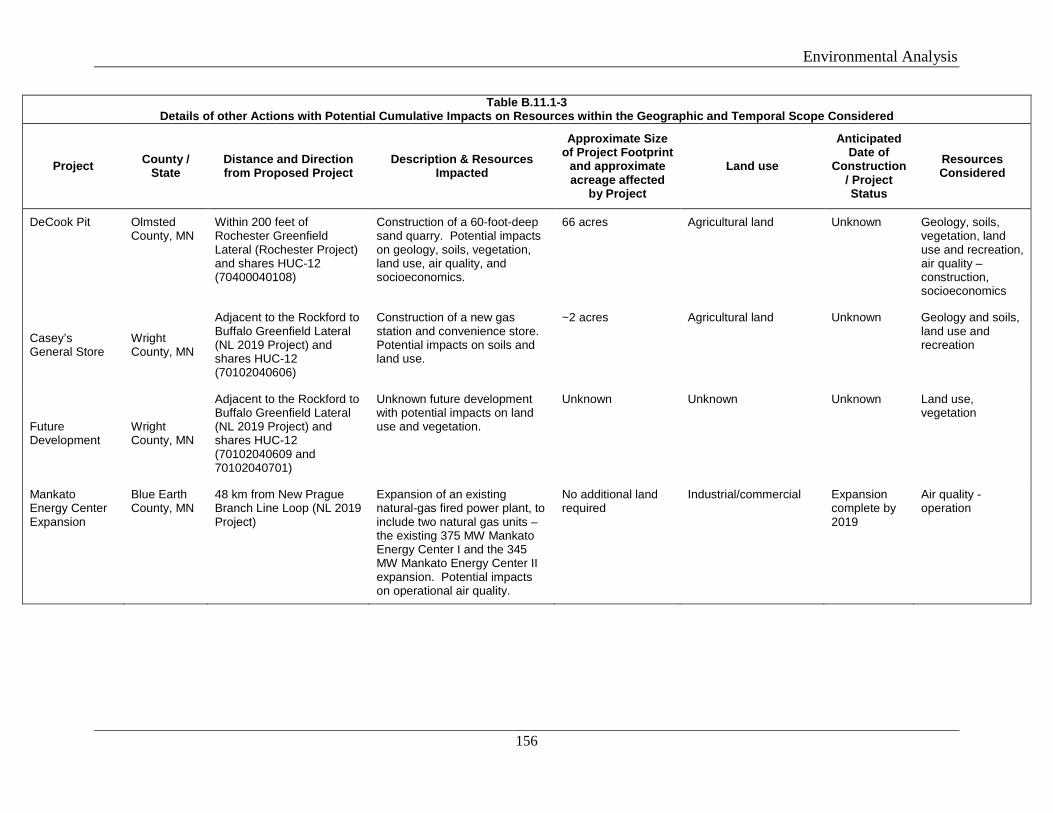
Environmental Analysis
156
Table B.11.1-3 Details of other Actions with Potential Cumulative Impacts on Resources within the Geographic and Temporal Scope Considered
Project County / State
Distance and Direction from Proposed Project
Description & Resources Impacted
Approximate Size of Project Footprint
and approximate acreage affected
by Project
Land use
Anticipated Date of
Construction/ Project Status
Resources Considered
DeCook Pit Olmsted County, MN
Within 200 feet of Rochester Greenfield Lateral (Rochester Project) and shares HUC-12 (70400040108)
Construction of a 60-foot-deep sand quarry. Potential impacts on geology, soils, vegetation, land use, air quality, and socioeconomics.
66 acres Agricultural land Unknown Geology, soils, vegetation, land use and recreation, air quality – construction, socioeconomics
Casey’s General Store
Wright County, MN
Adjacent to the Rockford to Buffalo Greenfield Lateral (NL 2019 Project) and shares HUC-12 (70102040606)
Construction of a new gas station and convenience store. Potential impacts on soils and land use.
~2 acres Agricultural land Unknown Geology and soils, land use and recreation
Future Development
Wright County, MN
Adjacent to the Rockford to Buffalo Greenfield Lateral (NL 2019 Project) and shares HUC-12 (70102040609 and 70102040701)
Unknown future development with potential impacts on land use and vegetation.
Unknown Unknown Unknown Land use, vegetation
Mankato Energy Center Expansion
Blue Earth County, MN
48 km from New Prague Branch Line Loop (NL 2019 Project)
Expansion of an existing natural-gas fired power plant, to include two natural gas units – the existing 375 MW Mankato Energy Center I and the 345 MW Mankato Energy Center II expansion. Potential impacts on operational air quality.
No additional land required
Industrial/commercial Expansion complete by 2019
Air quality - operation
Environmental Analysis
157
The actions considered in our cumulative impact analysis are included based on the likelihood of their impacts coinciding with impacts from either of Northern’s projects, meaning the other actions have current or ongoing impacts or are “reasonably foreseeable.” The actions we considered are those that could affect similar resources during the same timeframe as Northern’s proposed projects. The anticipated cumulative impacts of the projects and these other actions are discussed below.
Geology and Soils
As both the Rochester and NL 2019 Projects’ impact on geology and soils would be highly localized and limited primarily to the footprint during the period of active construction, cumulative impacts on geology and soils would only occur if other geographically overlapping or abutting projects were constructed at the same time (and place) as the projects (and the exposure of soils to erosion and sedimentation) occurs. Four actions identified in table B.11.1-3 fall within the geographic and temporal scopes for geology and soils, including the DeCook Pit, MERC Project, Casey’s General Store, and the Carver Compressor Station non-jurisdictional facilities.
Neither Northern’s projects nor the other actions occurring within the geographic and/or temporal scopes of the projects would result in impacts on mineral resources. Cumulative impacts from geologic hazard impacts would only occur if other projects are constructed at the same time and place as the proposed facilities. Impacts on geologic resources could occur due to construction through karst terrain located along the Rochester Greenfield Lateral. Northern conducted a geotechnical investigation along the Rochester Greenfield Lateral which indicated a small portion of the Rochester Greenfield Lateral crosses areas of shallow bedrock; however, based on the type of bedrock and its weathered condition, Northern would use mechanical methods such as jackhammers or rock teeth on backhoe bucket to excavate in this area. In the remaining areas of the Rochester Greenfield Lateral, bedrock is typically 25 feet below grade and would not be impacted by the open cut or HDD construction methods.
The MERC Project would share a footprint with the Rochester TBS facility, at the north end of the Rochester Greenfield Lateral. However, soil stabilization for the MERC pipeline would likely have been completed prior to commencement of construction activities for the Rochester Project. The Carver Compressor Station non-jurisdictional facilities would be constructed adjacent to the Carver Compressor Station. The Rochester Greenfield Lateral would be located adjacent to the DeCook Pit in Olmsted County; however, the schedule for construction of the quarry is unknown at this time. Northern would implement the FERC’s Plan and Procedures to minimize any soil impacts and contain them within the right-of-way.
In the event ground disturbing activities for the Rochester TBS or Rochester Greenfield Lateral occur at the same time as the MERC Project or the DeCook Pit, and with respect to the Carver Compressor Station and its non-jurisdictional facilities, there would be a minor cumulative increase in the potential for soil erosion from stormwater, high winds, or other soil impacts. However, Northern’s projects would implement BMPs to limit erosion and sedimentation. Northern would implement FERC’s Plan to minimize impacts on soils. We believe that the limited footprint and the measures Northern would adopt to minimize impacts on
Environmental Analysis
158
soils would prevent any significant contribution to cumulative impacts on geology and soils from the proposed projects in consideration with the other identified actions.
Surface Water
The geographic scope for assessing cumulative impacts on surface water resources includes each HUC-12 watershed crossed by the projects. The temporal scope is limited to the duration of construction through revegetation. The actions in table B.11.1-3 that fall within the geographic and temporal scopes for water resources include the MERC Project and the DeCook Pit, which would share a HUC-12 with portions of the Rochester Greenfield Lateral; the Carver Compressor Station non-jurisdictional facilities which would be adjacent to the Carver Compressor Station; the Water Treatment Plant, which is within the same HUC-12 as a portion of the Willmar C-Line Extension; Casey’s General Store which shares a HUC-12 with a portion of the Rockford to Buffalo Greenfield Lateral; and the future development in Wright County, which is within the same HUC-12 as a portion of the Rockford to Buffalo Greenfield Lateral.
Northern would cross all waterbodies by the HDD method, thereby avoiding impacts on waterbodies. The only other actions described above that could also have direct or indirect impacts on waterbodies are the Water Treatment Plant and the MERC Project, which would cross five waterbodies also using HDD. No other surface water features are impacted by any other actions, and Northern would implement the FERC’s Procedures as well as its Plan for Inadvertent Release of Drilling Mud. We do not believe that even if an inadvertent release were to occur, it would result in a significant impact. Therefore, because both projects’ direct impacts on these waterbodies would be avoided by use of HDD and indirect impacts would be adequately minimized by the use of the FERC’s Plan and Procedures and Northern’s Plan for Inadvertent Release of Drilling Mud, we conclude that any contribution to cumulative impacts on waterbodies from the projects in consideration with the other identified actions would be negligible.
Groundwater and Wetlands
Similar to surface water resources, the geographic scope for assessing cumulative impacts on wetlands and groundwater includes each HUC-12 watershed crossed by the projects. The temporal scope is limited to the duration of construction through revegetation, with the exception of areas of permanent conversion of vegetation. Other actions which share geographic and temporal scopes with Northern’s projects are identified in the surface water discussion above. As indicated in section B.3.1, the depth to groundwater is deeper than the trench excavations for open-trench construction. Consequently, impacts from Northern’s proposed projects on groundwater would likely be limited only to HDD activities. There is a chance that HDD construction associated with Northern’s projects, in combination with HDD construction associated with the MERC Project, could result in temporary cumulative impacts within the aquifers if the HDD activities occur concurrently or within several days of one another. If temporary impacts occur, it would likely be limited to short-term turbidity visible in groundwater. We also anticipate that Northern’s SPCC Plan would prevent or minimize the opportunity for and necessitate immediate control and clean-up of spills of fuels, lubricants, or other hazardous material, and would therefore minimize the opportunity for cumulative impacts that could result if other actions were to also result in spills. For these reasons, we conclude that
Environmental Analysis
159
any contribution to cumulative impacts on groundwater from the proposed projects would be negligible.
Construction of Northern’s projects would impact about 2.5 acres of emergent wetlands, and operation of the projects would permanently impact about 0.2 acre of emergent wetland, in total.
The Carver Compressor Station and its non-jurisdictional facilities, DeCook Pit, Casey’s General Store, and Water Treatment Plant would not result in wetland impacts. Wetland impacts associated with the future development in Wright County are not defined but assumed to be none. The only other action that could impact wetlands is the MERC Project, which shares HUC-12 (70400040108) with a portion of the Rochester Greenfield Lateral. The entire Rochester Project would temporarily impact approximately 0.5 acre of wetland and less than 0.1 acre of wetland would be affected by operation of the Rochester Project. However, no wetlands were identified in the Rochester Project workspaces which are within HUC-12 (70400040108). Wetland impacts from the Rochester Project would be minimized by use of standard construction methods and mitigation measures in the Plan, Procedures, and Northern’s SPCC plan.
Since there are only 0.2 acre of permanent wetland impacts associated with Northern’s projects, they would have a negligible contribution to long-term cumulative impacts on emergent wetlands. No other actions were identified within the HUC-12s associated with Northern’s permanent wetland impacts. Therefore, Northern’s project, when considered with other actions in the vicinity, would not result in cumulative impacts on wetlands.
Vegetation and Wildlife
Cumulative impacts on vegetation and wildlife, including threatened and endangered species affected by the projects, could occur in the HUC-12 watersheds crossed by the projects with other actions constructed at the same time. Other actions which share a HUC-12 with Northern’s projects are identified in the surface water discussion above. The construction activities associated with clearing, grading, removal of vegetation, and the potential for the establishment of invasive plant species occurring during the same timeframe and area can result in cumulative impacts. In addition, changes of these environments can also cause alteration of wildlife habitat, displacement of wildlife, and other secondary effects such as forest fragmentation. To account for both direct and indirect effects of the projects, the geographic scope was evaluated to the watershed level for the project areas, which we found appropriate based on the relative rural nature of the construction footprints.
The other actions described above that could also have direct or indirect impacts on vegetation are the MERC Project, DeCook Pit, and the future development in Wright County. Portions of the Rochester Greenfield Lateral, the MERC Project, and the DeCook Pit are within the same HUC-12 (70400040108). Northern’s construction activities within this HUC-12 would primarily impact agricultural land; impacts on local wildlife populations and vegetation would be minimal. A portion of the Rockford to Buffalo Greenfield Lateral is located in the same HUC-12 watersheds as the proposed future development in Wright County. Although the exact scope of the development is not known, vegetation within this portion of the HUC-12 watersheds is primarily agricultural; impacts on local wildlife populations and vegetation will be minimal.
Environmental Analysis
160
Northern designed the Rochester and NL 2019 Projects to minimize impacts on mature forested areas. No substantial changes in land cover, habitat availability, or suitability are anticipated as a result of the proposed Rochester Project. Of the 9.8 acres total of forest impacted by Northern’s projects, about 4.8 acres would be allowed to revegetate to pre-construction conditions, although this would still represent a long-term impact on these forested areas. Similarly, the MERC Project was sited to minimize tree clearing and impacts on wildlife habitats by clearing only 3.5 acres of trees. However, no forested impacts associated with the Rochester Greenfield Lateral would be within the HUC-12 shared by the MERC Project. The impact on vegetation and wildlife from the proposed projects would have a limited cumulative impact when considered with other identified projects.
We anticipate that there would be minor contributions to temporary cumulative impacts on herbaceous vegetation and wildlife species that utilize open space, pastureland, and existing energy corridors where construction of the projects occurs in the same footprint, such as with the MERC Project. However, this land would be allowed to revert to pre-construction conditions following construction of the pipeline and, therefore, would minimize the potential for any significant contribution to cumulative impacts on wildlife or vegetation from the projects.
Land Use, Visual Resources, and Recreation
The construction and operation of the projects and other future actions would require the temporary and permanent use of land, which would result in temporary and permanent impact/conversion of land use. The majority of the projects’ impacts on general land uses would be restricted to the construction workspaces; therefore, the geographic scope for land use and recreation used was 1 mile from the edge of the projects. The temporal scope would be limited to the duration of construction, with the exception of long-term impacts associated with permanent land use conversion and permanent impacts on visual resources. Of the actions identified in table B.11.1-3, all are within the geographic and temporal scope except the Owatonna Compressor Station and the Mankato Energy Center.
The proposed projects would permanently convert a relatively small amount of land (9 acres). Although other actions listed above could result in changes to land use, such as conversion from open areas/agricultural to residential, Northern’s projects would allow most areas to revert to preconstruction conditions. For these reasons, we conclude cumulative impacts on land use would not be significant.
Visual impacts during construction would be minor and temporary and would not contribute to cumulative impacts. However, our cumulative analysis did not identify other projects within the viewshed of the projects’ aboveground facilities; therefore, we conclude any contribution to visual cumulative impacts would not be significant.
The NL 2019 Project has the potential to result in temporary impacts on recreation where it traverses the Lake Rebecca Park Reserve. Access to discrete areas of the reserve could temporarily be restricted to the public during active construction of Northern’s project. However, none of the other actions considered within the geographic scope of the NL 2019 Project would impact recreation within the Lake Rebecca Park Reserve. Therefore, any contribution to cumulative impacts on recreation would be negligible.
Environmental Analysis
161
Cultural Resources
Cumulative impacts on cultural resources would only occur if other actions were to affect the same historic properties as Northern’s projects. Northern would avoid or prepare treatment plans for any historic properties that would be adversely affected, therefore, the projects would not contribute to cumulative impacts on historic properties.
Socioeconomics
We anticipate that the majority of socioeconomic impacts from Northern’s projects would occur within impacted counties and would be limited to the duration of construction. Three of the actions listed in the table above are within the geographic and temporal scope of Northern’s proposed projects, including the MERC Project, DeCook Pit, and the Carver Compressor Station non-jurisdictional facilities. Northern’s projects and these actions have or would generate temporary construction jobs, increased local spending, and tax revenues. In the event that portions of the MERC Project or the DeCook Pit would be constructed prior to the start of Northern’s projects, most socioeconomic impacts would no longer be additive to the Northern projects, with the exception of tax revenues. In addition, the proposed projects would not disproportionately affect racial, ethnic, or low-income population groups. The socioeconomic impact associated with construction of Northern’s projects would be short-term and localized primarily because of the relatively short construction period (about nine months).
If both the Northern projects and the actions identified within the same geographic scope are constructed at the same time, there could be minor contribution to cumulative impacts from increased traffic. Deliveries of pipe and other construction materials could coincide, also resulting in some minor cumulative impact on traffic. These impacts would be expected to be localized, minor, and short-term (only lasting for a few minutes to perhaps a day). Based on this information, we do not anticipate that Northern’s projects, when considered with the other actions, would result in any significant cumulative impact on public services, traffic, or availability of housing.
Noise
Concurrent construction and operation of the projects and other actions in the vicinity of the same NSA could result in cumulative sound level impacts. Noise impacts from the Rochester Project as well as the other actions listed in the table above would only occur during construction activities. Noise impacts associated with the NL 2019 Project compressor stations would be permanent.
Temporary cumulative impacts on noise could occur if an action is being actively constructed within the immediate vicinity and at the same time as construction of Northern’s projects. However, our cumulative analysis did not identify circumstances where another action would occur simultaneously in the same geographic scope with Northern’s projects.
Air Quality
Construction emissions from Northern’s projects and the actions in table B.11.1-3 would be temporary and relatively isolated from each other geographically and temporally.
Environmental Analysis
162
Construction-related air quality impacts would subside once construction activities are complete. As our cumulative analysis did not identify circumstances where another action would occur simultaneously in the same geographic scope with Northern’s projects, we do not anticipate any cumulative air impacts during construction.
The Owatonna Compressor Station (NL 2019 Project) is within the geographic scope for operational air quality of a La Crosse Branch Line MAOP Uprate (Rochester Project) workspace. However, the La Crosse Branch Line MAOP Uprate would have no impacts on air quality during operation; therefore, the Rochester Project would not contribute to cumulative impacts on operational air quality.
The Mankato Energy Center has the potential to impact air quality during operation and is within the geographic scope of the New Prague Branch Line Loop. However, there would be no air quality impacts associated with operation of the New Prague Branch Line Loop; therefore, no cumulative impacts on air quality would occur.
No other actions were identified within 50 kilometers of the NL 2019 Project compressor stations, therefore we do not anticipate any cumulative air impacts from construction of the Projects.
B.11.2 Climate Change
Climate change is the change in climate over time, and cannot be represented by single annual events or individual weather anomalies. While a single large flood event; a particularly cold summer; or warm winter are not necessarily strong indications of climate change; a series of floods or warm years that statistically change the average precipitation or temperature over years or decades may indicate climate change. However, recent research has begun to attribute certain extreme weather events to climate change (USGCRP 2017).
Climate Change is driven by accumulation of GHG in the atmosphere primarily through
combustion of fossil fuels (coal, petroleum, and natural gas), combined with agricultural emissions and clearing of forests. These impacts have accelerated throughout the end of the 20th, and into the 21st Century. Climate change is a global concern, however for this analysis, we will focus on the potential cumulative climate change impacts on the project areas.
The following observations of environmental impacts with a high or very high level of confidence are attributed to climate change in the Midwest region (Melillo, et.al. 2014; NOAA 2017; USGCRP 2017):
• average temperatures have risen about 1.5 °F between 1900 and 2010 and are projected to increase another 4 to 5 °F over the next several decades;
• an increase in health risks due to projected additional heat stress and poor air quality; • the agricultural crop growing season has lengthened since 1950 and is projected to
continue lengthening due to the earlier occurrence of the last spring freeze, potentially increasing crop production in the short-term;
Environmental Analysis
163
• increased temperature stress, wetter springs, and the continued occurrence of springtime cold air outbreaks may reduce crop yields overall in the long-term (particularly corn and soybeans);
• a change in range and/or elevation is projected for many tree species with potential declines in paper birch, quaking aspen, balsam fir, and black spruce and increases in oaks and pines;
• tree species in flat terrain may have difficultly migrating the long distances needed to reach temperatures suitable for the species, resulting in some potential decline in forests;
• increased insect outbreaks, forest fire, and drought may result in increased tree mortality and the reduction in beneficial carbon sinks;
• annual precipitation has increased by about 20 percent over the past century, particularly from increased high intensity rainfall events, and this trend is projected to continue;
• surface water temperatures in the Great Lakes have increased several degrees between 1968 and 2002, and are projected to increase by about 7 to 12 degrees by the end of the century; and
• increased surface water temperatures, increased precipitation, and longer growing seasons are projected to result in an increase in blue-green and toxic algae in the Great Leaks, harming fish and reducing water quality; and
• the rate and magnitude of expected changes will exceed those experienced in the last century.
The USGCRP report states that in the Midwest region “per capita GHG emissions are 22 percent higher than the national average due, in part, to the reliance on fossil fuels, particularly coal for electricity generation.” Natural gas emits less CO2 compared to other fuel sources (e.g., fuel oil or coal). Therefore, the USGCRP report also notes that increased use of natural gas in the Midwest may reduce emissions of GHGs.
We presented the direct and indirect GHG emissions associated with construction and operation of the projects in section B.8. Assuming natural gas delivered by the NL 2019 Project would be used in quantities sufficient to power at year-round capacity the new 345 MW combustion turbine/heat recovery steam generator train authorized on February 14, 2014 in the Major Amendment to the Title V Operating Permit issued by the Minnesota Pollution Control Agency to the Mankato Energy Center (Air Individual Permit 01300098-101), the NL 2019 Project’s downstream GHG (as CO2e) emissions from this new combustion turbine could be as much as 1,585,055 tons per year (Minnesota Pollution Control Agency, 2014). The expansion of the Mankato Energy Center is further discussed in section 11.1 (cumulative impacts)
There is no generally accepted significance criteria for GHG emissions. In addition, we cannot determine the project’s incremental physical impacts on the environment caused by GHG emissions. Therefore we cannot determine whether the projects’ contribution to climate change would be significant. There is no standard methodology to determine whether, and to what extent, a project’s incremental contribution to GHG emissions would result in physical effects on the environment for the purposes of evaluating the project’s impacts on climate change, either locally or nationally. Although certain models do exist, the Commission has determined that they are not necessary or feasible for a NEPA analysis.
Environmental Analysis
164
The construction and operation would increase the atmospheric concentration of GHGs, in combination with past and future emissions from all other sources, and contribute incrementally to future climate change impacts. There is no generally accepted methodology to estimate what extent, a project’s incremental contribution to greenhouse gas emissions would result in physical effects on the environment for the purposes of evaluating the project’s impacts on climate change, either locally or nationally. Because we cannot determine the Project’s incremental physical impacts due to climate change on the environment, we cannot determine whether or not the Project’s contribution to cumulative impacts on climate change would be significant.
B.11.3 Conclusions on Cumulative Impacts
Impacts associated with Northern’s projects would be relatively minor. The impacts from other existing and proposed actions or general activities within the geographic scope of analysis are also expected to be minor. Our project-specific and resource specific (based on appropriate geographic scope) analysis leads us to conclude that the projects would contribute to a negligible cumulative impact when the effects of the proposed projects are added to past, present, and reasonably foreseeable actions.
Alternatives
165
SECTION C – ALTERNATIVES
In preparing this EA, we considered a range of alternatives in order to determine whether they would be environmentally preferable over the NL 2019 and Rochester Projects. We have established several key evaluation criteria to determine whether an alternative would be environmentally preferable; namely:
• technical feasibility and practicality; • significant environmental advantage over the proposed action; and • ability to meet the project’s stated objective.
A discussion of alternatives is generally guided by comments received during scoping, agency input, landowner preferences, and/or the goal of avoiding or reducing impacts on identified environmental resources, as applicable. Other than a comment from the EPA regarding project impacts on the Mississippi River (discussed in section C.3, below), we did not receive comments that would inform us to a detailed evaluation of any specific alternatives. However, in accordance with NEPA and Commission policy, we did evaluate the no-action alternative. We also provide an overview of system alternatives and siting options for the Carver Compressor Station, although we ultimately determined that a detailed evaluation of these alternatives was not warranted. Likewise, we discuss several route alternatives and variations in the context of project development and design and addressing specific landowner requests and preferences.
C.1 NO-ACTION ALTERNATIVE
Under the no-action alternative, the environmental impacts associated with each project and analyzed in this EA would not occur. However, Northern’s objective of providing natural gas to meet near-term demand for its customers would not occur. This includes the delivery of natural gas to heat homes and businesses, supplying natural gas for appliance and machinery operation, and supplying gas to industrial plant operations, including the Mankato Energy Center. The customers, however, would still require additional natural gas transportation capacity to meet residential, commercial, and industrial growth demands. Alternatively, Northern’s customers could investigate the potential to use other sources of energy to meet the demands that would be met by the proposed projects; however, their willingness and ability to do so is speculative and outside the scope of our analysis here. Therefore, this alternative would not satisfy the third criterion above that considers the alternative’s ability to meet the purpose and need for the projects; as such, we do not recommend it.
C.2 SYSTEM ALTERNATIVES
System alternatives are those that generally use existing, modified, or other proposed pipeline systems to meet the purpose and need of a project, rather than constructing a brand new project. Northern operates more than 14,700 miles of natural gas transmission pipelines as an integrated system, with interdependent hydraulics and engineering. Recently, Northern has expanded parts of it system to provide additional natural gas service, meet specific customer
Environmental Analysis
166
needs, and to implement various upgrades.13 Thus, Northern continually assesses its overall pipeline system in order to meet increasing service demands in an efficient and timely manner. FERC’s prior environmental reviews of these actions have shown them to be environmentally acceptable as well.
Northern conducted its own internal systems assessment for the currently proposed NL 2019 and Rochester Projects, and proposed the facilities it believes necessary to meet each project’s purpose and need. For example, Northern considered a compression-only alternative, which would involve no new pipeline; however, because the customer delivery point locations are not adjacent to existing pipeline infrastructure, this alternative would not meet Northern’s objectives and was not further evaluated. Northern also considered two other project configurations that maximized the amount of looping and collocation, rather than construction across greenfield sites; however, these configurations would result in a greater amount of total right-of-way of anywhere from 50 to 120 miles.14 We have reviewed Northern’s filed materials and, because each project as proposed would not result in significant environmental impact, nor did we receive any comments to the effect that Northern could design a more efficient or less environmentally impactful project to meet the needs as proposed, we did not further evaluate alternatives using Northern’s pipeline system.
At times, other existing pipeline systems can meet some (or all) of the stated objective of a proposed project. Two other natural gas pipeline systems (Northern Border Pipeline Company and Viking Gas Transmission Company) operate in the same general area as Northern. A preliminary investigation by Northern indicated that use of either of these systems would require the construction of at least 100 miles of new pipeline, as well as new delivery stations and additional compression. Similar to our discussion above, we reviewed this information and concluded we did not need to further evaluate alternatives on these systems, due to no obvious environmental advantage and no comments filed suggesting that the objectives of Northern’s two proposed projects could be met by either of these other two systems.
C.3 ROUTE ALTERNATIVES AND VARIATIONS
During project design and development, Northern considered several route options for its Rochester Greenfield Lateral (Rochester Project) and for the Rockford to Buffalo Lateral (NL 2019 Project).15 In both cases, environmental impacts associated with the alternate routing appeared to be similar or greater compared to the route ultimately proposed by Northern in its FERC Application. Also, no driving environmental comments were received or discovered that would lead us to conduct our own detailed evaluation of route alternatives.
13 See, for example the Cedar Station Upgrade Project (FERC Docket No. CP16-487-000), the Northern Lights 2017 Expansion Project (CP16-472-000), and the Marquette Branch Line Expansion Project (CP18-81-000).
14 This information can be found in Northern’s filed Resource Report 10, which can be accessed via FERC’s eLibrary at Accession no. 20180727-5220.
15 Northern’s discussion of these options, including maps can accessed via FERC’s eLibrary at Accession no. 20180727-5220.
Environmental Analysis
167
During the pre-filing process, the EPA and several landowners requested additional information on the Alexandria Branch Line Loop Extension and the NL 2019 Project’s need to cross the Mississippi River. At that time, Northern was exploring various project design and routing options for the loop extension, including a pipeline crossing of the Mississippi River. However, Northern, in discussion with landowners and the EPA, engineered a solution that would avoid impacts on the Mississippi River. Specifically, the pipeline would be constructed as two segments, with the loop extension being re-started downstream of the Mississippi River. According to Northern, the purpose of the Alexandria Branch Line Loop Extension would still be met without installing new pipe under the Mississippi River, and Northern states that the configuration is engineered to addresses hydraulic and pressure loss concerns. Thus, no further alternatives evaluation is necessary.
During the preliminary design stage for the projects, Northern participated in our pre-filing process. This process emphasizes identification of potential stakeholder issues early in the development of a project, as well as identification and evaluation of alternatives and options that may avoid or minimize these issues. During this process, Northern identified and evaluated several route variations. Route variations are relatively short deviations (generally in proximity to the proposed route) that would avoid or further reduce impacts on specific localized resources. Route variations are typically identified in response to specific local concerns, such as property-specific concerns of landowners, and do not result in significant departure from the original alignment.
Rochester Project Route Variations
During development of the Rochester Greenfield Lateral and in discussions with landowners and the MNDNR, Northern identified and evaluated four minor route variations that address specific landowner concerns, such as property avoidance, avoiding impacts on a pine tree plantation, and a wooded area. Northern also revised its route to avoid a proposed quarry that was identified by MNDNR.
NL 2019 Project Route Variations
During development of the Rockford to Buffalo Greenfield Lateral, and in response to scoping comments, Northern identified and evaluated three minor route variations. For example, The Three Rivers Park District expressed concern over impacts within the Rebecca Lake Park Preserve. The Three Rivers Park District, which oversees the preserve, requested that the HDD exit pit be sited outside of an area containing newly planted trees. Northern incorporated this variation into the route which accommodates the Three Rivers Park District Request. The second instance was based on information Northern received from the City of Buffalo regarding a proposed commercial development (Casey’s General Store) near MP 9.9. Northern revised its planned route to avoid future impacts on the future development site. The other route variation was adopted as a result of a request by the City of Rockford to avoid an area slated for future residential and/or industrial development.
Because these route variations were adopted by Northern during pre-filing, they are a part of the officially proposed project and as such, the environmental impacts are evaluated in section
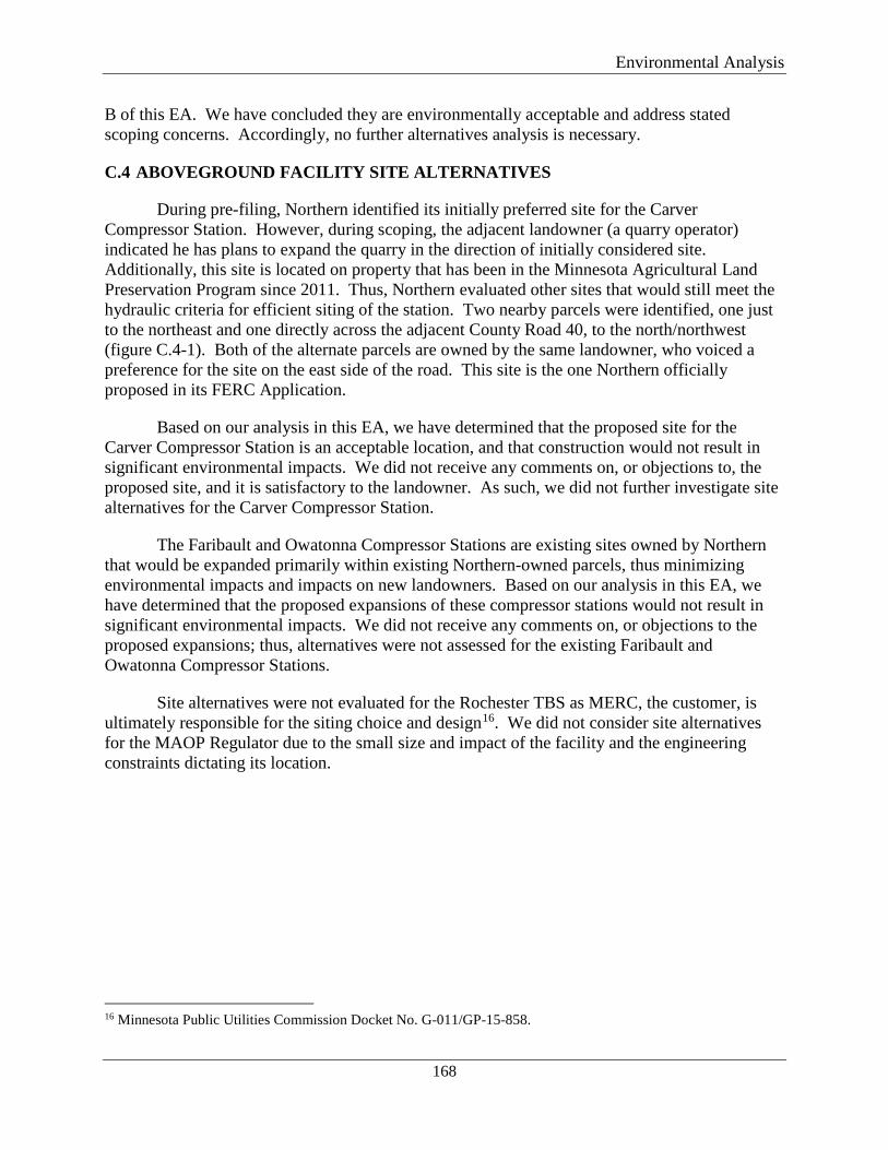
Environmental Analysis
168
B of this EA. We have concluded they are environmentally acceptable and address stated scoping concerns. Accordingly, no further alternatives analysis is necessary.
C.4 ABOVEGROUND FACILITY SITE ALTERNATIVES
During pre-filing, Northern identified its initially preferred site for the Carver Compressor Station. However, during scoping, the adjacent landowner (a quarry operator) indicated he has plans to expand the quarry in the direction of initially considered site. Additionally, this site is located on property that has been in the Minnesota Agricultural Land Preservation Program since 2011. Thus, Northern evaluated other sites that would still meet the hydraulic criteria for efficient siting of the station. Two nearby parcels were identified, one just to the northeast and one directly across the adjacent County Road 40, to the north/northwest (figure C.4-1). Both of the alternate parcels are owned by the same landowner, who voiced a preference for the site on the east side of the road. This site is the one Northern officially proposed in its FERC Application.
Based on our analysis in this EA, we have determined that the proposed site for the Carver Compressor Station is an acceptable location, and that construction would not result in significant environmental impacts. We did not receive any comments on, or objections to, the proposed site, and it is satisfactory to the landowner. As such, we did not further investigate site alternatives for the Carver Compressor Station.
The Faribault and Owatonna Compressor Stations are existing sites owned by Northern that would be expanded primarily within existing Northern-owned parcels, thus minimizing environmental impacts and impacts on new landowners. Based on our analysis in this EA, we have determined that the proposed expansions of these compressor stations would not result in significant environmental impacts. We did not receive any comments on, or objections to the proposed expansions; thus, alternatives were not assessed for the existing Faribault and Owatonna Compressor Stations.
Site alternatives were not evaluated for the Rochester TBS as MERC, the customer, is ultimately responsible for the siting choice and design16. We did not consider site alternatives for the MAOP Regulator due to the small size and impact of the facility and the engineering constraints dictating its location.
16 Minnesota Public Utilities Commission Docket No. G-011/GP-15-858.
Alternatives
169
Figure C.4-1 Carver Compressor Station Site Alternatives
Conclusions and Recommendations
170
SECTION D – STAFF’S CONCLUSIONS AND RECOMMENDATIONS
Based upon the analysis in this EA, we have determined that if Northern constructs and operates the proposed facilities in accordance with its application, supplements, and staff’s recommended mitigation measures below, approval of the Rochester Project and NL 2019 Project would not constitute a major federal action significantly affecting the quality of the human environment.
We recommend that the Commission Order contain a finding of no significant impact and that the following mitigation measures be included as conditions to any Certificate the Commission may issue:
1. Northern shall follow the construction procedures and mitigation measures described in its application and supplements (including responses to staff data requests) and as identified in the EA, unless modified by the Order. Northern must:
a. request any modification to these procedures, measures, or conditions in a filing with the Secretary;
b. justify each modification relative to site-specific conditions;
c. explain how that modification provides an equal or greater level of environmental protection than the original measure; and
d. receive approval in writing from the Director of OEP before using that modification.
2. The Director of OEP, or the Director’s designee, has delegated authority to address any requests for approvals or authorizations necessary to carry out the conditions of the Order, and take whatever steps are necessary to ensure the protection of environmental resources during construction and operation of the projects. This authority shall allow:
a. the modification of conditions of the Order;
b. stop-work authority; and
c. the imposition of any additional measures deemed necessary to ensure continued compliance with the intent of the conditions of the Order as well as the avoidance or mitigation of unforeseen adverse environmental impact resulting from project construction and operation.
3. Prior to any construction, Northern shall file an affirmative statement with the Secretary for both projects, certified by a senior company official, that all company personnel, environmental inspectors (EIs), and contractor personnel will be informed of the EI’s authority and have been or will be trained on the implementation of the environmental mitigation measures appropriate to their jobs before becoming involved with construction and restoration activities.
Conclusions and Recommendations
171
4. The authorized facility locations for each project shall be as shown in the EA, as supplemented by filed alignment sheets, and shall include the right-of-way modifications identified in condition number 12. As soon as they are available, and before the start of construction, Northern shall file with the Secretary any revised detailed survey alignment maps/sheets at a scale not smaller than 1:6,000 with station positions for the facility approved by the Order. All requests for modifications of environmental conditions of the Order or site-specific clearances must be written and must reference locations designated on these alignment maps/sheets.
Northern’s exercise of eminent domain authority granted under NGA Section 7(h) in any condemnation proceedings related to the Order must be consistent with these authorized facilities and locations. Northern’s right of eminent domain granted under NGA Section 7(h) does not authorize it to increase the size of its natural gas facilities to accommodate future needs or to acquire a right-of-way for a pipeline to transport a commodity other than natural gas.
5. Northern shall file with the Secretary detailed alignment maps/sheets and aerial photographs at a scale not smaller than 1:6,000 identifying all route realignments or facility relocations, and staging areas, pipe storage yards, new access roads, and other areas that would be used or disturbed and have not been previously identified in filings with the Secretary. Approval for each of these areas must be explicitly requested in writing. For each area, the request must include a description of the existing land use/cover type, documentation of landowner approval, whether any cultural resources or federally listed threatened or endangered species would be affected, and whether any other environmentally sensitive areas are within or abutting the area. All areas shall be clearly identified on the maps/sheets/aerial photographs. Each area must be approved in writing by the Director of OEP before construction in or near that area.
This requirement does not apply to extra workspace allowed by FERC’s Plan and/or minor field realignments per landowner needs and requirements that do not affect other landowners or sensitive environmental areas such as wetlands. Examples of alterations requiring approval include all route realignments and facility location changes resulting from:
a. implementation of cultural resources mitigation measures;
b. implementation of endangered, threatened, or special concern species mitigation measures;
c. recommendations by state regulatory authorities; and
d. agreements with individual landowners that affect other landowners or could affect sensitive environmental areas.
6. Within 60 days of the acceptance of the Certificate and before construction begins, Northern shall file an Implementation Plan for the projects with the Secretary for review and written approval by the Director of OEP. Northern must file revisions to the plan as schedules change. The plan shall identify:
Conclusions and Recommendations
172
a. how Northern will implement the construction procedures and mitigation measures described in its application and supplements (including responses to staff data requests), identified in the EA, and required by the Order;
b. how Northern will incorporate these requirements into the contract bid documents, construction contracts (especially penalty clauses and specifications), and construction drawings so that the mitigation required at each site is clear to onsite construction and inspection personnel;
c. the number of EIs assigned, and how the company will ensure that sufficient personnel are available to implement the environmental mitigation;
d. company personnel, including EIs and contractors, who will receive copies of the appropriate material;
e. the location and dates of the environmental compliance training and instructions Northern will give to all personnel involved with construction and restoration (initial and refresher training as the project progresses and personnel change);
f. the company personnel (if known) and specific portion of Northern’s organization having responsibility for compliance;
g. the procedures (including use of contract penalties) Northern will follow if noncompliance occurs; and
h. for each discrete facility, a Gantt or PERT chart (or similar project scheduling diagram), and dates for:
i. the completion of all required surveys and reports;
ii. the environmental compliance training of onsite personnel;
iii. the start of construction; and
iv. the start and completion of restoration.
7. Northern shall employ at least one EI per construction spread. The environmental inspectors shall be:
a. responsible for monitoring and ensuring compliance with all mitigation measures required by the Order and other grants, permits, certificates, or other authorizing documents;
b. responsible for evaluating the construction contractor's implementation of the environmental mitigation measures required in the contract (see condition 6 above) and any other authorizing document;
Conclusions and Recommendations
173
c. empowered to order correction of acts that violate the environmental conditions of the Order, and any other authorizing document;
d. responsible for documenting compliance with the environmental conditions of the Order, as well as any environmental conditions/permit requirements imposed by other federal, state, or local agencies; and
e. responsible for maintaining status reports.
8. Beginning with the filing of its Implementation Plan, Northern shall file updated status reports for the projects with the Secretary on a biweekly basis until all construction and restoration activities are complete. On request, these status reports will also be provided to other federal and state agencies with permitting responsibilities. Status reports shall include:
a. an update on Northern’s efforts to obtain the necessary federal authorizations;
b. the construction status of the projects, work planned for the following reporting period, and any schedule changes for dry-wash crossings or work in other environmentally sensitive areas;
c. a listing of all problems encountered and each instance of noncompliance observed by the environmental inspector(s) during the reporting period (both for the conditions imposed by the Commission and any environmental conditions/permit requirements imposed by other federal, state, or local agencies);
d. a description of the corrective actions implemented in response to all instances of noncompliance;
e. the effectiveness of all corrective actions implemented;
f. a description of any landowner/resident complaints that may relate to compliance with the requirements of the Order, and the measures taken to satisfy their concerns; and
g. copies of any correspondence received by Northern from other federal, state, or local permitting agencies concerning instances of noncompliance, and Northern’s response.
9. Northern must receive written authorization from the Director of OEP before commencing construction of any project facilities. To obtain such authorization, Northern must file with the Secretary documentation that it has received all applicable authorizations required under federal law (or evidence of waiver thereof).
10. Northern must receive written authorization from the Director of OEP before placing the projects into service. Such authorization will only be granted following a determination that rehabilitation and restoration of the right-of-way and other areas affected by the projects are proceeding satisfactorily.
Conclusions and Recommendations
174
11. Within 30 days of placing the authorized facilities in service, Northern shall file an affirmative statement with the Secretary, certified by a senior company official:
a. that the facilities have been constructed in compliance with all applicable conditions, and that continuing activities will be consistent with all applicable conditions; or
b. identifying which of the conditions in the Order Northern has complied with or will comply with. This statement shall also identify any areas affected by the projects where compliance measures were not properly implemented, if not previously identified in filed status reports, and the reason for noncompliance.
12. Northern shall reduce the offset of its Alexandria Branch Line Loop Extension, New Prague Branch Line Loop, and Willmar C-Line Extension in all locations where the pipelines are immediately adjacent to its existing operational right-of-way and restrict the new permanent right-of-way width along these locations to a maximum of 25 feet immediately adjacent to its existing operation right-of-way.
13. Northern shall not begin construction of the Rochester or the NL 2019 Project facilities,
including use of staging, storage, or temporary work areas and new or to-be-improved access roads until: a. Northern files with the Secretary:
i. remaining cultural resources survey report(s) and addendum(s);
ii. site evaluation report(s) and avoidance/treatment plan(s), as required; and
iii. the Minnesota SHPO’s comments on the cultural resources reports, addendums, and plans;
b. the Advisory Council on Historic Preservation is afforded an opportunity to comment
if historic properties would be adversely affected; and
d. the FERC staff reviews and the Director of OEP approves the cultural resources reports and plans and notifies Northern in writing that treatment plans/mitigation measures (including archaeological data recovery) may be implemented and/or construction may proceed.
All materials filed with the Commission containing location, character, and ownership information about cultural resources must have the cover and any relevant pages therein clearly labeled in bold lettering: “CUI//PRIV - DO NOT RELEASE.”
14. Prior to any nighttime (7 p.m. to 7 a.m.) drilling of HDDs on the Rochester Project and the NL 2019 Project, Northern shall file with the Secretary, for the review and written approval by the Director of OEP, a HDD noise mitigation plan to reduce the projected noise level attributable to the proposed drilling operations at NSAs with
Conclusions and Recommendations
175
predicted unmitigated noise levels above 55 dBA Ldn. During drilling operations, Northern should implement the approved plan, monitor noise levels, include the noise levels in the biweekly construction status reports, and make all reasonable efforts to restrict the noise attributable to the drilling operations to no more than 55 dBA Ldn at the NSAs.
15. Northern shall file a noise survey with the Secretary no later than 60 days after placing
the Rochester TBS and MAOP Regulator each into service. If full load condition noise surveys are not possible, Northern shall provide an interim survey at the maximum possible horsepower load and provide the full load survey within 6 months. If the noise attributable to the operation of either of these facilities at any load exceeds an Ldn of 55 dBA at any nearby NSAs, Northern shall file a report on what changes are needed and install additional noise controls to meet that level within 1 year of the facility’s in-service date. Northern shall confirm compliance with the Ldn of 55 dBA requirement by filing a second noise survey with the Secretary no later than 60 days after it installs the additional noise controls.
16. Northern shall file a noise survey with the Secretary no later than 60 days after placing the new Carver Compressor Station, and the modified Faribault and Owatonna Compressor Stations in service. If full load condition noise surveys are not possible, Northern shall provide an interim survey at the maximum possible horsepower load and provide the full load survey within 6 months. If the noise attributable to the operation of any of the compressor stations at any load exceeds an Ldn of 55 dBA at any nearby NSAs, Northern shall file a report on what changes are needed and install additional noise controls to meet that level within 1 year of the compressor station’s in-service date. Northern shall confirm compliance with the Ldn of 55 dBA requirement by filing a second noise survey with the Secretary no later than 60 days after it installs the additional noise controls.
List of Preparers
176
SECTION E – LIST OF PREPARERS
Yuan, Julia – Environmental Project Manager, Land Use, Socioeconomics M.P.S., Natural Resources Management, 2003, State University of New York, College of
Environmental Science and Forestry B.S., Environmental Biology/Forestry, 1999, State University of New York, College of
Environmental Science and Forestry Boros, Laurie – Cultural Resources B.A., Anthropology/Archaeology, 1980, City University of New York, Queens College Kragie, S. Xiah – Air, Noise, and Safety
M.A., Geochemistry, 2013, Columbia University M.P.H., Global Environmental Health, 2008, Emory University B.S., Civil & Environmental Engineering, 2006, University of Maryland, College Park
Rodgers, J. Keith – Geology, Soils, Groundwater B.S., Geological Sciences with Geochemistry Option; 2004; Virginia Tech M.E., Water Resources, 2008, University of Arizona
Zielinski, Jennifer – Water Resources, Vegetation, Wildlife M.S., Environmental Policy, 2015, George Washington University B.S., Environmental Science, 2010, University of Delaware
References
177
SECTION F – REFERENCES
Adams, R. and Barry, J. Green 2016. Minnesota regions prone to surface karst feature development, MNDNR Ecological and Water Resources Division, Series GW-01, St. Paul, Minnesota.
American Hospital Directory 2018. Individual Hospital Statistics for Minnesota. Available
online at: https://www.ahd.com/states/hospital_MN.html accessed February 12, 2018. American Petroleum Institute (API) 1999. API 1104: Standard for Welding of Pipelines and
Related Facilities. Available online at: https://law.resource.org/pub/us/cfr/ibr/002/api.1104.1999.pdf (Version September, 1999) Accessed February 12, 2018.
Council on Environmental Quality (CEQ) 1997. Considering Cumulative Effects Under the
National Environmental Policy Act, Council on Environmental Quality Executive Office of the President.
City of Rockford 2016. 2016 Drinking Water Report, Consumer Confidence Report. Federal Emergency Management Agency (FEMA) 2016. Risk Mapping, Assessment, and
Planning (Risk MAP). Available online at: https://www.fema.gov/risk-mapping-assessment-and-planning-risk-map. Accessed February 15, 2018.
Helgesen, J.O. 2009. Appraisal of Ground Water for Irrigation in the Little Falls Area, Morrison
County, Minnesota. Morrison County Soil and Water Conservation District, MNDNR division of Water, Soils, and Minerals.
Hodgson, John and Miriam Hernandez. March 2018a. Phase I Archaeological and Cultural
Resource Investigation Results, Proposed Northern Natural Gas Rochester Project; Olmsted, Freeborn and Mower Counties, Minnesota; and Northern Lights 2019 Expansion Project in Hennepin, Wright, Carver, Le Sueur, Morrison, Rice and Steele Counties, Minnesota
Hodgson, John and Miriam Hernandez. July 2018b. Phase I Archaeological and Cultural
Resource Investigation Results, Proposed Northern Natural Gas Rockford to Buffalo Natural Gas Pipeline Lateral Project; Hennepin and Wright Counties, Minnesota.
Hodgson, John and Miriam Hernandez. July 2018c. Phase I Archaeological and Cultural
Resource Investigation Results, Proposed Northern Natural Gas Rochester Project; Olmsted, Freeborn and Mower Counties, Minnesota; and Northern Lights 2019 Expansion Project in Hennepin, Wright, Carver, Le Sueur, Morrison, Rice and Steele Counties, Minnesota (Supplemental Information Report)
References
178
Melillo, Jerry M.; Terese (T.C.) Richmond; and Gary W. Yohe, Eds. 2014: Climate Change Impacts in the United States: The Third National Climate Assessment. U.S. Global Change Research Program, 841 pp. doi:10.7930/J0Z31WJ2.
Minnesota Geological Survey (MGS) 1966. Paleoecology of the Cambrian and Ordovician Strata of Minnesota. Webers, G.F.
_____1988. Olmsted County Geologic Atlas. Available online at:
http://www.dnr.state.mn.us/waters/programs/ gw_section/mapping/platesum/olmscga.html. Accessed February 2, 2018.
_____1994. Minnesota at a Glance, Precambrian Geology. Available online at:
https://conservancy.umn.edu/ bitstream/handle/11299/59433/MN_subsurface.pdf?sequence=4. Accessed February 2, 2018.
_____2000. Minnesota at a Glance, Ancient tropical seas – Paleozoic history of Southeastern
Minnesota. Available online at: ftp://mgsweb2.mngs.umn.edu/pub2/mnglance/Paleozoic_bdrk.pdf. Accessed February 2, 2018.
_____2018. Minnesota County Well Index. Available online at:
http://www.health.state.mn.us/divs/eh/cwi/. Accessed March 13, 2018. Minnesota Department of Agriculture (MNDA) 2018a. Emerald Ash Borer Early Detection and
Rapid Response. Available online at: https://www.mda.state.mn.us/emeraldashborer. Accessed July 2018.
_____2018b. 2018 Noxious Weed List. Available at
https://www.mda.state.mn.us/sites/default/files/inline-files/noxiousweeds2018.pdf. Accessed November 2018.
_____2018c. Dutch Elm Disease. Available online at:
https://www.mda.state.mn.us/plants/plantdiseases/dutchelm.aspx. Accessed July 2018. Minnesota Department of Health (MNDH) 2014. Wellhead Protection Areas. Available online
at: ftp://ftp.gisdata.mn.gov/pub/gdrs/data/pub/us_mn_state_health/water_wellhead_protection_areas/metadata/metadata.html. Current as of January 30, 2014.
_____2017. Petroleum Remediation Program Maps Online. Available online at: http://pca-
gis02.pca.state.mn.us/prp/index.html. Accessed March 7, 2018. Minnesota Department of Natural Resources (MNDNR) 2008. Environmental Review Fact
Sheet Series: Blanding’s Turtle (Emydoidea blandingii). Available online at: https://files.dnr.state.mn.us/natural_resources/animals/reptiles_amphibians/turtles/blandings_turtle/factsheet.pdf. Accessed November 2018.
References
179
_____2018a. Fossils – clues to the past. Available online at:
http://www.dnr.state.mn.us/education/geology/ digging/fossils.html. Accessed February 13, 2018.
_____2018b. Minnesota Spring Inventory. Available online at:
http://mndnr.maps.arcgis.com/apps/View/index. html?appid=2a163323d2bb43d0928e03aa2c03451d. Accessed March 5, 2018.
_____2018c. Oak Wilt Management. Available online at:
https://www.dnr.state.mn.us/treecare/forest_health/oakwilt/management.html#properly. Accessed July 2018.
Minnesota Pollution Control Agency (MNPCA_ 2006. Revised Regional Total Maximum Daily
Load Evaluation of Fecal Coliform Bacteria Impairments in the Lower Mississippi River Basin in Minnesota.
_____2008. Root River Watershed Turbidity TMDL: Project overview. Available online at:
https://www.pca.state.mn.us/sites/default/files/wq-iw9-08a.pdf. _____2013. Last Approved Impaired Waters List. Available online at:
https://www.pca.state.mn.us/water/lastapproved-impaired-waters-list. Accessed March 11, 2018.
_____2014. Air Individual Permit for Mankato Energy Center, LLC/Mankato Energy Center II,
LLC (owners), Calpine Corporation (owner), Calpine Operating Services Company, Inc. (operator). Major Amendment 01300098-101, issued February 14, 2014. Website: https://www.pca.state.mn.us/sites/default/files/01300098-101-aqpermit.pdf
_____2018. Minnesota’s Impaired Waters List, 2018 Draft. Available online at: https://www.pca.state.mn.us/water/minnesotas-impaired-waters-list. Accessed March 11, 2018.
North American Bird Conservation Initiative (NABCI) 2018. Bird Conservation Regions Map. Available online at: http://nabci-us.org/resources/bird-conservation-regions-map/. Accessed July 2018.
National Wild and Scenic Rivers System 2018. Minnesota. Available online at: http://www.rivers.gov/minnesota.php. Accessed March 11, 2018.
National Oceanic and Atmospheric Administration (NOAA) 2017. Global and Regional Sea Level Rise Scenarios for the United States. January 2017
Pipeline Hazardous Materials Safety Administration (PHMSA) 2017. Pipeline Incident Cause Breakdowns: 5 Year Average (2013-2017). Available online at: https://www.phmsa.dot.gov/pipeline/library/data-stats/pipelineincidenttrends
References
180
Public School Review 2018. Minnesota Public Schools. Available online at:
https://www.publicschoolreview.com/minnesota accessed February 12, 2018. U.S. Census Bureau 2018a. QuickFacts. Available online at:
https://www.census.gov/quickfacts/fact/table/US/PST045217. Accessed February 12, 2018.
U.S. Census Bureau 2018b. 2012-2016 American Community Survey 5-Year Estimates.
Available online at: https://factfinder.census.gov/faces/nav/jsf/pages/index.xhtml. Accessed February 12, 2018.
U.S. Army Corps of Engineers (USACE) 1987. Corps of Engineers Wetlands Delineation
Manual, Technical Report Y-87-1, U.S. Army Engineer Waterways Experiment Station, Vicksburg, MS.
_____1991. “Questions and Answers on the 1987 Manual,” Memorandum from John F. Studt Dated October 7, 1991.
_____1992. “Clarification and Interpretation of the 1987 Manual,” Memorandum from Major
General Arthur E. Williams Dated March 6, 1992. _____2010. Regional Supplement to the Corps of Engineers Wetland Delineation Manual:
Midwest Region (Version 2.0), ed. J.S. Wakeley, R.W. Lichvar, and C.V. Noble. ERDC/EL TR-10-16. Vicksburg, MS: U.S. Army Engineer Research and Development Center.
_____ 2011. Regional Supplement to the Corps of Engineers Wetland Delineation Manual:
Northcentral and Northeast Region (Version 2.0), ed. J.S. Wakeley, R.W. Lichvar, C.V. Noble, and J.F. Berkowitz. ERDC/EL TR-12-1. Vicksburg, MS. U.S. Army Engineer Research and Development Center.
USACOPS. 2018. Minnesota Departments by County. Available online at: https://www.usacops.com/mn accessed February 12, 2018.
USDA 2018a. Federal Noxious Weeds. Available online at: https://plants.usda.gov/java/noxious rptType=Federal. Accessed March 2018.
USDA 2018b. Minnesota State-Listed Noxious Weeds. Available online at:
https://plants.usda.gov/java/noxious?rpt Type=State&statefips=27. Accessed March 2018.
U.S. Environmental Protection Agency (EPA) 2016. Facility Registry Service. Available online at: http://www.epa.gov/enviro/facilityregistryservice-frs. Accessed March 8, 2018.
_____2018. Sole Source Aquifers. Available online at:
https://epa.maps.arcgis.com/apps/webappviewer/index.html. Accessed March 8, 2018.
References
181
Natural Resources Conservation Service (NRCS) 2018. Soil Survey Geographic Database (SSURGO) database for Carver, Freeborn, Hennepin, Le Sueur, Morrison, Mower, Olmsted, Rice, Steele and Wright counties. Available online- at http://sdmdataaccess.nrcs.usda.gov/. Accessed March 2018.
USA Fire and Rescue 2018. Minnesota Fire and Rescue Departments by County. Available online at: https//www.usafireandrescue.com/mn/firelist.html accessed February 12, 2018.
U.S. Global Change Research Program (USGCRP) 2017. Climate Science Special Report:
Fourth National Climate Assessment, Volume I, Chapter 3 Detection and Attribution of Climate Change [Wuebbles, D.J., D.W. Fahey, K.A. Hibbard, D.J. Dokken, B.C. Stewart, and T.K. Maycock (eds.)]. U.S. Global Change Research Program, Washington, DC, USA, 470 pp., doi: 10.7930/J0J964J6.
United States Geological Survey (USGS) 2018a. Seismic Hazard Maps and Site-Specific Data. Available online at: https://earthquake.usgs.gov/hazards/hazmaps/. Accessed February 2, 2018.
_____2018b. Quaternary Fault and Fold Database of the US. Available online at: https://earthquake.usgs.gov /hazards/qfaults. Accessed March 14, 2018.
_____2018c. Landslide Hazards. Available online at: https://www.usgs.gov/science/mission-areas/natural-hazards/landslide-hazards?qt-programs_l2_landing_page=0#qt-programs_l2_landing_page. Accessed February 2, 2018.
Wilde, Louis; Christopher Loos; and Jack Williamson 2012. Pipelines and Property Values: An
Eclectic Review of the Literature.
Woodward, D.G. 1986. Hydrogeological Framework and Properties of the regional Aquifers in the Hollandale Embayment, Southeast Minnesota. USGS.
Wenck Associates, Inc. 2013. North Fork Crow and Lower Crow Bacteria, Turbidity, and Low
Dissolved Oxygen TMDL Assessment Report.
Appendix A
Topographic Maps for the Rochester Project
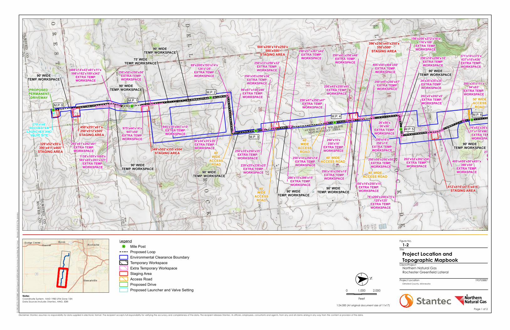
Figure No.
Client/Project
Project Location
Notes
G:\P
ROJE
CTS\
1937
0588
7_NN
G\Fig
ures\
2018
0926
\NNG
_Roc
heste
r_Gre
enfie
ld_Fig
1-2.m
xd
Rev
ised:
2018
-09-27
By: jb
rzeska
1:24,000 (At original document size of 11x17)
Disclaimer: Stantec assumes no responsibility for data supplied in electronic format. The recipient accepts full responsibility for verifying the accuracy and completeness of the data. The recipient releases Stantec, its officers, employees, consultants and agents, from any and all claims arising in any way from the content or provision of the data.
Project Location and Topographic Mapbook
1-2
Northern Natural GasRochester Greenfield Lateral
193705887Olmsted County, Minnesota
Title
&-Ï
&-Ï
&-Ï
&-Ï
&-Ï
&-Ï
&-Ï
M.P. 0M.P. 1
M.P. 2
M.P. 3
M.P. 4
M.P. 5
M.P. 6
274'x44'x274'x44'EXTRA TEMP.WORKSPACE
273'x4'x273'x4'EXTRA TEMP.WORKSPACE
76'x53'x36'x37'x31'x110'x96'x32'EXTRA TEMP.WORKSPACE
200'x35'x111'x94'x63'
EXTRA TEMP.WORKSPACE
405'x459'x50'x451'x398'x50'
EXTRA TEMP.WORKSPACE
371'x10'x375'x437'x10'x436'EXTRA TEMP.WORKSPACE
202'x54'x202'x54'EXTRA TEMP.WORKSPACE
202'x5'x202'x5'EXTRA TEMP.WORKSPACE
76'x200'x200'x75'x125'x125'
EXTRA TEMP.WORKSPACE
250'x50'x250'x50'EXTRA TEMP.WORKSPACE
250'x45'x250'x47'EXTRA TEMP.WORKSPACE
405'x50'x404'x50'EXTRA TEMP.WORKSPACE
250'x45'x250'x46'EXTRA TEMP.WORKSPACE
250'x45'x250'x45'EXTRA TEMP.WORKSPACE
250'x47'x250'x47'EXTRA TEMP.WORKSPACE
250'x57'x287'x42'EXTRA TEMP.WORKSPACE
239'x25'x239'x25'EXTRA TEMP.WORKSPACE
250'x35'x250'x35'EXTRA TEMP.WORKSPACE
250'x35'x250'x36'EXTRA TEMP.WORKSPACE
99'x97'x100'x99'EXTRA TEMP.WORKSPACE
36'x34'x35'x35'EXTRA TEMP.WORKSPACE
69'x200'x193'x74'x124'x125'
EXTRA TEMP.WORKSPACE
945'x14'x947'x10'EXTRA TEMP.WORKSPACE
250'x50'x250'x50'EXTRA TEMP.WORKSPACE
975'x44'x14'x947'x50'
EXTRA TEMP.WORKSPACE
488'x14'x43'x61'x11'x598'x182'x189'x342'
EXTRA TEMP.WORKSPACE
1138'x105'x1095'x593'x45'x203'x321'
EXTRA TEMP.WORKSPACE
293'x61'x292'x61'EXTRA TEMP.WORKSPACE
90' WIDETEMP. WORKSPACE
90' WIDETEMP. WORKSPACE
90' WIDETEMP. WORKSPACE
90' WIDETEMP. WORKSPACE90' WIDE
TEMP. WORKSPACE
90' WIDETEMP. WORKSPACE
90' WIDETEMP. WORKSPACE
90' WIDETEMP. WORKSPACE
75' WIDETEMP. WORKSPACE
90' WIDETEMP. WORKSPACE
90' WIDETEMP. WORKSPACE
50' WIDEACCESS
ROAD
250'x33'x250'x32'EXTRA TEMP.WORKSPACE
286'x15'x286'x15'EXTRA TEMP.WORKSPACE
250'x15'x250'x16'
EXTRA TEMP.WORKSPACE
250'x14'x250'x14'EXTRA TEMP.WORKSPACE
250'x16'x250'x15'
EXTRA TEMP.WORKSPACE
250'x16'x250'x15'EXTRA TEMP.WORKSPACE
26'x50'x26'x50'
EXTRA TEMP.WORKSPACE
329'x52'x55'x390'x411'x465'
STAGING AREA
450'x251'x61'x250'x512'x505'
STAGING AREA
349'x502'x355'x504'STAGING AREA
396'x250'x45'x250'x350'x500'
STAGING AREA
412'x416'x415'x416'STAGING AREA
331'x299'x747'x500'x484'
STAGING AREA34'x35'x35'x35'EXTRA TEMP.WORKSPACE
267'x44'x267'x44'EXTRA TEMP.WORKSPACE
504'x250'x10'x250'x500'x500'
STAGING AREA
250'x16'x250'x15'EXTRA TEMP.WORKSPACE
156'x200'x272'x10'x116'x189'
EXTRA TEMP.WORKSPACE
250'x10'x250'x10'EXTRA TEMP.WORKSPACE
40'WIDE
ACCESSROAD
40' WIDEACCESS ROAD
40'WIDE
ACCESSROAD40'
WIDEACCESS
ROAD
270'x140'ROCHESTER
LAUNCHER ANDVALVE SITE
PROPOSED PERMANENTDRIVEWAY
40' WIDEACCESS ROAD
Legend
($
$¯
0 1,000 2,000
FeetCoordinate System: NAD 1983 UTM Zone 15NData Sources Include: Stantec, NNG, ESRI
Page 1 of 2
Legend&-Ï Mile Post
Proposed LoopEnvironmental Clearance BoundaryTemporary WorkspaceExtra Temporary WorkspaceStaging AreaAccess RoadProposed DriveProposed Launcher and Valve Setting
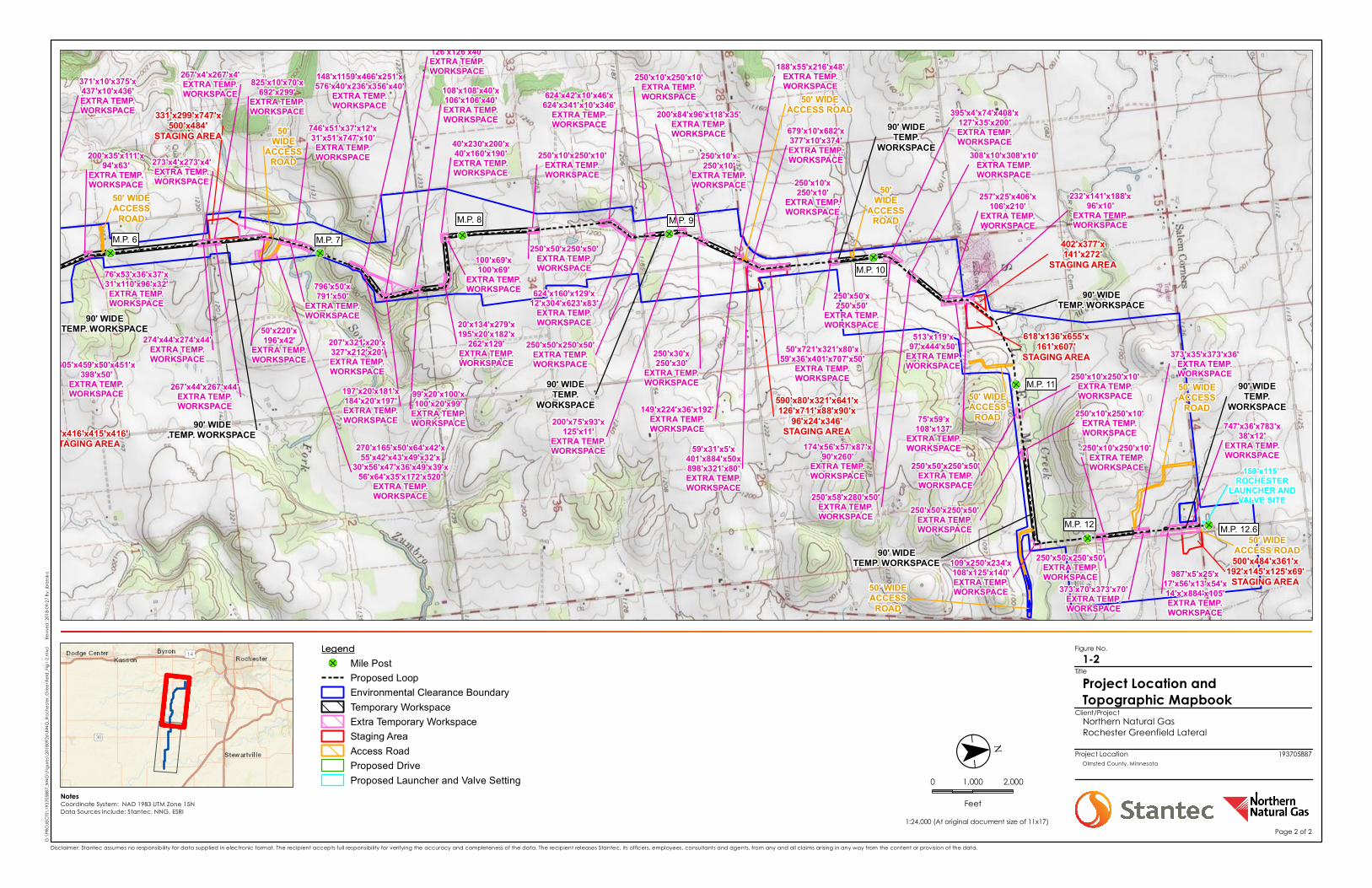
Figure No.
Client/Project
Project Location
Notes
G:\P
ROJE
CTS\
1937
0588
7_NN
G\Fig
ures\
2018
0926
\NNG
_Roc
heste
r_Gre
enfie
ld_Fig
1-2.m
xd
Rev
ised:
2018
-09-27
By: jb
rzeska
1:24,000 (At original document size of 11x17)
Disclaimer: Stantec assumes no responsibility for data supplied in electronic format. The recipient accepts full responsibility for verifying the accuracy and completeness of the data. The recipient releases Stantec, its officers, employees, consultants and agents, from any and all claims arising in any way from the content or provision of the data.
Project Location and Topographic Mapbook
1-2
Northern Natural GasRochester Greenfield Lateral
193705887Olmsted County, Minnesota
Title
&-Ï &-Ï
&-Ï
&-Ï
&-Ï
&-Ï
&-Ï
&-Ï
M.P. 6 M.P. 7M.P. 8 M.P. 9
M.P. 10
M.P. 11
M.P. 12 M.P. 12.6
987'x5'x25'x17'x56'x13'x54'x14'x'x884'x105'EXTRA TEMP.WORKSPACE
90' WIDETEMP.
WORKSPACE747'x36'x783'x
38'x12'EXTRA TEMP.WORKSPACE
373'x70'x373'x70'EXTRA TEMP.WORKSPACE
373'x35'x373'x36'EXTRA TEMP.WORKSPACE
232'x141'x188'x96'x10'
EXTRA TEMP.WORKSPACE
250'x10'x250'x10'EXTRA TEMP.WORKSPACE
257'x25'x406'x106'x210'
EXTRA TEMP.WORKSPACE
513'x119'x97'x444'x50'
EXTRA TEMP.WORKSPACE
174'x56'x57'x87'x90'x260'
EXTRA TEMP.WORKSPACE
308'x10'x308'x10'EXTRA TEMP.WORKSPACE
395'x4'x74'x408'x127'x35'x200'EXTRA TEMP.WORKSPACE
250'x58'x280'x50'EXTRA TEMP.WORKSPACE
250'x50'x250'x50'
EXTRA TEMP.WORKSPACE
250'x10'x250'x10'
EXTRA TEMP.WORKSPACE
50'x721'x321'x80'x59'x36'x401'x707'x50'
EXTRA TEMP.WORKSPACE
59'x31'x5'x401'x884'x50x898'x321'x80'EXTRA TEMP.WORKSPACE
679'x10'x682'x377'x10'x374'EXTRA TEMP.WORKSPACE
188'x55'x216'x48'EXTRA TEMP.WORKSPACE
149'x224'x36'x192'EXTRA TEMP.WORKSPACE
250'x30'x250'x30'
EXTRA TEMP.WORKSPACE
200'x84'x96'x118'x35'EXTRA TEMP.WORKSPACE
250'x50'x250'x50'EXTRA TEMP.WORKSPACE
250'x10'x250'x10'EXTRA TEMP.WORKSPACE
624'x160'x129'x12'x304'x623'x83'
EXTRA TEMP.WORKSPACE
624'x42'x10'x46'x624'x341'x10'x346'
EXTRA TEMP.WORKSPACE
250'x50'x250'x50'EXTRA TEMP.WORKSPACE
207'x321'x20'x327'x212'x20'EXTRA TEMP.WORKSPACE
148'x1159'x466'x251'x576'x40'x236'x356'x40'
EXTRA TEMP.WORKSPACE
796'x50'x791'x50'
EXTRA TEMP.WORKSPACE
746'x51'x37'x12'x31'x51'x747'x10'EXTRA TEMP.WORKSPACE
825'x10'x70'x692'x299'
EXTRA TEMP.WORKSPACE
274'x44'x274'x44'EXTRA TEMP.WORKSPACE
273'x4'x273'x4'EXTRA TEMP.WORKSPACE
76'x53'x36'x37'x31'x110'x96'x32'EXTRA TEMP.WORKSPACE
200'x35'x111'x94'x63'
EXTRA TEMP.WORKSPACE
405'x459'x50'x451'x398'x50'
EXTRA TEMP.WORKSPACE
371'x10'x375'x437'x10'x436'EXTRA TEMP.WORKSPACE
202'x5'x202'x5'EXTRA TEMP.WORKSPACE
90' WIDETEMP. WORKSPACE
90' WIDETEMP. WORKSPACE
90' WIDETEMP.
WORKSPACE
90' WIDETEMP.
WORKSPACE90' WIDE
TEMP. WORKSPACE
90' WIDETEMP. WORKSPACE
90' WIDETEMP. WORKSPACE 50'
WIDEACCESS
ROAD
50' WIDEACCESS
ROAD
50'x220'x196'x42'
EXTRA TEMP.WORKSPACE
50'WIDE
ACCESSROAD
50' WIDEACCESS
ROAD
412'x416'x415'x416'STAGING AREA
331'x299'x747'x500'x484'
STAGING AREA
590'x80'x321'x641'x126'x711'x88'x90'x
96'x24'x346'STAGING AREA
618'x136'x655'x161'x607'
STAGING AREA
402'x377'x141'x272'
STAGING AREA
500'x484'x361'x192'x145'x125'x69'
STAGING AREA
34'x35'x35'x35'EXTRA TEMP.WORKSPACE
267'x44'x267'x44'EXTRA TEMP.WORKSPACE
267'x4'x267'x4'EXTRA TEMP.WORKSPACE
156'x200'x272'x10'x116'x189'
EXTRA TEMP.WORKSPACE
250'x10'x250'x10'EXTRA TEMP.WORKSPACE
270'x165'x50'x64'x42'x55'x42'x43'x49'x32'x
30'x56'x47'x36'x49'x39'x56'x64'x35'x172'x520'
EXTRA TEMP.WORKSPACE
250'x10'x250'x10'EXTRA TEMP.WORKSPACE 50' WIDE
ACCESS ROAD
50' WIDEACCESS
ROAD
250'x50'x250'x50'EXTRA TEMP.WORKSPACE
250'x10'x250'x10'EXTRA TEMP.WORKSPACE
250'x10'x250'x10'EXTRA TEMP.WORKSPACE
250'x50'x250'x50'EXTRA TEMP.WORKSPACE
50' WIDEACCESS
ROAD
109'x250'x234'x108'x125'x140'EXTRA TEMP.WORKSPACE
50' WIDEACCESS ROAD250'x50'x250'x50'
EXTRA TEMP.WORKSPACE
250'x10'x250'x10'
EXTRA TEMP.WORKSPACE
200'x75'x93'x125'x11'
EXTRA TEMP.WORKSPACE
150'x115' ROCHESTER
LAUNCHER ANDVALVE SITE
75'x59'x108'x137'
EXTRA TEMP.WORKSPACE
197'x20'x181'x184'x20'x197'EXTRA TEMP.WORKSPACE
100'x100'x40'x126'x126'x40'EXTRA TEMP.WORKSPACE
108'x108'x40'x106'x106'x40'EXTRA TEMP.WORKSPACE
99'x20'x100'x100'x20'x99'
EXTRA TEMP.WORKSPACE
20'x134'x279'x195'x20'x182'x
262'x129'EXTRA TEMP.WORKSPACE
100'x69'x100'x69'
EXTRA TEMP.WORKSPACE
40'x230'x200'x40'x160'x190'EXTRA TEMP.WORKSPACE
Legend
($
$¯
0 1,000 2,000
FeetCoordinate System: NAD 1983 UTM Zone 15NData Sources Include: Stantec, NNG, ESRI
Page 2 of 2
Legend&-Ï Mile Post
Proposed LoopEnvironmental Clearance BoundaryTemporary WorkspaceExtra Temporary WorkspaceStaging AreaAccess RoadProposed DriveProposed Launcher and Valve Setting
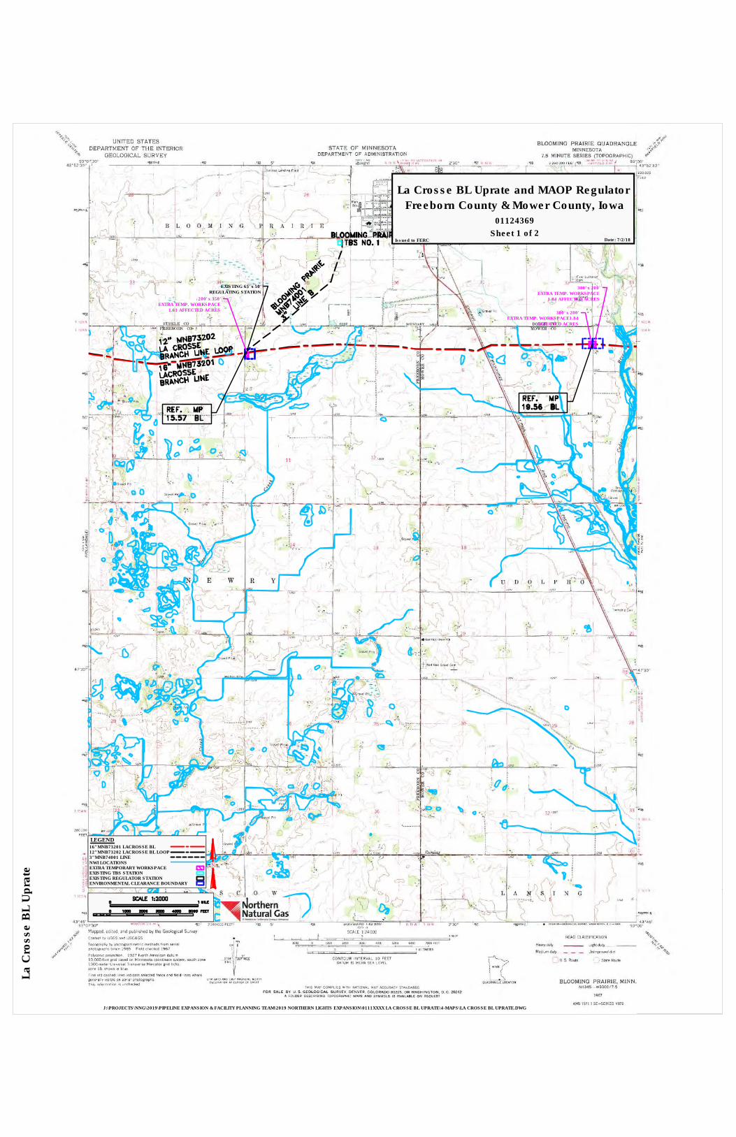
01124369
La Crosse BL Uprate and MAOP RegulatorFreeborn County & Mower County, Iowa
Date: 7/2/18Issued to FERCSheet 1 of 2
J:\PROJECTS\NNG\2019\PIPELINE EXPANSION & FACILITY PLANNING TEAM\2019 NORTHERN LIGHTS EXPANSION\0111XXXX LA CROSSE BL UPRATE\4-MAPS\LA CROSSE BL UPRATE.DWG
La C
ross
e B
L U
pra
te
200' x 350'EXTRA TEMP. WORKSPACE
1.61 AFFECTED ACRES
LEGEND
EXTRA TEMPORARY WORKSPACE
EXISTING REGULATOR STATION
NWI LOCATIONS
ENVIRONMENTAL CLEARANCE BOUNDARY
300' x 200'EXTRA TEMP. WORKSPACE1.84
AFFECTED ACRES
300' x 200'EXTRA TEMP. WORKSPACE
1.84 AFFECTED ACRES
3" MNB74001 LINE
16" MNB73201 LACROSSE BL12" MNB73202 LACROSSE BL LOOP
EXISTING 65' x 50'REGULATING STATION
EXISTING TBS STATION
AutoCAD SHX Text
NO.
AutoCAD SHX Text
BLOOMING PRAIRIE
AutoCAD SHX Text
TBS
AutoCAD SHX Text
1
AutoCAD SHX Text
BLOOMING PRAIRIE
AutoCAD SHX Text
MNB74001
AutoCAD SHX Text
3"
AutoCAD SHX Text
LINE B
AutoCAD SHX Text
15.57
AutoCAD SHX Text
16" MNB73201
AutoCAD SHX Text
LACROSSE
AutoCAD SHX Text
BRANCH LINE
AutoCAD SHX Text
12" MNB73202
AutoCAD SHX Text
LA CROSSE
AutoCAD SHX Text
BRANCH LINE LOOP
AutoCAD SHX Text
19.56
AutoCAD SHX Text
BL
AutoCAD SHX Text
BL
AutoCAD SHX Text
REF.
AutoCAD SHX Text
MP
AutoCAD SHX Text
BL
AutoCAD SHX Text
REF.
AutoCAD SHX Text
MP
AutoCAD SHX Text
SCALE 1:2000
AutoCAD SHX Text
MILE
AutoCAD SHX Text
1
AutoCAD SHX Text
0
AutoCAD SHX Text
FEET
AutoCAD SHX Text
5000
AutoCAD SHX Text
4000
AutoCAD SHX Text
3000
AutoCAD SHX Text
2000
AutoCAD SHX Text
1000
AutoCAD SHX Text
0
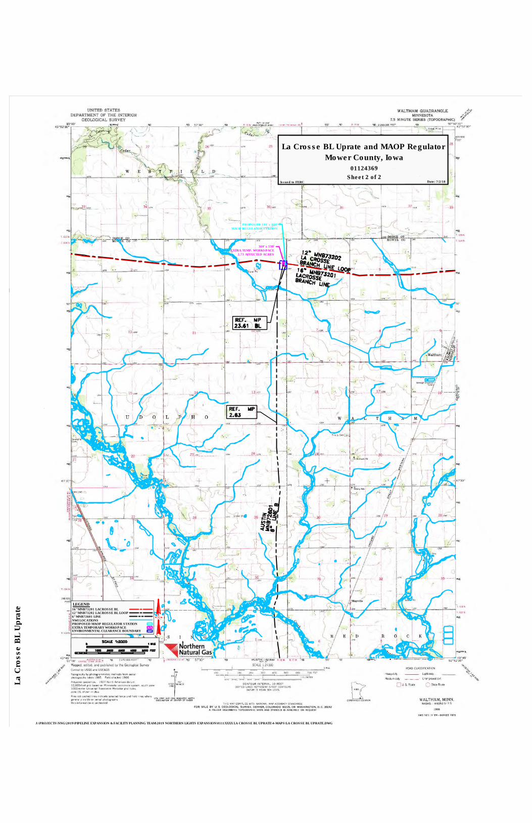
J:\PROJECTS\NNG\2019\PIPELINE EXPANSION & FACILITY PLANNING TEAM\2019 NORTHERN LIGHTS EXPANSION\0111XXXX LA CROSSE BL UPRATE\4-MAPS\LA CROSSE BL UPRATE.DWG
La C
ross
e B
L U
pra
te
LEGEND
NWI LOCATIONS6" MNB72601 LINE
360' x 330'EXTRA TEMP. WORKSPACE
2.73 AFFECTED ACRES
PROPOSED MAOP REGULATOR STATION
ENVIRONMENTAL CLEARANCE BOUNDARY
16" MNB73201 LACROSSE BL12" MNB73202 LACROSSE BL LOOP
EXTRA TEMPORARY WORKSPACE
PROPOSED 100' x 100'MAOP REGULATOR STATION
01124369
Mower County, Iowa
Sheet 2 of 2
La Crosse BL Uprate and MAOP Regulator
Date: 7/2/18Issued to FERC
AutoCAD SHX Text
AUSTIN
AutoCAD SHX Text
MNB72601
AutoCAD SHX Text
6"
AutoCAD SHX Text
LINE B
AutoCAD SHX Text
2.63
AutoCAD SHX Text
REF.
AutoCAD SHX Text
MP
AutoCAD SHX Text
16" MNB73201
AutoCAD SHX Text
LACROSSE
AutoCAD SHX Text
BRANCH LINE
AutoCAD SHX Text
12" MNB73202
AutoCAD SHX Text
LA CROSSE
AutoCAD SHX Text
BRANCH LINE LOOP
AutoCAD SHX Text
23.61
AutoCAD SHX Text
BL
AutoCAD SHX Text
BL
AutoCAD SHX Text
BL
AutoCAD SHX Text
MP
AutoCAD SHX Text
BL
AutoCAD SHX Text
REF.
AutoCAD SHX Text
MP
AutoCAD SHX Text
SCALE 1:2000
AutoCAD SHX Text
MILE
AutoCAD SHX Text
1
AutoCAD SHX Text
0
AutoCAD SHX Text
FEET
AutoCAD SHX Text
5000
AutoCAD SHX Text
4000
AutoCAD SHX Text
3000
AutoCAD SHX Text
2000
AutoCAD SHX Text
1000
AutoCAD SHX Text
0
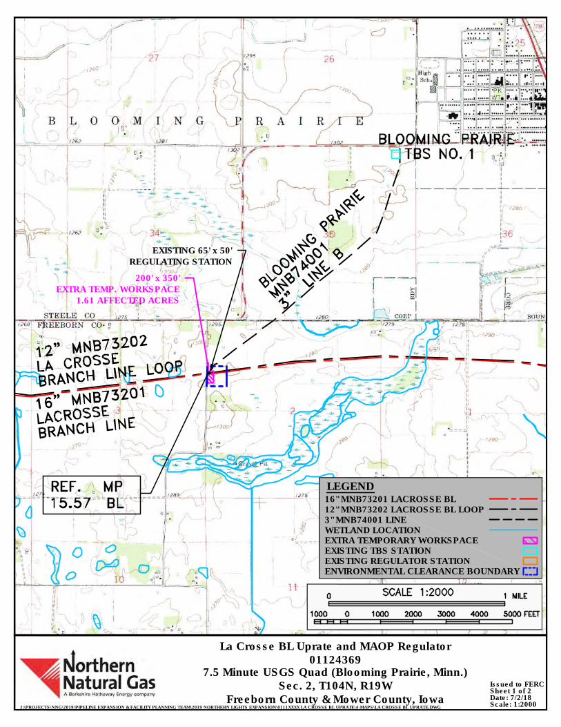
7.5 Minute USGS Quad (Blooming Prairie, Minn.)
J:\PROJECTS\NNG\2019\PIPELINE EXPANSION & FACILITY PLANNING TEAM\2019 NORTHERN LIGHTS EXPANSION\0111XXXX LA CROSSE BL UPRATE\4-MAPS\LA CROSSE BL UPRATE.DWG
Date: 7/2/18Scale: 1:2000
La Crosse BL Uprate and MAOP Regulator01124369
Sec. 2, T104N, R19WFreeborn County & Mower County, Iowa
Sheet 1 of 2Issued to FERC
200' x 350'EXTRA TEMP. WORKSPACE
1.61 AFFECTED ACRES
LEGEND
EXTRA TEMPORARY WORKSPACE
3" MNB74001 LINE
EXISTING REGULATOR STATION
WETLAND LOCATION
ENVIRONMENTAL CLEARANCE BOUNDARY
16" MNB73201 LACROSSE BL12" MNB73202 LACROSSE BL LOOP
EXISTING 65' x 50'REGULATING STATION
EXISTING TBS STATION
AutoCAD SHX Text
NO.
AutoCAD SHX Text
BLOOMING PRAIRIE
AutoCAD SHX Text
TBS
AutoCAD SHX Text
1
AutoCAD SHX Text
BLOOMING PRAIRIE
AutoCAD SHX Text
MNB74001
AutoCAD SHX Text
3"
AutoCAD SHX Text
LINE B
AutoCAD SHX Text
15.57
AutoCAD SHX Text
16" MNB73201
AutoCAD SHX Text
LACROSSE
AutoCAD SHX Text
BRANCH LINE
AutoCAD SHX Text
12" MNB73202
AutoCAD SHX Text
LA CROSSE
AutoCAD SHX Text
BRANCH LINE LOOP
AutoCAD SHX Text
BL
AutoCAD SHX Text
REF.
AutoCAD SHX Text
MP
AutoCAD SHX Text
1000
AutoCAD SHX Text
0
AutoCAD SHX Text
1000
AutoCAD SHX Text
2000
AutoCAD SHX Text
3000
AutoCAD SHX Text
4000
AutoCAD SHX Text
5000
AutoCAD SHX Text
FEET
AutoCAD SHX Text
0
AutoCAD SHX Text
1 MILE
AutoCAD SHX Text
SCALE 1:2000
7.5 Minute USGS Quad (Blooming Prairie, Minn.)
J:\PROJECTS\NNG\2019\PIPELINE EXPANSION & FACILITY PLANNING TEAM\2019 NORTHERN LIGHTS EXPANSION\0111XXXX LA CROSSE BL UPRATE\4-MAPS\LA CROSSE BL UPRATE.DWG
Date: 7/2/18Scale: 1:2000
La Crosse BL Uprate and MAOP Regulator01124369
Sec. 5 & 4, T104N, R18WFreeborn County & Mower County, Iowa
Sheet 1 of 1Issued to FERC
300' x 200'EXTRA TEMP. WORKSPACE
1.84 AFFECTED ACRES
300' x 200'EXTRA TEMP. WORKSPACE
1.84 AFFECTED ACRES
EXTRA TEMPORARY WORKSPACE
3" MNB74001 LINEWETLAND LOCATION
ENVIRONMENTAL CLEARANCE BOUNDARY
LEGEND16" MNB73201 LACROSSE BL12" MNB73202 LACROSSE BL LOOP
AutoCAD SHX Text
BLOOMING PRAIRIE
AutoCAD SHX Text
19.56
AutoCAD SHX Text
BL
AutoCAD SHX Text
BL
AutoCAD SHX Text
REF.
AutoCAD SHX Text
MP
AutoCAD SHX Text
1000
AutoCAD SHX Text
0
AutoCAD SHX Text
1000
AutoCAD SHX Text
2000
AutoCAD SHX Text
3000
AutoCAD SHX Text
4000
AutoCAD SHX Text
5000
AutoCAD SHX Text
FEET
AutoCAD SHX Text
0
AutoCAD SHX Text
1 MILE
AutoCAD SHX Text
SCALE 1:2000
7.5 Minute USGS Quad (Waltham, Minn.)
J:\PROJECTS\NNG\2019\PIPELINE EXPANSION & FACILITY PLANNING TEAM\2019 NORTHERN LIGHTS EXPANSION\0111XXXX LA CROSSE BL UPRATE\4-MAPS\LA CROSSE BL UPRATE.DWG
Date: 7/2/18Scale: 1:2000
La Crosse BL Uprate and MAOP Regulator01124369
Sec. 1, T104N, R18WMower County, Iowa
Sheet 1 of 1Issued to FERC
360' x 330'EXTRA TEMP. WORKSPACE
2.73 AFFECTED ACRES
EXTRA TEMPORARY WORKSPACEPROPOSED MAOP REGULATOR STATION
WETLAND LOCATION
ENVIR. CLEAR. BOUNDARY
16" MNB73201 LACROSSE BL12" MNB73202 LACROSSE BL LOOP
LEGEND
3" MNB74001 LINE
PROPOSED 100' x 100'MAOP REGULATOR STATION
AutoCAD SHX Text
16" MNB73201
AutoCAD SHX Text
LACROSSE
AutoCAD SHX Text
BRANCH LINE
AutoCAD SHX Text
12" MNB73202
AutoCAD SHX Text
LA CROSSE
AutoCAD SHX Text
BRANCH LINE LOOP
AutoCAD SHX Text
23.61
AutoCAD SHX Text
BL
AutoCAD SHX Text
BL
AutoCAD SHX Text
REF.
AutoCAD SHX Text
MP
AutoCAD SHX Text
1000
AutoCAD SHX Text
0
AutoCAD SHX Text
1000
AutoCAD SHX Text
2000
AutoCAD SHX Text
3000
AutoCAD SHX Text
4000
AutoCAD SHX Text
5000
AutoCAD SHX Text
FEET
AutoCAD SHX Text
0
AutoCAD SHX Text
1 MILE
AutoCAD SHX Text
SCALE 1:2000
Appendix B
Topographic Maps for the Northern Lights 2019 Expansion Project
Figure No.
Client/Project
Project Location
Notes
G:\
PRO
JEC
TS\1
9370
5887
_NN
G\
Fig
ure
s\20
1807
20_9
0\N
NG
_Ro
ckf
ord
_to
_Bu
ffalo
_Fig
1-3.
mxd
R
evise
d: 2
018-
07-2
3 By
: jb
rze
ska
1:24,000 (At original document size of 11x17)
Disclaimer: Stantec assumes no responsibility for data supplied in electronic format. The recipient accepts full responsibility for verifying the accuracy and completeness of the data. The recipient releases Stantec, its officers, employees, consultants and agents, from any and all claims arising in any way from the content or provision of the data.
Project Location and Topographic Mapbook
1-3
Northern Natural Gas Rockford to Buffalo Greenfield Lateral
193705887Wright County, Minnesota
Title
&-Ï
&-Ï
&-Ï
&-Ï
&-Ï
&-Ï
&-Ï
&-Ï
119'x173'x36'x165'x115'x36'EXTRA TEMP.WORKSPACE
139'x104'x14'x106'142'x13'
EXTRA TEMP.WORKSPACE
217'x29'x218'x30'
EXTRA TEMP.WORKSPACE
187'x187x222'x215'x101'x76'x100'x486'x17'x22'x228'
EXTRA TEMP.WORKSPACE
100' WIDETEMP. WORKSPACE
30'WIDE
ACCESSROAD
275'x60'x222'x40'EXTRA TEMP.WORKSPACE
100' WIDETEMP. WORKSPACE
50'WIDE
ACCESSROAD
30'WIDE
ACCESSROAD
428'x106'x83'x169'x17'x217x510'x
280'x168'x201'EXTRA TEMP.WORKSPACE
449'x70'x77'x336'x480'x870'x496'
STAGING AREA488'x211'x71'x
701'x5'EXTRA TEMP.WORKSPACE
150'x83'x150'x74'EXTRA TEMP.WORKSPACE
100' WIDETEMP. WORKSPACE
100' WIDETEMP. WORKSPACE
147'x158'x94'x25'x200'
EXTRA TEMP.WORKSPACE
86'x98'x22'x48'x50'x46'x127'x87'x50'EXTRA TEMP.WORKSPACE
118'x76'x50'x108'EXTRA TEMP.WORKSPACE
100' WIDETEMP.
WORKSPACE
250'x50'x248'x50'EXTRA TEMP.WORKSPACE
299'x50'x281'x53EXTRA TEMP.WORKSPACE
245'x53'x262'x50'EXTRA TEMP.WORKSPACE
42'x199'x50'x50'x34'x38'x45'x44'x
40'x51'x42'EXTRA TEMP.WORKSPACE
100' WIDETEMP. WORKSPACE
358'x50'x358'x50'EXTRA TEMP.WORKSPACE
480'x472'x376'x169'
EXTRA TEMP.WORKSPACE
248'x143'x114'x78'x48'x197'
EXTRA TEMP.WORKSPACE
100' WIDETEMP.
WORKSPACE
30' WIDEACCESS
ROAD
92'x93'x121'x189'x88'x127'EXTRA TEMP.WORKSPACE
754'x86'x655'x46'x16'x38'x115'
EXTRA TEMP.WORKSPACE
292'x84'x198'x239'EXTRA TEMP.WORKSPACE
49'x33'x159'x84'x23'
EXTRA TEMP.WORKSPACE
141'x99'x126'x16'x277'x481'x227'x156'
STAGING AREA
75' WIDETEMP. WORKSPACE
502'x323'x147'x342'x483'
STAGING AREA
250'x50'x250'x50'EXTRA TEMP.WORKSPACE
84'x94'x26'x83'x66'
EXTRA TEMP.WORKSPACE
285'x54'x91'x190'x128'
EXTRA TEMP.WORKSPACE
108'x21'x58'x149'x15'x31'x88'
EXTRA TEMP.WORKSPACE
100' WIDETEMP.
WORKSPACE
170'x141'x73'x97'x9'x96'
EXTRA TEMP.WORKSPACE
342'x108'x280'x120'EXTRA TEMP.WORKSPACE
75'x223'x88'x178'EXTRA TEMP.WORKSPACE
250'x19'x250'x19'
EXTRA TEMP.WORKSPACE
250'x31'x250'x31'EXTRA TEMP.WORKSPACE
100' WIDETEMP. WORKSPACE
37'x47'x236'x29'x12'x19'x19'x14'x19'x13'x
7'x7'x13'x15'x32'x28'x15'x15'x22'EXTRA TEMP.WORKSPACE
250'x50'x250'x50'EXTRA TEMP.WORKSPACE
623'x125'x338'x296'x66'x24'x157'x372'x715'x42'x62'x47'EXTRA TEMP.WORKSPACE
50' WIDEACCESS
ROAD
233'x48'x254'x78'x15'x23'x28'x12'x30'
EXTRA TEMP.WORKSPACE
100' WIDETEMP.
WORKSPACE
500'x526'x610'x60'x111'x476'
STAGING AREA
225'x143'x147'x49'EXTRA TEMP.WORKSPACE
250'x50'x250'x50'EXTRA TEMP.WORKSPACE
431'x50'x368'x77'EXTRA TEMP.WORKSPACE
129'x94'x57'x256'x107'x51'x224'
EXTRA TEMP.WORKSPACE
100' WIDETEMP. WORKSPACE
47' WIDEACCESS
ROAD
40' WIDEACCESS
ROAD
30' WIDEACCESS ROAD
65'x83'x144'x1190'x186'x1315'
EXTRA TEMP.WORKSPACE
407'x50'x403'x81'x57'x113'
EXTRA TEMP.WORKSPACE
220'x50'x218'x48'x51'x46'
EXTRA TEMP.WORKSPACE
30' WIDEACCESS
ROAD
272'x68'x38'x306'x25'
EXTRA TEMP.WORKSPACE
52' WIDEACCESS
ROAD
169'x84'x214'x128'x40'
17'x123'x109'x169'EXTRA TEMP.WORKSPACE
334'x7'x61'x66'x334'
EXTRA TEMP.WORKSPACE
250'x66'x250'x66'EXTRA TEMP.WORKSPACE
250'x65'x249'x65'
EXTRA TEMP.WORKSPACE
PROPOSEDPERMANENTDRIVEWAY
150'x145'ROCKFORD LAUNCHER
AND VALVE SITE
162'x92'x45'x74'x254'x51,
EXTRA TEMP.WORKSPACE
M.P. 0
M.P. 1
M.P. 2
M.P. 3M.P. 4
M.P. 5M.P. 6
($
$ ¯0 1,000 2,000
FeetCoordinate System: NAD 1983 UTM Zone 15NData Sources Include: Stantec, NNG, ESRI
Legend
&-Ï Mile PostProposed LoopEnvironmental Clearance BoundaryTemporary WorkspaceExtra Temporary WorkspaceStaging AreaAccess RoadProposed DriveProposed Valve Setting
Page 1 of 2
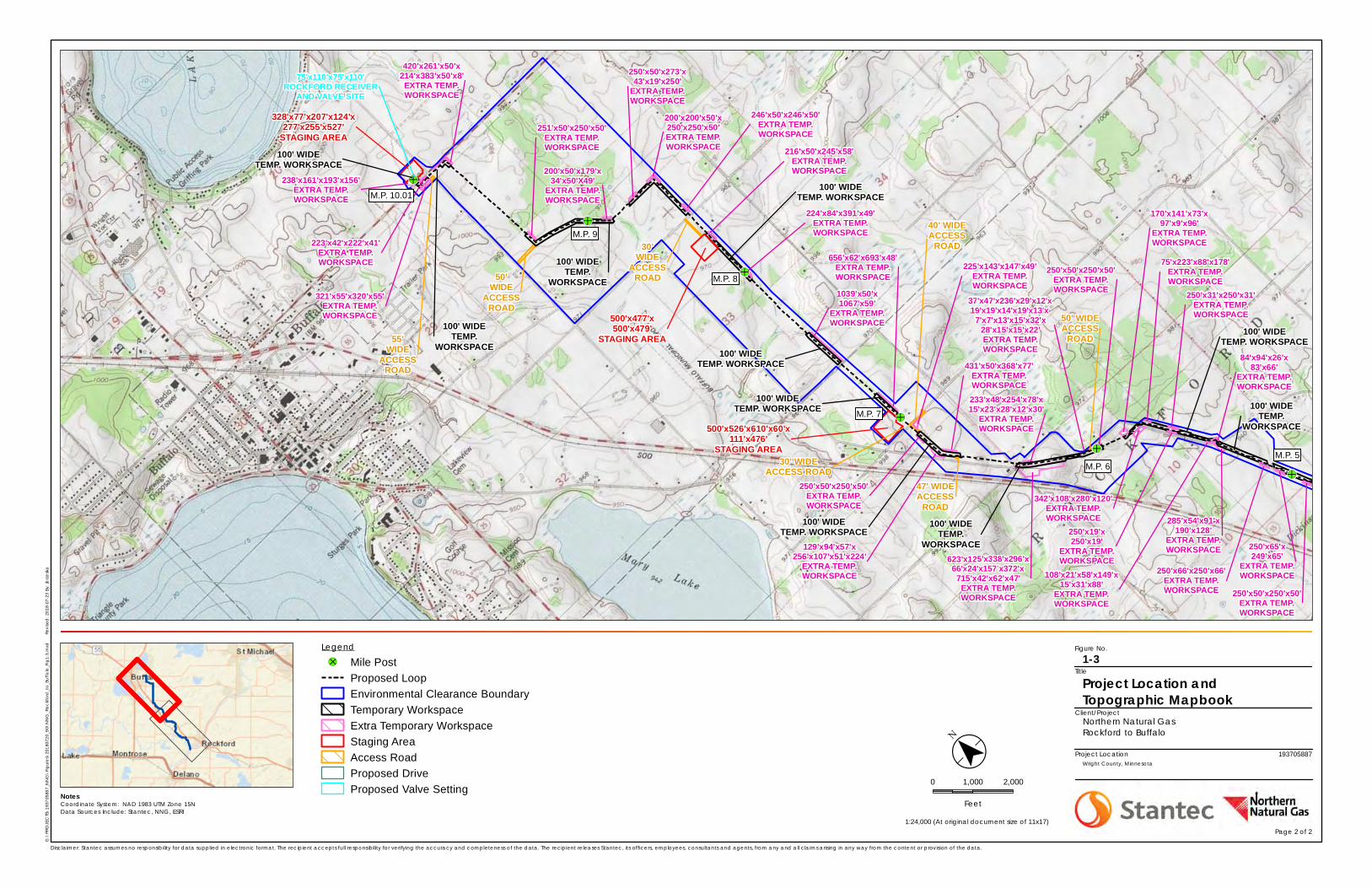
Figure No.
Client/Project
Project Location
Notes
G:\
PRO
JEC
TS\1
9370
5887
_NN
G\
Fig
ure
s\20
1807
20_9
0\N
NG
_Ro
ckf
ord
_to
_Bu
ffalo
_Fig
1-3.
mxd
Revi
sed
: 201
8-07
-23
By: j
brz
esk
a
1:24,000 (At original document size of 11x17)
Disclaimer: Stantec assumes no responsibility for data supplied in electronic format. The recipient accepts full responsibility for verifying the accuracy and completeness of the data. The recipient releases Stantec, its officers, employees, consultants and agents, from any and all claims arising in any way from the content or provision of the data.
Project Location and Topographic Mapbook
1-3
Northern Natural GasRockford to Buffalo
193705887Wright County, Minnesota
Title
&-Ï
&-Ï
&-Ï
&-Ï
&-Ï
&-Ï
&-Ï
86'x98'x22'x48'x50'x46'x127'x87'x50'EXTRA TEMP.WORKSPACE
42'x199'x50'x50'x34'x38'x45'x44'x
40'x51'x42'EXTRA TEMP.WORKSPACE
100' WIDETEMP. WORKSPACE
480'x472'x376'x169'
EXTRA TEMP.WORKSPACE
30' WIDEACCESS
ROAD
92'x93'x121'x189'x88'x127'EXTRA TEMP.WORKSPACE
754'x86'x655'x46'x16'x38'x115'
EXTRA TEMP.WORKSPACE
292'x84'x198'x239'EXTRA TEMP.WORKSPACE
49'x33'x159'x84'x23'
EXTRA TEMP.WORKSPACE
141'x99'x126'x16'x277'x481'x227'x156'
STAGING AREA
75' WIDETEMP. WORKSPACE
502'x323'x147'x342'x483'
STAGING AREA
250'x50'x250'x50'EXTRA TEMP.WORKSPACE
84'x94'x26'x83'x66'
EXTRA TEMP.WORKSPACE
285'x54'x91'x190'x128'
EXTRA TEMP.WORKSPACE
108'x21'x58'x149'x15'x31'x88'
EXTRA TEMP.WORKSPACE
100' WIDETEMP.
WORKSPACE
170'x141'x73'x97'x9'x96'
EXTRA TEMP.WORKSPACE
342'x108'x280'x120'EXTRA TEMP.WORKSPACE
75'x223'x88'x178'EXTRA TEMP.WORKSPACE
250'x19'x250'x19'
EXTRA TEMP.WORKSPACE
250'x31'x250'x31'EXTRA TEMP.WORKSPACE
100' WIDETEMP. WORKSPACE
37'x47'x236'x29'x12'x19'x19'x14'x19'x13'x
7'x7'x13'x15'x32'x28'x15'x15'x22'EXTRA TEMP.WORKSPACE
250'x50'x250'x50'EXTRA TEMP.WORKSPACE
623'x125'x338'x296'x66'x24'x157'x372'x715'x42'x62'x47'EXTRA TEMP.WORKSPACE
50' WIDEACCESS
ROAD
233'x48'x254'x78'x15'x23'x28'x12'x30'
EXTRA TEMP.WORKSPACE
100' WIDETEMP.
WORKSPACE
500'x526'x610'x60'x111'x476'
STAGING AREA
225'x143'x147'x49'EXTRA TEMP.WORKSPACE
250'x50'x250'x50'EXTRA TEMP.WORKSPACE
431'x50'x368'x77'EXTRA TEMP.WORKSPACE
129'x94'x57'x256'x107'x51'x224'
EXTRA TEMP.WORKSPACE
100' WIDETEMP. WORKSPACE
656'x62'x693'x48'EXTRA TEMP.WORKSPACE
100' WIDETEMP. WORKSPACE
1039'x50'x1067'x59'
EXTRA TEMP.WORKSPACE
100' WIDETEMP. WORKSPACE
224'x84'x391'x49'EXTRA TEMP.WORKSPACE
216'x50'x245'x58'EXTRA TEMP.WORKSPACE
500'x477'x500'x479'
STAGING AREA
100' WIDETEMP. WORKSPACE
30'WIDE
ACCESSROAD
200'x200'x50'x250'x250'x50'EXTRA TEMP.WORKSPACE
246'x50'x246'x50'EXTRA TEMP.WORKSPACE
250'x50'x273'x43'x19'x250'
EXTRA TEMP.WORKSPACE
200'x50'x179'x34'x50'X49'
EXTRA TEMP.WORKSPACE
100' WIDETEMP.
WORKSPACE
251'x50'x250'x50'EXTRA TEMP.WORKSPACE
321'x55'x320'x55'EXTRA TEMP.WORKSPACE
238'x161'x193'x156'EXTRA TEMP.WORKSPACE
328'x77'x207'x124'x277'x255'x527'
STAGING AREA
420'x261'x50'x214'x383'x50'x8'EXTRA TEMP.WORKSPACE
223'x42'x222'x41'EXTRA TEMP.WORKSPACE
100' WIDETEMP. WORKSPACE
55'WIDE
ACCESSROAD
100' WIDETEMP.
WORKSPACE
47' WIDEACCESS
ROAD
40' WIDEACCESS
ROAD
30' WIDEACCESS ROAD
50'WIDE
ACCESSROAD
250'x66'x250'x66'EXTRA TEMP.WORKSPACE
250'x65'x249'x65'
EXTRA TEMP.WORKSPACE
75'x110'x75'x110'ROCKFORD RECEIVER
AND VALVE SITE
M.P. 5M.P. 6
M.P. 7
M.P. 8
M.P. 9
M.P. 10.01
($
$ ¯0 1,000 2,000
FeetCoordinate System: NAD 1983 UTM Zone 15NData Sources Include: Stantec, NNG, ESRI
Legend
&-Ï Mile PostProposed LoopEnvironmental Clearance BoundaryTemporary WorkspaceExtra Temporary WorkspaceStaging AreaAccess RoadProposed DriveProposed Valve Setting
Page 2 of 2
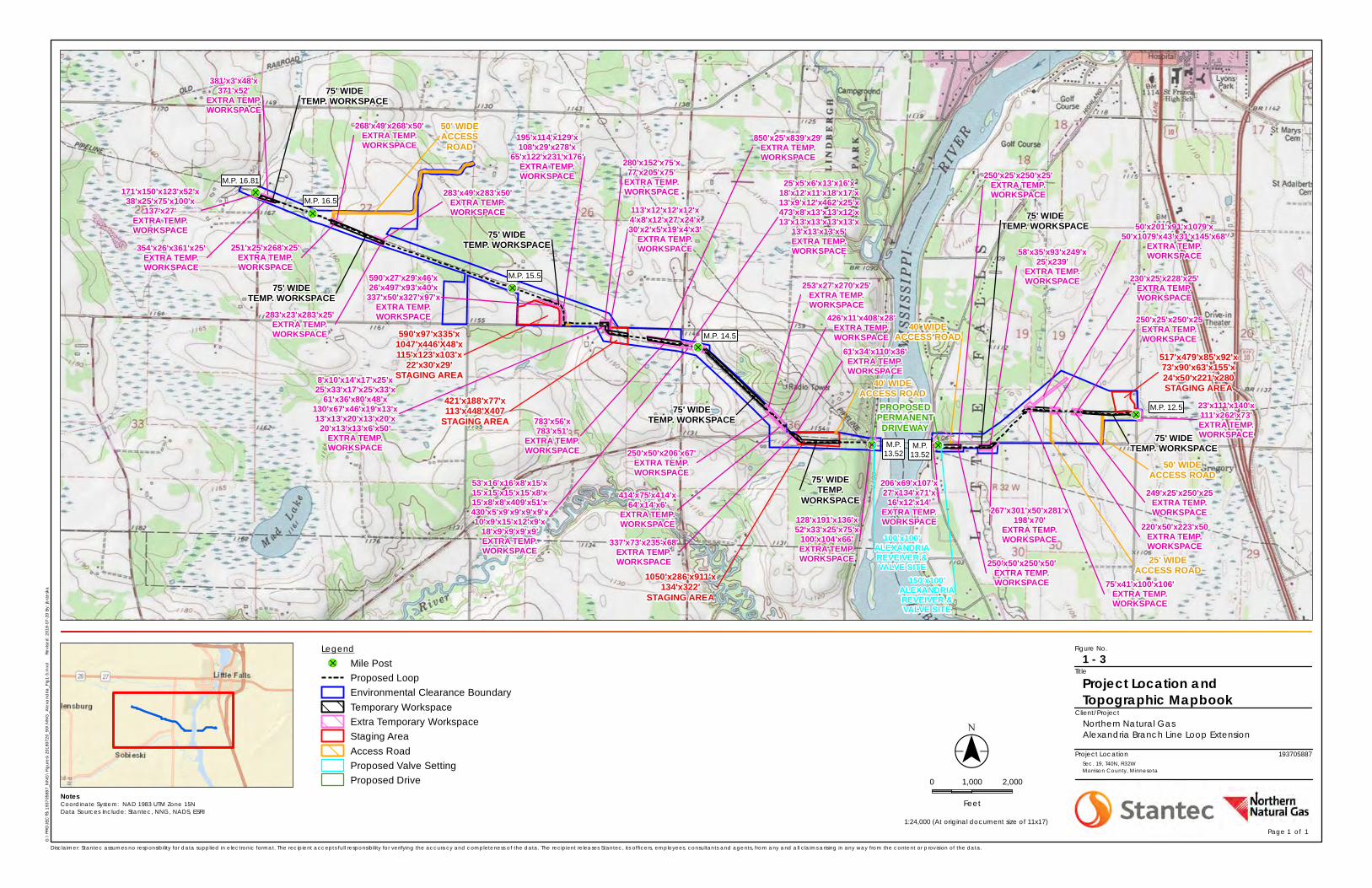
Figure No.
Client/Project
Project Location
Notes
G:\
PRO
JEC
TS\1
9370
5887
_NN
G\
Fig
ure
s\20
1807
20_9
0\N
NG
_Ale
xand
ria_F
ig1-
3.m
xd
Re
vise
d: 2
018-
07-2
0 By
: jb
rze
ska
Disclaimer: Stantec assumes no responsibility for data supplied in electronic format. The recipient accepts full responsibility for verifying the accuracy and completeness of the data. The recipient releases Stantec, its officers, employees, consultants and agents, from any and all claims arising in any way from the content or provision of the data.
Project Location and Topographic Mapbook
1 - 3
Northern Natural GasAlexandria Branch Line Loop Extension
193705887Sec. 19, T40N, R32WMorrison County, Minnesota
Title
&-Ï
&-Ï&-Ï
&-Ï
&-Ï
&-Ï
&-Ï
M.P. 16.81
M.P. 12.5
M.P.13.52
M.P.13.52
M.P. 14.5
M.P. 15.5
M.P. 16.5
249'x25'x250'x25EXTRA TEMP.WORKSPACE
250'x25'x250'x25EXTRA TEMP.WORKSPACE
50' WIDEACCESS ROAD
220'x50'x223'x50EXTRA TEMP.WORKSPACE
75'x41'x100'x106'EXTRA TEMP.WORKSPACE
25' WIDEACCESS ROAD
50'x201'x91'x1079'x50'x1079'x43'x31'x145'x68'
EXTRA TEMP.WORKSPACE
230'x25'x228'x25'EXTRA TEMP.WORKSPACE
267'x301'x50'x281'x198'x70'
EXTRA TEMP.WORKSPACE
58'x35'x93'x249'x25'x239'
EXTRA TEMP.WORKSPACE
128'x191'x136'x52'x33'x25'x75'x
100'x104'x66'EXTRA TEMP.WORKSPACE
250'x25'x250'x25'EXTRA TEMP.WORKSPACE
250'x50'x250'x50'EXTRA TEMP.WORKSPACE
40' WIDEACCESS ROAD
337'x73'x235'x68'EXTRA TEMP.WORKSPACE
414'x75'x414'x64'x14'x6'
EXTRA TEMP.WORKSPACE
61'x34'x110'x36'EXTRA TEMP.WORKSPACE
250'x50'x206'x67'EXTRA TEMP.WORKSPACE
426'x11'x408'x28'EXTRA TEMP.WORKSPACE
253'x27'x270'x25'EXTRA TEMP.WORKSPACE
53'x16'x16'x8'x15'x15'x15'x15'x15'x8'x15'x8'x8'x409'x51'x430'x5'x9'x9'x9'x9'x10'x9'x15'x12'x9'x
18'x9'x9'x9'x9'EXTRA TEMP.WORKSPACE
25'x5'x6'x13'x16'x18'x12'x11'x18'x17'x13'x9'x12'x462'x25'x473'x8'x13'x13'x12'x13'x13'x13'x13'x13'x
13'x13'x13'x5'EXTRA TEMP.WORKSPACE
783'x56'x783'x51'
EXTRA TEMP.WORKSPACE
850'x25'x839'x29'EXTRA TEMP.WORKSPACE
590'x27'x29'x46'x26'x497'x93'x40'x337'x50'x327'x97'x
EXTRA TEMP.WORKSPACE
283'x49'x283'x50'EXTRA TEMP.WORKSPACE
251'x25'x268'x25'EXTRA TEMP.WORKSPACE
268'x49'x268'x50'EXTRA TEMP.WORKSPACE
50' WIDEACCESS
ROAD
354'x26'x361'x25'EXTRA TEMP.WORKSPACE
381'x3'x48'x371'x52'
EXTRA TEMP.WORKSPACE
171'x150'x123'x52'x38'x25'x75'x100'x
137'x27'EXTRA TEMP.WORKSPACE
283'x23'x283'x25'EXTRA TEMP.WORKSPACE
75' WIDETEMP. WORKSPACE
75' WIDETEMP. WORKSPACE
75' WIDETEMP.
WORKSPACE
75' WIDETEMP. WORKSPACE
75' WIDETEMP. WORKSPACE
75' WIDETEMP. WORKSPACE
75' WIDETEMP. WORKSPACE
113'x12'x12'x12'x4'x8'x12'x27'x24'x30'x2'x5'x19'x4'x3'
EXTRA TEMP.WORKSPACE
8'x10'x14'x17'x25'x25'x33'x17'x25'x33'x
61'x36'x80'x48'x130'x67'x46'x19'x13'x13'x13'x20'x13'x20'x
20'x13'x13'x6'x50'EXTRA TEMP.WORKSPACE
206'x69'x107'x27'x134'x71'x
16'x12'x14'EXTRA TEMP.WORKSPACE
517'x479'x85'x92'x73'x90'x63'x155'x24'x50'x221'x280STAGING AREA
1050'x286'x911'x134'x322'
STAGING AREA
590'x97'x335'x1047'x446'X48'x115'x123'x103'x
22'x30'x29'STAGING AREA
421'x188'x77'x113'x448'X407
STAGING AREA
195'x114'x129'x108'x29'x278'x
65'x122'x231'x176'EXTRA TEMP.WORKSPACE
280'x152'x75'x77'x205'x75'
EXTRA TEMP.WORKSPACE
40' WIDEACCESS ROAD
23'x111'x140'x111'x262'x73'EXTRA TEMP.WORKSPACE
PROPOSEDPERMANENTDRIVEWAY
100'x100'ALEXANDRIAREVEIVER &VALVE SITE
150'x100'ALEXANDRIAREVEIVER &VALVE SITE
Legend&-Ï Mile Post
Proposed LoopEnvironmental Clearance BoundaryTemporary WorkspaceExtra Temporary WorkspaceStaging AreaAccess RoadProposed Valve SettingProposed Drive
Coordinate System: NAD 1983 UTM Zone 15NData Sources Include: Stantec, NNG, NADS, ESRI
Page 1 of 1 1:24,000 (At original document size of 11x17)
($$¯0 1,000 2,000
Feet
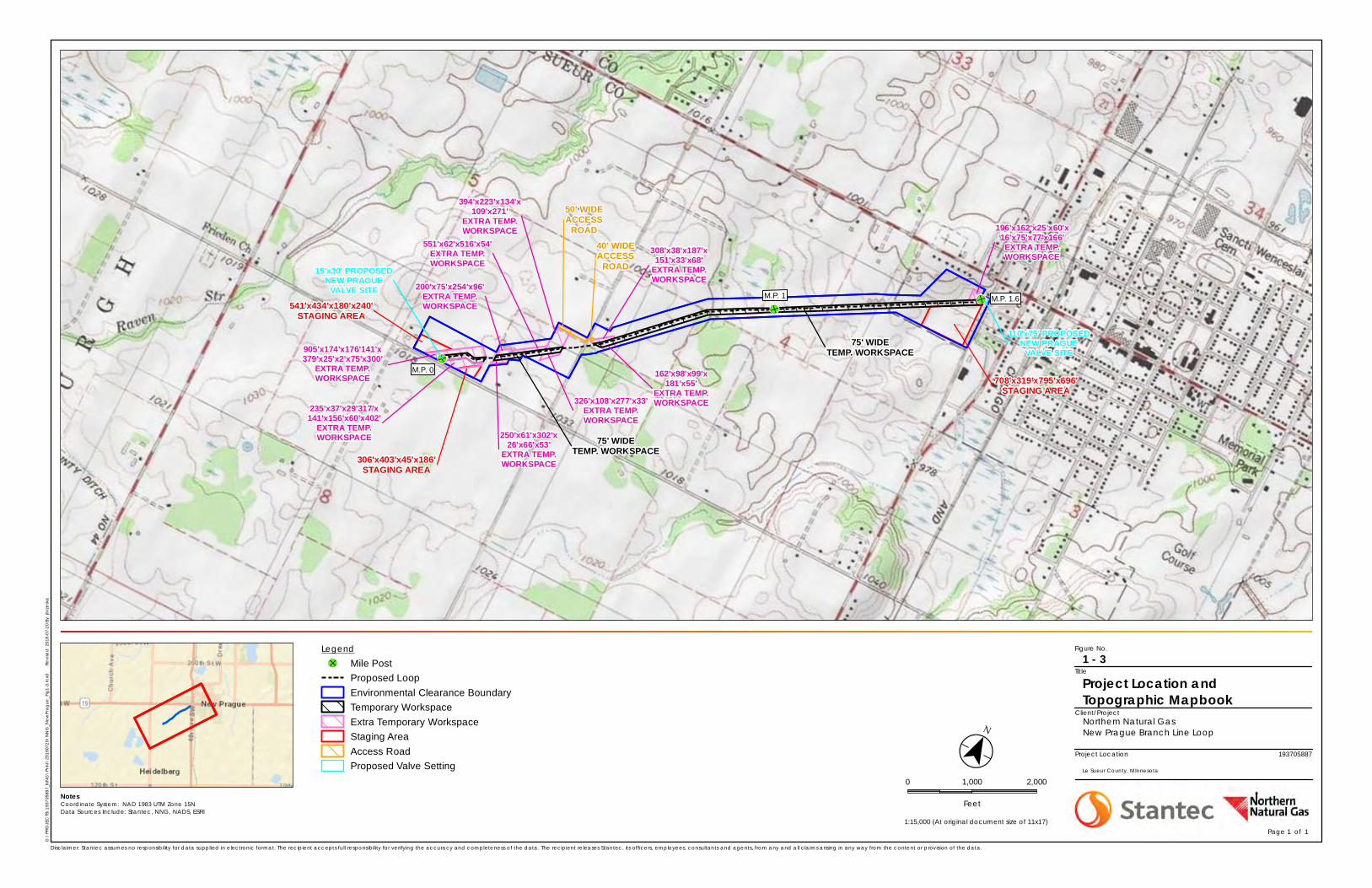
Figure No.
Client/Project
Project Location
Notes
G:\
PRO
JEC
TS\1
9370
5887
_NN
G\
Prin
t\20
1807
20\N
NG
_Ne
wPr
ag
ue_F
ig1-
3.m
xd
Re
vise
d: 2
018-
07-2
0 By
: jb
rze
ska
Disclaimer: Stantec assumes no responsibility for data supplied in electronic format. The recipient accepts full responsibility for verifying the accuracy and completeness of the data. The recipient releases Stantec, its officers, employees, consultants and agents, from any and all claims arising in any way from the content or provision of the data.
Project Location and Topographic Mapbook
1 - 3
Northern Natural GasNew Prague Branch Line Loop
193705887
Le Sueur County, MInnesota
Title
&-Ï
&-Ï
&-ÏM.P. 1
M.P. 0
M.P. 1.6541'x434'x180'x240'STAGING AREA
905'x174'x176'141'x379'x25'x2'x75'x300'
EXTRA TEMP.WORKSPACE
235'x37'x29'317'x141'x156'x60'x402'
EXTRA TEMP.WORKSPACE
306'x403'x45'x186'STAGING AREA
250'x61'x302'x26'x66'x53'
EXTRA TEMP.WORKSPACE
200'x75'x254'x96'EXTRA TEMP.WORKSPACE
551'x62'x516'x54'EXTRA TEMP.WORKSPACE
326'x108'x277'x33'EXTRA TEMP.WORKSPACE
394'x223'x134'x109'x271'
EXTRA TEMP.WORKSPACE
75' WIDETEMP. WORKSPACE
308'x38'x187'x151'x33'x68'
EXTRA TEMP.WORKSPACE
162'x98'x99'x181'x55'
EXTRA TEMP.WORKSPACE
75' WIDETEMP. WORKSPACE
708'x319'x795'x696'STAGING AREA
196'x162'x25'x60'x16'x75'x77'x166'EXTRA TEMP.WORKSPACE
50' WIDEACCESS
ROAD
PROPOSED24"
PROPOSED
24"
PROPOSED24"
PROPOSED24"
PROPOSED24"
008-W1
001-W1
006-W1
40' WIDEACCESS
ROAD15'x30' PROPOSEDNEW PRAGUE
VALVE SITE
110'x75' PROPOSEDNEW PRAGUE
VALVE SITE
Legend&-Ï Mile Post
Proposed LoopEnvironmental Clearance BoundaryTemporary WorkspaceExtra Temporary WorkspaceStaging AreaAccess RoadProposed Valve Setting
Coordinate System: NAD 1983 UTM Zone 15NData Sources Include: Stantec, NNG, NADS, ESRI
Page 1 of 1 1:15,000 (At original document size of 11x17)
($$¯
0 1,000 2,000
Feet
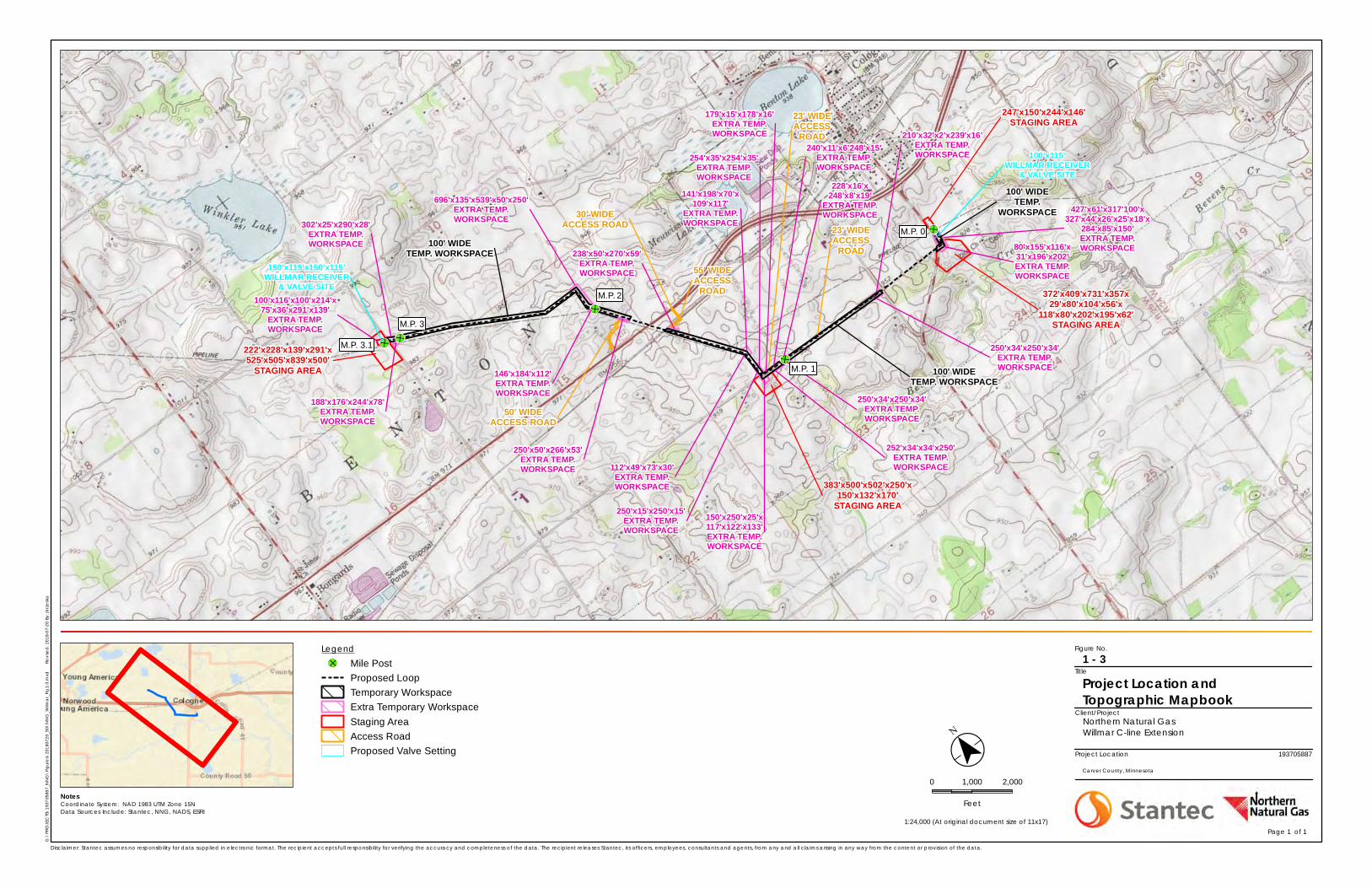
Figure No.
Client/Project
Project Location
Notes
G:\
PRO
JEC
TS\1
9370
5887
_NN
G\
Fig
ure
s\20
1807
20_9
0\N
NG
_Wilm
ar_
Fig
1-3.
mxd
Revi
sed
: 201
8-07
-20
By: j
brz
esk
a
Disclaimer: Stantec assumes no responsibility for data supplied in electronic format. The recipient accepts full responsibility for verifying the accuracy and completeness of the data. The recipient releases Stantec, its officers, employees, consultants and agents, from any and all claims arising in any way from the content or provision of the data.
Project Location and Topographic Mapbook
1 - 3
Northern Natural GasWillmar C-line Extension
193705887
Carver County, Minnesota
Title
&-Ï
&-Ï
&-Ï
&-Ï
&-Ï
80'x155'x116'x31'x196'x202'EXTRA TEMP.WORKSPACE
247'x150'x244'x146'STAGING AREA
427'x61'x317'100'x327'x44'x26'x25'x18'x
284'x85'x150'EXTRA TEMP.WORKSPACE
100' WIDETEMP.
WORKSPACE
250'x34'x250'x34'EXTRA TEMP.WORKSPACE100' WIDE
TEMP. WORKSPACE
210'x32'x2'x239'x16'EXTRA TEMP.WORKSPACE
150'x250'x25'x117'x122'x133'EXTRA TEMP.WORKSPACE
252'x34'x34'x250'EXTRA TEMP.WORKSPACE
383'x500'x502'x250'x150'x132'x170'
STAGING AREA
23' WIDEACCESS
ROAD
250'x34'x250'x34'EXTRA TEMP.WORKSPACE
228'x16'x248'x8'x19'
EXTRA TEMP.WORKSPACE
240'x11'x6'248'x15'EXTRA TEMP.WORKSPACE
23' WIDEACCESS
ROAD
179'x15'x178'x16'EXTRA TEMP.WORKSPACE
141'x198'x70'x109'x117'
EXTRA TEMP.WORKSPACE
112'x49'x73'x30'EXTRA TEMP.WORKSPACE
250'x15'x250'x15'EXTRA TEMP.WORKSPACE
254'x35'x254'x35'EXTRA TEMP.WORKSPACE
250'x50'x266'x53'EXTRA TEMP.WORKSPACE
238'x50'x270'x59'EXTRA TEMP.WORKSPACE 55' WIDE
ACCESSROAD
30' WIDEACCESS ROAD
146'x184'x112'EXTRA TEMP.WORKSPACE
696'x135'x539'x50'x250'EXTRA TEMP.WORKSPACE
50' WIDEACCESS ROAD
100' WIDETEMP. WORKSPACE
188'x176'x244'x78'EXTRA TEMP.WORKSPACE
302'x25'x290'x28'EXTRA TEMP.WORKSPACE
100'x116'x100'x214'x75'x36'x291'x139'
EXTRA TEMP.WORKSPACE
222'x228'x139'x291'x525'x505'x839'x500'
STAGING AREA
372'x409'x731'x357x29'x80'x104'x56'x
118'x80'x202'x195'x62'STAGING AREA
150'x115'x150'x115'WILLMAR RECEIVER
& VALVE SITE
100'x115'WILLMAR RECEIVER
& VALVE SITE
M.P. 0
M.P. 1
M.P. 2
M.P. 3
M.P. 3.1
Legend&-Ï Mile Post
Proposed LoopTemporary WorkspaceExtra Temporary WorkspaceStaging AreaAccess RoadProposed Valve Setting
Coordinate System: NAD 1983 UTM Zone 15NData Sources Include: Stantec, NNG, NADS, ESRI
Page 1 of 1 1:24,000 (At original document size of 11x17)
($
$ ¯0 1,000 2,000
Feet
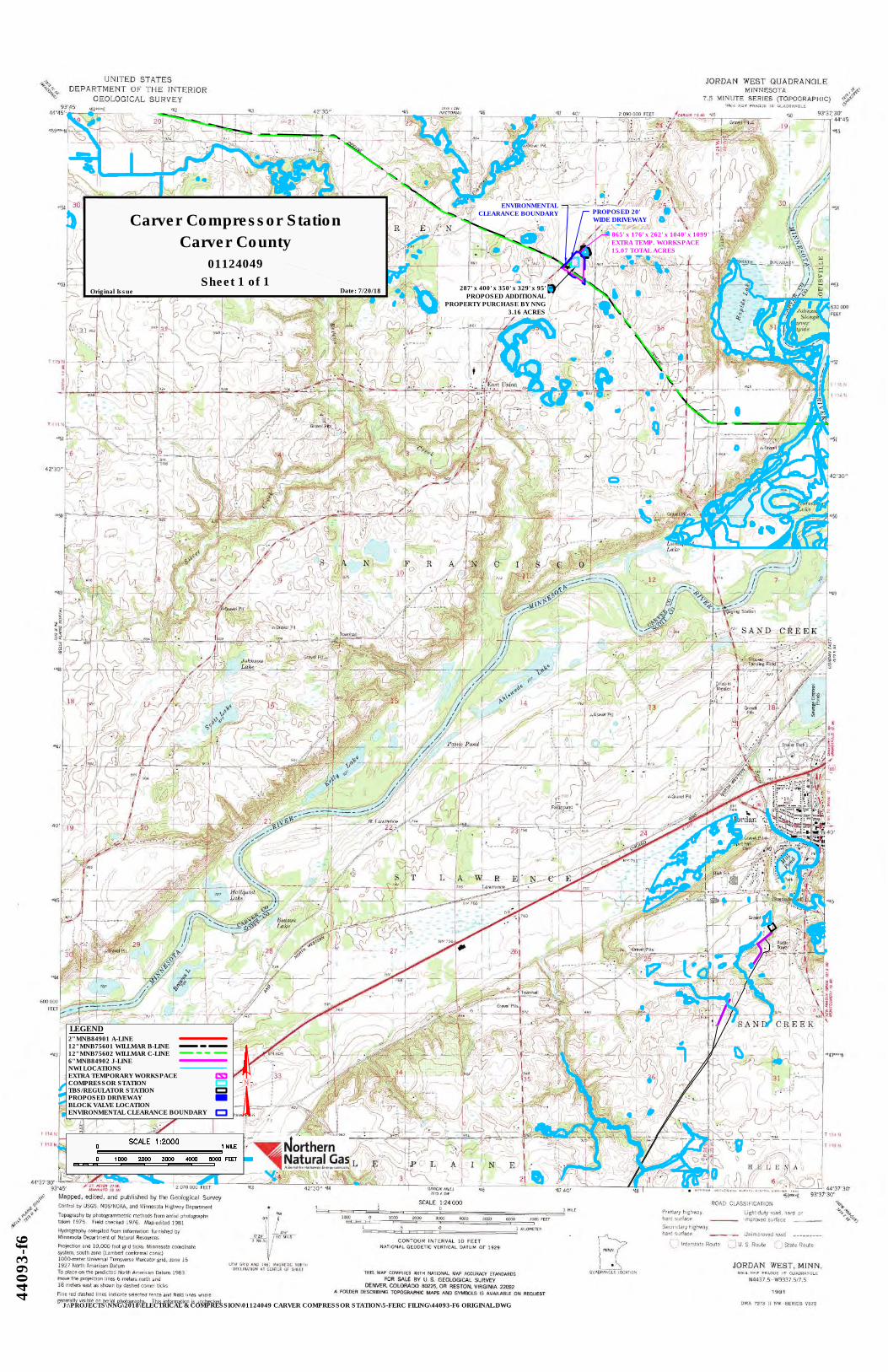
01124049
Carver Compressor StationCarver County
Date: 7/20/18Original IssueSheet 1 of 1
J:\PROJECTS\NNG\2018\ELECTRICAL & COMPRESSION\01124049 CARVER COMPRESSOR STATION\5-FERC FILING\44093-F6 ORIGINAL.DWG
4409
3-f6
865' x 176' x 262' x 1040' x 1099'EXTRA TEMP. WORKSPACE15.07 TOTAL ACRES
LEGEND2" MNB84901 A-LINE12" MNB75601 WILLMAR B-LINE
EXTRA TEMPORARY WORKSPACE
TBS/REGULATOR STATION
NWI LOCATIONS6" MNB84902 J-LINE12" MNB75602 WILLMAR C-LINE
COMPRESSOR STATION
BLOCK VALVE LOCATIONENVIRONMENTAL CLEARANCE BOUNDARY
ENVIRONMENTALCLEARANCE BOUNDARY
287' x 400' x 350' x 329' x 95'PROPOSED ADDITIONAL
PROPERTY PURCHASE BY NNG3.16 ACRES
PROPOSED DRIVEWAY
PROPOSED 20'WIDE DRIVEWAY
AutoCAD SHX Text
SCALE 1:2000
AutoCAD SHX Text
MILE
AutoCAD SHX Text
1
AutoCAD SHX Text
0
AutoCAD SHX Text
FEET
AutoCAD SHX Text
5000
AutoCAD SHX Text
4000
AutoCAD SHX Text
3000
AutoCAD SHX Text
2000
AutoCAD SHX Text
1000
AutoCAD SHX Text
0
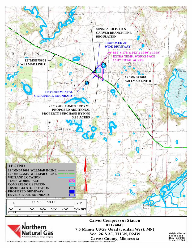
7.5 Minute USGS Quad (Jordan West, MN)
J:\PROJECTS\NNG\2018\ELECTRICAL & COMPRESSION\01124049 CARVER COMPRESSOR STATION\5-FERC FILING\44093-F6 ORIGINAL.DWG
Date: 7/20/18Scale: 1:2000
Carver Compressor Station01124049
Sec. 26 & 35, T115N, R24WCarver County, Minnesota
Sheet 1 of 1Original Issue
LEGEND12" MNB75601 WILLMAR B-LINE
TEMP. WORKSPACE
12" MNB75602 WILLMAR C-LINE
COMPRESSOR STATIONTBS/REGULATOR STATION
WETLAND LOCATION
ENVIR. CLEAR. BOUNDARY
12" MNB75602WILLMAR LINE C
12" MNB75601WILLMAR LINE B
MINNEAPOLIS 1R &CARVER BRANCH LINEREGULATION
ENVIRONMENTALCLEARANCE BOUNDARY
PROPOSED 20'WIDE DRIVEWAY
PROPOSED DRIVEWAY
865' x 176' x 262' x 1040' x 1099'EXTRA TEMP. WORKSPACE15.07 TOTAL ACRES
287' x 400' x 350' x 329' x 95'PROPOSED ADDITIONAL
PROPERTY PURCHASE BY NNG3.16 ACRES
AutoCAD SHX Text
1000
AutoCAD SHX Text
0
AutoCAD SHX Text
1000
AutoCAD SHX Text
2000
AutoCAD SHX Text
3000
AutoCAD SHX Text
4000
AutoCAD SHX Text
5000
AutoCAD SHX Text
FEET
AutoCAD SHX Text
0
AutoCAD SHX Text
1 MILE
AutoCAD SHX Text
SCALE 1:2000
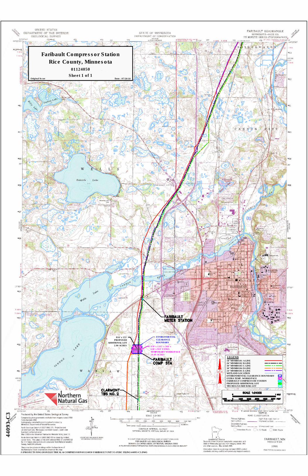
J:\PROJECTS\NNG\2018\ELECTRICAL & COMPRESSION\01124050 FARIBAULT UNIT 3\5-FERC FILING\44093-C3.DWG
4409
3-C
3
01124050
Faribault Compressor StationRice County, Minnesota
Date: 07/20/18Original IssueSheet 1 of 1
LEGEND
30" MNM80103 C-LINE
EXTRA TEMP. WORKSPACE
WETLAND LOCATION
26" MNM80102 B-LINE
ENVIRONMENTAL CLEARANCE BOUNDARY
TBS/REG/GUARD RAIL LOT
18" MNM80101 A-LINE
24" MNM80105 E-LINE30" MNM80104 D-LINE
FARIBAULT COMPRESSOR STATION
ENVIRONMENTALCLEARANCEBOUNDARY
970' x 1165' x 366' x638' x 959' EXTRATEMPORARY WORKSPACE24.49 ACRES
816' x 155'PROPOSED
ADDITIONAL LOT2.90 ACRES
PROPOSED ADDITIONAL LOT
AutoCAD SHX Text
NO.
AutoCAD SHX Text
CLARMONT
AutoCAD SHX Text
TBS
AutoCAD SHX Text
2
AutoCAD SHX Text
FARIBAULT
AutoCAD SHX Text
METER STATION
AutoCAD SHX Text
STA
AutoCAD SHX Text
FARIBAULT
AutoCAD SHX Text
COMP
AutoCAD SHX Text
SCALE 1:24000
AutoCAD SHX Text
MILE
AutoCAD SHX Text
1
AutoCAD SHX Text
0
AutoCAD SHX Text
FEET
AutoCAD SHX Text
5000
AutoCAD SHX Text
4000
AutoCAD SHX Text
3000
AutoCAD SHX Text
2000
AutoCAD SHX Text
1000
AutoCAD SHX Text
0
AutoCAD SHX Text
1000
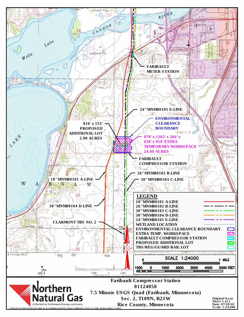
J:\PROJECTS\NNG\2018\ELECTRICAL & COMPRESSION\01124050 FARIBAULT UNIT 3\5-FERC FILING\44093-C3.DWG
Faribault Compressor Station01124050
7.5 Minute USGS Quad (Faribault, Minnnesota)Sec. 2, T109N, R21W
Rice County, Minnesota
LEGEND
EXTRA TEMP. WORKSPACE
WETLAND LOCATIONENVIRONMENTAL CLEARANCE BOUNDARY
TBS/REG/GUARD RAIL LOT
FARIBAULT COMPRESSOR STATION
Date: 07/20/18Scale: 1:24,000
Sheet 1 of 1Original Issue
ENVIRONMENTALCLEARANCEBOUNDARY
970' x 1165' x 366' x638' x 959' EXTRATEMPORARY WORKSPACE24.49 ACRES
816' x 155'PROPOSED
ADDITIONAL LOT2.90 ACRES
30" MNM80103 C-LINE
FARIBAULTCOMPRESSOR STATION
26" MNM80102 B-LINE
18" MNM80101 A-LINE
30" MNM80104 D-LINE
CLARMONT TBS NO. 2
FARIBAULTMETER STATION
24" MNM80105 E-LINE
30" MNM80103 C-LINE26" MNM80102 B-LINE18" MNM80101 A-LINE
24" MNM80105 E-LINE30" MNM80104 D-LINE
PROPOSED ADDITIONAL LOT
AutoCAD SHX Text
1000
AutoCAD SHX Text
0
AutoCAD SHX Text
1000
AutoCAD SHX Text
2000
AutoCAD SHX Text
3000
AutoCAD SHX Text
4000
AutoCAD SHX Text
5000
AutoCAD SHX Text
FEET
AutoCAD SHX Text
0
AutoCAD SHX Text
1 MILE
AutoCAD SHX Text
SCALE 1:24000
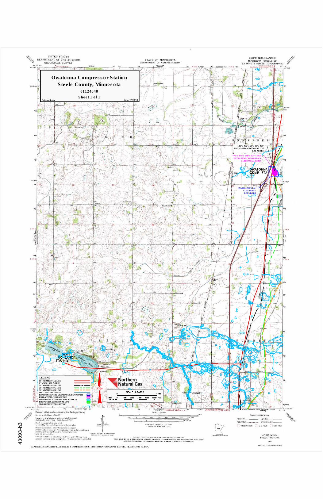
J:\PROJECTS\NNG\2018\ELECTRICAL & COMPRESSION\01124048 OWATONNA UNIT 2\5-FERC FILING\43093-H3.DWG
4309
3-h
3
01124048
Owatonna Compressor StationSteele County, Minnesota
Date: 07/20/18Original IssueSheet 1 of 1
772' x 873' x 548' x 327' x 403' EXTRA TEMP. WORKSPACE
11.82 TOTAL ACRES
ENVIRONMENTALCLEARANCEBOUNDART
115' x 462' x 21' x 96' x 470'PROPOSED ADDITIONAL LOT
1.24 ACRES
LEGEND
30" MNM80103 C-LINE
EXTRA TEMP. WORKSPACE
WETLAND LOCATION
24" MNM80102 B-LINE
ENVIRONMENTAL CLEARANCE BOUNDARY
TBS/REGULATOR STATION
18" MNM80101 A-LINE
30" MNM80104 D-LINE
OWATONNA COMPRESSOR STATIONPROPOSED ADDITIONAL LOT
2" MNB81801 A-LINE
AutoCAD SHX Text
STA
AutoCAD SHX Text
OWATONNA
AutoCAD SHX Text
COMP
AutoCAD SHX Text
NO.
AutoCAD SHX Text
NEW
AutoCAD SHX Text
RICHLAND
AutoCAD SHX Text
TBS
AutoCAD SHX Text
1
AutoCAD SHX Text
SCALE 1:24000
AutoCAD SHX Text
MILE
AutoCAD SHX Text
1
AutoCAD SHX Text
0
AutoCAD SHX Text
FEET
AutoCAD SHX Text
5000
AutoCAD SHX Text
4000
AutoCAD SHX Text
3000
AutoCAD SHX Text
2000
AutoCAD SHX Text
1000
AutoCAD SHX Text
0
AutoCAD SHX Text
1000
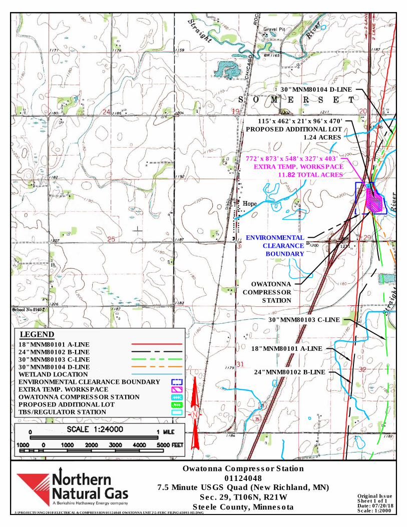
J:\PROJECTS\NNG\2018\ELECTRICAL & COMPRESSION\01124048 OWATONNA UNIT 2\5-FERC FILING\43093-H3.DWG
Date: 07/20/18Scale: 1:2000
Owatonna Compressor Station01124048
7.5 Minute USGS Quad (New Richland, MN)Sec. 29, T106N, R21W
Steele County, MinnesotaSheet 1 of 1Original Issue
115' x 462' x 21' x 96' x 470' PROPOSED ADDITIONAL LOT
1.24 ACRES
772' x 873' x 548' x 327' x 403' EXTRA TEMP. WORKSPACE
11.82 TOTAL ACRES
ENVIRONMENTAL CLEARANCE BOUNDARY
OWATONNACOMPRESSOR
STATION
18" MNM80101 A-LINE
LEGEND
30" MNM80103 C-LINE
EXTRA TEMP. WORKSPACE
WETLAND LOCATION
24" MNM80102 B-LINE
ENVIRONMENTAL CLEARANCE BOUNDARY
TBS/REGULATOR STATION
18" MNM80101 A-LINE
30" MNM80104 D-LINE
OWATONNA COMPRESSOR STATIONPROPOSED ADDITIONAL LOT
24" MNM80102 B-LINE
30" MNM80103 C-LINE
30" MNM80104 D-LINE
AutoCAD SHX Text
1000
AutoCAD SHX Text
0
AutoCAD SHX Text
1000
AutoCAD SHX Text
2000
AutoCAD SHX Text
3000
AutoCAD SHX Text
4000
AutoCAD SHX Text
5000
AutoCAD SHX Text
FEET
AutoCAD SHX Text
0
AutoCAD SHX Text
1 MILE
AutoCAD SHX Text
SCALE 1:24000
Appendix C
Typical Right-of-Way Cross Sections
For the Rochester Project and the Northern Lights 2019 Expansion Project
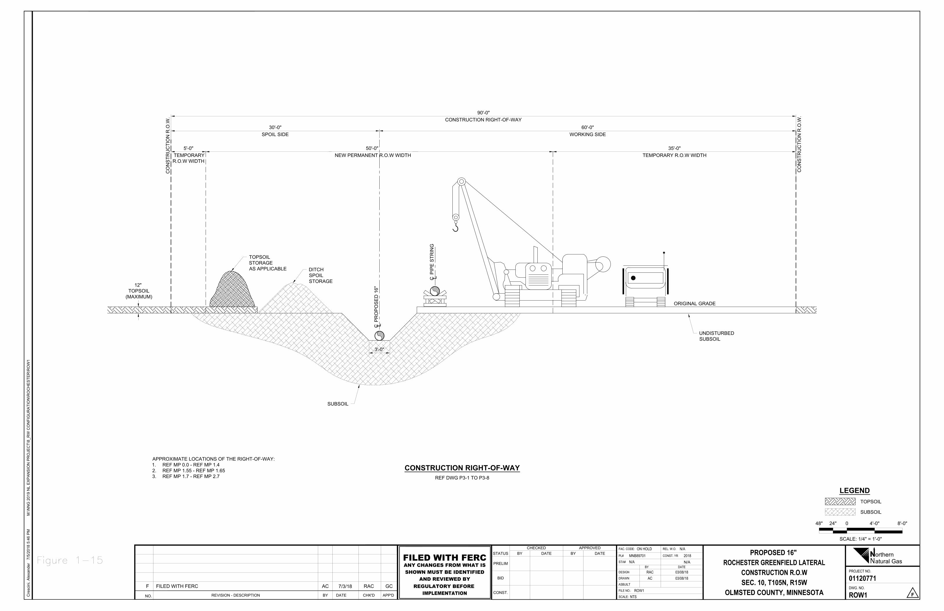
CO
NS
TRU
CTI
ON
R.O
.W.
CO
NS
TRU
CTI
ON
R.O
.W.
CP
RO
PO
SE
D 1
6"
CP
IPE
STR
ING
SUBSOIL
DITCHSPOILSTORAGE
60'-0"WORKING SIDE
90'-0"CONSTRUCTION RIGHT-OF-WAY
30'-0"SPOIL SIDE
TOPSOILSTORAGEAS APPLICABLE
ORIGINAL GRADE
UNDISTURBEDSUBSOIL
12" TOPSOIL
(MAXIMUM)
3'-0"
5'-0" TEMPORARYR.O.W WIDTH
35'-0"TEMPORARY R.O.W WIDTH
50'-0" NEW PERMANENT R.O.W WIDTH
SCALE: 1/4" = 1'-0"
48" 24" 0 4'-0" 8'-0"
TOPSOIL
SUBSOIL
LEGEND
REF DWG P3-1 TO P3-8
CONSTRUCTION RIGHT-OF-WAY
Cre
scin
i, A
lexa
nder
7/5/
2018
5:4
6 P
MM
:\NN
G 2
019
NL
EX
PA
NS
ION
PR
OJE
CT\
8_R
W C
ON
FIG
UR
ATI
ON
\RO
CH
ES
TER
\RO
W1
NO. REVISION - DESCRIPTION CHK'DDATE APP'DBY
F FILED WITH FERC AC 7/3/18 RAC GC
NPROJECT NO.
FAC. CODE: REL. W.O.DATEBY
DWG. NO.
CONST. YRSTATUS
PRELIM
BID
CONST.SCALE:
DATECHECKED
BYAPPROVED
BY
FILE NO.:
ASBUILT
DESIGN
DRAWN
PL#
DATESTA#
orthernatural Gas
PROPOSED 16" ROCHESTER GREENFIELD LATERAL
CONSTRUCTION R.O.WSEC. 10, T105N, R15W
OLMSTED COUNTY, MINNESOTA
01120771
ROW1 F
ON HOLD N/AMNB89701N/A
2018
RAC 03/08/18AC 03/08/18
ROW1NTS
N/AFILED WITH FERCANY CHANGES FROM WHAT ISSHOWN MUST BE IDENTIFIED
AND REVIEWED BYREGULATORY BEFORE
IMPLEMENTATION
APPROXIMATE LOCATIONS OF THE RIGHT-OF-WAY:1. REF MP 0.0 - REF MP 1.42. REF MP 1.55 - REF MP 1.653. REF MP 1.7 - REF MP 2.7
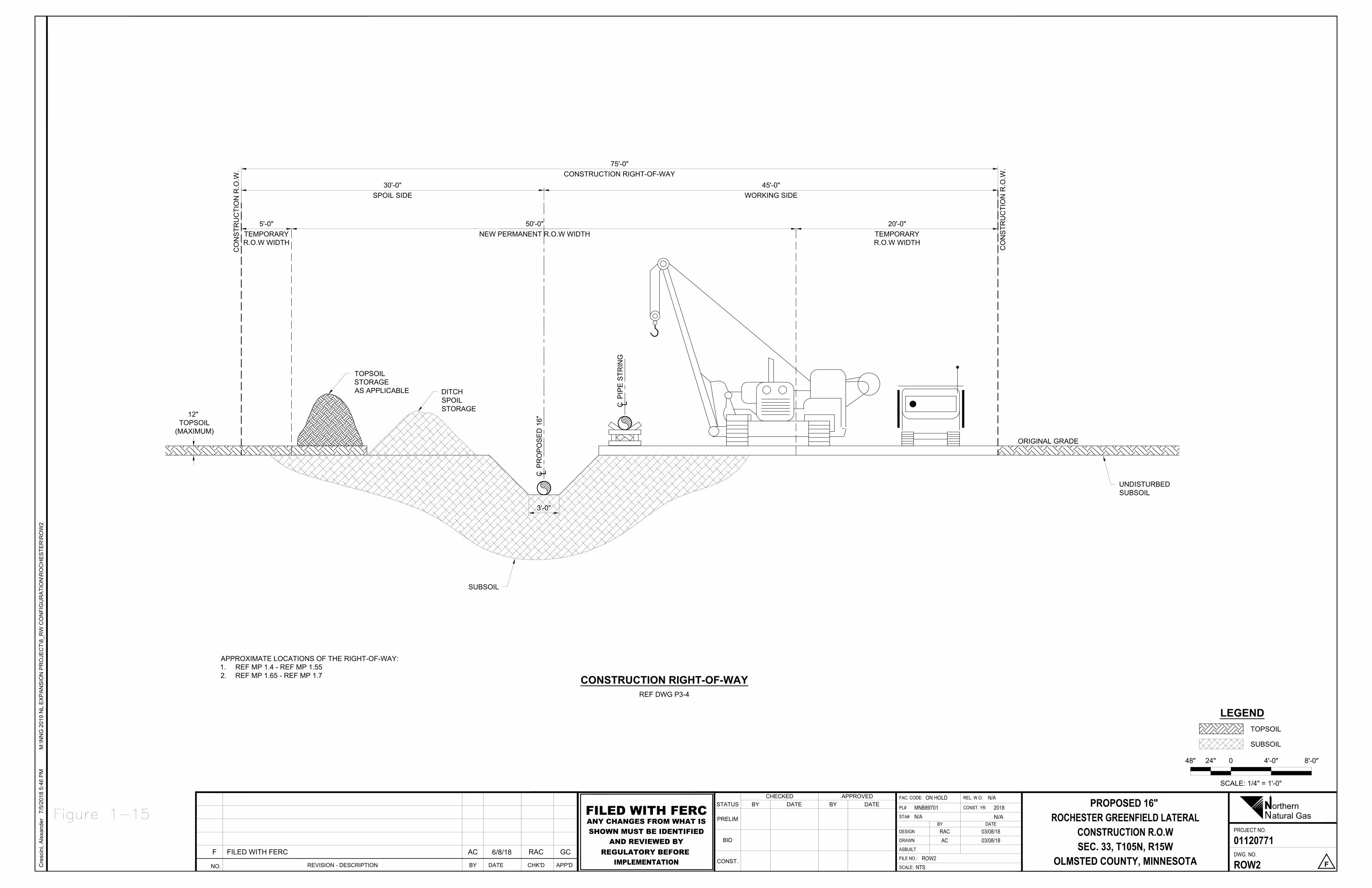
CO
NS
TRU
CTI
ON
R.O
.W.
CO
NS
TRU
CTI
ON
R.O
.W.
CP
RO
PO
SE
D 1
6"
CP
IPE
STR
ING
SUBSOIL
DITCHSPOILSTORAGE
45'-0"WORKING SIDE
75'-0"CONSTRUCTION RIGHT-OF-WAY
30'-0"SPOIL SIDE
TOPSOILSTORAGEAS APPLICABLE
ORIGINAL GRADE
UNDISTURBEDSUBSOIL
12" TOPSOIL
(MAXIMUM)
3'-0"
5'-0"TEMPORARYR.O.W WIDTH
50'-0"NEW PERMANENT R.O.W WIDTH
20'-0"TEMPORARYR.O.W WIDTH
SCALE: 1/4" = 1'-0"
48" 24" 0 4'-0" 8'-0"
TOPSOIL
SUBSOIL
LEGEND
REF DWG P3-4
CONSTRUCTION RIGHT-OF-WAY
Cre
scin
i, A
lexa
nder
7/5/
2018
5:4
6 P
MM
:\NN
G 2
019
NL
EX
PA
NS
ION
PR
OJE
CT\
8_R
W C
ON
FIG
UR
ATI
ON
\RO
CH
ES
TER
\RO
W2
NO. REVISION - DESCRIPTION CHK'DDATE APP'DBY
F FILED WITH FERC AC 6/8/18 RAC GC
NPROJECT NO.
FAC. CODE: REL. W.O.DATEBY
DWG. NO.
CONST. YRSTATUS
PRELIM
BID
CONST.SCALE:
DATECHECKED
BYAPPROVED
BY
FILE NO.:
ASBUILT
DESIGN
DRAWN
PL#
DATESTA#
orthernatural Gas
PROPOSED 16" ROCHESTER GREENFIELD LATERAL
CONSTRUCTION R.O.WSEC. 33, T105N, R15W
OLMSTED COUNTY, MINNESOTA
01120771
ROW2 F
ON HOLD N/AMNB89701N/A
2018
RAC 03/08/18AC 03/08/18
ROW2NTS
N/AFILED WITH FERCANY CHANGES FROM WHAT ISSHOWN MUST BE IDENTIFIED
AND REVIEWED BYREGULATORY BEFORE
IMPLEMENTATION
APPROXIMATE LOCATIONS OF THE RIGHT-OF-WAY:1. REF MP 1.4 - REF MP 1.552. REF MP 1.65 - REF MP 1.7
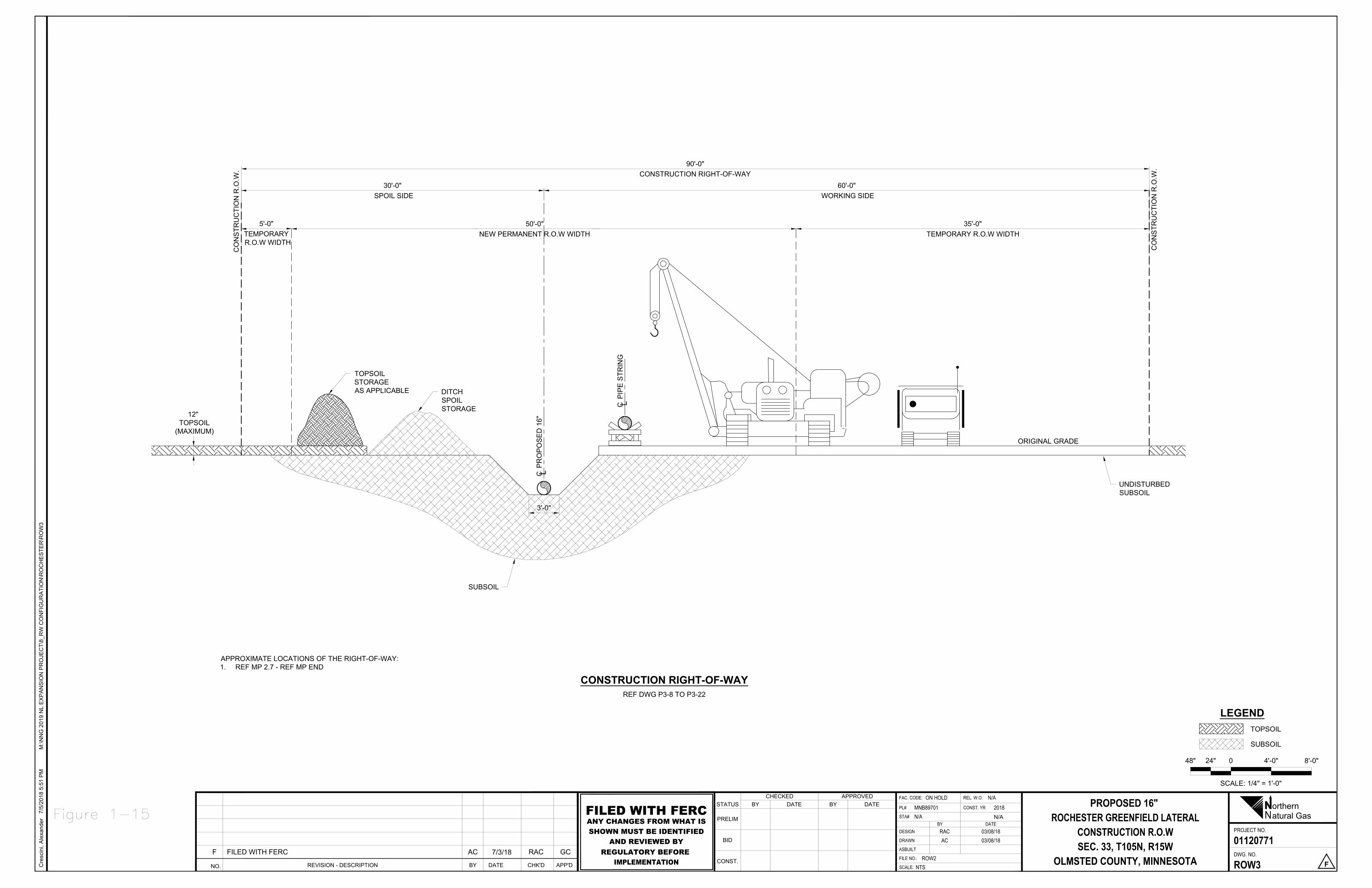
CO
NS
TRU
CTI
ON
R.O
.W.
CO
NS
TRU
CTI
ON
R.O
.W.
CP
RO
PO
SE
D 1
6"
CP
IPE
STR
ING
SUBSOIL
DITCHSPOILSTORAGE
60'-0" WORKING SIDE
90'-0"CONSTRUCTION RIGHT-OF-WAY
30'-0" SPOIL SIDE
TOPSOILSTORAGEAS APPLICABLE
ORIGINAL GRADE
UNDISTURBEDSUBSOIL
12" TOPSOIL
(MAXIMUM)
3'-0"
5'-0"TEMPORARY R.O.W WIDTH
50'-0"NEW PERMANENT R.O.W WIDTH
35'-0"TEMPORARY R.O.W WIDTH
SCALE: 1/4" = 1'-0"
48" 24" 0 4'-0" 8'-0"
TOPSOIL
SUBSOIL
LEGEND
REF DWG P3-8 TO P3-22
CONSTRUCTION RIGHT-OF-WAY
Cre
scin
i, A
lexa
nder
7/5/
2018
5:5
1 P
MM
:\NN
G 2
019
NL
EX
PA
NS
ION
PR
OJE
CT\
8_R
W C
ON
FIG
UR
ATI
ON
\RO
CH
ES
TER
\RO
W3
NO. REVISION - DESCRIPTION CHK'DDATE APP'DBY
F FILED WITH FERC AC 7/3/18 RAC GC
NPROJECT NO.
FAC. CODE: REL. W.O.DATEBY
DWG. NO.
CONST. YRSTATUS
PRELIM
BID
CONST.SCALE:
DATECHECKED
BYAPPROVED
BY
FILE NO.:
ASBUILT
DESIGN
DRAWN
PL#
DATESTA#
orthernatural Gas
PROPOSED 16" ROCHESTER GREENFIELD LATERAL
CONSTRUCTION R.O.WSEC. 33, T105N, R15W
OLMSTED COUNTY, MINNESOTA
01120771
ROW3 F
ON HOLD N/AMNB89701N/A
2018
RAC 03/08/18AC 03/08/18
ROW2NTS
N/AFILED WITH FERCANY CHANGES FROM WHAT ISSHOWN MUST BE IDENTIFIED
AND REVIEWED BYREGULATORY BEFORE
IMPLEMENTATION
APPROXIMATE LOCATIONS OF THE RIGHT-OF-WAY:1. REF MP 2.7 - REF MP END
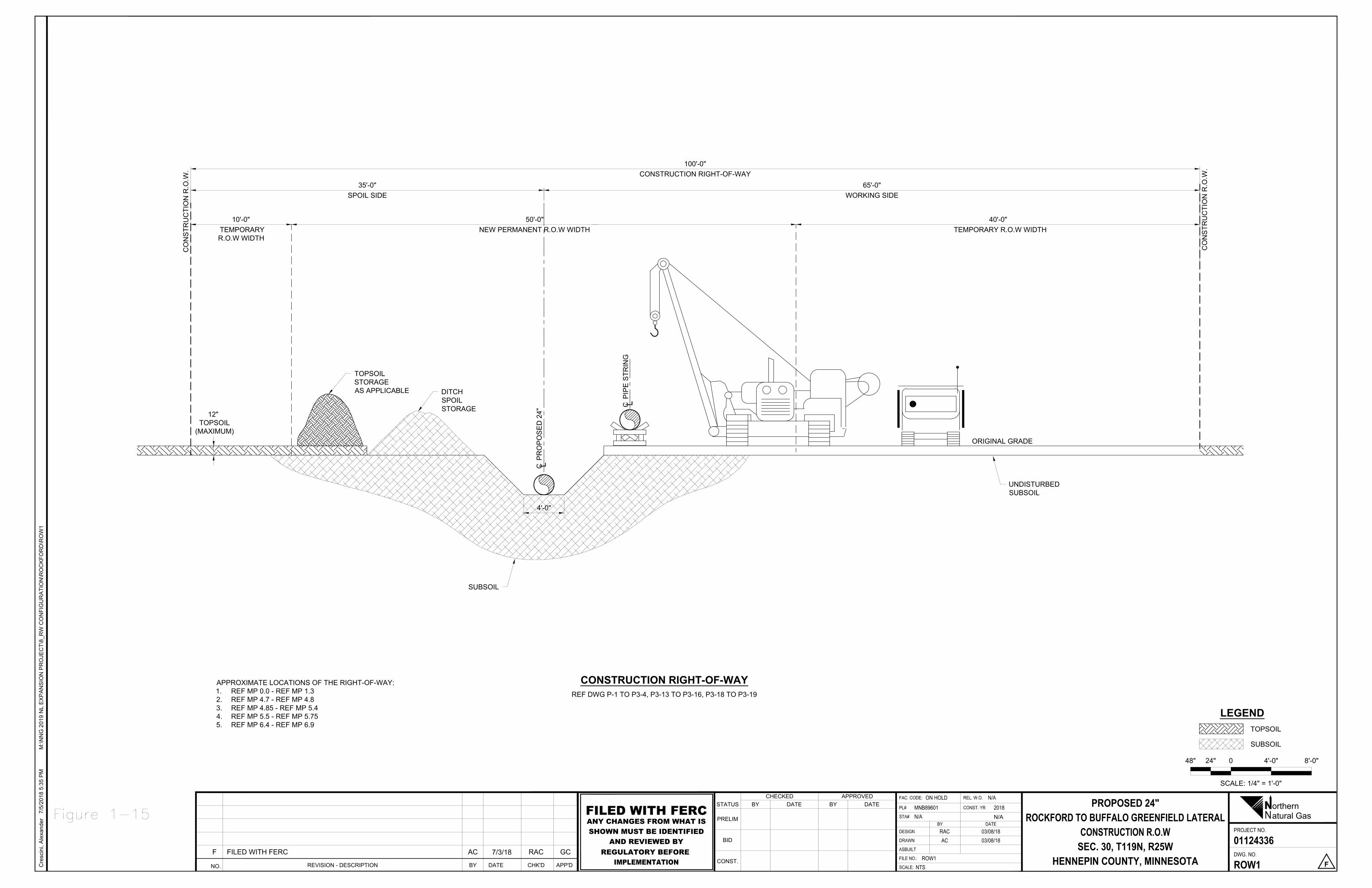
CO
NS
TRU
CTI
ON
R.O
.W.
CO
NS
TRU
CTI
ON
R.O
.W.
CP
RO
PO
SE
D 2
4" C
PIP
E S
TRIN
G
SUBSOIL
DITCHSPOILSTORAGE
65'-0"WORKING SIDE
100'-0"CONSTRUCTION RIGHT-OF-WAY
35'-0"SPOIL SIDE
TOPSOILSTORAGEAS APPLICABLE
ORIGINAL GRADE
UNDISTURBEDSUBSOIL
12" TOPSOIL
(MAXIMUM)
4'-0"
10'-0" TEMPORARYR.O.W WIDTH
50'-0"NEW PERMANENT R.O.W WIDTH
40'-0" TEMPORARY R.O.W WIDTH
SCALE: 1/4" = 1'-0"
48" 24" 0 4'-0" 8'-0"
TOPSOIL
SUBSOIL
LEGEND
REF DWG P-1 TO P3-4, P3-13 TO P3-16, P3-18 TO P3-19
CONSTRUCTION RIGHT-OF-WAY
Cre
scin
i, A
lexa
nder
7/5/
2018
5:3
5 P
MM
:\NN
G 2
019
NL
EX
PA
NS
ION
PR
OJE
CT\
8_R
W C
ON
FIG
UR
ATI
ON
\RO
CK
FOR
D\R
OW
1
NO. REVISION - DESCRIPTION CHK'DDATE APP'DBY
F FILED WITH FERC AC 7/3/18 RAC GC
NPROJECT NO.
FAC. CODE: REL. W.O.DATEBY
DWG. NO.
CONST. YRSTATUS
PRELIM
BID
CONST.SCALE:
DATECHECKED
BYAPPROVED
BY
FILE NO.:
ASBUILT
DESIGN
DRAWN
PL#
DATESTA#
orthernatural Gas
PROPOSED 24"ROCKFORD TO BUFFALO GREENFIELD LATERAL
CONSTRUCTION R.O.WSEC. 30, T119N, R25W
HENNEPIN COUNTY, MINNESOTA
01124336
ROW1 F
ON HOLD N/AMNB89601N/A
2018
RAC 03/08/18AC 03/08/18
ROW1NTS
N/AFILED WITH FERCANY CHANGES FROM WHAT ISSHOWN MUST BE IDENTIFIED
AND REVIEWED BYREGULATORY BEFORE
IMPLEMENTATION
APPROXIMATE LOCATIONS OF THE RIGHT-OF-WAY:1. REF MP 0.0 - REF MP 1.32. REF MP 4.7 - REF MP 4.83. REF MP 4.85 - REF MP 5.44. REF MP 5.5 - REF MP 5.755. REF MP 6.4 - REF MP 6.9
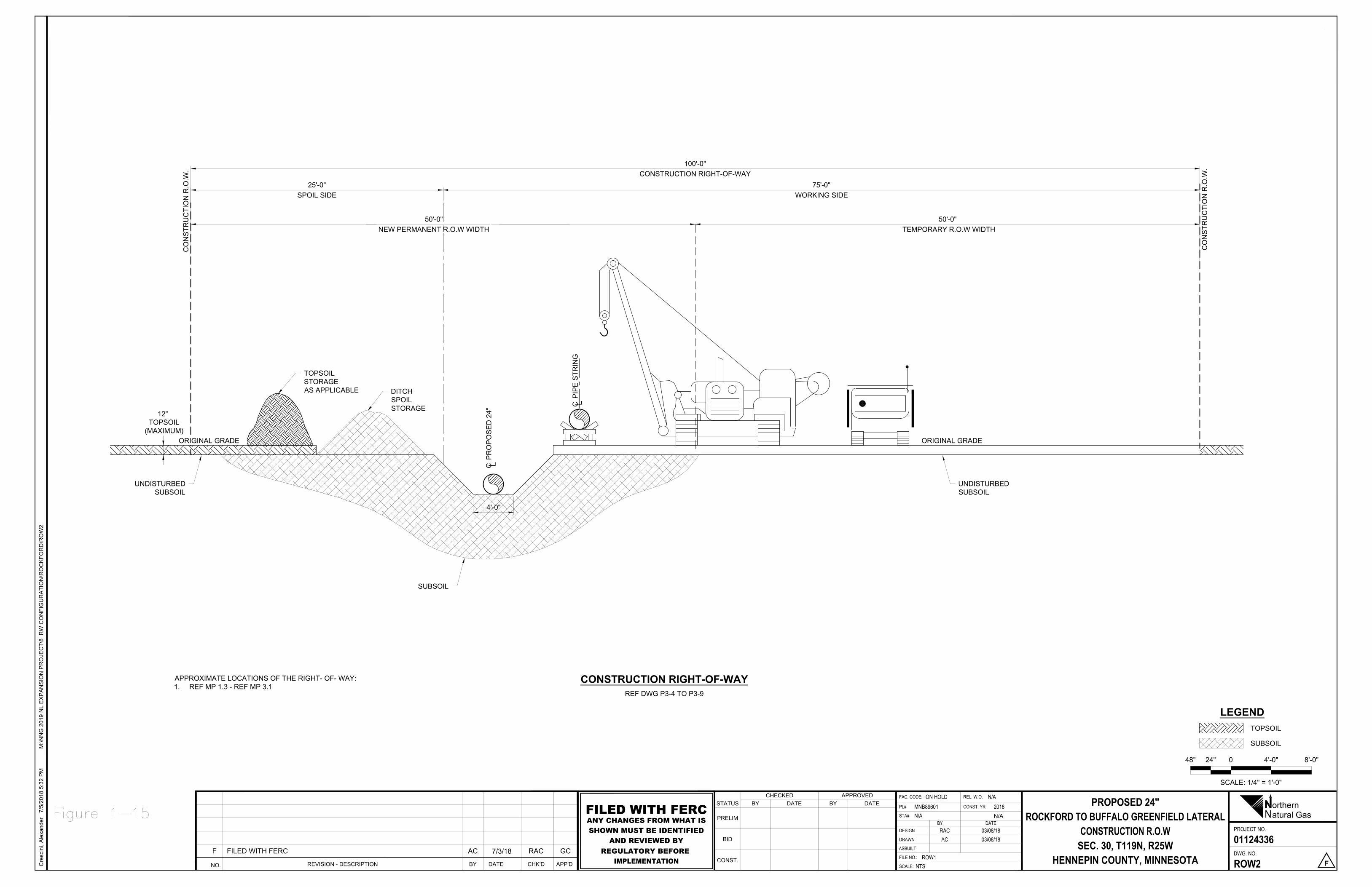
CO
NS
TRU
CTI
ON
R.O
.W.
CO
NS
TRU
CTI
ON
R.O
.W.
UNDISTURBEDSUBSOIL
CP
RO
PO
SE
D 2
4" C
PIP
E S
TRIN
G
SUBSOIL
DITCHSPOILSTORAGE
75'-0"WORKING SIDE
100'-0"CONSTRUCTION RIGHT-OF-WAY
25'-0"SPOIL SIDE
TOPSOILSTORAGEAS APPLICABLE
ORIGINAL GRADE
UNDISTURBEDSUBSOIL
12" TOPSOIL
(MAXIMUM)
4'-0"
50'-0"NEW PERMANENT R.O.W WIDTH
50'-0" TEMPORARY R.O.W WIDTH
ORIGINAL GRADE
SCALE: 1/4" = 1'-0"
48" 24" 0 4'-0" 8'-0"
TOPSOIL
SUBSOIL
LEGEND
REF DWG P3-4 TO P3-9
CONSTRUCTION RIGHT-OF-WAY
Cre
scin
i, A
lexa
nder
7/5/
2018
5:3
2 P
MM
:\NN
G 2
019
NL
EX
PA
NS
ION
PR
OJE
CT\
8_R
W C
ON
FIG
UR
ATI
ON
\RO
CK
FOR
D\R
OW
2
NO. REVISION - DESCRIPTION CHK'DDATE APP'DBY
F FILED WITH FERC AC 7/3/18 RAC GC
NPROJECT NO.
FAC. CODE: REL. W.O.DATEBY
DWG. NO.
CONST. YRSTATUS
PRELIM
BID
CONST.SCALE:
DATECHECKED
BYAPPROVED
BY
FILE NO.:
ASBUILT
DESIGN
DRAWN
PL#
DATESTA#
orthernatural Gas
PROPOSED 24"ROCKFORD TO BUFFALO GREENFIELD LATERAL
CONSTRUCTION R.O.WSEC. 30, T119N, R25W
HENNEPIN COUNTY, MINNESOTA
01124336
ROW2 F
ON HOLD N/AMNB89601N/A
2018
RAC 03/08/18AC 03/08/18
ROW1NTS
N/AFILED WITH FERCANY CHANGES FROM WHAT ISSHOWN MUST BE IDENTIFIED
AND REVIEWED BYREGULATORY BEFORE
IMPLEMENTATION
APPROXIMATE LOCATIONS OF THE RIGHT- OF- WAY:1. REF MP 1.3 - REF MP 3.1
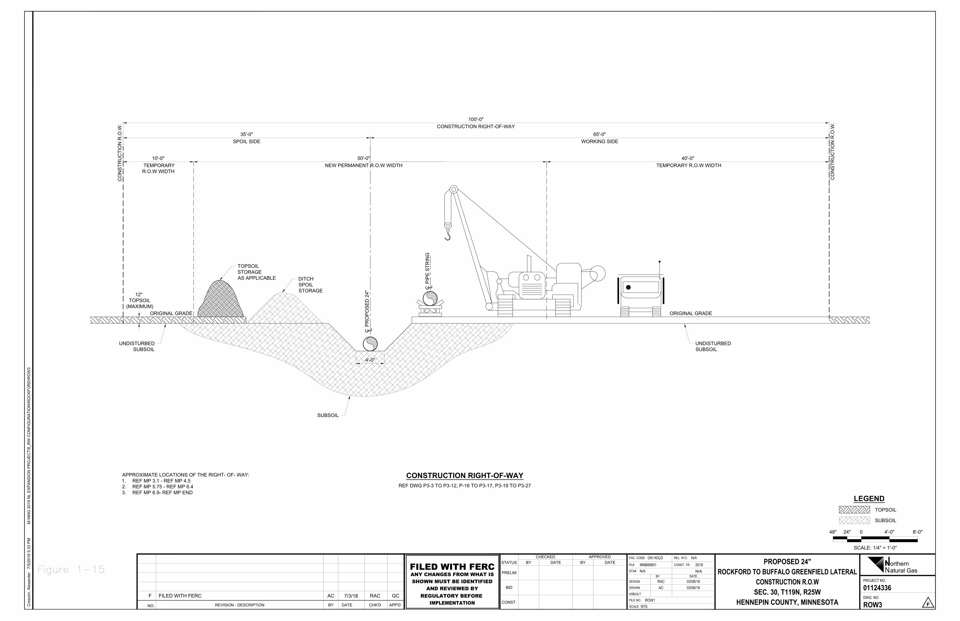
CO
NS
TRU
CTI
ON
R.O
.W.
CO
NS
TRU
CTI
ON
R.O
.W.
UNDISTURBEDSUBSOIL
CP
RO
PO
SE
D 2
4" C
PIP
E S
TRIN
G
SUBSOIL
DITCHSPOILSTORAGE
65'-0"WORKING SIDE
100'-0"CONSTRUCTION RIGHT-OF-WAY
35'-0"SPOIL SIDE
TOPSOILSTORAGEAS APPLICABLE
ORIGINAL GRADE
UNDISTURBEDSUBSOIL
12" TOPSOIL
(MAXIMUM)
4'-0"
50'-0"NEW PERMANENT R.O.W WIDTH
10'-0" TEMPORARYR.O.W WIDTH
ORIGINAL GRADE
40'-0" TEMPORARY R.O.W WIDTH
SCALE: 1/4" = 1'-0"
48" 24" 0 4'-0" 8'-0"
TOPSOIL
SUBSOIL
LEGEND
REF DWG P3-3 TO P3-12, P-16 TO P3-17, P3-19 TO P3-27
CONSTRUCTION RIGHT-OF-WAY
Cre
scin
i, A
lexa
nder
7/5/
2018
5:3
3 P
MM
:\NN
G 2
019
NL
EX
PA
NS
ION
PR
OJE
CT\
8_R
W C
ON
FIG
UR
ATI
ON
\RO
CK
FOR
D\R
OW
3
NO. REVISION - DESCRIPTION CHK'DDATE APP'DBY
F FILED WITH FERC AC 7/3/18 RAC GC
NPROJECT NO.
FAC. CODE: REL. W.O.DATEBY
DWG. NO.
CONST. YRSTATUS
PRELIM
BID
CONST.SCALE:
DATECHECKED
BYAPPROVED
BY
FILE NO.:
ASBUILT
DESIGN
DRAWN
PL#
DATESTA#
orthernatural Gas
PROPOSED 24"ROCKFORD TO BUFFALO GREENFIELD LATERAL
CONSTRUCTION R.O.WSEC. 30, T119N, R25W
HENNEPIN COUNTY, MINNESOTA
01124336
ROW3 F
ON HOLD N/AMNB89601N/A
2018
RAC 03/08/18AC 03/08/18
ROW1NTS
N/AFILED WITH FERCANY CHANGES FROM WHAT ISSHOWN MUST BE IDENTIFIED
AND REVIEWED BYREGULATORY BEFORE
IMPLEMENTATION
APPROXIMATE LOCATIONS OF THE RIGHT- OF- WAY:1. REF MP 3.1 - REF MP 4.52. REF MP 5.75 - REF MP 6.43. REF MP 6.9- REF MP END
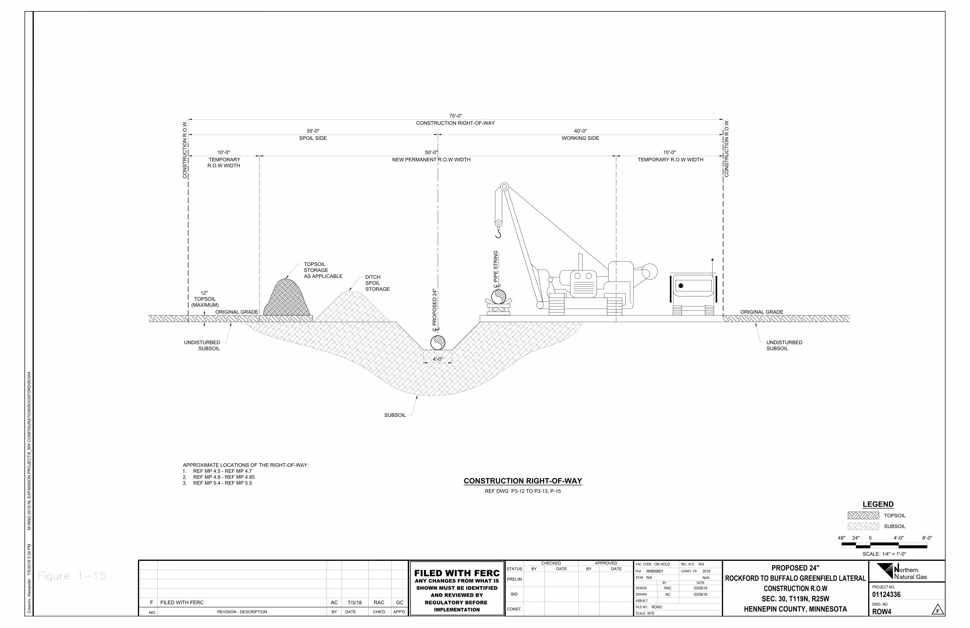
CO
NS
TRU
CTI
ON
R.O
.W.
ORIGINAL GRADE
CO
NS
TRU
CTI
ON
R.O
.W.
UNDISTURBEDSUBSOIL
CP
RO
PO
SE
D 2
4" C
PIP
E S
TRIN
G
SUBSOIL
DITCHSPOILSTORAGE
40'-0"WORKING SIDE
75'-0"CONSTRUCTION RIGHT-OF-WAY
35'-0"SPOIL SIDE
TOPSOILSTORAGEAS APPLICABLE
ORIGINAL GRADE
UNDISTURBEDSUBSOIL
12" TOPSOIL
(MAXIMUM)
4'-0"
50'-0"NEW PERMANENT R.O.W WIDTH
15'-0" TEMPORARY R.O.W WIDTH
10'-0" TEMPORARYR.O.W WIDTH
SCALE: 1/4" = 1'-0"
48" 24" 0 4'-0" 8'-0"
TOPSOIL
SUBSOIL
LEGEND
REF DWG P3-12 TO P3-13, P-15
CONSTRUCTION RIGHT-OF-WAY
Cre
scin
i, A
lexa
nder
7/5/
2018
5:3
4 P
MM
:\NN
G 2
019
NL
EX
PA
NS
ION
PR
OJE
CT\
8_R
W C
ON
FIG
UR
ATI
ON
\RO
CK
FOR
D\R
OW
4
NO. REVISION - DESCRIPTION CHK'DDATE APP'DBY
F FILED WITH FERC AC 7/3/18 RAC GC
NPROJECT NO.
FAC. CODE: REL. W.O.DATEBY
DWG. NO.
CONST. YRSTATUS
PRELIM
BID
CONST.SCALE:
DATECHECKED
BYAPPROVED
BY
FILE NO.:
ASBUILT
DESIGN
DRAWN
PL#
DATESTA#
orthernatural Gas
PROPOSED 24"ROCKFORD TO BUFFALO GREENFIELD LATERAL
CONSTRUCTION R.O.WSEC. 30, T119N, R25W
HENNEPIN COUNTY, MINNESOTA
01124336
ROW4 F
ON HOLD N/AMNB89601N/A
2018
RAC 03/08/18AC 03/08/18
ROW2NTS
N/AFILED WITH FERCANY CHANGES FROM WHAT ISSHOWN MUST BE IDENTIFIED
AND REVIEWED BYREGULATORY BEFORE
IMPLEMENTATION
APPROXIMATE LOCATIONS OF THE RIGHT-OF-WAY:1. REF MP 4.5 - REF MP 4.72. REF MP 4.8 - REF MP 4.853. REF MP 5.4 - REF MP 5.5
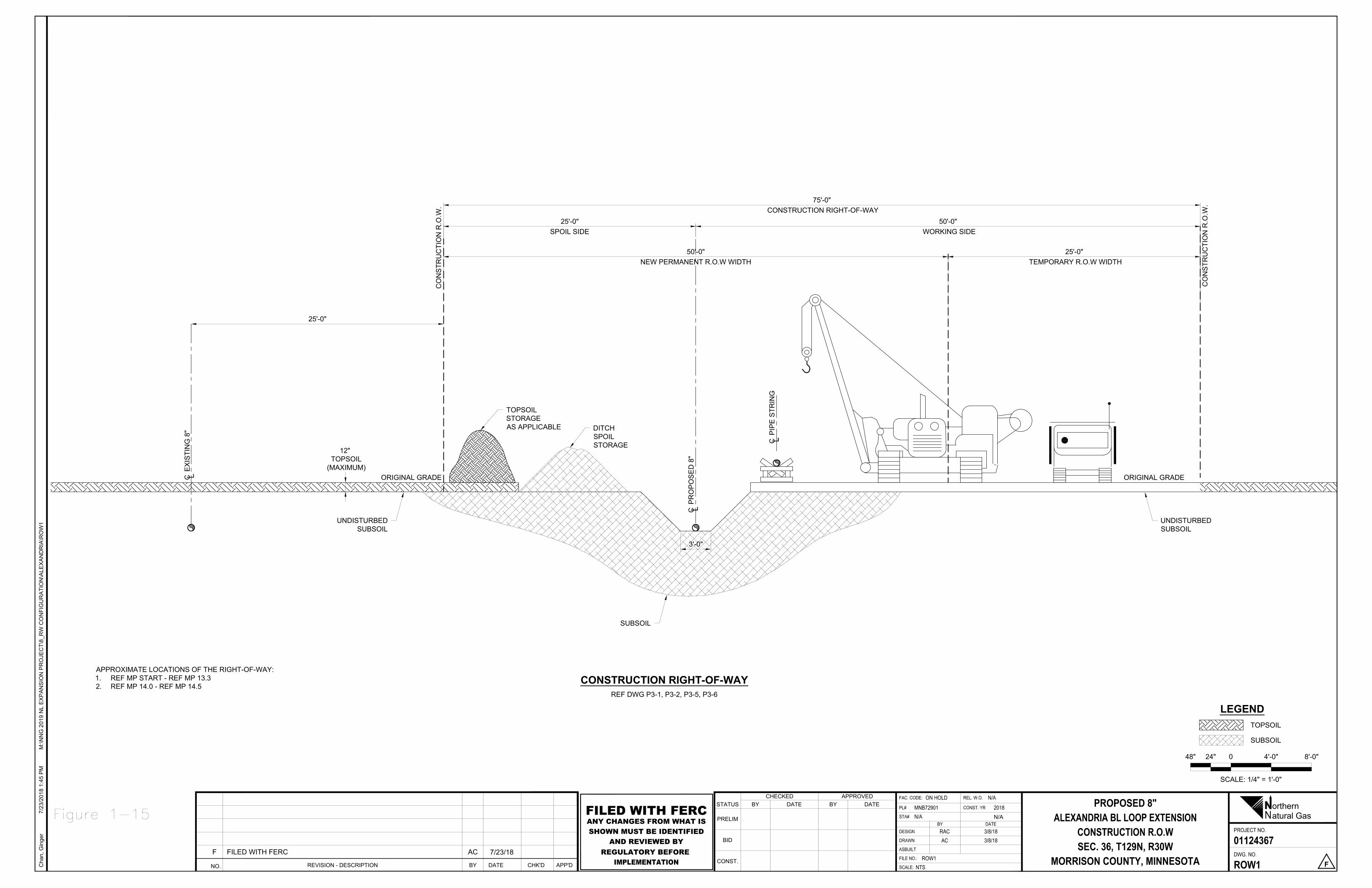
CO
NS
TRU
CTI
ON
R.O
.W.
ORIGINAL GRADE
CO
NS
TRU
CTI
ON
R.O
.W.
SCALE: 1/4" = 1'-0"
48" 24" 0 4'-0" 8'-0"
TOPSOIL
SUBSOIL
LEGEND
UNDISTURBEDSUBSOIL
CP
RO
PO
SE
D 8
"
CP
IPE
STR
ING
SUBSOIL
DITCHSPOILSTORAGE
50'-0" WORKING SIDE
75'-0" CONSTRUCTION RIGHT-OF-WAY
25'-0"SPOIL SIDE
REF DWG P3-1, P3-2, P3-5, P3-6
CONSTRUCTION RIGHT-OF-WAY
Cha
n, G
inge
r7/
23/2
018
1:45
PM
M:\N
NG
201
9 N
L E
XP
AN
SIO
N P
RO
JEC
T\8_
RW
CO
NFI
GU
RA
TIO
N\A
LEX
AN
DR
IA\R
OW
1
NPROJECT NO.
FAC. CODE: REL. W.O.DATEBY
DWG. NO.
CONST. YRSTATUS
PRELIM
BID
CONST.SCALE:
DATECHECKED
BYAPPROVED
BY
FILE NO.:
ASBUILT
DESIGN
DRAWN
PL#
DATESTA#
orthernatural Gas
PROPOSED 8"ALEXANDRIA BL LOOP EXTENSION
CONSTRUCTION R.O.WSEC. 36, T129N, R30W
MORRISON COUNTY, MINNESOTA
01124367
ROW1 F
ON HOLD N/AMNB72901N/A
2018
RAC 3/8/18AC 3/8/18
ROW1NTS
NO. REVISION - DESCRIPTION CHK'DDATE APP'DBY
F FILED WITH FERC AC 7/23/18
N/AFILED WITH FERCANY CHANGES FROM WHAT ISSHOWN MUST BE IDENTIFIED
AND REVIEWED BYREGULATORY BEFORE
IMPLEMENTATION
TOPSOILSTORAGEAS APPLICABLE
ORIGINAL GRADE
UNDISTURBEDSUBSOIL
12" TOPSOIL
(MAXIMUM)
3'-0"
CE
XIS
TIN
G 8
"
25'-0"
50'-0"NEW PERMANENT R.O.W WIDTH
25'-0" TEMPORARY R.O.W WIDTH
APPROXIMATE LOCATIONS OF THE RIGHT-OF-WAY:1. REF MP START - REF MP 13.32. REF MP 14.0 - REF MP 14.5
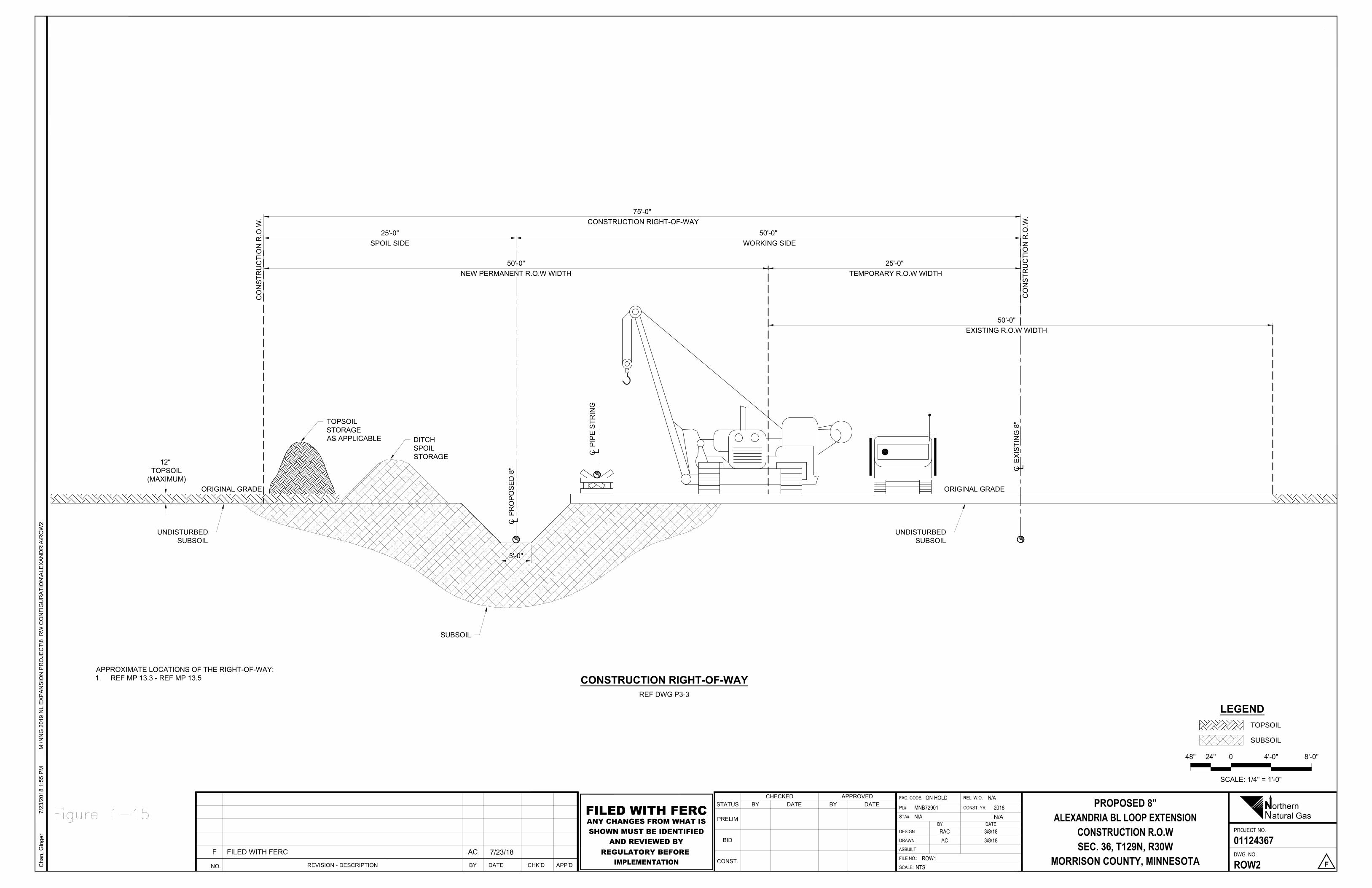
CO
NS
TRU
CTI
ON
R.O
.W.
ORIGINAL GRADE
CO
NS
TRU
CTI
ON
R.O
.W.
UNDISTURBEDSUBSOIL
CP
RO
PO
SE
D 8
"
CP
IPE
STR
ING
SUBSOIL
DITCHSPOILSTORAGE
50'-0" WORKING SIDE
75'-0" CONSTRUCTION RIGHT-OF-WAY
25'-0"SPOIL SIDE
TOPSOILSTORAGEAS APPLICABLE
ORIGINAL GRADE
UNDISTURBEDSUBSOIL
12" TOPSOIL
(MAXIMUM)
3'-0"
50'-0"NEW PERMANENT R.O.W WIDTH
25'-0" TEMPORARY R.O.W WIDTH
50'-0"EXISTING R.O.W WIDTH
CE
XIS
TIN
G 8
"
SCALE: 1/4" = 1'-0"
48" 24" 0 4'-0" 8'-0"
TOPSOIL
SUBSOIL
LEGENDREF DWG P3-3
CONSTRUCTION RIGHT-OF-WAY
Cha
n, G
inge
r7/
23/2
018
1:55
PM
M:\N
NG
201
9 N
L E
XP
AN
SIO
N P
RO
JEC
T\8_
RW
CO
NFI
GU
RA
TIO
N\A
LEX
AN
DR
IA\R
OW
2
NPROJECT NO.
FAC. CODE: REL. W.O.DATEBY
DWG. NO.
CONST. YRSTATUS
PRELIM
BID
CONST.SCALE:
DATECHECKED
BYAPPROVED
BY
FILE NO.:
ASBUILT
DESIGN
DRAWN
PL#
DATESTA#
orthernatural Gas
PROPOSED 8"ALEXANDRIA BL LOOP EXTENSION
CONSTRUCTION R.O.WSEC. 36, T129N, R30W
MORRISON COUNTY, MINNESOTA
01124367
ROW2 F
ON HOLD N/AMNB72901N/A
2018
RAC 3/8/18AC 3/8/18
ROW1NTS
NO. REVISION - DESCRIPTION CHK'DDATE APP'DBY
F FILED WITH FERC AC 7/23/18
N/AFILED WITH FERCANY CHANGES FROM WHAT ISSHOWN MUST BE IDENTIFIED
AND REVIEWED BYREGULATORY BEFORE
IMPLEMENTATION
APPROXIMATE LOCATIONS OF THE RIGHT-OF-WAY:1. REF MP 13.3 - REF MP 13.5
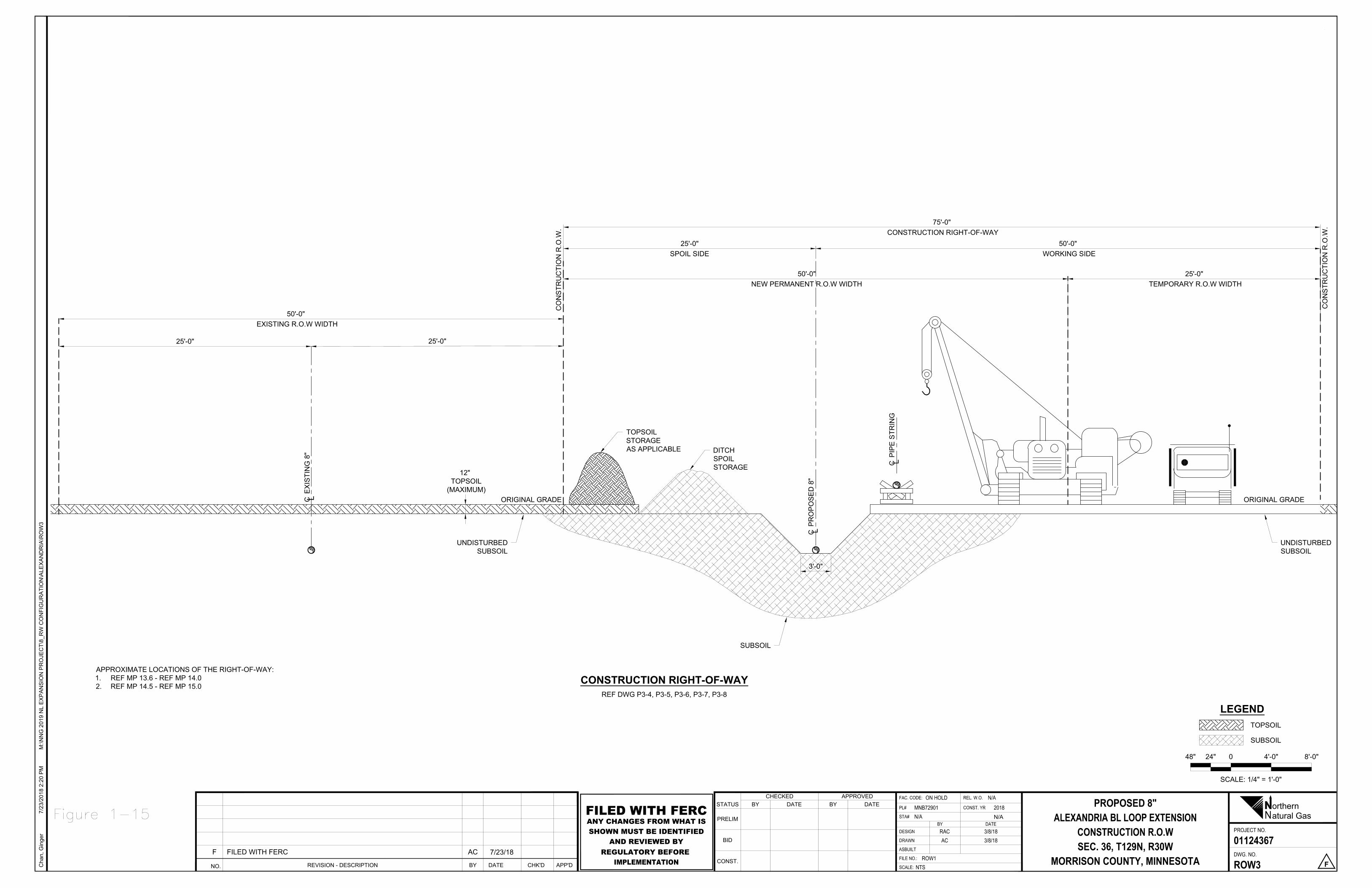
CO
NS
TRU
CTI
ON
R.O
.W.
ORIGINAL GRADE
CO
NS
TRU
CTI
ON
R.O
.W.
SCALE: 1/4" = 1'-0"
48" 24" 0 4'-0" 8'-0"
TOPSOIL
SUBSOIL
LEGEND
UNDISTURBEDSUBSOIL
CP
RO
PO
SE
D 8
"
CP
IPE
STR
ING
SUBSOIL
DITCHSPOILSTORAGE
50'-0" WORKING SIDE
75'-0" CONSTRUCTION RIGHT-OF-WAY
25'-0"SPOIL SIDE
REF DWG P3-4, P3-5, P3-6, P3-7, P3-8
CONSTRUCTION RIGHT-OF-WAY
Cha
n, G
inge
r7/
23/2
018
2:20
PM
M:\N
NG
201
9 N
L E
XP
AN
SIO
N P
RO
JEC
T\8_
RW
CO
NFI
GU
RA
TIO
N\A
LEX
AN
DR
IA\R
OW
3
NPROJECT NO.
FAC. CODE: REL. W.O.DATEBY
DWG. NO.
CONST. YRSTATUS
PRELIM
BID
CONST.SCALE:
DATECHECKED
BYAPPROVED
BY
FILE NO.:
ASBUILT
DESIGN
DRAWN
PL#
DATESTA#
orthernatural Gas
PROPOSED 8"ALEXANDRIA BL LOOP EXTENSION
CONSTRUCTION R.O.WSEC. 36, T129N, R30W
MORRISON COUNTY, MINNESOTA
01124367
ROW3 F
ON HOLD N/AMNB72901N/A
2018
RAC 3/8/18AC 3/8/18
ROW1NTS
NO. REVISION - DESCRIPTION CHK'DDATE APP'DBY
F FILED WITH FERC AC 7/23/18
N/AFILED WITH FERCANY CHANGES FROM WHAT ISSHOWN MUST BE IDENTIFIED
AND REVIEWED BYREGULATORY BEFORE
IMPLEMENTATION
TOPSOILSTORAGEAS APPLICABLE
ORIGINAL GRADE
UNDISTURBEDSUBSOIL
12" TOPSOIL
(MAXIMUM)
3'-0"
CE
XIS
TIN
G 8
"
25'-0"
50'-0"NEW PERMANENT R.O.W WIDTH
25'-0" TEMPORARY R.O.W WIDTH
APPROXIMATE LOCATIONS OF THE RIGHT-OF-WAY:1. REF MP 13.6 - REF MP 14.02. REF MP 14.5 - REF MP 15.0
25'-0"
50'-0" EXISTING R.O.W WIDTH
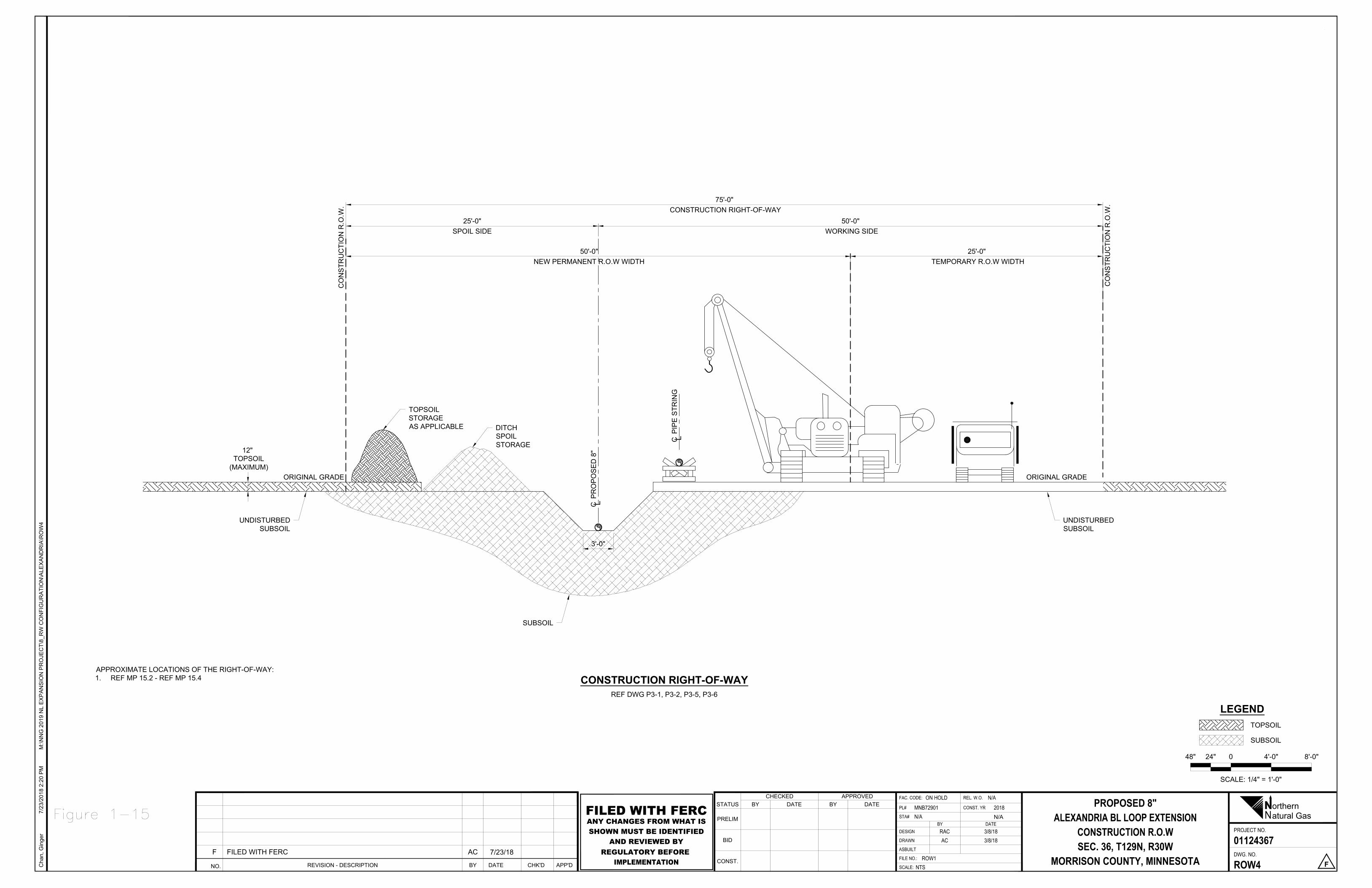
CO
NS
TRU
CTI
ON
R.O
.W.
ORIGINAL GRADE
CO
NS
TRU
CTI
ON
R.O
.W.
UNDISTURBEDSUBSOIL
SUBSOIL
DITCHSPOILSTORAGE
50'-0" WORKING SIDE
75'-0" CONSTRUCTION RIGHT-OF-WAY
25'-0"SPOIL SIDE
TOPSOILSTORAGEAS APPLICABLE
ORIGINAL GRADE
UNDISTURBEDSUBSOIL
12" TOPSOIL
(MAXIMUM)
3'-0"
50'-0"NEW PERMANENT R.O.W WIDTH
25'-0" TEMPORARY R.O.W WIDTH
CP
RO
PO
SE
D 8
"
CP
IPE
STR
ING
SCALE: 1/4" = 1'-0"
48" 24" 0 4'-0" 8'-0"
TOPSOIL
SUBSOIL
LEGENDREF DWG P3-1, P3-2, P3-5, P3-6
CONSTRUCTION RIGHT-OF-WAY
Cha
n, G
inge
r7/
23/2
018
2:20
PM
M:\N
NG
201
9 N
L E
XP
AN
SIO
N P
RO
JEC
T\8_
RW
CO
NFI
GU
RA
TIO
N\A
LEX
AN
DR
IA\R
OW
4
NPROJECT NO.
FAC. CODE: REL. W.O.DATEBY
DWG. NO.
CONST. YRSTATUS
PRELIM
BID
CONST.SCALE:
DATECHECKED
BYAPPROVED
BY
FILE NO.:
ASBUILT
DESIGN
DRAWN
PL#
DATESTA#
orthernatural Gas
PROPOSED 8"ALEXANDRIA BL LOOP EXTENSION
CONSTRUCTION R.O.WSEC. 36, T129N, R30W
MORRISON COUNTY, MINNESOTA
01124367
ROW4 F
ON HOLD N/AMNB72901N/A
2018
RAC 3/8/18AC 3/8/18
ROW1NTS
NO. REVISION - DESCRIPTION CHK'DDATE APP'DBY
F FILED WITH FERC AC 7/23/18
N/AFILED WITH FERCANY CHANGES FROM WHAT ISSHOWN MUST BE IDENTIFIED
AND REVIEWED BYREGULATORY BEFORE
IMPLEMENTATION
APPROXIMATE LOCATIONS OF THE RIGHT-OF-WAY:1. REF MP 15.2 - REF MP 15.4

CO
NS
TRU
CTI
ON
R.O
.W.
ORIGINAL GRADE
CO
NS
TRU
CTI
ON
R.O
.W.
UNDISTURBEDSUBSOIL
SUBSOIL
DITCHSPOILSTORAGE
50'-0" WORKING SIDE
75'-0" CONSTRUCTION RIGHT-OF-WAY
25'-0"SPOIL SIDE
TOPSOILSTORAGEAS APPLICABLE
ORIGINAL GRADE
UNDISTURBEDSUBSOIL
12" TOPSOIL
(MAXIMUM)
3'-0"
50'-0"NEW PERMANENT R.O.W WIDTH
25'-0" TEMPORARY R.O.W WIDTH
CP
RO
PO
SE
D 8
"
CP
IPE
STR
ING
CE
XIS
TIN
G 8
"
25'-0"
SCALE: 1/4" = 1'-0"
48" 24" 0 4'-0" 8'-0"
TOPSOIL
SUBSOIL
LEGENDREF DWG P3-10, P3-11, P3-12
CONSTRUCTION RIGHT-OF-WAY
Cha
n, G
inge
r7/
23/2
018
2:20
PM
M:\N
NG
201
9 N
L E
XP
AN
SIO
N P
RO
JEC
T\8_
RW
CO
NFI
GU
RA
TIO
N\A
LEX
AN
DR
IA\R
OW
5
NPROJECT NO.
FAC. CODE: REL. W.O.DATEBY
DWG. NO.
CONST. YRSTATUS
PRELIM
BID
CONST.SCALE:
DATECHECKED
BYAPPROVED
BY
FILE NO.:
ASBUILT
DESIGN
DRAWN
PL#
DATESTA#
orthernatural Gas
PROPOSED 8"ALEXANDRIA BL LOOP EXTENSION
CONSTRUCTION R.O.WSEC. 36, T129N, R30W
MORRISON COUNTY, MINNESOTA
01124367
ROW5 F
ON HOLD N/AMNB72901N/A
2018
RAC 3/8/18AC 3/8/18
ROW1NTS
NO. REVISION - DESCRIPTION CHK'DDATE APP'DBY
F FILED WITH FERC AC 7/23/18
N/AFILED WITH FERCANY CHANGES FROM WHAT ISSHOWN MUST BE IDENTIFIED
AND REVIEWED BYREGULATORY BEFORE
IMPLEMENTATION
APPROXIMATE LOCATIONS OF THE RIGHT-OF-WAY:1. REF MP 16.1 - REF MP END
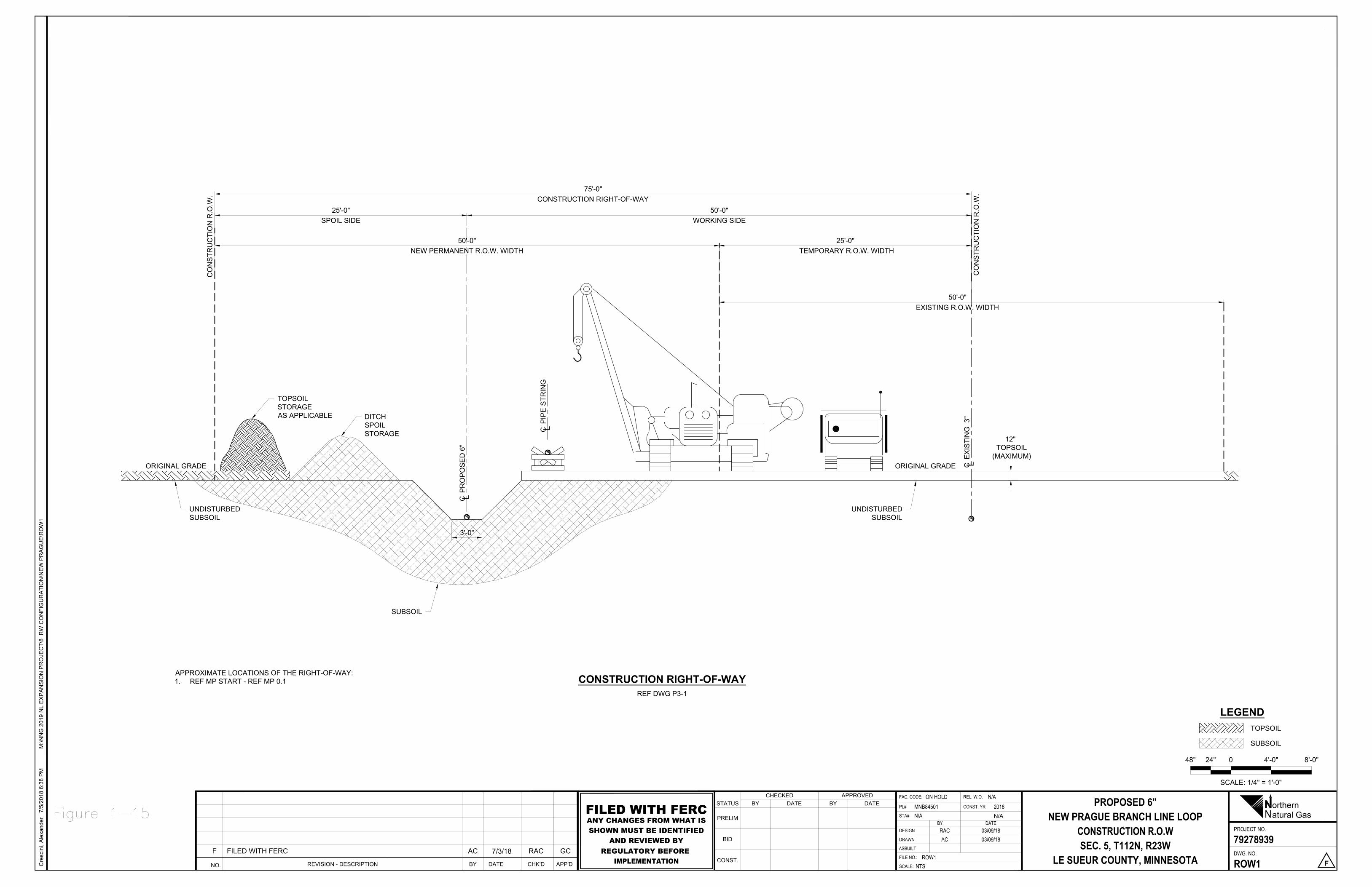
CO
NS
TRU
CTI
ON
R.O
.W.
ORIGINAL GRADE
CO
NS
TRU
CTI
ON
R.O
.W.
UNDISTURBEDSUBSOIL
CP
RO
PO
SE
D 6
"
CP
IPE
STR
ING
SUBSOIL
DITCHSPOILSTORAGE
50'-0"WORKING SIDE
75'-0"CONSTRUCTION RIGHT-OF-WAY
25'-0"SPOIL SIDE
TOPSOILSTORAGEAS APPLICABLE
ORIGINAL GRADE
UNDISTURBEDSUBSOIL
12" TOPSOIL
(MAXIMUM)
3'-0"
CE
XIS
TIN
G 3
"
50'-0"NEW PERMANENT R.O.W. WIDTH
25'-0" TEMPORARY R.O.W. WIDTH
50'-0"EXISTING R.O.W. WIDTH
SCALE: 1/4" = 1'-0"
48" 24" 0 4'-0" 8'-0"
TOPSOIL
SUBSOIL
LEGEND
REF DWG P3-1
CONSTRUCTION RIGHT-OF-WAY
Cre
scin
i, A
lexa
nder
7/5/
2018
6:3
8 P
MM
:\NN
G 2
019
NL
EX
PA
NS
ION
PR
OJE
CT\
8_R
W C
ON
FIG
UR
ATI
ON
\NE
W P
RA
GU
E\R
OW
1
NPROJECT NO.
FAC. CODE: REL. W.O.DATEBY
DWG. NO.
CONST. YRSTATUS
PRELIM
BID
CONST.SCALE:
DATECHECKED
BYAPPROVED
BY
FILE NO.:
ASBUILT
DESIGN
DRAWN
PL#
DATESTA#
orthernatural Gas
PROPOSED 6"NEW PRAGUE BRANCH LINE LOOP
CONSTRUCTION R.O.WSEC. 5, T112N, R23W
LE SUEUR COUNTY, MINNESOTA
79278939
ROW1 F
ON HOLD N/AMNB84501N/A
2018
RAC 03/09/18AC 03/09/18
ROW1NTS
NO. REVISION - DESCRIPTION CHK'DDATE APP'DBY
F FILED WITH FERC AC 7/3/18 RAC GC
N/AFILED WITH FERCANY CHANGES FROM WHAT ISSHOWN MUST BE IDENTIFIED
AND REVIEWED BYREGULATORY BEFORE
IMPLEMENTATION
APPROXIMATE LOCATIONS OF THE RIGHT-OF-WAY:1. REF MP START - REF MP 0.1
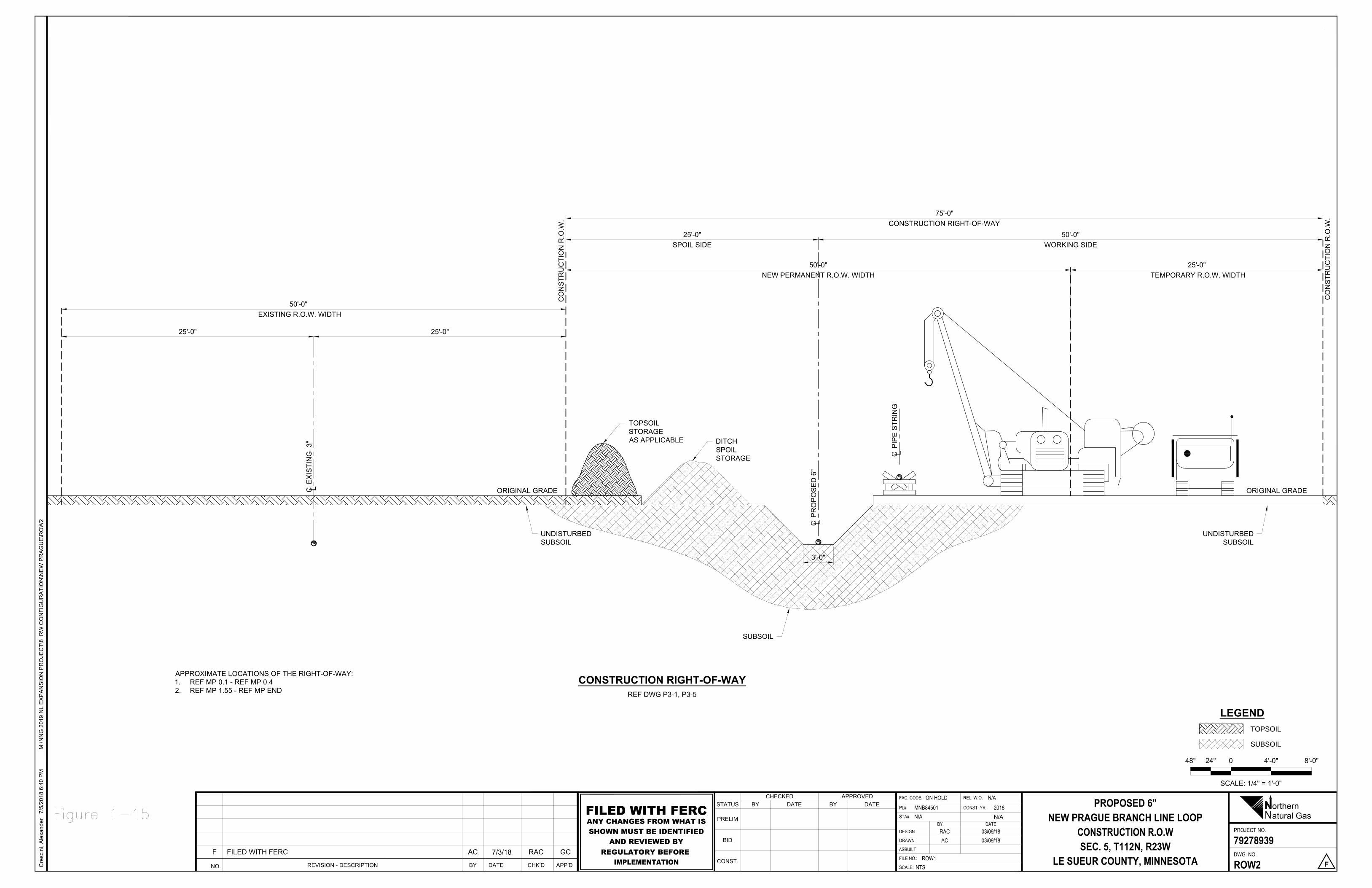
CO
NS
TRU
CTI
ON
R.O
.W.
ORIGINAL GRADE
CO
NS
TRU
CTI
ON
R.O
.W.
UNDISTURBEDSUBSOIL
CP
RO
PO
SE
D 6
"
CP
IPE
STR
ING
SUBSOIL
DITCHSPOILSTORAGE
50'-0"WORKING SIDE
75'-0"CONSTRUCTION RIGHT-OF-WAY
25'-0"SPOIL SIDE
TOPSOILSTORAGEAS APPLICABLE
ORIGINAL GRADE
UNDISTURBEDSUBSOIL
3'-0"
CE
XIS
TIN
G 3
"
50'-0"NEW PERMANENT R.O.W. WIDTH
25'-0" TEMPORARY R.O.W. WIDTH
25'-0"25'-0"
50'-0" EXISTING R.O.W. WIDTH
SCALE: 1/4" = 1'-0"
48" 24" 0 4'-0" 8'-0"
TOPSOIL
SUBSOIL
LEGEND
REF DWG P3-1, P3-5
CONSTRUCTION RIGHT-OF-WAY
Cre
scin
i, A
lexa
nder
7/5/
2018
6:4
0 P
MM
:\NN
G 2
019
NL
EX
PA
NS
ION
PR
OJE
CT\
8_R
W C
ON
FIG
UR
ATI
ON
\NE
W P
RA
GU
E\R
OW
2
NPROJECT NO.
FAC. CODE: REL. W.O.DATEBY
DWG. NO.
CONST. YRSTATUS
PRELIM
BID
CONST.SCALE:
DATECHECKED
BYAPPROVED
BY
FILE NO.:
ASBUILT
DESIGN
DRAWN
PL#
DATESTA#
orthernatural Gas
PROPOSED 6"NEW PRAGUE BRANCH LINE LOOP
CONSTRUCTION R.O.WSEC. 5, T112N, R23W
LE SUEUR COUNTY, MINNESOTA
79278939
ROW2 F
ON HOLD N/AMNB84501N/A
2018
RAC 03/09/18AC 03/09/18
ROW1NTS
NO. REVISION - DESCRIPTION CHK'DDATE APP'DBY
F FILED WITH FERC AC 7/3/18 RAC GC
N/AFILED WITH FERCANY CHANGES FROM WHAT ISSHOWN MUST BE IDENTIFIED
AND REVIEWED BYREGULATORY BEFORE
IMPLEMENTATION
APPROXIMATE LOCATIONS OF THE RIGHT-OF-WAY:1. REF MP 0.1 - REF MP 0.42. REF MP 1.55 - REF MP END

CO
NS
TRU
CTI
ON
R.O
.W.
ORIGINAL GRADE
CO
NS
TRU
CTI
ON
R.O
.W.
UNDISTURBEDSUBSOIL
CP
RO
PO
SE
D 6
"
CP
IPE
STR
ING
SUBSOIL
DITCHSPOILSTORAGE
50'-0"WORKING SIDE
75'-0"CONSTRUCTION RIGHT-OF-WAY
25'-0"SPOIL SIDE
TOPSOILSTORAGEAS APPLICABLE
ORIGINAL GRADE
UNDISTURBEDSUBSOIL
12" TOPSOIL
(MAXIMUM)
3'-0"
CE
XIS
TIN
G 3
"
50'-0"NEW PERMANENT R.O.W. WIDTH
25'-0" TEMPORARY R.O.W. WIDTH
25'-0"
SCALE: 1/4" = 1'-0"
48" 24" 0 4'-0" 8'-0"
TOPSOIL
SUBSOIL
LEGEND
REF DWG P3-2, P3-3, P3-4, P3-5
CONSTRUCTION RIGHT-OF-WAY
Cre
scin
i, A
lexa
nder
7/5/
2018
6:4
1 P
MM
:\NN
G 2
019
NL
EX
PA
NS
ION
PR
OJE
CT\
8_R
W C
ON
FIG
UR
ATI
ON
\NE
W P
RA
GU
E\R
OW
3
NPROJECT NO.
FAC. CODE: REL. W.O.DATEBY
DWG. NO.
CONST. YRSTATUS
PRELIM
BID
CONST.SCALE:
DATECHECKED
BYAPPROVED
BY
FILE NO.:
ASBUILT
DESIGN
DRAWN
PL#
DATESTA#
orthernatural Gas
PROPOSED 6"NEW PRAGUE BRANCH LINE LOOP
CONSTRUCTION R.O.WSEC. 5, T112N, R23W
LE SUEUR COUNTY, MINNESOTA
79278939
ROW3 F
ON HOLD N/AMNB84501N/A
2018
RAC 03/09/18AC 03/09/18
ROW1NTS
NO. REVISION - DESCRIPTION CHK'DDATE APP'DBY
F FILED WITH FERC AC 7/3/18 RAC GC
N/AFILED WITH FERCANY CHANGES FROM WHAT ISSHOWN MUST BE IDENTIFIED
AND REVIEWED BYREGULATORY BEFORE
IMPLEMENTATION
APPROXIMATE LOCATIONS OF THE RIGHT-OF-WAY:1. REF MP 0.4 - REF MP 0.72. REF MP 0.8 - REF MP 0.93. REF MP 1.0 - REF MP 1.55
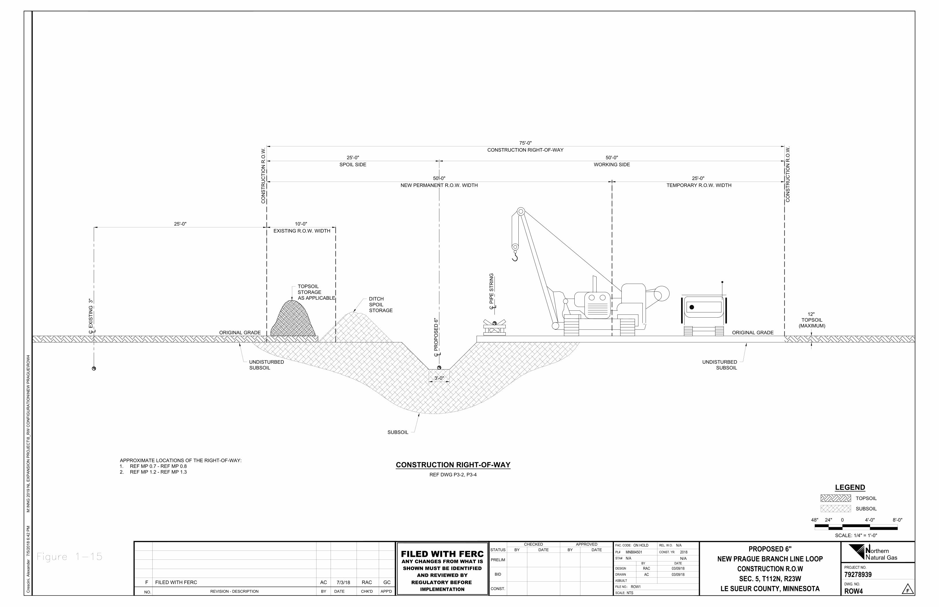
CO
NS
TRU
CTI
ON
R.O
.W.
ORIGINAL GRADE
CO
NS
TRU
CTI
ON
R.O
.W.
UNDISTURBEDSUBSOIL
CP
RO
PO
SE
D 6
"
CP
IPE
STR
ING
SUBSOIL
DITCHSPOILSTORAGE
50'-0"WORKING SIDE
75'-0"CONSTRUCTION RIGHT-OF-WAY
25'-0"SPOIL SIDE
TOPSOILSTORAGEAS APPLICABLE
ORIGINAL GRADE
UNDISTURBEDSUBSOIL
12" TOPSOIL
(MAXIMUM)
3'-0"
CE
XIS
TIN
G 3
"
50'-0"NEW PERMANENT R.O.W. WIDTH
25'-0" TEMPORARY R.O.W. WIDTH
25'-0" 10'-0" EXISTING R.O.W. WIDTH
SCALE: 1/4" = 1'-0"
48" 24" 0 4'-0" 8'-0"
TOPSOIL
SUBSOIL
LEGEND
REF DWG P3-2, P3-4
CONSTRUCTION RIGHT-OF-WAY
Cre
scin
i, A
lexa
nder
7/5/
2018
6:4
2 P
MM
:\NN
G 2
019
NL
EX
PA
NS
ION
PR
OJE
CT\
8_R
W C
ON
FIG
UR
ATI
ON
\NE
W P
RA
GU
E\R
OW
4
NPROJECT NO.
FAC. CODE: REL. W.O.DATEBY
DWG. NO.
CONST. YRSTATUS
PRELIM
BID
CONST.SCALE:
DATECHECKED
BYAPPROVED
BY
FILE NO.:
ASBUILT
DESIGN
DRAWN
PL#
DATESTA#
orthernatural Gas
PROPOSED 6"NEW PRAGUE BRANCH LINE LOOP
CONSTRUCTION R.O.WSEC. 5, T112N, R23W
LE SUEUR COUNTY, MINNESOTA
79278939
ROW4 F
ON HOLD N/AMNB84501N/A
2018
RAC 03/09/18AC 03/09/18
ROW1NTS
NO. REVISION - DESCRIPTION CHK'DDATE APP'DBY
F FILED WITH FERC AC 7/3/18 RAC GC
N/AFILED WITH FERCANY CHANGES FROM WHAT ISSHOWN MUST BE IDENTIFIED
AND REVIEWED BYREGULATORY BEFORE
IMPLEMENTATION
APPROXIMATE LOCATIONS OF THE RIGHT-OF-WAY:1. REF MP 0.7 - REF MP 0.82. REF MP 1.2 - REF MP 1.3
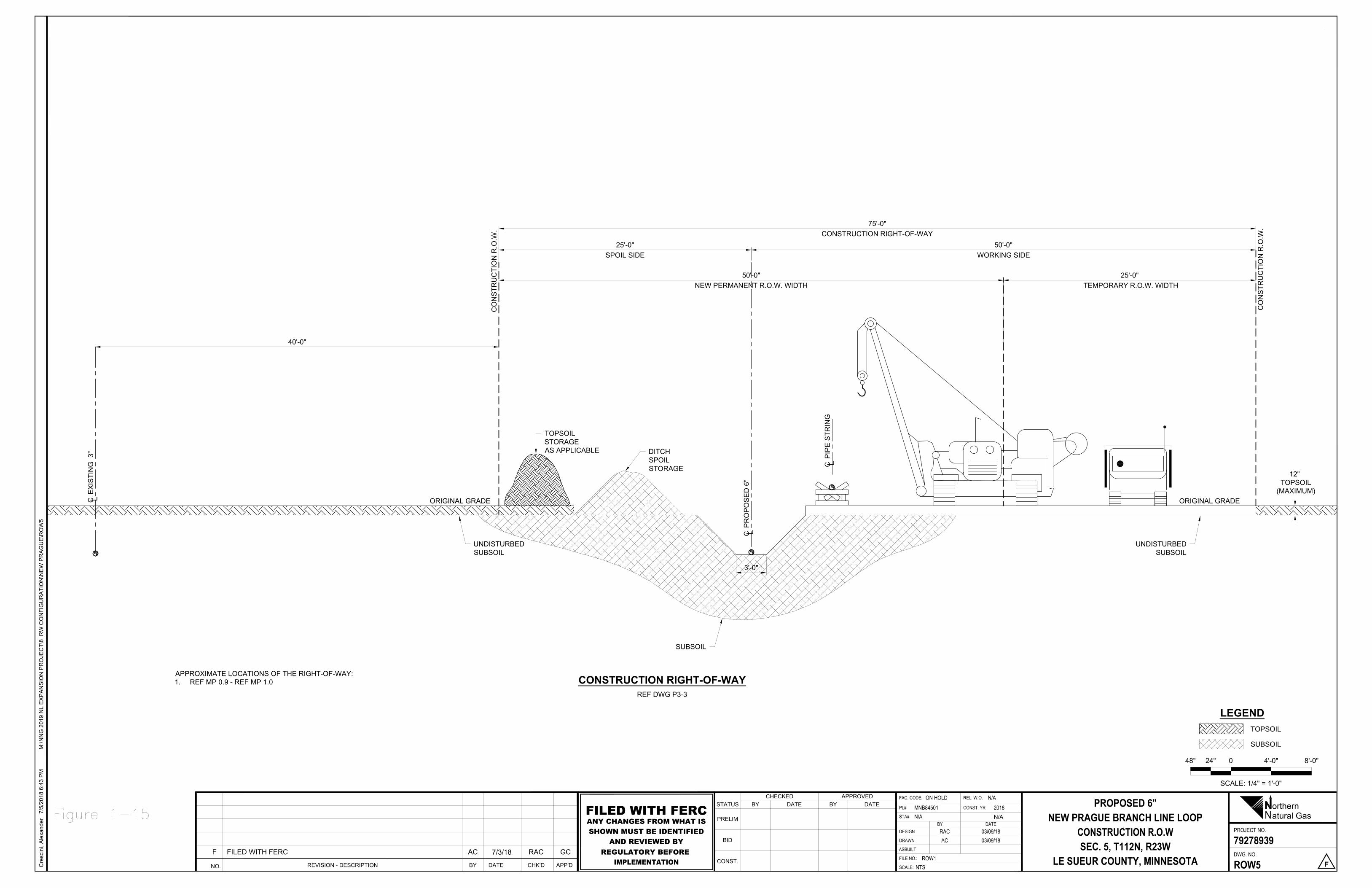
CO
NS
TRU
CTI
ON
R.O
.W.
ORIGINAL GRADEC
ON
STR
UC
TIO
N R
.O.W
.
UNDISTURBEDSUBSOIL
CP
RO
PO
SE
D 6
"
CP
IPE
STR
ING
SUBSOIL
DITCHSPOILSTORAGE
50'-0"WORKING SIDE
75'-0"CONSTRUCTION RIGHT-OF-WAY
25'-0"SPOIL SIDE
TOPSOILSTORAGEAS APPLICABLE
ORIGINAL GRADE
UNDISTURBEDSUBSOIL
12" TOPSOIL
(MAXIMUM)
3'-0"
CE
XIS
TIN
G 3
"
50'-0"NEW PERMANENT R.O.W. WIDTH
25'-0" TEMPORARY R.O.W. WIDTH
40'-0"
SCALE: 1/4" = 1'-0"
48" 24" 0 4'-0" 8'-0"
TOPSOIL
SUBSOIL
LEGEND
REF DWG P3-3
CONSTRUCTION RIGHT-OF-WAY
Cre
scin
i, A
lexa
nder
7/5/
2018
6:4
3 P
MM
:\NN
G 2
019
NL
EX
PA
NS
ION
PR
OJE
CT\
8_R
W C
ON
FIG
UR
ATI
ON
\NE
W P
RA
GU
E\R
OW
5
NPROJECT NO.
FAC. CODE: REL. W.O.DATEBY
DWG. NO.
CONST. YRSTATUS
PRELIM
BID
CONST.SCALE:
DATECHECKED
BYAPPROVED
BY
FILE NO.:
ASBUILT
DESIGN
DRAWN
PL#
DATESTA#
orthernatural Gas
PROPOSED 6"NEW PRAGUE BRANCH LINE LOOP
CONSTRUCTION R.O.WSEC. 5, T112N, R23W
LE SUEUR COUNTY, MINNESOTA
79278939
ROW5 F
ON HOLD N/AMNB84501N/A
2018
RAC 03/09/18AC 03/09/18
ROW1NTS
NO. REVISION - DESCRIPTION CHK'DDATE APP'DBY
F FILED WITH FERC AC 7/3/18 RAC GC
N/AFILED WITH FERCANY CHANGES FROM WHAT ISSHOWN MUST BE IDENTIFIED
AND REVIEWED BYREGULATORY BEFORE
IMPLEMENTATION
APPROXIMATE LOCATIONS OF THE RIGHT-OF-WAY:1. REF MP 0.9 - REF MP 1.0
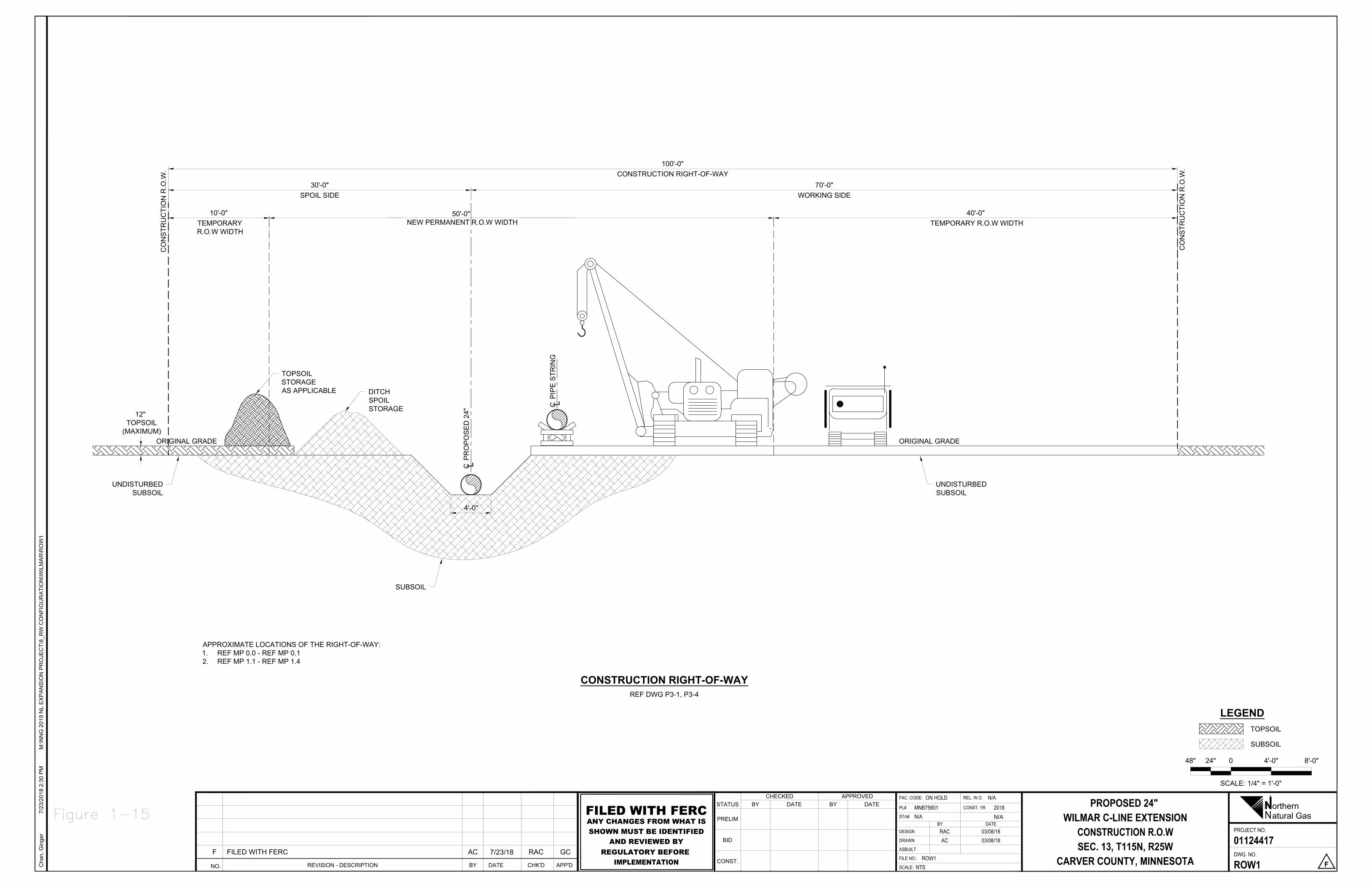
CO
NS
TRU
CTI
ON
R.O
.W.
ORIGINAL GRADE
CO
NS
TRU
CTI
ON
R.O
.W.
UNDISTURBEDSUBSOIL
CP
RO
PO
SE
D 2
4" C
PIP
E S
TRIN
G
SUBSOIL
DITCHSPOILSTORAGE
70'-0"WORKING SIDE
100'-0"CONSTRUCTION RIGHT-OF-WAY
30'-0"SPOIL SIDE
TOPSOILSTORAGEAS APPLICABLE
ORIGINAL GRADE
UNDISTURBEDSUBSOIL
12" TOPSOIL
(MAXIMUM)
4'-0"
10'-0" TEMPORARY R.O.W WIDTH
50'-0" NEW PERMANENT R.O.W WIDTH
40'-0" TEMPORARY R.O.W WIDTH
SCALE: 1/4" = 1'-0"
48" 24" 0 4'-0" 8'-0"
TOPSOIL
SUBSOIL
LEGEND
REF DWG P3-1, P3-4
CONSTRUCTION RIGHT-OF-WAY
Cha
n, G
inge
r7/
23/2
018
2:30
PM
M:\N
NG
201
9 N
L E
XP
AN
SIO
N P
RO
JEC
T\8_
RW
CO
NFI
GU
RA
TIO
N\W
ILM
AR
\RO
W1
NO. REVISION - DESCRIPTION CHK'DDATE APP'DBY
F FILED WITH FERC AC 7/23/18 RAC GC
FILED WITH FERCANY CHANGES FROM WHAT ISSHOWN MUST BE IDENTIFIED
AND REVIEWED BYREGULATORY BEFORE
IMPLEMENTATION
NPROJECT NO.
FAC. CODE: REL. W.O.DATEBY
DWG. NO.
CONST. YRSTATUS
PRELIM
BID
CONST.SCALE:
DATECHECKED
BYAPPROVED
BY
FILE NO.:
ASBUILT
DESIGN
DRAWN
PL#
DATESTA#
orthernatural Gas
PROPOSED 24" WILMAR C-LINE EXTENSION
CONSTRUCTION R.O.WSEC. 13, T115N, R25W
CARVER COUNTY, MINNESOTA
01124417
ROW1 F
ON HOLD N/AMNB75601N/A
2018
RAC 03/08/18AC 03/08/18
ROW1NTS
N/A
APPROXIMATE LOCATIONS OF THE RIGHT-OF-WAY:1. REF MP 0.0 - REF MP 0.12. REF MP 1.1 - REF MP 1.4
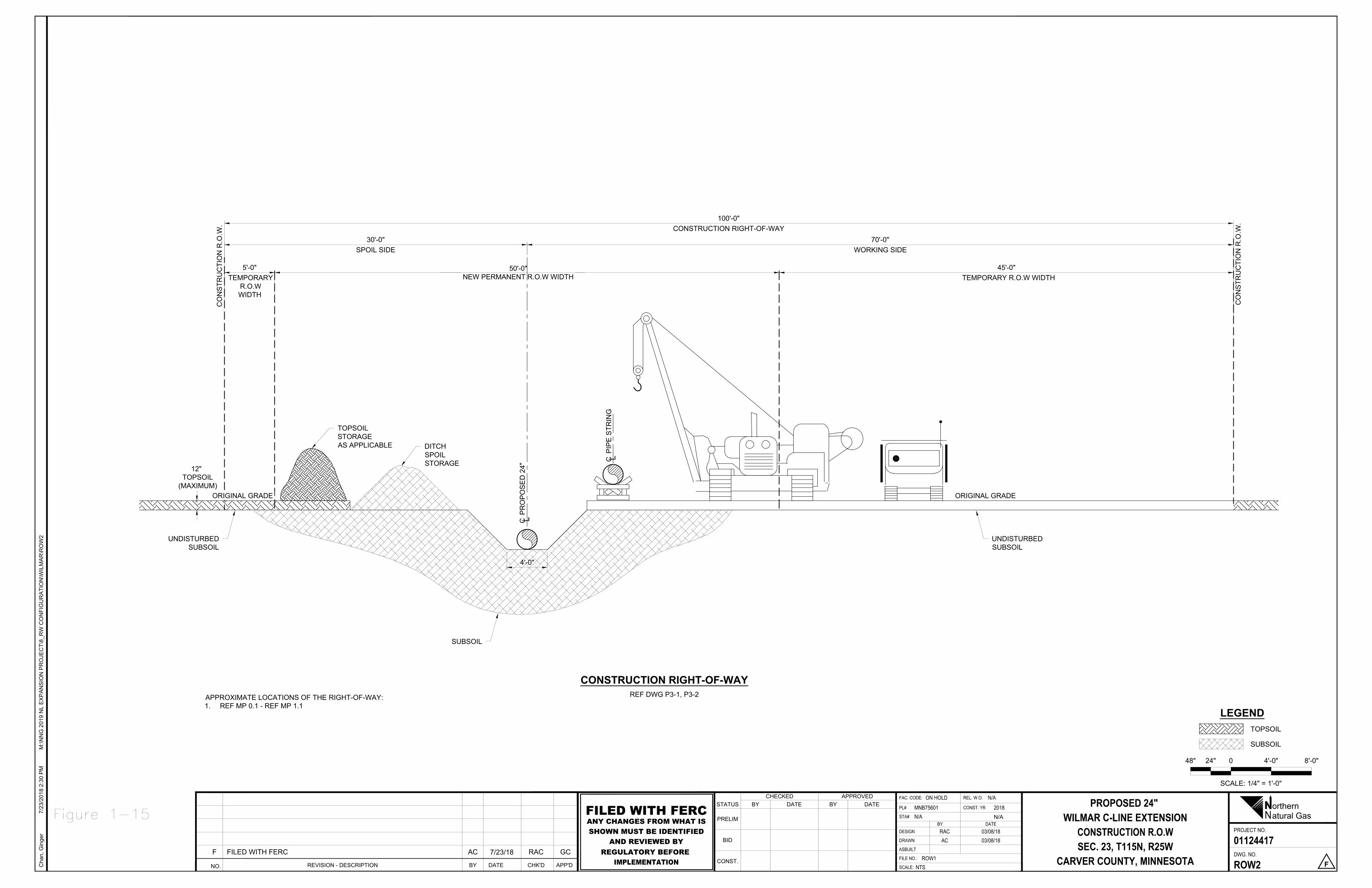
CO
NS
TRU
CTI
ON
R.O
.W.
CO
NS
TRU
CTI
ON
R.O
.W.
UNDISTURBEDSUBSOIL
CP
RO
PO
SE
D 2
4" C
PIP
E S
TRIN
G
SUBSOIL
DITCHSPOILSTORAGE
70'-0"WORKING SIDE
100'-0"CONSTRUCTION RIGHT-OF-WAY
30'-0"SPOIL SIDE
TOPSOILSTORAGEAS APPLICABLE
ORIGINAL GRADE
UNDISTURBEDSUBSOIL
12" TOPSOIL
(MAXIMUM)
4'-0"
5'-0" TEMPORARY
R.O.WWIDTH
50'-0"NEW PERMANENT R.O.W WIDTH
45'-0" TEMPORARY R.O.W WIDTH
ORIGINAL GRADE
SCALE: 1/4" = 1'-0"
48" 24" 0 4'-0" 8'-0"
TOPSOIL
SUBSOIL
LEGEND
REF DWG P3-1, P3-2
CONSTRUCTION RIGHT-OF-WAY
Cha
n, G
inge
r7/
23/2
018
2:30
PM
M:\N
NG
201
9 N
L E
XP
AN
SIO
N P
RO
JEC
T\8_
RW
CO
NFI
GU
RA
TIO
N\W
ILM
AR
\RO
W2
NO. REVISION - DESCRIPTION CHK'DDATE APP'DBY
F FILED WITH FERC AC 7/23/18 RAC GC
FILED WITH FERCANY CHANGES FROM WHAT ISSHOWN MUST BE IDENTIFIED
AND REVIEWED BYREGULATORY BEFORE
IMPLEMENTATION
NPROJECT NO.
FAC. CODE: REL. W.O.DATEBY
DWG. NO.
CONST. YRSTATUS
PRELIM
BID
CONST.SCALE:
DATECHECKED
BYAPPROVED
BY
FILE NO.:
ASBUILT
DESIGN
DRAWN
PL#
DATESTA#
orthernatural Gas
PROPOSED 24" WILMAR C-LINE EXTENSION
CONSTRUCTION R.O.WSEC. 23, T115N, R25W
CARVER COUNTY, MINNESOTA
01124417
ROW2 F
ON HOLD N/AMNB75601N/A
2018
RAC 03/08/18AC 03/08/18
ROW1NTS
N/A
APPROXIMATE LOCATIONS OF THE RIGHT-OF-WAY:1. REF MP 0.1 - REF MP 1.1
CO
NS
TRU
CTI
ON
R.O
.W.
CO
NS
TRU
CTI
ON
R.O
.W.
UNDISTURBEDSUBSOIL
CP
RO
PO
SE
D 2
4" C
PIP
E S
TRIN
G
SUBSOIL
DITCHSPOILSTORAGE
65'-0"WORKING SIDE
100'-0"CONSTRUCTION RIGHT-OF-WAY
35'-0" SPOIL SIDE
TOPSOILSTORAGEAS APPLICABLE
ORIGINAL GRADE
UNDISTURBEDSUBSOIL
12" TOPSOIL
(MAXIMUM)
4'-0"
10'-0" TEMPORARYR.O.W WIDTH
50'-0"NEW PERMANENT R.O.W WIDTH
40'-0"TEMPORARY R.O.W WIDTH
ORIGINAL GRADE
15'-0"
CE
XIS
TIN
G 1
2"
43'-0"EXISTING R.O.W WIDTH
SCALE: 1/8" = 1'-0"
96" 48" 0 8'-0" 16'-0"
TOPSOIL
SUBSOIL
LEGEND
REF DWG P3-4, P3-5
CONSTRUCTION RIGHT-OF-WAY
Cha
n, G
inge
r7/
23/2
018
2:30
PM
M:\N
NG
201
9 N
L E
XP
AN
SIO
N P
RO
JEC
T\8_
RW
CO
NFI
GU
RA
TIO
N\W
ILM
AR
\RO
W3
NO. REVISION - DESCRIPTION CHK'DDATE APP'DBY
F FILED WITH FERC AC 7/23/18 RAC GC
FILED WITH FERCANY CHANGES FROM WHAT ISSHOWN MUST BE IDENTIFIED
AND REVIEWED BYREGULATORY BEFORE
IMPLEMENTATION
NPROJECT NO.
FAC. CODE: REL. W.O.DATEBY
DWG. NO.
CONST. YRSTATUS
PRELIM
BID
CONST.SCALE:
DATECHECKED
BYAPPROVED
BY
FILE NO.:
ASBUILT
DESIGN
DRAWN
PL#
DATESTA#
orthernatural Gas
PROPOSED 24" WILMAR C-LINE EXTENSION
CONSTRUCTION R.O.WSEC. 14, T115N, R25W
CARVER COUNTY, MINNESOTA
01124417
ROW3 F
ON HOLD N/AMNB75601N/A
2018
RAC 03/08/18AC 03/08/18
ROW1NTS
N/A
APPROXIMATE LOCATIONS OF THE RIGHT-OF-WAY:1. REF MP 1.4 - REF MP 1.9
CO
NS
TRU
CTI
ON
R.O
.W.
CO
NS
TRU
CTI
ON
R.O
.W.
UNDISTURBEDSUBSOIL
CP
RO
PO
SE
D 2
4" C
PIP
E S
TRIN
G
SUBSOIL
DITCHSPOILSTORAGE
65'-0"WORKING SIDE
100'-0"CONSTRUCTION RIGHT-OF-WAY
35'-0" SPOIL SIDE
TOPSOILSTORAGEAS APPLICABLE
ORIGINAL GRADE
UNDISTURBEDSUBSOIL
12" TOPSOIL
(MAXIMUM)
4'-0"
10'-0" TEMPORARYR.O.W WIDTH
50'-0"NEW PERMANENT ROW WIDTH
40'-0"TEMPORARY R.O.W WIDTH
ORIGINAL GRADE
15'-0"
CE
XIS
TIN
G 1
2"
SCALE: 1/8" = 1'-0"
96" 48" 0 8'-0" 16'-0"
TOPSOIL
SUBSOIL
LEGEND
REF DWG P3-5 TO P3-8
CONSTRUCTION RIGHT-OF-WAY
Cha
n, G
inge
r7/
23/2
018
2:29
PM
M:\N
NG
201
9 N
L E
XP
AN
SIO
N P
RO
JEC
T\8_
RW
CO
NFI
GU
RA
TIO
N\W
ILM
AR
\RO
W4
NO. REVISION - DESCRIPTION CHK'DDATE APP'DBY
F FILED WITH FERC AC 7/23/18 RAC GC
FILED WITH FERCANY CHANGES FROM WHAT ISSHOWN MUST BE IDENTIFIED
AND REVIEWED BYREGULATORY BEFORE
IMPLEMENTATION
NPROJECT NO.
FAC. CODE: REL. W.O.DATEBY
DWG. NO.
CONST. YRSTATUS
PRELIM
BID
CONST.SCALE:
DATECHECKED
BYAPPROVED
BY
FILE NO.:
ASBUILT
DESIGN
DRAWN
PL#
DATESTA#
orthernatural Gas
PROPOSED 24" WILMAR C-LINE EXTENSION
CONSTRUCTION R.O.WSEC. 14, T115N, R25W
CARVER COUNTY, MINNESOTA
01124417
ROW4 F
ON HOLD N/AMNB75601N/A
2018
RAC 03/08/18AC 03/08/18
ROW1NTS
N/A
APPROXIMATE LOCATIONS OF THE RIGHT-OF-WAY:1. REF MP 1.9 - REF MP 2.02. REF MP 2.0 - REF MP 2.3 (NO PARALLEL LINE)3. REF MP 2.3 - REF MP END
Appendix D
Additional Temporary Workspaces and Staging Areas Tables
For the Rochester Project and the Northern Lights 2019 Expansion Project
Table D-1: Additional Temporary Workspaces and Staging Areas for the Rochester Project
MP Description Existing Land Use Total Area (acres)a
Rochester Greenfield Lateral
0.00 ATWS Agricultural 0.70
Industrial/ Commercial
0.08
0.03 Staging area Agricultural 3.89
Open Land 0.02
0.22 ATWS Agricultural 0.36
Industrial/ Commercial
0.06
0.23 Staging area Agricultural 5.55
0.53 ATWS Agricultural 3.92
0.71 ATWS Agricultural 1.73
1.12 ATWS Agricultural 0.57
1.12 Staging area Agricultural 4.02
Industrial/ Commercial 0.05
1.21 ATWS Agricultural 0.27
Industrial/ Commercial 0.02
1.21 ATWS Agricultural 0.22
2.21 ATWS Agricultural 0.53
2.21 ATWS Agricultural 0.03
2.68 ATWS Agricultural 0.23
3.07 ATWS Agricultural 0.01
Industrial/ Commercial
0.19
3.07 ATWS Agricultural 0.13
Forested 0.01
3.20 ATWS Agricultural 0.17
Industrial/ Commercial
0.01
MP Description Existing Land Use Total Area (acres)a
3.21 ATWS Industrial/
Commercial 0.14
3.21 Staging area Agricultural 4.00
Industrial/ Commercial 0.05
3.42 ATWS Agricultural 0.26
3.42 ATWS Agricultural 0.04
Industrial/ Commercial
0.06
3.86 ATWS
Industrial/ Commercial
0.01
Agricultural 0.08
3.86 ATWS Agricultural 0.27
4.14 ATWS
Agricultural 0.10
Industrial/ Commercial 0.01
Residential 0.15
4.14 ATWS Agricultural 0.02
Industrial/ Commercial 0.07
4.20 ATWS Agricultural 0.02
Industrial/ Commercial 0.07
4.20 ATWS Agricultural 0.24
Industrial/ Commercial 0.02
4.2 Staging area Agricultural 4.15
Industrial/ Commercial 0.13
4.29 ATWS Agricultural 0.46
4.33 ATWS Agricultural 0.06
Industrial/ Commercial 0.02
4.45 ATWS Agricultural 0.06
Industrial/ Commercial 0.02
4.45 ATWS Agricultural 0.26
4.80 ATWS Agricultural 0.74
4.81 ATWS Agricultural 0.01
Industrial/ Commercial 0.02
MP Description Existing Land Use Total Area (acres)a
4.85 ATWS Agricultural 0.06
4.85 ATWS Agricultural 0.28
Industrial/ Commercial 0.01
5.06 ATWS Agricultural 0.56
5.09 ATWS Agricultural 0.03
5.41 ATWS Agricultural 0.24
5.41 ATWS Agricultural 0.02
5.45 ATWS Agricultural 0.18
5.45 ATWS Agricultural 0.97
Industrial/ Commercial 0.01
5.45 Staging area Agricultural 3.81
Industrial/ Commercial 0.14
5.88 ATWS Agricultural 0.12
5.88 ATWS Agricultural 0.19
6.41 ATWS Agricultural 0.25
Industrial/ Commercial 0.02
6.41 ATWS Agricultural .02
6.45 ATWS Agricultural .02
6.46 ATWS Agricultural 0.26
Industrial/ Commercial 0.01
6.47 Staging area Agricultural 7.95
6.61 ATWS Agricultural 2.50
6.67 ATWS Agricultural 1.07
6.71 ATWS Agricultural 0.15
6.80 ATWS Agricultural 0.92
Forested 0.01
6.80 ATWS Agricultural 0.18
Forested 0.01
7.15 ATWS Agricultural 2.89
7.15 ATWS Agricultural 0.26
MP Description Existing Land Use Total Area (acres)a
7.35 ATWS Agricultural 0.22
7.35 ATWS Agricultural 0.18
7.53 ATWS Agricultural 0.22
7.53 ATWS Agricultural 0.10
7.64 ATWS Agricultural 0.07
Open Land 0.30
7.64 ATWS Agricultural 0.04
Open Land 0.24
7.89 ATWS Agricultural 0.37
7.89 ATWS Agricultural 0.16
8.31 ATWS Agricultural 0.30
Industrial/ Commercial 0.02
8.32 ATWS Agricultural 0.05
8.64 ATWS Agricultural 0.23
8.64 ATWS Agricultural 1.02
Wetland 0.07
8.88 ATWS Agricultural 0.28
8.88 ATWS Agricultural 0.06
9.04 ATWS Agricultural 0.27
9.04 ATWS Agricultural 0.21
9.33 ATWS Agricultural 0.22
Open Land <0.01
9.33 ATWS
Agricultural 0.29
Industrial/ Commercial 0.11
Open Land 0.01
9.40 Staging area
Agricultural 5.41
Industrial/ Commercial 0.27
Residential 0.11
9.40 ATWS
Agricultural 1.20
Industrial/ Commercial 0.05
Open Land 0.07
9.40 ATWS Agricultural 0.19
MP Description Existing Land Use Total Area (acres)a
Industrial/ Commercial 0.01
Open Land 0.04
9.79 ATWS Agricultural 0.29
9.79 ATWS Agricultural 0.06
10.05 ATWS Agricultural 0.41
10.05 ATWS Agricultural 0.84
10.19 ATWS Agricultural 0.07
10.19 ATWS Agricultural 0.30
10.39 ATWS Agricultural 0.64
10.39 ATWS Agricultural 0.56
Wetland 0.06
10.51 ATWS Agricultural 0.17
10.51 ATWS Agricultural 0.26
10.56 Staging area Agricultural 1.69
10.51 Staging area Agricultural 6.14
Industrial/ Commercial <0.01
11.12 ATWS Agricultural 0.29
11.12 ATWS Agricultural 0.02
Forested 0.04
11.30 ATWS Agricultural 0.03
Forested 0.02
11.30 ATWS Agricultural 0.29
11.74 ATWS Agricultural 0.94
12.06 ATWS Agricultural 0.29
12.06 ATWS Agricultural 0.06
12.23 ATWS Agricultural 0.60
12.23 ATWS Agricultural 0.30
12.35 ATWS Agricultural 2.32
12.38 ATWS Agricultural 0.67
12.44 Staging Area Agricultural 4.32
Industrial/ Commercial 0.26
MP Description Existing Land Use Total Area (acres)a
Subtotal Acreage for Rochester Greenfield Lateral 91.78
La Crosse Branch line MAOP Uprate
N/A ATWS Agricultural 1.06
Industrial/ Commercial 0.55
N/A ATWS Agricultural 1.61
Industrial/ Commercial 0.23
N/A ATWS Agricultural 1.71
Industrial/ Commercial 0.13
N/A ATWS Agricultural 2.43
Industrial/ Commercial 0.30
Subtotal for La Crosse Branch line MAOP Uprate 8.00
Total Acreage for Rochester Project 99.78 a Dimensions for workspaces and staging areas are shown in Appendix A figures.
Table D-2: Additional Temporary Extra Workspaces and Staging Areas for the NL 2019 Project
MP Description Existing Land Use Total Area (acres)a
Rockford to Buffalo Greenfield Lateral
0.01 ATWS
Forested 0.23 Industrial/
Commercial 0.31
Open Land 0.73
0.09 ATWS Forested 0.11
Open Land 0.10
0.17 ATWS Open Land 0.01
Residential 0.07 0.17 ATWS Open Land 0.34 0.98 ATWS Agricultural 3.10 1.13 ATWS Agricultural 1.67 1.15 ATWS Agricultural 0.92 1.20 Staging area Agricultural 9.69 1.35 ATWS Agricultural 0.27
1.44 ATWS Agricultural 0.28
Industrial/ Commercial 0.01
1.7 ATWS Agricultural 0.16
Industrial/ Commercial 0.02
1.91
ATWS Forested 0.16 Agriculture 0.09 Open Land 0.28
2.05 ATWS Open Land 0.41 2.97 ATWS Agricultural 0.35
3.07 ATWS Agricultural 0.18
Forested 0.19
3.33 ATWS Agricultural 0.04
Industrial/ Commercial 0.21 Forested 0.06
3.33 ATWS Agricultural 0.15 3.55 ATWS Agricultural 0.29
3.68 ATWS
Agricultural 0.28
3.80 ATWS Agricultural 0.25
Residential 0.04
3.85 ATWS Agricultural 0.06
Residential 0.06 3.98 ATWS Open Land 0.29 4.16 Staging area Agricultural 3.22
MP Description Existing Land Use Total Area (acres)a Residential 0.04
4.28 ATWS Industrial/ Commercial 0.03
Open Land 0.14
4.28 ATWS Agricultural 0.24
Industrial/ Commercial 0.04 Open Land 0.13
4.33
ATWS Agricultural 0.26 Industrial/ Commercial 0.02
Open Land 0.33
4.35 Staging area Agricultural 2.21
Industrial/ Commercial 0.01 4.35 ATWS Agricultural 2.68 4.53 ATWS Agricultural 0.52 4.53 ATWS Agricultural 0.10 4.55 ATWS Agricultural 1.30 4.76 ATWS Agricultural 0.59 4.89 ATWS Agricultural 0.28 5.04 ATWS Agricultural 0.28 5.12 ATWS Agricultural 0.28
5.33 ATWS Agricultural 0.46
Industrial/ Commercial 0.01
5.37 ATWS Agricultural 0.05
Industrial/ Commercial 0.01 Wetland <0.01
5.38 ATWS Agricultural 0.01
Industrial/ Commercial 0.12 5.57 ATWS Industrial/ Commercial 0.11 5.58 ATWS Agricultural 0.18 5.71 ATWS Agricultural 0.35 5.76 ATWS Agricultural 0.75
5.84 ATWS Agricultural 0.49
Residential 0.01 5.98 ATWS Agricultural 0.34
6.03
ATWS Agricultural 0.05
Industrial/ Commercial 0.08
6.15
ATWS Agricultural 3.82 Industrial/ Commercial 0.02
Open Land 0.03 Wetland 0.32
6.31 ATWS Agricultural 0.30
MP Description Existing Land Use Total Area (acres)a Industrial/ Commercial 0.01
6.68 ATWS Agricultural 0.44
6.72 ATWS Agricultural 0.45
Industrial/ Commercial 0.17 6.84 ATWS Agricultural 0.29 6.9 ATWS Agricultural 0.34
6.95 Staging area Agricultural 6.71
Industrial/ Commercial 0.01 7.01 ATWS Agricultural 0.76
7.38 ATWS Agricultural 1.16
Industrial/ Commercial 0.05 7.95 ATWS Agricultural 0.29 8.16 Staging Area Agricultural 5.15 8.20 ATWS Agricultural 0.27
8.38 ATWS Agricultural 0.24
Industrial/ Commercial 0.04 8.58 ATWS Agricultural 0.52 8.71 ATWS Agricultural 0.29 8.88 ATWS Agricultural 0.27 9.28 ATWS Agricultural 0.29
9.81
ATWS Agricultural 0.25
Industrial/ Commercial 0.43
Open Land 0.02 Wetland 0.04
9.96 ATWS Agricultural 0.41 9.96 ATWS Industrial/ Commercial 0.20
10.05 Staging area Agricultural 3.82
Industrial/ Commercial 0.03 10.05 ATWS Industrial/ Commercial 0.78
Subtotal Acreage for Rockford to Buffalo Greenfield Lateral 65.35 Alexandria Branch Line Loop Extension
12.50 ATWS Open Land 0.60
Wetland 0.03 Industrial/ Commercial 0.02
12.55 Staging area Agricultural 5.40
Industrial/ Commercial 0.06 12.78 ATWS Agricultural 0.14 12.78 ATWS Agricultural 0.29
12.89 ATWS Agricultural 0.13
12.89 ATWS Agricultural 0.25 12.98 ATWS Forested 0.12 12.98 ATWS Agricultural 0.37
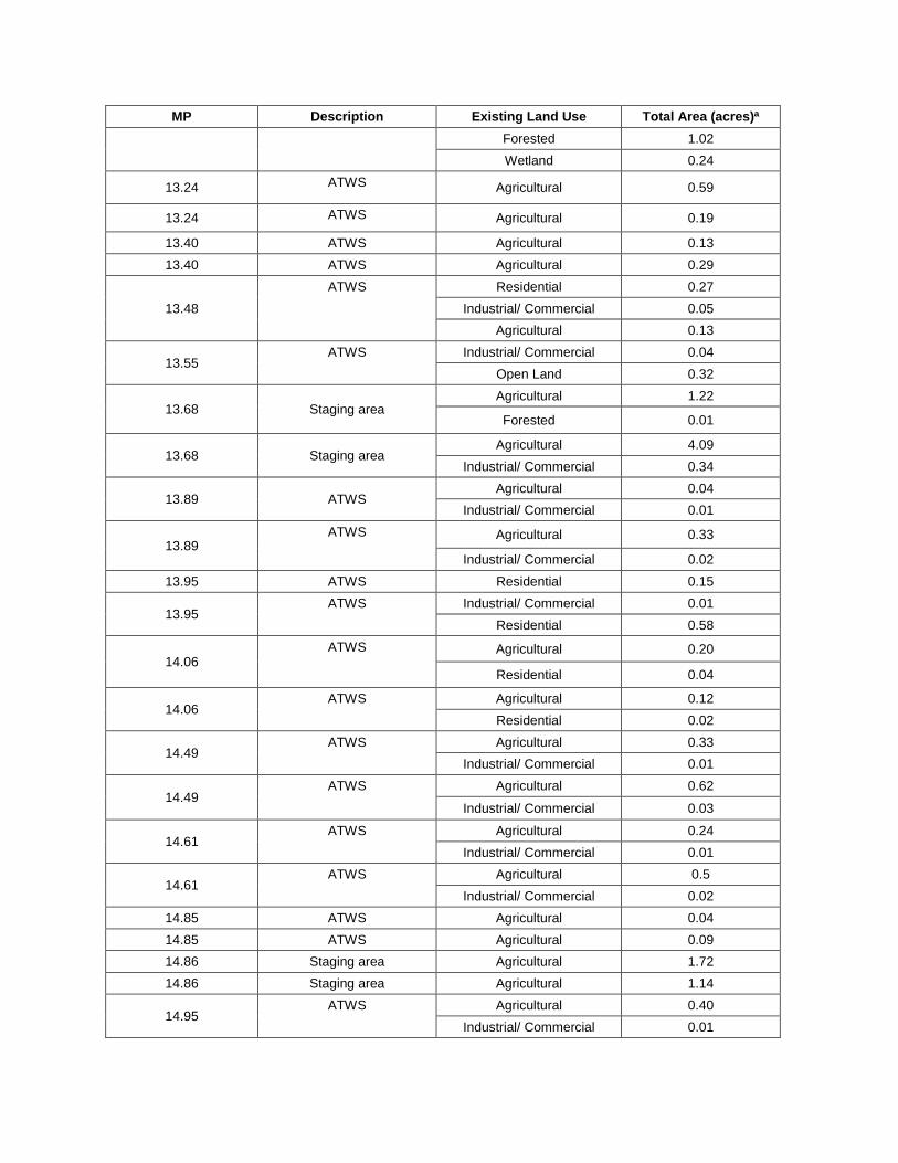
MP Description Existing Land Use Total Area (acres)a Forested 1.02 Wetland 0.24
13.24 ATWS Agricultural 0.59
13.24 ATWS Agricultural 0.19
13.40 ATWS Agricultural 0.13 13.40 ATWS Agricultural 0.29
13.48 ATWS Residential 0.27
Industrial/ Commercial 0.05 Agricultural 0.13
13.55 ATWS Industrial/ Commercial 0.04
Open Land 0.32
13.68 Staging area Agricultural 1.22
Forested 0.01
13.68 Staging area Agricultural 4.09
Industrial/ Commercial 0.34
13.89 ATWS Agricultural 0.04
Industrial/ Commercial 0.01
13.89 ATWS Agricultural 0.33
Industrial/ Commercial 0.02
13.95 ATWS Residential 0.15
13.95 ATWS Industrial/ Commercial 0.01
Residential 0.58
14.06 ATWS Agricultural 0.20
Residential 0.04
14.06 ATWS Agricultural 0.12
Residential 0.02
14.49 ATWS Agricultural 0.33
Industrial/ Commercial 0.01
14.49 ATWS Agricultural 0.62
Industrial/ Commercial 0.03
14.61 ATWS Agricultural 0.24
Industrial/ Commercial 0.01
14.61 ATWS Agricultural 0.5
Industrial/ Commercial 0.02 14.85 ATWS Agricultural 0.04 14.85 ATWS Agricultural 0.09 14.86 Staging area Agricultural 1.72 14.86 Staging area Agricultural 1.14
14.95 ATWS Agricultural 0.40
Industrial/ Commercial 0.01
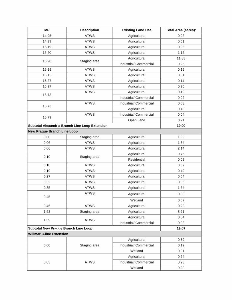
MP Description Existing Land Use Total Area (acres)a 14.95 ATWS Agricultural 0.08 14.99 ATWS Agricultural 0.61 15.19 ATWS Agricultural 0.35 15.20 ATWS Agricultural 1.16
15.20 Staging area Agricultural 11.83
Industrial/ Commercial 0.23 16.15 ATWS Agricultural 0.16 16.15 ATWS Agricultural 0.31 16.37 ATWS Agricultural 0.14 16.37 ATWS Agricultural 0.30
16.73 ATWS Agricultural 0.19
Industrial/ Commercial 0.02
16.73 ATWS Industrial/ Commercial 0.03
Agricultural 0.40
16.79 ATWS Industrial/ Commercial 0.04
Open Land 0.21 Subtotal Alexandria Branch Line Loop Extension 39.09 New Prague Branch Line Loop
0.00 Staging area Agricultural 1.99 0.06 ATWS Agricultural 1.34 0.06 ATWS Agricultural 2.14
0.10 Staging area Agricultural 0.75 Residential 0.05
0.18 ATWS Agricultural 0.32 0.19 ATWS Agricultural 0.40 0.27 ATWS Agricultural 0.64 0.32 ATWS Agricultural 0.35 0.35 ATWS Agricultural 1.64
0.45 ATWS Agricultural 0.38
Wetland 0.07 0.45 ATWS Agricultural 0.23 1.52 Staging area Agricultural 8.21
1.59 ATWS Agricultural 0.54
Industrial/ Commercial 0.02 Subtotal New Prague Branch Line Loop 19.07 Willmar C-line Extension
0.00 Staging area Agricultural 0.69
Industrial/ Commercial 0.12 Wetland 0.01
0.03 ATWS Agricultural 0.64
Industrial/ Commercial 0.23 Wetland 0.20
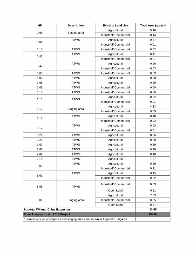
MP Description Existing Land Use Total Area (acres)a
0.08 Staging area Agricultural 9.18
Industrial/ Commercial 0.14
0.09 ATWS Agricultural 0.47
Industrial/ Commercial 0.01 0.10 ATWS Industrial/ Commercial 0.02
0.47 ATWS Agricultural 0.11
Industrial/ Commercial 0.01
0.47 ATWS Agricultural 0.06
Industrial/ Commercial 0.03 1.00 ATWS Industrial/ Commercial 0.09 1.00 ATWS Agricultural 0.20 1.05 ATWS Agricultural 0.20 1.05 ATWS Industrial/ Commercial 0.09 1.10 ATWS Industrial/ Commercial 0.06
1.13 ATWS Agricultural 0.52
Industrial/ Commercial 0.01
1.13 Staging area Agricultural 4.33
Industrial/ Commercial 0.09
1.17 ATWS Agricultural 0.18
Industrial/ Commercial 0.02
1.17 ATWS Agricultural 0.08
Industrial/ Commercial 0.01 1.26 ATWS Agricultural 0.06 1.27 ATWS Agricultural 0.39 1.62 ATWS Agricultural 0.29 1.86 ATWS Agricultural 0.30 2.02 ATWS Agricultural 0.18 2.10 ATWS Agricultural 1.37
3.03 ATWS Agricultural 0.39
Industrial/ Commercial 0.21
3.03 ATWS Agricultural 0.15
Industrial/ Commercial 0.02
3.08 ATWS Industrial/ Commercial 0.03
Open Land 0.21
3.09 Staging area Agricultural 7.83
Industrial/ Commercial 0.65 Open Land 0.67
Subtotal Willmar C-line Extension 30.55 Total Acreage for NL 2019 Project 154.06 a Dimensions for workspaces and staging areas are shown in Appendix B figures.
Appendix E
Noise Sensitive Area Maps
For the Northern Lights 2019 Expansion Project Compressor Stations
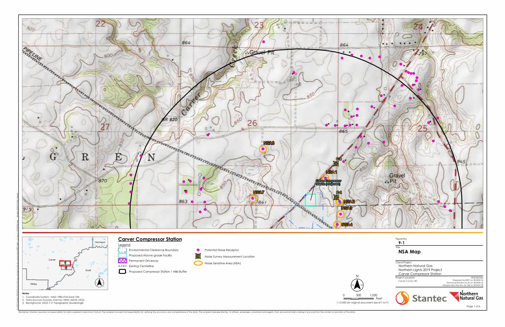
Figure No.
Client/Project
Project Location
Carver
Hennepin
Scott
Sibley
12
B
B
!(
!(
!(
!(
!(
!(
!(
!(
!(
!(
!(!(
!(
!(!(!(!(
!(
!(!(!(!(
!(
!(
!(
!(!(
!(
!(!(
!(
!(
!(!(!(
!(
!(
!(
!(
!(
!(
!(
!(
!(
!(
!(
!(
!(!(!(
!(
!(!(
!(
!(!(
!(
!(
!(
!(!(
!(
!(
Carver CompressorStation (Proposed)
NSA8
NSA7
NSA1
NSA2NSA3
NSA4
C-1
C-2
Notes 0 500 1,000Feet
LegendEnvironmental Clearance BoundaryProposed Above-grade FacilityPermanent DrivewayExisting CenterlineProposed Compressor Station 1 Mile Buffer
!( Potential Noise Receptor
B Noise Survey Measurement LocationNoise Sensitive Area (NSA)
V:\19
37\A
ctive
\193
7057
26\0
3_da
ta\g
is_ca
d\gis
\mxd
s\all
_com
pone
nts\
FERC
\fig9
-1_cs
_nsa
_nl_1
9370
5726
.mxd
R
evise
d: 20
18-07
-24 By
: safos
ter
($$¯1:12,000 (At original document size of 11x17)
Disclaimer: Stantec assumes no responsibility for data supplied in electronic format. The recipient accepts full responsibility for verifying the accuracy and completeness of the data. The recipient releases Stantec, its officers, employees, consultants and agents, from any and all claims arising in any way from the content or provision of the data.
NSA Map9-1
Northern Natural GasNorthern Lights 2019 ProjectCarver Compressor Station
193705726Carver County, MN Prepared by BWT on 2018-03-14
Technical Review by SF on 2018-03-15Independent Review by DB on 2018-07-23
Title
($$¯1.2.3.
Coordinate System: NAD 1983 UTM Zone 15NData Sources Include: Stantec, NNG, NADS, USGSBackground: USGS 7.5' Topographic Quadrangle
Page 1 of 6
Carver Compressor Station
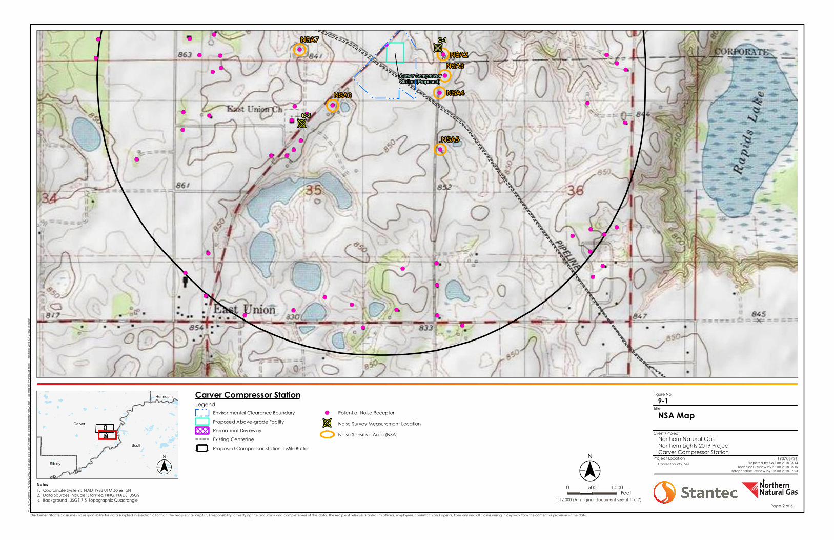
Figure No.
Client/Project
Project Location
Carver
Hennepin
Scott
Sibley
12
B
B
!(
!(
!(
!(
!( !(!(
!(
!(
!(!(
!(
!(
!(
!(
!(!(
!(
!(
!(
!(
!(
!(!(
!(
!(!(
!(
!(!(
!(
!(
!(
!(
!(
!(
!( !(!(
!(
!(
!(
!(
!(
!(
!(
!(
!(
!(!(
!(
Carver CompressorStation (Proposed)
NSA7NSA2
NSA3
NSA4
NSA5
NSA6
C-1
C-3
Notes 0 500 1,000Feet
LegendEnvironmental Clearance BoundaryProposed Above-grade FacilityPermanent DrivewayExisting CenterlineProposed Compressor Station 1 Mile Buffer
!( Potential Noise Receptor
B Noise Survey Measurement LocationNoise Sensitive Area (NSA)
V:\19
37\A
ctive
\193
7057
26\0
3_da
ta\g
is_ca
d\gis
\mxd
s\all
_com
pone
nts\
FERC
\fig9
-1_cs
_nsa
_nl_1
9370
5726
.mxd
R
evise
d: 20
18-07
-24 By
: safos
ter
($$¯1:12,000 (At original document size of 11x17)
Disclaimer: Stantec assumes no responsibility for data supplied in electronic format. The recipient accepts full responsibility for verifying the accuracy and completeness of the data. The recipient releases Stantec, its officers, employees, consultants and agents, from any and all claims arising in any way from the content or provision of the data.
NSA Map9-1
Northern Natural GasNorthern Lights 2019 ProjectCarver Compressor Station
193705726Carver County, MN Prepared by BWT on 2018-03-14
Technical Review by SF on 2018-03-15Independent Review by DB on 2018-07-23
Title
($$¯1.2.3.
Coordinate System: NAD 1983 UTM Zone 15NData Sources Include: Stantec, NNG, NADS, USGSBackground: USGS 7.5' Topographic Quadrangle
Page 2 of 6
Carver Compressor Station
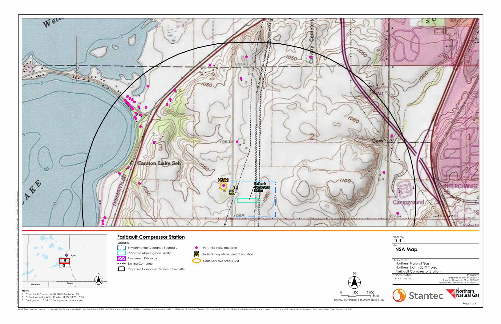
Figure No.
Client/Project
Project Location
§̈¦35 Rice
SteeleWaseca
34
B
!(!(!(!(
!( !(
!(
!(
!(
!(!(!(
!(
!(!(
!(!(
!(!(
!(
!(
!(
!(
!( !(
!(
!(
!(
!(
!(!(
!(
!(
!(
!(!(!(!(
FaribaultCompressorStation
NSA1F-1
Notes 0 500 1,000Feet
LegendEnvironmental Clearance BoundaryProposed Above-grade FacilityPermanent DrivewayExisting CenterlineProposed Compressor Station 1 Mile Buffer
!( Potential Noise Receptor
B Noise Survey Measurement LocationNoise Sensitive Area (NSA)
V:\19
37\A
ctive
\193
7057
26\0
3_da
ta\g
is_ca
d\gis
\mxd
s\all
_com
pone
nts\
FERC
\fig9
-1_cs
_nsa
_nl_1
9370
5726
.mxd
R
evise
d: 20
18-07
-24 By
: safos
ter
($$¯1:12,000 (At original document size of 11x17)
Disclaimer: Stantec assumes no responsibility for data supplied in electronic format. The recipient accepts full responsibility for verifying the accuracy and completeness of the data. The recipient releases Stantec, its officers, employees, consultants and agents, from any and all claims arising in any way from the content or provision of the data.
NSA Map9-1
Northern Natural GasNorthern Lights 2019 ProjectFaribault Compressor Station
193705726Rice County, MN Prepared by BWT on 2018-03-14
Technical Review by SF on 2018-03-15Independent Review by DB on 2018-07-23
Title
($$¯1.2.3.
Coordinate System: NAD 1983 UTM Zone 15NData Sources Include: Stantec, NNG, NADS, USGSBackground: USGS 7.5' Topographic Quadrangle
Page 3 of 6
Faribault Compressor Station
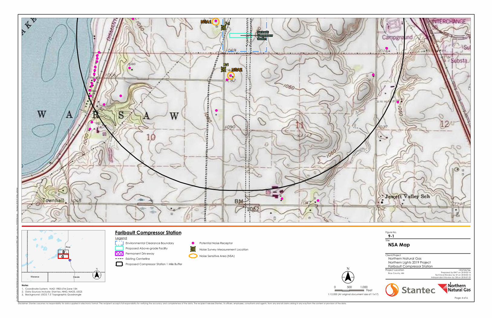
Figure No.
Client/Project
Project Location
§̈¦35
Rice
SteeleWaseca
34
B
B
!(
!(
!(
!(!(
!(
!(
!(
!(!(
!(
!(!(!(!(
!(!(!(
!(!(!(
!(
!(
!(
!(
!(
!(
FaribaultCompressorStation
NSA1
NSA2F-2
F-1
Notes 0 500 1,000Feet
LegendEnvironmental Clearance BoundaryProposed Above-grade FacilityPermanent DrivewayExisting CenterlineProposed Compressor Station 1 Mile Buffer
!( Potential Noise Receptor
B Noise Survey Measurement LocationNoise Sensitive Area (NSA)
V:\19
37\A
ctive
\193
7057
26\0
3_da
ta\g
is_ca
d\gis
\mxd
s\all
_com
pone
nts\
FERC
\fig9
-1_cs
_nsa
_nl_1
9370
5726
.mxd
R
evise
d: 20
18-07
-24 By
: safos
ter
($$¯1:12,000 (At original document size of 11x17)
Disclaimer: Stantec assumes no responsibility for data supplied in electronic format. The recipient accepts full responsibility for verifying the accuracy and completeness of the data. The recipient releases Stantec, its officers, employees, consultants and agents, from any and all claims arising in any way from the content or provision of the data.
NSA Map9-1
Northern Natural GasNorthern Lights 2019 ProjectFaribault Compressor Station
193705726Rice County, MN Prepared by BWT on 2018-03-14
Technical Review by SF on 2018-03-15Independent Review by DB on 2018-07-23
Title
($$¯1.2.3.
Coordinate System: NAD 1983 UTM Zone 15NData Sources Include: Stantec, NNG, NADS, USGSBackground: USGS 7.5' Topographic Quadrangle
Page 4 of 6
Faribault Compressor Station
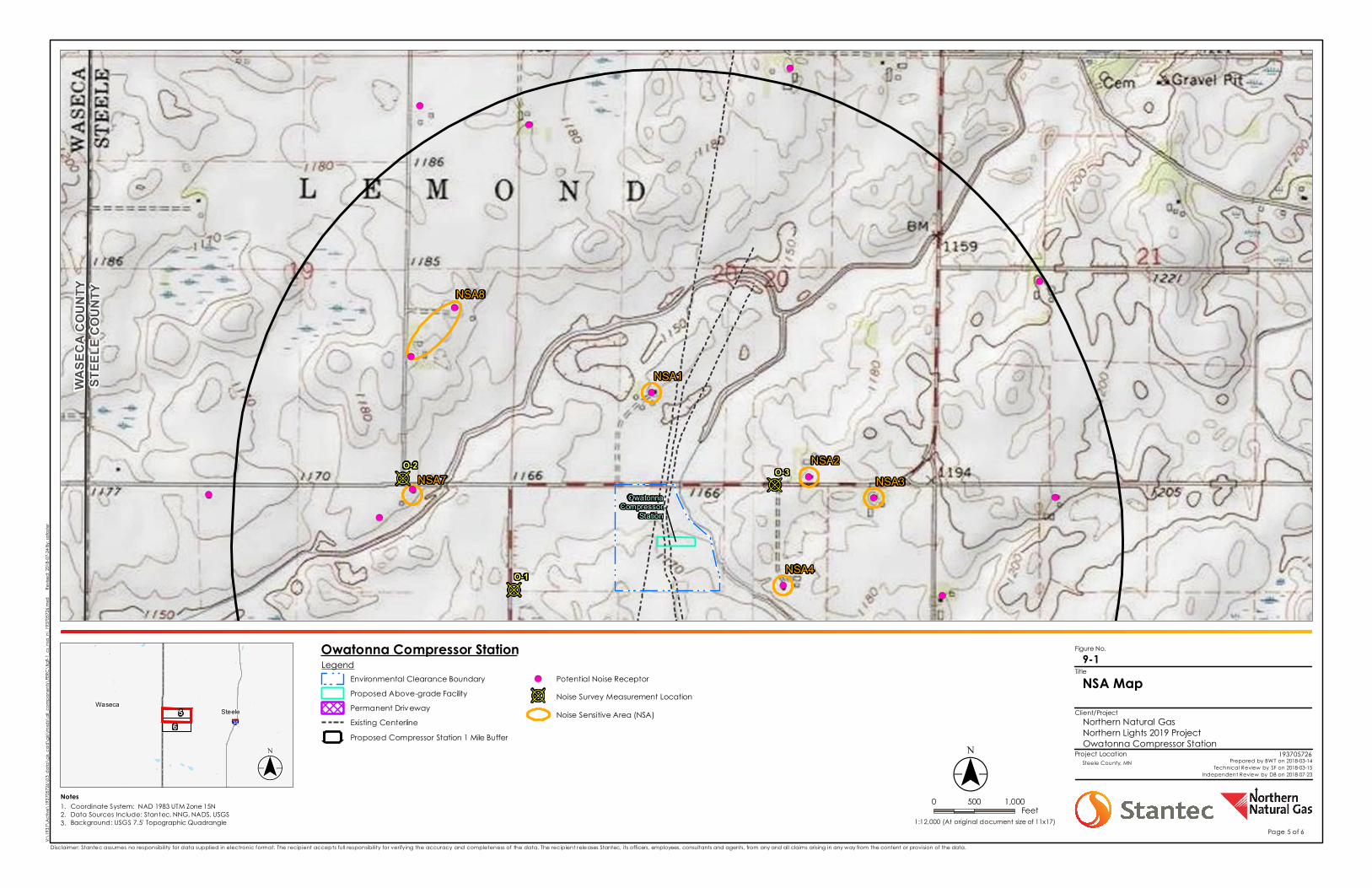
Figure No.
Client/Project
Project Location
§̈¦35Steele
Waseca5
6
B
B B
!(
!(
!(
!(
!(!(
!(
!(
!(
!(
!(
!(
!(
!(!(
OwatonnaCompressor
Station
STEE
LE C
OUNT
YWA
SECA
COU
NTY
NSA1
NSA2
NSA4
NSA3NSA7
NSA8
O-1
O-2 O-3
Notes 0 500 1,000Feet
LegendEnvironmental Clearance BoundaryProposed Above-grade FacilityPermanent DrivewayExisting CenterlineProposed Compressor Station 1 Mile Buffer
!( Potential Noise Receptor
B Noise Survey Measurement LocationNoise Sensitive Area (NSA)
V:\19
37\A
ctive
\193
7057
26\0
3_da
ta\g
is_ca
d\gis
\mxd
s\all
_com
pone
nts\
FERC
\fig9
-1_cs
_nsa
_nl_1
9370
5726
.mxd
R
evise
d: 20
18-07
-24 By
: safos
ter
($$¯1:12,000 (At original document size of 11x17)
Disclaimer: Stantec assumes no responsibility for data supplied in electronic format. The recipient accepts full responsibility for verifying the accuracy and completeness of the data. The recipient releases Stantec, its officers, employees, consultants and agents, from any and all claims arising in any way from the content or provision of the data.
NSA Map9-1
Northern Natural GasNorthern Lights 2019 ProjectOwatonna Compressor Station
193705726Steele County, MN Prepared by BWT on 2018-03-14
Technical Review by SF on 2018-03-15Independent Review by DB on 2018-07-23
Title
($$¯1.2.3.
Coordinate System: NAD 1983 UTM Zone 15NData Sources Include: Stantec, NNG, NADS, USGSBackground: USGS 7.5' Topographic Quadrangle
Page 5 of 6
Owatonna Compressor Station
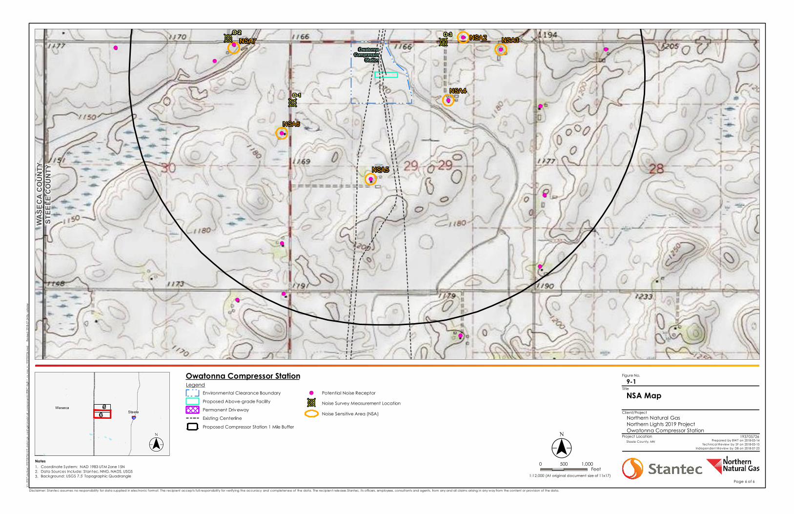
Figure No.
Client/Project
Project Location
§̈¦35Steele
Waseca 56
B
B B!(!(
!(
!(
!(
!(
!(
!(
!(!(
!(
!(
!(
!(!(
!(
OwatonnaCompressor
Station
STEE
LE C
OUNT
YWA
SECA
COU
NTY
NSA2
NSA4
NSA3
NSA5
NSA6
NSA7
O-1
O-2 O-3
Notes 0 500 1,000Feet
LegendEnvironmental Clearance BoundaryProposed Above-grade FacilityPermanent DrivewayExisting CenterlineProposed Compressor Station 1 Mile Buffer
!( Potential Noise Receptor
B Noise Survey Measurement LocationNoise Sensitive Area (NSA)
V:\19
37\A
ctive
\193
7057
26\0
3_da
ta\g
is_ca
d\gis
\mxd
s\all
_com
pone
nts\
FERC
\fig9
-1_cs
_nsa
_nl_1
9370
5726
.mxd
R
evise
d: 20
18-07
-24 By
: safos
ter
($$¯1:12,000 (At original document size of 11x17)
Disclaimer: Stantec assumes no responsibility for data supplied in electronic format. The recipient accepts full responsibility for verifying the accuracy and completeness of the data. The recipient releases Stantec, its officers, employees, consultants and agents, from any and all claims arising in any way from the content or provision of the data.
NSA Map9-1
Northern Natural GasNorthern Lights 2019 ProjectOwatonna Compressor Station
193705726Steele County, MN Prepared by BWT on 2018-03-14
Technical Review by SF on 2018-03-15Independent Review by DB on 2018-07-23
Title
($$¯1.2.3.
Coordinate System: NAD 1983 UTM Zone 15NData Sources Include: Stantec, NNG, NADS, USGSBackground: USGS 7.5' Topographic Quadrangle
Page 6 of 6
Owatonna Compressor Station
Related Documents