August 1, 2011 Mr. Dale Rundquist Compliance Project Manager California Energy Commission 1516 Ninth Street MS-2000 Sacramento, CA 95661 Subject: Walnut Creek Energy Park (Docket No. 05-AFC-2C) Petition for Modification #4 – Addition of Two New Construction Laydown Areas Dear Mr. Rundquist: Walnut Creek Energy, LLC (WCE) (a wholly owned subsidiary of Edison Mission Energy) petitions the California Energy Commission to modify the certification for Walnut Creek Energy Park (WCEP) (05-AFC-02C). As such please find attached Petition for Modification #4 (Petition) for the WCEP, intended to address the addition of two construction laydown areas. This Petition has been prepared in accordance with California Code of Regulations, Title 20, Public Utilities and Energy, Section 1769. WCE requests that this Petition be authorized as an Insignificant Project Change, as defined in the WCEP’s Final Commission Decision for the WCEP (February 2008). As described in the attached Petition, WCE does not suggest any revisions to the Conditions of Certification set forth in the February 2008 certification for WCEP. With adherence to the Conditions of Certification, the WCEP, as modified, will not cause significant adverse impacts to the environment and will not cause environmental impacts substantially different than those addressed in the Commission Decision. Should you have any questions or require additional information related to this submittal, please contact me at (714) 513-8100. Sincerely, Ramiro R. Garcia Environmental Program Manager Attachment WCEP File: 14.05.04 DATE AUG 01 2011 RECD. AUG 03 2011 DOCKET 05-AFC-2C

Welcome message from author
This document is posted to help you gain knowledge. Please leave a comment to let me know what you think about it! Share it to your friends and learn new things together.
Transcript

August 1, 2011 Mr. Dale Rundquist Compliance Project Manager California Energy Commission 1516 Ninth Street MS-2000 Sacramento, CA 95661 Subject: Walnut Creek Energy Park (Docket No. 05-AFC-2C)
Petition for Modification #4 – Addition of Two New Construction Laydown Areas Dear Mr. Rundquist: Walnut Creek Energy, LLC (WCE) (a wholly owned subsidiary of Edison Mission Energy) petitions the California Energy Commission to modify the certification for Walnut Creek Energy Park (WCEP) (05-AFC-02C). As such please find attached Petition for Modification #4 (Petition) for the WCEP, intended to address the addition of two construction laydown areas. This Petition has been prepared in accordance with California Code of Regulations, Title 20, Public Utilities and Energy, Section 1769. WCE requests that this Petition be authorized as an Insignificant Project Change, as defined in the WCEP’s Final Commission Decision for the WCEP (February 2008). As described in the attached Petition, WCE does not suggest any revisions to the Conditions of Certification set forth in the February 2008 certification for WCEP. With adherence to the Conditions of Certification, the WCEP, as modified, will not cause significant adverse impacts to the environment and will not cause environmental impacts substantially different than those addressed in the Commission Decision. Should you have any questions or require additional information related to this submittal, please contact me at (714) 513-8100. Sincerely,
Ramiro R. Garcia Environmental Program Manager Attachment WCEP File: 14.05.04
DATE AUG 01 2011RECD. AUG 03 2011
DOCKET05-AFC-2C

P e t i t i o n f o r M o d i f i c a t i o n N o . 4
Addition of New Construction Laydown Areas
for the
Walnut Creek Energy Park City of Industry, California
(05-AFC-02C)
Submitted to the:
California Energy Commission
Submitted by:
Walnut Creek Energy, LLC A wholly owned subsidiary of
With Technical Assistance by:
Sacramento, California
July 2011


WCEP PETITION FOR MODIFICATION #4_LAYDOWN AREAS_FINALV0 iii
Contents
Section Page
Acronyms and Abbreviations ......................................................................................................... v
Executive Summary .................................................................................................................... ES-1
1.0 Introduction .............................................................................................................................. 1-1 1.1 Overview of Modifications ............................................................................................... 1-1 1.2 Ownership of the Facility Property .................................................................................. 1-2 1.3 Necessity of Proposed Changes ....................................................................................... 1-2
1.4 Consistency of Changes with Certification ..................................................................... 1-2 1.5 Summary of Environmental Impacts ............................................................................... 1-2 1.6 Conditions of Certification ................................................................................................ 1-3
1.7 References ........................................................................................................................... 1-3
2.0 Description of Project Modifications ................................................................................... 2-1
3.0 Environmental Analysis of Proposed Project Modifications ........................................... 3-3 3.1 Biological Resources .......................................................................................................... 3-3 3.2 Cultural Resources ............................................................................................................. 3-5 3.3 Paleontological Resources ................................................................................................. 3-6
3.4 Worker Safety ..................................................................................................................... 3-8 3.5 LORS .................................................................................................................................. 3-10
4.0 Potential Effects on the Public .............................................................................................. 4-1
5.0 List of Property Owners ......................................................................................................... 5-1
6.0 Potential Effects on Property Owners .................................................................................. 6-1
Figures Figure 1 Project Site Vicinity Figure 2 Project Site and Proposed Laydown Areas Figure 3 California Natural Diversity Database – 5 mile Radius
Attachments Attachment 1 California Natural Diversity Database Attachment 2 Laydown Area #1 and #2 Site Photographs Attachment 3 List of Property Owners within 1,000 feet Attachment 4 Phase I ESA - Laydown Area #1 Attachment 5 Phase I ESA – Laydown Area #2

WCEP PETITION FOR MODIFICATION #4_LAYDOWN AREAS_FINALV0 v
Acronyms and Abbreviations
AFC Application for Certification
CCR California Code of Regulations
CEC California Energy Commission
BTEX Benzene, Toluene, Ethylbenzene and Xylenes
DPW Department of Public Works
EME Edison Mission Energy
ESA Environmental Site Assessment
kV kilovolt (1,000 volts)
LORS laws, ordinances, regulations, and standards
PCE Perchloroethylene
ppm parts per million
REC Recognized Environmental Conditions
SCE Southern California Edison
TCE Trichloroethethylene
TPH Total Petroleum Hydrocarbons
UST Underground Storage Tank
VOCs Volatile Organic Comounds
WCE Walnut Creek Energy, LLC
WCEP Walnut Creek Energy Park

WCEP PETITION FOR MODIFICATION #4_LAYDOWN AREAS_FINALV1.DOCX ES-1
Executive Summary
Walnut Creek Energy, LLC (WCE) (a wholly owned subsidiary of Edison Mission Energy) petitions the California Energy Commission to modify the certification for Walnut Creek Energy Park (WCEP) (05-AFC-02C). This Petition for Modification #4 (Petition) proposes to add two new construction laydown areas for the WCEP.
The new proposed laydown areas (Figure 1) consist of two separate parcels across the road from each other, on South Azusa Avenue in the City of Industry, CA 91745, approximately 1 mile east of the WCEP site. The first parcel is currently a vacant lot approximately 15.29 acres in size owned by the Industry Urban Development Agency. This parcel has been used by the City in the past for similar purposes; therefore, the parcel is highly disturbed, and currently undeveloped. The second parcel is approximately 4.1 acres in size, also currently undeveloped and also owned by the City of Industry, and has historically been used for agricultural purposes, and therefore is also highly disturbed.
This Petition has been prepared in accordance with California Code of Regulations, Title 20, Public Utilities and Energy, Section 1769. WCE requests authorization of this Petition as an Insignificant Project Change, as defined in the WCEP’s Final Commission Decision for the WCEP (February 2008). As stated in the General Compliance Conditions of Certification, Condition COM-14 (POST CERTIFICATION CHANGES TO THE ENERGY COMMISSION DECISION: AMENDMENTS, OWNERSHIP CHANGES, INSIGNIFICANT PROJECT CHANGES AND VERIFICATION CHANGES):
“A proposed modification that does not alter the intent or purpose of a condition of certification, does not have potential for significant adverse environmental impact, does not violate applicable laws, ordinances, regulations, or standards, or does not result in an ownership change, may be authorized by the CPM as an insignificant project change pursuant to section 1769(a)(2).”
WCE does not suggest any revisions to the Conditions of Certification set forth in the February 2008 certification for WCEP. With adherence to the Conditions of Certification, the WCEP, as modified, will not cause significant adverse impacts to the environment and will not cause environmental impacts substantially different than those addressed in the Commission Decision.

WCEP PETITION FOR MODIFICATION #4_LAYDOWN AREAS_FINALV0 1-1
SECTION 1.0
Introduction
1.1 Overview of Modifications
Walnut Creek Energy, LLC (WCE) petitions the California Energy Commission (CEC) to modify the certification for Walnut Creek Energy Park (WCEP) (05-AFC-02C). The Application for Certification (AFC) for this project was filed in 2005 (WCE, 2005) and the facility received CEC certification on February 27, 2008 (CEC, 2008).
This Petition for Modification proposes to add two new construction laydown areas to the existing project. A detailed description of the proposed modifications to the WCEP is included in Section 2.0.
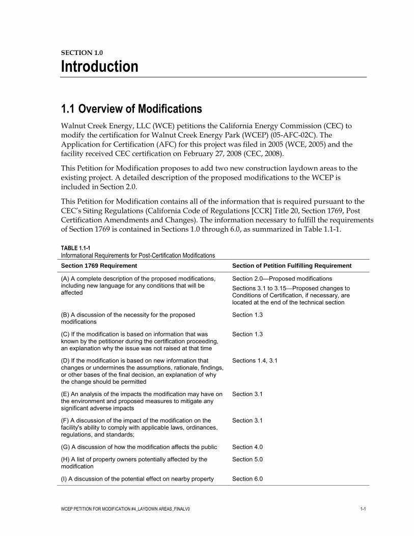
This Petition for Modification contains all of the information that is required pursuant to the CEC’s Siting Regulations (California Code of Regulations [CCR] Title 20, Section 1769, Post Certification Amendments and Changes). The information necessary to fulfill the requirements of Section 1769 is contained in Sections 1.0 through 6.0, as summarized in Table 1.1-1.
TABLE 1.1-1
Informational Requirements for Post-Certification Modifications
Section 1769 Requirement Section of Petition Fulfilling Requirement
(A) A complete description of the proposed modifications, including new language for any conditions that will be affected
Section 2.0—Proposed modifications Sections 3.1 to 3.15—Proposed changes to Conditions of Certification, if necessary, are located at the end of the technical section
(B) A discussion of the necessity for the proposed modifications
Section 1.3
(C) If the modification is based on information that was known by the petitioner during the certification proceeding, an explanation why the issue was not raised at that time
Section 1.3
(D) If the modification is based on new information that changes or undermines the assumptions, rationale, findings, or other bases of the final decision, an explanation of why the change should be permitted
Sections 1.4, 3.1
(E) An analysis of the impacts the modification may have on the environment and proposed measures to mitigate any significant adverse impacts
Section 3.1
(F) A discussion of the impact of the modification on the facility's ability to comply with applicable laws, ordinances, regulations, and standards;
Section 3.1
(G) A discussion of how the modification affects the public Section 4.0
(H) A list of property owners potentially affected by the modification
Section 5.0
(I) A discussion of the potential effect on nearby property Section 6.0
WALNUT CREEK ENERGY PARK PETITION FOR MODIFICATION NO. 4
1-2 WCEP PETITION FOR MODIFICATION #4_LAYDOWN AREAS_FINALV0
TABLE 1.1-1
Informational Requirements for Post-Certification Modifications
Section 1769 Requirement Section of Petition Fulfilling Requirement owners, the public and the parties in the application proceedings.
1.2 Ownership of the Facility Property
WCE will own the WCEP, and is a wholly-owned subsidiary of Edison Mission Energy (EME). EME is an independent power developer, owner, and operator engaged in the business of owning or leasing, operating, and selling energy and capacity from electric power generation facilities.
1.3 Necessity of Proposed Changes
The Siting Regulations require a discussion of the necessity for the proposed revision to WCEP certification and whether the modification is based on information known by the petitioner during the certification proceeding (Title 20, CCR, Sections 1769 [a][1][B] and [C]). This Petition for Modification requests approval to add two new construction laydown areas to the original WCEP, as described in the Commission Decision. The purpose of the modification is to allow for additional construction laydown and material storage area in close proximity to the WCEP site. The addition of the laydown areas will allow for the storage and movement of equipment and supplies to and from the WCEP site over a relatively short distance in a safe and efficient manner.
1.4 Consistency of Changes with Certification
The Siting Regulations also require a discussion of the consistency of the proposed project revision with the applicable laws, ordinances, regulations, and standards (LORS) and whether the modifications are based on new information that changes or undermines the assumptions, rationale, findings, or other basis of the final decision (Title 20, CCR Section 1769 [a][1][D]). If the project is no longer consistent with the certification, the Petition for Modification must provide an explanation why the modification should be permitted.
The proposed project revisions are consistent with all applicable LORS. This Petition for Modification is not based on new information that changes or undermines any basis for the Final Decision. The findings and conclusions contained in the Commission Decision for WCEP (CEC, 2008) are still applicable to the project, as modified.
1.5 Summary of Environmental Impacts
The CEC Siting Regulations require that an analysis be conducted to address the potential impacts the proposed modifications may have on the environment, and proposed measures to mitigate any potentially significant adverse impacts (Title 20, CCR, Section 1769 [a][1][E]). The regulations also require a discussion of the impact of the modification on the facility’s
WALNUT CREEK ENERGY PARK PETITION FOR MODIFICATION NO. 4
WCEP PETITION FOR MODIFICATION #4_LAYDOWN AREAS_FINALV0 1-3
ability to comply with applicable LORS (Section 1769 [1][a][F]). Section 3.0 of this Petition for Modification includes a discussion of the potential environmental impacts associated with the modifications, as well as a discussion of the consistency of the modification with LORS. Section 3.0 also includes updated environmental baseline information if changes have occurred since the AFC that would have a bearing on the environmental analysis of the Petition for Modification. Section 3.0 concludes that there will be no significant environmental impacts associated with implementing the actions specified in the Petition for Modification and that the project as modified will comply with all applicable LORS.
1.6 Conditions of Certification
The addition of the WCEP laydown areas identified in this petition would require no changes to the CEC Conditions of Certification, as described in the Commission Decision for the WCEP.
1.7 References
AECOM Environment. 2011. Phase I Environmental Site Assessment, Walnut Creek Energy Park Additional Laydown Area, South Azusa Avenue, City of Industry, California. May.
AECOM Environment. 2011. Phase I Environmental Site Assessment, Walnut Creek Energy Park Proposed Laydown Area, Southeast Corner of Chestnut Street and Anaheim-Puente Road, City of Industry, California. July.
California Department of Fish and Game. 2011. Natural Diversity Database. Azusa, Baldwin Park, El Monte, Glendora, La Habra, Mt. Wilson, San Dimas, Whittier, and Yorba Linda, CA 7.5-minute USGS Quads. June 22.
California Energy Commission (CEC). 2008. Final Commission Decision on Walnut Creek Energy Park. California Energy Commission, Sacramento, California. February.
South Central Coastal Information Center (SCCIC). 2011. California Historical Resources Information System (CHRIS). California State University, Fullerton, CA. June 24.
Walnut Creek Energy, LLC (WCE). 2005. Application for Certification for the Walnut Creek Energy Park. Submitted to the California Energy Commission. Submitted by Walnut Creek Energy, LLC, a wholly owned subsidiary of Edison Mission Energy.


WCEP PETITION FOR MODIFICATION #4_LAYDOWN AREAS_FINALV0 2-1
SECTION 2.0
Description of Project Modifications
This section includes a description of the proposed project modifications, consistent with CEC Siting Regulations (Title 20, CCR, Section 1769 [a][1][A]). This Petition for Modification proposes to add two new construction laydown area to the WCEP.
The new proposed laydown areas, referred to in this Petition as Laydown Area #1 and Laydown Area #2 (Figures 1 and 2), consist of two separate parcels located across from each other on South Azusa Avenue in the City of Industry, CA 91745, approximately 1 mile east of the WCEP site. Laydown Area #1 is currently a vacant lot approximately 15.29 acres in size owned by the Industry Urban Development Agency. This parcel has been used by the City in the past for similar purposes (material and equipment storage); therefore, the parcel is highly disturbed, and currently undeveloped. Laydown Area #2 is approximately 4.1 acres in size and has historically been used for agricultural purposes, therefore it is also currently undeveloped and also highly disturbed.
The WCEP site and proposed laydown areas are all within an area of the City of Industry that is zoned Industrial; therefore this temporary activity is a permitted use. Similar to the WCEP site, access to the laydown areas from the nearest freeway would be from the Pomona Freeway, located approximately .60 miles to the south on South Azusa Avenue. The route from the laydown areas to the WCEP site follows South Azusa Avenue south for .40 miles to East Gale Avenue, then west on East Gale Avenue for approximately .80 miles, then north on Bixby Drive approximately .20 miles.
WCE does not suggest any revisions to the Conditions of Certification set forth in the February 2008 certification for the WCEP. With adherence to the Conditions of Certification, the WCEP, as modified, will not cause significant adverse impacts to the environment and will not cause environmental impacts substantially different than those addressed in the Commission Decision.
This Petition for Modification requests approval to add two new construction laydown areas to the original WCEP, as described in the Commission Decision. The purpose of the modification is to allow for inclusion of additional construction laydown and material storage areas that are in close proximity to the WCEP site, in this case approximately 1 mile east (see Figure 1). The current WCEP construction site is relatively compact with only a small amount of existing laydown area available for excess material or equipment storage. The addition of the laydown areas will allow for the storage and movement of equipment and supplies to and from the WCEP site over a relatively short distance in a safe and efficient manner.
No Conditions of Certification will be changed, therefore no new language is proposed.


WCEP PETITION FOR MODIFICATION #4_LAYDOWN AREAS_FINALV0 3-3
SECTION 3.0
Environmental Analysis of Proposed Project Modifications
The proposed modifications to the WCEP would be limited to the addition of the two previously described offsite laydown areas. As a result, the environmental analysis for all of the environmental disciplines does not differ significantly from that described in the AFC, and the impacts associated with this Petition for Modification would be less than significant. The environmental analysis for the following environmental disciplines would not differ significantly from the AFC and Supplement IV:
Air Quality Biological Resources Cultural Resources
Geology and Paleontology Hazardous Materials Management Land Use
Noise Public Health Socioeconomics
Soil and Water Resources Traffic and Transportation Visual Resources Waste Management Worker Safety and Fire Protection
For the environmental disciplines of Biological Resources, Cultural Resources, Paleontological Resources and Worker Safety, additional evaluation and verification by technical resource experts was undertaken in order to confirm that the proposed addition of the new laydown area would not change the environmental analysis presented in the AFC. Sections 3.1 to 3.4 below describe the additional evaluation performed for the aforementioned four resource areas. The addition of the new proposed laydown areas does not require changes to the Conditions of Certification.
3.1 Biological Resources
The Commission Decision determined that the WCEP would not have significant impacts on Biological Resources. Pursuant to this proposed Petition for Modification, the addition of the new proposed laydown areas is not expected to have a significant impact on Biological Resources.

WALNUT CREEK ENERGY PARK PETITION FOR MODIFICATION NO. 4
3-4 WCEP PETITION FOR MODIFICATION #4_LAYDOWN AREAS_FINALV0
3.1.1 Environmental Baseline Information
This Petition for Modification does not require changes to the Environmental Baseline Information as described in the AFC. There have been no significant changes that would alter the analysis or conclusions for Biological Resources.
3.1.2 Environmental Consequences
The proposed addition of the new laydown areas is not expected to cause any significant change to biological resources, as discussed in the AFC. In preparation of the WCEP AFC, no issues or significant impacts were identified for biological resources, and as such, no Conditions of Certification for biological resources were issued by the CEC for construction or operation of the WCEP.
A biological resources site reconnaissance survey of the proposed laydown areas was conducted on July 21, 2011 by a CH2M HILL biologist. The new laydown areas are located in a highly urbanized setting surrounded by industrial and residential land uses. Both sites are highly disturbed and currently undeveloped, and do not contain native habitat. Laydown Area #1 consists of non-native grassland and ruderal growth primarily vegetated with weedy species such as grasses (Bromus spp.), wild oat (Avena fatua), clover (Melilotus sp.), and bindweed (Convolvulaceae sp.). With the exception of a large vegetated mound in the eastern-central portion of the site, Laydown Area #1 is flat. Currently, the northeast corner of Laydown Area 1 is associated with the adjacent recycling facility and is therefore disturbed. The southernmost portion of Laydown Area 1 is gravel-covered and disturbed.
Laydown Area #2 is currently an active agricultural field with row crops (watermelon, basil, squash, and tomatoes) and some fallow areas. The southern portion of Laydown Area #2 consists of a dirt parking lot for an on-site fruit stand and may also serve as a staging area for agricultural equipment. Although both laydown areas provide minimal to low biological value, both sites currently provide a minimal amount of foraging and sheltering habitat for urban-adapted wildlife species such as mourning dove (Zenaida macroura), barn swallow (Hirundo rustica), house finch (Carpodacus mexicanus), and California ground squirrel (Spermophilus beecheyi). In addition, an American kestrel (Falco sparverius) was observed at Laydown Area 1.
No suitable habitat for sensitive species is present due to the highly disturbed nature of the two sites and therefore no significant impacts to Biological Resources are anticipated with the use of these new laydown areas. Based on a review of a newly acquired California Natural Diversity Database (CNDDB) (Figure 3), no sensitive species were observed during the site reconnaissance.
3.1.3 Mitigation Measures
The impacts on biological resources as a result of the proposed new laydown areas are less than significant, and will, therefore, not require additional mitigation measures.
3.1.4 Consistency with LORS
The proposed addition to the WCEP of the new laydown areas will remain consistent with all applicable LORS related to Biological Resources.
WALNUT CREEK ENERGY PARK PETITION FOR MODIFICATION NO. 4
WCEP PETITION FOR MODIFICATION #4_LAYDOWN AREAS_FINALV0 3-5
3.1.5 Conditions of Certification
The proposed addition to the WCEP of the new laydown areas will not require changes to the Conditions of Certification for Biological Resources.
3.2 Cultural Resources
The Commission Decision determined that the WCEP would not have significant impacts on Cultural Resources. Pursuant to this proposed Petition for Modification, the addition of the new proposed laydown areas is not expected to have a significant impact on Cultural Resources.
3.2.1 Environmental Baseline Information
This Petition for Modification does not require changes to the Environmental Baseline Information as described in the AFC. There have been no significant changes in terms of local development that would change the analysis or conclusions for Cultural Resources.
3.2.2 Environmental Consequences
The proposed addition of the new laydown areas is not expected to cause any significant change to Cultural Resources, as discussed in the AFC. In preparation of the WCEP AFC, no issues or significant impacts were identified for Cultural Resources.
In order to confirm that there would be no new issues or potential impacts associated with Cultural Resources as it relates to the new proposed laydown areas, a current archaeological records search was performed on June 23, 2011, and an intensive pedestrian survey of each proposed laydown area was performed, the first on June 24, 2011 and the second on July 21, 2011. These activities were conducted by the WCEP Cultural Resources Monitor (CRM), and supervised by the WCEP Cultural Resources Specialist (CRS).
The proposed new additional laydown areas for the WCEP were subject to a cultural resources inventory. This inventory includes archival research, site reconnaissance, and surface pedestrian survey. The area of potential effect (APE) for the laydown areas was determined in accordance with the latest CEC Rules of Practice and Procedure & Power Plant Site Certification Regulations (CEC 2007) for assessing potential impacts to archaeological and architectural resources. CH2M HILL completed a literature search for the affected areas at the California Historical Resources Information System (CHRIS), South Central Coastal Information Center (Center), using a definition of a one-half mile buffer zone around the proposed laydown areas. With assistance from Center staff, the CHRIS literature and records review included a review of all recorded archaeological sites as well as all known cultural resource survey and excavation reports. The National Register of Historic Places (NHRP), the California Register, California Historical Landmarks, and California Points of Historical Interest were all examined.
According to information available in the CHRIS files, no previous cultural resource studies have been prepared within the proposed laydown areas. No previously recorded resources are located within the proposed laydown areas.
A cultural resources site reconnaissance survey of the proposed laydown areas was conducted on June 24, 2011 and July 21, 2011, by Daniel Ewers, M.A., RPA, the acting CRM
WALNUT CREEK ENERGY PARK PETITION FOR MODIFICATION NO. 4
3-6 WCEP PETITION FOR MODIFICATION #4_LAYDOWN AREAS_FINALV0
for the WCEP. Visibility was excellent throughout each laydown area. Each proposed laydown area has been previously disturbed. The larger area to the east of South Azusa Avenue, depicted on the attached figures as Laydown Area #1, currently is mostly vacant, and has historically, served as a material and equipment storage area. Several pieces of construction equipment and supplies were stored in this area at the time of the site reconnaissance. The smaller area west of South Azusa Avenue, depicted on the attached figures as Laydown Area #2, is currently used for limited agricultural activities. At the time of the site reconnaissance a variety of row crops and some fallow areas were evident.
Cultural sensitivity in the laydown areas is considered low to moderate. No cultural resources were found during this cultural resources assessment and no significant historical resources were identified. No subsurface disturbance of the laydown areas is planned or anticipated.
3.2.3 Mitigation Measures
The impacts on Cultural Resources as a result of the proposed new laydown areas are less than significant, and will, therefore, not require additional mitigation measures.
3.2.4 Consistency with LORS
The proposed addition to the WCEP of the new proposed laydown areas will remain consistent with all applicable LORS related to Cultural Resources.
3.2.5 Conditions of Certification
The proposed addition to the WCEP of the new laydown areas will not require changes to the Conditions of Certification for Cultural Resources.
3.3 Paleontological Resources
The Commission Decision determined that the WCEP would not have significant impacts on Paleontological Resources. Pursuant to this proposed Petition for Modification, the addition of the new proposed laydown areas is not expected to have a significant impact on Paleontological Resources.
3.3.1 Environmental Baseline Information
This Petition for Modification does not require changes to the Environmental Baseline Information as described in the AFC. There have been no significant changes that would alter the analysis or conclusions for Paleontological Resources.
3.3.2 Environmental Consequences
The proposed addition of the new laydown areas is not expected to cause any significant change to Paleontological Resources, as discussed in the AFC. In preparation of the WCEP AFC, no issues or significant impacts were identified for Paleontological Resources provided the proposed mitigation measures were followed. The AFC found no fossils within three miles of the WCEP Project site. This buffer includes the proposed laydown areas.
In order to confirm that there would be no new issues or potential impacts associated with Paleontological Resources as it relates to the new proposed laydown areas, a review of

WALNUT CREEK ENERGY PARK PETITION FOR MODIFICATION NO. 4
WCEP PETITION FOR MODIFICATION #4_LAYDOWN AREAS_FINALV0 3-7
existing geologic maps and the project Paleontological Resources Monitoring and Mitigation Plan was performed by the WCEP Paleontological Resources Monitor (PRM) and Staff Paleontologist James Verhoff, under the supervision of the Paleontological Resources Specialist (PRS). The proposed laydown areas are within the buffer zone of the WCEP Project site, and therefore no additional literature review was conducted.
Four geologic units underlie or lie in the immediate vicinity of the proposed laydown areas. Granitic basement rocks lie at great depth under the area; these have low paleontological sensitivity, and are very unlikely to be encountered during construction. Above this basement, but still well below depths that would be reached by construction, are Tertiary marine strata of high paleontological sensitivity. The near-surface material at the proposed Laydown Area #1 includes both disturbed native sediment and artificial fill; both disturbed sediment and artificial fill have no potential to produce scientifically significant fossils. The uppermost units consist of the high-sensitivity Pleistocene alluvium, and low-sensitivity Holocene alluvium. The near-surface material at the proposed Laydown Area #2 consists of disturbed sediment, most likely low-sensitivity Holocene alluvium disturbed by the agricultural activities which have occurred at the site. Post-Pleistocene aggradation has likely deposited a great thickness of low-sensitivity Holocene sediment in the area of the project site and two proposed laydown areas, and therefore construction encounters with scientifically significant fossils are unlikely.
The new proposed laydown areas have previously disturbed surface areas resulting from prior uses, the larger area for similar purposes (material and equipment storage), and the smaller area for agricultural purposes. The proposed areas are intended for storage and staging activities only, and no excavations or ground disturbances below this disturbed sediment are planned. Since no excavation beyond grading is planned for the laydown areas, and disturbed sediment is known to be at the surface of each site, no effect to paleontological resources is anticipated. Therefore, paleontological resources monitoring will not be necessary during site preparation and use.
Because no impacts to paleontological resources will result from the set-up and use of the laydown areas, no changes to the current monitoring protocol is required, and no additional paleontological monitoring will be necessary.
3.3.3 Mitigation Measures
The impacts on Paleontological Resources as a result of the proposed new laydown areas are less than significant, and will, therefore, not require additional mitigation measures.
3.3.4 Consistency with LORS
The proposed addition to the WCEP of the new proposed laydown areas will remain consistent with all applicable LORS related to Paleontological Resources.
3.3.5 Conditions of Certification
The proposed addition to the WCEP of the new laydown areas will not require changes to the Conditions of Certification for Paleontological Resources.
WALNUT CREEK ENERGY PARK PETITION FOR MODIFICATION NO. 4
3-8 WCEP PETITION FOR MODIFICATION #4_LAYDOWN AREAS_FINALV0
3.4 Worker Safety
The Commission Decision determined that the WCEP would not have significant impacts on Worker Safety. Pursuant to this proposed Petition for Modification, the addition of the new proposed laydown areas is not expected to have a significant impact on Worker Safety.
3.4.1 Environmental Baseline Information
This Petition for Modification does not require changes to the Environmental Baseline Information as described in the AFC. There have been no significant changes that would alter the analysis or conclusions for Worker Safety.
3.4.2 Environmental Consequences
Two separate Phase I Environmental Site Assessments (ESAs) were undertaken by WCE to assess potential environmental issues at Laydown Area #1 and #2, which are described in more detail below, and are included here as Attachments 4 and 5. In each Phase I ESA, Recognized Environmental Conditions (RECs) associated with each laydown area were discussed, and with one exception (a soil stockpile discussed below), these RECs are primarily associated with groundwater issues. Since no pumping of groundwater or other subsurface activities is planned, these RECs are not expected to be an issue.
The Phase I ESA for Laydown Area #1 was performed by AECOM Environment (AECOM) in May 2011 (Attachment 4). Based on the results of the ESA, none of the environmental conditions identified during the ESA for the Laydown Area #1 would appear to result in an unsafe condition for those workers who may use this site as a storage or laydown area. During the performance of the ESA, AECOM identified several potential and one historical REC associated with the site, as described below.
The subject property is located within the Puente Valley Operable Unit of the San Gabriel Valley (Area 4) Superfund site. The groundwater beneath this area has been contaminated with volatile organic compounds (VOCs), perchlorate, and 1,4-dioxane. The presence of impacted groundwater beneath the subject property is considered a REC.
Tosco – 76 Station #5621 at 948 South Azusa Avenue is located adjacent to the south of the southwest corner of the subject property. This site is listed as a leaking underground storage tank (UST) site with impacts to groundwater. The reported status is that remedial action is underway. Information on the State Water Resources Control Board public database indicates that the impacted groundwater has migrated off-site to the west. Due to the regulatory status and likely migration of impacted groundwater beneath the subject property, it is AECOM’s opinion that this site represents a REC.
Stockpiles of soil located on the eastern side of the subject property may contain hazardous materials.
Three USTs were formerly located at the parcel at the southwest corner of the subject property. One 500-gallon waste oil UST was removed in 1988. A soil sample collected from under this UST found total petroleum hydrocarbons (TPH) at a concentration of 806 parts per million (ppm). The impacted soil was excavated and additional sampling did not indicate further TPH impacts. Seven groundwater monitoring wells were

WALNUT CREEK ENERGY PARK PETITION FOR MODIFICATION NO. 4
WCEP PETITION FOR MODIFICATION #4_LAYDOWN AREAS_FINALV0 3-9
installed on this portion of the subject property in 1989 and 1991. The groundwater monitoring did not indicate significant concentrations of TPH or benzene, toluene, ethylbenzene and xylenes (BTEX) in the groundwater. In 1996, two 7,500-gallon diesel USTs were removed from this parcel. The Regional Water Quality Control Board issued a “no further action” letter in 1997.
The aforementioned stockpile of soil that “…potentially may contain hazardous materials…” was observed on the eastern portion of the site. Despite the inconclusive nature of this statement, it is not anticipated that the soil stockpile will present an adverse condition to workers as the stockpile will not be disturbed. Furthermore, it was observed that the stockpile was completely overgrown with vegetation (Attachment 2, Photo 3) and therefore is relatively stable. As stated in the Phase I: “According to the site contact, this soil was placed on the subject property in approximately 2005, following a road widening project on Railroad Street.”
The Phase I ESA for Laydown Area #2 was performed by AECOM in July 2011. Based on the results of the ESA, none of the environmental conditions identified during the ESA for Laydown Area #2 would appear to result in an unsafe condition for those workers who may use the site as a storage or laydown area. During the performance of the ESA, AECOM identified one potential and one historical REC associated with the site, as described below.
The subject property is located within the Puente Valley Operable Unit of the San Gabriel Valley (Area 4) Superfund site. The groundwater beneath this area has been contaminated with perchloroethylene (PCE) and trichloroethylene (TCE). The presence of impacted groundwater beneath the subject property is considered a REC.
Historical research indicates that the subject property was occupied by a farm house complex at the immediate corner of Chestnut and Anaheim-Puente Road from 1924 to 2002. This farm house complex included: a single family residence; detached garage; corrugated metal building with hazardous materials storage; a barn with 55-gallon drum storage; a wood shed with a 1000-gallon diesel fuel UST and associated dispensing pump; a groundwater production well and concrete driveways and sidewalks. According to records reviewed at CNC Engineering, the City of Industry, Industry Urban Development Agency issued a notice of Construction Completion for the UST removal and building demolitions in October 2002. According to records review at the County of Los Angeles, Department of Public Works (DPW), the DPW issued to the Industry Urban Development Agency a Closure Certification for the UST on November 17, 2004. As such, the former UST represents a Historical REC.
3.4.3 Mitigation Measures
The impacts on Worker Safety as a result of the proposed new laydown areas are less than significant, and will, therefore, not require additional mitigation measures.
3.4.4 Consistency with LORS
The proposed addition to the WCEP of the new laydown area will remain consistent with all applicable LORS related to Worker Safety.
WALNUT CREEK ENERGY PARK PETITION FOR MODIFICATION NO. 4
3-10 WCEP PETITION FOR MODIFICATION #4_LAYDOWN AREAS_FINALV0
3.4.5 Conditions of Certification
The proposed addition to the WCEP of the new laydown area will not require changes to the Conditions of Certification for Worker Safety.
3.5 LORS
The Commission Decision certifying the WCEP project concluded that the project is in compliance with all applicable LORS. The project, as modified, will continue to comply with all applicable LORS.

WCEP PETITION FOR MODIFICATION #4_LAYDOWN AREAS_FINALV0 4-1
SECTION 4.0
Potential Effects on the Public
This section discusses the potential effects on the public that may result from the modifications proposed in this Petition for Modification application, pursuant to CEC Siting Regulations (Title 20, CCR, Section 1769[a][1][G]).
No adverse effects on the public will occur because of the changes to the project, as proposed in this Petition for Modification.

WCEP PETITION FOR MODIFICATION #4_LAYDOWN AREAS_FINALV0 5-1
SECTION 5.0
List of Property Owners
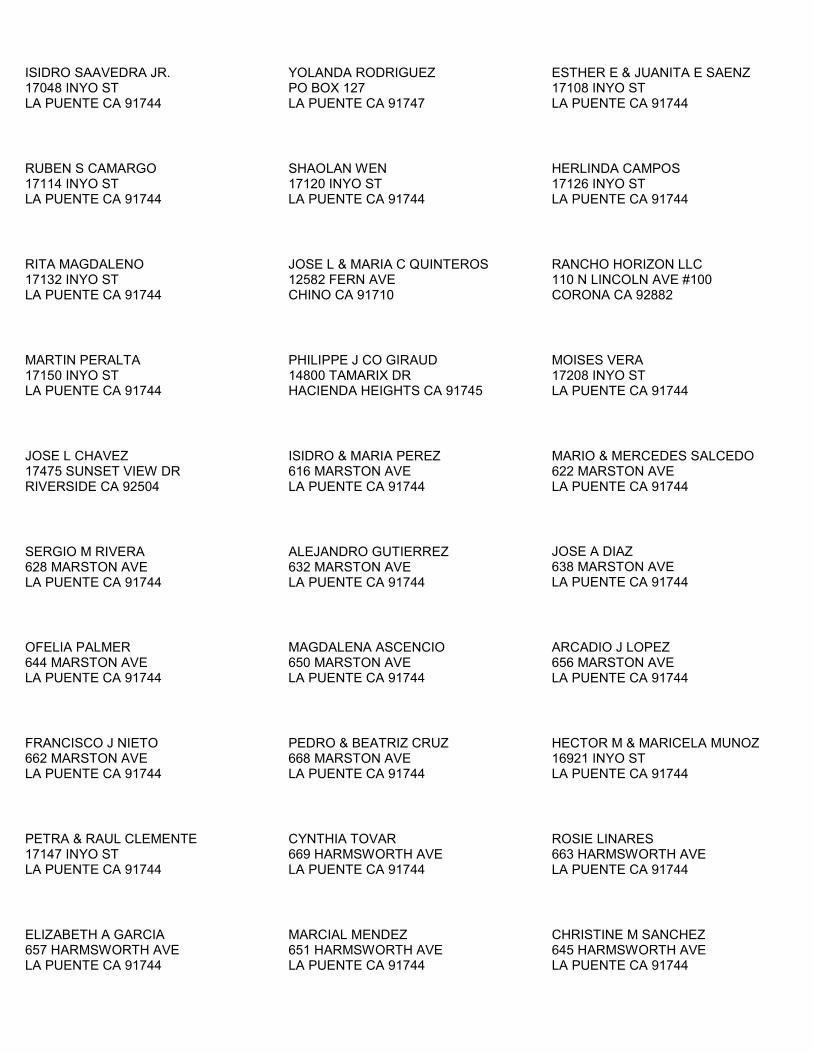
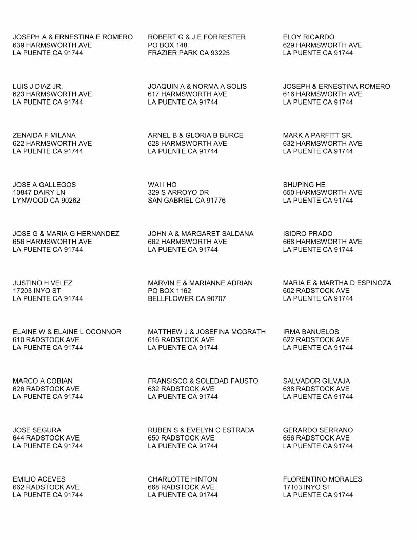
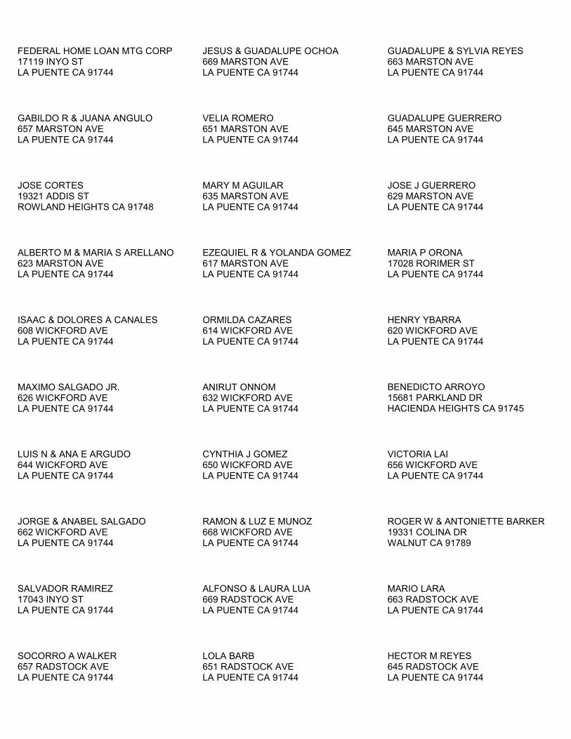
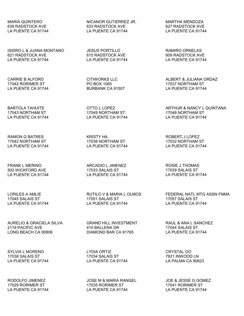
This section lists the property owners in accordance with the CEC Siting Regulations (Title 20, CCR, Section 1769[a][1][H]). A list of property owners within 1,000 feet of the proposed facility is included as Attachment 3. The list is provided in a format suitable for copying to mailing labels.


WCEP PETITION FOR MODIFICATION #4_LAYDOWN AREAS_FINALV0 6-1
SECTION 6.0
Potential Effects on Property Owners
This section addresses potential effects of the project changes proposed in this Petition for Modification on nearby property owners, the public, and parties in the application proceeding, pursuant to CEC Siting Regulations (Title 20, CCR, Section 1769 [a][1][I]).
The project, as modified, will not differ significantly in potential effects on adjacent land owners, compared with the project as previously proposed. The project, therefore, would have no adverse effects on nearby property owners, the public, or other parties in the application proceeding.


Figures


DEN \\COBRA\PROJ\WALNUT_CREEK_ENERGY_PARK\GIS\MAPFILES\SITE_VICINITY_MAP.MXD LHEYERDA 7/26/2011 8:51:06 AM
60
WCEP FACILITYWCEP LAYDOWN #1
WCEP LAYDOWN #2
Anaheim
Fullerton
West Covina
El Monte
Pomona
Norwalk
Whittier
GlendoraArcadia
Diamond Bar
La Habra
Hacienda Heights
Baldwin Park
Yorba Linda
Buena Park
South Whittier
Cerritos
Pico Rivera
Brea
Walnut
Covina
Azusa
San Dimas
La Mirada
Placentia
Rowland Heights
DuarteMonrovia
Valinda
VincentTemple City
La Puente
Avocado Heights
Citrus
South El Monte
Santa Fe Springs
West Puente Valley
South San Jose Hills
La Palma
Chino Hills
West Whittier-Los Nietos
IndustryIndustry
IrwindaleIrwindale
La Habra HeightsLa Habra Heights
Charter OakCharter Oak
East La MiradaEast La Mirada
BradburyBradbury
Mayflower VillageMayflower Village
North El MonteNorth El Monte
210
10
5
10
ProjectLocation
15
10
5
40
LegendWCEP Facility
WCEP Laydown #1
WCEP Laydown #2
County Boundary
Railroads (150 to 50k)
City Limits
0 1 2
Miles1:126,720
FIGURE 1Project Site VicinityWalnut Creek Energy ParkCity of Industry, CA
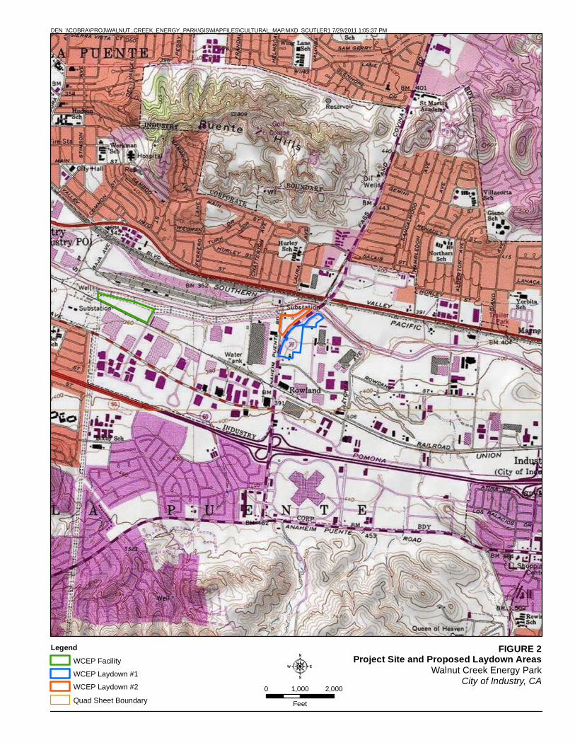
FIGURE 2Project Site and Proposed Laydown Areas
Walnut Creek Energy ParkCity of Industry, CA
0 1,000 2,000
Feet
Legend
WCEP Facility
WCEP Laydown #1
WCEP Laydown #2
Quad Sheet Boundary
DEN \\COBRA\PROJ\WALNUT_CREEK_ENERGY_PARK\GIS\MAPFILES\CULTURAL_MAP.MXD SCUTLER1 7/29/2011 1:05:37 PM

ATTACHMENT 1
California Natural Diversity Database

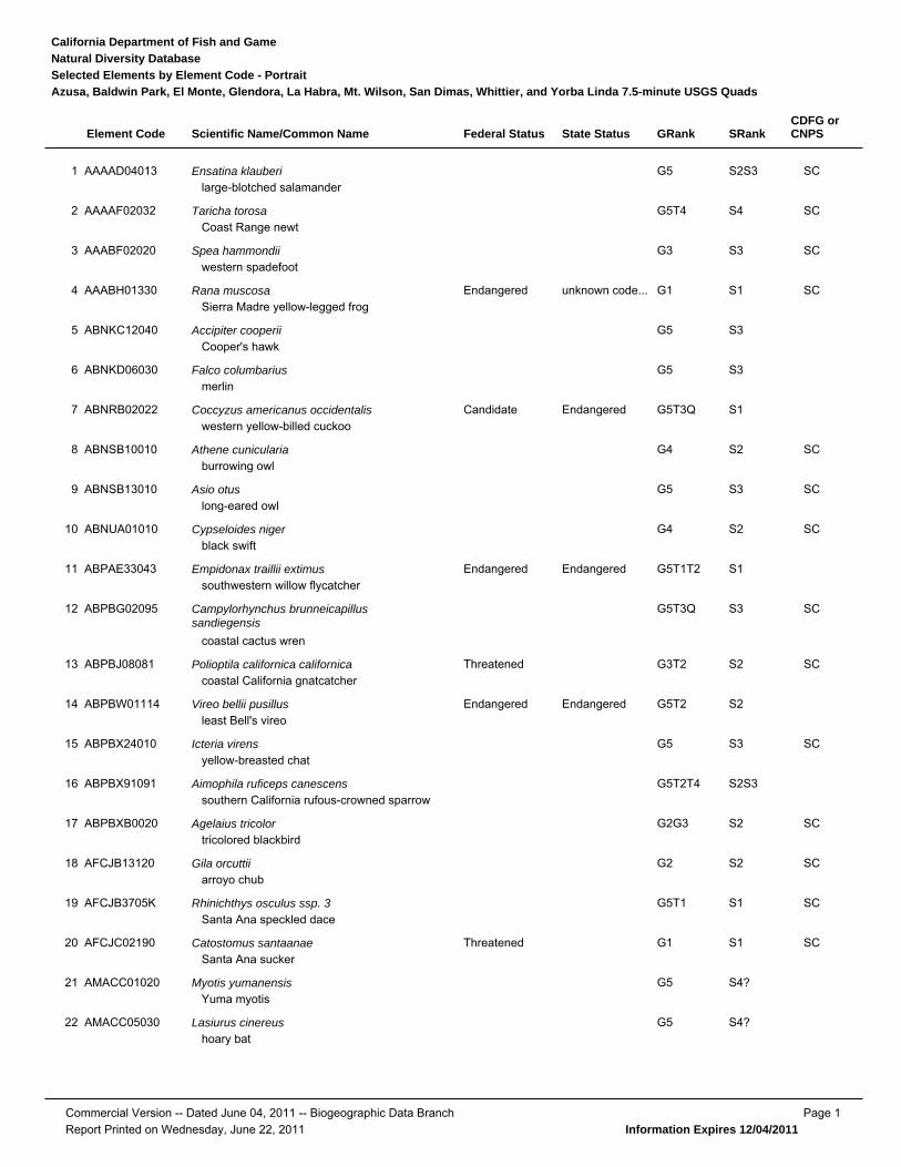
State StatusFederal StatusScientific Name/Common NameElement Code SRankGRank
Natural Diversity DatabaseCalifornia Department of Fish and Game
Selected Elements by Element Code - PortraitAzusa, Baldwin Park, El Monte, Glendora, La Habra, Mt. Wilson, San Dimas, Whittier, and Yorba Linda 7.5-minute USGS Quads
CDFG orCNPS
SCEnsatina klauberilarge-blotched salamander
AAAAD04013 S2S3G51
SCTaricha torosaCoast Range newt
AAAAF02032 S4G5T42
SCSpea hammondiiwestern spadefoot
AAABF02020 S3G33
SCunknown code...EndangeredRana muscosaSierra Madre yellow-legged frog
AAABH01330 S1G14
Accipiter cooperiiCooper's hawk
ABNKC12040 S3G55
Falco columbariusmerlin
ABNKD06030 S3G56
EndangeredCandidateCoccyzus americanus occidentaliswestern yellow-billed cuckoo
ABNRB02022 S1G5T3Q7
SCAthene cuniculariaburrowing owl
ABNSB10010 S2G48
SCAsio otuslong-eared owl
ABNSB13010 S3G59
SCCypseloides nigerblack swift
ABNUA01010 S2G410
EndangeredEndangeredEmpidonax traillii extimussouthwestern willow flycatcher
ABPAE33043 S1G5T1T211
SCCampylorhynchus brunneicapillussandiegensis
coastal cactus wren
ABPBG02095 S3G5T3Q12
SCThreatenedPolioptila californica californicacoastal California gnatcatcher
ABPBJ08081 S2G3T213
EndangeredEndangeredVireo bellii pusillusleast Bell's vireo
ABPBW01114 S2G5T214
SCIcteria virensyellow-breasted chat
ABPBX24010 S3G515
Aimophila ruficeps canescenssouthern California rufous-crowned sparrow
ABPBX91091 S2S3G5T2T416
SCAgelaius tricolortricolored blackbird
ABPBXB0020 S2G2G317
SCGila orcuttiiarroyo chub
AFCJB13120 S2G218
SCRhinichthys osculus ssp. 3Santa Ana speckled dace
AFCJB3705K S1G5T119
SCThreatenedCatostomus santaanaeSanta Ana sucker
AFCJC02190 S1G120
Myotis yumanensisYuma myotis
AMACC01020 S4?G521
Lasiurus cinereushoary bat
AMACC05030 S4?G522
Commercial Version -- Dated June 04, 2011 -- Biogeographic Data Branch Page 1Report Printed on Wednesday, June 22, 2011 Information Expires 12/04/2011
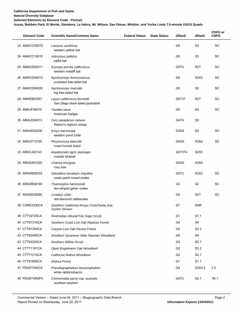
State StatusFederal StatusScientific Name/Common NameElement Code SRankGRank
Natural Diversity DatabaseCalifornia Department of Fish and Game
Selected Elements by Element Code - PortraitAzusa, Baldwin Park, El Monte, Glendora, La Habra, Mt. Wilson, San Dimas, Whittier, and Yorba Linda 7.5-minute USGS Quads
CDFG orCNPS
SCLasiurus xanthinuswestern yellow bat
AMACC05070 S3G523
SCAntrozous palliduspallid bat
AMACC10010 S3G524
SCEumops perotis californicuswestern mastiff bat
AMACD02011 S3?G5T425
SCNyctinomops femorosaccuspocketed free-tailed bat
AMACD04010 S2S3G426
SCNyctinomops macrotisbig free-tailed bat
AMACD04020 S2G527
SCLepus californicus bennettiiSan Diego black-tailed jackrabbit
AMAEB03051 S3?G5T3?28
SCTaxidea taxusAmerican badger
AMAJF04010 S4G529
Ovis canadensis nelsoniNelson's bighorn sheep
AMALE04013 S3G4T430
SCEmys marmoratawestern pond turtle
ARAAD02030 S3G3G431
SCPhrynosoma blainvilliicoast horned lizard
ARACF12100 S3S4G4G532
Aspidoscelis tigris stejnegericoastal whiptail
ARACJ02143 S2S3G5T3T433
Charina trivirgatarosy boa
ARADA01020 S3S4G4G534
SCSalvadora hexalepis virgulteacoast patch-nosed snake
ARADB30033 S2S3G5T335
SCThamnophis hammondiitwo-striped garter snake
ARADB36160 S2G336
SCCrotalus ruberred-diamond rattlesnake
ARADE02090 S2?G437
Southern California Arroyo Chub/Santa AnaSucker Stream
CARE2330CA SNRG?38
Riversidian Alluvial Fan Sage ScrubCTT32720CA S1.1G139
Southern Coast Live Oak Riparian ForestCTT61310CA S4G440
Canyon Live Oak Ravine ForestCTT61350CA S3.3G341
Southern Sycamore Alder Riparian WoodlandCTT62400CA S4G442
Southern Willow ScrubCTT63320CA S2.1G343
Open Engelmann Oak WoodlandCTT71181CA S2.2G244
California Walnut WoodlandCTT71210CA S2.1G245
Walnut ForestCTT81600CA S1.1G146
2.2Pseudognaphalium leucocephalumwhite rabbit-tobacco
PDAST440C0 S2S3.2G447
1B.1Centromadia parryi ssp. australissouthern tarplant
PDAST4R0P4 S2.1G4T248
Commercial Version -- Dated June 04, 2011 -- Biogeographic Data Branch Page 2Report Printed on Wednesday, June 22, 2011 Information Expires 12/04/2011
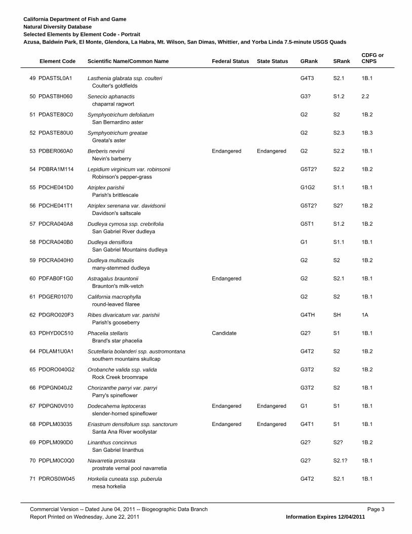
State StatusFederal StatusScientific Name/Common NameElement Code SRankGRank
Natural Diversity DatabaseCalifornia Department of Fish and Game
Selected Elements by Element Code - PortraitAzusa, Baldwin Park, El Monte, Glendora, La Habra, Mt. Wilson, San Dimas, Whittier, and Yorba Linda 7.5-minute USGS Quads
CDFG orCNPS
1B.1Lasthenia glabrata ssp. coulteriCoulter's goldfields
PDAST5L0A1 S2.1G4T349
2.2Senecio aphanactischaparral ragwort
PDAST8H060 S1.2G3?50
1B.2Symphyotrichum defoliatumSan Bernardino aster
PDASTE80C0 S2G251
1B.3Symphyotrichum greataeGreata's aster
PDASTE80U0 S2.3G252
1B.1EndangeredEndangeredBerberis neviniiNevin's barberry
PDBER060A0 S2.2G253
1B.2Lepidium virginicum var. robinsoniiRobinson's pepper-grass
PDBRA1M114 S2.2G5T2?54
1B.1Atriplex parishiiParish's brittlescale
PDCHE041D0 S1.1G1G255
1B.2Atriplex serenana var. davidsoniiDavidson's saltscale
PDCHE041T1 S2?G5T2?56
1B.2Dudleya cymosa ssp. crebrifoliaSan Gabriel River dudleya
PDCRA040A8 S1.2G5T157
1B.1Dudleya densifloraSan Gabriel Mountains dudleya
PDCRA040B0 S1.1G158
1B.2Dudleya multicaulismany-stemmed dudleya
PDCRA040H0 S2G259
1B.1EndangeredAstragalus brauntoniiBraunton's milk-vetch
PDFAB0F1G0 S2.1G260
1B.1California macrophyllaround-leaved filaree
PDGER01070 S2G261
1ARibes divaricatum var. parishiiParish's gooseberry
PDGRO020F3 SHG4TH62
1B.1CandidatePhacelia stellarisBrand's star phacelia
PDHYD0C510 S1G2?63
1B.2Scutellaria bolanderi ssp. austromontanasouthern mountains skullcap
PDLAM1U0A1 S2G4T264
1B.2Orobanche valida ssp. validaRock Creek broomrape
PDORO040G2 S2G3T265
1B.1Chorizanthe parryi var. parryiParry's spineflower
PDPGN040J2 S2G3T266
1B.1EndangeredEndangeredDodecahema leptocerasslender-horned spineflower
PDPGN0V010 S1G167
1B.1EndangeredEndangeredEriastrum densifolium ssp. sanctorumSanta Ana River woollystar
PDPLM03035 S1G4T168
1B.2Linanthus concinnusSan Gabriel linanthus
PDPLM090D0 S2?G2?69
1B.1Navarretia prostrataprostrate vernal pool navarretia
PDPLM0C0Q0 S2.1?G2?70
1B.1Horkelia cuneata ssp. puberulamesa horkelia
PDROS0W045 S2.1G4T271
Commercial Version -- Dated June 04, 2011 -- Biogeographic Data Branch Page 3Report Printed on Wednesday, June 22, 2011 Information Expires 12/04/2011
State StatusFederal StatusScientific Name/Common NameElement Code SRankGRank
Natural Diversity DatabaseCalifornia Department of Fish and Game
Selected Elements by Element Code - PortraitAzusa, Baldwin Park, El Monte, Glendora, La Habra, Mt. Wilson, San Dimas, Whittier, and Yorba Linda 7.5-minute USGS Quads
CDFG orCNPS
1B.2Galium grandeSan Gabriel bedstraw
PDRUB0N0V0 S2.2G272
2.2Cladium californicumCalifornia saw-grass
PMCYP04010 S2.2G473
2.2Fimbristylis thermalishot springs fimbristylis
PMCYP0B0N0 S2.2G474
1B.1EndangeredThreatenedBrodiaea filifoliathread-leaved brodiaea
PMLIL0C050 S2.1G275
1B.2Calochortus clavatus var. gracilisslender mariposa-lily
PMLIL0D096 S2G4T276
1B.2Calochortus plummeraePlummer's mariposa-lily
PMLIL0D150 S3G377
1B.2Calochortus weedii var. intermediusintermediate mariposa-lily
PMLIL0D1J1 S2.2G3G4T278
2.1Imperata brevifoliaCalifornia satintail
PMPOA3D020 S2.1G279
4.3Muhlenbergia californicaCalifornia muhly
PMPOA480A0 S3.3G380
1B.1EndangeredEndangeredOrcuttia californicaCalifornia Orcutt grass
PMPOA4G010 S2.1G281
2.2Thelypteris puberula var. sonorensisSonoran maiden fern
PPTHE05192 S2.2?G5T382
Commercial Version -- Dated June 04, 2011 -- Biogeographic Data Branch Page 4Report Printed on Wednesday, June 22, 2011 Information Expires 12/04/2011
ATTACHMENT 2
Laydown Areas - Site Photographs

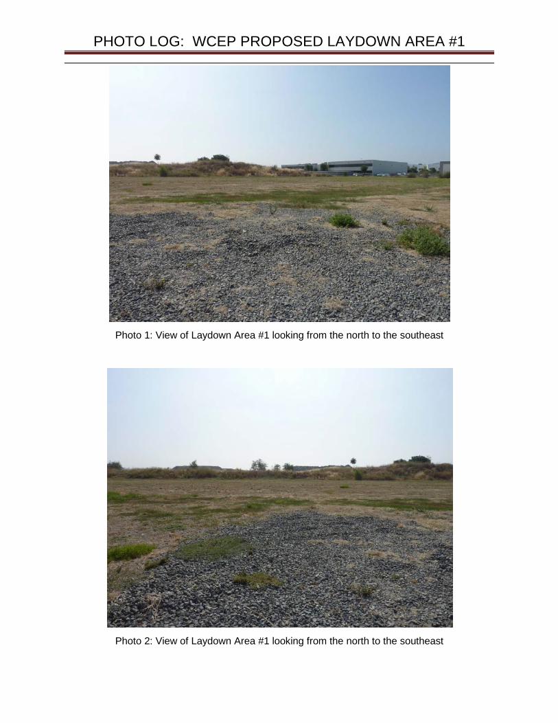
PHOTO LOG: WCEP PROPOSED LAYDOWN AREA #1
Photo 1: View of Laydown Area #1 looking from the north to the southeast
Photo 2: View of Laydown Area #1 looking from the north to the southeast

PHOTO LOG: WCEP PROPOSED LAYDOWN AREA #1
Photo 3: View of Laydown Area #1 from southeast corner looking north along soil stockpile.
Photo 4: View from northeast corner of Laydown Area #1 looking south.
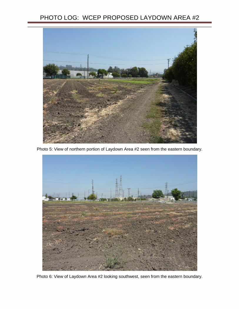
PHOTO LOG: WCEP PROPOSED LAYDOWN AREA #2
Photo 5: View of northern portion of Laydown Area #2 seen from the eastern boundary.
Photo 6: View of Laydown Area #2 looking southwest, seen from the eastern boundary.

PHOTO LOG: WCEP PROPOSED LAYDOWN AREA #2
Photo 7: View of northern portion of Laydown Area #2 along Chestnut St. looking west.
Photo 8: View of southwestern portion of Laydown Area #2.
ATTACHMENT 3
List of Property Owners within 1,000 feet

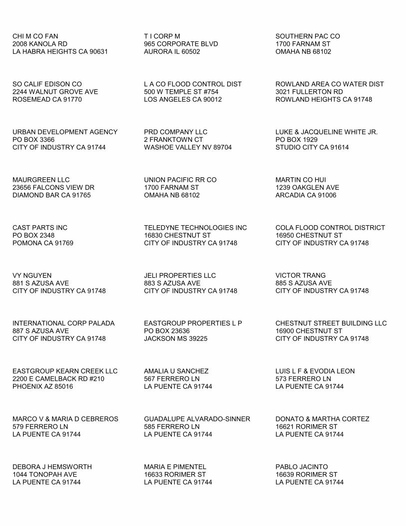
CHI M CO FAN 2008 KANOLA RD LA HABRA HEIGHTS CA 90631
T I CORP M 965 CORPORATE BLVD AURORA IL 60502
SOUTHERN PAC CO 1700 FARNAM ST OMAHA NB 68102
SO CALIF EDISON CO 2244 WALNUT GROVE AVE ROSEMEAD CA 91770
L A CO FLOOD CONTROL DIST 500 W TEMPLE ST #754 LOS ANGELES CA 90012
ROWLAND AREA CO WATER DIST 3021 FULLERTON RD ROWLAND HEIGHTS CA 91748
URBAN DEVELOPMENT AGENCY PO BOX 3366 CITY OF INDUSTRY CA 91744
PRD COMPANY LLC 2 FRANKTOWN CT WASHOE VALLEY NV 89704
LUKE & JACQUELINE WHITE JR. PO BOX 1929 STUDIO CITY CA 91614
MAURGREEN LLC 23656 FALCONS VIEW DR DIAMOND BAR CA 91765
UNION PACIFIC RR CO 1700 FARNAM ST OMAHA NB 68102
MARTIN CO HUI 1239 OAKGLEN AVE ARCADIA CA 91006
CAST PARTS INC PO BOX 2348 POMONA CA 91769
TELEDYNE TECHNOLOGIES INC 16830 CHESTNUT ST CITY OF INDUSTRY CA 91748
COLA FLOOD CONTROL DISTRICT 16950 CHESTNUT ST CITY OF INDUSTRY CA 91748
VY NGUYEN 881 S AZUSA AVE CITY OF INDUSTRY CA 91748
JELI PROPERTIES LLC 883 S AZUSA AVE CITY OF INDUSTRY CA 91748
VICTOR TRANG 885 S AZUSA AVE CITY OF INDUSTRY CA 91748
INTERNATIONAL CORP PALADA 887 S AZUSA AVE CITY OF INDUSTRY CA 91748
EASTGROUP PROPERTIES L P PO BOX 23636 JACKSON MS 39225
CHESTNUT STREET BUILDING LLC 16900 CHESTNUT ST CITY OF INDUSTRY CA 91748
EASTGROUP KEARN CREEK LLC 2200 E CAMELBACK RD #210 PHOENIX AZ 85016
AMALIA U SANCHEZ 567 FERRERO LN LA PUENTE CA 91744
LUIS L F & EVODIA LEON 573 FERRERO LN LA PUENTE CA 91744
MARCO V & MARIA D CEBREROS 579 FERRERO LN LA PUENTE CA 91744
GUADALUPE ALVARADO-SINNER 585 FERRERO LN LA PUENTE CA 91744
DONATO & MARTHA CORTEZ 16621 RORIMER ST LA PUENTE CA 91744
DEBORA J HEMSWORTH 1044 TONOPAH AVE LA PUENTE CA 91744
MARIA E PIMENTEL 16633 RORIMER ST LA PUENTE CA 91744
PABLO JACINTO 16639 RORIMER ST LA PUENTE CA 91744
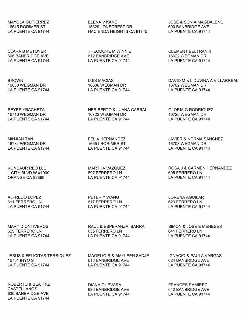
MAYOLA GUTIERREZ 16645 RORIMER ST LA PUENTE CA 91744
ELENA V KANE 15829 LONECREST DR HACIENDA HEIGHTS CA 91745
JOSE & SONIA MAGDALENO 600 BANBRIDGE AVE LA PUENTE CA 91744
CLARA B METOYER 606 BANBRIDGE AVE LA PUENTE CA 91744
THEODORE M WINNIE 612 BANBRIDGE AVE LA PUENTE CA 91744
CLEMENT BELTRAN II 16622 WEGMAN DR LA PUENTE CA 91744
BROWN 16630 WEGMAN DR LA PUENTE CA 91744
LUIS MACIAS 16636 WEGMAN DR LA PUENTE CA 91744
DAVID M & LIDUVINA A VILLARREAL 16702 WEGMAN DR LA PUENTE CA 91744
REYES YRACHETA 16716 WEGMAN DR LA PUENTE CA 91744
HERIBERTO & JUANA CABRAL 16722 WEGMAN DR LA PUENTE CA 91744
GLORIA G RODRIGUEZ 16728 WEGMAN DR LA PUENTE CA 91744
MINJIAN TAN 16734 WEGMAN DR LA PUENTE CA 91744
FELIX HERNANDEZ 16651 RORIMER ST LA PUENTE CA 91744
JAVIER & NORMA SANCHEZ 16708 WEGMAN DR LA PUENTE CA 91744
KONDAUR REO LLC 1 CITY BLVD W #1900 ORANGE CA 92868
MARTHA VAZQUEZ 597 FERRERO LN LA PUENTE CA 91744
ROSA J & CARMEN HERNANDEZ 605 FERRERO LN LA PUENTE CA 91744
ALFREDO LOPEZ 611 FERRERO LN LA PUENTE CA 91744
PETER Y WANG 617 FERRERO LN LA PUENTE CA 91744
LORENA AGUILAR 623 FERRERO LN LA PUENTE CA 91744
MARY D ONTIVEROS 629 FERRERO LN LA PUENTE CA 91744
RAUL & ESPERANZA IBARRA 635 FERRERO LN LA PUENTE CA 91744
SIMON & JOSE E MENESES 641 FERRERO LN LA PUENTE CA 91744
JESUS & FELICITAS TERRIQUEZ 16751 INYO ST LA PUENTE CA 91744
MAGELIO R & AMYLEEN SADJE 618 BANBRIDGE AVE LA PUENTE CA 91744
IGNACIO & PAULA VARGAS 624 BANBRIDGE AVE LA PUENTE CA 91744
ROBERTO & BEATRIZ CASTELLANOS 630 BANBRIDGE AVE LA PUENTE CA 91744
DIANA GUEVARA 636 BANBRIDGE AVE LA PUENTE CA 91744
FRANCES RAMIREZ 642 BANBRIDGE AVE LA PUENTE CA 91744
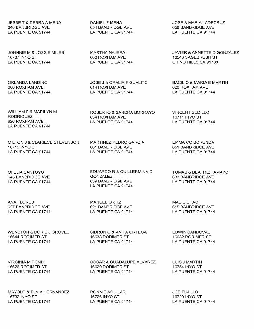
JESSE T & DEBRA A MENA 648 BANBRIDGE AVE LA PUENTE CA 91744
DANIEL F MENA 654 BANBRIDGE AVE LA PUENTE CA 91744
JOSE & MARIA LADECRUZ 658 BANBRIDGE AVE LA PUENTE CA 91744
JOHNNIE M & JOSSIE MILES 16737 INYO ST LA PUENTE CA 91744
MARTHA NAJERA 600 ROXHAM AVE LA PUENTE CA 91744
JAVIER & ANNETTE D GONZALEZ 16543 SAGEBRUSH ST CHINO HILLS CA 91709
ORLANDA LANDINO 608 ROXHAM AVE LA PUENTE CA 91744
JOSE J & ORALIA F GUALITO 614 ROXHAM AVE LA PUENTE CA 91744
BACILIO & MARIA E MARTIN 620 ROXHAM AVE LA PUENTE CA 91744
WILLIAM F & MARILYN M RODRIGUEZ 626 ROXHAM AVE LA PUENTE CA 91744
ROBERTO & SANDRA BORRAYO 634 ROXHAM AVE LA PUENTE CA 91744
VINCENT SEDILLO 16711 INYO ST LA PUENTE CA 91744
MILTON J & CLARIECE STEVENSON 16719 INYO ST LA PUENTE CA 91744
MARTINEZ PEDRO GARCIA 661 BANBRIDGE AVE LA PUENTE CA 91744
EMMA CO BORUNDA 651 BANBRIDGE AVE LA PUENTE CA 91744
OFELIA SANTOYO 645 BANBRIDGE AVE LA PUENTE CA 91744
EDUARDO R & GUILLERMINA D GONZALEZ 639 BANBRIDGE AVE LA PUENTE CA 91744
TOMAS & BEATRIZ TAMAYO 633 BANBRIDGE AVE LA PUENTE CA 91744
ANA FLORES 627 BANBRIDGE AVE LA PUENTE CA 91744
MANUEL ORTIZ 621 BANBRIDGE AVE LA PUENTE CA 91744
MAE C SHAO 615 BANBRIDGE AVE LA PUENTE CA 91744
WENSTON & DORIS J GROVES 16644 RORIMER ST LA PUENTE CA 91744
SIDRONIO & ANITA ORTEGA 16638 RORIMER ST LA PUENTE CA 91744
EDWIN SANDOVAL 16632 RORIMER ST LA PUENTE CA 91744
VIRGINIA M POND 16626 RORIMER ST LA PUENTE CA 91744
OSCAR & GUADALUPE ALVAREZ 16620 RORIMER ST LA PUENTE CA 91744
LUIS J MARTIN 16754 INYO ST LA PUENTE CA 91744
MAYOLO & ELVIA HERNANDEZ 16732 INYO ST LA PUENTE CA 91744
RONNIE AGUILAR 16726 INYO ST LA PUENTE CA 91744
JOE TUJILLO 16720 INYO ST LA PUENTE CA 91744

JOSE L AVILA 16714 INYO ST LA PUENTE CA 91744
GUILLERMO G & RAQUEL TORRES 16708 INYO ST LA PUENTE CA 91744
ANTONIO & SARA VARELA 14911 RAGUS ST LA PUENTE CA 91744
JUANA A CENICEROS 16738 INYO ST LA PUENTE CA 91744
REBECCA M DIOSOMITO 17332 VILLA PARK ST LA PUENTE CA 91744
MARGARITA GADZHYAN 507 W 64TH ST INGLEWOOD CA 90302
ROMEO M & LYDIA C CAYAGO 17335 AZALEA CT LA PUENTE CA 91744
ALICE WAN 17329 AZALEA CT LA PUENTE CA 91744
SOO H & SINJA KWON 17323 AZALEA CT LA PUENTE CA 91744
M & ELEN SALEH 17315 AZALEA CT LA PUENTE CA 91744
NOBUO & KAYOKO INOHARA 17311 AZALEA CT LA PUENTE CA 91744
AMY DIEP 17305 AZALEA CT LA PUENTE CA 91744
WINFRED SHEN 17301 AZALEA CT LA PUENTE CA 91744
PAUL & NARUMOL RUANGUTAI 17300 AZALEA CT LA PUENTE CA 91744
RODELU L GOCO 17304 AZALEA CT LA PUENTE CA 91744
JULIO RODRIGUEZ 17310 AZALEA CT LA PUENTE CA 91744
URSULA I CORDERO 17316 AZALEA CT LA PUENTE CA 91744
OMAR QUEZADA 17322 AZALEA CT LA PUENTE CA 91744
CESAR A & JENNIFER G CADIZ 17328 AZALEA CT LA PUENTE CA 91744
GARY R & FLORY LEMCKE 17332 AZALEA CT LA PUENTE CA 91744
FRANCISCO & ESPERANZA GUTIERREZ 17340 AZALEA CT LA PUENTE CA 91744
LAURALA LTD 222 N CANON DR #205 BEVERLY HILLS CA 90210
KEREN K LEISRAEL 42 E 69TH ST NEW YORK NY 10021
GROUP WALLA 17231 RAILROAD ST #200 CITY OF INDUSTRY CA 91748
YOUNG S LEE 17331 VALLEY BLVD LA PUENTE CA 91744
EML LLC PO BOX 881660 LOS ANGELES CA 90009
PUENTE LLC 222 N CANON DR #205 BEVERLY HILLS CA 90210
HECTOR & IRENE SALAZAR 17025 INYO ST LA PUENTE CA 91744
JORGE & SARA SALAS 17034 INYO ST LA PUENTE CA 91744
R F & Y Y ENRIQUEZ 17042 INYO ST LA PUENTE CA 91744
ISIDRO SAAVEDRA JR. 17048 INYO ST LA PUENTE CA 91744
YOLANDA RODRIGUEZ PO BOX 127 LA PUENTE CA 91747
ESTHER E & JUANITA E SAENZ 17108 INYO ST LA PUENTE CA 91744
RUBEN S CAMARGO 17114 INYO ST LA PUENTE CA 91744
SHAOLAN WEN 17120 INYO ST LA PUENTE CA 91744
HERLINDA CAMPOS 17126 INYO ST LA PUENTE CA 91744
RITA MAGDALENO 17132 INYO ST LA PUENTE CA 91744
JOSE L & MARIA C QUINTEROS 12582 FERN AVE CHINO CA 91710
RANCHO HORIZON LLC 110 N LINCOLN AVE #100 CORONA CA 92882
MARTIN PERALTA 17150 INYO ST LA PUENTE CA 91744
PHILIPPE J CO GIRAUD 14800 TAMARIX DR HACIENDA HEIGHTS CA 91745
MOISES VERA 17208 INYO ST LA PUENTE CA 91744
JOSE L CHAVEZ 17475 SUNSET VIEW DR RIVERSIDE CA 92504
ISIDRO & MARIA PEREZ 616 MARSTON AVE LA PUENTE CA 91744
MARIO & MERCEDES SALCEDO 622 MARSTON AVE LA PUENTE CA 91744
SERGIO M RIVERA 628 MARSTON AVE LA PUENTE CA 91744
ALEJANDRO GUTIERREZ 632 MARSTON AVE LA PUENTE CA 91744
JOSE A DIAZ 638 MARSTON AVE LA PUENTE CA 91744
OFELIA PALMER 644 MARSTON AVE LA PUENTE CA 91744
MAGDALENA ASCENCIO 650 MARSTON AVE LA PUENTE CA 91744
ARCADIO J LOPEZ 656 MARSTON AVE LA PUENTE CA 91744
FRANCISCO J NIETO 662 MARSTON AVE LA PUENTE CA 91744
PEDRO & BEATRIZ CRUZ 668 MARSTON AVE LA PUENTE CA 91744
HECTOR M & MARICELA MUNOZ 16921 INYO ST LA PUENTE CA 91744
PETRA & RAUL CLEMENTE 17147 INYO ST LA PUENTE CA 91744
CYNTHIA TOVAR 669 HARMSWORTH AVE LA PUENTE CA 91744
ROSIE LINARES 663 HARMSWORTH AVE LA PUENTE CA 91744
ELIZABETH A GARCIA 657 HARMSWORTH AVE LA PUENTE CA 91744
MARCIAL MENDEZ 651 HARMSWORTH AVE LA PUENTE CA 91744
CHRISTINE M SANCHEZ 645 HARMSWORTH AVE LA PUENTE CA 91744
JOSEPH A & ERNESTINA E ROMERO 639 HARMSWORTH AVE LA PUENTE CA 91744
ROBERT G & J E FORRESTER PO BOX 148 FRAZIER PARK CA 93225
ELOY RICARDO 629 HARMSWORTH AVE LA PUENTE CA 91744
LUIS J DIAZ JR. 623 HARMSWORTH AVE LA PUENTE CA 91744
JOAQUIN A & NORMA A SOLIS 617 HARMSWORTH AVE LA PUENTE CA 91744
JOSEPH & ERNESTINA ROMERO 616 HARMSWORTH AVE LA PUENTE CA 91744
ZENAIDA F MILANA 622 HARMSWORTH AVE LA PUENTE CA 91744
ARNEL B & GLORIA B BURCE 628 HARMSWORTH AVE LA PUENTE CA 91744
MARK A PARFITT SR. 632 HARMSWORTH AVE LA PUENTE CA 91744
JOSE A GALLEGOS 10847 DAIRY LN LYNWOOD CA 90262
WAI I HO 329 S ARROYO DR SAN GABRIEL CA 91776
SHUPING HE 650 HARMSWORTH AVE LA PUENTE CA 91744
JOSE G & MARIA G HERNANDEZ 656 HARMSWORTH AVE LA PUENTE CA 91744
JOHN A & MARGARET SALDANA 662 HARMSWORTH AVE LA PUENTE CA 91744
ISIDRO PRADO 668 HARMSWORTH AVE LA PUENTE CA 91744
JUSTINO H VELEZ 17203 INYO ST LA PUENTE CA 91744
MARVIN E & MARIANNE ADRIAN PO BOX 1162 BELLFLOWER CA 90707
MARIA E & MARTHA D ESPINOZA 602 RADSTOCK AVE LA PUENTE CA 91744
ELAINE W & ELAINE L OCONNOR 610 RADSTOCK AVE LA PUENTE CA 91744
MATTHEW J & JOSEFINA MCGRATH 616 RADSTOCK AVE LA PUENTE CA 91744
IRMA BANUELOS 622 RADSTOCK AVE LA PUENTE CA 91744
MARCO A COBIAN 626 RADSTOCK AVE LA PUENTE CA 91744
FRANSISCO & SOLEDAD FAUSTO 632 RADSTOCK AVE LA PUENTE CA 91744
SALVADOR GILVAJA 638 RADSTOCK AVE LA PUENTE CA 91744
JOSE SEGURA 644 RADSTOCK AVE LA PUENTE CA 91744
RUBEN S & EVELYN C ESTRADA 650 RADSTOCK AVE LA PUENTE CA 91744
GERARDO SERRANO 656 RADSTOCK AVE LA PUENTE CA 91744
EMILIO ACEVES 662 RADSTOCK AVE LA PUENTE CA 91744
CHARLOTTE HINTON 668 RADSTOCK AVE LA PUENTE CA 91744
FLORENTINO MORALES 17103 INYO ST LA PUENTE CA 91744
FEDERAL HOME LOAN MTG CORP 17119 INYO ST LA PUENTE CA 91744
JESUS & GUADALUPE OCHOA 669 MARSTON AVE LA PUENTE CA 91744
GUADALUPE & SYLVIA REYES 663 MARSTON AVE LA PUENTE CA 91744
GABILDO R & JUANA ANGULO 657 MARSTON AVE LA PUENTE CA 91744
VELIA ROMERO 651 MARSTON AVE LA PUENTE CA 91744
GUADALUPE GUERRERO 645 MARSTON AVE LA PUENTE CA 91744
JOSE CORTES 19321 ADDIS ST ROWLAND HEIGHTS CA 91748
MARY M AGUILAR 635 MARSTON AVE LA PUENTE CA 91744
JOSE J GUERRERO 629 MARSTON AVE LA PUENTE CA 91744
ALBERTO M & MARIA S ARELLANO 623 MARSTON AVE LA PUENTE CA 91744
EZEQUIEL R & YOLANDA GOMEZ 617 MARSTON AVE LA PUENTE CA 91744
MARIA P ORONA 17028 RORIMER ST LA PUENTE CA 91744
ISAAC & DOLORES A CANALES 608 WICKFORD AVE LA PUENTE CA 91744
ORMILDA CAZARES 614 WICKFORD AVE LA PUENTE CA 91744
HENRY YBARRA 620 WICKFORD AVE LA PUENTE CA 91744
MAXIMO SALGADO JR. 626 WICKFORD AVE LA PUENTE CA 91744
ANIRUT ONNOM 632 WICKFORD AVE LA PUENTE CA 91744
BENEDICTO ARROYO 15681 PARKLAND DR HACIENDA HEIGHTS CA 91745
LUIS N & ANA E ARGUDO 644 WICKFORD AVE LA PUENTE CA 91744
CYNTHIA J GOMEZ 650 WICKFORD AVE LA PUENTE CA 91744
VICTORIA LAI 656 WICKFORD AVE LA PUENTE CA 91744
JORGE & ANABEL SALGADO 662 WICKFORD AVE LA PUENTE CA 91744
RAMON & LUZ E MUNOZ 668 WICKFORD AVE LA PUENTE CA 91744
ROGER W & ANTONIETTE BARKER 19331 COLINA DR WALNUT CA 91789
SALVADOR RAMIREZ 17043 INYO ST LA PUENTE CA 91744
ALFONSO & LAURA LUA 669 RADSTOCK AVE LA PUENTE CA 91744
MARIO LARA 663 RADSTOCK AVE LA PUENTE CA 91744
SOCORRO A WALKER 657 RADSTOCK AVE LA PUENTE CA 91744
LOLA BARB 651 RADSTOCK AVE LA PUENTE CA 91744
HECTOR M REYES 645 RADSTOCK AVE LA PUENTE CA 91744
MARIA QUINTERO 639 RADSTOCK AVE LA PUENTE CA 91744
NICANOR GUTIERREZ JR. 633 RADSTOCK AVE LA PUENTE CA 91744
MARTHA MENDOZA 627 RADSTOCK AVE LA PUENTE CA 91744
ISIDRO L & JUANA MONTANO 621 RADSTOCK AVE LA PUENTE CA 91744
JESUS PORTILLO 615 RADSTOCK AVE LA PUENTE CA 91744
RAMIRO ORNELAS 609 RADSTOCK AVE LA PUENTE CA 91744
CARRIE B ALFORD 17042 RORIMER ST LA PUENTE CA 91744
CITIWORKS LLC PO BOX 1065 BURBANK CA 91507
ALBERT & JULIANA ORDAZ 17037 NORTHAM ST LA PUENTE CA 91744
BARTOLA TAHUITE 17043 NORTHAM ST LA PUENTE CA 91744
OTTO L LOPEZ 17049 NORTHAM ST LA PUENTE CA 91744
ARTHUR & NANCY L QUINTANA 17048 NORTHAM ST LA PUENTE CA 91744
RAMON G BATRES 17042 NORTHAM ST LA PUENTE CA 91744
KRISTY HA 17038 NORTHAM ST LA PUENTE CA 91744
ROBERT J LOPEZ 17032 NORTHAM ST LA PUENTE CA 91744
FRANK L MERINO 502 WICKFORD AVE LA PUENTE CA 91744
ARCADIO L JIMENEZ 17033 SALAIS ST LA PUENTE CA 91744
ROSIE J THOMAS 17039 SALAIS ST LA PUENTE CA 91744
LORILES A AMLIE 17045 SALAIS ST LA PUENTE CA 91744
RUTILO V & MARIA L OLMOS 17051 SALAIS ST LA PUENTE CA 91744
FEDERAL NATL MTG ASSN FNMA 17057 SALAIS ST LA PUENTE CA 91744
AURELIO & GRACIELA SILVA 2119 PACIFIC AVE LONG BEACH CA 90806
GRAND HILL INVESTMENT 410 BALLENA DR DIAMOND BAR CA 91765
RAUL & ANA L SANCHEZ 17044 SALAIS ST LA PUENTE CA 91744
SYLVIA L MORENO 17038 SALAIS ST LA PUENTE CA 91744
LYDIA ORTIZ 17034 SALAIS ST LA PUENTE CA 91744
CRYSTAL OO 7921 INWOOD LN LA PALMA CA 90623
RODOLFO JIMENEZ 17029 RORIMER ST LA PUENTE CA 91744
JOSE M & MARIA RANGEL 17035 RORIMER ST LA PUENTE CA 91744
JOE & JESSE G GOMEZ 17041 RORIMER ST LA PUENTE CA 91744
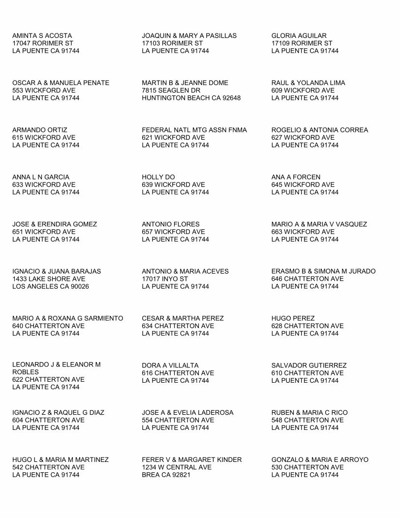
AMINTA S ACOSTA 17047 RORIMER ST LA PUENTE CA 91744
JOAQUIN & MARY A PASILLAS 17103 RORIMER ST LA PUENTE CA 91744
GLORIA AGUILAR 17109 RORIMER ST LA PUENTE CA 91744
OSCAR A & MANUELA PENATE 553 WICKFORD AVE LA PUENTE CA 91744
MARTIN B & JEANNE DOME 7815 SEAGLEN DR HUNTINGTON BEACH CA 92648
RAUL & YOLANDA LIMA 609 WICKFORD AVE LA PUENTE CA 91744
ARMANDO ORTIZ 615 WICKFORD AVE LA PUENTE CA 91744
FEDERAL NATL MTG ASSN FNMA 621 WICKFORD AVE LA PUENTE CA 91744
ROGELIO & ANTONIA CORREA 627 WICKFORD AVE LA PUENTE CA 91744
ANNA L N GARCIA 633 WICKFORD AVE LA PUENTE CA 91744
HOLLY DO 639 WICKFORD AVE LA PUENTE CA 91744
ANA A FORCEN 645 WICKFORD AVE LA PUENTE CA 91744
JOSE & ERENDIRA GOMEZ 651 WICKFORD AVE LA PUENTE CA 91744
ANTONIO FLORES 657 WICKFORD AVE LA PUENTE CA 91744
MARIO A & MARIA V VASQUEZ 663 WICKFORD AVE LA PUENTE CA 91744
IGNACIO & JUANA BARAJAS 1433 LAKE SHORE AVE LOS ANGELES CA 90026
ANTONIO & MARIA ACEVES 17017 INYO ST LA PUENTE CA 91744
ERASMO B & SIMONA M JURADO 646 CHATTERTON AVE LA PUENTE CA 91744
MARIO A & ROXANA G SARMIENTO 640 CHATTERTON AVE LA PUENTE CA 91744
CESAR & MARTHA PEREZ 634 CHATTERTON AVE LA PUENTE CA 91744
HUGO PEREZ 628 CHATTERTON AVE LA PUENTE CA 91744
LEONARDO J & ELEANOR M ROBLES 622 CHATTERTON AVE LA PUENTE CA 91744
DORA A VILLALTA 616 CHATTERTON AVE LA PUENTE CA 91744
SALVADOR GUTIERREZ 610 CHATTERTON AVE LA PUENTE CA 91744
IGNACIO Z & RAQUEL G DIAZ 604 CHATTERTON AVE LA PUENTE CA 91744
JOSE A & EVELIA LADEROSA 554 CHATTERTON AVE LA PUENTE CA 91744
RUBEN & MARIA C RICO 548 CHATTERTON AVE LA PUENTE CA 91744
HUGO L & MARIA M MARTINEZ 542 CHATTERTON AVE LA PUENTE CA 91744
FERER V & MARGARET KINDER 1234 W CENTRAL AVE BREA CA 92821
GONZALO & MARIA E ARROYO 530 CHATTERTON AVE LA PUENTE CA 91744

OMAR MALDONADO 524 CHATTERTON AVE LA PUENTE CA 91744
CITY OF LA PUENTE 15900 E MAIN ST LA PUENTE CA 91744
CLARENCE W AVERY II 16855 TURK DR LA PUENTE CA 91744
ALFREDO & BLANCA GONZALEZ 16849 TURK DR LA PUENTE CA 91744
J GUADALUPE PEREZ 9427 FRIENDSHIP AVE PICO RIVERA CA 90660
WILLIAM & SONIA NAVARETTE 16839 TURK DR LA PUENTE CA 91744
MARIA BARRAGAN 16833 TURK DR LA PUENTE CA 91744
LILLY RUIZ 16829 TURK DR LA PUENTE CA 91744
JORGE M & VERONICA MENDOZA 16821 TURK DR LA PUENTE CA 91744
ROSA ESQUIVEL 16813 TURK DR LA PUENTE CA 91744
JUAN C & MARTHA D GALLEGOS 584 FERRERO LN LA PUENTE CA 91744
JOSE A & ADELINA H MATA JR. 570 FERRERO LN LA PUENTE CA 91744
ALEJANDRO N & AMALIA U SANCHEZ 568 FERRERO LN LA PUENTE CA 91744
IRMA GDN DEDIOS 16804 WEGMAN DR LA PUENTE CA 91744
RICARDO A AYALA 16812 WEGMAN DR LA PUENTE CA 91744
GABRIEL LOPEZ 16814 WEGMAN DR LA PUENTE CA 91744
DULCE GUTIERREZ 16820 WEGMAN DR LA PUENTE CA 91744
RICHARD A VEJAR 16826 WEGMAN DR LA PUENTE CA 91744
JOHN SANCHEZ 16830 WEGMAN DR LA PUENTE CA 91744
THIEN Q TRAN 16838 WEGMAN DR LA PUENTE CA 91744
ARTURO A & ROSA M VELAZQUEZ 16864 WEGMAN DR LA PUENTE CA 91744
CARLOS GALINDO 16856 WEGMAN DR LA PUENTE CA 91744
IRMA A BENITEZ 16850 WEGMAN DR LA PUENTE CA 91744
JUAN & SUSANA MACIAS 16842 WEGMAN DR LA PUENTE CA 91744
JUAN P AGUIRRE 16863 TURK DR LA PUENTE CA 91744
RAMON L & SUSAN R GUZMAN 16869 TURK DR LA PUENTE CA 91744
MARTIN & MARIA MALDONADO 16903 TURK DR LA PUENTE CA 91744
ELVIRA RUIZ 16909 TURK DR LA PUENTE CA 91744
FELIPE & MONICA ESCOBAR 16915 TURK DR LA PUENTE CA 91744
HENDRICUS S HENDRIYANTO 16921 TURK DR LA PUENTE CA 91744
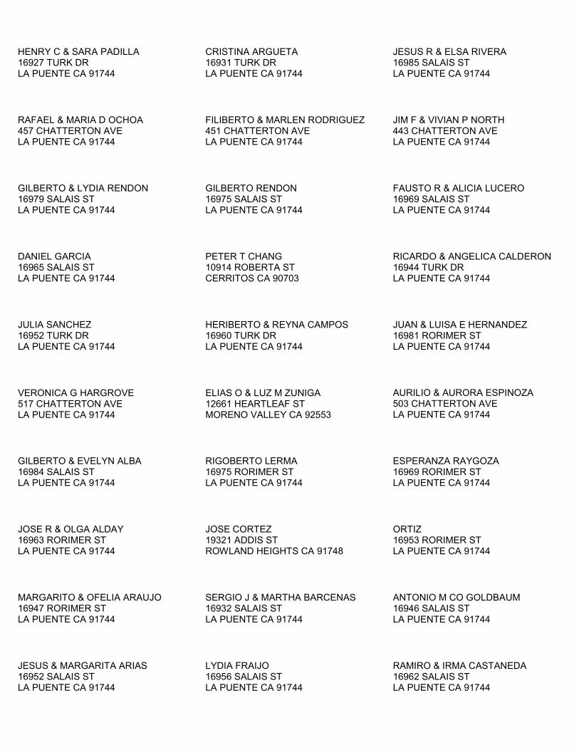
HENRY C & SARA PADILLA 16927 TURK DR LA PUENTE CA 91744
CRISTINA ARGUETA 16931 TURK DR LA PUENTE CA 91744
JESUS R & ELSA RIVERA 16985 SALAIS ST LA PUENTE CA 91744
RAFAEL & MARIA D OCHOA 457 CHATTERTON AVE LA PUENTE CA 91744
FILIBERTO & MARLEN RODRIGUEZ 451 CHATTERTON AVE LA PUENTE CA 91744
JIM F & VIVIAN P NORTH 443 CHATTERTON AVE LA PUENTE CA 91744
GILBERTO & LYDIA RENDON 16979 SALAIS ST LA PUENTE CA 91744
GILBERTO RENDON 16975 SALAIS ST LA PUENTE CA 91744
FAUSTO R & ALICIA LUCERO 16969 SALAIS ST LA PUENTE CA 91744
DANIEL GARCIA 16965 SALAIS ST LA PUENTE CA 91744
PETER T CHANG 10914 ROBERTA ST CERRITOS CA 90703
RICARDO & ANGELICA CALDERON 16944 TURK DR LA PUENTE CA 91744
JULIA SANCHEZ 16952 TURK DR LA PUENTE CA 91744
HERIBERTO & REYNA CAMPOS 16960 TURK DR LA PUENTE CA 91744
JUAN & LUISA E HERNANDEZ 16981 RORIMER ST LA PUENTE CA 91744
VERONICA G HARGROVE 517 CHATTERTON AVE LA PUENTE CA 91744
ELIAS O & LUZ M ZUNIGA 12661 HEARTLEAF ST MORENO VALLEY CA 92553
AURILIO & AURORA ESPINOZA 503 CHATTERTON AVE LA PUENTE CA 91744
GILBERTO & EVELYN ALBA 16984 SALAIS ST LA PUENTE CA 91744
RIGOBERTO LERMA 16975 RORIMER ST LA PUENTE CA 91744
ESPERANZA RAYGOZA 16969 RORIMER ST LA PUENTE CA 91744
JOSE R & OLGA ALDAY 16963 RORIMER ST LA PUENTE CA 91744
JOSE CORTEZ 19321 ADDIS ST ROWLAND HEIGHTS CA 91748
ORTIZ 16953 RORIMER ST LA PUENTE CA 91744
MARGARITO & OFELIA ARAUJO 16947 RORIMER ST LA PUENTE CA 91744
SERGIO J & MARTHA BARCENAS 16932 SALAIS ST LA PUENTE CA 91744
ANTONIO M CO GOLDBAUM 16946 SALAIS ST LA PUENTE CA 91744
JESUS & MARGARITA ARIAS 16952 SALAIS ST LA PUENTE CA 91744
LYDIA FRAIJO 16956 SALAIS ST LA PUENTE CA 91744
RAMIRO & IRMA CASTANEDA 16962 SALAIS ST LA PUENTE CA 91744

HUMBERTO & CARMEN MONTANEZ 16974 SALAIS ST LA PUENTE CA 91744
CHARLIE & MARRYANN LEE 8516 MISSION DR ROSEMEAD CA 91770
JOSE & MARIA CORREA 16941 RORIMER ST LA PUENTE CA 91744
BENIGNO & LUPE VERDUZCO 996 E 9TH ST POMONA CA 91766
BENJAMIN INIGUEZ 16931 RORIMER ST LA PUENTE CA 91744
BERTHA MCCUSKER 1382 E LA DENEY DR ONTARIO CA 91764
LILIA M ROJAS 16904 TURK DR LA PUENTE CA 91744
ADRIANA ABELLO 16912 TURK DR LA PUENTE CA 91744
MARIA L SANCHEZ 16918 TURK DR LA PUENTE CA 91744
LUIS M & VIRGINIA BARRAGAN 16924 TURK DR LA PUENTE CA 91744
ROSA A GARCIA 16927 HURLEY ST LA PUENTE CA 91744
OSCAR A OLMEDO 748 MEEKER AVE LA PUENTE CA 91746
ELIAZAR BAEZ 16915 HURLEY ST LA PUENTE CA 91744
ARMANDO & CARMEN MORAN 16909 HURLEY ST LA PUENTE CA 91744
ROSENDO B CO MAGALLANEZ 16903 HURLEY ST LA PUENTE CA 91744
ALEJANDRO A DECD VIZVETO 6321 REPTON ST LOS ANGELES CA 90042
VICTOR MORAN 16937 HURLEY ST LA PUENTE CA 91744
CALIFORNIA HSNG FIN AGCY PO BOX 4034 SACRAMENTO CA 95812
ROCIO VALLE 18653 BELLORITA ST ROWLAND HEIGHTS CA 91748
JOSE M & MARIA C SANCHEZ 16850 TURK DR LA PUENTE CA 91744
EUSEBIO JIMENEZ 16856 TURK DR LA PUENTE CA 91744
SAUL & RACHEL ESTRADA 16902 RORIMER ST LA PUENTE CA 91744
ESTHER F & JO ANN FRAGER 16910 RORIMER ST LA PUENTE CA 91744
WAYNE A & TERESA FRAGER 16914 RORIMER ST LA PUENTE CA 91744
CRAIG E MAY 16918 RORIMER ST LA PUENTE CA 91744
MARIA M QUEZADA 3008 E BIG RANGE CT ONTARIO CA 91761
HERIBERTO R & MARIAELENA RAYGOZA 16930 RORIMER ST LA PUENTE CA 91744
OSCAR RODRIGUEZ 16934 RORIMER ST LA PUENTE CA 91744
NELSON A PEREZ 1004 EDANRUTH AVE LA PUENTE CA 91746
HUGO & RAQUEL ESCOBEDO 16851 HURLEY ST LA PUENTE CA 91744
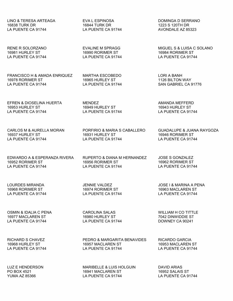
LINO & TERESA ARTEAGA 16838 TURK DR LA PUENTE CA 91744
EVA L ESPINOSA 16844 TURK DR LA PUENTE CA 91744
DOMINGA D SERRANO 1223 S 120TH DR AVONDALE AZ 85323
RENE R SOLORZANO 16981 HURLEY ST LA PUENTE CA 91744
EVALINE M SPRAGG 16990 RORIMER ST LA PUENTE CA 91744
MIGUEL S & LUISA C SOLANO 16984 RORIMER ST LA PUENTE CA 91744
FRANCISCO H & AMADA ENRIQUEZ 16978 RORIMER ST LA PUENTE CA 91744
MARTHA ESCOBEDO 16965 HURLEY ST LA PUENTE CA 91744
LORI A BANH 1126 BILTON WAY SAN GABRIEL CA 91776
EFREN & DIOSELINA HUERTA 16953 HURLEY ST LA PUENTE CA 91744
MENDEZ 16949 HURLEY ST LA PUENTE CA 91744
AMANDA MEFFERD 16943 HURLEY ST LA PUENTE CA 91744
CARLOS M & AURELLA MORAN 16937 HURLEY ST LA PUENTE CA 91744
PORFIRIO & MARIA S CABALLERO 16931 HURLEY ST LA PUENTE CA 91744
GUADALUPE & JUANA RAYGOZA 16946 RORIMER ST LA PUENTE CA 91744
EDWARDO A & ESPERANZA RIVERA 16952 RORIMER ST LA PUENTE CA 91744
RUPERTO & DIANA M HERNANDEZ 16956 RORIMER ST LA PUENTE CA 91744
JOSE S GONZALEZ 16962 RORIMER ST LA PUENTE CA 91744
LOURDES MIRANDA 16968 RORIMER ST LA PUENTE CA 91744
JENNIE VALDEZ 16974 RORIMER ST LA PUENTE CA 91744
JOSE I & MARINA A PENA 16963 MACLAREN ST LA PUENTE CA 91744
OSMIN & IDALIA C PENA 16977 MACLAREN ST LA PUENTE CA 91744
CAROLINA SALAS 16980 HURLEY ST LA PUENTE CA 91744
WILLIAM H CO TITTLE 7042 DINWIDDIE ST DOWNEY CA 90241
RICHARD S CHAVEZ 16968 HURLEY ST LA PUENTE CA 91744
PEDRO & MARGARITA BENAVIDES 16957 MACLAREN ST LA PUENTE CA 91744
RICARDO GARCIA 16953 MACLAREN ST LA PUENTE CA 91744
LUZ E HENDERSON PO BOX 4521 YUMA AZ 85366
MARIBELLE & LUIS HOLGUIN 16941 MACLAREN ST LA PUENTE CA 91744
DAVID ARIAS 16952 SALAIS ST LA PUENTE CA 91744
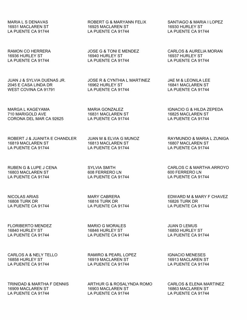
MARIA L S DENAVAS 16931 MACLAREN ST LA PUENTE CA 91744
ROBERT G & MARYANN FELIX 16925 MACLAREN ST LA PUENTE CA 91744
SANTIAGO & MARIA I LOPEZ 16930 HURLEY ST LA PUENTE CA 91744
RAMON CO HERRERA 16936 HURLEY ST LA PUENTE CA 91744
JOSE G & TONI E MENDEZ 16940 HURLEY ST LA PUENTE CA 91744
CARLOS & AURELIA MORAN 16937 HURLEY ST LA PUENTE CA 91744
JUAN J & SYLVIA DUENAS JR. 2045 E CASA LINDA DR WEST COVINA CA 91791
JOSE R & CYNTHIA L MARTINEZ 16962 HURLEY ST LA PUENTE CA 91744
JAE M & LEONILA LEE 16841 MACLAREN ST LA PUENTE CA 91744
MARGA L KAGEYAMA 710 MARIGOLD AVE CORONA DEL MAR CA 92625
MARIA GONZALEZ 16831 MACLAREN ST LA PUENTE CA 91744
IGNACIO G & HILDA ZEPEDA 16825 MACLAREN ST LA PUENTE CA 91744
ROBERT J & JUANITA E CHANDLER 16819 MACLAREN ST LA PUENTE CA 91744
JUAN M & ELVIA G MUNOZ 16813 MACLAREN ST LA PUENTE CA 91744
RAYMUNDO & MARIA L ZUNIGA 16807 MACLAREN ST LA PUENTE CA 91744
RUBEN G & LUPE J CENA 16803 MACLAREN ST LA PUENTE CA 91744
SYLVIA SMITH 608 FERRERO LN LA PUENTE CA 91744
CARLOS C & MARTHA ARROYO 600 FERRERO LN LA PUENTE CA 91744
NICOLAS ARIAS 16808 TURK DR LA PUENTE CA 91744
MARY CABRERA 16816 TURK DR LA PUENTE CA 91744
EDWARD M & MARY F CHAVEZ 16826 TURK DR LA PUENTE CA 91744
FLORIBERTO MENDEZ 16840 HURLEY ST LA PUENTE CA 91744
MARIO G MORALES 16846 HURLEY ST LA PUENTE CA 91744
JUAN D LEMUS 16850 HURLEY ST LA PUENTE CA 91744
CARLOS A & NELY TELLO 16858 HURLEY ST LA PUENTE CA 91744
RAMIRO & PEARL LOPEZ 16919 MACLAREN ST LA PUENTE CA 91744
IGNACIO MENESES 16913 MACLAREN ST LA PUENTE CA 91744
TRINIDAD & MARTHA F DENNIS 16909 MACLAREN ST LA PUENTE CA 91744
ARTHUR G & ROSALYNDA ROMO 16903 MACLAREN ST LA PUENTE CA 91744
CARLOS & ELENA MARTINEZ 16863 MACLAREN ST LA PUENTE CA 91744
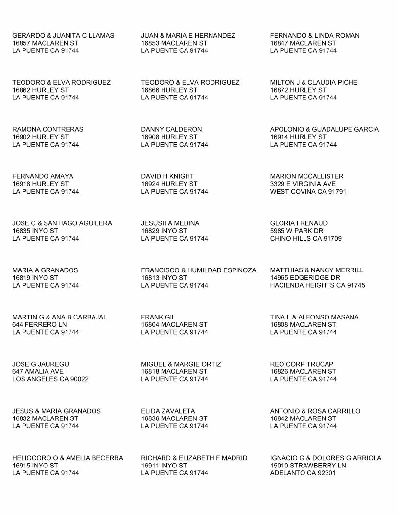
GERARDO & JUANITA C LLAMAS 16857 MACLAREN ST LA PUENTE CA 91744
JUAN & MARIA E HERNANDEZ 16853 MACLAREN ST LA PUENTE CA 91744
FERNANDO & LINDA ROMAN 16847 MACLAREN ST LA PUENTE CA 91744
TEODORO & ELVA RODRIGUEZ 16862 HURLEY ST LA PUENTE CA 91744
TEODORO & ELVA RODRIGUEZ 16866 HURLEY ST LA PUENTE CA 91744
MILTON J & CLAUDIA PICHE 16872 HURLEY ST LA PUENTE CA 91744
RAMONA CONTRERAS 16902 HURLEY ST LA PUENTE CA 91744
DANNY CALDERON 16908 HURLEY ST LA PUENTE CA 91744
APOLONIO & GUADALUPE GARCIA 16914 HURLEY ST LA PUENTE CA 91744
FERNANDO AMAYA 16918 HURLEY ST LA PUENTE CA 91744
DAVID H KNIGHT 16924 HURLEY ST LA PUENTE CA 91744
MARION MCCALLISTER 3329 E VIRGINIA AVE WEST COVINA CA 91791
JOSE C & SANTIAGO AGUILERA 16835 INYO ST LA PUENTE CA 91744
JESUSITA MEDINA 16829 INYO ST LA PUENTE CA 91744
GLORIA I RENAUD 5985 W PARK DR CHINO HILLS CA 91709
MARIA A GRANADOS 16819 INYO ST LA PUENTE CA 91744
FRANCISCO & HUMILDAD ESPINOZA 16813 INYO ST LA PUENTE CA 91744
MATTHIAS & NANCY MERRILL 14965 EDGERIDGE DR HACIENDA HEIGHTS CA 91745
MARTIN G & ANA B CARBAJAL 644 FERRERO LN LA PUENTE CA 91744
FRANK GIL 16804 MACLAREN ST LA PUENTE CA 91744
TINA L & ALFONSO MASANA 16808 MACLAREN ST LA PUENTE CA 91744
JOSE G JAUREGUI 647 AMALIA AVE LOS ANGELES CA 90022
MIGUEL & MARGIE ORTIZ 16818 MACLAREN ST LA PUENTE CA 91744
REO CORP TRUCAP 16826 MACLAREN ST LA PUENTE CA 91744
JESUS & MARIA GRANADOS 16832 MACLAREN ST LA PUENTE CA 91744
ELIDA ZAVALETA 16836 MACLAREN ST LA PUENTE CA 91744
ANTONIO & ROSA CARRILLO 16842 MACLAREN ST LA PUENTE CA 91744
HELIOCORO O & AMELIA BECERRA 16915 INYO ST LA PUENTE CA 91744
RICHARD & ELIZABETH F MADRID 16911 INYO ST LA PUENTE CA 91744
IGNACIO G & DOLORES G ARRIOLA 15010 STRAWBERRY LN ADELANTO CA 92301

HELIODORO O & AMALIA BECERRA 16863 INYO ST LA PUENTE CA 91744
JOSE & GUILLERMINA GARCIA 16857 INYO ST LA PUENTE CA 91744
PABLO C MARTINEZ 16851 INYO ST LA PUENTE CA 91744
JORGE S LOPEZ 16847 INYO ST LA PUENTE CA 91744
RIGOBERTO PEREZ 16848 MACLAREN ST LA PUENTE CA 91744
JOSE A & LAURA VILLANUEVA 16854 MACLAREN ST LA PUENTE CA 91744
LIVIER RAMIREZ 16860 MACLAREN ST LA PUENTE CA 91744
ANA V BRIZUELA 16864 MACLAREN ST LA PUENTE CA 91744
IGNACIO M & CRISTINA P LARIOS 16904 MACLAREN ST LA PUENTE CA 91744
DONALD A & NOHEMI TAORRES 16910 MACLAREN ST LA PUENTE CA 91744
EFREN & ELENA GOMEZ 16916 MACLAREN ST LA PUENTE CA 91744
SAMUEL J ESWORTHY 8526 KESTER AVE PANORAMA CITY CA 91402
GUADALUPE HERNANDEZ 16965 INYO ST LA PUENTE CA 91744
CALIXTO C & RUTH HERNANDEZ 647 CHATTERTON AVE LA PUENTE CA 91744
GUSTAVO & CARMEN AREVALO 641 CHATTERTON AVE LA PUENTE CA 91744
ALEJANDRO VASQUEZ 637 CHATTERTON AVE LA PUENTE CA 91744
MARIA BALDEON 631 CHATTERTON AVE LA PUENTE CA 91744
FADY SHEHATTA 16964 MACLAREN ST LA PUENTE CA 91744
SALOMON & ROSALINA ZAMORA 16959 INYO ST LA PUENTE CA 91744
TRINIDAD & MARGARITA CHAVARIN 16955 INYO ST LA PUENTE CA 91744
SOFIA AGUAYO PO BOX 39965 DOWNEY CA 90239
MILLER 1012 WEST RD LA HABRA HEIGHTS CA 90631
MARY BENITEZ 16937 INYO ST LA PUENTE CA 91744
ANACLETO TAPIA 16933 INYO ST LA PUENTE CA 91744
ROSA GONZALES 16927 INYO ST LA PUENTE CA 91744
MARIA S DOMINGUEZ 16926 MACLAREN ST LA PUENTE CA 91744
JOSE E & RAQUELINA MIRANDA 16932 MACLAREN ST LA PUENTE CA 91744
JOSEPHINE CAMPOS 16938 MACLAREN ST LA PUENTE CA 91744
ALFONSO SIFUENTES 16942 MACLAREN ST LA PUENTE CA 91744
RODOLFO H MALDONADO 16948 MACLAREN ST LA PUENTE CA 91744

RAFAEL & ELODIA CARBAJAL 16954 MACLAREN ST LA PUENTE CA 91744
ARMANDO TINOCO 16960 MACLAREN ST LA PUENTE CA 91744
EDUARDO GONZALEZ 16924 INYO ST LA PUENTE CA 91744
BEORNORED L & BARBARA HOCKENHULL JR. 16930 INYO ST LA PUENTE CA 91744
HORACIO BARRIOS 16936 INYO ST LA PUENTE CA 91744
JESSE E ESCOBEDO 16940 INYO ST LA PUENTE CA 91744
ROBERT BERNAL 18421 E NEARFIELD ST AZUSA CA 91702
JOSE P & SOCORRO RAMOS 16952 INYO ST LA PUENTE CA 91744
GONZALO RIVAS 16958 INYO ST LA PUENTE CA 91744
ROBERTO MERITO 16962 INYO ST LA PUENTE CA 91744
UBALDO G & GUADALUPE AVILA 16968 INYO ST LA PUENTE CA 91744
ALVARO R & MARIA C PEREZ 16974 INYO ST LA PUENTE CA 91744
J CARMEN & MANUELA E ARELLANO 16980 INYO ST LA PUENTE CA 91744
OFELIA & GUSTAVO ARTEAGA 16984 INYO ST LA PUENTE CA 91744
RAUL & PETRA CLEMENTE 17008 INYO ST LA PUENTE CA 91744
VIDAL & IMELDA ARTEAGA 17000 INYO ST LA PUENTE CA 91744
MANUEL & SOCORRO BEDOY 17016 INYO ST LA PUENTE CA 91744
LASCURAIN ERIK E CABRALES 16804 INYO ST LA PUENTE CA 91744
REO CORP TRUCAP 1925 W PINNACLE PEAK RD PHOENIX AZ 85027
OSCAR N & GUILLERMINA ALVAREZ 16814 INYO ST LA PUENTE CA 91744
MARIO & ROSA GUZMAN 16820 INYO ST LA PUENTE CA 91744
LAURA RAMIREZ 16826 INYO ST LA PUENTE CA 91744
ALEJANDRO MALDONADO 16832 INYO ST LA PUENTE CA 91744
PAULINO M & ELIZABETH P ALVAREZ 730 DE PALMA WAY MONTEBELLO CA 90640
AIDA M TORRES 16844 INYO ST LA PUENTE CA 91744
AURORA J MONTANO 16848 INYO ST LA PUENTE CA 91744
JACINTO RAMIREZ 16854 INYO ST LA PUENTE CA 91744
GUS KANE JR. 21616 E BLUEBELL CT WALNUT CA 91789
ALBERTO H ESPINOZA 16902 INYO ST LA PUENTE CA 91744
JESUS & MATHILDE ORTEGA 16908 INYO ST LA PUENTE CA 91744
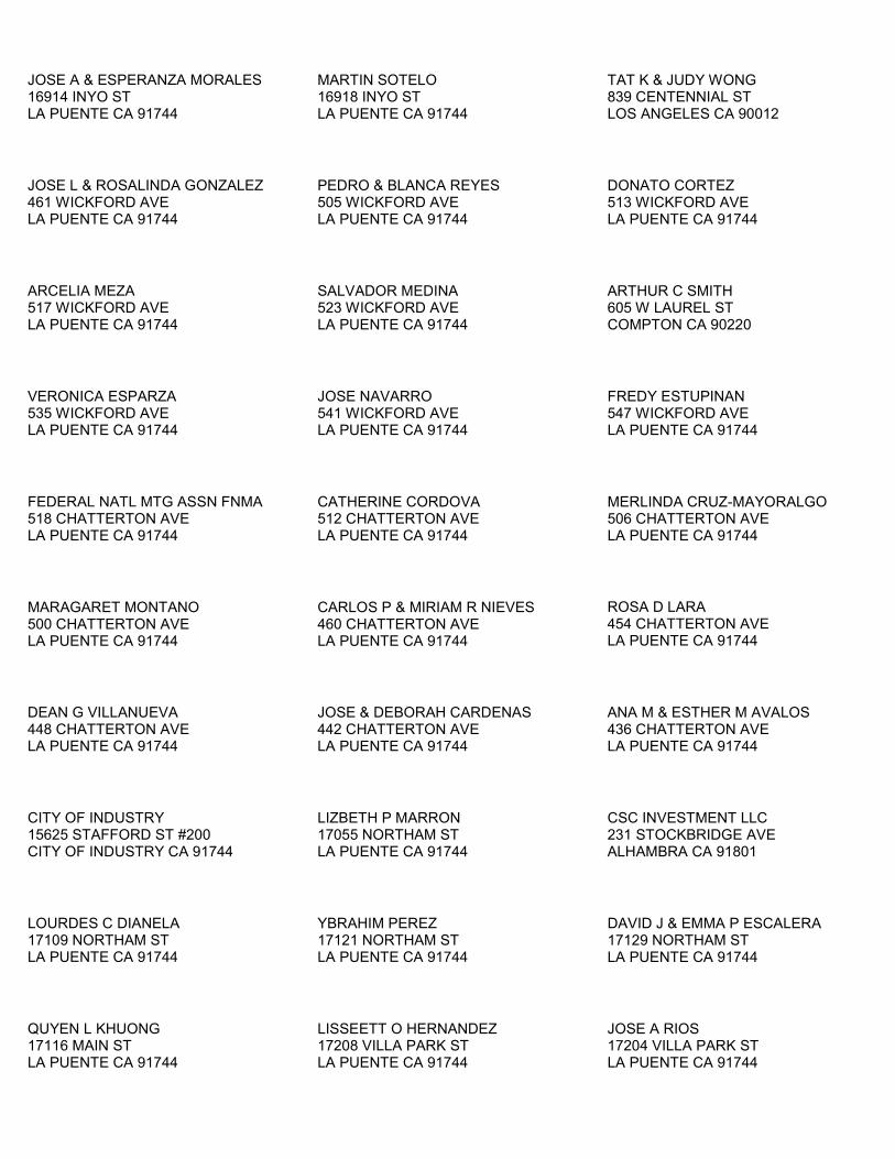
JOSE A & ESPERANZA MORALES 16914 INYO ST LA PUENTE CA 91744
MARTIN SOTELO 16918 INYO ST LA PUENTE CA 91744
TAT K & JUDY WONG 839 CENTENNIAL ST LOS ANGELES CA 90012
JOSE L & ROSALINDA GONZALEZ 461 WICKFORD AVE LA PUENTE CA 91744
PEDRO & BLANCA REYES 505 WICKFORD AVE LA PUENTE CA 91744
DONATO CORTEZ 513 WICKFORD AVE LA PUENTE CA 91744
ARCELIA MEZA 517 WICKFORD AVE LA PUENTE CA 91744
SALVADOR MEDINA 523 WICKFORD AVE LA PUENTE CA 91744
ARTHUR C SMITH 605 W LAUREL ST COMPTON CA 90220
VERONICA ESPARZA 535 WICKFORD AVE LA PUENTE CA 91744
JOSE NAVARRO 541 WICKFORD AVE LA PUENTE CA 91744
FREDY ESTUPINAN 547 WICKFORD AVE LA PUENTE CA 91744
FEDERAL NATL MTG ASSN FNMA 518 CHATTERTON AVE LA PUENTE CA 91744
CATHERINE CORDOVA 512 CHATTERTON AVE LA PUENTE CA 91744
MERLINDA CRUZ-MAYORALGO 506 CHATTERTON AVE LA PUENTE CA 91744
MARAGARET MONTANO 500 CHATTERTON AVE LA PUENTE CA 91744
CARLOS P & MIRIAM R NIEVES 460 CHATTERTON AVE LA PUENTE CA 91744
ROSA D LARA 454 CHATTERTON AVE LA PUENTE CA 91744
DEAN G VILLANUEVA 448 CHATTERTON AVE LA PUENTE CA 91744
JOSE & DEBORAH CARDENAS 442 CHATTERTON AVE LA PUENTE CA 91744
ANA M & ESTHER M AVALOS 436 CHATTERTON AVE LA PUENTE CA 91744
CITY OF INDUSTRY 15625 STAFFORD ST #200 CITY OF INDUSTRY CA 91744
LIZBETH P MARRON 17055 NORTHAM ST LA PUENTE CA 91744
CSC INVESTMENT LLC 231 STOCKBRIDGE AVE ALHAMBRA CA 91801
LOURDES C DIANELA 17109 NORTHAM ST LA PUENTE CA 91744
YBRAHIM PEREZ 17121 NORTHAM ST LA PUENTE CA 91744
DAVID J & EMMA P ESCALERA 17129 NORTHAM ST LA PUENTE CA 91744
QUYEN L KHUONG 17116 MAIN ST LA PUENTE CA 91744
LISSEETT O HERNANDEZ 17208 VILLA PARK ST LA PUENTE CA 91744
JOSE A RIOS 17204 VILLA PARK ST LA PUENTE CA 91744

DENNIS MCCRAY 17215 MAIN ST LA PUENTE CA 91744
FLORENTINO CO OGAZ 17225 MAIN ST LA PUENTE CA 91744
THOMAS H & ALICE GRUETER 17231 MAIN ST LA PUENTE CA 91744
GUSTAVO HERNANDEZ 421 LAURA AVE LA PUENTE CA 91744
CARLOS & GABY SOLORZANO 415 LAURA AVE LA PUENTE CA 91744
VILLA LAS BRISAS LLC 9454 WILSHIRE BLVD #700 BEVERLY HILLS CA 90212
ADOLFO CO BELTRAN 1955 MONTE VISTA ST PASADENA CA 91107
AGAPITO CORTEZ 1214 BEECH HILL AVE HACIENDA HEIGHTS CA 91745
CECILIA S WU 801 S GARFIELD AVE #328 ALHAMBRA CA 91801
EVERARDO CORTEZ 1909 VASCONES DR HACIENDA HEIGHTS CA 91745
ROWLAND UNIFIED SCHOOL DISTRICT 1830 NOGALES ST ROWLAND HEIGHTS CA 91748
DEVELL USA INC 17232 RAILROAD ST CITY OF INDUSTRY CA 91748
RAILROAD LLC 17232 RAILROAD ST CITY OF INDUSTRY CA 91748
FREEDOM INTERNATIONAL GROUP LTD 17358 RAILROAD ST CITY OF INDUSTRY CA 91748
NUCCIO 1217 LORAIN RD SAN MARINO CA 91108
RICHARD & BOBBYE KREPS 17251 CHESTNUT ST CITY OF INDUSTRY CA 91748
YUM YUM DONUTS SHOPS INC 18830 SAN JOSE AVE CITY OF INDUSTRY CA 91748
DESCANSANDO PARTNERS LP PO BOX 4792 COVINA CA 91723
UTILITY TRAILER MANUFACTURING CO 17295 RAILROAD ST CITY OF INDUSTRY CA 91748
DOUGLAS HAHN CH2M HILL 9193 S JAMAICA ST ENGLEWOOD CO 80112


ATTACHMENT 4
Phase I ESA – Laydown Area #1

Prepared for: Prepared by: Walnut Creek Energy LLC AECOM Santa Ana, California Orange, California 60159854 May 2011
Environment
Phase I Environmental Site Assessment of Walnut Creek Energy Park Additional Laydown Area, South Azusa Avenue, City of Industry, California

Prepared for: Prepared by: Walnut Creek Energy LLC AECOM Santa Ana, California Orange, California 60159854 May 2011
Environment
Phase I Environmental Site Assessment of Walnut Creek Energy Park Additional Laydown Area, South Azusa Avenue, City of Industry, California

AECOM Environment i
May 2011 60159854
Contents
1.0 Introduction .................................................................................................................... 1-1
1.1 Purpose ................................................................................................................................ 1-1
1.2 Scope of Work ..................................................................................................................... 1-1
1.3 Study Limitations .................................................................................................................. 1-1
1.4 Site-Related Limiting Conditions ......................................................................................... 1-2
1.5 Data Gaps/Data Failure ....................................................................................................... 1-2
2.0 Site Description ............................................................................................................. 2-1
2.1 Site Location and Parcel Description .................................................................................. 2-1
2.2 Site Ownership ..................................................................................................................... 2-1
2.3 Site Visit ............................................................................................................................... 2-1
2.3.1 Site and Facility Description ................................................................................. 2-1
2.3.2 Building Walk Through.......................................................................................... 2-2
2.3.3 Surrounding Properties ......................................................................................... 2-2
2.3.4 Petroleum Products and Hazardous Materials .................................................... 2-2
2.3.5 Polychlorinated Biphenyls .................................................................................... 2-2
2.3.6 Aboveground Storage Tanks ................................................................................ 2-3
2.3.7 Underground Storage Tanks ................................................................................ 2-3
2.3.8 Solid Waste ........................................................................................................... 2-3
2.3.9 Hazardous Waste ................................................................................................. 2-4
2.3.10 Water ..................................................................................................................... 2-4
2.3.11 Wastewater ........................................................................................................... 2-4
2.3.12 Stormwater ............................................................................................................ 2-4
2.3.13 Heating and Cooling ............................................................................................. 2-4
3.0 Environmental Setting .................................................................................................. 3-1
3.1 Topography .......................................................................................................................... 3-1
3.2 Soil/Geology ......................................................................................................................... 3-1
3.3 Groundwater/Hydrology ....................................................................................................... 3-1
4.0 Site and Area History .................................................................................................... 4-1
4.1 Subject Property .................................................................................................................. 4-1
4.2 Off-site Properties ................................................................................................................ 4-1
4.3 Previously Prepared Environmental Reports ...................................................................... 4-1

AECOM Environment ii
May 2011 60159854
5.0 Database and Records Review .................................................................................... 5-3
5.1 User Provided Information ................................................................................................... 5-3
5.2 Title Records/Environmental Liens ..................................................................................... 5-3
5.3 Database Information .......................................................................................................... 5-3
5.3.1 Subject Property ................................................................................................... 5-3
5.3.2 Surrounding Sites ................................................................................................. 5-5
5.4 Agency File Review ............................................................................................................. 5-5
6.0 Findings and Opinions .................................................................................................. 6-1
6.1 Recognized Environmental Conditions ............................................................................... 6-1
6.2 Historical Recognized Environmental Conditions ............................................................... 6-1
6.3 De Minimis Conditions ......................................................................................................... 6-1
7.0 Conclusions ................................................................................................................... 7-2
8.0 Quality Control/Quality Assurance .............................................................................. 8-3
8.1 Site Visit, Research, and Report Preparation ..................................................................... 8-3
8.2 Quality Control Review ........................................................................................................ 8-3
8.3 Environmental Professional Statement ............................................................................... 8-3
9.0 References ........................................................................................................................ 4
9.1 Persons Interviewed ............................................................................................................... 4
9.2 Agencies Contacted ................................................................................................................ 4
9.3 Documents Reviewed ............................................................................................................. 4
List of Appendices
Appendix A Representative Site Photographs
Appendix B Environmental Database Report
Appendix C Qualifications of Environmental Professionals

AECOM Environment iii
May 2011 60159854
List of Figures
Figure 1 – Site Location Map
Figure 2 – Site Plan
AECOM Environment ES-1
May 2011 60159854
Executive Summary
Walnut Creek Energy LLC contracted with AECOM to perform a Phase I Environmental Site
Assessment (ESA) of an approximately 15.29-acre property located on the east side of South Azusa
Avenue south of Chestnut Street, City of Industry, Los Angeles County, California (subject property).
This Phase I ESA was performed in general conformance with the scope and limitations of American
Society for Testing and Materials Standard Practice Designation E 1527-05 for ESAs. Exceptions to,
or deletions from, this practice are described in this report.
The site visit occurred on June 16 and 23, 2011. The subject property is located in an industrial area within the City of Industry. The subject property is bordered to the north by Azusa Avenue and Chestnut Street, followed by agricultural land and a flood control channel. The subject property is bordered to the east by a concrete batch plant and crushing operation at 17300 Chestnut Street. The subject property is bordered to the south by a vacant parcel (former gas station) at 948 South Azusa Avenue, a multi-tenant industrial/warehouse facility at 17231 Railroad Street, and Utility Trailer Manufacturing at 17295 Railroad Street. The subject property is bordered to the west by Azusa Avenue, followed by agricultural land and industrial buildings at 883 to 887 South Azusa Avenue. The property adjacent to the south of the southwest corner of the subject property was formerly occupied by a gas station. There is a potential that a release from this facility has impacted groundwater beneath the southwest corner of the subject property.
Historical research indicates that the subject property was occupied by citrus groves and residences
in 1928. By 1938, the subject property was used for citrus groves, residences and agricultural row
crops. This use appears to have continued until at least 1953. By 1968, the existing adjacent roads
had been constructed. The southwestern portion of the subject property was developed with a
concrete batch plant (Transit Mixed Concrete) and the northeastern portion of the subject property
was used for a storage area for the adjacent trailer manufacturing facility (Utility Trailer Manufacturing
Company) and later used for employee parking. The central portion of the subject property was used
for agriculture. By 2002, the southwestern parcel had been cleared and appeared to be vacant,
undeveloped land. By 2005, the adjacent trailer manufacturing facility had been demolished and the
northeastern portion of the subject property appeared to be vacant, undeveloped land. The
northeastern portion of the subject property was later used as a contractor storage yard.
One address associated with the subject property (17300 Chestnut Street, which is also associated
with the property adjacent to the east) is identified on the EMI (Air Emissions), Resource
Conservation and Recovery Act (RCRA)-Non-Gen, Facility Index System (FINDS), Waste
Discharger System (WDS), Historical UST, Sweeps UST, Well Investigation Program (WIP), Los
Angeles County Hazardous Materials System (HMS), HAZNET (related to disposal of hazardous
waste), Integrated Compliance Information System (ICIS) and the Spills, Leaks, Investigations, and
Cleanup (SLIC) environmental databases reviewed for this assessment. The subject property is
also located within the Puente Valley Operable Unit of the San Gabriel Valley (Area 4) Superfund
Site. The database listings relate to operations at the Utility Trailer Manufacturing Company. These
operations were conducted on the main portion of this facility. The northernmost portion of the
facility, which is included in the subject property, was historically used for storage and parking.
Therefore the regulatory listings for the Utility Trailer Manufacturing Company do not themselves
represent a REC. The location of the subject property within the San Gabriel Valley (Area 4) NPL
site does represent a REC.

AECOM Environment ES-2
May 2011 60159854
Three USTs were formerly located at the parcel at the southwest corner of the subject property. One
500-gallon waste oil UST was removed in 1988. A soil sample collected from under this UST found
total petroleum hydrocarbons (TPH) at a concentration of 806 parts per million (ppm). The impacted
soil was excavated and additional sampling did not indicate further TPH impacts. Seven groundwater
monitoring wells were installed on this portion of the subject property in 1989 and 1991. The
groundwater monitoring did not indicate significant concentrations of TPH or benzene, toluene,
ethylbenzene and xylenes (BTEX) in the groundwater. In 1996, two 7,500-gallon diesel USTs were
removed from this parcel. The Regional Water Quality Control Board issued a “no further action”
letter in 1997.
Based on the assessment performed, the following recognized environmental conditions (RECs) were
identified during this assessment:
• The subject property is located within the Puente Valley Operable Unit of the San Gabriel
Valley (Area 4) Superfund site. The groundwater beneath this area has been contaminated
with VOCs, perchlorate, and 1,4-dioxane. The presence of impacted groundwater beneath
the subject property is considered a REC.
• Tosco – 76 Station #5621 at 948 South Azusa Avenue is located adjacent to the south of the
southwest corner of the subject property. This site is listed as a leaking underground storage
tank site with impacts to groundwater. The reported status is that remedial action is
underway. Information on the State Water Resources Control Board public database
indicates that the impacted groundwater has migrated off-site to the west. Due to the
regulatory status and likely migration of impacted groundwater beneath the subject property, it
is AECOM’s opinion that this site represents a REC.
• Stockpiles of soil located on the eastern side of the subject property may contain hazardous
materials.
The following Historical REC was identified during this assessment:
• Three USTs were formerly located at the parcel at the southwest corner of the subject
property. One 500-gallon waste oil UST was removed in 1988. A soil sample collected from
under this UST found total petroleum hydrocarbons (TPH) at a concentration of 806 parts per
million (ppm). The impacted soil was excavated and additional sampling did not indicate
further TPH impacts. Seven groundwater monitoring wells were installed on this portion of
the subject property in 1989 and 1991. The groundwater monitoring did not indicate
significant concentrations of TPH or benzene, toluene, ethylbenzene and xylenes (BTEX) in
the groundwater. In 1996, two 7,500-gallon diesel USTs were removed from this parcel. The
Regional Water Quality Control Board issued a “no further action” letter in 1997.
The following de minimis conditions were identified during this assessment:
• Small areas of staining were noted in the northern portion of the subject property. These
areas are likely due to small releases of oil from stored vehicles and equipment. Minor
staining was also noted in the area of a diesel AST and a hazardous waste drum.
AECOM Environment 1-1
May 2011 60159854
1.0 Introduction
1.1 Purpose
This Phase I Environmental Site Assessment (ESA) was performed pursuant to AECOM's written
proposal, dated June 7, 2011. This assessment was performed in advance of the potential use of the
subject property as a construction laydown area. The purpose of this Phase I ESA is to provide the
client with information for use in evaluating recognized environmental conditions (RECs) associated
with the subject property.
A REC is defined by the ASTM as “The presence of or likely presence of any hazardous substances
or petroleum products on a property under conditions that indicate an existing release, a past release,
or a material threat of a release of any hazardous substances or petroleum products even under
conditions in compliance with laws. The term is not intended to include de minimis conditions that
generally do not present a material risk to public health or the environment and that generally would
not be the subject of an enforcement action if brought to the attention of appropriate government
agencies.” This assessment is based on a review of existing conditions, reported pre-existing
conditions, and observed operations at the subject property and adjacent properties.
1.2 Scope of Work
The Phase I ESA included a site visit, regulatory research, historical review, and environmental
database analysis of the subject property. In conducting the Phase I ESA, AECOM assessed the
subject property for visible signs of possible contamination, researched public records for the subject
property, and conducted interviews with representatives of regulatory agencies and current tenants.
This project was performed in general accordance with ASTM Standard Practice Designation E 1527-
05 and AECOM’s proposal, dated June 7, 2011. Conclusions reached in this report are based upon
the assessment performed and are subject limitations set forth in Sections 1.3, 1.4, and 1.5 below.
1.3 Study Limitations
This report describes the results of AECOM’s Phase I ESA to identify the presence of contamination-
related liabilities materially affecting the subject facility and/or property. In the conduct of this
assessment, AECOM assessed the presence of such problems within the limits of the established
scope of work as described in our proposal.
As with any due diligence assessment, there is a certain degree of dependence upon oral information
provided by facility or site representatives, which is not readily verifiable through visual observations or
supported by any available written documentation. AECOM shall not be held responsible for
conditions or consequences arising from relevant facts that were concealed, withheld, or not fully
disclosed by facility or site representatives at the time this assessment was performed. In addition,
the findings in this report are subject to certain conditions and assumptions, which are noted in the
report. Any party reviewing the findings of the report must carefully review and consider all such
conditions and assumptions.
AECOM Environment 1-2
May 2011 60159854
This report and all field data and notes were gathered and/or prepared by AECOM in accordance with
the agreed upon scope of work and generally accepted engineering and scientific practice in effect at
the time of AECOM's assessment of the subject property. The statements, conclusions, and opinions
contained in this report are only intended to give approximations of the environmental conditions at the
subject property.
As specified in the ASTM standard (referred to below as “this practice”), it is incumbent that the client
and any other parties who review and rely upon this report understand the following inherent
conditions surrounding any Phase I ESA:
• Uncertainty Not Eliminated – No ESA can wholly eliminate uncertainty regarding the potential
for REC in connection with a property. Performance of this practice is intended to reduce, but
not eliminate, uncertainty regarding the potential for REC in connection with a property, and
this practice recognizes reasonable limits of time and costs. (Section 4.5.1 of the ASTM
standard)
• Not Exhaustive – “All appropriate inquiry” does not mean an exhaustive assessment of a
clean property. There is a point at which the cost of information obtained outweighs the
usefulness of the information and, in fact, may be a material detriment to the orderly
completion of transactions. One of the purposes of this practice is to identify a balance
between the competing goals of limiting the costs and time demands inherent in performing
an ESA and the reduction of uncertainty about unknown conditions resulting from additional
information. (Section 4.5.2 of the ASTM Standard)
• Comparison with Subsequent Inquiry – It should not be concluded or assumed that an inquiry
was not an “all appropriate inquiry” merely because the inquiry did not identify RECs in
connection with a property. ESAs must be evaluated based on the reasonableness of
judgments made at the time and under the circumstances in which they were made.
Subsequent ESAs should not be considered valid standards to judge the appropriateness of
any prior assessment based on hindsight, new information, use of developing technology or
analytical techniques, or other factors. (Section 4.5.4 of the ASTM Standard)
This report was prepared pursuant to an agreement between Edison Mission Energy (Client) and
AECOM and is for the exclusive use of the Client. No other party is entitled to rely on the conclusions,
observations, specifications, or data contained herein without first obtaining AECOM’s written consent
and provided any such party signs an AECOM-generated Reliance Letter. A third party’s signing of
the AECOM Reliance Letter and AECOM’s written consent are conditions precedent to any additional
use or reliance on this report.
The passage of time may result in changes in technology, economic conditions, site variations, or
regulatory provisions, which would render the report inaccurate. Reliance on this report after the date
of issuance as an accurate representation of current site conditions shall be at the user’s sole risk.
1.4 Site-Related Limiting Conditions
No site-specific limitations were encountered during the course of this assessment:
1.5 Data Gaps/Data Failure
The following data failure/data gaps were encountered during the course of this assessment:

AECOM Environment 1-3
May 2011 60159854
• As specified in the agreed upon scope of work, a title search was not conducted as part of
this ESA. However, based upon historical data collected from other sources, this data gap
does not represent a data failure and as a result is not expected to impact the results of this
assessment.
• A limitation was encountered in determining the historical use of the subject property. The
earliest source of historical information reasonably ascertainable within the time frame of this
report in which usage could be determined was an aerial photograph from 1928. At the time
of the photograph, the subject property appeared to be agricultural citrus groves (a developed
use per the ASTM Standard). Therefore, the ASTM E1527 requirement to determine all
obvious uses of the property from the present back to the property’s first obvious developed
use, or back to 1940, whichever is earlier, was achieved. Based upon the identified
agricultural land use, it is unlikely that there had been significant prior development; therefore,
this limitation does not represent a data failure and as a result is not expected to impact the
results of this assessment.
• Per ASTM, past owners, operators, and occupants of the subject property who are likely to
have material information regarding the potential for contamination at the subject property
shall be contacted to the extent that they can be identified and that the information likely to be
obtained is not duplicative of information already obtained from other sources. Attempts were
made to contact a former tenant, Skanska. As of the date of this report, no replies had been
received from the contacts. Based upon historical data collected from other sources, other
past owners and/or operators at the subject property were not interviewed. This data gap is
not expected to represent a data failure and as a result is not expected to impact the results of
this assessment.
AECOM Environment 2-1
May 2011 60159854
2.0 Site Description
2.1 Site Location and Parcel Description
The subject property is located on the east side of South Azusa Avenue, south of Chestnut Street,
City of Industry, Los Angeles County, California. The subject property is accessed from South Azusa
Way on the west side of the subject property.
According to the Los Angeles Assessor’s Office, the subject property consists of portions of eight
parcels of land that are designated by the county as Parcel Numbers 8264-025-903, -904, -908, -914,
-915, -917 and -918 and 8264-024-909. The approximate location of the subject property is illustrated
on Figure 1 - Site Location Map.
2.2 Site Ownership
According to the Environmental Lien Search, the subject property is owned by the City of Industry
Urban Development Agency.
2.3 Site Visit
Mr. Geoff Knight of AECOM’s Orange, California, office visited the subject property on June 16 and
23, 2011. During the initial site visit, Mr. Knight was accompanied by Eduardo Pereira, of CNC
Engineering, representing the subject property owner, the City of Industry. Mr. Knight was
unaccompanied during the second visit.
The site visit methodology consisted of walking over accessible areas of the subject property, the
perimeter, and the portions of the surrounding area. The following sections summarize the results of
the site visit.
Site-related limiting conditions encountered during this assessment were previously summarized in
Section 1.4.
2.3.1 Site and Facility Description
The approximately 15.29-acre subject property is vacant and undeveloped.
The western portion of the subject property is an open field and the eastern portion of the subject
property contains piles of dirt. According to the site contact, this soil was placed on the subject
property in approximately 2005, following a road widening project on Railroad Street.
The soil piles observed on the east side of the subject property are considered to represent a
Recognized Environmental Condition.
The northern portion of the subject property is used as a construction storage yard by Skanska and
High Light Electric Inc. This area contains portable office trailers and stored construction materials
and equipment. An aboveground diesel storage tank and an apparent concrete truck washout area
were observed at the west side of this area.

AECOM Environment 2-2
May 2011 60159854
A concrete pad is located at the southwestern portion of the subject property. This pad was reportedly
intended for a transformer, which was never installed.
During the site visit, no visual evidence of potable water wells, monitoring wells, dry wells, clarifiers,
septic tanks, or leach fields was observed on the subject property. Visual evidence of significant
areas of discolored soil, water, or unusual vegetative conditions or odors was not observed during the
site visit. Minor staining attributed to parked vehicles and equipment was observed in the northern
portion of the subject property.
The minimal staining observed at the northern area is considered to represent a de minimis condition
(the definition of a de minimis condition as per the ASTM Standard is included in Section 1.1) .
The general layout of the subject property is illustrated on Figure 2 - Site Plan and Representative Site
Photographs are provided in Appendix A.
2.3.2 Building Walk Through
There are no permanent buildings on the subject property. Two portable office trailers are located on
the northern portion of the subject property. These trailers are reportedly only for office use and were
not accessed during the site walk-through.
2.3.3 Surrounding Properties
The subject property is bordered to the north by Azusa Avenue and Chestnut Street, followed by agricultural land and a flood control channel. The subject property is bordered to the east by a concrete batch plant and crushing operation at 17300 Chestnut Street. The subject property is bordered to the south by a vacant parcel (former gas station) at 948 South Azusa Avenue, a multi-tenant industrial/warehouse facility at 17231 Railroad Street, and Utility Trailer Manufacturing at 17295 Railroad Street. The subject property is bordered to the west by Azusa Avenue, followed by agricultural land and industrial buildings at 883 to 887 South Azusa Avenue.
The property adjacent to the south of the southwest corner of the subject property was formerly occupied by a gas station.
AECOM did not observe any dry cleaners in the immediate vicinity (500 feet) of the subject property. In addition, no sensitive receptors (i.e. day care centers, schools, hospitals, water bodies) are adjacent to the subject property. Based on AECOM site reconnaissance of the surrounding neighborhood, no other off-site sources of concern were identified.
2.3.4 Petroleum Products and Hazardous Materials
An approximately 15,000-gallon aboveground storage tank (AST) is located in the northern portion of
the subject property. The AST is labeled as containing diesel.
No other commercial cleaning supplies, hazardous materials or petroleum products were observed at
the subject property. Significant staining or visual evidence of a hazardous materials release was not
observed at the time of the site visit.
2.3.5 Polychlorinated Biphenyls
Polychlorinated biphenyls (PCB)-containing dielectric fluids have been widely used as coolants and
lubricants in transformers, capacitors, and other electric equipment due to their insulating and
AECOM Environment 2-3
May 2011 60159854
nonflammable properties. Based on the years of development of the subject property (pre-1979), the
potential exists for PCBs to be present on site.
During the site visit, one concrete pad was observed in the southwest portion of the subject property.
This concrete pad was reportedly constructed for a transformer, but the transformer was never
installed on site.
2.3.6 Aboveground Storage Tanks
Two aboveground storage tanks (ASTs) were observed during the site visit. An approximately 200-
gallon polyethylene AST was observed in the northern portion of the subject property. This AST was
observed to be empty. An approximately 15,000-gallon AST at the west side of the northern portion of
the subject property was labeled as containing diesel. The AST is located within a secondary
containment structure. A concrete fueling pad is located in front of the AST. It is not known if this
AST is currently in use and how much, if any, diesel fuel it currently contains. Minor staining was
noted at an opening at the rear of the containment structure.
The staining in the area of the AST is considered to represent a de minimis condition.
No ASTs were listed in the site-specific environmental database report reviewed by AECOM, or
otherwise identified during AECOM’s review of historical aerial photographs.
2.3.7 Underground Storage Tanks
Visual evidence of underground storage tanks (USTs) (e.g., vent pipes, fill ports) was not observed
during the site visit.
Three USTs were formerly located at the parcel at the southwest corner of the subject property. One
500-gallon waste oil UST was removed in 1988. A soil sample collected from under this UST found
total petroleum hydrocarbons (TPH) at a concentration of 806 parts per million (ppm). The impacted
soil was excavated and additional sampling did not indicate further TPH impacts. Seven groundwater
monitoring wells were installed on this portion of the subject property in 1989 and 1991. The
groundwater monitoring did not indicate significant concentrations of TPH or benzene, toluene,
ethylbenzene and xylenes (BTEX) in the groundwater.
In 1996, two 7,500-gallon diesel USTs were removed from this parcel. The Regional Water Quality
Control Board issued a “no further action” letter in 1997.
Although a UST was reported at 17300 Chestnut Street, environmental reports indicated that this UST
was not located on the subject property portion of this facility.
The USTs formerly located on the subject property are considered to represent a Historical REC.
2.3.8 Solid Waste
Solid waste generated at the Skanska equipment yard appears to be placed in an on-site dumpster.
AECOM observed the dumpster being emptied by a commercial hauler.

AECOM Environment 2-4
May 2011 60159854
2.3.9 Hazardous Waste
One 55-gallon drum labeled as hazardous waste and an automobile battery were observed near the
office trailers on the northern portion of the subject property. Minor staining was noted in the area of
the drum.
The staining in the area of the hazardous waste drum is considered to represent a de minimis
condition.
No other evidence of hazardous waste generation was observed at the subject property.
2.3.10 Water
There is no potable water currently supplied to the subject property. No potable water wells were
observed at the subject property.
2.3.11 Wastewater
No wastewater is discharged at the subject property.
A structure that appeared to be a concrete truck washout area was observed in the northern portion of
the subject property. A small sump, approximately 2 feet by 3 feet was located within the structure.
The structure did not appear to contain a drain or discharge point and was observed to be in good
condition with no significant cracks or openings.
2.3.12 Stormwater
Stormwater from the subject property appears to drain primarily via sheet flow to adjacent streets and
properties. There is also an unpaved drainage channel which drains a portion of the Skanska yard. No
staining was observed in the vicinity of the drainage areas.
2.3.13 Heating and Cooling
There are no permanent buildings to be heated or cooled located on the subject property. The
temporary office trailers located on the northern portion of the subject property appear to be equipped
with electric HVAC units.

AECOM Environment 3-1
May 2011 60159854
3.0 Environmental Setting
3.1 Topography
According to the United States Geological Survey topographic map of the subject property area
(Baldwin Park quadrangle) and a review of the Google Earth website, the elevation of the subject
property is approximately 362 feet above mean sea level. Based on a review of these technical
resources and AECOM’s site visit, the subject property appears to be generally flat with a slight
downward slope toward the west-southwest.
3.2 Soil/Geology
Site-specific geologic information was not identified during the course of this assessment. According
to the environmental database report, the subject property is classified as Urban land with variable
properties.
According to geologic information provided in the environmental database report, the bedrock
geology of the subject property is of the Cenozoic era, Tertiary system, Miocene Series.
Environmental reports for the adjacent trailer manufacturing facility indicate that soil beneath the
subject property is composed of clayey silts and silty sands to a depth of 12 feet below ground
surface (bgs). From 12 to 50 feet bgs the soil consists of sands interbedded with silty clay.
3.3 Groundwater/Hydrology
Site specific groundwater information was not available. According to reports from the adjacent trailer
manufacturing facility, Groundwater was encountered at this site in 1999 at depths of 28 to 34 feet
bgs.
As discussed further below, the site lies within the Puente Valley Operable Unit of the San Gabriel
Valley Superfund Site (PVOU). One monitoring well used to monitor groundwater conditions
associated with the PVOU is located just west of the subject property. This well – indentified as
3079M had a depth to static water level of approximately 36 feet below ground surface in June 2009.
Groundwater flow in this well appears to be towards the northwest.
AECOM Environment 4-1
May 2011 60159854
4.0 Site and Area History
Historical information for the subject property and surrounding properties is based on AECOM’s
review and analysis of the following historical sources:
• Aerial photographs dated 1928, 1938, 1949, 1953, 1968, 1977, 1990, 1995, 2002, and 2005;
• Topographic maps dated 1901, 1904, 1927, 1953, 1966, 1972, and 1981
• City directories for the years 1972, 1980, 1987, 1997, 2001, and 2008
According to Environmental Data Resources (EDR), Sanborn® Fire Insurance map coverage is not
available for the subject property.
4.1 Subject Property
Historical research indicates that the subject property was occupied by citrus groves and residences
in 1928. By 1938, the subject property was used for citrus groves, residences and agricultural row
crops. This use appears to have continued until at least 1953. By 1968, the existing adjacent roads
had been constructed. The southwestern portion of the subject property was developed with a
concrete batch plant (Transit Mixed Concrete) and the northeastern portion of the subject property
was used for a storage area for the adjacent trailer manufacturing facility (Utility Trailer Manufacturing
Company) and later used for employee parking. The central portion of the subject property was used
for agriculture. By 2002, the southwestern parcel had been cleared and appeared to be vacant,
undeveloped land. By 2005, the adjacent trailer manufacturing facility had been demolished and the
northeastern portion of the subject property appeared to be vacant, undeveloped land. The
northeastern portion of the subject property was later used as a contractor storage yard.
Based on the historical use of the subject property as agricultural from the 1920s through the 2000s,
residual concentrations of organo-chlorine pesticides (OCPs) may be present in shallow soil of the
subject property, as this is common throughout much of the agricultural regions of California. Based
on the non-residential use of the subject property, the potential presence of residual concentrations of
OCPs remaining in the shallow on-site soils (if any) is not a REC, in AECOM’s opinion,
4.2 Off-site Properties
From at least 1928 through 1953, surrounding properties appear to have residential and agricultural.
South Azusa Avenue and Chestnut Street were constructed between 1953 and 1968, along with the
Utility Trailer Manufacturing Company to the east and the gas station to the south. Additional
industrial buildings to the south were constructed between 1977 and 1990. The existing industrial
buildings to the west were constructed between 1995 and 2002. Utility Trailer Manufacturing
Company to the east was demolished between 2002 and 2005.
4.3 Previously Prepared Environmental Reports
Phase I Environmental Site Assessment Report, 17300 Chestnut Street and 942 South Azusa
Avenue, City of Industry, Los Angeles County, California, dated December 20, 2001. Prepared
by Gradient Engineers Inc. for Industry Urban Development Agency c/o CNC Engineering.
AECOM Environment 4-2
May 2011 60159854
This assessment report included the parcel at the southwest corner of the subject property (942 South
Azusa Avenue) and the property adjacent to the east (17300 Chestnut Street), the northernmost
portion of which is included in the subject property boundary. At the time of this assessment, the
facility at 17300 Chestnut Street was a truck trailer manufacturing facility and the parcel to the
southwest was used for truck trailer parking. The historical review indicates that the 17300 Chestnut
Street property was residential and agricultural in 1953. By 1960 some structures associated with the
trailer manufacturing facility had been constructed, but the northwestern portion remained agriculture
and residential. By 1975, the northwestern portion was vacant land, and by 1979 this parcel was used
for trailer storage. The 942 South Azusa Avenue property was observed to be residential and
agricultural in 1953. By 1955, this parcel was developed with a concrete batch plant that was
abandoned in 1992. USTs were removed from the 942 South Azusa Avenue parcel in 1988 and
1996. Groundwater investigation was conducted following removal of the USTs and in 1997; the
Regional Water Quality Control Board issued a “no further action” letter. The report indicates that
these parcels are located within the San Gabriel Valley Area 4 NPL site. The trailer manufacturing
facility at 17300 Chestnut Street was named as a Potentially Responsible Party to the groundwater
contamination. A gas station located to the south of the 942 South Azusa Avenue parcel was
included on the Leaking Underground Storage Tank database. This gas station had impacted
groundwater and was considered to have the potential for adverse impact to the subject property.
AECOM Environment 5-3
May 2011 60159854
5.0 Database and Records Review
5.1 User Provided Information
The Client provided AECOM with a number of documents relating to environmental issues associated
with the former Utility Trailer Manufacturing Company located at 17300 East Chestnut Street. The
subject property includes the northernmost portion of this facility.
5.2 Title Records/Environmental Liens
Per the agreed upon scope of work, a Lien Search Report was ordered from EDR as a part of this
assessment. According to the Lien Search Report, no environmental liens are recorded on the
subject property.
5.3 Database Information
In accordance with the scope of work and ASTM Standard E-1527-05, a search of various
governmental databases was conducted by EDR. The site-specific environmental database report
prepared by EDR was reviewed to determine the potential for environmental impacts to the subject
property from on-site and/or off-site sources of concern. The database abbreviations are provided in
the site-specific environmental database report.
The database report includes various reports detailing database information for each of the sites
identified/geocoded within the specified radius. Additional sites with recognized environmental risks
were identified, but AECOM was not able to map them to specific locations due to
insufficient/contradicting address information. These sites were included in the database report as
"orphan" sites. Based upon AECOM's review, there does not appear to be any significant concerns
associated with any of the orphan sites. A summary of AECOM’s review and analysis of the site-
specific environmental database report is presented below. A copy of the database report is provided
in Appendix B.
Based on AECOM’s research, the subject property is not located on or within a 1-mile radius of tribal
lands.
5.3.1 Subject Property
One address associated with the subject property (17300 Chestnut Street) is identified on the EMI
(Air Emissions), Resource Conservation and Recovery Act (RCRA)-Non-Gen, Facility Index System
(FINDS), Waste Discharger System (WDS), Historical UST, Sweeps UST, Well Investigation
Program (WIP), Los Angeles County Hazardous Materials System (HMS), HAZNET (related to
disposal of hazardous waste), Integrated Compliance Information System (ICIS) and the Spills,
Leaks, Investigations, and Cleanup (SLIC) environmental databases reviewed for this assessment.
The subject property is also located within the Puente Valley Operable Unit of the San Gabriel
Valley (Area 4) Superfund Site.
EMI: There are two EMI listings for the subject property address. The listings are both for the Utility
Trailer Manufacturing Company. This facility reported air emissions to the South Coast Air Quality
Management District in 1987, 1990, and 1995 through 2001.
AECOM Environment 5-4
May 2011 60159854
RCRA-Non-Gen and FINDS: The RCRA-Non-Gen listing identifies Utility Trailer Manufacturing
Company as a handler of hazardous waste and not as a generator of hazardous waste. The facility
was listed as a large quantity generator of hazardous waste in 1981, with no violations found. The
FINDS listing points to several other database listings including the generator listing.
WDS: The WDS listing for the Utility Trailer Manufacturing Company indicates that this facility was
subject to wastewater discharge requirements and was a minor threat to water quality.
HIST UST and SWEEPS UST: These database listings indicate that a 1,000-gallon underground
gasoline storage tank was installed on the Property in 1955.
WIP: The WIP listing has an active status.
Los Angeles County HMS: This database listing indicates that the Utility Trailer Manufacturing
Company was permitted to use and store hazardous materials. The permit has been removed.
HAZNET: The HAZNET listing for the Utility Trailer Manufacturing Company indicates that the
facility disposed of hazardous waste from the following categories: unspecified organic liquid
mixture, off-specification, aged, or surplus organics, latex waste, unspecified oil-containing waste,
unspecified solvent mixture, aqueous solution with total organic residues less than 10 percent,
halogenated solvents, organic solids with halogens, waste oil and mixed oil, oil/water separation
sludge, and other organic solids. There is also a HAZNET listing for Industry Urban Development.
This facility disposed of hazardous waste from the following categories: asbestos containing waste
and off-specification, aged or surplus organics.
ICIS: Enforcement actions were noted against Utility Trailer Manufacturing Company in 1986 and
2003.
SLIC: The SLIC listing indicates that groundwater may have been impacted and this case has an
open status. The lead agency is the Los Angeles Regional Water Quality Control Board (RWQCB).
NPL: The subject property is located within the boundaries of the Puente Operable Unit of the San
Gabriel Valley (Area 4) Superfund site. This NPL site includes a plume of VOC contaminated
groundwater along the axis of San Jose Creek. Drinking water wells in the area have been
impacted. Potentially Responsible Parties (PRPs) have been identified and investigation and
remediation continue. The Utility Trailer Manufacturing Company has been identified as a PRP for
this Superfund site.
AECOM has reviewed additional documents regarding the environmental conditions on the subject
property:
The Final First Five-Year Review Report for the San Gabriel Valley Superfund Site (Area 4), Puente
Valley Operable Unit, prepared in March 2011, indicates that the subject property is located within
a plume of impacted groundwater that originates in an area located over 1.5 miles to the northwest.
Groundwater monitoring and remedial activities are ongoing.
The database listings relate to operations at the Utility Trailer Manufacturing Company. These
operations were conducted on the main portion of this facility. The northernmost portion of the
facility, which is included in the subject property, was historically used for storage and parking.
Therefore the regulatory listings for the Utility Trailer Manufacturing Company do not represent a

AECOM Environment 5-5
May 2011 60159854
REC. The location of the subject property within the San Gabriel Valley (Area 4) NPL site does
represent a REC.
5.3.2 Surrounding Sites
According to the EDR report, there are six UST sites, eight leaking UST (LUST) sites, two CERCLIS
sites (including the San Gabriel NPL site), one Resource Conservation and Recovery Act (RCRA)
Treatment, Storage and Disposal Facility (TSDF), two RCRA Large Quantity Generators (RCRA-
LQG), seven RCRA Small Quantity Generators (RCRA-SQG), six ENVIROSTOR sites, four Spills,
Leaks and Incidents Clean-Up (SLIC) sites, one landfill site (SWF/LF), one aboveground storage tank
site (AST), one recycling facility (SWRCY), eight Cortese sites, two Notify 65 sites, eleven Well
Investigation Program sites (WIP), and two HWP sites located within their respective ASTM search
distances from the subject property. Based on AECOM’s review of these database listings, none of
these sites are expected to present a REC to the subject property based on their distance from the
subject property, regulatory status (i.e. closed, no violations found), media impacted (i.e. soil only),
and/or topographical position from the subject property (i.e. down-gradient or cross-gradient). Due to
their proximity to the subject property, the following sites are discussed in additional detail.
• Tosco – 76 Station #5621 at 948 South Azusa Avenue is located adjacent to the south of the
southwest corner of the subject property. This site is listed as a leaking underground storage
tank site with impacts to groundwater. The reported status is that remedial action is
underway. Information on file on the State Water Resources Control Board indicates that the
impacted groundwater has migrated off-site to the west. Due to the regulatory status, it is
AECOM’s opinion that this site presents a REC to the subject property.
5.4 Agency File Review
AECOM submitted Freedom of Information Act (FOIA) requests to the Los Angeles County
Department of Public Works to determine if they have files related to a historical hazardous materials
release that may have occurred at the subject property. No information for the subject property is on
file with this agency.
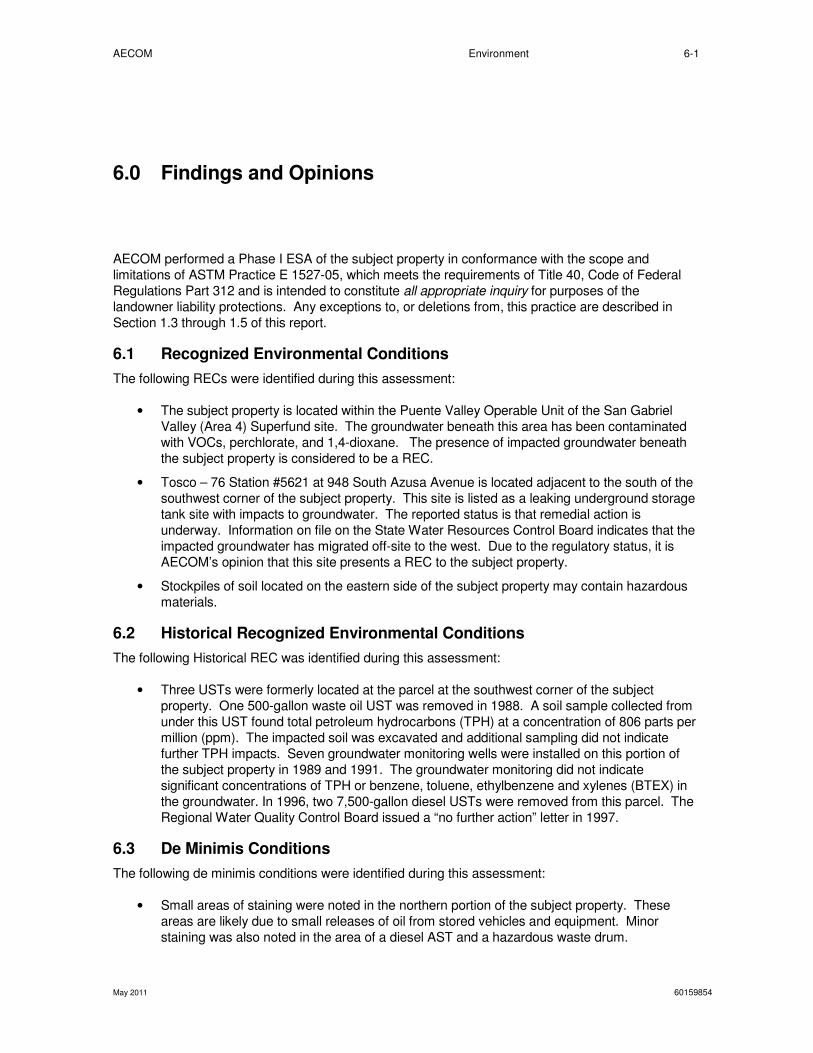
AECOM Environment 6-1
May 2011 60159854
6.0 Findings and Opinions
AECOM performed a Phase I ESA of the subject property in conformance with the scope and
limitations of ASTM Practice E 1527-05, which meets the requirements of Title 40, Code of Federal
Regulations Part 312 and is intended to constitute all appropriate inquiry for purposes of the
landowner liability protections. Any exceptions to, or deletions from, this practice are described in
Section 1.3 through 1.5 of this report.
6.1 Recognized Environmental Conditions
The following RECs were identified during this assessment:
• The subject property is located within the Puente Valley Operable Unit of the San Gabriel
Valley (Area 4) Superfund site. The groundwater beneath this area has been contaminated
with VOCs, perchlorate, and 1,4-dioxane. The presence of impacted groundwater beneath
the subject property is considered to be a REC.
• Tosco – 76 Station #5621 at 948 South Azusa Avenue is located adjacent to the south of the
southwest corner of the subject property. This site is listed as a leaking underground storage
tank site with impacts to groundwater. The reported status is that remedial action is
underway. Information on file on the State Water Resources Control Board indicates that the
impacted groundwater has migrated off-site to the west. Due to the regulatory status, it is
AECOM’s opinion that this site presents a REC to the subject property.
• Stockpiles of soil located on the eastern side of the subject property may contain hazardous
materials.
6.2 Historical Recognized Environmental Conditions
The following Historical REC was identified during this assessment:
• Three USTs were formerly located at the parcel at the southwest corner of the subject
property. One 500-gallon waste oil UST was removed in 1988. A soil sample collected from
under this UST found total petroleum hydrocarbons (TPH) at a concentration of 806 parts per
million (ppm). The impacted soil was excavated and additional sampling did not indicate
further TPH impacts. Seven groundwater monitoring wells were installed on this portion of
the subject property in 1989 and 1991. The groundwater monitoring did not indicate
significant concentrations of TPH or benzene, toluene, ethylbenzene and xylenes (BTEX) in
the groundwater. In 1996, two 7,500-gallon diesel USTs were removed from this parcel. The
Regional Water Quality Control Board issued a “no further action” letter in 1997.
6.3 De Minimis Conditions
The following de minimis conditions were identified during this assessment:
• Small areas of staining were noted in the northern portion of the subject property. These
areas are likely due to small releases of oil from stored vehicles and equipment. Minor
staining was also noted in the area of a diesel AST and a hazardous waste drum.
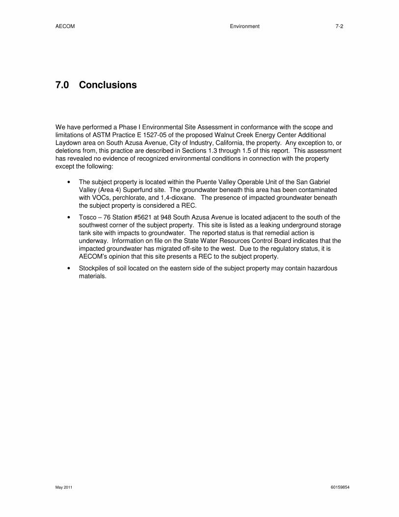
AECOM Environment 7-2
May 2011 60159854
7.0 Conclusions
We have performed a Phase I Environmental Site Assessment in conformance with the scope and
limitations of ASTM Practice E 1527-05 of the proposed Walnut Creek Energy Center Additional
Laydown area on South Azusa Avenue, City of Industry, California, the property. Any exception to, or
deletions from, this practice are described in Sections 1.3 through 1.5 of this report. This assessment
has revealed no evidence of recognized environmental conditions in connection with the property
except the following:
• The subject property is located within the Puente Valley Operable Unit of the San Gabriel
Valley (Area 4) Superfund site. The groundwater beneath this area has been contaminated
with VOCs, perchlorate, and 1,4-dioxane. The presence of impacted groundwater beneath
the subject property is considered a REC.
• Tosco – 76 Station #5621 at 948 South Azusa Avenue is located adjacent to the south of the
southwest corner of the subject property. This site is listed as a leaking underground storage
tank site with impacts to groundwater. The reported status is that remedial action is
underway. Information on file on the State Water Resources Control Board indicates that the
impacted groundwater has migrated off-site to the west. Due to the regulatory status, it is
AECOM’s opinion that this site presents a REC to the subject property.
• Stockpiles of soil located on the eastern side of the subject property may contain hazardous
materials.

AECOM
May 2011
8.0 Quality Control/Quality Assurance
8.1 Site Visit, Research, and Report Preparation
The site visit was conducted by Geoff Knight of AECOM. R
conducted by David Simon, in AECOM’s
Signature:
8.2 Quality Control Review
A first level review of this report was conducted by
office.
Signature:
A second level review of this report was conducted by
office.
Signature: __ _________________________
8.3 Environmental Professional Statement
Mr. David Simon was the Environmental Professional (EP) for this project.
is below and his CV is provided in Appendix C
I declare that, to the best of our professional knowledge and belief, I meet the definition of an EP as
defined in §312.10 of 40 Code of Federal Regulations (
based on education, training, and experience to assess a property of the nature, history, and setting of
the subject property. I have developed and performed all the ap
with the standards and practices set forth in 40 CFR Part 312.
Signature: ___________________________
Environment
Quality Control/Quality Assurance
Site Visit, Research, and Report Preparation
was conducted by Geoff Knight of AECOM. Research and report preparation were
, in AECOM’s Orange, California office.
Quality Control Review
A first level review of this report was conducted by Roy Litzenberg, in AECOM’s San Diego, California
A second level review of this report was conducted by Geoff Knight, in AECOM’s Orange
_________________________
Environmental Professional Statement
was the Environmental Professional (EP) for this project. Mr. Simon’s
CV is provided in Appendix C:
I declare that, to the best of our professional knowledge and belief, I meet the definition of an EP as
Code of Federal Regulations (CFR) and that I have the specific qualifications
based on education, training, and experience to assess a property of the nature, history, and setting of
the subject property. I have developed and performed all the appropriate inquiries in conformance
with the standards and practices set forth in 40 CFR Part 312.
___________________________ Date: June 28, 2011
8-3
60159854
ation were
San Diego, California
Geoff Knight, in AECOM’s Orange, California
’s EP statement
I declare that, to the best of our professional knowledge and belief, I meet the definition of an EP as
and that I have the specific qualifications
based on education, training, and experience to assess a property of the nature, history, and setting of
propriate inquiries in conformance
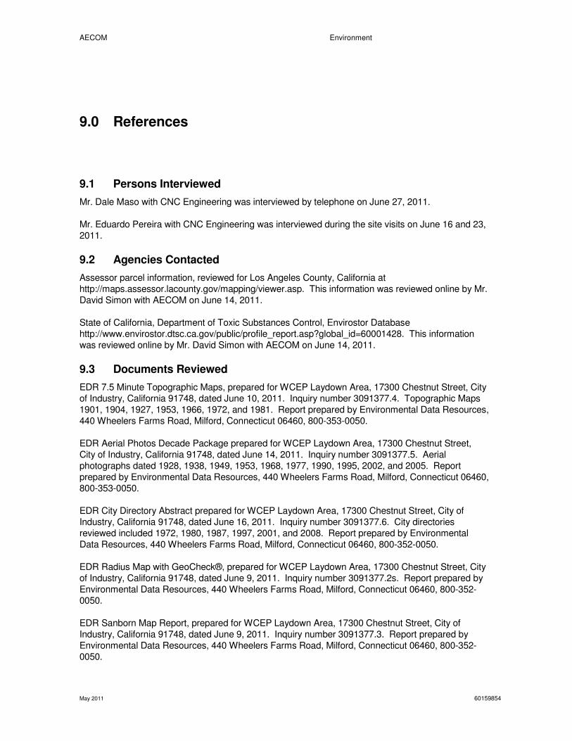
AECOM Environment
May 2011 60159854
9.0 References
9.1 Persons Interviewed
Mr. Dale Maso with CNC Engineering was interviewed by telephone on June 27, 2011.
Mr. Eduardo Pereira with CNC Engineering was interviewed during the site visits on June 16 and 23,
2011.
9.2 Agencies Contacted
Assessor parcel information, reviewed for Los Angeles County, California at
http://maps.assessor.lacounty.gov/mapping/viewer.asp. This information was reviewed online by Mr.
David Simon with AECOM on June 14, 2011.
State of California, Department of Toxic Substances Control, Envirostor Database
http://www.envirostor.dtsc.ca.gov/public/profile_report.asp?global_id=60001428. This information
was reviewed online by Mr. David Simon with AECOM on June 14, 2011.
9.3 Documents Reviewed
EDR 7.5 Minute Topographic Maps, prepared for WCEP Laydown Area, 17300 Chestnut Street, City
of Industry, California 91748, dated June 10, 2011. Inquiry number 3091377.4. Topographic Maps
1901, 1904, 1927, 1953, 1966, 1972, and 1981. Report prepared by Environmental Data Resources,
440 Wheelers Farms Road, Milford, Connecticut 06460, 800-353-0050.
EDR Aerial Photos Decade Package prepared for WCEP Laydown Area, 17300 Chestnut Street,
City of Industry, California 91748, dated June 14, 2011. Inquiry number 3091377.5. Aerial
photographs dated 1928, 1938, 1949, 1953, 1968, 1977, 1990, 1995, 2002, and 2005. Report
prepared by Environmental Data Resources, 440 Wheelers Farms Road, Milford, Connecticut 06460,
800-353-0050.
EDR City Directory Abstract prepared for WCEP Laydown Area, 17300 Chestnut Street, City of
Industry, California 91748, dated June 16, 2011. Inquiry number 3091377.6. City directories
reviewed included 1972, 1980, 1987, 1997, 2001, and 2008. Report prepared by Environmental
Data Resources, 440 Wheelers Farms Road, Milford, Connecticut 06460, 800-352-0050.
EDR Radius Map with GeoCheck®, prepared for WCEP Laydown Area, 17300 Chestnut Street, City
of Industry, California 91748, dated June 9, 2011. Inquiry number 3091377.2s. Report prepared by
Environmental Data Resources, 440 Wheelers Farms Road, Milford, Connecticut 06460, 800-352-
0050.
EDR Sanborn Map Report, prepared for WCEP Laydown Area, 17300 Chestnut Street, City of
Industry, California 91748, dated June 9, 2011. Inquiry number 3091377.3. Report prepared by
Environmental Data Resources, 440 Wheelers Farms Road, Milford, Connecticut 06460, 800-352-
0050.
AECOM Environment
May 2011 60159854
Environ Strategy Consultants, Inc. First Quarter 2011 Waste Discharge Requirement Monitoring
Report, Compliance File No. CI-8917, 76 Station No. 5621, 948 Azusa Avenue, City of Industry,
California. April 6, 2011.
GeoTrans, Inc. Groundwater Monitoring and Sampling Report, Third Quarter 2010, Puente Valley
Operable Unit, Los Angeles County, California. December 22, 2010
Gradient Engineers Inc. Phase I Environmental Site Assessment Report, 17300 East Chestnut
Street and 942 South Azusa Avenue, City of Industry, Los Angeles County, California. December
20, 2001
Harding Lawson Associates. Groundwater Monitoring Data – 1999, Utility Trailer Manufacturing
Company, 17300 East Chestnut Street, City of Industry, California. January 17, 2000
United States Environmental Protection Agency, Region 9, San Francisco, California. Final First
Five-Year Review Report for San Gabriel Valley Superfund Site (Area 4), Puente Valley Operable
Unit, City of Industry, City of La Puente, Los Angeles County, California. March 2011.

AECOM Environment
May 2011 60159854
Figures
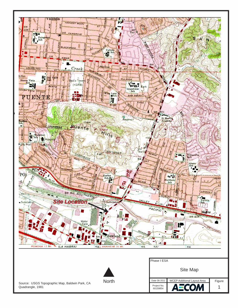
Historical Topographic Map→
NTARGET QUADTARGET QUADNAME: BALDWIN PARKMAP YEAR: 1981PHOTOREVISED:1966SERIES: 7.5SCALE: 1:24000
SITE NAME: WCEP Laydown Area ADDRESS: 17300 Chestnut Street
City of Industry, CA 91748LAT/LONG: 34.0079 / -117.9262
CLIENT: AECOMCONTACT: David SimonINQUIRY#: 3091377.4RESEARCH DATE: 06/10/2011
Phase I ESA
Site Map
Date 06-2011
Project No.60159854
Figure
1
NorthSource: USGS Topographic Map, Baldwin Park, CA Quadrangle, 1981
Site Location
WCEP Additional Layout Area

Phase I ESA
Site Plan
Date 06-2011
Project No.60159854
Figure
2
NorthNot to Scale
WCEP Additional Layout Area
Orange Boundary is the Property Boundary

AECOM Environment
May 2011 60159854
Appendix A Representative Site Photographs
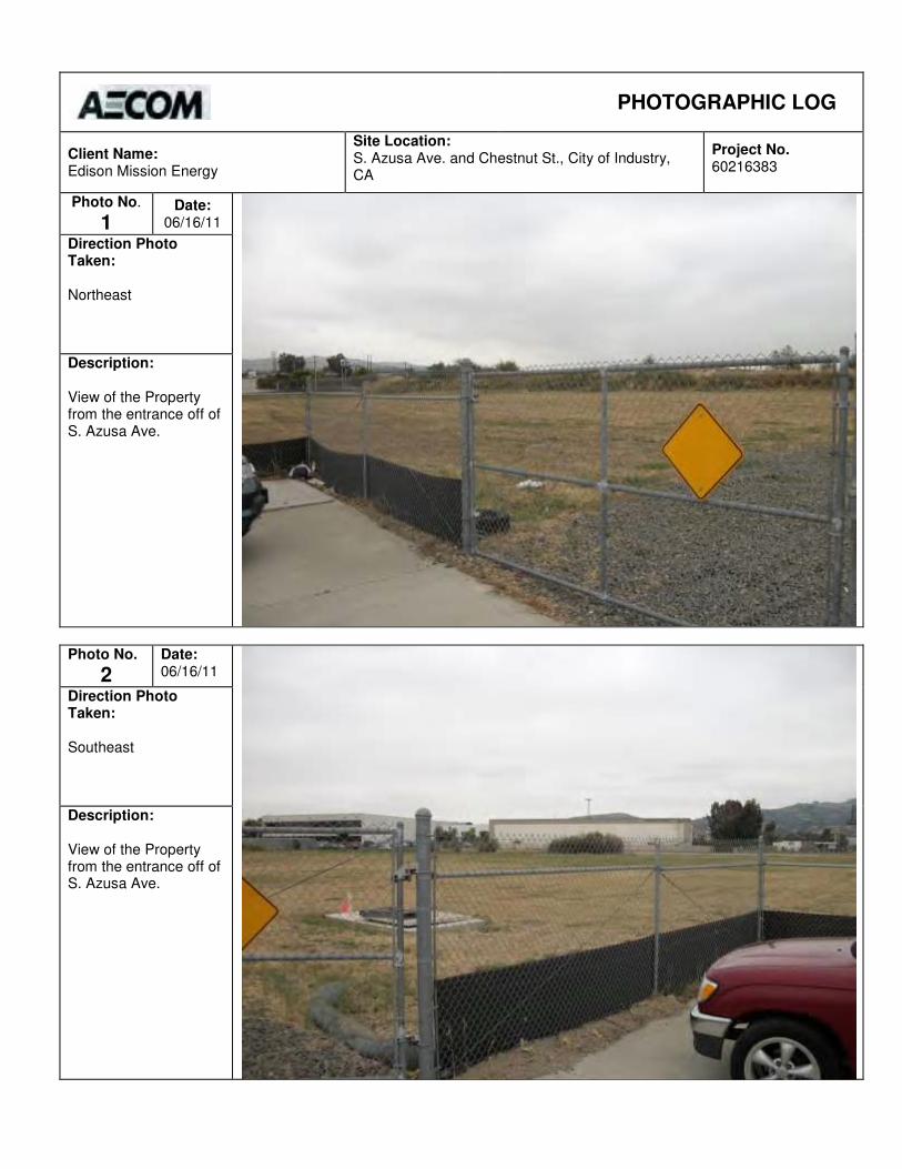
PHOTOGRAPHIC LOG
Client Name: Edison Mission Energy
Site Location: S. Azusa Ave. and Chestnut St., City of Industry, CA
Project No. 60216383
Photo No.
1 Date:
06/16/11
Direction Photo Taken: Northeast
Description: View of the Property from the entrance off of S. Azusa Ave.
Photo No.
2
Date: 06/16/11
Direction Photo Taken: Southeast
Description: View of the Property from the entrance off of S. Azusa Ave.
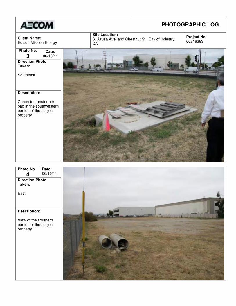
PHOTOGRAPHIC LOG
Client Name: Edison Mission Energy
Site Location: S. Azusa Ave. and Chestnut St., City of Industry, CA
Project No. 60216383
Photo No.
3 Date:
06/16/11
Direction Photo Taken: Southeast
Description: Concrete transformer pad in the southwestern portion of the subject property
Photo No.
4
Date: 06/16/11
Direction Photo Taken: East
Description: View of the southern portion of the subject property
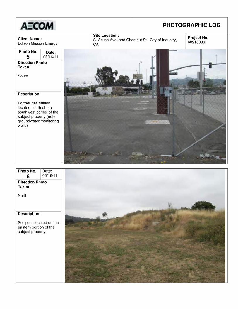
PHOTOGRAPHIC LOG
Client Name: Edison Mission Energy
Site Location: S. Azusa Ave. and Chestnut St., City of Industry, CA
Project No. 60216383
Photo No.
5 Date:
06/16/11
Direction Photo Taken: South
Description: Former gas station located south of the southwest corner of the subject property (note groundwater monitoring wells)
Photo No.
6
Date: 06/16/11
Direction Photo Taken: North
Description: Soil piles located on the eastern portion of the subject property
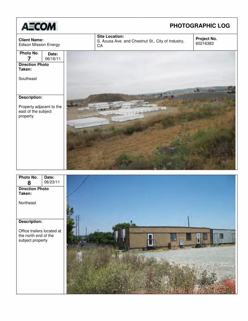
PHOTOGRAPHIC LOG
Client Name: Edison Mission Energy
Site Location: S. Azusa Ave. and Chestnut St., City of Industry, CA
Project No. 60216383
Photo No.
7 Date:
06/16/11
Direction Photo Taken: Southeast
Description: Property adjacent to the east of the subject property
Photo No.
8
Date: 06/23/11
Direction Photo Taken: Northeast
Description: Office trailers located at the north end of the subject property
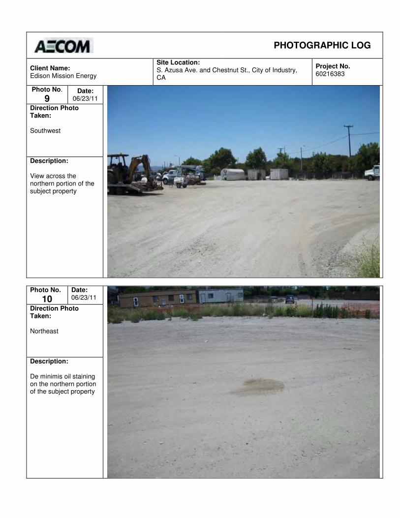
PHOTOGRAPHIC LOG
Client Name: Edison Mission Energy
Site Location: S. Azusa Ave. and Chestnut St., City of Industry, CA
Project No. 60216383
Photo No.
9 Date:
06/23/11
Direction Photo Taken: Southwest
Description: View across the northern portion of the subject property
Photo No.
10
Date: 06/23/11
Direction Photo Taken: Northeast
Description: De minimis oil staining on the northern portion of the subject property
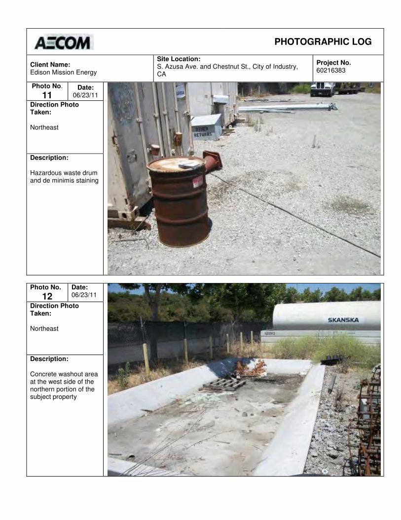
PHOTOGRAPHIC LOG
Client Name: Edison Mission Energy
Site Location: S. Azusa Ave. and Chestnut St., City of Industry, CA
Project No. 60216383
Photo No.
11 Date:
06/23/11
Direction Photo Taken: Northeast
Description: Hazardous waste drum and de minimis staining
Photo No.
12
Date: 06/23/11
Direction Photo Taken: Northeast
Description: Concrete washout area at the west side of the northern portion of the subject property

PHOTOGRAPHIC LOG
Client Name: Edison Mission Energy
Site Location: S. Azusa Ave. and Chestnut St., City of Industry, CA
Project No. 60216383
Photo No.
13 Date:
06/23/11
Direction Photo Taken: Northwest
Description: Diesel AST located in the northern portion of the subject property
Photo No.
14
Date: 06/23/11
Direction Photo Taken: Southeast
Description: De minimis staining at the outlet of the AST containment structure
AECOM Environment
May 2011 60159854
Appendix B Environmental Database Report

FORM-PB9-PVC
®kcehCoeG htiw tropeR ™paM suidaR RDE ehT
440 Wheelers Farms RoadMilford, CT 06461Toll Free: 800.352.0050www.edrnet.com
WCEP Laydown Area17300 Chestnut StreetCity of Industry, CA 91748
Inquiry Number: 3091377.2sJune 09, 2011
SECTION PAGE
Executive Summary ES1
Overview Map 2
Detail Map 3
Map Findings Summary 4
Map Findings 8
Orphan Summary 160
Government Records Searched/Data Currency Tracking GR-1
GEOCHECK ADDENDUM
Physical Setting Source Addendum A-1
Physical Setting Source Summary A-2
Physical Setting Source Map A-8
Physical Setting Source Map Findings A-9
Physical Setting Source Records Searched A-22
TC3091377.2s Page 1
Thank you for your business.Please contact EDR at 1-800-352-0050
with any questions or comments.
Disclaimer - Copyright and Trademark Notice
This Report contains certain information obtained from a variety of public and other sources reasonably available to Environmental DataResources, Inc. It cannot be concluded from this Report that coverage information for the target and surrounding properties does not exist fromother sources. NO WARRANTY EXPRESSED OR IMPLIED, IS MADE WHATSOEVER IN CONNECTION WITH THIS REPORT. ENVIRONMENTALDATA RESOURCES, INC. SPECIFICALLY DISCLAIMS THE MAKING OF ANY SUCH WARRANTIES, INCLUDING WITHOUT LIMITATION,MERCHANTABILITY OR FITNESS FOR A PARTICULAR USE OR PURPOSE. ALL RISK IS ASSUMED BY THE USER. IN NO EVENT SHALLENVIRONMENTAL DATA RESOURCES, INC. BE LIABLE TO ANYONE, WHETHER ARISING OUT OF ERRORS OR OMISSIONS, NEGLIGENCE,ACCIDENT OR ANY OTHER CAUSE, FOR ANY LOSS OF DAMAGE, INCLUDING, WITHOUT LIMITATION, SPECIAL, INCIDENTAL,CONSEQUENTIAL, OR EXEMPLARY DAMAGES. ANY LIABILITY ON THE PART OF ENVIRONMENTAL DATA RESOURCES, INC. IS STRICTLYLIMITED TO A REFUND OF THE AMOUNT PAID FOR THIS REPORT. Purchaser accepts this Report "AS IS". Any analyses, estimates, ratings,environmental risk levels or risk codes provided in this Report are provided for illustrative purposes only, and are not intended to provide, norshould they be interpreted as providing any facts regarding, or prediction or forecast of, any environmental risk for any property. Only a Phase IEnvironmental Site Assessment performed by an environmental professional can provide information regarding the environmental risk for anyproperty. Additionally, the information provided in this Report is not to be construed as legal advice.
Copyright 2011 by Environmental Data Resources, Inc. All rights reserved. Reproduction in any media or format, in wholeor in part, of any report or map of Environmental Data Resources, Inc., or its affiliates, is prohibited without prior written permission.
EDR and its logos (including Sanborn and Sanborn Map) are trademarks of Environmental Data Resources, Inc. or its affiliates. All othertrademarks used herein are the property of their respective owners.
TABLE OF CONTENTS

EXECUTIVE SUMMARY
TC3091377.2s EXECUTIVE SUMMARY 1
A search of available environmental records was conducted by Environmental Data Resources, Inc (EDR).The report was designed to assist parties seeking to meet the search requirements of EPA’s Standardsand Practices for All Appropriate Inquiries (40 CFR Part 312), the ASTM Standard Practice forEnvironmental Site Assessments (E 1527-05) or custom requirements developed for the evaluation ofenvironmental risk associated with a parcel of real estate.
TARGET PROPERTY INFORMATION
ADDRESS
17300 CHESTNUT STREETCITY OF INDUSTRY, CA 91748
COORDINATES
34.007900 - 34˚ 0’ 28.4’’Latitude (North): 117.926200 - 117˚ 55’ 34.3’’Longitude (West): Zone 11Universal Tranverse Mercator: 414472.0UTM X (Meters): 3763224.0UTM Y (Meters): 362 ft. above sea levelElevation:
USGS TOPOGRAPHIC MAP ASSOCIATED WITH TARGET PROPERTY
34117-A8 BALDWIN PARK, CATarget Property Map:1981Most Recent Revision:
33117-H8 LA HABRA, CASouth Map:1981Most Recent Revision:
AERIAL PHOTOGRAPHY IN THIS REPORT
2005Photo Year:USDASource:
TARGET PROPERTY SEARCH RESULTS
The target property was identified in the following records. For more information on thisproperty see page 8 of the attached EDR Radius Map report:
EPA IDDatabase(s)Site
UTILITY TRAILER MFG CO.17300 E. CHESTNUT ST.INDUSTRY, CA 91748
N/AEMI
UTILITY TRAILER MFG CO17300 E CHESTNUT STREETLA PUENTE, CA 91748
CAD990739252RCRA-NonGenFINDSWDSHIST USTSWEEPS USTWIPFacility Status: Active
LOS ANGELES CO. HMSHAZNETEMI
EXECUTIVE SUMMARY
TC3091377.2s EXECUTIVE SUMMARY 2
INDUSTRY IRBAN DEVELOPMENT17300 CHESTNUT STCITY OF INDUSTRY, CA 91748
N/AHAZNET
UTILITY TRAILER MFG. CO.17300 CHESTNUT STREET CITY OF INDUSTRY CA 91748CITY OF INDUSTRY, CA 91748
N/AICIS
UTILITY TRAILOR MFG. CO.17300 E. CHESTNUT ST.CITY OF INDUSTRY, CA 91749
N/ASLICFacility Status: Open - Site Assessment
DATABASES WITH NO MAPPED SITES
No mapped sites were found in EDR’s search of available ("reasonably ascertainable ") governmentrecords either on the target property or within the search radius around the target property for thefollowing databases:
STANDARD ENVIRONMENTAL RECORDS
Federal NPL site list
Proposed NPL Proposed National Priority List SitesNPL LIENS Federal Superfund Liens
Federal Delisted NPL site list
Delisted NPL National Priority List Deletions
Federal CERCLIS list
FEDERAL FACILITY Federal Facility Site Information listing
Federal CERCLIS NFRAP site List
CERC-NFRAP CERCLIS No Further Remedial Action Planned
Federal RCRA CORRACTS facilities list
CORRACTS Corrective Action Report
Federal RCRA generators list
RCRA-CESQG RCRA - Conditionally Exempt Small Quantity Generator
Federal institutional controls / engineering controls registries
US INST CONTROL Sites with Institutional Controls

EXECUTIVE SUMMARY
TC3091377.2s EXECUTIVE SUMMARY 3
Federal ERNS list
ERNS Emergency Response Notification System
State- and tribal - equivalent NPL
RESPONSE State Response Sites
State and tribal leaking storage tank lists
INDIAN LUST Leaking Underground Storage Tanks on Indian Land
State and tribal registered storage tank lists
INDIAN UST Underground Storage Tanks on Indian LandFEMA UST Underground Storage Tank Listing
State and tribal voluntary cleanup sites
VCP Voluntary Cleanup Program PropertiesINDIAN VCP Voluntary Cleanup Priority Listing
ADDITIONAL ENVIRONMENTAL RECORDS
Local Brownfield lists
US BROWNFIELDS A Listing of Brownfields Sites
Local Lists of Landfill / Solid Waste Disposal Sites
ODI Open Dump InventoryDEBRIS REGION 9 Torres Martinez Reservation Illegal Dump Site LocationsWMUDS/SWAT Waste Management Unit DatabaseHAULERS Registered Waste Tire Haulers ListingINDIAN ODI Report on the Status of Open Dumps on Indian Lands
Local Lists of Hazardous waste / Contaminated Sites
US CDL Clandestine Drug LabsHIST Cal-Sites Historical Calsites DatabaseSCH School Property Evaluation ProgramToxic Pits Toxic Pits Cleanup Act SitesCDL Clandestine Drug LabsUS HIST CDL National Clandestine Laboratory Register
Local Land Records
LIENS 2 CERCLA Lien InformationLUCIS Land Use Control Information SystemLIENS Environmental Liens ListingDEED Deed Restriction Listing
Records of Emergency Release Reports
HMIRS Hazardous Materials Information Reporting System
EXECUTIVE SUMMARY
TC3091377.2s EXECUTIVE SUMMARY 4
CHMIRS California Hazardous Material Incident Report SystemLDS Land Disposal Sites ListingMCS Military Cleanup Sites Listing
Other Ascertainable Records
DOT OPS Incident and Accident DataDOD Department of Defense SitesFUDS Formerly Used Defense SitesCONSENT Superfund (CERCLA) Consent DecreesUMTRA Uranium Mill Tailings SitesMINES Mines Master Index FileTRIS Toxic Chemical Release Inventory SystemTSCA Toxic Substances Control ActFTTS FIFRA/ TSCA Tracking System - FIFRA (Federal Insecticide, Fungicide, & Rodenticide Act)/TSCA (Toxic Substances Control Act)HIST FTTS FIFRA/TSCA Tracking System Administrative Case ListingSSTS Section 7 Tracking SystemsPADS PCB Activity Database SystemMLTS Material Licensing Tracking SystemRADINFO Radiation Information DatabaseRAATS RCRA Administrative Action Tracking SystemCA BOND EXP. PLAN Bond Expenditure PlanNPDES NPDES Permits ListingCortese "Cortese" Hazardous Waste & Substances Sites ListLA Co. Site Mitigation Site Mitigation ListDRYCLEANERS Cleaner FacilitiesINDIAN RESERV Indian ReservationsSCRD DRYCLEANERS State Coalition for Remediation of Drycleaners ListingFINANCIAL ASSURANCE Financial Assurance Information ListingHWT Registered Hazardous Waste Transporter DatabaseCOAL ASH EPA Coal Combustion Residues Surface Impoundments ListPCB TRANSFORMER PCB Transformer Registration DatabasePROC Certified Processors DatabaseMWMP Medical Waste Management Program ListingCOAL ASH DOE Sleam-Electric Plan Operation Data
EDR PROPRIETARY RECORDS
EDR Proprietary Records
Manufactured Gas Plants EDR Proprietary Manufactured Gas PlantsEDR Historical Auto Stations EDR Proprietary Historic Gas StationsEDR Historical Cleaners EDR Proprietary Historic Dry Cleaners
SURROUNDING SITES: SEARCH RESULTS
Surrounding sites were identified in the following databases.
Elevations have been determined from the USGS Digital Elevation Model and should be evaluated ona relative (not an absolute) basis. Relative elevation information between sites of close proximityshould be field verified. Sites with an elevation equal to or higher than the target property have beendifferentiated below from sites with an elevation lower than the target property.Page numbers and map identification numbers refer to the EDR Radius Map report where detaileddata on individual sites can be reviewed.
Sites listed in bold italics are in multiple databases.
Unmappable (orphan) sites are not considered in the foregoing analysis.

EXECUTIVE SUMMARY
TC3091377.2s EXECUTIVE SUMMARY 5
STANDARD ENVIRONMENTAL RECORDS
Federal NPL site list
NPL: Also known as Superfund, the National Priority List database is a subset of CERCLIS andidentifies over 1,200 sites for priority cleanup under the Superfund program. The source of this database isthe U.S. EPA.
A review of the NPL list, as provided by EDR, and dated 12/31/2010 has revealed that there is 1 NPL site within approximately 1 mile of the target property.
PageMap IDDirection / Distance Address Equal/Higher Elevation ____________________ ________ ___________________ _____ _____
SAN GABRIEL VALLEY (AREA 4) STIMSON AVE & OLD VALLE 0 - 1/8 (0.000 mi.) 0 24
Federal CERCLIS list
CERCLIS: The Comprehensive Environmental Response, Compensation and Liability Information Systemcontains data on potentially hazardous waste sites that have been reported to the USEPA by states,municipalities, private companies and private persons, pursuant to Section 103 of the ComprehensiveEnvironmental Response, Compensation and Liability Act (CERCLA). CERCLIS contains sites which are eitherproposed to or on the National Priorities List (NPL) and sites which are in the screening and assessment phasefor possible inclusion on the NPL.
A review of the CERCLIS list, as provided by EDR, and dated 02/25/2011 has revealed that there are 2 CERCLIS sites within approximately 0.5 miles of the target property.
PageMap IDDirection / Distance Address Equal/Higher Elevation ____________________ ________ ___________________ _____ _____
SAN GABRIEL VALLEY (AREA 4) STIMSON AVE & OLD VALLE 0 - 1/8 (0.000 mi.) 0 24 MINI STORAGE DRUMS 17295 E. VALLEY BLVD NNW 0 - 1/8 (0.107 mi.) E19 69
Federal RCRA non-CORRACTS TSD facilities list
RCRA-TSDF: RCRAInfo is EPA’s comprehensive information system, providing access to data supportingthe Resource Conservation and Recovery Act (RCRA) of 1976 and the Hazardous and Solid Waste Amendments (HSWA)of 1984. The database includes selective information on sites which generate, transport, store, treat and/ordispose of hazardous waste as defined by the Resource Conservation and Recovery Act (RCRA). Transporters areindividuals or entities that move hazardous waste from the generator offsite to a facility that can recycle,treat, store, or dispose of the waste. TSDFs treat, store, or dispose of the waste.
A review of the RCRA-TSDF list, as provided by EDR, and dated 03/11/2011 has revealed that there is 1 RCRA-TSDF site within approximately 0.5 miles of the target property.
PageMap IDDirection / Distance Address Equal/Higher Elevation ____________________ ________ ___________________ _____ _____
H H ROBERTSON CO WASD 999 SOUTH HATCHER AVENUESE 1/4 - 1/2 (0.264 mi.) M43 110
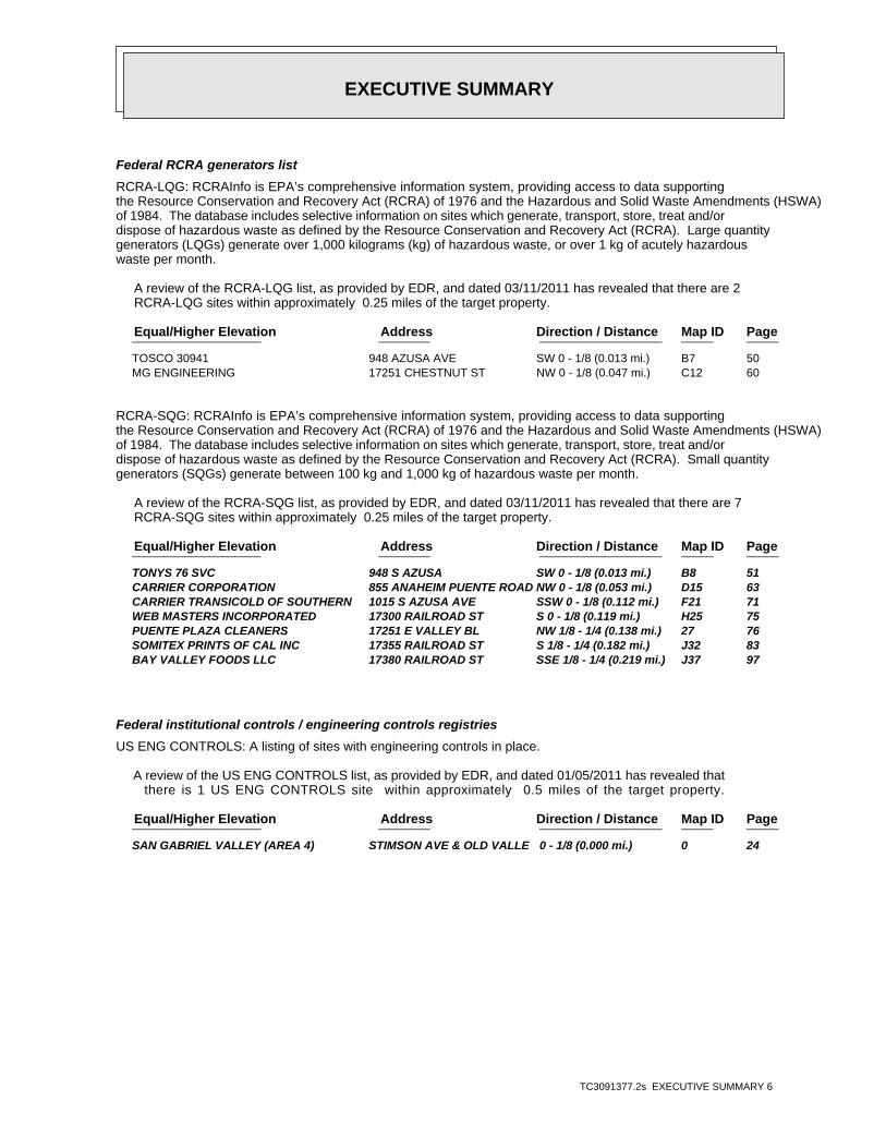
EXECUTIVE SUMMARY
TC3091377.2s EXECUTIVE SUMMARY 6
Federal RCRA generators list
RCRA-LQG: RCRAInfo is EPA’s comprehensive information system, providing access to data supportingthe Resource Conservation and Recovery Act (RCRA) of 1976 and the Hazardous and Solid Waste Amendments (HSWA)of 1984. The database includes selective information on sites which generate, transport, store, treat and/ordispose of hazardous waste as defined by the Resource Conservation and Recovery Act (RCRA). Large quantitygenerators (LQGs) generate over 1,000 kilograms (kg) of hazardous waste, or over 1 kg of acutely hazardouswaste per month.
A review of the RCRA-LQG list, as provided by EDR, and dated 03/11/2011 has revealed that there are 2 RCRA-LQG sites within approximately 0.25 miles of the target property.
PageMap IDDirection / Distance Address Equal/Higher Elevation ____________________ ________ ___________________ _____ _____
TOSCO 30941 948 AZUSA AVE SW 0 - 1/8 (0.013 mi.) B7 50 MG ENGINEERING 17251 CHESTNUT ST NW 0 - 1/8 (0.047 mi.) C12 60
RCRA-SQG: RCRAInfo is EPA’s comprehensive information system, providing access to data supportingthe Resource Conservation and Recovery Act (RCRA) of 1976 and the Hazardous and Solid Waste Amendments (HSWA)of 1984. The database includes selective information on sites which generate, transport, store, treat and/ordispose of hazardous waste as defined by the Resource Conservation and Recovery Act (RCRA). Small quantitygenerators (SQGs) generate between 100 kg and 1,000 kg of hazardous waste per month.
A review of the RCRA-SQG list, as provided by EDR, and dated 03/11/2011 has revealed that there are 7 RCRA-SQG sites within approximately 0.25 miles of the target property.
PageMap IDDirection / Distance Address Equal/Higher Elevation ____________________ ________ ___________________ _____ _____
TONYS 76 SVC 948 S AZUSA SW 0 - 1/8 (0.013 mi.) B8 51 CARRIER CORPORATION 855 ANAHEIM PUENTE ROAD NW 0 - 1/8 (0.053 mi.) D15 63 CARRIER TRANSICOLD OF SOUTHERN 1015 S AZUSA AVE SSW 0 - 1/8 (0.112 mi.) F21 71 WEB MASTERS INCORPORATED 17300 RAILROAD ST S 0 - 1/8 (0.119 mi.) H25 75 PUENTE PLAZA CLEANERS 17251 E VALLEY BL NW 1/8 - 1/4 (0.138 mi.) 27 76 SOMITEX PRINTS OF CAL INC 17355 RAILROAD ST S 1/8 - 1/4 (0.182 mi.) J32 83 BAY VALLEY FOODS LLC 17380 RAILROAD ST SSE 1/8 - 1/4 (0.219 mi.) J37 97
Federal institutional controls / engineering controls registries
US ENG CONTROLS: A listing of sites with engineering controls in place.
A review of the US ENG CONTROLS list, as provided by EDR, and dated 01/05/2011 has revealed that there is 1 US ENG CONTROLS site within approximately 0.5 miles of the target property.
PageMap IDDirection / Distance Address Equal/Higher Elevation ____________________ ________ ___________________ _____ _____
SAN GABRIEL VALLEY (AREA 4) STIMSON AVE & OLD VALLE 0 - 1/8 (0.000 mi.) 0 24
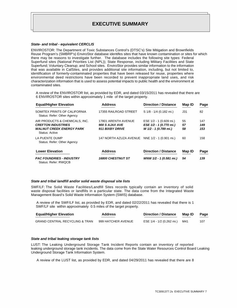
EXECUTIVE SUMMARY
TC3091377.2s EXECUTIVE SUMMARY 7
State- and tribal - equivalent CERCLIS
ENVIROSTOR: The Department of Toxic Substances Control’s (DTSC’s) Site Mitigation and BrownfieldsReuse Program’s (SMBRP’s) EnviroStor database identifes sites that have known contamination or sites for whichthere may be reasons to investigate further. The database includes the following site types: FederalSuperfund sites (National Priorities List (NPL)); State Response, including Military Facilities and StateSuperfund; Voluntary Cleanup; and School sites. EnviroStor provides similar information to the informationthat was available in CalSites, and provides additional site information, including, but not limited to,identification of formerly-contaminated properties that have been released for reuse, properties whereenvironmental deed restrictions have been recorded to prevent inappropriate land uses, and riskcharacterization information that is used to assess potential impacts to public health and the environment atcontaminated sites.
A review of the ENVIROSTOR list, as provided by EDR, and dated 03/15/2011 has revealed that there are 6 ENVIROSTOR sites within approximately 1 mile of the target property.
PageMap IDDirection / Distance Address Equal/Higher Elevation ____________________ ________ ___________________ _____ _____
SOMITEX PRINTS OF CALIFORNIA 17355 RAILROAD STREET S 1/8 - 1/4 (0.182 mi.) J31 82Status: Refer: Other Agency
AIR PRODUCTS & CHEMICALS, INC. 17801 ARENTH AVENUE ESE 1/2 - 1 (0.609 mi.) 55 147 CREFTON INDUSTRIES 900 S AJAX AVE ESE 1/2 - 1 (0.770 mi.) 57 149 WALNUT CREEK ENERGY PARK 911 BIXBY DRIVE W 1/2 - 1 (0.789 mi.) 58 153
Status: Active
LA PUENTE DUMP 147 NORTH AZUZA AVENUE NNE 1/2 - 1 (0.901 mi.) 60 158Status: Refer: Other Agency
PageMap IDDirection / Distance Address Lower Elevation ____________________ ________ ___________________ _____ _____
PAC FOUNDRIES - INDUSTRY 16800 CHESTNUT ST WNW 1/2 - 1 (0.581 mi.) 54 139Status: Refer: RWQCB
State and tribal landfill and/or solid waste disposal site lists
SWF/LF: The Solid Waste Facilities/Landfill Sites records typically contain an inventory of solidwaste disposal facilities or landfills in a particular state. The data come from the Integrated WasteManagement Board’s Solid Waste Information System (SWIS) database.
A review of the SWF/LF list, as provided by EDR, and dated 02/22/2011 has revealed that there is 1 SWF/LF site within approximately 0.5 miles of the target property.
PageMap IDDirection / Distance Address Equal/Higher Elevation ____________________ ________ ___________________ _____ _____
GRAND CENTRAL RECYCLING & TRAN 999 HATCHER AVENUE ESE 1/4 - 1/2 (0.262 mi.) M41 107
State and tribal leaking storage tank lists
LUST: The Leaking Underground Storage Tank Incident Reports contain an inventory of reportedleaking underground storage tank incidents. The data come from the State Water Resources Control Board LeakingUnderground Storage Tank Information System.
A review of the LUST list, as provided by EDR, and dated 04/29/2011 has revealed that there are 8
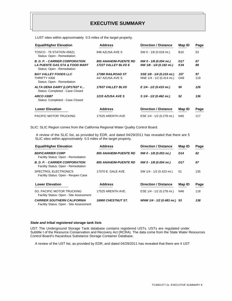
EXECUTIVE SUMMARY
TC3091377.2s EXECUTIVE SUMMARY 8
LUST sites within approximately 0.5 miles of the target property.
PageMap IDDirection / Distance Address Equal/Higher Elevation ____________________ ________ ___________________ _____ _____
TOSCO - 76 STATION #5621 948 AZUSA AVE S SW 0 - 1/8 (0.018 mi.) B10 53Status: Open - Remediation
B. D. P. - CARRIER CORPORATION 855 ANAHEIM-PUENTE RD NW 0 - 1/8 (0.054 mi.) D17 67 LA PUENTE GAS STA & FOOD MART 17227 VALLEY BLVD E NW 1/8 - 1/4 (0.192 mi.) K34 89
Status: Open - Remediation
BAY VALLEY FOODS LLC 17380 RAILROAD ST SSE 1/8 - 1/4 (0.219 mi.) J37 97 THRIFTY #306 447 AZUSA AVE S NNE 1/4 - 1/2 (0.414 mi.) O49 119
Status: Open - Remediation
ALTA DENA DAIRY (LOP17637 V... 17637 VALLEY BLVD E 1/4 - 1/2 (0.415 mi.) 50 126Status: Completed - Case Closed
ARCO #3087 1215 AZUSA AVE S S 1/4 - 1/2 (0.462 mi.) 52 136Status: Completed - Case Closed
PageMap IDDirection / Distance Address Lower Elevation ____________________ ________ ___________________ _____ _____
PACIFIC MOTOR TRUCKING 17525 ARENTH AVE ESE 1/4 - 1/2 (0.278 mi.) N45 117
SLIC: SLIC Region comes from the California Regional Water Quality Control Board.
A review of the SLIC list, as provided by EDR, and dated 04/29/2011 has revealed that there are 5 SLIC sites within approximately 0.5 miles of the target property.
PageMap IDDirection / Distance Address Equal/Higher Elevation ____________________ ________ ___________________ _____ _____
BDP/CARRIER CORP 855 ANAHEIM-PUENTE RD NW 0 - 1/8 (0.053 mi.) D14 62Facility Status: Open - Remediation
B. D. P. - CARRIER CORPORATION 855 ANAHEIM-PUENTE RD NW 0 - 1/8 (0.054 mi.) D17 67Facility Status: Open - Remediation
SPECTROL ELECTRONICS 17070 E. GALE AVE. SW 1/4 - 1/2 (0.423 mi.) 51 135Facility Status: Open - Reopen Case
PageMap IDDirection / Distance Address Lower Elevation ____________________ ________ ___________________ _____ _____
SO. PACIFIC MOTOR TRUCKING 17525 ARENTH AVE. ESE 1/4 - 1/2 (0.278 mi.) N46 118Facility Status: Open - Site Assessment
CARRIER SOUTHERN CALIFORNIA 16900 CHESTNUT ST. WNW 1/4 - 1/2 (0.483 mi.) 53 138Facility Status: Open - Site Assessment
State and tribal registered storage tank lists
UST: The Underground Storage Tank database contains registered USTs. USTs are regulated underSubtitle I of the Resource Conservation and Recovery Act (RCRA). The data come from the State Water ResourcesControl Board’s Hazardous Substance Storage Container Database.
A review of the UST list, as provided by EDR, and dated 04/29/2011 has revealed that there are 4 UST
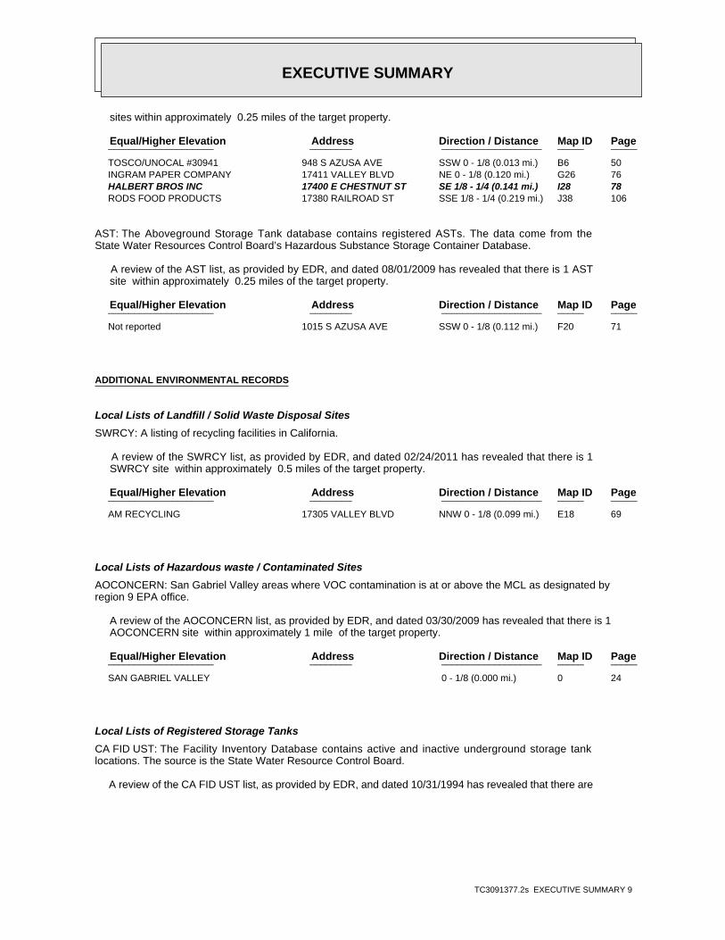
EXECUTIVE SUMMARY
TC3091377.2s EXECUTIVE SUMMARY 9
sites within approximately 0.25 miles of the target property.
PageMap IDDirection / Distance Address Equal/Higher Elevation ____________________ ________ ___________________ _____ _____
TOSCO/UNOCAL #30941 948 S AZUSA AVE SSW 0 - 1/8 (0.013 mi.) B6 50 INGRAM PAPER COMPANY 17411 VALLEY BLVD NE 0 - 1/8 (0.120 mi.) G26 76 HALBERT BROS INC 17400 E CHESTNUT ST SE 1/8 - 1/4 (0.141 mi.) I28 78 RODS FOOD PRODUCTS 17380 RAILROAD ST SSE 1/8 - 1/4 (0.219 mi.) J38 106
AST: The Aboveground Storage Tank database contains registered ASTs. The data come from theState Water Resources Control Board’s Hazardous Substance Storage Container Database.
A review of the AST list, as provided by EDR, and dated 08/01/2009 has revealed that there is 1 AST site within approximately 0.25 miles of the target property.
PageMap IDDirection / Distance Address Equal/Higher Elevation ____________________ ________ ___________________ _____ _____
Not reported 1015 S AZUSA AVE SSW 0 - 1/8 (0.112 mi.) F20 71
ADDITIONAL ENVIRONMENTAL RECORDS
Local Lists of Landfill / Solid Waste Disposal Sites
SWRCY: A listing of recycling facilities in California.
A review of the SWRCY list, as provided by EDR, and dated 02/24/2011 has revealed that there is 1 SWRCY site within approximately 0.5 miles of the target property.
PageMap IDDirection / Distance Address Equal/Higher Elevation ____________________ ________ ___________________ _____ _____
AM RECYCLING 17305 VALLEY BLVD NNW 0 - 1/8 (0.099 mi.) E18 69
Local Lists of Hazardous waste / Contaminated Sites
AOCONCERN: San Gabriel Valley areas where VOC contamination is at or above the MCL as designated byregion 9 EPA office.
A review of the AOCONCERN list, as provided by EDR, and dated 03/30/2009 has revealed that there is 1 AOCONCERN site within approximately 1 mile of the target property.
PageMap IDDirection / Distance Address Equal/Higher Elevation ____________________ ________ ___________________ _____ _____
SAN GABRIEL VALLEY 0 - 1/8 (0.000 mi.) 0 24
Local Lists of Registered Storage Tanks
CA FID UST: The Facility Inventory Database contains active and inactive underground storage tanklocations. The source is the State Water Resource Control Board.
A review of the CA FID UST list, as provided by EDR, and dated 10/31/1994 has revealed that there are

EXECUTIVE SUMMARY
TC3091377.2s EXECUTIVE SUMMARY 10
3 CA FID UST sites within approximately 0.25 miles of the target property.
PageMap IDDirection / Distance Address Equal/Higher Elevation ____________________ ________ ___________________ _____ _____
CARRIER CORPORATION 855 ANAHEIM PUENTE ROAD NW 0 - 1/8 (0.053 mi.) D15 63 INGRAM PAPER 17411 VALLEY BLVD NE 0 - 1/8 (0.116 mi.) G23 73 BAY VALLEY FOODS LLC 17380 RAILROAD ST SSE 1/8 - 1/4 (0.219 mi.) J37 97
HIST UST: Historical UST Registered Database.
A review of the HIST UST list, as provided by EDR, and dated 10/15/1990 has revealed that there are 5 HIST UST sites within approximately 0.25 miles of the target property.
PageMap IDDirection / Distance Address Equal/Higher Elevation ____________________ ________ ___________________ _____ _____
CARRIER CORPORATION 855 ANAHEIM PUENTE ROAD NW 0 - 1/8 (0.053 mi.) D15 63 BDP COMPANY. 855 ANAHEIM PUENTE RD NW 0 - 1/8 (0.053 mi.) D16 67 CHROMALLOY AMERICAN CORPORATIO 17400 CHESTNUT ST SE 1/8 - 1/4 (0.144 mi.) 30 79 M. MUWALLA’S ARCO 17227 VALLEY BLVD NW 1/8 - 1/4 (0.192 mi.) K35 95 ROD’S FOOD PRODUCTS 17380 RAILROAD ST SSE 1/8 - 1/4 (0.219 mi.) J36 96
SWEEPS UST: Statewide Environmental Evaluation and Planning System. This underground storage tanklisting was updated and maintained by a company contacted by the SWRCB in the early 1990’s. The listing is nolonger updated or maintained. The local agency is the contact for more information on a site on the SWEEPSlist.
A review of the SWEEPS UST list, as provided by EDR, and dated 06/01/1994 has revealed that there are 5 SWEEPS UST sites within approximately 0.25 miles of the target property.
PageMap IDDirection / Distance Address Equal/Higher Elevation ____________________ ________ ___________________ _____ _____
CARRIER CORPORATION 855 ANAHEIM PUENTE ROAD NW 0 - 1/8 (0.053 mi.) D15 63 INGRAM PAPER 17411 VALLEY BLVD NE 0 - 1/8 (0.116 mi.) G23 73 HALBERT BROS INC 17400 E CHESTNUT ST SE 1/8 - 1/4 (0.141 mi.) I28 78 LA PUENTE GAS STA & FOOD MART 17227 VALLEY BLVD E NW 1/8 - 1/4 (0.192 mi.) K34 89 BAY VALLEY FOODS LLC 17380 RAILROAD ST SSE 1/8 - 1/4 (0.219 mi.) J37 97
Other Ascertainable Records
ROD: Record of Decision. ROD documents mandate a permanent remedy at an NPL (Superfund) sitecontaining technical and health information to aid the cleanup.
A review of the ROD list, as provided by EDR, and dated 02/25/2011 has revealed that there is 1 ROD site within approximately 1 mile of the target property.
PageMap IDDirection / Distance Address Equal/Higher Elevation ____________________ ________ ___________________ _____ _____
SAN GABRIEL VALLEY (AREA 4) STIMSON AVE & OLD VALLE 0 - 1/8 (0.000 mi.) 0 24
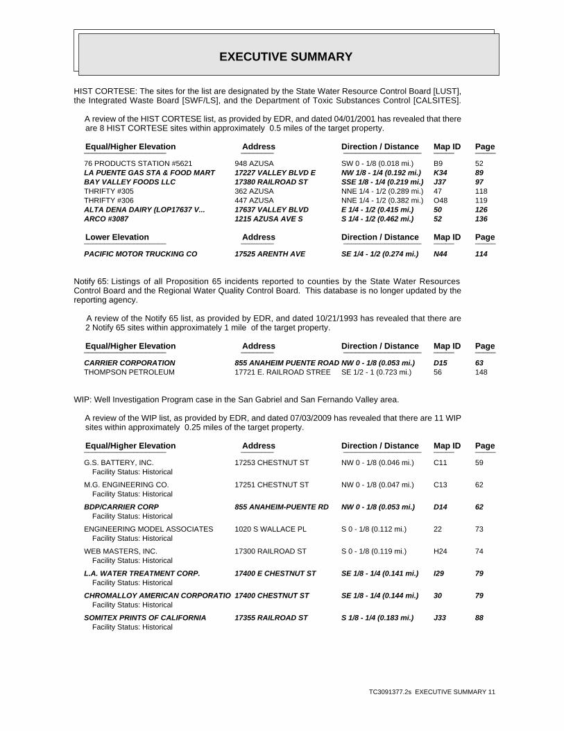
EXECUTIVE SUMMARY
TC3091377.2s EXECUTIVE SUMMARY 11
HIST CORTESE: The sites for the list are designated by the State Water Resource Control Board [LUST],the Integrated Waste Board [SWF/LS], and the Department of Toxic Substances Control [CALSITES].
A review of the HIST CORTESE list, as provided by EDR, and dated 04/01/2001 has revealed that there are 8 HIST CORTESE sites within approximately 0.5 miles of the target property.
PageMap IDDirection / Distance Address Equal/Higher Elevation ____________________ ________ ___________________ _____ _____
76 PRODUCTS STATION #5621 948 AZUSA SW 0 - 1/8 (0.018 mi.) B9 52 LA PUENTE GAS STA & FOOD MART 17227 VALLEY BLVD E NW 1/8 - 1/4 (0.192 mi.) K34 89 BAY VALLEY FOODS LLC 17380 RAILROAD ST SSE 1/8 - 1/4 (0.219 mi.) J37 97 THRIFTY #305 362 AZUSA NNE 1/4 - 1/2 (0.289 mi.) 47 118 THRIFTY #306 447 AZUSA NNE 1/4 - 1/2 (0.382 mi.) O48 119 ALTA DENA DAIRY (LOP17637 V... 17637 VALLEY BLVD E 1/4 - 1/2 (0.415 mi.) 50 126 ARCO #3087 1215 AZUSA AVE S S 1/4 - 1/2 (0.462 mi.) 52 136
PageMap IDDirection / Distance Address Lower Elevation ____________________ ________ ___________________ _____ _____
PACIFIC MOTOR TRUCKING CO 17525 ARENTH AVE SE 1/4 - 1/2 (0.274 mi.) N44 114
Notify 65: Listings of all Proposition 65 incidents reported to counties by the State Water ResourcesControl Board and the Regional Water Quality Control Board. This database is no longer updated by thereporting agency.
A review of the Notify 65 list, as provided by EDR, and dated 10/21/1993 has revealed that there are 2 Notify 65 sites within approximately 1 mile of the target property.
PageMap IDDirection / Distance Address Equal/Higher Elevation ____________________ ________ ___________________ _____ _____
CARRIER CORPORATION 855 ANAHEIM PUENTE ROAD NW 0 - 1/8 (0.053 mi.) D15 63 THOMPSON PETROLEUM 17721 E. RAILROAD STREE SE 1/2 - 1 (0.723 mi.) 56 148
WIP: Well Investigation Program case in the San Gabriel and San Fernando Valley area.
A review of the WIP list, as provided by EDR, and dated 07/03/2009 has revealed that there are 11 WIP sites within approximately 0.25 miles of the target property.
PageMap IDDirection / Distance Address Equal/Higher Elevation ____________________ ________ ___________________ _____ _____
G.S. BATTERY, INC. 17253 CHESTNUT ST NW 0 - 1/8 (0.046 mi.) C11 59Facility Status: Historical
M.G. ENGINEERING CO. 17251 CHESTNUT ST NW 0 - 1/8 (0.047 mi.) C13 62Facility Status: Historical
BDP/CARRIER CORP 855 ANAHEIM-PUENTE RD NW 0 - 1/8 (0.053 mi.) D14 62Facility Status: Historical
ENGINEERING MODEL ASSOCIATES 1020 S WALLACE PL S 0 - 1/8 (0.112 mi.) 22 73Facility Status: Historical
WEB MASTERS, INC. 17300 RAILROAD ST S 0 - 1/8 (0.119 mi.) H24 74Facility Status: Historical
L.A. WATER TREATMENT CORP. 17400 E CHESTNUT ST SE 1/8 - 1/4 (0.141 mi.) I29 79Facility Status: Historical
CHROMALLOY AMERICAN CORPORATIO 17400 CHESTNUT ST SE 1/8 - 1/4 (0.144 mi.) 30 79Facility Status: Historical
SOMITEX PRINTS OF CALIFORNIA 17355 RAILROAD ST S 1/8 - 1/4 (0.183 mi.) J33 88Facility Status: Historical
EXECUTIVE SUMMARY
TC3091377.2s EXECUTIVE SUMMARY 12
PageMap IDDirection / Distance Address Equal/Higher Elevation ____________________ ________ ___________________ _____ _____
ROD’S FOOD PRODUCTS 17380 RAILROAD ST SSE 1/8 - 1/4 (0.219 mi.) J36 96Facility Status: HistoricalFacility Status: Historical
L.A. CROWN INTERNATIONAL CO. 1100 S AZUSA AVE S 1/8 - 1/4 (0.223 mi.) L39 106 RUSSEL STANLEY WEST, INC. 1100 S AZUSA AVE S 1/8 - 1/4 (0.223 mi.) L40 107
HWP: Detailed information on permitted hazardous waste facilities and corrective action("cleanups") tracked in EnviroStor.
A review of the HWP list, as provided by EDR, and dated 08/09/2010 has revealed that there are 2 HWP sites within approximately 1 mile of the target property.
PageMap IDDirection / Distance Address Equal/Higher Elevation ____________________ ________ ___________________ _____ _____
MAXIM LIGHTING INTERNATIONAL 999 S HATCHER AVE ESE 1/4 - 1/2 (0.264 mi.) M42 107 KIM LIGHTING 16555 E GALE AVE W 1/2 - 1 (0.892 mi.) 59 155

EXECUTIVE SUMMARY
TC3091377.2s EXECUTIVE SUMMARY 13
Due to poor or inadequate address information, the following sites were not mapped. Count: 8 records.
Site Name Database(s)____________ ____________
PACIFIC MOTOR TRUCKING, SOUTHERN P CA FID UST, SWEEPS USTSAN GABRIEL RIVER RESPONSE CERCLIS, FINDSECOLAB CERC-NFRAPLA PUENTE DUMP CERC-NFRAPAUTO AND TRUCK ELECTRICAL REPAIR RCRA-SQG, FINDS, HAZNETCEMEX, INC. MINESVULCAN MATERIALS CO. MINESLITHONIA WEST ENVIROSTOR
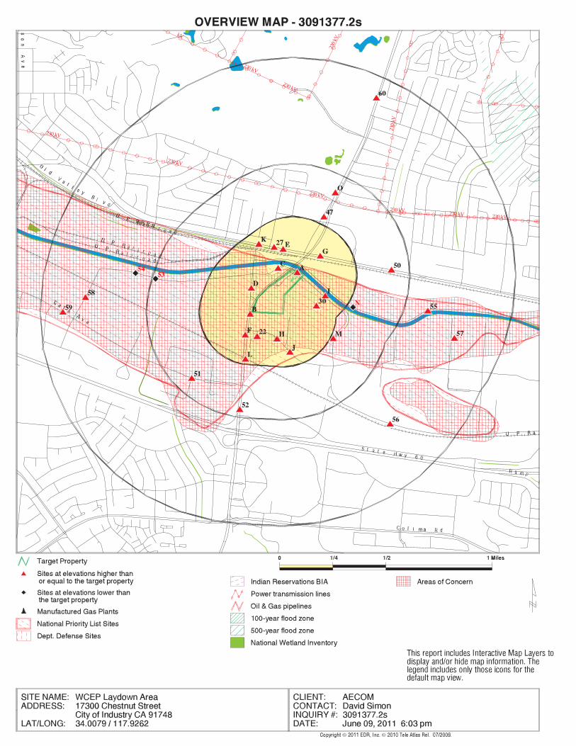
EDR Inc.EDR Inc.EDR Inc.EDR Inc.EDR Inc.EDR Inc.EDR Inc.EDR Inc.EDR Inc.EDR Inc.EDR Inc.EDR Inc.EDR Inc.EDR Inc.EDR Inc.EDR Inc.EDR Inc.EDR Inc.EDR Inc.EDR Inc.EDR Inc.EDR Inc.EDR Inc.EDR Inc.EDR Inc.EDR Inc.EDR Inc.EDR Inc.EDR Inc.EDR Inc.EDR Inc.EDR Inc.EDR Inc.EDR Inc.EDR Inc.EDR Inc.EDR Inc.EDR Inc.EDR Inc.EDR Inc.
230 kV
230
kV
230 kV230 kV
230 kV
230 kV
230 kV
23
230
kV
230 kV
230 kV
kV

EDR Inc.EDR Inc.EDR Inc.EDR Inc.EDR Inc.EDR Inc.EDR Inc.EDR Inc.EDR Inc.EDR Inc.EDR Inc.EDR Inc.EDR Inc.EDR Inc.EDR Inc.EDR Inc.EDR Inc.EDR Inc.EDR Inc.EDR Inc.EDR Inc.EDR Inc.EDR Inc.EDR Inc.EDR Inc.EDR Inc.EDR Inc.EDR Inc.EDR Inc.EDR Inc.EDR Inc.EDR Inc.EDR Inc.EDR Inc.EDR Inc.EDR Inc.EDR Inc.EDR Inc.EDR Inc.EDR Inc.

MAP FINDINGS SUMMARY
SearchTarget Distance Total
Database Property (Miles) < 1/8 1/8 - 1/4 1/4 - 1/2 1/2 - 1 > 1 Plotted
STANDARD ENVIRONMENTAL RECORDS
Federal NPL site list
1 NR 0 0 0 1 1.000NPL 0 NR 0 0 0 0 1.000Proposed NPL 0 NR NR NR NR NR TPNPL LIENS
Federal Delisted NPL site list
0 NR 0 0 0 0 1.000Delisted NPL
Federal CERCLIS list
2 NR NR 0 0 2 0.500CERCLIS 0 NR 0 0 0 0 1.000FEDERAL FACILITY
Federal CERCLIS NFRAP site List
0 NR NR 0 0 0 0.500CERC-NFRAP
Federal RCRA CORRACTS facilities list
0 NR 0 0 0 0 1.000CORRACTS
Federal RCRA non-CORRACTS TSD facilities list
1 NR NR 1 0 0 0.500RCRA-TSDF
Federal RCRA generators list
2 NR NR NR 0 2 0.250RCRA-LQG 7 NR NR NR 3 4 0.250RCRA-SQG 0 NR NR NR 0 0 0.250RCRA-CESQG
Federal institutional controls /engineering controls registries
1 NR NR 0 0 1 0.500US ENG CONTROLS 0 NR NR 0 0 0 0.500US INST CONTROL
Federal ERNS list
0 NR NR NR NR NR TPERNS
State- and tribal - equivalent NPL
0 NR 0 0 0 0 1.000RESPONSE
State- and tribal - equivalent CERCLIS
6 NR 5 0 1 0 1.000ENVIROSTOR
State and tribal landfill and/orsolid waste disposal site lists
1 NR NR 1 0 0 0.500SWF/LF
State and tribal leaking storage tank lists
8 NR NR 4 2 2 0.500LUST 5 NR NR 3 0 2 0.500 XSLIC
TC3091377.2s Page 4

MAP FINDINGS SUMMARY
SearchTarget Distance Total
Database Property (Miles) < 1/8 1/8 - 1/4 1/4 - 1/2 1/2 - 1 > 1 Plotted
0 NR NR 0 0 0 0.500INDIAN LUST
State and tribal registered storage tank lists
4 NR NR NR 2 2 0.250UST 1 NR NR NR 0 1 0.250AST 0 NR NR NR 0 0 0.250INDIAN UST 0 NR NR NR 0 0 0.250FEMA UST
State and tribal voluntary cleanup sites
0 NR NR 0 0 0 0.500VCP 0 NR NR 0 0 0 0.500INDIAN VCP
ADDITIONAL ENVIRONMENTAL RECORDS
Local Brownfield lists
0 NR NR 0 0 0 0.500US BROWNFIELDS
Local Lists of Landfill / SolidWaste Disposal Sites
0 NR NR 0 0 0 0.500ODI 0 NR NR 0 0 0 0.500DEBRIS REGION 9 0 NR NR 0 0 0 0.500WMUDS/SWAT 1 NR NR 0 0 1 0.500SWRCY 0 NR NR NR NR NR TPHAULERS 0 NR NR 0 0 0 0.500INDIAN ODI
Local Lists of Hazardous waste /Contaminated Sites
0 NR NR NR NR NR TPUS CDL 0 NR 0 0 0 0 1.000HIST Cal-Sites 0 NR NR NR 0 0 0.250SCH 0 NR 0 0 0 0 1.000Toxic Pits 1 NR 0 0 0 1 1.000AOCONCERN 0 NR NR NR NR NR TPCDL 0 NR NR NR NR NR TPUS HIST CDL
Local Lists of Registered Storage Tanks
3 NR NR NR 1 2 0.250CA FID UST 5 NR NR NR 3 2 0.250 XHIST UST 5 NR NR NR 3 2 0.250 XSWEEPS UST
Local Land Records
0 NR NR NR NR NR TPLIENS 2 0 NR NR 0 0 0 0.500LUCIS 0 NR NR NR NR NR TPLIENS 0 NR NR 0 0 0 0.500DEED
Records of Emergency Release Reports
0 NR NR NR NR NR TPHMIRS 0 NR NR NR NR NR TPCHMIRS
TC3091377.2s Page 5
MAP FINDINGS SUMMARY
SearchTarget Distance Total
Database Property (Miles) < 1/8 1/8 - 1/4 1/4 - 1/2 1/2 - 1 > 1 Plotted
0 NR NR NR NR NR TPLDS 0 NR NR NR NR NR TPMCS
Other Ascertainable Records
0 NR NR NR 0 0 0.250 XRCRA-NonGen 0 NR NR NR NR NR TPDOT OPS 0 NR 0 0 0 0 1.000DOD 0 NR 0 0 0 0 1.000FUDS 0 NR 0 0 0 0 1.000CONSENT 1 NR 0 0 0 1 1.000ROD 0 NR NR 0 0 0 0.500UMTRA 0 NR NR NR 0 0 0.250MINES 0 NR NR NR NR NR TPTRIS 0 NR NR NR NR NR TPTSCA 0 NR NR NR NR NR TPFTTS 0 NR NR NR NR NR TPHIST FTTS 0 NR NR NR NR NR TPSSTS 0 NR NR NR NR NR TP XICIS 0 NR NR NR NR NR TPPADS 0 NR NR NR NR NR TPMLTS 0 NR NR NR NR NR TPRADINFO 0 NR NR NR NR NR TP XFINDS 0 NR NR NR NR NR TPRAATS 0 NR 0 0 0 0 1.000CA BOND EXP. PLAN 0 NR NR NR NR NR TPNPDES 0 NR NR NR NR NR TP XWDS 0 NR NR 0 0 0 0.500Cortese 8 NR NR 5 2 1 0.500HIST CORTESE 2 NR 1 0 0 1 1.000Notify 65 0 NR NR NR NR NR TPLA Co. Site Mitigation 0 NR NR NR 0 0 0.250DRYCLEANERS 11 NR NR NR 6 5 0.250 XWIP 0 NR NR NR NR NR TP XLOS ANGELES CO. HMS 0 NR NR NR NR NR TP XHAZNET 0 NR NR NR NR NR TP XEMI 0 NR 0 0 0 0 1.000INDIAN RESERV 0 NR NR 0 0 0 0.500SCRD DRYCLEANERS 0 NR NR NR NR NR TPFINANCIAL ASSURANCE 2 NR 1 1 0 0 1.000HWP 0 NR NR NR 0 0 0.250HWT 0 NR NR 0 0 0 0.500COAL ASH EPA 0 NR NR NR NR NR TPPCB TRANSFORMER 0 NR NR 0 0 0 0.500PROC 0 NR NR NR 0 0 0.250MWMP 0 NR NR NR NR NR TPCOAL ASH DOE
EDR PROPRIETARY RECORDS
EDR Proprietary Records
0 NR 0 0 0 0 1.000Manufactured Gas Plants
TC3091377.2s Page 6
MAP FINDINGS SUMMARY
SearchTarget Distance Total
Database Property (Miles) < 1/8 1/8 - 1/4 1/4 - 1/2 1/2 - 1 > 1 Plotted
0 NR NR NR 0 0 0.250EDR Historical Auto Stations 0 NR NR NR 0 0 0.250EDR Historical Cleaners
NOTES:
TP = Target Property
NR = Not Requested at this Search Distance
Sites may be listed in more than one database
TC3091377.2s Page 7

MAP FINDINGSMap IDDirection
EDR ID NumberDistanceEPA ID NumberDatabase(s)SiteElevation
0Part. Matter 10 Micrometers & Smllr Tons/Yr: 0Particulate Matter Tons/Yr: 0SOX - Oxides of Sulphur Tons/Yr: 0NOX - Oxides of Nitrogen Tons/Yr: 0Carbon Monoxide Emissions Tons/Yr: 27Reactive Organic Gases Tons/Yr: 31Total Organic Hydrocarbon Gases Tons/Yr: BConsolidated Emission Reporting Rule: Not reportedCommunity Health Air Pollution Info System: SOUTH COAST AQMDAir District Name: 3715SIC Code: SCAir District Name: 5125Facility ID: SCAir Basin: 19County Code: 2001Year:
EMI:
Site 1 of 5 in cluster A
Actual:362 ft.
Property INDUSTRY, CA 91748Target 17300 E. CHESTNUT ST. N/AA1 EMIUTILITY TRAILER MFG CO. S106841940
PrivateLegal status: (415) 555-1212Owner/operator telephone: Not reportedOwner/operator country: NOT REQUIRED, ME 99999 NOT REQUIREDOwner/operator address: NOT REQUIREDOwner/operator name:
Owner/Operator Summary:
Handler: Non-Generators do not presently generate hazardous wasteDescription: Non-GeneratorClassification: 09EPA Region: Not reportedContact email: Not reportedContact telephone: USContact country: Not reported Not reportedContact address: Not reportedContact: CITY OF INDUSTRY, CA 91749 P O BOX 1299Mailing address: CAD990739252EPA ID: LA PUENTE, CA 91748 17300 E CHESTNUT STREETFacility address: UTILITY TRAILER MFG COFacility name: 09/01/1996Date form received by agency:
RCRA-NonGen:
EMIHAZNET
LOS ANGELES CO. HMSWIP
SWEEPS USTSite 2 of 5 in cluster AHIST UST
Actual:362 ft.
Property WDSLA PUENTE, CA 91748Target FINDS17300 E CHESTNUT STREET CAD990739252A2 RCRA-NonGenUTILITY TRAILER MFG CO 1000287353
TC3091377.2s Page 8
MAP FINDINGSMap IDDirection
EDR ID NumberDistanceEPA ID NumberDatabase(s)SiteElevation
transported off-site.these facilities release directly to air, water, land, or that arefrom facilities on the amounts of over 300 listed toxic chemicals thatUS EPA TRIS (Toxics Release Inventory System) contains information
facilities.generators, transporters, and treatment, storage, and disposalprovides California with information on hazardous waste shipments forCalifornia Hazardous Waste Tracking System - Datamart (HWTS-DATAMART)
their precursors, as well as hazardous air pollutants (HAPs).on stationary and mobile sources that emit criteria air pollutants andThe NEI (National Emissions Inventory) database contains information Environmental Interest/Information System
110001200799Registry ID:
FINDS:
No violations foundViolation Status:
Large Quantity GeneratorClassification: UTILITY TRAILER MFG COFacility name: 04/10/1981Date form received by agency:
Historical Generators:
NoUsed oil transporter: NoUsed oil transfer facility: NoUsed oil Specification marketer: NoUsed oil fuel marketer to burner: NoUser oil refiner: NoUsed oil processor: NoUsed oil fuel burner: NoFurnace exemption: NoOn-site burner exemption: NoUnderground injection activity: NoTreater, storer or disposer of HW: NoTransporter of hazardous waste: NoRecycler of hazardous waste: NoMixed waste (haz. and radioactive): NoU.S. importer of hazardous waste:
Handler Activities Summary:
Not reportedOwner/Op end date: 01/01/0001Owner/Op start date: OperatorOwner/Operator Type: PrivateLegal status: (415) 555-1212Owner/operator telephone: Not reportedOwner/operator country: NOT REQUIRED, ME 99999 NOT REQUIREDOwner/operator address: NOT REQUIREDOwner/operator name:
Not reportedOwner/Op end date: Not reportedOwner/Op start date: OwnerOwner/Operator Type:
UTILITY TRAILER MFG CO (Continued) 1000287353
TC3091377.2s Page 9
MAP FINDINGSMap IDDirection
EDR ID NumberDistanceEPA ID NumberDatabase(s)SiteElevation
Category C - Facilities having no waste treatment systems, such asComplexity: represent no threat to water quality. Level. A Zero (0) may be used to code those NURDS that are found to considered a minor threat to water quality unless coded at a higher to a major or minor threat. Not: All nurds without a TTWQ will be should cause a relatively minor impairment of beneficial uses compared Minor Threat to Water Quality. A violation of a regional board orderTreat To Water: Not reportedPOTW: Not reportedReclamation: 0Baseline Flow: 0Design Flow: Not reportedSecondary Waste Type: Not reportedSecondary Waste: Not reportedPrimary Waste Type: Not reportedPrimary Waste: Not reportedSIC Code 2: 0SIC Code: PrivateAgency Type: Not reportedAgency Telephone: Not reportedAgency Contact: 0Agency City,St,Zip: Not reportedAgency Address: UTILITY TRAILER MANUFACTURINGAgency Name: Not reportedFacility Contact: Not reportedFacility Telephone: 4Subregion: are assigned by the Regional Board CAS000001 The 1st 2 characters designate the state. The remaining 7NPDES Number: under Waste Discharge Requirements. Active - Any facility with a continuous or seasonal discharge that isFacility Status: Industrial, Agricultural or Solid Waste (Class I, II or III) Other - Does not fall into the category of Municipal/Domestic,Facility Type: 4 19I009083Facility ID:
CA WDS:
Incident Tracking, Compliance Assistance, and Compliance Monitoring.that support Compliance and Enforcement programs. These include;has the capability to track other activities occurring in the Regionthat information with Federal actions already in the system. ICIS alsoCompliance System (PCS) which supports the NPDES and will integrateit Headquarters. A future release of ICIS will replace the Permitinformation is maintained in ICIS by EPA in the Regional offices andFederal Administrative and Judicial enforcement actions. Thisa single repository for that information. Currently, ICIS contains allreplace EPA’s independent databases that contain Enforcement data withinformation across most of EPA’s programs. The vision for ICIS is tocomplete, will contain integrated Enforcement and ComplianceCompliance Information System and provides a database that, whenICIS (Integrated Compliance Information System) is the Integrated
corrective action activities required under RCRA.program staff to track the notification, permit, compliance, andand treat, store, or dispose of hazardous waste. RCRAInfo allows RCRAevents and activities related to facilities that generate, transport,Conservation and Recovery Act (RCRA) program through the tracking ofRCRAInfo is a national information system that supports the Resource
UTILITY TRAILER MFG CO (Continued) 1000287353
TC3091377.2s Page 10

MAP FINDINGSMap IDDirection
EDR ID NumberDistanceEPA ID NumberDatabase(s)SiteElevation
013231-013543Facility Id:LARegion:
LOS ANGELES CO. HMS:
Not reportedFacility Suite:AHSUStaff:ActiveFile Status:105.0295File Number:4Region:
WIP:
Not reportedNumber Of Tanks: Not reportedContent: Not reportedStg: Not reportedTank Use: Not reportedCapacity: Not reportedActv Date: Not reportedSwrcb Tank Id: Not reportedOwner Tank Id: Not reportedTank Status: 06-30-89Created Date: Not reportedAct Date: 06-30-89Ref Date: Not reportedBoard Of Equalization: 9Number: 13574Comp Number: AStatus:
SWEEPS UST:
Stock InventorLeak Detection: Not reportedTank Construction: REGULARType of Fuel: PRODUCTTank Used for: 00001000Tank Capacity: 1955Year Installed: 01Container Num: 001Tank Num:
INDUSTRY, CA 91749Owner City,St,Zip: 17300 E. CHESTNUTOwner Address: UTILITY TRAILER MFG. CO.Owner Name: 8189651541Telephone: MFG. FACILITYContact Name: 0001Total Tanks: MFG. FACILITYOther Type: OtherFacility Type: 00000055632Facility ID: STATERegion:
HIST UST:
dairy waste ponds. dischargers having waste storage systems with land disposal such as disposal systems, such as septic systems with subsurface disposal, or management practices, facilities with passive waste treatment and cooling water dischargers or thosewho must comply through best
UTILITY TRAILER MFG CO (Continued) 1000287353
TC3091377.2s Page 11

MAP FINDINGSMap IDDirection
EDR ID NumberDistanceEPA ID NumberDatabase(s)SiteElevation
H01Disposal Method: Latex wasteWaste Category: Los AngelesTSD County: Not reportedTSD EPA ID: Los AngelesGen County: CITY OF INDUSTRY, CA 917491011Mailing City,St,Zip: PO BOX 1299Mailing Address: Not reportedMailing Name: 6269651541Telephone: ROBERT GRIFFIS/CORP EHS MGRContact: CAD990739252Gepaid: 2002Year:
Not reportedFacility County: 0.22Tons: T01Disposal Method: Off-specification, aged or surplus organicsWaste Category: Los AngelesTSD County: Not reportedTSD EPA ID: Los AngelesGen County: CITY OF INDUSTRY, CA 917491011Mailing City,St,Zip: PO BOX 1299Mailing Address: Not reportedMailing Name: 6269651541Telephone: ROBERT GRIFFIS/CORP EHS MGRContact: CAD990739252Gepaid: 2002Year:
Not reportedFacility County: 2.05Tons: H01Disposal Method: Unspecified organic liquid mixtureWaste Category: Los AngelesTSD County: Not reportedTSD EPA ID: Los AngelesGen County: CITY OF INDUSTRY, CA 917491011Mailing City,St,Zip: PO BOX 1299Mailing Address: Not reportedMailing Name: 6269651541Telephone: ROBERT GRIFFIS/CORP EHS MGRContact: CAD990739252Gepaid: 2002Year:
HAZNET:
Not reportedFacility Type:Not reportedPermit Status:Not reportedPermit Number:6HArea:RemovedFacility Status:013256-013574Facility Id:LARegion:
T0Facility Type:RemovedPermit Status:0000T6407Permit Number:6HArea:RemovedFacility Status:
UTILITY TRAILER MFG CO (Continued) 1000287353
TC3091377.2s Page 12
MAP FINDINGSMap IDDirection
EDR ID NumberDistanceEPA ID NumberDatabase(s)SiteElevation
SCAir Basin: 19County Code: 1990Year:
0Part. Matter 10 Micrometers & Smllr Tons/Yr: 0Particulate Matter Tons/Yr: 0SOX - Oxides of Sulphur Tons/Yr: 4NOX - Oxides of Nitrogen Tons/Yr: 3Carbon Monoxide Emissions Tons/Yr: 170Reactive Organic Gases Tons/Yr: 290Total Organic Hydrocarbon Gases Tons/Yr: Not reportedConsolidated Emission Reporting Rule: Not reportedCommunity Health Air Pollution Info System: SOUTH COAST AQMDAir District Name: 3715SIC Code: SCAir District Name: 5125Facility ID: SCAir Basin: 19County Code: 1987Year:
EMI:
25 additional CA_HAZNET: record(s) in the EDR Site Report.Click this hyperlink while viewing on your computer to access
Not reportedFacility County: 2.75Tons: R01Disposal Method: Unspecified organic liquid mixtureWaste Category: Los AngelesTSD County: Not reportedTSD EPA ID: Los AngelesGen County: CITY OF INDUSTRY, CA 917491011Mailing City,St,Zip: PO BOX 1299Mailing Address: Not reportedMailing Name: 6269651541Telephone: ROBERT GRIFFIS/CORP EHS MGRContact: CAD990739252Gepaid: 2001Year:
Not reportedFacility County: 1.25Tons: R01Disposal Method: Unspecified organic liquid mixtureWaste Category: Los AngelesTSD County: Not reportedTSD EPA ID: Los AngelesGen County: CITY OF INDUSTRY, CA 917491011Mailing City,St,Zip: PO BOX 1299Mailing Address: Not reportedMailing Name: 6269651541Telephone: ROBERT GRIFFIS/CORP EHS MGRContact: CAD990739252Gepaid: 2002Year:
Not reportedFacility County: 0.45Tons:
UTILITY TRAILER MFG CO (Continued) 1000287353
TC3091377.2s Page 13

MAP FINDINGSMap IDDirection
EDR ID NumberDistanceEPA ID NumberDatabase(s)SiteElevation
Not reportedConsolidated Emission Reporting Rule: Not reportedCommunity Health Air Pollution Info System: SOUTH COAST AQMDAir District Name: 3715SIC Code: SCAir District Name: 5125Facility ID: SCAir Basin: 19County Code: 1997Year:
0Part. Matter 10 Micrometers & Smllr Tons/Yr: 0Particulate Matter Tons/Yr: 0SOX - Oxides of Sulphur Tons/Yr: 0NOX - Oxides of Nitrogen Tons/Yr: 0Carbon Monoxide Emissions Tons/Yr: 37Reactive Organic Gases Tons/Yr: 47Total Organic Hydrocarbon Gases Tons/Yr: Not reportedConsolidated Emission Reporting Rule: Not reportedCommunity Health Air Pollution Info System: SOUTH COAST AQMDAir District Name: 3715SIC Code: SCAir District Name: 5125Facility ID: SCAir Basin: 19County Code: 1996Year:
0Part. Matter 10 Micrometers & Smllr Tons/Yr: 0Particulate Matter Tons/Yr: 0SOX - Oxides of Sulphur Tons/Yr: 1NOX - Oxides of Nitrogen Tons/Yr: 0Carbon Monoxide Emissions Tons/Yr: 31Reactive Organic Gases Tons/Yr: 41Total Organic Hydrocarbon Gases Tons/Yr: Not reportedConsolidated Emission Reporting Rule: Not reportedCommunity Health Air Pollution Info System: SOUTH COAST AQMDAir District Name: 3715SIC Code: SCAir District Name: 5125Facility ID: SCAir Basin: 19County Code: 1995Year:
0Part. Matter 10 Micrometers & Smllr Tons/Yr: 0Particulate Matter Tons/Yr: 0SOX - Oxides of Sulphur Tons/Yr: 2NOX - Oxides of Nitrogen Tons/Yr: 2Carbon Monoxide Emissions Tons/Yr: 64Reactive Organic Gases Tons/Yr: 154Total Organic Hydrocarbon Gases Tons/Yr: Not reportedConsolidated Emission Reporting Rule: Not reportedCommunity Health Air Pollution Info System: SOUTH COAST AQMDAir District Name: 3715SIC Code: SCAir District Name: 5125Facility ID:
UTILITY TRAILER MFG CO (Continued) 1000287353
TC3091377.2s Page 14
MAP FINDINGSMap IDDirection
EDR ID NumberDistanceEPA ID NumberDatabase(s)SiteElevation
0Particulate Matter Tons/Yr: 0SOX - Oxides of Sulphur Tons/Yr: 0NOX - Oxides of Nitrogen Tons/Yr: 0Carbon Monoxide Emissions Tons/Yr: 20Reactive Organic Gases Tons/Yr: 23Total Organic Hydrocarbon Gases Tons/Yr: Not reportedConsolidated Emission Reporting Rule: Not reportedCommunity Health Air Pollution Info System: SOUTH COAST AQMDAir District Name: 3715SIC Code: SCAir District Name: 5125Facility ID: SCAir Basin: 19County Code: 2000Year:
0Part. Matter 10 Micrometers & Smllr Tons/Yr: 0Particulate Matter Tons/Yr: 0SOX - Oxides of Sulphur Tons/Yr: 0NOX - Oxides of Nitrogen Tons/Yr: 0Carbon Monoxide Emissions Tons/Yr: 20Reactive Organic Gases Tons/Yr: 23Total Organic Hydrocarbon Gases Tons/Yr: Not reportedConsolidated Emission Reporting Rule: Not reportedCommunity Health Air Pollution Info System: SOUTH COAST AQMDAir District Name: 3715SIC Code: SCAir District Name: 5125Facility ID: SCAir Basin: 19County Code: 1999Year:
0Part. Matter 10 Micrometers & Smllr Tons/Yr: 0Particulate Matter Tons/Yr: 0SOX - Oxides of Sulphur Tons/Yr: 0NOX - Oxides of Nitrogen Tons/Yr: 0Carbon Monoxide Emissions Tons/Yr: 20Reactive Organic Gases Tons/Yr: 23Total Organic Hydrocarbon Gases Tons/Yr: Not reportedConsolidated Emission Reporting Rule: Not reportedCommunity Health Air Pollution Info System: SOUTH COAST AQMDAir District Name: 3715SIC Code: SCAir District Name: 5125Facility ID: SCAir Basin: 19County Code: 1998Year:
0Part. Matter 10 Micrometers & Smllr Tons/Yr: 0Particulate Matter Tons/Yr: 0SOX - Oxides of Sulphur Tons/Yr: 0NOX - Oxides of Nitrogen Tons/Yr: 0Carbon Monoxide Emissions Tons/Yr: 20Reactive Organic Gases Tons/Yr: 23Total Organic Hydrocarbon Gases Tons/Yr:
UTILITY TRAILER MFG CO (Continued) 1000287353
TC3091377.2s Page 15
MAP FINDINGSMap IDDirection
EDR ID NumberDistanceEPA ID NumberDatabase(s)SiteElevation
0Part. Matter 10 Micrometers & Smllr Tons/Yr:
UTILITY TRAILER MFG CO (Continued) 1000287353
6263331488Telephone: KEVIN RADEKIContact: CAC002579587Gepaid: 2004Year:
Not reportedFacility County: 0Tons: H01Disposal Method: Off-specification, aged or surplus inorganicsWaste Category: Los AngelesTSD County: CAD008364432TSD EPA ID: Los AngelesGen County: CITY OF INDUSTRY, CA 91744Mailing City,St,Zip: 15651 E STAFFORD STMailing Address: Not reportedMailing Name: 6263331488Telephone: KEVIN RADEKIContact: CAC002579587Gepaid: 2005Year:
Los AngelesFacility County: 0.84Tons: Not reportedDisposal Method: Asbestos containing wasteWaste Category: 99TSD County: AZC950823111TSD EPA ID: Los AngelesGen County: CITY OF INDUSTRY, CA 91744Mailing City,St,Zip: 15651 E STAFFORD STMailing Address: Not reportedMailing Name: 6263331488Telephone: KEVIN RADEKIContact: CAC002579587Gepaid: 2006Year:
Los AngelesFacility County: 0.8Tons: Not reportedDisposal Method: Asbestos containing wasteWaste Category: 99TSD County: AZC950823111TSD EPA ID: Los AngelesGen County: CITY OF INDUSTRY, CA 91744Mailing City,St,Zip: 15651 E STAFFORD STMailing Address: Not reportedMailing Name: 6263331488Telephone: KEVIN RADEKIContact: CAC002579587Gepaid: 2007Year:
HAZNET:
Site 3 of 5 in cluster A
Actual:362 ft.
Property CITY OF INDUSTRY, CA 91748Target 17300 CHESTNUT ST N/AA3 HAZNETINDUSTRY IRBAN DEVELOPMENT S108209427
TC3091377.2s Page 16
MAP FINDINGSMap IDDirection
EDR ID NumberDistanceEPA ID NumberDatabase(s)SiteElevation
Not reportedFacility County: 0Tons: H01Disposal Method: Off-specification, aged or surplus inorganicsWaste Category: Los AngelesTSD County: CAD008364432TSD EPA ID: Los AngelesGen County: CITY OF INDUSTRY, CA 91744Mailing City,St,Zip: 15651 E STAFFORD STMailing Address: Not reportedMailing Name:
INDUSTRY IRBAN DEVELOPMENT (Continued) S108209427
CITY OF INDUSTRY, California 91748 17300 CHESTNUT STREET CITY OF INDUSTRY CA 91748Facility Address: UTILITY TRAILER MFG COFacility Name: SAN GABRIEL / PUENTE VALLEY (LIEN RELEASE)Action Name: RCRAINFO CAD990739252Program ID: 110001200799FRS ID: 09-2003-0224Enforcement Action ID:
10EPA Region #: Los AngelesFacility County: CERCLA 122h Agrmt For Cost RecoveryEnforcement Action Type: CITY OF INDUSTRY, California 91748 17300 CHESTNUT STREET CITY OF INDUSTRY CA 91748Facility Address: UTILITY TRAILER MFG. CO.Facility Name: SAN GABRIEL / PUENTE VALLEY (LIEN RELEASE)Action Name: TRIS 91748TLTYT17300Program ID: 110001200799FRS ID: 09-2003-0224Enforcement Action ID:
10EPA Region #: Los AngelesFacility County: CERCLA 122h Agrmt For Cost RecoveryEnforcement Action Type: CITY OF INDUSTRY, California 91748 17300 CHESTNUT STREET CITY OF INDUSTRY CA 91748Facility Address: UTILITY TRAILER MANUFACTURINGFacility Name: SAN GABRIEL / PUENTE VALLEY (LIEN RELEASE)Action Name: FRS 110001200799Program ID: 110001200799FRS ID: 09-2003-0224Enforcement Action ID:
10EPA Region #: Los AngelesFacility County: CERCLA 122h Agrmt For Cost RecoveryEnforcement Action Type: CITY OF INDUSTRY, California 91748 17300 CHESTNUT STREET CITY OF INDUSTRY CA 91748Facility Address: UTILITY TRAILER MFG COFacility Name: SAN GABRIEL / PUENTE VALLEY (LIEN RELEASE)Action Name: EIS 1317211Program ID: 110001200799FRS ID: 09-2003-0224Enforcement Action ID:
ICIS:
Site 4 of 5 in cluster A
Actual:362 ft.
Property CITY OF INDUSTRY, CA 91748Target 17300 CHESTNUT STREET CITY OF INDUSTRY CA 91748 N/AA4 ICISUTILITY TRAILER MFG. CO. 1011591523
TC3091377.2s Page 17
MAP FINDINGSMap IDDirection
EDR ID NumberDistanceEPA ID NumberDatabase(s)SiteElevation
Los AngelesFacility County: Civil Judicial ActionEnforcement Action Type: CITY OF INDUSTRY, California 91748 17300 CHESTNUT STREET CITY OF INDUSTRY CA 91748Facility Address: UTILITY TRAILER MANUFACTURINGFacility Name: UTILITY TRAILER MANUFACTURING COMPANYAction Name: FRS 110001200799Program ID: 110001200799FRS ID: 09-1986-0004Enforcement Action ID:
10EPA Region #: Los AngelesFacility County: Civil Judicial ActionEnforcement Action Type: CITY OF INDUSTRY, California 91748 17300 CHESTNUT STREET CITY OF INDUSTRY CA 91748Facility Address: Not reportedFacility Name: UTILITY TRAILER MANUFACTURING COMPANYAction Name: NEI NEI21504Program ID: 110001200799FRS ID: 09-1986-0004Enforcement Action ID:
10EPA Region #: Los AngelesFacility County: CERCLA 122h Agrmt For Cost RecoveryEnforcement Action Type: CITY OF INDUSTRY, California 91748 17300 CHESTNUT STREET CITY OF INDUSTRY CA 91748Facility Address: Not reportedFacility Name: SAN GABRIEL / PUENTE VALLEY (LIEN RELEASE)Action Name: NEI NEI21504Program ID: 110001200799FRS ID: 09-2003-0224Enforcement Action ID:
10EPA Region #: Los AngelesFacility County: CERCLA 122h Agrmt For Cost RecoveryEnforcement Action Type: CITY OF INDUSTRY, California 91748 17300 CHESTNUT STREET CITY OF INDUSTRY CA 91748Facility Address: UTILITY TRAILER MANUFACTURING COMPANYFacility Name: SAN GABRIEL / PUENTE VALLEY (LIEN RELEASE)Action Name: HWTS-DATAMART CAD990739252Program ID: 110001200799FRS ID: 09-2003-0224Enforcement Action ID:
10EPA Region #: Los AngelesFacility County: CERCLA 122h Agrmt For Cost RecoveryEnforcement Action Type: CITY OF INDUSTRY, California 91748 17300 CHESTNUT STREET CITY OF INDUSTRY CA 91748Facility Address: UTILITY TRAILER MFG COFacility Name: SAN GABRIEL / PUENTE VALLEY (LIEN RELEASE)Action Name: NEI NTI21504Program ID: 110001200799FRS ID: 09-2003-0224Enforcement Action ID:
10EPA Region #: Los AngelesFacility County: CERCLA 122h Agrmt For Cost RecoveryEnforcement Action Type:
UTILITY TRAILER MFG. CO. (Continued) 1011591523
TC3091377.2s Page 18

MAP FINDINGSMap IDDirection
EDR ID NumberDistanceEPA ID NumberDatabase(s)SiteElevation
10EPA Region #: Los AngelesFacility County: Civil Judicial ActionEnforcement Action Type: CITY OF INDUSTRY, California 91748 17300 CHESTNUT STREET CITY OF INDUSTRY CA 91748Facility Address: UTILITY TRAILER MFG. CO.Facility Name: UTILITY TRAILER MANUFACTURING COMPANYAction Name: TRIS 91748TLTYT17300Program ID: 110001200799FRS ID: 09-1986-0004Enforcement Action ID:
10EPA Region #: Los AngelesFacility County: Civil Judicial ActionEnforcement Action Type: CITY OF INDUSTRY, California 91748 17300 CHESTNUT STREET CITY OF INDUSTRY CA 91748Facility Address: UTILITY TRAILER MFG COFacility Name: UTILITY TRAILER MANUFACTURING COMPANYAction Name: RCRAINFO CAD990739252Program ID: 110001200799FRS ID: 09-1986-0004Enforcement Action ID:
10EPA Region #: Los AngelesFacility County: Civil Judicial ActionEnforcement Action Type: CITY OF INDUSTRY, California 91748 17300 CHESTNUT STREET CITY OF INDUSTRY CA 91748Facility Address: UTILITY TRAILER MFG COFacility Name: UTILITY TRAILER MANUFACTURING COMPANYAction Name: NEI NTI21504Program ID: 110001200799FRS ID: 09-1986-0004Enforcement Action ID:
10EPA Region #: Los AngelesFacility County: Civil Judicial ActionEnforcement Action Type: CITY OF INDUSTRY, California 91748 17300 CHESTNUT STREET CITY OF INDUSTRY CA 91748Facility Address: UTILITY TRAILER MFG COFacility Name: UTILITY TRAILER MANUFACTURING COMPANYAction Name: EIS 1317211Program ID: 110001200799FRS ID: 09-1986-0004Enforcement Action ID:
10EPA Region #: Los AngelesFacility County: Civil Judicial ActionEnforcement Action Type: CITY OF INDUSTRY, California 91748 17300 CHESTNUT STREET CITY OF INDUSTRY CA 91748Facility Address: UTILITY TRAILER MANUFACTURING COMPANYFacility Name: UTILITY TRAILER MANUFACTURING COMPANYAction Name: HWTS-DATAMART CAD990739252Program ID: 110001200799FRS ID: 09-1986-0004Enforcement Action ID:
10EPA Region #:
UTILITY TRAILER MFG. CO. (Continued) 1011591523
TC3091377.2s Page 19
MAP FINDINGSMap IDDirection
EDR ID NumberDistanceEPA ID NumberDatabase(s)SiteElevation
NEI NEI21504Program ID:
3715SIC Code: Not reportedNAIC Code: NoFed Facility: NTribal Indicator: 17300 CHESTNUT STREETAddress: UTILITY TRAILER MANUFACTURINGFacility Name: NEI NEI21504Program ID:
4225SIC Code: Not reportedNAIC Code: NoFed Facility: NTribal Indicator: 17300 CHESTNUT STREETAddress: UTILITY TRAILER MANUFACTURINGFacility Name: HWTS-DATAMART CAD990739252Program ID:
3715SIC Code: Not reportedNAIC Code: NoFed Facility: NTribal Indicator: 17300 CHESTNUT STREETAddress: UTILITY TRAILER MANUFACTURINGFacility Name: HWTS-DATAMART CAD990739252Program ID:
4225SIC Code: Not reportedNAIC Code: NoFed Facility: NTribal Indicator: 17300 CHESTNUT STREETAddress: UTILITY TRAILER MANUFACTURINGFacility Name: FRS 110001200799Program ID:
3715SIC Code: Not reportedNAIC Code: NoFed Facility: NTribal Indicator: 17300 CHESTNUT STREETAddress: UTILITY TRAILER MANUFACTURINGFacility Name: FRS 110001200799Program ID:
4225SIC Code: Not reportedNAIC Code: NoFed Facility: NTribal Indicator: 17300 CHESTNUT STREETAddress: UTILITY TRAILER MANUFACTURINGFacility Name: EIS 1317211Program ID:
3715SIC Code: Not reportedNAIC Code: NoFed Facility: NTribal Indicator: 17300 CHESTNUT STREETAddress: UTILITY TRAILER MANUFACTURINGFacility Name: EIS 1317211Program ID:
UTILITY TRAILER MFG. CO. (Continued) 1011591523
TC3091377.2s Page 20
MAP FINDINGSMap IDDirection
EDR ID NumberDistanceEPA ID NumberDatabase(s)SiteElevation
UTILITY TRAILER MANUFACTURINGFacility Name: EIS 1317211Program ID:
4225SIC Code: Not reportedNAIC Code: NoFed Facility: NTribal Indicator: 17300 CHESTNUT STREETAddress: UTILITY TRAILER MANUFACTURINGFacility Name: TRIS 91748TLTYT17300Program ID:
3715SIC Code: Not reportedNAIC Code: NoFed Facility: NTribal Indicator: 17300 CHESTNUT STREETAddress: UTILITY TRAILER MANUFACTURINGFacility Name: TRIS 91748TLTYT17300Program ID:
4225SIC Code: Not reportedNAIC Code: NoFed Facility: NTribal Indicator: 17300 CHESTNUT STREETAddress: UTILITY TRAILER MANUFACTURINGFacility Name: RCRAINFO CAD990739252Program ID:
3715SIC Code: Not reportedNAIC Code: NoFed Facility: NTribal Indicator: 17300 CHESTNUT STREETAddress: UTILITY TRAILER MANUFACTURINGFacility Name: RCRAINFO CAD990739252Program ID:
4225SIC Code: Not reportedNAIC Code: NoFed Facility: NTribal Indicator: 17300 CHESTNUT STREETAddress: UTILITY TRAILER MANUFACTURINGFacility Name: NEI NTI21504Program ID:
3715SIC Code: Not reportedNAIC Code: NoFed Facility: NTribal Indicator: 17300 CHESTNUT STREETAddress: UTILITY TRAILER MANUFACTURINGFacility Name: NEI NTI21504Program ID:
4225SIC Code: Not reportedNAIC Code: NoFed Facility: NTribal Indicator: 17300 CHESTNUT STREETAddress: UTILITY TRAILER MANUFACTURINGFacility Name:
UTILITY TRAILER MFG. CO. (Continued) 1011591523
TC3091377.2s Page 21
MAP FINDINGSMap IDDirection
EDR ID NumberDistanceEPA ID NumberDatabase(s)SiteElevation
17300 CHESTNUT STREETAddress: UTILITY TRAILER MANUFACTURINGFacility Name: NEI NEI21504Program ID:
3715SIC Code: Not reportedNAIC Code: NoFed Facility: NTribal Indicator: 17300 CHESTNUT STREETAddress: UTILITY TRAILER MANUFACTURINGFacility Name: NEI NEI21504Program ID:
4225SIC Code: Not reportedNAIC Code: NoFed Facility: NTribal Indicator: 17300 CHESTNUT STREETAddress: UTILITY TRAILER MANUFACTURINGFacility Name: HWTS-DATAMART CAD990739252Program ID:
3715SIC Code: Not reportedNAIC Code: NoFed Facility: NTribal Indicator: 17300 CHESTNUT STREETAddress: UTILITY TRAILER MANUFACTURINGFacility Name: HWTS-DATAMART CAD990739252Program ID:
4225SIC Code: Not reportedNAIC Code: NoFed Facility: NTribal Indicator: 17300 CHESTNUT STREETAddress: UTILITY TRAILER MANUFACTURINGFacility Name: FRS 110001200799Program ID:
3715SIC Code: Not reportedNAIC Code: NoFed Facility: NTribal Indicator: 17300 CHESTNUT STREETAddress: UTILITY TRAILER MANUFACTURINGFacility Name: FRS 110001200799Program ID:
4225SIC Code: Not reportedNAIC Code: NoFed Facility: NTribal Indicator: 17300 CHESTNUT STREETAddress: UTILITY TRAILER MANUFACTURINGFacility Name: EIS 1317211Program ID:
3715SIC Code: Not reportedNAIC Code: NoFed Facility: NTribal Indicator: 17300 CHESTNUT STREETAddress:
UTILITY TRAILER MFG. CO. (Continued) 1011591523
TC3091377.2s Page 22

MAP FINDINGSMap IDDirection
EDR ID NumberDistanceEPA ID NumberDatabase(s)SiteElevation
4225SIC Code: Not reportedNAIC Code: NoFed Facility: NTribal Indicator: 17300 CHESTNUT STREETAddress: UTILITY TRAILER MANUFACTURINGFacility Name: TRIS 91748TLTYT17300Program ID:
3715SIC Code: Not reportedNAIC Code: NoFed Facility: NTribal Indicator: 17300 CHESTNUT STREETAddress: UTILITY TRAILER MANUFACTURINGFacility Name: TRIS 91748TLTYT17300Program ID:
4225SIC Code: Not reportedNAIC Code: NoFed Facility: NTribal Indicator: 17300 CHESTNUT STREETAddress: UTILITY TRAILER MANUFACTURINGFacility Name: RCRAINFO CAD990739252Program ID:
3715SIC Code: Not reportedNAIC Code: NoFed Facility: NTribal Indicator: 17300 CHESTNUT STREETAddress: UTILITY TRAILER MANUFACTURINGFacility Name: RCRAINFO CAD990739252Program ID:
4225SIC Code: Not reportedNAIC Code: NoFed Facility: NTribal Indicator: 17300 CHESTNUT STREETAddress: UTILITY TRAILER MANUFACTURINGFacility Name: NEI NTI21504Program ID:
3715SIC Code: Not reportedNAIC Code: NoFed Facility: NTribal Indicator: 17300 CHESTNUT STREETAddress: UTILITY TRAILER MANUFACTURINGFacility Name: NEI NTI21504Program ID:
4225SIC Code: Not reportedNAIC Code: NoFed Facility: NTribal Indicator:
UTILITY TRAILER MFG. CO. (Continued) 1011591523
TC3091377.2s Page 23
MAP FINDINGSMap IDDirection
EDR ID NumberDistanceEPA ID NumberDatabase(s)SiteElevation
Click here to access the California GeoTracker records for this facility:
Not reportedSite History: Not reportedPotential Contaminants of Concern: Aquifer used for drinking water supplyPotential Media Affected: Not reportedFile Location: 105.0295RB Case Number: Not reportedLocal Agency: AHSCase Worker: Cleanup Program SiteCase Type: -117.926113Longitude: 34.005165Latitude: Not reportedLead Agency Case Number: LOS ANGELES RWQCB (REGION 4)Lead Agency: SL603798673Global Id: 2002-06-30 00:00:00Status Date: Open - Site AssessmentFacility Status: STATERegion:
SLIC:
Site 5 of 5 in cluster A
Actual:362 ft.
Property CITY OF INDUSTRY, CA 91749Target 17300 E. CHESTNUT ST. N/AA5 SLICUTILITY TRAILOR MFG. CO. S106484495
area where VOC contamination is at or above the MCL as designated by region 9 EPA officeAOCONCERN:
1 ft.< 1/8
LOS ANGELES (County), CA Concern N/AAreas of AOCONCERNSAN GABRIEL VALLEY CCA0000001
10Category Value: Distance To Nearest Population-> 0 And <= 1/4 MileCategory Description: Currently on the Final NPLNPL Status:
1Category Value: Depth To Aquifer-<= 10 FeetCategory Description: Currently on the Final NPLNPL Status:
Category Details:
5/8/1984Final Date: NFederal: 09EPA Region: CAD980817985EPA ID:
NPL:
1 ft. FINDS< 1/8 ROD
US ENG CONTROLSLA PUENTE, CA 91744Region CERCLISSTIMSON AVE & OLD VALLEY BLVD CAD980817985NPL NPLSAN GABRIEL VALLEY (AREA 4) 1000114960
TC3091377.2s Page 24

MAP FINDINGSMap IDDirection
EDR ID NumberDistanceEPA ID NumberDatabase(s)SiteElevation
tothe NPL in May 1984 because it involves a serious problem that requiredThis site, along with the three other San Gabriel Valley sites, was addedEPA continues its investigation to identify sources of the contamination.and to develop alternatives for treatment and management of the problem.feasibility study to determine the aerial and vertical extent of contaminationHealth Services and EPA are preparing to initiate a remedial investigation/snapshot view of the degree of contamination. The State Department ofA supplemental sampling program of contaminated wells will begin soon to get aare not effective, wells are removed from service. Status June 1984):consumption. When alternative methods of reducing the TCE level below 5 ppbless than 5 parts per billion ppb) of TCE, alevel considered safe for humancompanies in the area have tested to ensure that their water supplies containand PCE. Approximately 100,000 people are affected. Cities and public waterthe area exceed the EPA SuggestedNo Adverse Response Levels SNARL) for TCEanalyses by State agencies and local water companies. Many public wells inwith trichloroethylene TCE) and perchloroethylene PCE), according toplume is about1 mile long and 1 mile wide. Ground water is contaminatedGabriel ground water basin in La Puenta, Los Angeles County, California. Theground water plume that runs along the axis of the San Jose Creek in the SanConditions at listing September 1983): San Gabriel Valley Area 4) is a
Summary Details:
4Scoring: GROUND WATER PATHWAYPathway: 79-01-6CAS #: TRICHLOROETHYLENE (TCE)Substance: U228Substance ID: Currently on the Final NPLNPL Status:
4Scoring: GROUND WATER PATHWAYPathway: 127-18-4CAS #: TETRACHLOROETHENESubstance: U210Substance ID: Currently on the Final NPLNPL Status:
Not reportedScoring: Not reportedPathway: Not reportedCAS #: Not reportedSubstance: Not reportedSubstance ID: Currently on the Final NPLNPL Status:
Substance Details:
05/08/84Date Finalized: Not reportedDate Deleted: 09/08/83Date Proposed: 09EPA Region: LOS ANGELESSite County: NoFederal Site: CASite State: LA PUENTESite City: 91744Site Zip: FinalSite Status: SAN GABRIEL VALLEY (AREA 4)Site Name:
Site Details:
SAN GABRIEL VALLEY (AREA 4) (Continued) 1000114960
TC3091377.2s Page 25
MAP FINDINGSMap IDDirection
EDR ID NumberDistanceEPA ID NumberDatabase(s)SiteElevation
Jeff InglisContact Name: 9270048.00000Contact ID:
Not reportedContact Email: Site Assessment Manager (SAM)Contact Title: (415) 972-3219Contact Tel: Karen JuristContact Name: 9271184.00000Contact ID:
CERCLIS Site Contact Name(s):
Not reportedSite FUDS Flag: Not reportedAlias EPA ID: Not reportedCC Concurrence FY: Not reportedCC Concurrence Date: 06037Site Fips Code: Not reportedNon NPL Status Date: Not reportedNon NPL Status: Not reportedRResp Fed Agency Code: Not reportedRBRAC Code: SQMIDMNSN Unit Code: Currently on the Final NPLNPL Status: SUSite Settings Code: GroundwaterClassification: 09EPA Region: Not reportedRST Code: Not reportedParent ID: Not reportedNFRAP Flag: Not reportedSite Init By Prog: Not reportedUSGS Quadrangle: Not reportedRCRA ID: NSite Orphan Flag: 30.00000DMNSN Number: Not a Federal FacilityFederal Facility: 18070106USGC Hydro Unit: 4480SMSA Number: 092CIFMS ID: 34Congressional District: SAN GABRIEL VALLEY (AREAShort Name: LOS ANGELESFacility County: CAD980817985EPA ID: 0902091Site ID:
CERCLIS:
CAState: LA PUENTECity: SAN GABRIEL VALLEY (AREA 4)NPL Name:
Narratives Details:
Not reportedDeleted Date: 05/08/1984Final Date: 09/08/1983Proposed Date: FinalNPL Status:
Site Status Details:
taking immediate remedial action.
SAN GABRIEL VALLEY (AREA 4) (Continued) 1000114960
TC3091377.2s Page 26

MAP FINDINGSMap IDDirection
EDR ID NumberDistanceEPA ID NumberDatabase(s)SiteElevation
make a unified offer for all of the work (i.e., shallow zone and intermediatewas signed, and Special Notice letters were sent out, the PRPs were unable tothe Baldwin Park OU, EPA issued a ROD in March 1993. After the Interim RODrespective OUs. EPA also issued UAOs to two parties in the El Monte OU. InSouth El Monte OUs have entered into AOCs to perform the RI/FS for theirPVSC and EPA completed the RI/FS in May 1997. PRPs in the EL Monte andCorporation completed the activities that the UAO required in 1996, and theDiversey Corporation, that failed to present a good faith offer. Diverseyunilateral administrative order (UAO) to two PRPs, Goe Engineering and(AOC) with EPA to conduct the RI/FS. Also in September 1993, EPA issued a(PVSC), and in September 1993 entered into an administrative order on consentPVOU. Forty-two of these PRPs formed the Puente Valley Steering Committeeoffer to perform the remedial investigation/feasibility study (RI/FS) for theresponsible parties (PRPs), requesting that these parties present a good faiththe basin. In May 1993, EPA sent Special Notice letters to 58 potentiallyhydrogeology and contaminant distribution, and planning remedial activities inbasin into eight operable units (OUs) to provide a means of describingAgency’s (EPA’s) National Priorities List (NPL). EPA subsequently divided thewere listed as San Gabriel Areas 1 through 4 on the Environmental Protectionidentified. In May 1984, four broad areas of contamination within the basingroundwater contaminated with volatile organic compounds (VOCs) was firstValley has been the subject of environmental investigation since 1979 whensite includes industrial, commercial, and residential. The San Gabrielpurveyors that are regulated as public water supply systems. Land use at theSan Gabriel Basin is used for drinking water, supplied to the public bythe San Gabriel Basin. The majority of the groundwater pumped from the mainCoast, in eastern Los Angeles County. Located within the San Gabriel Valley isportion of the San Gabriel Valley, approximately 25 miles from the PacificThe Puente Valley Operable Unit (PVOU) is located within the southeasternSite Description: Not reportedAlias Comments: LA PUENTE, CA 91744 STIMSON AVE & OLD VALLEY BLVDAlias Address: SAN GABRIEL VALLEY (AREA 4)Alias Name: 101Alias ID:
CERCLIS Site Alias Name(s):
Not reportedContact Email: Site Assessment Manager (SAM)Contact Title: (415) 972-3097Contact Tel: Dawn RichmondContact Name: 9270438.00000Contact ID:
Not reportedContact Email: Site Assessment Manager (SAM)Contact Title: (415) 972-3814Contact Tel: Carl BricknerContact Name: 13002167.00000Contact ID:
Not reportedContact Email: Remedial Project Manager (RPM)Contact Title: (415) 947-4218Contact Tel: Raymond ChaviraContact Name: 13001930.00000Contact ID:
Not reportedContact Email: Site Assessment Manager (SAM)Contact Title: (415) 972-3095Contact Tel:
SAN GABRIEL VALLEY (AREA 4) (Continued) 1000114960
TC3091377.2s Page 27
MAP FINDINGSMap IDDirection
EDR ID NumberDistanceEPA ID NumberDatabase(s)SiteElevation
Not reportedPlanning Status: State, Fund FinancedPrimary Responsibility: SITEWIDEOperable Unit: Higher priority for further assessmentPriority Level: 09/01/1983Date Completed: 03/01/1983Date Started: SITE INSPECTIONAction: 001Action Code:
For detailed financial records, contact EDR for a Site Report.:
Not reportedAction Anomaly: Not reportedUrgency Indicator: Not reportedPlanning Status: EPA Fund-FinancedPrimary Responsibility: SITEWIDEOperable Unit: Higher priority for further assessmentPriority Level: 09/01/1983Date Completed: 03/01/1983Date Started: SITE INSPECTIONAction: 002Action Code:
For detailed financial records, contact EDR for a Site Report.:
Not reportedAction Anomaly: Not reportedUrgency Indicator: Not reportedPlanning Status: Federal EnforcementPrimary Responsibility: SITEWIDEOperable Unit: Not reportedPriority Level: 08/01/1983Date Completed: Not reportedDate Started: ISSUE REQUEST LETTERS (104E)Action: 001Action Code:
For detailed financial records, contact EDR for a Site Report.:
Not reportedAction Anomaly: Not reportedUrgency Indicator: Not reportedPlanning Status: State, No Fund MoneyPrimary Responsibility: SITEWIDEOperable Unit: Not reportedPriority Level: 04/01/1980Date Completed: Not reportedDate Started: DISCOVERYAction: 001Action Code:
CERCLIS Assessment History:
and 1,4-dioxane at OU 1 was completed on June 14, 2005.Significant Differences (ESD) addressing the emerging contaminants perchloratewould be conducted by two different PRP groups or parties. An Explanation ofimplementation of the remedy such that the intermediate and shallow zone workprocess moving forward as expeditiously as possible, EPA carved outzone cleanup, and Mid-Valley monitoring). In an effort to keep the cleanup
SAN GABRIEL VALLEY (AREA 4) (Continued) 1000114960
TC3091377.2s Page 28
MAP FINDINGSMap IDDirection
EDR ID NumberDistanceEPA ID NumberDatabase(s)SiteElevation
Not reportedAction Anomaly: Not reportedUrgency Indicator: Not reportedPlanning Status: Federal EnforcementPrimary Responsibility: SITEWIDEOperable Unit: Not reportedPriority Level: 01/01/1984Date Completed: Not reportedDate Started: ISSUE REQUEST LETTERS (104E)Action: 002Action Code:
For detailed financial records, contact EDR for a Site Report.:
Not reportedAction Anomaly: Not reportedUrgency Indicator: Not reportedPlanning Status: EPA Fund-FinancedPrimary Responsibility: SITEWIDEOperable Unit: Not reportedPriority Level: 09/08/1983Date Completed: Not reportedDate Started: PROPOSAL TO NATIONAL PRIORITIES LISTAction: 001Action Code:
For detailed financial records, contact EDR for a Site Report.:
Not reportedAction Anomaly: Not reportedUrgency Indicator: Not reportedPlanning Status: EPA Fund-FinancedPrimary Responsibility: SITEWIDEOperable Unit: Higher priority for further assessmentPriority Level: 09/01/1983Date Completed: Not reportedDate Started: PRELIMINARY ASSESSMENTAction: 001Action Code:
For detailed financial records, contact EDR for a Site Report.:
Not reportedAction Anomaly: Not reportedUrgency Indicator: Not reportedPlanning Status: EPA Fund-FinancedPrimary Responsibility: SITEWIDEOperable Unit: Not reportedPriority Level: 09/01/1983Date Completed: Not reportedDate Started: HAZARD RANKING SYSTEM PACKAGEAction: 001Action Code:
For detailed financial records, contact EDR for a Site Report.:
Not reportedAction Anomaly: Not reportedUrgency Indicator:
SAN GABRIEL VALLEY (AREA 4) (Continued) 1000114960
TC3091377.2s Page 29
MAP FINDINGSMap IDDirection
EDR ID NumberDistanceEPA ID NumberDatabase(s)SiteElevation
For detailed financial records, contact EDR for a Site Report.:
Not reportedAction Anomaly: Not reportedUrgency Indicator: Not reportedPlanning Status: EPA Fund-FinancedPrimary Responsibility: SITEWIDEOperable Unit: Not reportedPriority Level: 06/07/1990Date Completed: Not reportedDate Started: Notice Letters IssuedAction: 012Action Code:
For detailed financial records, contact EDR for a Site Report.:
Not reportedAction Anomaly: Not reportedUrgency Indicator: Not reportedPlanning Status: EPA Fund-FinancedPrimary Responsibility: SITEWIDEOperable Unit: Not reportedPriority Level: 05/07/1990Date Completed: Not reportedDate Started: Notice Letters IssuedAction: 010Action Code:
For detailed financial records, contact EDR for a Site Report.:
Not reportedAction Anomaly: Not reportedUrgency Indicator: Not reportedPlanning Status: Federal EnforcementPrimary Responsibility: SITEWIDEOperable Unit: Not reportedPriority Level: 12/30/1988Date Completed: Not reportedDate Started: ISSUE REQUEST LETTERS (104E)Action: 003Action Code:
For detailed financial records, contact EDR for a Site Report.:
Not reportedAction Anomaly: Not reportedUrgency Indicator: Not reportedPlanning Status: EPA Fund-FinancedPrimary Responsibility: SITEWIDEOperable Unit: Not reportedPriority Level: 05/08/1984Date Completed: Not reportedDate Started: FINAL LISTING ON NATIONAL PRIORITIES LISTAction: 001Action Code:
For detailed financial records, contact EDR for a Site Report.:
SAN GABRIEL VALLEY (AREA 4) (Continued) 1000114960
TC3091377.2s Page 30
MAP FINDINGSMap IDDirection
EDR ID NumberDistanceEPA ID NumberDatabase(s)SiteElevation
Not reportedDate Started: Notice Letters IssuedAction: 020Action Code:
For detailed financial records, contact EDR for a Site Report.:
Not reportedAction Anomaly: Not reportedUrgency Indicator: Not reportedPlanning Status: EPA Fund-FinancedPrimary Responsibility: SITEWIDEOperable Unit: Not reportedPriority Level: 10/12/1990Date Completed: Not reportedDate Started: Notice Letters IssuedAction: 019Action Code:
For detailed financial records, contact EDR for a Site Report.:
Not reportedAction Anomaly: Not reportedUrgency Indicator: Not reportedPlanning Status: EPA Fund-FinancedPrimary Responsibility: SITEWIDEOperable Unit: Not reportedPriority Level: 09/20/1990Date Completed: Not reportedDate Started: Notice Letters IssuedAction: 017Action Code:
For detailed financial records, contact EDR for a Site Report.:
Not reportedAction Anomaly: Not reportedUrgency Indicator: Not reportedPlanning Status: EPA Fund-FinancedPrimary Responsibility: SITEWIDEOperable Unit: Not reportedPriority Level: 07/09/1990Date Completed: Not reportedDate Started: Notice Letters IssuedAction: 014Action Code:
For detailed financial records, contact EDR for a Site Report.:
Not reportedAction Anomaly: Not reportedUrgency Indicator: Not reportedPlanning Status: Federal EnforcementPrimary Responsibility: SITEWIDEOperable Unit: Not reportedPriority Level: 06/08/1990Date Completed: Not reportedDate Started: ISSUE REQUEST LETTERS (104E)Action: 004Action Code:
SAN GABRIEL VALLEY (AREA 4) (Continued) 1000114960
TC3091377.2s Page 31

MAP FINDINGSMap IDDirection
EDR ID NumberDistanceEPA ID NumberDatabase(s)SiteElevation
SITEWIDEOperable Unit: Not reportedPriority Level: 03/06/1991Date Completed: Not reportedDate Started: Notice Letters IssuedAction: 004Action Code:
For detailed financial records, contact EDR for a Site Report.:
Not reportedAction Anomaly: Not reportedUrgency Indicator: Not reportedPlanning Status: EPA Fund-FinancedPrimary Responsibility: SITEWIDEOperable Unit: Not reportedPriority Level: 02/07/1991Date Completed: Not reportedDate Started: Notice Letters IssuedAction: 002Action Code:
For detailed financial records, contact EDR for a Site Report.:
Not reportedAction Anomaly: Not reportedUrgency Indicator: Not reportedPlanning Status: EPA Fund-FinancedPrimary Responsibility: SITEWIDEOperable Unit: Not reportedPriority Level: 12/07/1990Date Completed: Not reportedDate Started: Notice Letters IssuedAction: 022Action Code:
For detailed financial records, contact EDR for a Site Report.:
Not reportedAction Anomaly: Not reportedUrgency Indicator: Not reportedPlanning Status: EPA Fund-FinancedPrimary Responsibility: SITEWIDEOperable Unit: Not reportedPriority Level: 12/06/1990Date Completed: Not reportedDate Started: Notice Letters IssuedAction: 021Action Code:
For detailed financial records, contact EDR for a Site Report.:
Not reportedAction Anomaly: Not reportedUrgency Indicator: Not reportedPlanning Status: EPA Fund-FinancedPrimary Responsibility: SITEWIDEOperable Unit: Not reportedPriority Level: 12/05/1990Date Completed:
SAN GABRIEL VALLEY (AREA 4) (Continued) 1000114960
TC3091377.2s Page 32

MAP FINDINGSMap IDDirection
EDR ID NumberDistanceEPA ID NumberDatabase(s)SiteElevation
Not reportedUrgency Indicator: Not reportedPlanning Status: EPA Fund-FinancedPrimary Responsibility: SITEWIDEOperable Unit: Not reportedPriority Level: 09/26/1991Date Completed: Not reportedDate Started: Notice Letters IssuedAction: 018Action Code:
For detailed financial records, contact EDR for a Site Report.:
Not reportedAction Anomaly: Not reportedUrgency Indicator: Not reportedPlanning Status: EPA Fund-FinancedPrimary Responsibility: SITEWIDEOperable Unit: Not reportedPriority Level: 07/09/1991Date Completed: Not reportedDate Started: Notice Letters IssuedAction: 015Action Code:
For detailed financial records, contact EDR for a Site Report.:
Not reportedAction Anomaly: Not reportedUrgency Indicator: Not reportedPlanning Status: EPA Fund-FinancedPrimary Responsibility: SITEWIDEOperable Unit: Not reportedPriority Level: 07/03/1991Date Completed: Not reportedDate Started: Notice Letters IssuedAction: 013Action Code:
For detailed financial records, contact EDR for a Site Report.:
Not reportedAction Anomaly: Not reportedUrgency Indicator: Not reportedPlanning Status: EPA Fund-FinancedPrimary Responsibility: SITEWIDEOperable Unit: Not reportedPriority Level: 03/15/1991Date Completed: Not reportedDate Started: Notice Letters IssuedAction: 005Action Code:
For detailed financial records, contact EDR for a Site Report.:
Not reportedAction Anomaly: Not reportedUrgency Indicator: Not reportedPlanning Status: EPA Fund-FinancedPrimary Responsibility:
SAN GABRIEL VALLEY (AREA 4) (Continued) 1000114960
TC3091377.2s Page 33

MAP FINDINGSMap IDDirection
EDR ID NumberDistanceEPA ID NumberDatabase(s)SiteElevation
For detailed financial records, contact EDR for a Site Report.:
Not reportedAction Anomaly: Not reportedUrgency Indicator: Not reportedPlanning Status: EPA Fund-FinancedPrimary Responsibility: SITEWIDEOperable Unit: Not reportedPriority Level: 01/12/1993Date Completed: Not reportedDate Started: Notice Letters IssuedAction: 001Action Code:
For detailed financial records, contact EDR for a Site Report.:
Not reportedAction Anomaly: Not reportedUrgency Indicator: Not reportedPlanning Status: EPA Fund-FinancedPrimary Responsibility: SITEWIDEOperable Unit: Not reportedPriority Level: 09/16/1992Date Completed: Not reportedDate Started: RISK/HEALTH ASSESSMENTAction: 001Action Code:
For detailed financial records, contact EDR for a Site Report.:
Not reportedAction Anomaly: Not reportedUrgency Indicator: Not reportedPlanning Status: EPA Fund-FinancedPrimary Responsibility: SITEWIDEOperable Unit: Not reportedPriority Level: 09/16/1992Date Completed: Not reportedDate Started: ECOLOGICAL RISK ASSESSMENTAction: 001Action Code:
For detailed financial records, contact EDR for a Site Report.:
Not reportedAction Anomaly: Not reportedUrgency Indicator: PrimaryPlanning Status: EPA Fund-FinancedPrimary Responsibility: SITEWIDEOperable Unit: Not reportedPriority Level: 12/27/1991Date Completed: 12/27/1991Date Started: REMOVAL ASSESSMENTAction: 001Action Code:
For detailed financial records, contact EDR for a Site Report.:
Not reportedAction Anomaly:
SAN GABRIEL VALLEY (AREA 4) (Continued) 1000114960
TC3091377.2s Page 34
MAP FINDINGSMap IDDirection
EDR ID NumberDistanceEPA ID NumberDatabase(s)SiteElevation
Not reportedDate Started: ADMINISTRATIVE ORDER ON CONSENTAction: 001Action Code:
For detailed financial records, contact EDR for a Site Report.:
Not reportedAction Anomaly: Not reportedUrgency Indicator: Not reportedPlanning Status: EPA Fund-FinancedPrimary Responsibility: SITEWIDEOperable Unit: Not reportedPriority Level: 05/26/1993Date Completed: Not reportedDate Started: Special Notice IssuedAction: 002Action Code:
For detailed financial records, contact EDR for a Site Report.:
Not reportedAction Anomaly: Not reportedUrgency Indicator: Not reportedPlanning Status: EPA Fund-FinancedPrimary Responsibility: SITEWIDEOperable Unit: Not reportedPriority Level: 05/07/1993Date Completed: Not reportedDate Started: Notice Letters IssuedAction: 011Action Code:
For detailed financial records, contact EDR for a Site Report.:
Not reportedAction Anomaly: Not reportedUrgency Indicator: Not reportedPlanning Status: EPA Fund-FinancedPrimary Responsibility: SITEWIDEOperable Unit: Not reportedPriority Level: 04/09/1993Date Completed: Not reportedDate Started: Notice Letters IssuedAction: 006Action Code:
For detailed financial records, contact EDR for a Site Report.:
Not reportedAction Anomaly: Not reportedUrgency Indicator: Not reportedPlanning Status: EPA Fund-FinancedPrimary Responsibility: SITEWIDEOperable Unit: Not reportedPriority Level: 02/12/1993Date Completed: Not reportedDate Started: Notice Letters IssuedAction: 003Action Code:
SAN GABRIEL VALLEY (AREA 4) (Continued) 1000114960
TC3091377.2s Page 35
MAP FINDINGSMap IDDirection
EDR ID NumberDistanceEPA ID NumberDatabase(s)SiteElevation
PrimaryPlanning Status: Federal EnforcementPrimary Responsibility: SITEWIDEOperable Unit: Not reportedPriority Level: 07/01/1994Date Completed: 09/30/1984Date Started: NATIONAL PRIORITIES LIST RESPONSIBLE PARTY SEARCHAction: 001Action Code:
For detailed financial records, contact EDR for a Site Report.:
Not reportedAction Anomaly: Not reportedUrgency Indicator: PrimaryPlanning Status: Federal EnforcementPrimary Responsibility: SITEWIDEOperable Unit: Not reportedPriority Level: 07/01/1994Date Completed: 01/30/1989Date Started: NATIONAL PRIORITIES LIST RESPONSIBLE PARTY SEARCHAction: 002Action Code:
For detailed financial records, contact EDR for a Site Report.:
Not reportedAction Anomaly: Not reportedUrgency Indicator: Not reportedPlanning Status: EPA Fund-FinancedPrimary Responsibility: SITEWIDEOperable Unit: Not reportedPriority Level: 02/03/1994Date Completed: Not reportedDate Started: Special Notice IssuedAction: 001Action Code:
For detailed financial records, contact EDR for a Site Report.:
Not reportedAction Anomaly: Not reportedUrgency Indicator: PrimaryPlanning Status: Federal EnforcementPrimary Responsibility: SITEWIDEOperable Unit: Not reportedPriority Level: 09/30/1993Date Completed: 05/26/1993Date Started: REMEDIAL INVESTIGATION/FEASIBILITY STUDY NEGOTIATIONSAction: 001Action Code:
For detailed financial records, contact EDR for a Site Report.:
Not reportedAction Anomaly: Not reportedUrgency Indicator: PrimaryPlanning Status: Federal EnforcementPrimary Responsibility: SITEWIDEOperable Unit: Not reportedPriority Level: 09/30/1993Date Completed:
SAN GABRIEL VALLEY (AREA 4) (Continued) 1000114960
TC3091377.2s Page 36
MAP FINDINGSMap IDDirection
EDR ID NumberDistanceEPA ID NumberDatabase(s)SiteElevation
For detailed financial records, contact EDR for a Site Report.:
Not reportedAction Anomaly: Not reportedUrgency Indicator: Not reportedPlanning Status: EPA Fund-FinancedPrimary Responsibility: SITEWIDEOperable Unit: Not reportedPriority Level: 08/18/1995Date Completed: Not reportedDate Started: Notice Letters IssuedAction: 016Action Code:
For detailed financial records, contact EDR for a Site Report.:
Not reportedAction Anomaly: Not reportedUrgency Indicator: Not reportedPlanning Status: EPA Fund-FinancedPrimary Responsibility: SITEWIDEOperable Unit: Not reportedPriority Level: 05/05/1995Date Completed: Not reportedDate Started: Notice Letters IssuedAction: 009Action Code:
For detailed financial records, contact EDR for a Site Report.:
Not reportedAction Anomaly: Not reportedUrgency Indicator: Not reportedPlanning Status: EPA Fund-FinancedPrimary Responsibility: SITEWIDEOperable Unit: Not reportedPriority Level: 04/20/1995Date Completed: Not reportedDate Started: Notice Letters IssuedAction: 008Action Code:
For detailed financial records, contact EDR for a Site Report.:
Not reportedAction Anomaly: Not reportedUrgency Indicator: Not reportedPlanning Status: EPA Fund-FinancedPrimary Responsibility: SITEWIDEOperable Unit: Not reportedPriority Level: 04/13/1995Date Completed: Not reportedDate Started: Notice Letters IssuedAction: 007Action Code:
For detailed financial records, contact EDR for a Site Report.:
Not reportedAction Anomaly: Not reportedUrgency Indicator:
SAN GABRIEL VALLEY (AREA 4) (Continued) 1000114960
TC3091377.2s Page 37

MAP FINDINGSMap IDDirection
EDR ID NumberDistanceEPA ID NumberDatabase(s)SiteElevation
09/30/1998Date Completed: Not reportedDate Started: RECORD OF DECISIONAction: 001Action Code:
For detailed financial records, contact EDR for a Site Report.:
New Action Resulting from Take OverAction Anomaly: Not reportedUrgency Indicator: PrimaryPlanning Status: EPA Fund-FinancedPrimary Responsibility: SITEWIDEOperable Unit: Not reportedPriority Level: 09/30/1998Date Completed: 12/20/1996Date Started: COMBINED REMEDIAL INVESTIGATION/FEASIBILITY STUDYAction: 001Action Code:
For detailed financial records, contact EDR for a Site Report.:
Not reportedAction Anomaly: Not reportedUrgency Indicator: Not reportedPlanning Status: Federal EnforcementPrimary Responsibility: SITEWIDEOperable Unit: Not reportedPriority Level: 02/25/1998Date Completed: Not reportedDate Started: ADMINISTRATIVE ORDER ON CONSENTAction: 003Action Code:
For detailed financial records, contact EDR for a Site Report.:
Not reportedAction Anomaly: Not reportedUrgency Indicator: Not reportedPlanning Status: Federal EnforcementPrimary Responsibility: SITEWIDEOperable Unit: Not reportedPriority Level: 07/02/1997Date Completed: Not reportedDate Started: ADMINISTRATIVE ORDER ON CONSENTAction: 002Action Code:
For detailed financial records, contact EDR for a Site Report.:
Original Action Take OverAction Anomaly: Not reportedUrgency Indicator: PrimaryPlanning Status: Responsible PartyPrimary Responsibility: CD, RD/RA INTERMEDIATE ZONEOperable Unit: Not reportedPriority Level: 12/20/1996Date Completed: 09/30/1993Date Started: STUDY POTENTIALLY RESPONSIBLE PARTY REMEDIAL INVESTIGATION/FEASIBILITYAction: 001Action Code:
SAN GABRIEL VALLEY (AREA 4) (Continued) 1000114960
TC3091377.2s Page 38

MAP FINDINGSMap IDDirection
EDR ID NumberDistanceEPA ID NumberDatabase(s)SiteElevation
Not reportedPlanning Status: Federal EnforcementPrimary Responsibility: CD, RD/RA SHALLOW ZONEOperable Unit: Not reportedPriority Level: 09/27/2001Date Completed: 09/28/2000Date Started: REMEDIAL DESIGN/REMEDIAL ACTION NEGOTIATIONSAction: 002Action Code:
For detailed financial records, contact EDR for a Site Report.:
Not reportedAction Anomaly: Not reportedUrgency Indicator: Not reportedPlanning Status: Federal EnforcementPrimary Responsibility: CD, RD/RA SHALLOW ZONEOperable Unit: Not reportedPriority Level: 09/13/2001Date Completed: Not reportedDate Started: UNILATERAL ADMIN ORDERAction: 001Action Code:
For detailed financial records, contact EDR for a Site Report.:
Not reportedAction Anomaly: Not reportedUrgency Indicator: Not reportedPlanning Status: Federal EnforcementPrimary Responsibility: SITEWIDEOperable Unit: Search Complete, Viable PRPsPriority Level: 09/28/2000Date Completed: 10/01/1999Date Started: NATIONAL PRIORITIES LIST RESPONSIBLE PARTY SEARCHAction: 003Action Code:
For detailed financial records, contact EDR for a Site Report.:
Not reportedAction Anomaly: Not reportedUrgency Indicator: Not reportedPlanning Status: Federal EnforcementPrimary Responsibility: SITEWIDEOperable Unit: Not reportedPriority Level: 09/14/1999Date Completed: Not reportedDate Started: ADMINISTRATIVE ORDER ON CONSENTAction: 004Action Code:
For detailed financial records, contact EDR for a Site Report.:
Not reportedAction Anomaly: Not reportedUrgency Indicator: PrimaryPlanning Status: Federal EnforcementPrimary Responsibility: SITEWIDEOperable Unit: Not reportedPriority Level:
SAN GABRIEL VALLEY (AREA 4) (Continued) 1000114960
TC3091377.2s Page 39
MAP FINDINGSMap IDDirection
EDR ID NumberDistanceEPA ID NumberDatabase(s)SiteElevation
For detailed financial records, contact EDR for a Site Report.:
Not reportedAction Anomaly: Not reportedUrgency Indicator: Not reportedPlanning Status: Federal EnforcementPrimary Responsibility: SITEWIDEOperable Unit: Not reportedPriority Level: 04/22/2003Date Completed: Not reportedDate Started: Lodged By DOJAction: 010Action Code:
For detailed financial records, contact EDR for a Site Report.:
Not reportedAction Anomaly: Not reportedUrgency Indicator: Not reportedPlanning Status: Federal EnforcementPrimary Responsibility: SITEWIDEOperable Unit: Not reportedPriority Level: 05/16/2002Date Completed: Not reportedDate Started: Lodged By DOJAction: 011Action Code:
For detailed financial records, contact EDR for a Site Report.:
Not reportedAction Anomaly: Not reportedUrgency Indicator: PrimaryPlanning Status: Federal EnforcementPrimary Responsibility: SITEWIDEOperable Unit: Not reportedPriority Level: 03/21/2002Date Completed: 09/28/2000Date Started: REMEDIAL DESIGN/REMEDIAL ACTION NEGOTIATIONSAction: 001Action Code:
For detailed financial records, contact EDR for a Site Report.:
Not reportedAction Anomaly: Not reportedUrgency Indicator: Not reportedPlanning Status: Federal EnforcementPrimary Responsibility: CD, RD/RA INTERMEDIATE ZONEOperable Unit: Not reportedPriority Level: 03/21/2002Date Completed: Not reportedDate Started: UNILATERAL ADMIN ORDERAction: 002Action Code:
For detailed financial records, contact EDR for a Site Report.:
Not reportedAction Anomaly: Not reportedUrgency Indicator:
SAN GABRIEL VALLEY (AREA 4) (Continued) 1000114960
TC3091377.2s Page 40
MAP FINDINGSMap IDDirection
EDR ID NumberDistanceEPA ID NumberDatabase(s)SiteElevation
09/08/2005Date Completed: 06/11/2003Date Started: CONSENT DECREEAction: 001Action Code:
For detailed financial records, contact EDR for a Site Report.:
Original Action Take OverAction Anomaly: Not reportedUrgency Indicator: PrimaryPlanning Status: EPA Fund-FinancedPrimary Responsibility: CD, RD/RA SHALLOW ZONEOperable Unit: Not reportedPriority Level: 07/25/2005Date Completed: 09/27/2001Date Started: REMEDIAL DESIGNAction: 001Action Code:
For detailed financial records, contact EDR for a Site Report.:
Not reportedAction Anomaly: Not reportedUrgency Indicator: Not reportedPlanning Status: Federal EnforcementPrimary Responsibility: SITEWIDEOperable Unit: Not reportedPriority Level: 06/25/2005Date Completed: 08/22/2003Date Started: CONSENT DECREEAction: 005Action Code:
For detailed financial records, contact EDR for a Site Report.:
Not reportedAction Anomaly: Not reportedUrgency Indicator: Not reportedPlanning Status: Federal EnforcementPrimary Responsibility: SITEWIDEOperable Unit: Not reportedPriority Level: 06/14/2005Date Completed: Not reportedDate Started: Explanation Of Significant DifferencesAction: 001Action Code:
For detailed financial records, contact EDR for a Site Report.:
Not reportedAction Anomaly: Not reportedUrgency Indicator: Not reportedPlanning Status: Federal EnforcementPrimary Responsibility: SITEWIDEOperable Unit: Not reportedPriority Level: 07/31/2003Date Completed: Not reportedDate Started: Lodged By DOJAction: 002Action Code:
SAN GABRIEL VALLEY (AREA 4) (Continued) 1000114960
TC3091377.2s Page 41
MAP FINDINGSMap IDDirection
EDR ID NumberDistanceEPA ID NumberDatabase(s)SiteElevation
Not reportedUrgency Indicator: Not reportedPlanning Status: Federal EnforcementPrimary Responsibility: CD, RD/RA SHALLOW ZONEOperable Unit: Not reportedPriority Level: 04/28/2006Date Completed: 07/25/2005Date Started: CONSENT DECREEAction: 006Action Code:
For detailed financial records, contact EDR for a Site Report.:
Not reportedAction Anomaly: Not reportedUrgency Indicator: Not reportedPlanning Status: Federal EnforcementPrimary Responsibility: CD, RD/RA SHALLOW ZONEOperable Unit: Not reportedPriority Level: 04/24/2006Date Completed: Not reportedDate Started: Lodged By DOJAction: 003Action Code:
For detailed financial records, contact EDR for a Site Report.:
New Action Resulting from Take OverAction Anomaly: Not reportedUrgency Indicator: Not reportedPlanning Status: Responsible PartyPrimary Responsibility: CD, RD/RA SHALLOW ZONEOperable Unit: Not reportedPriority Level: 02/27/2006Date Completed: 07/25/2005Date Started: POTENTIALLY RESPONSIBLE PARTY REMEDIAL DESIGNAction: 002Action Code:
For detailed financial records, contact EDR for a Site Report.:
Not reportedAction Anomaly: Not reportedUrgency Indicator: Not reportedPlanning Status: Responsible PartyPrimary Responsibility: CD, RD/RA SHALLOW ZONEOperable Unit: Not reportedPriority Level: Not reportedDate Completed: 02/27/2006Date Started: POTENTIALLY RESPONSIBLE PARTY REMEDIAL ACTIONAction: 002Action Code:
For detailed financial records, contact EDR for a Site Report.:
Not reportedAction Anomaly: Not reportedUrgency Indicator: PrimaryPlanning Status: Federal EnforcementPrimary Responsibility: SITEWIDEOperable Unit: Not reportedPriority Level:
SAN GABRIEL VALLEY (AREA 4) (Continued) 1000114960
TC3091377.2s Page 42
MAP FINDINGSMap IDDirection
EDR ID NumberDistanceEPA ID NumberDatabase(s)SiteElevation
For detailed financial records, contact EDR for a Site Report.:
Not reportedAction Anomaly: Not reportedUrgency Indicator: Not reportedPlanning Status: Federal EnforcementPrimary Responsibility: SITEWIDEOperable Unit: Not reportedPriority Level: 04/17/2007Date Completed: 09/26/2006Date Started: CONSENT DECREEAction: 008Action Code:
For detailed financial records, contact EDR for a Site Report.:
Not reportedAction Anomaly: Not reportedUrgency Indicator: Not reportedPlanning Status: Federal EnforcementPrimary Responsibility: SITEWIDEOperable Unit: Not reportedPriority Level: 01/29/2007Date Completed: 09/26/2006Date Started: CONSENT DECREEAction: 007Action Code:
For detailed financial records, contact EDR for a Site Report.:
Not reportedAction Anomaly: Not reportedUrgency Indicator: Not reportedPlanning Status: Federal EnforcementPrimary Responsibility: SITEWIDEOperable Unit: Not reportedPriority Level: 11/02/2006Date Completed: Not reportedDate Started: Lodged By DOJAction: 005Action Code:
For detailed financial records, contact EDR for a Site Report.:
Not reportedAction Anomaly: Not reportedUrgency Indicator: Not reportedPlanning Status: Federal EnforcementPrimary Responsibility: SITEWIDEOperable Unit: Not reportedPriority Level: 11/02/2006Date Completed: Not reportedDate Started: Lodged By DOJAction: 006Action Code:
For detailed financial records, contact EDR for a Site Report.:
Not reportedAction Anomaly:
SAN GABRIEL VALLEY (AREA 4) (Continued) 1000114960
TC3091377.2s Page 43
MAP FINDINGSMap IDDirection
EDR ID NumberDistanceEPA ID NumberDatabase(s)SiteElevation
Not reportedDate Started: Lodged By DOJAction: 009Action Code:
For detailed financial records, contact EDR for a Site Report.:
Not reportedAction Anomaly: Not reportedUrgency Indicator: Not reportedPlanning Status: Federal EnforcementPrimary Responsibility: SITEWIDEOperable Unit: Not reportedPriority Level: 02/05/2008Date Completed: 08/21/2007Date Started: CONSENT DECREEAction: 003Action Code:
For detailed financial records, contact EDR for a Site Report.:
Not reportedAction Anomaly: Not reportedUrgency Indicator: Not reportedPlanning Status: Federal EnforcementPrimary Responsibility: SITEWIDEOperable Unit: Not reportedPriority Level: 12/26/2007Date Completed: 07/27/2007Date Started: CONSENT DECREEAction: 009Action Code:
For detailed financial records, contact EDR for a Site Report.:
Not reportedAction Anomaly: Not reportedUrgency Indicator: Not reportedPlanning Status: Federal EnforcementPrimary Responsibility: SITEWIDEOperable Unit: Not reportedPriority Level: 11/29/2007Date Completed: Not reportedDate Started: Lodged By DOJAction: 007Action Code:
For detailed financial records, contact EDR for a Site Report.:
Not reportedAction Anomaly: Not reportedUrgency Indicator: Not reportedPlanning Status: Federal EnforcementPrimary Responsibility: SITEWIDEOperable Unit: Not reportedPriority Level: 08/30/2007Date Completed: Not reportedDate Started: Lodged By DOJAction: 008Action Code:
SAN GABRIEL VALLEY (AREA 4) (Continued) 1000114960
TC3091377.2s Page 44
MAP FINDINGSMap IDDirection
EDR ID NumberDistanceEPA ID NumberDatabase(s)SiteElevation
Federal EnforcementPrimary Responsibility: SITEWIDEOperable Unit: Not reportedPriority Level: 02/25/2009Date Completed: Not reportedDate Started: Lodged By DOJAction: 012Action Code:
For detailed financial records, contact EDR for a Site Report.:
Not reportedAction Anomaly: Not reportedUrgency Indicator: Not reportedPlanning Status: Federal EnforcementPrimary Responsibility: CD, RD/RA INTERMEDIATE ZONEOperable Unit: Not reportedPriority Level: 02/11/2009Date Completed: Not reportedDate Started: Lodged By DOJAction: 004Action Code:
For detailed financial records, contact EDR for a Site Report.:
Not reportedAction Anomaly: Not reportedUrgency Indicator: PrimaryPlanning Status: EPA Fund-FinancedPrimary Responsibility: SITEWIDEOperable Unit: Not reportedPriority Level: 10/28/2008Date Completed: 05/01/1984Date Started: COMMUNITY INVOLVEMENTAction: 001Action Code:
For detailed financial records, contact EDR for a Site Report.:
Not reportedAction Anomaly: Not reportedUrgency Indicator: Not reportedPlanning Status: Federal EnforcementPrimary Responsibility: SITEWIDEOperable Unit: Not reportedPriority Level: 10/27/2008Date Completed: Not reportedDate Started: CONSENT DECREEAction: 010Action Code:
For detailed financial records, contact EDR for a Site Report.:
Not reportedAction Anomaly: Not reportedUrgency Indicator: Not reportedPlanning Status: Not reportedPrimary Responsibility: SITEWIDEOperable Unit: Not reportedPriority Level: 09/02/2008Date Completed:
SAN GABRIEL VALLEY (AREA 4) (Continued) 1000114960
TC3091377.2s Page 45

MAP FINDINGSMap IDDirection
EDR ID NumberDistanceEPA ID NumberDatabase(s)SiteElevation
For detailed financial records, contact EDR for a Site Report.:
Not reportedAction Anomaly: Not reportedUrgency Indicator: Not reportedPlanning Status: Federal EnforcementPrimary Responsibility: CD, RD/RA INTERMEDIATE ZONEOperable Unit: Not reportedPriority Level: 08/21/2009Date Completed: 09/29/2008Date Started: CONSENT DECREEAction: 002Action Code:
For detailed financial records, contact EDR for a Site Report.:
Not reportedAction Anomaly: Not reportedUrgency Indicator: PrimaryPlanning Status: Responsible PartyPrimary Responsibility: CD, RD/RA INTERMEDIATE ZONEOperable Unit: Not reportedPriority Level: 07/21/2009Date Completed: 03/29/2002Date Started: POTENTIALLY RESPONSIBLE PARTY REMEDIAL DESIGNAction: 001Action Code:
For detailed financial records, contact EDR for a Site Report.:
Not reportedAction Anomaly: Long Term ActionUrgency Indicator: PrimaryPlanning Status: Responsible PartyPrimary Responsibility: CD, RD/RA INTERMEDIATE ZONEOperable Unit: Not reportedPriority Level: Not reportedDate Completed: 07/21/2009Date Started: POTENTIALLY RESPONSIBLE PARTY REMEDIAL ACTIONAction: 001Action Code:
For detailed financial records, contact EDR for a Site Report.:
Not reportedAction Anomaly: Not reportedUrgency Indicator: Not reportedPlanning Status: Federal EnforcementPrimary Responsibility: SITEWIDEOperable Unit: Not reportedPriority Level: 04/27/2009Date Completed: 09/29/2008Date Started: CONSENT DECREEAction: 011Action Code:
For detailed financial records, contact EDR for a Site Report.:
Not reportedAction Anomaly: Not reportedUrgency Indicator: Not reportedPlanning Status:
SAN GABRIEL VALLEY (AREA 4) (Continued) 1000114960
TC3091377.2s Page 46
MAP FINDINGSMap IDDirection
EDR ID NumberDistanceEPA ID NumberDatabase(s)SiteElevation
GroundwaterContaminated Media : 00Operable Unit: 03/31/05Planned Complet. date: 06/14/05Action Completion date: Explanation Of Significant DifferencesAction Name: 001Action ID:
Not reportedActual Date: Not reportedEvent Code: LOS ANGELESCounty: 09EPA Region: LA PUENTE, CA 91744 STIMSON AVE & OLD VALLEY BLVDAddress: SAN GABRIEL VALLEY (AREA 4)Name: 0902091Site ID: CAD980817985EPA ID:
US ENG CONTROLS:
2715 additional US CERCLIS Financial: record(s) in the EDR Site Report.Click this hyperlink while viewing on your computer to access
40674Page Number: 48Fed Register Volume: 09/08/1983Fed Register Date:
19480Page Number: 49Fed Register Volume: 05/08/1984Fed Register Date:
Federal Register Details:
For detailed financial records, contact EDR for a Site Report.:
Not reportedAction Anomaly: Not reportedUrgency Indicator: Not reportedPlanning Status: Federal EnforcementPrimary Responsibility: SITEWIDEOperable Unit: Not reportedPriority Level: 09/29/2009Date Completed: Not reportedDate Started: Notice of Intent by All PartiesAction: 001Action Code:
For detailed financial records, contact EDR for a Site Report.:
Not reportedAction Anomaly: Not reportedUrgency Indicator: Not reportedPlanning Status: Federal EnforcementPrimary Responsibility: SITEWIDEOperable Unit: Not reportedPriority Level: 09/24/2009Date Completed: Not reportedDate Started: UNILATERAL ADMIN ORDERAction: 003Action Code:
SAN GABRIEL VALLEY (AREA 4) (Continued) 1000114960
TC3091377.2s Page 47
MAP FINDINGSMap IDDirection
EDR ID NumberDistanceEPA ID NumberDatabase(s)SiteElevation
ExtractionEngineering Control: GroundwaterContaminated Media : 00Operable Unit: 09/30/98Planned Complet. date: 09/30/98Action Completion date: RECORD OF DECISIONAction Name: 001Action ID:
DischargeEngineering Control: GroundwaterContaminated Media : 00Operable Unit: 09/30/98Planned Complet. date: 09/30/98Action Completion date: RECORD OF DECISIONAction Name: 001Action ID:
Carbon AdsorptionEngineering Control: GroundwaterContaminated Media : 00Operable Unit: 09/30/98Planned Complet. date: 09/30/98Action Completion date: RECORD OF DECISIONAction Name: 001Action ID:
Air StrippingEngineering Control: GroundwaterContaminated Media : 00Operable Unit: 09/30/98Planned Complet. date: 09/30/98Action Completion date: RECORD OF DECISIONAction Name: 001Action ID:
UV OxidationEngineering Control: GroundwaterContaminated Media : 00Operable Unit: 03/31/05Planned Complet. date: 06/14/05Action Completion date: Explanation Of Significant DifferencesAction Name: 001Action ID:
Ion ExchangeEngineering Control: GroundwaterContaminated Media : 00Operable Unit: 03/31/05Planned Complet. date: 06/14/05Action Completion date: Explanation Of Significant DifferencesAction Name: 001Action ID:
Carbon AdsorptionEngineering Control: GroundwaterContaminated Media : 00Operable Unit: 03/31/05Planned Complet. date: 06/14/05Action Completion date: Explanation Of Significant DifferencesAction Name: 001Action ID:
Biological Treatment, (N.O.S.)Engineering Control:
SAN GABRIEL VALLEY (AREA 4) (Continued) 1000114960
TC3091377.2s Page 48

MAP FINDINGSMap IDDirection
EDR ID NumberDistanceEPA ID NumberDatabase(s)SiteElevation
information is maintained in ICIS by EPA in the Regional offices andFederal Administrative and Judicial enforcement actions. Thisa single repository for that information. Currently, ICIS contains allreplace EPA’s independent databases that contain Enforcement data withinformation across most of EPA’s programs. The vision for ICIS is tocomplete, will contain integrated Enforcement and ComplianceCompliance Information System and provides a database that, whenICIS (Integrated Compliance Information System) is the Integrated
and financial information.including an inventory of sites, planned and actual site activities,system contains information on all aspects of hazardous waste sites,to support management in all phases of the Superfund program. TheLiability Information System) is the Superfund database that is usedCERCLIS (Comprehensive Environmental Response, Compensation, and Environmental Interest/Information System
110009267907Registry ID:
FINDS:
Full-text of USEPA Record of Decision(s) is available from EDR.ROD:
Treatment, (N.O.S.)Engineering Control: GroundwaterContaminated Media : 00Operable Unit: 09/30/98Planned Complet. date: 09/30/98Action Completion date: RECORD OF DECISIONAction Name: 001Action ID:
Pump And TreatEngineering Control: GroundwaterContaminated Media : 00Operable Unit: 09/30/98Planned Complet. date: 09/30/98Action Completion date: RECORD OF DECISIONAction Name: 001Action ID:
Natural AttenuationEngineering Control: GroundwaterContaminated Media : 00Operable Unit: 09/30/98Planned Complet. date: 09/30/98Action Completion date: RECORD OF DECISIONAction Name: 001Action ID:
MonitoringEngineering Control: GroundwaterContaminated Media : 00Operable Unit: 09/30/98Planned Complet. date: 09/30/98Action Completion date: RECORD OF DECISIONAction Name: 001Action ID:
SAN GABRIEL VALLEY (AREA 4) (Continued) 1000114960
TC3091377.2s Page 49
MAP FINDINGSMap IDDirection
EDR ID NumberDistanceEPA ID NumberDatabase(s)SiteElevation
Incident Tracking, Compliance Assistance, and Compliance Monitoring.that support Compliance and Enforcement programs. These include;has the capability to track other activities occurring in the Regionthat information with Federal actions already in the system. ICIS alsoCompliance System (PCS) which supports the NPDES and will integrateit Headquarters. A future release of ICIS will replace the Permit
SAN GABRIEL VALLEY (AREA 4) (Continued) 1000114960
-117.93007Longitude:34.00498Latitude:2337Facility ID:
UST:
71 ft. Site 1 of 5 in cluster B0.013 mi.
Relative:Higher
Actual:381 ft.
< 1/8 ROWLAND HEIGHTS, CA 91748SSW 948 S AZUSA AVE N/AB6 USTTOSCO/UNOCAL #30941 U004049416
NoU.S. importer of hazardous waste:Handler Activities Summary:
100 kg of that material at any time hazardous waste during any calendar month, and accumulates more than from the cleanup of a spill, into or on any land or water, of acutely of any residue or contaminated soil, waste or other debris resulting kg of acutely hazardous waste at any time; or generates 100 kg or less hazardous waste during any calendar month, and accumulates more than 1 waste during any calendar month; or generates 1 kg or less of acutely cleanup of a spill, into or on any land or water, of acutely hazardous residue or contaminated soil, waste or other debris resulting from the during any calendar month; or generates more than 100 kg of any calendar month; or generates more than 1 kg of acutely hazardous waste Handler: generates 1,000 kg or more of hazardous waste during anyDescription: Large Quantity GeneratorClassification: 09EPA Region: Not reportedContact email: (714) 428-6572Contact telephone: Not reportedContact country: Not reported Not reportedContact address: STEVE BOYDContact: PHOENIX, AZ 85072 PO BOX 52085Mailing address: CAL000135708EPA ID: CITY OF INDUSTRY, CA 91748 948 AZUSA AVEFacility address: TOSCO 30941Facility name: 02/20/2002Date form received by agency:
RCRA-LQG:
71 ft. Site 2 of 5 in cluster B0.013 mi.
Relative:Higher
Actual:380 ft.
< 1/8 CITY OF INDUSTRY, CA 91748SW 948 AZUSA AVE CAL000135708B7 RCRA-LQGTOSCO 30941 1007200300
TC3091377.2s Page 50

MAP FINDINGSMap IDDirection
EDR ID NumberDistanceEPA ID NumberDatabase(s)SiteElevation
No violations foundViolation Status:
NoUsed oil transporter: NoUsed oil transfer facility: NoUsed oil Specification marketer: NoUsed oil fuel marketer to burner: NoUser oil refiner: NoUsed oil processor: NoUsed oil fuel burner: NoFurnace exemption: NoOn-site burner exemption: NoUnderground injection activity: NoTreater, storer or disposer of HW: NoTransporter of hazardous waste: NoRecycler of hazardous waste: NoMixed waste (haz. and radioactive):
TOSCO 30941 (Continued) 1007200300
NOT REQUIREDOwner/operator address: NOT REQUIREDOwner/operator name:
Not reportedOwner/Op end date: Not reportedOwner/Op start date: OwnerOwner/Operator Type: PrivateLegal status: (415) 555-1212Owner/operator telephone: Not reportedOwner/operator country: NOT REQUIRED, ME 99999 NOT REQUIREDOwner/operator address: UNOCAL SO NIV OFFICEOwner/operator name:
Owner/Operator Summary:
hazardous waste at any time waste during any calendar month, and accumulates more than 1000 kg of hazardous waste at any time; or generates 100 kg or less of hazardous waste during any calendar month and accumulates less than 6000 kg of Handler: generates more than 100 and less than 1000 kg of hazardousDescription: Small Small Quantity GeneratorClassification: 09EPA Region: Not reportedContact email: (818) 965-1415Contact telephone: USContact country: INDUSTRY, CA 91748 948 S AZUSAContact address: MAURO ANTENUCCIContact: INDUSTRY, CA 91748 S AZUSAMailing address: CAD983587270EPA ID: INDUSTRY, CA 91748 948 S AZUSAFacility address: TONYS 76 SVCFacility name: 07/03/1991Date form received by agency:
RCRA-SQG:
71 ft. Site 3 of 5 in cluster B0.013 mi.
Relative:Higher
Actual:380 ft.
< 1/8 CITY OF INDUSTRY, CA 91748SW FINDS948 S AZUSA CAD983587270B8 RCRA-SQGTONYS 76 SVC 1000594843
TC3091377.2s Page 51
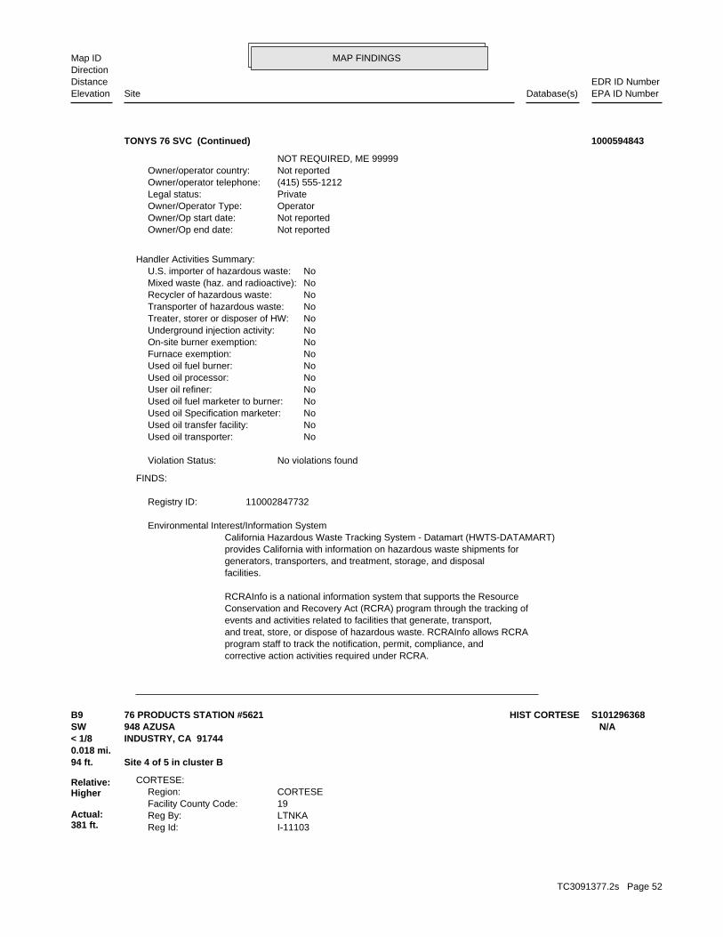
MAP FINDINGSMap IDDirection
EDR ID NumberDistanceEPA ID NumberDatabase(s)SiteElevation
corrective action activities required under RCRA.program staff to track the notification, permit, compliance, andand treat, store, or dispose of hazardous waste. RCRAInfo allows RCRAevents and activities related to facilities that generate, transport,Conservation and Recovery Act (RCRA) program through the tracking ofRCRAInfo is a national information system that supports the Resource
facilities.generators, transporters, and treatment, storage, and disposalprovides California with information on hazardous waste shipments forCalifornia Hazardous Waste Tracking System - Datamart (HWTS-DATAMART) Environmental Interest/Information System
110002847732Registry ID:
FINDS:
No violations foundViolation Status:
NoUsed oil transporter: NoUsed oil transfer facility: NoUsed oil Specification marketer: NoUsed oil fuel marketer to burner: NoUser oil refiner: NoUsed oil processor: NoUsed oil fuel burner: NoFurnace exemption: NoOn-site burner exemption: NoUnderground injection activity: NoTreater, storer or disposer of HW: NoTransporter of hazardous waste: NoRecycler of hazardous waste: NoMixed waste (haz. and radioactive): NoU.S. importer of hazardous waste:
Handler Activities Summary:
Not reportedOwner/Op end date: Not reportedOwner/Op start date: OperatorOwner/Operator Type: PrivateLegal status: (415) 555-1212Owner/operator telephone: Not reportedOwner/operator country: NOT REQUIRED, ME 99999
TONYS 76 SVC (Continued) 1000594843
I-11103Reg Id: LTNKAReg By: 19Facility County Code: CORTESERegion:
CORTESE:
94 ft. Site 4 of 5 in cluster B0.018 mi.
Relative:Higher
Actual:381 ft.
< 1/8 INDUSTRY, CA 91744SW 948 AZUSA N/AB9 HIST CORTESE76 PRODUCTS STATION #5621 S101296368
TC3091377.2s Page 52
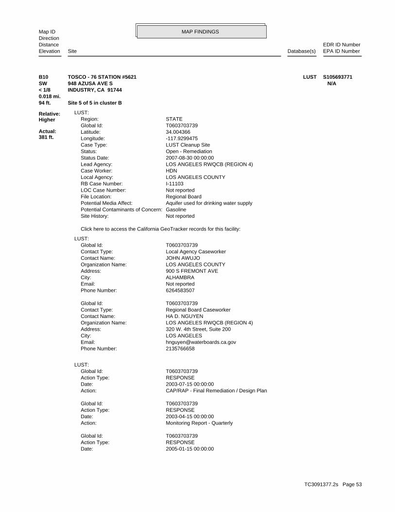
MAP FINDINGSMap IDDirection
EDR ID NumberDistanceEPA ID NumberDatabase(s)SiteElevation
2005-01-15 00:00:00Date: RESPONSEAction Type: T0603703739Global Id:
Monitoring Report - QuarterlyAction: 2003-04-15 00:00:00Date: RESPONSEAction Type: T0603703739Global Id:
CAP/RAP - Final Remediation / Design PlanAction: 2003-07-15 00:00:00Date: RESPONSEAction Type: T0603703739Global Id:
LUST:
2135766658Phone Number: [email protected]: LOS ANGELESCity: 320 W. 4th Street, Suite 200Address: LOS ANGELES RWQCB (REGION 4)Organization Name: HA D. NGUYENContact Name: Regional Board CaseworkerContact Type: T0603703739Global Id:
6264583507Phone Number: Not reportedEmail: ALHAMBRACity: 900 S FREMONT AVEAddress: LOS ANGELES COUNTYOrganization Name: JOHN AWUJOContact Name: Local Agency CaseworkerContact Type: T0603703739Global Id:
LUST:
Click here to access the California GeoTracker records for this facility:
Not reportedSite History: GasolinePotential Contaminants of Concern: Aquifer used for drinking water supplyPotential Media Affect: Regional BoardFile Location: Not reportedLOC Case Number: I-11103RB Case Number: LOS ANGELES COUNTYLocal Agency: HDNCase Worker: LOS ANGELES RWQCB (REGION 4)Lead Agency: 2007-08-30 00:00:00Status Date: Open - RemediationStatus: LUST Cleanup SiteCase Type: -117.9299475Longitude: 34.004366Latitude: T0603703739Global Id: STATERegion:
LUST:
94 ft. Site 5 of 5 in cluster B0.018 mi.
Relative:Higher
Actual:381 ft.
< 1/8 INDUSTRY, CA 91744SW 948 AZUSA AVE S N/AB10 LUSTTOSCO - 76 STATION #5621 S105693771
TC3091377.2s Page 53
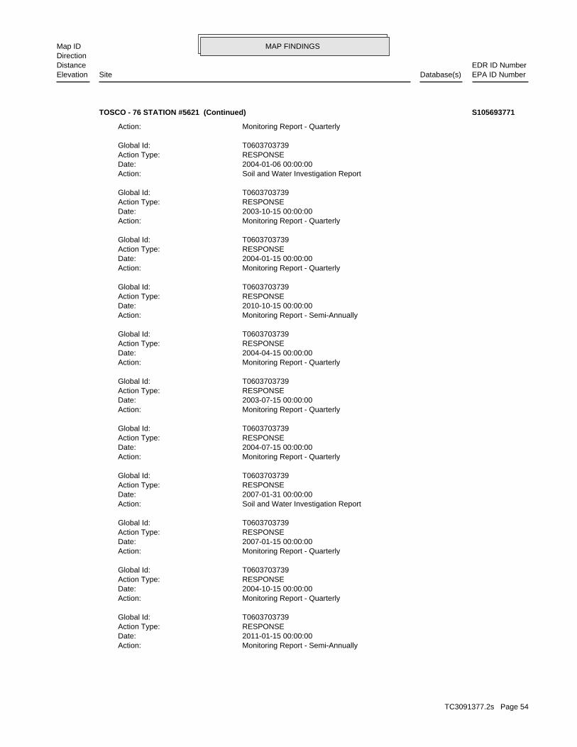
MAP FINDINGSMap IDDirection
EDR ID NumberDistanceEPA ID NumberDatabase(s)SiteElevation
Monitoring Report - Semi-AnnuallyAction: 2011-01-15 00:00:00Date: RESPONSEAction Type: T0603703739Global Id:
Monitoring Report - QuarterlyAction: 2004-10-15 00:00:00Date: RESPONSEAction Type: T0603703739Global Id:
Monitoring Report - QuarterlyAction: 2007-01-15 00:00:00Date: RESPONSEAction Type: T0603703739Global Id:
Soil and Water Investigation ReportAction: 2007-01-31 00:00:00Date: RESPONSEAction Type: T0603703739Global Id:
Monitoring Report - QuarterlyAction: 2004-07-15 00:00:00Date: RESPONSEAction Type: T0603703739Global Id:
Monitoring Report - QuarterlyAction: 2003-07-15 00:00:00Date: RESPONSEAction Type: T0603703739Global Id:
Monitoring Report - QuarterlyAction: 2004-04-15 00:00:00Date: RESPONSEAction Type: T0603703739Global Id:
Monitoring Report - Semi-AnnuallyAction: 2010-10-15 00:00:00Date: RESPONSEAction Type: T0603703739Global Id:
Monitoring Report - QuarterlyAction: 2004-01-15 00:00:00Date: RESPONSEAction Type: T0603703739Global Id:
Monitoring Report - QuarterlyAction: 2003-10-15 00:00:00Date: RESPONSEAction Type: T0603703739Global Id:
Soil and Water Investigation ReportAction: 2004-01-06 00:00:00Date: RESPONSEAction Type: T0603703739Global Id:
Monitoring Report - QuarterlyAction:
TOSCO - 76 STATION #5621 (Continued) S105693771
TC3091377.2s Page 54
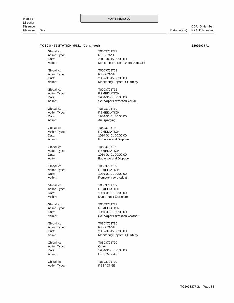
MAP FINDINGSMap IDDirection
EDR ID NumberDistanceEPA ID NumberDatabase(s)SiteElevation
RESPONSEAction Type: T0603703739Global Id:
Leak ReportedAction: 1950-01-01 00:00:00Date: OtherAction Type: T0603703739Global Id:
Monitoring Report - QuarterlyAction: 2005-07-15 00:00:00Date: RESPONSEAction Type: T0603703739Global Id:
Soil Vapor Extraction w/OtherAction: 1950-01-01 00:00:00Date: REMEDIATIONAction Type: T0603703739Global Id:
Dual Phase ExtractionAction: 1950-01-01 00:00:00Date: REMEDIATIONAction Type: T0603703739Global Id:
Remove free productAction: 1950-01-01 00:00:00Date: REMEDIATIONAction Type: T0603703739Global Id:
Excavate and DisposeAction: 1950-01-01 00:00:00Date: REMEDIATIONAction Type: T0603703739Global Id:
Excavate and DisposeAction: 1950-01-01 00:00:00Date: REMEDIATIONAction Type: T0603703739Global Id:
Air spargingAction: 1950-01-01 00:00:00Date: REMEDIATIONAction Type: T0603703739Global Id:
Soil Vapor Extraction w/GACAction: 1950-01-01 00:00:00Date: REMEDIATIONAction Type: T0603703739Global Id:
Monitoring Report - QuarterlyAction: 2006-01-15 00:00:00Date: RESPONSEAction Type: T0603703739Global Id:
Monitoring Report - Semi-AnnuallyAction: 2011-04-15 00:00:00Date: RESPONSEAction Type: T0603703739Global Id:
TOSCO - 76 STATION #5621 (Continued) S105693771
TC3091377.2s Page 55

MAP FINDINGSMap IDDirection
EDR ID NumberDistanceEPA ID NumberDatabase(s)SiteElevation
Monitoring Report - QuarterlyAction: 2007-04-15 00:00:00Date: RESPONSEAction Type: T0603703739Global Id:
Monitoring Report - QuarterlyAction: 2006-07-15 00:00:00Date: RESPONSEAction Type: T0603703739Global Id:
Monitoring Report - Semi-AnnuallyAction: 2009-07-15 00:00:00Date: RESPONSEAction Type: T0603703739Global Id:
Monitoring Report - QuarterlyAction: 2008-10-15 00:00:00Date: RESPONSEAction Type: T0603703739Global Id:
Monitoring Report - QuarterlyAction: 2009-01-15 00:00:00Date: RESPONSEAction Type: T0603703739Global Id:
Staff LetterAction: 2003-10-06 00:00:00Date: ENFORCEMENTAction Type: T0603703739Global Id:
Monitoring Report - QuarterlyAction: 2008-01-15 00:00:00Date: RESPONSEAction Type: T0603703739Global Id:
UnknownAction: 2008-03-03 00:00:00Date: RESPONSEAction Type: T0603703739Global Id:
Staff LetterAction: 2009-06-15 00:00:00Date: ENFORCEMENTAction Type: T0603703739Global Id:
13267 RequirementAction: 2001-03-15 00:00:00Date: ENFORCEMENTAction Type: T0603703739Global Id:
Monitoring Report - QuarterlyAction: 2006-04-15 00:00:00Date: RESPONSEAction Type: T0603703739Global Id:
Monitoring Report - QuarterlyAction: 2005-10-15 00:00:00Date:
TOSCO - 76 STATION #5621 (Continued) S105693771
TC3091377.2s Page 56

MAP FINDINGSMap IDDirection
EDR ID NumberDistanceEPA ID NumberDatabase(s)SiteElevation
RESPONSEAction Type: T0603703739Global Id:
Monitoring Report - Semi-AnnuallyAction: 2010-01-15 00:00:00Date: RESPONSEAction Type: T0603703739Global Id:
Monitoring Report - Semi-AnnuallyAction: 2010-04-15 00:00:00Date: RESPONSEAction Type: T0603703739Global Id:
Monitoring Report - QuarterlyAction: 2006-10-15 00:00:00Date: RESPONSEAction Type: T0603703739Global Id:
Monitoring Report - QuarterlyAction: 2008-04-15 00:00:00Date: RESPONSEAction Type: T0603703739Global Id:
Monitoring Report - QuarterlyAction: 2002-10-15 00:00:00Date: RESPONSEAction Type: T0603703739Global Id:
Monitoring Report - QuarterlyAction: 2005-04-15 00:00:00Date: RESPONSEAction Type: T0603703739Global Id:
Monitoring Report - QuarterlyAction: 2009-04-15 00:00:00Date: RESPONSEAction Type: T0603703739Global Id:
Monitoring Report - QuarterlyAction: 2008-07-15 00:00:00Date: RESPONSEAction Type: T0603703739Global Id:
Staff LetterAction: 2003-04-29 00:00:00Date: ENFORCEMENTAction Type: T0603703739Global Id:
Monitoring Report - QuarterlyAction: 2007-07-15 00:00:00Date: RESPONSEAction Type: T0603703739Global Id:
Monitoring Report - QuarterlyAction: 2007-10-15 00:00:00Date: RESPONSEAction Type: T0603703739Global Id:
TOSCO - 76 STATION #5621 (Continued) S105693771
TC3091377.2s Page 57

MAP FINDINGSMap IDDirection
EDR ID NumberDistanceEPA ID NumberDatabase(s)SiteElevation
UNKLeak Source: UNKCause of Leak: Not reportedHow Leak Stopped: Not reportedHow Leak Discovered: Not reportedDate the Case was Closed: 7/15/2002Date Case Last Changed on Database: Not reportedDate Leak Stopped: Not reportedDate Confirmation Began: 3/5/1990Date Leak Record Entered: 2/28/1990Date Leak First Reported: Not reportedDate Leak Discovered: SELEnforcement Type: RAILROAD STCross Street: 19000Local Agency: HSPStaff: Not reportedW Global ID: T0603703739Global ID: Not reportedAbatement Method Used at the Site: GroundwaterCase Type: Not reportedLocal Case No: Not reportedSubstance Quantity: GasolineSubstance: Remedial action (cleanup) UnderwayStatus: I-11103facid: Los AngelesCounty: 04Regional Board: 4Region:
LUST REG 4:
Monitoring Report - Semi-AnnuallyAction: 2010-07-15 00:00:00Date: RESPONSEAction Type: T0603703739Global Id:
Monitoring Report - QuarterlyAction: 2002-07-15 00:00:00Date: RESPONSEAction Type: T0603703739Global Id:
Monitoring Report - QuarterlyAction: 2002-04-15 00:00:00Date: RESPONSEAction Type: T0603703739Global Id:
Monitoring Report - QuarterlyAction: 2003-01-15 00:00:00Date: RESPONSEAction Type: T0603703739Global Id:
Soil and Water Investigation WorkplanAction: 2009-07-20 00:00:00Date: RESPONSEAction Type: T0603703739Global Id:
Soil and Water Investigation ReportAction: 2010-03-18 00:00:00Date:
TOSCO - 76 STATION #5621 (Continued) S105693771
TC3091377.2s Page 58

MAP FINDINGSMap IDDirection
EDR ID NumberDistanceEPA ID NumberDatabase(s)SiteElevation
3/31/01 1ST QTR GW MON RPT 2001 10/13/00 3RD QTR GW MON RPT 2000; 1/16/01 4TH QTR GW MON RPT 2000; 7/14/00 2ND QTR GW MON RPT 2000; 8/17/00 INTERIM REMEDIAL REPORT;Summary: Not reportedAssigned Name: Not reportedSuspended: Not reportedCleanup Fund Id: Not reportedPriority: Not reportedBeneficial Use: Not reportedLocal Agency Staff: 34.004366 / -1Lat/Long: LUSTProgram: 3525 HYLAND AVE.RP Address: LIZ SEWELLResponsible Party: Not reportedOwner Contact: Not reportedOrganization: Not reportedSoil Qualifier: =GW Qualifier: Not reportedSignificant Interim Remedial Action Taken: Not reportedHist Max MTBE Conc in Soil: 550000Hist Max MTBE Conc in Groundwater: 4/20/2002Historical Max MTBE Date: 3/13/2001Enforcement Action Date: 2/28/1990Post Remedial Action Monitoring Began: 10/6/2003Remedial Action Underway: 7/14/2003Remediation Plan Submitted: 6/13/1991Pollution Characterization Began: 5/12/1988Preliminary Site Assessment Began: 10/18/1990Preliminary Site Assessment Workplan Submitted: UNKSource of Cleanup Funding: 6264.4336747589910731228371318Approx. Dist To Production Well (ft): Not reportedWell Name: Not reportedWater System: Not reportedOperator:
TOSCO - 76 STATION #5621 (Continued) S105693771
Not reportedFacility Suite:DKOOStaff:HistoricalFile Status:105.0104File Number:4Region:
WIP:
245 ft. Site 1 of 3 in cluster C0.046 mi.
Relative:Higher
Actual:374 ft.
< 1/8 CITY OF INDUSTRY (CORPORATE NA, CA 91748NW 17253 CHESTNUT ST N/AC11 WIPG.S. BATTERY, INC. S106764842
TC3091377.2s Page 59
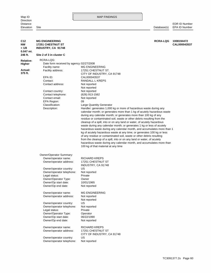
MAP FINDINGSMap IDDirection
EDR ID NumberDistanceEPA ID NumberDatabase(s)SiteElevation
Not reportedOwner/operator telephone: USOwner/operator country: CITY OF INDUSTRY, CA 91748 17251 CHESTNUT STOwner/operator address: RICHARD KREPSOwner/operator name:
Not reportedOwner/Op end date: 06/22/1990Owner/Op start date: OperatorOwner/Operator Type: PrivateLegal status: Not reportedOwner/operator telephone: USOwner/operator country: Not reported Not reportedOwner/operator address: MG ENGINEERINGOwner/operator name:
Not reportedOwner/Op end date: 10/01/1965Owner/Op start date: OwnerOwner/Operator Type: PrivateLegal status: Not reportedOwner/operator telephone: USOwner/operator country: INDUSTRY, CA 91748 17251 CHESTNUT STOwner/operator address: RICHARD KREPSOwner/operator name:
Owner/Operator Summary:
100 kg of that material at any time hazardous waste during any calendar month, and accumulates more than from the cleanup of a spill, into or on any land or water, of acutely of any residue or contaminated soil, waste or other debris resulting kg of acutely hazardous waste at any time; or generates 100 kg or less hazardous waste during any calendar month, and accumulates more than 1 waste during any calendar month; or generates 1 kg or less of acutely cleanup of a spill, into or on any land or water, of acutely hazardous residue or contaminated soil, waste or other debris resulting from the during any calendar month; or generates more than 100 kg of any calendar month; or generates more than 1 kg of acutely hazardous waste Handler: generates 1,000 kg or more of hazardous waste during anyDescription: Large Quantity GeneratorClassification: 09EPA Region: Not reportedContact email: (626) 913-1562Contact telephone: Not reportedContact country: Not reported Not reportedContact address: RANDALL L KREPSContact: CAL000043537EPA ID: CITY OF INDUSTRY, CA 91748 17251 CHESTNUT ST.Facility address: MG ENGINEERINGFacility name: 02/27/2008Date form received by agency:
RCRA-LQG:
246 ft. Site 2 of 3 in cluster C0.047 mi.
Relative:Higher
Actual:375 ft.
< 1/8 INDUSTRY, CA 91748NW 17251 CHESTNUT ST CAL000043537C12 RCRA-LQGMG ENGINEERING 1008194472
TC3091377.2s Page 60
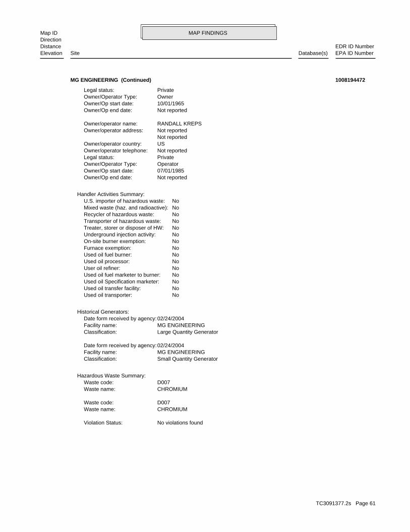
MAP FINDINGSMap IDDirection
EDR ID NumberDistanceEPA ID NumberDatabase(s)SiteElevation
No violations foundViolation Status:
CHROMIUMWaste name: D007Waste code:
CHROMIUMWaste name: D007Waste code:
Hazardous Waste Summary:
Small Quantity GeneratorClassification: MG ENGINEERINGFacility name: 02/24/2004Date form received by agency:
Large Quantity GeneratorClassification: MG ENGINEERINGFacility name: 02/24/2004Date form received by agency:
Historical Generators:
NoUsed oil transporter: NoUsed oil transfer facility: NoUsed oil Specification marketer: NoUsed oil fuel marketer to burner: NoUser oil refiner: NoUsed oil processor: NoUsed oil fuel burner: NoFurnace exemption: NoOn-site burner exemption: NoUnderground injection activity: NoTreater, storer or disposer of HW: NoTransporter of hazardous waste: NoRecycler of hazardous waste: NoMixed waste (haz. and radioactive): NoU.S. importer of hazardous waste:
Handler Activities Summary:
Not reportedOwner/Op end date: 07/01/1985Owner/Op start date: OperatorOwner/Operator Type: PrivateLegal status: Not reportedOwner/operator telephone: USOwner/operator country: Not reported Not reportedOwner/operator address: RANDALL KREPSOwner/operator name:
Not reportedOwner/Op end date: 10/01/1965Owner/Op start date: OwnerOwner/Operator Type: PrivateLegal status:
MG ENGINEERING (Continued) 1008194472
TC3091377.2s Page 61
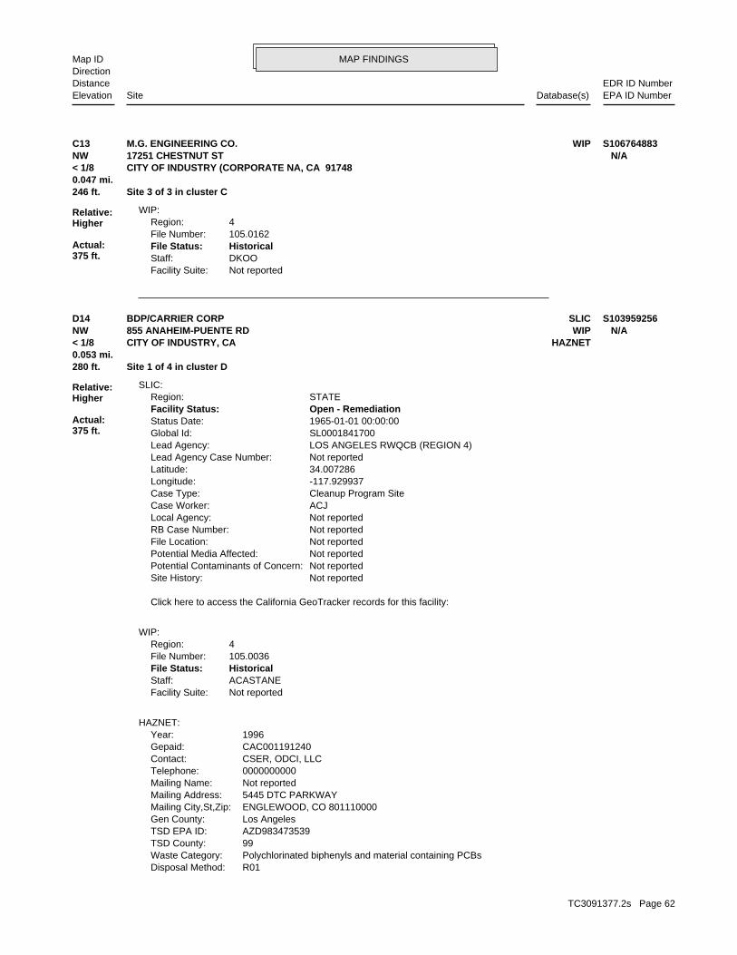
MAP FINDINGSMap IDDirection
EDR ID NumberDistanceEPA ID NumberDatabase(s)SiteElevation
Not reportedFacility Suite:DKOOStaff:HistoricalFile Status:105.0162File Number:4Region:
WIP:
246 ft. Site 3 of 3 in cluster C0.047 mi.
Relative:Higher
Actual:375 ft.
< 1/8 CITY OF INDUSTRY (CORPORATE NA, CA 91748NW 17251 CHESTNUT ST N/AC13 WIPM.G. ENGINEERING CO. S106764883
R01Disposal Method: Polychlorinated biphenyls and material containing PCBsWaste Category: 99TSD County: AZD983473539TSD EPA ID: Los AngelesGen County: ENGLEWOOD, CO 801110000Mailing City,St,Zip: 5445 DTC PARKWAYMailing Address: Not reportedMailing Name: 0000000000Telephone: CSER, ODCI, LLCContact: CAC001191240Gepaid: 1996Year:
HAZNET:
Not reportedFacility Suite:ACASTANEStaff:HistoricalFile Status:105.0036File Number:4Region:
WIP:
Click here to access the California GeoTracker records for this facility:
Not reportedSite History: Not reportedPotential Contaminants of Concern: Not reportedPotential Media Affected: Not reportedFile Location: Not reportedRB Case Number: Not reportedLocal Agency: ACJCase Worker: Cleanup Program SiteCase Type: -117.929937Longitude: 34.007286Latitude: Not reportedLead Agency Case Number: LOS ANGELES RWQCB (REGION 4)Lead Agency: SL0001841700Global Id: 1965-01-01 00:00:00Status Date: Open - RemediationFacility Status: STATERegion:
SLIC:
280 ft. Site 1 of 4 in cluster D0.053 mi.
Relative:Higher
Actual:375 ft.
< 1/8 HAZNETCITY OF INDUSTRY, CA NW WIP855 ANAHEIM-PUENTE RD N/AD14 SLICBDP/CARRIER CORP S103959256
TC3091377.2s Page 62

MAP FINDINGSMap IDDirection
EDR ID NumberDistanceEPA ID NumberDatabase(s)SiteElevation
Los AngelesFacility County: 2.4045Tons:
BDP/CARRIER CORP (Continued) S103959256
Large Quantity GeneratorClassification: CARRIER CORPORATIONFacility name: 02/28/2002Date form received by agency:
Historical Generators:
NoUsed oil transporter: NoUsed oil transfer facility: NoUsed oil Specification marketer: NoUsed oil fuel marketer to burner: NoUser oil refiner: NoUsed oil processor: NoUsed oil fuel burner: NoFurnace exemption: NoOn-site burner exemption: NoUnderground injection activity: NoTreater, storer or disposer of HW: NoTransporter of hazardous waste: NoRecycler of hazardous waste: NoMixed waste (haz. and radioactive): NoU.S. importer of hazardous waste:
Handler Activities Summary:
hazardous waste at any time waste during any calendar month, and accumulates more than 1000 kg of hazardous waste at any time; or generates 100 kg or less of hazardous waste during any calendar month and accumulates less than 6000 kg of Handler: generates more than 100 and less than 1000 kg of hazardousDescription: Small Small Quantity GeneratorClassification: PrivateLand type: 09EPA Region: [email protected] email: 5816Telephone ext.: (949) 253-2958Contact telephone: Not reportedContact country: Not reported Not reportedContact address: SCOTT E PARSONSContact: IRVINE, CA 92614 SUITE 500 17770 CARTWRIGHT ROADMailing address: CAD066702689EPA ID: CITY OF INDUSTRY, CA 91748 935 S. AZUSA AVE.Facility address: CARRIER CORPORATIONFacility name: 02/28/2002Date form received by agency:
RCRA-SQG:
Notify 65280 ft. SWEEPS USTSite 2 of 4 in cluster D0.053 mi. HIST UST
Relative:Higher
Actual:375 ft.
< 1/8 CA FID USTROWLAND HEIGHTS, CA 91748NW FINDS855 ANAHEIM PUENTE ROAD CAD066702689D15 RCRA-SQGCARRIER CORPORATION 1000107995
TC3091377.2s Page 63
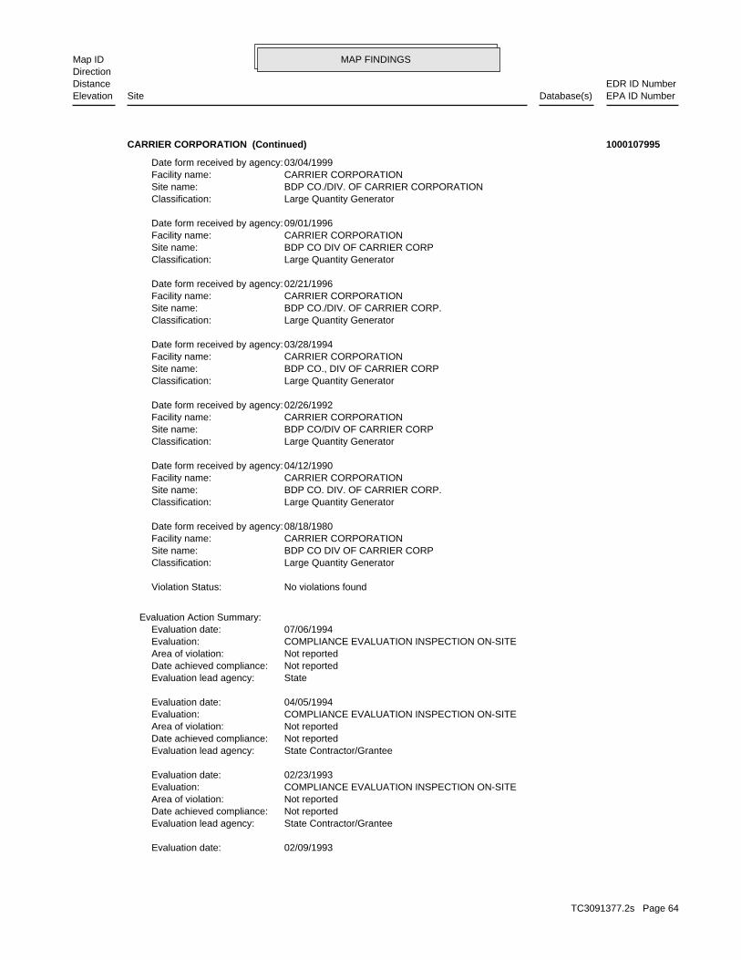
MAP FINDINGSMap IDDirection
EDR ID NumberDistanceEPA ID NumberDatabase(s)SiteElevation
02/09/1993Evaluation date:
State Contractor/GranteeEvaluation lead agency: Not reportedDate achieved compliance: Not reportedArea of violation: COMPLIANCE EVALUATION INSPECTION ON-SITEEvaluation: 02/23/1993Evaluation date:
State Contractor/GranteeEvaluation lead agency: Not reportedDate achieved compliance: Not reportedArea of violation: COMPLIANCE EVALUATION INSPECTION ON-SITEEvaluation: 04/05/1994Evaluation date:
StateEvaluation lead agency: Not reportedDate achieved compliance: Not reportedArea of violation: COMPLIANCE EVALUATION INSPECTION ON-SITEEvaluation: 07/06/1994Evaluation date:
Evaluation Action Summary:
No violations foundViolation Status:
Large Quantity GeneratorClassification: BDP CO DIV OF CARRIER CORPSite name: CARRIER CORPORATIONFacility name: 08/18/1980Date form received by agency:
Large Quantity GeneratorClassification: BDP CO. DIV. OF CARRIER CORP.Site name: CARRIER CORPORATIONFacility name: 04/12/1990Date form received by agency:
Large Quantity GeneratorClassification: BDP CO/DIV OF CARRIER CORPSite name: CARRIER CORPORATIONFacility name: 02/26/1992Date form received by agency:
Large Quantity GeneratorClassification: BDP CO., DIV OF CARRIER CORPSite name: CARRIER CORPORATIONFacility name: 03/28/1994Date form received by agency:
Large Quantity GeneratorClassification: BDP CO./DIV. OF CARRIER CORP.Site name: CARRIER CORPORATIONFacility name: 02/21/1996Date form received by agency:
Large Quantity GeneratorClassification: BDP CO DIV OF CARRIER CORPSite name: CARRIER CORPORATIONFacility name: 09/01/1996Date form received by agency:
Large Quantity GeneratorClassification: BDP CO./DIV. OF CARRIER CORPORATIONSite name: CARRIER CORPORATIONFacility name: 03/04/1999Date form received by agency:
CARRIER CORPORATION (Continued) 1000107995
TC3091377.2s Page 64
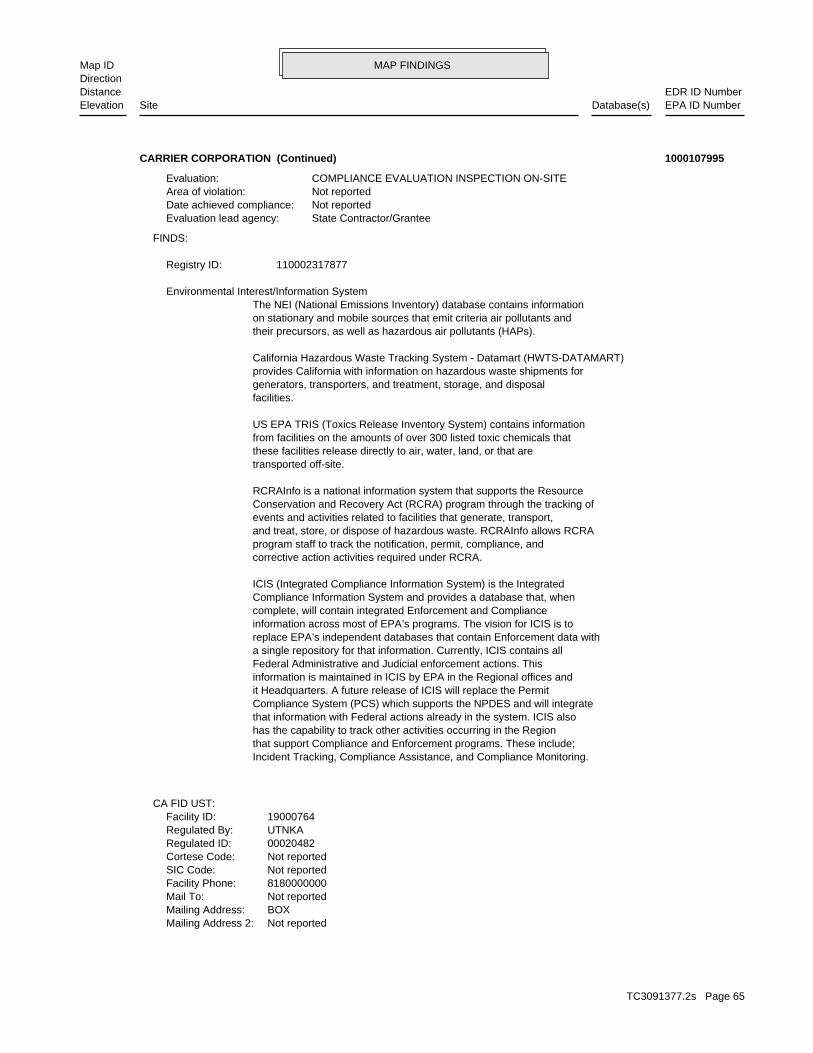
MAP FINDINGSMap IDDirection
EDR ID NumberDistanceEPA ID NumberDatabase(s)SiteElevation
Not reportedMailing Address 2: BOXMailing Address: Not reportedMail To: 8180000000Facility Phone: Not reportedSIC Code: Not reportedCortese Code: 00020482Regulated ID: UTNKARegulated By: 19000764Facility ID:
CA FID UST:
Incident Tracking, Compliance Assistance, and Compliance Monitoring.that support Compliance and Enforcement programs. These include;has the capability to track other activities occurring in the Regionthat information with Federal actions already in the system. ICIS alsoCompliance System (PCS) which supports the NPDES and will integrateit Headquarters. A future release of ICIS will replace the Permitinformation is maintained in ICIS by EPA in the Regional offices andFederal Administrative and Judicial enforcement actions. Thisa single repository for that information. Currently, ICIS contains allreplace EPA’s independent databases that contain Enforcement data withinformation across most of EPA’s programs. The vision for ICIS is tocomplete, will contain integrated Enforcement and ComplianceCompliance Information System and provides a database that, whenICIS (Integrated Compliance Information System) is the Integrated
corrective action activities required under RCRA.program staff to track the notification, permit, compliance, andand treat, store, or dispose of hazardous waste. RCRAInfo allows RCRAevents and activities related to facilities that generate, transport,Conservation and Recovery Act (RCRA) program through the tracking ofRCRAInfo is a national information system that supports the Resource
transported off-site.these facilities release directly to air, water, land, or that arefrom facilities on the amounts of over 300 listed toxic chemicals thatUS EPA TRIS (Toxics Release Inventory System) contains information
facilities.generators, transporters, and treatment, storage, and disposalprovides California with information on hazardous waste shipments forCalifornia Hazardous Waste Tracking System - Datamart (HWTS-DATAMART)
their precursors, as well as hazardous air pollutants (HAPs).on stationary and mobile sources that emit criteria air pollutants andThe NEI (National Emissions Inventory) database contains information Environmental Interest/Information System
110002317877Registry ID:
FINDS:
State Contractor/GranteeEvaluation lead agency: Not reportedDate achieved compliance: Not reportedArea of violation: COMPLIANCE EVALUATION INSPECTION ON-SITEEvaluation:
CARRIER CORPORATION (Continued) 1000107995
TC3091377.2s Page 65

MAP FINDINGSMap IDDirection
EDR ID NumberDistanceEPA ID NumberDatabase(s)SiteElevation
Not reportedNumber Of Tanks: Not reportedContent: Not reportedStg: Not reportedTank Use: Not reportedCapacity: Not reportedActv Date: Not reportedSwrcb Tank Id: Not reportedOwner Tank Id: Not reportedTank Status: 06-30-89Created Date: Not reportedAct Date: 06-30-89Ref Date: Not reportedBoard Of Equalization: 9Number: 3836Comp Number: AStatus:
SWEEPS UST:
NoneLeak Detection: 6 inchesTank Construction: Not reportedType of Fuel: WASTETank Used for: 00015000Tank Capacity: 1956Year Installed: 2Container Num: 002Tank Num:
NoneLeak Detection: 6 inchesTank Construction: Not reportedType of Fuel: PRODUCTTank Used for: 00008000Tank Capacity: 1956Year Installed: 1Container Num: 001Tank Num:
SYRACUSE, NY 13221Owner City,St,Zip: CARRIER PARKWAY, P.O. BOX 4808Owner Address: CARRIER CORPORATIONOwner Name: 8189641211Telephone: MR. P. THOMPSON, PLANT MANAGERContact Name: 0002Total Tanks: MANUFACTURINGOther Type: OtherFacility Type: 00000050560Facility ID: STATERegion:
HIST UST:
ActiveStatus: Not reportedComments: Not reportedEPA ID: Not reportedNPDES Number: Not reportedDUNs Number: Not reportedContact Phone: Not reportedContact: INDUSTRYMailing City,St,Zip:
CARRIER CORPORATION (Continued) 1000107995
TC3091377.2s Page 66

MAP FINDINGSMap IDDirection
EDR ID NumberDistanceEPA ID NumberDatabase(s)SiteElevation
91748-1032Incident Description: Not reportedDischarge Date: Not reportedFacility Type: Not reportedBoard File Number: Not reportedStaff Initials: Not reportedDate Reported:
Notify 65:
CARRIER CORPORATION (Continued) 1000107995
NoneLeak Detection: Not reportedTank Construction: Not reportedType of Fuel: PRODUCTTank Used for: 00010000Tank Capacity: 1969Year Installed: 3259Container Num: 002Tank Num:
NoneLeak Detection: Not reportedTank Construction: REGULARType of Fuel: PRODUCTTank Used for: 00001000Tank Capacity: 1964Year Installed: #1Container Num: 001Tank Num:
SYRACUSE, NY 13221Owner City,St,Zip: CARRIER PARKWAY, P.O. BOX 4848Owner Address: CARRIER CORPORATIONOwner Name: 8189641211Telephone: MR. P. THOMPSONContact Name: 0002Total Tanks: MANUFACTURINGOther Type: OtherFacility Type: 00000020482Facility ID: STATERegion:
HIST UST:
280 ft. Site 3 of 4 in cluster D0.053 mi.
Relative:Higher
Actual:375 ft.
< 1/8 CITY OF INDUSTRY, CA 91749NW 855 ANAHEIM PUENTE RD N/AD16 HIST USTBDP COMPANY. U001569798
Pollution CharacterizationStatus: 105.0036facid: Los AngelesCounty: 04Regional Board: 4Region:
LUST REG 4:
284 ft. Site 4 of 4 in cluster D0.054 mi.
Relative:Higher
Actual:375 ft.
< 1/8 INDUSTRY, CA 91746NW SLIC855 ANAHEIM-PUENTE RD N/AD17 LUSTB. D. P. - CARRIER CORPORATION S102424870
TC3091377.2s Page 67

MAP FINDINGSMap IDDirection
EDR ID NumberDistanceEPA ID NumberDatabase(s)SiteElevation
PROGRESS 105.0036 REMEDIATION IN CASE BEING HANDLED BY SURFACE WATER OR TOXICS DIV. WIP CASESummary: Not reportedAssigned Name: Not reportedSuspended: Not reportedCleanup Fund Id: Not reportedPriority: Not reportedBeneficial Use: Not reportedLocal Agency Staff: 34.0051469 / -1Lat/Long: LUSTProgram: Not reportedRP Address: BLANK RPResponsible Party: Not reportedOwner Contact: Not reportedOrganization: Not reportedSoil Qualifier: Not reportedGW Qualifier: Not reportedSignificant Interim Remedial Action Taken: Not reportedHist Max MTBE Conc in Soil: Not reportedHist Max MTBE Conc in Groundwater: Not reportedHistorical Max MTBE Date: Not reportedEnforcement Action Date: Not reportedPost Remedial Action Monitoring Began: Not reportedRemedial Action Underway: Not reportedRemediation Plan Submitted: 6/30/2002Pollution Characterization Began: Not reportedPreliminary Site Assessment Began: Not reportedPreliminary Site Assessment Workplan Submitted: UNKSource of Cleanup Funding: 6232.5169224742072682218524931Approx. Dist To Production Well (ft): Not reportedWell Name: Not reportedWater System: OLD CASE #917460061Operator: UNKLeak Source: UNKCause of Leak: Not reportedHow Leak Stopped: Not reportedHow Leak Discovered: Not reportedDate the Case was Closed: 3/31/1989Date Case Last Changed on Database: Not reportedDate Leak Stopped: Not reportedDate Confirmation Began: 12/31/1986Date Leak Record Entered: 4/29/1985Date Leak First Reported: Not reportedDate Leak Discovered: Not reportedEnforcement Type: Not reportedCross Street: 19000Local Agency: wipStaff: Not reportedW Global ID: T0603700149Global ID: Not reportedAbatement Method Used at the Site: GroundwaterCase Type: 1841700Local Case No: Not reportedSubstance Quantity: SolventsSubstance:
B. D. P. - CARRIER CORPORATION (Continued) S102424870
TC3091377.2s Page 68

MAP FINDINGSMap IDDirection
EDR ID NumberDistanceEPA ID NumberDatabase(s)SiteElevation
Click here to access the California GeoTracker records for this facility:
using groundwater extraction with air stripping. delineated. Groundwater remediation began in 1986 and continues in 1985. The extent of PCE and TCE in soil and groundwater have been Assessment began when a vapor degreaser was discovered to be leakingSite History: * SolventsPotential Contaminants of Concern: Aquifer used for drinking water supplyPotential Media Affected: Regional BoardFile Location: 105.0036RB Case Number: LOS ANGELES COUNTYLocal Agency: WIPCase Worker: Cleanup Program SiteCase Type: -117.932395935059Longitude: 34.0053029092262Latitude: Not reportedLead Agency Case Number: LOS ANGELES RWQCB (REGION 4)Lead Agency: T0603700149Global Id: 2009-05-22 00:00:00Status Date: Open - RemediationFacility Status: STATERegion:
SLIC:
B. D. P. - CARRIER CORPORATION (Continued) S102424870
136955Party Number: 2011-02-22 00:00:00As Of: NRural: 01/10/2011Effective Date: NWhether The Facility Is Grandfathered: Not reportedFacility Phone Number:
SWRCY:
525 ft. Site 1 of 2 in cluster E0.099 mi.
Relative:Higher
Actual:381 ft.
< 1/8 LA PUENTE, CA 91744NNW 17305 VALLEY BLVD N/AE18 SWRCYAM RECYCLING S110770375
Not reportedRCRA ID: Not reportedSite Orphan Flag: Not reportedDMNSN Number: Not a Federal FacilityFederal Facility: Not reportedUSGC Hydro Unit: Not reportedSMSA Number: Not reportedIFMS ID: Not reportedCongressional District: MINI STORAGE DRUMSShort Name: LOS ANGELESFacility County: CAN000908561EPA ID: 0908561Site ID:
CERCLIS:
563 ft. Site 2 of 2 in cluster E0.107 mi.
Relative:Higher
Actual:381 ft.
< 1/8 LA PUENTE, CA NNW 17295 E. VALLEY BLVD CAN000908561E19 CERCLISMINI STORAGE DRUMS 1010417126
TC3091377.2s Page 69

MAP FINDINGSMap IDDirection
EDR ID NumberDistanceEPA ID NumberDatabase(s)SiteElevation
CERCLIS Assessment History:
in a 20’box truck parked on the storage lot property.Valley Blvd., La Puente, Los Angeles Co., CA. The abandoned waste is locatedThe site is located at Extra-Space Storage, a mini-storage located at 17295 E.Site Description: Not reportedAlias Comments:
Not reportedContact Email: Site Assessment Manager (SAM)Contact Title: (415) 972-3097Contact Tel: Dawn RichmondContact Name: 9270438.00000Contact ID:
Not reportedContact Email: Site Assessment Manager (SAM)Contact Title: (415) 972-3814Contact Tel: Carl BricknerContact Name: 13002167.00000Contact ID:
Not reportedContact Email: Site Assessment Manager (SAM)Contact Title: (415) 972-3095Contact Tel: Jeff InglisContact Name: 9270048.00000Contact ID:
Not reportedContact Email: Site Assessment Manager (SAM)Contact Title: (415) 972-3219Contact Tel: Karen JuristContact Name: 9271184.00000Contact ID:
Not reportedContact Email: On-Scene Coordinator (OSC)Contact Title: (562) 499-6312Contact Tel: Robert WiseContact Name: 9270721.00000Contact ID:
CERCLIS Site Contact Name(s):
Not reportedSite FUDS Flag: Not reportedAlias EPA ID: Not reportedCC Concurrence FY: Not reportedCC Concurrence Date: 06037Site Fips Code: 20071126Non NPL Status Date: Removal Only Site (No Site Assessment Work Needed)Non NPL Status: Not reportedRResp Fed Agency Code: Not reportedRBRAC Code: Not reportedDMNSN Unit Code: Not on the NPLNPL Status: Not reportedSite Settings Code: Not reportedClassification: 09EPA Region: Not reportedRST Code: Not reportedParent ID: Not reportedNFRAP Flag: RSite Init By Prog: Not reportedUSGS Quadrangle:
MINI STORAGE DRUMS (Continued) 1010417126
TC3091377.2s Page 70
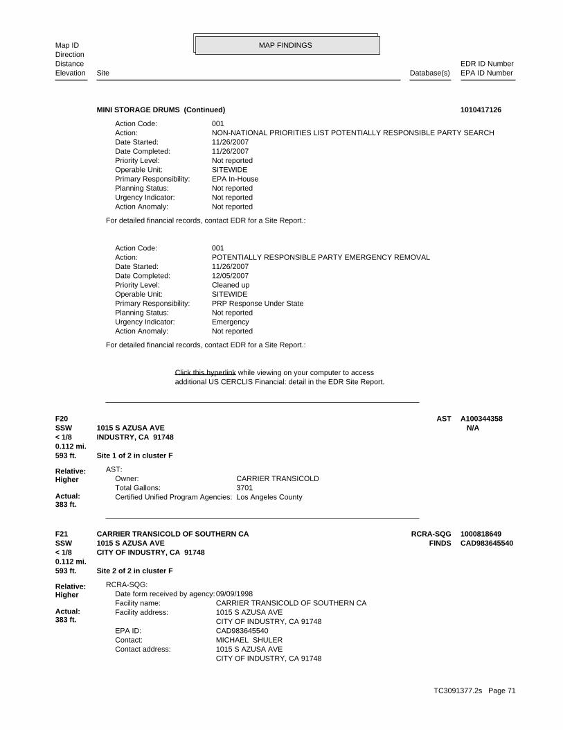
MAP FINDINGSMap IDDirection
EDR ID NumberDistanceEPA ID NumberDatabase(s)SiteElevation
additional US CERCLIS Financial: detail in the EDR Site Report.Click this hyperlink while viewing on your computer to access
For detailed financial records, contact EDR for a Site Report.:
Not reportedAction Anomaly: EmergencyUrgency Indicator: Not reportedPlanning Status: PRP Response Under StatePrimary Responsibility: SITEWIDEOperable Unit: Cleaned upPriority Level: 12/05/2007Date Completed: 11/26/2007Date Started: POTENTIALLY RESPONSIBLE PARTY EMERGENCY REMOVALAction: 001Action Code:
For detailed financial records, contact EDR for a Site Report.:
Not reportedAction Anomaly: Not reportedUrgency Indicator: Not reportedPlanning Status: EPA In-HousePrimary Responsibility: SITEWIDEOperable Unit: Not reportedPriority Level: 11/26/2007Date Completed: 11/26/2007Date Started: NON-NATIONAL PRIORITIES LIST POTENTIALLY RESPONSIBLE PARTY SEARCHAction: 001Action Code:
MINI STORAGE DRUMS (Continued) 1010417126
Los Angeles CountyCertified Unified Program Agencies: 3701Total Gallons: CARRIER TRANSICOLDOwner:
AST:
593 ft. Site 1 of 2 in cluster F0.112 mi.
Relative:Higher
Actual:383 ft.
< 1/8 INDUSTRY, CA 91748SSW 1015 S AZUSA AVE N/AF20 AST A100344358
CITY OF INDUSTRY, CA 91748 1015 S AZUSA AVEContact address: MICHAEL SHULERContact: CAD983645540EPA ID: CITY OF INDUSTRY, CA 91748 1015 S AZUSA AVEFacility address: CARRIER TRANSICOLD OF SOUTHERN CAFacility name: 09/09/1998Date form received by agency:
RCRA-SQG:
593 ft. Site 2 of 2 in cluster F0.112 mi.
Relative:Higher
Actual:383 ft.
< 1/8 CITY OF INDUSTRY, CA 91748SSW FINDS1015 S AZUSA AVE CAD983645540F21 RCRA-SQGCARRIER TRANSICOLD OF SOUTHERN CA 1000818649
TC3091377.2s Page 71

MAP FINDINGSMap IDDirection
EDR ID NumberDistanceEPA ID NumberDatabase(s)SiteElevation
THESE CAUSTIC OR ACID SOLUTIONS BECOME CONTAMINATED AND MUST BE USED BY MANY INDUSTRIES TO CLEAN METAL PARTS PRIOR TO PAINTING. WHEN OR DEGREASE PARTS. HYDROCHLORIC ACID, A SOLUTION WITH A LOW PH, IS CAUSTIC SOLUTION WITH A HIGH PH, IS OFTEN USED BY INDUSTRIES TO CLEAN CONSIDERED TO BE A CORROSIVE HAZARDOUS WASTE. SODIUM HYDROXIDE, A A WASTE WHICH HAS A PH OF LESS THAN 2 OR GREATER THAN 12.5 ISWaste name: D002Waste code:
WHICH WOULD BE CONSIDERED AS IGNITABLE HAZARDOUS WASTE. MATERIAL. LACQUER THINNER IS AN EXAMPLE OF A COMMONLY USED SOLVENT WHICH CAN BE OBTAINED FROM THE MANUFACTURER OR DISTRIBUTOR OF THE FLASH POINT OF A WASTE IS TO REVIEW THE MATERIAL SAFETY DATA SHEET, CLOSED CUP FLASH POINT TESTER. ANOTHER METHOD OF DETERMINING THE LESS THAN 140 DEGREES FAHRENHEIT AS DETERMINED BY A PENSKY-MARTENS IGNITABLE HAZARDOUS WASTES ARE THOSE WASTES WHICH HAVE A FLASHPOINT OFWaste name: D001Waste code:
Hazardous Waste Summary:
NoUsed oil transporter: NoUsed oil transfer facility: NoUsed oil Specification marketer: NoUsed oil fuel marketer to burner: NoUser oil refiner: NoUsed oil processor: NoUsed oil fuel burner: NoFurnace exemption: NoOn-site burner exemption: NoUnderground injection activity: NoTreater, storer or disposer of HW: NoTransporter of hazardous waste: NoRecycler of hazardous waste: NoMixed waste (haz. and radioactive): NoU.S. importer of hazardous waste:
Handler Activities Summary:
Not reportedOwner/Op end date: Not reportedOwner/Op start date: OwnerOwner/Operator Type: PrivateLegal status: (626) 913-4331Owner/operator telephone: Not reportedOwner/operator country: CITY OF INDUSTRY, CA 91748 1015 S AZUSA AVEOwner/operator address: CARRIER TRANSICOLD OF S CAOwner/operator name:
Owner/Operator Summary:
hazardous waste at any time waste during any calendar month, and accumulates more than 1000 kg of hazardous waste at any time; or generates 100 kg or less of hazardous waste during any calendar month and accumulates less than 6000 kg of Handler: generates more than 100 and less than 1000 kg of hazardousDescription: Small Small Quantity GeneratorClassification: 09EPA Region: Not reportedContact email: (626) 913-4331Contact telephone: USContact country:
CARRIER TRANSICOLD OF SOUTHERN CA (Continued) 1000818649
TC3091377.2s Page 72
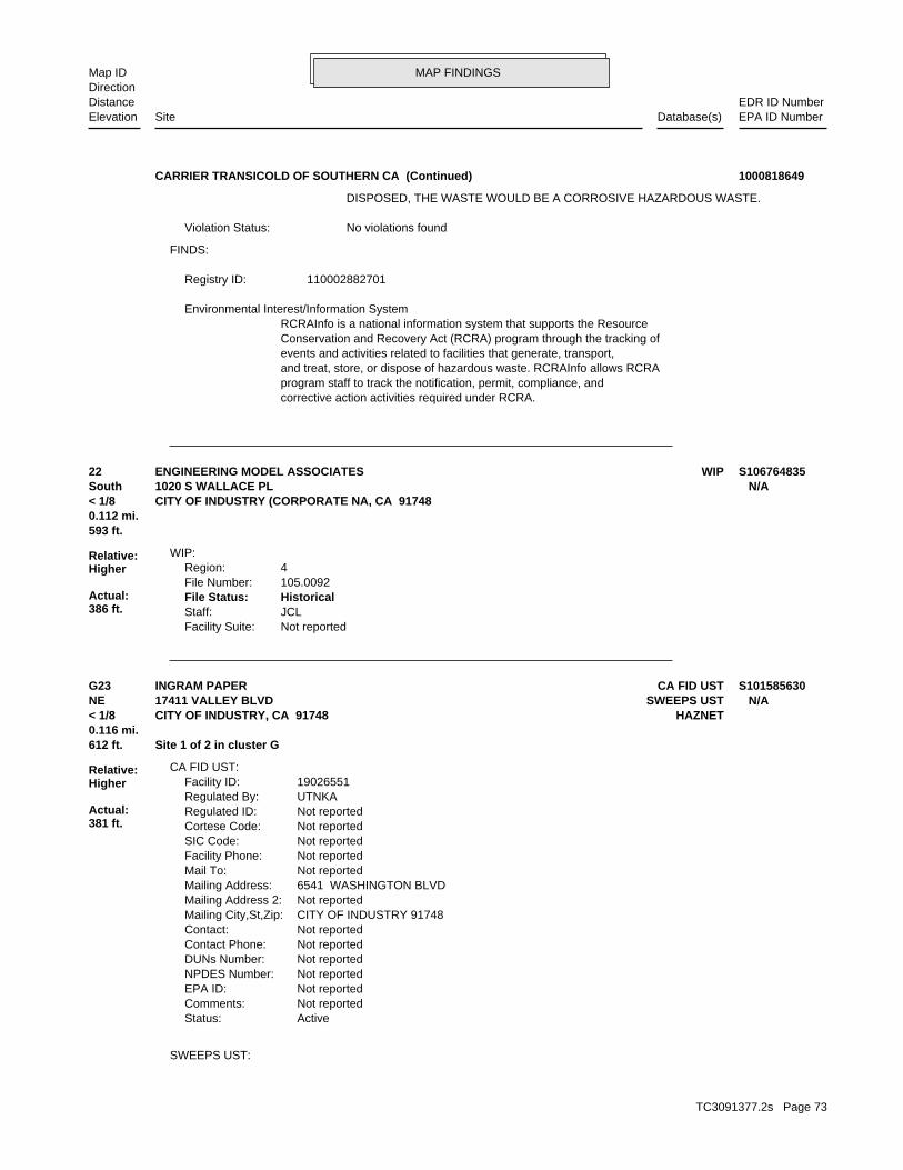
MAP FINDINGSMap IDDirection
EDR ID NumberDistanceEPA ID NumberDatabase(s)SiteElevation
corrective action activities required under RCRA.program staff to track the notification, permit, compliance, andand treat, store, or dispose of hazardous waste. RCRAInfo allows RCRAevents and activities related to facilities that generate, transport,Conservation and Recovery Act (RCRA) program through the tracking ofRCRAInfo is a national information system that supports the Resource Environmental Interest/Information System
110002882701Registry ID:
FINDS:
No violations foundViolation Status:
DISPOSED, THE WASTE WOULD BE A CORROSIVE HAZARDOUS WASTE.
CARRIER TRANSICOLD OF SOUTHERN CA (Continued) 1000818649
Not reportedFacility Suite:JCLStaff:HistoricalFile Status:105.0092File Number:4Region:
WIP:
593 ft.0.112 mi.
Relative:Higher
Actual:386 ft.
< 1/8 CITY OF INDUSTRY (CORPORATE NA, CA 91748South 1020 S WALLACE PL N/A22 WIPENGINEERING MODEL ASSOCIATES S106764835
SWEEPS UST:
ActiveStatus: Not reportedComments: Not reportedEPA ID: Not reportedNPDES Number: Not reportedDUNs Number: Not reportedContact Phone: Not reportedContact: CITY OF INDUSTRY 91748Mailing City,St,Zip: Not reportedMailing Address 2: 6541 WASHINGTON BLVDMailing Address: Not reportedMail To: Not reportedFacility Phone: Not reportedSIC Code: Not reportedCortese Code: Not reportedRegulated ID: UTNKARegulated By: 19026551Facility ID:
CA FID UST:
612 ft. Site 1 of 2 in cluster G0.116 mi.
Relative:Higher
Actual:381 ft.
< 1/8 HAZNETCITY OF INDUSTRY, CA 91748NE SWEEPS UST17411 VALLEY BLVD N/AG23 CA FID USTINGRAM PAPER S101585630
TC3091377.2s Page 73
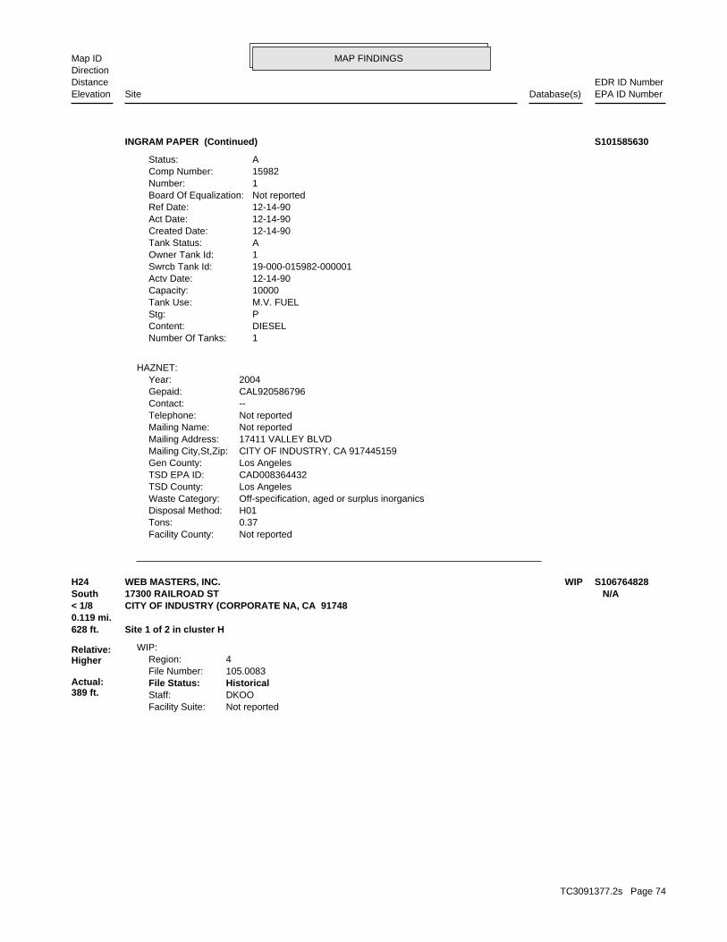
MAP FINDINGSMap IDDirection
EDR ID NumberDistanceEPA ID NumberDatabase(s)SiteElevation
Not reportedFacility County: 0.37Tons: H01Disposal Method: Off-specification, aged or surplus inorganicsWaste Category: Los AngelesTSD County: CAD008364432TSD EPA ID: Los AngelesGen County: CITY OF INDUSTRY, CA 917445159Mailing City,St,Zip: 17411 VALLEY BLVDMailing Address: Not reportedMailing Name: Not reportedTelephone: --Contact: CAL920586796Gepaid: 2004Year:
HAZNET:
1Number Of Tanks: DIESELContent: PStg: M.V. FUELTank Use: 10000Capacity: 12-14-90Actv Date: 19-000-015982-000001Swrcb Tank Id: 1Owner Tank Id: ATank Status: 12-14-90Created Date: 12-14-90Act Date: 12-14-90Ref Date: Not reportedBoard Of Equalization: 1Number: 15982Comp Number: AStatus:
INGRAM PAPER (Continued) S101585630
Not reportedFacility Suite:DKOOStaff:HistoricalFile Status:105.0083File Number:4Region:
WIP:
628 ft. Site 1 of 2 in cluster H0.119 mi.
Relative:Higher
Actual:389 ft.
< 1/8 CITY OF INDUSTRY (CORPORATE NA, CA 91748South 17300 RAILROAD ST N/AH24 WIPWEB MASTERS, INC. S106764828
TC3091377.2s Page 74
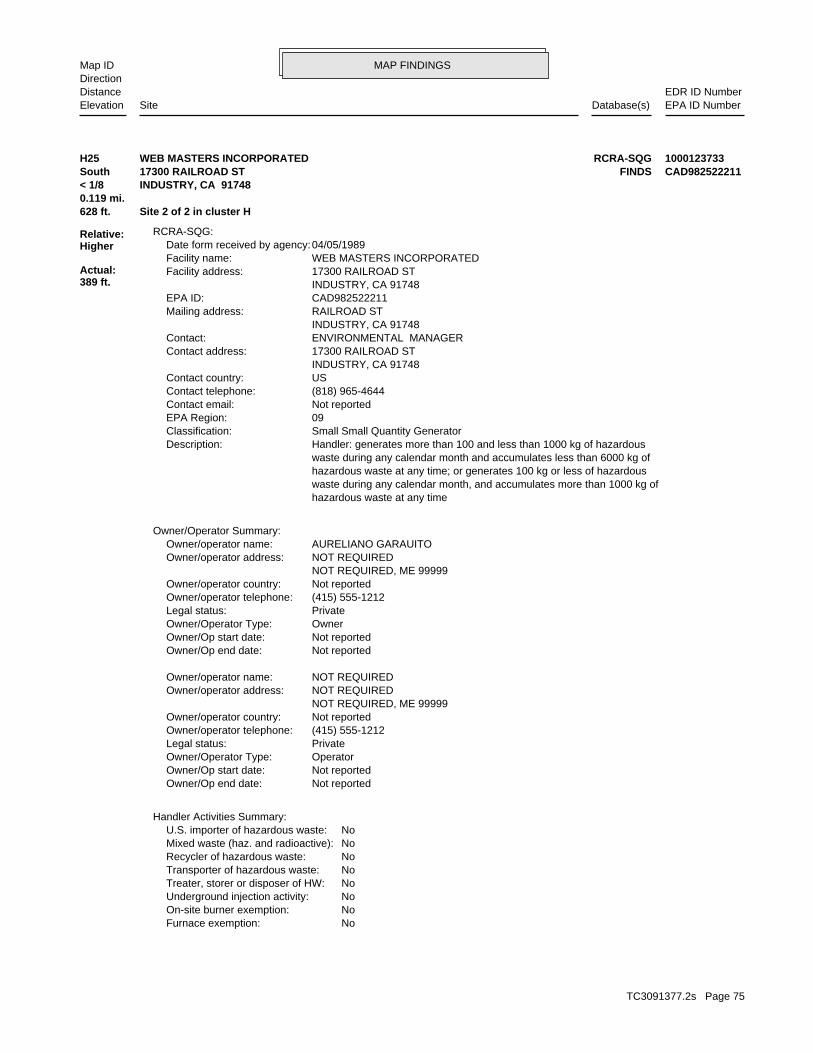
MAP FINDINGSMap IDDirection
EDR ID NumberDistanceEPA ID NumberDatabase(s)SiteElevation
NoFurnace exemption: NoOn-site burner exemption: NoUnderground injection activity: NoTreater, storer or disposer of HW: NoTransporter of hazardous waste: NoRecycler of hazardous waste: NoMixed waste (haz. and radioactive): NoU.S. importer of hazardous waste:
Handler Activities Summary:
Not reportedOwner/Op end date: Not reportedOwner/Op start date: OperatorOwner/Operator Type: PrivateLegal status: (415) 555-1212Owner/operator telephone: Not reportedOwner/operator country: NOT REQUIRED, ME 99999 NOT REQUIREDOwner/operator address: NOT REQUIREDOwner/operator name:
Not reportedOwner/Op end date: Not reportedOwner/Op start date: OwnerOwner/Operator Type: PrivateLegal status: (415) 555-1212Owner/operator telephone: Not reportedOwner/operator country: NOT REQUIRED, ME 99999 NOT REQUIREDOwner/operator address: AURELIANO GARAUITOOwner/operator name:
Owner/Operator Summary:
hazardous waste at any time waste during any calendar month, and accumulates more than 1000 kg of hazardous waste at any time; or generates 100 kg or less of hazardous waste during any calendar month and accumulates less than 6000 kg of Handler: generates more than 100 and less than 1000 kg of hazardousDescription: Small Small Quantity GeneratorClassification: 09EPA Region: Not reportedContact email: (818) 965-4644Contact telephone: USContact country: INDUSTRY, CA 91748 17300 RAILROAD STContact address: ENVIRONMENTAL MANAGERContact: INDUSTRY, CA 91748 RAILROAD STMailing address: CAD982522211EPA ID: INDUSTRY, CA 91748 17300 RAILROAD STFacility address: WEB MASTERS INCORPORATEDFacility name: 04/05/1989Date form received by agency:
RCRA-SQG:
628 ft. Site 2 of 2 in cluster H0.119 mi.
Relative:Higher
Actual:389 ft.
< 1/8 INDUSTRY, CA 91748South FINDS17300 RAILROAD ST CAD982522211H25 RCRA-SQGWEB MASTERS INCORPORATED 1000123733
TC3091377.2s Page 75

MAP FINDINGSMap IDDirection
EDR ID NumberDistanceEPA ID NumberDatabase(s)SiteElevation
corrective action activities required under RCRA.program staff to track the notification, permit, compliance, andand treat, store, or dispose of hazardous waste. RCRAInfo allows RCRAevents and activities related to facilities that generate, transport,Conservation and Recovery Act (RCRA) program through the tracking ofRCRAInfo is a national information system that supports the Resource Environmental Interest/Information System
110002841113Registry ID:
FINDS:
No violations foundViolation Status:
NoUsed oil transporter: NoUsed oil transfer facility: NoUsed oil Specification marketer: NoUsed oil fuel marketer to burner: NoUser oil refiner: NoUsed oil processor: NoUsed oil fuel burner:
WEB MASTERS INCORPORATED (Continued) 1000123733
-117.92413Longitude:34.00898Latitude:1906Facility ID:
UST:
634 ft. Site 2 of 2 in cluster G0.120 mi.
Relative:Higher
Actual:382 ft.
< 1/8 LA PUENTE, CA 91744NE 17411 VALLEY BLVD N/AG26 USTINGRAM PAPER COMPANY U003777285
Handler: generates more than 100 and less than 1000 kg of hazardousDescription: Small Small Quantity GeneratorClassification: 09EPA Region: Not reportedContact email: Not reportedContact telephone: Not reportedContact country: Not reported Not reportedContact address: Not reportedContact: LA PUENTE, CA 91744 E VALLEY BLMailing address: CAD981998032EPA ID: LA PUENTE, CA 91744 17251 E VALLEY BLFacility address: PUENTE PLAZA CLEANERSFacility name: 09/01/1996Date form received by agency:
RCRA-SQG:
727 ft.0.138 mi.
Relative:Higher
Actual:381 ft.
1/8-1/4 EMILA PUENTE, CA 91744NW FINDS17251 E VALLEY BL CAD98199803227 RCRA-SQGPUENTE PLAZA CLEANERS 1000322078
TC3091377.2s Page 76

MAP FINDINGSMap IDDirection
EDR ID NumberDistanceEPA ID NumberDatabase(s)SiteElevation
corrective action activities required under RCRA.program staff to track the notification, permit, compliance, andand treat, store, or dispose of hazardous waste. RCRAInfo allows RCRAevents and activities related to facilities that generate, transport,Conservation and Recovery Act (RCRA) program through the tracking ofRCRAInfo is a national information system that supports the Resource Environmental Interest/Information System
110002771493Registry ID:
FINDS:
No violations foundViolation Status:
NoUsed oil transporter: NoUsed oil transfer facility: NoUsed oil Specification marketer: NoUsed oil fuel marketer to burner: NoUser oil refiner: NoUsed oil processor: NoUsed oil fuel burner: NoFurnace exemption: NoOn-site burner exemption: NoUnderground injection activity: NoTreater, storer or disposer of HW: NoTransporter of hazardous waste: NoRecycler of hazardous waste: NoMixed waste (haz. and radioactive): NoU.S. importer of hazardous waste:
Handler Activities Summary:
Not reportedOwner/Op end date: Not reportedOwner/Op start date: OperatorOwner/Operator Type: PrivateLegal status: (415) 555-1212Owner/operator telephone: Not reportedOwner/operator country: NOT REQUIRED, ME 99999 NOT REQUIREDOwner/operator address: NOT REQUIREDOwner/operator name:
Not reportedOwner/Op end date: Not reportedOwner/Op start date: OwnerOwner/Operator Type: PrivateLegal status: (415) 555-1212Owner/operator telephone: Not reportedOwner/operator country: NOT REQUIRED, ME 99999 NOT REQUIREDOwner/operator address: KWON KI BAIKOwner/operator name:
Owner/Operator Summary:
hazardous waste at any time waste during any calendar month, and accumulates more than 1000 kg of hazardous waste at any time; or generates 100 kg or less of hazardous waste during any calendar month and accumulates less than 6000 kg of
PUENTE PLAZA CLEANERS (Continued) 1000322078
TC3091377.2s Page 77
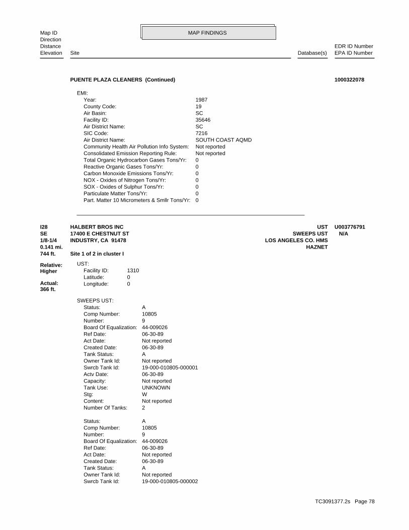
MAP FINDINGSMap IDDirection
EDR ID NumberDistanceEPA ID NumberDatabase(s)SiteElevation
0Part. Matter 10 Micrometers & Smllr Tons/Yr: 0Particulate Matter Tons/Yr: 0SOX - Oxides of Sulphur Tons/Yr: 0NOX - Oxides of Nitrogen Tons/Yr: 0Carbon Monoxide Emissions Tons/Yr: 0Reactive Organic Gases Tons/Yr: 0Total Organic Hydrocarbon Gases Tons/Yr: Not reportedConsolidated Emission Reporting Rule: Not reportedCommunity Health Air Pollution Info System: SOUTH COAST AQMDAir District Name: 7216SIC Code: SCAir District Name: 35646Facility ID: SCAir Basin: 19County Code: 1987Year:
EMI:
PUENTE PLAZA CLEANERS (Continued) 1000322078
19-000-010805-000002Swrcb Tank Id: Not reportedOwner Tank Id: ATank Status: 06-30-89Created Date: Not reportedAct Date: 06-30-89Ref Date: 44-009026Board Of Equalization: 9Number: 10805Comp Number: AStatus:
2Number Of Tanks: Not reportedContent: WStg: UNKNOWNTank Use: Not reportedCapacity: 06-30-89Actv Date: 19-000-010805-000001Swrcb Tank Id: Not reportedOwner Tank Id: ATank Status: 06-30-89Created Date: Not reportedAct Date: 06-30-89Ref Date: 44-009026Board Of Equalization: 9Number: 10805Comp Number: AStatus:
SWEEPS UST:
0Longitude:0Latitude:1310Facility ID:
UST:
744 ft. Site 1 of 2 in cluster I0.141 mi. HAZNET
Relative:Higher
Actual:366 ft.
1/8-1/4 LOS ANGELES CO. HMSINDUSTRY, CA 91478SE SWEEPS UST17400 E CHESTNUT ST N/AI28 USTHALBERT BROS INC U003776791
TC3091377.2s Page 78
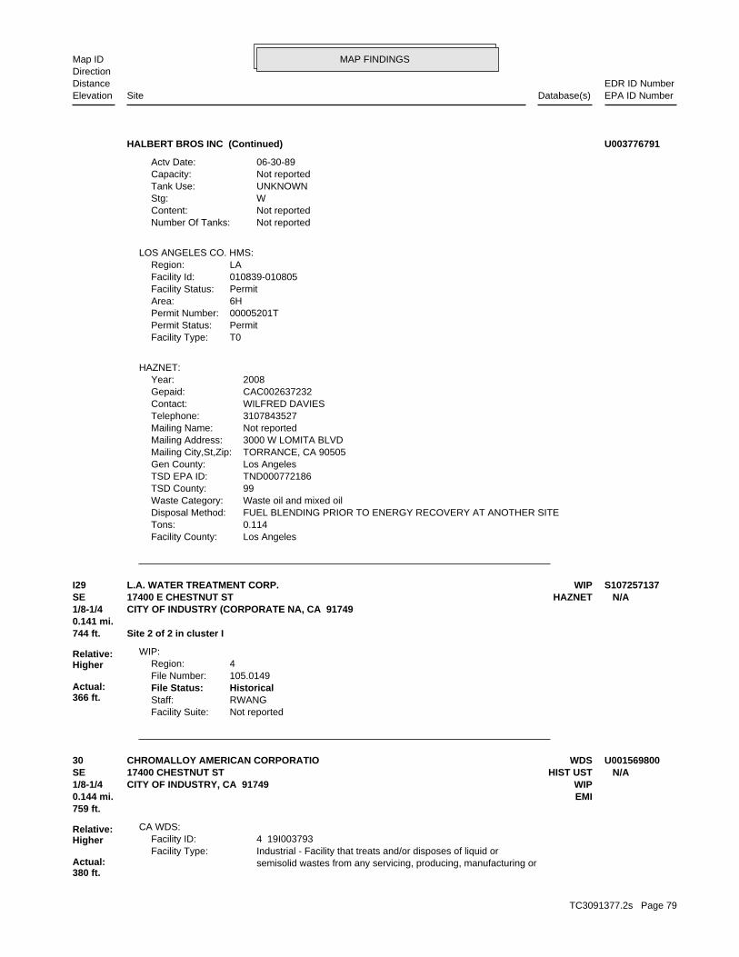
MAP FINDINGSMap IDDirection
EDR ID NumberDistanceEPA ID NumberDatabase(s)SiteElevation
Los AngelesFacility County: 0.114Tons: FUEL BLENDING PRIOR TO ENERGY RECOVERY AT ANOTHER SITEDisposal Method: Waste oil and mixed oilWaste Category: 99TSD County: TND000772186TSD EPA ID: Los AngelesGen County: TORRANCE, CA 90505Mailing City,St,Zip: 3000 W LOMITA BLVDMailing Address: Not reportedMailing Name: 3107843527Telephone: WILFRED DAVIESContact: CAC002637232Gepaid: 2008Year:
HAZNET:
T0Facility Type:PermitPermit Status:00005201TPermit Number:6HArea:PermitFacility Status:010839-010805Facility Id:LARegion:
LOS ANGELES CO. HMS:
Not reportedNumber Of Tanks: Not reportedContent: WStg: UNKNOWNTank Use: Not reportedCapacity: 06-30-89Actv Date:
HALBERT BROS INC (Continued) U003776791
Not reportedFacility Suite:RWANGStaff:HistoricalFile Status:105.0149File Number:4Region:
WIP:
744 ft. Site 2 of 2 in cluster I0.141 mi.
Relative:Higher
Actual:366 ft.
1/8-1/4 CITY OF INDUSTRY (CORPORATE NA, CA 91749SE HAZNET17400 E CHESTNUT ST N/AI29 WIPL.A. WATER TREATMENT CORP. S107257137
semisolid wastes from any servicing, producing, manufacturing or Industrial - Facility that treats and/or disposes of liquid orFacility Type: 4 19I003793Facility ID:
CA WDS:
759 ft.0.144 mi. EMI
Relative:Higher
Actual:380 ft.
1/8-1/4 WIPCITY OF INDUSTRY, CA 91749SE HIST UST17400 CHESTNUT ST N/A30 WDSCHROMALLOY AMERICAN CORPORATIO U001569800
TC3091377.2s Page 79
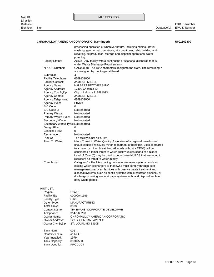
MAP FINDINGSMap IDDirection
EDR ID NumberDistanceEPA ID NumberDatabase(s)SiteElevation
PRODUCTTank Used for: 00007500Tank Capacity: 1979Year Installed: #1 REG.Container Num: 001Tank Num:
ST. LOUIS, MO 63105Owner City,St,Zip: 120 S. CENTRAL AVENUEOwner Address: CHROMALLOY AMERICAN CORPORATIOOwner Name: 3147269200Telephone: TIM EVANS, CORPORATE DEVELOPMEContact Name: 0003Total Tanks: MANUFACTURINGOther Type: OtherFacility Type: 00000041199Facility ID: STATERegion:
HIST UST:
dairy waste ponds. dischargers having waste storage systems with land disposal such as disposal systems, such as septic systems with subsurface disposal, or management practices, facilities with passive waste treatment and cooling water dischargers or thosewho must comply through best Category C - Facilities having no waste treatment systems, such asComplexity: represent no threat to water quality. Level. A Zero (0) may be used to code those NURDS that are found to considered a minor threat to water quality unless coded at a higher to a major or minor threat. Not: All nurds without a TTWQ will be should cause a relatively minor impairment of beneficial uses compared Minor Threat to Water Quality. A violation of a regional board orderTreat To Water: The facility is not a POTW.POTW: Not reportedReclamation: 0Baseline Flow: 0Design Flow: Not reportedSecondary Waste Type: Not reportedSecondary Waste: Not reportedPrimary Waste Type: Not reportedPrimary Waste: Not reportedSIC Code 2: 0SIC Code: PrivateAgency Type: 6269131800Agency Telephone: JAMES R MILLERAgency Contact: City of Industry 917481013Agency City,St,Zip: 17400 Chestnut St.Agency Address: HALBERT BROTHERS INC.Agency Name: JAMES R MILLERFacility Contact: 6269131800Facility Telephone: 4Subregion: are assigned by the Regional Board CAS000001 The 1st 2 characters designate the state. The remaining 7NPDES Number: under Waste Discharge Requirements. Active - Any facility with a continuous or seasonal discharge that isFacility Status: pumping. repairing, oil production, storage and disposal operations, water washing, geothermal operations, air conditioning, ship building and processing operation of whatever nature, including mining, gravel
CHROMALLOY AMERICAN CORPORATIO (Continued) U001569800
TC3091377.2s Page 80

MAP FINDINGSMap IDDirection
EDR ID NumberDistanceEPA ID NumberDatabase(s)SiteElevation
Not reportedConsolidated Emission Reporting Rule: Not reportedCommunity Health Air Pollution Info System: SOUTH COAST AQMDAir District Name: 3589SIC Code: SCAir District Name: 9145Facility ID: SCAir Basin: 19County Code: 1990Year:
0Part. Matter 10 Micrometers & Smllr Tons/Yr: 1Particulate Matter Tons/Yr: 0SOX - Oxides of Sulphur Tons/Yr: 0NOX - Oxides of Nitrogen Tons/Yr: 0Carbon Monoxide Emissions Tons/Yr: 7Reactive Organic Gases Tons/Yr: 8Total Organic Hydrocarbon Gases Tons/Yr: Not reportedConsolidated Emission Reporting Rule: Not reportedCommunity Health Air Pollution Info System: SOUTH COAST AQMDAir District Name: 3443SIC Code: SCAir District Name: 9145Facility ID: SCAir Basin: 19County Code: 1987Year:
EMI:
Not reportedFacility Suite:RWANGStaff:HistoricalFile Status:105.0117File Number:4Region:
WIP:
VisualLeak Detection: 6 inchesTank Construction: Not reportedType of Fuel: Not reportedTank Used for: 00010000Tank Capacity: Not reportedYear Installed: #3Container Num: 003Tank Num:
Stock InventorLeak Detection: Not reportedTank Construction: UNLEADEDType of Fuel: PRODUCTTank Used for: 00008000Tank Capacity: 1979Year Installed: #2-UNLEADEContainer Num: 002Tank Num:
Stock InventorLeak Detection: Not reportedTank Construction: REGULARType of Fuel:
CHROMALLOY AMERICAN CORPORATIO (Continued) U001569800
TC3091377.2s Page 81
MAP FINDINGSMap IDDirection
EDR ID NumberDistanceEPA ID NumberDatabase(s)SiteElevation
0Part. Matter 10 Micrometers & Smllr Tons/Yr: 1Particulate Matter Tons/Yr: 0SOX - Oxides of Sulphur Tons/Yr: 0NOX - Oxides of Nitrogen Tons/Yr: 0Carbon Monoxide Emissions Tons/Yr: 2Reactive Organic Gases Tons/Yr: 2Total Organic Hydrocarbon Gases Tons/Yr:
CHROMALLOY AMERICAN CORPORATIO (Continued) U001569800
Not reportedSchedule Area Name: Not reportedFuture Due Date: Not reportedFuture Document Type: Not reportedFuture Sub Area Name: Not reportedFuture Area Name:
Not reportedComments: Not reportedCompleted Date: Not reportedCompleted Document Type: Not reportedCompleted Sub Area Name: Not reportedCompleted Area Name:
Completed Info:
Envirostor ID NumberAlias Type: 71002558Alias Name: EPA Identification NumberAlias Type: CAD072304942Alias Name: NONE SPECIFIEDPotential Description: NONE SPECIFIEDConfirmed COC: NONE SPECIFIEDPotential COC: NONE SPECIFIEDPast Use: NONE SPECIFIEDAPN: -117.926234Longitude: 34.003181Latitude: Not reportedFunding: NONE SPECIFIEDSite Mgmt. Req.: NORestricted Use: Not reportedStatus Date: Refer: Other AgencyStatus: Not reportedSpecial Program: 24Senate: 58Assembly: Not reportedSite Code: 71002558Facility ID: Cleanup CypressDivision Branch: Not reportedSupervisor: Not reportedProgram Manager: NONE SPECIFIEDLead Agency: NONE SPECIFIEDRegulatory Agencies: NONPL: Not reportedAcres: Tiered PermitSite Type Detailed: Tiered PermitSite Type:
ENVIROSTOR:
962 ft. Site 1 of 6 in cluster J0.182 mi.
Relative:Higher
Actual:393 ft.
1/8-1/4 CITY OF INDUSTRY, CA 91748South 17355 RAILROAD STREET N/AJ31 ENVIROSTORSOMITEX PRINTS OF CALIFORNIA S110494305
TC3091377.2s Page 82
MAP FINDINGSMap IDDirection
EDR ID NumberDistanceEPA ID NumberDatabase(s)SiteElevation
Not reportedSchedule Revised Date: Not reportedSchedule Due Date: Not reportedSchedule Document Type: Not reportedSchedule Sub Area Name:
SOMITEX PRINTS OF CALIFORNIA (Continued) S110494305
NoTransporter of hazardous waste: NoRecycler of hazardous waste: NoMixed waste (haz. and radioactive): NoU.S. importer of hazardous waste:
Handler Activities Summary:
Not reportedOwner/Op end date: Not reportedOwner/Op start date: OperatorOwner/Operator Type: PrivateLegal status: (415) 555-1212Owner/operator telephone: Not reportedOwner/operator country: NOT REQUIRED, ME 99999 NOT REQUIREDOwner/operator address: NOT REQUIREDOwner/operator name:
Not reportedOwner/Op end date: Not reportedOwner/Op start date: OwnerOwner/Operator Type: PrivateLegal status: (415) 555-1212Owner/operator telephone: Not reportedOwner/operator country: NOT REQUIRED, ME 99999 NOT REQUIREDOwner/operator address: SOMITEX PRINTS OF CA, INCOwner/operator name:
Owner/Operator Summary:
hazardous waste at any time waste during any calendar month, and accumulates more than 1000 kg of hazardous waste at any time; or generates 100 kg or less of hazardous waste during any calendar month and accumulates less than 6000 kg of Handler: generates more than 100 and less than 1000 kg of hazardousDescription: Small Small Quantity GeneratorClassification: 09EPA Region: Not reportedContact email: (818) 965-8411Contact telephone: USContact country: CITY OF INDUSTRY, CA 91748 17355 RAILROAD STContact address: ENVIRONMENTAL MANAGERContact: CAD072304942EPA ID: CITY OF INDUSTRY, CA 91748 17355 RAILROAD STFacility address: SOMITEX PRINTS OF CA, INCFacility name: 03/19/1986Date form received by agency:
RCRA-SQG:
962 ft. Site 2 of 6 in cluster J0.182 mi. EMI
Relative:Higher
Actual:393 ft.
1/8-1/4 LA Co. Site MitigationCITY OF INDUSTRY, CA 91714South FINDS17355 RAILROAD ST CAD072304942J32 RCRA-SQGSOMITEX PRINTS OF CAL INC 1000264549
TC3091377.2s Page 83
MAP FINDINGSMap IDDirection
EDR ID NumberDistanceEPA ID NumberDatabase(s)SiteElevation
46Reactive Organic Gases Tons/Yr: 46Total Organic Hydrocarbon Gases Tons/Yr: Not reportedConsolidated Emission Reporting Rule: Not reportedCommunity Health Air Pollution Info System: SOUTH COAST AQMDAir District Name: 2396SIC Code: SCAir District Name: 9114Facility ID: SCAir Basin: 19County Code: 1987Year:
EMI:
11/3/1997Abated Date:5/11/2004Entered Date:Not reportedAssigned To:YesAbated:RO0011255Case ID:SD0011255Site ID:FA0021522Facility ID:
LA Co. Site Mitigation:
corrective action activities required under RCRA.program staff to track the notification, permit, compliance, andand treat, store, or dispose of hazardous waste. RCRAInfo allows RCRAevents and activities related to facilities that generate, transport,Conservation and Recovery Act (RCRA) program through the tracking ofRCRAInfo is a national information system that supports the Resource
facilities.generators, transporters, and treatment, storage, and disposalprovides California with information on hazardous waste shipments forCalifornia Hazardous Waste Tracking System - Datamart (HWTS-DATAMART)
their precursors, as well as hazardous air pollutants (HAPs).on stationary and mobile sources that emit criteria air pollutants andThe NEI (National Emissions Inventory) database contains information Environmental Interest/Information System
110002420461Registry ID:
FINDS:
No violations foundViolation Status:
NoUsed oil transporter: NoUsed oil transfer facility: NoUsed oil Specification marketer: NoUsed oil fuel marketer to burner: NoUser oil refiner: NoUsed oil processor: NoUsed oil fuel burner: NoFurnace exemption: NoOn-site burner exemption: NoUnderground injection activity: NoTreater, storer or disposer of HW:
SOMITEX PRINTS OF CAL INC (Continued) 1000264549
TC3091377.2s Page 84

MAP FINDINGSMap IDDirection
EDR ID NumberDistanceEPA ID NumberDatabase(s)SiteElevation
0Part. Matter 10 Micrometers & Smllr Tons/Yr: 0Particulate Matter Tons/Yr: 0SOX - Oxides of Sulphur Tons/Yr: 4NOX - Oxides of Nitrogen Tons/Yr: 2Carbon Monoxide Emissions Tons/Yr: 4Reactive Organic Gases Tons/Yr: 6Total Organic Hydrocarbon Gases Tons/Yr: Not reportedConsolidated Emission Reporting Rule: Not reportedCommunity Health Air Pollution Info System: SOUTH COAST AQMDAir District Name: 2396SIC Code: SCAir District Name: 9114Facility ID: SCAir Basin: 19County Code: 1996Year:
0Part. Matter 10 Micrometers & Smllr Tons/Yr: 0Particulate Matter Tons/Yr: 0SOX - Oxides of Sulphur Tons/Yr: 3NOX - Oxides of Nitrogen Tons/Yr: 2Carbon Monoxide Emissions Tons/Yr: 5Reactive Organic Gases Tons/Yr: 6Total Organic Hydrocarbon Gases Tons/Yr: Not reportedConsolidated Emission Reporting Rule: Not reportedCommunity Health Air Pollution Info System: SOUTH COAST AQMDAir District Name: 2396SIC Code: SCAir District Name: 9114Facility ID: SCAir Basin: 19County Code: 1995Year:
0Part. Matter 10 Micrometers & Smllr Tons/Yr: 0Particulate Matter Tons/Yr: 0SOX - Oxides of Sulphur Tons/Yr: 7NOX - Oxides of Nitrogen Tons/Yr: 2Carbon Monoxide Emissions Tons/Yr: 10Reactive Organic Gases Tons/Yr: 10Total Organic Hydrocarbon Gases Tons/Yr: Not reportedConsolidated Emission Reporting Rule: Not reportedCommunity Health Air Pollution Info System: SOUTH COAST AQMDAir District Name: 2396SIC Code: SCAir District Name: 9114Facility ID: SCAir Basin: 19County Code: 1990Year:
0Part. Matter 10 Micrometers & Smllr Tons/Yr: 0Particulate Matter Tons/Yr: 0SOX - Oxides of Sulphur Tons/Yr: 4NOX - Oxides of Nitrogen Tons/Yr: 1Carbon Monoxide Emissions Tons/Yr:
SOMITEX PRINTS OF CAL INC (Continued) 1000264549
TC3091377.2s Page 85
MAP FINDINGSMap IDDirection
EDR ID NumberDistanceEPA ID NumberDatabase(s)SiteElevation
2396SIC Code: SCAir District Name: 9114Facility ID: SCAir Basin: 19County Code: 2000Year:
0Part. Matter 10 Micrometers & Smllr Tons/Yr: 0Particulate Matter Tons/Yr: 0SOX - Oxides of Sulphur Tons/Yr: 2NOX - Oxides of Nitrogen Tons/Yr: 1Carbon Monoxide Emissions Tons/Yr: 2Reactive Organic Gases Tons/Yr: 3Total Organic Hydrocarbon Gases Tons/Yr: Not reportedConsolidated Emission Reporting Rule: Not reportedCommunity Health Air Pollution Info System: SOUTH COAST AQMDAir District Name: 2396SIC Code: SCAir District Name: 9114Facility ID: SCAir Basin: 19County Code: 1999Year:
0Part. Matter 10 Micrometers & Smllr Tons/Yr: 0Particulate Matter Tons/Yr: 0SOX - Oxides of Sulphur Tons/Yr: 2NOX - Oxides of Nitrogen Tons/Yr: 1Carbon Monoxide Emissions Tons/Yr: 2Reactive Organic Gases Tons/Yr: 3Total Organic Hydrocarbon Gases Tons/Yr: Not reportedConsolidated Emission Reporting Rule: Not reportedCommunity Health Air Pollution Info System: SOUTH COAST AQMDAir District Name: 2396SIC Code: SCAir District Name: 9114Facility ID: SCAir Basin: 19County Code: 1998Year:
0Part. Matter 10 Micrometers & Smllr Tons/Yr: 0Particulate Matter Tons/Yr: 0SOX - Oxides of Sulphur Tons/Yr: 2NOX - Oxides of Nitrogen Tons/Yr: 1Carbon Monoxide Emissions Tons/Yr: 2Reactive Organic Gases Tons/Yr: 3Total Organic Hydrocarbon Gases Tons/Yr: Not reportedConsolidated Emission Reporting Rule: Not reportedCommunity Health Air Pollution Info System: SOUTH COAST AQMDAir District Name: 2396SIC Code: SCAir District Name: 9114Facility ID: SCAir Basin: 19County Code: 1997Year:
SOMITEX PRINTS OF CAL INC (Continued) 1000264549
TC3091377.2s Page 86
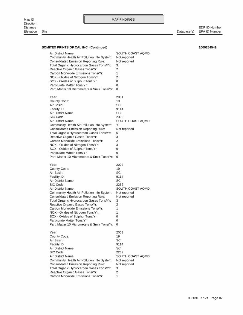
MAP FINDINGSMap IDDirection
EDR ID NumberDistanceEPA ID NumberDatabase(s)SiteElevation
1Carbon Monoxide Emissions Tons/Yr: 2Reactive Organic Gases Tons/Yr: 3Total Organic Hydrocarbon Gases Tons/Yr: Not reportedConsolidated Emission Reporting Rule: Not reportedCommunity Health Air Pollution Info System: SOUTH COAST AQMDAir District Name: 2262SIC Code: SCAir District Name: 9114Facility ID: SCAir Basin: 19County Code: 2003Year:
0Part. Matter 10 Micrometers & Smllr Tons/Yr: 0Particulate Matter Tons/Yr: 0SOX - Oxides of Sulphur Tons/Yr: 1NOX - Oxides of Nitrogen Tons/Yr: 1Carbon Monoxide Emissions Tons/Yr: 2Reactive Organic Gases Tons/Yr: 3Total Organic Hydrocarbon Gases Tons/Yr: Not reportedConsolidated Emission Reporting Rule: Not reportedCommunity Health Air Pollution Info System: SOUTH COAST AQMDAir District Name: 2262SIC Code: SCAir District Name: 9114Facility ID: SCAir Basin: 19County Code: 2002Year:
0Part. Matter 10 Micrometers & Smllr Tons/Yr: 0Particulate Matter Tons/Yr: 0SOX - Oxides of Sulphur Tons/Yr: 3NOX - Oxides of Nitrogen Tons/Yr: 2Carbon Monoxide Emissions Tons/Yr: 3Reactive Organic Gases Tons/Yr: 5Total Organic Hydrocarbon Gases Tons/Yr: Not reportedConsolidated Emission Reporting Rule: YCommunity Health Air Pollution Info System: SOUTH COAST AQMDAir District Name: 2396SIC Code: SCAir District Name: 9114Facility ID: SCAir Basin: 19County Code: 2001Year:
0Part. Matter 10 Micrometers & Smllr Tons/Yr: 0Particulate Matter Tons/Yr: 0SOX - Oxides of Sulphur Tons/Yr: 2NOX - Oxides of Nitrogen Tons/Yr: 1Carbon Monoxide Emissions Tons/Yr: 2Reactive Organic Gases Tons/Yr: 3Total Organic Hydrocarbon Gases Tons/Yr: Not reportedConsolidated Emission Reporting Rule: Not reportedCommunity Health Air Pollution Info System: SOUTH COAST AQMDAir District Name:
SOMITEX PRINTS OF CAL INC (Continued) 1000264549
TC3091377.2s Page 87

MAP FINDINGSMap IDDirection
EDR ID NumberDistanceEPA ID NumberDatabase(s)SiteElevation
0.16Part. Matter 10 Micrometers & Smllr Tons/Yr: 0.15824Particulate Matter Tons/Yr: 0.014083SOX - Oxides of Sulphur Tons/Yr: 1.3511NOX - Oxides of Nitrogen Tons/Yr: 1.42457Carbon Monoxide Emissions Tons/Yr: 1.89Reactive Organic Gases Tons/Yr: 3.274591Total Organic Hydrocarbon Gases Tons/Yr: Not reportedConsolidated Emission Reporting Rule: YCommunity Health Air Pollution Info System: SOUTH COAST AQMDAir District Name: 2262SIC Code: SCAir District Name: 9114Facility ID: SCAir Basin: 19County Code: 2004Year:
0Part. Matter 10 Micrometers & Smllr Tons/Yr: 0Particulate Matter Tons/Yr: 0SOX - Oxides of Sulphur Tons/Yr: 1NOX - Oxides of Nitrogen Tons/Yr:
SOMITEX PRINTS OF CAL INC (Continued) 1000264549
Not reportedReclamation: 0Baseline Flow: 0Design Flow: Not reportedSecondary Waste Type: Not reportedSecondary Waste: Not reportedPrimary Waste Type: Not reportedPrimary Waste: Not reportedSIC Code 2: 0SIC Code: PrivateAgency Type: Not reportedAgency Telephone: Bill KongsliAgency Contact: City of Industry 91746Agency City,St,Zip: 17355 Railroad St.Agency Address: SOMITEX PRINTS OF CALIFORNIAAgency Name: Bill KongsliFacility Contact: Not reportedFacility Telephone: 4Subregion: are assigned by the Regional Board CAS000001 The 1st 2 characters designate the state. The remaining 7NPDES Number: under Waste Discharge Requirements. Active - Any facility with a continuous or seasonal discharge that isFacility Status: pumping. repairing, oil production, storage and disposal operations, water washing, geothermal operations, air conditioning, ship building and processing operation of whatever nature, including mining, gravel semisolid wastes from any servicing, producing, manufacturing or Industrial - Facility that treats and/or disposes of liquid orFacility Type: 4 19I009950Facility ID:
CA WDS:
965 ft. Site 3 of 6 in cluster J0.183 mi.
Relative:Higher
Actual:393 ft.
1/8-1/4 CITY OF INDUSTRY (CORPORATE NA, CA 91748South WIP17355 RAILROAD ST N/AJ33 WDSSOMITEX PRINTS OF CALIFORNIA S102063620
TC3091377.2s Page 88
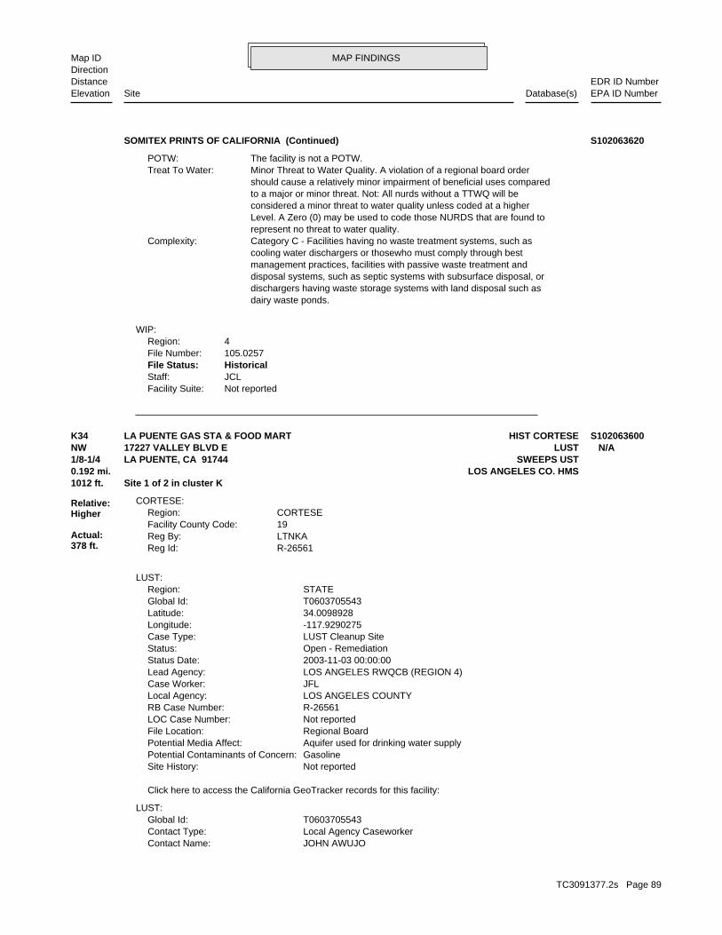
MAP FINDINGSMap IDDirection
EDR ID NumberDistanceEPA ID NumberDatabase(s)SiteElevation
Not reportedFacility Suite:JCLStaff:HistoricalFile Status:105.0257File Number:4Region:
WIP:
dairy waste ponds. dischargers having waste storage systems with land disposal such as disposal systems, such as septic systems with subsurface disposal, or management practices, facilities with passive waste treatment and cooling water dischargers or thosewho must comply through best Category C - Facilities having no waste treatment systems, such asComplexity: represent no threat to water quality. Level. A Zero (0) may be used to code those NURDS that are found to considered a minor threat to water quality unless coded at a higher to a major or minor threat. Not: All nurds without a TTWQ will be should cause a relatively minor impairment of beneficial uses compared Minor Threat to Water Quality. A violation of a regional board orderTreat To Water: The facility is not a POTW.POTW:
SOMITEX PRINTS OF CALIFORNIA (Continued) S102063620
JOHN AWUJOContact Name: Local Agency CaseworkerContact Type: T0603705543Global Id:
LUST:
Click here to access the California GeoTracker records for this facility:
Not reportedSite History: GasolinePotential Contaminants of Concern: Aquifer used for drinking water supplyPotential Media Affect: Regional BoardFile Location: Not reportedLOC Case Number: R-26561RB Case Number: LOS ANGELES COUNTYLocal Agency: JFLCase Worker: LOS ANGELES RWQCB (REGION 4)Lead Agency: 2003-11-03 00:00:00Status Date: Open - RemediationStatus: LUST Cleanup SiteCase Type: -117.9290275Longitude: 34.0098928Latitude: T0603705543Global Id: STATERegion:
LUST:
R-26561Reg Id: LTNKAReg By: 19Facility County Code: CORTESERegion:
CORTESE:
1012 ft. Site 1 of 2 in cluster K0.192 mi. LOS ANGELES CO. HMS
Relative:Higher
Actual:378 ft.
1/8-1/4 SWEEPS USTLA PUENTE, CA 91744NW LUST17227 VALLEY BLVD E N/AK34 HIST CORTESELA PUENTE GAS STA & FOOD MART S102063600
TC3091377.2s Page 89
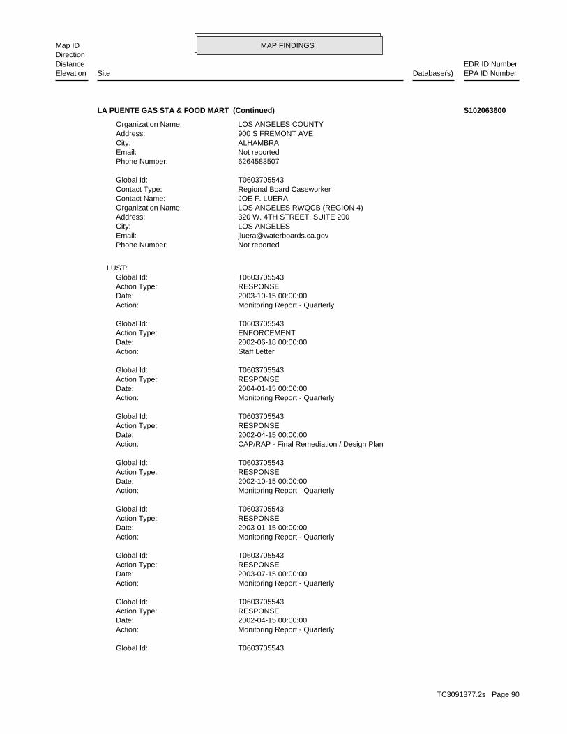
MAP FINDINGSMap IDDirection
EDR ID NumberDistanceEPA ID NumberDatabase(s)SiteElevation
T0603705543Global Id:
Monitoring Report - QuarterlyAction: 2002-04-15 00:00:00Date: RESPONSEAction Type: T0603705543Global Id:
Monitoring Report - QuarterlyAction: 2003-07-15 00:00:00Date: RESPONSEAction Type: T0603705543Global Id:
Monitoring Report - QuarterlyAction: 2003-01-15 00:00:00Date: RESPONSEAction Type: T0603705543Global Id:
Monitoring Report - QuarterlyAction: 2002-10-15 00:00:00Date: RESPONSEAction Type: T0603705543Global Id:
CAP/RAP - Final Remediation / Design PlanAction: 2002-04-15 00:00:00Date: RESPONSEAction Type: T0603705543Global Id:
Monitoring Report - QuarterlyAction: 2004-01-15 00:00:00Date: RESPONSEAction Type: T0603705543Global Id:
Staff LetterAction: 2002-06-18 00:00:00Date: ENFORCEMENTAction Type: T0603705543Global Id:
Monitoring Report - QuarterlyAction: 2003-10-15 00:00:00Date: RESPONSEAction Type: T0603705543Global Id:
LUST:
Not reportedPhone Number: [email protected]: LOS ANGELESCity: 320 W. 4TH STREET, SUITE 200Address: LOS ANGELES RWQCB (REGION 4)Organization Name: JOE F. LUERAContact Name: Regional Board CaseworkerContact Type: T0603705543Global Id:
6264583507Phone Number: Not reportedEmail: ALHAMBRACity: 900 S FREMONT AVEAddress: LOS ANGELES COUNTYOrganization Name:
LA PUENTE GAS STA & FOOD MART (Continued) S102063600
TC3091377.2s Page 90
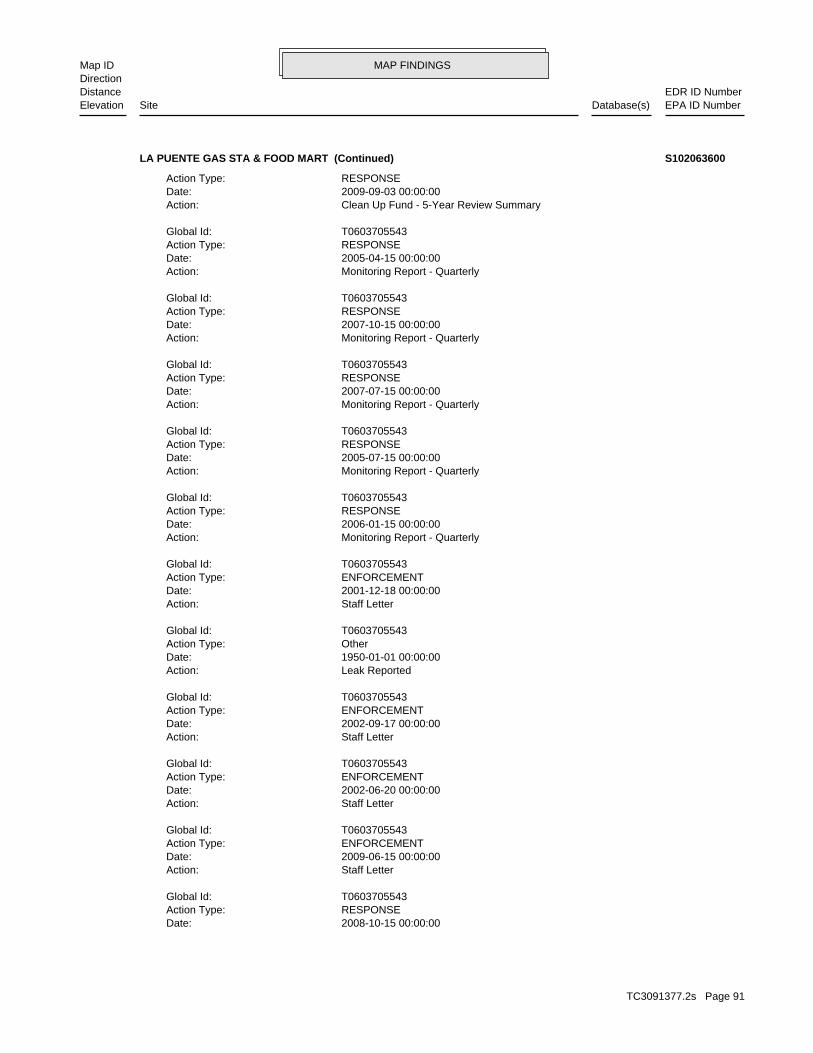
MAP FINDINGSMap IDDirection
EDR ID NumberDistanceEPA ID NumberDatabase(s)SiteElevation
2008-10-15 00:00:00Date: RESPONSEAction Type: T0603705543Global Id:
Staff LetterAction: 2009-06-15 00:00:00Date: ENFORCEMENTAction Type: T0603705543Global Id:
Staff LetterAction: 2002-06-20 00:00:00Date: ENFORCEMENTAction Type: T0603705543Global Id:
Staff LetterAction: 2002-09-17 00:00:00Date: ENFORCEMENTAction Type: T0603705543Global Id:
Leak ReportedAction: 1950-01-01 00:00:00Date: OtherAction Type: T0603705543Global Id:
Staff LetterAction: 2001-12-18 00:00:00Date: ENFORCEMENTAction Type: T0603705543Global Id:
Monitoring Report - QuarterlyAction: 2006-01-15 00:00:00Date: RESPONSEAction Type: T0603705543Global Id:
Monitoring Report - QuarterlyAction: 2005-07-15 00:00:00Date: RESPONSEAction Type: T0603705543Global Id:
Monitoring Report - QuarterlyAction: 2007-07-15 00:00:00Date: RESPONSEAction Type: T0603705543Global Id:
Monitoring Report - QuarterlyAction: 2007-10-15 00:00:00Date: RESPONSEAction Type: T0603705543Global Id:
Monitoring Report - QuarterlyAction: 2005-04-15 00:00:00Date: RESPONSEAction Type: T0603705543Global Id:
Clean Up Fund - 5-Year Review SummaryAction: 2009-09-03 00:00:00Date: RESPONSEAction Type:
LA PUENTE GAS STA & FOOD MART (Continued) S102063600
TC3091377.2s Page 91

MAP FINDINGSMap IDDirection
EDR ID NumberDistanceEPA ID NumberDatabase(s)SiteElevation
Not reportedDate the Case was Closed: 5/31/2002Date Case Last Changed on Database: Not reportedDate Leak Stopped: Not reportedDate Confirmation Began: Not reportedDate Leak Record Entered: 3/16/1999Date Leak First Reported: 2/17/1999Date Leak Discovered: LETEnforcement Type: LAURA AVECross Street: 19000Local Agency: HSPStaff: Not reportedW Global ID: T0603705543Global ID: Not reportedAbatement Method Used at the Site: GroundwaterCase Type: Not reportedLocal Case No: Not reportedSubstance Quantity: GasolineSubstance: Remedial action (cleanup) UnderwayStatus: R-26561facid: Los AngelesCounty: 04Regional Board: 4Region:
LUST REG 4:
Final Remedial Action Report / Corrective Action ReportAction: 2003-09-15 00:00:00Date: RESPONSEAction Type: T0603705543Global Id:
Other Report / DocumentAction: 2002-07-31 00:00:00Date: RESPONSEAction Type: T0603705543Global Id:
Leak DiscoveryAction: 1950-01-01 00:00:00Date: OtherAction Type: T0603705543Global Id:
Soil and Water Investigation ReportAction: 2002-09-20 00:00:00Date: RESPONSEAction Type: T0603705543Global Id:
Soil and Water Investigation ReportAction: 2002-05-15 00:00:00Date: RESPONSEAction Type: T0603705543Global Id:
Monitoring Report - Semi-AnnuallyAction: 2009-07-15 00:00:00Date: RESPONSEAction Type: T0603705543Global Id:
Monitoring Report - QuarterlyAction:
LA PUENTE GAS STA & FOOD MART (Continued) S102063600
TC3091377.2s Page 92
MAP FINDINGSMap IDDirection
EDR ID NumberDistanceEPA ID NumberDatabase(s)SiteElevation
4670Comp Number: AStatus:
4Number Of Tanks: Not reportedContent: WStg: UNKNOWNTank Use: Not reportedCapacity: 06-30-89Actv Date: 19-000-004670-000001Swrcb Tank Id: Not reportedOwner Tank Id: ATank Status: 06-30-89Created Date: Not reportedAct Date: 06-30-89Ref Date: 44-007838Board Of Equalization: 9Number: 4670Comp Number: AStatus:
SWEEPS UST:
PHASED PROGRAM & INITIATE THE PROGRAM WITH GW MON WELL INSTALL. 7/20/00 REMEDIAL ACTION WP; 3/5/01 REQUEST TO CONDUCT THE RAP ON ASummary: Not reportedAssigned Name: Not reportedSuspended: Not reportedCleanup Fund Id: Not reportedPriority: Not reportedBeneficial Use: Not reportedLocal Agency Staff: 34.0098928 / -1Lat/Long: LUSTProgram: 46 WHISTLING ISLERP Address: MR. BHUPENDRA N. PATELResponsible Party: Not reportedOwner Contact: Not reportedOrganization: =Soil Qualifier: =GW Qualifier: YesSignificant Interim Remedial Action Taken: 12985Hist Max MTBE Conc in Soil: 40908Hist Max MTBE Conc in Groundwater: 4/25/2002Historical Max MTBE Date: 2/9/2001Enforcement Action Date: 3/16/1999Post Remedial Action Monitoring Began: 11/3/2003Remedial Action Underway: 5/3/2002Remediation Plan Submitted: 6/20/2002Pollution Characterization Began: 2/9/2001Preliminary Site Assessment Began: 5/30/2000Preliminary Site Assessment Workplan Submitted: TankSource of Cleanup Funding: 6800.1256249919070201082146137Approx. Dist To Production Well (ft): Not reportedWell Name: Not reportedWater System: Not reportedOperator: TankLeak Source: Not reportedCause of Leak: Not reportedHow Leak Stopped: Repair TankHow Leak Discovered:
LA PUENTE GAS STA & FOOD MART (Continued) S102063600
TC3091377.2s Page 93
MAP FINDINGSMap IDDirection
EDR ID NumberDistanceEPA ID NumberDatabase(s)SiteElevation
T0Facility Type:ClosedPermit Status:00005605TPermit Number:6JArea:ClosedFacility Status:004501-004670Facility Id:LARegion:
LOS ANGELES CO. HMS:
Not reportedNumber Of Tanks: Not reportedContent: WStg: UNKNOWNTank Use: Not reportedCapacity: 06-30-89Actv Date: 19-000-004670-000004Swrcb Tank Id: Not reportedOwner Tank Id: ATank Status: 06-30-89Created Date: Not reportedAct Date: 06-30-89Ref Date: 44-007838Board Of Equalization: 9Number: 4670Comp Number: AStatus:
Not reportedNumber Of Tanks: Not reportedContent: WStg: UNKNOWNTank Use: Not reportedCapacity: 06-30-89Actv Date: 19-000-004670-000003Swrcb Tank Id: Not reportedOwner Tank Id: ATank Status: 06-30-89Created Date: Not reportedAct Date: 06-30-89Ref Date: 44-007838Board Of Equalization: 9Number: 4670Comp Number: AStatus:
Not reportedNumber Of Tanks: Not reportedContent: WStg: UNKNOWNTank Use: Not reportedCapacity: 06-30-89Actv Date: 19-000-004670-000002Swrcb Tank Id: Not reportedOwner Tank Id: ATank Status: 06-30-89Created Date: Not reportedAct Date: 06-30-89Ref Date: 44-007838Board Of Equalization: 9Number:
LA PUENTE GAS STA & FOOD MART (Continued) S102063600
TC3091377.2s Page 94
MAP FINDINGSMap IDDirection
EDR ID NumberDistanceEPA ID NumberDatabase(s)SiteElevation
T0Facility Type:RemovedPermit Status:000238860Permit Number:6JArea:RemovedFacility Status:004501-026561Facility Id:LARegion:
Not reportedFacility Type:Not reportedPermit Status:Not reportedPermit Number:6JArea:OPENFacility Status:004501-055023Facility Id:LARegion:
LA PUENTE GAS STA & FOOD MART (Continued) S102063600
UNLEADEDType of Fuel: PRODUCTTank Used for: 00004000Tank Capacity: Not reportedYear Installed: 2Container Num: 003Tank Num:
Stock InventorLeak Detection: Not reportedTank Construction: REGULARType of Fuel: PRODUCTTank Used for: 00006000Tank Capacity: Not reportedYear Installed: 3Container Num: 002Tank Num:
Stock InventorLeak Detection: Not reportedTank Construction: PREMIUMType of Fuel: PRODUCTTank Used for: 00006000Tank Capacity: Not reportedYear Installed: 4Container Num: 001Tank Num:
LA PUENTE, CA 91744Owner City,St,Zip: 17227 E. VALLEY BLVD.Owner Address: MOHAMED A. MUWALLAOwner Name: 8189127814Telephone: MOHAMED MUWALLAContact Name: 0004Total Tanks: Not reportedOther Type: Gas StationFacility Type: 00000016998Facility ID: STATERegion:
HIST UST:
1012 ft. Site 2 of 2 in cluster K0.192 mi.
Relative:Higher
Actual:378 ft.
1/8-1/4 LA PUENTE, CA 91744NW 17227 VALLEY BLVD N/AK35 HIST USTM. MUWALLA’S ARCO U001569633
TC3091377.2s Page 95
MAP FINDINGSMap IDDirection
EDR ID NumberDistanceEPA ID NumberDatabase(s)SiteElevation
Stock InventorLeak Detection: Not reportedTank Construction: UNLEADEDType of Fuel: PRODUCTTank Used for: 00004000Tank Capacity: Not reportedYear Installed: 1Container Num: 004Tank Num:
Stock InventorLeak Detection: Not reportedTank Construction:
M. MUWALLA’S ARCO (Continued) U001569633
004Tank Num:
Stock InventorLeak Detection: Not reportedTank Construction: DIESELType of Fuel: PRODUCTTank Used for: 00008000Tank Capacity: 1977Year Installed: 1Container Num: 003Tank Num:
Stock InventorLeak Detection: Not reportedTank Construction: DIESELType of Fuel: PRODUCTTank Used for: 00008000Tank Capacity: 1977Year Installed: 2Container Num: 002Tank Num:
Stock InventorLeak Detection: Not reportedTank Construction: PREMIUMType of Fuel: PRODUCTTank Used for: 00010000Tank Capacity: 1978Year Installed: 4Container Num: 001Tank Num:
CARROLLTON, TX 75006Owner City,St,Zip: 1820 N. JOSEY LANEOwner Address: MERICO, INC.Owner Name: 8189121671Telephone: JIM HILLERContact Name: 0004Total Tanks: FOOD PROCESSOROther Type: OtherFacility Type: 00000003969Facility ID: STATERegion:
HIST UST:
1154 ft. Site 4 of 6 in cluster J0.219 mi.
Relative:Higher
Actual:394 ft.
1/8-1/4 CITY OF INDUSTRY, CA 91749SSE WIP17380 RAILROAD ST N/AJ36 HIST USTROD’S FOOD PRODUCTS 1000137907
TC3091377.2s Page 96

MAP FINDINGSMap IDDirection
EDR ID NumberDistanceEPA ID NumberDatabase(s)SiteElevation
Not reportedFacility Suite:RWANGStaff:HistoricalFile Status:105.0240File Number:4Region:
Not reportedFacility Suite:UNIDENTIFIEDStaff:HistoricalFile Status:105.0205File Number:4Region:
WIP:
Stock InventorLeak Detection: Not reportedTank Construction: UNLEADEDType of Fuel: PRODUCTTank Used for: 00010000Tank Capacity: 1978Year Installed: 3Container Num:
ROD’S FOOD PRODUCTS (Continued) 1000137907
GREEN BAY, WI 54307 PO BOX 19057Owner/operator address: TREEHOUSE FOODS INCOwner/operator name:
Owner/Operator Summary:
hazardous waste at any time waste during any calendar month, and accumulates more than 1000 kg of hazardous waste at any time; or generates 100 kg or less of hazardous waste during any calendar month and accumulates less than 6000 kg of Handler: generates more than 100 and less than 1000 kg of hazardousDescription: Small Small Quantity GeneratorClassification: 09EPA Region: [email protected] email: 215Telephone ext.: 626-912-1671Contact telephone: USContact country: CITY OF INDUSTRY, CA 91748 17380 RAILROAD STREETContact address: ARTHUR THOMASContact: CAD983576950EPA ID: CITY OF INDUSTRY, CA 91748 17380 RAILROAD STREETFacility address: BAY VALLEY FOODS LLCFacility name: 07/13/2005Date form received by agency:
RCRA-SQG:
EMIHAZNET
LOS ANGELES CO. HMSSWEEPS UST
CA FID UST1156 ft. LUSTSite 5 of 6 in cluster J0.219 mi. HIST CORTESE
Relative:Higher
Actual:395 ft.
1/8-1/4 NPDESLA PUENTE, CA 91748SSE FINDS17380 RAILROAD ST CAD983576950J37 RCRA-SQGBAY VALLEY FOODS LLC 1000594069
TC3091377.2s Page 97

MAP FINDINGSMap IDDirection
EDR ID NumberDistanceEPA ID NumberDatabase(s)SiteElevation
USED BY MANY INDUSTRIES TO CLEAN METAL PARTS PRIOR TO PAINTING. WHEN OR DEGREASE PARTS. HYDROCHLORIC ACID, A SOLUTION WITH A LOW PH, IS CAUSTIC SOLUTION WITH A HIGH PH, IS OFTEN USED BY INDUSTRIES TO CLEAN CONSIDERED TO BE A CORROSIVE HAZARDOUS WASTE. SODIUM HYDROXIDE, A A WASTE WHICH HAS A PH OF LESS THAN 2 OR GREATER THAN 12.5 ISWaste name: D002Waste code:
WHICH WOULD BE CONSIDERED AS IGNITABLE HAZARDOUS WASTE. MATERIAL. LACQUER THINNER IS AN EXAMPLE OF A COMMONLY USED SOLVENT WHICH CAN BE OBTAINED FROM THE MANUFACTURER OR DISTRIBUTOR OF THE FLASH POINT OF A WASTE IS TO REVIEW THE MATERIAL SAFETY DATA SHEET, CLOSED CUP FLASH POINT TESTER. ANOTHER METHOD OF DETERMINING THE LESS THAN 140 DEGREES FAHRENHEIT AS DETERMINED BY A PENSKY-MARTENS IGNITABLE HAZARDOUS WASTES ARE THOSE WASTES WHICH HAVE A FLASHPOINT OFWaste name: D001Waste code:
Hazardous Waste Summary:
Small Quantity GeneratorClassification: RODS FOODS PRODUCTS INCSite name: BAY VALLEY FOODS LLCFacility name: 11/18/1991Date form received by agency:
Historical Generators:
NoUsed oil transporter: NoUsed oil transfer facility: NoUsed oil Specification marketer: NoUsed oil fuel marketer to burner: NoUser oil refiner: NoUsed oil processor: NoUsed oil fuel burner: NoFurnace exemption: NoOn-site burner exemption: NoUnderground injection activity: NoTreater, storer or disposer of HW: NoTransporter of hazardous waste: NoRecycler of hazardous waste: NoMixed waste (haz. and radioactive): NoU.S. importer of hazardous waste:
Handler Activities Summary:
Not reportedOwner/Op end date: 06/27/2005Owner/Op start date: OperatorOwner/Operator Type: PrivateLegal status: Not reportedOwner/operator telephone: USOwner/operator country: Not reported Not reportedOwner/operator address: BAY VALLEY FOODS LLCOwner/operator name:
Not reportedOwner/Op end date: 06/27/2005Owner/Op start date: OwnerOwner/Operator Type: PrivateLegal status: Not reportedOwner/operator telephone: USOwner/operator country:
BAY VALLEY FOODS LLC (Continued) 1000594069
TC3091377.2s Page 98
MAP FINDINGSMap IDDirection
EDR ID NumberDistanceEPA ID NumberDatabase(s)SiteElevation
N/AAgency Id: TerminatedFacility Status: CAS000002Npdes Number:
91744Discharge Zip: CaDischarge State: City Of IndustryDischarge City: 15625 E Stafford StDischarge Address: Industry CityDischarge Name: 5/22/2008Termination Date Of Regulatory Measure: Not reportedExpiration Date Of Regulatory Measure: 5/13/2008 4:10:00 PMEffective Date Of Regulatory Measure: N/AAdoption Date Of Regulatory Measure: ConstructionProgram Type: 4 19C351825WDID: Not AvailaPlace Id: EnrolleeRegulatory Measure Type: Not reportedOrder No: Not AvailaRegulatory Measure Id: 4Region: N/AAgency Id: TerminatedFacility Status: CAS000002Npdes Number:
NPDES:
corrective action activities required under RCRA.program staff to track the notification, permit, compliance, andand treat, store, or dispose of hazardous waste. RCRAInfo allows RCRAevents and activities related to facilities that generate, transport,Conservation and Recovery Act (RCRA) program through the tracking ofRCRAInfo is a national information system that supports the Resource
transported off-site.these facilities release directly to air, water, land, or that arefrom facilities on the amounts of over 300 listed toxic chemicals thatUS EPA TRIS (Toxics Release Inventory System) contains information
their precursors, as well as hazardous air pollutants (HAPs).on stationary and mobile sources that emit criteria air pollutants andThe NEI (National Emissions Inventory) database contains information
and settlements.regions and states with cooperative agreements, enforcement actions,Toxic Substances Control Act (TSCA). The system tracks inspections inFederal Insecticide, Fungicide, and Rodenticide Act (FIFRA) and theNCDB (National Compliance Data Base) supports implementation of the Environmental Interest/Information System
110002317895Registry ID:
FINDS:
No violations foundViolation Status:
DISPOSED, THE WASTE WOULD BE A CORROSIVE HAZARDOUS WASTE. THESE CAUSTIC OR ACID SOLUTIONS BECOME CONTAMINATED AND MUST BE
BAY VALLEY FOODS LLC (Continued) 1000594069
TC3091377.2s Page 99

MAP FINDINGSMap IDDirection
EDR ID NumberDistanceEPA ID NumberDatabase(s)SiteElevation
Not reportedSource of Cleanup Funding: 7879.2822634903298845079179957Approx. Dist To Production Well (ft): Not reportedWell Name: Not reportedWater System: Not reportedOperator: Not reportedLeak Source: Not reportedCause of Leak: Not reportedHow Leak Stopped: Not reportedHow Leak Discovered: 5/16/1996Date the Case was Closed: 5/16/1996Date Case Last Changed on Database: Not reportedDate Leak Stopped: Not reportedDate Confirmation Began: 8/29/1989Date Leak Record Entered: 8/21/1989Date Leak First Reported: Not reportedDate Leak Discovered: Not reportedEnforcement Type: Not reportedCross Street: 19000Local Agency: UNKStaff: Not reportedW Global ID: T0603702635Global ID: Excavate and DisposeAbatement Method Used at the Site: GroundwaterCase Type: Not reportedLocal Case No: Not reportedSubstance Quantity: GasolineSubstance: Case ClosedStatus: 917490016facid: Los AngelesCounty: 04Regional Board: 4Region:
LUST REG 4:
917490016Reg Id: LTNKAReg By: 19Facility County Code: CORTESERegion:
CORTESE:
91744Discharge Zip: CaDischarge State: City of IndustryDischarge City: 15625 E Stafford StDischarge Address: City of IndustryDischarge Name: 9/2/2010 7:45:00 AMTermination Date Of Regulatory Measure: Not reportedExpiration Date Of Regulatory Measure: 5/7/2008 1:41:00 PMEffective Date Of Regulatory Measure: N/AAdoption Date Of Regulatory Measure: ConstructionProgram Type: 4 19C351730WDID: Not AvailaPlace Id: EnrolleeRegulatory Measure Type: Not reportedOrder No: Not AvailaRegulatory Measure Id: 4Region:
BAY VALLEY FOODS LLC (Continued) 1000594069
TC3091377.2s Page 100
MAP FINDINGSMap IDDirection
EDR ID NumberDistanceEPA ID NumberDatabase(s)SiteElevation
Not reportedOwner Tank Id: ATank Status: 06-30-89Created Date: Not reportedAct Date: 06-30-89Ref Date: 44-009687Board Of Equalization: 9Number: 12339Comp Number: AStatus:
SWEEPS UST:
ActiveStatus: Not reportedComments: Not reportedEPA ID: Not reportedNPDES Number: Not reportedDUNs Number: Not reportedContact Phone: Not reportedContact: INDUSTRYMailing City,St,Zip: Not reportedMailing Address 2: 17380 RAILROAD STMailing Address: Not reportedMail To: 8180000000Facility Phone: Not reportedSIC Code: Not reportedCortese Code: 00003969Regulated ID: UTNKARegulated By: 19002111Facility ID:
CA FID UST:
LTR FROM LACDPW 1-23-95 RWQCB LEAD AGENCY.Summary: Not reportedAssigned Name: Not reportedSuspended: Not reportedCleanup Fund Id: Not reportedPriority: Not reportedBeneficial Use: Not reportedLocal Agency Staff: 34.0015001 / -1Lat/Long: LUSTProgram: 17380 RAILROAD ST, INDUSTRY, CA 91749RP Address: ROD’S FOODS PRODUCTSResponsible Party: Not reportedOwner Contact: Not reportedOrganization: Not reportedSoil Qualifier: Not reportedGW Qualifier: YesSignificant Interim Remedial Action Taken: Not reportedHist Max MTBE Conc in Soil: Not reportedHist Max MTBE Conc in Groundwater: Not reportedHistorical Max MTBE Date: Not reportedEnforcement Action Date: 4/17/1995Post Remedial Action Monitoring Began: Not reportedRemedial Action Underway: Not reportedRemediation Plan Submitted: 8/15/1989Pollution Characterization Began: Not reportedPreliminary Site Assessment Began: Not reportedPreliminary Site Assessment Workplan Submitted:
BAY VALLEY FOODS LLC (Continued) 1000594069
TC3091377.2s Page 101
MAP FINDINGSMap IDDirection
EDR ID NumberDistanceEPA ID NumberDatabase(s)SiteElevation
Not reportedMailing Name: 6269121671Telephone: ARTHUR THOMASContact: CAD983576950Gepaid: 2009Year:
Los AngelesFacility County: 0.0375Tons: (H010-H129) OR (H131-H135) STORAGE, BULKING, AND/OR TRANSFER OFF SITE--NO TREATMENT/REOVERYDisposal Method: Other organic solidsWaste Category: 99TSD County: AZR000501510TSD EPA ID: Los AngelesGen County: CITY OF INDUSTRY, CA 917480000Mailing City,St,Zip: 17380 RAILROAD STMailing Address: Not reportedMailing Name: 6269121671Telephone: ARTHUR THOMASContact: CAD983576950Gepaid: 2009Year:
HAZNET:
T0Facility Type:RemovedPermit Status:00004104TPermit Number:6HArea:RemovedFacility Status:012220-012339Facility Id:LARegion:
LOS ANGELES CO. HMS:
Not reportedNumber Of Tanks: Not reportedContent: WStg: UNKNOWNTank Use: Not reportedCapacity: 06-30-89Actv Date: 19-000-012339-000002Swrcb Tank Id: Not reportedOwner Tank Id: ATank Status: 06-30-89Created Date: Not reportedAct Date: 06-30-89Ref Date: 44-009687Board Of Equalization: 9Number: 12339Comp Number: AStatus:
2Number Of Tanks: Not reportedContent: WStg: UNKNOWNTank Use: Not reportedCapacity: 06-30-89Actv Date: 19-000-012339-000001Swrcb Tank Id:
BAY VALLEY FOODS LLC (Continued) 1000594069
TC3091377.2s Page 102

MAP FINDINGSMap IDDirection
EDR ID NumberDistanceEPA ID NumberDatabase(s)SiteElevation
Los AngelesFacility County: 0.418Tons: Not reportedDisposal Method: Waste oil and mixed oilWaste Category: Not reportedTSD County: AZR000504332TSD EPA ID: Los AngelesGen County: CITY OF INDUSTRY, CA 917480000Mailing City,St,Zip: 17380 RAILROAD STMailing Address: Not reportedMailing Name: 6269121671Telephone: ARTHUR THOMASContact: CAD983576950Gepaid: 2008Year:
Los AngelesFacility County: 0.285Tons: Not reportedDisposal Method: Waste oil and mixed oilWaste Category: 99TSD County: AZR000504332TSD EPA ID: Los AngelesGen County: CITY OF INDUSTRY, CA 917480000Mailing City,St,Zip: 17380 RAILROAD STMailing Address: Not reportedMailing Name: 6269121671Telephone: ARTHUR THOMASContact: CAD983576950Gepaid: 2009Year:
Los AngelesFacility County: 0.228Tons: ORGANICS RECOVERY ECT OTHER RECOVERY OF RECLAMATION FOR REUSE INCLUDING ACID REGENERATION,Disposal Method: Waste oil and mixed oilWaste Category: 99TSD County: AZR000504332TSD EPA ID: Los AngelesGen County: CITY OF INDUSTRY, CA 917480000Mailing City,St,Zip: 17380 RAILROAD STMailing Address: Not reportedMailing Name: 6269121671Telephone: ARTHUR THOMASContact: CAD983576950Gepaid: 2009Year:
Los AngelesFacility County: 0.19Tons: ORGANICS RECOVERY ECT OTHER RECOVERY OF RECLAMATION FOR REUSE INCLUDING ACID REGENERATION,Disposal Method: Waste oil and mixed oilWaste Category: Los AngelesTSD County: CAD099452708TSD EPA ID: Los AngelesGen County: CITY OF INDUSTRY, CA 917480000Mailing City,St,Zip: 17380 RAILROAD STMailing Address:
BAY VALLEY FOODS LLC (Continued) 1000594069
TC3091377.2s Page 103

MAP FINDINGSMap IDDirection
EDR ID NumberDistanceEPA ID NumberDatabase(s)SiteElevation
19County Code: 1997Year:
0Part. Matter 10 Micrometers & Smllr Tons/Yr: 0Particulate Matter Tons/Yr: 0SOX - Oxides of Sulphur Tons/Yr: 3NOX - Oxides of Nitrogen Tons/Yr: 1Carbon Monoxide Emissions Tons/Yr: 2Reactive Organic Gases Tons/Yr: 4Total Organic Hydrocarbon Gases Tons/Yr: Not reportedConsolidated Emission Reporting Rule: Not reportedCommunity Health Air Pollution Info System: SOUTH COAST AQMDAir District Name: 2099SIC Code: SCAir District Name: 42079Facility ID: SCAir Basin: 19County Code: 1996Year:
0Part. Matter 10 Micrometers & Smllr Tons/Yr: 0Particulate Matter Tons/Yr: 0SOX - Oxides of Sulphur Tons/Yr: 1NOX - Oxides of Nitrogen Tons/Yr: 0Carbon Monoxide Emissions Tons/Yr: 1Reactive Organic Gases Tons/Yr: 1Total Organic Hydrocarbon Gases Tons/Yr: Not reportedConsolidated Emission Reporting Rule: Not reportedCommunity Health Air Pollution Info System: SOUTH COAST AQMDAir District Name: 2099SIC Code: SCAir District Name: 42079Facility ID: SCAir Basin: 19County Code: 1995Year:
0Part. Matter 10 Micrometers & Smllr Tons/Yr: 0Particulate Matter Tons/Yr: 0SOX - Oxides of Sulphur Tons/Yr: 2NOX - Oxides of Nitrogen Tons/Yr: 0Carbon Monoxide Emissions Tons/Yr: 1Reactive Organic Gases Tons/Yr: 3Total Organic Hydrocarbon Gases Tons/Yr: Not reportedConsolidated Emission Reporting Rule: Not reportedCommunity Health Air Pollution Info System: SOUTH COAST AQMDAir District Name: 2099SIC Code: SCAir District Name: 42079Facility ID: SCAir Basin: 19County Code: 1990Year:
EMI:
13 additional CA_HAZNET: record(s) in the EDR Site Report.Click this hyperlink while viewing on your computer to access
BAY VALLEY FOODS LLC (Continued) 1000594069
TC3091377.2s Page 104

MAP FINDINGSMap IDDirection
EDR ID NumberDistanceEPA ID NumberDatabase(s)SiteElevation
Not reportedCommunity Health Air Pollution Info System: SOUTH COAST AQMDAir District Name: 2099SIC Code: SCAir District Name: 42079Facility ID: SCAir Basin: 19County Code: 2000Year:
0Part. Matter 10 Micrometers & Smllr Tons/Yr: 0Particulate Matter Tons/Yr: 0SOX - Oxides of Sulphur Tons/Yr: 2NOX - Oxides of Nitrogen Tons/Yr: 0Carbon Monoxide Emissions Tons/Yr: 0Reactive Organic Gases Tons/Yr: 0Total Organic Hydrocarbon Gases Tons/Yr: Not reportedConsolidated Emission Reporting Rule: Not reportedCommunity Health Air Pollution Info System: SOUTH COAST AQMDAir District Name: 2099SIC Code: SCAir District Name: 42079Facility ID: SCAir Basin: 19County Code: 1999Year:
0Part. Matter 10 Micrometers & Smllr Tons/Yr: 0Particulate Matter Tons/Yr: 0SOX - Oxides of Sulphur Tons/Yr: 2NOX - Oxides of Nitrogen Tons/Yr: 0Carbon Monoxide Emissions Tons/Yr: 0Reactive Organic Gases Tons/Yr: 0Total Organic Hydrocarbon Gases Tons/Yr: Not reportedConsolidated Emission Reporting Rule: Not reportedCommunity Health Air Pollution Info System: SOUTH COAST AQMDAir District Name: 2099SIC Code: SCAir District Name: 42079Facility ID: SCAir Basin: 19County Code: 1998Year:
0Part. Matter 10 Micrometers & Smllr Tons/Yr: 0Particulate Matter Tons/Yr: 0SOX - Oxides of Sulphur Tons/Yr: 2NOX - Oxides of Nitrogen Tons/Yr: 0Carbon Monoxide Emissions Tons/Yr: 0Reactive Organic Gases Tons/Yr: 0Total Organic Hydrocarbon Gases Tons/Yr: Not reportedConsolidated Emission Reporting Rule: Not reportedCommunity Health Air Pollution Info System: SOUTH COAST AQMDAir District Name: 2099SIC Code: SCAir District Name: 42079Facility ID: SCAir Basin:
BAY VALLEY FOODS LLC (Continued) 1000594069
TC3091377.2s Page 105
MAP FINDINGSMap IDDirection
EDR ID NumberDistanceEPA ID NumberDatabase(s)SiteElevation
0Part. Matter 10 Micrometers & Smllr Tons/Yr: 0Particulate Matter Tons/Yr: 0SOX - Oxides of Sulphur Tons/Yr: 2NOX - Oxides of Nitrogen Tons/Yr: 1Carbon Monoxide Emissions Tons/Yr: 0Reactive Organic Gases Tons/Yr: 0Total Organic Hydrocarbon Gases Tons/Yr: Not reportedConsolidated Emission Reporting Rule: Not reportedCommunity Health Air Pollution Info System: SOUTH COAST AQMDAir District Name: 2099SIC Code: SCAir District Name: 42079Facility ID: SCAir Basin: 19County Code: 2001Year:
0Part. Matter 10 Micrometers & Smllr Tons/Yr: 0Particulate Matter Tons/Yr: 0SOX - Oxides of Sulphur Tons/Yr: 2NOX - Oxides of Nitrogen Tons/Yr: 0Carbon Monoxide Emissions Tons/Yr: 0Reactive Organic Gases Tons/Yr: 0Total Organic Hydrocarbon Gases Tons/Yr: Not reportedConsolidated Emission Reporting Rule:
BAY VALLEY FOODS LLC (Continued) 1000594069
-117.92623Longitude:34.00193Latitude:1560Facility ID:
UST:
1156 ft. Site 6 of 6 in cluster J0.219 mi.
Relative:Higher
Actual:395 ft.
1/8-1/4 ROWLAND HEIGHTS, CA 91748SSE 17380 RAILROAD ST N/AJ38 USTRODS FOOD PRODUCTS U004049075
Not reportedFacility Suite:UNIDENTIFIEDStaff:Not reportedFile Status:105.0148File Number:4Region:
WIP:
1178 ft. Site 1 of 2 in cluster L0.223 mi.
Relative:Higher
Actual:390 ft.
1/8-1/4 CITY OF INDUSTRY (CORPORATE NA, CA 91748South 1100 S AZUSA AVE N/AL39 WIPL.A. CROWN INTERNATIONAL CO. S106764873
TC3091377.2s Page 106

MAP FINDINGSMap IDDirection
EDR ID NumberDistanceEPA ID NumberDatabase(s)SiteElevation
Not reportedFacility Suite:UNIDENTIFIEDStaff:Not reportedFile Status:105.0245File Number:4Region:
WIP:
1178 ft. Site 2 of 2 in cluster L0.223 mi.
Relative:Higher
Actual:390 ft.
1/8-1/4 CITY OF INDUSTRY (CORPORATE NA, CA 91748South 1100 S AZUSA AVE N/AL40 WIPRUSSEL STANLEY WEST, INC. S106764934
Not reportedRestrictions: YesPublic Notice: San Gabriel ValleyArea:
LOS ANGELES CO. LF:
1385 ft. Site 1 of 3 in cluster M0.262 mi.
Relative:Higher
Actual:384 ft.
1/4-1/2 CITY OF INDUSTRY, CA 91748ESE 999 HATCHER AVENUE N/AM41 SWF/LFGRAND CENTRAL RECYCLING & TRANSFER STATION/GRAND CENTRAL REC S108657834
Not reportedMailing Name: 6269647500Telephone: JAMES SCZEPCZENSKIContact: CAL000012972Gepaid: 2003Year:
Los AngelesFacility County: 3.44Tons: R01Disposal Method: Waste oil and mixed oilWaste Category: Los AngelesTSD County: CAT080013352TSD EPA ID: Los AngelesGen County: CITY OF INDUSTRY, CA 917461202Mailing City,St,Zip: 13280 AMAR ROADMailing Address: Not reportedMailing Name: 6269647500Telephone: JAMES SCZEPCZENSKIContact: CAL000012972Gepaid: 2003Year:
HAZNET:
Not reportedFacility Suite:JCLStaff:HistoricalFile Status:105.0115File Number:4Region:
WIP:
1393 ft. Site 2 of 3 in cluster M0.264 mi.
Relative:Higher
Actual:384 ft.
1/4-1/2 HWPCITY OF INDUSTRY, CA 91748ESE HAZNET999 S HATCHER AVE N/AM42 WIPMAXIM LIGHTING INTERNATIONAL S103678071
TC3091377.2s Page 107
MAP FINDINGSMap IDDirection
EDR ID NumberDistanceEPA ID NumberDatabase(s)SiteElevation
Not reportedFacility County: 7.25Tons: D80Disposal Method: Other organic solidsWaste Category: Los AngelesTSD County: Not reportedTSD EPA ID: Los AngelesGen County: CITY OF INDUSTRY, CA 917461202Mailing City,St,Zip: 13280 AMAR ROADMailing Address: Not reportedMailing Name: 6269647500Telephone: JAMES SCZEPCZENSKIContact: CAL000012972Gepaid: 2002Year:
Not reportedFacility County: 11.74Tons: R01Disposal Method: Waste oil and mixed oilWaste Category: Los AngelesTSD County: Not reportedTSD EPA ID: Los AngelesGen County: CITY OF INDUSTRY, CA 917461202Mailing City,St,Zip: 13280 AMAR ROADMailing Address: Not reportedMailing Name: 6269647500Telephone: JAMES SCZEPCZENSKIContact: CAL000012972Gepaid: 2002Year:
Los AngelesFacility County: 1.14Tons: R01Disposal Method: Waste oil and mixed oilWaste Category: Los AngelesTSD County: CAD099452708TSD EPA ID: Los AngelesGen County: CITY OF INDUSTRY, CA 917461202Mailing City,St,Zip: 13280 AMAR ROADMailing Address: Not reportedMailing Name: 6269647500Telephone: JAMES SCZEPCZENSKIContact: CAL000012972Gepaid: 2003Year:
Los AngelesFacility County: 3.8Tons: D80Disposal Method: Other organic solidsWaste Category: Los AngelesTSD County: CAT080033681TSD EPA ID: Los AngelesGen County: CITY OF INDUSTRY, CA 917461202Mailing City,St,Zip: 13280 AMAR ROADMailing Address:
MAXIM LIGHTING INTERNATIONAL (Continued) S103678071
TC3091377.2s Page 108

MAP FINDINGSMap IDDirection
EDR ID NumberDistanceEPA ID NumberDatabase(s)SiteElevation
is necessary. Corrective action will be similarly evaluated at those closure was achieved or whether post-closure care such as monitoring available, explains the various actions, and determines whether clean plan can be prepared by DTSC which incorporates all of the data the former waste units will be evaluated on that basis. A closure activities undertaken by IUDA is being sought and clean closure of decontamination is moot at this point. Documentation of the from ground water at the Facility. Any issue of further sampling and trans-1,2-Dichloroethene (DCE). 1,1,1 TCA, TCE, and PCE were reported 1,1,1-Trichloroethane (TCA), Perchlorethene (PCE), and previous encountered in the soils at the Facility included operation now occupies the property. Constituents-of-concern (COCs), the former units were handled by IUDA. A regional waste recycling received a report on any sampling nor on how the demolition wastes of IUDA demolished all traces of the former Facility. DTSC has not redevelop the property. In the process of redeveloping the property, IUDA did not submit a revised Closure Plan to DTSC, but proceeded to waste management units and remediate any associated contamination. (IUDA) in 1999. IUDA requested guidance from DTSC on how to close the was transferred to the City of Industry Urban Redevelopment Agency soil, groundwater and soil vapor sampling and analysis. The property in some twelve reports on investigations for site characterization of Works, various owners, and various potential buyers. These resulted Quality Control Board, County of Los Angeles Department of Public investigations were performed for the Los Angeles Regional Water Robertson and still determined to be deficient. By 1998, a number of revised Closure Plan was submitted in 1994. This was revised by DTSC with Robertson and the sampling analysis plan (SAP) portion of a Facility. Throughout this period there were intermittent contacts by manufacturing operations such as Maxim Lighting occupied the former property was transferred to the Gomel Family Trust and other never submitted by Robertson and no approval was ever granted. The It ceased operation in 1986, however an adequate closure plan was was located on a multi-acre property located in the City of Industry. aluminum and other metal architectural fixtures. The former Facility stored wastes generated on-site during manufacture of anodized was under an interim status document (ISD). The former facility the former Facility is Robertson Ceco Corp. (Robertson). Operation Inactive facility undergoing closure: The operator and prior owner ofFacility Status: Not reportedPublic Information Officer: 24Senate District: 58Assembly District: 300351Site Code: Not reportedSupervisor: RICHARD ALLENCorrective Action Lead: Not reportedPermit Renewal Lead: Not reportedPermit Maintenance Lead: SOUTHERN CALIFORNIA PERMITS AND CORRECTIVE ACTIONRegion: Not reportedCleanup Status: HAZ WASTE - UNDERGOING CLOSUREFacility Type: -117.922687Longitude: 34.003566Latitude: CAD008246027EPA Id:
HWP:
9 additional CA_HAZNET: record(s) in the EDR Site Report.Click this hyperlink while viewing on your computer to access
MAXIM LIGHTING INTERNATIONAL (Continued) S103678071
TC3091377.2s Page 109
MAP FINDINGSMap IDDirection
EDR ID NumberDistanceEPA ID NumberDatabase(s)SiteElevation
Not reportedDoc Comments: 1992-12-23 00:00:00Actual Date: Notice of Deficiency - Closure PlanEvent Description: CONTAIN1, TANKSTR1, TANKTRT1Unit Names: CAD008246027EPA Id:
HWP:
Not reportedDoc Comments: 1980-11-19 00:00:00Actual Date: Initial SubmittalEvent Description: CONTAIN1, TANKSTR1, TANKTRT1Unit Names: CAD008246027EPA Id:
Not reportedDoc Comments: 1981-03-30 00:00:00Actual Date: Approval of Interim Status ChangeEvent Description: CONTAIN1, TANKSTR1, TANKTRT1Unit Names: CAD008246027EPA Id:
HWP:
Not reportedSite History: various previous sampling programs. areas of the property where contamination had been demonstrated in
MAXIM LIGHTING INTERNATIONAL (Continued) S103678071
CITY NOT REPORTED, ME 99999 ADDRESS NOT REPORTEDOwner/operator address: NAME NOT REPORTEDOwner/operator name:
Owner/Operator Summary:
Handler: Non-Generators do not presently generate hazardous wasteDescription: Non-GeneratorClassification: waste Handler is engaged in the treatment, storage or disposal of hazardousDescription: TSDFClassification: Facility is not located on Indian land. Additional information is not known.Land type: 09EPA Region: Not reportedContact email: Not reportedContact telephone: Not reportedContact country: Not reported Not reportedContact address: Not reportedContact: CY OF INDUSTY, CA 91744 PO BOX 1215Mailing address: CAD008246027EPA ID: LA PUENTE, CA 91748 999 S HATCHER AVEFacility address: H H ROBERTSON CO WASDFacility name: 09/16/1994Date form received by agency:
RCRA-TSDF:
1393 ft. Site 3 of 3 in cluster M0.264 mi. HIST UST
Relative:Higher
Actual:384 ft.
1/4-1/2 FINDSLA PUENTE, CA 91748ESE RCRA-NonGen999 SOUTH HATCHER AVENUE CAD008246027M43 RCRA-TSDFH H ROBERTSON CO WASD 1000130159
TC3091377.2s Page 110

MAP FINDINGSMap IDDirection
EDR ID NumberDistanceEPA ID NumberDatabase(s)SiteElevation
Not reported Proposed penalty amount: State Enforcement lead agency: Not reported Enf. disp. status date: Not reported Enf. disposition status: 01/27/1987 Enforcement action date: WRITTEN INFORMAL Enforcement action: StateViolation lead agency: 01/01/1987Date achieved compliance: 11/26/1986Date violation determined: TSD - Financial RequirementsArea of violation: Not reportedRegulation violated:
Facility Has Received Notices of Violations:
CA029Event: 12/20/2007Event date:
Corrective Action Summary:
Large Quantity GeneratorClassification: H H ROBERTSON CO WASDFacility name: 08/18/1980Date form received by agency:
Historical Generators:
NoUsed oil transporter: NoUsed oil transfer facility: NoUsed oil Specification marketer: NoUsed oil fuel marketer to burner: NoUser oil refiner: NoUsed oil processor: NoUsed oil fuel burner: NoFurnace exemption: NoOn-site burner exemption: NoUnderground injection activity: NoTreater, storer or disposer of HW: NoTransporter of hazardous waste: NoRecycler of hazardous waste: NoMixed waste (haz. and radioactive): NoU.S. importer of hazardous waste:
Handler Activities Summary:
Not reportedOwner/Op end date: Not reportedOwner/Op start date: OwnerOwner/Operator Type: PrivateLegal status: (415) 555-1212Owner/operator telephone: Not reportedOwner/operator country: NOT REQUIRED, ME 99999 NOT REQUIREDOwner/operator address: H H ROBERTSON COOwner/operator name:
Not reportedOwner/Op end date: Not reportedOwner/Op start date: OperatorOwner/Operator Type: PrivateLegal status: (415) 555-1212Owner/operator telephone: Not reportedOwner/operator country:
H H ROBERTSON CO WASD (Continued) 1000130159
TC3091377.2s Page 111
MAP FINDINGSMap IDDirection
EDR ID NumberDistanceEPA ID NumberDatabase(s)SiteElevation
StateEvaluation lead agency: 01/01/1987Date achieved compliance: Generators - GeneralArea of violation: FINANCIAL RECORD REVIEWEvaluation: 08/22/1986Evaluation date:
StateEvaluation lead agency: 01/01/1987Date achieved compliance: TSD - Financial RequirementsArea of violation: FINANCIAL RECORD REVIEWEvaluation: 11/26/1986Evaluation date:
Evaluation Action Summary:
Not reported Paid penalty amount: Not reported Final penalty amount: Not reported Proposed penalty amount: State Enforcement lead agency: Not reported Enf. disp. status date: Not reported Enf. disposition status: 10/06/1985 Enforcement action date: WRITTEN INFORMAL Enforcement action: StateViolation lead agency: 10/22/1985Date achieved compliance: 09/24/1985Date violation determined: Generators - GeneralArea of violation: Not reportedRegulation violated:
Not reported Paid penalty amount: Not reported Final penalty amount: Not reported Proposed penalty amount: Not reported Enforcement lead agency: Not reported Enf. disp. status date: Not reported Enf. disposition status: Not reported Enforcement action date: Not reported Enforcement action: StateViolation lead agency: 01/01/1986Date achieved compliance: 12/26/1985Date violation determined: Generators - GeneralArea of violation: Not reportedRegulation violated:
Not reported Paid penalty amount: Not reported Final penalty amount: Not reported Proposed penalty amount: State Enforcement lead agency: Not reported Enf. disp. status date: Not reported Enf. disposition status: 08/22/1986 Enforcement action date: WRITTEN INFORMAL Enforcement action: StateViolation lead agency: 01/01/1987Date achieved compliance: 08/22/1986Date violation determined: Generators - GeneralArea of violation: Not reportedRegulation violated:
Not reported Paid penalty amount: Not reported Final penalty amount:
H H ROBERTSON CO WASD (Continued) 1000130159
TC3091377.2s Page 112
MAP FINDINGSMap IDDirection
EDR ID NumberDistanceEPA ID NumberDatabase(s)SiteElevation
Visual, Stock InventorLeak Detection: Not reportedTank Construction: REGULARType of Fuel: PRODUCTTank Used for: 00010000Tank Capacity: 1965Year Installed: 1Container Num: 001Tank Num:
CITY OF INDUSTRY, CA 91749Owner City,St,Zip: 999 S. HATCHEROwner Address: H.H. ROBERTSON COMPANYOwner Name: 8189646511Telephone: ESTON OWENSContact Name: 0001Total Tanks: MANUFACTURINGOther Type: OtherFacility Type: 00000065858Facility ID: STATERegion:
HIST UST:
corrective action activities required under RCRA.program staff to track the notification, permit, compliance, andand treat, store, or dispose of hazardous waste. RCRAInfo allows RCRAevents and activities related to facilities that generate, transport,Conservation and Recovery Act (RCRA) program through the tracking ofRCRAInfo is a national information system that supports the Resource Environmental Interest/Information System
110009528298Registry ID:
FINDS:
StateEvaluation lead agency: Not reportedDate achieved compliance: Not reportedArea of violation: NON-FINANCIAL RECORD REVIEWEvaluation: 09/24/1985Evaluation date:
StateEvaluation lead agency: 10/22/1985Date achieved compliance: Generators - GeneralArea of violation: COMPLIANCE EVALUATION INSPECTION ON-SITEEvaluation: 09/24/1985Evaluation date:
StateEvaluation lead agency: 01/01/1986Date achieved compliance: Generators - GeneralArea of violation: FINANCIAL RECORD REVIEWEvaluation: 12/26/1985Evaluation date:
H H ROBERTSON CO WASD (Continued) 1000130159
TC3091377.2s Page 113

MAP FINDINGSMap IDDirection
EDR ID NumberDistanceEPA ID NumberDatabase(s)SiteElevation
NoUsed oil processor: NoUsed oil fuel burner: NoFurnace exemption: NoOn-site burner exemption: NoUnderground injection activity: NoTreater, storer or disposer of HW: NoTransporter of hazardous waste: NoRecycler of hazardous waste: NoMixed waste (haz. and radioactive): NoU.S. importer of hazardous waste:
Handler Activities Summary:
Not reportedOwner/Op end date: Not reportedOwner/Op start date: OperatorOwner/Operator Type: PrivateLegal status: (415) 555-1212Owner/operator telephone: Not reportedOwner/operator country: NOT REQUIRED, ME 99999 NOT REQUIREDOwner/operator address: NOT REQUIREDOwner/operator name:
Not reportedOwner/Op end date: Not reportedOwner/Op start date: OwnerOwner/Operator Type: PrivateLegal status: (415) 555-1212Owner/operator telephone: Not reportedOwner/operator country: NOT REQUIRED, ME 99999 NOT REQUIREDOwner/operator address: JACK COOPER TRANSPORT COOwner/operator name:
Owner/Operator Summary:
hazardous waste at any time waste during any calendar month, and accumulates more than 1000 kg of hazardous waste at any time; or generates 100 kg or less of hazardous waste during any calendar month and accumulates less than 6000 kg of Handler: generates more than 100 and less than 1000 kg of hazardousDescription: Small Small Quantity GeneratorClassification: 09EPA Region: Not reportedContact email: (818) 965-1205Contact telephone: USContact country: CITY OF INDUSTRY, CA 91744 17525 ARENTH AVEContact address: ENVIRONMENTAL MANAGERContact: CAT000617373EPA ID: CITY OF INDUSTRY, CA 91744 17525 ARENTH AVEFacility address: PACIFIC MOTOR TRUCKING COFacility name: 05/17/1990Date form received by agency:
RCRA-SQG:
1447 ft. HAZNETSite 1 of 3 in cluster N0.274 mi. LOS ANGELES CO. HMS
Relative:Lower
Actual:360 ft.
1/4-1/2 HIST CORTESECITY OF INDUSTRY, CA 91744SE FINDS17525 ARENTH AVE CAT000617373N44 RCRA-SQGPACIFIC MOTOR TRUCKING CO 1000250274
TC3091377.2s Page 114

MAP FINDINGSMap IDDirection
EDR ID NumberDistanceEPA ID NumberDatabase(s)SiteElevation
8005695262Telephone: JACK COOPER TRANSPORTContact: CAT000617373Gepaid: 1996Year:
Los AngelesFacility County: 1.4594Tons: H01Disposal Method: Unspecified organic liquid mixtureWaste Category: Los AngelesTSD County: CAL000113451TSD EPA ID: Los AngelesGen County: SAN BERNARDINO, CA 924101627Mailing City,St,Zip: 1680 SANTA FE WAYMailing Address: Not reportedMailing Name: 8005695262Telephone: JACK COOPER TRANSPORTContact: CAT000617373Gepaid: 1997Year:
HAZNET:
T0Facility Type:RemovedPermit Status:00006299TPermit Number:6HArea:RemovedFacility Status:015458-016788Facility Id:LARegion:
LOS ANGELES CO. HMS:
R-16788Reg Id: LTNKAReg By: 19Facility County Code: CORTESERegion:
CORTESE:
corrective action activities required under RCRA.program staff to track the notification, permit, compliance, andand treat, store, or dispose of hazardous waste. RCRAInfo allows RCRAevents and activities related to facilities that generate, transport,Conservation and Recovery Act (RCRA) program through the tracking ofRCRAInfo is a national information system that supports the Resource Environmental Interest/Information System
110002943708Registry ID:
FINDS:
No violations foundViolation Status:
NoUsed oil transporter: NoUsed oil transfer facility: NoUsed oil Specification marketer: NoUsed oil fuel marketer to burner: NoUser oil refiner:
PACIFIC MOTOR TRUCKING CO (Continued) 1000250274
TC3091377.2s Page 115
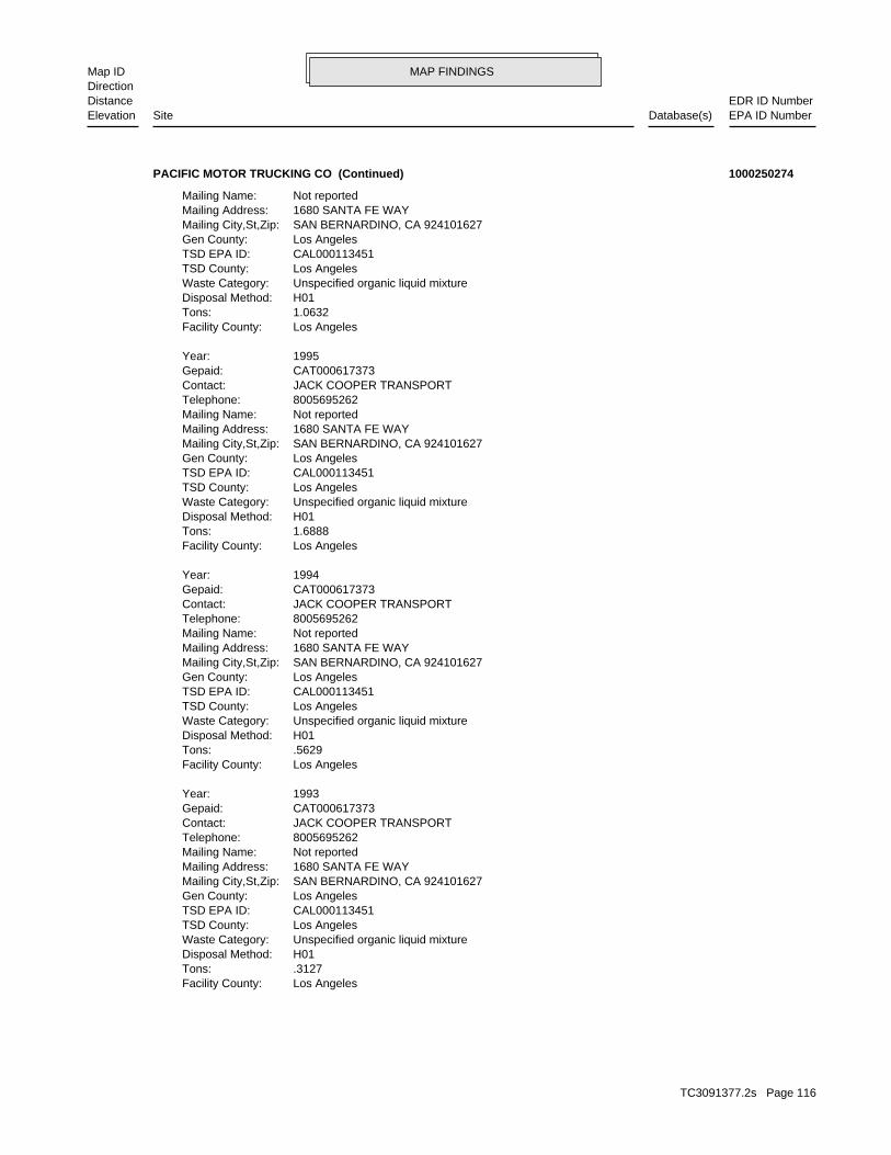
MAP FINDINGSMap IDDirection
EDR ID NumberDistanceEPA ID NumberDatabase(s)SiteElevation
Los AngelesFacility County: .3127Tons: H01Disposal Method: Unspecified organic liquid mixtureWaste Category: Los AngelesTSD County: CAL000113451TSD EPA ID: Los AngelesGen County: SAN BERNARDINO, CA 924101627Mailing City,St,Zip: 1680 SANTA FE WAYMailing Address: Not reportedMailing Name: 8005695262Telephone: JACK COOPER TRANSPORTContact: CAT000617373Gepaid: 1993Year:
Los AngelesFacility County: .5629Tons: H01Disposal Method: Unspecified organic liquid mixtureWaste Category: Los AngelesTSD County: CAL000113451TSD EPA ID: Los AngelesGen County: SAN BERNARDINO, CA 924101627Mailing City,St,Zip: 1680 SANTA FE WAYMailing Address: Not reportedMailing Name: 8005695262Telephone: JACK COOPER TRANSPORTContact: CAT000617373Gepaid: 1994Year:
Los AngelesFacility County: 1.6888Tons: H01Disposal Method: Unspecified organic liquid mixtureWaste Category: Los AngelesTSD County: CAL000113451TSD EPA ID: Los AngelesGen County: SAN BERNARDINO, CA 924101627Mailing City,St,Zip: 1680 SANTA FE WAYMailing Address: Not reportedMailing Name: 8005695262Telephone: JACK COOPER TRANSPORTContact: CAT000617373Gepaid: 1995Year:
Los AngelesFacility County: 1.0632Tons: H01Disposal Method: Unspecified organic liquid mixtureWaste Category: Los AngelesTSD County: CAL000113451TSD EPA ID: Los AngelesGen County: SAN BERNARDINO, CA 924101627Mailing City,St,Zip: 1680 SANTA FE WAYMailing Address: Not reportedMailing Name:
PACIFIC MOTOR TRUCKING CO (Continued) 1000250274
TC3091377.2s Page 116
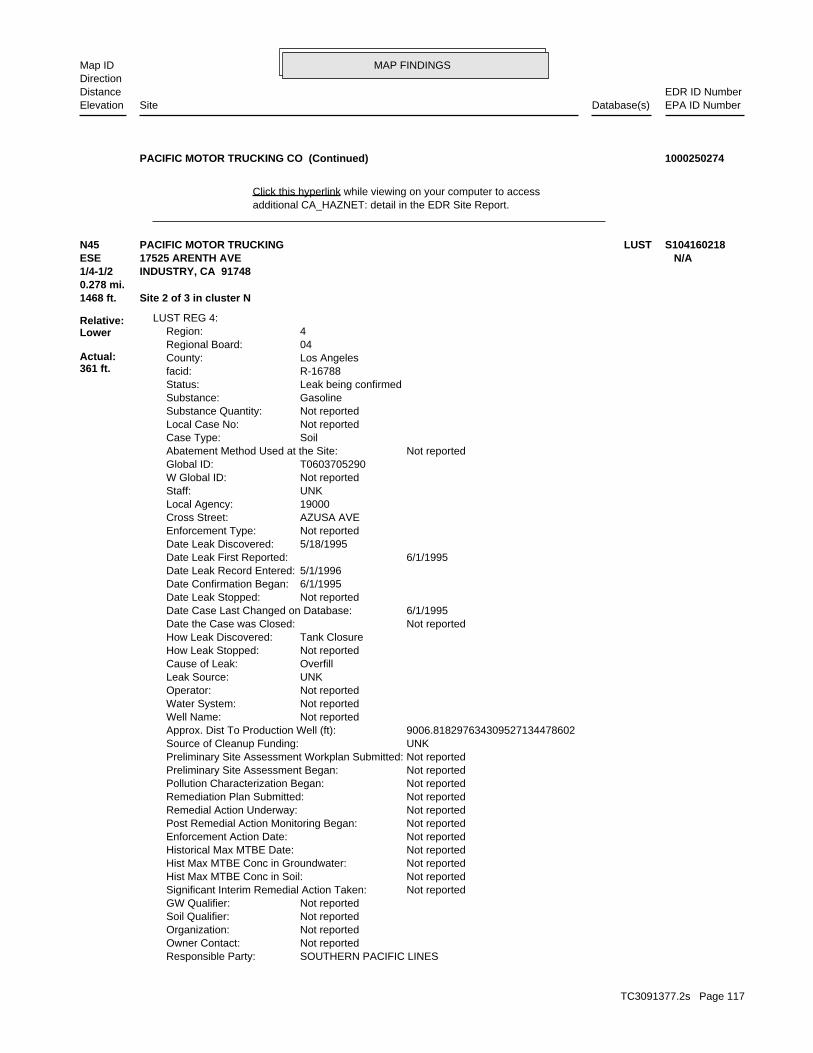
MAP FINDINGSMap IDDirection
EDR ID NumberDistanceEPA ID NumberDatabase(s)SiteElevation
additional CA_HAZNET: detail in the EDR Site Report.Click this hyperlink while viewing on your computer to access
PACIFIC MOTOR TRUCKING CO (Continued) 1000250274
SOUTHERN PACIFIC LINESResponsible Party: Not reportedOwner Contact: Not reportedOrganization: Not reportedSoil Qualifier: Not reportedGW Qualifier: Not reportedSignificant Interim Remedial Action Taken: Not reportedHist Max MTBE Conc in Soil: Not reportedHist Max MTBE Conc in Groundwater: Not reportedHistorical Max MTBE Date: Not reportedEnforcement Action Date: Not reportedPost Remedial Action Monitoring Began: Not reportedRemedial Action Underway: Not reportedRemediation Plan Submitted: Not reportedPollution Characterization Began: Not reportedPreliminary Site Assessment Began: Not reportedPreliminary Site Assessment Workplan Submitted: UNKSource of Cleanup Funding: 9006.818297634309527134478602Approx. Dist To Production Well (ft): Not reportedWell Name: Not reportedWater System: Not reportedOperator: UNKLeak Source: OverfillCause of Leak: Not reportedHow Leak Stopped: Tank ClosureHow Leak Discovered: Not reportedDate the Case was Closed: 6/1/1995Date Case Last Changed on Database: Not reportedDate Leak Stopped: 6/1/1995Date Confirmation Began: 5/1/1996Date Leak Record Entered: 6/1/1995Date Leak First Reported: 5/18/1995Date Leak Discovered: Not reportedEnforcement Type: AZUSA AVECross Street: 19000Local Agency: UNKStaff: Not reportedW Global ID: T0603705290Global ID: Not reportedAbatement Method Used at the Site: SoilCase Type: Not reportedLocal Case No: Not reportedSubstance Quantity: GasolineSubstance: Leak being confirmedStatus: R-16788facid: Los AngelesCounty: 04Regional Board: 4Region:
LUST REG 4:
1468 ft. Site 2 of 3 in cluster N0.278 mi.
Relative:Lower
Actual:361 ft.
1/4-1/2 INDUSTRY, CA 91748ESE 17525 ARENTH AVE N/AN45 LUSTPACIFIC MOTOR TRUCKING S104160218
TC3091377.2s Page 117
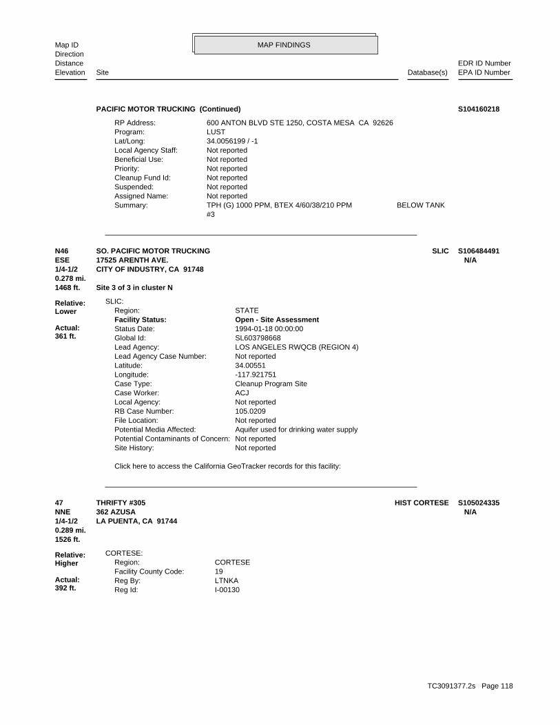
MAP FINDINGSMap IDDirection
EDR ID NumberDistanceEPA ID NumberDatabase(s)SiteElevation
#3 TPH (G) 1000 PPM, BTEX 4/60/38/210 PPM BELOW TANKSummary: Not reportedAssigned Name: Not reportedSuspended: Not reportedCleanup Fund Id: Not reportedPriority: Not reportedBeneficial Use: Not reportedLocal Agency Staff: 34.0056199 / -1Lat/Long: LUSTProgram: 600 ANTON BLVD STE 1250, COSTA MESA CA 92626RP Address:
PACIFIC MOTOR TRUCKING (Continued) S104160218
Click here to access the California GeoTracker records for this facility:
Not reportedSite History: Not reportedPotential Contaminants of Concern: Aquifer used for drinking water supplyPotential Media Affected: Not reportedFile Location: 105.0209RB Case Number: Not reportedLocal Agency: ACJCase Worker: Cleanup Program SiteCase Type: -117.921751Longitude: 34.00551Latitude: Not reportedLead Agency Case Number: LOS ANGELES RWQCB (REGION 4)Lead Agency: SL603798668Global Id: 1994-01-18 00:00:00Status Date: Open - Site AssessmentFacility Status: STATERegion:
SLIC:
1468 ft. Site 3 of 3 in cluster N0.278 mi.
Relative:Lower
Actual:361 ft.
1/4-1/2 CITY OF INDUSTRY, CA 91748ESE 17525 ARENTH AVE. N/AN46 SLICSO. PACIFIC MOTOR TRUCKING S106484491
I-00130Reg Id: LTNKAReg By: 19Facility County Code: CORTESERegion:
CORTESE:
1526 ft.0.289 mi.
Relative:Higher
Actual:392 ft.
1/4-1/2 LA PUENTA, CA 91744NNE 362 AZUSA N/A47 HIST CORTESETHRIFTY #305 S105024335
TC3091377.2s Page 118
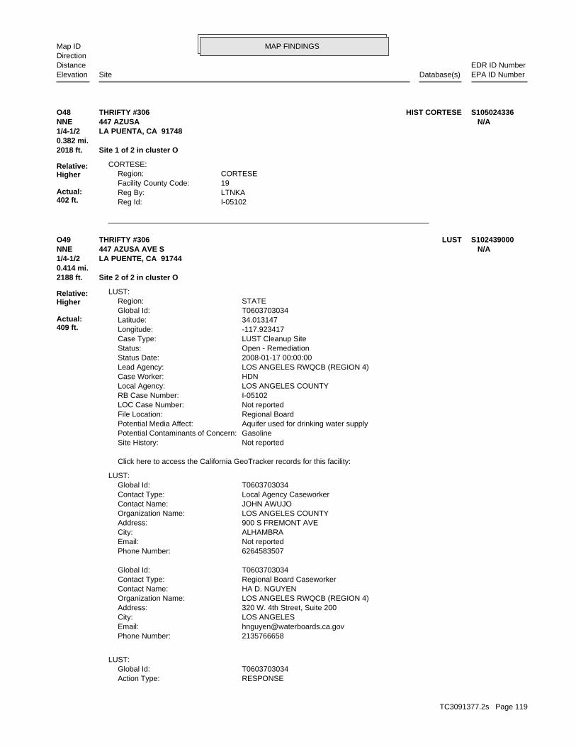
MAP FINDINGSMap IDDirection
EDR ID NumberDistanceEPA ID NumberDatabase(s)SiteElevation
I-05102Reg Id: LTNKAReg By: 19Facility County Code: CORTESERegion:
CORTESE:
2018 ft. Site 1 of 2 in cluster O0.382 mi.
Relative:Higher
Actual:402 ft.
1/4-1/2 LA PUENTA, CA 91748NNE 447 AZUSA N/AO48 HIST CORTESETHRIFTY #306 S105024336
RESPONSEAction Type: T0603703034Global Id:
LUST:
2135766658Phone Number: [email protected]: LOS ANGELESCity: 320 W. 4th Street, Suite 200Address: LOS ANGELES RWQCB (REGION 4)Organization Name: HA D. NGUYENContact Name: Regional Board CaseworkerContact Type: T0603703034Global Id:
6264583507Phone Number: Not reportedEmail: ALHAMBRACity: 900 S FREMONT AVEAddress: LOS ANGELES COUNTYOrganization Name: JOHN AWUJOContact Name: Local Agency CaseworkerContact Type: T0603703034Global Id:
LUST:
Click here to access the California GeoTracker records for this facility:
Not reportedSite History: GasolinePotential Contaminants of Concern: Aquifer used for drinking water supplyPotential Media Affect: Regional BoardFile Location: Not reportedLOC Case Number: I-05102RB Case Number: LOS ANGELES COUNTYLocal Agency: HDNCase Worker: LOS ANGELES RWQCB (REGION 4)Lead Agency: 2008-01-17 00:00:00Status Date: Open - RemediationStatus: LUST Cleanup SiteCase Type: -117.923417Longitude: 34.013147Latitude: T0603703034Global Id: STATERegion:
LUST:
2188 ft. Site 2 of 2 in cluster O0.414 mi.
Relative:Higher
Actual:409 ft.
1/4-1/2 LA PUENTE, CA 91744NNE 447 AZUSA AVE S N/AO49 LUSTTHRIFTY #306 S102439000
TC3091377.2s Page 119

MAP FINDINGSMap IDDirection
EDR ID NumberDistanceEPA ID NumberDatabase(s)SiteElevation
Monitoring Report - QuarterlyAction: 2004-10-15 00:00:00Date: RESPONSEAction Type: T0603703034Global Id:
Monitoring Report - QuarterlyAction: 2004-04-15 00:00:00Date: RESPONSEAction Type: T0603703034Global Id:
Monitoring Report - QuarterlyAction: 2004-01-15 00:00:00Date: RESPONSEAction Type: T0603703034Global Id:
Remedial Progress ReportAction: 2011-01-15 00:00:00Date: RESPONSEAction Type: T0603703034Global Id:
Monitoring Report - Semi-AnnuallyAction: 2011-01-15 00:00:00Date: RESPONSEAction Type: T0603703034Global Id:
Monitoring Report - QuarterlyAction: 2003-10-15 00:00:00Date: RESPONSEAction Type: T0603703034Global Id:
Monitoring Report - QuarterlyAction: 2005-01-15 00:00:00Date: RESPONSEAction Type: T0603703034Global Id:
Interim Remedial Action PlanAction: 2010-09-03 00:00:00Date: RESPONSEAction Type: T0603703034Global Id:
Soil and Water Investigation ReportAction: 2004-02-05 00:00:00Date: RESPONSEAction Type: T0603703034Global Id:
Monitoring Report - QuarterlyAction: 2005-07-15 00:00:00Date: RESPONSEAction Type: T0603703034Global Id:
Soil and Water Investigation ReportAction: 2002-04-15 00:00:00Date: RESPONSEAction Type: T0603703034Global Id:
Remedial Progress ReportAction: 2003-08-01 00:00:00Date:
THRIFTY #306 (Continued) S102439000
TC3091377.2s Page 120
MAP FINDINGSMap IDDirection
EDR ID NumberDistanceEPA ID NumberDatabase(s)SiteElevation
RESPONSEAction Type: T0603703034Global Id:
Staff LetterAction: 2009-06-15 00:00:00Date: ENFORCEMENTAction Type: T0603703034Global Id:
Staff LetterAction: 2002-05-14 00:00:00Date: ENFORCEMENTAction Type: T0603703034Global Id:
Monitoring Report - QuarterlyAction: 2006-07-15 00:00:00Date: RESPONSEAction Type: T0603703034Global Id:
Leak ReportedAction: 1950-01-01 00:00:00Date: OtherAction Type: T0603703034Global Id:
Remedial Progress ReportAction: 2008-04-11 00:00:00Date: RESPONSEAction Type: T0603703034Global Id:
Monitoring Report - QuarterlyAction: 2005-10-15 00:00:00Date: RESPONSEAction Type: T0603703034Global Id:
Monitoring Report - QuarterlyAction: 2006-01-15 00:00:00Date: RESPONSEAction Type: T0603703034Global Id:
Staff LetterAction: 2008-10-16 00:00:00Date: ENFORCEMENTAction Type: T0603703034Global Id:
Soil Vapor Extraction w/OtherAction: 1950-01-01 00:00:00Date: REMEDIATIONAction Type: T0603703034Global Id:
Dual Phase ExtractionAction: 1950-01-01 00:00:00Date: REMEDIATIONAction Type: T0603703034Global Id:
Remove free productAction: 1950-01-01 00:00:00Date: REMEDIATIONAction Type: T0603703034Global Id:
THRIFTY #306 (Continued) S102439000
TC3091377.2s Page 121
MAP FINDINGSMap IDDirection
EDR ID NumberDistanceEPA ID NumberDatabase(s)SiteElevation
Monitoring Report - QuarterlyAction: 2008-07-15 00:00:00Date: RESPONSEAction Type: T0603703034Global Id:
Remedial Progress ReportAction: 2007-07-15 00:00:00Date: RESPONSEAction Type: T0603703034Global Id:
Remedial Progress ReportAction: 2008-01-15 00:00:00Date: RESPONSEAction Type: T0603703034Global Id:
Monitoring Report - QuarterlyAction: 2007-04-15 00:00:00Date: RESPONSEAction Type: T0603703034Global Id:
Monitoring Report - QuarterlyAction: 2008-04-15 00:00:00Date: RESPONSEAction Type: T0603703034Global Id:
Monitoring Report - QuarterlyAction: 2008-10-15 00:00:00Date: RESPONSEAction Type: T0603703034Global Id:
Remedial Progress ReportAction: 2009-01-15 00:00:00Date: RESPONSEAction Type: T0603703034Global Id:
Monitoring Report - Semi-AnnuallyAction: 2009-07-15 00:00:00Date: RESPONSEAction Type: T0603703034Global Id:
Well Installation ReportAction: 2009-01-27 00:00:00Date: RESPONSEAction Type: T0603703034Global Id:
Staff LetterAction: 2002-01-23 00:00:00Date: ENFORCEMENTAction Type: T0603703034Global Id:
Monitoring Report - QuarterlyAction: 2006-10-15 00:00:00Date: RESPONSEAction Type: T0603703034Global Id:
Monitoring Report - QuarterlyAction: 2007-01-15 00:00:00Date:
THRIFTY #306 (Continued) S102439000
TC3091377.2s Page 122
MAP FINDINGSMap IDDirection
EDR ID NumberDistanceEPA ID NumberDatabase(s)SiteElevation
RESPONSEAction Type: T0603703034Global Id:
Monitoring Report - QuarterlyAction: 2002-04-15 00:00:00Date: RESPONSEAction Type: T0603703034Global Id:
Monitoring Report - QuarterlyAction: 2009-04-15 00:00:00Date: RESPONSEAction Type: T0603703034Global Id:
Remedial Progress ReportAction: 2009-04-15 00:00:00Date: RESPONSEAction Type: T0603703034Global Id:
Remedial Progress ReportAction: 2010-01-15 00:00:00Date: RESPONSEAction Type: T0603703034Global Id:
Monitoring Report - QuarterlyAction: 2006-04-15 00:00:00Date: RESPONSEAction Type: T0603703034Global Id:
Monitoring Report - QuarterlyAction: 2005-04-15 00:00:00Date: RESPONSEAction Type: T0603703034Global Id:
Monitoring Report - Semi-AnnuallyAction: 2010-01-15 00:00:00Date: RESPONSEAction Type: T0603703034Global Id:
Remedial Progress ReportAction: 2009-07-15 00:00:00Date: RESPONSEAction Type: T0603703034Global Id:
Monitoring Report - QuarterlyAction: 2009-01-15 00:00:00Date: RESPONSEAction Type: T0603703034Global Id:
Staff LetterAction: 2011-02-02 00:00:00Date: ENFORCEMENTAction Type: T0603703034Global Id:
Corrective Action Plan / Remedial Action PlanAction: 2008-06-27 00:00:00Date: RESPONSEAction Type: T0603703034Global Id:
THRIFTY #306 (Continued) S102439000
TC3091377.2s Page 123
MAP FINDINGSMap IDDirection
EDR ID NumberDistanceEPA ID NumberDatabase(s)SiteElevation
04Regional Board: 4Region:
LUST REG 4:
Monitoring Report - QuarterlyAction: 2003-07-15 00:00:00Date: RESPONSEAction Type: T0603703034Global Id:
Monitoring Report - QuarterlyAction: 2003-01-15 00:00:00Date: RESPONSEAction Type: T0603703034Global Id:
Monitoring Report - QuarterlyAction: 2003-04-15 00:00:00Date: RESPONSEAction Type: T0603703034Global Id:
Monitoring Report - QuarterlyAction: 2002-10-15 00:00:00Date: RESPONSEAction Type: T0603703034Global Id:
Leak DiscoveryAction: 1950-01-01 00:00:00Date: OtherAction Type: T0603703034Global Id:
Monitoring Report - Semi-AnnuallyAction: 2010-07-15 00:00:00Date: RESPONSEAction Type: T0603703034Global Id:
Remedial Progress ReportAction: 2011-07-15 00:00:00Date: RESPONSEAction Type: T0603703034Global Id:
Monitoring Report - QuarterlyAction: 2004-07-15 00:00:00Date: RESPONSEAction Type: T0603703034Global Id:
CAP/RAP - Final Remediation / Design PlanAction: 2002-03-15 00:00:00Date: RESPONSEAction Type: T0603703034Global Id:
Final Remedial Action Report / Corrective Action ReportAction: 2002-08-12 00:00:00Date: RESPONSEAction Type: T0603703034Global Id:
Monitoring Report - QuarterlyAction: 2002-07-15 00:00:00Date:
THRIFTY #306 (Continued) S102439000
TC3091377.2s Page 124

MAP FINDINGSMap IDDirection
EDR ID NumberDistanceEPA ID NumberDatabase(s)SiteElevation
PLAN; 10/30/00 3RD QTR GW MON RPT 2000; 1/25/01 4TH QTR GW MON RPT GW @ 22’, FP PRESENT, PLUME NOT DEFINED.; 10/4/00 CORRECTIVE ACTIONSummary: Not reportedAssigned Name: Not reportedSuspended: Not reportedCleanup Fund Id: Not reportedPriority: Not reportedBeneficial Use: Not reportedLocal Agency Staff: 34.0247373 / -1Lat/Long: LUSTProgram: P.O. BOX 2128RP Address: CHRIS PANAITESCUResponsible Party: Not reportedOwner Contact: Not reportedOrganization: =Soil Qualifier: =GW Qualifier: Not reportedSignificant Interim Remedial Action Taken: 2.5Hist Max MTBE Conc in Soil: 165000Hist Max MTBE Conc in Groundwater: 6/5/2003Historical Max MTBE Date: Not reportedEnforcement Action Date: 6/22/1989Post Remedial Action Monitoring Began: 8/6/2003Remedial Action Underway: 5/14/2002Remediation Plan Submitted: 1/23/2002Pollution Characterization Began: 3/5/1987Preliminary Site Assessment Began: 3/5/1987Preliminary Site Assessment Workplan Submitted: UNKSource of Cleanup Funding: 5826.4978500981859294015023853Approx. Dist To Production Well (ft): Not reportedWell Name: Not reportedWater System: Not reportedOperator: UNKLeak Source: UNKCause of Leak: Not reportedHow Leak Stopped: Subsurface MonitoringHow Leak Discovered: Not reportedDate the Case was Closed: 8/6/2002Date Case Last Changed on Database: Not reportedDate Leak Stopped: Not reportedDate Confirmation Began: 9/1/1989Date Leak Record Entered: 6/22/1989Date Leak First Reported: 6/14/1989Date Leak Discovered: LETEnforcement Type: MAIN STCross Street: 19000Local Agency: HSPStaff: Not reportedW Global ID: T0603703034Global ID: Remove Free ProductAbatement Method Used at the Site: GroundwaterCase Type: Not reportedLocal Case No: Not reportedSubstance Quantity: GasolineSubstance: Remedial action (cleanup) UnderwayStatus: I-05102facid: Los AngelesCounty:
THRIFTY #306 (Continued) S102439000
TC3091377.2s Page 125

MAP FINDINGSMap IDDirection
EDR ID NumberDistanceEPA ID NumberDatabase(s)SiteElevation
2000; 3/31/01 SITE ASSESSMENT & FIELD TESTING RPT
THRIFTY #306 (Continued) S102439000
OtherAction Type: T0603704040Global Id:
LUST:
6264583507Phone Number: Not reportedEmail: ALHAMBRACity: 900 S FREMONT AVEAddress: LOS ANGELES COUNTYOrganization Name: JOHN AWUJOContact Name: Local Agency CaseworkerContact Type: T0603704040Global Id:
Not reportedPhone Number: [email protected]: Los AngelesCity: 320 W. 4TH ST., SUITE 200Address: LOS ANGELES RWQCB (REGION 4)Organization Name: YUE RONGContact Name: Regional Board CaseworkerContact Type: T0603704040Global Id:
LUST:
Click here to access the California GeoTracker records for this facility:
Not reportedSite History: GasolinePotential Contaminants of Concern: Aquifer used for drinking water supplyPotential Media Affect: Not reportedFile Location: Not reportedLOC Case Number: I-13131RB Case Number: LOS ANGELES COUNTYLocal Agency: YRCase Worker: LOS ANGELES RWQCB (REGION 4)Lead Agency: 1997-01-24 00:00:00Status Date: Completed - Case ClosedStatus: LUST Cleanup SiteCase Type: -117.919275Longitude: 34.008229Latitude: T0603704040Global Id: STATERegion:
LUST:
I-13131Reg Id: LTNKAReg By: 19Facility County Code: CORTESERegion:
CORTESE:
EMI2189 ft. LOS ANGELES CO. HMS0.415 mi. SWEEPS UST
Relative:Higher
Actual:391 ft.
1/4-1/2 CA FID USTINDUSTRY, CA 91748East LUST17637 VALLEY BLVD N/A50 HIST CORTESEALTA DENA DAIRY (LOP17637 V... S101583310
TC3091377.2s Page 126

MAP FINDINGSMap IDDirection
EDR ID NumberDistanceEPA ID NumberDatabase(s)SiteElevation
Not reportedOwner Contact: Not reportedOrganization: Not reportedSoil Qualifier: Not reportedGW Qualifier: Not reportedSignificant Interim Remedial Action Taken: Not reportedHist Max MTBE Conc in Soil: Not reportedHist Max MTBE Conc in Groundwater: Not reportedHistorical Max MTBE Date: Not reportedEnforcement Action Date: Not reportedPost Remedial Action Monitoring Began: Not reportedRemedial Action Underway: Not reportedRemediation Plan Submitted: 5/15/1994Pollution Characterization Began: 11/5/1991Preliminary Site Assessment Began: Not reportedPreliminary Site Assessment Workplan Submitted: UNKSource of Cleanup Funding: 10175.175790664818849704368914Approx. Dist To Production Well (ft): Not reportedWell Name: Not reportedWater System: SHIELDS, ROBERTOperator: UNKLeak Source: UNKCause of Leak: Not reportedHow Leak Stopped: Tank ClosureHow Leak Discovered: 1/24/1997Date the Case was Closed: 7/14/1996Date Case Last Changed on Database: Not reportedDate Leak Stopped: Not reportedDate Confirmation Began: 12/20/1991Date Leak Record Entered: 11/5/1991Date Leak First Reported: 10/2/1991Date Leak Discovered: Not reportedEnforcement Type: AZUSA AVECross Street: 19000Local Agency: UNKStaff: Not reportedW Global ID: T0603704040Global ID: Not reportedAbatement Method Used at the Site: GroundwaterCase Type: Not reportedLocal Case No: Not reportedSubstance Quantity: GasolineSubstance: Case ClosedStatus: I-13131facid: Los AngelesCounty: 04Regional Board: 4Region:
LUST REG 4:
Leak DiscoveryAction: 1950-01-01 00:00:00Date: OtherAction Type: T0603704040Global Id:
Leak ReportedAction: 1950-01-01 00:00:00Date:
ALTA DENA DAIRY (LOP17637 V... (Continued) S101583310
TC3091377.2s Page 127
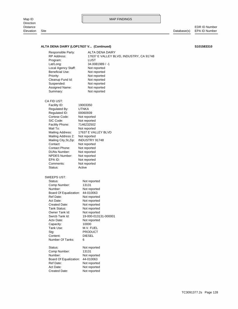
MAP FINDINGSMap IDDirection
EDR ID NumberDistanceEPA ID NumberDatabase(s)SiteElevation
Not reportedCreated Date: Not reportedAct Date: Not reportedRef Date: 44-010063Board Of Equalization: Not reportedNumber: 13131Comp Number: Not reportedStatus:
6Number Of Tanks: DIESELContent: PRODUCTStg: M.V. FUELTank Use: 10000Capacity: Not reportedActv Date: 19-000-013131-000001Swrcb Tank Id: Not reportedOwner Tank Id: Not reportedTank Status: Not reportedCreated Date: Not reportedAct Date: Not reportedRef Date: 44-010063Board Of Equalization: Not reportedNumber: 13131Comp Number: Not reportedStatus:
SWEEPS UST:
ActiveStatus: Not reportedComments: Not reportedEPA ID: Not reportedNPDES Number: Not reportedDUNs Number: Not reportedContact Phone: Not reportedContact: INDUSTRY 91748Mailing City,St,Zip: Not reportedMailing Address 2: 17637 E VALLEY BLVDMailing Address: Not reportedMail To: 7146232502Facility Phone: Not reportedSIC Code: Not reportedCortese Code: 00060939Regulated ID: UTNKARegulated By: 19003350Facility ID:
CA FID UST:
Not reportedSummary: Not reportedAssigned Name: Not reportedSuspended: Not reportedCleanup Fund Id: Not reportedPriority: Not reportedBeneficial Use: Not reportedLocal Agency Staff: 34.0081989 / -1Lat/Long: LUSTProgram: 17637 E VALLEY BLVD, INDUSTRY, CA 91748RP Address: ALTA DENA DAIRYResponsible Party:
ALTA DENA DAIRY (LOP17637 V... (Continued) S101583310
TC3091377.2s Page 128
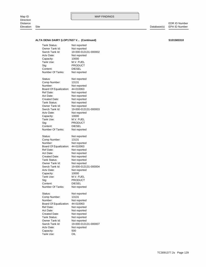
MAP FINDINGSMap IDDirection
EDR ID NumberDistanceEPA ID NumberDatabase(s)SiteElevation
OILTank Use: 500Capacity: Not reportedActv Date: 19-000-013131-000007Swrcb Tank Id: Not reportedOwner Tank Id: Not reportedTank Status: Not reportedCreated Date: Not reportedAct Date: Not reportedRef Date: 44-010063Board Of Equalization: Not reportedNumber: 13131Comp Number: Not reportedStatus:
Not reportedNumber Of Tanks: DIESELContent: PRODUCTStg: M.V. FUELTank Use: 10000Capacity: Not reportedActv Date: 19-000-013131-000004Swrcb Tank Id: Not reportedOwner Tank Id: Not reportedTank Status: Not reportedCreated Date: Not reportedAct Date: Not reportedRef Date: 44-010063Board Of Equalization: Not reportedNumber: 13131Comp Number: Not reportedStatus:
Not reportedNumber Of Tanks: DIESELContent: PRODUCTStg: M.V. FUELTank Use: 10000Capacity: Not reportedActv Date: 19-000-013131-000003Swrcb Tank Id: Not reportedOwner Tank Id: Not reportedTank Status: Not reportedCreated Date: Not reportedAct Date: Not reportedRef Date: 44-010063Board Of Equalization: Not reportedNumber: 13131Comp Number: Not reportedStatus:
Not reportedNumber Of Tanks: DIESELContent: PRODUCTStg: M.V. FUELTank Use: 10000Capacity: Not reportedActv Date: 19-000-013131-000002Swrcb Tank Id: Not reportedOwner Tank Id: Not reportedTank Status:
ALTA DENA DAIRY (LOP17637 V... (Continued) S101583310
TC3091377.2s Page 129
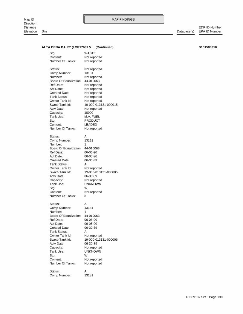
MAP FINDINGSMap IDDirection
EDR ID NumberDistanceEPA ID NumberDatabase(s)SiteElevation
13131Comp Number: AStatus:
Not reportedNumber Of Tanks: Not reportedContent: WStg: UNKNOWNTank Use: Not reportedCapacity: 06-30-89Actv Date: 19-000-013131-000006Swrcb Tank Id: Not reportedOwner Tank Id: ATank Status: 06-30-89Created Date: 06-05-90Act Date: 06-05-90Ref Date: 44-010063Board Of Equalization: 1Number: 13131Comp Number: AStatus:
8Number Of Tanks: Not reportedContent: WStg: UNKNOWNTank Use: Not reportedCapacity: 06-30-89Actv Date: 19-000-013131-000005Swrcb Tank Id: Not reportedOwner Tank Id: ATank Status: 06-30-89Created Date: 06-05-90Act Date: 06-05-90Ref Date: 44-010063Board Of Equalization: 1Number: 13131Comp Number: AStatus:
Not reportedNumber Of Tanks: LEADEDContent: PRODUCTStg: M.V. FUELTank Use: 10000Capacity: Not reportedActv Date: 19-000-013131-000015Swrcb Tank Id: Not reportedOwner Tank Id: Not reportedTank Status: Not reportedCreated Date: Not reportedAct Date: Not reportedRef Date: 44-010063Board Of Equalization: Not reportedNumber: 13131Comp Number: Not reportedStatus:
Not reportedNumber Of Tanks: Not reportedContent: WASTEStg:
ALTA DENA DAIRY (LOP17637 V... (Continued) S101583310
TC3091377.2s Page 130
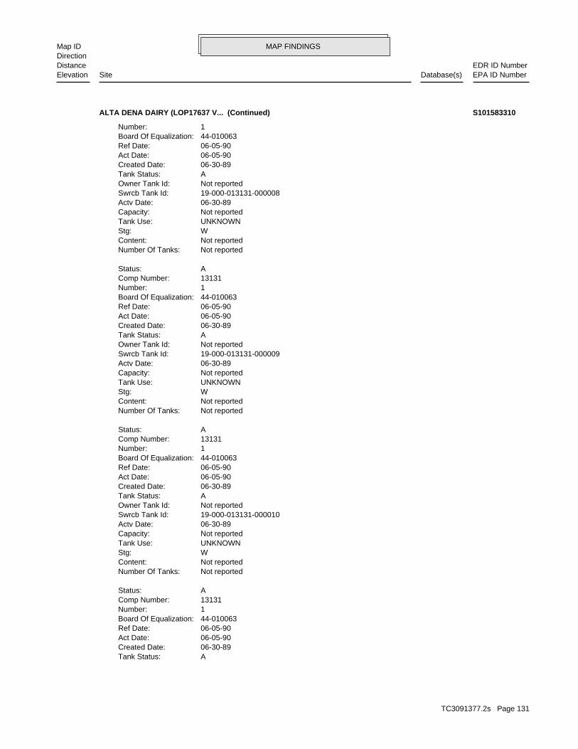
MAP FINDINGSMap IDDirection
EDR ID NumberDistanceEPA ID NumberDatabase(s)SiteElevation
ATank Status: 06-30-89Created Date: 06-05-90Act Date: 06-05-90Ref Date: 44-010063Board Of Equalization: 1Number: 13131Comp Number: AStatus:
Not reportedNumber Of Tanks: Not reportedContent: WStg: UNKNOWNTank Use: Not reportedCapacity: 06-30-89Actv Date: 19-000-013131-000010Swrcb Tank Id: Not reportedOwner Tank Id: ATank Status: 06-30-89Created Date: 06-05-90Act Date: 06-05-90Ref Date: 44-010063Board Of Equalization: 1Number: 13131Comp Number: AStatus:
Not reportedNumber Of Tanks: Not reportedContent: WStg: UNKNOWNTank Use: Not reportedCapacity: 06-30-89Actv Date: 19-000-013131-000009Swrcb Tank Id: Not reportedOwner Tank Id: ATank Status: 06-30-89Created Date: 06-05-90Act Date: 06-05-90Ref Date: 44-010063Board Of Equalization: 1Number: 13131Comp Number: AStatus:
Not reportedNumber Of Tanks: Not reportedContent: WStg: UNKNOWNTank Use: Not reportedCapacity: 06-30-89Actv Date: 19-000-013131-000008Swrcb Tank Id: Not reportedOwner Tank Id: ATank Status: 06-30-89Created Date: 06-05-90Act Date: 06-05-90Ref Date: 44-010063Board Of Equalization: 1Number:
ALTA DENA DAIRY (LOP17637 V... (Continued) S101583310
TC3091377.2s Page 131

MAP FINDINGSMap IDDirection
EDR ID NumberDistanceEPA ID NumberDatabase(s)SiteElevation
Not reportedPermit Number:6HArea:OPENFacility Status:012897-036804Facility Id:LARegion:
T0Facility Type:RemovedPermit Status:00004851TPermit Number:6HArea:RemovedFacility Status:012897-013131Facility Id:LARegion:
LOS ANGELES CO. HMS:
Not reportedNumber Of Tanks: Not reportedContent: WStg: UNKNOWNTank Use: Not reportedCapacity: 06-30-89Actv Date: 19-000-013131-000013Swrcb Tank Id: Not reportedOwner Tank Id: ATank Status: 06-30-89Created Date: 06-05-90Act Date: 06-05-90Ref Date: 44-010063Board Of Equalization: 1Number: 13131Comp Number: AStatus:
Not reportedNumber Of Tanks: Not reportedContent: WStg: UNKNOWNTank Use: Not reportedCapacity: 06-30-89Actv Date: 19-000-013131-000012Swrcb Tank Id: Not reportedOwner Tank Id: ATank Status: 06-30-89Created Date: 06-05-90Act Date: 06-05-90Ref Date: 44-010063Board Of Equalization: 1Number: 13131Comp Number: AStatus:
Not reportedNumber Of Tanks: Not reportedContent: WStg: UNKNOWNTank Use: Not reportedCapacity: 06-30-89Actv Date: 19-000-013131-000011Swrcb Tank Id: Not reportedOwner Tank Id:
ALTA DENA DAIRY (LOP17637 V... (Continued) S101583310
TC3091377.2s Page 132
MAP FINDINGSMap IDDirection
EDR ID NumberDistanceEPA ID NumberDatabase(s)SiteElevation
19County Code: 1997Year:
0Part. Matter 10 Micrometers & Smllr Tons/Yr: 0Particulate Matter Tons/Yr: 0SOX - Oxides of Sulphur Tons/Yr: 6NOX - Oxides of Nitrogen Tons/Yr: 0Carbon Monoxide Emissions Tons/Yr: 1Reactive Organic Gases Tons/Yr: 1Total Organic Hydrocarbon Gases Tons/Yr: Not reportedConsolidated Emission Reporting Rule: Not reportedCommunity Health Air Pollution Info System: SOUTH COAST AQMDAir District Name: 2026SIC Code: SCAir District Name: 5903Facility ID: SCAir Basin: 19County Code: 1995Year:
0Part. Matter 10 Micrometers & Smllr Tons/Yr: 0Particulate Matter Tons/Yr: 0SOX - Oxides of Sulphur Tons/Yr: 6NOX - Oxides of Nitrogen Tons/Yr: 0Carbon Monoxide Emissions Tons/Yr: 1Reactive Organic Gases Tons/Yr: 1Total Organic Hydrocarbon Gases Tons/Yr: Not reportedConsolidated Emission Reporting Rule: Not reportedCommunity Health Air Pollution Info System: SOUTH COAST AQMDAir District Name: 2026SIC Code: SCAir District Name: 5903Facility ID: SCAir Basin: 19County Code: 1993Year:
0Part. Matter 10 Micrometers & Smllr Tons/Yr: 0Particulate Matter Tons/Yr: 0SOX - Oxides of Sulphur Tons/Yr: 4NOX - Oxides of Nitrogen Tons/Yr: 1Carbon Monoxide Emissions Tons/Yr: 0Reactive Organic Gases Tons/Yr: 0Total Organic Hydrocarbon Gases Tons/Yr: Not reportedConsolidated Emission Reporting Rule: Not reportedCommunity Health Air Pollution Info System: SOUTH COAST AQMDAir District Name: 2026SIC Code: SCAir District Name: 5903Facility ID: SCAir Basin: 19County Code: 1990Year:
EMI:
Not reportedFacility Type:Not reportedPermit Status:
ALTA DENA DAIRY (LOP17637 V... (Continued) S101583310
TC3091377.2s Page 133
MAP FINDINGSMap IDDirection
EDR ID NumberDistanceEPA ID NumberDatabase(s)SiteElevation
Not reportedCommunity Health Air Pollution Info System: SOUTH COAST AQMDAir District Name: 2026SIC Code: SCAir District Name: 800339Facility ID: SCAir Basin: 19County Code: 2000Year:
0Part. Matter 10 Micrometers & Smllr Tons/Yr: 0Particulate Matter Tons/Yr: 0SOX - Oxides of Sulphur Tons/Yr: 0NOX - Oxides of Nitrogen Tons/Yr: 2Carbon Monoxide Emissions Tons/Yr: 0Reactive Organic Gases Tons/Yr: 1Total Organic Hydrocarbon Gases Tons/Yr: Not reportedConsolidated Emission Reporting Rule: Not reportedCommunity Health Air Pollution Info System: SOUTH COAST AQMDAir District Name: 2026SIC Code: SCAir District Name: 800339Facility ID: SCAir Basin: 19County Code: 1999Year:
0Part. Matter 10 Micrometers & Smllr Tons/Yr: 0Particulate Matter Tons/Yr: 0SOX - Oxides of Sulphur Tons/Yr: 0NOX - Oxides of Nitrogen Tons/Yr: 2Carbon Monoxide Emissions Tons/Yr: 0Reactive Organic Gases Tons/Yr: 1Total Organic Hydrocarbon Gases Tons/Yr: Not reportedConsolidated Emission Reporting Rule: Not reportedCommunity Health Air Pollution Info System: SOUTH COAST AQMDAir District Name: 2026SIC Code: SCAir District Name: 800339Facility ID: SCAir Basin: 19County Code: 1998Year:
0Part. Matter 10 Micrometers & Smllr Tons/Yr: 0Particulate Matter Tons/Yr: 0SOX - Oxides of Sulphur Tons/Yr: 0NOX - Oxides of Nitrogen Tons/Yr: 2Carbon Monoxide Emissions Tons/Yr: 0Reactive Organic Gases Tons/Yr: 1Total Organic Hydrocarbon Gases Tons/Yr: Not reportedConsolidated Emission Reporting Rule: Not reportedCommunity Health Air Pollution Info System: SOUTH COAST AQMDAir District Name: 2026SIC Code: SCAir District Name: 800339Facility ID: SCAir Basin:
ALTA DENA DAIRY (LOP17637 V... (Continued) S101583310
TC3091377.2s Page 134
MAP FINDINGSMap IDDirection
EDR ID NumberDistanceEPA ID NumberDatabase(s)SiteElevation
0Part. Matter 10 Micrometers & Smllr Tons/Yr: 0Particulate Matter Tons/Yr: 0SOX - Oxides of Sulphur Tons/Yr: 3NOX - Oxides of Nitrogen Tons/Yr: 2Carbon Monoxide Emissions Tons/Yr: 0Reactive Organic Gases Tons/Yr: 1Total Organic Hydrocarbon Gases Tons/Yr: Not reportedConsolidated Emission Reporting Rule: Not reportedCommunity Health Air Pollution Info System: SOUTH COAST AQMDAir District Name: 2026SIC Code: SCAir District Name: 800339Facility ID: SCAir Basin: 19County Code: 2001Year:
0Part. Matter 10 Micrometers & Smllr Tons/Yr: 0Particulate Matter Tons/Yr: 0SOX - Oxides of Sulphur Tons/Yr: 0NOX - Oxides of Nitrogen Tons/Yr: 2Carbon Monoxide Emissions Tons/Yr: 0Reactive Organic Gases Tons/Yr: 1Total Organic Hydrocarbon Gases Tons/Yr: Not reportedConsolidated Emission Reporting Rule:
ALTA DENA DAIRY (LOP17637 V... (Continued) S101583310
Click here to access the California GeoTracker records for this facility:
Not reportedSite History: Not reportedPotential Contaminants of Concern: Aquifer used for drinking water supplyPotential Media Affected: Not reportedFile Location: 105.0260RB Case Number: Not reportedLocal Agency: ACJCase Worker: Cleanup Program SiteCase Type: -117.953161Longitude: 34.007937Latitude: Not reportedLead Agency Case Number: LOS ANGELES RWQCB (REGION 4)Lead Agency: SL603798671Global Id: 1996-06-18 00:00:00Status Date: Open - Reopen CaseFacility Status: STATERegion:
SLIC:
2231 ft.0.423 mi.
Relative:Higher
Actual:395 ft.
1/4-1/2 CITY OF INDUSTRY, CA 91749SW 17070 E. GALE AVE. N/A51 SLICSPECTROL ELECTRONICS S106484494
TC3091377.2s Page 135
MAP FINDINGSMap IDDirection
EDR ID NumberDistanceEPA ID NumberDatabase(s)SiteElevation
OtherAction Type: T0603705093Global Id:
Leak StoppedAction: 1950-01-01 00:00:00Date: OtherAction Type: T0603705093Global Id:
LUST:
6264583507Phone Number: Not reportedEmail: ALHAMBRACity: 900 S FREMONT AVEAddress: LOS ANGELES COUNTYOrganization Name: JOHN AWUJOContact Name: Local Agency CaseworkerContact Type: T0603705093Global Id:
Not reportedPhone Number: [email protected]: Los AngelesCity: 320 W. 4TH ST., SUITE 200Address: LOS ANGELES RWQCB (REGION 4)Organization Name: YUE RONGContact Name: Regional Board CaseworkerContact Type: T0603705093Global Id:
LUST:
Click here to access the California GeoTracker records for this facility:
Not reportedSite History: GasolinePotential Contaminants of Concern: SoilPotential Media Affect: Not reportedFile Location: Not reportedLOC Case Number: R-12068RB Case Number: LOS ANGELES COUNTYLocal Agency: JACase Worker: LOS ANGELES COUNTYLead Agency: 1994-02-23 00:00:00Status Date: Completed - Case ClosedStatus: LUST Cleanup SiteCase Type: -117.9308975Longitude: 34.0001181Latitude: T0603705093Global Id: STATERegion:
LUST:
R-12068Reg Id: LTNKAReg By: 19Facility County Code: CORTESERegion:
CORTESE:
2440 ft.0.462 mi.
Relative:Higher
Actual:411 ft.
1/4-1/2 INDUSTRY, CA 91748South LUST1215 AZUSA AVE S N/A52 HIST CORTESEARCO #3087 S102424244
TC3091377.2s Page 136
MAP FINDINGSMap IDDirection
EDR ID NumberDistanceEPA ID NumberDatabase(s)SiteElevation
Not reportedOwner Contact: Not reportedOrganization: Not reportedSoil Qualifier: Not reportedGW Qualifier: Not reportedSignificant Interim Remedial Action Taken: Not reportedHist Max MTBE Conc in Soil: Not reportedHist Max MTBE Conc in Groundwater: Not reportedHistorical Max MTBE Date: Not reportedEnforcement Action Date: Not reportedPost Remedial Action Monitoring Began: Not reportedRemedial Action Underway: Not reportedRemediation Plan Submitted: Not reportedPollution Characterization Began: Not reportedPreliminary Site Assessment Began: Not reportedPreliminary Site Assessment Workplan Submitted: UNKSource of Cleanup Funding: 5772.2117210550780308408868092Approx. Dist To Production Well (ft): Not reportedWell Name: Not reportedWater System: DANIEL, JAMES JR.Operator: UNKLeak Source: UNKCause of Leak: Not reportedHow Leak Stopped: Tank ClosureHow Leak Discovered: 2/23/1994Date the Case was Closed: 2/23/1994Date Case Last Changed on Database: 10/24/1990Date Leak Stopped: Not reportedDate Confirmation Began: 12/5/1990Date Leak Record Entered: 11/1/1990Date Leak First Reported: 10/24/1990Date Leak Discovered: Not reportedEnforcement Type: GALE AVECross Street: 19000Local Agency: UNKStaff: Not reportedW Global ID: T0603705093Global ID: Not reportedAbatement Method Used at the Site: SoilCase Type: Not reportedLocal Case No: Not reportedSubstance Quantity: GasolineSubstance: Case ClosedStatus: R-12068facid: Los AngelesCounty: 04Regional Board: 4Region:
LUST REG 4:
Leak DiscoveryAction: 1950-01-01 00:00:00Date: OtherAction Type: T0603705093Global Id:
Leak ReportedAction: 1950-01-01 00:00:00Date:
ARCO #3087 (Continued) S102424244
TC3091377.2s Page 137

MAP FINDINGSMap IDDirection
EDR ID NumberDistanceEPA ID NumberDatabase(s)SiteElevation
OLD CASE #120690-27Summary: Not reportedAssigned Name: Not reportedSuspended: Not reportedCleanup Fund Id: Not reportedPriority: Not reportedBeneficial Use: Not reportedLocal Agency Staff: 34.0001181 / -1Lat/Long: LUSTProgram: 1055 W 7TH ST, LOS ANGELES CA 90017RP Address: ARCO PRODUCTS COResponsible Party:
ARCO #3087 (Continued) S102424244
Waste oil and mixed oilWaste Category: Los AngelesTSD County: CAD008302903TSD EPA ID: Los AngelesGen County: LA PUENTE, CA 917491111Mailing City,St,Zip: PO BOX 1111Mailing Address: Not reportedMailing Name: 6268544592Telephone: JESSE MORENO / SAFETY COORDContact: CAL000306960Gepaid: 2007Year:
HAZNET:
Not reportedFacility Suite:ACASTANEStaff:ActiveFile Status:105.0060File Number:4Region:
WIP:
Click here to access the California GeoTracker records for this facility:
Not reportedSite History: Not reportedPotential Contaminants of Concern: Aquifer used for drinking water supplyPotential Media Affected: Not reportedFile Location: 105.0060RB Case Number: Not reportedLocal Agency: ACJCase Worker: Cleanup Program SiteCase Type: -117.937995Longitude: 34.007501Latitude: Not reportedLead Agency Case Number: LOS ANGELES RWQCB (REGION 4)Lead Agency: SL603798659Global Id: 1988-09-23 00:00:00Status Date: Open - Site AssessmentFacility Status: STATERegion:
SLIC:
2548 ft.0.483 mi.
Relative:Lower
Actual:355 ft.
1/4-1/2 HAZNETCITY OF INDUSTRY, CA 91745WNW WIP16900 CHESTNUT ST. N/A53 SLICCARRIER SOUTHERN CALIFORNIA S106484482
TC3091377.2s Page 138
MAP FINDINGSMap IDDirection
EDR ID NumberDistanceEPA ID NumberDatabase(s)SiteElevation
Los AngelesFacility County: 0.35Tons: FUEL BLENDING PRIOR TO ENERGY RECOVERY AT ANOTHER SITEDisposal Method:
CARRIER SOUTHERN CALIFORNIA (Continued) S106484482
Not reportedOwner/operator telephone: USOwner/operator country: INDUSTRY, CA 91745 16800 CHESTNUT STREETOwner/operator address: CAST PARTS, INC.Owner/operator name:
Not reportedOwner/Op end date: 12/01/2000Owner/Op start date: OperatorOwner/Operator Type: PrivateLegal status: Not reportedOwner/operator telephone: USOwner/operator country: Not reported Not reportedOwner/operator address: CAST PARTS, INC.Owner/operator name:
Owner/Operator Summary:
100 kg of that material at any time hazardous waste during any calendar month, and accumulates more than from the cleanup of a spill, into or on any land or water, of acutely of any residue or contaminated soil, waste or other debris resulting kg of acutely hazardous waste at any time; or generates 100 kg or less hazardous waste during any calendar month, and accumulates more than 1 waste during any calendar month; or generates 1 kg or less of acutely cleanup of a spill, into or on any land or water, of acutely hazardous residue or contaminated soil, waste or other debris resulting from the during any calendar month; or generates more than 100 kg of any calendar month; or generates more than 1 kg of acutely hazardous waste Handler: generates 1,000 kg or more of hazardous waste during anyDescription: Large Quantity GeneratorClassification: PrivateLand type: 09EPA Region: [email protected] email: (909) 595-2252Contact telephone: Not reportedContact country: Not reported Not reportedContact address: AL BANNISTERContact: POMONA, CA 91766 P.O. BOX 2348Mailing address: CAD075301390EPA ID: INDUSTRY, CA 91745 16800 CHESTNUT STREETFacility address: PAC FOUNDRIES - INDUSTRYFacility name: 02/27/2008Date form received by agency:
RCRA-LQG:
ENVIROSTOR3067 ft. EMI0.581 mi. HAZNET
Relative:Lower
Actual:355 ft.
1/2-1 FINDSINDUSTRY, CA 91745WNW TRIS16800 CHESTNUT ST 91745TLDYN1654 RCRA-LQGPAC FOUNDRIES - INDUSTRY 1000921594
TC3091377.2s Page 139
MAP FINDINGSMap IDDirection
EDR ID NumberDistanceEPA ID NumberDatabase(s)SiteElevation
PAC FOUNDRIES INDUSTRYSite name: PAC FOUNDRIES - INDUSTRYFacility name: 01/29/1996Date form received by agency:
Large Quantity GeneratorClassification: TELEDYNE CASTING SERVICE-PICCOSite name: PAC FOUNDRIES - INDUSTRYFacility name: 01/30/1996Date form received by agency:
Small Quantity GeneratorClassification: PAC FOUNDRIES INDUSTRYSite name: PAC FOUNDRIES - INDUSTRYFacility name: 09/01/1996Date form received by agency:
Large Quantity GeneratorClassification: TELEDYNE CASTING SERVICE-PICCOSite name: PAC FOUNDRIES - INDUSTRYFacility name: 03/04/1999Date form received by agency:
Large Quantity GeneratorClassification: TELEDYNE CAST PARTS-INDUSTRY OPERATIONSSite name: PAC FOUNDRIES - INDUSTRYFacility name: 10/12/2000Date form received by agency:
Large Quantity GeneratorClassification: PAC FOUNDRIES INDUSTRYSite name: PAC FOUNDRIES - INDUSTRYFacility name: 01/09/2001Date form received by agency:
Small Quantity GeneratorClassification: PAC FOUNDRIES-INDUSTRY OPERATIONSSite name: PAC FOUNDRIES - INDUSTRYFacility name: 03/01/2006Date form received by agency:
Historical Generators:
NoUsed oil transporter: NoUsed oil transfer facility: NoUsed oil Specification marketer: NoUsed oil fuel marketer to burner: NoUser oil refiner: NoUsed oil processor: NoUsed oil fuel burner: NoFurnace exemption: NoOn-site burner exemption: NoUnderground injection activity: NoTreater, storer or disposer of HW: NoTransporter of hazardous waste: NoRecycler of hazardous waste: NoMixed waste (haz. and radioactive): NoU.S. importer of hazardous waste:
Handler Activities Summary:
Not reportedOwner/Op end date: 12/01/2000Owner/Op start date: OwnerOwner/Operator Type: PrivateLegal status:
PAC FOUNDRIES - INDUSTRY (Continued) 1000921594
TC3091377.2s Page 140
MAP FINDINGSMap IDDirection
EDR ID NumberDistanceEPA ID NumberDatabase(s)SiteElevation
08/29/2000 Enforcement action date: Not reported Enforcement action: EPAViolation lead agency: 01/08/2001Date achieved compliance: 08/04/2000Date violation determined: Used Oil - GeneratorsArea of violation: F - 279.20-24Regulation violated:
Not reported Paid penalty amount: Not reported Final penalty amount: Not reported Proposed penalty amount: EPA Enforcement lead agency: Not reported Enf. disp. status date: Not reported Enf. disposition status: 01/08/2001 Enforcement action date: WRITTEN INFORMAL Enforcement action: EPAViolation lead agency: 01/08/2001Date achieved compliance: 08/04/2000Date violation determined: Used Oil - GeneratorsArea of violation: F - 279.20-24Regulation violated:
Not reported Paid penalty amount: Not reported Final penalty amount: Not reported Proposed penalty amount: State Enforcement lead agency: Not reported Enf. disp. status date: Not reported Enf. disposition status: 12/27/2007 Enforcement action date: WRITTEN INFORMAL Enforcement action: StateViolation lead agency: 12/27/2007Date achieved compliance: 12/27/2007Date violation determined: Generators - GeneralArea of violation: Not reportedRegulation violated:
Facility Has Received Notices of Violations:
LEADWaste name: D008Waste code:
WHICH WOULD BE CONSIDERED AS IGNITABLE HAZARDOUS WASTE. MATERIAL. LACQUER THINNER IS AN EXAMPLE OF A COMMONLY USED SOLVENT WHICH CAN BE OBTAINED FROM THE MANUFACTURER OR DISTRIBUTOR OF THE FLASH POINT OF A WASTE IS TO REVIEW THE MATERIAL SAFETY DATA SHEET, CLOSED CUP FLASH POINT TESTER. ANOTHER METHOD OF DETERMINING THE LESS THAN 140 DEGREES FAHRENHEIT AS DETERMINED BY A PENSKY-MARTENS IGNITABLE HAZARDOUS WASTES ARE THOSE WASTES WHICH HAVE A FLASHPOINT OFWaste name: D001Waste code:
Hazardous Waste Summary:
Large Quantity GeneratorClassification: TELEDYNE AIRCRAFT PRODUCTSSite name: PAC FOUNDRIES - INDUSTRYFacility name: 03/18/1994Date form received by agency:
Large Quantity GeneratorClassification:
PAC FOUNDRIES - INDUSTRY (Continued) 1000921594
TC3091377.2s Page 141
MAP FINDINGSMap IDDirection
EDR ID NumberDistanceEPA ID NumberDatabase(s)SiteElevation
0.5Tons: (H010-H129) OR (H131-H135) STORAGE, BULKING, AND/OR TRANSFER OFF SITE--NO TREATMENT/REOVERYDisposal Method: Aqueous solution with total organic residues less than 10 percentWaste Category: Los AngelesTSD County: CAT000613893TSD EPA ID: Los AngelesGen County: POMONA, CA 917692348Mailing City,St,Zip: PO BOX 2348Mailing Address: Not reportedMailing Name: 9095952252Telephone: CHRIS JAMESContact: CAD075301390Gepaid: 2007Year:
HAZNET:
corrective action activities required under RCRA.program staff to track the notification, permit, compliance, andand treat, store, or dispose of hazardous waste. RCRAInfo allows RCRAevents and activities related to facilities that generate, transport,Conservation and Recovery Act (RCRA) program through the tracking ofRCRAInfo is a national information system that supports the Resource
transported off-site.these facilities release directly to air, water, land, or that arefrom facilities on the amounts of over 300 listed toxic chemicals thatUS EPA TRIS (Toxics Release Inventory System) contains information
their precursors, as well as hazardous air pollutants (HAPs).on stationary and mobile sources that emit criteria air pollutants andThe NEI (National Emissions Inventory) database contains information Environmental Interest/Information System
110009531756Registry ID:
FINDS:
EPAEvaluation lead agency: 01/08/2001Date achieved compliance: Used Oil - GeneratorsArea of violation: COMPLIANCE EVALUATION INSPECTION ON-SITEEvaluation: 08/04/2000Evaluation date:
StateEvaluation lead agency: 12/27/2007Date achieved compliance: Generators - GeneralArea of violation: COMPLIANCE EVALUATION INSPECTION ON-SITEEvaluation: 12/27/2007Evaluation date:
Evaluation Action Summary:
Not reported Paid penalty amount: Not reported Final penalty amount: Not reported Proposed penalty amount: EPA Enforcement lead agency: Not reported Enf. disp. status date: Not reported Enf. disposition status:
PAC FOUNDRIES - INDUSTRY (Continued) 1000921594
TC3091377.2s Page 142
MAP FINDINGSMap IDDirection
EDR ID NumberDistanceEPA ID NumberDatabase(s)SiteElevation
POMONA, CA 917692348Mailing City,St,Zip: PO BOX 2348Mailing Address: Not reportedMailing Name: 9095952252Telephone: CHRIS JAMESContact: CAD075301390Gepaid: 2007Year:
Los AngelesFacility County: 10Tons: TREATMENT) DISCHARGE TO SEWER/POTW OR NPDES(WITH PRIOR STORAGE--WITH OR WITHOUTDisposal Method: Oil/water separation sludgeWaste Category: Los AngelesTSD County: CAT080013352TSD EPA ID: Los AngelesGen County: POMONA, CA 917692348Mailing City,St,Zip: PO BOX 2348Mailing Address: Not reportedMailing Name: 9095952252Telephone: CHRIS JAMESContact: CAD075301390Gepaid: 2007Year:
Los AngelesFacility County: 3.33Tons: TREATMENT) DISCHARGE TO SEWER/POTW OR NPDES(WITH PRIOR STORAGE--WITH OR WITHOUTDisposal Method: Unspecified alkaline solutionWaste Category: Los AngelesTSD County: CAT080013352TSD EPA ID: Los AngelesGen County: POMONA, CA 917692348Mailing City,St,Zip: PO BOX 2348Mailing Address: Not reportedMailing Name: 9095952252Telephone: CHRIS JAMESContact: CAD075301390Gepaid: 2007Year:
Los AngelesFacility County: 3.99Tons: ORGANICS RECOVERY ECT OTHER RECOVERY OF RECLAMATION FOR REUSE INCLUDING ACID REGENERATION,Disposal Method: Waste oil and mixed oilWaste Category: Los AngelesTSD County: CAT080013352TSD EPA ID: Los AngelesGen County: POMONA, CA 917692348Mailing City,St,Zip: PO BOX 2348Mailing Address: Not reportedMailing Name: 9095952252Telephone: CHRIS JAMESContact: CAD075301390Gepaid: 2007Year:
Los AngelesFacility County:
PAC FOUNDRIES - INDUSTRY (Continued) 1000921594
TC3091377.2s Page 143
MAP FINDINGSMap IDDirection
EDR ID NumberDistanceEPA ID NumberDatabase(s)SiteElevation
28Total Organic Hydrocarbon Gases Tons/Yr: Not reportedConsolidated Emission Reporting Rule: Not reportedCommunity Health Air Pollution Info System: SOUTH COAST AQMDAir District Name: 3324SIC Code: SCAir District Name: 7037Facility ID: SCAir Basin: 19County Code: 1995Year:
0Part. Matter 10 Micrometers & Smllr Tons/Yr: 0Particulate Matter Tons/Yr: 0SOX - Oxides of Sulphur Tons/Yr: 1NOX - Oxides of Nitrogen Tons/Yr: 0Carbon Monoxide Emissions Tons/Yr: 63Reactive Organic Gases Tons/Yr: 85Total Organic Hydrocarbon Gases Tons/Yr: Not reportedConsolidated Emission Reporting Rule: Not reportedCommunity Health Air Pollution Info System: SOUTH COAST AQMDAir District Name: 3324SIC Code: SCAir District Name: 7037Facility ID: SCAir Basin: 19County Code: 1990Year:
0Part. Matter 10 Micrometers & Smllr Tons/Yr: 0Particulate Matter Tons/Yr: 0SOX - Oxides of Sulphur Tons/Yr: 0NOX - Oxides of Nitrogen Tons/Yr: 0Carbon Monoxide Emissions Tons/Yr: 35Reactive Organic Gases Tons/Yr: 100Total Organic Hydrocarbon Gases Tons/Yr: Not reportedConsolidated Emission Reporting Rule: Not reportedCommunity Health Air Pollution Info System: SOUTH COAST AQMDAir District Name: 3324SIC Code: SCAir District Name: 7037Facility ID: SCAir Basin: 19County Code: 1987Year:
EMI:
151 additional CA_HAZNET: record(s) in the EDR Site Report.Click this hyperlink while viewing on your computer to access
Los AngelesFacility County: 1.05Tons: TREATMENT) DISCHARGE TO SEWER/POTW OR NPDES(WITH PRIOR STORAGE--WITH OR WITHOUTDisposal Method: Unspecified aqueous solutionWaste Category: Los AngelesTSD County: CAT080013352TSD EPA ID: Los AngelesGen County:
PAC FOUNDRIES - INDUSTRY (Continued) 1000921594
TC3091377.2s Page 144

MAP FINDINGSMap IDDirection
EDR ID NumberDistanceEPA ID NumberDatabase(s)SiteElevation
0Part. Matter 10 Micrometers & Smllr Tons/Yr: 0Particulate Matter Tons/Yr: 0SOX - Oxides of Sulphur Tons/Yr: 2NOX - Oxides of Nitrogen Tons/Yr: 1Carbon Monoxide Emissions Tons/Yr: 9Reactive Organic Gases Tons/Yr: 15Total Organic Hydrocarbon Gases Tons/Yr: Not reportedConsolidated Emission Reporting Rule: Not reportedCommunity Health Air Pollution Info System: SOUTH COAST AQMDAir District Name: 3324SIC Code: SCAir District Name: 7037Facility ID: SCAir Basin: 19County Code: 1998Year:
0Part. Matter 10 Micrometers & Smllr Tons/Yr: 0Particulate Matter Tons/Yr: 0SOX - Oxides of Sulphur Tons/Yr: 2NOX - Oxides of Nitrogen Tons/Yr: 1Carbon Monoxide Emissions Tons/Yr: 9Reactive Organic Gases Tons/Yr: 16Total Organic Hydrocarbon Gases Tons/Yr: Not reportedConsolidated Emission Reporting Rule: Not reportedCommunity Health Air Pollution Info System: SOUTH COAST AQMDAir District Name: 3324SIC Code: SCAir District Name: 7037Facility ID: SCAir Basin: 19County Code: 1997Year:
0Part. Matter 10 Micrometers & Smllr Tons/Yr: 0Particulate Matter Tons/Yr: 0SOX - Oxides of Sulphur Tons/Yr: 3NOX - Oxides of Nitrogen Tons/Yr: 1Carbon Monoxide Emissions Tons/Yr: 16Reactive Organic Gases Tons/Yr: 27Total Organic Hydrocarbon Gases Tons/Yr: Not reportedConsolidated Emission Reporting Rule: Not reportedCommunity Health Air Pollution Info System: SOUTH COAST AQMDAir District Name: 3324SIC Code: SCAir District Name: 7037Facility ID: SCAir Basin: 19County Code: 1996Year:
0Part. Matter 10 Micrometers & Smllr Tons/Yr: 0Particulate Matter Tons/Yr: 0SOX - Oxides of Sulphur Tons/Yr: 1NOX - Oxides of Nitrogen Tons/Yr: 0Carbon Monoxide Emissions Tons/Yr: 27Reactive Organic Gases Tons/Yr:
PAC FOUNDRIES - INDUSTRY (Continued) 1000921594
TC3091377.2s Page 145
MAP FINDINGSMap IDDirection
EDR ID NumberDistanceEPA ID NumberDatabase(s)SiteElevation
NONE SPECIFIEDRegulatory Agencies: NONPL: Not reportedAcres: * HistoricalSite Type Detailed: HistoricalSite Type:
ENVIROSTOR:
0Part. Matter 10 Micrometers & Smllr Tons/Yr: 0Particulate Matter Tons/Yr: 0SOX - Oxides of Sulphur Tons/Yr: 2NOX - Oxides of Nitrogen Tons/Yr: 1Carbon Monoxide Emissions Tons/Yr: 12Reactive Organic Gases Tons/Yr: 16Total Organic Hydrocarbon Gases Tons/Yr: Not reportedConsolidated Emission Reporting Rule: YCommunity Health Air Pollution Info System: SOUTH COAST AQMDAir District Name: 3324SIC Code: SCAir District Name: 126544Facility ID: SCAir Basin: 19County Code: 2001Year:
0Part. Matter 10 Micrometers & Smllr Tons/Yr: 0Particulate Matter Tons/Yr: 0SOX - Oxides of Sulphur Tons/Yr: 2NOX - Oxides of Nitrogen Tons/Yr: 1Carbon Monoxide Emissions Tons/Yr: 9Reactive Organic Gases Tons/Yr: 16Total Organic Hydrocarbon Gases Tons/Yr: Not reportedConsolidated Emission Reporting Rule: Not reportedCommunity Health Air Pollution Info System: SOUTH COAST AQMDAir District Name: 3324SIC Code: SCAir District Name: 7037Facility ID: SCAir Basin: 19County Code: 2000Year:
0Part. Matter 10 Micrometers & Smllr Tons/Yr: 0Particulate Matter Tons/Yr: 0SOX - Oxides of Sulphur Tons/Yr: 2NOX - Oxides of Nitrogen Tons/Yr: 1Carbon Monoxide Emissions Tons/Yr: 9Reactive Organic Gases Tons/Yr: 16Total Organic Hydrocarbon Gases Tons/Yr: Not reportedConsolidated Emission Reporting Rule: Not reportedCommunity Health Air Pollution Info System: SOUTH COAST AQMDAir District Name: 3324SIC Code: SCAir District Name: 7037Facility ID: SCAir Basin: 19County Code: 1999Year:
PAC FOUNDRIES - INDUSTRY (Continued) 1000921594
TC3091377.2s Page 146

MAP FINDINGSMap IDDirection
EDR ID NumberDistanceEPA ID NumberDatabase(s)SiteElevation
Not reportedSchedule Revised Date: Not reportedSchedule Due Date: Not reportedSchedule Document Type: Not reportedSchedule Sub Area Name: Not reportedSchedule Area Name: Not reportedFuture Due Date: Not reportedFuture Document Type: Not reportedFuture Sub Area Name: Not reportedFuture Area Name:
Not reportedComments: Not reportedCompleted Date: Not reportedCompleted Document Type: Not reportedCompleted Sub Area Name: Not reportedCompleted Area Name:
Completed Info:
Envirostor ID NumberAlias Type: 19340771Alias Name: Project Code (Site Code)Alias Type: 300649Alias Name: APNAlias Type: 8242030004Alias Name: Alternate NameAlias Type: TELEDYNE/PICCOAlias Name: NONE SPECIFIEDPotential Description: NONE SPECIFIEDConfirmed COC: NONE SPECIFIEDPotential COC: NONE SPECIFIEDPast Use: 8242030004APN: -117.939082598498Longitude: 34.0064975310235Latitude: Not reportedFunding: NONE SPECIFIEDSite Mgmt. Req.: NORestricted Use: 1997-01-28 00:00:00Status Date: Refer: RWQCBStatus: Not reportedSpecial Program: 24Senate: 58Assembly: 300649Site Code: 19340771Facility ID: Cleanup ChatsworthDivision Branch: Referred - Not AssignedSupervisor: Not reportedProgram Manager: NONE SPECIFIEDLead Agency:
PAC FOUNDRIES - INDUSTRY (Continued) 1000921594
NONPL: Not reportedAcres: Tiered PermitSite Type Detailed: Tiered PermitSite Type:
ENVIROSTOR:
3216 ft.0.609 mi.
Relative:Higher
Actual:383 ft.
1/2-1 CITY OF INDUSTRY, CA 91748ESE 17801 ARENTH AVENUE N/A55 ENVIROSTORAIR PRODUCTS & CHEMICALS, INC. S109434182
TC3091377.2s Page 147

MAP FINDINGSMap IDDirection
EDR ID NumberDistanceEPA ID NumberDatabase(s)SiteElevation
Not reportedSchedule Revised Date: Not reportedSchedule Due Date: Not reportedSchedule Document Type: Not reportedSchedule Sub Area Name: Not reportedSchedule Area Name: Not reportedFuture Due Date: Not reportedFuture Document Type: Not reportedFuture Sub Area Name: Not reportedFuture Area Name:
Not reportedComments: Not reportedCompleted Date: Not reportedCompleted Document Type: Not reportedCompleted Sub Area Name: Not reportedCompleted Area Name:
Completed Info:
Envirostor ID NumberAlias Type: 71002459Alias Name: EPA Identification NumberAlias Type: CAD053872156Alias Name: NONE SPECIFIEDPotential Description: NONE SPECIFIEDConfirmed COC: NONE SPECIFIEDPotential COC: NONE SPECIFIEDPast Use: NONE SPECIFIEDAPN: -117.9151674Longitude: 34.0053382Latitude: Not reportedFunding: NONE SPECIFIEDSite Mgmt. Req.: NORestricted Use: Not reportedStatus Date: Not reportedStatus: Not reportedSpecial Program: 24Senate: 58Assembly: Not reportedSite Code: 71002459Facility ID: Cleanup CypressDivision Branch: Not reportedSupervisor: Not reportedProgram Manager: NONE SPECIFIEDLead Agency: NONE SPECIFIEDRegulatory Agencies:
AIR PRODUCTS & CHEMICALS, INC. (Continued) S109434182
91748-1111Incident Description: Not reportedDischarge Date: Not reportedFacility Type: Not reportedBoard File Number: Not reportedStaff Initials: Not reportedDate Reported:
Notify 65:
3817 ft.0.723 mi.
Relative:Higher
Actual:412 ft.
1/2-1 INDUSTRY, CA 91748SE 17721 E. RAILROAD STREET N/A56 Notify 65THOMPSON PETROLEUM S100178005
TC3091377.2s Page 148
MAP FINDINGSMap IDDirection
EDR ID NumberDistanceEPA ID NumberDatabase(s)SiteElevation
NoUsed oil processor: NoUsed oil fuel burner: NoFurnace exemption: NoOn-site burner exemption: NoUnderground injection activity: NoTreater, storer or disposer of HW: NoTransporter of hazardous waste: NoRecycler of hazardous waste: NoMixed waste (haz. and radioactive): NoU.S. importer of hazardous waste:
Handler Activities Summary:
Not reportedOwner/Op end date: Not reportedOwner/Op start date: OperatorOwner/Operator Type: PrivateLegal status: (415) 555-1212Owner/operator telephone: Not reportedOwner/operator country: NOT REQUIRED, ME 99999 NOT REQUIREDOwner/operator address: NOT REQUIREDOwner/operator name:
Not reportedOwner/Op end date: Not reportedOwner/Op start date: OwnerOwner/Operator Type: PrivateLegal status: (415) 555-1212Owner/operator telephone: Not reportedOwner/operator country: NOT REQUIRED, ME 99999 NOT REQUIREDOwner/operator address: CREFTCON INDUSTRIESOwner/operator name:
Owner/Operator Summary:
hazardous waste at any time waste during any calendar month, and accumulates more than 1000 kg of hazardous waste at any time; or generates 100 kg or less of hazardous waste during any calendar month and accumulates less than 6000 kg of Handler: generates more than 100 and less than 1000 kg of hazardousDescription: Small Small Quantity GeneratorClassification: 09EPA Region: Not reportedContact email: (818) 964-6531Contact telephone: USContact country: CITY OF INDUSTRY, CA 91749 900 S AJAX AVEContact address: ENVIRONMENTAL MANAGERContact: CAD982001703EPA ID: LA PUENTE, CA 91748 900 S AJAX AVEFacility address: CREFTON INDUSTRIESFacility name: 06/15/1987Date form received by agency:
RCRA-SQG:
4065 ft. ENVIROSTOR0.770 mi. HAZNET
Relative:Higher
Actual:393 ft.
1/2-1 WDSLA PUENTE, CA 91748ESE FINDS900 S AJAX AVE CAD98200170357 RCRA-SQGCREFTON INDUSTRIES 1000231012
TC3091377.2s Page 149
MAP FINDINGSMap IDDirection
EDR ID NumberDistanceEPA ID NumberDatabase(s)SiteElevation
Not reportedPOTW: Not reportedReclamation: 0Baseline Flow: 0Design Flow: Not reportedSecondary Waste Type: Not reportedSecondary Waste: Not reportedPrimary Waste Type: Not reportedPrimary Waste: Not reportedSIC Code 2: 0SIC Code: Not reportedAgency Type: Not reportedAgency Telephone: Not reportedAgency Contact: 0Agency City,St,Zip: Not reportedAgency Address: CREFTCON INDUSTRIESAgency Name: Not reportedFacility Contact: Not reportedFacility Telephone: 4Subregion: are assigned by the Regional Board CAS000001 The 1st 2 characters designate the state. The remaining 7NPDES Number: under Waste Discharge Requirements. Active - Any facility with a continuous or seasonal discharge that isFacility Status: Not reportedFacility Type: 4 19I002982Facility ID:
CA WDS:
corrective action activities required under RCRA.program staff to track the notification, permit, compliance, andand treat, store, or dispose of hazardous waste. RCRAInfo allows RCRAevents and activities related to facilities that generate, transport,Conservation and Recovery Act (RCRA) program through the tracking ofRCRAInfo is a national information system that supports the Resource
transported off-site.these facilities release directly to air, water, land, or that arefrom facilities on the amounts of over 300 listed toxic chemicals thatUS EPA TRIS (Toxics Release Inventory System) contains information
facilities.generators, transporters, and treatment, storage, and disposalprovides California with information on hazardous waste shipments forCalifornia Hazardous Waste Tracking System - Datamart (HWTS-DATAMART) Environmental Interest/Information System
110002317868Registry ID:
FINDS:
No violations foundViolation Status:
NoUsed oil transporter: NoUsed oil transfer facility: NoUsed oil Specification marketer: NoUsed oil fuel marketer to burner: NoUser oil refiner:
CREFTON INDUSTRIES (Continued) 1000231012
TC3091377.2s Page 150
MAP FINDINGSMap IDDirection
EDR ID NumberDistanceEPA ID NumberDatabase(s)SiteElevation
5.00Tons: Not reportedDisposal Method: Aqueous solution with total organic residues 10 percent or moreWaste Category: Los AngelesTSD County: Not reportedTSD EPA ID: Los AngelesGen County: LA PUENTE, CA 917491269Mailing City,St,Zip: PO BOX 1269Mailing Address: Not reportedMailing Name: 8189646531Telephone: BILLY NORSWORTHY/PLT MGRContact: CAD982001703Gepaid: 2002Year:
Not reportedFacility County: 9.17Tons: R01Disposal Method: Unspecified aqueous solutionWaste Category: Los AngelesTSD County: Not reportedTSD EPA ID: Los AngelesGen County: LA PUENTE, CA 917491269Mailing City,St,Zip: PO BOX 1269Mailing Address: Not reportedMailing Name: 8189646531Telephone: BILLY NORSWORTHY/PLT MGRContact: CAD982001703Gepaid: 2002Year:
Not reportedFacility County: 8.34Tons: R01Disposal Method: Unspecified aqueous solutionWaste Category: Los AngelesTSD County: Not reportedTSD EPA ID: Los AngelesGen County: LA PUENTE, CA 917491269Mailing City,St,Zip: PO BOX 1269Mailing Address: Not reportedMailing Name: 8189646531Telephone: BILLY NORSWORTHY/PLT MGRContact: CAD982001703Gepaid: 2002Year:
HAZNET:
dairy waste ponds. dischargers having waste storage systems with land disposal such as disposal systems, such as septic systems with subsurface disposal, or management practices, facilities with passive waste treatment and cooling water dischargers or thosewho must comply through best Category C - Facilities having no waste treatment systems, such asComplexity: represent no threat to water quality. Level. A Zero (0) may be used to code those NURDS that are found to considered a minor threat to water quality unless coded at a higher to a major or minor threat. Not: All nurds without a TTWQ will be should cause a relatively minor impairment of beneficial uses compared Minor Threat to Water Quality. A violation of a regional board orderTreat To Water:
CREFTON INDUSTRIES (Continued) 1000231012
TC3091377.2s Page 151
MAP FINDINGSMap IDDirection
EDR ID NumberDistanceEPA ID NumberDatabase(s)SiteElevation
-117.912952Longitude: 34.00381Latitude: Not reportedFunding: NONE SPECIFIEDSite Mgmt. Req.: NORestricted Use: Not reportedStatus Date: Not reportedStatus: Not reportedSpecial Program: 24Senate: 58Assembly: Not reportedSite Code: 71002952Facility ID: Cleanup CypressDivision Branch: Not reportedSupervisor: Not reportedProgram Manager: NONE SPECIFIEDLead Agency: NONE SPECIFIEDRegulatory Agencies: NONPL: Not reportedAcres: Tiered PermitSite Type Detailed: Tiered PermitSite Type:
ENVIROSTOR:
32 additional CA_HAZNET: record(s) in the EDR Site Report.Click this hyperlink while viewing on your computer to access
Not reportedFacility County: 8.34Tons: R01Disposal Method: Waste oil and mixed oilWaste Category: Los AngelesTSD County: Not reportedTSD EPA ID: Los AngelesGen County: LA PUENTE, CA 917491269Mailing City,St,Zip: PO BOX 1269Mailing Address: Not reportedMailing Name: 8189646531Telephone: BILLY NORSWORTHY/PLT MGRContact: CAD982001703Gepaid: 2001Year:
Not reportedFacility County: 26.95Tons: D80Disposal Method: Other organic solidsWaste Category: 99TSD County: Not reportedTSD EPA ID: Los AngelesGen County: LA PUENTE, CA 917491269Mailing City,St,Zip: PO BOX 1269Mailing Address: Not reportedMailing Name: 8189646531Telephone: BILLY NORSWORTHY/PLT MGRContact: CAD982001703Gepaid: 2002Year:
Not reportedFacility County:
CREFTON INDUSTRIES (Continued) 1000231012
TC3091377.2s Page 152

MAP FINDINGSMap IDDirection
EDR ID NumberDistanceEPA ID NumberDatabase(s)SiteElevation
Not reportedSchedule Revised Date: Not reportedSchedule Due Date: Not reportedSchedule Document Type: Not reportedSchedule Sub Area Name: Not reportedSchedule Area Name: Not reportedFuture Due Date: Not reportedFuture Document Type: Not reportedFuture Sub Area Name: Not reportedFuture Area Name:
Not reportedComments: Not reportedCompleted Date: Not reportedCompleted Document Type: Not reportedCompleted Sub Area Name: Not reportedCompleted Area Name:
Completed Info:
Envirostor ID NumberAlias Type: 71002952Alias Name: EPA Identification NumberAlias Type: CAD982001703Alias Name: NONE SPECIFIEDPotential Description: NONE SPECIFIEDConfirmed COC: NONE SPECIFIEDPotential COC: NONE SPECIFIEDPast Use: NONE SPECIFIEDAPN:
CREFTON INDUSTRIES (Continued) 1000231012
NONE SPECIFIEDPotential COC: NONE SPECIFIEDPast Use: NONE SPECIFIEDAPN: 0 / 0Lat/Long: Responsible PartyFunding: NORestricted Use: 2011-03-11 00:00:00Status Date: ActiveStatus: Voluntary Cleanup ProgramSpecial Programs Code: 24Senate: 58Assembly: 301520-11Site Code: Cleanup ChatsworthDivision Branch: JAVIER HINOJOSASupervisor: JOSE DIAZProject Manager: Not reportedLead Agency Description: NONE SPECIFIEDLead Agency: SMBRPCleanup Oversight Agencies: NONational Priorities List: Not reportedAcres: NONE SPECIFIEDSite Mgmt. Req.: Voluntary CleanupSite Type Detail: Voluntary CleanupSite Type: 60001428Facility ID:
VCP:
4166 ft.0.789 mi.
Relative:Higher
Actual:367 ft.
1/2-1 ENVIROSTORCITY OF INDUSTRY, CA 91745West WIP911 BIXBY DRIVE N/A58 VCPWALNUT CREEK ENERGY PARK S106764926
TC3091377.2s Page 153

MAP FINDINGSMap IDDirection
EDR ID NumberDistanceEPA ID NumberDatabase(s)SiteElevation
NONE SPECIFIEDConfirmed COC: NONE SPECIFIEDPotential COC: NONE SPECIFIEDPast Use: NONE SPECIFIEDAPN: 0Longitude: 0Latitude: Responsible PartyFunding: NONE SPECIFIEDSite Mgmt. Req.: NORestricted Use: 2011-03-11 00:00:00Status Date: ActiveStatus: Voluntary Cleanup ProgramSpecial Program: 24Senate: 58Assembly: 301520-11Site Code: 60001428Facility ID: Cleanup ChatsworthDivision Branch: JAVIER HINOJOSASupervisor: JOSE DIAZProgram Manager: NONE SPECIFIEDLead Agency: SMBRPRegulatory Agencies: NONPL: Not reportedAcres: Voluntary CleanupSite Type Detailed: Voluntary CleanupSite Type:
ENVIROSTOR:
Not reportedFacility Suite:RWANGStaff:HistoricalFile Status:105.0229File Number:4Region:
WIP:
Not reportedSchedule Revised Date: 2011-06-24 00:00:00Schedule Due Date: Phase 1Schedule Document Type: Not reportedSchedule Sub Area Name: PROJECT WIDESchedule Area Name: Not reportedFuture Due Date: Not reportedFuture Document Type: Not reportedFuture Sub Area Name: Not reportedFuture Area Name:
Not reportedComments: 2011-03-11 00:00:00Completed Date: Voluntary Cleanup AgreementCompleted Document Type: Not reportedCompleted Sub Area Name: PROJECT WIDECompleted Area Name:
Completed Info:
Envirostor ID NumberAlias Type: 60001428Alias Name: Project Code (Site Code)Alias Type: 301520-11Alias Name: NONE SPECIFIEDPotential Description: NONE SPECIFIEDConfirmed COC:
WALNUT CREEK ENERGY PARK (Continued) S106764926
TC3091377.2s Page 154

MAP FINDINGSMap IDDirection
EDR ID NumberDistanceEPA ID NumberDatabase(s)SiteElevation
Not reportedSchedule Revised Date: 2011-06-24 00:00:00Schedule Due Date: Phase 1Schedule Document Type: Not reportedSchedule Sub Area Name: PROJECT WIDESchedule Area Name: Not reportedFuture Due Date: Not reportedFuture Document Type: Not reportedFuture Sub Area Name: Not reportedFuture Area Name:
Not reportedComments: 2011-03-11 00:00:00Completed Date: Voluntary Cleanup AgreementCompleted Document Type: Not reportedCompleted Sub Area Name: PROJECT WIDECompleted Area Name:
Completed Info:
Envirostor ID NumberAlias Type: 60001428Alias Name: Project Code (Site Code)Alias Type: 301520-11Alias Name: NONE SPECIFIEDPotential Description:
WALNUT CREEK ENERGY PARK (Continued) S106764926
0Baseline Flow: 0Design Flow: Not reportedSecondary Waste Type: Not reportedSecondary Waste: Not reportedPrimary Waste Type: Not reportedPrimary Waste: Not reportedSIC Code 2: 0SIC Code: PrivateAgency Type: Not reportedAgency Telephone: Not reportedAgency Contact: City of Industry 91745Agency City,St,Zip: 16555 E. Gale Ave.Agency Address: KIIM LIGHTINGAgency Name: Not reportedFacility Contact: Not reportedFacility Telephone: 4Subregion: are assigned by the Regional Board CAS000001 The 1st 2 characters designate the state. The remaining 7NPDES Number: under Waste Discharge Requirements. Active - Any facility with a continuous or seasonal discharge that isFacility Status: pumping. repairing, oil production, storage and disposal operations, water washing, geothermal operations, air conditioning, ship building and processing operation of whatever nature, including mining, gravel semisolid wastes from any servicing, producing, manufacturing or Industrial - Facility that treats and/or disposes of liquid orFacility Type: 4 19I004395Facility ID:
CA WDS:
4712 ft. HWP0.892 mi. HAZNET
Relative:Higher
Actual:374 ft.
1/2-1 WIPCITY OF INDUSTRY, CA 91745West WDS16555 E GALE AVE 91745KMLGH1659 TRISKIM LIGHTING 1006816084
TC3091377.2s Page 155
MAP FINDINGSMap IDDirection
EDR ID NumberDistanceEPA ID NumberDatabase(s)SiteElevation
2009Year:
Los AngelesFacility County: 1.561Tons: (H010-H129) OR (H131-H135) STORAGE, BULKING, AND/OR TRANSFER OFF SITE--NO TREATMENT/REOVERYDisposal Method: Unspecified organic liquid mixtureWaste Category: Los AngelesTSD County: CAD097030993TSD EPA ID: Los AngelesGen County: CITY OF INDUSTRY, CA 917160080Mailing City,St,Zip: PO BOX 60080Mailing Address: Not reportedMailing Name: 6269685666Telephone: RANDY GARYContact: CAD128298254Gepaid: 2009Year:
Los AngelesFacility County: 2.09Tons: ORGANICS RECOVERY ECT OTHER RECOVERY OF RECLAMATION FOR REUSE INCLUDING ACID REGENERATION,Disposal Method: Waste oil and mixed oilWaste Category: Los AngelesTSD County: CAT080013352TSD EPA ID: Los AngelesGen County: CITY OF INDUSTRY, CA 917160080Mailing City,St,Zip: PO BOX 60080Mailing Address: Not reportedMailing Name: 6269685666Telephone: RANDY GARYContact: CAD128298254Gepaid: 2009Year:
HAZNET:
Not reportedFacility Suite:JCLStaff:HistoricalFile Status:105.0144File Number:4Region:
WIP:
dairy waste ponds. dischargers having waste storage systems with land disposal such as disposal systems, such as septic systems with subsurface disposal, or management practices, facilities with passive waste treatment and cooling water dischargers or thosewho must comply through best Category C - Facilities having no waste treatment systems, such asComplexity: represent no threat to water quality. Level. A Zero (0) may be used to code those NURDS that are found to considered a minor threat to water quality unless coded at a higher to a major or minor threat. Not: All nurds without a TTWQ will be should cause a relatively minor impairment of beneficial uses compared Minor Threat to Water Quality. A violation of a regional board orderTreat To Water: The facility is not a POTW.POTW: Not reportedReclamation:
KIM LIGHTING (Continued) 1006816084
TC3091377.2s Page 156
MAP FINDINGSMap IDDirection
EDR ID NumberDistanceEPA ID NumberDatabase(s)SiteElevation
SOUTHERN CALIFORNIA PERMITS AND CORRECTIVE ACTIONRegion: Not reportedCleanup Status: HAZ WASTE - NON-OPERATINGFacility Type: -117.941732Longitude: 34.002907Latitude: CAD128298254EPA Id:
HWP:
17 additional CA_HAZNET: record(s) in the EDR Site Report.Click this hyperlink while viewing on your computer to access
Los AngelesFacility County: 4.807Tons: ORGANICS RECOVERY ECT OTHER RECOVERY OF RECLAMATION FOR REUSE INCLUDING ACID REGENERATION,Disposal Method: Waste oil and mixed oilWaste Category: Los AngelesTSD County: CAT080013352TSD EPA ID: Los AngelesGen County: CITY OF INDUSTRY, CA 917160080Mailing City,St,Zip: PO BOX 60080Mailing Address: Not reportedMailing Name: 6269685666Telephone: RANDY GARYContact: CAD128298254Gepaid: 2008Year:
Los AngelesFacility County: 0.22935Tons: (H010-H129) OR (H131-H135) STORAGE, BULKING, AND/OR TRANSFER OFF SITE--NO TREATMENT/REOVERYDisposal Method: Unspecified sludge wasteWaste Category: Los AngelesTSD County: CAD097030993TSD EPA ID: Los AngelesGen County: CITY OF INDUSTRY, CA 917160080Mailing City,St,Zip: PO BOX 60080Mailing Address: Not reportedMailing Name: 6269685666Telephone: RANDY GARYContact: CAD128298254Gepaid: 2008Year:
Los AngelesFacility County: 5.355Tons: ORGANICS RECOVERY ECT OTHER RECOVERY OF RECLAMATION FOR REUSE INCLUDING ACID REGENERATION,Disposal Method: Unspecified aqueous solutionWaste Category: Los AngelesTSD County: CAT080013352TSD EPA ID: Los AngelesGen County: CITY OF INDUSTRY, CA 917160080Mailing City,St,Zip: PO BOX 60080Mailing Address: Not reportedMailing Name: 6269685666Telephone: RANDY GARYContact: CAD128298254Gepaid:
KIM LIGHTING (Continued) 1006816084
TC3091377.2s Page 157
MAP FINDINGSMap IDDirection
EDR ID NumberDistanceEPA ID NumberDatabase(s)SiteElevation
Not reportedSite History: Not reportedFacility Status: Not reportedPublic Information Officer: Not reportedSenate District: Not reportedAssembly District: Not reportedSite Code: Not reportedSupervisor: Not reportedCorrective Action Lead: Not reportedPermit Renewal Lead: Not reportedPermit Maintenance Lead:
KIM LIGHTING (Continued) 1006816084
EPA Identification NumberAlias Type: CAD980636641Alias Name: Alternate NameAlias Type: SHERATON HOTEL & RESORTAlias Name: Alternate NameAlias Type: PUENTE WSTE DISP/REFUSE DISP RECLAMATIONAlias Name: Alternate NameAlias Type: INDUSTRY HILLS LANDFILLAlias Name: Alternate NameAlias Type: INDUSTRY HILLS CONVENTION & EXHIBIT CTRAlias Name: Alternate NameAlias Type: DWIGHT D EISENHOWER GOLF COURSEAlias Name: Alternate NameAlias Type: CITY OF INDUSTRY CONVENTION CENTERAlias Name: NONE SPECIFIEDPotential Description: NONE SPECIFIEDConfirmed COC: 10008, 10065, 10179, 10196, 10198, 20004Potential COC: NONE SPECIFIEDPast Use: NONE SPECIFIEDAPN: 0Longitude: 0Latitude: Not reportedFunding: NONE SPECIFIEDSite Mgmt. Req.: NORestricted Use: 1995-08-15 00:00:00Status Date: Refer: Other AgencyStatus: Not reportedSpecial Program: Not reportedSenate: Not reportedAssembly: Not reportedSite Code: 19490192Facility ID: Cleanup ChatsworthDivision Branch: Referred - Not AssignedSupervisor: Not reportedProgram Manager: NONE SPECIFIEDLead Agency: NONE SPECIFIEDRegulatory Agencies: NONPL: Not reportedAcres: * HistoricalSite Type Detailed: HistoricalSite Type:
ENVIROSTOR:
4758 ft.0.901 mi.
Relative:Higher
Actual:457 ft.
1/2-1 LA PUENTE, CA 91744NNE 147 NORTH AZUZA AVENUE N/A60 ENVIROSTORLA PUENTE DUMP 1000350117
TC3091377.2s Page 158
MAP FINDINGSMap IDDirection
EDR ID NumberDistanceEPA ID NumberDatabase(s)SiteElevation
Not reportedSchedule Revised Date: Not reportedSchedule Due Date: Not reportedSchedule Document Type: Not reportedSchedule Sub Area Name: Not reportedSchedule Area Name: Not reportedFuture Due Date: Not reportedFuture Document Type: Not reportedFuture Sub Area Name: Not reportedFuture Area Name:
FACILITY IDENTIFIED ID FROM ERRISComments: 1983-09-28 00:00:00Completed Date: * DiscoveryCompleted Document Type: Not reportedCompleted Sub Area Name: PROJECT WIDECompleted Area Name:
ASSESS DONE RCRA 3012 REFINERY & OIL PRODUCTION WASTES DISP. CONDNGR, CO HLTH, SWMB. PRELIM RESIDENT(CO ENGR FILE). WASTE TYPE: CERCLA FILED BY IT CORP - OIL BASIN. INCIDENT: 4/ 23/84 SULPHUR & METHANE ODOR COMPLAINT FROM OTHER RECREATIONAL FAC. OVERLIES A PORTION OF SAN GABRIEL G-WATER SOURCE ACT: CO ENGR IWP - CLII LDFL. CURRENTLY USED AS GOLF COURSE &Comments: 1984-04-01 00:00:00Completed Date: Preliminary Assessment ReportCompleted Document Type: Not reportedCompleted Sub Area Name: PROJECT WIDECompleted Area Name:
IN 1988 SITE SCREENING DONE SITE IS ON THE SWAT LIST- RANK 13- TO BE ASSESSEDComments: 1987-12-02 00:00:00Completed Date: Site ScreeningCompleted Document Type: Not reportedCompleted Sub Area Name: PROJECT WIDECompleted Area Name:
monitoring wells. Klein- felder found TCE at 9.0 ppb and 11.0 ppb in two groundwater recommendation. Sample Results: Solid Waste Assessment Report by aquifer, containment, and waste quantity. DHS agrees with this Screening Site Inspection under Cercla due to high value for depth to completed by DHS in September 1988 recommends medium- priority Site Screening done: EPA E&E review of Preliminary Assess- mentComments: 1988-12-21 00:00:00Completed Date: Site ScreeningCompleted Document Type: Not reportedCompleted Sub Area Name: PROJECT WIDECompleted Area Name:
the EPA further action recommendation. EPA Federal Investigation Team report reviewed. DTSC concurs withComments: 1991-08-21 00:00:00Completed Date: Site ScreeningCompleted Document Type: Not reportedCompleted Sub Area Name: PROJECT WIDECompleted Area Name:
Completed Info:
Envirostor ID NumberAlias Type: 19490192Alias Name:
LA PUENTE DUMP (Continued) 1000350117
TC3091377.2s Page 159
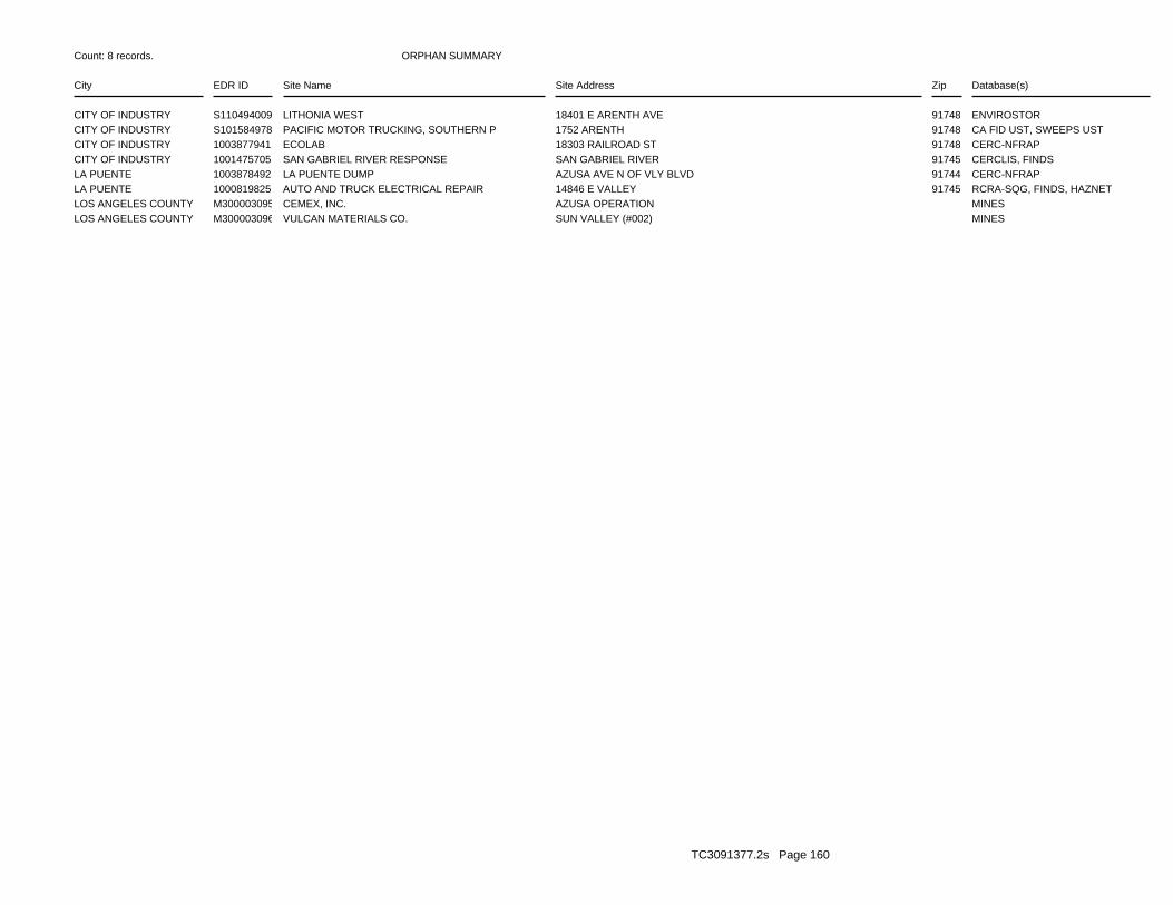
ORPHAN SUMMARY
City EDR ID Site Name Site Address Zip Database(s)
Count: 8 records.
CITY OF INDUSTRY S110494009 LITHONIA WEST 18401 E ARENTH AVE 91748 ENVIROSTORCITY OF INDUSTRY S101584978 PACIFIC MOTOR TRUCKING, SOUTHERN P 1752 ARENTH 91748 CA FID UST, SWEEPS USTCITY OF INDUSTRY 1003877941 ECOLAB 18303 RAILROAD ST 91748 CERC-NFRAPCITY OF INDUSTRY 1001475705 SAN GABRIEL RIVER RESPONSE SAN GABRIEL RIVER 91745 CERCLIS, FINDSLA PUENTE 1003878492 LA PUENTE DUMP AZUSA AVE N OF VLY BLVD 91744 CERC-NFRAPLA PUENTE 1000819825 AUTO AND TRUCK ELECTRICAL REPAIR 14846 E VALLEY 91745 RCRA-SQG, FINDS, HAZNETLOS ANGELES COUNTY M300003095 CEMEX, INC. AZUSA OPERATION MINESLOS ANGELES COUNTY M300003096 VULCAN MATERIALS CO. SUN VALLEY (#002) MINES
TC3091377.2s Page 160

To maintain currency of the following federal and state databases, EDR contacts the appropriate governmental agencyon a monthly or quarterly basis, as required.
Number of Days to Update: Provides confirmation that EDR is reporting records that have been updated within 90 daysfrom the date the government agency made the information available to the public.
STANDARD ENVIRONMENTAL RECORDS
Federal NPL site list
NPL: National Priority ListNational Priorities List (Superfund). The NPL is a subset of CERCLIS and identifies over 1,200 sites for prioritycleanup under the Superfund Program. NPL sites may encompass relatively large areas. As such, EDR provides polygoncoverage for over 1,000 NPL site boundaries produced by EPA’s Environmental Photographic Interpretation Center(EPIC) and regional EPA offices.
Date of Government Version: 12/31/2010Date Data Arrived at EDR: 01/13/2011Date Made Active in Reports: 01/28/2011Number of Days to Update: 15
Source: EPATelephone: N/ALast EDR Contact: 04/13/2011Next Scheduled EDR Contact: 07/25/2011Data Release Frequency: Quarterly
NPL Site Boundaries
Sources:
EPA’s Environmental Photographic Interpretation Center (EPIC)Telephone: 202-564-7333
EPA Region 1 EPA Region 6Telephone 617-918-1143 Telephone: 214-655-6659
EPA Region 3 EPA Region 7Telephone 215-814-5418 Telephone: 913-551-7247
EPA Region 4 EPA Region 8Telephone 404-562-8033 Telephone: 303-312-6774
EPA Region 5 EPA Region 9Telephone 312-886-6686 Telephone: 415-947-4246
EPA Region 10Telephone 206-553-8665
Proposed NPL: Proposed National Priority List SitesA site that has been proposed for listing on the National Priorities List through the issuance of a proposed rulein the Federal Register. EPA then accepts public comments on the site, responds to the comments, and places onthe NPL those sites that continue to meet the requirements for listing.
Date of Government Version: 12/31/2010Date Data Arrived at EDR: 01/13/2011Date Made Active in Reports: 01/28/2011Number of Days to Update: 15
Source: EPATelephone: N/ALast EDR Contact: 04/13/2011Next Scheduled EDR Contact: 07/25/2011Data Release Frequency: Quarterly
NPL LIENS: Federal Superfund LiensFederal Superfund Liens. Under the authority granted the USEPA by CERCLA of 1980, the USEPA has the authorityto file liens against real property in order to recover remedial action expenditures or when the property ownerreceived notification of potential liability. USEPA compiles a listing of filed notices of Superfund Liens.
Date of Government Version: 10/15/1991Date Data Arrived at EDR: 02/02/1994Date Made Active in Reports: 03/30/1994Number of Days to Update: 56
Source: EPATelephone: 202-564-4267Last EDR Contact: 05/16/2011Next Scheduled EDR Contact: 08/29/2011Data Release Frequency: No Update Planned
TC3091377.2s Page GR-1
GOVERNMENT RECORDS SEARCHED / DATA CURRENCY TRACKING

Federal Delisted NPL site list
DELISTED NPL: National Priority List DeletionsThe National Oil and Hazardous Substances Pollution Contingency Plan (NCP) establishes the criteria that theEPA uses to delete sites from the NPL. In accordance with 40 CFR 300.425.(e), sites may be deleted from theNPL where no further response is appropriate.
Date of Government Version: 12/31/2010Date Data Arrived at EDR: 01/13/2011Date Made Active in Reports: 01/28/2011Number of Days to Update: 15
Source: EPATelephone: N/ALast EDR Contact: 04/13/2011Next Scheduled EDR Contact: 07/25/2011Data Release Frequency: Quarterly
Federal CERCLIS list
CERCLIS: Comprehensive Environmental Response, Compensation, and Liability Information SystemCERCLIS contains data on potentially hazardous waste sites that have been reported to the USEPA by states, municipalities,private companies and private persons, pursuant to Section 103 of the Comprehensive Environmental Response, Compensation,and Liability Act (CERCLA). CERCLIS contains sites which are either proposed to or on the National PrioritiesList (NPL) and sites which are in the screening and assessment phase for possible inclusion on the NPL.
Date of Government Version: 02/25/2011Date Data Arrived at EDR: 03/01/2011Date Made Active in Reports: 05/02/2011Number of Days to Update: 62
Source: EPATelephone: 703-412-9810Last EDR Contact: 06/03/2011Next Scheduled EDR Contact: 09/12/2011Data Release Frequency: Quarterly
FEDERAL FACILITY: Federal Facility Site Information listingA listing of National Priority List (NPL) and Base Realignment and Closure (BRAC) sites found in the ComprehensiveEnvironmental Response, Compensation and Liability Information System (CERCLIS) Database where EPAa??s FederalFacilities Restoration and Reuse Office is involved in cleanup activities.
Date of Government Version: 12/10/2010Date Data Arrived at EDR: 01/11/2011Date Made Active in Reports: 02/16/2011Number of Days to Update: 36
Source: Environmental Protection AgencyTelephone: 703-603-8704Last EDR Contact: 04/15/2011Next Scheduled EDR Contact: 07/25/2011Data Release Frequency: Varies
Federal CERCLIS NFRAP site List
CERCLIS-NFRAP: CERCLIS No Further Remedial Action PlannedArchived sites are sites that have been removed and archived from the inventory of CERCLIS sites. Archived statusindicates that, to the best of EPA’s knowledge, assessment at a site has been completed and that EPA has determinedno further steps will be taken to list this site on the National Priorities List (NPL), unless information indicatesthis decision was not appropriate or other considerations require a recommendation for listing at a later time.This decision does not necessarily mean that there is no hazard associated with a given site; it only means that,based upon available information, the location is not judged to be a potential NPL site.
Date of Government Version: 02/25/2011Date Data Arrived at EDR: 03/01/2011Date Made Active in Reports: 05/02/2011Number of Days to Update: 62
Source: EPATelephone: 703-412-9810Last EDR Contact: 06/03/2011Next Scheduled EDR Contact: 09/12/2011Data Release Frequency: Quarterly
Federal RCRA CORRACTS facilities list
CORRACTS: Corrective Action ReportCORRACTS identifies hazardous waste handlers with RCRA corrective action activity.
TC3091377.2s Page GR-2
GOVERNMENT RECORDS SEARCHED / DATA CURRENCY TRACKING
Date of Government Version: 05/25/2010Date Data Arrived at EDR: 06/02/2010Date Made Active in Reports: 10/04/2010Number of Days to Update: 124
Source: EPATelephone: 800-424-9346Last EDR Contact: 05/16/2011Next Scheduled EDR Contact: 08/29/2011Data Release Frequency: Quarterly
Federal RCRA non-CORRACTS TSD facilities list
RCRA-TSDF: RCRA - Treatment, Storage and DisposalRCRAInfo is EPA’s comprehensive information system, providing access to data supporting the Resource Conservationand Recovery Act (RCRA) of 1976 and the Hazardous and Solid Waste Amendments (HSWA) of 1984. The databaseincludes selective information on sites which generate, transport, store, treat and/or dispose of hazardous wasteas defined by the Resource Conservation and Recovery Act (RCRA). Transporters are individuals or entities thatmove hazardous waste from the generator offsite to a facility that can recycle, treat, store, or dispose of thewaste. TSDFs treat, store, or dispose of the waste.
Date of Government Version: 03/11/2011Date Data Arrived at EDR: 04/05/2011Date Made Active in Reports: 05/02/2011Number of Days to Update: 27
Source: Environmental Protection AgencyTelephone: (415) 495-8895Last EDR Contact: 04/05/2011Next Scheduled EDR Contact: 07/18/2011Data Release Frequency: Quarterly
Federal RCRA generators list
RCRA-LQG: RCRA - Large Quantity GeneratorsRCRAInfo is EPA’s comprehensive information system, providing access to data supporting the Resource Conservationand Recovery Act (RCRA) of 1976 and the Hazardous and Solid Waste Amendments (HSWA) of 1984. The databaseincludes selective information on sites which generate, transport, store, treat and/or dispose of hazardous wasteas defined by the Resource Conservation and Recovery Act (RCRA). Large quantity generators (LQGs) generateover 1,000 kilograms (kg) of hazardous waste, or over 1 kg of acutely hazardous waste per month.
Date of Government Version: 03/11/2011Date Data Arrived at EDR: 04/05/2011Date Made Active in Reports: 05/02/2011Number of Days to Update: 27
Source: Environmental Protection AgencyTelephone: (415) 495-8895Last EDR Contact: 04/05/2011Next Scheduled EDR Contact: 07/18/2011Data Release Frequency: Quarterly
RCRA-SQG: RCRA - Small Quantity GeneratorsRCRAInfo is EPA’s comprehensive information system, providing access to data supporting the Resource Conservationand Recovery Act (RCRA) of 1976 and the Hazardous and Solid Waste Amendments (HSWA) of 1984. The databaseincludes selective information on sites which generate, transport, store, treat and/or dispose of hazardous wasteas defined by the Resource Conservation and Recovery Act (RCRA). Small quantity generators (SQGs) generatebetween 100 kg and 1,000 kg of hazardous waste per month.
Date of Government Version: 03/11/2011Date Data Arrived at EDR: 04/05/2011Date Made Active in Reports: 05/02/2011Number of Days to Update: 27
Source: Environmental Protection AgencyTelephone: (415) 495-8895Last EDR Contact: 04/05/2011Next Scheduled EDR Contact: 07/18/2011Data Release Frequency: Quarterly
RCRA-CESQG: RCRA - Conditionally Exempt Small Quantity GeneratorsRCRAInfo is EPA’s comprehensive information system, providing access to data supporting the Resource Conservationand Recovery Act (RCRA) of 1976 and the Hazardous and Solid Waste Amendments (HSWA) of 1984. The databaseincludes selective information on sites which generate, transport, store, treat and/or dispose of hazardous wasteas defined by the Resource Conservation and Recovery Act (RCRA). Conditionally exempt small quantity generators(CESQGs) generate less than 100 kg of hazardous waste, or less than 1 kg of acutely hazardous waste per month.
Date of Government Version: 03/11/2011Date Data Arrived at EDR: 04/05/2011Date Made Active in Reports: 05/02/2011Number of Days to Update: 27
Source: Environmental Protection AgencyTelephone: (415) 495-8895Last EDR Contact: 04/05/2011Next Scheduled EDR Contact: 07/18/2011Data Release Frequency: Varies
TC3091377.2s Page GR-3
GOVERNMENT RECORDS SEARCHED / DATA CURRENCY TRACKING

Federal institutional controls / engineering controls registries
US ENG CONTROLS: Engineering Controls Sites ListA listing of sites with engineering controls in place. Engineering controls include various forms of caps, buildingfoundations, liners, and treatment methods to create pathway elimination for regulated substances to enter environmentalmedia or effect human health.
Date of Government Version: 01/05/2011Date Data Arrived at EDR: 01/14/2011Date Made Active in Reports: 01/28/2011Number of Days to Update: 14
Source: Environmental Protection AgencyTelephone: 703-603-0695Last EDR Contact: 03/14/2011Next Scheduled EDR Contact: 06/27/2011Data Release Frequency: Varies
US INST CONTROL: Sites with Institutional ControlsA listing of sites with institutional controls in place. Institutional controls include administrative measures,such as groundwater use restrictions, construction restrictions, property use restrictions, and post remediationcare requirements intended to prevent exposure to contaminants remaining on site. Deed restrictions are generallyrequired as part of the institutional controls.
Date of Government Version: 01/05/2011Date Data Arrived at EDR: 01/14/2011Date Made Active in Reports: 01/28/2011Number of Days to Update: 14
Source: Environmental Protection AgencyTelephone: 703-603-0695Last EDR Contact: 03/14/2011Next Scheduled EDR Contact: 06/27/2011Data Release Frequency: Varies
Federal ERNS list
ERNS: Emergency Response Notification SystemEmergency Response Notification System. ERNS records and stores information on reported releases of oil and hazardoussubstances.
Date of Government Version: 12/31/2010Date Data Arrived at EDR: 01/07/2011Date Made Active in Reports: 03/21/2011Number of Days to Update: 73
Source: National Response Center, United States Coast GuardTelephone: 202-267-2180Last EDR Contact: 04/05/2011Next Scheduled EDR Contact: 07/18/2011Data Release Frequency: Annually
State- and tribal - equivalent NPL
RESPONSE: State Response SitesIdentifies confirmed release sites where DTSC is involved in remediation, either in a lead or oversight capacity.These confirmed release sites are generally high-priority and high potential risk.
Date of Government Version: 03/15/2011Date Data Arrived at EDR: 03/17/2011Date Made Active in Reports: 04/20/2011Number of Days to Update: 34
Source: Department of Toxic Substances ControlTelephone: 916-323-3400Last EDR Contact: 05/11/2011Next Scheduled EDR Contact: 08/22/2011Data Release Frequency: Quarterly
State- and tribal - equivalent CERCLIS
ENVIROSTOR: EnviroStor DatabaseThe Department of Toxic Substances Control’s (DTSC’s) Site Mitigation and Brownfields Reuse Program’s (SMBRP’s)EnviroStor database identifes sites that have known contamination or sites for which there may be reasons to investigatefurther. The database includes the following site types: Federal Superfund sites (National Priorities List (NPL));State Response, including Military Facilities and State Superfund; Voluntary Cleanup; and School sites. EnviroStorprovides similar information to the information that was available in CalSites, and provides additional site information,including, but not limited to, identification of formerly-contaminated properties that have been released forreuse, properties where environmental deed restrictions have been recorded to prevent inappropriate land uses,and risk characterization information that is used to assess potential impacts to public health and the environmentat contaminated sites.
TC3091377.2s Page GR-4
GOVERNMENT RECORDS SEARCHED / DATA CURRENCY TRACKING
Date of Government Version: 03/15/2011Date Data Arrived at EDR: 03/17/2011Date Made Active in Reports: 04/20/2011Number of Days to Update: 34
Source: Department of Toxic Substances ControlTelephone: 916-323-3400Last EDR Contact: 05/11/2011Next Scheduled EDR Contact: 08/22/2011Data Release Frequency: Quarterly
State and tribal landfill and/or solid waste disposal site lists
SWF/LF (SWIS): Solid Waste Information SystemActive, Closed and Inactive Landfills. SWF/LF records typically contain an inve ntory of solid waste disposalfacilities or landfills. These may be active or i nactive facilities or open dumps that failed to meet RCRA Section4004 criteria for solid waste landfills or disposal sites.
Date of Government Version: 02/22/2011Date Data Arrived at EDR: 02/22/2011Date Made Active in Reports: 03/22/2011Number of Days to Update: 28
Source: Department of Resources Recycling and RecoveryTelephone: 916-341-6320Last EDR Contact: 05/24/2011Next Scheduled EDR Contact: 09/05/2011Data Release Frequency: Quarterly
State and tribal leaking storage tank lists
LUST REG 9: Leaking Underground Storage Tank ReportOrange, Riverside, San Diego counties. For more current information, please refer to the State Water ResourcesControl Board’s LUST database.
Date of Government Version: 03/01/2001Date Data Arrived at EDR: 04/23/2001Date Made Active in Reports: 05/21/2001Number of Days to Update: 28
Source: California Regional Water Quality Control Board San Diego Region (9)Telephone: 858-637-5595Last EDR Contact: 03/28/2011Next Scheduled EDR Contact: 07/11/2011Data Release Frequency: No Update Planned
LUST REG 7: Leaking Underground Storage Tank Case ListingLeaking Underground Storage Tank locations. Imperial, Riverside, San Diego, Santa Barbara counties.
Date of Government Version: 02/26/2004Date Data Arrived at EDR: 02/26/2004Date Made Active in Reports: 03/24/2004Number of Days to Update: 27
Source: California Regional Water Quality Control Board Colorado River Basin Region (7)Telephone: 760-776-8943Last EDR Contact: 05/02/2011Next Scheduled EDR Contact: 08/15/2011Data Release Frequency: No Update Planned
LUST REG 6V: Leaking Underground Storage Tank Case ListingLeaking Underground Storage Tank locations. Inyo, Kern, Los Angeles, Mono, San Bernardino counties.
Date of Government Version: 06/07/2005Date Data Arrived at EDR: 06/07/2005Date Made Active in Reports: 06/29/2005Number of Days to Update: 22
Source: California Regional Water Quality Control Board Victorville Branch Office (6)Telephone: 760-241-7365Last EDR Contact: 03/14/2011Next Scheduled EDR Contact: 06/27/2011Data Release Frequency: No Update Planned
LUST REG 6L: Leaking Underground Storage Tank Case ListingFor more current information, please refer to the State Water Resources Control Board’s LUST database.
Date of Government Version: 09/09/2003Date Data Arrived at EDR: 09/10/2003Date Made Active in Reports: 10/07/2003Number of Days to Update: 27
Source: California Regional Water Quality Control Board Lahontan Region (6)Telephone: 530-542-5572Last EDR Contact: 03/14/2011Next Scheduled EDR Contact: 06/27/2011Data Release Frequency: No Update Planned
LUST REG 5: Leaking Underground Storage Tank DatabaseLeaking Underground Storage Tank locations. Alameda, Alpine, Amador, Butte, Colusa, Contra Costa, Calveras, ElDorado, Fresno, Glenn, Kern, Kings, Lake, Lassen, Madera, Mariposa, Merced, Modoc, Napa, Nevada, Placer, Plumas,Sacramento, San Joaquin, Shasta, Solano, Stanislaus, Sutter, Tehama, Tulare, Tuolumne, Yolo, Yuba counties.
TC3091377.2s Page GR-5
GOVERNMENT RECORDS SEARCHED / DATA CURRENCY TRACKING

Date of Government Version: 07/01/2008Date Data Arrived at EDR: 07/22/2008Date Made Active in Reports: 07/31/2008Number of Days to Update: 9
Source: California Regional Water Quality Control Board Central Valley Region (5)Telephone: 916-464-4834Last EDR Contact: 04/04/2011Next Scheduled EDR Contact: 07/18/2011Data Release Frequency: Quarterly
LUST REG 4: Underground Storage Tank Leak ListLos Angeles, Ventura counties. For more current information, please refer to the State Water Resources ControlBoard’s LUST database.
Date of Government Version: 09/07/2004Date Data Arrived at EDR: 09/07/2004Date Made Active in Reports: 10/12/2004Number of Days to Update: 35
Source: California Regional Water Quality Control Board Los Angeles Region (4)Telephone: 213-576-6710Last EDR Contact: 06/06/2011Next Scheduled EDR Contact: 09/19/2011Data Release Frequency: No Update Planned
LUST REG 3: Leaking Underground Storage Tank DatabaseLeaking Underground Storage Tank locations. Monterey, San Benito, San Luis Obispo, Santa Barbara, Santa Cruz counties.
Date of Government Version: 05/19/2003Date Data Arrived at EDR: 05/19/2003Date Made Active in Reports: 06/02/2003Number of Days to Update: 14
Source: California Regional Water Quality Control Board Central Coast Region (3)Telephone: 805-542-4786Last EDR Contact: 04/18/2011Next Scheduled EDR Contact: 08/01/2011Data Release Frequency: No Update Planned
LUST REG 2: Fuel Leak ListLeaking Underground Storage Tank locations. Alameda, Contra Costa, Marin, Napa, San Francisco, San Mateo, SantaClara, Solano, Sonoma counties.
Date of Government Version: 09/30/2004Date Data Arrived at EDR: 10/20/2004Date Made Active in Reports: 11/19/2004Number of Days to Update: 30
Source: California Regional Water Quality Control Board San Francisco Bay Region (2)Telephone: 510-622-2433Last EDR Contact: 03/21/2011Next Scheduled EDR Contact: 07/04/2011Data Release Frequency: Quarterly
LUST REG 1: Active Toxic Site InvestigationDel Norte, Humboldt, Lake, Mendocino, Modoc, Siskiyou, Sonoma, Trinity counties. For more current information,please refer to the State Water Resources Control Board’s LUST database.
Date of Government Version: 02/01/2001Date Data Arrived at EDR: 02/28/2001Date Made Active in Reports: 03/29/2001Number of Days to Update: 29
Source: California Regional Water Quality Control Board North Coast (1)Telephone: 707-570-3769Last EDR Contact: 05/02/2011Next Scheduled EDR Contact: 08/15/2011Data Release Frequency: No Update Planned
LUST: Geotracker’s Leaking Underground Fuel Tank ReportLeaking Underground Storage Tank Incident Reports. LUST records contain an inventory of reported leaking undergroundstorage tank incidents. Not all states maintain these records, and the information stored varies by state. Formore information on a particular leaking underground storage tank sites, please contact the appropriate regulatoryagency.
Date of Government Version: 04/29/2011Date Data Arrived at EDR: 04/29/2011Date Made Active in Reports: 05/17/2011Number of Days to Update: 18
Source: State Water Resources Control BoardTelephone: see region listLast EDR Contact: 04/29/2011Next Scheduled EDR Contact: 07/04/2011Data Release Frequency: Quarterly
LUST REG 8: Leaking Underground Storage TanksCalifornia Regional Water Quality Control Board Santa Ana Region (8). For more current information, please referto the State Water Resources Control Board’s LUST database.
TC3091377.2s Page GR-6
GOVERNMENT RECORDS SEARCHED / DATA CURRENCY TRACKING

Date of Government Version: 02/14/2005Date Data Arrived at EDR: 02/15/2005Date Made Active in Reports: 03/28/2005Number of Days to Update: 41
Source: California Regional Water Quality Control Board Santa Ana Region (8)Telephone: 909-782-4496Last EDR Contact: 04/18/2011Next Scheduled EDR Contact: 08/01/2011Data Release Frequency: Varies
SLIC: Statewide SLIC CasesThe SLIC (Spills, Leaks, Investigations and Cleanup) program is designed to protect and restore water qualityfrom spills, leaks, and similar discharges.
Date of Government Version: 04/29/2011Date Data Arrived at EDR: 04/29/2011Date Made Active in Reports: 05/17/2011Number of Days to Update: 18
Source: State Water Resources Control BoardTelephone: 866-480-1028Last EDR Contact: 04/29/2011Next Scheduled EDR Contact: 07/04/2011Data Release Frequency: Varies
SLIC REG 1: Active Toxic Site InvestigationsThe SLIC (Spills, Leaks, Investigations and Cleanup) program is designed to protect and restore water qualityfrom spills, leaks, and similar discharges.
Date of Government Version: 04/03/2003Date Data Arrived at EDR: 04/07/2003Date Made Active in Reports: 04/25/2003Number of Days to Update: 18
Source: California Regional Water Quality Control Board, North Coast Region (1)Telephone: 707-576-2220Last EDR Contact: 05/02/2011Next Scheduled EDR Contact: 08/15/2011Data Release Frequency: No Update Planned
SLIC REG 2: Spills, Leaks, Investigation & Cleanup Cost Recovery ListingThe SLIC (Spills, Leaks, Investigations and Cleanup) program is designed to protect and restore water qualityfrom spills, leaks, and similar discharges.
Date of Government Version: 09/30/2004Date Data Arrived at EDR: 10/20/2004Date Made Active in Reports: 11/19/2004Number of Days to Update: 30
Source: Regional Water Quality Control Board San Francisco Bay Region (2)Telephone: 510-286-0457Last EDR Contact: 03/21/2011Next Scheduled EDR Contact: 07/04/2011Data Release Frequency: Quarterly
SLIC REG 3: Spills, Leaks, Investigation & Cleanup Cost Recovery ListingThe SLIC (Spills, Leaks, Investigations and Cleanup) program is designed to protect and restore water qualityfrom spills, leaks, and similar discharges.
Date of Government Version: 05/18/2006Date Data Arrived at EDR: 05/18/2006Date Made Active in Reports: 06/15/2006Number of Days to Update: 28
Source: California Regional Water Quality Control Board Central Coast Region (3)Telephone: 805-549-3147Last EDR Contact: 04/18/2011Next Scheduled EDR Contact: 08/01/2011Data Release Frequency: Semi-Annually
SLIC REG 4: Spills, Leaks, Investigation & Cleanup Cost Recovery ListingThe SLIC (Spills, Leaks, Investigations and Cleanup) program is designed to protect and restore water qualityfrom spills, leaks, and similar discharges.
Date of Government Version: 11/17/2004Date Data Arrived at EDR: 11/18/2004Date Made Active in Reports: 01/04/2005Number of Days to Update: 47
Source: Region Water Quality Control Board Los Angeles Region (4)Telephone: 213-576-6600Last EDR Contact: 04/04/2011Next Scheduled EDR Contact: 07/18/2011Data Release Frequency: Varies
SLIC REG 5: Spills, Leaks, Investigation & Cleanup Cost Recovery ListingThe SLIC (Spills, Leaks, Investigations and Cleanup) program is designed to protect and restore water qualityfrom spills, leaks, and similar discharges.
TC3091377.2s Page GR-7
GOVERNMENT RECORDS SEARCHED / DATA CURRENCY TRACKING
Date of Government Version: 04/01/2005Date Data Arrived at EDR: 04/05/2005Date Made Active in Reports: 04/21/2005Number of Days to Update: 16
Source: Regional Water Quality Control Board Central Valley Region (5)Telephone: 916-464-3291Last EDR Contact: 03/14/2011Next Scheduled EDR Contact: 06/27/2011Data Release Frequency: Semi-Annually
SLIC REG 6V: Spills, Leaks, Investigation & Cleanup Cost Recovery ListingThe SLIC (Spills, Leaks, Investigations and Cleanup) program is designed to protect and restore water qualityfrom spills, leaks, and similar discharges.
Date of Government Version: 05/24/2005Date Data Arrived at EDR: 05/25/2005Date Made Active in Reports: 06/16/2005Number of Days to Update: 22
Source: Regional Water Quality Control Board, Victorville BranchTelephone: 619-241-6583Last EDR Contact: 05/16/2011Next Scheduled EDR Contact: 08/29/2011Data Release Frequency: Semi-Annually
SLIC REG 6L: SLIC SitesThe SLIC (Spills, Leaks, Investigations and Cleanup) program is designed to protect and restore water qualityfrom spills, leaks, and similar discharges.
Date of Government Version: 09/07/2004Date Data Arrived at EDR: 09/07/2004Date Made Active in Reports: 10/12/2004Number of Days to Update: 35
Source: California Regional Water Quality Control Board, Lahontan RegionTelephone: 530-542-5574Last EDR Contact: 05/16/2011Next Scheduled EDR Contact: 08/29/2011Data Release Frequency: No Update Planned
SLIC REG 7: SLIC ListThe SLIC (Spills, Leaks, Investigations and Cleanup) program is designed to protect and restore water qualityfrom spills, leaks, and similar discharges.
Date of Government Version: 11/24/2004Date Data Arrived at EDR: 11/29/2004Date Made Active in Reports: 01/04/2005Number of Days to Update: 36
Source: California Regional Quality Control Board, Colorado River Basin RegionTelephone: 760-346-7491Last EDR Contact: 05/02/2011Next Scheduled EDR Contact: 08/15/2011Data Release Frequency: No Update Planned
SLIC REG 8: Spills, Leaks, Investigation & Cleanup Cost Recovery ListingThe SLIC (Spills, Leaks, Investigations and Cleanup) program is designed to protect and restore water qualityfrom spills, leaks, and similar discharges.
Date of Government Version: 04/03/2008Date Data Arrived at EDR: 04/03/2008Date Made Active in Reports: 04/14/2008Number of Days to Update: 11
Source: California Region Water Quality Control Board Santa Ana Region (8)Telephone: 951-782-3298Last EDR Contact: 03/14/2011Next Scheduled EDR Contact: 06/27/2011Data Release Frequency: Semi-Annually
SLIC REG 9: Spills, Leaks, Investigation & Cleanup Cost Recovery ListingThe SLIC (Spills, Leaks, Investigations and Cleanup) program is designed to protect and restore water qualityfrom spills, leaks, and similar discharges.
Date of Government Version: 09/10/2007Date Data Arrived at EDR: 09/11/2007Date Made Active in Reports: 09/28/2007Number of Days to Update: 17
Source: California Regional Water Quality Control Board San Diego Region (9)Telephone: 858-467-2980Last EDR Contact: 05/09/2011Next Scheduled EDR Contact: 08/22/2011Data Release Frequency: Annually
INDIAN LUST R10: Leaking Underground Storage Tanks on Indian LandLUSTs on Indian land in Alaska, Idaho, Oregon and Washington.
TC3091377.2s Page GR-8
GOVERNMENT RECORDS SEARCHED / DATA CURRENCY TRACKING
Date of Government Version: 02/03/2011Date Data Arrived at EDR: 02/04/2011Date Made Active in Reports: 03/21/2011Number of Days to Update: 45
Source: EPA Region 10Telephone: 206-553-2857Last EDR Contact: 05/02/2011Next Scheduled EDR Contact: 08/15/2011Data Release Frequency: Quarterly
INDIAN LUST R1: Leaking Underground Storage Tanks on Indian LandA listing of leaking underground storage tank locations on Indian Land.
Date of Government Version: 09/01/2010Date Data Arrived at EDR: 11/05/2010Date Made Active in Reports: 01/28/2011Number of Days to Update: 84
Source: EPA Region 1Telephone: 617-918-1313Last EDR Contact: 05/03/2011Next Scheduled EDR Contact: 08/15/2011Data Release Frequency: Varies
INDIAN LUST R8: Leaking Underground Storage Tanks on Indian LandLUSTs on Indian land in Colorado, Montana, North Dakota, South Dakota, Utah and Wyoming.
Date of Government Version: 02/04/2011Date Data Arrived at EDR: 02/04/2011Date Made Active in Reports: 03/21/2011Number of Days to Update: 45
Source: EPA Region 8Telephone: 303-312-6271Last EDR Contact: 05/02/2011Next Scheduled EDR Contact: 08/15/2011Data Release Frequency: Quarterly
INDIAN LUST R6: Leaking Underground Storage Tanks on Indian LandLUSTs on Indian land in New Mexico and Oklahoma.
Date of Government Version: 02/03/2011Date Data Arrived at EDR: 02/04/2011Date Made Active in Reports: 03/21/2011Number of Days to Update: 45
Source: EPA Region 6Telephone: 214-665-6597Last EDR Contact: 05/02/2011Next Scheduled EDR Contact: 08/15/2011Data Release Frequency: Varies
INDIAN LUST R4: Leaking Underground Storage Tanks on Indian LandLUSTs on Indian land in Florida, Mississippi and North Carolina.
Date of Government Version: 03/03/2011Date Data Arrived at EDR: 03/18/2011Date Made Active in Reports: 05/02/2011Number of Days to Update: 45
Source: EPA Region 4Telephone: 404-562-8677Last EDR Contact: 05/02/2011Next Scheduled EDR Contact: 08/15/2011Data Release Frequency: Semi-Annually
INDIAN LUST R9: Leaking Underground Storage Tanks on Indian LandLUSTs on Indian land in Arizona, California, New Mexico and Nevada
Date of Government Version: 01/31/2011Date Data Arrived at EDR: 02/01/2011Date Made Active in Reports: 03/21/2011Number of Days to Update: 48
Source: Environmental Protection AgencyTelephone: 415-972-3372Last EDR Contact: 05/02/2011Next Scheduled EDR Contact: 08/15/2011Data Release Frequency: Quarterly
INDIAN LUST R7: Leaking Underground Storage Tanks on Indian LandLUSTs on Indian land in Iowa, Kansas, and Nebraska
Date of Government Version: 11/04/2009Date Data Arrived at EDR: 05/04/2010Date Made Active in Reports: 07/07/2010Number of Days to Update: 64
Source: EPA Region 7Telephone: 913-551-7003Last EDR Contact: 05/04/2010Next Scheduled EDR Contact: 05/16/2011Data Release Frequency: Varies
State and tribal registered storage tank lists
TC3091377.2s Page GR-9
GOVERNMENT RECORDS SEARCHED / DATA CURRENCY TRACKING
UST: Active UST FacilitiesActive UST facilities gathered from the local regulatory agencies
Date of Government Version: 04/29/2011Date Data Arrived at EDR: 04/29/2011Date Made Active in Reports: 05/18/2011Number of Days to Update: 19
Source: SWRCBTelephone: 916-480-1028Last EDR Contact: 04/29/2011Next Scheduled EDR Contact: 07/04/2011Data Release Frequency: Semi-Annually
AST: Aboveground Petroleum Storage Tank FacilitiesRegistered Aboveground Storage Tanks.
Date of Government Version: 08/01/2009Date Data Arrived at EDR: 09/10/2009Date Made Active in Reports: 10/01/2009Number of Days to Update: 21
Source: State Water Resources Control BoardTelephone: 916-341-5712Last EDR Contact: 04/25/2011Next Scheduled EDR Contact: 07/25/2011Data Release Frequency: Quarterly
INDIAN UST R10: Underground Storage Tanks on Indian LandThe Indian Underground Storage Tank (UST) database provides information about underground storage tanks on Indianland in EPA Region 10 (Alaska, Idaho, Oregon, Washington, and Tribal Nations).
Date of Government Version: 02/03/2011Date Data Arrived at EDR: 02/04/2011Date Made Active in Reports: 03/21/2011Number of Days to Update: 45
Source: EPA Region 10Telephone: 206-553-2857Last EDR Contact: 05/02/2011Next Scheduled EDR Contact: 08/15/2011Data Release Frequency: Quarterly
INDIAN UST R9: Underground Storage Tanks on Indian LandThe Indian Underground Storage Tank (UST) database provides information about underground storage tanks on Indianland in EPA Region 9 (Arizona, California, Hawaii, Nevada, the Pacific Islands, and Tribal Nations).
Date of Government Version: 01/31/2011Date Data Arrived at EDR: 02/01/2011Date Made Active in Reports: 03/21/2011Number of Days to Update: 48
Source: EPA Region 9Telephone: 415-972-3368Last EDR Contact: 05/02/2011Next Scheduled EDR Contact: 08/15/2011Data Release Frequency: Quarterly
INDIAN UST R8: Underground Storage Tanks on Indian LandThe Indian Underground Storage Tank (UST) database provides information about underground storage tanks on Indianland in EPA Region 8 (Colorado, Montana, North Dakota, South Dakota, Utah, Wyoming and 27 Tribal Nations).
Date of Government Version: 02/04/2011Date Data Arrived at EDR: 02/04/2011Date Made Active in Reports: 03/21/2011Number of Days to Update: 45
Source: EPA Region 8Telephone: 303-312-6137Last EDR Contact: 05/02/2011Next Scheduled EDR Contact: 08/15/2011Data Release Frequency: Quarterly
INDIAN UST R7: Underground Storage Tanks on Indian LandThe Indian Underground Storage Tank (UST) database provides information about underground storage tanks on Indianland in EPA Region 7 (Iowa, Kansas, Missouri, Nebraska, and 9 Tribal Nations).
Date of Government Version: 11/01/2010Date Data Arrived at EDR: 12/02/2010Date Made Active in Reports: 01/28/2011Number of Days to Update: 57
Source: EPA Region 7Telephone: 913-551-7003Last EDR Contact: 02/03/2011Next Scheduled EDR Contact: 05/16/2011Data Release Frequency: Varies
INDIAN UST R6: Underground Storage Tanks on Indian LandThe Indian Underground Storage Tank (UST) database provides information about underground storage tanks on Indianland in EPA Region 6 (Louisiana, Arkansas, Oklahoma, New Mexico, Texas and 65 Tribes).
TC3091377.2s Page GR-10
GOVERNMENT RECORDS SEARCHED / DATA CURRENCY TRACKING

Date of Government Version: 02/03/2011Date Data Arrived at EDR: 02/04/2011Date Made Active in Reports: 03/21/2011Number of Days to Update: 45
Source: EPA Region 6Telephone: 214-665-7591Last EDR Contact: 05/02/2011Next Scheduled EDR Contact: 08/15/2011Data Release Frequency: Semi-Annually
INDIAN UST R5: Underground Storage Tanks on Indian LandThe Indian Underground Storage Tank (UST) database provides information about underground storage tanks on Indianland in EPA Region 5 (Michigan, Minnesota and Wisconsin and Tribal Nations).
Date of Government Version: 01/01/2011Date Data Arrived at EDR: 02/23/2011Date Made Active in Reports: 05/02/2011Number of Days to Update: 68
Source: EPA Region 5Telephone: 312-886-6136Last EDR Contact: 05/02/2011Next Scheduled EDR Contact: 08/15/2011Data Release Frequency: Varies
INDIAN UST R4: Underground Storage Tanks on Indian LandThe Indian Underground Storage Tank (UST) database provides information about underground storage tanks on Indianland in EPA Region 4 (Alabama, Florida, Georgia, Kentucky, Mississippi, North Carolina, South Carolina, Tennesseeand Tribal Nations)
Date of Government Version: 03/03/2011Date Data Arrived at EDR: 03/18/2011Date Made Active in Reports: 05/02/2011Number of Days to Update: 45
Source: EPA Region 4Telephone: 404-562-9424Last EDR Contact: 05/02/2011Next Scheduled EDR Contact: 08/15/2011Data Release Frequency: Semi-Annually
INDIAN UST R1: Underground Storage Tanks on Indian LandThe Indian Underground Storage Tank (UST) database provides information about underground storage tanks on Indianland in EPA Region 1 (Connecticut, Maine, Massachusetts, New Hampshire, Rhode Island, Vermont and ten TribalNations).
Date of Government Version: 09/01/2010Date Data Arrived at EDR: 11/05/2010Date Made Active in Reports: 01/28/2011Number of Days to Update: 84
Source: EPA, Region 1Telephone: 617-918-1313Last EDR Contact: 05/03/2011Next Scheduled EDR Contact: 08/15/2011Data Release Frequency: Varies
FEMA UST: Underground Storage Tank ListingA listing of all FEMA owned underground storage tanks.
Date of Government Version: 01/01/2010Date Data Arrived at EDR: 02/16/2010Date Made Active in Reports: 04/12/2010Number of Days to Update: 55
Source: FEMATelephone: 202-646-5797Last EDR Contact: 04/18/2011Next Scheduled EDR Contact: 08/01/2011Data Release Frequency: Varies
State and tribal voluntary cleanup sites
INDIAN VCP R7: Voluntary Cleanup Priority LisitngA listing of voluntary cleanup priority sites located on Indian Land located in Region 7.
Date of Government Version: 03/20/2008Date Data Arrived at EDR: 04/22/2008Date Made Active in Reports: 05/19/2008Number of Days to Update: 27
Source: EPA, Region 7Telephone: 913-551-7365Last EDR Contact: 04/20/2009Next Scheduled EDR Contact: 07/20/2009Data Release Frequency: Varies
VCP: Voluntary Cleanup Program PropertiesContains low threat level properties with either confirmed or unconfirmed releases and the project proponentshave request that DTSC oversee investigation and/or cleanup activities and have agreed to provide coverage forDTSC’s costs.
TC3091377.2s Page GR-11
GOVERNMENT RECORDS SEARCHED / DATA CURRENCY TRACKING

Date of Government Version: 03/15/2011Date Data Arrived at EDR: 03/17/2011Date Made Active in Reports: 04/20/2011Number of Days to Update: 34
Source: Department of Toxic Substances ControlTelephone: 916-323-3400Last EDR Contact: 05/11/2011Next Scheduled EDR Contact: 08/22/2011Data Release Frequency: Quarterly
INDIAN VCP R1: Voluntary Cleanup Priority ListingA listing of voluntary cleanup priority sites located on Indian Land located in Region 1.
Date of Government Version: 09/01/2010Date Data Arrived at EDR: 01/05/2011Date Made Active in Reports: 03/21/2011Number of Days to Update: 75
Source: EPA, Region 1Telephone: 617-918-1102Last EDR Contact: 04/05/2011Next Scheduled EDR Contact: 07/18/2011Data Release Frequency: Varies
ADDITIONAL ENVIRONMENTAL RECORDS
Local Brownfield lists
US BROWNFIELDS: A Listing of Brownfields SitesIncluded in the listing are brownfields properties addresses by Cooperative Agreement Recipients and brownfieldsproperties addressed by Targeted Brownfields Assessments. Targeted Brownfields Assessments-EPA’s Targeted BrownfieldsAssessments (TBA) program is designed to help states, tribes, and municipalities--especially those without EPABrownfields Assessment Demonstration Pilots--minimize the uncertainties of contamination often associated withbrownfields. Under the TBA program, EPA provides funding and/or technical assistance for environmental assessmentsat brownfields sites throughout the country. Targeted Brownfields Assessments supplement and work with other effortsunder EPA’s Brownfields Initiative to promote cleanup and redevelopment of brownfields. Cooperative AgreementRecipients-States, political subdivisions, territories, and Indian tribes become Brownfields Cleanup RevolvingLoan Fund (BCRLF) cooperative agreement recipients when they enter into BCRLF cooperative agreements with theU.S. EPA. EPA selects BCRLF cooperative agreement recipients based on a proposal and application process. BCRLFcooperative agreement recipients must use EPA funds provided through BCRLF cooperative agreement for specifiedbrownfields-related cleanup activities.
Date of Government Version: 12/29/2010Date Data Arrived at EDR: 12/30/2010Date Made Active in Reports: 03/21/2011Number of Days to Update: 81
Source: Environmental Protection AgencyTelephone: 202-566-2777Last EDR Contact: 03/29/2011Next Scheduled EDR Contact: 07/11/2011Data Release Frequency: Semi-Annually
Local Lists of Landfill / Solid Waste Disposal Sites
ODI: Open Dump InventoryAn open dump is defined as a disposal facility that does not comply with one or more of the Part 257 or Part 258Subtitle D Criteria.
Date of Government Version: 06/30/1985Date Data Arrived at EDR: 08/09/2004Date Made Active in Reports: 09/17/2004Number of Days to Update: 39
Source: Environmental Protection AgencyTelephone: 800-424-9346Last EDR Contact: 06/09/2004Next Scheduled EDR Contact: N/AData Release Frequency: No Update Planned
DEBRIS REGION 9: Torres Martinez Reservation Illegal Dump Site LocationsA listing of illegal dump sites location on the Torres Martinez Indian Reservation located in eastern RiversideCounty and northern Imperial County, California.
Date of Government Version: 01/12/2009Date Data Arrived at EDR: 05/07/2009Date Made Active in Reports: 09/21/2009Number of Days to Update: 137
Source: EPA, Region 9Telephone: 415-947-4219Last EDR Contact: 03/28/2011Next Scheduled EDR Contact: 07/11/2011Data Release Frequency: No Update Planned
TC3091377.2s Page GR-12
GOVERNMENT RECORDS SEARCHED / DATA CURRENCY TRACKING
WMUDS/SWAT: Waste Management Unit DatabaseWaste Management Unit Database System. WMUDS is used by the State Water Resources Control Board staff and theRegional Water Quality Control Boards for program tracking and inventory of waste management units. WMUDS is composedof the following databases: Facility Information, Scheduled Inspections Information, Waste Management Unit Information,SWAT Program Information, SWAT Report Summary Information, SWAT Report Summary Data, Chapter 15 (formerly Subchapter15) Information, Chapter 15 Monitoring Parameters, TPCA Program Information, RCRA Program Information, ClosureInformation, and Interested Parties Information.
Date of Government Version: 04/01/2000Date Data Arrived at EDR: 04/10/2000Date Made Active in Reports: 05/10/2000Number of Days to Update: 30
Source: State Water Resources Control BoardTelephone: 916-227-4448Last EDR Contact: 05/16/2011Next Scheduled EDR Contact: 08/29/2011Data Release Frequency: No Update Planned
SWRCY: Recycler DatabaseA listing of recycling facilities in California.
Date of Government Version: 02/24/2011Date Data Arrived at EDR: 03/23/2011Date Made Active in Reports: 04/21/2011Number of Days to Update: 29
Source: Department of ConservationTelephone: 916-323-3836Last EDR Contact: 03/23/2011Next Scheduled EDR Contact: 07/04/2011Data Release Frequency: Quarterly
HAULERS: Registered Waste Tire Haulers ListingA listing of registered waste tire haulers.
Date of Government Version: 02/22/2011Date Data Arrived at EDR: 02/22/2011Date Made Active in Reports: 03/24/2011Number of Days to Update: 30
Source: Integrated Waste Management BoardTelephone: 916-341-6422Last EDR Contact: 05/24/2011Next Scheduled EDR Contact: 09/05/2011Data Release Frequency: Varies
INDIAN ODI: Report on the Status of Open Dumps on Indian LandsLocation of open dumps on Indian land.
Date of Government Version: 12/31/1998Date Data Arrived at EDR: 12/03/2007Date Made Active in Reports: 01/24/2008Number of Days to Update: 52
Source: Environmental Protection AgencyTelephone: 703-308-8245Last EDR Contact: 05/09/2011Next Scheduled EDR Contact: 08/22/2011Data Release Frequency: Varies
Local Lists of Hazardous waste / Contaminated Sites
US CDL: Clandestine Drug LabsA listing of clandestine drug lab locations. The U.S. Department of Justice ("the Department") provides thisweb site as a public service. It contains addresses of some locations where law enforcement agencies reportedthey found chemicals or other items that indicated the presence of either clandestine drug laboratories or dumpsites.In most cases, the source of the entries is not the Department, and the Department has not verified the entryand does not guarantee its accuracy. Members of the public must verify the accuracy of all entries by, for example,contacting local law enforcement and local health departments.
Date of Government Version: 02/02/2011Date Data Arrived at EDR: 03/17/2011Date Made Active in Reports: 05/02/2011Number of Days to Update: 46
Source: Drug Enforcement AdministrationTelephone: 202-307-1000Last EDR Contact: 06/07/2011Next Scheduled EDR Contact: 09/19/2011Data Release Frequency: Quarterly
HIST CAL-SITES: Calsites DatabaseThe Calsites database contains potential or confirmed hazardous substance release properties. In 1996, CaliforniaEPA reevaluated and significantly reduced the number of sites in the Calsites database. No longer updated by thestate agency. It has been replaced by ENVIROSTOR.
TC3091377.2s Page GR-13
GOVERNMENT RECORDS SEARCHED / DATA CURRENCY TRACKING

Date of Government Version: 08/08/2005Date Data Arrived at EDR: 08/03/2006Date Made Active in Reports: 08/24/2006Number of Days to Update: 21
Source: Department of Toxic Substance ControlTelephone: 916-323-3400Last EDR Contact: 02/23/2009Next Scheduled EDR Contact: 05/25/2009Data Release Frequency: No Update Planned
SCH: School Property Evaluation ProgramThis category contains proposed and existing school sites that are being evaluated by DTSC for possible hazardousmaterials contamination. In some cases, these properties may be listed in the CalSites category depending on thelevel of threat to public health and safety or the environment they pose.
Date of Government Version: 03/15/2011Date Data Arrived at EDR: 03/17/2011Date Made Active in Reports: 04/20/2011Number of Days to Update: 34
Source: Department of Toxic Substances ControlTelephone: 916-323-3400Last EDR Contact: 05/11/2011Next Scheduled EDR Contact: 08/22/2011Data Release Frequency: Quarterly
TOXIC PITS: Toxic Pits Cleanup Act SitesToxic PITS Cleanup Act Sites. TOXIC PITS identifies sites suspected of containing hazardous substances where cleanuphas not yet been completed.
Date of Government Version: 07/01/1995Date Data Arrived at EDR: 08/30/1995Date Made Active in Reports: 09/26/1995Number of Days to Update: 27
Source: State Water Resources Control BoardTelephone: 916-227-4364Last EDR Contact: 01/26/2009Next Scheduled EDR Contact: 04/27/2009Data Release Frequency: No Update Planned
CDL: Clandestine Drug LabsA listing of drug lab locations. Listing of a location in this database does not indicate that any illegal druglab materials were or were not present there, and does not constitute a determination that the location eitherrequires or does not require additional cleanup work.
Date of Government Version: 12/31/2010Date Data Arrived at EDR: 03/04/2011Date Made Active in Reports: 03/24/2011Number of Days to Update: 20
Source: Department of Toxic Substances ControlTelephone: 916-255-6504Last EDR Contact: 04/04/2011Next Scheduled EDR Contact: 07/18/2011Data Release Frequency: Varies
US HIST CDL: National Clandestine Laboratory RegisterA listing of clandestine drug lab locations. The U.S. Department of Justice ("the Department") provides thisweb site as a public service. It contains addresses of some locations where law enforcement agencies reportedthey found chemicals or other items that indicated the presence of either clandestine drug laboratories or dumpsites.In most cases, the source of the entries is not the Department, and the Department has not verified the entryand does not guarantee its accuracy. Members of the public must verify the accuracy of all entries by, for example,contacting local law enforcement and local health departments.
Date of Government Version: 09/01/2007Date Data Arrived at EDR: 11/19/2008Date Made Active in Reports: 03/30/2009Number of Days to Update: 131
Source: Drug Enforcement AdministrationTelephone: 202-307-1000Last EDR Contact: 03/23/2009Next Scheduled EDR Contact: 06/22/2009Data Release Frequency: No Update Planned
Local Lists of Registered Storage Tanks
CA FID UST: Facility Inventory DatabaseThe Facility Inventory Database (FID) contains a historical listing of active and inactive underground storagetank locations from the State Water Resource Control Board. Refer to local/county source for current data.
Date of Government Version: 10/31/1994Date Data Arrived at EDR: 09/05/1995Date Made Active in Reports: 09/29/1995Number of Days to Update: 24
Source: California Environmental Protection AgencyTelephone: 916-341-5851Last EDR Contact: 12/28/1998Next Scheduled EDR Contact: N/AData Release Frequency: No Update Planned
TC3091377.2s Page GR-14
GOVERNMENT RECORDS SEARCHED / DATA CURRENCY TRACKING
UST MENDOCINO: Mendocino County UST DatabaseA listing of underground storage tank locations in Mendocino County.
Date of Government Version: 09/23/2009Date Data Arrived at EDR: 09/23/2009Date Made Active in Reports: 10/01/2009Number of Days to Update: 8
Source: Department of Public HealthTelephone: 707-463-4466Last EDR Contact: 06/06/2011Next Scheduled EDR Contact: 09/19/2011Data Release Frequency: Annually
HIST UST: Hazardous Substance Storage Container DatabaseThe Hazardous Substance Storage Container Database is a historical listing of UST sites. Refer to local/countysource for current data.
Date of Government Version: 10/15/1990Date Data Arrived at EDR: 01/25/1991Date Made Active in Reports: 02/12/1991Number of Days to Update: 18
Source: State Water Resources Control BoardTelephone: 916-341-5851Last EDR Contact: 07/26/2001Next Scheduled EDR Contact: N/AData Release Frequency: No Update Planned
SWEEPS UST: SWEEPS UST ListingStatewide Environmental Evaluation and Planning System. This underground storage tank listing was updated andmaintained by a company contacted by the SWRCB in the early 1990’s. The listing is no longer updated or maintained.The local agency is the contact for more information on a site on the SWEEPS list.
Date of Government Version: 06/01/1994Date Data Arrived at EDR: 07/07/2005Date Made Active in Reports: 08/11/2005Number of Days to Update: 35
Source: State Water Resources Control BoardTelephone: N/ALast EDR Contact: 06/03/2005Next Scheduled EDR Contact: N/AData Release Frequency: No Update Planned
Local Land Records
LIENS 2: CERCLA Lien InformationA Federal CERCLA (’Superfund’) lien can exist by operation of law at any site or property at which EPA has spentSuperfund monies. These monies are spent to investigate and address releases and threatened releases of contamination.CERCLIS provides information as to the identity of these sites and properties.
Date of Government Version: 02/01/2011Date Data Arrived at EDR: 02/04/2011Date Made Active in Reports: 05/02/2011Number of Days to Update: 87
Source: Environmental Protection AgencyTelephone: 202-564-6023Last EDR Contact: 05/02/2011Next Scheduled EDR Contact: 08/15/2011Data Release Frequency: Varies
LUCIS: Land Use Control Information SystemLUCIS contains records of land use control information pertaining to the former Navy Base Realignment and Closureproperties.
Date of Government Version: 12/09/2005Date Data Arrived at EDR: 12/11/2006Date Made Active in Reports: 01/11/2007Number of Days to Update: 31
Source: Department of the NavyTelephone: 843-820-7326Last EDR Contact: 05/23/2011Next Scheduled EDR Contact: 09/05/2011Data Release Frequency: Varies
LIENS: Environmental Liens ListingA listing of property locations with environmental liens for California where DTSC is a lien holder.
Date of Government Version: 04/05/2011Date Data Arrived at EDR: 04/06/2011Date Made Active in Reports: 05/17/2011Number of Days to Update: 41
Source: Department of Toxic Substances ControlTelephone: 916-323-3400Last EDR Contact: 03/28/2011Next Scheduled EDR Contact: 05/02/2011Data Release Frequency: Varies
TC3091377.2s Page GR-15
GOVERNMENT RECORDS SEARCHED / DATA CURRENCY TRACKING
DEED: Deed Restriction ListingSite Mitigation and Brownfields Reuse Program Facility Sites with Deed Restrictions & Hazardous Waste ManagementProgram Facility Sites with Deed / Land Use Restriction. The DTSC Site Mitigation and Brownfields Reuse Program(SMBRP) list includes sites cleaned up under the program’s oversight and generally does not include currentor former hazardous waste facilities that required a hazardous waste facility permit. The list represents deedrestrictions that are active. Some sites have multiple deed restrictions. The DTSC Hazardous Waste ManagementProgram (HWMP) has developed a list of current or former hazardous waste facilities that have a recorded landuse restriction at the local county recorder’s office. The land use restrictions on this list were required bythe DTSC HWMP as a result of the presence of hazardous substances that remain on site after the facility (orpart of the facility) has been closed or cleaned up. The types of land use restriction include deed notice, deedrestriction, or a land use restriction that binds current and future owners.
Date of Government Version: 03/18/2011Date Data Arrived at EDR: 03/18/2011Date Made Active in Reports: 04/20/2011Number of Days to Update: 33
Source: Department of Toxic Substances ControlTelephone: 916-323-3400Last EDR Contact: 03/18/2011Next Scheduled EDR Contact: 06/27/2011Data Release Frequency: Semi-Annually
Records of Emergency Release Reports
HMIRS: Hazardous Materials Information Reporting SystemHazardous Materials Incident Report System. HMIRS contains hazardous material spill incidents reported to DOT.
Date of Government Version: 12/31/2010Date Data Arrived at EDR: 01/05/2011Date Made Active in Reports: 02/25/2011Number of Days to Update: 51
Source: U.S. Department of TransportationTelephone: 202-366-4555Last EDR Contact: 04/05/2011Next Scheduled EDR Contact: 07/18/2011Data Release Frequency: Annually
CHMIRS: California Hazardous Material Incident Report SystemCalifornia Hazardous Material Incident Reporting System. CHMIRS contains information on reported hazardous materialincidents (accidental releases or spills).
Date of Government Version: 12/31/2009Date Data Arrived at EDR: 07/21/2010Date Made Active in Reports: 08/20/2010Number of Days to Update: 30
Source: Office of Emergency ServicesTelephone: 916-845-8400Last EDR Contact: 05/02/2011Next Scheduled EDR Contact: 08/15/2011Data Release Frequency: Varies
LDS: Land Disposal Sites ListingThe Land Disposal program regulates of waste discharge to land for treatment, storage and disposal in waste managementunits.
Date of Government Version: 04/29/2011Date Data Arrived at EDR: 04/29/2011Date Made Active in Reports: 05/17/2011Number of Days to Update: 18
Source: State Water Qualilty Control BoardTelephone: 866-480-1028Last EDR Contact: 04/29/2011Next Scheduled EDR Contact: 07/04/2011Data Release Frequency: Quarterly
MCS: Military Cleanup Sites ListingThe State Water Resources Control Board and nine Regional Water Quality Control Boards partner with the Departmentof Defense (DoD) through the Defense and State Memorandum of Agreement (DSMOA) to oversee the investigationand remediation of water quality issues at military facilities.
Date of Government Version: 04/29/2011Date Data Arrived at EDR: 04/29/2011Date Made Active in Reports: 05/17/2011Number of Days to Update: 18
Source: State Water Resources Control BoardTelephone: 866-480-1028Last EDR Contact: 04/29/2011Next Scheduled EDR Contact: 07/04/2011Data Release Frequency: Quarterly
Other Ascertainable Records
TC3091377.2s Page GR-16
GOVERNMENT RECORDS SEARCHED / DATA CURRENCY TRACKING
RCRA-NonGen: RCRA - Non GeneratorsRCRAInfo is EPA’s comprehensive information system, providing access to data supporting the Resource Conservationand Recovery Act (RCRA) of 1976 and the Hazardous and Solid Waste Amendments (HSWA) of 1984. The databaseincludes selective information on sites which generate, transport, store, treat and/or dispose of hazardous wasteas defined by the Resource Conservation and Recovery Act (RCRA). Non-Generators do not presently generate hazardouswaste.
Date of Government Version: 03/11/2011Date Data Arrived at EDR: 04/05/2011Date Made Active in Reports: 05/02/2011Number of Days to Update: 27
Source: Environmental Protection AgencyTelephone: (415) 495-8895Last EDR Contact: 04/05/2011Next Scheduled EDR Contact: 07/18/2011Data Release Frequency: Varies
DOT OPS: Incident and Accident DataDepartment of Transporation, Office of Pipeline Safety Incident and Accident data.
Date of Government Version: 01/12/2011Date Data Arrived at EDR: 02/11/2011Date Made Active in Reports: 05/02/2011Number of Days to Update: 80
Source: Department of Transporation, Office of Pipeline SafetyTelephone: 202-366-4595Last EDR Contact: 05/11/2011Next Scheduled EDR Contact: 08/22/2011Data Release Frequency: Varies
DOD: Department of Defense SitesThis data set consists of federally owned or administered lands, administered by the Department of Defense, thathave any area equal to or greater than 640 acres of the United States, Puerto Rico, and the U.S. Virgin Islands.
Date of Government Version: 12/31/2005Date Data Arrived at EDR: 11/10/2006Date Made Active in Reports: 01/11/2007Number of Days to Update: 62
Source: USGSTelephone: 888-275-8747Last EDR Contact: 04/21/2011Next Scheduled EDR Contact: 08/01/2011Data Release Frequency: Semi-Annually
FUDS: Formerly Used Defense SitesThe listing includes locations of Formerly Used Defense Sites properties where the US Army Corps of Engineersis actively working or will take necessary cleanup actions.
Date of Government Version: 12/31/2009Date Data Arrived at EDR: 08/12/2010Date Made Active in Reports: 12/02/2010Number of Days to Update: 112
Source: U.S. Army Corps of EngineersTelephone: 202-528-4285Last EDR Contact: 03/15/2011Next Scheduled EDR Contact: 06/27/2011Data Release Frequency: Varies
CONSENT: Superfund (CERCLA) Consent DecreesMajor legal settlements that establish responsibility and standards for cleanup at NPL (Superfund) sites. Releasedperiodically by United States District Courts after settlement by parties to litigation matters.
Date of Government Version: 10/01/2010Date Data Arrived at EDR: 10/29/2010Date Made Active in Reports: 01/28/2011Number of Days to Update: 91
Source: Department of Justice, Consent Decree LibraryTelephone: VariesLast EDR Contact: 04/04/2011Next Scheduled EDR Contact: 07/18/2011Data Release Frequency: Varies
ROD: Records Of DecisionRecord of Decision. ROD documents mandate a permanent remedy at an NPL (Superfund) site containing technicaland health information to aid in the cleanup.
Date of Government Version: 02/25/2011Date Data Arrived at EDR: 03/16/2011Date Made Active in Reports: 03/21/2011Number of Days to Update: 5
Source: EPATelephone: 703-416-0223Last EDR Contact: 03/16/2011Next Scheduled EDR Contact: 06/27/2011Data Release Frequency: Annually
TC3091377.2s Page GR-17
GOVERNMENT RECORDS SEARCHED / DATA CURRENCY TRACKING

UMTRA: Uranium Mill Tailings SitesUranium ore was mined by private companies for federal government use in national defense programs. When the millsshut down, large piles of the sand-like material (mill tailings) remain after uranium has been extracted fromthe ore. Levels of human exposure to radioactive materials from the piles are low; however, in some cases tailingswere used as construction materials before the potential health hazards of the tailings were recognized.
Date of Government Version: 09/14/2010Date Data Arrived at EDR: 10/21/2010Date Made Active in Reports: 01/28/2011Number of Days to Update: 99
Source: Department of EnergyTelephone: 505-845-0011Last EDR Contact: 06/02/2011Next Scheduled EDR Contact: 09/12/2011Data Release Frequency: Varies
MINES: Mines Master Index FileContains all mine identification numbers issued for mines active or opened since 1971. The data also includesviolation information.
Date of Government Version: 02/08/2011Date Data Arrived at EDR: 03/09/2011Date Made Active in Reports: 05/02/2011Number of Days to Update: 54
Source: Department of Labor, Mine Safety and Health AdministrationTelephone: 303-231-5959Last EDR Contact: 06/08/2011Next Scheduled EDR Contact: 09/19/2011Data Release Frequency: Semi-Annually
TRIS: Toxic Chemical Release Inventory SystemToxic Release Inventory System. TRIS identifies facilities which release toxic chemicals to the air, water andland in reportable quantities under SARA Title III Section 313.
Date of Government Version: 12/31/2009Date Data Arrived at EDR: 12/17/2010Date Made Active in Reports: 03/21/2011Number of Days to Update: 94
Source: EPATelephone: 202-566-0250Last EDR Contact: 05/27/2011Next Scheduled EDR Contact: 09/12/2011Data Release Frequency: Annually
TSCA: Toxic Substances Control ActToxic Substances Control Act. TSCA identifies manufacturers and importers of chemical substances included on theTSCA Chemical Substance Inventory list. It includes data on the production volume of these substances by plantsite.
Date of Government Version: 12/31/2006Date Data Arrived at EDR: 09/29/2010Date Made Active in Reports: 12/02/2010Number of Days to Update: 64
Source: EPATelephone: 202-260-5521Last EDR Contact: 03/29/2011Next Scheduled EDR Contact: 07/11/2011Data Release Frequency: Every 4 Years
FTTS: FIFRA/ TSCA Tracking System - FIFRA (Federal Insecticide, Fungicide, & Rodenticide Act)/TSCA (Toxic Substances Control Act)FTTS tracks administrative cases and pesticide enforcement actions and compliance activities related to FIFRA,TSCA and EPCRA (Emergency Planning and Community Right-to-Know Act). To maintain currency, EDR contacts theAgency on a quarterly basis.
Date of Government Version: 04/09/2009Date Data Arrived at EDR: 04/16/2009Date Made Active in Reports: 05/11/2009Number of Days to Update: 25
Source: EPA/Office of Prevention, Pesticides and Toxic SubstancesTelephone: 202-566-1667Last EDR Contact: 05/27/2011Next Scheduled EDR Contact: 09/12/2011Data Release Frequency: Quarterly
FTTS INSP: FIFRA/ TSCA Tracking System - FIFRA (Federal Insecticide, Fungicide, & Rodenticide Act)/TSCA (Toxic Substances Control Act)A listing of FIFRA/TSCA Tracking System (FTTS) inspections and enforcements.
Date of Government Version: 04/09/2009Date Data Arrived at EDR: 04/16/2009Date Made Active in Reports: 05/11/2009Number of Days to Update: 25
Source: EPATelephone: 202-566-1667Last EDR Contact: 05/27/2011Next Scheduled EDR Contact: 09/12/2011Data Release Frequency: Quarterly
TC3091377.2s Page GR-18
GOVERNMENT RECORDS SEARCHED / DATA CURRENCY TRACKING

HIST FTTS: FIFRA/TSCA Tracking System Administrative Case ListingA complete administrative case listing from the FIFRA/TSCA Tracking System (FTTS) for all ten EPA regions. Theinformation was obtained from the National Compliance Database (NCDB). NCDB supports the implementation of FIFRA(Federal Insecticide, Fungicide, and Rodenticide Act) and TSCA (Toxic Substances Control Act). Some EPA regionsare now closing out records. Because of that, and the fact that some EPA regions are not providing EPA Headquarterswith updated records, it was decided to create a HIST FTTS database. It included records that may not be includedin the newer FTTS database updates. This database is no longer updated.
Date of Government Version: 10/19/2006Date Data Arrived at EDR: 03/01/2007Date Made Active in Reports: 04/10/2007Number of Days to Update: 40
Source: Environmental Protection AgencyTelephone: 202-564-2501Last EDR Contact: 12/17/2007Next Scheduled EDR Contact: 03/17/2008Data Release Frequency: No Update Planned
HIST FTTS INSP: FIFRA/TSCA Tracking System Inspection & Enforcement Case ListingA complete inspection and enforcement case listing from the FIFRA/TSCA Tracking System (FTTS) for all ten EPAregions. The information was obtained from the National Compliance Database (NCDB). NCDB supports the implementationof FIFRA (Federal Insecticide, Fungicide, and Rodenticide Act) and TSCA (Toxic Substances Control Act). SomeEPA regions are now closing out records. Because of that, and the fact that some EPA regions are not providingEPA Headquarters with updated records, it was decided to create a HIST FTTS database. It included records thatmay not be included in the newer FTTS database updates. This database is no longer updated.
Date of Government Version: 10/19/2006Date Data Arrived at EDR: 03/01/2007Date Made Active in Reports: 04/10/2007Number of Days to Update: 40
Source: Environmental Protection AgencyTelephone: 202-564-2501Last EDR Contact: 12/17/2008Next Scheduled EDR Contact: 03/17/2008Data Release Frequency: No Update Planned
SSTS: Section 7 Tracking SystemsSection 7 of the Federal Insecticide, Fungicide and Rodenticide Act, as amended (92 Stat. 829) requires allregistered pesticide-producing establishments to submit a report to the Environmental Protection Agency by March1st each year. Each establishment must report the types and amounts of pesticides, active ingredients and devicesbeing produced, and those having been produced and sold or distributed in the past year.
Date of Government Version: 12/31/2009Date Data Arrived at EDR: 12/10/2010Date Made Active in Reports: 02/25/2011Number of Days to Update: 77
Source: EPATelephone: 202-564-4203Last EDR Contact: 05/02/2011Next Scheduled EDR Contact: 08/15/2011Data Release Frequency: Annually
ICIS: Integrated Compliance Information SystemThe Integrated Compliance Information System (ICIS) supports the information needs of the national enforcementand compliance program as well as the unique needs of the National Pollutant Discharge Elimination System (NPDES)program.
Date of Government Version: 01/07/2011Date Data Arrived at EDR: 01/21/2011Date Made Active in Reports: 03/21/2011Number of Days to Update: 59
Source: Environmental Protection AgencyTelephone: 202-564-5088Last EDR Contact: 03/28/2011Next Scheduled EDR Contact: 07/11/2011Data Release Frequency: Quarterly
PADS: PCB Activity Database SystemPCB Activity Database. PADS Identifies generators, transporters, commercial storers and/or brokers and disposersof PCB’s who are required to notify the EPA of such activities.
Date of Government Version: 11/01/2010Date Data Arrived at EDR: 11/10/2010Date Made Active in Reports: 02/16/2011Number of Days to Update: 98
Source: EPATelephone: 202-566-0500Last EDR Contact: 04/22/2011Next Scheduled EDR Contact: 08/01/2011Data Release Frequency: Annually
TC3091377.2s Page GR-19
GOVERNMENT RECORDS SEARCHED / DATA CURRENCY TRACKING
MLTS: Material Licensing Tracking SystemMLTS is maintained by the Nuclear Regulatory Commission and contains a list of approximately 8,100 sites whichpossess or use radioactive materials and which are subject to NRC licensing requirements. To maintain currency,EDR contacts the Agency on a quarterly basis.
Date of Government Version: 03/18/2010Date Data Arrived at EDR: 04/06/2010Date Made Active in Reports: 05/27/2010Number of Days to Update: 51
Source: Nuclear Regulatory CommissionTelephone: 301-415-7169Last EDR Contact: 03/14/2011Next Scheduled EDR Contact: 06/27/2011Data Release Frequency: Quarterly
RADINFO: Radiation Information DatabaseThe Radiation Information Database (RADINFO) contains information about facilities that are regulated by U.S.Environmental Protection Agency (EPA) regulations for radiation and radioactivity.
Date of Government Version: 01/11/2011Date Data Arrived at EDR: 01/13/2011Date Made Active in Reports: 02/16/2011Number of Days to Update: 34
Source: Environmental Protection AgencyTelephone: 202-343-9775Last EDR Contact: 04/13/2011Next Scheduled EDR Contact: 07/25/2011Data Release Frequency: Quarterly
FINDS: Facility Index System/Facility Registry SystemFacility Index System. FINDS contains both facility information and ’pointers’ to other sources that contain moredetail. EDR includes the following FINDS databases in this report: PCS (Permit Compliance System), AIRS (AerometricInformation Retrieval System), DOCKET (Enforcement Docket used to manage and track information on civil judicialenforcement cases for all environmental statutes), FURS (Federal Underground Injection Control), C-DOCKET (CriminalDocket System used to track criminal enforcement actions for all environmental statutes), FFIS (Federal FacilitiesInformation System), STATE (State Environmental Laws and Statutes), and PADS (PCB Activity Data System).
Date of Government Version: 04/14/2010Date Data Arrived at EDR: 04/16/2010Date Made Active in Reports: 05/27/2010Number of Days to Update: 41
Source: EPATelephone: (415) 947-8000Last EDR Contact: 03/14/2011Next Scheduled EDR Contact: 06/27/2011Data Release Frequency: Quarterly
RAATS: RCRA Administrative Action Tracking SystemRCRA Administration Action Tracking System. RAATS contains records based on enforcement actions issued under RCRApertaining to major violators and includes administrative and civil actions brought by the EPA. For administrationactions after September 30, 1995, data entry in the RAATS database was discontinued. EPA will retain a copy ofthe database for historical records. It was necessary to terminate RAATS because a decrease in agency resourcesmade it impossible to continue to update the information contained in the database.
Date of Government Version: 04/17/1995Date Data Arrived at EDR: 07/03/1995Date Made Active in Reports: 08/07/1995Number of Days to Update: 35
Source: EPATelephone: 202-564-4104Last EDR Contact: 06/02/2008Next Scheduled EDR Contact: 09/01/2008Data Release Frequency: No Update Planned
BRS: Biennial Reporting SystemThe Biennial Reporting System is a national system administered by the EPA that collects data on the generationand management of hazardous waste. BRS captures detailed data from two groups: Large Quantity Generators (LQG)and Treatment, Storage, and Disposal Facilities.
Date of Government Version: 12/31/2009Date Data Arrived at EDR: 03/01/2011Date Made Active in Reports: 05/02/2011Number of Days to Update: 62
Source: EPA/NTISTelephone: 800-424-9346Last EDR Contact: 05/27/2011Next Scheduled EDR Contact: 09/12/2011Data Release Frequency: Biennially
TC3091377.2s Page GR-20
GOVERNMENT RECORDS SEARCHED / DATA CURRENCY TRACKING

CA BOND EXP. PLAN: Bond Expenditure PlanDepartment of Health Services developed a site-specific expenditure plan as the basis for an appropriation ofHazardous Substance Cleanup Bond Act funds. It is not updated.
Date of Government Version: 01/01/1989Date Data Arrived at EDR: 07/27/1994Date Made Active in Reports: 08/02/1994Number of Days to Update: 6
Source: Department of Health ServicesTelephone: 916-255-2118Last EDR Contact: 05/31/1994Next Scheduled EDR Contact: N/AData Release Frequency: No Update Planned
WDS: Waste Discharge SystemSites which have been issued waste discharge requirements.
Date of Government Version: 06/19/2007Date Data Arrived at EDR: 06/20/2007Date Made Active in Reports: 06/29/2007Number of Days to Update: 9
Source: State Water Resources Control BoardTelephone: 916-341-5227Last EDR Contact: 05/27/2011Next Scheduled EDR Contact: 09/12/2011Data Release Frequency: Quarterly
NPDES: NPDES Permits ListingA listing of NPDES permits, including stormwater.
Date of Government Version: 02/22/2011Date Data Arrived at EDR: 02/22/2011Date Made Active in Reports: 03/22/2011Number of Days to Update: 28
Source: State Water Resources Control BoardTelephone: 916-445-9379Last EDR Contact: 05/24/2011Next Scheduled EDR Contact: 09/05/2011Data Release Frequency: Quarterly
CORTESE: "Cortese" Hazardous Waste & Substances Sites ListThe sites for the list are designated by the State Water Resource Control Board (LUST), the Integrated WasteBoard (SWF/LS), and the Department of Toxic Substances Control (Cal-Sites). This listing is no longer updatedby the state agency.
Date of Government Version: 04/05/2011Date Data Arrived at EDR: 04/05/2011Date Made Active in Reports: 05/04/2011Number of Days to Update: 29
Source: CAL EPA/Office of Emergency InformationTelephone: 916-323-3400Last EDR Contact: 04/05/2011Next Scheduled EDR Contact: 07/18/2011Data Release Frequency: Quarterly
HIST CORTESE: Hazardous Waste & Substance Site ListThe sites for the list are designated by the State Water Resource Control Board [LUST], the Integrated Waste Board[SWF/LS], and the Department of Toxic Substances Control [CALSITES].
Date of Government Version: 04/01/2001Date Data Arrived at EDR: 01/22/2009Date Made Active in Reports: 04/08/2009Number of Days to Update: 76
Source: Department of Toxic Substances ControlTelephone: 916-323-3400Last EDR Contact: 01/22/2009Next Scheduled EDR Contact: N/AData Release Frequency: No Update Planned
NOTIFY 65: Proposition 65 RecordsListings of all Proposition 65 incidents reported to counties by the State Water Resources Control Board and theRegional Water Quality Control Board. This database is no longer updated by the reporting agency.
Date of Government Version: 10/21/1993Date Data Arrived at EDR: 11/01/1993Date Made Active in Reports: 11/19/1993Number of Days to Update: 18
Source: State Water Resources Control BoardTelephone: 916-445-3846Last EDR Contact: 03/29/2011Next Scheduled EDR Contact: 07/11/2011Data Release Frequency: No Update Planned
TC3091377.2s Page GR-21
GOVERNMENT RECORDS SEARCHED / DATA CURRENCY TRACKING
DRYCLEANERS: Cleaner FacilitiesA list of drycleaner related facilities that have EPA ID numbers. These are facilities with certain SIC codes:power laundries, family and commercial; garment pressing and cleaner’s agents; linen supply; coin-operated laundriesand cleaning; drycleaning plants, except rugs; carpet and upholster cleaning; industrial launderers; laundry andgarment services.
Date of Government Version: 09/15/2010Date Data Arrived at EDR: 09/16/2010Date Made Active in Reports: 09/29/2010Number of Days to Update: 13
Source: Department of Toxic Substance ControlTelephone: 916-327-4498Last EDR Contact: 05/16/2011Next Scheduled EDR Contact: 06/27/2011Data Release Frequency: Annually
WIP: Well Investigation Program Case ListWell Investigation Program case in the San Gabriel and San Fernando Valley area.
Date of Government Version: 07/03/2009Date Data Arrived at EDR: 07/21/2009Date Made Active in Reports: 08/03/2009Number of Days to Update: 13
Source: Los Angeles Water Quality Control BoardTelephone: 213-576-6726Last EDR Contact: 04/05/2011Next Scheduled EDR Contact: 07/18/2011Data Release Frequency: Varies
HAZNET: Facility and Manifest DataFacility and Manifest Data. The data is extracted from the copies of hazardous waste manifests received each yearby the DTSC. The annual volume of manifests is typically 700,000 - 1,000,000 annually, representing approximately350,000 - 500,000 shipments. Data are from the manifests submitted without correction, and therefore many containsome invalid values for data elements such as generator ID, TSD ID, waste category, and disposal method.
Date of Government Version: 12/31/2009Date Data Arrived at EDR: 07/07/2010Date Made Active in Reports: 08/12/2010Number of Days to Update: 36
Source: California Environmental Protection AgencyTelephone: 916-255-1136Last EDR Contact: 04/22/2011Next Scheduled EDR Contact: 08/01/2011Data Release Frequency: Annually
EMI: Emissions Inventory DataToxics and criteria pollutant emissions data collected by the ARB and local air pollution agencies.
Date of Government Version: 12/31/2008Date Data Arrived at EDR: 09/29/2010Date Made Active in Reports: 10/18/2010Number of Days to Update: 19
Source: California Air Resources BoardTelephone: 916-322-2990Last EDR Contact: 04/01/2011Next Scheduled EDR Contact: 07/11/2011Data Release Frequency: Varies
INDIAN RESERV: Indian ReservationsThis map layer portrays Indian administered lands of the United States that have any area equal to or greaterthan 640 acres.
Date of Government Version: 12/31/2005Date Data Arrived at EDR: 12/08/2006Date Made Active in Reports: 01/11/2007Number of Days to Update: 34
Source: USGSTelephone: 202-208-3710Last EDR Contact: 04/21/2011Next Scheduled EDR Contact: 08/01/2011Data Release Frequency: Semi-Annually
SCRD DRYCLEANERS: State Coalition for Remediation of Drycleaners ListingThe State Coalition for Remediation of Drycleaners was established in 1998, with support from the U.S. EPA Officeof Superfund Remediation and Technology Innovation. It is comprised of representatives of states with establisheddrycleaner remediation programs. Currently the member states are Alabama, Connecticut, Florida, Illinois, Kansas,Minnesota, Missouri, North Carolina, Oregon, South Carolina, Tennessee, Texas, and Wisconsin.
Date of Government Version: 03/07/2011Date Data Arrived at EDR: 03/09/2011Date Made Active in Reports: 05/02/2011Number of Days to Update: 54
Source: Environmental Protection AgencyTelephone: 615-532-8599Last EDR Contact: 06/06/2011Next Scheduled EDR Contact: 08/08/2011Data Release Frequency: Varies
TC3091377.2s Page GR-22
GOVERNMENT RECORDS SEARCHED / DATA CURRENCY TRACKING

PROC: Certified Processors DatabaseA listing of certified processors.
Date of Government Version: 02/28/2011Date Data Arrived at EDR: 03/23/2011Date Made Active in Reports: 04/21/2011Number of Days to Update: 29
Source: Department of ConservationTelephone: 916-323-3836Last EDR Contact: 03/23/2011Next Scheduled EDR Contact: 07/04/2011Data Release Frequency: Quarterly
MWMP: Medical Waste Management Program ListingThe Medical Waste Management Program (MWMP) ensures the proper handling and disposal of medical waste by permittingand inspecting medical waste Offsite Treatment Facilities (PDF) and Transfer Stations (PDF) throughout thestate. MWMP also oversees all Medical Waste Transporters.
Date of Government Version: 03/04/2011Date Data Arrived at EDR: 03/17/2011Date Made Active in Reports: 04/20/2011Number of Days to Update: 34
Source: Department of Public HealthTelephone: 916-558-1784Last EDR Contact: 03/14/2011Next Scheduled EDR Contact: 06/27/2011Data Release Frequency: Varies
COAL ASH DOE: Sleam-Electric Plan Operation DataA listing of power plants that store ash in surface ponds.
Date of Government Version: 12/31/2005Date Data Arrived at EDR: 08/07/2009Date Made Active in Reports: 10/22/2009Number of Days to Update: 76
Source: Department of EnergyTelephone: 202-586-8719Last EDR Contact: 04/19/2011Next Scheduled EDR Contact: 08/01/2011Data Release Frequency: Varies
COAL ASH EPA: Coal Combustion Residues Surface Impoundments ListA listing of coal combustion residues surface impoundments with high hazard potential ratings.
Date of Government Version: 08/17/2010Date Data Arrived at EDR: 01/03/2011Date Made Active in Reports: 03/21/2011Number of Days to Update: 77
Source: Environmental Protection AgencyTelephone: N/ALast EDR Contact: 03/18/2011Next Scheduled EDR Contact: 06/27/2011Data Release Frequency: Varies
HWT: Registered Hazardous Waste Transporter DatabaseA listing of hazardous waste transporters. In California, unless specifically exempted, it is unlawful for anyperson to transport hazardous wastes unless the person holds a valid registration issued by DTSC. A hazardouswaste transporter registration is valid for one year and is assigned a unique registration number.
Date of Government Version: 04/19/2011Date Data Arrived at EDR: 04/19/2011Date Made Active in Reports: 05/12/2011Number of Days to Update: 23
Source: Department of Toxic Substances ControlTelephone: 916-440-7145Last EDR Contact: 04/19/2011Next Scheduled EDR Contact: 08/01/2011Data Release Frequency: Quarterly
HWP: EnviroStor Permitted Facilities ListingDetailed information on permitted hazardous waste facilities and corrective action ("cleanups") tracked in EnviroStor.
Date of Government Version: 08/09/2010Date Data Arrived at EDR: 08/11/2010Date Made Active in Reports: 08/20/2010Number of Days to Update: 9
Source: Department of Toxic Substances ControlTelephone: 916-323-3400Last EDR Contact: 06/03/2011Next Scheduled EDR Contact: 09/12/2011Data Release Frequency: Quarterly
FINANCIAL ASSURANCE 2: Financial Assurance Information ListingA listing of financial assurance information for solid waste facilities. Financial assurance is intended to ensurethat resources are available to pay for the cost of closure, post-closure care, and corrective measures if theowner or operator of a regulated facility is unable or unwilling to pay.
TC3091377.2s Page GR-23
GOVERNMENT RECORDS SEARCHED / DATA CURRENCY TRACKING

Date of Government Version: 03/15/2011Date Data Arrived at EDR: 03/16/2011Date Made Active in Reports: 04/26/2011Number of Days to Update: 41
Source: California Integrated Waste Management BoardTelephone: 916-341-6066Last EDR Contact: 05/23/2011Next Scheduled EDR Contact: 09/05/2011Data Release Frequency: Varies
FINANCIAL ASSURANCE 1: Financial Assurance Information ListingFinancial Assurance information
Date of Government Version: 03/01/2007Date Data Arrived at EDR: 06/01/2007Date Made Active in Reports: 06/29/2007Number of Days to Update: 28
Source: Department of Toxic Substances ControlTelephone: 916-255-3628Last EDR Contact: 05/05/2011Next Scheduled EDR Contact: 08/15/2011Data Release Frequency: Varies
FEDLAND: Federal and Indian LandsFederally and Indian administrated lands of the United States. Lands included are administrated by: Army Corpsof Engineers, Bureau of Reclamation, National Wild and Scenic River, National Wildlife Refuge, Public Domain Land,Wilderness, Wilderness Study Area, Wildlife Management Area, Bureau of Indian Affairs, Bureau of Land Management,Department of Justice, Forest Service, Fish and Wildlife Service, National Park Service.
Date of Government Version: 12/31/2005Date Data Arrived at EDR: 02/06/2006Date Made Active in Reports: 01/11/2007Number of Days to Update: 339
Source: U.S. Geological SurveyTelephone: 888-275-8747Last EDR Contact: 04/21/2011Next Scheduled EDR Contact: 08/01/2011Data Release Frequency: N/A
PCB TRANSFORMER: PCB Transformer Registration DatabaseThe database of PCB transformer registrations that includes all PCB registration submittals.
Date of Government Version: 01/01/2008Date Data Arrived at EDR: 02/18/2009Date Made Active in Reports: 05/29/2009Number of Days to Update: 100
Source: Environmental Protection AgencyTelephone: 202-566-0517Last EDR Contact: 05/05/2011Next Scheduled EDR Contact: 08/15/2011Data Release Frequency: Varies
EDR PROPRIETARY RECORDS
EDR Proprietary Records
Manufactured Gas Plants: EDR Proprietary Manufactured Gas PlantsThe EDR Proprietary Manufactured Gas Plant Database includes records of coal gas plants (manufactured gas plants)compiled by EDR’s researchers. Manufactured gas sites were used in the United States from the 1800’s to 1950’sto produce a gas that could be distributed and used as fuel. These plants used whale oil, rosin, coal, or a mixtureof coal, oil, and water that also produced a significant amount of waste. Many of the byproducts of the gas production,such as coal tar (oily waste containing volatile and non-volatile chemicals), sludges, oils and other compoundsare potentially hazardous to human health and the environment. The byproduct from this process was frequentlydisposed of directly at the plant site and can remain or spread slowly, serving as a continuous source of soiland groundwater contamination.
Date of Government Version: N/ADate Data Arrived at EDR: N/ADate Made Active in Reports: N/ANumber of Days to Update: N/A
Source: EDR, Inc.Telephone: N/ALast EDR Contact: N/ANext Scheduled EDR Contact: N/AData Release Frequency: No Update Planned
EDR Historical Auto Stations: EDR Proprietary Historic Gas StationsEDR has searched selected national collections of business directories and has collected listings of potentialgas station/filling station/service station sites that were available to EDR researchers. EDR’s review was limitedto those categories of sources that might, in EDR’s opinion, include gas station/filling station/service stationestablishments. The categories reviewed included, but were not limited to gas, gas station, gasoline station,filling station, auto, automobile repair, auto service station, service station, etc.
TC3091377.2s Page GR-24
GOVERNMENT RECORDS SEARCHED / DATA CURRENCY TRACKING
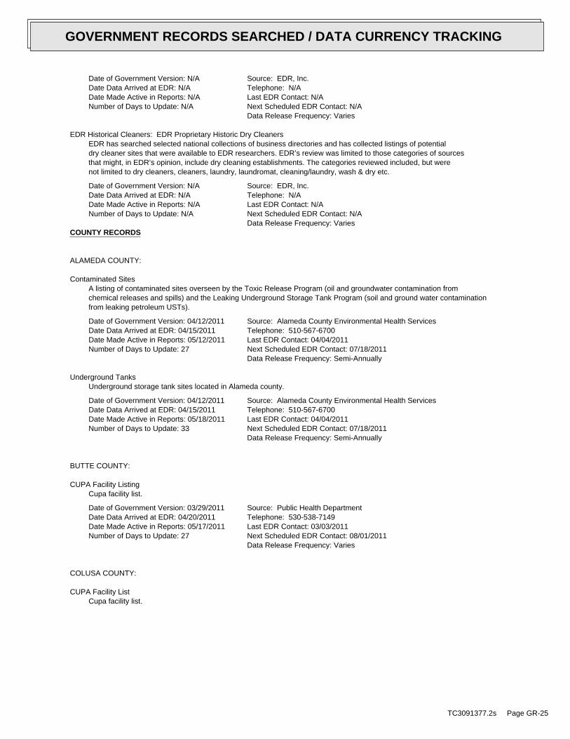
Date of Government Version: N/ADate Data Arrived at EDR: N/ADate Made Active in Reports: N/ANumber of Days to Update: N/A
Source: EDR, Inc.Telephone: N/ALast EDR Contact: N/ANext Scheduled EDR Contact: N/AData Release Frequency: Varies
EDR Historical Cleaners: EDR Proprietary Historic Dry CleanersEDR has searched selected national collections of business directories and has collected listings of potentialdry cleaner sites that were available to EDR researchers. EDR’s review was limited to those categories of sourcesthat might, in EDR’s opinion, include dry cleaning establishments. The categories reviewed included, but werenot limited to dry cleaners, cleaners, laundry, laundromat, cleaning/laundry, wash & dry etc.
Date of Government Version: N/ADate Data Arrived at EDR: N/ADate Made Active in Reports: N/ANumber of Days to Update: N/A
Source: EDR, Inc.Telephone: N/ALast EDR Contact: N/ANext Scheduled EDR Contact: N/AData Release Frequency: Varies
COUNTY RECORDS
ALAMEDA COUNTY:
Contaminated SitesA listing of contaminated sites overseen by the Toxic Release Program (oil and groundwater contamination fromchemical releases and spills) and the Leaking Underground Storage Tank Program (soil and ground water contaminationfrom leaking petroleum USTs).
Date of Government Version: 04/12/2011Date Data Arrived at EDR: 04/15/2011Date Made Active in Reports: 05/12/2011Number of Days to Update: 27
Source: Alameda County Environmental Health ServicesTelephone: 510-567-6700Last EDR Contact: 04/04/2011Next Scheduled EDR Contact: 07/18/2011Data Release Frequency: Semi-Annually
Underground TanksUnderground storage tank sites located in Alameda county.
Date of Government Version: 04/12/2011Date Data Arrived at EDR: 04/15/2011Date Made Active in Reports: 05/18/2011Number of Days to Update: 33
Source: Alameda County Environmental Health ServicesTelephone: 510-567-6700Last EDR Contact: 04/04/2011Next Scheduled EDR Contact: 07/18/2011Data Release Frequency: Semi-Annually
BUTTE COUNTY:
CUPA Facility ListingCupa facility list.
Date of Government Version: 03/29/2011Date Data Arrived at EDR: 04/20/2011Date Made Active in Reports: 05/17/2011Number of Days to Update: 27
Source: Public Health DepartmentTelephone: 530-538-7149Last EDR Contact: 03/03/2011Next Scheduled EDR Contact: 08/01/2011Data Release Frequency: Varies
COLUSA COUNTY:
CUPA Facility ListCupa facility list.
TC3091377.2s Page GR-25
GOVERNMENT RECORDS SEARCHED / DATA CURRENCY TRACKING
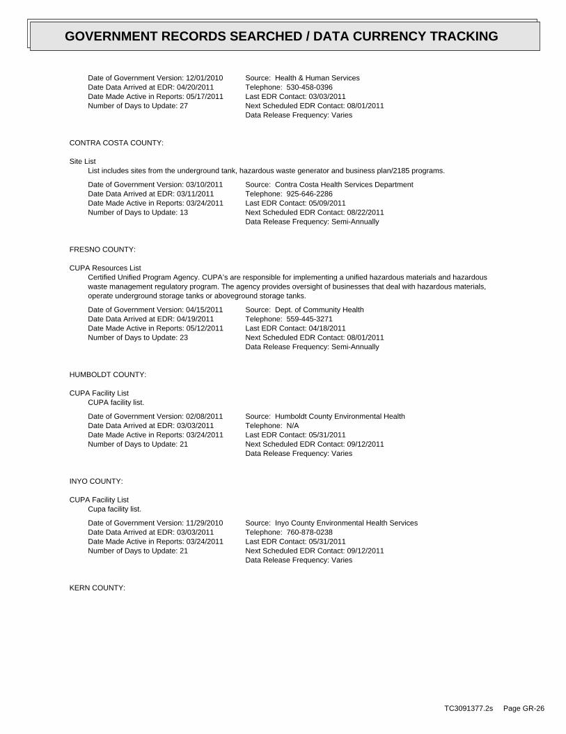
Date of Government Version: 12/01/2010Date Data Arrived at EDR: 04/20/2011Date Made Active in Reports: 05/17/2011Number of Days to Update: 27
Source: Health & Human ServicesTelephone: 530-458-0396Last EDR Contact: 03/03/2011Next Scheduled EDR Contact: 08/01/2011Data Release Frequency: Varies
CONTRA COSTA COUNTY:
Site ListList includes sites from the underground tank, hazardous waste generator and business plan/2185 programs.
Date of Government Version: 03/10/2011Date Data Arrived at EDR: 03/11/2011Date Made Active in Reports: 03/24/2011Number of Days to Update: 13
Source: Contra Costa Health Services DepartmentTelephone: 925-646-2286Last EDR Contact: 05/09/2011Next Scheduled EDR Contact: 08/22/2011Data Release Frequency: Semi-Annually
FRESNO COUNTY:
CUPA Resources ListCertified Unified Program Agency. CUPA’s are responsible for implementing a unified hazardous materials and hazardouswaste management regulatory program. The agency provides oversight of businesses that deal with hazardous materials,operate underground storage tanks or aboveground storage tanks.
Date of Government Version: 04/15/2011Date Data Arrived at EDR: 04/19/2011Date Made Active in Reports: 05/12/2011Number of Days to Update: 23
Source: Dept. of Community HealthTelephone: 559-445-3271Last EDR Contact: 04/18/2011Next Scheduled EDR Contact: 08/01/2011Data Release Frequency: Semi-Annually
HUMBOLDT COUNTY:
CUPA Facility ListCUPA facility list.
Date of Government Version: 02/08/2011Date Data Arrived at EDR: 03/03/2011Date Made Active in Reports: 03/24/2011Number of Days to Update: 21
Source: Humboldt County Environmental HealthTelephone: N/ALast EDR Contact: 05/31/2011Next Scheduled EDR Contact: 09/12/2011Data Release Frequency: Varies
INYO COUNTY:
CUPA Facility ListCupa facility list.
Date of Government Version: 11/29/2010Date Data Arrived at EDR: 03/03/2011Date Made Active in Reports: 03/24/2011Number of Days to Update: 21
Source: Inyo County Environmental Health ServicesTelephone: 760-878-0238Last EDR Contact: 05/31/2011Next Scheduled EDR Contact: 09/12/2011Data Release Frequency: Varies
KERN COUNTY:
TC3091377.2s Page GR-26
GOVERNMENT RECORDS SEARCHED / DATA CURRENCY TRACKING

Underground Storage Tank Sites & Tank ListingKern County Sites and Tanks Listing.
Date of Government Version: 08/31/2010Date Data Arrived at EDR: 09/01/2010Date Made Active in Reports: 09/30/2010Number of Days to Update: 29
Source: Kern County Environment Health Services DepartmentTelephone: 661-862-8700Last EDR Contact: 05/31/2011Next Scheduled EDR Contact: 08/29/2011Data Release Frequency: Quarterly
KINGS COUNTY:
CUPA Facility ListA listing of sites included in the county?s Certified Unified Program Agency database. California?s Secretaryfor Environmental Protection established the unified hazardous materials and hazardous waste regulatory programas required by chapter 6.11 of the California Health and Safety Code. The Unified Program consolidates the administration,permits, inspections, and enforcement activities.
Date of Government Version: 12/06/2010Date Data Arrived at EDR: 03/03/2011Date Made Active in Reports: 03/31/2011Number of Days to Update: 28
Source: Kings County Department of Public HealthTelephone: 559-584-1411Last EDR Contact: 05/31/2011Next Scheduled EDR Contact: 09/12/2011Data Release Frequency: Varies
LOS ANGELES COUNTY:
San Gabriel Valley Areas of ConcernSan Gabriel Valley areas where VOC contamination is at or above the MCL as designated by region 9 EPA office.
Date of Government Version: 03/30/2009Date Data Arrived at EDR: 03/31/2009Date Made Active in Reports: 10/23/2009Number of Days to Update: 206
Source: EPA Region 9Telephone: 415-972-3178Last EDR Contact: 03/28/2011Next Scheduled EDR Contact: 07/11/2011Data Release Frequency: No Update Planned
HMS: Street Number ListIndustrial Waste and Underground Storage Tank Sites.
Date of Government Version: 12/30/2010Date Data Arrived at EDR: 03/03/2011Date Made Active in Reports: 03/24/2011Number of Days to Update: 21
Source: Department of Public WorksTelephone: 626-458-3517Last EDR Contact: 04/18/2011Next Scheduled EDR Contact: 08/01/2011Data Release Frequency: Semi-Annually
List of Solid Waste FacilitiesSolid Waste Facilities in Los Angeles County.
Date of Government Version: 04/25/2011Date Data Arrived at EDR: 04/28/2011Date Made Active in Reports: 05/17/2011Number of Days to Update: 19
Source: La County Department of Public WorksTelephone: 818-458-5185Last EDR Contact: 04/25/2011Next Scheduled EDR Contact: 08/08/2011Data Release Frequency: Varies
City of Los Angeles LandfillsLandfills owned and maintained by the City of Los Angeles.
Date of Government Version: 03/05/2009Date Data Arrived at EDR: 03/10/2009Date Made Active in Reports: 04/08/2009Number of Days to Update: 29
Source: Engineering & Construction DivisionTelephone: 213-473-7869Last EDR Contact: 05/24/2011Next Scheduled EDR Contact: 09/05/2011Data Release Frequency: Varies
TC3091377.2s Page GR-27
GOVERNMENT RECORDS SEARCHED / DATA CURRENCY TRACKING
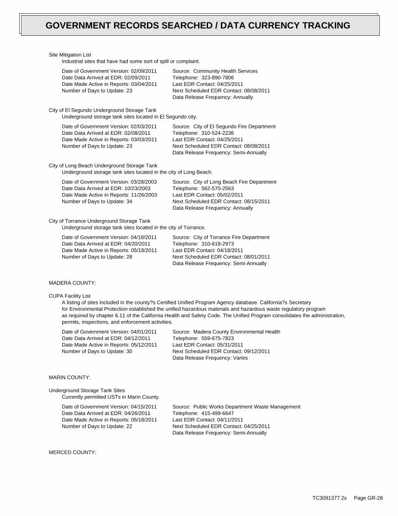
Site Mitigation ListIndustrial sites that have had some sort of spill or complaint.
Date of Government Version: 02/09/2011Date Data Arrived at EDR: 02/09/2011Date Made Active in Reports: 03/04/2011Number of Days to Update: 23
Source: Community Health ServicesTelephone: 323-890-7806Last EDR Contact: 04/25/2011Next Scheduled EDR Contact: 08/08/2011Data Release Frequency: Annually
City of El Segundo Underground Storage TankUnderground storage tank sites located in El Segundo city.
Date of Government Version: 02/03/2011Date Data Arrived at EDR: 02/08/2011Date Made Active in Reports: 03/03/2011Number of Days to Update: 23
Source: City of El Segundo Fire DepartmentTelephone: 310-524-2236Last EDR Contact: 04/25/2011Next Scheduled EDR Contact: 08/08/2011Data Release Frequency: Semi-Annually
City of Long Beach Underground Storage TankUnderground storage tank sites located in the city of Long Beach.
Date of Government Version: 03/28/2003Date Data Arrived at EDR: 10/23/2003Date Made Active in Reports: 11/26/2003Number of Days to Update: 34
Source: City of Long Beach Fire DepartmentTelephone: 562-570-2563Last EDR Contact: 05/02/2011Next Scheduled EDR Contact: 08/15/2011Data Release Frequency: Annually
City of Torrance Underground Storage TankUnderground storage tank sites located in the city of Torrance.
Date of Government Version: 04/18/2011Date Data Arrived at EDR: 04/20/2011Date Made Active in Reports: 05/18/2011Number of Days to Update: 28
Source: City of Torrance Fire DepartmentTelephone: 310-618-2973Last EDR Contact: 04/18/2011Next Scheduled EDR Contact: 08/01/2011Data Release Frequency: Semi-Annually
MADERA COUNTY:
CUPA Facility ListA listing of sites included in the county?s Certified Unified Program Agency database. California?s Secretaryfor Environmental Protection established the unified hazardous materials and hazardous waste regulatory programas required by chapter 6.11 of the California Health and Safety Code. The Unified Program consolidates the administration,permits, inspections, and enforcement activities.
Date of Government Version: 04/01/2011Date Data Arrived at EDR: 04/12/2011Date Made Active in Reports: 05/12/2011Number of Days to Update: 30
Source: Madera County Environmental HealthTelephone: 559-675-7823Last EDR Contact: 05/31/2011Next Scheduled EDR Contact: 09/12/2011Data Release Frequency: Varies
MARIN COUNTY:
Underground Storage Tank SitesCurrently permitted USTs in Marin County.
Date of Government Version: 04/15/2011Date Data Arrived at EDR: 04/26/2011Date Made Active in Reports: 05/18/2011Number of Days to Update: 22
Source: Public Works Department Waste ManagementTelephone: 415-499-6647Last EDR Contact: 04/11/2011Next Scheduled EDR Contact: 04/25/2011Data Release Frequency: Semi-Annually
MERCED COUNTY:
TC3091377.2s Page GR-28
GOVERNMENT RECORDS SEARCHED / DATA CURRENCY TRACKING

CUPA Facility ListCUPA facility list.
Date of Government Version: 11/22/2010Date Data Arrived at EDR: 03/03/2011Date Made Active in Reports: 03/24/2011Number of Days to Update: 21
Source: Merced County Environmental HealthTelephone: 209-381-1094Last EDR Contact: 05/31/2011Next Scheduled EDR Contact: 09/12/2011Data Release Frequency: Varies
MONTEREY COUNTY:
CUPA Facility ListingCUPA Program listing from the Environmental Health Division.
Date of Government Version: 01/20/2011Date Data Arrived at EDR: 03/03/2011Date Made Active in Reports: 03/24/2011Number of Days to Update: 21
Source: Monterey County Health DepartmentTelephone: 831-796-1297Last EDR Contact: 05/31/2011Next Scheduled EDR Contact: 09/12/2011Data Release Frequency: Varies
NAPA COUNTY:
Sites With Reported ContaminationA listing of leaking underground storage tank sites located in Napa county.
Date of Government Version: 07/09/2008Date Data Arrived at EDR: 07/09/2008Date Made Active in Reports: 07/31/2008Number of Days to Update: 22
Source: Napa County Department of Environmental ManagementTelephone: 707-253-4269Last EDR Contact: 03/07/2011Next Scheduled EDR Contact: 06/20/2011Data Release Frequency: No Update Planned
Closed and Operating Underground Storage Tank SitesUnderground storage tank sites located in Napa county.
Date of Government Version: 01/15/2008Date Data Arrived at EDR: 01/16/2008Date Made Active in Reports: 02/08/2008Number of Days to Update: 23
Source: Napa County Department of Environmental ManagementTelephone: 707-253-4269Last EDR Contact: 06/06/2011Next Scheduled EDR Contact: 09/19/2011Data Release Frequency: No Update Planned
ORANGE COUNTY:
List of Industrial Site CleanupsPetroleum and non-petroleum spills.
Date of Government Version: 02/02/2011Date Data Arrived at EDR: 02/17/2011Date Made Active in Reports: 03/22/2011Number of Days to Update: 33
Source: Health Care AgencyTelephone: 714-834-3446Last EDR Contact: 05/16/2011Next Scheduled EDR Contact: 08/29/2011Data Release Frequency: Annually
List of Underground Storage Tank CleanupsOrange County Underground Storage Tank Cleanups (LUST).
Date of Government Version: 02/02/2011Date Data Arrived at EDR: 02/17/2011Date Made Active in Reports: 03/22/2011Number of Days to Update: 33
Source: Health Care AgencyTelephone: 714-834-3446Last EDR Contact: 05/16/2011Next Scheduled EDR Contact: 08/29/2011Data Release Frequency: Quarterly
TC3091377.2s Page GR-29
GOVERNMENT RECORDS SEARCHED / DATA CURRENCY TRACKING
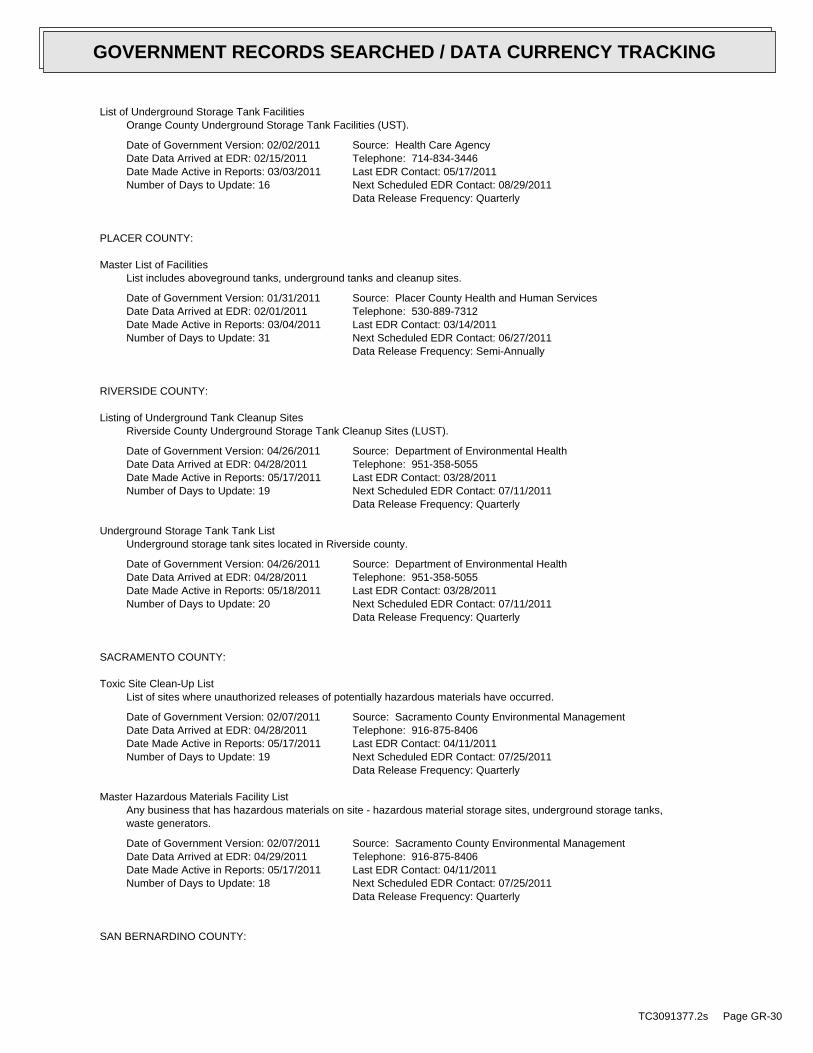
List of Underground Storage Tank FacilitiesOrange County Underground Storage Tank Facilities (UST).
Date of Government Version: 02/02/2011Date Data Arrived at EDR: 02/15/2011Date Made Active in Reports: 03/03/2011Number of Days to Update: 16
Source: Health Care AgencyTelephone: 714-834-3446Last EDR Contact: 05/17/2011Next Scheduled EDR Contact: 08/29/2011Data Release Frequency: Quarterly
PLACER COUNTY:
Master List of FacilitiesList includes aboveground tanks, underground tanks and cleanup sites.
Date of Government Version: 01/31/2011Date Data Arrived at EDR: 02/01/2011Date Made Active in Reports: 03/04/2011Number of Days to Update: 31
Source: Placer County Health and Human ServicesTelephone: 530-889-7312Last EDR Contact: 03/14/2011Next Scheduled EDR Contact: 06/27/2011Data Release Frequency: Semi-Annually
RIVERSIDE COUNTY:
Listing of Underground Tank Cleanup SitesRiverside County Underground Storage Tank Cleanup Sites (LUST).
Date of Government Version: 04/26/2011Date Data Arrived at EDR: 04/28/2011Date Made Active in Reports: 05/17/2011Number of Days to Update: 19
Source: Department of Environmental HealthTelephone: 951-358-5055Last EDR Contact: 03/28/2011Next Scheduled EDR Contact: 07/11/2011Data Release Frequency: Quarterly
Underground Storage Tank Tank ListUnderground storage tank sites located in Riverside county.
Date of Government Version: 04/26/2011Date Data Arrived at EDR: 04/28/2011Date Made Active in Reports: 05/18/2011Number of Days to Update: 20
Source: Department of Environmental HealthTelephone: 951-358-5055Last EDR Contact: 03/28/2011Next Scheduled EDR Contact: 07/11/2011Data Release Frequency: Quarterly
SACRAMENTO COUNTY:
Toxic Site Clean-Up ListList of sites where unauthorized releases of potentially hazardous materials have occurred.
Date of Government Version: 02/07/2011Date Data Arrived at EDR: 04/28/2011Date Made Active in Reports: 05/17/2011Number of Days to Update: 19
Source: Sacramento County Environmental ManagementTelephone: 916-875-8406Last EDR Contact: 04/11/2011Next Scheduled EDR Contact: 07/25/2011Data Release Frequency: Quarterly
Master Hazardous Materials Facility ListAny business that has hazardous materials on site - hazardous material storage sites, underground storage tanks,waste generators.
Date of Government Version: 02/07/2011Date Data Arrived at EDR: 04/29/2011Date Made Active in Reports: 05/17/2011Number of Days to Update: 18
Source: Sacramento County Environmental ManagementTelephone: 916-875-8406Last EDR Contact: 04/11/2011Next Scheduled EDR Contact: 07/25/2011Data Release Frequency: Quarterly
SAN BERNARDINO COUNTY:
TC3091377.2s Page GR-30
GOVERNMENT RECORDS SEARCHED / DATA CURRENCY TRACKING
Hazardous Material PermitsThis listing includes underground storage tanks, medical waste handlers/generators, hazardous materials handlers,hazardous waste generators, and waste oil generators/handlers.
Date of Government Version: 03/10/2011Date Data Arrived at EDR: 03/11/2011Date Made Active in Reports: 03/24/2011Number of Days to Update: 13
Source: San Bernardino County Fire Department Hazardous Materials DivisionTelephone: 909-387-3041Last EDR Contact: 05/16/2011Next Scheduled EDR Contact: 08/29/2011Data Release Frequency: Quarterly
SAN DIEGO COUNTY:
Hazardous Materials Management Division DatabaseThe database includes: HE58 - This report contains the business name, site address, business phone number, establishment’H’ permit number, type of permit, and the business status. HE17 - In addition to providing the same informationprovided in the HE58 listing, HE17 provides inspection dates, violations received by the establishment, hazardouswaste generated, the quantity, method of storage, treatment/disposal of waste and the hauler, and informationon underground storage tanks. Unauthorized Release List - Includes a summary of environmental contamination casesin San Diego County (underground tank cases, non-tank cases, groundwater contamination, and soil contaminationare included.)
Date of Government Version: 09/09/2010Date Data Arrived at EDR: 09/15/2010Date Made Active in Reports: 09/29/2010Number of Days to Update: 14
Source: Hazardous Materials Management DivisionTelephone: 619-338-2268Last EDR Contact: 03/18/2011Next Scheduled EDR Contact: 06/27/2011Data Release Frequency: Quarterly
Solid Waste FacilitiesSan Diego County Solid Waste Facilities.
Date of Government Version: 10/01/2010Date Data Arrived at EDR: 11/16/2010Date Made Active in Reports: 01/25/2011Number of Days to Update: 70
Source: Department of Health ServicesTelephone: 619-338-2209Last EDR Contact: 05/02/2011Next Scheduled EDR Contact: 08/15/2011Data Release Frequency: Varies
Environmental Case ListingThe listing contains all underground tank release cases and projects pertaining to properties contaminated withhazardous substances that are actively under review by the Site Assessment and Mitigation Program.
Date of Government Version: 03/23/2010Date Data Arrived at EDR: 06/15/2010Date Made Active in Reports: 07/09/2010Number of Days to Update: 24
Source: San Diego County Department of Environmental HealthTelephone: 619-338-2371Last EDR Contact: 12/21/2010Next Scheduled EDR Contact: 03/28/2011Data Release Frequency: No Update Planned
SAN FRANCISCO COUNTY:
Local Oversite FacilitiesA listing of leaking underground storage tank sites located in San Francisco county.
Date of Government Version: 09/19/2008Date Data Arrived at EDR: 09/19/2008Date Made Active in Reports: 09/29/2008Number of Days to Update: 10
Source: Department Of Public Health San Francisco CountyTelephone: 415-252-3920Last EDR Contact: 05/16/2011Next Scheduled EDR Contact: 08/16/2011Data Release Frequency: Quarterly
TC3091377.2s Page GR-31
GOVERNMENT RECORDS SEARCHED / DATA CURRENCY TRACKING
Underground Storage Tank InformationUnderground storage tank sites located in San Francisco county.
Date of Government Version: 11/29/2010Date Data Arrived at EDR: 03/10/2011Date Made Active in Reports: 03/15/2011Number of Days to Update: 5
Source: Department of Public HealthTelephone: 415-252-3920Last EDR Contact: 05/31/2011Next Scheduled EDR Contact: 08/29/2011Data Release Frequency: Quarterly
SAN JOAQUIN COUNTY:
San Joaquin Co. USTA listing of underground storage tank locations in San Joaquin county.
Date of Government Version: 03/30/2011Date Data Arrived at EDR: 03/31/2011Date Made Active in Reports: 04/22/2011Number of Days to Update: 22
Source: Environmental Health DepartmentTelephone: N/ALast EDR Contact: 03/28/2011Next Scheduled EDR Contact: 07/11/2011Data Release Frequency: Semi-Annually
SAN LUIS OBISPO COUNTY:
CUPA Facility ListCupa Facility List.
Date of Government Version: 11/17/2010Date Data Arrived at EDR: 03/03/2011Date Made Active in Reports: 03/24/2011Number of Days to Update: 21
Source: San Luis Obispo County Public Health DepartmentTelephone: 805-781-5596Last EDR Contact: 05/31/2011Next Scheduled EDR Contact: 09/12/2011Data Release Frequency: Varies
SAN MATEO COUNTY:
Business InventoryList includes Hazardous Materials Business Plan, hazardous waste generators, and underground storage tanks.
Date of Government Version: 04/19/2011Date Data Arrived at EDR: 04/20/2011Date Made Active in Reports: 05/17/2011Number of Days to Update: 27
Source: San Mateo County Environmental Health Services DivisionTelephone: 650-363-1921Last EDR Contact: 03/28/2011Next Scheduled EDR Contact: 07/04/2011Data Release Frequency: Annually
Fuel Leak ListA listing of leaking underground storage tank sites located in San Mateo county.
Date of Government Version: 03/21/2011Date Data Arrived at EDR: 03/22/2011Date Made Active in Reports: 04/20/2011Number of Days to Update: 29
Source: San Mateo County Environmental Health Services DivisionTelephone: 650-363-1921Last EDR Contact: 03/21/2011Next Scheduled EDR Contact: 07/04/2011Data Release Frequency: Semi-Annually
SANTA BARBARA COUNTY:
CUPA Facility ListingCUPA Program Listing from the Environmental Health Services division.
TC3091377.2s Page GR-32
GOVERNMENT RECORDS SEARCHED / DATA CURRENCY TRACKING
Date of Government Version: 11/22/2010Date Data Arrived at EDR: 03/03/2011Date Made Active in Reports: 03/24/2011Number of Days to Update: 21
Source: Santa Barbara County Public Health DepartmentTelephone: 805-686-8167Last EDR Contact: 05/31/2011Next Scheduled EDR Contact: 09/12/2011Data Release Frequency: Varies
SANTA CLARA COUNTY:
HIST LUST - Fuel Leak Site Activity ReportA listing of open and closed leaking underground storage tanks. This listing is no longer updated by the county.Leaking underground storage tanks are now handled by the Department of Environmental Health.
Date of Government Version: 03/29/2005Date Data Arrived at EDR: 03/30/2005Date Made Active in Reports: 04/21/2005Number of Days to Update: 22
Source: Santa Clara Valley Water DistrictTelephone: 408-265-2600Last EDR Contact: 03/23/2009Next Scheduled EDR Contact: 06/22/2009Data Release Frequency: No Update Planned
LOP ListingA listing of leaking underground storage tanks located in Santa Clara county.
Date of Government Version: 05/29/2009Date Data Arrived at EDR: 06/01/2009Date Made Active in Reports: 06/15/2009Number of Days to Update: 14
Source: Department of Environmental HealthTelephone: 408-918-3417Last EDR Contact: 06/06/2011Next Scheduled EDR Contact: 09/19/2011Data Release Frequency: Annually
Hazardous Material FacilitiesHazardous material facilities, including underground storage tank sites.
Date of Government Version: 08/31/2009Date Data Arrived at EDR: 08/31/2009Date Made Active in Reports: 09/18/2009Number of Days to Update: 18
Source: City of San Jose Fire DepartmentTelephone: 408-535-7694Last EDR Contact: 05/31/2011Next Scheduled EDR Contact: 08/29/2011Data Release Frequency: Annually
SANTA CRUZ COUNTY:
CUPA Facility ListCUPA facility listing.
Date of Government Version: 11/22/2010Date Data Arrived at EDR: 03/03/2011Date Made Active in Reports: 03/24/2011Number of Days to Update: 21
Source: Santa Cruz County Environmental HealthTelephone: 831-464-2761Last EDR Contact: 05/31/2011Next Scheduled EDR Contact: 09/12/2011Data Release Frequency: Varies
SHASTA COUNTY:
CUPA Facility ListCupa Facility List.
Date of Government Version: 11/30/2010Date Data Arrived at EDR: 03/03/2011Date Made Active in Reports: 03/24/2011Number of Days to Update: 21
Source: Shasta County Department of Resource ManagementTelephone: 530-225-5789Last EDR Contact: 05/31/2011Next Scheduled EDR Contact: 09/12/2011Data Release Frequency: Varies
SOLANO COUNTY:
TC3091377.2s Page GR-33
GOVERNMENT RECORDS SEARCHED / DATA CURRENCY TRACKING

Leaking Underground Storage TanksA listing of leaking underground storage tank sites located in Solano county.
Date of Government Version: 03/21/2011Date Data Arrived at EDR: 03/25/2011Date Made Active in Reports: 04/21/2011Number of Days to Update: 27
Source: Solano County Department of Environmental ManagementTelephone: 707-784-6770Last EDR Contact: 03/21/2011Next Scheduled EDR Contact: 06/20/2011Data Release Frequency: Quarterly
Underground Storage TanksUnderground storage tank sites located in Solano county.
Date of Government Version: 03/21/2011Date Data Arrived at EDR: 03/25/2011Date Made Active in Reports: 04/22/2011Number of Days to Update: 28
Source: Solano County Department of Environmental ManagementTelephone: 707-784-6770Last EDR Contact: 03/21/2011Next Scheduled EDR Contact: 06/20/2011Data Release Frequency: Quarterly
SONOMA COUNTY:
Leaking Underground Storage Tank SitesA listing of leaking underground storage tank sites located in Sonoma county.
Date of Government Version: 04/05/2011Date Data Arrived at EDR: 04/06/2011Date Made Active in Reports: 05/12/2011Number of Days to Update: 36
Source: Department of Health ServicesTelephone: 707-565-6565Last EDR Contact: 04/04/2011Next Scheduled EDR Contact: 07/18/2011Data Release Frequency: Quarterly
SUTTER COUNTY:
Underground Storage TanksUnderground storage tank sites located in Sutter county.
Date of Government Version: 03/14/2011Date Data Arrived at EDR: 03/15/2011Date Made Active in Reports: 03/24/2011Number of Days to Update: 9
Source: Sutter County Department of AgricultureTelephone: 530-822-7500Last EDR Contact: 03/14/2011Next Scheduled EDR Contact: 06/27/2011Data Release Frequency: Semi-Annually
VENTURA COUNTY:
Business Plan, Hazardous Waste Producers, and Operating Underground TanksThe BWT list indicates by site address whether the Environmental Health Division has Business Plan (B), WasteProducer (W), and/or Underground Tank (T) information.
Date of Government Version: 01/26/2011Date Data Arrived at EDR: 02/25/2011Date Made Active in Reports: 03/22/2011Number of Days to Update: 25
Source: Ventura County Environmental Health DivisionTelephone: 805-654-2813Last EDR Contact: 05/24/2011Next Scheduled EDR Contact: 09/05/2011Data Release Frequency: Quarterly
Inventory of Illegal Abandoned and Inactive SitesVentura County Inventory of Closed, Illegal Abandoned, and Inactive Sites.
Date of Government Version: 04/01/2011Date Data Arrived at EDR: 04/07/2011Date Made Active in Reports: 05/12/2011Number of Days to Update: 35
Source: Environmental Health DivisionTelephone: 805-654-2813Last EDR Contact: 04/07/2011Next Scheduled EDR Contact: 07/25/2011Data Release Frequency: Annually
TC3091377.2s Page GR-34
GOVERNMENT RECORDS SEARCHED / DATA CURRENCY TRACKING

Listing of Underground Tank Cleanup SitesVentura County Underground Storage Tank Cleanup Sites (LUST).
Date of Government Version: 05/29/2008Date Data Arrived at EDR: 06/24/2008Date Made Active in Reports: 07/31/2008Number of Days to Update: 37
Source: Environmental Health DivisionTelephone: 805-654-2813Last EDR Contact: 05/24/2011Next Scheduled EDR Contact: 09/05/2011Data Release Frequency: Quarterly
Medical Waste Program ListTo protect public health and safety and the environment from potential exposure to disease causing agents, theEnvironmental Health Division Medical Waste Program regulates the generation, handling, storage, treatment anddisposal of medical waste throughout the County.
Date of Government Version: 01/26/2011Date Data Arrived at EDR: 02/08/2011Date Made Active in Reports: 03/08/2011Number of Days to Update: 28
Source: Ventura County Resource Management AgencyTelephone: 805-654-2813Last EDR Contact: 05/02/2011Next Scheduled EDR Contact: 08/15/2011Data Release Frequency: Quarterly
Underground Tank Closed Sites ListVentura County Operating Underground Storage Tank Sites (UST)/Underground Tank Closed Sites List.
Date of Government Version: 03/01/2011Date Data Arrived at EDR: 03/23/2011Date Made Active in Reports: 04/22/2011Number of Days to Update: 30
Source: Environmental Health DivisionTelephone: 805-654-2813Last EDR Contact: 03/23/2011Next Scheduled EDR Contact: 07/04/2011Data Release Frequency: Quarterly
YOLO COUNTY:
Underground Storage Tank Comprehensive Facility ReportUnderground storage tank sites located in Yolo county.
Date of Government Version: 01/25/2011Date Data Arrived at EDR: 02/03/2011Date Made Active in Reports: 03/04/2011Number of Days to Update: 29
Source: Yolo County Department of HealthTelephone: 530-666-8646Last EDR Contact: 04/11/2011Next Scheduled EDR Contact: 07/11/2011Data Release Frequency: Annually
OTHER DATABASE(S)
Depending on the geographic area covered by this report, the data provided in these specialty databases may or may not becomplete. For example, the existence of wetlands information data in a specific report does not mean that all wetlands in thearea covered by the report are included. Moreover, the absence of any reported wetlands information does not necessarilymean that wetlands do not exist in the area covered by the report.
CT MANIFEST: Hazardous Waste Manifest DataFacility and manifest data. Manifest is a document that lists and tracks hazardous waste from the generator throughtransporters to a tsd facility.
Date of Government Version: 12/31/2007Date Data Arrived at EDR: 08/26/2009Date Made Active in Reports: 09/11/2009Number of Days to Update: 16
Source: Department of Environmental ProtectionTelephone: 860-424-3375Last EDR Contact: 05/26/2011Next Scheduled EDR Contact: 09/05/2011Data Release Frequency: Annually
TC3091377.2s Page GR-35
GOVERNMENT RECORDS SEARCHED / DATA CURRENCY TRACKING
NJ MANIFEST: Manifest InformationHazardous waste manifest information.
Date of Government Version: 12/31/2009Date Data Arrived at EDR: 07/22/2010Date Made Active in Reports: 08/26/2010Number of Days to Update: 35
Source: Department of Environmental ProtectionTelephone: N/ALast EDR Contact: 04/19/2011Next Scheduled EDR Contact: 08/01/2011Data Release Frequency: Annually
NY MANIFEST: Facility and Manifest DataManifest is a document that lists and tracks hazardous waste from the generator through transporters to a TSDfacility.
Date of Government Version: 12/31/2010Date Data Arrived at EDR: 05/12/2011Date Made Active in Reports: 05/24/2011Number of Days to Update: 12
Source: Department of Environmental ConservationTelephone: 518-402-8651Last EDR Contact: 05/12/2011Next Scheduled EDR Contact: 08/22/2011Data Release Frequency: Annually
PA MANIFEST: Manifest InformationHazardous waste manifest information.
Date of Government Version: 12/31/2008Date Data Arrived at EDR: 12/01/2009Date Made Active in Reports: 12/14/2009Number of Days to Update: 13
Source: Department of Environmental ProtectionTelephone: 717-783-8990Last EDR Contact: 04/04/2011Next Scheduled EDR Contact: 07/06/2011Data Release Frequency: Annually
RI MANIFEST: Manifest informationHazardous waste manifest information
Date of Government Version: 12/31/2009Date Data Arrived at EDR: 07/19/2010Date Made Active in Reports: 08/26/2010Number of Days to Update: 38
Source: Department of Environmental ManagementTelephone: 401-222-2797Last EDR Contact: 05/31/2011Next Scheduled EDR Contact: 09/12/2011Data Release Frequency: Annually
WI MANIFEST: Manifest InformationHazardous waste manifest information.
Date of Government Version: 12/31/2009Date Data Arrived at EDR: 07/06/2010Date Made Active in Reports: 07/26/2010Number of Days to Update: 20
Source: Department of Natural ResourcesTelephone: N/ALast EDR Contact: 03/21/2011Next Scheduled EDR Contact: 07/04/2011Data Release Frequency: Annually
Oil/Gas Pipelines: This data was obtained by EDR from the USGS in 1994. It is referred to by USGS as GeoData Digital Line Graphsfrom 1:100,000-Scale Maps. It was extracted from the transportation category including some oil, but primarilygas pipelines.
Electric Power Transmission Line DataSource: Rextag Strategies Corp.Telephone: (281) 769-2247U.S. Electric Transmission and Power Plants Systems Digital GIS Data
Sensitive Receptors: There are individuals deemed sensitive receptors due to their fragile immune systems and special sensitivityto environmental discharges. These sensitive receptors typically include the elderly, the sick, and children. While the location of allsensitive receptors cannot be determined, EDR indicates those buildings and facilities - schools, daycares, hospitals, medical centers,and nursing homes - where individuals who are sensitive receptors are likely to be located.
AHA Hospitals:Source: American Hospital Association, Inc.Telephone: 312-280-5991The database includes a listing of hospitals based on the American Hospital Association’s annual survey of hospitals.
TC3091377.2s Page GR-36
GOVERNMENT RECORDS SEARCHED / DATA CURRENCY TRACKING

Medical Centers: Provider of Services ListingSource: Centers for Medicare & Medicaid ServicesTelephone: 410-786-3000A listing of hospitals with Medicare provider number, produced by Centers of Medicare & Medicaid Services,a federal agency within the U.S. Department of Health and Human Services.
Nursing HomesSource: National Institutes of HealthTelephone: 301-594-6248Information on Medicare and Medicaid certified nursing homes in the United States.
Public SchoolsSource: National Center for Education StatisticsTelephone: 202-502-7300The National Center for Education Statistics’ primary database on elementaryand secondary public education in the United States. It is a comprehensive, annual, national statisticaldatabase of all public elementary and secondary schools and school districts, which contains data that arecomparable across all states.
Private SchoolsSource: National Center for Education StatisticsTelephone: 202-502-7300The National Center for Education Statistics’ primary database on private school locations in the United States.
Daycare Centers: Licensed FacilitiesSource: Department of Social ServicesTelephone: 916-657-4041
Flood Zone Data: This data, available in select counties across the country, was obtained by EDR in 2003 & 2011 from the FederalEmergency Management Agency (FEMA). Data depicts 100-year and 500-year flood zones as defined by FEMA.
NWI: National Wetlands Inventory. This data, available in select counties across the country, was obtained by EDRin 2002 and 2005 from the U.S. Fish and Wildlife Service.
Scanned Digital USGS 7.5’ Topographic Map (DRG)Source: United States Geologic SurveyA digital raster graphic (DRG) is a scanned image of a U.S. Geological Survey topographic map. The map imagesare made by scanning published paper maps on high-resolution scanners. The raster imageis georeferenced and fit to the Universal Transverse Mercator (UTM) projection.
STREET AND ADDRESS INFORMATION
© 2010 Tele Atlas North America, Inc. All rights reserved. This material is proprietary and the subject of copyright protectionand other intellectual property rights owned by or licensed to Tele Atlas North America, Inc. The use of this material is subjectto the terms of a license agreement. You will be held liable for any unauthorized copying or disclosure of this material.
TC3091377.2s Page GR-37
GOVERNMENT RECORDS SEARCHED / DATA CURRENCY TRACKING
TC3091377.2s Page A-1
geologic strata.of the soil, and nearby wells. Groundwater flow velocity is generally impacted by the nature of theGroundwater flow direction may be impacted by surface topography, hydrology, hydrogeology, characteristics
2. Groundwater flow velocity. 1. Groundwater flow direction, and
Assessment of the impact of contaminant migration generally has two principle investigative components:
forming an opinion about the impact of potential contaminant migration.EDR’s GeoCheck Physical Setting Source Addendum is provided to assist the environmental professional in
1981Most Recent Revision:33117-H8 LA HABRA, CASouth Map:
1981Most Recent Revision:34117-A8 BALDWIN PARK, CATarget Property Map:
USGS TOPOGRAPHIC MAP
362 ft. above sea levelElevation:3763224.0UTM Y (Meters): 414472.0UTM X (Meters): Zone 11Universal Tranverse Mercator: 117.9262 - 117˚ 55’ 34.3’’Longitude (West): 34.00790 - 34˚ 0’ 28.4’’Latitude (North):
TARGET PROPERTY COORDINATES
CITY OF INDUSTRY, CA 9174817300 CHESTNUT STREETWCEP LAYDOWN AREA
TARGET PROPERTY ADDRESS
GEOCHECK - PHYSICAL SETTING SOURCE ADDENDUM®
TC3091377.2s Page A-2
should be field verified.on a relative (not an absolute) basis. Relative elevation information between sites of close proximitySource: Topography has been determined from the USGS 7.5’ Digital Elevation Model and should be evaluated
SURROUNDING TOPOGRAPHY: ELEVATION PROFILES
Ele
vatio
n (f
t)E
leva
tion
(ft)
TP
TP0 1/2 1 Miles
✩Target Property Elevation: 362 ft.
North South
West East
443
435
424
412
404
398
392
386
379
362
383
389
399
425
542
599
646
707
507359
356
355
352
352
352
365
368
375
362
378
385
389
391
394
395
397
400
404
General WSWGeneral Topographic Gradient:TARGET PROPERTY TOPOGRAPHY
should contamination exist on the target property, what downgradient sites might be impacted.assist the environmental professional in forming an opinion about the impact of nearby contaminated properties or,Surface topography may be indicative of the direction of surficial groundwater flow. This information can be used toTOPOGRAPHIC INFORMATION
collected on nearby properties, and regional groundwater flow information (from deep aquifers).sources of information, such as surface topographic information, hydrologic information, hydrogeologic datausing site-specific well data. If such data is not reasonably ascertainable, it may be necessary to rely on otherGroundwater flow direction for a particular site is best determined by a qualified environmental professionalGROUNDWATER FLOW DIRECTION INFORMATION
GEOCHECK - PHYSICAL SETTING SOURCE SUMMARY®

TC3091377.2s Page A-3
Not Reported
GENERAL DIRECTIONLOCATIONGROUNDWATER FLOWFROM TPMAP ID
hydrogeologically, and the depth to water table.authorities at select sites and has extracted the date of the report, groundwater flow direction as determinedflow at specific points. EDR has reviewed reports submitted by environmental professionals to regulatoryEDR has developed the AQUIFLOW Information System to provide data on the general direction of groundwater
AQUIFLOW®
Search Radius: 1.000 Mile.
* ©1996 Site−specific hydrogeological data gathered by CERCLIS Alerts, Inc., Bainbridge Island, WA. All rights reserved. All of the information and opinions presented are those of the cited EPA report(s), which were completed undera Comprehensive Environmental Response Compensation and Liability Information System (CERCLIS) investigation.
Information is inferred in the CERCLIS investigation report(s) Data Quality:No information about a sole source aquifer is available Sole Source Aquifer:bedrock aquifer.the underlying and discrete Canyon alluvium aquifer and Industry HillsThe Valley alluvium at the site is likely hydraulically connected to Hydraulic Connection:8 feet to 38 feet. Inferred Depth to Water:Southeast Groundwater Flow Direction:CAD980636641 Site EPA ID Number:La Puente Dump Site Name:1/2 - 1 Mile NNE Location Relative to TP:1.25 miles Search Radius:
Site-Specific Hydrogeological Data*:
* ©1996 Site−specific hydrogeological data gathered by CERCLIS Alerts, Inc., Bainbridge Island, WA. All rights reserved. All of the information and opinions presented are those of the cited EPA report(s), which were completed undera Comprehensive Environmental Response Compensation and Liability Information System (CERCLIS) investigation.
contamination exist on the target property, what downgradient sites might be impacted.environmental professional in forming an opinion about the impact of nearby contaminated properties or, shouldof groundwater flow direction in the immediate area. Such hydrogeologic information can be used to assist theHydrogeologic information obtained by installation of wells on a specific site can often be an indicatorHYDROGEOLOGIC INFORMATION
YES - refer to the Overview Map and Detail MapBALDWIN PARK
NATIONAL WETLAND INVENTORYNWI ElectronicData CoverageNWI Quad at Target Property
Not ReportedAdditional Panels in search area:
06037C - FEMA DFIRM Flood dataFlood Plain Panel at Target Property:
YES - refer to the Overview Map and Detail MapLOS ANGELES, CA
FEMA FLOOD ZONEFEMA FloodElectronic DataTarget Property County
and bodies of water).Refer to the Physical Setting Source Map following this summary for hydrologic information (major waterways
contamination exist on the target property, what downgradient sites might be impacted.the environmental professional in forming an opinion about the impact of nearby contaminated properties or, shouldSurface water can act as a hydrologic barrier to groundwater flow. Such hydrologic information can be used to assistHYDROLOGIC INFORMATION
GEOCHECK - PHYSICAL SETTING SOURCE SUMMARY®

TC3091377.2s Page A-4
> 10 inchesDepth to Bedrock Max:
> 10 inchesDepth to Bedrock Min:
Not ReportedCorrosion Potential - Uncoated Steel:
Hydric Status: Soil does not meet the requirements for a hydric soil.
Not reportedSoil Drainage Class:
Not reportedHydrologic Group:
variableSoil Surface Texture:
URBAN LAND Soil Component Name:
The following information is based on Soil Conservation Service STATSGO data.in a landscape. Soil maps for STATSGO are compiled by generalizing more detailed (SSURGO) soil survey maps.for privately owned lands in the United States. A soil map in a soil survey is a representation of soil patternsSurvey (NCSS) and is responsible for collecting, storing, maintaining and distributing soil survey informationThe U.S. Department of Agriculture’s (USDA) Soil Conservation Service (SCS) leads the National Cooperative Soil
DOMINANT SOIL COMPOSITION IN GENERAL AREA OF TARGET PROPERTY
Map, USGS Digital Data Series DDS - 11 (1994).of the Conterminous U.S. at 1:2,500,000 Scale - a digital representation of the 1974 P.B. King and H.M. BeikmanGeologic Age and Rock Stratigraphic Unit Source: P.G. Schruben, R.E. Arndt and W.J. Bawiec, Geology
ROCK STRATIGRAPHIC UNIT GEOLOGIC AGE IDENTIFICATION
Stratified SequenceCategory:CenozoicEra:TertiarySystem:MioceneSeries:TmCode: (decoded above as Era, System & Series)
at which contaminant migration may be occurring.Geologic information can be used by the environmental professional in forming an opinion about the relative speedGEOLOGIC INFORMATION IN GENERAL AREA OF TARGET PROPERTY
move more quickly through sandy-gravelly types of soils than silty-clayey types of soils.characteristics data collected on nearby properties and regional soil information. In general, contaminant plumesto rely on other sources of information, including geologic age identification, rock stratigraphic unit and soilusing site specific geologic and soil strata data. If such data are not reasonably ascertainable, it may be necessaryGroundwater flow velocity information for a particular site is best determined by a qualified environmental professionalGROUNDWATER FLOW VELOCITY INFORMATION
GEOCHECK - PHYSICAL SETTING SOURCE SUMMARY®
TC3091377.2s Page A-5
very fine sandy loamweathered bedrocksandcoarse sandgravelly - sandy loamsilty clay loamclay loamstratifiedDeeper Soil Types:
silty claysandgravelly - loamfine sandy loamShallow Soil Types:
sandgravelly - sandcoarse sandgravelly - sandy loamclay loamfine sandsandy loamloamy sandsilt loamclayloamSurficial Soil Types:
sandgravelly - sandcoarse sandgravelly - sandy loamclay loamfine sandsandy loamloamy sandsilt loamclayloamSoil Surface Textures:
appear within the general area of target property.Based on Soil Conservation Service STATSGO data, the following additional subordinant soil types may
OTHER SOIL TYPES IN AREA
Min: 0.00Max: 0.00
Min: 0.00Max: 0.00Not reportedNot reportedvariable 6 inches 0 inches 1
Soil Layer Information
Boundary Classification
PermeabilityRate (in/hr)
Layer Upper Lower Soil Texture Class AASHTO Group Unified Soil Soil Reaction(pH)
GEOCHECK - PHYSICAL SETTING SOURCE SUMMARY®
TC3091377.2s Page A-6
1/2 - 1 Mile NNECAOG60000031443 141/2 - 1 Mile ENECAOG60000031259 131/2 - 1 Mile NNWCAOG60000031411 121/2 - 1 Mile NNECAOG60000031407 A111/2 - 1 Mile NNECAOG60000031365 101/2 - 1 Mile NNECAOG60000031385 A91/2 - 1 Mile ENECAOG60000031275 81/2 - 1 Mile NNWCAOG60000031344 71/2 - 1 Mile ENECAOG60000031189 61/2 - 1 Mile NNECAOG60000031341 51/4 - 1/2 Mile NorthCAOG60000031316 41/4 - 1/2 Mile NECAOG60000031206 31/4 - 1/2 Mile NorthCAOG60000031306 21/4 - 1/2 Mile NNECAOG60000031261 1
STATE OIL/GAS WELL INFORMATION
LOCATIONFROM TPWELL IDMAP ID
OTHER STATE DATABASE INFORMATION
No Wells Found
STATE DATABASE WELL INFORMATION
LOCATIONFROM TPWELL IDMAP ID
Note: PWS System location is not always the same as well location.
No PWS System Found
FEDERAL FRDS PUBLIC WATER SUPPLY SYSTEM INFORMATION
LOCATIONFROM TPWELL IDMAP ID
No Wells Found
FEDERAL USGS WELL INFORMATION
LOCATIONFROM TPWELL IDMAP ID
1.000State DatabaseNearest PWS within 1 mileFederal FRDS PWS1.000Federal USGS
WELL SEARCH DISTANCE INFORMATION
SEARCH DISTANCE (miles)DATABASE
opinion about the impact of contaminant migration on nearby drinking water wells.professional in assessing sources that may impact ground water flow direction, and in forming anEDR Local/Regional Water Agency records provide water well information to assist the environmental
LOCAL / REGIONAL WATER AGENCY RECORDS
GEOCHECK - PHYSICAL SETTING SOURCE SUMMARY®
TC3091377.2s Page A-7
1/2 - 1 Mile NNWCAOG60000031485 281/2 - 1 Mile NorthCAOG60000031564 271/2 - 1 Mile NNECAOG60000031533 E261/2 - 1 Mile NorthCAOG60000031532 D251/2 - 1 Mile NNECAOG60000031518 E241/2 - 1 Mile NNWCAOG60000031483 C231/2 - 1 Mile NNECAOG60000031511 E221/2 - 1 Mile NorthCAOG60000031516 E211/2 - 1 Mile NorthCAOG60000031517 D201/2 - 1 Mile NorthCAOG60000031515 D191/2 - 1 Mile ENECAOG60000031164 181/2 - 1 Mile NNWCAOG60000031479 C171/2 - 1 Mile NWCAOG60000031327 B161/2 - 1 Mile NWCAOG60000031314 B15
STATE OIL/GAS WELL INFORMATION
LOCATIONFROM TPWELL IDMAP ID
GEOCHECK - PHYSICAL SETTING SOURCE SUMMARY®
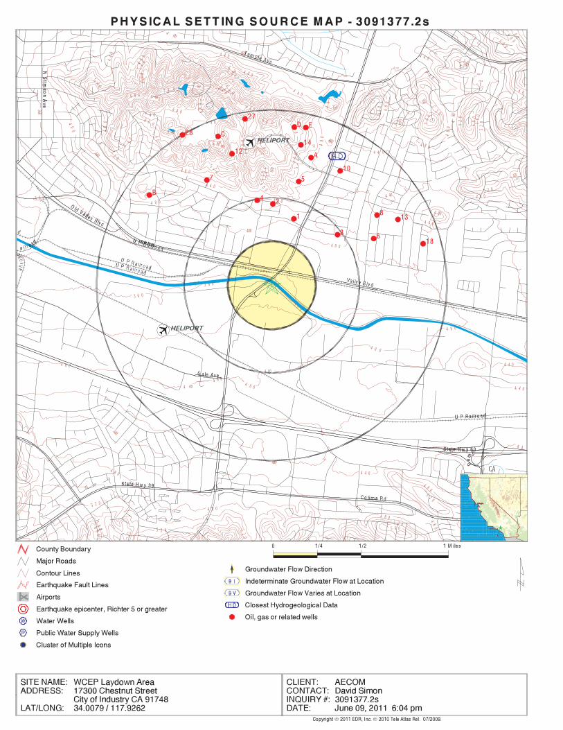
EDR Inc.EDR Inc.EDR Inc.EDR Inc.EDR Inc.EDR Inc.EDR Inc.EDR Inc.EDR Inc.EDR Inc.EDR Inc.EDR Inc.EDR Inc.EDR Inc.EDR Inc.EDR Inc.EDR Inc.EDR Inc.EDR Inc.EDR Inc.EDR Inc.EDR Inc.EDR Inc.EDR Inc.EDR Inc.EDR Inc.EDR Inc.EDR Inc.EDR Inc.EDR Inc.EDR Inc.EDR Inc.EDR Inc.EDR Inc.EDR Inc.EDR Inc.EDR Inc.EDR Inc.EDR Inc.EDR Inc.
6 0 05 60
5 2 0
5
20
7 60
7 60 5605206 4 0
48
0
7 2 0
72
0
6 8 06 8 0
68
0
52
0
6 8 0 5 20
48
0
56
0
60
0
5
2 0
40
6 80
56
0
4807 2
0
6 80
48
0
4 8 0
640
60 0
6 0
68
0
6 4 0
6 4 0
64 0
6 4 0
64
0
60
0
6
00
60
0
6 0 0
60
0
60
0
600
56
0
5
6 0
56
05
60
5 60
56
0
56
0
560
52
0
5205
2 0
5 20
5
2 0
5 20 5
20
48
0
4 8 0
48
0
48
0
4 8 0
48 0
3 6 0 4 40
4 80
4 4 0
36
0
3 6 0
360
3 6 0
3 6 0 3 6 0
3 6 0
52
0
52
0
5 2 0
480
4 8 0
4 0 0
4 0 0
400
4 00
40
0
4 0 0
400
4 0 0
4 0 0
4 0 0
4 004 4 0
4 4 0
4
4 0
4 4 0
4 4 0
44
0
440
4 4 0
4 4 0
4 4 0
4 0 04 00 4 4 0
4 4
4 4 0
440
440
5 2 0
5 6 060
0
4 8 0
48
0
4 8 0
4 8 0
4 8 0
5 2 0
05
20
5 2 0
5 2 0
5
56
0CA
TC3091377.2s Page A-9
3NE1/4 - 1/2 Mile
CAOG60000031206OIL_GAS
CAOG60000031306Site id:1District:Not ReportedComments 1:12/30/1899Abanddate:12/12/1968Spuddate:Not ReportedZone:
0Y coord:0X coord:SBBm:
10WRge:2STwn:9Sec:0Td:-117.926097Longitude8:34.014636Latitude83:-117.925201Longitude2:34.014624Latitude27:hudSource:
014Status cod:W1-5Map:Not ReportedCaog m2 area:WALNUTField:1Well no:Hurley ALease:Ark Properties Inc.Operator:03718744Apinumber:
2North1/4 - 1/2 Mile
CAOG60000031306OIL_GAS
CAOG60000031261Site id:1District:Not ReportedComments 1:12/30/1899Abanddate:12/12/1968Spuddate:Not ReportedZone:
0Y coord:0X coord:SBBm:
10WRge:2STwn:10Sec:2250Td:-117.924Longitude8:34.013406Latitude83:-117.923104Longitude2:34.013394Latitude27:hudSource:
006Status cod:W1-5Map:Not ReportedCaog m2 area:WALNUTField:2Well no:Didier-HurleyLease:Louis H. DidierOperator:03718627Apinumber:
1NNE1/4 - 1/2 Mile
CAOG60000031261OIL_GAS
Map IDDirectionDistance EDR ID NumberDatabase
GEOCHECK - PHYSICAL SETTING SOURCE MAP FINDINGS®
TC3091377.2s Page A-10
1804Td:-117.923519Longitude8:34.016494Latitude83:-117.922623Longitude2:34.016482Latitude27:hudSource:
006Status cod:W1-5Map:Not ReportedCaog m2 area:WALNUTField:1Well no:GreuterLease:Lewis GuerrieriOperator:03718629Apinumber:
5NNE1/2 - 1 Mile
CAOG60000031341OIL_GAS
CAOG60000031316Site id:1District:Not ReportedComments 1:12/30/1899Abanddate:12/12/1968Spuddate:Not ReportedZone:
0Y coord:0X coord:SBBm:
10WRge:2STwn:9Sec:2596Td:-117.927651Longitude8:34.014937Latitude83:-117.926755Longitude2:34.014925Latitude27:hudSource:
006Status cod:W1-5Map:Not ReportedCaog m2 area:WALNUTField:3Well no:Didier-HurleyLease:Louis H. DidierOperator:03718628Apinumber:
4North1/4 - 1/2 Mile
CAOG60000031316OIL_GAS
CAOG60000031206Site id:1District:Not ReportedComments 1:12/30/1899Abanddate:12/12/1968Spuddate:Not ReportedZone:
0Y coord:0X coord:SBBm:
10WRge:2STwn:10Sec:2206Td:-117.919655Longitude8:34.012093Latitude83:-117.918759Longitude2:34.012081Latitude27:hudSource:
006Status cod:W1-5Map:Not ReportedCaog m2 area:WALNUTField:1Well no:PeelLease:ARCO Western EnergyOperator:03718745Apinumber:
GEOCHECK - PHYSICAL SETTING SOURCE MAP FINDINGS®
TC3091377.2s Page A-11
CAOG60000031344Site id:1District:Not ReportedComments 1:12/30/1899Abanddate:12/12/1968Spuddate:Not ReportedZone:
0Y coord:0X coord:SBBm:
10WRge:2STwn:9Sec:5001Td:-117.932658Longitude8:34.016612Latitude83:-117.931761Longitude2:34.0166Latitude27:hudSource:
006Status cod:W1-5Map:Not ReportedCaog m2 area:WALNUTField:1Well no:PuenteLease:Bardeen Petroleum Co. Ltd.Operator:03718626Apinumber:
7NNW1/2 - 1 Mile
CAOG60000031344OIL_GAS
CAOG60000031189Site id:1District:Not ReportedComments 1:12/30/1899Abanddate:12/12/1968Spuddate:Not ReportedZone:
0Y coord:0X coord:SBBm:
10WRge:2STwn:10Sec:404Td:-117.916051Longitude8:34.011771Latitude83:-117.915155Longitude2:34.011759Latitude27:hudSource:
006Status cod:W1-5Map:Not ReportedCaog m2 area:LOS ANGELES COUNTYField:5Well no:Puente C. H.Lease:ARCO Western EnergyOperator:03705171Apinumber:
6ENE1/2 - 1 Mile
CAOG60000031189OIL_GAS
CAOG60000031341Site id:1District:Not ReportedComments 1:12/30/1899Abanddate:12/12/1968Spuddate:Not ReportedZone:
0Y coord:0X coord:SBBm:
10WRge:2STwn:10Sec:
GEOCHECK - PHYSICAL SETTING SOURCE MAP FINDINGS®

TC3091377.2s Page A-12
10NNE1/2 - 1 Mile
CAOG60000031365OIL_GAS
CAOG60000031385Site id:1District:Not ReportedComments 1:12/30/1899Abanddate:12/12/1968Spuddate:Not ReportedZone:
0Y coord:0X coord:SBBm:
10WRge:2STwn:10Sec:0Td:-117.92264Longitude8:34.018248Latitude83:-117.921744Longitude2:34.018237Latitude27:hudSource:
014Status cod:W1-5Map:Not ReportedCaog m2 area:WALNUTField:1Well no:LautenbachLease:Elmar Oil Corp.Operator:03706369Apinumber:
A9NNE1/2 - 1 Mile
CAOG60000031385OIL_GAS
CAOG60000031275Site id:1District:Not ReportedComments 1:12/30/1899Abanddate:12/12/1968Spuddate:Not ReportedZone:
0Y coord:0X coord:SBBm:
10WRge:2STwn:10Sec:4000Td:-117.915721Longitude8:34.013712Latitude83:-117.914825Longitude2:34.0137Latitude27:hudSource:
006Status cod:W1-5Map:Not ReportedCaog m2 area:LOS ANGELES COUNTYField:A-1Well no:PetitfilsLease:ARCO Western EnergyOperator:03705166Apinumber:
8ENE1/2 - 1 Mile
CAOG60000031275OIL_GAS
Map IDDirectionDistance EDR ID NumberDatabase
GEOCHECK - PHYSICAL SETTING SOURCE MAP FINDINGS®
TC3091377.2s Page A-13
0Td:-117.930153Longitude8:34.018791Latitude83:-117.929256Longitude2:34.01878Latitude27:hudSource:
006Status cod:W1-5Map:Not ReportedCaog m2 area:WALNUTField:3Well no:Not ReportedLease:Bardeen Oil Co.Operator:03718750Apinumber:
12NNW1/2 - 1 Mile
CAOG60000031411OIL_GAS
CAOG60000031407Site id:1District:Not ReportedComments 1:12/30/1899Abanddate:12/12/1968Spuddate:Not ReportedZone:
0Y coord:0X coord:SBBm:
10WRge:2STwn:10Sec:0Td:-117.92193Longitude8:34.018694Latitude83:-117.921034Longitude2:34.018683Latitude27:hudSource:
014Status cod:W1-5Map:Not ReportedCaog m2 area:WALNUTField:1Well no:VanderhoofLease:Elmar Oil Corp.Operator:03706370Apinumber:
A11NNE1/2 - 1 Mile
CAOG60000031407OIL_GAS
CAOG60000031365Site id:1District:Not ReportedComments 1:12/30/1899Abanddate:12/12/1968Spuddate:Not ReportedZone:
0Y coord:0X coord:SBBm:
10WRge:2STwn:10Sec:1645Td:-117.919395Longitude8:34.017374Latitude83:-117.918499Longitude2:34.017362Latitude27:hudSource:
006Status cod:W1-5Map:Not ReportedCaog m2 area:WALNUTField:2Well no:Not ReportedLease:Bardeen Oil Co.Operator:03718749Apinumber:
GEOCHECK - PHYSICAL SETTING SOURCE MAP FINDINGS®
TC3091377.2s Page A-14
CAOG60000031443Site id:1District:Not ReportedComments 1:12/30/1899Abanddate:12/12/1968Spuddate:Not ReportedZone:
0Y coord:0X coord:SBBm:
10WRge:2STwn:3Sec:0Td:-117.923299Longitude8:34.01953Latitude83:-117.922403Longitude2:34.019519Latitude27:hudSource:
014Status cod:W1-5Map:Not ReportedCaog m2 area:WALNUTField:2Well no:VanderhoofLease:Elmar Oil Corp.Operator:03706371Apinumber:
14NNE1/2 - 1 Mile
CAOG60000031443OIL_GAS
CAOG60000031259Site id:1District:Not ReportedComments 1:12/30/1899Abanddate:12/12/1968Spuddate:Not ReportedZone:
0Y coord:0X coord:SBBm:
10WRge:2STwn:10Sec:1226Td:-117.913642Longitude8:34.013353Latitude83:-117.912746Longitude2:34.013341Latitude27:hudSource:
006Status cod:W1-5Map:Not ReportedCaog m2 area:LOS ANGELES COUNTYField:6Well no:Puente C. H.Lease:ARCO Western EnergyOperator:03705172Apinumber:
13ENE1/2 - 1 Mile
CAOG60000031259OIL_GAS
CAOG60000031411Site id:1District:Not ReportedComments 1:12/30/1899Abanddate:12/12/1968Spuddate:Not ReportedZone:
0Y coord:0X coord:SBBm:
10WRge:2STwn:9Sec:
GEOCHECK - PHYSICAL SETTING SOURCE MAP FINDINGS®
TC3091377.2s Page A-15
C17NNW1/2 - 1 Mile
CAOG60000031479OIL_GAS
CAOG60000031327Site id:1District:Not ReportedComments 1:12/30/1899Abanddate:12/12/1968Spuddate:Not ReportedZone:
0Y coord:0X coord:SBBm:
10WRge:2STwn:9Sec:3903Td:-117.938376Longitude8:34.015823Latitude83:-117.937479Longitude2:34.015811Latitude27:hudSource:
006Status cod:W1-5Map:Not ReportedCaog m2 area:LOS ANGELES COUNTYField:1Well no:Pearson-WilleyLease:Freudenthal and Myers Exploration Co.Operator:03705410Apinumber:
B16NW1/2 - 1 Mile
CAOG60000031327OIL_GAS
CAOG60000031314Site id:1District:Not ReportedComments 1:12/30/1899Abanddate:12/12/1968Spuddate:Not ReportedZone:
0Y coord:0X coord:SBBm:
10WRge:2STwn:9Sec:2538Td:-117.938401Longitude8:34.014935Latitude83:-117.937504Longitude2:34.014923Latitude27:hudSource:
006Status cod:W1-5Map:Not ReportedCaog m2 area:LOS ANGELES COUNTYField:1Well no:Louis H. DidierLease:Freudenthal and Myers Exploration Co.Operator:03705409Apinumber:
B15NW1/2 - 1 Mile
CAOG60000031314OIL_GAS
Map IDDirectionDistance EDR ID NumberDatabase
GEOCHECK - PHYSICAL SETTING SOURCE MAP FINDINGS®
TC3091377.2s Page A-16
0Td:-117.924614Longitude8:34.020868Latitude83:-117.923718Longitude2:34.020857Latitude27:hudSource:
008Status cod:W1-5Map:Not ReportedCaog m2 area:WALNUTField:1Well no:Tara LeeLease:New Horizon Exploration, IncOperator:03723719Apinumber:
D19North1/2 - 1 Mile
CAOG60000031515OIL_GAS
CAOG60000031164Site id:1District:Not ReportedComments 1:12/30/1899Abanddate:12/12/1968Spuddate:Not ReportedZone:
0Y coord:0X coord:SBBm:
10WRge:2STwn:10Sec:498Td:-117.911136Longitude8:34.011338Latitude83:-117.91024Longitude2:34.011326Latitude27:hudSource:
006Status cod:W1-5Map:Not ReportedCaog m2 area:LOS ANGELES COUNTYField:4Well no:Puente C. H.Lease:ARCO Western EnergyOperator:03705170Apinumber:
18ENE1/2 - 1 Mile
CAOG60000031164OIL_GAS
CAOG60000031479Site id:1District:Not ReportedComments 1:12/30/1899Abanddate:12/12/1968Spuddate:Not ReportedZone:
0Y coord:0X coord:SBBm:
10WRge:2STwn:4Sec:4096Td:-117.931053Longitude8:34.020151Latitude83:-117.930156Longitude2:34.02014Latitude27:hudSource:
006Status cod:W1-5Map:Not ReportedCaog m2 area:WALNUTField:1Well no:Not ReportedLease:Bardeen Oil Co.Operator:03718748Apinumber:
GEOCHECK - PHYSICAL SETTING SOURCE MAP FINDINGS®
TC3091377.2s Page A-17
CAOG60000031516Site id:1District:Not ReportedComments 1:12/30/1899Abanddate:12/12/1968Spuddate:Not ReportedZone:
0Y coord:0X coord:SBBm:
10WRge:2STwn:3Sec:0Td:-117.923197Longitude8:34.020871Latitude83:-117.922301Longitude2:34.02086Latitude27:hudSource:
009Status cod:W1-5Map:Not ReportedCaog m2 area:WALNUTField:2Well no:Roger FergusonLease:New Horizon Exploration, Inc.Operator:03723155Apinumber:
E21North1/2 - 1 Mile
CAOG60000031516OIL_GAS
CAOG60000031517Site id:1District:Not ReportedComments 1:12/30/1899Abanddate:12/12/1968Spuddate:Not ReportedZone:
0Y coord:0X coord:SBBm:
10WRge:2STwn:3Sec:0Td:-117.923873Longitude8:34.02091Latitude83:-117.922977Longitude2:34.020899Latitude27:hudSource:
009Status cod:W1-5Map:Not ReportedCaog m2 area:WALNUTField:1Well no:Dillon RayLease:New Horizon Exploration, Inc.Operator:03723723Apinumber:
D20North1/2 - 1 Mile
CAOG60000031517OIL_GAS
CAOG60000031515Site id:1District:Not ReportedComments 1:12/30/1899Abanddate:12/12/1968Spuddate:Not ReportedZone:
0Y coord:0X coord:SBBm:
10WRge:2STwn:3Sec:
GEOCHECK - PHYSICAL SETTING SOURCE MAP FINDINGS®

TC3091377.2s Page A-18
E24NNE1/2 - 1 Mile
CAOG60000031518OIL_GAS
CAOG60000031483Site id:1District:Not ReportedComments 1:12/30/1899Abanddate:12/12/1968Spuddate:Not ReportedZone:
0Y coord:0X coord:SBBm:
10WRge:2STwn:4Sec:2419Td:-117.932038Longitude8:34.020315Latitude83:-117.931141Longitude2:34.020304Latitude27:hudSource:
006Status cod:W1-5Map:Not ReportedCaog m2 area:WALNUTField:1Well no:Not ReportedLease:Jose Oil Co.Operator:03718822Apinumber:
C23NNW1/2 - 1 Mile
CAOG60000031483OIL_GAS
CAOG60000031511Site id:1District:Not ReportedComments 1:12/30/1899Abanddate:12/12/1968Spuddate:Not ReportedZone:
0Y coord:0X coord:SBBm:
10WRge:2STwn:3Sec:0Td:-117.922716Longitude8:34.020829Latitude83:-117.92182Longitude2:34.020818Latitude27:hudSource:
008Status cod:W1-5Map:Not ReportedCaog m2 area:WALNUTField:3Well no:Roger FergusonLease:New Horizon Exploration, IncOperator:03723361Apinumber:
E22NNE1/2 - 1 Mile
CAOG60000031511OIL_GAS
Map IDDirectionDistance EDR ID NumberDatabase
GEOCHECK - PHYSICAL SETTING SOURCE MAP FINDINGS®
TC3091377.2s Page A-19
0Td:-117.922633Longitude8:34.021226Latitude83:-117.921737Longitude2:34.021215Latitude27:hudSource:
008Status cod:W1-5Map:Not ReportedCaog m2 area:WALNUTField:2Well no:PinnacleLease:New Horizon Exploration, Inc.Operator:03725166Apinumber:
E26NNE1/2 - 1 Mile
CAOG60000031533OIL_GAS
CAOG60000031532Site id:1District:AComments 1:12/30/1899Abanddate:12/12/1968Spuddate:Not ReportedZone:
0Y coord:0X coord:SBBm:
10WRge:2STwn:3Sec:0Td:-117.923384Longitude8:34.021226Latitude83:-117.922488Longitude2:34.021215Latitude27:hudSource:
008Status cod:W1-5Map:Not ReportedCaog m2 area:WALNUTField:1Well no:TitleistLease:New Horizon Exploration, Inc.Operator:03725164Apinumber:
D25North1/2 - 1 Mile
CAOG60000031532OIL_GAS
CAOG60000031518Site id:1District:AComments 1:12/30/1899Abanddate:12/12/1968Spuddate:Not ReportedZone:
0Y coord:0X coord:SBBm:
10WRge:2STwn:3Sec:0Td:-117.922666Longitude8:34.020956Latitude83:-117.92177Longitude2:34.020945Latitude27:hudSource:
008Status cod:W1-5Map:Not ReportedCaog m2 area:WALNUTField:1Well no:PinnacleLease:New Horizon Exploration, Inc.Operator:03725165Apinumber:
GEOCHECK - PHYSICAL SETTING SOURCE MAP FINDINGS®
TC3091377.2s Page A-20
CAOG60000031485Site id:1District:Not ReportedComments 1:12/30/1899Abanddate:12/12/1968Spuddate:Not ReportedZone:
0Y coord:0X coord:SBBm:
10WRge:2STwn:4Sec:3020Td:-117.935091Longitude8:34.020354Latitude83:-117.934194Longitude2:34.020343Latitude27:hudSource:
006Status cod:W1-5Map:Not ReportedCaog m2 area:LOS ANGELES COUNTYField:1Well no:Didier-Puente ProjectLease:Louis H. DidierOperator:03705349Apinumber:
28NNW1/2 - 1 Mile
CAOG60000031485OIL_GAS
CAOG60000031564Site id:1District:Not ReportedComments 1:12/30/1899Abanddate:12/12/1968Spuddate:Not ReportedZone:
0Y coord:0X coord:SBBm:
10WRge:2STwn:4Sec:2267Td:-117.928862Longitude8:34.021681Latitude83:-117.927965Longitude2:34.02167Latitude27:hudSource:
006Status cod:W1-5Map:Not ReportedCaog m2 area:WALNUTField:1Well no:L. E. DixonLease:Neaves Petroleum DevelopmentsOperator:03718823Apinumber:
27North1/2 - 1 Mile
CAOG60000031564OIL_GAS
CAOG60000031533Site id:1District:AComments 1:12/30/1899Abanddate:12/12/1968Spuddate:Not ReportedZone:
0Y coord:0X coord:SBBm:
10WRge:2STwn:3Sec:
GEOCHECK - PHYSICAL SETTING SOURCE MAP FINDINGS®

TC3091377.2s Page A-21
0%0%100%0.933 pCi/LBasementNot ReportedNot ReportedNot ReportedNot ReportedLiving Area - 2nd Floor0%2%98%0.711 pCi/LLiving Area - 1st Floor
% >20 pCi/L% 4-20 pCi/L% <4 pCi/LAverage ActivityArea
Number of sites tested: 63
Federal Area Radon Information for LOS ANGELES COUNTY, CA
: Zone 3 indoor average level < 2 pCi/L. : Zone 2 indoor average level >= 2 pCi/L and <= 4 pCi/L. Note: Zone 1 indoor average level > 4 pCi/L.
Federal EPA Radon Zone for LOS ANGELES County: 2
02091748
______________________> 4 pCi/LNum TestsZipcode
Radon Test Results
State Database: CA Radon
AREA RADON INFORMATION
GEOCHECK - PHYSICAL SETTING SOURCE MAP FINDINGSRADON
®
TOPOGRAPHIC INFORMATION
USGS 7.5’ Digital Elevation Model (DEM)Source: United States Geologic SurveyEDR acquired the USGS 7.5’ Digital Elevation Model in 2002 and updated it in 2006. The 7.5 minute DEM correspondsto the USGS 1:24,000- and 1:25,000-scale topographic quadrangle maps. The DEM provides elevation datawith consistent elevation units and projection.
Scanned Digital USGS 7.5’ Topographic Map (DRG)Source: United States Geologic SurveyA digital raster graphic (DRG) is a scanned image of a U.S. Geological Survey topographic map. The map imagesare made by scanning published paper maps on high-resolution scanners. The raster imageis georeferenced and fit to the Universal Transverse Mercator (UTM) projection.
HYDROLOGIC INFORMATION
Flood Zone Data: This data, available in select counties across the country, was obtained by EDR in 2003 & 2011 from the FederalEmergency Management Agency (FEMA). Data depicts 100-year and 500-year flood zones as defined by FEMA.
NWI: National Wetlands Inventory. This data, available in select counties across the country, was obtained by EDRin 2002 and 2005 from the U.S. Fish and Wildlife Service.
HYDROGEOLOGIC INFORMATION
AQUIFLOW Information SystemR
Source: EDR proprietary database of groundwater flow informationEDR has developed the AQUIFLOW Information System (AIS) to provide data on the general direction of groundwater
flow at specific points. EDR has reviewed reports submitted to regulatory authorities at select sites and hasextracted the date of the report, hydrogeologically determined groundwater flow direction and depth to water tableinformation.
GEOLOGIC INFORMATION
Geologic Age and Rock Stratigraphic UnitSource: P.G. Schruben, R.E. Arndt and W.J. Bawiec, Geology of the Conterminous U.S. at 1:2,500,000 Scale - A digitalrepresentation of the 1974 P.B. King and H.M. Beikman Map, USGS Digital Data Series DDS - 11 (1994).
STATSGO: State Soil Geographic DatabaseSource: Department of Agriculture, Natural Resources Conservation ServicesThe U.S. Department of Agriculture’s (USDA) Natural Resources Conservation Service (NRCS) leads the nationalConservation Soil Survey (NCSS) and is responsible for collecting, storing, maintaining and distributing soilsurvey information for privately owned lands in the United States. A soil map in a soil survey is a representationof soil patterns in a landscape. Soil maps for STATSGO are compiled by generalizing more detailed (SSURGO)soil survey maps.
SSURGO: Soil Survey Geographic DatabaseSource: Department of Agriculture, Natural Resources Conservation Services (NRCS)Telephone: 800-672-5559SSURGO is the most detailed level of mapping done by the Natural Resources Conservation Services, mappingscales generally range from 1:12,000 to 1:63,360. Field mapping methods using national standards are used toconstruct the soil maps in the Soil Survey Geographic (SSURGO) database. SSURGO digitizing duplicates theoriginal soil survey maps. This level of mapping is designed for use by landowners, townships and countynatural resource planning and management.
TC3091377.2s Page A-22
PHYSICAL SETTING SOURCE RECORDS SEARCHED
LOCAL / REGIONAL WATER AGENCY RECORDS
FEDERAL WATER WELLS
PWS: Public Water SystemsSource: EPA/Office of Drinking WaterTelephone: 202-564-3750Public Water System data from the Federal Reporting Data System. A PWS is any water system which provides water to at
least 25 people for at least 60 days annually. PWSs provide water from wells, rivers and other sources.
PWS ENF: Public Water Systems Violation and Enforcement DataSource: EPA/Office of Drinking WaterTelephone: 202-564-3750Violation and Enforcement data for Public Water Systems from the Safe Drinking Water Information System (SDWIS) after
August 1995. Prior to August 1995, the data came from the Federal Reporting Data System (FRDS).
USGS Water Wells: USGS National Water Inventory System (NWIS)This database contains descriptive information on sites where the USGS collects or has collected data on surfacewater and/or groundwater. The groundwater data includes information on wells, springs, and other sources of groundwater.
STATE RECORDS
Water Well DatabaseSource: Department of Water ResourcesTelephone: 916-651-9648
California Drinking Water Quality DatabaseSource: Department of Health ServicesTelephone: 916-324-2319The database includes all drinking water compliance and special studies monitoring for the state of California
since 1984. It consists of over 3,200,000 individual analyses along with well and water system information.
OTHER STATE DATABASE INFORMATION
California Oil and Gas Well LocationsSource: Department of ConservationTelephone: 916-323-1779Oil and Gas well locations in the state.
RADON
State Database: CA RadonSource: Department of Health ServicesTelephone: 916-324-2208Radon Database for California
Area Radon InformationSource: USGSTelephone: 703-356-4020The National Radon Database has been developed by the U.S. Environmental Protection Agency(USEPA) and is a compilation of the EPA/State Residential Radon Survey and the National Residential Radon Survey.The study covers the years 1986 - 1992. Where necessary data has been supplemented by information collected atprivate sources such as universities and research institutions.
EPA Radon ZonesSource: EPATelephone: 703-356-4020Sections 307 & 309 of IRAA directed EPA to list and identify areas of U.S. with the potential for elevated indoorradon levels.
TC3091377.2s Page A-23
PHYSICAL SETTING SOURCE RECORDS SEARCHED

OTHER
Airport Landing Facilities: Private and public use landing facilitiesSource: Federal Aviation Administration, 800-457-6656
Epicenters: World earthquake epicenters, Richter 5 or greaterSource: Department of Commerce, National Oceanic and Atmospheric Administration
California Earthquake Fault Lines: The fault lines displayed on EDR’s Topographic map are digitized quaternary fault lines,prepared in 1975 by the United State Geological Survey. Additional information (also from 1975) regarding activity at specific faultlines comes from California’s Preliminary Fault Activity Map prepared by the California Division of Mines and Geology.
STREET AND ADDRESS INFORMATION
© 2010 Tele Atlas North America, Inc. All rights reserved. This material is proprietary and the subject of copyright protectionand other intellectual property rights owned by or licensed to Tele Atlas North America, Inc. The use of this material is subjectto the terms of a license agreement. You will be held liable for any unauthorized copying or disclosure of this material.
TC3091377.2s Page A-24
PHYSICAL SETTING SOURCE RECORDS SEARCHED
™tropeR etiS RDE
440 Wheelers Farms RoadMilford, CT 06461Toll Free: 800.352.0050www.edrnet.com
UTILITY TRAILER MFG CO17300 E CHESTNUT STREETLA PUENTE, CA 91748
Inquiry Number: June 13, 2011
The EDR-Site Report is a comprehensive presentation of government filings on a facility identified inTM
a search of federal, state and local environmental databases. The report is divided into three sections:
Section 1: Facility Summary . . . . . . . . . . . . . . . . . . . . . . . . . . . . . . . . . . . . . . . . . . . . . . . . . . . . . . . . Page 3
Summary of facility filings including a review of the following areas: waste management,waste disposal, multi-media issues, and Superfund liability.
Section 2: Facility Detail Reports . . . . . . . . . . . . . . . . . . . . . . . . . . . . . . . . . . . . . . . . . . . . . . . . . . . . Page 4
All available detailed information from databases where sites are identified.
Section 3: Databases and Update Information. . . . . . . . . . . . . . . . . . . . . . . . . . . . . . . . . . . . . . . . . . Page 16
Name, source, update dates, contact phone number and description of each of the databasesfor this report.
Thank you for your business.Please contact EDR at 1-800-352-0050
with any questions or comments.
Disclaimer - Copyright and Trademark Notice
This report contains information obtained from a variety of public and other sources reasonably available to Environmental DataResources , Inc. It cannot be concluded from this Report that coverage information for the target and surrounding properties does not exist fromother sources. NO WARRANTY EXPRESSED OR IMPLIED, IS MADE WHATSOEVER IN CONNECTION WITH THIS REPORT. ENVIRONMENTALDATA RESOURCES, INC. SPECIFICALLY DISCLAIMS THE MAKING OF ANYSUCH WARRANTIES, INCLUDING WITHOUT LIMITATION,MERCHANTABILITY OR FITNESS FOR A PARTICULAR USE OR PURPOSE. ALL RISK IS ASSUMED BY THE USER. IN NO EVENT SHALLENVIRONMENTAL DATA RESOURCES, INC. BE LIABLE TO ANYONE, WHETHER ARISING OUT OF ERRORS OR OMISSIONS, NEGLIGENCE,ACCIDENT OR ANY OTHER CAUSE, FOR ANY LOSS OR DAMAGE, INCLUDING, WITHOUT LIMITATION, SPECIAL, INCIDENTAL, CONSEQUENTIAL, OR EXEMPLARY DAMAGES.ANY LIABILITY ON THE PART OF ENVIRONMENTAL DATA RESOURCES, INC. IS STRICTLYLIMITED TO A REFUND OF THE AMOUNT PAID FOR THIS REPORT.Purchaser accepts this report "AS IS". Any analyses, estimates, ratings, or risk codes provided in this report are provided for illustrative purposes only, and are not intended to provide, norshould they be interpreted as providing any facts regarding, or prediction or forecast of, any environmental risk for any property. Only a Phase IEnvironmental Site Assesment performed by an environmental professional can produce information regarding the environmental risk for any property. Additionally, the information provided in this Report is not to be construed as legal advice.
Copyright 2008 by Environmental Data Resources, Inc. All rights reserved. Reproduction in any media or format, in wholeor in part, of any report or map of Environmental Data Resources, Inc., or its affiliates, is prohibited without prior written permission.
EDR and its logos (including Sanborn and Sanborn Map) are trademarks of Environmental Data Resources, Inc. or its affiliates. All othertrademarks used herein are the property of their respective owners.
TABLE OF CONTENTS
Report# Prepared for / June 13, 2011 Page# 2 of 17

FACILITY 1 FACILITY UTILITY TRAILER MFG CO 17300 E CHESTNUT STREET LA PUENTE, CA 91748 AREA EDR ID #1000287353 EPA #CAD990739252
WASTE MANAGEMENT YES - p4 Facility generates hazardous waste (RCRA)
Facility treats, stores, or disposes of hazardous waste NOon-site (RCRA/TSDF)
NOFacility has received Notices of Violations (RCRA/VIOL)
Facility has been subject to RCRA administrative NOactions (RAATS)
NOFacility has been subject to corrective actions (CORRACTS)
NOFacility handles PCBs (PADS)
NOFacility uses radioactive materials (MLTS)
Facility manages registered aboveground storage NOtanks (AST)
Facility manages registered underground storage NOtanks (UST)
Facility has reported leaking underground storage NOtank incidents (LUST)
NOFacility has reported emergency releases to the soil (ERNS)
Facility has reported hazardous material incidents NOto DOT (HMIRS)
WASTE DISPOSAL NOFacility is a Superfund Site (NPL)
Facility has a known or suspect abandoned, inactive or NOuncontrolled hazardous waste site (CERCLIS)
NOFacility has a reported Superfund Lien on it (LIENS)
NOFacility is listed as a state hazardous waste site (SHWS)
NOFacility has disposed of solid waste on-site (SWF/LF)
MULTIMEDIA NOFacility uses toxic chemicals and has notified EPA under SARA Title III, Section 313 (TRIS)
NOFacility produces pesticides and has notified EPA under Section 7 of FIFRA (SSTS)
Facility manufactures or imports toxic chemicals NOon the TSCA list (TSCA)
Facility has inspections under FIFRA, TSCA NOor EPCRA (FTTS)
YES - p5 Facility is listed in EPA’s index system (FINDS)
YES - p7 Facility is listed in a county/local unique database (LOCAL)
POTENTIAL SUPERFUND LIABILITY NOFacility has a list of potentially responsible parties PRP
TOTAL (YES) 3
SECTION 1: FACILITY SUMMARY
Report# Prepared for / June 13, 2011 Page# 3 of 17
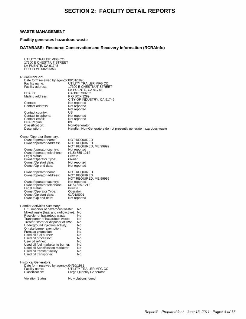
WASTE MANAGEMENT
Facility generates hazardous waste
DATABASE: Resource Conservation and Recovery Information (RCRAInfo)
UTILITY TRAILER MFG CO17300 E CHESTNUT STREETLA PUENTE, CA 91748EDR ID #1000287353
RCRA-NonGen: 09/01/1996Date form received by agency: UTILITY TRAILER MFG COFacility name: 17300 E CHESTNUT STREETFacility address: LA PUENTE, CA 91748 CAD990739252EPA ID: P O BOX 1299Mailing address: CITY OF INDUSTRY, CA 91749 Not reportedContact: Not reportedContact address: Not reported USContact country: Not reportedContact telephone: Not reportedContact email: 09EPA Region: Non-GeneratorClassification: Handler: Non-Generators do not presently generate hazardous wasteDescription:
Owner/Operator Summary: NOT REQUIREDOwner/operator name: NOT REQUIREDOwner/operator address: NOT REQUIRED, ME 99999 Not reportedOwner/operator country: (415) 555-1212Owner/operator telephone: PrivateLegal status: OwnerOwner/Operator Type: Not reportedOwner/Op start date: Not reportedOwner/Op end date:
NOT REQUIREDOwner/operator name: NOT REQUIREDOwner/operator address: NOT REQUIRED, ME 99999 Not reportedOwner/operator country: (415) 555-1212Owner/operator telephone: PrivateLegal status: OperatorOwner/Operator Type: 01/01/0001Owner/Op start date: Not reportedOwner/Op end date:
Handler Activities Summary: NoU.S. importer of hazardous waste: NoMixed waste (haz. and radioactive): NoRecycler of hazardous waste: NoTransporter of hazardous waste: NoTreater, storer or disposer of HW: NoUnderground injection activity: NoOn-site burner exemption: NoFurnace exemption: NoUsed oil fuel burner: NoUsed oil processor: NoUser oil refiner: NoUsed oil fuel marketer to burner: NoUsed oil Specification marketer: NoUsed oil transfer facility: NoUsed oil transporter:
Historical Generators: 04/10/1981Date form received by agency: UTILITY TRAILER MFG COFacility name: Large Quantity GeneratorClassification:
No violations foundViolation Status:
SECTION 2: FACILITY DETAIL REPORTS
Report# Prepared for / June 13, 2011 Page# 4 of 17
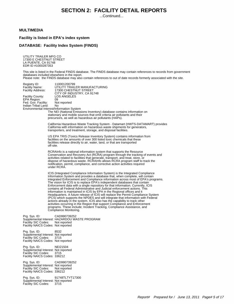
MULTIMEDIA
Facility is listed in EPA’s index system
DATABASE: Facility Index System (FINDS)
UTILITY TRAILER MFG CO17300 E CHESTNUT STREETLA PUENTE, CA 91748EDR ID #1000287353
This site is listed in the Federal FINDS database. The FINDS database may contain references to records from government databases included elsewhere in the report. Please note: the FINDS database may also contain references to out of date records formerly associated with the site.
110001200799Registry ID: UTILITY TRAILER MANUFACTURINGFacility Name: 17300 CHESTNUT STREETFacility Address: CITY OF INDUSTRY, CA 91748 LOS ANGELESFacility County: 09EPA Region: Not reportedFed. Gov. Facility: NoIndian Tribal Land: Environmental Interest/Information SystemThe NEI (National Emissions Inventory) database contains information onstationary and mobile sources that emit criteria air pollutants and theirprecursors, as well as hazardous air pollutants (HAPs).
California Hazardous Waste Tracking System - Datamart (HWTS-DATAMART) providesCalifornia with information on hazardous waste shipments for generators,transporters, and treatment, storage, and disposal facilities.
US EPA TRIS (Toxics Release Inventory System) contains information fromfacilities on the amounts of over 300 listed toxic chemicals that thesefacilities release directly to air, water, land, or that are transportedoff-site.
RCRAInfo is a national information system that supports the ResourceConservation and Recovery Act (RCRA) program through the tracking of events andactivities related to facilities that generate, transport, and treat, store, ordispose of hazardous waste. RCRAInfo allows RCRA program staff to track thenotification, permit, compliance, and corrective action activities requiredunder RCRA.
ICIS (Integrated Compliance Information System) is the Integrated ComplianceInformation System and provides a database that, when complete, will containintegrated Enforcement and Compliance information across most of EPA’s programs.The vision for ICIS is to replace EPA’s independent databases that containEnforcement data with a single repository for that information. Currently, ICIScontains all Federal Administrative and Judicial enforcement actions. Thisinformation is maintained in ICIS by EPA in the Regional offices and itHeadquarters. A future release of ICIS will replace the Permit Compliance System(PCS) which supports the NPDES and will integrate that information with Federalactions already in the system. ICIS also has the capability to track otheractivities occurring in the Region that support Compliance and Enforcementprograms. These include; Incident Tracking, Compliance Assistance, andCompliance Monitoring.
CAD990739252Prg. Sys. ID: HAZARDOU WASTE PROGRAMSupplemental Interest: Not reportedFacility SIC Codes: Not reportedFacility NAICS Codes:
8532Prg. Sys. ID: Not reportedSupplemental Interest: 3715Facility SIC Codes: Not reportedFacility NAICS Codes:
NEI21504Prg. Sys. ID: Not reportedSupplemental Interest: 3715Facility SIC Codes: 336212Facility NAICS Codes:
CAD990739252Prg. Sys. ID: Not reportedSupplemental Interest: Not reportedFacility SIC Codes: 336212Facility NAICS Codes:
91748TLTYT17300Prg. Sys. ID: Not reportedSupplemental Interest: 3715Facility SIC Codes:
SECTION 2: FACILITY DETAIL REPORTS...Continued...
Report# Prepared for / June 13, 2011 Page# 5 of 17
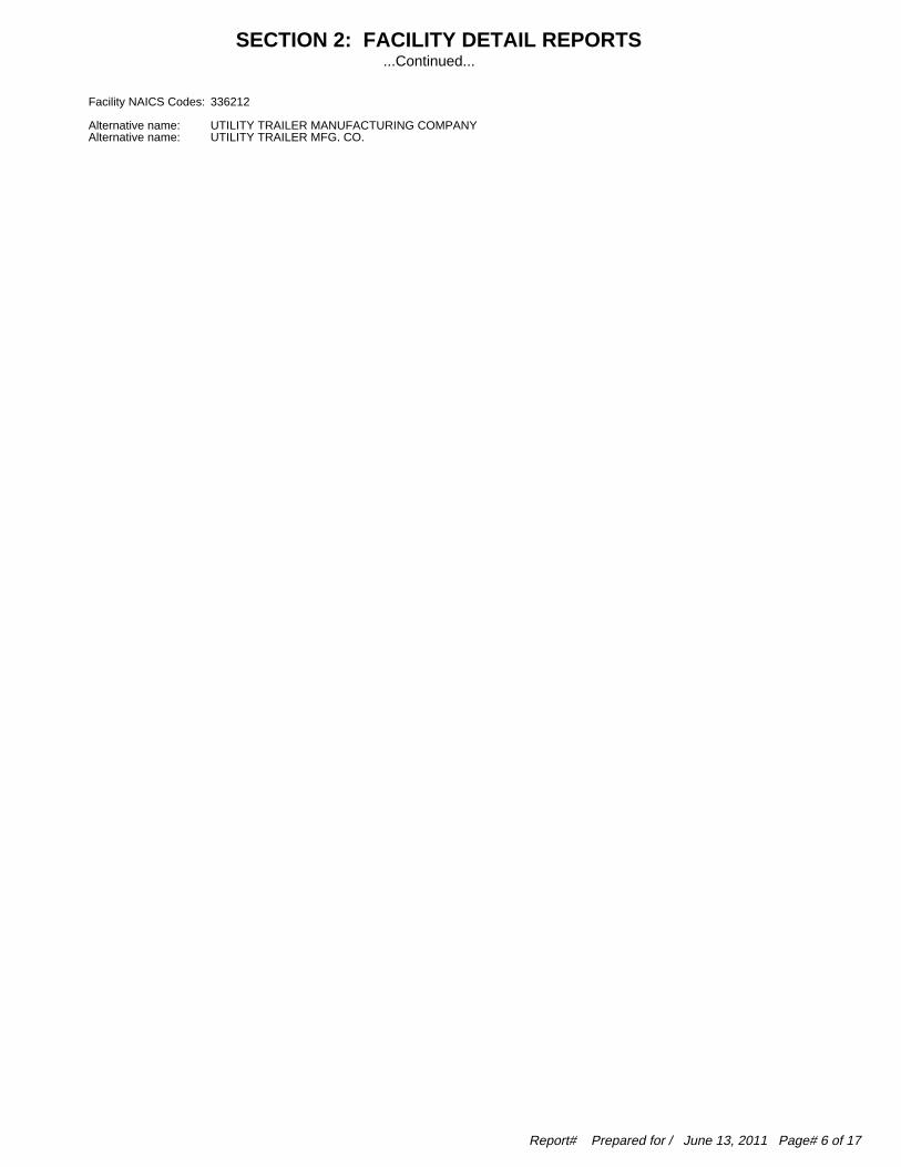
336212Facility NAICS Codes:
UTILITY TRAILER MANUFACTURING COMPANYAlternative name: UTILITY TRAILER MFG. CO.Alternative name:
SECTION 2: FACILITY DETAIL REPORTS...Continued...
Report# Prepared for / June 13, 2011 Page# 6 of 17
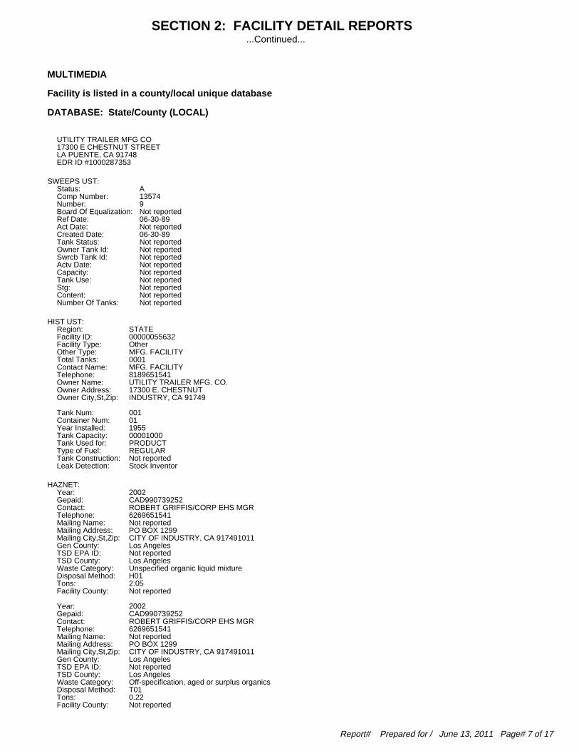
MULTIMEDIA
Facility is listed in a county/local unique database
DATABASE: State/County (LOCAL)
UTILITY TRAILER MFG CO17300 E CHESTNUT STREETLA PUENTE, CA 91748EDR ID #1000287353
SWEEPS UST: AStatus: 13574Comp Number: 9Number: Not reportedBoard Of Equalization: 06-30-89Ref Date: Not reportedAct Date: 06-30-89Created Date: Not reportedTank Status: Not reportedOwner Tank Id: Not reportedSwrcb Tank Id: Not reportedActv Date: Not reportedCapacity: Not reportedTank Use: Not reportedStg: Not reportedContent: Not reportedNumber Of Tanks:
HIST UST: STATERegion: 00000055632Facility ID: OtherFacility Type: MFG. FACILITYOther Type: 0001Total Tanks: MFG. FACILITYContact Name: 8189651541Telephone: UTILITY TRAILER MFG. CO.Owner Name: 17300 E. CHESTNUTOwner Address: INDUSTRY, CA 91749Owner City,St,Zip:
001Tank Num: 01Container Num: 1955Year Installed: 00001000Tank Capacity: PRODUCTTank Used for: REGULARType of Fuel: Not reportedTank Construction: Stock InventorLeak Detection:
HAZNET: 2002Year: CAD990739252Gepaid: ROBERT GRIFFIS/CORP EHS MGRContact: 6269651541Telephone: Not reportedMailing Name: PO BOX 1299Mailing Address: CITY OF INDUSTRY, CA 917491011Mailing City,St,Zip: Los AngelesGen County: Not reportedTSD EPA ID: Los AngelesTSD County: Unspecified organic liquid mixtureWaste Category: H01Disposal Method: 2.05Tons: Not reportedFacility County:
2002Year: CAD990739252Gepaid: ROBERT GRIFFIS/CORP EHS MGRContact: 6269651541Telephone: Not reportedMailing Name: PO BOX 1299Mailing Address: CITY OF INDUSTRY, CA 917491011Mailing City,St,Zip: Los AngelesGen County: Not reportedTSD EPA ID: Los AngelesTSD County: Off-specification, aged or surplus organicsWaste Category: T01Disposal Method: 0.22Tons: Not reportedFacility County:
SECTION 2: FACILITY DETAIL REPORTS...Continued...
Report# Prepared for / June 13, 2011 Page# 7 of 17

2002Year: CAD990739252Gepaid: ROBERT GRIFFIS/CORP EHS MGRContact: 6269651541Telephone: Not reportedMailing Name: PO BOX 1299Mailing Address: CITY OF INDUSTRY, CA 917491011Mailing City,St,Zip: Los AngelesGen County: Not reportedTSD EPA ID: Los AngelesTSD County: Latex wasteWaste Category: H01Disposal Method: 0.45Tons: Not reportedFacility County:
2002Year: CAD990739252Gepaid: ROBERT GRIFFIS/CORP EHS MGRContact: 6269651541Telephone: Not reportedMailing Name: PO BOX 1299Mailing Address: CITY OF INDUSTRY, CA 917491011Mailing City,St,Zip: Los AngelesGen County: Not reportedTSD EPA ID: Los AngelesTSD County: Unspecified organic liquid mixtureWaste Category: R01Disposal Method: 1.25Tons: Not reportedFacility County:
2001Year: CAD990739252Gepaid: ROBERT GRIFFIS/CORP EHS MGRContact: 6269651541Telephone: Not reportedMailing Name: PO BOX 1299Mailing Address: CITY OF INDUSTRY, CA 917491011Mailing City,St,Zip: Los AngelesGen County: Not reportedTSD EPA ID: Los AngelesTSD County: Unspecified organic liquid mixtureWaste Category: R01Disposal Method: 2.75Tons: Not reportedFacility County:
2000Year: CAD990739252Gepaid: UTILITY TRAILER MANUFACTURINGContact: 6269651541Telephone: Not reportedMailing Name: 17300 E CHESTNUT STMailing Address: CITY OF INDUSTRY, CA 917491011Mailing City,St,Zip: Los AngelesGen County: CAT080033681TSD EPA ID: Los AngelesTSD County: Off-specification, aged or surplus organicsWaste Category: D80Disposal Method: 6.0000Tons: Los AngelesFacility County:
1999Year: CAD990739252Gepaid: UTILITY TRAILER MANUFACTURINGContact: 6269651541Telephone: Not reportedMailing Name: 17300 E CHESTNUT STMailing Address: CITY OF INDUSTRY, CA 917491011Mailing City,St,Zip: Los AngelesGen County: CAD008252405TSD EPA ID: Los AngelesTSD County: Unspecified organic liquid mixtureWaste Category: R01Disposal Method: 5.2125Tons: Los AngelesFacility County:
1997Year: CAD990739252Gepaid: UTILITY TRAILER MANUFACTURINGContact: 6269651541Telephone: Not reportedMailing Name: 17300 E CHESTNUT STMailing Address: CITY OF INDUSTRY, CA 917491011Mailing City,St,Zip: Los AngelesGen County: CAD000088252TSD EPA ID:
SECTION 2: FACILITY DETAIL REPORTS...Continued...
Report# Prepared for / June 13, 2011 Page# 8 of 17

Los AngelesTSD County: Unspecified oil-containing wasteWaste Category: H01Disposal Method: .4587Tons: Los AngelesFacility County:
1997Year: CAD990739252Gepaid: UTILITY TRAILER MANUFACTURINGContact: 6269651541Telephone: Not reportedMailing Name: 17300 E CHESTNUT STMailing Address: CITY OF INDUSTRY, CA 917491011Mailing City,St,Zip: Los AngelesGen County: CAD000088252TSD EPA ID: Los AngelesTSD County: Latex wasteWaste Category: H01Disposal Method: .6880Tons: Los AngelesFacility County:
1997Year: CAD990739252Gepaid: UTILITY TRAILER MANUFACTURINGContact: 6269651541Telephone: Not reportedMailing Name: 17300 E CHESTNUT STMailing Address: CITY OF INDUSTRY, CA 917491011Mailing City,St,Zip: Los AngelesGen County: CAD000088252TSD EPA ID: Los AngelesTSD County: Unspecified oil-containing wasteWaste Category: Not reportedDisposal Method: .4587Tons: Los AngelesFacility County:
1997Year: CAD990739252Gepaid: UTILITY TRAILER MANUFACTURINGContact: 6269651541Telephone: Not reportedMailing Name: 17300 E CHESTNUT STMailing Address: CITY OF INDUSTRY, CA 917491011Mailing City,St,Zip: Los AngelesGen County: CAD000088252TSD EPA ID: Los AngelesTSD County: Latex wasteWaste Category: Not reportedDisposal Method: .6880Tons: Los AngelesFacility County:
1996Year: CAD990739252Gepaid: UTILITY TRAILER MANUFACTURINGContact: 6269651541Telephone: Not reportedMailing Name: 17300 E CHESTNUT STMailing Address: CITY OF INDUSTRY, CA 917491011Mailing City,St,Zip: Los AngelesGen County: CAD000088252TSD EPA ID: Los AngelesTSD County: Unspecified solvent mixtureWaste Category: H01Disposal Method: .8757Tons: Los AngelesFacility County:
1996Year: CAD990739252Gepaid: UTILITY TRAILER MANUFACTURINGContact: 6269651541Telephone: Not reportedMailing Name: 17300 E CHESTNUT STMailing Address: CITY OF INDUSTRY, CA 917491011Mailing City,St,Zip: Los AngelesGen County: CAT080013352TSD EPA ID: Los AngelesTSD County: Aqueous solution with total organic residues less than 10 percentWaste Category: R01Disposal Method: 9.2782Tons: Los AngelesFacility County:
1996Year: CAD990739252Gepaid: UTILITY TRAILER MANUFACTURINGContact: 6269651541Telephone:
SECTION 2: FACILITY DETAIL REPORTS...Continued...
Report# Prepared for / June 13, 2011 Page# 9 of 17

Not reportedMailing Name: 17300 E CHESTNUT STMailing Address: CITY OF INDUSTRY, CA 917491011Mailing City,St,Zip: Los AngelesGen County: CAD000088252TSD EPA ID: Los AngelesTSD County: Unspecified oil-containing wasteWaste Category: H01Disposal Method: 1.1467Tons: Los AngelesFacility County:
1996Year: CAD990739252Gepaid: UTILITY TRAILER MANUFACTURINGContact: 6269651541Telephone: Not reportedMailing Name: 17300 E CHESTNUT STMailing Address: CITY OF INDUSTRY, CA 917491011Mailing City,St,Zip: Los AngelesGen County: CAD000088252TSD EPA ID: Los AngelesTSD County: Latex wasteWaste Category: H01Disposal Method: 2.6271Tons: Los AngelesFacility County:
1996Year: CAD990739252Gepaid: UTILITY TRAILER MANUFACTURINGContact: 6269651541Telephone: Not reportedMailing Name: 17300 E CHESTNUT STMailing Address: CITY OF INDUSTRY, CA 917491011Mailing City,St,Zip: Los AngelesGen County: AZD049318009TSD EPA ID: 99TSD County: Halogenated solvents (chloroforms, methyl chloride, perchloroethylene, etc)Waste Category: R01Disposal Method: .0250Tons: Los AngelesFacility County:
1996Year: CAD990739252Gepaid: UTILITY TRAILER MANUFACTURINGContact: 6269651541Telephone: Not reportedMailing Name: 17300 E CHESTNUT STMailing Address: CITY OF INDUSTRY, CA 917491011Mailing City,St,Zip: Los AngelesGen County: CAD000088252TSD EPA ID: Los AngelesTSD County: Latex wasteWaste Category: Not reportedDisposal Method: .4587Tons: Los AngelesFacility County:
1996Year: CAD990739252Gepaid: UTILITY TRAILER MANUFACTURINGContact: 6269651541Telephone: Not reportedMailing Name: 17300 E CHESTNUT STMailing Address: CITY OF INDUSTRY, CA 917491011Mailing City,St,Zip: Los AngelesGen County: CAD000088252TSD EPA ID: Los AngelesTSD County: Not reportedWaste Category: Not reportedDisposal Method: 1.1467Tons: Los AngelesFacility County:
1995Year: CAD990739252Gepaid: UTILITY TRAILER MANUFACTURINGContact: 6269651541Telephone: Not reportedMailing Name: 17300 E CHESTNUT STMailing Address: CITY OF INDUSTRY, CA 917491011Mailing City,St,Zip: Los AngelesGen County: AZD982441263TSD EPA ID: 99TSD County: Organic solids with halogensWaste Category: T03Disposal Method: .1250Tons: Los AngelesFacility County:
SECTION 2: FACILITY DETAIL REPORTS...Continued...
Report# Prepared for / June 13, 2011 Page# 10 of 17

1995Year: CAD990739252Gepaid: UTILITY TRAILER MANUFACTURINGContact: 6269651541Telephone: Not reportedMailing Name: 17300 E CHESTNUT STMailing Address: CITY OF INDUSTRY, CA 917491011Mailing City,St,Zip: Los AngelesGen County: CAT080013352TSD EPA ID: Los AngelesTSD County: Waste oil and mixed oilWaste Category: Not reportedDisposal Method: .8340Tons: Los AngelesFacility County:
1995Year: CAD990739252Gepaid: UTILITY TRAILER MANUFACTURINGContact: 6269651541Telephone: Not reportedMailing Name: 17300 E CHESTNUT STMailing Address: CITY OF INDUSTRY, CA 917491011Mailing City,St,Zip: Los AngelesGen County: CAT080013352TSD EPA ID: Los AngelesTSD County: Aqueous solution with total organic residues less than 10 percentWaste Category: R01Disposal Method: 6.2550Tons: Los AngelesFacility County:
1995Year: CAD990739252Gepaid: UTILITY TRAILER MANUFACTURINGContact: 6269651541Telephone: Not reportedMailing Name: 17300 E CHESTNUT STMailing Address: CITY OF INDUSTRY, CA 917491011Mailing City,St,Zip: Los AngelesGen County: CAT080013352TSD EPA ID: Los AngelesTSD County: Waste oil and mixed oilWaste Category: R01Disposal Method: .8340Tons: Los AngelesFacility County:
1995Year: CAD990739252Gepaid: UTILITY TRAILER MANUFACTURINGContact: 6269651541Telephone: Not reportedMailing Name: 17300 E CHESTNUT STMailing Address: CITY OF INDUSTRY, CA 917491011Mailing City,St,Zip: Los AngelesGen County: CAT080010101TSD EPA ID: San DiegoTSD County: Halogenated solvents (chloroforms, methyl chloride, perchloroethylene, etc)Waste Category: H01Disposal Method: .1042Tons: Los AngelesFacility County:
1994Year: CAD990739252Gepaid: UTILITY TRAILER MANUFACTURINGContact: 6269651541Telephone: Not reportedMailing Name: 17300 E CHESTNUT STMailing Address: CITY OF INDUSTRY, CA 917491011Mailing City,St,Zip: Los AngelesGen County: CAD099452708TSD EPA ID: Los AngelesTSD County: Waste oil and mixed oilWaste Category: R01Disposal Method: .5421Tons: Los AngelesFacility County:
1994Year: CAD990739252Gepaid: UTILITY TRAILER MANUFACTURINGContact: 6269651541Telephone: Not reportedMailing Name: 17300 E CHESTNUT STMailing Address: CITY OF INDUSTRY, CA 917491011Mailing City,St,Zip: Los AngelesGen County: CAT080013352TSD EPA ID:
SECTION 2: FACILITY DETAIL REPORTS...Continued...
Report# Prepared for / June 13, 2011 Page# 11 of 17

Los AngelesTSD County: Oil/water separation sludgeWaste Category: R01Disposal Method: 1.0425Tons: Los AngelesFacility County:
1994Year: CAD990739252Gepaid: UTILITY TRAILER MANUFACTURINGContact: 6269651541Telephone: Not reportedMailing Name: 17300 E CHESTNUT STMailing Address: CITY OF INDUSTRY, CA 917491011Mailing City,St,Zip: Los AngelesGen County: CAT080013352TSD EPA ID: Los AngelesTSD County: Waste oil and mixed oilWaste Category: R01Disposal Method: .6463Tons: Los AngelesFacility County:
1994Year: CAD990739252Gepaid: UTILITY TRAILER MANUFACTURINGContact: 6269651541Telephone: Not reportedMailing Name: 17300 E CHESTNUT STMailing Address: CITY OF INDUSTRY, CA 917491011Mailing City,St,Zip: Los AngelesGen County: CAD099452708TSD EPA ID: Los AngelesTSD County: Waste oil and mixed oilWaste Category: Not reportedDisposal Method: .6463Tons: Los AngelesFacility County:
1993Year: CAD990739252Gepaid: UTILITY TRAILER MANUFACTURINGContact: 6269651541Telephone: Not reportedMailing Name: 17300 E CHESTNUT STMailing Address: CITY OF INDUSTRY, CA 917491011Mailing City,St,Zip: Los AngelesGen County: CAT080010101TSD EPA ID: San DiegoTSD County: Other organic solidsWaste Category: H01Disposal Method: 2.1000Tons: Los AngelesFacility County:
1993Year: CAD990739252Gepaid: UTILITY TRAILER MANUFACTURINGContact: 6269651541Telephone: Not reportedMailing Name: 17300 E CHESTNUT STMailing Address: CITY OF INDUSTRY, CA 917491011Mailing City,St,Zip: Los AngelesGen County: CAT080013352TSD EPA ID: Los AngelesTSD County: Waste oil and mixed oilWaste Category: R01Disposal Method: 2.5020Tons: Los AngelesFacility County:
1993Year: CAD990739252Gepaid: UTILITY TRAILER MANUFACTURINGContact: 6269651541Telephone: Not reportedMailing Name: 17300 E CHESTNUT STMailing Address: CITY OF INDUSTRY, CA 917491011Mailing City,St,Zip: Los AngelesGen County: CAD099452708TSD EPA ID: Los AngelesTSD County: Waste oil and mixed oilWaste Category: Not reportedDisposal Method: .5421Tons: Los AngelesFacility County:
CA WDS: 4 19I009083Facility ID: Other - Does not fall into the category of Municipal/Domestic, Industrial,Facility Type:
SECTION 2: FACILITY DETAIL REPORTS...Continued...
Report# Prepared for / June 13, 2011 Page# 12 of 17

Agricultural or Solid Waste (Class I, II or III) Active - Any facility with a continuous or seasonal discharge that is underFacility Status: Waste Discharge Requirements. CAS000001 The 1st 2 characters designate the state. The remaining 7 are assignedNPDES Number: by the Regional Board 4Subregion: Not reportedFacility Telephone: Not reportedFacility Contact: UTILITY TRAILER MANUFACTURINGAgency Name: Not reportedAgency Address: 0Agency City,St,Zip: Not reportedAgency Contact: Not reportedAgency Telephone: PrivateAgency Type: 0SIC Code: Not reportedSIC Code 2: Not reportedPrimary Waste: Not reportedPrimary Waste Type: Not reportedSecondary Waste: Not reportedSecondary Waste Type: 0Design Flow: 0Baseline Flow: Not reportedReclamation: Not reportedPOTW: Minor Threat to Water Quality. A violation of a regional board order shouldTreat To Water: cause a relatively minor impairment of beneficial uses compared to a major or minor threat. Not: All nurds without a TTWQ will be considered a minor threat to water quality unless coded at a higher Level. A Zero (0) may be used to code those NURDS that are found to represent no threat to water quality. Category C - Facilities having no waste treatment systems, such as cooling waterComplexity: dischargers or thosewho must comply through best management practices, facilities with passive waste treatment and disposal systems, such as septic systems with subsurface disposal, or dischargers having waste storage systems with land disposal such as dairy waste ponds.
WIP:4Region:105.0295File Number:ActiveFile Status:AHSUStaff:Not reportedFacility Suite:
LOS ANGELES CO. HMS:LARegion:013231-013543Facility Id:RemovedFacility Status:6HArea:0000T6407Permit Number:RemovedPermit Status:T0Facility Type:
LARegion:013256-013574Facility Id:RemovedFacility Status:6HArea:Not reportedPermit Number:Not reportedPermit Status:Not reportedFacility Type:
EMI: 1987Year: 19County Code: SCAir Basin: 5125Facility ID: SCAir District Name: 3715SIC Code: SOUTH COAST AQMDAir District Name: Not reportedCommunity Health Air Pollution Info System: Not reportedConsolidated Emission Reporting Rule: 290Total Organic Hydrocarbon Gases Tons/Yr: 170Reactive Organic Gases Tons/Yr: 3Carbon Monoxide Emissions Tons/Yr: 4NOX - Oxides of Nitrogen Tons/Yr: 0SOX - Oxides of Sulphur Tons/Yr: 0Particulate Matter Tons/Yr: 0Part. Matter 10 Micrometers & Smllr Tons/Yr:
1990Year: 19County Code: SCAir Basin: 5125Facility ID: SCAir District Name: 3715SIC Code:
SECTION 2: FACILITY DETAIL REPORTS...Continued...
Report# Prepared for / June 13, 2011 Page# 13 of 17
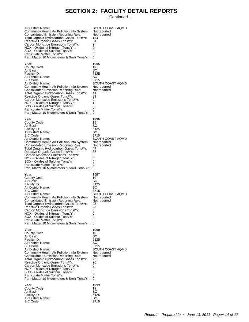
SOUTH COAST AQMDAir District Name: Not reportedCommunity Health Air Pollution Info System: Not reportedConsolidated Emission Reporting Rule: 154Total Organic Hydrocarbon Gases Tons/Yr: 64Reactive Organic Gases Tons/Yr: 2Carbon Monoxide Emissions Tons/Yr: 2NOX - Oxides of Nitrogen Tons/Yr: 0SOX - Oxides of Sulphur Tons/Yr: 0Particulate Matter Tons/Yr: 0Part. Matter 10 Micrometers & Smllr Tons/Yr:
1995Year: 19County Code: SCAir Basin: 5125Facility ID: SCAir District Name: 3715SIC Code: SOUTH COAST AQMDAir District Name: Not reportedCommunity Health Air Pollution Info System: Not reportedConsolidated Emission Reporting Rule: 41Total Organic Hydrocarbon Gases Tons/Yr: 31Reactive Organic Gases Tons/Yr: 0Carbon Monoxide Emissions Tons/Yr: 1NOX - Oxides of Nitrogen Tons/Yr: 0SOX - Oxides of Sulphur Tons/Yr: 0Particulate Matter Tons/Yr: 0Part. Matter 10 Micrometers & Smllr Tons/Yr:
1996Year: 19County Code: SCAir Basin: 5125Facility ID: SCAir District Name: 3715SIC Code: SOUTH COAST AQMDAir District Name: Not reportedCommunity Health Air Pollution Info System: Not reportedConsolidated Emission Reporting Rule: 47Total Organic Hydrocarbon Gases Tons/Yr: 37Reactive Organic Gases Tons/Yr: 0Carbon Monoxide Emissions Tons/Yr: 0NOX - Oxides of Nitrogen Tons/Yr: 0SOX - Oxides of Sulphur Tons/Yr: 0Particulate Matter Tons/Yr: 0Part. Matter 10 Micrometers & Smllr Tons/Yr:
1997Year: 19County Code: SCAir Basin: 5125Facility ID: SCAir District Name: 3715SIC Code: SOUTH COAST AQMDAir District Name: Not reportedCommunity Health Air Pollution Info System: Not reportedConsolidated Emission Reporting Rule: 23Total Organic Hydrocarbon Gases Tons/Yr: 20Reactive Organic Gases Tons/Yr: 0Carbon Monoxide Emissions Tons/Yr: 0NOX - Oxides of Nitrogen Tons/Yr: 0SOX - Oxides of Sulphur Tons/Yr: 0Particulate Matter Tons/Yr: 0Part. Matter 10 Micrometers & Smllr Tons/Yr:
1998Year: 19County Code: SCAir Basin: 5125Facility ID: SCAir District Name: 3715SIC Code: SOUTH COAST AQMDAir District Name: Not reportedCommunity Health Air Pollution Info System: Not reportedConsolidated Emission Reporting Rule: 23Total Organic Hydrocarbon Gases Tons/Yr: 20Reactive Organic Gases Tons/Yr: 0Carbon Monoxide Emissions Tons/Yr: 0NOX - Oxides of Nitrogen Tons/Yr: 0SOX - Oxides of Sulphur Tons/Yr: 0Particulate Matter Tons/Yr: 0Part. Matter 10 Micrometers & Smllr Tons/Yr:
1999Year: 19County Code: SCAir Basin: 5125Facility ID: SCAir District Name: 3715SIC Code:
SECTION 2: FACILITY DETAIL REPORTS...Continued...
Report# Prepared for / June 13, 2011 Page# 14 of 17
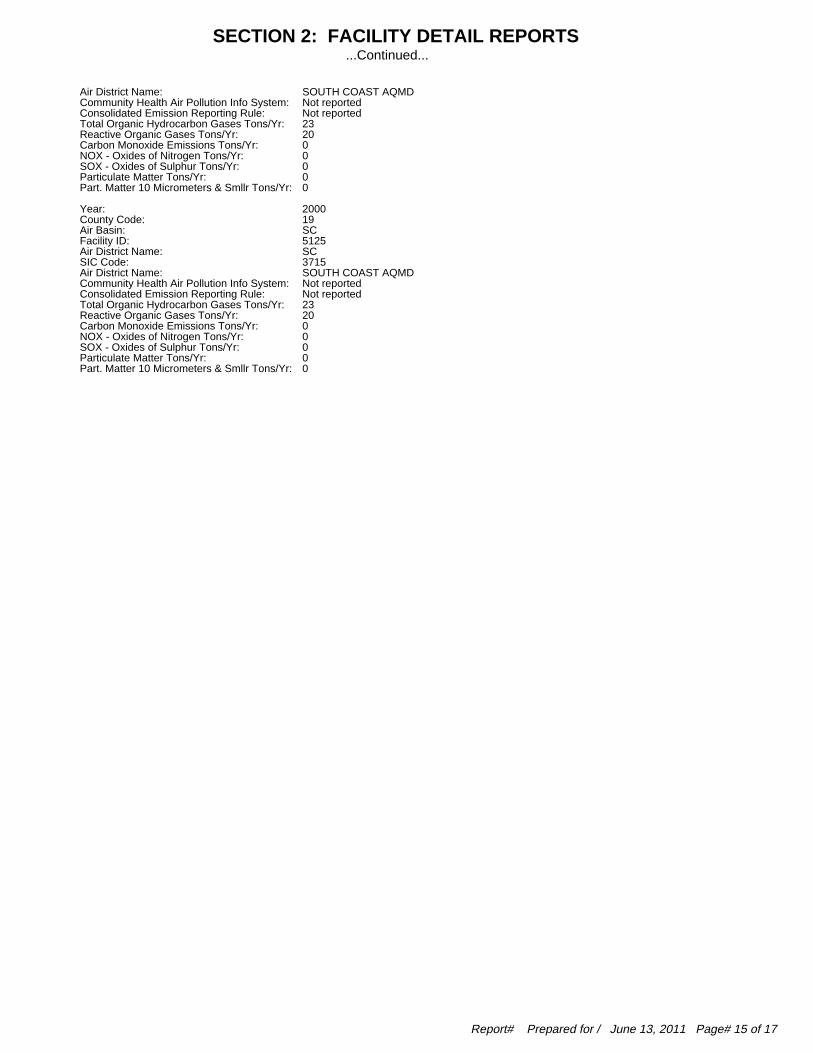
SOUTH COAST AQMDAir District Name: Not reportedCommunity Health Air Pollution Info System: Not reportedConsolidated Emission Reporting Rule: 23Total Organic Hydrocarbon Gases Tons/Yr: 20Reactive Organic Gases Tons/Yr: 0Carbon Monoxide Emissions Tons/Yr: 0NOX - Oxides of Nitrogen Tons/Yr: 0SOX - Oxides of Sulphur Tons/Yr: 0Particulate Matter Tons/Yr: 0Part. Matter 10 Micrometers & Smllr Tons/Yr:
2000Year: 19County Code: SCAir Basin: 5125Facility ID: SCAir District Name: 3715SIC Code: SOUTH COAST AQMDAir District Name: Not reportedCommunity Health Air Pollution Info System: Not reportedConsolidated Emission Reporting Rule: 23Total Organic Hydrocarbon Gases Tons/Yr: 20Reactive Organic Gases Tons/Yr: 0Carbon Monoxide Emissions Tons/Yr: 0NOX - Oxides of Nitrogen Tons/Yr: 0SOX - Oxides of Sulphur Tons/Yr: 0Particulate Matter Tons/Yr: 0Part. Matter 10 Micrometers & Smllr Tons/Yr:
SECTION 2: FACILITY DETAIL REPORTS...Continued...
Report# Prepared for / June 13, 2011 Page# 15 of 17

To maintain currency of the following federal, state and local databases, EDR contacts the appropriate government agency on a monthlyor quarterly basis as required.
Elapsed ASTM days: Provides confirmation that this report meets or exceeds the 90-day updatingrequirement of the ASTM standard.
DATABASES FOUND IN THIS REPORT
RCRA-NonGen: RCRA - Non GeneratorsSource: Environmental Protection AgencyTelephone: 703-308-0035
RCRAInfo is EPA’s comprehensive information system, providing access to data supporting theResource Conservation and Recovery Act (RCRA) of 1976 and the Hazardous and Solid WasteAmendments (HSWA) of 1984. The database includes selective information on sites which generate,transport, store, treat and/or dispose of hazardous waste as defined by the Resource Conservationand Recovery Act (RCRA). Non-Generators do not presently generate hazardous waste.
Date of Government Version: 03/11/2011 Date of Last EDR Contact: 04/05/2011Database Release Frequency: Varies Date of Next Scheduled Update: 07/18/2011
FINDS: Facility Index System/Facility Registry SystemSource: EPATelephone: Not reported
Facility Index System. FINDS contains both facility information and ’pointers’ to other sourcesthat contain more detail. EDR includes the following FINDS databases in this report: PCS(Permit Compliance System), AIRS (Aerometric Information Retrieval System), DOCKET (EnforcementDocket used to manage and track information on civil judicial enforcement cases for all environmentalstatutes), FURS (Federal Underground Injection Control), C-DOCKET (Criminal Docket Systemused to track criminal enforcement actions for all environmental statutes), FFIS (FederalFacilities Information System), STATE (State Environmental Laws and Statutes), and PADS(PCB Activity Data System).
Date of Government Version: 04/14/2010 Date of Last EDR Contact: 03/14/2011Database Release Frequency: Quarterly Date of Next Scheduled Update: 06/27/2011
CA SWEEPS UST: SWEEPS UST ListingSource: State Water Resources Control BoardTelephone: Not reported
Statewide Environmental Evaluation and Planning System. This underground storage tank listingwas updated and maintained by a company contacted by the SWRCB in the early 1980’s. The listingis no longer updated or maintained. The local agency is the contact for more informationon a site on the SWEEPS list.
Date of Government Version: 06/01/1994 Date of Last EDR Contact: 06/03/2005Database Release Frequency: No Update Planned Date of Next Scheduled Update: Not reported
CA HIST UST: Hazardous Substance Storage Container DatabaseSource: State Water Resources Control BoardTelephone: 916-341-5851
The Hazardous Substance Storage Container Database is a historical listing of UST sites.Refer to local/county source for current data.
Date of Government Version: 10/15/1990 Date of Last EDR Contact: 07/26/2001Database Release Frequency: No Update Planned Date of Next Scheduled Update: Not reported
CA HAZNET: Facility and Manifest DataSource: California Environmental Protection AgencyTelephone: 916-255-1136
Facility and Manifest Data. The data is extracted from the copies of hazardous waste manifestsreceived each year by the DTSC. The annual volume of manifests is typically 700,000 - 1,000,000annually, representing approximately 350,000 - 500,000 shipments. Data are from the manifestssubmitted without correction, and therefore many contain some invalid values for data elementssuch as generator ID, TSD ID, waste category, and disposal method.
Date of Government Version: 12/31/2009 Date of Last EDR Contact: 04/22/2011Database Release Frequency: Annually Date of Next Scheduled Update: 08/01/2011
SECTION 3: DATABASES AND UPDATE DATES
Report# Prepared for / June 13, 2011 Page# 16 of 17

CA CA WDS: Waste Discharge SystemSource: State Water Resources Control BoardTelephone: 916-341-5227
Sites which have been issued waste discharge requirements.
Date of Government Version: 06/19/2007 Date of Last EDR Contact: 06/13/2011Database Release Frequency: Quarterly Date of Next Scheduled Update: 09/12/2011
CA WIP: Well Investigation Program Case ListSource: Los Angeles Water Quality Control BoardTelephone: 213-576-6726
Well Investigation Program case in the San Gabriel and San Fernando Valley area.
Date of Government Version: 07/03/2009 Date of Last EDR Contact: 04/05/2011Database Release Frequency: Varies Date of Next Scheduled Update: 07/18/2011
CA LOS ANGELES CO. HMS: HMS: Street Number ListSource: Department of Public WorksTelephone: 626-458-3517
Industrial Waste and Underground Storage Tank Sites.
Date of Government Version: 12/30/2010 Date of Last EDR Contact: 04/18/2011Database Release Frequency: Semi-Annually Date of Next Scheduled Update: 08/01/2011
CA EMI: Emissions Inventory DataSource: California Air Resources BoardTelephone: 916-322-2990
Toxics and criteria pollutant emissions data collected by the ARB and local air pollutionagencies.
Date of Government Version: 12/31/2008 Date of Last EDR Contact: 04/01/2011Database Release Frequency: Varies Date of Next Scheduled Update: 07/11/2011
SECTION 3: DATABASES AND UPDATE DATES...Continued...
Report# Prepared for / June 13, 2011 Page# 17 of 17

AECOM Environment
May 2011 60159854
Appendix C Qualifications of Environmental Professionals
AECOM
Geoffrey W Knight Page 1
Geoffrey W Knight Program Manager
Years Experience: 26
Technical Specialties
• Regulatory Guidance • Environmental Compliance Management • Environmental Policy/Protocol Development • Real Estate Transaction Assessment • Site Characterization and Closure Plans
Professional History
• AECOM • KW Brown & Associates • Harding Lawson Associates/ABB Environmental Services • Ecology & Environment • County Sanitation Districts of Los Angeles County
Education
• B.S. (Atmospheric Sciences) University of California, Los Angeles
Professional Registrations and Affiliations
• Certified Professional Environmental Auditor
Representative Project Experience
Vishay, International Due Diligence, Worldwide. Managed Phase I and Phase II
assessments of electronics manufacturing facilities in Great Britain, Italy, Germany,
India and China.
Nixon Peabody, International Due Diligence, U.S.. Managed a team performing a
due diligence evaluation of a large edible oil manufacturing company. The evaluation
included oil manufacturing facilities, rented properties and a short line railroad.
Rental Service Corporation, Phase I ESAs, United States and Canada. Program
manager for performing Phase I environmental site assessments throughout the
United States and Canada. The program evaluates 100-200 sites per year, including
collecting soil samples at each location and performing a focused regulatory
evaluation.
Dubin, Clark & Associates, Due Diligence Assessments, Specialty Steel
Manufacturers, California and Wisconsin. Performed pre-acquisition due diligence
assessments for an investment company. Evaluated environmental compliance, site
conditions, environmental capital equipment and short- and long-term investment

AECOM
Geoffrey W Knight Page 2
requirements for a number of different businesses including lighting equipment
manufacturers, vehicle parts manufacturers and speciality steel manufacturers.
Invitrogen, Phase I ESAs, U.S. and Europe. Program manager for Phase I
environmental site assessments for a biotech company acquiring companies in the
U.S. and Europe. The assessments include evaluation of key environmental, health
and safety requirements as well as the Phase I work scope.
ITT Industries, Phase I and II ESAs, California. Managed Phase I and Phase II site
assessments of industrial properties in a number of Southern California locations. The
evaluations included Phase I site assessments in accordance with a company-specific
protocol; and Phase II investigations including soil, soil gas and groundwater
sampling.
Los Angeles Unified School District, Phase I ESAs, Proposed School Sites, Los
Angeles, CA. Mr. Knight performed Phase I ESAs at several sites being considered
for acquisition for elementary schools. The work included a comprehensive
assessment of historical site use; site inspection; and report documentation. None of
the sites were judged to exhibit recognized environmental conditions and were moved
into the condemnation process.
Owens Corning, Due Diligence Evaluations, Roofing Manufacturer, U.S..
Managed pre-acquisition due diligence assessments of five fiberglass product
manufacturing companies. Assessment included evaluating compliance with federal
and state air, water, solid and hazardous waste, right-to-know, and spill prevention
regulations, as well as review and assessment of compliance with all operating
permits and reporting requirements. The impacts of emerging regulatory requirements
was also examined, particularly with respect to evolving state air permitting schemes.
Also assessed potential for operational impacts to soil and groundwater, reviewed
ongoing site assessment and remediation efforts, and evaluated potential off-site PRP
liability. Examined major health and safety-related issues. Developed comprehensive
cost estimates for corrective actions, current and future capital investment, and long-
term strategic initiatives.
ARSH, Inc., RCRA Closures, California and Florida. Mr. Knight is the project
manager for a RCRA closure process at a former chemical plant/TSDF. The work
includes negotiating a Cleanup Agreement with the Department of Toxic Substances
Control; developing work plans; and assessing 20 identified SWMUs and AOCs.
IMC Chemicals Inc., Waste Site Closures, Mining Facility, Trona, CA. Mr. Knight
is assisting a mining facility close a variety of waste disposal and release locations at a
large active mine site. The work includes extensive interaction with the California
Regional Water Quality Control Board; developing assessment and clean up work
plans; and overseeing clean up activities.
Wingate Partners, Material Compliance Evaluation, Drum Reconditioning
Facility, Salt Lake City, Utah. Mr. Knight conducted an acquisition due diligence
compliance evaluation of a drum reconditioning facility. The evaluation included
assessing material compliance with relative to environmental regulatory and permit
requirements for air, water, waste and hazardous materials.
ROY A. LITZENBERG, R.E.A. Project Scientist II KEY QUALIFICATIONS • Project Manager for more than 800 Phase I ESA investigation in the past seven years • Thoroughly familiar with the requirements of ASTM Standard Practice for
Environmental Site Assessments (E1527-97/2000). • Project/Site Manager for Decommissioning, Decontamination, Phase II, and
Remedial Action for various facilities. BACKGROUND Roy Litzenberg has more than 12 years of environmental experience on various projects including Phase I, Phase II, Phase III (remedial field activities), and site restoration. Representative project experience includes: PHASE I • Served as Project Manager for over 800 Phase I site assessments on properties located
throughout the United States, primarily in California and the Southwest. Responsibilities included determining scope of work, coordinating project tasks, conducting site reconnaissance, identifying hazardous materials and petroleum products concerns (PCBs, Asbestos-containing Materials, Lead-containing Paint, USTs, ASTs, etc.), conducting historic site and vicinity review (including review of historic aerial photographs, historic maps, and building permits), reviewing agency database information in order to assess potential contamination at the subject property and potential impact to the subject property by surrounding sites, contacting appropriate government agencies, and summarizing the information obtained during the Phase I investigation into a final report for submission to the client.
PHASE II • Project manager for over 30 Phase II investigations as follow-up to potential
contamination discovered during Phase I investigations. In these situations, the existence of former USTs with no formal closure was identified. Responsibilities included preparation of scope of work, workplan, oversight of field operations, data review and interpretation, and report preparation.
Types of facilities include the following:
• Gasoline Stations • Manufacturing Facilities • Commercial Buildings
• Historical Facilities with USTs, Clarifiers • Dry Cleaners • Agricultural Facilities • Radioactive Isotope Manufacturer
PHASE III - REMEDIATION
• Project Manager/Field Supervisor for remediation and closure projects to address various types of contamination, including hydrocarbons, heavy metals, and solvents.
Types of facilities remediated include:
• Chemical Manufacturing/Bulk Storage Plant • Producing Oil Field • Radiator Manufacturing Facility • Underground Storage Tank Facilities • Commercial/Industrial Clarifiers • Rapid Response Remediation of Jet Fuel Spill

DAVID L. SIMON, R.E.A. Project Engineer KEY QUALIFICATIONS • Project Manager for more than 400 Phase I ESA investigation in the past eight years • Thoroughly familiar with the requirements of ASTM Standard Practice for
Environmental Site Assessments (E1527-97/2000). • Project/Site Manager for Asbestos and Lead-based Paint Surveys and Phase II
Assessments for various facilities. BACKGROUND David Simon has more than 14 years of environmental experience on various projects including Phase I, Phase II, Remedial Investigation/Feasibility Studies, and asbestos and lead-based paint identification and abatement activities. Representative project experience includes: PHASE I • Served as Project Manager for over 400 Phase I site assessments on properties located
throughout the western United States, primarily in California. Responsibilities included determining scope of work, coordinating project tasks, conducting site reconnaissance, identifying hazardous materials and petroleum products concerns (PCBs, Asbestos-containing Materials, Lead-containing Paint, USTs, ASTs, etc.), conducting historic site and vicinity review (including review of historic aerial photographs, historic maps, and building permits), reviewing agency database information in order to assess potential contamination at the subject property and potential impact to the subject property by surrounding sites, contacting appropriate government agencies, and summarizing the information obtained during the Phase I investigation into a final report for submission to the client.
PHASE II • Project manager for over 20 Phase II investigations as follow-up to potential
contamination discovered during Phase I investigations. In these situations, the existence of former USTs with no formal closure was identified. Responsibilities included preparation of scope of work, workplan, oversight of field operations, data review and interpretation, and report preparation.
Types of facilities include the following:
• Gasoline Stations • Manufacturing Facilities • Commercial Buildings • Historical Facilities with USTs, Clarifiers • Dry Cleaners • Agricultural Facilities
ASBESTOS AND LEAD PAINT
• Project Manager/Field Supervisor for surveys to identify the locations of asbestos-containing materials and lead-based paint. Responsibilities during abatement projects included oversight of contractor work practices, monitoring, notifications, and report preparation.
Types of facilities investigated and/or abated include:
• High-rise Office Buildings • Educational Facilities • Apartment Buildings • Commercial Properties • Industrial/Warehouse Properties • Historical Structures

ATTACHMENT 5
Phase I ESA – Laydown Area #2
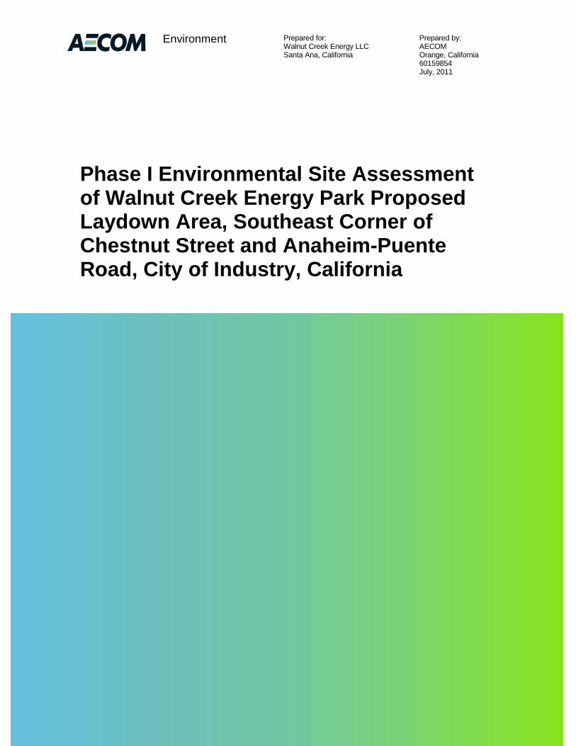
Prepared for: Prepared by: Walnut Creek Energy LLC AECOM Santa Ana, California Orange, California 60159854 July, 2011
Environment
Phase I Environmental Site Assessment of Walnut Creek Energy Park Proposed Laydown Area, Southeast Corner of Chestnut Street and Anaheim-Puente Road, City of Industry, California

AECOM Environment i
July 2011 60216383
Contents
1.0 Introduction .................................................................................................................... 1-1
1.1 Purpose ................................................................................................................................ 1-1
1.2 Scope of Work ..................................................................................................................... 1-1
1.3 Study Limitations .................................................................................................................. 1-1
1.4 Site-Related Limiting Conditions ......................................................................................... 1-2
1.5 Data Gaps/Data Failure ....................................................................................................... 1-2
2.0 Site Description ............................................................................................................. 2-1
2.1 Site Location and Parcel Description .................................................................................. 2-1
2.2 Site Ownership ..................................................................................................................... 2-1
2.3 Site Visit ............................................................................................................................... 2-1 2.3.1 Site and Facility Description ................................................................................. 2-1 2.3.2 Building Walk Through.......................................................................................... 2-2 2.3.3 Surrounding Properties ......................................................................................... 2-2 2.3.4 Petroleum Products and Hazardous Materials .................................................... 2-2 2.3.5 Polychlorinated Biphenyls .................................................................................... 2-2 2.3.6 Aboveground Storage Tanks ................................................................................ 2-3 2.3.7 Underground Storage Tanks ................................................................................ 2-3 2.3.8 Solid Waste ........................................................................................................... 2-3 2.3.9 Hazardous Waste ................................................................................................. 2-3 2.3.10 Water ..................................................................................................................... 2-3 2.3.11 Wastewater ........................................................................................................... 2-4 2.3.12 Stormwater ............................................................................................................ 2-4 2.3.13 Heating and Cooling ............................................................................................. 2-4
3.0 Environmental Setting .................................................................................................. 3-1
3.1 Topography .......................................................................................................................... 3-1
3.2 Soil/Geology ......................................................................................................................... 3-1
3.3 Groundwater/Hydrology ....................................................................................................... 3-1
4.0 Site and Area History .................................................................................................... 4-1
4.1 Subject Property .................................................................................................................. 4-1
4.2 Off-site Properties ................................................................................................................ 4-1
4.3 Previously Prepared Environmental Reports ...................................................................... 4-1

AECOM Environment ii
July 2011 60216383
5.0 Database and Records Review .................................................................................... 5-2
5.1 User Provided Information ................................................................................................... 5-2
5.2 Title Records/Environmental Liens ..................................................................................... 5-2
5.3 Database Information .......................................................................................................... 5-2 5.3.1 Subject Property ................................................................................................... 5-2 5.3.2 Surrounding Sites ................................................................................................. 5-2
5.4 Agency File Review ............................................................................................................. 5-3
6.0 Findings and Opinions .................................................................................................. 6-1
6.1 Recognized Environmental Conditions ............................................................................... 6-1
6.2 Historical Recognized Environmental Conditions ............................................................... 6-1
6.3 De Minimis Conditions ......................................................................................................... 6-1
7.0 Conclusions ................................................................................................................... 7-2
8.0 Quality Control/Quality Assurance .............................................................................. 8-3
8.1 Site Visit, Research, and Report Preparation ..................................................................... 8-3
8.2 Quality Control Review ........................................................................................................ 8-3
8.3 Environmental Professional Statement ............................................................................... 8-3
9.0 References ........................................................................................................................ 4
9.1 Persons Interviewed ............................................................................................................... 4
9.2 Agencies Contacted ................................................................................................................ 4
9.3 Documents Reviewed ............................................................................................................. 4
List of Appendices Appendix A Representative Site Photographs
Appendix B Environmental Database Report
Appendix C Qualifications of Environmental Professionals
AECOM Environment iii
July 2011 60216383
List of Figures Figure 1 – Site Location Map
Figure 2 – Site Plan

AECOM Environment ES-1
July 2011 60216383
Executive Summary
Walnut Creek Energy LLC contracted with AECOM to perform a Phase I Environmental Site Assessment (ESA) of an approximately 4.1-acre property located on the southeast corner of Chestnut Street and Anaheim-Puente Road, City of Industry, Los Angeles County, California (subject property). This Phase I ESA was performed in general conformance with the scope and limitations of American Society for Testing and Materials Standard Practice Designation E 1527-05 for ESAs. Exceptions to, or deletions from, this practice are described in this report.
The site visit occurred on July 7, 2011. The subject property is owned by the City of Industry Urban Development Agency and is currently leased to Camacho Strawberries who uses it for agricultural purposes.
The subject property is comprised of three parcels (parcel numbers: 8264-005-911 with no street address listed; 8264-025-906 with a street address of 804 S. Azusa Avenue, Azusa, CA; and 8264-025-901 with no street address listed). Depending on the file reviewed or database searched, the property has been listed as 804 S. Azusa and as 804 Anaheim-Puente Road. Additionally the subject property is listed in three cities including City of Industry, Azusa and Rowland Heights. This report will refer to the property as 804 S. Azusa Avenue, City of Industry, CA.
The subject property is located in an industrial area within the City of Industry. The subject property is bordered to the north by Chestnut Street, followed by two residential homes and two industrial facilities (17251 and 17253 Chestnut). The subject property is bordered to the south and east by South Azusa Avenue beyond which is open field that has historically been in agricultural use. The subject property is bordered to the west by Anaheim-Puente Road beyond which are two industrial buildings (881 and 883 Anaheim-Puente Road) and two associated parking lots.
Historical research indicates that the subject property was occupied by a farm house complex at the corner of Chestnut and Anaheim-Puente Road from 1924 to 2002. This farm house complex included: a single family residence; detached garage; corrugated metal building with hazardous materials storage; a barn with 55-gallon drum storage; a wood shed with a 1,000-gallon diesel fuel underground storage tank and associated dispensing pump; a groundwater production well; and concrete driveways and sidewalks. The remaining portion of the subject property was in citrus groves until 1977. From 1977 to 1990 the remaining portion appears to be vacant (not farmed). From 1990 to present, the field appears to be in agricultural row crops. From 1990 to present, the southern tip of the subject property appears developed with the fruit stand and large electrical billboard observed during the site inspection.
According to records reviewed at CNC Engineering, the City of Industry, Industry Urban Development Agency issued a notice of Construction Completion for the UST removal and building demolitions in October 2002. According to records review at the County of Los Angeles, Department of Public Works (DPW), the DWP issued to the Industry Urban Development Agency a Closure Certification for the UST on November 17, 2004. Records review at the City of Industry indicate that the groundwater production well was abandoned in August 2002. Files could not be found relative to the former hazardous materials and 55-gallon drum storage areas.
The subject property is not listed on any of the databases searched by Environmental Data Resources, Inc. (EDR). The subject property is located within the Puente Valley Operable Unit of the San Gabriel Valley (Area 4) Superfund Site. The San Gabriel Valley (Area 4) Superfund Site is
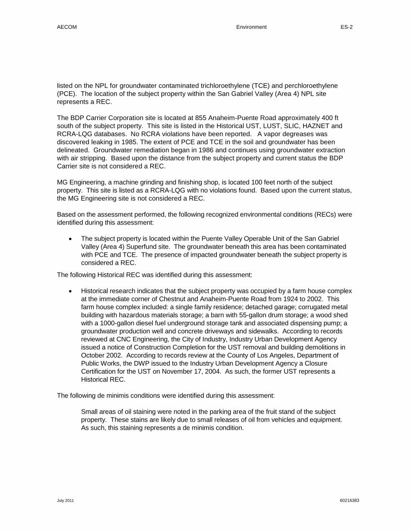
AECOM Environment ES-2
July 2011 60216383
listed on the NPL for groundwater contaminated trichloroethylene (TCE) and perchloroethylene (PCE). The location of the subject property within the San Gabriel Valley (Area 4) NPL site represents a REC.
The BDP Carrier Corporation site is located at 855 Anaheim-Puente Road approximately 400 ft south of the subject property. This site is listed in the Historical UST, LUST, SLIC, HAZNET and RCRA-LQG databases. No RCRA violations have been reported. A vapor degreases was discovered leaking in 1985. The extent of PCE and TCE in the soil and groundwater has been delineated. Groundwater remediation began in 1986 and continues using groundwater extraction with air stripping. Based upon the distance from the subject property and current status the BDP Carrier site is not considered a REC.
MG Engineering, a machine grinding and finishing shop, is located 100 feet north of the subject property. This site is listed as a RCRA-LQG with no violations found. Based upon the current status, the MG Engineering site is not considered a REC.
Based on the assessment performed, the following recognized environmental conditions (RECs) were identified during this assessment:
• The subject property is located within the Puente Valley Operable Unit of the San Gabriel Valley (Area 4) Superfund site. The groundwater beneath this area has been contaminated with PCE and TCE. The presence of impacted groundwater beneath the subject property is considered a REC.
The following Historical REC was identified during this assessment:
• Historical research indicates that the subject property was occupied by a farm house complex at the immediate corner of Chestnut and Anaheim-Puente Road from 1924 to 2002. This farm house complex included: a single family residence; detached garage; corrugated metal building with hazardous materials storage; a barn with 55-gallon drum storage; a wood shed with a 1000-gallon diesel fuel underground storage tank and associated dispensing pump; a groundwater production well and concrete driveways and sidewalks. According to records reviewed at CNC Engineering, the City of Industry, Industry Urban Development Agency issued a notice of Construction Completion for the UST removal and building demolitions in October 2002. According to records review at the County of Los Angeles, Department of Public Works, the DWP issued to the Industry Urban Development Agency a Closure Certification for the UST on November 17, 2004. As such, the former UST represents a Historical REC.
The following de minimis conditions were identified during this assessment:
Small areas of oil staining were noted in the parking area of the fruit stand of the subject property. These stains are likely due to small releases of oil from vehicles and equipment. As such, this staining represents a de minimis condition.
AECOM Environment 1-1
July 2011 60216383
1.0 Introduction
1.1 P urpos e
This ESA was performed pursuant to EME’s request and authorization dated July 5, 2011. . This assessment was performed in advance of the potential use of the subject property as a construction laydown area. The purpose of this Phase I ESA is to provide the client with information for use in evaluating recognized environmental conditions (RECs) associated with the subject property.
A REC is defined by the ASTM as “The presence of or likely presence of any hazardous substances or petroleum products on a property under conditions that indicate an existing release, a past release, or a material threat of a release of any hazardous substances or petroleum products even under conditions in compliance with laws. The term is not intended to include de minimis conditions that generally do not present a material risk to public health or the environment and that generally would not be the subject of an enforcement action if brought to the attention of appropriate government agencies.” This assessment is based on a review of existing conditions, reported pre-existing conditions, and observed operations at the subject property and adjacent properties.
1.2 S cope of Work
The Phase I ESA included a site visit, regulatory research, historical review, and environmental database analysis of the subject property. In conducting the Phase I ESA, AECOM assessed the subject property for visible signs of possible contamination, researched public records for the subject property, and conducted interviews with representatives of regulatory agencies and current tenants.
This project was performed in general accordance with ASTM Standard Practice Designation E 1527-05.. Conclusions reached in this report are based upon the assessment performed and are subject limitations set forth in Sections 1.3, 1.4, and 1.5 below.
1.3 S tudy L imitations
This report describes the results of AECOM’s Phase I ESA to identify the presence of contamination-related liabilities materially affecting the subject facility and/or property. In the conduct of this assessment, AECOM assessed the presence of such problems within the limits of the established scope of work as described in our proposal.
As with any due diligence assessment, there is a certain degree of dependence upon oral information provided by facility or site representatives, which is not readily verifiable through visual observations or supported by any available written documentation. AECOM shall not be held responsible for conditions or consequences arising from relevant facts that were concealed, withheld, or not fully disclosed by facility or site representatives at the time this assessment was performed. In addition, the findings in this report are subject to certain conditions and assumptions, which are noted in the report. Any party reviewing the findings of the report must carefully review and consider all such conditions and assumptions.
This report and all field data and notes were gathered and/or prepared by AECOM in accordance with the agreed upon scope of work and generally accepted engineering and scientific practice in effect at
AECOM Environment 1-2
July 2011 60216383
the time of AECOM's assessment of the subject property. The statements, conclusions, and opinions contained in this report are only intended to give approximations of the environmental conditions at the subject property.
As specified in the ASTM standard (referred to below as “this practice”), it is incumbent that the client and any other parties who review and rely upon this report understand the following inherent conditions surrounding any Phase I ESA:
• Uncertainty Not Eliminated – No ESA can wholly eliminate uncertainty regarding the potential for REC in connection with a property. Performance of this practice is intended to reduce, but not eliminate, uncertainty regarding the potential for REC in connection with a property, and this practice recognizes reasonable limits of time and costs. (Section 4.5.1 of the ASTM standard)
• Not Exhaustive – “All appropriate inquiry” does not mean an exhaustive assessment of a clean property. There is a point at which the cost of information obtained outweighs the usefulness of the information and, in fact, may be a material detriment to the orderly completion of transactions. One of the purposes of this practice is to identify a balance between the competing goals of limiting the costs and time demands inherent in performing an ESA and the reduction of uncertainty about unknown conditions resulting from additional information. (Section 4.5.2 of the ASTM Standard)
• Comparison with Subsequent Inquiry – It should not be concluded or assumed that an inquiry was not an “all appropriate inquiry” merely because the inquiry did not identify RECs in connection with a property. ESAs must be evaluated based on the reasonableness of judgments made at the time and under the circumstances in which they were made. Subsequent ESAs should not be considered valid standards to judge the appropriateness of any prior assessment based on hindsight, new information, use of developing technology or analytical techniques, or other factors. (Section 4.5.4 of the ASTM Standard)
This report was prepared pursuant to an agreement between Edison Mission Energy (Client) and AECOM and is for the exclusive use of the Client. No other party is entitled to rely on the conclusions, observations, specifications, or data contained herein without first obtaining AECOM’s written consent and provided any such party signs an AECOM-generated Reliance Letter. A third party’s signing of the AECOM Reliance Letter and AECOM’s written consent are conditions precedent to any additional use or reliance on this report.
The passage of time may result in changes in technology, economic conditions, site variations, or regulatory provisions, which would render the report inaccurate. Reliance on this report after the date of issuance as an accurate representation of current site conditions shall be at the user’s sole risk.
1.4 S ite-R elated L imiting C onditions
No site-specific limitations were encountered during the course of this assessment:
1.5 Data G aps /Data F ailure
The following data failure/data gaps were encountered during the course of this assessment:
• As specified in the agreed upon scope of work, a title search was not conducted as part of this ESA. However, based upon historical data collected from other sources, this data gap
AECOM Environment 1-3
July 2011 60216383
does not represent a data failure and as a result is not expected to impact the results of this assessment.
• Per ASTM, past owners, operators, and occupants of the subject property who are likely to have material information regarding the potential for contamination at the subject property shall be contacted to the extent that they can be identified and that the information likely to be obtained is not duplicative of information already obtained from other sources. AECOM spoke with Ismael Cruz, a representative of Camacho”s Strawberries the current lease tenant of the subject property. Mr. Cruz was able to describe activities at the subject property from approximately 1985 to present. Attempts were made to identify the former owner of the farm complex. As of the date of this report, this information has not been obtained. Based upon historical data collected from other sources, this data gap is not expected to represent a data failure and as a result is not expected to impact the results of this assessment.

AECOM Environment 2-1
July 2011 60216383
2.0 Site Description
2.1 S ite L ocation and P arcel Des cription
The subject property is located on the southeast corner of Chestnut Street and Anaheim-Puente Road, City of Industry, Los Angeles County, California. The subject property is accessed from a gated dirt driveway at the southwest corner off of Anaheim-Puente Road.
The subject property is comprised of three parcels (parcel numbers: 8264-005-911 with no street address listed; 8264-025-906 with a street address of 804 S. Azusa Avenue, Azusa, CA; and 8264-025-901 with no street address listed). Depending on the file reviewed or database searched, the property has been listed as 804 S. Azusa and as 804 Anaheim-Puente Road. Additionally the subject property is listed in three cities including City of Industry, Azusa and Rowland Heights. This report will refer to the property as 804 S. Azusa Avenue, City of Industry, CA.
2.2 S ite Owners hip
According to the EDR Environmental Lien Search, the subject property is owned by the City of Industry Urban Development Agency.
2.3 S ite V is it
Don Koch of AECOM’s Orange, California, office visited the subject property on July 7, 2011. During the site visit, Mr. Koch was accompanied by Ruel Ituralde of CNC Engineering, representing the subject property owner, the City of Industry.
The site visit methodology consisted of walking over accessible areas of the subject property including the fruit stand and irrigation pipe/equipment laydown area; the perimeter dirt roads and three transit lines through the cultivated field, Anaheim-Puente Road and Chestnut Street, and the portions of the surrounding area. The following sections summarize the results of the site visit.
Site-related limiting conditions encountered during this assessment were previously summarized in Section 1.4.
2.3.1 Site and Facility Description The subject property is approximately 4.1-acres in size. It is currently leased to Camacho Strawberries and is currently in agricultural use. The northern-most parcel is in basil, sage and tomato farming. The southern two parcels are in strawberry farming. Additionally, the southern tip of the southern parcel is used for equipment and irrigation pipe storage. A strawberry fruit and vegetable stand with associated dirt driveway and parking is also located in this area. A large electrical billboard sign is located immediately northwest of the fruit stand.
During the site visit, no visual evidence of potable water wells, monitoring wells, dry wells, clarifiers, septic tanks, or leach fields was observed on the subject property. Visual evidence of significant areas of discolored soil, water, or unusual vegetative conditions or odors was not observed during the site visit. Small areas of oil staining were noted in the parking area of the fruit stand. These stains are likely due to small releases of oil from vehicles and equipment.

AECOM Environment 2-2
July 2011 60216383
The general layout of the subject property is illustrated on Figure 2 - Site Plan and Representative Site Photographs are provided in Appendix A.
2.3.2 Building Walk Through There are no permanent buildings on the subject property. A portable strawberry fruit stand and one truck trailer are located on the southern tip of the southern parcel. The stand is used for the sale of fruits and vegetables. The trailer is used for farming supplies.
2.3.3 Surrounding Properties The subject property is located in an industrial area within the City of Industry. The subject property is bordered to the north by Chestnut Street, followed by two residential homes and two industrial facilities (MG Engineering, LLC [a metal finishing and grinding facility] located at 17251Chestnut and Masco Machinery Sales Company [a distributor of various machinery] located at 17253 Chestnut). The subject property is bordered to the south and east by South Azusa Avenue beyond which is open field that has historically been in agricultural use. The subject property is bordered to the west by Anaheim-Puente Road beyond which are two industrial buildings (a vacant building located at 881 Anaheim-Puente Road and Deyce USA [a distributor of handbags] located at 883 Anaheim-Puente Road) and two associated parking lots.
AECOM did not observe any gas stations or dry cleaners in the immediate vicinity (500 feet) of the subject property. In addition, no sensitive receptors (i.e. day care centers, schools, or hospitals) are adjacent to the subject property. San Jose Creek, a storm water channel, is located within 100 feet of the northern tip of the northern most parcel. Based on AECOM’s site reconnaissance of the surrounding neighborhood, no other off-site sources of concern were identified.
2.3.4 Petroleum Products and Hazardous Materials No commercial cleaning supplies, hazardous materials or petroleum products were observed at the subject property. According to Ismael Cruz, a representative of Camacho”s Strawberries, granular fertilizers containing nitrogen, phosphorus and potassium are and have historically been used at the subject site. Agri-mite and various other pesticides have been used for the control of spider mites and other insects. Methyl bromide (MeBr) was historically used at the subject site until 2005. MeBr is an odorless, colorless gas that has been used as a soil fumigant and structural fumigant to control pests across a wide range of agricultural sectors. Significant staining or visual evidence of a hazardous materials release was not observed at the time of the site visit.
2.3.5 Polychlorinated Biphenyls Polychlorinated biphenyls (PCB)-containing dielectric fluids have been widely used as coolants and lubricants in transformers, capacitors, and other electric equipment due to their insulating and nonflammable properties. Based on the historical use of the property there is a low potential for PCBs to be present on site.
During the site visit, no transformers or capacitor banks were observed on the subject property. One pad mounted electric transformer was observed at 883 Anaheim-Puente Road and one pad mounted electric transformer was observed at 17251 Chestnut Street. AECOM observed no leaks of transformer coolant at either location.

AECOM Environment 2-3
July 2011 60216383
2.3.6 Aboveground Storage Tanks No above ground storage tanks (ASTs) were observed on the subject property. No ASTs were listed in the site-specific environmental database report reviewed by AECOM, or otherwise identified during AECOM’s review of historical aerial photographs.
2.3.7 Underground Storage Tanks Visual evidence of underground storage tanks (USTs) (e.g., vent pipes, fill ports) was not observed during the site visit.
One UST, ancillary piping and one gas pump were formerly located at the farm house complex located at the southeast corner of Chestnut Street and Anaheim-Puente Road. It is believed that the tank was installed pre-1950. The tank was single walled steel with a capacity was 1000-gallons and measured 3 ft wide and 10 feet long. The tank was used for diesel storage for farm tractors and personal cars. The tank was removed in 2002 under Los Angeles County Department of Public Works (LACDWP) and Los Angeles County Fire Department (LACFD) closure and removal permits. During tank removal the tank was observed to be in good condition with no apparent ruptures. The tank and fuel dispenser were shipped to Ecology Auto Wrecking as scrap metal. Analytical results for soil samples beneath the tank and excavated soils did not contain any detectable fuel-related hydrocarbons. The stock piled soils were used for backfill of the UST excavation pit. On October 24, 2002, the Industry Urban Development Agency issued to the construction contractor a Notice of Acceptance indicating that the UST removal and building demolition was determined complete per the specifications of the project. On November 17, 2004, the LACDPW issued a Hazardous Materials Underground Storage Closure Certification to the Industry Urban Development Agency indicating that all UST closure requirements were completed.
2.3.8 Solid Waste Solid waste generated at the subject property is very limited and consists of waste fruit and vegetables and general trash from the farming crew. Trash is removed by Camacho weekly.
2.3.9 Hazardous Waste No hazardous waste is generated at the subject property.
Hazardous materials located at the former farm house complex consisting of 1-gallon to 55-gallon containers of gasoline, paints, primers, stains, grass killer, chlorinated solvents, and waste oil were packaged and manifested off-site as hazardous waste for disposal during the farm house complex demolition in 2002. On October 24, 2002, the Industry Urban Development Agency issued to the construction contractor a Notice of Acceptance indicating that the building demolition was determined complete per the specifications of the project.
No other evidence of hazardous waste generation was observed at the subject property.
2.3.10 Water There is no potable water currently supplied to the subject property. No potable water wells were observed at the subject property. Gray water is currently used for crop drip irrigation.

AECOM Environment 2-4
July 2011 60216383
2.3.11 Wastewater No wastewater is discharged at the subject property. A contract chemical toilet is on-site for all farm workers.
2.3.12 Stormwater Stormwater from the subject property appears to drain primarily via sheet flow to adjacent streets and properties.
2.3.13 Heating and Cooling There are no permanent buildings heated or cooled on the subject property. The fruit stand and trailer are not heated or colled..
AECOM Environment 3-1
July 2011 60216383
3.0 Environmental Setting
3.1 Topography
According to the United States Geological Survey topographic map of the subject property area (Baldwin Park quadrangle) and a review of the Google Earth website, the elevation of the subject property is approximately 375 feet above mean sea level. Based on a review of these technical resources and AECOM’s site visit, the subject property appears to be generally flat with a slight downward slope toward the west-southwest.
3.2 S oil/G eology
The subject property is located within the northeastern block of the Los Angeles Basin, part of the Transverse Ranges Geomorphic Province, underlain by marine Cenozoic sedimentary rocks. The Whittier Fault is located approximately 21/2 miles southwest of the subject property. Soil types include Holocene age alluvial deposits consisting of gravel, sand and silt.
3.3 G roundwater/Hydrology
Based on the Los Angeles County Hydrological Records Division, the regional groundwater depth is reported to be 26 feet below ground surface. On November 8, 2001, Kleinfelder conducted groundwater measurements at the onsite production well, Well 3079P located immediately east of the farm house complex metal shed using an electronic groundwater measuring tape. The groundwater depth was measured to be 26 ft. from the top of the well casing.
Based upon local topography, groundwater flow appears to be towards the northwest.
AECOM Environment 4-1
July 2011 60216383
4.0 Site and Area History
Historical information for the subject property and surrounding properties is based on AECOM’s review and analysis of the following historical sources:
• Aerial photographs
•
dated 1928, 1938, 1949, 1953, 1968, 1976, 1990, 1995, 2002, and 2005;
Topographic maps
•
dated 1901, 1904, 1927, 1953, 1966, 1972, and 1981
City directories
According to Environmental Data Resources (EDR), Sanborn® Fire Insurance map coverage is not available for the subject property.
for the years 1972, 1987, 1993, 1998, and 2008
4.1 S ubject P roperty
Historical research indicates that the subject property has been in agricultural use since 1928 (citrus and row crops). The subject property was occupied by a farm house complex at the immediate southeast corner of Chestnut and Anaheim-Puente Road from 1924 to 2002. This farm house complex included: a single family residence; detached garage; corrugated metal building with hazardous materials storage; a barn with 55-gallon drum storage; a wood shed with a 1000-gallon diesel fuel underground storage tank and associated dispensing pump; a groundwater production well and concrete driveways and sidewalks. EDR City Directory Abstract Files have no addresses listed from 1972 to 2008 for the subject property.
Based on the historical use of the subject property as agricultural from the 1920s through the 2000s, residual concentrations of pesticides may be present in shallow soil of the subject property, as this is common throughout much of the agricultural regions of California. Based on the proposed use of the subject property, the potential presence of residual concentrations of pesticides remaining in the shallow on-site soils (if any) is a de minimis condition...
4.2 Off-s ite P roperties
From at least 1928 through 1953, bordering properties appear to have been in residential and agricultural use. By 1968, South Azusa Avenue has been built and a small parking lot appears west of the subject property. By 1976 the parking lot appears larger. By 1990, the industrial buildings located at 17251 and 17253 Chestnut Street have been constructed. By 2002, the industrial buildings and associated parking lots have been constructed at 881 and 883 Anaheim-Puente Road.
4.3 P revious ly P repared E nvironmental R eports
No previous Environmental Reports were provided to AECOM by the client for review.
AECOM Environment 5-2
July 2011 60216383
5.0 Database and Records Review
5.1 Us er P rovided Information
The Client provided AECOM with no documents relating to environmental issues associated with the subject property.
5.2 Title R ecords /E nvironmental L iens
Per the agreed upon scope of work, a Lien Search Report was ordered from EDR as a part of this assessment. According to the Lien Search Report, no environmental liens are recorded on the subject property.
5.3 Databas e Information
In accordance with the scope of work and ASTM Standard E-1527-05, a search of various governmental databases was conducted by EDR. The site-specific environmental database report prepared by EDR was reviewed to determine the potential for environmental impacts to the subject property from on-site and/or off-site sources of concern. The database abbreviations are provided in the site-specific environmental database report.
The database report includes various reports detailing database information for each of the sites identified/geocoded within the specified radius. Additional sites with recognized environmental risks were identified, but AECOM was not able to map them to specific locations due to insufficient/contradicting address information. These sites were included in the database report as "orphan" sites. Based upon AECOM's review, there does not appear to be any significant concerns associated with any of the orphan sites. A summary of AECOM’s review and analysis of the site-specific environmental database report is presented below. A copy of the database report is provided in Appendix B.
Based on AECOM’s research, the subject property is not located on or within a 1-mile radius of tribal lands.
5.3.1 Subject Property The subject property was not listed in any of the data bases searched by EDR.
The location of the subject property within the San Gabriel Valley (Area 4) NPL site does represent a REC.
5.3.2 Surrounding Sites The subject property is located within the Puente Valley Operable Unit of the San Gabriel Valley (Area 4) Superfund Site. The San Gabriel Valley (Area 4) Superfund Site is listed on the NPL for groundwater contaminated trichloroethylene (TCE) and perchloroethylene (PCE).
The location of the subject property within the San Gabriel Valley (Area 4) NPL site represents a REC.

AECOM Environment 5-3
July 2011 60216383
The BDP Carrier Corporation site is located at 855 Anaheim-Puente Road approximately 400 ft south of the subject property. This site is listed in the Historical UST, LUST, SLIC, HAZNET and RCRA-LQG databases. No RCRA violations have been reported. A vapor degreases was discovered leaking in 1985. The extent of PCE and TCE in the soil and groundwater has been delineated. Groundwater remediation began in 1986 and continues using groundwater extraction with air stripping. Based upon the distance from the subject property and current status the BDP Carrier site is not considered a REC.
MG Engineering is located north of the subject property. MG Engineering is actually a grinding shop according to an interview with the receptionist. This site is listed as a RCRA-LQG with no violations found. Based upon the current status, the MG Engineering site is not considered a REC. property.
5.4 Agenc y F ile R eview
AECOM has reviewed files at CNC Engineering, LACDPW-Building and Safety Division, LAC-Assessor’s Office, City of Industry, LACDPW-UST Division. Findings from these file reviews have been incorporated into the report..
AECOM Environment 6-1
July 2011 60216383
6.0 Findings and Opinions
AECOM performed a Phase I ESA of the subject property in conformance with the scope and limitations of ASTM Practice E 1527-05, which meets the requirements of Title 40, Code of Federal Regulations Part 312 and is intended to constitute all appropriate inquiry for purposes of the landowner liability protections. Any exceptions to, or deletions from, this practice are described in Section 1.3 through 1.5 of this report.
6.1 R ecognized E nvironmental C onditions The following RECs were identified during this assessment:
• The subject property is located within the Puente Valley Operable Unit of the San Gabriel Valley (Area 4) Superfund site. The groundwater beneath this area has been contaminated with PCE and TCE.
6.2 His torical R ecognized E nvironmental C onditions The following Historical REC was identified during this assessment:
• Historical research indicates that the subject property was occupied by a farm house complex at the immediate corner of Chestnut and Anaheim-Puente Road from 1924 to 2002. This farm house complex included: a single family residence; detached garage; corrugated metal building with hazardous materials storage; a barn with 55-gallon drum storage; a wood shed with a 1000-gallon diesel fuel underground storage tank and associated dispensing pump; a groundwater production well and concrete driveways and sidewalks. According to records reviewed at CNC Engineering, the City of Industry, Industry Urban Development Agency issued a notice of Construction Completion for the UST removal and building demolitions in October 2002. According to records review at the County of Los Angeles, Department of Public Works, the DWP issued to the Industry Urban Development Agency a Closure Certification for the UST on November 17, 2004.
6.3 De Minimis C onditions The following de minimis conditions were identified during this assessment:
Small areas of oil staining were noted in the parking area of the fruit stand of the subject property. These stains are likely due to small releases of oil from vehicles and equipment. Residual pesticides remaining in the soils at the subject property from historical agricultural use.

AECOM Environment 7-2
July 2011 60216383
7.0 Conclusions
We have performed a Phase I Environmental Site Assessment in conformance with the scope and limitations of ASTM Practice E 1527-05 of the approximately 4.1-acre property located on the southeast corner of Chestnut Street and Anaheim-Puente Road, City of Industry, Los Angeles County, California. Any exception to, or deletions from, this practice are described in Sections 1.3 through 1.5 of this report. This assessment has revealed no evidence of recognized environmental conditions in connection with the property except the following:
• The subject property is located within the Puente Valley Operable Unit of the San Gabriel Valley (Area 4) Superfund site. The groundwater beneath this area has been contaminated with PCE and TCE.

AECOM Environment 8-3
July 2011 60216383
8.0 Quality Control/Quality Assurance
8.1 S ite V is it, R es earch, and R eport P reparation
The site visit was conducted by Donald Koch of AECOM. Research and report preparation were conducted by Donald Koch, in AECOM’s Orange, California office.
Signature:
8.2 Quality C ontrol R eview
A second level review of this report was conducted by Geoff Knight, in AECOM’s Orange, California office.
Signature: __ _________________________
8.3 E nvironmental P rofes s ional S tatement
Mr. David Simon was the Environmental Professional (EP) for this project. Mr. Simon’s EP statement is below and his CV is provided in Appendix C:
I declare that, to the best of our professional knowledge and belief, I meet the definition of an EP as defined in §312.10 of 40 Code of Federal Regulations (CFR) and that I have the specific qualifications based on education, training, and experience to assess a property of the nature, history, and setting of the subject property. I have developed and performed all the appropriate inquiries in conformance with the standards and practices set forth in 40 CFR Part 312.
Signature: ___________________________ Date: July 13, 2011

AECOM Environment
July 2011 60216383
9.0 References
9.1 P ers ons Interviewed
Mr. Ruel Ituralde with CNC Engineering was interviewed during the site visit on July 7, 2011 and in his office on July 11, 2011.
9.2 Agencies C ontacted
Assessor parcel information, reviewed for Los Angeles County, California at http://maps.assessor.lacounty.gov/mapping/viewer.asp. This information was reviewed online by Mr. Donald Koch with AECOM on July 11 and 12, 2011.
State of California, Department of Toxic Substances Control, Envirostor Database http://www.envirostor.dtsc.ca.gov/public/profile_report.asp?global_id=60001428. This information was reviewed online by Mr. Donald Koch with AECOM on July 11, 2011.
Mr. Mazen Dudar, Senior Civil Engineer, Los Angeles County Department of Public Works, 16005 East Central Avenue, LaPuente, CA 91744
Counter clerk, City of Industry, Administrative Office, 15625 Stafford Street, Ste. 100, City of Industry.
Counter clerk, Industry Urban Development Agency, 15625 Stafford Street, Ste. 200, City of Industry.
LACDPW, UST Division, 900 S. Freemont Avenue, Alhambra, CA.
9.3 Documents R eviewed
EDR 7.5 Minute Topographic Maps, prepared for Strawberry Field, 804 S Azusa Avenue, Rowland Heights, CA 91748, dated July 8, 2011. Inquiry number 3118265.4 Topographic Maps 1901, 1904, 1927, 1953, 1966, 1972, and 1981. Report prepared by Environmental Data Resources, 440 Wheelers Farms Road, Milford, Connecticut 06460, 800-353-0050.
EDR Aerial Photos Decade Package prepared for Strawberry Field, 804 S Azusa Avenue, Rowland Heights, CA 91748, dated July 12, 2011. Inquiry number 3118265.5. Aerial photographs dated 1928, 1938, 1949, 1953, 1968, 1976, 1990, 1995, 2002, and 2005. Report prepared by Environmental Data Resources, 440 Wheelers Farms Road, Milford, Connecticut 06460, 800-353-0050.
EDR City Directory Abstract prepared for Strawberry Field, 804 S Azusa Avenue, Rowland Heights, CA 91748, dated July 12, 2011. Inquiry number 3118265.6. City directories reviewed included 1972, 1987, 1993, 1998, and 2008. Report prepared by Environmental Data Resources, 440 Wheelers Farms Road, Milford, Connecticut 06460, 800-352-0050.
EDR Radius Map with GeoCheck®, prepared for WCEP Laydown Area, 17300 Chestnut Street, City of Industry, California 91748, dated June 9, 2011. Inquiry number 3091377.2s. Report prepared by
AECOM Environment
July 2011 60216383
Environmental Data Resources, 440 Wheelers Farms Road, Milford, Connecticut 06460, 800-352-0050.
EDR Sanborn Map Report, prepared for Strawberry Field, 804 S Azusa Avenue, Rowland Heights, CA 91748, dated July 11, 2011. Inquiry number 3118265.2s. Report prepared by Environmental Data Resources, 440 Wheelers Farms Road, Milford, Connecticut 06460, 800-352-0050.
City of Industry California, Contract Documents and Specifications for Construction of Project No. 307, Removal of Underground Storage Tanks and Demolition of Build Structures at 841 Seventh Avenue and 804 Anaheim-Puente Road, February 2002.
Notices of Acceptance, Industry Urban Development Agency for Project No. APC-0307 dated October 24, 2002.
Closure Report Underground Storage Tank, Farmhouse Site, 804 Anaheim-Puente Road, City of Industry, File No. 26972-37770 LACDPW, dated October 14, 2002.
Hazardous Materials Underground Storage Closure Certification, 804 Anaheim, City of Industry, Dated November 17, 2004.
United States Environmental Protection Agency, Region 9, San Francisco, California. Final First Five-Year Review Report for San Gabriel Valley Superfund Site (Area 4), Puente Valley Operable Unit, City of Industry, City of La Puente, Los Angeles County, California. March 2011.

AECOM Environment
July 2011 60216383
Figures

Image Provided by ESRI
Site
Boundaries of the Property are Approximate.
Figure #1A SITE LOCATION STREET MAP3118265 - Strawberry Field
804 S Azusa AvenueRowland Heights, CA 91748
PREPARED FOR: Walnut Creek Energy LLCPROJ. MGR: DATE: 07/13/2011DRAWN BY: Donald Koch PROJ. #: 60216383
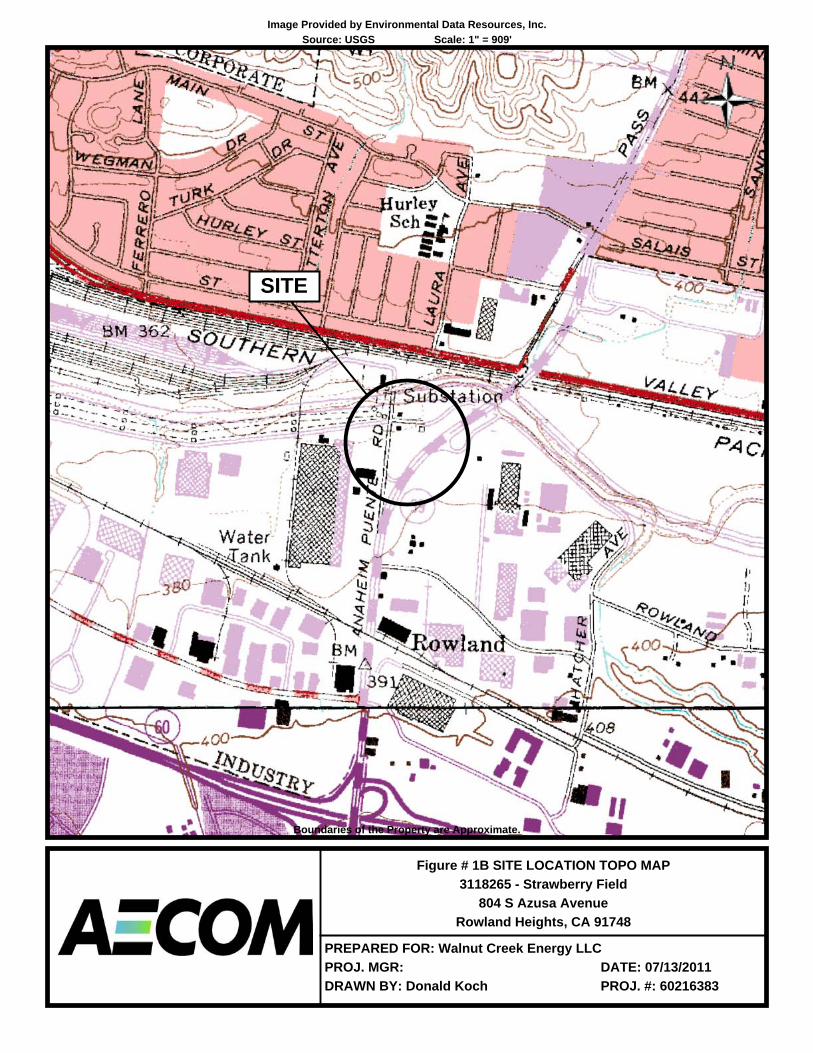
Image Provided by Environmental Data Resources, Inc.Source: USGS Scale: 1" = 909'
SITE
Boundaries of the Property are Approximate.
Figure # 1B SITE LOCATION TOPO MAP3118265 - Strawberry Field
804 S Azusa AvenueRowland Heights, CA 91748
PREPARED FOR: Walnut Creek Energy LLCPROJ. MGR: DATE: 07/13/2011DRAWN BY: Donald Koch PROJ. #: 60216383

PROPERTYBOUNDARY
STRAWBERRY FRUITSTAND AND FARM
IRRIGATION PIPING/EQUIPMENT LAYDOWN
BUILDINGPUMP
BARNRESIDENCE
GA
RAG
E
HAZARDOUSMATERIALS
STORAGE CORRUGATEDMETALBUILDING
FUEL STORAGEUNDERGROUND
50 GALLONTANK DRUM
STORAGE
Project No.
Date:Figure
Phase 1 ESA
Site Plan
07-2011
2
WCEP Proposed Laydown Area
LEGEND:
PROPERTY BOUNDARY
FORMER FARM HOUSECOMPLEX
AECOM Environment
July 2011 60216383
Appendix A Representative Site Photographs
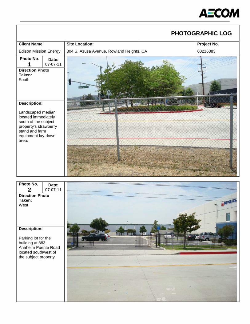
PHOTOGRAPHIC LOG
Client Name:
Edison Mission Energy
Site Location:
804 S. Azusa Avenue, Rowland Heights, CA
Project No.
60216383
Photo No.1
Date:07-07-11
Direction Photo Taken:South
Description:
Landscaped median located immediately south of the subject property’s strawberry stand and farm equipment lay-down area.
Photo No.2
Date:07-07-11
Direction Photo Taken:West
Description:
Parking lot for the building at 883Anaheim Puente Road located southwest of the subject property.

PHOTOGRAPHIC LOG
Client Name:
Edison Mission Energy
Site Location:
804 S. Azusa Avenue, Rowland Heights, CA
Project No.
60216383
Photo No.3
Date:07-07-11
Direction Photo Taken:Northwest
Description:
Building at 883 Anaheim Puente Road (currently occupied by Deyce USA, Inc.) located west of the subject property.
Photo No.4
Date:07-07-11
Direction Photo Taken:Southwest
Description:
Vacant Building at 881 Anaheim Puente Road (formerly occupied by Spyder X-Bracing) located west of the subject property.

PHOTOGRAPHIC LOG
Client Name:
Edison Mission Energy
Site Location:
804 S. Azusa Avenue, Rowland Heights, CA
Project No.
60216383
Photo No.5
Date:07-07-11
Direction Photo Taken:West
Description:
Parking lot for the building at 881Anaheim Puente Road located southwest of the subject propert
Photo No.6
Date:07-07-11
Direction Photo Taken:North
Description:
Building at 17251 Chestnut Street (currently occupied by MG Engineering, LLC) located north of the subject property.
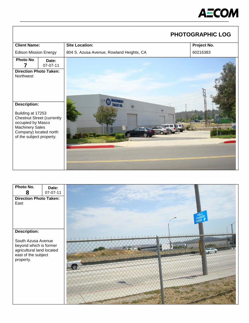
PHOTOGRAPHIC LOG
Client Name:
Edison Mission Energy
Site Location:
804 S. Azusa Avenue, Rowland Heights, CA
Project No.
60216383
Photo No.7
Date:07-07-11
Direction Photo Taken:Northwest
Description:
Building at 17253 Chestnut Street (currently occupied by Masco Machinery Sales Company) located north of the subject property.
Photo No.8
Date:07-07-11
Direction Photo Taken:East
Description:
South Azusa Avenue beyond which is former agricultural land located east of the subject property.
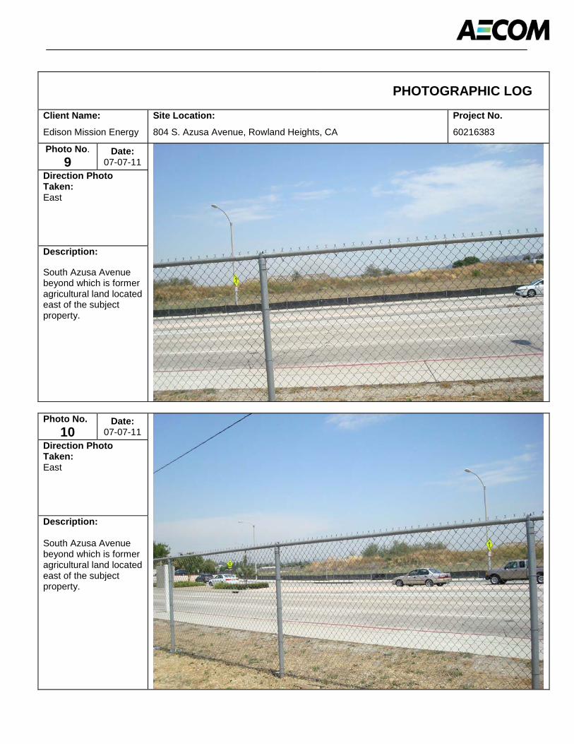
PHOTOGRAPHIC LOG
Client Name:
Edison Mission Energy
Site Location:
804 S. Azusa Avenue, Rowland Heights, CA
Project No.
60216383
Photo No.9
Date:07-07-11
Direction Photo Taken:East
Description:
South Azusa Avenue beyond which is former agricultural land located east of the subject property.
Photo No.10
Date:07-07-11
Direction Photo Taken:East
Description:
South Azusa Avenue beyond which is former agricultural land located east of the subject property.

PHOTOGRAPHIC LOG
Client Name:
Edison Mission Energy
Site Location:
804 S. Azusa Avenue, Rowland Heights, CA
Project No.
60216383
Photo No.11
Date:07-07-11
Direction Photo Taken:Northeast
Description:
Subject property’s strawberry stand and farm equipment lay-down area. A large lighted billboard sign is located immediately northeast of the strawberry stand.
Photo No.12
Date:07-07-11
Direction Photo Taken:East
Description:
Subject property’s strawberry stand and farm equipment lay-down area. A large lighted billboard sign is located immediately northeast of the strawberry stand.

PHOTOGRAPHIC LOG
Client Name:
Edison Mission Energy
Site Location:
804 S. Azusa Avenue, Rowland Heights, CA
Project No.
60216383
Photo No.13
Date:07-07-11
Direction Photo Taken:South
Description:
Irrigation pipe storage at the subject property’s strawberry stand and farm equipment lay-down area.
Photo No.14
Date:07-07-11
Direction Photo Taken:West
Description:
Trailer and equipment storage at the subjectproperty’s strawberry stand and farm equipment lay-down area.

PHOTOGRAPHIC LOG
Client Name:
Edison Mission Energy
Site Location:
804 S. Azusa Avenue, Rowland Heights, CA
Project No.
60216383
Photo No.15
Date:07-07-11
Direction Photo Taken:East
Description:
Trailer, irrigation pipe, and equipment storage at the subject property’s strawberry stand and farm equipment lay-down area.
Photo No.16
Date:07-07-11
Direction Photo Taken:NA
Description:
Vat of unknown material at the subjectproperty’s strawberry stand and farm equipment lay-down area.
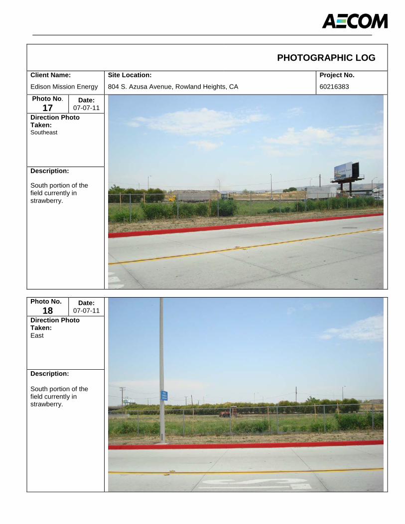
PHOTOGRAPHIC LOG
Client Name:
Edison Mission Energy
Site Location:
804 S. Azusa Avenue, Rowland Heights, CA
Project No.
60216383
Photo No.17
Date:07-07-11
Direction Photo Taken:Southeast
Description:
South portion of the field currently in strawberry.
Photo No.18
Date:07-07-11
Direction Photo Taken:East
Description:
South portion of the field currently in strawberry.
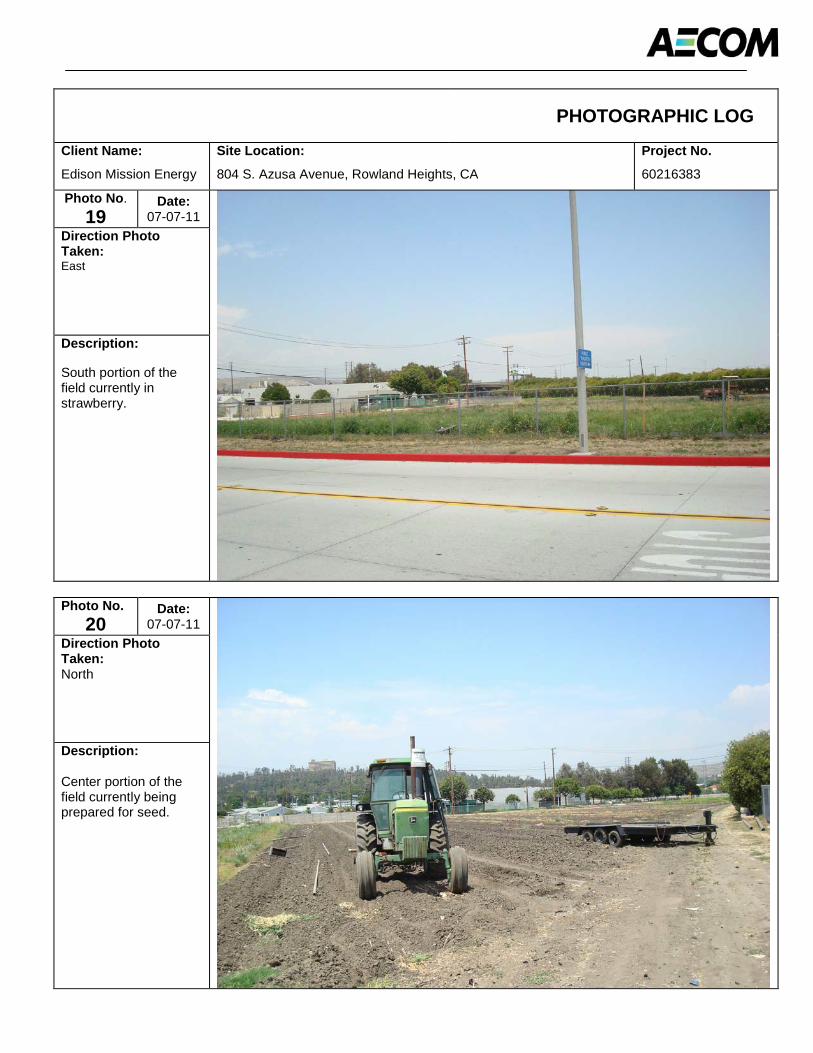
PHOTOGRAPHIC LOG
Client Name:
Edison Mission Energy
Site Location:
804 S. Azusa Avenue, Rowland Heights, CA
Project No.
60216383
Photo No.19
Date:07-07-11
Direction Photo Taken:East
Description:
South portion of the field currently in strawberry.
Photo No.20
Date:07-07-11
Direction Photo Taken:North
Description:
Center portion of the field currently being prepared for seed.
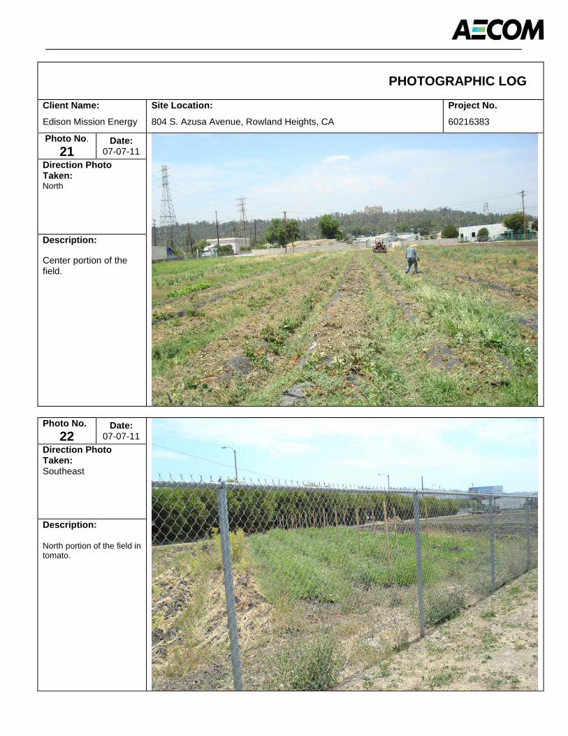
PHOTOGRAPHIC LOG
Client Name:
Edison Mission Energy
Site Location:
804 S. Azusa Avenue, Rowland Heights, CA
Project No.
60216383
Photo No.21
Date:07-07-11
Direction Photo Taken:North
Description:
Center portion of the field.
Photo No.22
Date:07-07-11
Direction Photo Taken:Southeast
Description:
North portion of the field in tomato.
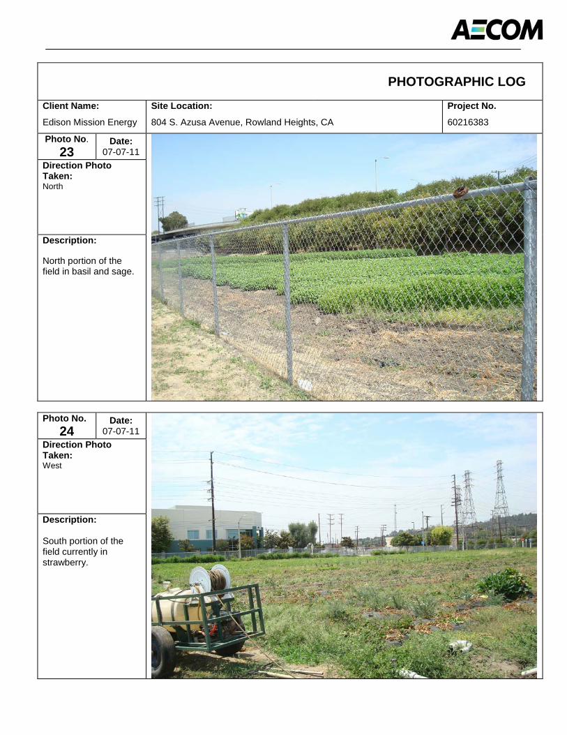
PHOTOGRAPHIC LOG
Client Name:
Edison Mission Energy
Site Location:
804 S. Azusa Avenue, Rowland Heights, CA
Project No.
60216383
Photo No.23
Date:07-07-11
Direction Photo Taken:North
Description:
North portion of the field in basil and sage.
Photo No.24
Date:07-07-11
Direction Photo Taken:West
Description:
South portion of the field currently in strawberry.

AECOM Environment
July 2011 60216383
Appendix B Environmental Database Report
FORM-PB9-PVC
®kcehCoeG htiw tropeR ™paM suidaR RDE ehTmetsyS ®kcehCdleiF RDE eht gnisu deraperP
440 Wheelers Farms RoadMilford, CT 06461Toll Free: 800.352.0050www.edrnet.com
Strawberry Field804 S Azusa AvenueRowland Heights, CA 91748
Inquiry Number: 3118265.2sJuly 11, 2011
SECTION PAGE
Executive Summary ES1
Overview Map 2
Detail Map 3
Map Findings Summary 4
Map Findings 8
Orphan Summary 116
Government Records Searched/Data Currency Tracking GR-1
GEOCHECK ADDENDUM
Physical Setting Source Addendum A-1
Physical Setting Source Summary A-2
Physical Setting Source Map A-8
Physical Setting Source Map Findings A-9
Physical Setting Source Records Searched A-18
TC3118265.2s Page 1
Thank you for your business.Please contact EDR at 1-800-352-0050
with any questions or comments.
Disclaimer - Copyright and Trademark Notice
The EDR FieldCheck System enables EDR’s customers to make certain online modifications to the maps and text contained in®EDR Radius Map Reports. As a result, the maps and text contained in this Report may have been so modified. EDR has not takenany action to verify any such modifications, and this report and the findings set forth herein must be read in light of this fact. The EDRFieldCheck System accesses user-modified records from previously submitted reports. Any user-modified record from a previous reportthat is plotted outside the search radius of this report may not be included in this report.
This Report contains certain information obtained from a variety of public and other sources reasonably available to Environmental DataResources, Inc. It cannot be concluded from this Report that coverage information for the target and surrounding properties does not exist fromother sources. NO WARRANTY EXPRESSED OR IMPLIED, IS MADE WHATSOEVER IN CONNECTION WITH THIS REPORT. ENVIRONMENTALDATA RESOURCES, INC. SPECIFICALLY DISCLAIMS THE MAKING OF ANY SUCH WARRANTIES, INCLUDING WITHOUT LIMITATION,MERCHANTABILITY OR FITNESS FOR A PARTICULAR USE OR PURPOSE. ALL RISK IS ASSUMED BY THE USER. IN NO EVENT SHALLENVIRONMENTAL DATA RESOURCES, INC. BE LIABLE TO ANYONE, WHETHER ARISING OUT OF ERRORS OR OMISSIONS, NEGLIGENCE,ACCIDENT OR ANY OTHER CAUSE, FOR ANY LOSS OF DAMAGE, INCLUDING, WITHOUT LIMITATION, SPECIAL, INCIDENTAL,CONSEQUENTIAL, OR EXEMPLARY DAMAGES. ANY LIABILITY ON THE PART OF ENVIRONMENTAL DATA RESOURCES, INC. IS STRICTLYLIMITED TO A REFUND OF THE AMOUNT PAID FOR THIS REPORT. Purchaser accepts this Report "AS IS". Any analyses, estimates, ratings,environmental risk levels or risk codes provided in this Report are provided for illustrative purposes only, and are not intended to provide, norshould they be interpreted as providing any facts regarding, or prediction or forecast of, any environmental risk for any property. Only a Phase IEnvironmental Site Assessment performed by an environmental professional can provide information regarding the environmental risk for anyproperty. Additionally, the information provided in this Report is not to be construed as legal advice.
Copyright 2011 by Environmental Data Resources, Inc. All rights reserved. Reproduction in any media or format, in wholeor in part, of any report or map of Environmental Data Resources, Inc., or its affiliates, is prohibited without prior written permission.
EDR and its logos (including Sanborn and Sanborn Map) are trademarks of Environmental Data Resources, Inc. or its affiliates. All othertrademarks used herein are the property of their respective owners.
TABLE OF CONTENTS

EXECUTIVE SUMMARY
TC3118265.2s EXECUTIVE SUMMARY 1
A search of the environmental records was conducted by Environmental Data Resources, Inc. (EDR).AECOM used the EDR FieldCheck System to review and/or revise the results of this search, based onindependent data verification by AECOM. The report was designed to assist parties seeking to meet thesearch requirements of EPA’s Standards and Practices for All Appropriate Inquiries (40 CFR Part 312),the ASTM Standard Practice for Environmental Site Assessments (E 1527-05) or custom requirementsdeveloped for the evaluation of environmental risk associated with a parcel of real estate.
TARGET PROPERTY INFORMATION
ADDRESS
804 S AZUSA AVENUEROWLAND HEIGHTS, CA 91748
COORDINATES
34.007100 - 34˚ 0’ 25.6’’Latitude (North): 117.929300 - 117˚ 55’ 45.5’’Longitude (West): Zone 11Universal Tranverse Mercator: 414184.9UTM X (Meters): 3763138.0UTM Y (Meters): 375 ft. above sea levelElevation:
USGS TOPOGRAPHIC MAP ASSOCIATED WITH TARGET PROPERTY
34117-A8 BALDWIN PARK, CATarget Property Map:1981Most Recent Revision:
33117-H8 LA HABRA, CASouth Map:1981Most Recent Revision:
AERIAL PHOTOGRAPHY IN THIS REPORT
2005Photo Year:USDASource:
TARGET PROPERTY SEARCH RESULTS
The target property was not listed in any of the databases searched by EDR.
DATABASES WITH NO MAPPED SITES
No sites were identified in following databases.
STANDARD ENVIRONMENTAL RECORDS
Federal NPL site list
Proposed NPL Proposed National Priority List Sites
EXECUTIVE SUMMARY
TC3118265.2s EXECUTIVE SUMMARY 2
NPL LIENS Federal Superfund Liens
Federal Delisted NPL site list
Delisted NPL National Priority List Deletions
Federal CERCLIS list
FEDERAL FACILITY Federal Facility Site Information listing
Federal CERCLIS NFRAP site List
CERC-NFRAP CERCLIS No Further Remedial Action Planned
Federal RCRA CORRACTS facilities list
CORRACTS Corrective Action Report
Federal RCRA generators list
RCRA-CESQG RCRA - Conditionally Exempt Small Quantity Generator
Federal institutional controls / engineering controls registries
US INST CONTROL Sites with Institutional Controls
Federal ERNS list
ERNS Emergency Response Notification System
State- and tribal - equivalent NPL
RESPONSE State Response Sites
State and tribal leaking storage tank lists
INDIAN LUST Leaking Underground Storage Tanks on Indian Land
State and tribal registered storage tank lists
INDIAN UST Underground Storage Tanks on Indian LandFEMA UST Underground Storage Tank Listing
State and tribal voluntary cleanup sites
VCP Voluntary Cleanup Program PropertiesINDIAN VCP Voluntary Cleanup Priority Listing
ADDITIONAL ENVIRONMENTAL RECORDS
Local Brownfield lists
US BROWNFIELDS A Listing of Brownfields Sites
Local Lists of Landfill / Solid Waste Disposal Sites
ODI Open Dump Inventory
EXECUTIVE SUMMARY
TC3118265.2s EXECUTIVE SUMMARY 3
DEBRIS REGION 9 Torres Martinez Reservation Illegal Dump Site LocationsWMUDS/SWAT Waste Management Unit DatabaseHAULERS Registered Waste Tire Haulers ListingINDIAN ODI Report on the Status of Open Dumps on Indian Lands
Local Lists of Hazardous waste / Contaminated Sites
US CDL Clandestine Drug LabsHIST Cal-Sites Historical Calsites DatabaseSCH School Property Evaluation ProgramToxic Pits Toxic Pits Cleanup Act SitesCDL Clandestine Drug LabsUS HIST CDL National Clandestine Laboratory Register
Local Land Records
LIENS 2 CERCLA Lien InformationLUCIS Land Use Control Information SystemLIENS Environmental Liens ListingDEED Deed Restriction Listing
Records of Emergency Release Reports
HMIRS Hazardous Materials Information Reporting SystemCHMIRS California Hazardous Material Incident Report SystemLDS Land Disposal Sites ListingMCS Military Cleanup Sites Listing
Other Ascertainable Records
DOT OPS Incident and Accident DataDOD Department of Defense SitesFUDS Formerly Used Defense SitesCONSENT Superfund (CERCLA) Consent DecreesUMTRA Uranium Mill Tailings SitesMINES Mines Master Index FileTRIS Toxic Chemical Release Inventory SystemTSCA Toxic Substances Control ActFTTS FIFRA/ TSCA Tracking System - FIFRA (Federal Insecticide, Fungicide, & Rodenticide Act)/TSCA (Toxic Substances Control Act)HIST FTTS FIFRA/TSCA Tracking System Administrative Case ListingSSTS Section 7 Tracking SystemsICIS Integrated Compliance Information SystemPADS PCB Activity Database SystemMLTS Material Licensing Tracking SystemRADINFO Radiation Information DatabaseFINDS Facility Index System/Facility Registry SystemRAATS RCRA Administrative Action Tracking SystemCA BOND EXP. PLAN Bond Expenditure PlanNPDES NPDES Permits ListingWDS Waste Discharge SystemCortese "Cortese" Hazardous Waste & Substances Sites ListLA Co. Site Mitigation Site Mitigation ListDRYCLEANERS Cleaner FacilitiesLOS ANGELES CO. HMS HMS: Street Number List
EXECUTIVE SUMMARY
TC3118265.2s EXECUTIVE SUMMARY 4
HAZNET Facility and Manifest DataEMI Emissions Inventory DataINDIAN RESERV Indian ReservationsSCRD DRYCLEANERS State Coalition for Remediation of Drycleaners ListingFINANCIAL ASSURANCE Financial Assurance Information ListingHWT Registered Hazardous Waste Transporter DatabaseCOAL ASH EPA Coal Combustion Residues Surface Impoundments ListPCB TRANSFORMER PCB Transformer Registration DatabasePROC Certified Processors DatabaseMWMP Medical Waste Management Program ListingCOAL ASH DOE Sleam-Electric Plan Operation Data
EDR PROPRIETARY RECORDS
EDR Proprietary Records
Manufactured Gas Plants EDR Proprietary Manufactured Gas PlantsEDR Historical Auto Stations EDR Proprietary Historic Gas StationsEDR Historical Cleaners EDR Proprietary Historic Dry Cleaners
SURROUNDING SITES: SEARCH RESULTS
Surrounding sites were identified in the following databases.
Elevations have been determined from the USGS Digital Elevation Model and should be evaluated ona relative (not an absolute) basis. Relative elevation information between sites of close proximityshould be field verified. Sites with an elevation equal to or higher than the target property have beendifferentiated below from sites with an elevation lower than the target property.Page numbers and map identification numbers refer to the EDR Radius Map report where detaileddata on individual sites can be reviewed.
Sites listed in bold italics are in multiple databases.
Unmappable (orphan) sites are not considered in the foregoing analysis.
STANDARD ENVIRONMENTAL RECORDS
Federal NPL site list
NPL: Also known as Superfund, the National Priority List database is a subset of CERCLIS andidentifies over 1,200 sites for priority cleanup under the Superfund program. The source of this database isthe U.S. EPA.
An online review and analysis by AECOM of the NPL list, as provided by EDR, and dated 03/31/2011 has revealed that there is 1 NPL site within approximately 1 mile of the target property.
PageMap IDDirection / Distance Address Equal/Higher Elevation ____________________ ________ ___________________ _____ _____
SAN GABRIEL VALLEY (AREA 4) STIMSON AVE & OLD VALLE 0 - 1/8 (0.000 mi.) 0 8
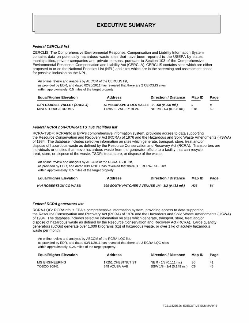
EXECUTIVE SUMMARY
TC3118265.2s EXECUTIVE SUMMARY 5
Federal CERCLIS list
CERCLIS: The Comprehensive Environmental Response, Compensation and Liability Information Systemcontains data on potentially hazardous waste sites that have been reported to the USEPA by states,municipalities, private companies and private persons, pursuant to Section 103 of the ComprehensiveEnvironmental Response, Compensation and Liability Act (CERCLA). CERCLIS contains sites which are eitherproposed to or on the National Priorities List (NPL) and sites which are in the screening and assessment phasefor possible inclusion on the NPL.
An online review and analysis by AECOM of the CERCLIS list, as provided by EDR, and dated 02/25/2011 has revealed that there are 2 CERCLIS sites within approximately 0.5 miles of the target property.
PageMap IDDirection / Distance Address Equal/Higher Elevation ____________________ ________ ___________________ _____ _____
SAN GABRIEL VALLEY (AREA 4) STIMSON AVE & OLD VALLE 0 - 1/8 (0.000 mi.) 0 8 MINI STORAGE DRUMS 17295 E. VALLEY BLVD NE 1/8 - 1/4 (0.198 mi.) F18 69
Federal RCRA non-CORRACTS TSD facilities list
RCRA-TSDF: RCRAInfo is EPA’s comprehensive information system, providing access to data supportingthe Resource Conservation and Recovery Act (RCRA) of 1976 and the Hazardous and Solid Waste Amendments (HSWA)of 1984. The database includes selective information on sites which generate, transport, store, treat and/ordispose of hazardous waste as defined by the Resource Conservation and Recovery Act (RCRA). Transporters areindividuals or entities that move hazardous waste from the generator offsite to a facility that can recycle,treat, store, or dispose of the waste. TSDFs treat, store, or dispose of the waste.
An online review and analysis by AECOM of the RCRA-TSDF list, as provided by EDR, and dated 03/11/2011 has revealed that there is 1 RCRA-TSDF site within approximately 0.5 miles of the target property.
PageMap IDDirection / Distance Address Equal/Higher Elevation ____________________ ________ ___________________ _____ _____
H H ROBERTSON CO WASD 999 SOUTH HATCHER AVENUSE 1/4 - 1/2 (0.433 mi.) H26 84
Federal RCRA generators list
RCRA-LQG: RCRAInfo is EPA’s comprehensive information system, providing access to data supportingthe Resource Conservation and Recovery Act (RCRA) of 1976 and the Hazardous and Solid Waste Amendments (HSWA)of 1984. The database includes selective information on sites which generate, transport, store, treat and/ordispose of hazardous waste as defined by the Resource Conservation and Recovery Act (RCRA). Large quantitygenerators (LQGs) generate over 1,000 kilograms (kg) of hazardous waste, or over 1 kg of acutely hazardouswaste per month.
An online review and analysis by AECOM of the RCRA-LQG list, as provided by EDR, and dated 03/11/2011 has revealed that there are 2 RCRA-LQG sites within approximately 0.25 miles of the target property.
PageMap IDDirection / Distance Address Equal/Higher Elevation ____________________ ________ ___________________ _____ _____
MG ENGINEERING 17251 CHESTNUT ST NE 0 - 1/8 (0.111 mi.) B6 41 TOSCO 30941 948 AZUSA AVE SSW 1/8 - 1/4 (0.148 mi.) C9 45
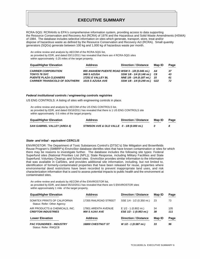
EXECUTIVE SUMMARY
TC3118265.2s EXECUTIVE SUMMARY 6
RCRA-SQG: RCRAInfo is EPA’s comprehensive information system, providing access to data supportingthe Resource Conservation and Recovery Act (RCRA) of 1976 and the Hazardous and Solid Waste Amendments (HSWA)of 1984. The database includes selective information on sites which generate, transport, store, treat and/ordispose of hazardous waste as defined by the Resource Conservation and Recovery Act (RCRA). Small quantitygenerators (SQGs) generate between 100 kg and 1,000 kg of hazardous waste per month.
An online review and analysis by AECOM of the RCRA-SQG list, as provided by EDR, and dated 03/11/2011 has revealed that there are 4 RCRA-SQG sites within approximately 0.25 miles of the target property.
PageMap IDDirection / Distance Address Equal/Higher Elevation ____________________ ________ ___________________ _____ _____
CARRIER CORPORATION 855 ANAHEIM PUENTE ROAD WSW 0 - 1/8 (0.046 mi.) A4 37 TONYS 76 SVC 948 S AZUSA SSW 1/8 - 1/4 (0.148 mi.) C8 43 PUENTE PLAZA CLEANERS 17251 E VALLEY BL NNE 1/8 - 1/4 (0.187 mi.) 15 61 CARRIER TRANSICOLD OF SOUTHERN 1015 S AZUSA AVE SSW 1/8 - 1/4 (0.249 mi.) G22 72
Federal institutional controls / engineering controls registries
US ENG CONTROLS: A listing of sites with engineering controls in place.
An online review and analysis by AECOM of the US ENG CONTROLS list, as provided by EDR, and dated 03/16/2011 has revealed that there is 1 US ENG CONTROLS site within approximately 0.5 miles of the target property.
PageMap IDDirection / Distance Address Equal/Higher Elevation ____________________ ________ ___________________ _____ _____
SAN GABRIEL VALLEY (AREA 4) STIMSON AVE & OLD VALLE 0 - 1/8 (0.000 mi.) 0 8
State- and tribal - equivalent CERCLIS
ENVIROSTOR: The Department of Toxic Substances Control’s (DTSC’s) Site Mitigation and BrownfieldsReuse Program’s (SMBRP’s) EnviroStor database identifes sites that have known contamination or sites for whichthere may be reasons to investigate further. The database includes the following site types: FederalSuperfund sites (National Priorities List (NPL)); State Response, including Military Facilities and StateSuperfund; Voluntary Cleanup; and School sites. EnviroStor provides similar information to the informationthat was available in CalSites, and provides additional site information, including, but not limited to,identification of formerly-contaminated properties that have been released for reuse, properties whereenvironmental deed restrictions have been recorded to prevent inappropriate land uses, and riskcharacterization information that is used to assess potential impacts to public health and the environment atcontaminated sites.
An online review and analysis by AECOM of the ENVIROSTOR list, as provided by EDR, and dated 05/10/2011 has revealed that there are 5 ENVIROSTOR sites within approximately 1 mile of the target property.
PageMap IDDirection / Distance Address Equal/Higher Elevation ____________________ ________ ___________________ _____ _____
SOMITEX PRINTS OF CALIFORNIA 17355 RAILROAD STREET SSE 1/4 - 1/2 (0.350 mi.) 23 73Status: Refer: Other Agency
AIR PRODUCTS & CHEMICALS, INC. 17801 ARENTH AVENUE E 1/2 - 1 (0.802 mi.) 34 105 CREFTON INDUSTRIES 900 S AJAX AVE ESE 1/2 - 1 (0.953 mi.) 38 111
PageMap IDDirection / Distance Address Lower Elevation ____________________ ________ ___________________ _____ _____
PAC FOUNDRIES - INDUSTRY 16800 CHESTNUT ST W 1/2 - 1 (0.587 mi.) 33 96Status: Refer: RWQCB
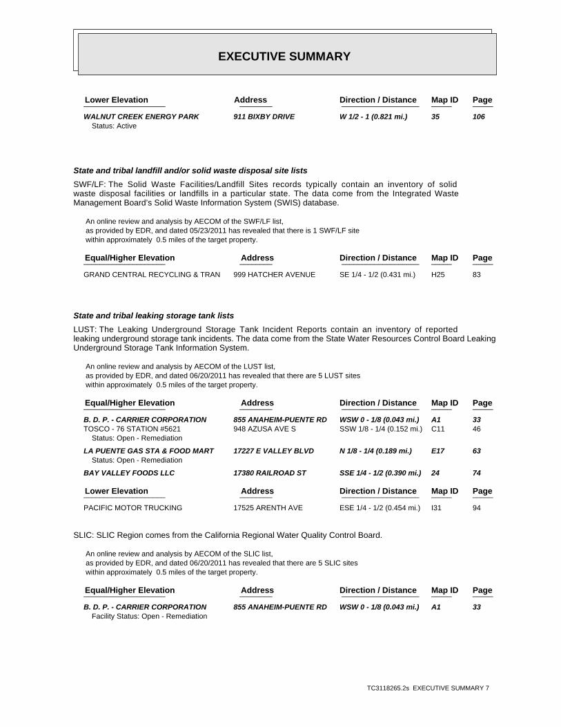
EXECUTIVE SUMMARY
TC3118265.2s EXECUTIVE SUMMARY 7
PageMap IDDirection / Distance Address Lower Elevation ____________________ ________ ___________________ _____ _____
WALNUT CREEK ENERGY PARK 911 BIXBY DRIVE W 1/2 - 1 (0.821 mi.) 35 106Status: Active
State and tribal landfill and/or solid waste disposal site lists
SWF/LF: The Solid Waste Facilities/Landfill Sites records typically contain an inventory of solidwaste disposal facilities or landfills in a particular state. The data come from the Integrated WasteManagement Board’s Solid Waste Information System (SWIS) database.
An online review and analysis by AECOM of the SWF/LF list, as provided by EDR, and dated 05/23/2011 has revealed that there is 1 SWF/LF site within approximately 0.5 miles of the target property.
PageMap IDDirection / Distance Address Equal/Higher Elevation ____________________ ________ ___________________ _____ _____
GRAND CENTRAL RECYCLING & TRAN 999 HATCHER AVENUE SE 1/4 - 1/2 (0.431 mi.) H25 83
State and tribal leaking storage tank lists
LUST: The Leaking Underground Storage Tank Incident Reports contain an inventory of reportedleaking underground storage tank incidents. The data come from the State Water Resources Control Board LeakingUnderground Storage Tank Information System.
An online review and analysis by AECOM of the LUST list, as provided by EDR, and dated 06/20/2011 has revealed that there are 5 LUST sites within approximately 0.5 miles of the target property.
PageMap IDDirection / Distance Address Equal/Higher Elevation ____________________ ________ ___________________ _____ _____
B. D. P. - CARRIER CORPORATION 855 ANAHEIM-PUENTE RD WSW 0 - 1/8 (0.043 mi.) A1 33 TOSCO - 76 STATION #5621 948 AZUSA AVE S SSW 1/8 - 1/4 (0.152 mi.) C11 46
Status: Open - Remediation
LA PUENTE GAS STA & FOOD MART 17227 E VALLEY BLVD N 1/8 - 1/4 (0.189 mi.) E17 63Status: Open - Remediation
BAY VALLEY FOODS LLC 17380 RAILROAD ST SSE 1/4 - 1/2 (0.390 mi.) 24 74
PageMap IDDirection / Distance Address Lower Elevation ____________________ ________ ___________________ _____ _____
PACIFIC MOTOR TRUCKING 17525 ARENTH AVE ESE 1/4 - 1/2 (0.454 mi.) I31 94
SLIC: SLIC Region comes from the California Regional Water Quality Control Board.
An online review and analysis by AECOM of the SLIC list, as provided by EDR, and dated 06/20/2011 has revealed that there are 5 SLIC sites within approximately 0.5 miles of the target property.
PageMap IDDirection / Distance Address Equal/Higher Elevation ____________________ ________ ___________________ _____ _____
B. D. P. - CARRIER CORPORATION 855 ANAHEIM-PUENTE RD WSW 0 - 1/8 (0.043 mi.) A1 33Facility Status: Open - Remediation
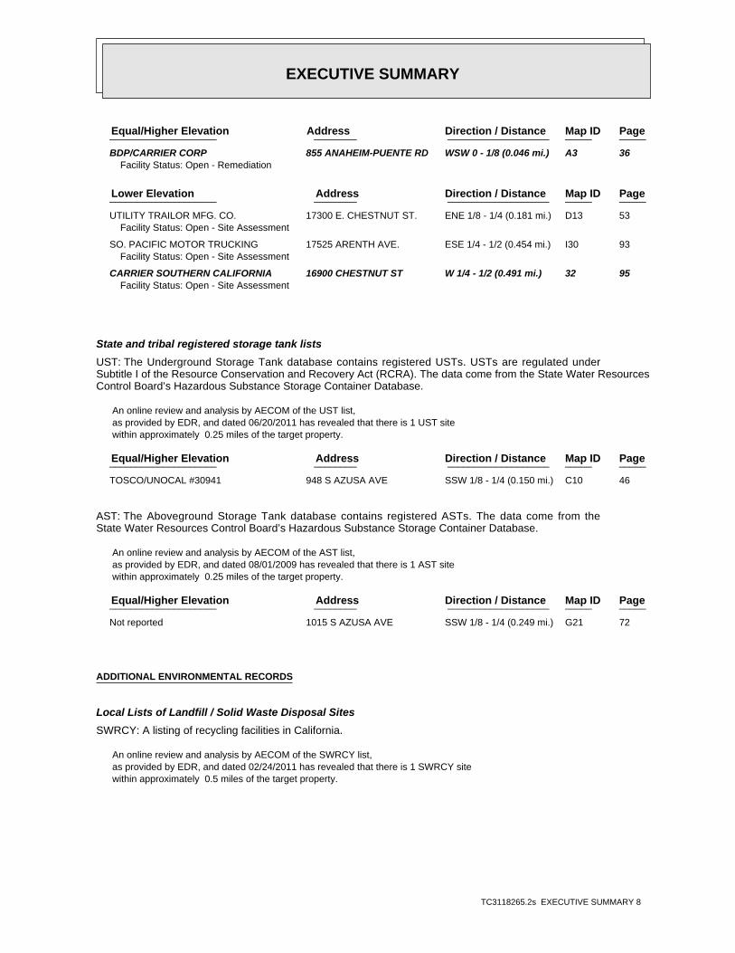
EXECUTIVE SUMMARY
TC3118265.2s EXECUTIVE SUMMARY 8
PageMap IDDirection / Distance Address Equal/Higher Elevation ____________________ ________ ___________________ _____ _____
BDP/CARRIER CORP 855 ANAHEIM-PUENTE RD WSW 0 - 1/8 (0.046 mi.) A3 36Facility Status: Open - Remediation
PageMap IDDirection / Distance Address Lower Elevation ____________________ ________ ___________________ _____ _____
UTILITY TRAILOR MFG. CO. 17300 E. CHESTNUT ST. ENE 1/8 - 1/4 (0.181 mi.) D13 53Facility Status: Open - Site Assessment
SO. PACIFIC MOTOR TRUCKING 17525 ARENTH AVE. ESE 1/4 - 1/2 (0.454 mi.) I30 93Facility Status: Open - Site Assessment
CARRIER SOUTHERN CALIFORNIA 16900 CHESTNUT ST W 1/4 - 1/2 (0.491 mi.) 32 95Facility Status: Open - Site Assessment
State and tribal registered storage tank lists
UST: The Underground Storage Tank database contains registered USTs. USTs are regulated underSubtitle I of the Resource Conservation and Recovery Act (RCRA). The data come from the State Water ResourcesControl Board’s Hazardous Substance Storage Container Database.
An online review and analysis by AECOM of the UST list, as provided by EDR, and dated 06/20/2011 has revealed that there is 1 UST site within approximately 0.25 miles of the target property.
PageMap IDDirection / Distance Address Equal/Higher Elevation ____________________ ________ ___________________ _____ _____
TOSCO/UNOCAL #30941 948 S AZUSA AVE SSW 1/8 - 1/4 (0.150 mi.) C10 46
AST: The Aboveground Storage Tank database contains registered ASTs. The data come from theState Water Resources Control Board’s Hazardous Substance Storage Container Database.
An online review and analysis by AECOM of the AST list, as provided by EDR, and dated 08/01/2009 has revealed that there is 1 AST site within approximately 0.25 miles of the target property.
PageMap IDDirection / Distance Address Equal/Higher Elevation ____________________ ________ ___________________ _____ _____
Not reported 1015 S AZUSA AVE SSW 1/8 - 1/4 (0.249 mi.) G21 72
ADDITIONAL ENVIRONMENTAL RECORDS
Local Lists of Landfill / Solid Waste Disposal Sites
SWRCY: A listing of recycling facilities in California.
An online review and analysis by AECOM of the SWRCY list, as provided by EDR, and dated 02/24/2011 has revealed that there is 1 SWRCY site within approximately 0.5 miles of the target property.

EXECUTIVE SUMMARY
TC3118265.2s EXECUTIVE SUMMARY 9
PageMap IDDirection / Distance Address Equal/Higher Elevation ____________________ ________ ___________________ _____ _____
AM RECYCLING 17305 VALLEY BLVD NE 1/8 - 1/4 (0.207 mi.) F19 71
Local Lists of Hazardous waste / Contaminated Sites
AOCONCERN: San Gabriel Valley areas where VOC contamination is at or above the MCL as designated byregion 9 EPA office.
An online review and analysis by AECOM of the AOCONCERN list, as provided by EDR, and dated 03/30/2009 has revealed that there is 1 AOCONCERN site within approximately 1 mile of the target property.
PageMap IDDirection / Distance Address Equal/Higher Elevation ____________________ ________ ___________________ _____ _____
SAN GABRIEL VALLEY 0 - 1/8 (0.000 mi.) 0 8
Local Lists of Registered Storage Tanks
CA FID UST: The Facility Inventory Database contains active and inactive underground storage tanklocations. The source is the State Water Resource Control Board.
An online review and analysis by AECOM of the CA FID UST list, as provided by EDR, and dated 10/31/1994 has revealed that there is 1 CA FID UST site within approximately 0.25 miles of the target property.
PageMap IDDirection / Distance Address Equal/Higher Elevation ____________________ ________ ___________________ _____ _____
CARRIER CORPORATION 855 ANAHEIM PUENTE ROAD WSW 0 - 1/8 (0.046 mi.) A4 37
HIST UST: Historical UST Registered Database.
An online review and analysis by AECOM of the HIST UST list, as provided by EDR, and dated 10/15/1990 has revealed that there are 4 HIST UST sites within approximately 0.25 miles of the target property.
PageMap IDDirection / Distance Address Equal/Higher Elevation ____________________ ________ ___________________ _____ _____
BDP COMPANY. 855 ANAHEIM PUENTE RD WSW 0 - 1/8 (0.046 mi.) A2 35 CARRIER CORPORATION 855 ANAHEIM PUENTE ROAD WSW 0 - 1/8 (0.046 mi.) A4 37 M. MUWALLA’S ARCO 17227 VALLEY BLVD N 1/8 - 1/4 (0.189 mi.) E16 62
PageMap IDDirection / Distance Address Lower Elevation ____________________ ________ ___________________ _____ _____
UTILITY TRAILER MFG CO 17300 E CHESTNUT STREET ENE 1/8 - 1/4 (0.186 mi.) D14 53
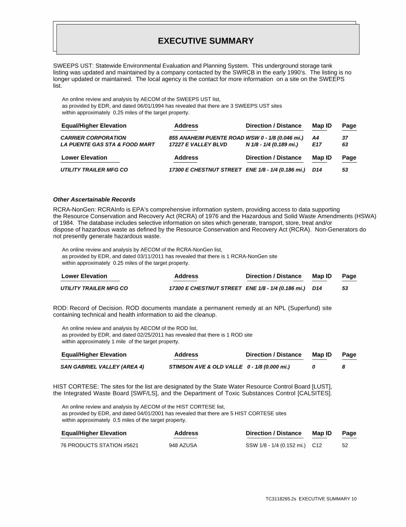
EXECUTIVE SUMMARY
TC3118265.2s EXECUTIVE SUMMARY 10
SWEEPS UST: Statewide Environmental Evaluation and Planning System. This underground storage tanklisting was updated and maintained by a company contacted by the SWRCB in the early 1990’s. The listing is nolonger updated or maintained. The local agency is the contact for more information on a site on the SWEEPSlist.
An online review and analysis by AECOM of the SWEEPS UST list, as provided by EDR, and dated 06/01/1994 has revealed that there are 3 SWEEPS UST sites within approximately 0.25 miles of the target property.
PageMap IDDirection / Distance Address Equal/Higher Elevation ____________________ ________ ___________________ _____ _____
CARRIER CORPORATION 855 ANAHEIM PUENTE ROAD WSW 0 - 1/8 (0.046 mi.) A4 37 LA PUENTE GAS STA & FOOD MART 17227 E VALLEY BLVD N 1/8 - 1/4 (0.189 mi.) E17 63
PageMap IDDirection / Distance Address Lower Elevation ____________________ ________ ___________________ _____ _____
UTILITY TRAILER MFG CO 17300 E CHESTNUT STREET ENE 1/8 - 1/4 (0.186 mi.) D14 53
Other Ascertainable Records
RCRA-NonGen: RCRAInfo is EPA’s comprehensive information system, providing access to data supportingthe Resource Conservation and Recovery Act (RCRA) of 1976 and the Hazardous and Solid Waste Amendments (HSWA)of 1984. The database includes selective information on sites which generate, transport, store, treat and/ordispose of hazardous waste as defined by the Resource Conservation and Recovery Act (RCRA). Non-Generators donot presently generate hazardous waste.
An online review and analysis by AECOM of the RCRA-NonGen list, as provided by EDR, and dated 03/11/2011 has revealed that there is 1 RCRA-NonGen site within approximately 0.25 miles of the target property.
PageMap IDDirection / Distance Address Lower Elevation ____________________ ________ ___________________ _____ _____
UTILITY TRAILER MFG CO 17300 E CHESTNUT STREET ENE 1/8 - 1/4 (0.186 mi.) D14 53
ROD: Record of Decision. ROD documents mandate a permanent remedy at an NPL (Superfund) sitecontaining technical and health information to aid the cleanup.
An online review and analysis by AECOM of the ROD list, as provided by EDR, and dated 02/25/2011 has revealed that there is 1 ROD site within approximately 1 mile of the target property.
PageMap IDDirection / Distance Address Equal/Higher Elevation ____________________ ________ ___________________ _____ _____
SAN GABRIEL VALLEY (AREA 4) STIMSON AVE & OLD VALLE 0 - 1/8 (0.000 mi.) 0 8
HIST CORTESE: The sites for the list are designated by the State Water Resource Control Board [LUST],the Integrated Waste Board [SWF/LS], and the Department of Toxic Substances Control [CALSITES].
An online review and analysis by AECOM of the HIST CORTESE list, as provided by EDR, and dated 04/01/2001 has revealed that there are 5 HIST CORTESE sites within approximately 0.5 miles of the target property.
PageMap IDDirection / Distance Address Equal/Higher Elevation ____________________ ________ ___________________ _____ _____
76 PRODUCTS STATION #5621 948 AZUSA SSW 1/8 - 1/4 (0.152 mi.) C12 52
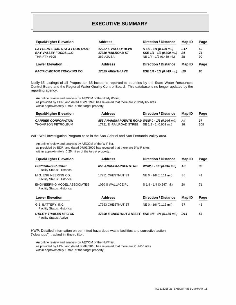
EXECUTIVE SUMMARY
TC3118265.2s EXECUTIVE SUMMARY 11
PageMap IDDirection / Distance Address Equal/Higher Elevation ____________________ ________ ___________________ _____ _____
LA PUENTE GAS STA & FOOD MART 17227 E VALLEY BLVD N 1/8 - 1/4 (0.189 mi.) E17 63 BAY VALLEY FOODS LLC 17380 RAILROAD ST SSE 1/4 - 1/2 (0.390 mi.) 24 74 THRIFTY #305 362 AZUSA NE 1/4 - 1/2 (0.439 mi.) 28 90
PageMap IDDirection / Distance Address Lower Elevation ____________________ ________ ___________________ _____ _____
PACIFIC MOTOR TRUCKING CO 17525 ARENTH AVE ESE 1/4 - 1/2 (0.449 mi.) I29 90
Notify 65: Listings of all Proposition 65 incidents reported to counties by the State Water ResourcesControl Board and the Regional Water Quality Control Board. This database is no longer updated by thereporting agency.
An online review and analysis by AECOM of the Notify 65 list, as provided by EDR, and dated 10/21/1993 has revealed that there are 2 Notify 65 sites within approximately 1 mile of the target property.
PageMap IDDirection / Distance Address Equal/Higher Elevation ____________________ ________ ___________________ _____ _____
CARRIER CORPORATION 855 ANAHEIM PUENTE ROAD WSW 0 - 1/8 (0.046 mi.) A4 37 THOMPSON PETROLEUM 17721 E. RAILROAD STREE SE 1/2 - 1 (0.903 mi.) 36 108
WIP: Well Investigation Program case in the San Gabriel and San Fernando Valley area.
An online review and analysis by AECOM of the WIP list, as provided by EDR, and dated 07/03/2009 has revealed that there are 5 WIP sites within approximately 0.25 miles of the target property.
PageMap IDDirection / Distance Address Equal/Higher Elevation ____________________ ________ ___________________ _____ _____
BDP/CARRIER CORP 855 ANAHEIM-PUENTE RD WSW 0 - 1/8 (0.046 mi.) A3 36Facility Status: Historical
M.G. ENGINEERING CO. 17251 CHESTNUT ST NE 0 - 1/8 (0.111 mi.) B5 41Facility Status: Historical
ENGINEERING MODEL ASSOCIATES 1020 S WALLACE PL S 1/8 - 1/4 (0.247 mi.) 20 71Facility Status: Historical
PageMap IDDirection / Distance Address Lower Elevation ____________________ ________ ___________________ _____ _____
G.S. BATTERY, INC. 17253 CHESTNUT ST NE 0 - 1/8 (0.115 mi.) B7 43Facility Status: Historical
UTILITY TRAILER MFG CO 17300 E CHESTNUT STREET ENE 1/8 - 1/4 (0.186 mi.) D14 53Facility Status: Active
HWP: Detailed information on permitted hazardous waste facilities and corrective action("cleanups") tracked in EnviroStor.
An online review and analysis by AECOM of the HWP list, as provided by EDR, and dated 08/09/2010 has revealed that there are 2 HWP sites within approximately 1 mile of the target property.
EXECUTIVE SUMMARY
TC3118265.2s EXECUTIVE SUMMARY 12
PageMap IDDirection / Distance Address Equal/Higher Elevation ____________________ ________ ___________________ _____ _____
MAXIM LIGHTING INTERNATIONAL 999 S HATCHER AVE SE 1/4 - 1/2 (0.433 mi.) H27 87
PageMap IDDirection / Distance Address Lower Elevation ____________________ ________ ___________________ _____ _____
KIM LIGHTING 16555 E GALE AVE W 1/2 - 1 (0.936 mi.) 37 108
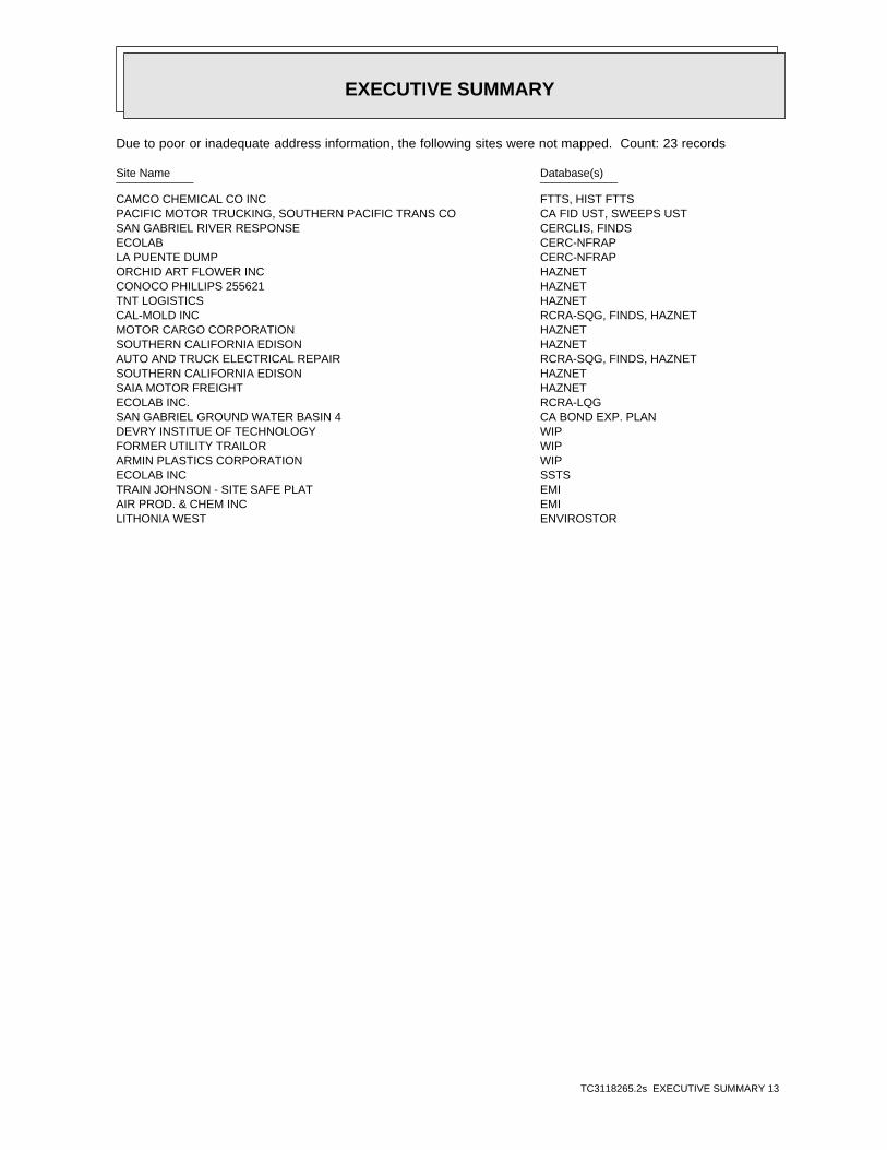
EXECUTIVE SUMMARY
TC3118265.2s EXECUTIVE SUMMARY 13
Due to poor or inadequate address information, the following sites were not mapped. Count: 23 records
Site Name Database(s)____________ ____________
CAMCO CHEMICAL CO INC FTTS, HIST FTTSPACIFIC MOTOR TRUCKING, SOUTHERN PACIFIC TRANS CO CA FID UST, SWEEPS USTSAN GABRIEL RIVER RESPONSE CERCLIS, FINDSECOLAB CERC-NFRAPLA PUENTE DUMP CERC-NFRAPORCHID ART FLOWER INC HAZNETCONOCO PHILLIPS 255621 HAZNETTNT LOGISTICS HAZNETCAL-MOLD INC RCRA-SQG, FINDS, HAZNETMOTOR CARGO CORPORATION HAZNETSOUTHERN CALIFORNIA EDISON HAZNETAUTO AND TRUCK ELECTRICAL REPAIR RCRA-SQG, FINDS, HAZNETSOUTHERN CALIFORNIA EDISON HAZNETSAIA MOTOR FREIGHT HAZNETECOLAB INC. RCRA-LQGSAN GABRIEL GROUND WATER BASIN 4 CA BOND EXP. PLANDEVRY INSTITUE OF TECHNOLOGY WIPFORMER UTILITY TRAILOR WIPARMIN PLASTICS CORPORATION WIPECOLAB INC SSTSTRAIN JOHNSON - SITE SAFE PLAT EMIAIR PROD. & CHEM INC EMILITHONIA WEST ENVIROSTOR

EDR Inc.EDR Inc.EDR Inc.EDR Inc.EDR Inc.EDR Inc.EDR Inc.EDR Inc.EDR Inc.EDR Inc.EDR Inc.EDR Inc.EDR Inc.EDR Inc.EDR Inc.EDR Inc.EDR Inc.EDR Inc.EDR Inc.EDR Inc.EDR Inc.EDR Inc.EDR Inc.EDR Inc.EDR Inc.EDR Inc.EDR Inc.EDR Inc.EDR Inc.EDR Inc.EDR Inc.EDR Inc.EDR Inc.EDR Inc.EDR Inc.EDR Inc.EDR Inc.EDR Inc.EDR Inc.EDR Inc.
230 kV
230
kV
230 kV
230 kV
230 kV
230 kV
230 kV
230 kV
230 kV
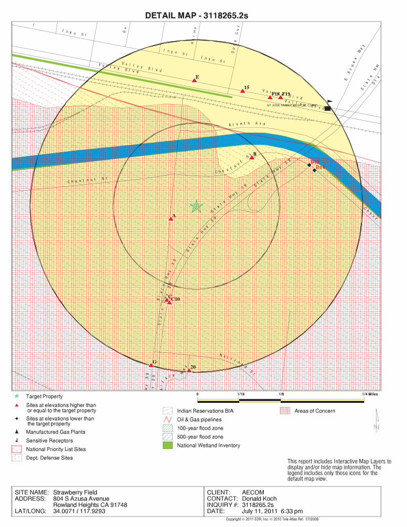
EDR Inc.EDR Inc.EDR Inc.EDR Inc.EDR Inc.EDR Inc.EDR Inc.EDR Inc.EDR Inc.EDR Inc.EDR Inc.EDR Inc.EDR Inc.EDR Inc.EDR Inc.EDR Inc.EDR Inc.EDR Inc.EDR Inc.EDR Inc.EDR Inc.EDR Inc.EDR Inc.EDR Inc.EDR Inc.EDR Inc.EDR Inc.EDR Inc.EDR Inc.EDR Inc.EDR Inc.EDR Inc.EDR Inc.EDR Inc.EDR Inc.EDR Inc.EDR Inc.EDR Inc.EDR Inc.EDR Inc.
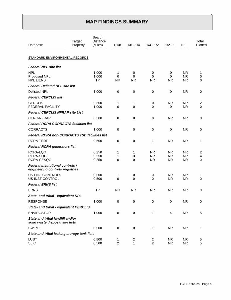
MAP FINDINGS SUMMARY
SearchTarget Distance Total
Database Property (Miles) < 1/8 1/8 - 1/4 1/4 - 1/2 1/2 - 1 > 1 Plotted
STANDARD ENVIRONMENTAL RECORDS
Federal NPL site list
1 NR 0 0 0 1 1.000NPL 0 NR 0 0 0 0 1.000Proposed NPL 0 NR NR NR NR NR TPNPL LIENS
Federal Delisted NPL site list
0 NR 0 0 0 0 1.000Delisted NPL
Federal CERCLIS list
2 NR NR 0 1 1 0.500CERCLIS 0 NR 0 0 0 0 1.000FEDERAL FACILITY
Federal CERCLIS NFRAP site List
0 NR NR 0 0 0 0.500CERC-NFRAP
Federal RCRA CORRACTS facilities list
0 NR 0 0 0 0 1.000CORRACTS
Federal RCRA non-CORRACTS TSD facilities list
1 NR NR 1 0 0 0.500RCRA-TSDF
Federal RCRA generators list
2 NR NR NR 1 1 0.250RCRA-LQG 4 NR NR NR 3 1 0.250RCRA-SQG 0 NR NR NR 0 0 0.250RCRA-CESQG
Federal institutional controls /engineering controls registries
1 NR NR 0 0 1 0.500US ENG CONTROLS 0 NR NR 0 0 0 0.500US INST CONTROL
Federal ERNS list
0 NR NR NR NR NR TPERNS
State- and tribal - equivalent NPL
0 NR 0 0 0 0 1.000RESPONSE
State- and tribal - equivalent CERCLIS
5 NR 4 1 0 0 1.000ENVIROSTOR
State and tribal landfill and/orsolid waste disposal site lists
1 NR NR 1 0 0 0.500SWF/LF
State and tribal leaking storage tank lists
5 NR NR 2 2 1 0.500LUST 5 NR NR 2 1 2 0.500SLIC
TC3118265.2s Page 4

MAP FINDINGS SUMMARY
SearchTarget Distance Total
Database Property (Miles) < 1/8 1/8 - 1/4 1/4 - 1/2 1/2 - 1 > 1 Plotted
0 NR NR 0 0 0 0.500INDIAN LUST
State and tribal registered storage tank lists
1 NR NR NR 1 0 0.250UST 1 NR NR NR 1 0 0.250AST 0 NR NR NR 0 0 0.250INDIAN UST 0 NR NR NR 0 0 0.250FEMA UST
State and tribal voluntary cleanup sites
0 NR NR 0 0 0 0.500VCP 0 NR NR 0 0 0 0.500INDIAN VCP
ADDITIONAL ENVIRONMENTAL RECORDS
Local Brownfield lists
0 NR NR 0 0 0 0.500US BROWNFIELDS
Local Lists of Landfill / SolidWaste Disposal Sites
0 NR NR 0 0 0 0.500ODI 0 NR NR 0 0 0 0.500DEBRIS REGION 9 0 NR NR 0 0 0 0.500WMUDS/SWAT 1 NR NR 0 1 0 0.500SWRCY 0 NR NR NR NR NR TPHAULERS 0 NR NR 0 0 0 0.500INDIAN ODI
Local Lists of Hazardous waste /Contaminated Sites
0 NR NR NR NR NR TPUS CDL 0 NR 0 0 0 0 1.000HIST Cal-Sites 0 NR NR NR 0 0 0.250SCH 0 NR 0 0 0 0 1.000Toxic Pits 1 NR 0 0 0 1 1.000AOCONCERN 0 NR NR NR NR NR TPCDL 0 NR NR NR NR NR TPUS HIST CDL
Local Lists of Registered Storage Tanks
1 NR NR NR 0 1 0.250CA FID UST 4 NR NR NR 2 2 0.250HIST UST 3 NR NR NR 2 1 0.250SWEEPS UST
Local Land Records
0 NR NR NR NR NR TPLIENS 2 0 NR NR 0 0 0 0.500LUCIS 0 NR NR NR NR NR TPLIENS 0 NR NR 0 0 0 0.500DEED
Records of Emergency Release Reports
0 NR NR NR NR NR TPHMIRS 0 NR NR NR NR NR TPCHMIRS
TC3118265.2s Page 5

MAP FINDINGS SUMMARY
SearchTarget Distance Total
Database Property (Miles) < 1/8 1/8 - 1/4 1/4 - 1/2 1/2 - 1 > 1 Plotted
0 NR NR NR NR NR TPLDS 0 NR NR NR NR NR TPMCS
Other Ascertainable Records
1 NR NR NR 1 0 0.250RCRA-NonGen 0 NR NR NR NR NR TPDOT OPS 0 NR 0 0 0 0 1.000DOD 0 NR 0 0 0 0 1.000FUDS 0 NR 0 0 0 0 1.000CONSENT 1 NR 0 0 0 1 1.000ROD 0 NR NR 0 0 0 0.500UMTRA 0 NR NR NR 0 0 0.250MINES 0 NR NR NR NR NR TPTRIS 0 NR NR NR NR NR TPTSCA 0 NR NR NR NR NR TPFTTS 0 NR NR NR NR NR TPHIST FTTS 0 NR NR NR NR NR TPSSTS 0 NR NR NR NR NR TPICIS 0 NR NR NR NR NR TPPADS 0 NR NR NR NR NR TPMLTS 0 NR NR NR NR NR TPRADINFO 0 NR NR NR NR NR TPFINDS 0 NR NR NR NR NR TPRAATS 0 NR 0 0 0 0 1.000CA BOND EXP. PLAN 0 NR NR NR NR NR TPNPDES 0 NR NR NR NR NR TPWDS 0 NR NR 0 0 0 0.500Cortese 5 NR NR 3 2 0 0.500HIST CORTESE 2 NR 1 0 0 1 1.000Notify 65 0 NR NR NR NR NR TPLA Co. Site Mitigation 0 NR NR NR 0 0 0.250DRYCLEANERS 5 NR NR NR 2 3 0.250WIP 0 NR NR NR NR NR TPLOS ANGELES CO. HMS 0 NR NR NR NR NR TPHAZNET 0 NR NR NR NR NR TPEMI 0 NR 0 0 0 0 1.000INDIAN RESERV 0 NR NR 0 0 0 0.500SCRD DRYCLEANERS 0 NR NR NR NR NR TPFINANCIAL ASSURANCE 2 NR 1 1 0 0 1.000HWP 0 NR NR NR 0 0 0.250HWT 0 NR NR 0 0 0 0.500COAL ASH EPA 0 NR NR NR NR NR TPPCB TRANSFORMER 0 NR NR 0 0 0 0.500PROC 0 NR NR NR 0 0 0.250MWMP 0 NR NR NR NR NR TPCOAL ASH DOE
EDR PROPRIETARY RECORDS
EDR Proprietary Records
0 NR 0 0 0 0 1.000Manufactured Gas Plants
TC3118265.2s Page 6

MAP FINDINGS SUMMARY
SearchTarget Distance Total
Database Property (Miles) < 1/8 1/8 - 1/4 1/4 - 1/2 1/2 - 1 > 1 Plotted
0 NR NR NR 0 0 0.250EDR Historical Auto Stations 0 NR NR NR 0 0 0.250EDR Historical Cleaners
NOTES:
TP = Target Property
NR = Not Requested at this Search Distance
Sites may be listed in more than one database
TC3118265.2s Page 7

MAP FINDINGSMap IDDirection
EDR ID NumberDistanceEPA ID NumberDatabase(s)SiteElevation
area where VOC contamination is at or above the MCL as designated by region 9 EPA officeAOCONCERN:
1 ft. Additional polygons located at: SE 4160 ft.< 1/8
LOS ANGELES (County), CA Concern N/AAreas of AOCONCERNSAN GABRIEL VALLEY CCA0000001
GROUND WATER PATHWAYPathway: 127-18-4CAS #: TETRACHLOROETHENESubstance: U210Substance ID: Currently on the Final NPLNPL Status:
Not reportedScoring: Not reportedPathway: Not reportedCAS #: Not reportedSubstance: Not reportedSubstance ID: Currently on the Final NPLNPL Status:
Substance Details:
05/08/84Date Finalized: Not reportedDate Deleted: 09/08/83Date Proposed: 09EPA Region: LOS ANGELESSite County: NoFederal Site: CASite State: LA PUENTESite City: 91744Site Zip: FinalSite Status: SAN GABRIEL VALLEY (AREA 4)Site Name:
Site Details:
10Category Value: Distance To Nearest Population-> 0 And <= 1/4 MileCategory Description: Currently on the Final NPLNPL Status:
1Category Value: Depth To Aquifer-<= 10 FeetCategory Description: Currently on the Final NPLNPL Status:
Category Details:
1984-05-08 00:00:00Final Date: NFederal: 09EPA Region: CAD980817985EPA ID:
NPL:
1 ft. FINDSAdditional polygons located at: SE 4018 ft.< 1/8 ROD
US ENG CONTROLSLA PUENTE, CA 91744Region CERCLISSTIMSON AVE & OLD VALLEY BLVD CAD980817985NPL NPLSAN GABRIEL VALLEY (AREA 4) 1000114960
TC3118265.2s Page 8

MAP FINDINGSMap IDDirection
EDR ID NumberDistanceEPA ID NumberDatabase(s)SiteElevation
NSite Orphan Flag: 30.00000DMNSN Number: Not a Federal FacilityFederal Facility: 18070106USGC Hydro Unit: 4480SMSA Number: 092CIFMS ID: 34Congressional District: SAN GABRIEL VALLEY (AREAShort Name: LOS ANGELESFacility County: CAD980817985EPA ID: 0902091Site ID:
CERCLIS:
CAState: LA PUENTECity: SAN GABRIEL VALLEY (AREA 4)NPL Name:
Narratives Details:
Not reportedDeleted Date: 05/08/1984Final Date: 09/08/1983Proposed Date: FinalNPL Status:
Site Status Details:
taking immediate remedial action.tothe NPL in May 1984 because it involves a serious problem that requiredThis site, along with the three other San Gabriel Valley sites, was addedEPA continues its investigation to identify sources of the contamination.and to develop alternatives for treatment and management of the problem.feasibility study to determine the aerial and vertical extent of contaminationHealth Services and EPA are preparing to initiate a remedial investigation/snapshot view of the degree of contamination. The State Department ofA supplemental sampling program of contaminated wells will begin soon to get aare not effective, wells are removed from service. Status June 1984):consumption. When alternative methods of reducing the TCE level below 5 ppbless than 5 parts per billion ppb) of TCE, alevel considered safe for humancompanies in the area have tested to ensure that their water supplies containand PCE. Approximately 100,000 people are affected. Cities and public waterthe area exceed the EPA SuggestedNo Adverse Response Levels SNARL) for TCEanalyses by State agencies and local water companies. Many public wells inwith trichloroethylene TCE) and perchloroethylene PCE), according toplume is about1 mile long and 1 mile wide. Ground water is contaminatedGabriel ground water basin in La Puenta, Los Angeles County, California. Theground water plume that runs along the axis of the San Jose Creek in the SanConditions at listing September 1983): San Gabriel Valley Area 4) is a
Summary Details:
4Scoring: GROUND WATER PATHWAYPathway: 79-01-6CAS #: TRICHLOROETHYLENE (TCE)Substance: U228Substance ID: Currently on the Final NPLNPL Status:
4Scoring:
SAN GABRIEL VALLEY (AREA 4) (Continued) 1000114960
TC3118265.2s Page 9
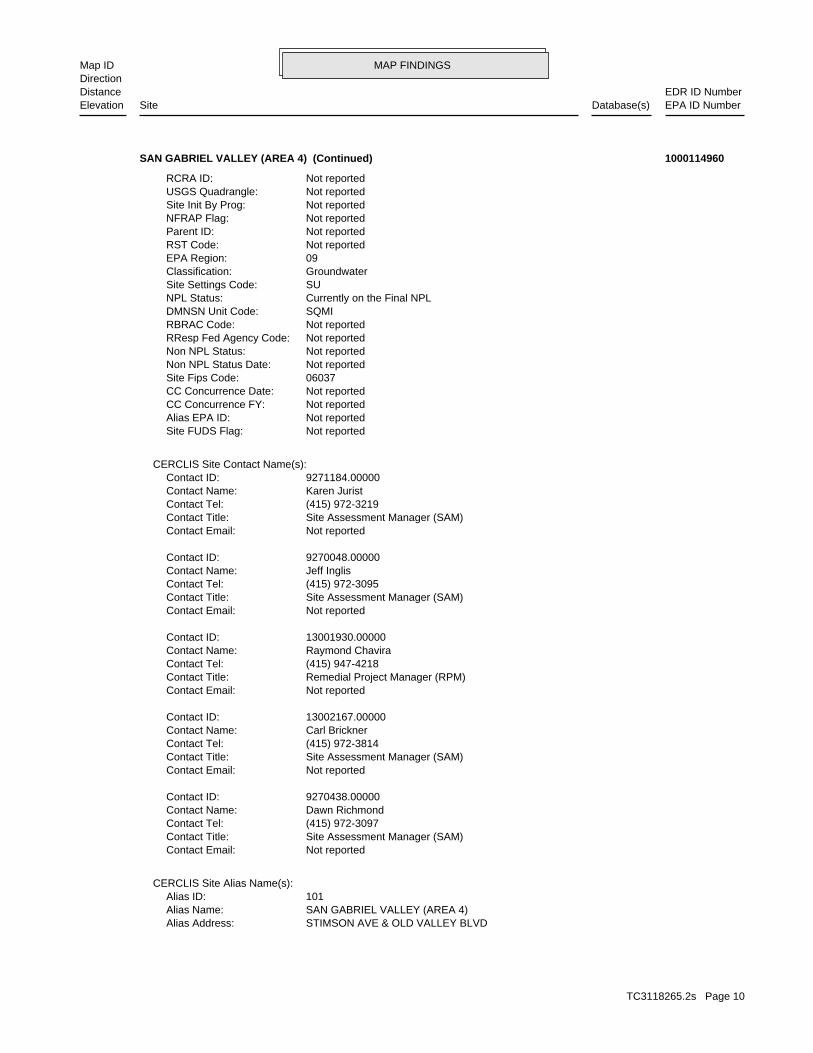
MAP FINDINGSMap IDDirection
EDR ID NumberDistanceEPA ID NumberDatabase(s)SiteElevation
STIMSON AVE & OLD VALLEY BLVDAlias Address: SAN GABRIEL VALLEY (AREA 4)Alias Name: 101Alias ID:
CERCLIS Site Alias Name(s):
Not reportedContact Email: Site Assessment Manager (SAM)Contact Title: (415) 972-3097Contact Tel: Dawn RichmondContact Name: 9270438.00000Contact ID:
Not reportedContact Email: Site Assessment Manager (SAM)Contact Title: (415) 972-3814Contact Tel: Carl BricknerContact Name: 13002167.00000Contact ID:
Not reportedContact Email: Remedial Project Manager (RPM)Contact Title: (415) 947-4218Contact Tel: Raymond ChaviraContact Name: 13001930.00000Contact ID:
Not reportedContact Email: Site Assessment Manager (SAM)Contact Title: (415) 972-3095Contact Tel: Jeff InglisContact Name: 9270048.00000Contact ID:
Not reportedContact Email: Site Assessment Manager (SAM)Contact Title: (415) 972-3219Contact Tel: Karen JuristContact Name: 9271184.00000Contact ID:
CERCLIS Site Contact Name(s):
Not reportedSite FUDS Flag: Not reportedAlias EPA ID: Not reportedCC Concurrence FY: Not reportedCC Concurrence Date: 06037Site Fips Code: Not reportedNon NPL Status Date: Not reportedNon NPL Status: Not reportedRResp Fed Agency Code: Not reportedRBRAC Code: SQMIDMNSN Unit Code: Currently on the Final NPLNPL Status: SUSite Settings Code: GroundwaterClassification: 09EPA Region: Not reportedRST Code: Not reportedParent ID: Not reportedNFRAP Flag: Not reportedSite Init By Prog: Not reportedUSGS Quadrangle: Not reportedRCRA ID:
SAN GABRIEL VALLEY (AREA 4) (Continued) 1000114960
TC3118265.2s Page 10
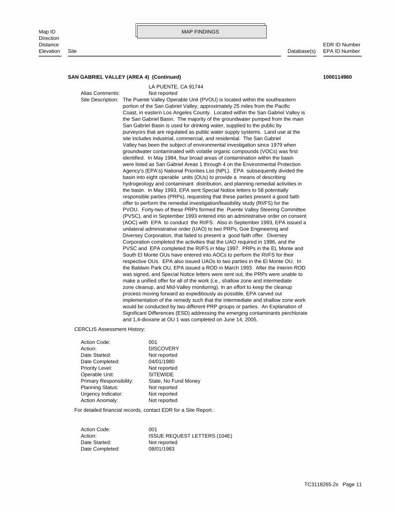
MAP FINDINGSMap IDDirection
EDR ID NumberDistanceEPA ID NumberDatabase(s)SiteElevation
08/01/1983Date Completed: Not reportedDate Started: ISSUE REQUEST LETTERS (104E)Action: 001Action Code:
For detailed financial records, contact EDR for a Site Report.:
Not reportedAction Anomaly: Not reportedUrgency Indicator: Not reportedPlanning Status: State, No Fund MoneyPrimary Responsibility: SITEWIDEOperable Unit: Not reportedPriority Level: 04/01/1980Date Completed: Not reportedDate Started: DISCOVERYAction: 001Action Code:
CERCLIS Assessment History:
and 1,4-dioxane at OU 1 was completed on June 14, 2005.Significant Differences (ESD) addressing the emerging contaminants perchloratewould be conducted by two different PRP groups or parties. An Explanation ofimplementation of the remedy such that the intermediate and shallow zone workprocess moving forward as expeditiously as possible, EPA carved outzone cleanup, and Mid-Valley monitoring). In an effort to keep the cleanupmake a unified offer for all of the work (i.e., shallow zone and intermediatewas signed, and Special Notice letters were sent out, the PRPs were unable tothe Baldwin Park OU, EPA issued a ROD in March 1993. After the Interim RODrespective OUs. EPA also issued UAOs to two parties in the El Monte OU. InSouth El Monte OUs have entered into AOCs to perform the RI/FS for theirPVSC and EPA completed the RI/FS in May 1997. PRPs in the EL Monte andCorporation completed the activities that the UAO required in 1996, and theDiversey Corporation, that failed to present a good faith offer. Diverseyunilateral administrative order (UAO) to two PRPs, Goe Engineering and(AOC) with EPA to conduct the RI/FS. Also in September 1993, EPA issued a(PVSC), and in September 1993 entered into an administrative order on consentPVOU. Forty-two of these PRPs formed the Puente Valley Steering Committeeoffer to perform the remedial investigation/feasibility study (RI/FS) for theresponsible parties (PRPs), requesting that these parties present a good faiththe basin. In May 1993, EPA sent Special Notice letters to 58 potentiallyhydrogeology and contaminant distribution, and planning remedial activities inbasin into eight operable units (OUs) to provide a means of describingAgency’s (EPA’s) National Priorities List (NPL). EPA subsequently divided thewere listed as San Gabriel Areas 1 through 4 on the Environmental Protectionidentified. In May 1984, four broad areas of contamination within the basingroundwater contaminated with volatile organic compounds (VOCs) was firstValley has been the subject of environmental investigation since 1979 whensite includes industrial, commercial, and residential. The San Gabrielpurveyors that are regulated as public water supply systems. Land use at theSan Gabriel Basin is used for drinking water, supplied to the public bythe San Gabriel Basin. The majority of the groundwater pumped from the mainCoast, in eastern Los Angeles County. Located within the San Gabriel Valley isportion of the San Gabriel Valley, approximately 25 miles from the PacificThe Puente Valley Operable Unit (PVOU) is located within the southeasternSite Description: Not reportedAlias Comments: LA PUENTE, CA 91744
SAN GABRIEL VALLEY (AREA 4) (Continued) 1000114960
TC3118265.2s Page 11
MAP FINDINGSMap IDDirection
EDR ID NumberDistanceEPA ID NumberDatabase(s)SiteElevation
EPA Fund-FinancedPrimary Responsibility: SITEWIDEOperable Unit: Higher priority for further assessmentPriority Level: 09/01/1983Date Completed: Not reportedDate Started: PRELIMINARY ASSESSMENTAction: 001Action Code:
For detailed financial records, contact EDR for a Site Report.:
Not reportedAction Anomaly: Not reportedUrgency Indicator: Not reportedPlanning Status: EPA Fund-FinancedPrimary Responsibility: SITEWIDEOperable Unit: Not reportedPriority Level: 09/01/1983Date Completed: Not reportedDate Started: HAZARD RANKING SYSTEM PACKAGEAction: 001Action Code:
For detailed financial records, contact EDR for a Site Report.:
Not reportedAction Anomaly: Not reportedUrgency Indicator: Not reportedPlanning Status: State, Fund FinancedPrimary Responsibility: SITEWIDEOperable Unit: Higher priority for further assessmentPriority Level: 09/01/1983Date Completed: 03/01/1983Date Started: SITE INSPECTIONAction: 001Action Code:
For detailed financial records, contact EDR for a Site Report.:
Not reportedAction Anomaly: Not reportedUrgency Indicator: Not reportedPlanning Status: EPA Fund-FinancedPrimary Responsibility: SITEWIDEOperable Unit: Higher priority for further assessmentPriority Level: 09/01/1983Date Completed: 03/01/1983Date Started: SITE INSPECTIONAction: 002Action Code:
For detailed financial records, contact EDR for a Site Report.:
Not reportedAction Anomaly: Not reportedUrgency Indicator: Not reportedPlanning Status: Federal EnforcementPrimary Responsibility: SITEWIDEOperable Unit: Not reportedPriority Level:
SAN GABRIEL VALLEY (AREA 4) (Continued) 1000114960
TC3118265.2s Page 12
MAP FINDINGSMap IDDirection
EDR ID NumberDistanceEPA ID NumberDatabase(s)SiteElevation
Not reportedAction Anomaly: Not reportedUrgency Indicator: Not reportedPlanning Status: Federal EnforcementPrimary Responsibility: SITEWIDEOperable Unit: Not reportedPriority Level: 12/30/1988Date Completed: Not reportedDate Started: ISSUE REQUEST LETTERS (104E)Action: 003Action Code:
For detailed financial records, contact EDR for a Site Report.:
Not reportedAction Anomaly: Not reportedUrgency Indicator: Not reportedPlanning Status: EPA Fund-FinancedPrimary Responsibility: SITEWIDEOperable Unit: Not reportedPriority Level: 05/08/1984Date Completed: Not reportedDate Started: FINAL LISTING ON NATIONAL PRIORITIES LISTAction: 001Action Code:
For detailed financial records, contact EDR for a Site Report.:
Not reportedAction Anomaly: Not reportedUrgency Indicator: Not reportedPlanning Status: Federal EnforcementPrimary Responsibility: SITEWIDEOperable Unit: Not reportedPriority Level: 01/01/1984Date Completed: Not reportedDate Started: ISSUE REQUEST LETTERS (104E)Action: 002Action Code:
For detailed financial records, contact EDR for a Site Report.:
Not reportedAction Anomaly: Not reportedUrgency Indicator: Not reportedPlanning Status: EPA Fund-FinancedPrimary Responsibility: SITEWIDEOperable Unit: Not reportedPriority Level: 09/08/1983Date Completed: Not reportedDate Started: PROPOSAL TO NATIONAL PRIORITIES LISTAction: 001Action Code:
For detailed financial records, contact EDR for a Site Report.:
Not reportedAction Anomaly: Not reportedUrgency Indicator: Not reportedPlanning Status:
SAN GABRIEL VALLEY (AREA 4) (Continued) 1000114960
TC3118265.2s Page 13
MAP FINDINGSMap IDDirection
EDR ID NumberDistanceEPA ID NumberDatabase(s)SiteElevation
For detailed financial records, contact EDR for a Site Report.:
Not reportedAction Anomaly: Not reportedUrgency Indicator: Not reportedPlanning Status: EPA Fund-FinancedPrimary Responsibility: SITEWIDEOperable Unit: Not reportedPriority Level: 07/09/1990Date Completed: Not reportedDate Started: Notice Letters IssuedAction: 014Action Code:
For detailed financial records, contact EDR for a Site Report.:
Not reportedAction Anomaly: Not reportedUrgency Indicator: Not reportedPlanning Status: Federal EnforcementPrimary Responsibility: SITEWIDEOperable Unit: Not reportedPriority Level: 06/08/1990Date Completed: Not reportedDate Started: ISSUE REQUEST LETTERS (104E)Action: 004Action Code:
For detailed financial records, contact EDR for a Site Report.:
Not reportedAction Anomaly: Not reportedUrgency Indicator: Not reportedPlanning Status: EPA Fund-FinancedPrimary Responsibility: SITEWIDEOperable Unit: Not reportedPriority Level: 06/07/1990Date Completed: Not reportedDate Started: Notice Letters IssuedAction: 012Action Code:
For detailed financial records, contact EDR for a Site Report.:
Not reportedAction Anomaly: Not reportedUrgency Indicator: Not reportedPlanning Status: EPA Fund-FinancedPrimary Responsibility: SITEWIDEOperable Unit: Not reportedPriority Level: 05/07/1990Date Completed: Not reportedDate Started: Notice Letters IssuedAction: 010Action Code:
For detailed financial records, contact EDR for a Site Report.:
SAN GABRIEL VALLEY (AREA 4) (Continued) 1000114960
TC3118265.2s Page 14

MAP FINDINGSMap IDDirection
EDR ID NumberDistanceEPA ID NumberDatabase(s)SiteElevation
Not reportedDate Started: Notice Letters IssuedAction: 022Action Code:
For detailed financial records, contact EDR for a Site Report.:
Not reportedAction Anomaly: Not reportedUrgency Indicator: Not reportedPlanning Status: EPA Fund-FinancedPrimary Responsibility: SITEWIDEOperable Unit: Not reportedPriority Level: 12/06/1990Date Completed: Not reportedDate Started: Notice Letters IssuedAction: 021Action Code:
For detailed financial records, contact EDR for a Site Report.:
Not reportedAction Anomaly: Not reportedUrgency Indicator: Not reportedPlanning Status: EPA Fund-FinancedPrimary Responsibility: SITEWIDEOperable Unit: Not reportedPriority Level: 12/05/1990Date Completed: Not reportedDate Started: Notice Letters IssuedAction: 020Action Code:
For detailed financial records, contact EDR for a Site Report.:
Not reportedAction Anomaly: Not reportedUrgency Indicator: Not reportedPlanning Status: EPA Fund-FinancedPrimary Responsibility: SITEWIDEOperable Unit: Not reportedPriority Level: 10/12/1990Date Completed: Not reportedDate Started: Notice Letters IssuedAction: 019Action Code:
For detailed financial records, contact EDR for a Site Report.:
Not reportedAction Anomaly: Not reportedUrgency Indicator: Not reportedPlanning Status: EPA Fund-FinancedPrimary Responsibility: SITEWIDEOperable Unit: Not reportedPriority Level: 09/20/1990Date Completed: Not reportedDate Started: Notice Letters IssuedAction: 017Action Code:
SAN GABRIEL VALLEY (AREA 4) (Continued) 1000114960
TC3118265.2s Page 15
MAP FINDINGSMap IDDirection
EDR ID NumberDistanceEPA ID NumberDatabase(s)SiteElevation
SITEWIDEOperable Unit: Not reportedPriority Level: 07/03/1991Date Completed: Not reportedDate Started: Notice Letters IssuedAction: 013Action Code:
For detailed financial records, contact EDR for a Site Report.:
Not reportedAction Anomaly: Not reportedUrgency Indicator: Not reportedPlanning Status: EPA Fund-FinancedPrimary Responsibility: SITEWIDEOperable Unit: Not reportedPriority Level: 03/15/1991Date Completed: Not reportedDate Started: Notice Letters IssuedAction: 005Action Code:
For detailed financial records, contact EDR for a Site Report.:
Not reportedAction Anomaly: Not reportedUrgency Indicator: Not reportedPlanning Status: EPA Fund-FinancedPrimary Responsibility: SITEWIDEOperable Unit: Not reportedPriority Level: 03/06/1991Date Completed: Not reportedDate Started: Notice Letters IssuedAction: 004Action Code:
For detailed financial records, contact EDR for a Site Report.:
Not reportedAction Anomaly: Not reportedUrgency Indicator: Not reportedPlanning Status: EPA Fund-FinancedPrimary Responsibility: SITEWIDEOperable Unit: Not reportedPriority Level: 02/07/1991Date Completed: Not reportedDate Started: Notice Letters IssuedAction: 002Action Code:
For detailed financial records, contact EDR for a Site Report.:
Not reportedAction Anomaly: Not reportedUrgency Indicator: Not reportedPlanning Status: EPA Fund-FinancedPrimary Responsibility: SITEWIDEOperable Unit: Not reportedPriority Level: 12/07/1990Date Completed:
SAN GABRIEL VALLEY (AREA 4) (Continued) 1000114960
TC3118265.2s Page 16
MAP FINDINGSMap IDDirection
EDR ID NumberDistanceEPA ID NumberDatabase(s)SiteElevation
Not reportedUrgency Indicator: Not reportedPlanning Status: EPA Fund-FinancedPrimary Responsibility: SITEWIDEOperable Unit: Not reportedPriority Level: 09/16/1992Date Completed: Not reportedDate Started: ECOLOGICAL RISK ASSESSMENTAction: 001Action Code:
For detailed financial records, contact EDR for a Site Report.:
Not reportedAction Anomaly: Not reportedUrgency Indicator: PrimaryPlanning Status: EPA Fund-FinancedPrimary Responsibility: SITEWIDEOperable Unit: Not reportedPriority Level: 12/27/1991Date Completed: 12/27/1991Date Started: REMOVAL ASSESSMENTAction: 001Action Code:
For detailed financial records, contact EDR for a Site Report.:
Not reportedAction Anomaly: Not reportedUrgency Indicator: Not reportedPlanning Status: EPA Fund-FinancedPrimary Responsibility: SITEWIDEOperable Unit: Not reportedPriority Level: 09/26/1991Date Completed: Not reportedDate Started: Notice Letters IssuedAction: 018Action Code:
For detailed financial records, contact EDR for a Site Report.:
Not reportedAction Anomaly: Not reportedUrgency Indicator: Not reportedPlanning Status: EPA Fund-FinancedPrimary Responsibility: SITEWIDEOperable Unit: Not reportedPriority Level: 07/09/1991Date Completed: Not reportedDate Started: Notice Letters IssuedAction: 015Action Code:
For detailed financial records, contact EDR for a Site Report.:
Not reportedAction Anomaly: Not reportedUrgency Indicator: Not reportedPlanning Status: EPA Fund-FinancedPrimary Responsibility:
SAN GABRIEL VALLEY (AREA 4) (Continued) 1000114960
TC3118265.2s Page 17
MAP FINDINGSMap IDDirection
EDR ID NumberDistanceEPA ID NumberDatabase(s)SiteElevation
For detailed financial records, contact EDR for a Site Report.:
Not reportedAction Anomaly: Not reportedUrgency Indicator: Not reportedPlanning Status: EPA Fund-FinancedPrimary Responsibility: SITEWIDEOperable Unit: Not reportedPriority Level: 04/09/1993Date Completed: Not reportedDate Started: Notice Letters IssuedAction: 006Action Code:
For detailed financial records, contact EDR for a Site Report.:
Not reportedAction Anomaly: Not reportedUrgency Indicator: Not reportedPlanning Status: EPA Fund-FinancedPrimary Responsibility: SITEWIDEOperable Unit: Not reportedPriority Level: 02/12/1993Date Completed: Not reportedDate Started: Notice Letters IssuedAction: 003Action Code:
For detailed financial records, contact EDR for a Site Report.:
Not reportedAction Anomaly: Not reportedUrgency Indicator: Not reportedPlanning Status: EPA Fund-FinancedPrimary Responsibility: SITEWIDEOperable Unit: Not reportedPriority Level: 01/12/1993Date Completed: Not reportedDate Started: Notice Letters IssuedAction: 001Action Code:
For detailed financial records, contact EDR for a Site Report.:
Not reportedAction Anomaly: Not reportedUrgency Indicator: Not reportedPlanning Status: EPA Fund-FinancedPrimary Responsibility: SITEWIDEOperable Unit: Not reportedPriority Level: 09/16/1992Date Completed: Not reportedDate Started: RISK/HEALTH ASSESSMENTAction: 001Action Code:
For detailed financial records, contact EDR for a Site Report.:
Not reportedAction Anomaly:
SAN GABRIEL VALLEY (AREA 4) (Continued) 1000114960
TC3118265.2s Page 18
MAP FINDINGSMap IDDirection
EDR ID NumberDistanceEPA ID NumberDatabase(s)SiteElevation
02/03/1994Date Completed: Not reportedDate Started: Special Notice IssuedAction: 001Action Code:
For detailed financial records, contact EDR for a Site Report.:
Not reportedAction Anomaly: Not reportedUrgency Indicator: PrimaryPlanning Status: Federal EnforcementPrimary Responsibility: SITEWIDEOperable Unit: Not reportedPriority Level: 09/30/1993Date Completed: 05/26/1993Date Started: REMEDIAL INVESTIGATION/FEASIBILITY STUDY NEGOTIATIONSAction: 001Action Code:
For detailed financial records, contact EDR for a Site Report.:
Not reportedAction Anomaly: Not reportedUrgency Indicator: PrimaryPlanning Status: Federal EnforcementPrimary Responsibility: SITEWIDEOperable Unit: Not reportedPriority Level: 09/30/1993Date Completed: Not reportedDate Started: ADMINISTRATIVE ORDER ON CONSENTAction: 001Action Code:
For detailed financial records, contact EDR for a Site Report.:
Not reportedAction Anomaly: Not reportedUrgency Indicator: Not reportedPlanning Status: EPA Fund-FinancedPrimary Responsibility: SITEWIDEOperable Unit: Not reportedPriority Level: 05/26/1993Date Completed: Not reportedDate Started: Special Notice IssuedAction: 002Action Code:
For detailed financial records, contact EDR for a Site Report.:
Not reportedAction Anomaly: Not reportedUrgency Indicator: Not reportedPlanning Status: EPA Fund-FinancedPrimary Responsibility: SITEWIDEOperable Unit: Not reportedPriority Level: 05/07/1993Date Completed: Not reportedDate Started: Notice Letters IssuedAction: 011Action Code:
SAN GABRIEL VALLEY (AREA 4) (Continued) 1000114960
TC3118265.2s Page 19
MAP FINDINGSMap IDDirection
EDR ID NumberDistanceEPA ID NumberDatabase(s)SiteElevation
Not reportedUrgency Indicator: Not reportedPlanning Status: EPA Fund-FinancedPrimary Responsibility: SITEWIDEOperable Unit: Not reportedPriority Level: 04/20/1995Date Completed: Not reportedDate Started: Notice Letters IssuedAction: 008Action Code:
For detailed financial records, contact EDR for a Site Report.:
Not reportedAction Anomaly: Not reportedUrgency Indicator: Not reportedPlanning Status: EPA Fund-FinancedPrimary Responsibility: SITEWIDEOperable Unit: Not reportedPriority Level: 04/13/1995Date Completed: Not reportedDate Started: Notice Letters IssuedAction: 007Action Code:
For detailed financial records, contact EDR for a Site Report.:
Not reportedAction Anomaly: Not reportedUrgency Indicator: PrimaryPlanning Status: Federal EnforcementPrimary Responsibility: SITEWIDEOperable Unit: Not reportedPriority Level: 07/01/1994Date Completed: 09/30/1984Date Started: NATIONAL PRIORITIES LIST RESPONSIBLE PARTY SEARCHAction: 001Action Code:
For detailed financial records, contact EDR for a Site Report.:
Not reportedAction Anomaly: Not reportedUrgency Indicator: PrimaryPlanning Status: Federal EnforcementPrimary Responsibility: SITEWIDEOperable Unit: Not reportedPriority Level: 07/01/1994Date Completed: 01/30/1989Date Started: NATIONAL PRIORITIES LIST RESPONSIBLE PARTY SEARCHAction: 002Action Code:
For detailed financial records, contact EDR for a Site Report.:
Not reportedAction Anomaly: Not reportedUrgency Indicator: Not reportedPlanning Status: EPA Fund-FinancedPrimary Responsibility: SITEWIDEOperable Unit: Not reportedPriority Level:
SAN GABRIEL VALLEY (AREA 4) (Continued) 1000114960
TC3118265.2s Page 20

MAP FINDINGSMap IDDirection
EDR ID NumberDistanceEPA ID NumberDatabase(s)SiteElevation
For detailed financial records, contact EDR for a Site Report.:
Not reportedAction Anomaly: Not reportedUrgency Indicator: Not reportedPlanning Status: Federal EnforcementPrimary Responsibility: SITEWIDEOperable Unit: Not reportedPriority Level: 07/02/1997Date Completed: Not reportedDate Started: ADMINISTRATIVE ORDER ON CONSENTAction: 002Action Code:
For detailed financial records, contact EDR for a Site Report.:
Original Action Take OverAction Anomaly: Not reportedUrgency Indicator: PrimaryPlanning Status: Responsible PartyPrimary Responsibility: CD, RD/RA INTERMEDIATE ZONEOperable Unit: Not reportedPriority Level: 12/20/1996Date Completed: 09/30/1993Date Started: STUDY POTENTIALLY RESPONSIBLE PARTY REMEDIAL INVESTIGATION/FEASIBILITYAction: 001Action Code:
For detailed financial records, contact EDR for a Site Report.:
Not reportedAction Anomaly: Not reportedUrgency Indicator: Not reportedPlanning Status: EPA Fund-FinancedPrimary Responsibility: SITEWIDEOperable Unit: Not reportedPriority Level: 08/18/1995Date Completed: Not reportedDate Started: Notice Letters IssuedAction: 016Action Code:
For detailed financial records, contact EDR for a Site Report.:
Not reportedAction Anomaly: Not reportedUrgency Indicator: Not reportedPlanning Status: EPA Fund-FinancedPrimary Responsibility: SITEWIDEOperable Unit: Not reportedPriority Level: 05/05/1995Date Completed: Not reportedDate Started: Notice Letters IssuedAction: 009Action Code:
For detailed financial records, contact EDR for a Site Report.:
Not reportedAction Anomaly:
SAN GABRIEL VALLEY (AREA 4) (Continued) 1000114960
TC3118265.2s Page 21

MAP FINDINGSMap IDDirection
EDR ID NumberDistanceEPA ID NumberDatabase(s)SiteElevation
09/28/2000Date Completed: 10/01/1999Date Started: NATIONAL PRIORITIES LIST RESPONSIBLE PARTY SEARCHAction: 003Action Code:
For detailed financial records, contact EDR for a Site Report.:
Not reportedAction Anomaly: Not reportedUrgency Indicator: Not reportedPlanning Status: Federal EnforcementPrimary Responsibility: SITEWIDEOperable Unit: Not reportedPriority Level: 09/14/1999Date Completed: Not reportedDate Started: ADMINISTRATIVE ORDER ON CONSENTAction: 004Action Code:
For detailed financial records, contact EDR for a Site Report.:
Not reportedAction Anomaly: Not reportedUrgency Indicator: PrimaryPlanning Status: Federal EnforcementPrimary Responsibility: SITEWIDEOperable Unit: Not reportedPriority Level: 09/30/1998Date Completed: Not reportedDate Started: RECORD OF DECISIONAction: 001Action Code:
For detailed financial records, contact EDR for a Site Report.:
New Action Resulting from Take OverAction Anomaly: Not reportedUrgency Indicator: PrimaryPlanning Status: EPA Fund-FinancedPrimary Responsibility: SITEWIDEOperable Unit: Not reportedPriority Level: 09/30/1998Date Completed: 12/20/1996Date Started: COMBINED REMEDIAL INVESTIGATION/FEASIBILITY STUDYAction: 001Action Code:
For detailed financial records, contact EDR for a Site Report.:
Not reportedAction Anomaly: Not reportedUrgency Indicator: Not reportedPlanning Status: Federal EnforcementPrimary Responsibility: SITEWIDEOperable Unit: Not reportedPriority Level: 02/25/1998Date Completed: Not reportedDate Started: ADMINISTRATIVE ORDER ON CONSENTAction: 003Action Code:
SAN GABRIEL VALLEY (AREA 4) (Continued) 1000114960
TC3118265.2s Page 22
MAP FINDINGSMap IDDirection
EDR ID NumberDistanceEPA ID NumberDatabase(s)SiteElevation
PrimaryPlanning Status: Federal EnforcementPrimary Responsibility: SITEWIDEOperable Unit: Not reportedPriority Level: 03/21/2002Date Completed: 09/28/2000Date Started: REMEDIAL DESIGN/REMEDIAL ACTION NEGOTIATIONSAction: 001Action Code:
For detailed financial records, contact EDR for a Site Report.:
Not reportedAction Anomaly: Not reportedUrgency Indicator: Not reportedPlanning Status: Federal EnforcementPrimary Responsibility: CD, RD/RA INTERMEDIATE ZONEOperable Unit: Not reportedPriority Level: 03/21/2002Date Completed: Not reportedDate Started: UNILATERAL ADMIN ORDERAction: 002Action Code:
For detailed financial records, contact EDR for a Site Report.:
Not reportedAction Anomaly: Not reportedUrgency Indicator: Not reportedPlanning Status: Federal EnforcementPrimary Responsibility: CD, RD/RA SHALLOW ZONEOperable Unit: Not reportedPriority Level: 09/27/2001Date Completed: 09/28/2000Date Started: REMEDIAL DESIGN/REMEDIAL ACTION NEGOTIATIONSAction: 002Action Code:
For detailed financial records, contact EDR for a Site Report.:
Not reportedAction Anomaly: Not reportedUrgency Indicator: Not reportedPlanning Status: Federal EnforcementPrimary Responsibility: CD, RD/RA SHALLOW ZONEOperable Unit: Not reportedPriority Level: 09/13/2001Date Completed: Not reportedDate Started: UNILATERAL ADMIN ORDERAction: 001Action Code:
For detailed financial records, contact EDR for a Site Report.:
Not reportedAction Anomaly: Not reportedUrgency Indicator: Not reportedPlanning Status: Federal EnforcementPrimary Responsibility: SITEWIDEOperable Unit: Search Complete, Viable PRPsPriority Level:
SAN GABRIEL VALLEY (AREA 4) (Continued) 1000114960
TC3118265.2s Page 23
MAP FINDINGSMap IDDirection
EDR ID NumberDistanceEPA ID NumberDatabase(s)SiteElevation
For detailed financial records, contact EDR for a Site Report.:
Not reportedAction Anomaly: Not reportedUrgency Indicator: Not reportedPlanning Status: Federal EnforcementPrimary Responsibility: SITEWIDEOperable Unit: Not reportedPriority Level: 06/14/2005Date Completed: Not reportedDate Started: Explanation Of Significant DifferencesAction: 001Action Code:
For detailed financial records, contact EDR for a Site Report.:
Not reportedAction Anomaly: Not reportedUrgency Indicator: Not reportedPlanning Status: Federal EnforcementPrimary Responsibility: SITEWIDEOperable Unit: Not reportedPriority Level: 07/31/2003Date Completed: Not reportedDate Started: Lodged By DOJAction: 002Action Code:
For detailed financial records, contact EDR for a Site Report.:
Not reportedAction Anomaly: Not reportedUrgency Indicator: Not reportedPlanning Status: Federal EnforcementPrimary Responsibility: SITEWIDEOperable Unit: Not reportedPriority Level: 04/22/2003Date Completed: Not reportedDate Started: Lodged By DOJAction: 010Action Code:
For detailed financial records, contact EDR for a Site Report.:
Not reportedAction Anomaly: Not reportedUrgency Indicator: Not reportedPlanning Status: Federal EnforcementPrimary Responsibility: SITEWIDEOperable Unit: Not reportedPriority Level: 05/16/2002Date Completed: Not reportedDate Started: Lodged By DOJAction: 011Action Code:
For detailed financial records, contact EDR for a Site Report.:
Not reportedAction Anomaly: Not reportedUrgency Indicator:
SAN GABRIEL VALLEY (AREA 4) (Continued) 1000114960
TC3118265.2s Page 24
MAP FINDINGSMap IDDirection
EDR ID NumberDistanceEPA ID NumberDatabase(s)SiteElevation
Not reportedPriority Level: 02/27/2006Date Completed: 07/25/2005Date Started: POTENTIALLY RESPONSIBLE PARTY REMEDIAL DESIGNAction: 002Action Code:
For detailed financial records, contact EDR for a Site Report.:
Not reportedAction Anomaly: Not reportedUrgency Indicator: Not reportedPlanning Status: Responsible PartyPrimary Responsibility: CD, RD/RA SHALLOW ZONEOperable Unit: Not reportedPriority Level: Not reportedDate Completed: 02/27/2006Date Started: POTENTIALLY RESPONSIBLE PARTY REMEDIAL ACTIONAction: 002Action Code:
For detailed financial records, contact EDR for a Site Report.:
Not reportedAction Anomaly: Not reportedUrgency Indicator: PrimaryPlanning Status: Federal EnforcementPrimary Responsibility: SITEWIDEOperable Unit: Not reportedPriority Level: 09/08/2005Date Completed: 06/11/2003Date Started: CONSENT DECREEAction: 001Action Code:
For detailed financial records, contact EDR for a Site Report.:
Original Action Take OverAction Anomaly: Not reportedUrgency Indicator: PrimaryPlanning Status: EPA Fund-FinancedPrimary Responsibility: CD, RD/RA SHALLOW ZONEOperable Unit: Not reportedPriority Level: 07/25/2005Date Completed: 09/27/2001Date Started: REMEDIAL DESIGNAction: 001Action Code:
For detailed financial records, contact EDR for a Site Report.:
Not reportedAction Anomaly: Not reportedUrgency Indicator: Not reportedPlanning Status: Federal EnforcementPrimary Responsibility: SITEWIDEOperable Unit: Not reportedPriority Level: 06/25/2005Date Completed: 08/22/2003Date Started: CONSENT DECREEAction: 005Action Code:
SAN GABRIEL VALLEY (AREA 4) (Continued) 1000114960
TC3118265.2s Page 25
MAP FINDINGSMap IDDirection
EDR ID NumberDistanceEPA ID NumberDatabase(s)SiteElevation
Not reportedUrgency Indicator: Not reportedPlanning Status: Federal EnforcementPrimary Responsibility: SITEWIDEOperable Unit: Not reportedPriority Level: 11/02/2006Date Completed: Not reportedDate Started: Lodged By DOJAction: 005Action Code:
For detailed financial records, contact EDR for a Site Report.:
Not reportedAction Anomaly: Not reportedUrgency Indicator: Not reportedPlanning Status: Federal EnforcementPrimary Responsibility: SITEWIDEOperable Unit: Not reportedPriority Level: 11/02/2006Date Completed: Not reportedDate Started: Lodged By DOJAction: 006Action Code:
For detailed financial records, contact EDR for a Site Report.:
Not reportedAction Anomaly: Not reportedUrgency Indicator: Not reportedPlanning Status: Federal EnforcementPrimary Responsibility: CD, RD/RA SHALLOW ZONEOperable Unit: Not reportedPriority Level: 04/28/2006Date Completed: 07/25/2005Date Started: CONSENT DECREEAction: 006Action Code:
For detailed financial records, contact EDR for a Site Report.:
Not reportedAction Anomaly: Not reportedUrgency Indicator: Not reportedPlanning Status: Federal EnforcementPrimary Responsibility: CD, RD/RA SHALLOW ZONEOperable Unit: Not reportedPriority Level: 04/24/2006Date Completed: Not reportedDate Started: Lodged By DOJAction: 003Action Code:
For detailed financial records, contact EDR for a Site Report.:
New Action Resulting from Take OverAction Anomaly: Not reportedUrgency Indicator: Not reportedPlanning Status: Responsible PartyPrimary Responsibility: CD, RD/RA SHALLOW ZONEOperable Unit:
SAN GABRIEL VALLEY (AREA 4) (Continued) 1000114960
TC3118265.2s Page 26
MAP FINDINGSMap IDDirection
EDR ID NumberDistanceEPA ID NumberDatabase(s)SiteElevation
For detailed financial records, contact EDR for a Site Report.:
Not reportedAction Anomaly: Not reportedUrgency Indicator: Not reportedPlanning Status: Federal EnforcementPrimary Responsibility: SITEWIDEOperable Unit: Not reportedPriority Level: 11/29/2007Date Completed: Not reportedDate Started: Lodged By DOJAction: 007Action Code:
For detailed financial records, contact EDR for a Site Report.:
Not reportedAction Anomaly: Not reportedUrgency Indicator: Not reportedPlanning Status: Federal EnforcementPrimary Responsibility: SITEWIDEOperable Unit: Not reportedPriority Level: 08/30/2007Date Completed: Not reportedDate Started: Lodged By DOJAction: 008Action Code:
For detailed financial records, contact EDR for a Site Report.:
Not reportedAction Anomaly: Not reportedUrgency Indicator: Not reportedPlanning Status: Federal EnforcementPrimary Responsibility: SITEWIDEOperable Unit: Not reportedPriority Level: 04/17/2007Date Completed: 09/26/2006Date Started: CONSENT DECREEAction: 008Action Code:
For detailed financial records, contact EDR for a Site Report.:
Not reportedAction Anomaly: Not reportedUrgency Indicator: Not reportedPlanning Status: Federal EnforcementPrimary Responsibility: SITEWIDEOperable Unit: Not reportedPriority Level: 01/29/2007Date Completed: 09/26/2006Date Started: CONSENT DECREEAction: 007Action Code:
For detailed financial records, contact EDR for a Site Report.:
Not reportedAction Anomaly:
SAN GABRIEL VALLEY (AREA 4) (Continued) 1000114960
TC3118265.2s Page 27
MAP FINDINGSMap IDDirection
EDR ID NumberDistanceEPA ID NumberDatabase(s)SiteElevation
05/01/1984Date Started: COMMUNITY INVOLVEMENTAction: 001Action Code:
For detailed financial records, contact EDR for a Site Report.:
Not reportedAction Anomaly: Not reportedUrgency Indicator: Not reportedPlanning Status: Federal EnforcementPrimary Responsibility: SITEWIDEOperable Unit: Not reportedPriority Level: 10/27/2008Date Completed: Not reportedDate Started: CONSENT DECREEAction: 010Action Code:
For detailed financial records, contact EDR for a Site Report.:
Not reportedAction Anomaly: Not reportedUrgency Indicator: Not reportedPlanning Status: Not reportedPrimary Responsibility: SITEWIDEOperable Unit: Not reportedPriority Level: 09/02/2008Date Completed: Not reportedDate Started: Lodged By DOJAction: 009Action Code:
For detailed financial records, contact EDR for a Site Report.:
Not reportedAction Anomaly: Not reportedUrgency Indicator: Not reportedPlanning Status: Federal EnforcementPrimary Responsibility: SITEWIDEOperable Unit: Not reportedPriority Level: 02/05/2008Date Completed: 08/21/2007Date Started: CONSENT DECREEAction: 003Action Code:
For detailed financial records, contact EDR for a Site Report.:
Not reportedAction Anomaly: Not reportedUrgency Indicator: Not reportedPlanning Status: Federal EnforcementPrimary Responsibility: SITEWIDEOperable Unit: Not reportedPriority Level: 12/26/2007Date Completed: 07/27/2007Date Started: CONSENT DECREEAction: 009Action Code:
SAN GABRIEL VALLEY (AREA 4) (Continued) 1000114960
TC3118265.2s Page 28

MAP FINDINGSMap IDDirection
EDR ID NumberDistanceEPA ID NumberDatabase(s)SiteElevation
Responsible PartyPrimary Responsibility: CD, RD/RA INTERMEDIATE ZONEOperable Unit: Not reportedPriority Level: Not reportedDate Completed: 07/21/2009Date Started: POTENTIALLY RESPONSIBLE PARTY REMEDIAL ACTIONAction: 001Action Code:
For detailed financial records, contact EDR for a Site Report.:
Not reportedAction Anomaly: Not reportedUrgency Indicator: Not reportedPlanning Status: Federal EnforcementPrimary Responsibility: SITEWIDEOperable Unit: Not reportedPriority Level: 04/27/2009Date Completed: 09/29/2008Date Started: CONSENT DECREEAction: 011Action Code:
For detailed financial records, contact EDR for a Site Report.:
Not reportedAction Anomaly: Not reportedUrgency Indicator: Not reportedPlanning Status: Federal EnforcementPrimary Responsibility: SITEWIDEOperable Unit: Not reportedPriority Level: 02/25/2009Date Completed: Not reportedDate Started: Lodged By DOJAction: 012Action Code:
For detailed financial records, contact EDR for a Site Report.:
Not reportedAction Anomaly: Not reportedUrgency Indicator: Not reportedPlanning Status: Federal EnforcementPrimary Responsibility: CD, RD/RA INTERMEDIATE ZONEOperable Unit: Not reportedPriority Level: 02/11/2009Date Completed: Not reportedDate Started: Lodged By DOJAction: 004Action Code:
For detailed financial records, contact EDR for a Site Report.:
Not reportedAction Anomaly: Not reportedUrgency Indicator: PrimaryPlanning Status: EPA Fund-FinancedPrimary Responsibility: SITEWIDEOperable Unit: Not reportedPriority Level: 10/28/2008Date Completed:
SAN GABRIEL VALLEY (AREA 4) (Continued) 1000114960
TC3118265.2s Page 29
MAP FINDINGSMap IDDirection
EDR ID NumberDistanceEPA ID NumberDatabase(s)SiteElevation
For detailed financial records, contact EDR for a Site Report.:
Not reportedAction Anomaly: Not reportedUrgency Indicator: Not reportedPlanning Status: Federal EnforcementPrimary Responsibility: SITEWIDEOperable Unit: Not reportedPriority Level: 09/29/2009Date Completed: Not reportedDate Started: Notice of Intent by All PartiesAction: 001Action Code:
For detailed financial records, contact EDR for a Site Report.:
Not reportedAction Anomaly: Not reportedUrgency Indicator: Not reportedPlanning Status: Federal EnforcementPrimary Responsibility: SITEWIDEOperable Unit: Not reportedPriority Level: 09/24/2009Date Completed: Not reportedDate Started: UNILATERAL ADMIN ORDERAction: 003Action Code:
For detailed financial records, contact EDR for a Site Report.:
Not reportedAction Anomaly: Not reportedUrgency Indicator: Not reportedPlanning Status: Federal EnforcementPrimary Responsibility: CD, RD/RA INTERMEDIATE ZONEOperable Unit: Not reportedPriority Level: 08/21/2009Date Completed: 09/29/2008Date Started: CONSENT DECREEAction: 002Action Code:
For detailed financial records, contact EDR for a Site Report.:
Not reportedAction Anomaly: Not reportedUrgency Indicator: PrimaryPlanning Status: Responsible PartyPrimary Responsibility: CD, RD/RA INTERMEDIATE ZONEOperable Unit: Not reportedPriority Level: 07/21/2009Date Completed: 03/29/2002Date Started: POTENTIALLY RESPONSIBLE PARTY REMEDIAL DESIGNAction: 001Action Code:
For detailed financial records, contact EDR for a Site Report.:
Not reportedAction Anomaly: Long Term ActionUrgency Indicator: PrimaryPlanning Status:
SAN GABRIEL VALLEY (AREA 4) (Continued) 1000114960
TC3118265.2s Page 30
MAP FINDINGSMap IDDirection
EDR ID NumberDistanceEPA ID NumberDatabase(s)SiteElevation
UV OxidationEngineering Control: GroundwaterContaminated Media : 00Operable Unit: 3/31/2005Planned Complet. date: 6/14/2005Action Completion date: Explanation Of Significant DifferencesAction Name: 001Action ID:
Ion ExchangeEngineering Control: GroundwaterContaminated Media : 00Operable Unit: 3/31/2005Planned Complet. date: 6/14/2005Action Completion date: Explanation Of Significant DifferencesAction Name: 001Action ID:
Carbon AdsorptionEngineering Control: GroundwaterContaminated Media : 00Operable Unit: 3/31/2005Planned Complet. date: 6/14/2005Action Completion date: Explanation Of Significant DifferencesAction Name: 001Action ID:
Biological Treatment, (N.O.S.)Engineering Control: GroundwaterContaminated Media : 00Operable Unit: 3/31/2005Planned Complet. date: 6/14/2005Action Completion date: Explanation Of Significant DifferencesAction Name: 001Action ID:
Not reportedActual Date: Not reportedEvent Code: LOS ANGELESCounty: 09EPA Region: LA PUENTE, CA 91744 STIMSON AVE & OLD VALLEY BLVDAddress: SAN GABRIEL VALLEY (AREA 4)Name: 0902091Site ID: CAD980817985EPA ID:
US ENG CONTROLS:
2715 additional US CERCLIS Financial: record(s) in the EDR Site Report.Click this hyperlink while viewing on your computer to access
40674Page Number: 48Fed Register Volume: 09/08/1983Fed Register Date:
19480Page Number: 49Fed Register Volume: 05/08/1984Fed Register Date:
Federal Register Details:
SAN GABRIEL VALLEY (AREA 4) (Continued) 1000114960
TC3118265.2s Page 31

MAP FINDINGSMap IDDirection
EDR ID NumberDistanceEPA ID NumberDatabase(s)SiteElevation
001Action ID:
Pump And TreatEngineering Control: GroundwaterContaminated Media : 00Operable Unit: 9/30/1998Planned Complet. date: 9/30/1998Action Completion date: RECORD OF DECISIONAction Name: 001Action ID:
Natural AttenuationEngineering Control: GroundwaterContaminated Media : 00Operable Unit: 9/30/1998Planned Complet. date: 9/30/1998Action Completion date: RECORD OF DECISIONAction Name: 001Action ID:
MonitoringEngineering Control: GroundwaterContaminated Media : 00Operable Unit: 9/30/1998Planned Complet. date: 9/30/1998Action Completion date: RECORD OF DECISIONAction Name: 001Action ID:
ExtractionEngineering Control: GroundwaterContaminated Media : 00Operable Unit: 9/30/1998Planned Complet. date: 9/30/1998Action Completion date: RECORD OF DECISIONAction Name: 001Action ID:
DischargeEngineering Control: GroundwaterContaminated Media : 00Operable Unit: 9/30/1998Planned Complet. date: 9/30/1998Action Completion date: RECORD OF DECISIONAction Name: 001Action ID:
Carbon AdsorptionEngineering Control: GroundwaterContaminated Media : 00Operable Unit: 9/30/1998Planned Complet. date: 9/30/1998Action Completion date: RECORD OF DECISIONAction Name: 001Action ID:
Air StrippingEngineering Control: GroundwaterContaminated Media : 00Operable Unit: 9/30/1998Planned Complet. date: 9/30/1998Action Completion date: RECORD OF DECISIONAction Name: 001Action ID:
SAN GABRIEL VALLEY (AREA 4) (Continued) 1000114960
TC3118265.2s Page 32
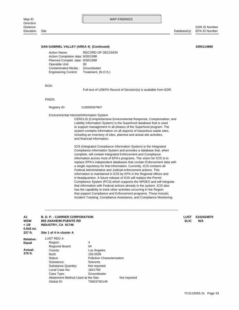
MAP FINDINGSMap IDDirection
EDR ID NumberDistanceEPA ID NumberDatabase(s)SiteElevation
Incident Tracking, Compliance Assistance, and Compliance Monitoring.that support Compliance and Enforcement programs. These include;has the capability to track other activities occurring in the Regionthat information with Federal actions already in the system. ICIS alsoCompliance System (PCS) which supports the NPDES and will integrateit Headquarters. A future release of ICIS will replace the Permitinformation is maintained in ICIS by EPA in the Regional offices andFederal Administrative and Judicial enforcement actions. Thisa single repository for that information. Currently, ICIS contains allreplace EPA’s independent databases that contain Enforcement data withinformation across most of EPA’s programs. The vision for ICIS is tocomplete, will contain integrated Enforcement and ComplianceCompliance Information System and provides a database that, whenICIS (Integrated Compliance Information System) is the Integrated
and financial information.including an inventory of sites, planned and actual site activities,system contains information on all aspects of hazardous waste sites,to support management in all phases of the Superfund program. TheLiability Information System) is the Superfund database that is usedCERCLIS (Comprehensive Environmental Response, Compensation, and Environmental Interest/Information System
110009267907Registry ID:
FINDS:
Full-text of USEPA Record of Decision(s) is available from EDR.ROD:
Treatment, (N.O.S.)Engineering Control: GroundwaterContaminated Media : 00Operable Unit: 9/30/1998Planned Complet. date: 9/30/1998Action Completion date: RECORD OF DECISIONAction Name:
SAN GABRIEL VALLEY (AREA 4) (Continued) 1000114960
T0603700149Global ID: Not reportedAbatement Method Used at the Site: GroundwaterCase Type: 1841700Local Case No: Not reportedSubstance Quantity: SolventsSubstance: Pollution CharacterizationStatus: 105.0036facid: Los AngelesCounty: 04Regional Board: 4Region:
LUST REG 4:
227 ft. Site 1 of 4 in cluster A0.043 mi.
Relative:Equal
Actual:375 ft.
< 1/8 INDUSTRY, CA 91746WSW SLIC855 ANAHEIM-PUENTE RD N/AA1 LUSTB. D. P. - CARRIER CORPORATION S102424870
TC3118265.2s Page 33
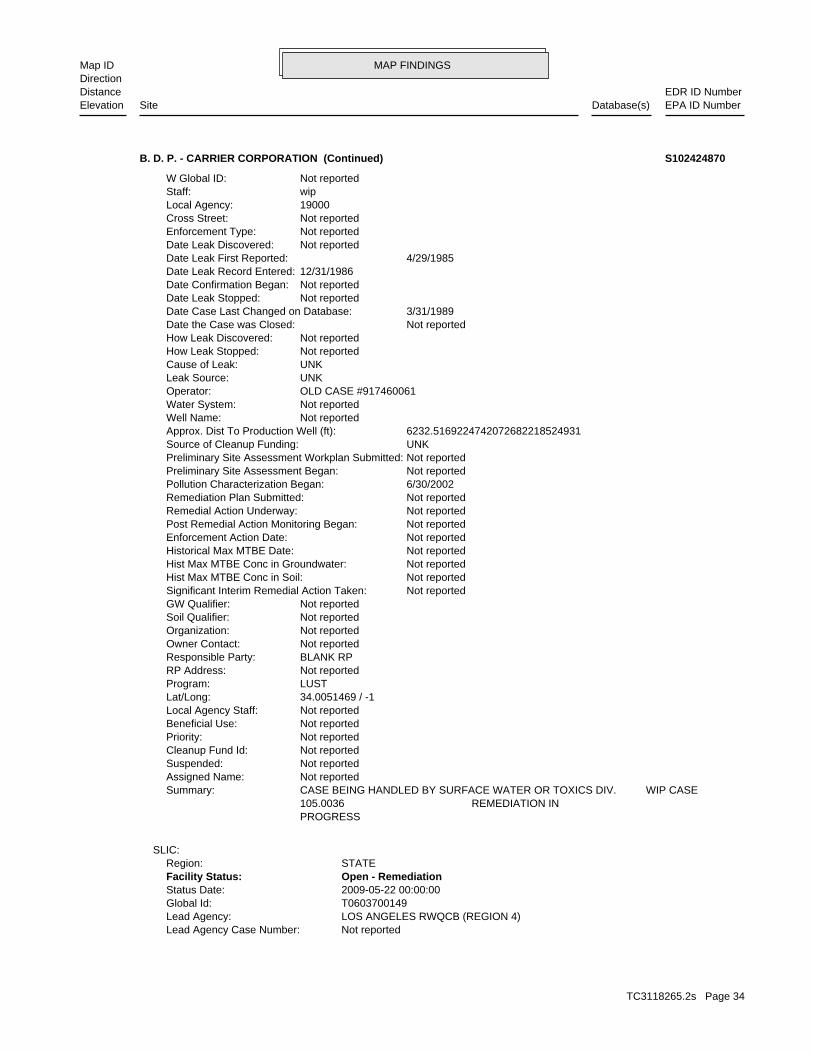
MAP FINDINGSMap IDDirection
EDR ID NumberDistanceEPA ID NumberDatabase(s)SiteElevation
Not reportedLead Agency Case Number: LOS ANGELES RWQCB (REGION 4)Lead Agency: T0603700149Global Id: 2009-05-22 00:00:00Status Date: Open - RemediationFacility Status: STATERegion:
SLIC:
PROGRESS 105.0036 REMEDIATION IN CASE BEING HANDLED BY SURFACE WATER OR TOXICS DIV. WIP CASESummary: Not reportedAssigned Name: Not reportedSuspended: Not reportedCleanup Fund Id: Not reportedPriority: Not reportedBeneficial Use: Not reportedLocal Agency Staff: 34.0051469 / -1Lat/Long: LUSTProgram: Not reportedRP Address: BLANK RPResponsible Party: Not reportedOwner Contact: Not reportedOrganization: Not reportedSoil Qualifier: Not reportedGW Qualifier: Not reportedSignificant Interim Remedial Action Taken: Not reportedHist Max MTBE Conc in Soil: Not reportedHist Max MTBE Conc in Groundwater: Not reportedHistorical Max MTBE Date: Not reportedEnforcement Action Date: Not reportedPost Remedial Action Monitoring Began: Not reportedRemedial Action Underway: Not reportedRemediation Plan Submitted: 6/30/2002Pollution Characterization Began: Not reportedPreliminary Site Assessment Began: Not reportedPreliminary Site Assessment Workplan Submitted: UNKSource of Cleanup Funding: 6232.5169224742072682218524931Approx. Dist To Production Well (ft): Not reportedWell Name: Not reportedWater System: OLD CASE #917460061Operator: UNKLeak Source: UNKCause of Leak: Not reportedHow Leak Stopped: Not reportedHow Leak Discovered: Not reportedDate the Case was Closed: 3/31/1989Date Case Last Changed on Database: Not reportedDate Leak Stopped: Not reportedDate Confirmation Began: 12/31/1986Date Leak Record Entered: 4/29/1985Date Leak First Reported: Not reportedDate Leak Discovered: Not reportedEnforcement Type: Not reportedCross Street: 19000Local Agency: wipStaff: Not reportedW Global ID:
B. D. P. - CARRIER CORPORATION (Continued) S102424870
TC3118265.2s Page 34
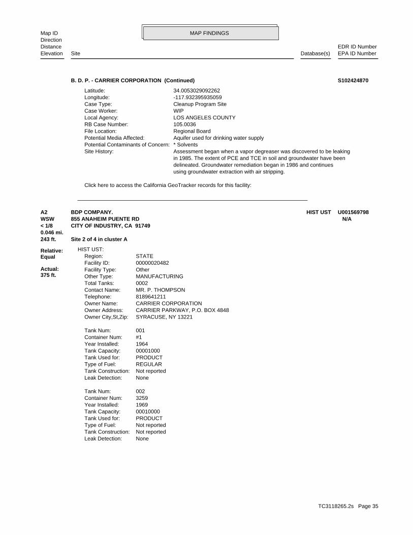
MAP FINDINGSMap IDDirection
EDR ID NumberDistanceEPA ID NumberDatabase(s)SiteElevation
Click here to access the California GeoTracker records for this facility:
using groundwater extraction with air stripping. delineated. Groundwater remediation began in 1986 and continues in 1985. The extent of PCE and TCE in soil and groundwater have been Assessment began when a vapor degreaser was discovered to be leakingSite History: * SolventsPotential Contaminants of Concern: Aquifer used for drinking water supplyPotential Media Affected: Regional BoardFile Location: 105.0036RB Case Number: LOS ANGELES COUNTYLocal Agency: WIPCase Worker: Cleanup Program SiteCase Type: -117.932395935059Longitude: 34.0053029092262Latitude:
B. D. P. - CARRIER CORPORATION (Continued) S102424870
NoneLeak Detection: Not reportedTank Construction: Not reportedType of Fuel: PRODUCTTank Used for: 00010000Tank Capacity: 1969Year Installed: 3259Container Num: 002Tank Num:
NoneLeak Detection: Not reportedTank Construction: REGULARType of Fuel: PRODUCTTank Used for: 00001000Tank Capacity: 1964Year Installed: #1Container Num: 001Tank Num:
SYRACUSE, NY 13221Owner City,St,Zip: CARRIER PARKWAY, P.O. BOX 4848Owner Address: CARRIER CORPORATIONOwner Name: 8189641211Telephone: MR. P. THOMPSONContact Name: 0002Total Tanks: MANUFACTURINGOther Type: OtherFacility Type: 00000020482Facility ID: STATERegion:
HIST UST:
243 ft. Site 2 of 4 in cluster A0.046 mi.
Relative:Equal
Actual:375 ft.
< 1/8 CITY OF INDUSTRY, CA 91749WSW 855 ANAHEIM PUENTE RD N/AA2 HIST USTBDP COMPANY. U001569798
TC3118265.2s Page 35
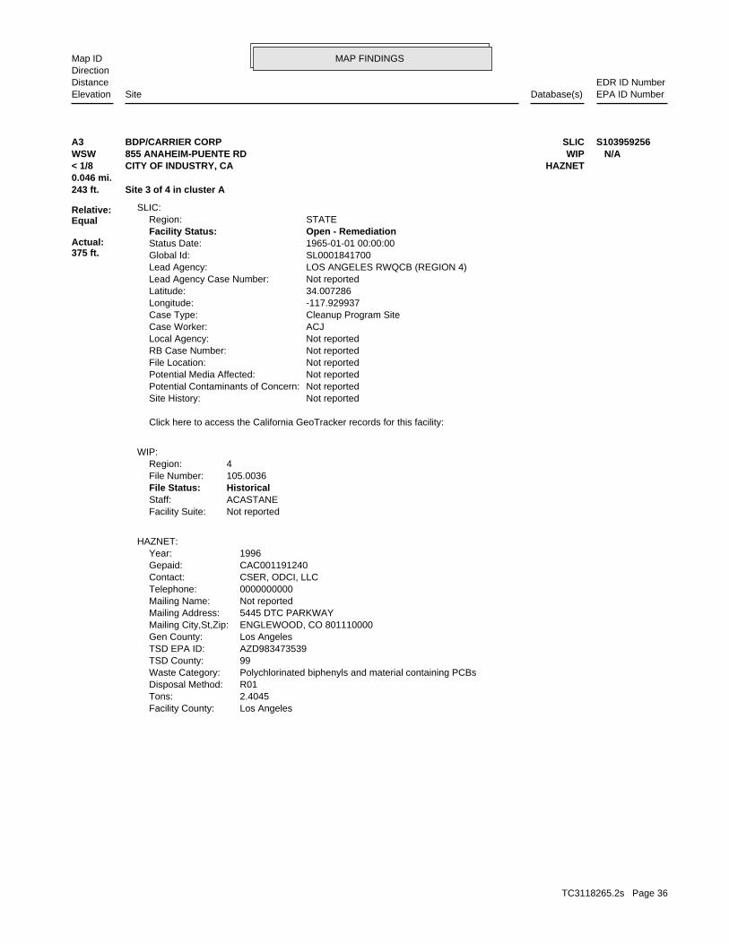
MAP FINDINGSMap IDDirection
EDR ID NumberDistanceEPA ID NumberDatabase(s)SiteElevation
Los AngelesFacility County: 2.4045Tons: R01Disposal Method: Polychlorinated biphenyls and material containing PCBsWaste Category: 99TSD County: AZD983473539TSD EPA ID: Los AngelesGen County: ENGLEWOOD, CO 801110000Mailing City,St,Zip: 5445 DTC PARKWAYMailing Address: Not reportedMailing Name: 0000000000Telephone: CSER, ODCI, LLCContact: CAC001191240Gepaid: 1996Year:
HAZNET:
Not reportedFacility Suite:ACASTANEStaff:HistoricalFile Status:105.0036File Number:4Region:
WIP:
Click here to access the California GeoTracker records for this facility:
Not reportedSite History: Not reportedPotential Contaminants of Concern: Not reportedPotential Media Affected: Not reportedFile Location: Not reportedRB Case Number: Not reportedLocal Agency: ACJCase Worker: Cleanup Program SiteCase Type: -117.929937Longitude: 34.007286Latitude: Not reportedLead Agency Case Number: LOS ANGELES RWQCB (REGION 4)Lead Agency: SL0001841700Global Id: 1965-01-01 00:00:00Status Date: Open - RemediationFacility Status: STATERegion:
SLIC:
243 ft. Site 3 of 4 in cluster A0.046 mi.
Relative:Equal
Actual:375 ft.
< 1/8 HAZNETCITY OF INDUSTRY, CA WSW WIP855 ANAHEIM-PUENTE RD N/AA3 SLICBDP/CARRIER CORP S103959256
TC3118265.2s Page 36
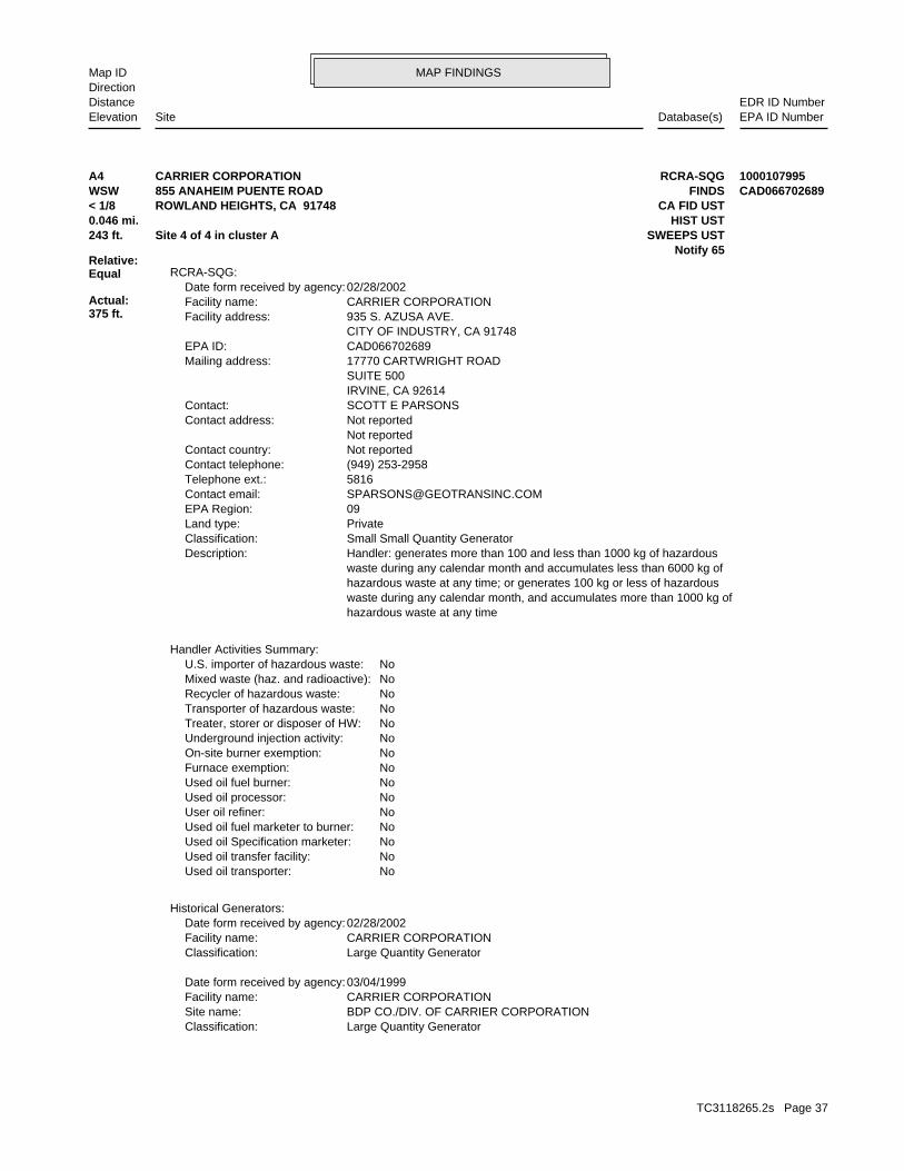
MAP FINDINGSMap IDDirection
EDR ID NumberDistanceEPA ID NumberDatabase(s)SiteElevation
Large Quantity GeneratorClassification: BDP CO./DIV. OF CARRIER CORPORATIONSite name: CARRIER CORPORATIONFacility name: 03/04/1999Date form received by agency:
Large Quantity GeneratorClassification: CARRIER CORPORATIONFacility name: 02/28/2002Date form received by agency:
Historical Generators:
NoUsed oil transporter: NoUsed oil transfer facility: NoUsed oil Specification marketer: NoUsed oil fuel marketer to burner: NoUser oil refiner: NoUsed oil processor: NoUsed oil fuel burner: NoFurnace exemption: NoOn-site burner exemption: NoUnderground injection activity: NoTreater, storer or disposer of HW: NoTransporter of hazardous waste: NoRecycler of hazardous waste: NoMixed waste (haz. and radioactive): NoU.S. importer of hazardous waste:
Handler Activities Summary:
hazardous waste at any time waste during any calendar month, and accumulates more than 1000 kg of hazardous waste at any time; or generates 100 kg or less of hazardous waste during any calendar month and accumulates less than 6000 kg of Handler: generates more than 100 and less than 1000 kg of hazardousDescription: Small Small Quantity GeneratorClassification: PrivateLand type: 09EPA Region: [email protected] email: 5816Telephone ext.: (949) 253-2958Contact telephone: Not reportedContact country: Not reported Not reportedContact address: SCOTT E PARSONSContact: IRVINE, CA 92614 SUITE 500 17770 CARTWRIGHT ROADMailing address: CAD066702689EPA ID: CITY OF INDUSTRY, CA 91748 935 S. AZUSA AVE.Facility address: CARRIER CORPORATIONFacility name: 02/28/2002Date form received by agency:
RCRA-SQG:
Notify 65243 ft. SWEEPS USTSite 4 of 4 in cluster A0.046 mi. HIST UST
Relative:Equal
Actual:375 ft.
< 1/8 CA FID USTROWLAND HEIGHTS, CA 91748WSW FINDS855 ANAHEIM PUENTE ROAD CAD066702689A4 RCRA-SQGCARRIER CORPORATION 1000107995
TC3118265.2s Page 37
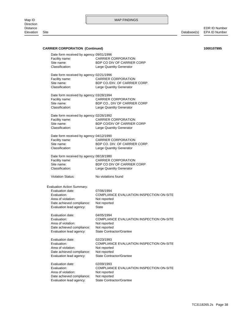
MAP FINDINGSMap IDDirection
EDR ID NumberDistanceEPA ID NumberDatabase(s)SiteElevation
State Contractor/GranteeEvaluation lead agency: Not reportedDate achieved compliance: Not reportedArea of violation: COMPLIANCE EVALUATION INSPECTION ON-SITEEvaluation: 02/09/1993Evaluation date:
State Contractor/GranteeEvaluation lead agency: Not reportedDate achieved compliance: Not reportedArea of violation: COMPLIANCE EVALUATION INSPECTION ON-SITEEvaluation: 02/23/1993Evaluation date:
State Contractor/GranteeEvaluation lead agency: Not reportedDate achieved compliance: Not reportedArea of violation: COMPLIANCE EVALUATION INSPECTION ON-SITEEvaluation: 04/05/1994Evaluation date:
StateEvaluation lead agency: Not reportedDate achieved compliance: Not reportedArea of violation: COMPLIANCE EVALUATION INSPECTION ON-SITEEvaluation: 07/06/1994Evaluation date:
Evaluation Action Summary:
No violations foundViolation Status:
Large Quantity GeneratorClassification: BDP CO DIV OF CARRIER CORPSite name: CARRIER CORPORATIONFacility name: 08/18/1980Date form received by agency:
Large Quantity GeneratorClassification: BDP CO. DIV. OF CARRIER CORP.Site name: CARRIER CORPORATIONFacility name: 04/12/1990Date form received by agency:
Large Quantity GeneratorClassification: BDP CO/DIV OF CARRIER CORPSite name: CARRIER CORPORATIONFacility name: 02/26/1992Date form received by agency:
Large Quantity GeneratorClassification: BDP CO., DIV OF CARRIER CORPSite name: CARRIER CORPORATIONFacility name: 03/28/1994Date form received by agency:
Large Quantity GeneratorClassification: BDP CO./DIV. OF CARRIER CORP.Site name: CARRIER CORPORATIONFacility name: 02/21/1996Date form received by agency:
Large Quantity GeneratorClassification: BDP CO DIV OF CARRIER CORPSite name: CARRIER CORPORATIONFacility name: 09/01/1996Date form received by agency:
CARRIER CORPORATION (Continued) 1000107995
TC3118265.2s Page 38
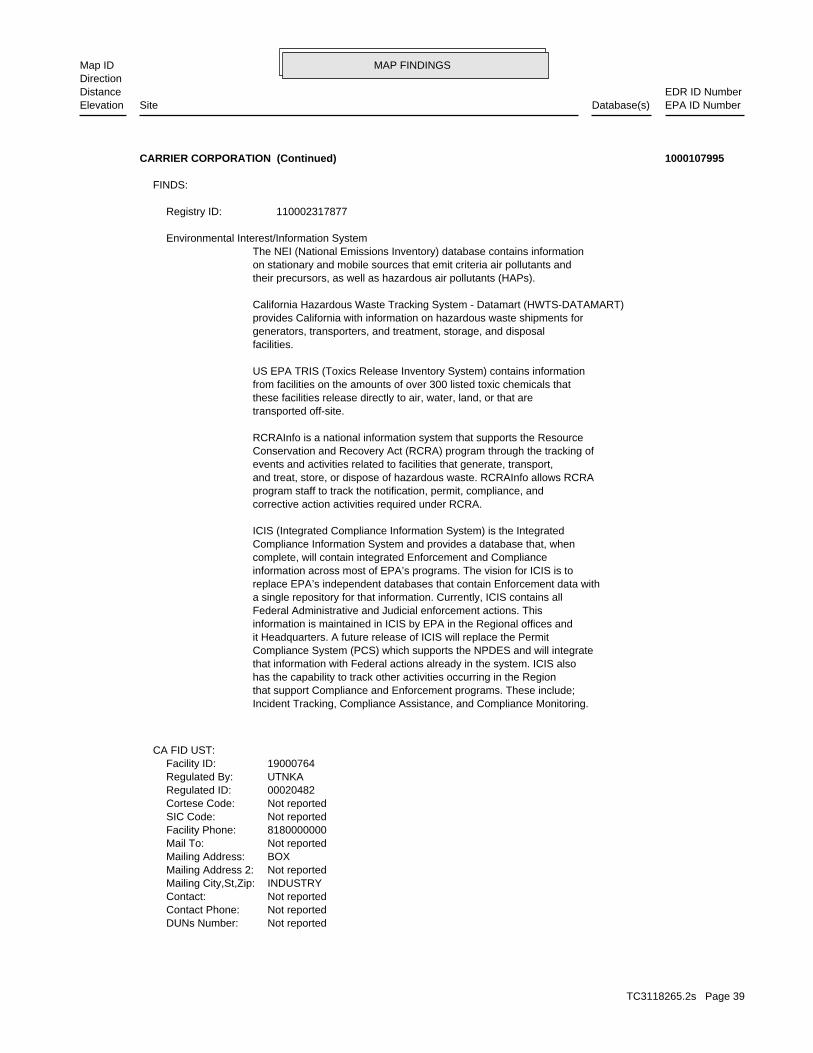
MAP FINDINGSMap IDDirection
EDR ID NumberDistanceEPA ID NumberDatabase(s)SiteElevation
Not reportedDUNs Number: Not reportedContact Phone: Not reportedContact: INDUSTRYMailing City,St,Zip: Not reportedMailing Address 2: BOXMailing Address: Not reportedMail To: 8180000000Facility Phone: Not reportedSIC Code: Not reportedCortese Code: 00020482Regulated ID: UTNKARegulated By: 19000764Facility ID:
CA FID UST:
Incident Tracking, Compliance Assistance, and Compliance Monitoring.that support Compliance and Enforcement programs. These include;has the capability to track other activities occurring in the Regionthat information with Federal actions already in the system. ICIS alsoCompliance System (PCS) which supports the NPDES and will integrateit Headquarters. A future release of ICIS will replace the Permitinformation is maintained in ICIS by EPA in the Regional offices andFederal Administrative and Judicial enforcement actions. Thisa single repository for that information. Currently, ICIS contains allreplace EPA’s independent databases that contain Enforcement data withinformation across most of EPA’s programs. The vision for ICIS is tocomplete, will contain integrated Enforcement and ComplianceCompliance Information System and provides a database that, whenICIS (Integrated Compliance Information System) is the Integrated
corrective action activities required under RCRA.program staff to track the notification, permit, compliance, andand treat, store, or dispose of hazardous waste. RCRAInfo allows RCRAevents and activities related to facilities that generate, transport,Conservation and Recovery Act (RCRA) program through the tracking ofRCRAInfo is a national information system that supports the Resource
transported off-site.these facilities release directly to air, water, land, or that arefrom facilities on the amounts of over 300 listed toxic chemicals thatUS EPA TRIS (Toxics Release Inventory System) contains information
facilities.generators, transporters, and treatment, storage, and disposalprovides California with information on hazardous waste shipments forCalifornia Hazardous Waste Tracking System - Datamart (HWTS-DATAMART)
their precursors, as well as hazardous air pollutants (HAPs).on stationary and mobile sources that emit criteria air pollutants andThe NEI (National Emissions Inventory) database contains information Environmental Interest/Information System
110002317877Registry ID:
FINDS:
CARRIER CORPORATION (Continued) 1000107995
TC3118265.2s Page 39

MAP FINDINGSMap IDDirection
EDR ID NumberDistanceEPA ID NumberDatabase(s)SiteElevation
Not reportedStaff Initials: Not reportedDate Reported:
Notify 65:
Not reportedNumber Of Tanks: Not reportedContent: Not reportedStg: Not reportedTank Use: Not reportedCapacity: Not reportedActv Date: Not reportedSwrcb Tank Id: Not reportedOwner Tank Id: Not reportedTank Status: 06-30-89Created Date: Not reportedAct Date: 06-30-89Ref Date: Not reportedBoard Of Equalization: 9Number: 3836Comp Number: AStatus:
SWEEPS UST:
NoneLeak Detection: 6 inchesTank Construction: Not reportedType of Fuel: WASTETank Used for: 00015000Tank Capacity: 1956Year Installed: 2Container Num: 002Tank Num:
NoneLeak Detection: 6 inchesTank Construction: Not reportedType of Fuel: PRODUCTTank Used for: 00008000Tank Capacity: 1956Year Installed: 1Container Num: 001Tank Num:
SYRACUSE, NY 13221Owner City,St,Zip: CARRIER PARKWAY, P.O. BOX 4808Owner Address: CARRIER CORPORATIONOwner Name: 8189641211Telephone: MR. P. THOMPSON, PLANT MANAGERContact Name: 0002Total Tanks: MANUFACTURINGOther Type: OtherFacility Type: 00000050560Facility ID: STATERegion:
HIST UST:
ActiveStatus: Not reportedComments: Not reportedEPA ID: Not reportedNPDES Number:
CARRIER CORPORATION (Continued) 1000107995
TC3118265.2s Page 40

MAP FINDINGSMap IDDirection
EDR ID NumberDistanceEPA ID NumberDatabase(s)SiteElevation
91748-1032Incident Description: Not reportedDischarge Date: Not reportedFacility Type: Not reportedBoard File Number:
CARRIER CORPORATION (Continued) 1000107995
Not reportedFacility Suite:DKOOStaff:HistoricalFile Status:105.0162File Number:4Region:
WIP:
586 ft. Site 1 of 3 in cluster B0.111 mi.
Relative:Equal
Actual:375 ft.
< 1/8 CITY OF INDUSTRY (CORPORATE NA, CA 91748NE 17251 CHESTNUT ST N/AB5 WIPM.G. ENGINEERING CO. S106764883
USOwner/operator country: INDUSTRY, CA 91748 17251 CHESTNUT STOwner/operator address: RICHARD KREPSOwner/operator name:
Owner/Operator Summary:
100 kg of that material at any time hazardous waste during any calendar month, and accumulates more than from the cleanup of a spill, into or on any land or water, of acutely of any residue or contaminated soil, waste or other debris resulting kg of acutely hazardous waste at any time; or generates 100 kg or less hazardous waste during any calendar month, and accumulates more than 1 waste during any calendar month; or generates 1 kg or less of acutely cleanup of a spill, into or on any land or water, of acutely hazardous residue or contaminated soil, waste or other debris resulting from the during any calendar month; or generates more than 100 kg of any calendar month; or generates more than 1 kg of acutely hazardous waste Handler: generates 1,000 kg or more of hazardous waste during anyDescription: Large Quantity GeneratorClassification: 09EPA Region: Not reportedContact email: (626) 913-1562Contact telephone: Not reportedContact country: Not reported Not reportedContact address: RANDALL L KREPSContact: CAL000043537EPA ID: CITY OF INDUSTRY, CA 91748 17251 CHESTNUT ST.Facility address: MG ENGINEERINGFacility name: 02/27/2008Date form received by agency:
RCRA-LQG:
586 ft. Site 2 of 3 in cluster B0.111 mi.
Relative:Equal
Actual:375 ft.
< 1/8 INDUSTRY, CA 91748NE 17251 CHESTNUT ST CAL000043537B6 RCRA-LQGMG ENGINEERING 1008194472
TC3118265.2s Page 41

MAP FINDINGSMap IDDirection
EDR ID NumberDistanceEPA ID NumberDatabase(s)SiteElevation
MG ENGINEERINGFacility name: 02/24/2004Date form received by agency:
Historical Generators:
NoUsed oil transporter: NoUsed oil transfer facility: NoUsed oil Specification marketer: NoUsed oil fuel marketer to burner: NoUser oil refiner: NoUsed oil processor: NoUsed oil fuel burner: NoFurnace exemption: NoOn-site burner exemption: NoUnderground injection activity: NoTreater, storer or disposer of HW: NoTransporter of hazardous waste: NoRecycler of hazardous waste: NoMixed waste (haz. and radioactive): NoU.S. importer of hazardous waste:
Handler Activities Summary:
Not reportedOwner/Op end date: 07/01/1985Owner/Op start date: OperatorOwner/Operator Type: PrivateLegal status: Not reportedOwner/operator telephone: USOwner/operator country: Not reported Not reportedOwner/operator address: RANDALL KREPSOwner/operator name:
Not reportedOwner/Op end date: 10/01/1965Owner/Op start date: OwnerOwner/Operator Type: PrivateLegal status: Not reportedOwner/operator telephone: USOwner/operator country: CITY OF INDUSTRY, CA 91748 17251 CHESTNUT STOwner/operator address: RICHARD KREPSOwner/operator name:
Not reportedOwner/Op end date: 06/22/1990Owner/Op start date: OperatorOwner/Operator Type: PrivateLegal status: Not reportedOwner/operator telephone: USOwner/operator country: Not reported Not reportedOwner/operator address: MG ENGINEERINGOwner/operator name:
Not reportedOwner/Op end date: 10/01/1965Owner/Op start date: OwnerOwner/Operator Type: PrivateLegal status: Not reportedOwner/operator telephone:
MG ENGINEERING (Continued) 1008194472
TC3118265.2s Page 42

MAP FINDINGSMap IDDirection
EDR ID NumberDistanceEPA ID NumberDatabase(s)SiteElevation
No violations foundViolation Status:
CHROMIUMWaste name: D007Waste code:
CHROMIUMWaste name: D007Waste code:
Hazardous Waste Summary:
Small Quantity GeneratorClassification: MG ENGINEERINGFacility name: 02/24/2004Date form received by agency:
Large Quantity GeneratorClassification:
MG ENGINEERING (Continued) 1008194472
Not reportedFacility Suite:DKOOStaff:HistoricalFile Status:105.0104File Number:4Region:
WIP:
608 ft. Site 3 of 3 in cluster B0.115 mi.
Relative:Lower
Actual:374 ft.
< 1/8 CITY OF INDUSTRY (CORPORATE NA, CA 91748NE 17253 CHESTNUT ST N/AB7 WIPG.S. BATTERY, INC. S106764842
hazardous waste at any time waste during any calendar month, and accumulates more than 1000 kg of hazardous waste at any time; or generates 100 kg or less of hazardous waste during any calendar month and accumulates less than 6000 kg of Handler: generates more than 100 and less than 1000 kg of hazardousDescription: Small Small Quantity GeneratorClassification: 09EPA Region: Not reportedContact email: (818) 965-1415Contact telephone: USContact country: INDUSTRY, CA 91748 948 S AZUSAContact address: MAURO ANTENUCCIContact: INDUSTRY, CA 91748 S AZUSAMailing address: CAD983587270EPA ID: INDUSTRY, CA 91748 948 S AZUSAFacility address: TONYS 76 SVCFacility name: 07/03/1991Date form received by agency:
RCRA-SQG:
779 ft. Site 1 of 5 in cluster C0.148 mi.
Relative:Higher
Actual:380 ft.
1/8-1/4 CITY OF INDUSTRY, CA 91748SSW FINDS948 S AZUSA CAD983587270C8 RCRA-SQGTONYS 76 SVC 1000594843
TC3118265.2s Page 43
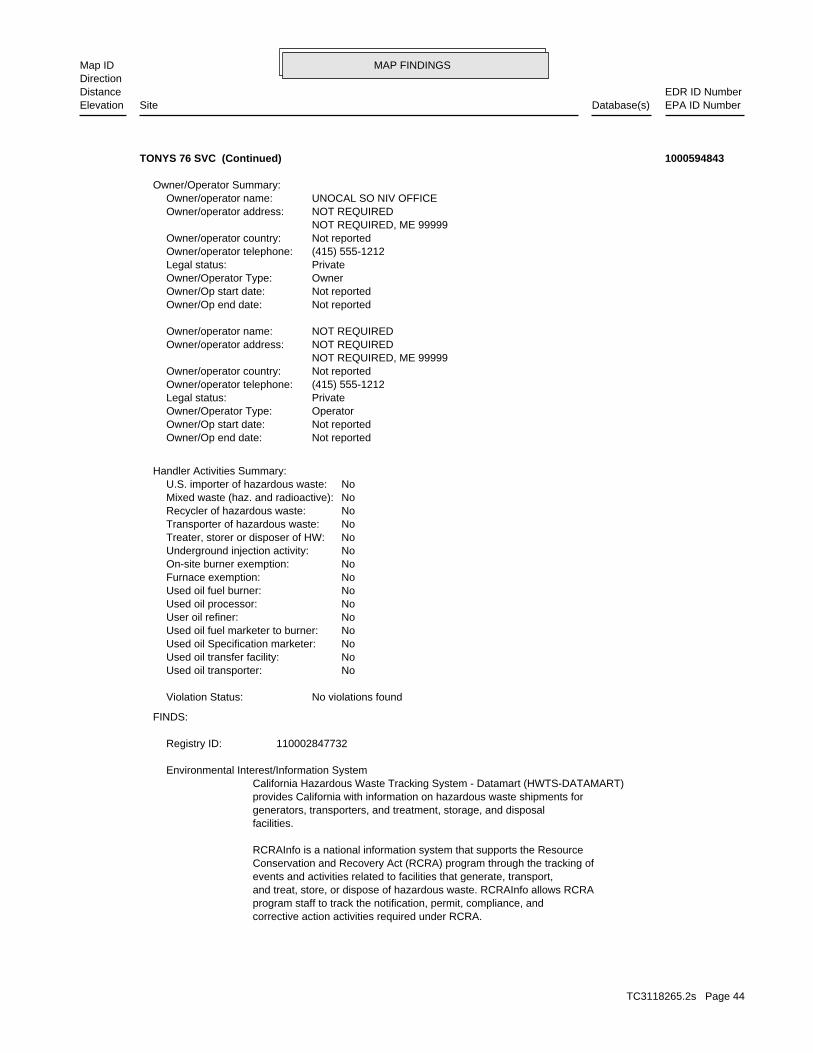
MAP FINDINGSMap IDDirection
EDR ID NumberDistanceEPA ID NumberDatabase(s)SiteElevation
corrective action activities required under RCRA.program staff to track the notification, permit, compliance, andand treat, store, or dispose of hazardous waste. RCRAInfo allows RCRAevents and activities related to facilities that generate, transport,Conservation and Recovery Act (RCRA) program through the tracking ofRCRAInfo is a national information system that supports the Resource
facilities.generators, transporters, and treatment, storage, and disposalprovides California with information on hazardous waste shipments forCalifornia Hazardous Waste Tracking System - Datamart (HWTS-DATAMART) Environmental Interest/Information System
110002847732Registry ID:
FINDS:
No violations foundViolation Status:
NoUsed oil transporter: NoUsed oil transfer facility: NoUsed oil Specification marketer: NoUsed oil fuel marketer to burner: NoUser oil refiner: NoUsed oil processor: NoUsed oil fuel burner: NoFurnace exemption: NoOn-site burner exemption: NoUnderground injection activity: NoTreater, storer or disposer of HW: NoTransporter of hazardous waste: NoRecycler of hazardous waste: NoMixed waste (haz. and radioactive): NoU.S. importer of hazardous waste:
Handler Activities Summary:
Not reportedOwner/Op end date: Not reportedOwner/Op start date: OperatorOwner/Operator Type: PrivateLegal status: (415) 555-1212Owner/operator telephone: Not reportedOwner/operator country: NOT REQUIRED, ME 99999 NOT REQUIREDOwner/operator address: NOT REQUIREDOwner/operator name:
Not reportedOwner/Op end date: Not reportedOwner/Op start date: OwnerOwner/Operator Type: PrivateLegal status: (415) 555-1212Owner/operator telephone: Not reportedOwner/operator country: NOT REQUIRED, ME 99999 NOT REQUIREDOwner/operator address: UNOCAL SO NIV OFFICEOwner/operator name:
Owner/Operator Summary:
TONYS 76 SVC (Continued) 1000594843
TC3118265.2s Page 44

MAP FINDINGSMap IDDirection
EDR ID NumberDistanceEPA ID NumberDatabase(s)SiteElevation
No violations foundViolation Status:
NoUsed oil transporter: NoUsed oil transfer facility: NoUsed oil Specification marketer: NoUsed oil fuel marketer to burner: NoUser oil refiner: NoUsed oil processor: NoUsed oil fuel burner: NoFurnace exemption: NoOn-site burner exemption: NoUnderground injection activity: NoTreater, storer or disposer of HW: NoTransporter of hazardous waste: NoRecycler of hazardous waste: NoMixed waste (haz. and radioactive): NoU.S. importer of hazardous waste:
Handler Activities Summary:
100 kg of that material at any time hazardous waste during any calendar month, and accumulates more than from the cleanup of a spill, into or on any land or water, of acutely of any residue or contaminated soil, waste or other debris resulting kg of acutely hazardous waste at any time; or generates 100 kg or less hazardous waste during any calendar month, and accumulates more than 1 waste during any calendar month; or generates 1 kg or less of acutely cleanup of a spill, into or on any land or water, of acutely hazardous residue or contaminated soil, waste or other debris resulting from the during any calendar month; or generates more than 100 kg of any calendar month; or generates more than 1 kg of acutely hazardous waste Handler: generates 1,000 kg or more of hazardous waste during anyDescription: Large Quantity GeneratorClassification: 09EPA Region: Not reportedContact email: (714) 428-6572Contact telephone: Not reportedContact country: Not reported Not reportedContact address: STEVE BOYDContact: PHOENIX, AZ 85072 PO BOX 52085Mailing address: CAL000135708EPA ID: CITY OF INDUSTRY, CA 91748 948 AZUSA AVEFacility address: TOSCO 30941Facility name: 02/20/2002Date form received by agency:
RCRA-LQG:
779 ft. Site 2 of 5 in cluster C0.148 mi.
Relative:Higher
Actual:380 ft.
1/8-1/4 CITY OF INDUSTRY, CA 91748SSW 948 AZUSA AVE CAL000135708C9 RCRA-LQGTOSCO 30941 1007200300
TC3118265.2s Page 45
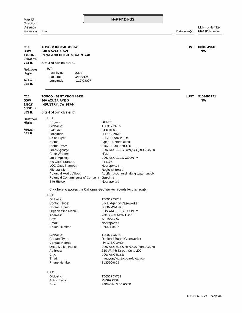
MAP FINDINGSMap IDDirection
EDR ID NumberDistanceEPA ID NumberDatabase(s)SiteElevation
-117.93007Longitude:34.00498Latitude:2337Facility ID:
UST:
794 ft. Site 3 of 5 in cluster C0.150 mi.
Relative:Higher
Actual:381 ft.
1/8-1/4 ROWLAND HEIGHTS, CA 91748SSW 948 S AZUSA AVE N/AC10 USTTOSCO/UNOCAL #30941 U004049416
2009-04-15 00:00:00Date: RESPONSEAction Type: T0603703739Global Id:
LUST:
2135766658Phone Number: [email protected]: LOS ANGELESCity: 320 W. 4th Street, Suite 200Address: LOS ANGELES RWQCB (REGION 4)Organization Name: HA D. NGUYENContact Name: Regional Board CaseworkerContact Type: T0603703739Global Id:
6264583507Phone Number: Not reportedEmail: ALHAMBRACity: 900 S FREMONT AVEAddress: LOS ANGELES COUNTYOrganization Name: JOHN AWUJOContact Name: Local Agency CaseworkerContact Type: T0603703739Global Id:
LUST:
Click here to access the California GeoTracker records for this facility:
Not reportedSite History: GasolinePotential Contaminants of Concern: Aquifer used for drinking water supplyPotential Media Affect: Regional BoardFile Location: Not reportedLOC Case Number: I-11103RB Case Number: LOS ANGELES COUNTYLocal Agency: HDNCase Worker: LOS ANGELES RWQCB (REGION 4)Lead Agency: 2007-08-30 00:00:00Status Date: Open - RemediationStatus: LUST Cleanup SiteCase Type: -117.9299475Longitude: 34.004366Latitude: T0603703739Global Id: STATERegion:
LUST:
803 ft. Site 4 of 5 in cluster C0.152 mi.
Relative:Higher
Actual:381 ft.
1/8-1/4 INDUSTRY, CA 91744SSW 948 AZUSA AVE S N/AC11 LUSTTOSCO - 76 STATION #5621 S105693771
TC3118265.2s Page 46
MAP FINDINGSMap IDDirection
EDR ID NumberDistanceEPA ID NumberDatabase(s)SiteElevation
Monitoring Report - QuarterlyAction: 2006-10-15 00:00:00Date: RESPONSEAction Type: T0603703739Global Id:
Monitoring Report - QuarterlyAction: 2005-07-15 00:00:00Date: RESPONSEAction Type: T0603703739Global Id:
Staff LetterAction: 2009-06-15 00:00:00Date: ENFORCEMENTAction Type: T0603703739Global Id:
Monitoring Report - QuarterlyAction: 2008-04-15 00:00:00Date: RESPONSEAction Type: T0603703739Global Id:
Monitoring Report - Semi-AnnuallyAction: 2011-01-15 00:00:00Date: RESPONSEAction Type: T0603703739Global Id:
Monitoring Report - QuarterlyAction: 2002-10-15 00:00:00Date: RESPONSEAction Type: T0603703739Global Id:
Monitoring Report - QuarterlyAction: 2006-01-15 00:00:00Date: RESPONSEAction Type: T0603703739Global Id:
Monitoring Report - QuarterlyAction: 2005-01-15 00:00:00Date: RESPONSEAction Type: T0603703739Global Id:
Monitoring Report - QuarterlyAction: 2003-10-15 00:00:00Date: RESPONSEAction Type: T0603703739Global Id:
Monitoring Report - Semi-AnnuallyAction: 2010-10-15 00:00:00Date: RESPONSEAction Type: T0603703739Global Id:
Monitoring Report - QuarterlyAction: 2008-07-15 00:00:00Date: RESPONSEAction Type: T0603703739Global Id:
Monitoring Report - QuarterlyAction:
TOSCO - 76 STATION #5621 (Continued) S105693771
TC3118265.2s Page 47

MAP FINDINGSMap IDDirection
EDR ID NumberDistanceEPA ID NumberDatabase(s)SiteElevation
RESPONSEAction Type: T0603703739Global Id:
Monitoring Report - QuarterlyAction: 2002-04-15 00:00:00Date: RESPONSEAction Type: T0603703739Global Id:
Monitoring Report - QuarterlyAction: 2003-01-15 00:00:00Date: RESPONSEAction Type: T0603703739Global Id:
UnknownAction: 2008-03-03 00:00:00Date: RESPONSEAction Type: T0603703739Global Id:
Monitoring Report - Semi-AnnuallyAction: 2010-07-15 00:00:00Date: RESPONSEAction Type: T0603703739Global Id:
Monitoring Report - Semi-AnnuallyAction: 2011-04-15 00:00:00Date: RESPONSEAction Type: T0603703739Global Id:
Monitoring Report - Semi-AnnuallyAction: 2010-04-15 00:00:00Date: RESPONSEAction Type: T0603703739Global Id:
Soil and Water Investigation ReportAction: 2010-03-18 00:00:00Date: RESPONSEAction Type: T0603703739Global Id:
Soil and Water Investigation WorkplanAction: 2009-07-20 00:00:00Date: RESPONSEAction Type: T0603703739Global Id:
Staff LetterAction: 2003-10-06 00:00:00Date: ENFORCEMENTAction Type: T0603703739Global Id:
Monitoring Report - Semi-AnnuallyAction: 2010-01-15 00:00:00Date: RESPONSEAction Type: T0603703739Global Id:
Staff LetterAction: 2003-04-29 00:00:00Date: ENFORCEMENTAction Type: T0603703739Global Id:
TOSCO - 76 STATION #5621 (Continued) S105693771
TC3118265.2s Page 48

MAP FINDINGSMap IDDirection
EDR ID NumberDistanceEPA ID NumberDatabase(s)SiteElevation
Monitoring Report - QuarterlyAction: 2007-01-15 00:00:00Date: RESPONSEAction Type: T0603703739Global Id:
Soil and Water Investigation ReportAction: 2007-01-31 00:00:00Date: RESPONSEAction Type: T0603703739Global Id:
Air spargingAction: 1950-01-01 00:00:00Date: REMEDIATIONAction Type: T0603703739Global Id:
Soil Vapor Extraction w/GACAction: 1950-01-01 00:00:00Date: REMEDIATIONAction Type: T0603703739Global Id:
Monitoring Report - QuarterlyAction: 2004-04-15 00:00:00Date: RESPONSEAction Type: T0603703739Global Id:
Monitoring Report - QuarterlyAction: 2003-07-15 00:00:00Date: RESPONSEAction Type: T0603703739Global Id:
Monitoring Report - QuarterlyAction: 2007-07-15 00:00:00Date: RESPONSEAction Type: T0603703739Global Id:
Monitoring Report - QuarterlyAction: 2007-10-15 00:00:00Date: RESPONSEAction Type: T0603703739Global Id:
Monitoring Report - QuarterlyAction: 2006-04-15 00:00:00Date: RESPONSEAction Type: T0603703739Global Id:
Monitoring Report - QuarterlyAction: 2005-10-15 00:00:00Date: RESPONSEAction Type: T0603703739Global Id:
13267 RequirementAction: 2001-03-15 00:00:00Date: ENFORCEMENTAction Type: T0603703739Global Id:
Monitoring Report - QuarterlyAction: 2002-07-15 00:00:00Date:
TOSCO - 76 STATION #5621 (Continued) S105693771
TC3118265.2s Page 49
MAP FINDINGSMap IDDirection
EDR ID NumberDistanceEPA ID NumberDatabase(s)SiteElevation
RESPONSEAction Type: T0603703739Global Id:
Leak ReportedAction: 1950-01-01 00:00:00Date: OtherAction Type: T0603703739Global Id:
Soil Vapor Extraction w/OtherAction: 1950-01-01 00:00:00Date: REMEDIATIONAction Type: T0603703739Global Id:
Monitoring Report - QuarterlyAction: 2006-07-15 00:00:00Date: RESPONSEAction Type: T0603703739Global Id:
Monitoring Report - QuarterlyAction: 2008-10-15 00:00:00Date: RESPONSEAction Type: T0603703739Global Id:
Monitoring Report - QuarterlyAction: 2008-01-15 00:00:00Date: RESPONSEAction Type: T0603703739Global Id:
Dual Phase ExtractionAction: 1950-01-01 00:00:00Date: REMEDIATIONAction Type: T0603703739Global Id:
Remove free productAction: 1950-01-01 00:00:00Date: REMEDIATIONAction Type: T0603703739Global Id:
Excavate and DisposeAction: 1950-01-01 00:00:00Date: REMEDIATIONAction Type: T0603703739Global Id:
Excavate and DisposeAction: 1950-01-01 00:00:00Date: REMEDIATIONAction Type: T0603703739Global Id:
Monitoring Report - QuarterlyAction: 2004-07-15 00:00:00Date: RESPONSEAction Type: T0603703739Global Id:
Monitoring Report - QuarterlyAction: 2004-10-15 00:00:00Date: RESPONSEAction Type: T0603703739Global Id:
TOSCO - 76 STATION #5621 (Continued) S105693771
TC3118265.2s Page 50
MAP FINDINGSMap IDDirection
EDR ID NumberDistanceEPA ID NumberDatabase(s)SiteElevation
Not reportedDate Leak Discovered: SELEnforcement Type: RAILROAD STCross Street: 19000Local Agency: HSPStaff: Not reportedW Global ID: T0603703739Global ID: Not reportedAbatement Method Used at the Site: GroundwaterCase Type: Not reportedLocal Case No: Not reportedSubstance Quantity: GasolineSubstance: Remedial action (cleanup) UnderwayStatus: I-11103facid: Los AngelesCounty: 04Regional Board: 4Region:
LUST REG 4:
Monitoring Report - QuarterlyAction: 2004-01-15 00:00:00Date: RESPONSEAction Type: T0603703739Global Id:
Monitoring Report - Semi-AnnuallyAction: 2009-07-15 00:00:00Date: RESPONSEAction Type: T0603703739Global Id:
Monitoring Report - QuarterlyAction: 2005-04-15 00:00:00Date: RESPONSEAction Type: T0603703739Global Id:
Monitoring Report - QuarterlyAction: 2003-04-15 00:00:00Date: RESPONSEAction Type: T0603703739Global Id:
CAP/RAP - Final Remediation / Design PlanAction: 2003-07-15 00:00:00Date: RESPONSEAction Type: T0603703739Global Id:
Soil and Water Investigation ReportAction: 2004-01-06 00:00:00Date: RESPONSEAction Type: T0603703739Global Id:
Monitoring Report - QuarterlyAction: 2007-04-15 00:00:00Date: RESPONSEAction Type: T0603703739Global Id:
Monitoring Report - QuarterlyAction: 2009-01-15 00:00:00Date:
TOSCO - 76 STATION #5621 (Continued) S105693771
TC3118265.2s Page 51

MAP FINDINGSMap IDDirection
EDR ID NumberDistanceEPA ID NumberDatabase(s)SiteElevation
3/31/01 1ST QTR GW MON RPT 2001 10/13/00 3RD QTR GW MON RPT 2000; 1/16/01 4TH QTR GW MON RPT 2000; 7/14/00 2ND QTR GW MON RPT 2000; 8/17/00 INTERIM REMEDIAL REPORT;Summary: Not reportedAssigned Name: Not reportedSuspended: Not reportedCleanup Fund Id: Not reportedPriority: Not reportedBeneficial Use: Not reportedLocal Agency Staff: 34.004366 / -1Lat/Long: LUSTProgram: 3525 HYLAND AVE.RP Address: LIZ SEWELLResponsible Party: Not reportedOwner Contact: Not reportedOrganization: Not reportedSoil Qualifier: =GW Qualifier: Not reportedSignificant Interim Remedial Action Taken: Not reportedHist Max MTBE Conc in Soil: 550000Hist Max MTBE Conc in Groundwater: 4/20/2002Historical Max MTBE Date: 3/13/2001Enforcement Action Date: 2/28/1990Post Remedial Action Monitoring Began: 10/6/2003Remedial Action Underway: 7/14/2003Remediation Plan Submitted: 6/13/1991Pollution Characterization Began: 5/12/1988Preliminary Site Assessment Began: 10/18/1990Preliminary Site Assessment Workplan Submitted: UNKSource of Cleanup Funding: 6264.4336747589910731228371318Approx. Dist To Production Well (ft): Not reportedWell Name: Not reportedWater System: Not reportedOperator: UNKLeak Source: UNKCause of Leak: Not reportedHow Leak Stopped: Not reportedHow Leak Discovered: Not reportedDate the Case was Closed: 7/15/2002Date Case Last Changed on Database: Not reportedDate Leak Stopped: Not reportedDate Confirmation Began: 3/5/1990Date Leak Record Entered: 2/28/1990Date Leak First Reported:
TOSCO - 76 STATION #5621 (Continued) S105693771
I-11103Reg Id: LTNKAReg By: 19Facility County Code: CORTESERegion:
CORTESE:
803 ft. Site 5 of 5 in cluster C0.152 mi.
Relative:Higher
Actual:381 ft.
1/8-1/4 INDUSTRY, CA 91744SSW 948 AZUSA N/AC12 HIST CORTESE76 PRODUCTS STATION #5621 S101296368
TC3118265.2s Page 52
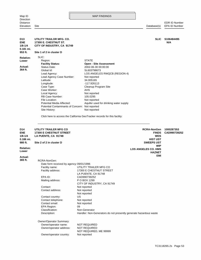
MAP FINDINGSMap IDDirection
EDR ID NumberDistanceEPA ID NumberDatabase(s)SiteElevation
Click here to access the California GeoTracker records for this facility:
Not reportedSite History: Not reportedPotential Contaminants of Concern: Aquifer used for drinking water supplyPotential Media Affected: Not reportedFile Location: 105.0295RB Case Number: Not reportedLocal Agency: AHSCase Worker: Cleanup Program SiteCase Type: -117.926113Longitude: 34.005165Latitude: Not reportedLead Agency Case Number: LOS ANGELES RWQCB (REGION 4)Lead Agency: SL603798673Global Id: 2002-06-30 00:00:00Status Date: Open - Site AssessmentFacility Status: STATERegion:
SLIC:
953 ft. Site 1 of 2 in cluster D0.181 mi.
Relative:Lower
Actual:364 ft.
1/8-1/4 CITY OF INDUSTRY, CA 91749ENE 17300 E. CHESTNUT ST. N/AD13 SLICUTILITY TRAILOR MFG. CO. S106484495
Not reportedOwner/operator country: NOT REQUIRED, ME 99999 NOT REQUIREDOwner/operator address: NOT REQUIREDOwner/operator name:
Owner/Operator Summary:
Handler: Non-Generators do not presently generate hazardous wasteDescription: Non-GeneratorClassification: 09EPA Region: Not reportedContact email: Not reportedContact telephone: USContact country: Not reported Not reportedContact address: Not reportedContact: CITY OF INDUSTRY, CA 91749 P O BOX 1299Mailing address: CAD990739252EPA ID: LA PUENTE, CA 91748 17300 E CHESTNUT STREETFacility address: UTILITY TRAILER MFG COFacility name: 09/01/1996Date form received by agency:
RCRA-NonGen:
EMIHAZNET
LOS ANGELES CO. HMSWIP
980 ft. SWEEPS USTSite 2 of 2 in cluster D0.186 mi. HIST UST
Relative:Lower
Actual:365 ft.
1/8-1/4 WDSLA PUENTE, CA 91748ENE FINDS17300 E CHESTNUT STREET CAD990739252D14 RCRA-NonGenUTILITY TRAILER MFG CO 1000287353
TC3118265.2s Page 53
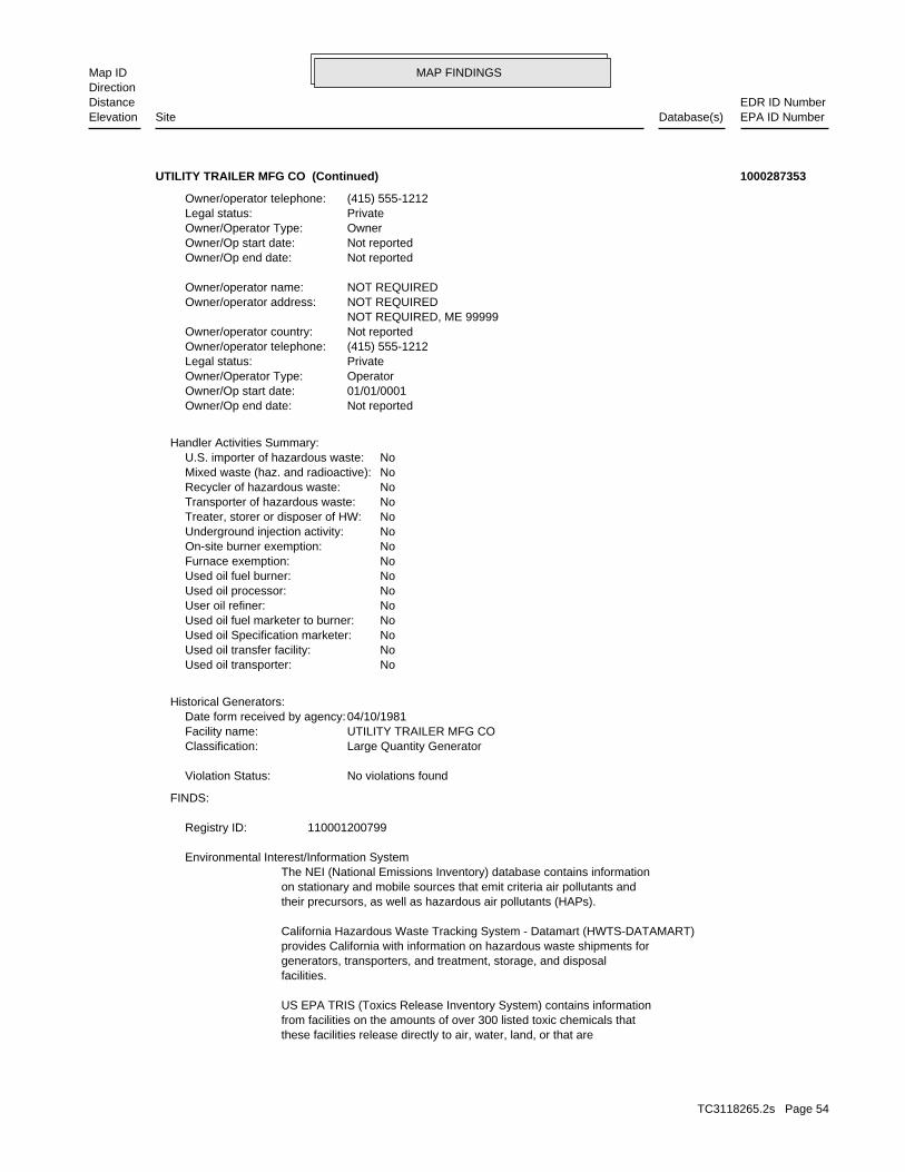
MAP FINDINGSMap IDDirection
EDR ID NumberDistanceEPA ID NumberDatabase(s)SiteElevation
these facilities release directly to air, water, land, or that arefrom facilities on the amounts of over 300 listed toxic chemicals thatUS EPA TRIS (Toxics Release Inventory System) contains information
facilities.generators, transporters, and treatment, storage, and disposalprovides California with information on hazardous waste shipments forCalifornia Hazardous Waste Tracking System - Datamart (HWTS-DATAMART)
their precursors, as well as hazardous air pollutants (HAPs).on stationary and mobile sources that emit criteria air pollutants andThe NEI (National Emissions Inventory) database contains information Environmental Interest/Information System
110001200799Registry ID:
FINDS:
No violations foundViolation Status:
Large Quantity GeneratorClassification: UTILITY TRAILER MFG COFacility name: 04/10/1981Date form received by agency:
Historical Generators:
NoUsed oil transporter: NoUsed oil transfer facility: NoUsed oil Specification marketer: NoUsed oil fuel marketer to burner: NoUser oil refiner: NoUsed oil processor: NoUsed oil fuel burner: NoFurnace exemption: NoOn-site burner exemption: NoUnderground injection activity: NoTreater, storer or disposer of HW: NoTransporter of hazardous waste: NoRecycler of hazardous waste: NoMixed waste (haz. and radioactive): NoU.S. importer of hazardous waste:
Handler Activities Summary:
Not reportedOwner/Op end date: 01/01/0001Owner/Op start date: OperatorOwner/Operator Type: PrivateLegal status: (415) 555-1212Owner/operator telephone: Not reportedOwner/operator country: NOT REQUIRED, ME 99999 NOT REQUIREDOwner/operator address: NOT REQUIREDOwner/operator name:
Not reportedOwner/Op end date: Not reportedOwner/Op start date: OwnerOwner/Operator Type: PrivateLegal status: (415) 555-1212Owner/operator telephone:
UTILITY TRAILER MFG CO (Continued) 1000287353
TC3118265.2s Page 54
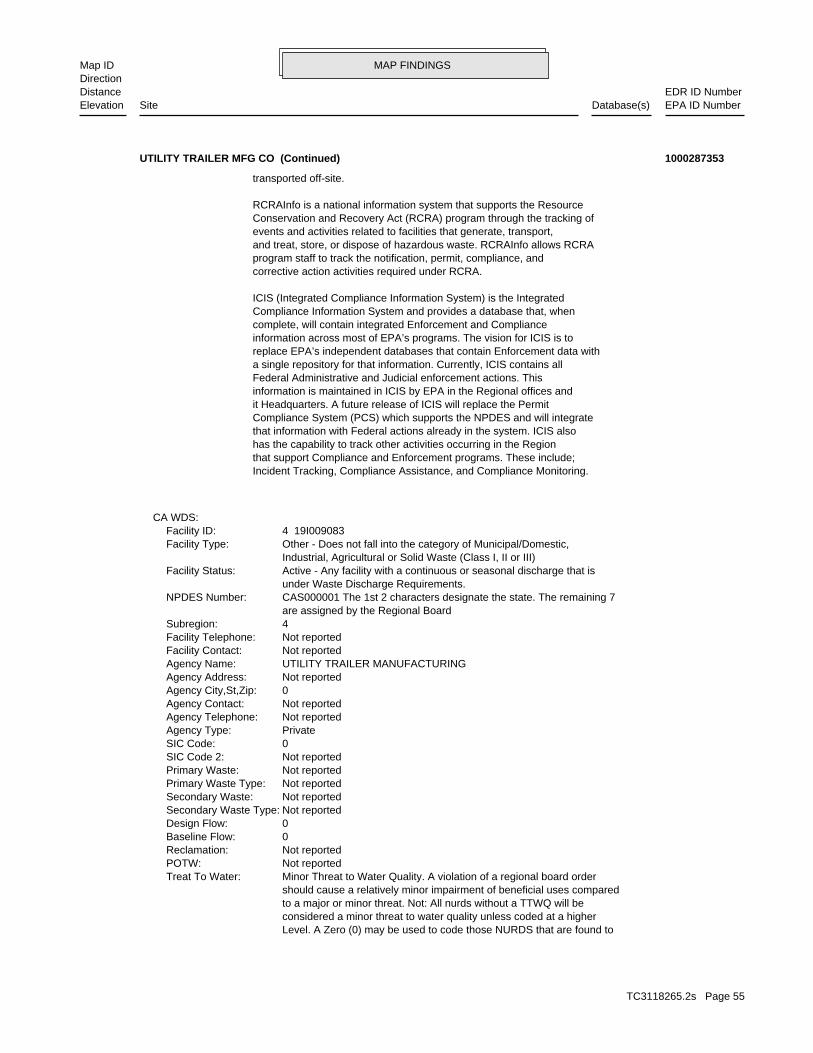
MAP FINDINGSMap IDDirection
EDR ID NumberDistanceEPA ID NumberDatabase(s)SiteElevation
Level. A Zero (0) may be used to code those NURDS that are found to considered a minor threat to water quality unless coded at a higher to a major or minor threat. Not: All nurds without a TTWQ will be should cause a relatively minor impairment of beneficial uses compared Minor Threat to Water Quality. A violation of a regional board orderTreat To Water: Not reportedPOTW: Not reportedReclamation: 0Baseline Flow: 0Design Flow: Not reportedSecondary Waste Type: Not reportedSecondary Waste: Not reportedPrimary Waste Type: Not reportedPrimary Waste: Not reportedSIC Code 2: 0SIC Code: PrivateAgency Type: Not reportedAgency Telephone: Not reportedAgency Contact: 0Agency City,St,Zip: Not reportedAgency Address: UTILITY TRAILER MANUFACTURINGAgency Name: Not reportedFacility Contact: Not reportedFacility Telephone: 4Subregion: are assigned by the Regional Board CAS000001 The 1st 2 characters designate the state. The remaining 7NPDES Number: under Waste Discharge Requirements. Active - Any facility with a continuous or seasonal discharge that isFacility Status: Industrial, Agricultural or Solid Waste (Class I, II or III) Other - Does not fall into the category of Municipal/Domestic,Facility Type: 4 19I009083Facility ID:
CA WDS:
Incident Tracking, Compliance Assistance, and Compliance Monitoring.that support Compliance and Enforcement programs. These include;has the capability to track other activities occurring in the Regionthat information with Federal actions already in the system. ICIS alsoCompliance System (PCS) which supports the NPDES and will integrateit Headquarters. A future release of ICIS will replace the Permitinformation is maintained in ICIS by EPA in the Regional offices andFederal Administrative and Judicial enforcement actions. Thisa single repository for that information. Currently, ICIS contains allreplace EPA’s independent databases that contain Enforcement data withinformation across most of EPA’s programs. The vision for ICIS is tocomplete, will contain integrated Enforcement and ComplianceCompliance Information System and provides a database that, whenICIS (Integrated Compliance Information System) is the Integrated
corrective action activities required under RCRA.program staff to track the notification, permit, compliance, andand treat, store, or dispose of hazardous waste. RCRAInfo allows RCRAevents and activities related to facilities that generate, transport,Conservation and Recovery Act (RCRA) program through the tracking ofRCRAInfo is a national information system that supports the Resource
transported off-site.
UTILITY TRAILER MFG CO (Continued) 1000287353
TC3118265.2s Page 55

MAP FINDINGSMap IDDirection
EDR ID NumberDistanceEPA ID NumberDatabase(s)SiteElevation
LOS ANGELES CO. HMS:
Not reportedFacility Suite:AHSUStaff:ActiveFile Status:105.0295File Number:4Region:
WIP:
Not reportedNumber Of Tanks: Not reportedContent: Not reportedStg: Not reportedTank Use: Not reportedCapacity: Not reportedActv Date: Not reportedSwrcb Tank Id: Not reportedOwner Tank Id: Not reportedTank Status: 06-30-89Created Date: Not reportedAct Date: 06-30-89Ref Date: Not reportedBoard Of Equalization: 9Number: 13574Comp Number: AStatus:
SWEEPS UST:
Stock InventorLeak Detection: Not reportedTank Construction: REGULARType of Fuel: PRODUCTTank Used for: 00001000Tank Capacity: 1955Year Installed: 01Container Num: 001Tank Num:
INDUSTRY, CA 91749Owner City,St,Zip: 17300 E. CHESTNUTOwner Address: UTILITY TRAILER MFG. CO.Owner Name: 8189651541Telephone: MFG. FACILITYContact Name: 0001Total Tanks: MFG. FACILITYOther Type: OtherFacility Type: 00000055632Facility ID: STATERegion:
HIST UST:
dairy waste ponds. dischargers having waste storage systems with land disposal such as disposal systems, such as septic systems with subsurface disposal, or management practices, facilities with passive waste treatment and cooling water dischargers or thosewho must comply through best Category C - Facilities having no waste treatment systems, such asComplexity: represent no threat to water quality.
UTILITY TRAILER MFG CO (Continued) 1000287353
TC3118265.2s Page 56
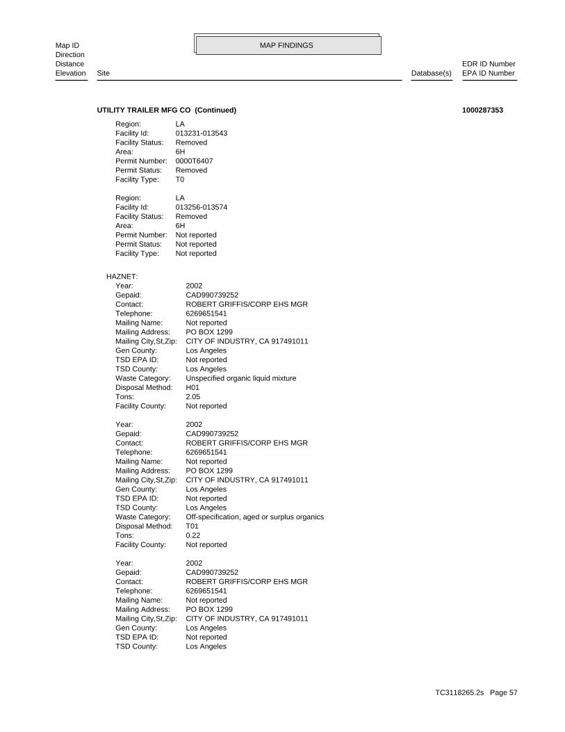
MAP FINDINGSMap IDDirection
EDR ID NumberDistanceEPA ID NumberDatabase(s)SiteElevation
Los AngelesTSD County: Not reportedTSD EPA ID: Los AngelesGen County: CITY OF INDUSTRY, CA 917491011Mailing City,St,Zip: PO BOX 1299Mailing Address: Not reportedMailing Name: 6269651541Telephone: ROBERT GRIFFIS/CORP EHS MGRContact: CAD990739252Gepaid: 2002Year:
Not reportedFacility County: 0.22Tons: T01Disposal Method: Off-specification, aged or surplus organicsWaste Category: Los AngelesTSD County: Not reportedTSD EPA ID: Los AngelesGen County: CITY OF INDUSTRY, CA 917491011Mailing City,St,Zip: PO BOX 1299Mailing Address: Not reportedMailing Name: 6269651541Telephone: ROBERT GRIFFIS/CORP EHS MGRContact: CAD990739252Gepaid: 2002Year:
Not reportedFacility County: 2.05Tons: H01Disposal Method: Unspecified organic liquid mixtureWaste Category: Los AngelesTSD County: Not reportedTSD EPA ID: Los AngelesGen County: CITY OF INDUSTRY, CA 917491011Mailing City,St,Zip: PO BOX 1299Mailing Address: Not reportedMailing Name: 6269651541Telephone: ROBERT GRIFFIS/CORP EHS MGRContact: CAD990739252Gepaid: 2002Year:
HAZNET:
Not reportedFacility Type:Not reportedPermit Status:Not reportedPermit Number:6HArea:RemovedFacility Status:013256-013574Facility Id:LARegion:
T0Facility Type:RemovedPermit Status:0000T6407Permit Number:6HArea:RemovedFacility Status:013231-013543Facility Id:LARegion:
UTILITY TRAILER MFG CO (Continued) 1000287353
TC3118265.2s Page 57
MAP FINDINGSMap IDDirection
EDR ID NumberDistanceEPA ID NumberDatabase(s)SiteElevation
1990Year:
0Part. Matter 10 Micrometers & Smllr Tons/Yr: 0Particulate Matter Tons/Yr: 0SOX - Oxides of Sulphur Tons/Yr: 4NOX - Oxides of Nitrogen Tons/Yr: 3Carbon Monoxide Emissions Tons/Yr: 170Reactive Organic Gases Tons/Yr: 290Total Organic Hydrocarbon Gases Tons/Yr: Not reportedConsolidated Emission Reporting Rule: Not reportedCommunity Health Air Pollution Info System: SOUTH COAST AQMDAir District Name: 3715SIC Code: SCAir District Name: 5125Facility ID: SCAir Basin: 19County Code: 1987Year:
EMI:
25 additional CA_HAZNET: record(s) in the EDR Site Report.Click this hyperlink while viewing on your computer to access
Not reportedFacility County: 2.75Tons: R01Disposal Method: Unspecified organic liquid mixtureWaste Category: Los AngelesTSD County: Not reportedTSD EPA ID: Los AngelesGen County: CITY OF INDUSTRY, CA 917491011Mailing City,St,Zip: PO BOX 1299Mailing Address: Not reportedMailing Name: 6269651541Telephone: ROBERT GRIFFIS/CORP EHS MGRContact: CAD990739252Gepaid: 2001Year:
Not reportedFacility County: 1.25Tons: R01Disposal Method: Unspecified organic liquid mixtureWaste Category: Los AngelesTSD County: Not reportedTSD EPA ID: Los AngelesGen County: CITY OF INDUSTRY, CA 917491011Mailing City,St,Zip: PO BOX 1299Mailing Address: Not reportedMailing Name: 6269651541Telephone: ROBERT GRIFFIS/CORP EHS MGRContact: CAD990739252Gepaid: 2002Year:
Not reportedFacility County: 0.45Tons: H01Disposal Method: Latex wasteWaste Category:
UTILITY TRAILER MFG CO (Continued) 1000287353
TC3118265.2s Page 58

MAP FINDINGSMap IDDirection
EDR ID NumberDistanceEPA ID NumberDatabase(s)SiteElevation
SOUTH COAST AQMDAir District Name: 3715SIC Code: SCAir District Name: 5125Facility ID: SCAir Basin: 19County Code: 1997Year:
0Part. Matter 10 Micrometers & Smllr Tons/Yr: 0Particulate Matter Tons/Yr: 0SOX - Oxides of Sulphur Tons/Yr: 0NOX - Oxides of Nitrogen Tons/Yr: 0Carbon Monoxide Emissions Tons/Yr: 37Reactive Organic Gases Tons/Yr: 47Total Organic Hydrocarbon Gases Tons/Yr: Not reportedConsolidated Emission Reporting Rule: Not reportedCommunity Health Air Pollution Info System: SOUTH COAST AQMDAir District Name: 3715SIC Code: SCAir District Name: 5125Facility ID: SCAir Basin: 19County Code: 1996Year:
0Part. Matter 10 Micrometers & Smllr Tons/Yr: 0Particulate Matter Tons/Yr: 0SOX - Oxides of Sulphur Tons/Yr: 1NOX - Oxides of Nitrogen Tons/Yr: 0Carbon Monoxide Emissions Tons/Yr: 31Reactive Organic Gases Tons/Yr: 41Total Organic Hydrocarbon Gases Tons/Yr: Not reportedConsolidated Emission Reporting Rule: Not reportedCommunity Health Air Pollution Info System: SOUTH COAST AQMDAir District Name: 3715SIC Code: SCAir District Name: 5125Facility ID: SCAir Basin: 19County Code: 1995Year:
0Part. Matter 10 Micrometers & Smllr Tons/Yr: 0Particulate Matter Tons/Yr: 0SOX - Oxides of Sulphur Tons/Yr: 2NOX - Oxides of Nitrogen Tons/Yr: 2Carbon Monoxide Emissions Tons/Yr: 64Reactive Organic Gases Tons/Yr: 154Total Organic Hydrocarbon Gases Tons/Yr: Not reportedConsolidated Emission Reporting Rule: Not reportedCommunity Health Air Pollution Info System: SOUTH COAST AQMDAir District Name: 3715SIC Code: SCAir District Name: 5125Facility ID: SCAir Basin: 19County Code:
UTILITY TRAILER MFG CO (Continued) 1000287353
TC3118265.2s Page 59
MAP FINDINGSMap IDDirection
EDR ID NumberDistanceEPA ID NumberDatabase(s)SiteElevation
0NOX - Oxides of Nitrogen Tons/Yr: 0Carbon Monoxide Emissions Tons/Yr: 20Reactive Organic Gases Tons/Yr: 23Total Organic Hydrocarbon Gases Tons/Yr: Not reportedConsolidated Emission Reporting Rule: Not reportedCommunity Health Air Pollution Info System: SOUTH COAST AQMDAir District Name: 3715SIC Code: SCAir District Name: 5125Facility ID: SCAir Basin: 19County Code: 2000Year:
0Part. Matter 10 Micrometers & Smllr Tons/Yr: 0Particulate Matter Tons/Yr: 0SOX - Oxides of Sulphur Tons/Yr: 0NOX - Oxides of Nitrogen Tons/Yr: 0Carbon Monoxide Emissions Tons/Yr: 20Reactive Organic Gases Tons/Yr: 23Total Organic Hydrocarbon Gases Tons/Yr: Not reportedConsolidated Emission Reporting Rule: Not reportedCommunity Health Air Pollution Info System: SOUTH COAST AQMDAir District Name: 3715SIC Code: SCAir District Name: 5125Facility ID: SCAir Basin: 19County Code: 1999Year:
0Part. Matter 10 Micrometers & Smllr Tons/Yr: 0Particulate Matter Tons/Yr: 0SOX - Oxides of Sulphur Tons/Yr: 0NOX - Oxides of Nitrogen Tons/Yr: 0Carbon Monoxide Emissions Tons/Yr: 20Reactive Organic Gases Tons/Yr: 23Total Organic Hydrocarbon Gases Tons/Yr: Not reportedConsolidated Emission Reporting Rule: Not reportedCommunity Health Air Pollution Info System: SOUTH COAST AQMDAir District Name: 3715SIC Code: SCAir District Name: 5125Facility ID: SCAir Basin: 19County Code: 1998Year:
0Part. Matter 10 Micrometers & Smllr Tons/Yr: 0Particulate Matter Tons/Yr: 0SOX - Oxides of Sulphur Tons/Yr: 0NOX - Oxides of Nitrogen Tons/Yr: 0Carbon Monoxide Emissions Tons/Yr: 20Reactive Organic Gases Tons/Yr: 23Total Organic Hydrocarbon Gases Tons/Yr: Not reportedConsolidated Emission Reporting Rule: Not reportedCommunity Health Air Pollution Info System:
UTILITY TRAILER MFG CO (Continued) 1000287353
TC3118265.2s Page 60

MAP FINDINGSMap IDDirection
EDR ID NumberDistanceEPA ID NumberDatabase(s)SiteElevation
0Part. Matter 10 Micrometers & Smllr Tons/Yr: 0Particulate Matter Tons/Yr: 0SOX - Oxides of Sulphur Tons/Yr:
UTILITY TRAILER MFG CO (Continued) 1000287353
NoRecycler of hazardous waste: NoMixed waste (haz. and radioactive): NoU.S. importer of hazardous waste:
Handler Activities Summary:
Not reportedOwner/Op end date: Not reportedOwner/Op start date: OperatorOwner/Operator Type: PrivateLegal status: (415) 555-1212Owner/operator telephone: Not reportedOwner/operator country: NOT REQUIRED, ME 99999 NOT REQUIREDOwner/operator address: NOT REQUIREDOwner/operator name:
Not reportedOwner/Op end date: Not reportedOwner/Op start date: OwnerOwner/Operator Type: PrivateLegal status: (415) 555-1212Owner/operator telephone: Not reportedOwner/operator country: NOT REQUIRED, ME 99999 NOT REQUIREDOwner/operator address: KWON KI BAIKOwner/operator name:
Owner/Operator Summary:
hazardous waste at any time waste during any calendar month, and accumulates more than 1000 kg of hazardous waste at any time; or generates 100 kg or less of hazardous waste during any calendar month and accumulates less than 6000 kg of Handler: generates more than 100 and less than 1000 kg of hazardousDescription: Small Small Quantity GeneratorClassification: 09EPA Region: Not reportedContact email: Not reportedContact telephone: Not reportedContact country: Not reported Not reportedContact address: Not reportedContact: LA PUENTE, CA 91744 E VALLEY BLMailing address: CAD981998032EPA ID: LA PUENTE, CA 91744 17251 E VALLEY BLFacility address: PUENTE PLAZA CLEANERSFacility name: 09/01/1996Date form received by agency:
RCRA-SQG:
986 ft.0.187 mi.
Relative:Higher
Actual:381 ft.
1/8-1/4 EMILA PUENTE, CA 91744NNE FINDS17251 E VALLEY BL CAD98199803215 RCRA-SQGPUENTE PLAZA CLEANERS 1000322078
TC3118265.2s Page 61

MAP FINDINGSMap IDDirection
EDR ID NumberDistanceEPA ID NumberDatabase(s)SiteElevation
0Part. Matter 10 Micrometers & Smllr Tons/Yr: 0Particulate Matter Tons/Yr: 0SOX - Oxides of Sulphur Tons/Yr: 0NOX - Oxides of Nitrogen Tons/Yr: 0Carbon Monoxide Emissions Tons/Yr: 0Reactive Organic Gases Tons/Yr: 0Total Organic Hydrocarbon Gases Tons/Yr: Not reportedConsolidated Emission Reporting Rule: Not reportedCommunity Health Air Pollution Info System: SOUTH COAST AQMDAir District Name: 7216SIC Code: SCAir District Name: 35646Facility ID: SCAir Basin: 19County Code: 1987Year:
EMI:
corrective action activities required under RCRA.program staff to track the notification, permit, compliance, andand treat, store, or dispose of hazardous waste. RCRAInfo allows RCRAevents and activities related to facilities that generate, transport,Conservation and Recovery Act (RCRA) program through the tracking ofRCRAInfo is a national information system that supports the Resource Environmental Interest/Information System
110002771493Registry ID:
FINDS:
No violations foundViolation Status:
NoUsed oil transporter: NoUsed oil transfer facility: NoUsed oil Specification marketer: NoUsed oil fuel marketer to burner: NoUser oil refiner: NoUsed oil processor: NoUsed oil fuel burner: NoFurnace exemption: NoOn-site burner exemption: NoUnderground injection activity: NoTreater, storer or disposer of HW: NoTransporter of hazardous waste:
PUENTE PLAZA CLEANERS (Continued) 1000322078
0004Total Tanks: Not reportedOther Type: Gas StationFacility Type: 00000016998Facility ID: STATERegion:
HIST UST:
999 ft. Site 1 of 2 in cluster E0.189 mi.
Relative:Higher
Actual:378 ft.
1/8-1/4 LA PUENTE, CA 91744North 17227 VALLEY BLVD N/AE16 HIST USTM. MUWALLA’S ARCO U001569633
TC3118265.2s Page 62

MAP FINDINGSMap IDDirection
EDR ID NumberDistanceEPA ID NumberDatabase(s)SiteElevation
Stock InventorLeak Detection: Not reportedTank Construction: UNLEADEDType of Fuel: PRODUCTTank Used for: 00004000Tank Capacity: Not reportedYear Installed: 1Container Num: 004Tank Num:
Stock InventorLeak Detection: Not reportedTank Construction: UNLEADEDType of Fuel: PRODUCTTank Used for: 00004000Tank Capacity: Not reportedYear Installed: 2Container Num: 003Tank Num:
Stock InventorLeak Detection: Not reportedTank Construction: REGULARType of Fuel: PRODUCTTank Used for: 00006000Tank Capacity: Not reportedYear Installed: 3Container Num: 002Tank Num:
Stock InventorLeak Detection: Not reportedTank Construction: PREMIUMType of Fuel: PRODUCTTank Used for: 00006000Tank Capacity: Not reportedYear Installed: 4Container Num: 001Tank Num:
LA PUENTE, CA 91744Owner City,St,Zip: 17227 E. VALLEY BLVD.Owner Address: MOHAMED A. MUWALLAOwner Name: 8189127814Telephone: MOHAMED MUWALLAContact Name:
M. MUWALLA’S ARCO (Continued) U001569633
T0603705543Global Id: STATERegion:
LUST:
R-26561Reg Id: LTNKAReg By: 19Facility County Code: CORTESERegion:
CORTESE:
999 ft. Site 2 of 2 in cluster E0.189 mi. LOS ANGELES CO. HMS
Relative:Higher
Actual:378 ft.
1/8-1/4 SWEEPS USTLA PUENTE, CA North LUST17227 E VALLEY BLVD N/AE17 HIST CORTESELA PUENTE GAS STA & FOOD MART S102063600
TC3118265.2s Page 63
MAP FINDINGSMap IDDirection
EDR ID NumberDistanceEPA ID NumberDatabase(s)SiteElevation
Clean Up Fund - 5-Year Review SummaryAction: 2009-09-03 00:00:00Date: RESPONSEAction Type: T0603705543Global Id:
Monitoring Report - QuarterlyAction: 2007-07-15 00:00:00Date: RESPONSEAction Type: T0603705543Global Id:
Monitoring Report - QuarterlyAction: 2007-10-15 00:00:00Date: RESPONSEAction Type: T0603705543Global Id:
Monitoring Report - QuarterlyAction: 2008-10-15 00:00:00Date: RESPONSEAction Type: T0603705543Global Id:
LUST:
6264583507Phone Number: Not reportedEmail: ALHAMBRACity: 900 S FREMONT AVEAddress: LOS ANGELES COUNTYOrganization Name: JOHN AWUJOContact Name: Local Agency CaseworkerContact Type: T0603705543Global Id:
Not reportedPhone Number: [email protected]: LOS ANGELESCity: 320 W. 4TH STREET, SUITE 200Address: LOS ANGELES RWQCB (REGION 4)Organization Name: JOE F. LUERAContact Name: Regional Board CaseworkerContact Type: T0603705543Global Id:
LUST:
Click here to access the California GeoTracker records for this facility:
Not reportedSite History: GasolinePotential Contaminants of Concern: Aquifer used for drinking water supplyPotential Media Affect: Regional BoardFile Location: Not reportedLOC Case Number: R-26561RB Case Number: LOS ANGELES COUNTYLocal Agency: JFLCase Worker: LOS ANGELES RWQCB (REGION 4)Lead Agency: 2003-11-03 00:00:00Status Date: Open - RemediationStatus: LUST Cleanup SiteCase Type: -117.9290275Longitude: 34.0098928Latitude:
LA PUENTE GAS STA & FOOD MART (Continued) S102063600
TC3118265.2s Page 64
MAP FINDINGSMap IDDirection
EDR ID NumberDistanceEPA ID NumberDatabase(s)SiteElevation
OtherAction Type: T0603705543Global Id:
Final Remedial Action Report / Corrective Action ReportAction: 2003-09-15 00:00:00Date: RESPONSEAction Type: T0603705543Global Id:
Staff LetterAction: 2002-06-20 00:00:00Date: ENFORCEMENTAction Type: T0603705543Global Id:
Staff LetterAction: 2002-09-17 00:00:00Date: ENFORCEMENTAction Type: T0603705543Global Id:
Other Report / DocumentAction: 2002-07-31 00:00:00Date: RESPONSEAction Type: T0603705543Global Id:
Soil and Water Investigation ReportAction: 2002-09-20 00:00:00Date: RESPONSEAction Type: T0603705543Global Id:
Soil and Water Investigation ReportAction: 2002-05-15 00:00:00Date: RESPONSEAction Type: T0603705543Global Id:
Staff LetterAction: 2001-12-18 00:00:00Date: ENFORCEMENTAction Type: T0603705543Global Id:
Monitoring Report - QuarterlyAction: 2006-01-15 00:00:00Date: RESPONSEAction Type: T0603705543Global Id:
Staff LetterAction: 2002-06-18 00:00:00Date: ENFORCEMENTAction Type: T0603705543Global Id:
Monitoring Report - Semi-AnnuallyAction: 2009-07-15 00:00:00Date: RESPONSEAction Type: T0603705543Global Id:
Monitoring Report - QuarterlyAction: 2005-07-15 00:00:00Date: RESPONSEAction Type: T0603705543Global Id:
LA PUENTE GAS STA & FOOD MART (Continued) S102063600
TC3118265.2s Page 65
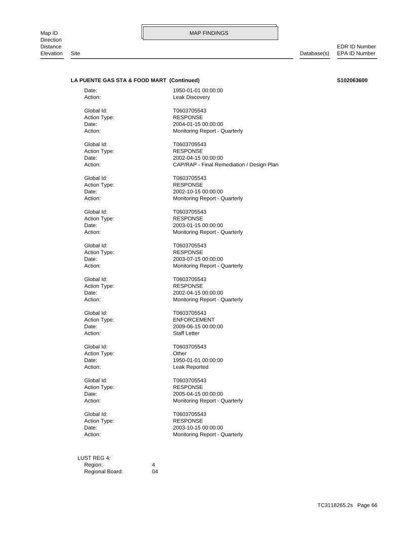
MAP FINDINGSMap IDDirection
EDR ID NumberDistanceEPA ID NumberDatabase(s)SiteElevation
04Regional Board: 4Region:
LUST REG 4:
Monitoring Report - QuarterlyAction: 2003-10-15 00:00:00Date: RESPONSEAction Type: T0603705543Global Id:
Monitoring Report - QuarterlyAction: 2005-04-15 00:00:00Date: RESPONSEAction Type: T0603705543Global Id:
Leak ReportedAction: 1950-01-01 00:00:00Date: OtherAction Type: T0603705543Global Id:
Staff LetterAction: 2009-06-15 00:00:00Date: ENFORCEMENTAction Type: T0603705543Global Id:
Monitoring Report - QuarterlyAction: 2002-04-15 00:00:00Date: RESPONSEAction Type: T0603705543Global Id:
Monitoring Report - QuarterlyAction: 2003-07-15 00:00:00Date: RESPONSEAction Type: T0603705543Global Id:
Monitoring Report - QuarterlyAction: 2003-01-15 00:00:00Date: RESPONSEAction Type: T0603705543Global Id:
Monitoring Report - QuarterlyAction: 2002-10-15 00:00:00Date: RESPONSEAction Type: T0603705543Global Id:
CAP/RAP - Final Remediation / Design PlanAction: 2002-04-15 00:00:00Date: RESPONSEAction Type: T0603705543Global Id:
Monitoring Report - QuarterlyAction: 2004-01-15 00:00:00Date: RESPONSEAction Type: T0603705543Global Id:
Leak DiscoveryAction: 1950-01-01 00:00:00Date:
LA PUENTE GAS STA & FOOD MART (Continued) S102063600
TC3118265.2s Page 66
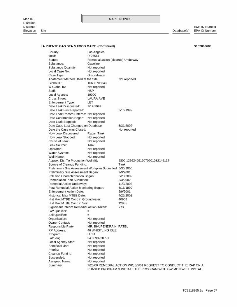
MAP FINDINGSMap IDDirection
EDR ID NumberDistanceEPA ID NumberDatabase(s)SiteElevation
PHASED PROGRAM & INITIATE THE PROGRAM WITH GW MON WELL INSTALL. 7/20/00 REMEDIAL ACTION WP; 3/5/01 REQUEST TO CONDUCT THE RAP ON ASummary: Not reportedAssigned Name: Not reportedSuspended: Not reportedCleanup Fund Id: Not reportedPriority: Not reportedBeneficial Use: Not reportedLocal Agency Staff: 34.0098928 / -1Lat/Long: LUSTProgram: 46 WHISTLING ISLERP Address: MR. BHUPENDRA N. PATELResponsible Party: Not reportedOwner Contact: Not reportedOrganization: =Soil Qualifier: =GW Qualifier: YesSignificant Interim Remedial Action Taken: 12985Hist Max MTBE Conc in Soil: 40908Hist Max MTBE Conc in Groundwater: 4/25/2002Historical Max MTBE Date: 2/9/2001Enforcement Action Date: 3/16/1999Post Remedial Action Monitoring Began: 11/3/2003Remedial Action Underway: 5/3/2002Remediation Plan Submitted: 6/20/2002Pollution Characterization Began: 2/9/2001Preliminary Site Assessment Began: 5/30/2000Preliminary Site Assessment Workplan Submitted: TankSource of Cleanup Funding: 6800.1256249919070201082146137Approx. Dist To Production Well (ft): Not reportedWell Name: Not reportedWater System: Not reportedOperator: TankLeak Source: Not reportedCause of Leak: Not reportedHow Leak Stopped: Repair TankHow Leak Discovered: Not reportedDate the Case was Closed: 5/31/2002Date Case Last Changed on Database: Not reportedDate Leak Stopped: Not reportedDate Confirmation Began: Not reportedDate Leak Record Entered: 3/16/1999Date Leak First Reported: 2/17/1999Date Leak Discovered: LETEnforcement Type: LAURA AVECross Street: 19000Local Agency: HSPStaff: Not reportedW Global ID: T0603705543Global ID: Not reportedAbatement Method Used at the Site: GroundwaterCase Type: Not reportedLocal Case No: Not reportedSubstance Quantity: GasolineSubstance: Remedial action (cleanup) UnderwayStatus: R-26561facid: Los AngelesCounty:
LA PUENTE GAS STA & FOOD MART (Continued) S102063600
TC3118265.2s Page 67

MAP FINDINGSMap IDDirection
EDR ID NumberDistanceEPA ID NumberDatabase(s)SiteElevation
06-30-89Ref Date: 44-007838Board Of Equalization: 9Number: 4670Comp Number: AStatus:
Not reportedNumber Of Tanks: Not reportedContent: WStg: UNKNOWNTank Use: Not reportedCapacity: 06-30-89Actv Date: 19-000-004670-000003Swrcb Tank Id: Not reportedOwner Tank Id: ATank Status: 06-30-89Created Date: Not reportedAct Date: 06-30-89Ref Date: 44-007838Board Of Equalization: 9Number: 4670Comp Number: AStatus:
Not reportedNumber Of Tanks: Not reportedContent: WStg: UNKNOWNTank Use: Not reportedCapacity: 06-30-89Actv Date: 19-000-004670-000002Swrcb Tank Id: Not reportedOwner Tank Id: ATank Status: 06-30-89Created Date: Not reportedAct Date: 06-30-89Ref Date: 44-007838Board Of Equalization: 9Number: 4670Comp Number: AStatus:
4Number Of Tanks: Not reportedContent: WStg: UNKNOWNTank Use: Not reportedCapacity: 06-30-89Actv Date: 19-000-004670-000001Swrcb Tank Id: Not reportedOwner Tank Id: ATank Status: 06-30-89Created Date: Not reportedAct Date: 06-30-89Ref Date: 44-007838Board Of Equalization: 9Number: 4670Comp Number: AStatus:
SWEEPS UST:
LA PUENTE GAS STA & FOOD MART (Continued) S102063600
TC3118265.2s Page 68
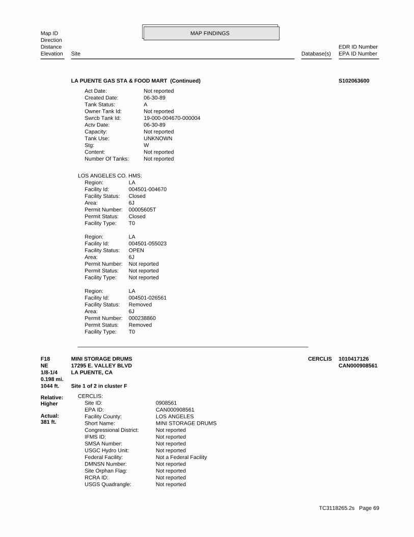
MAP FINDINGSMap IDDirection
EDR ID NumberDistanceEPA ID NumberDatabase(s)SiteElevation
T0Facility Type:RemovedPermit Status:000238860Permit Number:6JArea:RemovedFacility Status:004501-026561Facility Id:LARegion:
Not reportedFacility Type:Not reportedPermit Status:Not reportedPermit Number:6JArea:OPENFacility Status:004501-055023Facility Id:LARegion:
T0Facility Type:ClosedPermit Status:00005605TPermit Number:6JArea:ClosedFacility Status:004501-004670Facility Id:LARegion:
LOS ANGELES CO. HMS:
Not reportedNumber Of Tanks: Not reportedContent: WStg: UNKNOWNTank Use: Not reportedCapacity: 06-30-89Actv Date: 19-000-004670-000004Swrcb Tank Id: Not reportedOwner Tank Id: ATank Status: 06-30-89Created Date: Not reportedAct Date:
LA PUENTE GAS STA & FOOD MART (Continued) S102063600
Not reportedUSGS Quadrangle: Not reportedRCRA ID: Not reportedSite Orphan Flag: Not reportedDMNSN Number: Not a Federal FacilityFederal Facility: Not reportedUSGC Hydro Unit: Not reportedSMSA Number: Not reportedIFMS ID: Not reportedCongressional District: MINI STORAGE DRUMSShort Name: LOS ANGELESFacility County: CAN000908561EPA ID: 0908561Site ID:
CERCLIS:
1044 ft. Site 1 of 2 in cluster F0.198 mi.
Relative:Higher
Actual:381 ft.
1/8-1/4 LA PUENTE, CA NE 17295 E. VALLEY BLVD CAN000908561F18 CERCLISMINI STORAGE DRUMS 1010417126
TC3118265.2s Page 69
MAP FINDINGSMap IDDirection
EDR ID NumberDistanceEPA ID NumberDatabase(s)SiteElevation
CERCLIS Assessment History:
in a 20’box truck parked on the storage lot property.Valley Blvd., La Puente, Los Angeles Co., CA. The abandoned waste is locatedThe site is located at Extra-Space Storage, a mini-storage located at 17295 E.Site Description: Not reportedAlias Comments:
Not reportedContact Email: Site Assessment Manager (SAM)Contact Title: (415) 972-3097Contact Tel: Dawn RichmondContact Name: 9270438.00000Contact ID:
Not reportedContact Email: Site Assessment Manager (SAM)Contact Title: (415) 972-3814Contact Tel: Carl BricknerContact Name: 13002167.00000Contact ID:
Not reportedContact Email: Site Assessment Manager (SAM)Contact Title: (415) 972-3095Contact Tel: Jeff InglisContact Name: 9270048.00000Contact ID:
Not reportedContact Email: Site Assessment Manager (SAM)Contact Title: (415) 972-3219Contact Tel: Karen JuristContact Name: 9271184.00000Contact ID:
Not reportedContact Email: On-Scene Coordinator (OSC)Contact Title: (562) 499-6312Contact Tel: Robert WiseContact Name: 9270721.00000Contact ID:
CERCLIS Site Contact Name(s):
Not reportedSite FUDS Flag: Not reportedAlias EPA ID: Not reportedCC Concurrence FY: Not reportedCC Concurrence Date: 06037Site Fips Code: 20071126Non NPL Status Date: Removal Only Site (No Site Assessment Work Needed)Non NPL Status: Not reportedRResp Fed Agency Code: Not reportedRBRAC Code: Not reportedDMNSN Unit Code: Not on the NPLNPL Status: Not reportedSite Settings Code: Not reportedClassification: 09EPA Region: Not reportedRST Code: Not reportedParent ID: Not reportedNFRAP Flag: RSite Init By Prog:
MINI STORAGE DRUMS (Continued) 1010417126
TC3118265.2s Page 70
MAP FINDINGSMap IDDirection
EDR ID NumberDistanceEPA ID NumberDatabase(s)SiteElevation
additional US CERCLIS Financial: detail in the EDR Site Report.Click this hyperlink while viewing on your computer to access
For detailed financial records, contact EDR for a Site Report.:
Not reportedAction Anomaly: EmergencyUrgency Indicator: Not reportedPlanning Status: PRP Response Under StatePrimary Responsibility: SITEWIDEOperable Unit: Cleaned upPriority Level: 12/05/2007Date Completed: 11/26/2007Date Started: POTENTIALLY RESPONSIBLE PARTY EMERGENCY REMOVALAction: 001Action Code:
For detailed financial records, contact EDR for a Site Report.:
Not reportedAction Anomaly: Not reportedUrgency Indicator: Not reportedPlanning Status: EPA In-HousePrimary Responsibility: SITEWIDEOperable Unit: Not reportedPriority Level: 11/26/2007Date Completed: 11/26/2007Date Started: NON-NATIONAL PRIORITIES LIST POTENTIALLY RESPONSIBLE PARTY SEARCHAction: 001Action Code:
MINI STORAGE DRUMS (Continued) 1010417126
136955Party Number: 2011-02-22 00:00:00As Of: NRural: 01/10/2011Effective Date: NWhether The Facility Is Grandfathered: Not reportedFacility Phone Number:
SWRCY:
1092 ft. Site 2 of 2 in cluster F0.207 mi.
Relative:Higher
Actual:381 ft.
1/8-1/4 LA PUENTE, CA 91744NE 17305 VALLEY BLVD N/AF19 SWRCYAM RECYCLING S110770375
Not reportedFacility Suite:JCLStaff:HistoricalFile Status:105.0092File Number:4Region:
WIP:
1305 ft.0.247 mi.
Relative:Higher
Actual:386 ft.
1/8-1/4 CITY OF INDUSTRY (CORPORATE NA, CA 91748South 1020 S WALLACE PL N/A20 WIPENGINEERING MODEL ASSOCIATES S106764835
TC3118265.2s Page 71

MAP FINDINGSMap IDDirection
EDR ID NumberDistanceEPA ID NumberDatabase(s)SiteElevation
Los Angeles CountyCertified Unified Program Agencies: 3701Total Gallons: CARRIER TRANSICOLDOwner:
AST:
1312 ft. Site 1 of 2 in cluster G0.249 mi.
Relative:Higher
Actual:383 ft.
1/8-1/4 INDUSTRY, CA 91748SSW 1015 S AZUSA AVE N/AG21 AST A100344358
NoUsed oil processor: NoUsed oil fuel burner: NoFurnace exemption: NoOn-site burner exemption: NoUnderground injection activity: NoTreater, storer or disposer of HW: NoTransporter of hazardous waste: NoRecycler of hazardous waste: NoMixed waste (haz. and radioactive): NoU.S. importer of hazardous waste:
Handler Activities Summary:
Not reportedOwner/Op end date: Not reportedOwner/Op start date: OwnerOwner/Operator Type: PrivateLegal status: (626) 913-4331Owner/operator telephone: Not reportedOwner/operator country: CITY OF INDUSTRY, CA 91748 1015 S AZUSA AVEOwner/operator address: CARRIER TRANSICOLD OF S CAOwner/operator name:
Owner/Operator Summary:
hazardous waste at any time waste during any calendar month, and accumulates more than 1000 kg of hazardous waste at any time; or generates 100 kg or less of hazardous waste during any calendar month and accumulates less than 6000 kg of Handler: generates more than 100 and less than 1000 kg of hazardousDescription: Small Small Quantity GeneratorClassification: 09EPA Region: Not reportedContact email: (626) 913-4331Contact telephone: USContact country: CITY OF INDUSTRY, CA 91748 1015 S AZUSA AVEContact address: MICHAEL SHULERContact: CAD983645540EPA ID: CITY OF INDUSTRY, CA 91748 1015 S AZUSA AVEFacility address: CARRIER TRANSICOLD OF SOUTHERN CAFacility name: 09/09/1998Date form received by agency:
RCRA-SQG:
1312 ft. Site 2 of 2 in cluster G0.249 mi.
Relative:Higher
Actual:383 ft.
1/8-1/4 CITY OF INDUSTRY, CA 91748SSW FINDS1015 S AZUSA AVE CAD983645540G22 RCRA-SQGCARRIER TRANSICOLD OF SOUTHERN CA 1000818649
TC3118265.2s Page 72

MAP FINDINGSMap IDDirection
EDR ID NumberDistanceEPA ID NumberDatabase(s)SiteElevation
corrective action activities required under RCRA.program staff to track the notification, permit, compliance, andand treat, store, or dispose of hazardous waste. RCRAInfo allows RCRAevents and activities related to facilities that generate, transport,Conservation and Recovery Act (RCRA) program through the tracking ofRCRAInfo is a national information system that supports the Resource Environmental Interest/Information System
110002882701Registry ID:
FINDS:
No violations foundViolation Status:
DISPOSED, THE WASTE WOULD BE A CORROSIVE HAZARDOUS WASTE. THESE CAUSTIC OR ACID SOLUTIONS BECOME CONTAMINATED AND MUST BE USED BY MANY INDUSTRIES TO CLEAN METAL PARTS PRIOR TO PAINTING. WHEN OR DEGREASE PARTS. HYDROCHLORIC ACID, A SOLUTION WITH A LOW PH, IS CAUSTIC SOLUTION WITH A HIGH PH, IS OFTEN USED BY INDUSTRIES TO CLEAN CONSIDERED TO BE A CORROSIVE HAZARDOUS WASTE. SODIUM HYDROXIDE, A A WASTE WHICH HAS A PH OF LESS THAN 2 OR GREATER THAN 12.5 ISWaste name: D002Waste code:
WHICH WOULD BE CONSIDERED AS IGNITABLE HAZARDOUS WASTE. MATERIAL. LACQUER THINNER IS AN EXAMPLE OF A COMMONLY USED SOLVENT WHICH CAN BE OBTAINED FROM THE MANUFACTURER OR DISTRIBUTOR OF THE FLASH POINT OF A WASTE IS TO REVIEW THE MATERIAL SAFETY DATA SHEET, CLOSED CUP FLASH POINT TESTER. ANOTHER METHOD OF DETERMINING THE LESS THAN 140 DEGREES FAHRENHEIT AS DETERMINED BY A PENSKY-MARTENS IGNITABLE HAZARDOUS WASTES ARE THOSE WASTES WHICH HAVE A FLASHPOINT OFWaste name: D001Waste code:
Hazardous Waste Summary:
NoUsed oil transporter: NoUsed oil transfer facility: NoUsed oil Specification marketer: NoUsed oil fuel marketer to burner: NoUser oil refiner:
CARRIER TRANSICOLD OF SOUTHERN CA (Continued) 1000818649
Not reportedSite Code: 71002558Facility ID: Cleanup CypressDivision Branch: Not reportedSupervisor: Not reportedProgram Manager: NONE SPECIFIEDLead Agency: NONE SPECIFIEDRegulatory Agencies: NONPL: Not reportedAcres: Tiered PermitSite Type Detailed: Tiered PermitSite Type:
ENVIROSTOR:
1848 ft.0.350 mi.
Relative:Higher
Actual:393 ft.
1/4-1/2 CITY OF INDUSTRY, CA 91748SSE 17355 RAILROAD STREET N/A23 ENVIROSTORSOMITEX PRINTS OF CALIFORNIA S110494305
TC3118265.2s Page 73
MAP FINDINGSMap IDDirection
EDR ID NumberDistanceEPA ID NumberDatabase(s)SiteElevation
Not reportedSchedule Revised Date: Not reportedSchedule Due Date: Not reportedSchedule Document Type: Not reportedSchedule Sub Area Name: Not reportedSchedule Area Name: Not reportedFuture Due Date: Not reportedFuture Document Type: Not reportedFuture Sub Area Name: Not reportedFuture Area Name:
Not reportedComments: Not reportedCompleted Date: Not reportedCompleted Document Type: Not reportedCompleted Sub Area Name: Not reportedCompleted Area Name:
Completed Info:
Envirostor ID NumberAlias Type: 71002558Alias Name: EPA Identification NumberAlias Type: CAD072304942Alias Name: NONE SPECIFIEDPotential Description: NONE SPECIFIEDConfirmed COC: NONE SPECIFIEDPotential COC: NONE SPECIFIEDPast Use: NONE SPECIFIEDAPN: -117.926234Longitude: 34.003181Latitude: Not reportedFunding: NONE SPECIFIEDSite Mgmt. Req.: NORestricted Use: Not reportedStatus Date: Refer: Other AgencyStatus: Not reportedSpecial Program: 24Senate: 58Assembly:
SOMITEX PRINTS OF CALIFORNIA (Continued) S110494305
USContact country: CITY OF INDUSTRY, CA 91748 17380 RAILROAD STREETContact address: ARTHUR THOMASContact: CAD983576950EPA ID: CITY OF INDUSTRY, CA 91748 17380 RAILROAD STREETFacility address: BAY VALLEY FOODS LLCFacility name: 07/13/2005Date form received by agency:
RCRA-SQG:
EMIHAZNET
LOS ANGELES CO. HMSSWEEPS UST
CA FID UST2059 ft. LUST0.390 mi. HIST CORTESE
Relative:Higher
Actual:395 ft.
1/4-1/2 NPDESLA PUENTE, CA 91748SSE FINDS17380 RAILROAD ST CAD98357695024 RCRA-SQGBAY VALLEY FOODS LLC 1000594069
TC3118265.2s Page 74
MAP FINDINGSMap IDDirection
EDR ID NumberDistanceEPA ID NumberDatabase(s)SiteElevation
Small Quantity GeneratorClassification: RODS FOODS PRODUCTS INCSite name: BAY VALLEY FOODS LLCFacility name: 11/18/1991Date form received by agency:
Historical Generators:
NoUsed oil transporter: NoUsed oil transfer facility: NoUsed oil Specification marketer: NoUsed oil fuel marketer to burner: NoUser oil refiner: NoUsed oil processor: NoUsed oil fuel burner: NoFurnace exemption: NoOn-site burner exemption: NoUnderground injection activity: NoTreater, storer or disposer of HW: NoTransporter of hazardous waste: NoRecycler of hazardous waste: NoMixed waste (haz. and radioactive): NoU.S. importer of hazardous waste:
Handler Activities Summary:
Not reportedOwner/Op end date: 06/27/2005Owner/Op start date: OperatorOwner/Operator Type: PrivateLegal status: Not reportedOwner/operator telephone: USOwner/operator country: Not reported Not reportedOwner/operator address: BAY VALLEY FOODS LLCOwner/operator name:
Not reportedOwner/Op end date: 06/27/2005Owner/Op start date: OwnerOwner/Operator Type: PrivateLegal status: Not reportedOwner/operator telephone: USOwner/operator country: GREEN BAY, WI 54307 PO BOX 19057Owner/operator address: TREEHOUSE FOODS INCOwner/operator name:
Owner/Operator Summary:
hazardous waste at any time waste during any calendar month, and accumulates more than 1000 kg of hazardous waste at any time; or generates 100 kg or less of hazardous waste during any calendar month and accumulates less than 6000 kg of Handler: generates more than 100 and less than 1000 kg of hazardousDescription: Small Small Quantity GeneratorClassification: 09EPA Region: [email protected] email: 215Telephone ext.: 626-912-1671Contact telephone:
BAY VALLEY FOODS LLC (Continued) 1000594069
TC3118265.2s Page 75
MAP FINDINGSMap IDDirection
EDR ID NumberDistanceEPA ID NumberDatabase(s)SiteElevation
EnrolleeRegulatory Measure Type: Not reportedOrder No: Not AvailableRegulatory Measure Id: 4Region: N/AAgency Id: TerminatedFacility Status: CAS000002Npdes Number:
NPDES:
corrective action activities required under RCRA.program staff to track the notification, permit, compliance, andand treat, store, or dispose of hazardous waste. RCRAInfo allows RCRAevents and activities related to facilities that generate, transport,Conservation and Recovery Act (RCRA) program through the tracking ofRCRAInfo is a national information system that supports the Resource
transported off-site.these facilities release directly to air, water, land, or that arefrom facilities on the amounts of over 300 listed toxic chemicals thatUS EPA TRIS (Toxics Release Inventory System) contains information
their precursors, as well as hazardous air pollutants (HAPs).on stationary and mobile sources that emit criteria air pollutants andThe NEI (National Emissions Inventory) database contains information
and settlements.regions and states with cooperative agreements, enforcement actions,Toxic Substances Control Act (TSCA). The system tracks inspections inFederal Insecticide, Fungicide, and Rodenticide Act (FIFRA) and theNCDB (National Compliance Data Base) supports implementation of the Environmental Interest/Information System
110002317895Registry ID:
FINDS:
No violations foundViolation Status:
DISPOSED, THE WASTE WOULD BE A CORROSIVE HAZARDOUS WASTE. THESE CAUSTIC OR ACID SOLUTIONS BECOME CONTAMINATED AND MUST BE USED BY MANY INDUSTRIES TO CLEAN METAL PARTS PRIOR TO PAINTING. WHEN OR DEGREASE PARTS. HYDROCHLORIC ACID, A SOLUTION WITH A LOW PH, IS CAUSTIC SOLUTION WITH A HIGH PH, IS OFTEN USED BY INDUSTRIES TO CLEAN CONSIDERED TO BE A CORROSIVE HAZARDOUS WASTE. SODIUM HYDROXIDE, A A WASTE WHICH HAS A PH OF LESS THAN 2 OR GREATER THAN 12.5 ISWaste name: D002Waste code:
WHICH WOULD BE CONSIDERED AS IGNITABLE HAZARDOUS WASTE. MATERIAL. LACQUER THINNER IS AN EXAMPLE OF A COMMONLY USED SOLVENT WHICH CAN BE OBTAINED FROM THE MANUFACTURER OR DISTRIBUTOR OF THE FLASH POINT OF A WASTE IS TO REVIEW THE MATERIAL SAFETY DATA SHEET, CLOSED CUP FLASH POINT TESTER. ANOTHER METHOD OF DETERMINING THE LESS THAN 140 DEGREES FAHRENHEIT AS DETERMINED BY A PENSKY-MARTENS IGNITABLE HAZARDOUS WASTES ARE THOSE WASTES WHICH HAVE A FLASHPOINT OFWaste name: D001Waste code:
Hazardous Waste Summary:
BAY VALLEY FOODS LLC (Continued) 1000594069
TC3118265.2s Page 76
MAP FINDINGSMap IDDirection
EDR ID NumberDistanceEPA ID NumberDatabase(s)SiteElevation
Not reportedEnforcement Type: Not reportedCross Street: 19000Local Agency: UNKStaff: Not reportedW Global ID: T0603702635Global ID: Excavate and DisposeAbatement Method Used at the Site: GroundwaterCase Type: Not reportedLocal Case No: Not reportedSubstance Quantity: GasolineSubstance: Case ClosedStatus: 917490016facid: Los AngelesCounty: 04Regional Board: 4Region:
LUST REG 4:
917490016Reg Id: LTNKAReg By: 19Facility County Code: CORTESERegion:
CORTESE:
91744Discharge Zip: CaDischarge State: City of IndustryDischarge City: 15625 E Stafford StDischarge Address: City of IndustryDischarge Name: 9/2/2010 7:45:00 AMTermination Date Of Regulatory Measure: Not reportedExpiration Date Of Regulatory Measure: 5/7/2008 1:41:00 PMEffective Date Of Regulatory Measure: N/AAdoption Date Of Regulatory Measure: ConstructionProgram Type: 4 19C351730WDID: Not AvailablePlace Id: EnrolleeRegulatory Measure Type: Not reportedOrder No: Not AvailableRegulatory Measure Id: 4Region: N/AAgency Id: TerminatedFacility Status: CAS000002Npdes Number:
91744Discharge Zip: CaDischarge State: City Of IndustryDischarge City: 15625 E Stafford StDischarge Address: Industry CityDischarge Name: 5/22/2008Termination Date Of Regulatory Measure: Not reportedExpiration Date Of Regulatory Measure: 5/13/2008 4:10:00 PMEffective Date Of Regulatory Measure: N/AAdoption Date Of Regulatory Measure: ConstructionProgram Type: 4 19C351825WDID: Not AvailablePlace Id:
BAY VALLEY FOODS LLC (Continued) 1000594069
TC3118265.2s Page 77
MAP FINDINGSMap IDDirection
EDR ID NumberDistanceEPA ID NumberDatabase(s)SiteElevation
Not reportedDUNs Number: Not reportedContact Phone: Not reportedContact: INDUSTRYMailing City,St,Zip: Not reportedMailing Address 2: 17380 RAILROAD STMailing Address: Not reportedMail To: 8180000000Facility Phone: Not reportedSIC Code: Not reportedCortese Code: 00003969Regulated ID: UTNKARegulated By: 19002111Facility ID:
CA FID UST:
LTR FROM LACDPW 1-23-95 RWQCB LEAD AGENCY.Summary: Not reportedAssigned Name: Not reportedSuspended: Not reportedCleanup Fund Id: Not reportedPriority: Not reportedBeneficial Use: Not reportedLocal Agency Staff: 34.0015001 / -1Lat/Long: LUSTProgram: 17380 RAILROAD ST, INDUSTRY, CA 91749RP Address: ROD’S FOODS PRODUCTSResponsible Party: Not reportedOwner Contact: Not reportedOrganization: Not reportedSoil Qualifier: Not reportedGW Qualifier: YesSignificant Interim Remedial Action Taken: Not reportedHist Max MTBE Conc in Soil: Not reportedHist Max MTBE Conc in Groundwater: Not reportedHistorical Max MTBE Date: Not reportedEnforcement Action Date: 4/17/1995Post Remedial Action Monitoring Began: Not reportedRemedial Action Underway: Not reportedRemediation Plan Submitted: 8/15/1989Pollution Characterization Began: Not reportedPreliminary Site Assessment Began: Not reportedPreliminary Site Assessment Workplan Submitted: Not reportedSource of Cleanup Funding: 7879.2822634903298845079179957Approx. Dist To Production Well (ft): Not reportedWell Name: Not reportedWater System: Not reportedOperator: Not reportedLeak Source: Not reportedCause of Leak: Not reportedHow Leak Stopped: Not reportedHow Leak Discovered: 5/16/1996Date the Case was Closed: 5/16/1996Date Case Last Changed on Database: Not reportedDate Leak Stopped: Not reportedDate Confirmation Began: 8/29/1989Date Leak Record Entered: 8/21/1989Date Leak First Reported: Not reportedDate Leak Discovered:
BAY VALLEY FOODS LLC (Continued) 1000594069
TC3118265.2s Page 78
MAP FINDINGSMap IDDirection
EDR ID NumberDistanceEPA ID NumberDatabase(s)SiteElevation
17380 RAILROAD STMailing Address: Not reportedMailing Name: 6269121671Telephone: ARTHUR THOMASContact: CAD983576950Gepaid: 2009Year:
HAZNET:
T0Facility Type:RemovedPermit Status:00004104TPermit Number:6HArea:RemovedFacility Status:012220-012339Facility Id:LARegion:
LOS ANGELES CO. HMS:
Not reportedNumber Of Tanks: Not reportedContent: WStg: UNKNOWNTank Use: Not reportedCapacity: 06-30-89Actv Date: 19-000-012339-000002Swrcb Tank Id: Not reportedOwner Tank Id: ATank Status: 06-30-89Created Date: Not reportedAct Date: 06-30-89Ref Date: 44-009687Board Of Equalization: 9Number: 12339Comp Number: AStatus:
2Number Of Tanks: Not reportedContent: WStg: UNKNOWNTank Use: Not reportedCapacity: 06-30-89Actv Date: 19-000-012339-000001Swrcb Tank Id: Not reportedOwner Tank Id: ATank Status: 06-30-89Created Date: Not reportedAct Date: 06-30-89Ref Date: 44-009687Board Of Equalization: 9Number: 12339Comp Number: AStatus:
SWEEPS UST:
ActiveStatus: Not reportedComments: Not reportedEPA ID: Not reportedNPDES Number:
BAY VALLEY FOODS LLC (Continued) 1000594069
TC3118265.2s Page 79
MAP FINDINGSMap IDDirection
EDR ID NumberDistanceEPA ID NumberDatabase(s)SiteElevation
Los AngelesFacility County: 0.285Tons: Not reportedDisposal Method: Waste oil and mixed oilWaste Category: 99TSD County: AZR000504332TSD EPA ID: Los AngelesGen County: CITY OF INDUSTRY, CA 917480000Mailing City,St,Zip: 17380 RAILROAD STMailing Address: Not reportedMailing Name: 6269121671Telephone: ARTHUR THOMASContact: CAD983576950Gepaid: 2009Year:
Los AngelesFacility County: 0.228Tons: ORGANICS RECOVERY ECT OTHER RECOVERY OF RECLAMATION FOR REUSE INCLUDING ACID REGENERATION,Disposal Method: Waste oil and mixed oilWaste Category: 99TSD County: AZR000504332TSD EPA ID: Los AngelesGen County: CITY OF INDUSTRY, CA 917480000Mailing City,St,Zip: 17380 RAILROAD STMailing Address: Not reportedMailing Name: 6269121671Telephone: ARTHUR THOMASContact: CAD983576950Gepaid: 2009Year:
Los AngelesFacility County: 0.19Tons: ORGANICS RECOVERY ECT OTHER RECOVERY OF RECLAMATION FOR REUSE INCLUDING ACID REGENERATION,Disposal Method: Waste oil and mixed oilWaste Category: Los AngelesTSD County: CAD099452708TSD EPA ID: Los AngelesGen County: CITY OF INDUSTRY, CA 917480000Mailing City,St,Zip: 17380 RAILROAD STMailing Address: Not reportedMailing Name: 6269121671Telephone: ARTHUR THOMASContact: CAD983576950Gepaid: 2009Year:
Los AngelesFacility County: 0.0375Tons: (H010-H129) OR (H131-H135) STORAGE, BULKING, AND/OR TRANSFER OFF SITE--NO TREATMENT/REOVERYDisposal Method: Other organic solidsWaste Category: 99TSD County: AZR000501510TSD EPA ID: Los AngelesGen County: CITY OF INDUSTRY, CA 917480000Mailing City,St,Zip:
BAY VALLEY FOODS LLC (Continued) 1000594069
TC3118265.2s Page 80
MAP FINDINGSMap IDDirection
EDR ID NumberDistanceEPA ID NumberDatabase(s)SiteElevation
42079Facility ID: SCAir Basin: 19County Code: 1996Year:
0Part. Matter 10 Micrometers & Smllr Tons/Yr: 0Particulate Matter Tons/Yr: 0SOX - Oxides of Sulphur Tons/Yr: 1NOX - Oxides of Nitrogen Tons/Yr: 0Carbon Monoxide Emissions Tons/Yr: 1Reactive Organic Gases Tons/Yr: 1Total Organic Hydrocarbon Gases Tons/Yr: Not reportedConsolidated Emission Reporting Rule: Not reportedCommunity Health Air Pollution Info System: SOUTH COAST AQMDAir District Name: 2099SIC Code: SCAir District Name: 42079Facility ID: SCAir Basin: 19County Code: 1995Year:
0Part. Matter 10 Micrometers & Smllr Tons/Yr: 0Particulate Matter Tons/Yr: 0SOX - Oxides of Sulphur Tons/Yr: 2NOX - Oxides of Nitrogen Tons/Yr: 0Carbon Monoxide Emissions Tons/Yr: 1Reactive Organic Gases Tons/Yr: 3Total Organic Hydrocarbon Gases Tons/Yr: Not reportedConsolidated Emission Reporting Rule: Not reportedCommunity Health Air Pollution Info System: SOUTH COAST AQMDAir District Name: 2099SIC Code: SCAir District Name: 42079Facility ID: SCAir Basin: 19County Code: 1990Year:
EMI:
13 additional CA_HAZNET: record(s) in the EDR Site Report.Click this hyperlink while viewing on your computer to access
Los AngelesFacility County: 0.418Tons: Not reportedDisposal Method: Waste oil and mixed oilWaste Category: Not reportedTSD County: AZR000504332TSD EPA ID: Los AngelesGen County: CITY OF INDUSTRY, CA 917480000Mailing City,St,Zip: 17380 RAILROAD STMailing Address: Not reportedMailing Name: 6269121671Telephone: ARTHUR THOMASContact: CAD983576950Gepaid: 2008Year:
BAY VALLEY FOODS LLC (Continued) 1000594069
TC3118265.2s Page 81

MAP FINDINGSMap IDDirection
EDR ID NumberDistanceEPA ID NumberDatabase(s)SiteElevation
0Total Organic Hydrocarbon Gases Tons/Yr: Not reportedConsolidated Emission Reporting Rule: Not reportedCommunity Health Air Pollution Info System: SOUTH COAST AQMDAir District Name: 2099SIC Code: SCAir District Name: 42079Facility ID: SCAir Basin: 19County Code: 1999Year:
0Part. Matter 10 Micrometers & Smllr Tons/Yr: 0Particulate Matter Tons/Yr: 0SOX - Oxides of Sulphur Tons/Yr: 2NOX - Oxides of Nitrogen Tons/Yr: 0Carbon Monoxide Emissions Tons/Yr: 0Reactive Organic Gases Tons/Yr: 0Total Organic Hydrocarbon Gases Tons/Yr: Not reportedConsolidated Emission Reporting Rule: Not reportedCommunity Health Air Pollution Info System: SOUTH COAST AQMDAir District Name: 2099SIC Code: SCAir District Name: 42079Facility ID: SCAir Basin: 19County Code: 1998Year:
0Part. Matter 10 Micrometers & Smllr Tons/Yr: 0Particulate Matter Tons/Yr: 0SOX - Oxides of Sulphur Tons/Yr: 2NOX - Oxides of Nitrogen Tons/Yr: 0Carbon Monoxide Emissions Tons/Yr: 0Reactive Organic Gases Tons/Yr: 0Total Organic Hydrocarbon Gases Tons/Yr: Not reportedConsolidated Emission Reporting Rule: Not reportedCommunity Health Air Pollution Info System: SOUTH COAST AQMDAir District Name: 2099SIC Code: SCAir District Name: 42079Facility ID: SCAir Basin: 19County Code: 1997Year:
0Part. Matter 10 Micrometers & Smllr Tons/Yr: 0Particulate Matter Tons/Yr: 0SOX - Oxides of Sulphur Tons/Yr: 3NOX - Oxides of Nitrogen Tons/Yr: 1Carbon Monoxide Emissions Tons/Yr: 2Reactive Organic Gases Tons/Yr: 4Total Organic Hydrocarbon Gases Tons/Yr: Not reportedConsolidated Emission Reporting Rule: Not reportedCommunity Health Air Pollution Info System: SOUTH COAST AQMDAir District Name: 2099SIC Code: SCAir District Name:
BAY VALLEY FOODS LLC (Continued) 1000594069
TC3118265.2s Page 82
MAP FINDINGSMap IDDirection
EDR ID NumberDistanceEPA ID NumberDatabase(s)SiteElevation
0Part. Matter 10 Micrometers & Smllr Tons/Yr: 0Particulate Matter Tons/Yr: 0SOX - Oxides of Sulphur Tons/Yr: 2NOX - Oxides of Nitrogen Tons/Yr: 1Carbon Monoxide Emissions Tons/Yr: 0Reactive Organic Gases Tons/Yr: 0Total Organic Hydrocarbon Gases Tons/Yr: Not reportedConsolidated Emission Reporting Rule: Not reportedCommunity Health Air Pollution Info System: SOUTH COAST AQMDAir District Name: 2099SIC Code: SCAir District Name: 42079Facility ID: SCAir Basin: 19County Code: 2001Year:
0Part. Matter 10 Micrometers & Smllr Tons/Yr: 0Particulate Matter Tons/Yr: 0SOX - Oxides of Sulphur Tons/Yr: 2NOX - Oxides of Nitrogen Tons/Yr: 0Carbon Monoxide Emissions Tons/Yr: 0Reactive Organic Gases Tons/Yr: 0Total Organic Hydrocarbon Gases Tons/Yr: Not reportedConsolidated Emission Reporting Rule: Not reportedCommunity Health Air Pollution Info System: SOUTH COAST AQMDAir District Name: 2099SIC Code: SCAir District Name: 42079Facility ID: SCAir Basin: 19County Code: 2000Year:
0Part. Matter 10 Micrometers & Smllr Tons/Yr: 0Particulate Matter Tons/Yr: 0SOX - Oxides of Sulphur Tons/Yr: 2NOX - Oxides of Nitrogen Tons/Yr: 0Carbon Monoxide Emissions Tons/Yr: 0Reactive Organic Gases Tons/Yr:
BAY VALLEY FOODS LLC (Continued) 1000594069
Not reportedRestrictions: YesPublic Notice: San Gabriel ValleyArea:
LOS ANGELES CO. LF:
2278 ft. Site 1 of 3 in cluster H0.431 mi.
Relative:Higher
Actual:384 ft.
1/4-1/2 CITY OF INDUSTRY, CA 91748SE 999 HATCHER AVENUE N/AH25 SWF/LFGRAND CENTRAL RECYCLING & TRANSFER STATION/GRAND CENTRAL REC S108657834
TC3118265.2s Page 83
MAP FINDINGSMap IDDirection
EDR ID NumberDistanceEPA ID NumberDatabase(s)SiteElevation
NoFurnace exemption: NoOn-site burner exemption: NoUnderground injection activity: NoTreater, storer or disposer of HW: NoTransporter of hazardous waste: NoRecycler of hazardous waste: NoMixed waste (haz. and radioactive): NoU.S. importer of hazardous waste:
Handler Activities Summary:
Not reportedOwner/Op end date: Not reportedOwner/Op start date: OwnerOwner/Operator Type: PrivateLegal status: (415) 555-1212Owner/operator telephone: Not reportedOwner/operator country: NOT REQUIRED, ME 99999 NOT REQUIREDOwner/operator address: H H ROBERTSON COOwner/operator name:
Not reportedOwner/Op end date: Not reportedOwner/Op start date: OperatorOwner/Operator Type: PrivateLegal status: (415) 555-1212Owner/operator telephone: Not reportedOwner/operator country: CITY NOT REPORTED, ME 99999 ADDRESS NOT REPORTEDOwner/operator address: NAME NOT REPORTEDOwner/operator name:
Owner/Operator Summary:
Handler: Non-Generators do not presently generate hazardous wasteDescription: Non-GeneratorClassification: waste Handler is engaged in the treatment, storage or disposal of hazardousDescription: TSDFClassification: Facility is not located on Indian land. Additional information is not known.Land type: 09EPA Region: Not reportedContact email: Not reportedContact telephone: Not reportedContact country: Not reported Not reportedContact address: Not reportedContact: CY OF INDUSTY, CA 91744 PO BOX 1215Mailing address: CAD008246027EPA ID: LA PUENTE, CA 91748 999 S HATCHER AVEFacility address: H H ROBERTSON CO WASDFacility name: 09/16/1994Date form received by agency:
RCRA-TSDF:
2284 ft. Site 2 of 3 in cluster H0.433 mi. HIST UST
Relative:Higher
Actual:384 ft.
1/4-1/2 FINDSLA PUENTE, CA 91748SE RCRA-NonGen999 SOUTH HATCHER AVENUE CAD008246027H26 RCRA-TSDFH H ROBERTSON CO WASD 1000130159
TC3118265.2s Page 84
MAP FINDINGSMap IDDirection
EDR ID NumberDistanceEPA ID NumberDatabase(s)SiteElevation
Not reported Enforcement lead agency: Not reported Enf. disp. status date: Not reported Enf. disposition status: Not reported Enforcement action date: Not reported Enforcement action: StateViolation lead agency: 01/01/1986Date achieved compliance: 12/26/1985Date violation determined: Generators - GeneralArea of violation: Not reportedRegulation violated:
Not reported Paid penalty amount: Not reported Final penalty amount: Not reported Proposed penalty amount: State Enforcement lead agency: Not reported Enf. disp. status date: Not reported Enf. disposition status: 08/22/1986 Enforcement action date: WRITTEN INFORMAL Enforcement action: StateViolation lead agency: 01/01/1987Date achieved compliance: 08/22/1986Date violation determined: Generators - GeneralArea of violation: Not reportedRegulation violated:
Not reported Paid penalty amount: Not reported Final penalty amount: Not reported Proposed penalty amount: State Enforcement lead agency: Not reported Enf. disp. status date: Not reported Enf. disposition status: 01/27/1987 Enforcement action date: WRITTEN INFORMAL Enforcement action: StateViolation lead agency: 01/01/1987Date achieved compliance: 11/26/1986Date violation determined: TSD - Financial RequirementsArea of violation: Not reportedRegulation violated:
Facility Has Received Notices of Violations:
CA029Event: 12/20/2007Event date:
Corrective Action Summary:
Large Quantity GeneratorClassification: H H ROBERTSON CO WASDFacility name: 08/18/1980Date form received by agency:
Historical Generators:
NoUsed oil transporter: NoUsed oil transfer facility: NoUsed oil Specification marketer: NoUsed oil fuel marketer to burner: NoUser oil refiner: NoUsed oil processor: NoUsed oil fuel burner:
H H ROBERTSON CO WASD (Continued) 1000130159
TC3118265.2s Page 85
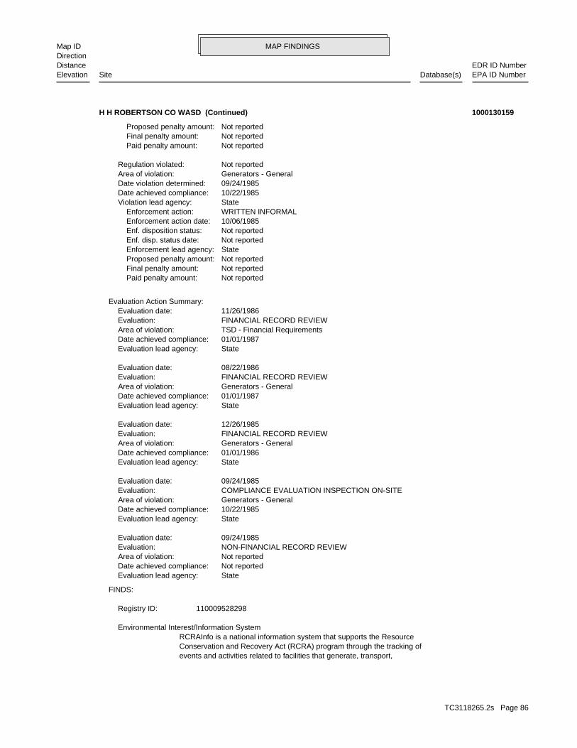
MAP FINDINGSMap IDDirection
EDR ID NumberDistanceEPA ID NumberDatabase(s)SiteElevation
events and activities related to facilities that generate, transport,Conservation and Recovery Act (RCRA) program through the tracking ofRCRAInfo is a national information system that supports the Resource Environmental Interest/Information System
110009528298Registry ID:
FINDS:
StateEvaluation lead agency: Not reportedDate achieved compliance: Not reportedArea of violation: NON-FINANCIAL RECORD REVIEWEvaluation: 09/24/1985Evaluation date:
StateEvaluation lead agency: 10/22/1985Date achieved compliance: Generators - GeneralArea of violation: COMPLIANCE EVALUATION INSPECTION ON-SITEEvaluation: 09/24/1985Evaluation date:
StateEvaluation lead agency: 01/01/1986Date achieved compliance: Generators - GeneralArea of violation: FINANCIAL RECORD REVIEWEvaluation: 12/26/1985Evaluation date:
StateEvaluation lead agency: 01/01/1987Date achieved compliance: Generators - GeneralArea of violation: FINANCIAL RECORD REVIEWEvaluation: 08/22/1986Evaluation date:
StateEvaluation lead agency: 01/01/1987Date achieved compliance: TSD - Financial RequirementsArea of violation: FINANCIAL RECORD REVIEWEvaluation: 11/26/1986Evaluation date:
Evaluation Action Summary:
Not reported Paid penalty amount: Not reported Final penalty amount: Not reported Proposed penalty amount: State Enforcement lead agency: Not reported Enf. disp. status date: Not reported Enf. disposition status: 10/06/1985 Enforcement action date: WRITTEN INFORMAL Enforcement action: StateViolation lead agency: 10/22/1985Date achieved compliance: 09/24/1985Date violation determined: Generators - GeneralArea of violation: Not reportedRegulation violated:
Not reported Paid penalty amount: Not reported Final penalty amount: Not reported Proposed penalty amount:
H H ROBERTSON CO WASD (Continued) 1000130159
TC3118265.2s Page 86

MAP FINDINGSMap IDDirection
EDR ID NumberDistanceEPA ID NumberDatabase(s)SiteElevation
Visual, Stock InventorLeak Detection: Not reportedTank Construction: REGULARType of Fuel: PRODUCTTank Used for: 00010000Tank Capacity: 1965Year Installed: 1Container Num: 001Tank Num:
CITY OF INDUSTRY, CA 91749Owner City,St,Zip: 999 S. HATCHEROwner Address: H.H. ROBERTSON COMPANYOwner Name: 8189646511Telephone: ESTON OWENSContact Name: 0001Total Tanks: MANUFACTURINGOther Type: OtherFacility Type: 00000065858Facility ID: STATERegion:
HIST UST:
corrective action activities required under RCRA.program staff to track the notification, permit, compliance, andand treat, store, or dispose of hazardous waste. RCRAInfo allows RCRA
H H ROBERTSON CO WASD (Continued) 1000130159
CAL000012972Gepaid: 2003Year:
Los AngelesFacility County: 3.44Tons: R01Disposal Method: Waste oil and mixed oilWaste Category: Los AngelesTSD County: CAT080013352TSD EPA ID: Los AngelesGen County: CITY OF INDUSTRY, CA 917461202Mailing City,St,Zip: 13280 AMAR ROADMailing Address: Not reportedMailing Name: 6269647500Telephone: JAMES SCZEPCZENSKIContact: CAL000012972Gepaid: 2003Year:
HAZNET:
Not reportedFacility Suite:JCLStaff:HistoricalFile Status:105.0115File Number:4Region:
WIP:
2284 ft. Site 3 of 3 in cluster H0.433 mi.
Relative:Higher
Actual:384 ft.
1/4-1/2 HWPCITY OF INDUSTRY, CA 91748SE HAZNET999 S HATCHER AVE N/AH27 WIPMAXIM LIGHTING INTERNATIONAL S103678071
TC3118265.2s Page 87

MAP FINDINGSMap IDDirection
EDR ID NumberDistanceEPA ID NumberDatabase(s)SiteElevation
Not reportedFacility County: 7.25Tons: D80Disposal Method: Other organic solidsWaste Category: Los AngelesTSD County: Not reportedTSD EPA ID: Los AngelesGen County: CITY OF INDUSTRY, CA 917461202Mailing City,St,Zip: 13280 AMAR ROADMailing Address: Not reportedMailing Name: 6269647500Telephone: JAMES SCZEPCZENSKIContact: CAL000012972Gepaid: 2002Year:
Not reportedFacility County: 11.74Tons: R01Disposal Method: Waste oil and mixed oilWaste Category: Los AngelesTSD County: Not reportedTSD EPA ID: Los AngelesGen County: CITY OF INDUSTRY, CA 917461202Mailing City,St,Zip: 13280 AMAR ROADMailing Address: Not reportedMailing Name: 6269647500Telephone: JAMES SCZEPCZENSKIContact: CAL000012972Gepaid: 2002Year:
Los AngelesFacility County: 1.14Tons: R01Disposal Method: Waste oil and mixed oilWaste Category: Los AngelesTSD County: CAD099452708TSD EPA ID: Los AngelesGen County: CITY OF INDUSTRY, CA 917461202Mailing City,St,Zip: 13280 AMAR ROADMailing Address: Not reportedMailing Name: 6269647500Telephone: JAMES SCZEPCZENSKIContact: CAL000012972Gepaid: 2003Year:
Los AngelesFacility County: 3.8Tons: D80Disposal Method: Other organic solidsWaste Category: Los AngelesTSD County: CAT080033681TSD EPA ID: Los AngelesGen County: CITY OF INDUSTRY, CA 917461202Mailing City,St,Zip: 13280 AMAR ROADMailing Address: Not reportedMailing Name: 6269647500Telephone: JAMES SCZEPCZENSKIContact:
MAXIM LIGHTING INTERNATIONAL (Continued) S103678071
TC3118265.2s Page 88
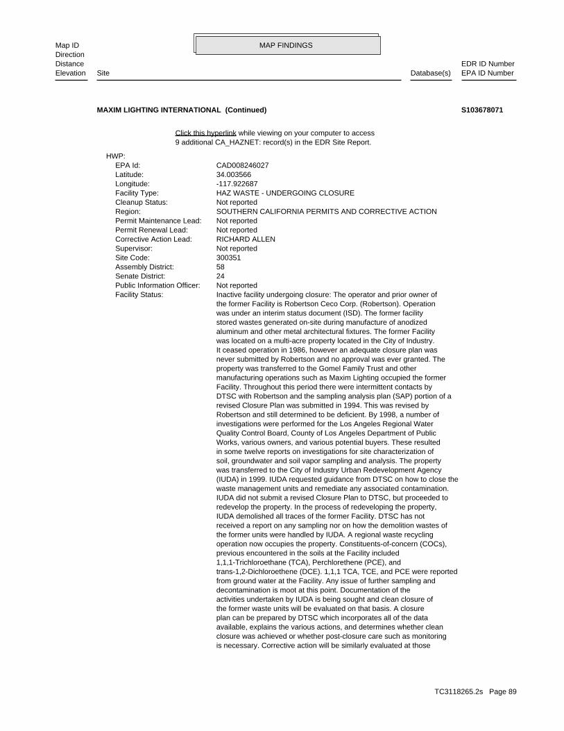
MAP FINDINGSMap IDDirection
EDR ID NumberDistanceEPA ID NumberDatabase(s)SiteElevation
is necessary. Corrective action will be similarly evaluated at those closure was achieved or whether post-closure care such as monitoring available, explains the various actions, and determines whether clean plan can be prepared by DTSC which incorporates all of the data the former waste units will be evaluated on that basis. A closure activities undertaken by IUDA is being sought and clean closure of decontamination is moot at this point. Documentation of the from ground water at the Facility. Any issue of further sampling and trans-1,2-Dichloroethene (DCE). 1,1,1 TCA, TCE, and PCE were reported 1,1,1-Trichloroethane (TCA), Perchlorethene (PCE), and previous encountered in the soils at the Facility included operation now occupies the property. Constituents-of-concern (COCs), the former units were handled by IUDA. A regional waste recycling received a report on any sampling nor on how the demolition wastes of IUDA demolished all traces of the former Facility. DTSC has not redevelop the property. In the process of redeveloping the property, IUDA did not submit a revised Closure Plan to DTSC, but proceeded to waste management units and remediate any associated contamination. (IUDA) in 1999. IUDA requested guidance from DTSC on how to close the was transferred to the City of Industry Urban Redevelopment Agency soil, groundwater and soil vapor sampling and analysis. The property in some twelve reports on investigations for site characterization of Works, various owners, and various potential buyers. These resulted Quality Control Board, County of Los Angeles Department of Public investigations were performed for the Los Angeles Regional Water Robertson and still determined to be deficient. By 1998, a number of revised Closure Plan was submitted in 1994. This was revised by DTSC with Robertson and the sampling analysis plan (SAP) portion of a Facility. Throughout this period there were intermittent contacts by manufacturing operations such as Maxim Lighting occupied the former property was transferred to the Gomel Family Trust and other never submitted by Robertson and no approval was ever granted. The It ceased operation in 1986, however an adequate closure plan was was located on a multi-acre property located in the City of Industry. aluminum and other metal architectural fixtures. The former Facility stored wastes generated on-site during manufacture of anodized was under an interim status document (ISD). The former facility the former Facility is Robertson Ceco Corp. (Robertson). Operation Inactive facility undergoing closure: The operator and prior owner ofFacility Status: Not reportedPublic Information Officer: 24Senate District: 58Assembly District: 300351Site Code: Not reportedSupervisor: RICHARD ALLENCorrective Action Lead: Not reportedPermit Renewal Lead: Not reportedPermit Maintenance Lead: SOUTHERN CALIFORNIA PERMITS AND CORRECTIVE ACTIONRegion: Not reportedCleanup Status: HAZ WASTE - UNDERGOING CLOSUREFacility Type: -117.922687Longitude: 34.003566Latitude: CAD008246027EPA Id:
HWP:
9 additional CA_HAZNET: record(s) in the EDR Site Report.Click this hyperlink while viewing on your computer to access
MAXIM LIGHTING INTERNATIONAL (Continued) S103678071
TC3118265.2s Page 89
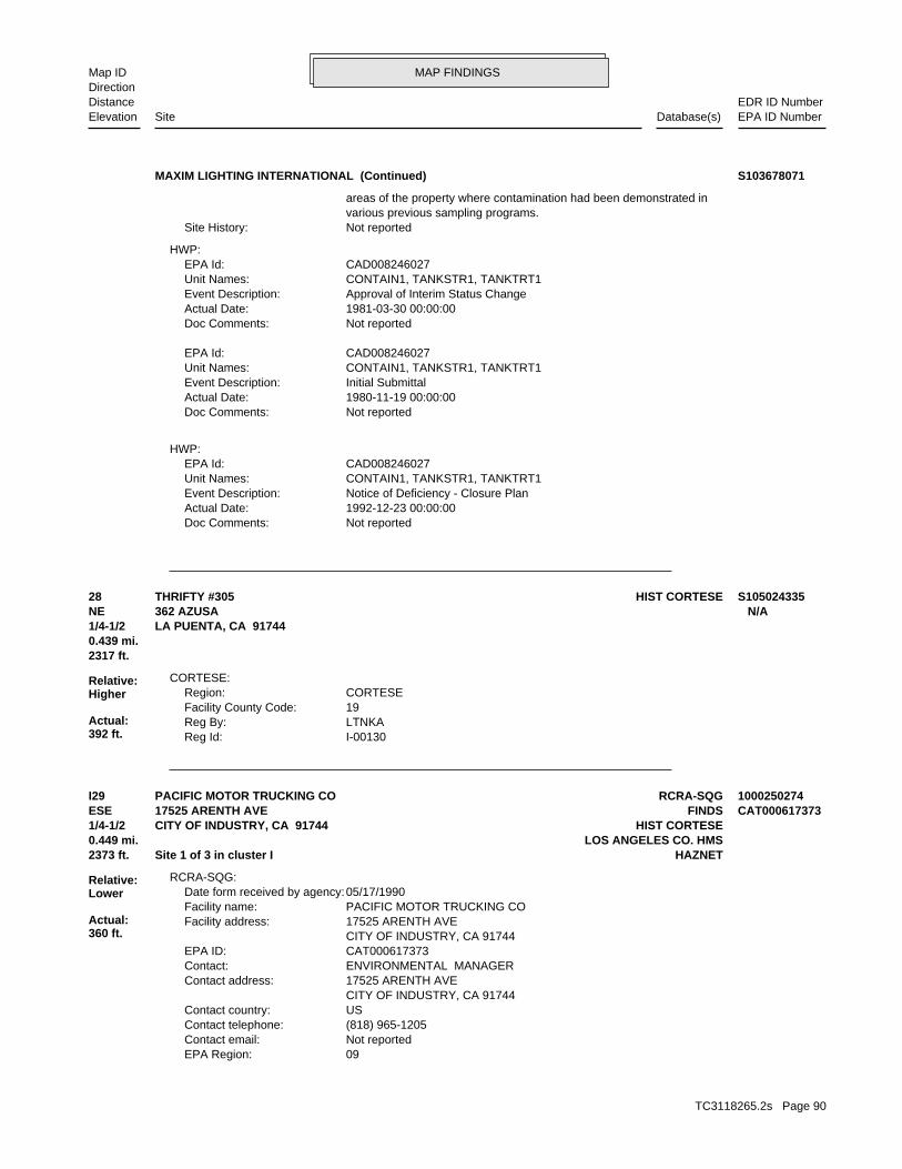
MAP FINDINGSMap IDDirection
EDR ID NumberDistanceEPA ID NumberDatabase(s)SiteElevation
Not reportedDoc Comments: 1992-12-23 00:00:00Actual Date: Notice of Deficiency - Closure PlanEvent Description: CONTAIN1, TANKSTR1, TANKTRT1Unit Names: CAD008246027EPA Id:
HWP:
Not reportedDoc Comments: 1980-11-19 00:00:00Actual Date: Initial SubmittalEvent Description: CONTAIN1, TANKSTR1, TANKTRT1Unit Names: CAD008246027EPA Id:
Not reportedDoc Comments: 1981-03-30 00:00:00Actual Date: Approval of Interim Status ChangeEvent Description: CONTAIN1, TANKSTR1, TANKTRT1Unit Names: CAD008246027EPA Id:
HWP:
Not reportedSite History: various previous sampling programs. areas of the property where contamination had been demonstrated in
MAXIM LIGHTING INTERNATIONAL (Continued) S103678071
I-00130Reg Id: LTNKAReg By: 19Facility County Code: CORTESERegion:
CORTESE:
2317 ft.0.439 mi.
Relative:Higher
Actual:392 ft.
1/4-1/2 LA PUENTA, CA 91744NE 362 AZUSA N/A28 HIST CORTESETHRIFTY #305 S105024335
09EPA Region: Not reportedContact email: (818) 965-1205Contact telephone: USContact country: CITY OF INDUSTRY, CA 91744 17525 ARENTH AVEContact address: ENVIRONMENTAL MANAGERContact: CAT000617373EPA ID: CITY OF INDUSTRY, CA 91744 17525 ARENTH AVEFacility address: PACIFIC MOTOR TRUCKING COFacility name: 05/17/1990Date form received by agency:
RCRA-SQG:
2373 ft. HAZNETSite 1 of 3 in cluster I0.449 mi. LOS ANGELES CO. HMS
Relative:Lower
Actual:360 ft.
1/4-1/2 HIST CORTESECITY OF INDUSTRY, CA 91744ESE FINDS17525 ARENTH AVE CAT000617373I29 RCRA-SQGPACIFIC MOTOR TRUCKING CO 1000250274
TC3118265.2s Page 90
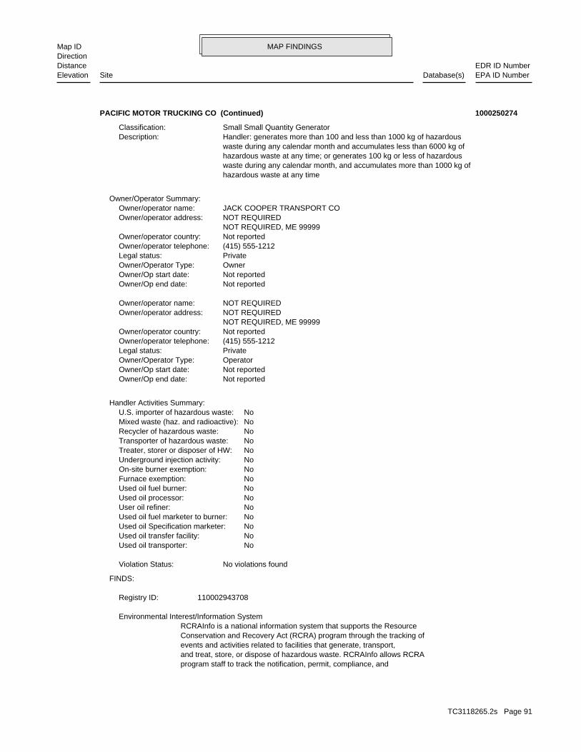
MAP FINDINGSMap IDDirection
EDR ID NumberDistanceEPA ID NumberDatabase(s)SiteElevation
program staff to track the notification, permit, compliance, andand treat, store, or dispose of hazardous waste. RCRAInfo allows RCRAevents and activities related to facilities that generate, transport,Conservation and Recovery Act (RCRA) program through the tracking ofRCRAInfo is a national information system that supports the Resource Environmental Interest/Information System
110002943708Registry ID:
FINDS:
No violations foundViolation Status:
NoUsed oil transporter: NoUsed oil transfer facility: NoUsed oil Specification marketer: NoUsed oil fuel marketer to burner: NoUser oil refiner: NoUsed oil processor: NoUsed oil fuel burner: NoFurnace exemption: NoOn-site burner exemption: NoUnderground injection activity: NoTreater, storer or disposer of HW: NoTransporter of hazardous waste: NoRecycler of hazardous waste: NoMixed waste (haz. and radioactive): NoU.S. importer of hazardous waste:
Handler Activities Summary:
Not reportedOwner/Op end date: Not reportedOwner/Op start date: OperatorOwner/Operator Type: PrivateLegal status: (415) 555-1212Owner/operator telephone: Not reportedOwner/operator country: NOT REQUIRED, ME 99999 NOT REQUIREDOwner/operator address: NOT REQUIREDOwner/operator name:
Not reportedOwner/Op end date: Not reportedOwner/Op start date: OwnerOwner/Operator Type: PrivateLegal status: (415) 555-1212Owner/operator telephone: Not reportedOwner/operator country: NOT REQUIRED, ME 99999 NOT REQUIREDOwner/operator address: JACK COOPER TRANSPORT COOwner/operator name:
Owner/Operator Summary:
hazardous waste at any time waste during any calendar month, and accumulates more than 1000 kg of hazardous waste at any time; or generates 100 kg or less of hazardous waste during any calendar month and accumulates less than 6000 kg of Handler: generates more than 100 and less than 1000 kg of hazardousDescription: Small Small Quantity GeneratorClassification:
PACIFIC MOTOR TRUCKING CO (Continued) 1000250274
TC3118265.2s Page 91
MAP FINDINGSMap IDDirection
EDR ID NumberDistanceEPA ID NumberDatabase(s)SiteElevation
SAN BERNARDINO, CA 924101627Mailing City,St,Zip: 1680 SANTA FE WAYMailing Address: Not reportedMailing Name: 8005695262Telephone: JACK COOPER TRANSPORTContact: CAT000617373Gepaid: 1995Year:
Los AngelesFacility County: 1.0632Tons: H01Disposal Method: Unspecified organic liquid mixtureWaste Category: Los AngelesTSD County: CAL000113451TSD EPA ID: Los AngelesGen County: SAN BERNARDINO, CA 924101627Mailing City,St,Zip: 1680 SANTA FE WAYMailing Address: Not reportedMailing Name: 8005695262Telephone: JACK COOPER TRANSPORTContact: CAT000617373Gepaid: 1996Year:
Los AngelesFacility County: 1.4594Tons: H01Disposal Method: Unspecified organic liquid mixtureWaste Category: Los AngelesTSD County: CAL000113451TSD EPA ID: Los AngelesGen County: SAN BERNARDINO, CA 924101627Mailing City,St,Zip: 1680 SANTA FE WAYMailing Address: Not reportedMailing Name: 8005695262Telephone: JACK COOPER TRANSPORTContact: CAT000617373Gepaid: 1997Year:
HAZNET:
T0Facility Type:RemovedPermit Status:00006299TPermit Number:6HArea:RemovedFacility Status:015458-016788Facility Id:LARegion:
LOS ANGELES CO. HMS:
R-16788Reg Id: LTNKAReg By: 19Facility County Code: CORTESERegion:
CORTESE:
corrective action activities required under RCRA.
PACIFIC MOTOR TRUCKING CO (Continued) 1000250274
TC3118265.2s Page 92
MAP FINDINGSMap IDDirection
EDR ID NumberDistanceEPA ID NumberDatabase(s)SiteElevation
additional CA_HAZNET: detail in the EDR Site Report.Click this hyperlink while viewing on your computer to access
Los AngelesFacility County: .3127Tons: H01Disposal Method: Unspecified organic liquid mixtureWaste Category: Los AngelesTSD County: CAL000113451TSD EPA ID: Los AngelesGen County: SAN BERNARDINO, CA 924101627Mailing City,St,Zip: 1680 SANTA FE WAYMailing Address: Not reportedMailing Name: 8005695262Telephone: JACK COOPER TRANSPORTContact: CAT000617373Gepaid: 1993Year:
Los AngelesFacility County: .5629Tons: H01Disposal Method: Unspecified organic liquid mixtureWaste Category: Los AngelesTSD County: CAL000113451TSD EPA ID: Los AngelesGen County: SAN BERNARDINO, CA 924101627Mailing City,St,Zip: 1680 SANTA FE WAYMailing Address: Not reportedMailing Name: 8005695262Telephone: JACK COOPER TRANSPORTContact: CAT000617373Gepaid: 1994Year:
Los AngelesFacility County: 1.6888Tons: H01Disposal Method: Unspecified organic liquid mixtureWaste Category: Los AngelesTSD County: CAL000113451TSD EPA ID: Los AngelesGen County:
PACIFIC MOTOR TRUCKING CO (Continued) 1000250274
ACJCase Worker: Cleanup Program SiteCase Type: -117.921751Longitude: 34.00551Latitude: Not reportedLead Agency Case Number: LOS ANGELES RWQCB (REGION 4)Lead Agency: SL603798668Global Id: 1994-01-18 00:00:00Status Date: Open - Site AssessmentFacility Status: STATERegion:
SLIC:
2399 ft. Site 2 of 3 in cluster I0.454 mi.
Relative:Lower
Actual:362 ft.
1/4-1/2 CITY OF INDUSTRY, CA 91748ESE 17525 ARENTH AVE. N/AI30 SLICSO. PACIFIC MOTOR TRUCKING S106484491
TC3118265.2s Page 93
MAP FINDINGSMap IDDirection
EDR ID NumberDistanceEPA ID NumberDatabase(s)SiteElevation
Click here to access the California GeoTracker records for this facility:
Not reportedSite History: Not reportedPotential Contaminants of Concern: Aquifer used for drinking water supplyPotential Media Affected: Not reportedFile Location: 105.0209RB Case Number: Not reportedLocal Agency:
SO. PACIFIC MOTOR TRUCKING (Continued) S106484491
Not reportedHist Max MTBE Conc in Soil: Not reportedHist Max MTBE Conc in Groundwater: Not reportedHistorical Max MTBE Date: Not reportedEnforcement Action Date: Not reportedPost Remedial Action Monitoring Began: Not reportedRemedial Action Underway: Not reportedRemediation Plan Submitted: Not reportedPollution Characterization Began: Not reportedPreliminary Site Assessment Began: Not reportedPreliminary Site Assessment Workplan Submitted: UNKSource of Cleanup Funding: 9006.818297634309527134478602Approx. Dist To Production Well (ft): Not reportedWell Name: Not reportedWater System: Not reportedOperator: UNKLeak Source: OverfillCause of Leak: Not reportedHow Leak Stopped: Tank ClosureHow Leak Discovered: Not reportedDate the Case was Closed: 6/1/1995Date Case Last Changed on Database: Not reportedDate Leak Stopped: 6/1/1995Date Confirmation Began: 5/1/1996Date Leak Record Entered: 6/1/1995Date Leak First Reported: 5/18/1995Date Leak Discovered: Not reportedEnforcement Type: AZUSA AVECross Street: 19000Local Agency: UNKStaff: Not reportedW Global ID: T0603705290Global ID: Not reportedAbatement Method Used at the Site: SoilCase Type: Not reportedLocal Case No: Not reportedSubstance Quantity: GasolineSubstance: Leak being confirmedStatus: R-16788facid: Los AngelesCounty: 04Regional Board: 4Region:
LUST REG 4:
2399 ft. Site 3 of 3 in cluster I0.454 mi.
Relative:Lower
Actual:362 ft.
1/4-1/2 INDUSTRY, CA 91748ESE 17525 ARENTH AVE N/AI31 LUSTPACIFIC MOTOR TRUCKING S104160218
TC3118265.2s Page 94

MAP FINDINGSMap IDDirection
EDR ID NumberDistanceEPA ID NumberDatabase(s)SiteElevation
#3 TPH (G) 1000 PPM, BTEX 4/60/38/210 PPM BELOW TANKSummary: Not reportedAssigned Name: Not reportedSuspended: Not reportedCleanup Fund Id: Not reportedPriority: Not reportedBeneficial Use: Not reportedLocal Agency Staff: 34.0056199 / -1Lat/Long: LUSTProgram: 600 ANTON BLVD STE 1250, COSTA MESA CA 92626RP Address: SOUTHERN PACIFIC LINESResponsible Party: Not reportedOwner Contact: Not reportedOrganization: Not reportedSoil Qualifier: Not reportedGW Qualifier: Not reportedSignificant Interim Remedial Action Taken:
PACIFIC MOTOR TRUCKING (Continued) S104160218
Not reportedMailing Name: 6268544592Telephone: JESSE MORENO / SAFETY COORDContact: CAL000306960Gepaid: 2007Year:
HAZNET:
Not reportedFacility Suite:ACASTANEStaff:ActiveFile Status:105.0060File Number:4Region:
WIP:
Click here to access the California GeoTracker records for this facility:
Not reportedSite History: Not reportedPotential Contaminants of Concern: Aquifer used for drinking water supplyPotential Media Affected: Not reportedFile Location: 105.0060RB Case Number: Not reportedLocal Agency: ACJCase Worker: Cleanup Program SiteCase Type: -117.937995Longitude: 34.007501Latitude: Not reportedLead Agency Case Number: LOS ANGELES RWQCB (REGION 4)Lead Agency: SL603798659Global Id: 1988-09-23 00:00:00Status Date: Open - Site AssessmentFacility Status: STATERegion:
SLIC:
2593 ft.0.491 mi.
Relative:Lower
Actual:355 ft.
1/4-1/2 HAZNETCITY OF INDUSTRY (CORPORATE NA, CA 91745West WIP16900 CHESTNUT ST N/A32 SLICCARRIER SOUTHERN CALIFORNIA S106484482
TC3118265.2s Page 95
MAP FINDINGSMap IDDirection
EDR ID NumberDistanceEPA ID NumberDatabase(s)SiteElevation
Los AngelesFacility County: 0.35Tons: FUEL BLENDING PRIOR TO ENERGY RECOVERY AT ANOTHER SITEDisposal Method: Waste oil and mixed oilWaste Category: Los AngelesTSD County: CAD008302903TSD EPA ID: Los AngelesGen County: LA PUENTE, CA 917491111Mailing City,St,Zip: PO BOX 1111Mailing Address:
CARRIER SOUTHERN CALIFORNIA (Continued) S106484482
Not reportedOwner/Op end date: 12/01/2000Owner/Op start date: OperatorOwner/Operator Type: PrivateLegal status: Not reportedOwner/operator telephone: USOwner/operator country: Not reported Not reportedOwner/operator address: CAST PARTS, INC.Owner/operator name:
Owner/Operator Summary:
100 kg of that material at any time hazardous waste during any calendar month, and accumulates more than from the cleanup of a spill, into or on any land or water, of acutely of any residue or contaminated soil, waste or other debris resulting kg of acutely hazardous waste at any time; or generates 100 kg or less hazardous waste during any calendar month, and accumulates more than 1 waste during any calendar month; or generates 1 kg or less of acutely cleanup of a spill, into or on any land or water, of acutely hazardous residue or contaminated soil, waste or other debris resulting from the during any calendar month; or generates more than 100 kg of any calendar month; or generates more than 1 kg of acutely hazardous waste Handler: generates 1,000 kg or more of hazardous waste during anyDescription: Large Quantity GeneratorClassification: PrivateLand type: 09EPA Region: [email protected] email: (909) 595-2252Contact telephone: Not reportedContact country: Not reported Not reportedContact address: AL BANNISTERContact: POMONA, CA 91766 P.O. BOX 2348Mailing address: CAD075301390EPA ID: INDUSTRY, CA 91745 16800 CHESTNUT STREETFacility address: PAC FOUNDRIES - INDUSTRYFacility name: 02/27/2008Date form received by agency:
RCRA-LQG:
ENVIROSTOR3099 ft. EMI0.587 mi. HAZNET
Relative:Lower
Actual:355 ft.
1/2-1 FINDSINDUSTRY, CA 91745West TRIS16800 CHESTNUT ST 91745TLDYN1633 RCRA-LQGPAC FOUNDRIES - INDUSTRY 1000921594
TC3118265.2s Page 96
MAP FINDINGSMap IDDirection
EDR ID NumberDistanceEPA ID NumberDatabase(s)SiteElevation
TELEDYNE CASTING SERVICE-PICCOSite name: PAC FOUNDRIES - INDUSTRYFacility name: 01/30/1996Date form received by agency:
Small Quantity GeneratorClassification: PAC FOUNDRIES INDUSTRYSite name: PAC FOUNDRIES - INDUSTRYFacility name: 09/01/1996Date form received by agency:
Large Quantity GeneratorClassification: TELEDYNE CASTING SERVICE-PICCOSite name: PAC FOUNDRIES - INDUSTRYFacility name: 03/04/1999Date form received by agency:
Large Quantity GeneratorClassification: TELEDYNE CAST PARTS-INDUSTRY OPERATIONSSite name: PAC FOUNDRIES - INDUSTRYFacility name: 10/12/2000Date form received by agency:
Large Quantity GeneratorClassification: PAC FOUNDRIES INDUSTRYSite name: PAC FOUNDRIES - INDUSTRYFacility name: 01/09/2001Date form received by agency:
Small Quantity GeneratorClassification: PAC FOUNDRIES-INDUSTRY OPERATIONSSite name: PAC FOUNDRIES - INDUSTRYFacility name: 03/01/2006Date form received by agency:
Historical Generators:
NoUsed oil transporter: NoUsed oil transfer facility: NoUsed oil Specification marketer: NoUsed oil fuel marketer to burner: NoUser oil refiner: NoUsed oil processor: NoUsed oil fuel burner: NoFurnace exemption: NoOn-site burner exemption: NoUnderground injection activity: NoTreater, storer or disposer of HW: NoTransporter of hazardous waste: NoRecycler of hazardous waste: NoMixed waste (haz. and radioactive): NoU.S. importer of hazardous waste:
Handler Activities Summary:
Not reportedOwner/Op end date: 12/01/2000Owner/Op start date: OwnerOwner/Operator Type: PrivateLegal status: Not reportedOwner/operator telephone: USOwner/operator country: INDUSTRY, CA 91745 16800 CHESTNUT STREETOwner/operator address: CAST PARTS, INC.Owner/operator name:
PAC FOUNDRIES - INDUSTRY (Continued) 1000921594
TC3118265.2s Page 97
MAP FINDINGSMap IDDirection
EDR ID NumberDistanceEPA ID NumberDatabase(s)SiteElevation
Used Oil - GeneratorsArea of violation: F - 279.20-24Regulation violated:
Not reported Paid penalty amount: Not reported Final penalty amount: Not reported Proposed penalty amount: EPA Enforcement lead agency: Not reported Enf. disp. status date: Not reported Enf. disposition status: 01/08/2001 Enforcement action date: WRITTEN INFORMAL Enforcement action: EPAViolation lead agency: 01/08/2001Date achieved compliance: 08/04/2000Date violation determined: Used Oil - GeneratorsArea of violation: F - 279.20-24Regulation violated:
Not reported Paid penalty amount: Not reported Final penalty amount: Not reported Proposed penalty amount: State Enforcement lead agency: Not reported Enf. disp. status date: Not reported Enf. disposition status: 12/27/2007 Enforcement action date: WRITTEN INFORMAL Enforcement action: StateViolation lead agency: 12/27/2007Date achieved compliance: 12/27/2007Date violation determined: Generators - GeneralArea of violation: Not reportedRegulation violated:
Facility Has Received Notices of Violations:
LEADWaste name: D008Waste code:
WHICH WOULD BE CONSIDERED AS IGNITABLE HAZARDOUS WASTE. MATERIAL. LACQUER THINNER IS AN EXAMPLE OF A COMMONLY USED SOLVENT WHICH CAN BE OBTAINED FROM THE MANUFACTURER OR DISTRIBUTOR OF THE FLASH POINT OF A WASTE IS TO REVIEW THE MATERIAL SAFETY DATA SHEET, CLOSED CUP FLASH POINT TESTER. ANOTHER METHOD OF DETERMINING THE LESS THAN 140 DEGREES FAHRENHEIT AS DETERMINED BY A PENSKY-MARTENS IGNITABLE HAZARDOUS WASTES ARE THOSE WASTES WHICH HAVE A FLASHPOINT OFWaste name: D001Waste code:
Hazardous Waste Summary:
Large Quantity GeneratorClassification: TELEDYNE AIRCRAFT PRODUCTSSite name: PAC FOUNDRIES - INDUSTRYFacility name: 03/18/1994Date form received by agency:
Large Quantity GeneratorClassification: PAC FOUNDRIES INDUSTRYSite name: PAC FOUNDRIES - INDUSTRYFacility name: 01/29/1996Date form received by agency:
Large Quantity GeneratorClassification:
PAC FOUNDRIES - INDUSTRY (Continued) 1000921594
TC3118265.2s Page 98
MAP FINDINGSMap IDDirection
EDR ID NumberDistanceEPA ID NumberDatabase(s)SiteElevation
CAT000613893TSD EPA ID: Los AngelesGen County: POMONA, CA 917692348Mailing City,St,Zip: PO BOX 2348Mailing Address: Not reportedMailing Name: 9095952252Telephone: CHRIS JAMESContact: CAD075301390Gepaid: 2007Year:
HAZNET:
corrective action activities required under RCRA.program staff to track the notification, permit, compliance, andand treat, store, or dispose of hazardous waste. RCRAInfo allows RCRAevents and activities related to facilities that generate, transport,Conservation and Recovery Act (RCRA) program through the tracking ofRCRAInfo is a national information system that supports the Resource
transported off-site.these facilities release directly to air, water, land, or that arefrom facilities on the amounts of over 300 listed toxic chemicals thatUS EPA TRIS (Toxics Release Inventory System) contains information
their precursors, as well as hazardous air pollutants (HAPs).on stationary and mobile sources that emit criteria air pollutants andThe NEI (National Emissions Inventory) database contains information Environmental Interest/Information System
110009531756Registry ID:
FINDS:
EPAEvaluation lead agency: 01/08/2001Date achieved compliance: Used Oil - GeneratorsArea of violation: COMPLIANCE EVALUATION INSPECTION ON-SITEEvaluation: 08/04/2000Evaluation date:
StateEvaluation lead agency: 12/27/2007Date achieved compliance: Generators - GeneralArea of violation: COMPLIANCE EVALUATION INSPECTION ON-SITEEvaluation: 12/27/2007Evaluation date:
Evaluation Action Summary:
Not reported Paid penalty amount: Not reported Final penalty amount: Not reported Proposed penalty amount: EPA Enforcement lead agency: Not reported Enf. disp. status date: Not reported Enf. disposition status: 08/29/2000 Enforcement action date: Not reported Enforcement action: EPAViolation lead agency: 01/08/2001Date achieved compliance: 08/04/2000Date violation determined:
PAC FOUNDRIES - INDUSTRY (Continued) 1000921594
TC3118265.2s Page 99
MAP FINDINGSMap IDDirection
EDR ID NumberDistanceEPA ID NumberDatabase(s)SiteElevation
CAD075301390Gepaid: 2007Year:
Los AngelesFacility County: 10Tons: TREATMENT) DISCHARGE TO SEWER/POTW OR NPDES(WITH PRIOR STORAGE--WITH OR WITHOUTDisposal Method: Oil/water separation sludgeWaste Category: Los AngelesTSD County: CAT080013352TSD EPA ID: Los AngelesGen County: POMONA, CA 917692348Mailing City,St,Zip: PO BOX 2348Mailing Address: Not reportedMailing Name: 9095952252Telephone: CHRIS JAMESContact: CAD075301390Gepaid: 2007Year:
Los AngelesFacility County: 3.33Tons: TREATMENT) DISCHARGE TO SEWER/POTW OR NPDES(WITH PRIOR STORAGE--WITH OR WITHOUTDisposal Method: Unspecified alkaline solutionWaste Category: Los AngelesTSD County: CAT080013352TSD EPA ID: Los AngelesGen County: POMONA, CA 917692348Mailing City,St,Zip: PO BOX 2348Mailing Address: Not reportedMailing Name: 9095952252Telephone: CHRIS JAMESContact: CAD075301390Gepaid: 2007Year:
Los AngelesFacility County: 3.99Tons: ORGANICS RECOVERY ECT OTHER RECOVERY OF RECLAMATION FOR REUSE INCLUDING ACID REGENERATION,Disposal Method: Waste oil and mixed oilWaste Category: Los AngelesTSD County: CAT080013352TSD EPA ID: Los AngelesGen County: POMONA, CA 917692348Mailing City,St,Zip: PO BOX 2348Mailing Address: Not reportedMailing Name: 9095952252Telephone: CHRIS JAMESContact: CAD075301390Gepaid: 2007Year:
Los AngelesFacility County: 0.5Tons: (H010-H129) OR (H131-H135) STORAGE, BULKING, AND/OR TRANSFER OFF SITE--NO TREATMENT/REOVERYDisposal Method: Aqueous solution with total organic residues less than 10 percentWaste Category: Los AngelesTSD County:
PAC FOUNDRIES - INDUSTRY (Continued) 1000921594
TC3118265.2s Page 100

MAP FINDINGSMap IDDirection
EDR ID NumberDistanceEPA ID NumberDatabase(s)SiteElevation
SCAir District Name: 7037Facility ID: SCAir Basin: 19County Code: 1995Year:
0Part. Matter 10 Micrometers & Smllr Tons/Yr: 0Particulate Matter Tons/Yr: 0SOX - Oxides of Sulphur Tons/Yr: 1NOX - Oxides of Nitrogen Tons/Yr: 0Carbon Monoxide Emissions Tons/Yr: 63Reactive Organic Gases Tons/Yr: 85Total Organic Hydrocarbon Gases Tons/Yr: Not reportedConsolidated Emission Reporting Rule: Not reportedCommunity Health Air Pollution Info System: SOUTH COAST AQMDAir District Name: 3324SIC Code: SCAir District Name: 7037Facility ID: SCAir Basin: 19County Code: 1990Year:
0Part. Matter 10 Micrometers & Smllr Tons/Yr: 0Particulate Matter Tons/Yr: 0SOX - Oxides of Sulphur Tons/Yr: 0NOX - Oxides of Nitrogen Tons/Yr: 0Carbon Monoxide Emissions Tons/Yr: 35Reactive Organic Gases Tons/Yr: 100Total Organic Hydrocarbon Gases Tons/Yr: Not reportedConsolidated Emission Reporting Rule: Not reportedCommunity Health Air Pollution Info System: SOUTH COAST AQMDAir District Name: 3324SIC Code: SCAir District Name: 7037Facility ID: SCAir Basin: 19County Code: 1987Year:
EMI:
151 additional CA_HAZNET: record(s) in the EDR Site Report.Click this hyperlink while viewing on your computer to access
Los AngelesFacility County: 1.05Tons: TREATMENT) DISCHARGE TO SEWER/POTW OR NPDES(WITH PRIOR STORAGE--WITH OR WITHOUTDisposal Method: Unspecified aqueous solutionWaste Category: Los AngelesTSD County: CAT080013352TSD EPA ID: Los AngelesGen County: POMONA, CA 917692348Mailing City,St,Zip: PO BOX 2348Mailing Address: Not reportedMailing Name: 9095952252Telephone: CHRIS JAMESContact:
PAC FOUNDRIES - INDUSTRY (Continued) 1000921594
TC3118265.2s Page 101
MAP FINDINGSMap IDDirection
EDR ID NumberDistanceEPA ID NumberDatabase(s)SiteElevation
9Reactive Organic Gases Tons/Yr: 15Total Organic Hydrocarbon Gases Tons/Yr: Not reportedConsolidated Emission Reporting Rule: Not reportedCommunity Health Air Pollution Info System: SOUTH COAST AQMDAir District Name: 3324SIC Code: SCAir District Name: 7037Facility ID: SCAir Basin: 19County Code: 1998Year:
0Part. Matter 10 Micrometers & Smllr Tons/Yr: 0Particulate Matter Tons/Yr: 0SOX - Oxides of Sulphur Tons/Yr: 2NOX - Oxides of Nitrogen Tons/Yr: 1Carbon Monoxide Emissions Tons/Yr: 9Reactive Organic Gases Tons/Yr: 16Total Organic Hydrocarbon Gases Tons/Yr: Not reportedConsolidated Emission Reporting Rule: Not reportedCommunity Health Air Pollution Info System: SOUTH COAST AQMDAir District Name: 3324SIC Code: SCAir District Name: 7037Facility ID: SCAir Basin: 19County Code: 1997Year:
0Part. Matter 10 Micrometers & Smllr Tons/Yr: 0Particulate Matter Tons/Yr: 0SOX - Oxides of Sulphur Tons/Yr: 3NOX - Oxides of Nitrogen Tons/Yr: 1Carbon Monoxide Emissions Tons/Yr: 16Reactive Organic Gases Tons/Yr: 27Total Organic Hydrocarbon Gases Tons/Yr: Not reportedConsolidated Emission Reporting Rule: Not reportedCommunity Health Air Pollution Info System: SOUTH COAST AQMDAir District Name: 3324SIC Code: SCAir District Name: 7037Facility ID: SCAir Basin: 19County Code: 1996Year:
0Part. Matter 10 Micrometers & Smllr Tons/Yr: 0Particulate Matter Tons/Yr: 0SOX - Oxides of Sulphur Tons/Yr: 1NOX - Oxides of Nitrogen Tons/Yr: 0Carbon Monoxide Emissions Tons/Yr: 27Reactive Organic Gases Tons/Yr: 28Total Organic Hydrocarbon Gases Tons/Yr: Not reportedConsolidated Emission Reporting Rule: Not reportedCommunity Health Air Pollution Info System: SOUTH COAST AQMDAir District Name: 3324SIC Code:
PAC FOUNDRIES - INDUSTRY (Continued) 1000921594
TC3118265.2s Page 102
MAP FINDINGSMap IDDirection
EDR ID NumberDistanceEPA ID NumberDatabase(s)SiteElevation
0Part. Matter 10 Micrometers & Smllr Tons/Yr: 0Particulate Matter Tons/Yr: 0SOX - Oxides of Sulphur Tons/Yr: 2NOX - Oxides of Nitrogen Tons/Yr: 1Carbon Monoxide Emissions Tons/Yr: 12Reactive Organic Gases Tons/Yr: 16Total Organic Hydrocarbon Gases Tons/Yr: Not reportedConsolidated Emission Reporting Rule: YCommunity Health Air Pollution Info System: SOUTH COAST AQMDAir District Name: 3324SIC Code: SCAir District Name: 126544Facility ID: SCAir Basin: 19County Code: 2001Year:
0Part. Matter 10 Micrometers & Smllr Tons/Yr: 0Particulate Matter Tons/Yr: 0SOX - Oxides of Sulphur Tons/Yr: 2NOX - Oxides of Nitrogen Tons/Yr: 1Carbon Monoxide Emissions Tons/Yr: 9Reactive Organic Gases Tons/Yr: 16Total Organic Hydrocarbon Gases Tons/Yr: Not reportedConsolidated Emission Reporting Rule: Not reportedCommunity Health Air Pollution Info System: SOUTH COAST AQMDAir District Name: 3324SIC Code: SCAir District Name: 7037Facility ID: SCAir Basin: 19County Code: 2000Year:
0Part. Matter 10 Micrometers & Smllr Tons/Yr: 0Particulate Matter Tons/Yr: 0SOX - Oxides of Sulphur Tons/Yr: 2NOX - Oxides of Nitrogen Tons/Yr: 1Carbon Monoxide Emissions Tons/Yr: 9Reactive Organic Gases Tons/Yr: 16Total Organic Hydrocarbon Gases Tons/Yr: Not reportedConsolidated Emission Reporting Rule: Not reportedCommunity Health Air Pollution Info System: SOUTH COAST AQMDAir District Name: 3324SIC Code: SCAir District Name: 7037Facility ID: SCAir Basin: 19County Code: 1999Year:
0Part. Matter 10 Micrometers & Smllr Tons/Yr: 0Particulate Matter Tons/Yr: 0SOX - Oxides of Sulphur Tons/Yr: 2NOX - Oxides of Nitrogen Tons/Yr: 1Carbon Monoxide Emissions Tons/Yr:
PAC FOUNDRIES - INDUSTRY (Continued) 1000921594
TC3118265.2s Page 103
MAP FINDINGSMap IDDirection
EDR ID NumberDistanceEPA ID NumberDatabase(s)SiteElevation
Not reportedSchedule Revised Date: Not reportedSchedule Due Date: Not reportedSchedule Document Type: Not reportedSchedule Sub Area Name: Not reportedSchedule Area Name: Not reportedFuture Due Date: Not reportedFuture Document Type: Not reportedFuture Sub Area Name: Not reportedFuture Area Name:
Not reportedComments: Not reportedCompleted Date: Not reportedCompleted Document Type: Not reportedCompleted Sub Area Name: Not reportedCompleted Area Name:
Completed Info:
Envirostor ID NumberAlias Type: 19340771Alias Name: Project Code (Site Code)Alias Type: 300649Alias Name: APNAlias Type: 8242030004Alias Name: Alternate NameAlias Type: TELEDYNE/PICCOAlias Name: NONE SPECIFIEDPotential Description: NONE SPECIFIEDConfirmed COC: NONE SPECIFIEDPotential COC: NONE SPECIFIEDPast Use: 8242030004APN: -117.939082598498Longitude: 34.0064975310235Latitude: Not reportedFunding: NONE SPECIFIEDSite Mgmt. Req.: NORestricted Use: 1997-01-28 00:00:00Status Date: Refer: RWQCBStatus: Not reportedSpecial Program: 24Senate: 58Assembly: 300649Site Code: 19340771Facility ID: Cleanup ChatsworthDivision Branch: Referred - Not AssignedSupervisor: Not reportedProgram Manager: NONE SPECIFIEDLead Agency: NONE SPECIFIEDRegulatory Agencies: NONPL: Not reportedAcres: * HistoricalSite Type Detailed: HistoricalSite Type:
ENVIROSTOR:
PAC FOUNDRIES - INDUSTRY (Continued) 1000921594
TC3118265.2s Page 104

MAP FINDINGSMap IDDirection
EDR ID NumberDistanceEPA ID NumberDatabase(s)SiteElevation
Not reportedSchedule Revised Date: Not reportedSchedule Due Date: Not reportedSchedule Document Type: Not reportedSchedule Sub Area Name: Not reportedSchedule Area Name: Not reportedFuture Due Date: Not reportedFuture Document Type: Not reportedFuture Sub Area Name: Not reportedFuture Area Name:
Not reportedComments: Not reportedCompleted Date: Not reportedCompleted Document Type: Not reportedCompleted Sub Area Name: Not reportedCompleted Area Name:
Completed Info:
Envirostor ID NumberAlias Type: 71002459Alias Name: EPA Identification NumberAlias Type: CAD053872156Alias Name: NONE SPECIFIEDPotential Description: NONE SPECIFIEDConfirmed COC: NONE SPECIFIEDPotential COC: NONE SPECIFIEDPast Use: NONE SPECIFIEDAPN: -117.9151674Longitude: 34.0053382Latitude: Not reportedFunding: NONE SPECIFIEDSite Mgmt. Req.: NORestricted Use: Not reportedStatus Date: Not reportedStatus: Not reportedSpecial Program: 24Senate: 58Assembly: Not reportedSite Code: 71002459Facility ID: Cleanup CypressDivision Branch: Not reportedSupervisor: Not reportedProgram Manager: NONE SPECIFIEDLead Agency: NONE SPECIFIEDRegulatory Agencies: NONPL: Not reportedAcres: Tiered PermitSite Type Detailed: Tiered PermitSite Type:
ENVIROSTOR:
4237 ft.0.802 mi.
Relative:Higher
Actual:383 ft.
1/2-1 CITY OF INDUSTRY, CA 91748East 17801 ARENTH AVENUE N/A34 ENVIROSTORAIR PRODUCTS & CHEMICALS, INC. S109434182
TC3118265.2s Page 105
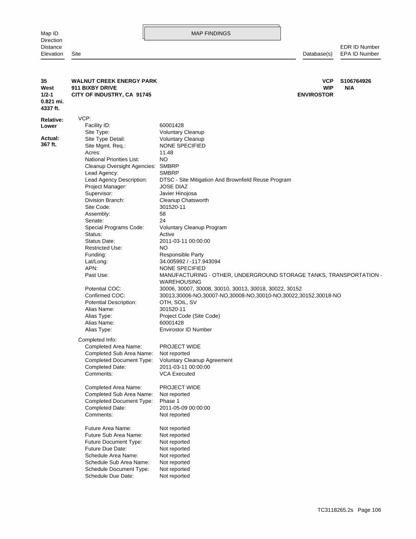
MAP FINDINGSMap IDDirection
EDR ID NumberDistanceEPA ID NumberDatabase(s)SiteElevation
Not reportedSchedule Due Date: Not reportedSchedule Document Type: Not reportedSchedule Sub Area Name: Not reportedSchedule Area Name: Not reportedFuture Due Date: Not reportedFuture Document Type: Not reportedFuture Sub Area Name: Not reportedFuture Area Name:
Not reportedComments: 2011-05-09 00:00:00Completed Date: Phase 1Completed Document Type: Not reportedCompleted Sub Area Name: PROJECT WIDECompleted Area Name:
VCA ExecutedComments: 2011-03-11 00:00:00Completed Date: Voluntary Cleanup AgreementCompleted Document Type: Not reportedCompleted Sub Area Name: PROJECT WIDECompleted Area Name:
Completed Info:
Envirostor ID NumberAlias Type: 60001428Alias Name: Project Code (Site Code)Alias Type: 301520-11Alias Name: OTH, SOIL, SVPotential Description: 30013,30006-NO,30007-NO,30008-NO,30010-NO,30022,30152,30018-NOConfirmed COC: 30006, 30007, 30008, 30010, 30013, 30018, 30022, 30152Potential COC: WAREHOUSING MANUFACTURING - OTHER, UNDERGROUND STORAGE TANKS, TRANSPORTATION -Past Use: NONE SPECIFIEDAPN: 34.005992 / -117.943094Lat/Long: Responsible PartyFunding: NORestricted Use: 2011-03-11 00:00:00Status Date: ActiveStatus: Voluntary Cleanup ProgramSpecial Programs Code: 24Senate: 58Assembly: 301520-11Site Code: Cleanup ChatsworthDivision Branch: Javier HinojosaSupervisor: JOSE DIAZProject Manager: DTSC - Site Mitigation And Brownfield Reuse ProgramLead Agency Description: SMBRPLead Agency: SMBRPCleanup Oversight Agencies: NONational Priorities List: 11.48Acres: NONE SPECIFIEDSite Mgmt. Req.: Voluntary CleanupSite Type Detail: Voluntary CleanupSite Type: 60001428Facility ID:
VCP:
4337 ft.0.821 mi.
Relative:Lower
Actual:367 ft.
1/2-1 ENVIROSTORCITY OF INDUSTRY, CA 91745West WIP911 BIXBY DRIVE N/A35 VCPWALNUT CREEK ENERGY PARK S106764926
TC3118265.2s Page 106
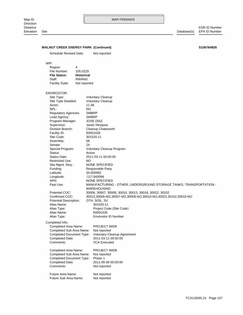
MAP FINDINGSMap IDDirection
EDR ID NumberDistanceEPA ID NumberDatabase(s)SiteElevation
Not reportedFuture Sub Area Name: Not reportedFuture Area Name:
Not reportedComments: 2011-05-09 00:00:00Completed Date: Phase 1Completed Document Type: Not reportedCompleted Sub Area Name: PROJECT WIDECompleted Area Name:
VCA ExecutedComments: 2011-03-11 00:00:00Completed Date: Voluntary Cleanup AgreementCompleted Document Type: Not reportedCompleted Sub Area Name: PROJECT WIDECompleted Area Name:
Completed Info:
Envirostor ID NumberAlias Type: 60001428Alias Name: Project Code (Site Code)Alias Type: 301520-11Alias Name: OTH, SOIL, SVPotential Description: 30013,30006-NO,30007-NO,30008-NO,30010-NO,30022,30152,30018-NOConfirmed COC: 30006, 30007, 30008, 30010, 30013, 30018, 30022, 30152Potential COC: WAREHOUSING MANUFACTURING - OTHER, UNDERGROUND STORAGE TANKS, TRANSPORTATION -Past Use: NONE SPECIFIEDAPN: -117.943094Longitude: 34.005992Latitude: Responsible PartyFunding: NONE SPECIFIEDSite Mgmt. Req.: NORestricted Use: 2011-03-11 00:00:00Status Date: ActiveStatus: Voluntary Cleanup ProgramSpecial Program: 24Senate: 58Assembly: 301520-11Site Code: 60001428Facility ID: Cleanup ChatsworthDivision Branch: Javier HinojosaSupervisor: JOSE DIAZProgram Manager: SMBRPLead Agency: SMBRPRegulatory Agencies: NONPL: 11.48Acres: Voluntary CleanupSite Type Detailed: Voluntary CleanupSite Type:
ENVIROSTOR:
Not reportedFacility Suite:RWANGStaff:HistoricalFile Status:105.0229File Number:4Region:
WIP:
Not reportedSchedule Revised Date:
WALNUT CREEK ENERGY PARK (Continued) S106764926
TC3118265.2s Page 107
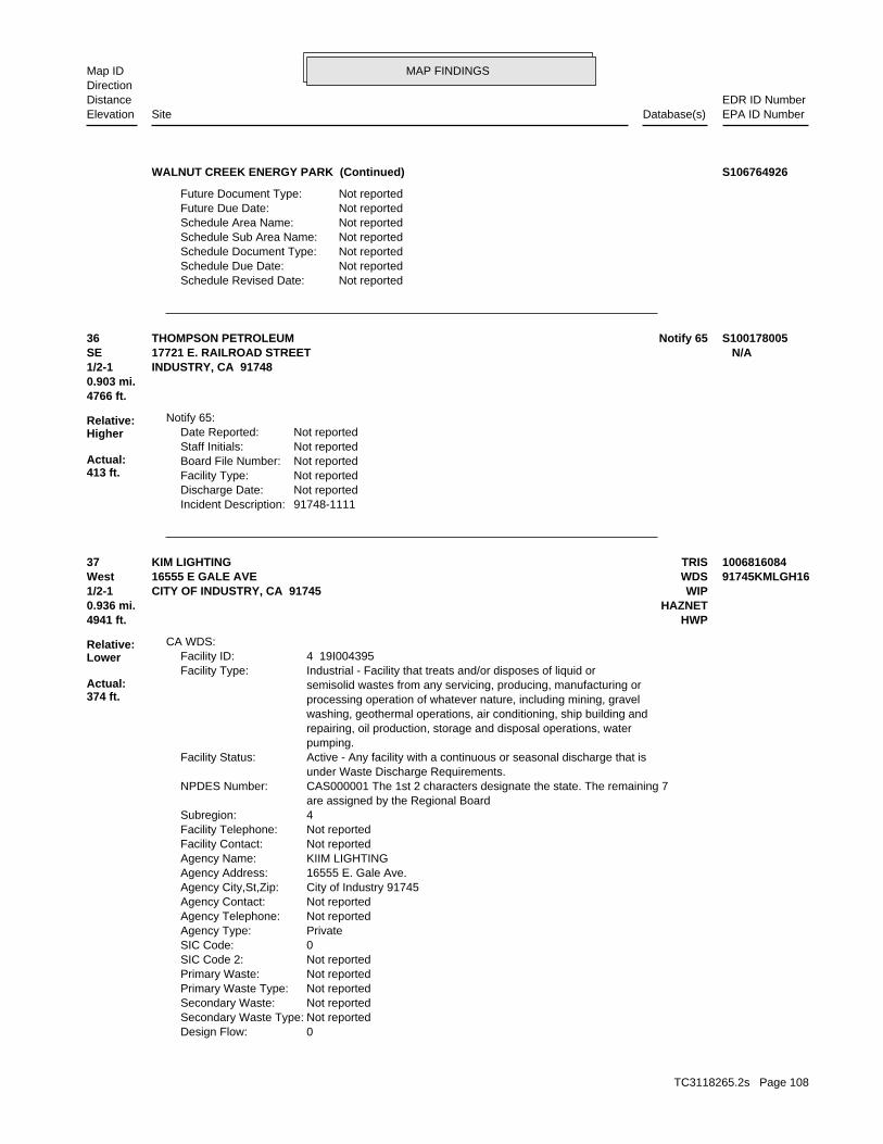
MAP FINDINGSMap IDDirection
EDR ID NumberDistanceEPA ID NumberDatabase(s)SiteElevation
Not reportedSchedule Revised Date: Not reportedSchedule Due Date: Not reportedSchedule Document Type: Not reportedSchedule Sub Area Name: Not reportedSchedule Area Name: Not reportedFuture Due Date: Not reportedFuture Document Type:
WALNUT CREEK ENERGY PARK (Continued) S106764926
91748-1111Incident Description: Not reportedDischarge Date: Not reportedFacility Type: Not reportedBoard File Number: Not reportedStaff Initials: Not reportedDate Reported:
Notify 65:
4766 ft.0.903 mi.
Relative:Higher
Actual:413 ft.
1/2-1 INDUSTRY, CA 91748SE 17721 E. RAILROAD STREET N/A36 Notify 65THOMPSON PETROLEUM S100178005
0Design Flow: Not reportedSecondary Waste Type: Not reportedSecondary Waste: Not reportedPrimary Waste Type: Not reportedPrimary Waste: Not reportedSIC Code 2: 0SIC Code: PrivateAgency Type: Not reportedAgency Telephone: Not reportedAgency Contact: City of Industry 91745Agency City,St,Zip: 16555 E. Gale Ave.Agency Address: KIIM LIGHTINGAgency Name: Not reportedFacility Contact: Not reportedFacility Telephone: 4Subregion: are assigned by the Regional Board CAS000001 The 1st 2 characters designate the state. The remaining 7NPDES Number: under Waste Discharge Requirements. Active - Any facility with a continuous or seasonal discharge that isFacility Status: pumping. repairing, oil production, storage and disposal operations, water washing, geothermal operations, air conditioning, ship building and processing operation of whatever nature, including mining, gravel semisolid wastes from any servicing, producing, manufacturing or Industrial - Facility that treats and/or disposes of liquid orFacility Type: 4 19I004395Facility ID:
CA WDS:
4941 ft. HWP0.936 mi. HAZNET
Relative:Lower
Actual:374 ft.
1/2-1 WIPCITY OF INDUSTRY, CA 91745West WDS16555 E GALE AVE 91745KMLGH1637 TRISKIM LIGHTING 1006816084
TC3118265.2s Page 108
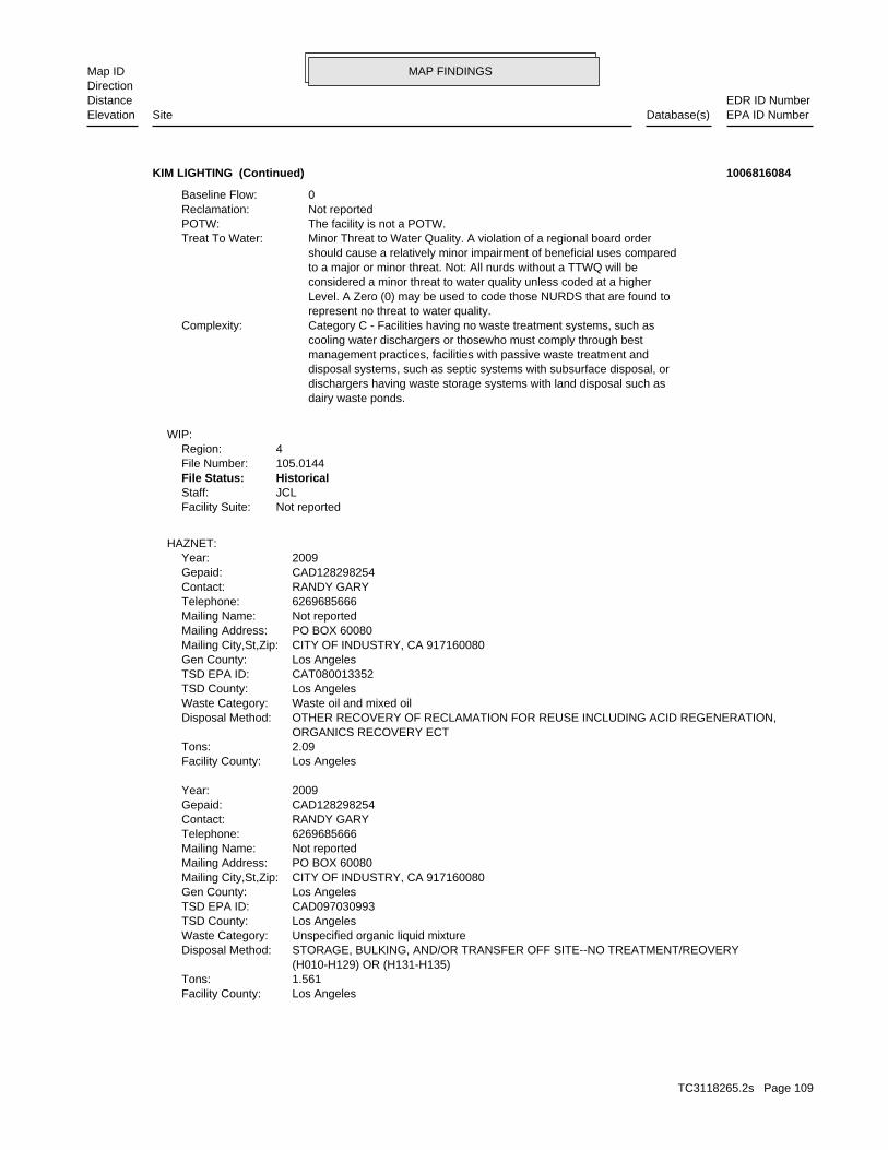
MAP FINDINGSMap IDDirection
EDR ID NumberDistanceEPA ID NumberDatabase(s)SiteElevation
Los AngelesFacility County: 1.561Tons: (H010-H129) OR (H131-H135) STORAGE, BULKING, AND/OR TRANSFER OFF SITE--NO TREATMENT/REOVERYDisposal Method: Unspecified organic liquid mixtureWaste Category: Los AngelesTSD County: CAD097030993TSD EPA ID: Los AngelesGen County: CITY OF INDUSTRY, CA 917160080Mailing City,St,Zip: PO BOX 60080Mailing Address: Not reportedMailing Name: 6269685666Telephone: RANDY GARYContact: CAD128298254Gepaid: 2009Year:
Los AngelesFacility County: 2.09Tons: ORGANICS RECOVERY ECT OTHER RECOVERY OF RECLAMATION FOR REUSE INCLUDING ACID REGENERATION,Disposal Method: Waste oil and mixed oilWaste Category: Los AngelesTSD County: CAT080013352TSD EPA ID: Los AngelesGen County: CITY OF INDUSTRY, CA 917160080Mailing City,St,Zip: PO BOX 60080Mailing Address: Not reportedMailing Name: 6269685666Telephone: RANDY GARYContact: CAD128298254Gepaid: 2009Year:
HAZNET:
Not reportedFacility Suite:JCLStaff:HistoricalFile Status:105.0144File Number:4Region:
WIP:
dairy waste ponds. dischargers having waste storage systems with land disposal such as disposal systems, such as septic systems with subsurface disposal, or management practices, facilities with passive waste treatment and cooling water dischargers or thosewho must comply through best Category C - Facilities having no waste treatment systems, such asComplexity: represent no threat to water quality. Level. A Zero (0) may be used to code those NURDS that are found to considered a minor threat to water quality unless coded at a higher to a major or minor threat. Not: All nurds without a TTWQ will be should cause a relatively minor impairment of beneficial uses compared Minor Threat to Water Quality. A violation of a regional board orderTreat To Water: The facility is not a POTW.POTW: Not reportedReclamation: 0Baseline Flow:
KIM LIGHTING (Continued) 1006816084
TC3118265.2s Page 109

MAP FINDINGSMap IDDirection
EDR ID NumberDistanceEPA ID NumberDatabase(s)SiteElevation
Not reportedCleanup Status: HAZ WASTE - NON-OPERATINGFacility Type: -117.941732Longitude: 34.002907Latitude: CAD128298254EPA Id:
HWP:
17 additional CA_HAZNET: record(s) in the EDR Site Report.Click this hyperlink while viewing on your computer to access
Los AngelesFacility County: 4.807Tons: ORGANICS RECOVERY ECT OTHER RECOVERY OF RECLAMATION FOR REUSE INCLUDING ACID REGENERATION,Disposal Method: Waste oil and mixed oilWaste Category: Los AngelesTSD County: CAT080013352TSD EPA ID: Los AngelesGen County: CITY OF INDUSTRY, CA 917160080Mailing City,St,Zip: PO BOX 60080Mailing Address: Not reportedMailing Name: 6269685666Telephone: RANDY GARYContact: CAD128298254Gepaid: 2008Year:
Los AngelesFacility County: 0.22935Tons: (H010-H129) OR (H131-H135) STORAGE, BULKING, AND/OR TRANSFER OFF SITE--NO TREATMENT/REOVERYDisposal Method: Unspecified sludge wasteWaste Category: Los AngelesTSD County: CAD097030993TSD EPA ID: Los AngelesGen County: CITY OF INDUSTRY, CA 917160080Mailing City,St,Zip: PO BOX 60080Mailing Address: Not reportedMailing Name: 6269685666Telephone: RANDY GARYContact: CAD128298254Gepaid: 2008Year:
Los AngelesFacility County: 5.355Tons: ORGANICS RECOVERY ECT OTHER RECOVERY OF RECLAMATION FOR REUSE INCLUDING ACID REGENERATION,Disposal Method: Unspecified aqueous solutionWaste Category: Los AngelesTSD County: CAT080013352TSD EPA ID: Los AngelesGen County: CITY OF INDUSTRY, CA 917160080Mailing City,St,Zip: PO BOX 60080Mailing Address: Not reportedMailing Name: 6269685666Telephone: RANDY GARYContact: CAD128298254Gepaid: 2009Year:
KIM LIGHTING (Continued) 1006816084
TC3118265.2s Page 110
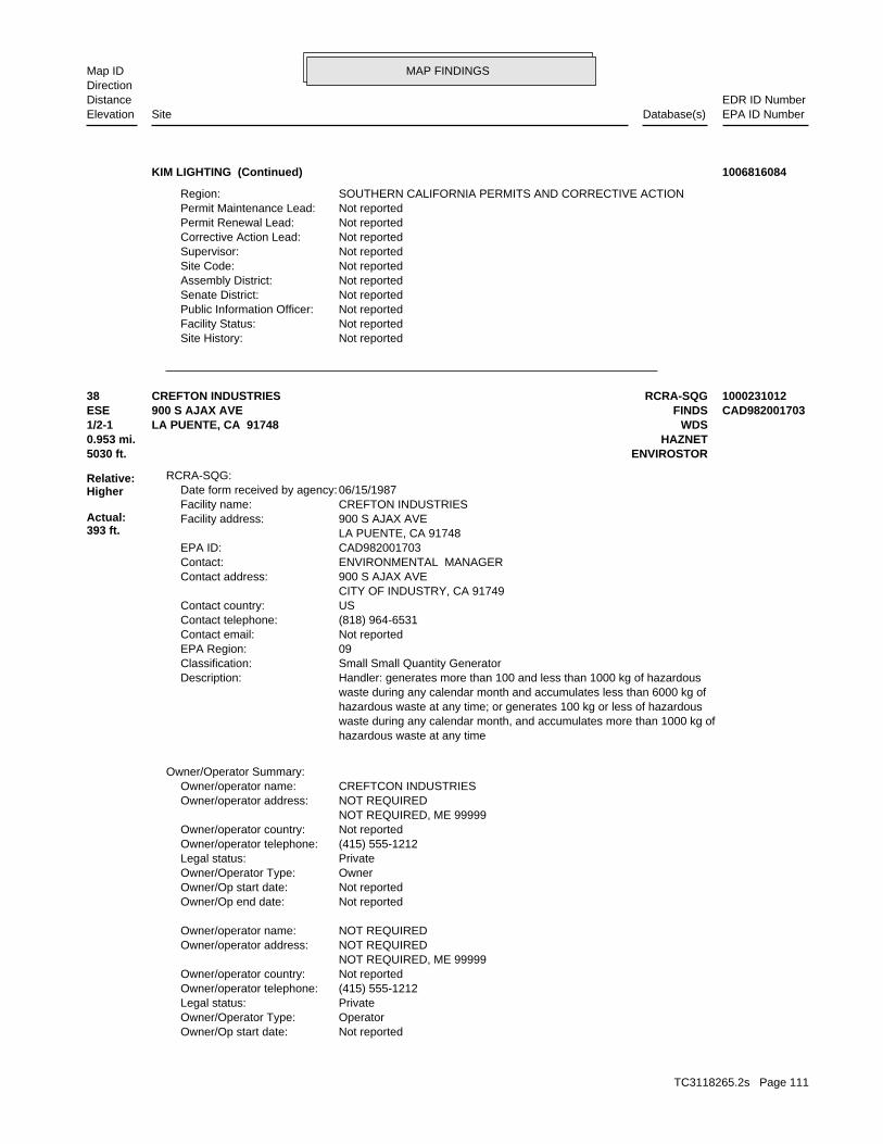
MAP FINDINGSMap IDDirection
EDR ID NumberDistanceEPA ID NumberDatabase(s)SiteElevation
Not reportedSite History: Not reportedFacility Status: Not reportedPublic Information Officer: Not reportedSenate District: Not reportedAssembly District: Not reportedSite Code: Not reportedSupervisor: Not reportedCorrective Action Lead: Not reportedPermit Renewal Lead: Not reportedPermit Maintenance Lead: SOUTHERN CALIFORNIA PERMITS AND CORRECTIVE ACTIONRegion:
KIM LIGHTING (Continued) 1006816084
Not reportedOwner/Op start date: OperatorOwner/Operator Type: PrivateLegal status: (415) 555-1212Owner/operator telephone: Not reportedOwner/operator country: NOT REQUIRED, ME 99999 NOT REQUIREDOwner/operator address: NOT REQUIREDOwner/operator name:
Not reportedOwner/Op end date: Not reportedOwner/Op start date: OwnerOwner/Operator Type: PrivateLegal status: (415) 555-1212Owner/operator telephone: Not reportedOwner/operator country: NOT REQUIRED, ME 99999 NOT REQUIREDOwner/operator address: CREFTCON INDUSTRIESOwner/operator name:
Owner/Operator Summary:
hazardous waste at any time waste during any calendar month, and accumulates more than 1000 kg of hazardous waste at any time; or generates 100 kg or less of hazardous waste during any calendar month and accumulates less than 6000 kg of Handler: generates more than 100 and less than 1000 kg of hazardousDescription: Small Small Quantity GeneratorClassification: 09EPA Region: Not reportedContact email: (818) 964-6531Contact telephone: USContact country: CITY OF INDUSTRY, CA 91749 900 S AJAX AVEContact address: ENVIRONMENTAL MANAGERContact: CAD982001703EPA ID: LA PUENTE, CA 91748 900 S AJAX AVEFacility address: CREFTON INDUSTRIESFacility name: 06/15/1987Date form received by agency:
RCRA-SQG:
5030 ft. ENVIROSTOR0.953 mi. HAZNET
Relative:Higher
Actual:393 ft.
1/2-1 WDSLA PUENTE, CA 91748ESE FINDS900 S AJAX AVE CAD98200170338 RCRA-SQGCREFTON INDUSTRIES 1000231012
TC3118265.2s Page 111
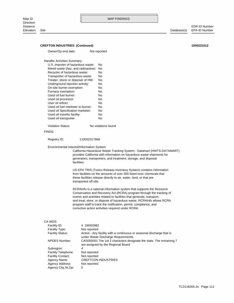
MAP FINDINGSMap IDDirection
EDR ID NumberDistanceEPA ID NumberDatabase(s)SiteElevation
0Agency City,St,Zip: Not reportedAgency Address: CREFTCON INDUSTRIESAgency Name: Not reportedFacility Contact: Not reportedFacility Telephone: 4Subregion: are assigned by the Regional Board CAS000001 The 1st 2 characters designate the state. The remaining 7NPDES Number: under Waste Discharge Requirements. Active - Any facility with a continuous or seasonal discharge that isFacility Status: Not reportedFacility Type: 4 19I002982Facility ID:
CA WDS:
corrective action activities required under RCRA.program staff to track the notification, permit, compliance, andand treat, store, or dispose of hazardous waste. RCRAInfo allows RCRAevents and activities related to facilities that generate, transport,Conservation and Recovery Act (RCRA) program through the tracking ofRCRAInfo is a national information system that supports the Resource
transported off-site.these facilities release directly to air, water, land, or that arefrom facilities on the amounts of over 300 listed toxic chemicals thatUS EPA TRIS (Toxics Release Inventory System) contains information
facilities.generators, transporters, and treatment, storage, and disposalprovides California with information on hazardous waste shipments forCalifornia Hazardous Waste Tracking System - Datamart (HWTS-DATAMART) Environmental Interest/Information System
110002317868Registry ID:
FINDS:
No violations foundViolation Status:
NoUsed oil transporter: NoUsed oil transfer facility: NoUsed oil Specification marketer: NoUsed oil fuel marketer to burner: NoUser oil refiner: NoUsed oil processor: NoUsed oil fuel burner: NoFurnace exemption: NoOn-site burner exemption: NoUnderground injection activity: NoTreater, storer or disposer of HW: NoTransporter of hazardous waste: NoRecycler of hazardous waste: NoMixed waste (haz. and radioactive): NoU.S. importer of hazardous waste:
Handler Activities Summary:
Not reportedOwner/Op end date:
CREFTON INDUSTRIES (Continued) 1000231012
TC3118265.2s Page 112
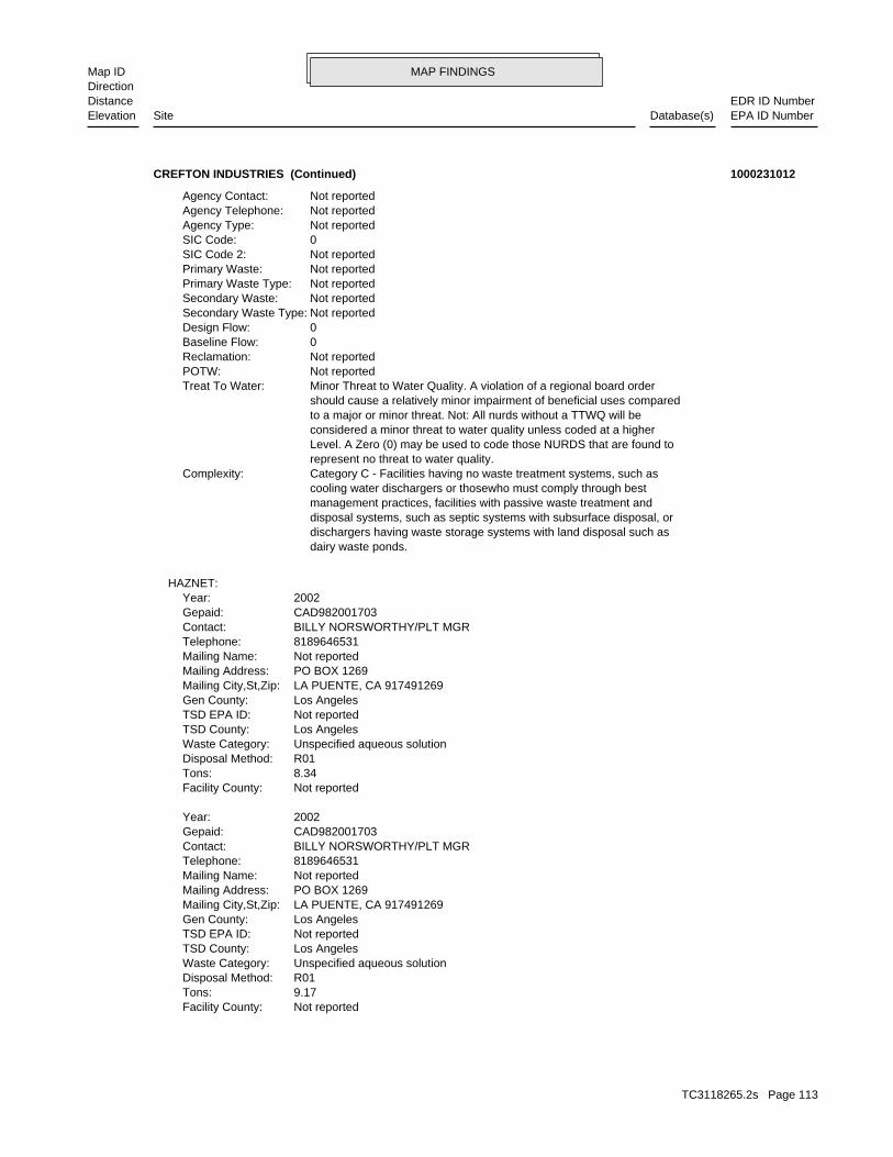
MAP FINDINGSMap IDDirection
EDR ID NumberDistanceEPA ID NumberDatabase(s)SiteElevation
Not reportedFacility County: 9.17Tons: R01Disposal Method: Unspecified aqueous solutionWaste Category: Los AngelesTSD County: Not reportedTSD EPA ID: Los AngelesGen County: LA PUENTE, CA 917491269Mailing City,St,Zip: PO BOX 1269Mailing Address: Not reportedMailing Name: 8189646531Telephone: BILLY NORSWORTHY/PLT MGRContact: CAD982001703Gepaid: 2002Year:
Not reportedFacility County: 8.34Tons: R01Disposal Method: Unspecified aqueous solutionWaste Category: Los AngelesTSD County: Not reportedTSD EPA ID: Los AngelesGen County: LA PUENTE, CA 917491269Mailing City,St,Zip: PO BOX 1269Mailing Address: Not reportedMailing Name: 8189646531Telephone: BILLY NORSWORTHY/PLT MGRContact: CAD982001703Gepaid: 2002Year:
HAZNET:
dairy waste ponds. dischargers having waste storage systems with land disposal such as disposal systems, such as septic systems with subsurface disposal, or management practices, facilities with passive waste treatment and cooling water dischargers or thosewho must comply through best Category C - Facilities having no waste treatment systems, such asComplexity: represent no threat to water quality. Level. A Zero (0) may be used to code those NURDS that are found to considered a minor threat to water quality unless coded at a higher to a major or minor threat. Not: All nurds without a TTWQ will be should cause a relatively minor impairment of beneficial uses compared Minor Threat to Water Quality. A violation of a regional board orderTreat To Water: Not reportedPOTW: Not reportedReclamation: 0Baseline Flow: 0Design Flow: Not reportedSecondary Waste Type: Not reportedSecondary Waste: Not reportedPrimary Waste Type: Not reportedPrimary Waste: Not reportedSIC Code 2: 0SIC Code: Not reportedAgency Type: Not reportedAgency Telephone: Not reportedAgency Contact:
CREFTON INDUSTRIES (Continued) 1000231012
TC3118265.2s Page 113

MAP FINDINGSMap IDDirection
EDR ID NumberDistanceEPA ID NumberDatabase(s)SiteElevation
Not reportedSupervisor: Not reportedProgram Manager: NONE SPECIFIEDLead Agency: NONE SPECIFIEDRegulatory Agencies: NONPL: Not reportedAcres: Tiered PermitSite Type Detailed: Tiered PermitSite Type:
ENVIROSTOR:
32 additional CA_HAZNET: record(s) in the EDR Site Report.Click this hyperlink while viewing on your computer to access
Not reportedFacility County: 8.34Tons: R01Disposal Method: Waste oil and mixed oilWaste Category: Los AngelesTSD County: Not reportedTSD EPA ID: Los AngelesGen County: LA PUENTE, CA 917491269Mailing City,St,Zip: PO BOX 1269Mailing Address: Not reportedMailing Name: 8189646531Telephone: BILLY NORSWORTHY/PLT MGRContact: CAD982001703Gepaid: 2001Year:
Not reportedFacility County: 26.95Tons: D80Disposal Method: Other organic solidsWaste Category: 99TSD County: Not reportedTSD EPA ID: Los AngelesGen County: LA PUENTE, CA 917491269Mailing City,St,Zip: PO BOX 1269Mailing Address: Not reportedMailing Name: 8189646531Telephone: BILLY NORSWORTHY/PLT MGRContact: CAD982001703Gepaid: 2002Year:
Not reportedFacility County: 5.00Tons: Not reportedDisposal Method: Aqueous solution with total organic residues 10 percent or moreWaste Category: Los AngelesTSD County: Not reportedTSD EPA ID: Los AngelesGen County: LA PUENTE, CA 917491269Mailing City,St,Zip: PO BOX 1269Mailing Address: Not reportedMailing Name: 8189646531Telephone: BILLY NORSWORTHY/PLT MGRContact: CAD982001703Gepaid: 2002Year:
CREFTON INDUSTRIES (Continued) 1000231012
TC3118265.2s Page 114
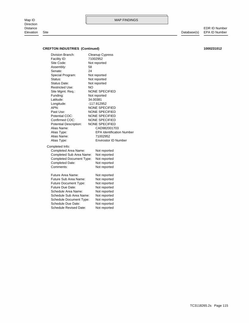
MAP FINDINGSMap IDDirection
EDR ID NumberDistanceEPA ID NumberDatabase(s)SiteElevation
Not reportedSchedule Revised Date: Not reportedSchedule Due Date: Not reportedSchedule Document Type: Not reportedSchedule Sub Area Name: Not reportedSchedule Area Name: Not reportedFuture Due Date: Not reportedFuture Document Type: Not reportedFuture Sub Area Name: Not reportedFuture Area Name:
Not reportedComments: Not reportedCompleted Date: Not reportedCompleted Document Type: Not reportedCompleted Sub Area Name: Not reportedCompleted Area Name:
Completed Info:
Envirostor ID NumberAlias Type: 71002952Alias Name: EPA Identification NumberAlias Type: CAD982001703Alias Name: NONE SPECIFIEDPotential Description: NONE SPECIFIEDConfirmed COC: NONE SPECIFIEDPotential COC: NONE SPECIFIEDPast Use: NONE SPECIFIEDAPN: -117.912952Longitude: 34.00381Latitude: Not reportedFunding: NONE SPECIFIEDSite Mgmt. Req.: NORestricted Use: Not reportedStatus Date: Not reportedStatus: Not reportedSpecial Program: 24Senate: 58Assembly: Not reportedSite Code: 71002952Facility ID: Cleanup CypressDivision Branch:
CREFTON INDUSTRIES (Continued) 1000231012
TC3118265.2s Page 115

TC3118265.2s Page 116
ROWLAND HEIGHTS S109431172 SAIA MOTOR FREIGHT STATE RTE 60 .25 MI W OF FAIRWAY DR 91748 HAZNETLA PUENTE S108221054 SOUTHERN CALIFORNIA EDISON N W CORNER OF ANAHEIM RD & 91748 HAZNETLA PUENTE 1000819825 AUTO AND TRUCK ELECTRICAL REPAIR 14846 E VALLEY 91745 RCRA-SQG, FINDS, HAZNETLA PUENTE S100833444 SAN GABRIEL GROUND WATER BASIN 4 LA PUENTE AREA 91744 CA BOND EXP. PLANLA PUENTE 1003878492 LA PUENTE DUMP AZUSA AVE N OF VLY BLVD 91744 CERC-NFRAPINDUSTRY S108220973 SOUTHERN CALIFORNIA EDISON 21508 FERRERO PKWY 91748 HAZNETINDUSTRY S106089430 MOTOR CARGO CORPORATION AZUSA RD & ROWAND ST 91748 HAZNETINDUSTRY S106825477 AIR PROD. & CHEM INC 17801 E. ARENTH AVE. 91744 EMICITY OF INDUSTRY (CORP S106764798 ARMIN PLASTICS CORPORATION 1890 E RAILROAD ST 91748 WIPCITY OF INDUSTRY (CORP S107504180 FORMER UTILITY TRAILOR 17747 RAILROAD (17747 & 17735) ST 91748 WIPCITY OF INDUSTRY (CORP S106769900 DEVRY INSTITUE OF TECHNOLOGY 12801 S CROSSROAD PKWY 91744 WIPCITY OF INDUSTRY 1001475705 SAN GABRIEL RIVER RESPONSE SAN GABRIEL RIVER 91745 CERCLIS, FINDSCITY OF INDUSTRY 1007271821 CAMCO CHEMICAL CO INC 1838 E RAILROAD ST 91748 FTTS, HIST FTTSCITY OF INDUSTRY 1005428309 ECOLAB INC 18383 E RAILROAD ST 91749 SSTSCITY OF INDUSTRY S106841302 TRAIN JOHNSON - SITE SAFE PLAT 1801 RAILROAD 91748 EMICITY OF INDUSTRY 1014386561 ECOLAB INC. 18383 E RAILROAD STREET 91748 RCRA-LQGCITY OF INDUSTRY 1003877941 ECOLAB 18303 E RAILROAD STREET 91749 CERC-NFRAPCITY OF INDUSTRY 1000139393 CAL-MOLD INC 17438 E RAILROAD 91744 RCRA-SQG, FINDS, HAZNETCITY OF INDUSTRY S106088526 TNT LOGISTICS CRNR OF ANAHEIM/PUENTE & ARENTH 91748 HAZNETCITY OF INDUSTRY S110373545 CONOCO PHILLIPS 255621 948 AZUSA AVE 91748 HAZNETCITY OF INDUSTRY S110494009 LITHONIA WEST 18401 E. ARENTH AVENUE 91748 ENVIROSTOR
TRANS COCITY OF INDUSTRY S101584978 PACIFIC MOTOR TRUCKING, SOUTHERN PACIFIC 1752 ARENTH 91748 CA FID UST, SWEEPS USTCITY OF INDUSTRY S108215596 ORCHID ART FLOWER INC 18961 ARENTH STE C 91748 HAZNET
Count: 23 records ORPHAN SUMMARY
City EDR ID Site Name Site Address Zip Database(s)
To maintain currency of the following federal and state databases, EDR contacts the appropriate governmental agencyon a monthly or quarterly basis, as required.
Number of Days to Update: Provides confirmation that EDR is reporting records that have been updated within 90 daysfrom the date the government agency made the information available to the public.
STANDARD ENVIRONMENTAL RECORDS
Federal NPL site list
NPL: National Priority ListNational Priorities List (Superfund). The NPL is a subset of CERCLIS and identifies over 1,200 sites for prioritycleanup under the Superfund Program. NPL sites may encompass relatively large areas. As such, EDR provides polygoncoverage for over 1,000 NPL site boundaries produced by EPA’s Environmental Photographic Interpretation Center(EPIC) and regional EPA offices.
Date of Government Version: 03/31/2011Date Data Arrived at EDR: 04/13/2011Date Made Active in Reports: 06/14/2011Number of Days to Update: 62
Source: EPATelephone: N/ALast EDR Contact: 04/13/2011Next Scheduled EDR Contact: 07/25/2011Data Release Frequency: Quarterly
NPL Site Boundaries
Sources:
EPA’s Environmental Photographic Interpretation Center (EPIC)Telephone: 202-564-7333
EPA Region 1 EPA Region 6Telephone 617-918-1143 Telephone: 214-655-6659
EPA Region 3 EPA Region 7Telephone 215-814-5418 Telephone: 913-551-7247
EPA Region 4 EPA Region 8Telephone 404-562-8033 Telephone: 303-312-6774
EPA Region 5 EPA Region 9Telephone 312-886-6686 Telephone: 415-947-4246
EPA Region 10Telephone 206-553-8665
Proposed NPL: Proposed National Priority List SitesA site that has been proposed for listing on the National Priorities List through the issuance of a proposed rulein the Federal Register. EPA then accepts public comments on the site, responds to the comments, and places onthe NPL those sites that continue to meet the requirements for listing.
Date of Government Version: 03/31/2011Date Data Arrived at EDR: 04/13/2011Date Made Active in Reports: 06/14/2011Number of Days to Update: 62
Source: EPATelephone: N/ALast EDR Contact: 04/13/2011Next Scheduled EDR Contact: 07/25/2011Data Release Frequency: Quarterly
NPL LIENS: Federal Superfund LiensFederal Superfund Liens. Under the authority granted the USEPA by CERCLA of 1980, the USEPA has the authorityto file liens against real property in order to recover remedial action expenditures or when the property ownerreceived notification of potential liability. USEPA compiles a listing of filed notices of Superfund Liens.
Date of Government Version: 10/15/1991Date Data Arrived at EDR: 02/02/1994Date Made Active in Reports: 03/30/1994Number of Days to Update: 56
Source: EPATelephone: 202-564-4267Last EDR Contact: 05/16/2011Next Scheduled EDR Contact: 08/29/2011Data Release Frequency: No Update Planned
TC3118265.2s Page GR-1
GOVERNMENT RECORDS SEARCHED / DATA CURRENCY TRACKING
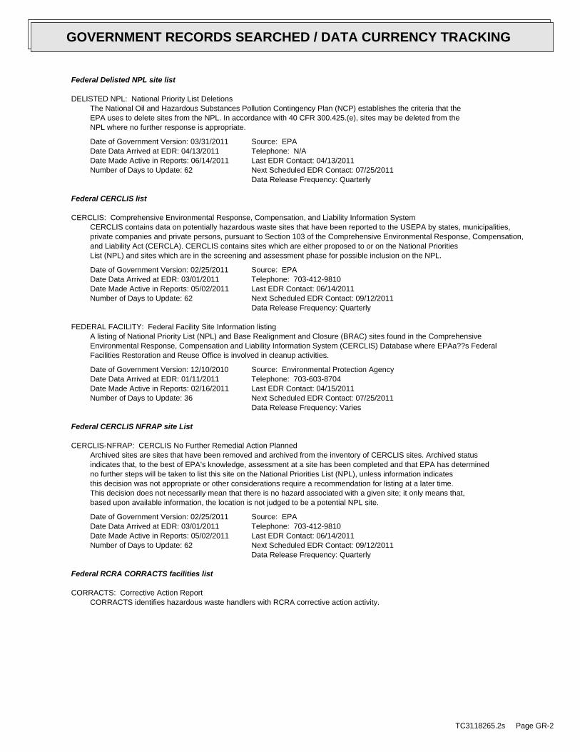
Federal Delisted NPL site list
DELISTED NPL: National Priority List DeletionsThe National Oil and Hazardous Substances Pollution Contingency Plan (NCP) establishes the criteria that theEPA uses to delete sites from the NPL. In accordance with 40 CFR 300.425.(e), sites may be deleted from theNPL where no further response is appropriate.
Date of Government Version: 03/31/2011Date Data Arrived at EDR: 04/13/2011Date Made Active in Reports: 06/14/2011Number of Days to Update: 62
Source: EPATelephone: N/ALast EDR Contact: 04/13/2011Next Scheduled EDR Contact: 07/25/2011Data Release Frequency: Quarterly
Federal CERCLIS list
CERCLIS: Comprehensive Environmental Response, Compensation, and Liability Information SystemCERCLIS contains data on potentially hazardous waste sites that have been reported to the USEPA by states, municipalities,private companies and private persons, pursuant to Section 103 of the Comprehensive Environmental Response, Compensation,and Liability Act (CERCLA). CERCLIS contains sites which are either proposed to or on the National PrioritiesList (NPL) and sites which are in the screening and assessment phase for possible inclusion on the NPL.
Date of Government Version: 02/25/2011Date Data Arrived at EDR: 03/01/2011Date Made Active in Reports: 05/02/2011Number of Days to Update: 62
Source: EPATelephone: 703-412-9810Last EDR Contact: 06/14/2011Next Scheduled EDR Contact: 09/12/2011Data Release Frequency: Quarterly
FEDERAL FACILITY: Federal Facility Site Information listingA listing of National Priority List (NPL) and Base Realignment and Closure (BRAC) sites found in the ComprehensiveEnvironmental Response, Compensation and Liability Information System (CERCLIS) Database where EPAa??s FederalFacilities Restoration and Reuse Office is involved in cleanup activities.
Date of Government Version: 12/10/2010Date Data Arrived at EDR: 01/11/2011Date Made Active in Reports: 02/16/2011Number of Days to Update: 36
Source: Environmental Protection AgencyTelephone: 703-603-8704Last EDR Contact: 04/15/2011Next Scheduled EDR Contact: 07/25/2011Data Release Frequency: Varies
Federal CERCLIS NFRAP site List
CERCLIS-NFRAP: CERCLIS No Further Remedial Action PlannedArchived sites are sites that have been removed and archived from the inventory of CERCLIS sites. Archived statusindicates that, to the best of EPA’s knowledge, assessment at a site has been completed and that EPA has determinedno further steps will be taken to list this site on the National Priorities List (NPL), unless information indicatesthis decision was not appropriate or other considerations require a recommendation for listing at a later time.This decision does not necessarily mean that there is no hazard associated with a given site; it only means that,based upon available information, the location is not judged to be a potential NPL site.
Date of Government Version: 02/25/2011Date Data Arrived at EDR: 03/01/2011Date Made Active in Reports: 05/02/2011Number of Days to Update: 62
Source: EPATelephone: 703-412-9810Last EDR Contact: 06/14/2011Next Scheduled EDR Contact: 09/12/2011Data Release Frequency: Quarterly
Federal RCRA CORRACTS facilities list
CORRACTS: Corrective Action ReportCORRACTS identifies hazardous waste handlers with RCRA corrective action activity.
TC3118265.2s Page GR-2
GOVERNMENT RECORDS SEARCHED / DATA CURRENCY TRACKING

Date of Government Version: 03/09/2011Date Data Arrived at EDR: 03/15/2011Date Made Active in Reports: 06/14/2011Number of Days to Update: 91
Source: EPATelephone: 800-424-9346Last EDR Contact: 05/16/2011Next Scheduled EDR Contact: 08/29/2011Data Release Frequency: Quarterly
Federal RCRA non-CORRACTS TSD facilities list
RCRA-TSDF: RCRA - Treatment, Storage and DisposalRCRAInfo is EPA’s comprehensive information system, providing access to data supporting the Resource Conservationand Recovery Act (RCRA) of 1976 and the Hazardous and Solid Waste Amendments (HSWA) of 1984. The databaseincludes selective information on sites which generate, transport, store, treat and/or dispose of hazardous wasteas defined by the Resource Conservation and Recovery Act (RCRA). Transporters are individuals or entities thatmove hazardous waste from the generator offsite to a facility that can recycle, treat, store, or dispose of thewaste. TSDFs treat, store, or dispose of the waste.
Date of Government Version: 03/11/2011Date Data Arrived at EDR: 04/05/2011Date Made Active in Reports: 05/02/2011Number of Days to Update: 27
Source: Environmental Protection AgencyTelephone: (415) 495-8895Last EDR Contact: 07/07/2011Next Scheduled EDR Contact: 10/17/2011Data Release Frequency: Quarterly
Federal RCRA generators list
RCRA-LQG: RCRA - Large Quantity GeneratorsRCRAInfo is EPA’s comprehensive information system, providing access to data supporting the Resource Conservationand Recovery Act (RCRA) of 1976 and the Hazardous and Solid Waste Amendments (HSWA) of 1984. The databaseincludes selective information on sites which generate, transport, store, treat and/or dispose of hazardous wasteas defined by the Resource Conservation and Recovery Act (RCRA). Large quantity generators (LQGs) generateover 1,000 kilograms (kg) of hazardous waste, or over 1 kg of acutely hazardous waste per month.
Date of Government Version: 03/11/2011Date Data Arrived at EDR: 04/05/2011Date Made Active in Reports: 05/02/2011Number of Days to Update: 27
Source: Environmental Protection AgencyTelephone: (415) 495-8895Last EDR Contact: 07/07/2011Next Scheduled EDR Contact: 10/17/2011Data Release Frequency: Quarterly
RCRA-SQG: RCRA - Small Quantity GeneratorsRCRAInfo is EPA’s comprehensive information system, providing access to data supporting the Resource Conservationand Recovery Act (RCRA) of 1976 and the Hazardous and Solid Waste Amendments (HSWA) of 1984. The databaseincludes selective information on sites which generate, transport, store, treat and/or dispose of hazardous wasteas defined by the Resource Conservation and Recovery Act (RCRA). Small quantity generators (SQGs) generatebetween 100 kg and 1,000 kg of hazardous waste per month.
Date of Government Version: 03/11/2011Date Data Arrived at EDR: 04/05/2011Date Made Active in Reports: 05/02/2011Number of Days to Update: 27
Source: Environmental Protection AgencyTelephone: (415) 495-8895Last EDR Contact: 07/07/2011Next Scheduled EDR Contact: 10/17/2011Data Release Frequency: Quarterly
RCRA-CESQG: RCRA - Conditionally Exempt Small Quantity GeneratorsRCRAInfo is EPA’s comprehensive information system, providing access to data supporting the Resource Conservationand Recovery Act (RCRA) of 1976 and the Hazardous and Solid Waste Amendments (HSWA) of 1984. The databaseincludes selective information on sites which generate, transport, store, treat and/or dispose of hazardous wasteas defined by the Resource Conservation and Recovery Act (RCRA). Conditionally exempt small quantity generators(CESQGs) generate less than 100 kg of hazardous waste, or less than 1 kg of acutely hazardous waste per month.
Date of Government Version: 03/11/2011Date Data Arrived at EDR: 04/05/2011Date Made Active in Reports: 05/02/2011Number of Days to Update: 27
Source: Environmental Protection AgencyTelephone: (415) 495-8895Last EDR Contact: 07/07/2011Next Scheduled EDR Contact: 10/17/2011Data Release Frequency: Varies
TC3118265.2s Page GR-3
GOVERNMENT RECORDS SEARCHED / DATA CURRENCY TRACKING

Federal institutional controls / engineering controls registries
US ENG CONTROLS: Engineering Controls Sites ListA listing of sites with engineering controls in place. Engineering controls include various forms of caps, buildingfoundations, liners, and treatment methods to create pathway elimination for regulated substances to enter environmentalmedia or effect human health.
Date of Government Version: 03/16/2011Date Data Arrived at EDR: 03/25/2011Date Made Active in Reports: 06/14/2011Number of Days to Update: 81
Source: Environmental Protection AgencyTelephone: 703-603-0695Last EDR Contact: 06/13/2011Next Scheduled EDR Contact: 09/26/2011Data Release Frequency: Varies
US INST CONTROL: Sites with Institutional ControlsA listing of sites with institutional controls in place. Institutional controls include administrative measures,such as groundwater use restrictions, construction restrictions, property use restrictions, and post remediationcare requirements intended to prevent exposure to contaminants remaining on site. Deed restrictions are generallyrequired as part of the institutional controls.
Date of Government Version: 03/16/2011Date Data Arrived at EDR: 03/25/2011Date Made Active in Reports: 06/14/2011Number of Days to Update: 81
Source: Environmental Protection AgencyTelephone: 703-603-0695Last EDR Contact: 06/13/2011Next Scheduled EDR Contact: 09/26/2011Data Release Frequency: Varies
Federal ERNS list
ERNS: Emergency Response Notification SystemEmergency Response Notification System. ERNS records and stores information on reported releases of oil and hazardoussubstances.
Date of Government Version: 04/05/2011Date Data Arrived at EDR: 04/05/2011Date Made Active in Reports: 06/14/2011Number of Days to Update: 70
Source: National Response Center, United States Coast GuardTelephone: 202-267-2180Last EDR Contact: 07/05/2011Next Scheduled EDR Contact: 10/17/2011Data Release Frequency: Annually
State- and tribal - equivalent NPL
RESPONSE: State Response SitesIdentifies confirmed release sites where DTSC is involved in remediation, either in a lead or oversight capacity.These confirmed release sites are generally high-priority and high potential risk.
Date of Government Version: 05/10/2011Date Data Arrived at EDR: 05/11/2011Date Made Active in Reports: 06/15/2011Number of Days to Update: 35
Source: Department of Toxic Substances ControlTelephone: 916-323-3400Last EDR Contact: 06/16/2011Next Scheduled EDR Contact: 08/22/2011Data Release Frequency: Quarterly
State- and tribal - equivalent CERCLIS
ENVIROSTOR: EnviroStor DatabaseThe Department of Toxic Substances Control’s (DTSC’s) Site Mitigation and Brownfields Reuse Program’s (SMBRP’s)EnviroStor database identifes sites that have known contamination or sites for which there may be reasons to investigatefurther. The database includes the following site types: Federal Superfund sites (National Priorities List (NPL));State Response, including Military Facilities and State Superfund; Voluntary Cleanup; and School sites. EnviroStorprovides similar information to the information that was available in CalSites, and provides additional site information,including, but not limited to, identification of formerly-contaminated properties that have been released forreuse, properties where environmental deed restrictions have been recorded to prevent inappropriate land uses,and risk characterization information that is used to assess potential impacts to public health and the environmentat contaminated sites.
TC3118265.2s Page GR-4
GOVERNMENT RECORDS SEARCHED / DATA CURRENCY TRACKING

Date of Government Version: 05/10/2011Date Data Arrived at EDR: 05/11/2011Date Made Active in Reports: 06/15/2011Number of Days to Update: 35
Source: Department of Toxic Substances ControlTelephone: 916-323-3400Last EDR Contact: 06/16/2011Next Scheduled EDR Contact: 08/22/2011Data Release Frequency: Quarterly
State and tribal landfill and/or solid waste disposal site lists
SWF/LF (SWIS): Solid Waste Information SystemActive, Closed and Inactive Landfills. SWF/LF records typically contain an inve ntory of solid waste disposalfacilities or landfills. These may be active or i nactive facilities or open dumps that failed to meet RCRA Section4004 criteria for solid waste landfills or disposal sites.
Date of Government Version: 05/23/2011Date Data Arrived at EDR: 05/24/2011Date Made Active in Reports: 06/15/2011Number of Days to Update: 22
Source: Department of Resources Recycling and RecoveryTelephone: 916-341-6320Last EDR Contact: 05/24/2011Next Scheduled EDR Contact: 09/05/2011Data Release Frequency: Quarterly
State and tribal leaking storage tank lists
LUST REG 9: Leaking Underground Storage Tank ReportOrange, Riverside, San Diego counties. For more current information, please refer to the State Water ResourcesControl Board’s LUST database.
Date of Government Version: 03/01/2001Date Data Arrived at EDR: 04/23/2001Date Made Active in Reports: 05/21/2001Number of Days to Update: 28
Source: California Regional Water Quality Control Board San Diego Region (9)Telephone: 858-637-5595Last EDR Contact: 06/27/2011Next Scheduled EDR Contact: 10/10/2011Data Release Frequency: No Update Planned
LUST REG 7: Leaking Underground Storage Tank Case ListingLeaking Underground Storage Tank locations. Imperial, Riverside, San Diego, Santa Barbara counties.
Date of Government Version: 02/26/2004Date Data Arrived at EDR: 02/26/2004Date Made Active in Reports: 03/24/2004Number of Days to Update: 27
Source: California Regional Water Quality Control Board Colorado River Basin Region (7)Telephone: 760-776-8943Last EDR Contact: 05/02/2011Next Scheduled EDR Contact: 08/15/2011Data Release Frequency: No Update Planned
LUST REG 6V: Leaking Underground Storage Tank Case ListingLeaking Underground Storage Tank locations. Inyo, Kern, Los Angeles, Mono, San Bernardino counties.
Date of Government Version: 06/07/2005Date Data Arrived at EDR: 06/07/2005Date Made Active in Reports: 06/29/2005Number of Days to Update: 22
Source: California Regional Water Quality Control Board Victorville Branch Office (6)Telephone: 760-241-7365Last EDR Contact: 06/13/2011Next Scheduled EDR Contact: 09/26/2011Data Release Frequency: No Update Planned
LUST REG 6L: Leaking Underground Storage Tank Case ListingFor more current information, please refer to the State Water Resources Control Board’s LUST database.
Date of Government Version: 09/09/2003Date Data Arrived at EDR: 09/10/2003Date Made Active in Reports: 10/07/2003Number of Days to Update: 27
Source: California Regional Water Quality Control Board Lahontan Region (6)Telephone: 530-542-5572Last EDR Contact: 06/13/2011Next Scheduled EDR Contact: 09/26/2011Data Release Frequency: No Update Planned
LUST REG 5: Leaking Underground Storage Tank DatabaseLeaking Underground Storage Tank locations. Alameda, Alpine, Amador, Butte, Colusa, Contra Costa, Calveras, ElDorado, Fresno, Glenn, Kern, Kings, Lake, Lassen, Madera, Mariposa, Merced, Modoc, Napa, Nevada, Placer, Plumas,Sacramento, San Joaquin, Shasta, Solano, Stanislaus, Sutter, Tehama, Tulare, Tuolumne, Yolo, Yuba counties.
TC3118265.2s Page GR-5
GOVERNMENT RECORDS SEARCHED / DATA CURRENCY TRACKING
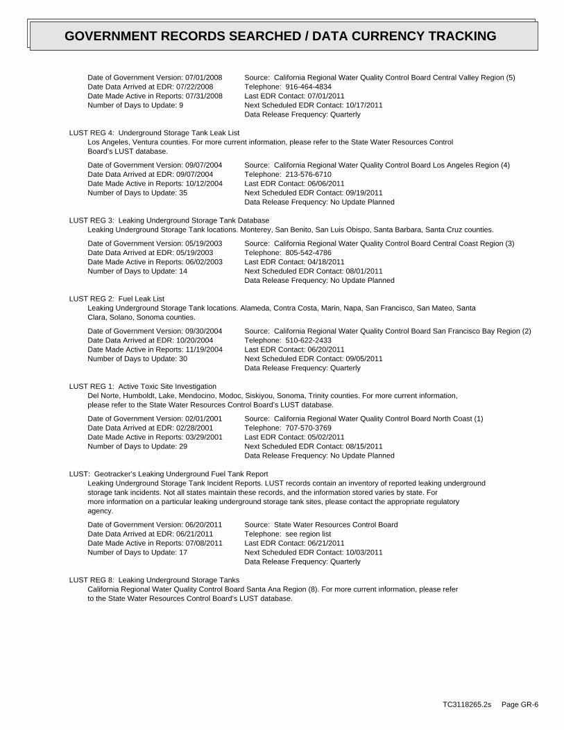
Date of Government Version: 07/01/2008Date Data Arrived at EDR: 07/22/2008Date Made Active in Reports: 07/31/2008Number of Days to Update: 9
Source: California Regional Water Quality Control Board Central Valley Region (5)Telephone: 916-464-4834Last EDR Contact: 07/01/2011Next Scheduled EDR Contact: 10/17/2011Data Release Frequency: Quarterly
LUST REG 4: Underground Storage Tank Leak ListLos Angeles, Ventura counties. For more current information, please refer to the State Water Resources ControlBoard’s LUST database.
Date of Government Version: 09/07/2004Date Data Arrived at EDR: 09/07/2004Date Made Active in Reports: 10/12/2004Number of Days to Update: 35
Source: California Regional Water Quality Control Board Los Angeles Region (4)Telephone: 213-576-6710Last EDR Contact: 06/06/2011Next Scheduled EDR Contact: 09/19/2011Data Release Frequency: No Update Planned
LUST REG 3: Leaking Underground Storage Tank DatabaseLeaking Underground Storage Tank locations. Monterey, San Benito, San Luis Obispo, Santa Barbara, Santa Cruz counties.
Date of Government Version: 05/19/2003Date Data Arrived at EDR: 05/19/2003Date Made Active in Reports: 06/02/2003Number of Days to Update: 14
Source: California Regional Water Quality Control Board Central Coast Region (3)Telephone: 805-542-4786Last EDR Contact: 04/18/2011Next Scheduled EDR Contact: 08/01/2011Data Release Frequency: No Update Planned
LUST REG 2: Fuel Leak ListLeaking Underground Storage Tank locations. Alameda, Contra Costa, Marin, Napa, San Francisco, San Mateo, SantaClara, Solano, Sonoma counties.
Date of Government Version: 09/30/2004Date Data Arrived at EDR: 10/20/2004Date Made Active in Reports: 11/19/2004Number of Days to Update: 30
Source: California Regional Water Quality Control Board San Francisco Bay Region (2)Telephone: 510-622-2433Last EDR Contact: 06/20/2011Next Scheduled EDR Contact: 09/05/2011Data Release Frequency: Quarterly
LUST REG 1: Active Toxic Site InvestigationDel Norte, Humboldt, Lake, Mendocino, Modoc, Siskiyou, Sonoma, Trinity counties. For more current information,please refer to the State Water Resources Control Board’s LUST database.
Date of Government Version: 02/01/2001Date Data Arrived at EDR: 02/28/2001Date Made Active in Reports: 03/29/2001Number of Days to Update: 29
Source: California Regional Water Quality Control Board North Coast (1)Telephone: 707-570-3769Last EDR Contact: 05/02/2011Next Scheduled EDR Contact: 08/15/2011Data Release Frequency: No Update Planned
LUST: Geotracker’s Leaking Underground Fuel Tank ReportLeaking Underground Storage Tank Incident Reports. LUST records contain an inventory of reported leaking undergroundstorage tank incidents. Not all states maintain these records, and the information stored varies by state. Formore information on a particular leaking underground storage tank sites, please contact the appropriate regulatoryagency.
Date of Government Version: 06/20/2011Date Data Arrived at EDR: 06/21/2011Date Made Active in Reports: 07/08/2011Number of Days to Update: 17
Source: State Water Resources Control BoardTelephone: see region listLast EDR Contact: 06/21/2011Next Scheduled EDR Contact: 10/03/2011Data Release Frequency: Quarterly
LUST REG 8: Leaking Underground Storage TanksCalifornia Regional Water Quality Control Board Santa Ana Region (8). For more current information, please referto the State Water Resources Control Board’s LUST database.
TC3118265.2s Page GR-6
GOVERNMENT RECORDS SEARCHED / DATA CURRENCY TRACKING
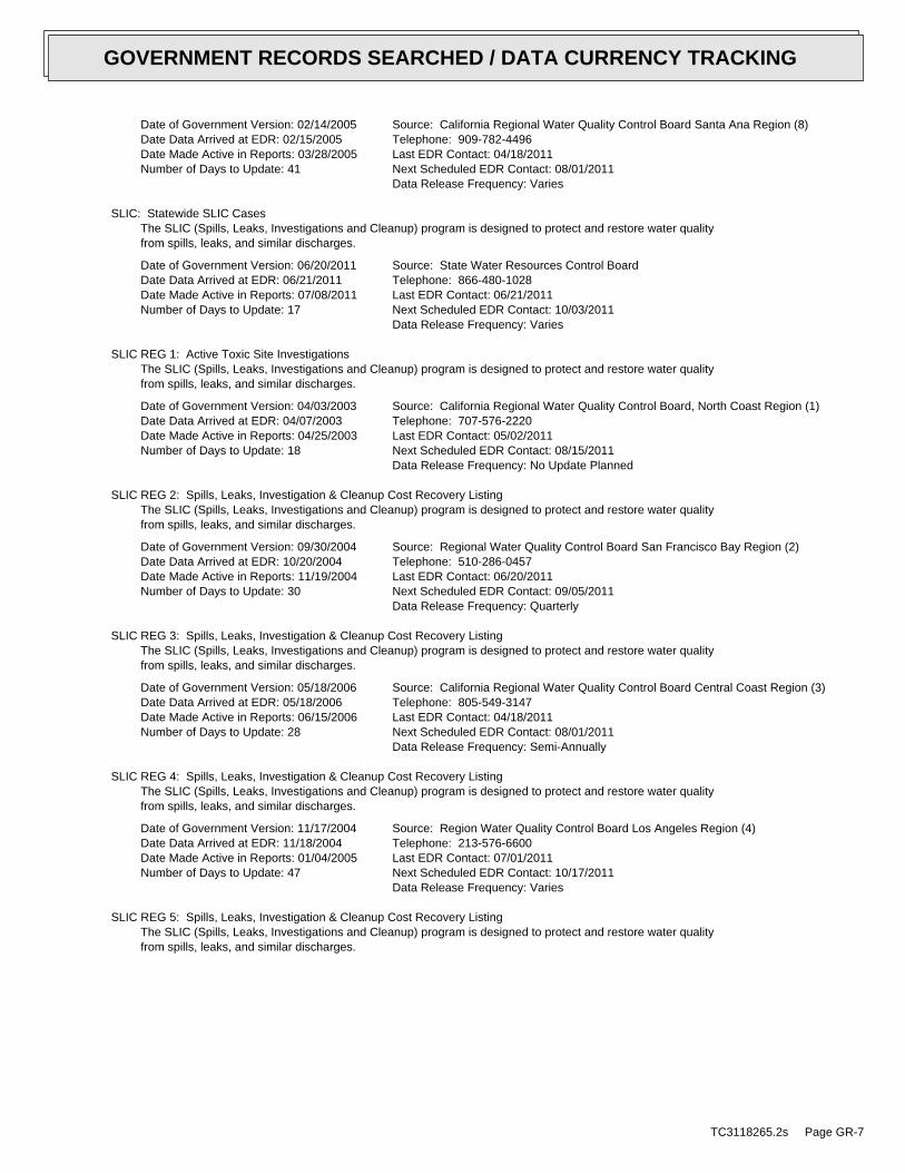
Date of Government Version: 02/14/2005Date Data Arrived at EDR: 02/15/2005Date Made Active in Reports: 03/28/2005Number of Days to Update: 41
Source: California Regional Water Quality Control Board Santa Ana Region (8)Telephone: 909-782-4496Last EDR Contact: 04/18/2011Next Scheduled EDR Contact: 08/01/2011Data Release Frequency: Varies
SLIC: Statewide SLIC CasesThe SLIC (Spills, Leaks, Investigations and Cleanup) program is designed to protect and restore water qualityfrom spills, leaks, and similar discharges.
Date of Government Version: 06/20/2011Date Data Arrived at EDR: 06/21/2011Date Made Active in Reports: 07/08/2011Number of Days to Update: 17
Source: State Water Resources Control BoardTelephone: 866-480-1028Last EDR Contact: 06/21/2011Next Scheduled EDR Contact: 10/03/2011Data Release Frequency: Varies
SLIC REG 1: Active Toxic Site InvestigationsThe SLIC (Spills, Leaks, Investigations and Cleanup) program is designed to protect and restore water qualityfrom spills, leaks, and similar discharges.
Date of Government Version: 04/03/2003Date Data Arrived at EDR: 04/07/2003Date Made Active in Reports: 04/25/2003Number of Days to Update: 18
Source: California Regional Water Quality Control Board, North Coast Region (1)Telephone: 707-576-2220Last EDR Contact: 05/02/2011Next Scheduled EDR Contact: 08/15/2011Data Release Frequency: No Update Planned
SLIC REG 2: Spills, Leaks, Investigation & Cleanup Cost Recovery ListingThe SLIC (Spills, Leaks, Investigations and Cleanup) program is designed to protect and restore water qualityfrom spills, leaks, and similar discharges.
Date of Government Version: 09/30/2004Date Data Arrived at EDR: 10/20/2004Date Made Active in Reports: 11/19/2004Number of Days to Update: 30
Source: Regional Water Quality Control Board San Francisco Bay Region (2)Telephone: 510-286-0457Last EDR Contact: 06/20/2011Next Scheduled EDR Contact: 09/05/2011Data Release Frequency: Quarterly
SLIC REG 3: Spills, Leaks, Investigation & Cleanup Cost Recovery ListingThe SLIC (Spills, Leaks, Investigations and Cleanup) program is designed to protect and restore water qualityfrom spills, leaks, and similar discharges.
Date of Government Version: 05/18/2006Date Data Arrived at EDR: 05/18/2006Date Made Active in Reports: 06/15/2006Number of Days to Update: 28
Source: California Regional Water Quality Control Board Central Coast Region (3)Telephone: 805-549-3147Last EDR Contact: 04/18/2011Next Scheduled EDR Contact: 08/01/2011Data Release Frequency: Semi-Annually
SLIC REG 4: Spills, Leaks, Investigation & Cleanup Cost Recovery ListingThe SLIC (Spills, Leaks, Investigations and Cleanup) program is designed to protect and restore water qualityfrom spills, leaks, and similar discharges.
Date of Government Version: 11/17/2004Date Data Arrived at EDR: 11/18/2004Date Made Active in Reports: 01/04/2005Number of Days to Update: 47
Source: Region Water Quality Control Board Los Angeles Region (4)Telephone: 213-576-6600Last EDR Contact: 07/01/2011Next Scheduled EDR Contact: 10/17/2011Data Release Frequency: Varies
SLIC REG 5: Spills, Leaks, Investigation & Cleanup Cost Recovery ListingThe SLIC (Spills, Leaks, Investigations and Cleanup) program is designed to protect and restore water qualityfrom spills, leaks, and similar discharges.
TC3118265.2s Page GR-7
GOVERNMENT RECORDS SEARCHED / DATA CURRENCY TRACKING

Date of Government Version: 04/01/2005Date Data Arrived at EDR: 04/05/2005Date Made Active in Reports: 04/21/2005Number of Days to Update: 16
Source: Regional Water Quality Control Board Central Valley Region (5)Telephone: 916-464-3291Last EDR Contact: 06/13/2011Next Scheduled EDR Contact: 09/26/2011Data Release Frequency: Semi-Annually
SLIC REG 6V: Spills, Leaks, Investigation & Cleanup Cost Recovery ListingThe SLIC (Spills, Leaks, Investigations and Cleanup) program is designed to protect and restore water qualityfrom spills, leaks, and similar discharges.
Date of Government Version: 05/24/2005Date Data Arrived at EDR: 05/25/2005Date Made Active in Reports: 06/16/2005Number of Days to Update: 22
Source: Regional Water Quality Control Board, Victorville BranchTelephone: 619-241-6583Last EDR Contact: 05/16/2011Next Scheduled EDR Contact: 08/29/2011Data Release Frequency: Semi-Annually
SLIC REG 6L: SLIC SitesThe SLIC (Spills, Leaks, Investigations and Cleanup) program is designed to protect and restore water qualityfrom spills, leaks, and similar discharges.
Date of Government Version: 09/07/2004Date Data Arrived at EDR: 09/07/2004Date Made Active in Reports: 10/12/2004Number of Days to Update: 35
Source: California Regional Water Quality Control Board, Lahontan RegionTelephone: 530-542-5574Last EDR Contact: 05/16/2011Next Scheduled EDR Contact: 08/29/2011Data Release Frequency: No Update Planned
SLIC REG 7: SLIC ListThe SLIC (Spills, Leaks, Investigations and Cleanup) program is designed to protect and restore water qualityfrom spills, leaks, and similar discharges.
Date of Government Version: 11/24/2004Date Data Arrived at EDR: 11/29/2004Date Made Active in Reports: 01/04/2005Number of Days to Update: 36
Source: California Regional Quality Control Board, Colorado River Basin RegionTelephone: 760-346-7491Last EDR Contact: 05/02/2011Next Scheduled EDR Contact: 08/15/2011Data Release Frequency: No Update Planned
SLIC REG 8: Spills, Leaks, Investigation & Cleanup Cost Recovery ListingThe SLIC (Spills, Leaks, Investigations and Cleanup) program is designed to protect and restore water qualityfrom spills, leaks, and similar discharges.
Date of Government Version: 04/03/2008Date Data Arrived at EDR: 04/03/2008Date Made Active in Reports: 04/14/2008Number of Days to Update: 11
Source: California Region Water Quality Control Board Santa Ana Region (8)Telephone: 951-782-3298Last EDR Contact: 06/13/2011Next Scheduled EDR Contact: 09/13/2011Data Release Frequency: Semi-Annually
SLIC REG 9: Spills, Leaks, Investigation & Cleanup Cost Recovery ListingThe SLIC (Spills, Leaks, Investigations and Cleanup) program is designed to protect and restore water qualityfrom spills, leaks, and similar discharges.
Date of Government Version: 09/10/2007Date Data Arrived at EDR: 09/11/2007Date Made Active in Reports: 09/28/2007Number of Days to Update: 17
Source: California Regional Water Quality Control Board San Diego Region (9)Telephone: 858-467-2980Last EDR Contact: 05/09/2011Next Scheduled EDR Contact: 08/22/2011Data Release Frequency: Annually
INDIAN LUST R10: Leaking Underground Storage Tanks on Indian LandLUSTs on Indian land in Alaska, Idaho, Oregon and Washington.
TC3118265.2s Page GR-8
GOVERNMENT RECORDS SEARCHED / DATA CURRENCY TRACKING

Date of Government Version: 05/17/2011Date Data Arrived at EDR: 05/19/2011Date Made Active in Reports: 06/14/2011Number of Days to Update: 26
Source: EPA Region 10Telephone: 206-553-2857Last EDR Contact: 05/02/2011Next Scheduled EDR Contact: 08/15/2011Data Release Frequency: Quarterly
INDIAN LUST R1: Leaking Underground Storage Tanks on Indian LandA listing of leaking underground storage tank locations on Indian Land.
Date of Government Version: 03/07/2011Date Data Arrived at EDR: 05/20/2011Date Made Active in Reports: 06/14/2011Number of Days to Update: 25
Source: EPA Region 1Telephone: 617-918-1313Last EDR Contact: 05/03/2011Next Scheduled EDR Contact: 08/15/2011Data Release Frequency: Varies
INDIAN LUST R8: Leaking Underground Storage Tanks on Indian LandLUSTs on Indian land in Colorado, Montana, North Dakota, South Dakota, Utah and Wyoming.
Date of Government Version: 05/16/2011Date Data Arrived at EDR: 05/17/2011Date Made Active in Reports: 06/14/2011Number of Days to Update: 28
Source: EPA Region 8Telephone: 303-312-6271Last EDR Contact: 05/02/2011Next Scheduled EDR Contact: 08/15/2011Data Release Frequency: Quarterly
INDIAN LUST R6: Leaking Underground Storage Tanks on Indian LandLUSTs on Indian land in New Mexico and Oklahoma.
Date of Government Version: 05/10/2011Date Data Arrived at EDR: 05/11/2011Date Made Active in Reports: 06/14/2011Number of Days to Update: 34
Source: EPA Region 6Telephone: 214-665-6597Last EDR Contact: 05/02/2011Next Scheduled EDR Contact: 08/15/2011Data Release Frequency: Varies
INDIAN LUST R4: Leaking Underground Storage Tanks on Indian LandLUSTs on Indian land in Florida, Mississippi and North Carolina.
Date of Government Version: 03/03/2011Date Data Arrived at EDR: 03/18/2011Date Made Active in Reports: 05/02/2011Number of Days to Update: 45
Source: EPA Region 4Telephone: 404-562-8677Last EDR Contact: 05/02/2011Next Scheduled EDR Contact: 08/15/2011Data Release Frequency: Semi-Annually
INDIAN LUST R9: Leaking Underground Storage Tanks on Indian LandLUSTs on Indian land in Arizona, California, New Mexico and Nevada
Date of Government Version: 01/31/2011Date Data Arrived at EDR: 02/01/2011Date Made Active in Reports: 03/21/2011Number of Days to Update: 48
Source: Environmental Protection AgencyTelephone: 415-972-3372Last EDR Contact: 05/02/2011Next Scheduled EDR Contact: 08/15/2011Data Release Frequency: Quarterly
INDIAN LUST R7: Leaking Underground Storage Tanks on Indian LandLUSTs on Indian land in Iowa, Kansas, and Nebraska
Date of Government Version: 11/04/2009Date Data Arrived at EDR: 05/04/2010Date Made Active in Reports: 07/07/2010Number of Days to Update: 64
Source: EPA Region 7Telephone: 913-551-7003Last EDR Contact: 05/04/2010Next Scheduled EDR Contact: 05/16/2011Data Release Frequency: Varies
State and tribal registered storage tank lists
TC3118265.2s Page GR-9
GOVERNMENT RECORDS SEARCHED / DATA CURRENCY TRACKING

UST: Active UST FacilitiesActive UST facilities gathered from the local regulatory agencies
Date of Government Version: 06/20/2011Date Data Arrived at EDR: 06/21/2011Date Made Active in Reports: 07/08/2011Number of Days to Update: 17
Source: SWRCBTelephone: 916-480-1028Last EDR Contact: 06/21/2011Next Scheduled EDR Contact: 10/03/2011Data Release Frequency: Semi-Annually
AST: Aboveground Petroleum Storage Tank FacilitiesRegistered Aboveground Storage Tanks.
Date of Government Version: 08/01/2009Date Data Arrived at EDR: 09/10/2009Date Made Active in Reports: 10/01/2009Number of Days to Update: 21
Source: State Water Resources Control BoardTelephone: 916-341-5712Last EDR Contact: 07/08/2011Next Scheduled EDR Contact: 10/24/2011Data Release Frequency: Quarterly
INDIAN UST R10: Underground Storage Tanks on Indian LandThe Indian Underground Storage Tank (UST) database provides information about underground storage tanks on Indianland in EPA Region 10 (Alaska, Idaho, Oregon, Washington, and Tribal Nations).
Date of Government Version: 05/17/2011Date Data Arrived at EDR: 05/19/2011Date Made Active in Reports: 06/14/2011Number of Days to Update: 26
Source: EPA Region 10Telephone: 206-553-2857Last EDR Contact: 05/02/2011Next Scheduled EDR Contact: 08/15/2011Data Release Frequency: Quarterly
INDIAN UST R9: Underground Storage Tanks on Indian LandThe Indian Underground Storage Tank (UST) database provides information about underground storage tanks on Indianland in EPA Region 9 (Arizona, California, Hawaii, Nevada, the Pacific Islands, and Tribal Nations).
Date of Government Version: 05/18/2011Date Data Arrived at EDR: 05/26/2011Date Made Active in Reports: 06/14/2011Number of Days to Update: 19
Source: EPA Region 9Telephone: 415-972-3368Last EDR Contact: 05/02/2011Next Scheduled EDR Contact: 08/15/2011Data Release Frequency: Quarterly
INDIAN UST R8: Underground Storage Tanks on Indian LandThe Indian Underground Storage Tank (UST) database provides information about underground storage tanks on Indianland in EPA Region 8 (Colorado, Montana, North Dakota, South Dakota, Utah, Wyoming and 27 Tribal Nations).
Date of Government Version: 05/16/2011Date Data Arrived at EDR: 05/17/2011Date Made Active in Reports: 06/14/2011Number of Days to Update: 28
Source: EPA Region 8Telephone: 303-312-6137Last EDR Contact: 05/02/2011Next Scheduled EDR Contact: 08/15/2011Data Release Frequency: Quarterly
INDIAN UST R7: Underground Storage Tanks on Indian LandThe Indian Underground Storage Tank (UST) database provides information about underground storage tanks on Indianland in EPA Region 7 (Iowa, Kansas, Missouri, Nebraska, and 9 Tribal Nations).
Date of Government Version: 04/01/2011Date Data Arrived at EDR: 06/01/2011Date Made Active in Reports: 06/14/2011Number of Days to Update: 13
Source: EPA Region 7Telephone: 913-551-7003Last EDR Contact: 02/03/2011Next Scheduled EDR Contact: 05/16/2011Data Release Frequency: Varies
INDIAN UST R6: Underground Storage Tanks on Indian LandThe Indian Underground Storage Tank (UST) database provides information about underground storage tanks on Indianland in EPA Region 6 (Louisiana, Arkansas, Oklahoma, New Mexico, Texas and 65 Tribes).
TC3118265.2s Page GR-10
GOVERNMENT RECORDS SEARCHED / DATA CURRENCY TRACKING
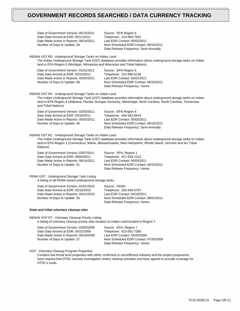
Date of Government Version: 05/10/2011Date Data Arrived at EDR: 05/11/2011Date Made Active in Reports: 06/14/2011Number of Days to Update: 34
Source: EPA Region 6Telephone: 214-665-7591Last EDR Contact: 05/02/2011Next Scheduled EDR Contact: 08/15/2011Data Release Frequency: Semi-Annually
INDIAN UST R5: Underground Storage Tanks on Indian LandThe Indian Underground Storage Tank (UST) database provides information about underground storage tanks on Indianland in EPA Region 5 (Michigan, Minnesota and Wisconsin and Tribal Nations).
Date of Government Version: 01/01/2011Date Data Arrived at EDR: 02/23/2011Date Made Active in Reports: 05/02/2011Number of Days to Update: 68
Source: EPA Region 5Telephone: 312-886-6136Last EDR Contact: 05/02/2011Next Scheduled EDR Contact: 08/15/2011Data Release Frequency: Varies
INDIAN UST R4: Underground Storage Tanks on Indian LandThe Indian Underground Storage Tank (UST) database provides information about underground storage tanks on Indianland in EPA Region 4 (Alabama, Florida, Georgia, Kentucky, Mississippi, North Carolina, South Carolina, Tennesseeand Tribal Nations)
Date of Government Version: 03/03/2011Date Data Arrived at EDR: 03/18/2011Date Made Active in Reports: 05/02/2011Number of Days to Update: 45
Source: EPA Region 4Telephone: 404-562-9424Last EDR Contact: 05/02/2011Next Scheduled EDR Contact: 08/15/2011Data Release Frequency: Semi-Annually
INDIAN UST R1: Underground Storage Tanks on Indian LandThe Indian Underground Storage Tank (UST) database provides information about underground storage tanks on Indianland in EPA Region 1 (Connecticut, Maine, Massachusetts, New Hampshire, Rhode Island, Vermont and ten TribalNations).
Date of Government Version: 03/07/2011Date Data Arrived at EDR: 05/04/2011Date Made Active in Reports: 06/14/2011Number of Days to Update: 41
Source: EPA, Region 1Telephone: 617-918-1313Last EDR Contact: 05/03/2011Next Scheduled EDR Contact: 08/15/2011Data Release Frequency: Varies
FEMA UST: Underground Storage Tank ListingA listing of all FEMA owned underground storage tanks.
Date of Government Version: 01/01/2010Date Data Arrived at EDR: 02/16/2010Date Made Active in Reports: 04/12/2010Number of Days to Update: 55
Source: FEMATelephone: 202-646-5797Last EDR Contact: 04/18/2011Next Scheduled EDR Contact: 08/01/2011Data Release Frequency: Varies
State and tribal voluntary cleanup sites
INDIAN VCP R7: Voluntary Cleanup Priority LisitngA listing of voluntary cleanup priority sites located on Indian Land located in Region 7.
Date of Government Version: 03/20/2008Date Data Arrived at EDR: 04/22/2008Date Made Active in Reports: 05/19/2008Number of Days to Update: 27
Source: EPA, Region 7Telephone: 913-551-7365Last EDR Contact: 04/20/2009Next Scheduled EDR Contact: 07/20/2009Data Release Frequency: Varies
VCP: Voluntary Cleanup Program PropertiesContains low threat level properties with either confirmed or unconfirmed releases and the project proponentshave request that DTSC oversee investigation and/or cleanup activities and have agreed to provide coverage forDTSC’s costs.
TC3118265.2s Page GR-11
GOVERNMENT RECORDS SEARCHED / DATA CURRENCY TRACKING
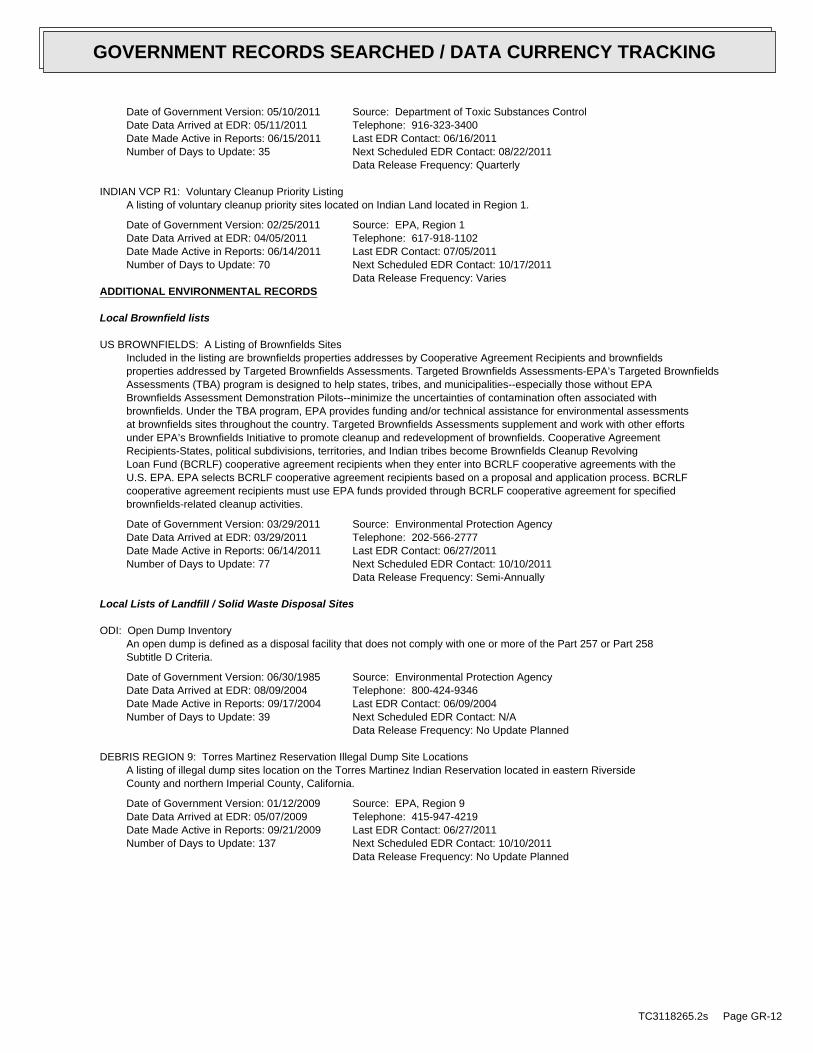
Date of Government Version: 05/10/2011Date Data Arrived at EDR: 05/11/2011Date Made Active in Reports: 06/15/2011Number of Days to Update: 35
Source: Department of Toxic Substances ControlTelephone: 916-323-3400Last EDR Contact: 06/16/2011Next Scheduled EDR Contact: 08/22/2011Data Release Frequency: Quarterly
INDIAN VCP R1: Voluntary Cleanup Priority ListingA listing of voluntary cleanup priority sites located on Indian Land located in Region 1.
Date of Government Version: 02/25/2011Date Data Arrived at EDR: 04/05/2011Date Made Active in Reports: 06/14/2011Number of Days to Update: 70
Source: EPA, Region 1Telephone: 617-918-1102Last EDR Contact: 07/05/2011Next Scheduled EDR Contact: 10/17/2011Data Release Frequency: Varies
ADDITIONAL ENVIRONMENTAL RECORDS
Local Brownfield lists
US BROWNFIELDS: A Listing of Brownfields SitesIncluded in the listing are brownfields properties addresses by Cooperative Agreement Recipients and brownfieldsproperties addressed by Targeted Brownfields Assessments. Targeted Brownfields Assessments-EPA’s Targeted BrownfieldsAssessments (TBA) program is designed to help states, tribes, and municipalities--especially those without EPABrownfields Assessment Demonstration Pilots--minimize the uncertainties of contamination often associated withbrownfields. Under the TBA program, EPA provides funding and/or technical assistance for environmental assessmentsat brownfields sites throughout the country. Targeted Brownfields Assessments supplement and work with other effortsunder EPA’s Brownfields Initiative to promote cleanup and redevelopment of brownfields. Cooperative AgreementRecipients-States, political subdivisions, territories, and Indian tribes become Brownfields Cleanup RevolvingLoan Fund (BCRLF) cooperative agreement recipients when they enter into BCRLF cooperative agreements with theU.S. EPA. EPA selects BCRLF cooperative agreement recipients based on a proposal and application process. BCRLFcooperative agreement recipients must use EPA funds provided through BCRLF cooperative agreement for specifiedbrownfields-related cleanup activities.
Date of Government Version: 03/29/2011Date Data Arrived at EDR: 03/29/2011Date Made Active in Reports: 06/14/2011Number of Days to Update: 77
Source: Environmental Protection AgencyTelephone: 202-566-2777Last EDR Contact: 06/27/2011Next Scheduled EDR Contact: 10/10/2011Data Release Frequency: Semi-Annually
Local Lists of Landfill / Solid Waste Disposal Sites
ODI: Open Dump InventoryAn open dump is defined as a disposal facility that does not comply with one or more of the Part 257 or Part 258Subtitle D Criteria.
Date of Government Version: 06/30/1985Date Data Arrived at EDR: 08/09/2004Date Made Active in Reports: 09/17/2004Number of Days to Update: 39
Source: Environmental Protection AgencyTelephone: 800-424-9346Last EDR Contact: 06/09/2004Next Scheduled EDR Contact: N/AData Release Frequency: No Update Planned
DEBRIS REGION 9: Torres Martinez Reservation Illegal Dump Site LocationsA listing of illegal dump sites location on the Torres Martinez Indian Reservation located in eastern RiversideCounty and northern Imperial County, California.
Date of Government Version: 01/12/2009Date Data Arrived at EDR: 05/07/2009Date Made Active in Reports: 09/21/2009Number of Days to Update: 137
Source: EPA, Region 9Telephone: 415-947-4219Last EDR Contact: 06/27/2011Next Scheduled EDR Contact: 10/10/2011Data Release Frequency: No Update Planned
TC3118265.2s Page GR-12
GOVERNMENT RECORDS SEARCHED / DATA CURRENCY TRACKING

WMUDS/SWAT: Waste Management Unit DatabaseWaste Management Unit Database System. WMUDS is used by the State Water Resources Control Board staff and theRegional Water Quality Control Boards for program tracking and inventory of waste management units. WMUDS is composedof the following databases: Facility Information, Scheduled Inspections Information, Waste Management Unit Information,SWAT Program Information, SWAT Report Summary Information, SWAT Report Summary Data, Chapter 15 (formerly Subchapter15) Information, Chapter 15 Monitoring Parameters, TPCA Program Information, RCRA Program Information, ClosureInformation, and Interested Parties Information.
Date of Government Version: 04/01/2000Date Data Arrived at EDR: 04/10/2000Date Made Active in Reports: 05/10/2000Number of Days to Update: 30
Source: State Water Resources Control BoardTelephone: 916-227-4448Last EDR Contact: 05/16/2011Next Scheduled EDR Contact: 08/29/2011Data Release Frequency: No Update Planned
SWRCY: Recycler DatabaseA listing of recycling facilities in California.
Date of Government Version: 02/24/2011Date Data Arrived at EDR: 03/23/2011Date Made Active in Reports: 04/21/2011Number of Days to Update: 29
Source: Department of ConservationTelephone: 916-323-3836Last EDR Contact: 06/21/2011Next Scheduled EDR Contact: 10/03/2011Data Release Frequency: Quarterly
HAULERS: Registered Waste Tire Haulers ListingA listing of registered waste tire haulers.
Date of Government Version: 05/24/2011Date Data Arrived at EDR: 05/24/2011Date Made Active in Reports: 06/15/2011Number of Days to Update: 22
Source: Integrated Waste Management BoardTelephone: 916-341-6422Last EDR Contact: 05/24/2011Next Scheduled EDR Contact: 09/05/2011Data Release Frequency: Varies
INDIAN ODI: Report on the Status of Open Dumps on Indian LandsLocation of open dumps on Indian land.
Date of Government Version: 12/31/1998Date Data Arrived at EDR: 12/03/2007Date Made Active in Reports: 01/24/2008Number of Days to Update: 52
Source: Environmental Protection AgencyTelephone: 703-308-8245Last EDR Contact: 05/09/2011Next Scheduled EDR Contact: 08/22/2011Data Release Frequency: Varies
Local Lists of Hazardous waste / Contaminated Sites
US CDL: Clandestine Drug LabsA listing of clandestine drug lab locations. The U.S. Department of Justice ("the Department") provides thisweb site as a public service. It contains addresses of some locations where law enforcement agencies reportedthey found chemicals or other items that indicated the presence of either clandestine drug laboratories or dumpsites.In most cases, the source of the entries is not the Department, and the Department has not verified the entryand does not guarantee its accuracy. Members of the public must verify the accuracy of all entries by, for example,contacting local law enforcement and local health departments.
Date of Government Version: 02/02/2011Date Data Arrived at EDR: 03/17/2011Date Made Active in Reports: 05/02/2011Number of Days to Update: 46
Source: Drug Enforcement AdministrationTelephone: 202-307-1000Last EDR Contact: 06/07/2011Next Scheduled EDR Contact: 09/19/2011Data Release Frequency: Quarterly
HIST CAL-SITES: Calsites DatabaseThe Calsites database contains potential or confirmed hazardous substance release properties. In 1996, CaliforniaEPA reevaluated and significantly reduced the number of sites in the Calsites database. No longer updated by thestate agency. It has been replaced by ENVIROSTOR.
TC3118265.2s Page GR-13
GOVERNMENT RECORDS SEARCHED / DATA CURRENCY TRACKING
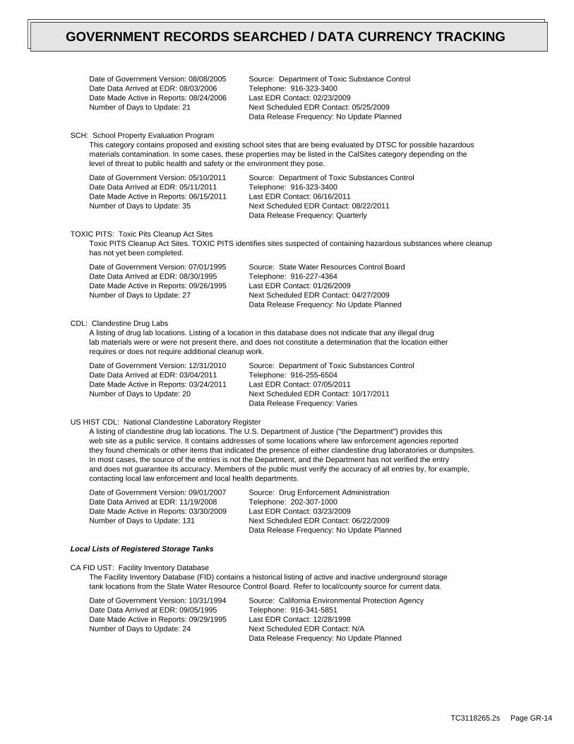
Date of Government Version: 08/08/2005Date Data Arrived at EDR: 08/03/2006Date Made Active in Reports: 08/24/2006Number of Days to Update: 21
Source: Department of Toxic Substance ControlTelephone: 916-323-3400Last EDR Contact: 02/23/2009Next Scheduled EDR Contact: 05/25/2009Data Release Frequency: No Update Planned
SCH: School Property Evaluation ProgramThis category contains proposed and existing school sites that are being evaluated by DTSC for possible hazardousmaterials contamination. In some cases, these properties may be listed in the CalSites category depending on thelevel of threat to public health and safety or the environment they pose.
Date of Government Version: 05/10/2011Date Data Arrived at EDR: 05/11/2011Date Made Active in Reports: 06/15/2011Number of Days to Update: 35
Source: Department of Toxic Substances ControlTelephone: 916-323-3400Last EDR Contact: 06/16/2011Next Scheduled EDR Contact: 08/22/2011Data Release Frequency: Quarterly
TOXIC PITS: Toxic Pits Cleanup Act SitesToxic PITS Cleanup Act Sites. TOXIC PITS identifies sites suspected of containing hazardous substances where cleanuphas not yet been completed.
Date of Government Version: 07/01/1995Date Data Arrived at EDR: 08/30/1995Date Made Active in Reports: 09/26/1995Number of Days to Update: 27
Source: State Water Resources Control BoardTelephone: 916-227-4364Last EDR Contact: 01/26/2009Next Scheduled EDR Contact: 04/27/2009Data Release Frequency: No Update Planned
CDL: Clandestine Drug LabsA listing of drug lab locations. Listing of a location in this database does not indicate that any illegal druglab materials were or were not present there, and does not constitute a determination that the location eitherrequires or does not require additional cleanup work.
Date of Government Version: 12/31/2010Date Data Arrived at EDR: 03/04/2011Date Made Active in Reports: 03/24/2011Number of Days to Update: 20
Source: Department of Toxic Substances ControlTelephone: 916-255-6504Last EDR Contact: 07/05/2011Next Scheduled EDR Contact: 10/17/2011Data Release Frequency: Varies
US HIST CDL: National Clandestine Laboratory RegisterA listing of clandestine drug lab locations. The U.S. Department of Justice ("the Department") provides thisweb site as a public service. It contains addresses of some locations where law enforcement agencies reportedthey found chemicals or other items that indicated the presence of either clandestine drug laboratories or dumpsites.In most cases, the source of the entries is not the Department, and the Department has not verified the entryand does not guarantee its accuracy. Members of the public must verify the accuracy of all entries by, for example,contacting local law enforcement and local health departments.
Date of Government Version: 09/01/2007Date Data Arrived at EDR: 11/19/2008Date Made Active in Reports: 03/30/2009Number of Days to Update: 131
Source: Drug Enforcement AdministrationTelephone: 202-307-1000Last EDR Contact: 03/23/2009Next Scheduled EDR Contact: 06/22/2009Data Release Frequency: No Update Planned
Local Lists of Registered Storage Tanks
CA FID UST: Facility Inventory DatabaseThe Facility Inventory Database (FID) contains a historical listing of active and inactive underground storagetank locations from the State Water Resource Control Board. Refer to local/county source for current data.
Date of Government Version: 10/31/1994Date Data Arrived at EDR: 09/05/1995Date Made Active in Reports: 09/29/1995Number of Days to Update: 24
Source: California Environmental Protection AgencyTelephone: 916-341-5851Last EDR Contact: 12/28/1998Next Scheduled EDR Contact: N/AData Release Frequency: No Update Planned
TC3118265.2s Page GR-14
GOVERNMENT RECORDS SEARCHED / DATA CURRENCY TRACKING

UST MENDOCINO: Mendocino County UST DatabaseA listing of underground storage tank locations in Mendocino County.
Date of Government Version: 09/23/2009Date Data Arrived at EDR: 09/23/2009Date Made Active in Reports: 10/01/2009Number of Days to Update: 8
Source: Department of Public HealthTelephone: 707-463-4466Last EDR Contact: 06/06/2011Next Scheduled EDR Contact: 09/19/2011Data Release Frequency: Annually
HIST UST: Hazardous Substance Storage Container DatabaseThe Hazardous Substance Storage Container Database is a historical listing of UST sites. Refer to local/countysource for current data.
Date of Government Version: 10/15/1990Date Data Arrived at EDR: 01/25/1991Date Made Active in Reports: 02/12/1991Number of Days to Update: 18
Source: State Water Resources Control BoardTelephone: 916-341-5851Last EDR Contact: 07/26/2001Next Scheduled EDR Contact: N/AData Release Frequency: No Update Planned
SWEEPS UST: SWEEPS UST ListingStatewide Environmental Evaluation and Planning System. This underground storage tank listing was updated andmaintained by a company contacted by the SWRCB in the early 1990’s. The listing is no longer updated or maintained.The local agency is the contact for more information on a site on the SWEEPS list.
Date of Government Version: 06/01/1994Date Data Arrived at EDR: 07/07/2005Date Made Active in Reports: 08/11/2005Number of Days to Update: 35
Source: State Water Resources Control BoardTelephone: N/ALast EDR Contact: 06/03/2005Next Scheduled EDR Contact: N/AData Release Frequency: No Update Planned
Local Land Records
LIENS 2: CERCLA Lien InformationA Federal CERCLA (’Superfund’) lien can exist by operation of law at any site or property at which EPA has spentSuperfund monies. These monies are spent to investigate and address releases and threatened releases of contamination.CERCLIS provides information as to the identity of these sites and properties.
Date of Government Version: 02/01/2011Date Data Arrived at EDR: 02/04/2011Date Made Active in Reports: 05/02/2011Number of Days to Update: 87
Source: Environmental Protection AgencyTelephone: 202-564-6023Last EDR Contact: 05/02/2011Next Scheduled EDR Contact: 08/15/2011Data Release Frequency: Varies
LUCIS: Land Use Control Information SystemLUCIS contains records of land use control information pertaining to the former Navy Base Realignment and Closureproperties.
Date of Government Version: 12/09/2005Date Data Arrived at EDR: 12/11/2006Date Made Active in Reports: 01/11/2007Number of Days to Update: 31
Source: Department of the NavyTelephone: 843-820-7326Last EDR Contact: 07/11/2011Next Scheduled EDR Contact: 09/05/2011Data Release Frequency: Varies
LIENS: Environmental Liens ListingA listing of property locations with environmental liens for California where DTSC is a lien holder.
Date of Government Version: 06/28/2011Date Data Arrived at EDR: 06/29/2011Date Made Active in Reports: 07/08/2011Number of Days to Update: 9
Source: Department of Toxic Substances ControlTelephone: 916-323-3400Last EDR Contact: 06/27/2011Next Scheduled EDR Contact: 09/26/2011Data Release Frequency: Varies
TC3118265.2s Page GR-15
GOVERNMENT RECORDS SEARCHED / DATA CURRENCY TRACKING
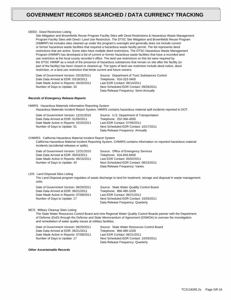
DEED: Deed Restriction ListingSite Mitigation and Brownfields Reuse Program Facility Sites with Deed Restrictions & Hazardous Waste ManagementProgram Facility Sites with Deed / Land Use Restriction. The DTSC Site Mitigation and Brownfields Reuse Program(SMBRP) list includes sites cleaned up under the program’s oversight and generally does not include currentor former hazardous waste facilities that required a hazardous waste facility permit. The list represents deedrestrictions that are active. Some sites have multiple deed restrictions. The DTSC Hazardous Waste ManagementProgram (HWMP) has developed a list of current or former hazardous waste facilities that have a recorded landuse restriction at the local county recorder’s office. The land use restrictions on this list were required bythe DTSC HWMP as a result of the presence of hazardous substances that remain on site after the facility (orpart of the facility) has been closed or cleaned up. The types of land use restriction include deed notice, deedrestriction, or a land use restriction that binds current and future owners.
Date of Government Version: 03/18/2011Date Data Arrived at EDR: 03/18/2011Date Made Active in Reports: 04/20/2011Number of Days to Update: 33
Source: Department of Toxic Substances ControlTelephone: 916-323-3400Last EDR Contact: 06/14/2011Next Scheduled EDR Contact: 09/26/2011Data Release Frequency: Semi-Annually
Records of Emergency Release Reports
HMIRS: Hazardous Materials Information Reporting SystemHazardous Materials Incident Report System. HMIRS contains hazardous material spill incidents reported to DOT.
Date of Government Version: 12/31/2010Date Data Arrived at EDR: 01/05/2011Date Made Active in Reports: 02/25/2011Number of Days to Update: 51
Source: U.S. Department of TransportationTelephone: 202-366-4555Last EDR Contact: 07/05/2011Next Scheduled EDR Contact: 10/17/2011Data Release Frequency: Annually
CHMIRS: California Hazardous Material Incident Report SystemCalifornia Hazardous Material Incident Reporting System. CHMIRS contains information on reported hazardous materialincidents (accidental releases or spills).
Date of Government Version: 12/31/2010Date Data Arrived at EDR: 05/03/2011Date Made Active in Reports: 06/15/2011Number of Days to Update: 43
Source: Office of Emergency ServicesTelephone: 916-845-8400Last EDR Contact: 05/02/2011Next Scheduled EDR Contact: 08/15/2011Data Release Frequency: Varies
LDS: Land Disposal Sites ListingThe Land Disposal program regulates of waste discharge to land for treatment, storage and disposal in waste managementunits.
Date of Government Version: 06/20/2011Date Data Arrived at EDR: 06/21/2011Date Made Active in Reports: 07/08/2011Number of Days to Update: 17
Source: State Water Qualilty Control BoardTelephone: 866-480-1028Last EDR Contact: 06/21/2011Next Scheduled EDR Contact: 10/03/2011Data Release Frequency: Quarterly
MCS: Military Cleanup Sites ListingThe State Water Resources Control Board and nine Regional Water Quality Control Boards partner with the Departmentof Defense (DoD) through the Defense and State Memorandum of Agreement (DSMOA) to oversee the investigationand remediation of water quality issues at military facilities.
Date of Government Version: 06/20/2011Date Data Arrived at EDR: 06/21/2011Date Made Active in Reports: 07/08/2011Number of Days to Update: 17
Source: State Water Resources Control BoardTelephone: 866-480-1028Last EDR Contact: 06/21/2011Next Scheduled EDR Contact: 10/03/2011Data Release Frequency: Quarterly
Other Ascertainable Records
TC3118265.2s Page GR-16
GOVERNMENT RECORDS SEARCHED / DATA CURRENCY TRACKING

RCRA-NonGen: RCRA - Non GeneratorsRCRAInfo is EPA’s comprehensive information system, providing access to data supporting the Resource Conservationand Recovery Act (RCRA) of 1976 and the Hazardous and Solid Waste Amendments (HSWA) of 1984. The databaseincludes selective information on sites which generate, transport, store, treat and/or dispose of hazardous wasteas defined by the Resource Conservation and Recovery Act (RCRA). Non-Generators do not presently generate hazardouswaste.
Date of Government Version: 03/11/2011Date Data Arrived at EDR: 04/05/2011Date Made Active in Reports: 05/02/2011Number of Days to Update: 27
Source: Environmental Protection AgencyTelephone: (415) 495-8895Last EDR Contact: 07/07/2011Next Scheduled EDR Contact: 10/17/2011Data Release Frequency: Varies
DOT OPS: Incident and Accident DataDepartment of Transporation, Office of Pipeline Safety Incident and Accident data.
Date of Government Version: 01/12/2011Date Data Arrived at EDR: 02/11/2011Date Made Active in Reports: 05/02/2011Number of Days to Update: 80
Source: Department of Transporation, Office of Pipeline SafetyTelephone: 202-366-4595Last EDR Contact: 05/11/2011Next Scheduled EDR Contact: 08/22/2011Data Release Frequency: Varies
DOD: Department of Defense SitesThis data set consists of federally owned or administered lands, administered by the Department of Defense, thathave any area equal to or greater than 640 acres of the United States, Puerto Rico, and the U.S. Virgin Islands.
Date of Government Version: 12/31/2005Date Data Arrived at EDR: 11/10/2006Date Made Active in Reports: 01/11/2007Number of Days to Update: 62
Source: USGSTelephone: 888-275-8747Last EDR Contact: 04/21/2011Next Scheduled EDR Contact: 08/01/2011Data Release Frequency: Semi-Annually
FUDS: Formerly Used Defense SitesThe listing includes locations of Formerly Used Defense Sites properties where the US Army Corps of Engineersis actively working or will take necessary cleanup actions.
Date of Government Version: 12/31/2009Date Data Arrived at EDR: 08/12/2010Date Made Active in Reports: 12/02/2010Number of Days to Update: 112
Source: U.S. Army Corps of EngineersTelephone: 202-528-4285Last EDR Contact: 06/14/2011Next Scheduled EDR Contact: 09/26/2011Data Release Frequency: Varies
CONSENT: Superfund (CERCLA) Consent DecreesMajor legal settlements that establish responsibility and standards for cleanup at NPL (Superfund) sites. Releasedperiodically by United States District Courts after settlement by parties to litigation matters.
Date of Government Version: 12/31/2010Date Data Arrived at EDR: 04/05/2011Date Made Active in Reports: 06/14/2011Number of Days to Update: 70
Source: Department of Justice, Consent Decree LibraryTelephone: VariesLast EDR Contact: 07/01/2011Next Scheduled EDR Contact: 10/17/2011Data Release Frequency: Varies
ROD: Records Of DecisionRecord of Decision. ROD documents mandate a permanent remedy at an NPL (Superfund) site containing technicaland health information to aid in the cleanup.
Date of Government Version: 02/25/2011Date Data Arrived at EDR: 03/16/2011Date Made Active in Reports: 03/21/2011Number of Days to Update: 5
Source: EPATelephone: 703-416-0223Last EDR Contact: 06/15/2011Next Scheduled EDR Contact: 09/26/2011Data Release Frequency: Annually
TC3118265.2s Page GR-17
GOVERNMENT RECORDS SEARCHED / DATA CURRENCY TRACKING

UMTRA: Uranium Mill Tailings SitesUranium ore was mined by private companies for federal government use in national defense programs. When the millsshut down, large piles of the sand-like material (mill tailings) remain after uranium has been extracted fromthe ore. Levels of human exposure to radioactive materials from the piles are low; however, in some cases tailingswere used as construction materials before the potential health hazards of the tailings were recognized.
Date of Government Version: 09/14/2010Date Data Arrived at EDR: 10/21/2010Date Made Active in Reports: 01/28/2011Number of Days to Update: 99
Source: Department of EnergyTelephone: 505-845-0011Last EDR Contact: 06/02/2011Next Scheduled EDR Contact: 09/12/2011Data Release Frequency: Varies
MINES: Mines Master Index FileContains all mine identification numbers issued for mines active or opened since 1971. The data also includesviolation information.
Date of Government Version: 02/08/2011Date Data Arrived at EDR: 03/09/2011Date Made Active in Reports: 05/02/2011Number of Days to Update: 54
Source: Department of Labor, Mine Safety and Health AdministrationTelephone: 303-231-5959Last EDR Contact: 06/08/2011Next Scheduled EDR Contact: 09/19/2011Data Release Frequency: Semi-Annually
TRIS: Toxic Chemical Release Inventory SystemToxic Release Inventory System. TRIS identifies facilities which release toxic chemicals to the air, water andland in reportable quantities under SARA Title III Section 313.
Date of Government Version: 12/31/2009Date Data Arrived at EDR: 12/17/2010Date Made Active in Reports: 03/21/2011Number of Days to Update: 94
Source: EPATelephone: 202-566-0250Last EDR Contact: 05/27/2011Next Scheduled EDR Contact: 09/12/2011Data Release Frequency: Annually
TSCA: Toxic Substances Control ActToxic Substances Control Act. TSCA identifies manufacturers and importers of chemical substances included on theTSCA Chemical Substance Inventory list. It includes data on the production volume of these substances by plantsite.
Date of Government Version: 12/31/2006Date Data Arrived at EDR: 09/29/2010Date Made Active in Reports: 12/02/2010Number of Days to Update: 64
Source: EPATelephone: 202-260-5521Last EDR Contact: 06/30/2011Next Scheduled EDR Contact: 10/10/2011Data Release Frequency: Every 4 Years
FTTS: FIFRA/ TSCA Tracking System - FIFRA (Federal Insecticide, Fungicide, & Rodenticide Act)/TSCA (Toxic Substances Control Act)FTTS tracks administrative cases and pesticide enforcement actions and compliance activities related to FIFRA,TSCA and EPCRA (Emergency Planning and Community Right-to-Know Act). To maintain currency, EDR contacts theAgency on a quarterly basis.
Date of Government Version: 04/09/2009Date Data Arrived at EDR: 04/16/2009Date Made Active in Reports: 05/11/2009Number of Days to Update: 25
Source: EPA/Office of Prevention, Pesticides and Toxic SubstancesTelephone: 202-566-1667Last EDR Contact: 05/27/2011Next Scheduled EDR Contact: 09/12/2011Data Release Frequency: Quarterly
FTTS INSP: FIFRA/ TSCA Tracking System - FIFRA (Federal Insecticide, Fungicide, & Rodenticide Act)/TSCA (Toxic Substances Control Act)A listing of FIFRA/TSCA Tracking System (FTTS) inspections and enforcements.
Date of Government Version: 04/09/2009Date Data Arrived at EDR: 04/16/2009Date Made Active in Reports: 05/11/2009Number of Days to Update: 25
Source: EPATelephone: 202-566-1667Last EDR Contact: 05/27/2011Next Scheduled EDR Contact: 09/12/2011Data Release Frequency: Quarterly
TC3118265.2s Page GR-18
GOVERNMENT RECORDS SEARCHED / DATA CURRENCY TRACKING
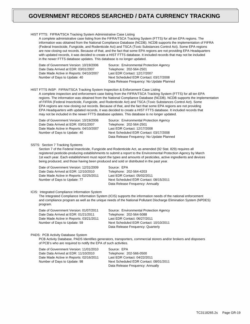
HIST FTTS: FIFRA/TSCA Tracking System Administrative Case ListingA complete administrative case listing from the FIFRA/TSCA Tracking System (FTTS) for all ten EPA regions. Theinformation was obtained from the National Compliance Database (NCDB). NCDB supports the implementation of FIFRA(Federal Insecticide, Fungicide, and Rodenticide Act) and TSCA (Toxic Substances Control Act). Some EPA regionsare now closing out records. Because of that, and the fact that some EPA regions are not providing EPA Headquarterswith updated records, it was decided to create a HIST FTTS database. It included records that may not be includedin the newer FTTS database updates. This database is no longer updated.
Date of Government Version: 10/19/2006Date Data Arrived at EDR: 03/01/2007Date Made Active in Reports: 04/10/2007Number of Days to Update: 40
Source: Environmental Protection AgencyTelephone: 202-564-2501Last EDR Contact: 12/17/2007Next Scheduled EDR Contact: 03/17/2008Data Release Frequency: No Update Planned
HIST FTTS INSP: FIFRA/TSCA Tracking System Inspection & Enforcement Case ListingA complete inspection and enforcement case listing from the FIFRA/TSCA Tracking System (FTTS) for all ten EPAregions. The information was obtained from the National Compliance Database (NCDB). NCDB supports the implementationof FIFRA (Federal Insecticide, Fungicide, and Rodenticide Act) and TSCA (Toxic Substances Control Act). SomeEPA regions are now closing out records. Because of that, and the fact that some EPA regions are not providingEPA Headquarters with updated records, it was decided to create a HIST FTTS database. It included records thatmay not be included in the newer FTTS database updates. This database is no longer updated.
Date of Government Version: 10/19/2006Date Data Arrived at EDR: 03/01/2007Date Made Active in Reports: 04/10/2007Number of Days to Update: 40
Source: Environmental Protection AgencyTelephone: 202-564-2501Last EDR Contact: 12/17/2008Next Scheduled EDR Contact: 03/17/2008Data Release Frequency: No Update Planned
SSTS: Section 7 Tracking SystemsSection 7 of the Federal Insecticide, Fungicide and Rodenticide Act, as amended (92 Stat. 829) requires allregistered pesticide-producing establishments to submit a report to the Environmental Protection Agency by March1st each year. Each establishment must report the types and amounts of pesticides, active ingredients and devicesbeing produced, and those having been produced and sold or distributed in the past year.
Date of Government Version: 12/31/2009Date Data Arrived at EDR: 12/10/2010Date Made Active in Reports: 02/25/2011Number of Days to Update: 77
Source: EPATelephone: 202-564-4203Last EDR Contact: 05/02/2011Next Scheduled EDR Contact: 08/15/2011Data Release Frequency: Annually
ICIS: Integrated Compliance Information SystemThe Integrated Compliance Information System (ICIS) supports the information needs of the national enforcementand compliance program as well as the unique needs of the National Pollutant Discharge Elimination System (NPDES)program.
Date of Government Version: 01/07/2011Date Data Arrived at EDR: 01/21/2011Date Made Active in Reports: 03/21/2011Number of Days to Update: 59
Source: Environmental Protection AgencyTelephone: 202-564-5088Last EDR Contact: 06/27/2011Next Scheduled EDR Contact: 10/10/2011Data Release Frequency: Quarterly
PADS: PCB Activity Database SystemPCB Activity Database. PADS Identifies generators, transporters, commercial storers and/or brokers and disposersof PCB’s who are required to notify the EPA of such activities.
Date of Government Version: 11/01/2010Date Data Arrived at EDR: 11/10/2010Date Made Active in Reports: 02/16/2011Number of Days to Update: 98
Source: EPATelephone: 202-566-0500Last EDR Contact: 04/22/2011Next Scheduled EDR Contact: 08/01/2011Data Release Frequency: Annually
TC3118265.2s Page GR-19
GOVERNMENT RECORDS SEARCHED / DATA CURRENCY TRACKING

MLTS: Material Licensing Tracking SystemMLTS is maintained by the Nuclear Regulatory Commission and contains a list of approximately 8,100 sites whichpossess or use radioactive materials and which are subject to NRC licensing requirements. To maintain currency,EDR contacts the Agency on a quarterly basis.
Date of Government Version: 03/18/2010Date Data Arrived at EDR: 04/06/2010Date Made Active in Reports: 05/27/2010Number of Days to Update: 51
Source: Nuclear Regulatory CommissionTelephone: 301-415-7169Last EDR Contact: 06/13/2011Next Scheduled EDR Contact: 09/26/2011Data Release Frequency: Quarterly
RADINFO: Radiation Information DatabaseThe Radiation Information Database (RADINFO) contains information about facilities that are regulated by U.S.Environmental Protection Agency (EPA) regulations for radiation and radioactivity.
Date of Government Version: 01/11/2011Date Data Arrived at EDR: 01/13/2011Date Made Active in Reports: 02/16/2011Number of Days to Update: 34
Source: Environmental Protection AgencyTelephone: 202-343-9775Last EDR Contact: 04/13/2011Next Scheduled EDR Contact: 07/25/2011Data Release Frequency: Quarterly
FINDS: Facility Index System/Facility Registry SystemFacility Index System. FINDS contains both facility information and ’pointers’ to other sources that contain moredetail. EDR includes the following FINDS databases in this report: PCS (Permit Compliance System), AIRS (AerometricInformation Retrieval System), DOCKET (Enforcement Docket used to manage and track information on civil judicialenforcement cases for all environmental statutes), FURS (Federal Underground Injection Control), C-DOCKET (CriminalDocket System used to track criminal enforcement actions for all environmental statutes), FFIS (Federal FacilitiesInformation System), STATE (State Environmental Laws and Statutes), and PADS (PCB Activity Data System).
Date of Government Version: 04/14/2010Date Data Arrived at EDR: 04/16/2010Date Made Active in Reports: 05/27/2010Number of Days to Update: 41
Source: EPATelephone: (415) 947-8000Last EDR Contact: 06/14/2011Next Scheduled EDR Contact: 09/26/2011Data Release Frequency: Quarterly
RAATS: RCRA Administrative Action Tracking SystemRCRA Administration Action Tracking System. RAATS contains records based on enforcement actions issued under RCRApertaining to major violators and includes administrative and civil actions brought by the EPA. For administrationactions after September 30, 1995, data entry in the RAATS database was discontinued. EPA will retain a copy ofthe database for historical records. It was necessary to terminate RAATS because a decrease in agency resourcesmade it impossible to continue to update the information contained in the database.
Date of Government Version: 04/17/1995Date Data Arrived at EDR: 07/03/1995Date Made Active in Reports: 08/07/1995Number of Days to Update: 35
Source: EPATelephone: 202-564-4104Last EDR Contact: 06/02/2008Next Scheduled EDR Contact: 09/01/2008Data Release Frequency: No Update Planned
BRS: Biennial Reporting SystemThe Biennial Reporting System is a national system administered by the EPA that collects data on the generationand management of hazardous waste. BRS captures detailed data from two groups: Large Quantity Generators (LQG)and Treatment, Storage, and Disposal Facilities.
Date of Government Version: 12/31/2009Date Data Arrived at EDR: 03/01/2011Date Made Active in Reports: 05/02/2011Number of Days to Update: 62
Source: EPA/NTISTelephone: 800-424-9346Last EDR Contact: 05/27/2011Next Scheduled EDR Contact: 09/12/2011Data Release Frequency: Biennially
TC3118265.2s Page GR-20
GOVERNMENT RECORDS SEARCHED / DATA CURRENCY TRACKING
CA BOND EXP. PLAN: Bond Expenditure PlanDepartment of Health Services developed a site-specific expenditure plan as the basis for an appropriation ofHazardous Substance Cleanup Bond Act funds. It is not updated.
Date of Government Version: 01/01/1989Date Data Arrived at EDR: 07/27/1994Date Made Active in Reports: 08/02/1994Number of Days to Update: 6
Source: Department of Health ServicesTelephone: 916-255-2118Last EDR Contact: 05/31/1994Next Scheduled EDR Contact: N/AData Release Frequency: No Update Planned
WDS: Waste Discharge SystemSites which have been issued waste discharge requirements.
Date of Government Version: 06/19/2007Date Data Arrived at EDR: 06/20/2007Date Made Active in Reports: 06/29/2007Number of Days to Update: 9
Source: State Water Resources Control BoardTelephone: 916-341-5227Last EDR Contact: 06/13/2011Next Scheduled EDR Contact: 09/12/2011Data Release Frequency: Quarterly
NPDES: NPDES Permits ListingA listing of NPDES permits, including stormwater.
Date of Government Version: 05/24/2011Date Data Arrived at EDR: 05/24/2011Date Made Active in Reports: 06/15/2011Number of Days to Update: 22
Source: State Water Resources Control BoardTelephone: 916-445-9379Last EDR Contact: 05/24/2011Next Scheduled EDR Contact: 09/05/2011Data Release Frequency: Quarterly
CORTESE: "Cortese" Hazardous Waste & Substances Sites ListThe sites for the list are designated by the State Water Resource Control Board (LUST), the Integrated WasteBoard (SWF/LS), and the Department of Toxic Substances Control (Cal-Sites). This listing is no longer updatedby the state agency.
Date of Government Version: 04/05/2011Date Data Arrived at EDR: 04/05/2011Date Made Active in Reports: 05/04/2011Number of Days to Update: 29
Source: CAL EPA/Office of Emergency InformationTelephone: 916-323-3400Last EDR Contact: 07/01/2011Next Scheduled EDR Contact: 10/17/2011Data Release Frequency: Quarterly
HIST CORTESE: Hazardous Waste & Substance Site ListThe sites for the list are designated by the State Water Resource Control Board [LUST], the Integrated Waste Board[SWF/LS], and the Department of Toxic Substances Control [CALSITES].
Date of Government Version: 04/01/2001Date Data Arrived at EDR: 01/22/2009Date Made Active in Reports: 04/08/2009Number of Days to Update: 76
Source: Department of Toxic Substances ControlTelephone: 916-323-3400Last EDR Contact: 01/22/2009Next Scheduled EDR Contact: N/AData Release Frequency: No Update Planned
NOTIFY 65: Proposition 65 RecordsListings of all Proposition 65 incidents reported to counties by the State Water Resources Control Board and theRegional Water Quality Control Board. This database is no longer updated by the reporting agency.
Date of Government Version: 10/21/1993Date Data Arrived at EDR: 11/01/1993Date Made Active in Reports: 11/19/1993Number of Days to Update: 18
Source: State Water Resources Control BoardTelephone: 916-445-3846Last EDR Contact: 06/27/2011Next Scheduled EDR Contact: 10/10/2011Data Release Frequency: No Update Planned
TC3118265.2s Page GR-21
GOVERNMENT RECORDS SEARCHED / DATA CURRENCY TRACKING

DRYCLEANERS: Cleaner FacilitiesA list of drycleaner related facilities that have EPA ID numbers. These are facilities with certain SIC codes:power laundries, family and commercial; garment pressing and cleaner’s agents; linen supply; coin-operated laundriesand cleaning; drycleaning plants, except rugs; carpet and upholster cleaning; industrial launderers; laundry andgarment services.
Date of Government Version: 09/15/2010Date Data Arrived at EDR: 09/16/2010Date Made Active in Reports: 09/29/2010Number of Days to Update: 13
Source: Department of Toxic Substance ControlTelephone: 916-327-4498Last EDR Contact: 06/13/2011Next Scheduled EDR Contact: 09/26/2011Data Release Frequency: Annually
WIP: Well Investigation Program Case ListWell Investigation Program case in the San Gabriel and San Fernando Valley area.
Date of Government Version: 07/03/2009Date Data Arrived at EDR: 07/21/2009Date Made Active in Reports: 08/03/2009Number of Days to Update: 13
Source: Los Angeles Water Quality Control BoardTelephone: 213-576-6726Last EDR Contact: 07/01/2011Next Scheduled EDR Contact: 10/17/2011Data Release Frequency: Varies
HAZNET: Facility and Manifest DataFacility and Manifest Data. The data is extracted from the copies of hazardous waste manifests received each yearby the DTSC. The annual volume of manifests is typically 700,000 - 1,000,000 annually, representing approximately350,000 - 500,000 shipments. Data are from the manifests submitted without correction, and therefore many containsome invalid values for data elements such as generator ID, TSD ID, waste category, and disposal method.
Date of Government Version: 12/31/2009Date Data Arrived at EDR: 07/07/2010Date Made Active in Reports: 08/12/2010Number of Days to Update: 36
Source: California Environmental Protection AgencyTelephone: 916-255-1136Last EDR Contact: 04/22/2011Next Scheduled EDR Contact: 08/01/2011Data Release Frequency: Annually
EMI: Emissions Inventory DataToxics and criteria pollutant emissions data collected by the ARB and local air pollution agencies.
Date of Government Version: 12/31/2008Date Data Arrived at EDR: 09/29/2010Date Made Active in Reports: 10/18/2010Number of Days to Update: 19
Source: California Air Resources BoardTelephone: 916-322-2990Last EDR Contact: 06/30/2011Next Scheduled EDR Contact: 10/10/2011Data Release Frequency: Varies
INDIAN RESERV: Indian ReservationsThis map layer portrays Indian administered lands of the United States that have any area equal to or greaterthan 640 acres.
Date of Government Version: 12/31/2005Date Data Arrived at EDR: 12/08/2006Date Made Active in Reports: 01/11/2007Number of Days to Update: 34
Source: USGSTelephone: 202-208-3710Last EDR Contact: 04/21/2011Next Scheduled EDR Contact: 08/01/2011Data Release Frequency: Semi-Annually
SCRD DRYCLEANERS: State Coalition for Remediation of Drycleaners ListingThe State Coalition for Remediation of Drycleaners was established in 1998, with support from the U.S. EPA Officeof Superfund Remediation and Technology Innovation. It is comprised of representatives of states with establisheddrycleaner remediation programs. Currently the member states are Alabama, Connecticut, Florida, Illinois, Kansas,Minnesota, Missouri, North Carolina, Oregon, South Carolina, Tennessee, Texas, and Wisconsin.
Date of Government Version: 03/07/2011Date Data Arrived at EDR: 03/09/2011Date Made Active in Reports: 05/02/2011Number of Days to Update: 54
Source: Environmental Protection AgencyTelephone: 615-532-8599Last EDR Contact: 06/06/2011Next Scheduled EDR Contact: 08/08/2011Data Release Frequency: Varies
TC3118265.2s Page GR-22
GOVERNMENT RECORDS SEARCHED / DATA CURRENCY TRACKING
PROC: Certified Processors DatabaseA listing of certified processors.
Date of Government Version: 02/28/2011Date Data Arrived at EDR: 03/23/2011Date Made Active in Reports: 04/21/2011Number of Days to Update: 29
Source: Department of ConservationTelephone: 916-323-3836Last EDR Contact: 06/21/2011Next Scheduled EDR Contact: 10/03/2011Data Release Frequency: Quarterly
MWMP: Medical Waste Management Program ListingThe Medical Waste Management Program (MWMP) ensures the proper handling and disposal of medical waste by permittingand inspecting medical waste Offsite Treatment Facilities (PDF) and Transfer Stations (PDF) throughout thestate. MWMP also oversees all Medical Waste Transporters.
Date of Government Version: 03/04/2011Date Data Arrived at EDR: 03/17/2011Date Made Active in Reports: 04/20/2011Number of Days to Update: 34
Source: Department of Public HealthTelephone: 916-558-1784Last EDR Contact: 06/14/2011Next Scheduled EDR Contact: 09/26/2011Data Release Frequency: Varies
COAL ASH DOE: Sleam-Electric Plan Operation DataA listing of power plants that store ash in surface ponds.
Date of Government Version: 12/31/2005Date Data Arrived at EDR: 08/07/2009Date Made Active in Reports: 10/22/2009Number of Days to Update: 76
Source: Department of EnergyTelephone: 202-586-8719Last EDR Contact: 04/19/2011Next Scheduled EDR Contact: 08/01/2011Data Release Frequency: Varies
COAL ASH EPA: Coal Combustion Residues Surface Impoundments ListA listing of coal combustion residues surface impoundments with high hazard potential ratings.
Date of Government Version: 08/17/2010Date Data Arrived at EDR: 01/03/2011Date Made Active in Reports: 03/21/2011Number of Days to Update: 77
Source: Environmental Protection AgencyTelephone: N/ALast EDR Contact: 06/14/2011Next Scheduled EDR Contact: 09/26/2011Data Release Frequency: Varies
HWT: Registered Hazardous Waste Transporter DatabaseA listing of hazardous waste transporters. In California, unless specifically exempted, it is unlawful for anyperson to transport hazardous wastes unless the person holds a valid registration issued by DTSC. A hazardouswaste transporter registration is valid for one year and is assigned a unique registration number.
Date of Government Version: 04/19/2011Date Data Arrived at EDR: 04/19/2011Date Made Active in Reports: 05/12/2011Number of Days to Update: 23
Source: Department of Toxic Substances ControlTelephone: 916-440-7145Last EDR Contact: 04/19/2011Next Scheduled EDR Contact: 08/01/2011Data Release Frequency: Quarterly
HWP: EnviroStor Permitted Facilities ListingDetailed information on permitted hazardous waste facilities and corrective action ("cleanups") tracked in EnviroStor.
Date of Government Version: 08/09/2010Date Data Arrived at EDR: 08/11/2010Date Made Active in Reports: 08/20/2010Number of Days to Update: 9
Source: Department of Toxic Substances ControlTelephone: 916-323-3400Last EDR Contact: 06/03/2011Next Scheduled EDR Contact: 09/12/2011Data Release Frequency: Quarterly
FINANCIAL ASSURANCE 2: Financial Assurance Information ListingA listing of financial assurance information for solid waste facilities. Financial assurance is intended to ensurethat resources are available to pay for the cost of closure, post-closure care, and corrective measures if theowner or operator of a regulated facility is unable or unwilling to pay.
TC3118265.2s Page GR-23
GOVERNMENT RECORDS SEARCHED / DATA CURRENCY TRACKING
Date of Government Version: 03/15/2011Date Data Arrived at EDR: 03/16/2011Date Made Active in Reports: 04/26/2011Number of Days to Update: 41
Source: California Integrated Waste Management BoardTelephone: 916-341-6066Last EDR Contact: 05/23/2011Next Scheduled EDR Contact: 09/05/2011Data Release Frequency: Varies
FINANCIAL ASSURANCE 1: Financial Assurance Information ListingFinancial Assurance information
Date of Government Version: 03/01/2007Date Data Arrived at EDR: 06/01/2007Date Made Active in Reports: 06/29/2007Number of Days to Update: 28
Source: Department of Toxic Substances ControlTelephone: 916-255-3628Last EDR Contact: 05/05/2011Next Scheduled EDR Contact: 08/15/2011Data Release Frequency: Varies
FEDLAND: Federal and Indian LandsFederally and Indian administrated lands of the United States. Lands included are administrated by: Army Corpsof Engineers, Bureau of Reclamation, National Wild and Scenic River, National Wildlife Refuge, Public Domain Land,Wilderness, Wilderness Study Area, Wildlife Management Area, Bureau of Indian Affairs, Bureau of Land Management,Department of Justice, Forest Service, Fish and Wildlife Service, National Park Service.
Date of Government Version: 12/31/2005Date Data Arrived at EDR: 02/06/2006Date Made Active in Reports: 01/11/2007Number of Days to Update: 339
Source: U.S. Geological SurveyTelephone: 888-275-8747Last EDR Contact: 04/21/2011Next Scheduled EDR Contact: 08/01/2011Data Release Frequency: N/A
PCB TRANSFORMER: PCB Transformer Registration DatabaseThe database of PCB transformer registrations that includes all PCB registration submittals.
Date of Government Version: 01/01/2008Date Data Arrived at EDR: 02/18/2009Date Made Active in Reports: 05/29/2009Number of Days to Update: 100
Source: Environmental Protection AgencyTelephone: 202-566-0517Last EDR Contact: 05/05/2011Next Scheduled EDR Contact: 08/15/2011Data Release Frequency: Varies
EDR PROPRIETARY RECORDS
EDR Proprietary Records
Manufactured Gas Plants: EDR Proprietary Manufactured Gas PlantsThe EDR Proprietary Manufactured Gas Plant Database includes records of coal gas plants (manufactured gas plants)compiled by EDR’s researchers. Manufactured gas sites were used in the United States from the 1800’s to 1950’sto produce a gas that could be distributed and used as fuel. These plants used whale oil, rosin, coal, or a mixtureof coal, oil, and water that also produced a significant amount of waste. Many of the byproducts of the gas production,such as coal tar (oily waste containing volatile and non-volatile chemicals), sludges, oils and other compoundsare potentially hazardous to human health and the environment. The byproduct from this process was frequentlydisposed of directly at the plant site and can remain or spread slowly, serving as a continuous source of soiland groundwater contamination.
Date of Government Version: N/ADate Data Arrived at EDR: N/ADate Made Active in Reports: N/ANumber of Days to Update: N/A
Source: EDR, Inc.Telephone: N/ALast EDR Contact: N/ANext Scheduled EDR Contact: N/AData Release Frequency: No Update Planned
EDR Historical Auto Stations: EDR Proprietary Historic Gas StationsEDR has searched selected national collections of business directories and has collected listings of potentialgas station/filling station/service station sites that were available to EDR researchers. EDR’s review was limitedto those categories of sources that might, in EDR’s opinion, include gas station/filling station/service stationestablishments. The categories reviewed included, but were not limited to gas, gas station, gasoline station,filling station, auto, automobile repair, auto service station, service station, etc.
TC3118265.2s Page GR-24
GOVERNMENT RECORDS SEARCHED / DATA CURRENCY TRACKING

Date of Government Version: N/ADate Data Arrived at EDR: N/ADate Made Active in Reports: N/ANumber of Days to Update: N/A
Source: EDR, Inc.Telephone: N/ALast EDR Contact: N/ANext Scheduled EDR Contact: N/AData Release Frequency: Varies
EDR Historical Cleaners: EDR Proprietary Historic Dry CleanersEDR has searched selected national collections of business directories and has collected listings of potentialdry cleaner sites that were available to EDR researchers. EDR’s review was limited to those categories of sourcesthat might, in EDR’s opinion, include dry cleaning establishments. The categories reviewed included, but werenot limited to dry cleaners, cleaners, laundry, laundromat, cleaning/laundry, wash & dry etc.
Date of Government Version: N/ADate Data Arrived at EDR: N/ADate Made Active in Reports: N/ANumber of Days to Update: N/A
Source: EDR, Inc.Telephone: N/ALast EDR Contact: N/ANext Scheduled EDR Contact: N/AData Release Frequency: Varies
COUNTY RECORDS
ALAMEDA COUNTY:
Contaminated SitesA listing of contaminated sites overseen by the Toxic Release Program (oil and groundwater contamination fromchemical releases and spills) and the Leaking Underground Storage Tank Program (soil and ground water contaminationfrom leaking petroleum USTs).
Date of Government Version: 04/12/2011Date Data Arrived at EDR: 04/15/2011Date Made Active in Reports: 05/12/2011Number of Days to Update: 27
Source: Alameda County Environmental Health ServicesTelephone: 510-567-6700Last EDR Contact: 07/05/2011Next Scheduled EDR Contact: 10/17/2011Data Release Frequency: Semi-Annually
Underground TanksUnderground storage tank sites located in Alameda county.
Date of Government Version: 04/12/2011Date Data Arrived at EDR: 04/15/2011Date Made Active in Reports: 05/18/2011Number of Days to Update: 33
Source: Alameda County Environmental Health ServicesTelephone: 510-567-6700Last EDR Contact: 07/05/2011Next Scheduled EDR Contact: 10/17/2011Data Release Frequency: Semi-Annually
BUTTE COUNTY:
CUPA Facility ListingCupa facility list.
Date of Government Version: 03/29/2011Date Data Arrived at EDR: 04/20/2011Date Made Active in Reports: 05/17/2011Number of Days to Update: 27
Source: Public Health DepartmentTelephone: 530-538-7149Last EDR Contact: 03/03/2011Next Scheduled EDR Contact: 08/01/2011Data Release Frequency: Varies
COLUSA COUNTY:
CUPA Facility ListCupa facility list.
TC3118265.2s Page GR-25
GOVERNMENT RECORDS SEARCHED / DATA CURRENCY TRACKING
Date of Government Version: 12/01/2010Date Data Arrived at EDR: 04/20/2011Date Made Active in Reports: 05/17/2011Number of Days to Update: 27
Source: Health & Human ServicesTelephone: 530-458-0396Last EDR Contact: 03/03/2011Next Scheduled EDR Contact: 08/01/2011Data Release Frequency: Varies
CONTRA COSTA COUNTY:
Site ListList includes sites from the underground tank, hazardous waste generator and business plan/2185 programs.
Date of Government Version: 03/10/2011Date Data Arrived at EDR: 03/11/2011Date Made Active in Reports: 03/24/2011Number of Days to Update: 13
Source: Contra Costa Health Services DepartmentTelephone: 925-646-2286Last EDR Contact: 06/13/2011Next Scheduled EDR Contact: 08/22/2011Data Release Frequency: Semi-Annually
EL DORADO COUNTY:
CUPA Facility ListCUPA facility list.
Date of Government Version: 03/28/2011Date Data Arrived at EDR: 05/13/2011Date Made Active in Reports: 06/15/2011Number of Days to Update: 33
Source: El Dorado County Environmental Management DepartmentTelephone: 530-621-6623Last EDR Contact: 03/28/2011Next Scheduled EDR Contact: 08/22/2011Data Release Frequency: Varies
FRESNO COUNTY:
CUPA Resources ListCertified Unified Program Agency. CUPA’s are responsible for implementing a unified hazardous materials and hazardouswaste management regulatory program. The agency provides oversight of businesses that deal with hazardous materials,operate underground storage tanks or aboveground storage tanks.
Date of Government Version: 04/15/2011Date Data Arrived at EDR: 04/19/2011Date Made Active in Reports: 05/12/2011Number of Days to Update: 23
Source: Dept. of Community HealthTelephone: 559-445-3271Last EDR Contact: 04/18/2011Next Scheduled EDR Contact: 08/01/2011Data Release Frequency: Semi-Annually
HUMBOLDT COUNTY:
CUPA Facility ListCUPA facility list.
Date of Government Version: 02/08/2011Date Data Arrived at EDR: 03/03/2011Date Made Active in Reports: 03/24/2011Number of Days to Update: 21
Source: Humboldt County Environmental HealthTelephone: N/ALast EDR Contact: 06/30/2011Next Scheduled EDR Contact: 10/10/2011Data Release Frequency: Varies
INYO COUNTY:
TC3118265.2s Page GR-26
GOVERNMENT RECORDS SEARCHED / DATA CURRENCY TRACKING

CUPA Facility ListCupa facility list.
Date of Government Version: 11/29/2010Date Data Arrived at EDR: 03/03/2011Date Made Active in Reports: 03/24/2011Number of Days to Update: 21
Source: Inyo County Environmental Health ServicesTelephone: 760-878-0238Last EDR Contact: 06/13/2011Next Scheduled EDR Contact: 09/12/2011Data Release Frequency: Varies
KERN COUNTY:
Underground Storage Tank Sites & Tank ListingKern County Sites and Tanks Listing.
Date of Government Version: 08/31/2010Date Data Arrived at EDR: 09/01/2010Date Made Active in Reports: 09/30/2010Number of Days to Update: 29
Source: Kern County Environment Health Services DepartmentTelephone: 661-862-8700Last EDR Contact: 06/16/2011Next Scheduled EDR Contact: 08/29/2011Data Release Frequency: Quarterly
KINGS COUNTY:
CUPA Facility ListA listing of sites included in the county?s Certified Unified Program Agency database. California?s Secretaryfor Environmental Protection established the unified hazardous materials and hazardous waste regulatory programas required by chapter 6.11 of the California Health and Safety Code. The Unified Program consolidates the administration,permits, inspections, and enforcement activities.
Date of Government Version: 06/09/2011Date Data Arrived at EDR: 06/09/2011Date Made Active in Reports: 07/08/2011Number of Days to Update: 29
Source: Kings County Department of Public HealthTelephone: 559-584-1411Last EDR Contact: 05/31/2011Next Scheduled EDR Contact: 09/12/2011Data Release Frequency: Varies
LOS ANGELES COUNTY:
San Gabriel Valley Areas of ConcernSan Gabriel Valley areas where VOC contamination is at or above the MCL as designated by region 9 EPA office.
Date of Government Version: 03/30/2009Date Data Arrived at EDR: 03/31/2009Date Made Active in Reports: 10/23/2009Number of Days to Update: 206
Source: EPA Region 9Telephone: 415-972-3178Last EDR Contact: 03/28/2011Next Scheduled EDR Contact: 10/10/2011Data Release Frequency: No Update Planned
HMS: Street Number ListIndustrial Waste and Underground Storage Tank Sites.
Date of Government Version: 03/31/2011Date Data Arrived at EDR: 06/09/2011Date Made Active in Reports: 06/15/2011Number of Days to Update: 6
Source: Department of Public WorksTelephone: 626-458-3517Last EDR Contact: 04/18/2011Next Scheduled EDR Contact: 08/01/2011Data Release Frequency: Semi-Annually
List of Solid Waste FacilitiesSolid Waste Facilities in Los Angeles County.
TC3118265.2s Page GR-27
GOVERNMENT RECORDS SEARCHED / DATA CURRENCY TRACKING
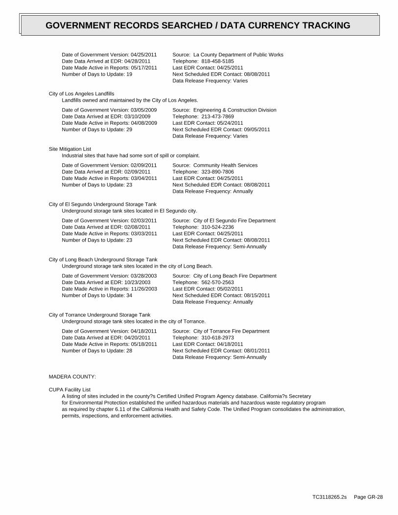
Date of Government Version: 04/25/2011Date Data Arrived at EDR: 04/28/2011Date Made Active in Reports: 05/17/2011Number of Days to Update: 19
Source: La County Department of Public WorksTelephone: 818-458-5185Last EDR Contact: 04/25/2011Next Scheduled EDR Contact: 08/08/2011Data Release Frequency: Varies
City of Los Angeles LandfillsLandfills owned and maintained by the City of Los Angeles.
Date of Government Version: 03/05/2009Date Data Arrived at EDR: 03/10/2009Date Made Active in Reports: 04/08/2009Number of Days to Update: 29
Source: Engineering & Construction DivisionTelephone: 213-473-7869Last EDR Contact: 05/24/2011Next Scheduled EDR Contact: 09/05/2011Data Release Frequency: Varies
Site Mitigation ListIndustrial sites that have had some sort of spill or complaint.
Date of Government Version: 02/09/2011Date Data Arrived at EDR: 02/09/2011Date Made Active in Reports: 03/04/2011Number of Days to Update: 23
Source: Community Health ServicesTelephone: 323-890-7806Last EDR Contact: 04/25/2011Next Scheduled EDR Contact: 08/08/2011Data Release Frequency: Annually
City of El Segundo Underground Storage TankUnderground storage tank sites located in El Segundo city.
Date of Government Version: 02/03/2011Date Data Arrived at EDR: 02/08/2011Date Made Active in Reports: 03/03/2011Number of Days to Update: 23
Source: City of El Segundo Fire DepartmentTelephone: 310-524-2236Last EDR Contact: 04/25/2011Next Scheduled EDR Contact: 08/08/2011Data Release Frequency: Semi-Annually
City of Long Beach Underground Storage TankUnderground storage tank sites located in the city of Long Beach.
Date of Government Version: 03/28/2003Date Data Arrived at EDR: 10/23/2003Date Made Active in Reports: 11/26/2003Number of Days to Update: 34
Source: City of Long Beach Fire DepartmentTelephone: 562-570-2563Last EDR Contact: 05/02/2011Next Scheduled EDR Contact: 08/15/2011Data Release Frequency: Annually
City of Torrance Underground Storage TankUnderground storage tank sites located in the city of Torrance.
Date of Government Version: 04/18/2011Date Data Arrived at EDR: 04/20/2011Date Made Active in Reports: 05/18/2011Number of Days to Update: 28
Source: City of Torrance Fire DepartmentTelephone: 310-618-2973Last EDR Contact: 04/18/2011Next Scheduled EDR Contact: 08/01/2011Data Release Frequency: Semi-Annually
MADERA COUNTY:
CUPA Facility ListA listing of sites included in the county?s Certified Unified Program Agency database. California?s Secretaryfor Environmental Protection established the unified hazardous materials and hazardous waste regulatory programas required by chapter 6.11 of the California Health and Safety Code. The Unified Program consolidates the administration,permits, inspections, and enforcement activities.
TC3118265.2s Page GR-28
GOVERNMENT RECORDS SEARCHED / DATA CURRENCY TRACKING

Date of Government Version: 06/07/2011Date Data Arrived at EDR: 06/08/2011Date Made Active in Reports: 07/08/2011Number of Days to Update: 30
Source: Madera County Environmental HealthTelephone: 559-675-7823Last EDR Contact: 05/31/2011Next Scheduled EDR Contact: 09/12/2011Data Release Frequency: Varies
MARIN COUNTY:
Underground Storage Tank SitesCurrently permitted USTs in Marin County.
Date of Government Version: 04/15/2011Date Data Arrived at EDR: 04/26/2011Date Made Active in Reports: 05/18/2011Number of Days to Update: 22
Source: Public Works Department Waste ManagementTelephone: 415-499-6647Last EDR Contact: 07/11/2011Next Scheduled EDR Contact: 10/24/2011Data Release Frequency: Semi-Annually
MERCED COUNTY:
CUPA Facility ListCUPA facility list.
Date of Government Version: 06/06/2011Date Data Arrived at EDR: 06/06/2011Date Made Active in Reports: 06/15/2011Number of Days to Update: 9
Source: Merced County Environmental HealthTelephone: 209-381-1094Last EDR Contact: 05/31/2011Next Scheduled EDR Contact: 09/12/2011Data Release Frequency: Varies
MONTEREY COUNTY:
CUPA Facility ListingCUPA Program listing from the Environmental Health Division.
Date of Government Version: 01/20/2011Date Data Arrived at EDR: 03/03/2011Date Made Active in Reports: 03/24/2011Number of Days to Update: 21
Source: Monterey County Health DepartmentTelephone: 831-796-1297Last EDR Contact: 06/20/2011Next Scheduled EDR Contact: 09/12/2011Data Release Frequency: Varies
NAPA COUNTY:
Sites With Reported ContaminationA listing of leaking underground storage tank sites located in Napa county.
Date of Government Version: 07/09/2008Date Data Arrived at EDR: 07/09/2008Date Made Active in Reports: 07/31/2008Number of Days to Update: 22
Source: Napa County Department of Environmental ManagementTelephone: 707-253-4269Last EDR Contact: 03/07/2011Next Scheduled EDR Contact: 06/20/2011Data Release Frequency: No Update Planned
Closed and Operating Underground Storage Tank SitesUnderground storage tank sites located in Napa county.
Date of Government Version: 01/15/2008Date Data Arrived at EDR: 01/16/2008Date Made Active in Reports: 02/08/2008Number of Days to Update: 23
Source: Napa County Department of Environmental ManagementTelephone: 707-253-4269Last EDR Contact: 06/06/2011Next Scheduled EDR Contact: 09/19/2011Data Release Frequency: No Update Planned
ORANGE COUNTY:
TC3118265.2s Page GR-29
GOVERNMENT RECORDS SEARCHED / DATA CURRENCY TRACKING

List of Industrial Site CleanupsPetroleum and non-petroleum spills.
Date of Government Version: 05/02/2011Date Data Arrived at EDR: 05/20/2011Date Made Active in Reports: 06/15/2011Number of Days to Update: 26
Source: Health Care AgencyTelephone: 714-834-3446Last EDR Contact: 05/16/2011Next Scheduled EDR Contact: 08/29/2011Data Release Frequency: Annually
List of Underground Storage Tank CleanupsOrange County Underground Storage Tank Cleanups (LUST).
Date of Government Version: 05/05/2011Date Data Arrived at EDR: 05/20/2011Date Made Active in Reports: 06/15/2011Number of Days to Update: 26
Source: Health Care AgencyTelephone: 714-834-3446Last EDR Contact: 05/16/2011Next Scheduled EDR Contact: 08/29/2011Data Release Frequency: Quarterly
List of Underground Storage Tank FacilitiesOrange County Underground Storage Tank Facilities (UST).
Date of Government Version: 05/05/2011Date Data Arrived at EDR: 05/17/2011Date Made Active in Reports: 06/20/2011Number of Days to Update: 34
Source: Health Care AgencyTelephone: 714-834-3446Last EDR Contact: 05/17/2011Next Scheduled EDR Contact: 08/29/2011Data Release Frequency: Quarterly
PLACER COUNTY:
Master List of FacilitiesList includes aboveground tanks, underground tanks and cleanup sites.
Date of Government Version: 06/20/2011Date Data Arrived at EDR: 06/21/2011Date Made Active in Reports: 07/08/2011Number of Days to Update: 17
Source: Placer County Health and Human ServicesTelephone: 530-889-7312Last EDR Contact: 06/13/2011Next Scheduled EDR Contact: 09/26/2011Data Release Frequency: Semi-Annually
RIVERSIDE COUNTY:
Listing of Underground Tank Cleanup SitesRiverside County Underground Storage Tank Cleanup Sites (LUST).
Date of Government Version: 04/26/2011Date Data Arrived at EDR: 04/28/2011Date Made Active in Reports: 05/17/2011Number of Days to Update: 19
Source: Department of Environmental HealthTelephone: 951-358-5055Last EDR Contact: 06/27/2011Next Scheduled EDR Contact: 10/10/2011Data Release Frequency: Quarterly
Underground Storage Tank Tank ListUnderground storage tank sites located in Riverside county.
Date of Government Version: 04/26/2011Date Data Arrived at EDR: 04/28/2011Date Made Active in Reports: 05/18/2011Number of Days to Update: 20
Source: Department of Environmental HealthTelephone: 951-358-5055Last EDR Contact: 06/27/2011Next Scheduled EDR Contact: 10/10/2011Data Release Frequency: Quarterly
SACRAMENTO COUNTY:
TC3118265.2s Page GR-30
GOVERNMENT RECORDS SEARCHED / DATA CURRENCY TRACKING

Toxic Site Clean-Up ListList of sites where unauthorized releases of potentially hazardous materials have occurred.
Date of Government Version: 02/07/2011Date Data Arrived at EDR: 04/28/2011Date Made Active in Reports: 05/17/2011Number of Days to Update: 19
Source: Sacramento County Environmental ManagementTelephone: 916-875-8406Last EDR Contact: 07/08/2011Next Scheduled EDR Contact: 10/24/2011Data Release Frequency: Quarterly
Master Hazardous Materials Facility ListAny business that has hazardous materials on site - hazardous material storage sites, underground storage tanks,waste generators.
Date of Government Version: 02/07/2011Date Data Arrived at EDR: 04/29/2011Date Made Active in Reports: 05/17/2011Number of Days to Update: 18
Source: Sacramento County Environmental ManagementTelephone: 916-875-8406Last EDR Contact: 07/08/2011Next Scheduled EDR Contact: 10/24/2011Data Release Frequency: Quarterly
SAN BERNARDINO COUNTY:
Hazardous Material PermitsThis listing includes underground storage tanks, medical waste handlers/generators, hazardous materials handlers,hazardous waste generators, and waste oil generators/handlers.
Date of Government Version: 06/09/2011Date Data Arrived at EDR: 06/09/2011Date Made Active in Reports: 06/15/2011Number of Days to Update: 6
Source: San Bernardino County Fire Department Hazardous Materials DivisionTelephone: 909-387-3041Last EDR Contact: 05/16/2011Next Scheduled EDR Contact: 08/29/2011Data Release Frequency: Quarterly
SAN DIEGO COUNTY:
Hazardous Materials Management Division DatabaseThe database includes: HE58 - This report contains the business name, site address, business phone number, establishment’H’ permit number, type of permit, and the business status. HE17 - In addition to providing the same informationprovided in the HE58 listing, HE17 provides inspection dates, violations received by the establishment, hazardouswaste generated, the quantity, method of storage, treatment/disposal of waste and the hauler, and informationon underground storage tanks. Unauthorized Release List - Includes a summary of environmental contamination casesin San Diego County (underground tank cases, non-tank cases, groundwater contamination, and soil contaminationare included.)
Date of Government Version: 09/09/2010Date Data Arrived at EDR: 09/15/2010Date Made Active in Reports: 09/29/2010Number of Days to Update: 14
Source: Hazardous Materials Management DivisionTelephone: 619-338-2268Last EDR Contact: 06/17/2011Next Scheduled EDR Contact: 09/26/2011Data Release Frequency: Quarterly
Solid Waste FacilitiesSan Diego County Solid Waste Facilities.
Date of Government Version: 10/01/2010Date Data Arrived at EDR: 11/16/2010Date Made Active in Reports: 01/25/2011Number of Days to Update: 70
Source: Department of Health ServicesTelephone: 619-338-2209Last EDR Contact: 05/02/2011Next Scheduled EDR Contact: 08/15/2011Data Release Frequency: Varies
TC3118265.2s Page GR-31
GOVERNMENT RECORDS SEARCHED / DATA CURRENCY TRACKING

Environmental Case ListingThe listing contains all underground tank release cases and projects pertaining to properties contaminated withhazardous substances that are actively under review by the Site Assessment and Mitigation Program.
Date of Government Version: 03/23/2010Date Data Arrived at EDR: 06/15/2010Date Made Active in Reports: 07/09/2010Number of Days to Update: 24
Source: San Diego County Department of Environmental HealthTelephone: 619-338-2371Last EDR Contact: 06/14/2011Next Scheduled EDR Contact: 09/26/2011Data Release Frequency: No Update Planned
SAN FRANCISCO COUNTY:
Local Oversite FacilitiesA listing of leaking underground storage tank sites located in San Francisco county.
Date of Government Version: 09/19/2008Date Data Arrived at EDR: 09/19/2008Date Made Active in Reports: 09/29/2008Number of Days to Update: 10
Source: Department Of Public Health San Francisco CountyTelephone: 415-252-3920Last EDR Contact: 05/16/2011Next Scheduled EDR Contact: 08/16/2011Data Release Frequency: Quarterly
Underground Storage Tank InformationUnderground storage tank sites located in San Francisco county.
Date of Government Version: 11/29/2010Date Data Arrived at EDR: 03/10/2011Date Made Active in Reports: 03/15/2011Number of Days to Update: 5
Source: Department of Public HealthTelephone: 415-252-3920Last EDR Contact: 05/31/2011Next Scheduled EDR Contact: 08/29/2011Data Release Frequency: Quarterly
SAN JOAQUIN COUNTY:
San Joaquin Co. USTA listing of underground storage tank locations in San Joaquin county.
Date of Government Version: 06/27/2011Date Data Arrived at EDR: 06/29/2011Date Made Active in Reports: 07/08/2011Number of Days to Update: 9
Source: Environmental Health DepartmentTelephone: N/ALast EDR Contact: 06/27/2011Next Scheduled EDR Contact: 10/10/2011Data Release Frequency: Semi-Annually
SAN LUIS OBISPO COUNTY:
CUPA Facility ListCupa Facility List.
Date of Government Version: 05/31/2011Date Data Arrived at EDR: 05/31/2011Date Made Active in Reports: 07/08/2011Number of Days to Update: 38
Source: San Luis Obispo County Public Health DepartmentTelephone: 805-781-5596Last EDR Contact: 05/31/2011Next Scheduled EDR Contact: 09/12/2011Data Release Frequency: Varies
SAN MATEO COUNTY:
Business InventoryList includes Hazardous Materials Business Plan, hazardous waste generators, and underground storage tanks.
TC3118265.2s Page GR-32
GOVERNMENT RECORDS SEARCHED / DATA CURRENCY TRACKING

Date of Government Version: 04/19/2011Date Data Arrived at EDR: 04/20/2011Date Made Active in Reports: 05/17/2011Number of Days to Update: 27
Source: San Mateo County Environmental Health Services DivisionTelephone: 650-363-1921Last EDR Contact: 06/20/2011Next Scheduled EDR Contact: 09/05/2011Data Release Frequency: Annually
Fuel Leak ListA listing of leaking underground storage tank sites located in San Mateo county.
Date of Government Version: 03/21/2011Date Data Arrived at EDR: 03/22/2011Date Made Active in Reports: 04/20/2011Number of Days to Update: 29
Source: San Mateo County Environmental Health Services DivisionTelephone: 650-363-1921Last EDR Contact: 06/20/2011Next Scheduled EDR Contact: 09/05/2011Data Release Frequency: Semi-Annually
SANTA BARBARA COUNTY:
CUPA Facility ListingCUPA Program Listing from the Environmental Health Services division.
Date of Government Version: 11/22/2010Date Data Arrived at EDR: 03/03/2011Date Made Active in Reports: 03/24/2011Number of Days to Update: 21
Source: Santa Barbara County Public Health DepartmentTelephone: 805-686-8167Last EDR Contact: 06/29/2011Next Scheduled EDR Contact: 09/12/2011Data Release Frequency: Varies
SANTA CLARA COUNTY:
HIST LUST - Fuel Leak Site Activity ReportA listing of open and closed leaking underground storage tanks. This listing is no longer updated by the county.Leaking underground storage tanks are now handled by the Department of Environmental Health.
Date of Government Version: 03/29/2005Date Data Arrived at EDR: 03/30/2005Date Made Active in Reports: 04/21/2005Number of Days to Update: 22
Source: Santa Clara Valley Water DistrictTelephone: 408-265-2600Last EDR Contact: 03/23/2009Next Scheduled EDR Contact: 06/22/2009Data Release Frequency: No Update Planned
LOP ListingA listing of leaking underground storage tanks located in Santa Clara county.
Date of Government Version: 05/29/2009Date Data Arrived at EDR: 06/01/2009Date Made Active in Reports: 06/15/2009Number of Days to Update: 14
Source: Department of Environmental HealthTelephone: 408-918-3417Last EDR Contact: 07/08/2011Next Scheduled EDR Contact: 09/19/2011Data Release Frequency: Annually
Hazardous Material FacilitiesHazardous material facilities, including underground storage tank sites.
Date of Government Version: 08/31/2009Date Data Arrived at EDR: 08/31/2009Date Made Active in Reports: 09/18/2009Number of Days to Update: 18
Source: City of San Jose Fire DepartmentTelephone: 408-535-7694Last EDR Contact: 06/13/2011Next Scheduled EDR Contact: 08/29/2011Data Release Frequency: Annually
SANTA CRUZ COUNTY:
TC3118265.2s Page GR-33
GOVERNMENT RECORDS SEARCHED / DATA CURRENCY TRACKING
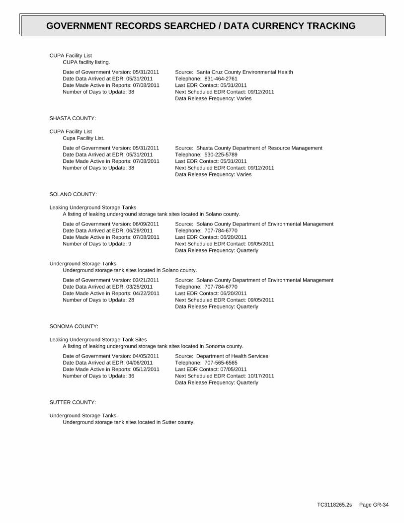
CUPA Facility ListCUPA facility listing.
Date of Government Version: 05/31/2011Date Data Arrived at EDR: 05/31/2011Date Made Active in Reports: 07/08/2011Number of Days to Update: 38
Source: Santa Cruz County Environmental HealthTelephone: 831-464-2761Last EDR Contact: 05/31/2011Next Scheduled EDR Contact: 09/12/2011Data Release Frequency: Varies
SHASTA COUNTY:
CUPA Facility ListCupa Facility List.
Date of Government Version: 05/31/2011Date Data Arrived at EDR: 05/31/2011Date Made Active in Reports: 07/08/2011Number of Days to Update: 38
Source: Shasta County Department of Resource ManagementTelephone: 530-225-5789Last EDR Contact: 05/31/2011Next Scheduled EDR Contact: 09/12/2011Data Release Frequency: Varies
SOLANO COUNTY:
Leaking Underground Storage TanksA listing of leaking underground storage tank sites located in Solano county.
Date of Government Version: 06/09/2011Date Data Arrived at EDR: 06/29/2011Date Made Active in Reports: 07/08/2011Number of Days to Update: 9
Source: Solano County Department of Environmental ManagementTelephone: 707-784-6770Last EDR Contact: 06/20/2011Next Scheduled EDR Contact: 09/05/2011Data Release Frequency: Quarterly
Underground Storage TanksUnderground storage tank sites located in Solano county.
Date of Government Version: 03/21/2011Date Data Arrived at EDR: 03/25/2011Date Made Active in Reports: 04/22/2011Number of Days to Update: 28
Source: Solano County Department of Environmental ManagementTelephone: 707-784-6770Last EDR Contact: 06/20/2011Next Scheduled EDR Contact: 09/05/2011Data Release Frequency: Quarterly
SONOMA COUNTY:
Leaking Underground Storage Tank SitesA listing of leaking underground storage tank sites located in Sonoma county.
Date of Government Version: 04/05/2011Date Data Arrived at EDR: 04/06/2011Date Made Active in Reports: 05/12/2011Number of Days to Update: 36
Source: Department of Health ServicesTelephone: 707-565-6565Last EDR Contact: 07/05/2011Next Scheduled EDR Contact: 10/17/2011Data Release Frequency: Quarterly
SUTTER COUNTY:
Underground Storage TanksUnderground storage tank sites located in Sutter county.
TC3118265.2s Page GR-34
GOVERNMENT RECORDS SEARCHED / DATA CURRENCY TRACKING

Date of Government Version: 03/14/2011Date Data Arrived at EDR: 03/15/2011Date Made Active in Reports: 03/24/2011Number of Days to Update: 9
Source: Sutter County Department of AgricultureTelephone: 530-822-7500Last EDR Contact: 06/13/2011Next Scheduled EDR Contact: 09/26/2011Data Release Frequency: Semi-Annually
VENTURA COUNTY:
Business Plan, Hazardous Waste Producers, and Operating Underground TanksThe BWT list indicates by site address whether the Environmental Health Division has Business Plan (B), WasteProducer (W), and/or Underground Tank (T) information.
Date of Government Version: 01/26/2011Date Data Arrived at EDR: 02/25/2011Date Made Active in Reports: 03/22/2011Number of Days to Update: 25
Source: Ventura County Environmental Health DivisionTelephone: 805-654-2813Last EDR Contact: 05/24/2011Next Scheduled EDR Contact: 09/05/2011Data Release Frequency: Quarterly
Inventory of Illegal Abandoned and Inactive SitesVentura County Inventory of Closed, Illegal Abandoned, and Inactive Sites.
Date of Government Version: 04/01/2011Date Data Arrived at EDR: 04/07/2011Date Made Active in Reports: 05/12/2011Number of Days to Update: 35
Source: Environmental Health DivisionTelephone: 805-654-2813Last EDR Contact: 07/08/2011Next Scheduled EDR Contact: 10/24/2011Data Release Frequency: Annually
Listing of Underground Tank Cleanup SitesVentura County Underground Storage Tank Cleanup Sites (LUST).
Date of Government Version: 05/29/2008Date Data Arrived at EDR: 06/24/2008Date Made Active in Reports: 07/31/2008Number of Days to Update: 37
Source: Environmental Health DivisionTelephone: 805-654-2813Last EDR Contact: 05/24/2011Next Scheduled EDR Contact: 09/05/2011Data Release Frequency: Quarterly
Medical Waste Program ListTo protect public health and safety and the environment from potential exposure to disease causing agents, theEnvironmental Health Division Medical Waste Program regulates the generation, handling, storage, treatment anddisposal of medical waste throughout the County.
Date of Government Version: 04/26/2011Date Data Arrived at EDR: 05/03/2011Date Made Active in Reports: 06/15/2011Number of Days to Update: 43
Source: Ventura County Resource Management AgencyTelephone: 805-654-2813Last EDR Contact: 05/02/2011Next Scheduled EDR Contact: 08/15/2011Data Release Frequency: Quarterly
Underground Tank Closed Sites ListVentura County Operating Underground Storage Tank Sites (UST)/Underground Tank Closed Sites List.
Date of Government Version: 03/01/2011Date Data Arrived at EDR: 03/23/2011Date Made Active in Reports: 04/22/2011Number of Days to Update: 30
Source: Environmental Health DivisionTelephone: 805-654-2813Last EDR Contact: 06/21/2011Next Scheduled EDR Contact: 10/03/2011Data Release Frequency: Quarterly
YOLO COUNTY:
TC3118265.2s Page GR-35
GOVERNMENT RECORDS SEARCHED / DATA CURRENCY TRACKING
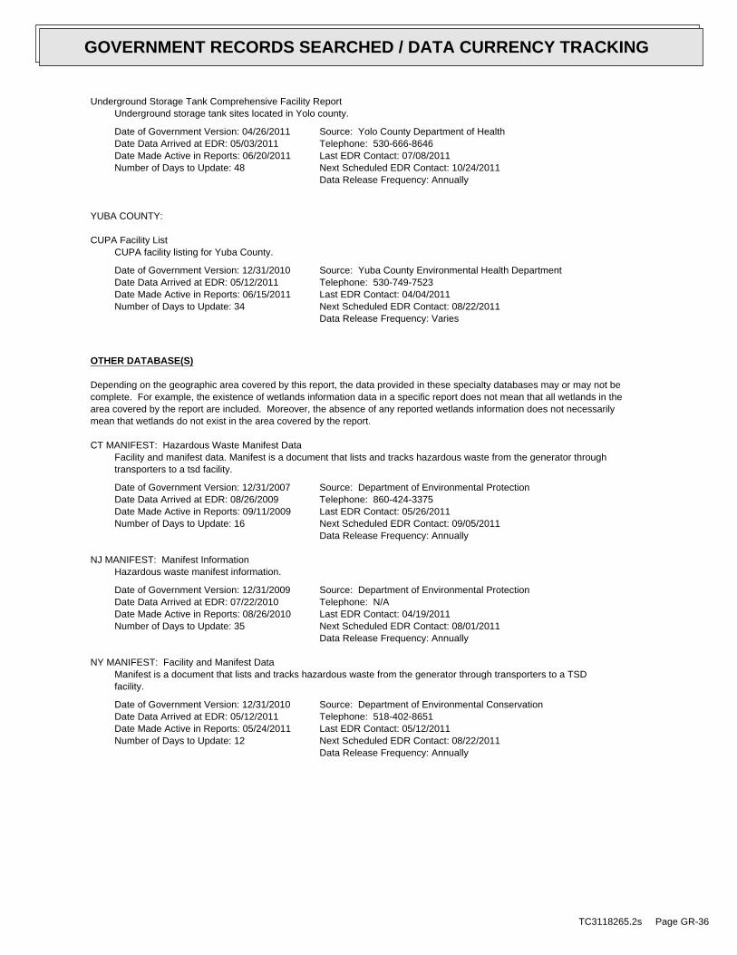
Underground Storage Tank Comprehensive Facility ReportUnderground storage tank sites located in Yolo county.
Date of Government Version: 04/26/2011Date Data Arrived at EDR: 05/03/2011Date Made Active in Reports: 06/20/2011Number of Days to Update: 48
Source: Yolo County Department of HealthTelephone: 530-666-8646Last EDR Contact: 07/08/2011Next Scheduled EDR Contact: 10/24/2011Data Release Frequency: Annually
YUBA COUNTY:
CUPA Facility ListCUPA facility listing for Yuba County.
Date of Government Version: 12/31/2010Date Data Arrived at EDR: 05/12/2011Date Made Active in Reports: 06/15/2011Number of Days to Update: 34
Source: Yuba County Environmental Health DepartmentTelephone: 530-749-7523Last EDR Contact: 04/04/2011Next Scheduled EDR Contact: 08/22/2011Data Release Frequency: Varies
OTHER DATABASE(S)
Depending on the geographic area covered by this report, the data provided in these specialty databases may or may not becomplete. For example, the existence of wetlands information data in a specific report does not mean that all wetlands in thearea covered by the report are included. Moreover, the absence of any reported wetlands information does not necessarilymean that wetlands do not exist in the area covered by the report.
CT MANIFEST: Hazardous Waste Manifest DataFacility and manifest data. Manifest is a document that lists and tracks hazardous waste from the generator throughtransporters to a tsd facility.
Date of Government Version: 12/31/2007Date Data Arrived at EDR: 08/26/2009Date Made Active in Reports: 09/11/2009Number of Days to Update: 16
Source: Department of Environmental ProtectionTelephone: 860-424-3375Last EDR Contact: 05/26/2011Next Scheduled EDR Contact: 09/05/2011Data Release Frequency: Annually
NJ MANIFEST: Manifest InformationHazardous waste manifest information.
Date of Government Version: 12/31/2009Date Data Arrived at EDR: 07/22/2010Date Made Active in Reports: 08/26/2010Number of Days to Update: 35
Source: Department of Environmental ProtectionTelephone: N/ALast EDR Contact: 04/19/2011Next Scheduled EDR Contact: 08/01/2011Data Release Frequency: Annually
NY MANIFEST: Facility and Manifest DataManifest is a document that lists and tracks hazardous waste from the generator through transporters to a TSDfacility.
Date of Government Version: 12/31/2010Date Data Arrived at EDR: 05/12/2011Date Made Active in Reports: 05/24/2011Number of Days to Update: 12
Source: Department of Environmental ConservationTelephone: 518-402-8651Last EDR Contact: 05/12/2011Next Scheduled EDR Contact: 08/22/2011Data Release Frequency: Annually
TC3118265.2s Page GR-36
GOVERNMENT RECORDS SEARCHED / DATA CURRENCY TRACKING
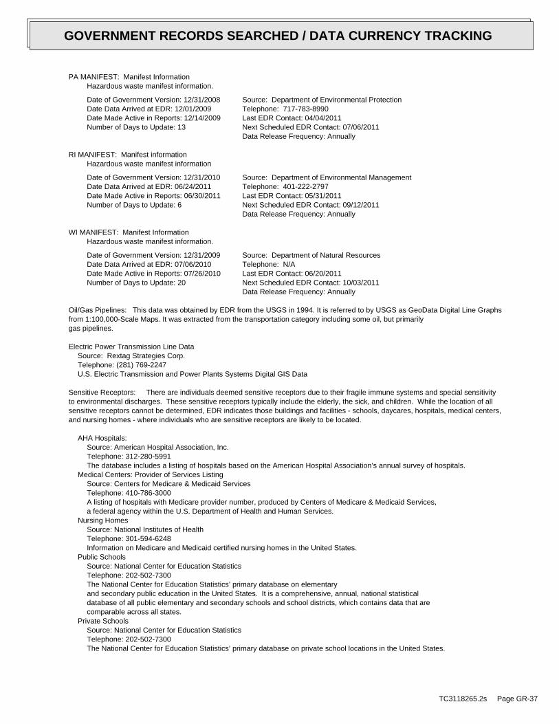
PA MANIFEST: Manifest InformationHazardous waste manifest information.
Date of Government Version: 12/31/2008Date Data Arrived at EDR: 12/01/2009Date Made Active in Reports: 12/14/2009Number of Days to Update: 13
Source: Department of Environmental ProtectionTelephone: 717-783-8990Last EDR Contact: 04/04/2011Next Scheduled EDR Contact: 07/06/2011Data Release Frequency: Annually
RI MANIFEST: Manifest informationHazardous waste manifest information
Date of Government Version: 12/31/2010Date Data Arrived at EDR: 06/24/2011Date Made Active in Reports: 06/30/2011Number of Days to Update: 6
Source: Department of Environmental ManagementTelephone: 401-222-2797Last EDR Contact: 05/31/2011Next Scheduled EDR Contact: 09/12/2011Data Release Frequency: Annually
WI MANIFEST: Manifest InformationHazardous waste manifest information.
Date of Government Version: 12/31/2009Date Data Arrived at EDR: 07/06/2010Date Made Active in Reports: 07/26/2010Number of Days to Update: 20
Source: Department of Natural ResourcesTelephone: N/ALast EDR Contact: 06/20/2011Next Scheduled EDR Contact: 10/03/2011Data Release Frequency: Annually
Oil/Gas Pipelines: This data was obtained by EDR from the USGS in 1994. It is referred to by USGS as GeoData Digital Line Graphsfrom 1:100,000-Scale Maps. It was extracted from the transportation category including some oil, but primarilygas pipelines.
Electric Power Transmission Line DataSource: Rextag Strategies Corp.Telephone: (281) 769-2247U.S. Electric Transmission and Power Plants Systems Digital GIS Data
Sensitive Receptors: There are individuals deemed sensitive receptors due to their fragile immune systems and special sensitivityto environmental discharges. These sensitive receptors typically include the elderly, the sick, and children. While the location of allsensitive receptors cannot be determined, EDR indicates those buildings and facilities - schools, daycares, hospitals, medical centers,and nursing homes - where individuals who are sensitive receptors are likely to be located.
AHA Hospitals:Source: American Hospital Association, Inc.Telephone: 312-280-5991The database includes a listing of hospitals based on the American Hospital Association’s annual survey of hospitals.
Medical Centers: Provider of Services ListingSource: Centers for Medicare & Medicaid ServicesTelephone: 410-786-3000A listing of hospitals with Medicare provider number, produced by Centers of Medicare & Medicaid Services,a federal agency within the U.S. Department of Health and Human Services.
Nursing HomesSource: National Institutes of HealthTelephone: 301-594-6248Information on Medicare and Medicaid certified nursing homes in the United States.
Public SchoolsSource: National Center for Education StatisticsTelephone: 202-502-7300The National Center for Education Statistics’ primary database on elementaryand secondary public education in the United States. It is a comprehensive, annual, national statisticaldatabase of all public elementary and secondary schools and school districts, which contains data that arecomparable across all states.
Private SchoolsSource: National Center for Education StatisticsTelephone: 202-502-7300The National Center for Education Statistics’ primary database on private school locations in the United States.
TC3118265.2s Page GR-37
GOVERNMENT RECORDS SEARCHED / DATA CURRENCY TRACKING
Daycare Centers: Licensed FacilitiesSource: Department of Social ServicesTelephone: 916-657-4041
Flood Zone Data: This data, available in select counties across the country, was obtained by EDR in 2003 & 2011 from the FederalEmergency Management Agency (FEMA). Data depicts 100-year and 500-year flood zones as defined by FEMA.
NWI: National Wetlands Inventory. This data, available in select counties across the country, was obtained by EDRin 2002 and 2005 from the U.S. Fish and Wildlife Service.
Scanned Digital USGS 7.5’ Topographic Map (DRG)Source: United States Geologic SurveyA digital raster graphic (DRG) is a scanned image of a U.S. Geological Survey topographic map. The map imagesare made by scanning published paper maps on high-resolution scanners. The raster imageis georeferenced and fit to the Universal Transverse Mercator (UTM) projection.
STREET AND ADDRESS INFORMATION
© 2010 Tele Atlas North America, Inc. All rights reserved. This material is proprietary and the subject of copyright protectionand other intellectual property rights owned by or licensed to Tele Atlas North America, Inc. The use of this material is subjectto the terms of a license agreement. You will be held liable for any unauthorized copying or disclosure of this material.
TC3118265.2s Page GR-38
GOVERNMENT RECORDS SEARCHED / DATA CURRENCY TRACKING
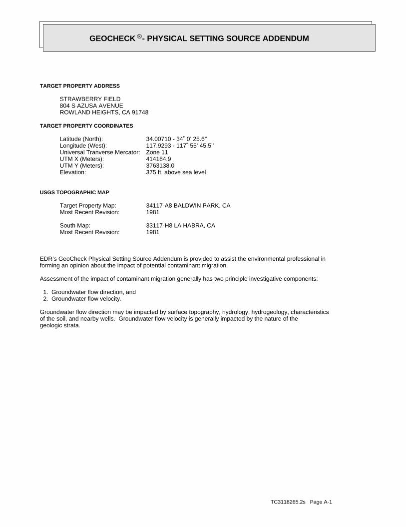
TC3118265.2s Page A-1
geologic strata.of the soil, and nearby wells. Groundwater flow velocity is generally impacted by the nature of theGroundwater flow direction may be impacted by surface topography, hydrology, hydrogeology, characteristics
2. Groundwater flow velocity. 1. Groundwater flow direction, and
Assessment of the impact of contaminant migration generally has two principle investigative components:
forming an opinion about the impact of potential contaminant migration.EDR’s GeoCheck Physical Setting Source Addendum is provided to assist the environmental professional in
1981Most Recent Revision:33117-H8 LA HABRA, CASouth Map:
1981Most Recent Revision:34117-A8 BALDWIN PARK, CATarget Property Map:
USGS TOPOGRAPHIC MAP
375 ft. above sea levelElevation:3763138.0UTM Y (Meters): 414184.9UTM X (Meters): Zone 11Universal Tranverse Mercator: 117.9293 - 117˚ 55’ 45.5’’Longitude (West): 34.00710 - 34˚ 0’ 25.6’’Latitude (North):
TARGET PROPERTY COORDINATES
ROWLAND HEIGHTS, CA 91748804 S AZUSA AVENUESTRAWBERRY FIELD
TARGET PROPERTY ADDRESS
GEOCHECK - PHYSICAL SETTING SOURCE ADDENDUM®

TC3118265.2s Page A-2
should be field verified.on a relative (not an absolute) basis. Relative elevation information between sites of close proximitySource: Topography has been determined from the USGS 7.5’ Digital Elevation Model and should be evaluated
SURROUNDING TOPOGRAPHY: ELEVATION PROFILES
Ele
vatio
n (f
t)E
leva
tion
(ft)
TP
TP0 1/2 1 Miles
✩Target Property Elevation: 375 ft.
North South
West East
462
448
435
421
409
399
391
385
381
375
372
380
397
416
435
455
555
539
631362
364
361
359
361
352
365
370
372
375
377
373
383
386
387
391
393
394
395
General NNWGeneral Topographic Gradient:TARGET PROPERTY TOPOGRAPHY
should contamination exist on the target property, what downgradient sites might be impacted.assist the environmental professional in forming an opinion about the impact of nearby contaminated properties or,Surface topography may be indicative of the direction of surficial groundwater flow. This information can be used toTOPOGRAPHIC INFORMATION
collected on nearby properties, and regional groundwater flow information (from deep aquifers).sources of information, such as surface topographic information, hydrologic information, hydrogeologic datausing site-specific well data. If such data is not reasonably ascertainable, it may be necessary to rely on otherGroundwater flow direction for a particular site is best determined by a qualified environmental professionalGROUNDWATER FLOW DIRECTION INFORMATION
GEOCHECK - PHYSICAL SETTING SOURCE SUMMARY®

TC3118265.2s Page A-3
Not Reported
GENERAL DIRECTIONLOCATIONGROUNDWATER FLOWFROM TPMAP ID
hydrogeologically, and the depth to water table.authorities at select sites and has extracted the date of the report, groundwater flow direction as determinedflow at specific points. EDR has reviewed reports submitted by environmental professionals to regulatoryEDR has developed the AQUIFLOW Information System to provide data on the general direction of groundwater
AQUIFLOW®
Search Radius: 1.000 Mile.
* ©1996 Site−specific hydrogeological data gathered by CERCLIS Alerts, Inc., Bainbridge Island, WA. All rights reserved. All of the information and opinions presented are those of the cited EPA report(s), which were completed undera Comprehensive Environmental Response Compensation and Liability Information System (CERCLIS) investigation.
Information is inferred in the CERCLIS investigation report(s) Data Quality:No information about a sole source aquifer is available Sole Source Aquifer:bedrock aquifer.the underlying and discrete Canyon alluvium aquifer and Industry HillsThe Valley alluvium at the site is likely hydraulically connected to Hydraulic Connection:8 feet to 38 feet. Inferred Depth to Water:Southeast Groundwater Flow Direction:CAD980636641 Site EPA ID Number:La Puente Dump Site Name:1/2 - 1 Mile NE Location Relative to TP:1.25 miles Search Radius:
Site-Specific Hydrogeological Data*:
* ©1996 Site−specific hydrogeological data gathered by CERCLIS Alerts, Inc., Bainbridge Island, WA. All rights reserved. All of the information and opinions presented are those of the cited EPA report(s), which were completed undera Comprehensive Environmental Response Compensation and Liability Information System (CERCLIS) investigation.
contamination exist on the target property, what downgradient sites might be impacted.environmental professional in forming an opinion about the impact of nearby contaminated properties or, shouldof groundwater flow direction in the immediate area. Such hydrogeologic information can be used to assist theHydrogeologic information obtained by installation of wells on a specific site can often be an indicatorHYDROGEOLOGIC INFORMATION
YES - refer to the Overview Map and Detail MapBALDWIN PARK
NATIONAL WETLAND INVENTORYNWI ElectronicData CoverageNWI Quad at Target Property
Not ReportedAdditional Panels in search area:
06037C - FEMA DFIRM Flood dataFlood Plain Panel at Target Property:
YES - refer to the Overview Map and Detail MapLOS ANGELES, CA
FEMA FLOOD ZONEFEMA FloodElectronic DataTarget Property County
and bodies of water).Refer to the Physical Setting Source Map following this summary for hydrologic information (major waterways
contamination exist on the target property, what downgradient sites might be impacted.the environmental professional in forming an opinion about the impact of nearby contaminated properties or, shouldSurface water can act as a hydrologic barrier to groundwater flow. Such hydrologic information can be used to assistHYDROLOGIC INFORMATION
GEOCHECK - PHYSICAL SETTING SOURCE SUMMARY®
TC3118265.2s Page A-4
> 10 inchesDepth to Bedrock Max:
> 10 inchesDepth to Bedrock Min:
Not ReportedCorrosion Potential - Uncoated Steel:
Hydric Status: Soil does not meet the requirements for a hydric soil.
Not reportedSoil Drainage Class:
Not reportedHydrologic Group:
variableSoil Surface Texture:
URBAN LAND Soil Component Name:
The following information is based on Soil Conservation Service STATSGO data.in a landscape. Soil maps for STATSGO are compiled by generalizing more detailed (SSURGO) soil survey maps.for privately owned lands in the United States. A soil map in a soil survey is a representation of soil patternsSurvey (NCSS) and is responsible for collecting, storing, maintaining and distributing soil survey informationThe U.S. Department of Agriculture’s (USDA) Soil Conservation Service (SCS) leads the National Cooperative Soil
DOMINANT SOIL COMPOSITION IN GENERAL AREA OF TARGET PROPERTY
Map, USGS Digital Data Series DDS - 11 (1994).of the Conterminous U.S. at 1:2,500,000 Scale - a digital representation of the 1974 P.B. King and H.M. BeikmanGeologic Age and Rock Stratigraphic Unit Source: P.G. Schruben, R.E. Arndt and W.J. Bawiec, Geology
ROCK STRATIGRAPHIC UNIT GEOLOGIC AGE IDENTIFICATION
Stratified SequenceCategory:CenozoicEra:TertiarySystem:MioceneSeries:TmCode: (decoded above as Era, System & Series)
at which contaminant migration may be occurring.Geologic information can be used by the environmental professional in forming an opinion about the relative speedGEOLOGIC INFORMATION IN GENERAL AREA OF TARGET PROPERTY
move more quickly through sandy-gravelly types of soils than silty-clayey types of soils.characteristics data collected on nearby properties and regional soil information. In general, contaminant plumesto rely on other sources of information, including geologic age identification, rock stratigraphic unit and soilusing site specific geologic and soil strata data. If such data are not reasonably ascertainable, it may be necessaryGroundwater flow velocity information for a particular site is best determined by a qualified environmental professionalGROUNDWATER FLOW VELOCITY INFORMATION
GEOCHECK - PHYSICAL SETTING SOURCE SUMMARY®

TC3118265.2s Page A-5
very fine sandy loamweathered bedrocksandcoarse sandgravelly - sandy loamsilty clay loamclay loamstratifiedDeeper Soil Types:
silty claysandgravelly - loamfine sandy loamShallow Soil Types:
sandgravelly - sandcoarse sandgravelly - sandy loamclay loamfine sandsandy loamloamy sandsilt loamclayloamSurficial Soil Types:
sandgravelly - sandcoarse sandgravelly - sandy loamclay loamfine sandsandy loamloamy sandsilt loamclayloamSoil Surface Textures:
appear within the general area of target property.Based on Soil Conservation Service STATSGO data, the following additional subordinant soil types may
OTHER SOIL TYPES IN AREA
Min: 0.00Max: 0.00
Min: 0.00Max: 0.00Not reportedNot reportedvariable 6 inches 0 inches 1
Soil Layer Information
Boundary Classification
PermeabilityRate (in/hr)
Layer Upper Lower Soil Texture Class AASHTO Group Unified Soil Soil Reaction(pH)
GEOCHECK - PHYSICAL SETTING SOURCE SUMMARY®

TC3118265.2s Page A-6
1/2 - 1 Mile NorthCAOG70000028507 C141/2 - 1 Mile NNECAOG70000028435 B131/2 - 1 Mile ENECAOG70000028298 121/2 - 1 Mile NNECAOG70000028413 B111/2 - 1 Mile ENECAOG70000028208 101/2 - 1 Mile NorthCAOG70000028439 91/2 - 1 Mile NWCAOG70000028352 A81/2 - 1 Mile NWCAOG70000028338 A71/2 - 1 Mile NNECAOG70000028368 61/2 - 1 Mile NNWCAOG70000028371 51/2 - 1 Mile ENECAOG70000028226 41/2 - 1 Mile NNECAOG70000028329 31/2 - 1 Mile NorthCAOG70000028340 21/2 - 1 Mile NECAOG70000028283 1
STATE OIL/GAS WELL INFORMATION
LOCATIONFROM TPWELL IDMAP ID
OTHER STATE DATABASE INFORMATION
No Wells Found
STATE DATABASE WELL INFORMATION
LOCATIONFROM TPWELL IDMAP ID
Note: PWS System location is not always the same as well location.
No PWS System Found
FEDERAL FRDS PUBLIC WATER SUPPLY SYSTEM INFORMATION
LOCATIONFROM TPWELL IDMAP ID
No Wells Found
FEDERAL USGS WELL INFORMATION
LOCATIONFROM TPWELL IDMAP ID
1.000State DatabaseNearest PWS within 1 mileFederal FRDS PWS1.000Federal USGS
WELL SEARCH DISTANCE INFORMATION
SEARCH DISTANCE (miles)DATABASE
opinion about the impact of contaminant migration on nearby drinking water wells.professional in assessing sources that may impact ground water flow direction, and in forming anEDR Local/Regional Water Agency records provide water well information to assist the environmental
LOCAL / REGIONAL WATER AGENCY RECORDS
GEOCHECK - PHYSICAL SETTING SOURCE SUMMARY®
TC3118265.2s Page A-7
1/2 - 1 Mile NNWCAOG70000028524 E231/2 - 1 Mile NNECAOG70000028543 221/2 - 1 Mile NNWCAOG70000028513 E211/2 - 1 Mile NNWCAOG70000028462 D201/2 - 1 Mile NWCAOG70000028434 D191/2 - 1 Mile SWCAOG70000027066 181/2 - 1 Mile NorthCAOG70000028511 C171/2 - 1 Mile NNECAOG70000028471 161/2 - 1 Mile NECAOG70000028391 15
STATE OIL/GAS WELL INFORMATION
LOCATIONFROM TPWELL IDMAP ID
GEOCHECK - PHYSICAL SETTING SOURCE SUMMARY®
EDR Inc.EDR Inc.EDR Inc.EDR Inc.EDR Inc.EDR Inc.EDR Inc.EDR Inc.EDR Inc.EDR Inc.EDR Inc.EDR Inc.EDR Inc.EDR Inc.EDR Inc.EDR Inc.EDR Inc.EDR Inc.EDR Inc.EDR Inc.EDR Inc.EDR Inc.EDR Inc.EDR Inc.EDR Inc.EDR Inc.EDR Inc.EDR Inc.EDR Inc.EDR Inc.EDR Inc.EDR Inc.EDR Inc.EDR Inc.EDR Inc.EDR Inc.EDR Inc.EDR Inc.EDR Inc.EDR Inc.
5 605 2 0
5
20
7 60
7 60 5605206 4 0
48
0
7 2 0
72
0
6 8 06 8 0
68
0
52
0
6 8 0 5 20
48
0
56
0
60
0
52 0
6 80
56
0
4807 2
0
6 80
48
0
4 8 0
640
68
0
6 4 0
6 4 0
64 0
6 4 0
64
0
60
0
6
0 0
60
0
6 0 0
60
0
60
0
600
56
0
5
6 0
56
0
5
60
5 60
56
05
60
52
0
5205
2 0
5 20
5
2 0
5 20 5
20
48
0
4 8 0
48
0
48
0
4 8 0
48 0
3 6 0 4 40
4 80
4 4 0
36
0
3 6 0
360
3
6 0
3 6 0 3 6 0
3 6 0
52
0
52
0
5 2 0
480
4 8 0
4 0 0
4 0 0
4 0 0
400
40
0
4 0 0
400
4 0 0
4 0 0
4 0 0
4 00
4 4 0
4
4 0
4 4 0
4 4 0
44
0
440
4 4 0
4 4 0
4 4 0
4 0 04 00
4 4 0
440
440
4 4 0
5 2 0
5 6 060
0
600
6 0
4 8 0
48
0
4 8 0
4 8 0
4 8 0
5 2 0
5
2 0
52
0
5 2 0
5 2 0
52
0
5 6 00
560
5
56
0
5 60
56
0
6 0 0
60
00
CA
TC3118265.2s Page A-9
SBBasemeridi:10WRange:2STownship:9Section:Any AreaAreaname:WalnutFieldname:
Ark Properties Inc.Operatorna:1Wellnumber:Hurley ALeasename:
Los AngelesCountyname:Not ReportedConfidenti:ABWellsymbol:Not ReportedGissourcec:014Statuscode:0Geodistric:1District:03718744Apinumber:
3NNE1/2 - 1 Mile
CAOG70000028329OIL_GAS
CAOG70000028340Site id:-117.927651Long83:34.014937Lat83:
SBBasemeridi:10WRange:2STownship:9Section:Any AreaAreaname:WalnutFieldname:
Louis H. DidierOperatorna:3Wellnumber:Didier-HurleyLeasename:
Los AngelesCountyname:Not ReportedConfidenti:ABWellsymbol:Not ReportedGissourcec:014Statuscode:0Geodistric:1District:03718628Apinumber:
2North1/2 - 1 Mile
CAOG70000028340OIL_GAS
CAOG70000028283Site id:-117.924Long83:34.013406Lat83:
SBBasemeridi:10WRange:2STownship:10Section:Any AreaAreaname:WalnutFieldname:
Louis H. DidierOperatorna:2Wellnumber:Didier-HurleyLeasename:
Los AngelesCountyname:Not ReportedConfidenti:ABWellsymbol:Not ReportedGissourcec:014Statuscode:0Geodistric:1District:03718627Apinumber:
1NE1/2 - 1 Mile
CAOG70000028283OIL_GAS
Map IDDirectionDistance EDR ID NumberDatabase
GEOCHECK - PHYSICAL SETTING SOURCE MAP FINDINGS®
TC3118265.2s Page A-10
SBBasemeridi:10WRange:2STownship:10Section:Any AreaAreaname:WalnutFieldname:
Lewis GuerrieriOperatorna:1Wellnumber:GreuterLeasename:
Los AngelesCountyname:Not ReportedConfidenti:ABWellsymbol:Not ReportedGissourcec:014Statuscode:0Geodistric:1District:03718629Apinumber:
6NNE1/2 - 1 Mile
CAOG70000028368OIL_GAS
CAOG70000028371Site id:-117.932658Long83:34.016612Lat83:
SBBasemeridi:10WRange:2STownship:9Section:Any AreaAreaname:WalnutFieldname:
Bardeen Petroleum Co. Ltd.Operatorna:1Wellnumber:PuenteLeasename:
Los AngelesCountyname:Not ReportedConfidenti:ABWellsymbol:Not ReportedGissourcec:014Statuscode:0Geodistric:1District:03718626Apinumber:
5NNW1/2 - 1 Mile
CAOG70000028371OIL_GAS
CAOG70000028226Site id:-117.919655Long83:34.012093Lat83:
SBBasemeridi:10WRange:2STownship:10Section:Any AreaAreaname:WalnutFieldname:
ARCO Western EnergyOperatorna:1Wellnumber:PeelLeasename:
Los AngelesCountyname:Not ReportedConfidenti:ABWellsymbol:Not ReportedGissourcec:014Statuscode:0Geodistric:1District:03718745Apinumber:
4ENE1/2 - 1 Mile
CAOG70000028226OIL_GAS
CAOG70000028329Site id:-117.926097Long83:34.014636Lat83:
GEOCHECK - PHYSICAL SETTING SOURCE MAP FINDINGS®
TC3118265.2s Page A-11
SBBasemeridi:10WRange:2STownship:9Section:Any AreaAreaname:WalnutFieldname:
Bardeen Oil Co.Operatorna:3Wellnumber:Not ReportedLeasename:
Los AngelesCountyname:Not ReportedConfidenti:ABWellsymbol:Not ReportedGissourcec:014Statuscode:0Geodistric:1District:03718750Apinumber:
9North1/2 - 1 Mile
CAOG70000028439OIL_GAS
CAOG70000028352Site id:-117.938376Long83:34.015823Lat83:
SBBasemeridi:10WRange:2STownship:9Section:Any AreaAreaname:Any FieldFieldname:
Freudenthal and Myers Exploration Co.Operatorna:1Wellnumber:Pearson-WilleyLeasename:
Los AngelesCountyname:Not ReportedConfidenti:DHWellsymbol:Not ReportedGissourcec:006Statuscode:0Geodistric:1District:03705410Apinumber:
A8NW1/2 - 1 Mile
CAOG70000028352OIL_GAS
CAOG70000028338Site id:-117.938401Long83:34.014935Lat83:
SBBasemeridi:10WRange:2STownship:9Section:Any AreaAreaname:Any FieldFieldname:
Freudenthal and Myers Exploration Co.Operatorna:1Wellnumber:Louis H. DidierLeasename:
Los AngelesCountyname:Not ReportedConfidenti:DHWellsymbol:Not ReportedGissourcec:006Statuscode:0Geodistric:1District:03705409Apinumber:
A7NW1/2 - 1 Mile
CAOG70000028338OIL_GAS
CAOG70000028368Site id:-117.923519Long83:34.016494Lat83:
GEOCHECK - PHYSICAL SETTING SOURCE MAP FINDINGS®

TC3118265.2s Page A-12
SBBasemeridi:10WRange:2STownship:10Section:Any AreaAreaname:Any FieldFieldname:
ARCO Western EnergyOperatorna:A-1Wellnumber:PetitfilsLeasename:
Los AngelesCountyname:Not ReportedConfidenti:DHWellsymbol:Not ReportedGissourcec:006Statuscode:0Geodistric:1District:03705166Apinumber:
12ENE1/2 - 1 Mile
CAOG70000028298OIL_GAS
CAOG70000028413Site id:-117.92264Long83:34.018248Lat83:
SBBasemeridi:10WRange:2STownship:10Section:Any AreaAreaname:WalnutFieldname:
Elmar Oil Corp.Operatorna:1Wellnumber:LautenbachLeasename:
Los AngelesCountyname:Not ReportedConfidenti:ABWellsymbol:Not ReportedGissourcec:014Statuscode:0Geodistric:1District:03706369Apinumber:
B11NNE1/2 - 1 Mile
CAOG70000028413OIL_GAS
CAOG70000028208Site id:-117.916051Long83:34.011771Lat83:
SBBasemeridi:10WRange:2STownship:10Section:Any AreaAreaname:Any FieldFieldname:
ARCO Western EnergyOperatorna:5Wellnumber:Puente C. H.Leasename:
Los AngelesCountyname:Not ReportedConfidenti:DHWellsymbol:Not ReportedGissourcec:006Statuscode:0Geodistric:1District:03705171Apinumber:
10ENE1/2 - 1 Mile
CAOG70000028208OIL_GAS
CAOG70000028439Site id:-117.930153Long83:34.018791Lat83:
GEOCHECK - PHYSICAL SETTING SOURCE MAP FINDINGS®

TC3118265.2s Page A-13
SBBasemeridi:10WRange:2STownship:10Section:Any AreaAreaname:WalnutFieldname:
Bardeen Oil Co.Operatorna:2Wellnumber:Not ReportedLeasename:
Los AngelesCountyname:Not ReportedConfidenti:ABWellsymbol:Not ReportedGissourcec:014Statuscode:0Geodistric:1District:03718749Apinumber:
15NE1/2 - 1 Mile
CAOG70000028391OIL_GAS
CAOG70000028507Site id:-117.931053Long83:34.020151Lat83:
SBBasemeridi:10WRange:2STownship:4Section:Any AreaAreaname:WalnutFieldname:
Bardeen Oil Co.Operatorna:1Wellnumber:Not ReportedLeasename:
Los AngelesCountyname:Not ReportedConfidenti:ABWellsymbol:Not ReportedGissourcec:014Statuscode:0Geodistric:1District:03718748Apinumber:
C14North1/2 - 1 Mile
CAOG70000028507OIL_GAS
CAOG70000028435Site id:-117.92193Long83:34.018694Lat83:
SBBasemeridi:10WRange:2STownship:10Section:Any AreaAreaname:WalnutFieldname:
Elmar Oil Corp.Operatorna:1Wellnumber:VanderhoofLeasename:
Los AngelesCountyname:Not ReportedConfidenti:ABWellsymbol:Not ReportedGissourcec:014Statuscode:0Geodistric:1District:03706370Apinumber:
B13NNE1/2 - 1 Mile
CAOG70000028435OIL_GAS
CAOG70000028298Site id:-117.915721Long83:34.013712Lat83:
GEOCHECK - PHYSICAL SETTING SOURCE MAP FINDINGS®

TC3118265.2s Page A-14
SBBasemeridi:10WRange:2STownship:16Section:Any AreaAreaname:Any FieldFieldname:
Morton and SonsOperatorna:2-1Wellnumber:Wm. Rowland EstateLeasename:
Los AngelesCountyname:Not ReportedConfidenti:DHWellsymbol:Not ReportedGissourcec:006Statuscode:0Geodistric:1District:03705709Apinumber:
18SW1/2 - 1 Mile
CAOG70000027066OIL_GAS
CAOG70000028511Site id:-117.932038Long83:34.020315Lat83:
SBBasemeridi:10WRange:2STownship:4Section:Any AreaAreaname:WalnutFieldname:
Jose Oil Co.Operatorna:1Wellnumber:Not ReportedLeasename:
Los AngelesCountyname:Not ReportedConfidenti:ABWellsymbol:Not ReportedGissourcec:014Statuscode:0Geodistric:1District:03718822Apinumber:
C17North1/2 - 1 Mile
CAOG70000028511OIL_GAS
CAOG70000028471Site id:-117.923299Long83:34.01953Lat83:
SBBasemeridi:10WRange:2STownship:3Section:Any AreaAreaname:WalnutFieldname:
Elmar Oil Corp.Operatorna:2Wellnumber:VanderhoofLeasename:
Los AngelesCountyname:Not ReportedConfidenti:ABWellsymbol:Not ReportedGissourcec:014Statuscode:0Geodistric:1District:03706371Apinumber:
16NNE1/2 - 1 Mile
CAOG70000028471OIL_GAS
CAOG70000028391Site id:-117.919395Long83:34.017374Lat83:
GEOCHECK - PHYSICAL SETTING SOURCE MAP FINDINGS®
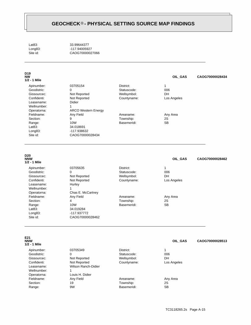
TC3118265.2s Page A-15
SBBasemeridi:9WRange:2STownship:19Section:Any AreaAreaname:Any FieldFieldname:
Louis H. DidierOperatorna:1Wellnumber:Wilson Ranch-DidierLeasename:
Los AngelesCountyname:Not ReportedConfidenti:DHWellsymbol:Not ReportedGissourcec:006Statuscode:0Geodistric:1District:03705349Apinumber:
E21NNW1/2 - 1 Mile
CAOG70000028513OIL_GAS
CAOG70000028462Site id:-117.937772Long83:34.019284Lat83:
SBBasemeridi:10WRange:2STownship:4Section:Any AreaAreaname:Any FieldFieldname:
Chas E. McCartneyOperatorna:1Wellnumber:HurleyLeasename:
Los AngelesCountyname:Not ReportedConfidenti:DHWellsymbol:Not ReportedGissourcec:006Statuscode:0Geodistric:1District:03705635Apinumber:
D20NNW1/2 - 1 Mile
CAOG70000028462OIL_GAS
CAOG70000028434Site id:-117.938632Long83:34.018691Lat83:
SBBasemeridi:10WRange:2STownship:9Section:Any AreaAreaname:Any FieldFieldname:
ARCO Western EnergyOperatorna:1Wellnumber:DidierLeasename:
Los AngelesCountyname:Not ReportedConfidenti:DHWellsymbol:Not ReportedGissourcec:006Statuscode:0Geodistric:1District:03705154Apinumber:
D19NW1/2 - 1 Mile
CAOG70000028434OIL_GAS
CAOG70000027066Site id:-117.94005927Long83:33.99644377Lat83:
GEOCHECK - PHYSICAL SETTING SOURCE MAP FINDINGS®

TC3118265.2s Page A-16
CAOG70000028524Site id:-117.935196Long83:34.020631Lat83:
SBBasemeridi:10WRange:2STownship:4Section:Any AreaAreaname:Any FieldFieldname:
Louis H. DidierOperatorna:1Wellnumber:Didier-Puente ProjectLeasename:
Los AngelesCountyname:Not ReportedConfidenti:DHWellsymbol:Not ReportedGissourcec:006Statuscode:0Geodistric:1District:03705348Apinumber:
E23NNW1/2 - 1 Mile
CAOG70000028524OIL_GAS
CAOG70000028543Site id:-117.924614Long83:34.020868Lat83:
SBBasemeridi:10WRange:2STownship:3Section:Any AreaAreaname:WalnutFieldname:
Pacific Palms Petroleum, LLCOperatorna:1Wellnumber:Tara LeeLeasename:
Los AngelesCountyname:Not ReportedConfidenti:APWellsymbol:Not ReportedGissourcec:008Statuscode:0Geodistric:1District:03723719Apinumber:
22NNE1/2 - 1 Mile
CAOG70000028543OIL_GAS
CAOG70000028513Site id:-117.935091Long83:34.020354Lat83:
GEOCHECK - PHYSICAL SETTING SOURCE MAP FINDINGS®
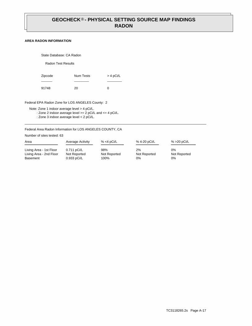
TC3118265.2s Page A-17
0%0%100%0.933 pCi/LBasementNot ReportedNot ReportedNot ReportedNot ReportedLiving Area - 2nd Floor0%2%98%0.711 pCi/LLiving Area - 1st Floor
% >20 pCi/L% 4-20 pCi/L% <4 pCi/LAverage ActivityArea
Number of sites tested: 63
Federal Area Radon Information for LOS ANGELES COUNTY, CA
: Zone 3 indoor average level < 2 pCi/L. : Zone 2 indoor average level >= 2 pCi/L and <= 4 pCi/L. Note: Zone 1 indoor average level > 4 pCi/L.
Federal EPA Radon Zone for LOS ANGELES County: 2
02091748
______________________> 4 pCi/LNum TestsZipcode
Radon Test Results
State Database: CA Radon
AREA RADON INFORMATION
GEOCHECK - PHYSICAL SETTING SOURCE MAP FINDINGSRADON
®

TOPOGRAPHIC INFORMATION
USGS 7.5’ Digital Elevation Model (DEM)Source: United States Geologic SurveyEDR acquired the USGS 7.5’ Digital Elevation Model in 2002 and updated it in 2006. The 7.5 minute DEM correspondsto the USGS 1:24,000- and 1:25,000-scale topographic quadrangle maps. The DEM provides elevation datawith consistent elevation units and projection.
Scanned Digital USGS 7.5’ Topographic Map (DRG)Source: United States Geologic SurveyA digital raster graphic (DRG) is a scanned image of a U.S. Geological Survey topographic map. The map imagesare made by scanning published paper maps on high-resolution scanners. The raster imageis georeferenced and fit to the Universal Transverse Mercator (UTM) projection.
HYDROLOGIC INFORMATION
Flood Zone Data: This data, available in select counties across the country, was obtained by EDR in 2003 & 2011 from the FederalEmergency Management Agency (FEMA). Data depicts 100-year and 500-year flood zones as defined by FEMA.
NWI: National Wetlands Inventory. This data, available in select counties across the country, was obtained by EDRin 2002 and 2005 from the U.S. Fish and Wildlife Service.
HYDROGEOLOGIC INFORMATION
AQUIFLOW Information SystemR
Source: EDR proprietary database of groundwater flow informationEDR has developed the AQUIFLOW Information System (AIS) to provide data on the general direction of groundwater
flow at specific points. EDR has reviewed reports submitted to regulatory authorities at select sites and hasextracted the date of the report, hydrogeologically determined groundwater flow direction and depth to water tableinformation.
GEOLOGIC INFORMATION
Geologic Age and Rock Stratigraphic UnitSource: P.G. Schruben, R.E. Arndt and W.J. Bawiec, Geology of the Conterminous U.S. at 1:2,500,000 Scale - A digitalrepresentation of the 1974 P.B. King and H.M. Beikman Map, USGS Digital Data Series DDS - 11 (1994).
STATSGO: State Soil Geographic DatabaseSource: Department of Agriculture, Natural Resources Conservation ServicesThe U.S. Department of Agriculture’s (USDA) Natural Resources Conservation Service (NRCS) leads the nationalConservation Soil Survey (NCSS) and is responsible for collecting, storing, maintaining and distributing soilsurvey information for privately owned lands in the United States. A soil map in a soil survey is a representationof soil patterns in a landscape. Soil maps for STATSGO are compiled by generalizing more detailed (SSURGO)soil survey maps.
SSURGO: Soil Survey Geographic DatabaseSource: Department of Agriculture, Natural Resources Conservation Services (NRCS)Telephone: 800-672-5559SSURGO is the most detailed level of mapping done by the Natural Resources Conservation Services, mappingscales generally range from 1:12,000 to 1:63,360. Field mapping methods using national standards are used toconstruct the soil maps in the Soil Survey Geographic (SSURGO) database. SSURGO digitizing duplicates theoriginal soil survey maps. This level of mapping is designed for use by landowners, townships and countynatural resource planning and management.
TC3118265.2s Page A-18
PHYSICAL SETTING SOURCE RECORDS SEARCHED
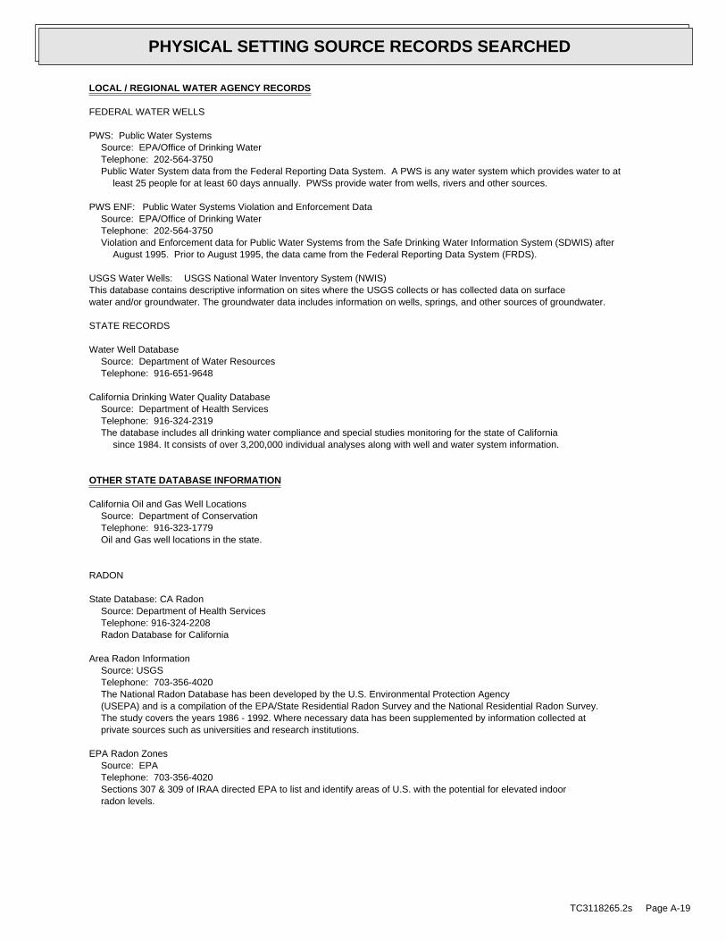
LOCAL / REGIONAL WATER AGENCY RECORDS
FEDERAL WATER WELLS
PWS: Public Water SystemsSource: EPA/Office of Drinking WaterTelephone: 202-564-3750Public Water System data from the Federal Reporting Data System. A PWS is any water system which provides water to at
least 25 people for at least 60 days annually. PWSs provide water from wells, rivers and other sources.
PWS ENF: Public Water Systems Violation and Enforcement DataSource: EPA/Office of Drinking WaterTelephone: 202-564-3750Violation and Enforcement data for Public Water Systems from the Safe Drinking Water Information System (SDWIS) after
August 1995. Prior to August 1995, the data came from the Federal Reporting Data System (FRDS).
USGS Water Wells: USGS National Water Inventory System (NWIS)This database contains descriptive information on sites where the USGS collects or has collected data on surfacewater and/or groundwater. The groundwater data includes information on wells, springs, and other sources of groundwater.
STATE RECORDS
Water Well DatabaseSource: Department of Water ResourcesTelephone: 916-651-9648
California Drinking Water Quality DatabaseSource: Department of Health ServicesTelephone: 916-324-2319The database includes all drinking water compliance and special studies monitoring for the state of California
since 1984. It consists of over 3,200,000 individual analyses along with well and water system information.
OTHER STATE DATABASE INFORMATION
California Oil and Gas Well LocationsSource: Department of ConservationTelephone: 916-323-1779Oil and Gas well locations in the state.
RADON
State Database: CA RadonSource: Department of Health ServicesTelephone: 916-324-2208Radon Database for California
Area Radon InformationSource: USGSTelephone: 703-356-4020The National Radon Database has been developed by the U.S. Environmental Protection Agency(USEPA) and is a compilation of the EPA/State Residential Radon Survey and the National Residential Radon Survey.The study covers the years 1986 - 1992. Where necessary data has been supplemented by information collected atprivate sources such as universities and research institutions.
EPA Radon ZonesSource: EPATelephone: 703-356-4020Sections 307 & 309 of IRAA directed EPA to list and identify areas of U.S. with the potential for elevated indoorradon levels.
TC3118265.2s Page A-19
PHYSICAL SETTING SOURCE RECORDS SEARCHED

OTHER
Airport Landing Facilities: Private and public use landing facilitiesSource: Federal Aviation Administration, 800-457-6656
Epicenters: World earthquake epicenters, Richter 5 or greaterSource: Department of Commerce, National Oceanic and Atmospheric Administration
California Earthquake Fault Lines: The fault lines displayed on EDR’s Topographic map are digitized quaternary fault lines,prepared in 1975 by the United State Geological Survey. Additional information (also from 1975) regarding activity at specific faultlines comes from California’s Preliminary Fault Activity Map prepared by the California Division of Mines and Geology.
STREET AND ADDRESS INFORMATION
© 2010 Tele Atlas North America, Inc. All rights reserved. This material is proprietary and the subject of copyright protectionand other intellectual property rights owned by or licensed to Tele Atlas North America, Inc. The use of this material is subjectto the terms of a license agreement. You will be held liable for any unauthorized copying or disclosure of this material.
TC3118265.2s Page A-20
PHYSICAL SETTING SOURCE RECORDS SEARCHED

AECOM Environment
July 2011 60216383
Appendix C Qualifications of Environmental Professionals
Donald G. Koch
Principal Env. Scientist
Education MS, Biological Science, Arizona State University, Phoenix, 1971 BS, Biological Science, Arizona State University, Phoenix, 1969
Registrations Registered Environmental Assessor, California
Years of Experience
16
With AECOM:
With Other Firms:
24
Mr. Koch has over 30 years of experience in the environmental field, Mr. Koch has managed environmental regulatory compliance, including for the Department of Energy (DOE) Grand Junction Projects Office. He has also been director of hazardous materials and waste for a southwest electric and gas utility firm. Mr. Koch’s environmental regulatory compliance experience includes managing numerous compliance issues related to remedial activities (CERCLA National Priorities List sites), Mr. Koch has provided decontamination and decommissioning services to numerous clients, including a blown-foam poly-urethane surf board blank manufacturing company, a two-piece steel and aluminum wheel manufacturing complex, a large nickel/copper and chrome plating/polishing plant, a large paint and color resin mixing and blending facility; and a cement/kiln plant. Closure activities have included the management of hazardous materials/wastes (characterization, profiling, manifesting and transportation/disposal), equipment asset management (sale, recycle and scrap disposal), structure (buildings, tanks, bunkers) demolition and disposal, flat work (asphalt and concrete pads, driveways, roads, pits) demolition and recycle/disposal, clarifier and interceptor closures, Tier Permitted Units and PBR Closures, Phase II Investigations, and remediation of contaminated soils and groundwater.
Mr. Koch received the DOE “Productivity, Quality and Incentive (PQI) Award” for cost effectiveness/savings for his work. He also received the President’s Award for the one of the highest cost savings recorded for his work on the UMTRA Grand Junction Uranium Mill Tailings Remedial Action sites.
Project Experience
Decontamination & Decommissioning
DOE Rocky-Flats EG&G Forging Facility, Oxnard, California. This project involved the privatization of the facility under the Clinton/O’leary Program. The project included a Phase I EA, Phase II EA, Asset management of all forging equipment to commercial outlets, decontamination of all forging cellars and trenches, building modifications/renovations, and soil remediation.
Lockheed Martin, Decontamination & Decommissioning, Pasadena, California. Project managed the decontamination and decommissioning of the "Jumbo" High-Vacuum Mercury Bombardment Chamber located at the Pasadena Facility. A contract requirement for the effort was to generate no hazardous waste disposal to landfill. Successfully completed the project with complete decontamination of the 40-ton unit which was subsequently cut, sized and sent to Japan for scrap metal re-melt.
Sanwa Bank, Decontamination & Decommissioning, Garden Grove, California. Project managed the mold and chemical decontamination of a 210,000 square foot dental complex contaminated with mold, fungus and mercury. The office complex abatement involved the removal of the mercury contaminated HVAC system, elemental mercury vacuuming and nitric acid solution floor scrubbing. Microbial contamination abatement required implementation of a ventilation, drying and de-humidification system; patient file irradiation, bag-out of contaminated equipment, a biocide treatment and encapsulation.
Beverly Hill Unified School District, Decontamination, Beverly Hills, California. Project managed the decontamination of a 105,300 sq. ft. multi-level elementary school contaminated with mold, fungus, asbestos and lead-based
paint. The mold and fungus amplification was the result of the building sustaining considerable water intrusion from leaking roof structures, broken windows and faulty plumbing (both potable water supply lines and sanitary sewer). Microbiological contamination abatement required implementation of a ventilation, drying and de-humidification system, bag-out of contaminated equipment, a biocide treatment and encapsulation and an aggressive clearance. ACM and Pb-paint were abated in accordance with SCAQMD Rule 1403 and HUD Guidelines respectively.
General Motors/Kiddy World, Decontamination & Decommissioning, San Jose, California. Project managed the decontamination and decommissioning of a six building complex in San Jose, CA. for General Motors Headquarters. This project involved the abatement of asbestos and lead-based paint; the removal/disposal of PCB ballasts; the removal and disposal of mercury vapor and halide lamps, the staging, overpacking and disposal of numerous chemicals; the removal/recycling of chlorofluorocarbons and the demolition of three buildings including structure and flat-work.
Clark Foam Decontamination & Decommissioning, Mission Viejo, California. Project managed the closure of the Clark Foam blown-foam poly-urethane surf board blank manufacturing facility located in Mission Viejo, CA. Activities included a public auction of equipment, decontamination and decommissioning of the TDI tanks, mixers and transfer lines, and removal of contaminated slabs and paving. The buildings were gutted leaving only the perimeter walls. Asbestos containing roof penetration mastics were abated. The property was subsequently sold to a wood frame manufacturing company.
BASF Resin and Paint Manufacturing and Processing Plant, Colton, California. Project managed the closure of the BASF Resin and Paint Manufacturing and Processing Plant, located in Colton, California. The project involved the decontamination, demolition and disposal of 10 paint mixing tanks, three asbestos insulated resin tanks, 2-miles of transfer piping, 32 pumps, and 32 mixers. Following decontamination, all equipment was cut and sized for transportation to an inland empire re-melt facility, as BASF did not wish to sell and/or recycle the equipment. Internal walls and flooring contaminated with heavy metal resins were decontaminated using advanced chemical cleaning processes. NIOSH wipe sampling was performed to confirm that contamination was completely removed. Additionally, damaged and significantly damaged asbestos containing materials (structural) were abated.
Remediation
ARCO Sand Springs Superfund Site, Modified Lime Fixation Demonstration Study. During the study, approximately 300 yd3 of acid lube-oil sludge were treated by lime fixation. Results of this study allowed for a Record of Decision Change from Incineration to solidification/stabilization.
Amoco Sugar Creek Refinery, Filtration and Low Temperature Desorption Demonstration of Pond Sludges. This $2.5 million study was successful in removing Petroleum Hydrocarbons from the sludges such that following treatment, the sludge cake could be returned to the ponds for disposal.
Amoco (MANDAN Refinery), Remediation of Polishing Ponds. Involved the development of an Excavation Plan, H&S Plan and Sampling and Analysis Plan. Treatment involved concentration at the sludge concentrator and solvent washing of filter cake. Post sludge removal involved solidification of petroleum-contaminated pond bottom soil and refill/compaction back into the pond.
Related Documents