DISTRICT SURVEY REPORT FOR Granite THENI DISTRICT TAMIL NADU STATE DEPARTMENT OF GEOLOGY AND MINING THENI DISTRICT

Welcome message from author
This document is posted to help you gain knowledge. Please leave a comment to let me know what you think about it! Share it to your friends and learn new things together.
Transcript
DISTRICT SURVEY REPORT
FOR Granite
THENI DISTRICT
TAMIL NADU STATE
DEPARTMENT OF GEOLOGY
AND MINING
THENI DISTRICT
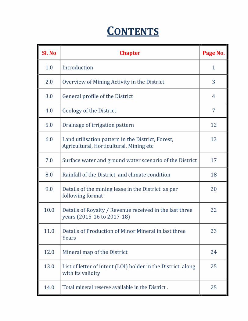
CONTENTS
Sl. No Chapter Page No.
1.0 Introduction 1
2.0 Overview of Mining Activity in the District 3
3.0 General profile of the District 4
4.0 Geology of the District 7
5.0 Drainage of irrigation pattern 12
6.0 Land utilisation pattern in the District, Forest, Agricultural, Horticultural, Mining etc
13
7.0 Surface water and ground water scenario of the District 17
8.0 Rainfall of the District and climate condition 18
9.0 Details of the mining lease in the District as per following format
20
10.0 Details of Royalty / Revenue received in the last three years (2015-16 to 2017-18)
22
11.0 Details of Production of Minor Mineral in last three Years
23
12.0 Mineral map of the District 24
13.0 List of letter of intent (LOI) holder in the District along with its validity
25
14.0 Total mineral reserve available in the District . 25
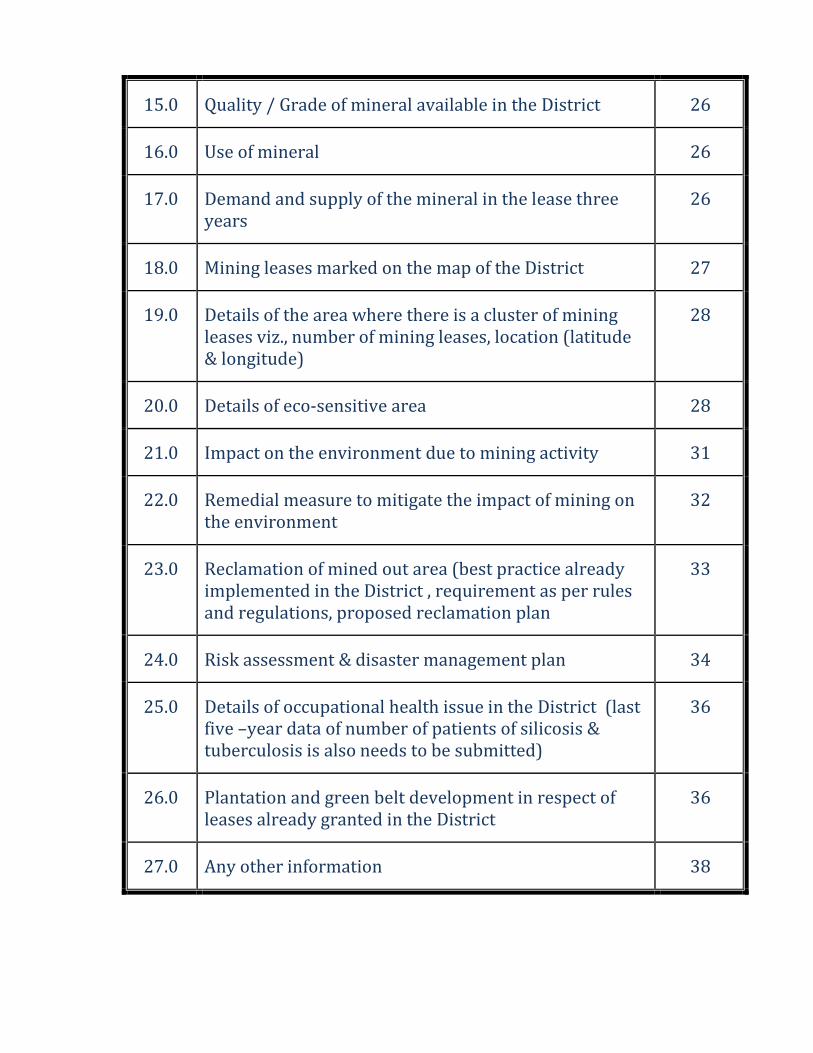
15.0 Quality / Grade of mineral available in the District 26
16.0 Use of mineral 26
17.0 Demand and supply of the mineral in the lease three years
26
18.0 Mining leases marked on the map of the District 27
19.0 Details of the area where there is a cluster of mining leases viz., number of mining leases, location (latitude & longitude)
28
20.0 Details of eco-sensitive area 28
21.0 Impact on the environment due to mining activity 31
22.0 Remedial measure to mitigate the impact of mining on the environment
32
23.0 Reclamation of mined out area (best practice already implemented in the District , requirement as per rules and regulations, proposed reclamation plan
33
24.0 Risk assessment & disaster management plan 34
25.0 Details of occupational health issue in the District (last five –year data of number of patients of silicosis & tuberculosis is also needs to be submitted)
36
26.0 Plantation and green belt development in respect of leases already granted in the District
36
27.0 Any other information 38
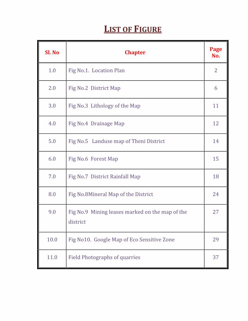
LIST OF FIGURE
Sl. No Chapter Page No.
1.0 Fig No.1. Location Plan 2
2.0 Fig No.2 District Map 6
3.0 Fig No.3 Lithology of the Map 11
4.0 Fig No.4 Drainage Map 12
5.0 Fig No.5 Landuse map of Theni District 14
6.0 Fig No.6 Forest Map 15
7.0 Fig No.7 District Rainfall Map 18
8.0 Fig No.8Mineral Map of the District 24
9.0 Fig No.9 Mining leases marked on the map of the
district
27
10.0 Fig No10. Google Map of Eco Sensitive Zone 29
11.0 Field Photographs of quarries 37
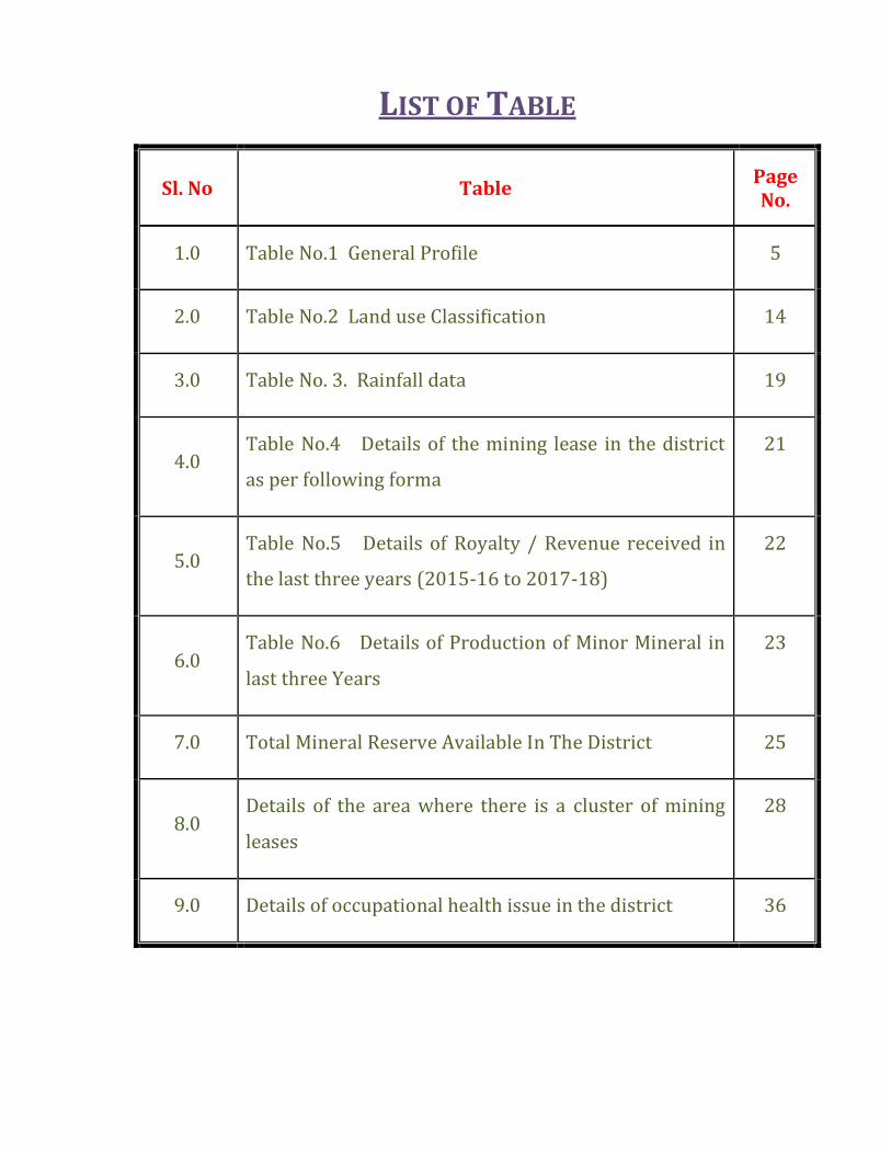
LIST OF TABLE
Sl. No Table Page No.
1.0 Table No.1 General Profile 5
2.0 Table No.2 Land use Classification 14
3.0 Table No. 3. Rainfall data 19
4.0 Table No.4 Details of the mining lease in the district
as per following forma
21
5.0 Table No.5 Details of Royalty / Revenue received in
the last three years (2015-16 to 2017-18)
22
6.0 Table No.6 Details of Production of Minor Mineral in
last three Years
23
7.0 Total Mineral Reserve Available In The District 25
8.0 Details of the area where there is a cluster of mining
leases
28
9.0 Details of occupational health issue in the district 36
D I S T R I C T S U R V E Y R E P O R T - T H E N I Page 1
1.0 - INTRODUCTION:
With reference to the gazette notification dated 15th January 2016, Ministry of
Environment, Forest and Climate Change, the District Environment Impact Assessment
Authority (DEIAA) and District -Environment Appraisal Committee (DEAC) are to be
constituted for prior environmental clearance of quarry for minor and major minerals.
District Survey Report should be prepared with the assistance of irrigation department,
Drainage department, Forest department, and Mining department and Revenue
department in the district. The main purpose of preparation of District Survey Report is
to identify the mineral resources and mining activities along with other relevant data of
district. The SEIAA/DEIAA and SEAC/DEAC will scrutinize and recommend the prior
environmental clearance for minor and major minerals on the basis of District Survey
Report. The District Survey Report is prepared with the Assistance of Geological Survey
of India, State Unit: Tamil Nadu and Puducherry, Chennai. The District Survey Report
(DSR) report prepared based on the guidelines by MOEF S.O. 3611(E). dt 25.July 2018.
Theni District is one of the District of Tamil Nadu state in South India. It is, lying
at the foot of the Western Ghats, is bounded by Dindigul District to the north, Madurai
District in the East, Idukki district of Kerala State in the West and south and
Virudhunagar District to the southwest. Theni District was formed by bifurcation from
erstwhile Madurai District as per G.O. Ms. No. 679 Revenue Department, Dtd. July 7,
1996. Theni Municipal town was only a firka headquarters till 31.12.96. Consequent to
the formation of the new district, Theni Municipal Town was upgraded as the Taluk and
District headquarters on January 1, 1997.
DISTRICT SURVEY REPORT
OF
THENI DISTRICT
D I S T R I C T S U R V E Y R E P O R T - T H E N I Page 2
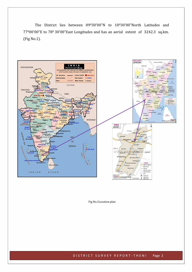
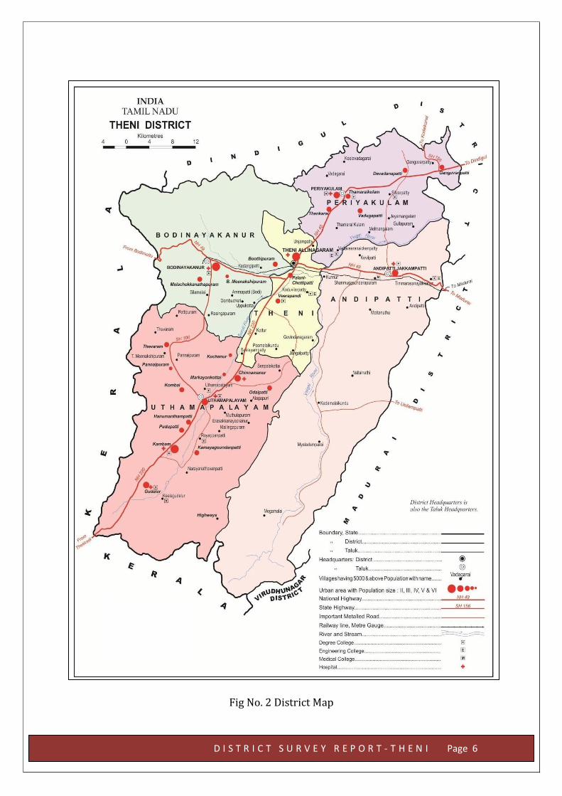
The District lies between 09030'00‟N to 10030'00‟North Latitudes and
77000'00‟E to 780 30'00‟East Longitudes and has an aerial extent of 3242.3 sq.km.
(Fig No.1).
Fig No.1Location plan
D I S T R I C T S U R V E Y R E P O R T - T H E N I Page 3
2.0 OVERVIEW OF MINING ACTIVITY IN THE DISTRICT;
The minerals of economic importance found in Theni district of Tamil
Nadu are granite and Limestone. Granite is mined in Myladumparai and limestone
Mines are found in Thimmarasanaickanur and Myladumparai. Mining activities
based on these minerals are very less. However, numerous rough stone quarries
are operational for production of construction material and earth fill (gravel). In
addition to above, manufacturing sand also called M. Sand is also mined.
The office of the Assistant Director, Department of Geology and Mining
functions under the control of the District Collector, Theni. The Assistant Director,
Geology and Mining assists the District Collector in the Mineral Administration
works.Theni District has limited occurrence of minerals. The available Major
mineral is Limestone and Minor Minerals are Granite and Charnockites.
Charnockites are quarried for rough stones.
Granite:
Granite is found in Myladumparai village in Andipatti Taluk. The
massive granite body trends in N60E-S60W with a dip of 80° to South. Granites
(raw silk variety) are found in Myladumparai. Granites are quarried for
dimensional stones.
Rough Stone
Charnockite and granitic gneisses are extensively quarried as rough
stone which is used as aggregates for construction of building, laying of roads and
for preparation of value added products like hollow blocks, pillar stones, M-sand
etc. Charnockite occurs as massive bodies, medium to coarse grained in all the five
taluks- Periyakulam, Theni, Andipatti, Bodinayakkanur and Uthamapalayam. At
places in Thimmarasanayakkanur Bit-I, charnockite occurs with intercalations of
calc granulite and hornblende biotite gneiss. Near E.Kamatchipuram, charnockite
is found in association with calcgranulite+sillimanite while at places around
Kullapuram, it is found associated with calc gneisses. Near Odaipatty, Charnockite
is found at a depth of nearly 15m below quartzo-feldspathic gneiss. Near Kombai,
coarse grained granites and granitic gneisses are quarried for Roughstones.
Gravel/Savudu /Wind Earth/Earth
Graval /Earth occurs in Bodinayakkanur, Uthamapalayam and
Andipatty areas. They are mainly used as filling material for building
constructions and road works.
D I S T R I C T S U R V E Y R E P O R T - T H E N I Page 4
3.0 GENERAL PROFILE OF THE DISTRICT:
Theni District holds Nature's beauty with the spicy green ornaments, historical
temples and famous water falls. The Theni town in the District Headquarters known as
the "Second Manchester of South India" indicates the various cotton trade. It is situated
at 295 ft. above the mean sea level. Theni district ranks 2nd in ASIA in banana trading. It
is known for the large scale trading of garlic, cotton, cardamom, grapes and chilli.
The Vaigai River, Kottagudi River, Suruliyar River, Varaganathi River, Manjalar
River and Varattaru River flow through the district. The important reservoirs in the
district are Vaigai Dam, Manjalaru Dam, Sothuparai Dam, Sanmughanathi Dam,
Manalaru Dam and Melmanalaru Dam. Three hydropower station projects namely,
Periyar, Surliar and Vaigai Micro Hydropower Station generate electricity in the district.
Agriculture, Industry and Trade play an important role for its economic
developmental activities. Principal crops like paddy, sugarcane, cotton, coconut,
groundnut and various kinds of fruits and vegetables viz. cholam, cumbu, redgram,
greengram, blackgram, horsegram, turmeric, mango, banana, tapioca and gingelly are
being cultivated in this district. Sericulture is another occupation of the people of the
district.
Cotton Spinning Mills and sugar Mills are the major industries in this district.
Handloom weaving and power looms are found in Andipatti taluk. Plenty of wind mills
were erected in this region with the help of Ministry of Non-Conventional Energy and
Tamil Nadu Energy Development Agency. In Uthamapalayam taluk, "Highwavis Estate"
plays an important role in the production of tea.
DIVISION TALUKS Revenue
Firkas VILLAGES
Periyakulam
Theni 2 12 Periyakulam 2 22
Andipatti 4 25
Uthamapalayam Uthamapalayam 6 39
Bodinayakanur 3 15 Total 17 113
https://en.wikipedia.org/w/index.php?title=Suruliyar_River&amp%3Baction=edit&amp%3Bredlink=1
https://en.wikipedia.org/w/index.php?title=Suruliyar_River&amp%3Baction=edit&amp%3Bredlink=1
D I S T R I C T S U R V E Y R E P O R T - T H E N I Page 5
Table No. 1 General Profile
1. Area : 3242.3 Sq.km.
2. Population ( as per Provisional 2011 Census)
: 24,79,052
Male Female Total
625683 620216 1245899
Rural Urban Total
575418 670481 1245899
3. No. of Revenue Divisions : 2- Periyakulam, Uthamapalayam
4. No. of Taluks : 5
5. No. of Revenue Villages : 113
6. No. of Blocks : 8
7. No. of Village Panchayats : 130
8. No. of Town Panchayats : 22
9. No. of Municipalities : 6
10. No. of Panchayat Unions : 8
11. No. of Parliamentary constituencies
: 1
12. No. of Assembly constituencies
: 4
13. Irrigation : 1. Total Gross Area Irrigated 73221 Hec.
2. Net area irrigated 59950 Hec.
14. Road : 1. State Highways 764.445 km
2. Sugarcane Road 5.30km
3. Other District Roads 389.90 km
4. Major District roads 226.05 km
5. National Highways 74.00 km
15. Railways Route Length 1) Broad Gauge 7838
2) Metre Gauge 12748
16. Forest : 1) Reserved Forest 35481hec
2) Unclassified Forest 31094 hec
3) Reserved Lands -
17 Electricity : 1) Hydro 578 m.units
2) Wind Mill Generation 12.5 m.units
3) Thermal -
18. Industries : 1) Large Scale Industries 15
2) Medium Scale Industries 4
3) Small Scale Industries 209
4) Cottage Industries 552
D I S T R I C T S U R V E Y R E P O R T - T H E N I Page 6
Fig No. 2 District Map
D I S T R I C T S U R V E Y R E P O R T - T H E N I Page 7
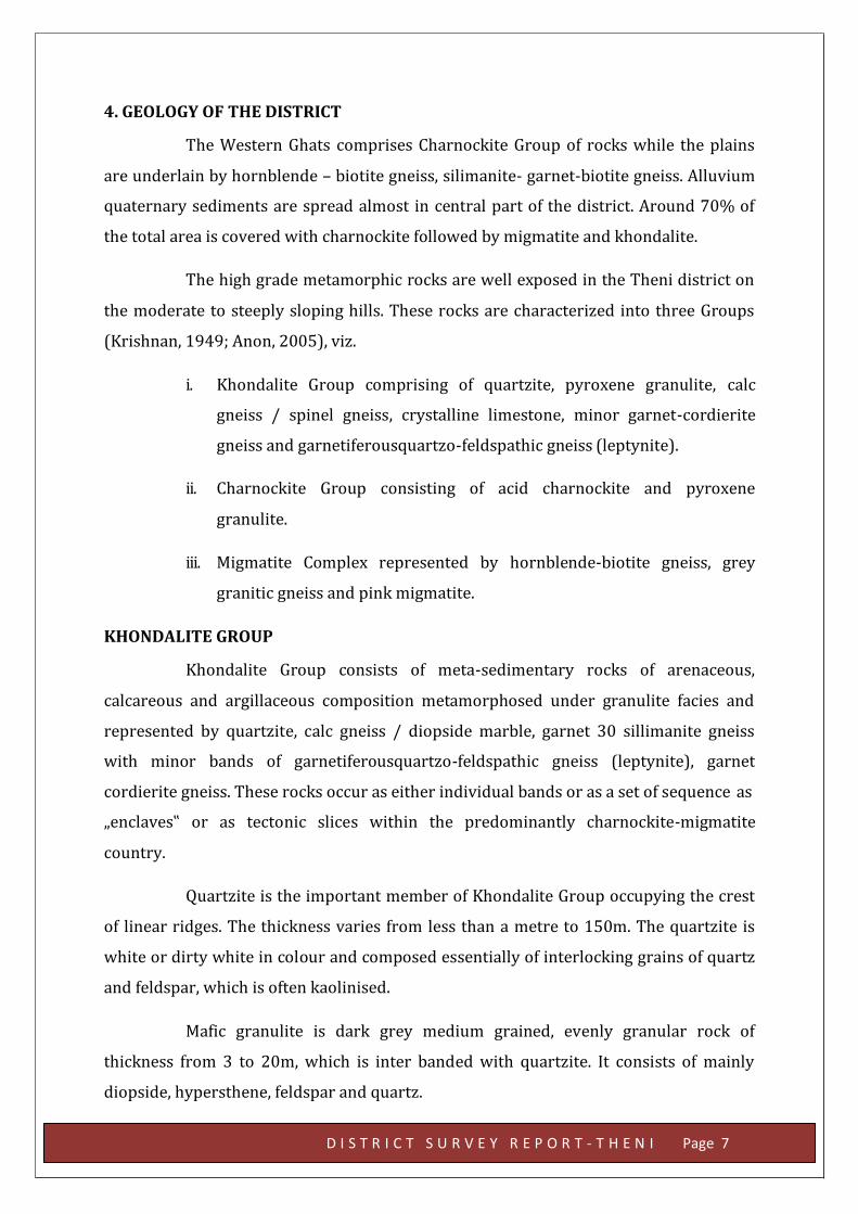
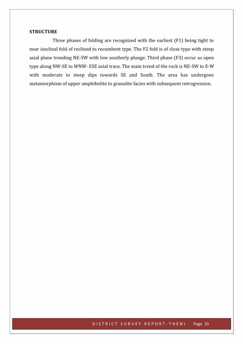
4. GEOLOGY OF THE DISTRICT
The Western Ghats comprises Charnockite Group of rocks while the plains
are underlain by hornblende – biotite gneiss, silimanite- garnet-biotite gneiss. Alluvium
quaternary sediments are spread almost in central part of the district. Around 70% of
the total area is covered with charnockite followed by migmatite and khondalite.
The high grade metamorphic rocks are well exposed in the Theni district on
the moderate to steeply sloping hills. These rocks are characterized into three Groups
(Krishnan, 1949; Anon, 2005), viz.
i. Khondalite Group comprising of quartzite, pyroxene granulite, calc
gneiss / spinel gneiss, crystalline limestone, minor garnet-cordierite
gneiss and garnetiferousquartzo-feldspathic gneiss (leptynite).
ii. Charnockite Group consisting of acid charnockite and pyroxene
granulite.
iii. Migmatite Complex represented by hornblende-biotite gneiss, grey
granitic gneiss and pink migmatite.
KHONDALITE GROUP
Khondalite Group consists of meta-sedimentary rocks of arenaceous,
calcareous and argillaceous composition metamorphosed under granulite facies and
represented by quartzite, calc gneiss / diopside marble, garnet 30 sillimanite gneiss
with minor bands of garnetiferousquartzo-feldspathic gneiss (leptynite), garnet
cordierite gneiss. These rocks occur as either individual bands or as a set of sequence as
„enclaves‟ or as tectonic slices within the predominantly charnockite-migmatite
country.
Quartzite is the important member of Khondalite Group occupying the crest
of linear ridges. The thickness varies from less than a metre to 150m. The quartzite is
white or dirty white in colour and composed essentially of interlocking grains of quartz
and feldspar, which is often kaolinised.
Mafic granulite is dark grey medium grained, evenly granular rock of
thickness from 3 to 20m, which is inter banded with quartzite. It consists of mainly
diopside, hypersthene, feldspar and quartz.
D I S T R I C T S U R V E Y R E P O R T - T H E N I Page 8
Calcareous gneiss is grayish white, medium grained, granular or gneissose
rock with typical ribbed weathering. It consists mainly of green diopside, white calcite
and quartz with pinhead size garnets, green apatite and magnetite as accessory
minerals. The thickness of calc gneiss varies from a meter to 30 m. With the decrease of
silicate minerals and increase of carbonates, the calc gneiss grades into crystalline
limestone at a few places.
Garnet-silimanite gneiss represents metamorphosed pelitic sediments. This
rock shows a thickness varying from 1 to 50m. Development of garnet is very profuse
and at times, garnet rich layers of 1 to 2cm thick are found alternating with quartz
feldspar rich layers. Silimanite occurs in varying amounts. Biotite is a common
associate mineral. Development of cordierite is noticed in the garnet-silimanite gneiss
in a few places.
Minor bands of a few centimetres to a couple of metres wide whitish looking
quartzo- feldspathic gneiss (leptynite) with unevenly distributed pink garnets occurs as
31 inter-bands within garnet-sillimanaite gneiss. This rock represents the
metamorphosed psammitic sediments within the predominant metapelitic rock. 2.1.2.
Charnockite Group.
CHARNOCKITE GROUP
The Charnockite Group consists of acid to intermediate charnockite and the
associated thin interbands and lenses of pyroxene granulite. The pyroxene granulite is
dark grey granular to gneissic, medium grained and occurs mostly as unmappable
bands within charnockite and hornblende biotite gneiss.
The charnockite is grey, greasy, medium to coarse grained massive rock and
occupies a major part of Theni district. It occurs over the hills as well as the plains
underlying the metasediments. The rock is chiefly made up of quartz, K-feldspar,
plagioclase and hypersthene with apatite and magnetite as accessories. Pink garnets
upto 1 to 2mm diameter are developed in places (Krishnan, 1949; Anon, 2005). 2.1.3.
D I S T R I C T S U R V E Y R E P O R T - T H E N I Page 9
MIGMATITE COMPLEX
The charnockitic rocks have been extensively migmatised due to later quartz
feldspathic influx resulting in banded hornblende-biotite gneiss which with change in
intensity of migmatisation grade into granitic gneiss and grey hornblende granite.
The hornblende biotite gneiss is medium to coarse, pale grey coloured rock
and show banded structure with alternating quart-feldspar rich layers and hornblende
biotite rich layers with individual layers ranging from 1mm to 1cm width imparting a
well developed gneissosity to the rock. (Krishnan, 1949; Anon, 2005).
Granitic gneiss is grey, medium grained, well foliated rock with colour and
compositional banding. It occurs mostly as band upto 15m wide, co-folded along with
the metasediments. The rock is chiefly made up of quartz and orthoclase, which is
mostly perthitic with plagioclase and biotite as the main accessories. The hornblende
granite is a medium grained massive, grey coloured rock and is made up of quartz, K- 32
feldspar, and plagioclase with hornblende and biotite as accessories. Minute sulphide
minerals mainly pyrite and pyrrhotite and rare chalcopyrite are seen embedded within
hornblende and biotite in hand specimen.
A small band of carbonatite with magnetite is exposed at the foot hills
around Cumbam Mettu. Younger intrusives that are noticed in the Theni district are thin
veins of pegmatite seen cutting all the rocks. Pegmatite is coarse grained, mostly pink
coloured with orthoclase and quartz as the main minerals. Biotite and magnetite occur
in small.quantity. Quaternary sediments up to 10 to 30m thick occur in the Cumbum
valley occupying the NNE-SSW troughs formed due to block faulting (graben). The
Quaternary sediments of Theni district comprises gravity slided deposits and boulders
and cobbles overlain by sheet wash and slope wash materials like medium sized
boulders, pebbles and coarse sands. Colluvial deposits of assorted pebbles and sand are
deposited at the bread in slope, which are overlain by a graded sequence of alluvial
deposits of medium sands, find sand and slit. It is overlain by basal boulder bed,
siliceous limestone, calcareous and ferruginous sandstone with calcrete and kankar
layers and coarse sandstone inter bedded with partly lithified sandstone and thin layers
of Kankar and sand-silt-clay admixtures.
D I S T R I C T S U R V E Y R E P O R T - T H E N I Page 10
STRUCTURE
Three phases of folding are recognized with the earliest (F1) being tight to
near isoclinal fold of reclined to recumbent type. The F2 fold is of close type with steep
axial plane trending NE-SW with low southerly plunge. Third phase (F3) occur as open
type along NW-SE to WNW- ESE axial trace. The main trend of the rock is NE-SW to E-W
with moderate to steep dips towards SE and South. The area has undergone
metamorphism of upper amphibolite to granulite facies with subsequent retrogression.
D I S T R I C T S U R V E Y R E P O R T - T H E N I Page 11
Fig No. 3 Lithology of the Map
(Source: Magesh et al., 2012)
D I S T R I C T S U R V E Y R E P O R T - T H E N I Page 12
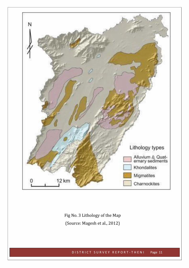
5. DRAINAGE OF IRRIGATION PATTERN:
Vaigai river has its origin in the eastern slope of Western Ghats in
Gandamanayakanur. Theni district is drained by a network of rivers namely Vaigai
River, SuruliAr, Periyarriver and Kottagudi River. The tributaries of Vaigai river i.e.
KoothantchiAr, Kottagudi River, Theniaru, Manjalar, Varahanadhi and some local
streams are drained in this district. The regional drainage pattern is dentritic and major
direction of the flow of river is easterly (east, southeast and northeast) from the
Western Ghat hills.
Fig No.4 Drainage Map (source Sukumar and Sankar, 2011
D I S T R I C T S U R V E Y R E P O R T - T H E N I Page 13
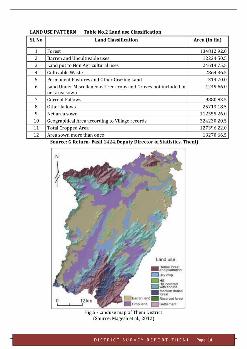
6. LAND UTILISATION PATTERN IN THENI DISTRICT
The land use pattern in the district is influenced by types of soil,
goundwater, rainfall and irrigation projects. The major landuse type in the study area
are barren land, crop land, dense forest and plantations, dry crop land, hill, shrub land,
medium dense forest, reserved forest, and settlements. Around 40% of the total area is
under cultivation, remaining forest and barren land are 34% and 26% respectively.
Soil is one of the natural resources that impacts the agricultural
development of an area. Theni district is characterised by red, black and brown soils.
The major part of the area is characterised by red gravelly soil (in deeply buried
pediments and moderately buried pediments) with red loamy soil and. The red soils are
medium to heavy textured soils with moderate to higher permeability. Red loamy soil is
a product of weathered granite of Archaean and quartzite of Proterozoic age. The black
soils are limited to less than 1% of the area. They are fine textured with low
permeability. The brown soils are limited to less than 1% of the area and they
characterised by low permeability. The alluvial soil (in the flood plains) at some places.
Groundwater is available up to 750m from the surface of the earth below
which it decreases in amount, the reason being that the rocks are well compacted by
pressure due to overburden. The water table may be met within a few hundred meters
in humid regions while it is at the surface in swamps and lakes. The water table
parallels the topography of the region. The depth to water table is closely related to the
topography, subsurface lithology, precipitation, and also to the irrigation channels and
surface water bodies. Excellent groundwater potential zone is concentrated in the
north-eastern and north-western region of the district due to the distribution of alluvial
plains and agricultural land with high infiltration ability (Magesh et al, 2012). The
minimum depth of water table is in the range of 2 to 20 m in Theni District.
D I S T R I C T S U R V E Y R E P O R T - T H E N I Page 14
LAND USE PATTERN Table No.2 Land use Classification
Sl. No Land Classification Area (in Ha)
1 Forest 134812.92.0
2 Barren and Uncultivable uses 12224.50.5
3 Land put to Non Agricultural uses 24614.75.5
4 Cultivable Waste 2864.36.5
5 Permanent Pastures and Other Grazing Land 314.70.0
6 Land Under Miscellaneous Tree crops and Groves not included in net area sown
1249.66.0
7 Current Fallows 9880.83.5
8 Other fallows 25713.18.5
9 Net area sown 112555.26.0
10 Geographical Area according to Village records 324230.20.5
11 Total Cropped Area 127396.22.0
12 Area sown more than once 13270.66.5
Source: G Return- Fasli 1424,Deputy Director of Statistics, Theni)
Fig.5 -Landuse map of Theni District (Source: Magesh et al., 2012)
D I S T R I C T S U R V E Y R E P O R T - T H E N I Page 15
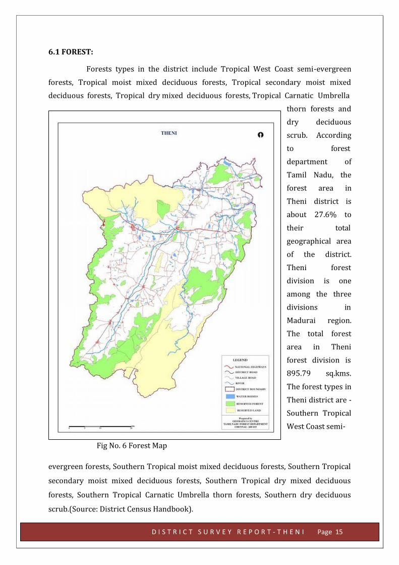
6.1 FOREST:
Forests types in the district include Tropical West Coast semi-evergreen
forests, Tropical moist mixed deciduous forests, Tropical secondary moist mixed
deciduous forests, Tropical dry mixed deciduous forests, Tropical Carnatic Umbrella
thorn forests and
dry deciduous
scrub. According
to forest
department of
Tamil Nadu, the
forest area in
Theni district is
about 27.6% to
their total
geographical area
of the district.
Theni forest
division is one
among the three
divisions in
Madurai region.
The total forest
area in Theni
forest division is
895.79 sq.kms.
The forest types in
Theni district are -
Southern Tropical
West Coast semi-
Fig No. 6 Forest Map
evergreen forests, Southern Tropical moist mixed deciduous forests, Southern Tropical
secondary moist mixed deciduous forests, Southern Tropical dry mixed deciduous
forests, Southern Tropical Carnatic Umbrella thorn forests, Southern dry deciduous
scrub.(Source: District Census Handbook).
D I S T R I C T S U R V E Y R E P O R T - T H E N I Page 16
AGRICULTURE
The district is characterised by Red, Black and Brown soils. The major part of
the area is characterised by red soil, which can be either transported or lateritic (insitu).
These are medium to heavy textured soils with moderate to higher permeability. The
black soils are limited to less than 1% of the area. They are fine textured with low
permeability. The brown soils are limited to less than 1% of the area and they
characterised by low permeability.
HORTICULTURAL
Horticulture sector has emerged as one of the important and vibrant part of
Indian agriculture in recent years. Its role in the Country’s nutritional security, poverty
alleviation and employment generation programme is becoming increasing important.
It offers not only a wide range of options to the farmers for crop diversification for
making agriculture more profitable through efficient land use, but also provides ample
scope for sustaining large number of agro-industries which generate huge employment
opportunities. Horticulture crops identified as a means of diversification, optimum
utilization of natural resources and creating skilled employment for rural masses
especially women folk.
Major horticulture crops cultivated in this district are fruits crops like
mango, banana, grapes, guava and aonla, tropical vegetables like bhendi, tomato, brinjal,
onion, temperate vegetables like cauliflower, beetroot and knol-khol, spices and
condiments like pepper and cardamom and plantation crops like coffee and tea

D I S T R I C T S U R V E Y R E P O R T - T H E N I Page 17
7. SURFACE WATER AND GROUND WATER SCENARIO OF THE DISTRICT
BASIN AND SUB-BASIN
The district is part of vaigai sub basin.
DRAINAGE
Vaigairiver has its origin in the eastern slope of Western Ghat at
Gandamanayakanur. Suruliar, Theniar, Varahanadhi and Manjalar are its main
tributaries. The regional drainage pattern is dentritic and major direction of the flow of
river is easterly (east, southeast and northeast) from this Western Ghat hills.
OCUURENCE OF GROUND WATER
Ground water occurs under water table or phreatic conditions in weathered,
jointed and fractured formations. The pore space developed in the weathered
mantle(disintegrated material) acts as shallow granular aquifers and forms the
potential water bearing and yielding zones. Water table is very shallow in canal and
tank irrigated regions whereas it is somewhat deeper in other regions. Ground water
occurs under water table or phreatic conditions but the intensity of weathering, joint,
fracture and its development is much less when compared to gneissic formations. As a
result, these are not termed as potential water bearing zones excepting in a region
where the intensity of weathering coupled with development of joints and fractures is
greater. Sometimes the occurrence of kankar material over charnockite hampers the
permeability and well yielding capacity. Ground water occurs under water table or semi
confined conditions. The valley fill sediments are highly porous and permeable and the
sandy material facilitates vertical infiltration. Valley fill sediments play a vital road in
the development of Ground Water in Theni District.
Ground water occurs under water table or semi confined conditions. The
valley fill sediments are highly porous and permeable and the sandy material facilitates
vertical infiltration. Valley fill sediments play a vital road in the development of Ground
Water in Theni District.
D I S T R I C T S U R V E Y R E P O R T - T H E N I Page 18
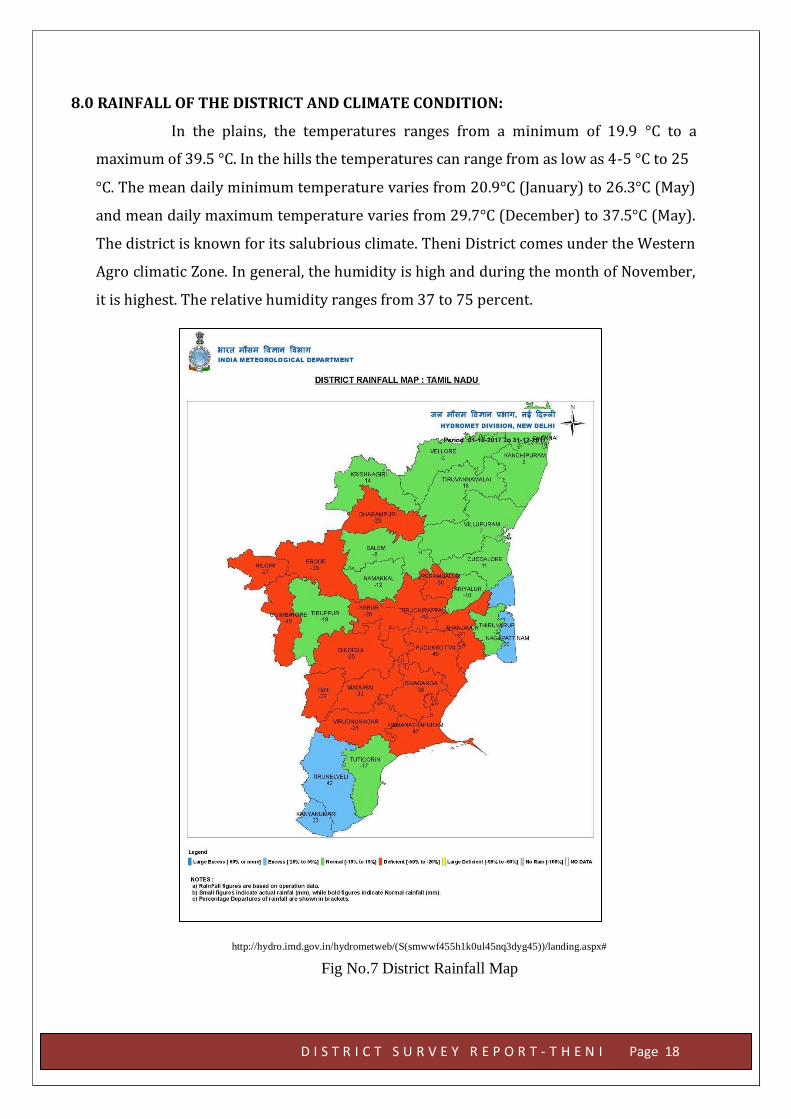
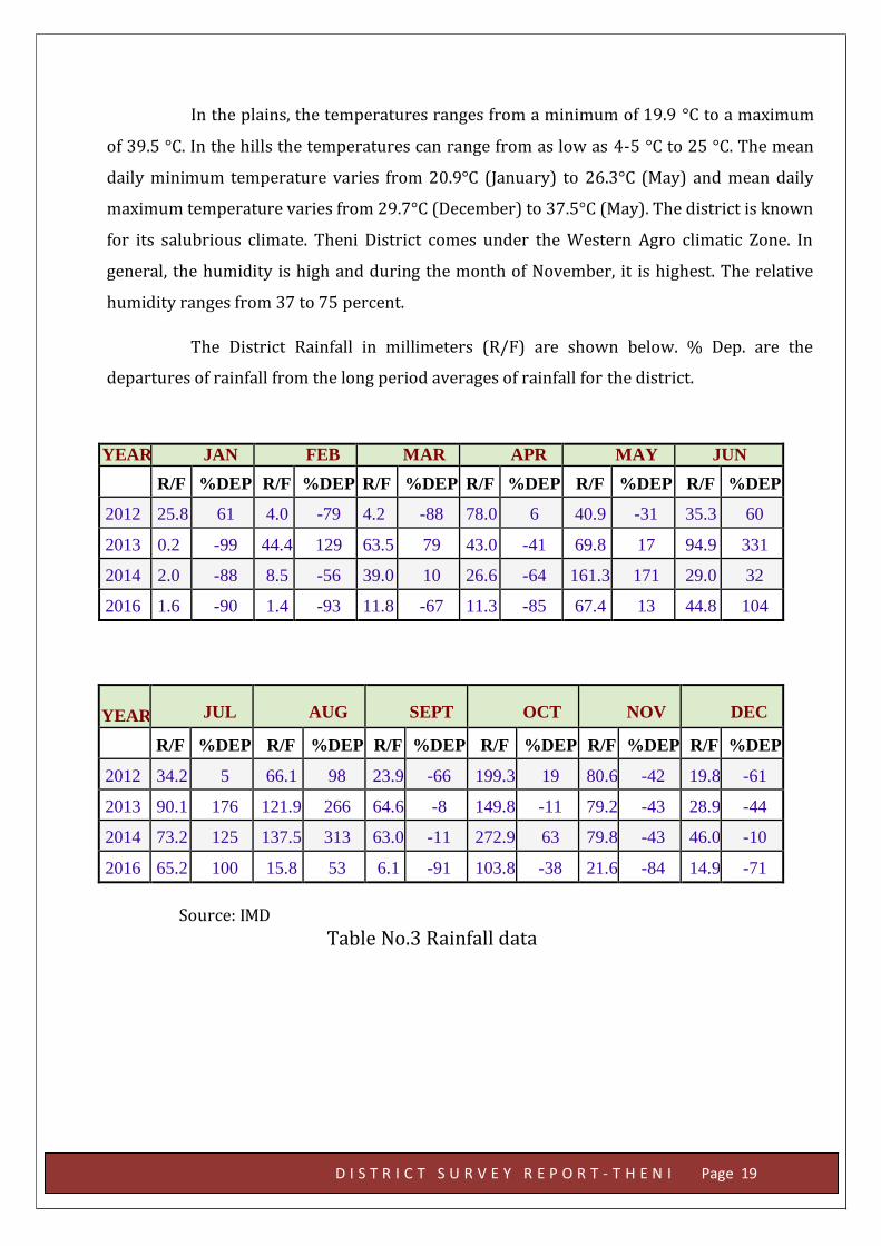
8.0 RAINFALL OF THE DISTRICT AND CLIMATE CONDITION:
In the plains, the temperatures ranges from a minimum of 19.9 °C to a
maximum of 39.5 °C. In the hills the temperatures can range from as low as 4-5 °C to 25
°C. The mean daily minimum temperature varies from 20.9°C (January) to 26.3°C (May)
and mean daily maximum temperature varies from 29.7°C (December) to 37.5°C (May).
The district is known for its salubrious climate. Theni District comes under the Western
Agro climatic Zone. In general, the humidity is high and during the month of November,
it is highest. The relative humidity ranges from 37 to 75 percent.
http://hydro.imd.gov.in/hydrometweb/(S(smwwf455h1k0ul45nq3dyg45))/landing.aspx#
Fig No.7 District Rainfall Map
In the plains, the temperatures ranges from a minimum of 19.9 °C to a maximum
of 39.5 °C. In the hills the temperatures can range from as low as 4-5 °C to 25 °C. The mean
daily minimum temperature varies from 20.9°C (January) to 26.3°C (May) and mean daily
maximum temperature varies from 29.7°C (December) to 37.5°C (May). The district is known
for its salubrious climate. Theni District comes under the Western Agro climatic Zone. In
general, the humidity is high and during the month of November, it is highest. The relative
humidity ranges from 37 to 75 percent.
The District Rainfall in millimeters (R/F) are shown below. % Dep. are the
departures of rainfall from the long period averages of rainfall for the district.
YEAR JAN FEB MAR APR MAY JUN
R/F %DEP R/F %DEP R/F %DEP R/F %DEP R/F %DEP R/F %DEP
2012 25.8 61 4.0 -79 4.2 -88 78.0 6 40.9 -31 35.3 60
2013 0.2 -99 44.4 129 63.5 79 43.0 -41 69.8 17 94.9 331
2014 2.0 -88 8.5 -56 39.0 10 26.6 -64 161.3 171 29.0 32
2016 1.6 -90 1.4 -93 11.8 -67 11.3 -85 67.4 13 44.8 104
YEAR JUL AUG SEPT OCT NOV DEC
R/F %DEP R/F %DEP R/F %DEP R/F %DEP R/F %DEP R/F %DEP
2012 34.2 5 66.1 98 23.9 -66 199.3 19 80.6 -42 19.8 -61
2013 90.1 176 121.9 266 64.6 -8 149.8 -11 79.2 -43 28.9 -44
2014 73.2 125 137.5 313 63.0 -11 272.9 63 79.8 -43 46.0 -10
2016 65.2 100 15.8 53 6.1 -91 103.8 -38 21.6 -84 14.9 -71
Source: IMD Table No.3 Rainfall data
D I S T R I C T S U R V E Y R E P O R T - T H E N I Page 19
D I S T R I C T S U R V E Y R E P O R T - T H E N I Page 20
9.0 DETAILS OF THE MINING LEASE IN THE DISTRICT
Granite: Granite is found in Myladumparai village in Andipatti Taluk. The massive
granite body trends in N60E-S60W with a dip of 80° to South. Granites (raw silk variety)
are found in Myladmparai. Granites are quarried for dimensional stones.
One Granite quarry lease granted in Myladumparai Village, Andipatty Taluk, in
Theni District for quarrying Granite in dimensional blocks and used as building
material. The list of the Granite quarry lease is given below.
D I S T R I C T S U R V E Y R E P O R T - T H E N I Page 21
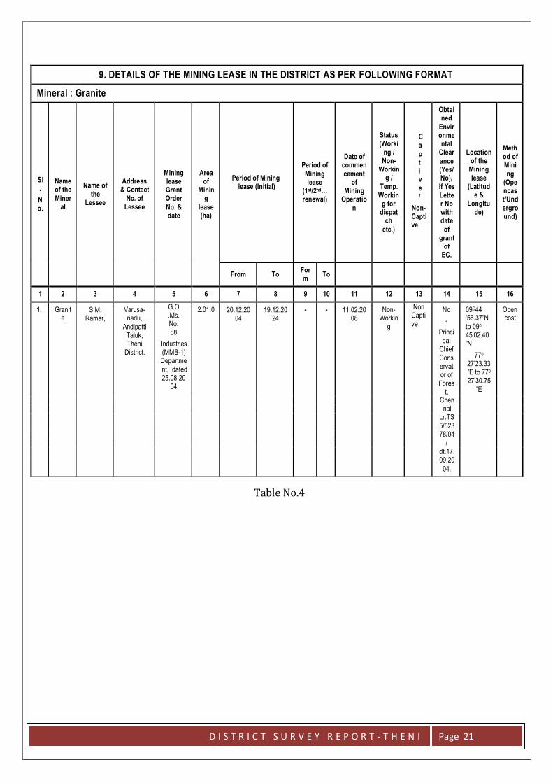
9. DETAILS OF THE MINING LEASE IN THE DISTRICT AS PER FOLLOWING FORMAT
Mineral : Granite
Sl
.
N o.
Name of the
Miner al
Name of
the Lessee
Address & Contact
No. of Lessee
Mining lease Grant Order
No. & date
Area of
Minin g
lease (ha)
Period of Mining
lease (Initial)
Period of
Mining lease
(1st/2nd… renewal)
Date of commen
cement of
Mining Operatio
n
Status (Worki
ng / Non-
Workin g /
Temp.
Workin g for
dispat ch
etc.)
C a
p t i v
e
/
Non- Capti ve
Obtai ned
Envir onme ntal
Clear
ance (Yes/ No), If Yes
Lette r No with date
of grant
of EC.
Location of the
Mining
lease (Latitud
e & Longitu
de)
Meth od of Mini
ng (Ope ncas t/Und
ergro und)
From To
For m
To
1 2 3 4 5 6 7 8 9 10 11 12 13 14 15 16
1. Granit e
S.M. Ramar,
Varusa- nadu,
Andipatti Taluk, Theni
District.
G.O .Ms. No.
88
Industries (MMB-1) Departme
nt, dated 25.08.20
04
2.01.0 20.12.20 04
19.12.20 24
- - 11.02.20 08
Non- Workin
g
Non Capti ve
No
-
Princi pal
Chief
Cons ervat or of
Fores
t,
09O44 ’56.37”N
to 090
45’02.40
”N
770
27’23.33 ”E to 770
27’30.75
”E
Open cost
Chen
nai
Lr.TS
5/523
78/04
/
dt.17.
09.20
04.
Table No.4
D I S T R I C T S U R V E Y R E P O R T - T H E N I Page 22
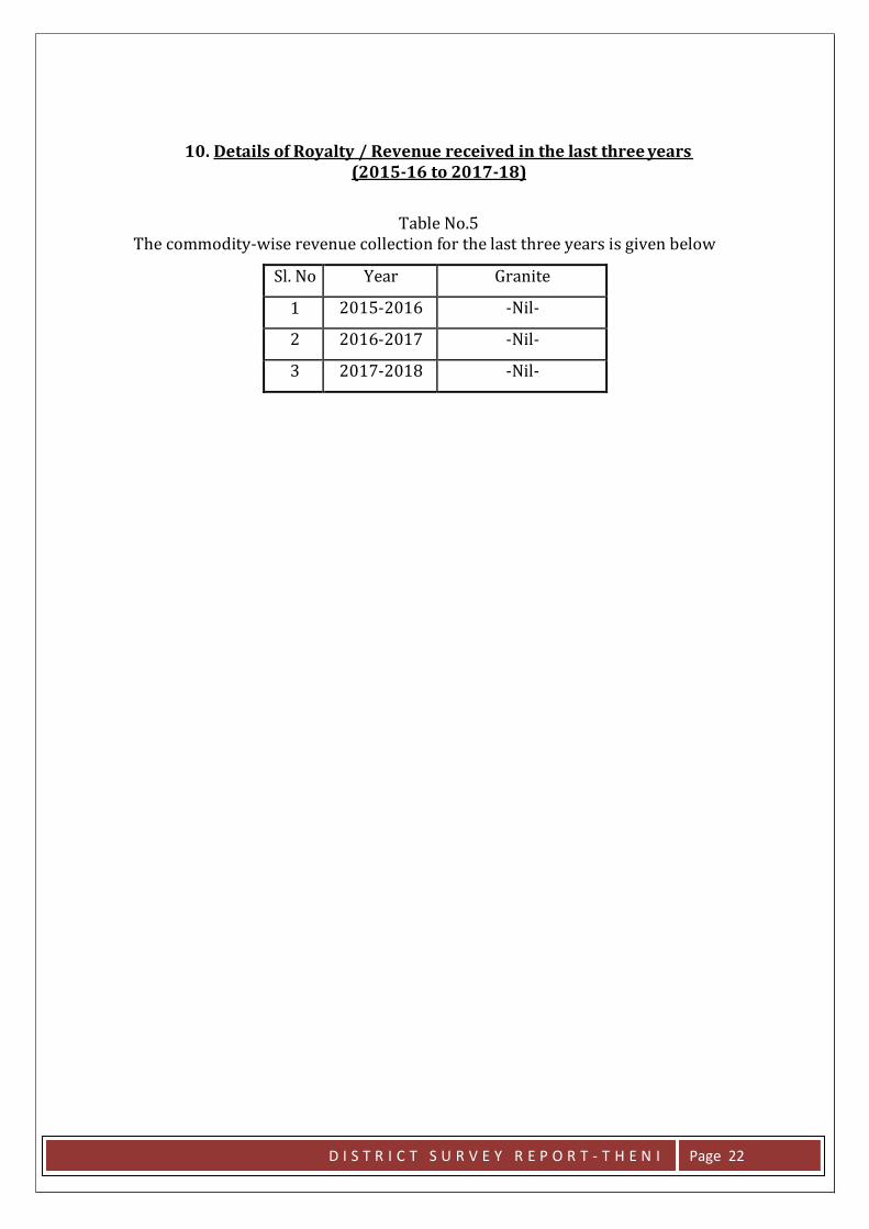
10. Details of Royalty / Revenue received in the last three years (2015-16 to 2017-18)
Table No.5 The commodity-wise revenue collection for the last three years is given below
Sl. No Year Granite
1 2015-2016 -Nil-
2 2016-2017 -Nil-
3 2017-2018 -Nil-
D I S T R I C T S U R V E Y R E P O R T - T H E N I Page 23
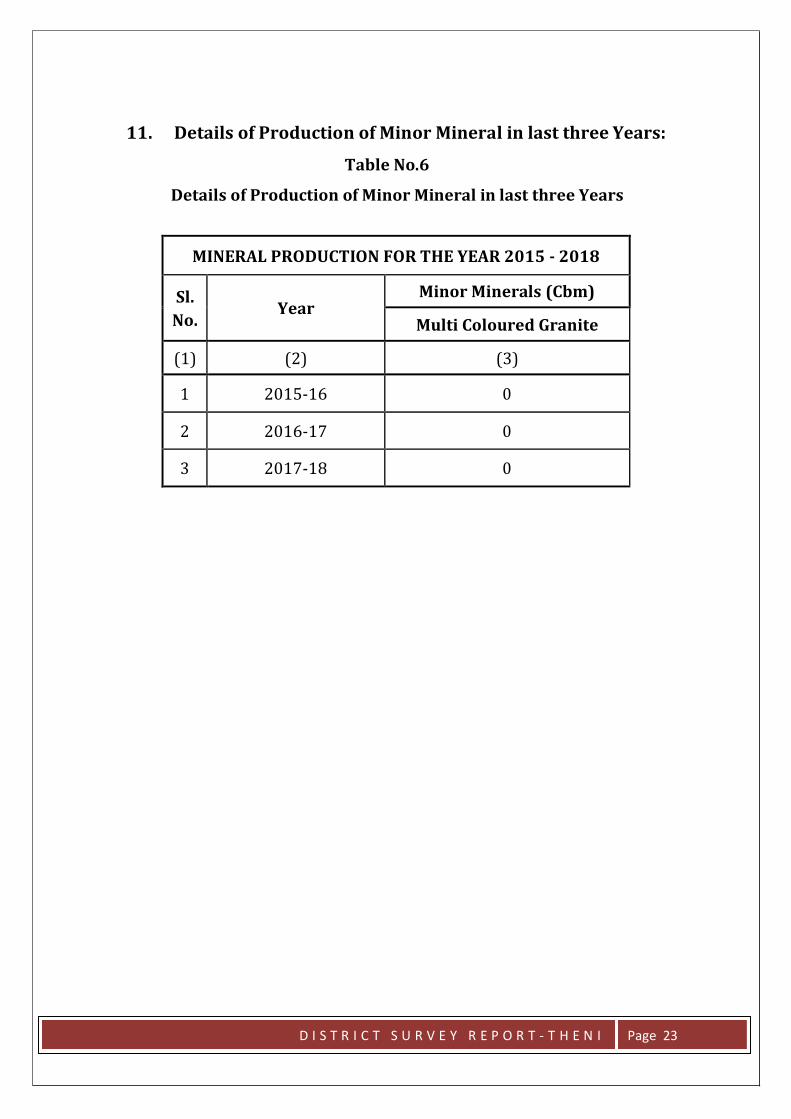
11. Details of Production of Minor Mineral in last three Years:
Table No.6
Details of Production of Minor Mineral in last three Years
MINERAL PRODUCTION FOR THE YEAR 2015 - 2018
Sl.
No. Year
Minor Minerals (Cbm)
Multi Coloured Granite
(1) (2) (3)
1 2015-16 0
2 2016-17 0
3 2017-18 0
D I S T R I C T S U R V E Y R E P O R T - T H E N I Page 24
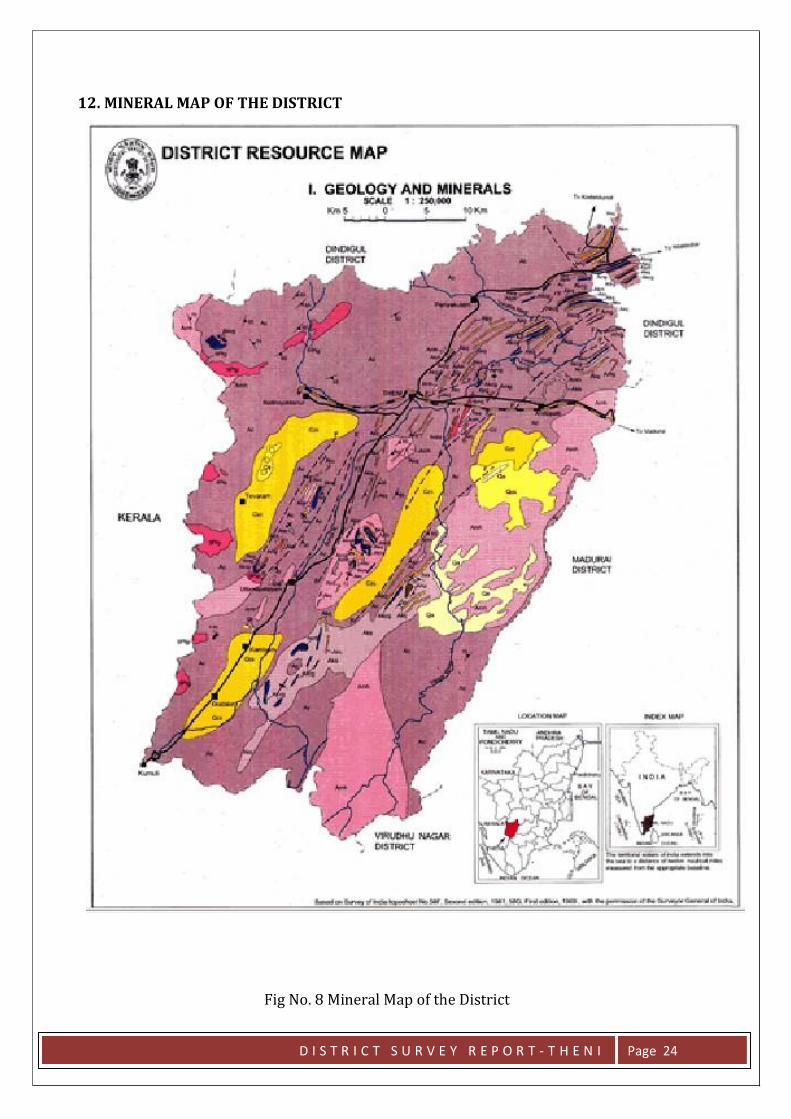
12. MINERAL MAP OF THE DISTRICT
Fig No. 8 Mineral Map of the District
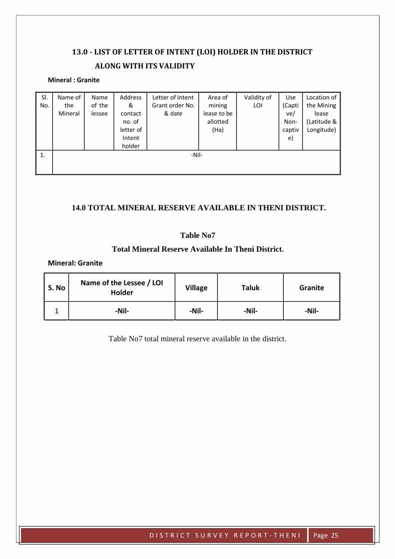
13.0 - LIST OF LETTER OF INTENT (LOI) HOLDER IN THE DISTRICT
ALONG WITH ITS VALIDITY
Mineral : Granite
Sl. No.
Name of the
Mineral
Name of the lessee
Address &
contact no. of
letter of Intent holder
Letter of Intent Grant order No.
& date
Area of mining
lease to be allotted
(Ha)
Validity of LOI
Use (Capti
ve/ Non- captiv
e)
Location of the Mining
lease (Latitude & Longitude)
1. -Nil-
14.0 TOTAL MINERAL RESERVE AVAILABLE IN THENI DISTRICT.
Table No7
Total Mineral Reserve Available In Theni District.
Mineral: Granite
S. No Name of the Lessee / LOI
Holder
Village
Taluk
Granite
1 -Nil- -Nil- -Nil- -Nil-
Table No7 total mineral reserve available in the district.
D I S T R I C T S U R V E Y R E P O R T - T H E N I Page 25
15.0 - QUALITY / GRADE OF MINERAL AVAILABLE IN THE DISTRICT
The Western Ghats comprises Charnockite Group of rocks while the plains
are underlain by hornblende – biotite gneiss, silimanite- garnet-biotite gneiss. Alluvium
quaternary sedimentsare spread almost in central part of the district. Around 70% of
the total area is covered with charnockite followed by migmatite and khondalite.
The high grade metamorphic rocks are well exposed in the Theni district on
the moderate to steeply sloping hills. These rocks are characterized into three Groups
(Krishnan, 1949; Anon, 2005), viz.i)Khondalite Group comprising of quartzite, pyroxene
granulite, calc gneiss / spinel gneiss, crystalline limestone, minor garnet-cordierite
gneiss and garnetiferousquartzo-feldspathic gneiss (leptynite).ii.Charnockite Group
consisting of acid charnockite and pyroxene granulite.iii.Migmatite Complex
represented by hornblende-biotite gneiss, grey granitic gneiss and pink migmatite.
16.0 - USE OF MINERAL
Granite is found in Myladumparai village in Andipatti Taluk. The massive
granite body trends in N60E-S60W with a dip of 80° to South. Granites (raw silk variety)
are found in Myladumparai. Granites are quarried for dimensional stones and used as
Building material.
17.0 - DEMAND AND SUPPLY OF THE MINERAL IN THE LAST THREE YEARS
2015-2016 2016-2017 2017-2018
Demand (Lakh Ts) No production of Granite as the Granite quarry is non-operative
Supply (Lakh Ts)
D I S T R I C T S U R V E Y R E P O R T - T H E N I Page 26
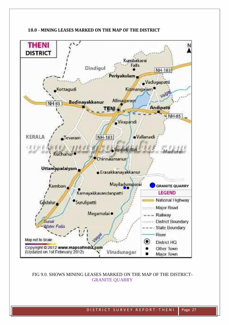
18.0 - MINING LEASES MARKED ON THE MAP OF THE DISTRICT
FIG 9.0. SHOWS MINING LEASES MARKED ON THE MAP OF THE DISTRICT-
GRANITE QUARRY
D I S T R I C T S U R V E Y R E P O R T - T H E N I Page 27
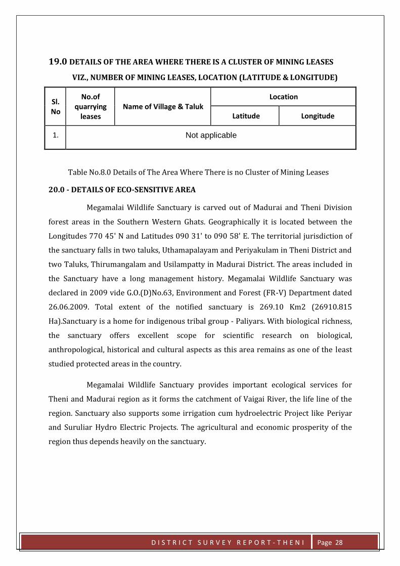
19.0 DETAILS OF THE AREA WHERE THERE IS A CLUSTER OF MINING LEASES
VIZ., NUMBER OF MINING LEASES, LOCATION (LATITUDE & LONGITUDE)
Sl. No
No.of quarrying
leases
Name of Village & Taluk
Location
Latitude Longitude
1. Not applicable
Table No.8.0 Details of The Area Where There is no Cluster of Mining Leases
20.0 - DETAILS OF ECO-SENSITIVE AREA
Megamalai Wildlife Sanctuary is carved out of Madurai and Theni Division
forest areas in the Southern Western Ghats. Geographically it is located between the
Longitudes 770 45' N and Latitudes 090 31' to 090 58' E. The territorial jurisdiction of
the sanctuary falls in two taluks, Uthamapalayam and Periyakulam in Theni District and
two Taluks, Thirumangalam and Usilampatty in Madurai District. The areas included in
the Sanctuary have a long management history. Megamalai Wildlife Sanctuary was
declared in 2009 vide G.O.(D)No.63, Environment and Forest (FR-V) Department dated
26.06.2009. Total extent of the notified sanctuary is 269.10 Km2 (26910.815
Ha).Sanctuary is a home for indigenous tribal group - Paliyars. With biological richness,
the sanctuary offers excellent scope for scientific research on biological,
anthropological, historical and cultural aspects as this area remains as one of the least
studied protected areas in the country.
Megamalai Wildlife Sanctuary provides important ecological services for
Theni and Madurai region as it forms the catchment of Vaigai River, the life line of the
region. Sanctuary also supports some irrigation cum hydroelectric Project like Periyar
and Suruliar Hydro Electric Projects. The agricultural and economic prosperity of the
region thus depends heavily on the sanctuary.
D I S T R I C T S U R V E Y R E P O R T - T H E N I Page 28
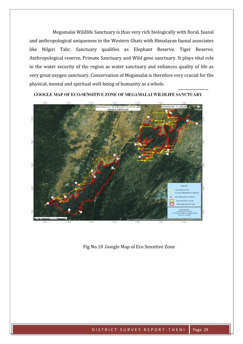
Megamalai Wildlife Sanctuary is thus very rich biologically with floral, faunal
and anthropological uniqueness in the Western Ghats with Himalayan faunal associates
like Nilgiri Tahr. Sanctuary qualifies as Elephant Reserve, Tiger Reserve,
Anthropological reserve, Primate Sanctuary and Wild gene sanctuary. It plays vital role
in the water security of the region as water sanctuary and enhances quality of life as
very great oxygen sanctuary. Conservation of Megamalai is therefore very crucial for the
physical, mental and spiritual well-being of humanity as a whole.
Fig No.10 .Google Map of Eco Sensitive Zone
D I S T R I C T S U R V E Y R E P O R T - T H E N I Page 29
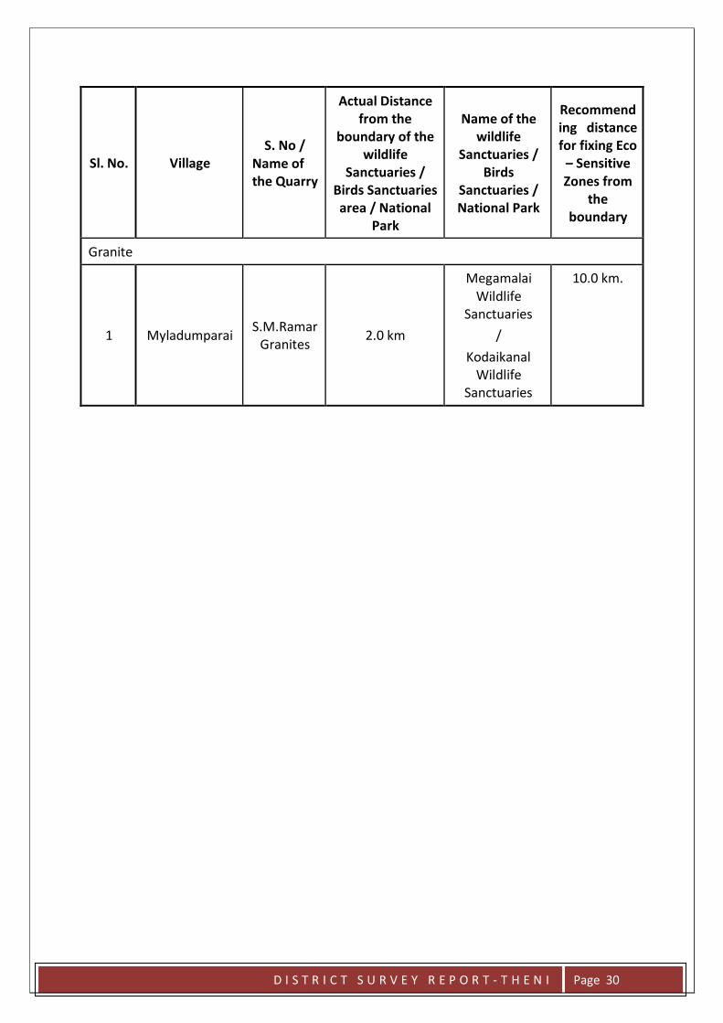
Sl. No.
Village
S. No / Name of the Quarry
Actual Distance from the
boundary of the wildlife
Sanctuaries / Birds Sanctuaries area / National
Park
Name of the
wildlife Sanctuaries /
Birds Sanctuaries / National Park
Recommend ing distance for fixing Eco – Sensitive Zones from
the boundary
Granite
1
Myladumparai
S.M.Ramar Granites
2.0 km
Megamalai Wildlife
Sanctuaries
/
Kodaikanal Wildlife
Sanctuaries
10.0 km.
D I S T R I C T S U R V E Y R E P O R T - T H E N I Page 30
21.0 - IMPACT ON THE ENVIRONMENTDUE TO MINING ACTIVITY:-
Environmental impact on granite quarrying can be broadly classified in to two categories:
1. Environmental degradation
2. Environmental pollution
ENVIRONMENTAL DEGRADATION: Degradation of topography, fauna and flora
invariably takes place on granite quarrying. While developing infrastructure,
vegetation cover is destroyed, topography degraded and fauna and flora affected.
If it is rubber plantation in Kerala, it is mango grooves in Tamil Nadu that is
destroyed. Natural lakes, nalla beds have become the convenient loci to dump the
over burden. Filling up of the natural drainage channels creates problem in the
water way system. Degradation the topography leads to destruction of vegetative
cover, dry air circulation, non precipitation, choking of natural drainage and finally
to extreme drought. This is what happening at present in excessively quarried
areas for which the reason attributed is failure of monsoon.
ENVIRONMENTAL POLLUTION: Air, water and noise pollution, ground vibration
from blasting and generation of solid waste are some of the impacts of granite
quarrying on environment which have extreme destructive consequences. Silicosis
is the prevalent disease that affects major of the quarry workers and the adjoining
villages. In addition to the natural water sources getting contaminated with
particulates, deepening of quarry depth intercepts ground water table. Natural
topographic gradient is upset with concomitant change in drainage pattern.
Deepened out quarries have become overnight perched aquifers draining away
water from all the surrounding highlands. Noise pollution, over and above those
from quarrying equipment gets accentuated from increased use of jet
burners(flames cutters). Ground vibration on account of blasting are at times
worst, simulating seismic waves, and causing damages to the buildings nearby.
Solid waste is non-biodegradable and slow mechanical disintegration of which
leads to environment of silica, sodium, potassium and calcium in soils. Soils
become unproductive. Inadequate space for dumping solid wastes near quarries
leads to dumping of them on either side of the road. Granite dumps on road sides
impart not only aesthetic displeasure but also ugly sights and potential danger for
traffic hazards.
D I S T R I C T S U R V E Y R E P O R T - T H E N I Page 31
22. REMEDIAL MEASURE TO MITIGATE THE IMPACT OF MINING ON THE ENVIRONMENT.
The Top Soil, rock Fragments etc., as Mineral Rejects are generated approach
road formation or dumping yard site etc.,
Air Environment
Plantation along approach roads and all along the safety barrier of the mining
lease.
Water tankers with spraying arrangement will be used for regular water
sprinkling on the haul roads to ensure effective dust suppression.
Haul roads will be maintained regularly.
Speed limits will be prescribed for transport vehicles
Water will be sprayed daily on the roads by using water tankers.
Periodic maintenance of the trucks used for transport shall be done to reduce
smoke emissions.
Over loading of trucks is avoided
Noise Environment
Development of green belt all along the boundary of the mining lease area which
will act as effective noise barrier.
Loading, hauling and lifting equipment and earth moving machineries etc., are
bound to produce certain level of noise which will be bring down to acceptable
norms
Proper gradient of haul roads to reduce cumulative noise levels.
Water Environment
There will be no major effect on the surface water environment.
Surface water channels will be made to divert all surface drainage for green belt
development & dust suppression purposes.
D I S T R I C T S U R V E Y R E P O R T - T H E N I Page 32
Mine water will be used for dust suppression & green belt development.
Land Environment
Landscape will be changed due to open cast mine. There will be no land
subsidence as area is made up of hard rock. Aesthetic environment will be
effected.
Soil cover and the weathered material accounts for the Over Burden
Agriculture is seen mainly in the plains far away from the lease area. A few
bushes will be cleared to facilitate mining and other related activities and there
are no big trees.
Top soil will be removed & stored on the inner boundary of the mining lease
area. To improve its quality, soil stabilizers shall be mixed and leguminous
plantation will be done over these stacks.
Top soil shall be used in afforestation work, as early as possible.
A retaining wall and garland drain will be constructed all around to prevent the
wash off
23. RECLAMATION OF MINED OUT AREA (BEST PRACTICE ALREADY
IMPLEMENTED IN THE DISTRICT, REQUIREMENT AS PER RULES AND
REGULATIONS, PROPOSED RECLAMATION PLAN)
During the end of the life of the mine, when the mine reaches its ultimate pit
limit, the pit will be partially backfilled and partially act as a good storage for water. The
spring water and seepage water will prove to be a viable source for water supply to
agriculture lands nearby. In the mining area, depth has been envisaged as workable
depth for safe & economic mining during the lease period. Hence, after mine reaches
ultimate pit limit and fencing will be constructed around the quarried pits to prevent
inherent entry of the public and cattle.
D I S T R I C T S U R V E Y R E P O R T - T H E N I Page 33
24. RISK ASSESSMENT & DISASTER MANAGEMENT PLAN
Any mines have dangers or risk like fires, inundation, failure of machinery,
which need to be investigated, addressed and mitigated. Disaster management is
formulated with an aim of taking precautionary steps to avert disaster and also to take
such action after the disaster which limits the damage to the minimum. Mining
operations may be carried to the utmost safety but there is always some element of
danger or risk in it. No major disaster is envisaged. Only minor accidents may take
place. No perennial source of surface water is present in the ML area. Blasting in ore
body will be proposed. The mining operations will be carried out under supervision of
statutory personnel’s as per provisions of MCR 1960, MCDR 1988, Mines Rules
1955,Mines Act 1952 & strictly following safety aspects as per MMR 1961 monitored by
Directorate General of Mines safety. The following natural/industrial hazards may occur
during normal operation.
Accident due to explosives;
Accident due to heavy mining equipment;
In order to take care of above hazard/disaster, the following control measures
will be adopted;
All safety precautions and provisions of Mine Act, 1952, Metalliferous Mines
Regulation, 1961 and Mines Rules, 1955 will be strictly followed during all
mining operations;
Entry of unauthorized persons will be prohibited;
Fire fighting and first aid provisions in the mines office complex and mining area
Provisions of all the safety appliances such as safety boot, helmets, goggles etc.
will be made
available to the employees and regular check for their use;
Training and refresher courses for all the employees working in hazardous
premises; Under Mines
D I S T R I C T S U R V E Y R E P O R T - T H E N I Page 34

vocational training rules all employees of mines shall have to undergo the
training at a
regular interval;
Working of mine, as per approved mine plan and regularly updating the mine
plans;
Cleaning of mine faces will be regularly done;
Handling of explosives, charging and blasting will be carried out by competent
persons only;
Provisions of magazine at a safe place with fencing and necessary security
arrangement;
Regular maintenance and testing of all mining equipment as per manufacturer’s
guidelines;
Suppression of dust on the haulage roads;
Adequate safety equipment will be provided at explosive magazine; and
Increasing the awareness of safety and disaster through competitions, posters
and other similardrivers.
For any type of above disaster, a rescue team will be formed by training the
mining staff with specialized training.
D I S T R I C T S U R V E Y R E P O R T - T H E N I Page 35
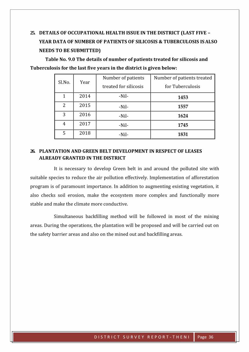
25. DETAILS OF OCCUPATIONAL HEALTH ISSUE IN THE DISTRICT (LAST FIVE –
YEAR DATA OF NUMBER OF PATIENTS OF SILICOSIS & TUBERCULOSIS IS ALSO
NEEDS TO BE SUBMITTED)
Table No. 9.0 The details of number of patients treated for silicosis and
Tuberculosis for the last five years in the district is given below:
Sl.No. Year Number of patients
treated for silicosis
Number of patients treated
for Tuberculosis
1 2014 -Nil- 1453
2 2015 -Nil- 1557
3 2016 -Nil- 1624
4 2017 -Nil- 1745
5 2018 -Nil- 1831
26. PLANTATION AND GREEN BELT DEVELOPMENT IN RESPECT OF LEASES
ALREADY GRANTED IN THE DISTRICT
It is necessary to develop Green belt in and around the polluted site with
suitable species to reduce the air pollution effectively. Implementation of afforestation
program is of paramount importance. In addition to augmenting existing vegetation, it
also checks soil erosion, make the ecosystem more complex and functionally more
stable and make the climate more conductive.
Simultaneous backfilling method will be followed in most of the mining
areas. During the operations, the plantation will be proposed and will be carried out on
the safety barrier areas and also on the mined out and backfilling areas.
D I S T R I C T S U R V E Y R E P O R T - T H E N I Page 36
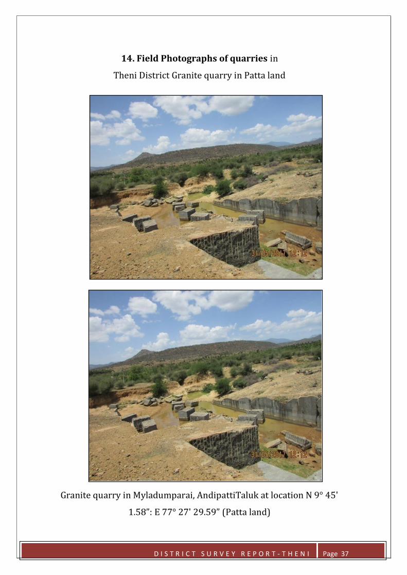
14. Field Photographs of quarries in
Theni District Granite quarry in Patta land
Granite quarry in Myladumparai, AndipattiTaluk at location N 9° 45ʹ
1.58”: E 77° 27ʹ 29.59” (Patta land)
D I S T R I C T S U R V E Y R E P O R T - T H E N I Page 37
Related Documents