1 DISTRICT IRRIGATION PLAN Hailakandi, ASSAM

Welcome message from author
This document is posted to help you gain knowledge. Please leave a comment to let me know what you think about it! Share it to your friends and learn new things together.
Transcript
1
DISTRICT IRRIGATION PLAN
Hailakandi, ASSAM
2
District Irrigation Plan, 2016-2021
Hailakandi, Assam
NABARD CONSULTANCY SERVICES PVT. LTD.
Corporate Office : 24, Rajendra Place, NABARD Building, New Delhi – 110125
Reg. Office : Plot No. C24, G Taluka, 3rd Floor, NABARD Building
Bandra Kurla Complex, Bandra East, Mumbai-400051

District Irrigation Plan, Hailakandi
3
District Irrigation Plan, Hailakandi
4
Contents
List of Tables ............................................................................................................................................................ 6
List of Figures & Maps ............................................................................................................................................. 7
Executive Summary ................................................................................................................................................. 8
District Demography: ............................................................................................................................................. 10
Agriculture: ............................................................................................................................................................. 10
District Water Profile: ............................................................................................................................................. 10
PMKSY Financial Proposal: ................................................................................................................................... 10
Expected Outcome: ................................................................................................................................................ 11
Introduction ............................................................................................................................................................ 12
Chapter 1: General Information of the District..................................................................................................... 22
1.1 District profile: .................................................................................................................................................... 22
Location and Geographical Unit: .............................................................................................................................. 22
Brief History .............................................................................................................................................................. 23
Administrative Set-up of Hailakandi.......................................................................................................................... 23
Chapter 2: District water Profile ............................................................................................................................ 30
2.1 Area wise, Crop wise Irrigation Status: ............................................................................................................... 30
2.2 Production and Productivity of Major Crops: ...................................................................................................... 30
2.3 Irrigation Based Classification: ........................................................................................................................... 31
Chapter 3: District Water Availability ................................................................................................................... 33
3.1 Status of Water Availability ................................................................................................................................. 33
3.2 Status of Ground Water Availability .................................................................................................................... 34
3.3 Status of Command Area ................................................................................................................................... 38
3.4 Existing Type of Irrigation ................................................................................................................................... 38
Chapter 4: Water Requirement/Demand ............................................................................................................... 40
District Irrigation Plan, Hailakandi
5
4.1 Domestic Water Demand ............................................................................................................................... 40
4.2 Crop Water Requirement ............................................................................................................................... 41
4.3 Livestock Water Requirement ........................................................................................................................ 43
4.4 Industrial Water Requirement ......................................................................................................................... 44
4.5 Water Demand Power Generation ................................................................................................................. 46
4.6 Total Water Demand of the district for various sectors ................................................................................... 46
4.7 Water budget .................................................................................................................................................. 49
Chapter 5 : Strategic Action Plan for Irrigation ................................................................................................... 51
5.1 Strategic Plan for irrigation in PMKSY. ........................................................................................................... 51
5.2 Department wise total Plan of the district ....................................................................................................... 51
5.3 Component-wise Plan .................................................................................................................................... 52
5.4Block-wise Plan under PMKSY ....................................................................................................................... 53
5.5 Suggestions ................................................................................................................................................... 54
5.6 Expected Outcome ......................................................................................................................................... 55
Annexures ............................................................................................................................................................... 51
District Irrigation Plan, Hailakandi
6
Introduction
Background
Preparation of decentralized area specific district planning process visualized in various plans took
concrete shape through the years and initiatives like specific guidelines on methodologies and processes for
preparation of district plans; framework for preparation of perspective plan, medium term and annual plans by then
planning commission in 1969 and the 73rd and 74th constitutional amendments conferring constitutional status to
Panchayats at district and sub district level; local self-government in urban areas; constitution of district planning
committee to consolidate the plans prepared at Panchayats and municipalities and prepare a draft development
plan for the whole district.
The decentralized planning process was further strengthened through emphasis by planning commission
on preparation of district level plans and making it an integral part of the process of preparation of the state ‘s 11th
five year plan. The Planning commission issued guidelines in August 2006 for preparation of the district plans. The
guidelines define the District Planning as ‗the process of preparing an integrated plan for the local government
sector in a district taking into account the resources (natural, human and financial) available and covering the
sectoral activities and schemes assigned to the district level and below and those implemented through local
governments in a state. The document that embodies this statement of resources and their allocation for various
purposes is known as the District Plan‖.
Government of India through a resolution in National Development Council on 29th May 2007 conceived a
special Additional Central Assistance Scheme (ACAS) to address the slow growth of agriculture and allied sectors
by incentivizing states to draw up plans for their agriculture sectors more comprehensively. The NDC resolution
states "GoI will introduce a new Additional Central Assistance Scheme to incentivize states to draw up plans for
their agriculture sector more comprehensively, taking agro-climatic conditions, natural resource issues and
technology into account, and integrating livestock, poultry and fisheries, etc. This will involve a new scheme for
Additional Central Assistance (ACA) to State Plans, administered by the Union Ministry of Agriculture over and
above its existing Centrally Sponsored Schemes, to supplement the State-specific strategies including special
schemes for beneficiaries of land reforms. The newly created National Rainfed Area Authority will, on request,
assist States in planning for rainfed areas".
The NDC in its resolution advised the states to prepare a comprehensive district agriculture plans (C-
DAP) that will fully utilize available resources and will include allied agriculture sectors. Further, GOI issued a
manual on preparation of comprehensive district agriculture plans to help the states prepare C-DAP. As per these
guidelines, the objective of district planning is ‗to design an integrated and participatory action plan for the
development of local area in general and agriculture and allied sectors in particular‘. The objectives of
Comprehensive District Agriculture Plan (C-DAP) are:
To prepare a Comprehensive District Agriculture Plan (C-DAP) through participatory process involving
various organisations and stakeholders.
District Irrigation Plan, Hailakandi
7
To enable optimum utilisation of scarce natural, physical & financial resources.
To assess and plan for the infrastructure required to support the agriculture development.
To establish linkages with the required institutional support services, like credit, technology transfer, ICT,
research etc.
To evolve an action plan for achieving sustainable agricultural growth with food security and cropping
system that will improve farmers‘ income.
The guidelines required the state/district authorities to (i) ensure that the agricultural plans are prepared
for the district and then integrated into the agricultural plans of the State based on the agro-climatic conditions,
availability of technology, trained manpower and natural resources; (ii) local needs / crops / feed and fodder /
animal husbandry / dairying / fisheries / priorities are reflected in the plan; (iii) productivity gaps for important crops
and livestock and fisheries are reduced; and (iv) the returns to the farmers from these are maximized.
The latest move in the process of strengthening of decentralized planning process was the Government
of India guidelines issued in 2015 in the form of a template for the preparation of District Irrigation Plan (DIP) and
State Irrigation Plan (SIP) as part of the Pradhan MantriKrishiSinchayeeYojana (PMKSY) program and made the
preparation of DIP and SIP mandatory for the states to receive funds from the program. The present report is a
product of these long drawn efforts of Government of India to strengthen the decentralized planning process in the
country focusing on the vital resource i.e., water.
Water is of vital importance for human & animal life, maintenance of ecological balance and promotion of
developmental activities. Considering its vital importance and ever increasing demand for water, in the face of
population growth, urbanization & industrialization and considerations of climatic change, making water, an
increasingly a scarce resource, available to multiple uses, planning and management of this vital resources,
utilization of water economically, optimally and equitably assumes greater importance.
According to the 12th Five year Plan the water budget estimates of India by Ministry of Water Resources
suggests an availability of 1123 billion cubic meters (BCM) against a current estimated demand of 710 BCM. The
Standing Committee of the Ministry of Water Resources estimates that this water demand will rise to 1093 BCM by
2025. Though the existing water availability in the immediate future seems to be adequate, with the near constant
supply of water resources in the face of increasing demand on account of population growth, urbanisation and
industrialization will strain the water supply-demand balance.
The per capita water availability which stood at 5,177 cubic meters in 1951 was reduced to 1820 cubic
meters in 2001 while the international prescribed limit is 1800 cubic meters. The projected per capita availability of
water is 1341 cubic meters in 2025 and 1140 cubic meters in 2050 suggesting shortage of water in the medium
term1. Further, the all India water balance estimates does not reflect the variations in water balance across time and
space- certain areas having a positive water balance and the others facing acute shortage. The problem is further
accentuated by water quality related issues.
With the abundant surface and ground water supply in the first five decades since independence, more
than 80 percent of the total available water resources were allocated for irrigation purposes and the rest meeting
1Ministry of Water Resources (2011), Strategic Plan for Ministry of Water Resources, Government of India, New Delhi.
District Irrigation Plan, Hailakandi
8
the domestic and industrial demands. In a recent studyon the demand for water from agriculture, domestic and
industrial uses in 2000, 2025 and 2050 seems to suggest that domestic demand (34 BCM in 2000, 66 BCM in 2025
and 101 BCM in 2050) and industrial demand (42 BCM in 2000, 92 BCM in 2025 and 161 BCM in 2050) for water
will utilize the total balance water available while agriculture demand for water will be (605 BCM in 2000, 675 BCM
in 2025 and 637 BCM in 2050). This change is partly because of the changing sectoral contributions of India‘s
GDP and also partly because of dynamics of irrigation development in the country where the initial expansion in
area under irrigation is propelled by the availability of abundant water resources and availability of good quality
land. This is no longer the case in many of the states where the availability of land and water are serious
constraints for further expansion of irrigation. Further, as per the erstwhile planning commission up to March 2012
out of 141 million hectares of net sown area in the country 114 (or 81%) million hectares is Irrigation Potential
Created (IPC) and 88 (or 62%) million hectares is Irrigation Potential Utilised (IPU) leaving almost 20% of irrigated
potential unutilized. This leaves 40 percent of the net sown area in the country dependent on rainfall which makes
farming a high risk and less productive.
The competing demands for water resources and the emerging issues and concerns were to be
addressed through certain basic principles and commonality in approaches in dealing with planning, development
and management of water resources2 under an Integrated Water Resource Management framework. The main
objectives of water resource management as delineated in National Water Policy 2012 are:
a) Planning, development and management of water resources need to be governed by common integrated
perspective considering local, regional, State and national context, having an environmentally sound
basis, keeping in view the human, social and economic needs.
b) Principle of equity and social justice must inform use and allocation of water.
c) Good governance through transparent informed decision making is crucial to the objectives of equity,
social justice and sustainability. Meaningful intensive participation, transparency and accountability
should guide decision making and regulation of water resources.
d) Water needs to be managed as a common pool community resource held, by the state, under public trust
doctrine to achieve food security, support livelihood, and ensure equitable and sustainable development
for all.
e) Water is essential for sustenance of eco-system, and therefore, minimum ecological needs should be
given due consideration.
f) Safe Water for drinking and sanitation should be considered as pre-emptive needs, followed by high
priority allocation for other basic domestic needs (including needs of animals), achieving food security,
supporting sustenance agriculture and minimum eco-system needs. Available water, after meeting the
above needs, should be allocated in a manner to promote its conservation and efficient use.
g) All the elements of the water cycle, i.e., evapo-transpiration, precipitation, runoff, river, lakes, soil
moisture, and ground water, sea, etc., are interdependent and the basic hydrological unit is the river
basin, which should be considered as the basic hydrological unit for planning.
h) Given the limits on enhancing the availability of utilizable water resources and increased variability in
supplies due to climate change, meeting the future needs will depend more on demand management,
and hence, this needs to be given priority, especially through (a) evolving an agricultural system which
2Ministry of Water Resources, National Water Policy, 2012, Government of India, New Delhi.
District Irrigation Plan, Hailakandi
9
economizes on water use and maximizes value from water, and (b) bringing in maximum efficiency in use
of water and avoiding wastages.
i) Water quality and quantity are interlinked and need to be managed in an integrated manner, consistent
with broader environmental management approaches inter-alia including the use of economic incentives
and penalties to reduce pollution and wastage.
j) The impact of climate change on water resources availability must be factored into water management
related decisions. Water using activities need to be regulated keeping in mind the local geo climatic and
hydrological situation.
Government of India launched Pradhan MantriKrishiSinchayeeYojana (PMKSY) to address the
constraints in providing assured irrigation as well as increasing efficiency and productivity of current water use to
bring more prosperity to the rural areas. Priorities of Government of India were reflected in the Hon‘ble President‘s
address to the joint Session of the Parliament of 16thLok Sabha where he indicated that ―Each drop of water is
precious. Government is committed to giving high priority to water security. It will complete the long
pending irrigation projects on priority and launch the ‘Pradhan MantriKrishiSinchayeeYojana’ with the
motto of ‘HarKhetKoPani’. There is a need for seriously considering all options including linking of rivers,
where feasible; for ensuring optimal use of our water resources to prevent the recurrence of floods and
drought. By harnessing rain water through ‘Jal Sanchay’ and ‘Jal Sinchan’, we will nurture water
conservation and ground water recharge. Micro irrigation will be popularised to ensure ‘Per drop-More
crop”.
PMKSY has been approved with an indicative outlay of Rs.50,000 crore over a period of five years from
2015-16 to 2019-20. The programme is an amalgamation of on-going schemes of Ministry of Water Resources,
River Development and Ganga Rejuvenation, Ministry of Agriculture & Cooperation and Ministry of Rural
Development. The existing schemes AIBP, CADWM, MI, SWMA, Watershed& Convergence with MGNREGA were
brought together under the umbrella program of PMKSY. Further the scheme seeks convergence with scheme
likeMahatma Gandhi National Rural Employment Guarantee Scheme (MGNRES), RashtriyaKrishiVikasYojana
(RKVY), Jawaharlal Nehru National Solar Mission and Rural Electrification programmes (JLNNSM&REP), Rural
Infrastructure Development Fund (RIDF), Members of Parliament Local Area Development Scheme (MPLAD),
Members of Legislative Assembly Local Area Development Fund (MLALAD), Local Body Funds (LBF), Working
Plan of State Forest Department (WPSFD) etc. The PMKSY will be implemented in an area development mode
only by adopting a decentralized state level planning and projectised execution structure that will allow the state to
draw up their own irrigation development plans based on DIPs and SIPs with a horizon of 5-7 years. The program
will be implemented as part of RashtriyaKrishiVikasYojana (RKVY) with state agriculture department acting as the
State Nodal Agency. However, the implementing departments for the four components like AIBP, PMKSY
(HarKhetKoPani), PMKSY (Per drop more crop) and PMKSY (watershed development) will be decided by the
respective program ministry/department.
The funds under this program would be provided to the states as per the pattern of assistance of
Centrally Sponsored Schemes (CSS) decided by the Ministry of Finance and NITI Aayog. During 2015-16 the
existing pattern of assistance of ongoing scheme was continued. An outlay of Rs. 50,000 crore has been approved
for 2015-20. The financial assistance provided to the state governments from this centrally sponsored scheme is
subject to fulfillment of certain conditions.Firstly, a state will become eligible to access PMKSY fund only if it has
District Irrigation Plan, Hailakandi
10
prepared the District Irrigation Plans (DIP) and State Irrigation Plan (SIP), excepting for the initial year, and the
expenditure in water resource development for agriculture sector in the year under consideration is not less than
the baseline expenditure, which is defined as the average of the expenditure in irrigation sector irrespective of the
department in the state plan in three years prior to the year under consideration. Secondly, States will be given
additional weightage for levying charges on water and electricity for irrigation purposes, so as to ensure
sustainability of the programme. Thirdly, interstate allocation of PMKSY fund will be decided based on
Share of percentage of unirrigated area in the state vis-à-vis national average including prominence of
areas classified under Desert Development Programme (DDP) and Drought Prone Area Development
Programme (DPAP)
Increase in percentage share of expenditure on water resource development for agriculture sector in
State Plan expenditure in the previous year over three years prior to it and
Improvement in irrigation efficiency in the state.
Vision
The overreaching vision of Pradhan MantriKrishiSinchayeeYojana (PMKSY) will be to ensure access to
some means of protective irrigation to all agricultural farms in the country, to produce ‗per drop more crop‘, thus
bringing much desired rural prosperity.
Objective
The objectives of the PMKSY are to:
a) Achieve convergence of investments in irrigation at the field level (preparation of district level and, if
required, sub district level water use plans).
b) Enhance the physical access of water on the farm and expand cultivable area under assured irrigation
(HarKhetkoPani),
c) Integration of water source, distribution and its efficient use, to make best use of water through
appropriate technologies and practices.
d) Improve on-farm water use efficiency to reduce wastage and increase availability both in duration and
extent,
e) Enhance the adoption of precision-irrigation and other water saving technologies (More crop per drop).
f) Enhance recharge of aquifers and introduce sustainable water conservation practices
g) Ensure the integrated development of rainfed areas using the watershed approach towards soil and water
conservation, regeneration of ground water, arresting runoff, providing livelihood options and other NRM
activities.
h) Promote extension activities relating to water harvesting, water management and crop alignment for
farmers and grass root level field functionaries.
i) Explore the feasibility of reusing treated municipal waste water for peri-urban agriculture, and
j) Attract greater private investments in irrigation.
Strategy/approach
To achieve these objectives PMKSY adopted strategies that include
District Irrigation Plan, Hailakandi
11
a) Creation of new water sources; repair, restoration and renovation of defunct water sources; construction
of water harvesting structures, secondary & micro storage, groundwater development, enhancing
potentials of traditional water bodies at village level like Jal Mandir (Gujarat); Khatri, Kuhl (H.P.); Zabo
(Nagaland); Eri, Ooranis (T.N.); Dongs (Assam); Katas, Bandhas (Odisha and M.P.) etc.
b) Developing/augmenting distribution network where irrigation sources (both assured and protective) are
available or created;
c) Promotion of scientific moisture conservation and run off control measures to improve ground water
recharge so as to create opportunities for farmers to access recharged water through shallow tube/dug
wells;
d) Promoting efficient water conveyance and field application devices within the farm viz, underground
piping system, Drip & Sprinklers, pivots, rain-guns and other application devices etc.;
e) Encouraging community irrigation through registered user groups/farmer producers‘ organisations/NGOs;
and
f) Farmer oriented activities like capacity building, training and exposure visits, demonstrations, farm
schools, skill development in efficient water and crop management practices (crop alignment) including
large scale awareness on more crop per drop of water through mass media campaign, exhibitions, field
days, and extension activities through short animation films etc.
Programme Components
PMKSY has following four components:
1. Accelerated Irrigation Benefit Programme (AIBP): to focus on faster completion of ongoing Major and
Medium Irrigation including National Projects.
2. PMKSY (HarKhetkoPani): This component focuses on-
a) Creation of new water sources through Minor Irrigation (both surface and ground water)
b) Repair, restoration and renovation of water bodies; strengthening carrying capacity of traditional water
sources, construction rain water harvesting structures (Jal Sanchay);
c) Command area development, strengthening and creation of distribution network from source to the farm;
d) Ground water development in the areas where it is abundant, so that sink is created to store runoff/ flood
water during peak rainy season.
e) Improvement in water management and distribution system for water bodies to take advantage of the
available source which is not tapped to its fullest capacity (deriving benefits from low hanging fruits). At
least 10% of the command area to be covered under micro/precision irrigation.
f) Diversion of water from source of different location where it is plenty to nearby water scarce areas, lift
irrigation from water bodies/rivers at lower elevation to supplement requirements beyond IWMP and
MGNREGS irrespective of irrigation command.
g) Creating and rejuvenating traditional water storage systems like Khatri, Kuhl etc. at feasible locations.
3. PMKSY (Per Drop More Crop):
District Irrigation Plan, Hailakandi
12
a) Programme management, preparation of State/District Irrigation Plan, approval of annual action plan,
Monitoring etc.
b) Promoting efficient water conveyance and precision water application devices like drips, sprinklers, pivots,
rain-guns in the farm (Jal Sinchan);
c) Topping up of input cost particularly under civil construction beyond permissible limit (40%), under
MGNREGS for activities like lining inlet, outlet, silt traps, distribution system etc.
d) Construction of micro irrigation structures to supplement source creation activities including tube wells
and dug wells (in areas where ground water is available and not under semi critical/ critical/ over exploited
category of development) which are not supported under AIBP, PMKSY (HarKhetkoPani), PMKSY
(Watershed) and MGNREGS as per Taluka/district irrigation plan.
e) Secondary storage structures at tail end of canal system to store water when available in abundance
(rainy season) or from perennial sources like streams for use during dry periods through effective on-farm
water management;
f) Water lifting devices like diesel/ electric/ solar pumpsets including water carriage pipes, underground
piping system.
g) Extension activities for promotion of scientific moisture conservation and agronomic measures including
cropping alignment to maximise use of available water including rainfall and minimise irrigation
requirement (Jal Sarankchan);
h) Capacity building, training and awareness campaign including low cost publications, use of pico
projectors and low cost films for encouraging potential use water source through technological, agronomic
and management practices including community irrigation.
i) The extension workers will be empowered to disseminate relevant technologies under PMKSY only after
requisite training is provided to them especially in the area of promotion of scientific moisture
conservation and agronomic measures, improved/ innovative distribution system like pipe and box outlet
system, etc. Appropriate Domain Experts will act as Master Trainers.
j) Information Communication Technology (ICT) interventions through NeGP-A to be made use in the field
of water use efficiency, precision irrigation technologies, on farm water management, crop alignment etc.
and also to do intensive monitoring of the Scheme.
4. PMKSY (Watershed Development):
a) Effective management of runoff water and improved soil & moisture conservation activities such as ridge
area treatment, drainage line treatment, rain water harvesting, in-situ moisture conservation and other
allied activities on watershed basis.
b) Converging with MGNREGS for creation of water source to full potential in identified backward
rainfedTalukas including renovation of traditional water bodies
Rationale/ Justification
In reference to the status and need of irrigation, the water resource management including irrigation
related priorities was identified for Sirmour district by the peoples‘ representatives of district with support from
administration and technical experts. For instance the reports of Strategic Research and Extension Plan (SREP)
prepared under ATMA program, Comprehensive District Agriculture Plan (C-DAP) prepared as part of
District Irrigation Plan, Hailakandi
13
RashtriyaKrishiVikasYojana (RKVY), Potential Linked Credit Plans (PLP) of NABARD and the Integrated District
Development Plan etc. identified number of irrigation related issues for Sirmour district including (i) promoting water
use efficiency through sprinkler and drip irrigation; (iii) promoting protected polyhouse cultivation to minimize risk
factors and enhance quality and productivity; (iv) Improvement of on-farm water delivery and efficiency of existing
irrigation systems; (v) promotion of soil conservation of arable & non-arable land through engineering measures;
(vi) creation of new water harvesting structures, check dams, ponds, tanks, etc (vii) increase the forest cover in the
district and (viii) land improvement measures.
Methodology
During the course of preparation of District Irrigation Plan (DIP) the team visited thedistrict to collect data
and have interaction with all the stakeholders. Methodology adopted to prepare DIP is outlined in brief as under:
a) Collection of primary and secondary data from field from various sources including published documents
and websites.
b) Various meetings were held to obtain ground level realities and data from key personnel/stakeholders
through structured, unstructured interviews, focused group discussions etc.
c) Meetings with State Government departments and related institutions were held
d) Meeting was also held with State Level authorities.
e) GIS maps of the areas/clusters were studied to understand the land morphology, topography of the
district.
f) Focused group discussions and interaction with agriculture officers, horticulture officers, soil conservation
officers, extension officers, rural development department, animal husbandry department, irrigation
officers both at Talukas anddistrict level for identifying the key issues and focus areas of the region.
g) Discussion with NABARD officer of the district was also held during the visit.
On the basis of detailed discussion and analysis of data, the team arrived at the projections of various
components of PMKSY and Department wise plan for four years from 2016-17 to 2019-20 as detailed in the plan.
District Irrigation Plan, Hailakandi
14
Chapter 1
General Information of the District
Hailakandi district is one of the three districts of the Barak valley. The other two being Cachar and
Karimganj.It is opined that in ancient days, the old Cachar district was divided into a few smaller nations and each
nation was ruled by an independent ruler. It is also believed that the Halam tribe people of Kuki origin were mostly
inhabited in present Hailakandi district. Hence it was regarded as a Kuki state. The word ‗Hala‘ denotes to God in
Kuki language and Kundi refers to ―Parameswara‖ or the land of ―Parameswara‖. Thus, the word ‗Hala-Kundi‖
means ―Kingdom of God‖. Perhaps, the word ‗Halakundi‘ was changed to ‗Halla-Kandi‘ during Kachari rule and
finally during the British rule it was converted into its present term ‗Hailakandi‘.
It is believed that the present Hailakandi district was the kingdom of Kuki tribes until 1568 A.D. and the
whole kingdom was under the control of Tripura administration. Jatinga and Hailakandi were formed into a kingdom
during 16th A.D. and it was known to be as ―Jayatungabarsha‖. Loknath and Marundanath had been discovered as
the names of two kings by the inscription found in two copper plates. Adinath, Shrinath and Bhabanath were the
ancestors of above two kings. The symbol inserted in the copper plate of Marundanath reveals an idol of Lakhsmi,
the goddess of wealth and an ox the carrier of Lord Siva. It is assumed that these kings belong to Nath dynasty and
were the worshipers of Lord Siva. The Roya family worshiped Goddess Lakshmi as their special goddess.
From the two other brick inscriptions discovered on the bank of ‗Rak-vata‘ or ―ShakwalaDighi‖ (tank) about
3 kms away from Lalabazar that Maharaja Harish Chandra Narayan had been ruling over this country up to 1490
saka or 1568 A.D. It can be said that the Kacharis did not come to Hailakandi which was under the Tripura
administration up to 1568 A.D and were inhabited by Kuki.
In the battle of Maibong, Kachari king Tamradhway was defeated by the Ahom, King Rudra Sinha in 1906
and subsequently the king left his capital and took shelter at Khaspur in the plains of Cachar. It is believed that the
Kachari princes seemed to have settled in the plains of Cachar permanently from this time. The king Suradarpa
Narayan, son of Tamradhwaj, constructed many palaces and temples in Khaspur and the kingdom was named as
‗Hidimba kingdom‘.
A sizeable portion of Brahims and high caste people from Koch-Behar, Tripura and Sylhet came to the
Royal court of Kachari kingdom at Khaspur for their livelihood and the king patronised them all in all respects. The
king had encouraged equally all immigrants who had come from Sylhet, Bengal and other to the newly established
capital for their settlement. The cultivators were also helped to encroach upon the Tripuri territory in the Dhaleswari
Valley which consisted the most area of present Hailakandi district. Mr. C. A. Sopitt also admitted that the Kacharis
were migrated to the plains of Cachar only in 1750 and king Suradarpa and his successors ruled over it. It is
therefore, believed that present Hailakandi district came under Kachari kingdom only after 1750 A.D. The district
Hailakandi as a part of old Cachar district was annexed to the British territory in 1832 and the central Cachar and a
part of hill tracts of Cachar were finally annexed by the British in 1833. The district was included in the
Commissionership of Dacca in 1835 and Captain Fisher was posted as Deputy Commissioner with the power of a
Magistrate. The Judge of Sylhet acted as a session Judge of Cachar. However, in 1854 the northern part of Cachar
which was already under the British was annexed to the district of Nowgong (Nagoan). In 1867 with the formation of
Naga Hills district, this tract was partitioned between the district of Nowgong and Cachar.
District Irrigation Plan, Hailakandi
15
At that time the district consisted of three Sub-Divisions, North Cachar, a hilly area of 4276 km² and two
plains Sub-Divisions of Silchar and Hailakandi with 4967 km² Later in 1951, with the constitution of United Mikir and
North Cachar Hills, the North Cachar tract was separated from Cachar and the loss having been substantiated by
adding Karimganj sub - division with parts of old Karimganj P.S., Badarpur, Ratabari and PatharKandi P.S. from the
independent district Sylhet.
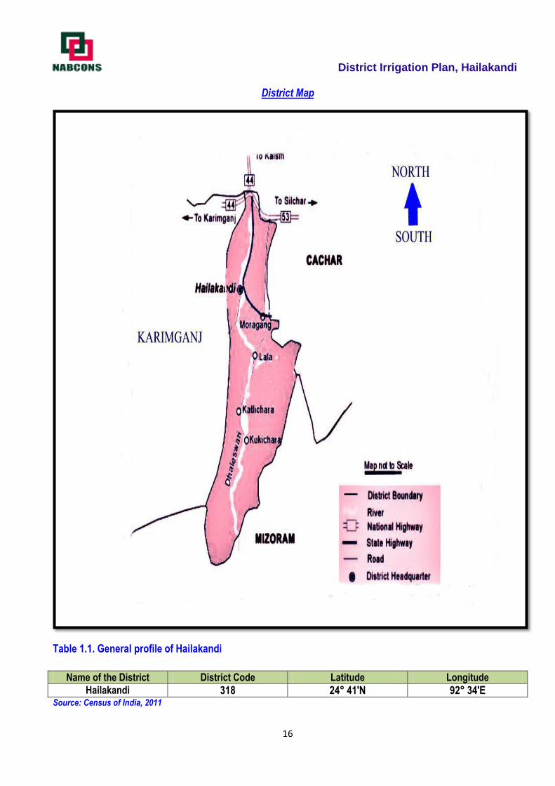
1.1 District Profile
The District is located between latitudes north 24º41' and 24º68' and between longitudes east 92º34' and
92º57‘. District was created on 01/10/1989. Hailakandi consists of five developmental blocks: Algapur, Hailakandi,
Lala, Katlicherra& South Hailakandi. The District consisting of four Revenue Circles namely: Algapur, Hailakandi,
Lala & Katlicherra. The district has 62 Nos of GaonPanchayat and 331 Nos of Revenue Villages, 01 Municipality
Board and 2 Nos Town Committees. There is also a small township at ‗Hindustan Paper Mill‘ area at Panchgram in
Algapur Dev. Block. The Connectivity of the district consists of road NH-53 and NH-154 and Railway (Broad Gauge
under construction). Nearest Airport is Kumbhirgram airport which is 83 Km from the district headquarter. The prime
geographical character that forms the topographical features of Hailakandi is the river Barak and its tributaries. The
river spread rich alluvial plains across the length and breadth of three southern districts of Assam. There are two
major rivers flowing through the district namely Katakhal&Dhaleswari. Also, there are two small rivers named
Pola&Jita.There are two reserved forests in Hailakandi district, the Inner line Reserved Forest and Katakhal
Reserved Forest. The southern part was also recommended as Dhaleswari Wildlife Sanctuary.
Comparative Table of Demographic Details of Hailakandi District Description 2011 Census 2001 Census
Actual Population 659,296 542,872
Male 337,890 280,513
Female 321,406 262,359
Population Growth 21.45% 20.89%
Area Sq. Km 1,327 1,327
Density/km2 497 409
Proportion to Assam Population 2.11% 2.04%
Sex Ratio (Per 1000) 951 935
Child Sex Ratio (0-6 Age) 954 927
Average Literacy 74.33 59.64
Male Literacy 80.74 68.24
Female Literacy 67.60 50.46
Total Child Population (0- 6 Age) 111,278 100,962
Male Population (0- 6 Age) 56,936 52,400
Female Population (0- 6 Age) 54,342 48,563
Literates 407,366 3,872,120
Male Literates 226,836 2,136,829
Female Literates 180,530 1,735,291
Child Proportion (0-6 Age) 16.88% 18.60%
Boys Proportion (0-6 Age) 16.85% 18.68%
Girls Proportion (0-6 Age) 16.91% 18.51%
Source: Census of India 2011
District Irrigation Plan, Hailakandi
16
District Map
Table 1.1. General profile of Hailakandi
Name of the District District Code Latitude Longitude
Hailakandi 318 24° 41'N 92° 34'E Source: Census of India, 2011
District Irrigation Plan, Hailakandi
17
Administrative setup of Hailakandi District
The Deputy Commissioner of the District is the overall in charge of the administration of the entire district.
He also acts as the Collector in case of Revenue matters, as a District Magistrate in case of maintenance of Law
and Order and General Administration, as a District Election Officer in case of conduct of Election, as a Principal
Census Officer while conducting Census, and so on. A number of Officers, like Additional Deputy Commissioners,
Sub-divisional Officers, Extra Assistant Commissioners and others assist the Deputy Commissioner is looking after
the administration of the district. At lower level each sub-division is headed by one Sub-Divisional Officer whereas
under him there will be Revenue Circle Officers for each revenue circles who are responsible for the entire
administration of the area under their respective revenue circle.
The district Hailakandi is situated in the Barak Valley region of Assam. Hailakandi district has no any Sub-
Division. It comprises 4 Revenue Circle with 331 villages. It has 5 Community Development Blocks. There is no any
jurisdictional changes taken place during 2001-2011. The total area in the district is 1327 square Kms.In terms of
area Hailakandi ranks 24th. The district has 3 towns (2 statutory towns and 1 census towns).Hailakandi MB is a
major town of the district. The other urban components include Lala TC and H.P.C. Township which is a Census
Town.
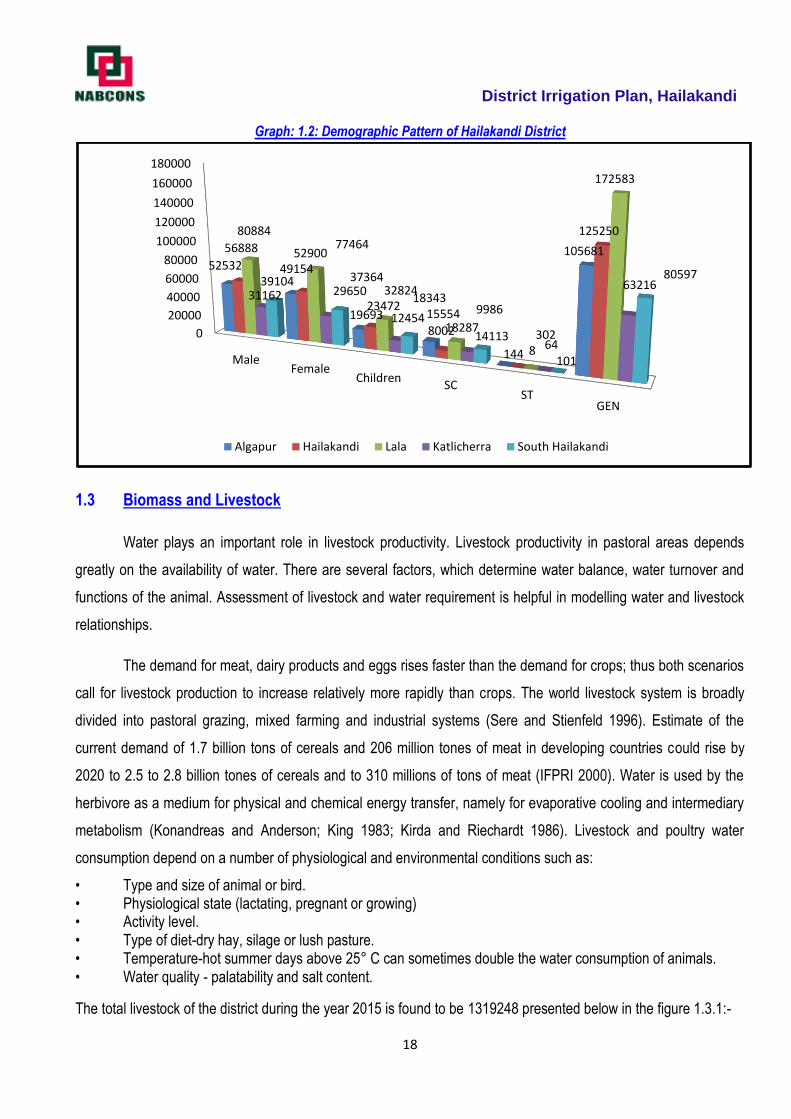
1.2 Demography
The total population of the district 6,59,296 as per ther block level data and out of which 6, 11,156 lived in
rural areas and 48,140 in urban area. The population density is 497 per sq. km and sex ratio is of 951 female per
1000 males. The Schedule castes comprise 65942 (10.72%), Schedule Tribes 619 (0.10%), other backward and
general castes 587946.
It is reflected from table 1.2 that total population of the district is 6,59,296out of which 270570 male
and256532 female people. Lala Block reserves the highest population and Katlicherra Block reserves the lowest
population.
Table: 1.2 Block wise Population Statistics of Hailakandi District
Name of the Block
Population Scheduled Caste
Schedule Tribe General Total
Male Female Children Total No. of House Hold
No. of Member
No. of House Hold
No. of Member
No. of House Hold
No. of Members
No. of House Hold
No. of Members
Algapur 52532 49154 19706 121392 3109 15554 26 144 23648 105681 26783 121379
Hailakandi 66888 62900 36710 166498 1597 8002 2 8 28341 125250 29922 133260
Lala 80884 77464 44791 203139 3658 18287 61 302 38425 172583 42144 191172
Katlicherra 31162 29650 12598 73410 1996 9986 14 64 13317 63216 15327 73266
South Haikalandi
39104 37364 18389 94857 2825 14113 23 101 16800 80597 19648 94811
TOTAL 270570 256532 132194 659296 13185 65942 126 619 120531 592735 133824 659296
Source: Census, 2011
District Irrigation Plan, Hailakandi
18
Graph: 1.2: Demographic Pattern of Hailakandi District
1.3 Biomass and Livestock
Water plays an important role in livestock productivity. Livestock productivity in pastoral areas depends
greatly on the availability of water. There are several factors, which determine water balance, water turnover and
functions of the animal. Assessment of livestock and water requirement is helpful in modelling water and livestock
relationships.
The demand for meat, dairy products and eggs rises faster than the demand for crops; thus both scenarios
call for livestock production to increase relatively more rapidly than crops. The world livestock system is broadly
divided into pastoral grazing, mixed farming and industrial systems (Sere and Stienfeld 1996). Estimate of the
current demand of 1.7 billion tons of cereals and 206 million tones of meat in developing countries could rise by
2020 to 2.5 to 2.8 billion tones of cereals and to 310 millions of tons of meat (IFPRI 2000). Water is used by the
herbivore as a medium for physical and chemical energy transfer, namely for evaporative cooling and intermediary
metabolism (Konandreas and Anderson; King 1983; Kirda and Riechardt 1986). Livestock and poultry water
consumption depend on a number of physiological and environmental conditions such as:
• Type and size of animal or bird. • Physiological state (lactating, pregnant or growing) • Activity level. • Type of diet-dry hay, silage or lush pasture. • Temperature-hot summer days above 25° C can sometimes double the water consumption of animals. • Water quality - palatability and salt content.
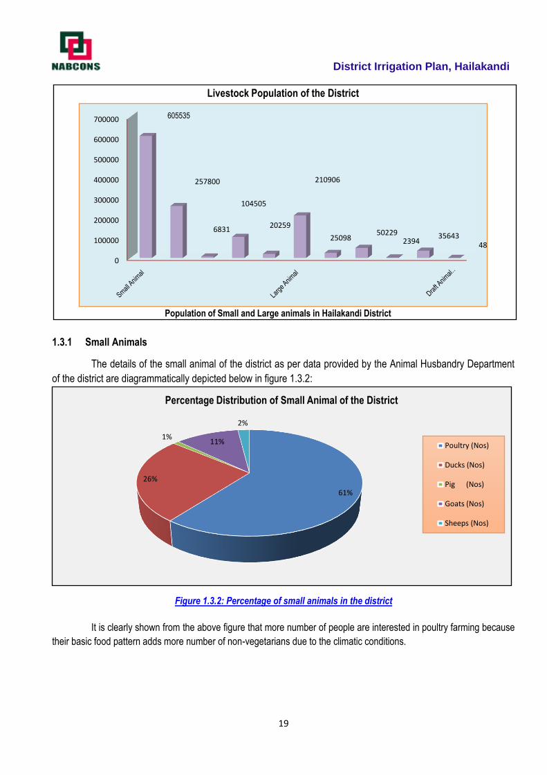
The total livestock of the district during the year 2015 is found to be 1319248 presented below in the figure 1.3.1:-
0
20000
40000
60000
80000
100000
120000
140000
160000
180000
MaleFemale
ChildrenSC
STGEN
52532 49154
19693 15554
144
10568156888 52900
23472
8002
8
1252508088477464
32824
18287302
172583
31162 29650
124549986
64
6321639104 37364
18343
14113
101
80597
Algapur Hailakandi Lala Katlicherra South Hailakandi
District Irrigation Plan, Hailakandi
19
1.3.1 Small Animals
The details of the small animal of the district as per data provided by the Animal Husbandry Department
of the district are diagrammatically depicted below in figure 1.3.2:
Figure 1.3.2: Percentage of small animals in the district
It is clearly shown from the above figure that more number of people are interested in poultry farming because
their basic food pattern adds more number of non-vegetarians due to the climatic conditions.
0
100000
200000
300000
400000
500000
600000
700000 605535
257800
6831
104505
20259
210906
2509850229
239435643
48
Livestock Population of the District
Population of Small and Large animals in Hailakandi District
61%
26%
1%11%
2%
Percentage Distribution of Small Animal of the District
Poultry (Nos)
Ducks (Nos)
Pig (Nos)
Goats (Nos)
Sheeps (Nos)
District Irrigation Plan, Hailakandi
20
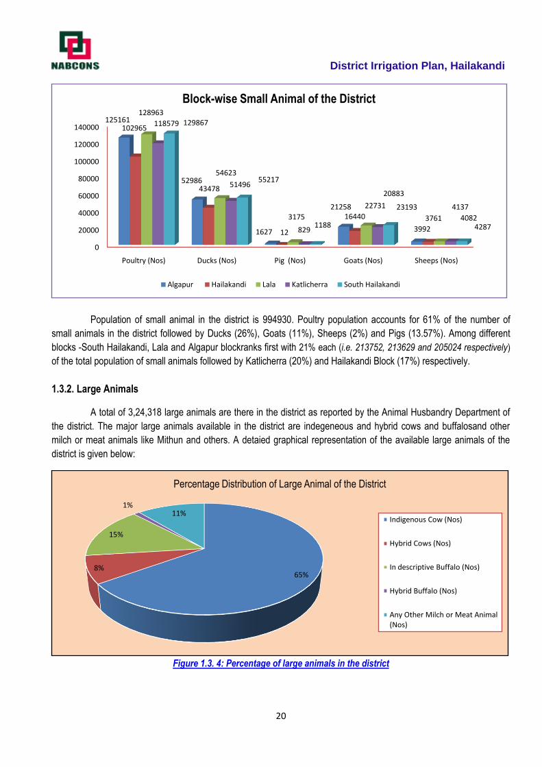
Population of small animal in the district is 994930. Poultry population accounts for 61% of the number of
small animals in the district followed by Ducks (26%), Goats (11%), Sheeps (2%) and Pigs (13.57%). Among different
blocks -South Hailakandi, Lala and Algapur blockranks first with 21% each (i.e. 213752, 213629 and 205024 respectively)
of the total population of small animals followed by Katlicherra (20%) and Hailakandi Block (17%) respectively.
1.3.2. Large Animals
A total of 3,24,318 large animals are there in the district as reported by the Animal Husbandry Department of
the district. The major large animals available in the district are indegeneous and hybrid cows and buffalosand other
milch or meat animals like Mithun and others. A detaied graphical representation of the available large animals of the
district is given below:
Figure 1.3. 4: Percentage of large animals in the district
0
20000
40000
60000
80000
100000
120000
140000
Poultry (Nos) Ducks (Nos) Pig (Nos) Goats (Nos) Sheeps (Nos)
125161
52986
1627
21258
3992
102965
43478
12
16440 3761
128963
54623
3175
22731 4137
118579
51496
829
20883
4082
129867
55217
1188
23193
4287
Block-wise Small Animal of the District
Algapur Hailakandi Lala Katlicherra South Hailakandi
65%8%
15%
1%11%
Percentage Distribution of Large Animal of the District
Indigenous Cow (Nos)
Hybrid Cows (Nos)
In descriptive Buffalo (Nos)
Hybrid Buffalo (Nos)
Any Other Milch or Meat Animal (Nos)
District Irrigation Plan, Hailakandi
21
Figure 1.3. 5: Block wise Large Animal Population
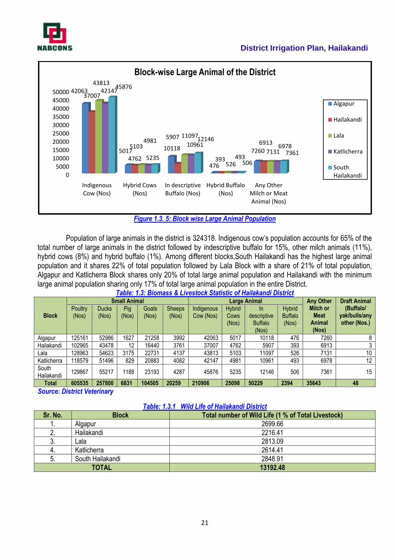
Population of large animals in the district is 324318. Indigenous cow‘s population accounts for 65% of the total number of large animals in the district followed by indescriptive buffalo for 15%, other milch animals (11%), hybrid cows (8%) and hybrid buffalo (1%). Among different blocks,South Hailakandi has the highest large animal population and it shares 22% of total population followed by Lala Block with a share of 21% of total population, Algapur and Katlicherra Block shares only 20% of total large animal population and Hailakandi with the minimum large animal population sharing only 17% of total large animal population in the entire District.
Table: 1.3: Biomass & Livestock Statistic of Hailakandi District
Block
Small Animal Large Animal Any Other Milch or
Meat Animal (Nos)
Draft Animal (Buffalo/
yak/bulls/any other (Nos.)
Poultry (Nos)
Ducks (Nos)
Pig (Nos)
Goats (Nos)
Sheeps (Nos)
Indigenous Cow (Nos)
Hybrid Cows (Nos)
In descriptive
Buffalo (Nos)
Hybrid Buffalo (Nos)
Algapur 125161 52986 1627 21258 3992 42063 5017 10118 476 7260 8
Hailakandi 102965 43478 12 16440 3761 37007 4762 5907 393 6913 3
Lala 128963 54623 3175 22731 4137 43813 5103 11097 526 7131 10
Katlicherra 118579 51496 829 20883 4082 42147 4981 10961 493 6978 12
South Hailakandi
129867 55217 1188 23193 4287 45876 5235 12146 506 7361 15
Total 605535 257800 6831 104505 20259 210906 25098 50229 2394 35643 48
Source: District Veterinary
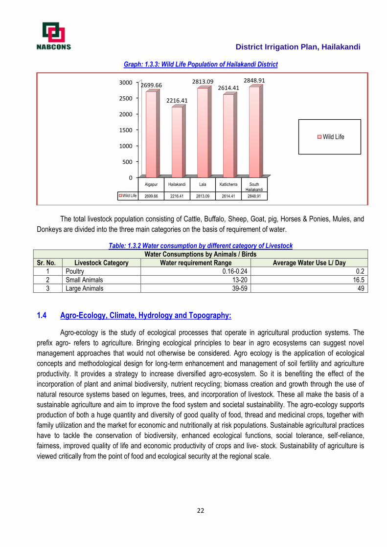
Table: 1.3.1 Wild Life of Hailakandi District
Sr. No. Block Total number of Wild Life (1 % of Total Livestock)
1. Algapur 2699.66
2. Hailakandi 2216.41
3. Lala 2813.09
4. Katlicherra 2614.41
5. South Hailakandi 2848.91
TOTAL 13192.48
0
500010000
15000
20000
25000
3000035000
40000
45000
50000
Indigenous Cow (Nos)
Hybrid Cows (Nos)
In descriptive Buffalo (Nos)
Hybrid Buffalo (Nos)
Any Other Milch or Meat Animal (Nos)
42063
5017 10118
476
7260
37007
4762
5907
393
6913
43813
5103
11097
526
7131
42147
498110961
493
6978
45876
5235
12146
506
7361
Block-wise Large Animal of the District
Algapur
Hailakandi
Lala
Katlicherra
South Hailakandi
District Irrigation Plan, Hailakandi
22
Graph: 1.3.3: Wild Life Population of Hailakandi District
The total livestock population consisting of Cattle, Buffalo, Sheep, Goat, pig, Horses & Ponies, Mules, and
Donkeys are divided into the three main categories on the basis of requirement of water.
Table: 1.3.2 Water consumption by different category of Livestock
Water Consumptions by Animals / Birds
Sr. No. Livestock Category Water requirement Range Average Water Use L/ Day
1 Poultry 0.16-0.24 0.2
2 Small Animals 13-20 16.5
3 Large Animals 39-59 49
1.4 Agro-Ecology, Climate, Hydrology and Topography:
Agro-ecology is the study of ecological processes that operate in agricultural production systems. The
prefix agro- refers to agriculture. Bringing ecological principles to bear in agro ecosystems can suggest novel
management approaches that would not otherwise be considered. Agro ecology is the application of ecological
concepts and methodological design for long-term enhancement and management of soil fertility and agriculture
productivity. It provides a strategy to increase diversified agro-ecosystem. So it is benefiting the effect of the
incorporation of plant and animal biodiversity, nutrient recycling; biomass creation and growth through the use of
natural resource systems based on legumes, trees, and incorporation of livestock. These all make the basis of a
sustainable agriculture and aim to improve the food system and societal sustainability. The agro-ecology supports
production of both a huge quantity and diversity of good quality of food, thread and medicinal crops, together with
family utilization and the market for economic and nutritionally at risk populations. Sustainable agricultural practices
have to tackle the conservation of biodiversity, enhanced ecological functions, social tolerance, self-reliance,
fairness, improved quality of life and economic productivity of crops and live- stock. Sustainability of agriculture is
viewed critically from the point of food and ecological security at the regional scale.
0
500
1000
1500
2000
2500
3000
Algapur Hailakandi Lala Katlicherra South Hailakandi
Wild Life 2699.66 2216.41 2813.09 2614.41 2848.91
2699.66
2216.41
2813.092614.41
2848.91
Wild Life
District Irrigation Plan, Hailakandi
23
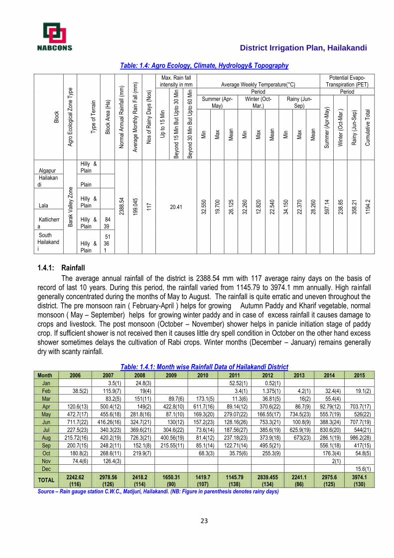
Table: 1.4: Agro Ecology, Climate, Hydrology& Topography
Blo
ck
Agr
o E
colo
gica
l Zon
e T
ype
Typ
e of
Ter
rain
Blo
ck A
rea
(Ha)
Nor
mal
Ann
ual R
ainf
all (
mm
)
Ave
rage
Mon
thly
Rai
n F
all (
mm
)
Nos
of R
ainy
Day
s (N
os)
Max. Rain fall intensity in mm Average Weekly Temperature(°C)
Potential Evapo-Transpiration (PET)
Up
to 1
5 M
in
Bey
ond
15 M
in B
ut U
pto
30 M
in
Bey
ond
30 M
in B
ut U
pto
60 M
in
Period Period
Summer (Apr-May)
Winter (Oct-Mar.)
Rainy (Jun-Sep)
Sum
mer
(A
pr-M
ay)
Win
ter
(Oct
-Mar
.)
Rai
ny (
Jun-
Sep
)
Cum
ulat
ive
Tot
al
Min
Max
Mea
n
Min
Max
Mea
n
Min
Max
Mea
n
Algapur
Bar
ak V
alle
y Z
one
Hilly & Plain
238
8.54
199.
045
117
20.41 32
.550
19.7
00
26.1
25
32.2
60
12.8
20
22.5
40
34.1
50
22.3
70
28.2
60
597.
14
238.
85
358.
21
1194
.2
Hailakandi Plain
Lala Hilly & Plain
Katlicherra
Hilly & Plain
8439
South Hailakandi
Hilly & Plain
51361
1.4.1: Rainfall
The average annual rainfall of the district is 2388.54 mm with 117 average rainy days on the basis of record of last 10 years. During this period, the rainfall varied from 1145.79 to 3974.1 mm annually. High rainfall generally concentrated during the months of May to August. The rainfall is quite erratic and uneven throughout the district. The pre monsoon rain ( February-April ) helps for growing Autumn Paddy and Kharif vegetable, normal monsoon ( May – September) helps for growing winter paddy and in case of excess rainfall it causes damage to crops and livestock. The post monsoon (October – November) shower helps in panicle initiation stage of paddy crop. If sufficient shower is not received then it causes little dry spell condition in October on the other hand excess shower sometimes delays the cultivation of Rabi crops. Winter months (December – January) remains generally dry with scanty rainfall.
Table: 1.4.1: Month wise Rainfall Data of Hailakandi District Month 2006 2007 2008 2009 2010 2011 2012 2013 2014 2015
Jan 3.5(1) 24.8(3) 52.52(1) 0.52(1)
Feb 38.5(2) 115.9(7) 19(4) 3.4(1) 1.375(1) 4.2(1) 32.4(4) 19.1(2)
Mar 83.2(5) 151(11) 89.7(6) 173.1(5) 11.3(6) 36.81(5) 16(2) 55.4(4)
Apr 120.6(13) 500.4(12) 149(2) 422.8(10) 611.7(16) 89.14(12) 370.6(22) 86.7(9) 92.79(12) 703.7(17)
May 472.7(17) 455.6(18) 281.8(16) 87.1(10) 169.3(20) 279.07(22) 166.55(17) 734.5(23) 555.7(19) 526(22)
Jun 711.7(22) 416.26(16) 324.7(21) 130(12) 157.2(23) 128.16(26) 753.3(21) 100.8(9) 388.3(24) 707.7(19)
Jul 227.5(23) 340.3(23) 369.6(21) 304.6(22) 73.6(14) 187.56(27) 385.6(19) 625.9(19) 830.6(20) 544(21)
Aug 215.72(16) 420.2(19) 726.3(21) 400.56(19) 81.4(12) 237.18(23) 373.9(18) 673(23) 286.1(19) 986.2(28)
Sep 200.7(15) 248.2(11) 152.1(8) 215.55(11) 85.1(14) 122.71(14) 495.5(21) 556.1(18) 417(15)
Oct 180.8(2) 268.6(11) 219.9(7) 68.3(3) 35.75(6) 255.3(9) 176.3(4) 54.8(5)
Nov 74.4(6) 126.4(3) 2(1)
Dec 15.6(1)
TOTAL 2242.62
(116) 2978.56
(126) 2418.2 (114)
1650.31 (90)
1419.7 (107)
1145.79 (138)
2839.455 (134)
2241.1 (86)
2975.6 (125)
3974.1 (130)
Source – Rain gauge station C.W.C., Matijuri, Hailakandi. (NB: Figure in parenthesis denotes rainy days)
District Irrigation Plan, Hailakandi
24
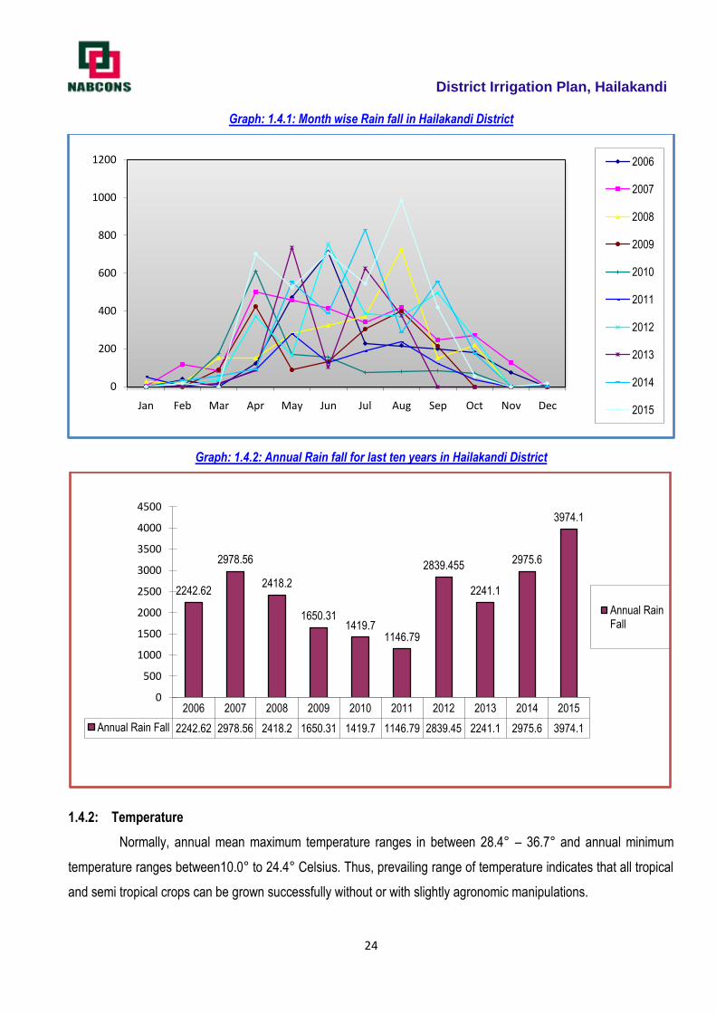
Graph: 1.4.1: Month wise Rain fall in Hailakandi District
Graph: 1.4.2: Annual Rain fall for last ten years in Hailakandi District
1.4.2: Temperature
Normally, annual mean maximum temperature ranges in between 28.4° – 36.7° and annual minimum
temperature ranges between10.0° to 24.4° Celsius. Thus, prevailing range of temperature indicates that all tropical
and semi tropical crops can be grown successfully without or with slightly agronomic manipulations.
0
200
400
600
800
1000
1200
Jan Feb Mar Apr May Jun Jul Aug Sep Oct Nov Dec
2006
2007
2008
2009
2010
2011
2012
2013
2014
2015
2006 2007 2008 2009 2010 2011 2012 2013 2014 2015
Annual Rain Fall 2242.62 2978.56 2418.2 1650.31 1419.7 1146.79 2839.45 2241.1 2975.6 3974.1
2242.62
2978.56
2418.2
1650.311419.7
1146.79
2839.455
2241.1
2975.6
3974.1
0
500
1000
1500
2000
2500
3000
3500
4000
4500
Annual Rain Fall
District Irrigation Plan, Hailakandi
25
Table: 1.4.2: Average weekly Temperature in °C
Year
Period
Summer (Apr-May) Winter (Oct-Mar.) Rainy (Jun-Sep)
Max Min Mean Max Min Mean Max Min Mean
2004 33.8 21.0 27.4 31.6 11.6 21.6 33.8 20.0 26.9
2005 33.3 21.1 27.15 30.6 12.8 21.7 33.8 23.3 28.55
2006 35.0 20.0 27.5 30.0 14.4 22.2 32.8 22.8 27.8
2007 32.3 21.5 26.9 32.2 15.0 23.6 32.3 23.8 28.3
2008 33.3 21.1 27.2 32.2 11.1 21.65 33.8 22.2 28.0
2009 28.4 22.2 25.3 31.1 12.2 21.65 32.2 22.2 27.2
2010 33.3 17.8 25.55 30.5 11.1 20.8 36.7 21.7 29.2
2011 30.0 16.7 23.35 35.6 10.0 22.8 36.1 24.4 30.25
2012 32.8 14.5 23.65 34.4 15.6 25.0 34.4 22.2 28.3
2013 33.3 21.1 27.2 34.4 14.4 24.4 35.6 21.1 28.35
Average of 2004 to 2013
32.55
19.7
26.125
32.26
12.82
22.54
34.15
22.37
28.26
Source: VigyanMandir, Hailakandi
1.4.3: Agro Climatic Zone and Agro Ecological Situations (AES):
The State has been delineated into six Agro Climatic Zones on the basis of Physiography, Climate, Soils,
Crops and Cropping Pattern. Southern part of the state delineated as Barak Valley Zone comprising of three
districts namely Cachar, Hailakandi and Karimganj. Hailakandi district with 132700 Hectares occupies 19.26% area
of the zone. Similarly the district has been further divided in five Agro Ecological Situation (AESs) Viz.
AES-I- Beel and Hoar situation (Covering Algapur, Hailakandi & Lala Block and 3% of the cultivable area) AES-II- Alluvial flood prone situation (Covering Algapur, Hailakandi, Lala, Katlicherra & South Hailakandi
Block and 15% of the cultivable area) AES-III- Alluvial flood free situation (Covering Algapur, Hailakandi, Lala, Katlicherra & South Hailakandi
Block and 17% of the cultivable area) AES-IV- Plantation crop growing situation (Covering Algapur, Hailakandi, Lala, Katlicherra & South
Hailakandi Block and 45% of the cultivable area) AES-V- Hill and forest situation (Covering Algapur Lala, Katlicherra & South Hailakandi Block and 20% of
the cultivable area) on the basis of Physiography, soil, climate, topography, cropping pattern etc.
Graph: 1.4.3: Diagram Showing Percentage coverage of AES
3% 15%
17%
45%
20%AES-I
AES-II
AES-III
AES-IV
AES-V
District Irrigation Plan, Hailakandi
26
1.5: Soil Profile:
Soil is a major part of the natural environment, alongside air and water, and is vital to the existence of life
on the planet. Soil is the result of the process of the gradual breakdown of rock - the solid geology that makes up
the earth. As rock becomes broken down through a variety of processes, such as weathering and erosion, the
particles become ground smaller and smaller. As a whole, soil is made up from four constituents: mineral material,
organic material, air and water. There are considered to be three main mineral parts to soil; ‗sand‘, ‗silt‘ and ‗clay‘.
These parts give the soil its 'mineral texture'. In addition, as leaves and other organic material fall to the ground and
decompose - there also forms an ‗organic‘ layer. Soil scientists (or pedologists) use a series of sieves to separate
out the constituent parts in order to characterize soil by texture class.
Many natural bodies, such as plants and animals, are discrete entities which can be classified and
guidelines for their identification followed. Soils are much more difficult to identify and classify than these discrete
bodies for two main reasons: (i) soil is more or less a continuum covering the land surface of the earth, not a set of
discrete entities; and (ii) most of the soil is below ground and therefore not readily visible. Soils grade into one
another across the landscape usually without sharp boundaries between one type of soil and another. Soil
surveyors who make maps of soils have to use their skills in reading changes in the landscape coupled with auger
borings in the soil to identify the nature of the soil.
There are several ways of classifying a soil, from the simple to the complex. A soil type may be as simple
as ‗a sandy soil‘ or ‗a clayey soil‘ and this is often the perception of many land users, such as farmers or civil
engineers, who see it as material they have to deal with to achieve an end result, such as the growing of a crop of
wheat, or the building a road. Simple classifications tend to be of local and restricted relevance only. At the other
end of the spectrum is the soil scientist who needs to understand how soils have formed, which types occur where,
and for what the different types of soil can be used. The soil scientist seeks a much broader understanding, with the
aim of underpinning the use and preservation of this important natural resource, and this has manifested itself in a
number of detailed soil classification systems worldwide.
Soils have many important functions. Perhaps the best appreciated is the function to support the growth of
agricultural and horticultural crops. Soil is the mainstay of agriculture and horticulture, forming as it does the
medium in which growth and ultimately the yield of food producing crops occurs. Farmers and gardeners have
worked with their soils over many centuries to produce increasing amounts of food to keep pace with the needs of a
burgeoning world population. The soil's natural cycles go a long way in ensuring that the soil can provide an
adequate physical, chemical and biological medium for crop growth. The farmer and horticulturalist have also
become skilled in managing soils so that these natural cycles can be added to as necessary to facilitate adequate
soil support and increasing yield to enhance production.
1.5:1: Structural Classification of Soil:
The soil of Barak valley zone owes their origin to Shillong plateau and other surrounding hills to a large
extent and the main river has also a minor contribution to it. The soils are formed from the sedimentary rocks like
sandstone, shale and sandy shale. Depending upon situations, the soil varies from sandy type to clay type with pH
from 4.5 to 5.9. The major classes of soil prevalent in the district are old riverine alluvial, old mountain alluvial, non-
laterite red soil and pit soil. Old riverine alluvial soil of the district is mainly confined to the banks of the river Barak,
Katakhal, Dhalaeswari; the texture varies from sandy to silky loam. The old mountain alluvial soil occurs in broad
plains bordering riverine alluvial soils. Soils of this group are generally silky to clay. Non-laterite soil group
comprises low-lying areas. The pit soils occur in scattered patches of low-lying areas locally called ―Beel and
District Irrigation Plan, Hailakandi
27
Haors‖. These soils are generally rich in organic matters, high in pH, usually dark grey in colour and heavy in
texture. The fertility status of soil denoted as high (H), medium (M) and low (L) on the basis of soil test report (2000)
of Soil Testing Laboratory, Silchar. The Block wise soil reaction and fertility status is presented in Table: 1.5.1
Table: 1.5.1: Soil Reaction and Fertility Status of Different Blocks of Hailakandi District
Block ADO Circle Soil pH Fertility Status
N P K
Algapur Panchgram 4.7-5.9 M M L
Boalipar 4.5-5.8 M M L
Hailakandi Hailakandi 4.8-5.7 L L L
Lala Lala HQ 4.6-4.9 M M L
Lala Bazar 4.7-5.4 L L L
Katlicherra Katlicherra 4.5-5.3 M M L
South Hailakandi Monipur 4.5-5.6 M M L
Source: Soil Testing Laboratory, Silchar
The soils of the district are classified in to (five) types viz. Tilla Land/Red Soil, Alluvial Soil, Sandy Soil, Sandy Loam, Clay & Clay Loam soils. 37.52% cultivable area of the district is occupied by Sandy Loam Soil; 31.76% by Alluvial Soil, 17.51% by Clay Loam Soil; 9.90% by Sandy Soil and 3.30% by Tilla Land/Red Soils. Tilla land/ Red Soil existed in only 3 (three) blocks viz. Lala, Katlicherra and South Hailakandi where as all other soils are existed in all the blocks of the district. Block wise classification of soil is presented below in Table: 1.5.2 and in Graph: 1.5.1. The data reveals that all type of tropical and semi tropical crops can be grown successfully with the some corrective measures.
Table: 1.5.2: Block wise Classification of Soil of Hailakandi District
Name of Block
Tilla Land/ Red Soil
Alluvial soil Sandy Soil Sandy Loam Soil
Clay & Clay Loam Soil
Total Cultivable area
Area % Area % Area % Area % Area %
Algapur - - 4632 43 1293 12 3124 29 1723 16 10772
Hailakandi - - 4034 32 1008 8 5168 41 2395 19 12605
Lala 928 5 5385 29 2043 11 7056 38 3157 17 18569
Katlicherra 372 6 1612 26 439 8 2602 42 1116 18 6195
South Hailakandi 552 7 2131 27 710 9 3078 39 1421 18 7892
TOTAL 1852 17794 5547 21028 9812 56033
Source: District Agriculture Office, Hailakandi
Graph: 1.5.1: Block wise Classification of Soil of Hailakandi District
0
1000
2000
3000
4000
5000
6000
7000
8000
Tilla Land/ Red Soil
Alluvial Soil Sandy Soil Sandy Loam Clay & Clay Loam
0
4632
1293
3124
1723
0
4034
1008
5168
2395
928
5385
2043
7056
3157
372
1612
439
2602
1116
552
2131
710
3078
1421
Algapur
Hailakandi
Lala
Katlicherra
South Hailakandi
District Irrigation Plan, Hailakandi
28
(i) Tilla Land / Red Soil
Red soils are formed as a result of the draining down of old crystalline rock, less clayey and sandier in
nature. This is having a rich content of iron plus small humus content. The content of essential nutrient like
nitrogen, phosphorus and lime is very less in red soils. Slightly acidic, it is incapable of retain moisture. It is due to
the presence of iron dioxide deposits, that red soils get the unique red tint and are comparatively infertile because
of lime deficiency and soluble salt content. Red soils in India are alternatively known as Yellow Soil.
(ii) Alluvial Soil
Alluvial relating to or derived from alluvium. Alluvial soils are formed mainly due to silt deposited by Indo-
Gangetic-Brahmaputra Rivers. Alluvial soils is porous because of its loamy (equal portion sand and clay) nature.
Porosity and texture provide good drainage and other condition favourable for agriculture. The proportion of
nitrogen is generally low. The proportion of potash, phosphoric acid and alkaline are adequate. The proportion of
iron dioxide and lime vary within a wide range.
Alluvial soils are mostly flat and regular soils and are best suited for agriculture.
(iii) Sandy Soil
Sandy soil has the largest particles among the different soil types. It is dry and gritty to the touch and
because the particles have huge spaces between them, it cannot hold on to water. Water and nutrients quickly
drain away from the plant root zone. Sandy soil is opposite of clay soil.
(iv) Sandy Loam Soil
Sandy loam soil is a type of soil used in plant beds and pots that require ample drainage for the plants to
thrive. Sandy loam soil is a mixture that is generally well balanced, but has sand as a dominant component. Perfect
loamy soil is ideal for most growing, and contains an even mixture of sand, silt and clay in roughly even proportions.
Type of sandy loam are categorized by the size of sand and include coarse sandy loam, sandy loam, fine
sandy loam and very fine sandy loam. Sandy loam soils are made of approximately 60% sand, 10% clay and 30%
silt particles. Plants that are grown in a sandy loam soil need frequent irrigation and fertilization to maintain healthy
growth. The best way to improve a sandy loam soil for gardening is to mix organic matter into the soil.
(v) Clay & Clay Loam Soil
Clay soil has the smallest particles so it has good water storage qualities. It is sticky to the touch when
wet, but smooth when dry.
Due to the tiny size of its particles and its tendency to settle together, little air passes through its spaces.
Because it is also slower to drain it has a tighter hold on plant nutrients. Clay soil is thus rich in plant food for better
growth.
Clay loam is a soil mixture that contains more clay than type of rock and minerals. The particles of clay
are very small, which is one of its important characteristic. Usually clay loam contains a good deal of plant nutrients
and supports most types of plants and crops. Clay loams can be improved to create better drainage without too
much difficulty.
District Irrigation Plan, Hailakandi
29
Graph: 1.5.2: Classification of Soil (Cultivable land) of Hailakandi District
1.5.2: Land Slope:
Slope of land is also one of the important physiographic aspects influencing the land use of an area. The
effect of slope on agriculture may be both direct and indirect. The most obvious direct influence of slope is in the
form of the restrained on cultivation and accessibility. The indirect effect of slope manifests itself in pedological and
climatic modification including the position of water table, development of soils, air drainage, and relative freedom
from frost. This classification gives information regarding slope percent classes in the study area.
Table 1.5.3 Slope Category Slope Category Slope Class
Nearly level 0-1 %
Very gently sloping 1-3 %
Gently sloping 3-8 %
Strongly sloping 8-15 %
Mod. steep to steep 15-35 %
Steep sloping 35-45 %
Very Steep sloping >45 %
Table: 1.5.4 Land Slope Pattern of Hailakandi District
Slope Class Algapur Hailakandi Lala Katlicherra South Hailakandi
0-3%- Nearly Level
3-8%- Very Gently Sloping
8-25%- Strongly Sloping
>25%- Steep Sloping
1.6: ` Soil Erosion and Run-off Status:
Soil erosion is a naturally occurring process that affects all landforms. In agriculture, soil erosion refers to
the wearing away of a field's topsoil by the natural physical forces of weather and wind or through forces associated
with farming activities such as tillage.Erosion, whether it is by water, wind or tillage, involves three distinct actions –
soil detachment, movement and deposition. Topsoil, which is high in organic matter, fertility and soil life, is
relocated elsewhere "on-site" where it builds up over time or is carried "off-site" where it fills in drainage channels.
1852
17794
554721028
9812Tilla Land/ Red Soil
Alluvial Soil
Sandy Soil
Sandy Loam
Clay & Clay Loam
District Irrigation Plan, Hailakandi
30
Soil erosion reduces cropland productivity and contributes to the pollution of adjacent watercourses, wetlands, and
lakes.
Soil erosion can be a slow process that continues relatively unnoticed or can occur at an alarming rate,
causing serious loss of topsoil. Soil compaction, low organic matter, loss of soil structure, poor internal drainage,
salinization, and soil acidity problems are other serious soil degradation conditions that can accelerate the soil
erosion process. The greater the intensity and duration of a rainstorm, the higher the erosion potential. The impact
of raindrops on the soil surface can break down soil aggregates and disperse the aggregate material. Lighter
aggregate materials such as very fine sand, silt, clay and organic matter are easily removed by the raindrop splash
and runoff water; greater raindrop energy or runoff amounts are required to move larger sand and gravel
particles.Soil movement by rainfall (raindrop splash) is usually greatest and most noticeable during short-duration,
high-intensity thunderstorms. Although the erosion caused by long-lasting and less-intense storms is not usually as
spectacular or noticeable as that produced during thunderstorms, the amount of soil loss can be significant,
especially when compounded over time.
Data of soil erosion is not available for this district as remote sensing based soil erosion potential map
and data attached and there is no sedimentary monitoring station.
1.7 Land use Pattern
1.7.1. Concept of Land use
Land use is a function of four variables - land, water, air and man, each plays in its own role in composing
its life history. Land constitutes its body; water runs through its veins like blood, air gives it oxygen and man acts as
the dynamic actor to reflect its types, pattern and distribution. Land varies in altitudes, forms and expressions. Man
has played his part on land to portray the different phases of his ties with it. The Homo-sapiens moved from one
topography to another where climate, flora and fauna also changed. He used land, flora and fauna to fit his limited
wants. Men multiplied, their wants increased and become complex, the uses of land also increased, methods and
technology also changed. Man was making his own map on the face of the earth to portray his link, adaptation,
creation and destruction. Man has cleared the forest for shifting (Jhum) cultivation. He then used the land for large-
scale farming, small-scale farming, intensive farming, mixed farming, dry farming, etc. He has used the land for one
crop or another is a minor land use problem, but to use each plot of land for the right cultivation under optimum
conditions to obtain optimum yield is a significant problem. Man has learnt the use of grasslands, semi-arid and arid
lands to his own advantage by applying improved methodology and utilization of his accomplishments.
Over a period, geographic pattern of agricultural land use are the outcome of concurrent interaction
between the variable combinations of natural condition and human circumstances. Primarily, these are influenced
by natural condition and thereafter affected by human circumstances because of their colonizing capability. The
human circumstances are mainly responsible for dynamism in agriculture land use or changing cropland
occupancy. Therefore, efficient cropland occupancy, say cropping pattern, implies the most successful use of
agriculture land, consequent upon development of irrigation facilities and application of modern methods of farm
technology. The key to the most important aspect of land use lies in the relation of population to land. The crux of
the review, therefore, refers to the study of the problems in use of land by man. According to R.H. Best, the term
land use deals with the spatial aspects of human activities on the Land and with the way in which the land surface
is adapted or could be adapted, to serve human needs. This leads one back to the village farm and farmer, to the
fields, gardens, pastures, fallow land, forest and to the isolated farmstead (Freeman, 1960). The land use shifts
District Irrigation Plan, Hailakandi
31
from agricultural uses to residential, industrial, transportation, neighbourhood retail and service activities due to
urbanization. A true nature of these dynamic qualities in land use emerges from a historical survey designed to
reveal the successive development of inherent characteristics of land because 'some changes are short-lived
whereas others represent a more constant demand' (Jackson, 1963).
1.7.2: Land Use Classification
The conservation and development of land resource is in area needs special focus. It needs well thought
and rational planning, which in turn depends upon minute observation of land use pattern. The aim of this study is
clear visualization of local land environment. The intense and focused study of the details of land use puts us in a
position to conserve the important elements of the nature, which otherwise lead in a direction of destruction and
consequently threaten the social strata. The present study focuses mainly on dimension, which is very important
from the sustainability point of view that is distribution of different groups of land use, i.e. their ratios in the region.
Therefore, it becomes very complex and diversified to study all the groups available at micro-level, homogenous
groups are generalized to reduce the number of groups, and these simplified groups of land use are called
generalized land use classification.
World Land Use Classification mainly recognizes nine categories. These are Settlement and Associated
Non Agricultural Land, Horticulture, Tree and Permanent Crops, Crop Land, Improved Permanent Pasture,
Improved Grazing Land, Wood Land, Swamps and Marshes, Unproductive Land.
In India, a standard classification system is yet to develop. National Atlas and The land use classification
presented by All India Soil and Land Use Survey 1970 are as follows:
1. Forest Land (F) F1 without Canopy F2 Sparse Forest F3 General Forest F4 Fully Stocked Top Canopy
2. Cultivated land (CC) C1 Single Cropped C2 Double Cropped C3 Triple Cropped
3. Terraced Land (T) T1 Poorly Bounded Land T2 Poor Terracing Measures T3 Bench Terraces
4. Waste Land (W) W1 Fit for Cultivation W2 Unfit for Cultivation
5. Pasture Land (P) P Pasture and Grazing Land H Hay Land When the Grass Periodically Cut P1 With
Young Shrubs P2 With Well Grows Shrubs T Thorny Lands and Heavy Canopy Shrubs.
Land use classification by Statistical Department of Government of India.
I. Geographical Area - Area calculated by Survey Department.
II. Reported Area (Statistical area related to land use)
1. Forest.
2. Land not Available for Cultivation. a) Land Put to Non- Agricultural Use.
b) Barren and Uncultivable Land.
3. Other Uncultivable and excluding Fallow Land.
a) Permanent Pastures and Other Grazing Land.
b) Miscellaneous Tree Crops and Gardens.
c) Cultivable Waste Land.
4. Fallow Land

District Irrigation Plan, Hailakandi
32
a) Fallow Other than Current Fallow
b) Current Fallow
5. Cultivated Land a) Net Sown Area, b) Area Sown More Than Once.
I. Net Irrigated Area.
II. Total Irrigated Area.
The analysis of land use in the present study is based on district statistical magazine, data available at
block level and revenue office. Following categories of land use have been recognized in the study area. In the
analysis of land use pattern study has been adopted at block level: Forest Cover, Barren and cultivable waste land,
Current Fallow land, Other Fallow land, Barren & uncultivable Land, Land put to non-agricultural Use, Pastures and
Grazing Land, Area under bush, forest & garden, Net area sown.
1.7.3: Built-Up Land
It is an area of human habitation developed due to non-agricultural use and that has a cover of buildings,
transport and communication, utilities in association with water, vegetationand vacant lands. For delineating built –
up land built up polygons interpreted under settlement.
1.7.4. Built-up Land (Urban)
All places with a municipality, corporation or cantonment or which are notified as town areas and all other
places which satisfy the criteria of a minimum population of 5000, at least 75 per cent of whose male working
population is non-agricultural and having a density of population of at least 400 per sq. km. are placed under this
category (Census of India). It comprises areas of intensive use with much of the land covered by intensive use and
covered by structures. It includes residential, recreational, public & semi-public, transportation, communication and
isolated areas such as parks, playgrounds, open spaces and vegetated areas.
1.7.5. Built-Up Area (Rural)
These are the lands used for human settlement and are of size comparatively less than the urban
settlements of which more than 80% of the people are involved in the primary activity of agriculture. All the
agricultural villages covering 5 hectares area and more are included in this category. These are the built-up areas,
smaller in size, mainly associated with agriculture and allied sectors and non-commercial activities with population
size less than 5000, generally lack supporting facilities that are unique to urban areas like hospitals, industries
(large and medium scale), institutional etc. They appear in dark bluish green in the core built-up area and bluish in
the periphery; the size varies from small to big; irregular and discontinuous in appearance; can be seen in clusters
con-contiguous or scattered.
1.7.6. Agricultural Land
These are the lands primarily used for farming and for production of food, fiber, and other commercial and
horticultural crops. It includes land under crops (irrigated and unirrigated, fallow, plantations etc.).
District Irrigation Plan, Hailakandi
33
1.7.7. Cropland
These are the areas with standing crop as on the date of satellite overpass. Cropped areas appear in
bright red to red in color with varying shape and size in a contiguous to non-contiguous pattern. They are widely
distributed in different terrains; prominently appear in the irrigated areas irrespective of the source of irrigation.
1.7.8. Forest
These are the areas bearing an association predominantly of trees and other vegetation types (within the
notified forest boundaries) capable of producing timber and other forest produce. They comprise of thick and dense
canopy of tall trees, which can be evergreen, semi evergreen or deciduous (moist/dry/thorn). Evergreen forest
includes both coniferous and tropical broadleaved evergreen species and predominantly remains green throughout
the year. Semi-evergreen is a forest type that includes a combination of evergreen and deciduous species with the
former dominating the canopy cover. Deciduous forest types are of predominantly composed of species, which
shed their leaves once a year, especially during summer. They exhibit bright red to dark red in color in varying
sizes, smooth to medium texture depending on the crown density, contiguous to non-contiguous in pattern based
on their location. The size can be irregular and discontinuous occupying medium relief mountain/hill slopes within
the notified areas. Forest blank are the openings amidst forest areas, devoid of tree cover, observed as openings of
assorted size and shapes as manifested on the imagery. They appear in light yellow to light brown in tone,
generally small in size. They possess regular to irregular shape, scattered in the forested areas. Most of these
areas are seen along hill tops/slopes midst forest areas. Forest blanks are also to be included in this category.
1.7.8.1. Dense/Closed
This category includes all the areas where the canopy cover/density is more than 40%.
1.7.8.2. Open/Degraded
This category includes all the forest areas where the canopy cover/density ranges between 10 – 40%.
1.7.9. Wastelands
Wasteland is described as degraded land which can be brought under vegetative cover with reasonable
effort and which is currently underutilized and land which is deteriorating for lack of appropriate water and soil
management or an account of natural causes. Wastelands can result from inherent / imposed disabilities such as
by location, environment.
1.7.10. Dense Scrub
These areas possess shallow and skeletal soils, at times chemically degraded, extremes of slopes,
severely eroded and lands subjected to excessive aridity with scrubs dominating the landscape. They have a
tendency for intermixing with cropped areas.
1.7.11. Open Scrub
This category has a similar description as mentioned in the earlier class excepting that they possess
sparse vegetation or devoid of scrub and have a thin soil cover.
District Irrigation Plan, Hailakandi
34
1.7.12. Barren/Rocky/Stony Waste
These are rock exposures of varying lithology often barren and devoid of soil and vegetation cover. They
occur amidst hill-forests as openings or as isolated exposures on plateau and plains. Such lands can be easily
discriminated from other categories of wastelands because of their characteristic spectral response. They appear in
greenish blue to yellow to brownish in color depending on the rock type. They vary in size with irregular to
discontinuous shape with a linear to contiguous or dispersed pattern. They are located in steep isolated hillocks/hill
slopes, crests, plateau and eroded plains associated with barren and exposed rocky/stony wastes, lateritic
outcrops, mining and quarrying sites.
1.7.13. Water Bodies
This category comprises areas with surface water, either impounded in the form of ponds, lakes and
reservoirs or flowing as streams, rivers, canals etc. These are seen clearly on the satellite image in blue to dark
blue or cyan color depending on the depth of water.
1.7.13.1. River /Stream/Canal
Rivers/streams are natural course of water flowing on the land surface along a definite channel/slope
regularly or intermittently towards a sea in most cases or a lake or an inland basin in desert areas or a marsh or
another river. Depending upon the nature of availability of water, rivers are sub-divided into perennial or seasonal.
They appear in light to dark blue in colour, long, narrow to wide depending on the size of the river. They appear in
contiguous, at times non linear pattern and associated with drainage pattern on hill slopes, flood plains or uplands,
at times with vegetation along the banks.
1.7.13.2. Lakes / Ponds
These are accumulation of water in a depression of various sizes either natural or saline Lakes / ponds
are those that retain water in them either for one season or throughout the year and usually not subject to extreme
fluctuation in water level. Ponds are body of water limited in size, either natural or artificial, regular in shape, smaller
in size than a lake, generally located near settlements.
1.7.13.3. Reservoir / Tanks
Reservoir is an artificial lake created by construction of a dam across the river specifically for irrigation,
and water supply for domestic/industrial needs, flood control, etc., either singly or in combination. Tanks are small
lakes of impounded water ways constructed on land surface for irrigation. They appear in light blue to dark blue
depending on the depth from small to large sizes. They possess regular to irregular shape dispersed to linear,
occupying lowlands, plains. They are associated with croplands, low lands and reservoirs surrounded by hills with
or without vegetation.
The total geographical area (TGA) of Hailakandi is 132700 hectare. The largest Block of the district is
South Hailakandi which comprises of a TGA of 51,361 hectare i.e. about 38.7% of the TGA of the district.
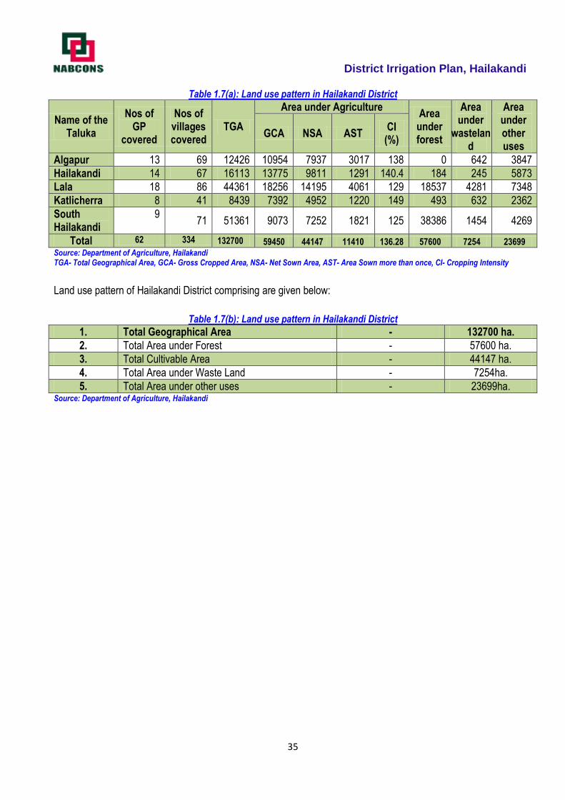
District Irrigation Plan, Hailakandi
35
Table 1.7(a): Land use pattern in Hailakandi District
Name of the Taluka
Nos of GP
covered
Nos of villages covered
TGA
Area under Agriculture Area
under forest
Area under
wasteland
Area under other uses
GCA NSA AST CI
(%)
Algapur 13 69 12426 10954 7937 3017 138 0 642 3847
Hailakandi 14 67 16113 13775 9811 1291 140.4 184 245 5873
Lala 18 86 44361 18256 14195 4061 129 18537 4281 7348
Katlicherra 8 41 8439 7392 4952 1220 149 493 632 2362
South Hailakandi
9 71 51361 9073 7252 1821 125 38386 1454 4269
Total 62 334 132700 59450 44147 11410 136.28 57600 7254 23699 Source: Department of Agriculture, Hailakandi TGA- Total Geographical Area, GCA- Gross Cropped Area, NSA- Net Sown Area, AST- Area Sown more than once, CI- Cropping Intensity
Land use pattern of Hailakandi District comprising are given below:
Table 1.7(b): Land use pattern in Hailakandi District
1. Total Geographical Area - 132700 ha.
2. Total Area under Forest - 57600 ha.
3. Total Cultivable Area - 44147 ha.
4. Total Area under Waste Land - 7254ha.
5. Total Area under other uses - 23699ha. Source: Department of Agriculture, Hailakandi
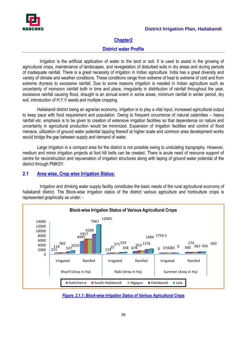
District Irrigation Plan, Hailakandi
36
Chapter2
District water Profile
Irrigation is the artificial application of water to the land or soil. It is used to assist in the growing of
agricultural crops, maintenance of landscapes, and revegetation of disturbed soils in dry areas and during periods of inadequate rainfall. There is a great necessity of irrigation in Indian agriculture. India has a great diversity and variety of climate and weather conditions. These conditions range from extreme of heat to extreme of cold and from extreme dryness to excessive rainfall. Due to some reasons irrigation is needed in Indian agriculture such as uncertainty of monsoon rainfall both in time and place, irregularity in distribution of rainfall throughout the year, excessive rainfall causing flood, draught is an annual event in some areas, minimum rainfall in winter period, dry soil, introduction of H.Y.V seeds and multiple cropping.
Hailakandi district being an agrarian economy, irrigation is to play a vital input, increased agricultural output to keep pace with food requirement and population. Owing to frequent occurrence of natural calamities – heavy rainfall etc. emphasis is to be given to creation of extensive irrigation facilities so that dependence on nature and uncertainty in agricultural production would be minimized. Expansion of irrigation facilities and control of flood menace, utilization of ground water potential tapping thereof at higher scale and common area development works would bridge the gap between supply and demand of water.
Large irrigation in a compact area for the district is not possible owing to undulating topography. However, medium and minor irrigation projects at foot hill belts can be created. There is acute need of resource support of centre for reconstruction and rejuvenation of irrigation structures along with taping of ground water potential of the district through PMKSY.
2.1 Area wise, Crop wise Irrigation Status:
Irrigation and drinking water supply facility constitutes the basic needs of the rural agricultural economy of hailakandi district. The Block-wise irrigation status of the district various agriculture and horticulture crops is represented graphically as under: -
Figure. 2.1.1: Block-wise Irrigation Status of Various Agricultural Crops
02000400060008000
100001200014000
Irrigated Rainfed Irrigated Rainfed Irrigated Rainfed
Kharif (Area in Ha) Rabi (Area in Ha) Summer (Area in Ha)
221
4945
114 678 0 300114
5927
25923
0274902
6268
371 1176592 997537
7967
224
1484
50 4561019
12045
358
1754.5
0450
Block-wise Irrigation Status of Various Agricultural Crops
Katlicherra South Hailakandi Algapur Hailakandi Lala
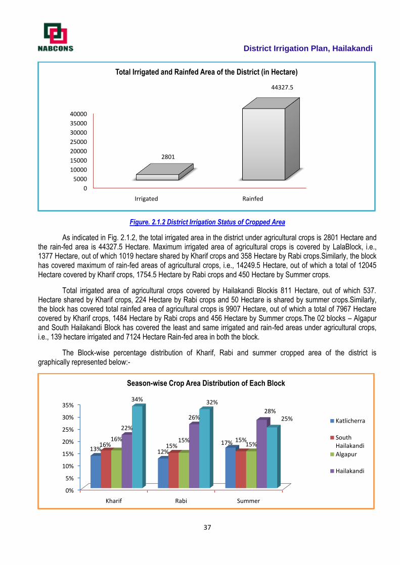
District Irrigation Plan, Hailakandi
37
Figure. 2.1.2 District Irrigation Status of Cropped Area
As indicated in Fig. 2.1.2, the total irrigated area in the district under agricultural crops is 2801 Hectare and the rain-fed area is 44327.5 Hectare. Maximum irrigated area of agricultural crops is covered by LalaBlock, i.e., 1377 Hectare, out of which 1019 hectare shared by Kharif crops and 358 Hectare by Rabi crops.Similarly, the block has covered maximum of rain-fed areas of agricultural crops, i.e., 14249.5 Hectare, out of which a total of 12045 Hectare covered by Kharif crops, 1754.5 Hectare by Rabi crops and 450 Hectare by Summer crops.
Total irrigated area of agricultural crops covered by Hailakandi Blockis 811 Hectare, out of which 537. Hectare shared by Kharif crops, 224 Hectare by Rabi crops and 50 Hectare is shared by summer crops.Similarly, the block has covered total rainfed area of agricultural crops is 9907 Hectare, out of which a total of 7967 Hectare covered by Kharif crops, 1484 Hectare by Rabi crops and 456 Hectare by Summer crops.The 02 blocks – Algapur and South Hailakandi Block has covered the least and same irrigated and rain-fed areas under agricultural crops, i.e., 139 hectare irrigated and 7124 Hectare Rain-fed area in both the block.
The Block-wise percentage distribution of Kharif, Rabi and summer cropped area of the district is graphically represented below:-
0
5000
10000
15000
20000
25000
30000
35000
40000
Irrigated Rainfed
2801
44327.5
Total Irrigated and Rainfed Area of the District (in Hectare)
0%
5%
10%
15%
20%
25%
30%
35%
Kharif Rabi Summer
13% 12%
17%16% 15%15%16% 15%
15%
22%
26%28%
34% 32%
25%
Season-wise Crop Area Distribution of Each Block
Katlicherra
South Hailakandi
Algapur
Hailakandi

District Irrigation Plan, Hailakandi
38
As regards horticulture crops, the district has covered a total of 2974 Hectare of land under horticulture.
All the Horticulture cropped area of the district is rain-fed. No irrigated area is under horticulture crops in the district.
Lala Block has maximum of 1079 hectare horticulture cropped area followed by Hailakandi and katlicherra block
with 856 hectare and 835 hectare respectively. The Block-wise horticulture crop area distribution of the district is
represented graphically as follows:
Figure 2.1.3: Block wise Area Under Rain-fed for Horticultural Crops
0
200
400
600
800
1000
1200
Katlicherra South Hailakandi Algapur Hailakandi Lala
835
102102
856
1079
Block wise Horticulture Crop Area in the District (in hectare)
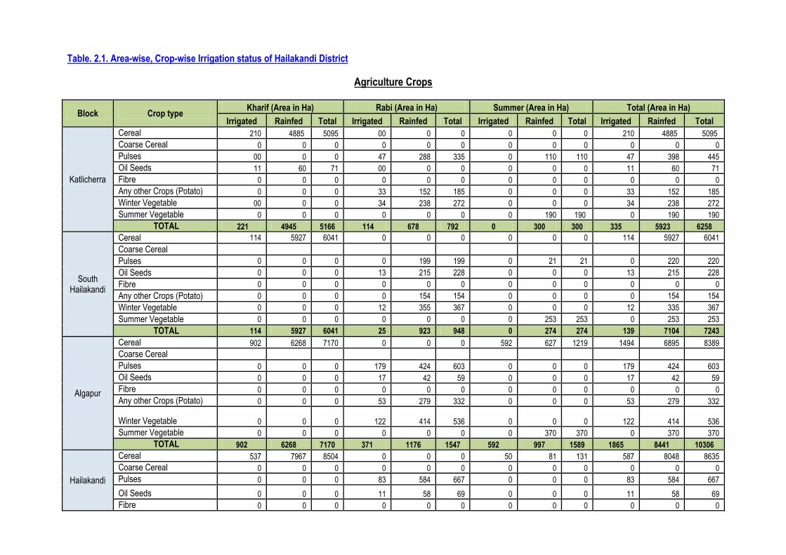
Table. 2.1. Area-wise, Crop-wise Irrigation status of Hailakandi District
Agriculture Crops
Block Crop type Kharif (Area in Ha) Rabi (Area in Ha) Summer (Area in Ha) Total (Area in Ha)
Irrigated Rainfed Total Irrigated Rainfed Total Irrigated Rainfed Total Irrigated Rainfed Total
Katlicherra
Cereal 210 4885 5095 00 0 0 0 0 0 210 4885 5095
Coarse Cereal 0 0 0 0 0 0 0 0 0 0 0 0
Pulses 00 0 0 47 288 335 0 110 110 47 398 445
Oil Seeds 11 60 71 00 0 0 0 0 0 11 60 71
Fibre 0 0 0 0 0 0 0 0 0 0 0 0
Any other Crops (Potato) 0 0 0 33 152 185 0 0 0 33 152 185
Winter Vegetable 00 0 0 34 238 272 0 0 0 34 238 272
Summer Vegetable 0 0 0 0 0 0 0 190 190 0 190 190
TOTAL 221 4945 5166 114 678 792 0 300 300 335 5923 6258
South Hailakandi
Cereal 114 5927 6041 0 0 0 0 0 0 114 5927 6041
Coarse Cereal
Pulses 0 0 0 0 199 199 0 21 21 0 220 220
Oil Seeds 0 0 0 13 215 228 0 0 0 13 215 228
Fibre 0 0 0 0 0 0 0 0 0 0 0 0
Any other Crops (Potato) 0 0 0 0 154 154 0 0 0 0 154 154
Winter Vegetable 0 0 0 12 355 367 0 0 0 12 335 367
Summer Vegetable 0 0 0 0 0 0 0 253 253 0 253 253
TOTAL 114 5927 6041 25 923 948 0 274 274 139 7104 7243
Algapur
Cereal 902 6268 7170 0 0 0 592 627 1219 1494 6895 8389
Coarse Cereal Pulses 0 0 0 179 424 603 0 0 0 179 424 603
Oil Seeds 0 0 0 17 42 59 0 0 0 17 42 59
Fibre 0 0 0 0 0 0 0 0 0 0 0 0
Any other Crops (Potato) 0 0 0 53 279 332 0 0 0 53 279 332
Winter Vegetable 0 0 0 122 414
536 0 0 0 122 414
536
Summer Vegetable 0 0 0 0 0 0 0 370 370 0 370 370
TOTAL 902 6268 7170 371 1176 1547 592 997 1589 1865 8441 10306
Hailakandi
Cereal 537 7967 8504 0 0 0 50 81 131 587 8048 8635
Coarse Cereal 0 0 0 0 0 0 0 0 0 0 0 0
Pulses 0 0 0 83 584 667 0 0 0 83 584 667
Oil Seeds 0 0 0 11 58 69 0 0 0 11 58 69
Fibre 0 0 0 0 0 0 0 0 0 0 0 0
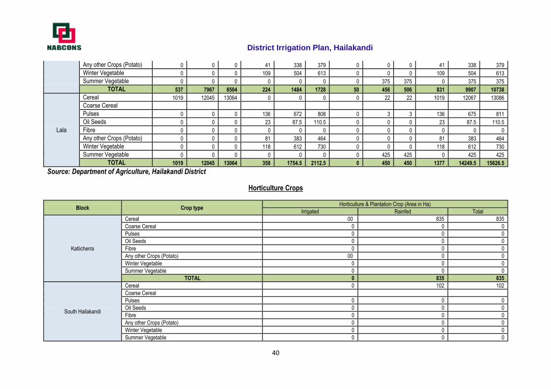
District Irrigation Plan, Hailakandi
40
Any other Crops (Potato) 0 0 0 41 338 379 0 0 0 41 338 379
Winter Vegetable 0 0 0 109 504 613 0 0 0 109 504 613
Summer Vegetable 0 0 0 0 0 0 0 375 375 0 375 375
TOTAL 537 7967 8504 224 1484 1728 50 456 506 831 9907 10738
Lala
Cereal 1019 12045 13064 0 0 0 0 22 22 1019 12067 13086
Coarse Cereal
Pulses 0 0 0 136 672 808 0 3 3 136 675 811
Oil Seeds 0 0 0 23 87.5 110.5 0 0 0 23 87.5 110.5
Fibre 0 0 0 0 0 0 0 0 0 0 0 0
Any other Crops (Potato) 0 0 0 81 383 464 0 0 0 81 383 464
Winter Vegetable 0 0 0 118 612 730 0 0 0 118 612 730
Summer Vegetable 0 0 0 0 0 0 0 425 425 0 425 425
TOTAL 1019 12045 13064 358 1754.5 2112.5 0 450 450 1377 14249.5 15626.5
Source: Department of Agriculture, Hailakandi District
Horticulture Crops
Block Crop type Horticulture & Plantation Crop (Area in Ha)
Irrigated Rainfed Total
Katlicherra
Cereal 00 835 835
Coarse Cereal 0 0 0
Pulses 0 0 0
Oil Seeds 0 0 0
Fibre 0 0 0
Any other Crops (Potato) 00 0 0
Winter Vegetable 0 0 0
Summer Vegetable 0 0 0
TOTAL 0 835 835
South Hailakandi
Cereal 0 102 102
Coarse Cereal
Pulses 0 0 0
Oil Seeds 0 0 0
Fibre 0 0 0
Any other Crops (Potato) 0 0 0
Winter Vegetable 0 0 0
Summer Vegetable 0 0 0
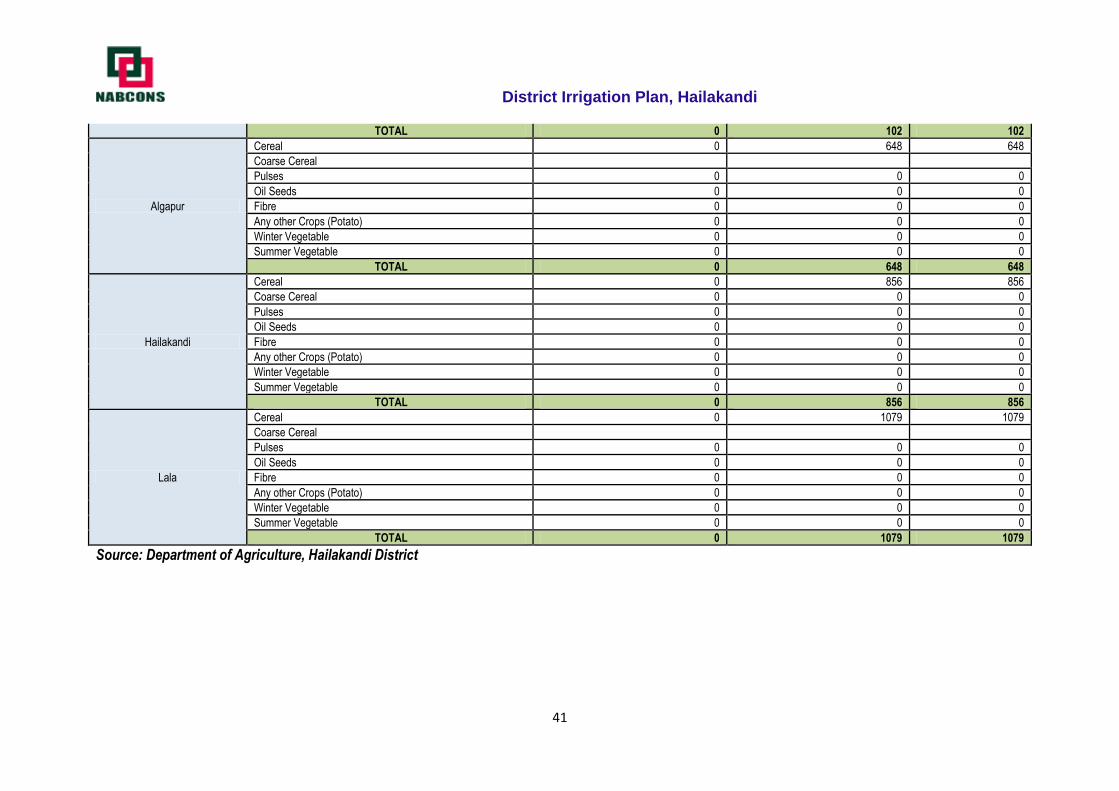
District Irrigation Plan, Hailakandi
41
TOTAL 0 102 102
Algapur
Cereal 0 648 648
Coarse Cereal
Pulses 0 0 0
Oil Seeds 0 0 0
Fibre 0 0 0
Any other Crops (Potato) 0 0 0
Winter Vegetable 0 0 0
Summer Vegetable 0 0 0
TOTAL 0 648 648
Hailakandi
Cereal 0 856 856
Coarse Cereal 0 0 0
Pulses 0 0 0
Oil Seeds 0 0 0
Fibre 0 0 0
Any other Crops (Potato) 0 0 0
Winter Vegetable 0 0 0
Summer Vegetable 0 0 0
TOTAL 0 856 856
Lala
Cereal 0 1079 1079
Coarse Cereal
Pulses 0 0 0
Oil Seeds 0 0 0
Fibre 0 0 0
Any other Crops (Potato) 0 0 0
Winter Vegetable 0 0 0
Summer Vegetable 0 0 0
TOTAL 0 1079 1079
Source: Department of Agriculture, Hailakandi District

2.2 Production & Productivity of Hailakandi District
Paddy, potato, pulses, oilseeds, vegetables etc. are the major cereals and food crops in the district. Among
the horticulture crops, the most significant ones are banana, assam lemon, litchi, pineapple, coconut, mango,
guava, jackfruit, papaya, orange, block pepper and areca nut and other medicinal and aromatic crops etc.
Block-wise Area production and Productivity of various Crops in the District
Name of the
Block
Rainfed Irrigated Total
Area
(Ha)
Production
(qtl/yr)
Productivity
(kg/Ha)
Area
(Ha)
Production
(qtl/yr)
Productivity
(kg/Ha)
Area
(Ha)
Production
(qtl/yr)
Productivity
(kg/Ha)
Algapur 9089 458050.4 164855 1865 108660.3 44890 10954 566710.7 209745
Hailakandi 11137 632864.4 167320 831 64003.9 41015 11968 696868.3 208335
Lala 15221 834707.4 167320 1373 92200.9 41015 16594 926908.3 208335
South Hailakandi 9025 596313.95 160525 139 8399.2 26990 9164 604713.15 187515
Katlicherra 6648 390525.05 162370 335 24174.4 35390 6983 414699.45 197760
Total 51120 2912461.2 822390 4543 297438.7 189300 55663 3209899.9 1011690
Source: - District Agriculture Department
The total area covered under agriculture and horticulture crop production in the district is 55,663
hectare.Algapur block has the highest area under irrigated cropping with 41 % of the total irrigated area of 4543
Hectare followed by Lala block with 30 %. Further, Lala block also ranks 1st in rain-fed area as it has highest area
under rain-fed cropping with 30 % of total Rain-fed area of 51120 Hectare followed by Hailakandi Block with 22
%.Other blocks – Algapur and Katlicherra block both contributes only 20 % and 13 % whereas South Hailakandi
block contributes 3 % and 18 % of the total irrigated and Rain-fed area of the district, respectively.
For rain-fed area production Lala Block contributes highest with 29 % of the total production of 2912461.5
Qtls/year, followed by Hailakandi of 22 %, South Hailakandi of 20 %, Algapur and Katlicherra of 16 % and 13
%irrespective to the area covered under rain-fed condition. As regards irrigated area production, Algapur block
contributes highest with 37 % of total production of the district, i.e., 297438.7 Qtls/year, followed by Lala,
Hailakandi, Katlicherra and south Hailakandi block.x
The highest yield in the district is of Algapur Block with 209745 kg/ha followed by both Hailakandi and Lala
Block with 208335 kg/ha. The South Hailakandi Block is having lowest productivity in the district with 187515 kg/ha.
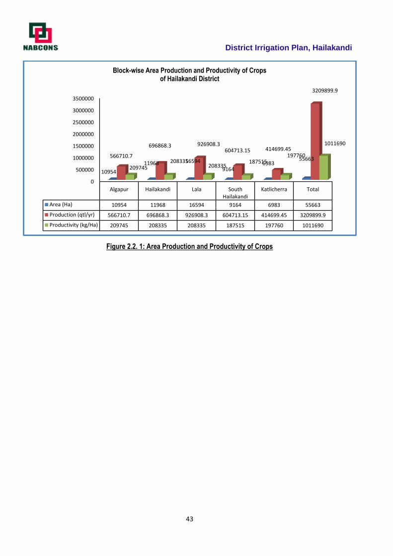
District Irrigation Plan, Hailakandi
43
Figure 2.2. 1: Area Production and Productivity of Crops
0
500000
1000000
1500000
2000000
2500000
3000000
3500000
Algapur Hailakandi Lala South Hailakandi
Katlicherra Total
Area (Ha) 10954 11968 16594 9164 6983 55663
Production (qtl/yr) 566710.7 696868.3 926908.3 604713.15 414699.45 3209899.9
Productivity (kg/Ha) 209745 208335 208335 187515 197760 1011690
10954
11968 16594
91646983
55663566710.7
696868.3 926908.3604713.15 414699.45
3209899.9
209745208335
208335187515
197760
1011690
Block-wise Area Production and Productivity of Cropsof Hailakandi District
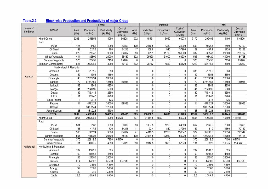
Table.2.2. Block-wise Production and Productivity of major Crops
Name of the Block
Season
Rainfed Irrigated Total
Area (Ha)
Production (qtl/yr)
Productivity (kg/Ha)
Cost of Cultivation
(Rs/Ha)
Area (Ha)
Production (qtl/yr)
Productivity (kg/Ha)
Cost of Cultivation
(Rs/Ha)
Area (Ha)
Production (qtl/yr)
Productivity (kg/Ha)
Cost of Cultivation
(Rs/Ha)
Algapur
Kharif Cereal 6268 253854 4050 56328 902 45551 5050 60078 7170 299405 9100 116406
Rabi
Pulse 424 4452 1050 30809 179 2416.5 1350 36900 603 6868.5 2400 67709
Oil Seed 42 327.6 780 34216 17 159.8 940 37966 59 487.4 1720 72182
Potato 279 27342 9800 134897 53 6201 11700 150900 332 33543 21500 285797
Winter Vegetable 414 82800 20000 65489 122 25620 21000 69239 536 108420 41000 134728
Summer Vegetable 370 26455 7150 65170 0 0 0 0 370 26455 7150 65170
Summer Cereal (Boro) 627 24766.5 3950 50100 592 28712 4850 55120 1219 53478.5 8800 105220
Horticultural & Plantation
Arecanut 335 2177.5 650 0 0 0 0 335 2177.5 650
Coconut 42 1953 4650 0 0 0 0 42 1953 4650
Pineapple 45 12619.94 28000 0 0 0 0 45 12619.94 28000
Banana 70 8751.466 12550 136988 0 0 0 0 70 8751.466 12550 136988
Jackfruit 38 1843 4850 0 0 0 0 38 1843 4850
Mango 41 2040.96 5000 0 0 0 0 41 2040.96 5000
Guava 32 749.415 2350 0 0 0 0 32 749.415 2350
Litchi 11 733.47 6900 0 0 0 0 11 733.47 6900
Block Pepper 3 3.75 125 0 0 0 0 3 3.75 125
Papaya 14 4762.24 35000 139986 0 0 0 0 14 4762.24 35000 139986
Orange 8 987.3144 12900 0 0 0 0 8 987.3144 12900
Assam Lemon 28 1431.223 5100 0 0 0 0 28 1431.223 5100
TOTAL 9089 458050.4 164855 592485 1865 108660.3 44890 410203 10954 566710.7 209745 942610
Hailakandi
Kharif Cereal 7961 394366.5 4950 56328 537 31414.5 5850 60078 8504 425781 10800 116406
Rabi
Pulse 584 6132 1050 30809 83 1037.5 1250 34559 667 7169.5 2300 65368
Oil Seed 58 417.6 720 34216 11 92.4 840 37966 69 510 1560 72182
Potato 338 33124 9800 134897 41 4612.5 11250 138647 379 37736.5 21050 273544
Winter Vegetable 504 104328 20700 65489 109 24034.5 22050 69239 613 128362.5 42750 134728
Summer Vegetable 375 26812.5 7150 65170 0 0 0 0 375 26812.5 7150 65170
Summer Cereal 81 4009.5 4950 57073 50 2812.5 5625 57573 131 6822 10575 114646
Horticultural & Plantation
Arecanut 702 4387.5 625 0 0 0 0 702 4387.5 625
Coconut 99 4603.5 4650 0 0 0 0 99 4603.5 4650
Pineapple 86 24080 28000 0 0 0 0 86 24080 28000
Banana 114 14307 12500 136988 0 0 0 0 114 14307 12500 136988
Jackfruit 70 3395 4850 0 0 0 0 70 3395 4850
Mango 52 2600 5000 0 0 0 0 52 2600 5000
Guava 40 940 2350 0 0 0 0 40 940 2350
Litchi 15.5 1069.5 6900 0 0 0 0 15.5 1069.5 6900
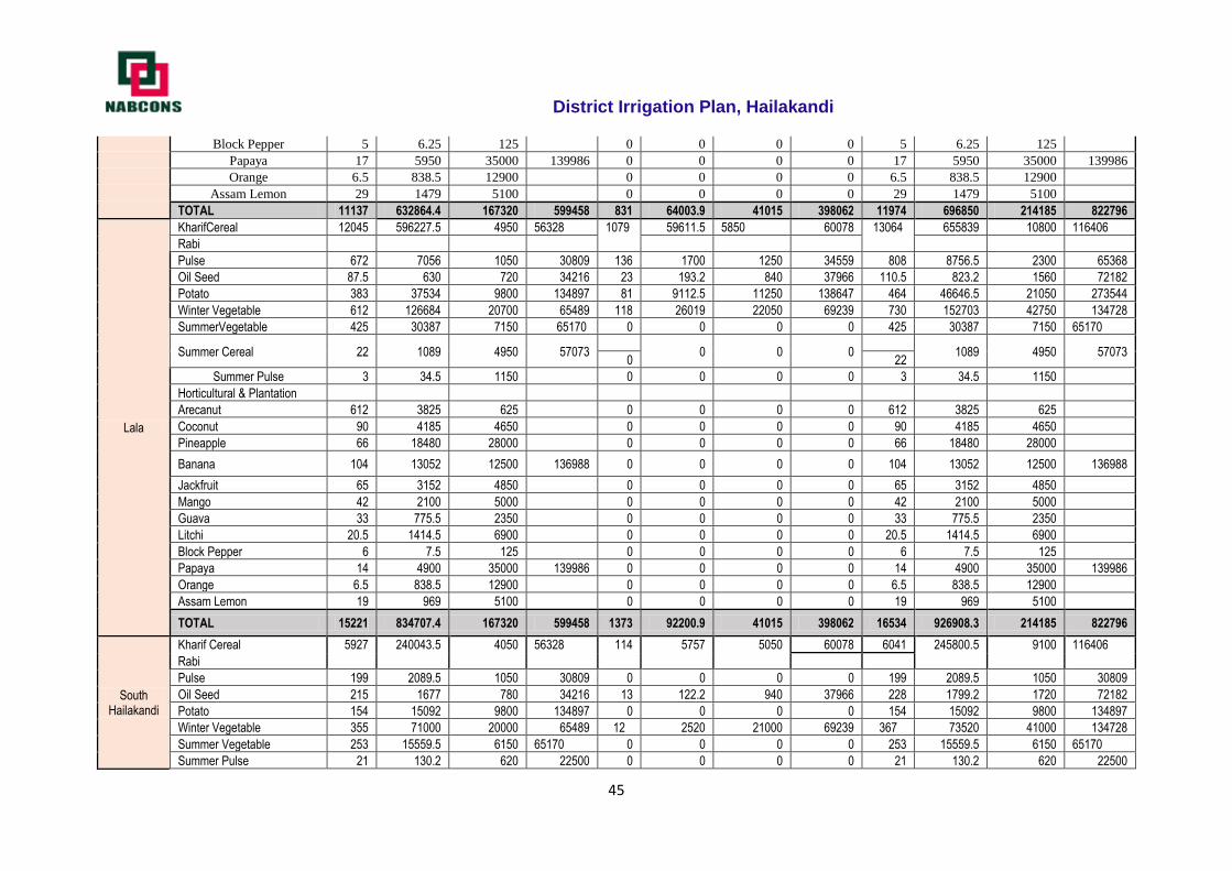
District Irrigation Plan, Hailakandi
45
Block Pepper 5 6.25 125 0 0 0 0 5 6.25 125
Papaya 17 5950 35000 139986 0 0 0 0 17 5950 35000 139986
Orange 6.5 838.5 12900 0 0 0 0 6.5 838.5 12900
Assam Lemon 29 1479 5100 0 0 0 0 29 1479 5100
TOTAL 11137 632864.4 167320 599458 831 64003.9 41015 398062 11974 696850 214185 822796
Lala
KharifCereal 12045 596227.5 4950 56328 1079 59611.5 5850 60078 13064 655839 10800 116406
Rabi
Pulse 672 7056 1050 30809 136 1700 1250 34559 808 8756.5 2300 65368
Oil Seed 87.5 630 720 34216 23 193.2 840 37966 110.5 823.2 1560 72182
Potato 383 37534 9800 134897 81 9112.5 11250 138647 464 46646.5 21050 273544
Winter Vegetable 612 126684 20700 65489 118 26019 22050 69239 730 152703 42750 134728
SummerVegetable 425 30387 7150 65170 0 0 0 0 425 30387 7150 65170
Summer Cereal 22 1089 4950 57073
0 0 0
1089 4950 57073 0 22
Summer Pulse 3 34.5 1150 0 0 0 0 3 34.5 1150
Horticultural & Plantation
Arecanut 612 3825 625 0 0 0 0 612 3825 625
Coconut 90 4185 4650 0 0 0 0 90 4185 4650
Pineapple 66 18480 28000 0 0 0 0 66 18480 28000
Banana 104 13052 12500 136988 0 0 0 0 104 13052 12500 136988
Jackfruit 65 3152 4850 0 0 0 0 65 3152 4850
Mango 42 2100 5000 0 0 0 0 42 2100 5000
Guava 33 775.5 2350 0 0 0 0 33 775.5 2350
Litchi 20.5 1414.5 6900 0 0 0 0 20.5 1414.5 6900
Block Pepper 6 7.5 125 0 0 0 0 6 7.5 125
Papaya 14 4900 35000 139986 0 0 0 0 14 4900 35000 139986
Orange 6.5 838.5 12900 0 0 0 0 6.5 838.5 12900
Assam Lemon 19 969 5100 0 0 0 0 19 969 5100
TOTAL 15221 834707.4 167320 599458 1373 92200.9 41015 398062 16534 926908.3 214185 822796
South Hailakandi
Kharif Cereal 5927 240043.5 4050 56328 114 5757 5050 60078 6041 245800.5 9100 116406
Rabi
Pulse 199 2089.5 1050 30809 0 0 0 0 199 2089.5 1050 30809
Oil Seed 215 1677 780 34216 13 122.2 940 37966 228 1799.2 1720 72182
Potato 154 15092 9800 134897 0 0 0 0 154 15092 9800 134897
Winter Vegetable 355 71000 20000 65489 12 2520 21000 69239 367 73520 41000 134728
Summer Vegetable 253 15559.5 6150 65170 0 0 0 0 253 15559.5 6150 65170
Summer Pulse 21 130.2 620 22500 0 0 0 0 21 130.2 620 22500
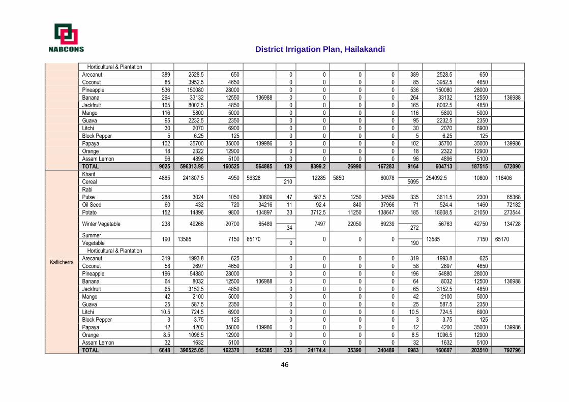
District Irrigation Plan, Hailakandi
46
Horticultural & Plantation
Arecanut 389 2528.5 650 0 0 0 0 389 2528.5 650
Coconut 85 3952.5 4650 0 0 0 0 85 3952.5 4650
Pineapple 536 150080 28000 0 0 0 0 536 150080 28000
Banana 264 33132 12550 136988 0 0 0 0 264 33132 12550 136988
Jackfruit 165 8002.5 4850 0 0 0 0 165 8002.5 4850
Mango 116 5800 5000 0 0 0 0 116 5800 5000
Guava 95 2232.5 2350 0 0 0 0 95 2232.5 2350
Litchi 30 2070 6900 0 0 0 0 30 2070 6900
Block Pepper 5 6.25 125 0 0 0 0 5 6.25 125
Papaya 102 35700 35000 139986 0 0 0 0 102 35700 35000 139986
Orange 18 2322 12900 0 0 0 0 18 2322 12900
Assam Lemon 96 4896 5100 0 0 0 0 96 4896 5100
TOTAL 9025 596313.95 160525 564885 139 8399.2 26990 167283 9164 604713 187515 672090
Katlicherra
Kharif 4885 241807.5 4950 56328
12285 5850 60078
254092.5 10800 116406
Cereal 210 5095
Rabi
Pulse 288 3024 1050 30809 47 587.5 1250 34559 335 3611.5 2300 65368
Oil Seed 60 432 720 34216 11 92.4 840 37966 71 524.4 1460 72182
Potato 152 14896 9800 134897 33 3712.5 11250 138647 185 18608.5 21050 273544
Winter Vegetable 238 49266 20700 65489
7497 22050 69239
56763 42750 134728 34 272
Summer 190 13585 7150 65170
0 0 0
13585 7150 65170
Vegetable 0 190
Horticultural & Plantation
Arecanut 319 1993.8 625 0 0 0 0 319 1993.8 625
Coconut 58 2697 4650 0 0 0 0 58 2697 4650
Pineapple 196 54880 28000 0 0 0 0 196 54880 28000
Banana 64 8032 12500 136988 0 0 0 0 64 8032 12500 136988
Jackfruit 65 3152.5 4850 0 0 0 0 65 3152.5 4850
Mango 42 2100 5000 0 0 0 0 42 2100 5000
Guava 25 587.5 2350 0 0 0 0 25 587.5 2350
Litchi 10.5 724.5 6900 0 0 0 0 10.5 724.5 6900
Block Pepper 3 3.75 125 0 0 0 0 3 3.75 125
Papaya 12 4200 35000 139986 0 0 0 0 12 4200 35000 139986
Orange 8.5 1096.5 12900 0 0 0 0 8.5 1096.5 12900
Assam Lemon 32 1632 5100 0 0 0 0 32 1632 5100
TOTAL 6648 390525.05 162370 542385 335 24174.4 35390 340489 6983 160607 203510 792796
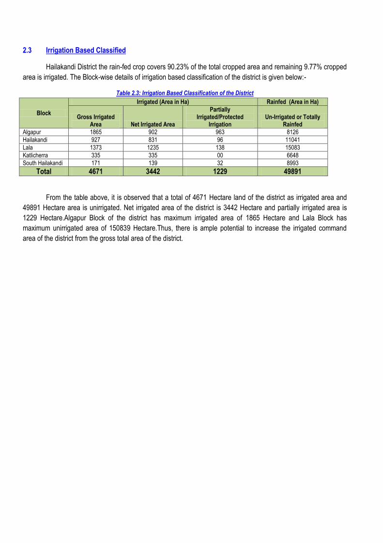
2.3 Irrigation Based Classified
Hailakandi District the rain-fed crop covers 90.23% of the total cropped area and remaining 9.77% cropped
area is irrigated. The Block-wise details of irrigation based classification of the district is given below:-
Table 2.3: Irrigation Based Classification of the District
Block
Irrigated (Area in Ha) Rainfed (Area in Ha)
Gross Irrigated Area Net Irrigated Area
Partially Irrigated/Protected
Irrigation Un-Irrigated or Totally
Rainfed
Algapur 1865 902 963 8126
Hailakandi 927 831 96 11041
Lala 1373 1235 138 15083
Katlicherra 335 335 00 6648
South Hailakandi 171 139 32 8993
Total 4671 3442 1229 49891
From the table above, it is observed that a total of 4671 Hectare land of the district as irrigated area and
49891 Hectare area is unirrigated. Net irrigated area of the district is 3442 Hectare and partially irrigated area is
1229 Hectare.Algapur Block of the district has maximum irrigated area of 1865 Hectare and Lala Block has
maximum unirrigated area of 150839 Hectare.Thus, there is ample potential to increase the irrigated command
area of the district from the gross total area of the district.
District Irrigation Plan, Hailakandi
48
Chapter 3
District Water Availability
Hydrogeology
The ground water conditions in the district can be described under two distinct hydro geological units, i.e.
conditions prevailing in the semi-consolidated formations and conditions prevailing in the unconsolidated
formations.
i) Semi-Consolidated Formations: A very narrow belt of Upper Tertiary semi-consolidated rock formation
engulf the northern fringe area of the district with Bhutan consisting mainly claystone/siltstone/sandstone and form
low to moderate altitude denudation structural hills. The trend of hills is generally in E-W direction. These are
characterized by high run off, low infiltration to groundwater and experience secondary porosity development
through cracks/joints/bedding planes. Springs are developed in this belt.
ii) Unconsolidated Formations: Major parts of the district are underlain by unconsolidated formations
represented by the alluvial deposits of recent age. Bhabar formation comprises of the alluvial sediments at the
foothill belt in the north and the valley covering the central and southern part. The behaviour of ground water in the
piedmont sediments is naturally different from that in the alluvial areas occurring further south.
Bhabar-Terai Belt: This zone consists of the terrace deposits in the foot hill regions of the Himalayas
composed of talus fans. The material is a heterogeneous admixture of boulders, pebbles, cobbles with the
interstices filled by sand and silt. These sediments are highly permeable with low retentive capacity. Thus, the
streams in this region are devoid of any appreciable surface flow, although, there are evidences of sub-surface
flow. Behaviour of ground water in the further south is less erratic. Here, ground water occurs under water table
conditions. The depth to water level is rather high.
Older Alluvium: Ground water occurs under water table conditions in the elevated flat-topped areas of
Older alluvial sediments. These areas are usually forested. It comprises of sand, gravel and silt with higher
proportion of clay. Ground water occurs under unconfined to confined conditions.
Newer Alluvium: The district is mostly covered by newer alluvium and the formation comprises of sand,
gravel and pebble with silt and clay. Ground water in this zone occurs under unconfined condition.
Based on the behaviour and occurrence of ground water, the regional ground water flow system of district
has been described under following categories.
i. Shallow Aquifer Group (occurring within 50 m depth):
It consists of a mixture of boulder, gravel, sand, silt and clay. The thickness of the aquifer varies from 15
to 40 m. Ground water in this aquifer generally occurs under water table to semi-confined conditions. The pebbles,
boulders are restricted mostly to the northern parts of the district. They occur at the depth between ground level to
50 m below ground level. The development of ground water from this aquifer is done by open well and shallow tube
well for both the domestic and irrigation purposes. The water level in the major parts of the district generally lies
between 2 to 4 m below ground level. The northern most parts occupied by the piedmont zones and the areas
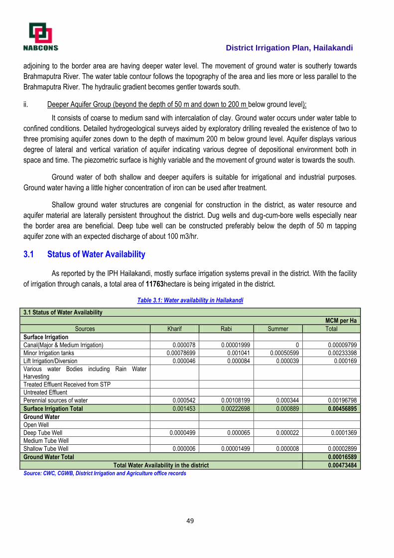
District Irrigation Plan, Hailakandi
49
adjoining to the border area are having deeper water level. The movement of ground water is southerly towards
Brahmaputra River. The water table contour follows the topography of the area and lies more or less parallel to the
Brahmaputra River. The hydraulic gradient becomes gentler towards south.
ii. Deeper Aquifer Group (beyond the depth of 50 m and down to 200 m below ground level):
It consists of coarse to medium sand with intercalation of clay. Ground water occurs under water table to
confined conditions. Detailed hydrogeological surveys aided by exploratory drilling revealed the existence of two to
three promising aquifer zones down to the depth of maximum 200 m below ground level. Aquifer displays various
degree of lateral and vertical variation of aquifer indicating various degree of depositional environment both in
space and time. The piezometric surface is highly variable and the movement of ground water is towards the south.
Ground water of both shallow and deeper aquifers is suitable for irrigational and industrial purposes.
Ground water having a little higher concentration of iron can be used after treatment.
Shallow ground water structures are congenial for construction in the district, as water resource and
aquifer material are laterally persistent throughout the district. Dug wells and dug-cum-bore wells especially near
the border area are beneficial. Deep tube well can be constructed preferably below the depth of 50 m tapping
aquifer zone with an expected discharge of about 100 m3/hr.
3.1 Status of Water Availability
As reported by the IPH Hailakandi, mostly surface irrigation systems prevail in the district. With the facility
of irrigation through canals, a total area of 11763hectare is being irrigated in the district.
Table 3.1: Water availability in Hailakandi
3.1 Status of Water Availability
MCM per Ha
Sources Kharif Rabi Summer Total
Surface Irrigation
Canal(Major & Medium Irrigation) 0.000078 0.00001999 0 0.00009799
Minor Irrigation tanks 0.00078699 0.001041 0.00050599 0.00233398
Lift Irrigation/Diversion 0.000046 0.000084 0.000039 0.000169
Various water Bodies including Rain Water Harvesting
Treated Effluent Received from STP
Untreated Effluent
Perennial sources of water 0.000542 0.00108199 0.000344 0.00196798
Surface Irrigation Total 0.001453 0.00222698 0.000889 0.00456895
Ground Water
Open Well
Deep Tube Well 0.0000499 0.000065 0.000022 0.0001369
Medium Tube Well
Shallow Tube Well 0.000006 0.00001499 0.000008 0.00002899
Ground Water Total 0.00016589
Total Water Availability in the district 0.00473484
Source: CWC, CGWB, District Irrigation and Agriculture office records
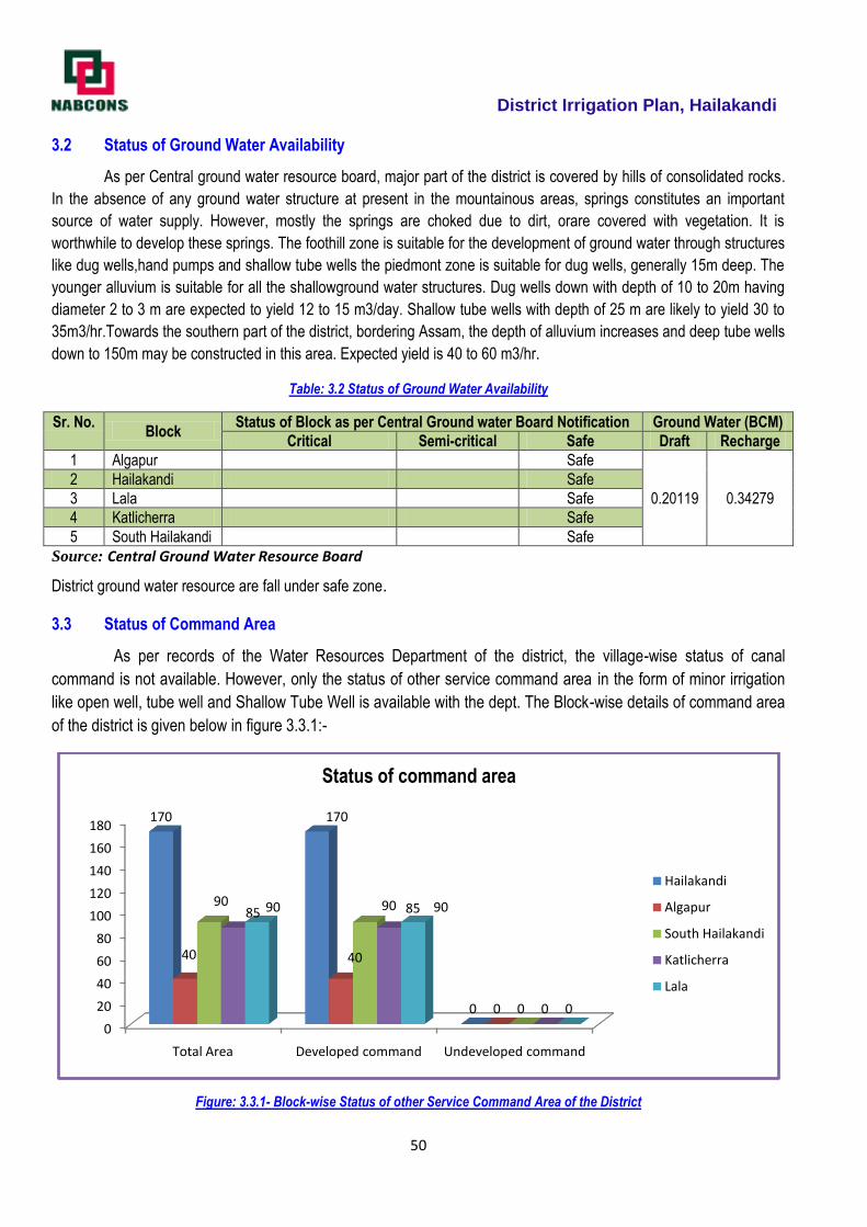
District Irrigation Plan, Hailakandi
50
3.2 Status of Ground Water Availability
As per Central ground water resource board, major part of the district is covered by hills of consolidated rocks.
In the absence of any ground water structure at present in the mountainous areas, springs constitutes an important
source of water supply. However, mostly the springs are choked due to dirt, orare covered with vegetation. It is
worthwhile to develop these springs. The foothill zone is suitable for the development of ground water through structures
like dug wells,hand pumps and shallow tube wells the piedmont zone is suitable for dug wells, generally 15m deep. The
younger alluvium is suitable for all the shallowground water structures. Dug wells down with depth of 10 to 20m having
diameter 2 to 3 m are expected to yield 12 to 15 m3/day. Shallow tube wells with depth of 25 m are likely to yield 30 to
35m3/hr.Towards the southern part of the district, bordering Assam, the depth of alluvium increases and deep tube wells
down to 150m may be constructed in this area. Expected yield is 40 to 60 m3/hr.
Table: 3.2 Status of Ground Water Availability
Sr. No. Block
Status of Block as per Central Ground water Board Notification Ground Water (BCM)
Critical Semi-critical Safe Draft Recharge
1 Algapur Safe
0.20119 0.34279
2 Hailakandi Safe
3 Lala Safe
4 Katlicherra Safe
5 South Hailakandi Safe
Source: Central Ground Water Resource Board
District ground water resource are fall under safe zone.
3.3 Status of Command Area
As per records of the Water Resources Department of the district, the village-wise status of canal
command is not available. However, only the status of other service command area in the form of minor irrigation
like open well, tube well and Shallow Tube Well is available with the dept. The Block-wise details of command area
of the district is given below in figure 3.3.1:-
Figure: 3.3.1- Block-wise Status of other Service Command Area of the District
0
20
40
60
80
100
120
140
160
180
Total Area Developed command Undeveloped command
170 170
0
40 40
0
90 90
0
85 85
0
90 90
0
Status of command area
Hailakandi
Algapur
South Hailakandi
Katlicherra
Lala
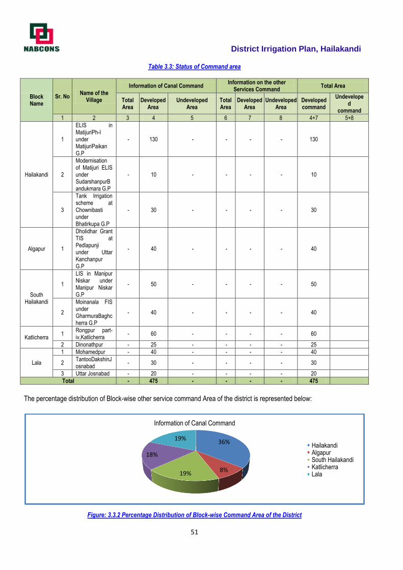
District Irrigation Plan, Hailakandi
51
Table 3.3: Status of Command area
Block Name
Sr. No Name of the
Village
Information of Canal Command Information on the other
Services Command Total Area
Total Area
Developed Area
Undeveloped Area
Total Area
Developed Area
Undeveloped Area
Developed command
Undeveloped
command
1 2 3 4 5 6 7 8 4+7 5+8
Hailakandi
1
ELIS in MatijuriPh-I under MatijuriPaikan G.P
- 130 - - - - 130
2
Modernisation of Matijuri ELIS under SudarshanpurBandukmara G.P
- 10 - - - - 10
3
Tank Irrigation scheme at Chownibasti under Bhatirkupa G.P
- 30 - - - - 30
Algapur 1
Dholidhar Grant TIS at Pedlapunji under Uttar Kanchanpur G.P
- 40 - - - - 40
South Hailakandi
1
LIS in Manipur Niskar under Manipur Niskar G.P
- 50 - - - - 50
2
Moinanala FIS under GharmuraBaghcherra G.P
- 40 - - - - 40
Katlicherra 1
Rongpur part-iv,Katlicherra
- 60 - - - - 60
2 Dinonathpur - 25 - - - - 25
Lala
1 Mohamedpur - 40 - - - - 40
2 TantooDakshinJosnabad
- 30 - - - - 30
3 Uttar Josnabad - 20 - - - - 20
Total - 475 - - - - 475
The percentage distribution of Block-wise other service command Area of the district is represented below:
Figure: 3.3.2 Percentage Distribution of Block-wise Command Area of the District
36%
8%19%
18%
19%
Information of Canal Command
HailakandiAlgapurSouth HailakandiKatlicherraLala
District Irrigation Plan, Hailakandi
52
From Fiigure: 3.3.2, it is observed that Hailakandi Block of the district has occupied the maximum command area
with 36% of total command area of the district, while South Hailakandi and Lala District occupied 19% of the total command
area and Katlicherra and Algapur Block occupied with 18% and 8% respectively.
3.4 Existing Type of Irrigation
District economy being largely agrarian, irrigation is to play vital input, increased agricultural output to keep pace with
food requirement and population. The major source of surface irrigation of the district are Rivers, rain water and Streams
&nallas to irrigate.
Large irrigation in a compact area for the district is not possible owing to undulating topography. However medium
irrigation projects at foot hill belts are to be taken up. There is acute need of resource support forreconstruction and
rejuvenation of irrigation structures along with taping of ground water through PMKSY.The Existing Type of Irrigation in the
district is summarized in Table: 3.4 (a) and 3.4 (b)
Table 3.4(a): Existing type of surface irrigation sources (in Numbers)
Blo
ck
Surface Irrigation (1) Ground Water (2) O
ther
Sou
rces
incl
udin
g T
radi
tiona
l
WH
S (
3)
Tre
ated
Affl
uent
Dis
char
ge fr
om S
TP
Water Extraction Device /Lift
Total
Canal Based
Tank/Pond/Reservoir Tube Well
Open Well
Bore Well
Ele
ctric
al P
ump
(4)
Die
sel P
ump
(5)
Oth
er (
6)
Irrig
atio
n S
ourc
es (
1+2+
3)
Wat
er E
xtra
ctio
n U
nits
(4+
5+6)
Gov
t. C
anal
Com
mun
ity/ P
vt. C
anal
Com
mun
ity P
ond
incl
udin
g sm
all
Indi
vidu
al/ P
vt. P
ond
Gov
t. R
eser
voir/
Dam
s
Gov
t.
Pvt
.
Com
mun
ity /
Gov
t.
Pvt
.
Gov
t.
Pvt
.
Algapur 04 47 2157 45 118.00 667 2253 758
Hailakndi 04 30 2871 8 30 02+100 271 2943 373
Lala 03 19 747 13 84 769 97
Katlicherra 04 15 691 7 02+49 51 717 102.00
South Hailakandi
04 59 879 13 97.00 373 955 470
Total 19 170 7345 8 95 381 1446 7637 1800
Table 3.4(b): Existing type of surface irrigation sources (in Numbers)
Blo
ck
Surface Irrigation (1) Ground Water (2)
Oth
er S
ourc
es in
clud
ing
Tra
ditio
nal
WH
S (
3)
Tre
ated
Affl
uent
Dis
char
ge fr
om S
TP
Water Extraction Device /Lift
Total
Canal Based
Tank/Pond/Reservoir Tube Well
Open Well
Bore Well
Ele
ctric
al P
ump
(4)
Die
sel P
ump
(5)
Oth
er (
6)
Irrig
atio
n S
ourc
es (
1+2+
3)
Wat
er E
xtra
ctio
n U
nits
(4+
5+6)
Gov
t. C
anal
Com
mun
ity/ P
vt. C
anal
Com
mun
ity P
ond
incl
udin
g sm
all
Indi
vidu
al/ P
vt. P
ond
Gov
t. R
eser
voir/
Dam
s
Gov
t.
Pvt
.
Com
mun
ity /
Gov
t.
Pvt
.
Gov
t.
Pvt
.
Algapur 80 100 4325 90 236 1334
1570
Hailakndi 43 73 671.5 16 60 204 542 863.5 746
Lala 30 39 132 26 168 201 194
Katlicherra 48 29 223 35 102 102 335 204
South Hailakandi
34 221 801 26 194 746 1082 940
Total 235 462 6152.5 16 211 762 2892 2481.5 3654
Source: District Agriculture & Irrigation Department

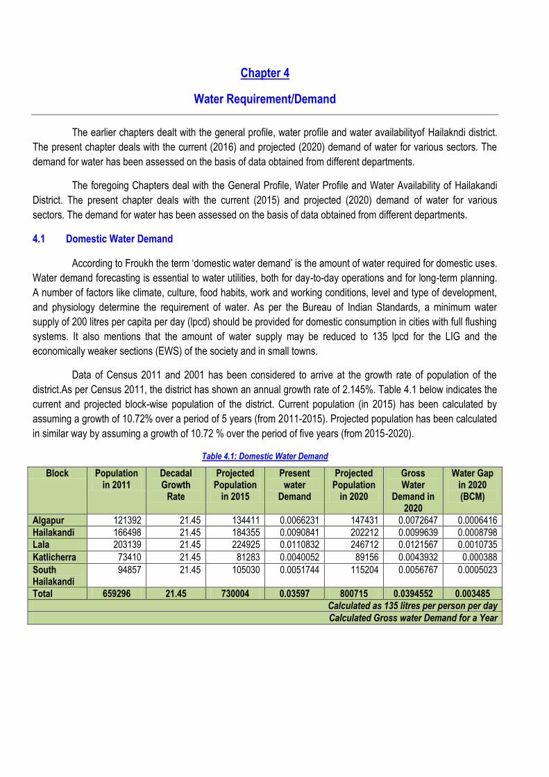
Chapter 4
Water Requirement/Demand
The earlier chapters dealt with the general profile, water profile and water availabilityof Hailakndi district.
The present chapter deals with the current (2016) and projected (2020) demand of water for various sectors. The
demand for water has been assessed on the basis of data obtained from different departments.
The foregoing Chapters deal with the General Profile, Water Profile and Water Availability of Hailakandi
District. The present chapter deals with the current (2015) and projected (2020) demand of water for various
sectors. The demand for water has been assessed on the basis of data obtained from different departments.
4.1 Domestic Water Demand
According to Froukh the term ‗domestic water demand‘ is the amount of water required for domestic uses.
Water demand forecasting is essential to water utilities, both for day-to-day operations and for long-term planning.
A number of factors like climate, culture, food habits, work and working conditions, level and type of development,
and physiology determine the requirement of water. As per the Bureau of Indian Standards, a minimum water
supply of 200 litres per capita per day (lpcd) should be provided for domestic consumption in cities with full flushing
systems. It also mentions that the amount of water supply may be reduced to 135 lpcd for the LIG and the
economically weaker sections (EWS) of the society and in small towns.
Data of Census 2011 and 2001 has been considered to arrive at the growth rate of population of the
district.As per Census 2011, the district has shown an annual growth rate of 2.145%. Table 4.1 below indicates the
current and projected block-wise population of the district. Current population (in 2015) has been calculated by
assuming a growth of 10.72% over a period of 5 years (from 2011-2015). Projected population has been calculated
in similar way by assuming a growth of 10.72 % over the period of five years (from 2015-2020).
Table 4.1: Domestic Water Demand
Block Population in 2011
Decadal Growth
Rate
Projected Population
in 2015
Present water
Demand
Projected Population
in 2020
Gross Water
Demand in 2020
Water Gap in 2020 (BCM)
Algapur 121392 21.45 134411 0.0066231 147431 0.0072647 0.0006416
Hailakandi 166498 21.45 184355 0.0090841 202212 0.0099639 0.0008798
Lala 203139 21.45 224925 0.0110832 246712 0.0121567 0.0010735
Katlicherra 73410 21.45 81283 0.0040052 89156 0.0043932 0.000388
South Hailakandi
94857 21.45 105030 0.0051744 115204 0.0056767 0.0005023
Total 659296 21.45 730004 0.03597 800715 0.0394552 0.003485
Calculated as 135 litres per person per day
Calculated Gross water Demand for a Year
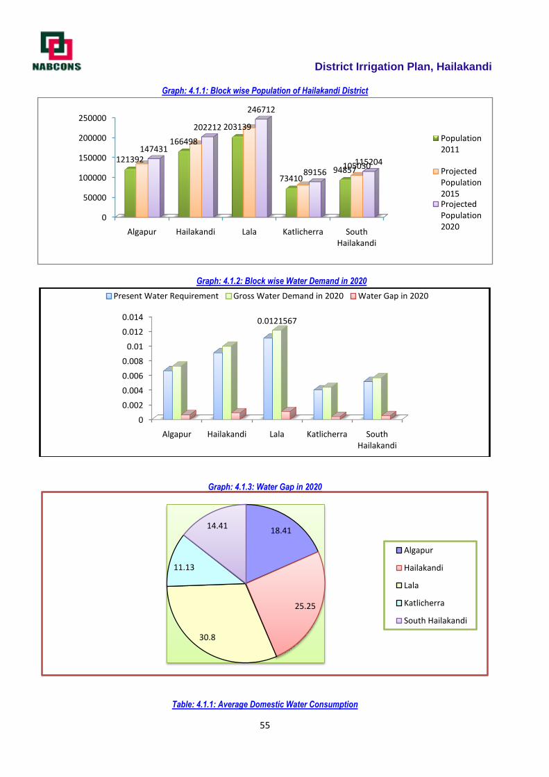
District Irrigation Plan, Hailakandi
55
Graph: 4.1.1: Block wise Population of Hailakandi District
Graph: 4.1.2: Block wise Water Demand in 2020
Graph: 4.1.3: Water Gap in 2020
Table: 4.1.1: Average Domestic Water Consumption
0
50000
100000
150000
200000
250000
Algapur Hailakandi Lala Katlicherra South Hailakandi
121392
166498
203139
7341094857105030
147431
202212
246712
89156115204
Population 2011
Projected Population 2015Projected Population 2020
0
0.002
0.004
0.006
0.008
0.01
0.012
0.014
Algapur Hailakandi Lala Katlicherra South Hailakandi
0.0121567
Present Water Requirement Gross Water Demand in 2020 Water Gap in 2020
18.41
25.25
30.8
11.13
14.41
Algapur
Hailakandi
Lala
Katlicherra
South Hailakandi
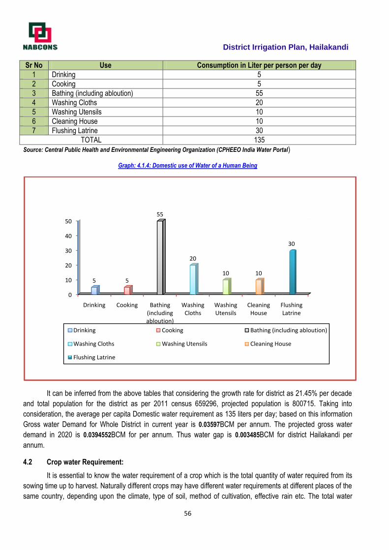
District Irrigation Plan, Hailakandi
56
Sr No Use Consumption in Liter per person per day
1 Drinking 5
2 Cooking 5
3 Bathing (including abloution) 55
4 Washing Cloths 20
5 Washing Utensils 10
6 Cleaning House 10
7 Flushing Latrine 30
TOTAL 135
Source: Central Public Health and Environmental Engineering Organization (CPHEEO India Water Portal)
Graph: 4.1.4: Domestic use of Water of a Human Being
It can be inferred from the above tables that considering the growth rate for district as 21.45% per decade
and total population for the district as per 2011 census 659296, projected population is 800715. Taking into
consideration, the average per capita Domestic water requirement as 135 liters per day; based on this information
Gross water Demand for Whole District in current year is 0.03597BCM per annum. The projected gross water
demand in 2020 is 0.0394552BCM for per annum. Thus water gap is 0.003485BCM for district Hailakandi per
annum.
4.2 Crop water Requirement:
It is essential to know the water requirement of a crop which is the total quantity of water required from its
sowing time up to harvest. Naturally different crops may have different water requirements at different places of the
same country, depending upon the climate, type of soil, method of cultivation, effective rain etc. The total water
0
10
20
30
40
50
Drinking Cooking Bathing (including abloution)
Washing Cloths
Washing Utensils
Cleaning House
Flushing Latrine
5 5
55
20
10 10
30
Drinking Cooking Bathing (including abloution)
Washing Cloths Washing Utensils Cleaning House
Flushing Latrine
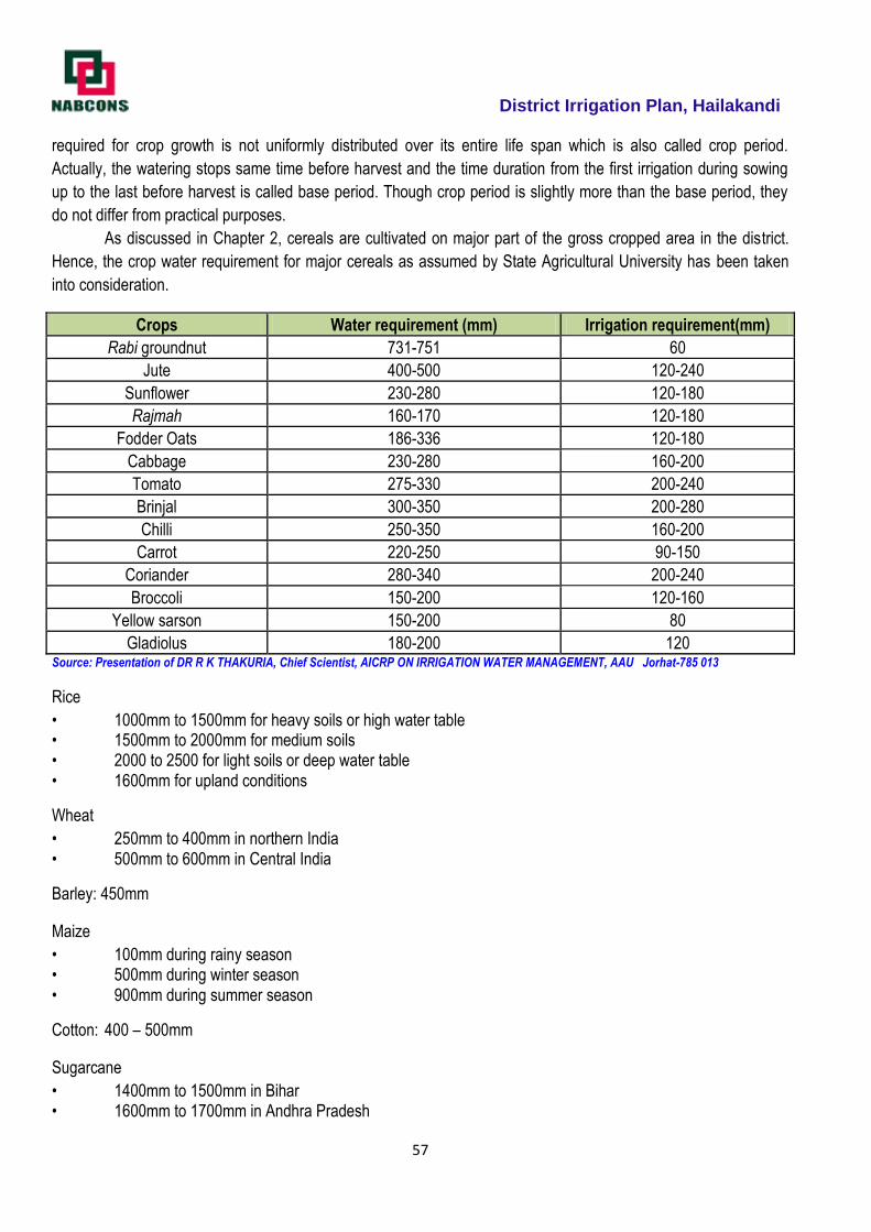
District Irrigation Plan, Hailakandi
57
required for crop growth is not uniformly distributed over its entire life span which is also called crop period.
Actually, the watering stops same time before harvest and the time duration from the first irrigation during sowing
up to the last before harvest is called base period. Though crop period is slightly more than the base period, they
do not differ from practical purposes.
As discussed in Chapter 2, cereals are cultivated on major part of the gross cropped area in the district.
Hence, the crop water requirement for major cereals as assumed by State Agricultural University has been taken
into consideration.
Crops Water requirement (mm) Irrigation requirement(mm)
Rabi groundnut 731-751 60
Jute 400-500 120-240
Sunflower 230-280 120-180
Rajmah 160-170 120-180
Fodder Oats 186-336 120-180
Cabbage 230-280 160-200
Tomato 275-330 200-240
Brinjal 300-350 200-280
Chilli 250-350 160-200
Carrot 220-250 90-150
Coriander 280-340 200-240
Broccoli 150-200 120-160
Yellow sarson 150-200 80
Gladiolus 180-200 120 Source: Presentation of DR R K THAKURIA, Chief Scientist, AICRP ON IRRIGATION WATER MANAGEMENT, AAU Jorhat-785 013
Rice
• 1000mm to 1500mm for heavy soils or high water table • 1500mm to 2000mm for medium soils • 2000 to 2500 for light soils or deep water table • 1600mm for upland conditions
Wheat
• 250mm to 400mm in northern India • 500mm to 600mm in Central India
Barley: 450mm
Maize
• 100mm during rainy season • 500mm during winter season • 900mm during summer season
Cotton: 400 – 500mm
Sugarcane
• 1400mm to 1500mm in Bihar • 1600mm to 1700mm in Andhra Pradesh
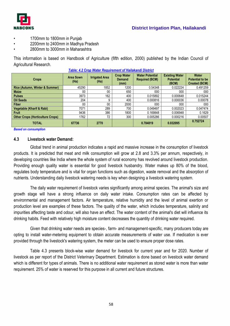
District Irrigation Plan, Hailakandi
58
• 1700mm to 1800mm in Punjab • 2200mm to 2400mm in Madhya Pradesh • 2800mm to 3000mm in Maharashtra
This information is based on Handbook of Agriculture (fifth edition, 2000) published by the Indian Council of
Agricultural Research. Table: 4.2 Crop Water Requirement of Hailakandi District
Crops Area Sown
(Ha) Irrigated Area
(Ha)
Crop Water Demand
(mm)
Water Potential Required (BCM)
Existing Water Potential
(BCM)
Water Potential to be Created (BCM)
Rice (Autumn, Winter & Summer) 45290 1852 1200 0.54348 0.022224 0.491259
Maize 00 00 650 000 000 000
Pulses 3973 162 400 0.015892 0.000648 0.015244
Oil Seeds 204 9 400 0.000816 0.000036 0.00078
Fiber 00 00 2000 000 000 000
Vegetable (Kharif & Rabi) 7071 289 700 0.049497 0.002023 0.047474
Fruit 9436 386 1800 0.169848 0.006948 0.1629
Other Crops (Horticulture Crops) 1762 72 300 0.005286 0.000216 0.00507
TOTAL 67736 2770 0.784819 0.032095 0.752724
Based on consumption
4.3 Livestock water Demand:
Global trend in animal production indicates a rapid and massive increase in the consumption of livestock
products. It is predicted that meat and milk consumption will grow at 2.8 and 3.3% per annum, respectively, in
developing countries like India where the whole system of rural economy has revolved around livestock production.
Providing enough quality water is essential for good livestock husbandry. Water makes up 80% of the blood,
regulates body temperature and is vital for organ functions such as digestion, waste removal and the absorption of
nutrients. Understanding daily livestock watering needs is key when designing a livestock watering system.
The daily water requirement of livestock varies significantly among animal species. The animal's size and
growth stage will have a strong influence on daily water intake. Consumption rates can be affected by
environmental and management factors. Air temperature, relative humidity and the level of animal exertion or
production level are examples of these factors. The quality of the water, which includes temperature, salinity and
impurities affecting taste and odour, will also have an effect. The water content of the animal's diet will influence its
drinking habits. Feed with relatively high moisture content decreases the quantity of drinking water required.
Given that drinking water needs are species-, farm- and management-specific, many producers today are
opting to install water-metering equipment to obtain accurate measurements of water use. If medication is ever
provided through the livestock's watering system, the meter can be used to ensure proper dose rates.
Table 4.3 presents block-wise water demand for livestock for current year and for 2020. Number of
livestock as per report of the District Veterinary Department. Estimation is done based on livestock water demand
which is different for types of animals. There is no additional water requirement as stored water is more than water
requirement. 25% of water is reserved for this purpose in all current and future structures.
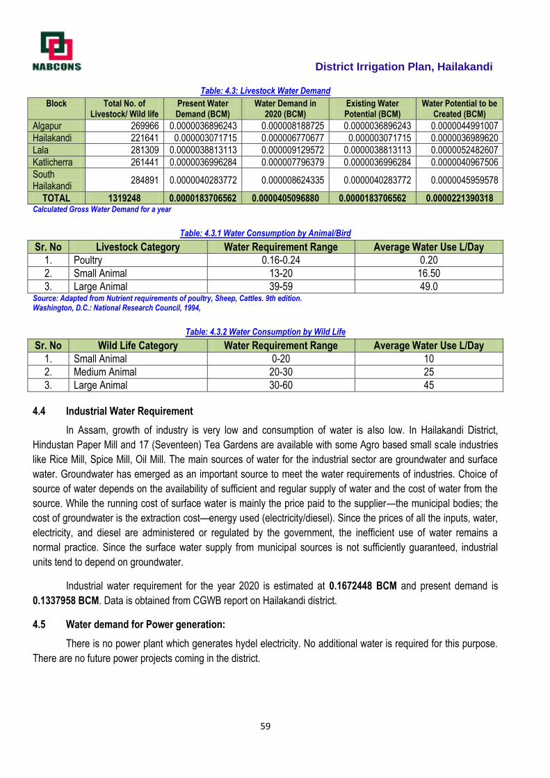
District Irrigation Plan, Hailakandi
59
Table: 4.3: Livestock Water Demand
Block Total No. of Livestock/ Wild life
Present Water Demand (BCM)
Water Demand in 2020 (BCM)
Existing Water Potential (BCM)
Water Potential to be Created (BCM)
Algapur 269966 0.0000036896243 0.000008188725 0.0000036896243 0.0000044991007
Hailakandi 221641 0.000003071715 0.000006770677 0.000003071715 0.0000036989620
Lala 281309 0.0000038813113 0.000009129572 0.0000038813113 0.0000052482607
Katlicherra 261441 0.0000036996284 0.000007796379 0.0000036996284 0.0000040967506
South Hailakandi
284891 0.0000040283772 0.000008624335 0.0000040283772 0.0000045959578
TOTAL 1319248 0.0000183706562 0.0000405096880 0.0000183706562 0.0000221390318 Calculated Gross Water Demand for a year
Table: 4.3.1 Water Consumption by Animal/Bird
Sr. No Livestock Category Water Requirement Range Average Water Use L/Day
1. Poultry 0.16-0.24 0.20
2. Small Animal 13-20 16.50
3. Large Animal 39-59 49.0 Source: Adapted from Nutrient requirements of poultry, Sheep, Cattles. 9th edition. Washington, D.C.: National Research Council, 1994,
Table: 4.3.2 Water Consumption by Wild Life
Sr. No Wild Life Category Water Requirement Range Average Water Use L/Day
1. Small Animal 0-20 10
2. Medium Animal 20-30 25
3. Large Animal 30-60 45
4.4 Industrial Water Requirement
In Assam, growth of industry is very low and consumption of water is also low. In Hailakandi District,
Hindustan Paper Mill and 17 (Seventeen) Tea Gardens are available with some Agro based small scale industries
like Rice Mill, Spice Mill, Oil Mill. The main sources of water for the industrial sector are groundwater and surface
water. Groundwater has emerged as an important source to meet the water requirements of industries. Choice of
source of water depends on the availability of sufficient and regular supply of water and the cost of water from the
source. While the running cost of surface water is mainly the price paid to the supplier—the municipal bodies; the
cost of groundwater is the extraction cost—energy used (electricity/diesel). Since the prices of all the inputs, water,
electricity, and diesel are administered or regulated by the government, the inefficient use of water remains a
normal practice. Since the surface water supply from municipal sources is not sufficiently guaranteed, industrial
units tend to depend on groundwater.
Industrial water requirement for the year 2020 is estimated at 0.1672448 BCM and present demand is
0.1337958 BCM. Data is obtained from CGWB report on Hailakandi district.
4.5 Water demand for Power generation:
There is no power plant which generates hydel electricity. No additional water is required for this purpose.
There are no future power projects coming in the district.
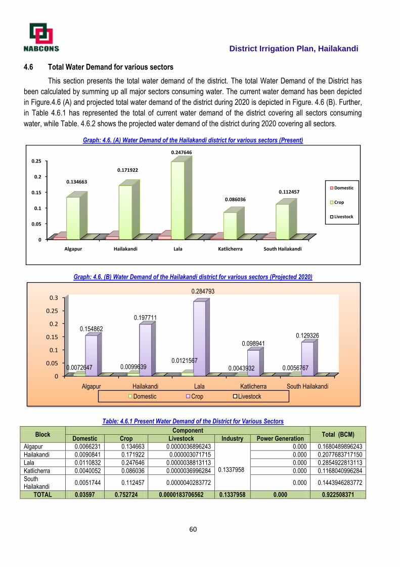
District Irrigation Plan, Hailakandi
60
4.6 Total Water Demand for various sectors
This section presents the total water demand of the district. The total Water Demand of the District has
been calculated by summing up all major sectors consuming water. The current water demand has been depicted
in Figure.4.6 (A) and projected total water demand of the district during 2020 is depicted in Figure. 4.6 (B). Further,
in Table 4.6.1 has represented the total of current water demand of the district covering all sectors consuming
water, while Table. 4.6.2 shows the projected water demand of the district during 2020 covering all sectors.
Graph: 4.6. (A) Water Demand of the Hailakandi district for various sectors (Present)
Graph: 4.6. (B) Water Demand of the Hailakandi district for various sectors (Projected 2020)
Table: 4.6.1 Present Water Demand of the District for Various Sectors
Block Component
Total (BCM) Domestic Crop Livestock Industry Power Generation
Algapur 0.0066231 0.134663 0.0000036896243 0.1337958
0.000 0.1680489896243
Hailakandi 0.0090841 0.171922 0.000003071715 0.000 0.2077683717150
Lala 0.0110832 0.247646 0.0000038813113 0.000 0.2854922813113
Katlicherra 0.0040052 0.086036 0.0000036996284 0.000 0.1168040996284
South Hailakandi
0.0051744 0.112457 0.0000040283772 0.000 0.1443946283772
TOTAL 0.03597 0.752724 0.0000183706562 0.1337958 0.000 0.922508371
0
0.05
0.1
0.15
0.2
0.25
Algapur Hailakandi Lala Katlicherra South Hailakandi
0.134663
0.171922
0.247646
0.086036
0.112457Domestic
Crop
Livestock
0
0.05
0.1
0.15
0.2
0.25
0.3
Algapur Hailakandi Lala Katlicherra South Hailakandi
0.0072647 0.00996390.0121567
0.0043932 0.0056767
0.154862
0.197711
0.284793
0.098941
0.129326
Domestic Crop Livestock
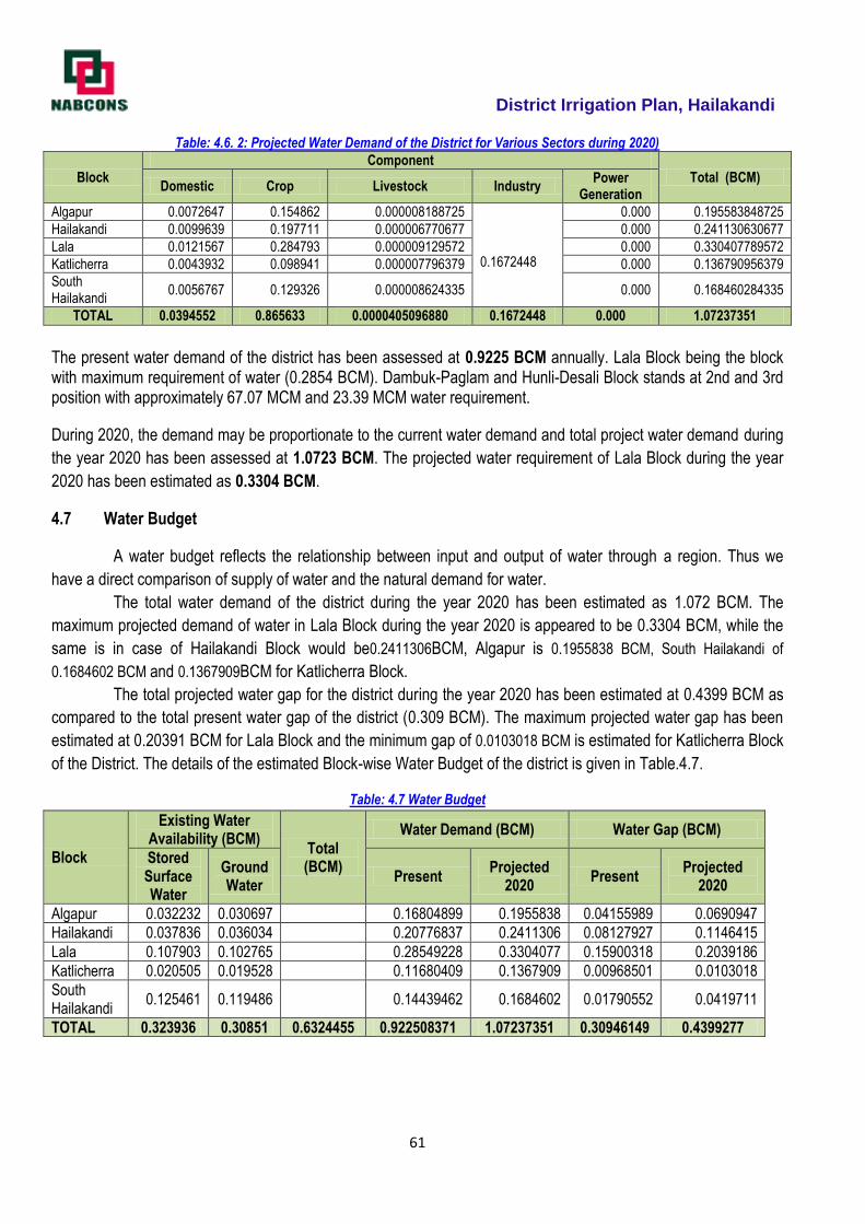
District Irrigation Plan, Hailakandi
61
Table: 4.6. 2: Projected Water Demand of the District for Various Sectors during 2020)
Block
Component
Total (BCM) Domestic Crop Livestock Industry
Power Generation
Algapur 0.0072647 0.154862 0.000008188725 0.1672448
0.000 0.195583848725
Hailakandi 0.0099639 0.197711 0.000006770677 0.000 0.241130630677
Lala 0.0121567 0.284793 0.000009129572 0.000 0.330407789572
Katlicherra 0.0043932 0.098941 0.000007796379 0.000 0.136790956379
South Hailakandi
0.0056767 0.129326 0.000008624335 0.000 0.168460284335
TOTAL 0.0394552 0.865633 0.0000405096880 0.1672448 0.000 1.07237351
The present water demand of the district has been assessed at 0.9225 BCM annually. Lala Block being the block with maximum requirement of water (0.2854 BCM). Dambuk-Paglam and Hunli-Desali Block stands at 2nd and 3rd position with approximately 67.07 MCM and 23.39 MCM water requirement.
During 2020, the demand may be proportionate to the current water demand and total project water demand during
the year 2020 has been assessed at 1.0723 BCM. The projected water requirement of Lala Block during the year
2020 has been estimated as 0.3304 BCM.
4.7 Water Budget
A water budget reflects the relationship between input and output of water through a region. Thus we
have a direct comparison of supply of water and the natural demand for water.
The total water demand of the district during the year 2020 has been estimated as 1.072 BCM. The
maximum projected demand of water in Lala Block during the year 2020 is appeared to be 0.3304 BCM, while the
same is in case of Hailakandi Block would be0.2411306BCM, Algapur is 0.1955838 BCM, South Hailakandi of
0.1684602 BCM and 0.1367909BCM for Katlicherra Block.
The total projected water gap for the district during the year 2020 has been estimated at 0.4399 BCM as
compared to the total present water gap of the district (0.309 BCM). The maximum projected water gap has been
estimated at 0.20391 BCM for Lala Block and the minimum gap of 0.0103018 BCM is estimated for Katlicherra Block
of the District. The details of the estimated Block-wise Water Budget of the district is given in Table.4.7.
Table: 4.7 Water Budget
Block
Existing Water Availability (BCM)
Total (BCM)
Water Demand (BCM) Water Gap (BCM)
Stored Surface Water
Ground Water
Present Projected
2020 Present
Projected 2020
Algapur 0.032232 0.030697 0.16804899 0.1955838 0.04155989 0.0690947
Hailakandi 0.037836 0.036034 0.20776837 0.2411306 0.08127927 0.1146415
Lala 0.107903 0.102765 0.28549228 0.3304077 0.15900318 0.2039186
Katlicherra 0.020505 0.019528 0.11680409 0.1367909 0.00968501 0.0103018
South Hailakandi
0.125461 0.119486 0.14439462 0.1684602 0.01790552 0.0419711
TOTAL 0.323936 0.30851 0.6324455 0.922508371 1.07237351 0.30946149 0.4399277
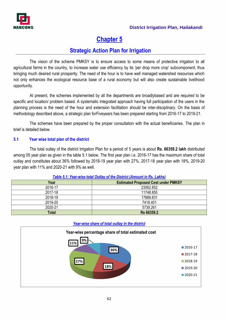
District Irrigation Plan, Hailakandi
62
Chapter 5
Strategic Action Plan for Irrigation
The vision of the scheme PMKSY is to ensure access to some means of protective irrigation to all
agricultural farms in the country, to increase water use efficiency by its ‗per drop more crop‘ subcomponent, thus
bringing much desired rural prosperity. The need of the hour is to have well managed watershed resources which
not only enhances the ecological resource base of a rural economy but will also create sustainable livelihood
opportunity.
At present, the schemes implemented by all the departments are broadlybased and are required to be
specific and location/ problem based. A systematic integrated approach having full participation of the users in the
planning process is the need of the hour and extension facilitation should be inter-disciplinary. On the basis of
methodology described above, a strategic plan forFiveyears has been prepared starting from 2016-17 to 2019-21.
The schemes have been prepared by the proper consultation with the actual beneficiaries. The plan in
brief is detailed below.
5.1 Year wise total plan of the district
The total outlay of the district Irrigation Plan for a period of 5 years is about Rs. 66359.2 lakh distributed
among 05 year plan as given in the table 5.1 below. The first year plan i.e. 2016-17 has the maximum share of total
outlay and constitutes about 36% followed by 2018-19 year plan with 27%, 2017-18 year plan with 18%, 2019-20
year plan with 11% and 2020-21 with 9% as well.
Table 5.1: Year-wise total Outlay of the District (Amount in Rs. Lakhs)
Year Estimated Proposed Cost under PMKSY
2016-17 23562.852
2017-18 11748.855
2018-19 17889.831
2019-20 7418.401
2020-21 5739.261
Total Rs 66359.2
Year-wise share of total outlay in the district
36%
18%
27%
11%9%
Year-wise percentage share of total estimated cost
2016-17
2017-18
2018-19
2019-20
2020-21
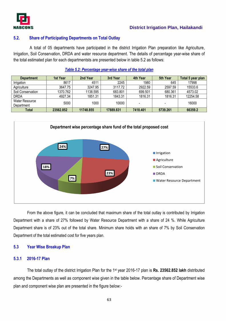
District Irrigation Plan, Hailakandi
63
5.2. Share of Participating Departments on Total Outlay
A total of 05 departments have participated in the district Irrigation Plan preparation like Agriculture,
Irrigation, Soil Conservation, DRDA and water resource department. The details of percentage year-wise share of
the total estimated plan for each departmentsts are presented below in table 5.2 as follows:
Table 5.2: Percentage year-wise share of the total plan
Department 1st Year 2nd Year 3rd Year 4th Year 5th Year Total 5 year plan
Irrigation 8617 4511 2245 1980 645 17998
Agriculture 3647.75 3247.95 3117.72 2922.59 2597.59 15533.6
Soil Conservation 1370.762 1138.595 683.801 699.501 680.361 4573.02
DRDA 4927.34 1851.31 1843.31 1816.31 1816.31 12254.58
Water Resource Department
5000 1000 10000 - - 16000
Total 23562.852 11748.855 17889.831 7418.401 5739.261 66359.2
From the above figure, it can be concluded that maximum share of the total outlay is contributed by Irrigation
Department with a share of 27% followed by Water Resource Department with a share of 24 %. While Agriculture
Department share is of 23% out of the total share. Minimum share holds with an share of 7% by Soil Conservation
Department of the total estimated cost for five years plan.
5.3 Year Wise Breakup Plan
5.3.1 2016-17 Plan
The total outlay of the district Irrigation Plan for the 1st year 2016-17 plan is Rs. 23562.852 lakh distributed
among the Departments as well as component wise given in the table below. Percentage share of Department wise
plan and component wise plan are presented in the figure below:-
27%
23%
7%
18%
24%
Department wise percentage share fund of the total proposed cost
Irrigation
Agriculture
Soil Conservation
DRDA
Water Resource Department
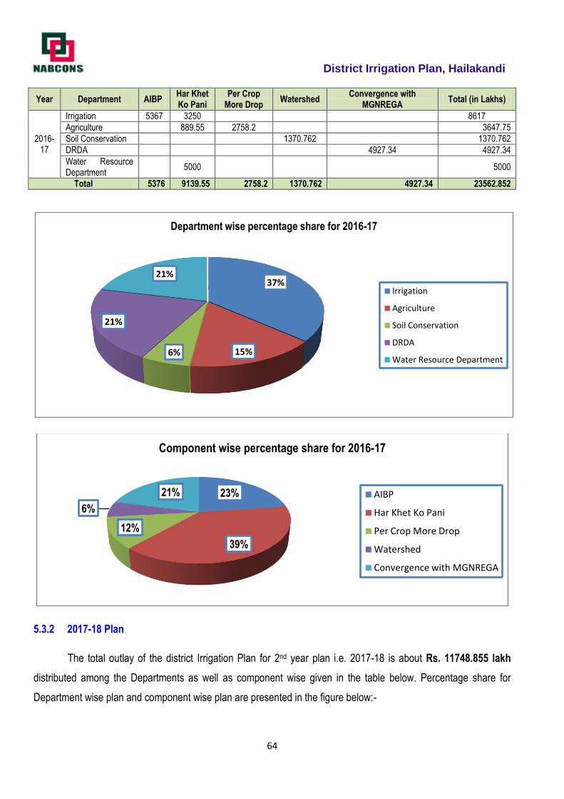
District Irrigation Plan, Hailakandi
64
Year Department AIBP Har Khet Ko Pani
Per Crop More Drop
Watershed Convergence with
MGNREGA Total (in Lakhs)
2016-17
Irrigation 5367 3250 8617
Agriculture 889.55 2758.2 3647.75
Soil Conservation 1370.762 1370.762
DRDA 4927.34 4927.34
Water Resource Department
5000 5000
Total 5376 9139.55 2758.2 1370.762 4927.34 23562.852
5.3.2 2017-18 Plan
The total outlay of the district Irrigation Plan for 2nd year plan i.e. 2017-18 is about Rs. 11748.855 lakh
distributed among the Departments as well as component wise given in the table below. Percentage share for
Department wise plan and component wise plan are presented in the figure below:-
37%
15%6%
21%
21%
Department wise percentage share for 2016-17
Irrigation
Agriculture
Soil Conservation
DRDA
Water Resource Department
23%
39%
12%
6%
21%
Component wise percentage share for 2016-17
AIBP
Har Khet Ko Pani
Per Crop More Drop
Watershed
Convergence with MGNREGA
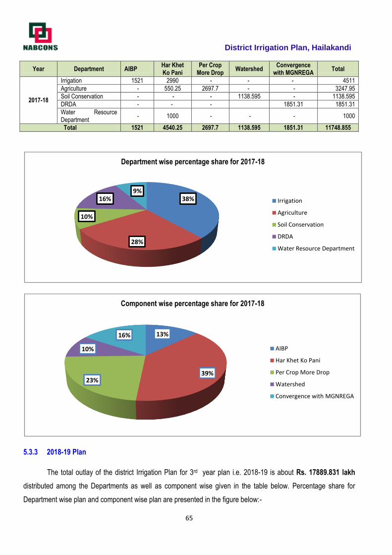
District Irrigation Plan, Hailakandi
65
Year Department AIBP Har Khet Ko Pani
Per Crop More Drop
Watershed Convergence
with MGNREGA Total
2017-18
Irrigation 1521 2990 - - - 4511
Agriculture - 550.25 2697.7 - - 3247.95
Soil Conservation - - - 1138.595 - 1138.595
DRDA - - - 1851.31 1851.31
Water Resource Department
- 1000 - - - 1000
Total 1521 4540.25 2697.7 1138.595 1851.31 11748.855
5.3.3 2018-19 Plan
The total outlay of the district Irrigation Plan for 3rd year plan i.e. 2018-19 is about Rs. 17889.831 lakh
distributed among the Departments as well as component wise given in the table below. Percentage share for
Department wise plan and component wise plan are presented in the figure below:-
38%
28%
10%
16%9%
Department wise percentage share for 2017-18
Irrigation
Agriculture
Soil Conservation
DRDA
Water Resource Department
13%
39%23%
10%
16%
Component wise percentage share for 2017-18
AIBP
Har Khet Ko Pani
Per Crop More Drop
Watershed
Convergence with MGNREGA
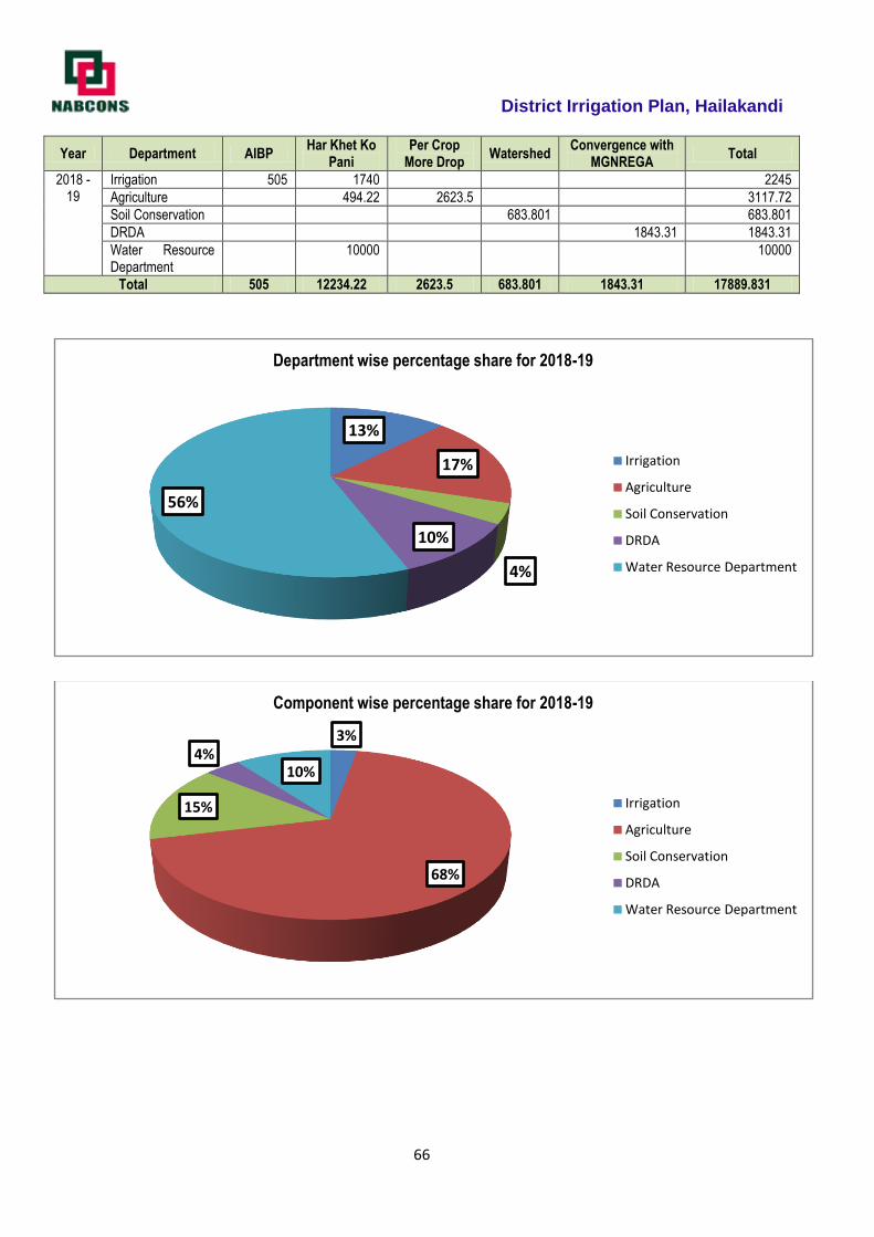
District Irrigation Plan, Hailakandi
66
Year Department AIBP Har Khet Ko
Pani Per Crop
More Drop Watershed
Convergence with MGNREGA
Total
2018 -19
Irrigation 505 1740 2245
Agriculture 494.22 2623.5 3117.72
Soil Conservation 683.801 683.801
DRDA 1843.31 1843.31
Water Resource Department
10000 10000
Total 505 12234.22 2623.5 683.801 1843.31 17889.831
13%
17%
4%
10%
56%
Department wise percentage share for 2018-19
Irrigation
Agriculture
Soil Conservation
DRDA
Water Resource Department
3%
68%
15%
4%10%
Component wise percentage share for 2018-19
Irrigation
Agriculture
Soil Conservation
DRDA
Water Resource Department
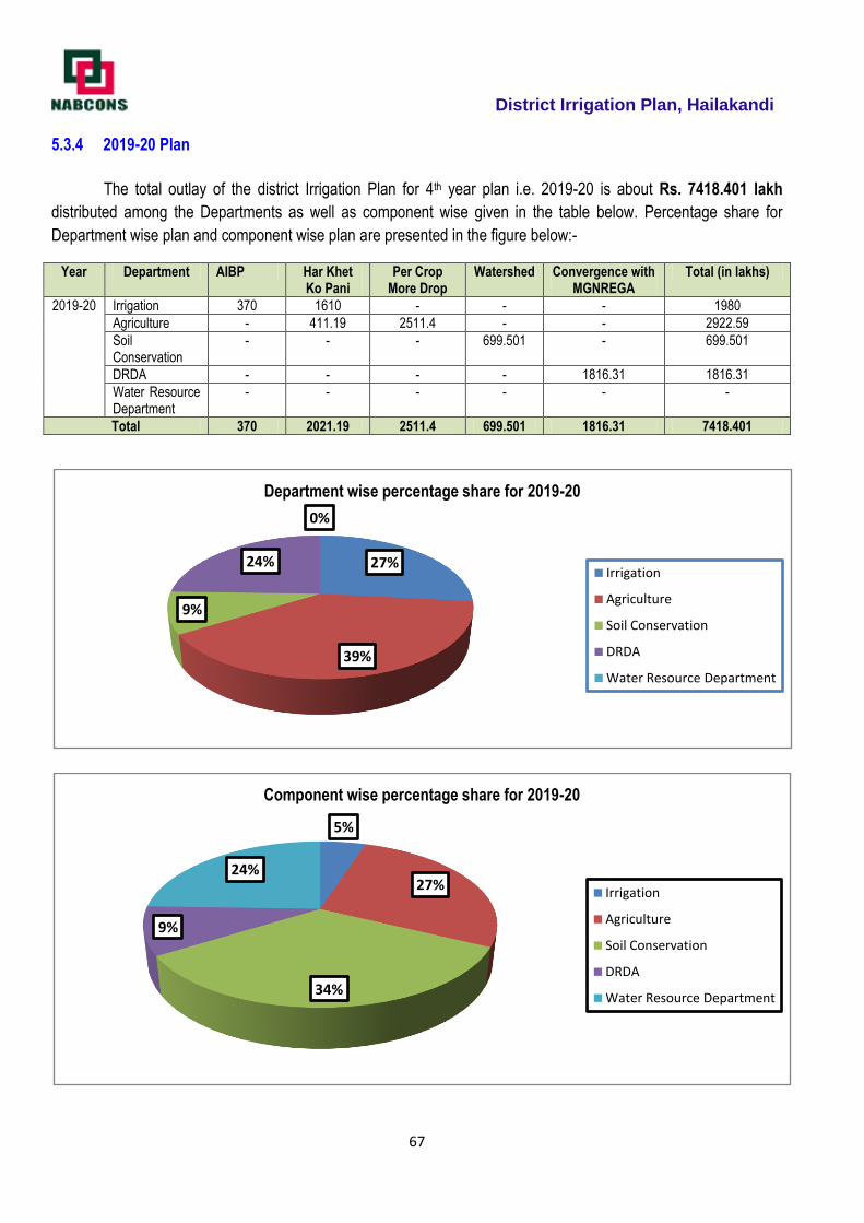
District Irrigation Plan, Hailakandi
67
5.3.4 2019-20 Plan
The total outlay of the district Irrigation Plan for 4th year plan i.e. 2019-20 is about Rs. 7418.401 lakh
distributed among the Departments as well as component wise given in the table below. Percentage share for
Department wise plan and component wise plan are presented in the figure below:-
Year Department AIBP Har Khet Ko Pani
Per Crop More Drop
Watershed Convergence with MGNREGA
Total (in lakhs)
2019-20 Irrigation 370 1610 - - - 1980
Agriculture - 411.19 2511.4 - - 2922.59
Soil Conservation
- - - 699.501 - 699.501
DRDA - - - - 1816.31 1816.31
Water Resource Department
- - - - - -
Total 370 2021.19 2511.4 699.501 1816.31 7418.401
27%
39%
9%
24%
0%
Department wise percentage share for 2019-20
Irrigation
Agriculture
Soil Conservation
DRDA
Water Resource Department
5%
27%
34%
9%
24%
Component wise percentage share for 2019-20
Irrigation
Agriculture
Soil Conservation
DRDA
Water Resource Department
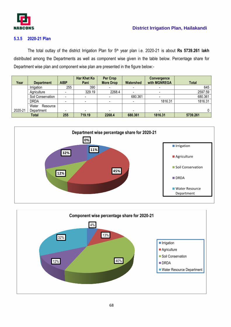
District Irrigation Plan, Hailakandi
68
5.3.5 2020-21 Plan
The total outlay of the district Irrigation Plan for 5th year plan i.e. 2020-21 is about Rs 5739.261 lakh
distributed among the Departments as well as component wise given in the table below. Percentage share for
Department wise plan and component wise plan are presented in the figure below:-
Year Department AIBP Har Khet Ko
Pani Per Crop
More Drop Watershed Convergence
with MGNREGA Total
2020-21
Irrigation 255 390 - - - 645
Agriculture - 329.19 2268.4 - - 2597.59
Soil Conservation - - - 680.361 - 680.361
DRDA - - - - 1816.31 1816.31
Water Resource Department - - - - - 0
Total 255 719.19 2268.4 680.361 1816.31 5739.261
11%
45%12%
32%
0%
Department wise percentage share for 2020-21
Irrigation
Agriculture
Soil Conservation
DRDA
Water Resource Department
4%
13%
40%12%
32%
Component wise percentage share for 2020-21
Irrigation
Agriculture
Soil Conservation
DRDA
Water Resource Department

District Irrigation Plan, Hailakandi
69
5.4 Suggestions
For successful implementation of PMKSY plan it is suggested that:
All the stakeholders should convene meeting of Panchayat Samities and then finalize the village plan and
prepare DPR.
There should not be any duplicity of project.
The Department should supplement each other so that the maximum irrigation efficiency is achieved.
Agriculture and Horticulture Department should take micro irrigation projects in the command of minor
irrigation projects which are either completed or likely to be completed in near future.
All the irrigation projects should have a component of water conveyance so that the each drop of water is
judiciously utilized.
Where ever feasible, solar pumpsets should be installed.
All the structures planned should be geo tagged and marked on map, so that social monitoring of the
projects can be conducted. This will also avoid the duplicity.
Priority should be given to projects to minimize the gap in potential created and potential utilized.
Wherever sites with low head LIS have already been exhausted, higher per hectare norms should be
allowed.
Execution of the scheme should be expeditiously completed.
There should be smooth fund flow for timely completion of the project and to avoid cost escalation.
District Irrigation Plan, Hailakandi
70
`
ANNEXURES
Strategic Action Plan for Irrigation of Hailakandi District under PMKSY
District Irrigation Plan, Hailakandi
71
2016-17 DistrictIrrigation plan
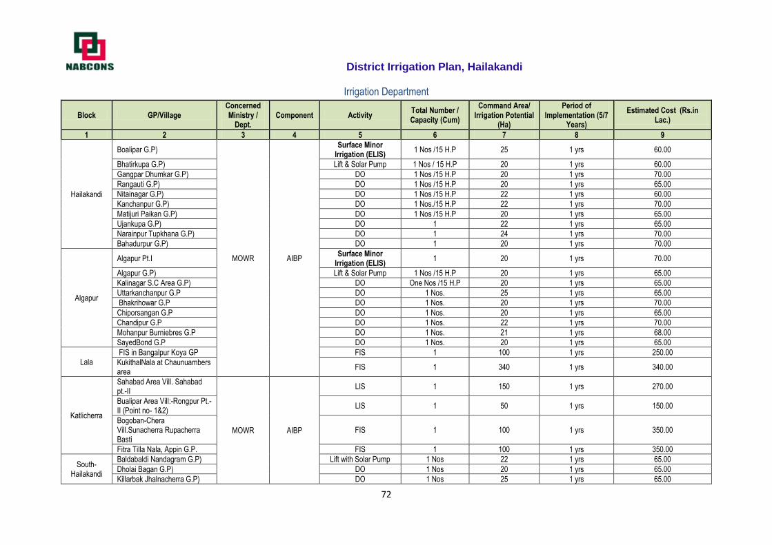
District Irrigation Plan, Hailakandi
72
Irrigation Department
Block GP/Village Concerned Ministry /
Dept. Component Activity
Total Number / Capacity (Cum)
Command Area/ Irrigation Potential
(Ha)
Period of Implementation (5/7
Years)
Estimated Cost (Rs.in Lac.)
1 2 3 4 5 6 7 8 9
Hailakandi
Boalipar G.P)
MOWR AIBP
Surface Minor Irrigation (ELIS)
1 Nos /15 H.P 25 1 yrs 60.00
Bhatirkupa G.P) Lift & Solar Pump 1 Nos / 15 H.P 20 1 yrs 60.00
Gangpar Dhumkar G.P) DO 1 Nos /15 H.P 20 1 yrs 70.00
Rangauti G.P) DO 1 Nos /15 H.P 20 1 yrs 65.00
Nitainagar G.P) DO 1 Nos /15 H.P 22 1 yrs 60.00
Kanchanpur G.P) DO 1 Nos./15 H.P 22 1 yrs 70.00
Matijuri Paikan G.P) DO 1 Nos /15 H.P 20 1 yrs 65.00
Ujankupa G.P) DO 1 22 1 yrs 65.00
Narainpur Tupkhana G.P) DO 1 24 1 yrs 70.00
Bahadurpur G.P) DO 1 20 1 yrs 70.00
Algapur
Algapur Pt.I Surface Minor
Irrigation (ELIS) 1 20 1 yrs 70.00
Algapur G.P) Lift & Solar Pump 1 Nos /15 H.P 20 1 yrs 65.00
Kalinagar S.C Area G.P) DO One Nos /15 H.P 20 1 yrs 65.00
Uttarkanchanpur G.P DO 1 Nos. 25 1 yrs 65.00
Bhakrihowar G.P DO 1 Nos. 20 1 yrs 70.00
Chiporsangan G.P DO 1 Nos. 20 1 yrs 65.00
Chandipur G.P DO 1 Nos. 22 1 yrs 70.00
Mohanpur Burniebres G.P DO 1 Nos. 21 1 yrs 68.00
SayedBond G.P DO 1 Nos. 20 1 yrs 65.00
Lala
FIS in Bangalpur Koya GP FIS 1 100 1 yrs 250.00
KukithalNala at Chaunuambers area
FIS 1 340 1 yrs 340.00
Katlicherra
Sahabad Area Vill. Sahabad pt.-II
MOWR AIBP
LIS 1 150 1 yrs 270.00
Bualipar Area Vill:-Rongpur Pt.-II (Point no- 1&2)
LIS 1 50 1 yrs 150.00
Bogoban-Chera Vill.Sunacherra Rupacherra Basti
FIS 1 100 1 yrs 350.00
Fitra Tilla Nala, Appin G.P. FIS 1 100 1 yrs 350.00
South-Hailakandi
Baldabaldi Nandagram G.P) Lift with Solar Pump 1 Nos 22 1 yrs 65.00
Dholai Bagan G.P) DO 1 Nos 20 1 yrs 65.00
Killarbak Jhalnacherra G.P) DO 1 Nos 25 1 yrs 65.00

District Irrigation Plan, Hailakandi
73
Manipur Niskar G.P) DO 1 Nos 20 1 yrs 65.00
Gharmura Baghcherra G.P) DO 1 Nos 21 1 yrs 60.00
Baruncherra Kukicherra G.P) DO 1 Nos 25 1 yrs 65.00
Jamira G.P) DO 1 Nos 20 1 yrs 65.00
Dhariarghat Karicherra G.P) DO 1 Nos 22 1 yrs 65.00
Palaicherra G.P) DO 1 Nos 21 1 yrs 66.00
Algapur Algapur G.P
MOWR AIBP
Lift & Solar Pump 1 Nos /15 H.P 25 1 yrs 70.00
Kalinagar S.C Area G.P Lift & Solar Pump 1 No / 15 H.P 22 1 yrs 70.00
Lala
Krishnapur area Mohamedpur Joy Krishnapur GP (Solar)
DO 1 20 1 yrs 65.00
Mohamedpur Pt-II (Solar) Lift & Solar Pump 1 22 1 yrs 60.00
Sarbanandopur&Nizvernapur GP (Solar)
DO 1 25 1 yrs 75.00
Jalalpur Tantoo Donipur GP (Solar)
DO 1 19 1 yrs 60.00
Purbo Kettar Band Rajesopur Chandropur GP(Solar )
DO 1 20 1 yrs 65.00
Mukta Cherra Rajesopur GP(Solar)
DO 1 20 1 yrs 65.00
Gudam Ghat Monasara GP(Sol.
DO 1 22 1 yrs 65.00
Saidpur Tantu GP(Solar) DO 1 28 1 yrs 80.00
Tero number Sarbanandapur GP(Solar)
DO 1 25 1 yrs 75.00
Vichingcha-1 Bowerghat GP(Solar)
DO 1 23 1 yrs 65.00
Bowabeel area At Dudpur Kuchila GP(Solar)
DO 1 22 1 yrs 65.00
Amla, Purbo Ketterband Rajeswarpur GP(Solar)
DO 1 20 1 yrs 65.00
Kattlicherra
D.T.W. (Solar) Rongpur Pt.-VII Sahabad G.P.
Lift with Solar Pump 1 25 1 yrs 62.00
D.T.W. Chorair Gram Sahabad G.P. (Solar)
DO 1 22 1 yrs 60.00
D.T.W. Tuker Gram Vill:-Rongpur Pt.-I (Solar)
DO 1 25 1 yrs 73.00
D.T.W. Alekjenderpur Rangabak G.P.(solar)
DO 1 22 1 yrs 61.00
D.T.W. Bonogram Area Vill:-Rongpur Pt.-III (Solar) Rangabak G.P.
DO 1 20 1 yrs 66.00
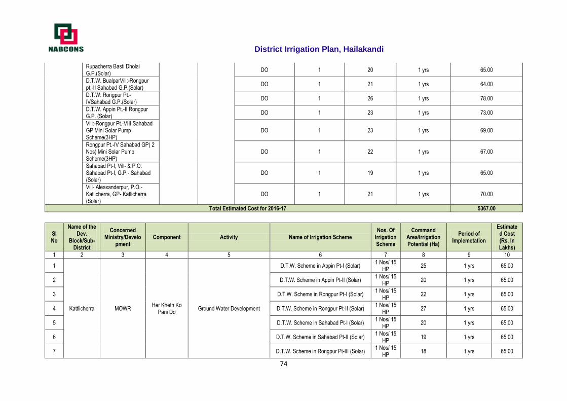
District Irrigation Plan, Hailakandi
74
Rupacherra Basti Dholai G.P.(Solar)
DO 1 20 1 yrs 65.00
D.T.W. BualparVill:-Rongpur pt.-II Sahabad G.P.(Solar)
DO 1 21 1 yrs 64.00
D.T.W. Rongpur Pt.-IVSahabad G.P.(Solar)
DO 1 26 1 yrs 78.00
D.T.W. Appin Pt.-II Rongpur G.P. (Solar)
DO 1 23 1 yrs 73.00
Vill:-Rongpur Pt.-VIII Sahabad GP Mini Solar Pump Scheme(3HP)
DO 1 23 1 yrs 69.00
Rongpur Pt.-IV Sahabad GP( 2 Nos) Mini Solar Pump Scheme(3HP)
DO 1 22 1 yrs 67.00
Sahabad Pt-I, Vill- & P.O. Sahabad Pt-I, G.P.- Sahabad (Solar)
DO 1 19 1 yrs 65.00
Vill- Aleaxanderpur, P.O.- Katlicherra, GP- Katlicherra (Solar)
DO 1 21 1 yrs 70.00
Total Estimated Cost for 2016-17 5367.00
Sl No
Name of the Dev.
Block/Sub-District
Concerned Ministry/Develo
pment Component Activity Name of Irrigation Scheme
Nos. Of Irrigation Scheme
Command Area/Irrigation Potential (Ha)
Period of Implemetation
Estimated Cost (Rs. In Lakhs)
1 2 3 4 5 6 7 8 9 10
1
Kattlicherra MOWR Her Kheth Ko
Pani Do Ground Water Development
D.T.W. Scheme in Appin Pt-I (Solar) 1 Nos/ 15
HP 25 1 yrs 65.00
2 D.T.W. Scheme in Appin Pt-II (Solar) 1 Nos/ 15
HP 20 1 yrs 65.00
3 D.T.W. Scheme in Rongpur Pt-I (Solar) 1 Nos/ 15
HP 22 1 yrs 65.00
4 D.T.W. Scheme in Rongpur Pt-II (Solar) 1 Nos/ 15
HP 27 1 yrs 65.00
5 D.T.W. Scheme in Sahabad Pt-I (Solar) 1 Nos/ 15
HP 20 1 yrs 65.00
6 D.T.W. Scheme in Sahabad Pt-II (Solar) 1 Nos/ 15
HP 19 1 yrs 65.00
7 D.T.W. Scheme in Rongpur Pt-III (Solar) 1 Nos/ 15
HP 18 1 yrs 65.00
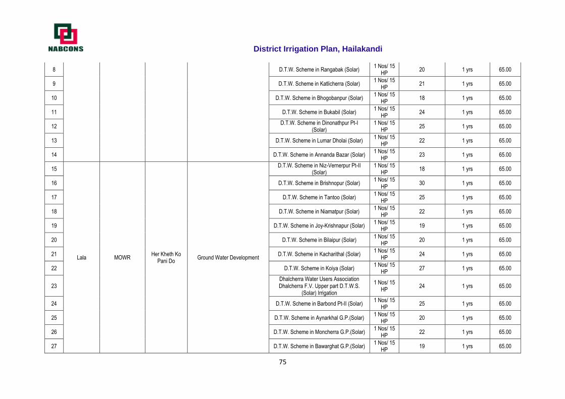
District Irrigation Plan, Hailakandi
75
8 D.T.W. Scheme in Rangabak (Solar) 1 Nos/ 15
HP 20 1 yrs 65.00
9 D.T.W. Scheme in Katlicherra (Solar) 1 Nos/ 15
HP 21 1 yrs 65.00
10 D.T.W. Scheme in Bhogobanpur (Solar) 1 Nos/ 15
HP 18 1 yrs 65.00
11 D.T.W. Scheme in Bukabil (Solar) 1 Nos/ 15
HP 24 1 yrs 65.00
12 D.T.W. Scheme in Dinonathpur Pt-I
(Solar) 1 Nos/ 15
HP 25 1 yrs 65.00
13 D.T.W. Scheme in Lumar Dholai (Solar) 1 Nos/ 15
HP 22 1 yrs 65.00
14 D.T.W. Scheme in Annanda Bazar (Solar) 1 Nos/ 15
HP 23 1 yrs 65.00
15
Lala MOWR Her Kheth Ko
Pani Do Ground Water Development
D.T.W. Scheme in Niz-Vernerpur Pt-II (Solar)
1 Nos/ 15 HP
18 1 yrs 65.00
16 D.T.W. Scheme in Brishnopur (Solar) 1 Nos/ 15
HP 30 1 yrs 65.00
17 D.T.W. Scheme in Tantoo (Solar) 1 Nos/ 15
HP 25 1 yrs 65.00
18 D.T.W. Scheme in Niamatpur (Solar) 1 Nos/ 15
HP 22 1 yrs 65.00
19 D.T.W. Scheme in Joy-Krishnapur (Solar) 1 Nos/ 15
HP 19 1 yrs 65.00
20 D.T.W. Scheme in Bilaipur (Solar) 1 Nos/ 15
HP 20 1 yrs 65.00
21 D.T.W. Scheme in Kacharithal (Solar) 1 Nos/ 15
HP 24 1 yrs 65.00
22 D.T.W. Scheme in Koiya (Solar) 1 Nos/ 15
HP 27 1 yrs 65.00
23 Dhalcherra Water Users Association Dhalcherra F.V. Upper part D.T.W.S.
(Solar) Irrigation
1 Nos/ 15 HP
24 1 yrs 65.00
24 D.T.W. Scheme in Barbond Pt-II (Solar) 1 Nos/ 15
HP 25 1 yrs 65.00
25 D.T.W. Scheme in Aynarkhal G.P.(Solar) 1 Nos/ 15
HP 20 1 yrs 65.00
26 D.T.W. Scheme in Moncherra G.P.(Solar) 1 Nos/ 15
HP 22 1 yrs 65.00
27 D.T.W. Scheme in Bawarghat G.P.(Solar) 1 Nos/ 15
HP 19 1 yrs 65.00
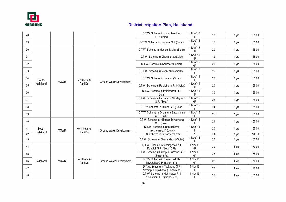
District Irrigation Plan, Hailakandi
76
28 D.T.W. Scheme in Nimaichandpur
G.P.(Solar) 1 Nos/ 15
HP 18 1 yrs 65.00
29 D.T.W. Scheme in Lalamuk G.P.(Solar) 1 Nos/ 15
HP 15 1 yrs 65.00
30
South- Hailakandi
MOWR Her Kheth Ko
Pani Do Ground Water Development
D.T.W. Scheme in Manipur Niskar (Solar) 1 Nos/ 15
HP 20 1 yrs 65.00
31 D.T.W. Scheme in Dhariarghat (Solar) 1 Nos/ 15
HP 19 1 yrs 65.00
32 D.T.W. Scheme in Karicherra (Solar) 1 Nos/ 15
HP 25 1 yrs 65.00
33 D.T.W. Scheme in Nagacherra (Solar) 1 Nos/ 15
HP 26 1 yrs 65.00
34 D.T.W. Scheme in Sampur (Solar) 1 Nos/ 15
HP 22 1 yrs 65.00
35 D.T.W. Scheme in Paloicherra Pt-I (Solar) 1 Nos/ 15
HP 20 1 yrs 65.00
36 D.T.W. Scheme in Paloicherra Pt-II
(Solar) 1 Nos/ 15
HP 30 1 yrs 65.00
37 D.T.W. Scheme in Baldabaldi Nandagram
G.P. (Solar) 1 Nos/ 15
HP 28 1 yrs 65.00
38 D.T.W. Scheme in Jamira G.P.(Solar) 1 Nos/ 15
HP 24 1 yrs 65.00
39 D.T.W. Scheme in Gharmura Bagacherra
G.P. (Solar) 1 Nos/ 15
HP 25 1 yrs 65.00
40
South- Hailakandi
MOWR Her Kheth Ko
Pani Do Ground Water Development
D.T.W. Scheme in Killarbak Jalnacherra G.P. (Solar)
1 Nos/ 15 HP
21 1 yrs 65.00
41 D.T.W. Scheme in Baruncherra
Kukicherra G.P. (Solar) 1 Nos/ 15
HP 20 1 yrs 65.00
42 F.I.S. Scheme in Jalnacherra area 1 100 1 yrs 180.00
43 D.T.W. Scheme in Dhariar Grant (Solar) 1 Nos/ 15
HP 20 1 yrs 65.00
44
Hailakandi MOWR Her Kheth Ko
Pani Do Ground Water Development
D.T.W. Scheme in Vichingcha Pt-II Rangtuli G.P. (Solar) 5Pts
1 No/ 15 HP
30 1 Yrs 70.00
45 D.T.W. Scheme in Dudhpur Barbond G.P.
(Solar) 5Pts 1 No/ 15
HP 25 1 Yrs 65.00
46 D.T.W. Scheme in Bawarghat Pt-I
Bawarghat G.P. (Solar) 5Pts 1 No/ 15
HP 22 1 Yrs 70.00
47 D.T.W. Scheme in Tupkhana G.P Narainpur Tupkhana. (Solar) 5Pts
1 No/ 15 HP
20 1 Yrs 70.00
48 D.T.W. Scheme in Nichintapur Pt-I
Nichintapur G.P.(Solar) 5Pts 1 No/ 15
HP 25 1 Yrs 65.00
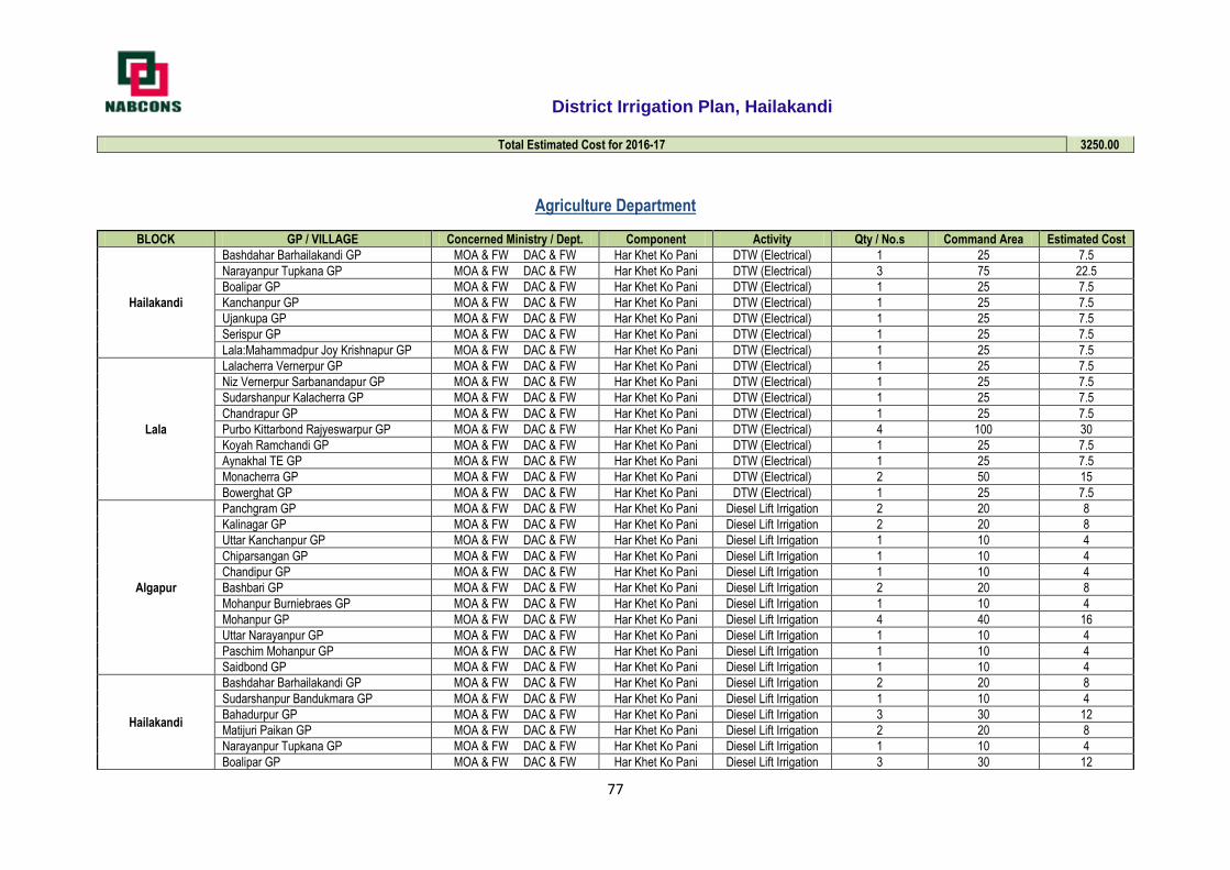
District Irrigation Plan, Hailakandi
77
Total Estimated Cost for 2016-17 3250.00
Agriculture Department
BLOCK GP / VILLAGE Concerned Ministry / Dept. Component Activity Qty / No.s Command Area Estimated Cost
Hailakandi
Bashdahar Barhailakandi GP MOA & FW DAC & FW Har Khet Ko Pani DTW (Electrical) 1 25 7.5
Narayanpur Tupkana GP MOA & FW DAC & FW Har Khet Ko Pani DTW (Electrical) 3 75 22.5
Boalipar GP MOA & FW DAC & FW Har Khet Ko Pani DTW (Electrical) 1 25 7.5
Kanchanpur GP MOA & FW DAC & FW Har Khet Ko Pani DTW (Electrical) 1 25 7.5
Ujankupa GP MOA & FW DAC & FW Har Khet Ko Pani DTW (Electrical) 1 25 7.5
Serispur GP MOA & FW DAC & FW Har Khet Ko Pani DTW (Electrical) 1 25 7.5
Lala:Mahammadpur Joy Krishnapur GP MOA & FW DAC & FW Har Khet Ko Pani DTW (Electrical) 1 25 7.5
Lala
Lalacherra Vernerpur GP MOA & FW DAC & FW Har Khet Ko Pani DTW (Electrical) 1 25 7.5
Niz Vernerpur Sarbanandapur GP MOA & FW DAC & FW Har Khet Ko Pani DTW (Electrical) 1 25 7.5
Sudarshanpur Kalacherra GP MOA & FW DAC & FW Har Khet Ko Pani DTW (Electrical) 1 25 7.5
Chandrapur GP MOA & FW DAC & FW Har Khet Ko Pani DTW (Electrical) 1 25 7.5
Purbo Kittarbond Rajyeswarpur GP MOA & FW DAC & FW Har Khet Ko Pani DTW (Electrical) 4 100 30
Koyah Ramchandi GP MOA & FW DAC & FW Har Khet Ko Pani DTW (Electrical) 1 25 7.5
Aynakhal TE GP MOA & FW DAC & FW Har Khet Ko Pani DTW (Electrical) 1 25 7.5
Monacherra GP MOA & FW DAC & FW Har Khet Ko Pani DTW (Electrical) 2 50 15
Bowerghat GP MOA & FW DAC & FW Har Khet Ko Pani DTW (Electrical) 1 25 7.5
Algapur
Panchgram GP MOA & FW DAC & FW Har Khet Ko Pani Diesel Lift Irrigation 2 20 8
Kalinagar GP MOA & FW DAC & FW Har Khet Ko Pani Diesel Lift Irrigation 2 20 8
Uttar Kanchanpur GP MOA & FW DAC & FW Har Khet Ko Pani Diesel Lift Irrigation 1 10 4
Chiparsangan GP MOA & FW DAC & FW Har Khet Ko Pani Diesel Lift Irrigation 1 10 4
Chandipur GP MOA & FW DAC & FW Har Khet Ko Pani Diesel Lift Irrigation 1 10 4
Bashbari GP MOA & FW DAC & FW Har Khet Ko Pani Diesel Lift Irrigation 2 20 8
Mohanpur Burniebraes GP MOA & FW DAC & FW Har Khet Ko Pani Diesel Lift Irrigation 1 10 4
Mohanpur GP MOA & FW DAC & FW Har Khet Ko Pani Diesel Lift Irrigation 4 40 16
Uttar Narayanpur GP MOA & FW DAC & FW Har Khet Ko Pani Diesel Lift Irrigation 1 10 4
Paschim Mohanpur GP MOA & FW DAC & FW Har Khet Ko Pani Diesel Lift Irrigation 1 10 4
Saidbond GP MOA & FW DAC & FW Har Khet Ko Pani Diesel Lift Irrigation 1 10 4
Hailakandi
Bashdahar Barhailakandi GP MOA & FW DAC & FW Har Khet Ko Pani Diesel Lift Irrigation 2 20 8
Sudarshanpur Bandukmara GP MOA & FW DAC & FW Har Khet Ko Pani Diesel Lift Irrigation 1 10 4
Bahadurpur GP MOA & FW DAC & FW Har Khet Ko Pani Diesel Lift Irrigation 3 30 12
Matijuri Paikan GP MOA & FW DAC & FW Har Khet Ko Pani Diesel Lift Irrigation 2 20 8
Narayanpur Tupkana GP MOA & FW DAC & FW Har Khet Ko Pani Diesel Lift Irrigation 1 10 4
Boalipar GP MOA & FW DAC & FW Har Khet Ko Pani Diesel Lift Irrigation 3 30 12
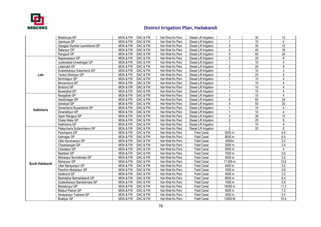
District Irrigation Plan, Hailakandi
78
Bhatirkupa GP MOA & FW DAC & FW Har Khet Ko Pani Diesel Lift Irrigation 3 30 12
Ujankupa GP MOA & FW DAC & FW Har Khet Ko Pani Diesel Lift Irrigation 1 10 4
Gangpar Dumkar Laxmirbond GP MOA & FW DAC & FW Har Khet Ko Pani Diesel Lift Irrigation 3 30 12
Ratanpur GP MOA & FW DAC & FW Har Khet Ko Pani Diesel Lift Irrigation 4 40 16
Rangauti GP MOA & FW DAC & FW Har Khet Ko Pani Diesel Lift Irrigation 6 60 24
Lala
Rajyeswarpur GP MOA & FW DAC & FW Har Khet Ko Pani Diesel Lift Irrigation 2 20 8
Jyotsnabad Umednagar GP MOA & FW DAC & FW Har Khet Ko Pani Diesel Lift Irrigation 1 10 4
Lalamukh GP MOA & FW DAC & FW Har Khet Ko Pani Diesel Lift Irrigation 2 20 8
Sudarshanpur Kalacherra GP MOA & FW DAC & FW Har Khet Ko Pani Diesel Lift Irrigation 1 10 4
Tantoo Dhanipur GP MOA & FW DAC & FW Har Khet Ko Pani Diesel Lift Irrigation 2 20 8
Nichintapur GP MOA & FW DAC & FW Har Khet Ko Pani Diesel Lift Irrigation 1 10 4
Monacherra GP MOA & FW DAC & FW Har Khet Ko Pani Diesel Lift Irrigation 1 10 4
Borbond GP MOA & FW DAC & FW Har Khet Ko Pani Diesel Lift Irrigation 1 10 4
Bowerghat GP MOA & FW DAC & FW Har Khet Ko Pani Diesel Lift Irrigation 1 10 4
Katlicherra
Rangabak GP MOA & FW DAC & FW Har Khet Ko Pani Diesel Lift Irrigation 1 10 4
Harishnagar GP MOA & FW DAC & FW Har Khet Ko Pani Diesel Lift Irrigation 6 60 24
Sahabad GP MOA & FW DAC & FW Har Khet Ko Pani Diesel Lift Irrigation 5 50 20
Sonacherra Rupacherra GP MOA & FW DAC & FW Har Khet Ko Pani Diesel Lift Irrigation 1 10 4
Dinanathpur GP MOA & FW DAC & FW Har Khet Ko Pani Diesel Lift Irrigation 1 10 4
Appin Rangpur GP MOA & FW DAC & FW Har Khet Ko Pani Diesel Lift Irrigation 3 30 12
Dhalai Malai GP MOA & FW DAC & FW Har Khet Ko Pani Diesel Lift Irrigation 2 20 8
Katlicherra GP MOA & FW DAC & FW Har Khet Ko Pani Diesel Lift Irrigation 1 10 4
South Hailakandi
Palaycherra Sultanicherra GP MOA & FW DAC & FW Har Khet Ko Pani Diesel Lift Irrigation 2 20 8
Panchgram GP MOA & FW DAC & FW Har Khet Ko Pani Field Canal 6000 m 4.8
Kalinagar GP MOA & FW DAC & FW Har Khet Ko Pani Field Canal 8000 m 6.4
Uttar Kanchanpur GP MOA & FW DAC & FW Har Khet Ko Pani Field Canal 4000m 3.2
Chiparsangan GP MOA & FW DAC & FW Har Khet Ko Pani Field Canal 3000 m 2.4
Chandipur GP MOA & FW DAC & FW Har Khet Ko Pani Field Canal 5000 m 4
Bashbari GP MOA & FW DAC & FW Har Khet Ko Pani Field Canal 7000 m 5.6
Mohanpur Burniebraes GP MOA & FW DAC & FW Har Khet Ko Pani Field Canal 4000 m 3.2
Mohanpur GP MOA & FW DAC & FW Har Khet Ko Pani Field Canal 17 000 m 13.6
Uttar Narayanpur GP MOA & FW DAC & FW Har Khet Ko Pani Field Canal 4000 m 3.2
Paschim Mohanpur GP MOA & FW DAC & FW Har Khet Ko Pani Field Canal 1000 m 0.8
Saidbond GP MOA & FW DAC & FW Har Khet Ko Pani Field Canal 4000 m 3.2
Bashdahar Barhailakandi GP MOA & FW DAC & FW Har Khet Ko Pani Field Canal 8000 m 6.4
Sudarshanpur Bandukmara GP MOA & FW DAC & FW Har Khet Ko Pani Field Canal 1000 m 0.8
Bahadurpur GP MOA & FW DAC & FW Har Khet Ko Pani Field Canal 14000 m 11.2
Matijuri Paikan GP MOA & FW DAC & FW Har Khet Ko Pani Field Canal 9000 m 7.2
Narayanpur Tupkana GP MOA & FW DAC & FW Har Khet Ko Pani Field Canal 3000 m 2.4
Boalipar GP MOA & FW DAC & FW Har Khet Ko Pani Field Canal 13000 M 10.4
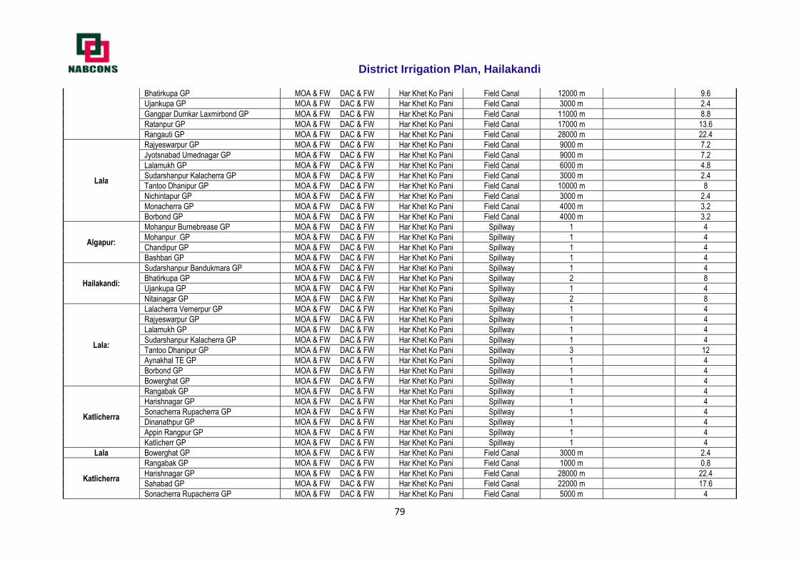
District Irrigation Plan, Hailakandi
79
Bhatirkupa GP MOA & FW DAC & FW Har Khet Ko Pani Field Canal 12000 m 9.6
Ujankupa GP MOA & FW DAC & FW Har Khet Ko Pani Field Canal 3000 m 2.4
Gangpar Dumkar Laxmirbond GP MOA & FW DAC & FW Har Khet Ko Pani Field Canal 11000 m 8.8
Ratanpur GP MOA & FW DAC & FW Har Khet Ko Pani Field Canal 17000 m 13.6
Rangauti GP MOA & FW DAC & FW Har Khet Ko Pani Field Canal 28000 m 22.4
Lala
Rajyeswarpur GP MOA & FW DAC & FW Har Khet Ko Pani Field Canal 9000 m 7.2
Jyotsnabad Umednagar GP MOA & FW DAC & FW Har Khet Ko Pani Field Canal 9000 m 7.2
Lalamukh GP MOA & FW DAC & FW Har Khet Ko Pani Field Canal 6000 m 4.8
Sudarshanpur Kalacherra GP MOA & FW DAC & FW Har Khet Ko Pani Field Canal 3000 m 2.4
Tantoo Dhanipur GP MOA & FW DAC & FW Har Khet Ko Pani Field Canal 10000 m 8
Nichintapur GP MOA & FW DAC & FW Har Khet Ko Pani Field Canal 3000 m 2.4
Monacherra GP MOA & FW DAC & FW Har Khet Ko Pani Field Canal 4000 m 3.2
Borbond GP MOA & FW DAC & FW Har Khet Ko Pani Field Canal 4000 m 3.2
Algapur:
Mohanpur Burnebrease GP MOA & FW DAC & FW Har Khet Ko Pani Spillway 1 4
Mohanpur GP MOA & FW DAC & FW Har Khet Ko Pani Spillway 1 4
Chandipur GP MOA & FW DAC & FW Har Khet Ko Pani Spillway 1 4
Bashbari GP MOA & FW DAC & FW Har Khet Ko Pani Spillway 1 4
Hailakandi:
Sudarshanpur Bandukmara GP MOA & FW DAC & FW Har Khet Ko Pani Spillway 1 4
Bhatirkupa GP MOA & FW DAC & FW Har Khet Ko Pani Spillway 2 8
Ujankupa GP MOA & FW DAC & FW Har Khet Ko Pani Spillway 1 4
Nitainagar GP MOA & FW DAC & FW Har Khet Ko Pani Spillway 2 8
Lala:
Lalacherra Vernerpur GP MOA & FW DAC & FW Har Khet Ko Pani Spillway 1 4
Rajyeswarpur GP MOA & FW DAC & FW Har Khet Ko Pani Spillway 1 4
Lalamukh GP MOA & FW DAC & FW Har Khet Ko Pani Spillway 1 4
Sudarshanpur Kalacherra GP MOA & FW DAC & FW Har Khet Ko Pani Spillway 1 4
Tantoo Dhanipur GP MOA & FW DAC & FW Har Khet Ko Pani Spillway 3 12
Aynakhal TE GP MOA & FW DAC & FW Har Khet Ko Pani Spillway 1 4
Borbond GP MOA & FW DAC & FW Har Khet Ko Pani Spillway 1 4
Bowerghat GP MOA & FW DAC & FW Har Khet Ko Pani Spillway 1 4
Katlicherra
Rangabak GP MOA & FW DAC & FW Har Khet Ko Pani Spillway 1 4
Harishnagar GP MOA & FW DAC & FW Har Khet Ko Pani Spillway 1 4
Sonacherra Rupacherra GP MOA & FW DAC & FW Har Khet Ko Pani Spillway 1 4
Dinanathpur GP MOA & FW DAC & FW Har Khet Ko Pani Spillway 1 4
Appin Rangpur GP MOA & FW DAC & FW Har Khet Ko Pani Spillway 1 4
Katlicherr GP MOA & FW DAC & FW Har Khet Ko Pani Spillway 1 4
Lala Bowerghat GP MOA & FW DAC & FW Har Khet Ko Pani Field Canal 3000 m 2.4
Katlicherra
Rangabak GP MOA & FW DAC & FW Har Khet Ko Pani Field Canal 1000 m 0.8
Harishnagar GP MOA & FW DAC & FW Har Khet Ko Pani Field Canal 28000 m 22.4
Sahabad GP MOA & FW DAC & FW Har Khet Ko Pani Field Canal 22000 m 17.6
Sonacherra Rupacherra GP MOA & FW DAC & FW Har Khet Ko Pani Field Canal 5000 m 4
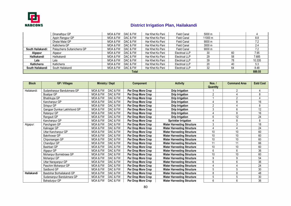
District Irrigation Plan, Hailakandi
80
Dinanathpur GP MOA & FW DAC & FW Har Khet Ko Pani Field Canal 5000 m 4
Appin Rangpur GP MOA & FW DAC & FW Har Khet Ko Pani Field Canal 11000 m 8.8
Dhalai Malai GP MOA & FW DAC & FW Har Khet Ko Pani Field Canal 9000 m 7.2
Katlicherra GP MOA & FW DAC & FW Har Khet Ko Pani Field Canal 3000 m 2.4
South Hailakandi: Palaycherra Sultanicherra GP MOA & FW DAC & FW Har Khet Ko Pani Field Canal 9000 m 7.2
Algapur Algapur MOA & FW DAC & FW Har Khet Ko Pani Electrical LLP 30 60 7.95
Hailkakandi Hailkakandi MOA & FW DAC & FW Har Khet Ko Pani Electrical LLP 29 58 7.685
Lala Lala MOA & FW DAC & FW Har Khet Ko Pani Electrical LLP 39 78 10.335
Katlicherra Katlicherra MOA & FW DAC & FW Har Khet Ko Pani Electrical LLP 20 40 5.3
South Hailakandi South Hailakandi MOA & FW DAC & FW Har Khet Ko Pani Electrical LLP 32 64 8.48
Total 889.55
Block GP / Villages Ministry / Dept Component Activity Nos. / Quantity
Command Area Estd Cost
Hailakandi: Sudarshanpur Bandukmara GP MOA & FW DAC & FW Per Drop More Crop Drip Irrigation 1 2 4
Boalipar GP MOA & FW DAC & FW Per Drop More Crop Drip Irrigation 2 4 8
Bhatirkupa GP MOA & FW DAC & FW Per Drop More Crop Drip Irrigation 1 2 4
Kanchanpur GP MOA & FW DAC & FW Per Drop More Crop Drip Irrigation 4 8 16
Sirispur GP MOA & FW DAC & FW Per Drop More Crop Drip Irrigation 2 4 8
Gangpar Dumkar Lakhirbond GP MOA & FW DAC & FW Per Drop More Crop Drip Irrigation 3 6 12
Ratanpur GP MOA & FW DAC & FW Per Drop More Crop Drip Irrigation 4 8 16
Rangauti GP MOA & FW DAC & FW Per Drop More Crop Drip Irrigation 6 12 24
Kanchanpur GP MOA & FW DAC & FW Per Drop More Crop Sprinkler Irrigation 4 8 8
Algapur: Panchgram GP MOA & FW DAC & FW Per Drop More Crop Water Harvesting Structure 3 3 18
Kalinagar GP MOA & FW DAC & FW Per Drop More Crop Water Harvesting Structure 4 4 24
Uttar Kanchanpur GP MOA & FW DAC & FW Per Drop More Crop Water Harvesting Structure 10 10 60
Bakrihowar GP MOA & FW DAC & FW Per Drop More Crop Water Harvesting Structure 10 10 60
Chiporsangan GP MOA & FW DAC & FW Per Drop More Crop Water Harvesting Structure 10 10 60
Chandipur GP MOA & FW DAC & FW Per Drop More Crop Water Harvesting Structure 11 11 66
Bashbari GP MOA & FW DAC & FW Per Drop More Crop Water Harvesting Structure 10 10 60
Algapur GP MOA & FW DAC & FW Per Drop More Crop Water Harvesting Structure 6 6 36
Mohanpur Burniebraes GP MOA & FW DAC & FW Per Drop More Crop Water Harvesting Structure 10 10 60
Mohanpur GP MOA & FW DAC & FW Per Drop More Crop Water Harvesting Structure 9 9 54
Uttar Narayanpur GP MOA & FW DAC & FW Per Drop More Crop Water Harvesting Structure 6 6 36
Paschim Mohanpur GP MOA & FW DAC & FW Per Drop More Crop Water Harvesting Structure 4 4 24
Saidbond GP MOA & FW DAC & FW Per Drop More Crop Water Harvesting Structure 5 5 30
Hailakandi Basdohar Borhailakandi GP MOA & FW DAC & FW Per Drop More Crop Water Harvesting Structure 8 8 48
Sudarsanpur Bandukmara GP MOA & FW DAC & FW Per Drop More Crop Water Harvesting Structure 5 5 30
Bahadurpur GP MOA & FW DAC & FW Per Drop More Crop Water Harvesting Structure 6 6 36
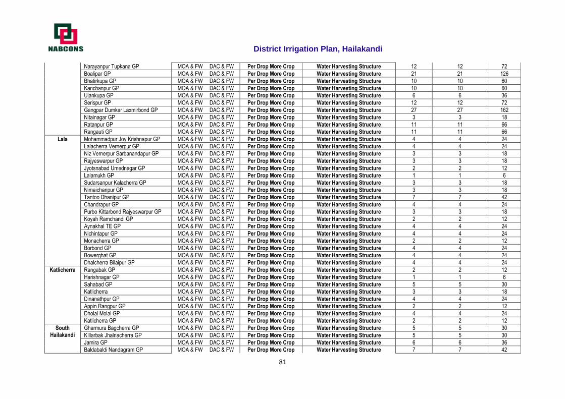
District Irrigation Plan, Hailakandi
81
Narayanpur Tupkana GP MOA & FW DAC & FW Per Drop More Crop Water Harvesting Structure 12 12 72
Boalipar GP MOA & FW DAC & FW Per Drop More Crop Water Harvesting Structure 21 21 126
Bhatirkupa GP MOA & FW DAC & FW Per Drop More Crop Water Harvesting Structure 10 10 60
Kanchanpur GP MOA & FW DAC & FW Per Drop More Crop Water Harvesting Structure 10 10 60
Ujankupa GP MOA & FW DAC & FW Per Drop More Crop Water Harvesting Structure 6 6 36
Serispur GP MOA & FW DAC & FW Per Drop More Crop Water Harvesting Structure 12 12 72
Gangpar Dumkar Laxmirbond GP MOA & FW DAC & FW Per Drop More Crop Water Harvesting Structure 27 27 162
Nitainagar GP MOA & FW DAC & FW Per Drop More Crop Water Harvesting Structure 3 3 18
Ratanpur GP MOA & FW DAC & FW Per Drop More Crop Water Harvesting Structure 11 11 66
Rangauti GP MOA & FW DAC & FW Per Drop More Crop Water Harvesting Structure 11 11 66
Lala Mohammadpur Joy Krishnapur GP MOA & FW DAC & FW Per Drop More Crop Water Harvesting Structure 4 4 24
Lalacherra Vernerpur GP MOA & FW DAC & FW Per Drop More Crop Water Harvesting Structure 4 4 24
Niz Vernerpur Sarbanandapur GP MOA & FW DAC & FW Per Drop More Crop Water Harvesting Structure 3 3 18
Rajyeswarpur GP MOA & FW DAC & FW Per Drop More Crop Water Harvesting Structure 3 3 18
Jyotsnabad Umednagar GP MOA & FW DAC & FW Per Drop More Crop Water Harvesting Structure 2 2 12
Lalamukh GP MOA & FW DAC & FW Per Drop More Crop Water Harvesting Structure 1 1 6
Sudarsanpur Kalacherra GP MOA & FW DAC & FW Per Drop More Crop Water Harvesting Structure 3 3 18
Nimaichanpur GP MOA & FW DAC & FW Per Drop More Crop Water Harvesting Structure 3 3 18
Tantoo Dhanipur GP MOA & FW DAC & FW Per Drop More Crop Water Harvesting Structure 7 7 42
Chandrapur GP MOA & FW DAC & FW Per Drop More Crop Water Harvesting Structure 4 4 24
Purbo Kittarbond Rajyeswarpur GP MOA & FW DAC & FW Per Drop More Crop Water Harvesting Structure 3 3 18
Koyah Ramchandi GP MOA & FW DAC & FW Per Drop More Crop Water Harvesting Structure 2 2 12
Aynakhal TE GP MOA & FW DAC & FW Per Drop More Crop Water Harvesting Structure 4 4 24
Nichintapur GP MOA & FW DAC & FW Per Drop More Crop Water Harvesting Structure 4 4 24
Monacherra GP MOA & FW DAC & FW Per Drop More Crop Water Harvesting Structure 2 2 12
Borbond GP MOA & FW DAC & FW Per Drop More Crop Water Harvesting Structure 4 4 24
Bowerghat GP MOA & FW DAC & FW Per Drop More Crop Water Harvesting Structure 4 4 24
Dhalcherra Bilaipur GP MOA & FW DAC & FW Per Drop More Crop Water Harvesting Structure 4 4 24
Katlicherra Rangabak GP MOA & FW DAC & FW Per Drop More Crop Water Harvesting Structure 2 2 12
Harishnagar GP MOA & FW DAC & FW Per Drop More Crop Water Harvesting Structure 1 1 6
Sahabad GP MOA & FW DAC & FW Per Drop More Crop Water Harvesting Structure 5 5 30
Katlicherra MOA & FW DAC & FW Per Drop More Crop Water Harvesting Structure 3 3 18
Dinanathpur GP MOA & FW DAC & FW Per Drop More Crop Water Harvesting Structure 4 4 24
Appin Rangpur GP MOA & FW DAC & FW Per Drop More Crop Water Harvesting Structure 2 2 12
Dholai Molai GP MOA & FW DAC & FW Per Drop More Crop Water Harvesting Structure 4 4 24
Katlicherra GP MOA & FW DAC & FW Per Drop More Crop Water Harvesting Structure 2 2 12
South Hailakandi
Gharmura Bagcherra GP MOA & FW DAC & FW Per Drop More Crop Water Harvesting Structure 5 5 30
KIllarbak Jhalnacherra GP MOA & FW DAC & FW Per Drop More Crop Water Harvesting Structure 5 5 30
Jamira GP MOA & FW DAC & FW Per Drop More Crop Water Harvesting Structure 6 6 36
Baldabaldi Nandagram GP MOA & FW DAC & FW Per Drop More Crop Water Harvesting Structure 7 7 42
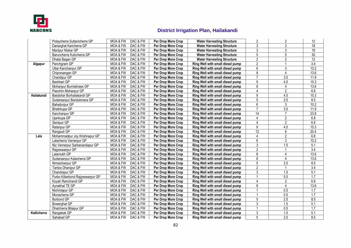
District Irrigation Plan, Hailakandi
82
Polaycherra Sultanicherra GP MOA & FW DAC & FW Per Drop More Crop Water Harvesting Structure 2 2 12
Dariarghat Karicherra GP MOA & FW DAC & FW Per Drop More Crop Water Harvesting Structure 3 3 18
Manipur Niskar GP MOA & FW DAC & FW Per Drop More Crop Water Harvesting Structure 3 3 18
Baruncherra Kukicherra GP MOA & FW DAC & FW Per Drop More Crop Water Harvesting Structure 5 5 30
Dhalai Bagan GP MOA & FW DAC & FW Per Drop More Crop Water Harvesting Structure 2 2 12
Algapur Panchgram GP MOA & FW DAC & FW Per Drop More Crop Ring Well with small diesel pump 2 1 3.4
Uttar Kanchanpur GP MOA & FW DAC & FW Per Drop More Crop Ring Well with small diesel pump 6 3 10.2
Chiporsangan GP MOA & FW DAC & FW Per Drop More Crop Ring Well with small diesel pump 8 4 13.6
Chandipur GP MOA & FW DAC & FW Per Drop More Crop Ring Well with small diesel pump 7 3.5 11.9
Bashbari GP MOA & FW DAC & FW Per Drop More Crop Ring Well with small diesel pump 9 4.5 15.3
Mohanpur Burniebraes GP MOA & FW DAC & FW Per Drop More Crop Ring Well with small diesel pump 8 4 13.6
Paschim Mohanpur GP MOA & FW DAC & FW Per Drop More Crop Ring Well with small diesel pump 4 2 6.8
Hailakandi Basdohar Borhailakandi GP MOA & FW DAC & FW Per Drop More Crop Ring Well with small diesel pump 9 4.5 15.3
Sudarsanpur Bandukmara GP MOA & FW DAC & FW Per Drop More Crop Ring Well with small diesel pump 5 2.5 8.5
Bahadurpur GP MOA & FW DAC & FW Per Drop More Crop Ring Well with small diesel pump 6 3 10.2
Bhatirkupa GP MOA & FW DAC & FW Per Drop More Crop Ring Well with small diesel pump 7 3.5 11.9
Kanchanpur GP MOA & FW DAC & FW Per Drop More Crop Ring Well with small diesel pump 14 7 23.8
Ujankupa GP MOA & FW DAC & FW Per Drop More Crop Ring Well with small diesel pump 4 2 6.8
Serispur GP MOA & FW DAC & FW Per Drop More Crop Ring Well with small diesel pump 4 2 6.8
Ratanpur GP MOA & FW DAC & FW Per Drop More Crop Ring Well with small diesel pump 9 4.5 15.3
Rangauti GP MOA & FW DAC & FW Per Drop More Crop Ring Well with small diesel pump 12 6 20.4
Lala Mohammadpur Joy Krishnapur GP MOA & FW DAC & FW Per Drop More Crop Ring Well with small diesel pump 4 2 6.8
Lalacherra Vernerpur GP MOA & FW DAC & FW Per Drop More Crop Ring Well with small diesel pump 6 3 10.2
Niz Vernerpur Sarbanandapur GP MOA & FW DAC & FW Per Drop More Crop Ring Well with small diesel pump 3 1.5 5.1
Rajyeswarpur GP MOA & FW DAC & FW Per Drop More Crop Ring Well with small diesel pump 2 1 3.4
Lalamukh GP MOA & FW DAC & FW Per Drop More Crop Ring Well with small diesel pump 8 4 13.6
Sudarsanpur Kalacherra GP MOA & FW DAC & FW Per Drop More Crop Ring Well with small diesel pump 8 4 13.6
Nimaichanpur GP MOA & FW DAC & FW Per Drop More Crop Ring Well with small diesel pump 5 2.5 8.5
Tantoo Dhanipur GP MOA & FW DAC & FW Per Drop More Crop Ring Well with small diesel pump 2 1 3.4
Chandrapur GP MOA & FW DAC & FW Per Drop More Crop Ring Well with small diesel pump 3 1.5 5.1
Purbo Kittarbond Rajyeswarpur GP MOA & FW DAC & FW Per Drop More Crop Ring Well with small diesel pump 1 0.5 1.7
Koyah Ramchandi GP MOA & FW DAC & FW Per Drop More Crop Ring Well with small diesel pump 4 2 6.8
Aynakhal TE GP MOA & FW DAC & FW Per Drop More Crop Ring Well with small diesel pump 8 4 13.6
Nichintapur GP MOA & FW DAC & FW Per Drop More Crop Ring Well with small diesel pump 1 0.5 1.7
Monacherra GP MOA & FW DAC & FW Per Drop More Crop Ring Well with small diesel pump 1 0.5 1.7
Borbond GP MOA & FW DAC & FW Per Drop More Crop Ring Well with small diesel pump 5 2.5 8.5
Bowerghat GP MOA & FW DAC & FW Per Drop More Crop Ring Well with small diesel pump 3 1.5 5.1
Dhalcherra Bilaipur GP MOA & FW DAC & FW Per Drop More Crop Ring Well with small diesel pump 1 0.5 1.7
Katlicherra Rangabak GP MOA & FW DAC & FW Per Drop More Crop Ring Well with small diesel pump 3 1.5 5.1
Sahabad GP MOA & FW DAC & FW Per Drop More Crop Ring Well with small diesel pump 5 2.5 8.5
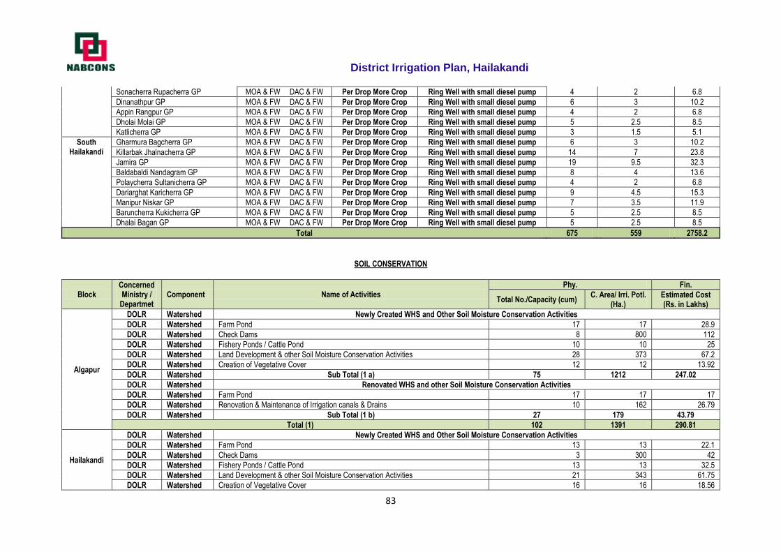
District Irrigation Plan, Hailakandi
83
Sonacherra Rupacherra GP MOA & FW DAC & FW Per Drop More Crop Ring Well with small diesel pump 4 2 6.8
Dinanathpur GP MOA & FW DAC & FW Per Drop More Crop Ring Well with small diesel pump 6 3 10.2
Appin Rangpur GP MOA & FW DAC & FW Per Drop More Crop Ring Well with small diesel pump 4 2 6.8
Dholai Molai GP MOA & FW DAC & FW Per Drop More Crop Ring Well with small diesel pump 5 2.5 8.5
Katlicherra GP MOA & FW DAC & FW Per Drop More Crop Ring Well with small diesel pump 3 1.5 5.1
South Hailakandi
Gharmura Bagcherra GP MOA & FW DAC & FW Per Drop More Crop Ring Well with small diesel pump 6 3 10.2
Killarbak Jhalnacherra GP MOA & FW DAC & FW Per Drop More Crop Ring Well with small diesel pump 14 7 23.8
Jamira GP MOA & FW DAC & FW Per Drop More Crop Ring Well with small diesel pump 19 9.5 32.3
Baldabaldi Nandagram GP MOA & FW DAC & FW Per Drop More Crop Ring Well with small diesel pump 8 4 13.6
Polaycherra Sultanicherra GP MOA & FW DAC & FW Per Drop More Crop Ring Well with small diesel pump 4 2 6.8
Dariarghat Karicherra GP MOA & FW DAC & FW Per Drop More Crop Ring Well with small diesel pump 9 4.5 15.3
Manipur Niskar GP MOA & FW DAC & FW Per Drop More Crop Ring Well with small diesel pump 7 3.5 11.9
Baruncherra Kukicherra GP MOA & FW DAC & FW Per Drop More Crop Ring Well with small diesel pump 5 2.5 8.5
Dhalai Bagan GP MOA & FW DAC & FW Per Drop More Crop Ring Well with small diesel pump 5 2.5 8.5
Total 675 559 2758.2
SOIL CONSERVATION
Block Concerned Ministry /
Departmet Component Name of Activities
Phy. Fin.
Total No./Capacity (cum) C. Area/ Irri. Potl.
(Ha.) Estimated Cost (Rs. in Lakhs)
Algapur
DOLR Watershed Newly Created WHS and Other Soil Moisture Conservation Activities
DOLR Watershed Farm Pond 17 17 28.9
DOLR Watershed Check Dams 8 800 112
DOLR Watershed Fishery Ponds / Cattle Pond 10 10 25
DOLR Watershed Land Development & other Soil Moisture Conservation Activities 28 373 67.2
DOLR Watershed Creation of Vegetative Cover 12 12 13.92
DOLR Watershed Sub Total (1 a) 75 1212 247.02
DOLR Watershed Renovated WHS and other Soil Moisture Conservation Activities
DOLR Watershed Farm Pond 17 17 17
DOLR Watershed Renovation & Maintenance of Irrigation canals & Drains 10 162 26.79
DOLR Watershed Sub Total (1 b) 27 179 43.79
Total (1) 102 1391 290.81
Hailakandi
DOLR Watershed Newly Created WHS and Other Soil Moisture Conservation Activities
DOLR Watershed Farm Pond 13 13 22.1
DOLR Watershed Check Dams 3 300 42
DOLR Watershed Fishery Ponds / Cattle Pond 13 13 32.5
DOLR Watershed Land Development & other Soil Moisture Conservation Activities 21 343 61.75
DOLR Watershed Creation of Vegetative Cover 16 16 18.56
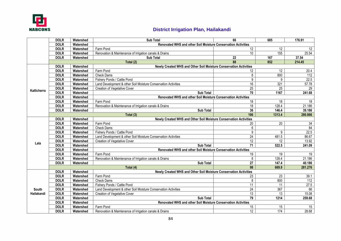
District Irrigation Plan, Hailakandi
84
DOLR Watershed Sub Total 66 685 176.91
DOLR Watershed Renovated WHS and other Soil Moisture Conservation Activities
DOLR Watershed Farm Pond 12 12 12
DOLR Watershed Renovation & Maintenance of Irrigation canals & Drains 10 155 25.54
DOLR Watershed Sub Total 22 167 37.54
Total (2) 88 852 214.45
Katlicherra
DOLR Watershed Newly Created WHS and Other Soil Moisture Conservation Activities
DOLR Watershed Farm Pond 12 12 20.4
DOLR Watershed Check Dams 8 800 112
DOLR Watershed Fishery Ponds / Cattle Pond 9 9 22.5
DOLR Watershed Land Development & other Soil Moisture Conservation Activities 16 321 57.78
DOLR Watershed Creation of Vegetative Cover 25 25 29
DOLR Watershed Sub Total 70 1167 241.68
DOLR Watershed Renovated WHS and other Soil Moisture Conservation Activities
DOLR Watershed Farm Pond 18 18 18
DOLR Watershed Renovation & Maintenance of Irrigation canals & Drains 18 128.4 21.186
DOLR Watershed Sub Total 36 146.4 39.186
Total (3) 106 1313.4 280.866
Lala
DOLR Watershed Newly Created WHS and Other Soil Moisture Conservation Activities
DOLR Watershed Farm Pond 20 20 34
DOLR Watershed Check Dams 6 84
DOLR Watershed Fishery Ponds / Cattle Pond 9 9 22.5
DOLR Watershed Land Development & other Soil Moisture Conservation Activities 24 481.5 86.67
DOLR Watershed Creation of Vegetative Cover 12 12 13.92
DOLR Watershed Sub Total 71 522.5 241.09
DOLR Watershed Renovated WHS and other Soil Moisture Conservation Activities
DOLR Watershed Farm Pond 19 19 19
DOLR Watershed Renovation & Maintenance of Irrigation canals & Drains 8 128.4 21.186
DOLR Watershed Sub Total 27 147.4 40.186
Total (4) 98 669.9 281.276
South Hailakandi
DOLR Watershed Newly Created WHS and Other Soil Moisture Conservation Activities
DOLR Watershed Farm Pond 23 23 39.1
DOLR Watershed Check Dams 8 800 112
DOLR Watershed Fishery Ponds / Cattle Pond 11 11 27.5
DOLR Watershed Land Development & other Soil Moisture Conservation Activities 24 367 66
DOLR Watershed Creation of Vegetative Cover 13 13 15.08
DOLR Watershed Sub Total 79 1214 259.68
DOLR Watershed Renovated WHS and other Soil Moisture Conservation Activities
DOLR Watershed Farm Pond 15 15 15
DOLR Watershed Renovation & Maintenance of Irrigation canals & Drains 12 174 28.68
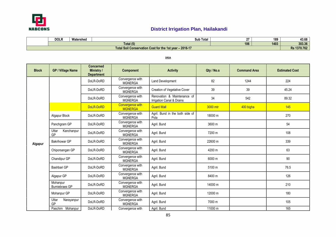
District Irrigation Plan, Hailakandi
85
DOLR Watershed Sub Total 27 189 43.68
Total (5) 106 1403 303.36
Total Soil Conservation Cost for the 1st year – 2016-17 Rs 1370.762
DRDA
Block GP / Village Name Concerned Ministry /
Department Component Activity Qty / No.s Command Area Estimated Cost
Algapur
DoLR-DoRD Convergence with
MGNERGA Land Development 82 1244 224
DoLR-DoRD Convergence with
MGNERGA Creation of Vegetative Cover 39 39 45.24
DoLR-DoRD Convergence with
MGNERGA Renovation & Maintenance of Irrigation Canal & Drains
34 542 89.32
DoLR-DoRD Convergence with
MGNERGA Guard Wall 3000 mtr 400 bigha 145
Algapur Block DoLR-DoRD Convergence with
MGNERGA Agril. Bund in the both side of Pola
18000 m 270
Panchgram GP DoLR-DoRD Convergence with
MGNERGA Agril. Bund 3600 m 54
Uttar Kanchanpur GP
DoLR-DoRD Convergence with
MGNERGA Agril. Bund 7200 m 108
Bakrihowar GP DoLR-DoRD Convergence with
MGNERGA Agril. Bund 22600 m 339
Chiporsangan GP DoLR-DoRD Convergence with
MGNERGA Agril. Bund 4200 m 63
Chandipur GP DoLR-DoRD Convergence with
MGNERGA Agril. Bund 6000 m 90
Bashbari GP DoLR-DoRD Convergence with
MGNERGA Agril. Bund 5100 m 76.5
Algapur GP DoLR-DoRD Convergence with
MGNERGA Agril. Bund 8400 m 126
Mohanpur Burniebraes GP
DoLR-DoRD Convergence with
MGNERGA Agril. Bund 14000 m 210
Mohanpur GP DoLR-DoRD Convergence with
MGNERGA Agril. Bund 12000 m 180
Uttar Narayanpur GP
DoLR-DoRD Convergence with
MGNERGA Agril. Bund 7000 m 105
Paschim Mohanpur DoLR-DoRD Convergence with Agril. Bund 11000 m 165
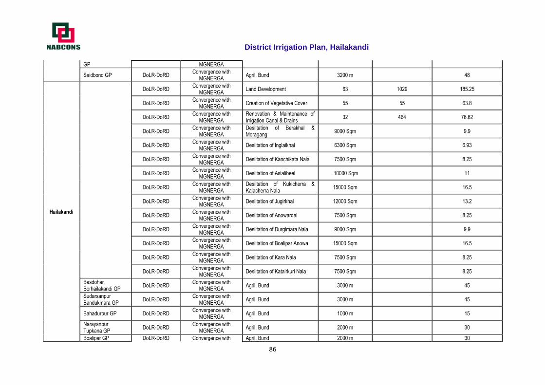
District Irrigation Plan, Hailakandi
86
GP MGNERGA
Saidbond GP DoLR-DoRD Convergence with
MGNERGA Agril. Bund 3200 m 48
Hailakandi
DoLR-DoRD Convergence with
MGNERGA Land Development 63 1029 185.25
DoLR-DoRD Convergence with
MGNERGA Creation of Vegetative Cover 55 55 63.8
DoLR-DoRD Convergence with
MGNERGA Renovation & Maintenance of Irrigation Canal & Drains
32 464 76.62
DoLR-DoRD Convergence with
MGNERGA Desiltation of Berakhal & Moragang
9000 Sqm 9.9
DoLR-DoRD Convergence with
MGNERGA Desiltation of Inglaikhal 6300 Sqm 6.93
DoLR-DoRD Convergence with
MGNERGA Desiltation of Kanchikata Nala 7500 Sqm 8.25
DoLR-DoRD Convergence with
MGNERGA Desiltation of Asialibeel 10000 Sqm 11
DoLR-DoRD Convergence with
MGNERGA Desiltation of Kukicherra & Kalacherra Nala
15000 Sqm 16.5
DoLR-DoRD Convergence with
MGNERGA Desiltation of Jugirkhal 12000 Sqm 13.2
DoLR-DoRD Convergence with
MGNERGA Desiltation of Anowardal 7500 Sqm 8.25
DoLR-DoRD Convergence with
MGNERGA Desiltation of Durgimara Nala 9000 Sqm 9.9
DoLR-DoRD Convergence with
MGNERGA Desiltation of Boalipar Anowa 15000 Sqm 16.5
DoLR-DoRD Convergence with
MGNERGA Desiltation of Kara Nala 7500 Sqm 8.25
DoLR-DoRD Convergence with
MGNERGA Desiltation of Katairkuri Nala 7500 Sqm 8.25
Basdohar Borhailakandi GP
DoLR-DoRD Convergence with
MGNERGA Agril. Bund 3000 m 45
Sudarsanpur Bandukmara GP
DoLR-DoRD Convergence with
MGNERGA Agril. Bund 3000 m 45
Bahadurpur GP DoLR-DoRD Convergence with
MGNERGA Agril. Bund 1000 m 15
Narayanpur Tupkana GP
DoLR-DoRD Convergence with
MGNERGA Agril. Bund 2000 m 30
Boalipar GP DoLR-DoRD Convergence with Agril. Bund 2000 m 30
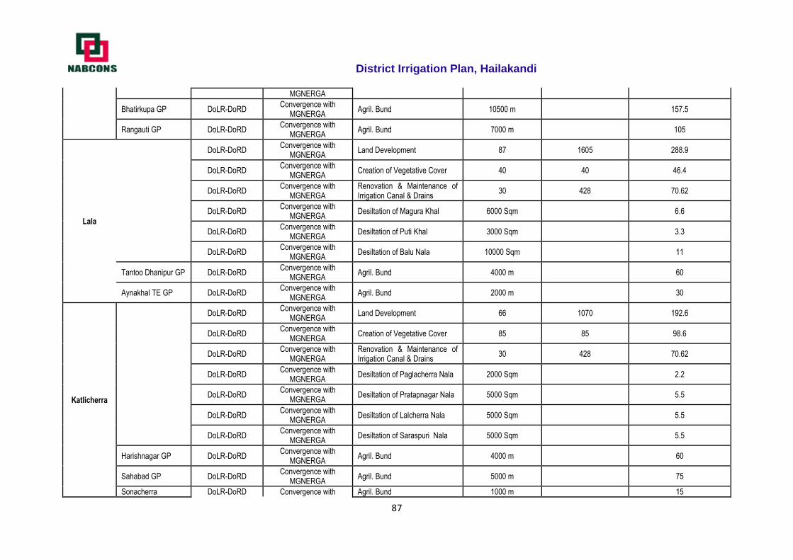
District Irrigation Plan, Hailakandi
87
MGNERGA
Bhatirkupa GP DoLR-DoRD Convergence with
MGNERGA Agril. Bund 10500 m 157.5
Rangauti GP DoLR-DoRD Convergence with
MGNERGA Agril. Bund 7000 m 105
Lala
DoLR-DoRD Convergence with
MGNERGA Land Development 87 1605 288.9
DoLR-DoRD Convergence with
MGNERGA Creation of Vegetative Cover 40 40 46.4
DoLR-DoRD Convergence with
MGNERGA Renovation & Maintenance of Irrigation Canal & Drains
30 428 70.62
DoLR-DoRD Convergence with
MGNERGA Desiltation of Magura Khal 6000 Sqm 6.6
DoLR-DoRD Convergence with
MGNERGA Desiltation of Puti Khal 3000 Sqm 3.3
DoLR-DoRD Convergence with
MGNERGA Desiltation of Balu Nala 10000 Sqm 11
Tantoo Dhanipur GP DoLR-DoRD Convergence with
MGNERGA Agril. Bund 4000 m 60
Aynakhal TE GP DoLR-DoRD Convergence with
MGNERGA Agril. Bund 2000 m 30
Katlicherra
DoLR-DoRD Convergence with
MGNERGA Land Development 66 1070 192.6
DoLR-DoRD Convergence with
MGNERGA Creation of Vegetative Cover 85 85 98.6
DoLR-DoRD Convergence with
MGNERGA Renovation & Maintenance of Irrigation Canal & Drains
30 428 70.62
DoLR-DoRD Convergence with
MGNERGA Desiltation of Paglacherra Nala 2000 Sqm 2.2
DoLR-DoRD Convergence with
MGNERGA Desiltation of Pratapnagar Nala 5000 Sqm 5.5
DoLR-DoRD Convergence with
MGNERGA Desiltation of Lalcherra Nala 5000 Sqm 5.5
DoLR-DoRD Convergence with
MGNERGA Desiltation of Saraspuri Nala 5000 Sqm 5.5
Harishnagar GP DoLR-DoRD Convergence with
MGNERGA Agril. Bund 4000 m 60
Sahabad GP DoLR-DoRD Convergence with
MGNERGA Agril. Bund 5000 m 75
Sonacherra DoLR-DoRD Convergence with Agril. Bund 1000 m 15
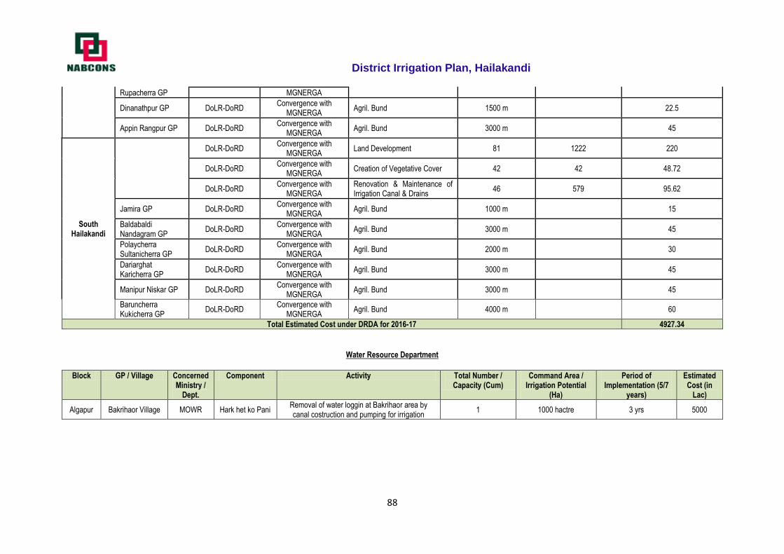
District Irrigation Plan, Hailakandi
88
Rupacherra GP MGNERGA
Dinanathpur GP DoLR-DoRD Convergence with
MGNERGA Agril. Bund 1500 m 22.5
Appin Rangpur GP DoLR-DoRD Convergence with
MGNERGA Agril. Bund 3000 m 45
South Hailakandi
DoLR-DoRD Convergence with
MGNERGA Land Development 81 1222 220
DoLR-DoRD Convergence with
MGNERGA Creation of Vegetative Cover 42 42 48.72
DoLR-DoRD Convergence with
MGNERGA Renovation & Maintenance of Irrigation Canal & Drains
46 579 95.62
Jamira GP DoLR-DoRD Convergence with
MGNERGA Agril. Bund 1000 m 15
Baldabaldi Nandagram GP
DoLR-DoRD Convergence with
MGNERGA Agril. Bund 3000 m 45
Polaycherra Sultanicherra GP
DoLR-DoRD Convergence with
MGNERGA Agril. Bund 2000 m 30
Dariarghat Karicherra GP
DoLR-DoRD Convergence with
MGNERGA Agril. Bund 3000 m 45
Manipur Niskar GP DoLR-DoRD Convergence with
MGNERGA Agril. Bund 3000 m 45
Baruncherra Kukicherra GP
DoLR-DoRD Convergence with
MGNERGA Agril. Bund 4000 m 60
Total Estimated Cost under DRDA for 2016-17 4927.34
Water Resource Department
Block GP / Village Concerned Ministry /
Dept.
Component Activity Total Number / Capacity (Cum)
Command Area / Irrigation Potential
(Ha)
Period of Implementation (5/7
years)
Estimated Cost (in
Lac)
Algapur Bakrihaor Village MOWR Hark het ko Pani Removal of water loggin at Bakrihaor area by canal costruction and pumping for irrigation
1 1000 hactre 3 yrs 5000
District Irrigation Plan, Hailakandi
89
2017-18 Irrigation plan of Hailakandi District
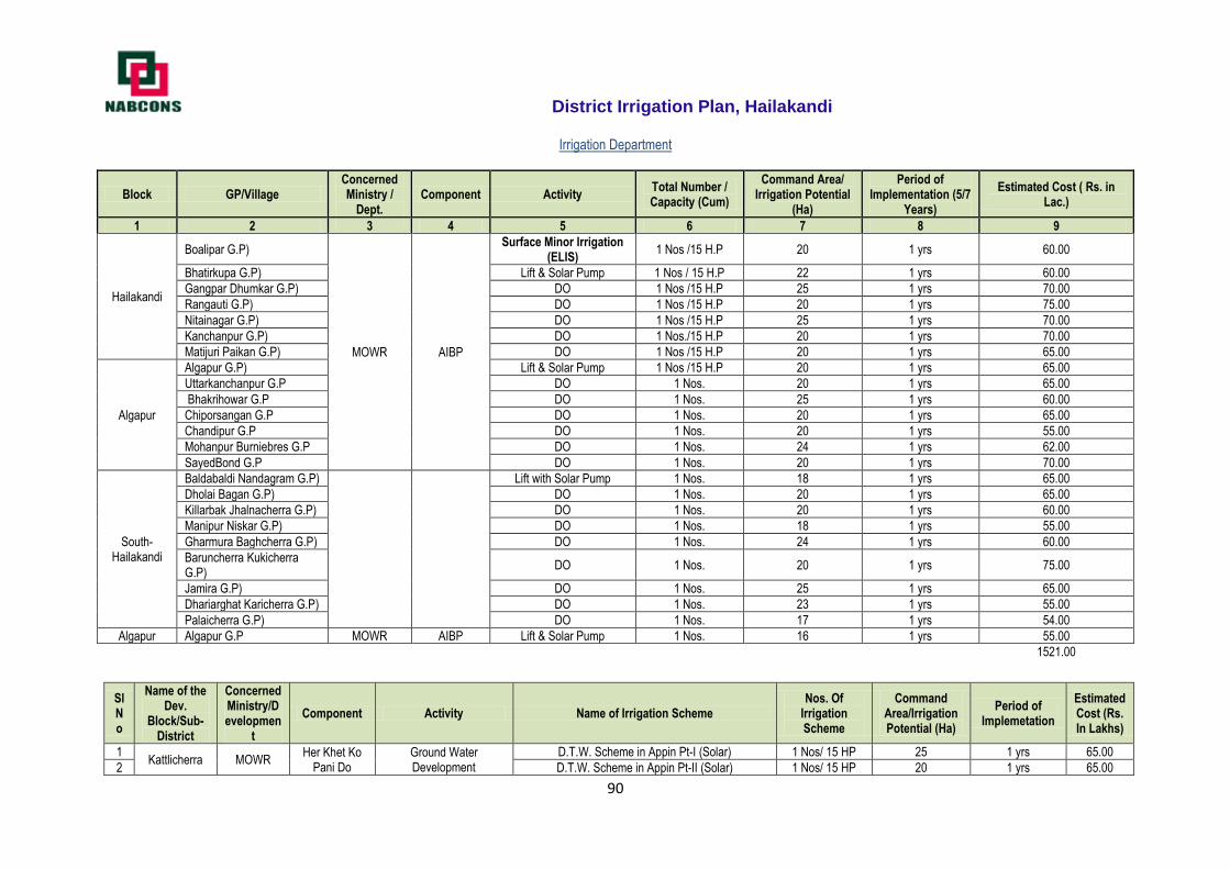
District Irrigation Plan, Hailakandi
90
Irrigation Department
Block GP/Village Concerned Ministry /
Dept. Component Activity
Total Number / Capacity (Cum)
Command Area/ Irrigation Potential
(Ha)
Period of Implementation (5/7
Years)
Estimated Cost ( Rs. in Lac.)
1 2 3 4 5 6 7 8 9
Hailakandi
Boalipar G.P)
MOWR AIBP
Surface Minor Irrigation (ELIS)
1 Nos /15 H.P 20 1 yrs 60.00
Bhatirkupa G.P) Lift & Solar Pump 1 Nos / 15 H.P 22 1 yrs 60.00
Gangpar Dhumkar G.P) DO 1 Nos /15 H.P 25 1 yrs 70.00
Rangauti G.P) DO 1 Nos /15 H.P 20 1 yrs 75.00
Nitainagar G.P) DO 1 Nos /15 H.P 25 1 yrs 70.00
Kanchanpur G.P) DO 1 Nos./15 H.P 20 1 yrs 70.00
Matijuri Paikan G.P) DO 1 Nos /15 H.P 20 1 yrs 65.00
Algapur
Algapur G.P) Lift & Solar Pump 1 Nos /15 H.P 20 1 yrs 65.00
Uttarkanchanpur G.P DO 1 Nos. 20 1 yrs 65.00
Bhakrihowar G.P DO 1 Nos. 25 1 yrs 60.00
Chiporsangan G.P DO 1 Nos. 20 1 yrs 65.00
Chandipur G.P DO 1 Nos. 20 1 yrs 55.00
Mohanpur Burniebres G.P DO 1 Nos. 24 1 yrs 62.00
SayedBond G.P DO 1 Nos. 20 1 yrs 70.00
South-Hailakandi
Baldabaldi Nandagram G.P)
Lift with Solar Pump 1 Nos. 18 1 yrs 65.00
Dholai Bagan G.P) DO 1 Nos. 20 1 yrs 65.00
Killarbak Jhalnacherra G.P) DO 1 Nos. 20 1 yrs 60.00
Manipur Niskar G.P) DO 1 Nos. 18 1 yrs 55.00
Gharmura Baghcherra G.P) DO 1 Nos. 24 1 yrs 60.00
Baruncherra Kukicherra G.P)
DO 1 Nos. 20 1 yrs 75.00
Jamira G.P) DO 1 Nos. 25 1 yrs 65.00
Dhariarghat Karicherra G.P) DO 1 Nos. 23 1 yrs 55.00
Palaicherra G.P) DO 1 Nos. 17 1 yrs 54.00
Algapur Algapur G.P MOWR AIBP Lift & Solar Pump 1 Nos. 16 1 yrs 55.00
1521.00
Sl No
Name of the Dev.
Block/Sub-District
Concerned Ministry/Developmen
t
Component Activity Name of Irrigation Scheme Nos. Of
Irrigation Scheme
Command Area/Irrigation Potential (Ha)
Period of Implemetation
Estimated Cost (Rs. In Lakhs)
1 Kattlicherra MOWR
Her Khet Ko Pani Do
Ground Water Development
D.T.W. Scheme in Appin Pt-I (Solar) 1 Nos/ 15 HP 25 1 yrs 65.00
2 D.T.W. Scheme in Appin Pt-II (Solar) 1 Nos/ 15 HP 20 1 yrs 65.00
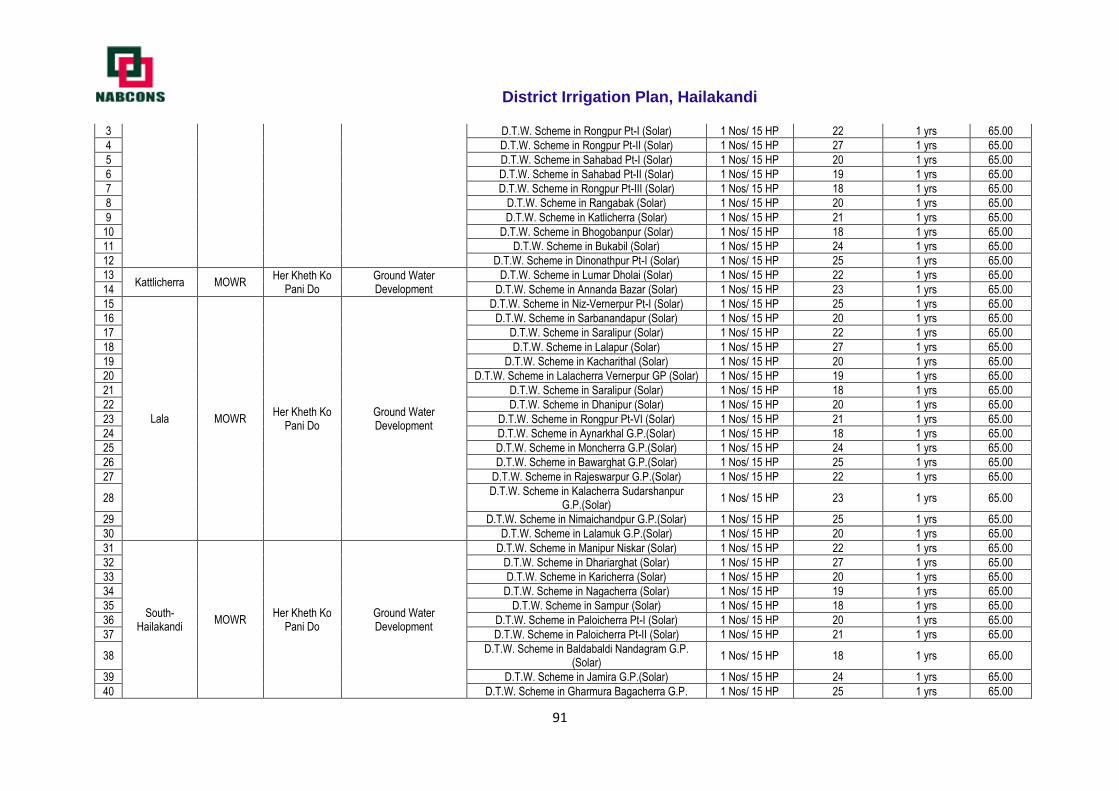
District Irrigation Plan, Hailakandi
91
3 D.T.W. Scheme in Rongpur Pt-I (Solar) 1 Nos/ 15 HP 22 1 yrs 65.00
4 D.T.W. Scheme in Rongpur Pt-II (Solar) 1 Nos/ 15 HP 27 1 yrs 65.00
5 D.T.W. Scheme in Sahabad Pt-I (Solar) 1 Nos/ 15 HP 20 1 yrs 65.00
6 D.T.W. Scheme in Sahabad Pt-II (Solar) 1 Nos/ 15 HP 19 1 yrs 65.00
7 D.T.W. Scheme in Rongpur Pt-III (Solar) 1 Nos/ 15 HP 18 1 yrs 65.00
8 D.T.W. Scheme in Rangabak (Solar) 1 Nos/ 15 HP 20 1 yrs 65.00
9 D.T.W. Scheme in Katlicherra (Solar) 1 Nos/ 15 HP 21 1 yrs 65.00
10 D.T.W. Scheme in Bhogobanpur (Solar) 1 Nos/ 15 HP 18 1 yrs 65.00
11 D.T.W. Scheme in Bukabil (Solar) 1 Nos/ 15 HP 24 1 yrs 65.00
12 D.T.W. Scheme in Dinonathpur Pt-I (Solar) 1 Nos/ 15 HP 25 1 yrs 65.00
13 Kattlicherra MOWR
Her Kheth Ko Pani Do
Ground Water Development
D.T.W. Scheme in Lumar Dholai (Solar) 1 Nos/ 15 HP 22 1 yrs 65.00
14 D.T.W. Scheme in Annanda Bazar (Solar) 1 Nos/ 15 HP 23 1 yrs 65.00
15
Lala MOWR Her Kheth Ko
Pani Do Ground Water Development
D.T.W. Scheme in Niz-Vernerpur Pt-I (Solar) 1 Nos/ 15 HP 25 1 yrs 65.00
16 D.T.W. Scheme in Sarbanandapur (Solar) 1 Nos/ 15 HP 20 1 yrs 65.00
17 D.T.W. Scheme in Saralipur (Solar) 1 Nos/ 15 HP 22 1 yrs 65.00
18 D.T.W. Scheme in Lalapur (Solar) 1 Nos/ 15 HP 27 1 yrs 65.00
19 D.T.W. Scheme in Kacharithal (Solar) 1 Nos/ 15 HP 20 1 yrs 65.00
20 D.T.W. Scheme in Lalacherra Vernerpur GP (Solar) 1 Nos/ 15 HP 19 1 yrs 65.00
21 D.T.W. Scheme in Saralipur (Solar) 1 Nos/ 15 HP 18 1 yrs 65.00
22 D.T.W. Scheme in Dhanipur (Solar) 1 Nos/ 15 HP 20 1 yrs 65.00
23 D.T.W. Scheme in Rongpur Pt-VI (Solar) 1 Nos/ 15 HP 21 1 yrs 65.00
24 D.T.W. Scheme in Aynarkhal G.P.(Solar) 1 Nos/ 15 HP 18 1 yrs 65.00
25 D.T.W. Scheme in Moncherra G.P.(Solar) 1 Nos/ 15 HP 24 1 yrs 65.00
26 D.T.W. Scheme in Bawarghat G.P.(Solar) 1 Nos/ 15 HP 25 1 yrs 65.00
27 D.T.W. Scheme in Rajeswarpur G.P.(Solar) 1 Nos/ 15 HP 22 1 yrs 65.00
28 D.T.W. Scheme in Kalacherra Sudarshanpur
G.P.(Solar) 1 Nos/ 15 HP 23 1 yrs 65.00
29 D.T.W. Scheme in Nimaichandpur G.P.(Solar) 1 Nos/ 15 HP 25 1 yrs 65.00
30 D.T.W. Scheme in Lalamuk G.P.(Solar) 1 Nos/ 15 HP 20 1 yrs 65.00
31
South- Hailakandi
MOWR Her Kheth Ko
Pani Do Ground Water Development
D.T.W. Scheme in Manipur Niskar (Solar) 1 Nos/ 15 HP 22 1 yrs 65.00
32 D.T.W. Scheme in Dhariarghat (Solar) 1 Nos/ 15 HP 27 1 yrs 65.00
33 D.T.W. Scheme in Karicherra (Solar) 1 Nos/ 15 HP 20 1 yrs 65.00
34 D.T.W. Scheme in Nagacherra (Solar) 1 Nos/ 15 HP 19 1 yrs 65.00
35 D.T.W. Scheme in Sampur (Solar) 1 Nos/ 15 HP 18 1 yrs 65.00
36 D.T.W. Scheme in Paloicherra Pt-I (Solar) 1 Nos/ 15 HP 20 1 yrs 65.00
37 D.T.W. Scheme in Paloicherra Pt-II (Solar) 1 Nos/ 15 HP 21 1 yrs 65.00
38 D.T.W. Scheme in Baldabaldi Nandagram G.P.
(Solar) 1 Nos/ 15 HP 18 1 yrs 65.00
39 D.T.W. Scheme in Jamira G.P.(Solar) 1 Nos/ 15 HP 24 1 yrs 65.00
40 D.T.W. Scheme in Gharmura Bagacherra G.P. 1 Nos/ 15 HP 25 1 yrs 65.00
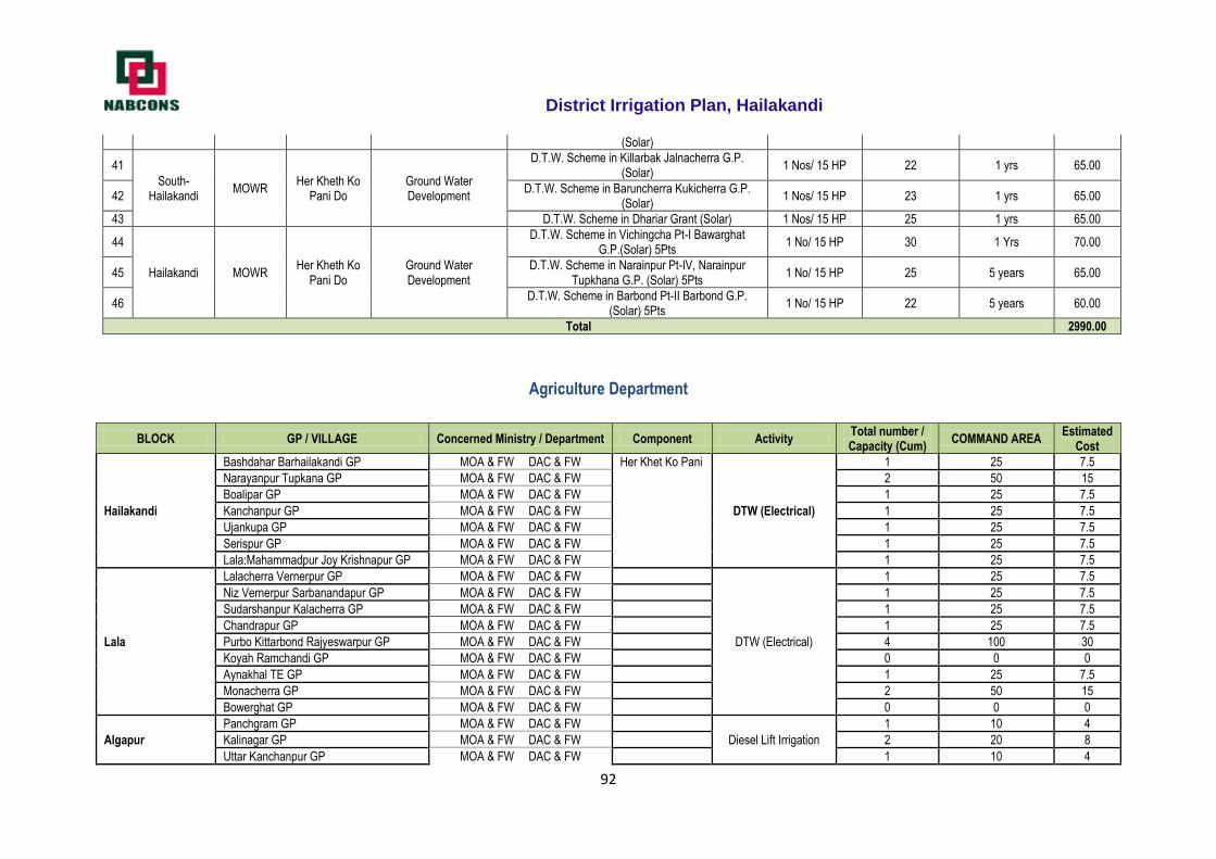
District Irrigation Plan, Hailakandi
92
(Solar)
41
South- Hailakandi
MOWR Her Kheth Ko
Pani Do Ground Water Development
D.T.W. Scheme in Killarbak Jalnacherra G.P. (Solar)
1 Nos/ 15 HP 22 1 yrs 65.00
42 D.T.W. Scheme in Baruncherra Kukicherra G.P.
(Solar) 1 Nos/ 15 HP 23 1 yrs 65.00
43 D.T.W. Scheme in Dhariar Grant (Solar) 1 Nos/ 15 HP 25 1 yrs 65.00
44
Hailakandi MOWR Her Kheth Ko
Pani Do Ground Water Development
D.T.W. Scheme in Vichingcha Pt-I Bawarghat G.P.(Solar) 5Pts
1 No/ 15 HP 30 1 Yrs 70.00
45 D.T.W. Scheme in Narainpur Pt-IV, Narainpur
Tupkhana G.P. (Solar) 5Pts 1 No/ 15 HP 25 5 years 65.00
46 D.T.W. Scheme in Barbond Pt-II Barbond G.P.
(Solar) 5Pts 1 No/ 15 HP 22 5 years 60.00
Total 2990.00
Agriculture Department
BLOCK GP / VILLAGE Concerned Ministry / Department Component Activity Total number / Capacity (Cum)
COMMAND AREA Estimated
Cost
Hailakandi
Bashdahar Barhailakandi GP MOA & FW DAC & FW Her Khet Ko Pani
DTW (Electrical)
1 25 7.5
Narayanpur Tupkana GP MOA & FW DAC & FW 2 50 15
Boalipar GP MOA & FW DAC & FW 1 25 7.5
Kanchanpur GP MOA & FW DAC & FW 1 25 7.5
Ujankupa GP MOA & FW DAC & FW 1 25 7.5
Serispur GP MOA & FW DAC & FW 1 25 7.5
Lala:Mahammadpur Joy Krishnapur GP MOA & FW DAC & FW 1 25 7.5
Lala
Lalacherra Vernerpur GP MOA & FW DAC & FW
DTW (Electrical)
1 25 7.5
Niz Vernerpur Sarbanandapur GP MOA & FW DAC & FW 1 25 7.5
Sudarshanpur Kalacherra GP MOA & FW DAC & FW 1 25 7.5
Chandrapur GP MOA & FW DAC & FW 1 25 7.5
Purbo Kittarbond Rajyeswarpur GP MOA & FW DAC & FW 4 100 30
Koyah Ramchandi GP MOA & FW DAC & FW 0 0 0
Aynakhal TE GP MOA & FW DAC & FW 1 25 7.5
Monacherra GP MOA & FW DAC & FW 2 50 15
Bowerghat GP MOA & FW DAC & FW 0 0 0
Algapur
Panchgram GP MOA & FW DAC & FW
Diesel Lift Irrigation
1 10 4
Kalinagar GP MOA & FW DAC & FW 2 20 8
Uttar Kanchanpur GP MOA & FW DAC & FW 1 10 4
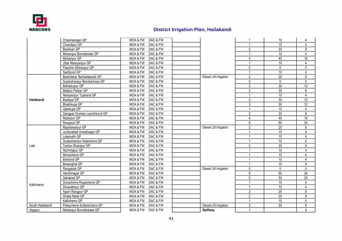
District Irrigation Plan, Hailakandi
93
Chiparsangan GP MOA & FW DAC & FW 1 10 4
Chandipur GP MOA & FW DAC & FW 1 10 4
Bashbari GP MOA & FW DAC & FW 2 20 8
Mohanpur Burniebraes GP MOA & FW DAC & FW 1 10 4
Mohanpur GP MOA & FW DAC & FW 4 40 16
Uttar Narayanpur GP MOA & FW DAC & FW 1 10 4
Paschim Mohanpur GP MOA & FW DAC & FW 0 0 0
Saidbond GP MOA & FW DAC & FW 1 10 4
Hailakandi
Bashdahar Barhailakandi GP MOA & FW DAC & FW Diesel Lift Irrigation 2 20 8
Sudarshanpur Bandukmara GP MOA & FW DAC & FW 0 0 0
Bahadurpur GP MOA & FW DAC & FW 3 30 12
Matijuri Paikan GP MOA & FW DAC & FW 2 20 8
Narayanpur Tupkana GP MOA & FW DAC & FW 1 10 4
Boalipar GP MOA & FW DAC & FW 3 30 12
Bhatirkupa GP MOA & FW DAC & FW 3 30 12
Ujankupa GP MOA & FW DAC & FW 1 10 4
Gangpar Dumkar Laxmirbond GP MOA & FW DAC & FW 2 20 8
Ratanpur GP MOA & FW DAC & FW 4 40 16
Rangauti GP MOA & FW DAC & FW 6 60 24
Lala
Rajyeswarpur GP MOA & FW DAC & FW Diesel Lift Irrigation 2 20 8
Jyotsnabad Umednagar GP MOA & FW DAC & FW 1 10 4
Lalamukh GP MOA & FW DAC & FW 1 10 4
Sudarshanpur Kalacherra GP MOA & FW DAC & FW 1 10 4
Tantoo Dhanipur GP MOA & FW DAC & FW 2 20 8
Nichintapur GP MOA & FW DAC & FW 1 10 4
Monacherra GP MOA & FW DAC & FW 1 10 4
Borbond GP MOA & FW DAC & FW 1 10 4
Bowerghat GP MOA & FW DAC & FW 1 10 4
Katlicherra
Rangabak GP MOA & FW DAC & FW Diesel Lift Irrigation 0 0 0
Harishnagar GP MOA & FW DAC & FW 6 60 24
Sahabad GP MOA & FW DAC & FW 5 50 20
Sonacherra Rupacherra GP MOA & FW DAC & FW 1 10 4
Dinanathpur GP MOA & FW DAC & FW 1 10 4
Appin Rangpur GP MOA & FW DAC & FW 2 20 8
Dhalai Malai GP MOA & FW DAC & FW 2 20 8
Katlicherra GP MOA & FW DAC & FW 1 10 4
South Hailakandi Palaycherra Sultanicherra GP MOA & FW DAC & FW Diesel Lift Irrigation 2 20 8
Algapur: Mohanpur Burnebrease GP MOA & FW DAC & FW Spillway 1 4
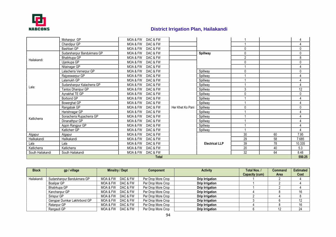
District Irrigation Plan, Hailakandi
94
Mohanpur GP MOA & FW DAC & FW 1 4
Chandipur GP MOA & FW DAC & FW 1 4
Bashbari GP MOA & FW DAC & FW 0 0
Hailakandi:
Sudarshanpur Bandukmara GP MOA & FW DAC & FW Spillway 0 0
Bhatirkupa GP MOA & FW DAC & FW 2 8
Ujankupa GP MOA & FW DAC & FW
Her Khet Ko Pani
0 0
Nitainagar GP MOA & FW DAC & FW 1 4
Lala:
Lalacherra Vernerpur GP MOA & FW DAC & FW Spillway 0 0
Rajyeswarpur GP MOA & FW DAC & FW Spillway 1 4
Lalamukh GP MOA & FW DAC & FW Spillway 1 4
Sudarshanpur Kalacherra GP MOA & FW DAC & FW Spillway 1 4
Tantoo Dhanipur GP MOA & FW DAC & FW Spillway 3 12
Aynakhal TE GP MOA & FW DAC & FW Spillway 0 0
Borbond GP MOA & FW DAC & FW Spillway 1 4
Bowerghat GP MOA & FW DAC & FW Spillway 1 4
Katlicherra
Rangabak GP MOA & FW DAC & FW Spillway 0 0
Harishnagar GP MOA & FW DAC & FW Spillway 1 4
Sonacherra Rupacherra GP MOA & FW DAC & FW Spillway 1 4
Dinanathpur GP MOA & FW DAC & FW Spillway 1 4
Appin Rangpur GP MOA & FW DAC & FW Spillway 1 4
Katlicherr GP MOA & FW DAC & FW Spillway 1 4
Algapur Algapur MOA & FW DAC & FW
Electrical LLP
30 60 7.95
Hailkakandi Hailkakandi MOA & FW DAC & FW 29 58 7.685
Lala Lala MOA & FW DAC & FW 39 78 10.335
Katlicherra Katlicherra MOA & FW DAC & FW 20 40 5.3
South Hailakandi South Hailakandi MOA & FW DAC & FW 32 64 8.48
Total 550.25
Block gp / village Minsitry / Dept Component Activity Total Nos. / Capacity (cum)
Command Area
Estimated Cost
Hailakandi: Sudarshanpur Bandukmara GP MOA & FW DAC & FW Per Drop More Crop Drip Irrigation 1 2 4
Boalipar GP MOA & FW DAC & FW Per Drop More Crop Drip Irrigation 1 2 4
Bhatirkupa GP MOA & FW DAC & FW Per Drop More Crop Drip Irrigation 1 2 4
Kanchanpur GP MOA & FW DAC & FW Per Drop More Crop Drip Irrigation 4 8 16
Sirispur GP MOA & FW DAC & FW Per Drop More Crop Drip Irrigation 2 4 8
Gangpar Dumkar Lakhirbond GP MOA & FW DAC & FW Per Drop More Crop Drip Irrigation 3 6 12
Ratanpur GP MOA & FW DAC & FW Per Drop More Crop Drip Irrigation 4 8 16
Rangauti GP MOA & FW DAC & FW Per Drop More Crop Drip Irrigation 6 12 24
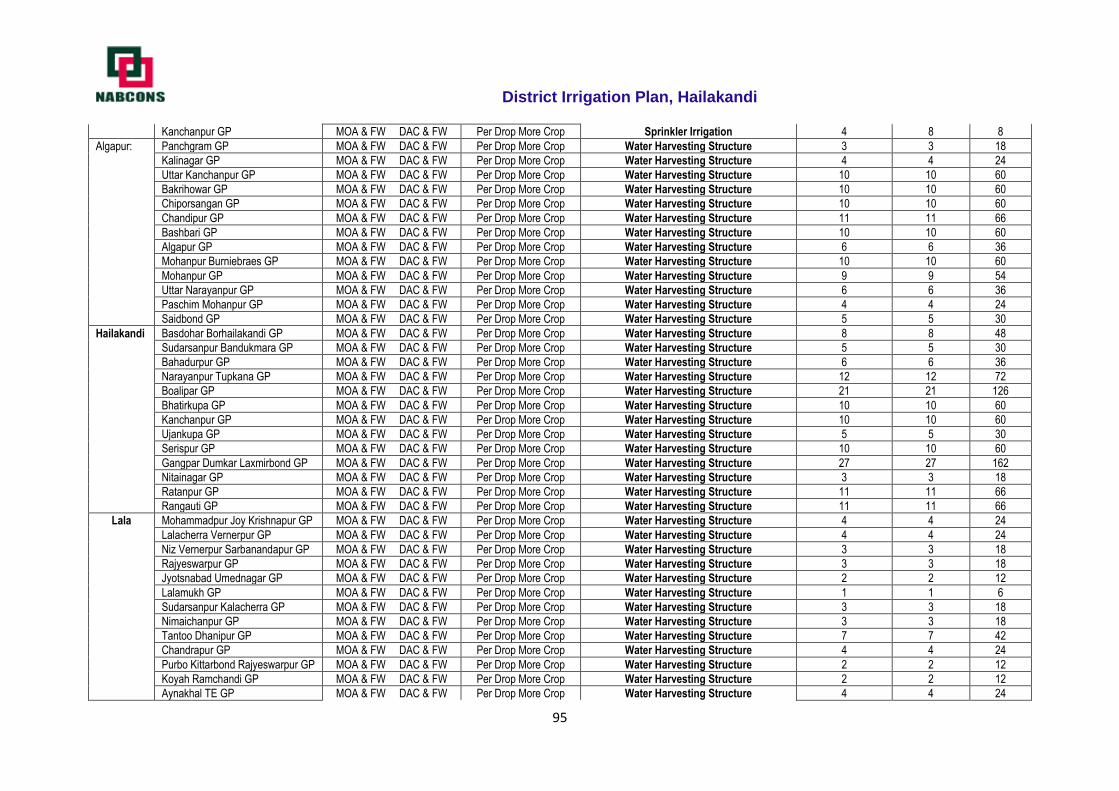
District Irrigation Plan, Hailakandi
95
Kanchanpur GP MOA & FW DAC & FW Per Drop More Crop Sprinkler Irrigation 4 8 8
Algapur: Panchgram GP MOA & FW DAC & FW Per Drop More Crop Water Harvesting Structure 3 3 18
Kalinagar GP MOA & FW DAC & FW Per Drop More Crop Water Harvesting Structure 4 4 24
Uttar Kanchanpur GP MOA & FW DAC & FW Per Drop More Crop Water Harvesting Structure 10 10 60
Bakrihowar GP MOA & FW DAC & FW Per Drop More Crop Water Harvesting Structure 10 10 60
Chiporsangan GP MOA & FW DAC & FW Per Drop More Crop Water Harvesting Structure 10 10 60
Chandipur GP MOA & FW DAC & FW Per Drop More Crop Water Harvesting Structure 11 11 66
Bashbari GP MOA & FW DAC & FW Per Drop More Crop Water Harvesting Structure 10 10 60
Algapur GP MOA & FW DAC & FW Per Drop More Crop Water Harvesting Structure 6 6 36
Mohanpur Burniebraes GP MOA & FW DAC & FW Per Drop More Crop Water Harvesting Structure 10 10 60
Mohanpur GP MOA & FW DAC & FW Per Drop More Crop Water Harvesting Structure 9 9 54
Uttar Narayanpur GP MOA & FW DAC & FW Per Drop More Crop Water Harvesting Structure 6 6 36
Paschim Mohanpur GP MOA & FW DAC & FW Per Drop More Crop Water Harvesting Structure 4 4 24
Saidbond GP MOA & FW DAC & FW Per Drop More Crop Water Harvesting Structure 5 5 30
Hailakandi Basdohar Borhailakandi GP MOA & FW DAC & FW Per Drop More Crop Water Harvesting Structure 8 8 48
Sudarsanpur Bandukmara GP MOA & FW DAC & FW Per Drop More Crop Water Harvesting Structure 5 5 30
Bahadurpur GP MOA & FW DAC & FW Per Drop More Crop Water Harvesting Structure 6 6 36
Narayanpur Tupkana GP MOA & FW DAC & FW Per Drop More Crop Water Harvesting Structure 12 12 72
Boalipar GP MOA & FW DAC & FW Per Drop More Crop Water Harvesting Structure 21 21 126
Bhatirkupa GP MOA & FW DAC & FW Per Drop More Crop Water Harvesting Structure 10 10 60
Kanchanpur GP MOA & FW DAC & FW Per Drop More Crop Water Harvesting Structure 10 10 60
Ujankupa GP MOA & FW DAC & FW Per Drop More Crop Water Harvesting Structure 5 5 30
Serispur GP MOA & FW DAC & FW Per Drop More Crop Water Harvesting Structure 10 10 60
Gangpar Dumkar Laxmirbond GP MOA & FW DAC & FW Per Drop More Crop Water Harvesting Structure 27 27 162
Nitainagar GP MOA & FW DAC & FW Per Drop More Crop Water Harvesting Structure 3 3 18
Ratanpur GP MOA & FW DAC & FW Per Drop More Crop Water Harvesting Structure 11 11 66
Rangauti GP MOA & FW DAC & FW Per Drop More Crop Water Harvesting Structure 11 11 66
Lala Mohammadpur Joy Krishnapur GP MOA & FW DAC & FW Per Drop More Crop Water Harvesting Structure 4 4 24
Lalacherra Vernerpur GP MOA & FW DAC & FW Per Drop More Crop Water Harvesting Structure 4 4 24
Niz Vernerpur Sarbanandapur GP MOA & FW DAC & FW Per Drop More Crop Water Harvesting Structure 3 3 18
Rajyeswarpur GP MOA & FW DAC & FW Per Drop More Crop Water Harvesting Structure 3 3 18
Jyotsnabad Umednagar GP MOA & FW DAC & FW Per Drop More Crop Water Harvesting Structure 2 2 12
Lalamukh GP MOA & FW DAC & FW Per Drop More Crop Water Harvesting Structure 1 1 6
Sudarsanpur Kalacherra GP MOA & FW DAC & FW Per Drop More Crop Water Harvesting Structure 3 3 18
Nimaichanpur GP MOA & FW DAC & FW Per Drop More Crop Water Harvesting Structure 3 3 18
Tantoo Dhanipur GP MOA & FW DAC & FW Per Drop More Crop Water Harvesting Structure 7 7 42
Chandrapur GP MOA & FW DAC & FW Per Drop More Crop Water Harvesting Structure 4 4 24
Purbo Kittarbond Rajyeswarpur GP MOA & FW DAC & FW Per Drop More Crop Water Harvesting Structure 2 2 12
Koyah Ramchandi GP MOA & FW DAC & FW Per Drop More Crop Water Harvesting Structure 2 2 12
Aynakhal TE GP MOA & FW DAC & FW Per Drop More Crop Water Harvesting Structure 4 4 24
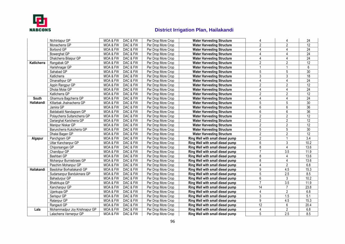
District Irrigation Plan, Hailakandi
96
Nichintapur GP MOA & FW DAC & FW Per Drop More Crop Water Harvesting Structure 4 4 24
Monacherra GP MOA & FW DAC & FW Per Drop More Crop Water Harvesting Structure 2 2 12
Borbond GP MOA & FW DAC & FW Per Drop More Crop Water Harvesting Structure 4 4 24
Bowerghat GP MOA & FW DAC & FW Per Drop More Crop Water Harvesting Structure 4 4 24
Dhalcherra Bilaipur GP MOA & FW DAC & FW Per Drop More Crop Water Harvesting Structure 4 4 24
Katlicherra Rangabak GP MOA & FW DAC & FW Per Drop More Crop Water Harvesting Structure 2 2 12
Harishnagar GP MOA & FW DAC & FW Per Drop More Crop Water Harvesting Structure 1 1 6
Sahabad GP MOA & FW DAC & FW Per Drop More Crop Water Harvesting Structure 5 5 30
Katlicherra MOA & FW DAC & FW Per Drop More Crop Water Harvesting Structure 3 3 18
Dinanathpur GP MOA & FW DAC & FW Per Drop More Crop Water Harvesting Structure 4 4 24
Appin Rangpur GP MOA & FW DAC & FW Per Drop More Crop Water Harvesting Structure 2 2 12
Dholai Molai GP MOA & FW DAC & FW Per Drop More Crop Water Harvesting Structure 4 4 24
Katlicherra GP MOA & FW DAC & FW Per Drop More Crop Water Harvesting Structure 2 2 12
South Hailakandi
Gharmura Bagcherra GP MOA & FW DAC & FW Per Drop More Crop Water Harvesting Structure 4 4 24
KIllarbak Jhalnacherra GP MOA & FW DAC & FW Per Drop More Crop Water Harvesting Structure 5 5 30
Jamira GP MOA & FW DAC & FW Per Drop More Crop Water Harvesting Structure 6 6 36
Baldabaldi Nandagram GP MOA & FW DAC & FW Per Drop More Crop Water Harvesting Structure 6 6 36
Polaycherra Sultanicherra GP MOA & FW DAC & FW Per Drop More Crop Water Harvesting Structure 2 2 12
Dariarghat Karicherra GP MOA & FW DAC & FW Per Drop More Crop Water Harvesting Structure 2 2 12
Manipur Niskar GP MOA & FW DAC & FW Per Drop More Crop Water Harvesting Structure 2 2 12
Baruncherra Kukicherra GP MOA & FW DAC & FW Per Drop More Crop Water Harvesting Structure 5 5 30
Dhalai Bagan GP MOA & FW DAC & FW Per Drop More Crop Water Harvesting Structure 2 2 12
Algapur Panchgram GP MOA & FW DAC & FW Per Drop More Crop Ring Well with small diesel pump 2 1 3.4
Uttar Kanchanpur GP MOA & FW DAC & FW Per Drop More Crop Ring Well with small diesel pump 6 3 10.2
Chiporsangan GP MOA & FW DAC & FW Per Drop More Crop Ring Well with small diesel pump 8 4 13.6
Chandipur GP MOA & FW DAC & FW Per Drop More Crop Ring Well with small diesel pump 7 3.5 11.9
Bashbari GP MOA & FW DAC & FW Per Drop More Crop Ring Well with small diesel pump 8 4 13.6
Mohanpur Burniebraes GP MOA & FW DAC & FW Per Drop More Crop Ring Well with small diesel pump 8 4 13.6
Paschim Mohanpur GP MOA & FW DAC & FW Per Drop More Crop Ring Well with small diesel pump 4 2 6.8
Hailakandi Basdohar Borhailakandi GP MOA & FW DAC & FW Per Drop More Crop Ring Well with small diesel pump 9 4.5 15.3
Sudarsanpur Bandukmara GP MOA & FW DAC & FW Per Drop More Crop Ring Well with small diesel pump 5 2.5 8.5
Bahadurpur GP MOA & FW DAC & FW Per Drop More Crop Ring Well with small diesel pump 6 3 10.2
Bhatirkupa GP MOA & FW DAC & FW Per Drop More Crop Ring Well with small diesel pump 7 3.5 11.9
Kanchanpur GP MOA & FW DAC & FW Per Drop More Crop Ring Well with small diesel pump 14 7 23.8
Ujankupa GP MOA & FW DAC & FW Per Drop More Crop Ring Well with small diesel pump 4 2 6.8
Serispur GP MOA & FW DAC & FW Per Drop More Crop Ring Well with small diesel pump 3 1.5 5.1
Ratanpur GP MOA & FW DAC & FW Per Drop More Crop Ring Well with small diesel pump 9 4.5 15.3
Rangauti GP MOA & FW DAC & FW Per Drop More Crop Ring Well with small diesel pump 12 6 20.4
Lala Mohammadpur Joy Krishnapur GP MOA & FW DAC & FW Per Drop More Crop Ring Well with small diesel pump 4 2 6.8
Lalacherra Vernerpur GP MOA & FW DAC & FW Per Drop More Crop Ring Well with small diesel pump 5 2.5 8.5
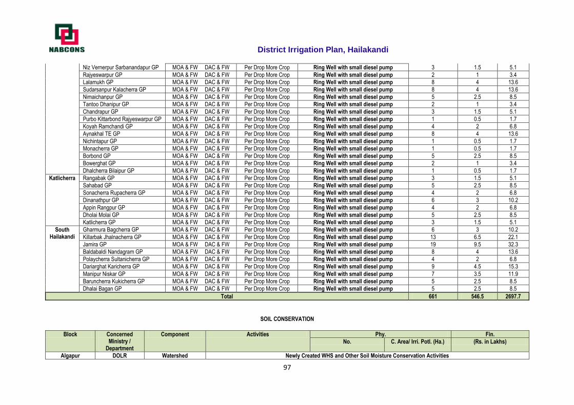
District Irrigation Plan, Hailakandi
97
Niz Vernerpur Sarbanandapur GP MOA & FW DAC & FW Per Drop More Crop Ring Well with small diesel pump 3 1.5 5.1
Rajyeswarpur GP MOA & FW DAC & FW Per Drop More Crop Ring Well with small diesel pump 2 1 3.4
Lalamukh GP MOA & FW DAC & FW Per Drop More Crop Ring Well with small diesel pump 8 4 13.6
Sudarsanpur Kalacherra GP MOA & FW DAC & FW Per Drop More Crop Ring Well with small diesel pump 8 4 13.6
Nimaichanpur GP MOA & FW DAC & FW Per Drop More Crop Ring Well with small diesel pump 5 2.5 8.5
Tantoo Dhanipur GP MOA & FW DAC & FW Per Drop More Crop Ring Well with small diesel pump 2 1 3.4
Chandrapur GP MOA & FW DAC & FW Per Drop More Crop Ring Well with small diesel pump 3 1.5 5.1
Purbo Kittarbond Rajyeswarpur GP MOA & FW DAC & FW Per Drop More Crop Ring Well with small diesel pump 1 0.5 1.7
Koyah Ramchandi GP MOA & FW DAC & FW Per Drop More Crop Ring Well with small diesel pump 4 2 6.8
Aynakhal TE GP MOA & FW DAC & FW Per Drop More Crop Ring Well with small diesel pump 8 4 13.6
Nichintapur GP MOA & FW DAC & FW Per Drop More Crop Ring Well with small diesel pump 1 0.5 1.7
Monacherra GP MOA & FW DAC & FW Per Drop More Crop Ring Well with small diesel pump 1 0.5 1.7
Borbond GP MOA & FW DAC & FW Per Drop More Crop Ring Well with small diesel pump 5 2.5 8.5
Bowerghat GP MOA & FW DAC & FW Per Drop More Crop Ring Well with small diesel pump 2 1 3.4
Dhalcherra Bilaipur GP MOA & FW DAC & FW Per Drop More Crop Ring Well with small diesel pump 1 0.5 1.7
Katlicherra Rangabak GP MOA & FW DAC & FW Per Drop More Crop Ring Well with small diesel pump 3 1.5 5.1
Sahabad GP MOA & FW DAC & FW Per Drop More Crop Ring Well with small diesel pump 5 2.5 8.5
Sonacherra Rupacherra GP MOA & FW DAC & FW Per Drop More Crop Ring Well with small diesel pump 4 2 6.8
Dinanathpur GP MOA & FW DAC & FW Per Drop More Crop Ring Well with small diesel pump 6 3 10.2
Appin Rangpur GP MOA & FW DAC & FW Per Drop More Crop Ring Well with small diesel pump 4 2 6.8
Dholai Molai GP MOA & FW DAC & FW Per Drop More Crop Ring Well with small diesel pump 5 2.5 8.5
Katlicherra GP MOA & FW DAC & FW Per Drop More Crop Ring Well with small diesel pump 3 1.5 5.1
South Hailakandi
Gharmura Bagcherra GP MOA & FW DAC & FW Per Drop More Crop Ring Well with small diesel pump 6 3 10.2
Killarbak Jhalnacherra GP MOA & FW DAC & FW Per Drop More Crop Ring Well with small diesel pump 13 6.5 22.1
Jamira GP MOA & FW DAC & FW Per Drop More Crop Ring Well with small diesel pump 19 9.5 32.3
Baldabaldi Nandagram GP MOA & FW DAC & FW Per Drop More Crop Ring Well with small diesel pump 8 4 13.6
Polaycherra Sultanicherra GP MOA & FW DAC & FW Per Drop More Crop Ring Well with small diesel pump 4 2 6.8
Dariarghat Karicherra GP MOA & FW DAC & FW Per Drop More Crop Ring Well with small diesel pump 9 4.5 15.3
Manipur Niskar GP MOA & FW DAC & FW Per Drop More Crop Ring Well with small diesel pump 7 3.5 11.9
Baruncherra Kukicherra GP MOA & FW DAC & FW Per Drop More Crop Ring Well with small diesel pump 5 2.5 8.5
Dhalai Bagan GP MOA & FW DAC & FW Per Drop More Crop Ring Well with small diesel pump 5 2.5 8.5
Total 661 546.5 2697.7
SOIL CONSERVATION
Block Concerned Ministry /
Department
Component Activities Phy. Fin.
No. C. Area/ Irri. Potl. (Ha.) (Rs. in Lakhs)
Algapur DOLR Watershed Newly Created WHS and Other Soil Moisture Conservation Activities
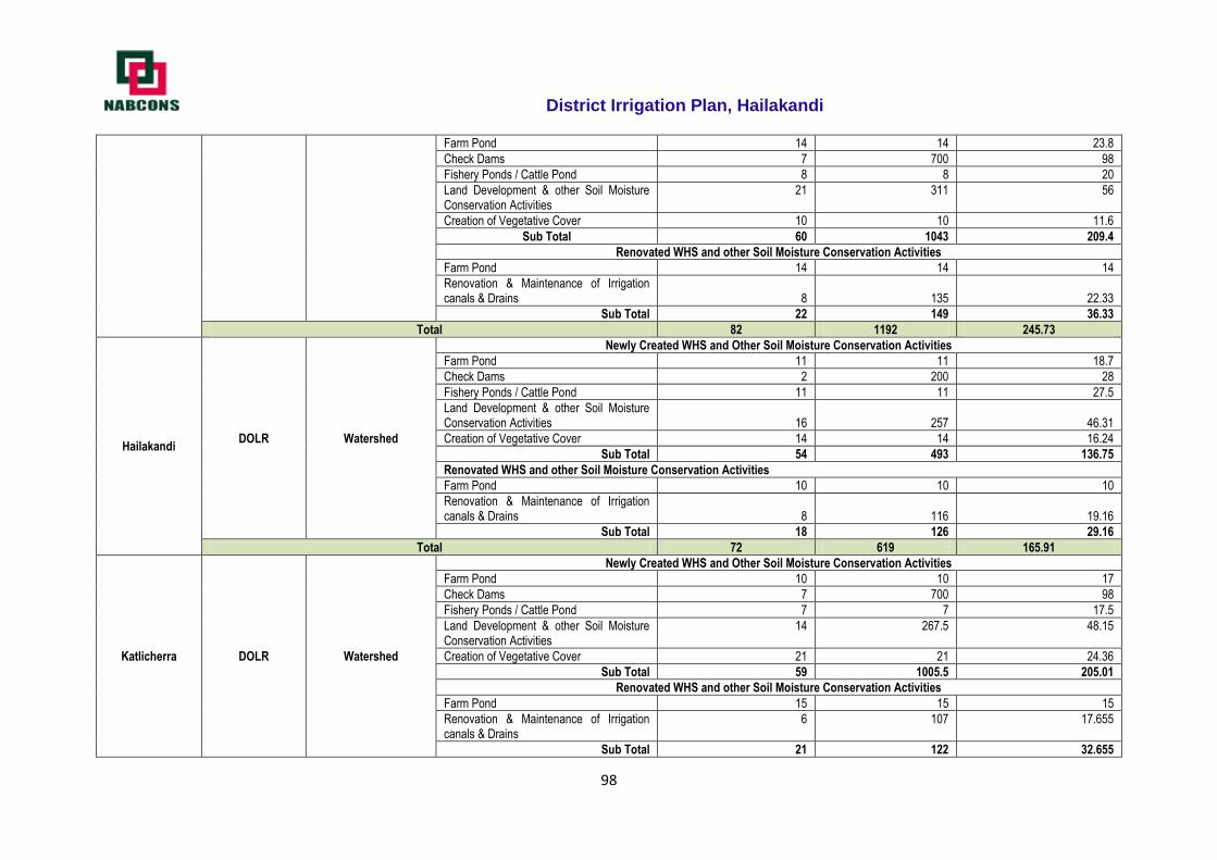
District Irrigation Plan, Hailakandi
98
Farm Pond 14 14 23.8
Check Dams 7 700 98
Fishery Ponds / Cattle Pond 8 8 20
Land Development & other Soil Moisture Conservation Activities
21 311 56
Creation of Vegetative Cover 10 10 11.6
Sub Total 60 1043 209.4
Renovated WHS and other Soil Moisture Conservation Activities
Farm Pond 14 14 14
Renovation & Maintenance of Irrigation canals & Drains 8 135 22.33
Sub Total 22 149 36.33
Total 82 1192 245.73
Hailakandi DOLR Watershed
Newly Created WHS and Other Soil Moisture Conservation Activities
Farm Pond 11 11 18.7
Check Dams 2 200 28
Fishery Ponds / Cattle Pond 11 11 27.5
Land Development & other Soil Moisture Conservation Activities 16 257 46.31
Creation of Vegetative Cover 14 14 16.24
Sub Total 54 493 136.75
Renovated WHS and other Soil Moisture Conservation Activities
Farm Pond 10 10 10
Renovation & Maintenance of Irrigation canals & Drains 8 116 19.16
Sub Total 18 126 29.16
Total 72 619 165.91
Katlicherra DOLR Watershed
Newly Created WHS and Other Soil Moisture Conservation Activities
Farm Pond 10 10 17
Check Dams 7 700 98
Fishery Ponds / Cattle Pond 7 7 17.5
Land Development & other Soil Moisture Conservation Activities
14 267.5 48.15
Creation of Vegetative Cover 21 21 24.36
Sub Total 59 1005.5 205.01
Renovated WHS and other Soil Moisture Conservation Activities
Farm Pond 15 15 15
Renovation & Maintenance of Irrigation canals & Drains
6 107 17.655
Sub Total 21 122 32.655
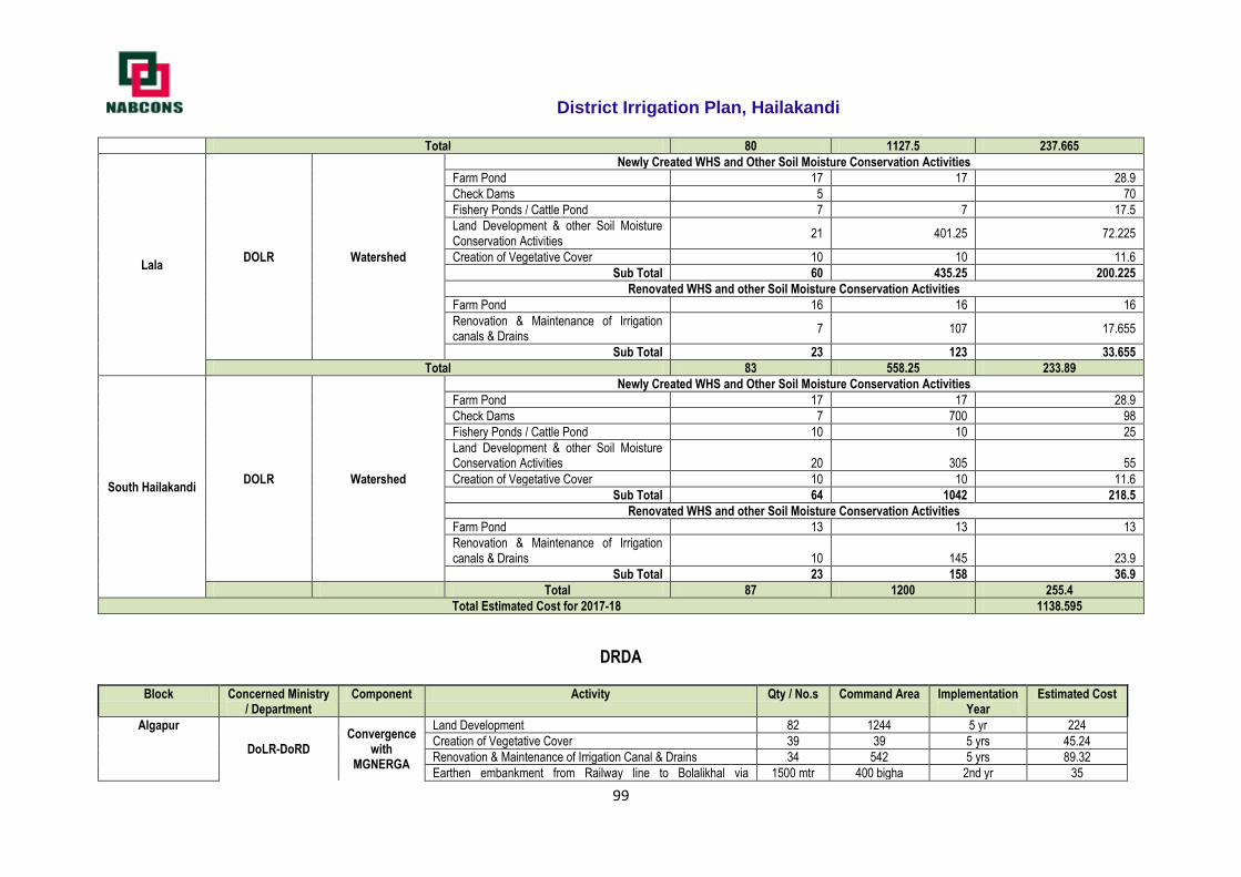
District Irrigation Plan, Hailakandi
99
Total 80 1127.5 237.665
Lala DOLR Watershed
Newly Created WHS and Other Soil Moisture Conservation Activities
Farm Pond 17 17 28.9
Check Dams 5 70
Fishery Ponds / Cattle Pond 7 7 17.5
Land Development & other Soil Moisture Conservation Activities
21 401.25 72.225
Creation of Vegetative Cover 10 10 11.6
Sub Total 60 435.25 200.225
Renovated WHS and other Soil Moisture Conservation Activities
Farm Pond 16 16 16
Renovation & Maintenance of Irrigation canals & Drains
7 107 17.655
Sub Total 23 123 33.655
Total 83 558.25 233.89
South Hailakandi DOLR Watershed
Newly Created WHS and Other Soil Moisture Conservation Activities
Farm Pond 17 17 28.9
Check Dams 7 700 98
Fishery Ponds / Cattle Pond 10 10 25
Land Development & other Soil Moisture Conservation Activities 20 305 55
Creation of Vegetative Cover 10 10 11.6
Sub Total 64 1042 218.5
Renovated WHS and other Soil Moisture Conservation Activities
Farm Pond 13 13 13
Renovation & Maintenance of Irrigation canals & Drains 10 145 23.9
Sub Total 23 158 36.9
Total 87 1200 255.4
Total Estimated Cost for 2017-18 1138.595
DRDA
Block Concerned Ministry / Department
Component Activity Qty / No.s Command Area Implementation Year
Estimated Cost
Algapur
DoLR-DoRD Convergence
with MGNERGA
Land Development 82 1244 5 yr 224
Creation of Vegetative Cover 39 39 5 yrs 45.24
Renovation & Maintenance of Irrigation Canal & Drains 34 542 5 yrs 89.32
Earthen embankment from Railway line to Bolalikhal via 1500 mtr 400 bigha 2nd yr 35
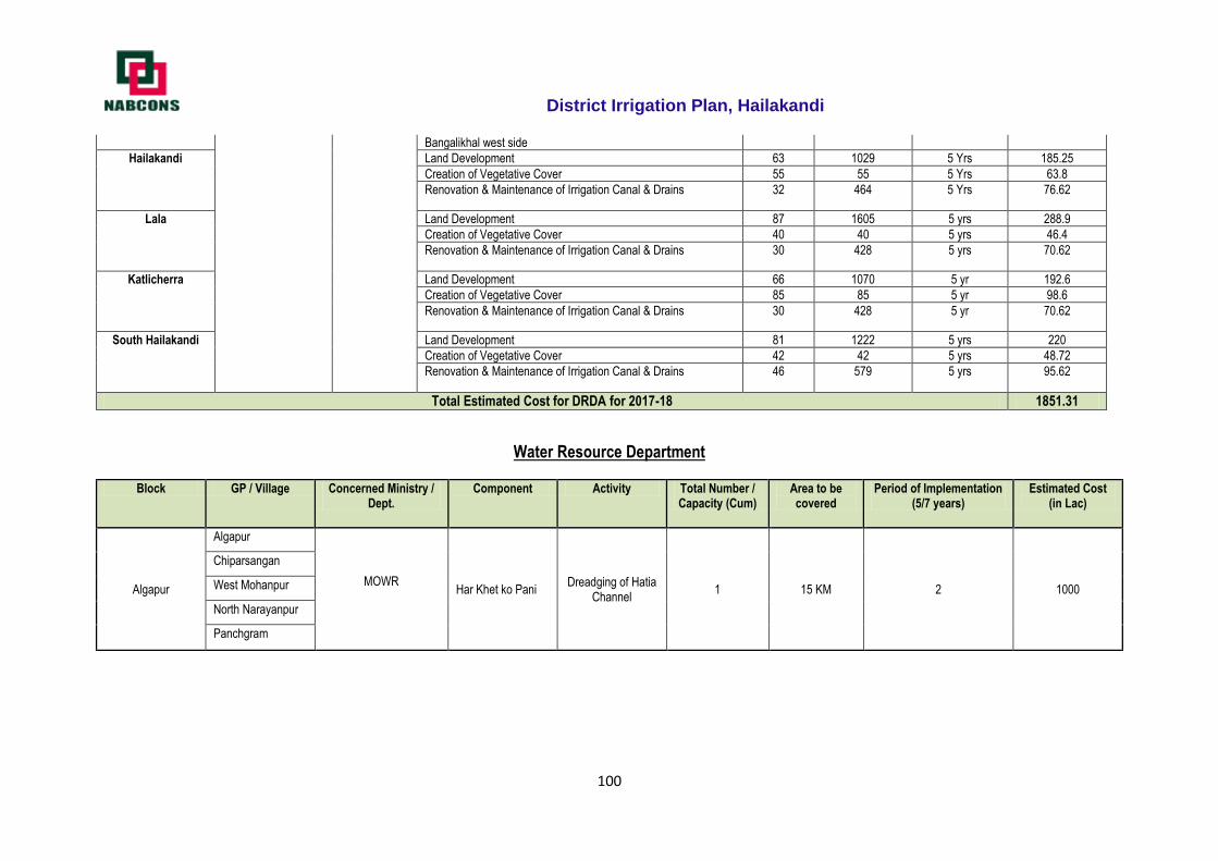
District Irrigation Plan, Hailakandi
100
Bangalikhal west side
Hailakandi
Land Development 63 1029 5 Yrs 185.25
Creation of Vegetative Cover 55 55 5 Yrs 63.8
Renovation & Maintenance of Irrigation Canal & Drains 32 464 5 Yrs 76.62
Lala
Land Development 87 1605 5 yrs 288.9
Creation of Vegetative Cover 40 40 5 yrs 46.4
Renovation & Maintenance of Irrigation Canal & Drains 30 428 5 yrs 70.62
Katlicherra
Land Development 66 1070 5 yr 192.6
Creation of Vegetative Cover 85 85 5 yr 98.6
Renovation & Maintenance of Irrigation Canal & Drains 30 428 5 yr 70.62
South Hailakandi
Land Development 81 1222 5 yrs 220
Creation of Vegetative Cover 42 42 5 yrs 48.72
Renovation & Maintenance of Irrigation Canal & Drains 46 579 5 yrs 95.62
Total Estimated Cost for DRDA for 2017-18 1851.31
Water Resource Department
Block GP / Village Concerned Ministry / Dept.
Component Activity Total Number / Capacity (Cum)
Area to be covered
Period of Implementation (5/7 years)
Estimated Cost (in Lac)
Algapur
Algapur
MOWR
Har Khet ko Pani Dreadging of Hatia
Channel 1 15 KM 2 1000
Chiparsangan
West Mohanpur
North Narayanpur
Panchgram
District Irrigation Plan, Hailakandi
101
2018-19 Irrigation Plan
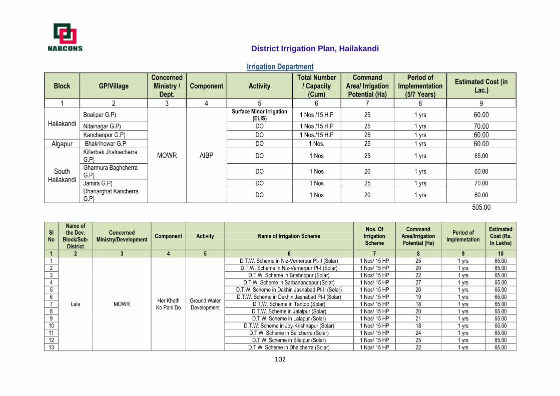
District Irrigation Plan, Hailakandi
102
Irrigation Department
Block GP/Village Concerned Ministry /
Dept. Component Activity
Total Number / Capacity
(Cum)
Command Area/ Irrigation Potential (Ha)
Period of Implementation
(5/7 Years)
Estimated Cost (in Lac.)
1 2 3 4 5 6 7 8 9
Hailakandi
Boalipar G.P)
MOWR AIBP
Surface Minor Irrigation (ELIS)
1 Nos /15 H.P 25 1 yrs 60.00
Nitainagar G.P) DO 1 Nos /15 H.P 25 1 yrs 70.00 Kanchanpur G.P) DO 1 Nos./15 H.P 25 1 yrs 60.00
Algapur Bhakrihowar G.P DO 1 Nos. 25 1 yrs 60.00
South Hailakandi
Killarbak Jhalnacherra G.P)
DO 1 Nos 25 1 yrs 65.00
Gharmura Baghcherra G.P)
DO 1 Nos 20 1 yrs 60.00
Jamira G.P) DO 1 Nos 25 1 yrs 70.00
Dhariarghat Karicherra G.P)
DO 1 Nos 20 1 yrs 60.00
505.00
Sl No
Name of the Dev.
Block/Sub-District
Concerned Ministry/Development
Component Activity Name of Irrigation Scheme Nos. Of
Irrigation Scheme
Command Area/Irrigation Potential (Ha)
Period of Implemetation
Estimated Cost (Rs. In Lakhs)
1 2 3 4 5 6 7 8 9 10
1
Lala MOWR Her Kheth
Ko Pani Do Ground Water Development
D.T.W. Scheme in Niz-Vernerpur Pt-II (Solar) 1 Nos/ 15 HP 25 1 yrs 65.00
2 D.T.W. Scheme in Niz-Vernerpur Pt-I (Solar) 1 Nos/ 15 HP 20 1 yrs 65.00
3 D.T.W. Scheme in Brishnopur (Solar) 1 Nos/ 15 HP 22 1 yrs 65.00
4 D.T.W. Scheme in Sarbanandapur (Solar) 1 Nos/ 15 HP 27 1 yrs 65.00
5 D.T.W. Scheme in Dakhin Jasnabad Pt-II (Solar) 1 Nos/ 15 HP 20 1 yrs 65.00
6 D.T.W. Scheme in Dakhin Jasnabad Pt-I (Solar) 1 Nos/ 15 HP 19 1 yrs 65.00
7 D.T.W. Scheme in Tantoo (Solar) 1 Nos/ 15 HP 18 1 yrs 65.00
8 D.T.W. Scheme in Jalalpur (Solar) 1 Nos/ 15 HP 20 1 yrs 65.00
9 D.T.W. Scheme in Lalapur (Solar) 1 Nos/ 15 HP 21 1 yrs 65.00
10 D.T.W. Scheme in Joy-Krishnapur (Solar) 1 Nos/ 15 HP 18 1 yrs 65.00
11 D.T.W. Scheme in Balicherra (Solar) 1 Nos/ 15 HP 24 1 yrs 65.00
12 D.T.W. Scheme in Bilaipur (Solar) 1 Nos/ 15 HP 25 1 yrs 65.00
13 D.T.W. Scheme in Dhalcherra (Solar) 1 Nos/ 15 HP 22 1 yrs 65.00
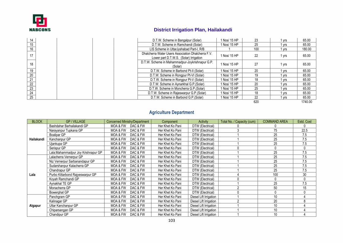
District Irrigation Plan, Hailakandi
103
14 D.T.W. Scheme in Bangalpur (Solar) 1 Nos/ 15 HP 23 1 yrs 65.00
15 D.T.W. Scheme in Ramchandi (Solar) 1 Nos/ 15 HP 25 1 yrs 65.00
16 LIS Scheme in UttarJyshabad Part-I, R/B 1 100 1 yrs 180.00
17 Dhalcherra Water Users Association Dhalcherra F.V.
Lower part D.T.W.S. (Solar) Irrigation 1 Nos/ 15 HP 22 1 yrs 65.00
18 D.T.W. Scheme in Mahammadpur-Joykrishnapur G.P.
(Solar) 1 Nos/ 15 HP 27 1 yrs 65.00
19 D.T.W. Scheme in Barbond Pt-II (Solar) 1 Nos/ 15 HP 20 1 yrs 65.00
20 D.T.W. Scheme in Rongpur Pt-VI (Solar) 1 Nos/ 15 HP 19 1 yrs 65.00
21 D.T.W. Scheme in Rongpur Pt-V (Solar) 1 Nos/ 15 HP 18 1 yrs 65.00
22 D.T.W. Scheme in Aynarkhal G.P.(Solar) 1 Nos/ 15 HP 20 1 yrs 65.00
23 D.T.W. Scheme in Moncherra G.P.(Solar) 1 Nos/ 15 HP 25 1 yrs 65.00
24 D.T.W. Scheme in Rajeswarpur G.P.(Solar) 1 Nos/ 15 HP 18 1 yrs 65.00
25 D.T.W. Scheme in Barbond G.P.(Solar) 1 Nos/ 15 HP 22 1 yrs 65.00
620
1740.00
Agriculture Department
BLOCK GP / VILLAGE Concerned Ministry/Department Component Activity Total No. / Capacity (cum) COMMAND AREA Estd. Cost
Hailakandi
Bashdahar Barhailakandi GP MOA & FW DAC & FW Her Khet Ko Pani DTW (Electrical) 0 0 0
Narayanpur Tupkana GP MOA & FW DAC & FW Her Khet Ko Pani DTW (Electrical) 3 75 22.5
Boalipar GP MOA & FW DAC & FW Her Khet Ko Pani DTW (Electrical) 1 25 7.5
Kanchanpur GP MOA & FW DAC & FW Her Khet Ko Pani DTW (Electrical) 1 25 7.5
Ujankupa GP MOA & FW DAC & FW Her Khet Ko Pani DTW (Electrical) 1 25 7.5
Serispur GP MOA & FW DAC & FW Her Khet Ko Pani DTW (Electrical) 0 0 0
Lala:Mahammadpur Joy Krishnapur GP MOA & FW DAC & FW Her Khet Ko Pani DTW (Electrical) 1 25 7.5
Lala
Lalacherra Vernerpur GP MOA & FW DAC & FW Her Khet Ko Pani DTW (Electrical) 1 25 7.5
Niz Vernerpur Sarbanandapur GP MOA & FW DAC & FW Her Khet Ko Pani DTW (Electrical) 1 25 7.5
Sudarshanpur Kalacherra GP MOA & FW DAC & FW Her Khet Ko Pani DTW (Electrical) 1 25 7.5
Chandrapur GP MOA & FW DAC & FW Her Khet Ko Pani DTW (Electrical) 1 25 7.5
Purbo Kittarbond Rajyeswarpur GP MOA & FW DAC & FW Her Khet Ko Pani DTW (Electrical) 4 100 30
Koyah Ramchandi GP MOA & FW DAC & FW Her Khet Ko Pani DTW (Electrical) 0 0 0
Aynakhal TE GP MOA & FW DAC & FW Her Khet Ko Pani DTW (Electrical) 1 25 7.5
Monacherra GP MOA & FW DAC & FW Her Khet Ko Pani DTW (Electrical) 2 50 15
Bowerghat GP MOA & FW DAC & FW Her Khet Ko Pani DTW (Electrical) 0 0 0
Algapur
Panchgram GP MOA & FW DAC & FW Her Khet Ko Pani Diesel Lift Irrigation 1 10 4
Kalinagar GP MOA & FW DAC & FW Her Khet Ko Pani Diesel Lift Irrigation 2 20 8
Uttar Kanchanpur GP MOA & FW DAC & FW Her Khet Ko Pani Diesel Lift Irrigation 1 10 4
Chiparsangan GP MOA & FW DAC & FW Her Khet Ko Pani Diesel Lift Irrigation 1 10 4
Chandipur GP MOA & FW DAC & FW Her Khet Ko Pani Diesel Lift Irrigation 1 10 4
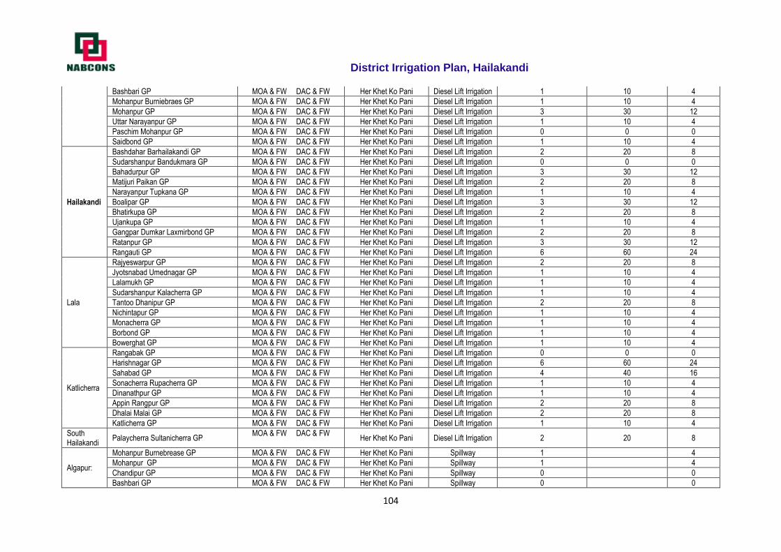
District Irrigation Plan, Hailakandi
104
Bashbari GP MOA & FW DAC & FW Her Khet Ko Pani Diesel Lift Irrigation 1 10 4
Mohanpur Burniebraes GP MOA & FW DAC & FW Her Khet Ko Pani Diesel Lift Irrigation 1 10 4
Mohanpur GP MOA & FW DAC & FW Her Khet Ko Pani Diesel Lift Irrigation 3 30 12
Uttar Narayanpur GP MOA & FW DAC & FW Her Khet Ko Pani Diesel Lift Irrigation 1 10 4
Paschim Mohanpur GP MOA & FW DAC & FW Her Khet Ko Pani Diesel Lift Irrigation 0 0 0
Saidbond GP MOA & FW DAC & FW Her Khet Ko Pani Diesel Lift Irrigation 1 10 4
Hailakandi
Bashdahar Barhailakandi GP MOA & FW DAC & FW Her Khet Ko Pani Diesel Lift Irrigation 2 20 8
Sudarshanpur Bandukmara GP MOA & FW DAC & FW Her Khet Ko Pani Diesel Lift Irrigation 0 0 0
Bahadurpur GP MOA & FW DAC & FW Her Khet Ko Pani Diesel Lift Irrigation 3 30 12
Matijuri Paikan GP MOA & FW DAC & FW Her Khet Ko Pani Diesel Lift Irrigation 2 20 8
Narayanpur Tupkana GP MOA & FW DAC & FW Her Khet Ko Pani Diesel Lift Irrigation 1 10 4
Boalipar GP MOA & FW DAC & FW Her Khet Ko Pani Diesel Lift Irrigation 3 30 12
Bhatirkupa GP MOA & FW DAC & FW Her Khet Ko Pani Diesel Lift Irrigation 2 20 8
Ujankupa GP MOA & FW DAC & FW Her Khet Ko Pani Diesel Lift Irrigation 1 10 4
Gangpar Dumkar Laxmirbond GP MOA & FW DAC & FW Her Khet Ko Pani Diesel Lift Irrigation 2 20 8
Ratanpur GP MOA & FW DAC & FW Her Khet Ko Pani Diesel Lift Irrigation 3 30 12
Rangauti GP MOA & FW DAC & FW Her Khet Ko Pani Diesel Lift Irrigation 6 60 24
Lala
Rajyeswarpur GP MOA & FW DAC & FW Her Khet Ko Pani Diesel Lift Irrigation 2 20 8
Jyotsnabad Umednagar GP MOA & FW DAC & FW Her Khet Ko Pani Diesel Lift Irrigation 1 10 4
Lalamukh GP MOA & FW DAC & FW Her Khet Ko Pani Diesel Lift Irrigation 1 10 4
Sudarshanpur Kalacherra GP MOA & FW DAC & FW Her Khet Ko Pani Diesel Lift Irrigation 1 10 4
Tantoo Dhanipur GP MOA & FW DAC & FW Her Khet Ko Pani Diesel Lift Irrigation 2 20 8
Nichintapur GP MOA & FW DAC & FW Her Khet Ko Pani Diesel Lift Irrigation 1 10 4
Monacherra GP MOA & FW DAC & FW Her Khet Ko Pani Diesel Lift Irrigation 1 10 4
Borbond GP MOA & FW DAC & FW Her Khet Ko Pani Diesel Lift Irrigation 1 10 4
Bowerghat GP MOA & FW DAC & FW Her Khet Ko Pani Diesel Lift Irrigation 1 10 4
Katlicherra
Rangabak GP MOA & FW DAC & FW Her Khet Ko Pani Diesel Lift Irrigation 0 0 0
Harishnagar GP MOA & FW DAC & FW Her Khet Ko Pani Diesel Lift Irrigation 6 60 24
Sahabad GP MOA & FW DAC & FW Her Khet Ko Pani Diesel Lift Irrigation 4 40 16
Sonacherra Rupacherra GP MOA & FW DAC & FW Her Khet Ko Pani Diesel Lift Irrigation 1 10 4
Dinanathpur GP MOA & FW DAC & FW Her Khet Ko Pani Diesel Lift Irrigation 1 10 4
Appin Rangpur GP MOA & FW DAC & FW Her Khet Ko Pani Diesel Lift Irrigation 2 20 8
Dhalai Malai GP MOA & FW DAC & FW Her Khet Ko Pani Diesel Lift Irrigation 2 20 8
Katlicherra GP MOA & FW DAC & FW Her Khet Ko Pani Diesel Lift Irrigation 1 10 4
South Hailakandi
Palaycherra Sultanicherra GP MOA & FW DAC & FW
Her Khet Ko Pani Diesel Lift Irrigation 2 20 8
Algapur:
Mohanpur Burnebrease GP MOA & FW DAC & FW Her Khet Ko Pani Spillway 1 4
Mohanpur GP MOA & FW DAC & FW Her Khet Ko Pani Spillway 1 4
Chandipur GP MOA & FW DAC & FW Her Khet Ko Pani Spillway 0 0
Bashbari GP MOA & FW DAC & FW Her Khet Ko Pani Spillway 0 0
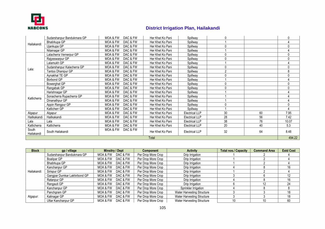
District Irrigation Plan, Hailakandi
105
Hailakandi:
Sudarshanpur Bandukmara GP MOA & FW DAC & FW Her Khet Ko Pani Spillway 0 0
Bhatirkupa GP MOA & FW DAC & FW Her Khet Ko Pani Spillway 1 4
Ujankupa GP MOA & FW DAC & FW Her Khet Ko Pani Spillway 0 0
Nitainagar GP MOA & FW DAC & FW Her Khet Ko Pani Spillway 1 4
Lala:
Lalacherra Vernerpur GP MOA & FW DAC & FW Her Khet Ko Pani Spillway 0 0
Rajyeswarpur GP MOA & FW DAC & FW Her Khet Ko Pani Spillway 0 0
Lalamukh GP MOA & FW DAC & FW Her Khet Ko Pani Spillway 1 4
Sudarshanpur Kalacherra GP MOA & FW DAC & FW Her Khet Ko Pani Spillway 0 0
Tantoo Dhanipur GP MOA & FW DAC & FW Her Khet Ko Pani Spillway 2 8
Aynakhal TE GP MOA & FW DAC & FW Her Khet Ko Pani Spillway 0 0
Borbond GP MOA & FW DAC & FW Her Khet Ko Pani Spillway 1 4
Bowerghat GP MOA & FW DAC & FW Her Khet Ko Pani Spillway 0 0
Katlicherra
Rangabak GP MOA & FW DAC & FW Her Khet Ko Pani Spillway 0 0
Harishnagar GP MOA & FW DAC & FW Her Khet Ko Pani Spillway 1 4
Sonacherra Rupacherra GP MOA & FW DAC & FW Her Khet Ko Pani Spillway 1 4
Dinanathpur GP MOA & FW DAC & FW Her Khet Ko Pani Spillway 1 4
Appin Rangpur GP MOA & FW DAC & FW Her Khet Ko Pani Spillway 0 0
Katlicherr GP MOA & FW DAC & FW Her Khet Ko Pani Spillway 1 4
Algapur Algapur MOA & FW DAC & FW Her Khet Ko Pani Electrical LLP 30 60 7.95
Hailkakandi Hailkakandi MOA & FW DAC & FW Her Khet Ko Pani Electrical LLP 28 56 7.42
Lala Lala MOA & FW DAC & FW Her Khet Ko Pani Electrical LLP 38 76 10.07
Katlicherra Katlicherra MOA & FW DAC & FW Her Khet Ko Pani Electrical LLP 20 40 5.3
South Hailakandi
South Hailakandi MOA & FW DAC & FW
Her Khet Ko Pani Electrical LLP 32 64 8.48
Total 494.22
Block gp / village Minsitry / Dept Component Activity Total nos./ Capacity Command Area Estd Cost
Hailakandi:
Sudarshanpur Bandukmara GP MOA & FW DAC & FW Per Drop More Crop Drip Irrigation 1 2 4
Boalipar GP MOA & FW DAC & FW Per Drop More Crop Drip Irrigation 1 2 4
Bhatirkupa GP MOA & FW DAC & FW Per Drop More Crop Drip Irrigation 1 2 4
Kanchanpur GP MOA & FW DAC & FW Per Drop More Crop Drip Irrigation 4 8 16
Sirispur GP MOA & FW DAC & FW Per Drop More Crop Drip Irrigation 1 2 4
Gangpar Dumkar Lakhirbond GP MOA & FW DAC & FW Per Drop More Crop Drip Irrigation 3 6 12
Ratanpur GP MOA & FW DAC & FW Per Drop More Crop Drip Irrigation 4 8 16
Rangauti GP MOA & FW DAC & FW Per Drop More Crop Drip Irrigation 6 12 24
Kanchanpur GP MOA & FW DAC & FW Per Drop More Crop Sprinkler Irrigation 4 8 8
Algapur:
Panchgram GP MOA & FW DAC & FW Per Drop More Crop Water Harvesting Structure 3 3 18
Kalinagar GP MOA & FW DAC & FW Per Drop More Crop Water Harvesting Structure 3 3 18
Uttar Kanchanpur GP MOA & FW DAC & FW Per Drop More Crop Water Harvesting Structure 10 10 60
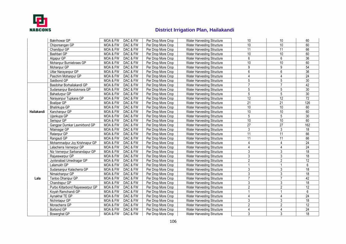
District Irrigation Plan, Hailakandi
106
Bakrihowar GP MOA & FW DAC & FW Per Drop More Crop Water Harvesting Structure 10 10 60
Chiporsangan GP MOA & FW DAC & FW Per Drop More Crop Water Harvesting Structure 10 10 60
Chandipur GP MOA & FW DAC & FW Per Drop More Crop Water Harvesting Structure 11 11 66
Bashbari GP MOA & FW DAC & FW Per Drop More Crop Water Harvesting Structure 10 10 60
Algapur GP MOA & FW DAC & FW Per Drop More Crop Water Harvesting Structure 6 6 36
Mohanpur Burniebraes GP MOA & FW DAC & FW Per Drop More Crop Water Harvesting Structure 10 10 60
Mohanpur GP MOA & FW DAC & FW Per Drop More Crop Water Harvesting Structure 9 9 54
Uttar Narayanpur GP MOA & FW DAC & FW Per Drop More Crop Water Harvesting Structure 6 6 36
Paschim Mohanpur GP MOA & FW DAC & FW Per Drop More Crop Water Harvesting Structure 4 4 24
Saidbond GP MOA & FW DAC & FW Per Drop More Crop Water Harvesting Structure 5 5 30
Hailakandi
Basdohar Borhailakandi GP MOA & FW DAC & FW Per Drop More Crop Water Harvesting Structure 7 7 42
Sudarsanpur Bandukmara GP MOA & FW DAC & FW Per Drop More Crop Water Harvesting Structure 5 5 30
Bahadurpur GP MOA & FW DAC & FW Per Drop More Crop Water Harvesting Structure 5 5 30
Narayanpur Tupkana GP MOA & FW DAC & FW Per Drop More Crop Water Harvesting Structure 12 12 72
Boalipar GP MOA & FW DAC & FW Per Drop More Crop Water Harvesting Structure 21 21 126
Bhatirkupa GP MOA & FW DAC & FW Per Drop More Crop Water Harvesting Structure 10 10 60
Kanchanpur GP MOA & FW DAC & FW Per Drop More Crop Water Harvesting Structure 10 10 60
Ujankupa GP MOA & FW DAC & FW Per Drop More Crop Water Harvesting Structure 5 5 30
Serispur GP MOA & FW DAC & FW Per Drop More Crop Water Harvesting Structure 10 10 60
Gangpar Dumkar Laxmirbond GP MOA & FW DAC & FW Per Drop More Crop Water Harvesting Structure 27 27 162
Nitainagar GP MOA & FW DAC & FW Per Drop More Crop Water Harvesting Structure 3 3 18
Ratanpur GP MOA & FW DAC & FW Per Drop More Crop Water Harvesting Structure 11 11 66
Rangauti GP MOA & FW DAC & FW Per Drop More Crop Water Harvesting Structure 11 11 66
Lala
Mohammadpur Joy Krishnapur GP MOA & FW DAC & FW Per Drop More Crop Water Harvesting Structure 4 4 24
Lalacherra Vernerpur GP MOA & FW DAC & FW Per Drop More Crop Water Harvesting Structure 4 4 24
Niz Vernerpur Sarbanandapur GP MOA & FW DAC & FW Per Drop More Crop Water Harvesting Structure 3 3 18
Rajyeswarpur GP MOA & FW DAC & FW Per Drop More Crop Water Harvesting Structure 3 3 18
Jyotsnabad Umednagar GP MOA & FW DAC & FW Per Drop More Crop Water Harvesting Structure 2 2 12
Lalamukh GP MOA & FW DAC & FW Per Drop More Crop Water Harvesting Structure 1 1 6
Sudarsanpur Kalacherra GP MOA & FW DAC & FW Per Drop More Crop Water Harvesting Structure 3 3 18
Nimaichanpur GP MOA & FW DAC & FW Per Drop More Crop Water Harvesting Structure 3 3 18
Tantoo Dhanipur GP MOA & FW DAC & FW Per Drop More Crop Water Harvesting Structure 7 7 42
Chandrapur GP MOA & FW DAC & FW Per Drop More Crop Water Harvesting Structure 3 3 18
Purbo Kittarbond Rajyeswarpur GP MOA & FW DAC & FW Per Drop More Crop Water Harvesting Structure 2 2 12
Koyah Ramchandi GP MOA & FW DAC & FW Per Drop More Crop Water Harvesting Structure 1 1 6
Aynakhal TE GP MOA & FW DAC & FW Per Drop More Crop Water Harvesting Structure 4 4 24
Nichintapur GP MOA & FW DAC & FW Per Drop More Crop Water Harvesting Structure 3 3 18
Monacherra GP MOA & FW DAC & FW Per Drop More Crop Water Harvesting Structure 2 2 12
Borbond GP MOA & FW DAC & FW Per Drop More Crop Water Harvesting Structure 4 4 24
Bowerghat GP MOA & FW DAC & FW Per Drop More Crop Water Harvesting Structure 3 3 18
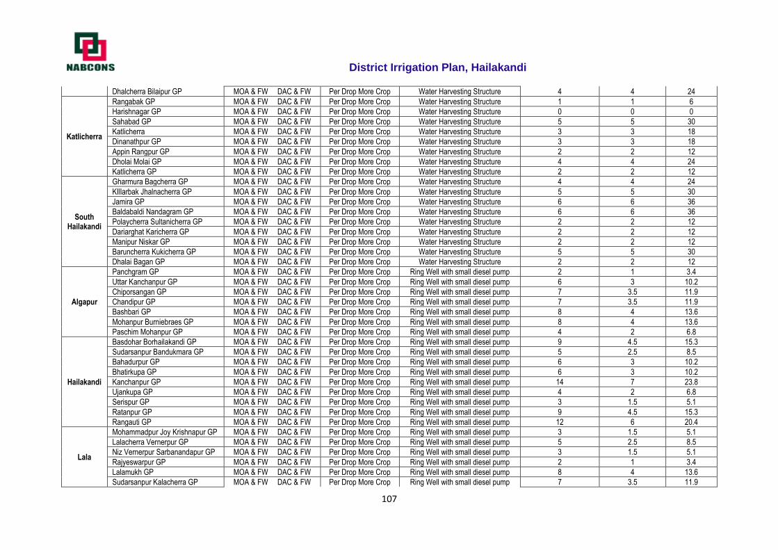
District Irrigation Plan, Hailakandi
107
Dhalcherra Bilaipur GP MOA & FW DAC & FW Per Drop More Crop Water Harvesting Structure 4 4 24
Katlicherra
Rangabak GP MOA & FW DAC & FW Per Drop More Crop Water Harvesting Structure 1 1 6
Harishnagar GP MOA & FW DAC & FW Per Drop More Crop Water Harvesting Structure 0 0 0
Sahabad GP MOA & FW DAC & FW Per Drop More Crop Water Harvesting Structure 5 5 30
Katlicherra MOA & FW DAC & FW Per Drop More Crop Water Harvesting Structure 3 3 18
Dinanathpur GP MOA & FW DAC & FW Per Drop More Crop Water Harvesting Structure 3 3 18
Appin Rangpur GP MOA & FW DAC & FW Per Drop More Crop Water Harvesting Structure 2 2 12
Dholai Molai GP MOA & FW DAC & FW Per Drop More Crop Water Harvesting Structure 4 4 24
Katlicherra GP MOA & FW DAC & FW Per Drop More Crop Water Harvesting Structure 2 2 12
South Hailakandi
Gharmura Bagcherra GP MOA & FW DAC & FW Per Drop More Crop Water Harvesting Structure 4 4 24
KIllarbak Jhalnacherra GP MOA & FW DAC & FW Per Drop More Crop Water Harvesting Structure 5 5 30
Jamira GP MOA & FW DAC & FW Per Drop More Crop Water Harvesting Structure 6 6 36
Baldabaldi Nandagram GP MOA & FW DAC & FW Per Drop More Crop Water Harvesting Structure 6 6 36
Polaycherra Sultanicherra GP MOA & FW DAC & FW Per Drop More Crop Water Harvesting Structure 2 2 12
Dariarghat Karicherra GP MOA & FW DAC & FW Per Drop More Crop Water Harvesting Structure 2 2 12
Manipur Niskar GP MOA & FW DAC & FW Per Drop More Crop Water Harvesting Structure 2 2 12
Baruncherra Kukicherra GP MOA & FW DAC & FW Per Drop More Crop Water Harvesting Structure 5 5 30
Dhalai Bagan GP MOA & FW DAC & FW Per Drop More Crop Water Harvesting Structure 2 2 12
Algapur
Panchgram GP MOA & FW DAC & FW Per Drop More Crop Ring Well with small diesel pump 2 1 3.4
Uttar Kanchanpur GP MOA & FW DAC & FW Per Drop More Crop Ring Well with small diesel pump 6 3 10.2
Chiporsangan GP MOA & FW DAC & FW Per Drop More Crop Ring Well with small diesel pump 7 3.5 11.9
Chandipur GP MOA & FW DAC & FW Per Drop More Crop Ring Well with small diesel pump 7 3.5 11.9
Bashbari GP MOA & FW DAC & FW Per Drop More Crop Ring Well with small diesel pump 8 4 13.6
Mohanpur Burniebraes GP MOA & FW DAC & FW Per Drop More Crop Ring Well with small diesel pump 8 4 13.6
Paschim Mohanpur GP MOA & FW DAC & FW Per Drop More Crop Ring Well with small diesel pump 4 2 6.8
Hailakandi
Basdohar Borhailakandi GP MOA & FW DAC & FW Per Drop More Crop Ring Well with small diesel pump 9 4.5 15.3
Sudarsanpur Bandukmara GP MOA & FW DAC & FW Per Drop More Crop Ring Well with small diesel pump 5 2.5 8.5
Bahadurpur GP MOA & FW DAC & FW Per Drop More Crop Ring Well with small diesel pump 6 3 10.2
Bhatirkupa GP MOA & FW DAC & FW Per Drop More Crop Ring Well with small diesel pump 6 3 10.2
Kanchanpur GP MOA & FW DAC & FW Per Drop More Crop Ring Well with small diesel pump 14 7 23.8
Ujankupa GP MOA & FW DAC & FW Per Drop More Crop Ring Well with small diesel pump 4 2 6.8
Serispur GP MOA & FW DAC & FW Per Drop More Crop Ring Well with small diesel pump 3 1.5 5.1
Ratanpur GP MOA & FW DAC & FW Per Drop More Crop Ring Well with small diesel pump 9 4.5 15.3
Rangauti GP MOA & FW DAC & FW Per Drop More Crop Ring Well with small diesel pump 12 6 20.4
Lala
Mohammadpur Joy Krishnapur GP MOA & FW DAC & FW Per Drop More Crop Ring Well with small diesel pump 3 1.5 5.1
Lalacherra Vernerpur GP MOA & FW DAC & FW Per Drop More Crop Ring Well with small diesel pump 5 2.5 8.5
Niz Vernerpur Sarbanandapur GP MOA & FW DAC & FW Per Drop More Crop Ring Well with small diesel pump 3 1.5 5.1
Rajyeswarpur GP MOA & FW DAC & FW Per Drop More Crop Ring Well with small diesel pump 2 1 3.4
Lalamukh GP MOA & FW DAC & FW Per Drop More Crop Ring Well with small diesel pump 8 4 13.6
Sudarsanpur Kalacherra GP MOA & FW DAC & FW Per Drop More Crop Ring Well with small diesel pump 7 3.5 11.9
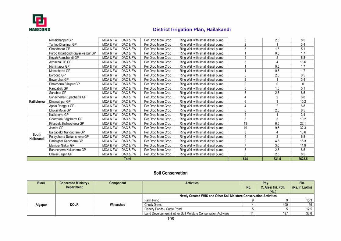
District Irrigation Plan, Hailakandi
108
Nimaichanpur GP MOA & FW DAC & FW Per Drop More Crop Ring Well with small diesel pump 5 2.5 8.5
Tantoo Dhanipur GP MOA & FW DAC & FW Per Drop More Crop Ring Well with small diesel pump 2 1 3.4
Chandrapur GP MOA & FW DAC & FW Per Drop More Crop Ring Well with small diesel pump 3 1.5 5.1
Purbo Kittarbond Rajyeswarpur GP MOA & FW DAC & FW Per Drop More Crop Ring Well with small diesel pump 1 0.5 1.7
Koyah Ramchandi GP MOA & FW DAC & FW Per Drop More Crop Ring Well with small diesel pump 4 2 6.8
Aynakhal TE GP MOA & FW DAC & FW Per Drop More Crop Ring Well with small diesel pump 8 4 13.6
Nichintapur GP MOA & FW DAC & FW Per Drop More Crop Ring Well with small diesel pump 1 0.5 1.7
Monacherra GP MOA & FW DAC & FW Per Drop More Crop Ring Well with small diesel pump 1 0.5 1.7
Borbond GP MOA & FW DAC & FW Per Drop More Crop Ring Well with small diesel pump 5 2.5 8.5
Bowerghat GP MOA & FW DAC & FW Per Drop More Crop Ring Well with small diesel pump 2 1 3.4
Dhalcherra Bilaipur GP MOA & FW DAC & FW Per Drop More Crop Ring Well with small diesel pump 0 0 0
Katlicherra
Rangabak GP MOA & FW DAC & FW Per Drop More Crop Ring Well with small diesel pump 3 1.5 5.1
Sahabad GP MOA & FW DAC & FW Per Drop More Crop Ring Well with small diesel pump 5 2.5 8.5
Sonacherra Rupacherra GP MOA & FW DAC & FW Per Drop More Crop Ring Well with small diesel pump 4 2 6.8
Dinanathpur GP MOA & FW DAC & FW Per Drop More Crop Ring Well with small diesel pump 6 3 10.2
Appin Rangpur GP MOA & FW DAC & FW Per Drop More Crop Ring Well with small diesel pump 4 2 6.8
Dholai Molai GP MOA & FW DAC & FW Per Drop More Crop Ring Well with small diesel pump 5 2.5 8.5
Katlicherra GP MOA & FW DAC & FW Per Drop More Crop Ring Well with small diesel pump 2 1 3.4
South Hailakandi
Gharmura Bagcherra GP MOA & FW DAC & FW Per Drop More Crop Ring Well with small diesel pump 6 3 10.2
Killarbak Jhalnacherra GP MOA & FW DAC & FW Per Drop More Crop Ring Well with small diesel pump 13 6.5 22.1
Jamira GP MOA & FW DAC & FW Per Drop More Crop Ring Well with small diesel pump 19 9.5 32.3
Baldabaldi Nandagram GP MOA & FW DAC & FW Per Drop More Crop Ring Well with small diesel pump 8 4 13.6
Polaycherra Sultanicherra GP MOA & FW DAC & FW Per Drop More Crop Ring Well with small diesel pump 4 2 6.8
Dariarghat Karicherra GP MOA & FW DAC & FW Per Drop More Crop Ring Well with small diesel pump 9 4.5 15.3
Manipur Niskar GP MOA & FW DAC & FW Per Drop More Crop Ring Well with small diesel pump 7 3.5 11.9
Baruncherra Kukicherra GP MOA & FW DAC & FW Per Drop More Crop Ring Well with small diesel pump 5 2.5 8.5
Dhalai Bagan GP MOA & FW DAC & FW Per Drop More Crop Ring Well with small diesel pump 5 2.5 8.5
Total 644 531.5 2623.5
Soil Conservation
Block Concerned Ministry / Department
Component Activities Phy. Fin.
No. C. Area/ Irri. Potl.
(Ha.) (Rs. in Lakhs)
Algapur DOLR Watershed
Newly Created WHS and Other Soil Moisture Conservation Activities
Farm Pond 9 9 15.3
Check Dams 4 400 56
Fishery Ponds / Cattle Pond 5 5 12.5
Land Development & other Soil Moisture Conservation Activities 11 187 33.6
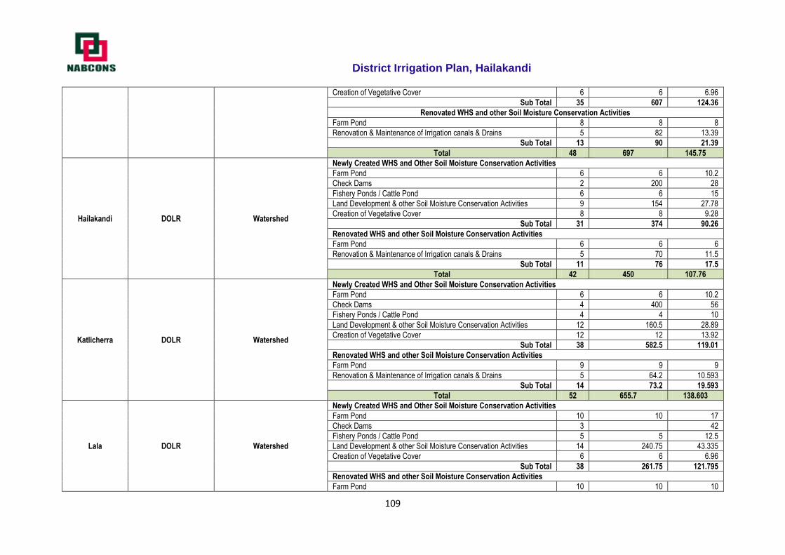
District Irrigation Plan, Hailakandi
109
Creation of Vegetative Cover 6 6 6.96
Sub Total 35 607 124.36
Renovated WHS and other Soil Moisture Conservation Activities
Farm Pond 8 8 8
Renovation & Maintenance of Irrigation canals & Drains 5 82 13.39
Sub Total 13 90 21.39
Total 48 697 145.75
Hailakandi DOLR Watershed
Newly Created WHS and Other Soil Moisture Conservation Activities
Farm Pond 6 6 10.2
Check Dams 2 200 28
Fishery Ponds / Cattle Pond 6 6 15
Land Development & other Soil Moisture Conservation Activities 9 154 27.78
Creation of Vegetative Cover 8 8 9.28
Sub Total 31 374 90.26
Renovated WHS and other Soil Moisture Conservation Activities
Farm Pond 6 6 6
Renovation & Maintenance of Irrigation canals & Drains 5 70 11.5
Sub Total 11 76 17.5
Total 42 450 107.76
Katlicherra DOLR Watershed
Newly Created WHS and Other Soil Moisture Conservation Activities
Farm Pond 6 6 10.2
Check Dams 4 400 56
Fishery Ponds / Cattle Pond 4 4 10
Land Development & other Soil Moisture Conservation Activities 12 160.5 28.89
Creation of Vegetative Cover 12 12 13.92
Sub Total 38 582.5 119.01
Renovated WHS and other Soil Moisture Conservation Activities
Farm Pond 9 9 9
Renovation & Maintenance of Irrigation canals & Drains 5 64.2 10.593
Sub Total 14 73.2 19.593
Total 52 655.7 138.603
Lala DOLR Watershed
Newly Created WHS and Other Soil Moisture Conservation Activities
Farm Pond 10 10 17
Check Dams 3 42
Fishery Ponds / Cattle Pond 5 5 12.5
Land Development & other Soil Moisture Conservation Activities 14 240.75 43.335
Creation of Vegetative Cover 6 6 6.96
Sub Total 38 261.75 121.795
Renovated WHS and other Soil Moisture Conservation Activities
Farm Pond 10 10 10
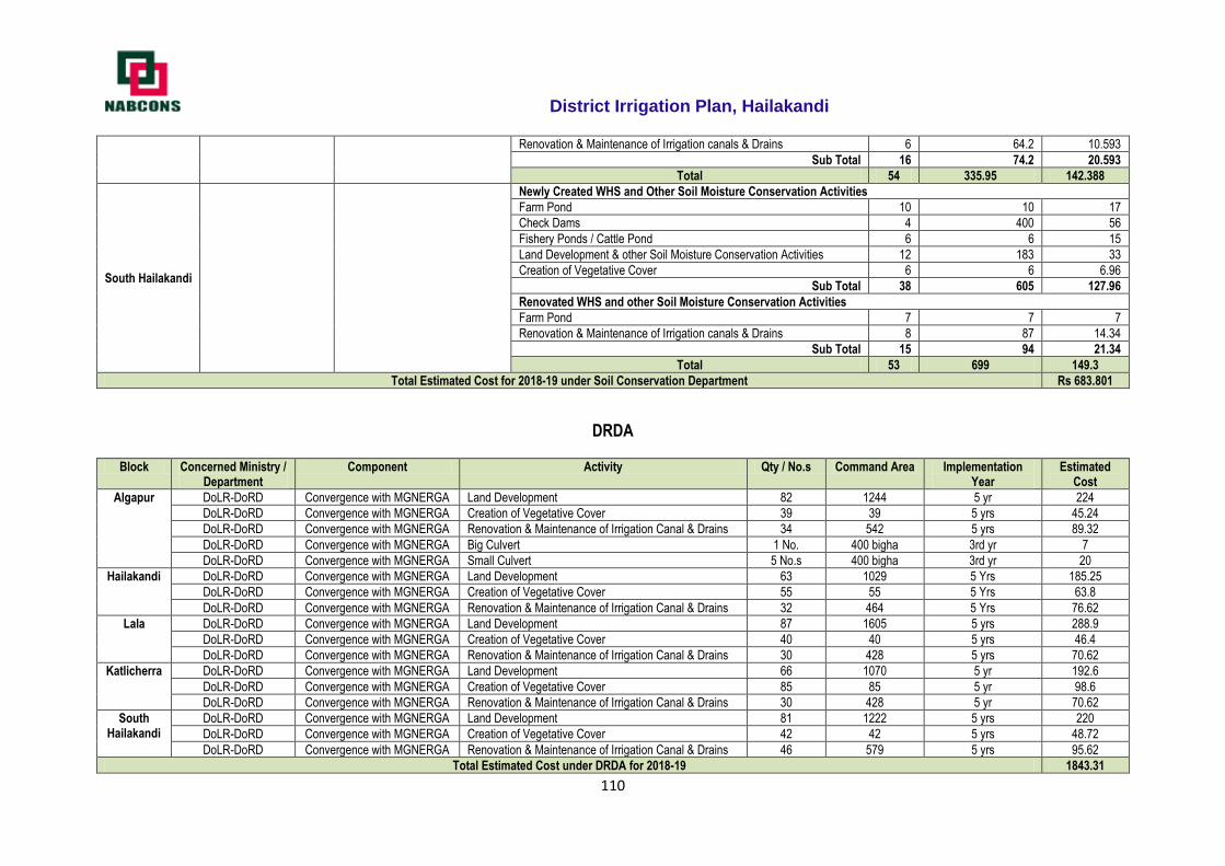
District Irrigation Plan, Hailakandi
110
Renovation & Maintenance of Irrigation canals & Drains 6 64.2 10.593
Sub Total 16 74.2 20.593
Total 54 335.95 142.388
South Hailakandi
Newly Created WHS and Other Soil Moisture Conservation Activities
Farm Pond 10 10 17
Check Dams 4 400 56
Fishery Ponds / Cattle Pond 6 6 15
Land Development & other Soil Moisture Conservation Activities 12 183 33
Creation of Vegetative Cover 6 6 6.96
Sub Total 38 605 127.96
Renovated WHS and other Soil Moisture Conservation Activities
Farm Pond 7 7 7
Renovation & Maintenance of Irrigation canals & Drains 8 87 14.34
Sub Total 15 94 21.34
Total 53 699 149.3
Total Estimated Cost for 2018-19 under Soil Conservation Department Rs 683.801
DRDA
Block Concerned Ministry / Department
Component Activity Qty / No.s Command Area Implementation Year
Estimated Cost
Algapur DoLR-DoRD Convergence with MGNERGA Land Development 82 1244 5 yr 224
DoLR-DoRD Convergence with MGNERGA Creation of Vegetative Cover 39 39 5 yrs 45.24
DoLR-DoRD Convergence with MGNERGA Renovation & Maintenance of Irrigation Canal & Drains 34 542 5 yrs 89.32
DoLR-DoRD Convergence with MGNERGA Big Culvert 1 No. 400 bigha 3rd yr 7
DoLR-DoRD Convergence with MGNERGA Small Culvert 5 No.s 400 bigha 3rd yr 20
Hailakandi DoLR-DoRD Convergence with MGNERGA Land Development 63 1029 5 Yrs 185.25
DoLR-DoRD Convergence with MGNERGA Creation of Vegetative Cover 55 55 5 Yrs 63.8
DoLR-DoRD Convergence with MGNERGA Renovation & Maintenance of Irrigation Canal & Drains 32 464 5 Yrs 76.62
Lala DoLR-DoRD Convergence with MGNERGA Land Development 87 1605 5 yrs 288.9
DoLR-DoRD Convergence with MGNERGA Creation of Vegetative Cover 40 40 5 yrs 46.4
DoLR-DoRD Convergence with MGNERGA Renovation & Maintenance of Irrigation Canal & Drains 30 428 5 yrs 70.62
Katlicherra DoLR-DoRD Convergence with MGNERGA Land Development 66 1070 5 yr 192.6
DoLR-DoRD Convergence with MGNERGA Creation of Vegetative Cover 85 85 5 yr 98.6
DoLR-DoRD Convergence with MGNERGA Renovation & Maintenance of Irrigation Canal & Drains 30 428 5 yr 70.62
South Hailakandi
DoLR-DoRD Convergence with MGNERGA Land Development 81 1222 5 yrs 220
DoLR-DoRD Convergence with MGNERGA Creation of Vegetative Cover 42 42 5 yrs 48.72
DoLR-DoRD Convergence with MGNERGA Renovation & Maintenance of Irrigation Canal & Drains 46 579 5 yrs 95.62
Total Estimated Cost under DRDA for 2018-19 1843.31
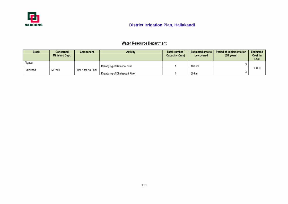
District Irrigation Plan, Hailakandi
111
Water Resource Department
Block Concerned Ministry / Dept.
Component Activity Total Number / Capacity (Cum)
Estimated area to be covered
Period of Implementation (5/7 years)
Estimated Cost (in
Lac)
Algapur
MOWR
Har Khet Ko Pani
Dreadging of Katakhal river 1 100 km 3
10000 Hailakandi Dreadging of Dhaleswari River 1 50 km
3
District Irrigation Plan, Hailakandi
112
2019 - 20 Irrigation plan of Hailakandi District
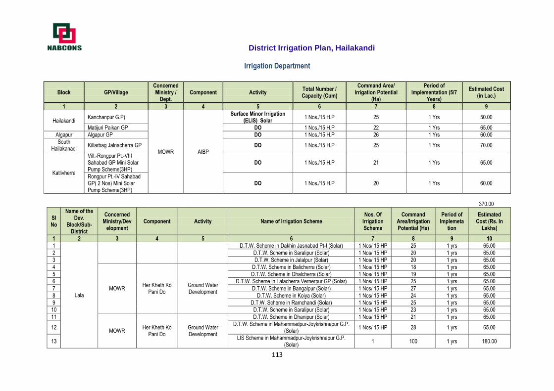
District Irrigation Plan, Hailakandi
113
Irrigation Department
Block GP/Village Concerned Ministry /
Dept. Component Activity
Total Number / Capacity (Cum)
Command Area/ Irrigation Potential
(Ha)
Period of Implementation (5/7
Years)
Estimated Cost (in Lac.)
1 2 3 4 5 6 7 8 9
Hailakandi Kanchanpur G.P)
MOWR AIBP
Surface Minor Irrigation (ELIS) Solar
1 Nos./15 H.P 25 1 Yrs 50.00
Matijuri Paikan GP DO 1 Nos./15 H.P 22 1 Yrs 65.00
Algapur Algapur GP DO 1 Nos./15 H.P 26 1 Yrs 60.00
South Hailakanadi
Killarbag Jalnacherra GP DO 1 Nos./15 H.P 25 1 Yrs 70.00
Katlivherra
Vill:-Rongpur Pt.-VIII Sahabad GP Mini Solar Pump Scheme(3HP)
DO 1 Nos./15 H.P 21 1 Yrs 65.00
Rongpur Pt.-IV Sahabad GP( 2 Nos) Mini Solar Pump Scheme(3HP)
DO 1 Nos./15 H.P 20 1 Yrs 60.00
370.00
Sl No
Name of the Dev.
Block/Sub-District
Concerned Ministry/Dev
elopment Component Activity Name of Irrigation Scheme
Nos. Of Irrigation Scheme
Command Area/Irrigation Potential (Ha)
Period of Implemeta
tion
Estimated Cost (Rs. In
Lakhs)
1 2 3 4 5 6 7 8 9 10
1
Lala
D.T.W. Scheme in Dakhin Jasnabad Pt-I (Solar) 1 Nos/ 15 HP 25 1 yrs 65.00
2 D.T.W. Scheme in Saralipur (Solar) 1 Nos/ 15 HP 20 1 yrs 65.00
3 D.T.W. Scheme in Jalalpur (Solar) 1 Nos/ 15 HP 20 1 yrs 65.00
4
MOWR Her Kheth Ko
Pani Do Ground Water Development
D.T.W. Scheme in Balicherra (Solar) 1 Nos/ 15 HP 18 1 yrs 65.00
5 D.T.W. Scheme in Dhalcherra (Solar) 1 Nos/ 15 HP 19 1 yrs 65.00
6 D.T.W. Scheme in Lalacherra Vernerpur GP (Solar) 1 Nos/ 15 HP 25 1 yrs 65.00
7 D.T.W. Scheme in Bangalpur (Solar) 1 Nos/ 15 HP 27 1 yrs 65.00
8 D.T.W. Scheme in Koiya (Solar) 1 Nos/ 15 HP 24 1 yrs 65.00
9 D.T.W. Scheme in Ramchandi (Solar) 1 Nos/ 15 HP 25 1 yrs 65.00
10 D.T.W. Scheme in Saralipur (Solar) 1 Nos/ 15 HP 23 1 yrs 65.00
11
MOWR Her Kheth Ko
Pani Do Ground Water Development
D.T.W. Scheme in Dhanipur (Solar) 1 Nos/ 15 HP 21 1 yrs 65.00
12 D.T.W. Scheme in Mahammadpur-Joykrishnapur G.P.
(Solar) 1 Nos/ 15 HP 28 1 yrs 65.00
13 LIS Scheme in Mahammadpur-Joykrishnapur G.P.
(Solar) 1 100 1 yrs 180.00
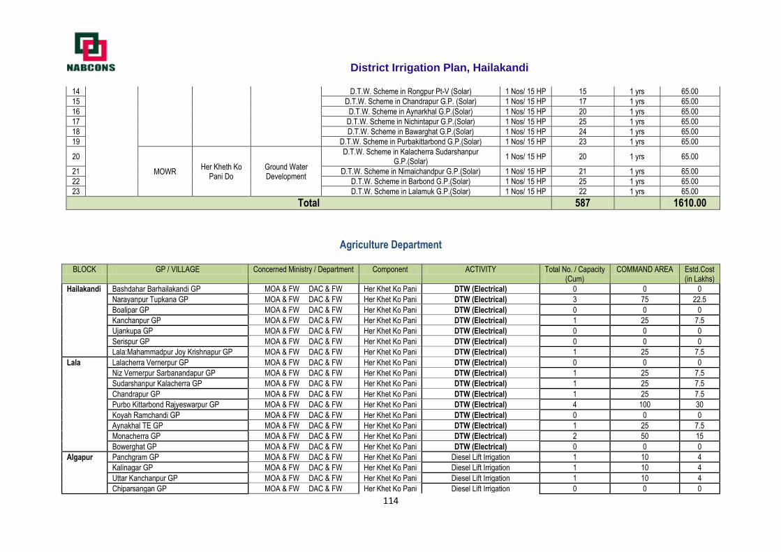
District Irrigation Plan, Hailakandi
114
14 D.T.W. Scheme in Rongpur Pt-V (Solar) 1 Nos/ 15 HP 15 1 yrs 65.00
15 D.T.W. Scheme in Chandrapur G.P. (Solar) 1 Nos/ 15 HP 17 1 yrs 65.00
16 D.T.W. Scheme in Aynarkhal G.P.(Solar) 1 Nos/ 15 HP 20 1 yrs 65.00
17 D.T.W. Scheme in Nichintapur G.P.(Solar) 1 Nos/ 15 HP 25 1 yrs 65.00
18 D.T.W. Scheme in Bawarghat G.P.(Solar) 1 Nos/ 15 HP 24 1 yrs 65.00
19 D.T.W. Scheme in Purbakittarbond G.P.(Solar) 1 Nos/ 15 HP 23 1 yrs 65.00
20
MOWR Her Kheth Ko
Pani Do Ground Water Development
D.T.W. Scheme in Kalacherra Sudarshanpur G.P.(Solar)
1 Nos/ 15 HP 20 1 yrs 65.00
21 D.T.W. Scheme in Nimaichandpur G.P.(Solar) 1 Nos/ 15 HP 21 1 yrs 65.00
22 D.T.W. Scheme in Barbond G.P.(Solar) 1 Nos/ 15 HP 25 1 yrs 65.00
23 D.T.W. Scheme in Lalamuk G.P.(Solar) 1 Nos/ 15 HP 22 1 yrs 65.00
Total 587
1610.00
Agriculture Department
BLOCK GP / VILLAGE Concerned Ministry / Department Component ACTIVITY Total No. / Capacity (Cum)
COMMAND AREA Estd.Cost (in Lakhs)
Hailakandi Bashdahar Barhailakandi GP MOA & FW DAC & FW Her Khet Ko Pani DTW (Electrical) 0 0 0
Narayanpur Tupkana GP MOA & FW DAC & FW Her Khet Ko Pani DTW (Electrical) 3 75 22.5
Boalipar GP MOA & FW DAC & FW Her Khet Ko Pani DTW (Electrical) 0 0 0
Kanchanpur GP MOA & FW DAC & FW Her Khet Ko Pani DTW (Electrical) 1 25 7.5
Ujankupa GP MOA & FW DAC & FW Her Khet Ko Pani DTW (Electrical) 0 0 0
Serispur GP MOA & FW DAC & FW Her Khet Ko Pani DTW (Electrical) 0 0 0
Lala:Mahammadpur Joy Krishnapur GP MOA & FW DAC & FW Her Khet Ko Pani DTW (Electrical) 1 25 7.5
Lala Lalacherra Vernerpur GP MOA & FW DAC & FW Her Khet Ko Pani DTW (Electrical) 0 0 0
Niz Vernerpur Sarbanandapur GP MOA & FW DAC & FW Her Khet Ko Pani DTW (Electrical) 1 25 7.5
Sudarshanpur Kalacherra GP MOA & FW DAC & FW Her Khet Ko Pani DTW (Electrical) 1 25 7.5
Chandrapur GP MOA & FW DAC & FW Her Khet Ko Pani DTW (Electrical) 1 25 7.5
Purbo Kittarbond Rajyeswarpur GP MOA & FW DAC & FW Her Khet Ko Pani DTW (Electrical) 4 100 30
Koyah Ramchandi GP MOA & FW DAC & FW Her Khet Ko Pani DTW (Electrical) 0 0 0
Aynakhal TE GP MOA & FW DAC & FW Her Khet Ko Pani DTW (Electrical) 1 25 7.5
Monacherra GP MOA & FW DAC & FW Her Khet Ko Pani DTW (Electrical) 2 50 15
Bowerghat GP MOA & FW DAC & FW Her Khet Ko Pani DTW (Electrical) 0 0 0
Algapur Panchgram GP MOA & FW DAC & FW Her Khet Ko Pani Diesel Lift Irrigation 1 10 4
Kalinagar GP MOA & FW DAC & FW Her Khet Ko Pani Diesel Lift Irrigation 1 10 4
Uttar Kanchanpur GP MOA & FW DAC & FW Her Khet Ko Pani Diesel Lift Irrigation 1 10 4
Chiparsangan GP MOA & FW DAC & FW Her Khet Ko Pani Diesel Lift Irrigation 0 0 0
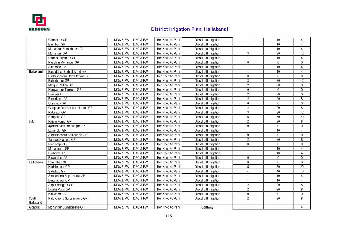
District Irrigation Plan, Hailakandi
115
Chandipur GP MOA & FW DAC & FW Her Khet Ko Pani Diesel Lift Irrigation 1 10 4
Bashbari GP MOA & FW DAC & FW Her Khet Ko Pani Diesel Lift Irrigation 1 10 4
Mohanpur Burniebraes GP MOA & FW DAC & FW Her Khet Ko Pani Diesel Lift Irrigation 1 10 4
Mohanpur GP MOA & FW DAC & FW Her Khet Ko Pani Diesel Lift Irrigation 3 30 12
Uttar Narayanpur GP MOA & FW DAC & FW Her Khet Ko Pani Diesel Lift Irrigation 1 10 4
Paschim Mohanpur GP MOA & FW DAC & FW Her Khet Ko Pani Diesel Lift Irrigation 0 0 0
Saidbond GP MOA & FW DAC & FW Her Khet Ko Pani Diesel Lift Irrigation 1 10 4
Hailakandi Bashdahar Barhailakandi GP MOA & FW DAC & FW Her Khet Ko Pani Diesel Lift Irrigation 1 10 4
Sudarshanpur Bandukmara GP MOA & FW DAC & FW Her Khet Ko Pani Diesel Lift Irrigation 0 0 0
Bahadurpur GP MOA & FW DAC & FW Her Khet Ko Pani Diesel Lift Irrigation 3 30 12
Matijuri Paikan GP MOA & FW DAC & FW Her Khet Ko Pani Diesel Lift Irrigation 2 20 8
Narayanpur Tupkana GP MOA & FW DAC & FW Her Khet Ko Pani Diesel Lift Irrigation 0 0 0
Boalipar GP MOA & FW DAC & FW Her Khet Ko Pani Diesel Lift Irrigation 2 20 8
Bhatirkupa GP MOA & FW DAC & FW Her Khet Ko Pani Diesel Lift Irrigation 2 20 8
Ujankupa GP MOA & FW DAC & FW Her Khet Ko Pani Diesel Lift Irrigation 0 0 0
Gangpar Dumkar Laxmirbond GP MOA & FW DAC & FW Her Khet Ko Pani Diesel Lift Irrigation 2 20 8
Ratanpur GP MOA & FW DAC & FW Her Khet Ko Pani Diesel Lift Irrigation 3 30 12
Rangauti GP MOA & FW DAC & FW Her Khet Ko Pani Diesel Lift Irrigation 5 50 20
Lala Rajyeswarpur GP MOA & FW DAC & FW Her Khet Ko Pani Diesel Lift Irrigation 2 20 8
Jyotsnabad Umednagar GP MOA & FW DAC & FW Her Khet Ko Pani Diesel Lift Irrigation 0 0 0
Lalamukh GP MOA & FW DAC & FW Her Khet Ko Pani Diesel Lift Irrigation 1 10 4
Sudarshanpur Kalacherra GP MOA & FW DAC & FW Her Khet Ko Pani Diesel Lift Irrigation 0 0 0
Tantoo Dhanipur GP MOA & FW DAC & FW Her Khet Ko Pani Diesel Lift Irrigation 2 20 8
Nichintapur GP MOA & FW DAC & FW Her Khet Ko Pani Diesel Lift Irrigation 0 0 0
Monacherra GP MOA & FW DAC & FW Her Khet Ko Pani Diesel Lift Irrigation 1 10 4
Borbond GP MOA & FW DAC & FW Her Khet Ko Pani Diesel Lift Irrigation 1 10 4
Bowerghat GP MOA & FW DAC & FW Her Khet Ko Pani Diesel Lift Irrigation 0 0 0
Katlicherra Rangabak GP MOA & FW DAC & FW Her Khet Ko Pani Diesel Lift Irrigation 0 0 0
Harishnagar GP MOA & FW DAC & FW Her Khet Ko Pani Diesel Lift Irrigation 5 50 20
Sahabad GP MOA & FW DAC & FW Her Khet Ko Pani Diesel Lift Irrigation 4 40 16
Sonacherra Rupacherra GP MOA & FW DAC & FW Her Khet Ko Pani Diesel Lift Irrigation 1 10 4
Dinanathpur GP MOA & FW DAC & FW Her Khet Ko Pani Diesel Lift Irrigation 1 10 4
Appin Rangpur GP MOA & FW DAC & FW Her Khet Ko Pani Diesel Lift Irrigation 2 20 8
Dhalai Malai GP MOA & FW DAC & FW Her Khet Ko Pani Diesel Lift Irrigation 2 20 8
Katlicherra GP MOA & FW DAC & FW Her Khet Ko Pani Diesel Lift Irrigation 0 0 0
South Hailakandi
Palaycherra Sultanicherra GP MOA & FW DAC & FW Her Khet Ko Pani Diesel Lift Irrigation 2 20 8
Algapur: Mohanpur Burnebrease GP MOA & FW DAC & FW Her Khet Ko Pani Spillway 1 4
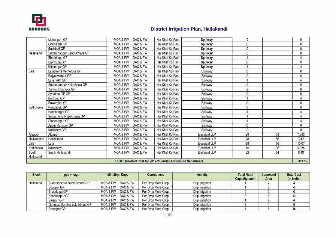
District Irrigation Plan, Hailakandi
116
Mohanpur GP MOA & FW DAC & FW Her Khet Ko Pani Spillway 0 0
Chandipur GP MOA & FW DAC & FW Her Khet Ko Pani Spillway 0 0
Bashbari GP MOA & FW DAC & FW Her Khet Ko Pani Spillway 0 0
Hailakandi: Sudarshanpur Bandukmara GP MOA & FW DAC & FW Her Khet Ko Pani Spillway 0 0
Bhatirkupa GP MOA & FW DAC & FW Her Khet Ko Pani Spillway 1 4
Ujankupa GP MOA & FW DAC & FW Her Khet Ko Pani Spillway 0 0
Nitainagar GP MOA & FW DAC & FW Her Khet Ko Pani Spillway 1 4
Lala: Lalacherra Vernerpur GP MOA & FW DAC & FW Her Khet Ko Pani Spillway 0 0
Rajyeswarpur GP MOA & FW DAC & FW Her Khet Ko Pani Spillway 0 0
Lalamukh GP MOA & FW DAC & FW Her Khet Ko Pani Spillway 1 4
Sudarshanpur Kalacherra GP MOA & FW DAC & FW Her Khet Ko Pani Spillway 0 0
Tantoo Dhanipur GP MOA & FW DAC & FW Her Khet Ko Pani Spillway 2 8
Aynakhal TE GP MOA & FW DAC & FW Her Khet Ko Pani Spillway 0 0
Borbond GP MOA & FW DAC & FW Her Khet Ko Pani Spillway 1 4
Bowerghat GP MOA & FW DAC & FW Her Khet Ko Pani Spillway 0 0
Katlicherra Rangabak GP MOA & FW DAC & FW Her Khet Ko Pani Spillway 0 0
Harishnagar GP MOA & FW DAC & FW Her Khet Ko Pani Spillway 1 4
Sonacherra Rupacherra GP MOA & FW DAC & FW Her Khet Ko Pani Spillway 1 4
Dinanathpur GP MOA & FW DAC & FW Her Khet Ko Pani Spillway 1 4
Appin Rangpur GP MOA & FW DAC & FW Her Khet Ko Pani Spillway 0 0
Katlicherr GP MOA & FW DAC & FW Her Khet Ko Pani Spillway 0 0
Algapur Algapur MOA & FW DAC & FW Her Khet Ko Pani Electrical LLP 29 58 7.685
Hailkakandi Hailkakandi MOA & FW DAC & FW Her Khet Ko Pani Electrical LLP 28 56 7.42
Lala Lala MOA & FW DAC & FW Her Khet Ko Pani Electrical LLP 38 76 10.07
Katlicherra Katlicherra MOA & FW DAC & FW Her Khet Ko Pani Electrical LLP 19 38 5.035
South Hailakandi
South Hailakandi MOA & FW DAC & FW Her Khet Ko Pani Electrical LLP 32 64 8.48
Total Estimated Cost for 2019-20 under Agriculture Department 411.19
Block gp / village Minsitry / Dept Component Activity Total Nos./ Capacity(cum)
Command Area
Estd Cost (in lakhs)
Hailakandi: Sudarshanpur Bandukmara GP MOA & FW DAC & FW Per Drop More Crop Drip Irrigation 1 2 4
Boalipar GP MOA & FW DAC & FW Per Drop More Crop Drip Irrigation 1 2 4
Bhatirkupa GP MOA & FW DAC & FW Per Drop More Crop Drip Irrigation 0 0 0
Kanchanpur GP MOA & FW DAC & FW Per Drop More Crop Drip Irrigation 3 6 12
Sirispur GP MOA & FW DAC & FW Per Drop More Crop Drip Irrigation 1 2 4
Gangpar Dumkar Lakhirbond GP MOA & FW DAC & FW Per Drop More Crop Drip Irrigation 2 4 8
Ratanpur GP MOA & FW DAC & FW Per Drop More Crop Drip Irrigation 4 8 16
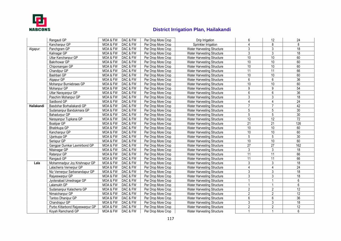
District Irrigation Plan, Hailakandi
117
Rangauti GP MOA & FW DAC & FW Per Drop More Crop Drip Irrigation 6 12 24
Kanchanpur GP MOA & FW DAC & FW Per Drop More Crop Sprinkler Irrigation 4 8 8
Algapur: Panchgram GP MOA & FW DAC & FW Per Drop More Crop Water Harvesting Structure 3 3 18
Kalinagar GP MOA & FW DAC & FW Per Drop More Crop Water Harvesting Structure 3 3 18
Uttar Kanchanpur GP MOA & FW DAC & FW Per Drop More Crop Water Harvesting Structure 10 10 60
Bakrihowar GP MOA & FW DAC & FW Per Drop More Crop Water Harvesting Structure 10 10 60
Chiporsangan GP MOA & FW DAC & FW Per Drop More Crop Water Harvesting Structure 10 10 60
Chandipur GP MOA & FW DAC & FW Per Drop More Crop Water Harvesting Structure 11 11 66
Bashbari GP MOA & FW DAC & FW Per Drop More Crop Water Harvesting Structure 10 10 60
Algapur GP MOA & FW DAC & FW Per Drop More Crop Water Harvesting Structure 6 6 36
Mohanpur Burniebraes GP MOA & FW DAC & FW Per Drop More Crop Water Harvesting Structure 10 10 60
Mohanpur GP MOA & FW DAC & FW Per Drop More Crop Water Harvesting Structure 9 9 54
Uttar Narayanpur GP MOA & FW DAC & FW Per Drop More Crop Water Harvesting Structure 6 6 36
Paschim Mohanpur GP MOA & FW DAC & FW Per Drop More Crop Water Harvesting Structure 3 3 18
Saidbond GP MOA & FW DAC & FW Per Drop More Crop Water Harvesting Structure 4 4 24
Hailakandi Basdohar Borhailakandi GP MOA & FW DAC & FW Per Drop More Crop Water Harvesting Structure 7 7 42
Sudarsanpur Bandukmara GP MOA & FW DAC & FW Per Drop More Crop Water Harvesting Structure 5 5 30
Bahadurpur GP MOA & FW DAC & FW Per Drop More Crop Water Harvesting Structure 5 5 30
Narayanpur Tupkana GP MOA & FW DAC & FW Per Drop More Crop Water Harvesting Structure 12 12 72
Boalipar GP MOA & FW DAC & FW Per Drop More Crop Water Harvesting Structure 21 21 126
Bhatirkupa GP MOA & FW DAC & FW Per Drop More Crop Water Harvesting Structure 10 10 60
Kanchanpur GP MOA & FW DAC & FW Per Drop More Crop Water Harvesting Structure 10 10 60
Ujankupa GP MOA & FW DAC & FW Per Drop More Crop Water Harvesting Structure 5 5 30
Serispur GP MOA & FW DAC & FW Per Drop More Crop Water Harvesting Structure 10 10 60
Gangpar Dumkar Laxmirbond GP MOA & FW DAC & FW Per Drop More Crop Water Harvesting Structure 27 27 162
Nitainagar GP MOA & FW DAC & FW Per Drop More Crop Water Harvesting Structure 3 3 18
Ratanpur GP MOA & FW DAC & FW Per Drop More Crop Water Harvesting Structure 11 11 66
Rangauti GP MOA & FW DAC & FW Per Drop More Crop Water Harvesting Structure 11 11 66
Lala Mohammadpur Joy Krishnapur GP MOA & FW DAC & FW Per Drop More Crop Water Harvesting Structure 3 3 18
Lalacherra Vernerpur GP MOA & FW DAC & FW Per Drop More Crop Water Harvesting Structure 4 4 24
Niz Vernerpur Sarbanandapur GP MOA & FW DAC & FW Per Drop More Crop Water Harvesting Structure 3 3 18
Rajyeswarpur GP MOA & FW DAC & FW Per Drop More Crop Water Harvesting Structure 3 3 18
Jyotsnabad Umednagar GP MOA & FW DAC & FW Per Drop More Crop Water Harvesting Structure 1 1 6
Lalamukh GP MOA & FW DAC & FW Per Drop More Crop Water Harvesting Structure 1 1 6
Sudarsanpur Kalacherra GP MOA & FW DAC & FW Per Drop More Crop Water Harvesting Structure 2 2 12
Nimaichanpur GP MOA & FW DAC & FW Per Drop More Crop Water Harvesting Structure 2 2 12
Tantoo Dhanipur GP MOA & FW DAC & FW Per Drop More Crop Water Harvesting Structure 6 6 36
Chandrapur GP MOA & FW DAC & FW Per Drop More Crop Water Harvesting Structure 3 3 18
Purbo Kittarbond Rajyeswarpur GP MOA & FW DAC & FW Per Drop More Crop Water Harvesting Structure 2 2 12
Koyah Ramchandi GP MOA & FW DAC & FW Per Drop More Crop Water Harvesting Structure 1 1 6
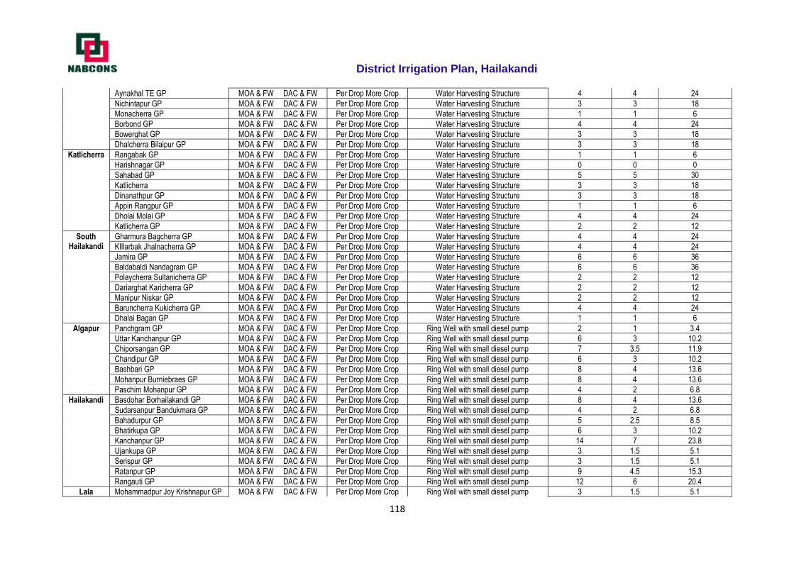
District Irrigation Plan, Hailakandi
118
Aynakhal TE GP MOA & FW DAC & FW Per Drop More Crop Water Harvesting Structure 4 4 24
Nichintapur GP MOA & FW DAC & FW Per Drop More Crop Water Harvesting Structure 3 3 18
Monacherra GP MOA & FW DAC & FW Per Drop More Crop Water Harvesting Structure 1 1 6
Borbond GP MOA & FW DAC & FW Per Drop More Crop Water Harvesting Structure 4 4 24
Bowerghat GP MOA & FW DAC & FW Per Drop More Crop Water Harvesting Structure 3 3 18
Dhalcherra Bilaipur GP MOA & FW DAC & FW Per Drop More Crop Water Harvesting Structure 3 3 18
Katlicherra Rangabak GP MOA & FW DAC & FW Per Drop More Crop Water Harvesting Structure 1 1 6
Harishnagar GP MOA & FW DAC & FW Per Drop More Crop Water Harvesting Structure 0 0 0
Sahabad GP MOA & FW DAC & FW Per Drop More Crop Water Harvesting Structure 5 5 30
Katlicherra MOA & FW DAC & FW Per Drop More Crop Water Harvesting Structure 3 3 18
Dinanathpur GP MOA & FW DAC & FW Per Drop More Crop Water Harvesting Structure 3 3 18
Appin Rangpur GP MOA & FW DAC & FW Per Drop More Crop Water Harvesting Structure 1 1 6
Dholai Molai GP MOA & FW DAC & FW Per Drop More Crop Water Harvesting Structure 4 4 24
Katlicherra GP MOA & FW DAC & FW Per Drop More Crop Water Harvesting Structure 2 2 12
South Hailakandi
Gharmura Bagcherra GP MOA & FW DAC & FW Per Drop More Crop Water Harvesting Structure 4 4 24
KIllarbak Jhalnacherra GP MOA & FW DAC & FW Per Drop More Crop Water Harvesting Structure 4 4 24
Jamira GP MOA & FW DAC & FW Per Drop More Crop Water Harvesting Structure 6 6 36
Baldabaldi Nandagram GP MOA & FW DAC & FW Per Drop More Crop Water Harvesting Structure 6 6 36
Polaycherra Sultanicherra GP MOA & FW DAC & FW Per Drop More Crop Water Harvesting Structure 2 2 12
Dariarghat Karicherra GP MOA & FW DAC & FW Per Drop More Crop Water Harvesting Structure 2 2 12
Manipur Niskar GP MOA & FW DAC & FW Per Drop More Crop Water Harvesting Structure 2 2 12
Baruncherra Kukicherra GP MOA & FW DAC & FW Per Drop More Crop Water Harvesting Structure 4 4 24
Dhalai Bagan GP MOA & FW DAC & FW Per Drop More Crop Water Harvesting Structure 1 1 6
Algapur Panchgram GP MOA & FW DAC & FW Per Drop More Crop Ring Well with small diesel pump 2 1 3.4
Uttar Kanchanpur GP MOA & FW DAC & FW Per Drop More Crop Ring Well with small diesel pump 6 3 10.2
Chiporsangan GP MOA & FW DAC & FW Per Drop More Crop Ring Well with small diesel pump 7 3.5 11.9
Chandipur GP MOA & FW DAC & FW Per Drop More Crop Ring Well with small diesel pump 6 3 10.2
Bashbari GP MOA & FW DAC & FW Per Drop More Crop Ring Well with small diesel pump 8 4 13.6
Mohanpur Burniebraes GP MOA & FW DAC & FW Per Drop More Crop Ring Well with small diesel pump 8 4 13.6
Paschim Mohanpur GP MOA & FW DAC & FW Per Drop More Crop Ring Well with small diesel pump 4 2 6.8
Hailakandi Basdohar Borhailakandi GP MOA & FW DAC & FW Per Drop More Crop Ring Well with small diesel pump 8 4 13.6
Sudarsanpur Bandukmara GP MOA & FW DAC & FW Per Drop More Crop Ring Well with small diesel pump 4 2 6.8
Bahadurpur GP MOA & FW DAC & FW Per Drop More Crop Ring Well with small diesel pump 5 2.5 8.5
Bhatirkupa GP MOA & FW DAC & FW Per Drop More Crop Ring Well with small diesel pump 6 3 10.2
Kanchanpur GP MOA & FW DAC & FW Per Drop More Crop Ring Well with small diesel pump 14 7 23.8
Ujankupa GP MOA & FW DAC & FW Per Drop More Crop Ring Well with small diesel pump 3 1.5 5.1
Serispur GP MOA & FW DAC & FW Per Drop More Crop Ring Well with small diesel pump 3 1.5 5.1
Ratanpur GP MOA & FW DAC & FW Per Drop More Crop Ring Well with small diesel pump 9 4.5 15.3
Rangauti GP MOA & FW DAC & FW Per Drop More Crop Ring Well with small diesel pump 12 6 20.4
Lala Mohammadpur Joy Krishnapur GP MOA & FW DAC & FW Per Drop More Crop Ring Well with small diesel pump 3 1.5 5.1
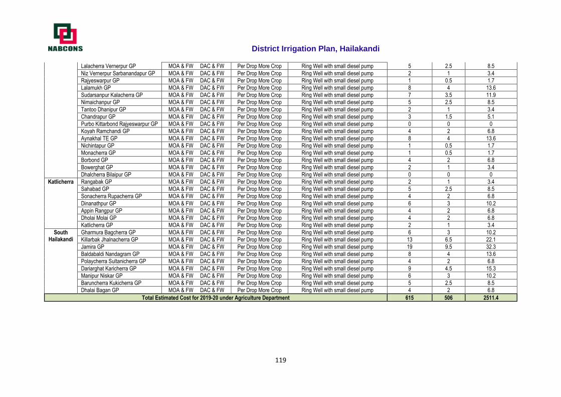
District Irrigation Plan, Hailakandi
119
Lalacherra Vernerpur GP MOA & FW DAC & FW Per Drop More Crop Ring Well with small diesel pump 5 2.5 8.5
Niz Vernerpur Sarbanandapur GP MOA & FW DAC & FW Per Drop More Crop Ring Well with small diesel pump 2 1 3.4
Rajyeswarpur GP MOA & FW DAC & FW Per Drop More Crop Ring Well with small diesel pump 1 0.5 1.7
Lalamukh GP MOA & FW DAC & FW Per Drop More Crop Ring Well with small diesel pump 8 4 13.6
Sudarsanpur Kalacherra GP MOA & FW DAC & FW Per Drop More Crop Ring Well with small diesel pump 7 3.5 11.9
Nimaichanpur GP MOA & FW DAC & FW Per Drop More Crop Ring Well with small diesel pump 5 2.5 8.5
Tantoo Dhanipur GP MOA & FW DAC & FW Per Drop More Crop Ring Well with small diesel pump 2 1 3.4
Chandrapur GP MOA & FW DAC & FW Per Drop More Crop Ring Well with small diesel pump 3 1.5 5.1
Purbo Kittarbond Rajyeswarpur GP MOA & FW DAC & FW Per Drop More Crop Ring Well with small diesel pump 0 0 0
Koyah Ramchandi GP MOA & FW DAC & FW Per Drop More Crop Ring Well with small diesel pump 4 2 6.8
Aynakhal TE GP MOA & FW DAC & FW Per Drop More Crop Ring Well with small diesel pump 8 4 13.6
Nichintapur GP MOA & FW DAC & FW Per Drop More Crop Ring Well with small diesel pump 1 0.5 1.7
Monacherra GP MOA & FW DAC & FW Per Drop More Crop Ring Well with small diesel pump 1 0.5 1.7
Borbond GP MOA & FW DAC & FW Per Drop More Crop Ring Well with small diesel pump 4 2 6.8
Bowerghat GP MOA & FW DAC & FW Per Drop More Crop Ring Well with small diesel pump 2 1 3.4
Dhalcherra Bilaipur GP MOA & FW DAC & FW Per Drop More Crop Ring Well with small diesel pump 0 0 0
Katlicherra Rangabak GP MOA & FW DAC & FW Per Drop More Crop Ring Well with small diesel pump 2 1 3.4
Sahabad GP MOA & FW DAC & FW Per Drop More Crop Ring Well with small diesel pump 5 2.5 8.5
Sonacherra Rupacherra GP MOA & FW DAC & FW Per Drop More Crop Ring Well with small diesel pump 4 2 6.8
Dinanathpur GP MOA & FW DAC & FW Per Drop More Crop Ring Well with small diesel pump 6 3 10.2
Appin Rangpur GP MOA & FW DAC & FW Per Drop More Crop Ring Well with small diesel pump 4 2 6.8
Dholai Molai GP MOA & FW DAC & FW Per Drop More Crop Ring Well with small diesel pump 4 2 6.8
Katlicherra GP MOA & FW DAC & FW Per Drop More Crop Ring Well with small diesel pump 2 1 3.4
South Hailakandi
Gharmura Bagcherra GP MOA & FW DAC & FW Per Drop More Crop Ring Well with small diesel pump 6 3 10.2
Killarbak Jhalnacherra GP MOA & FW DAC & FW Per Drop More Crop Ring Well with small diesel pump 13 6.5 22.1
Jamira GP MOA & FW DAC & FW Per Drop More Crop Ring Well with small diesel pump 19 9.5 32.3
Baldabaldi Nandagram GP MOA & FW DAC & FW Per Drop More Crop Ring Well with small diesel pump 8 4 13.6
Polaycherra Sultanicherra GP MOA & FW DAC & FW Per Drop More Crop Ring Well with small diesel pump 4 2 6.8
Dariarghat Karicherra GP MOA & FW DAC & FW Per Drop More Crop Ring Well with small diesel pump 9 4.5 15.3
Manipur Niskar GP MOA & FW DAC & FW Per Drop More Crop Ring Well with small diesel pump 6 3 10.2
Baruncherra Kukicherra GP MOA & FW DAC & FW Per Drop More Crop Ring Well with small diesel pump 5 2.5 8.5
Dhalai Bagan GP MOA & FW DAC & FW Per Drop More Crop Ring Well with small diesel pump 4 2 6.8
Total Estimated Cost for 2019-20 under Agriculture Department 615 506 2511.4
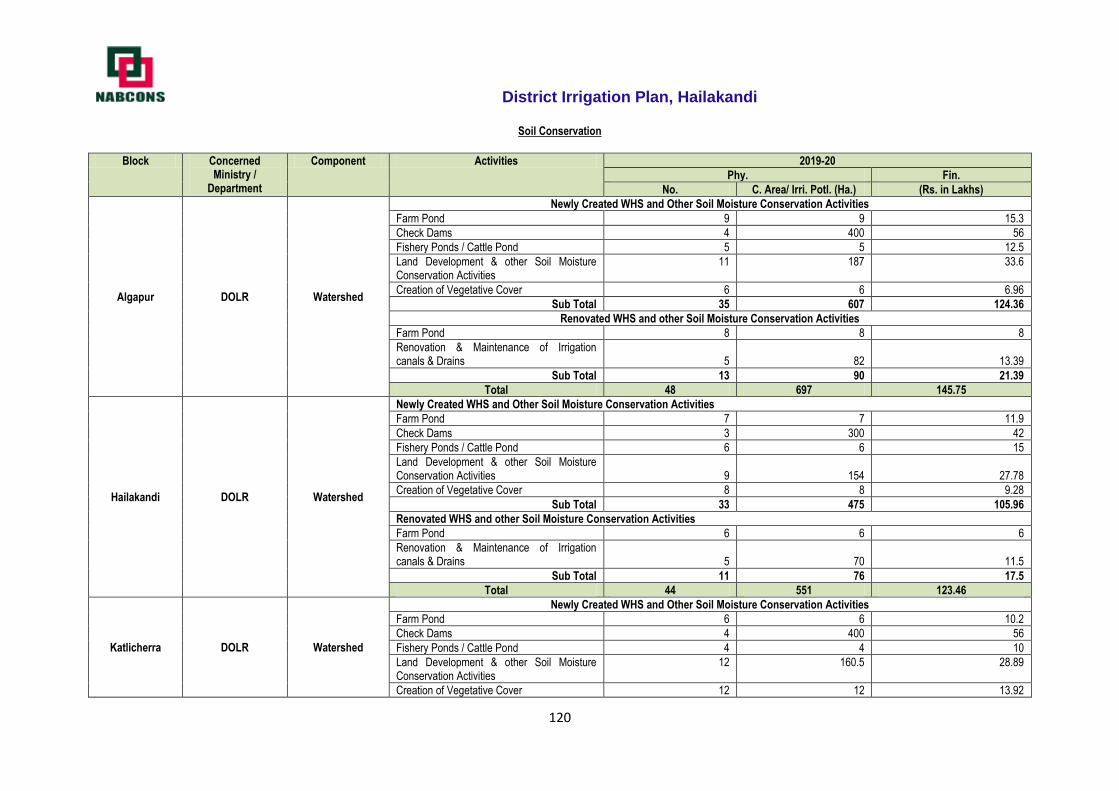
District Irrigation Plan, Hailakandi
120
Soil Conservation
Block Concerned Ministry /
Department
Component Activities 2019-20
Phy. Fin.
No. C. Area/ Irri. Potl. (Ha.) (Rs. in Lakhs)
Algapur DOLR Watershed
Newly Created WHS and Other Soil Moisture Conservation Activities
Farm Pond 9 9 15.3
Check Dams 4 400 56
Fishery Ponds / Cattle Pond 5 5 12.5
Land Development & other Soil Moisture Conservation Activities
11 187 33.6
Creation of Vegetative Cover 6 6 6.96
Sub Total 35 607 124.36
Renovated WHS and other Soil Moisture Conservation Activities
Farm Pond 8 8 8
Renovation & Maintenance of Irrigation canals & Drains 5 82 13.39
Sub Total 13 90 21.39
Total 48 697 145.75
Hailakandi DOLR Watershed
Newly Created WHS and Other Soil Moisture Conservation Activities
Farm Pond 7 7 11.9
Check Dams 3 300 42
Fishery Ponds / Cattle Pond 6 6 15
Land Development & other Soil Moisture Conservation Activities 9 154 27.78
Creation of Vegetative Cover 8 8 9.28
Sub Total 33 475 105.96
Renovated WHS and other Soil Moisture Conservation Activities
Farm Pond 6 6 6
Renovation & Maintenance of Irrigation canals & Drains 5 70 11.5
Sub Total 11 76 17.5
Total 44 551 123.46
Katlicherra DOLR Watershed
Newly Created WHS and Other Soil Moisture Conservation Activities
Farm Pond 6 6 10.2
Check Dams 4 400 56
Fishery Ponds / Cattle Pond 4 4 10
Land Development & other Soil Moisture Conservation Activities
12 160.5 28.89
Creation of Vegetative Cover 12 12 13.92
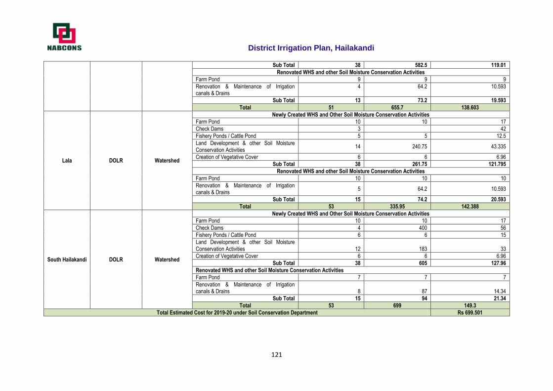
District Irrigation Plan, Hailakandi
121
Sub Total 38 582.5 119.01
Renovated WHS and other Soil Moisture Conservation Activities
Farm Pond 9 9 9
Renovation & Maintenance of Irrigation canals & Drains
4 64.2 10.593
Sub Total 13 73.2 19.593
Total 51 655.7 138.603
Lala DOLR Watershed
Newly Created WHS and Other Soil Moisture Conservation Activities
Farm Pond 10 10 17
Check Dams 3 42
Fishery Ponds / Cattle Pond 5 5 12.5
Land Development & other Soil Moisture Conservation Activities
14 240.75 43.335
Creation of Vegetative Cover 6 6 6.96
Sub Total 38 261.75 121.795
Renovated WHS and other Soil Moisture Conservation Activities
Farm Pond 10 10 10
Renovation & Maintenance of Irrigation canals & Drains
5 64.2 10.593
Sub Total 15 74.2 20.593
Total 53 335.95 142.388
South Hailakandi DOLR Watershed
Newly Created WHS and Other Soil Moisture Conservation Activities
Farm Pond 10 10 17
Check Dams 4 400 56
Fishery Ponds / Cattle Pond 6 6 15
Land Development & other Soil Moisture Conservation Activities 12 183 33
Creation of Vegetative Cover 6 6 6.96
Sub Total 38 605 127.96
Renovated WHS and other Soil Moisture Conservation Activities
Farm Pond 7 7 7
Renovation & Maintenance of Irrigation canals & Drains 8 87 14.34
Sub Total 15 94 21.34
Total 53 699 149.3
Total Estimated Cost for 2019-20 under Soil Conservation Department Rs 699.501
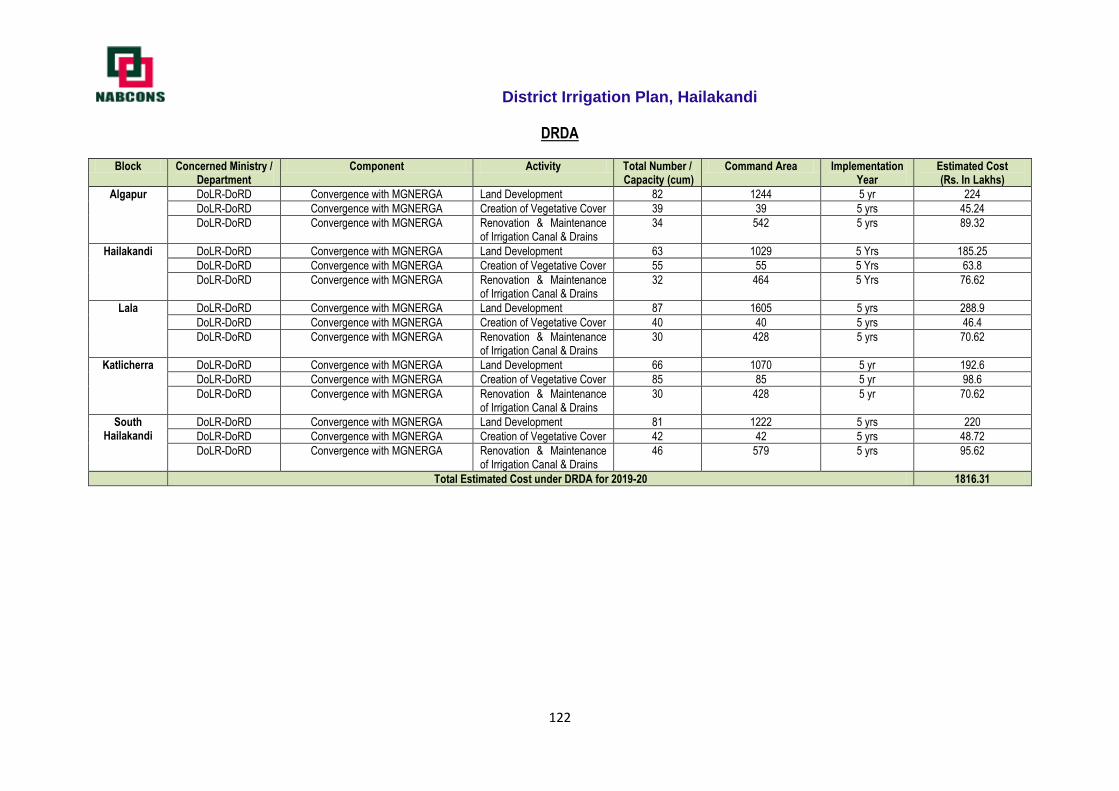
District Irrigation Plan, Hailakandi
122
DRDA
Block Concerned Ministry / Department
Component Activity Total Number / Capacity (cum)
Command Area Implementation Year
Estimated Cost (Rs. In Lakhs)
Algapur DoLR-DoRD Convergence with MGNERGA Land Development 82 1244 5 yr 224
DoLR-DoRD Convergence with MGNERGA Creation of Vegetative Cover 39 39 5 yrs 45.24
DoLR-DoRD Convergence with MGNERGA Renovation & Maintenance of Irrigation Canal & Drains
34 542 5 yrs 89.32
Hailakandi DoLR-DoRD Convergence with MGNERGA Land Development 63 1029 5 Yrs 185.25
DoLR-DoRD Convergence with MGNERGA Creation of Vegetative Cover 55 55 5 Yrs 63.8
DoLR-DoRD Convergence with MGNERGA Renovation & Maintenance of Irrigation Canal & Drains
32 464 5 Yrs 76.62
Lala DoLR-DoRD Convergence with MGNERGA Land Development 87 1605 5 yrs 288.9
DoLR-DoRD Convergence with MGNERGA Creation of Vegetative Cover 40 40 5 yrs 46.4
DoLR-DoRD Convergence with MGNERGA Renovation & Maintenance of Irrigation Canal & Drains
30 428 5 yrs 70.62
Katlicherra DoLR-DoRD Convergence with MGNERGA Land Development 66 1070 5 yr 192.6
DoLR-DoRD Convergence with MGNERGA Creation of Vegetative Cover 85 85 5 yr 98.6
DoLR-DoRD Convergence with MGNERGA Renovation & Maintenance of Irrigation Canal & Drains
30 428 5 yr 70.62
South Hailakandi
DoLR-DoRD Convergence with MGNERGA Land Development 81 1222 5 yrs 220
DoLR-DoRD Convergence with MGNERGA Creation of Vegetative Cover 42 42 5 yrs 48.72
DoLR-DoRD Convergence with MGNERGA Renovation & Maintenance of Irrigation Canal & Drains
46 579 5 yrs 95.62
Total Estimated Cost under DRDA for 2019-20 1816.31
District Irrigation Plan, Hailakandi
123
2020 - 21 Irrigation plan of Hailakandi District
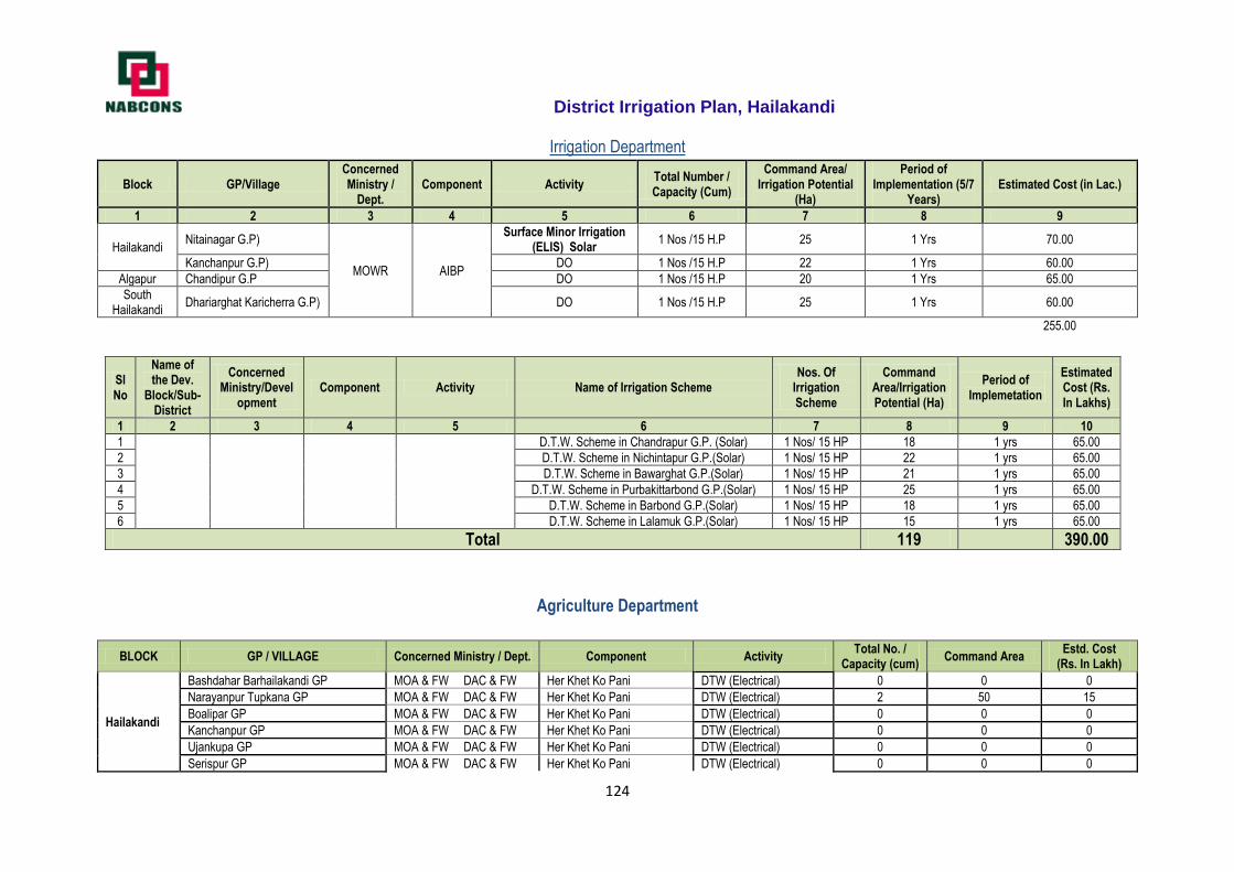
District Irrigation Plan, Hailakandi
124
Irrigation Department
Block GP/Village Concerned Ministry /
Dept. Component Activity
Total Number / Capacity (Cum)
Command Area/ Irrigation Potential
(Ha)
Period of Implementation (5/7
Years) Estimated Cost (in Lac.)
1 2 3 4 5 6 7 8 9
Hailakandi Nitainagar G.P)
MOWR AIBP
Surface Minor Irrigation (ELIS) Solar
1 Nos /15 H.P 25 1 Yrs 70.00
Kanchanpur G.P) DO 1 Nos /15 H.P 22 1 Yrs 60.00
Algapur Chandipur G.P DO 1 Nos /15 H.P 20 1 Yrs 65.00
South Hailakandi
Dhariarghat Karicherra G.P) DO 1 Nos /15 H.P 25 1 Yrs 60.00
255.00
Sl No
Name of the Dev.
Block/Sub-District
Concerned Ministry/Devel
opment Component Activity Name of Irrigation Scheme
Nos. Of Irrigation Scheme
Command Area/Irrigation Potential (Ha)
Period of Implemetation
Estimated Cost (Rs. In Lakhs)
1 2 3 4 5 6 7 8 9 10
1
D.T.W. Scheme in Chandrapur G.P. (Solar) 1 Nos/ 15 HP 18 1 yrs 65.00
2 D.T.W. Scheme in Nichintapur G.P.(Solar) 1 Nos/ 15 HP 22 1 yrs 65.00
3 D.T.W. Scheme in Bawarghat G.P.(Solar) 1 Nos/ 15 HP 21 1 yrs 65.00
4 D.T.W. Scheme in Purbakittarbond G.P.(Solar) 1 Nos/ 15 HP 25 1 yrs 65.00
5 D.T.W. Scheme in Barbond G.P.(Solar) 1 Nos/ 15 HP 18 1 yrs 65.00
6 D.T.W. Scheme in Lalamuk G.P.(Solar) 1 Nos/ 15 HP 15 1 yrs 65.00
Total 119
390.00
Agriculture Department
BLOCK GP / VILLAGE Concerned Ministry / Dept. Component Activity Total No. /
Capacity (cum) Command Area
Estd. Cost (Rs. In Lakh)
Hailakandi
Bashdahar Barhailakandi GP MOA & FW DAC & FW Her Khet Ko Pani DTW (Electrical) 0 0 0
Narayanpur Tupkana GP MOA & FW DAC & FW Her Khet Ko Pani DTW (Electrical) 2 50 15
Boalipar GP MOA & FW DAC & FW Her Khet Ko Pani DTW (Electrical) 0 0 0
Kanchanpur GP MOA & FW DAC & FW Her Khet Ko Pani DTW (Electrical) 0 0 0
Ujankupa GP MOA & FW DAC & FW Her Khet Ko Pani DTW (Electrical) 0 0 0
Serispur GP MOA & FW DAC & FW Her Khet Ko Pani DTW (Electrical) 0 0 0

District Irrigation Plan, Hailakandi
125
Lala:Mahammadpur Joy Krishnapur GP MOA & FW DAC & FW Her Khet Ko Pani DTW (Electrical) 1 25 7.5
Lala
Lalacherra Vernerpur GP MOA & FW DAC & FW Her Khet Ko Pani DTW (Electrical) 0 0 0
Niz Vernerpur Sarbanandapur GP MOA & FW DAC & FW Her Khet Ko Pani DTW (Electrical) 0 0 0
Sudarshanpur Kalacherra GP MOA & FW DAC & FW Her Khet Ko Pani DTW (Electrical) 1 25 7.5
Chandrapur GP MOA & FW DAC & FW Her Khet Ko Pani DTW (Electrical) 0 0 0
Purbo Kittarbond Rajyeswarpur GP MOA & FW DAC & FW Her Khet Ko Pani DTW (Electrical) 4 100 30
Koyah Ramchandi GP MOA & FW DAC & FW Her Khet Ko Pani DTW (Electrical) 0 0 0
Aynakhal TE GP MOA & FW DAC & FW Her Khet Ko Pani DTW (Electrical) 1 25 7.5
Monacherra GP MOA & FW DAC & FW Her Khet Ko Pani DTW (Electrical) 2 50 15
Bowerghat GP MOA & FW DAC & FW Her Khet Ko Pani DTW (Electrical) 0 0 0
Algapur
Panchgram GP MOA & FW DAC & FW Her Khet Ko Pani Diesel Lift Irrigation 1 10 4
Kalinagar GP MOA & FW DAC & FW Her Khet Ko Pani Diesel Lift Irrigation 1 10 4
Uttar Kanchanpur GP MOA & FW DAC & FW Her Khet Ko Pani Diesel Lift Irrigation 0 0 0
Chiparsangan GP MOA & FW DAC & FW Her Khet Ko Pani Diesel Lift Irrigation 0 0 0
Chandipur GP MOA & FW DAC & FW Her Khet Ko Pani Diesel Lift Irrigation 1 10 4
Bashbari GP MOA & FW DAC & FW Her Khet Ko Pani Diesel Lift Irrigation 1 10 4
Mohanpur Burniebraes GP MOA & FW DAC & FW Her Khet Ko Pani Diesel Lift Irrigation 0 0 0
Mohanpur GP MOA & FW DAC & FW Her Khet Ko Pani Diesel Lift Irrigation 3 30 12
Uttar Narayanpur GP MOA & FW DAC & FW Her Khet Ko Pani Diesel Lift Irrigation 0 0 0
Paschim Mohanpur GP MOA & FW DAC & FW Her Khet Ko Pani Diesel Lift Irrigation 0 0 0
Saidbond GP MOA & FW DAC & FW Her Khet Ko Pani Diesel Lift Irrigation 0 0 0
Hailakandi
Bashdahar Barhailakandi GP MOA & FW DAC & FW Her Khet Ko Pani Diesel Lift Irrigation 1 10 4
Sudarshanpur Bandukmara GP MOA & FW DAC & FW Her Khet Ko Pani Diesel Lift Irrigation 0 0 0
Bahadurpur GP MOA & FW DAC & FW Her Khet Ko Pani Diesel Lift Irrigation 2 20 8
Matijuri Paikan GP MOA & FW DAC & FW Her Khet Ko Pani Diesel Lift Irrigation 1 10 4
Narayanpur Tupkana GP MOA & FW DAC & FW Her Khet Ko Pani Diesel Lift Irrigation 0 0 0
Boalipar GP MOA & FW DAC & FW Her Khet Ko Pani Diesel Lift Irrigation 2 20 8
Bhatirkupa GP MOA & FW DAC & FW Her Khet Ko Pani Diesel Lift Irrigation 2 20 8
Ujankupa GP MOA & FW DAC & FW Her Khet Ko Pani Diesel Lift Irrigation 0 0 0
Gangpar Dumkar Laxmirbond GP MOA & FW DAC & FW Her Khet Ko Pani Diesel Lift Irrigation 2 20 8
Ratanpur GP MOA & FW DAC & FW Her Khet Ko Pani Diesel Lift Irrigation 3 30 12
Rangauti GP MOA & FW DAC & FW Her Khet Ko Pani Diesel Lift Irrigation 5 50 20
Lala
Rajyeswarpur GP MOA & FW DAC & FW Her Khet Ko Pani Diesel Lift Irrigation 1 10 4
Jyotsnabad Umednagar GP MOA & FW DAC & FW Her Khet Ko Pani Diesel Lift Irrigation 0 0 0
Lalamukh GP MOA & FW DAC & FW Her Khet Ko Pani Diesel Lift Irrigation 1 10 4
Sudarshanpur Kalacherra GP MOA & FW DAC & FW Her Khet Ko Pani Diesel Lift Irrigation 0 0 0
Tantoo Dhanipur GP MOA & FW DAC & FW Her Khet Ko Pani Diesel Lift Irrigation 2 20 8
Nichintapur GP MOA & FW DAC & FW Her Khet Ko Pani Diesel Lift Irrigation 0 0 0
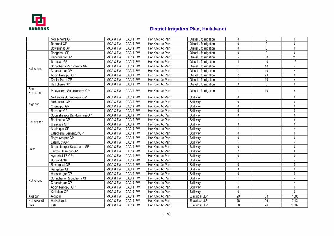
District Irrigation Plan, Hailakandi
126
Monacherra GP MOA & FW DAC & FW Her Khet Ko Pani Diesel Lift Irrigation 0 0 0
Borbond GP MOA & FW DAC & FW Her Khet Ko Pani Diesel Lift Irrigation 0 0 0
Bowerghat GP MOA & FW DAC & FW Her Khet Ko Pani Diesel Lift Irrigation 0 0 0
Katlicherra
Rangabak GP MOA & FW DAC & FW Her Khet Ko Pani Diesel Lift Irrigation 0 0 0
Harishnagar GP MOA & FW DAC & FW Her Khet Ko Pani Diesel Lift Irrigation 5 50 20
Sahabad GP MOA & FW DAC & FW Her Khet Ko Pani Diesel Lift Irrigation 4 40 16
Sonacherra Rupacherra GP MOA & FW DAC & FW Her Khet Ko Pani Diesel Lift Irrigation 1 10 4
Dinanathpur GP MOA & FW DAC & FW Her Khet Ko Pani Diesel Lift Irrigation 1 10 4
Appin Rangpur GP MOA & FW DAC & FW Her Khet Ko Pani Diesel Lift Irrigation 2 20 8
Dhalai Malai GP MOA & FW DAC & FW Her Khet Ko Pani Diesel Lift Irrigation 1 10 4
Katlicherra GP MOA & FW DAC & FW Her Khet Ko Pani Diesel Lift Irrigation 0 0 0
South Hailakandi
Palaycherra Sultanicherra GP MOA & FW DAC & FW Her Khet Ko Pani Diesel Lift Irrigation 1 10 4
Algapur:
Mohanpur Burnebrease GP MOA & FW DAC & FW Her Khet Ko Pani Spillway 0 0
Mohanpur GP MOA & FW DAC & FW Her Khet Ko Pani Spillway 0 0
Chandipur GP MOA & FW DAC & FW Her Khet Ko Pani Spillway 0 0
Bashbari GP MOA & FW DAC & FW Her Khet Ko Pani Spillway 0 0
Hailakandi:
Sudarshanpur Bandukmara GP MOA & FW DAC & FW Her Khet Ko Pani Spillway 0 0
Bhatirkupa GP MOA & FW DAC & FW Her Khet Ko Pani Spillway 1 4
Ujankupa GP MOA & FW DAC & FW Her Khet Ko Pani Spillway 0 0
Nitainagar GP MOA & FW DAC & FW Her Khet Ko Pani Spillway 1 4
Lala:
Lalacherra Vernerpur GP MOA & FW DAC & FW Her Khet Ko Pani Spillway 0 0
Rajyeswarpur GP MOA & FW DAC & FW Her Khet Ko Pani Spillway 0 0
Lalamukh GP MOA & FW DAC & FW Her Khet Ko Pani Spillway 1 4
Sudarshanpur Kalacherra GP MOA & FW DAC & FW Her Khet Ko Pani Spillway 0 0
Tantoo Dhanipur GP MOA & FW DAC & FW Her Khet Ko Pani Spillway 2 8
Aynakhal TE GP MOA & FW DAC & FW Her Khet Ko Pani Spillway 0 0
Borbond GP MOA & FW DAC & FW Her Khet Ko Pani Spillway 1 4
Bowerghat GP MOA & FW DAC & FW Her Khet Ko Pani Spillway 0 0
Katlicherra
Rangabak GP MOA & FW DAC & FW Her Khet Ko Pani Spillway 0 0
Harishnagar GP MOA & FW DAC & FW Her Khet Ko Pani Spillway 0 0
Sonacherra Rupacherra GP MOA & FW DAC & FW Her Khet Ko Pani Spillway 1 4
Dinanathpur GP MOA & FW DAC & FW Her Khet Ko Pani Spillway 1 4
Appin Rangpur GP MOA & FW DAC & FW Her Khet Ko Pani Spillway 0 0
Katlicherr GP MOA & FW DAC & FW Her Khet Ko Pani Spillway 0 0
Algapur Algapur MOA & FW DAC & FW Her Khet Ko Pani Electrical LLP 29 58 7.685
Hailkakandi Hailkakandi MOA & FW DAC & FW Her Khet Ko Pani Electrical LLP 28 56 7.42
Lala Lala MOA & FW DAC & FW Her Khet Ko Pani Electrical LLP 38 76 10.07
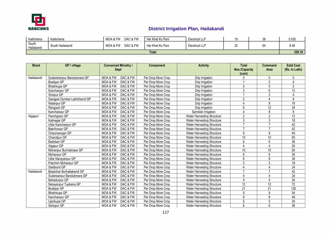
District Irrigation Plan, Hailakandi
127
Katlicherra Katlicherra MOA & FW DAC & FW Her Khet Ko Pani Electrical LLP 19 38 5.035
South Hailakandi
South Hailakandi MOA & FW DAC & FW Her Khet Ko Pani Electrical LLP 32 64 8.48
Total 329.19
Block GP / village Concerned Minsitry / Dept
Component Activity Total Nos./Capacity
(cum)
Command Area
Estd Cost (Rs. In Lakh)
Hailakandi: Sudarshanpur Bandukmara GP MOA & FW DAC & FW Per Drop More Crop Drip Irrigation 0 0 0
Boalipar GP MOA & FW DAC & FW Per Drop More Crop Drip Irrigation 1 2 4
Bhatirkupa GP MOA & FW DAC & FW Per Drop More Crop Drip Irrigation 0 0 0
Kanchanpur GP MOA & FW DAC & FW Per Drop More Crop Drip Irrigation 3 6 12
Sirispur GP MOA & FW DAC & FW Per Drop More Crop Drip Irrigation 1 2 4
Gangpar Dumkar Lakhirbond GP MOA & FW DAC & FW Per Drop More Crop Drip Irrigation 2 4 8
Ratanpur GP MOA & FW DAC & FW Per Drop More Crop Drip Irrigation 4 8 16
Rangauti GP MOA & FW DAC & FW Per Drop More Crop Drip Irrigation 6 12 24
Kanchanpur GP MOA & FW DAC & FW Per Drop More Crop Sprinkler Irrigation 4 8 8
Algapur: Panchgram GP MOA & FW DAC & FW Per Drop More Crop Water Harvesting Structure 2 2 12
Kalinagar GP MOA & FW DAC & FW Per Drop More Crop Water Harvesting Structure 3 3 18
Uttar Kanchanpur GP MOA & FW DAC & FW Per Drop More Crop Water Harvesting Structure 7 7 42
Bakrihowar GP MOA & FW DAC & FW Per Drop More Crop Water Harvesting Structure 7 7 42
Chiporsangan GP MOA & FW DAC & FW Per Drop More Crop Water Harvesting Structure 9 9 54
Chandipur GP MOA & FW DAC & FW Per Drop More Crop Water Harvesting Structure 10 10 60
Bashbari GP MOA & FW DAC & FW Per Drop More Crop Water Harvesting Structure 6 6 36
Algapur GP MOA & FW DAC & FW Per Drop More Crop Water Harvesting Structure 4 4 24
Mohanpur Burniebraes GP MOA & FW DAC & FW Per Drop More Crop Water Harvesting Structure 10 10 60
Mohanpur GP MOA & FW DAC & FW Per Drop More Crop Water Harvesting Structure 6 6 36
Uttar Narayanpur GP MOA & FW DAC & FW Per Drop More Crop Water Harvesting Structure 6 6 36
Paschim Mohanpur GP MOA & FW DAC & FW Per Drop More Crop Water Harvesting Structure 3 3 18
Saidbond GP MOA & FW DAC & FW Per Drop More Crop Water Harvesting Structure 4 4 24
Hailakandi Basdohar Borhailakandi GP MOA & FW DAC & FW Per Drop More Crop Water Harvesting Structure 7 7 42
Sudarsanpur Bandukmara GP MOA & FW DAC & FW Per Drop More Crop Water Harvesting Structure 4 4 24
Bahadurpur GP MOA & FW DAC & FW Per Drop More Crop Water Harvesting Structure 5 5 30
Narayanpur Tupkana GP MOA & FW DAC & FW Per Drop More Crop Water Harvesting Structure 12 12 72
Boalipar GP MOA & FW DAC & FW Per Drop More Crop Water Harvesting Structure 21 21 126
Bhatirkupa GP MOA & FW DAC & FW Per Drop More Crop Water Harvesting Structure 9 9 54
Kanchanpur GP MOA & FW DAC & FW Per Drop More Crop Water Harvesting Structure 8 8 48
Ujankupa GP MOA & FW DAC & FW Per Drop More Crop Water Harvesting Structure 5 5 30
Serispur GP MOA & FW DAC & FW Per Drop More Crop Water Harvesting Structure 6 6 36

District Irrigation Plan, Hailakandi
128
Gangpar Dumkar Laxmirbond GP MOA & FW DAC & FW Per Drop More Crop Water Harvesting Structure 27 27 162
Nitainagar GP MOA & FW DAC & FW Per Drop More Crop Water Harvesting Structure 3 3 18
Ratanpur GP MOA & FW DAC & FW Per Drop More Crop Water Harvesting Structure 8 8 48
Rangauti GP MOA & FW DAC & FW Per Drop More Crop Water Harvesting Structure 8 8 48
Lala Mohammadpur Joy Krishnapur GP MOA & FW DAC & FW Per Drop More Crop Water Harvesting Structure 3 3 18
Lalacherra Vernerpur GP MOA & FW DAC & FW Per Drop More Crop Water Harvesting Structure 4 4 24
Niz Vernerpur Sarbanandapur GP MOA & FW DAC & FW Per Drop More Crop Water Harvesting Structure 3 3 18
Rajyeswarpur GP MOA & FW DAC & FW Per Drop More Crop Water Harvesting Structure 3 3 18
Jyotsnabad Umednagar GP MOA & FW DAC & FW Per Drop More Crop Water Harvesting Structure 1 1 6
Lalamukh GP MOA & FW DAC & FW Per Drop More Crop Water Harvesting Structure 1 1 6
Sudarsanpur Kalacherra GP MOA & FW DAC & FW Per Drop More Crop Water Harvesting Structure 2 2 12
Nimaichanpur GP MOA & FW DAC & FW Per Drop More Crop Water Harvesting Structure 2 2 12
Tantoo Dhanipur GP MOA & FW DAC & FW Per Drop More Crop Water Harvesting Structure 6 6 36
Chandrapur GP MOA & FW DAC & FW Per Drop More Crop Water Harvesting Structure 3 3 18
Purbo Kittarbond Rajyeswarpur GP MOA & FW DAC & FW Per Drop More Crop Water Harvesting Structure 2 2 12
Koyah Ramchandi GP MOA & FW DAC & FW Per Drop More Crop Water Harvesting Structure 1 1 6
Aynakhal TE GP MOA & FW DAC & FW Per Drop More Crop Water Harvesting Structure 4 4 24
Nichintapur GP MOA & FW DAC & FW Per Drop More Crop Water Harvesting Structure 3 3 18
Monacherra GP MOA & FW DAC & FW Per Drop More Crop Water Harvesting Structure 1 1 6
Borbond GP MOA & FW DAC & FW Per Drop More Crop Water Harvesting Structure 4 4 24
Bowerghat GP MOA & FW DAC & FW Per Drop More Crop Water Harvesting Structure 3 3 18
Dhalcherra Bilaipur GP MOA & FW DAC & FW Per Drop More Crop Water Harvesting Structure 3 3 18
Katlicherra Rangabak GP MOA & FW DAC & FW Per Drop More Crop Water Harvesting Structure 1 1 6
Harishnagar GP MOA & FW DAC & FW Per Drop More Crop Water Harvesting Structure 0 0 0
Sahabad GP MOA & FW DAC & FW Per Drop More Crop Water Harvesting Structure 5 5 30
Katlicherra MOA & FW DAC & FW Per Drop More Crop Water Harvesting Structure 2 2 12
Dinanathpur GP MOA & FW DAC & FW Per Drop More Crop Water Harvesting Structure 3 3 18
Appin Rangpur GP MOA & FW DAC & FW Per Drop More Crop Water Harvesting Structure 1 1 6
Dholai Molai GP MOA & FW DAC & FW Per Drop More Crop Water Harvesting Structure 3 3 18
Katlicherra GP MOA & FW DAC & FW Per Drop More Crop Water Harvesting Structure 1 1 6
South Hailakandi
Gharmura Bagcherra GP MOA & FW DAC & FW Per Drop More Crop Water Harvesting Structure 4 4 24
KIllarbak Jhalnacherra GP MOA & FW DAC & FW Per Drop More Crop Water Harvesting Structure 4 4 24
Jamira GP MOA & FW DAC & FW Per Drop More Crop Water Harvesting Structure 4 4 24
Baldabaldi Nandagram GP MOA & FW DAC & FW Per Drop More Crop Water Harvesting Structure 6 6 36
Polaycherra Sultanicherra GP MOA & FW DAC & FW Per Drop More Crop Water Harvesting Structure 2 2 12
Dariarghat Karicherra GP MOA & FW DAC & FW Per Drop More Crop Water Harvesting Structure 2 2 12
Manipur Niskar GP MOA & FW DAC & FW Per Drop More Crop Water Harvesting Structure 2 2 12
Baruncherra Kukicherra GP MOA & FW DAC & FW Per Drop More Crop Water Harvesting Structure 4 4 24
Dhalai Bagan GP MOA & FW DAC & FW Per Drop More Crop Water Harvesting Structure 1 1 6
Algapur Panchgram GP MOA & FW DAC & FW Per Drop More Crop Ring Well with small diesel pump 2 1 3.4
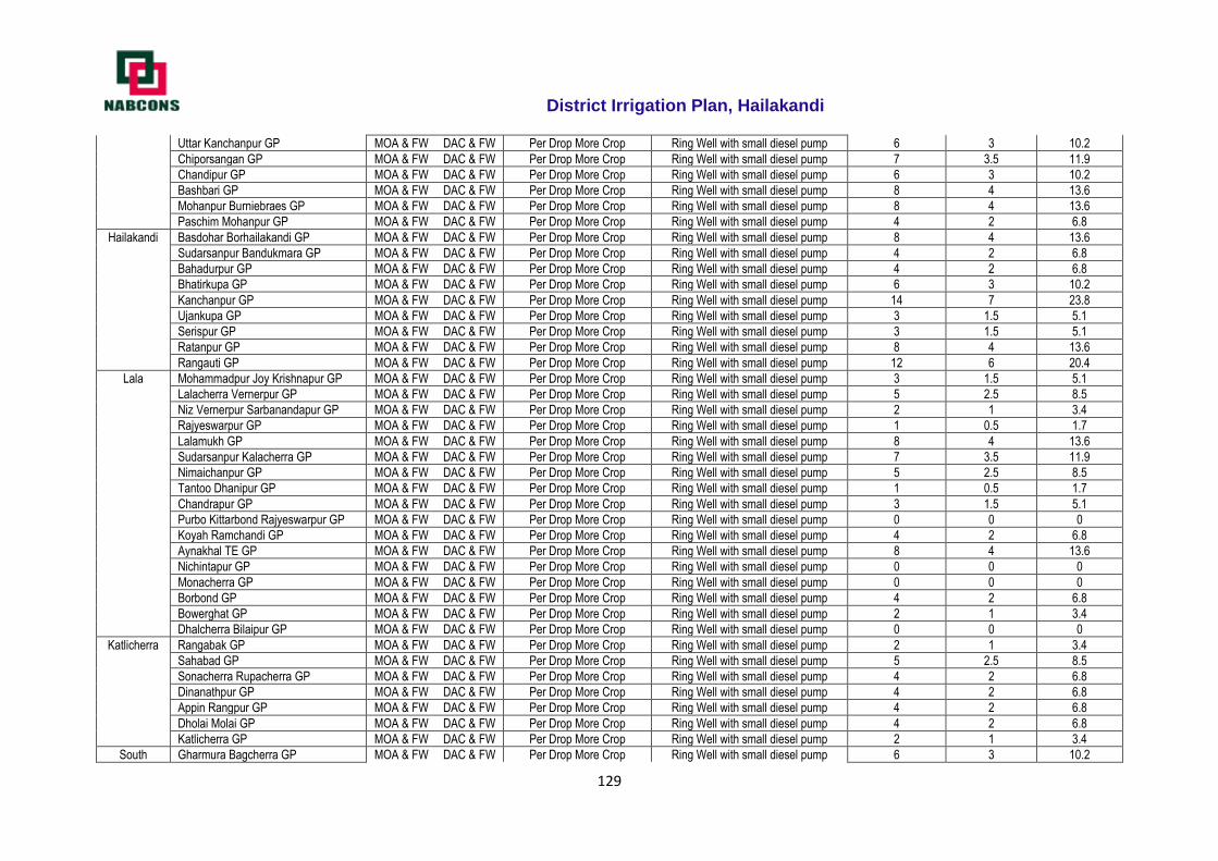
District Irrigation Plan, Hailakandi
129
Uttar Kanchanpur GP MOA & FW DAC & FW Per Drop More Crop Ring Well with small diesel pump 6 3 10.2
Chiporsangan GP MOA & FW DAC & FW Per Drop More Crop Ring Well with small diesel pump 7 3.5 11.9
Chandipur GP MOA & FW DAC & FW Per Drop More Crop Ring Well with small diesel pump 6 3 10.2
Bashbari GP MOA & FW DAC & FW Per Drop More Crop Ring Well with small diesel pump 8 4 13.6
Mohanpur Burniebraes GP MOA & FW DAC & FW Per Drop More Crop Ring Well with small diesel pump 8 4 13.6
Paschim Mohanpur GP MOA & FW DAC & FW Per Drop More Crop Ring Well with small diesel pump 4 2 6.8
Hailakandi Basdohar Borhailakandi GP MOA & FW DAC & FW Per Drop More Crop Ring Well with small diesel pump 8 4 13.6
Sudarsanpur Bandukmara GP MOA & FW DAC & FW Per Drop More Crop Ring Well with small diesel pump 4 2 6.8
Bahadurpur GP MOA & FW DAC & FW Per Drop More Crop Ring Well with small diesel pump 4 2 6.8
Bhatirkupa GP MOA & FW DAC & FW Per Drop More Crop Ring Well with small diesel pump 6 3 10.2
Kanchanpur GP MOA & FW DAC & FW Per Drop More Crop Ring Well with small diesel pump 14 7 23.8
Ujankupa GP MOA & FW DAC & FW Per Drop More Crop Ring Well with small diesel pump 3 1.5 5.1
Serispur GP MOA & FW DAC & FW Per Drop More Crop Ring Well with small diesel pump 3 1.5 5.1
Ratanpur GP MOA & FW DAC & FW Per Drop More Crop Ring Well with small diesel pump 8 4 13.6
Rangauti GP MOA & FW DAC & FW Per Drop More Crop Ring Well with small diesel pump 12 6 20.4
Lala Mohammadpur Joy Krishnapur GP MOA & FW DAC & FW Per Drop More Crop Ring Well with small diesel pump 3 1.5 5.1
Lalacherra Vernerpur GP MOA & FW DAC & FW Per Drop More Crop Ring Well with small diesel pump 5 2.5 8.5
Niz Vernerpur Sarbanandapur GP MOA & FW DAC & FW Per Drop More Crop Ring Well with small diesel pump 2 1 3.4
Rajyeswarpur GP MOA & FW DAC & FW Per Drop More Crop Ring Well with small diesel pump 1 0.5 1.7
Lalamukh GP MOA & FW DAC & FW Per Drop More Crop Ring Well with small diesel pump 8 4 13.6
Sudarsanpur Kalacherra GP MOA & FW DAC & FW Per Drop More Crop Ring Well with small diesel pump 7 3.5 11.9
Nimaichanpur GP MOA & FW DAC & FW Per Drop More Crop Ring Well with small diesel pump 5 2.5 8.5
Tantoo Dhanipur GP MOA & FW DAC & FW Per Drop More Crop Ring Well with small diesel pump 1 0.5 1.7
Chandrapur GP MOA & FW DAC & FW Per Drop More Crop Ring Well with small diesel pump 3 1.5 5.1
Purbo Kittarbond Rajyeswarpur GP MOA & FW DAC & FW Per Drop More Crop Ring Well with small diesel pump 0 0 0
Koyah Ramchandi GP MOA & FW DAC & FW Per Drop More Crop Ring Well with small diesel pump 4 2 6.8
Aynakhal TE GP MOA & FW DAC & FW Per Drop More Crop Ring Well with small diesel pump 8 4 13.6
Nichintapur GP MOA & FW DAC & FW Per Drop More Crop Ring Well with small diesel pump 0 0 0
Monacherra GP MOA & FW DAC & FW Per Drop More Crop Ring Well with small diesel pump 0 0 0
Borbond GP MOA & FW DAC & FW Per Drop More Crop Ring Well with small diesel pump 4 2 6.8
Bowerghat GP MOA & FW DAC & FW Per Drop More Crop Ring Well with small diesel pump 2 1 3.4
Dhalcherra Bilaipur GP MOA & FW DAC & FW Per Drop More Crop Ring Well with small diesel pump 0 0 0
Katlicherra Rangabak GP MOA & FW DAC & FW Per Drop More Crop Ring Well with small diesel pump 2 1 3.4
Sahabad GP MOA & FW DAC & FW Per Drop More Crop Ring Well with small diesel pump 5 2.5 8.5
Sonacherra Rupacherra GP MOA & FW DAC & FW Per Drop More Crop Ring Well with small diesel pump 4 2 6.8
Dinanathpur GP MOA & FW DAC & FW Per Drop More Crop Ring Well with small diesel pump 4 2 6.8
Appin Rangpur GP MOA & FW DAC & FW Per Drop More Crop Ring Well with small diesel pump 4 2 6.8
Dholai Molai GP MOA & FW DAC & FW Per Drop More Crop Ring Well with small diesel pump 4 2 6.8
Katlicherra GP MOA & FW DAC & FW Per Drop More Crop Ring Well with small diesel pump 2 1 3.4
South Gharmura Bagcherra GP MOA & FW DAC & FW Per Drop More Crop Ring Well with small diesel pump 6 3 10.2
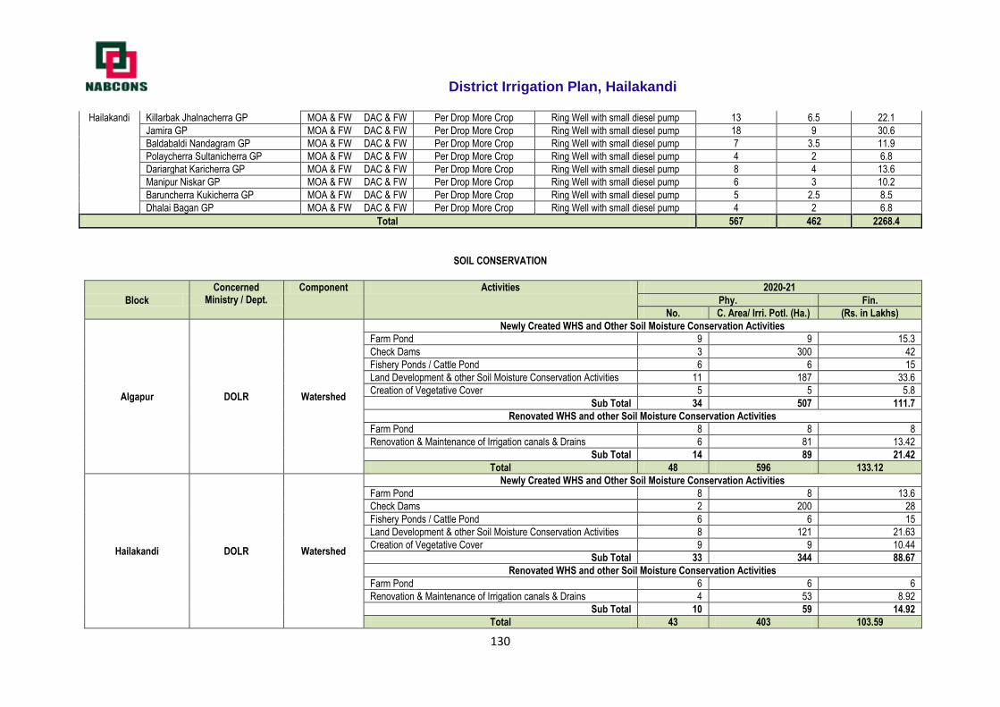
District Irrigation Plan, Hailakandi
130
Hailakandi Killarbak Jhalnacherra GP MOA & FW DAC & FW Per Drop More Crop Ring Well with small diesel pump 13 6.5 22.1
Jamira GP MOA & FW DAC & FW Per Drop More Crop Ring Well with small diesel pump 18 9 30.6
Baldabaldi Nandagram GP MOA & FW DAC & FW Per Drop More Crop Ring Well with small diesel pump 7 3.5 11.9
Polaycherra Sultanicherra GP MOA & FW DAC & FW Per Drop More Crop Ring Well with small diesel pump 4 2 6.8
Dariarghat Karicherra GP MOA & FW DAC & FW Per Drop More Crop Ring Well with small diesel pump 8 4 13.6
Manipur Niskar GP MOA & FW DAC & FW Per Drop More Crop Ring Well with small diesel pump 6 3 10.2
Baruncherra Kukicherra GP MOA & FW DAC & FW Per Drop More Crop Ring Well with small diesel pump 5 2.5 8.5
Dhalai Bagan GP MOA & FW DAC & FW Per Drop More Crop Ring Well with small diesel pump 4 2 6.8
Total 567 462 2268.4
SOIL CONSERVATION
Block
Concerned Ministry / Dept.
Component Activities 2020-21
Phy. Fin.
No. C. Area/ Irri. Potl. (Ha.) (Rs. in Lakhs)
Algapur DOLR Watershed
Newly Created WHS and Other Soil Moisture Conservation Activities
Farm Pond 9 9 15.3
Check Dams 3 300 42
Fishery Ponds / Cattle Pond 6 6 15
Land Development & other Soil Moisture Conservation Activities 11 187 33.6
Creation of Vegetative Cover 5 5 5.8
Sub Total 34 507 111.7
Renovated WHS and other Soil Moisture Conservation Activities
Farm Pond 8 8 8
Renovation & Maintenance of Irrigation canals & Drains 6 81 13.42
Sub Total 14 89 21.42
Total 48 596 133.12
Hailakandi DOLR Watershed
Newly Created WHS and Other Soil Moisture Conservation Activities
Farm Pond 8 8 13.6
Check Dams 2 200 28
Fishery Ponds / Cattle Pond 6 6 15
Land Development & other Soil Moisture Conservation Activities 8 121 21.63
Creation of Vegetative Cover 9 9 10.44
Sub Total 33 344 88.67
Renovated WHS and other Soil Moisture Conservation Activities
Farm Pond 6 6 6
Renovation & Maintenance of Irrigation canals & Drains 4 53 8.92
Sub Total 10 59 14.92
Total 43 403 103.59
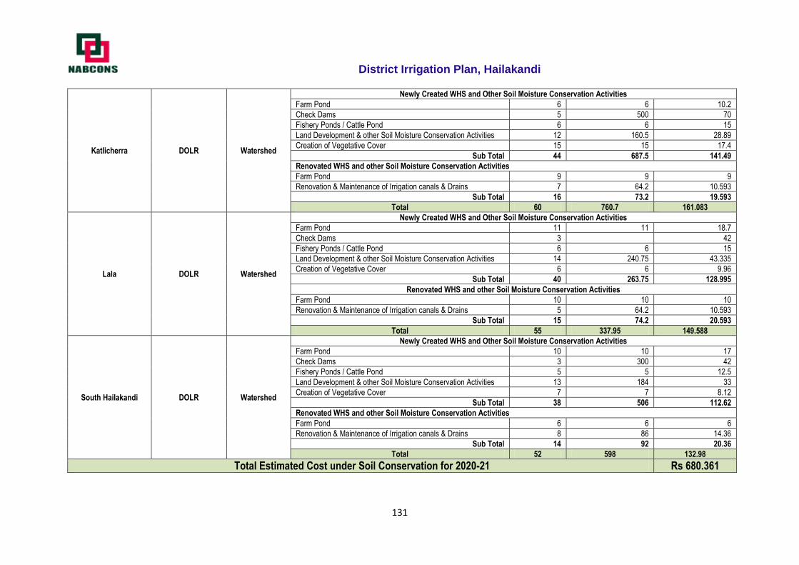
District Irrigation Plan, Hailakandi
131
Katlicherra DOLR Watershed
Newly Created WHS and Other Soil Moisture Conservation Activities
Farm Pond 6 6 10.2
Check Dams 5 500 70
Fishery Ponds / Cattle Pond 6 6 15
Land Development & other Soil Moisture Conservation Activities 12 160.5 28.89
Creation of Vegetative Cover 15 15 17.4
Sub Total 44 687.5 141.49
Renovated WHS and other Soil Moisture Conservation Activities
Farm Pond 9 9 9
Renovation & Maintenance of Irrigation canals & Drains 7 64.2 10.593
Sub Total 16 73.2 19.593
Total 60 760.7 161.083
Lala DOLR Watershed
Newly Created WHS and Other Soil Moisture Conservation Activities
Farm Pond 11 11 18.7
Check Dams 3 42
Fishery Ponds / Cattle Pond 6 6 15
Land Development & other Soil Moisture Conservation Activities 14 240.75 43.335
Creation of Vegetative Cover 6 6 9.96
Sub Total 40 263.75 128.995
Renovated WHS and other Soil Moisture Conservation Activities
Farm Pond 10 10 10
Renovation & Maintenance of Irrigation canals & Drains 5 64.2 10.593
Sub Total 15 74.2 20.593
Total 55 337.95 149.588
South Hailakandi DOLR Watershed
Newly Created WHS and Other Soil Moisture Conservation Activities
Farm Pond 10 10 17
Check Dams 3 300 42
Fishery Ponds / Cattle Pond 5 5 12.5
Land Development & other Soil Moisture Conservation Activities 13 184 33
Creation of Vegetative Cover 7 7 8.12
Sub Total 38 506 112.62
Renovated WHS and other Soil Moisture Conservation Activities
Farm Pond 6 6 6
Renovation & Maintenance of Irrigation canals & Drains 8 86 14.36
Sub Total 14 92 20.36
Total 52 598 132.98
Total Estimated Cost under Soil Conservation for 2020-21 Rs 680.361
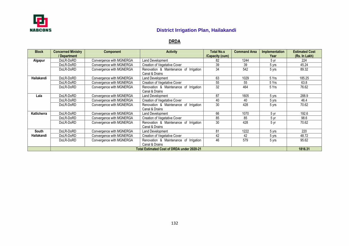
District Irrigation Plan, Hailakandi
132
DRDA
Block Concerned Ministry / Department
Component Activity Total No.s /Capacity (cum)
Command Area Implementation Year
Estimated Cost (Rs. In Lakh)
Algapur DoLR-DoRD Convergence with MGNERGA Land Development 82 1244 5 yr 224
DoLR-DoRD Convergence with MGNERGA Creation of Vegetative Cover 39 39 5 yrs 45.24
DoLR-DoRD Convergence with MGNERGA Renovation & Maintenance of Irrigation Canal & Drains
34 542 5 yrs 89.32
Hailakandi DoLR-DoRD Convergence with MGNERGA Land Development 63 1029 5 Yrs 185.25
DoLR-DoRD Convergence with MGNERGA Creation of Vegetative Cover 55 55 5 Yrs 63.8
DoLR-DoRD Convergence with MGNERGA Renovation & Maintenance of Irrigation Canal & Drains
32 464 5 Yrs 76.62
Lala DoLR-DoRD Convergence with MGNERGA Land Development 87 1605 5 yrs 288.9
DoLR-DoRD Convergence with MGNERGA Creation of Vegetative Cover 40 40 5 yrs 46.4
DoLR-DoRD Convergence with MGNERGA Renovation & Maintenance of Irrigation Canal & Drains
30 428 5 yrs 70.62
Katlicherra DoLR-DoRD Convergence with MGNERGA Land Development 66 1070 5 yr 192.6
DoLR-DoRD Convergence with MGNERGA Creation of Vegetative Cover 85 85 5 yr 98.6
DoLR-DoRD Convergence with MGNERGA Renovation & Maintenance of Irrigation Canal & Drains
30 428 5 yr 70.62
South Hailakandi
DoLR-DoRD Convergence with MGNERGA Land Development 81 1222 5 yrs 220
DoLR-DoRD Convergence with MGNERGA Creation of Vegetative Cover 42 42 5 yrs 48.72
DoLR-DoRD Convergence with MGNERGA Renovation & Maintenance of Irrigation Canal & Drains
46 579 5 yrs 95.62
Total Estimated Cost of DRDA under 2020-21 1816.31
Related Documents


![CURRICULUM VITAEpeople.iitr.ernet.in/facultyresume/nayanfwt_2.pdf · 2 [A] PROFESSIONAL FIELD EXPERIENCE (From 1973 to 1983):- In Assam Govt.. Flood Control & Irrigation Department](https://static.cupdf.com/doc/110x72/5f4de84d8361ff5f9d504a57/curriculum-2-a-professional-field-experience-from-1973-to-1983-in-assam-govt.jpg)

