Welcome message from author
This document is posted to help you gain knowledge. Please leave a comment to let me know what you think about it! Share it to your friends and learn new things together.
Transcript


district 3
Page 2
Page 3
transportation concept report
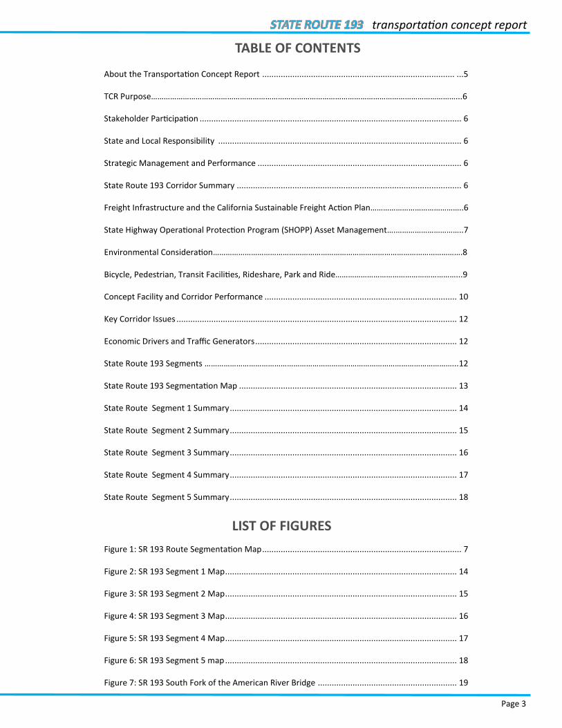
TABLE OF CONTENTS
About the Transportation Concept Report ................................................................................... ...5
TCR Purpose………………………………………………………………………………………………………………………………...6
Stakeholder Participation ................................................................................................................. 6
State and Local Responsibility ......................................................................................................... 6
Strategic Management and Performance ........................................................................................ 6
State Route 193 Corridor Summary ................................................................................................. 6
Freight Infrastructure and the California Sustainable Freight Action Plan……………………………………..6
State Highway Operational Protection Program (SHOPP) Asset Management….…………………………..7
Environmental Consideration……………………………………………………………………………………………………….8
Bicycle, Pedestrian, Transit Facilities, Rideshare, Park and Ride…………………………………………………...9
Concept Facility and Corridor Performance ................................................................................... 10
Key Corridor Issues ......................................................................................................................... 12
Economic Drivers and Traffic Generators ....................................................................................... 12
State Route 193 Segments ………………………………………………………………………………………………………...12
State Route 193 Segmentation Map .............................................................................................. 13
State Route Segment 1 Summary .................................................................................................. 14
State Route Segment 2 Summary .................................................................................................. 15
State Route Segment 3 Summary .................................................................................................. 16
State Route Segment 4 Summary .................................................................................................. 17
State Route Segment 5 Summary .................................................................................................. 18
LIST OF FIGURES
Figure 1: SR 193 Route Segmentation Map ...................................................................................... 7
Figure 2: SR 193 Segment 1 Map .................................................................................................... 14
Figure 3: SR 193 Segment 2 Map .................................................................................................... 15
Figure 4: SR 193 Segment 3 Map .................................................................................................... 16
Figure 5: SR 193 Segment 4 Map .................................................................................................... 17
Figure 6: SR 193 Segment 5 map .................................................................................................... 18
Figure 7: SR 193 South Fork of the American River Bridge ............................................................ 19
district 3
Page 4
LIST OF TABLES
Table 1: System Characteristics and Concept Facility ............................................................... 10-11
Table 2: Segment 1 Route Designations and Characteristics ......................................................... 14
Table 3: Segment 1 Project List ...................................................................................................... 14
Table 4: Segment 2 Route Designations and Characteristics ......................................................... 15
Table 5: Segment 2 Project List ...................................................................................................... 15
Table 6: Segment 3 Route Designations and Characteristics ......................................................... 16
Table 7: Segment 3 Project List ...................................................................................................... 16
Table 8: Segment 4 Route Designations and Characteristics ......................................................... 17
Table 9: Segment 4 Project List ...................................................................................................... 17
Table 10: Segment 5 Route Designations and Characteristics ....................................................... 18
Table 11: Segment 5 Project List .................................................................................................... 18

Page 5
transportation concept report
ABOUT THE TRANSPORTATION CONCEPT REPORT
System Planning is the long-range transportation planning process for the California Department of Transportation (Caltrans). The System Planning process fulfills Caltrans’ statutory responsibility as owner/operator of the State High-way System (SHS) (Gov. Code §65086) by evaluating conditions and proposing enhancements to the SHS. Through Sys-tem Planning, Caltrans focuses on developing an integrated multimodal transportation system that meets Caltrans’ goals of Safety and Health; Stewardship and Efficiency; Sustainability, Livability and Economy; System Performance; and Organizational Excellence.
The System Planning process is primarily composed of four parts: the District System Management and Development Plan (DSMDP), the Transportation Concept Report (TCR), the Corridor System Management Plan (CSMP), and the DSMDP Project List. The district-wide DSMDP is strategic policy and planning document that focuses on maintaining, operating, managing, and developing the transportation system. The TCR is a planning document that identifies the existing and future route conditions as well as future needs for each route on the SHS. The CSMP is a complex, multi-functional, multi-jurisdictional planning document that identifies future needs within corridors experiencing or ex-pected to experience high levels of congestion. The CSMP serves as a TCR for segments covered by the CSMP. The Dis-trict System Management Plan (DSMP) Project List is a list of planned and partially programmed transportation projects used to recommend projects for funding.
District 3 System Planning continues its efforts to streamline and expedite short-range to long-range project needs by creating focused documents such as:
The District 3 State Highway Bicycle Facility Plan (SHBFP) is a comprehensive plan that identifies a vision and frame-work for bicycle facility improvements on the SHS in District 3. It provides information regarding bicycling on the SHS along with recommended changes to improve connectivity and convenience.
The Intelligent Transportation Systems and Operations Plan (ITS/Ops Plan) provides critical guidance to optimize the State Highway System within the District by identifying and managing ITS and other operational strategies that yield a very high return on investment. The ITS/Ops Plan identifies an inventory of prioritized projects and a process for con-tinuously updating the inventory.
The District 3 Goods Movement Study is a district-wide gap analysis of the district goods movement network, propos-ing methodologies to identify and prioritize freight projects. Findings and recommendations from this study will be in-corporated into the forthcoming District 3 Goods Movement Plan, and will inform local, regional, and statewide plan-ning efforts
The district recently completed the D3 Complete Streets Plan which assesses existing conditions and opportunities to identify, prioritize, and implement complete streets enhancements to be included in transportation improvement pro-jects on the SHS corridors.
The District 3 Regional Concept of Transportation Operations (RCTO) Plan was completed in May 2016. This is a strate-gy document developed by Caltrans and its local and regional partners that articulates the District’s strategic planning approach for major transportation corridors within the District, consistent with the boundaries identified in the Dis-trict’s CSMPs. The Plan defines Goals and Objectives, Concepts, and Roles and Responsibilities for the United State (US) 50, State Route (SR) 51, Interstate (I)-80, SR 65, I-5, and SR 99 corridors. The Plan proposes short (1-5 years), medium (5-10 years), and long (10-20 years) range concepts related to system management, highway and arterial management, incident management, traveler information, operational improvements, and alternative modes. Specific projects are not proposed in the RCTO, but will guide project proposals in future CSMPs and the ITS/Ops plan.
These System Planning products are also intended as resources for stakeholders, the public, and partner, regional, and local agencies. This TCR includes projects identified in the previously discussed focused documents. For more infor-mation and to access all System Planning products, please visit:
http://www.dot.ca.gov/dist3/departments/planning/systemplanning.htm.

district 3
Page 6
TCR PURPOSE
California’s State Highway System needs long range planning documents to guide the logical development of transpor-tation systems as required by CA Gov. Code §65086 and as necessitated by the public, stakeholders, and system users. The purpose of the TCR is to evaluate current and projected conditions along the route and communicate the vision for the development of each route in each Caltrans District during a 20-year planning horizon. The TCR is developed with the goals of Safety and Health; Stewardship and Efficiency; Sustainability, Livability and Economy; System Performance; and Organizational Excellence, and meeting community and environmental needs along the corridor through integrat-ed management of the transportation network, including the highway, transit, pedestrian, bicycle, freight, operational improvements and travel demand management components of the corridor.
STAKEHOLDER PARTICIPATION
Stakeholder participation was sought throughout the development of the TCR for SR 193. Outreach efforts involved internal and external stakeholders, tribal governments, and regional and local agencies. During the initial information resource gathering for the TCR, stakeholders were contacted for initial input related to their particular specializations, and to verify data sources used and data accuracy. As the document was finalized, stakeholders were asked to review the document for comments, edits, and for consistency with the intent of existing plans, policies, and proce-dures. Written comments were received and incorporated into the final document. The process of including and work-ing closely with stakeholders adds value to the TCR, allows for outside input, provides an opportunity for ideas to be reflected in the document, increases credibility, and helps strengthen public support and trust.
STATE AND LOCAL RESPONSIBILITY
Improvements to the SHS are the responsibility of both Caltrans and local agencies. Developments that add cumulative impacts to this route and the regional State Highway System may necessitate that local jurisdictions provide nexus based, proportional fair-share funding for future highway improvements. Developments or local circulation changes that will have significant traffic impacts to the highway should provide improvements to mitigate those impacts.
STRATEGIC MANAGEMENT AND PERFORMANCE
The Department’s Strategic Management Plan is the road map of Caltrans’ role, expectations, and activities; and in-cludes performance measures to bring about transparency, accountability, sustainability, and innovation. The Plan highlights the Department goals which are: Safety and Health, Stewardship and Efficiency, Sustainability, Livability and Economy, System Performance, and Organizational Excellence.
STATE ROUTE 193 CORRIDOR SUMMARY
SR 193 is a two-lane conventional highway connecting the city of Lincoln, the town of Newcastle, the city of Auburn, and the city of Placerville. The route is 32 miles long through Placer and El Dorado County. SR 193 Segments one to five begin at Oak Tree Lane in the City of Lincoln, and travel east toward I-80 in the City of Auburn. There is a route break in the segment from I-80 to the SR 49/193 junction. From SR 49, segments four and five continue through El Dorado coun-ty and travel south to Placerville. SR 193 is a parallel route to SR 49 that provides regional connectivity for motorists from the City of Auburn and the City of Placerville. The route also provides highway access to Sierra College and Folsom Lake. Some of the projects for the route include construction of a Class II Bike Lane for the corridor as listed in the Com-plete Streets Plan and District 3 Bicycle and Pedestrian Plan. Caltrans may pursue relinquishment of the rest of this route because it doesn't serve as a major interregional travel route.
FREIGHT INFRASTRUCTURE AND THE CALIFORNIA SUSTAINABLE FREIGHT ACTION PLAN
Federal and State transportation planning processes require consideration of strategies for an integrated multimodal transportation system to facilitate efficient movement of people and goods. Title 23 CFR Part 450.208 requires the con-sideration of various freight related factors during the transportation planning process. The freight system has a signifi-

Page 7
transportation concept report
cant impact on both the SHS and the State’s economy and it is essential that freight moves throughout the region, state, and interstate destinations as efficiently as possible.
Caltrans District 3, a geographically diverse, 11-county area in northern Central California, is a crossroads for freight moving into and out of California. The Sacramento Metropolitan area is in the southern part of the District, which in-cludes the interior coastal range to the west, flat agricultural land across the valley, and foothills, river canyons, the Sierra Nevada Mountains, and the Lake Tahoe Basin.
A District 3 Goods Movement Study was completed in February 2015. The study is a district-wide gap analysis of the freight network to propose methodologies to identify and prioritize freight projects.
The California Sustainable Freight Action Plan is an ambitious statewide effort to improve freight efficiency and transi-tion the freight transport system to zero-emission technologies, while continuing to support California’s economy.
In July 2015, Governor Brown issued Executive Order B-32-15, which directs the Secretary of the California State Trans-portation Agency, Secretary of the California Environmental Protection Agency, and the Secretary of the Natural Re-sources Agency to lead the appropriate State departments in the development of a California Sustainable Freight Ac-tion Plan by July 2016. The State departments involved in this effort include the California Department of Transporta-tion, the California Air Resources Board, the California Energy Commission and the Governor’s Office of Business and Economic Development.
The integrated action plan identifies strategies and actions to achieve a sustainable freight transportation system that meets California’s environmental, energy, mobility, safety and economic needs. The plan also identifies and initiates corridor-level freight pilot projects within the State’s primary trade corridors that integrate advanced technologies, al-ternative fuels, freight and fuel infrastructure and local economic development opportunities.
The Executive Order further directs that the action plan will be informed by broad stakeholder input. In support of this direction, Caltrans has made available the services and expertise of its Planning Public Engagement Contract (PPEC) consultant team, led by MIG, Inc. The interagency team has engaged stakeholders throughout the State through webi-nars, presentations to staff and boards from regional agencies, and briefings with interested parties such as industry leaders, environmental groups, and other community groups. The California Freight Advisory Committee (CFAC) has also been a forum to gather input from groups, organizations, and businesses representing a cross section of the freight community. Originally formed to provide input for the California Freight Mobility Plan, the CFAC continues to advise the State on freight-related priorities, issues, projects, and funding needs.
http://www.fhwa.dot.gov/hep/guidance/superseded/23cfr450.cfm#sec.450.208
http://dot.ca.gov/hq/tpp/offices/ogm/CFAC/Governor%27s_Executive_Order_B-32-15_Sustainable_Freight_Plan.pdf
STATE HIGHWAY OPERATION AND PROTECTION PROGRAM (SHOPP) ASSET MAN-AGEMENT
Caltrans began implementing a Multi-Objective Decision Analysis (MODA) approach for project prioritization. The MODA framework for project prioritization was first piloted in parallel with the 2014 SHOPP. In the initial pilot effort, the focus was on evaluating if the MODA framework could be effectively applied to SHOPP project evaluation.
The MODA approach is the state of the art practice for multi-criteria decision analysis applied to transportation asset management. The MODA approach allows agencies to evaluate project benefits across multiple assets and competing investment decisions. As applied to the SHOPP, MODA will allow project benefits ranging from condition improvement to safety improvement and sustainability efforts to be evaluated in a common framework. When fully implemented, the MODA project evaluation will provide the following benefits:
The benefits in each of the five Department Strategic Goal areas will be determined at a project level. This will effectively tie SHOPP project prioritization to the broader goals of the Department.
Allow the department to prioritize projects from highest to lowest benefit cost ratio across the entire SHOPP re-gardless of asset composition and will incorporate condition improvement, safety, operations, and sustainability objectives among others.
district 3
Page 8
Ability to measure the benefits of projects that involve multiple objectives and shift our project development cul-ture from one of a largely silo based funding centered on a single objective to more comprehensive transportation solutions. This change in approach will provide the opportunity for greater economies of scale, better local partner coordination and less disruption to traffic.
A byproduct of the MODA implementation is a comprehensive documentation of how projects are prioritized and selected in the SHOPP. This documentation will provide a level of transparency that has been desired by external partners and oversight agencies.
The implementation of asset management will inevitably require business process changes in Caltrans system and pro-ject planning to support the new requirements. In 2015, a number of efforts were initiated to begin the process of defining necessary changes and to develop plans for the implementation of these changes. The Caltrans’ Division of Planning initiated “Planning Forward” and “Planning to Programming” reviews. These consultant assisted reviews take a fresh look at the products of system planning and how these products meet the current needs of Caltrans and exter-nal partners. The Planning to Programming effort is looking at how system planning efforts can better support asset management and project level programming of projects.
ENVIRONMENTAL CONSIDERATIONS
SAFETEA-LU Section 6001 and MAP-21 requires environmental considerations in the development of long-range trans-portation plans. To comply, environmental issues within the corridor are considered by describing the existing environ-mental setting, consulting with resource agencies, considering possible corridor development constraints, and discuss-ing potential avoidance, minimization, and mitigation. Including environmental considerations will help streamline pro-ject initiation and delivery, aid decision makers, and inform stakeholders.
Wildlife crossings are areas of concentrated animal movement intercepted by roadways. In most cases, effects are seen because animals are inadvertently hit by drivers as they attempt to cross the road surface, leading to mortality of ani-mals (“road-kill”) and safety concerns to the motoring public. In other cases, animals choose to avoid crossing, and the roads present barriers to animal movement, dividing a formerly single population into two or more isolated population segments, causing a range of negative effects. These effects may be less apparent, but are no less significant. Further, environmental regulations compel transportation professionals to reduce or eliminate effects on special status species and habitats. Wildlife crossing considerations are reflected in the California Comprehensive Wildlife Conservation Strat-egy (California Department of Fish & Game, 2006), which lists wildlife habitat fragmentation as one of the biggest threats to the state’s wildlife and suggests as a solution that “Wildlife considerations need to be incorporated early in the transportation planning process.” (Source: “Wildlife Crossings Guidance Manual, Caltrans, March 2009”)
As a component of the Department’s environmental stewardship commitments, the passage of fish past the many thousands of state highway crossings of rivers and streams has long been of concern to Departmental staff. For most fish species, migration for the purposes of spawning, rearing of young or for finding suitable habitat is essential to sur-vival. With the 1973 passage of the federal Endangered Species Act, and the recent passage of California Senate Bill 857 which amends California Fish and Game Code to incorporate specific provisions regarding Caltrans’ progress in re-moving barriers to fish passage, that stewardship commitment also carries a regulatory context whereby the Depart-ment must provide for the unimpeded passage of various aquatic species or potentially face litigation and/or penalties for non-compliance. (Source: http://www.dot.ca.gov/hq/oppd/fishPassage/Chapter%201%20Fwd%20&%20Intro.pdf)
In coordination with the California Department of Fish and Wildlife (CDFW), the California Department of Transporta-tion (Caltrans) continues to assess the Passage Assessment Database (PAD) for quality assurance review (QA/QC) of state highway locations. The purpose of the QA/QC is to improve and refine data for existing and new locations, which will help to inform future assessment needs, help to determine staff and funding needs to develop and deliver fish pas-sage remediation projects, and help to inform project priorities for recovery decisions. Completed locations have gone through the QA/QC process as well.
Caltrans and CDFW coordinate to determine the combined priority list of fish passage barriers on the state highway system. Once barrier locations have been assessed and identified, priorities are assigned, based on the relative habitat value at each location. The habitat value of each location is defined by the presence (or historic presence) and diversity of anadromous species, suitable upstream habitat quality and quantity and the localized knowledge of expert fisheries

Page 9
transportation concept report
and hydraulic professionals. (Source: Caltrans, 2015 Fish Passage Annual Report to the Legislature)
http://environment.fhwa.dot.gov/integ/related.asp
http://www.fhwa.dot.gov/map21/
BICYCLE, PEDESTRIAN, TRANSIT FACILITIES, RIDESHARE, PARK AND RIDE
Bicycle, pedestrian, and transit facility considerations have been incorporated into the TCR per Title 23 CFR Part 450.208 and Deputy Directive (DD) 64-R2 : Complete Streets-Integrating the Transportation System. DD-64-R2 states “Caltrans views all transportation improvements as opportunities to improve safety, access, and mobility for all travel-ers in California and recognizes bicycle, pedestrian, and transit modes as integral elements of transportation system.”
California has set a target to triple bicycling and double walking by 2020 by improving these options for all Californians. Better bicycle and pedestrian facilities that safely connect people with where they need to go will also promote healthy and active lifestyles and improve the environment by reducing automobile use and greenhouse gas emissions. Policies that stem from this plan will guide Caltrans’ decisions about future bicycle and pedestrian investments in safe facilities and programs that encourage walking and bicycling.
The first-ever California State Bicycle and Pedestrian Plan was recently completed, which is a visionary and comprehen-sive policy plan to support active modes of transportation and to increase safe bicycling and walking in California. The plan will guide the State in developing an integrated, multi-modal transportation network for all users, including: bicy-cle and pedestrian accommodation on the State Highway System where appropriate; connections to intercity rail and public transportation; and support for local government efforts to develop safe active transportation networks.
Bicycling constitutes an active transportation alternative to automobile use that can help reduce congestion and im-prove corridor performance. Bicycle facilities, particularly on parallel roads, are important in improving the attractive-ness and use of bicycling. These bicycle facilities are located on both local parallel roads and on dedicated pathways.
Caltrans District 3 recently completed the “Caltrans District 3 Complete Streets Plan” that will address the specific im-plementation of complete streets elements into the SHS within the District. A complete street is a transportation facili-ty that is planned, designed, operated, and maintained to provide safe mobility for all users, including bicyclists, pedes-trians, transit riders, and motorists appropriate to the function and context of the facility. Information regarding the addition of complete streets elements in the specific route or corridor will be included in each applicable TCR. Caltrans will develop and implement the Plan in coordination with local and regional agencies.
As owner/operator, Caltrans has primary responsibility for the SHS. In an era of reduced funding, environmental con-cerns and public health, capacity increasing projects are no longer the focus of improvements. Instead, we are focusing more on demand reduction strategies that include multi-modal opportunities. Projects that can incorporate compo-nents that encourage enhanced regional and local transit services, bicycle and pedestrian facility improvements and more robust ridesharing options are becoming the priority. Increased collaboration with local partner transportation agencies leads to improvements that fulfill the visions of local communities and are more sustainable. In addition, more funding opportunities are available when partners are engaged and have a vested interest.
http://www.fhwa.dot.gov/hep/23cfr450.htm#sec.450.208
http://www.dot.ca.gov/hq/tpp/offices/ocp/complete_streets_files/dd_64_r1_signed.pdf
http://www.cabikepedplan.org/
district 3
Page 10
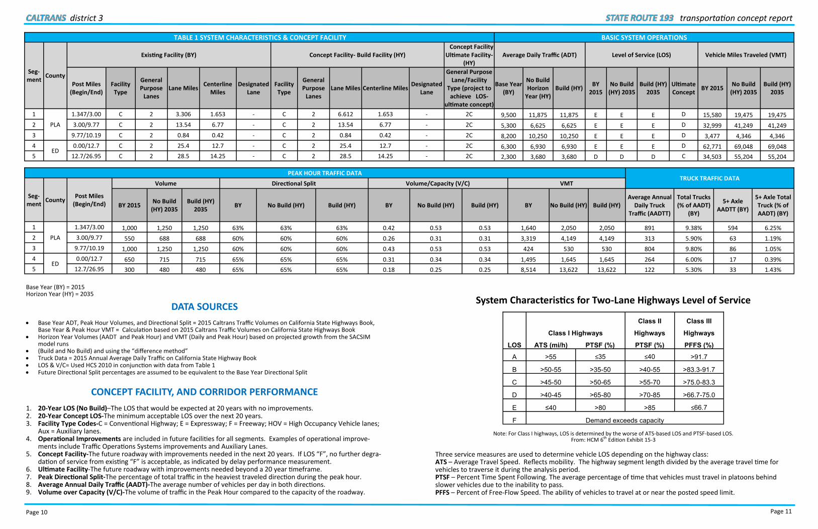
TABLE 1 SYSTEM CHARACTERISTICS & CONCEPT FACILITY
Seg-ment
County
Existing Facility (BY) Concept Facility- Build Facility (HY)
Post Miles (Begin/End)
Facility Type
General Purpose
Lanes Lane Miles
Centerline Miles
Designated Lane
Facility Type
General Purpose
Lanes Lane Miles Centerline Miles
Designated
1
PLA
1.347/3.00 C 2 3.306 1.653 - C 2 6.612 1.653
2 3.00/9.77 C 2 13.54 6.77 - C 2 13.54 6.77
3 9.77/10.19 C 2 0.84 0.42 - C 2 0.84 0.42
4 ED
0.00/12.7 C 2 25.4 12.7 - C 2 25.4 12.7
5 12.7/26.95 C 2 28.5 14.25 - C 2 28.5 14.25
PEAK HOUR TRAFFIC DATA
Seg-ment
County Post Miles
(Begin/End)
Volume Directional Split Volume/Capacity (V/C)
BY 2015 No Build
(HY) 2035 Build (HY)
2035 BY No Build (HY) Build (HY) BY
1
PLA
1.347/3.00 1,000 1,250 1,250 63% 63% 63% 0.42
2 3.00/9.77 550 688 688 60% 60% 60% 0.26
3 9.77/10.19 1,000 1,250 1,250 60% 60% 60% 0.43
4 ED
0.00/12.7 650 715 715 65% 65% 65% 0.31
5 12.7/26.95 300 480 480 65% 65% 65% 0.18
Base Year (BY) = 2015 Horizon Year (HY) = 2035
DATA SOURCES
Base Year ADT, Peak Hour Volumes, and Directional Split = 2015 Caltrans Traffic Volumes on California State Highways Book, Base Year & Peak Hour VMT = Calculation based on 2015 Caltrans Traffic Volumes on California State Highways Book
Horizon Year Volumes (AADT and Peak Hour) and VMT (Daily and Peak Hour) based on projected growth from the SACSIM model runs
(Build and No Build) and using the “difference method” Truck Data = 2015 Annual Average Daily Traffic on California State Highway Book LOS & V/C= Used HCS 2010 in conjunction with data from Table 1 Future Directional Split percentages are assumed to be equivalent to the Base Year Directional Split
CONCEPT FACILITY, AND CORRIDOR PERFORMANCE
1. 20-Year LOS (No Build)–The LOS that would be expected at 20 years with no improvements. 2. 20-Year Concept LOS-The minimum acceptable LOS over the next 20 years. 3. Facility Type Codes-C = Conventional Highway; E = Expressway; F = Freeway; HOV = High Occupancy Vehicle lanes;
Aux = Auxiliary lanes. 4. Operational Improvements are included in future facilities for all segments. Examples of operational improve-
ments include Traffic Operations Systems improvements and Auxiliary Lanes. 5. Concept Facility-The future roadway with improvements needed in the next 20 years. If LOS “F”, no further degra-
dation of service from existing “F” is acceptable, as indicated by delay performance measurement. 6. Ultimate Facility-The future roadway with improvements needed beyond a 20 year timeframe. 7. Peak Directional Split-The percentage of total traffic in the heaviest traveled direction during the peak hour. 8. Average Annual Daily Traffic (AADT)-The average number of vehicles per day in both directions. 9. Volume over Capacity (V/C)-The volume of traffic in the Peak Hour compared to the capacity of the roadway.
Page 11
transportation concept report
BASIC SYSTEM OPERATIONS
Build Facility (HY) Concept Facility Ultimate Facility-
(HY) Average Daily Traffic (ADT) Level of Service (LOS) Vehicle Miles Traveled (VMT)
Centerline Miles Designated
Lane
General Purpose Lane/Facility
Type (project to achieve LOS-
ultimate concept)
Base Year (BY)
No Build Horizon
Year (HY) Build (HY)
BY 2015
No Build (HY) 2035
Build (HY) 2035
Ultimate Concept
BY 2015 No Build
(HY) 2035 Build (HY)
2035
- 2C 9,500 11,875 11,875 E E E D 15,580 19,475 19,475
- 2C 5,300 6,625 6,625 E E E D 32,999 41,249 41,249
- 2C 8,200 10,250 10,250 E E E D 3,477 4,346 4,346
- 2C 6,300 6,930 6,930 E E E D 62,771 69,048 69,048
- 2C 2,300 3,680 3,680 D D D C 34,503 55,204 55,204
TRUCK TRAFFIC DATA Volume/Capacity (V/C) VMT
No Build (HY) Build (HY) BY No Build (HY) Build (HY) Average Annual
Daily Truck Traffic (AADTT)
Total Trucks (% of AADT)
(BY)
5+ Axle AADTT (BY)
5+ Axle Total Truck (% of AADT) (BY)
0.53 0.53 1,640 2,050 2,050 891 9.38% 594 6.25%
0.31 0.31 3,319 4,149 4,149 313 5.90% 63 1.19%
0.53 0.53 424 530 530 804 9.80% 86 1.05%
0.34 0.34 1,495 1,645 1,645 264 6.00% 17 0.39%
0.25 0.25 8,514 13,622 13,622 122 5.30% 33 1.43%
System Characteristics for Two-Lane Highways Level of Service
Note: For Class I highways, LOS is determined by the worse of ATS-based LOS and PTSF-based LOS. From: HCM 6th Edition Exhibit 15-3
Three service measures are used to determine vehicle LOS depending on the highway class: ATS – Average Travel Speed. Reflects mobility. The highway segment length divided by the average travel time for vehicles to traverse it during the analysis period. PTSF – Percent Time Spent Following. The average percentage of time that vehicles must travel in platoons behind slower vehicles due to the inability to pass. PFFS – Percent of Free-Flow Speed. The ability of vehicles to travel at or near the posted speed limit.
Class II Class III
Class I Highways Highways Highways
LOS ATS (mi/h) PTSF (%) PTSF (%) PFFS (%)
A >55 ≤35 ≤40 >91.7
B >50-55 >35-50 >40-55 >83.3-91.7
C >45-50 >50-65 >55-70 >75.0-83.3
D >40-45 >65-80 >70-85 >66.7-75.0
E ≤40 >80 >85 ≤66.7
F Demand exceeds capacity

district 3
Page 12
Two-Lane Highway Class Types: Class I – Speed and delay due to passing restriction are both important to motorists. LOS is defined by ATS and PTSF. Class II – Travel speed not a significant issue to drivers. LOS is defined by PTSF only. Class III – Passing restrictions and high speeds are not a major concern. Drivers travel at or near the speed limit. LOS is defined by PFFS. Two other characteristics that have a significant impact on actual operations and driver perceptions of service: Passing Capacity – The ability to pass is limited by the opposing flow rate and distribution of gaps in that flow. Passing Demand – As platooning and PTSF increase in a given direction, the demand for passing maneuvers increases. LOS A – Motorists experience high operating speeds, little difficulty passing, and platoons of three or more vehicles are rare for Class I highways. Class II highways have a small amount of platooning and speeds are controlled by roadway conditions. For Class III, drivers are able to maintain close to free flow speed (FFS). LOS B – Passing demand and passing capacity are balanced. Some platooning on Class I and II. Some speed reductions on Class I. Class III it is difficult to maintain FFS, but speed reduction is small. LOS C – Most vehicles are traveling in platoons. Noticeable drop in speeds for all three Classes. LOS D – Significant increase in platooning. Passing demand is high for Class I and II. For Class III the drop in FFS speed is significant. LOS E – Demand is approaching capacity. For Class I and II passing is virtually impossible, PTSF is more than 80%, and there is an extreme drop in FFS. For Class III speed is less than two-thirds of the FFS. LOS F – Demand flow in one or both directions exceeds the capacity of the segment. Operating conditions are unsta-ble, and heavy congestion exists on all classes of the two-lane highway. Definitions summarized from- HCM 6th Edition
KEY CORRIDOR ISSUES
Improving accessibility and connectivity for all modes of transportation and maintaining or exceeding the minimum acceptable Level Of Service (LOS) on each corridor segment are key issues for SR 193. These issues can be addressed by implementing targeted on/off-system projects and travel demand management strategies.
The projects listed under each segment summary will help to improve performance measures, including LOS which is a tool used to assess free flow of vehicle traffic on road segments. Minimizing conflicts between pedestrians, bicyclists, and vehicles by implementing Complete Streets and Context Sensitive projects and strategies will help to improve mul-timodal accessibility and increased connectivity along the corridor.
SR 193 connects Placer and El Dorado counties. It supports agricultural traffic and freight transportation/ large truck movements that follow the Kingpin-to rearmost-axle distance (KPRA) truck networks standard. SR 193 connects the City of Lincoln, Auburn, and Placerville. Beyond these cities, the route is predominately rural in nature, spanning large portions of agricultural land.
ECONOMIC DRIVERS AND TRAFFIC GENERATORS
SR 193 is a two-lane conventional highway that begins at the City of Lincoln and travels east toward the City of Auburn with a break in route from I-80 to the junction with SR 49 in Cool. The route continues to travel south and then con-nects back to the junction with SR 49 in Placerville. The route is often used as a short cut for truck traffic that would otherwise be routed through Roseville along I-80 and SR 65 to the Marysville/Yuba City area. The route links communi-ties to the two larger routes, US 50 and I-80, and is used as an alternative route for SR 49. It supports some of the agri-cultural traffic and freight transportation/large truck movements that follow KPRA truck networks standard. Due to the combination of rolling terrain, limited sight lines, at-grade access of residential driveways and truck traffic, the facility needs improvement to address the current LOS E and to accommodate future traffic flow.
STATE ROUTE 193 SEGMENTS
The following pages include a map and summary of each SR 193 segment.
Segment summaries provide a segment overview including route designations, traffic analysis data, existing Trans-portation Management System (TMS) elements, bicycle and pedestrian access, and freight and airport facilities. Infor-mation that covers more than 3 segments is described in the corridor summary. Needed improvement projects for
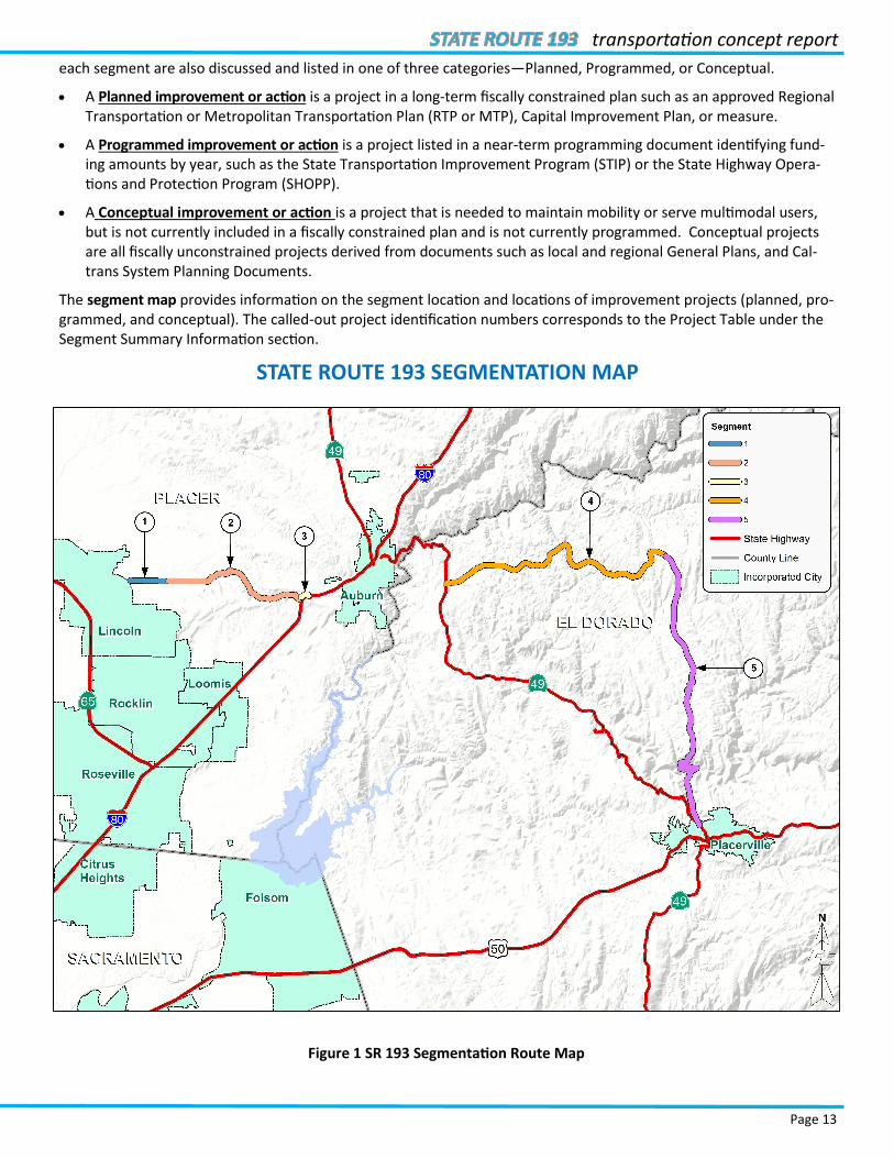
Page 13
transportation concept report
each segment are also discussed and listed in one of three categories—Planned, Programmed, or Conceptual.
A Planned improvement or action is a project in a long-term fiscally constrained plan such as an approved Regional Transportation or Metropolitan Transportation Plan (RTP or MTP), Capital Improvement Plan, or measure.
A Programmed improvement or action is a project listed in a near-term programming document identifying fund-ing amounts by year, such as the State Transportation Improvement Program (STIP) or the State Highway Opera-tions and Protection Program (SHOPP).
A Conceptual improvement or action is a project that is needed to maintain mobility or serve multimodal users, but is not currently included in a fiscally constrained plan and is not currently programmed. Conceptual projects are all fiscally unconstrained projects derived from documents such as local and regional General Plans, and Cal-trans System Planning Documents.
The segment map provides information on the segment location and locations of improvement projects (planned, pro-grammed, and conceptual). The called-out project identification numbers corresponds to the Project Table under the Segment Summary Information section.
STATE ROUTE 193 SEGMENTATION MAP
Figure 1 SR 193 Segmentation Route Map

district 3
Page 14
State Route 193 Segment 1 Summary
The first segment of SR 193 begins at Oak Tree Lane and ends at Sierra Col-lege Boulevard. This segment is a two-lane urban arterial and is heavily used to connect southbound travelers to the city of Rocklin, the Town of Loomis, and the Sierra College campus. The construction of a Class II bike lane was recommended in the DSMP as part of active transportation mobility im-provements. Based on the 2015 fore-casting data, the facility is currently operating at LOS E during peak periods and will remain at LOS E 20 years from now. There are no capacity enhance-ment projects plans and Caltrans in-tends to pursue relinquishment of the segment in the future.
Figure 2 Segment 1 Map: Oak Tree Lane (PM 1.347) to Sierra College Blvd.
(PM 3.00)
TABLE 2 SEGMENT 1 ROUTE DESIGNATIONS AND CHARACTERISTICS
Freeway &
Expressway
National
Highway
System
Strategic
Highway
Network
Scenic
Highway
Interregional
Road System
High
Emphasis
Focus
Route
Federal
Functional
Classification
Goods
Movement
Route
Truck
Designation
Bicycle and
Pedestrian Access
No No No No No No No Minor Arterial
4 No
65’ CA Legal
KPRA* Advisory
Highway Open
Shoulder
TABLE 3 SEGMENT 1 PROJECT LIST
Project Number
Description PM Location Lead Agency Source Purpose
Total Cost
Estimate*
(x $1,000)
Proposed Completion
Year
Project Category
1
Install Class II bike lane/NEV lane (shared) along SR 193 from Oak Tree Lane to Stardust Lane.
PLA 193 1.347/2.523
SR 193 from Oak Tree Lane to
Stardust Lane City of Lincoln Bike Plan
Complete Streets
$827 TBD Conceptual
2
Install Class II bike lane on SR 193 from Oak Tree Lane to Sierra College
Blvd.
PLA 193 1.347/3.000
SR 193 from Oak Tree Lane (Ferrari
Ranch Blvd was relinquished) to
Sierra College Blvd
PCTPA DSMP Complete
Streets $1,440 TBD Conceptual

Page 15
transportation concept report
State Route 193 Segment 2 Summary
Figure 3 Segment 2 Map: Sierra College Blvd. (PM 3.00) to Taylor Rd.
(PM 9.77)
Segment 2 begins at Sierra College Boule-vard and ends at Taylor Road in Newcas-tle. This segment is a conventional two-lane highway connecting the City of Lin-coln to Newcastle and I-80. The highway traverses both rolling and mountainous terrain. With narrow shoulders and poor sight distance, the segment has very few passing opportunities for motorists. A Class II Bike Lane is proposed for this en-tire segment as part of the district Com-plete Streets Plan. Based on the 2015 fore-casting data, the facility is currently oper-ating at LOS E during peak periods and will remain at LOS E 20 years from now. Cal-trans intends to pursue relinquishment of the segment in the future.
TABLE 4 SEGMENT 2 ROUTE DESIGNATIONS AND CHARACTERISTICS
Freeway &
Expressway
National
Highway
System
Strategic
Highway
Network
Scenic
Highway
Interregional
Road System
High
Emphasis
Focus
Route
Federal
Functional
Classification
Goods
Movement
Route
Truck Designation Bicycle and
Pedestrian Access
No No no No No No No Minor Arterial
4 No
65’ CA Legal KPRA*
Advisory
Highway Open
Shoulder
TABLE 5 SEGMENT 2 PROJECT LIST
Project Number
Description PM Location Lead
Agency Source Purpose
Total Cost
Estimate*
(x $1,000)
Proposed Completion
Year
Project Category
1 Construct a Class II bike lane
along SR 193 from Sierra College Blvd. to Taylor Road.
PLA 193 3.000/9.770
SR 193 from Sierra College Blvd. to
Taylor Rd. PCTPA DSMP
Complete Streets
$1,440 TBD Conceptual
2
Complete pavement rehabilitation along SR 193 from Sierra College Blvd. to
Newcastle.
PLA 193 3.000/9.395
SR 193 from Sierra College Blvd. to
Newcastle Caltrans RTP/MTP
System Preservation
$6,500 2021-2036 Planned
3
Complete curve improvements and widening
near Lincoln along SR 193 from 0.1 mile west to 0.9 mile east of Clark Tunnel
Road.
PLA 193 4.400/5.400
SR 193 near Lincoln from 0.1 mile west to 0.9 mile east of Clark Tunnel Road
Caltrans RTP/MTP System
Preservation $17,393 2018 Programmed
district 3
Page 16
State Route 193 Segment 3 Summary
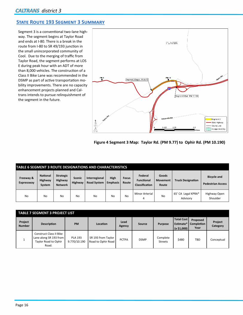
Segment 3 is a conventional two-lane high-way. The segment begins at Taylor Road and ends at I-80. There is a break in the route from I-80 to SR 49/193 junction in the small unincorporated community of Cool. Due to the merging of traffic from Taylor Road, the segment performs at LOS E during peak hour with an ADT of more than 8,000 vehicles. The construction of a Class II Bike Lane was recommended in the DSMP as part of active transportation mo-bility improvements. There are no capacity enhancement projects planned and Cal-trans intends to pursue relinquishment of the segment in the future.
TABLE 6 SEGMENT 3 ROUTE DESIGNATIONS AND CHARACTERISTICS
Freeway &
Expressway
National
Highway
System
Strategic
Highway
Network
Scenic
Highway
Interregional
Road System
High
Emphasis
Focus
Route
Federal
Functional
Classification
Goods
Movement
Route
Truck Designation Bicycle and
Pedestrian Access
No No No No No No No Minor Arterial
4 No
65’ CA Legal KPRA*
Advisory
Highway Open
Shoulder
TABLE 7 SEGMENT 3 PROJECT LIST
Project Number
Description PM Location Lead
Agency Source Purpose
Total Cost
Estimate*
(x $1,000)
Proposed Completion
Year
Project Category
1
Construct Class II Bike Lane along SR 193 from
Taylor Road to Ophir Road.
PLA 193 9.770/10.190
SR 193 from Taylor Road to Ophir Road
PCTPA DSMP Complete
Streets $480 TBD Conceptual
Figure 4 Segment 3 Map: Taylor Rd. (PM 9.77) to Ophir Rd. (PM 10.190)

Page 17
transportation concept report
State Route 193 Segment 4 Summary
Figure 5 Segment 4 Map: Junction SR 49 (PM 0.00) to Main Street
(PM 12.7)
Segment 4 begins at the small unincorporated com-munity of Cool and ends at Main Street in Georgetown. The segment is a two-lane conven-tional highway with no shoulders and limited pass-ing opportunities. Due to SR 193’s mountainous terrain, SR 49 is often the primary route between Placerville and Cool for motorists. A Class II Bike Lane is proposed in El Dorado County Bicycle Trans-portation Plan for this segment. A roundabout was propose at the intersection of SR 49/SR193. The segment is currently performing at LOS E and will not experience any significant level of growth in future year. There are no capacity enhancement projects planned and Caltrans intends to pursue relinquishment of the segment in the future.
TABLE 8 SEGMENT 4 ROUTE DESIGNATIONS AND CHARACTERISTICS
Freeway &
Expressway
National
Highway
System
Strategic
Highway
Network
Scenic
Highway
Interregional
Road System
High
Emphasis
Focus
Route
Federal
Functional
Classification
Goods
Movement
Route
Truck Designation Bicycle and
Pedestrian Access
No No No No No No No Minor Arterial
4 No
65’ CA Legal KPRA*
Advisory
Highway Open
Shoulder
TABLE 9 SEGMENT 4 PROJECT LIST
Project Number
Description PM Location Lead Agency Source Purpose
Total Cost
Estimate*
(x $1,000)
Proposed Completion
Year
Project Category
1 Roundabout ED 193 0.00 SR 49/SR 193 intersection Caltrans
Ideas for Cool’s
rural center by
Portland State
University-
March 2017
Safety and
Operational
Improvements
$2,000 TBD Conceptual
2 Class II bike
facility ED 193
0.00/.856
SR 193: From Jct. SR 49 to American River Trail (Auburn Lake
Trails)
Caltrans, El Dorado County
EDCTC Complete
Streets TBD TBD Conceptual
2 Class II ED 193
0.856/12.844
State Route 193: From American River Trail (Auburn Lake Trails) to
South St in Georgetown
Caltrans, El Dorado County
EDCTC Complete
Streets TBD TBD Conceptual
4 Class II bike
lanes ED 193
0.85/12.7 Auburn Lake Trails to Wentworth
Springs Rd Caltrans EDCTC
Complete Streets
TBD TBD Conceptual
5 Class II bike
lanes ED 193
0.00/0.85 SR 49 to Auburn Lake Trails Caltrans EDCTC
Complete Streets
TBD TBD Conceptual
6 Turnouts ED 193
4.16/11.1
US 50 PM 4.16, PM 6.4, PM 6.5, , PM 9.26, PM 10.9, and PM 11.1
(Traffic PID No. 283) Caltrans ITS/OPS Plan
System Preservation
$1,314 2018 Conceptual

district 3
Page 18
State Route 193 Segment 5 Summary
The final segment of SR 193 continues from Main Street in Georgetown all the way to the SR 49 junction in the City of Placerville. The segment is a narrow two-lane conventional highway with no shoul-ders and limited passing opportunities because of steep winding terrain which results in poor horizontal sight distance. SR 193 provides recreational access to the South Fork of the American River. The facility is currently operating at LOS D during peak periods and is expected to remain at LOS D in the horizon year. There are no capacity enhancement pro-jects planned and Caltrans intends to pursue relinquishment of this segment in the future.
Figure 6 Segment 5 Map: Main Street (PM 12.7) to Junction SR 49 (PM 26.95)
TABLE 10 SEGMENT 5 ROUTE DESIGNATIONS AND CHARACTERISTICS
Freeway &
Expressway
National
Highway
System
Strategic
Highway
Network
Scenic
Highway
Interregional
Road System
High
Emphasis
Focus
Route
Federal
Functional
Classification
Goods
Movement
Route
Truck Designation Bicycle and
Pedestrian Access
No No No No No No No Minor Arterial
4 No
65’ CA Legal KPRA*
Advisory
Highway Open
Shoulder
TABLE 11 SEGMENT 5 PROJECT LIST
Project Number
Description PM Location Lead Agency Source Purpose
Total Cost
Estimate* (x
$1,000)
Proposed Completion
Year
Project Category
1 Class II bike
lanes ELD 193
12.7/26.95 Through Georgetown Caltrans EDCTC
Complete Streets
TBD TBD Conceptual
2 Repair slipout ELD 193
24.2/24.3
In El Dorado County near Placerville, 1.1 miles north of the S. Fork American River
Bridge.
Caltrans SHOPP System
Preservation $2,300 2020 Planned

Page 19
transportation concept report
Figure 7 SR 193 South Fork of the American River Bridge
DISTRICT 3
California Department of Transportation
Prepared by : Hau Nguyen
For questions and concerns about this Transportation Concept Report, please contact:
Caltrans District 3 Division of Planning and Local Assistance Office of System Planning Analysis, Modeling and Forecasting Branch 703 B Street, Marysville, CA 95901 Email: [email protected] Phone: (530) 741-4199
For further Transportation Concept Report information, please visit:
Caltrans District 3 Website:
http://www.dot.ca.gov/dist3/departments/planning
(Select System Planning, then Transportation Concept Reports)
Related Documents