DISCRETIONARY APPLICATION For Public Display Applicant: Telstra Corporation Location: Highland Lakes Road, Reynolds Neck (CT 14823/1) Proposal: Utility Upgrade DA Number: DA 2021 / 00068 Date Advertised: 16 August 2021 Date Representation Period Closes: 30 August 2021 Responsible Officer: Louisa Brown (Planning Officer) Viewing Documents: The relevant documents may be viewed at Council’s website www.centralhighlands.tas.gov.au or at Council’s Offices 19 Alexander Street, Bothwell & 6 Tarleton Street, Hamilton during normal office hours. Representations to: General Manager 19 Alexander Street BOTHWELL TAS 7030 Email: [email protected]

Welcome message from author
This document is posted to help you gain knowledge. Please leave a comment to let me know what you think about it! Share it to your friends and learn new things together.
Transcript
DISCRETIONARY APPLICATION For Public Display
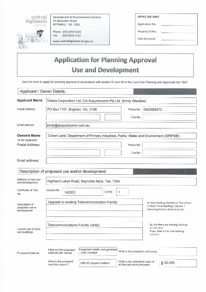
Applicant: Telstra Corporation Location: Highland Lakes Road, Reynolds Neck (CT 14823/1) Proposal: Utility Upgrade DA Number: DA 2021 / 00068 Date Advertised: 16 August 2021 Date Representation Period Closes: 30 August 2021 Responsible Officer: Louisa Brown (Planning Officer) Viewing Documents: The relevant documents may be viewed at Council’s website www.centralhighlands.tas.gov.au or at Council’s Offices 19 Alexander Street, Bothwell & 6 Tarleton Street, Hamilton during normal office hours. Representations to: General Manager 19 Alexander Street BOTHWELL TAS 7030 Email: [email protected]

Department of Primary Industries, Parks, Water and Environment GPO Box 1751, Hobart, TAS 7001 Australia Ph 1300 TAS PARKS / 1300 827 727 Fax 03) 6223 8308 www.parks.tas.gov.au
Enquiries: Amy Sanderson Phone: 6165 4671 Email: [email protected] Our ref: 21/3307
30 July 2021 Ms Emily Wardlaw Director – Planning Services Acquirecomm Pty Ltd PO Box 7157 BRIGHTON VIC 3186 Email: [email protected] [email protected] Dear Ms Wardlaw
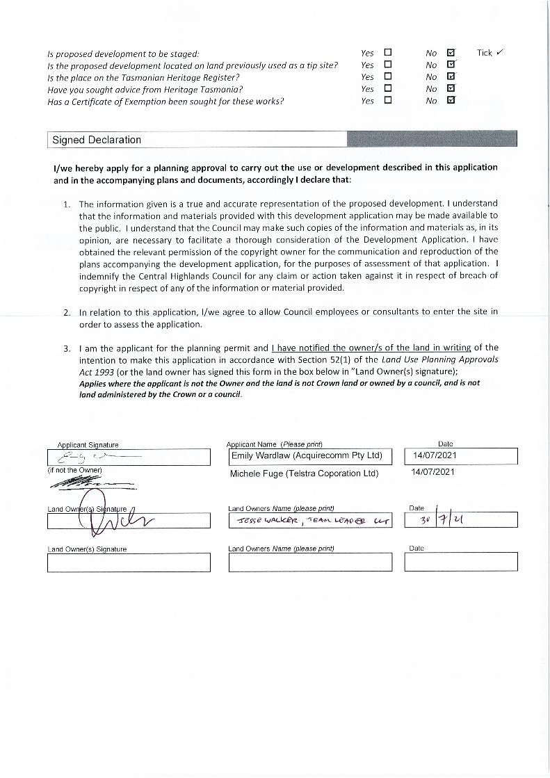
LODGEMENT OF PLANNING APPLICATION TELSTRA CORPORATION LTD C/o ACQUIRE COMM PTY LTD
TASGRN PROJECT - UPGRADE TO EXISTING TELECOMMUNICATIONS FACILITY HIGHLAND LAKES ROAD – REYNOLDS NECK
This letter, issued pursuant to section 52(1B) of the Land Use Planning and Approvals Act 1993, is to confirm that the Crown consents to the making of the enclosed Planning Permit Application. Crown consent is only given to the lodgement of this application. If any variation is proposed, please seek further consent from this office. To seek approval to commence work in the event that planning consent is obtained, please forward a complete copy of the planning permit to [email protected] If you need more information regarding the above, please contact the officer nominated at the head of this correspondence. Yours sincerely
Jesse Walker Team Leader (Unit Manager, Policy & Projects)

PERMIT APPLICATIONPLANNING
WATTLE GROVE, TAS, 7109
Proposed TasGRN telecommunication upgrade works
NetworkTasmanian Government Radio
at:
July 2021
HIGHLAND LAKES ROAD, REYNOLDS NECK, TAS, 7467Lot 1 on Diagram 142823, VOLUME 142823, FOLIO 1
2
Document Control
Prepared by Emily Wardlaw
Acquirecomm Pty Ltd Date 19 July 2021
Version
Date
Author
Reason
1 13/07/2021 Emily Hart Initial Draft 2 14/07/2021 Emily Wardlaw Amendments
3
Contents
Executive Summary 4
Site and Proposed Details 5
1. Introduction 6
2. Purpose and Demand 7
3. Site Selection 9
4. Proposed Development 10
5. Subject Site 11
6. Regulatory Framework & Assessment 16
7. Conclusion 25
Appendix A Copy of Title i
Appendix B Plans and Elevations ii
Appendix C EPBC Report iii
Appendix D Aboriginal Heritage Advice iv
Appendix E Media Releases v
4
Executive Summary
This report has been prepared by Acquirecomm Pty Ltd on behalf of Telstra Corporation Ltd in support
of a planning permit application for the upgrade of an existing Telstra Telecommunications Facility at
HIGHLAND LAKES ROAD, REYNOLDS NECK, TAS, 7304 as part of the TasGRN Project.
The Tasmanian Government Radio Network (TasGRN) is a collaborative project to transition eight core
user organisations, currently using five separate radio communications networks, onto one unified,
digital, and interoperable radio network.
The result will be a more reliable and resilient network enabling the provision of better services to the
Tasmanian community.
The proposed development is located at the existing Telstra Site at REYNOLDS NECK. The land is legally
described as Crown Land, Lot 1 on Diagram 142823, VOLUME 142823 FOLIO 1, Authority ; Tasmanian
Parks and Wildlife Service, DPIPWE (Crown Land Services).
Refer to copy of Title at Appendix A.
A discretionary application for planning approval for the TasGRN antenna and Solar Panel Array is
required.
This report outlines the purpose and demand for the development in REYNOLDS NECK and addresses
the planning merits of the proposal and its consistency with the relevant planning controls and codes
of the Central Highlands Planning Scheme. It is supported by the accompanied plans which show the
proposed layout and design of the facility.
The proposed development of the site represents the provision of essential emergency
communications infrastructure to the area as sought under the TasGRN Project. The proposed facility
will have an acceptable impact on the amenity of the area in terms of its use of materials and siting.
The facility is designed to have regard to its surrounds and represents an appropriate balance between
the net community benefit from the provision of essential emergency services communications and
the protection of the environment from any adverse impacts.
5
Site and Proposal Details
Address of Site HIGHLAND LAKES ROAD, REYNOLDS NECK, TAS, 7304
Legal Property Description Crown Land (Authority DPIPWE)
Lot 1 on Diagram 142823
VOLUME 142823, FOLIO 1
Local Authority Central Highlands Council
Use Utility
Zone and Overlays & Codes Environmental Management Zone
Telecommunications Code
Permit Type Discretionary
Owner Crown Land (Authority DPIPWE)
Applicant Telstra Corporation Limited ABN 051 775 556
C/- Acquirecomm PO Box 7157 Brighton, Vic, 3186
Contact Person Emily Wardlaw
Director Planning Services
0422685472
Our Reference TAS GRN REYNOLDS NECK
6
1 Introduction
The most extensive upgrade to multiagency emergency radio communications in Tasmania’s history
has commenced following the signing of a contract between the Tasmanian Government and Telstra
to deliver the Tasmanian Government Radio Network (TasGRN).
The TasGRN will replace five separate radio networks with one digital, public-safety grade radio
network to be delivered by Telstra and supported by Motorola Solutions Australia P/L. The Project is
a key element in delivering the State’s objective in keeping Tasmanians safe. The network will also
enhance day to day operations beyond emergency services and will support sustainable forest and
reserved land management, utility providers and health transport services.
Initial users of the TasGRN will include:
➢ Tasmania Police;
➢ Tasmania Fire Service;
➢ Ambulance Tasmania;
➢ State Emergency Service;
➢ Department of Primary Industries, Parks, Water and Environment;
➢ Sustainable Timber Tasmania;
➢ TasNetworks; and,
➢ Hydro Tasmania
Design and construction of the new network has now commenced with user organisations expected
to begin migrating over to the new infrastructure in the 2022/2023 financial year.
You can read more about the project here:
http://www.premier.tas.gov.au/site_resources_2015/additional_releases/telstra_awarded_tasgrn_c
ontract
https://www.tasgrn.tas.gov.au/
The project includes approximately 160 sites located within all 29 Local Government areas. The project
will involve the co-location of TasGRN equipment on existing communications structures owned by a
variety of operators. There will be a small number of new structures required to ensure breadth of
coverage across Tasmania.
Telstra has contracted Acquirecomm Pty Ltd to undertake the required environmental and planning
approvals on each site.

7
2 Purpose and Demand
The TasGRN Project is a result of the Tasmanian Government’s response to the Report of the Auditor-
General No. 10 of 2013-2014 (Government Radio Communication – Appendix One 1) which
recommended a whole-of-Government radio network (Tasmanian Government Radio Network -
TasGRN). The TasGRN aims to deliver a reliable, functional and usable state-wide public safety grade
radio communications network fit for purpose in supporting emergency response, public order during
major events and the day to day operations of Tasmania's Emergency Services Organisations (ESOs),
land managers and the electricity supply industry.
The Auditor-General’s report made eleven recommendations supporting progress and development
of a whole-of-government radio network, including:
➢ Agencies should work together to resolve congestion issues.
➢ Agencies should investigate ways to provide secure and confidential communications.
➢ Any whole-of-government network should consider a level of duplication with regard to
infrastructure and cost.
TASMANIAN GOVERNMENT RADIO NETWORK, (TASGRN) PROJECT SUBMISSION TO THE PARLIAMENTARY STANDING
COMMITTEE ON PUBLIC WORKS 27 JULY 2020
Project director Scott Wilson-Haffenden said the contract signing with Telstra was a significant
milestone for the state.
"The contract signing marks the commencement of an important partnership with
Telstra and it's key subcontractor Motorola to develop a radio network that
addresses recommendations made by the state government, and most notably the
Tasmanian government's response to the report from the auditor-general."
Acting Premier Jeremy Rockliff said the project, which includes a $567 million investment, was the
most significant radio communications technological upgrade in the state's history.
"Effective radio communications are absolutely mission critical to keeping
Tasmanians safe, and having such extensive infrastructure and radio
communications across multiple agencies is critical and vitally important so that all
agencies are working together through the one combined network, in order to
ensure the responsiveness of those on the front line."
Police, Fire and Emergency Management Minister Mark Shelton said it would mean a more cohesive
emergency management response, not only in bushfire situations but in day-to-day scenarios.
"Having an inter-operable radio network that all the agencies will be connected to
allows these agencies to coordinate responses to the emergencies - whether it be
8
the SES talking to the police or whether it's fire talking to Transcend on a car crash
or road rescue, these things are about keeping Tasmanians safe."
http://www.premier.tas.gov.au/site_resources_2015/additional_releases/telstra_awarded_tasgrn_c
ontract
The Project Submission to the Parliamentary Standing Committee on Public Works, 27 July 2020 states
that:
The TasGRN will have far-reaching social and environmental impacts, many of
which will apply to the Tasmanian community as a whole.
The submission lists that the Social and Environmental Impacts, in broad terms, include:
➢ Increased access and ease of use to mission-critical radio communications for the State’s large
volunteer base;
➢ Geographical equity for regional and remote citizens to have access to, and receive,more
responsive and coordinated emergency services;
➢ Geographical equity due to new government-funded site infrastructure having the potential
to be leveraged by commercial providers, to deliver more telecommunication services in
regional and remote Tasmania;
➢ Improved health, public safety and natural disaster response outcomes for all citizens of
Tasmania, including improved WHS for User Organisations;
➢ Avoided privacy breaches due to enhanced network security;
➢ Potential for economic and social benefits for rural towns through the provision of TasGRN
site access to commercial mobile service providers, enabling greater commercial and social
connectivity.
➢ Improved public confidence in ESO operations due to improved security and response times.
The submission also states that the environmental impacts of the TasGRN include:
➢ Increased ability to protect the environment due to ESOs’ more timely and coordinated
response to extreme events (e.g. bushfires, floods);
➢ Increased ability to protect World Heritage zones due to enhanced coverage in rural and
forested areas enabling greater mobility of resources; and
➢ The addition of new sites will intrude on natural environment.
A full copy of the submission can be found at:
https://www.parliament.tas.gov.au/ctee/Joint/Submissions/Tasmanian%20Government%20Radio%
20Network%20Project-
Department%20of%20Police,%20Fire%20and%20Emergency%20Management%20Submission.pdf
9
3 Site Selection
The TasGRN User Organisations have undertaken an extensive coverage prediction and site selection
process. This process generated a design that will economically leverage existing sites, minimising
green-field builds to meet the State’s coverage requirements. The trunked radio site design utilises
the best mix of available site infrastructure, using a combination of State, Telstra and other sites
assets.
The preliminary coverage design utilises a mix of VHF and UHF frequencies.
Selection of the UHF and VHF site locations is primarily based on UHF coverage requirements and may
require multiple sites in close proximity to maximise channel availability.
To obtain the level of coverage required by User Organisations the TasGRN will comprise 135
individual sites spread throughout the State and also 17 Radio Link Sites. There are only three (3)
greenfield sites, in total, required to be built across the State, the remaining quantity of sites will utilise
existing site components.
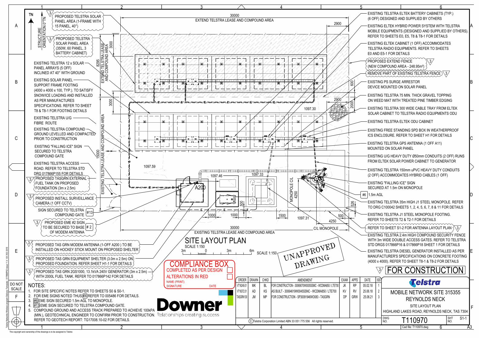
This application to upgrade the existing Telstra Facility at REYNOLDS NECK with TasGRN Equipment is
one of the 16 existing sites identified within Central Highlands Council under the project to be
upgraded.
10
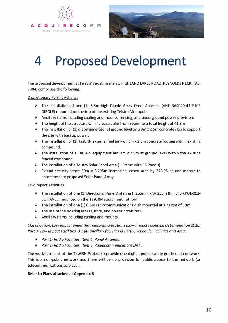
4 Proposed Development
The proposed development at Telstra’s existing site at, HIGHLAND LAKES ROAD, REYNOLDS NECK, TAS,
7304, comprises the following:
Discretionary Permit Activity:
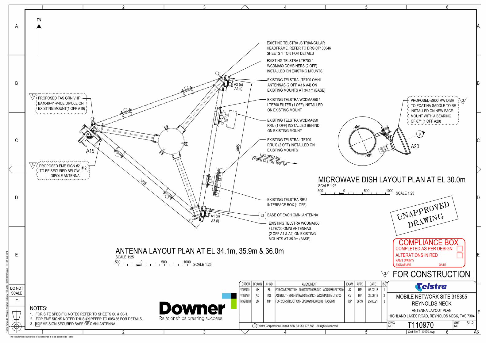
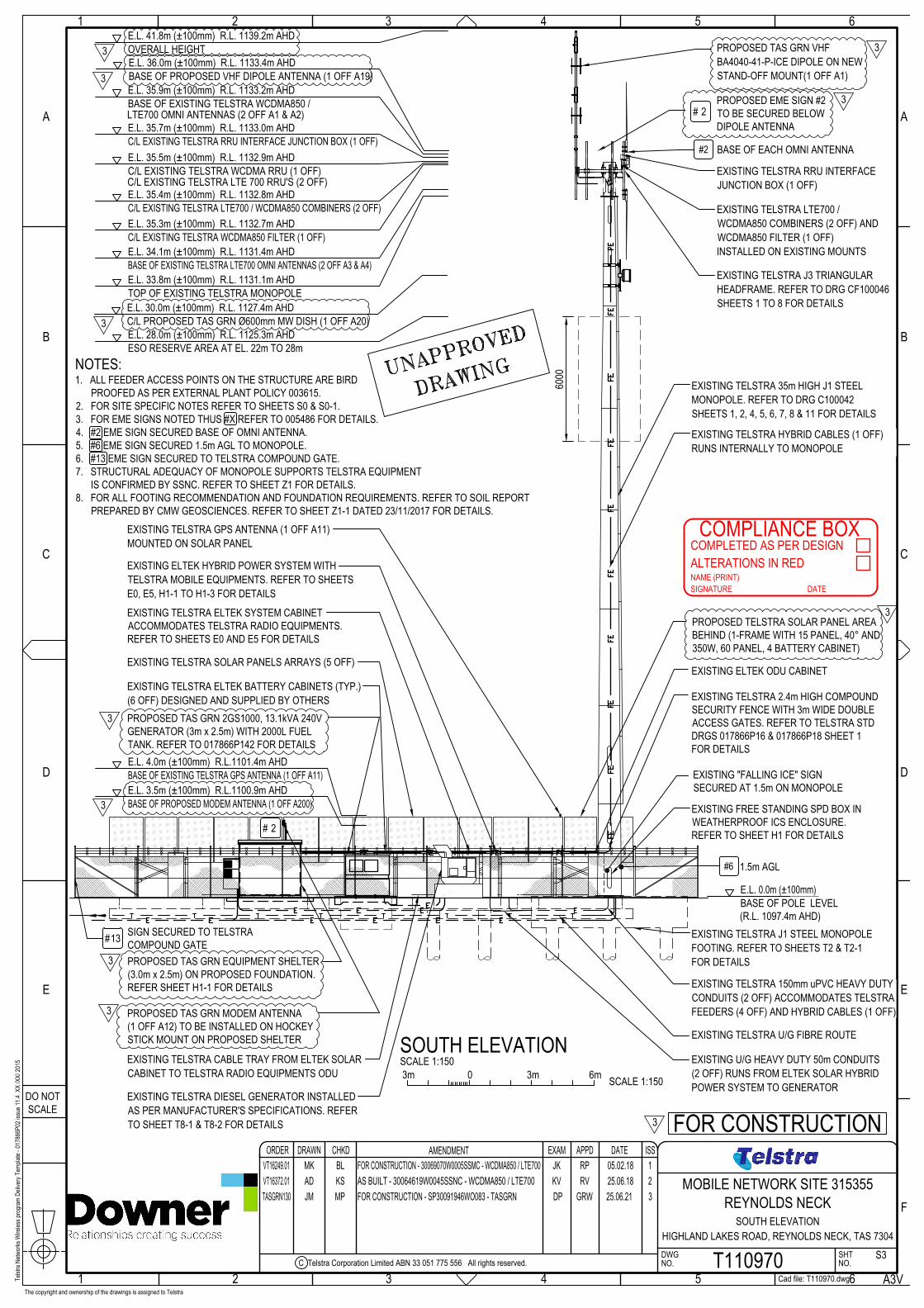
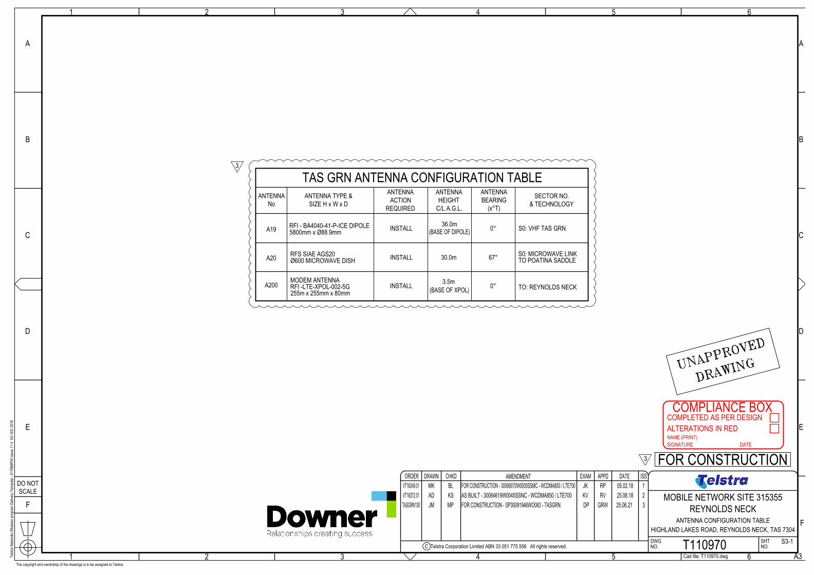
➢ The installation of one (1) 5.8m high Dipole Array Omni Antenna (VHF BA4040-41-P-ICE
DIPOLE) mounted on the top of the existing Telstra Monopole.
➢ Ancillary items including cabling and mounts, fencing, and underground power provision.
➢ The height of the structure will increase 2.3m from 39.5m to a total height of 41.8m
➢ The installation of (1) diesel generator at ground level on a 3m x 2.5m concrete slab to support
the site with backup power.
➢ The installation of (1) TasGRN external fuel tank on 3m x 2.5m concrete footing within existing
compound.
➢ The installation of a TasGRN equipment hut 3m x 2.5m at ground level within the existing
fenced compound.
➢ The installation of a Telstra Solar Panel Area (1 Frame with 15 Panels)
➢ Extend security fence 30m x 8.295m increasing leased area by 248.95 square meters to
accommodate proposed Solar Panel Array.
Low Impact Activities
➢ The installation of one (1) Directional Panel Antenna H 255mm x W 255m (RFI LTE-XPOL-002-
5G PANEL) mounted on the TasGRN equipment hut roof.
➢ The installation of one (1) 0.6m radiocommunications dish mounted at a height of 30m.
➢ The use of the existing access, fibre, and power provisions.
➢ Ancillary items including cabling and mounts.
Classification: Low Impact under the Telecommunications (Low-impact Facilities) Determination 2018:
Part 3- Low Impact Facilities, 3.1 (4) ancillary facilities & Part 3, Schedule, Facilities and Area:
➢ Part 1- Radio Facilities, Item 4, Panel Antenna.
➢ Part 1- Radio Facilities, Item 6, Radiocommunications Dish.
The works are part of the TasGRN Project to provide one digital, public-safety grade radio network.
This is a non-public network and there will be no provision for public access to the network (or
telecommunications services).
Refer to Plans attached at Appendix B.
11
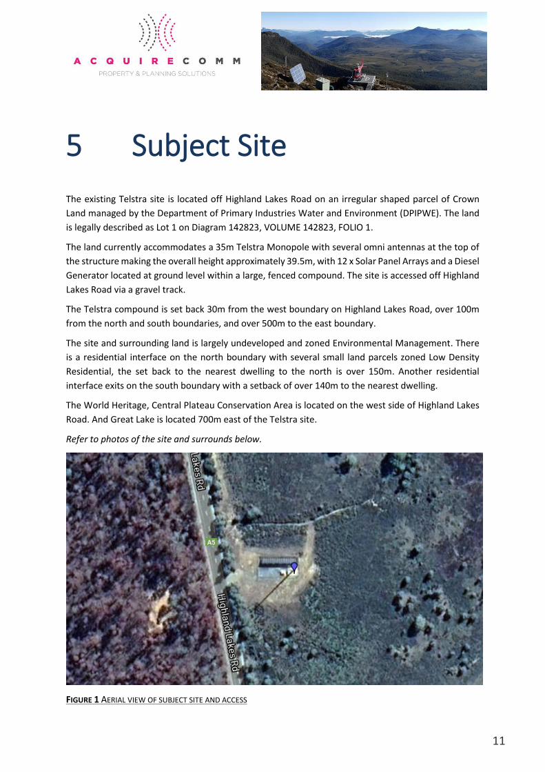
5 Subject Site
The existing Telstra site is located off Highland Lakes Road on an irregular shaped parcel of Crown
Land managed by the Department of Primary Industries Water and Environment (DPIPWE). The land
is legally described as Lot 1 on Diagram 142823, VOLUME 142823, FOLIO 1.
The land currently accommodates a 35m Telstra Monopole with several omni antennas at the top of
the structure making the overall height approximately 39.5m, with 12 x Solar Panel Arrays and a Diesel
Generator located at ground level within a large, fenced compound. The site is accessed off Highland
Lakes Road via a gravel track.
The Telstra compound is set back 30m from the west boundary on Highland Lakes Road, over 100m
from the north and south boundaries, and over 500m to the east boundary.
The site and surrounding land is largely undeveloped and zoned Environmental Management. There
is a residential interface on the north boundary with several small land parcels zoned Low Density
Residential, the set back to the nearest dwelling to the north is over 150m. Another residential
interface exits on the south boundary with a setback of over 140m to the nearest dwelling.
The World Heritage, Central Plateau Conservation Area is located on the west side of Highland Lakes
Road. And Great Lake is located 700m east of the Telstra site.
Refer to photos of the site and surrounds below.
FIGURE 1 AERIAL VIEW OF SUBJECT SITE AND ACCESS
12
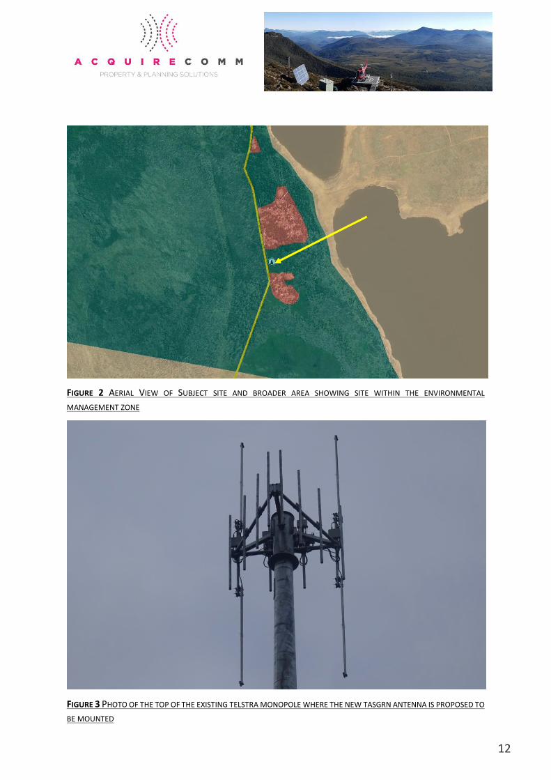
FIGURE 2 AERIAL VIEW OF SUBJECT SITE AND BROADER AREA SHOWING SITE WITHIN THE ENVIRONMENTAL
MANAGEMENT ZONE
FIGURE 3 PHOTO OF THE TOP OF THE EXISTING TELSTRA MONOPOLE WHERE THE NEW TASGRN ANTENNA IS PROPOSED TO
BE MOUNTED
13
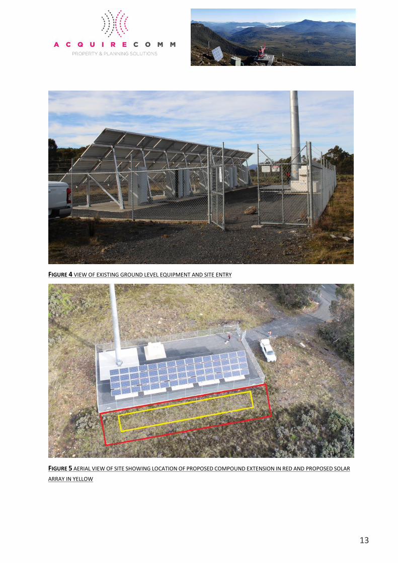
FIGURE 4 VIEW OF EXISTING GROUND LEVEL EQUIPMENT AND SITE ENTRY
FIGURE 5 AERIAL VIEW OF SITE SHOWING LOCATION OF PROPOSED COMPOUND EXTENSION IN RED AND PROPOSED SOLAR
ARRAY IN YELLOW
14
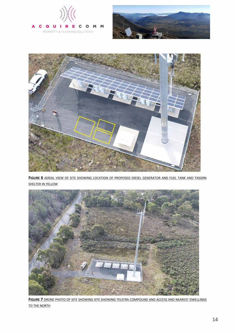
FIGURE 6 AERIAL VIEW OF SITE SHOWING LOCATION OF PROPOSED DIESEL GENERATOR AND FUEL TANK AND TASGRN
SHELTER IN YELLOW
FIGURE 7 DRONE PHOTO OF SITE SHOWING SITE SHOWING TELSTRA COMPOUND AND ACCESS AND NEAREST DWELLINGS
TO THE NORTH
15
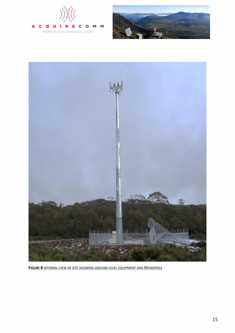
FIGURE 8 INTERNAL VIEW OF SITE SHOWING GROUND LEVEL EQUIPMENT AND MONOPOLE
16
6 Regulatory Framework &
Assessment
5.1 Federal Legislation
Radiocommunications Act 1992
The object of the Radiocommunications Act 1992 is to provide for management of the radiofrequency
spectrum in order to:
➢ maximise, by ensuring the efficient allocation and use of the spectrum, the overall public
benefit derived from using the radiofrequency spectrum.
➢ make adequate provision of the spectrum for use by public or community services.
➢ provide a responsive and flexible approach to meeting the needs of users of the spectrum.
➢ encourage the use of efficient radiocommunication technologies so that a wide range of
services of an adequate quality can be provided.
➢ provide an efficient, equitable and transparent system of charging for the use of spectrum,
taking account of the value of both commercial and non-commercial use of spectrum.
➢ support the communications policy objectives of the Commonwealth Government.
➢ provide a regulatory environment that maximises opportunities for the Australian
communications industry in domestic and international markets.
➢ promote Australia's interests concerning international agreements, treaties and conventions
relating to radiocommunications or the radiofrequency spectrum.
The TasGRN Network is licensed to operate the under the relevant spectrum requirements within the
420-430MHz (UHF) and 160-175MHz (VHF).
Telecommunications (Low Impact Facilities) Determination 2018
The Telecommunications (Low-impact Facilities) Determination came into effect on 1st July 1997 and
has recently been superseded by the Telecommunications (Low-impact Facilities) Determination 2018.
17
The Determination contains a list of Telecommunications (and Radiocommunications) Facilities that
the Commonwealth will continue to regulate. These are facilities that are essential to maintaining
telecommunications networks and are unlikely to cause significant community disruption during their
installation or operation. These facilities are therefore considered to be ‘Low-impact’ and do not
require planning approval under State or territory laws.
Whilst some of the works relating to the works at the site are defined under the Telecommunications
(Low-impact Facilities) Determination 2018, the proposed 5.8m omni antenna exceeds the height
requirements within the Determination, and therefore is required to be assessed under the relevant
state and local planning provisions along with the solar panel array, diesel generator and equipment
shelter.
Commonwealth Environment Protection and Biodiversity Conservation Act 1999
The Environment Protection and Biodiversity Conservation Act commenced on 16th July 2000. It
introduced a new role for the Commonwealth Government in the assessment and approval of
development proposals where those proposals involve actions that have a significant impact on
matters of National Environmental Significance, the environment of Commonwealth owned land and
actions carried out by the Commonwealth Government.
This proposal is not of National Environmental Significance, as it will not impact on:
➢ World Heritage Areas;
➢ Wetlands protected by International Treaty (The RAMSAR Convention);
➢ Nationally listed threatened species and communities;
➢ Nationally listed migratory species;
➢ All nuclear actions; or
➢ The environment of Commonwealth Marine area.
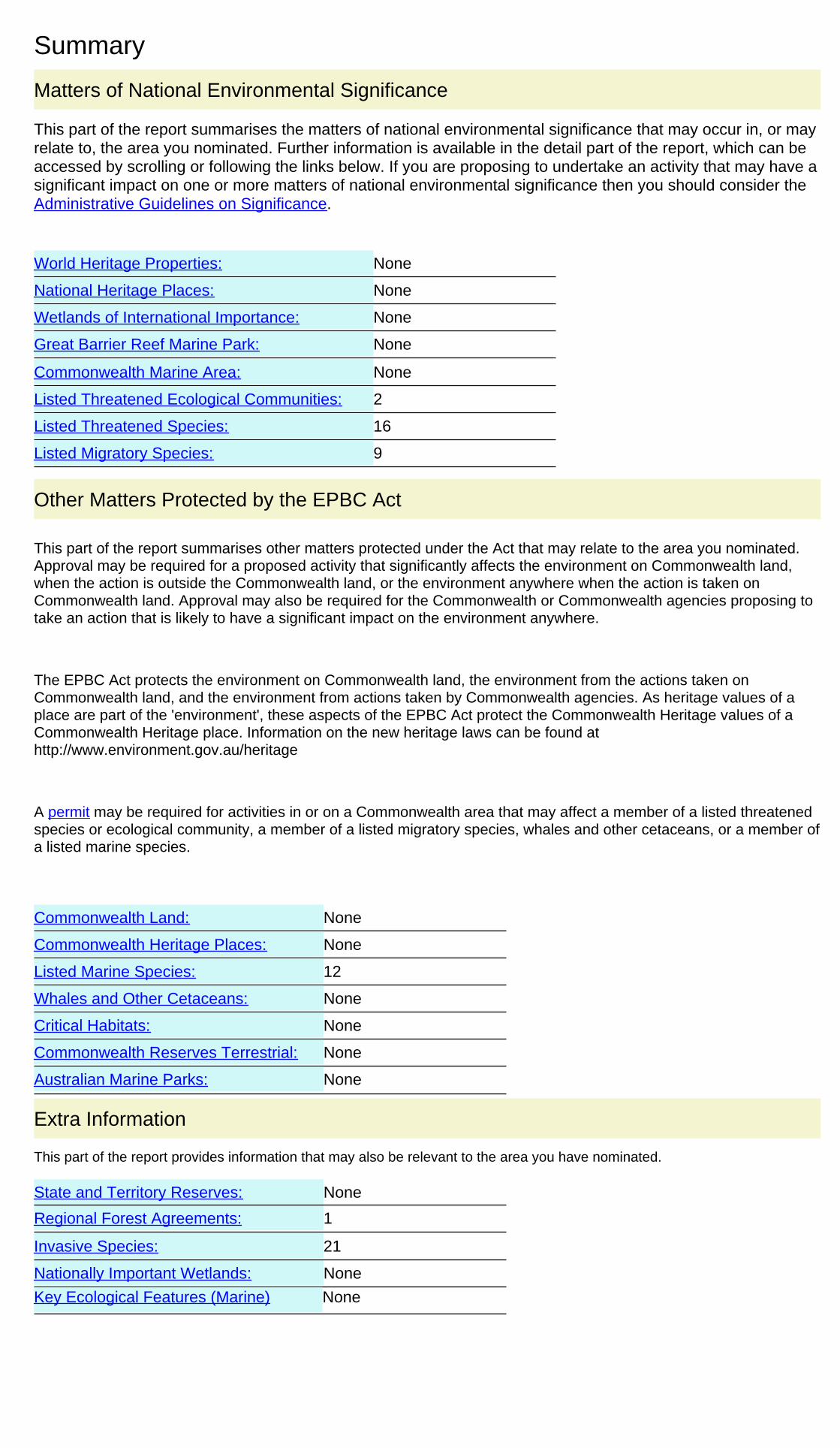
The EPBC Protected Matters report identifies 2 threatened ecological communities and 16 threatened
species in the region. The proposed upgrade is located on the existing Telstra Monopole and the
generator and shelter will be located within the existing fenced compound. The existing compound
fence will be extended increasing the compound area by 248.95 square meters to contain the
proposed solar panel array. Construction vehicles will utilise existing access and stand areas. Due to
the limited nature of the proposed works in terms of ground disturbance and duration there is no
undue threat to flora and fauna in the area.
Refer to EPBC Act Protected Matters Report at Appendix C.

18
Electromagnetic Energy and Health
EMF is sometimes known as electromagnetic radiation (EMR) or electromagnetic energy (EME).
Electromagnetic fields are present everywhere in our environment – the earth, sun and ionosphere
are all natural sources of EMF.
Telstra rely on the expert advice of international and national health authorities including the World
Health Organization (WHO) and the Australian Radiation Protection and Nuclear Safety Agency
(ARPANSA) for overall assessments of health and safety impacts.
The International Commission on Non-Ionizing Radiation Protection (ICNIRP) has issued guidelines on
levels of allowable public exposure to Radio Frequency (RF) fields, including guidelines on RF from
mobile phones and base stations that Telstra adheres to. These guidelines have a large safety margin
built into them.
Telstra confirms that the proposed TasGRN facility will comply with the mandated standard (RPS-S1)
for EMF set by ARPANSA, which is based on the safety guidelines recommended by the WHO. The
safety standard works by limiting the network signal to a level low enough to protect all people, in all
environments, 24 hours a day. The safety limit itself has a significant safety margin built into it.
Further information about EMF can be sourced at:
➢ Commonwealth Department of Health (ARPANSA) www.arpansa.gov.au
➢ Australian Communications and Media Authority (ACMA) www.acma.gov.au
➢ World Health Organisation (WHO) www.who.int/en/
Built and Cultural Heritage
Built and Cultural Heritage
In order to ascertain if any cultural or natural heritage values of local, state or national significance
apply to the site, a search was conducted of the relevant databases and heritage registers. The subject
site is not listed on the Tasmanian Heritage Register nor or there any Matters of National
Environmental Significance associated with the site.
No additional approvals or consideration is considered necessary on these matters.
Aboriginal Heritage
Aboriginal cultural heritage must be considered as part of all planning applications. This proposal was
assessed against the Aboriginal Heritage Tasmania (AHT) Property Search website to assess if there
were any matters of Aboriginal cultural heritage on the site. The search did not identify any registered
Aboriginal relics or apparent risk of impacting Aboriginal relics.
Refer to Appendix D for a copy of the AHT search record.
19
Telstra are aware that all Aboriginal heritage is protected under the Aboriginal Heritage Act 1975.
Telstra’s constructors will be notified that if any Aboriginal heritage is found, works are to cease
immediately and AHT be contacted for advice. The AHT Unanticipated Discovery Plan, will be provided
to the constructors to have on hand during ground disturbing works, to aid in meeting the
requirements under the Act.
5.2 Requirement for a Planning Permit
Under the provisions of the Central Highlands Planning Scheme, the proposed development falls
under a Utility definition. A Utility is a discretionary Use within the Environmental Management Zone.
However, pursuant to Clause 9.2.1, a discretionary use, must be considered as if that use class had
permitted status in that Use Table, where the proposal for development does not establish a new use,
or substantially intensify the use.
Under E19 Telecommunications Code, if the height of a telecommunications facility exceeds 60m
above natural ground level in the Environmental Management Zone, a Discretionary Permit is
required.
As the proposed TasGRN Omni antenna is located on the existing Telstra Monopole with the maximum
height of 41.8m, a Permitted Permit is required under the Telecommunications Code.
However, as the proposal does not meet all the acceptable solutions of the Zone Provisions, a
discretionary permit is required.
As such, an assessment of the proposal against the Acceptable Solutions (and where applicable) the
Performance Criteria of the Environmental Management Zone and Telecommunications Code is
provided below.
5.3 Central Highlands Planning Scheme Zone and Code Assessment
Clause 29 Environmental Management Zone
The proposed use and development is located within the Environmental Management Zone. A Utility
is a discretionary Use within the Environmental Management Zone. However, pursuant to Clause
9.2.1, a discretionary use, must be considered as if that use class had permitted status in that Use
Table, where the proposal for development does not establish a new use, or substantially intensify
the use.
An assessment is provided below against the Development Standards for Buildings and Works.
29.4.1 Building Height
20
Objective: To ensure that building height contributes positively to the landscape and does not result in
unreasonable impact on residential amenity of adjoining land.
Acceptable Solutions Assessment of Proposal
A1
Building height comply with any of the following:
(a) as proscribed in an applicable reserve management
plan;
(b) be no more than 7.5 m.
Not applicable as the maximum height in the
Telecommunications Code applies in this
instance.
(7.3.4) Where there is a conflict between a
provision in a code and a provision in a zone, the
code provision prevails.
29.4.2 Setback
Objective: To maintain desirable characteristics of the landscape, protect amenity of adjoining lots, avoid
land use conflict and fettering of use on nearby rural land and protect environmental values on adjoining
land zoned Environmental Living and adjoining land in the World Heritage Area.
Acceptable Solutions Assessment of Proposal
A1
Building setback from frontage must comply with any of
the following:
(a) as proscribed in an applicable reserve management
plan;
(b) be no less than 30 m.
Complies. The site is set back 30m from the
frontage of the property.
A2
Building setback from side and rear boundaries must
comply with any of the following:
(a) as proscribed in an applicable reserve management
plan;
(b) be no less than 30 m.
Complies. The smallest side setback is 100m to
the north boundary. The setback to the south
boundary is over 120m and the setback to the
rear boundary is over 500m.
A4
Building setback for buildings for sensitive use (including
residential use) must comply with all of the following:
(a) be sufficient to provide a separation distance from land
zoned Rural Resource no less than 100 m;
(b) be sufficient to provide a separation distance from land
zoned Significant Agriculture no less than 200 m.
Not applicable. The proposal is not for a
sensitive use.
A5
Buildings setback from the Tasmanian Wilderness World
Heritage Area must comply with any of the following:
Does not comply.
The setback to the World Heritage Area, Central
Plateau Conservation Area is already less that
21
(a) as proscribed in an applicable reserve management
plan;
(b) be no less than 500 m.
the prescribed 500m. The proposed compound
extension will maintain the existing setback.
Performance Criteria Assessment of Proposal
P5
Building setback from the Tasmanian Wilderness World
Heritage Area must satisfy all of the following:
(a) there is no significant impact from the development on
the environmental values of the land within the World
Heritage Area;
(b) the potential for the spread of weeds or soil pathogens
onto the land within the World Heritage Area is minimised;
(c) there is minimal potential for contaminated or
sedimented water runoff impacting the land within the
World Heritage Area;
(d) there are no reasonable and practical alternatives to
developing close to the land within the World Heritage
Area.
The proposed compound extension will
maintain the existing setback to the World
Heritage Tasmanian Wilderness Area.
There is no change to the established use on the
site which does impact significantly on the
environmental values of the World Heritage
Area. The proposed generator and equipment
shelter at ground level are located within the
existing fenced compound and the proposed
compound extension will be located on
previously disturbed ground on the north side.
Construction vehicles will utilise existing access
and stand areas and do not need to enter the
World Heritage Area minimising the potential
for the spread of weeds or soil pathogens.
Additionally, there will not be a significant
impact to matters relating to the existing
conditions for water runoff on the site, the new
compound area will have a permeable thick
gravel topping consistent with the existing
compound area. Once the antenna is integrated
with the TasGRN network and operational the
facility will require minimal maintenance.
The proposed omni antenna is a critical
element in the new Tasmanian Government
Radio Network and is sited to ensure efficient
and safe operation of the network.
The site is existing and therefore has been
assessed against this provision at its
establishment. The proposed upgrade works
ensure co-location on an existing facility. As
such there are no reasonable or practical
alternatives for a site set back further from the
WHA.
29.4.3 Design
Objective: To ensure that the location and appearance of buildings and works minimises adverse impact
on natural values and on the landscape.
22
Acceptable Solutions Assessment of Proposal
A1
The location of buildings and works must comply with any
of the following:
(a) be located on a site that does not require the clearing
of native vegetation and is not on a skyline or ridgeline;
(b) be located within a building area, if provided on the
title;
(c) be an addition or alteration to an existing building;
(d) as prescribed in an applicable reserve management
plan.
Complies. The proposed works meet item c), an
addition or alteration to an existing building.
The proposed TasGRN antenna is located on the
existing Telstra Monopole and the proposed
generator and equipment shelter will be
located in the existing compound. The
proposed new solar panels will be located
within a 248.95 square extension adjacent to
the existing compound area.
A2
Exterior building surfaces must be coloured using colours
with a light reflectance value not greater than 40 percent.
Complies. The omni antenna has a low
reflective galvanised steel finish. The diesel
generator and TasGRN shelter will be in a
muted non-reflective tone (pale eucalypt).
A3
Fill and excavation must comply with all of the following:
(a) height of fill and depth of excavation is no more than 1
m from natural ground level, except where required for
building foundations;
(b) extent is limited to the area required for the
construction of buildings and vehicular access.
Complies. The depth of excavation relating to
the concrete pad footings to support the
generator, equipment shelter, and solar panels
will be no more than 1m.
The concrete pads will be no larger than
required to support the proposed structures.
E19.0 Telecommunications Code
The purpose of this provision is to:
➢ facilitate equitable provision and access to high-speed broadband and telecommunication
networks as services essential for the prosperity, security and welfare of the community;
➢ encourage new telecommunication and digital facilities to form part of a local or regional
telecommunications network for all carriers;
➢ encourage shared use and co-location of facilities to minimise the number of towers within the
municipal area;
➢ minimise likely adverse impact of communication systems on community health and safety;
➢ minimise adverse visual impact of towers and antennae.
An assessment is provided below against the Development Standards for Buildings and Works.
E19.7.1 Shared Use and Co-Location
Objective: To minimise the total number of towers and antenna within the municipal area.
23
Acceptable Solutions Assessment of Proposal
A1
A new antenna must be located on an existing tower.
Complies. The new TasGRN omni antenna is
located on the existing Telstra Monopole.
A2
A new tower or mast must be structurally and technically
designed to accommodate comparable additional users,
including by the rearrangement of existing antenna and
the mounting of antenna at different heights.
Not applicable. The proposal is not for a new
mast.
E19.7.2 Visual Amenity
Objective: To minimise detrimental impact upon the visual amenity of a locality by reducing prominence
of telecommunications infrastructure.
Acceptable Solutions Assessment of Proposal
A1
The location of telecommunications infrastructure must
comply with all of the following:
(a) be within existing utility corridors and sites and use
existing infrastructure;
(b) be externally finished and maintained in a neutral
colour that minimises visual intrusiveness;
(c) not:
(i) be located on skylines that can be seen in silhouette;
(ii) be aligned diagonally to the principal slope of a hill;
(iii) cross at a low point of a saddle between hills;
(iv) be located around the base of a hill;
(v) be along the edge of an existing clearing;
(vi) be artificially lit unless required for air navigation
safety;
(vii) be used for signage purposes, other than necessary
warning and equipment information,
(d) aerial telecommunication lines or additional supporting
structures are erected and operated in residential and
commercial areas only where overhead cables exist;
(e) equipment housing and other visually intrusive
infrastructure is screened from public view.
a) Complies. The proposal is located on
existing infrastructure.
b) Complies. The new TasGRN antenna is a
natural product finish and is non reflective.
The equipment shelter and diesel
generator will be in muted non-reflective
tones.
c) Complies. The proposed TasGRN antenna is
located on existing infrastructure.
d) Not applicable. The proposed TasGRN
antenna is not located in a commercial or
residential area.
e) Complies. Current visibility of the existing
compound area is limited to a short section
of Highland Lakes Road approximately
100m north and south of the site where
passing traffic has fleeting views of the
ground level equipment contained within
the existing fenced compound. The
proposed compound extension and ground
level equipment will not significantly
change the existing views which are
predominantly screened by roadside
vegetation.
A2
24
Height above natural ground level must be no more than:
(a) 60 metres in the Environmental Management,
Rural Resource and Significant Agriculture Zones;
(b) 45 metres in the General Industrial or Port and
Marine Zone;
(c) 40 metres in the Central Business, Commercial,
Environmental Living, General Business, Major Tourism,
Rural Living and Utilities Zones;
(d) 20 metres in the Community Purpose, General
Residential, Inner Residential, Light Industrial, Local
Business, Low Density Residential, Recreation, Urban
Mixed Use and Village Zones.
Complies. The new TasGRN omni antenna will
be located below the prescribed 60m in the
Environmental Management Zone. The total
structure height will be 41.8m.
E19.7.3 Environmental Values
Objective: To ensure that environmental values are protected
Acceptable Solutions Assessment of Proposal
A1
Telecommunications infrastructure must not be
located in an area of environmental significance.
Complies. The site is not located within an area of
environmental significance.
E19.7.4 Access
Objective: To ensure that telecommunications infrastructure does not impede movement of vehicular and
other modes of transport.
Acceptable Solutions Assessment of Proposal
A1
Telecommunications infrastructure must not impede
movement of vehicular and other modes of
transport.
Complies. The proposed development will rely on the
existing access conditions to the site. Once the facility
is operational and integrated with the TasGRN
network, the facility will require minimal
maintenance.
E19.7.5 Significant Agricultural Land
Objective: To protect the productive capacity and efficient farming operations of significant agricultural
land.
Acceptable Solutions Assessment of Proposal
A1 Not Applicable.
25
Telecommunications infrastructure within the
Significant Agriculture Zone must be placed on or
within 2 metres of property boundaries or fence
lines.
The proposed development meets all Acceptable Solutions and (where applicable) the Performance
Criteria within the development standards of the Environmental Management Zone and the
Telecommunications Code. As such, a discretionary permit is required.
The omni antenna and ground level equipment is a critical element in the new Tasmanian Government
Radio Network and is sited to ensure the efficient and safe operation of the network.
Overall, the proposed development represents minimal change to the existing conditions on the site.
The facility has been appropriately sited and designed to minimise visibility and amenity impacts on
the surrounding environment as much as possible. There will minimal visual impact from the proposed
installation and a small height increase to the total structure height of 2.3m.
In the overall context of the social and economic benefits the TASGRN Network will deliver, a
reasonable balance has been struck with the addition of one (1) 5.8m omni antenna to the existing
Telstra Monopole and the installation of a diesel generator, equipment hut and solar panel array at
ground level.
6 Conclusion
This application forms an integral part of the TasGRN Project. The Project is a direct result of the
Tasmanian Government’s response to the Report of the Auditor-General No. 10 of 2013-2014 which
recommended a whole-of-Government radio network (Tasmanian Government Radio Network -
TasGRN).
The result will be a more reliable and resilient network enabling the provision of better services to the
Tasmanian community.
The proposed development meets the development standards of the Environmental Management
Zone and the Telecommunications Code.
The proposed upgrade to the existing Telstra Monopole at HIGHLAND LAKES ROAD, REYNOLDS NECK,
TAS, 7304 will from an integral component in the new Tasmanian Government Radio Network.
Acquirecomm on behalf of Telstra, have undertaken an assessment of the relevant matters as required
by the Radiocommunications Act 1992, the Telecommunications Act 1997, the Central Highlands
Planning Scheme 2015, the Environment Protection and Biodiversity Conservation Act 2000, and the
26
Aboriginal Heritage Act 1975. The proposal is considered appropriate in light of the relevant
legislative, environmental, technical, radio coverage and public safety requirements.
This assessment demonstrates that the proposal achieves a reasonable balance between the provision
of essential radio communication services and the need to protect the environment from adverse
impacts from such development. It is respectively requested that permission is granted for this permit
application.
d on cleared land ensuring no impact to ecological systems. The site is located at the

i
Appendix A Certificate of Title
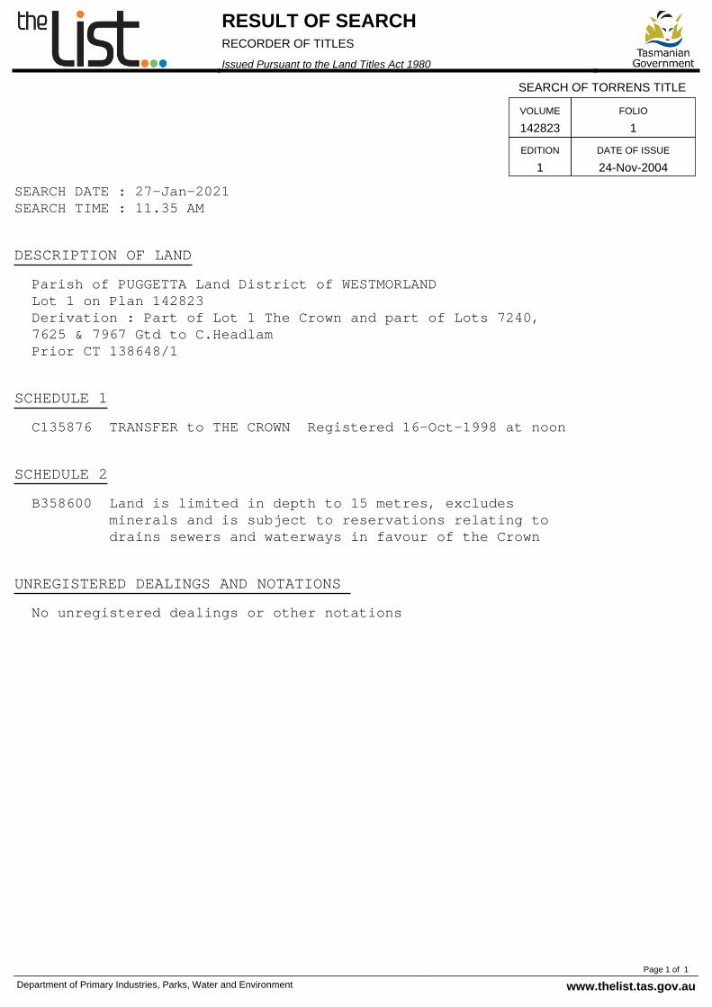
SEARCH DATE : 27-Jan-2021SEARCH TIME : 11.35 AM
DESCRIPTION OF LAND Parish of PUGGETTA Land District of WESTMORLAND Lot 1 on Plan 142823 Derivation : Part of Lot 1 The Crown and part of Lots 7240, 7625 & 7967 Gtd to C.Headlam Prior CT 138648/1
SCHEDULE 1 C135876 TRANSFER to THE CROWN Registered 16-Oct-1998 at noon
SCHEDULE 2 B358600 Land is limited in depth to 15 metres, excludes minerals and is subject to reservations relating to drains sewers and waterways in favour of the Crown
UNREGISTERED DEALINGS AND NOTATIONS No unregistered dealings or other notations
SEARCH OF TORRENS TITLE
VOLUME
142823FOLIO
1
EDITION
1DATE OF ISSUE
24-Nov-2004
RESULT OF SEARCHRECORDER OF TITLES
Issued Pursuant to the Land Titles Act 1980
Department of Primary Industries, Parks, Water and Environment www.thelist.tas.gov.auPage 1 of 1
ii
Appendix B Plans and Elevations
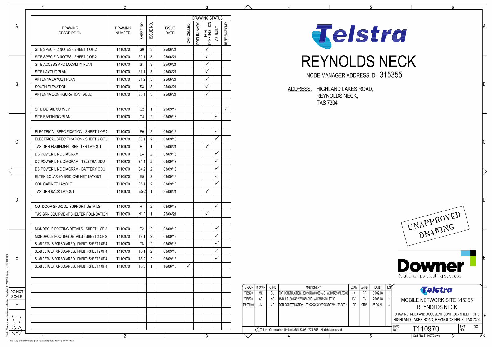
The copyright and ownership of the drawings is to be assigned to Telstra
REYNOLDS NECKADDRESS:
315355HIGHLAND LAKES ROAD,REYNOLDS NECK,TAS 7304
ORDERDO NOTSCALE
F
1
E
D
2 3
C
B
A
1 2 3
C Telstra Corporation Limited ABN 33 051 775 556 All rights reserved.
4 5
DWGNO.
DRAWN CHKD AMENDMENT DATEEXAM APPD ISS
6NO.SHT
A3
F
E
D
4 5
C
B
6
A
Cad file: T110970.dwg
MOBILE NETWORK SITE 315355REYNOLDS NECK
T110970 DC
DRAWING INDEX AND DOCUMENT CONTROL - SHEET 1 OF 3HIGHLAND LAKES ROAD, REYNOLDS NECK, TAS 7304
NODE MANAGER ADDRESS ID:
DRAWING STATUS
SHEE
T NO
.
DRAWINGNUMBER
DRAWINGDESCRIPTION
ISSU
E NO
.
ISSUEDATE
CANC
ELLE
D
PREL
IMIN
ARY
CONS
TRUC
TION
AS B
UILT
FOR
REFE
RENC
E ONL
Y
Telst
ra N
etwor
ks W
ireles
s pro
gram
Deli
very
Temp
late -
0178
66P0
2 iss
ue 11
.4 X
X /X
X/ 20
15
25/06/21
SITE ACCESS AND LOCALITY PLAN S1
S3SOUTH ELEVATION
S0T110970SITE SPECIFIC NOTES - SHEET 1 OF 2
OUTDOOR SPD/ODU SUPPORT DETAILS H1
ELECTRICAL SPECIFICATION - SHEET 1 OF 2 E0
3
T110970
T110970
T110970
T110970
T110970
03/09/18
03/09/18
03/09/18
P
P
P
P
P
P
ANTENNA LAYOUT PLAN S1-2T110970 P
S3-1ANTENNA CONFIGURATION TABLE T110970 P
ELTEK SOLAR HYBRID CABINET LAYOUT E5T110970 03/09/18 P
S0-1T110970SITE SPECIFIC NOTES - SHEET 2 OF 2 P
SITE LAYOUT PLAN S1-1T110970 P
2
2
2
2
SITE EARTHING PLAN G4 2T110970 03/09/18 P
MONOPOLE FOOTING DETAILS - SHEET 1 OF 2 T2T110970 03/09/18 P2
SLAB DETAILS FOR SOLAR EQUIPMENT - SHEET 1 OF 4
T8-1
T110970 03/09/18 P2
SLAB DETAILS FOR SOLAR EQUIPMENT - SHEET 2 OF 4 T110970 03/09/18 P2
DC POWER LINE DIAGRAM E4
T110970 03/09/18 P2DC POWER LINE DIAGRAM - TELSTRA ODU E4-1
T110970 03/09/18 P2DC POWER LINE DIAGRAM - BATTERY ODU E4-2
T8
ODU CABINET LAYOUT E5-1T110970 03/09/18 P2
ELECTRICAL SPECIFICATION - SHEET 2 OF 2 E0-1T110970 03/09/18 P2
T2-1T110970 03/09/18 P2MONOPOLE FOOTING DETAILS - SHEET 2 OF 2
SLAB DETAILS FOR SOLAR EQUIPMENT - SHEET 3 OF 4
T8-3
T110970 03/09/18 P2
SLAB DETAILS FOR SOLAR EQUIPMENT - SHEET 4 OF 4 T110970 16/06/18 P1
T8-2
SITE DETAIL SURVEY G2 1T110970 29/09/17 P
VT16372.01 AD KS AS BUILT - 30064619W0045SSNC - WCDMA850 / LTE700 KV RV 25.06.18 2VT16249.01 MK BL FOR CONSTRUCTION - 30069070W0005SSMC - WCDMA850 / LTE700 JK RP 05.02.18 1
TASGRN0XX JM MP FOR CONSTRUCTION - SPXXXXXXXWO0XXDOWN - TASGRN DP GRW 25.06.21 3
25/06/21
25/06/21
25/06/21
25/06/21
25/06/21
25/06/21
3
3
3
3
3
3
TAS GRN EQUIPMENT SHELTER LAYOUT E1T110970 P1 25/06/21
T110970 P1 25/06/21
T110970 P1 25/06/21
E5-2
H1-1
TAS GRN RACK LAYOUT
TAS GRN EQUIPMENT SHELTER FOUNDATION
AutoCAD SHX Text
UNAPPROVED
AutoCAD SHX Text
DRAWING
The copyright and ownership of the drawings is to be assigned to Telstra
CROWN LAND (TENURE ID 1207)TITLE REFERENCE 142823/1
PROPERTY DESCRIPTION
ORDERDO NOTSCALE
F
1
E
D
2 3
C
B
A
1 2 3
C Telstra Corporation Limited ABN 33 051 775 556 All rights reserved.
4 5
DWGNO.
DRAWN CHKD AMENDMENT DATEEXAM APPD ISS
6NO.SHT
A3
F
E
D
4 5
C
B
6
A
Cad file: T110970.dwg
MOBILE NETWORK SITE 315355REYNOLDS NECK
T110970 S1
SITE ACCESS AND LOCALITY PLANHIGHLAND LAKES ROAD, REYNOLDS NECK, TAS 7304
TN
SITE STRUCTURE CO-ORDINATES (GDA94)GPS READING ACCURACY: ± 10m
CENTRE OF POLELATITUDE -41.86061° (GDA94)
146.69550° (GDA94)LONGITUDE
LOCALITY PLANNOT TO SCALE
COPYRIGHT C WHEREIS REGISTERED TRADEMARK OF SENSIS PTY LTD.R
Telst
ra N
etwor
ks W
ireles
s pro
gram
Deli
very
Temp
late -
0178
66P0
2 iss
ue 11
.4 X
X /X
X/ 20
15
SITE ACCESS SCALE 1:2500
SCALE 1:25000 100m50m 50m
NOTE:1. FOR SITE SPECIFIC NOTES REFER TO SHEETS S0 & S0-1.
RFNSA SITE No. 7304015
EXISTING HOUSE (TYP.)
EXISTING TREES (TYP.)
HIGHLAND LAKES ROAD
PROPOSED TAS GRN INSTALLATION INEXISTING TELSTRA COMPOUND. REFERTO SHEET S1-1 FOR SITE LAYOUT PLAN
PROPERTY BOUNDARY (TYP.)
EXISTING TELSTRAACCESS TRACK APPROX.30m LONG. REFER TOTELSTRA STD DRAWING017866P155 FOR DETAILS
EXISTING TELSTRA U/GFIBRE ROUTE
EXISTING TELSTRADRIVEWAY AND CROSSOVER
EXISTING TELSTRAFIBRE PIT
HEADLAM ROAD
HEADLAM ROAD
VT16372.01 AD KS AS BUILT - 30064619W0045SSNC - WCDMA850 / LTE700 KV RV 25.06.18 2VT16249.01 MK BL FOR CONSTRUCTION - 30069070W0005SSMC - WCDMA850 / LTE700 JK RP 05.02.18 1
TASGRN130 JM MP FOR CONSTRUCTION - SP30091946WO083 - TASGRN DP GRW 25.06.21 3
FOR CONSTRUCTIONSIGNATURE
COMPLETED AS PER DESIGNALTERATIONS IN RED
DATENAME (PRINT)
COMPLIANCE BOX
3
3
159807
TO NEAREST HOUSE146587
TO NEAREST HOUSE
AutoCAD SHX Text
UNAPPROVED
AutoCAD SHX Text
DRAWING
PROPOSED TAS GRN MODEM ANTENNA (1-OFF A200 ) TO BEINSTALLED ON HOCKEY STICK MOUNT ON PROPOSED SHELTER
EXISTING TELSTRA COMPOUNDGROUND LEVELLED AND COMPACTEDPRIOR TO CONSTRUCTION
EXISTING ELTEK CABINET (1 OFF) ACCOMMODATESTELSTRA RADIO EQUIPMENTS. REFER TO SHEETSE0 AND E5-1 FOR DETAILS
EXISTING ELTEK HYBRID POWER SYSTEM WITH TELSTRAMOBILE EQUIPMENTS (DESIGNED AND SUPPLIED BY OTHERS).REFER TO SHEETS E0, E5, T8 & T8-1 FOR DETAILS
EXISTING TELSTRA ELTEK BATTERY CABINETS (TYP.)(6 OFF) DESIGNED AND SUPPLIED BY OTHERS
EXISTING TELSTRA J1 STEEL MONOPOLE FOOTING.REFER TO SHEETS T2 & T2-1 FOR DETAILS
EXISTING TELSTRA 35m HIGH J1 STEEL MONOPOLE. REFERTO DRG C100042 SHEETS 1, 2, 4, 5, 6, 7, 8 & 11 FOR DETAILS
The copyright and ownership of the drawings is to be assigned to Telstra
ORDERDO NOTSCALE
F
1
E
D
2 3
C
B
A
1 2 3
C Telstra Corporation Limited ABN 33 051 775 556 All rights reserved.
4 5
DWGNO.
DRAWN CHKD AMENDMENT DATEEXAM APPD ISS
6NO.SHT
A3
F
E
D
4 5
C
B
6
A
Cad file: T110970.dwg
MOBILE NETWORK SITE 315355REYNOLDS NECK
T110970 S1-1
SITE LAYOUT PLANHIGHLAND LAKES ROAD, REYNOLDS NECK, TAS 7304
TN
Telst
ra N
etwor
ks W
ireles
s pro
gram
Deli
very
Temp
late -
0178
66P0
2 iss
ue 11
.4 X
X /X
X/ 20
15
NOTES:1. FOR SITE SPECIFIC NOTES REFER TO SHEETS S0 & S0-1.2. FOR EME SIGNS NOTED THUS #X REFER TO 005486 FOR DETAILS.3. #6 EME SIGN SECURED 1.5m AGL TO MONOPOLE.4. #13 EME SIGN SECURED TO TELSTRA COMPOUND GATE.5. COMPOUND GROUND AND ACCESS TRACK PREPARED TO ACHIEVE 100kPA
(MIN.), GEOTECHNICAL ENGINEER TO CONFIRM PRIOR TO CONSTRUCTION.REFER TO GEOTECH REPORT: TG17008.10-02 FOR DETAILS.
SITE LAYOUT PLANSCALE 1:150
TN
SCALE 1:1500 3m 6m3m
STRU
CTUR
EOR
IENT
ATIO
N 0°
TN
MONO
POLE
C/L
SIGN SECURED TO TELSTRACOMPOUND GATE #13
EXISTING TELSTRA 75 MIN. THICK GRAVEL TOPPINGON WEED MAT WITH TREATED PINE TIMBER EDGING
EXISTING TELSTRA ACCESSROAD. REFER TO TELSTRA STDDRG 017866P155 FOR DETAILS
1.5m AGL#6
REFER TO SHEET S1-2 FOR ANTENNA LAYOUT PLAN
EXISTING TELSTRA 300 WIDE CABLE TRAY FROM ELTEKSOLAR CABINET TO TELSTRA RADIO EQUIPMENTS ODU
EXISTING FREE STANDING SPD BOX IN WEATHERPROOFICS ENCLOSURE. REFER TO SHEET H1 FOR DETAILS
EXISTING TELSTRA GPS ANTENNA (1 OFF A11)MOUNTED ON SOLAR PANEL
EXISTING TELSTRA 2.4m HIGH COMPOUND SECURITY FENCEWITH 3m WIDE DOUBLE ACCESS GATES. REFER TO TELSTRASTD DRGS 017866P16 & 017866P18 SHEET 1 FOR DETAILS
EXISTING SOLAR PANELSUPPORT FRAME FOOTING(4000 x 4000 x 100, TYP.). TO SATISFYSNOW/ICE LOADING AND INSTALLEDAS PER MANUFACTURESSPECIFICATIONS. REFER TO SHEETT8 & T8-1 FOR FOOTING DETAILS
EXISTING U/G HEAVY DUTY Ø50mm CONDUITS (2 OFF) RUNSFROM ELTEK SOLAR POWER CABINET TO GENERATOR
EXISTING TELSTRA DIESEL GENERATOR INSTALLED AS PERMANUFACTURER'S SPECIFICATIONS ON CONCRETE FOOTING(4000 x 4000). REFER TO SHEET T8-1 & T8-2 FOR DETAILS
EXISTING TELSTRA 12 x SOLARPANEL ARRAYS (5 OFF)INCLINED AT 40° WITH GROUND
30000EXISTING TELSTRA LEASE AND COMPOUND AREA
EXISTING TELSTRA U/GFIBRE ROUTE
EXISTING TELSTRA 150mm uPVC HEAVY DUTY CONDUITS(2 OFF) ACCOMMODATES HYBRID CABLES (1 OFF)
526
500
1097.331097.46
1097.59
1097.31
1097.30
42501500
500
EXISTING "FALLING ICE" SIGNSECURED TO TELSTRACOMPOUND GATE
EXISTING "FALLING ICE" SIGNSECURED AT 1.5m ON MONOPOLE
VT16372.01 AD KS AS BUILT - 30064619W0045SSNC - WCDMA850 / LTE700 KV RV 25.06.18 2
EXISTING TELSTRA ELTEK ODU CABINET
VT16249.01 MK BL FOR CONSTRUCTION - 30069070W0005SSMC - WCDMA850 / LTE700 JK RP 05.02.18 1
EXISTING PS SURGE ARRESTORDEVICE MOUNTED ON SOLAR PANEL
2000
2900
4250
10001000
30000EXTEND TELSTRA LEASE AND COMPOUND AREA
3000
3000
2900
FOR CONSTRUCTIONSIGNATURE
COMPLETED AS PER DESIGNALTERATIONS IN RED
DATENAME (PRINT)
COMPLIANCE BOX3
3C/L MONOPOLE
REMOVE PART OF EXISTING TELSTRA FENCE
PROPOSED EXTEND FENCE(NEW COMPOUND AREA - 248.95m²)
3
3
PROPOSED TELSTRA SOLARPANEL AREA (1-FRAME WITH15 PANEL, 40°)
PROPOSED TELSTRASOLAR PANEL AREA(350W, 60 PANEL, 3BATTERY CABINET)
3
3
PROPOSED TAS GRN 2GS1000, 13.1kVA 240V GENERATOR (3m x 2.5m)WITH 2000L FUEL TANK. REFER TO 017866P142 FOR DETAILS
PROPOSED TAS GRN EQUIPMENT SHELTER (3.0m x 2.5m) ONPROPOSED FOUNDATION. REFER SHEET H1-1 FOR DETAILS
3
3
3
A200
# 23 PROPOSED EME #2 SIGN
TO BE SECURED TO BASEOF MODEM ANTENNA
600
TASGRN130 JM MP FOR CONSTRUCTION - SP30091946WO083 - TASGRN DP GRW 25.06.21 3
PROPOSED INSTALL SURVEILLANCECAMERA (1 OFF CCTV)
3
PROPOSED TASGRN EXTERNALFUEL TANK ON PROPOSEDFOUNDATION (3m x 2.5m)
3
1500
0EX
ISTI
NG T
ELST
RA LE
ASE
AND
COMP
OUND
ARE
A82
95EX
TEND
TEL
STRA
LEAS
EAN
D CO
MPOU
ND A
REA
AutoCAD SHX Text
UNAPPROVED
AutoCAD SHX Text
DRAWING
EXISTING TELSTRA J3 TRIANGULARHEADFRAME. REFER TO DRG CF100046SHEETS 1 TO 8 FOR DETAILS
The copyright and ownership of the drawings is to be assigned to Telstra
ORDERDO NOTSCALE
F
1
E
D
2 3
C
B
A
1 2 3
C Telstra Corporation Limited ABN 33 051 775 556 All rights reserved.
4 5
DWGNO.
DRAWN CHKD AMENDMENT DATEEXAM APPD ISS
6NO.SHT
A3
F
E
D
4 5
C
B
6
A
Cad file: T110970.dwg
MOBILE NETWORK SITE 315355REYNOLDS NECK
T110970 S1-2
ANTENNA LAYOUT PLANHIGHLAND LAKES ROAD, REYNOLDS NECK, TAS 7304
TN
Telst
ra N
etwor
ks W
ireles
s pro
gram
Deli
very
Temp
late -
0178
66P0
2 iss
ue 11
.4 X
X /X
X/ 20
15
HEADFRAMEORIENTATION 100°TN
ANTENNA LAYOUT PLAN AT EL 34.1m, 35.9m & 36.0mSCALE 1:25
0 1000500 SCALE 1:25500
EXISTING TELSTRA WCDMA850/ LTE700 OMNI ANTENNAS(2 OFF A1 & A2) ON EXISTINGMOUNTS AT 35.9m (BASE)
A2 (u)
A1 (u)A3 (i)
A4 (i)
#2 BASE OF EACH OMNI ANTENNA
EXISTING TELSTRA LTE700RRU'S (2 OFF) INSTALLED ONEXISTING MOUNTS
EXISTING TELSTRA LTE700 /WCDMA80 COMBINERS (2 OFF)INSTALLED ON EXISTING MOUNTS
NOTES:1. FOR SITE SPECIFIC NOTES REFER TO SHEETS S0 & S0-1.2. FOR EME SIGNS NOTED THUS #X REFER TO 005486 FOR DETAILS.3. #2 EME SIGN SECURED BASE OF OMNI ANTENNA.
EXISTING TELSTRA LTE700 OMNIANTENNAS (2 OFF A3 & A4) ONEXISTING MOUNTS AT 34.1m (BASE)
EXISTING TELSTRA WCDMA850RRU (1 OFF) INSTALLED BEHINDON EXISTING MOUNT
EXISTING TELSTRA WCDMA850 /LTE700 FILTER (1 OFF) INSTALLEDON EXISTING MOUNT
EXISTING TELSTRA RRUINTERFACE BOX (1 OFF)
2865
VT16372.01 AD KS AS BUILT - 30064619W0045SSNC - WCDMA850 / LTE700 KV RV 25.06.18 2VT16249.01 MK BL FOR CONSTRUCTION - 30069070W0005SSMC - WCDMA850 / LTE700 JK RP 05.02.18 1
FOR CONSTRUCTIONSIGNATURE
COMPLETED AS PER DESIGNALTERATIONS IN RED
DATENAME (PRINT)
COMPLIANCE BOX
3
MICROWAVE DISH LAYOUT PLAN AT EL 30.0mSCALE 1:25
0 1000500 SCALE 1:25500
3055
0
A20A19
PROPOSED TAS GRN VHFBA4040-41-P-ICE DIPOLE ONEXISTING MOUNT(1 OFF A19)
3PROPOSED Ø600 MW DISHTO POATINA SADDLE TO BEINSTALLED ON NEW FACEMOUNT WITH A BEARINGOF 67° (1 OFF A20)
3
PROPOSED EME SIGN #2TO BE SECURED BELOW
DIPOLE ANTENNA
# 23
TASGRN130 JM MP FOR CONSTRUCTION - SP30091946WO083 - TASGRN DP GRW 25.06.21 3
AutoCAD SHX Text
UNAPPROVED
AutoCAD SHX Text
DRAWING
DO NOT
1
SCALE
2
ORDER
E
D
C Telstra Corporation Limited ABN 33 051 775 556 All rights reserved.
AMENDMENT
3
DRAWN CHKD
4
EXAM APPD
DWGNO.
5
ISSDATE
NO.SHT
A3V6
F
E
D
C
B
A
1 2
C
B
3 4 5
A
6
Cad file: T110970.dwg
MOBILE NETWORK SITE 315355REYNOLDS NECK
T110970 S3
SOUTH ELEVATIONHIGHLAND LAKES ROAD, REYNOLDS NECK, TAS 7304
The copyright and ownership of the drawings is assigned to Telstra
Telst
ra N
etwor
ks W
ireles
s pro
gram
Deli
very
Temp
late -
0178
66P0
2 iss
ue 11
.4 X
X /X
X/ 20
15
SOUTH ELEVATIONSCALE 1:150
SCALE 1:1500 3m 6m3m
E.L. 41.8m (±100mm) R.L. 1139.2m AHDOVERALL HEIGHT
E.L. 33.8m (±100mm) R.L. 1131.1m AHDTOP OF EXISTING TELSTRA MONOPOLE
E.L. 35.9m (±100mm) R.L. 1133.2m AHDBASE OF EXISTING TELSTRA WCDMA850 / LTE700 OMNI ANTENNAS (2 OFF A1 & A2)
E.L. 34.1m (±100mm) R.L. 1131.4m AHDBASE OF EXISTING TELSTRA LTE700 OMNI ANTENNAS (2 OFF A3 & A4)
(R.L. 1097.4m AHD)
1.5m AGL
EXISTING TELSTRA GPS ANTENNA (1 OFF A11)MOUNTED ON SOLAR PANEL
SIGN SECURED TO TELSTRACOMPOUND GATE
EXISTING TELSTRA ELTEK SYSTEM CABINETACCOMMODATES TELSTRA RADIO EQUIPMENTS.REFER TO SHEETS E0 AND E5 FOR DETAILS
EXISTING TELSTRA J1 STEEL MONOPOLEFOOTING. REFER TO SHEETS T2 & T2-1FOR DETAILS
EXISTING TELSTRA DIESEL GENERATOR INSTALLEDAS PER MANUFACTURER'S SPECIFICATIONS. REFERTO SHEET T8-1 & T8-2 FOR DETAILS
#13
EXISTING TELSTRA SOLAR PANELS ARRAYS (5 OFF)
EXISTING TELSTRA HYBRID CABLES (1 OFF)RUNS INTERNALLY TO MONOPOLE
#6
E.L. 0.0m (±100mm)BASE OF POLE LEVEL
NOTES:1. ALL FEEDER ACCESS POINTS ON THE STRUCTURE ARE BIRD
PROOFED AS PER EXTERNAL PLANT POLICY 003615.2. FOR SITE SPECIFIC NOTES REFER TO SHEETS S0 & S0-1.3. FOR EME SIGNS NOTED THUS #X REFER TO 005486 FOR DETAILS.4. #2 EME SIGN SECURED BASE OF OMNI ANTENNA.5. #6 EME SIGN SECURED 1.5m AGL TO MONOPOLE.6. #13 EME SIGN SECURED TO TELSTRA COMPOUND GATE.7. STRUCTURAL ADEQUACY OF MONOPOLE SUPPORTS TELSTRA EQUIPMENT
IS CONFIRMED BY SSNC. REFER TO SHEET Z1 FOR DETAILS.8. FOR ALL FOOTING RECOMMENDATION AND FOUNDATION REQUIREMENTS. REFER TO SOIL REPORT
PREPARED BY CMW GEOSCIENCES. REFER TO SHEET Z1-1 DATED 23/11/2017 FOR DETAILS.
EXISTING TELSTRA ELTEK BATTERY CABINETS (TYP.)(6 OFF) DESIGNED AND SUPPLIED BY OTHERS
EXISTING ELTEK HYBRID POWER SYSTEM WITHTELSTRA MOBILE EQUIPMENTS. REFER TO SHEETSE0, E5, H1-1 TO H1-3 FOR DETAILS
EXISTING U/G HEAVY DUTY 50m CONDUITS(2 OFF) RUNS FROM ELTEK SOLAR HYBRIDPOWER SYSTEM TO GENERATOR
EXISTING TELSTRA 150mm uPVC HEAVY DUTYCONDUITS (2 OFF) ACCOMMODATES TELSTRAFEEDERS (4 OFF) AND HYBRID CABLES (1 OFF)
E.L. 35.7m (±100mm) R.L. 1133.0m AHDC/L EXISTING TELSTRA RRU INTERFACE JUNCTION BOX (1 OFF)E.L. 35.5m (±100mm) R.L. 1132.9m AHDC/L EXISTING TELSTRA WCDMA RRU (1 OFF)
EXISTING TELSTRA J3 TRIANGULARHEADFRAME. REFER TO DRG CF100046SHEETS 1 TO 8 FOR DETAILS
#2 BASE OF EACH OMNI ANTENNA
EXISTING TELSTRA LTE700 /WCDMA850 COMBINERS (2 OFF) ANDWCDMA850 FILTER (1 OFF)INSTALLED ON EXISTING MOUNTS
EXISTING TELSTRA 35m HIGH J1 STEELMONOPOLE. REFER TO DRG C100042SHEETS 1, 2, 4, 5, 6, 7, 8 & 11 FOR DETAILS
EXISTING TELSTRA U/G FIBRE ROUTE
E.L. 28.0m (±100mm) R.L. 1125.3m AHDESO RESERVE AREA AT EL. 22m TO 28m
6000
EXISTING "FALLING ICE" SIGNSECURED AT 1.5m ON MONOPOLE
EXISTING FREE STANDING SPD BOX INWEATHERPROOF ICS ENCLOSURE.REFER TO SHEET H1 FOR DETAILS
VT16372.01 AD KS AS BUILT - 30064619W0045SSNC - WCDMA850 / LTE700 KV RV 25.06.18 2
E.L. 4.0m (±100mm) R.L.1101.4m AHDBASE OF EXISTING TELSTRA GPS ANTENNA (1 OFF A11)
C/L EXISTING TELSTRA LTE 700 RRU'S (2 OFF)E.L. 35.4m (±100mm) R.L. 1132.8m AHDC/L EXISTING TELSTRA LTE700 / WCDMA850 COMBINERS (2 OFF)E.L. 35.3m (±100mm) R.L. 1132.7m AHDC/L EXISTING TELSTRA WCDMA850 FILTER (1 OFF)
EXISTING TELSTRA RRU INTERFACEJUNCTION BOX (1 OFF)
EXISTING TELSTRA 2.4m HIGH COMPOUNDSECURITY FENCE WITH 3m WIDE DOUBLEACCESS GATES. REFER TO TELSTRA STDDRGS 017866P16 & 017866P18 SHEET 1FOR DETAILS
EXISTING ELTEK ODU CABINET
EXISTING TELSTRA CABLE TRAY FROM ELTEK SOLARCABINET TO TELSTRA RADIO EQUIPMENTS ODU
VT16249.01 MK BL FOR CONSTRUCTION - 30069070W0005SSMC - WCDMA850 / LTE700 JK RP 05.02.18 1
FOR CONSTRUCTION
SIGNATURE
COMPLETED AS PER DESIGNALTERATIONS IN RED
DATENAME (PRINT)
COMPLIANCE BOX
3
PROPOSED TAS GRN VHFBA4040-41-P-ICE DIPOLE ON NEWSTAND-OFF MOUNT(1 OFF A1)
PROPOSED EME SIGN #2TO BE SECURED BELOWDIPOLE ANTENNA
# 2
PROPOSED TAS GRN MODEM ANTENNA(1 OFF A12) TO BE INSTALLED ON HOCKEYSTICK MOUNT ON PROPOSED SHELTER
PROPOSED TELSTRA SOLAR PANEL AREABEHIND (1-FRAME WITH 15 PANEL, 40° AND350W, 60 PANEL, 4 BATTERY CABINET)
PROPOSED TAS GRN 2GS1000, 13.1kVA 240VGENERATOR (3m x 2.5m) WITH 2000L FUELTANK. REFER TO 017866P142 FOR DETAILS
PROPOSED TAS GRN EQUIPMENT SHELTER(3.0m x 2.5m) ON PROPOSED FOUNDATION.REFER SHEET H1-1 FOR DETAILS
3
3
3
E.L. 36.0m (±100mm) R.L. 1133.4m AHDBASE OF PROPOSED VHF DIPOLE ANTENNA (1 OFF A19)
E.L. 30.0m (±100mm) R.L. 1127.4m AHDC/L PROPOSED TAS GRN Ø600mm MW DISH (1 OFF A20)3
3
3
3
3
E.L. 3.5m (±100mm) R.L.1100.9m AHDBASE OF PROPOSED MODEM ANTENNA (1 OFF A200)3
# 2
3
TASGRN130 JM MP FOR CONSTRUCTION - SP30091946WO083 - TASGRN DP GRW 25.06.21 3
AutoCAD SHX Text
UNAPPROVED
AutoCAD SHX Text
DRAWING
ORDERDO NOTSCALE
F
1
E
D
2 3
C
B
A
1 2 3
C Telstra Corporation Limited ABN 33 051 775 556 All rights reserved.
4 5
DWGNO.
DRAWN CHKD AMENDMENT DATEEXAM APPD ISS
6NO.SHT
A3
F
E
D
4 5
C
B
6
A
Cad file: T110970.dwg
MOBILE NETWORK SITE 315355REYNOLDS NECK
T110970 S3-1
ANTENNA CONFIGURATION TABLEHIGHLAND LAKES ROAD, REYNOLDS NECK, TAS 7304
The copyright and ownership of the drawings is to be assigned to Telstra
Telst
ra N
etwor
ks W
ireles
s pro
gram
Deli
very
Temp
late -
0178
66P0
2 iss
ue 11
.4 X
X /X
X/ 20
15
VT16372.01 AD KS AS BUILT - 30064619W0045SSNC - WCDMA850 / LTE700 KV RV 25.06.18 2VT16249.01 MK BL FOR CONSTRUCTION - 30069070W0005SSMC - WCDMA850 / LTE700 JK RP 05.02.18 1
FOR CONSTRUCTIONSIGNATURE
COMPLETED AS PER DESIGNALTERATIONS IN RED
DATENAME (PRINT)
COMPLIANCE BOX
3
TAS GRN ANTENNA CONFIGURATION TABLEANTENNA
NoANTENNA TYPE &
SIZE H x W x D
ANTENNAHEIGHT
C/L A.G.L.
ANTENNABEARING
(x°T)
SECTOR NO.& TECHNOLOGY
ANTENNAACTION
REQUIRED
A1936.0mINSTALL 0°
MODEM ANTENNARFI -LTE-XPOL-002-5G255m x 255mm x 80mm
INSTALL 0°3.5m (BASE OF XPOL)
(BASE OF DIPOLE)
A200 TO: REYNOLDS NECK
3
RFI - BA4040-41-P-ICE DIPOLE5800mm x Ø88.9mm S0: VHF TAS GRN
A20 RFS SIAE AGS20Ø600 MICROWAVE DISH INSTALL 67°30.0m S0: MICROWAVE LINK
TO POATINA SADDLE
TASGRN130 JM MP FOR CONSTRUCTION - SP30091946WO083 - TASGRN DP GRW 25.06.21 3
AutoCAD SHX Text
UNAPPROVED
AutoCAD SHX Text
DRAWING

iii
Appendix C EPBC Report
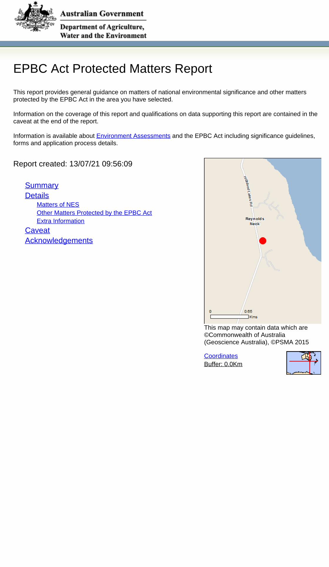
EPBC Act Protected Matters Report
This report provides general guidance on matters of national environmental significance and other mattersprotected by the EPBC Act in the area you have selected.
Information on the coverage of this report and qualifications on data supporting this report are contained in thecaveat at the end of the report.
Information is available about Environment Assessments and the EPBC Act including significance guidelines,forms and application process details.
Other Matters Protected by the EPBC Act
Acknowledgements
Buffer: 0.0Km
Matters of NES
Report created: 13/07/21 09:56:09
Coordinates
This map may contain data which are©Commonwealth of Australia(Geoscience Australia), ©PSMA 2015
CaveatExtra Information
DetailsSummary
Summary
This part of the report summarises the matters of national environmental significance that may occur in, or mayrelate to, the area you nominated. Further information is available in the detail part of the report, which can beaccessed by scrolling or following the links below. If you are proposing to undertake an activity that may have asignificant impact on one or more matters of national environmental significance then you should consider theAdministrative Guidelines on Significance.
Matters of National Environmental Significance
Listed Threatened Ecological Communities:
Listed Migratory Species:
2
Great Barrier Reef Marine Park:
Wetlands of International Importance:
Listed Threatened Species:
None
16
None
None
National Heritage Places:
Commonwealth Marine Area:
World Heritage Properties:
None
None
9
The EPBC Act protects the environment on Commonwealth land, the environment from the actions taken onCommonwealth land, and the environment from actions taken by Commonwealth agencies. As heritage values of aplace are part of the 'environment', these aspects of the EPBC Act protect the Commonwealth Heritage values of aCommonwealth Heritage place. Information on the new heritage laws can be found athttp://www.environment.gov.au/heritage
This part of the report summarises other matters protected under the Act that may relate to the area you nominated.Approval may be required for a proposed activity that significantly affects the environment on Commonwealth land,when the action is outside the Commonwealth land, or the environment anywhere when the action is taken onCommonwealth land. Approval may also be required for the Commonwealth or Commonwealth agencies proposing totake an action that is likely to have a significant impact on the environment anywhere.
A permit may be required for activities in or on a Commonwealth area that may affect a member of a listed threatenedspecies or ecological community, a member of a listed migratory species, whales and other cetaceans, or a member ofa listed marine species.
Other Matters Protected by the EPBC Act
None
None
None
Listed Marine Species:
Whales and Other Cetaceans:
12
Commonwealth Heritage Places:
None
None
Critical Habitats:
Commonwealth Land:
Commonwealth Reserves Terrestrial:
NoneAustralian Marine Parks:
Extra Information
This part of the report provides information that may also be relevant to the area you have nominated.
None
NoneState and Territory Reserves:
Nationally Important Wetlands:
1Regional Forest Agreements:
Invasive Species: 21
NoneKey Ecological Features (Marine)
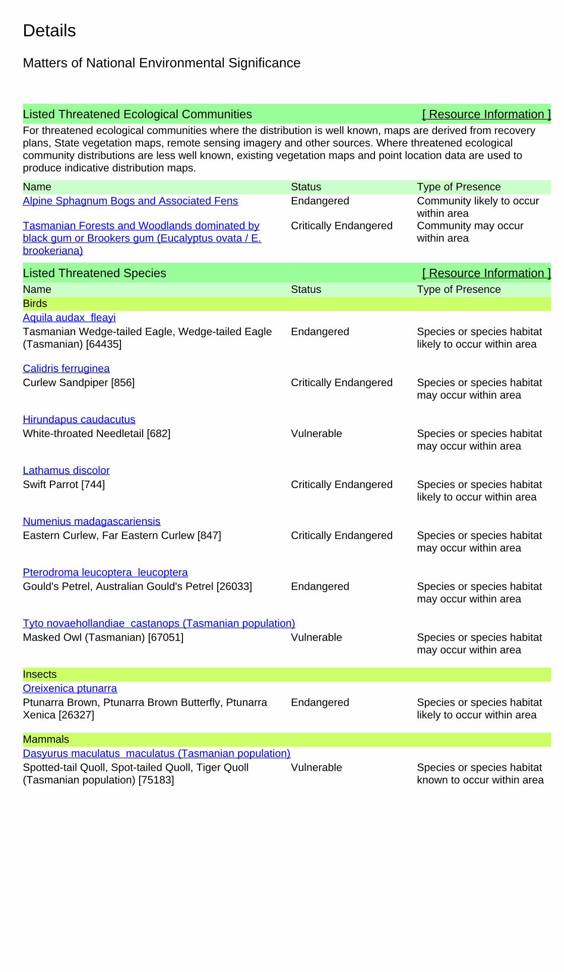
Details
Listed Threatened Species [ Resource Information ]Name Status Type of PresenceBirds
Tasmanian Wedge-tailed Eagle, Wedge-tailed Eagle(Tasmanian) [64435]
Endangered Species or species habitatlikely to occur within area
Aquila audax fleayi
Curlew Sandpiper [856] Critically Endangered Species or species habitatmay occur within area
Calidris ferruginea
White-throated Needletail [682] Vulnerable Species or species habitatmay occur within area
Hirundapus caudacutus
Swift Parrot [744] Critically Endangered Species or species habitatlikely to occur within area
Lathamus discolor
Eastern Curlew, Far Eastern Curlew [847] Critically Endangered Species or species habitatmay occur within area
Numenius madagascariensis
Gould's Petrel, Australian Gould's Petrel [26033] Endangered Species or species habitatmay occur within area
Pterodroma leucoptera leucoptera
Masked Owl (Tasmanian) [67051] Vulnerable Species or species habitatmay occur within area
Tyto novaehollandiae castanops (Tasmanian population)
Insects
Ptunarra Brown, Ptunarra Brown Butterfly, PtunarraXenica [26327]
Endangered Species or species habitatlikely to occur within area
Oreixenica ptunarra
Mammals
Spotted-tail Quoll, Spot-tailed Quoll, Tiger Quoll(Tasmanian population) [75183]
Vulnerable Species or species habitatknown to occur within area
Dasyurus maculatus maculatus (Tasmanian population)
For threatened ecological communities where the distribution is well known, maps are derived from recoveryplans, State vegetation maps, remote sensing imagery and other sources. Where threatened ecologicalcommunity distributions are less well known, existing vegetation maps and point location data are used toproduce indicative distribution maps.
Listed Threatened Ecological Communities [ Resource Information ]
Name Status Type of PresenceAlpine Sphagnum Bogs and Associated Fens Endangered Community likely to occur
within areaTasmanian Forests and Woodlands dominated byblack gum or Brookers gum (Eucalyptus ovata / E.brookeriana)
Critically Endangered Community may occurwithin area
Matters of National Environmental Significance
Name Status Type of Presence
Tasmanian Devil [299] Endangered Species or species habitatlikely to occur within area
Sarcophilus harrisii
Plants
Midlands Mimosa, Midlands Wattle [13563] Vulnerable Species or species habitatmay occur within area
Acacia axillaris
Curtis' Colobanth [23961] Vulnerable Species or species habitatlikely to occur within area
Colobanthus curtisiae
Miena Cider Gum [68394] Endangered Species or species habitatknown to occur within area
Eucalyptus gunnii subsp. divaricata
Hoary Sunray, Grassland Paper-daisy [89104] Endangered Species or species habitatlikely to occur within area
Leucochrysum albicans subsp. tricolor
Liawenee Greenhood [66896] Vulnerable Species or species habitatlikely to occur within area
Pterostylis pratensis
Swamp Everlasting, Swamp Paper Daisy [76215] Vulnerable Species or species habitatmay occur within area
Xerochrysum palustre
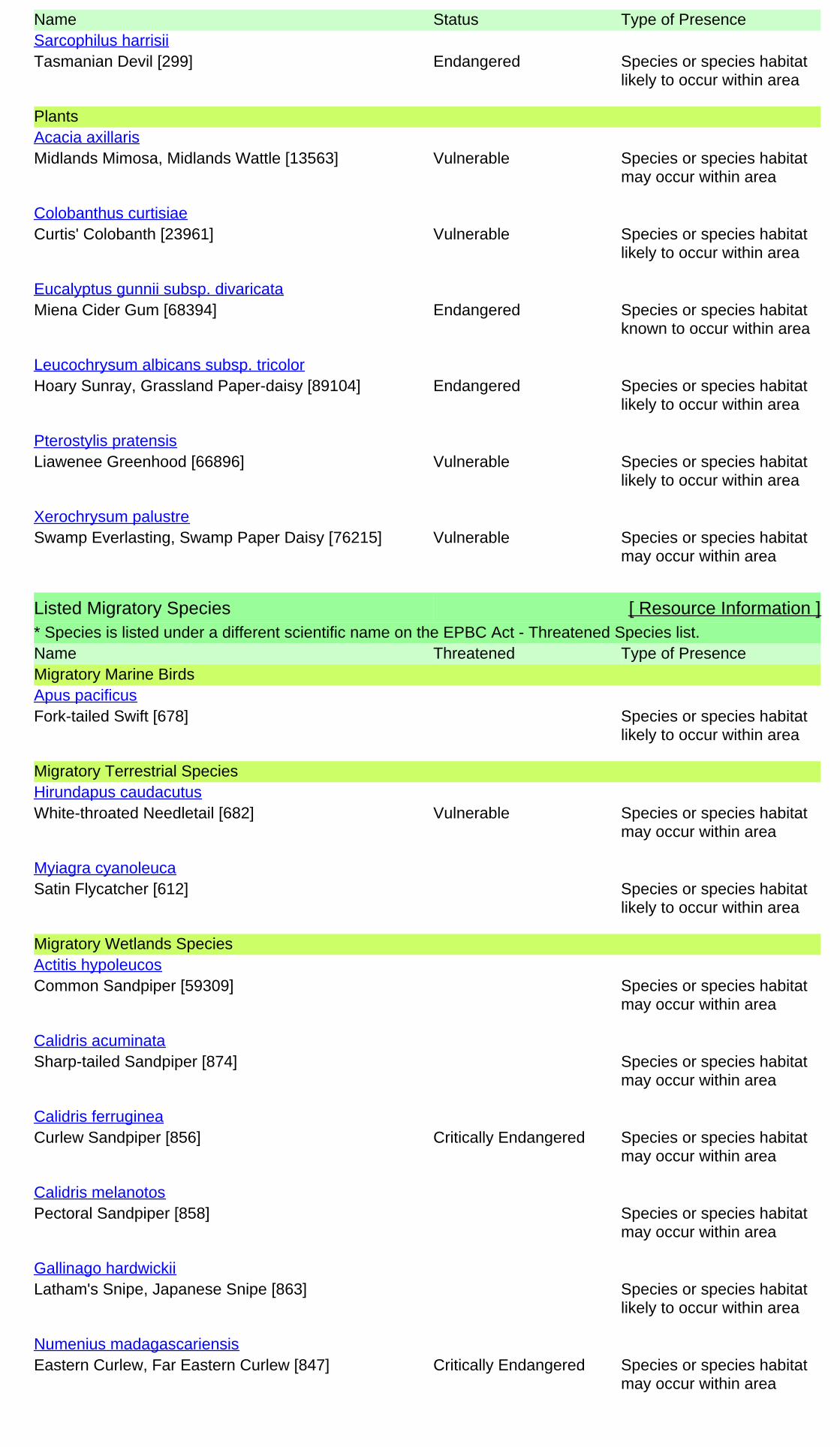
Listed Migratory Species [ Resource Information ]* Species is listed under a different scientific name on the EPBC Act - Threatened Species list.Name Threatened Type of PresenceMigratory Marine Birds
Fork-tailed Swift [678] Species or species habitatlikely to occur within area
Apus pacificus
Migratory Terrestrial Species
White-throated Needletail [682] Vulnerable Species or species habitatmay occur within area
Hirundapus caudacutus
Satin Flycatcher [612] Species or species habitatlikely to occur within area
Myiagra cyanoleuca
Migratory Wetlands Species
Common Sandpiper [59309] Species or species habitatmay occur within area
Actitis hypoleucos
Sharp-tailed Sandpiper [874] Species or species habitatmay occur within area
Calidris acuminata
Curlew Sandpiper [856] Critically Endangered Species or species habitatmay occur within area
Calidris ferruginea
Pectoral Sandpiper [858] Species or species habitatmay occur within area
Calidris melanotos
Latham's Snipe, Japanese Snipe [863] Species or species habitatlikely to occur within area
Gallinago hardwickii
Eastern Curlew, Far Eastern Curlew [847] Critically Endangered Species or species habitatmay occur within area
Numenius madagascariensis
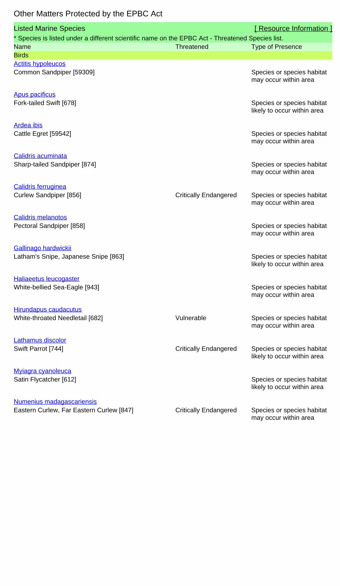
Listed Marine Species [ Resource Information ]* Species is listed under a different scientific name on the EPBC Act - Threatened Species list.Name Threatened Type of PresenceBirds
Common Sandpiper [59309] Species or species habitatmay occur within area
Actitis hypoleucos
Fork-tailed Swift [678] Species or species habitatlikely to occur within area
Apus pacificus
Cattle Egret [59542] Species or species habitatmay occur within area
Ardea ibis
Sharp-tailed Sandpiper [874] Species or species habitatmay occur within area
Calidris acuminata
Curlew Sandpiper [856] Critically Endangered Species or species habitatmay occur within area
Calidris ferruginea
Pectoral Sandpiper [858] Species or species habitatmay occur within area
Calidris melanotos
Latham's Snipe, Japanese Snipe [863] Species or species habitatlikely to occur within area
Gallinago hardwickii
White-bellied Sea-Eagle [943] Species or species habitatmay occur within area
Haliaeetus leucogaster
White-throated Needletail [682] Vulnerable Species or species habitatmay occur within area
Hirundapus caudacutus
Swift Parrot [744] Critically Endangered Species or species habitatlikely to occur within area
Lathamus discolor
Satin Flycatcher [612] Species or species habitatlikely to occur within area
Myiagra cyanoleuca
Eastern Curlew, Far Eastern Curlew [847] Critically Endangered Species or species habitatmay occur within area
Numenius madagascariensis
Other Matters Protected by the EPBC Act
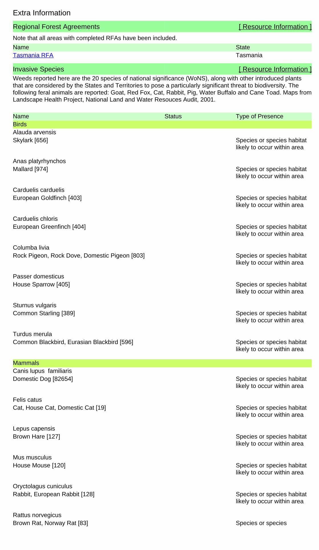
Regional Forest Agreements [ Resource Information ]
Note that all areas with completed RFAs have been included.
Name StateTasmania RFA Tasmania
Extra Information
Invasive Species [ Resource Information ]Weeds reported here are the 20 species of national significance (WoNS), along with other introduced plantsthat are considered by the States and Territories to pose a particularly significant threat to biodiversity. Thefollowing feral animals are reported: Goat, Red Fox, Cat, Rabbit, Pig, Water Buffalo and Cane Toad. Maps fromLandscape Health Project, National Land and Water Resouces Audit, 2001.
Name Status Type of PresenceBirds
Skylark [656] Species or species habitatlikely to occur within area
Alauda arvensis
Mallard [974] Species or species habitatlikely to occur within area
Anas platyrhynchos
European Goldfinch [403] Species or species habitatlikely to occur within area
Carduelis carduelis
European Greenfinch [404] Species or species habitatlikely to occur within area
Carduelis chloris
Rock Pigeon, Rock Dove, Domestic Pigeon [803] Species or species habitatlikely to occur within area
Columba livia
House Sparrow [405] Species or species habitatlikely to occur within area
Passer domesticus
Common Starling [389] Species or species habitatlikely to occur within area
Sturnus vulgaris
Common Blackbird, Eurasian Blackbird [596] Species or species habitatlikely to occur within area
Turdus merula
Mammals
Domestic Dog [82654] Species or species habitatlikely to occur within area
Canis lupus familiaris
Cat, House Cat, Domestic Cat [19] Species or species habitatlikely to occur within area
Felis catus
Brown Hare [127] Species or species habitatlikely to occur within area
Lepus capensis
House Mouse [120] Species or species habitatlikely to occur within area
Mus musculus
Rabbit, European Rabbit [128] Species or species habitatlikely to occur within area
Oryctolagus cuniculus
Brown Rat, Norway Rat [83] Species or speciesRattus norvegicus

Name Status Type of Presencehabitat likely to occur withinarea
Black Rat, Ship Rat [84] Species or species habitatlikely to occur within area
Rattus rattus
Red Fox, Fox [18] Species or species habitatlikely to occur within area
Vulpes vulpes
Plants
Broom, English Broom, Scotch Broom, CommonBroom, Scottish Broom, Spanish Broom [5934]
Species or species habitatlikely to occur within area
Cytisus scoparius
Montpellier Broom, Cape Broom, Canary Broom,Common Broom, French Broom, Soft Broom [20126]
Species or species habitatlikely to occur within area
Genista monspessulana
Blackberry, European Blackberry [68406] Species or species habitatlikely to occur within area
Rubus fruticosus aggregate
Willows except Weeping Willow, Pussy Willow andSterile Pussy Willow [68497]
Species or species habitatlikely to occur within area
Salix spp. except S.babylonica, S.x calodendron & S.x reichardtii
Gorse, Furze [7693] Species or species habitatlikely to occur within area
Ulex europaeus
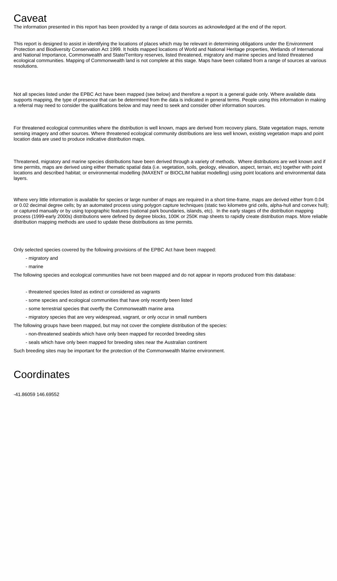
- non-threatened seabirds which have only been mapped for recorded breeding sites
- migratory species that are very widespread, vagrant, or only occur in small numbers
- some species and ecological communities that have only recently been listed
Not all species listed under the EPBC Act have been mapped (see below) and therefore a report is a general guide only. Where available datasupports mapping, the type of presence that can be determined from the data is indicated in general terms. People using this information in makinga referral may need to consider the qualifications below and may need to seek and consider other information sources.
For threatened ecological communities where the distribution is well known, maps are derived from recovery plans, State vegetation maps, remotesensing imagery and other sources. Where threatened ecological community distributions are less well known, existing vegetation maps and pointlocation data are used to produce indicative distribution maps.
- seals which have only been mapped for breeding sites near the Australian continent
Such breeding sites may be important for the protection of the Commonwealth Marine environment.
Threatened, migratory and marine species distributions have been derived through a variety of methods. Where distributions are well known and iftime permits, maps are derived using either thematic spatial data (i.e. vegetation, soils, geology, elevation, aspect, terrain, etc) together with pointlocations and described habitat; or environmental modelling (MAXENT or BIOCLIM habitat modelling) using point locations and environmental datalayers.
The information presented in this report has been provided by a range of data sources as acknowledged at the end of the report.Caveat
- migratory and
The following species and ecological communities have not been mapped and do not appear in reports produced from this database:
- marine
This report is designed to assist in identifying the locations of places which may be relevant in determining obligations under the EnvironmentProtection and Biodiversity Conservation Act 1999. It holds mapped locations of World and National Heritage properties, Wetlands of Internationaland National Importance, Commonwealth and State/Territory reserves, listed threatened, migratory and marine species and listed threatenedecological communities. Mapping of Commonwealth land is not complete at this stage. Maps have been collated from a range of sources at variousresolutions.
- threatened species listed as extinct or considered as vagrants
- some terrestrial species that overfly the Commonwealth marine area
The following groups have been mapped, but may not cover the complete distribution of the species:
Only selected species covered by the following provisions of the EPBC Act have been mapped:
Where very little information is available for species or large number of maps are required in a short time-frame, maps are derived either from 0.04or 0.02 decimal degree cells; by an automated process using polygon capture techniques (static two kilometre grid cells, alpha-hull and convex hull);or captured manually or by using topographic features (national park boundaries, islands, etc). In the early stages of the distribution mappingprocess (1999-early 2000s) distributions were defined by degree blocks, 100K or 250K map sheets to rapidly create distribution maps. More reliabledistribution mapping methods are used to update these distributions as time permits.
-41.86059 146.69552
Coordinates
-Environment and Planning Directorate, ACT-Birdlife Australia-Australian Bird and Bat Banding Scheme
-Department of Parks and Wildlife, Western Australia
Acknowledgements
-Office of Environment and Heritage, New South Wales
-Department of Primary Industries, Parks, Water and Environment, Tasmania
-Department of Land and Resource Management, Northern Territory-Department of Environmental and Heritage Protection, Queensland
-Department of Environment and Primary Industries, Victoria
-Australian National Wildlife Collection
-Department of Environment, Water and Natural Resources, South Australia
This database has been compiled from a range of data sources. The department acknowledges the followingcustodians who have contributed valuable data and advice:
-Australian Museum
-National Herbarium of NSW
Forestry Corporation, NSW-Australian Government, Department of Defence
-State Herbarium of South Australia
The Department is extremely grateful to the many organisations and individuals who provided expert adviceand information on numerous draft distributions.
-Natural history museums of Australia
-Queensland Museum
-Australian National Herbarium, Canberra
-Royal Botanic Gardens and National Herbarium of Victoria
-Geoscience Australia
-Ocean Biogeographic Information System
-Online Zoological Collections of Australian Museums-Queensland Herbarium
-Western Australian Herbarium
-Tasmanian Herbarium
-Northern Territory Herbarium
-South Australian Museum
-Museum Victoria
-University of New England
-CSIRO
-Other groups and individuals-Tasmanian Museum and Art Gallery, Hobart, Tasmania
-Museum and Art Gallery of the Northern Territory
-Reef Life Survey Australia-Australian Institute of Marine Science-Australian Government National Environmental Science Program
-Australian Tropical Herbarium, Cairns
-Australian Government – Australian Antarctic Data Centre
-Queen Victoria Museum and Art Gallery, Inveresk, Tasmania
-eBird Australia
-American Museum of Natural History
© Commonwealth of Australia
+61 2 6274 1111
Canberra City ACT 2601 Australia
GPO Box 858
Department of Agriculture Water and the Environment
Please feel free to provide feedback via the Contact Us page.
iv
Appendix D AHT Search
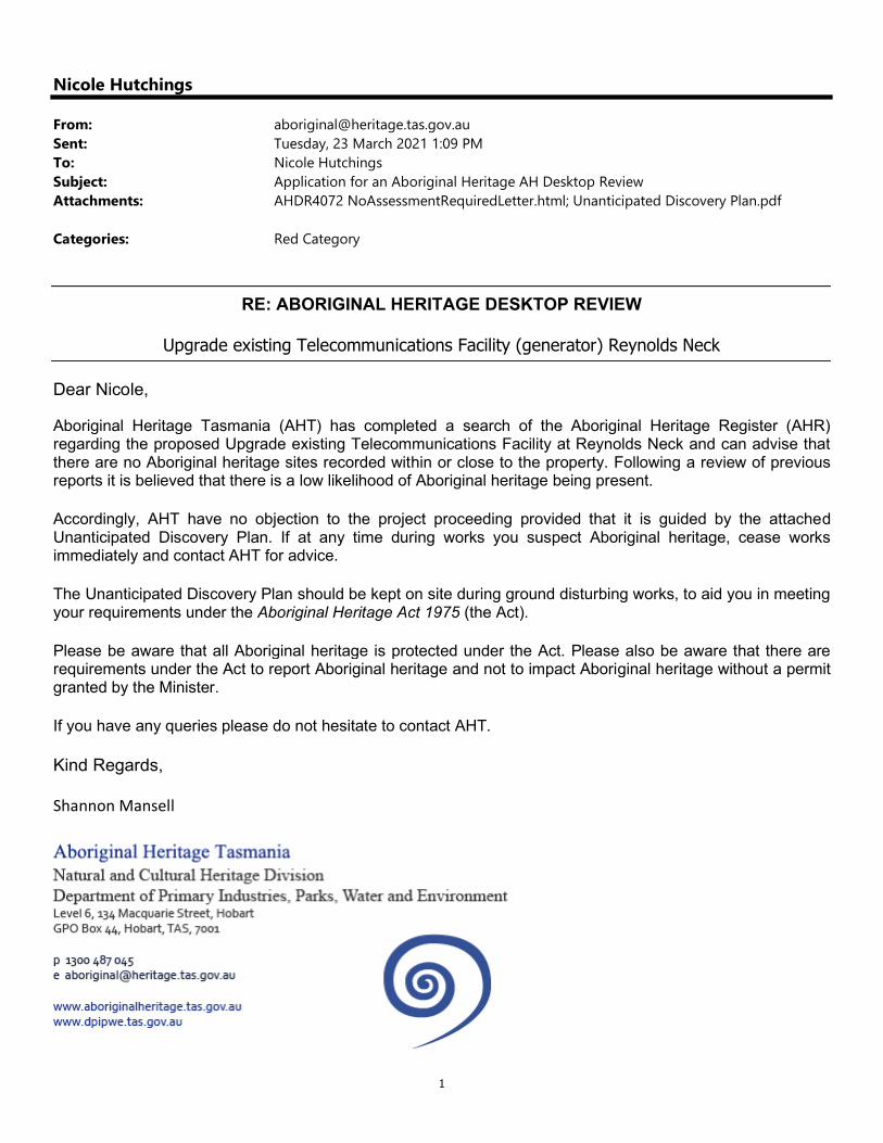
1
Nicole Hutchings
From: [email protected]: Tuesday, 23 March 2021 1:09 PMTo: Nicole HutchingsSubject: Application for an Aboriginal Heritage AH Desktop ReviewAttachments: AHDR4072 NoAssessmentRequiredLetter.html; Unanticipated Discovery Plan.pdf
Categories: Red Category
RE: ABORIGINAL HERITAGE DESKTOP REVIEW
Upgrade existing Telecommunications Facility (generator) Reynolds Neck
Dear Nicole,
Aboriginal Heritage Tasmania (AHT) has completed a search of the Aboriginal Heritage Register (AHR) regarding the proposed Upgrade existing Telecommunications Facility at Reynolds Neck and can advise that there are no Aboriginal heritage sites recorded within or close to the property. Following a review of previous reports it is believed that there is a low likelihood of Aboriginal heritage being present.
Accordingly, AHT have no objection to the project proceeding provided that it is guided by the attached Unanticipated Discovery Plan. If at any time during works you suspect Aboriginal heritage, cease works immediately and contact AHT for advice.
The Unanticipated Discovery Plan should be kept on site during ground disturbing works, to aid you in meeting your requirements under the Aboriginal Heritage Act 1975 (the Act).
Please be aware that all Aboriginal heritage is protected under the Act. Please also be aware that there are requirements under the Act to report Aboriginal heritage and not to impact Aboriginal heritage without a permit granted by the Minister.
If you have any queries please do not hesitate to contact AHT.
Kind Regards,
Shannon Mansell

2
CONFIDENTIALITY NOTICE AND DISCLAIMER: The information in this transmission may be confidential and/or protected by legal professional privilege, and is intended only for the person or persons to whom it is addressed. If you are not such a person, you are warned that any disclosure, copying or dissemination of the information is unauthorised. If you have received the transmission in error, please immediately contact this office by telephone, fax or email, to inform us of the error and to enable arrangements to be made for the destruction of the transmission, or its return at our cost. No liability is accepted for any unauthorised use of the information contained in this transmission.

v
Appendix E Media
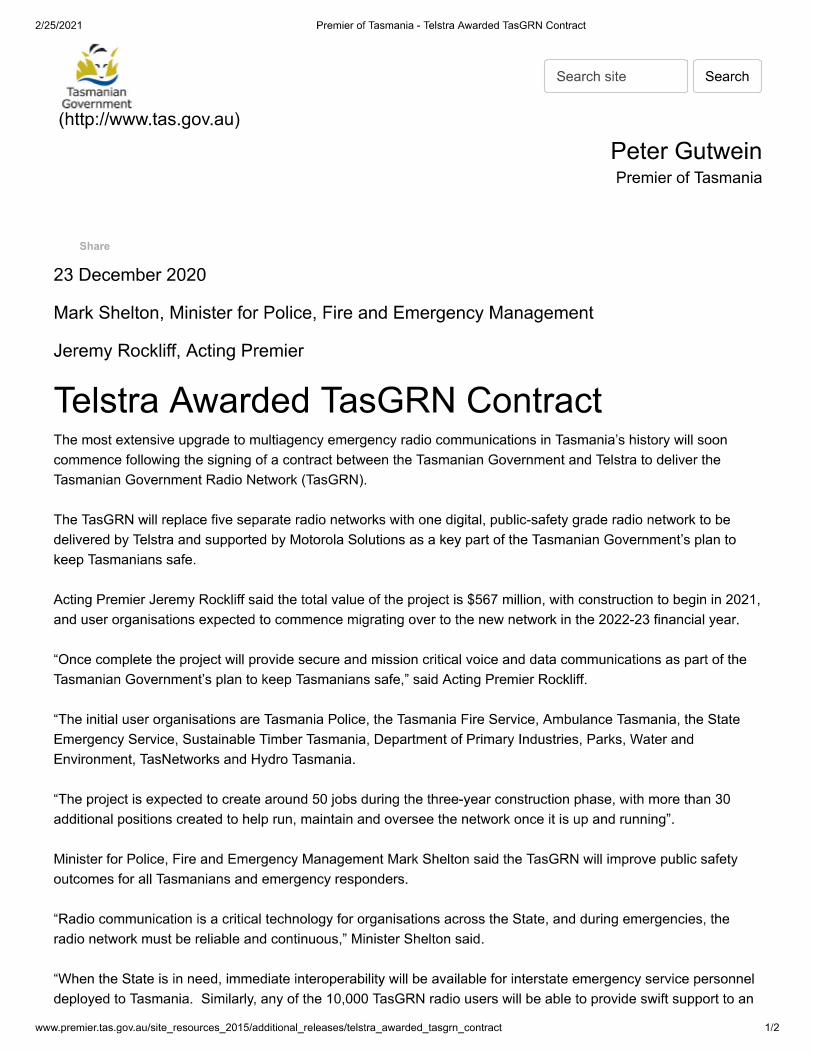
Related Documents