WWW.GERMAN-SUSTAINABLE-MOBILITY.DE THE SUSTAINABLE URBAN TRANSPORT GUIDE GERMANY Discover Berlin by Sustainable Transport

Welcome message from author
This document is posted to help you gain knowledge. Please leave a comment to let me know what you think about it! Share it to your friends and learn new things together.
Transcript

W W W.G ERM A N-SUS TA IN A BL E-MOBIL I T Y. DE
T H E SUS TA IN A B L E U R B A N T R A N SP O R T G UID E G ER M A N Y
Discover Berlin by Sustainable Transport

The German Partnership for Sustainable Mobility (GPSM) serves as a guide for sustainable mobility and green logistics solutions from Germany. As a platform for exchanging knowledge, expertise and experiences, GPSM supports the transformation towards sustainability worldwide. It serves as a network of information from academia, businesses, civil society and associations.
The GPSM supports the implementation of sustainable mobility and green logistics solutions in a comprehensive manner. In cooperation with various stakeholders from economic, scientific and societal backgrounds, the broad range of possible concepts, measures and technologies in the transport sector can be explored and prepared for implementation.
The GPSM is a reliable and inspiring network that offers access to expert knowledge, as well as networking formats. The GPSM is comprised of more than 150 reputable stakeholders in Germany.
The GPSM is part of Germany’s aspiration to be a trailblazer in progressive climate policy, and in follow-up to the Rio+20 process, to lead other international forums on sustainable development as well as in European integration.
Integrity and respect are core principles of our partnership values and mission. The transferability of concepts and ideas hinges upon respecting local and regional diversity, skillsets and experien-ces, as well as acknowledging their unique constraints.
www.german-sustainable-mobility.de
The German Partnership for Sustainable Mobility (GPSM)
Discover Berlin 3
Discover Berlin by Sustainable Transport
This guide to Berlin’s intermodal transportation system leads you from the main train station to the transport hub of Alexanderplatz, to the redeveloped Potsdamer Platz with its high-qua-lity architecture before ending the tour in the trendy borough of Kreuzberg. Along the way, you will be able to experience different modes of transport, including the bicycle sharing sys-tem. The detour sections provide further de-scription of Berlin’s transportation policies and infrastructure, including the city’s bicycle sha-ring system and the low emission zone.

4 Discover Berlin
A B O U T T H E AU T H O R S :
Dr Friedemann Kunst Friedemann Kunst is a town and traffic planner. He was responsible to prepare the first concept for the future urban development of Berlin after the reunification and was in charge of further major urban development projects in the city. Until his retirement in 2013, Dr Kunst was head of department of transport and traffic and responsible for planning and the operation of the inte-grated transport system in the German capital.
Sven Ledwoch Sven Ledwoch is a German traffic planner currently managing the regional light rail project “Re-gionalstadtbahn Neckar-Alb” for the City of Reutlingen as well as the reorganisation of the city’s bus network. Previously he was involved in EU and other international transport projects and worked for firms of engineering consultants. Following his interest in international development Mr Ledwoch is furthermore conducting a dissertation proposal on urban rail transit systems in emerging economies.
Lukas Sroka Lukas Sroka is a qualified geographer. During his bachelor studies at Philips University Marburg he had worked as a trainee at the Transport Policy Advisory Service/Sustainable Urban Transport Systems team at GIZ in Eschborn. After finishing, he started his master studies of economic and social geography in Leipzig where he specialised himself in sustainable traffic planning topics. Currently he works at the Mitteldeutscher Verkehrsverbund GmbH (MDV) at a project which tries to offer strategies for improving public transport in rural areas in Saxony.
Acknowledgements We would like to thank Kathrin Hoffmann (visitberlin) for contributing to the publication. We further express our thanks to Olivia Kieser (GIZ), Armin Wagner (GIZ), Michel Arnd (GIZ), Paweł Komendziński (GIZ) and Lena Osswald (GIZ) for reviewing the document and providing invaluab-le feedback.
1€ = $1.13
1€ = 124.5 Yen
1€ = 1.09 CHF
1€ = 1.29 GBP
(As of 28th April 2016)
Walking
Carsharing
Public Transport
Orientation
Cycling
Planning
Public TransportTickets
Content
Discover Berlin 5
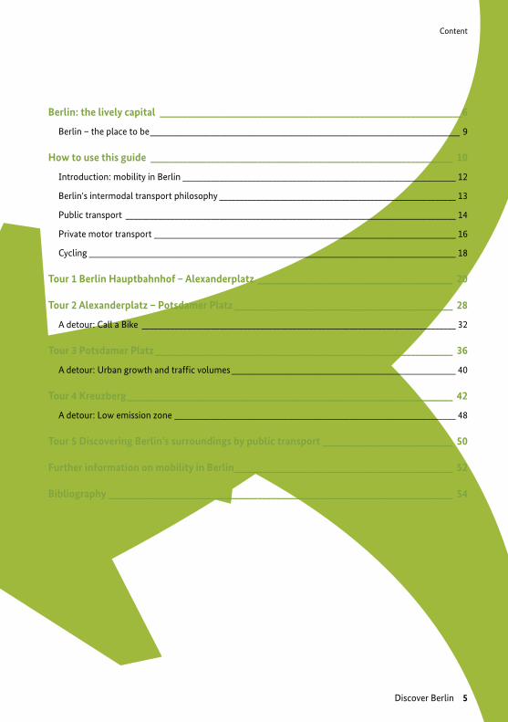
Berlin: the lively capital _________________________________________________________________6
Berlin – the place to be ____________________________________________________________________________ 9
How to use this guide _________________________________________________________________ 10
Introduction: mobility in Berlin ___________________________________________________________________ 12
Berlin's intermodal transport philosophy __________________________________________________________ 13
Public transport _________________________________________________________________________________ 14
Private motor transport __________________________________________________________________________ 16
Cycling __________________________________________________________________________________________ 18
Tour 1 Berlin Hauptbahnhof – Alexanderplatz __________________________________________ 20
Tour 2 Alexanderplatz – Potsdamer Platz _______________________________________________ 28
A detour: Call a Bike _____________________________________________________________________________ 32
Tour 3 Potsdamer Platz ________________________________________________________________ 36
A detour: Urban growth and traffic volumes _______________________________________________________ 40
Tour 4 Kreuzberg ______________________________________________________________________ 42
A detour: Low emission zone _____________________________________________________________________ 48
Tour 5 Discovering Berlin’s surroundings by public transport ____________________________ 50
Further information on mobility in Berlin _______________________________________________ 52
Bibliography __________________________________________________________________________ 54

Berlin the lively capital
6 Discover Berlin

Berlin the lively capital
Figu
re 1
: Ale
xand
erpl
atz
by n
ight
, pho
to b
y ce
ntra
lnia
k on
Flic
kr/
CC B
Y 2.
0
Figure 2: Intermodality: Bicycle parking at the entrance to a subway station © Sven Ledwoch
Discover Berlin 7
Welcome to Berlin, the old – and new – capital of Germany. With a population of 3.7 million, it is Germany’s largest city in terms of both po-pulation and area, ahead of Cologne, Hamburg and Munich. It is also one of Germany’s three city-states. Berlin lies at the centre of the me-tropolitan region of Berlin-Brandenburg; with 6 million inhabitants, the area includes the city and the entire surrounding state of Brandenburg. Berlin is regarded nationally and internationally as a centre for politics, culture, art, media, scien-ce and sport. It is a major European transport hub and is continuing to grow in importance. People are drawn to Berlin for many reasons, including its quirky reputation and vibrant nightlife, its di-verse range of old and new architecture and the high quality of life it offers.
Berlin: the lively capital
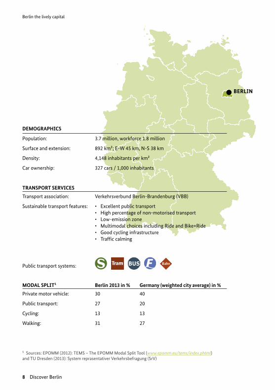
BERLIN
DEMOGRAPHICS
Population: 3.7 million, workforce 1.8 million
Surface and extension: 892 km²; E-W 45 km, N-S 38 km
Density: 4,148 inhabitants per km²
Car ownership: 327 cars / 1,000 inhabitants
TRANSPORT SERVICES
Transport association: Verkehrsverbund Berlin-Brandenburg (VBB)
Sustainable transport features: • Excellent public transport• High percentage of non-motorised transport• Low-emission zone• Multimodal choices including Ride and Bike+Ride• Good cycling infrastructure• Traffic calming
Public transport systems:
MODAL SPLIT¹ Berlin 2013 in % Germany (weighted city average) in %
Private motor vehicle: 30 40
Public transport: 27 20
Cycling: 13 13
Walking: 31 27
Berlin the lively capital
8 Discover Berlin
¹ Sources: EPOMM (2012): TEMS – The EPOMM Modal Split Tool (www.epomm.eu/tems/index.phtml) and TU Dresden (2013): System reprasentativer Verkehrsbefragung (SrV)
Berlin – the place to be
Everybody wants to visit Berlin: the German capital is appealing to people all over the world. No other city has such a moving history, no other city has changed this fast – and reinvents itself constantly. More than twenty five years after the Fall of the Wall and the German Reunification, Berlin exerts a unique attraction. Tourists, talents, technology, and tolerance shape the dynamic and welcoming rhythm of the city. Its secret of success is its mix of diversity, contrasts and sheer inexhaustible potential to consistently fire the enthu-siasm of its visitors from all over the world. People are excited by the mixture of history and Zeitgeist, the broad spectrum of art, culture, music, entertainment, and shopping facilities.
visitBerlin promotes Berlin as a travel destination all over the world and helps visitors to find their way around the city. At visitBerlin.com, you can access information about Germany’s capital in 14 languages. It is the perfect place to get inspiration and orientation to all that Berlin has to offer. Here, visitors can find out about current events, tours, exhibitions, and book tickets directly. The Berlin Service Center at +49 30 25 00 25 provides information on the complete spectrum of touristic services in Berlin. In addition, visitBerlin ope-rates six Berlin Tourist Information Offices: multilingual staff is ready to help visitors plan a great stay (see below for locations and opening hours). Indispensable for visitors to Germany‘s capital: visitBerlin also issu-es the official tourist ticket, the Berlin WelcomeCard. The city pass does not only include travel on all means of public transport but also discounts between 25 and 50 per cent at more than 200 touristic attractions. The Berlin WelcomeCard comes with a practical guide with an overview of all the deals included as well as a map of Berlin and Potsdam and a plan of the city’s public transport system. The card is available for tariff zones AB (Berlin) or ABC (Berlin and Potsdam) and time ranges from two to six days. Any number of children to the age of 6 and up to three children between the ages of 6 and 14 can accompany an adult at no extra charge. The ti-cket can be bought at all Berlin Tourist Information Offices, public transport ticket machines operated by BVG and S-Bahn Berlin, at the city’s airports, in many hotels, by calling visitBerlin at +49 30 25 00 25 and online at
berlin-welcomecard.com.
BERLIN TOURIST INFORMATION OFFICES (SELECTION):
Brandenburg Gate Daily 9.30am - 6pm*Pariser Platz / southern gatehouseS+U Brandenburger Tor
TV Tower Daily 10am - 4pm*Panoramastraße 1aS+U Alexanderplatz
(*Extended opening hours April-October)
General Tourist Information
Discover Berlin 9

How to use this guide?
How to use this guide?
10 Discover Berlin
This travel guide shows how to discover the city using sustainable modes of transport – by foot, bicycle and public transport. There are four prepared tours in this guide:
→ Tour 1 lets you discover the government quarter (Regierungsviertel) on a walking tour
→ Tour 2 will lead you from Alexanderplatz to Potsdamer Platz by bike and show you some parts of the old Friedrichstadt
→ Tour 3 is meant to let you discover Potsdamer Platz and bring you to Kreuzberg using U-Bahn the Berlin subway
→ Tour 4 shows you the green and lively Kreuzberg on a walking tour
The tours are planned in a way that you can do them one directly after the other. The guide is comple-mented with so called DETOURS. These detours contain supplementary information on sustainable transport in Berlin and the history of the places you will pass by.
As a bonus we compiled information on what to do if you want to get into Berlin’s surroundings.
O R I E N TAT IO N
This guide is equipped with small maps on the designated tour areas, an overview plan of the city cen-tre and a public transport network map, which just cover enough to let you do Tours 1-4. Paper maps are available in book stores and the tourist office; you may also wish to prepare your smartphone with an offline map allowing you to locate yourself via GPS in the city or surrounding areas. Good offline maps are maps.me (available for iPhone and Android, download the map of Berlin), HERE Maps, City Maps 2Go, OSMand or the offline map functionality of Google Maps.
² Straßenverkehrsordnung is the name of the German road traffic regulations; every road user must abide by.
How to use this guide?
Discover Berlin 11
B E R L I N BY B I K E
If you did not bring your own bike to Berlin, you may want to try the public bike sharing system Call a Bike. Further, many hotels and hostels, bike shops and other providers offer rental bikes. You will find detailed information on registration and use of bike-sharing systems in the detour on bike-sharing in Berlin on page 32. Consider registering at your accommodation or through restaurant Wi-Fi before starting your tour.
Important traffic rules: Every bike user is obliged to obey the rules of the StVO² which – for the most part – conform with international rules. Right has right-of-way on roads without other indication (important on minor roads). If you ride a bike in Berlin, you will soon come across special bike lanes. A blue sign with a white bicycle indicates bikeways – this also means that cyclists have to use those bikeways and should not use the normal road. A sign showing a pedestrian and a bicycle shows that pedestrians and cyclists must share the lane. Cycling on the pavement (every walkway without bike-way indication) is generally not allowed (except for children under 12 years). You are allowed to enter one-way roads or other roads with limited entry in the opposite direction if you see a small white sign with a bicycle symbol and the word frei under it. Most importantly, be respectful and considerate of other road users.
If you are in doubt in any situation, the most important rule is §1 StVO: “The participation in road traffic requires permanent attention and mutual considerateness.” Better be safe than sorry!
B E R L I N BY P U B L IC T R A N S P O RT
While following Tour 3 you will have to use public transport – do not forget to buy a ticket before boarding any tram, train or bus. You will find information on ticket options in the section Public trans-port on page 22.
BBBike is a smart urban cycling navigator for you and your bike. Find it online and as smart-phone app: www.bbbike.de
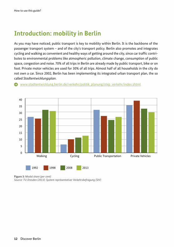
Figure 3: Modal share (per cent)Source: TU Dresden (2013): System repräsentativer Verkehrsbefragung (StV)
How to use this guide?
12 Discover Berlin
Introduction: mobility in Berlin As you may have noticed, public transport is key to mobility within Berlin. It is the backbone of the passenger transport system – and of the city's transport policy. Berlin also promotes and integrates cycling and walking as convenient and healthy ways of getting around the city, since car traffic contri-butes to environmental problems like atmospheric pollution, climate change, consumption of public space, congestion and noise. 70% of all trips in Berlin are already made by public transport, bike or on foot. Private motor vehicles are used for 30% of all trips. Almost half of all households in the city do not own a car. Since 2002, Berlin has been implementing its integrated urban transport plan, the so called Stadtentwicklungsplan.
www.stadtentwicklung.berlin.de/verkehr/politik_planung/step_verkehr/index.shtml
Walking Cycling Public Transportation Private Vehicles
40
35
30
25
20
15
10
5
0
1992 1998 2008 2013
How to use this guide?
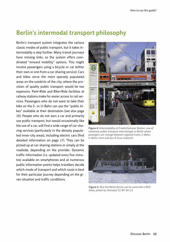
Figure 4: Intermodality at Friedrichstrasse Station: one of numerous public transport interchanges in Berlin where pasengers can change between regional trains, S-Bahn, U-Bahn, tram and bus © Sven Ledwoch
Figure 5: Also the Berlin ferries can be used with a BVG ticket, photo by Omnola/ CC BY-SA 2.0
Discover Berlin 13
Berlin's intermodal transport philosophyBerlin's transport system integrates the various classic modes of public transport, but it takes in-termodality a step further. Many transit journeys have missing links, so the system offers coor-dinated “onward mobility” options. This might involve passengers using a bicycle or car (either their own or one from a car-sharing service). Cars and bikes serve the more sparsely populated areas on the outskirts of the city, where the pro-vision of quality public transport would be too expensive. Park+Ride and Bike+Ride facilities at railway stations make for easier access to rail ser-vices. Passengers who do not want to take their bike on the S- or U-Bahn can use the “public bi-kes” available at their destination (see also page 19). People who do not own a car and primarily use public transport, but would occasionally like the use of a car, will find a wide range of car-sha-ring services (particularly in the densely popula-ted inner-city areas), including electric cars (find detailed information on page 17). They can be picked up at car-sharing stations or simply at the roadside, depending on the provider. Dynamic traffic information (i.e. updated every five minu-tes) available on smartphones and at numerous public information points helps travellers decide which mode of transport and which route is best for their particular journey depending on the gi-ven situation and traffic conditions.
How to use this guide?
14 Discover Berlin
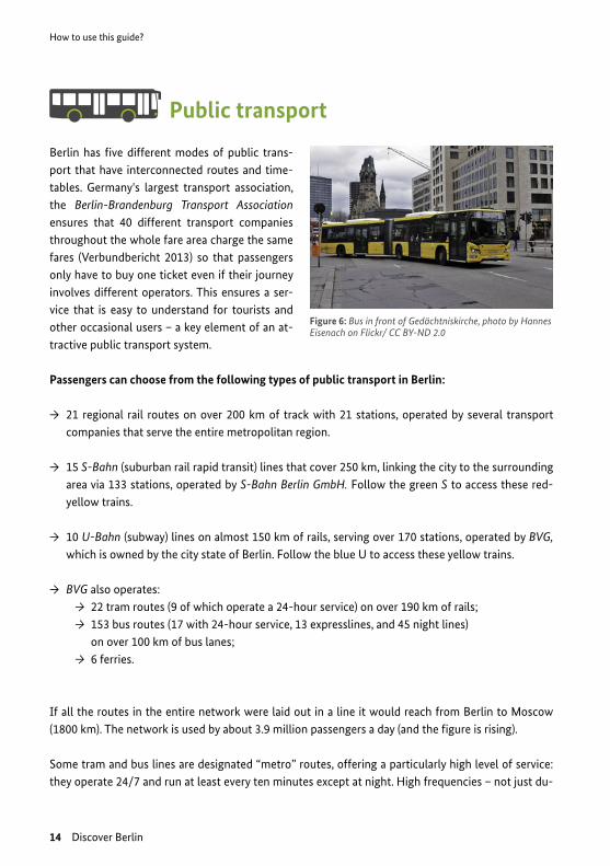
Public transport
Berlin has five different modes of public trans-port that have interconnected routes and time-tables. Germany's largest transport association, the Berlin-Brandenburg Transport Association ensures that 40 different transport companies throughout the whole fare area charge the same fares (Verbundbericht 2013) so that passengers only have to buy one ticket even if their journey involves different operators. This ensures a ser-vice that is easy to understand for tourists and other occasional users – a key element of an at-tractive public transport system.
Passengers can choose from the following types of public transport in Berlin:
→ 21 regional rail routes on over 200 km of track with 21 stations, operated by several transport companies that serve the entire metropolitan region.
→ 15 S-Bahn (suburban rail rapid transit) lines that cover 250 km, linking the city to the surrounding area via 133 stations, operated by S-Bahn Berlin GmbH. Follow the green S to access these red-yellow trains.
→ 10 U-Bahn (subway) lines on almost 150 km of rails, serving over 170 stations, operated by BVG, which is owned by the city state of Berlin. Follow the blue U to access these yellow trains.
→ BVG also operates: → 22 tram routes (9 of which operate a 24-hour service) on over 190 km of rails; → 153 bus routes (17 with 24-hour service, 13 expresslines, and 45 night lines)
on over 100 km of bus lanes; → 6 ferries.
If all the routes in the entire network were laid out in a line it would reach from Berlin to Moscow (1800 km). The network is used by about 3.9 million passengers a day (and the figure is rising).
Some tram and bus lines are designated “metro” routes, offering a particularly high level of service: they operate 24/7 and run at least every ten minutes except at night. High frequencies – not just du-
Figure 6: Bus in front of Gedächtniskirche, photo by Hannes Eisenach on Flickr/ CC BY-ND 2.0
How to use this guide?
Discover Berlin 15
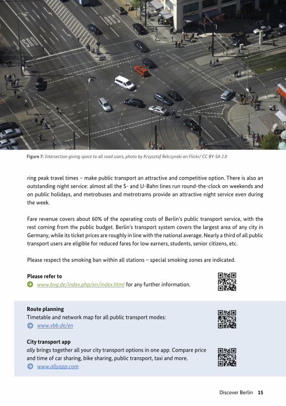
ring peak travel times – make public transport an attractive and competitive option. There is also an outstanding night service: almost all the S- and U-Bahn lines run round-the-clock on weekends and on public holidays, and metrobuses and metrotrams provide an attractive night service even during the week.
Fare revenue covers about 60% of the operating costs of Berlin's public transport service, with the rest coming from the public budget. Berlin's transport system covers the largest area of any city in Germany, while its ticket prices are roughly in line with the national average. Nearly a third of all public transport users are eligible for reduced fares for low earners, students, senior citizens, etc.
Please respect the smoking ban within all stations – special smoking zones are indicated.
Please refer to www.bvg.de/index.php/en/index.html for any further information.
Figure 7: Intersection giving space to all road users, photo by Krzysztof Belczynski on Flickr/ CC BY-SA 2.0
Route planning Timetable and network map for all public transport modes:
www.vbb.de/en
City transport app ally brings together all your city transport options in one app. Compare price and time of car sharing, bike sharing, public transport, taxi and more.
www.allyapp.com
How to use this guide?
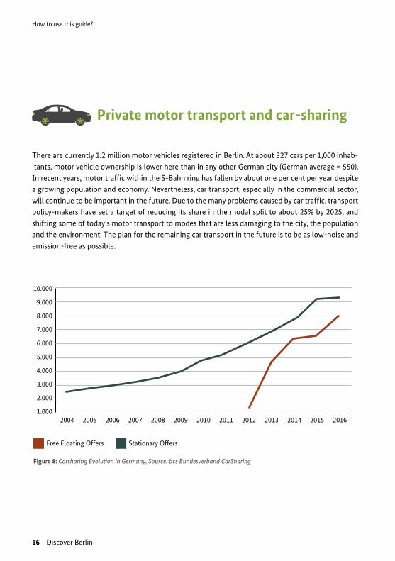
Figure 8: Carsharing Evolution in Germany, Source: bcs Bundesverband CarSharing
2004 2005 2006 2007 2008 2009 2010 2011 2012 2013 2014 2015 2016
10.000
9.000
8.000
7.000
6.000
5.000
4.000
3.000
2.000
1.000
Free Floating Offers Stationary Offers
16 Discover Berlin
Private motor transport and car-sharing
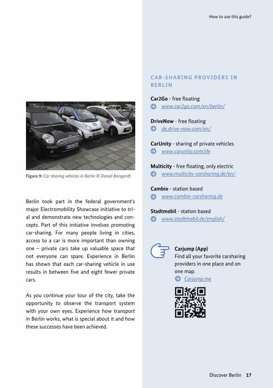
There are currently 1.2 million motor vehicles registered in Berlin. At about 327 cars per 1,000 inhab-itants, motor vehicle ownership is lower here than in any other German city (German average = 550). In recent years, motor traffic within the S-Bahn ring has fallen by about one per cent per year despite a growing population and economy. Nevertheless, car transport, especially in the commercial sector, will continue to be important in the future. Due to the many problems caused by car traffic, transport policy-makers have set a target of reducing its share in the modal split to about 25% by 2025, and shifting some of today's motor transport to modes that are less damaging to the city, the population and the environment. The plan for the remaining car transport in the future is to be as low-noise and emission-free as possible.
How to use this guide?
Figure 9: Car sharing vehicles in Berlin © Daniel Bongardt
Discover Berlin 17
C A R -S H A R I N G P ROV I D E R S I N B E R L I N
Car2Go - free floatingwww.car2go.com/en/berlin/
DriveNow - free floatingde.drive-now.com/en/
CarUnity - sharing of private vehicleswww.carunity.com/de
Multicity - free floating, only electricwww.multicity-carsharing.de/en/
Cambio - station basedwww.cambio-carsharing.de
Stadtmobil - station basedwww.stadtmobil.de/english/
Carjump (App)Find all your favorite carsharing providers in one place and on one map.
Carjump.me
Berlin took part in the federal government's major Electromobility Showcase initiative to tri-al and demonstrate new technologies and con-cepts. Part of this initiative involves promoting car-sharing. For many people living in cities, access to a car is more important than owning one – private cars take up valuable space that not everyone can spare. Experience in Berlin has shown that each car-sharing vehicle in use results in between five and eight fewer private cars.
As you continue your tour of the city, take the opportunity to observe the transport system with your own eyes. Experience how transport in Berlin works, what is special about it and how these successes have been achieved.

How to use this guide?
18 Discover Berlin
Cycling
Berlin is a bike-friendly city; cycling here is easy and enjoyable, even for visitors unfamiliar with the city. There are about 720 bicycles for every 1,000 inhabitants. Around 1.5 million trips a day are already made by bike, and cycle traffic continues to increase, for a number of reasons:
→ The city has good cycling infrastructure and is improving constantly: there are now 970 kilometres of bike paths and 290 km of bike lanes on main roads. About 70% of the 5,400 km road network is made up of secondary ro-ads with a 30 km/h speed limit, which makes them ideal for cycling. Furthermore, a grid of cycling routes has been added to the road network and benefits from signposts exclusi-vely for cycle traffic.
→ Bicycle parking facilities at public transport stops are an important part of public infra-structure: bike parking facilities have been installed at key S- and U-Bahn stations and are continually being expanded. These facili-ties are designed to make it easier to chan-
ge between different means of sustainable transport. The S-Bahn facilities are an exam-ple: since 1999, some 8,800 parking spaces for bikes have been created at 70 stations. The stations have racks for passengers to lock their bikes and most of them are covered. For new-build housing there is also a statutory requirement to provide safe parking for bicy-cles (two spaces per apartment or one per 100 m3 of commercial surface).
→ There are virtually no legal restrictions on ta-king bikes on rail transit services. People can take their bike on trams, regional trains and the S-Bahn and U-Bahn at any time. Restric-tions that used to apply at certain times of day have been lifted.
Figure 10: Trend of bicycle traffic since 1951
1952
1955
1958
1961
1964
1967
1970
1973
1976
1979
1982
1985
1988
1991
1994
1997
2000
2003
2006
2009
2012
250%
200%
150%
100%
50%
0%
In 2004, the total was defined to be 100%.
How to use this guide?
Discover Berlin 19
P ROV I D E R S O F T WO -W H E E L E R S H A R I N G I N B E R L I N
eMio (electric scooter sharing)www.emio-sharing.de
Call a Bike (bicycles)www.call-a-bike.de
M O R E A B O U T C YC L I N G
Cycling in Germany www.nationaler-radverkehrsplan.de/en/transferstelle
Cycling-Inclusive Policy Development: A Handbook:
www.fietsberaad.nl/library/ repository/bestanden/Cycling- handbook_secure.pdf
Planning for Cycling in Germany: Cycling Coordinators and Officers
www.sutp.org/files/contents/ documents/resources/C_Case- Studies/GIZ_SUTP_CS_Planning-for- Cycling-in-Germany_EN.pdf
→ There is also a range of public bicycles on offer: people who have left their bike at a Bike+Ride Station before boarding public transport or tourists who do not have their own bicycle will find private bike hire com-panies and public providers offering inex-pensive rates on 1,700 bikes at 160 stations around the city centre (see on page 32 "A detour: Call a Bike").
Further reading
→ Cycling strategy for Berlin 2011: The cycling strategy for Berlin is an integral part of the city’s overall transport development plan for sustainable mobility that is both socially fair and city friendly.
www.stadtentwicklung.berlin.de/verkehr/politik_planung/rad/strategie/down-load/radverkehrsstrategie_senatsbe-schluss_en.pdf
→ German Bike Academy/Deutsches Institut für Urbanistik provides seminars, workshops and other events on the subject of bike traffic.
www.fahrradakademie.de/index.phtml
Tour 1: Berlin Hauptbahnhof – Alexanderplatz
20 Discover Berlin
A
B
C
D
EF
G
H
A DB C
E F G H
Tier
gart
en
Spre
eSp
reeb
ogen
Pa
rk
Fede
ral
Chan
celle
ry
Reic
hsta
gBu
ildin
gPl
atz
der
Repu
blik Br
ande
nbur
gG
ate
Alexan
der-
plat
z
Hau
ptba
hnhh
of/
Was
hing
tonp
latz
Gus
tav-
Hei
nem
ann-
Brüc
ke
Paul
-Löb
e-A
llee
Sche
idem
anns
traß
e/Pl
atz
der R
epub
lik
Bran
denb
urge
r Tor
/Pa
riser
Pla
tz
S+U
Bra
nden
burg
Gat
e
S+U
Ale
xand
erpl
atz/
Mem
hard
tstr
aße
Wor
ld T
ime
Cloc
k
Pots
dam
er
Plat
z
Unt
er d
en L
inde
n
Berli
n Ce
ntra
l Sta
tion
Bahn
hof B
erlin
Fr
iedr
ichs
traß
e
Friedrichstraße
Berli
n Po
tsda
mer
Pl
atz
Bahn
hof
Tour
1: B
erlin
Hau
ptba
hnho
f – A
lexa
nder
plat
z
Tour 1: Berlin Hauptbahnhof – Alexanderplatz
HAMBURG
HANNOVER
DESSAUMAGDEBURG
JÜTERBURG LEIPZIG MÜNCHEN
ELSTERWERDA DRESDEN PRAG
FRANKFURT/O. WARSCHAU
ANGERMÜNDE STRALSUNDROSTOCK
Spandau
Gesundbrunnen
Hauptbahnhof
Ost-bahnhof
Südkreuz
Flughafen-Schönefeld
AlexanderplatzFriedrich- straßeZoologischer
Garten
Wannsee
Potsdamer Platz
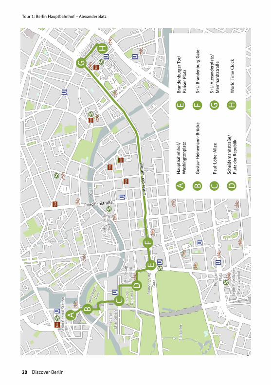
Discover Berlin 21
Tour 1: Berlin Hauptbahnhof – Alexanderplatz
Figu
re 1
1: M
ap –
Tou
r 1. S
ourc
e: O
pen
Stre
et M
ap5 .
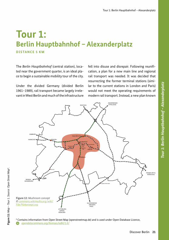
The Berlin Hauptbahnhof (central station), loca-ted near the government quarter, is an ideal pla-ce to begin a sustainable mobility tour of the city.
Under the divided Germany (divided Berlin 1961–1989), rail transport became largely irrele-vant in West Berlin and much of the infrastructure
fell into disuse and disrepair. Following reunifi-cation, a plan for a new main line and regional rail transport was needed. It was decided that resurrecting the former terminal stations (simi-lar to the current stations in London and Paris) would not meet the operating requirements of modern rail transport. Instead, a new plan known
DI S TA N C E 5 K M
Figure 12: Mushroom concept © commons.wikimedia.org/wiki/File:Pilzkonzept.svg
9 Contains information from Open Street Map (openstreetmap.de) and is used under Open Database Licence, opendatacommons.org/licenses/odbl/1.0/

Tour 1: Berlin Hauptbahnhof – Alexanderplatz
22 Discover Berlin
as the “mushroom concept” was developed (see Figure 12). This new approach to main line and regional transport was made possible by the construction of a north-south link (mostly in tunnels), which crosses the existing east-west rail link near the city centre. This junction is the site of the new central station or Hauptbahnhof. The mushroom concept is a synthesis of two ba-sic design options discussed during planning: the axis concept, and the ring concept, which inclu-ded four decentralised main line stations on the circular line, or Ringbahn, around the inner city. As built the new concept comprises the main central station and five other main line stations, some pre-existing and others new. They enable the city’s inhabitants to access main line rail ser-vices with great ease.
Construction of the 3.5 km tunnels and the Hauptbahnhof started in 1995. They were offici-ally opened in 2006, just in time for the Football World Cup.
The Hauptbahnhof is one of Europe’s largest “stack interchanges” and Europe´s largest tower train station. Flooded with natural light, five cir-culation levels give access to east-west rail ser-vices on Level +2 and north-south services on Level -3. Car and bike parking and a broad range of shops, food outlets and other service provi-ders complete the station’s facilities. The station is used by over 300,000 people a day.
T IC K E T I N F O R M AT IO N
Berlin has three fare zones: A, B, and C. A and B cover the entire area up to the city limits. A single ticket (A,B) costs EUR 2.70 and is valid for two hours, during which time you can change freely bet-ween modes of transport (all types of train, buses and trams) and interrupt the journey to your destination as often as you like. Round trips and return journeys are not permitted. You can save money by purchasing a pack of four single tickets for EUR 9.00. Day tickets (A,B) are also availa-ble for EUR 7.00, or weekly tickets costing EUR 30.00 (for zones A, B; March 2016).
More information on fares here:shop.bvg.de/index.php/tickets
M O R E O N F I N A N C I N G
→ Presentation of the financing of ur-ban mobility in Berlin: “Financing Public Transport in Germany – Case Study Berlin”
www.sustainabletransport.org/case-studies-on-funding- sustainable-public-transport/
→ General information on financing are available in the SUTP-module “Finan-cing Sustainable Urban Transport”:
www.sustainabletransport.org/financing-sustainable-urban- transport-international-review-of- national-urban-transport-policies- and-programmes/
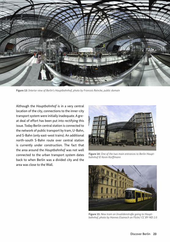
Figure 13: Interior view of Berlin’s Hauptbahnhof, photo by Francois Reincke, public domain
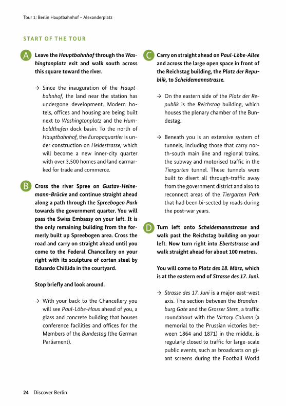
Figure 14: One of the two main entrances to Berlin Haupt-bahnhof © Kevin Korffmann
Figure 15: New tram on Invalidenstraße going to Haupt-bahnhof, photo by Hannes Eisenach on Flickr/ CC BY-ND 2.0
Tour 1: Berlin Hauptbahnhof – Alexanderplatz
Discover Berlin 23
Although the Hauptbahnhof is in a very central location of the city, connections to the inner-city transport system were initially inadequate. A gre-at deal of effort has been put into rectifying this issue. Today Berlin central station is connected to the network of public transport by tram, U-Bahn, and S-Bahn (only east-west trains). An additional north-south S-Bahn route over central station is currently under construction. The fact that the area around the Hauptbahnhof was not well connected to the urban transport system dates back to when Berlin was a divided city and the area was close to the Wall.
Tour 1: Berlin Hauptbahnhof – Alexanderplatz
A
24 Discover Berlin
S TA RT O F T H E TO U R
Leave the Hauptbahnhof through the Was-hingtonplatz exit and walk south across this square toward the river.
→ Since the inauguration of the Haupt-bahnhof, the land near the station has undergone development. Modern ho-tels, offices and housing are being built next to Washingtonplatz and the Hum-boldthafen dock basin. To the north of Hauptbahnhof, the Europaquartier is un-der construction on Heidestrasse, which will become a new inner-city quarter with over 3,500 homes and land earmar-ked for trade and commerce.
Cross the river Spree on Gustav-Heine-mann-Brücke and continue straight ahead along a path through the Spreebogen Park towards the government quarter. You will pass the Swiss Embassy on your left. It is the only remaining building from the for-merly built up Spreebogen area. Cross the road and carry on straight ahead until you come to the Federal Chancellery on your right with its sculpture of corten steel by Eduardo Chillida in the courtyard.
Stop briefly and look around.
→ With your back to the Chancellery you will see Paul-Löbe-Haus ahead of you, a glass and concrete building that houses conference facilities and offices for the Members of the Bundestag (the German Parliament).
Carry on straight ahead on Paul-Löbe-Allee and across the large open space in front of the Reichstag building, the Platz der Repu-blik, to Scheidemannstrasse.
→ On the eastern side of the Platz der Re-publik is the Reichstag building, which houses the plenary chamber of the Bun-destag.
→ Beneath you is an extensive system of tunnels, including those that carry nor-th-south main line and regional trains, the subway and motorised traffic in the Tiergarten tunnel. These tunnels were built to divert all through-traffic away from the government district and also to reconnect areas of the Tiergarten Park that had been bi-sected by roads during the post-war years.
Turn left onto Scheidemannstrasse and walk past the Reichstag building on your left. Now turn right into Ebertstrasse and walk straight ahead for about 100 metres.
You will come to Platz des 18. März, which is at the eastern end of Strasse des 17. Juni.
→ Strasse des 17. Juni is a major east-west axis. The section between the Branden-burg Gate and the Grosser Stern, a traffic roundabout with the Victory Column (a memorial to the Prussian victories bet-ween 1864 and 1871) in the middle, is regularly closed to traffic for large-scale public events, such as broadcasts on gi-ant screens during the Football World
B
C
D
Tour 1: Berlin Hauptbahnhof – Alexanderplatz
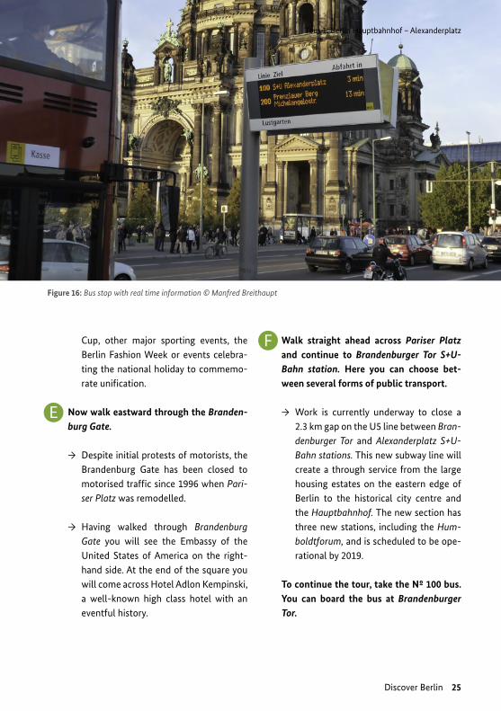
Figure 16: Bus stop with real time information © Manfred Breithaupt
Discover Berlin 25
Cup, other major sporting events, the Berlin Fashion Week or events celebra-ting the national holiday to commemo-rate unification.
Now walk eastward through the Branden-burg Gate.
→ Despite initial protests of motorists, the Brandenburg Gate has been closed to motorised traffic since 1996 when Pari-ser Platz was remodelled.
→ Having walked through Brandenburg Gate you will see the Embassy of the United States of America on the right-hand side. At the end of the square you will come across Hotel Adlon Kempinski, a well-known high class hotel with an eventful history.
Walk straight ahead across Pariser Platz and continue to Brandenburger Tor S+U-Bahn station. Here you can choose bet-ween several forms of public transport.
→ Work is currently underway to close a 2.3 km gap on the U5 line between Bran-denburger Tor and Alexanderplatz S+U-Bahn stations. This new subway line will create a through service from the large housing estates on the eastern edge of Berlin to the historical city centre and the Hauptbahnhof. The new section has three new stations, including the Hum-boldtforum, and is scheduled to be ope-rational by 2019.
To continue the tour, take the Nº 100 bus. You can board the bus at Brandenburger Tor.
E
F

Tour 1: Berlin Hauptbahnhof – Alexanderplatz
26 Discover Berlin
Take the bus eastwards towards Alexan-derplatz. Get off at the S+U Alexanderplatz Bhf/Memhardstrasse stop to continue the tour from there.
→ You have now almost arrived at Ale-xanderplatz. As you get off the bus, you will see the side of the Galeria Kaufhof department store ahead of you. Facing this building, walk to the left and then at the corner of the building turn right to enter Alexanderplatz. Pass the Brunnen der Völkerfreundschaft (friendship of the nations) fountain on your right and con-tinue to the World Time Clock.
→ Stop a moment here and look around. Alexanderplatz is steeped in history. East Berlin was the capital for the East German government and Alexanderplatz provided a venue for mass public events. For this reason Alexanderplatz was kept free of traffic (cars and trams) after the Second World War. On 4th November 1989, half a million people demons-trated at Alexanderplatz and claimed democratic reforms. On November 9th the wall fell.
You are standing in front of the World Time Clock, erected in 1971. To the south of the square you can see the Television Tower, which is the tallest structure in Germany at 368 metres.
→ After the fall of the Berlin Wall, exten-sive plans for redesigning Alexanderplatz
The bus route 100 goes from Zoologischer Garten to Alexanderplatz, and was the first to run between East and West Berlin fol-lowing German reunification. It is an inex-pensive alternative to taking a guided tour of the city. Along the route are a number of the city’s key sights. You can get on and off the bus as often as you like to visit these si-ghts within the ticket’s permitted time limit of two hours (Berlin Tourismus & Kongress GmbH, 2013 and Berlin – Tourismus, 2013).
The following sights can be seen along the route (from west to east):
→ Kaiser Wilhelm Memorial Church → Elephant Gate
(one of the entrances to the zoo) → Bellevue Palace (official residence of the
German President) → House of World Cultures → Reichstag (German Bundestag) → Brandenburg Gate → Unter den Linden → Humboldt University → Berlin Cathedral → Marx-Engels Forum → TV Tower → Alexanderplatz
G
H

Tour 1: Berlin Hauptbahnhof – Alexanderplatz
Karl-Liebknecht-S
traße
Alexanderstraße
Otto-B
raun-Straße
Dircksenstraße
GontardstraßeTelevision Tower
Commerzbank Alexanderplatz
World Time Clock
Alea 101
Rathausstraße
Call a Bike
Park Inn
C&A
Berliner Sparkassen
Saturn
Call a Bike
Kaufhof
Cinestar
Figure 17: Alexanderplatz
Discover Berlin 27
and the surrounding buildings were developed, including proposals for new high-rises. There is a model of the city on display at Am Köllnischen Park 3 sho-wing these urban design plans and the construction progress. The square has already been remodelled; so has Alexan-derstrasse, the road on the south-east side of the square. Trams have resumed service and the square once again serves as one of the city's important meeting places and a venue for public events.
→ Today, the area around Alexanderplatz is one of Berlin’s most important transport hubs, with over half a million people passing through every day. It serves as a station for main line trains and all types of local transport.
You can now decide how to proceed to Potsdamer Platz, the next stop on the tour. You can choose between taking the U-Bahn (U2), or renting a bicycle.
9 Contains information from Open Street Map (openstreetmap.de) and is used under Open Database Licence, opendatacommons.org/licenses/odbl/1.0/
Tour 2: Alexanderplatz – Potsdamer Platz
28 Discover Berlin
A
BC
DE
FG
H
A DB C
E F G H
Wor
ld T
ime
Cloc
k
Rath
ausb
rück
e
Schl
ossp
latz
Fran
zösi
sche
Str
aße
Gen
darm
enm
arkt
Mem
oria
l
Han
nah-
Are
ndt-
Stra
ße/
Eber
tstr
aße
Pots
dam
er P
latz
Plat
z de
rRe
publ
ikRe
ichs
tag
Build
ing
Tier
gart
en
Bran
denb
urg
Gat
e
Pots
dam
er
Plat
z
Unt
er d
en L
inde
nSc
hlos
spla
tzN
ikol
aiki
rche
Foreign Ministry
Gendarmenmarkt
Mem
oria
lFr
anzö
sisc
he S
traß
e
Leip
zige
r Str
aße
Ebertstraße
Paul
-Löb
e-A
llee
Wilhelmstraße
Tier
gart
enst
raße
Berli
n Po
tsda
mer
Pl
atz
Bahn
hof
Stresemannstr
aße
Friedrichstraße
Bahn
hof B
erlin
Fr
iedr
ichs
traß
e
Spre
ebog
en
Park
Wal
lstra
ße

Tour
2: A
lexa
nder
plat
z –
Pots
dam
er P
latz
Tour 2: Alexanderplatz – Potsdamer Platz
Discover Berlin 29
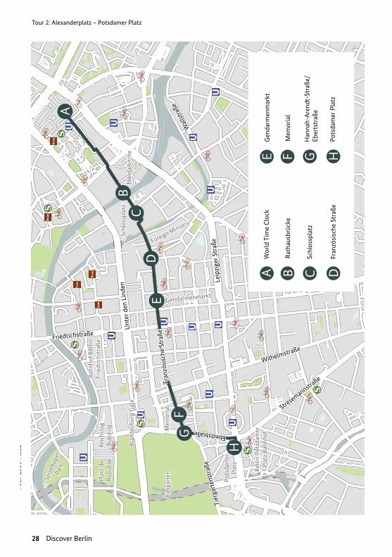
Figu
re 1
8: M
ap –
Tou
r 2. S
ourc
e: o
pens
tree
tmap
.de9
If you take the U-Bahn, walk from the World Time Clock to any of the Alexanderplatz station entrances that have a blue U-Bahn sign. Make sure you have a valid ticket (for information on tickets, see the box on page 22) and take the U2 line towards Ruhleben, which runs every four or five minutes. Alight at the seventh stop, Pots-damer Platz station.
To continue the tour by rental bike instead, walk from the World Time Clock back across Alexan-derplatz to Karl-Liebknecht-Strasse, where the-re is a Call a Bike docking station (1162) (see "A detour: Call a Bike" on page 32). Remain on your bike, head toward the S-Bahn and cross under the railway bridge; be careful, trams might be crossing your way!
Follow Rathausstrasse now until you reach Rat-hausbrücke. If there are construction sites, it might get narrow driving on the street. In this case, walk your bike on the sidewalk for this short distance.
10 Contains information from Open Street Map (openstreetmap.de) and is used under Open Database Licence, opendatacommons.org/licenses/odbl/1.0/
Tour 2: Alexanderplatz – Potsdamer Platz DI S TA N C E 3 K M
→ On your right you will see the television to-wer, Berlin’s highest building, measuring 368 m. If you go up the tower, you will have a great view on the city! Behind the television tower, you will find the Marienkirche, a church from the Middle Ages that began construction in 1270. Unlike many old buildings in the area, the church was not destroyed during war.
→ On your left you will come across the town hall of Berlin, named Rotes Rathaus, due to its red brick. Built between 1861 and 1869, this is the office of the Mayor of Berlin.
→ Opposite to the Town Hall is the construction site for a new subway station. Along with two other stations, this is part of a project to con-nect Berlin central station with Alexander-platz by closing the 2.2 km gap between U55 and U5. This development to the subway net-work has been under construction since 2011 and is expected to be finished in 2020. Total costs are estimated at EUR 525 million. The underground tunnels were bored through Berlin’s ancient glacial valley geological
A
B

Tour 2: Alexanderplatz – Potsdamer Platz
Figure 19: Weltzeituhr on Alexanderplatz, photo by Raoni on Flickr/ CC BY 2.0
30 Discover Berlin
structure using a shield driving method – a si-gnificant engineering challenge. The comple-tion of the U5 will connect the large residen-tial areas in the eastern part of Berlin directly to Berlin central station. Tourist spots, such as Museumsinsel, Humboldtforum and Unter den Linden will also have better public transport access. After completion, the 22 km long U5 will be fully accessible. An estimated number of 150,000 people will use it every day.
→ After having crossed Spandauer Straße, Niko-laiviertel and Nikolaikirche will appear on your left. You are now in one of the oldest settled areas of the city, although its buildings – with the exception of the church – only date back to 1987, the most recent phase of East Ger-man urban design. The Nikolaiviertel is loosely based on historical urban structures and was built using prefabricated concrete panels to create replicas of historical buildings that show how the old quarter might have looked.
Cross the Rathausbrücke and continue until you reach Schlossplatz.
→ On your right, you will see the big construc-tion site for the reconstruction of the Berlin city palace, the Stadtschloss. Following inten-sive public discussion and a decision of the Bundestag, the reconstruction of the Prus-sian palace under the name of Humboldtfo-rum started in 2013. It is expected to open in 2019. Following the instructions of Walter Ulbricht, the former Hohenzollern residence ruins were torn down to eliminate the me-mory of feudalism in 1950. The Palast der Re-publik was constructed to replace the former city palace, which was eventually demolished between 2003 and 2008. The new building will have reproductions of baroque facades on three sides and a modern fourth side. The inner part will be adapted to the needs of a modern centre for art, culture and science. The name Humboldt (in memory of Wilhelm

Tour 2: Alexanderplatz – Potsdamer Platz
Discover Berlin 31
and Alexander von Humboldt) stands for the objective of the future exhibition program to show the dialogue of European and non-Eu-ropean cultures in its historical and future dimensions.
→ On the left-hand side you will see the former Staatsrat building. Built after the war, it was the seat of the GDR’s head of government. Walter Ulbricht and Erich Honecker worked there for many years. The baroque part of the new facade is a section of the former City Pa-lace. It was removed from the palace before its deconstruction in 1950 and was integrated into the Staatsrat facade afterwards, as it was on this exact balcony where Karl Liebknecht proclaimed the German Free Socialist Repu-blic on 9th November 1918.
At Schlossplatz, 12 radial bicycle routes present the basic structure of the Berlin bicycle lane network, along with 8 tangential routes. A finer scaled network of bike lanes completes the in-dividual districts.
Follow Französische Straße westwards from Schlossplatz until it becomes Hannah-Ah-rendt-Straße and finally leads into Ebertstraße.
After crossing the Rathausbrücke over Spreeka-nal, you will pass the Foreign Ministry on your left and the Friedrichwerdersche Kirche, built by Karl Friedrich Schinkel, on your right.
In about 400 m, the street opens on the left-hand side into Gendarmenmarkt, the most beautiful square in this part of the city centre, the so-called Friedrichstadt.
→ It is the baroque extension of the me-dieval centre of Berlin. The suburb was created following strict regularities, one example being the orthogonally planned street grid. The German and French cathedrals are located on the Gendarmenmarkt square; in the centre of the square is the Konzerthaus (Con-cert House). French Huguenots fleeing religious persecution in their homeland were welcomed in Berlin during the 17th century, bringing their culture to the city.
On your right, just before arriving at Ebertstraße, you will see the Memorial to the Murdered Jews of Europe. The site measures 19,000 m² and is covered with 2711 concrete slabs, arranged in a grid pat-tern. It was built according to a draft by Peter Eisenman and inaugurated in 2005.
Cross Ebertstraße, turn left and drive down the road until you arrive at Potsdamer Platz.
The buildings on the left-hand side accom-modate the Permanent Representations of some of the German federal states called Bundesländer. They are a sign for the fe-deralism of the German state.
Please park your bike here.
C
D
E
F
G
H
Tour 2: Alexanderplatz – Potsdamer Platz
32 Discover Berlin
A D E TO U R : C A L L A B I K E
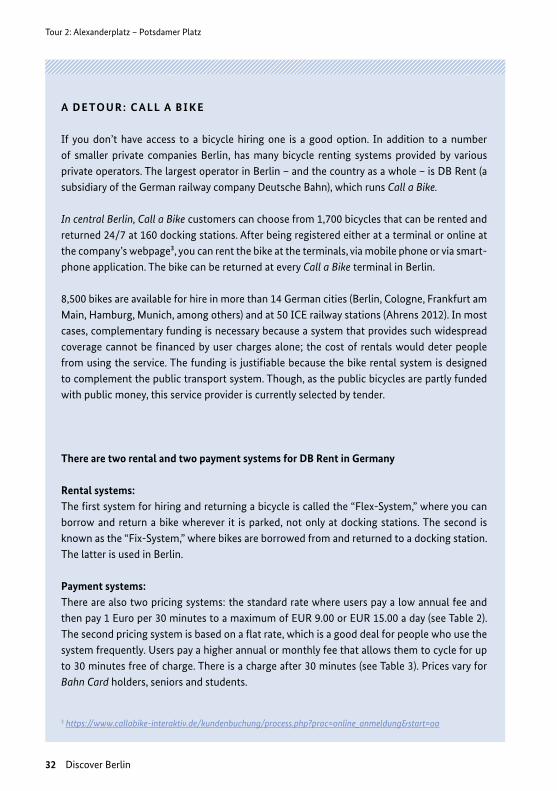
If you don’t have access to a bicycle hiring one is a good option. In addition to a number of smaller private companies Berlin, has many bicycle renting systems provided by various private operators. The largest operator in Berlin – and the country as a whole – is DB Rent (a subsidiary of the German railway company Deutsche Bahn), which runs Call a Bike.
In central Berlin, Call a Bike customers can choose from 1,700 bicycles that can be rented and returned 24/7 at 160 docking stations. After being registered either at a terminal or online at the company’s webpage³, you can rent the bike at the terminals, via mobile phone or via smart-phone application. The bike can be returned at every Call a Bike terminal in Berlin.
8,500 bikes are available for hire in more than 14 German cities (Berlin, Cologne, Frankfurt am Main, Hamburg, Munich, among others) and at 50 ICE railway stations (Ahrens 2012). In most cases, complementary funding is necessary because a system that provides such widespread coverage cannot be financed by user charges alone; the cost of rentals would deter people from using the service. The funding is justifiable because the bike rental system is designed to complement the public transport system. Though, as the public bicycles are partly funded with public money, this service provider is currently selected by tender.
There are two rental and two payment systems for DB Rent in Germany
Rental systems: The first system for hiring and returning a bicycle is called the “Flex-System,” where you can borrow and return a bike wherever it is parked, not only at docking stations. The second is known as the “Fix-System,” where bikes are borrowed from and returned to a docking station. The latter is used in Berlin.
Payment systems: There are also two pricing systems: the standard rate where users pay a low annual fee and then pay 1 Euro per 30 minutes to a maximum of EUR 9.00 or EUR 15.00 a day (see Table 2). The second pricing system is based on a flat rate, which is a good deal for people who use the system frequently. Users pay a higher annual or monthly fee that allows them to cycle for up to 30 minutes free of charge. There is a charge after 30 minutes (see Table 3). Prices vary for Bahn Card holders, seniors and students.
3 https://www.callabike-interaktiv.de/kundenbuchung/process.php?proc=online_anmeldung&start=oa

Tour 2: Alexanderplatz – Potsdamer Platz
Discover Berlin 33
STANDARD RATE (IN EUR)
REGULAR RATE (IN EUR)
REDUCED RATE FOR BAHN CARD HOLDERS, STUDENTS, SENIORS (IN EURO)
Each 30 minutes 1.00 1.00
Day (24 hours) 15.00 12.00
Fee / Term 3.00 / per year 3.00 / per year
STANDARD RATE (IN EUR)
REGULAR RATE (IN EUR)
REDUCED RATE FOR BAHN CARD HOLDERS, STUDENTS, SENIORS (IN EURO)
1 to 30 minutes Free Free
Each 30 minutes after the 31st minute 1.00 1.00
Day (24 hours) 12.00 9.00
Fee / Term 9.00 / per month 49.00 / per year
7.00 / per month39.00 / per year
How does Call a Bike work?
1. One-time registration on-site (at a terminal) or online (or using the Call a Bike app) free of charge:
www.callabike-interaktiv.de/index.php?id=389
2. Once you have registered, look for a Call a Bike station. You can download a map of docking stations for Berlin’s Call a Bike system at
www.callabike-interaktiv.de/kundenbuchung/process.php?proc=bikesuche
3. Hire a bike using a terminal or a mobile phone
I. Using a terminal: a) Touch the screen to activate it. Confirm your identity using a Maestro
or credit card or Call a Bike customer card. b) Select bikes (max 2 per customer) using the bike numbers displayed. c) Touch the display of the bike selected and remove the lock.
II. Using a phone: a) Call the phone number in the red box on the cover of the lock.
Table 1: Rate 1 (standard rate, as of March 2016)
Table 2: Rate 2 (flat rate)

Tour 2: Alexanderplatz – Potsdamer Platz
Figure 20: Call a Bike rent station in Berlin, photo by Rudolf Simon/ CC BY-SA 3.0 Unported
Figu
re 2
1: C
row
ded
Alex
ande
rpla
tz, p
hoto
by
Sasc
ha K
ohlm
ann
on F
lickr
/CC
BY-S
A 2.
0
34 Discover Berlin
4. If you would like to take a break while using your Call a Bike, close the lock and press the lock button. Your personal opening code will appear on the display. You can use this code to unlock the bike later (you can also access it online). Note: you will be charged for the time your bike is parked, even though you are not using it.
5. You can return the bike to any docking station to end the rental. Simply place it in a free slot and secure it using the lock provided. If all the slots are taken, leave the bike near a docking station. The system will recognise it as returned. Finally, press the button on the right of the lock and note the receipt code on the lock display.
(DB Rent GmbH, 2016; Deutsche Bahn AG, 2016)
Further reading
Call a Bike – das Stadtrad für Berlin www.callabike-interaktiv.de/index.php?id=389&key=18d-b52aee557023f2b-77d32c660c90f4...00000 (German only)
Call a Bike brochure in English www.callabike-interaktiv.de/kundenbuchung/download/ 500/200903_Call_a_Bike_ZCard_GB_oP.pdf
Map of docking stations for the Berlin Call a Bike system www.callabike-interaktiv.de/kundenbuchung/process.php? proc=bikesuche&f=500&&f=500

Tour 2: Alexanderplatz – Potsdamer Platz
Discover Berlin 35
Tour 3: Potsdamer Platz
36 Discover Berlin
AB C
D
A
DB
C D
Pots
dam
er P
latz
/St
rese
man
nstr
aße
Kollh
off-
Tow
er
Gle
isdr
eiec
k
Prin
zens
traß
e
Prinzenstraße
Gits
chin
er S
traß
e
Prin
zess
inen
gart
enMor
itzpl
atz
Pots
dam
er
Plat
z
Ebertstraße
Stresemannstr
aße
Lindenstraße
Wilhelmstraße
Meh
ringp
latz
Heinrich-Heine-Straße
Ora
nien
stra
ße
Alexandrinenstraße
Rudi
-Dut
schk
e-St
raße
Berli
n Po
tsda
mer
Pl
atz
Bahn
hof
Tour
3: P
otsd
amer
Pla
tz
Tour 3: Potsdamer Platz
Discover Berlin 37
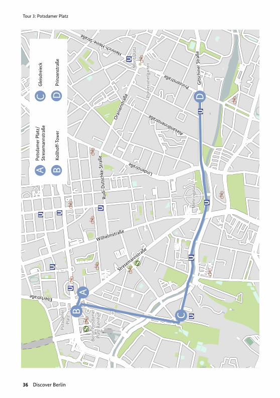
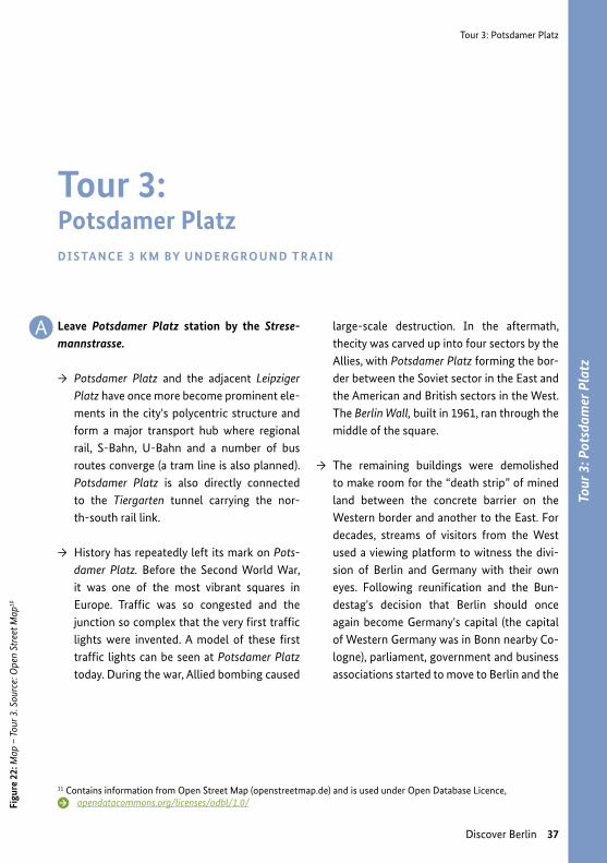
Leave Potsdamer Platz station by the Strese-mannstrasse.
→ Potsdamer Platz and the adjacent Leipziger Platz have once more become prominent ele-ments in the city's polycentric structure and form a major transport hub where regional rail, S-Bahn, U-Bahn and a number of bus routes converge (a tram line is also planned). Potsdamer Platz is also directly connected to the Tiergarten tunnel carrying the nor-th-south rail link.
→ History has repeatedly left its mark on Pots-damer Platz. Before the Second World War, it was one of the most vibrant squares in Europe. Traffic was so congested and the junction so complex that the very first traffic lights were invented. A model of these first traffic lights can be seen at Potsdamer Platz today. During the war, Allied bombing caused
Figu
re 2
2: M
ap –
Tou
r 3. S
ourc
e: O
pen
Stre
et M
ap10
11 Contains information from Open Street Map (openstreetmap.de) and is used under Open Database Licence, opendatacommons.org/licenses/odbl/1.0/
Tour 3: Potsdamer PlatzDI S TA N C E 3 K M BY U N D E RG RO U N D T R A I N
large-scale destruction. In the aftermath, thecity was carved up into four sectors by the Allies, with Potsdamer Platz forming the bor-der between the Soviet sector in the East and the American and British sectors in the West. The Berlin Wall, built in 1961, ran through the middle of the square.
→ The remaining buildings were demolished to make room for the “death strip” of mined land between the concrete barrier on the Western border and another to the East. For decades, streams of visitors from the West used a viewing platform to witness the divi-sion of Berlin and Germany with their own eyes. Following reunification and the Bun-destag's decision that Berlin should once again become Germany's capital (the capital of Western Germany was in Bonn nearby Co-logne), parliament, government and business associations started to move to Berlin and the
A
Tour 3: Potsdamer Platz
Figure 23: Potsdamer Platz today © Michael J. Zirbes
38 Discover Berlin
Figure 24: The first traffic lights on Berlin Potsdamer Platz, photo by Willy Pragher on Flickr/ CC BY 3.0
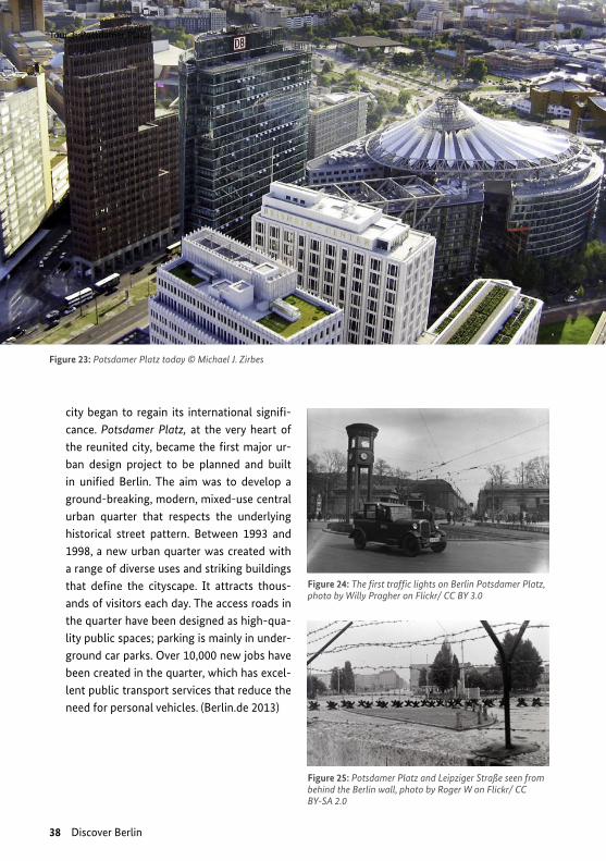
city began to regain its international signifi-cance. Potsdamer Platz, at the very heart of the reunited city, became the first major ur-ban design project to be planned and built in unified Berlin. The aim was to develop a ground-breaking, modern, mixed-use central urban quarter that respects the underlying historical street pattern. Between 1993 and 1998, a new urban quarter was created with a range of diverse uses and striking buildings that define the cityscape. It attracts thous-ands of visitors each day. The access roads in the quarter have been designed as high-qua-lity public spaces; parking is mainly in under-ground car parks. Over 10,000 new jobs have been created in the quarter, which has excel-lent public transport services that reduce the need for personal vehicles. (Berlin.de 2013)
Figure 25: Potsdamer Platz and Leipziger Straße seen from behind the Berlin wall, photo by Roger W on Flickr/ CC BY-SA 2.0

Tour 3: Potsdamer Platz
Figure 27: Mobility scenes from Berlin © M. Köller, © M. Breithaupt, © S. Ledwoch
Discover Berlin 39
Figure 26: Berlin Bus near Alexanderplatz photo by Rob Dammers on Flickr CC BY 2.0
For a wonderful view of the city from one of the tall buildings at Potdamer Platz, you can go to Panoramapunkt. It is located on the 24th and 25th floor of Kollhoff-Tower and offers an open-air viewing platform to visitors.
Go back into Potsdamer Platz station and take the U2 line towards Theodor-Heuss-Platz or Ruhleben, which runs every 5 minutes. Make sure you have a valid ticket.
Get off two stops later at Gleisdreieck and take the U1 towards Warschauer Strasse, which also runs every 5 minutes.
Go three stops to Prinzenstrasse station and leave by the Prinzenstrasse/Gitschiner Strasse exit.
More about mobility management
“Mobility Management & Commuting: Inputs and Examples of Best Practice in German Firms”:
www.sutp.org/files/contents/documents/resources/C_Case-Studies/GIZ_SUTP_CS_ Mobility-Management-Commuting-EN.pdf
B
C
D

A D E TO U R : U R B A N G ROW T H A N D T R A F F IC VO LU M E S
The new millennium represented a new beginning for Berlin. The population began to rise again, at increasing growth rates. Over the past 5 years, between 40,000 and 50,000 people moved to Berlin every year, mainly from other places in Germany and Europe. Furthermore, a growing number of refugees are coming to Berlin, fleeing war and persecution. The city estimates that around 20,000 to 25,000 refugees will move to Berlin annually on a long-term basis.
Not only is Berlin’s population expanding: after a longer phase of structural change, the eco-nomy of Berlin is growing again and jobs are being created. The growing number of inhab-itants and employment rate generates more traffic. The higher volume of traffic is evident in public transport, in motorised individual traffic and in bicycle traffic. It remains to be seen if the city’s ambitious goals concerning transport policy can be achieved under these new con-ditions of city and traffic growth. The goals include further reductions in motor vehicle traffic and increasing the share of environmentally sustainable mobility in the modal split.
The numbers show a clear and positive picture: between two surveys on mobility in 2008 and 2013, Berlin grew by 155,000 people. Rising demand for public transport caused the greatest increase in traffic volumes, accounting for 95% of added motorised traffic. Only 5% of addi-tional total traffic was from motor vehicles. In relation to all trips done, the total motorised traffic actually decreased by about 3% over the survey period; primarily in favour of non-mo-torised transport like walking and biking. The traffic census shows that inner city traffic con-tinues to decrease, as has been observed over the past decade (approximately 10% in total).
The numbers show that it is possible to decouple city growth from growth of private motori-sed traffic through transport policies, including measures aimed at strengthening sustainable mobility.
Tour 3: Potsdamer Platz
Figu
re 2
8: C
onst
ruct
ion
site
at M
useu
msin
sel B
erlin
on
Flic
kr u
nder
CC
BY 2
.0
40 Discover Berlin
Tour 3: Potsdamer Platz
Discover Berlin 41
Tour 4: Kreuzberg
42 Discover Berlin
A
BC D
E
F
G
A
D
BC
EFG
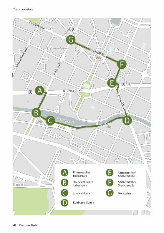
Prinzenstraße/Böcklerpark
Baerwaldbrücke/Urbanhafen
Kottbusser Tor/Adalbertstraße
Adalbertstraße/Oranienstraße
Landwehrkanal
Kottbusser Damm
Moritzplatz
Prin
zens
traß
e
Gitschiner Straße
Planufer
Kottbusser Straße
Oranienstraße
Prinzessinengarten
Moritzplatz
Landwehrkanal
Oranienstraße
Alex
andr
inen
stra
ße
Tour
4: K
reuz
berg
Tour 4: Kreuzberg
Discover Berlin 43
You will start in Kreuzberg, a district in the bo-rough of Friedrichshain-Kreuzberg. Until the administrative reform of 2001, it was a borough in its own right.
Along with Friedrichshain and Prenzlauer Berg, Kreuzberg is seen as one of Berlin's trendiest areas. Unlike the first two districts, however, Kreuzberg was in West Berlin. Right next to the Wall, it was effectively pushed out to the margins of the western city. Despite severe war damage, the typical late 19th century structure of the “tenement city” remained largely unda-maged in many parts of Kreuzberg. In the days of West Berlin, the district provided a refuge for people looking for alternative lifestyles and op-portunity to protest against the establishment.
Figu
re 2
9: M
ap –
Tou
r 4. S
ourc
e: O
pen
Stre
et M
ap10
12 Contains information from Open Street Map (openstreetmap.de) and is used under Open Database Licence, opendatacommons.org/licenses/odbl/1.0/
Tour 4: KreuzbergDI S TA N C E 3 K M WA L K I N G
→ Militant conflicts ignited over car-centric urban planning and transport policy in the post-war years. Radical urban redevelopment schemes to bulldoze vast areas for roads would have virtually destroyed the remaining historical structure of the district. Kottbusser Tor is a shining example of urban design in the 1960s and 1970s, giving an idea of what was planned for vast areas of Kreuzberg. Squat-ter movements and militant protests in the late 1970s led to a change of concept in re-development and transport policy. The road schemes were abandoned, and a “careful ur-ban renewal” model was developed instead, which lowered rents (“Internationale Bau-ausstellung 1984-87”). Today, the mixed-use buildings dating back to the Gründerzeit – Germany's period of rapid industrial expansi-on in the late 19th century – and set around inner courtyards, are highly sought after in creative circles.

Tour 4: Kreuzberg
Figure 31: U-Bahn station Prinzenstraße in 1900, unknown author, public domain
Figure 30: Baerwaldbrücke, photo by Lienhard Schulz on Flickr/ CC BY-SA 3.0
A
B
C
D
44 Discover Berlin
As you leave the U-Bahn station you will see Böcklerpark on your left and the Ur-banhafen ahead, which can be reached by crossing Baerwaldbrücke bridge.
This open space has a wonderful Mediter-ranean ambiance and is ideal for relaxing in the summer.
After crossing the Baerwaldbrücke Brid-ge, turn left and walk eastwards along the Landwehr canal to Kottbusser Strasse.
Turn left over the bridge and walk northwards on Kottbusser Strasse to Kott-busser Tor.
Tour 4: Kreuzberg
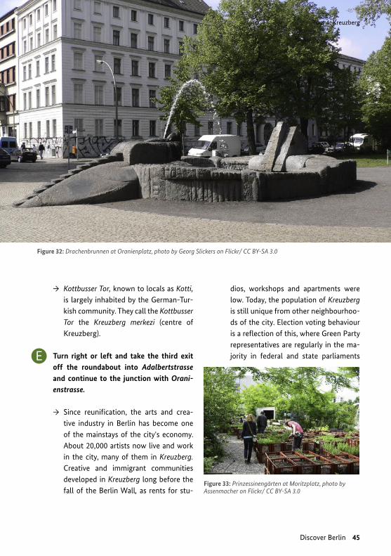
Figure 33: Prinzessinengärten at Moritzplatz, photo by Assenmacher on Flickr/ CC BY-SA 3.0
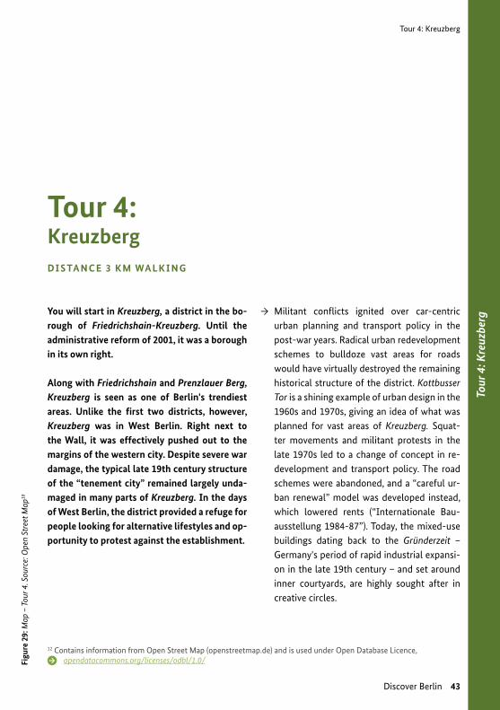
Figure 32: Drachenbrunnen at Oranienplatz, photo by Georg Slickers on Flickr/ CC BY-SA 3.0
Discover Berlin 45
→ Kottbusser Tor, known to locals as Kotti, is largely inhabited by the German-Tur-kish community. They call the Kottbusser Tor the Kreuzberg merkezi (centre of Kreuzberg).
Turn right or left and take the third exit off the roundabout into Adalbertstrasse and continue to the junction with Orani-enstrasse.
→ Since reunification, the arts and crea-tive industry in Berlin has become one of the mainstays of the city's economy. About 20,000 artists now live and work in the city, many of them in Kreuzberg. Creative and immigrant communities developed in Kreuzberg long before the fall of the Berlin Wall, as rents for stu-
dios, workshops and apartments were low. Today, the population of Kreuzberg is still unique from other neighbourhoo-ds of the city. Election voting behaviour is a reflection of this, where Green Party representatives are regularly in the ma-jority in federal and state parliaments E
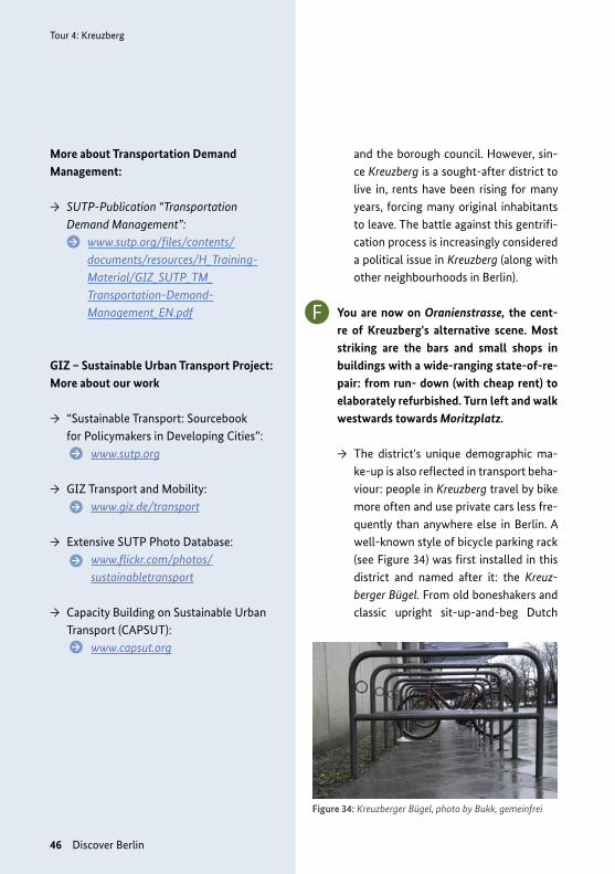
Figure 34: Kreuzberger Bügel, photo by Bukk, gemeinfrei
Tour 4: Kreuzberg
46 Discover Berlin
More about Transportation Demand Management:
→ SUTP-Publication “Transportation Demand Management”: www.sutp.org/files/contents/
documents/resources/H_Training- Material/GIZ_SUTP_TM_ Transportation-Demand- Management_EN.pdf
GIZ – Sustainable Urban Transport Project: More about our work
→ “Sustainable Transport: Sourcebook for Policymakers in Developing Cities”:
www.sutp.org
→ GIZ Transport and Mobility: www.giz.de/transport
→ Extensive SUTP Photo Database: www.flickr.com/photos/
sustainabletransport
→ Capacity Building on Sustainable Urban Transport (CAPSUT): www.capsut.org
and the borough council. However, sin-ce Kreuzberg is a sought-after district to live in, rents have been rising for many years, forcing many original inhabitants to leave. The battle against this gentrifi-cation process is increasingly considered a political issue in Kreuzberg (along with other neighbourhoods in Berlin).
You are now on Oranienstrasse, the cent-re of Kreuzberg's alternative scene. Most striking are the bars and small shops in buildings with a wide-ranging state-of-re-pair: from run- down (with cheap rent) to elaborately refurbished. Turn left and walk westwards towards Moritzplatz.
→ The district's unique demographic ma-ke-up is also reflected in transport beha-viour: people in Kreuzberg travel by bike more often and use private cars less fre-quently than anywhere else in Berlin. A well-known style of bicycle parking rack (see Figure 34) was first installed in this district and named after it: the Kreuz-berger Bügel. From old boneshakers and classic upright sit-up-and-beg Dutch
F

Figure 35: Berlin Urbanhafen 1900, unknown author, gemeinfrei
Tour 4: Kreuzberg
Discover Berlin 47
bikes, electric cycles and cargo bikes – it can all be found here in Kreuzberg when it comes to bicycle culture. Look closely and you might also spot a fashionable local on a “fixie” – a fixed-wheel bike with only one gear that seems to express a particular philosophy of life. (Berlin – Bezirksamt Friedrichshain-Kreuzberg 2008; Sightseeing Point GmbH; Berlin Tourismus & Kongress GmbH)
You have reached the end of the tour.
You are now at Moritzplatz and can go into the U-Bahn station of the same name. Make sure you have a valid ticket!
To get back to the Berlin Hauptbahnhof, take the U8 towards Wittenau, which runs every 5 minutes and change at Jannowitz-brücke onto the S7 S-Bahn line towards Potsdam Hbf, which runs every 2–5 minu-tes. Alight at Hauptbahnhof.
G

Tour 4: Kreuzberg
48 Discover Berlin
A D E TO U R : LOW E M I S S IO N ZO N E
So far you have been able to enjoy the advantages of public transport of Berlin in its many forms. However, you have no doubt noticed that Berlin's roads are often full of cars, despi-te the lowest rates of private motor vehicles among German cities. Driving a car produces harmful emissions: air pollutants, climate-damaging gases and noise. Fortunately, modern cars produce fewer emissions than older ones, so the days of Berlin smog alarms are long gone – the last alarm in West Berlin was in 1985. The modernisation of Berlin's industry and household heating systems has also made a major contribution to reducing atmospheric pollution.
Take a deep breath... Do you notice anything? The fact that you can't smell any pollutants in the atmosphere does not mean the problem is completely solved. Particulates (PM10, PM2.5) and nitrogen dioxide (NO2) still pollute the atmosphere, yet we scarcely notice them. The EU has set stringent limit values for these pollutants and threatens countries with financial fines for breaching them. However, these limits are still being exceeded in Berlin, which is why the city has introduced a “low emission zone”.
A low emission zone is a defined urban area in which limit values are often exceeded and where only low-emission vehicles can be driven. In Berlin this is the area within the S-Bahn ring, home to just over a million people. Violations incur a fine, currently set at EUR 80. Federal law defines four vehicle categories ranging from slightly lower emission to ultra-low emis-sion. Vehicles receive a coloured windscreen sticker marking their emission category. Local authorities have discretion to decide on the basis of local pollution conditions what vehicle categories should be prohibited from entering the low emission zone and what exemptions may be granted.
Berlin's low emission zone was introduced on 1 January 2008, as a method to achieve suffi-cient reductions in air pollution levels. Motor vehicles in Berlin are still major contributors to particulate pollution and are almost solely responsible for nitrogen oxide pollution. The low emission zone was introduced in two phases to give owners time to retrofit their vehicles or buy new ones. Initially vehicles with the highest emissions were prohibited, and the other three categories – red, yellow and green – were still allowed to enter the low emission zone. The second phase began on 1 January 2010. Since then, only vehicles that have a green sticker – the cleanest vehicle category at present – are allowed within the zone.
Continuous monitoring of air quality has shown that the low emission zone has been effec-tive: it has significantly sped up the replacement of old vehicles by low-emission ones. This has lowered particulate matter by 50% and nitrogen dioxide emissions by 20% from the predicted trends.

Tour 4: Kreuzberg
Figure 36: Low emission zone inside the S-Bahn ring in Berlin Source: Senate Department for Urban Development and the Environment (2013):
www.stadtentwicklung.berlin.de/umwelt/luftqualitaet/umweltzone/de/gebiet.shtml
Discover Berlin 49
Low emission zones have been introduced in over 300 other European cities and agglomera-tions. Despite this success, they are a subject for heated public debate. As long as limit values are being exceeded, low emission zones will remain a necessity. Other transport policies desi-gned to reduce motor vehicle traffic in the city promise to further reduce pollution.
Further reading
→ The low emission zone in Berlin – results of a first impact assessment www.stadtentwicklung.berlin.de/umwelt/luftqualitaet/de/luftreinhalteplan/
→ Berlin's Environmental Zone – Information for Foreign Tourists urbanaccessregulations.eu/images/stories/dpf_files/berlin%20lez%20english.pdf
→ The Low Emission Zone (Umweltzone) in Berlin www.unece.org/fileadmin/DAM/thepep/en/workplan/urban/documents/Skopje/ presentations/session4/1.low.emission.zone.pdf
→ Fact Sheet: Low Emission Zones - Examples from Berlin, London, and Beijing www.sutp.org/files/contents/documents/resources/E_Fact-Sheets-and-Policy-Briefs/GIZ_SUTP_FS_Low-Emission-Zones_EN.pdf
→ Clean Air – Made in Germany www.sutp.org/files/contents/documents/resources/E_Fact-Sheets-and-Policy-Briefs/GIZ_SUTP_FS_Low-Emission-Zones_EN.pdf

Tour 5: Discovering Berlin’s surroundings by public transport
Figure 37: Strandbad Wannsee, photo by Steffen Zahn on Flickr/ CC BY 2.0
Figure 38: Lüderitzstrasse named after Adolf Lüderitz in Wedding, Denis Barthel on Flickr/ CC BY-SA 4.0
50 Discover Berlin
A F R I K A N I S C H E S V I E RT E L
→ If you speak some German, you can set out for a walk exploring Berlin Afrikanisches Viertel. Discover how street-naming is connec-ted to history using a special web-site and app:
www. leo-af r ikan isches-v ie r te l .de/ It will guide you through the history of the district and explain how colonial past lives on in names of streets and squares.
Bonus Tour 5: Discovering Berlin’s surroundings by public transport
After having discovered the lively city of Berlin, you may feel the need to get out of town to see some of the calm places that Berliners go to on weekends. As a lot of former surrounding villages have been incorporated into Berlin, in many cases you do not have to leave the city borders to dive into the nature. Try the following spots to get some holiday feeling:
S T R A N D B A D WA N N S E E
→ On hot summer days, the bathing beach Strandbad Wannsee attracts a lot of visitors in search of a spot to cool down from the city trouble. The standard fare for a day ticket is EUR 5.50 reduced tickets are available for EUR 3.50. To get there from Berlin Haupt-bahnhof, take the S7 direction S Wannsee and leave it at S Nikolassee. It will take you a 10 minute walk through the forest to get to the beach from the S-Bahn station.
Tour 5: Discovering Berlin’s surroundings by public transport
Figure 39: Sanssouci, photo by Amanda Slater on Flickr/ CC BY-SA 2.0
Figure 40: Krimnicksee in Neue Mühle, photo by JCIV on Flickr/ CC BY-SA 4.0
Bonu
s Tou
r 5: D
isco
veri
ng B
erlin
’s su
rrou
ndin
gs b
y pu
blic
tran
spor
t
Discover Berlin 51
S C H LO S S S A N S S O U C I
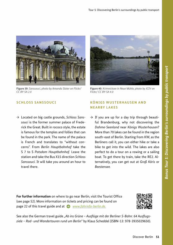
→ Located on big castle grounds, Schloss Sans-souci is the former summer palace of Frede-rick the Great. Built in rococo style, the estate is famous for the temples and follies that can be found in the park. The name of the palace is French and translates to “without con-cerns”. From Berlin Hauptbahnhof take the S 7 to S Potsdam Hauptbahnhof. Leave the station and take the Bus X15 direction Schloss Sanssouci. It will take you around an hour to travel there.
KÖ N IG S W U S T E R H AU S E N A N D N E A R BY L A K E S
→ If you are up for a day trip through beauti-ful Brandenburg, why not discovering the Dahme-Seenland near Königs Wusterhausen? More than 70 lakes can be found in the region south-east of Berlin. Starting from KW, as the Berliners call it, you can either hike or take a bike to get into the wild. The lakes are also perfect to do a tour on a rowing or a sailing boat. To get there by train, take the RE2. Al-ternatively, you can get out at Groß Köris or Beestensee.
For further information on where to go near Berlin, visit the Tourist Office (see page 52). More information on tickets and pricing can be found on page 22 of this travel guide and at www.fahrinfo-berlin.de.
See also the German travel guide „Ab ins Grüne – Ausflüge mit der Berliner S-Bahn: 64 Ausflugs- ziele – Rad- und Wandertouren rund um Berlin“ by Klaus Scheddel (ISBN-13: 978-3935029650).

52 Discover Berlin
Further information on mobility in Leipzig
Further information on mobility in Berlin
G E N E R A L T R AV E L L E R ´ S I N F O R M AT IO N
Check the following sites on the internet for general information:
www.berlin.de/en/wikitravel.org/en/Berlin
Homepage of visitBerlin with extensive information for tourists about Berlin and surroundings in various languages:
www.visitberlin.de/en
Going Local Berlin App: itunes.apple.com/en/app/id964438630 (iOS) play.google.com/store/apps/details?id=de.visitberlin. goinglocal&hl=en (Android)
Tourist Information: Brandenburg Gate – Pariser Platz / southern gatehouseTV Tower – Panoramastraße 1a
More adresses of Tourist Information Offices can be found at: www.visitberlin.de/en/plan/on-site/tourist-information
S IG H T S E E I N G I N B E R L I N :
An overview of guided tours is provided on the Berlin official web portal: www.berlin.de/en/tourism/guides/
There are also free and off-the-beaten-track tours offered by different providers. Here are some of them:
www.newberlintours.com/daily-tours/free-tour.htmloriginalberlintours.com/tours/free-original-berlin-walking-tour/alternativeberlin.com/tours/free-tour/
i
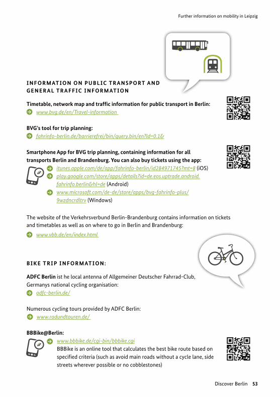
Discover Berlin 53
Further information on mobility in Leipzig
I N F O R M AT IO N O N P U B L IC T R A N S P O RT A N D G E N E R A L T R A F F IC I N F O R M AT IO N
Timetable, network map and traffic information for public transport in Berlin: www.bvg.de/en/Travel-information
BVG’s tool for trip planning: fahrinfo-berlin.de/barrierefrei/bin/query.bin/en?ld=0.1&
Smartphone App for BVG trip planning, containing information for all transports Berlin and Brandenburg. You can also buy tickets using the app:
itunes.apple.com/de/app/fahrinfo-berlin/id284971745?mt=8 (iOS) play.google.com/store/apps/details?id=de.eos.uptrade.android. fahrinfo.berlin&hl=de (Android) www.microsoft.com/de-de/store/apps/bvg-fahrinfo-plus/ 9wzdncrdltrv (Windows)
The website of the Verkehrsverbund Berlin-Brandenburg contains information on tickets and timetables as well as on where to go in Berlin and Brandenburg:
www.vbb.de/en/index.html
B I K E T R I P I N F O R M AT IO N :
ADFC Berlin ist he local antenna of Allgemeiner Deutscher Fahrrad-Club, Germanys national cycling organisation:
adfc-berlin.de/
Numerous cycling tours provided by ADFC Berlin: www.radundtouren.de/
BBBike@Berlin: www.bbbike.de/cgi-bin/bbbike.cgi BBBike is an online tool that calculates the best bike route based on specified criteria (such as avoid main roads without a cycle lane, side streets wherever possible or no cobblestones)
54 Discover Berlin
Bibliography
Bibliography
→ Ahrens, G.-A. (2012). Fahrradverleihsystem in Berlin. Accessed in March 2013: www.forschungsinformations- system.de/servlet/is/336893 (no longer available online)
→ Ammoser, H., & Hoppe, M. (2006). Diskussionsbeiträge aus dem Institut für Wirtschaft und Verkehr. Accessed in March 2013: Glossar Verkehrswesen und Verkehrswissenschaften.
→ BeMobility. (undated). BerlinelektroMobil. Accessed in March 2013: www.bemobility.de/bemobility-de/start
→ Berlin – Bezirksamt Friedrichshain-Kreuzberg. (2008). Studie Kreativwirtschaft am Wirtschaftsstandort Friedrichshain-Kreuzberg vorgestellt. Accessed in March 2013: www.berlin.de/ba-friedrichshain-kreuzberg/ aktuelles/pressemitteilungen/archiv/20080122.1100.92593.html
→ Berlin – Senatsverwaltung für Gesundheit und Soziales. (2011). Ausstoß von Dieselruß halbiert – hoher gesundheitlicher Nutzen der Umweltzone belegt. Accessed in March 2013: Pressemitteilung: www.berlin.de/sen/guv/presse/archiv/20110513.1200.344116.html (no longer available online); for further information see www.linksfraktion-berlin.de/uploads/media/Verkehr_in_Berlin_106.pdf and www.bmub.bund.de/fileadmin/ Daten_BMU/Download_PDF/Umweltinformation/bericht_bund_umk_2011_bf.pdf
→ Berlin – Senatsverwaltung für Stadtentwicklung und Umwelt. (2013). Accessed in March 2013: www.stadtentwicklung.berlin.de/verkehr/politik_planung/zahlen_fakten/entwicklung/de/fuss_fahrrad.shtml
→ Berlin – Senatsverwaltung für Stadtentwicklung und Umwelt. (2013). Zahlen und Fakten zum Verkehr – Mobilität der Stadt – Berliner Verkehr. Accessed in March 2013: Öffentlicher Verkehr: www.stadtentwicklung.berlin.de/verkehr/politik_planung/zahlen_fakten/entwicklung/de/oepnv.shtml
→ Berlin – Senatsverwaltung für Stadtentwicklung und Umwelt. (undated). Verkehr. Accessed in March 2013: Mit dem Auto – Umweltzone: www.stadtentwicklung.berlin.de/verkehr/mobil/auto/umweltzone/index.shtml
→ Berlin – Tourismus. (2013). Tourismus & Hotels – Touren. Accessed in March 2013: Berlin mit dem 100er Bus: www.berlin.de/tourismus/touren/985709-956960.gallery.html
→ Berlin & Brandenburg. (2013). Berlin-Brandenburg. Accessed in March 2013: Daten und Fakten zur Hauptstadt-region: www.berlin-brandenburg.de/daten-fakten (no longer available); for further information see www.berlin-brandenburg.de/suche.php?q=daten+und+fakten
→ Berlin. (2011). Politik, Verwaltung, Bürger. Accessed inMarch 2013: Zahlen und Fakten: www.berlin.de/ berlin-im-ueberblick/zahlenfakten/index.de.html
→ Berlin. (2013). Orte – Sehenswürdigkeiten. Accessed in March 2013: Alexanderplatz: www.berlin.de/orte/ sehenswuerdigkeiten/alexanderplatz
→ Berlin Tourismus & Kongress GmbH. (2013). Mit dem 100er Bus durch die Stadt. Accessed in March 2013: Hop on/Hop off mit dem öffentlichen Bus.: www.visitberlin.de/de/artikel/mit-dem-100er-busdurch-die-stadt (no lon-ger available); for further information see www.visitberlin.de/de/artikel/mit-der-buslinie-100-berlin-erkunden
→ Berlin Tourismus & Kongress GmbH. (undated). Tour durch Kreuzberg. Accessed in March 2013: Friedrichs-hain-Kreuzberg: www.visitberlin.de/de/artikel/tour-durch-kreuzberg
→ Berlin.de. (2013). Orte – Sehenswürdigkeiten. Accessed in March 2013: Potsdamer Platz: www.berlin.de/orte/sehenswuerdigkeiten/potsdamer-platz

Discover Berlin 55
Bibliography
→ BVG – Der Bus. (2013). Das Unternehmen. Accessed in March 2013: www.bvg.de/index.php/de/3927/name/Der+Bus.html
→ BVG – Die Straßenbahn. (2013). Das Unternehmen. Accessed in March 2013: www.bvg.de/index.php/de/3923/name/Die+Strassenbahn.html
→ BVG – Die U-Bahn. (2013). Das Unternehmen. Accessed in March 2013: www.bvg.de/index.php/de/3918/name/Umweltfreundlichkeit/article/11609. Html (no longer available); for further information see unternehmen.bvg.de/de/Unternehmen/Profil/U-Bahn
→ BVG – Fähre. (2013). Accessed in March 2013: www.bvg.de/index.php/de/3722/name/Faehre.html (no longer available); for further information see www.bvg.de/de/Aktuell/Newsmeldung?newsid=40
→ DB Rent GmbH. (April 2012). Call a Bike – das Stadtrad für Berlin. Accessed in March 2013: www.callabike-in-teraktiv.de/fileadmin/www.callabike-interaktiv.de/redaktion/pdf/2012_Flyer_Berlin.pdf
→ Der Tagesspiegel. (24 December 2006). Berliner Verkehr – Hauptbahnhof bewährt sich. Berlin. Von www.tages-spiegel.de/berlin/berliner-verkehr-hauptbahnhof-bewaehrt-sich/791274.html abgerufen.
→ Deutsche Bahn AG. (January 2005). Drehscheibe Berlin. Berlin Hauptbahnhof – Lehrter Bahnhof. Accessed in March 2013: www.deutschebahn.com/site/shared/de/dateianhaenge/infomaterial/bauprojekte/bauprojek-te__berlin__hauptbahnhof__broschuere.pdf (no longer available online; for further information see: www.berlin.de/sehenswuerdigkeiten/3561731-3558930-hauptbahnhof-berlin.html
→ Deutsche Bahn AG. (2012). Im Blickpunkt. Accessed in March 2013: 10 Jahre Call a Bike der Bahn – eine Erfolgs-geschichte: www.deutschebahn.com/de/konzern/im_blickpunkt/2733032/10_jahre_callabike.html
→ Janett Büttner. (2009). Bike sharing in ten European countries report. Accessed in March 2013: www.obisproject.com/palio/html.wmedia?_Instance=obis&_Connector=data&_ID=65&_Check-Sum=-1340785941
→ Potsdamer Platz. (2013). Potsdamer Platz. Accessed in March 2013: potsdamerplatz.de/de/home
→ S-Bahn Berlin. (2011). Mobilitätsketten für Berlin und das Umland. Accessed in March 2013: www.s-bahn-berlin.de/unternehmen/firmenprofil/moblitaet.htm
→ S-Bahn Berlin. (2013). S-Bahn Berlin. Accessed in March 2013: www.s-bahn-berlin.de
→ Sifton, S. (22 June 2008). Berlin, the Big Canvas. New York Times.
→ Sightseeing Point GmbH. (undated). Berlin im Wandel. Accessed in March 2013: Industrielle Revolution und-Gründerzeit: www.information-berlin.de/fakten/architektur/berlin-im-wandel
→ The Sustainable Urban Transport Guide Germany: Berlin
56 Discover Berlin
F R I E N D S O F T H E G E R M A N PA RT N E R S H I P F O R S U S TA I N A B L E M O B I L I T Y
IINASInterna�onal Ins�tute for Sustainability Analysisand Strategy
hjGrontmij HC Hamburg-Consult
innos – Sperlich GmbHWegbereiter für Innovationen.
Deutsche GVZ-Gesellschaft mbHDGG
IP-GreenMobility.de
(GMob)ip
Allgemeiner DeutscherFahrrad-Club
www.inplan.de
Jaano

Discover Berlin 57
G LO B A L F R I E N D S O F T H E G E R M A N PA RT N E R S H I P F O R S U S TA I N A B L E M O B I L I T Y
smartlanedata analytics and exchange
®
VCDB VerkehrsConsult Dresden-Berlin GmbH

58 Discover Berlin
P H OTO C R E DI T S
Cover picture by Jörg Schubert on Flickr/CC BY 2.0
Find the CC Licences under the following Links:
→ CC BY 2.0 creativecommons.org/licenses/by/2.0/
→ CC BY-SA 2.0 creativecommons.org/licenses/by/2.0/
→ CC BY-ND 2.0 creativecommons.org/licenses/by-nd/2.0/
→ CC BY 3.0 creativecommons.org/licenses/by/3.0/
→ CC BY-SA 3.0 creativecommons.org/licenses/by-sa/3.0/
→ CC BY-SA 4.0 creativecommons.org/licenses/by-sa/4.0/
DI S C L A I M E R
The information in this publication has been carefully researched and diligently compiled. Nevertheless, GIZ does not accept any liability or give any guarantee for the validity, accuracy and completeness of the information provided by the respective contributors and authors. The content of the publication has been written and provi-ded by the friends of the German Partnership for Sustainable Mobility that are listed in the publication and held fully responsible for the content and the photos. GIZ reserves the right to modify, append, delete parts or the complete content without prior notice, or to cancel the publication temporarily or permanently. This publica-tion contains links to third-party websites. GIZ is not responsible for the contents of any linked site or any link contained in a linked site. The placement and listing of companies, academia or other stakeholders (or their logos, contact details or other information) doesn’t mean any endorsement by GIZ or other partners. Users are encouraged to exercise due-diligence in respect to information, offers and proposals. This publication does not claim to be exhaustive.
Authors: Dr Friedemann Kunst, Sven Ledwoch, Lukas Sroka
Editors: Olivia Kieser, Paweł Komendziński, Lena Osswald, Michel Arnd
Design: Julia Klasen
May 2016


IMPRINT
German Partnership for Sustainable Mobility (GPSM)
Deutsche Gesellschaft für Internationale Zusammenarbeit (GIZ) GmbH
Registered offices Bonn and Eschborn, Germany
Dag-Hammarskjöld-Weg 1–5 · 65760 Eschborn
Telephone: +49 61 96 79 4199 · Telefax: +49 61 96 79 80 4199
E-Mail [email protected]
Web www.german-sustainable-mobility.de
Twitter www.twitter.com/GermanMobility
Facebook www.facebook.com/germansustainablemobility
Instagram www.instagram.com/germansustainablemobility/
SUPPORTED BY ON BEHALF OF
FURTHER SUPPORTERS
W W W.G ERM A N-SUS TA IN A BL E-MOBIL I T Y. DE
SUSTAINABLE MOBILITY – MADE IN GERMANY
“Sustainable Mobility – Made in Germany” stands for sustainable, proven, resource efficient, innovative, trustworthy and flexible solutions for all domains of mobility and logistics services.
Germany has a long history of successful changes and transformations in the transport sector – including
→ the establishment of comprehensive funding schemes
→ the re-emergence of walking and cycling as safe and viable modes of transport
→ the reorganization of the public transport sector
→ the continuous development of progressive regulations
→ the development of efficient propulsion systems
→ the integration of different modes of transport, including multimodality in logistics and ecomobility
Academia, businesses, civil society and associations have gathered invaluable experience and skills in framing these transformations.
The German experience is worth of study. Due to the scarcity of energy resources, the high population density and number of enterprises, as well as the compactness of the country, Germany opted early on for energy-efficient, integrated and smart solutions in the transport sector.
More on www.german-sustainable-mobility.de
Related Documents