See a better world. DigitalGlobe High Resolution Satellite Imagery KIAN KANG, SALES MANAGER, SOUTH EAST ASIA & TAIWAN

Welcome message from author
This document is posted to help you gain knowledge. Please leave a comment to let me know what you think about it! Share it to your friends and learn new things together.
Transcript
See a better world.
DigitalGlobe High Resolution Satellite Imagery
KIAN KANG, SALES MANAGER, SOUTH EAST ASIA & TAIWAN

DigitalGlobe Proprietary and Business Confidential
DigitalGlobe Overview
H E A D Q UA R T E R S C O L O R A D O U SA
Over 1,300 employees spanning the globe
DigitalGlobe Overview: Seeing a better world™

DigitalGlobe Proprietary and Business Confidential
Markets served
C I V I L G O V E R N M E N T
E N E R G Y
M I N I N G
D E F E N S E & I N T E L L I G E N C E
U S G O V E R N M E N T
T E C H N O L O G Y
G LO BA L D E V E LO P M E N T

DigitalGlobe Proprietary and Business Confidential
DigitalGlobe is…
The market leader in remote sensing.
IKONOS® .82 meter resolution 9 m CE90
QuickBird® .65 meter resolution 23 m CE90
WorldView-4® .31 meter resolution
<3.0 m CE90
WorldView-3® .31 meter resolution
<3.0 m CE90
WorldView-2® .46 meter resolution
<3.5 m CE90
GeoEye-1® .41 meter resolution
<3.5 m CE90
WorldView-1® .50 meter resolution <4 m CE90
AVAILABLE VIA DIGITALGLOBE ARCHIVE
CURRENTLY IMAGING IN ORBIT
1999 2001 2007 2008 2009 2014 2016

DigitalGlobe Proprietary and Business Confidential
WorldView-4

DigitalGlobe Proprietary and Business Confidential
Worldview 4 Technical Info

DigitalGlobe Proprietary and Business Confidential
Worldview 4: First Image
WV04 | FirstImage | Date 26 Nov 2016

DigitalGlobe Proprietary and Business Confidential
30cm Imagery: ChiangMai Airport
WV3 28 Dec 2016, Chiang Mai Airport, Thailand

DigitalGlobe Proprietary and Business Confidential
30cm Imagery : SKP Thailand
30 cm WV3, 11 Nov 2016SKP, Thailand

See a better world.
WV3 Short Wave Infrared
DigitalGlobe Proprietary and Business Confidential
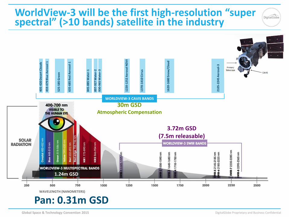
WorldView-3 will be the first high-resolution “super spectral” (>10 bands) satellite in the industry
1.24m GSD
WAVELENGTH (NANOMETERS)
3.72m GSD (7.5m releasable)
WORLDVIEW-3 CAVIS BANDS
40
5-4
20 D
ese
rt C
lou
ds
45
9-4
79 B
lue
Ae
roso
l 1
52
5-5
85 G
ree
n
63
5-6
85 R
ed
Ae
roso
l-1
84
5-8
85 W
ate
r-1
89
7-9
27 W
ate
r-2
93
0-9
65 W
ate
r-3
12
20
-12
52 A
ero
sol N
DV
I
13
70
-14
10 C
irru
s
16
20
-16
80 S
no
w/C
lou
d
21
05
-22
45 A
ero
sol-
3
30m GSD Atmospheric Compensation
1.24m GSD
Pan: 0.31m GSD Global Space & Technology Convention 2015

DigitalGlobe Proprietary and Business Confidential
Identify Man-Made or Geologic Material
Locate and classify man-made materials (metals, plastics, paints, fiberglass, asphalt, oil and various chemicals) and geologic minerals (clays, alteration, iron oxides, carbonates, and others) on the Earth’s surface. Material identification at this resolution enables high-confidence decision-making with information not available from any other satellite imaging company.

DigitalGlobe Proprietary and Business Confidential
Main Information of the Roof
• Roof materials • Roof tilt angle • Roof height
• The analysis is based on
shortwave infrared data (SWIR), elevation data and our clever engineers!

DigitalGlobe Proprietary and Business Confidential
See Through Smoke and Haze
Get a clear view of the ground with SWIR wavelengths that penetrate smoke and haze, so you can make decisions with confidence in heat-of-the-moment situations.

DigitalGlobe Proprietary and Business Confidential
Mining - Mapping Mineral Resources (1/2)
Clay
Carbonate
Mica
WV-1 Panchromatic WV2 Multispectral WV3 Classification of minerals
Location: Nevada Cuprite, 7.5m resolution WV3 shortwave infrared image
DigitalGlobe Proprietary and Business Confidential
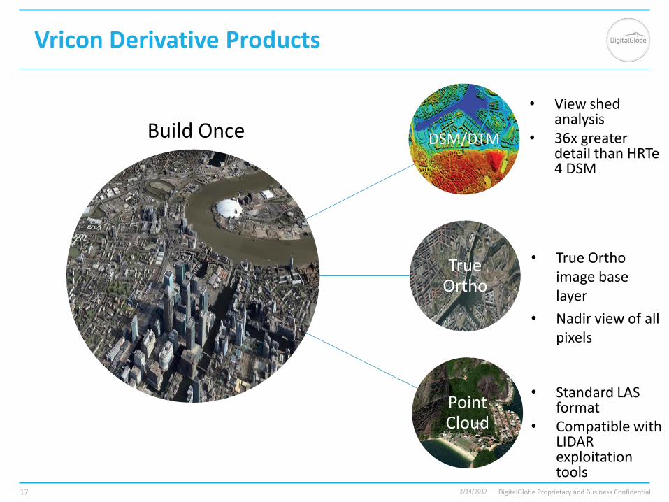
Vricon Derivative Products
DSM/DTM
True Ortho
Point Cloud
2/14/2017 17
Build Once
• View shed analysis
• 36x greater detail than HRTe 4 DSM
• Standard LAS format
• Compatible with LIDAR exploitation tools
• True Ortho image base layer
• Nadir view of all pixels

DigitalGlobe Proprietary and Business Confidential
Vricon 3D Surface Model
2/14/2017 18
• Accurate, Consistent Geospatial Foundation
• Every rendered pixel is accurate
• RGB Textured TIN Mesh
• Triangulated Irregular Network
• Very Small File Size
• Optimized for Streaming
• Hosted as Web Service
• Similar Technology to Modern Videogames
• Allows for extremely fast, efficient 3D rendering
0.5m Resolution --- 3m SE90 Absolute Accuracy

DigitalGlobe Proprietary and Business Confidential 2/14/2017 19
TO REPLACE IMAGE: • Right-click on the image • Select “Change Picture…” • Locate an appropriate image:
(Image should be 1600px wide by 1153px tall, Lower resolution images make the file easier to email. Higher resolution images look better)
• Select the image and click “OK” • DELETE THESE NOTES IF NOT NEEDED

DigitalGlobe Proprietary and Business Confidential
DigitalGlobe Proprietary and Business Confidential
DigitalGlobe Basemap
Related Documents