DEVELOPMENT OF ROAD INFRASTRUCTURE SAFETY FACILITY STANDARDS FOR THE ASIAN HIGHWAY NETWORK Bangkok DECEMBER 2017

Welcome message from author
This document is posted to help you gain knowledge. Please leave a comment to let me know what you think about it! Share it to your friends and learn new things together.
Transcript

DEVELOPMENT OF ROAD INFRASTRUCTURE
SAFETY FACILITY STANDARDS FOR THE ASIAN
HIGHWAY NETWORK
Bangkok
DECEMBER 2017

2
The views expressed in this publication are those of the authors and do not necessarily reflect the
views of the United Nations Secretariat. The opinions, figures and estimates set forth in this
publication are the responsibility of the authors, and should not necessarily be considered as reflecting
the views or carrying the endorsement of the United Nations.
The designations employed and the presentation of the material in this publication do not imply the
expression of any opinion whatsoever on the part of the Secretariat of the United Nations concerning
the legal status of any country, territory, city or area, or of its authorities, or concerning the
delimitation of its frontiers or boundaries. Mention of firm names and commercial products does not
imply the endorsement of the United Nations.
This publication is issued without formal editing.

3
Acknowledgements
This document was prepared by Mr. Ishtiaque Ahmed, Economic Affairs Officer, Transport
Infrastructure Section, Transport Division as the project manager. The Annex II bis on “Asian Highway
Design Standards” and the related “Design Guidelines” were prepared by Julian T.H. Kwong,
international road safety consultant under the direction and guidance of Mr. Ishtiaque Ahmed. The
international road assessment programme (iRAP) related inputs were provided by Mr Greg Smith of
iRAP. Valuable advices were extended by Mr. Pierre Chartier, Section Chief, Transport Infrastructure
Section and Mr. Yuwei Li, Director, Transport Division of ESCAP. Mr. Jeongsu Park, Expert from the
Republic of Korea to ESCAP also contributed to the study.
The development of the Design Standards and Design Guidelines has been realised with the generous
support of the Korea Expressway Corporation (KEC) under the direction of Dr Sung-Min Cho, Director
of R&D Planning Office. Technical inputs were provided by Dr. Ducknyung Kim of KEC.
The following countries participated in the project by providing up to date information on their current
design standards and usage of road safety infrastructure facilities. National Experts from the above
member countries have provided inputs as national reports:
• Bangladesh (Mr. Noor-E-Alam)
• China (Prof. Xiaojing Wang)
• India (Mr. Tony Mathew)
• Republic of Korea (Dr. Sung-min Cho)
• Thailand (Mr. Sujin Mungnimit)
Experts and delegates from member countries of the Asian Highway Network have offered valuable
comments on the development of this document.
The international road safety consultant would wish to express his appreciation to Mr C.K. Nip (Hong
Kong) and Mr Peter Monger (United Kingdom) for their technical advice.

4
Table of Contents
Executive Summary ...................................................................................................... 6
1. Introduction ............................................................................................................................ 8
2. Status of Road Safety in the Asian Highway member countries ............................................ 11
3. Current design standards for the Asian Highway Network ................................................... 14
3.1 Asian Highway Classification and Design Standards ............................................................. 14
3.2 Asian Highway Database ...................................................................................................... 14
4. Study Approach and Structure .............................................................................................. 19
Participating Countries .............................................................................................................. 21
5. Star Ratings for Road Safety ................................................................................................. 23
5.1 Star Rating System ............................................................................................................... 23
5.2 Key road attributes studied by International Road Assessment Programme (iRAP) ............ 23
5.3 Star ratings of Road Infrastructure Safety Facilities (RIFs) .................................................... 25
5.4 Safer roads investment plans: an example from Indonesia.................................................. 28
6. Design Standards on Road Infrastructure ............................................................................. 29
6.1 Citations by road user .......................................................................................................... 30
6.2 Citations by road attribute ................................................................................................... 30
6.3 Discussion on quantitative analysis ..................................................................................... 33
6.4 The Safe System Approach ................................................................................................... 34
6.5 Additional Design Standards Reviewed from International Sources .................................... 36
7. Selected Road Infrastructure Safety Facilities for the Asian Highway ................................... 38
7.1 Pre-selection of Road Facilities ............................................................................................ 38
7.2 Survey in the Asian Highway member countries .................................................................. 45
7.3 Perceived effectiveness of road infrastructure safety facilities (RIFs) .................................. 51
7.4 Discussions and conclusions on the survey .......................................................................... 57
8. Star Rating Testing for the Asian Highway Design Standards ................................................ 59
8.1 iRAP Star Ratings .................................................................................................................. 59
8.2 Analysis approach for the Star Rating .................................................................................. 60
8.3 Existing Asian Highway Network design standards and star ratings..................................... 61
8.4 Scenarios considered ........................................................................................................... 62
8.5 Results of the Star Rating Testing......................................................................................... 68

5
8.6 Results by road user type ..................................................................................................... 73
8.7 Discussion and conclusion of the star rating testing ............................................................ 80
9. Considerations and Scope of the Design Standards .............................................................. 82
9.1 Considerations for the development of the design standards .............................................. 82
9.2 Scope of the design standards ............................................................................................. 82
9.3 Structure of the design standards ........................................................................................ 83
9.4 Evaluation of the Selected Road Infrastructure Safety facilities ........................................... 85
9.5 Other road infrastructure safety facilities .......................................................................... 106
10. Conclusions and Recommendation .................................................................................... 109
Appendix A: Road Design Standards and Guides Cited (Literature Review) ................ 111
Appendix B: Inputs from the National Experts of the Participating Countries ............ 128
Appendix C: Standards/Guidelines/Manuals Cited in the Survey Replies ................... 134
6
Executive Summary
Road safety is a sustainable development issue that needs greater attention as road traffic fatalities
and injuries place a significant burden on national economies. The Asia-Pacific region accounted for
58% of the global road traffic deaths in 2013. Between 2010 and 2013, while 16 Asian Highway
member countries were successful in reducing road fatalities, others failed to do so. The seventh Goal
of the “updated Regional Road Safety Goals and Targets for Asia and the Pacific, 2016-2020”
emphasizes on developing the Asian Highway network as a model of road safety.
Studies show a strong correlation between infrastructure design and road safety and road engineering
and design can influence the severity of the crashes. In this regard, the Annex II to the
Intergovernmental Agreement on the Asian Highway Network which entered in to force on 4 July 2005
includes design standards for the Asian Highway Network. However, the design standard does not
provide adequate guidance on road infrastructure safety facilities.
As one of the initiatives to address the road safety problem on the Asian Highway Network, the ESCAP
secretariat, in association with the Korea Expressway Corporation conducted a study on the
development of technical standards on road infrastructure safety facilities for the Asian Highway
Network. A detailed literature review on existing standards for infrastructure element design and
specification to address road safety in the Asian Highway member countries and other international
sources was conducted. A list of 36 road infrastructure safety facilities was prepared. Detailed
information on road infrastructure safety practices was collected from five participating countries. A
survey was conducted to assess the prevalence, types and design standards of road safety facilities in
the Asian Highway member countries in end 2015. The international road assessment programme
(iRAP) methodology was used to illustrate how relative risk levels would change if road infrastructure
safety facilities were added to the existing Asian Highway standard. It could be concluded that there
is potential to promote the use of a broader range of road infrastructure safety facilities for the Asian
Highway Network.
The study suggested that the Intergovernmental Agreement on the Asian Highway Network provides
an adequate institutional platform for providing guidance to member countries in a number of areas
and could further be used for promoting a coordinated approach to the development and adoption of
standards of road infrastructure safety facilities. The study emphasizes on providing guidance to the
Asian Highway member countries through a dedicated new annex to the Intergovernmental
Agreement on the Asian Highway Network. In this regard, proposed mandatory minimum design

7
standards of road infrastructure safety facilities for the Asian Highway Network which could serve as
a draft Annex II bis “Asian Highway Design Standards for Road safety” to the Intergovernmental
Agreement on the Asian Highway Network; and related design guidelines of road infrastructure safety
facilities which could serve as a recommended practice for the Asian Highway Network have been
developed. The study recommended the Asian Highway member countries to consider adopting and
implementing technical design standards of road infrastructure safety facilities towards improving
road safety on the Asian Highway Network.
8
1. Introduction
The concept of an Asian Highway network was revived in 1992 under the framework of the Asian Land
Transport Infrastructure Development (ALTID) project adopted at the 48th Commission session,
following which a number of studies were implemented over the period 1993-2001 to bring the Asian
Highway network to over 140,000 kilometres. Subsequently, the network was formalized through an
Intergovernmental Agreement on the Asian Highway Network which entered into force in July 2005.
Road crashes are a major challenge towards sustainable development of the Asian Highway Network
as road traffic injuries place a serious burden on national economies. In 2013, the average road traffic
fatality rate for the Asian Highway member countries was lower than the global average and that of
the ESCAP region. In the third Ministerial Conference on Transport held in Moscow from 5 to 9
December 2016, the Transport Ministers of the ESCAP member countries adopted the “updated
Regional Road Safety Goals and Targets for Asia and the Pacific, 2016-2020”1. The overall objective is
50 per cent reduction in fatalities and serious injuries on the roads of Asia and the Pacific over the
period 2011-2020. The seventh of the eight Goals is “to develop the Asian Highway network as a model
of road safety”.
The Pillar 2 of the Global Plan for the Decade of Action for Road Safety 2011-2020 focuses on raising
the inherent safety and protective quality of road networks for the benefits of all road users. This is
intended to be achieved through the implementation of various road infrastructure agreements under
the UN framework, road infrastructure assessment and improved safety-conscious planning, design,
construction and operation of roads2. In this regard, six activities are included under Pillar 2. Those
include promoting safe operation, maintenance and improvement of existing road infrastructure by
road authorities and the developing safe new infrastructure that meets the mobility and access needs
of all users and encouraging research and development in safer roads and mobility.
The roadway and roadside design elements have an effect on crash risk as those have close
relationship with how road users including drivers and pedestrians perceive the road environment.
The roadway elements provide guidance to the road users in their decision making process. In
particular, the geometry of the road influences the crash rates as well as the severity of the crash.
According to the Highway Safety Manual (HSM) of the American Association for State Highway and
Transportation Officials (AASHTO)3, the combination of roadway factor and human factor results in
1 E/ESCAP/MCT(3)/11
2 Global Plan for the Decade of Action for Road Safety 2011-2020. Available at: http://www.who.int/roadsafety/decade_of_action/plan/plan_english.pdf?ua=1
3 AASHTO, 2010. Highway Safety Manual. 1st Edn. Washington, DC.
9
thirty three per cent of all road crashes. However, these proportions may vary depending on the
environment. A study on Mumbai-Pune expressway road accidents4 showed that human factors alone
(57%) had the highest influence on the occurrence of the crashes, followed by the combination of
human and infrastructure factors (22.5%).
Studies show a strong correlation between infrastructure design and road safety and road engineering
and design can influence the severity of the crashes. The design standards chosen for the construction
of new roads should ensure that they meet the highest existing safety standards available in the field.
In many countries, the installation of barriers to separate opposing directions of traffic and/or
different types of vehicles, the application of access control principles, better geometric design of
roads to increase the sight distance in curves and the improvement of road shoulders are examples of
infrastructure-related measures that have contributed to a reduction in road accidents and fatalities
wherever they have been applied. International experiences show that interventions in terms of road
infrastructure to improve the driving environment can pay for themselves and the related financial
investment can be recovered within a reasonable period of time5.
The Asian Highway Network consists of eight core routes that substantially cross more than one
subregion and a number of other routes within subregions or member countries. Among the former
are Asian Highway routes AH1 and AH6 which cross the Korean Peninsula and travel all the way to
Europe at the border with Bulgaria and Belarus, respectively. While these core routes offer an
interesting promise for enhanced inter- as well as intra-regional connectivity, the sections that
constitute them do not fall into the same class of Asian Highway classification and design standards
stipulated in Annex II to the Intergovernmental Agreement on the Asian Highway Network in the
countries that they traverse. Beside these technical differences, transport operation along the routes
is also made difficult by the absence of a common institutional framework to regulate movements
across borders.
In the light of the continuing growth of intra-regional trade, there is now concern that these technical
and institutional problems could in the short- to medium-term create bottlenecks along these core
routes. While harmonization of road construction standards is important, attention should also be
given to “above-the-ground” installations, in particular those linked to road safety such as speed
reduction devices, roadside safety features etc. Easing drivers’ vehicle operation and increased safety
4 Available at: http://www.jpresearchindia.com/pdf/JP%20Research%20India-ESAR2014.pdf 5 Ishtiaque Ahmed, “Road infrastructure and road safety”, Transport and Communications Bulletin for Asia and the Pacific:
Designing Safer Roads, No. 83 (2013). Available from www.unescap.org/sites/default/files/bulletin83_Fulltext.pdf.

10
require a “predictability of events” along roads and during road trips. Given that increased
connectivity will gradually lead to enhanced cross-border road movements, it is highly desirable that
this “predictability of events” be uniform along the road infrastructure of the Asian Highway member
countries and that standards be established to that effect.
However, the Asian Highway “classification and design standards as stipulated” in annex II to the
Intergovernmental Agreement on the Asian Highway network6 does not provide adequate guidance
on the road infrastructure safety facilities that might be considered in addressing road safety on the
Asian Highway routes. For example, no information on any proper type of guard fence is provided
while it is indicated in a note that “the recommended width of the median can be reduced with the
proper type of guard fence”. The above indicates that it would be beneficial for road safety along the
Asian Highway routes, if certain standards of the road infrastructure safety facilities could be
maintained along the routes.
In this regard, to address the road safety problem along the Asian Highway Network and as a follow
on to the previous successful collaborations between ESCAP and the Korea Expressway Corporation
(KEC), the ESCAP secretariat, conducted a study during 2015-2017 on the development of technical
standards on road infrastructure safety facilities for the Asian Highway Network. The study has been
a part of the initiative to achieve inclusive and sustainable development through regional cooperation
and integration in transport in the Asia-Pacific region and an activity towards implementation of the
Regional Action Programme for Sustainable Transport Connectivity in Asia and the Pacific, phase I
(2017-2021).
6 United Nations, Treaty Series, vol. 2323, No. 41607

11
2. Status of Road Safety in the Asian Highway member countries
The Asia-Pacific region accounted for 58 per cent of the global road traffic deaths in 2013. Since 2010,
there had been a mixed progress in tackling road safety among ESCAP member countries7. Road traffic
fatalities reduced from 777,000 in 2010 to 733,000 in 2013 representing a reduction of 5.6 per cent.
This achievement was prominent in the low income economies with a 24.68 per cent reduction. Lower
middle income economies and upper middle income economies were able to reduce the numbers by
5.49 and 5.11 per cents respectively. The number of road fatalities reduced in the SAARC (-8.37%),
ECO (-8.05%) and ASEAN (-0.07%) sub regions during the above period. However, in the least
developed countries, the trend was opposite, representing a 15.24 per cent increase. Among the
ESCAP subregions, the South and South-West Asia were able to achieve a reduction of road fatalities
by 8.24 per cent. On the contrary, in the North and Central Asia subregion, road fatalities increased
by 5.35 per cent during the above period.
The average road traffic fatality rate (fatalities per 100,000 inhabitants) for the Asian Highway member
countries in 2013 (16.95) was lower than the global average (17.4) and the ESCAP region average
(18.99). Between 2010 and 2013, while 16 Asian Highway member countries were successful in
reducing road fatalities, others (14 countries) failed to do so. Total number of fatalities in 30 of the
Asian Highway member countries8 reduced from 771,271 in 2010 to 729,418 in 2013, representing a
5.43 per cent reduction. Georgia (-24.96%), Singapore (-23.94%) Afghanistan
(-23.76%), Turkey (-23.65%), Lao People’s Democratic Republic (-23.30%) and Azerbaijan (-21.55%)
were able to reduce their national road fatalities by more than 20 per cent. However, indicating an
opposite situation, road fatalities in Myanmar (50.61%), Sri Lanka (29.33%), Tajikistan (24.04%),
Bangladesh (23.29%), Philippines (22.12%) and Mongolia (21.59%) increased by more than 20 per cent
between 2010 and 2013. Figure 1 shows the WHO-estimated number of road traffic fatalities and the
fatality rates per 100,000 inhabitants in the Asian Highway member countries.
7 E/ESCAP/MCT(3)/9
8 Data from the Democratic People’s Republic of Korea and Turkmenistan for the year 2010 were not
available.

Figure 1: Estimated road traffic fatalities and fatality rates in the Asian Highway member countries, 2013
Source: World Health Organization, Global Status Report on Road Safety 2015 (Geneva, 2015).
207551
261367
0
50 000
100 000
150 000
200 000
250 000
300 000
0
5
10
15
20
25
30
35
40
Ro
ad
tra
ffic
fa
tali
tie
s
Fa
tali
ty r
ate
pe
r 1
00
00
0 i
po
pu
lati
on
Road traffic fatalities Fatality rate per 100 000 population

13
Road deaths in member countries tend to be concentrated on a relatively small percentage of roads.
In India for example, national highways – which include AH Network roads - represent just 3% of all
roads by length yet experienced 33% of the nation’s road deaths in 2013. Many sections of the AH
Network have alarmingly high rates of trauma.
By comparison, it is not unusual that death rates on such roads are around ten times higher than the
United Kingdom’s highest risk roads. Furthermore, in each of these cases, there is evidence that
reported crash numbers underestimate the true number of deaths on the roads, and so the true
numbers could be higher.
It is likely that road safety on the AH Network will become ever more challenging. The world’s road
systems will continue to rapidly expand, with India, for example, aiming to invest more than $30 billion
a year building 66,000 kilometres of new roads at a rate 30 kilometres per day9. The World Bank
reports that nearly one billion people in rural areas around the world still lack access to all-weather
roads.10 In an increasingly urbanized world, everybody on every trip will at some stage use a road,
either as a pedestrian, bicyclist or with a vehicle. But the pressures on road networks are increasing—
be it economic and population growth, urbanisation, technology, or changes in how people transport
themselves on roads—and the lives of people are at stake. More people riding bikes or driving cars,
an ageing population, even expanding the road system can all bring about an increase in road crashes.
In Australia, for example, while overall road fatalities are progressively decreasing, the number of
cyclist fatalities and injuries has increased significantly11. In recognition of both the enormous public
health problem that road crashes cause and the potential for large-scale action, the United Nations
Sustainable Development Goals set the challenge of halving the number of global deaths and injuries
from road traffic crashes by 2020.12
9 Planning Commission (Government of India): Twelfth Five Year Plan (2012–2017) Faster, More Inclusive
and Sustainable Growth.
10 https://openknowledge.worldbank.org/handle/10986/20093.
11 BITRE. Australian cycling safety: casualties, crash types and participation levels 2015. URL:
https://bitre.gov.au/publications/2015/files/is_071_ph.pdf
12 http://www.un.org/sustainabledevelopment/health/

14
3. Current design standards for the Asian Highway Network
3.1 Asian Highway Classification and Design Standards
Design standards for the AH Network are set out in Annex II on “Asian Highway Classification and
Design Standards” to the Intergovernmental Agreement on the Asian Highway Network (referred to
herein as the AH Standard)13 was adopted on 18 November 2003 by an intergovernmental meeting
held in Bangkok, was open for signature in April 2004 in Shanghai and entered into force on 4 July
2005. The Annex II to the Agreement provides the minimum standards and guidelines for the
construction, improvement and maintenance of Asian Highway routes. In those guidelines, Asian
Highway routes are grouped into four classes: primary; class I; class II; and class III, which is specified
as the minimum desirable standard. The Standard is summarised in the following table.
Table 1: Asian Highway Standards summary
3.2 Asian Highway Database
The Asian Highway Database includes data on the road attributes specified in the AH Standard. The
database also contains provision for additional data, such as numbers of major intersections, traffic
volumes and fatalities, although not all countries provide this information. The database is managed
by the ESCAP Secretariat and is updated at regular intervals. The Asian Highway network currently
comprises about 129,902 km of roads passing through 32 member countries excluding potential Asian
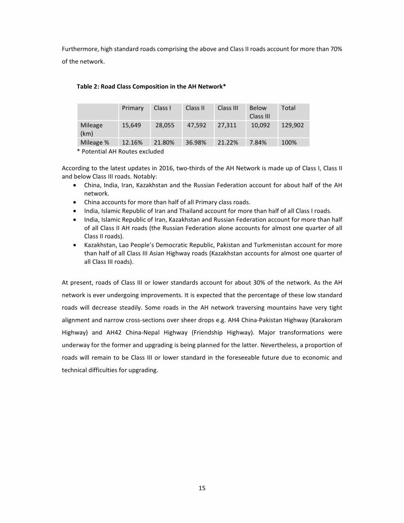
Highway routes in China. Table 2 provides a summary of the current AH Network by road class. Multi-
lane highways i.e. primary roads and Class I roads make up more than 33% of the network.
13 United Nations, Treaty Series, vol. 2323, No. 41607, annex II.
15
Furthermore, high standard roads comprising the above and Class II roads account for more than 70%
of the network.
Table 2: Road Class Composition in the AH Network*
Primary Class I Class II Class III Below
Class III
Total
Mileage
(km)
15,649 28,055 47,592 27,311 10,092 129,902
Mileage % 12.16% 21.80% 36.98% 21.22% 7.84% 100%
* Potential AH Routes excluded
According to the latest updates in 2016, two-thirds of the AH Network is made up of Class I, Class II
and below Class III roads. Notably:
• China, India, Iran, Kazakhstan and the Russian Federation account for about half of the AH
network.
• China accounts for more than half of all Primary class roads.
• India, Islamic Republic of Iran and Thailand account for more than half of all Class I roads.
• India, Islamic Republic of Iran, Kazakhstan and Russian Federation account for more than half
of all Class II AH roads (the Russian Federation alone accounts for almost one quarter of all
Class II roads).
• Kazakhstan, Lao People’s Democratic Republic, Pakistan and Turkmenistan account for more
than half of all Class III Asian Highway roads (Kazakhstan accounts for almost one quarter of
all Class III roads).
At present, roads of Class III or lower standards account for about 30% of the network. As the AH
network is ever undergoing improvements. It is expected that the percentage of these low standard
roads will decrease steadily. Some roads in the AH network traversing mountains have very tight
alignment and narrow cross-sections over sheer drops e.g. AH4 China-Pakistan Highway (Karakoram
Highway) and AH42 China-Nepal Highway (Friendship Highway). Major transformations were
underway for the former and upgrading is being planned for the latter. Nevertheless, a proportion of
roads will remain to be Class III or lower standard in the foreseeable future due to economic and
technical difficulties for upgrading.
16
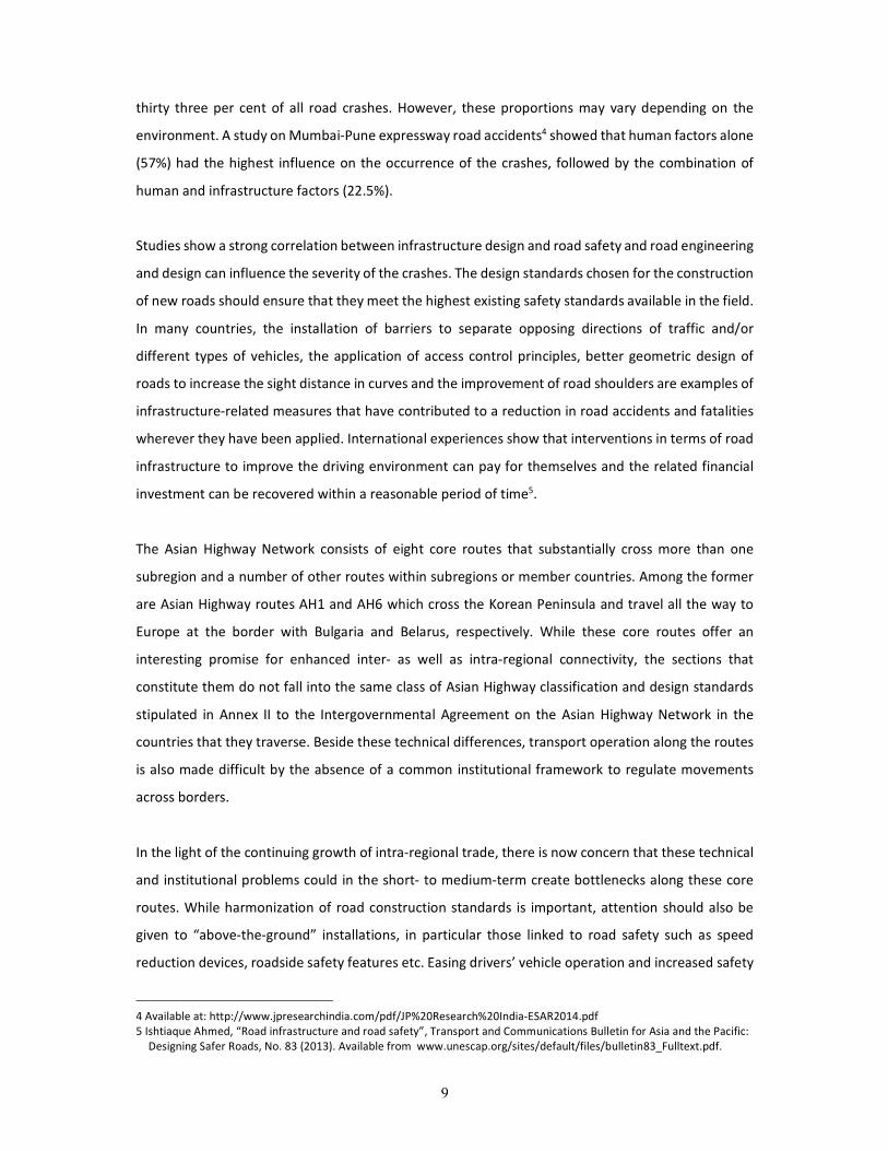
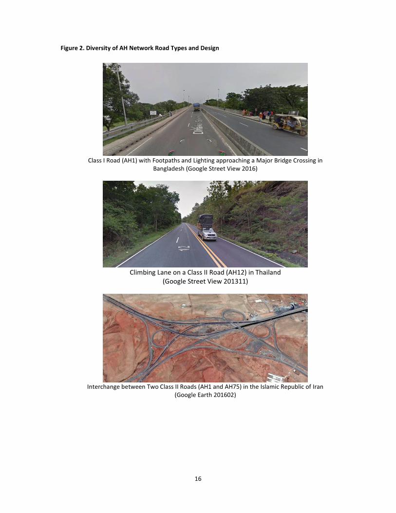
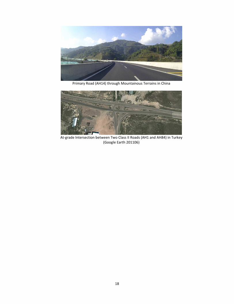
Figure 2. Diversity of AH Network Road Types and Design
Class I Road (AH1) with Footpaths and Lighting approaching a Major Bridge Crossing in
Bangladesh (Google Street View 2016)
Climbing Lane on a Class II Road (AH12) in Thailand
(Google Street View 201311)
Interchange between Two Class II Roads (AH1 and AH75) in the Islamic Republic of Iran
(Google Earth 201602)

17
Class II Road traversing Mountainous Terrains (AH61) in Kyrgyzstan
(Google Street View 201511)
Skewed Intersection on a Class II Road (AH26) in the Philippines
(Google Street View 201510)
Turning Lane on a Class I road (AH6) in the Russian Federation (Google Street View 201307)
18
Primary Road (AH14) through Mountainous Terrains in China
At-grade Intersection between Two Class II Roads (AH1 and AH84) in Turkey
(Google Earth 201106)

19
4. Study Approach and Structure
The objective of the study was to provide guidelines and recommendations to the Asian Highway
member countries through the followings:
a) Identify road infrastructure safety facilities (RIFs) for the Asian Highway network.
b) Develop design standards for the selected road infrastructure safety facilities (RIFs) for the
Asian Highway Network.
c) Provide guidance to the Asian Highway member countries through development of a
dedicated new annex (Annex II bis) to the Intergovernmental Agreement on the Asian
Highway Network on road infrastructure safety facilities known as “Asian Highway Design
Standards for Road Safety”
d) Develop a detailed “Design Guideline” for the selected road infrastructure safety facilities
(RIFs) for the Asian Highway network.
To meet the above objectives of the study the following steps were followed:
a) Conduct literature review on existing standards for road safety infrastructure element
design and specification to address road safety in the Asian Highway member countries and
international sources.
b) Organize a regional Joint-seminar in association with KEC to map out the future activities. This
workshop was organized in conjunction with the World Road Congress 2015 (Seoul, November
2015).
c) Collect detailed information from five participating member countries on their current
practices and experiences on road infrastructure safety facilities and the existing standards.
d) Pre-select specific elements of the road infrastructure facilities to be considered for the
development of regional standards for road safety on the Asian Highway.
e) Identify data requirements and design survey questionnaires for the information (basic data
and detailed data) to be collected from the Asian Highway member countries.
f) Conduct a survey in the Asian Highway member countries. Analyse the survey results to find
out the current practices and experiences in the member countries on road infrastructure
safety facilities.
g) Conduct star rating scenario testing for the pre-selected road infrastructure safety facilities
(RIFs) using the international road assessment programme (iRAP) methodology.

20
Flow chart of Activities
Literature Review Collection of Data from the
Participating Countries
Pre-selection of Road Infrastructure
Safety Facilities
Survey in the Asian Highway
member countries
Star Rating Scenario Testing of the selected
Road Infrastructure Safety Facilities
Short-Listing of Road Infrastructure Safety
Facilities
Detailed Review and Analyses of Existing
Design Standards
Development of Design Standards
for the selected Road
Infrastructure Safety Facilities
(RIFs)
Development of a detailed “Design
Guideline” for the selected Road
Infrastructure Safety Facilities
Expert Group Meeting
Bangkok, October 2016
Joint Seminar
Seoul, November 2015
Development of a draft annex (annex II bis) on the Intergovernmental Agreement on the
Asian Highway Network on “Asian Highway Design Standards for Road Safety”
Seventh Meeting of the Working Group on the Asian Highway
Network in Bangkok, December 2017, adopted the Annex II bis.
Expert Group Meeting in Bangkok, May 2017 and
Regional Meeting in Bangkok in August 2017
21
h) Identify a short-list of road infrastructure safety facilities (RIFs) for detailed studies.
i) Organize an Expert Group Meeting to discuss the preliminary findings of the study in October
2016 in Bangkok.
j) Develop design standards for the short-listed road infrastructure safety facilities. This would
provide general description of the standards which could be adopted by the Asian Highway
member countries as minimum design standards.
k) Develop detailed design guidelines for the short-listed road infrastructure safety facilities
(RIFs), which would serve as a design manual and/ guidelines to the Asian Highway member
countries.
l) Provide guidance to the Asian Highway member countries through development of a
dedicated new annex (Annex II bis) to the Intergovernmental Agreement on the Asian
Highway Network on road infrastructure safety facilities.
m) Organize an Expert Group Meeting to in May 2017 to review the study findings and review
and refine the draft Annex on road safety facilities.
n) Organize a Regional Meeting in Bangkok in August 2017 to review and finalize draft
documents produced by the secretariat on road infrastructure safety facilities.
o) Organize the 7th meeting of the Working Group on the Asian Highway network in Bangkok in
December 2017.
Participating Countries
The selected participating countries are located along Asian Highway routes AH1 and AH6. The
selected five countries were:
a) Bangladesh b) China c) India d) Republic of Korea and e) Thailand.
Above five countries have different income levels14 and socio-economic conditions15,16. The Republic
of Korea is a High Income Country with 12 fatalities per 100,000 populations. China and Thailand are
two Upper Middle Income Countries with 18.8 and 36.2 fatalities per 100,000 populations,
respectively. India is a Lower Middle Income Country with 16.6 fatalities per 100,000 populations and
Bangladesh represents the Low Income Countries with 13.6 fatalities per 100,000 populations,
respectively. China and the Republic of Korea represent countries that have reasonably high
proportion of access controlled and high speed limit roads in comparison to other countries of the
region because of their economies. India and Thailand have a high motor-cycle population and thus
14 List of Country and Lending Groups http://data.worldbank.org/about/country-and-lending-groups
15 Global Status Report on Road Safety, World Health Organization 2013 and
16 Internet Source: http://www.who.int/violence_injury_prevention/road_safety_status/2015/en/

22
accidents involving two and three wheelers are very high (34% and 73% of the road fatalities,
respectively). Bangladesh has a very high volume of pedestrians and thus accidents involving
pedestrians comprise of 32% of the road fatalities. It is believed that consideration of countries with
different income levels and socio-economic conditions will allow addressing diverse road safety
situations.

23
5. Star Ratings for Road Safety
5.1 Star Rating System
Star Ratings are an objective measure of the likelihood of a crash occurring and its severity on a
proactive basis. They draw on road safety inspection data and extensive real-world relationships
between road attributes (road features) and crash rates. Research shows that a person’s risk of death
or serious injury is highest on a one star road and lowest on a five star road17. In the Note prepared
for the seventieth session of the General Assembly on “improving global road safety”, the Secretary
General of the United Nations recommended to improve infrastructure, including by targeting the
highest volume 10 per cent of existing roads and set appropriate road infrastructure star rating targets
for all relevant road users and adopting minimum three-star standards and road safety audits for all
new road constructions18.
5.2 Key road attributes studied by International Road Assessment Programme (iRAP)
International road assessment programme (iRAP) inspections involve surveys to collect digital,
panoramic images or videos of roads and GPS location information. These data are then used to record
(or ‘code’) 50 types of road attributes that are known to influence the likelihood of a crash and its
severity. The road attributes, which are recorded for each 100 metre segment of road, include those
that are known to effect risk for vehicle occupants, motorcyclists, pedestrians and bicyclists. Table 3
provides a summary of the attributes that are recorded in iRAP projects (the complete list of road
attributes is available at www.irap.org).
17 Vaccines for Roads, Third Edition published by iRAP.
18 General Assembly Note A/70/386, page 19 para (g).

24
Table 3: Road attributes recorded by iRAP
Road attribute
Road user
Vehicle
occupants Motorcyclists Pedestrians Bicyclists
Bicycle facilities �
Delineation � � �
Intersection road volume level � � �
Intersection type a � � �
Lane width � � �
Median type b � � � �
Minor access point density � � �
Number of lanes � � � �
Passing demand � �
Paved shoulder width � � �
Pedestrian crossing facilities c � �
Quality of crossing d � �
Quality of curve d � � �
Quality of intersection d � � �
Radius of curvature � � �
Pavement condition � � �
Roadside design/obstacles e � � �
Shoulder rumble strips � �
Side friction/roadside activities � �
Sidewalk provision �
Speed f � � � �
a Intersection types includes 3-leg, 4-leg, roundabout, grade separation, railway, median crossing, provision of
turning lanes and signalisation. Presence of channelization is also recorded.
b Median type includes centre lines (no median), centre line rumble strips, two-way left-turn lanes, and
various width of raised, depressed, or flush medians with and without barriers.
c Pedestrian facilities include signalised and signalised crossings, median refuges and grade separation.
d The quality of crossing, curve, and intersection includes consideration of pavement markings, advance
signing, advisory speed limits, and sight distance.
e Roadside design/obstacles includes non-frangible objects such as trees and poles, drains, embankments,
cuts, cliffs and the distance of objects from the side of the road.
f Speed is based on ‘operating’ speed.
25
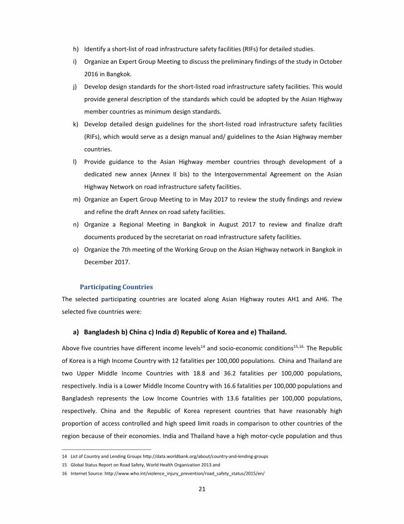
5.3 Star ratings of Road Infrastructure Safety Facilities (RIFs)
By systematically inspecting a road’s infrastructure attributes, it is possible to develop an
understanding of the level of risk that is ‘built in’ to road networks. This provides a basis for targeting
high-risk sections of road for improvement before people are killed or seriously injured. Inspections
are especially useful when crash data is unavailable or unreliable. These data also provide insights into
ways that the AH Standards could be enhanced for safety. The international road assessment
programme (iRAP) road safety inspections have now been conducted, or are being conducted, on
more than 500,000 km of roads in 62 countries (in 2016). In the context of this project, the iRAP
assessment results not only provide an indication of the relative level of risk on the AH Network, but
also an indication of the types of road safety attributes that could be considered for inclusion in a new
annex on “Asian Highway Design Standards for Road Safety”.
iRAP results for a sample of 6,725 km carriageway-km of Asian Highway network roads in 7 member
countries have been compiled for this report, as follows:
• Bangladesh (588 carriageway-km)
• India (119 carriageway-km)
• Indonesia (836 carriageway-km)
• Malaysia (1458 carriageway-km)
• Nepal (354 carriageway-km)
• Philippines (725 carriageway-km)
• Vietnam (2645 carriageway-km)
Approximately 42 billion vehicle-kilometres are travelled on the above roads each year.
Figure 3: Star Ratings for a sample of 6,725 km of Asian Highways in 7 countries
18%27% 30% 30%
31%
31%
54% 52%22%
20%
16%12%
24%19%
Vehicle occupants Motorcyclists Pedestrians Bicyclists

26
The results for the sample of AH Network roads show that:
• 51% of the roads are rated 3-stars or better for vehicle occupants
• 43% of the roads are rated 3-stars or better for motorcyclists
• 16% of the roads are rated 3-stars or better for pedestrians
• 18% of the roads are rated 3-stars or better for bicyclists.
The inspection data provides a rich source of information that gives insight road safety risk on the
sample of AH Network roads. Key road attribute combinations for the sample of roads are summarised
below in Figure 3. It is common for roads that carry significant pedestrian and bicycle flows to have no
footpaths and bicycle paths. Dedicated motorcycle lanes in countries like Vietnam, where the majority
of vehicles are motorcycles, are uncommon. Roadside hazards are common, intersections often lack
basic safety elements and roads that carry relatively high-speed traffic often do not have any median
separation.
Figure 4: Selected road attributes for a sample of 6,725 km of Asian Highways in 7 countries
27
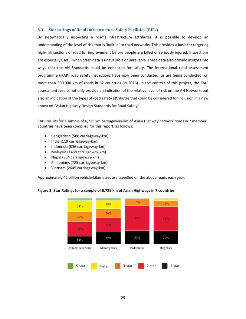
The following images were taken from the sample of Asian Highway network roads:
Figure 5: Examples from Bangladesh

28
5.4 Safer roads investment plans: an example from Indonesia
The road attributes and Star Rating results for the sample of AH Network roads suggest that there is
significant room for improvement across all road user types, but particularly for pedestrians and
bicyclists. Standard iRAP assessments include an economic analysis of more than 90 proven road
improvement options, to generate Safer Road Investment Plans (SRIP). The following is an example
of one such SRIP, for sample of AH Network roads in Indonesia.
Table 4: iRAP Safer Roads Investment Plan for a sample of AH Network roads in Indonesia
Countermeasure Type Length /
Sites
KSI Saved Economic
Benefit
(Rp m)
Cost
(Rp m)
Cost per
KSI saved
(Rp ‘000)
BCR
Roadside Safety - Hazard Removal 880 km 25,290 11,391,770 710,770 28,102 16
Shoulder widening 300 km 8,020 3,613,840 211,530 26,364 17
Delineation 380 km 5,420 2,439,410 14,100 853 173
Motorcycle Lanes 150 km 5,190 2,338,440 69,170 13,316 34
Bicycle Facilities 360 km 4,290 1,932,670 161,550 37,649 12
Road Surface Upgrade 110 km 4,250 1,916,060 74,270 10,392 26
Duplication 50 km 3,600 1,619,210 587,480 163,417 3
Pedestrian Crossing 2940 sites 2,970 1,338,550 320,340 95,422 4
Intersection - grade separation 8 sites 2,310 1,041,450 358,720 155,140 3
Roadside Safety - Barriers 50 km 1,770 795,790 43,560 24,653 18
Lane widening 70 km 1,490 669,900 61,500 24,611 11
Pedestrian Footpath 180 km 980 441,770 179,410 182,917 2
Intersection - signalise 80 sites 910 411,690 35,280 38,601 12
Additional lane 40 km 740 332,320 72,640 98,453 5
Intersection - delineation 140 sites 540 241,620 16,980 10,377 14
Intersection - right turn lanes (signalised) 60 sites 310 140,000 29,820 57,100 5
Central Hatching 40 km 200 91,490 1,350 3,966 68
Regulate roadside commercial activity 40 km 180 82,420 3,600 11,715 23
Parking improvements 20 km 120 53,840 11,550 57,536 5
Rumble strip / flexi-post 10 km 110 49,240 690 3,768 71
Railway Crossing 3 sites 90 40,100 2,730 30,698 15
Intersection - right turn lanes (unsignalised) 50 sites 60 26,010 10,080 103,864 3
Median Barrier 1 km 50 22,470 1,100 13,131 20
Total 68,890 31,030,070 2,978,230 43,229 10
Notes:
- KSI = killed and seriously injured, - Numbers might not add due to rounding
- Countermeasures that span across both northbound and southbound carriageways (such as grade separated intersections and
pedestrian overpasses) are reported as 2 sites in this table, with costs and benefits spread between the two.
Note: USD 1 = IDR 8,541 (18 May 2011).
29
6. Design Standards on Road Infrastructure
Literature review on existing standards for infrastructure element design and specification to address
road safety in the Asian Highway member countries and other international sources was conducted.
The review included a quantitative element to gauge the breadth of information provided in the
documents, and a qualitative elements to develop an appreciation of the level of detail provided. The
documents reviewed can be grouped into two broad categories:
a) Standards, which specify design requirements
b) Guides, which provide more generalised information and advice
A complete list of the documents cited is provided in Appendix A. Of these, 119 documents from the
following countries and organizations were reviewed for the following analyses. It is worth mentioning
here that design guidelines of other member countries were also reviewed at a later stage, but the
information is not included in the following analyses.
9 ESCAP member countries with an Asian Highway network:
• Afghanistan
• Bangladesh
• Bhutan
• China
• India
• Indonesia
• Nepal
• Philippines
• Singapore
4 ESCAP member countries without an Asian Highway route:
• Australia
• United Kingdom of Great Britain and Northern Ireland
• France
• United States of America
1 ESCAP Associate Member:
• Hong Kong, China
3 international organizations:
• United Nations ESCAP (Intergovernmental Agreement on the Asian Highway network-
Annex II)
• Asian Development Bank (ADB)

30
• PIARC (World Road Association)
6.1 Citations by road user
There is a mix of road users present on the AH Network. As such, it is important to consider the extent
to which different road users are addressed in the design standards and guides. To examine this, the
documents were checked for citations of four key road user groups: vehicle occupants, motorcyclists,
pedestrians and bicyclists.
The analysis showed that across the 119 documents reviewed, all made reference to vehicle
occupants, most made reference to motorcyclists, and significantly fewer referenced pedestrians and
bicyclists (see Figure 6). For example, of the documents from ESCAP members with an AH Network,
all the documents reference vehicle occupants; 94% reference motorcyclists; 47% reference
pedestrians; and 38% reference bicyclists. This finding is potentially of significance, given that in many
of the AH Network countries, vulnerable road users – especially pedestrians – account for a significant
percentage of road deaths. The AH Standard makes reference to vehicle occupants, pedestrians and
bicyclists, but no reference to motorcyclists is made.
Figure 6: Road user citations in standards and guides reviewed
6.2 Citations by road attribute
The extent to which the standards and guides refer to various road attributes is important, as this
helps to provide an indication of which road attributes are commonly addressed and a measure of the
comprehensiveness of documentation provided. The documents were reviewed for citations of 37
100%
100%
100%
100%
94%
92%
40%
82%
47%
50%
70%
82%
38%
50%
50%
82%
ESCAP members with AH network
ESCAP members without AH network
ESCAP associate members
International organizations
Addresses vehicle occupants Addresses motorcyclists Addresses pedestrians Addresses bicyclists

31
types of road attributes that are known to influence road safety risk. The analysis, summarised in
Figure 7, showed that across the 115 documents reviewed, nearly all the 37 road attributes were cited
at least once. The exception was ‘school zone crossing supervisor’, which was not cited. The most
common road attribute is ‘sight distance’, which is cited in 57 documents. By contrast, the AH Standard
cites just eight of the road attributes: speed limits, lane widths, number of lanes, curvature, grade,
median type, paved shoulder and sidewalk. This analysis showed that standards and guides in use by
ESCAP member countries and associate member countries cover a significantly broader number of
road attributes, suggesting there is scope to include a larger range of road attributes in the AH
standards.
Figure7: Number of standards and guides by road attribute cited
0 10 20 30 40 50 60 70
School zone crossing supervisor
Centreline rumble strips
Shoulder rumble strips
Service road
School zone warning
Differential speed limits
Roadworks
Vehicle parking
Facilities for motorised two…
Skid resistance / grip
Sidewalk
Pedestrian fencing
Land use
Road condition
Street lighting
Speed management / traffic…
Operating speed
Pedestrian crossing quality
Property access points
Pedestrian crossing facilities
Facilities for bicycles
Quality of curve
Paved shoulder
Median type
Roadside severity - distance
Grade
Intersection channelisation
Intersecting road volume
Delineation
Curvature
Intersection quality
Intersection type
Roadside severity - object
Number of lanes
Lane width
Speed limits
Sight distance
Number of standards and guides
AH Standard
All standards and guides reviewed
32
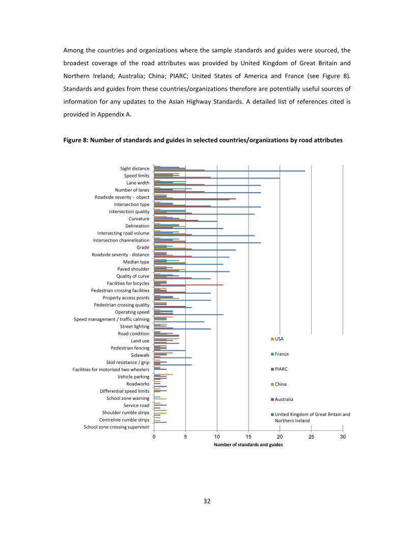
Among the countries and organizations where the sample standards and guides were sourced, the
broadest coverage of the road attributes was provided by United Kingdom of Great Britain and
Northern Ireland; Australia; China; PIARC; United States of America and France (see Figure 8).
Standards and guides from these countries/organizations therefore are potentially useful sources of
information for any updates to the Asian Highway Standards. A detailed list of references cited is
provided in Appendix A.
Figure 8: Number of standards and guides in selected countries/organizations by road attributes
0 5 10 15 20 25 30
School zone crossing supervisor
Centreline rumble strips
Shoulder rumble strips
Service road
School zone warning
Differential speed limits
Roadworks
Vehicle parking
Facilities for motorised two wheelers
Skid resistance / grip
Sidewalk
Pedestrian fencing
Land use
Road condition
Street lighting
Speed management / traffic calming
Operating speed
Pedestrian crossing quality
Property access points
Pedestrian crossing facilities
Facilities for bicycles
Quality of curve
Paved shoulder
Median type
Roadside severity - distance
Grade
Intersection channelisation
Intersecting road volume
Delineation
Curvature
Intersection quality
Intersection type
Roadside severity - object
Number of lanes
Lane width
Speed limits
Sight distance
Number of standards and guides
USA
France
PIARC
China
Australia
United Kingdom of Great Britain and
Northern Ireland
33
6.3 Discussion on quantitative analysis
The previous quantitative analyses shows that compared to the sample of standards and guides
reviewed, the AH Standard covers a very limited number of road attributes. Among the documents
reviewed, the range of detail provided is large as is the degree to which contemporary thinking in road
safety is captured. The AH Standard is among the most limited documents reviewed in terms of detail
and contemporary thinking for safety. In relation to road safety generally, for example, the AH
Standard includes only one very general reference, simply saying:
While developing the Asian Highway network, Parties shall give full consideration to issues of
safety (Article 10 of Section II, Annex II)
As another example, although the AH Standard cites pedestrians, sidewalks and bicyclists, this is only
in an extremely limited form, and is in the context of impeding traffic flows rather than improving
safety:
Pedestrians, bicycles and animal-drawn carts should be separated from through traffic by the
provision, where practical, of frontage roads and/or sidewalks for the sections where smooth
traffic is impeded by the existence of such local roads (Article 3 of Section II, Annex II).
Given that the AH Standard provides minimum standards for a limited number of road attributes,
countries are hence required to refer to other designs standards for specifications on other attributes.
For example, since the AH Standard does not include roadside safety specifications, countries must
draw on other sources for information on issues such as roadside clear zones, slopes and safety
barriers. However, the quality of information provided in some other standards and guides is, by
international best practice standards, poor. For example, despite the International Road Federation
(IRF) recommending that “road authorities in all countries immediately prohibit new installations of
‘Fishtail’ or ‘Spoon’ terminals…”, these hazardous design safety barrier ends are still included in design
standards in numerous countries and continue to be installed on upgraded and new roads. This type
of problem is often compounded by the fact that new, smoother pavements invariably lead to higher
speeds that significantly increase risk unless ameliorated with safety countermeasures.
On the other hand, there are numerous standards and guides among the sample reviewed that
provide comprehensive road safety information. The countries and organizations identified earlier
(United Kingdom of Great Britain and Northern Ireland; Australia; China; PIARC; and France) as having
broad coverage of road safety attributes also often have detailed, contemporary information on safety
issues. Furthermore, design documentation for specific projects conducted in the region may also
provide valuable information for particular road attributes. For example, Malaysia and Viet Nam now

34
have numerous examples of motorcycle lanes which could be drawn on for the development of the
AH Standard.
6.4 The Safe System Approach
In addition to information on specific road infrastructure facilities, many of the standards and guides
promote principles that are consistent with the “Safe System” approach to road safety. For example,
Austroads’ Guide to Road Design Part 4: Intersections and Crossings – General states:
Adopting a safe system approach to road safety recognises that humans, as road users, are fallible and
will continue to make mistakes, and that the community should not penalise people with death or
serious injury when they do make mistakes. In a safe system, therefore, roads (and vehicles) should be
designed to reduce the incidence and severity of crashes when they occur.
The safe system approach requires, in part (Australian Transport Council 2006):
• Designing, constructing and maintaining a road system (roads, vehicles and operating
requirements) so that forces on the human body generated in crashes are generally less than those
resulting in fatal or debilitating injury.
• Improving roads and roadsides to reduce the risk of crashes and minimise harm: measures for
higher speed roads including dividing traffic, designing “forgiving” roadsides, and providing clear driver
guidance. In areas with large numbers of vulnerable road users or substantial collision risk, speed
management supplemented by road and roadside treatments is a key strategy for limiting crashes.
• Managing speeds, taking into account the risks on different parts of the road system.
Safer road user behaviour, safer speeds, safer roads and safer vehicles are the four key elements that
make a safe system. In relation to speed the Australian Transport Council (2006) reported that the
chances of surviving a crash decrease markedly above certain speeds, depending on the type of crash,
for example:
• pedestrian struck by vehicle: 20 to 30 km/h
• motorcyclist struck by vehicle (or falling off): 20 to 30 km/h
• side impact vehicle striking a pole or tree: 30 to 40 km/h
• side impact vehicle to vehicle crash: 50 km/h
• head-on vehicle to vehicle (equal mass) crash: 70 km/h
In New Zealand, practical steps have been taken to give effect to similar guiding principles through a
Safety Management Systems (SMS) approach.

35
Road designers should be aware of, and through the design process actively support, the philosophy
and road safety objectives covered in the Austroads Guide to Road Safety (Austroads 2006-2009).
Countries leading in road safety have put these principles into practice with outstanding results. In
Sweden, the home of ‘Vision Zero’, the Road Administration defined a safe road transport system as
one where: the driver uses a seat belt, does not exceed the speed limits, and is sober; the vehicle has
a five star rating by Euro NCAP (European New Car Assessment Programme); and the road has a four
star rating by EuroRAP. Research showed this combination to be a stunning success: just two to three
percent of road deaths occurred when these conditions were met, despite them coinciding with 30%
of traffic flow. 19 ‘Sustainable Safety’ is widely credited as underpinning the Netherlands’ excellent
performance in road safety. Among countries with a population greater than one million people, the
Netherlands is often among the top three performers. In 2014, the national death rate was 3.4 deaths
per 100,000 population.20 Sustainable Safety focuses on three design principles for roads:
functionality, homogeneity and predictability, and requires the definition of minimum safety levels for
all roads.21 The Netherlands was the first country to set a national Star Rating target for its roads,
committing to achieve a minimum 3 star rating for national roads by 2020.
Although the specific approach to creating a safe system might vary from country to country, the
principles are universal. The moral imperative for taking this approach is compelling. So too is the
economic imperative; the economic savings from targeted safety upgrades typically exceed the cost
of their construction and maintenance.22
19 Stigson, H., Krafft, M. and C. Tingvall. 2008. ‘Use of fatal real-life crashes to analyze a safe road transport
system model, including the road user, the vehicle, and the road’, Traffic Injury Prevention, 9:463-471.
20 SWOV. 2015. SWOV Fact sheet: Road fatalities in the Netherlands. The Hague, the Netherlands. © SWOV.
URL: https://www.swov.nl/rapport/Factsheets/UK/FS_Road_fatalities.pdf
21 Wegman, F., Dijkstra, A., Schermers, G and P. van Vliet. 2005. Sustainable Safety in the Netherlands: the
vision, the implementation and the safety effects. Leidschendam. SWOV. URL:
http://www.swov.nl/rapport/R-2005-05.pdf
22 McMahon, K. and S. Dahdah. 2008. The True Cost of Road Crashes: Valuing life and the cost of a serious
injury. Hampshire, UK. © iRAP. URL: www.irap.org

36
6.5 Additional Design Standards Reviewed from International Sources
A diverse source of references was reviewed:
International Organizations
• UNESCAP – Intergovernmental Agreement on the Asian Highway Network
• UNECE Trans-European Transport Network (TET-N)
• International Road Assessment Programme (iRAP)
• World Road Federation (PIARC)
• United Nations Road Safety Collaboration
• World Bank Global Road Safety Facility (GRSF)
• International Road Federation (IRF)
• Asian Development Bank (ADB)
• Federation of European Motorcyclists Association (FEMA)
Comparison- Countries and Regions
• Australia
• France
• Germany
• Hong Kong, China
• Qatar
• Netherlands
• Norway
• Sweden
• United Kingdom
• United States
The references cover some of the latest publication releases e.g. the Road Safety Manual of the
World Road Federation (PIARC) released in 2015.
Among the comparison countries or regions, emphasis is given to countries with good safety
performance and standards or practices:
• Best performing countries (fatalities per 100,000 population): UK, Sweden, the
Netherlands, Norway
• Sustainable Safety concept: the Netherlands
• Self-explaining Roads concept: the Netherlands

37
• Vision Zero concept: Sweden, Norway
• Traffic Calming and Bicycles: the Netherlands
• Forgiving Roadside concept: United States
About the Trans-European Road Network (TERN)
The TERN project is coordinated through the United Nations Economic Commission for Europe
(UNECE). TERN consists of a well-developed network of high quality trunk roads. The related Trans-
European Motorway (TEM) project is an ongoing initiative to construct 12,000km of TERN motorways
across the eastern part of Europe and bordering countries. Both TERN and TEM overlap with the AH
Network in several countries, notably Turkey, Russian Federation, Armenia, Azerbaijan and Georgia.
Important documents including design standards from the TERN and TEM projects were reviewed.
Besides serving as a model for the AH Network, it is essential to take into account TERN and TEM
standards for overlapping TERN/TEM and AH routes.
The Convention on Road Signs and Signals Vienna (8 November 1968)
This convention, also known as the Vienna Convention, lays down a system of road signs, signals and
symbols and road markings for signifying a certain rule or conveying certain information to road-users.
The system is extensively used by both countries joining and not joining the convention. There are 14
parties to the Convention which are member countries of the AH Network (October 2016):
Following the opening for signature of the Vienna Convention, the United Nations Economic
Commission for Europe (UNECE), considering that it was necessary to achieve greater uniformity in
the rules governing road signs and signals in Europe, asked the UNECE Group of Experts on Road Traffic
Safety to prepare a draft Agreement supplementing the Vienna Convention. This is known as “The
European Agreement supplementing the 1968 Convention on Road Signs and Signals” with its
additional protocol. Among the AH Network member countries, this agreement was only signed by
Georgia and the Russian Federation.
The Vienna Convention is relevant since road signs, signals, symbols and road markings are themselves
crucial to road safety. They are also integral components of many road safety infrastructure facilities.
It may be noted that the Vienna Convention is not sufficient by itself to function as a design standard
or guideline, and it is up to individual countries and organizations to develop design standards and
guidelines on the basis of the convention.

38
7. Selected Road Infrastructure Safety Facilities for the Asian Highway
7.1 Pre-selection of Road Facilities
There are good evidences that addition of road infrastructure safety facilities would prevent deaths
and serious injuries and would be economically viable. The review of existing design standards showed
that there is a large range of road safety attributes (road infrastructure safety facilities) cited in road
design standards and guides in use among Asian Highway member countries, many of which are not
included in the current Annex II to the Intergovernmental Agreement on the Asian Highway Network.
Based on this information available through the review of literature, the following road infrastructure
facilities (RIF) were pre-selected for consideration in the study.
A. Delineation
A-1. Line marking A-2. Chevron markers
A-3. Raised reflectorized pavement markers
A-4. Flexible delineator posts

39
A-5. Coloured lanes
B. Roadsides and medians
B-1. Roadside barrier B-2. Median barrier
B-3. Buffer to protect head light from opposite
direction
B-4. Central hatching / wide centreline
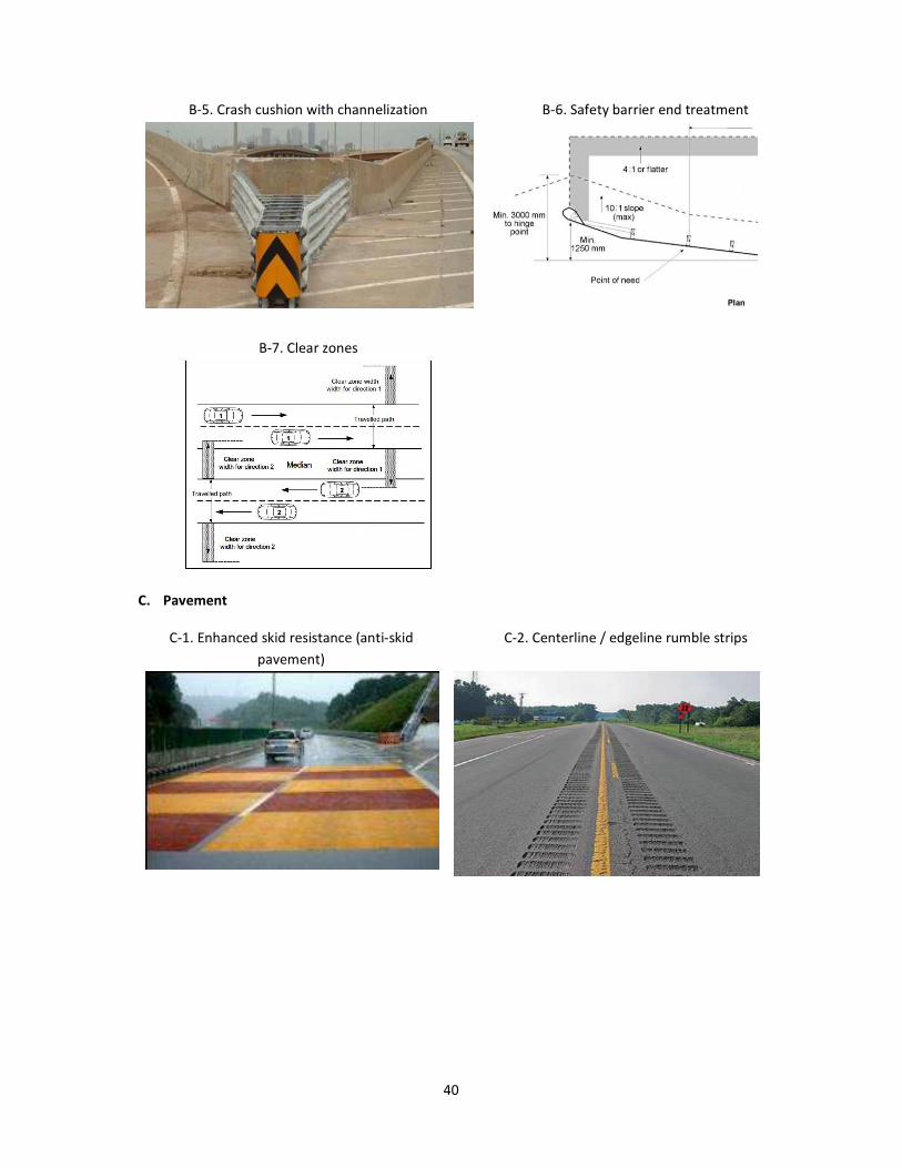
40
B-5. Crash cushion with channelization B-6. Safety barrier end treatment
B-7. Clear zones
C. Pavement
C-1. Enhanced skid resistance (anti-skid
pavement)
C-2. Centerline / edgeline rumble strips
41
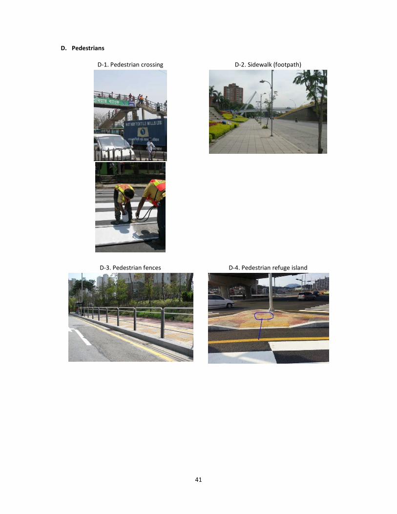
D. Pedestrians
D-1. Pedestrian crossing D-2. Sidewalk (footpath)
D-3. Pedestrian fences
D-4. Pedestrian refuge island

42
E. Intersection
E-1. Protected turn lane (pocket lane for
turning)
E-2. Intersection channelization
E-3. Roundabout
F. Speed control and regulation
F-1. Speed hump F-2. Visual traffic calming

43
F-3. Automatic speed cameras F-4. Variable speed limits
G. Bicycle and motorcycles
G-1. Bicycle lane G-2. Exclusive motorcycle lane
G-3. Non-exclusive motorcycle lane
G-4. Motorcycle-friendly safety barriers

44
H. Other facilities
H-1. Reflection mirror H-2. Lighting
H-3. Variable message sign
H-4. Roadside parking
H-5. Emergency escape ramp
H-6. Emergency telephones
H-7. Sight distance

45
7.2 Survey in the Asian Highway member countries
A survey was conducted by the ESCAP secretariat in the Asian Highway member countries to assess
the prevalence, types and design standards of road safety facilities in the Asian Highway. The survey
was sent by the ESCAP secretariat to all 32 Asian Highway member countries in December 2015, and
responses were received from 17 member countries.
The purpose of the questionnaire was to develop an understanding of:
• the extent to which the 36 road infrastructure safety facilities (RIFs) identified in the previous
section are present on the Asian Highway network
• perception about the effectiveness of the road infrastructure safety facilities if present on the
Asian Highway Network.
• the extent to which design standards, guidelines or manuals exist for the road infrastructure
safety facilities are present in the member countries
• the reasons that some road infrastructure safety facilities are not present on the Asian Highway
network.
The results of the survey are presented in this section.
Highways included in the response
Questionnaire participants were asked to specify which AHs their answers applied to. Table 5 lists
the responses.
Table 5: Highways included in the questionnaire responses
Country Highways
Bangladesh AH1, AH2, AH41
China Not specified
DPR Korea AH1 Pyongyang-Kaesong Completed, Sinuiju-Pyongyang under designing
and AH6 Pyongyang-Wonsan Completed, Wonjong-Sonbong-Chongjin-
Wonsan-Kosong design completed under construction
Georgia E60, E117
India AH1, AH2, AH42, AH43, AH45, AH46, AH47, AH48
I. R. of Iran AH1, AH2, AH70, AH71, AH72, AH75, AH78, AH8, AH81, AH82
Nepal AH2, AH42
Republic of Korea Asian Highway route no 1 (KYONGBU Expressway (No. 1), GUMA
Expressway (No. 45), National Highway (NH-No. 1)
Sri Lanka AH 43
Thailand AH1, AH2, AH3, AH12, AH13, AH15, AH16, AH18, AH121, AH123

46
Turkey AH1-5, AH84 (motorway), AH1, AH5, AH84, AH85, AH87
Viet Nam Not specified
Tajikistan AH67
Cambodia Not specified
Pakistan Not specified
Philippines Not specified
Russian Federation Not specified
Presence of road infrastructure safety facilities (RIFs) on the Asian Highway Network
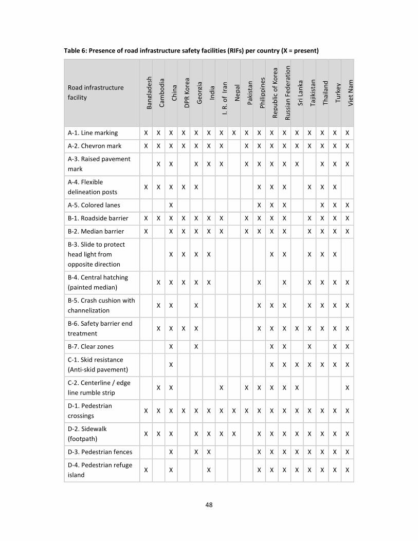
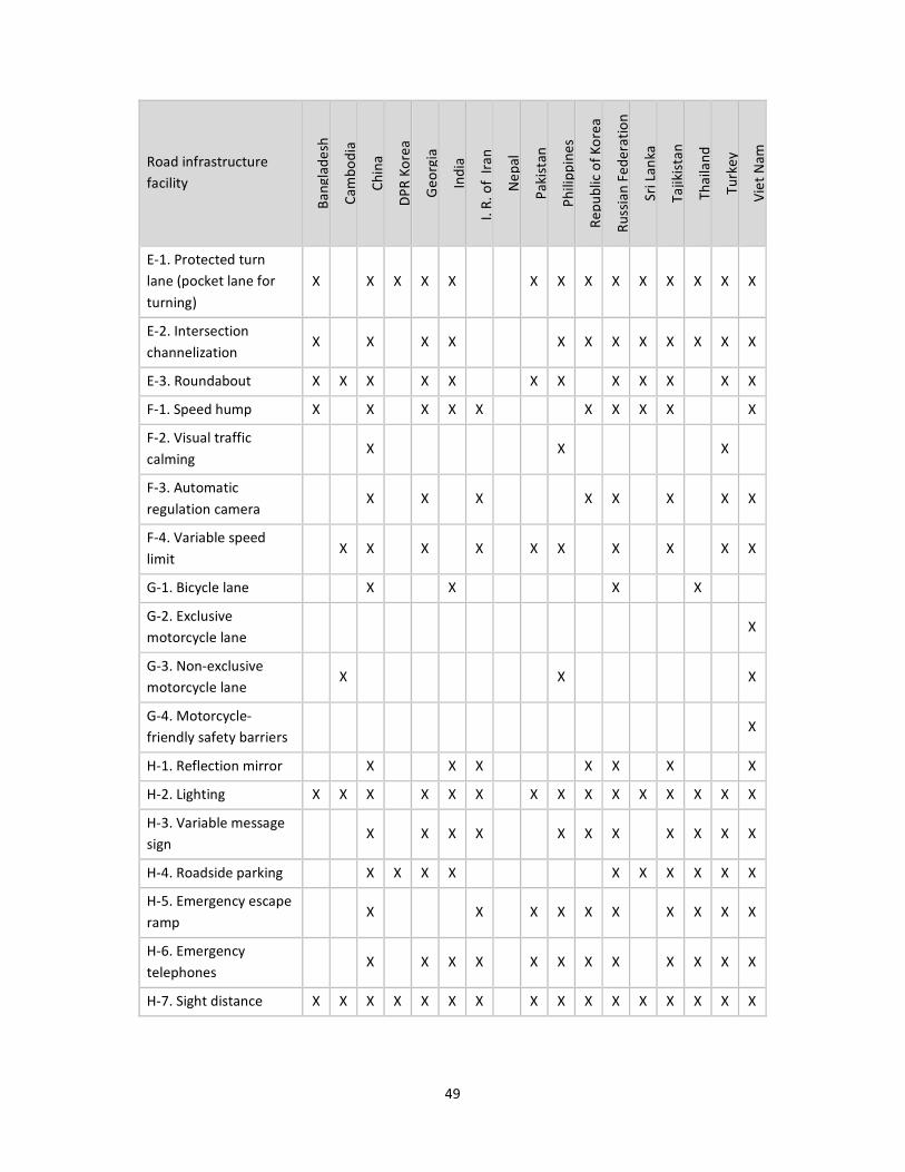
Questionnaire participants were asked to identify which of the 36 RIFs are present on the AH network
in their country. Key findings are:
• all 36 RIFs are used in at least one country
• China, the Russian Federation and Viet Nam use the largest number of the RIFs, with 33, 32 and
32 of the 36 RIFs, respectively
• Nepal uses 3 of the 36 RIFs, which is the fewest by a large margin. The countries with the next
fewest numbers are Democratic People’s Republic of Korea, Pakistan and Bangladesh, with 12,
14 and 14, respectively
• Nepal, Democratic People’s Republic of Korea, Bangladesh, Pakistan, I. R. of Iran and Sri Lanka
use less than half of the 36 RIFs
• the most commonly used RIFs are: pedestrian crossings, line marking, sight distance, chevron
markers, sidewalk and roadside barriers used in 17, 17, 16, 16, 15 and 15 countries, respectively.
• the least commonly used RIFs are: exclusive motorcycle lane, non-exclusive motorcycle lane
and visual traffic calming, present in 1, 1, and 3 countries, respectively.

47
Figure 9: Number of road infrastructure safety facilities (RIFs) present (%)
0% 10% 20% 30% 40% 50% 60% 70% 80% 90% 100%
Nepal
DPR Korea
Bangladesh
Pakistan
Cambodia
Iran
Sri Lanka
India
Georgia
Thailand
Philipines
Republic of Korea
Tajikistan
Turkey
Russian Federation
Viet Nam
China
No. of RIFs present (%)
Islamic Republic of Iran
48
Table 6: Presence of road infrastructure safety facilities (RIFs) per country (X = present)
Road infrastructure
facility
Ba
ng
lad
esh
Ca
mb
od
ia
Ch
ina
DP
R K
ore
a
Ge
org
ia
Ind
ia
I. R
. o
f I
ran
Ne
pa
l
Pa
kis
tan
Ph
ilip
pin
es
Re
pu
blic
of
Ko
rea
Ru
ssia
n F
ed
era
tio
n
Sri
La
nka
Ta
jikis
tan
Th
aila
nd
Tu
rke
y
Vie
t N
am
A-1. Line marking X X X X X X X X X X X X X X X X X
A-2. Chevron mark X X X X X X X X X X X X X X X X
A-3. Raised pavement
mark X X X X X X X X X X X X X
A-4. Flexible
delineation posts X X X X X X X X X X X
A-5. Colored lanes X X X X X X X
B-1. Roadside barrier X X X X X X X X X X X X X X X
B-2. Median barrier X X X X X X X X X X X X X X
B-3. Slide to protect
head light from
opposite direction
X X X X X X X X X
B-4. Central hatching
(painted median) X X X X X X X X X X X
B-5. Crash cushion with
channelization X X X X X X X X X X
B-6. Safety barrier end
treatment X X X X X X X X X X X X
B-7. Clear zones X X X X X X X
C-1. Skid resistance
(Anti-skid pavement) X X X X X X X X
C-2. Centerline / edge
line rumble strip X X X X X X X X X
D-1. Pedestrian
crossings X X X X X X X X X X X X X X X X X
D-2. Sidewalk
(footpath) X X X X X X X X X X X X X X X
D-3. Pedestrian fences X X X X X X X X X X X
D-4. Pedestrian refuge
island X X X X X X X X X X X
49
Road infrastructure
facility
Ba
ng
lad
esh
Ca
mb
od
ia
Ch
ina
DP
R K
ore
a
Ge
org
ia
Ind
ia
I. R
. o
f I
ran
Ne
pa
l
Pa
kis
tan
Ph
ilip
pin
es
Re
pu
blic
of
Ko
rea
Ru
ssia
n F
ed
era
tio
n
Sri
La
nka
Ta
jikis
tan
Th
aila
nd
Tu
rke
y
Vie
t N
am
E-1. Protected turn
lane (pocket lane for
turning)
X X X X X X X X X X X X X X
E-2. Intersection
channelization X X X X X X X X X X X X
E-3. Roundabout X X X X X X X X X X X X
F-1. Speed hump X X X X X X X X X X
F-2. Visual traffic
calming X X X
F-3. Automatic
regulation camera X X X X X X X X
F-4. Variable speed
limit X X X X X X X X X X
G-1. Bicycle lane X X X X
G-2. Exclusive
motorcycle lane X
G-3. Non-exclusive
motorcycle lane X X X
G-4. Motorcycle-
friendly safety barriers X
H-1. Reflection mirror X X X X X X X
H-2. Lighting X X X X X X X X X X X X X X X
H-3. Variable message
sign X X X X X X X X X X X
H-4. Roadside parking X X X X X X X X X X
H-5. Emergency escape
ramp X X X X X X X X X X
H-6. Emergency
telephones X X X X X X X X X X X X
H-7. Sight distance X X X X X X X X X X X X X X X X

50
Figure 10: Number of countries in which road infrastructure safety facilities (RIFs) are present (%)
0% 10% 20% 30% 40% 50% 60% 70% 80% 90% 100%
G-2. Exclusive motorcycle lane
G-4. Motorcycle-friendly safety barriers
F-2. Visual traffic calming
G-3. Non-exclusive motorcycle lane
G-1. Bicycle lane
A-5. Colored lanes
B-7. Clearzones
H-1. Reflection mirror
C-1. Skid resistance (Anti-skid pavement)
F-3. Automatic regulation camera
B-3. Slide to protect head light from opposite direction
C-2. Centerline / edgeline rumble strip
B-5. Crash cushion with channelization
F-1. Speed hump
F-4. Variable speed limit
H-4. Roadside parking
H-5. Emergency escape ramp
A-4. Flexible delineation posts
B-4. Central hatching (painted median)
D-3. Pedestrian fences
D-4. Pedestrian refuge island
H-3. Variable message sign
B-6. Safety barrier end treatment
E-2. Intersection channelization
E-3. Roundabout
H-6. Emergency telephones
A-3. Raised pavement mark
B-2. Median barrier
E-1. Protected turn lane (pocket lane for turning)
B-1. Roadside barrier
D-2. Sidewalk (footpath)
H-2. Lighting
A-2. Chevron mark
H-7. Sight distance
A-1. Line marking
D-1. Pedestrian crossings
Number of countries (%)

51
7.3 Perceived effectiveness of road infrastructure safety facilities (RIFs)
In the survey questionnaire, participants were asked to estimate the effectiveness of the RIFs present
on the Asian Highway network in their countries, using simple categories of: very effective, effective,
not effective and not known. The results are summarized in Figure 11.23 The key findings are:
• there is a correlation between the extent to which RIFs are present in a country and perceptions
about their effectiveness. The RIFs more commonly present (pedestrian crossing, line marking,
sight distance, chevron markers, sidewalk) are considered to be very effective or effective
• there is a small number of RIFs that, in a limited number of cases, were considered to be not
effective: raised pavement mark, safety barrier end treatment, central hatching and coloured
lanes
• in a small number of cases the RIFs effectiveness was not known.
23 Responses from the Philippines included numerical estimates of effectiveness. These were adjusted to
match the questionnaire answer options.

52
Figure 11: Perceived effectiveness of RIFs that are present on the AH network *
* Samples where a response was provided.
0 2 4 6 8 10 12 14 16
A-1. Line marking
A-2. Chevron mark
A-3. Raised pavement mark
A-4. Flexible delineation posts
A-5. Colored lanes
B-1. Roadside barrier
B-2. Median barrier
B-3. Slide to protect head light from opposite…
B-4. Central hatching (painted median)
B-5. Crash cushion with channelization
B-6. Safety barrier end treatment
B-7. Clearzones
C-1. Skid resistance (Anti-skid pavement)
C-2. Centerline / edgeline rumble strip
D-1. Pedestrian crossings
D-2. Sidewalk (footpath)
D-3. Pedestrian fences
D-4. Pedestrian refuge island
E-1. Protected turn lane (pocket lane for turning)
E-2. Intersection channelization
E-3. Roundabout
F-1. Speed hump
F-2. Visual traffic calming
F-3. Automatic regulation camera
F-4. Variable speed limit
G-1. Bicycle lane
G-2. Exclusive motorcycle lane
G-3. Non-exclusive motorcycle lane
G-4. Motorcycle-friendly safety barriers
H-1. Reflection mirror
H-2. Lighting
H-3. Variable message sign
H-4. Roadside parking
H-5. Emergency escape ramp
H-6. Emergency telephones
H-7. Sight distance
Number of countries
Sum of Very effective
Sum of Effective
Sum of Not effective
Sum of Not known
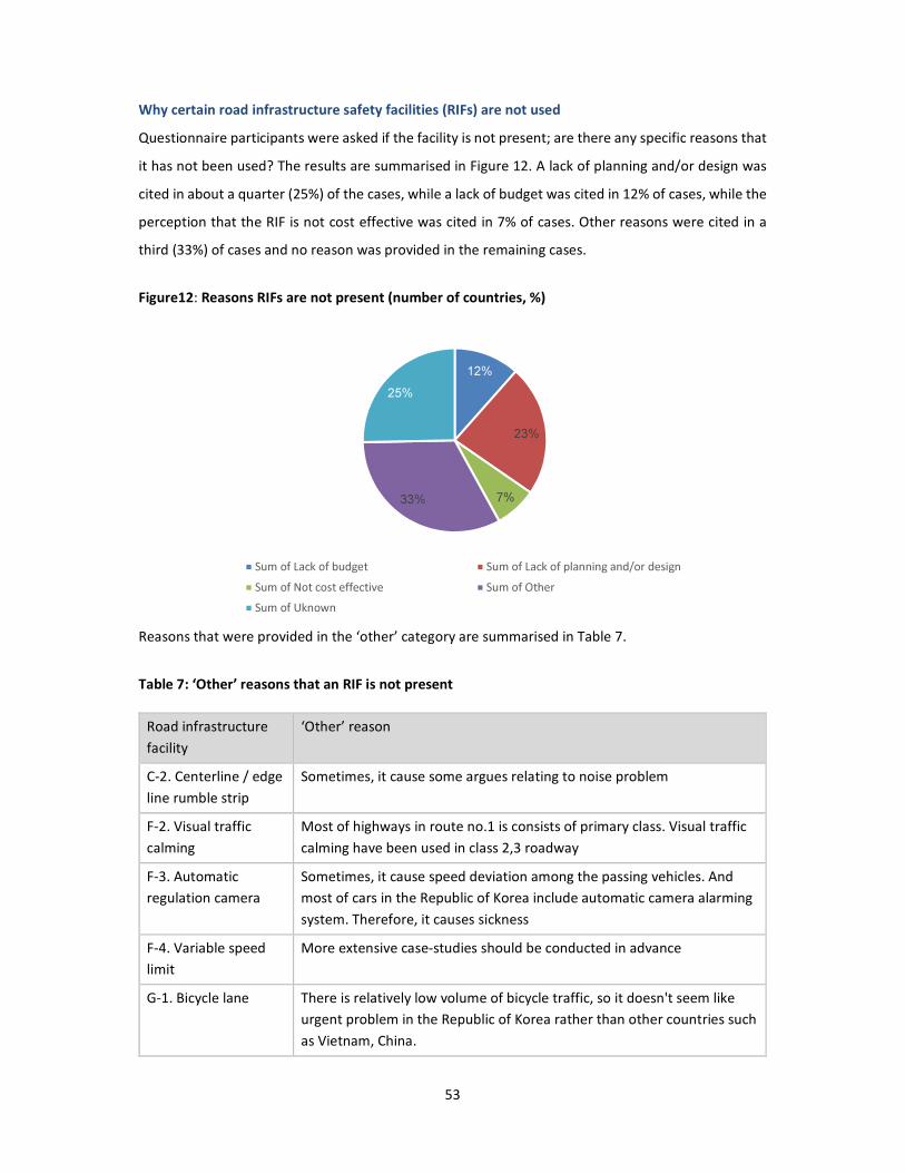
53
Why certain road infrastructure safety facilities (RIFs) are not used
Questionnaire participants were asked if the facility is not present; are there any specific reasons that
it has not been used? The results are summarised in Figure 12. A lack of planning and/or design was
cited in about a quarter (25%) of the cases, while a lack of budget was cited in 12% of cases, while the
perception that the RIF is not cost effective was cited in 7% of cases. Other reasons were cited in a
third (33%) of cases and no reason was provided in the remaining cases.
Figure12: Reasons RIFs are not present (number of countries, %)
Reasons that were provided in the ‘other’ category are summarised in Table 7.
Table 7: ‘Other’ reasons that an RIF is not present
Road infrastructure
facility
‘Other’ reason
C-2. Centerline / edge
line rumble strip
Sometimes, it cause some argues relating to noise problem
F-2. Visual traffic
calming
Most of highways in route no.1 is consists of primary class. Visual traffic
calming have been used in class 2,3 roadway
F-3. Automatic
regulation camera
Sometimes, it cause speed deviation among the passing vehicles. And
most of cars in the Republic of Korea include automatic camera alarming
system. Therefore, it causes sickness
F-4. Variable speed
limit
More extensive case-studies should be conducted in advance
G-1. Bicycle lane There is relatively low volume of bicycle traffic, so it doesn't seem like
urgent problem in the Republic of Korea rather than other countries such
as Vietnam, China.
12%
23%
7%33%
25%
Sum of Lack of budget Sum of Lack of planning and/or design
Sum of Not cost effective Sum of Other
Sum of Uknown
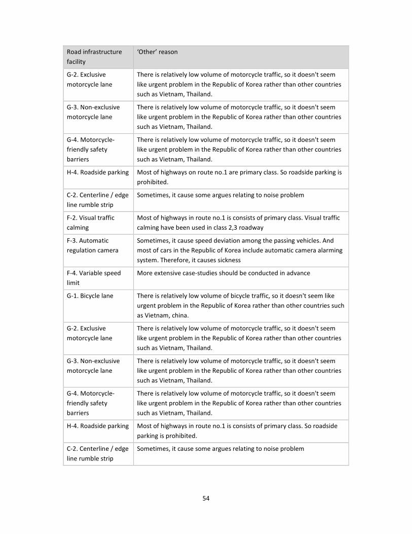
54
Road infrastructure
facility
‘Other’ reason
G-2. Exclusive
motorcycle lane
There is relatively low volume of motorcycle traffic, so it doesn't seem
like urgent problem in the Republic of Korea rather than other countries
such as Vietnam, Thailand.
G-3. Non-exclusive
motorcycle lane
There is relatively low volume of motorcycle traffic, so it doesn't seem
like urgent problem in the Republic of Korea rather than other countries
such as Vietnam, Thailand.
G-4. Motorcycle-
friendly safety
barriers
There is relatively low volume of motorcycle traffic, so it doesn't seem
like urgent problem in the Republic of Korea rather than other countries
such as Vietnam, Thailand.
H-4. Roadside parking Most of highways on route no.1 are primary class. So roadside parking is
prohibited.
C-2. Centerline / edge
line rumble strip
Sometimes, it cause some argues relating to noise problem
F-2. Visual traffic
calming
Most of highways in route no.1 is consists of primary class. Visual traffic
calming have been used in class 2,3 roadway
F-3. Automatic
regulation camera
Sometimes, it cause speed deviation among the passing vehicles. And
most of cars in the Republic of Korea include automatic camera alarming
system. Therefore, it causes sickness
F-4. Variable speed
limit
More extensive case-studies should be conducted in advance
G-1. Bicycle lane There is relatively low volume of bicycle traffic, so it doesn't seem like
urgent problem in the Republic of Korea rather than other countries such
as Vietnam, china.
G-2. Exclusive
motorcycle lane
There is relatively low volume of motorcycle traffic, so it doesn't seem
like urgent problem in the Republic of Korea rather than other countries
such as Vietnam, Thailand.
G-3. Non-exclusive
motorcycle lane
There is relatively low volume of motorcycle traffic, so it doesn't seem
like urgent problem in the Republic of Korea rather than other countries
such as Vietnam, Thailand.
G-4. Motorcycle-
friendly safety
barriers
There is relatively low volume of motorcycle traffic, so it doesn't seem
like urgent problem in the Republic of Korea rather than other countries
such as Vietnam, Thailand.
H-4. Roadside parking Most of highways in route no.1 is consists of primary class. So roadside
parking is prohibited.
C-2. Centerline / edge
line rumble strip
Sometimes, it cause some argues relating to noise problem

55
Road infrastructure
facility
‘Other’ reason
F-2. Visual traffic
calming
Most of highways in route no.1 is consists of primary class. Visual traffic
calming have been used in class 2,3 roadway
F-3. Automatic
regulation camera
Sometimes, it cause speed deviation among the passing vehicles. And
most of cars in the Republic of Korea include automatic camera alarming
system. Therefore, it causes sickness
F-4. Variable speed
limit
More extensive case-studies should be conducted in advance
G-1. Bicycle lane There is relatively low volume of bicycle traffic, so it doesn't seem like
urgent problem in the Republic of Korea rather than other countries such
as Vietnam, china.
G-2. Exclusive
motorcycle lane
There is relatively low volume of motorcycle traffic, so it doesn't seem
like urgent problem in the Republic of Korea rather than other countries
such as Vietnam, Thailand.
G-3. Non-exclusive
motorcycle lane
There is relatively low volume of motorcycle traffic, so it doesn't seem
like urgent problem in the Republic of Korea rather than other countries
such as Vietnam, Thailand.
G-4. Motorcycle-
friendly safety
barriers
There is relatively low volume of motorcycle traffic, so it doesn't seem
like urgent problem in the Republic of Korea rather than other countries
such as Vietnam, Thailand.
H-4. Roadside parking Most of highways in route no.1 is consists of primary class. So roadside
parking is prohibited.
A-4. Flexible
delineation posts
There is another kind
B-3. Slide to protect
head light from
opposite direction
There is another kind
The results are summarised by RIF in Figure 13.

56
Figure13: Reasons an RIF is not present
0 2 4 6 8 10 12 14 16
A-1. Line marking
A-2. Chevron mark
A-3. Raised pavement mark
A-4. Flexible delineation posts
A-5. Colored lanes
B-1. Roadside barrier
B-2. Median barrier
B-3. Slide to protect head light from…
B-4. Central hatching (painted median)
B-5. Crash cushion with channelization
B-6. Safety barrier end treatment
B-7. Clearzones
C-1. Skid resistance (Anti-skid…
C-2. Centerline / edgeline rumble strip
D-1. Pedestrian crossings
D-2. Sidewalk (footpath)
D-3. Pedestrian fences
D-4. Pedestrian refuge island
E-1. Protected turn lane (pocket lane…
E-2. Intersection channelization
E-3. Roundabout
F-1. Speed hump
F-2. Visual traffic calming
F-3. Automatic regulation camera
F-4. Variable speed limit
G-1. Bicycle lane
G-2. Exclusive motorcycle lane
G-3. Non-exclusive motorcycle lane
G-4. Motorcycle-friendly safety barriers
H-1. Reflection mirror
H-2. Lighting
H-3. Variable message sign
H-4. Roadside parking
H-5. Emergency escape ramp
H-6. Emergency telephones
H-7. Sight distance
Number of countries (%)
Sum of Lack of budget
Sum of Lack of planning and/or design
Sum of Not cost effective
Sum of Other
Sum of Uknown
57
Standards for RIF those are present on the Asian Highway Network
Participants were asked whether there are standards, guidelines or manuals that relate to the use of
the RIFs present on the AH network and in case there is, participants were asked to name them. The
results show that at least one standard, guideline or manual is available for each RIF present on the
AH network. In most of the cases standards, guidelines or manuals are available for:
• line marking
• chevron mark
• pedestrian crossings
• roadside barrier
• median barrier
• sidewalk (footpath)
• raised pavement mark
• emergency escape ramp.
The countries that cited the largest number of standards, guidelines or manuals are: Thailand,
Republic of Korea and Turkey. The countries that cited the fewest number of standards, guidelines or
manuals are: Islamic Republic of Iran, the Philippines and Nepal. Annex C lists all standards, guidelines
and/or manuals cites by RIF and country.
7.4 Discussions and conclusions on the survey
The questionnaire results received from 17 countries show that all the 36 RIFs are used in at least one
country. It is unsurprising that the RIFs most commonly present on the AHs are also those that are
perceived to be most effective. These include: pedestrian crossing, line marking, sight distance,
chevron markers, side walk and roadside safety barriers. The countries that use the largest number of
the RIFs are China, the Russian Federation and Viet Nam.
The results suggest that there is potential to promote the use of a broader range of RIF on the AH
network; just 10 of the countries use more than half of the 36 RIFs. For example, centreline and edge
line rumble strips are present on AHs in just over half of the sample countries, even though empirical
evidence shows that this type of treatment can be very effective on higher-speed roads. Perhaps
surprisingly, RIFs that are specific to motorcycle safety, such as exclusive motorcycle lane, non-
exclusive motorcycle lane and motorcycle-friendly safety barriers are among the least used RIFs on
the AH network, despite many countries in the ESCAP region having relatively high motorcycle
volumes.
58
The results also suggest that a rapid take up of internationally well-used RIFs in particular countries
may be needed. For example, Nepal reported using just three of the 36 RIFs, even though the roads
in that country are very often steep with sharp bends and are known to be high-risk. Notably though,
Nepal did report that a large number of the RIFs are now being included in road designs.
The questionnaire identifies a number of reasons that particular RIFs are not used, including lack of
planning and/or design (23%), lack of budget (12%), not cost effective (7%) and other reasons (33%).
Other reasons include issues relating to the vehicle mix in a country (for example, there are relatively
few motorcyclists in the Republic of Korea) and possible side effects, such as noise caused by rumble
strips. Apart from developing a regional standard that supports design and implementation of a
broader range of RIFs, these questionnaire results suggest that case studies to support the use of each
RIF and training on use of each RIF may be helpful in removing perceived barriers to their use. This
training could also address assist in ensuring that RIFs which are reportedly commonly present on the
AH network are installed according to best practice and identifying ways in which to address localised
challenges. For example, the result show that pedestrian crossings are widely perceived to be
effective, yet in practice there is an extensive problem with drivers failing to yield for pedestrians on
crossings and therefore failing to comply with the law. Issues of cost effectiveness and availability of
funding are also key barriers to the use of some RIFs, and therefore need to be addressed.
The questionnaire responses also provided an extensive list of standards, guidelines and/or manuals
related to the use of the RIFs, and therefore provided a useful resource for the development of road
safety facility infrastructure standards for the ESCAP region.
Overall, the results of the questionnaire, when taken into account along with empirical evidence and
best practices, are useful in the development of road safety facility infrastructure standards.

59
8. Star Rating Testing for the Asian Highway Design Standards
The iRAP methodology was used to illustrate how relative risk levels for vehicle occupants,
motorcyclists, pedestrians and bicyclists would change if RIFs were added to the standard. As part of
the context it is mentionable that the Note24 by the Secretary-General of the United Nations prepared
for the seventieth session of the General Assembly on “improving global road safety” included a
recommendation to improve infrastructure, including by targeting the highest volume 10 per cent of
existing roads and set appropriate road infrastructure star rating targets for all relevant road users
and adopting minimum three-star standards and road safety audits for all new road constructions.
One of the goals of this study was therefore to test whether the RIFs identified could be used to
improve the AH safety rating to at least three-stars - for all road users.
8.1 iRAP Star Ratings
iRAP Star Ratings are based on road infrastructure features and the degree to which they impact the
likelihood and severity of road crashes. The focus is on the features which influence the most common
and severe types of crash on roads for motor vehicles, motorcyclists, pedestrians and bicyclists. They
provide a simple and objective measure of the relative level of risk associated with road infrastructure
for an individual road user. 5-star (green) roads have the lowest level of risk, while 1-star (black) roads
are the highest level of risk.
The Star Ratings are based on Star Rating Scores (SRS). The iRAP models are used to calculate an SRS
at 100 metre intervals for each of the road user types, based on relative risk factors for each of the
road attributes. The scores are developed by combining relative risk factors using a multiplicative
model. A doubling of the SRS represents a doubling of the risk of death and serious injury. More
information on the risk factors used within the model can be found at
http://irap.org/en/about-irap-3/methodology.
24 General Assembly Note A/70/386, page 19 para (g).

60
8.2 Analysis approach for the Star Rating
Scenario testing was conducted for each of the highway and terrain classifications specified in Annex
II Asian Highway Classification and Design Standards of the Intergovernmental Agreement on the
Asian Highway Network (referred to herein as the AH Standard).25 Separate testing was conducted for
vehicle occupants, motorcyclists, pedestrians and bicyclists.
Road attributes were included in a synthesised dataset and analysed using the iRAP software ViDA.
Each scenario was modelled for a 3km length of road comprised of 30 x 100 metre segments. Road
attributes for each 100 metre segment were recorded in a single row of an Excel file. Road attributes
appearing at intermittent intervals on the network (such as intersections) were inserted in the dataset
at the appropriate frequency.
Adding attributes to the baseline scenario in the synthesised data-set enabled the individual influence
of the different road characteristics on the Star Ratings to be assessed in a systematic manner.
Different scenarios were progressively compiled for the four highway classifications and, within each
highway classification; the influence of the RIFs within the four terrains was assessed.
Using the Star Rating Scores (SRS), it was then straightforward to illustrate general patterns in matrices
of the influence of the RIFs on the Star Rating.
This process can be repeated using the publicly-available iRAP Star Rating Demonstrator, which is
available at http://vida.irap.org. Specifications on iRAP road attribute coding are detailed in Star
Ratings and Investment Plans: Coding Manual.26
Star Rating Bands
iRAP Star Ratings are determined by assigning Star Rating Scores (SRS) to the bands as shown in the
table below. Separate bands are used for motorised road users (vehicle occupants and motorcyclists),
bicyclists and pedestrians because their scores are calculated using different equations. That is,
motorised road user scores are based on head-on, run-off road and intersection crashes; pedestrian
scores are based on walking along and across the road crashes; and bicyclist scores are based on riding
along the road and intersections crashes. More information about the Star Rating bands is available
in: iRAP Methodology Fact Sheet #7: Star Rating bands.27
25 Available at: http://www.unescap.org/our-work/transport/asian-highway 26 Available for download at: http://irap.org/en/about-irap-3/specifications. 27 Available for download at: http://irap.org/en/about-irap-3/methodology.

61
Table 8: Star Rating bands and colours
Star Rating Star Rating Score
Vehicle
occupants and
motorcyclists
Bicyclists Pedestrians
Total Along Crossing
5 0 to < 2.5 0 to < 5 0 to < 5 0 to < 0.2 0 to < 4.8
4 2.5 to < 5 5 to < 10 5 to < 15 0.2 to < 1 4.8 to < 14
3 5 to < 12.5 10 to < 30 15 to < 40 1 to < 7.5 14 to < 32.5
2 12.5 to < 22.5 30 to < 60 40 to < 90 7.5 to < 15 32.5 to < 75
1 22.5+ 60+ 90+ 15+ 75+
8.3 Existing Asian Highway Network design standards and star ratings
The existing AH design standard, which sets minimum requirements for a limited number of road
attributes, is summarised in Table 10. The standard includes four highway classifications (Primary,
Class I, Class II and Class III) and, for each highway class, four terrain classifications (Level, Rolling,
Mountainous and Steep).
Baseline Assumptions
In order to produce star ratings for the existing AH design standards, a number of assumptions were
made about the existing AH design standards. For the purposes of the modelling, key assumptions
include that:
• Traffic volumes increase by 2,500 vehicles per day (vpd) per lane for each class:
o Class III roads were assumed to carry 2,500 vpd per lane (or a total of 5,000 vpd for
two lanes)
o Class II roads were assumed to carry 5,000 vpd per lane (or a total of 10,000 vpd for
two lanes)
o Class I roads were assumed to carry 7,500 vpd per lane (or a total of 30,000 vpd for
four lanes)
o Primary roads were assumed to carry 10,000 vpd per lane (or a total of 40,000 vpd
for four lanes).
• Operating speeds are equal to the design speeds (this topic is discussed further in the
discussion and conclusion section of the report).
• Roadsides hazards are present and Mountainous and Steep roads have short sections where
cliffs present.

62
• Curves become more frequent and tighter (smaller radius) moving from Level terrain to Steep
terrain.
• All intersections on the Primary highways are grade separated, while intersections are four-
leg unsignalised on the other highway classes. Intersections become increasingly frequent
moving from Primary to Class III roads.
• Pedestrians, bicyclists and motorcyclists are present on all highway classes (this topic is
discussed further in the discussion and conclusion section of the report), and the number of
locations that pedestrians cross the highway increase moving from Primary to Class III roads.
8.4 Scenarios considered
A series of scenarios were established by adding RIFs to the baseline existing AH standard, as described
below. The RIFs were selected from an original list of 36 options identified in Chapter 7.
Scenarios Road Infrastructure Attributes
Adequate delineation is provided on
all highway and terrain classes,
through the application of line
marking, chevron markers, raised
reflectorized pavement markers and
flexible delineator posts.
A-1. Line marking
A-3. Raised reflectorized
pavement markers
A-2. Chevron markers
A-4. Flexible delineator posts
Shoulder rumble strips are provided
on all Primary class highways, all
higher speed Class I highways
(100km/h and 80km/h) and on
curves on other Class I, II and III
highways.
C-2. Centerline / edge line
rumble strips
Sight distances at intersections and
pedestrian crossings are made
adequate (that is, there would be no
obstructions).
H-7. Sight distance

63
Roadside hazards are managed,
especially on Primary class highways,
higher speed Class I highways
(100km/h and 80km/h) and on
curves on other Class I, II and III
highways, through the use of clear
zones and safety barriers.
B-1. Roadside barrier
B-7. Clear zones
B-6. Safety barrier end
treatment
Median safety barriers are provided
on all Primary class highways, all
higher speed Class I highways
(100km/h and 80km/h), other Class I
roads have a 1-5m wide median
island, wide centerline treatment is
provided on higher speed (80km/h)
Class II highways, and rumble strips
(audio tactile lines) are provided on
curves of other highways.
B-2. Median barrier
B-5. Crash cushion with
channelization
Street lighting is provided at
intersections, at pedestrian crossings
and where bicyclists are present on
all highway classes.
H-2. Lighting
Protected turn lanes are provided at
at-grade intersections (note that it is
assumed that Primary highways have
grade-separated intersections).
E-2. Protected turn lanes
Islands are provided at at-grade
intersections to channelize turning
vehicles (note that it is assumed that
Primary highways have grade-
separated intersections).
E-2. Intersection channelization
A separate scenario was tested
whereby roundabouts are provided
at at-grade intersections.
E-3. Roundabout

64
Where pedestrians are present,
sidewalks with a physical barrier are
provided on all Primary class
highways, all higher speed Class I
highways (100km/h and 80km/h),
and paved sidewalks are provided on
all other classes of highway.
D-2. Paved sidewalk (with
barrier)
D-2. Paved sidewalk
Where pedestrians are present,
grade separated crossings are
provided on Primary highways,
signalized crossings are provided on
Class I highways and marked
crossings with refuge islands are
provided on Class II and Class III
highways.
D-1a. Grade separated
D-4. Pedestrian refuge island
D-1b. Marked crossing
Where bicyclists are present, off-road
bicycle paths are provided on
Primary highways and high speed
(100km/h) Class I highways and
marked on-road lanes are provided
on other Class I and Class II highways
(noting that Class III roads have
paved shoulders).
G-1a. Off-road bicycle lane
G-1b. On-road bicycle lane
Where motorcycle volumes are high,
exclusive lanes are provided on
Primary Highways and non-exclusive
lanes are provided on other classes
of highway.
G-2. Exclusive motorcycle lane
G-3. Non exclusive motorcycle
lane
Visual traffic calming is provided at
curves and intersections on Primary
highways and high speed (100km/h)
Class I highways, visual traffic calming
and/or speed humps are provided on
other classes of highway at curves,
intersections and pedestrian
crossings.
F-1. Speed bump
F-2. Visual traffic calming

65
Table 10: Summary of existing Asian Highway network design standards
Highway classification PRIMARY CLASS I CLASS II CLASS III
Terrain classification L R M S L R M S L R M S L R M S
Design speed (km/h) 120 100 80 60 100 80 50 50 80 6
0
5
0 40 60 50 40 30
Right of way (m) 50 40 40 30
Lane (m) 3.5 3.5 3.5 3.0 (3.25)
Shoulder (m) 3 2.5 3 2.5 2 1.5
(2.0)
0.75
(1.5)
Median strip (m) 4 3 2.5 None
Min. radii of horizontal curve (m) 520
(1000)
350
(600)
210
(350)
115
(160) 350 (600)
210
(350)
80
(110)
21
0
11
5
8
0
5
0
11
5 80 50 30
Pavement slope (%) 2 2 - 5
Shoulder slope (%) 3 - 6
Type of pavement Asphalt/cement concrete Dbl. bituminous
treatment
Max. superelevation (%) 10
Max. vertical grade (%) 4 5 6 7 4 5 6 7 4 5 6 7 4 5 6 7
Structure loading (minimum) HS20-44
L = level, R = rolling, M = mountainous, S = steep.
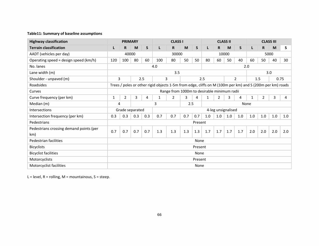
66
Table11: Summary of baseline assumptions
Highway classification PRIMARY CLASS I CLASS II CLASS III
Terrain classification L R M S L R M S L R M S L R M S
AADT (vehicles per day) 40000 30000 10000 5000
Operating speed = design speed (km/h) 120 100 80 60 100 80 50 50 80 60 50 40 60 50 40 30
No. lanes 4.0 2.0
Lane width (m) 3.5 3.0
Shoulder - unpaved (m) 3 2.5 3 2.5 2 1.5 0.75
Roadsides Trees / poles or other rigid objects 1-5m from edge, cliffs on M (100m per km) and S (200m per km) roads
Curves Range from 1000m to desirable minimum radii
Curve frequency (per km) 1 2 3 4 1 2 3 4 1 2 3 4 1 2 3 4
Median (m) 4 3 2.5 None
Intersections Grade separated 4-leg unsignalised
Intersection frequency (per km) 0.3 0.3 0.3 0.3 0.7 0.7 0.7 0.7 1.0 1.0 1.0 1.0 1.0 1.0 1.0 1.0
Pedestrians Present
Pedestrians crossing demand points (per
km) 0.7 0.7 0.7 0.7 1.3 1.3 1.3 1.3 1.7 1.7 1.7 1.7 2.0 2.0 2.0 2.0
Pedestrian facilities None
Bicyclists Present
Bicyclist facilities None
Motorcyclists Present
Motorcyclist facilities None
L = level, R = rolling, M = mountainous, S = steep.

67
Table12: Summary of additional road infrastructure facilities
Highway classification PRIMARY CLASS I CLASS II CLASS III
Terrain classification L R M S L R M S L R M S L R M S
Delineation Good line marking (A-1), raised reflectorized pavement markers (A-3) and flexible delineator posts (A-4), and chevron markers
on curves (A-2)
Paved shoulder (m) 3 2.5 3 2.5 2 1.5 0.75
Rumble strips Shoulder rumble strips (C-2) Shoulder rumble strips at curves (C-2)
Sight distance Adequate sight distance (H-7)
Roadsides Clear zone (5-10m) (B-7) or safety barrier (B-1) with safe
end treatment (B-6)
Clear zone (5-10m) (B-7) or safety barrier (B-1) with safe end
treatment (B-6) at curves
Median treatment Median safety barrier (B-2) with safe end
treatment (B-5, B-6) Island 1-5m wide
Wide CL (B-
4)
Centreline (rumble strips at curves) (C-
2)
Lighting Street lighting (H-2) at intersections, at pedestrian crossings and where bicyclists are present
Intersection protected
turn lanes N/A Protected turning pockets at intersections (E-1)
Intersection
channelization N/A Islands at intersections to channelize turning vehicles (E-2)
Roundabout N/A Roundabouts (E-3)
Pedestrian sidewalk Sidewalk (D-2) with physical barrier where
pedestrians are present Paved sidewalk (D-2) where pedestrians are present
Pedestrian crossings Grade separated (D-1) Signalised (D-1) Marked crossing (D-1) with refuge island (D-4)
Bicycle lanes Off-road path (G-1a) where bicyclists are
present
Marked on road lanes (G-1b) where bicyclists
are present Shoulder
Motorcycle lanes Exclusive lanes (G-2) where motorcycle volumes
are high Non-exclusive motorcycle lanes (G-3) where motorcycle volumes are high
Traffic calming Visual traffic calming (F-2) at curves and
intersections
Visual traffic calming (F-2) and/or speed humps (F-1) at curves, intersections
and pedestrian crossings

68
Road Infrastructure Facilities (RIFs) Not Included in the Analysis
Earlier it was stated that the RIFs used in this study were selected from a list of 36 previously
identified RIFs. Some of the RIFs in that list were not included in this study. Although these
RIFs may have some safety benefit if used on the AH network, they we excluded from this
study either because they are not included in the iRAP model or are not easily modelled in
this type of study. Generally speaking, RIFs are included in the iRAP model when there is
strong empirical evidence that they have an effect on risk of death and serious injury and
when that effect is bigger than 10 per cent. The RIFs not included in this study are: coloured
lanes (A-5), slide to protect head light from opposite direction (B-3), skid resistance (C-1),
variable speed limit (F-4), reflection mirror (H-1), variable message sign (H-3), roadside
parking (H4), emergency escape ramp (H-5) and emergency telephones (H-6).
8.5 Results of the Star Rating Testing
The following images provide an illustrated example of the Star Rating testing, for a Class II
highway in level terrain. The images illustrate the RIFs as they are applied to the highway and
the effect that they have on the Star Rating Scores.
Figure 14: Illustrated example of addition of RIFs to a Class II highway

69

70
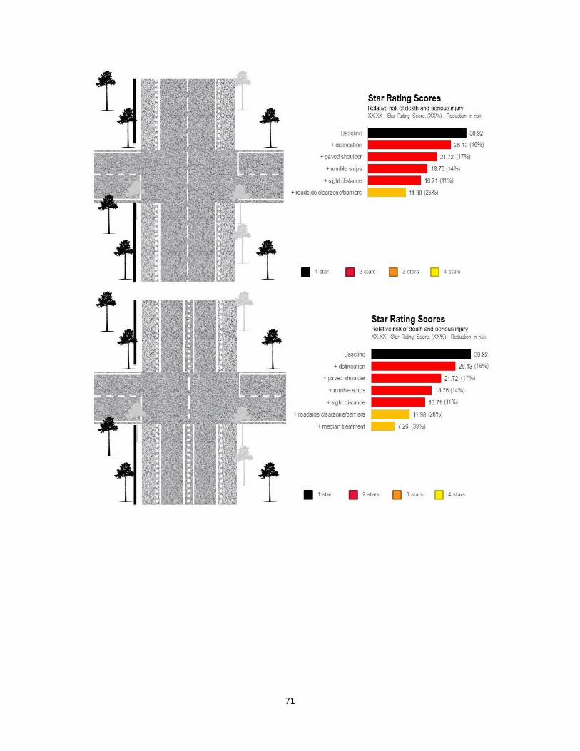
71

72
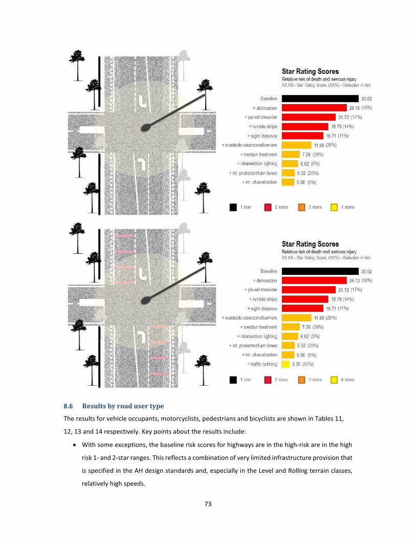
73
8.6 Results by road user type
The results for vehicle occupants, motorcyclists, pedestrians and bicyclists are shown in Tables 11,
12, 13 and 14 respectively. Key points about the results include:
• With some exceptions, the baseline risk scores for highways are in the high-risk are in the high
risk 1- and 2-star ranges. This reflects a combination of very limited infrastructure provision that
is specified in the AH design standards and, especially in the Level and Rolling terrain classes,
relatively high speeds.

74
• For each of the scenarios, the risk scores tend to improve when moving from Primary to Class
III highways and from Level to Steep terrain. This is largely a function of speed. For example, the
speed for a Primary Level highway is 120km/h while the speed for a Primary Steep highway is
just 60km/h. In the Class III category, speeds range from 60km/h to 30km/h. The way in which
speed affects risk is discussed in a subsequent section of the report.
• For each of the road user types, the risk scores for Class II Steep highways are higher than Class
II Mountainous highways, which are the opposite of the case for Primary, Class I and Class III
roads. This reflects the fact that speeds are the same for Class II Mountainous and Steep
highways, but it is assumed that Steep highways have more sharp curves and more hazardous
roadsides.
• Without exception, the addition of RIFs results in reductions in risk. In terms of risk reductions,
the following RIFs are among the most effective:
o Off-road bicycle paths.
o Fences to prevent pedestrians crossing.
o Sidewalks.
o Pedestrian crossings.
o Median treatments.
o Roadside clear zones / safety barriers.
o Roundabouts (compared with unsignalized 4-leg intersections).
• At least a 3-star rating was achieved for each of the road user types. In the case of Class II and
Class III highways, which have very low design speeds, either the baseline scenario achieves at
least 3-stars or 3-stars can be achieved with the application of one or a few RIFs, such as
delineation. For the higher speed roads, significantly more RIFs are required in order to achieve
a 3-star or better rating. This is especially the case for vulnerable road users.

75
Table 11: Vehicle occupant Star Ratings
Highway classification Primary Class I Class II Class III
Terrain classification L R M S L R M S L R M S L R M S
Baseline 42.26 27.09 19.35 13.30 30.92 19.57 7.75 10.73 22.70 13.01 11.57 9.30 10.55 8.39 7.64 6.10
+ delineation 33.96 21.05 14.26 9.36 26.13 15.70 5.76 7.71 18.96 10.20 8.54 6.60 8.74 6.52 5.54 4.24
+ paved shoulder 26.33 16.32 11.03 7.23 21.72 12.91 4.64 6.13 16.75 8.90 7.60 5.76 7.55 5.56 5.33 4.06
+ rumble strips 21.22 13.14 8.87 5.80 18.76 11.04 4.12 5.29 15.75 8.42 6.89 5.05 7.33 5.21 4.70 3.43
+ sight distance 20.99 13.01 8.80 5.78 16.71 9.98 3.87 5.03 14.16 7.76 6.50 4.85 6.66 4.83 4.50 3.35
+ roadside clear zone/barriers 12.81 7.93 5.63 3.97 11.98 7.00 3.25 4.08 13.50 7.00 5.73 4.30 6.31 4.27 3.92 3.01
+ median treatment 4.64 2.86 1.75 0.97 7.26 4.01 1.64 1.70 10.12 5.25 3.44 1.94 4.75 3.04 1.85 0.85
+ intersection lighting 4.57 2.82 1.73 0.96 6.62 3.68 1.56 1.62 9.63 5.04 3.32 1.87 4.54 2.92 1.79 0.82
+ int. protected turn lanes Not applicable
5.32 3.01 1.40 1.46 8.63 4.62 3.08 1.75 4.12 2.67 1.67 0.77
+ int. channelization 5.08 2.89 1.37 1.43 8.51 4.57 3.04 1.73 4.07 2.64 1.65 0.76
+ traffic calming 4.47 2.76 1.70 0.95 4.53 2.61 1.30 1.36 8.08 4.39 2.94 1.68 3.89 2.54 1.60 0.74
+ roundabout (instead of regular int.
and traffic calming) Not applicable 3.20 1.92 1.13 1.19 6.99 3.93 2.68 1.54 3.43 2.27 1.46 0.68
Keys:
5-star
4-star
3-star
2-star
1-star
Not
applicable

76
Table12: Motorcyclist Star Ratings
Highway classification Primary Class I Class II Class III
Terrain classification L R M S L R M S L R M S L R M S
Baseline 57.44 36.99 25.90 17.32 38.92 24.72 9.73 13.44 26.87 15.62 14.01 11.31 12.06 9.83 9.13 7.37
+ delineation 47.74 29.32 18.90 11.67 33.31 19.66 6.93 9.08 22.26 11.81 9.72 7.40 9.83 7.30 6.14 4.66
+ paved shoulder 39.96 24.41 15.50 9.38 28.82 16.76 5.73 7.39 19.99 10.44 8.71 6.50 8.61 6.29 5.91 4.47
+ rumble strips 34.76 21.13 13.22 7.85 25.81 14.83 5.17 6.46 18.94 9.93 7.94 5.73 8.37 5.92 5.23 3.79
+ sight distance 34.45 20.95 13.13 7.81 23.49 13.63 4.88 6.17 17.15 9.18 7.50 5.50 7.62 5.48 5.00 3.69
+ roadside clearzone/barriers 29.25 17.67 11.05 6.61 20.48 11.70 4.46 5.52 16.70 8.66 6.98 5.13 7.37 5.10 4.61 3.46
+ median treatment 24.04 14.39 8.18 4.09 17.47 9.76 3.17 3.49 14.32 7.45 5.01 2.88 6.36 4.26 2.75 1.30
+ intersection lighting 23.95 14.33 8.15 4.08 16.75 9.39 3.08 3.40 13.77 7.21 4.87 2.81 6.12 4.12 2.68 1.27
+ int. protected turn lanes Not applicable
14.90 8.44 2.85 3.16 12.34 6.61 4.53 2.63 5.52 3.78 2.50 1.20
+ int. chanelization 14.65 8.31 2.82 3.13 12.21 6.56 4.50 2.61 5.47 3.75 2.49 1.19
+ motorcycle lanes 11.05 6.93 4.35 2.48 8.73 5.42 2.11 2.43 10.05 5.65 3.97 2.34 4.86 3.40 2.31 1.12
+ traffic calming 10.92 6.86 4.31 2.46 8.19 5.14 2.05 2.36 9.62 5.46 3.86 2.29 4.68 3.29 2.25 1.09
+ roundabout (instead of regular int.
and traffic calming) Not applicable 15.27 8.63 2.89 3.21 12.63 6.73 4.60 2.66 5.64 3.85 2.54 1.21
Keys:
5-star
4-star
3-star
2-star
1-star
Not
applicable

77
Table 13: Pedestrian Star Ratings
Highway classification Primary Class I Class II Class III
Terrain classification L R M S L R M S L R M S L R M S
Baseline 104.0 94.3 92.2 53.2 85.3 82.3 24.4 30.4 73.7 40.9 26.2 13.0 26.1 17.8 9.2 2.8
+ paved shoulder 87.3 76.8 71.7 39.5 73.6 67.6 19.0 22.8 63.8 33.3 20.5 9.9 22.4 14.4 7.2 2.1
+ rumble strips 73.9 64.8 60.1 32.8 64.3 58.4 17.2 20.1 61.8 31.0 18.5 8.8 21.7 13.4 6.5 1.8
+ sight distance 52.0 45.6 42.3 23.1 45.3 41.1 12.1 14.2 43.6 21.8 13.1 6.2 15.3 9.4 4.6 1.3
+ sidewalk 14.4 12.0 9.6 4.1 19.8 16.1 3.7 3.8 21.0 9.1 4.8 2.1 7.0 3.7 1.6 0.4
+ pedestrian crossing 4.1 3.4 2.7 1.2 6.9 5.7 1.4 1.4 14.1 6.2 3.3 1.4 4.9 2.6 1.1 0.3
+ lighting 4.0 3.3 2.7 1.1 6.4 5.3 1.3 1.4 12.3 5.4 2.9 1.2 4.4 2.3 1.0 0.2
+ fences 0.5 0.4 0.3 0.1 2.6 2.3 0.6 0.7 7.8 3.5 1.9 0.8 2.4 1.3 0.6 0.1
+ traffic calming 0.4 0.3 0.3 0.1 2.2 2.0 0.5 0.6 6.3 2.8 1.6 0.7 2.0 1.1 0.5 0.1
Keys:
5-star
4-star
3-star
2-star
1-star
Not
applicable
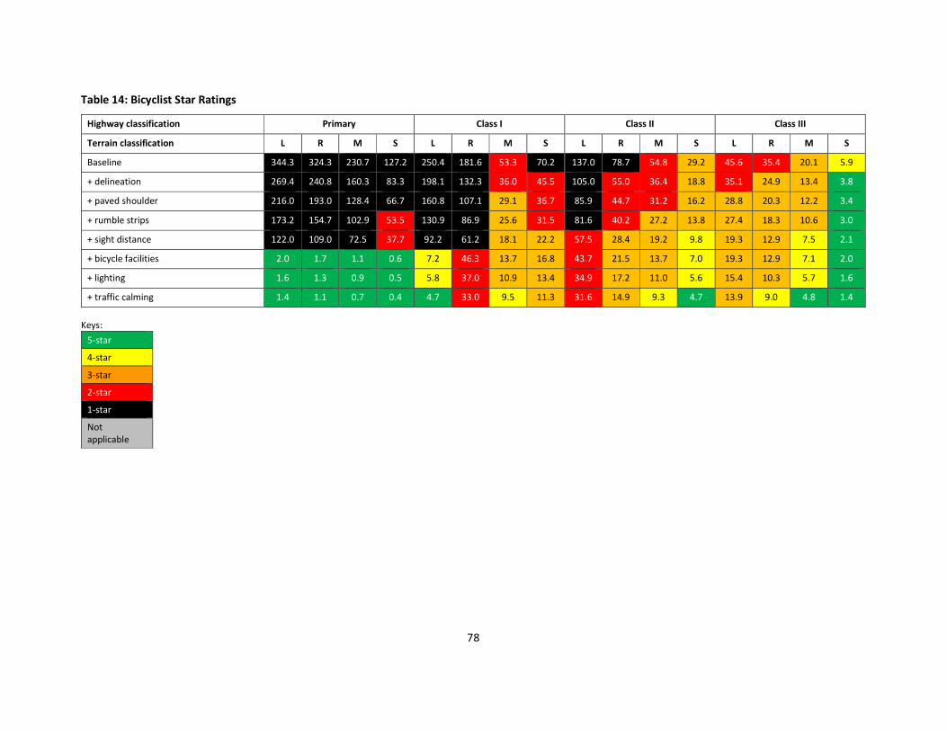
78
Table 14: Bicyclist Star Ratings
Highway classification Primary Class I Class II Class III
Terrain classification L R M S L R M S L R M S L R M S
Baseline 344.3 324.3 230.7 127.2 250.4 181.6 53.3 70.2 137.0 78.7 54.8 29.2 45.6 35.4 20.1 5.9
+ delineation 269.4 240.8 160.3 83.3 198.1 132.3 36.0 45.5 105.0 55.0 36.4 18.8 35.1 24.9 13.4 3.8
+ paved shoulder 216.0 193.0 128.4 66.7 160.8 107.1 29.1 36.7 85.9 44.7 31.2 16.2 28.8 20.3 12.2 3.4
+ rumble strips 173.2 154.7 102.9 53.5 130.9 86.9 25.6 31.5 81.6 40.2 27.2 13.8 27.4 18.3 10.6 3.0
+ sight distance 122.0 109.0 72.5 37.7 92.2 61.2 18.1 22.2 57.5 28.4 19.2 9.8 19.3 12.9 7.5 2.1
+ bicycle facilities 2.0 1.7 1.1 0.6 7.2 46.3 13.7 16.8 43.7 21.5 13.7 7.0 19.3 12.9 7.1 2.0
+ lighting 1.6 1.3 0.9 0.5 5.8 37.0 10.9 13.4 34.9 17.2 11.0 5.6 15.4 10.3 5.7 1.6
+ traffic calming 1.4 1.1 0.7 0.4 4.7 33.0 9.5 11.3 31.6 14.9 9.3 4.7 13.9 9.0 4.8 1.4
Keys:
5-star
4-star
3-star
2-star
1-star
Not
applicable

79
Traffic Speeds and Star Ratings
Traffic speeds are a particularly important factor in road safety and in the Star Ratings. The
relationship between speed and fatality risk is illustrated below in Figure 15, a feature of
which is that risk rapidly increases between 40km/h and 50km/h for pedestrians, between
55km/h and 60km/h for side impacts and between 80km/h and 90km/h for head-on crashes.
Figure 15: The risk of a fatality increases rapidly as speed increases
Source: OECD.
The Star Ratings in this study are based on the assumption that operating speeds are equal to
design speeds set in the Asian Highway design standard. However, if operating speeds are
even marginally higher than design speeds, the Star Ratings would decline and risk increase
markedly. Conversely, lower speeds will lead to markedly lower levels of risk.
To further illustrate this point, the chart below in Figure 16plots Star Rating Scores and Star
Ratings for the baseline Class I highway in Rolling terrain scenario. As was described in the
earlier results section, if the operating speed is assumed to be the same as the design speed
- 80km/h - then highway is rated 2-star. However, if operating speed is 85km/h or higher, the
road is rated 1-star. If the operating speed is 65km/h or 60km/h, the rating is 3-stars.

80
Figure16: Speed sensitivity testing for the Class I highway in Rolling Terrain baseline scenario
8.7 Discussion and conclusion of the star rating testing
The iRAP methodology was used to illustrate how relative risk levels for vehicle occupants,
motorcyclists, pedestrians and bicyclists would change if a range of Road Infrastructure Safety
Facilities (RIF) were added to the standard.
The analysis shows that, with some exceptions, the Star Ratings for the existing AH Standard
‘baseline’ scenarios are in the high risk 1- and 2-star ranges. This reflects a combination of
very limited infrastructure provision that is specified in the AH design standards and, especially
in the Level and Rolling terrain classes, relatively high speeds.
Without exception, the addition of the RIFs results in reductions in risk. In terms of risk
reductions, the following RIFs are among the most effective:
• Off-road bicycle paths.
• Fences to prevent pedestrians crossing.
• Sidewalks.
• Pedestrian crossings.
• Median treatments.
• Roadside clear zones / safety barriers.
• Roundabouts (compared with unsignalized 4-leg intersections).
At least a 3-star rating was achieved for each of the road user types. In the case of Class II and
Class III highways, which have very low design speeds, either the baseline scenario achieves
8.210.4
13.116.1
19.6
23.4
27.8
32.7
38.1
60km/h 65km/h 70km/h 75km/h Baseline(80km/h)
85km/h 90km/h 95km/h 100km/h
3-star
2-star
1-star

81
at least 3-stars or 3-stars can be achieved with the application of one or a few RIFs, such as
delineation. For the higher speed roads, significantly more RIFs are required in order to
achieve a 3-star or better rating. This is especially the case for vulnerable road users.
The analysis also emphases the fact that, in terms of safety, higher speeds can be tolerated
when there is sufficient infrastructure provision. Where infrastructure is insufficient, lower
speeds are necessary in order to reduce risk. This also highlights the important role that speed
enforcement can play in ensuring that operating speeds do not exceed the infrastructure
provision. This can be achieved through numerous means, including police enforcement and
fixed speed cameras.
Overall, this analysis indicates that achieving a minimum of a 3-star rating for all road users
on the AH network is feasible through the application of a range of reasonable well-known
RIFs that could be included in the AH Standard. In the future, the results of this study could
be refined and expanded on by testing more scenarios (for example, with varying traffic flows,
intersection types and RIF application frequency) in order to further inform policy and
planning.

82
9. Considerations and Scope of the Design Standards
9.1 Considerations for the development of the design standards
In the development of the design standards for the selected road infrastructure safety facilities,
the following assumptions were made:
• The design standard has to be universally applicable and practically achievable for the Asian
Highway network across 32 member countries. Such standard should also be compatible with
national standards in the member countries.
• It is necessary to take into consideration the vast difference in established practices and economic
status among these countries. Traffic conditions may also vary substantially between and within
countries in terms of traffic flows, vehicle composition, vehicle performance and road user
behaviour.
• Where feasible and practical, the design standard should encourage harmonization of safety
equipment and their usage. Admittedly, there are already substantial differences in technical
standards among countries. In such circumstances, the design standard should aim at
harmonization of the more universal principles.
• The objective of three-star rating is a minimum requirement and good performing countries should
lead the way to achieve even higher star ratings. It would be desirable to review and update the
design standard from time to time.
9.2 Scope of the design standards
The design standard is a comprehensive document which addresses road infrastructure safety
facilities from both the road planning and design perspective. The design standard involves both active
provision of RIFs and avoidance of undesirable practices or design.
Two very important safety approaches in contemporary era are “Self-explaining Roads” and “Forgiving
Design”. The concept of self-explaining roads encourage road designs which promote road-users to
adopt appropriate speeds and behaviour. This subject touches on consistency of alignment design and
a well-defined road hierarchy, and should be introduced into the design standard wherever applicable.
Forgiving designs aim at giving road-users adequate rooms for errors and limiting the severity of
injuries in case of a crash.
Since almost 30% of the AH Network is Class III or below, the design standard contains guidance on
the appropriate road safety treatments for these roads, bearing in mind that some of them are located

83
in very difficult terrains and could be single lane facilities. However, it is appreciated that the AH
Network is gradually migrating towards primary, Class I and Class II roads. Accordingly, a major
emphasis is given to the road safety needs for these road categories.
The design standard needs to addresses road safety at the interface between different road types.
This is particularly important since the AH Network is ever undergoing development in response to
traffic growth. A major concern arises where a primary road terminates at an at-grade intersection or
onto a road with low standard alignment.
9.3 Structure of the design standards
The design standard as developed in this study and presented at the end of this report consists of two
components:
1. Design Standards: this contains mandatory requirements. It is proposed that these would form
Annex II bis of the International Agreement on the Asian Highway Network as shown in Figure 17.
2. A Detailed “Design Guideline”: this consists of recommendations pertaining to the design
standards.
Figure 17: Proposed Updated Structure of the International Agreement on the AH Network
Annex I
Asian Highway Network
List of the Asian Highway Routes
Intergovernmental
Agreement on the
Asian Highway Network
Annex II
Asian Highway Classification and
Design Standards
Annex III
Identification and Signage of the
Asian Highway Network
Annex II bis
Asian Highway
Design Standards for Road
Safety

84
Under this approach, the design standard addresses road safety from a holistic perspective
incorporating modern concepts such as self-explaining roads and forgiving design. To reflect the
importance of the selected RIFs, however, these will be given additional weights.
The advantage of this approach is that authorities, project offices and road designers tend to prefer
solid requirements in the first place followed by supporting guidance. Other than certain mandatory
requirements, the design standard seeks to inspire and motivate stakeholders to formulate solutions
in their own contexts to satisfy the ultimate objectives i.e. three star ratings and enhanced safety
performance of roads under the Asian Highway Network.

85
9.4 Evaluation of the Selected Road Infrastructure Safety facilities
This section summarizes findings on each selected RIF from literature review of existing design
standard and practices from a variety of sources, notably information provided by the selected AH
member countries and references from other AH member countries and comparison countries.
Unless otherwise stated, the quoted Crash Modification Factors (CMF) were obtained from the CMF
Clearinghouse web site (www.cmfclearinghouse.org). CMF is not available for all the selected RIFs.
A-1 Line Marking
Line markings are a form of road signs laid on the road pavement to convey information which cannot
be readily served by vertical traffic signs. One of their primary functions is delineation assisting drivers
to keep to their lateral position. Some road markings indicate to drivers that they must not enter or
cross. Line markings may be thermoplastic, cold plastic, preformed materials or paints laid on the
pavement. Nevertheless, their performance could be undermined by rain, snow, dust and lack of
maintenance. Edge line in conjunction with centreline has a CMF between 0.76 and 0.87.
The following line markings are considered basic provisions for delineation:
• Edge line
• Lane line
• Centrelines
• Deceleration or acceleration lane lines
• Chevron markings at grade-separated intersections
These markings are generally covered in national standards and used in all AH member countries.
Certain AH roads do not have markings at all or markings are poorly maintained.
For centrelines, some countries adopt white colour whereas the others adopt yellow colour. Solid cum
dotted line is not always used and single solid lines are commonly used instead of double solid lines.
Harmonization in the use of line marking types is desirable but their colours could be maintained.
A-2 Chevron Mark
Chevron marks are vertical traffic signs with a pointed chevron symbol guiding drivers to negotiate a
bend. They are generally provided along the outside edges of a bend alerting approach drivers of the
existence and severity of the bend. Installation of chevron marks in conjunction with bend warning
signs generally has good effects with a CMF between 0.49 and 0.76. One study found that additional
sequential flashing beacons result in the most pronounced and consistent effect with a CMF as low as
0.23.

86
All the selected AH member countries use chevron marks. In China, green and blue background colours
are adopted for expressways and other roads respectively. They are commonly used for the
delineation of curves, sharp curves and interchange ramps. At least three marks should be visible at
any time.
In both Republic of Korea and Thailand, chevron marks have a black and yellow colour scheme. At
least two marks should be visible at any time. Their design standards also specify the distance between
marks according to approach speed and curvature of the bend.
In the UK, the need for chevron marks is judged on an individual basis but consistency of usage is
emphasized. The UK also suggests consideration for frangible supports to safeguard vehicle occupants
and motorcyclists. In France, it is recommended to provide four levels of delineation according to the
difference between approach speed and speed within the bend. A larger difference in speed requires
more signs with chevron marks along the entire bend. A moderate difference in speed requires a single
double chevron mark.
Chevron marks are also commonly used at roundabouts, end of a highway at a T-intersection and
sometimes at pinch points for traffic calming.
A-3 Raised pavement marker
A raised pavement marker, also known as cat’s eyes or road studs, is a safety device installed on the
pavement in conjunction with line markings. These markers generally contain a lens or retroreflective
materials to assist drivers visualizing the road layout at night time. They are particularly useful in rain,
fog or darkness when line markings become less visible. Raised pavement markers have a CMF
between 0.69 and 0.81. A lower CMF is achieved when used in conjunction with line markings.
In China, the colour, position and spacing of raised pavement markers are defined in national
standards. They are unidirectional and have identical colour with the associated pavement markings.
Raised pavement markers on centrelines or in tunnels are bidirectional. They are deployed for the
following road types outside edge lines:
• primary roads
• interchanges, service areas and laybys of Class I highway
• diverging or merging areas at interchanges
• tunnels

87
In the Republic of Korea, raised pavement markers are used on all types of roads to supplement line
marking for traffic during night time and adverse weather. Another function is to generate noise to
warn drivers crossing line markings. They are installed where necessary in conjunction with line
markings and where guidance through curves and a change in road environment is required. Standard
spacing of raised pavement markers may be adjusted according to engineering judgement.
In India, raised pavement markers are required on all types of highways with elaborate criteria for
their use.
In Thailand, raised pavement marker is defined in the national standard. The Department of Highways
has recently started using a 360-degree raised pavement marker.
A-4 Flexible Delineation Posts
Delineation posts are slender posts with reflective elements on the roadside to provide guidance of
the road alignment or to demarcate intersections, roadside hazards or a change in cross-section. They
have a CMF of 0.55 if used in conjunction with edge lines and centerlines. They should be passively
safe, being frangible and preferably self-restoring after an impact.
In China, delineation posts are extensively used on all types of roads. The national standard specifies
their use on the mainline and interchange of primary roads and Class 1 roads. Delineation posts are
also widely adopted on Classes 2 and 3 roads. The maximum spacing between posts is 50m on straight
sections and has to be reduced at curves. They may be substituted by reflectors or light-emitting units
mounted on safety barriers or kerbs. Other forms of delineation posts in use in China are marker posts
at intersections or accesses. Similar reflective posts are used to delineate roadside hazards such as
high slopes and rigid objects.
In India, flexible delineation posts are not yet covered in manuals or codes.
In Thailand, delineation posts are installed with spacing at 6 to 90m in the following locations:
• Horizontal and vertical curves.
• Locations with change in roadway width or alignment.
• Locations with extra delineation.
• Locations with confusing roadways.

88
In France and the UK, delineation posts are not standard equipment by default. They are deployed
mainly at bends, intersections and where needed by road conditions. In the UK, marker posts with
chainage are installed on the roadside of motorways at 100m intervals for emergency and
maintenance positioning purpose. They display the chainage, direction to the nearest emergency
telephone and indication if central reserve openings are in the proximity.
B-1 Roadside Barrier
Roadside safety barriers are longitudinal facilities to prevent an errant vehicle colliding onto aggressive
features or other road-users on the roadside. Aggressive features include those stopping the vehicle
abruptly, penetrating the vehicle compartment or causing the vehicle to roll or fall over. They are also
designed to limit the injury for vehicle occupants and to redirect vehicle with a safer trajectory.
Roadside safety barriers may be flexible, semi-flexible or rigid. Common types of roadside safety
barriers are W-beam barriers, Thrie-beam barriers, New Jersey barriers, F-barriers, Dutch step barriers
and parapets. In some countries, roadside barriers are specified by performance rather than
prescriptive design. In China, roadside barriers are classified into five grades according to their anti-
crash performance in terms of acceleration and crash energy.
Anti-crash level
Crash conditions Crash
acceleration
(m/s2)
Crash energy
(kJ) Speed (km/h) Mass of vehicle
(t)
Crash angle
(degree)
B 100 1.5 20 ≤ 200
40 10 20 70
A, Am 100 1.5 20 ≤ 200
60 10 20 160
SB, SBm 100 1.5 20 ≤ 200
80 10 20 280
SA, SAm 100 1.5 20 ≤ 200
80 14 20 400
SS 100 1.5 20 ≤ 200
80 18 20 520
In practice, roadside barriers are extensively used on all classes of roads in China. Common barrier
types are W-beam, Thrie-beam, F barriers and bridge parapets. Their use on Classes II and III roads is
more restricted to high risk sections, notable high slopes and cliff edges.

89
In the Republic of Korea, roadside safety barriers are extensively used on all types of roads. Common
barrier types are W-beam, Thrie-beam, New Jersey concrete barriers and bridge parapets. Taller
double layer safety barriers are used over high slopes.
In India, roadside safety barrier is covered in the design standard for the various road types.
In Thailand, the main barrier types are W-beam guardrails and New Jersey concrete barriers. It is up
to the designers, situations and circumstances to choose either barrier types as roadside or median
barriers. They are mainly deployed in the following conditions.
• There are possible hazards from roadside.
• Height of embankment of roadway is larger than 5m (7m maximum) and side slope is steeper
than 1:3.
• Downhill gradient > 6% and height of embankment > 3m.
• Water at the toe of slope is deeper than 1.50 m.
• Radius of a horizontal curve is smaller than 150 m.
• There are hazardous topographies, such as rivers, deep valleys, or rocks, on the fill slope which
may cause serious damage to vehicles.
The Roadside Design Guide of the United States contains comprehensive guidance on the use of
roadside safety barriers. Norwegian design manual 231E provides useful guidance on the usage of
safety barriers. In the UK, design standard TD19/06 illustrates the key consideration for safety barriers
to EU requirements. Important concepts include working width, length of need etc.
In Hong Kong, specially designed and tested Thrie-beam and parapets are available for the
containment of 22t double-decker buses at 50km/h. Their use is subject to a risk scoring assessment.
B-2 Median Barrier
Median barriers are safety barriers to prevent an errant vehicle colliding onto aggressive features on
the median or opposing traffic. Barrier type and design are the same as roadside safety barriers, except
that double sided barriers are often used on narrower medians.
In Bangladesh, New Jersey safety barriers are generally used for medians.

90
In China, median safety barriers are provided according to the following principles:
• if the width of the median of is less than or equal to 12m, median safety barriers must be
deployed
• if the width of the median is larger than 12m, the deployment of median barriers depends on
prevailing conditions
• if the two directions of a highway is constructed on separate road formations, safety barriers
shall be deployed on the left side; if the level difference is larger than 2m, safety barrier should be
deployed on the higher elevation road base.
• movable barrier must be deployed for motorway and median openings of Class I highway with
prohibited U-turns
• road sections with high probability of serious outcome due to road alignment, operating
speed, traffic volume and traffic composition shall have barriers with higher containment levels
In India, median safety barrier is covered in the design standard for the various road types.
In Thailand, both W-beam and New Jersey safety barriers may be used for medians.
B-4 Central Hatching (Painted Median)
No information has been received about the use of central hatching from the selected AH member
countries. Central hatching is not found in samples of AH roads in Bangladesh and Thailand using
Google Street View. It is not used on single carriageway roads in China.
In other AH member countries, wide centreline marking does not appear to be commonly used on
single carriageway roads. A wide centreline is used on single 4-lane or single 6-lane Class I roads on
AH84 in Turkey.
Wide centreline treatment has a CMF of 0.4 for all crashes. It helps to increase separation between
opposing traffic but is less effective in reducing speeds. The preferred width is 1m and is more effective
when used in conjunction with raised profile line marking or rumble strips.
In the Netherlands, wide centreline is extensively used for 80km/h and 100km/h single carriageway
highways. A dotted version is also used to permit overtaking with caution. Similar applications have
gain popularity in Australia.

91
In France and the UK, wide centreline treatment is extensively used to discourage overtaking at bends,
crest and sometimes on straight sections.
B-5 Crash Cushion with Channelization
There is a very high risk of vehicles colliding onto diverge gores at interchange due to loss of control
or abrupt manoeuvres. Severe casualties can result if the errant vehicle collides with aggressive
roadside features at the diverge gore. Crash cushions are installed to redirect or bring the errant
vehicle to a controlled stop, thereby reducing the potential of serious injuries. Crash cushion is highly
effective for this purpose as demonstrated by a CMF of 0.31.
In China, design standard of crash cushions has been developed recently. There are three categories
for 60, 80 and 100km/h. In the Republic of Korea, there is a comprehensive standard of crash cushions
and they are extensively deployed on primary roads and Class I roads in the AH Network. In India,
requirements for crash cushions to NCHRP Report 350 (US) are given in the design standard for
highways. No information has been received about the use of crash cushion in Bangladesh and
Thailand. Crash cushions are not found on AH roads in Bangladesh and Thailand using Google Street
View.
Crash cushions were developed in the United States in the 1970s and are extensively used in Europe,
Australia, Japan and Hong Kong. In Hong Kong, crash cushions are required at diverge gores on high
speed roads with speed limit of 70km/h or above. Their use is partly due to space constraints where
clear zones are often not practical.
B-6 Safety Barrier End Treatment
There is a very high risk of vehicles colliding with the end terminals of safety barriers due to loss of
control. Severe casualties can result if the errant vehicle is stopped abruptly upon impact. Metal safety
barriers may also penetrate into the vehicle compartment. Some end terminals have sloping end
which can launch an errant vehicle at high speed air-borne. Appropriate end treatments of safety
barriers reduce the risk of injuries due to the above collision mechanisms.
In China, curly safety barrier end terminals are generally adopted for both upstream and downstream
ends. Flaring is not specified but sometimes adopted on a project basis. The standard consists of a
transition design between W-beam safety barriers and concrete safety barriers.

92
In India, end treatments are covered in the design standard for the various road types.
In Thailand, there are two types of treatment for W-beam barriers, namely concrete anchor end
treatment and turned-down fish tail end treatment. For concrete barriers (New Jersey type), the end
terminal is progressively ramped down. All terminals have flaring designs.
In the UK, “P4” terminals are required for all upstream safety barrier end terminals on roads with
speed limit of 80km/h or above. These are end treatments tested at 100 to 110 km/h.
B-7 Clear Zones
Causes for vehicles crashing onto highway roadsides are diverse and cannot be readily eliminated.
Severe casualties can occur if an errant vehicle collides with aggressive fixed objects. In other cases,
the vehicle may roll over a steep side slope or else fall over a sheer drop. A clear zone comprising side
slopes of very gentle gradient and free of aggressive features will help to reduce the severity of
casualties. Clear zones have a CMF between 0.58 and 0.82.
In China, the design standard does not specify the requirements for clear zones. However, the guide
on the “Cherish the Life Project” contains specific guidance on clear zones and safety barriers.
Furthermore, the subject has attracted a lot of attention and interest in the highway community. In
practice, however, clear zones are not frequently designed and constructed in the highway system.
In India, a clear zone of 11.0m is specified. The clear zone consists of paved shoulders, a traversable
side slope at an 1:3 gradient. An additional run out area is also specified.
No information has been received on clear zone standards in Bangladesh, Republic of Korea, and
Thailand.
In France, the width of clear zone on expressways is specified as 8.5m (110km/h) and 10m (130km/h)
respectively.
The design standard of Norway is based on both traffic volume and speeds. The Norwegian standard
also contains the criteria for a clear zone in a variety of typical roadside conditions. This serves as a
good reference in conjunction with other requirements from AASHTO and the UK.

93
C-2 Centreline/Edge line Rumble Strip
Rumble strips are indentations on the pavement generating vibration and sound when driven over.
The main purpose is to alert drivers drifting away from their traffic lanes due to inattention or fatigue
driving. They are also used to discourage drivers crossing onto hatched areas or overtaking on
opposing lanes. Edge and centreline rumble strips have a CMF between 0.51 and 0.92.
In China, rumble strips are frequently used on the outside of edge line on primary roads. They are not
regularly used on other roads. Installation on centreline of single carriageway is uncommon.
In the Republic of Korea, rumble strips are used on highways outside cities. They are not used around
an interchange, in a tunnel or over bridge structures. They are retrofitted onto existing roads where
warranted by frequent crashes due to inattention or fatigue driving. The preferred technique for
installation is milling for asphalt pavement and rolling for concrete pavement.
In India, raised rib edge line markings are covered in the design standard. However, their use is
discouraged on curves for the safety of two wheelers. No information has been received on standards
and practices in Bangladesh and Thailand.
In Scandinavian countries, rumble strips are extensively used on primary roads and other rural roads.
These include rumble strips milled into the pavement or raised rib markings.
In the UK, raised rib markings are extensively used for hard shoulder and edge lines. They are also
used as edge lines forming chevron markings and hatched markings at lane reduction. Besides the
audible-vibratory warning they offer, these markings help to improve retroreflective performance of
a wet pavement. There are strict requirements for the maximum height and location of installation
pertaining to possible hazards for pedestrians, cyclists and motorcyclists.
Centreline rumble strips have been successfully deployed in Hokkaido, Japan (CERI). It is reported that
9mm and 12mm milled rumble strips are used over the centreline and roadside shoulder respectively.
They are also used on curves and are effective in uncompacted snow.
D-1 Pedestrian Crossings
In China, pedestrian crossings are provided for all signalized crossings in urban areas. They are also
provided as marked but uncontrolled crossings in towns and villages on Classes I, II and III highways.

94
In India, criteria are set for pedestrian crossings on two-lane highways. For four or six lane highways,
pedestrian crossings have to be grade-separated or else controlled facilities around intersections.
In Bangladesh and Thailand, there exist standards of pedestrian crossings. In general, non-signalized
crossings have to be preceded by warning signs and 50km/h speed limit signs. Along the AH network,
however, marked crossings are infrequent. There are occasional footbridges along major Class I roads
in Thailand.
D-2 Sidewalk (Footpath)
In Bangladesh, footpaths are not generally provided along highways but are provided in some recent
projects e.g. along the bridge crossing on AH2 at Bhairab Bazar.
In China, footpaths are generally provided within larger towns and cities including those traversed by
highways, but they are not usually provided in smaller towns and villages as this is not specified in the
highway design standard. Local governments and communities may opt to construct footpaths.
In the Republic of Korea, footpaths are generally provided within urban areas. Information has not
been received about their provision on highways. It is noted that the AH Network in the Republic of
Korea is mainly expressway.
In India, the requirement for footpaths of 1.5m minimum width is covered in the design standard for
highways. Additionally, increased protection including 200mm high kerbs and safety barriers or
pedestrian fences is specified for four-lane or six-lane roads.
In Thailand there is no design standard for footpath on highway although 2.4 – 2.5m is generally used.
D-3 Pedestrian Fences
Pedestrian fences are physical barriers used for the control and guidance of pedestrians along
sidewalks.
In China,pedestrian fences are generally provided in towns and cities traversed by highways, but
they are not usually provided in smaller towns and villages. In Bangladesh and Thailand, pedestrian
fences are rarely used on the AH network.
95
In India, requirements are given for the use of pedestrian fences on two lane highways.
Use of pedestrian fences varies among countries. In the Netherlands, pedestrian fences are not used.
In the UK, pedestrian fences are regularly used. In the last decade, however, there is a tendency to
substantially reduce the amount of pedestrian fences. Blocking of visibility also considered a potential
problem with pedestrian fences at crossings.
D-4 Pedestrian Refuge Island
Pedestrian Refuge Island is an area in the middle of a road designated exclusively for pedestrians and
sometimes slow vehicles. It is generally bounded by kerbs and possibly safety barriers to prevent
intrusion by vehicles. They may be standalone facilities on a single carriageway road. On dual
carriageway roads, they are part of the median.
In China, pedestrian refuge island is specified if the carriageway width is larger than 30m. In practice
they are only adopted on dual carriageway urban roads. They are rarely adopted on single carriageway
highways. In Thailand, pedestrian refuge island is not used.
In India, there is no guidance on pedestrian refuge at locations other than pedestrian crossings forming
part of a channelized intersection.
In other countries studied, pedestrian refuge island is an option for urbanized sections of highways
and at intersections with protected turn lanes. They are considered beneficial at higher traffic volume
to facilitate pedestrians crossing in two steps. The alternative is to provide build-outs, being local
inward extension of the footpath. In France, refuge islands should be 2.1m wide to accommodate
wheelchair users. In the UK, a minimum width of 1.5m is specified. Additionally, as refuge islands
constitute a pinch point, carriageway width between 3.1m and 3.9m is discouraged if there is frequent
bicycle traffic.
E-1 Protected Turn Lane
Protected left turn lanes provide a refuge for turning vehicles to slow down, wait and queue, thereby
causing reducing the disruption to through traffic. This in turn reduces the risk of rear-front collisions.
Protected turn lanes can be integrated with pedestrian crossing facilities and may be readily upgraded
to signalized intersections. Protected left turn lane has a CMF of 0.73 for 3-leg intersections but 0.96
for 4-leg intersections.

96
In China, protected left turn lane is specified for 4-lane highways unless left-turn traffic is very low.
Protected left turn lane is specified for high standard single 2-lane highways if the intersection leads
to an expressway or similar highways, there is a high volume of non-motorized vehicles and where
left-turning leads to congestion or collisions. In practice they are not frequently adopted outside cities
other than at signalized intersections.
In India, protected turn lane intersections with hatched markings or traffic islands are covered in the
design standard for highways.
In Thailand, it is specified on the basis of turning traffic volume but there is no further information
about their layout and frequency of usage. From Google Street View, protected turn lane is not used
on single carriageway roads of AH1 and AH2, U-turn/left turn lane is systematically adopted on dual
carriageway roads of AH1 and AH2.
E-2 Intersection Channelization (Side Road Deflection Islands)
This measure is beneficial in that main road turning traffic is forced to follow a designated path at
reduced speeds. Drivers approaching from the side road will be better alerted and compelled to slow
down by the island geometry. This is particularly important at crossroads. The deflection island may
also be designed to serve as a central refuge allowing pedestrians to cross in two steps. CMF of 0.2
and 0.5 are quoted in the design manuals of the UK and France respectively for rural crossroad
intersections.
In Bangladesh, deflection islands are not included in the standard. From Google Street View, they are
sometimes used in association with major highway improvement schemes.
In China, deflection islands are rarely adopted at highway intersections but may be used at highway
signalized intersection. In Thailand, they are not or rarely used at highway priority intersections, but
are generally used at highway signalized intersections.
In India, deflection islands on hatched markings are illustrated in the design standard for highways. It
is not clear whether physical traffic islands are used.
97
E-3 Roundabouts
Roundabouts are intersections whereby traffic circulates around a central island in one direction and
traffic entering the roundabout must give way to circulatory traffic. All traffic has to slow down on the
approach and negotiate the roundabout at reduced speeds. The primary safety benefit of roundabout
is minimum conflict points and any potential conflicts take place at a safer angle at lower speed.
Roundabouts have a very good safety record but this also depends on design parameters and traffic
conditions. It is therefore very important to set down essential safety principles in the Design standard.
No information has been received from the selected member countries on roundabout design
standard. An exception is India where some basic parameters are available for roundabouts on four
lane roads. From Google Street View, roundabouts are not common but occasionally used in these
countries. In Bangladesh, for example, roundabouts are sometimes used in the AH Network, both in
urbanized areas and in conjunction with major bridges.
In some European countries, notably Scandinavia, France and the Netherlands, single lane
“Continental” roundabouts are very popular at highway intersections. In the UK, there are more
variations in roundabout design and capacity is often maximized by adding traffic lanes at entries.
Turbo roundabout is a potentially safer and more efficient form of two lane roundabouts.
F-1 Speed Humps
Speed humps are physical traffic calming facilities which deter excessive speeds through vertical
deflection.
In Bangladesh, speed humps have been successfully adopted in a demonstration project on AH2 in
Bangladesh. The project achieved a CMF of 0.13 and 0.31 for fatalities and injuries over a period of 17
months.
In China, speed humps are sometimes adopted on Class 2 or 3 roads within towns and villages. These
may be in the form of speed tables or rubber/steel speed humps. They are often installed on side
roads immediately ahead of the intersection with a main road.
In India, there is national policy not to install speed humps on national highways including built-up
areas. However, “speed breakers” equivalent to speed humps are used on minor roads with elaborate
criteria in the design standard.

98
No information has been received from Korea and Thailand. Speed humps are not used according to
Google Street View on the AH network.
In France, flat top speed tables with 1:7 approach ramps or speed cushions are recommended in urban
areas. In the UK, a variety of speed humps are in use. Acceptability to bus operators is a major
consideration.
In the Netherlands, speed humps are frequently used in urbanized areas, including sections on major
roads. In general, these speed humps are relatively gentle and used in conjunction with traffic calming
schemes.
F-2 Visual Traffic Calming
This topic is intended to address traffic calming in urbanized sections on the AH Network. This does
not cover controlling traffic speeds on primary roads and other high speed roads relative to bends and
other hazards.
In China, basic traffic calming is generally provided for urbanized sections of highways. Common
measures include village name sign, speed limit signs, warning signs, rumble strips, school warning
signs etc. A wider cross-section may be adopted through towns and villages to give extra space for
slow vehicles but through road lane width is generally maintained.
In Bangladesh, visual traffic calming measures are very limited for urbanized sections of the AH
Network. For crowded conditions, however, traffic calming is probably self-enforcing by virtue of the
built-up environment and road conditions. Information has not been received from Korea and
Thailand.
In India, there is no separate guideline on visual traffic calming. However, the use of gateway
treatment is covered in the design standard.
In European countries including the UK, Netherlands and France, visual traffic calming is widely
adopted with a wide range of possibilities. In addition to signs and markings, an important measure is
to alter the cross-section of the road, through reduction of lane widths, provision of parking lanes and
possibly deliberate removal of centreline and edge line markings. There is also an emphasis on the
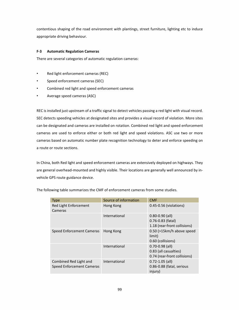
99
contentious shaping of the road environment with plantings, street furniture, lighting etc to induce
appropriate driving behaviour.
F-3 Automatic Regulation Cameras
There are several categories of automatic regulation cameras:
• Red light enforcement cameras (REC)
• Speed enforcement cameras (SEC)
• Combined red light and speed enforcement cameras
• Average speed cameras (ASC)
REC is installed just upstream of a traffic signal to detect vehicles passing a red light with visual record.
SEC detects speeding vehicles at designated sites and provides a visual record of violation. More sites
can be designated and cameras are installed on rotation. Combined red light and speed enforcement
cameras are used to enforce either or both red light and speed violations. ASC use two or more
cameras based on automatic number plate recognition technology to deter and enforce speeding on
a route or route sections.
In China, both Red light and speed enforcement cameras are extensively deployed on highways. They
are general overhead-mounted and highly visible. Their locations are generally well announced by in-
vehicle GPS route guidance device.
The following table summarizes the CMF of enforcement cameras from some studies.
Type Source of information CMF
Red Light Enforcement
Cameras
Hong Kong 0.45-0.56 (violations)
International 0.80-0.90 (all)
0.76-0.83 (fatal)
1.18 (rear-front collisions)
Speed Enforcement Cameras Hong Kong 0.50 (>15km/h above speed
limit)
0.60 (collisions)
International 0.70-0.98 (all)
0.83 (all casualties)
0.74 (rear-front collisions)
Combined Red Light and
Speed Enforcement Cameras
International 0.72-1.05 (all)
0.86-0.88 (fatal, serious
injury)

100
1.33-1.70 rear-front
collisions)
- (Fixed) 0.31-0.95
accident
J 0.35-0.88 injuries
J 0.29-0.83 fatal
- (mobile, hidden) 0.65-
0.85
No information on automatic regulation camera has been received from other AH selected member
countries.
In France, it was inferred that large scale deployment of speed enforcement cameras contributed to
a significant decrease of road fatalities. It was estimated that over the 7-year period between
November 2003 and December 2010, speed enforcement cameras prevented 15,193 fatalities and
62,259 casualties in France. This equates to a CMF of 0.79. However, it was also recognized that the
effectiveness tends dilute over time.
In the UK, average speed camera systems now cover 420km of roads and are expanding. In Australia,
these are known as Red-light Speed Cameras (RLSC) and their use is ever expanding.
It is recommended that this topic is covered under deployment of Intelligent Transportation Systems
(ITS).
G-1 Bicycle Lane
Bicycle lanes are facilities to separate bicycles from vehicle traffic. On-road bicycle lanes are strips of
the road pavement marked for bicycle travel. Off-road bicycle lanes are dedicated tracks for bicycle
travel and are physically separated from the road pavement. At very low traffic speeds and volume, it
may be adequate for bicycles and vehicles to share the road pavement. An important subject common
to both facilities is bicycle crossings where a bicycle facility intersects the path of vehicle travel.
No specific information has been received from Bangladesh, Korea and Thailand. It is however known
that bicycle lanes are generally provided in larger towns or cities in China. In India, a design guideline
is available for cycle tracks on urban roads. In most countries, bicycles may use the shoulder of
highways other than primary roads.

101
The Netherlands has extensive bicycle lanes and a large population of cyclists. The Netherlands also
has an elaborate design standard for these facilities, both inside and outside built-up areas. The
selection of segregated (off-road) or on-road bicycle lanes is based on road types, traffic speeds and
the relative volume of vehicle and bicycle traffic.
Many other countries e.g. the UK, Ireland, Australia, the United States have developed their own
design standard for bicycle lanes.
G-2 Exclusive Motorcycle Lanes
This facility is mainly adopted in Malaysia where traffic on major highways consists of a large volume
of motorcycles. Motorcycle lanes may be provided as a segregated carriageway separated from the
main flow with a safety barrier, as in the case of a primary road. Motorcycle lanes may also exist as a
wide shoulder along single or dual carriageway roads. A widened shoulder line is beneficial to provide
additional separation between traffic streams.
H-2 Lighting
The main safety function of road lighting is to light up the road pavement, road-users, vehicles and
critical features for night time travel. Road lighting also helps to foster the personal safety of
pedestrians and other road-users. The provision of road lighting in built-up areas is also symbolic to
increase the awareness of drivers to slow down. Lighting has CMF of 0.31 for at-grade intersections
and 0.5 for grade separated interchanges
In China, highway lighting is classified into asphalt pavement lighting and concrete pavement lighting.
The specification sets out criteria including average road surface luminance, uniformity of road surface
luminance, uniformity of road surface illuminance, glare limited, surround ratio and visually guided.
Highway level of lighting can be classified into two levels due to application conditions. There are two
levels of applications:
Level 1: High traffic density or/and bad sight distance or/and complicate road conditions
Level 2: Moderate traffic density, well sight distance, good road conditions
In India, the requirement for lighting is covered in the design standard for concessionaires of highway
projects. The need for lighting provision on different road sections or facility is specified for each type
of highways.
102
In Thailand, road lighting is generally provided in built-up areas and their vicinity along the AH
Network. The Department of Highways has been using its own street lighting specifications since 1979.
Lighting is generally based on 9 and 12-meter high poles or high mast poles for wide roads. Despite
specification of illumination for different road types, 21.5 lux is generally used for design regardless of
road types and locations. The specifications have been used since 1979 and are currently under
review.
In France, isolated provision of road lighting is considered inappropriate for rural road intersections.
In the UK, the Design Manual for Roads and Bridges contains the requirement of road lighting for the
strategic road network. There are elaborate requirements for treatments at lit and unlit sections of
the highway. Road lighting is provided at built-up areas and the roads with heavy traffic.
In the US, the need for lighting highways, freeways, interchanges and bridges are undertaken using
the AASHTO Roadway Lighting Design Guide Warranting System. AASHTO defines warrants for
Continuous Freeway Lighting (CFL), Complete Interchange Lighting (CIL) and Partial Interchange
Lighting (PIL) based on warrant conditions including:
• Traffic volumes
• Spacing of interchanges
• Lighting in adjacent areas
• Night-to-day crash ratio
Nevertheless, warrants only indicate the need for lighting should be investigated with sound
engineering judgment. Some US authorities prefer a simplified approach based on road classes and
traffic volumes.
AASHTO believes it is desirable to provide lighting on long bridges in urban and suburban areas even
if the approaches are not lighted. On bridges without full shoulders, lighting can enhance both safety
and utility of the bridges, and is therefore recommended. Where bridges are provided with sidewalks
for pedestrian movements, lighting is recommended for pedestrian safety and guidance.
For intersections, the Transportation Association of Canada’s Guide for the Design of Roadway Lighting
is recommended. This guide contains a scoring system based on 19 criteria, the most important of
which are bend radius, intersection frequencies, pedestrian activities and night-to-day collision ratio.
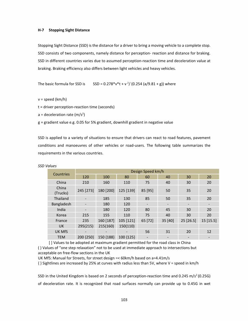
103
H-7 Stopping Sight Distance
Stopping Sight Distance (SSD) is the distance for a driver to bring a moving vehicle to a complete stop.
SSD consists of two components, namely distance for perception- reaction and distance for braking.
SSD in different countries varies due to assumed perception-reaction time and deceleration value at
braking. Braking efficiency also differs between light vehicles and heavy vehicles.
The basic formula for SSD is SSD = 0.278*v*t + v 2/ (0.254 (a/9.81 + g)) where
v = speed (km/h)
t = driver perception-reaction time (seconds)
a = deceleration rate (m/s2)
g = gradient value e.g. 0.05 for 5% gradient, downhill gradient in negative value
SSD is applied to a variety of situations to ensure that drivers can react to road features, pavement
conditions and manoeuvres of other vehicles or road-users. The following table summarizes the
requirements in the various countries.
SSD Values
Countries Design Speed km/h
120 100 80 60 40 30 20
China 210 160 110 75 40 30 20
China
(Trucks) 245 [273] 180 [200] 125 [139] 85 [95] 50 35 20
Thailand - 185 130 85 50 35 20
Bangladesh - 180 120 - - - -
India - 180 120 80 45 30 20
Korea 215 155 110 75 40 30 20
France 235 160 [187] 105 [121] 65 [72] 35 [40] 25 [26.5] 15 [15.5]
UK 295(215) 215(160) 150(110)
UK MfS - - - 56 31 20 12
TEM 200 {250} 150 {188} 100 {125} - - - -
[ ] Values to be adopted at maximum gradient permitted for the road class in China
( ) Values of “one step relaxation” not to be used at immediate approach to intersections but
acceptable on free-flow sections in the UK
UK MfS: Manual for Streets, for street design =< 60km/h based on a=4.41m/s
{ } Sightlines are increased by 25% at curves with radius less than 5V, where V = speed in km/h
SSD in the United Kingdom is based on 2 seconds of perception-reaction time and 0.245 m/s2 (0.25G)
of deceleration rate. It is recognized that road surfaces normally can provide up to 0.45G in wet
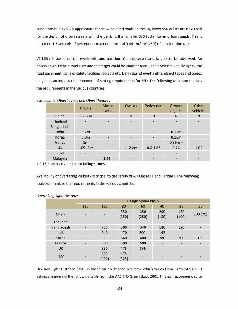
104
conditions but 0.25 G is appropriate for snow-covered roads. In the UK, lower SSD values are now used
for the design of urban streets with the thinking that smaller SSD foster lower urban speeds. This is
based on 1.5 seconds of perception-reaction time and 0.441 m/s2 (0.45G) of deceleration rate.
Visibility is based on the eye-height and position of an observer and targets to be observed. An
observer would be a road-user and the target could be another road-user, a vehicle, vehicle lights, the
road pavement, signs or safety facilities, objects etc. Definition of eye-heights, object types and object
heights is an important component of setting requirements for SSD. The following table summarizes
the requirements in the various countries.
Eye-heights, Object Types and Object Heights
Drivers Motor-
cyclists
Cyclists
Pedestrian
s
Ground
objects
Other
vehicles
China 1.2- 2m - N N N N
Thailand - - - - - -
Bangladesh - - - - - -
India 1.2m - - - 0.15m -
Korea 1.0m - - - 0.15m
France 1m - - - 0.35m + -
UK 1.05- 2.m - 1- 2.2m 0.6-1.8* 0.26 1.05
TEM - - - - - -
Malaysia 1.43m - - - -
+ 0.15m on roads subject to falling stones
Availability of overtaking visibility is critical to the safety of AH Classes II and III roads. The following
table summarizes the requirements in the various countries.
Overtaking Sight Distance
Design Speed km/h
120 100 80 60 40 30 20
China - - 550
(350)
350
(250)
200
(150)
150
(100) 100 (70)
Thailand - - - - - - -
Bangladesh - 720 500 340 180 120 -
India - 640 470 300- 165 - -
Korea - - 540 400 280 200 150
France - 500 500 500 - - -
UK - 580 475 345 - - -
TEM - 600
(400)
475
(325) - - - -
Decision Sight Distance (DSD) is based on pre-manoeuvre time which varies from 3s to 14.5s. DSD
values are given in the following table from the AASHTO Green Book 2001. It is not recommended to
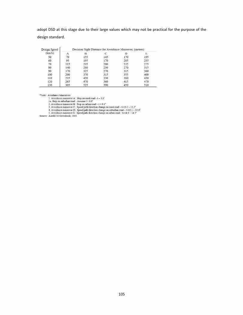
105
adopt DSD at this stage due to their large values which may not be practical for the purpose of the
design standard.

106
9.5 Other road infrastructure safety facilities
A-5 Coloured Lanes
Coloured surfacing may include dressings, asphalt or paints with colours applied to the entire road
pavement or a portion of it. They can enhance the visual appearance of the pavement and could be
beneficial for the following purposes:
• traffic calming
• infilling of widened markings
• infilling of hatched markings at intersections
• paving shoulders and cycle tracks
• paving footpaths
Coloured surfacing lasts longer if paved over non-trafficked areas e.g. central hatching. Their use
depends on availability of suitable materials and maintenance capacity. In the design standard,
coloured surfacing is incorporated as options under various RIFs.
B-3 Slide to protect Headlight
In the absence of road lighting, high beam headlights from opposing vehicle is a potential safety
problem, notably on expressways. The problem may also arise with parallel side roads. Screens or
vegetation are commonly adopted over median barriers in China. In the UK, such screening is not
considered to have a benefit and they are not standard equipment in many high income countries.
There are a number of considerations in their provision, e.g. effect on forward visibility and
maintenance safety for vegetation. The subject will be covered in the design standard.
C-1 Skid Resistance and Anti-skid Surfacing
Adequate skid resistance is crucial for road safety, especially on bends and where braking is required
including approach to intersections. Skid resistance is particularly important when the road surface is
wet.
For AH Primary Roads and Classes I, II roads with speed limit of 80km/h or above, open texture
surfacing materials should be adopted to avoid aquaplaning at locations subject to heavy rains.
Adequate skid resistance should be provided on the AH Network with priority given in the following
order:
107
Priority 1
Approaches to intersections, roundabouts and traffic signals
Approaches to pedestrian crossings
Gradient >10% and longer than 50m (not for uphill gradient on one way roads)
Bend radius <500m for speed limit >= 80km/h on AH Primary and Class 1 Roads
Bend radius <100m for speed limit >= 50km/h on AH Primary and Class 1 Roads
Priority 2
Bend radius <500m for speed limit >= 80km/h on AH Classes 2 and 3 Roads
Bend radius <100m for speed limit >= 50km/h on AH Classes 2 and 3 Roads
Roundabouts
Gradient >5% and longer than 50m (not for uphill gradient on one way roads)
Priority 3
General section of AH Class 2, 3 Roads
General section of AH Class 1 Roads
AH Primary Roads
Anti-skid surfacing should be considered at Priority 1 sites. A maintenance program is necessary to
ensure that the material is kept in good condition. Where there is notable skid resistance problem,
possibly supported by crash data, skidding warning signs should be erected in conjunction with
measures to reduce approach traffic speed.
F-4 Variable Speed Limit
This is generally covered under ITS but their relationship with fixed speed limit should be covered in
the design standard.
G-3 Non-exclusive Motorcycle Lanes
In many countries, motorcyclists are already using hard shoulders of Class I, II or III highways.
Shoulders for such purpose should be at least 2m wide. For high speed roads, an option is to
incorporate a widened shoulder marking. This will be covered in the design standard under slow
vehicle facilities.

108
G-4 Motorcycle-friendly Safety Facilities
The design standard should incorporate the use of motorcycle-friendly safety barrier design as an
option for highways where leisure motorcyclists are present. Overall, a holistic forgiving roadside
approach should be encouraged for the safety of all two wheel users.
H-1 Reflection Mirror
Reflection mirror would only be relevant for acute visibility problems on Class II or III roads at isolated
locations. Such problems should be addressed by road treatments in the first place. They will not be
recommended in the design standard.
H-3 Variable Message Sign
This is generally covered under ITS but their relationship with fixed directional signs should be
covered in the design standard.
H-4 Roadside Parking
As an important guiding document for the Trans-European Road Network (TERN), directive
2008/96/EC of the European Parliament and of the Council states that “Sufficient roadside parking
areas are very important for road safety. Parking areas enable drivers to take rest breaks in good time
and continue their journey with full concentration. The provision of sufficient safe parking areas
should therefore form an integral part of road infrastructure safety management.” This topic should
be incorporated in the design standard.
H-5 Emergency Escape Ramp
Emergency escape ramp is an important safety measure under safety management of long steep
grades. They are extensively used on primary roads of the AH network in China e.g. AH3, AH14 in
Yunnan Province. Their use is specific to geography and road design. In the design standard,
emergency escape ramps will be included.
H-6 Emergency Telephones
Emergency telephones are generally provided on primary roads. Their need is much reduced with the
widespread ownership of mobile phones. Their use is now more restricted to special managed road
sections, notably tunnels and major bridges. The topic is generally covered under ITS but their
relationship with fixed facilities e.g. chainage markers, laybys, safety barrier openings etc. could be
covered in the design standard.

109
10. Conclusions and Recommendation
Through review of literature, consideration of results of the survey conducted in the Asian Highway
member countries, star rating scenario testing of selected road infrastructure safety facilities, inputs
received from the participating member countries and detailed review and analyses of the existing
design standards and guidelines in the member countries and international sources, the following
conclusions are drawn:
(i) The study showed that compared to the samples of standards and guides reviewed, the
Annex II to the Intergovernmental Agreement on the Asian Highway Network covers limited number
of road infrastructure safety facilities. The Annex II to the Intergovernmental Agreement on the Asian
Highway network provides inadequate details and contemporary thinking about road safety. In
relation to road safety, for example, it includes only one very general reference, simply saying:
While developing the Asian Highway network, Parties shall give full consideration to issues of safety
(Paragraph 10, Section III of Annex II).
(ii) The international road assessment programme (iRAP) methodology was used to illustrate how
relative risk levels for vehicle occupants, motorcyclists, pedestrians and bicyclists would change if a
range of road infrastructure safety facilities were added to the existing Asian Highway standard
(Table 4 of Annex II). The analysis result shows that, with some exceptions, the Star Ratings for the
existing Asian Highway Standards as stipulated in the Annex II to the Agreement, the ‘baseline’
scenarios are in the high risk 1- and 2-star ranges. This reflects a combination of very limited
infrastructure provision that is specified in the Asian Highway design standards and, especially in the
Level and Rolling terrain classes, at relatively high speeds. Without exception, the addition of road
infrastructure safety facilities results in reductions in risk. Overall, this analysis indicates that achieving
a minimum of a 3-star rating for all road users on the Asian Highway network is feasible through the
application of a range of reasonable well-known road infrastructure safety facilities that could be
included in the Asian Highway design standards as a new Annex.
(iii) The results of the survey responses received from 17 Asian Highway member countries show
that all the 36 road infrastructure safety facilities are used in at least one member country. It is
unsurprising that the road infrastructure safety facilities most commonly present on the Asian
Highway routes are those which are perceived to be most effective. The results suggest that there is
potential to promote the use of a broader range of road infrastructure safety facilities on the Asian
Highway network; just 10 of the countries use more than half of the 36 road infrastructure safety
facilities. The results also suggest that a rapid take up of internationally well-used road infrastructure
110
safety facilities would be necessary. The questionnaire identifies a number of reasons that particular
road infrastructure safety facilities are not used, including lack of planning and/or design (23%), lack
of budget (12%), not cost effective (7%) and other reasons (33%). Apart from developing regional
standards to support design and implementation of a broader range of road infrastructure safety
facilities, these survey results suggest that case studies to support the use of each road infrastructure
safety facility and training on use of them may be helpful in removing perceived barriers to their uses.
(iv) The Intergovernmental Agreement on the Asian Highway Network developed under the
auspices of ESCAP secretariat provides an institutional platform for providing guidance to member
countries in many areas and could further be used for promoting a coordinated approach to the
development and adoption of standards of road infrastructure safety facilities along the routes of the
Asian Highway network. There is an urgent need for the member countries to adopt and implement
technical design standards of road infrastructure safety facilities for the Asian Highway network. In
this regard, two different draft documents have been prepared. The first document consists of the
proposed minimum design standards of road infrastructure safety facilities for the Asian Highway
Network known as “Asian Highway Design Standards for Road Safety”. This document could serve as
draft Annex II bis to the Intergovernmental Agreement on the Asian Highway network. The second
document included in is a comprehensive related detailed “Design Guideline” of road infrastructure
safety facilities which could serve as a recommended practice for the Asian Highway network.
In consideration of the above conclusions drawn in the study and as explained in the previous chapters
of this report, the following recommendations are made:
(i) The Asian Highway member countries are recommended to consider the road safety as a
priority in planning, designing, constructing, maintaining and managing the Asian Highway routes. As
road infrastructure safety facilities can play a vital role in improving road safety, it is strongly
recommended to adopt and practice technical design standards of road infrastructure safety facilities.
(ii) The study emphasizes on providing guidance to the Asian Highway member countries through
a dedicated new annex to the Intergovernmental Agreement on the Asian Highway network. The draft
new “Annex II bis” is recommended for consideration by the Asian Highway member countries
towards adoption as minimum technical standards of road infrastructure safety facilities for the Asian
Highway Network. The related design guidelines included at the end of this report is recommended to
be used as a reference document for the Asian Highway Network.

111
Appendix A: Road Design Standards and Guides Cited (Literature Review)
Country / Province /
Organization
Document title Author(s) Publication date Web address
China Guide for
Implementation of
Improve Highway
Safety to Cherish the
Life Project
(Provisional, in
Chinese only,
requires purchase)
Research Institute of
Highways and
Guizhou Provincial
Department of
Transport
2015/02/01 Nil
China JTG B01-2003
Technical Standard of
Highway Engineering
(requires purchase)
Ministry of Transport 2004 http://www.codeofc
hina.com/ps/jt/8536.
html (English version
on sale)
China JTG/T D21-2014
Guidelines for Design
of Highway Grade-
separated
Intersection (in
Chinese only,
requires purchase)
Ministry of Transport 2014 Nil
China JTG D81-2006
Guidelines for Design
of Highway Safety
Facilities (in Chinese
only, requires
purchase)
Ministry of Transport 2006 Nil
China JTG D20-2006 Design
Specification for
Highway Alignment
(in Chinese only,
requires purchase)
Ministry of Transport 2006 Nil
China JTG D82-2009
Specification for
Layout of Highway
Traffic Signs and
Markings (in Chinese
only, requires
purchase)
Ministry of Transport 2009 Nil
China JTG/T B05-2004
Guidelines for Safety
Audit of Highway
(recommended
standard, in Chinese
only, requires
purchase)
Ministry of Transport 2004 Nil
China JTG/T D71-2004 Draft
Specification for
Traffic Engineering of
Highway Tunnel (in
Chinese only,
requires purchase)
Ministry of Transport 2004 Nil
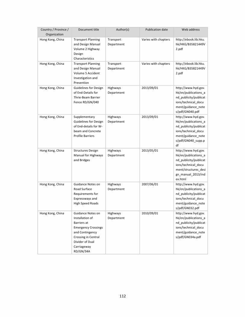
112
Country / Province /
Organization
Document title Author(s) Publication date Web address
Hong Kong, China Transport Planning
and Design Manual
Volume 2 Highway
Design
Characteristics
Transport
Department
Varies with chapters http://ebook.lib.hku.
hk/HKG/B35821449V
2.pdf
Hong Kong, China Transport Planning
and Design Manual
Volume 5 Accident
Investigation and
Prevention
Transport
Department
Varies with chapters http://ebook.lib.hku.
hk/HKG/B35821449V
2.pdf
Hong Kong, China Guidelines for Design
of End-Details for
Thrie-Beam Barrier
Fence RD/GN/040
Highways
Department
2013/09/01 http://www.hyd.gov.
hk/en/publications_a
nd_publicity/publicat
ions/technical_docu
ment/guidance_note
s/pdf/GN040.pdf
Hong Kong, China Supplementary
Guidelines for Design
of End-details for W-
beam and Concrete
Profile Barriers
Highways
Department
2013/09/01 http://www.hyd.gov.
hk/en/publications_a
nd_publicity/publicat
ions/technical_docu
ment/guidance_note
s/pdf/GN040_supp.p
df
Hong Kong, China Structures Design
Manual for Highways
and Bridges
Highways
Department
2013/05/01 http://www.hyd.gov.
hk/en/publications_a
nd_publicity/publicat
ions/technical_docu
ment/structures_desi
gn_manual_2013/ind
ex.html
Hong Kong, China Guidance Notes on
Road Surface
Requirements for
Expressways and
High Speed Roads
Highways
Department
2007/06/01 http://www.hyd.gov.
hk/en/publications_a
nd_publicity/publicat
ions/technical_docu
ment/guidance_note
s/pdf/GN032.pdf
Hong Kong, China Guidance Notes on
Installation of
Barriers at
Emergency Crossings
and Contingency
Crossing in Central
Divider of Dual
Carriageway
RD/GN/34A
Highways
Department
2010/09/01 http://www.hyd.gov.
hk/en/publications_a
nd_publicity/publicat
ions/technical_docu
ment/guidance_note
s/pdf/GN034a.pdf
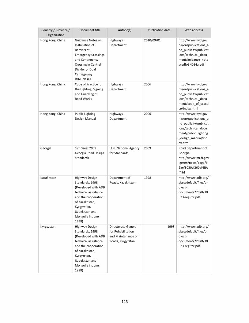
113
Country / Province /
Organization
Document title Author(s) Publication date Web address
Hong Kong, China Guidance Notes on
Installation of
Barriers at
Emergency Crossings
and Contingency
Crossing in Central
Divider of Dual
Carriageway
RD/GN/34A
Highways
Department
2010/09/01 http://www.hyd.gov.
hk/en/publications_a
nd_publicity/publicat
ions/technical_docu
ment/guidance_note
s/pdf/GN034a.pdf
Hong Kong, China Code of Practice for
the Lighting, Signing
and Guarding of
Road Works
Highways
Department
2006 http://www.hyd.gov.
hk/en/publications_a
nd_publicity/publicat
ions/technical_docu
ment/code_of_practi
ce/index.html
Hong Kong, China Public Lighting
Design Manual
Highways
Department
2006 http://www.hyd.gov.
hk/en/publications_a
nd_publicity/publicat
ions/technical_docu
ment/public_lighting
_design_manual/ind
ex.html
Georgia SST Gzegi:2009
Georgia Road Design
Standards
LEPL National Agency
for Standards
2009 Road Department of
Georgia:
http://www.mrdi.gov
.ge/en/news/page/5
2aef8030cf260af4f9c
f49d
Kazakhstan Highway Design
Standards, 1998
{Developed with ADB
technical assistance
and the cooperation
of Kazakhstan,
Kyrgyzstan,
Uzbekistan and
Mongolia in June
1998}
Department of
Roads, Kazakhstan
1998 http://www.adb.org/
sites/default/files/pr
oject-
document/72078/30
523-reg-tcr.pdf
Kyrgyzstan Highway Design
Standards, 1998
{Developed with ADB
technical assistance
and the cooperation
of Kazakhstan,
Kyrgyzstan,
Uzbekistan and
Mongolia in June
1998}
Directorate General
for Rehabilitation
and Maintenance of
Roads, Kyrgyzstan
1998 http://www.adb.org/
sites/default/files/pr
oject-
document/72078/30
523-reg-tcr.pdf

114
Country / Province /
Organization
Document title Author(s) Publication date Web address
Mongolia Highway Design
Standards, 1998
{Developed with ADB
technical assistance
and the cooperation
of Kazakhstan,
Kyrgyzstan,
Uzbekistan and
Mongolia in June
1998}
Department of
Roads, Mongolia
1998 http://www.adb.org/
sites/default/files/pr
oject-
document/72078/30
523-reg-tcr.pdf
Russian Federation
(the)
SNiP 2.05.02-85,
Design Standard for
Highways
SNiP 2004 http://oneroads.ru/fr
ee/snip_2.05.02-
08.pdf
Uzbekistan Highway Design
Standards, 1998
{Developed with ADB
technical assistance
and the cooperation
of Kazakhstan,
Kyrgyzstan,
Uzbekistan and
Mongolia in June
1998}
Directorate General
for Rehabilitation
and Maintenance of
Roads, Uzbekistan
1998 http://www.adb.org/
sites/default/files/pr
oject-
document/72078/30
523-reg-tcr.pdf
Indonesia Indonesian Highway
Capacity Manual
Part I - Urban Roads
Ministry of Public
Works
33970 https://nursyamsu05
.files.wordpress.com
/2012/04/ihcm-
urban-road-part-1-
5.pdf
Indonesia Indonesian Highway
Capacity Manual
Part II - Interurban
Roads
Ministry of Public
Works
34700 https://nursyamsu05
.files.wordpress.com
/2012/04/ihcm-
interurban-road-
part-6-7.pdf
Indonesia Indonesian Road
Design Manual
Being prepared in a
world bank's
project??
0 0
Singapore Chapter 10 of Civil
Design Criteria for
Road and Rail Transit
Systems
E/GD/09/106/A1
Land Transport
Authority
40210 http://www.lta.gov.s
g/content/dam/ltaw
eb/corp/Industry/file
s/DC_EGD09106A1_
Overall.pdf
Singapore COP for works on
public street
0 41852 http://www.lta.gov.s
g/content/dam/ltaw
eb/corp/Industry/file
s/COP%20for%20Wo
rks%20on%20Public
%20Streets_Aug%20
2014%20R8a.pdf
Thailand Traffic Engineering
(Thai)
0 0 0
Thailand Standard Traffic Signs
(Thai)
0 0 0

115
Country / Province /
Organization
Document title Author(s) Publication date Web address
Philippines (the) Highway Safety
Design Standards
Part 1: Road Safety
Design Manual
Department of Public
Works and Highways
41030 http://www.dpwh.go
v.ph/pdf/road%20saf
ety%20manuals%202
012.zip
Philippines (the) Highway Safety
Design Standards
Part 2: Road Signs
and Pavement
Markings Manual
Department of Public
Works and Highways
41030 http://www.dpwh.go
v.ph/pdf/road%20saf
ety%20manuals%202
012.zip
Bangladesh Geometric Design
Standards
for
Roads & Highways
Department
Ministry of
Communications
Roads and Railways
Division
36800 http://www.rhd.gov.
bd/Documents/Conv
Docs/Road%20Geom
etric%20Design%20
Manual.pdf
Bangladesh Road Sign Manual
Volume 1
Bangladesh Road
Transport Authority
Ministry of
Communication
36586 http://www.rhd.gov.
bd/Documents/Conv
Docs/Road%20Sign%
20Manual%20Volum
e-1.pdf
Bangladesh Road Sign Manual
Volume 2
Bangladesh Road
Transport Authority
Ministry of
Communication
36586 http://www.rhd.gov.
bd/Documents/Conv
Docs/Road%20Sign%
20Manual%20Volum
e-2.pdf
Bhutan Guidelines on Road
Classification System
and Delineation of
Construction and
Maintenance
Responsibilities
Royal Government of
Bhutan, Ministry of
Works & Human
Settlement
2009 http://www.mowhs.
gov.bt/wp-
content/uploads/201
0/11/English_Road_
Guidelines.pdf
Bhutan Draft Pavement
Markings Manual
Royal Government of
Bhutan, Ministry of
Works & Human
Settlement
39295 0
Bhutan Draft Road Signs
Manual
Royal Government of
Bhutan, Ministry of
Works & Human
Settlement
39295 0
Bhutan Road Safety Audit
Policies and Toolkit
Royal Government of
Bhutan, Ministry of
Works & Human
Settlement
39052 0
Bhutan Survey & Design
Manual
Royal Government of
Bhutan, Ministry of
Works & Human
Settlement
- 0

116
Country / Province /
Organization
Document title Author(s) Publication date Web address
India IRC : 73
Geometric Design of
Rural (non-Urban)
Highway
Indian Roads
Congress
1980 http://www.civilisco
des.blogspot.hk/sear
ch/label/IRC%2073%
20-
%201980%20GEOME
TRIC%20DESIGN%20
OF%20RURAL%20RO
ADS
India Street Design
Guidelines
Delhi Development
Authority, New Delhi
40483 http://www.uttipec.n
ic.in/StreetGuidelines
-R1-Feb2011-
UTTPEC-DDA.pdf
India IRC : 79-1981
Recommended
Practice for Road
Delineators
The Indian Road
Congress
0 0
India IRC : 35-1997
Code of Practice for
Road Markings (First
Revision)
The Indian Road
Congress
35643 http://www.manune
ethi.in/FILES/IRC%20
CODES%20&%20MO
RTH%20SPECIFICATI
ONS/IRC-35-
(Road%20markings%
20Ist%20revision%20
code%20of%20practi
ces).pdf
India IRC : 66-1976
Recommended
Practice for Sight
Distance on Rural
Highways
The Indian Road
Congress
28004 http://www.civilisco
des.blogspot.hk/sear
ch/label/IRC%2066%
20-
%201976%20RECOM
MENDED%20PRACTI
CE%20FOR%20SIGHT
%20DISTANCE%20FO
R%20RURAL%20HIG
HWAYS
India IRC : 86-1983
Geometric Design
Standards for Urban
Roads in Plains
The Indian Road
Congress
30529 http://www.civilisco
des.blogspot.hk/sear
ch/label/IRC%2086%
201983%20GEOMET
RIC%20DESIGN%20S
TANDARDS%20FOR%
20URBAN%20ROADS
%20IN%20PLAINS
Nepal Nepal Road Standard
2070
Department of Roads 41456 http://www.dor.gov.
np/documents/Nepal
%20Road%20Standar
d%20-2070.pdf
Nepal Road Safety Notes 2
Designing Safer Side
Drains
Ministry of Works
and Transport
35370 http://www.dor.gov.
np/documents/2%20
Designing%20Safer%
20Side%20Drains.pdf
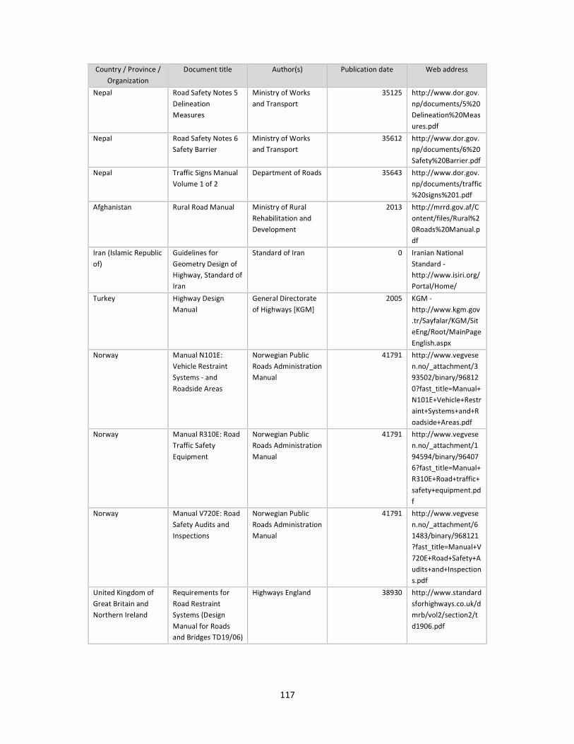
117
Country / Province /
Organization
Document title Author(s) Publication date Web address
Nepal Road Safety Notes 5
Delineation
Measures
Ministry of Works
and Transport
35125 http://www.dor.gov.
np/documents/5%20
Delineation%20Meas
ures.pdf
Nepal Road Safety Notes 6
Safety Barrier
Ministry of Works
and Transport
35612 http://www.dor.gov.
np/documents/6%20
Safety%20Barrier.pdf
Nepal Traffic Signs Manual
Volume 1 of 2
Department of Roads 35643 http://www.dor.gov.
np/documents/traffic
%20signs%201.pdf
Afghanistan Rural Road Manual Ministry of Rural
Rehabilitation and
Development
2013 http://mrrd.gov.af/C
ontent/files/Rural%2
0Roads%20Manual.p
df
Iran (Islamic Republic
of)
Guidelines for
Geometry Design of
Highway, Standard of
Iran
Standard of Iran 0 Iranian National
Standard -
http://www.isiri.org/
Portal/Home/
Turkey Highway Design
Manual
General Directorate
of Highways [KGM]
2005 KGM -
http://www.kgm.gov
.tr/Sayfalar/KGM/Sit
eEng/Root/MainPage
English.aspx
Norway Manual N101E:
Vehicle Restraint
Systems - and
Roadside Areas
Norwegian Public
Roads Administration
Manual
41791 http://www.vegvese
n.no/_attachment/3
93502/binary/96812
0?fast_title=Manual+
N101E+Vehicle+Restr
aint+Systems+and+R
oadside+Areas.pdf
Norway Manual R310E: Road
Traffic Safety
Equipment
Norwegian Public
Roads Administration
Manual
41791 http://www.vegvese
n.no/_attachment/1
94594/binary/96407
6?fast_title=Manual+
R310E+Road+traffic+
safety+equipment.pd
f
Norway Manual V720E: Road
Safety Audits and
Inspections
Norwegian Public
Roads Administration
Manual
41791 http://www.vegvese
n.no/_attachment/6
1483/binary/968121
?fast_title=Manual+V
720E+Road+Safety+A
udits+and+Inspection
s.pdf
United Kingdom of
Great Britain and
Northern Ireland
Requirements for
Road Restraint
Systems (Design
Manual for Roads
and Bridges TD19/06)
Highways England 38930 http://www.standard
sforhighways.co.uk/d
mrb/vol2/section2/t
d1906.pdf
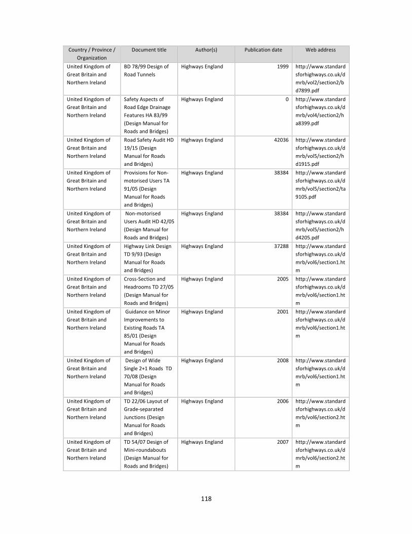
118
Country / Province /
Organization
Document title Author(s) Publication date Web address
United Kingdom of
Great Britain and
Northern Ireland
BD 78/99 Design of
Road Tunnels
Highways England 1999 http://www.standard
sforhighways.co.uk/d
mrb/vol2/section2/b
d7899.pdf
United Kingdom of
Great Britain and
Northern Ireland
Safety Aspects of
Road Edge Drainage
Features HA 83/99
(Design Manual for
Roads and Bridges)
Highways England 0 http://www.standard
sforhighways.co.uk/d
mrb/vol4/section2/h
a8399.pdf
United Kingdom of
Great Britain and
Northern Ireland
Road Safety Audit HD
19/15 (Design
Manual for Roads
and Bridges)
Highways England 42036 http://www.standard
sforhighways.co.uk/d
mrb/vol5/section2/h
d1915.pdf
United Kingdom of
Great Britain and
Northern Ireland
Provisions for Non-
motorised Users TA
91/05 (Design
Manual for Roads
and Bridges)
Highways England 38384 http://www.standard
sforhighways.co.uk/d
mrb/vol5/section2/ta
9105.pdf
United Kingdom of
Great Britain and
Northern Ireland
Non-motorised
Users Audit HD 42/05
(Design Manual for
Roads and Bridges)
Highways England 38384 http://www.standard
sforhighways.co.uk/d
mrb/vol5/section2/h
d4205.pdf
United Kingdom of
Great Britain and
Northern Ireland
Highway Link Design
TD 9/93 (Design
Manual for Roads
and Bridges)
Highways England 37288 http://www.standard
sforhighways.co.uk/d
mrb/vol6/section1.ht
m
United Kingdom of
Great Britain and
Northern Ireland
Cross-Section and
Headrooms TD 27/05
(Design Manual for
Roads and Bridges)
Highways England 2005 http://www.standard
sforhighways.co.uk/d
mrb/vol6/section1.ht
m
United Kingdom of
Great Britain and
Northern Ireland
Guidance on Minor
Improvements to
Existing Roads TA
85/01 (Design
Manual for Roads
and Bridges)
Highways England 2001 http://www.standard
sforhighways.co.uk/d
mrb/vol6/section1.ht
m
United Kingdom of
Great Britain and
Northern Ireland
Design of Wide
Single 2+1 Roads TD
70/08 (Design
Manual for Roads
and Bridges)
Highways England 2008 http://www.standard
sforhighways.co.uk/d
mrb/vol6/section1.ht
m
United Kingdom of
Great Britain and
Northern Ireland
TD 22/06 Layout of
Grade-separated
Junctions (Design
Manual for Roads
and Bridges)
Highways England 2006 http://www.standard
sforhighways.co.uk/d
mrb/vol6/section2.ht
m
United Kingdom of
Great Britain and
Northern Ireland
TD 54/07 Design of
Mini-roundabouts
(Design Manual for
Roads and Bridges)
Highways England 2007 http://www.standard
sforhighways.co.uk/d
mrb/vol6/section2.ht
m

119
Country / Province /
Organization
Document title Author(s) Publication date Web address
United Kingdom of
Great Britain and
Northern Ireland
TD 16/07 Geometric
Design of
Roundabouts (Design
Manual for Roads
and Bridges)
Highways England 2007 http://www.standard
sforhighways.co.uk/d
mrb/vol6/section2.ht
m
United Kingdom of
Great Britain and
Northern Ireland
TD 78/97 Design of
Road Markings at
Roundabouts
(Design Manual for
Roads and Bridges)
Highways England 1997 http://www.standard
sforhighways.co.uk/d
mrb/vol6/section2.ht
m
United Kingdom of
Great Britain and
Northern Ireland
TD 50/04 The
Geometric Layout of
Signal-Controlled
Junctions and
Signalised
Roundabouts (Design
Manual for Roads
and Bridges)
Highways England 2004 http://www.standard
sforhighways.co.uk/d
mrb/vol6/section2.ht
m
United Kingdom of
Great Britain and
Northern Ireland
TD 39/94 The Design
of Major
Interchanges (Design
Manual for Roads
and Bridges)
Highways England 1994 http://www.standard
sforhighways.co.uk/d
mrb/vol6/section2.ht
m
United Kingdom of
Great Britain and
Northern Ireland
TD 40/94 Layout of
Compact Grade
Separated Junctions
(Design Manual for
Roads and Bridges)
Highways England 1994 http://www.standard
sforhighways.co.uk/d
mrb/vol6/section2.ht
m
United Kingdom of
Great Britain and
Northern Ireland
TD 42/95 Geometric
Design of
Major/Minor Priority
Junctions (Design
Manual for Roads
and Bridges)
Highways England 1995 http://www.standard
sforhighways.co.uk/d
mrb/vol6/section2.ht
m
United Kingdom of
Great Britain and
Northern Ireland
TD 41/95 Vehicular
Access to All-Purpose
Trunk Roads
Highways England 1995 http://www.standard
sforhighways.co.uk/d
mrb/vol6/section2.ht
m
United Kingdom of
Great Britain and
Northern Ireland
TA 86/03 Layout of
Large Signal-
Controlled Junctions
(Design Manual for
Roads and Bridges)
Highways England 2003 http://www.standard
sforhighways.co.uk/d
mrb/vol6/section2.ht
m
United Kingdom of
Great Britain and
Northern Ireland
TD 36/93 Subways
for Pedestrians and
Pedal Cyclists Layout
and Dimensions
(Design Manual for
Roads and Bridges)
Highways England 1993 http://www.standard
sforhighways.co.uk/d
mrb/vol6/section3.ht
m
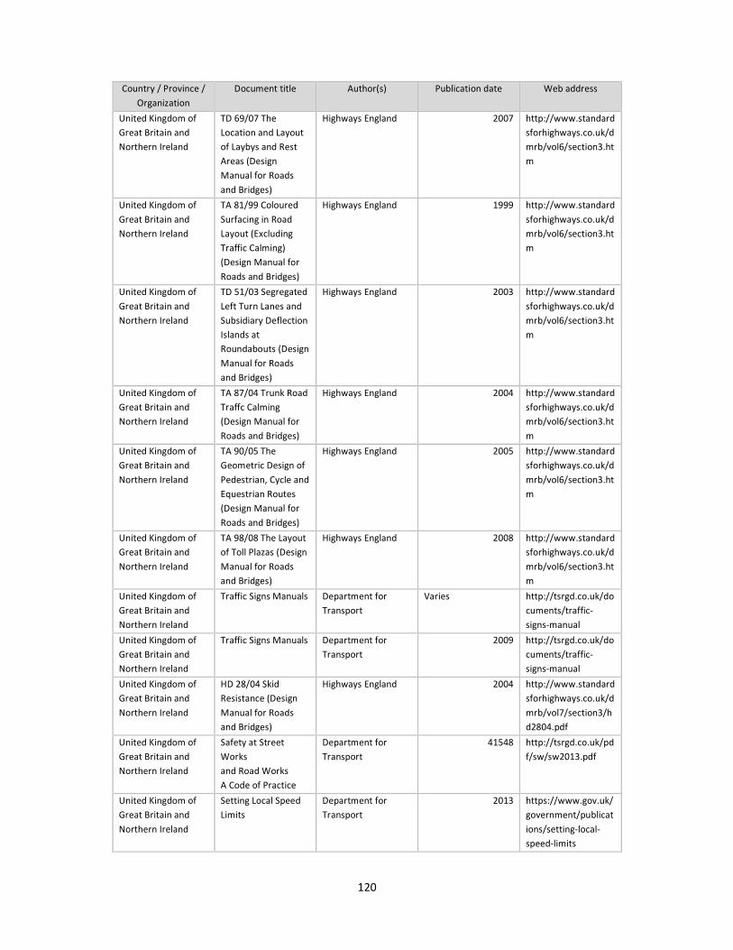
120
Country / Province /
Organization
Document title Author(s) Publication date Web address
United Kingdom of
Great Britain and
Northern Ireland
TD 69/07 The
Location and Layout
of Laybys and Rest
Areas (Design
Manual for Roads
and Bridges)
Highways England 2007 http://www.standard
sforhighways.co.uk/d
mrb/vol6/section3.ht
m
United Kingdom of
Great Britain and
Northern Ireland
TA 81/99 Coloured
Surfacing in Road
Layout (Excluding
Traffic Calming)
(Design Manual for
Roads and Bridges)
Highways England 1999 http://www.standard
sforhighways.co.uk/d
mrb/vol6/section3.ht
m
United Kingdom of
Great Britain and
Northern Ireland
TD 51/03 Segregated
Left Turn Lanes and
Subsidiary Deflection
Islands at
Roundabouts (Design
Manual for Roads
and Bridges)
Highways England 2003 http://www.standard
sforhighways.co.uk/d
mrb/vol6/section3.ht
m
United Kingdom of
Great Britain and
Northern Ireland
TA 87/04 Trunk Road
Traffc Calming
(Design Manual for
Roads and Bridges)
Highways England 2004 http://www.standard
sforhighways.co.uk/d
mrb/vol6/section3.ht
m
United Kingdom of
Great Britain and
Northern Ireland
TA 90/05 The
Geometric Design of
Pedestrian, Cycle and
Equestrian Routes
(Design Manual for
Roads and Bridges)
Highways England 2005 http://www.standard
sforhighways.co.uk/d
mrb/vol6/section3.ht
m
United Kingdom of
Great Britain and
Northern Ireland
TA 98/08 The Layout
of Toll Plazas (Design
Manual for Roads
and Bridges)
Highways England 2008 http://www.standard
sforhighways.co.uk/d
mrb/vol6/section3.ht
m
United Kingdom of
Great Britain and
Northern Ireland
Traffic Signs Manuals Department for
Transport
Varies http://tsrgd.co.uk/do
cuments/traffic-
signs-manual
United Kingdom of
Great Britain and
Northern Ireland
Traffic Signs Manuals Department for
Transport
2009 http://tsrgd.co.uk/do
cuments/traffic-
signs-manual
United Kingdom of
Great Britain and
Northern Ireland
HD 28/04 Skid
Resistance (Design
Manual for Roads
and Bridges)
Highways England 2004 http://www.standard
sforhighways.co.uk/d
mrb/vol7/section3/h
d2804.pdf
United Kingdom of
Great Britain and
Northern Ireland
Safety at Street
Works
and Road Works
A Code of Practice
Department for
Transport
41548 http://tsrgd.co.uk/pd
f/sw/sw2013.pdf
United Kingdom of
Great Britain and
Northern Ireland
Setting Local Speed
Limits
Department for
Transport
2013 https://www.gov.uk/
government/publicat
ions/setting-local-
speed-limits

121
Country / Province /
Organization
Document title Author(s) Publication date Web address
United Kingdom of
Great Britain and
Northern Ireland
Designing Safer
Roadsides - A
Handbook for
Highway Engineers
Passive Safety UK
in association with
Traffic Engineering &
Control
39569 http://www.ukroads.
org/webfiles/handbo
ok_flyer.pdf
United Kingdom of
Great Britain and
Northern Ireland
Design &
Maintenance
Guidance for Local
Authority Roads -
Provision of Road
Restraint Systems on
Local Authority
Roads
Department for
Transport, UK Roads
Liaison Group
40817 http://www.ukroadsl
iaisongroup.org/en/u
tilities/document-
summary.cfm?docid=
5803F825-EFC0-
4858-
B2A75D0DCE3382A9
United Kingdom of
Great Britain and
Northern Ireland
Passive Safety UK
Guidelines for
Specification and Use
of Passively Safe
Street Furniture on
the UK Road Network
Passive Safety UK
in association with
Traffic Engineering &
Control
40269 http://www.ukroads.
org/webfiles/Guideli
nes%20Print%20read
y.pdf
United Kingdom of
Great Britain and
Northern Ireland
The Use of Passively
Safe Signposts and
Lighting Columns
County Surveyors
Society with
Transport Research
Laboratory
39661 https://www.theilp.o
rg.uk/documents/css
-sl4-passive-safety/
United Kingdom of
Great Britain and
Northern Ireland
Guidelines for
Motorcycling
Institute of Highway
Engineers
2005 with updates http://www.motorcy
cleguidelines.org.uk/
#
France National Instruction
on Technical Design
Requirements for
Rural Motorways
(ICTAAL)
Centre of Study and
Expertise on Risks,
Environment,
Mobility and Design
(Cerema), France
36861 http://www.infra-
transports-
materiaux.cerema.fr/
IMG/pdf/US_ICTAAL
_GB.pdf
France Amenagement des
Routes Principales
(ARP) - Guide
Technique (in French
only, require
purchase)
Centre of Study and
Expertise on Risks,
Environment,
Mobility and Design
(Cerema), France
34547 http://catalogue.setr
a.fr/resultsframe.xsp
?q=&log=true&t2=DT
&t4=LO&t6=CA&t5=
VI&sujet=amenagem
ent+des+routes+prin
cipales&op_mots_suj
et=and&domaine=0
%7CTous&periode=1
&A1=1969&A2=2015
&sf=date&fenetre=1
&submit=Afficher
France The design of
interurban
intersections on
major roads - At-
grade intersections
Centre of Study and
Expertise on Risks,
Environment,
Mobility and Design
(Cerema), France
36130 http://www.infra-
transports-
materiaux.cerema.fr/
technical-guides-
r781.html
France Road Safety
Inspections
Centre of Study and
Expertise on Risks,
Environment,
Mobility and Design
(Cerema), France
39965 http://www.infra-
transports-
materiaux.cerema.fr/
technical-guides-
r781.html

122
Country / Province /
Organization
Document title Author(s) Publication date Web address
France Signing Bends Centre of Study and
Expertise on Risks,
Environment,
Mobility and Design
(Cerema), France
37438 http://www.infra-
transports-
materiaux.cerema.fr/
technical-guides-
r781.html
France Improving the Safety
of Bends on Major
Rural Roads
Centre of Study and
Expertise on Risks,
Environment,
Mobility and Design
(Cerema), France
37377 http://www.infra-
transports-
materiaux.cerema.fr/
technical-guides-
r781.html
France Road Junction
Improvement and
Safety
Centre of Study and
Expertise on Risks,
Environment,
Mobility and Design
(Cerema), France
35400 http://www.infra-
transports-
materiaux.cerema.fr/
technical-guides-
r781.html
France Handling Lateral
Obstacles on Main
Roads in Open
Country
Centre of Study and
Expertise on Risks,
Environment,
Mobility and Design
(Cerema), France
39295 http://www.infra-
transports-
materiaux.cerema.fr/
technical-guides-
r781.html
France Landscape and Road
Legibility
Centre of Study and
Expertise on Risks,
Environment,
Mobility and Design
(Cerema), France
38869 http://www.infra-
transports-
materiaux.cerema.fr/
technical-guides-
r781.html
France Lutte Contre Les
Prises à Contresens
(Measures to Prevent
Wrong Way Travel, in
French only)
Centre of Study and
Expertise on Risks,
Environment,
Mobility and Design
(Cerema), France
40422 http://www.infra-
transports-
materiaux.cerema.fr/
IMG/pdf/1034w_NI_
CSEE_134.pdf
France L’aménagement
d’une Traversée
d’agglomération
(Design of Highway
Traversing
Settlements, in
French only, requires
purchase)
Centre of Study and
Expertise on Risks,
Environment,
Mobility and Design
(Cerema), France
40269 http://www.cerema.f
r/
France Descentes de Forte
Pente et de Grande
Longueur sur Les
Routes de Type
Autoroute (Long
Steep Descent on
Expressway, in
French only)
Centre of Study and
Expertise on Risks,
Environment,
Mobility and Design
(Cerema), France
35462 http://dtrf.setra.fr/p
df/pj/Dtrf/0000/Dtrf-
0000742/DT742.pdf?
openerPage=resultat
s&qid=sdx_q0
0 Long Steep Grade 0 0 0
Australia Guide to Road Design Austroads 0 https://www.onlinep
ublications.austroads
.com.au/items/AGRD

123
Country / Province /
Organization
Document title Author(s) Publication date Web address
Australia Guide to Road Design
- DRAINAGE SET
Austroads 0 https://www.onlinep
ublications.austroads
.com.au/items/AGRD
-DRAIN
Australia Guide to Road Design
Part 1: Introduction
to Road Design
Austroads 0 https://www.onlinep
ublications.austroads
.com.au/items/AGRD
01-10
Australia Guide to Road Design
Part 2: Design
Considerations
Austroads 0 https://www.onlinep
ublications.austroads
.com.au/items/AGRD
02-06
Australia Guide to Road Design
Part 3: Geometric
Design
Austroads 0 https://www.onlinep
ublications.austroads
.com.au/items/AGRD
03-10
Australia Guide to Road Design
Part 4: Intersections
and Crossings –
General
Austroads 0 https://www.onlinep
ublications.austroads
.com.au/items/AGRD
04-09
Australia Guide to Road Design
Part 4A: Unsignalised
and Signalised
Intersections
Austroads 0 https://www.onlinep
ublications.austroads
.com.au/items/AGRD
04A-10
Australia Guide to Road Design
Part 4B:
Roundabouts
Austroads 0 https://www.onlinep
ublications.austroads
.com.au/items/AGRD
04B-11
Australia Guide to Road Design
Part 4C: Interchanges
Austroads 0 https://www.onlinep
ublications.austroads
.com.au/items/AGRD
04C-09
Australia Guide to Road Design
Part 5: Drainage –
General and
Hydrology
Considerations
0 0 https://www.onlinep
ublications.austroads
.com.au/items/AGRD
05-13
Australia Guide to Road Design
Part 5A: Drainage –
Road Surface,
Networks, Basins and
Subsurface
Austroads 0 https://www.onlinep
ublications.austroads
.com.au/items/AGRD
05A-13
Australia Guide to Road Design
Part 5B: Drainage –
Open Channels,
Culverts and
Floodways
Austroads 0 https://www.onlinep
ublications.austroads
.com.au/items/AGRD
05B-13
Australia Guide to Road Design
Part 6: Roadside
Design, Safety and
Barriers
Austroads 0 https://www.onlinep
ublications.austroads
.com.au/items/AGRD
06-10

124
Country / Province /
Organization
Document title Author(s) Publication date Web address
Australia Guide to Road Design
Part 6A: Pedestrian
and Cyclist Paths
Austroads 0 https://www.onlinep
ublications.austroads
.com.au/items/AGRD
06A-09
Australia Guide to Road Design
Part 6B: Roadside
Environment
Austroads 0 https://www.onlinep
ublications.austroads
.com.au/items/AGRD
06B-09
Australia Guide to Road Design
Part 7: Geotechnical
Investigation and
Design
Austroads 0 https://www.onlinep
ublications.austroads
.com.au/items/AGRD
07-08
Australia Guide to Road Design
Part 8: Process and
Documentation
Austroads 0 https://www.onlinep
ublications.austroads
.com.au/items/AGRD
08-09
Australia Austroads Design
Vehicles and Turning
Path Templates
Austroads 0 https://mail.google.c
om/mail/u/0/#inbox/
14e9b7d6ce17e3df
Australia Cycling Aspects of
Austroads Guides
(2014)
Austroads 0 https://www.onlinep
ublications.austroads
.com.au/items/AP-
G88-14
Australia Guide to Road Safety
— SET
Austroads 0 https://www.onlinep
ublications.austroads
.com.au/items/AGRS
Australia Guide to Road Safety
Part 1: Road Safety
Overview
Austroads 0 https://www.onlinep
ublications.austroads
.com.au/items/AGRS
01-13
Australia Guide to Road Safety
Part 2: Road Safety
Strategy and
Evaluation
Austroads 0 https://www.onlinep
ublications.austroads
.com.au/items/AGRS
02-13
Australia Guide to Road Safety
Part 3: Speed Limits
and Speed
Management
Austroads 0 https://www.onlinep
ublications.austroads
.com.au/items/AGRS
03-08
Australia Guide to Road Safety
Part 4: Local
Government and
Community Road
Safety
Austroads 0 https://www.onlinep
ublications.austroads
.com.au/items/AGRS
04-09
Australia Guide to Road Safety
Part 5: Road Safety
for Rural and Remote
Areas
Austroads 0 https://www.onlinep
ublications.austroads
.com.au/items/AGRS
05-06
Australia Guide to Road Safety
Part 6: Road Safety
Audit
Austroads 0 https://www.onlinep
ublications.austroads
.com.au/items/AGRS
06-09

125
Country / Province /
Organization
Document title Author(s) Publication date Web address
Australia Guide to Road Safety
Part 7: Road Network
Crash Risk
Assessment and
Management
Austroads 0 https://www.onlinep
ublications.austroads
.com.au/items/AGRS
07-06
Australia Guide to Road Safety
Part 8: Treatment of
Crash Locations
Austroads 0 https://www.onlinep
ublications.austroads
.com.au/items/AGRS
08-09
Australia Guide to Road Safety
Part 9: Roadside
Hazard Management
Austroads 0 https://www.onlinep
ublications.austroads
.com.au/items/AGRS
09-08
Australia Assessing Fitness to
Drive for Commercial
and Private Vehicle
Drivers
Austroads 0 https://www.onlinep
ublications.austroads
.com.au/items/AP-
G56-13
UNESCAP Asian Highway
Classification and
Design Standard
UNESCAP 34304 http://www.unescap.
org/sites/default/file
s/AH%20classificatio
n%20and%20design
%20standards-
English.pdf
PIARC Road Safety Audit
Guidelines for Safety
Checks of New Road
Projects
PIARC World Road
Federation
2011 http://www.piarc.org
/en/publications/tec
hnical-
reports/?catalog-
topic=32&catalog-
size=10&catalog-
sort=date&catalog-
offset=0&=OK
PIARC Sustainable
Interurban Roads for
Tomorrow
PIARC World Road
Federation
2009 http://www.piarc.org
/en/publications/tec
hnical-
reports/?catalog-
topic=32&catalog-
size=10&catalog-
sort=date&catalog-
offset=0&=OK
PIARC PIARC Catalogue of
Design Safety
Problems and
Potential
Countermeasures
PIARC World Road
Federation
2009 http://www.piarc.org
/en/publications/tec
hnical-
reports/?catalog-
topic=32&catalog-
size=10&catalog-
sort=date&catalog-
offset=0&=OK

126
Country / Province /
Organization
Document title Author(s) Publication date Web address
PIARC Human Factors
Guidelines for Safer
Road Infrastructure
PIARC World Road
Federation
2008 http://www.piarc.org
/en/publications/tec
hnical-
reports/?catalog-
topic=32&catalog-
size=10&catalog-
sort=date&catalog-
offset=0&=OK
PIARC Human Factors in
Road Design. Review
of Design Standards
in Nine Countries.
PIARC World Road
Federation
2012 http://www.piarc.org
/en/publications/tec
hnical-
reports/?catalog-
topic=27&catalog-
size=10&catalog-
sort=date&catalog-
offset=0&=OK
PIARC Road Accident
Investigation
Guidelines for Road
Engineers.
PIARC World Road
Federation
2013 http://www.piarc.org
/en/publications/tec
hnical-
reports/?catalog-
topic=27&catalog-
size=10&catalog-
sort=date&catalog-
offset=0&=OK
PIARC Road Safety
Inspection Guidelines
for Safety Checks of
Existing Roads.
PIARC World Road
Federation
2012 http://www.piarc.org
/en/publications/tec
hnical-
reports/?catalog-
topic=27&catalog-
size=10&catalog-
sort=date&catalog-
offset=0&=OK
PIARC Improvements in
Safe Working on
Roads.
PIARC World Road
Federation
2012 http://www.piarc.org
/en/publications/tec
hnical-
reports/?catalog-
topic=27&catalog-
size=10&catalog-
sort=date&catalog-
offset=0&=OK
ADB Road Safety
Guidelines for the
Asian and Pacific
Region
Asian Development
Bank
2003 http://www.adb.org/
sites/default/files/pu
blication/29532/road
-safety-guidelines.pdf
ADB Road Safety Audit for
Road Projects - An
Operational Tool Kit
Asian Development
Bank
37773 http://www.irfnet.ch
/files-
upload/member_are
a-pdf-
files/RS_WG/Annex/
Road-Safety-Audit-
for-Road-Projects.pdf

127
Country / Province /
Organization
Document title Author(s) Publication date Web address
United States of
America
Roadside Design
Guide 4th Edition
AASHTO 2011 https://bookstore.tra
nsportation.org/colle
ction_detail.aspx?ID=
105
United States of
America
A Policy on
Geometric Design of
Highways and
Streets, 6th Edition
AASHTO 2011 https://bookstore.tra
nsportation.org/colle
ction_detail.aspx?ID=
110
United States of
America
AASHTO Guide for
the Planning, Design,
and Operation of
Pedestrian Facilities,
1st Edition
AASHTO 2004 https://bookstore.tra
nsportation.org/colle
ction_detail.aspx?ID=
131
United States of
America
Guide for the
Development of
Bicycle Facilities, 4th
Edition
AASHTO 2012 https://bookstore.tra
nsportation.org/colle
ction_detail.aspx?ID=
116

128
Appendix B: Inputs from the National Experts of the Participating Countries
In parallel to the literature review, discussion on facilities to be included in the AH standards,
the Asian Highway member country and Star Rating testing, the ESCAP Secretariat engaged
national consultants in Bangladesh, China, India, the Republic of Korea and Thailand to
provide additional information on the overall road safety situation in their country and road
infrastructure facilities. These reports, listed and summarised below provided a valuable
resource for the further development of the AH design standard.
Reports Received from the Participating Countries
Bangladesh:
• Noor-e-Alam, December 2015. Final Report on Road Safety Infrastructure Facilities & Basic
Information/data on Road Infrastructure Design Practices/Guidelines in Bangladesh.
• Noor-e-Alam, December 2015. Road Safety Infrastructure Related Policy, Planning, Regulatory
and Technology Related Overall Situation in Bangladesh.
• Noor-e-Alam, July 2015. Report on Design Standard Of Road Infrastructure Safety facilities in
Bangladesh.
China:
• Xiaojing Wang, June 2016. China: The Design Standards and Available Specifications.
• Xiaojing Wang, September 2016. China: The Design Standards and Available Specifications
(Supplementary).
• Xiaojing Wang, 2016. RS-1A: Existing Literature on Road Safety Infrastructure Facilities in
China.
• Xiaojing Wang, 2016. RS-2: Overall situation of the road safety infrastructure practices in
China.
India:
• Tony Mathew, September 2016. Report on Design Guidelines for Road Safety Infrastructure
Facilities in India.
Republic of Korea:
• Manuals on Roads Safety Facilities in Republic of Korea.
• Sung-min Cho, December 2015. Current Status and the Guidelines of Road Safety Facilities in
the Republic of Korea Rep.

129
Thailand:
• Literature review on Road Safety Infrastructure in Thailand.
• Overall Situation of Road Safety Infrastructures in Thailand.
• Untitled (dealing with road infrastructure).
Summary of Reports
Each country has design standards for road infrastructure safety facilities, although these vary
according to local regulatory settings.
Design standard of road Infrastructure safety facilities Bangladesh China India Korea Thailand
Line marking • • • •
Chevron mark • • • •
Raised pavement mark • • • • •
Flexible delineation posts • •
•
Roadside barrier • • • •
Median Barrier • • • • •
Central hatching (painted median) •
Crash cushion with channelization • • •
Safety barrier end treatment • • • •
Clear zones •
Centerline / edge line rumble strip • • •
Pedestrian crossing • • • •
Sidewalk (footpath) • • • •
Pedestrian fences •
Pedestrian refuge island • • •
Protected turn lane (pocket lane for turning) • • •
Intersection channelization •
Speed hump •
Visual traffic calming •
Automatic regulation camera •
Bicycle lane •
Exclusive motorcycle lane •
Lighting • • • •
Sight distance • • • •
Road signs • •
Cattle crossing •
Truck Lay-bys •
Bus bays •
Rest areas •
Emergency Escape Ramps •
Skid Resistance •
Rockfall prevention •
Bangladesh
Given the size of the country, road network and vehicle population, the number of road crashes in
Bangladesh is one of the highest in the world. Despite Government-led efforts to address the road
safety problems, there have been a number of challenges including the (lack of) leadership in
implementing road safety, institutional weaknesses, professional capacity and expertise, resource

130
constraints, poor accident data recording system, lack of integration between concern agencies, lack
of government and private partnership. Resolving these issues will enable Bangladesh can look
towards building safer roads as well as maintaining safety on the roads.
Bangladesh’ policy and regulatory framework for road safety comprises the following:
• Road safety infrastructure related policies:
a. National Land Transport Policy, 2004
b. National Integrated Multimodal Transport Policy (NIMTP), 2013
c. The Motor Vehicles’ Axle Load Control Station Policy, 2012
• Road safety infrastructure related plans:
a. Road Master Plan by Roads and Highways Department (RHD)
b. National Road Safety Strategic Action Plan 2014 – 2016 by National Road Safety
Council
c. Sixth Five Year Plan (SFYP), 2011-15
• Road safety infrastructure related regulation:
a. The Highway Act, 1925:
b. The Motor Vehicles Ordinance, 1983
• Institutional Arrangements:
a. National Road Safety Council (NRSC)
b. Cabinet Committee on Road Safety
c. Accident Research Centre (ARC)
d. Bangladesh Road Transport Authority (BRTA)
e. Road safety division in Roads and Highways Department (RHD)
f. Highway Police
g. District Road Safety Committee (DRSC)
h. Non – Government Organization (NGO) initiatives towards Road Safety
i. Road Safety Voluntary & Advisory Group
China
A major issue for China is the intrinsic safety of a road. Once construction is complete, large scale
changes are not allowed except where reconstruction or expansion is necessary. It is therefore crucial
that road safety design is incorporated prior to construction.
Another issue is the road safety facilities, including road traffic signs, traffic road markings and road
protection facilities. According to the development of standards and specifications of highway
131
engineering and design, road safety factors still lack attention, and the safety related studies and
analysis of road geometric alignment design parameters and indicators, which can be used to
determine values of specific indicators, has not been taken into adequate consideration. Furthermore,
the application of specific indicators and parameters are still not in practice.
China has two key design standards:
1. The “Technical Standards of Highway Engineering (JTG B01-2014)” which classifies highways into
five classes (Motorway, I-Class highway, II-Class highway, III-Class highway and IV-Class highway),
and each class has a group of design speeds, the design speed is determined by road functions
and topographical conditions; and
2. The “Road Traffic Signs and Markings (GB5768-2009)”, the basic standards of road traffic signs and
markings system. There are two major categories: national and local. This standard recently
revised and draws on experiences from USA, the UK, Germany and Japan. Over 80% of signs are
the same or similar to those used in the US and Europe.
The draft edition of “Design Specification for Highway Alignment” which has being revised also clearly
clarifies that operating speed based design method shall be adopted for all classes of highway when
geometric alignment design general plan is confirmed.
India
Poor safety features in road network is a common problem in India. This is partly due to the lack of
awareness in road safety among the professionals who plan and design the road and partly due to the
lack of guidelines to design a safe road network. Road safety audits and blackspot improvement
schemes are not yet mainstream.
The Indian Roads Congress (IRC) publishes an extensive range of ‘Manuals’ that include the
specifications and standards for road design and construction. These are gradually being updated to
incorporate road safety principles consistent with international standards.
IRC is gradually updating guidelines to incorporate road safety into the design, and to make the road
furniture consistent with international guidelines. The IRC also publish the ‘Orange Book’ on behalf
of Ministry of Road Transport & Highways, which is the Specification for Road and Bridge Works. It is
the authoritative guide for quality control of highway construction in India covering materials used in
highway construction from earthworks to structures, traffic signs, road markings and street lighting.

132
State road agencies are responsible for design, construction and operation of state highways and other
roads. Generally state road agencies follow guidelines published by IRC and MoRT&H, however, the
extent of application of these guidelines on the ground is questionable.
Road safety is not well integrated into procurement practices for road design and construction.
Republic of Korea
In terms of traffic crashes and fatalities, the Republic of Korea is still behind the majority of OECD
countries.
Responsibility for road safety in the Republic of Korea is shared among various ministries and agencies.
These include:
• The Ministry of Land, Transport & Infrastructure is responsible for the national trunk road
network of motorways and national highways.
• The responsibility for the National Expressways, the top-ranked arterial road network is
entrusted to the Korea Expressway Corporation (KEC). KEC, a state-owned public corporation
is the actual authority for the expressways.
• Local roads including City Roads and Provincial Roads are under the local government.
• Ministry of Public Safety & Security (MPSS) is responsible for safety of people and disaster
management and has a safety management system.
• The National Police Agency is responsible for traffic enforcement and crash investigation. It
also operates traffic signals, crossings and speed enforcement cameras.
• KoROAD is a government affiliated agency, supporting the National Police Agency, responsible
for road traffic management. The agency is in charge of traffic monitoring, drivers’ license
examinations and management, training and education.
Guidelines and standards pertaining to Highway Safety are covered in the following documents:
• Expressway Design Manual, Chapter 12 (KEC)
• Guidelines on the Installation and Maintenance of a Road Safety Facility (MOLIT)
• Rules for the Road Structure & Facilities Standards (MOLIT)
• Guidelines on the Installation and Maintenance of a Road Safety Facility (MOLIT)
• Manual on the Installation and Maintenance of the Traffic Safety Signs (Korea National Police
Agency)
•
Thailand
Each year, there are new installations and maintenance operations of road safety infrastructures in
Thailand. The vast majority of these are routine-type upgrades involving pavement marking, road

133
signs, road delineators, road lighting and traffic signals, and safety guard devices. A small number are
improvement of roadway geometry, hazardous and black spot locations, intersection safety and signs
and markings (as preparation for entering the ASEAN Economic Community). There are occasional
projects involving the installation of bike lanes, pedestrian bridge and underpasses.
$.M $400.M $800.M $1200.M
Pavement marking
Road sign
Road delineator
Road lighting and traffic signals
Safety guard devices
Bike lanes
Pedestrian bridge and underpasses
Roadway geometry improvements
Hazardous and black spot locations…
Intersection safety improvements
Signs and markings improvements
Budget Expenditure on Safety Improvements (Baht)
2015 2014 2013 2012

134
Appendix C: Standards/Guidelines/Manuals Cited in the Survey Replies
Row Labels Country Name
A-1. Line marking Bangladesh Traffic Signs Manual, March 2000, Bangladesh Road
Transport Authority
Cambodia MPWT, Standards Traffic Control Devices
China Road Traffic Signs and Markings (GB5768-2009);JTG D81-
2006 Specification for Design of Highway Safety Facilities;
JTG/T D81-2006 Guidelines for Design of Highway Safety
Facilities; Specification for Layout of Highway Traffic Signs
and Markings (JTG D82-2009)
DPR Korea Law on Road Construction and Road Designing Standard
Law on Road Construction and Road Designing Standard
stimulates location, size, and color of line marking
Georgia A POLICY ON GEOMETRIC DESIGN OF HIGHWAYS AND
STREETS 2001, EN 13197, EN1423, EN1436, ГОСТ Р 51256-
99, Georgian Low "about Traffic Movement" , The
Georgian National StandardSST Gzebi:2009
Nepal TRAFFIC SIGNS MANUAL, Published by Department of
Road
Sri Lanka Gazette 444 -18 Published by Government of Sri Lanka
( Based on Vienna convention on Road Traffic)
Tajikistan по ГОСТУ 13508-74 и ГОСТ 23457-86
Thailand Manual of Uniform Traffic Control Devices (Pavement
Marking and Delineator), Department of Highways
Turkey Rood Signs Manual 1-2
Viet Nam QCVN:41
Republic of
Korea 도로안전시설설치및관리지침_Guidelines on the
installation and maintenance of a road safety facility
(MOLIT)
Russian
Federation
Set of Rules SP 34.13330.2012 related to highways
India IRC:35-2015
Philippines In accordance to the Department Orders and Manuals
A-2. Chevron
mark
Bangladesh Traffic Signs Manual, March 2000, Bangladesh Road
Transport Authority
Cambodia MPWT, Standards Traffic Control Devices

135
Row Labels Country Name
China Road Traffic Signs and Markings (GB5768-2009);JTG D81-
2006 Specification for Design of Highway Safety Facilities;
JTG/T D81-2006 Guidelines for Design of Highway Safety
Facilities; Specification for Layout of Highway Traffic Signs
and Markings (JTG D82-2009)
DPR Korea Regulation on National standard and Road Traffic Marking
Regulation on National standard and Road Traffic Marking
stimulates types, size, manufacture, installation of
chevron marking
Georgia ГОСТ Р 52 290—2004, Georgian Low "about Traffic
Movement"
Sri Lanka Gazette 444 -18 Published by Government of Sri Lanka
( Based on Vienna convention on Road Traffic)
Tajikistan ГОСТ23457-86
Thailand Manual of Uniform Traffic Control Devices (Traffic Sign),
Department of Highways
Turkey Rood Signs Manual 1-2
Viet Nam TC 83
Republic of
Korea 도로안전시설설치및관리지침_Guidelines on the
installation and maintenance of a road safety facility
(MOLIT)
Russian
Federation
State standard (GOST) nr. R 52289-2004 TSODD. This
TSODD regulates the rules of application of traffic signs,
traffic lights deployment, deployment of protective
fences and deployment of signal devices
India IRC:67-2012
Philippines In accordance to the Department Orders and Manuals
A-3. Raised
pavement mark
Cambodia MPWT, Standards Traffic Control Devices
China Road Traffic Signs and Markings (GB5768-2009);JTG D81-
2006 Specification for Design of Highway Safety Facilities;
JTG/T D81-2006 Guidelines for Design of Highway Safety
Facilities; Specification for Layout of Highway Traffic Signs
and Markings (JTG D82-2009)
Georgia ГОСТ Р 52 290—2004, Georgian Low "about Traffic
Movement"
136
Row Labels Country Name
Sri Lanka Gazette 444 -18 Published by Government of Sri Lanka
( Based on Vienna convention on Road Traffic)
Thailand Manual of Uniform Traffic Control Devices (Pavement
Marking and Delineator), Department of Highways
Turkey Rood Signs Manual 1-2
Viet Nam QCVN:41
Republic of
Korea 도로안전시설설치및관리지침_Guidelines on the
installation and maintenance of a road safety facility
(MOLIT)
Russian
Federation
State standard (GOST) nr. R 50971-2011 This TSODD
regulates the use of retro reflective road and about them,
general technical requirements and rules for their
application
India IRC:35-2015
Philippines In accordance to the Department Orders and Manuals
A-4. Flexible
delineation posts
Bangladesh Traffic Signs Manual, March 2000, Bangladesh Road
Transport Authority
Cambodia MPWT, Standards Traffic Control Devices
China JTG/T D81-2006 Guidelines for Design of Highway Safety
Facilities
DPR Korea Regulation on National standard and Road Traffic Marking
Regulation on National standard and Road Traffic Marking
stimulates size and method of installation of delineation
posts
Georgia EN 12899-3:2007
Tajikistan СС-1, СС-15, СЭВсерия 3.503.1-89
Republic of
Korea 도로안전시설설치및관리지침_Guidelines on the
installation and maintenance of a road safety facility
(MOLIT)
Russian
Federation
State standard (GOST) nr. R 50970-2011 This TSODD
regulates the use of signaling columns on the roads and
general technical requirements and rules for their
application
Philippines In accordance to the Department Orders and Manuals
A-5. Colored
lanes
Viet Nam QCVN:41

137
Row Labels Country Name
Russian
Federation
Interstate standards (GOST) 32753-2014 governs rules on
highways related to the colored non-slip mats (i.e
pedestrian crossings) and general technical requirements
and rules for their application
Philippines In accordance to the Department Orders and Manuals
B-1. Roadside
barrier
Bangladesh RHD Standard Drawings for Road Works
Cambodia MPWT, Standards Traffic Control Devices
China JTG D81-2006 Specification for Design of Highway Safety
Facilities; JTJ 074—94 Specification for Design and
Construction of Expressway Safety Appurtenances; JTG
B05-01-2013 Standard for Safety Performance Evaluation
of Highway Barriers
DPR Korea Law on Road Construction and Road Designing Standard
Georgia EN 1317
Tajikistan БР 100.30.15, БР 100.30.18, БР 100.45.15, БР 300.30.15 и
другие
Thailand Standard Drawings for Highway Construction, Department
of Highways
Viet Nam QCVN:41
Republic of
Korea 도로안전시설설치및관리지침_Guidelines on the
installation and maintenance of a road safety facility
(MOLIT)
Russian
Federation
State standard (GOST) nr. R 52607-2006 This TSODD
regulates the use of various types of protective barriers on
highways and theirs general technical requirements.
India MoRTH Specifications for road & bridge works
Philippines In accordance to the Department Orders and Manuals
B-2. Median
barrier
Bangladesh RHD Standard Drawings for Road Works
China JTG D81-2006 Specification for Design of Highway Safety
Facilities;JTJ 074—94 Specification for Design and
Construction of Expressway Safety Appurtenances; JTG
B05-01-2013 Standard for Safety Performance Evaluation
of Highway Barriers
DPR Korea Law on Road Construction and Road Designing Standard
Georgia Only Concrete EN 1317

138
Row Labels Country Name
Tajikistan 11-ДД/350-1,15-2,0-1,1 (У5), 11-ДД/400-1,15-2,0-1,1
(У6), 11-ДД/450-1,15-2,0-1,0 (У7
Thailand Standard Drawings for Highway Construction, Department
of Highways
Viet Nam QCVN:41
Republic of
Korea 도로안전시설설치및관리지침_Guidelines on the
installation and maintenance of a road safety facility
(MOLIT)
Russian
Federation
State standard (GOST) nr. R 52607-2006 This TSODD
regulates the use of various types of protective barriers on
highways and theirs general technical requirements.
India MoRTH Specifications for road & bridge works
Philippines In accordance to the Department Orders and Manuals
B-3. Slide to
protect head light
from opposite
direction
China JTG D81-2006 Specification for Design of Highway Safety
Facilities;JTG/T D81-2006 Guidelines for Design of
Highway Safety Facilities
DPR Korea Law on Road Construction and Road Designing Standard
Georgia EN 1317
Tajikistan ГОСТ23457-86
Republic of
Korea 도로안전시설설치및관리지침_Guidelines on the
installation and maintenance of a road safety facility
(MOLIT)
Russian
Federation
Interstate standards (GOST) 32838-2014 govern the
regulation of highways related to the use of barriers and
dazzle and their general technical requirements.
India MoRTH Specifications for road & bridge works
B-4. Central
hatching (painted
median)
Cambodia MPWT, Standards Traffic Control Devices
China Road Traffic Signs and Markings (GB5768-2009)
DPR Korea Law on Road Construction and Road Designing Standard
Georgia EN 1317
Tajikistan ГОСТ23457-86
Thailand Manual of Uniform Traffic Control Devices (Pavement
Marking and Delineator), Department of Highways
139
Row Labels Country Name
Turkey Rood Signs Manual 1-2
Viet Nam QCVN:41
Russian
Federation
Set of Rules SP 34.13330.2012 related to highways. State
standard (GOST) nr. R 52289-2004 TSODD. This TSODD
regulates the rules of application of traffic signs, traffic
lights deployment, deployment of protective fences and
deployment of signal devices
India IRC:35-2015
Philippines In accordance to the Department Orders and Manuals
B-5. Crash
cushion with
channelization
Cambodia MPWT, Standards Traffic Control Devices
Georgia EN 1317
Tajikistan ГОСТ23457-86
Viet Nam TC 83
Republic of
Korea 도로안전시설설치및관리지침_Guidelines on the
installation and maintenance of a road safety facility
(MOLIT)
Russian
Federation
Interstate standards (GOST) 33127-2014 govern the
regulation of highways related to the classification of the
road fences.
Philippines In accordance to the Department Orders and Manuals
B-6. Safety
barrier end
treatment
Cambodia MPWT, Standards Traffic Control Devices
China JTG/T D81-2006 Guidelines for Design of Highway Safety
Facilities
DPR Korea Law on Road Construction and Road Designing Standard
Georgia EN 1317
Sri Lanka Gazette 444 -18 Published by Government of Sri Lanka
( Based on Vienna convention on Road Traffic)
Tajikistan ГОСТ26804-86
Thailand Standard Drawings for Highway Construction, Department
of Highways
Viet Nam QCVN:41

140
Row Labels Country Name
Republic of
Korea 도로안전시설설치및관리지침_Guidelines on the
installation and maintenance of a road safety facility
(MOLIT)
Russian
Federation
State standard (GOST) nr. R 52289-2004 TSODD. This
TSODD regulates the rules of application of traffic signs,
traffic lights deployment, deployment of protective
fences and deployment of signal devices
Philippines In accordance to the Department Orders and Manuals
B-7. Clear zones China JTG D81-2006 Specification for Design of Highway Safety
Facilities; Guideline for Implementation of Highway Safety
Enhancement Project
Georgia A POLICY ON GEOMETRIC DESIGN OF HIGHWAYS AND
STREETS 2001
Tajikistan ГОСТ26804-86
Viet Nam Design standards
Republic of
Korea 도로안전시설설치및관리지침_Guidelines on the
installation and maintenance of a road safety facility
(MOLIT)
Russian
Federation
State standard (GOST) nr. R 52289-2004 TSODD. This
TSODD regulates the rules of application of traffic signs,
traffic lights deployment, deployment of protective
fences and deployment of signal devices
C-1. Skid
resistance (Anti-
skid pavement)
China JTG D50-2006 Specifications for Design of Highway Asphalt
Pavement; Guide for Implementation of Improved
Highway Safety to Cherish the Life Project (Tentative
Standard)
Sri Lanka Gazette 444 -18 Published by Government of Sri Lanka
( Based on Vienna convention on Road Traffic)
Viet Nam Design standards
Republic of
Korea 도로안전시설설치및관리지침_Guidelines on the
installation and maintenance of a road safety facility
(MOLIT)
Russian
Federation
Interstate standards (GOST) 32753-2014 governs rules on
highways related to the colored non-slip mats (i.e
pedestrian crossings) and general technical requirements
and rules for their application

141
Row Labels Country Name
C-2. Centerline /
edge line rumble
strip
Cambodia MPWT, Standards Traffic Control Devices
Sri Lanka Gazette 444 -18 Published by Government of Sri Lanka
( Based on Vienna convention on Road Traffic)
Viet Nam QCVN:41
Republic of
Korea 도로안전시설설치및관리지침_Guidelines on the
installation and maintenance of a road safety facility
(MOLIT)
Russian
Federation
Interstate standards (GOST) 33025-2014 govern the
regulation of highways related to the traffic lane with a
high coefficient of friction (rustling) and its general
technical requirements.
Philippines In accordance to the Department Orders and Manuals
D-1. Pedestrian
crossings
Bangladesh Traffic Signs Manual, March 2000, Bangladesh Road
Transport Authority
Cambodia MPWT, Standards Traffic Control Devices
China Road Traffic Signs and Markings (GB5768-2009)
DPR Korea Law on Road Construction and Road Designing Standard
Georgia A POLICY ON GEOMETRIC DESIGN OF HIGHWAYS AND
STREETS 2001, ГОСТ Р 51256-99, Georgian Low "about
Traffic Movement" ГОСТ 10807-78б ГОСТ 23457-8б ГОСТ
Р 52 290—2004
A POLICY ON GEOMETRIC DESIGN OF HIGHWAYS AND
STREETS 2001, ГОСТ Р 51256-99, Georgian Low "about
Traffic Movement" ГОСТ 10807-78б ГОСТ 23457-8б ГОСТ
Р 52 290—2004
Sri Lanka Gazette 444 -18 Published by Government of Sri Lanka
( Based on Vienna convention on Road Traffic)
Tajikistan по ГОСТУ 13508-74 и ГОСТ 23457-86
Thailand Standard Drawings for Highway Construction, Department
of Highways
Viet Nam QCVN:41
Republic of
Korea 보도설치및관리지침_Guidelines for pedestrian facility
(MOLIT)
Russian
Federation
State standard (GOST) nr. R 52289-2004 TSODD. This
TSODD regulates the rules of application of traffic signs,
142
Row Labels Country Name
traffic lights deployment, deployment of protective
fences and deployment of signal devices
India IRC:103-1998
Philippines In accordance to the Department Orders and Manuals
D-2. Sidewalk
(footpath)
Bangladesh Roads and Highways Department Geometric Design
Cambodia MPWT, Standards Traffic Control Devices
Georgia A POLICY ON GEOMETRIC DESIGN OF HIGHWAYS AND
STREETS 2001, Georgian Low "about Traffic Movement" ,
The Georgian National StandardSST Gzebi:2009, SNIP
2.05.02-85
Sri Lanka Gazette 444 -18 Published by Government of Sri Lanka
( Based on Vienna convention on Road Traffic)
Tajikistan по ГОСТУ 13508-74 и ГОСТ 23457-86
Thailand Standard Drawings for Highway Construction, Department
of Highways
Viet Nam Design standards
Republic of
Korea 보도설치및관리지침_Guidelines for pedestrian facility
(MOLIT)
Russian
Federation
Interstate standard (GOST) 33151-2014 regulates all
elements of traffic signs on motorways and general
technical requirements and rules for their application.
India IRC:103-1998
Philippines In accordance to the Department Orders and Manuals
D-3. Pedestrian
fences
Georgia A POLICY ON GEOMETRIC DESIGN OF HIGHWAYS AND
STREETS 2001, Georgian Low "about Traffic Movement" ,
The Georgian National StandardSST Gzebi:2009, SNIP
2.05.02-85
Sri Lanka Gazette 444 -18 Published by Government of Sri Lanka
( Based on Vienna convention on Road Traffic)
Thailand Standard Drawings for Highway Construction, Department
of Highways
Viet Nam QCVN:41
Republic of
Korea 보도설치및관리지침_Guidelines for pedestrian facility
(MOLIT)

143
Row Labels Country Name
Russian
Federation
State standard (GOST) nr. R 52289-2004 TSODD. This
TSODD regulates the rules of application of traffic signs,
traffic lights deployment, deployment of protective
fences and deployment of signal devices
India IRC:103-1998
Philippines In accordance to the Department Orders and Manuals
D-4. Pedestrian
refuge island
Bangladesh In upcoming 4 lining of National Highway guideline has
been proposed
Sri Lanka Gazette 444 -18 Published by Government of Sri Lanka
( Based on Vienna convention on Road Traffic)
Tajikistan по ГОСТУ 13508-74 и ГОСТ 23457-86
Thailand Standard Drawings for Highway Construction, Department
of Highways
Turkey Rood Design Manual
Viet Nam QCVN:41
Republic of
Korea 보도설치및관리지침_Guidelines for pedestrian facility
(MOLIT)
Russian
Federation
Interstate standard (GOST) 33151-2014 regulates all
elements of traffic signs on motorways and general
technical requirements and rules for their application.
India IRC-SP-41-1994
Philippines In accordance to the Department Orders and Manuals
E-1. Protected
turn lane (pocket
lane for turning)
Bangladesh In upcoming 4 lining of National Highway guideline has
been proposed
China Road Traffic Signs and Markings (GB5768-
2009);Specification for Layout of Highway Traffic Signs and
Markings (JTG D82-2009);Design Specification for Highway
Alignment(JTG D20-2006)
DPR Korea Law on Road Construction and Road Designing Standard
Georgia A POLICY ON GEOMETRIC DESIGN OF HIGHWAYS AND
STREETS 2001, Georgian Low "about Traffic Movement" ,
The Georgian National StandardSST Gzebi:2009, SNIP
2.05.02-85
Sri Lanka Gazette 444 -18 Published by Government of Sri Lanka
( Based on Vienna convention on Road Traffic)
Tajikistan по ГОСТ10807-78 и ГОСТ 23457-86

144
Row Labels Country Name
Thailand Standard Drawings for Highway Construction, Department
of Highways
Turkey Rood Design Manual
Viet Nam QCVN:41
Republic of
Korea 평면교차로설계지침_Guideline for level crossing facility
(MOLIT)
Russian
Federation
State standard (GOST) nr. R 52289-2004 TSODD. This
TSODD regulates the rules of application of traffic signs,
traffic lights deployment, deployment of protective
fences and deployment of signal devices
India IRC-SP-41-1994
Philippines In accordance to the Department Orders and Manuals
E-2. Intersection
channelization
Bangladesh In upcoming 4 lining of National Highway guideline has
been proposed
China Road Traffic Signs and Markings (GB5768-
2009);Specification for Layout of Highway Traffic Signs and
Markings (JTG D82-2009);Design Specification for Highway
Alignment(JTG D20-2007)
Georgia A POLICY ON GEOMETRIC DESIGN OF HIGHWAYS AND
STREETS 2001, Georgian Low "about Traffic Movement" ,
The Georgian National StandardSST Gzebi:2009, SNIP
2.05.02-85
Sri Lanka Gazette 444 -18 Published by Government of Sri Lanka
( Based on Vienna convention on Road Traffic)
Tajikistan по ГОСТ10807-78 и ГОСТ 23457-86
Thailand Standard Drawings for Highway Construction, Department
of Highways
Turkey Rood Signs Manual 1-2
Viet Nam QCVN:41
Republic of
Korea 평면교차로설계지침_Guideline for level crossing facility
(MOLIT)
Russian
Federation
State standard (GOST) nr. R 52289-2004 TSODD. This
TSODD regulates the rules of application of traffic signs,
traffic lights deployment, deployment of protective
fences and deployment of signal devices
India IRC-SP-41-1994

145
Row Labels Country Name
Philippines In accordance to the Department Orders and Manuals
E-3. Roundabout Bangladesh Road Safety Works Manual-2005,
Cambodia MPWT, Standards Traffic Control Devices
China Specification for Layout of Highway Traffic Signs and
Markings (JTG D82-2009)
Georgia A POLICY ON GEOMETRIC DESIGN OF HIGHWAYS AND
STREETS 2001, Georgian Low "about Traffic Movement" ,
The Georgian National StandardSST Gzebi:2009, SNIP
2.05.02-85
A POLICY ON GEOMETRIC DESIGN OF HIGHWAYS AND
STREETS 2001, Georgian Low "about Traffic Movement" ,
The Georgian National StandardSST Gzebi:2009, SNIP
2.05.02-85
Sri Lanka Gazette 444 -18 Published by Government of Sri Lanka
( Based on Vienna convention on Road Traffic)
Tajikistan по ГОСТ10807-78 и ГОСТ 23457-86
Turkey Rood Design Manual
Viet Nam QCVN:41
Russian
Federation
State standard (GOST) nr. R 52289-2004 TSODD. This
TSODD regulates the rules of application of traffic signs,
traffic lights deployment, deployment of protective
fences and deployment of signal devices
India IRC-SP-41-1994
Philippines In accordance to the Department Orders and Manuals
F-1. Speed hump Bangladesh Road Safety Works Manual-2005
China Guide for Implementation of Improved Highway Safety to
Cherish the Life Project (Tentative Standard);Guideline for
Implementation of Highway Safety Enhancement Project
Georgia ГОСТ Р 552605-2006, Georgian Low "about Traffic
Movement"
ГОСТ Р 552605-2006, Georgian Low "about Traffic
Movement"
Sri Lanka Gazette 444 -18 Published by Government of Sri Lanka
( Based on Vienna convention on Road Traffic)
Tajikistan СНиП 2.001-89 и Снип 2.05.02-85
Viet Nam QCVN:41

146
Row Labels Country Name
Republic of
Korea 도로안전시설설치및관리지침_Guidelines on the
installation and maintenance of a road safety facility
(MOLIT)
Russian
Federation
State standard (GOST) nr. R 52605-2006 This TSODD
regulate the use of "speed bumps" and their related,
general technical requirements and rules for their
application.
India IRC:99-1988
F-2. Visual traffic
calming
China Road Traffic Signs and Markings (GB5768-2009)
Philippines In accordance to the Department Orders and Manuals
F-3. Automatic
regulation
camera
China General Specifications of Intelligent Monitoring and
Recording System of Vehicles on Highways (GA/T 497-
2009);Technical Specifications for Motor Vehicle Point-to-
Point Speed Measurement (GA/T 959-2011)
Georgia EN 12966
Tajikistan Проект "Безопасный городв г. Душанбе"
Viet Nam Design standards
Republic of
Korea 교통단속처리지침_Guideline on traffic regulation and
process (Korea national police agency)
Russian
Federation
State standard (GOST) nr. R 52289-2004 TSODD This
TSODD regulates the rules of application of traffic signs,
traffic lights deployment, deployment travel of protective
fences and deployment of signal devices and within it,
there is a project of standards related to special technical
devices which operate in automatic mode and consist of
photo and video devices intended for controlling the
movement of vehicles on the roads, and general technical
requirements and rules for their application.
F-4. Variable
speed limit
Cambodia MPWT, Standards Traffic Control Devices
China Guidelines for Monitoring Technique of Motorway (No.3
Annoucement,2012)
Georgia EN 12966
Tajikistan по ГОСТ10807-78 и ГОСТ 23457-86
Viet Nam QCVN:41

147
Row Labels Country Name
Russian
Federation
State standard (GOST) nr. R 52289-2004 TSODD. This
TSODD regulates the rules of application of traffic signs,
traffic lights deployment, deployment of protective
fences and deployment of signal devices
Philippines In accordance to the Department Orders and Manuals
G-1. Bicycle lane Thailand Guide for Development of Bicycle Facility, Department of
Highways
Russian
Federation
State standard (GOST) nr. R 52289-2004 TSODD This
TSODD regulates the rules of application of traffic signs,
traffic lights deployment, deployment travel of protective
fences and deployment of signal devices and within it,
there is a project of standards related to special technical
devices which operate in automatic mode and consist of
photo and video devices intended for controlling the
movement of vehicles on the roads, and general technical
requirements and rules for their application. State
standard (GOST) nr. R 52766-2007 regulates all elements
of traffic signs on highways.
India IRC:11-1962
G-2. Exclusive
motorcycle lane
Viet Nam Design standards
G-3. Non-
exclusive
motorcycle lane
Cambodia MPWT, Standards Traffic Control Devices
Viet Nam Design standards
Philippines In accordance to the Department Orders and Manuals
G-4. Motorcycle-
friendly safety
barriers
Viet Nam Design standards
H-1. Reflection
mirror
China Guide for Implementation of Improved Highway Safety to
Cherish the Life Project (Tentative Standard)
Tajikistan устанавливаются на опасных поваротах (нету
национальных стандартов)
Viet Nam Design standards
Republic of
Korea 도로안전시설설치및관리지침_Guidelines on the
installation and maintenance of a road safety facility
(MOLIT)

148
Row Labels Country Name
Russian
Federation
Interstate standard (GOST) 33151-2014 regulates all
elements of traffic signs on motorways and general
technical requirements and rules for their application.
H-2. Lighting China Specification for Highway Lighting (GB/T 24969-2010)
Georgia СНйП II-4-79, TEM STANDARDS AND RECOMMENDED
PRACTICE
Sri Lanka Gazette 444 -18 Published by Government of Sri Lanka
( Based on Vienna convention on Road Traffic)
Tajikistan СН 278-64 и ВСН 22-75
Viet Nam Design standards
Republic of
Korea 도로안전시설설치및관리지침_Guidelines on the
installation and maintenance of a road safety facility
(MOLIT)
Russian
Federation
Interstate standard (GOST) 33151-2014 regulates all
elements of traffic signs on motorways and general
technical requirements and rules for their application.
Interstate standards (GOST) 32753-2014 governs rules on
highways related to the colored non-slip mats (i.e
pedestrian crossings) and general technical requirements
and rules for their application
India MoRTH Specifications for road & bridge works
Philippines In accordance to the Department Orders and Manuals
H-3. Variable
message sign
China Guidelines for Monitoring Technique of Motorway (No.3
Annoucement,2012)
Georgia EN 12966
Tajikistan по ГОСТ10807-78 и ГОСТ 23457-86
Thailand Exclusive Standards for Motorways, Department of
Highways
Viet Nam Design standards
Republic of
Korea 도로안전시설설치및관리지침_Guidelines on the
installation and maintenance of a road safety facility
(MOLIT)
Russian
Federation
State standard (GOST) nr. R 32865-2014 rules regulation of
highways related to the use of light and informative signs
and general technical requirements and rules for their
application.
India IRC-SP-85-2010

149
Row Labels Country Name
Philippines In accordance to the Department Orders and Manuals
H-4. Roadside
parking
DPR Korea Law on Road Construction and Road Designing Standard
Georgia A POLICY ON GEOMETRIC DESIGN OF HIGHWAYS AND
STREETS 2001, Georgian Low "about Traffic Movement" ,
The Georgian National StandardSST Gzebi:2009, SNIP
2.05.02-85
Sri Lanka Gazette 444 -18 Published by Government of Sri Lanka
( Based on Vienna convention on Road Traffic)
Thailand Exclusive Standards for Motorways, Department of
Highways
Viet Nam Design standards
Russian
Federation
Interstate standard (GOST) 33151-2014 regulates all
elements of traffic signs on motorways and general
technical requirements and rules for their application.
H-5. Emergency
escape ramp
China Guide for Implementation of Improved Highway Safety to
Cherish the Life Project (Tentative Standard);Guideline for
Implementation of Highway Safety Enhancement Project
Thailand Standard Drawings for Highway Construction, Department
of Highways
Turkey Rood Design Manual
Viet Nam Design standards
Republic of
Korea 도로안전시설설치및관리지침_Guidelines on the
installation and maintenance of a road safety facility
(MOLIT)
Russian
Federation
Interstate standard (GOST) 33151-2014 regulates all
elements of traffic signs on motorways and general
technical requirements and rules for their application.
Philippines In accordance to the Department Orders and Manuals
H-6. Emergency
telephones
China Guidelines for Communication Technique of Motorway
(No.3 Announcement,2012)
Georgia A POLICY ON GEOMETRIC DESIGN OF HIGHWAYS AND
STREETS 2001, Georgian Low "about Traffic Movement" ,
The Georgian National StandardSST Gzebi:2009, SNIP
2.05.02-85
A POLICY ON GEOMETRIC DESIGN OF HIGHWAYS AND
STREETS 2001, Georgian Low "about Traffic Movement" ,

150
Row Labels Country Name
The Georgian National StandardSST Gzebi:2009, SNIP
2.05.02-85
Tajikistan 01, 02, 03 и 04
Thailand Exclusive Standards for Motorways, Department of
Highways
Viet Nam Design standards
Republic of
Korea 도로안전시설설치및관리지침_Guidelines on the
installation and maintenance of a road safety facility
(MOLIT)
Russian
Federation
State standard (GOST) nr. R 52766-2007 regulates all
elements of traffic signs on highways.
Philippines In accordance to the Department Orders and Manuals
H-7. Sight
distance
Bangladesh Geometric Design Standards (Revised) Manual 2005
Cambodia MPWT, Standards Traffic Control Devices
China Design Specification for Highway Alignment (JTG D20-
2006)
DPR Korea Law on Road Construction and Road Designing Standard
Georgia A POLICY ON GEOMETRIC DESIGN OF HIGHWAYS AND
STREETS 2001, ГОСТ Р 51256-99, Georgian Low "about
Traffic Movement" ГОСТ 10807-78б ГОСТ 23457-8б ГОСТ
Р 52 290—2004
A POLICY ON GEOMETRIC DESIGN OF HIGHWAYS AND
STREETS 2001, ГОСТ Р 51256-99, Georgian Low "about
Traffic Movement" ГОСТ 10807-78б ГОСТ 23457-8б ГОСТ
Р 52 290—2004
Sri Lanka Gazette 444 -18 Published by Government of Sri Lanka
( Based on Vienna convention on Road Traffic)
Tajikistan 300м
Turkey Rood Design Manual
Viet Nam Design standards
Republic of
Korea 도로안전시설설치및관리지침_Guidelines on the
installation and maintenance of a road safety facility
(MOLIT)
Russian
Federation
State standard (GOST) nr. R 52289-2004 TSODD. This
TSODD regulates the rules of application of traffic signs,

151
Row Labels Country Name
traffic lights deployment, deployment of protective
fences and deployment of signal devices
India IRC:86-1983, IRC:66-1976
Philippines In accordance to the Department Orders and Manuals
152
Part II
ASIAN HIGHWAY DESIGN STANDARDS FOR ROAD SAFETY
DRAFT ANNEX II BIS
INTERGOVERNMENTAL AGREEMENT ON THE ASIAN HIGHWAY NETWORK
153
Part III
ASIAN HIGHWAY DESIGN STANDARD
FOR ROAD SAFETY
DESIGN GUIDELINES
Related Documents