U KRAINIAN C ATHOLIC U NIVERSITY B ACHELOR T HESIS Development of an unmanned aircraft traffic management system Author: Anton BORKIVSKYI Supervisor: Yurii S HOLOMII A thesis submitted in fulfillment of the requirements for the degree of Bachelor of Science in the Department of Computer Sciences Faculty of Applied Sciences Lviv 2020

Welcome message from author
This document is posted to help you gain knowledge. Please leave a comment to let me know what you think about it! Share it to your friends and learn new things together.
Transcript
UKRAINIAN CATHOLIC UNIVERSITY
BACHELOR THESIS
Development of an unmanned aircrafttraffic management system
Author:Anton BORKIVSKYI
Supervisor:Yurii SHOLOMII
A thesis submitted in fulfillment of the requirementsfor the degree of Bachelor of Science
in the
Department of Computer SciencesFaculty of Applied Sciences
Lviv 2020

ii
Declaration of AuthorshipI, Anton BORKIVSKYI, declare that this thesis titled, “Development of an unmannedaircraft traffic management system” and the work presented in it are my own. Iconfirm that:
• This work was done wholly or mainly while in candidature for a research de-gree at this University.
• Where any part of this thesis has previously been submitted for a degree orany other qualification at this University or any other institution, this has beenclearly stated.
• Where I have consulted the published work of others, this is always clearlyattributed.
• Where I have quoted from the work of others, the source is always given. Withthe exception of such quotations, this thesis is entirely my own work.
• I have acknowledged all main sources of help.
• Where the thesis is based on work done by myself jointly with others, I havemade clear exactly what was done by others and what I have contributed my-self.
Signed:
Date:

iii
“Do not fly too close to the sun”
Daedalus

iv
UKRAINIAN CATHOLIC UNIVERSITY
Faculty of Applied Sciences
Bachelor of Science
Development of an unmanned aircraft traffic management system
by Anton BORKIVSKYI
Abstract
As drones become more and more popular special rules for their regulation shouldbe created, and special systems for their management should be developed. For thatpurpose, SESAR has developed a list of services and strategy of their implementa-tion to ensure safe integration of unmanned aviation into airspace. The object of ourwork is to develop a decomposed system that would match the SESAR list whilebeing flexible and easy to extend. To design the architecture, we were following theIDesign framework. As a result, we provide a system with API documentation tocommunicate with it.

v
AcknowledgementsFirst of all, I would like to thank my supervisor Yurii Sholomii for help during workon this project and for all knowledge-sharing sessions we have had. Also, I amgrateful to the whole team of Applied Science Faculty at Ukrainian Catholic Uni-versity for an excellent academic program and Sigma Software for granting me thescholarship for my study. Finally, I am thankful to my family and friends who weresupporting me during all years of my study, especially to Bohdan Borkivskyi for anextraordinary contribution to my growth as a developer and personality.
vi
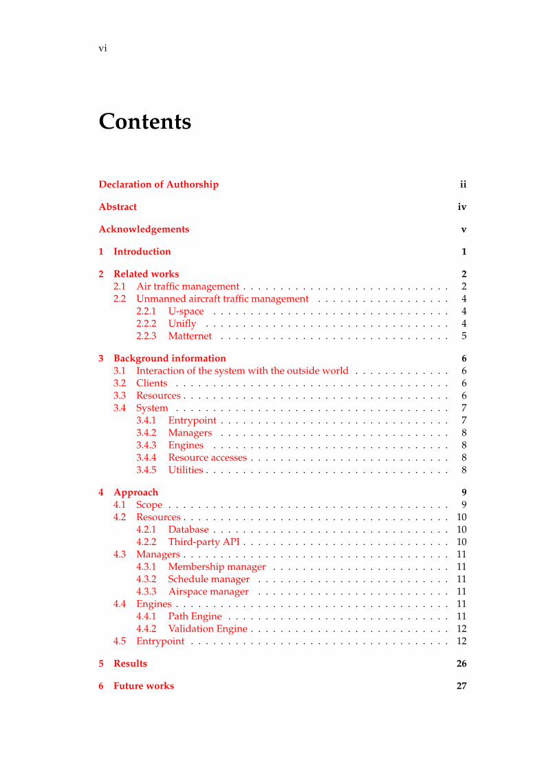
Contents
Declaration of Authorship ii
Abstract iv
Acknowledgements v
1 Introduction 1
2 Related works 22.1 Air traffic management . . . . . . . . . . . . . . . . . . . . . . . . . . . . 22.2 Unmanned aircraft traffic management . . . . . . . . . . . . . . . . . . 4
2.2.1 U-space . . . . . . . . . . . . . . . . . . . . . . . . . . . . . . . . 42.2.2 Unifly . . . . . . . . . . . . . . . . . . . . . . . . . . . . . . . . . 42.2.3 Matternet . . . . . . . . . . . . . . . . . . . . . . . . . . . . . . . 5
3 Background information 63.1 Interaction of the system with the outside world . . . . . . . . . . . . . 63.2 Clients . . . . . . . . . . . . . . . . . . . . . . . . . . . . . . . . . . . . . 63.3 Resources . . . . . . . . . . . . . . . . . . . . . . . . . . . . . . . . . . . . 63.4 System . . . . . . . . . . . . . . . . . . . . . . . . . . . . . . . . . . . . . 7
3.4.1 Entrypoint . . . . . . . . . . . . . . . . . . . . . . . . . . . . . . . 73.4.2 Managers . . . . . . . . . . . . . . . . . . . . . . . . . . . . . . . 83.4.3 Engines . . . . . . . . . . . . . . . . . . . . . . . . . . . . . . . . 83.4.4 Resource accesses . . . . . . . . . . . . . . . . . . . . . . . . . . . 83.4.5 Utilities . . . . . . . . . . . . . . . . . . . . . . . . . . . . . . . . . 8
4 Approach 94.1 Scope . . . . . . . . . . . . . . . . . . . . . . . . . . . . . . . . . . . . . . 94.2 Resources . . . . . . . . . . . . . . . . . . . . . . . . . . . . . . . . . . . . 10
4.2.1 Database . . . . . . . . . . . . . . . . . . . . . . . . . . . . . . . . 104.2.2 Third-party API . . . . . . . . . . . . . . . . . . . . . . . . . . . . 10
4.3 Managers . . . . . . . . . . . . . . . . . . . . . . . . . . . . . . . . . . . . 114.3.1 Membership manager . . . . . . . . . . . . . . . . . . . . . . . . 114.3.2 Schedule manager . . . . . . . . . . . . . . . . . . . . . . . . . . 114.3.3 Airspace manager . . . . . . . . . . . . . . . . . . . . . . . . . . 11
4.4 Engines . . . . . . . . . . . . . . . . . . . . . . . . . . . . . . . . . . . . . 114.4.1 Path Engine . . . . . . . . . . . . . . . . . . . . . . . . . . . . . . 114.4.2 Validation Engine . . . . . . . . . . . . . . . . . . . . . . . . . . . 12
4.5 Entrypoint . . . . . . . . . . . . . . . . . . . . . . . . . . . . . . . . . . . 12
5 Results 26
6 Future works 27

vii
Bibliography 28

viii
List of Figures
2.1 Modern Air Traffic Management [23] . . . . . . . . . . . . . . . . . . . . 22.2 Example of radar screen [11] . . . . . . . . . . . . . . . . . . . . . . . . . 32.3 Aircraft tracking [3] . . . . . . . . . . . . . . . . . . . . . . . . . . . . . 32.4 U-Space services [30] . . . . . . . . . . . . . . . . . . . . . . . . . . . . . 42.5 Unifly web application [31] . . . . . . . . . . . . . . . . . . . . . . . . . 5
3.1 Interaction of the system . . . . . . . . . . . . . . . . . . . . . . . . . . . 63.2 System layers . . . . . . . . . . . . . . . . . . . . . . . . . . . . . . . . . 7
4.1 Architecture of the system with involved agents . . . . . . . . . . . . . 94.2 Documents example . . . . . . . . . . . . . . . . . . . . . . . . . . . . . 104.3 Making hull to avoid NFZs . . . . . . . . . . . . . . . . . . . . . . . . . 124.4 C belongs to segment AB . . . . . . . . . . . . . . . . . . . . . . . . . . . 124.5 Create new user . . . . . . . . . . . . . . . . . . . . . . . . . . . . . . . . 144.6 User authentication . . . . . . . . . . . . . . . . . . . . . . . . . . . . . . 154.7 Get user’s drones . . . . . . . . . . . . . . . . . . . . . . . . . . . . . . . 164.8 Get information about all live drones . . . . . . . . . . . . . . . . . . . . 174.9 Get information about all flights . . . . . . . . . . . . . . . . . . . . . . 174.10 Create drone . . . . . . . . . . . . . . . . . . . . . . . . . . . . . . . . . . 184.11 Drone authentication for the flight . . . . . . . . . . . . . . . . . . . . . 194.12 Update information about location . . . . . . . . . . . . . . . . . . . . . 204.13 Get information about drone . . . . . . . . . . . . . . . . . . . . . . . . 214.14 Delete information about drone . . . . . . . . . . . . . . . . . . . . . . . 224.15 Create flight . . . . . . . . . . . . . . . . . . . . . . . . . . . . . . . . . . 234.16 Get information about flight . . . . . . . . . . . . . . . . . . . . . . . . . 244.17 Delete information about flight . . . . . . . . . . . . . . . . . . . . . . . 25
5.1 Path-building algorithm result . . . . . . . . . . . . . . . . . . . . . . . 26
ix
List of Abbreviations
JSON JavaScript Object NotationREST Representational State TransferAPI Application Programming InterfaceJWT JSON Web TokenSQL Structured Query LanguageORM Object-Relational MappingANSP Air Navigation Service ProviderATM Air Traffic ManagementNFZ Non-fly zone

1
Chapter 1
Introduction
The world is developing faster and faster nowadays. New technologies are replacingold ones each year. Opportunities for such new technologies appear as well.
Drones are incredibly popular: they are cheap, easy to come by, and fun to use.They can be used for all kinds of purposes, creating a whole field of new applicationsthat are rapidly expanding. International reports show [26] [9] [7] that drones willcreate a multi-billion dollar market with new jobs and opportunities for innovativecompanies, such as increasing market of delivery and other services (e. g. medicinetransportation). As the drone industry continues to grow, the number of dronesin the sky is expected to increase exponentially over the coming years. So, specialrules of traffic management should be implemented to complete the integration ofdrone traffic within the existing air traffic management (ATM) eco-system, as leftunchecked, these drones present a serious threat to manned aviation. As for now,there are described rules for unmanned aircraft airspace management and severalorganizations are on the way of implementing them, in particular, FAA (FederalAviation Administration) with NASA, SESAR Joint Undertaking.
2
Chapter 2
Related works
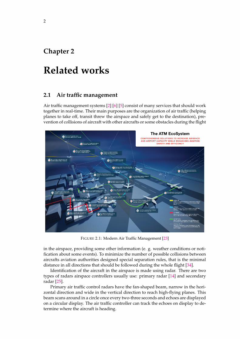
2.1 Air traffic management
Air traffic management systems [2] [6] [5] consist of many services that should worktogether in real-time. Their main purposes are the organization of air traffic (helpingplanes to take off, transit threw the airspace and safely get to the destination), pre-vention of collisions of aircraft with other aircrafts or some obstacles during the flight
FIGURE 2.1: Modern Air Traffic Management [23]
in the airspace, providing some other information (e. g. weather conditions or noti-fication about some events). To minimize the number of possible collisions betweenaircrafts aviation authorities designed special separation rules, that is the minimaldistance in all directions that should be followed during the whole flight [34].
Identification of the aircraft in the airspace is made using radar. There are twotypes of radars airspace controllers usually use: primary radar [14] and secondaryradar [25].
Primary air traffic control radars have the fan-shaped beam, narrow in the hori-zontal direction and wide in the vertical direction to reach high-flying planes. Thisbeam scans around in a circle once every two-three seconds and echoes are displayedon a circular display. The air traffic controller can track the echoes on display to de-termine where the aircraft is heading.

2.1. Air traffic management 3
FIGURE 2.2: Example of radar screen [11]
Secondary radar is partly a communication system between aircraft and air traf-fic controllers on the ground. A limited amount of information (e.g. aircraft heightand flight identification number) is requested by a controller on the ground and au-tomatically supplied by a transponder on the aircraft [17] [12]. This used to be calledidentification friend or foe, or IFF [20]. Secondary radar also acts as a radar systembecause the position of the aircraft is found by measuring the range (from the timedelay between request and reply) and the azimuth, as measured by an antenna onthe ground.
FIGURE 2.3: Aircraft tracking [3]
Nowadays, secondary radar is used more than the primary radar, because thereis a huge amount of planes in the airspace, so it is easier to communicate with themby means of secondary radar.
4 Chapter 2. Related works
2.2 Unmanned aircraft traffic management
As unmanned aviation (especially for delivering or long flights) is only becoming acommon thing, so rules for it are only in the developing stage. However, there areseveral companies that already develop ATM systems, but they are responsible forvery limited areas of applying.
2.2.1 U-space
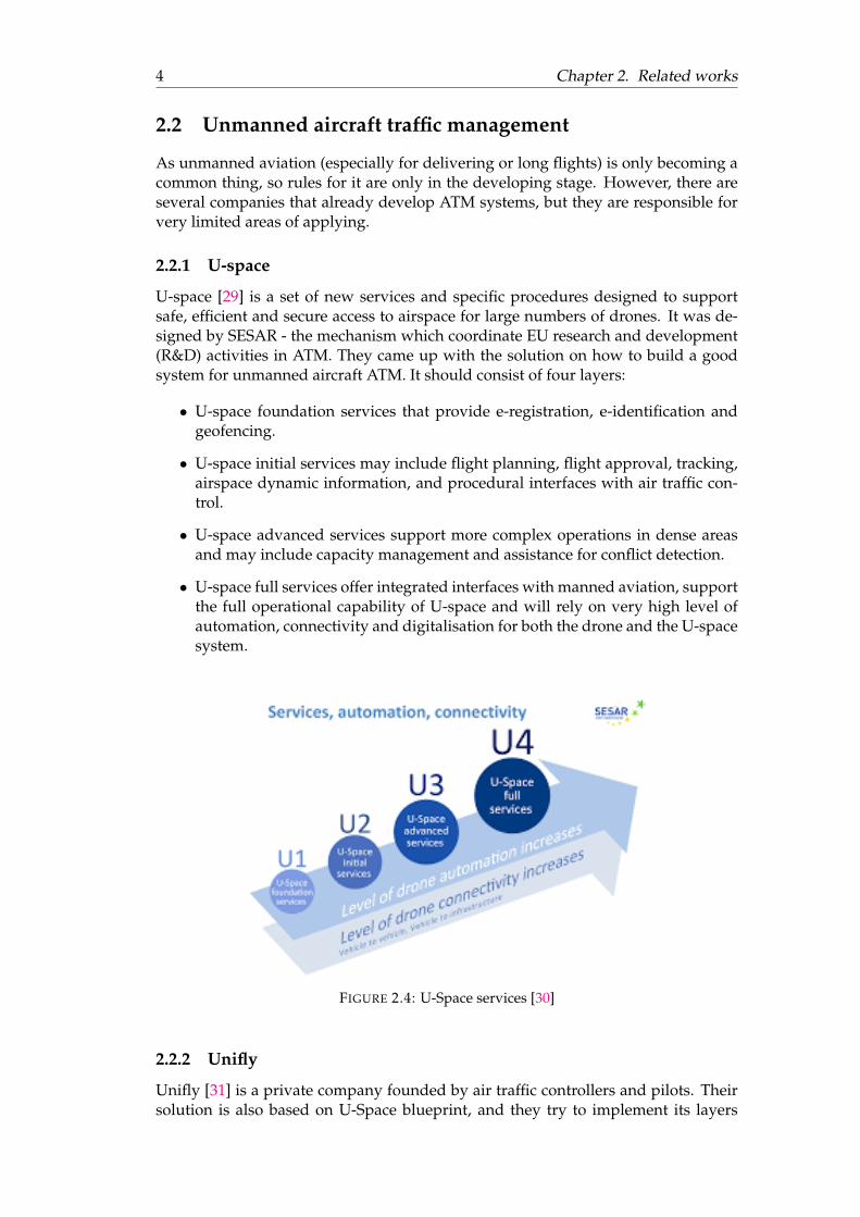
U-space [29] is a set of new services and specific procedures designed to supportsafe, efficient and secure access to airspace for large numbers of drones. It was de-signed by SESAR - the mechanism which coordinate EU research and development(R&D) activities in ATM. They came up with the solution on how to build a goodsystem for unmanned aircraft ATM. It should consist of four layers:
• U-space foundation services that provide e-registration, e-identification andgeofencing.
• U-space initial services may include flight planning, flight approval, tracking,airspace dynamic information, and procedural interfaces with air traffic con-trol.
• U-space advanced services support more complex operations in dense areasand may include capacity management and assistance for conflict detection.
• U-space full services offer integrated interfaces with manned aviation, supportthe full operational capability of U-space and will rely on very high level ofautomation, connectivity and digitalisation for both the drone and the U-spacesystem.
FIGURE 2.4: U-Space services [30]
2.2.2 Unifly
Unifly [31] is a private company founded by air traffic controllers and pilots. Theirsolution is also based on U-Space blueprint, and they try to implement its layers

2.2. Unmanned aircraft traffic management 5
step-by-step. For now, they developed an ecosystem that could work in Germany,Austria, Denmark and Belgium due to contracts with local ANSPs. Their solutionincludes Flight View module that designed to display both drone traffic and mannedtraffic on a UTM supervisor screen, Map Manager that allows managing geograph-ical data, Administration module allows the management of users or drones regis-tration, The Flight Approval module will confirm if the drone operation is allowedor not, etc. Also, they provide web and mobile applications for drone operators.
FIGURE 2.5: Unifly web application [31]
2.2.3 Matternet
One more example is Matternet [22]. This is a private company that develops sys-tem mainly for healthcare, but also e-commerce and logistic organizations. As in-stitutions in the medical domain sometimes urgently needed in some medicine oreven organ transportation to hospitals which are not provided with it at the moment- drone transportation could help in such transportation. Their solution includesMatternet M2 Drone, the Matternet Station and the Matternet Cloud Platform. TheStations are the endpoints for drone flights and work only with M2 Drones.

6
Chapter 3
Background information
3.1 Interaction of the system with the outside world
Our system is a server which aggregates the processing of all requests that wereaddressed to it, calculations and data transformations, all business logic and flows,accesses to needed data. The general flow of interaction between all needed partslooks like the following:
• some client sends the request to our system; each request corresponds to thespecific use case that should be done;
• based on given information there are some calculations or other actions basedon flow inside the system;
• if the given information is not enough - then the system will ask some dataresource to provide it;
• the client receives the corresponding response.
FIGURE 3.1: Interaction of the system
3.2 Clients
Our system is designed and built to be used by clients. Usually, in the web-applicationsfront-end part of the whole application is the main client. There are several ways toconnect the front-end and back-end parts of the application. The most common oneis REST using HTTP requests. Also, this way of communication with the servercould be used not only by front-end client but also by other clients (e.g. anotherserver that needs some data from our server). Clients that could probably use oursystem are officer portal (to check if the system is consistent) or drones themselves.As usually unmanned aircraft use GSM [10] or WiMAX [33] technologies as a wayof the communication, and therefore have access to the Internet, they could easilycommunicate with our system via it.
3.3 Resources
To function properly, our application should not only implement business logic anddo some calculations but also should have the ability to operate with some data.

3.4. System 7
These data could be obtained by sending requests and getting a response from otherservices by API or by connecting to some database server and getting data usingORM. Despite the fact databases are not part of the system, sometimes they couldbe developed and used by the same development team and mistakenly consideredas part of the system. In this case, they should also be considered as independentinstances.
3.4 System
During the system’s development, we should think about the separation of differentlogic parts, so changes in one part will not impact other parts. So, we have de-veloped the architecture of the system that consists of the following layers [18] [4]:entrypoint, managers, engines, resource accesses, utils. This type of decompositionis also called volatility-based decomposition. All parts of the systems encapsulatesome part of logic in themselves.
FIGURE 3.2: System layers
3.4.1 Entrypoint
Entrypoint stands for communication with clients. Web-portal for officer could com-municate with the system over REST API, while aircrafts could communicate overweb-sockets or use REST API as well. Other possible ways of communication arescheduled jobs, GUI. The way clients communicate with systems does not affect itsother parts. If we need to change the protocol of communication we simply replaceit with another library or framework, as the flows of business logic that will be calledfrom entrypoint will remain the same - we should only think of converting the resultto the appropriate format for the delivery mechanism.
8 Chapter 3. Background information
3.4.2 Managers
Managers encapsulate business logic or use cases in themselves. Each use case isconsisting of some other smaller activities. These activities, such as data transforma-tion, some calculations or data access, are located in other parts of the system thatwill be called by Manager.
Usually, there are several Managers in the system, and they stand for differentgroups of related use cases.
3.4.3 Engines
Engines encapsulate part of business logic in themselves, and they are mainly re-sponsible for calculations and data transformation. All such activities are groupedin different Engines by main activity of each Engine. If some extra data needed dur-ing the activity flow, then Engine calls corresponding Resource access.
3.4.4 Resource accesses
Resource accesses are adapters between the system and resources. This part of thesystem could be changed most frequently as we can change the database to store ourdata or data provider’s API, but our system should not be affected by these changes.
If some data is needed inside specific activity - Resource access could be calleddirectly from Engine. However, if a few consecutive activities will need these data,then Resource access could be called from the Manager.
3.4.5 Utilities
Utilities are the cross-system part that consists of additional packages, that does notrelate to business logic but provide additional services (e.g. logging).
9
Chapter 4
Approach
4.1 Scope
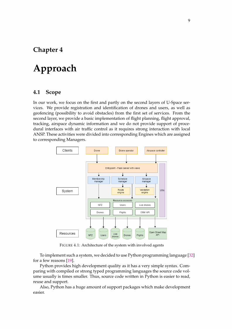
In our work, we focus on the first and partly on the second layers of U-Space ser-vices. We provide registration and identification of drones and users, as well asgeofencing (possibility to avoid obstacles) from the first set of services. From thesecond layer, we provide a basic implementation of flight planning, flight approval,tracking, airspace dynamic information and we do not provide support of proce-dural interfaces with air traffic control as it requires strong interaction with localANSP. These activities were divided into corresponding Engines which are assignedto corresponding Managers.
FIGURE 4.1: Architecture of the system with involved agents
To implement such a system, we decided to use Python programming language [32]for a few reasons [19].
Python provides high development quality as it has a very simple syntax. Com-paring with compiled or strong typed programming languages the source code vol-ume usually is times smaller. Thus, source code written in Python is easier to read,reuse and support.
Also, Python has a huge amount of support packages which make developmenteasier.

10 Chapter 4. Approach
4.2 Resources
4.2.1 Database
Most of our data is stored in MongoDB [15]. It is more convenient for our applicationfor a few reasons.
First of all, we store flights and non-fly zones in the database. Each flight pathand all non-fly zones are represented as the lists of coordinates. To represent themwell in SQL, we should use two schemas - for path/zone itself and all related co-ordinate points (connection 1-N). However, MongoDB is NoSQL [1] storage, whichworks with documents, represented in JSON objects, and it does not require the de-scription of such documents. So, we can simply create the specific key in such aJSON object with a list of coordinates as the corresponding value.
Also, MongoDB is known to be faster then SQL-based databases in some cases [24].It is an important aspect, as we have collection for unmanned aircrafts that are livein our airspace. We need to update their position and get it in almost real-time.However, it is not as fast as an in-memory database called Redis [16] which is alsoNoSQL storage, but this is a key-value store while MongoDB is a document store.Usually, it is used as cache as it holds data in RAM with the option to write data tothe database.
So, we decided to use MongoDB as a compromise decision between speed andusability aspects.
Collections in which we store documents:
FIGURE 4.2: Documents example
4.2.2 Third-party API
However, not all data needed for our system is located in the databases. Some partof our logic is related to geographical data. Nevertheless, there are cases when thesepieces of data are not coordinates of specific place themselves, but just a plain text -the name of some location. To deal with this problem, we use OpenStreetMap API.By giving the name of the location, it returns the exact geographical coordinates ofthat place.

4.3. Managers 11
4.3 Managers
As managers are part of the system that encapsulate business logic in themselves,and there are quite different use cases in the scope of our system - we decided togroup them into the following three managers.
4.3.1 Membership manager
Main manager use cases are registration and identification of users and drones. Reg-istration of the user is done by a unique username and password that will be hashed.During authentication, the user will send their username and password and basedon these data, JWT will be generated. This token then will be sent back and can beused to make requests related to operations with drones.
Registration of drone could be done by the user after authentication step, andthen it will be linked to this user in the database.
4.3.2 Schedule manager
The main goal of this manager’s use cases is everything related to flight planning.When the user is planning to establish the flight they give all needed information,that is information about start and end points of the flight (these points could be incoordinates notation or in place’s name notation that will be converted to coordi-nates one), information about the time when a flight should take place and one ofthe drones that are registered by this user.
4.3.3 Airspace manager
This manager is responsible for live airspace events. Authentication of the drone be-fore the beginning of the flight should take place with JWT issued to the user before.If the system does not find a connection between the user and drone - flight mightnot be started. Moreover, during the flight drone should regularly send informationabout its current position in the airspace, that is latitude, longitude and height.
4.4 Engines
To make the application flexible and decomposed, we identified two Engines in ourarchitecture. They encapsulate parts of calculation logic inside themselves in sucha way that changes in one engine will not affect the functionality of other engines.Changes in resource accesses that are used inside engines and changes in managersthat call specific engine will not affect the engine, as well.
4.4.1 Path Engine
The main goal of this engine is to build the path by given route, where the route iscoordinates of the start and the end, while the path is a sequence of adjacent coor-dinate points. Using appropriate resource accesses it can operate with such data asa list of NFZs to build path correctly and flights that are compatible with the givenflight.
To build a path we applied an algorithm that first checks if there any NFZs (redrectangles on Figure 4.3) intersecting direct segment (grey line on Figure 4.3) from

12 Chapter 4. Approach
start point to the end point (black dots on Figure 4.3). To achieve this, we use cal-culations in 2D space, as we assume that flights will not be too long in the distanceand the sphericity of the Earth will not have an effect on calculations. Then we use afunction that calculates the convex hull [8] of all point of all NFZs that are betweenroute points to find the convex ways (green lines on Figure 4.3) that will not intersectwith any of given NFZ. Then we select the shorter of the convex ways (green linebeneath the level of grey line on Figure 4.3) Although, this algorithm will work ex-cellently in most situations, it is not 100% accurate and could show the worse resultin edge situations.
FIGURE 4.3: Making hull to avoid NFZs
Also, in this engine, there are checks if the flight with this path could be allowedto be done. For example, if the length of the flight’s path is shorter then maximumdistance drone assigned to this flight could cover (the length of the path is calculatedby summing length of segments the path consist of; length of each segment is cal-culated using Vincenty’s method [28]); or if this flight’s path does not intersect withother flights’ paths in a given area at the same point of time.
4.4.2 Validation Engine
The main purpose of this engine is to validate the state of the drone in the liveairspace. First of all, there is a regular check of the time when specific unmannedaircraft has sent its data. If the time value extends the threshold - the system willchange the status of this drone. Also, there is a validation if the drone is keep go-ing in his way and has not deviated from the right direction. We can calculate it bychecking firstly if segment and point are aligned using vector cross product [27] andif so, whether it belongs to the segment or not (Figure 4.4).
FIGURE 4.4: C belongs to segment AB
4.5 Entrypoint
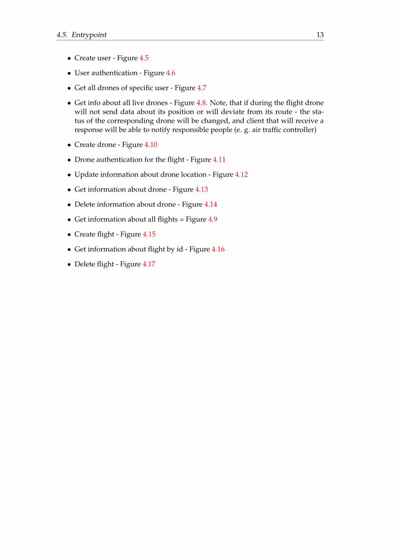
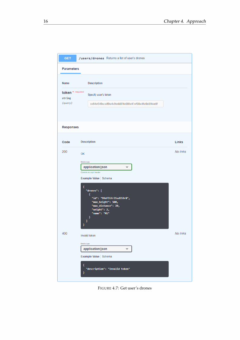
For communication with clients, we provide API. All information about correspond-ing requests and responses they provide could be found in the Figures:
4.5. Entrypoint 13
• Create user - Figure 4.5
• User authentication - Figure 4.6
• Get all drones of specific user - Figure 4.7
• Get info about all live drones - Figure 4.8. Note, that if during the flight dronewill not send data about its position or will deviate from its route - the sta-tus of the corresponding drone will be changed, and client that will receive aresponse will be able to notify responsible people (e. g. air traffic controller)
• Create drone - Figure 4.10
• Drone authentication for the flight - Figure 4.11
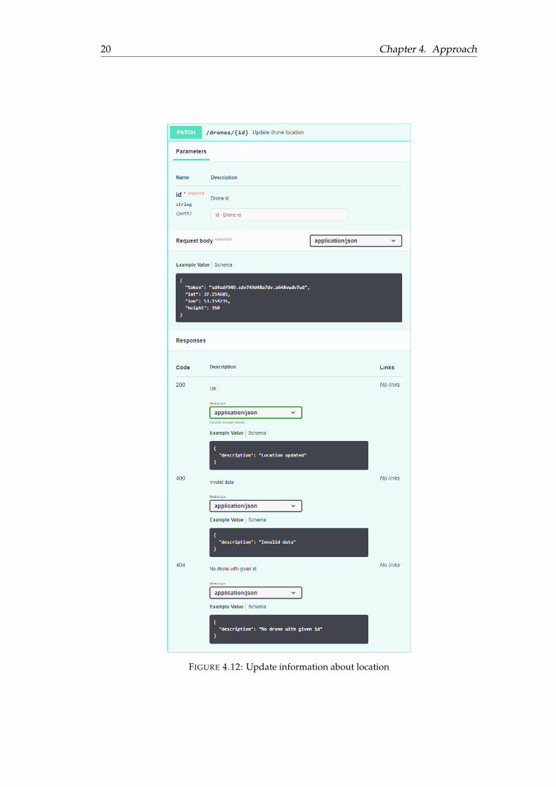
• Update information about drone location - Figure 4.12
• Get information about drone - Figure 4.13
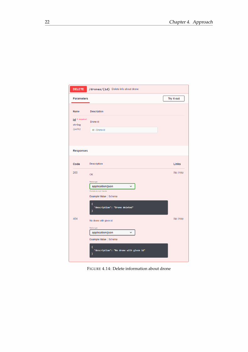
• Delete information about drone - Figure 4.14
• Get information about all flights = Figure 4.9
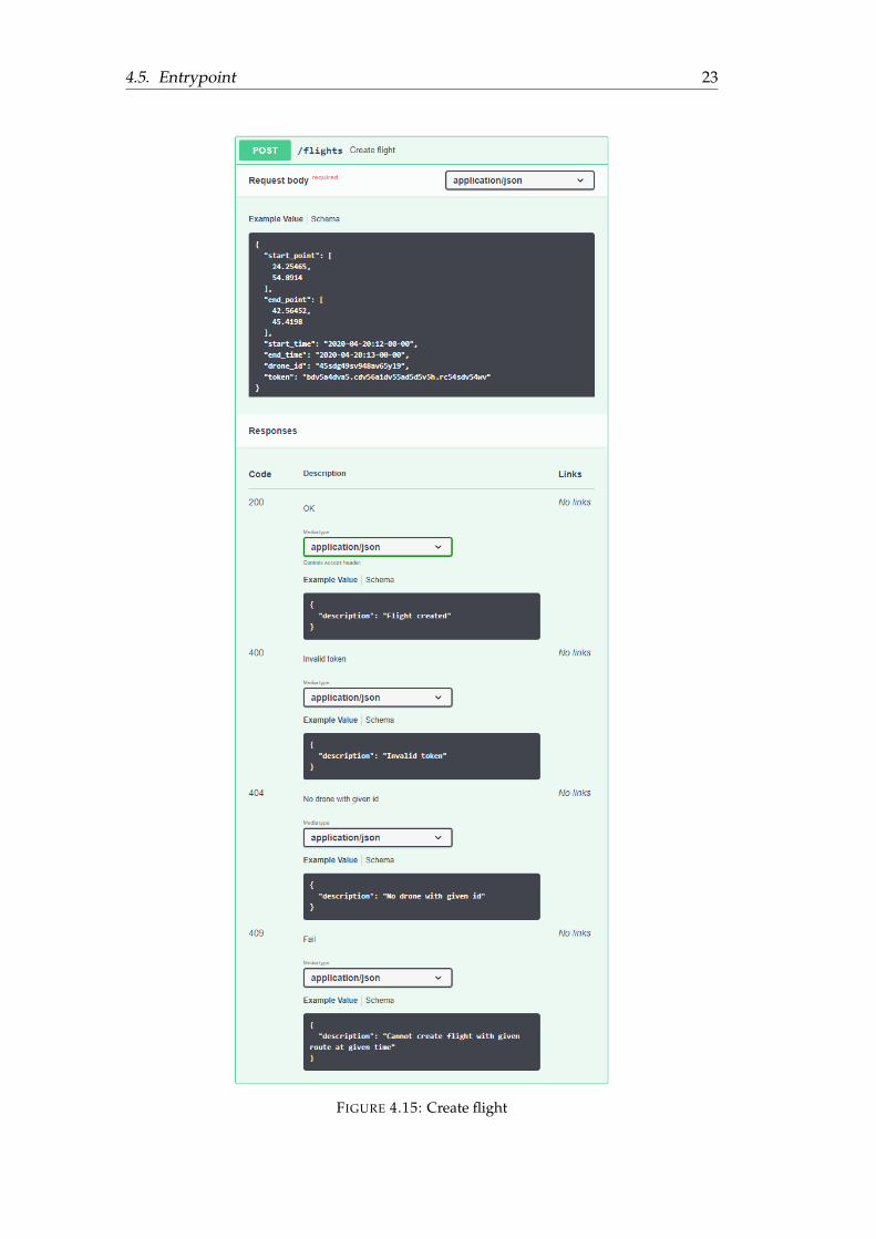
• Create flight - Figure 4.15
• Get information about flight by id - Figure 4.16
• Delete flight - Figure 4.17

14 Chapter 4. Approach
FIGURE 4.5: Create new user

4.5. Entrypoint 15
FIGURE 4.6: User authentication
16 Chapter 4. Approach
FIGURE 4.7: Get user’s drones

4.5. Entrypoint 17
FIGURE 4.8: Get information about all live drones
FIGURE 4.9: Get information about all flights

18 Chapter 4. Approach
FIGURE 4.10: Create drone

4.5. Entrypoint 19
FIGURE 4.11: Drone authentication for the flight
20 Chapter 4. Approach
FIGURE 4.12: Update information about location

4.5. Entrypoint 21
FIGURE 4.13: Get information about drone
22 Chapter 4. Approach
FIGURE 4.14: Delete information about drone
4.5. Entrypoint 23
FIGURE 4.15: Create flight

24 Chapter 4. Approach
FIGURE 4.16: Get information about flight

4.5. Entrypoint 25
FIGURE 4.17: Delete information about flight
26
Chapter 5
Results
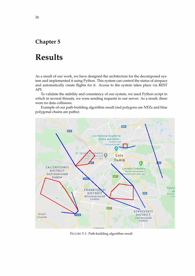
As a result of our work, we have designed the architecture for the decomposed sys-tem and implemented it using Python. This system can control the status of airspaceand automatically create flights for it. Access to the system takes place via RESTAPI.
To validate the stability and consistency of our system, we used Python script inwhich in several threads, we were sending requests to our server. As a result, therewere no data collisions.
Example of our path-building algorithm result (red polygons are NFZs and bluepolygonal chains are paths):
FIGURE 5.1: Path-building algorithm result

27
Chapter 6
Future works
As next steps, we could try to establish a front-end part for our system with thedrone operator and air space controller portals. Drone operator on such portal couldregister drones and establish flights for them while the controller will have the abilityto monitor the state of the live airspace.
One more point to improve is our path-building algorithm as it does not guar-antee 100% accuracy. The possible solutions could be Dijkstra’s Shortest Path Firstalgorithm [21] or A* search algorithm [13].

28
Bibliography
[1] Khaleel Ahmad and Mohd Javed. “Hands-On Redis”. In: NoSQL: Database forStorage and Retrieval of Data in Cloud. Chapman and Hall/CRC, 2017, pp. 355–364. DOI: 10.1201/9781315155579- 21. URL: https://doi.org/10.1201%2F9781315155579-21.
[2] “Air traffic management”. In: Aircraft Engineering and Aerospace Technology 74.5(2002). DOI: 10.1108/aeat.2002.12774eab.044. URL: https://doi.org/10.1108%2Faeat.2002.12774eab.044.
[3] Aircraft tracking. URL: https://ichef.bbci.co.uk/news/660/media/images/73552000/gif/_73552365_boeing777_malaysianflight_624gr_v3.gif.
[4] Mattia Battiston. Clean Architecture. Github. 2016. URL: https://github.com/mattia-battiston/clean-architecture-example.
[5] Lucio Bianco and Maurizio Bielli. “Air traffic management: Optimization mod-els and algorithms”. In: Journal of Advanced Transportation 26.2 (1992), pp. 131–167. DOI: 10.1002/atr.5670260205. eprint: https://onlinelibrary.wiley.com/doi/pdf/10.1002/atr.5670260205. URL: https://onlinelibrary.wiley.com/doi/abs/10.1002/atr.5670260205.
[6] Robert Caves and Cheng-Lung Wu. “Research review of air traffic manage-ment”. In: Transport Reviews - TRANSP REV 22 (Jan. 2002), pp. 115–132. DOI:10.1080/01441640110074773.
[7] Commercial Unmanned Aerial Vehicle (UAV) Market Analysis – Industry trends,forecasts and companies. 2020. URL: https : / / www . businessinsider . com /commercial-uav-market-analysis.
[8] Convex Hull. 2007. DOI: 10.3840/000404. URL: https://doi.org/10.3840%2F000404.
[9] Drone market outlook: industry growth trends, market stats and forecast. 2020. URL:https://www.businessinsider.com/drone-industry-analysis-market-trends-growth-forecasts.
[10] Philippe Dupuis. “Consolidating GSM Phase 1 and Evolving the Services andFeatures to GSM Phase 2 in ETSI SMG (1992–1995)”. In: GSM and UMTS. JohnWiley & Sons, Ltd, pp. 61–71. DOI: 10.1002/0470845546.ch4. URL: https://doi.org/10.1002%2F0470845546.ch4.
[11] Example of radar screen. URL: https://ak.picdn.net/shutterstock/videos/6657959/thumb/1.jpg.
[12] “General aviation transponder”. In: Aircraft Engineering and Aerospace Technol-ogy 78.5 (2006). DOI: 10.1108/aeat.2006.12778eab.014. URL: https://doi.org/10.1108%2Faeat.2006.12778eab.014.
[13] P. E. Hart, N. J. Nilsson, and B. Raphael. “A Formal Basis for the Heuristic De-termination of Minimum Cost Paths”. In: IEEE Transactions on Systems Scienceand Cybernetics 4.2 (1968), pp. 100–107. ISSN: 2168-2887. DOI: 10.1109/TSSC.1968.300136.

Bibliography 29
[14] Thomas Huber-Obst. “Target filtering for military ATC primary radar”. In:2018 19th International Radar Symposium (IRS). IEEE, 2018. DOI: 10.23919/irs.2018.8448061. URL: https://doi.org/10.23919%2Firs.2018.8448061.
[15] “Introduction to MongoDB”. In: The Definitive Guide to MongoDB. Apress, 2010,pp. 3–17. DOI: 10.1007/978-1-4302-3052-6_1. URL: https://doi.org/10.1007%2F978-1-4302-3052-6_1.
[16] Gurpreet Kaur and Jatinder Kaur. “In-Memory Data processing using RedisDatabase”. In: International Journal of Computer Applications 180.25 (2018), pp. 26–31. DOI: 10.5120/ijca2018916589. URL: https://doi.org/10.5120%2Fijca2018916589.
[17] H. Lans. “A GPS/GNSS transponder for use in aircraft”. In: Proceedings ofVNIS 93 - Vehicle Navigation and Information Systems Conference. IEEE. DOI:10.1109/vnis.1993.585731. URL: https://doi.org/10.1109%2Fvnis.1993.585731.
[18] J. Lowy. Righting Software. Addison Wesley, 2019. ISBN: 9780136524038. URL:https://books.google.com.ua/books?id=boT4xgEACAAJ.
[19] M. Lutz and an O’Reilly Media Company Safari. Learning Python, 5th Edition.O’Reilly Media, Incorporated, 2013. URL: https://books.google.com.ua/books?id=LWM6zQEACAAJ.
[20] Daniel L. Magruder. Counterinsurgency, Security Forces, and the IdentificationProblem. Routledge, 2017. DOI: 10.4324/9781315202341. URL: https://doi.org/10.4324%2F9781315202341.
[21] Neha Makariye. “Towards shortest path computation using Dijkstra algorithm”.In: 2017 International Conference on IoT and Application (ICIOT). IEEE, 2017. DOI:10.1109/iciota.2017.8073641. URL: https://doi.org/10.1109%2Ficiota.2017.8073641.
[22] Matternet. 2020. URL: https://mttr.net/.
[23] Modern air traffic management. URL: https://upload.wikimedia.org/wikipedia/commons/c/c5/Air_Traffic_Management.jpg.
[24] MongoDB vs. MySQL. URL: https://www.mongodb.com/compare/mongodb-mysql.
[25] “Secondary surveillance radar”. In: Understanding Radar Systems. Institution ofEngineering and Technology, pp. 159–170. DOI: 10.1049/sbra034e_ch7. URL:https://doi.org/10.1049%2Fsbra034e_ch7.
[26] The Drone Market Report 2019: Commercial Drone Market Size and Forecast (2019-2024). 2019. URL: https://www.researchandmarkets.com/reports/4764173/the-drone-market-report-2019-commercial-drone.
[27] “The Vector Cross Product”. In: Rotating Flow. Elsevier, 2011, pp. 373–375. DOI:10.1016/b978-0-12-382098-3.00015-9. URL: https://doi.org/10.1016%2Fb978-0-12-382098-3.00015-9.
[28] C. M. Thomas and W. E. Featherstone. “Validation of Vincenty’s Formulas forthe Geodesic Using a New Fourth-Order Extension of Kivioja’s Formula”. In:Journal of Surveying Engineering 131.1 (2005), pp. 20–26. DOI: 10.1061/(asce)0733-9453(2005)131:1(20). URL: https://doi.org/10.1061%2F%28asce%290733-9453%282005%29131%3A1%2820%29.
[29] U-space : blueprint. Luxembourg: Publications Office of the European Union,2017. ISBN: 978-92-9216-087-6.

30 Bibliography
[30] U-Space services. URL: https://www.aerosociety.com/media/7267/u-space-blueprint-to-reality.pdf.
[31] Unifly. 2020. URL: https://www.unifly.aero/solutions/unmanned-traffic-management.
[32] Guido Van Rossum and Fred L. Drake. Python 3 Reference Manual. Scotts Valley,CA: CreateSpace, 2009. ISBN: 1441412697.
[33] “WiMAX Architecture”. In: WiMAX. John Wiley & Sons, Ltd, pp. 207–217.DOI: 10 . 1002 / 9780470319055 . ch13. URL: https : / / doi . org / 10 . 1002 %2F9780470319055.ch13.
[34] Zhao Ning Zhang, Zhen Liu, and Dong Man Zhang. “Research on the LatestManeuver Moment of Aircraft and the Minimum Safety Distance between Air-crafts in Free Flight”. In: Applied Mechanics and Materials 538 (2014), pp. 134–145. DOI: 10.4028/www.scientific.net/amm.538.134. URL: https://doi.org/10.4028%2Fwww.scientific.net%2Famm.538.134.
Related Documents