Development of a Seismic Microzoning Map for Lima City and Callao, Peru Paper: Development of a Seismic Microzoning Map for Lima City and Callao, Peru Diana Calderon ∗ , Zenon Aguilar ∗ , Fernando Lazares ∗ , Silvia Alarcon ∗ , and Selene Quispe ∗∗ ∗ Japan Peru Center for Earthquake Engineering and Disaster Mitigation (CISMID), Faculty of Civil Engineering, National University of Engineering Av. Tupac Amaru No 1150, Lima 25, Peru E-mail: [email protected] ∗∗ Department of Environmental Science and Technology, TokyoInstitute of Technology, Kanagawa, Japan [Received September 4, 2014; accepted October 10, 2014] The location of Lima city and El Callao in the Pa- cific coast and the long history of seismic activity were the main reasons to develop a seismic micro- zoning map. The microzoning study was based on large numbers of geotechnical and geophysical explo- ration points distributed around the study area. The geotechnical exploration consisted of borehole tests and pits, from which soil samples were taken to the laboratory to determine the soil mechanical character- istics. The geophysical exploration consisted of one- point microtremor measurements and various meth- ods to estimate the S-wave velocity profile. The re- sults of both, the geotechnical and geophysical explo- ration were combined to develop a seismic microzon- ing map for Lima city and El Callao. This map shows five zones, where the zone with the best soil mechanical and dynamic characteristics covers most of the study area. Keywords: borehole tests, microtremor, S-wave velocity profiles, microzoning map 1. Introduction Lima city and Callao, the capital and the Constitutional Province of Peru respectively, are constantly exposed to earthquakes due to their location in the circum-Pacific seismic belt. The last large seismic event in the city oc- curred in 1974, when an earthquake of magnitude M w 8.0 hit the coast of Lima and Callao, causing severe damage in the buildings of Callao, Chorrillos, La Punta and La Molina districts. The damage was related to amplification of incident seismic waves by the local surface-soil condi- tions and the depth of the water table. By the time of the earthquake, few districts were pop- ulated; as a result, the seismic response of the non- populated areas remained unknown. During the last three to four decades, the city started to experience a large urbanization process, which took place in an informal way. In consequence, a large number of houses were built in non-suitable soils from the engineer- ing point of view. This problem was regarded to informality, to the inde- cision of local authorities, and to the lack of a detailed seismic microzoning studies. The first seismic microzoning study in the area dates from 1991, when Huaman developed a map for La Punta and El Callao districts. This study consisted of geotech- nical exploration by borehole tests and single point mi- crotremor measurements. From 2003 to 2005, CISMID was in charge of develop- ing a microzoning study in forty-two districts of Lima and Callao. New technology and data processing techniques were introduced by that time, such as velocity sensors, specially designed to measure microtremors. The result was a seismic microzoning map of almost all the area of Lima city and Callao. The resulting map divided the area of study into five zones that describe the geotechnical and dynamic charac- teristics of soils. From 2010, an effort to update the microzoning map of Lima and Callao was carried out in the framework of the SATREPS (Enhancement of Earthquake and Tsunami Disaster Mitigation Technology in Peru) Project. The update of the microzoning map was possible not only by increasing the number of exploration points, but also by introducing various surface wave exploration tech- niques in order to estimate the S-wave velocity profiles up to the basement rock. 2. Seismicity of the Study Area Lima city and Callao are the target area of this study. The first one is the capital of Peru, and is located in the central coast of the country; it is also, where approxi- mately one third of the country’s population lives. Callao, is the Constitutional Province of Peru, and is located just next to Lima bordering the Pacific Ocean. Currently, Lima city and Callao together are divided in forty nine districts; the majority of which belong to Journal of Disaster Research Vol.9 No.6, 2014 939

Welcome message from author
This document is posted to help you gain knowledge. Please leave a comment to let me know what you think about it! Share it to your friends and learn new things together.
Transcript

Development of a Seismic Microzoning Map for Lima City andCallao, Peru
Paper:
Development of a Seismic Microzoning Map forLima City and Callao, Peru
Diana Calderon∗, Zenon Aguilar∗, Fernando Lazares∗,Silvia Alarcon∗, and Selene Quispe∗∗
∗Japan Peru Center for Earthquake Engineering and Disaster Mitigation (CISMID),Faculty of Civil Engineering, National University of Engineering
Av. Tupac Amaru No 1150, Lima 25, PeruE-mail: [email protected]
∗∗Department of Environmental Science and Technology, Tokyo Institute of Technology, Kanagawa, Japan[Received September 4, 2014; accepted October 10, 2014]
The location of Lima city and El Callao in the Pa-cific coast and the long history of seismic activitywere the main reasons to develop a seismic micro-zoning map. The microzoning study was based onlarge numbers of geotechnical and geophysical explo-ration points distributed around the study area. Thegeotechnical exploration consisted of borehole testsand pits, from which soil samples were taken to thelaboratory to determine the soil mechanical character-istics. The geophysical exploration consisted of one-point microtremor measurements and various meth-ods to estimate the S-wave velocity profile. The re-sults of both, the geotechnical and geophysical explo-ration were combined to develop a seismic microzon-ing map for Lima city and El Callao. This map showsfive zones, where the zone with the best soil mechanicaland dynamic characteristics covers most of the studyarea.
Keywords: borehole tests, microtremor, S-wave velocityprofiles, microzoning map
1. Introduction
Lima city and Callao, the capital and the ConstitutionalProvince of Peru respectively, are constantly exposed toearthquakes due to their location in the circum-Pacificseismic belt. The last large seismic event in the city oc-curred in 1974, when an earthquake of magnitude Mw8.0hit the coast of Lima and Callao, causing severe damagein the buildings of Callao, Chorrillos, La Punta and LaMolina districts. The damage was related to amplificationof incident seismic waves by the local surface-soil condi-tions and the depth of the water table.
By the time of the earthquake, few districts were pop-ulated; as a result, the seismic response of the non-populated areas remained unknown.
During the last three to four decades, the city started toexperience a large urbanization process, which took placein an informal way. In consequence, a large number of
houses were built in non-suitable soils from the engineer-ing point of view.
This problem was regarded to informality, to the inde-cision of local authorities, and to the lack of a detailedseismic microzoning studies.
The first seismic microzoning study in the area datesfrom 1991, when Huaman developed a map for La Puntaand El Callao districts. This study consisted of geotech-nical exploration by borehole tests and single point mi-crotremor measurements.
From 2003 to 2005, CISMID was in charge of develop-ing a microzoning study in forty-two districts of Lima andCallao. New technology and data processing techniqueswere introduced by that time, such as velocity sensors,specially designed to measure microtremors. The resultwas a seismic microzoning map of almost all the area ofLima city and Callao.
The resulting map divided the area of study into fivezones that describe the geotechnical and dynamic charac-teristics of soils.
From 2010, an effort to update the microzoning mapof Lima and Callao was carried out in the framework ofthe SATREPS (Enhancement of Earthquake and TsunamiDisaster Mitigation Technology in Peru) Project.
The update of the microzoning map was possible notonly by increasing the number of exploration points, butalso by introducing various surface wave exploration tech-niques in order to estimate the S-wave velocity profiles upto the basement rock.
2. Seismicity of the Study Area
Lima city and Callao are the target area of this study.The first one is the capital of Peru, and is located in thecentral coast of the country; it is also, where approxi-mately one third of the country’s population lives. Callao,is the Constitutional Province of Peru, and is located justnext to Lima bordering the Pacific Ocean.
Currently, Lima city and Callao together are dividedin forty nine districts; the majority of which belong to
Journal of Disaster Research Vol.9 No.6, 2014 939
Calderon, D. et al.
Lima. By this moment, forty three districts out of fortynine districts were studied for microzoning purposes.
The most notable earthquakes that affected Lima andCallao from 1523 to 1974 are listed in a technical re-port [1]. From the list mentioned before, strong groundmotion with short and long duration, different intensities,and different frequency content were reported. Accordingto this list, the maximum intensity observed in Lima wasX MMI; and the predominant period for central Lima wasabout 0.1 seconds. Damage was observed in Callao, LaMolina and Chorrillos district mainly.
It is important to notice that the last strong earthquakereported in Lima was the October 3, 1974; and that sincethen, more than thirty years have passed, increasing theprobability of a seismic event occurrence. According toPulido et al. [2] a Mw8.9 earthquake is expected to occurin central coast of Peru that will hit directly to Lima City.
3. Geology and Geomorphology
The geology of the Lima region reflects the subductionof the Nazca Plate under the South American Plate, andthe consequent uplift and volcanic activity [3].
Sedimentary and intrusive rocks, as well as, unconsoli-dated deposits are part of the geologic units of Lima.
Rocks of sedimentary-volcanic origin, placed duringthe Late Jurassic to Cretaceous periods, are found mainlyin the northern part of the city. To the East, parallel to thecoast, intrusive rocks that belong to the coastal batholithspread as pulsations forming individual bodies of mag-matic mass.
The unconsolidated deposits are from the quaternaryperiod, and consist of alluvial, colluvial, marine and eo-lian deposits. Fig. 1 shows that the majority of themetropolitan area is built on the alluvial deposit that wasoriginated by the Chillon and Rimac rivers, that eroded,transported and deposited the sediments in their path. Thealluvial deposits consist of gravel, with boulders of 20 cmin the center of the city and of up to 60 cm in the east. Thesand as well as the silt-clay material creates lenses withinthe gravels. Occasionally, isolated areas of organic soil ofmore than two meters depth appears. Along the coastalcliffs the poor horizontal stratification of the debris can beobserved through the effects of erosion.
The depth of the alluvial deposits can be expected to befrom 400 to 600 m for the area of the alluvial cone of theChillon River; and the depth of the alluvial deposit fromthe Rimac River is about 200 m.
Besides the alluvial deposits, there are also marine de-posits. These are relatively new-sand deposits, createdthrough the erosive action of the ocean’s waves and cur-rents. Furthermore, the more recent eolian deposits aregenerally found in the areas of the alluvial cones of theRimac and Chillon rivers [6].
Fig. 1. Geology of Lima [4] and [5].
4. Geotechnical Aspects
In order to evaluate the geotechnical characteristics ofthe foundation soil at Lima city, exploration campaignswere carried out. The campaigns consisted of direct ex-ploration through borehole tests.
Soil samples were taken during the exploration and sentto a geotechnical laboratory where various tests were con-ducted. The results allowed describing soil profiles thatdefine the conditions of specific areas.
4.1. Soil Exploration CampaignsInformation regarding the soil profile of Lima city
was collected from different sources. The main sourceswere engineering consulting companies that developedgeotechnical studies in the districts. The National Waterand Sewer Company was another source.
In addition to the gathered information, explorationcampaigns were performed. The campaigns were carriedout by districts, and the type of exploration was decidedbased on the soil conditions of the site.
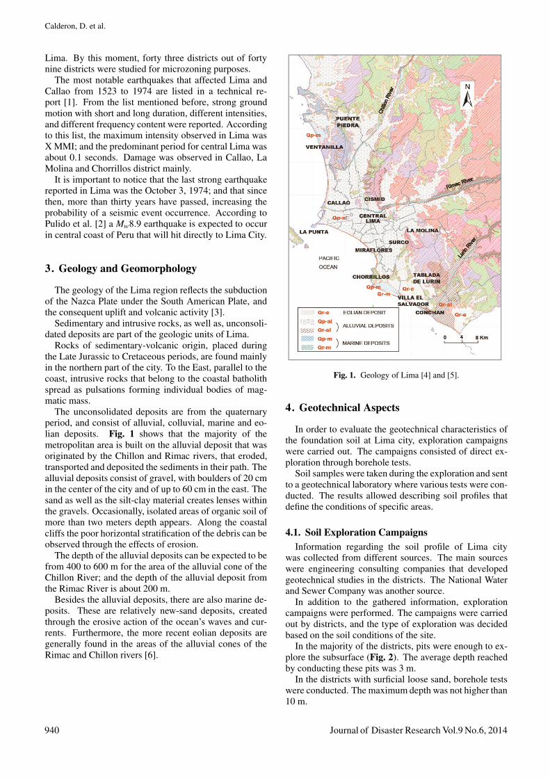
In the majority of the districts, pits were enough to ex-plore the subsurface (Fig. 2). The average depth reachedby conducting these pits was 3 m.
In the districts with surficial loose sand, borehole testswere conducted. The maximum depth was not higher than10 m.
940 Journal of Disaster Research Vol.9 No.6, 2014
Development of a Seismic Microzoning Map for Lima City andCallao, Peru
Fig. 2. Borehole at the independencia district.
4.2. Laboratory TestsThe soil samples obtained from the soil exploration
were tested in a geotechnical laboratory. Standard andspecial tests were carried out with the samples; the type oftest was chosen according to the soil characteristics foundin the visual inspection during the soil exploration. Stan-dard tests were applied to disturbed samples following theUnified Soil Classification System (USCS).
4.3. Material TypesBased on the information obtained from previous col-
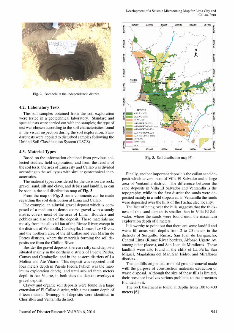
lected studies, field exploration, and from the results ofthe soil tests, the area of Lima city and Callao was dividedaccording to the soil types with similar geotechnical char-acteristics.
The material types considered for the division are rock,gravel, sand, silt and clays, and debris and landfill, as canbe seen in the soil distribution map of Fig. 3.
From the map of Fig. 3 some comments can be maderegarding the soil distribution at Lima and Callao.
For example, an alluvial gravel deposit which is com-posed of a medium to dense coarse gravel with a sandymatrix covers most of the area of Lima. Boulders andpebbles are also part of the deposit. These materials aremostly from the alluvial fan of the Rimac River; except inthe districts of Ventanilla, Carabayllo, Comas, Los Olivos,and the northern area of the El Callao and San Martin dePorres districts, where the materials forming the soil de-posits are from the Chillon River.
Besides the gravel deposits, there are silty sand depositssituated mainly in the northern districts of Puente Piedra,Comas and Carabayllo; and in the eastern districts of LaMolina and Ate Vitarte. This deposit was reported untilfour meters depth in Puente Piedra (which was the max-imum exploration depth), and until around three metersdepth in Ate Vitarte, in both sites the deposit overlays agravel deposit.
Clayey and organic soil deposits were found in a largeextension of El Callao district, with a maximum depth offifteen meters. Swampy soil deposits were identified inChorrillos and Ventanilla district.
Fig. 3. Soil distribution map [6].
Finally, another important deposit is the eolian sand de-posit which covers most of Villa El Salvador and a largearea of Ventanilla district. The difference between thesand deposits in Villa El Salvador and Ventanilla is thetopography, while in the first district the sands were de-posited mainly in a mild slope area, in Ventanilla the sandswere deposited over the hills of the Pachacutec locality.
The fact of being over the hills suggests that the thick-ness of this sand deposit is smaller than in Villa El Sal-vador, where the sands were found until the maximumexploration depth of 8 meters.
It is worthy to point out that there are some landfill andwaste fill areas with depths from 2 to 20 meters in thedistricts of Surquillo, Rimac, San Juan de Lurigancho,Central Lima (Rimac River borders, Alfonso Ugarte Av.among other places), and San Juan de Miraflores. Theselandfills were also found in the cliffs of La Perla, SanMiguel, Magdalena del Mar, San Isidro, and Mirafloresdistricts.
The landfills originated from old ground removal madewith the purpose of construction materials extraction orwaste disposal. Although the size of these fills is limited,their presence involves serious problems to the structuresfounded on it.
The rock basement is found at depths from 100 to 400meters [6].
Journal of Disaster Research Vol.9 No.6, 2014 941
Calderon, D. et al.
4.4. Geotechnical Microzoning MapThe area of Lima city was divided in zones according
to the geotechnical characteristics of the soils. The pur-pose of this grouping is to develop a map that allows toidentify the most convenient and inconvenient zones forsoil foundation of common structures.
The allowable bearing capacity was estimated at eachzone. This parameter was calculated for a typical build-ing with a strip foundation of 0.60 m width and with aminimum foundation depth of 0.80 m. The bearing ca-pacity theory proposed by Terzaghi was applied with thebearing capacity factors proposed by Vesic.
In all the zones, foundations must rest over the naturalsoil deposits and not over landfills.
5. Dynamic Characteristics
The dynamic analysis of the soils is a fundamental toolin the microzoning study because it allows determiningthe seismic soil response.
5.1. Calculation of the Fundamental Period of Vi-bration
The period of vibration is a dynamic parameter that de-fines the seismic soil response.
Researchers agree that the fundamental period of vibra-tion of the soils can be determined by microtremor mea-surements. Microtremors are defined as ambient or noisevibration [7] and [8]. These vibrations contain Rayleighand Love waves that are affected by the geological struc-ture of the site where they are measured [9].
In 1989, Nakamura [10] developed a method to cal-culate the fundamental period of vibration of soils frommicrotremor records. The method, often called the H/Vspectrum method, consists of the division of the horizon-tal Fourier component with the vertical Fourier compo-nent. The fundamental period is the period correspondentto the maximum value of the H/V spectrum.
5.1.1. One-Point Microtremor Measurement Cam-paigns
The first attempts to measure microtremors in the studyarea started in 1991, when Huaman conducted surveys inEl Callao district [11].
From 2003 to 2005 CISMID carried out microtremorsmeasurement campaigns massively in the study as part ofthe microzoning project APESEG.
Finally, from 2010 up to now, in the framework of theSATREPS Project, a more detailed measurement cam-paign was carried out by CISMID; the campaign consistedin increasing the number of measurement points in thestudy area.
The equipment used in the measurement campaigns isa velocity sensor CR 4.5-1S, which natural period is onesecond, with the data acquisition system GEODAS 15HSmanufactured by Anet Co., Ltd. (Fig. 4).
Fig. 4. Microtremor measurement.
Fig. 5. Distribution of one-point microtremor measurements.
The measurements are performed over the soil surface,using high sensitive sensors. Velocities of microtremorsare recorded and then stored digitally for data processing.
Currently, around one thousand four hundreds of one-point microtremors were measured in the city. The fun-damental period in the study area ranges from less than0.1 to 1.2 s. Fig. 5 shows the distribution of the one-pointmicrotremor measurements.
942 Journal of Disaster Research Vol.9 No.6, 2014

Development of a Seismic Microzoning Map for Lima City andCallao, Peru
Fig. 6. Microtremor array test in the Ventanilla district.
5.2. Estimation of the S-Wave Velocity Profile
In addition to the predominant period of vibration, theS-wave velocity profile defines the seismic response of thesoil structure in the study area.
There are many techniques to estimate the S-wave ve-locity profile. In this study, we had used the MASW, themicrotremor array, and the P-S logging test.
These methods are based on observing the wave prop-agation through the soil structure. For the MASW andthe microtremor array test, surface waves are measured,while for the P-S wave logging test the P and S-waves aremeasured directly.
The analysis followed in the MASW and microtremorarray tests consists on computing a dispersion curve ofRayleigh waves, which is then inverted in order to obtainthe S-wave velocity structure.
The analysis for the P-S wave logging test is differ-ent, it consists of identifying the first arrival time of theP and S waves, so that the velocity can be computed ateach depth where the sensor is placed.
Small and large microtremor array measurements wereconducted in places like Central Lima, Callao, PuentePiedra, Villa El Salvador, La Molina, Ventanilla districtamong others [12]. Fig. 6 shows an array measurement inVentanilla district.
In Central Lima, high velocity values were found atshallow depths, meaning that soils have a rigid dynamicbehavior. On the contrary, in Callao and Villa El Salvador,thick layers with medium velocity values were identified.These layers are associated with the long periods observedthere.
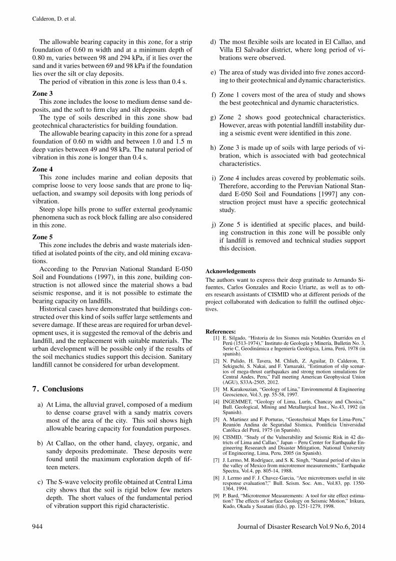
6. Seismic Microzoning Map
Based on the geotechnical and the dynamic character-istics of the soils, the area of study was divided into fivezones. The map showing the zones is called the seismic
Fig. 7. Seismic microzoning map.
microzoning map (Fig. 7). The description of each zoneis mentioned below.
Zone 1This zone includes the rock formations with different
fracturing degree that form the hills. The dense to verydense gravel and sand deposits are also considered in thiszone; as well as, the hard and very hard silt and clay de-posits.
The different types of materials described in this zoneshow the best geotechnical characteristics for buildingfoundation.
The allowable bearing capacity in this zone, for astrip foundation of 0.60 m width varies between 196 and392 kPa, if it lies over the gravel at a minimum depthof 0.80 m; and it is more than 491 kPa if the foundationlies over a slightly fractured rock at a minimum depth of0.40 m. If the foundation rests on the sand, silt or claydeposit, it is suggested to take values around 196 kPa.
The period of vibration in this zone is less than 0.3 s.
Zone 2This zone includes the medium dense to dense sand de-
posits, and, the medium stiff silt and clay deposits.Additionally, the areas with medium geologic hazard
that are found in the hillside and in the small hills of LosOlivos district, where potential landfill instability is prob-ably to occur in a seismic event, are included.
The types of soils described in this zone show goodgeotechnical characteristics for foundation purposes.
Journal of Disaster Research Vol.9 No.6, 2014 943
Calderon, D. et al.
The allowable bearing capacity in this zone, for a stripfoundation of 0.60 m width and at a minimum depth of0.80 m, varies between 98 and 294 kPa, if it lies over thesand and it varies between 69 and 98 kPa if the foundationlies over the silt or clay deposits.
The period of vibration in this zone is less than 0.4 s.
Zone 3This zone includes the loose to medium dense sand de-
posits, and the soft to firm clay and silt deposits.The type of soils described in this zone show bad
geotechnical characteristics for building foundation.The allowable bearing capacity in this zone for a spread
foundation of 0.60 m width and between 1.0 and 1.5 mdeep varies between 49 and 98 kPa. The natural period ofvibration in this zone is longer than 0.4 s.
Zone 4This zone includes marine and eolian deposits that
comprise loose to very loose sands that are prone to liq-uefaction, and swampy soil deposits with long periods ofvibration.
Steep slope hills prone to suffer external geodynamicphenomena such as rock block falling are also consideredin this zone.
Zone 5This zone includes the debris and waste materials iden-
tified at isolated points of the city, and old mining excava-tions.
According to the Peruvian National Standard E-050Soil and Foundations (1997), in this zone, building con-struction is not allowed since the material shows a badseismic response, and it is not possible to estimate thebearing capacity on landfills.
Historical cases have demonstrated that buildings con-structed over this kind of soils suffer large settlements andsevere damage. If these areas are required for urban devel-opment uses, it is suggested the removal of the debris andlandfill, and the replacement with suitable materials. Theurban development will be possible only if the results ofthe soil mechanics studies support this decision. Sanitarylandfill cannot be considered for urban development.
7. Conclusions
a) At Lima, the alluvial gravel, composed of a mediumto dense coarse gravel with a sandy matrix coversmost of the area of the city. This soil shows highallowable bearing capacity for foundation purposes.
b) At Callao, on the other hand, clayey, organic, andsandy deposits predominate. These deposits werefound until the maximum exploration depth of fif-teen meters.
c) The S-wave velocity profile obtained at Central Limacity shows that the soil is rigid below few metersdepth. The short values of the fundamental periodof vibration support this rigid characteristic.
d) The most flexible soils are located in El Callao, andVilla El Salvador district, where long period of vi-brations were observed.
e) The area of study was divided into five zones accord-ing to their geotechnical and dynamic characteristics.
f) Zone 1 covers most of the area of study and showsthe best geotechnical and dynamic characteristics.
g) Zone 2 shows good geotechnical characteristics.However, areas with potential landfill instability dur-ing a seismic event were identified in this zone.
h) Zone 3 is made up of soils with large periods of vi-bration, which is associated with bad geotechnicalcharacteristics.
i) Zone 4 includes areas covered by problematic soils.Therefore, according to the Peruvian National Stan-dard E-050 Soil and Foundations [1997] any con-struction project must have a specific geotechnicalstudy.
j) Zone 5 is identified at specific places, and build-ing construction in this zone will be possible onlyif landfill is removed and technical studies supportthis decision.
AcknowledgementsThe authors want to express their deep gratitude to Armando Si-fuentes, Carlos Gonzales and Rocio Uriarte, as well as to oth-ers research assistants of CISMID who at different periods of theproject collaborated with dedication to fulfill the outlined objec-tives.
References:[1] E. Silgado, “Historia de los Sismos mas Notables Ocurridos en el
Peru (1513-1974),” Instituto de Geologıa y Minerıa, Bulletin No. 3,Serie C, Geodinamica e Ingenierıa Geologica, Lima, Peru, 1978 (inspanish).
[2] N. Pulido, H. Tavera, M. Chlieh, Z. Aguilar, D. Calderon, T.Sekiguchi, S. Nakai, and F. Yamazaki, “Estimation of slip scenar-ios of mega-thrust earthquakes and strong motion simulations forCentral Andes, Peru,” Fall meeting American Geophysical Union(AGU), S33A-2505, 2012.
[3] M. Karakouzian, “Geology of Lina,” Environmental & EngineeringGeoscience, Vol.3, pp. 55-58, 1997.
[4] INGEMMET, “Geology of Lima, Lurın, Chancay and Chosica,”Bull. Geological, Mining and Metallurgical Inst., No.43, 1992 (inSpanish).
[5] A. Martinez and F. Porturas, “Geotechnical Maps for Lima-Peru,”Reunion Andina de Seguridad Sısmica, Pontificia UniversidadCatolica del Peru, 1975 (in Spanish).
[6] CISMID, “Study of the Vulnerability and Seismic Risk in 42 dis-tricts of Lima and Callao,” Japan – Peru Center for Earthquake En-gineering Reseearch and Disaster Mitigation, National Universityof Engineering, Lima, Peru, 2005 (in Spanish).
[7] J. Lermo, M. Rodrıguez, and S. K. Singh, “Natural period of sites inthe valley of Mexico from microtremor measurements,” EarthquakeSpectra, Vol.4, pp. 805-14, 1988.
[8] J. Lermo and F. J. Chavez-Garcia, “Are microtremors useful in siteresponse evaluation?,” Bull. Seism. Soc. Am., Vol.83, pp. 1350-1364, 1994.
[9] P. Bard, “Microtremor Measurements: A tool for site effect estima-tion? The effects of Surface Geology on Seismic Motion,” Irikura,Kudo, Okada y Sasatani (Eds), pp. 1251-1279, 1998.
944 Journal of Disaster Research Vol.9 No.6, 2014

Development of a Seismic Microzoning Map for Lima City andCallao, Peru
[10] Y. Nakamura, “A method for dynamic characteristics estimationof subsurface using microtremors on the ground surface,” Quar-terly Report Railway Technology Research Institute, Vol.30, No.3,pp. 25-30, 1989.
[11] C. Huaman, “Microzonificacion Sısmica de La Punta y El Callao,”Tesis de Grado, Facultad de Ingenierıa Civil, Universidad Nacionalde Ingenierıa, Lima, Peru, 1991 (in Spanish).
[12] D. Calderon, T. Sekiguchi, S. Nakai, Z. Aguilar, and F. Lazares,“Study of soil amplification based on microtremor and seismicrecords in Lima Peru,” Jour. Japan Assoc. Earthq. Eng., Vol.12,No.2, pp. 1-20, 2012.
Name:Diana Calderon
Affiliation:Assistant Professor, National University of En-gineering
Address:Tupac Amaru Av., Rimac, Lima, PeruBrief Career:2012 Ph.D. Eng., Chiba University2012- Assistant Professor, National University of EngineeringSelected Publications:• “Study of the Amplification and Noise from Microtremor Arrays andSeismic Records in Lima Peru,” Journal of JAEE, Vol.12, No.2, pp. 1-12,2012.Academic Societies & Scientific Organizations:• Peru-Japan Center for Seismic Research and Disaster Mitigation, Peru
Journal of Disaster Research Vol.9 No.6, 2014 945
Related Documents