P.O. Box 1749 Halifax, Nova Scotia B3J 3A5 Canada Item No. 13.1.5 North West Community Council May 8, 2017 TO: Chair and Members of North West Community Council ORIGINAL SIGNED SUBMITTED BY: Bob Bjerke, Director of Planning and Development DATE: March 10, 2017 SUBJECT: Case 19110 - Development Agreement for 592 Bedford Highway, Halifax ORIGIN Application by KWR Approvals Inc. LEGISLATIVE AUTHORITY See Attachment G. RECOMMENDATION It is recommended that North West Community Council: 1. Give notice of motion to consider approval of the proposed development agreement, as set out in Attachment A, to develop a residential multi-unit building at 592 Bedford Highway, Halifax and schedule a public hearing. 2. Approve the proposed development agreement, which shall be substantially of the same form as set out in Attachment A, of this report; and 3. Require the Agreement be signed by the property owner within 120 days, or any extension thereof granted by Council on request of the property owner, from the date of final approval by Council and any other bodies as necessary, including applicable appeal periods, whichever is later; otherwise this approval will be void and obligations arising hereunder shall be at an end.

Welcome message from author
This document is posted to help you gain knowledge. Please leave a comment to let me know what you think about it! Share it to your friends and learn new things together.
Transcript
P.O. Box 1749 Halifax, Nova Scotia B3J 3A5 Canada
Item No. 13.1.5
North West Community Council May 8, 2017
TO: Chair and Members of North West Community Council ORIGINAL SIGNED SUBMITTED BY:
Bob Bjerke, Director of Planning and Development DATE: March 10, 2017 SUBJECT: Case 19110 - Development Agreement for 592 Bedford Highway, Halifax ORIGIN Application by KWR Approvals Inc. LEGISLATIVE AUTHORITY See Attachment G. RECOMMENDATION It is recommended that North West Community Council:
1. Give notice of motion to consider approval of the proposed development agreement, as set out in
Attachment A, to develop a residential multi-unit building at 592 Bedford Highway, Halifax and schedule a public hearing.
2. Approve the proposed development agreement, which shall be substantially of the same form as set out in Attachment A, of this report; and
3. Require the Agreement be signed by the property owner within 120 days, or any extension thereof granted by Council on request of the property owner, from the date of final approval by Council and any other bodies as necessary, including applicable appeal periods, whichever is later; otherwise this approval will be void and obligations arising hereunder shall be at an end.
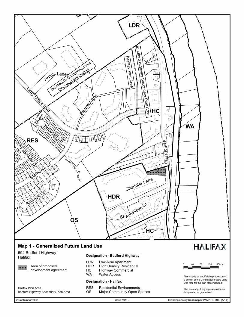
Case 19110: 592 Bedford Highway, Halifax Development Agreement Community Council Report - 2 - May 8, 2017 BACKGROUND KWR Approvals Inc., on behalf of the land owner, 3247003 Nova Scotia Limited is applying to enable the development of an eight storey residential multi-unit dwelling with a maximum of 50 residential units at 592 Bedford Highway, Halifax (Maps 1 through 3). As the proposal cannot be accommodated by the requirements of the Halifax Mainland Land Use Bylaw because it exceeds the permitted maximum height of 10.67 m (35 feet), the applicant has requested that the proposed multi-unit dwelling be considered by development agreement. Location, Designation, Zoning and Surrounding Land Use Subject Property 592 Bedford Highway Location South of the intersection of Larry Uteck Boulevard and the
Bedford Highway. Regional Plan Designation Urban Settlement
Community Plan Designation (Map 1)
Highway Commercial under the Bedford Highway Secondary Plan of the Halifax Municipal Planning Strategy
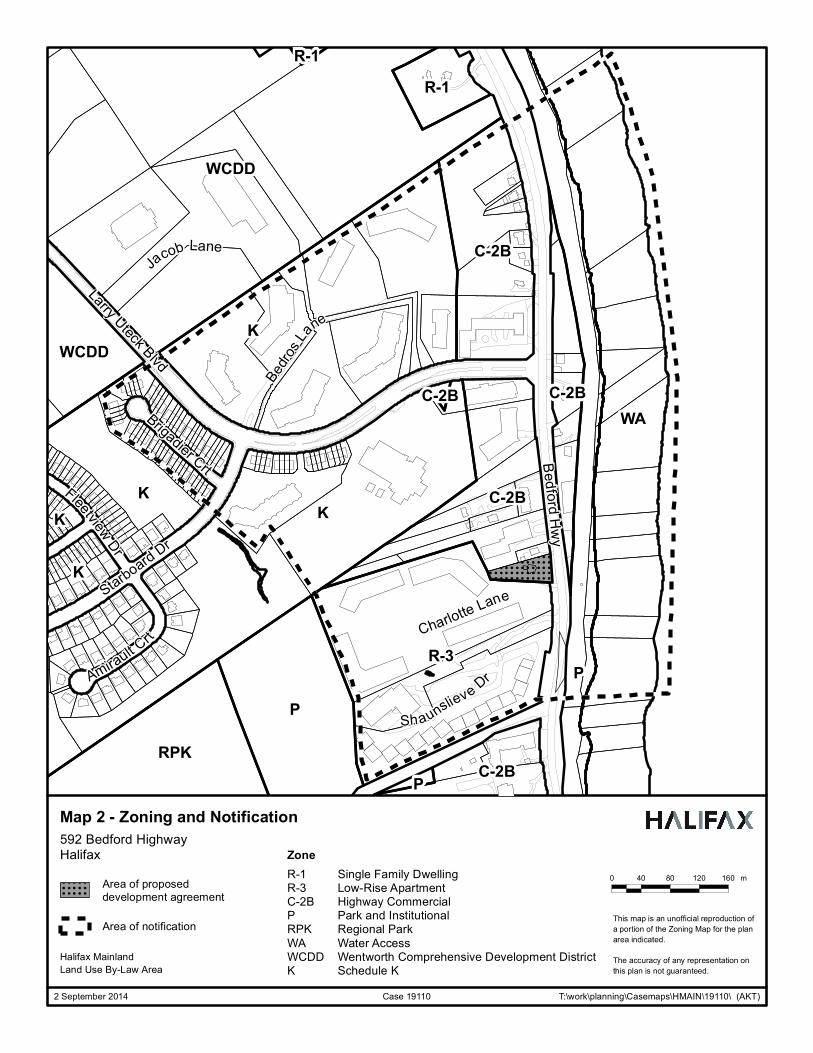
Zoning (Map 2) C-2B (Highway Commercial Zone) under the Halifax Mainland Land Use By-law
Schedule (Map 3) Schedule R of Halifax Land Use By-law Size of Property 2,226.5 sq.m. (23,967 sq. ft) Street Frontage Bedford Highway - Approximately 39.6 m (130 feet) Site Conditions Slopes upward as much as 14 metres (44 feet) from the
Bedford Highway Current Land Use(s) Commercial building
Surrounding Land Use(s) North – Commercial (Manorhouse Furniture) South and West – Residential (Ocean Brook Apartments) East – Bedford Highway /Commercial (Fisherman’s Market)
Proposal The applicant wishes to demolish the existing commercial building and construct a residential multi-unit dwelling in the form of a single, eight storey building. The major aspects of the proposal are as follows:
• eight storeys facing the Bedford Highway; • a maximum of 50 residential dwelling units; • extensive exterior and rooftop landscaping and indoor and outdoor amenity space; • a combination of underground and surface parking; and • 2 driveway accesses to the site; both from the Bedford Highway.
Enabling Policy and Zoning Context In 2011, Regional Council approved amendments to the Bedford Highway Secondary Plan and applied Schedule R in order to increase the level of land use control along Bedford Highway in the vicinity of Larry Uteck Boulevard (Map 3). The C-2B Zone that is applied within this area permits a mix of commercial and residential uses, including multi-unit dwellings, while limiting the maximum height of development to 10.67 metres (35 feet). Policy 1.8 of the Bedford Highway Secondary Plan allows for the consideration of taller development through the development agreement process.
Case 19110: 592 Bedford Highway, Halifax Development Agreement Community Council Report - 3 - May 8, 2017 COMMUNITY ENGAGEMENT The community engagement process is consistent with the intent of the HRM Community Engagement Strategy. The level of community engagement was consultation, achieved through providing information and seeking comments through the HRM website, signage posted on the subject site, letters mailed to property owners within the notification area and a public information meeting held on April 16, 2014 Attachment D contains a copy of the minutes from the meeting. The public comments received include the following topics:
• appropriate building heights for the local area; • existing and future traffic on the Bedford Highway; and • the need for sidewalks along the Bedford Highway.
A public hearing must be held by North West Community Council before they can consider approval of the proposed development agreement. Should Community Council decide to proceed with a public hearing on this application, in addition to the published newspaper advertisements, property owners within the notification area shown on Map 3 will be notified of the hearing by regular mail. The proposed development agreement will potentially impact local residents and property owners, community or neighbourhood organizations, and business and professional associations. DISCUSSION Staff has reviewed the proposal relative to all relevant policies and advise that it is consistent with the intent of the MPS. Attachment B provides an evaluation of the proposed development agreement in relation to the relevant MPS policies. Proposed Development Agreement Attachment A contains the proposed development agreement for the subject site and the conditions under which the development may occur. The proposed development agreement addresses the following matters:
• building height (8 storeys) and maximum number of units (50 units); • amenity space (internal and extensive external landscaped roof tops); • underground parking; • fine–grained modernist architecture; and • non-substantive amendments including:
o minor changes to the placement and architectural design of the building including changes in cladding material;
o the granting of an extension to the date of commencement of construction; and o the length of time for the completion of the development.
The attached development agreement will permit a residential multi-unit dwelling, subject to the controls identified above. Of the matters addressed by the proposed development agreement to satisfy the MPS criteria as shown in Attachment B, the following have been identified for detailed discussion. Design of the Building The proposed building contains eight storeys of residential units, and underground and surface parking. The existing site slopes significantly up from the Bedford Highway to the rear property line with an approximate rise of 13 m (43 feet). The building will be terraced, which enables the first four floors to be integrated into the slope of the site. This design keeps the profile of the building low in relation to surrounding properties, especially to the rear of the site. Although the overall height of the building is 8 storeys facing Bedford Highway, the height in relation to adjacent buildings is in most instances appropriate. Three dimensional renderings of the building are contained in Attachment D.
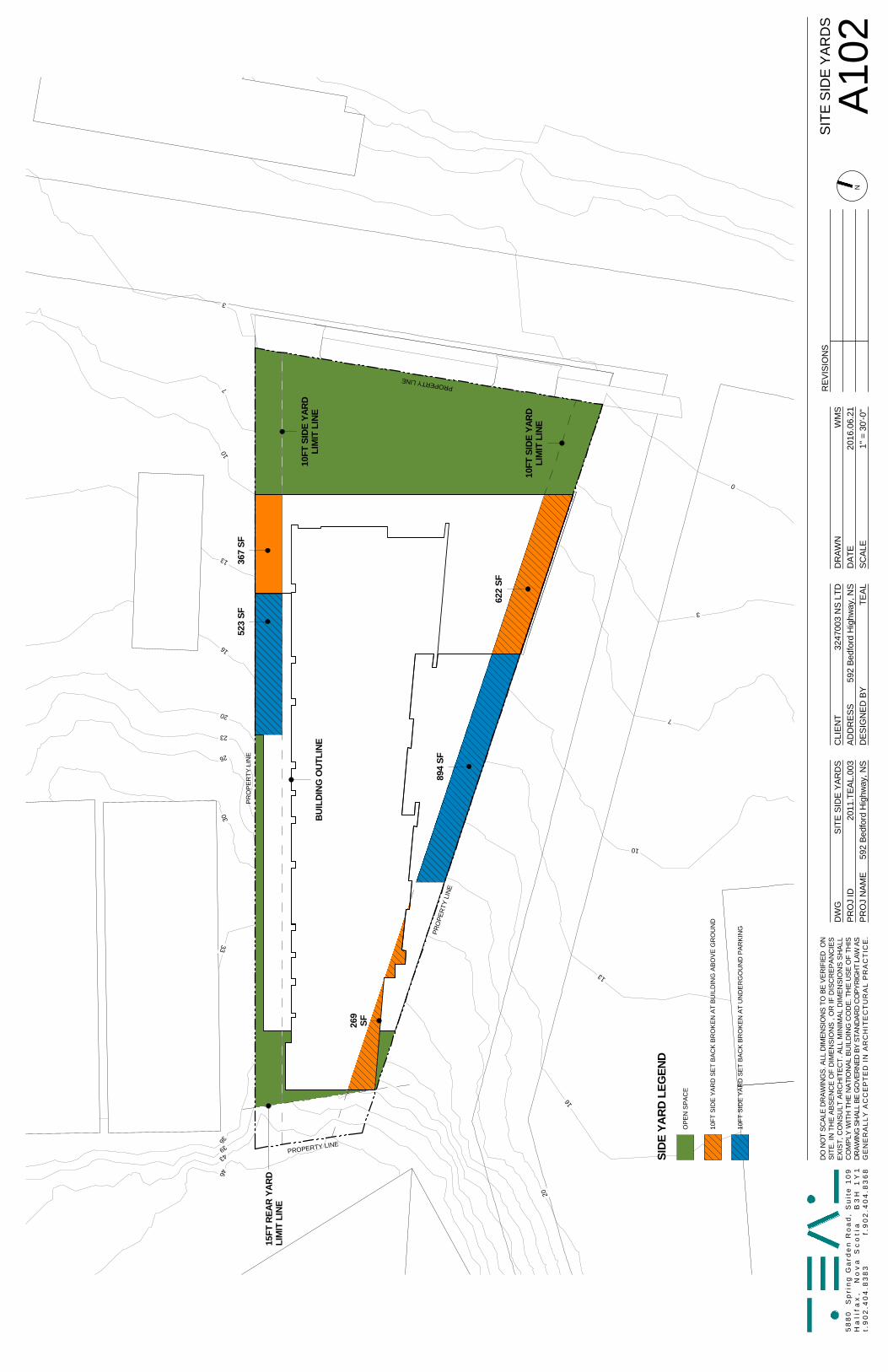
Case 19110: 592 Bedford Highway, Halifax Development Agreement Community Council Report - 4 - May 8, 2017 The following design and relationship issues have been identified for further discussion: Fine Grained Architecture – Policy requires that the proposed building has a fine grain design. This is interpreted to mean that the building may use a variety of lines, colours materials, or articulations so that elevations that can be seen from the public realm are interesting and engaging, regardless of their length. The development agreement requires a mix of building materials to break up the massing of the building and carry out the intent of the policy. The building is designed in a modernist architectural aesthetic. As originally proposed, the expression of this modernist design resulted in a building not considered a fine grain design. Updates to the design were negotiated, specifically on the Bedford Highway façade. The proposal now meets this policy test. The front elevation (east side) of the building contains architectural details including horizontal siding and other fine grain details on building panels and on the proposed garage doors. Further, the south side of the building is also well detailed. Notwithstanding the elevation drawings in the development agreement, the proposed agreement requires that further detailing be continued around to the northern corner of the building which is visible from the Bedford Highway to further enhance the detailing on this building face. The entire building also features coloured architectural panels implemented to break the design of the building into a finer grained pixelated pattern. This is intended to minimize the impact of the larger elevations of the building. Northern Building Facade – The northern facade includes a large wall, varying in height from three to seven storeys. This wall is predominately composed of a pixelated panel design with several narrow vertical bands of windows. The pixelated design and narrow window bands are intended to break up the mass of the wall. The developer has proposed the planting of a series of large coniferous and deciduous trees (2m tall at installation) along the north face of the building which are intended to break up the view of the wall and minimize the impact of this wall. Further, the surrounding buildings and existing landscaping on adjacent properties will further limit the public views of this façade from the street. The combination of the architectural design and landscaping reasonably mitigates the mass of the wall; however, other architecture design variations may be more effective in managing the impact of the wall. Designs which introduce additional shifts in building massing, variations in height and profile and the addition of greater relief to the façade may be more effective. Relationship to Surrounding Uses The proposed building is taller, of a higher lot coverage, and has smaller setbacks than would normally be expected within a suburban setting. At the rear (west) of the site, the building is located approximately 15 feet from the property line and 35 feet from an adjacent multi-unit dwelling located on Oceanview Lane. Typically the Land Use By-law would require a minimum 20 foot sideyard (40 foot separation between the buildings), but a reduction can be considered by development agreement. A five foot reduction in the setback is not significant and the implications of a reduced setback are offset because the proposed and existing buildings are not parallel with one another and the reduction in the setback is to one corner of the existing building. Further, the rear of the proposed building is of limited width and has limited proposed windows thus limiting the impact on privacy. Setbacks on much of the north side of the building are approximately 10 to 13 feet from the property line except near the Bedford Highway where the setback is reduced to a zero sideyard. Under the existing zone, commercial uses require a zero setback and new residential uses require a minimum of a 20 foot sideyard. The proximity of the proposed building impacts two adjacent properties: the Lands of Manorhouse Furniture and 3285414 NS Limited. The relationship with the Manorhouse property is less significant because of grade changes along this property line. The Manorhouse property is situated at a higher
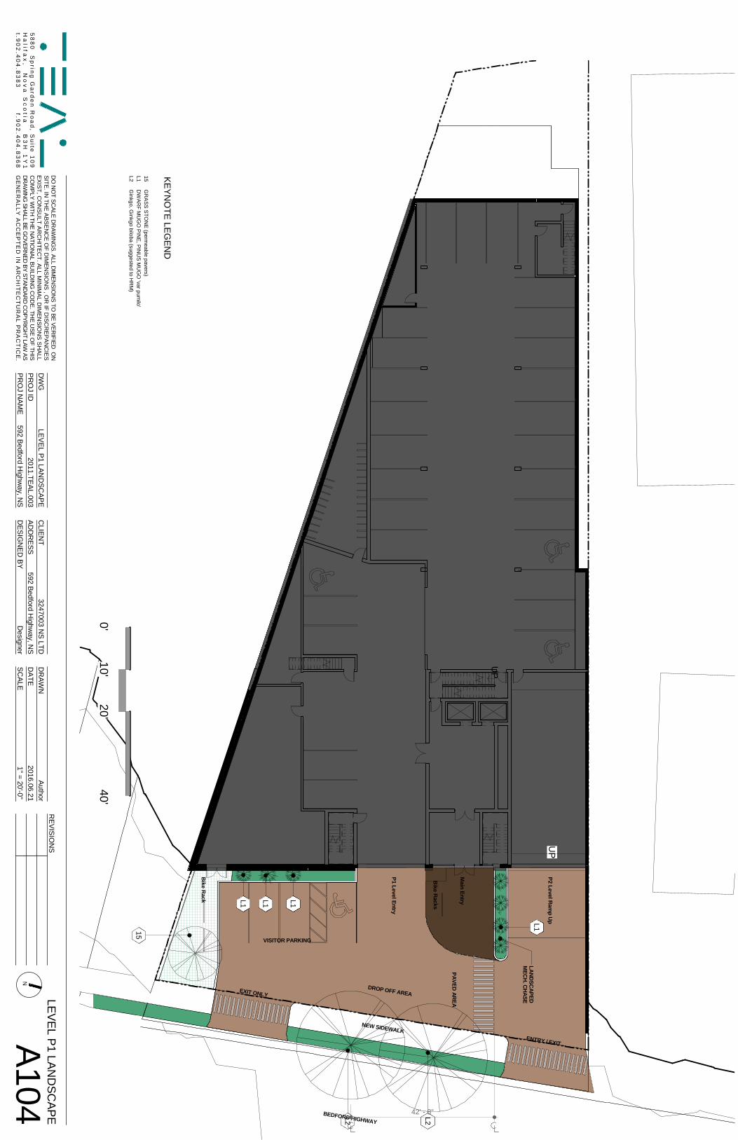
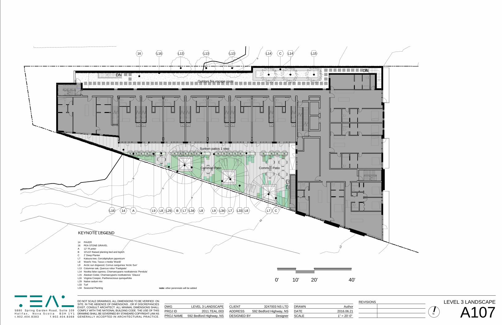
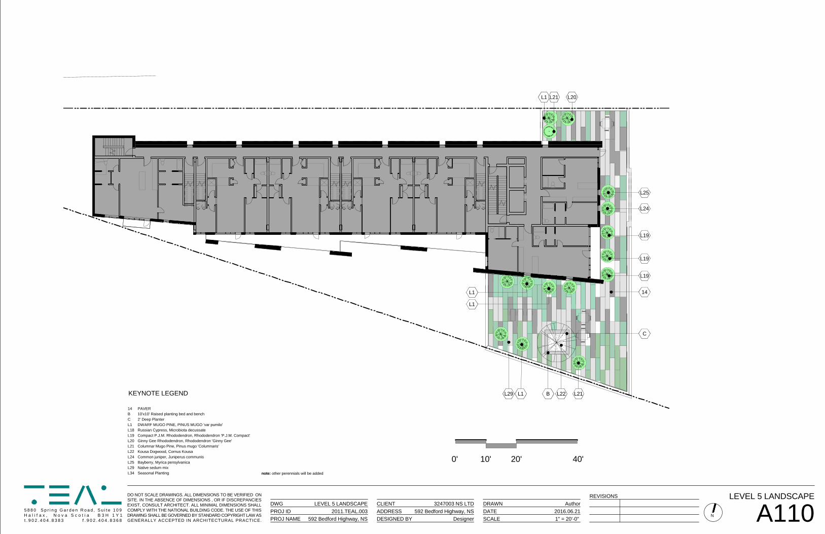
Case 19110: 592 Bedford Highway, Halifax Development Agreement Community Council Report - 5 - May 8, 2017 elevation than the 3285414 NS Limited parcel and the proposed building is limited to four to five storeys where adjacent to this property. Future redevelopment of the Manorhouse lands is not expected to be significantly impacted by the proposed building. The property of 3285414 NS Limited is affected to a greater extent by the proximity of the proposed building to their lands. Because of the close proximity, the proposed building (3-8 storeys) may have a greater presence over the adjacent two storey building on 3285414 NS Limited than if there were greater setbacks. Winter shadowing (Attachment F) of the 3285414 NS Limited lands could be expected which may impact heating costs and maintenance issues. With this said, because of the size of the 3285414 NS Limited lands, the scale of future redevelopment of the site would likely be limited in height and lot coverage. It is not expected that the proximity of the proposed building will significantly affect the ability of the 3285414 NS Limited lands to redevelop. South and East - To the northeast of the site is the Bedford Highway and Fisherman’s Market (Fish Distributor). To the south is the driveway access for multi-unit dwellings on Oceanview Lane. The site has an acceptable relationship to these areas because of existing and proposed setbacks and limited development potential of the lands adjacent to Oceanview Lane. Lot Coverage – Lot coverage for this proposal is identified by the applicant as approximately 48 percent above the parking podium. Lot coverage typically varies between 35 and 50 percent for suburban multi-unit dwellings, with the proposed being within this range. Typically, the lot coverage does not include parking podiums located below grade. Given the grades of the site, portions of the parking podium, specifically at the Bedford Highway elevation and portions of the northern and southern elevations are exposed to a greater extent than typical. This condition increases the lot coverage of the development to approximately 64 percent. The impact of such a building is more typical of an urban building design. However, given the surrounding existing development, specifically the adjacent access points to other multi-unit dwellings south of the site, the property does not visually appear to be overdeveloped and is within the scope of what can be considered under policy. Views There are no protected viewplanes in the area. However, policy requires the consideration of views from public spaces and active transportation corridors. Staff reviewed the impact on views from the parkland corridor that passes through the Bedros Lane condominium and apartment site located to the north. The proposed eight storey building is not anticipated to have a significant impact on views from the corridor. Staff has determined that the proposed building will not be visible along most of the corridor. Further, where there are views from the corridor between existing buildings, small portions of the building may be visible in the distance. In general, the impact on views can be described as minor in nature. Renderings of the site have been produced by the applicant from various angles and are found in Attachment E. The renderings demonstrate minimal impacts on views from developments on Bedros Lane, as well as the relationships with other buildings. Parking The proposed site has 54 parking spaces of which 51 are underground. This total includes 7 visitor spaces. This exceeds the required parking under the Halifax Mainland Land Use By-law for multi-units dwellings in the Bedford Highway area and is felt to be sufficient. . Landscaping / Amenity Space Due to the number of proposed units on the site and the lot coverage, extensive at grade and rooftop landscaping is proposed for this site. Additional interior space is also proposed for a combined total of approximately 22,440 sq. ft. amenity space. The total includes:
• Balconies: 3,863 sq. ft.; • Landscaping: 875 sq. ft.; • Green Roof /Roof Top Gardens: 16,402 sq. ft.;
Case 19110: 592 Bedford Highway, Halifax Development Agreement Community Council Report - 6 - May 8, 2017
• Gym: 870 sq. ft.; and • Community Room: 430 sq. ft.
The proposed extent of landscaping and open space is appropriate for a building of this scale. Pedestrian Linkages No existing public sidewalks exist on the Bedford Highway. The proposed development agreement requires that public sidewalks be constructed along the Bedford Highway frontage leading to an adjacent bus stop located in front of the Shaunslieve Apartments at 20 Charlotte Lane. Additional off-site sidewalks would require coordination, design and monetary resources as well as requiring significant alteration to off-site driveways and grades within the Bedford Highway right-of-way. These upgrades, including the proposed sidewalk, are beyond the responsibility of the developer and outside of the scope of this application. However, the Developer has offered to construct the proposed sidewalk, and thus it has been enabled in the development agreement. On-site walkways connecting both the front door and a secondary door to the proposed public sidewalk on the Bedford Highway is required by the proposed agreement. Because of the proposed building and site design, additional walkways are not required. Traffic The proposed development will have two access points on the Bedford Highway, one at each end of the existing road frontage. Development Engineering has indicated they will authorize both access points and no issues with this aspect of the proposal are anticipated. A Traffic Impact Statement (TIS) was provided for this application and accepted by Development Engineering. The study determined no upgrades were required to the road network to accommodate the proposed development. As a result of public concerns with the TIS (due to the date of data collected), engineering staff subsequently conducted further data collection and determined that the TIS sufficiently represented the existing and future local demands on the road network and confirmed that there are no concerns. Density Density in a planning context is one measure of the intensity of development, and is typically a measurement of the population or number of dwelling units in an area. It can be measured on a variety of scales ranging from single to multiple sites or from neighbourhoods to communities and beyond. In the case of this proposal, density is based on units per acre and population per acre to provide comparison with other developments. Density can be used as a control in planning documents or development agreements to achieve a specific population goal or establish a maximum limit within a given area. Most commonly, limits on density are linked to the capacity of service systems such as sewer, water or road networks. While density is an indicator of the intensity of a development, it is only a single measurement. It illustrates very little about a development itself in terms of form, typology, and can be deceptive when used to compare seemingly similar developments. If for example a large building contains many large 4-5 bedroom units within it, the calculation of units/acre would be low. If that same building were to be re-configured internally to include a number of smaller 1 bedroom units, the ‘density’ would increase despite the size of the building remaining the same. Similarly, measuring units per acre on a lot by lot basis is less telling about the true size of a development because this can be manipulated by placing the building on a differently sized lot. A small lot pushes the units per acre up while a larger lot forces this number down. This means that a building on a small lot can look on paper to be inappropriate when compared against others, although when seen in the physical context it may be appropriate. Policy 1.8 of the Bedford Highway Secondary Plan enables the consideration of buildings taller than 35 feet by development agreement. The policy does not establish maximum limits for density, building size
Case 19110: 592 Bedford Highway, Halifax Development Agreement Community Council Report - 7 - May 8, 2017 or height. The lack of guidance on these matters is common in planning policies as they are intended to allow for innovation and creativity in design based on the unique attributes of each site. Attachment C provides a comparison of densities for all other sites in the immediate area of the proposal under consideration. Existing development ranges from 11.1 units per acre to 35.5 units per acre, while the proposed development is for 105 units per acre. The applicable MPS policies establish several criteria that must be assessed for this proposal, in addition to the matter of density. If the proposal satisfies all the other criteria, then density alone should not be a matter of concern. The questions raised by the policy criteria include:
• does the density indicated cause any specific problems or issues; • is there adequate parking; • are the adjacent roads capable of supporting the development; • are sewer and water services capable of supporting the development; • is the bulk, mass and height of the building appropriate; • does the proposed building overshadow its neighbours; and • are the site and building well designed.
The proposed density is approximately 237 persons per acre (based on an average of 2.25 persons per unit) which is approximately 235 percent greater than other multi-unit developments in the area. There are no servicing or traffic concerns relative to this density, and the greater building envelope required to accommodate this higher density fits into the surrounding building context of the area due to the topography of the site. The proposed development and its density are at the very highest that may be appropriate for the site. Public concern was stated with regard to the ratio of parking to units. Staff advise that given that the parking standards are based in the Halifax Mainland Land Use By-law, the issue is general to most multi-unit dwellings in the Bedford Highway SPS. Conclusion SPS policy requires the consideration of specific planning matters and that the end product be a reasonable result of this consideration. Staff have reviewed the proposal in terms of all relevant policy criteria and advise that the proposal is reasonably consistent with the intent of the MPS. The proposed building form, mass and many other characteristics are very typical of its suburban location, however the density and relationship with surrounding properties is more typical of urban infill projects. SPS policy does not specifically specify densities, and as such the issue of density is less relevant than form and character. Ultimately policy requires the building fit in with the surrounding development without significantly affecting surrounding properties. In the case of the proposed building, the buildings form and mass are acceptable. The architectural characteristics debated within this report are subjective in nature, not explicitly laid out within policy, and are minimized by proposed and existing vegetation. Based on the above, and a complete review of relevant SPS policy, the proposed building meets the intent of the SPS policy. Therefore, staff recommended that North West Community Council approve the proposed development agreement (Attachment A). FINANCIAL IMPLICATIONS There are no financial implications. The applicant will be responsible for all costs, expenses, liabilities and obligations imposed under or incurred in order to satisfy the terms of this development agreement. The administration of the development agreement can be carried out within the approved 2016-2017 budget with existing resources.
Case 19110: 592 Bedford Highway, Halifax Development Agreement Community Council Report - 8 - May 8, 2017 RISK CONSIDERATION There are no significant risks associated with the recommendations contained within this report. This application may be considered under existing MPS policies. Community Council has the discretion to make decisions that are consistent with the MPS, and such decisions may be appealed to the N.S. Utility and Review Board. Information concerning risks and other implications of adopting the proposed development agreement are contained within the Discussion section of the staff report. ENVIRONMENTAL IMPLICATIONS No environmental implications are identified. ALTERNATIVES
1. North West Community Council may choose to approve the proposed development agreement subject to modifications. Such modifications may require further negotiation with the applicant and may require a supplementary report or another public hearing. A decision of Council to approve this development agreement is appealable to the N.S. Utility & Review Board as per Section 262 of the HRM Charter.
2. North West Community Council may choose to refuse the proposed development agreement, and
in doing so, must provide reasons why the proposed agreement does not reasonably carry out the intent of the MPS. A decision of Council to refuse the proposed development agreement is appealable to the N.S. Utility & Review Board as per Section 262 of the HRM Charter.
ATTACHMENTS Map 1: Generalized Future Land Use Map 2: Zoning and Notification Area Attachment A: Proposed Development Agreement Attachment B: MPS Policy Review Attachment C: Comparison of Local Densities by Site Attachment D Public Information Meeting Notes Attachment E 3D Renderings of Proposed Building Attachment F Solar Study Attachment G Legislative Authority Available Upon Request: Wind Study
Case 19110: 592 Bedford Highway, Halifax Development Agreement Community Council Report - 9 - May 8, 2017 ______________________________________________________________________ A copy of this report can be obtained online at http://www.halifax.ca/commcoun/index.php then choose the appropriate Community Council and meeting date, or by contacting the Office of the Municipal Clerk at 902.490.4210, or Fax 902.490.4208. Report Prepared by: Andrew Bone, MCIP, LPP, Planner III Development Approvals, 902-490-6743 ORIGINAL SIGNED Report Approved by:
Carl Purvis, Acting Manager, Current Planning, 902-490-4797
2 September 2014 T:\work\planning\Casemaps\HMAIN\19110\ (AKT)
LDRHDRHCWA
Low-Rise ApartmentHigh Density ResidentialHighway CommercialWater Access
Designation - Bedford Highway
This map is an unofficial reproduction ofa portion of the Generalized Future LandUse Map for the plan area indicated.
The accuracy of any representation onthis plan is not guaranteed.
Map 1 - Generalized Future Land Use
! ! ! ! ! ! !
! ! ! ! ! ! !
! ! ! ! ! ! !
! ! ! ! ! ! !
! ! ! ! ! ! ! ! ! ! ! ! ! !
! ! ! ! ! ! ! ! ! ! ! ! ! !
! ! ! ! ! ! ! ! ! ! ! ! ! !
! ! ! ! ! ! ! ! ! ! ! ! ! !
! ! ! ! ! ! ! ! ! ! ! ! ! !
! ! ! ! ! ! ! ! ! ! ! ! ! !
! ! ! ! ! ! ! ! ! ! ! ! ! !
Bedford Hwy
Starboard Dr
Larry Uteck Blvd
Jacob Lane
Shaunslieve Dr
Bedro
s Lane
Charlotte Lane
Amirault Crt
Fleetview Dr
Brigadier CrtRES
HC
WA
OS
HDR
HC
LDR
0 40 80 120 160 m
Case 19110
Halifax Plan AreaBedford Highway Secondary Plan Area
592 Bedford HighwayHalifax
Area of proposeddevelopment agreement
Wentworth Comprehensive
Development District
Bedford Highway Secondary Plan Area
Halifax Plan Area
RESOS
Residential EnvironmentsMajor Community Open Spaces
Designation - Halifax
2 September 2014 T:\work\planning\Casemaps\HMAIN\19110\ (AKT)
Area of notification
Map 2 - Zoning and Notification
This map is an unofficial reproduction ofa portion of the Zoning Map for the planarea indicated.
The accuracy of any representation onthis plan is not guaranteed.
R-1R-3C-2BPRPKWAWCDDK
Single Family DwellingLow-Rise ApartmentHighway CommercialPark and InstitutionalRegional ParkWater AccessWentworth Comprehensive Development DistrictSchedule K
Zone
! ! ! ! ! ! !
! ! ! ! ! ! !
! ! ! ! ! ! !
! ! ! ! ! ! !
! ! ! ! ! ! ! ! ! ! ! ! ! !
! ! ! ! ! ! ! ! ! ! ! ! ! !
! ! ! ! ! ! ! ! ! ! ! ! ! !
! ! ! ! ! ! ! ! ! ! ! ! ! !
! ! ! ! ! ! ! ! ! ! ! ! ! !
! ! ! ! ! ! ! ! ! ! ! ! ! !
! ! ! ! ! ! ! ! ! ! ! ! ! !
Bedford Hwy
Starboard Dr
Larry Uteck Blvd
Jacob Lane
Shaunslieve Dr
Bedro
s Lane
Charlotte Lane
Amirault Crt
Fleetview Dr
Brigadier Crt
K
K
WA
WCDD
R-3
P
K
P
RPK
C-2B
C-2B
K
C-2B
WCDD
R-1
K
C-2B
P
R-1
C-2B
0 40 80 120 160 m
Case 19110
Halifax MainlandLand Use By-Law Area
592 Bedford HighwayHalifax
Area of proposeddevelopment agreement
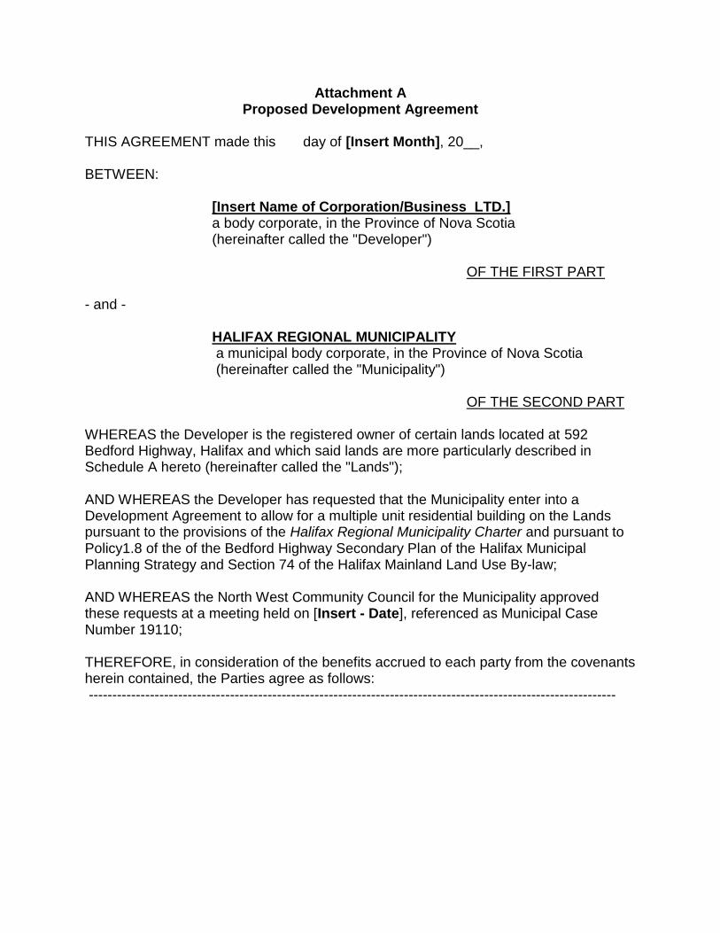
Attachment AProposed Development Agreement
THIS AGREEMENT made this day of [Insert Month], 20__,
BETWEEN:
[Insert Name of Corporation/Business LTD.]a body corporate, in the Province of Nova Scotia(hereinafter called the "Developer")
OF THE FIRST PART
- and -
HALIFAX REGIONAL MUNICIPALITYa municipal body corporate, in the Province of Nova Scotia(hereinafter called the "Municipality")
OF THE SECOND PART
WHEREAS the Developer is the registered owner of certain lands located at 592Bedford Highway, Halifax and which said lands are more particularly described inSchedule A hereto (hereinafter called the "Lands");
AND WHEREAS the Developer has requested that the Municipality enter into aDevelopment Agreement to allow for a multiple unit residential building on the Landspursuant to the provisions of the Halifax Regional Municipality Charter and pursuant toPolicy1.8 of the of the Bedford Highway Secondary Plan of the Halifax MunicipalPlanning Strategy and Section 74 of the Halifax Mainland Land Use By-law;
AND WHEREAS the North West Community Council for the Municipality approvedthese requests at a meeting held on [Insert - Date], referenced as Municipal CaseNumber 19110;
THEREFORE, in consideration of the benefits accrued to each party from the covenantsherein contained, the Parties agree as follows:----------------------------------------------------------------------------------------------------------------
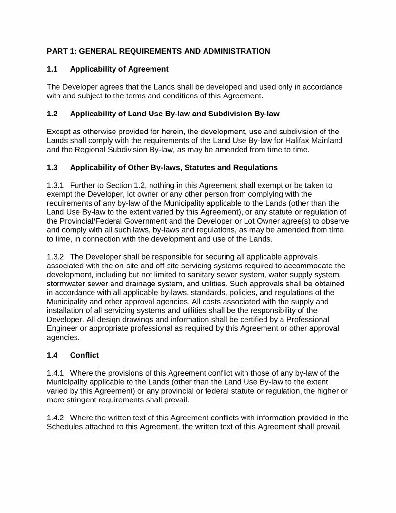
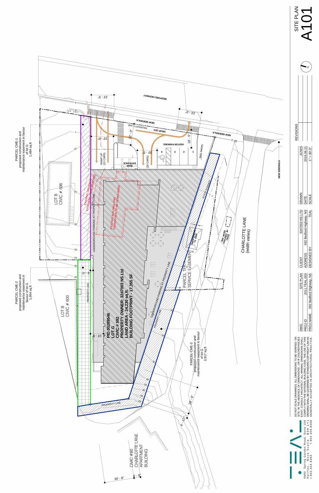
PART 1: GENERAL REQUIREMENTS AND ADMINISTRATION 1.1 Applicability of Agreement The Developer agrees that the Lands shall be developed and used only in accordance with and subject to the terms and conditions of this Agreement. 1.2 Applicability of Land Use By-law and Subdivision By-law Except as otherwise provided for herein, the development, use and subdivision of the Lands shall comply with the requirements of the Land Use By-law for Halifax Mainland and the Regional Subdivision By-law, as may be amended from time to time. 1.3 Applicability of Other By-laws, Statutes and Regulations 1.3.1 Further to Section 1.2, nothing in this Agreement shall exempt or be taken to exempt the Developer, lot owner or any other person from complying with the requirements of any by-law of the Municipality applicable to the Lands (other than the Land Use By-law to the extent varied by this Agreement), or any statute or regulation of the Provincial/Federal Government and the Developer or Lot Owner agree(s) to observe and comply with all such laws, by-laws and regulations, as may be amended from time to time, in connection with the development and use of the Lands. 1.3.2 The Developer shall be responsible for securing all applicable approvals associated with the on-site and off-site servicing systems required to accommodate the development, including but not limited to sanitary sewer system, water supply system, stormwater sewer and drainage system, and utilities. Such approvals shall be obtained in accordance with all applicable by-laws, standards, policies, and regulations of the Municipality and other approval agencies. All costs associated with the supply and installation of all servicing systems and utilities shall be the responsibility of the Developer. All design drawings and information shall be certified by a Professional Engineer or appropriate professional as required by this Agreement or other approval agencies. 1.4 Conflict 1.4.1 Where the provisions of this Agreement conflict with those of any by-law of the Municipality applicable to the Lands (other than the Land Use By-law to the extent varied by this Agreement) or any provincial or federal statute or regulation, the higher or more stringent requirements shall prevail. 1.4.2 Where the written text of this Agreement conflicts with information provided in the Schedules attached to this Agreement, the written text of this Agreement shall prevail.
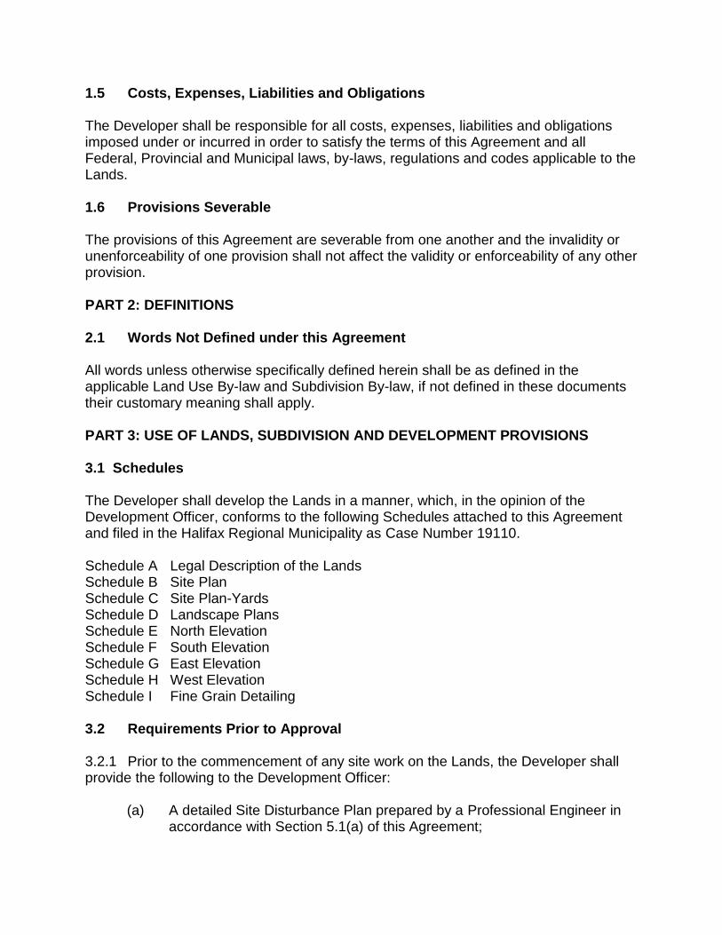
1.5 Costs, Expenses, Liabilities and Obligations The Developer shall be responsible for all costs, expenses, liabilities and obligations imposed under or incurred in order to satisfy the terms of this Agreement and all Federal, Provincial and Municipal laws, by-laws, regulations and codes applicable to the Lands. 1.6 Provisions Severable The provisions of this Agreement are severable from one another and the invalidity or unenforceability of one provision shall not affect the validity or enforceability of any other provision. PART 2: DEFINITIONS 2.1 Words Not Defined under this Agreement All words unless otherwise specifically defined herein shall be as defined in the applicable Land Use By-law and Subdivision By-law, if not defined in these documents their customary meaning shall apply. PART 3: USE OF LANDS, SUBDIVISION AND DEVELOPMENT PROVISIONS 3.1 Schedules The Developer shall develop the Lands in a manner, which, in the opinion of the Development Officer, conforms to the following Schedules attached to this Agreement and filed in the Halifax Regional Municipality as Case Number 19110. Schedule A Legal Description of the Lands Schedule B Site Plan Schedule C Site Plan-Yards Schedule D Landscape Plans Schedule E North Elevation Schedule F South Elevation Schedule G East Elevation Schedule H West Elevation Schedule I Fine Grain Detailing 3.2 Requirements Prior to Approval 3.2.1 Prior to the commencement of any site work on the Lands, the Developer shall provide the following to the Development Officer:
(a) A detailed Site Disturbance Plan prepared by a Professional Engineer in accordance with Section 5.1(a) of this Agreement;
(b) A detailed Erosion and Sedimentation Control Plan prepared by a Professional Engineer in accordance with Section 5.1(b) of this Agreement; and
(c) A detailed Site Grading and Stormwater Management Plan prepared by a Professional Engineer in accordance with Part 5 of this Agreement.
3.2.2 Prior to the issuance of a Development Permit, the Developer shall provide the
following to the Development Officer, unless otherwise permitted by the Development Officer as per the terms of this Agreement: (a) an outdoor lighting plan in accordance with Section 3.8 of this Agreement; (b) a detailed Landscape Plan prepared by a Landscape Architect in
accordance with Section 3.10 of this Agreement; (c) a Site Servicing Plan prepared by a Professional Engineer and acceptable
to the Development Engineer in accordance with Section 4.1 of this Agreement; and
(d) Bedford Highway sidewalk detailed design prepared by a Professional Engineer and acceptable to the Development Engineer in accordance with Section 3.7.7 of this Agreement.
3.2.3 Upon the issuance of the Occupancy Permit, the Developer shall: (a) have constructed a sidewalk and associated works along the street
frontage within the public right-of-way according to Section 3.7.7 of this Agreement;
(b) provide to the Development Officer a letter prepared by a member in good standing of the Canadian Society of Landscape Architects certifying that all landscaping has been completed according to Section 3.10 of this Agreement; and
3.2.4 Notwithstanding any other provision of this Agreement, the Developer shall not
occupy or use the Lands for any of the uses permitted by this Agreement until after an Occupancy Permit has been issued by the Municipality. Upon the issuance of an Occupancy Permit, the Developer shall comply with all applicable provisions of this Agreement and the Land Use By law (except to the extent that the provisions of the Land Use By law are varied by this Agreement) and with the terms and conditions of all permits, licenses, and approvals required to be obtained by the Developer pursuant to this Agreement.
3.2.5 At the time of issuance of the first Occupancy Permit, the Developer shall confirm
to the Development Officer that the requirements of this Agreement have been met.
3.3 General Description of Land Use 3.3.1 The use(s) of the Lands permitted by this Agreement are the following:
(a) uses permitted within the C-2B (Highway Commercial) zone applied to the Lands subject to the provisions contained within the Halifax Mainland Land Use By-law as amended from time to time; or
(b) a multiple unit residential building including indoor and outdoor amenity space
and underground and surface parking containing a maximum of fifty (50) residential dwelling units subject to the terms and conditions of this agreement.
3.4 Siting and Architectural Requirements 3.4.1 The building shall be located as shown on Schedule B and C. 3.4.2 The building shall be developed as illustrated on the Schedules inclusive of
exterior building materials, tone, emphasized building entry points utilizing material changes, and overall height, massing and form. The Development Officer may permit minor variation to the shape, size and the placement of elements of the building provided the size of the building is not increased and side yard setbacks are not reduced beyond permitted by this Agreement.
3.4.3 The building shall not exceed 8 (eight) storeys facing Bedford Highway plus
rooftop elevator mechanical structure and optional rooftop amenity space. Each storey shall not exceed 3.35 m (11 feet) in height floor to floor.
3.4.4 The floor elevations of the building shall be within 0.5 m (1.64 ft) of the
elevations identified below. All elevations are identified as above the ordinary high water mark (OHWM):
(a) P1 (Parking – Bedford Highway Level 9.38 m (30.8 feet) (b) P2( Parking Second Floor 12.43m (40.8 feet)
3.4.5 Balconies shall be provided for each unit and shall be constructed of metal or
aluminium framing with insert glass. 3.4.6 All vents, down spouts, flashing, electrical conduits, metres, service
connections, and other functional elements shall be treated as integral parts of the design. Unless otherwise permitted by the Development Officer, these elements shall match the tone of the adjacent surface, except where used expressly as an accent.
3.4.7 Large blank or unadorned walls shall not be permitted. The scale of large walls
shall be tempered by the introduction of artwork, such as murals, textural plantings and trellises, architectural detail or a combination of such elements.
3.4.8 Any exposed foundation in excess of 1 foot in height shall be architecturally
detailed, veneered with stone or brick or treated in an equivalent manner acceptable to the Development Officer.
3.4.9 All mechanical systems (HVAC, exhaust fans, etc.) shall be integrated in to the
design of the building. Where such mechanical systems are visible from adjacent properties or the Bedford Highway, they shall be screened from view. This shall exclude individual residential mechanical systems.
3.4.10 Roof mounted telecommunication equipment shall be integrated into the roof
design of the building. 3.4.11 Additional architectural detailing shall be provided on the east and north face of
the building facing the Bedford Highway consistent with Schedule I. The detailing shall apply to portions of the first four storeys and shall: (a) Consist of horizontal siding with a maximum exposure or height of 20.5 cm
(12 inches); (b) Be wood patterned or an alternate fine grained pattern; (c) Be wood toned or similar; (d) Be applied to portions of the building as shown in Schedule I. (e) Be carried around from the east facade to the portions of the north facade
(lowest four floors of the building) visible from the Bedford Highway. The detailing shall cover a minimum of 20 percent of the area of the facade.
3.5 Dwelling Unit Mix The multiple unit dwelling shall include the following mix of dwelling units:
(a) Minimum of one, one-bedroom or bachelor unit; and (b) Maximum of forty-nine, two-bedroom or greater units.
3.6 Internal Building Design 3.6.1 The internal design of the building is subject to a future design, the Development
Officer may permit any internal design which does not violate parking, amenity space, solid waste facilities and dwelling unit mix or other clauses of this agreement.
3.7 Parking, Circulation and Access 3.7.1 A minimum of forty-nine (49) vehicle parking spaces shall be required through a
combination of underground and surface parking. Seven parking spaces shall be signed as visitor parking.
3.7.3 The exterior parking areas shall be hard surfaced. 3.7.4 The limits of the exterior parking areas shall be defined by landscaping or curb. 3.7.5 Parking spaces shall be 18 feet by 9 feet in size, except for mobility parking
spaces.
3.7.6 A hard surface pedestrian walkway network shall be provided as shown on
Schedule B and D and shall include pedestrian access to the Bedford Highway. The network shall enable pedestrian access at or near the north and south entrances of the Bedford Highway road frontage. The access points shall be connected to a walkway which is located along the face of the building. All walkways shall be a minimum of 4.92 feet wide and be designed to be accessible with a grade of 5 percent or less unless otherwise approved by the Development Engineer of the Municipality. Additional walkways not shown on Schedule B shall be permitted.
3.7.7 The Developer shall construct a sidewalk and associated works along the street
frontage within the public right-of-way as shown on Schedule B and D upon the issuance of the Occupancy Permit. The sidewalk shall be extended along the Bedford Highway from the northern boundary with Civic 596 Bedford Highway to the northern property line of 89 Shaunslieve Drive. The sidewalk and associated works shall meet the design and construction standards of the Municipality as required by the Development Engineer of the Municipality. All costs for the construction of this work shall be at the Developers cost.
3.8 Outdoor Lighting
3.8.1 Outdoor lighting shall be directed to driveways, parking areas, loading area,
building entrances and walkways and shall be arranged so as to divert the light away from streets, adjacent lots and buildings.
3.8.2 Freestanding security lighting shall not exceed a height of 18 feet. All exterior
lighting shall be directed downwards with luminaries shielded to prevent unnecessary glare.
3.8.3 The Developer shall have a qualified professional prepare an exterior lighting
plan for the building and submit it to the Development Officer for review to determine compliance with this Agreement. The lighting plan shall contain, but shall not be limited to, the following:
(a) plans indicating the location on the premises, and the type of illuminating
devices, fixtures, lamps, supports, other devices; (b) demonstration that the outdoor lighting plan has been designed in
accordance with Crime Prevention Through Environmental Design (CPETD) principles ensuring adequate lighting for all areas of the site; and
(c) certification from a qualified person that the lighting plan meets the requirements of this agreement.
3.8.4 Upon the issuance of an Occupancy Permit the Developer shall provide to the Development Officer a letter from a qualified person that the installation of lighting meets the requirements of the lighting plan and this Agreement.
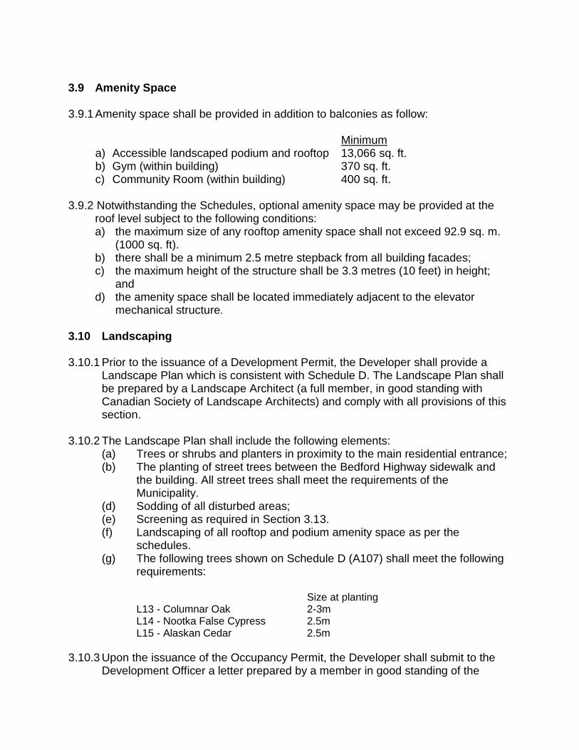
3.9 Amenity Space 3.9.1 Amenity space shall be provided in addition to balconies as follow: Minimum
a) Accessible landscaped podium and rooftop 13,066 sq. ft. b) Gym (within building) 370 sq. ft. c) Community Room (within building) 400 sq. ft.
3.9.2 Notwithstanding the Schedules, optional amenity space may be provided at the
roof level subject to the following conditions: a) the maximum size of any rooftop amenity space shall not exceed 92.9 sq. m.
(1000 sq. ft). b) there shall be a minimum 2.5 metre stepback from all building facades; c) the maximum height of the structure shall be 3.3 metres (10 feet) in height;
and d) the amenity space shall be located immediately adjacent to the elevator
mechanical structure.
3.10 Landscaping 3.10.1 Prior to the issuance of a Development Permit, the Developer shall provide a
Landscape Plan which is consistent with Schedule D. The Landscape Plan shall be prepared by a Landscape Architect (a full member, in good standing with Canadian Society of Landscape Architects) and comply with all provisions of this section.
3.10.2 The Landscape Plan shall include the following elements: (a) Trees or shrubs and planters in proximity to the main residential entrance; (b) The planting of street trees between the Bedford Highway sidewalk and
the building. All street trees shall meet the requirements of the Municipality.
(d) Sodding of all disturbed areas; (e) Screening as required in Section 3.13. (f) Landscaping of all rooftop and podium amenity space as per the
schedules. (g) The following trees shown on Schedule D (A107) shall meet the following
requirements:
Size at planting L13 - Columnar Oak 2-3m
L14 - Nootka False Cypress 2.5m L15 - Alaskan Cedar 2.5m
3.10.3 Upon the issuance of the Occupancy Permit, the Developer shall submit to the Development Officer a letter prepared by a member in good standing of the
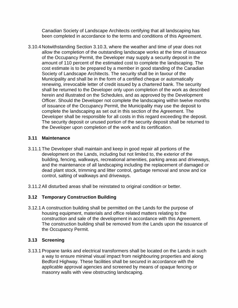
Canadian Society of Landscape Architects certifying that all landscaping has been completed in accordance to the terms and conditions of this Agreement.
3.10.4 Notwithstanding Section 3.10.3, where the weather and time of year does not
allow the completion of the outstanding landscape works at the time of issuance of the Occupancy Permit, the Developer may supply a security deposit in the amount of 110 percent of the estimated cost to complete the landscaping. The cost estimate is to be prepared by a member in good standing of the Canadian Society of Landscape Architects. The security shall be in favour of the Municipality and shall be in the form of a certified cheque or automatically renewing, irrevocable letter of credit issued by a chartered bank. The security shall be returned to the Developer only upon completion of the work as described herein and illustrated on the Schedules, and as approved by the Development Officer. Should the Developer not complete the landscaping within twelve months of issuance of the Occupancy Permit, the Municipality may use the deposit to complete the landscaping as set out in this section of the Agreement. The Developer shall be responsible for all costs in this regard exceeding the deposit. The security deposit or unused portion of the security deposit shall be returned to the Developer upon completion of the work and its certification.
3.11 Maintenance 3.11.1 The Developer shall maintain and keep in good repair all portions of the
development on the Lands, including but not limited to, the exterior of the building, fencing, walkways, recreational amenities, parking areas and driveways, and the maintenance of all landscaping including the replacement of damaged or dead plant stock, trimming and litter control, garbage removal and snow and ice control, salting of walkways and driveways.
3.11.2 All disturbed areas shall be reinstated to original condition or better. 3.12 Temporary Construction Building 3.12.1 A construction building shall be permitted on the Lands for the purpose of
housing equipment, materials and office related matters relating to the construction and sale of the development in accordance with this Agreement. The construction building shall be removed from the Lands upon the issuance of the Occupancy Permit.
3.13 Screening 3.13.1 Propane tanks and electrical transformers shall be located on the Lands in such
a way to ensure minimal visual impact from neighbouring properties and along Bedford Highway. These facilities shall be secured in accordance with the applicable approval agencies and screened by means of opaque fencing or masonry walls with view obstructing landscaping.
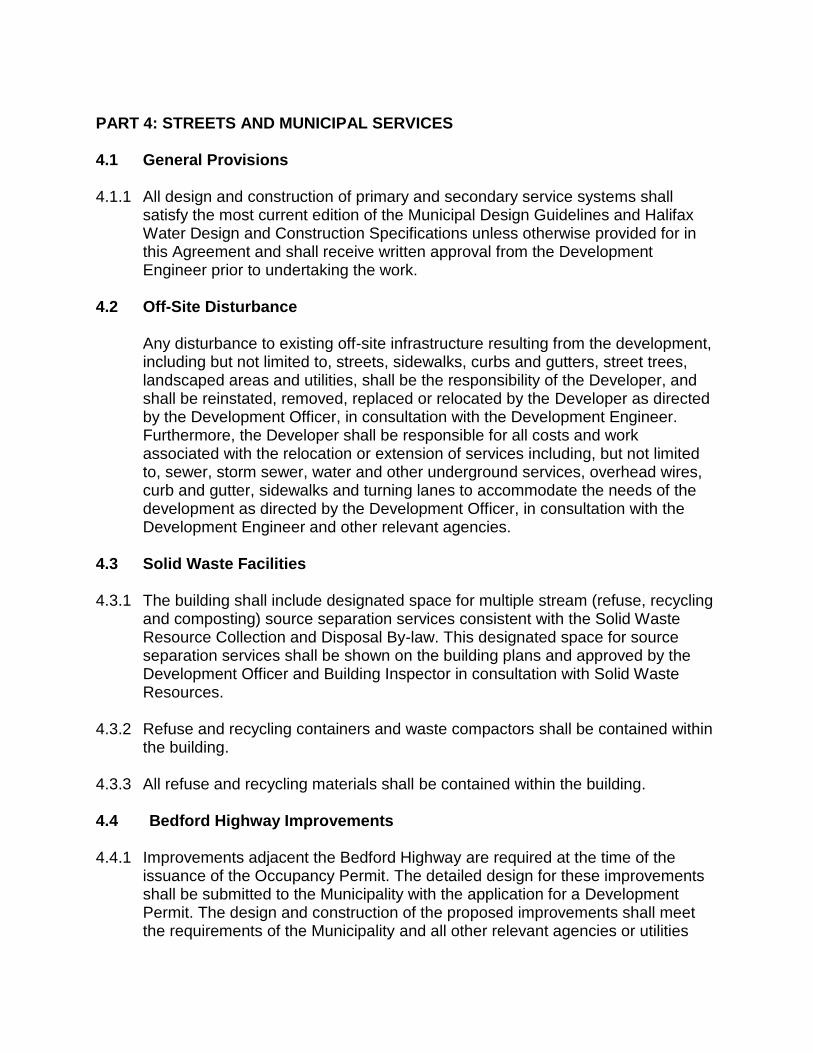
PART 4: STREETS AND MUNICIPAL SERVICES 4.1 General Provisions 4.1.1 All design and construction of primary and secondary service systems shall
satisfy the most current edition of the Municipal Design Guidelines and Halifax Water Design and Construction Specifications unless otherwise provided for in this Agreement and shall receive written approval from the Development Engineer prior to undertaking the work.
4.2 Off-Site Disturbance Any disturbance to existing off-site infrastructure resulting from the development,
including but not limited to, streets, sidewalks, curbs and gutters, street trees, landscaped areas and utilities, shall be the responsibility of the Developer, and shall be reinstated, removed, replaced or relocated by the Developer as directed by the Development Officer, in consultation with the Development Engineer. Furthermore, the Developer shall be responsible for all costs and work associated with the relocation or extension of services including, but not limited to, sewer, storm sewer, water and other underground services, overhead wires, curb and gutter, sidewalks and turning lanes to accommodate the needs of the development as directed by the Development Officer, in consultation with the Development Engineer and other relevant agencies.
4.3 Solid Waste Facilities 4.3.1 The building shall include designated space for multiple stream (refuse, recycling
and composting) source separation services consistent with the Solid Waste Resource Collection and Disposal By-law. This designated space for source separation services shall be shown on the building plans and approved by the Development Officer and Building Inspector in consultation with Solid Waste Resources.
4.3.2 Refuse and recycling containers and waste compactors shall be contained within
the building. 4.3.3 All refuse and recycling materials shall be contained within the building.
4.4 Bedford Highway Improvements 4.4.1 Improvements adjacent the Bedford Highway are required at the time of the
issuance of the Occupancy Permit. The detailed design for these improvements shall be submitted to the Municipality with the application for a Development Permit. The design and construction of the proposed improvements shall meet the requirements of the Municipality and all other relevant agencies or utilities
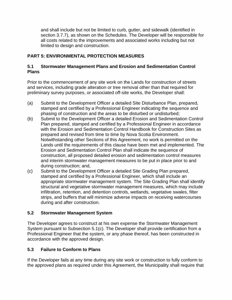
and shall include but not be limited to curb, gutter, and sidewalk (identified in section 3.7.7), as shown on the Schedules. The Developer will be responsible for all costs related to the improvements and associated works including but not limited to design and construction.
PART 5: ENVIRONMENTAL PROTECTION MEASURES
5.1 Stormwater Management Plans and Erosion and Sedimentation Control Plans
Prior to the commencement of any site work on the Lands for construction of streets and services, including grade alteration or tree removal other than that required for preliminary survey purposes, or associated off-site works, the Developer shall:
(a) Submit to the Development Officer a detailed Site Disturbance Plan, prepared,
stamped and certified by a Professional Engineer indicating the sequence and phasing of construction and the areas to be disturbed or undisturbed;
(b) Submit to the Development Officer a detailed Erosion and Sedimentation Control Plan prepared, stamped and certified by a Professional Engineer in accordance with the Erosion and Sedimentation Control Handbook for Construction Sites as prepared and revised from time to time by Nova Scotia Environment. Notwithstanding other Sections of this Agreement, no work is permitted on the Lands until the requirements of this clause have been met and implemented. The Erosion and Sedimentation Control Plan shall indicate the sequence of construction, all proposed detailed erosion and sedimentation control measures and interim stormwater management measures to be put in place prior to and during construction; and,
(c) Submit to the Development Officer a detailed Site Grading Plan prepared, stamped and certified by a Professional Engineer, which shall include an appropriate stormwater management system. The Site Grading Plan shall identify structural and vegetative stormwater management measures, which may include infiltration, retention, and detention controls, wetlands, vegetative swales, filter strips, and buffers that will minimize adverse impacts on receiving watercourses during and after construction.
5.2 Stormwater Management System
The Developer agrees to construct at his own expense the Stormwater Management System pursuant to Subsection 5.1(c). The Developer shall provide certification from a Professional Engineer that the system, or any phase thereof, has been constructed in accordance with the approved design.
5.3 Failure to Conform to Plans
If the Developer fails at any time during any site work or construction to fully conform to the approved plans as required under this Agreement, the Municipality shall require that
all site and construction works cease, except for works which may be approved by the Development Engineer to ensure compliance with the environmental protection measures.
PART 6: AMENDMENTS 6.1 Non-Substantive Amendments The following items are considered by both parties to be not substantive and may be amended by resolution of Council. (a) Minor changes to the placement and architectural design of the building as
outlined in Section 3.4 of this Agreement, including changes in cladding material, which are beyond the authority of the Development Officer under Sections 3.1 or 3.4 of this Agreement;
(b) The granting of an extension to the date of commencement of construction as identified in Section 7.3 of this Agreement; and
(c) The length of time for the completion of the development as identified in Section 7.5 of this Agreement.
6.2 Substantive Amendments
Amendments to any matters not identified under Section 6.1 shall be deemed substantive and may only be amended in accordance with the approval requirements of the Halifax Regional Municipality Charter.
PART 7: REGISTRATION, EFFECT OF CONVEYANCES AND DISCHARGE
7.1 Registration A copy of this Agreement and every amendment or discharge of this Agreement shall be recorded at the Registry of Deeds or Land Registry Office at Halifax, Nova Scotia and the Developer shall incur all costs in recording such documents. 7.2 Subsequent Owners 7.2.1 This Agreement shall be binding upon the parties hereto, their heirs, successors,
assigns, mortgagees, lessees and all subsequent owners, and shall run with the Lands which are the subject of this Agreement until this Agreement is discharged by Council.
7.2.2 Upon the transfer of title to any lot(s), the subsequent owner(s) thereof shall
observe and perform the terms and conditions of this Agreement to the extent applicable to the lot(s).
7.3 Commencement of Development
7.3.1 In the event that development on the Lands has not commenced within three (3)
years from the date of registration of this Agreement at the Registry of Deeds or Land Registry Office, as indicated herein, the Agreement shall have no further force or effect and henceforth the development of the Lands shall conform with the provisions of the Land Use By-law.
7.3.2 For the purpose of this section, commencement of development shall mean the
issuance of a Construction Permit. 7.3.3 For the purpose of this section, Council may consider granting an extension of
the commencement of development time period through a resolution under Section 6.1, if the Municipality receives a written request from the Developer at least sixty (60) calendar days prior to the expiry of the commencement of development time period.
7.4. Completion of Development Upon the completion of the whole development or complete phases of the development, Council may review this Agreement, in whole or in part, and may: (a) retain the Agreement in its present form; (b) negotiate a new Agreement; (c) discharge this Agreement; or (d) for those portions of the development which are completed, discharge this
Agreement and apply appropriate zoning pursuant to the Municipal Planning Strategy and Land Use By-law for Halifax Mainland, as may be amended from time to time.
7.5 Discharge of Agreement If the Developer fails to complete the development after five (5) years from the date of registration of this Agreement at the Registry of Deeds or Land Registration Office Council may review this Agreement, in whole or in part, and may: (a) retain the Agreement in its present form; (b) negotiate a new Agreement; or (c) discharge this Agreement. PART 8: ENFORCEMENT AND RIGHTS AND REMEDIES ON DEFAULT 8.1 Enforcement The Developer agrees that any officer appointed by the Municipality to enforce this Agreement shall be granted access onto the Lands during all reasonable hours without obtaining consent of the Developer. The Developer further agrees that, upon receiving
written notification from an officer of the Municipality to inspect the interior of any building located on the Lands, the Developer agrees to allow for such an inspection during any reasonable hour within twenty four hours of receiving such a request. 8.2 Failure to Comply If the Developer fails to observe or perform any condition of this Agreement after the Municipality has given the Developer fourteen (14) days written notice of the failure or default, then in each such case: (a) The Municipality shall be entitled to apply to any court of competent jurisdiction
for injunctive relief including an order prohibiting the Developer from continuing such default and the Developer hereby submits to the jurisdiction of such Court and waives any defence based upon the allegation that damages would be an adequate remedy;
(b) The Municipality may enter onto the Lands and perform any of the covenants contained in this Agreement or take such remedial action as is considered necessary to correct a breach of the Agreement, whereupon all reasonable expenses whether arising out of the entry onto the Lands or from the performance of the covenants or remedial action, shall be a first lien on the Lands and be shown on any tax certificate issued under the Assessment Act;
(c) The Municipality may by resolution discharge this Agreement whereupon this Agreement shall have no further force or effect and henceforth the development of the Lands shall conform with the provisions of the Land Use By-law; or
(d) In addition to the above remedies, the Municipality reserves the right to pursue any other remedy under the Halifax Regional Municipality Charter or Common Law in order to ensure compliance with this Agreement.
IN WITNESS WHEREAS the said parties to these presents have hereunto set their hands and affixed their seals the day and year first above written. SIGNED, SEALED AND DELIVERED in the presence of: Witness SIGNED, DELIVERED AND ATTESTED to by the proper signing officers of Halifax Regional Municipality, duly authorized in that behalf, in the presence of:
(Insert Registered Owner Name) Per:____________________________ HALIFAX REGIONAL MUNICIPALITY

Witness Witness
Per:____________________________ MAYOR Per:____________________________ MUNICIPAL CLERK
EXIS
TIN
G B
UIL
DIN
G A
ND
FOU
ND
ATIO
N T
O B
E D
EMO
LISH
ED
EXIS
TIN
G D
RIV
EWAY
EASE
MEN
T TO
BE
REM
OVE
D
LOT
BC
IVIC
# 5
96
CH
ARLO
TTE
LAN
E(w
idth
var
ies)
CIV
IC #
80C
HA
RLO
TTE
LA
NE
APA
RTM
ENT
BU
ILD
ING
PA
RC
EL T
EK
-1S
ER
VIC
E E
AS
EM
EN
T
ACC
ESS
EASE
MEN
T
LOT
BC
IVIC
# 6
00
UN
DER
GR
OU
ND
PAR
KIN
G A
T PR
OPE
RTY
LIN
E
UN
DER
GR
OU
ND
PAR
KIN
G A
T PR
OPE
RTY
LIN
E
RAM
P U
P(2
2 C
ARS)
(30
CAR
S)
0
3
7
10
13
16
20
23
26
30
33
36
39
43
0
3
7
10
13
16
20
23
26
30
13' - 6"
3' - 0"
20' - 5"
22' -
0"
23' - 0"
MAINENTRANCE
NEW SIDEWALK
PID
0028
9546
LOT
GC
IVIC
# 5
92PR
OPE
RTY
OW
NER:
324
7003
NS
Ltd
LAN
D A
REA
- 24
,230
sq.
ft.B
UILD
ING
FO
OTP
RIN
T - 1
7,35
5 SF
DROP OFF
VISITOR PARKING 18' -
5"
BIKE
RAC
KS
234
23' - 5"
23' - 0"
NEW SIDEWALK
PROPERTY LINE
PR
OP
ER
TY L
INE
BEDFORD HIGHWAY
PROPERTY LINE
PRO
PER
TY L
INE
NEW
SID
EWAL
K
28' -
6"
4' -
11"
6' - 8"30' - 8"
PAR
CEL
CM
E-1
prop
osed
con
stru
ctio
n an
dm
aint
enan
ce e
asem
ent i
n fa
vour
of lo
t G1,
484
sq.ft
PAR
CEL
CM
E-2
prop
osed
con
stru
ctio
n an
dm
aint
enan
ce e
asem
ent i
nfa
vour
of l
ot G
1,95
4 sq
.ft
PAR
CEL
CM
E-3
prop
osed
con
stru
ctio
n an
dm
aint
enan
ce e
asem
ent i
n fa
vour
of lo
t G3,
917
sq.ft
1
DO
NO
TSC
ALE
DR
AWIN
GS.
ALL
DIM
ENSI
ON
STO
BEVE
RIF
IED
ON
SITE
.IN
THE
ABS
ENC
EO
FD
IMEN
SIO
NS
,OR
IFD
ISC
RE
PAN
CIE
SE
XIS
T,C
ON
SU
LTA
RC
HIT
EC
T.A
LLM
INIM
AL
DIM
EN
SIO
NS
SH
ALL
CO
MPL
YW
ITH
THE
NAT
ION
ALBU
ILD
ING
CO
DE.
THE
USE
OF
THIS
DR
AWIN
GSH
ALL
BEG
OVE
RN
EDBY
STAN
DAR
DC
OPY
RIG
HT
LAW
ASG
EN
ER
ALL
YA
CC
EP
TE
DIN
AR
CH
ITE
CT
UR
AL
PR
AC
TIC
E.
58
80
Sp
rin
gG
ard
en
Ro
ad
,S
uit
e1
09
Ha
lifa
x,
No
va
Sc
oti
aB
3H
1Y
1t.
90
2.4
04
.83
83
f.9
02
.40
4.8
36
8
DW
GC
LIEN
TD
RAW
NP
RO
J ID
PR
OJ
NAM
EA
DD
RES
SD
ESIG
NED
BY
DAT
ES
CAL
EN
1" =
30'
-0"
A101
SITE
PLA
NJC
/WS
TEAL
592
Bedf
ord
Hig
hway
, NS
3247
003
NS
LTD
592
Bedf
ord
Hig
hway
, NS
SIT
E PL
AN20
11.T
EAL.
003
2016
.06.
21
REV
ISIO
NS
bonea
Typewritten Text
Schedule B - Site Plan
bonea
Sticky Note
MigrationConfirmed set by bonea
bonea
Sticky Note
Accepted set by bonea
0
3
7
10
13
16
20
3
7
10
13
16
20
23
26
30
33 36 39 43
46
523
SF
622
SF
894
SF
269
SF
10FT
SID
E YA
RDLI
MIT
LIN
E
PROPERTY LINE
PR
OP
ERTY
LIN
E
PROPERTY LINE
PRO
PER
TY L
INE
BU
ILD
ING
OU
TLIN
E10
FT S
IDE
YARD
LIM
IT L
INE
15FT
REA
R Y
ARD
LIM
IT L
INE
367
SF
OPE
N S
PAC
E
SIDE
YAR
D LE
GEN
D
10FT
SID
E YA
RD
SE
T B
ACK
BR
OKE
N A
T BU
ILD
ING
ABO
VE G
RO
UN
D
10FT
SID
E YA
RD
SET
BAC
K B
RO
KEN
AT
UN
DE
RG
OU
ND
PAR
KIN
G
DO
NO
TSC
ALE
DR
AWIN
GS.
ALL
DIM
ENSI
ON
STO
BEVE
RIF
IED
ON
SITE
.IN
THE
ABS
ENC
EO
FD
IMEN
SIO
NS
,OR
IFD
ISC
RE
PAN
CIE
SE
XIS
T,C
ON
SU
LTA
RC
HIT
EC
T.A
LLM
INIM
AL
DIM
EN
SIO
NS
SH
ALL
CO
MPL
YW
ITH
THE
NAT
ION
ALBU
ILD
ING
CO
DE.
THE
USE
OF
THIS
DR
AWIN
GSH
ALL
BEG
OVE
RN
EDBY
STAN
DAR
DC
OPY
RIG
HT
LAW
ASG
EN
ER
ALL
YA
CC
EP
TE
DIN
AR
CH
ITE
CT
UR
AL
PR
AC
TIC
E.
58
80
Sp
rin
gG
ard
en
Ro
ad
,S
uit
e1
09
Ha
lifa
x,
No
va
Sc
oti
aB
3H
1Y
1t.
90
2.4
04
.83
83
f.9
02
.40
4.8
36
8
DW
GC
LIEN
TD
RAW
NP
RO
J ID
PR
OJ
NAM
EA
DD
RES
SD
ESIG
NED
BY
DAT
ES
CAL
EN
1" =
30'
-0"
A102
SITE
SID
E YA
RD
SW
MS
TEAL
592
Bedf
ord
Hig
hway
, NS
3247
003
NS
LTD
592
Bedf
ord
Hig
hway
, NS
SIT
E SI
DE
YAR
DS
2011
.TEA
L.00
320
16.0
6.21
REV
ISIO
NS
bonea
Typewritten Text
Schedule C - Site Plan-Yards
UP
UP
L2L2
L1
L1 L1L1
P2 Level Ramp U
p
P1 Level Entry
Main Entry
Bike Rack
PAVED AR
EA
DROP OFF AREA
LANDSC
APEDM
ECH. CHASE
EXIT ONLY
ENTRY / EXIT
BEDFORD HIGHWAY
VISITOR PARKING
NEW SIDEWALK
Bike R
a cks
15
0'10'
20'40'
42' - 8"
DO
NO
TSC
ALED
RAW
ING
S.ALLD
IMEN
SION
STO
BEVER
IFIEDO
NSITE
.INTH
EA
BSEN
CE
OF
DIM
ENSIO
NS
,OR
IFD
ISCR
EPA
NC
IESE
XIS
T,CO
NS
ULT
AR
CH
ITEC
T.ALL
MIN
IMA
LD
IME
NS
ION
SS
HA
LLC
OM
PLYW
ITHTH
EN
ATION
ALBU
ILDIN
GC
OD
E.THE
USE
OF
THIS
DR
AWIN
GSH
ALLBE
GO
VERN
EDBY
STAND
ARD
CO
PYRIG
HT
LAWAS
GE
NE
RA
LLYA
CC
EP
TE
DIN
AR
CH
ITE
CT
UR
AL
PR
AC
TIC
E.
58
80
Sp
ring
Ga
rde
nR
oa
d,
Su
ite1
09
Ha
lifax
,N
ov
aS
co
tiaB
3H
1Y
1t.9
02
.40
4.8
38
3f.9
02
.40
4.8
36
8
DW
GC
LIENT
DR
AWN
PR
OJ ID
PR
OJ N
AME
AD
DR
ESSD
ESIG
NED
BYD
ATES
CALE
N 1" = 20'-0"
A104LEVEL P1 LAN
DSC
APEA
uthor
Designer
592 Bedford Highw
ay, NS
3247003 NS LTD
592 Bedford Highw
ay, NS
LEVEL P1 LAN
DSC
APE2011.TEA
L.0032016.06.21
REV
ISION
S
KEYN
OTE LEG
END
15G
RA
SS STON
E (permeable pavers)
L1D
WAR
F MU
GO
PINE, PIN
US M
UG
O 'var pum
ilo'L2
Ginkgo, G
inkgo biloba (suggested to HR
M)
bonea
Typewritten Text
Schedule D - Landscape Plans
bonea
Typewritten Text
bonea
Sticky Note
MigrationConfirmed set by bonea
bonea
Sticky Note
Accepted set by bonea
DNDN
-13
-10
-7
-4
0
3
0
L16
L9 L9L7 L7 L7
Sunken patios 1 step
Common PatioCommon Patio
Outdoor fire escape route
A BL29 L34 L34
C
0' 10' 20' 40'
16
L8 L8 L8L16
L13 L13 L13 L14 L14 L15
L33 C14
DO NOT SCALE DRAWINGS. ALL DIMENSIONS TO BE VERIFIED ONSITE. IN THE ABSENCE OF DIMENSIONS , OR IF DISCREPANCIESEXIST, CONSULT ARCHITECT. ALL MINIMAL DIMENSIONS SHALLCOMPLY WITH THE NATIONAL BUILDING CODE. THE USE OF THISDRAWING SHALL BE GOVERNED BY STANDARD COPYRIGHT LAW ASGENERALLY ACCEPTED IN ARCHITECTURAL PRACTICE.
5 8 8 0 S p r i n g G a r d e n R o a d , S u i t e 1 0 9H a l i f a x , N o v a S c o t i a B 3 H 1 Y 1t . 9 0 2 . 4 0 4 . 8 3 8 3 f . 9 0 2 . 4 0 4 . 8 3 6 8
DWG CLIENT DRAWNPROJ IDPROJ NAME
ADDRESSDESIGNED BY
DATESCALE
N 1" = 20'-0" A107
LEVEL 3 LANDSCAPEAuthor
Designer592 Bedford Highway, NS
3247003 NS LTD
592 Bedford Highway, NS
LEVEL 3 LANDSCAPE2011.TEAL.003 2016.06.21
REVISIONS
KEYNOTE LEGEND
14 PAVER16 PEA STONE GRAVELA 12" PLanterB 10'x10' Raised planting bed and benchC 2' Deep PlanterL7 Katsura tree, Cercidiphyllum japonicumL8 Ward's Yew, Taxus x media 'Wardii'L9 Arctic sun dogwood, Cornus sanguinea ‘Arctic Sun’L13 Columnar oak, Quercus robur 'Fastigiata'L14 Nootka false cypress, Chamaecyparis nootkatensis 'Pendula'L15 Alaskan Cedar, Chamaecyparis nootkatensis ´Glauca´L16 Virginia Creeper, Parthenocissus quinquefoliaL29 Native sedum mixL33 TurfL34 Seasonal Planting note: other perennials will be added
L1
L1
L1 L22 L21
L19
L19
L24
L25
L1 L21 L20
BL29
L19
0' 10' 20' 40'
C
14
DO NOT SCALE DRAWINGS. ALL DIMENSIONS TO BE VERIFIED ONSITE. IN THE ABSENCE OF DIMENSIONS , OR IF DISCREPANCIESEXIST, CONSULT ARCHITECT. ALL MINIMAL DIMENSIONS SHALLCOMPLY WITH THE NATIONAL BUILDING CODE. THE USE OF THISDRAWING SHALL BE GOVERNED BY STANDARD COPYRIGHT LAW ASGENERALLY ACCEPTED IN ARCHITECTURAL PRACTICE.
5 8 8 0 S p r i n g G a r d e n R o a d , S u i t e 1 0 9H a l i f a x , N o v a S c o t i a B 3 H 1 Y 1t . 9 0 2 . 4 0 4 . 8 3 8 3 f . 9 0 2 . 4 0 4 . 8 3 6 8
DWG CLIENT DRAWNPROJ IDPROJ NAME
ADDRESSDESIGNED BY
DATESCALE
N 1" = 20'-0" A110
LEVEL 5 LANDSCAPEAuthor
Designer592 Bedford Highway, NS
3247003 NS LTD
592 Bedford Highway, NS
LEVEL 5 LANDSCAPE2011.TEAL.003 2016.06.21
REVISIONS
note: other perennials will be added
KEYNOTE LEGEND
14 PAVERB 10'x10' Raised planting bed and benchC 2' Deep PlanterL1 DWARF MUGO PINE, PINUS MUGO 'var pumilo'L18 Russian Cypress, Microbiota decussateL19 Compact P.J.M. Rhododendron, Rhododendron 'P.J.M. Compact'L20 Ginny Gee Rhododendron, Rhododendron 'Ginny Gee'L21 Columnar Mugo Pine, Pinus mugo 'Columnaris'L22 Kousa Dogwood, Cornus KousaL24 Common juniper, Juniperus communisL25 Bayberry, Myrica pensylvanicaL29 Native sedum mixL34 Seasonal Planting
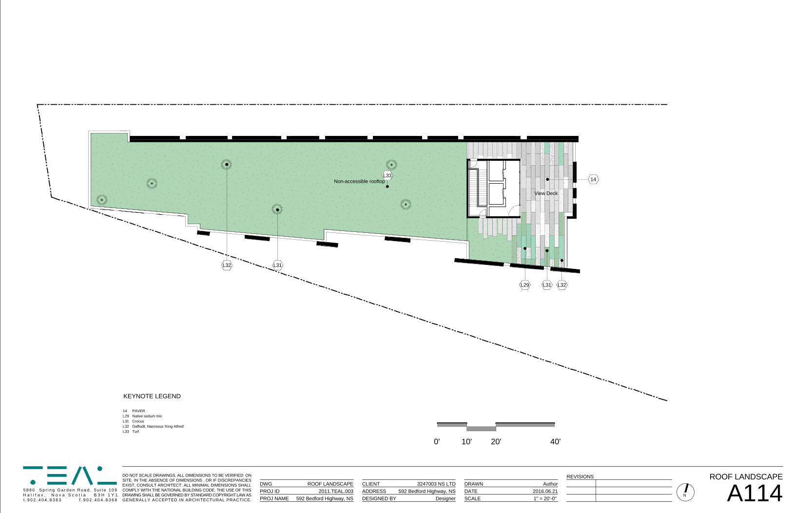
L31L29 L32
14L33
View Deck
L31L32
Non-accessible rooftop
0' 10' 20' 40'
DO NOT SCALE DRAWINGS. ALL DIMENSIONS TO BE VERIFIED ONSITE. IN THE ABSENCE OF DIMENSIONS , OR IF DISCREPANCIESEXIST, CONSULT ARCHITECT. ALL MINIMAL DIMENSIONS SHALLCOMPLY WITH THE NATIONAL BUILDING CODE. THE USE OF THISDRAWING SHALL BE GOVERNED BY STANDARD COPYRIGHT LAW ASGENERALLY ACCEPTED IN ARCHITECTURAL PRACTICE.
5 8 8 0 S p r i n g G a r d e n R o a d , S u i t e 1 0 9H a l i f a x , N o v a S c o t i a B 3 H 1 Y 1t . 9 0 2 . 4 0 4 . 8 3 8 3 f . 9 0 2 . 4 0 4 . 8 3 6 8
DWG CLIENT DRAWNPROJ IDPROJ NAME
ADDRESSDESIGNED BY
DATESCALE
N 1" = 20'-0" A114
ROOF LANDSCAPEAuthor
Designer592 Bedford Highway, NS
3247003 NS LTD
592 Bedford Highway, NS
ROOF LANDSCAPE2011.TEAL.003 2016.06.21
REVISIONS
KEYNOTE LEGEND
14 PAVERL29 Native sedum mixL31 CrocusL32 Daffodil, Narcissus 'King Alfred'L33 Turf
Level P10' - 0"
Level P210' - 0"
Level 320' - 0"
Level 430' - 0"
Level 540' - 0"
Level 650' - 0"
Level 760' - 0"
Level 870' - 0"
RO
OF
80' - 0"
34
9
5 2
1010
11
16
7
DO
NO
TSC
ALED
RAW
ING
S.ALLD
IMEN
SION
STO
BEVER
IFIEDO
NSITE
.INTH
EA
BSEN
CE
OF
DIM
ENSIO
NS
,OR
IFD
ISCR
EPA
NC
IESE
XIS
T,CO
NS
ULT
AR
CH
ITEC
T.ALL
MIN
IMA
LD
IME
NS
ION
SS
HA
LLC
OM
PLYW
ITHTH
EN
ATION
ALBU
ILDIN
GC
OD
E.THE
USE
OF
THIS
DR
AWIN
GSH
ALLBE
GO
VERN
EDBY
STAND
ARD
CO
PYRIG
HT
LAWAS
GE
NE
RA
LLYA
CC
EP
TE
DIN
AR
CH
ITE
CT
UR
AL
PR
AC
TIC
E.
58
80
Sp
ring
Ga
rde
nR
oa
d,
Su
ite1
09
Ha
lifax
,N
ov
aS
co
tiaB
3H
1Y
1t.9
02
.40
4.8
38
3f.9
02
.40
4.8
36
8
DW
GC
LIENT
DR
AWN
PR
OJ ID
PR
OJ N
AME
AD
DR
ESSD
ESIG
NED
BYD
ATES
CALE
1/16" = 1'-0" A201
NO
RTH
ELEVATION
JC/W
S
TEAL
592 Bedford Highw
ay, NS
3247003 NS LTD
592 Bedford Highw
ay, NS
NO
RTH
ELEVATIO
N2011.TEA
L.0032016.06.21
KEYN
OTE LEG
END
1C
OLO
UR
ED FIBER
CEM
EN
T PAN
ELS2
INSU
LATED PR
ECA
ST CO
NC
RE
TE PAN
ELS3
ALU
MIN
UM
GLA
ZING
SYSTEM: VISIO
N & SPAN
DR
EL PANELS
4A
LUM
INU
M G
LAZING
SYSTEM (FIR
E SHU
TTERS W
HE
RE N
ECE
SSARY)
5B
ALCO
NIES W
ITH FR
AMED
GLASS G
UAR
DS
6LAN
DSC
APED AC
CES
SIBLE R
OO
F7
LAND
SC
APED
NO
N-AC
CESSIBLE R
OO
F9
MEC
HAN
ICAL EN
CLO
SUR
E: PREC
AST CO
NC
RE
TE PAN
ELS10
CO
NC
RETE R
ETAININ
G W
ALL c/w G
UAR
D R
AIL11
OU
TLINE O
F CO
NC
RETE R
ETAININ
G W
ALL BEYO
ND
REV
ISION
S
bonea
Typewritten Text
Schedule E - North Elevation
bonea
Typewritten Text
bonea
Typewritten Text
bonea
Typewritten Text
bonea
Sticky Note
MigrationConfirmed set by bonea
bonea
Sticky Note
Accepted set by bonea
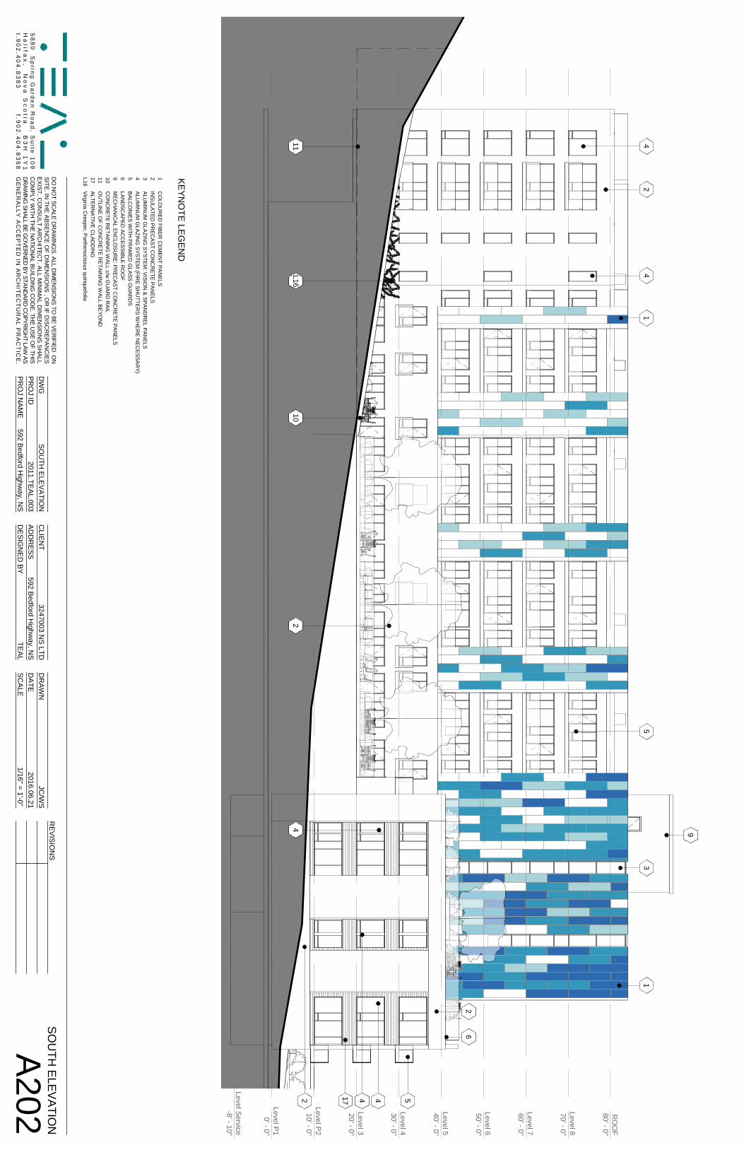
Level P10' - 0"
Level P210' - 0"
Level 320' - 0"
Level 430' - 0"
Level 540' - 0"
Level 650' - 0"
Level 760' - 0"
Level 870' - 0"
RO
OF
80' - 0"
Level Service-8' - 10"
21
3
9
5
54
2
4
44
4
102
211
1
6
L16
17
DO
NO
TSC
ALED
RAW
ING
S.ALLD
IMEN
SION
STO
BEVER
IFIEDO
NSITE
.INTH
EA
BSEN
CE
OF
DIM
ENSIO
NS
,OR
IFD
ISCR
EPA
NC
IESE
XIS
T,CO
NS
ULT
AR
CH
ITEC
T.ALL
MIN
IMA
LD
IME
NS
ION
SS
HA
LLC
OM
PLYW
ITHTH
EN
ATION
ALBU
ILDIN
GC
OD
E.THE
USE
OF
THIS
DR
AWIN
GSH
ALLBE
GO
VERN
EDBY
STAND
ARD
CO
PYRIG
HT
LAWAS
GE
NE
RA
LLYA
CC
EP
TE
DIN
AR
CH
ITE
CT
UR
AL
PR
AC
TIC
E.
58
80
Sp
ring
Ga
rde
nR
oa
d,
Su
ite1
09
Ha
lifax
,N
ov
aS
co
tiaB
3H
1Y
1t.9
02
.40
4.8
38
3f.9
02
.40
4.8
36
8
DW
GC
LIENT
DR
AWN
PR
OJ ID
PR
OJ N
AME
AD
DR
ESSD
ESIG
NED
BYD
ATES
CALE
1/16" = 1'-0" A202
SOU
TH ELEVATIO
NJC
/WS
TEAL
592 Bedford Highw
ay, NS
3247003 NS LTD
592 Bedford Highw
ay, NS
SO
UTH
ELEVATIO
N2011.TEA
L.0032016.06.21
KEYN
OTE LEG
END
1C
OLO
UR
ED FIBER
CEM
EN
T PAN
ELS2
INSU
LATED PR
ECA
ST CO
NC
RE
TE PAN
ELS3
ALU
MIN
UM
GLA
ZING
SYSTEM: VISIO
N & SPAN
DR
EL PANELS
4A
LUM
INU
M G
LAZING
SYSTEM (FIR
E SHU
TTERS W
HE
RE N
ECE
SSARY)
5B
ALCO
NIES W
ITH FR
AMED
GLASS G
UAR
DS
6LAN
DSC
APED AC
CES
SIBLE R
OO
F9
MEC
HAN
ICAL EN
CLO
SUR
E: PREC
AST CO
NC
RE
TE PAN
ELS10
CO
NC
RETE R
ETAININ
G W
ALL c/w G
UAR
D R
AIL11
OU
TLINE O
F CO
NC
RETE R
ETAININ
G W
ALL BEYO
ND
17A
LTER
NATIVE C
LADD
ING
L16V
irginia Creeper, P
arthenocissus quinquefolia
REV
ISION
S
bonea
Typewritten Text
Schedule F - South Elevation
bonea
Typewritten Text
bonea
Typewritten Text
bonea
Sticky Note
MigrationConfirmed set by bonea
bonea
Sticky Note
Accepted set by bonea
bonea
Typewritten Text
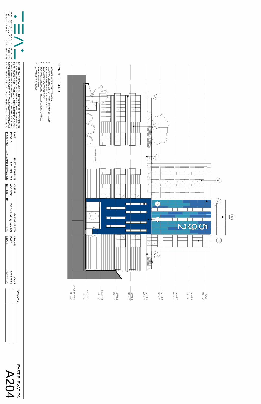
Level P10' - 0"
Level P210' - 0"
Level 320' - 0"
Level 430' - 0"
Level 540' - 0"
Level 650' - 0"
Level 760' - 0"
Level 870' - 0"
RO
OF
80' - 0"
Level Service-8' - 10"
9
13
3
65
123
617
DO
NO
TSC
ALED
RAW
ING
S.ALLD
IMEN
SION
STO
BEVER
IFIEDO
NSITE
.INTH
EA
BSEN
CE
OF
DIM
ENSIO
NS
,OR
IFD
ISCR
EPA
NC
IESE
XIS
T,CO
NS
ULT
AR
CH
ITEC
T.ALL
MIN
IMA
LD
IME
NS
ION
SS
HA
LLC
OM
PLYW
ITHTH
EN
ATION
ALBU
ILDIN
GC
OD
E.THE
USE
OF
THIS
DR
AWIN
GSH
ALLBE
GO
VERN
EDBY
STAND
ARD
CO
PYRIG
HT
LAWAS
GE
NE
RA
LLYA
CC
EP
TE
DIN
AR
CH
ITE
CT
UR
AL
PR
AC
TIC
E.
58
80
Sp
ring
Ga
rde
nR
oa
d,
Su
ite1
09
Ha
lifax
,N
ov
aS
co
tiaB
3H
1Y
1t.9
02
.40
4.8
38
3f.9
02
.40
4.8
36
8
DW
GC
LIENT
DR
AWN
PR
OJ ID
PR
OJ N
AME
AD
DR
ESSD
ESIG
NED
BYD
ATES
CALE
1/16" = 1'-0" A204
EAST ELEVATION
JC/W
S
TEAL
592 Bedford Highw
ay, NS
3247003 NS LTD
592 Bedford Highw
ay, NS
EA
ST ELE
VATIO
N2011.TEA
L.0032016.06.21
KEYN
OTE LEG
END
1C
OLO
UR
ED FIBER
CEM
EN
T PAN
ELS3
ALU
MIN
UM
GLA
ZING
SYSTEM: VISIO
N & SPAN
DR
EL PANELS
5B
ALCO
NIES W
ITH FR
AMED
GLASS G
UAR
DS
6LAN
DSC
APED AC
CES
SIBLE R
OO
F9
MEC
HAN
ICAL EN
CLO
SUR
E: PREC
AST CO
NC
RE
TE PAN
ELS12
FIBER C
EMEN
T PANEL
17A
LTER
NATIVE C
LADD
ING
REV
ISION
S
bonea
Typewritten Text
Schedule G - East Elevation
bonea
Typewritten Text
bonea
Sticky Note
MigrationConfirmed set by bonea
bonea
Sticky Note
Accepted set by bonea
bonea
Typewritten Text
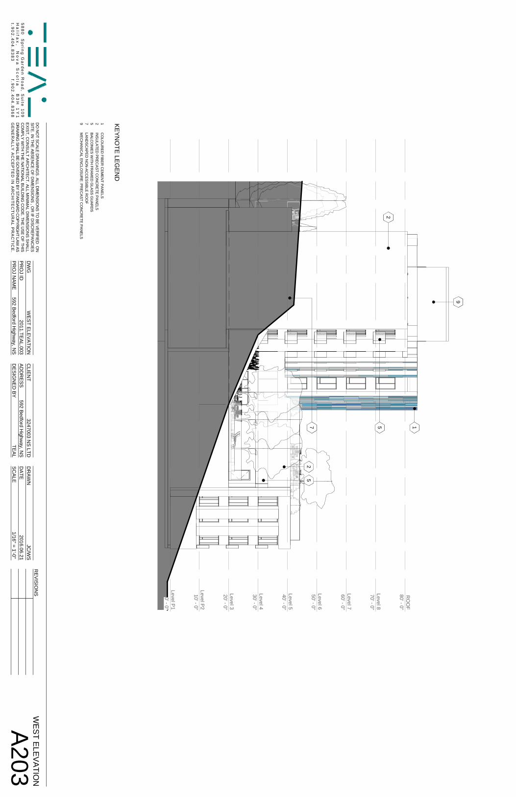
Level P10' - 0"
Level P210' - 0"
Level 320' - 0"
Level 430' - 0"
Level 540' - 0"
Level 650' - 0"
Level 760' - 0"
Level 870' - 0"
RO
OF
80' - 0"
9
2
15
52
7
DO
NO
TSC
ALED
RAW
ING
S.ALLD
IMEN
SION
STO
BEVER
IFIEDO
NSITE
.INTH
EA
BSEN
CE
OF
DIM
ENSIO
NS
,OR
IFD
ISCR
EPA
NC
IESE
XIS
T,CO
NS
ULT
AR
CH
ITEC
T.ALL
MIN
IMA
LD
IME
NS
ION
SS
HA
LLC
OM
PLYW
ITHTH
EN
ATION
ALBU
ILDIN
GC
OD
E.THE
USE
OF
THIS
DR
AWIN
GSH
ALLBE
GO
VERN
EDBY
STAND
ARD
CO
PYRIG
HT
LAWAS
GE
NE
RA
LLYA
CC
EP
TE
DIN
AR
CH
ITE
CT
UR
AL
PR
AC
TIC
E.
58
80
Sp
ring
Ga
rde
nR
oa
d,
Su
ite1
09
Ha
lifax
,N
ov
aS
co
tiaB
3H
1Y
1t.9
02
.40
4.8
38
3f.9
02
.40
4.8
36
8
DW
GC
LIENT
DR
AWN
PR
OJ ID
PR
OJ N
AME
AD
DR
ESSD
ESIG
NED
BYD
ATES
CALE
1/16" = 1'-0" A203
WEST ELEVATIO
NJC
/WS
TEAL
592 Bedford Highw
ay, NS
3247003 NS LTD
592 Bedford Highw
ay, NS
WEST ELEVATIO
N2011.TEA
L.0032016.06.21
KEYN
OTE LEG
END
1C
OLO
UR
ED FIBER
CEM
EN
T PAN
ELS2
INSU
LATED PR
ECA
ST CO
NC
RE
TE PAN
ELS5
BALC
ON
IES WITH
FRAM
ED G
LASS GU
ARD
S7
LAND
SC
APED
NO
N-AC
CESSIBLE R
OO
F9
MEC
HAN
ICAL EN
CLO
SUR
E: PREC
AST CO
NC
RE
TE PAN
ELS
REV
ISION
S
bonea
Typewritten Text
Schedule H - West Elevation
bonea
Typewritten Text
bonea
Sticky Note
MigrationConfirmed set by bonea
bonea
Sticky Note
Accepted set by bonea
bonea
Typewritten Text
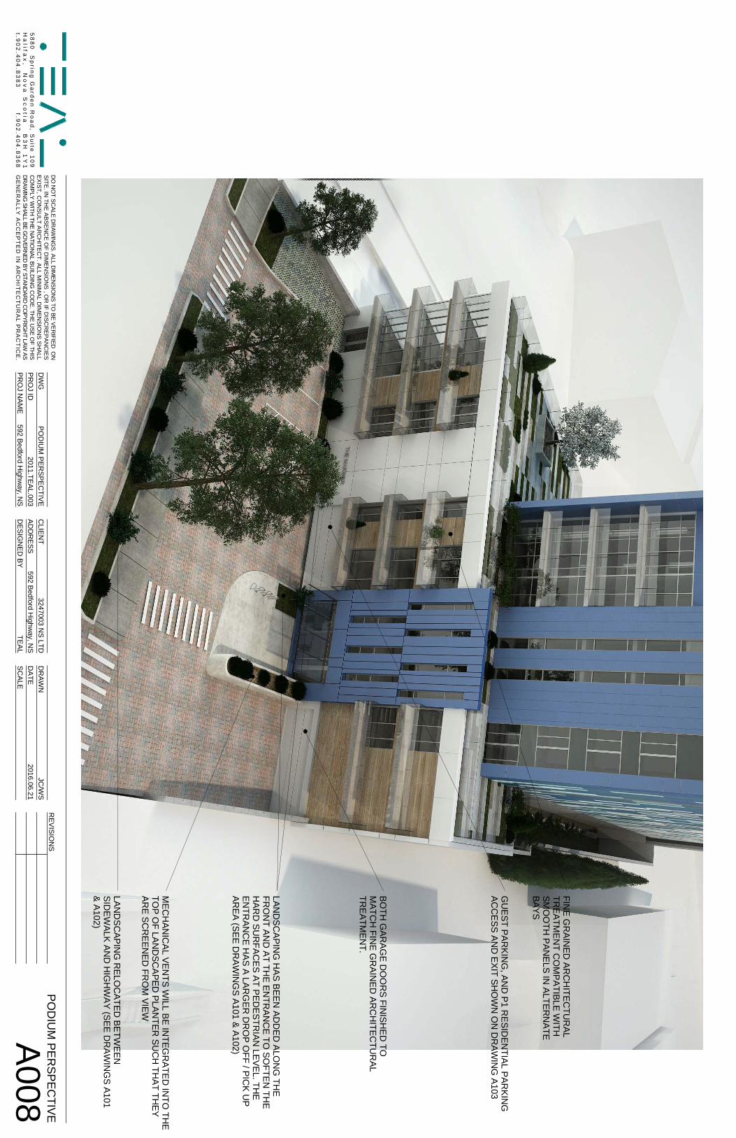
DO
NO
TSC
ALED
RAW
ING
S.ALLD
IMEN
SION
STO
BEVER
IFIEDO
NSITE
.INTH
EA
BSEN
CE
OF
DIM
ENSIO
NS
,OR
IFD
ISCR
EPA
NC
IESE
XIS
T,CO
NS
ULT
AR
CH
ITEC
T.ALL
MIN
IMA
LD
IME
NS
ION
SS
HA
LLC
OM
PLYW
ITHTH
EN
ATION
ALBU
ILDIN
GC
OD
E.THE
USE
OF
THIS
DR
AWIN
GSH
ALLBE
GO
VERN
EDBY
STAND
ARD
CO
PYRIG
HT
LAWAS
GE
NE
RA
LLYA
CC
EP
TE
DIN
AR
CH
ITE
CT
UR
AL
PR
AC
TIC
E.
58
80
Sp
ring
Ga
rde
nR
oa
d,
Su
ite1
09
Ha
lifax
,N
ov
aS
co
tiaB
3H
1Y
1t.9
02
.40
4.8
38
3f.9
02
.40
4.8
36
8
DW
GC
LIENT
DR
AWN
PR
OJ ID
PR
OJ N
AME
AD
DR
ESSD
ESIG
NED
BYD
ATES
CALE
A008
POD
IUM
PERSPEC
TIVEJC
/WS
TEAL
592 Bedford Highw
ay, NS
3247003 NS LTD
592 Bedford Highw
ay, NS
PO
DIU
M P
ERS
PEC
TIVE2011.TEA
L.0032016.06.21
REV
ISION
S
FINE G
RAIN
ED AR
CH
ITECTU
RAL
TREATM
ENT C
OM
PATIBLE WITH
SMO
OTH
PANELS IN
ALTERN
ATEBAYS
BOTH
GAR
AGE D
OO
RS FIN
ISHED
TOM
ATCH
FINE G
RAIN
ED AR
CH
ITECTU
RAL
TREATM
ENT.
LAND
SCAPIN
G R
ELOC
ATED BETW
EENSID
EWALK AN
D H
IGH
WAY (SEE D
RAW
ING
S A101& A102)
MEC
HAN
ICAL VEN
TS WILL BE IN
TEGR
ATED IN
TO TH
ETO
P OF LAN
DSC
APED PLAN
TER SU
CH
THAT TH
EYAR
E SCR
EENED
FRO
M VIEW
LAND
SCAPIN
G H
AS BEEN AD
DED
ALON
G TH
EFR
ON
T AND
AT THE EN
TRAN
CE TO
SOFTEN
THE
HAR
D SU
RFAC
ES AT PEDESTR
IAN LEVEL. TH
EEN
TRAN
CE H
AS A LARG
ER D
RO
P OFF / PIC
K UP
AREA (SEE D
RAW
ING
S A101 & A102)
GU
EST PARKIN
G, AN
D P1 R
ESIDEN
TIAL PARKIN
GAC
CESS AN
D EXIT SH
OW
N O
N D
RAW
ING
A103
bonea
Typewritten Text
Schedule I - Fine Grain Detailing
bonea
Typewritten Text
bonea
Typewritten Text
bonea
Typewritten Text
bonea
Typewritten Text
bonea
Typewritten Text
bonea
Typewritten Text
bonea
Typewritten Text
bonea
Typewritten Text
bonea
Typewritten Text
bonea
Typewritten Text
bonea
Typewritten Text
bonea
Typewritten Text
bonea
Typewritten Text
bonea
Typewritten Text
bonea
Typewritten Text
bonea
Sticky Note
MigrationConfirmed set by bonea
bonea
Sticky Note
Accepted set by bonea
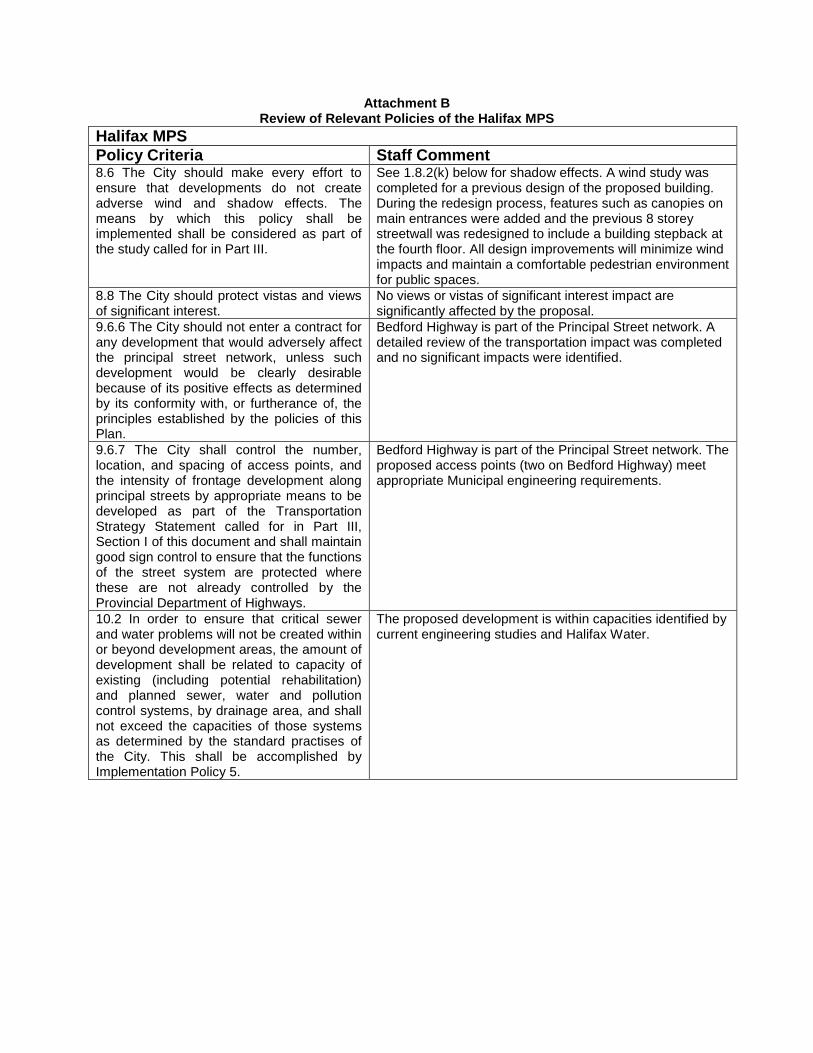
Attachment B Review of Relevant Policies of the Halifax MPS
Halifax MPS Policy Criteria Staff Comment 8.6 The City should make every effort to ensure that developments do not create adverse wind and shadow effects. The means by which this policy shall be implemented shall be considered as part of the study called for in Part III.
See 1.8.2(k) below for shadow effects. A wind study was completed for a previous design of the proposed building. During the redesign process, features such as canopies on main entrances were added and the previous 8 storey streetwall was redesigned to include a building stepback at the fourth floor. All design improvements will minimize wind impacts and maintain a comfortable pedestrian environment for public spaces.
8.8 The City should protect vistas and views of significant interest.
No views or vistas of significant interest impact are significantly affected by the proposal.
9.6.6 The City should not enter a contract for any development that would adversely affect the principal street network, unless such development would be clearly desirable because of its positive effects as determined by its conformity with, or furtherance of, the principles established by the policies of this Plan.
Bedford Highway is part of the Principal Street network. A detailed review of the transportation impact was completed and no significant impacts were identified.
9.6.7 The City shall control the number, location, and spacing of access points, and the intensity of frontage development along principal streets by appropriate means to be developed as part of the Transportation Strategy Statement called for in Part III, Section I of this document and shall maintain good sign control to ensure that the functions of the street system are protected where these are not already controlled by the Provincial Department of Highways.
Bedford Highway is part of the Principal Street network. The proposed access points (two on Bedford Highway) meet appropriate Municipal engineering requirements.
10.2 In order to ensure that critical sewer and water problems will not be created within or beyond development areas, the amount of development shall be related to capacity of existing (including potential rehabilitation) and planned sewer, water and pollution control systems, by drainage area, and shall not exceed the capacities of those systems as determined by the standard practises of the City. This shall be accomplished by Implementation Policy 5.
The proposed development is within capacities identified by current engineering studies and Halifax Water.
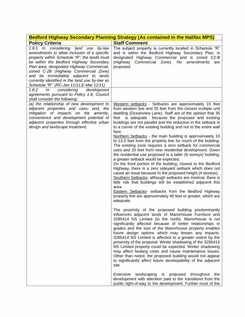
Bedford Highway Secondary Planning Strategy (As contained in the Halifax MPS) Policy Criteria Staff Comment 1.8.1 In considering land use by-law amendments to allow inclusion of a specific property within Schedule “R”, the lands must be within the Bedford Highway Secondary Plan area, designated Highway Commercial, zoned C-2B (Highway Commercial Zone) and be immediately adjacent to lands currently identified in the land use by-law as Schedule “R”. (RC-Jan 11/11;E-Mar 12/11)
The subject property is currently located in Schedule “R” and is within the Bedford Highway Secondary Plan, is designated Highway Commercial and is zoned C2-B (Highway Commercial Zone). No amendments are proposed.
1.8.2 In considering development agreements pursuant to Policy 1.8, Council shall consider the following:
(a) the relationship of new development to adjacent properties and uses; and, the mitigation of impacts on the amenity, convenience and development potential of adjacent properties through effective urban design and landscape treatment;
Western setbacks - Setbacks are approximately 15 feet from western line and 35 feet from the closest multiple unit dwelling (Oceanview Lane). Staff are of the opinion that 35 feet is adequate because the proposed and existing buildings are not parallel and the reduction in the setback is to a corner of the existing building and not to the entire wall face. Northern Setbacks - the main building is approximately 10 to 13.5 feet from the property line for much of the building. The existing zone requires a zero setback for commercial uses and 20 feet from new residential development. Given the residential use proposed is a taller (8 storeys) building, a greater setback would be expected. On the front portion of the building, closest to the Bedford Highway, there is a zero sideyard setback which does not cause an issue because fo the proposed height (4 storeys). Southern Setbacks- although setbacks are minimal, there is little risk that buildings will be established adjacent this area. Eastern Setbacks- setbacks from the Bedford Highway property line are approximately 40 feet or greater, which are adequate. The proximity of the proposed building predominantly influences adjacent lands of Manorhouse Furniture and 3285414 NS Limited (to the north). Manorhouse is not significantly affected because of better relationships in grades and the size of the Manorhouse property enables future design options which may lessen any impacts. 3285414 NS Limited is affected to a greater extent by the proximity of the proposal. Winter shadowing of the 3285414 NS Limited property could be expected. Winter shadowing may affect heating costs and cause maintenance issues. Other than noted, the proposed building would not appear to significantly affect future developability of the adjacent site Extensive landscaping is proposed throughout the development with attention paid to the transitions from the public right-of-way to the development. Further most of the
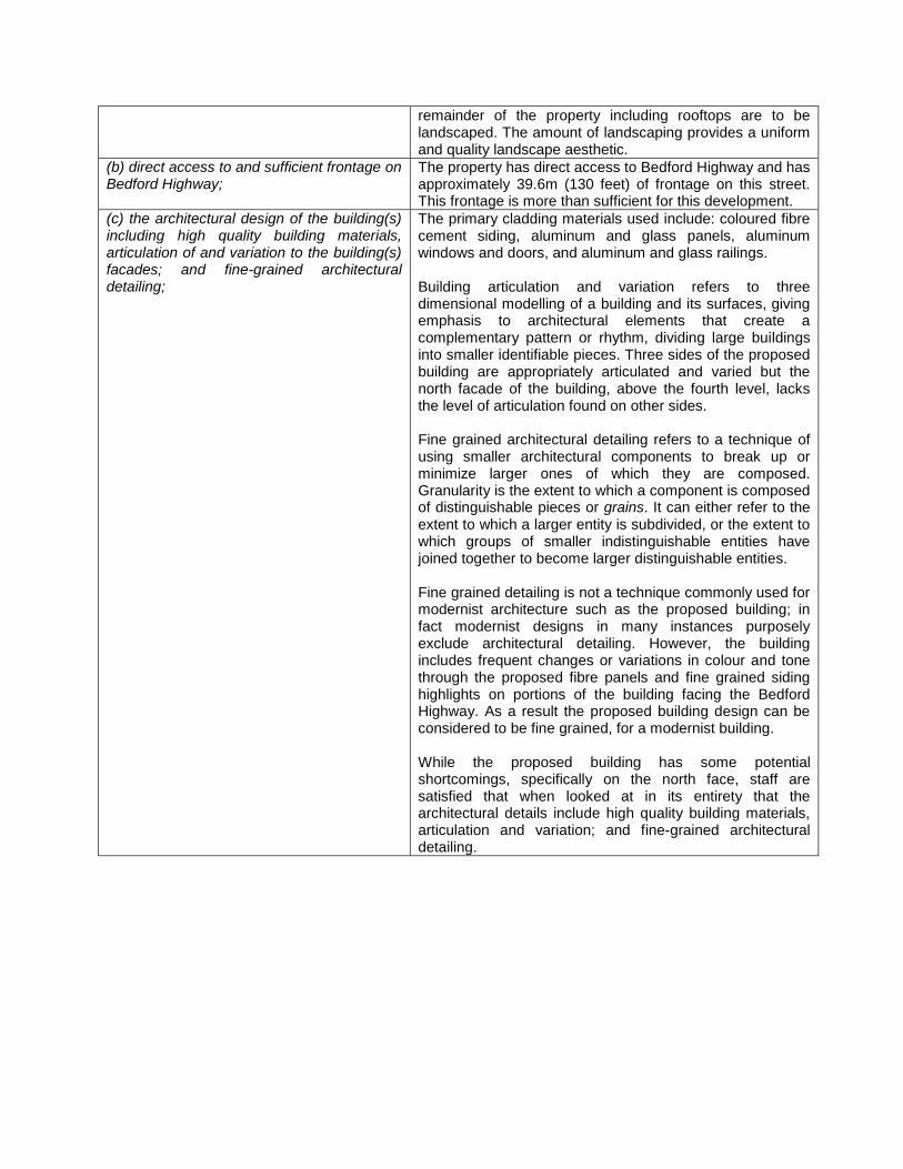
remainder of the property including rooftops are to be landscaped. The amount of landscaping provides a uniform and quality landscape aesthetic.
(b) direct access to and sufficient frontage on Bedford Highway;
The property has direct access to Bedford Highway and has approximately 39.6m (130 feet) of frontage on this street. This frontage is more than sufficient for this development.
(c) the architectural design of the building(s) including high quality building materials, articulation of and variation to the building(s) facades; and fine-grained architectural detailing;
The primary cladding materials used include: coloured fibre cement siding, aluminum and glass panels, aluminum windows and doors, and aluminum and glass railings. Building articulation and variation refers to three dimensional modelling of a building and its surfaces, giving emphasis to architectural elements that create a complementary pattern or rhythm, dividing large buildings into smaller identifiable pieces. Three sides of the proposed building are appropriately articulated and varied but the north facade of the building, above the fourth level, lacks the level of articulation found on other sides. Fine grained architectural detailing refers to a technique of using smaller architectural components to break up or minimize larger ones of which they are composed. Granularity is the extent to which a component is composed of distinguishable pieces or grains. It can either refer to the extent to which a larger entity is subdivided, or the extent to which groups of smaller indistinguishable entities have joined together to become larger distinguishable entities. Fine grained detailing is not a technique commonly used for modernist architecture such as the proposed building; in fact modernist designs in many instances purposely exclude architectural detailing. However, the building includes frequent changes or variations in colour and tone through the proposed fibre panels and fine grained siding highlights on portions of the building facing the Bedford Highway. As a result the proposed building design can be considered to be fine grained, for a modernist building. While the proposed building has some potential shortcomings, specifically on the north face, staff are satisfied that when looked at in its entirety that the architectural details include high quality building materials, articulation and variation; and fine-grained architectural detailing.
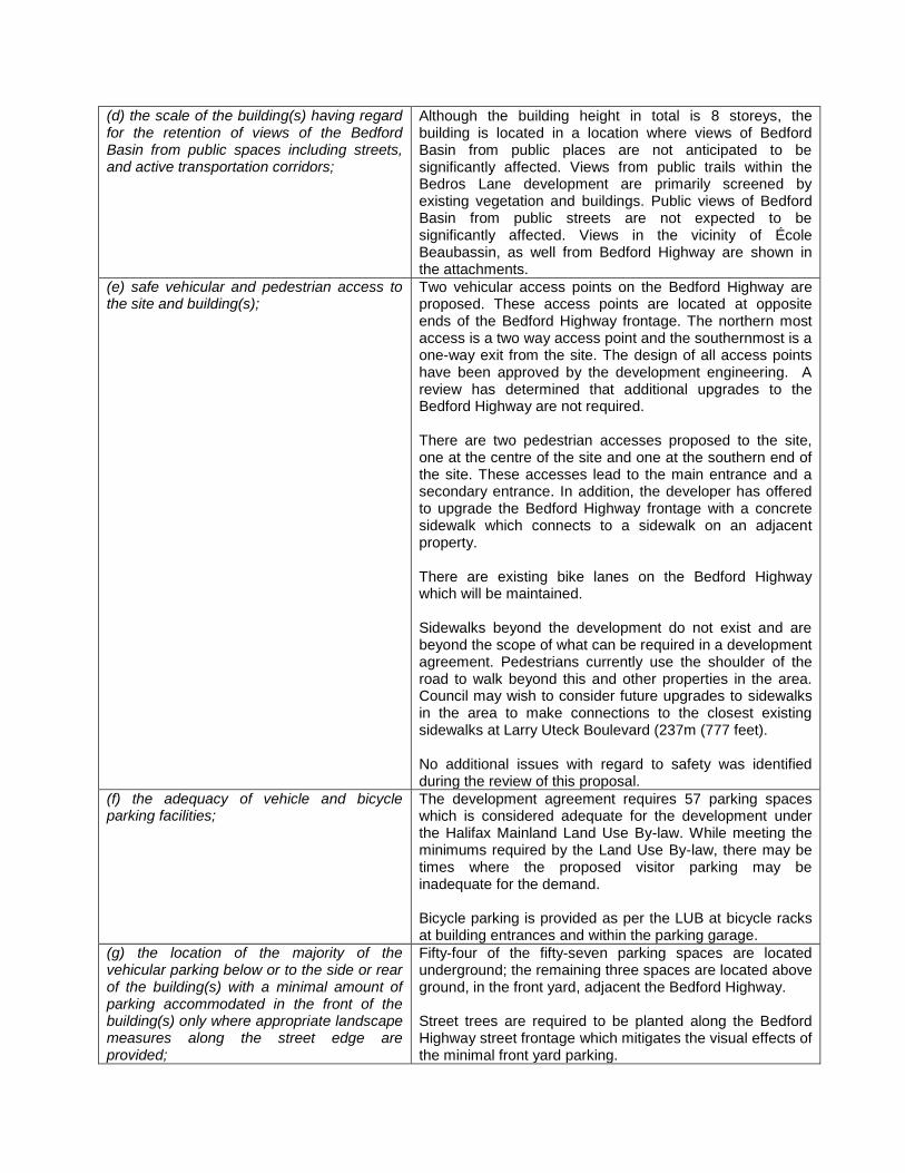
(d) the scale of the building(s) having regard for the retention of views of the Bedford Basin from public spaces including streets, and active transportation corridors;
Although the building height in total is 8 storeys, the building is located in a location where views of Bedford Basin from public places are not anticipated to be significantly affected. Views from public trails within the Bedros Lane development are primarily screened by existing vegetation and buildings. Public views of Bedford Basin from public streets are not expected to be significantly affected. Views in the vicinity of École Beaubassin, as well from Bedford Highway are shown in the attachments.
(e) safe vehicular and pedestrian access to the site and building(s);
Two vehicular access points on the Bedford Highway are proposed. These access points are located at opposite ends of the Bedford Highway frontage. The northern most access is a two way access point and the southernmost is a one-way exit from the site. The design of all access points have been approved by the development engineering. A review has determined that additional upgrades to the Bedford Highway are not required. There are two pedestrian accesses proposed to the site, one at the centre of the site and one at the southern end of the site. These accesses lead to the main entrance and a secondary entrance. In addition, the developer has offered to upgrade the Bedford Highway frontage with a concrete sidewalk which connects to a sidewalk on an adjacent property. There are existing bike lanes on the Bedford Highway which will be maintained. Sidewalks beyond the development do not exist and are beyond the scope of what can be required in a development agreement. Pedestrians currently use the shoulder of the road to walk beyond this and other properties in the area. Council may wish to consider future upgrades to sidewalks in the area to make connections to the closest existing sidewalks at Larry Uteck Boulevard (237m (777 feet). No additional issues with regard to safety was identified during the review of this proposal.
(f) the adequacy of vehicle and bicycle parking facilities;
The development agreement requires 57 parking spaces which is considered adequate for the development under the Halifax Mainland Land Use By-law. While meeting the minimums required by the Land Use By-law, there may be times where the proposed visitor parking may be inadequate for the demand. Bicycle parking is provided as per the LUB at bicycle racks at building entrances and within the parking garage.
(g) the location of the majority of the vehicular parking below or to the side or rear of the building(s) with a minimal amount of parking accommodated in the front of the building(s) only where appropriate landscape measures along the street edge are provided;
Fifty-four of the fifty-seven parking spaces are located underground; the remaining three spaces are located above ground, in the front yard, adjacent the Bedford Highway. Street trees are required to be planted along the Bedford Highway street frontage which mitigates the visual effects of the minimal front yard parking.
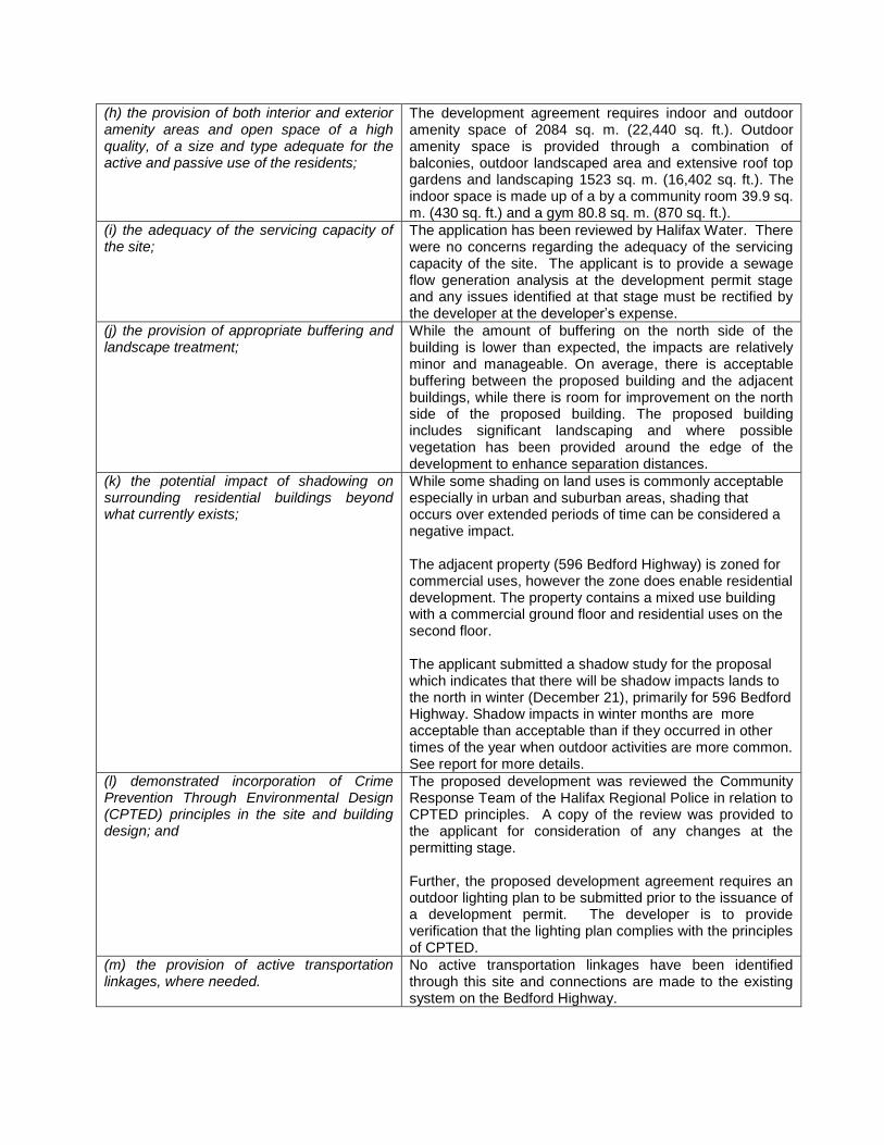
(h) the provision of both interior and exterior amenity areas and open space of a high quality, of a size and type adequate for the active and passive use of the residents;
The development agreement requires indoor and outdoor amenity space of 2084 sq. m. (22,440 sq. ft.). Outdoor amenity space is provided through a combination of balconies, outdoor landscaped area and extensive roof top gardens and landscaping 1523 sq. m. (16,402 sq. ft.). The indoor space is made up of a by a community room 39.9 sq. m. (430 sq. ft.) and a gym 80.8 sq. m. (870 sq. ft.).
(i) the adequacy of the servicing capacity of the site;
The application has been reviewed by Halifax Water. There were no concerns regarding the adequacy of the servicing capacity of the site. The applicant is to provide a sewage flow generation analysis at the development permit stage and any issues identified at that stage must be rectified by the developer at the developer’s expense.
(j) the provision of appropriate buffering and landscape treatment;
While the amount of buffering on the north side of the building is lower than expected, the impacts are relatively minor and manageable. On average, there is acceptable buffering between the proposed building and the adjacent buildings, while there is room for improvement on the north side of the proposed building. The proposed building includes significant landscaping and where possible vegetation has been provided around the edge of the development to enhance separation distances.
(k) the potential impact of shadowing on surrounding residential buildings beyond what currently exists;
While some shading on land uses is commonly acceptable especially in urban and suburban areas, shading that occurs over extended periods of time can be considered a negative impact. The adjacent property (596 Bedford Highway) is zoned for commercial uses, however the zone does enable residential development. The property contains a mixed use building with a commercial ground floor and residential uses on the second floor. The applicant submitted a shadow study for the proposal which indicates that there will be shadow impacts lands to the north in winter (December 21), primarily for 596 Bedford Highway. Shadow impacts in winter months are more acceptable than acceptable than if they occurred in other times of the year when outdoor activities are more common. See report for more details.
(l) demonstrated incorporation of Crime Prevention Through Environmental Design (CPTED) principles in the site and building design; and
The proposed development was reviewed the Community Response Team of the Halifax Regional Police in relation to CPTED principles. A copy of the review was provided to the applicant for consideration of any changes at the permitting stage. Further, the proposed development agreement requires an outdoor lighting plan to be submitted prior to the issuance of a development permit. The developer is to provide verification that the lighting plan complies with the principles of CPTED.
(m) the provision of active transportation linkages, where needed.
No active transportation linkages have been identified through this site and connections are made to the existing system on the Bedford Highway.
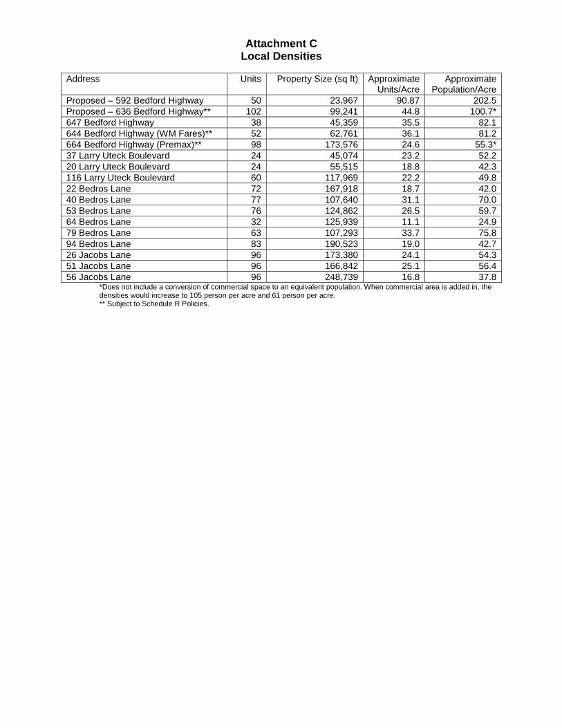
Attachment C Local Densities
Address Units Property Size (sq ft) Approximate
Units/Acre Approximate
Population/Acre Proposed – 592 Bedford Highway 50 23,967 90.87 202.5 Proposed – 636 Bedford Highway** 102 99,241 44.8 100.7* 647 Bedford Highway 38 45,359 35.5 82.1 644 Bedford Highway (WM Fares)** 52 62,761 36.1 81.2 664 Bedford Highway (Premax)** 98 173,576 24.6 55.3* 37 Larry Uteck Boulevard 24 45,074 23.2 52.2 20 Larry Uteck Boulevard 24 55,515 18.8 42.3 116 Larry Uteck Boulevard 60 117,969 22.2 49.8 22 Bedros Lane 72 167,918 18.7 42.0 40 Bedros Lane 77 107,640 31.1 70.0 53 Bedros Lane 76 124,862 26.5 59.7 64 Bedros Lane 32 125,939 11.1 24.9 79 Bedros Lane 63 107,293 33.7 75.8 94 Bedros Lane 83 190,523 19.0 42.7 26 Jacobs Lane 96 173,380 24.1 54.3 51 Jacobs Lane 96 166,842 25.1 56.4 56 Jacobs Lane 96 248,739 16.8 37.8
*Does not include a conversion of commercial space to an equivalent population. When commercial area is added in, the densities would increase to 105 person per acre and 61 person per acre. ** Subject to Schedule R Policies.
Attachment D – Public Information Meeting Notes HALIFAX REGIONAL MUNICIPALITY Public Information Meeting Case No. 19110
The following does not represent a verbatim record of the proceedings of this meeting.
Wednesday, April 16, 2014 7:00 p.m.
St. Peter’s Anglican Church Hall STAFF IN ATTENDANCE: Andrew Bone, Senior Planner, HRM Planning Applications Holly Kent, Planning Technician, HRM Planning Applications Cara McFarlane, Planning Controller, HRM Planning Applications ALSO IN ATTENDANCE: Councillor Tim Outhit, District 16 Kevin Riles, KWR Approvals Inc. Tom Emodi, Teal Architects Ken O’Brien, WSP Canada PUBLIC IN ATTENDANCE: Approximately 56 The meeting commenced at approximately 7:03 pm.
1. Call to order, purpose of meeting – Andrew Bone Case 19110 is an application by KWR Approvals Inc. to enter into a development agreement to permit a ten-storey (58 dwelling units, 6,800 square feet of commercial space and underground parking) at 592 Bedford Highway. The purpose of the Public Information Meeting (PIM) is to identify that Halifax has received an application, give some background on the proposal and receive feedback on the proposal from the public. This is purely for information exchange and no decisions will be made at this PIM. The PIM agenda was reviewed. Mr. Bone introduced himself as the Senior Planner facilitating this application through the planning process; Councillor Tim Outhit, District 16; Cara McFarlane and Holly Kent, HRM Planning Applications; Kevin Riles, KWR Approvals Inc.; Tom Emodi, Teal Architects; and Ken O’Brien, Traffic Engineer, WSP Canada. 2. Overview of planning process – Andrew Bone The planning process includes: PIM; a detailed staff review where comments from the public will be filtered through the appropriate specialists; a draft development agreement is negotiated with
the applicant; staff will write a staff report with a recommendation either for or against the proposal; North West Community Council (NWCC) will schedule a public hearing (another opportunity for the public to speak); NWCC will make a decision at the public hearing; there is a 14-day appeal period through the Nova Scotia Utility and Review Board; if not appealed, the development is executed and registered at which time subdivision and permit applications can be issued and construction can begin. 3. Presentation of Proposal – Andrew Bone The subject property, 592 Bedford Highway, is zoned C-2B (Highway Commercial) Zone which allows a broad range of commercial and residential land uses. Currently, there is a maximum height of 35 feet. Policy within the Halifax Municipal Planning Strategy (MPS), known as Schedule R, allows Council to consider higher buildings on certain properties along the Bedford Highway. The height is not specified; therefore, it is left to Council’s discretion. The area of the site is 25,500 square feet. Policy 1.8 of the Halifax MPS allows for mixed use development by development agreement. A map of properties affected by Schedule R was shown. Staff have reviewed this particular site and feel that it qualifies for consideration of the proposal. A list of Policy criteria for the proposal was reviewed. In the end, a development agreement is negotiated with the applicant and Council’s decision has to be based on the Policy criteria in the MPS. Presentation of Proposal – Kevin Riles The project team have been following the other proposals in the area and attended the public meetings and therefore, took into consideration things like views. Mr. Riles identified members of the project team: Karim Barghouti (developer); KWR Approvals Inc. (consultant and project management); Tom Emodi, Teal Architects; EXP Services Inc. (stormwater and erosion plan); Ken O’Brien, WSP (traffic engineer); SSDM (survey work); and Patterson Law. Presentation of Proposal – Tom Emodi
The concept site plan was shown. The idea was to hide the building into the landscaping. The building footprint is about 42% of the site; the retained/protected natural area is 17% (1/5) of the site; new landscaping at grade and roof is over 20% and the landscape roof over the underground parking area is about 48%. The idea is to improve the treed look of the site. All the buildings around this site are commercial and there are no residential in the immediate area except for the buildings above. One resident mentioned that there is a residential building at 37 Larry Uteck Boulevard which will be impacted. Shown on a plan were: roofed terraces (also a common one for everyone in the building; landscaped roof over the commercial component; and the higher portion of the building is situated so that the side facing the Bedford Highway is quite slim and elegant (doesn’t present a big face).
The shadow studies showed that even on the shortest day of the year the buildings impacted by shadows are not residential. Most of the rest of the year the shadows do not cover any buildings in a major way. The wind study done by RWDI concluded that there would be no impact from the wind. The materials and colors (blues, greens, greys) of the building more or less marry in with the marine environment and work well with the landscaping. The traffic study concluded that low numbers of additional vehicle trips generated by the redeveloped site are not expected to have a significant impact on the Bedford Highway. There are two driveways (shown on plan) to disperse vehicles coming on/off the site. The conclusion from the servicing schematic is that there is capacity and there is no problem with servicing in terms of water and wastewater. The landscaped roofs will balance the runoff after construction. In fact, the runoff post construction will be less than current runoff. Photos of different views pre and post construction were shown. One resident asked about the view from 37 Larry Uteck Boulevard (a residential building). Mr. Emodi explained that these photos are the best in terms of capturing all of the different views around the area. In summary: HRM has identified that this site has good capacity for development in a mixed use neighbourhood; it is tucked away in a curve of the Bedford Highway and underneath a ride in the landscaping underneath the hill; the building is almost at grade; along the Bedford Highway, the elevation is two storeys except for the slim front; the proposal uses only 42% of the lot; there are no concerns with technical studies; almost 100% of parking is underground except for a few drop off points; indoor/outdoor bicycle parking; advance design (every second floor there is a natural ventilation with views on both sides of the floor) and quality materials; and respected community views by turning the building in such a way to avoid significant impact. One resident asked how high the building is. Mr. Emodi said it is 102 feet (shorter than the one approved at 644 Bedford Highway at 106 feet) Mr. Bone showed elevations from other angles. He explained that the first floor elevation would be very much at grade to the Bedford Highway. The existing embankment would be graded and removed. The building is set into the hill in such a way that from the Royalton building the views are minimally affected. 4. Questions and Comments
Henderson Allen, Bedford Highway – The statement about just commercial next to the proposed building is false as there are two houses (including his own) there. Those views of the Basin will be significantly impacted. Over several years he has seen many people killed and on a daily basis accidents or near accidents on the Bedford Highway. The curve in the Highway where the proposed building is situated is not safe. Since Larry Uteck Boulevard has opened up, traffic is a nightmare. When the unfinished buildings on Larry Uteck are complete, there will be several more cars coming down there. What do they plan to do to improve the Bedford Highway? The proposed building comes up to the road; therefore, any future road widening will not be possible. Mr. Allen referred to the building at 827 Bedford Highway that he believes infringes on the Bedford Highway and encouraged Mr. Bone to look further into that one. Mr. Bone will present his comments to the review team.
Ken Brothers, Bedros Lane – When purchasing a property, he was advised by his real estateagent that 35 feet was the height recommendation in that area. He has a waterview from hisproperty and the angles are different from the various views shown. Not fully capturing theimpact on the water, he asked the developer, in his next presentation, to look at various viewsalong the plane. He has an issue with no real height restriction. Mr. Bone explained that thePolicy doesn’t establish a fixed height but through the development agreement, a height wouldbe established. Mr. Brothers said this sets precedence in moving forward. Most Councildecisions are predicated on fact proposal, value and precedence. He is not againstdevelopment, but from his property the view is the side of the proposed building; therefore,obstructing his view significantly. He’s taken back by the fact that this proposal is two to three times the height that has been presented in Council and the MPS and he has made previousdecisions based on that. He would like the developer to consider the extension of the additionalheight and modify the proposal into something that can conform with mitigating his view impact.
Elizabeth Sanderson, Bedros Lane – Unless one travels the Bedford Highway during the workweek, they have no idea of the impact these buildings have on the traffic. She does not believethat the traffic studies performed five years ago are still valid for current and futuredevelopments. The trees along the Bedford Highway are going to be destroyed and replacedwith steel, concrete and windows.
Maureen Palmeter, Fernleigh Park – She asked about this area being identified for highdensity. Mr. Bone explained that before 2010, a review of the planning policy on the westernshore of the Bedford Basin was done and through that process Schedule R, Policy 1.8, wasapproved. Ms. Palmeter understood that was to avoid large, unsightly buildings to be built as-of-right but give the developer the opportunity, with public input, to go higher. She feels theapplication letter from KWR Approvals is somewhat misleading and encouraged Mr. Bone to goback and review so that the Councillors look at this application from staff’s viewpoint and not the developer’s. The developer states that there are no guidelines for density calculation in the Bedford Highway Secondary Planning Strategy. The calculation is in the By-law and it states 75persons per acre but the developer has come up with 218 per acre. A density has not beenassigned to the commercial component of the proposal. This building is right up to the propertyline all the way around. The developer is not just asking for a building higher than 35 feet, theyare also asking for no setbacks and triple the density. The community needs to know exactlywhat is being asked of Council. Mr. Bone will clearly identify that in the report.
Bill Delaney, Larry Uteck Boulevard – He asked what went into the traffic study. Ken O’Brien– About 1.5 years ago, he provided a Traffic Impact Statement. The site produces traffic now.He concluded that a 58 unit apartment building would generate five trips entering in themorning/12 exiting in the morning and 13 entering in the afternoon/10 exiting in the afternoon.The total impact on the Bedford Highway as a result of looking at traffic now generated by theexisting land uses less taking it off the traffic generated by the new building is going to generate30 trips per hour total in the morning and 43 in the afternoon. Therefore, the number of tripsbeing generated by this site is considered insignificant. Mr. Delaney doesn’t see it that way as most units will have two vehicles. The explanation was for one site, there are three moredevelopments going ahead. He doesn’t understand how the city continues to accept the densityand make a statement that it won’t impact traffic. Mr. Bone – HRM traffic engineers willdetermine if the study is accurate and request changes if necessary.
Mr. Allen – He is concerned that the brook that runs down through the area will worsen withfurther development
John Bell, Charlotte Lane – He asked about the total height of the proposal that has been approved and this proposal. Mr. Bone mentioned that the site at 644 Bedford Highway is a total of 106 feet from the Bedford Highway to the highest point and the proposed, 592 Bedford Highway, is 102 feet. Mr. Bell said that four proposals along the Bedford Highway will have a significant impact on traffic. He is concerned that emergency vehicles are unable to get through. Ms. Palmeter – She is concerned about safety because the building will be up against the Highway. She wondered how long the data for a traffic impact statement are valid for. Mr. O’Brien explained that the volume provided by HRM is used. Ms. Palmeter stated that the traffic counts were done in 2011/12. It is now 2014. It was also noted that the studies were done in August when universities and schools are out which does not provide accurate data. Davena Davis, Fernleigh Park – Will there be a sidewalk? Mr. Bone said there isn’t anything proposed but for the other three applications, there have been discussions regarding pedestrian connection. The policy requires Council to look at pedestrian connectivity. Ray Provencher, Charlotte Lane – He is not against development. In the future, he believes there will be more than these four properties being developed. Does the City have plans to improve the Bedford Highway? It hasn’t changed for decades even though development continues to occur. Mr. Bone will be asking those questions to HRM’s design and engineer group. There is larger networking improvements scheduled in the Capital Budget. Councillor Outhit, Councillor for Bedford/Wentworth – The decision that a developer could ask to build higher by development agreement was made by the area Community Council a few years ago. He would like to have seen it capped at five or six storeys along the Bedford Highway. Traffic is a big issue. He personally had many large projects put on hold due to the condition of traffic on the Bedford Highway. Mr. O’Brien is correct when you look at the big picture, 58 more units will not have an impact on the Bedford Highway. The issue is all the new developments that will add up. He asked the community to be patient and promised he will continue to work on improvements to the Bedford Highway. He plans to meet with the developer as he is concerned about the height of this building and how close it is to the Highway. At the end of the day, compromises are met. While there isn’t a law that protects people’s views, he realizes the economic impact of that and doesn’t want to see it happen. Ms. Anderson – She questioned if the drawing that was shown was to scale. Mr. Emodi assured the community it was accurate and exactly how it will look in relation to its surroundings. The building is not right up against the Bedford Highway. Ms. Palmeter believes that it encroaches on HRM property. 5. Closing Comments
Mr. Bone thanked everyone for coming and expressing their comments.
6. Adjournment The meeting adjourned at approximately 8:38 p.m.
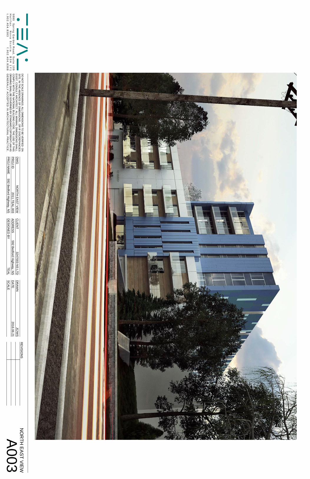
DO
NO
TSC
ALED
RAW
ING
S.ALLD
IMEN
SION
STO
BEVER
IFIEDO
NSITE
.INTH
EA
BSEN
CE
OF
DIM
ENSIO
NS
,OR
IFD
ISCR
EPA
NC
IESE
XIS
T,CO
NS
ULT
AR
CH
ITEC
T.ALL
MIN
IMA
LD
IME
NS
ION
SS
HA
LLC
OM
PLYW
ITHTH
EN
ATION
ALBU
ILDIN
GC
OD
E.THE
USE
OF
THIS
DR
AWIN
GSH
ALLBE
GO
VERN
EDBY
STAND
ARD
CO
PYRIG
HT
LAWAS
GE
NE
RA
LLYA
CC
EP
TE
DIN
AR
CH
ITE
CT
UR
AL
PR
AC
TIC
E.
58
80
Sp
ring
Ga
rde
nR
oa
d,
Su
ite1
09
Ha
lifax
,N
ov
aS
co
tiaB
3H
1Y
1t.9
02
.40
4.8
38
3f.9
02
.40
4.8
36
8
DW
GC
LIENT
DR
AWN
PR
OJ ID
PR
OJ N
AME
AD
DR
ESSD
ESIG
NED
BYD
ATES
CALE
A003
NO
RTH
EAST VIEWJC
/WS
TEAL
592 Bedford Highw
ay, NS
3247003 NS LTD
592 Bedford Highw
ay, NS
NO
RTH
EAST VIEW
2011.TEAL.003
2016.06.21
REV
ISION
S
bonea
Typewritten Text
Attachment E - 3D Renderings of Proposed Building
bonea
Typewritten Text
bonea
Typewritten Text
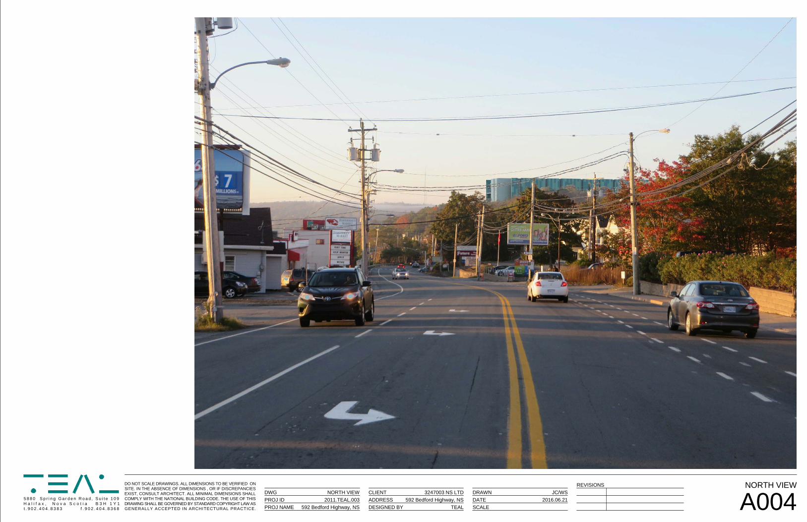
DO NOT SCALE DRAWINGS. ALL DIMENSIONS TO BE VERIFIED ONSITE. IN THE ABSENCE OF DIMENSIONS , OR IF DISCREPANCIESEXIST, CONSULT ARCHITECT. ALL MINIMAL DIMENSIONS SHALLCOMPLY WITH THE NATIONAL BUILDING CODE. THE USE OF THISDRAWING SHALL BE GOVERNED BY STANDARD COPYRIGHT LAW ASGENERALLY ACCEPTED IN ARCHITECTURAL PRACTICE.
5 8 8 0 S p r i n g G a r d e n R o a d , S u i t e 1 0 9H a l i f a x , N o v a S c o t i a B 3 H 1 Y 1t . 9 0 2 . 4 0 4 . 8 3 8 3 f . 9 0 2 . 4 0 4 . 8 3 6 8
DWG CLIENT DRAWNPROJ IDPROJ NAME
ADDRESSDESIGNED BY
DATESCALE A004
NORTH VIEWJC/WS
TEAL592 Bedford Highway, NS
3247003 NS LTD
592 Bedford Highway, NS
NORTH VIEW2011.TEAL.003 2016.06.21
REVISIONS
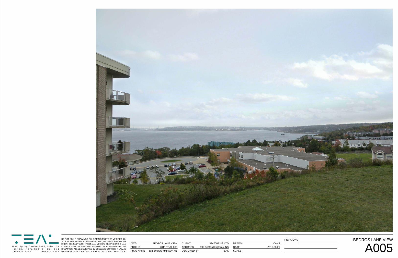
DO NOT SCALE DRAWINGS. ALL DIMENSIONS TO BE VERIFIED ONSITE. IN THE ABSENCE OF DIMENSIONS , OR IF DISCREPANCIESEXIST, CONSULT ARCHITECT. ALL MINIMAL DIMENSIONS SHALLCOMPLY WITH THE NATIONAL BUILDING CODE. THE USE OF THISDRAWING SHALL BE GOVERNED BY STANDARD COPYRIGHT LAW ASGENERALLY ACCEPTED IN ARCHITECTURAL PRACTICE.
5 8 8 0 S p r i n g G a r d e n R o a d , S u i t e 1 0 9H a l i f a x , N o v a S c o t i a B 3 H 1 Y 1t . 9 0 2 . 4 0 4 . 8 3 8 3 f . 9 0 2 . 4 0 4 . 8 3 6 8
DWG CLIENT DRAWNPROJ IDPROJ NAME
ADDRESSDESIGNED BY
DATESCALE A005
BEDROS LANE VIEWJC/WS
TEAL592 Bedford Highway, NS
3247003 NS LTD
592 Bedford Highway, NS
BEDROS LANE VIEW2011.TEAL.003 2016.06.21
REVISIONS
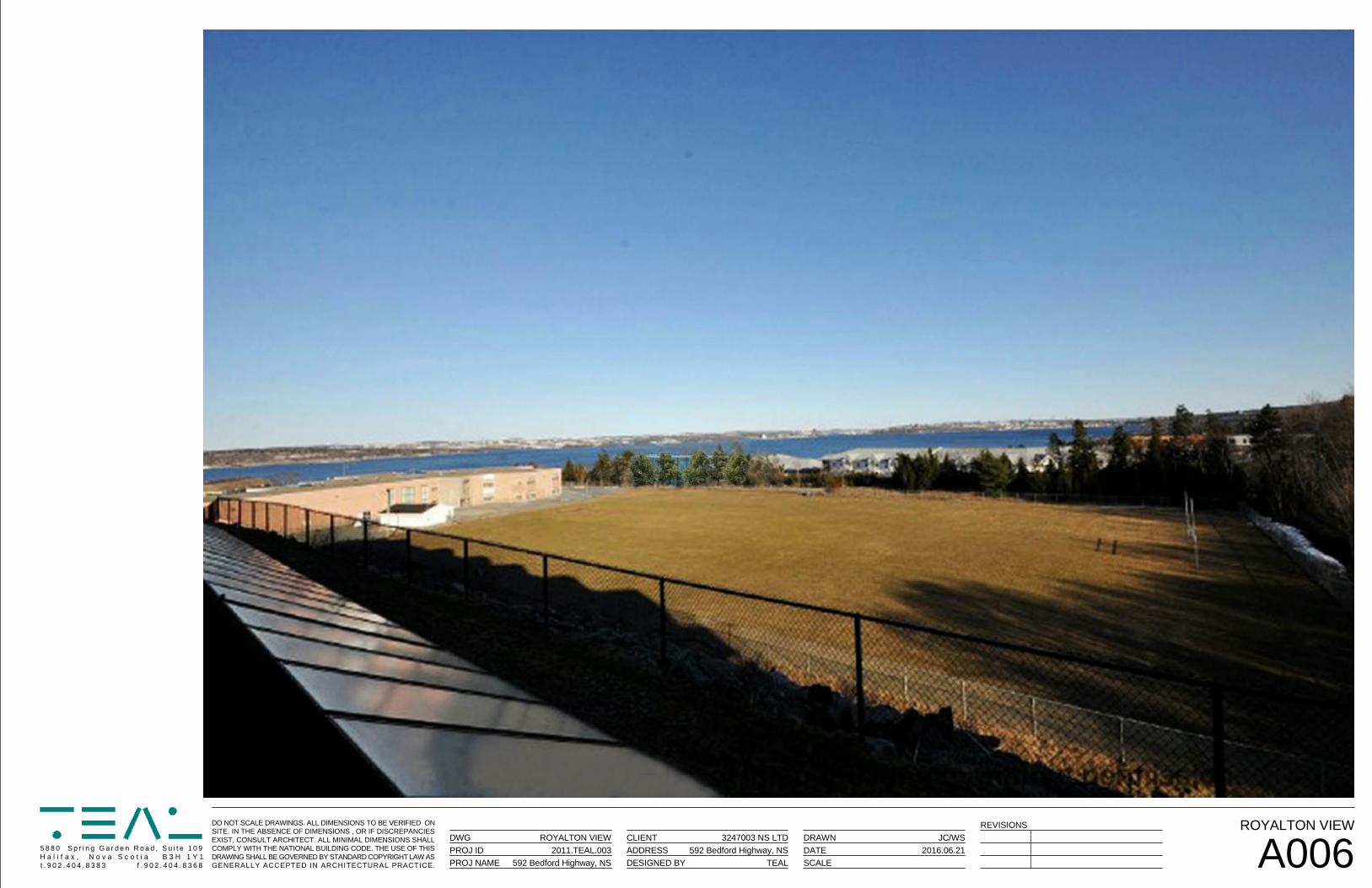
DO NOT SCALE DRAWINGS. ALL DIMENSIONS TO BE VERIFIED ONSITE. IN THE ABSENCE OF DIMENSIONS , OR IF DISCREPANCIESEXIST, CONSULT ARCHITECT. ALL MINIMAL DIMENSIONS SHALLCOMPLY WITH THE NATIONAL BUILDING CODE. THE USE OF THISDRAWING SHALL BE GOVERNED BY STANDARD COPYRIGHT LAW ASGENERALLY ACCEPTED IN ARCHITECTURAL PRACTICE.
5 8 8 0 S p r i n g G a r d e n R o a d , S u i t e 1 0 9H a l i f a x , N o v a S c o t i a B 3 H 1 Y 1t . 9 0 2 . 4 0 4 . 8 3 8 3 f . 9 0 2 . 4 0 4 . 8 3 6 8
DWG CLIENT DRAWNPROJ IDPROJ NAME
ADDRESSDESIGNED BY
DATESCALE A006
ROYALTON VIEWJC/WS
TEAL592 Bedford Highway, NS
3247003 NS LTD
592 Bedford Highway, NS
ROYALTON VIEW2011.TEAL.003 2016.06.21
REVISIONS
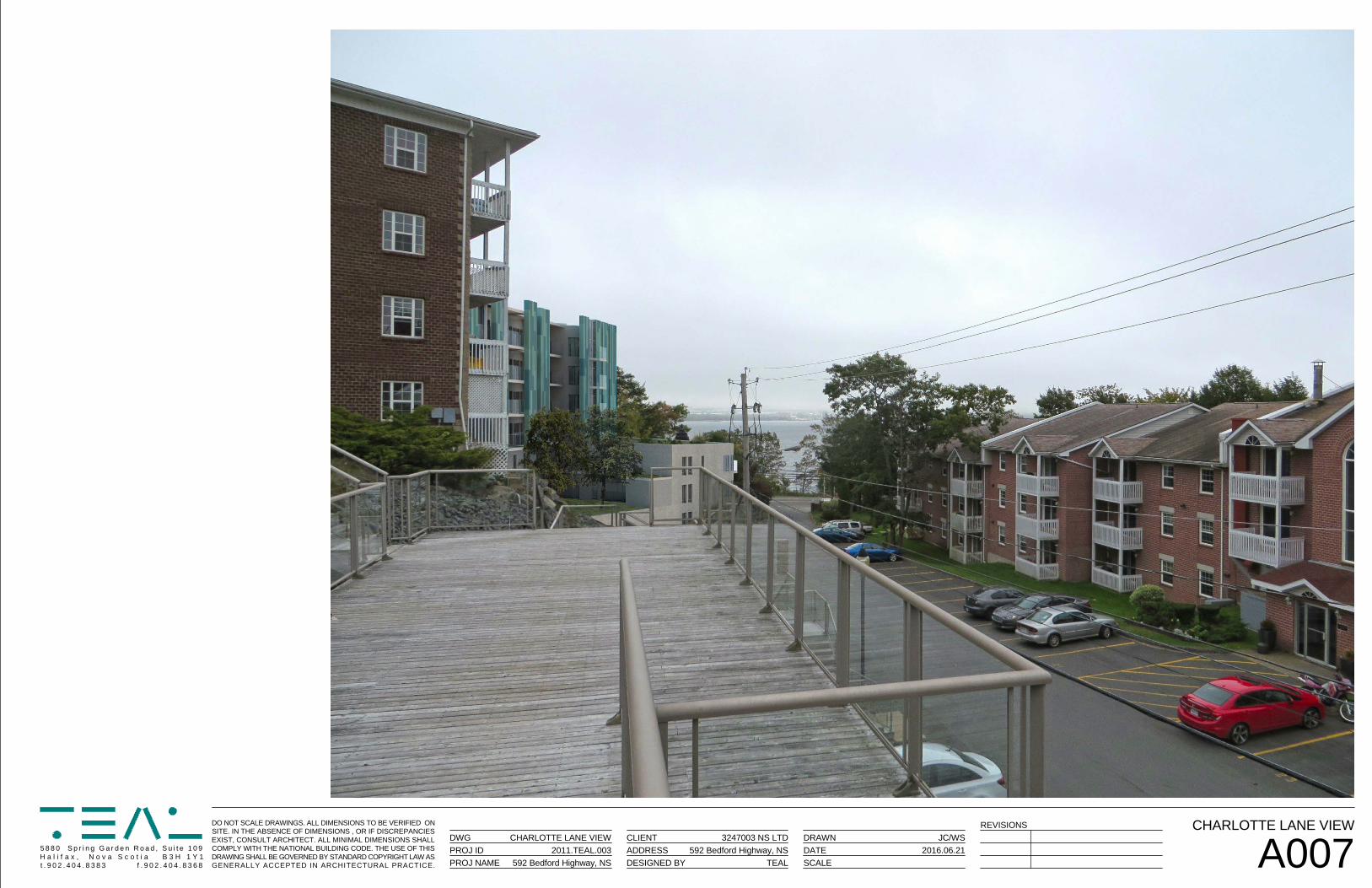
DO NOT SCALE DRAWINGS. ALL DIMENSIONS TO BE VERIFIED ONSITE. IN THE ABSENCE OF DIMENSIONS , OR IF DISCREPANCIESEXIST, CONSULT ARCHITECT. ALL MINIMAL DIMENSIONS SHALLCOMPLY WITH THE NATIONAL BUILDING CODE. THE USE OF THISDRAWING SHALL BE GOVERNED BY STANDARD COPYRIGHT LAW ASGENERALLY ACCEPTED IN ARCHITECTURAL PRACTICE.
5 8 8 0 S p r i n g G a r d e n R o a d , S u i t e 1 0 9H a l i f a x , N o v a S c o t i a B 3 H 1 Y 1t . 9 0 2 . 4 0 4 . 8 3 8 3 f . 9 0 2 . 4 0 4 . 8 3 6 8
DWG CLIENT DRAWNPROJ IDPROJ NAME
ADDRESSDESIGNED BY
DATESCALE A007
CHARLOTTE LANE VIEWJC/WS
TEAL592 Bedford Highway, NS
3247003 NS LTD
592 Bedford Highway, NS
CHARLOTTE LANE VIEW2011.TEAL.003 2016.06.21
REVISIONS
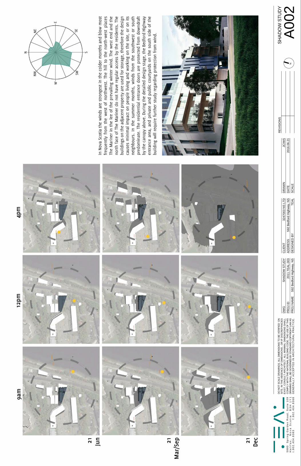
DO
NO
TSC
ALE
DR
AWIN
GS.
ALL
DIM
ENSI
ON
STO
BEVE
RIF
IED
ON
SITE
.IN
THE
ABS
ENC
EO
FD
IMEN
SIO
NS
,OR
IFD
ISC
RE
PAN
CIE
SE
XIS
T,C
ON
SU
LTA
RC
HIT
EC
T.A
LLM
INIM
AL
DIM
EN
SIO
NS
SH
ALL
CO
MPL
YW
ITH
THE
NAT
ION
ALBU
ILD
ING
CO
DE.
THE
USE
OF
THIS
DR
AWIN
GSH
ALL
BEG
OVE
RN
EDBY
STAN
DAR
DC
OPY
RIG
HT
LAW
ASG
EN
ER
ALL
YA
CC
EP
TE
DIN
AR
CH
ITE
CT
UR
AL
PR
AC
TIC
E.
58
80
Sp
rin
gG
ard
en
Ro
ad
,S
uit
e1
09
Ha
lifa
x,
No
va
Sc
oti
aB
3H
1Y
1t.
90
2.4
04
.83
83
f.9
02
.40
4.8
36
8
DW
GC
LIEN
TD
RAW
NP
RO
J ID
PR
OJ
NAM
EA
DD
RES
SD
ESIG
NED
BY
DAT
ES
CAL
EN
A0
02SH
ADO
W S
TUD
YJC
/WS
TEAL
592
Bedf
ord
Hig
hway
, NS
3247
003
NS
LTD
592
Bedf
ord
Hig
hway
, NS
SHAD
OW
STU
DY
2011
.TEA
L.00
320
16.0
6.21
REV
ISIO
NS
bonea
Typewritten Text
Attachment F - Solar Shadow Study
Attachment G – Legislative Authority
Development Agreements By Community Council
The Community Council Administrative Order, subsection 3 (1) “Subject to subsection (3) of this section, sections 29, 30 and 31 of the Halifax Regional Municipality Charter apply to each Community Council.”
Halifax Regional Municipality Charter:
Development agreements by community councils31 (1) This Section applies to a community council if the Council so provides in the policy
establishing the community council.
(2) Where a municipal planning strategy of the Municipality provides for development byagreement, the community council stands in the place and stead of the Council and Part VIIIapplies with all necessary changes.
(3) A development agreement, or amendment to a development agreement, entered into by acommunity council must be signed by the Mayor and the Clerk on behalf of the Municipality.
(4) Where a development agreement entered into by a community council purports to commit theMunicipality to an expenditure, the commitment has no force or effect until approved by theCouncil. 2008, c. 39, s. 31.
HRM Charter, Part VIII, Planning and Development, including:
Development agreements240 (1) The Council may consider development by development agreement where a municipal
planning strategy identifies(a) the developments that are subject to a development agreement;(b) the area or areas where the developments may be located; and(c) the matters that the Council must consider prior to the approval of a development
agreement.
(2) The land-use by-law must identify the developments to be considered by developmentagreement. 2008, c. 39, s. 240.
Content of development agreements242 (1) A development agreement may contain terms with respect to
(a) matters that a land-use by-law may contain;(b) hours of operation;(c) maintenance of the development;(d) easements for the construction, maintenance or improvement of watercourses, ditches,
land drainage works, stormwater systems, wastewater facilities, water systems and otherutilities;
(e) grading or alteration in elevation or contour of the land and provision for the disposal ofstorm and surface water;
(f) the construction, in whole or in part, of a stormwater system, wastewater facilities andwater system;
(g) the subdivision of land;(h) security or performance bonding.
(2) A development agreement may include plans or maps.
(3) A development agreement may
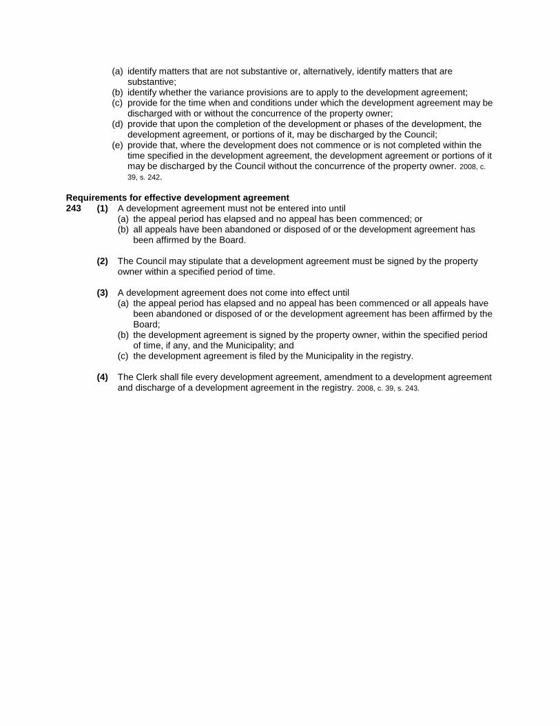
(a) identify matters that are not substantive or, alternatively, identify matters that are substantive;
(b) identify whether the variance provisions are to apply to the development agreement; (c) provide for the time when and conditions under which the development agreement may be
discharged with or without the concurrence of the property owner; (d) provide that upon the completion of the development or phases of the development, the
development agreement, or portions of it, may be discharged by the Council; (e) provide that, where the development does not commence or is not completed within the
time specified in the development agreement, the development agreement or portions of it may be discharged by the Council without the concurrence of the property owner. 2008, c. 39, s. 242.
Requirements for effective development agreement 243 (1) A development agreement must not be entered into until
(a) the appeal period has elapsed and no appeal has been commenced; or (b) all appeals have been abandoned or disposed of or the development agreement has
been affirmed by the Board.
(2) The Council may stipulate that a development agreement must be signed by the property owner within a specified period of time.
(3) A development agreement does not come into effect until (a) the appeal period has elapsed and no appeal has been commenced or all appeals have
been abandoned or disposed of or the development agreement has been affirmed by the Board;
(b) the development agreement is signed by the property owner, within the specified period of time, if any, and the Municipality; and
(c) the development agreement is filed by the Municipality in the registry.
(4) The Clerk shall file every development agreement, amendment to a development agreement and discharge of a development agreement in the registry. 2008, c. 39, s. 243.
Related Documents