E. Bracci, P. Coltelli, G. Cresci, C. Magnarapa, Montanari A. , Developing tourism in the Lunigiana, in A Min Tjoa (ed.) Information and Communication Technologies in Tourism 1997. Proceedings of the International Conference in Edinburgh, Scotland, 1997, Springer Verlag, Vienna and New York, 1997, pp.231- 240. Developing Tourism in the Lunigiana E. Bracci x , P. Coltelli x , G. Cresci x , C. Magnarapa x A. Montanari + (x) CNUCE - Institute of CNR, Via S. Maria 36, 56126 PISA (+) Consorzio Pisa Ricerche, P.zza D'Ancona, PISA Abstract The rapid evolution of hypermedia technology together with the increasingly wide use of the Internet can be effectively exploited to publicise the great artistic and historic heritage of Italy and its regions. Aiming to increase tourism, many public administrations have been looking with great interest to projects enhancing exposure of their territories and permitting virtual visits to museums, towns, archaeological sites and other sights. This paper describes a project, partially funded by the European Community, whose main goal is to produce a tool to allow tourists with different interests to cover virtual routes in a historical area named the “Lunigiana”. From a technical point of view, key aspects discussed are related to integrating Geographic Information Systems (GIS) with Database, Multimedia, Information Retrieval (IR) and Internet technologies. 1. Project aims The application of multimedia technologies represents an attractive means to develop tourism. Integration of GIS features in multimedia tourist systems is however quite a difficult problem that has yet to be completely solved by today's technology. The CNUCE, Institute of the Italian National Research Council, has been carrying out research in this field [Mogo92]. Current multimedia tourist systems do not support geographic features such as on-the-fly computation (i. e. distances, shortest routes, etc.) or display functions (i. e. pan, zoom, etc.), which are critical when the system must cover a wide area (a town, region, or larger). Such limitations can be overcome only by means of GIS tools. Over the last two to three years, the growth of the Internet and its user-friendliness has made these systems accessible to a very large number of users, thus rendering the joint approach (Multimedia + Internet) an extraordinary tool for tourist marketing. Many examples of multimedia tourist systems are viewable on the Internet [Wand96] [City96].

Welcome message from author
This document is posted to help you gain knowledge. Please leave a comment to let me know what you think about it! Share it to your friends and learn new things together.
Transcript

E. Bracci, P. Coltelli, G. Cresci, C. Magnarapa, Montanari A. , Developing tourism in the Lunigiana, in A Min Tjoa (ed.) Information and Communication Technologies in Tourism 1997. Proceedings of the International Conference in Edinburgh, Scotland, 1997, Springer Verlag, Vienna and New York, 1997, pp.231-240.
Developing Tourism in the Lunigiana
E. Braccix, P. Coltellix, G. Crescix, C. Magnarapax
A. Montanari+
(x) CNUCE - Institute of CNR, Via S. Maria 36, 56126 PISA
(+) Consorzio Pisa Ricerche, P.zza D'Ancona, PISA
Abstract
The rapid evolution of hypermedia technology together with the increasingly wide use of the Internet can be effectively exploited to publicise the great artistic and historic heritage of Italy and its regions. Aiming to increase tourism, many public administrations have been looking with great interest to projects enhancing exposure of their territories and permitting virtual visits to museums, towns, archaeological sites and other sights.This paper describes a project, partially funded by the European Community, whose main goal is to produce a tool to allow tourists with different interests to cover virtual routes in a historical area named the “Lunigiana”.From a technical point of view, key aspects discussed are related to integrating Geographic Information Systems (GIS) with Database, Multimedia, Information Retrieval (IR) and Internet technologies.
1. Project aims
The application of multimedia technologies represents an attractive means to develop tourism. Integration of GIS features in multimedia tourist systems is however quite a difficult problem that has yet to be completely solved by today's technology. The CNUCE, Institute of the Italian National Research Council, has been carrying out research in this field [Mogo92]. Current multimedia tourist systems do not support geographic features such as on-the-fly computation (i. e. distances, shortest routes, etc.) or display functions (i. e. pan, zoom, etc.), which are critical when the system must cover a wide area (a town, region, or larger). Such limitations can be overcome only by means of GIS tools. Over the last two to three years, the growth of the Internet and its user-friendliness has made these systems accessible to a very large number of users, thus rendering the joint approach (Multimedia + Internet) an extraordinary tool for tourist marketing. Many examples of multimedia tourist systems are viewable on the Internet [Wand96] [City96].
The project described in this article intends to implement a tourist system building upon CNUCE experience and exploiting today's powerful software tools. The system integrates features of database, multimedia, GIS, IR and Internet systems, and focuses on an area in central Italy called the Lunigiana.Although the system has been implemented for a specific geographic area, the approach is absolutely generalisable, so that the tool can be applied to different areas and subject data as described in the following.
2. Funding and partners
The project has been funded by:• European Community;• Regione Toscana (regional authority);• Comune di Massa (local municipality).for a total amount of 250 KECU over a period of three years (96- 98).European Community funding was awarded within the framework of structural funds for areas in industrial decline and is aimed at stimulating the creation of new employment. Funding by local authorities (region and municipality) imposes the targeting of areas under their jurisdiction.The following partners are involved in the project:• CNUCE - CNR is responsible for system design and supervision of technical
activities.• Consorzio Pisa Ricerche, an industrial consortium devoted to applied research,
has been charged with implementation.• Soprintendenza ai Beni Architettonici di Pisa, the local branch of the Ministry for
Cultural Heritage, is responsible for cultural data collection and the user interface.• Comune di Massa has provided tourist data (i. e. on hotels, restaurants, events,
etc.)
3. Why the Lunigiana?
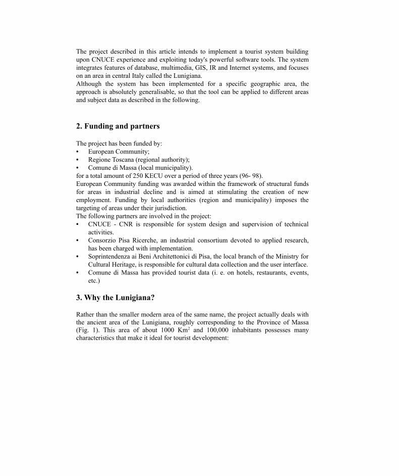
Rather than the smaller modern area of the same name, the project actually deals with the ancient area of the Lunigiana, roughly corresponding to the Province of Massa (Fig. 1). This area of about 1000 Km2 and 100,000 inhabitants possesses many characteristics that make it ideal for tourist development:
Fig. 1. The Lunigiana Area• It is an area with few economic resources, only marginally involved in industrial
activities, and where the natural environment as well as traditional crafts and customs have been preserved.
• It has a long and interesting history beginning in prehistory and developing throughout Roman times and the Middle Ages, as testified to by abundant archaeological findings, villages, castles, churches and museums. Lunigiana is located on the "Via Francigena", a road used since medieval times by pilgrims on their way to Rome from the North and West of Europe.
• There is no single dominant cultural or tourist attraction, but rather many sights which reveal the history, culture and evolution of this land. The situation is common to many other Italian regions: historic sites spread throughout the countryside. Thus, a geographic approach is best adopted in order to visit cultural places and link them to historic events and traditions.
• The Lunigiana is quite near and easily reached from the well-known sea-side resort area, the "Versilia". Tourism in Versilia has a long tradition (more than a century) and remains today one of Italy’s most popular bathing resorts. The chance to divert some tourism from the often overwhelmed Versilia to the Lunigiana would be welcomed by the local administrators of both areas, and for many tourists complementing a sea-side holiday with cultural (as well as natural and culinary) excursions could represent a pleasant change of pace.
4. The tool’s features
The main goal of the project is to promote the artistic, historic and natural resources of the Lunigiana by making the region known to a much wider population of potential users. In order to achieve this, the tool to be implemented must address the varying needs of different types of users: from leisurely browsers, to occasional tourists and students to experts with specific interests. Satisfying such a wide range of interests requires:
• A simple and attractive user interface; this is a crucial aspect as it affects the way users will perceive the system and its data [Salm89] [Leon89].
• Inclusion of a large number of data types (texts, graphics and maps), most of them with quality requirements (i. e. high-quality images) to satisfy expert requisites. Defining the data and their connections is an essential activity in information systems design involving both developers and experts in the subject. In this case, the problems are attributable to data complexity, rather than quantity.
• Functionality for both tourists and experts: simple, pre-defined analyses must be implemented for general users (occasional tourists), while experts must be allowed to conduct more in-depth analyses (for instance, dynamically building queries on a database or creating new routes based on individual requirements). The major difficulty here consists of making sure users do not get lost while navigating the system. Moreover, basic tools in support of data analyses include subject-specific documentation (called a ‘subject book’), in which topics are thoroughly described in simple, yet scientifically correct terms, as well as a dictionary of technical terminology.Both cultural and tourist data must be considered. Not all cultural data regarding the Lunigiana have been included; at this stage interest has been focused on the following themes:• Historic villages;• Castles;• Medieval churches;• The "Statue-stele" museum.The first three items are closely linked, as they represent the civil, military and religious expressions of the art and science of architecture, and through them tourists can come to understand the main aspects of the social and economic life of this region during the Middle Ages. The fourth item provides a glimpse of the area’s pre-historic development through the sculptures typical of that era.Tourist data include all the information needed to make a real visit, that is, road maps, means of transportation, hotels, restaurants, camp sites and so on. They also include information on events, shows and curiosities, and provide suggestions on how to meld the entertaining with the cultural.Suggestions are not related to a site but rather to site neighbourhood. To implement this, landscape has been partitioned by means of a grid and suggestions are connected to grid elements. The sizes of grid elements are not regular; they are inversely proportional to the concentration of cultural sights.
From a technical point of view, the tool must allow:• Different navigation modes: on thematic maps, on hypertexts, and on database.
Users can switch from one mode to the other and the system will manage the change: some functions available in one navigation mode are inactivated in others (e.g. suggestions are only available in geographic navigation mode).
• Integration of alpha-numeric and geographic queries. All queries return lists of places located on maps. Both lists and maps must be available for further selections.
• Creation of dynamic routes taking into account cultural interests, roads and distances, hotel and restaurant locations, etc. Pre-defined routes must also be supplied to meet needs of the hurried tourist.
• Route display by means of vector elements on a geo-referenced raster background.
• Differential local and remote use. When used in a local (LAN) environment, presentations make use of large, high-quality images and maps. When used in a remote (WAN) environment, some displays could be less detailed and some geographic functions disactivated in order to reduce network traffic and wait times.
• General services such as print-outs, bookmarks, etc.
Tourist systems currently available on the Internet do not include all the features described. One can find systems of differing complexity: from simple advertising tools, to complex teaching ones [Pers96]. Many allow geographic navigation and virtual visits, but do not support user geographic interaction or route definition. Furthermore, geographic and theme components are generally kept separate; results of queries on objects having geographic attributes are generally returned as lists or tables, not maps. Selections are made on tables [Pers96] or on pre-defined elements of a map. [Cali96] supports some geographic functions operating on a single theme only.
5. Data organisation
A suitable, well-organised data structure is a basic requirement for any information system. The system must operate on different data types (alpha-numeric, geographic, images, etc.), many of which are difficult to classify and structure. Different types of operations must be performed with various levels of complexity (e.g. tourists vs. experts). Operations include:• structured queries on alpha-numeric data;• retrieval of words in free text searches;• geographic navigation and enquiry;• hypertext navigation. Each type of operation can be performed easily by means of specialised software environments: Data Base Management System (DBMS), Information Retrieval (IR), Geographic Information Systems (GIS), HyperText/HyperMedia (HT/HM). Unfortunately, integration of so many software environments into a single computer system entails problems of compatibility, performance and cost. In practice, a compromise between functionality and complexity must be found.HT/HM is an intuitive and very attractive approach. However it has several shortcomings related mainly to data complexity and quantity. Large amounts of data can require long navigation paths. Complexity generally implies many connections (relationships) between data; in a hypertext this means a great number of links. Long navigation paths and many links increase the risks of winding up confused or lost in the system [Sign95]. Finally, some kinds of analyses (i. e. all the objects with a specified property) are difficult to implement in a hypertext.Data with such characteristics could be managed well through a DBMS approach. However, the use of such systems is limited by their main defect - a complex user interface unsuitable for users with limited computer skills (in practice, knowledge of a specialised language such as SQL is required).

Short descriptions are always required because the properties of cultural objects cannot be completely described by data structures. An IR tool is then needed to manage free (unstructured) texts and complement DBMS queries on structured data.The integration of specialised environments is obtained by associating the following to each object described in the system:• Its own series of attributes whose values can be part of a continuous range or a
number of discrete pre-defined alpha-numeric strings. SQL queries operate on these attributes and return lists of selected objects.
• A brief description in free text: a search engine operates on these descriptions to select all the documents where a keyword (or a combination of keywords) occurs. The engine returns a list of selected documents.
• A hypertext with sensitive elements or anchor points (so called “hot-spots” - words, images or map elements) activating links to the subject book and a dictionary. Fig. 2 presents a schematic illustration of a hypertext structure with four levels (home page, object description, subject book and dictionary) and their connections.
• Geographic co-ordinates of the site where the object resides. Such data are used to place objects on maps and allow geographic operations.
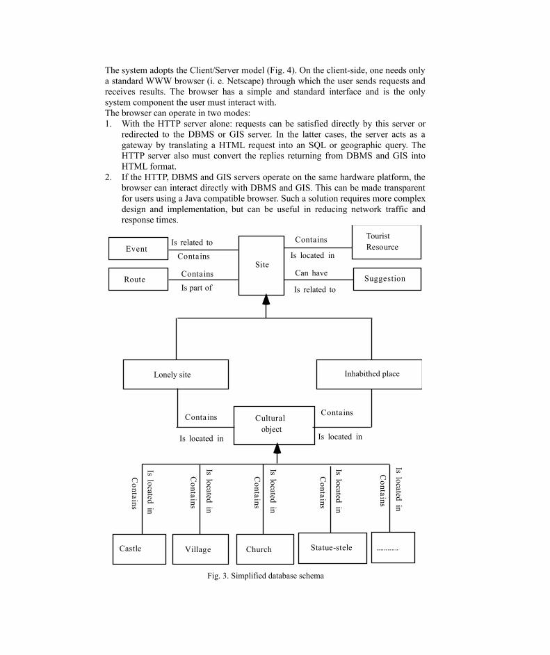
This integrated approach allows combining the simple and intuitive interface of HT/HM systems with the powerful analytic functions of DBMS, IR and GIS. The major emphasis is on detailed data analysis and modelling in order structure as much information as possible. This reduces the hypertext complexity and amount of free text descriptions as well. Fig. 3 shows a simplified conceptual scheme of DBMS data.
Home page
... ...
... ...
DictionaryLoop-holeMerlon..........
Historic families
of LunigianaBuilding materials
Medieval ChurchCastle Objects descriptions
Subject books
Fig. 2. Hypertext structure
6. System architecture
The system adopts the Client/Server model (Fig. 4). On the client-side, one needs only a standard WWW browser (i. e. Netscape) through which the user sends requests and receives results. The browser has a simple and standard interface and is the only system component the user must interact with.The browser can operate in two modes:1. With the HTTP server alone: requests can be satisfied directly by this server or
redirected to the DBMS or GIS server. In the latter cases, the server acts as a gateway by translating a HTML request into an SQL or geographic query. The HTTP server also must convert the replies returning from DBMS and GIS into HTML format.
2. If the HTTP, DBMS and GIS servers operate on the same hardware platform, the browser can interact directly with DBMS and GIS. This can be made transparent for users using a Java compatible browser. Such a solution requires more complex design and implementation, but can be useful in reducing network traffic and response times.
TouristResource
Contains
Is located in
SuggestionCan have
Is related to
Site
Event
Route
Contains
Is related to
Contains
Is part of
Is located in Is located in
Lonely site Inhabithed place
ContainsContains
Cultural object
Castle Village Church Statue-stele ............
Co
ntains
Is located in
Contains
Is located in
Contains
Is located in
Contains
Is located in
Co
ntains
Is located in
Fig. 3. Simplified database schema

Fig.4. System architectureWhichever solution is adopted for client application, four logical servers are required. Choices in this area are strictly determined by the hardware platform and operating system. There is no specific constraint for the HTTP server; these are available for UNIX and PC platforms with DOS, Windows, or Windows NT operating systems. In no case are costs an issue.DBMS functions are also available for many environments. Although, powerful platforms are generally required to manage large amounts of data, this is not the case here, and a simple (and inexpensive) product can be used (i. e. MS Access).IR functions are supplied by many products (low cost or even freeware) that can be integrated well with HTTP servers.The GIS server could be a major problem; many packages entail high costs and complexity, and often require powerful platforms. In our case, a product such as ArcView, a low-cost product available for most common platforms, seems to provide all the required functions. All four servers can be hosted on a single hardware platform: a high-end Intel workstation will likely be used for development and testing. Because of the speed of technological advancement, the system to support the tool’s operational life will be configured at project’s end in order to achieve the most cost-effective solution. Windows NT, by virtue of its compatibility with clients, the large base of applications and its reduced cost, is likely to be the operating system.Application programs are required both on the server side, in order to transmit queries from HTTP to the DBMS and GIS servers, and the client side, in order to complement standard browser functionality. On the first side, CGI (Common Gateway Interface) scripts can be used, while on the latter, the Java programming language seems to be the best choice because of its simplicity and platform independence.The architectural and software choices made for the project allow production of a general-use tool where new data and functions can be added without requiring global architecture modifications. The tool can support geographic and tourist data and functions for any country. It can also be used to support subject data related to other castles, villages and churches; but in this case modifications may be required to support new features not encountered in the Lunigiana. Such features will probably be related more to data properties than relationships, though they will likely also affect functions. Finally, addition of new topics requires a review of the data model and specific action on implementation, but general architecture, data organisation and many functions can be preserved.
7. Project timing and resources
IR Server
Database Server HTTP Server Geographical Server
Client Application
Client Application

The project, started in late spring of this year, will finish in the autumn of 1998; at that time the software tools and data must be ready for use. Following the principles and rules of information systems design, the project plan includes:• design;• data acquisition;• prototyping;• implementation;• testing. At the time of writing this, the design phase is near completion. Data analysis has been completed, function analysis is near completion and system architecture definition is in progress. Full design will be accomplished by January 97.Data acquisition has just started and will continue for the whole of next year, and a first prototype will be available by next spring.Initial planning allocated 8 person-months to design (mainly by the CNUCE and Soprintendenza), 24 person-months to prototyping and implementation (Consorzio Pisa Ricerche) and 14 person-months to data acquisition (the Soprintendenza and Massa Municipality). It now seems that we had slightly underestimated the resources necessary for system design - unforeseen difficulties were encountered and are described below.
8. Conclusions and future developments
The tool, whose development is now well under way, can effectively enhance tourism in an area with poor economic resources. Thus, the project conforms to the aims of European Community funding.During the design phase a few difficulties have been experienced, mainly related to data complexity and the large amount of specialised knowledge involved. Some data are intrinsically difficult to structure, and experience in this field is scarce. Historians, archaeologists, architects, art experts are involved in data and function analysis: definition of a common language for both software developers and cultural experts has proved to be another quite difficult task. Also, many computer experts are required to integrate HT/HM, IR, GIS and DBMS and select appropriate development environments and tools. Rapid technological evolution has the potential to create further problems: incorrect design choices can easily lead to the creation of quickly obsolete tools. Despite such design and implementation difficulties, early presentations and technical documents have been well-received by local administrations, which are thus preparing for a second phase of the project. This new phase will include:• Collection of new data mainly on Roman times (the name Lunigiana comes from
Luni, an important Roman port).• Addition of another region, the area of the Apuan Alps, with its great natural
resources and prevalent economic asset, the so-called white “Carrara” marble, used since the time of ancient Rome.
• New applications: 3-D display would be very effective in landscape representation and allowing now totally or partially destroyed castles to be reconstructed on the basis of historic documents and images; thus, giving the

virtual tourist the chance to roam the Lunigiana, not only as it is today, but as it was in bygone times as well.
9. Acknowledgements
The project involves the work of many people; the authors wish to thank all those who contributed to the partial results described here. A special thanks goes to Olga Renda for her contribution to data analysis and Giuseppe Muccioli for his technical support in defining the system architecture.
10. Bibliography
[Cali96] http://city.net/countries/united_states/california/san_francisco/maps/mapquest.html [City96] http://www.city.net/
[Leon89] M. K. Leong & others: Towards a visual language for an object-oriented multi-media data base system - Visual Database System - North Holland, pp. 465-495, 1989
[Mogo92]P. Mogorovich, C. Magnarapa, M.V. Masserotti, S. Mazzotta - Merging GIS with
multimedia technologies: the case study of an information system for tourist applications.EGIS 92 Conference Proceedings, Vol. II, pp. 1085-1094, March 1992
[Pers96] Perseus Project is available at the following Internet address:http://www.perseus.tufts.edu/
[Salm89] Salmon, Slater - Some aspects of the human - computer interactionComputer Graphics: systems and concepts.- Addison Wesley, pp. 455-483, 1989
[Sign95] O. Signore - Issues on Hypertext DesignDEXA 95: Database and Expert Systems Application - Proceedings of the international conference - Springer Verlag, pp. 283-292, 1995
[Wand96] http://www.spottedantelope.com/wander.htm
Related Documents