Presented at “Short Course on Conceptual Modelling of Geothermal Systems”, organized by UNU-GTP and LaGeo, in Santa Tecla, El Salvador, February 24 - March 2, 2013. 1 LaGeo S.A. de C.V. GEOTHERMAL TRAINING PROGRAMME DEVELOPING A CONCEPTUAL MODEL OF A GEOTHERMAL SYSTEM Anette K. Mortensen and Gudni Axelsson ISOR – Iceland GeoSurvey Grensásvegur 9, 108 Reykjavík ICELAND [email protected] [email protected] ABSTRACT Conceptual models are used to describe or illustrate essential features of geological situations and delineate the principal processes in the system, but conceptual models of geothermal systems are focused on data providing information about temperature, pressure and fluid flow towards, within and out of the system. Conceptual modelling of geothermal systems requires an integrated approach as geological, geochemical, geophysical data along with information from well testing and production have to be unified into a comprehensive model describing the physical features of the system. Conceptual models are an important tool throughout exploration, development and utilization of geothermal systems, where they are used both in field development planning and well siting as well as the basis for numerical modelling and reservoir assessment. Conceptual models of geothermal systems are spatial representations of the physical features of the system, which have traditionally been presented by 2D cross sections. The development of geological modelling tools in the past 10-15 years have facilitated the integration of all geological, geophysical and geochemical data as well as seen the advancement of 3D visualization and interpretation of the models. These modelling tools can make the conceptual models more dynamic as they allow for more efficient and continuous data updates. 1. INTRODUCTION Geothermal resources are distributed throughout the Earth’s crust with the greatest energy concentration associated with hydrothermal systems in volcanic regions at crustal plate boundaries. Yet exploitable geothermal resources may be found in most countries, either as warm ground-water in sedimentary formations or in deep circulation systems in crystalline rocks. Shallow thermal energy suitable for ground-source heat-pump utilization is available world-wide and attempts are underway at developing enhanced geothermal systems (EGS) in places where limited permeability precludes natural hydrothermal activity. Geothermal systems and reservoirs are classified on the basis of different aspects, such as reservoir temperature or enthalpy, physical state, their nature and geological setting. Steingrímsson et al. (2013) and Axelsson (2008) review these classifications and the distribution of geothermal resources worldwide.

Welcome message from author
This document is posted to help you gain knowledge. Please leave a comment to let me know what you think about it! Share it to your friends and learn new things together.
Transcript
Presented at “Short Course on Conceptual Modelling of Geothermal Systems”, organized by UNU-GTP and LaGeo, in Santa Tecla, El Salvador, February 24 - March 2, 2013.
1
LaGeo S.A. de C.V. GEOTHERMAL TRAINING PROGRAMME
DEVELOPING A CONCEPTUAL MODEL OF A GEOTHERMAL SYSTEM
Anette K. Mortensen and Gudni Axelsson ISOR – Iceland GeoSurvey
Grensásvegur 9, 108 Reykjavík ICELAND
[email protected] [email protected]
ABSTRACT Conceptual models are used to describe or illustrate essential features of geological situations and delineate the principal processes in the system, but conceptual models of geothermal systems are focused on data providing information about temperature, pressure and fluid flow towards, within and out of the system. Conceptual modelling of geothermal systems requires an integrated approach as geological, geochemical, geophysical data along with information from well testing and production have to be unified into a comprehensive model describing the physical features of the system. Conceptual models are an important tool throughout exploration, development and utilization of geothermal systems, where they are used both in field development planning and well siting as well as the basis for numerical modelling and reservoir assessment. Conceptual models of geothermal systems are spatial representations of the physical features of the system, which have traditionally been presented by 2D cross sections. The development of geological modelling tools in the past 10-15 years have facilitated the integration of all geological, geophysical and geochemical data as well as seen the advancement of 3D visualization and interpretation of the models. These modelling tools can make the conceptual models more dynamic as they allow for more efficient and continuous data updates.
1. INTRODUCTION Geothermal resources are distributed throughout the Earth’s crust with the greatest energy concentration associated with hydrothermal systems in volcanic regions at crustal plate boundaries. Yet exploitable geothermal resources may be found in most countries, either as warm ground-water in sedimentary formations or in deep circulation systems in crystalline rocks. Shallow thermal energy suitable for ground-source heat-pump utilization is available world-wide and attempts are underway at developing enhanced geothermal systems (EGS) in places where limited permeability precludes natural hydrothermal activity. Geothermal systems and reservoirs are classified on the basis of different aspects, such as reservoir temperature or enthalpy, physical state, their nature and geological setting. Steingrímsson et al. (2013) and Axelsson (2008) review these classifications and the distribution of geothermal resources worldwide.
Mortensen and Axelsson 2 Developing conceptual models
The understanding of the nature of hydrothermal systems started advancing during the 20th century. Increased utilization and greatly improved understanding went hand in hand with geothermal wells becoming the main instrument for geothermal development. This is because geothermal wells enable a drastic increase in the production from any given geothermal system, compared to its natural out-flow, as well as providing access deep into the systems, not otherwise possible, which enables a multitude of direct measurements of conditions at depth. The key to the successful exploration, development (incl. drilling) and utilization of any type of geo-thermal system is a clear definition and understanding of the nature and characteristics of the system in question, based on all available information and data. This is best achieved through the development of a conceptual model of a geothermal system, which is the focus of this short course. Conceptual models are descriptive or qualitative models incorporating, and unifying, the essential physical features of the systems in question (Grant and Bixley, 2011). The cooperation of the different disciplines involved in geothermal research and development is of particular importance here, rather than each discipline developing their own models or ideas independently. Conceptual models are an important basis of field development plans, i.e. in selecting locations and targets of wells to be drilled (Axelsson et al., 2013) and ultimately the foundation for all geothermal resource assessments, particularly volumetric assessments and geothermal reservoir modelling (Axelsson, 2013). This paper provides a review of the step-by-step development of conceptual models of geothermal systems, how they develop in hand with the gradual exploration and development of the geothermal system. Other presentations go into comprehensive detail regarding the data that provide the basis for conceptual models, how they are developed and finally how they are used for siting the different types of wells and as the basis of resource assessments, including the development of models of geothermal systems. 2. CONCEPTUAL MODELS The diverse information and data available on geothermal systems is increasingly being unified through the development of conceptual models of the respective systems. They play a key role in all phases of geothermal exploration and development, e.g. by providing a unified picture of the structure and nature of the system in question. Conceptual models are descriptive or qualitative models, not used for calculations. They are mainly based on geological information, both from surface mapping and analysis of subsurface data, remote sensing data, results of geophysical surveying, information on chemical and isotopic content of fluid in surface manifestations and reservoir fluid samples collected from wells, information on temperature- and pressure conditions based on analysis of available well-logging data as well as other reservoir engineering information. Comprehensive conceptual models of geothermal systems should incorporate the following as far as available information allows:
(1) Provide an estimate of the size of a system, more specifically information on areal extent, thickness and depth range as well as external boundaries (vertical)
(2) Explain the nature of the heat source(s) for a system (3) Include information on the location and strength of the hot up-flow/recharge zones, including
the likely origin of the fluid (4) Describe the location and strength of colder recharge zones (5) Define the general flow pattern in a system, both in the natural state and changes in the pattern
induced by production (6) Define the temperature and pressure conditions in a system (i.e. initial thermodynamic
conditions through formation temperature and pressure models) (7) Indicate locations of two-phase zones, as well as steam-dominated zones (8) Describe locations of main permeable flow structures (faults, fractures, horizontal layers, etc.) (9) Indicate the location of internal boundaries (vertical and/or horizontal) such as flow barriers (10) Delineate the cap-rock of the system (horizontal boundaries)
Developing conceptual models 3 Mortensen and Axelsson
(11) Describe division of system into subsystems, or separate reservoirs, if they exist Not all geothermal conceptual models incorporate all of the items above, in fact only a few do so. How advanced a conceptual model is depends on the state of development of the system in question. In the early stages knowledge is limited and only information on a few of the items above will naturally be available. When development continues knowledge on the items above increases; first when substantial deep drilling has been conducted and later when large-scale utilization has been on-going for quite some time, with associated monitoring. Only then fairly comprehensive knowledge on the items listed has become available. 3. DEVELOPING 2D AND 3D CONCEPTUAL MODELS Geothermal exploration and exploitation is a multidisciplinary science, starting with surface exploration followed by collection of drill-hole data and finally reservoir engineering modelling studies and utilization monitoring. Each discipline looks at the geothermal system from a certain viewpoint, having a tendency to define the geothermal system from that perspective. That is why developing a conceptual model is quite beneficial, as it unifies the different viewpoints. In order to create the most comprehensive geothermal conceptual model all the disciplines have to be incorporated, but essentially the focus is on geological structures, permeability, temperature and pressure conditions as well as fluid chemistry. 3.1 Data When developing conceptual models the focus should be placed on the following data / information: Surface geological and structural maps and other related information. Aerial photos and other
remote sensing data should also be considered, if available. Borehole information including location and design. Borehole geological data including lithology, alteration mineralogy and information on zones of
circulation losses. Information on porosity of different formations, as far as available. Surface geophysical data including gravity data, magnetic data and resistivity data. Emphasis
should be placed on available interpretations of such data. Seismic data, including information on regional seismicity, micro-earthquake data and seismic
survey data (seldom available), as well as relevant interpretations. Information on temperature and pressure conditions in the geothermal system from well-logging
data. Also initial temperature- and pressure-models, Information on feed-zone locations based on circulation losses, temperature and pressure logs, as
well as spinner logs, if available. Pressure transient data, both from short-term well-tests and longer-term interference tests, along
with available interpretation results. Available information on the chemical composition and gas content of reservoir fluid, including
isotope data, e.g. based on samples from surface manifestations. Detailed well-by-well information on mass production history. Detailed well-by-well information on reinjection history. Monitoring data including information on reservoir pressure changes (preferably from monitoring
wells) and reservoir temperature changes as well as changes in well-head pressure, well enthalpy, chemical content and gas content.
Reinjection test data, tracer test data and reinjection monitoring data. Surface monitoring data such as geodetic measurements (e.g. surface subsidence data) and results
of repeated micro-gravity surveying. Hydrogeological information on the whole geothermal region, including available hydrogeological
models incorporating ideas on regional flow, recharge and boundaries.
Mortensen and Axelsson 4 Developing conceptual models
All relevant previous studies, in particular studies presenting conceptual models, resource assess-ments, modelling work and chemical studies.
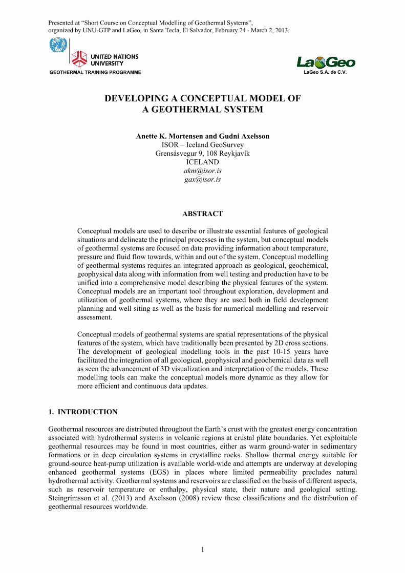
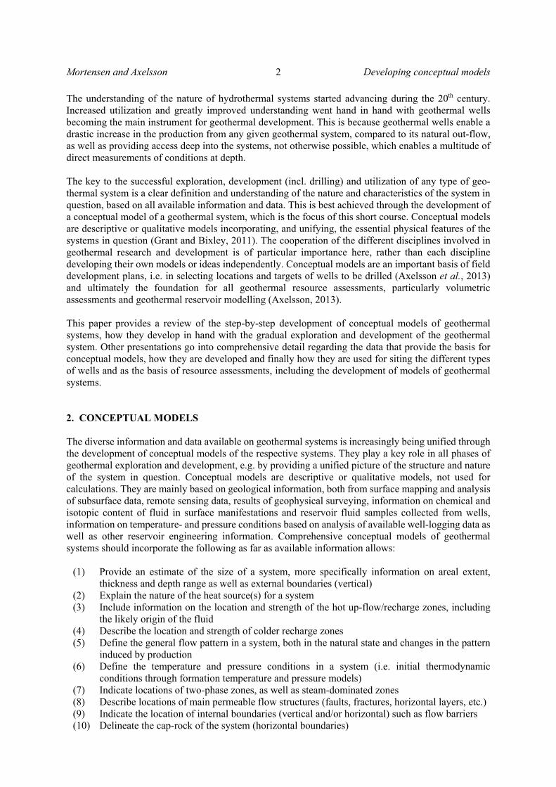
3.2. 2D and 3D models The relevant data and corresponding interpretation results, for the different disciplines involved in geothermal research and development, are described in various presentations at the present short course, but in the following the development of conceptual models in particular in 3D will be outlined. Data compiled during surface exploration are often presented on maps and cross sections and in figure 1 is an example of an initial model of Þeistareykir geothermal area, where the area has been subdivided according to one type of data, in this case the gas composition of fumaroles. As exploration of the geothermal fields progresses with the commencement of drilling increasingly more data is obtained from the subsurface. For many years the main form of presentation of subsurface data and models have been through 2D cross sections despite the spatial relationship of the data. Figures 1 and 2 are examples of such models representing an initial simple model prior to exploration drilling of the Þeistareykir geothermal area based on gas geochemistry of fumaroles, while the model from 1977 of Krafla geothermal field, where arrows are highlighting the areas of up- and outflow in the geothermal reservoir, as well as outlining the geological and structural control of flow. However, through computer software development it is now becoming more common to visualize geological data and models as digital 3D models. In recent years an increasing number of software programmes are becoming available for geological modelling and 3D visualization, typically originating from either the oil or mining industry, e.g. Petrel, Landmark, Leapfrog and RockWorks to name a few software programs representing different price ranges, capacities and degrees of user-friendliness. The objective with conceptual modelling is manifold, but the models are primary used to outline a field development strategy, well targeting
FIGURE 1: Zone division of Þeistareykir geothermal area based on gas geochemistry of fumaroles
(Ármannsson et al., 1986). Three of the areas appeared promising for drilling with estimated high reservoir
temperatures (A, C, D), while area B and E appeared disturbed by cold, groundwater (B and E)
FIGURE 2: A conceptual models of the Krafla geothermal system in NE-Iceland from 1977, where arrows are
highlighting the areas of up- and outflow in the geothermal reservoir, as well as outlining the geological and structural
control of flow (Valgarður Stefánsson, 1981)
Developing conceptual models 5 Mortensen and Axelsson
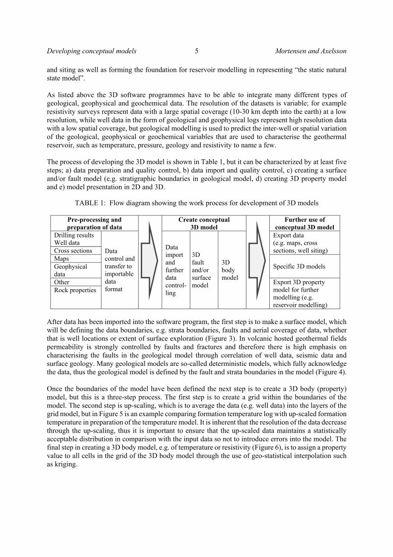
and siting as well as forming the foundation for reservoir modelling in representing “the static natural state model”. As listed above the 3D software programmes have to be able to integrate many different types of geological, geophysical and geochemical data. The resolution of the datasets is variable; for example resistivity surveys represent data with a large spatial coverage (10-30 km depth into the earth) at a low resolution, while well data in the form of geological and geophysical logs represent high resolution data with a low spatial coverage, but geological modelling is used to predict the inter-well or spatial variation of the geological, geophysical or geochemical variables that are used to characterise the geothermal reservoir, such as temperature, pressure, geology and resistivity to name a few. The process of developing the 3D model is shown in Table 1, but it can be characterized by at least five steps; a) data preparation and quality control, b) data import and quality control, c) creating a surface and/or fault model (e.g. stratigraphic boundaries in geological model, d) creating 3D property model and e) model presentation in 2D and 3D.
TABLE 1: Flow diagram showing the work process for development of 3D models
Pre-processing and preparation of data
Create conceptual 3D model
Further use of conceptual 3D model
Drilling results Well data
Data control and transfer to importable data format
Data import and further data control-ling
3D fault and/or surface model
3D body model
Export data (e.g. maps, cross sections, well siting) Cross sections
Maps Specific 3D models Geophysical
data Other Export 3D property
model for further modelling (e.g. reservoir modelling)
Rock properties
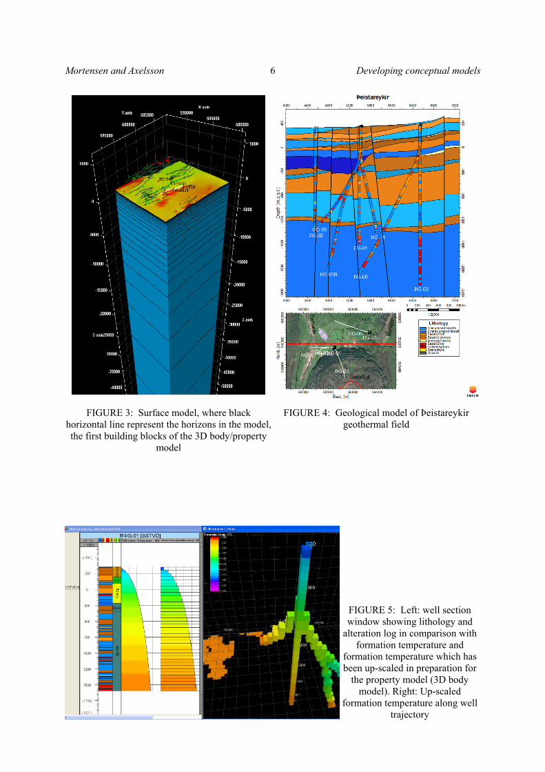
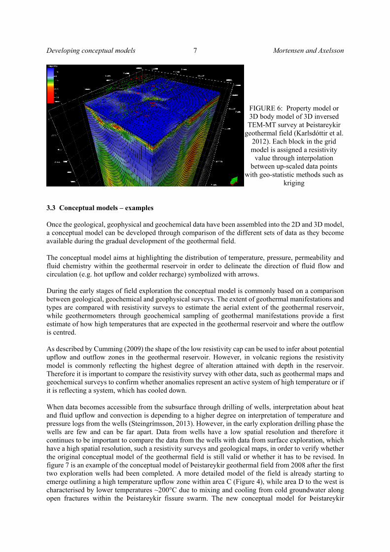
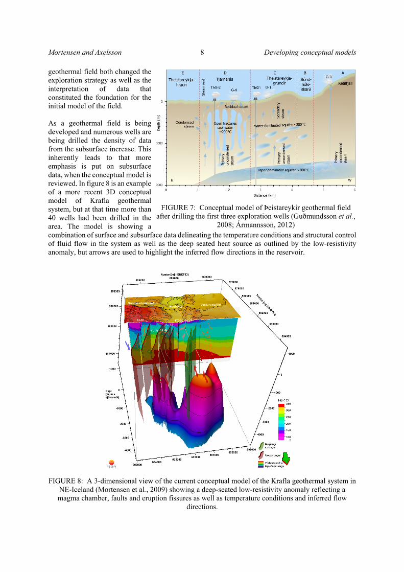
After data has been imported into the software program, the first step is to make a surface model, which will be defining the data boundaries, e.g. strata boundaries, faults and aerial coverage of data, whether that is well locations or extent of surface exploration (Figure 3). In volcanic hosted geothermal fields permeability is strongly controlled by faults and fractures and therefore there is high emphasis on characterising the faults in the geological model through correlation of well data, seismic data and surface geology. Many geological models are so-called deterministic models, which fully acknowledge the data, thus the geological model is defined by the fault and strata boundaries in the model (Figure 4). Once the boundaries of the model have been defined the next step is to create a 3D body (property) model, but this is a three-step process. The first step is to create a grid within the boundaries of the model. The second step is up-scaling, which is to average the data (e.g. well data) into the layers of the grid model, but in Figure 5 is an example comparing formation temperature log with up-scaled formation temperature in preparation of the temperature model. It is inherent that the resolution of the data decrease through the up-scaling, thus it is important to ensure that the up-scaled data maintains a statistically acceptable distribution in comparison with the input data so not to introduce errors into the model. The final step in creating a 3D body model, e.g. of temperature or resistivity (Figure 6), is to assign a property value to all cells in the grid of the 3D body model through the use of geo-statistical interpolation such as kriging.
Mortensen and Axelsson 6 Developing conceptual models
FIGURE 3: Surface model, where black horizontal line represent the horizons in the model, the first building blocks of the 3D body/property
model
FIGURE 4: Geological model of Þeistareykir geothermal field
FIGURE 5: Left: well section window showing lithology and
alteration log in comparison with formation temperature and
formation temperature which has been up-scaled in preparation for
the property model (3D body model). Right: Up-scaled
formation temperature along well trajectory
Developing conceptual models 7 Mortensen and Axelsson
3.3 Conceptual models – examples Once the geological, geophysical and geochemical data have been assembled into the 2D and 3D model, a conceptual model can be developed through comparison of the different sets of data as they become available during the gradual development of the geothermal field. The conceptual model aims at highlighting the distribution of temperature, pressure, permeability and fluid chemistry within the geothermal reservoir in order to delineate the direction of fluid flow and circulation (e.g. hot upflow and colder recharge) symbolized with arrows. During the early stages of field exploration the conceptual model is commonly based on a comparison between geological, geochemical and geophysical surveys. The extent of geothermal manifestations and types are compared with resistivity surveys to estimate the aerial extent of the geothermal reservoir, while geothermometers through geochemical sampling of geothermal manifestations provide a first estimate of how high temperatures that are expected in the geothermal reservoir and where the outflow is centred. As described by Cumming (2009) the shape of the low resistivity cap can be used to infer about potential upflow and outflow zones in the geothermal reservoir. However, in volcanic regions the resistivity model is commonly reflecting the highest degree of alteration attained with depth in the reservoir. Therefore it is important to compare the resistivity survey with other data, such as geothermal maps and geochemical surveys to confirm whether anomalies represent an active system of high temperature or if it is reflecting a system, which has cooled down. When data becomes accessible from the subsurface through drilling of wells, interpretation about heat and fluid upflow and convection is depending to a higher degree on interpretation of temperature and pressure logs from the wells (Steingrímsson, 2013). However, in the early exploration drilling phase the wells are few and can be far apart. Data from wells have a low spatial resolution and therefore it continues to be important to compare the data from the wells with data from surface exploration, which have a high spatial resolution, such a resistivity surveys and geological maps, in order to verify whether the original conceptual model of the geothermal field is still valid or whether it has to be revised. In figure 7 is an example of the conceptual model of Þeistareykir geothermal field from 2008 after the first two exploration wells had been completed. A more detailed model of the field is already starting to emerge outlining a high temperature upflow zone within area C (Figure 4), while area D to the west is characterised by lower temperatures ~200°C due to mixing and cooling from cold groundwater along open fractures within the Þeistareykir fissure swarm. The new conceptual model for Þeistareykir
FIGURE 6: Property model or 3D body model of 3D inversed TEM-MT survey at Þeistareykir
geothermal field (Karlsdóttir et al. 2012). Each block in the grid model is assigned a resistivity
value through interpolation between up-scaled data points
with geo-statistic methods such as kriging
Mortensen and Axelsson 8 Developing conceptual models
geothermal field both changed the exploration strategy as well as the interpretation of data that constituted the foundation for the initial model of the field. As a geothermal field is being developed and numerous wells are being drilled the density of data from the subsurface increase. This inherently leads to that more emphasis is put on subsurface data, when the conceptual model is reviewed. In figure 8 is an example of a more recent 3D conceptual model of Krafla geothermal system, but at that time more than 40 wells had been drilled in the area. The model is showing a combination of surface and subsurface data delineating the temperature conditions and structural control of fluid flow in the system as well as the deep seated heat source as outlined by the low-resistivity anomaly, but arrows are used to highlight the inferred flow directions in the reservoir.
FIGURE 8: A 3-dimensional view of the current conceptual model of the Krafla geothermal system in NE-Iceland (Mortensen et al., 2009) showing a deep-seated low-resistivity anomaly reflecting a magma chamber, faults and eruption fissures as well as temperature conditions and inferred flow
directions.
FIGURE 7: Conceptual model of Þeistareykir geothermal field after drilling the first three exploration wells (Guðmundsson et al.,
2008; Ármannsson, 2012)
Developing conceptual models 9 Mortensen and Axelsson
4. CONCLUSIONS This paper has reviewed the step-by-step development of conceptual models of geothermal systems, how they develop in hand with the gradual exploration and development of the geothermal system. Conceptual models are used to illustrate the essential features of the geothermal systems, but geothermal systems are characterized through a multidisciplinary approach involving geological, geochemical, geophysical and hydrogeological data from both surface and subsurface exploration. Hitherto data have mainly been integrated and presented in the form of 2D conceptual models. However, geological modelling tools have developed rapidly in the past decade and these software programmes are increasingly applied as a central tool in the development of geothermal fields. They facilitate spatial representation and visualization of the data in digital 3D models, but the multitude of data that are used to describe and define the geothermal system can be integrated and interpreted in one model. The geological modelling tools also allow for a more efficient and continuous model update as new data are obtained, but timely updates of conceptual models are critical for successful development planning, well siting and resource assessment of geothermal fields.
ACKNOWLEDGEMENTS The authors would like to acknowledge numerous colleagues worldwide for fruitful discussions on conceptual models of various geothermal systems during the last 2 – 3 decades. Landsvirkjun and Þeistareykir ehf. are also acknowledged for allowing publication of the case-history data presented here.
REFERENCES Axelsson, G., 2013: Dynamic modelling of geothermal systems. Proceedings of the “Short Course on Conceptual Modelling of Geothermal Systems”, organized by UNU-GTP and LaGeo, Santa Tecla, El Salvador, 21 pp. Axelsson, G., 2008: Production capacity of geothermal systems. Proceedings of the Workshop for Decision Makers on the Direct Heating Use of Geothermal Resources in Asia, organized by UNU-GTP, TBLRREM and TBGMED, Tianjin, China, 14 pp. Ármannsson, H., Gíslason, G. and Torfason, H., 1986: Surface exploration of the Theistareykir hightemperature geothermal area, Iceland, with special reference to the application of geochemical methods. Appl. Geochem., 1, 47-64. Ármannsson, H., 2012: The Theistareykir geothermal system, North-East Iceland: Case history. Short Course VII on Exploration for Geothermal Resources,organized by UNU-GTP, GDC and KenGen, at Lake Bogoria and Lake Naivasha, Kenya, Oct. 27 – Nov. 18, 2012, 11 pp. Cumming, W., 2009: Geothermal resource conceptual models using surface exploration data. Proceedings of the 34th Workshop on Geothermal Reservoir Engineering, Stanford University, California, USA, 6 pp. Darling, W.G. and Ármannsson, H., 1989: Stable isotopic aspects of fluid flow in the Krafla, Námafjall and Theistareykir geothermal systems of northeast Iceland. Chem. Geol., 76, 197–213. Guðmundsson, Á., Gautason, B., Lacasse, C., Axelsson, G., Þorgilsson, G., Ármannsson, H., Thulinius, H., Sæmundsson, K., Karlsdóttir, R., Kjaran, S.P., Pálmarsson, S.Ó., Halldórsdóttir S., Egilson Þ., 2008: Hugmyndalíkan jarðhitakerfisins á Þeistareykjum og jarðvarmamat með rúmmálsaðferð. ÍSOR, Iceland Geosurvey ÍSOR-2008/024, 522013, Mannvit MV-049, Vatnaskil 08.05.

Mortensen and Axelsson 10 Developing conceptual models
Grant, M.A., and Bixley, P.F., 2011: Geothermal reservoir engineering – Second edition. Academic Press, Burlington, USA, 359 pp. Mortensen, A.K., Gudmundsson, Á., Steingrímsson, B., Sigmundsson, F., Axelsson, G., Ármannsson, H., Björnsson, H., Ágústsson, K., Saemundsson, K., Ólafsson, M., Karlsdóttir, R., Halldórsdóttir, S., and Hauksson, T., 2009: The Krafla geothermal system. A review of geothermal research and revision of the conceptual model (in Icelandic). Iceland GeoSurvey, report ÍSOR-2009/057, Reykjavík, 208 pp. 9. Karlsdóttir, R., Teklesenbet Beyene, A., and Vilhjálmsson, A.M., 2012: Námafjall geothermal area, Northern Iceland. 3D inversion of MT and TEM data. ISOR Iceland Geosurvey, ÍSOR-2012/057, Landsvirkjun, LV-2012-112, 139 pp. Steingrímsson, B., 2013: Reservoir temperature and pressure models. Proceedings of the “Short Course on Conceptual Modelling of Geothermal Systems”, organized by UNU-GTP and LaGeo, Santa Tecla, El Salvador, 16 pp.
Stefánsson, V., 1981: The Krafla geothermal field, northeast Iceland. In: Rybach, L. og Muffler, L. J. P. (ritstj.), Geothermal Systems: Principlees and Case Histories, John Wiley & Sons, 273–294.
Related Documents