ClimateInformed Ravine Management www.glisa.msu.edu Developing a Community of ClimateInformed Conservation Practitioners to Protect a Priority Landscape in Illinois and Wisconsin Angela Larsen 1 , Abigail Derby Lewis 2 , Olga Lyandres 1 , Tingqiao Chen 3,4 , Ken Frank 3,4 1 Alliance for the Great Lakes 2 The Field Museum, Science Action Center 3 Michigan State University, Department of Fisheries and Wildlife within the College of Agriculture and Natural Resources 4 Michigan State University, Department of Counseling, Educational Psychology and Special Education within the College of Education This project was funded by Great Lakes Integrated Sciences + Assessments through a 2013 Great Lakes Climate Assessment Grant. Recommended Citation: Larsen, A., Derby Lewis, A, Lyandres, O. Chen, T., Frank, K. 2014. Developing a Community of ClimateInformed Conservation Practitioners to Protect a Priority Coastal Landscape in Illinois and Wisconsin. For further questions, please contact [email protected] or [email protected]

Welcome message from author
This document is posted to help you gain knowledge. Please leave a comment to let me know what you think about it! Share it to your friends and learn new things together.
Transcript
Climate-‐Informed Ravine Management
www.glisa.msu.edu
Developing a Community of Climate-‐Informed Conservation Practitioners to Protect a Priority
Landscape in Illinois and Wisconsin Angela Larsen1, Abigail Derby Lewis2, Olga Lyandres1, Tingqiao Chen3,4, Ken Frank3,4
1Alliance for the Great Lakes 2The Field Museum, Science Action Center 3Michigan State University, Department of Fisheries and Wildlife within the College of Agriculture and Natural Resources 4Michigan State University, Department of Counseling, Educational Psychology and Special Education within the College of Education
This project was funded by Great Lakes Integrated Sciences + Assessments through a 2013 Great Lakes Climate Assessment Grant.
Recommended Citation: Larsen, A., Derby Lewis, A, Lyandres, O. Chen, T., Frank, K. 2014. Developing a Community of Climate-‐Informed Conservation Practitioners to Protect a Priority Coastal Landscape in Illinois and Wisconsin.
For further questions, please contact [email protected] or [email protected]

CLIMATE-‐INFORMED RAVINE MANAGEMENT
2 www.glisa.umich.edu Last updated: 2/27/2015
Contents Problem .................................................................................................................................................................................................................................................. 3 Approach ................................................................................................................................................................................................................................................ 3
Network Mapping ..................................................................................................................................................................................................................... 4 Meeting Design ........................................................................................................................................................................................................................... 5 Planning with the Natural Network .................................................................................................................................................................................. 5 Implementation ......................................................................................................................................................................................................................... 6
Characterizing the Social Network ............................................................................................................................................................................................. 6 Purpose .......................................................................................................................................................................................................................................... 6 Methods ......................................................................................................................................................................................................................................... 6 Results ............................................................................................................................................................................................................................................ 7 Network Description ............................................................................................................................................................................................................... 8 Application ................................................................................................................................................................................................................................... 8
Next Steps .............................................................................................................................................................................................................................................. 9 Facilitation ................................................................................................................................................................................................................................... 9 Stormwater .................................................................................................................................................................................................................................. 9 Habitat ............................................................................................................................................................................................................................................ 9 Monitoring .................................................................................................................................................................................................................................... 9 Evaluation ..................................................................................................................................................................................................................................... 9
Discussion and Lessons Learned ................................................................................................................................................................................................. 9 References .......................................................................................................................................................................................................................................... 10 Appendix ............................................................................................................................................................................................................................................. 11
CLIMATE-‐INFORMED RAVINE MANAGEMENT
3 www.glisa.umich.edu Last updated: 2/27/2015
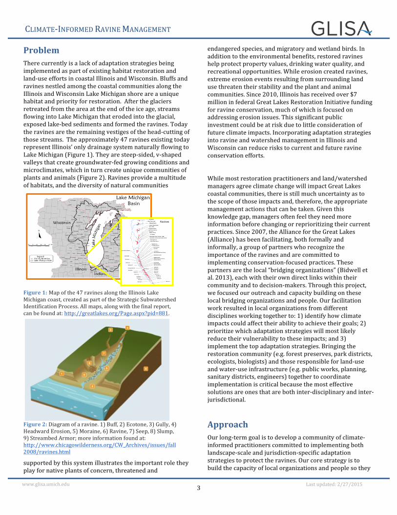
Problem There currently is a lack of adaptation strategies being implemented as part of existing habitat restoration and land-‐use efforts in coastal Illinois and Wisconsin. Bluffs and ravines nestled among the coastal communities along the Illinois and Wisconsin Lake Michigan shore are a unique habitat and priority for restoration. After the glaciers retreated from the area at the end of the ice age, streams flowing into Lake Michigan that eroded into the glacial, exposed lake-‐bed sediments and formed the ravines. Today the ravines are the remaining vestiges of the head-‐cutting of those streams. The approximately 47 ravines existing today represent Illinois’ only drainage system naturally flowing to Lake Michigan (Figure 1). They are steep-‐sided, v-‐shaped valleys that create groundwater-‐fed growing conditions and microclimates, which in turn create unique communities of plants and animals (Figure 2). Ravines provide a multitude of habitats, and the diversity of natural communities
supported by this system illustrates the important role they play for native plants of concern, threatened and
endangered species, and migratory and wetland birds. In addition to the environmental benefits, restored ravines help protect property values, drinking water quality, and recreational opportunities. While erosion created ravines, extreme erosion events resulting from surrounding land use threaten their stability and the plant and animal communities. Since 2010, Illinois has received over $7 million in federal Great Lakes Restoration Initiative funding for ravine conservation, much of which is focused on addressing erosion issues. This significant public investment could be at risk due to little consideration of future climate impacts. Incorporating adaptation strategies into ravine and watershed management in Illinois and Wisconsin can reduce risks to current and future ravine conservation efforts.
While most restoration practitioners and land/watershed managers agree climate change will impact Great Lakes coastal communities, there is still much uncertainty as to the scope of those impacts and, therefore, the appropriate management actions that can be taken. Given this knowledge gap, managers often feel they need more information before changing or reprioritizing their current practices. Since 2007, the Alliance for the Great Lakes (Alliance) has been facilitating, both formally and informally, a group of partners who recognize the importance of the ravines and are committed to implementing conservation-‐focused practices. These partners are the local “bridging organizations” (Bidwell et al. 2013), each with their own direct links within their community and to decision-‐makers. Through this project, we focused our outreach and capacity building on these local bridging organizations and people. Our facilitation work resulted in local organizations from different disciplines working together to: 1) identify how climate impacts could affect their ability to achieve their goals; 2) prioritize which adaptation strategies will most likely reduce their vulnerability to these impacts; and 3) implement the top adaptation strategies. Bringing the restoration community (e.g. forest preserves, park districts, ecologists, biologists) and those responsible for land-‐use and water-‐use infrastructure (e.g. public works, planning, sanitary districts, engineers) together to coordinate implementation is critical because the most effective solutions are ones that are both inter-‐disciplinary and inter-‐jurisdictional.
Approach Our long-‐term goal is to develop a community of climate-‐informed practitioners committed to implementing both landscape-‐scale and jurisdiction-‐specific adaptation strategies to protect the ravines. Our core strategy is to build the capacity of local organizations and people so they
Figure 1: Map of the 47 ravines along the Illinois Lake Michigan coast, created as part of the Strategic Subwatershed Identification Process. All maps, along with the final report, can be found at: http://greatlakes.org/Page.aspx?pid=881.
Figure 2: Diagram of a ravine. 1) Buff, 2) Ecotone, 3) Gully, 4) Headward Erosion, 5) Moraine, 6) Ravine, 7) Seep, 8) Slump, 9) Streambed Armor; more information found at: http://www.chicagowilderness.org/CW_Archives/issues/fall2008/ravines.html
CLIMATE-‐INFORMED RAVINE MANAGEMENT
4 www.glisa.umich.edu Last updated: 2/27/2015
can lead the implementation of these local climate-‐informed conservation practices, thus ensuring that climate change planning becomes integrated into routine land management decisions.
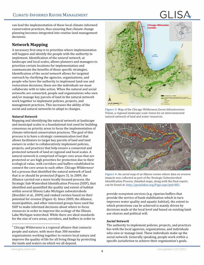
Network Mapping A necessary first step is to prioritize where implementation will happen and identify the people with the authority to implement. Identification of the natural network, at landscape and local scales, allows planners and managers to prioritize certain locations for implementation and communicate the benefits of those specific strategies. Identification of the social network allows for targeted outreach by clarifying the agencies, organizations, and people who have the authority to implement land-‐use and restoration decisions; these are the individuals we must collaborate with to take action. When the natural and social networks are connected, people and organizations who own and/or manage key parcels of land in the natural network work together to implement policies, projects, and management practices. This increases the ability of the social and natural networks to adapt to changes. Natural Network Mapping and identifying the natural network at landscape and municipal scales is a foundational tool used for building consensus on priority areas to focus the implementation of climate-‐informed conservation practices. The goal of this process is to have a strategic communication tool that allows facilitators to target key parcels of land and land owners in order to collaboratively implement policies, projects, and practices that help ensure a connected and protected network of land at regional and local scales. A natural network is comprised of larger core areas that are protected or are high priorities for protection due to their ecological value, with corridors and buffers established to connect the core areas to each other. Chicago Wilderness1 led a process that identified the natural network of land that is or should be protected (Figure 3). In 2009, the Alliance carried out a more locally focused process, the Strategic Sub-‐Watershed Identification Process (SSIP), that identified and quantified the quality and extent of habitat within several Illinois Lake Michigan subwatersheds (Boeckler et al., 2009) and ranked ravines based on their potential for erosion (Figure 4). Since 2009, the Alliance, municipalities, and other interested groups have used the SSIP to make informed decisions about where to focus resources in order to improve the ecology of the Illinois Lake Michigan watershed. While there are ideal standards for the size of core areas, corridors, and buffers in order to 1 Chicago Wilderness is a regional alliance that connects people and nature, with more than 300 member organizations working together to restore local nature and improve the quality of life for all living things by protecting the lands and waters on which we all depend.
provide ecosystem services (e.g. riparian buffers that provide the service of bank stabilization which in turn improves water quality and aquatic habitat), the extent to which protections can be achieved is mainly driven by decisions made at the local level and based on existing land-‐use choices and political will. Social Network The authority to implement policies, projects, and practices lies with the local agencies, organizations, and individuals who own or manage land. These individuals make up the social network. Generally speaking, people work within a specific jurisdiction to achieve their organization’s goals.
Figure 3: Map of the Chicago Wilderness Green Infrastructure Vision, a regional landscape scale vision for an interconnected natural network of land and water resources.
Figure 4: An aerial map of an Illinois ravine where data on erosion impacts was collected as part of the Strategic Subwatershed Identification Process. Detailed maps, along with the final report, can be found at: http://greatlakes.org/Page.aspx?pid=881.
CLIMATE-‐INFORMED RAVINE MANAGEMENT
5 www.glisa.umich.edu Last updated: 2/27/2015
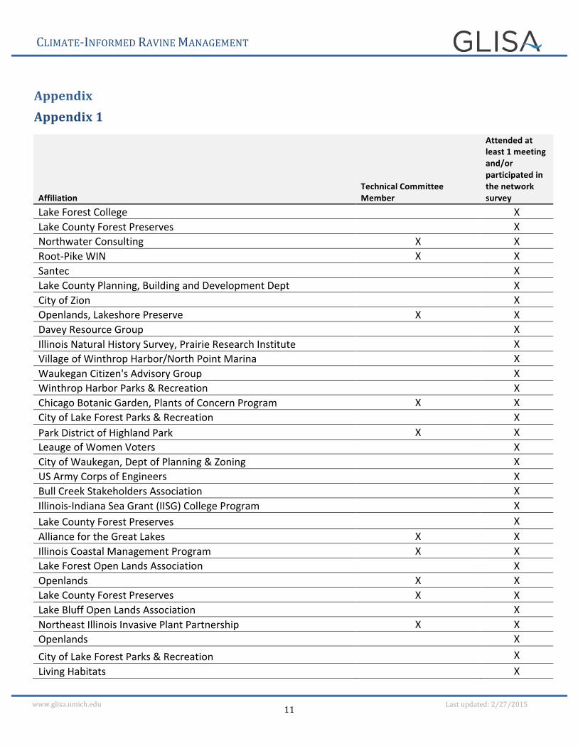
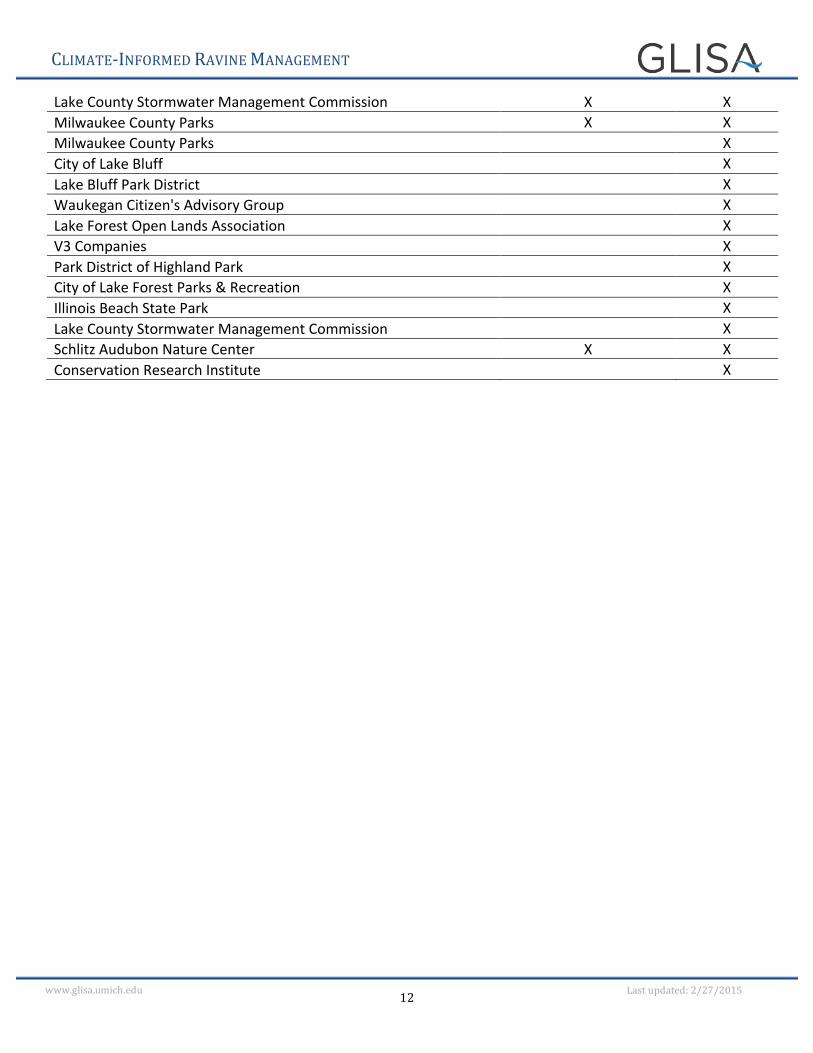
Bringing these individual actors together to facilitate the development of shared goals and strategies, which works to strengthen the community of climate-‐informed conservation practitioners, is core to our facilitation strategy. Understanding the structure of the network, for example the composition of sub-‐groups and how collaborative information sharing occurs, is key to building a strong social network connected to the natural network. In order to be effective, the facilitation and planning process begins with getting experts from different sectors together to identify shared goals. An important facet of effective engagement is identifying trusted local experts and working one-‐on-‐one with them to solidify their commitment to participate, usually as technical advisors, in the planning-‐to-‐implementation process. The strategy is to build the capacity of these technical advisors to be local champions who help lead the broader network. For this project, twelve individuals were invited to participate as technical advisors, four of whom received funding to provide data and information and two of whom committed to implementation. In addition, over 50 additional key stakeholders were identified and invited to participate (Appendix 1). Finally, we used social network analysis to establish a baseline for climate-‐informed behavior and inform the design of future facilitation strategies to more effectively implement climate-‐informed conservation strategies. Social network analysis has been applied in a variety of contexts – from understanding and predicting behavior and program effectiveness to the studies of resilience by linking social and ecological networks (Janssen et al., 2006). For more information on the social network analysis used, please see the Evaluation section of this paper.
Meeting Design Implementation requires collaboration, coordination, and communication with local stakeholders, which in turn is largely achieved through good meeting design and facilitation. This project included a series of five meetings designed to promote a step-‐wise progression of information sharing and place-‐based application of climate science, expected climate stressors, and likely impacts to the ravine system on core management practices. The meeting series was intended to achieve the following goals: 1) set the stage and introduce the project; 2) build consensus on the goal for regional landscape restoration of coastal ravines that will serve as the cornerstone for the climate vulnerability assessment and the overarching guidance for developing adaptation strategies; 3) select adaptation strategies that local implementers are committed to leading; 4) strengthen the capacity of local experts (e.g. members of the technical committee) by providing needed tools and information to lead implementation of prioritized adaptation strategies; and 5) share and guide the broader social network through the process and outcomes via a webinar.
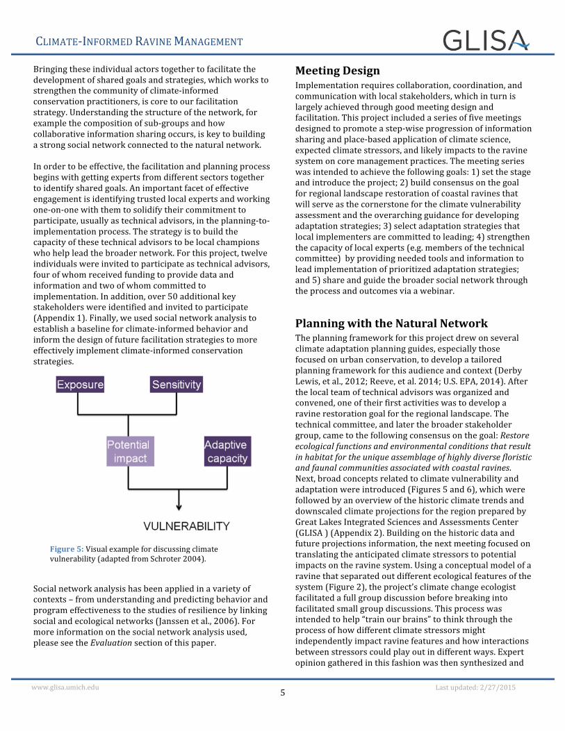
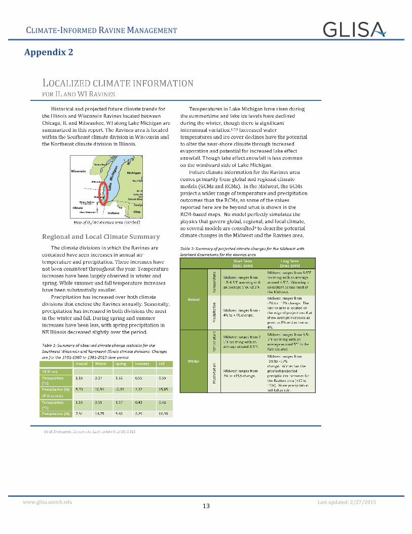
Planning with the Natural Network The planning framework for this project drew on several climate adaptation planning guides, especially those focused on urban conservation, to develop a tailored planning framework for this audience and context (Derby Lewis, et al., 2012; Reeve, et al. 2014; U.S. EPA, 2014). After the local team of technical advisors was organized and convened, one of their first activities was to develop a ravine restoration goal for the regional landscape. The technical committee, and later the broader stakeholder group, came to the following consensus on the goal: Restore ecological functions and environmental conditions that result in habitat for the unique assemblage of highly diverse floristic and faunal communities associated with coastal ravines. Next, broad concepts related to climate vulnerability and adaptation were introduced (Figures 5 and 6), which were followed by an overview of the historic climate trends and downscaled climate projections for the region prepared by Great Lakes Integrated Sciences and Assessments Center (GLISA ) (Appendix 2). Building on the historic data and future projections information, the next meeting focused on translating the anticipated climate stressors to potential impacts on the ravine system. Using a conceptual model of a ravine that separated out different ecological features of the system (Figure 2), the project’s climate change ecologist facilitated a full group discussion before breaking into facilitated small group discussions. This process was intended to help “train our brains” to think through the process of how different climate stressors might independently impact ravine features and how interactions between stressors could play out in different ways. Expert opinion gathered in this fashion was then synthesized and
Figure 5: Visual example for discussing climate vulnerability (adapted from Schroter 2004).
CLIMATE-‐INFORMED RAVINE MANAGEMENT
6 www.glisa.umich.edu Last updated: 2/27/2015
sent back to the group for review (Appendix 3). After the broader group of stakeholders had the opportunity to provide feedback on how climate stressors will impact the ravines, the smaller group of technical advisors came back together to focus on which climate stressors and impacts were most critical to address. This decision was based on three equally important aspects: the landscape restoration goal; the management goals of the implementer’s organization; and the implementer’s capacity to address the impacts. Adaptation strategies aimed at reducing these climate impacts were then drafted. The strategies tended to focus on actions that could be taken near-‐term and were divided into two categories: those that an individual organization could implement and those that needed collective action. The last meeting with just the implementers resulted in a prioritization of adaptation strategies by two organizations committed to implementation (Appendix 4).
Implementation While planning is vital to the process, the end goal is always implementation of climate-‐informed policies, projects, and management practices. As part of this project two local land managers, Lake County Forest Preserves and Openlands, committed to implementing the top adaptation strategies. As described in the Planning Framework section above, the Technical Committee developed a suite of adaptation strategies that spanned from the near-‐term (1-‐ 5 years) to longer-‐term (11-‐15 years). The two organizations then decided which strategies they were committed to helping lead. Following this, all stakeholders participated in a webinar where they voted on which of the top adaptation
strategies identified by the Technical Advisory group they wanted to help implement (APPENDIX 4). The top adaptation strategies will be used to guide future facilitation work with the committed implementers and broader network to continue to support the development of a community of climate-‐informed conservation practitioners.
Characterizing the Social Network
Purpose Social network analysis is used to characterize the structure of the ravine network and the interactions between members of the network. This information will be utilized to develop targeted facilitation strategies focused on increasing the frequency of implementation of ravine adaptation practices in the project area (See Application and Next Steps sections for more details). The underlying assumption, one supported by theory and research, is that the most effective facilitation strategies are those that utilize the existing network, which means that it is critical to identify the people who are well integrated within the network and best positioned to influence and lead, and design facilitation strategies with the intent of building the capacity of these local leaders. The individuals in the ravine network are composed of land managers, decision makers, and technical experts responsible for natural resource protection and stormwater management along the coast in northeastern Illinois and southeastern Wisconsin. The characterization of this network is designed to illuminate: (1) the composition of sub-‐groups within the network; (2) the extent to which sub-‐groups are able to collaborate and share information about ravine management; (3) how and from whom land managers acquire information that informs their decision-‐making; (4) the extent to which climate adaptation is included in planning and implementing ravine management strategies; and (5) beliefs about lake levels and freeze thaw cycles more broadly in the Great Lakes.2
Methods A survey instrument was developed that included questions about respondent’s closest colleagues, the frequency of their interactions with these colleagues, and whether and to what extent respondents incorporated issues of climate change into core ravine management practices. In addition, the survey instrument asked questions regarding sources of climate change related information. The complete survey instrument is attached in Appendix 5. A set of 49 individuals involved in ravine conservation and management was identified as the outreach targets for the survey. We administered the survey face-‐to-‐face at one of the facilitated meetings (on 6/17/2014, 14 responses collected), and online (using Qualtrics) (from 7/30/2014 to 9/22/2014, 30 responses collected).
2 Through the collaboration with Michigan State University and Great Lakes Integrated Sciences and Assessments Center, the survey also included the questions regarding lake levels and freeze thaw cycles in the Great Lakes, however, the reporting out on those results is beyond the scope of this paper.
Figure 6: Example of climate concepts: Scope and scale of adaptation to climate change (from Moser and Ekstrom 2010).
CLIMATE-‐INFORMED RAVINE MANAGEMENT
7 www.glisa.umich.edu Last updated: 2/27/2015
After collecting the survey data (N = 44 responses), social scientists at Michigan State University developed four network maps (Figures 7-‐10). It is important to note that the network maps discussed below focus on stormwater management because stormwater related strategies are the top adaptation strategies for the ravine network; additional diagrams and strategies related to habitat management are available upon request. In order for the frequency of implementation of core practices at an individual and sub-‐group scale to be analyzed and measured over time, statements describing core practices were analyzed for reliability, which was shown to be sufficiently high to conduct the analysis 3
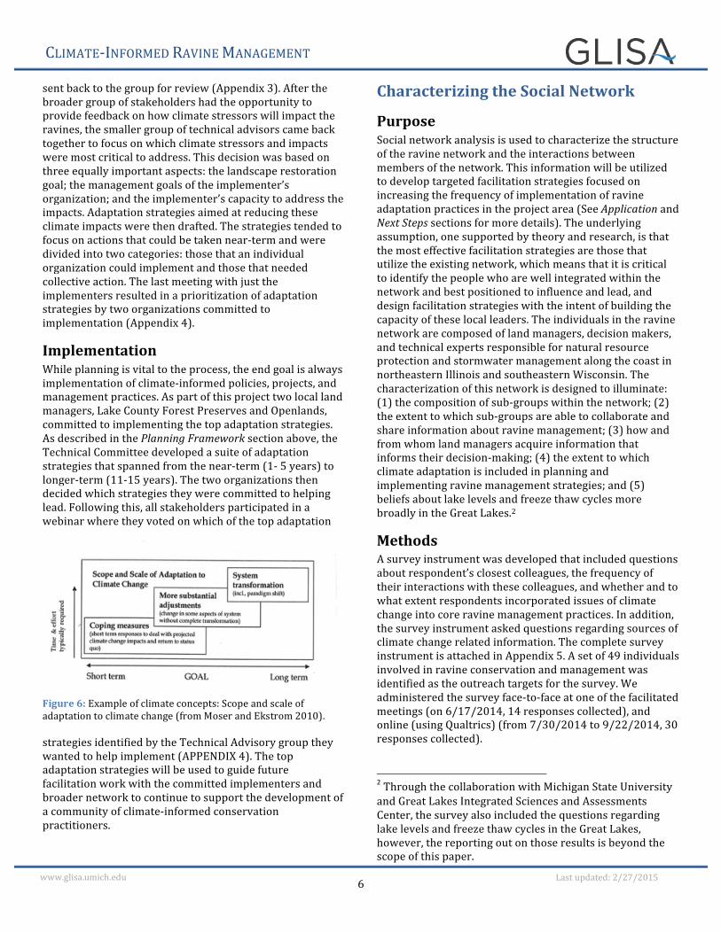
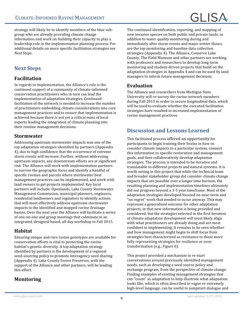
Results A sub-‐set of the survey data are discussed below and visually represented in Figures 7-‐10. In each figure, the following characteristics apply: 1) colored circles represent an individual person that was named as a “close college” by someone who filled out the survey; 2) circles are color coded according to four sub-‐groups; 3) sub-‐groups were formed based on individuals who interact most frequently with each other (Frank 1995, 1996); 4) the thickness of the lines between circles represents the frequency of interaction between those individuals; and 5) circle size represents frequency of an individual implementing ravine practices, with larger circles indicating more frequent implementation and smaller circles indicating less frequent. Overall, based on how often individuals interact with one another, four subgroups were identified within the network (Figure 7). Additional information gleaned from the survey includes which sub-‐groups (Figure 8) and which individuals (Figure 9) are implementing stormwater management practices most frequently, the frequency of individuals implementing climate-‐informed stormwater practices, and who is providing individuals in the ravine network with climate change information (Figure 10). Figure 10 also illustrates a feeder network, represented by green circles. Some of the sources of climate change information are members of the ravine network (indicated by red lines), while some sources are individuals outside the network (indicated by blue lines). The thickness of the lines represents the frequency of interaction between the person receiving and the person providing climate change information. The arrows on the blue and red lines indicate the direction the information was transmitted. The feeder network depicted in Figure 10 demonstrates that members of sub-‐groups are not communicating very frequently with 3 The reliability a for the ravine management practices are: stormwater management (a = 0.84); 2) habitat management (a = 0.82); 3) climate change informed stormwater management (a = 0.89); and 4) climate change informed habitat management (a = 0.89).
each other, or with members of other sub-‐groups, about climate change. For example, the grey and burgundy sub-‐groups have only a few red lines indicating infrequent communication about climate change.
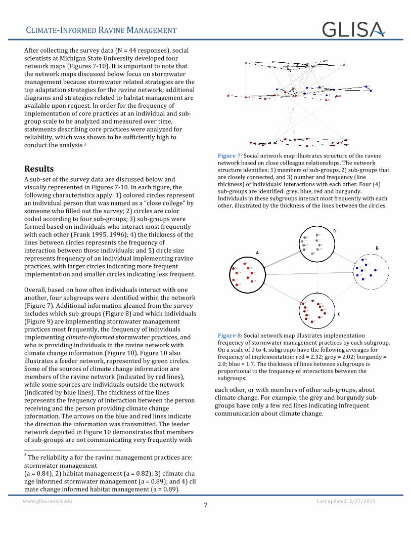
Figure 8: Social network map illustrates implementation frequency of stormwater management practices by each subgroup. On a scale of 0 to 4, subgroups have the following averages for frequency of implementation: red = 2.32; grey = 2.02; burgundy = 2.0; blue = 1.7. The thickness of lines between subgroups is proportional to the frequency of interactions between the subgroups.
Figure 7: Social network map illustrates structure of the ravine network based on close colleague relationships. The network structure identifies: 1) members of sub-‐groups, 2) sub-‐groups that are closely connected, and 3) number and frequency (line thickness) of individuals’ interactions with each other. Four (4) sub-‐groups are identified: grey, blue, red and burgundy. Individuals in these subgroups interact most frequently with each other, illustrated by the thickness of the lines between the circles.
CLIMATE-‐INFORMED RAVINE MANAGEMENT
8 www.glisa.umich.edu Last updated: 2/27/2015
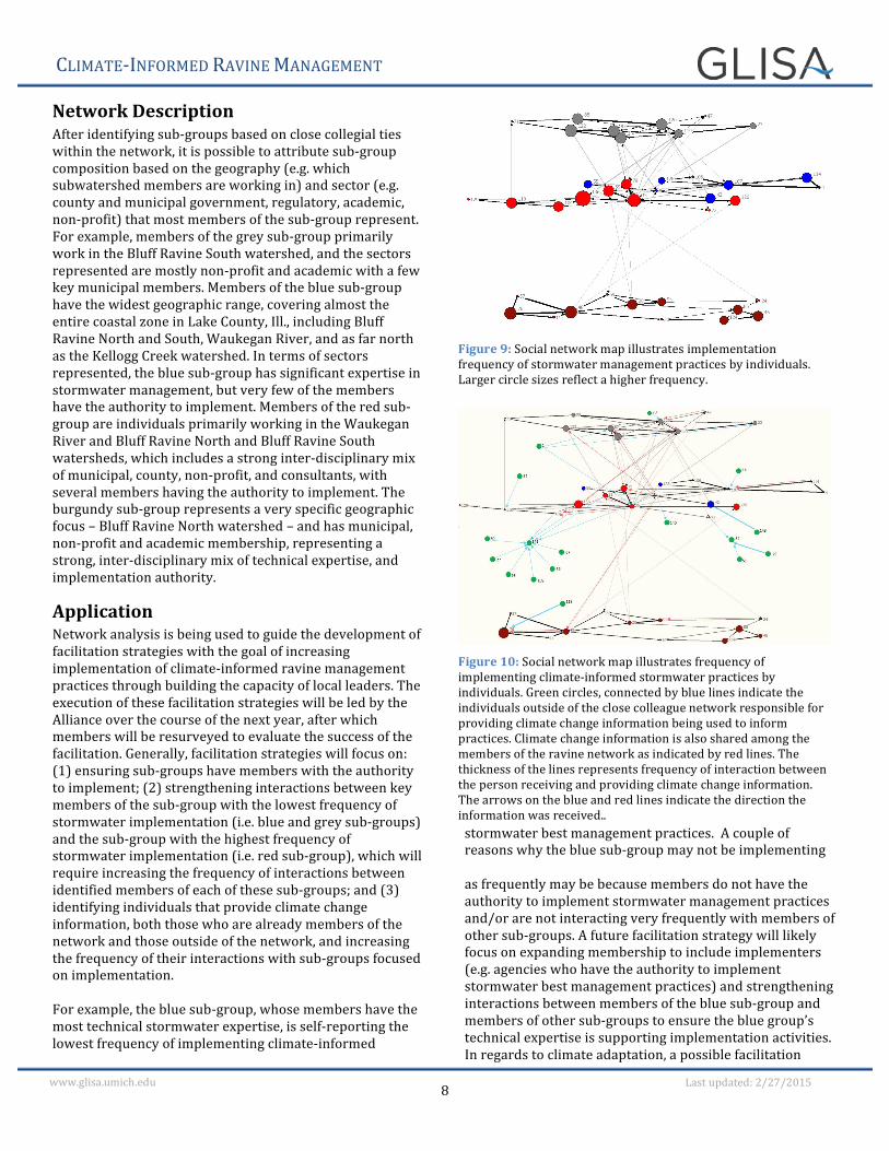
Network Description After identifying sub-‐groups based on close collegial ties within the network, it is possible to attribute sub-‐group composition based on the geography (e.g. which subwatershed members are working in) and sector (e.g. county and municipal government, regulatory, academic, non-‐profit) that most members of the sub-‐group represent. For example, members of the grey sub-‐group primarily work in the Bluff Ravine South watershed, and the sectors represented are mostly non-‐profit and academic with a few key municipal members. Members of the blue sub-‐group have the widest geographic range, covering almost the entire coastal zone in Lake County, Ill., including Bluff Ravine North and South, Waukegan River, and as far north as the Kellogg Creek watershed. In terms of sectors represented, the blue sub-‐group has significant expertise in stormwater management, but very few of the members have the authority to implement. Members of the red sub-‐group are individuals primarily working in the Waukegan River and Bluff Ravine North and Bluff Ravine South watersheds, which includes a strong inter-‐disciplinary mix of municipal, county, non-‐profit, and consultants, with several members having the authority to implement. The burgundy sub-‐group represents a very specific geographic focus – Bluff Ravine North watershed – and has municipal, non-‐profit and academic membership, representing a strong, inter-‐disciplinary mix of technical expertise, and implementation authority.
Application Network analysis is being used to guide the development of facilitation strategies with the goal of increasing implementation of climate-‐informed ravine management practices through building the capacity of local leaders. The execution of these facilitation strategies will be led by the Alliance over the course of the next year, after which members will be resurveyed to evaluate the success of the facilitation. Generally, facilitation strategies will focus on: (1) ensuring sub-‐groups have members with the authority to implement; (2) strengthening interactions between key members of the sub-‐group with the lowest frequency of stormwater implementation (i.e. blue and grey sub-‐groups) and the sub-‐group with the highest frequency of stormwater implementation (i.e. red sub-‐group), which will require increasing the frequency of interactions between identified members of each of these sub-‐groups; and (3) identifying individuals that provide climate change information, both those who are already members of the network and those outside of the network, and increasing the frequency of their interactions with sub-‐groups focused on implementation. For example, the blue sub-‐group, whose members have the most technical stormwater expertise, is self-‐reporting the lowest frequency of implementing climate-‐informed
stormwater best management practices. A couple of reasons why the blue sub-‐group may not be implementing as frequently may be because members do not have the authority to implement stormwater management practices and/or are not interacting very frequently with members of other sub-‐groups. A future facilitation strategy will likely focus on expanding membership to include implementers (e.g. agencies who have the authority to implement stormwater best management practices) and strengthening interactions between members of the blue sub-‐group and members of other sub-‐groups to ensure the blue group’s technical expertise is supporting implementation activities. In regards to climate adaptation, a possible facilitation
Figure 9: Social network map illustrates implementation frequency of stormwater management practices by individuals. Larger circle sizes reflect a higher frequency.
Figure 10: Social network map illustrates frequency of implementing climate-‐informed stormwater practices by individuals. Green circles, connected by blue lines indicate the individuals outside of the close colleague network responsible for providing climate change information being used to inform practices. Climate change information is also shared among the members of the ravine network as indicated by red lines. The thickness of the lines represents frequency of interaction between the person receiving and providing climate change information. The arrows on the blue and red lines indicate the direction the information was received..
CLIMATE-‐INFORMED RAVINE MANAGEMENT
9 www.glisa.umich.edu Last updated: 2/27/2015
strategy will likely be to identify members of the blue sub-‐group who are already providing climate change information and work on building their capacity to play a leadership role in the implementation planning process. For additional details on more specific facilitation strategies see Next Steps.
Next Steps
Facilitation In regards to implementation, the Alliance’s role is the continued support of a community of climate-‐informed conservation practitioners who in turn can lead the implementation of adaptation strategies. Continued facilitation of the network is needed to increase the number of practitioners embedding climate considerations into core management practices and to ensure that implementation is achieved because there is not yet a critical mass of local experts leading the integration of climate planning into their routine management decisions.
Stormwater Addressing upstream stormwater impacts was one of the top adaptation strategies identified by partners (Appendix 4), due to high confidence that the occurrence of extreme storm events will increase. Further, without addressing upstream impacts, any downstream efforts are at significant risk. The Alliance will work with implementation partners to narrow the geographic focus and identify a handful of specific ravines and parcels where stormwater best management practices can be implemented, and work with land owners to get projects implemented. Key local partners will include: Openlands, Lake County Stormwater Management Commission, municipal planners, engineers, residential landowners and regulators to identify actions that will most effectively address upstream stormwater impacts in the identified and mapped ravine drainage basins. Over the next year the Alliance will facilitate a series of one-‐on-‐one and group meetings that culminate in an integrated, designed-‐based, all-‐day workshop in Fall 2015.
Habitat Ensuring unique and rare ravine genotypes are available for conservation efforts is vital to protecting the ravine habitat’s genetic diversity. A top adaptation strategy identified by partners is the development of a regional seed-‐sourcing policy to promote interagency seed sharing (Appendix 4). Lake County Forest Preserves, with the support of the Alliance and other partners, will be leading this effort.
Monitoring
The continued identification, reporting, and mapping of new invasive species on both public and private lands, in addition to water quality monitoring during and immediately after storm events and major winter thaws, are the top monitoring and baseline data collection strategies (Appendix 4). The Alliance, Conserve Lake County, The Field Museum and other partners are working with professors and researchers to develop long-‐term monitoring and student-‐driven projects that build on the adaptation strategies in Appendix 4 and can be used by land managers to inform future management decisions.
Evaluation The Alliance and researchers from Michigan State University will re-‐survey the ravine network members during Fall 2015 in order to secure longitudinal data, which will be used to evaluate whether the executed facilitation strategies have resulted in increased implementation of ravine management practices.
Discussion and Lessons Learned This facilitated process offered an opportunity for participants to begin training their brains in how to consider climate impacts to a particular system, connect this information to specific restoration and management goals, and then collaboratively develop adaptation strategies. The process is intended to be iterative and translatable to different projects and natural systems. It is worth noting in this project that while the technical team and broader stakeholder group did consider climate change impacts that are possible over a longer time horizon, the resulting planning and implementation timelines ultimately did not progress beyond a 3-‐5 year timeframe. Most of the adaptation strategies developed focused on near-‐term and “no regret” work that needed to occur anyway. This may represent a generalized outcome for other adaptation projects, in that new information is being provided and considered, but the strategies selected in the first iteration of climate adaptation development will most likely align with what practitioners are already doing and are most confident in implementing. It remains to be seen whether and how management might begin to shift focus from strategies best characterized as resistance to those more fully representing strategies for resilience or even transformation (e.g., Figure 6). This project provided a mechanism to re-‐start conversations around previously identified management needs, such as developing a seed source policy and exchange program, from the perspective of climate change. Finding examples of existing management strategies that can “count” as adaptation to help illustrate what adaptation looks like, which is often described in vague or extremely high-‐level language, can be useful to jumpstart dialogue and
CLIMATE-‐INFORMED RAVINE MANAGEMENT
10 www.glisa.umich.edu Last updated: 2/27/2015
build interest in the project outcomes. It can also help underscore that existing restoration approaches and tools can remain the same, but a new perspective will enable us to better apply them to meet future challenges (Harvey et al. 2013). An important lesson for those leading a facilitated process to develop climate adaptation strategies is to be aware the outcomes will largely reflect the cultural values of the conservation practitioners. The question of how to adapt to a changing climate is informed by science, but will be shaped by the value system of a given community. For example, while climate models can help to inform which species are not likely to remain in a region over the long-‐term (e.g., species at the southern edge of their range or those dependent on microclimates not likely to remain under future conditions) practitioners may still decide to put resources into managing these species. Wildlife and other aspects of the natural world often represent one’s sense of place, and as such they play a prominent role in driving management decisions (EPA 2002). Understanding and respecting values, and not attempting to pre-‐determine which strategies should be developed or prioritized, is a key element to successfully engaging natural resource managers in meaningful dialogue, and can ultimately improve the chances for successful long-‐term conservation action.
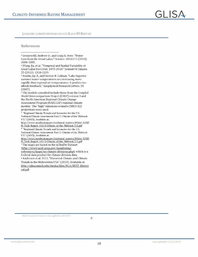
References Bidwell, David, Thomas Dietz, and Donald Scavia. 2013. "Fostering
knowledge networks for climate adaptation.” Nature: Climate Change 3:610-‐611.
Bidwell, D., Dietz, T. and Scavia, D. 2013. Fostering Knowledge Networks for Climate Adaptation. Nature Climate Change 3(7): 610–611.
Boeckler, J., Weiland, B., Glosik, B. 2009. Stresses and
Opportunities in Illinois Lake Michigan Watersheds, Strategic Sub-‐Watershed Identification Process (SSIP) Report for the Lake Michigan Watershed Ecosystem Partnership. http://greatlakes.org/Page.aspx?pid=881
Derby Lewis, A., Hall, K.R., Hellmann, J.J. 2012. Advancing
Adaptation in the City of Chicago: Climate Considerations for Management of Natural Areas. https://adapt.nd.edu/resources/1019.
Chicago Wilderness Biodiversity Recovery Plan, Climate Change
Update. 2012. http://climate.chicagowilderness.org/index.php?title=Main_Page
Frank, K.A. 1995. Identifying Cohesive Subgroups, Social Networks
17(1): 27–56
Frank, K. A. 1996. Mapping Interactions within and between Cohesive Subgroups. Social Networks 18(2): 93–119.
Harvey, R.G., Brandt L.A, Mazzotti, F.J. 2013. Climate Change
Adaptation: New Perspectives of Natural Resource Management and Conservation. University of Florida IFAS Extension http://edis.ifas.ufl.edu/pdffiles/UW/UW36300.pdf
Janssen, M.A., Bodin, O., Anderies, J., Elmqvist, T., Ernstson, H.,
McAllister, R., Olsson, P., Ryan, P. 2006. Toward a Network Perspective of the Study of Resilience in Social-‐Ecological Systems. Ecology and Society 11(1): 15.
Moser, S.C. and Ekstrom, J.A. 2010. A framework to diagnose
barriers to climate change adaptation. PNAS 107(51): 22026-‐22031.
Schroter D. and the ATEAM Consortium. 2004. Global change
vulnerability — assessing the European human–environment system, Potsdam Institute for Climate Impact Research.
Reeve, K., Kingston, R. 2014. Green Works for Climate Resilience: A
Guide to Community Planning for Climate Change. http://www.nwf.org/~/media/PDFs/Global-‐Warming/Climate-‐Smart-‐Conservation/2014/green-‐works-‐final-‐for-‐web.pdf
U.S. EPA, Office of Water, Climate Ready Estuaries. 2014. Being
Prepared for Climate Change, A Workbook for Developing Risk-‐Based Adaptation Plans (EPA 842-‐K-‐14-‐002). http://www2.epa.gov/sites/production/files/2014-‐09/documents/being_prepared_workbook_508.pdf
U.S. EPA, 2002. Community Culture and the Environment: A Guide
to Understanding a Sense of Place. (EPA 842-‐B-‐01-‐003) Office of Water, Washington, SC. http://www.epa.gov/care/library/community_culture.pdf
CLIMATE-‐INFORMED RAVINE MANAGEMENT
11 www.glisa.umich.edu Last updated: 2/27/2015
Appendix Appendix 1
Affiliation Technical Committee Member
Attended at least 1 meeting and/or participated in the network survey
Lake Forest College X Lake County Forest Preserves X Northwater Consulting X X Root-‐Pike WIN X X Santec X Lake County Planning, Building and Development Dept X City of Zion X Openlands, Lakeshore Preserve X X Davey Resource Group X Illinois Natural History Survey, Prairie Research Institute X Village of Winthrop Harbor/North Point Marina X Waukegan Citizen's Advisory Group X Winthrop Harbor Parks & Recreation X Chicago Botanic Garden, Plants of Concern Program X X City of Lake Forest Parks & Recreation X Park District of Highland Park X X Leauge of Women Voters X City of Waukegan, Dept of Planning & Zoning X US Army Corps of Engineers X Bull Creek Stakeholders Association X Illinois-‐Indiana Sea Grant (IISG) College Program X Lake County Forest Preserves X Alliance for the Great Lakes X X Illinois Coastal Management Program X X Lake Forest Open Lands Association X Openlands X X Lake County Forest Preserves X X Lake Bluff Open Lands Association X Northeast Illinois Invasive Plant Partnership X X Openlands X City of Lake Forest Parks & Recreation X Living Habitats X
CLIMATE-‐INFORMED RAVINE MANAGEMENT
12 www.glisa.umich.edu Last updated: 2/27/2015
Lake County Stormwater Management Commission X X Milwaukee County Parks X X Milwaukee County Parks X City of Lake Bluff X Lake Bluff Park District X Waukegan Citizen's Advisory Group X Lake Forest Open Lands Association X V3 Companies X Park District of Highland Park X City of Lake Forest Parks & Recreation X Illinois Beach State Park X Lake County Stormwater Management Commission X Schlitz Audubon Nature Center X X Conservation Research Institute X
CLIMATE-‐INFORMED RAVINE MANAGEMENT
13 www.glisa.umich.edu Last updated: 2/27/2015
Appendix 2
CLIMATE-‐INFORMED RAVINE MANAGEMENT
14 www.glisa.umich.edu Last updated: 2/27/2015
CLIMATE-‐INFORMED RAVINE MANAGEMENT
15 www.glisa.umich.edu Last updated: 2/27/2015
CLIMATE-‐INFORMED RAVINE MANAGEMENT
16 www.glisa.umich.edu Last updated: 2/27/2015
CLIMATE-‐INFORMED RAVINE MANAGEMENT
17 www.glisa.umich.edu Last updated: 2/27/2015
CLIMATE-‐INFORMED RAVINE MANAGEMENT
18 www.glisa.umich.edu Last updated: 2/27/2015
CLIMATE-‐INFORMED RAVINE MANAGEMENT
19 www.glisa.umich.edu Last updated: 2/27/2015
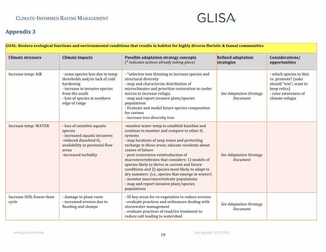
Appendix 3
GOAL: Restore ecological functions and environmental conditions that results in habitat for highly diverse floristic & faunal communities
Climate stressors Climate impacts Possible adaptation strategy concepts (* indicates actions already taking place)
Refined adaptation strategies
Considerations/ opportunities
Increase temp: AIR -‐ some species loss due to temp thresholds and/or lack of cold hardening -‐ increase in invasive species from the south -‐ loss of species at southern edge of range
-‐ *selective tree thinning to increase species and structural diversity -‐ map and characterize distribution of microclimates and prioritize restoration in cooler micros to increase refugia -‐ map and report invasive plant/species populations -‐ Evaluate and model future species composition for ravines -‐ increase tree diversity tree
See Adaptation Strategy Document
-‐ which species to thin vs. promote? (oaks should “win”; want to keep relics) -‐ raise awareness of climate refugia
Increase temp: WATER -‐ loss of sensitive aquatic species -‐ increased aquatic invasives -‐reduced dissolved O2 availability in perennial flow areas -‐increased turbidity
-‐monitor water temp to establish baseline and continue to monitor and compare to other IL systems -‐ map locations of seep zones and protecting recharge in those areas; educate residents about causes of failure -‐ post-‐restoration reintroduction of macroinvertebrates that considers: 1) models of species likely to thrive in current and future conditions and 2) species most likely to adapt to dry summers (i.e., species that emerge in winter) -‐ monitor macroinvertebrate populations -‐ map and report invasive plant/species populations
See Adaptation Strategy Document
Increase SOIL freeze-‐thaw cycle
-‐ damage to plant roots -‐ increased erosion due to flooding and slumps
-‐ ID key areas for re-‐vegetation to reduce erosion -‐ evaluate practices and ordinances dealing with stormwater management -‐ evaluate practices of road/ice treatment to reduce salt loading to watershed
See Adaptation Strategy Document
CLIMATE-‐INFORMED RAVINE MANAGEMENT
20 www.glisa.umich.edu Last updated: 2/27/2015
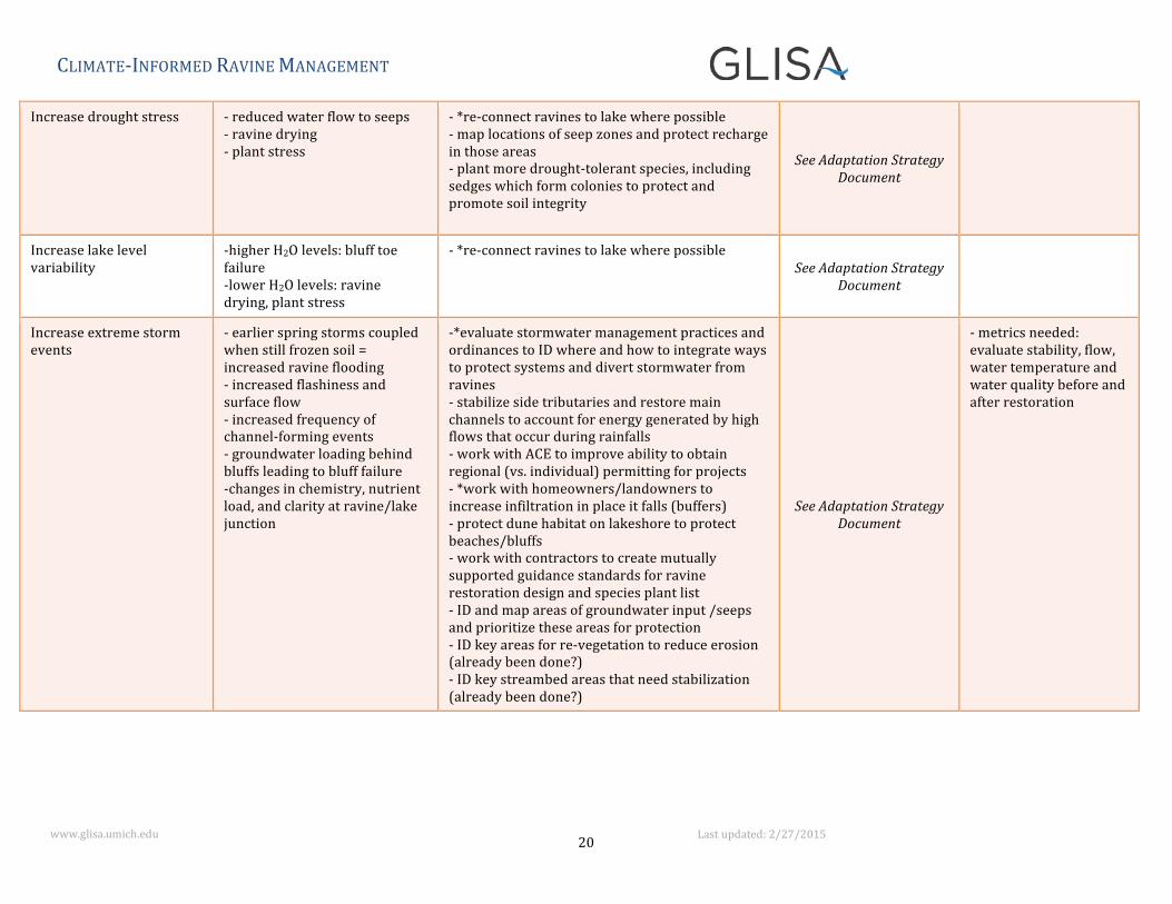
Increase drought stress -‐ reduced water flow to seeps -‐ ravine drying -‐ plant stress
-‐ *re-‐connect ravines to lake where possible -‐ map locations of seep zones and protect recharge in those areas -‐ plant more drought-‐tolerant species, including sedges which form colonies to protect and promote soil integrity
See Adaptation Strategy Document
Increase lake level variability
-‐higher H2O levels: bluff toe failure -‐lower H2O levels: ravine drying, plant stress
-‐ *re-‐connect ravines to lake where possible See Adaptation Strategy
Document
Increase extreme storm events
-‐ earlier spring storms coupled when still frozen soil = increased ravine flooding -‐ increased flashiness and surface flow -‐ increased frequency of channel-‐forming events -‐ groundwater loading behind bluffs leading to bluff failure -‐changes in chemistry, nutrient load, and clarity at ravine/lake junction
-‐*evaluate stormwater management practices and ordinances to ID where and how to integrate ways to protect systems and divert stormwater from ravines -‐ stabilize side tributaries and restore main channels to account for energy generated by high flows that occur during rainfalls -‐ work with ACE to improve ability to obtain regional (vs. individual) permitting for projects -‐ *work with homeowners/landowners to increase infiltration in place it falls (buffers) -‐ protect dune habitat on lakeshore to protect beaches/bluffs -‐ work with contractors to create mutually supported guidance standards for ravine restoration design and species plant list -‐ ID and map areas of groundwater input /seeps and prioritize these areas for protection -‐ ID key areas for re-‐vegetation to reduce erosion (already been done?) -‐ ID key streambed areas that need stabilization (already been done?)
See Adaptation Strategy Document
-‐ metrics needed: evaluate stability, flow, water temperature and water quality before and after restoration
CLIMATE-‐INFORMED RAVINE MANAGEMENT
21 www.glisa.umich.edu Last updated: 2/27/2015
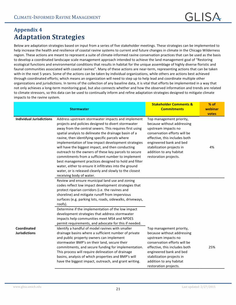
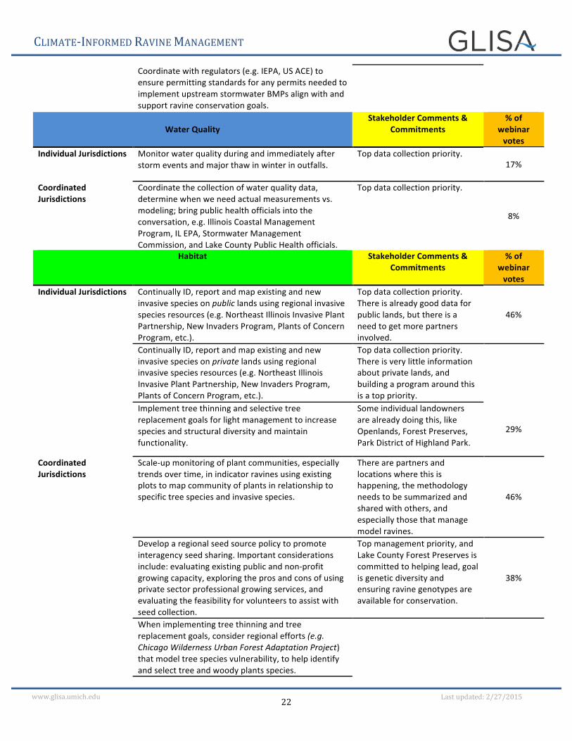
Appendix 4 Adaptation Strategies Below are adaptation strategies based on input from a series of five stakeholder meetings. These strategies can be implemented to help increase the health and resilience of coastal ravine systems to current and future changes in climate in the Chicago Wilderness region. These actions are meant to represent a suite of climate-‐informed ravine conservation practices that can be used as the basis to develop a coordinated landscape scale management approach intended to achieve the land management goal of “Restoring ecological functions and environmental conditions that results in habitat for the unique assemblage of highly diverse floristic and faunal communities associated with coastal ravines”. Many of these actions are near-‐term, representing actions that can be taken with-‐in the next 5 years. Some of the actions can be taken by individual organizations, while others are actions best achieved through coordinated efforts; which means an organization will need to step up to help lead and coordinate multiple other organizations and jurisdictions. In terms of the collection of any baseline data, it is vital that efforts be implemented in a way that not only achieves a long-‐term monitoring goal, but also connects whether and how the observed information and trends are related to climate stressors, so this data can be used to continually inform and refine adaptation strategies designed to mitigate climate impacts to the ravine system.
Stormwater Stakeholder Comments &
Commitments % of
webinar votes
Individual Jurisdictions Address upstream stormwater impacts and implement projects and policies designed to divert stormwater away from the central sewers. This requires first using spatial analysis to delineate the drainage basin of a ravine, then identifying specific parcels where implementation of low-‐impact development strategies will have the biggest impact, and then conducting outreach to the owners of these key parcels to secure commitments from a sufficient number to implement best management practices designed to hold and filter water, either to ensure it infiltrates into the ground water, or is released cleanly and slowly to the closest receiving body of water.
Top management priority, because without addressing upstream impacts no conservation efforts will be effective, this includes both engineered bank and bed stabilization projects in addition to any habitat restoration projects.
4%
Review and ensure municipal land use and zoning codes reflect low impact development strategies that protect riparian corridors (i.e. the ravines and shoreline) and mitigate runoff from impervious surfaces (e.g. parking lots, roads, sidewalks, driveways, roofs).
Determine if the implementation of the low impact development strategies that address stormwater impacts help communities meet MS4 and NPDES permit requirements, and advocate for this if needed.
Coordinated Jurisdictions
Identify a handful of model ravines with smaller drainage basins where a sufficient number of private and public property owners can implement stormwater BMP's on their land, secure their commitments, and secure funding for implementation. This process will require delineation of drainage basins, analysis of which properties and BMP's will have the biggest impact, outreach, and grant writing.
Top management priority, because without addressing upstream impacts no conservation efforts will be effective, this includes both engineered bank and bed stabilization projects in addition to any habitat restoration projects.
25%
CLIMATE-‐INFORMED RAVINE MANAGEMENT
22 www.glisa.umich.edu Last updated: 2/27/2015
Coordinate with regulators (e.g. IEPA, US ACE) to ensure permitting standards for any permits needed to implement upstream stormwater BMPs align with and support ravine conservation goals.
Water Quality
Stakeholder Comments & Commitments
% of webinar votes
Individual Jurisdictions Monitor water quality during and immediately after storm events and major thaw in winter in outfalls.
Top data collection priority. 17%
Coordinated Jurisdictions
Coordinate the collection of water quality data, determine when we need actual measurements vs. modeling; bring public health officials into the conversation, e.g. Illinois Coastal Management Program, IL EPA, Stormwater Management Commission, and Lake County Public Health officials.
Top data collection priority.
8%
Habitat Stakeholder Comments & Commitments
% of webinar votes
Individual Jurisdictions Continually ID, report and map existing and new invasive species on public lands using regional invasive species resources (e.g. Northeast Illinois Invasive Plant Partnership, New Invaders Program, Plants of Concern Program, etc.).
Top data collection priority. There is already good data for public lands, but there is a need to get more partners involved.
46%
Continually ID, report and map existing and new invasive species on private lands using regional invasive species resources (e.g. Northeast Illinois Invasive Plant Partnership, New Invaders Program, Plants of Concern Program, etc.).
Top data collection priority. There is very little information about private lands, and building a program around this is a top priority.
Implement tree thinning and selective tree replacement goals for light management to increase species and structural diversity and maintain functionality.
Some individual landowners are already doing this, like Openlands, Forest Preserves, Park District of Highland Park.
29%
Coordinated Jurisdictions
Scale-‐up monitoring of plant communities, especially trends over time, in indicator ravines using existing plots to map community of plants in relationship to specific tree species and invasive species.
There are partners and locations where this is happening, the methodology needs to be summarized and shared with others, and especially those that manage model ravines.
46%
Develop a regional seed source policy to promote interagency seed sharing. Important considerations include: evaluating existing public and non-‐profit growing capacity, exploring the pros and cons of using private sector professional growing services, and evaluating the feasibility for volunteers to assist with seed collection.
Top management priority, and Lake County Forest Preserves is committed to helping lead, goal is genetic diversity and ensuring ravine genotypes are available for conservation.
38%
When implementing tree thinning and tree replacement goals, consider regional efforts (e.g. Chicago Wilderness Urban Forest Adaptation Project) that model tree species vulnerability, to help identify and select tree and woody plants species.
CLIMATE-‐INFORMED RAVINE MANAGEMENT
23 www.glisa.umich.edu Last updated: 2/27/2015
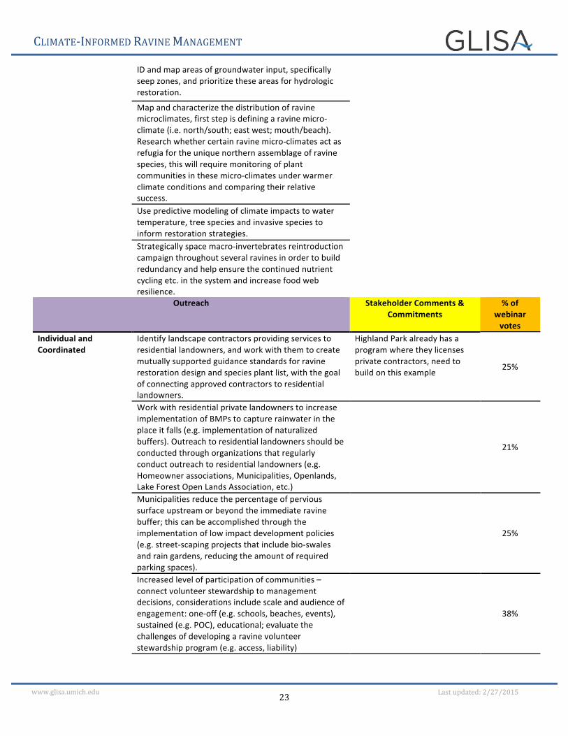
ID and map areas of groundwater input, specifically seep zones, and prioritize these areas for hydrologic restoration.
Map and characterize the distribution of ravine microclimates, first step is defining a ravine micro-‐climate (i.e. north/south; east west; mouth/beach). Research whether certain ravine micro-‐climates act as refugia for the unique northern assemblage of ravine species, this will require monitoring of plant communities in these micro-‐climates under warmer climate conditions and comparing their relative success.
Use predictive modeling of climate impacts to water temperature, tree species and invasive species to inform restoration strategies.
Strategically space macro-‐invertebrates reintroduction campaign throughout several ravines in order to build redundancy and help ensure the continued nutrient cycling etc. in the system and increase food web resilience.
Outreach Stakeholder Comments & Commitments
% of webinar votes
Individual and Coordinated
Identify landscape contractors providing services to residential landowners, and work with them to create mutually supported guidance standards for ravine restoration design and species plant list, with the goal of connecting approved contractors to residential landowners.
Highland Park already has a program where they licenses private contractors, need to build on this example
25%
Work with residential private landowners to increase implementation of BMPs to capture rainwater in the place it falls (e.g. implementation of naturalized buffers). Outreach to residential landowners should be conducted through organizations that regularly conduct outreach to residential landowners (e.g. Homeowner associations, Municipalities, Openlands, Lake Forest Open Lands Association, etc.)
21%
Municipalities reduce the percentage of pervious surface upstream or beyond the immediate ravine buffer; this can be accomplished through the implementation of low impact development policies (e.g. street-‐scaping projects that include bio-‐swales and rain gardens, reducing the amount of required parking spaces).
25%
Increased level of participation of communities – connect volunteer stewardship to management decisions, considerations include scale and audience of engagement: one-‐off (e.g. schools, beaches, events), sustained (e.g. POC), educational; evaluate the challenges of developing a ravine volunteer stewardship program (e.g. access, liability)
38%
CLIMATE-‐INFORMED RAVINE MANAGEMENT
24 www.glisa.umich.edu Last updated: 2/27/2015
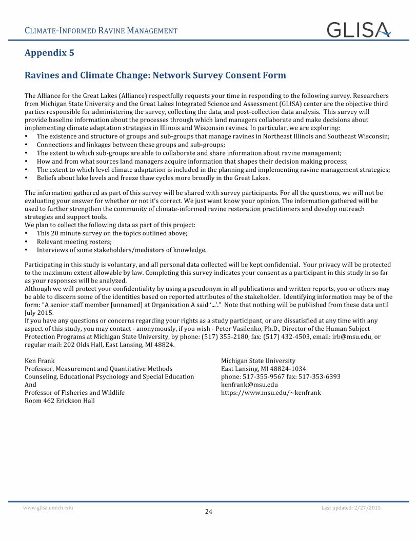
Appendix 5 Ravines and Climate Change: Network Survey Consent Form The Alliance for the Great Lakes (Alliance) respectfully requests your time in responding to the following survey. Researchers from Michigan State University and the Great Lakes Integrated Science and Assessment (GLISA) center are the objective third parties responsible for administering the survey, collecting the data, and post-‐collection data analysis. This survey will provide baseline information about the processes through which land managers collaborate and make decisions about implementing climate adaptation strategies in Illinois and Wisconsin ravines. In particular, we are exploring: • The existence and structure of groups and sub-‐groups that manage ravines in Northeast Illinois and Southeast Wisconsin; • Connections and linkages between these groups and sub-‐groups; • The extent to which sub-‐groups are able to collaborate and share information about ravine management; • How and from what sources land managers acquire information that shapes their decision making process; • The extent to which level climate adaptation is included in the planning and implementing ravine management strategies; • Beliefs about lake levels and freeze thaw cycles more broadly in the Great Lakes.
The information gathered as part of this survey will be shared with survey participants. For all the questions, we will not be evaluating your answer for whether or not it’s correct. We just want know your opinion. The information gathered will be used to further strengthen the community of climate-‐informed ravine restoration practitioners and develop outreach strategies and support tools. We plan to collect the following data as part of this project: • This 20 minute survey on the topics outlined above; • Relevant meeting rosters; • Interviews of some stakeholders/mediators of knowledge.
Participating in this study is voluntary, and all personal data collected will be kept confidential. Your privacy will be protected to the maximum extent allowable by law. Completing this survey indicates your consent as a participant in this study in so far as your responses will be analyzed. Although we will protect your confidentiality by using a pseudonym in all publications and written reports, you or others may be able to discern some of the identities based on reported attributes of the stakeholder. Identifying information may be of the form: “A senior staff member [unnamed] at Organization A said ‘...’.” Note that nothing will be published from these data until July 2015. If you have any questions or concerns regarding your rights as a study participant, or are dissatisfied at any time with any aspect of this study, you may contact -‐ anonymously, if you wish -‐ Peter Vasilenko, Ph.D., Director of the Human Subject Protection Programs at Michigan State University, by phone: (517) 355-‐2180, fax: (517) 432-‐4503, email: [email protected], or regular mail: 202 Olds Hall, East Lansing, MI 48824. Ken Frank Professor, Measurement and Quantitative Methods Counseling, Educational Psychology and Special Education And Professor of Fisheries and Wildlife Room 462 Erickson Hall
Michigan State University East Lansing, MI 48824-‐1034 phone: 517-‐355-‐9567 fax: 517-‐353-‐6393 [email protected] https://www.msu.edu/~kenfrank
CLIMATE-‐INFORMED RAVINE MANAGEMENT
25
www.glisa.umich.edu Last updated: 2/27/2015
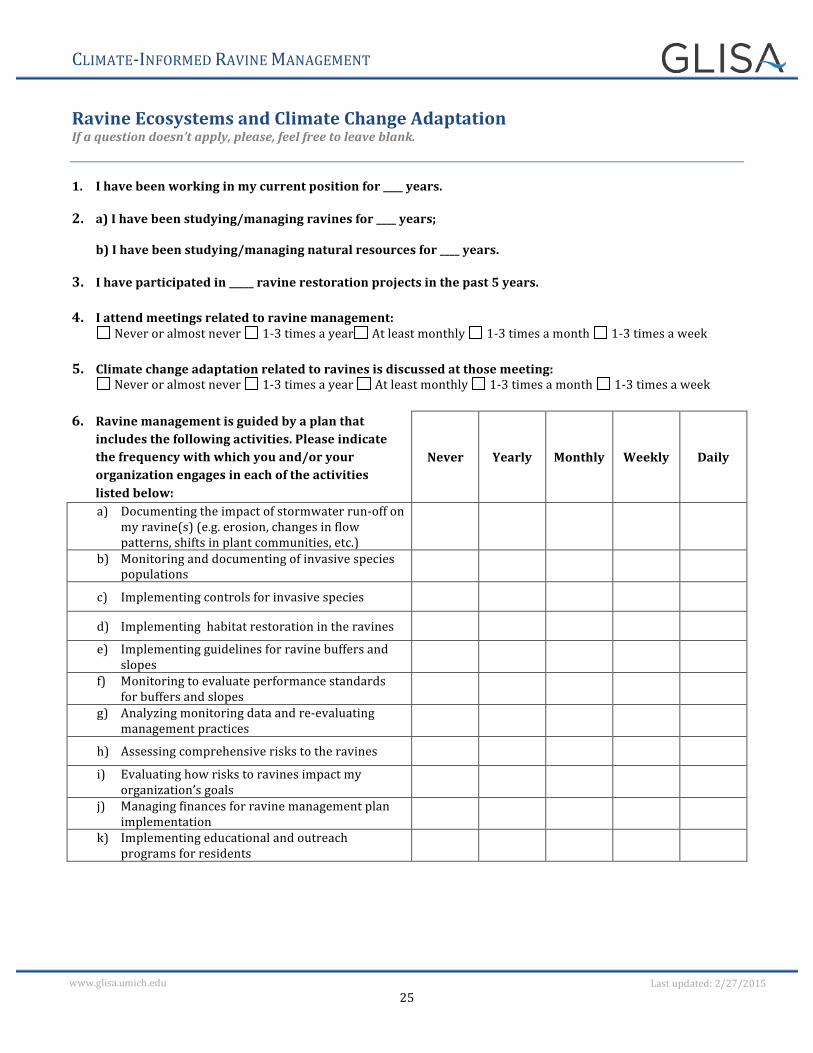
Ravine Ecosystems and Climate Change Adaptation If a question doesn’t apply, please, feel free to leave blank.
1. I have been working in my current position for ____ years.
2. a) I have been studying/managing ravines for ____ years;
b) I have been studying/managing natural resources for ____ years.
3. I have participated in _____ ravine restoration projects in the past 5 years. 4. I attend meetings related to ravine management:
Never or almost never 1-‐3 times a year At least monthly 1-‐3 times a month 1-‐3 times a week
5. Climate change adaptation related to ravines is discussed at those meeting: Never or almost never 1-‐3 times a year At least monthly 1-‐3 times a month 1-‐3 times a week
6. Ravine management is guided by a plan that
includes the following activities. Please indicate the frequency with which you and/or your organization engages in each of the activities listed below:
Never Yearly Monthly Weekly Daily
a) Documenting the impact of stormwater run-‐off on my ravine(s) (e.g. erosion, changes in flow patterns, shifts in plant communities, etc.)
b) Monitoring and documenting of invasive species populations
c) Implementing controls for invasive species
d) Implementing habitat restoration in the ravines
e) Implementing guidelines for ravine buffers and slopes
f) Monitoring to evaluate performance standards for buffers and slopes
g) Analyzing monitoring data and re-‐evaluating management practices
h) Assessing comprehensive risks to the ravines
i) Evaluating how risks to ravines impact my organization’s goals
j) Managing finances for ravine management plan implementation
k) Implementing educational and outreach programs for residents
CLIMATE-‐INFORMED RAVINE MANAGEMENT
26
www.glisa.umich.edu Last updated: 2/27/2015
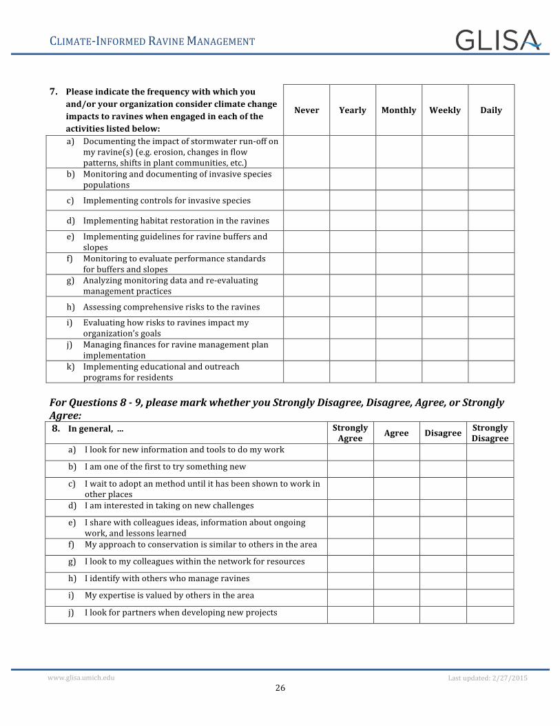
7. Please indicate the frequency with which you
and/or your organization consider climate change impacts to ravines when engaged in each of the activities listed below:
Never Yearly Monthly Weekly Daily
a) Documenting the impact of stormwater run-‐off on my ravine(s) (e.g. erosion, changes in flow patterns, shifts in plant communities, etc.)
b) Monitoring and documenting of invasive species populations
c) Implementing controls for invasive species
d) Implementing habitat restoration in the ravines
e) Implementing guidelines for ravine buffers and slopes
f) Monitoring to evaluate performance standards for buffers and slopes
g) Analyzing monitoring data and re-‐evaluating management practices
h) Assessing comprehensive risks to the ravines
i) Evaluating how risks to ravines impact my organization’s goals
j) Managing finances for ravine management plan implementation
k) Implementing educational and outreach programs for residents
For Questions 8 -‐ 9, please mark whether you Strongly Disagree, Disagree, Agree, or Strongly Agree: 8. In general, ... Strongly
Agree Agree Disagree Strongly Disagree
a) I look for new information and tools to do my work b) I am one of the first to try something new c) I wait to adopt an method until it has been shown to work in
other places
d) I am interested in taking on new challenges e) I share with colleagues ideas, information about ongoing
work, and lessons learned
f) My approach to conservation is similar to others in the area g) I look to my colleagues within the network for resources h) I identify with others who manage ravines i) My expertise is valued by others in the area j) I look for partners when developing new projects
CLIMATE-‐INFORMED RAVINE MANAGEMENT
27
www.glisa.umich.edu Last updated: 2/27/2015
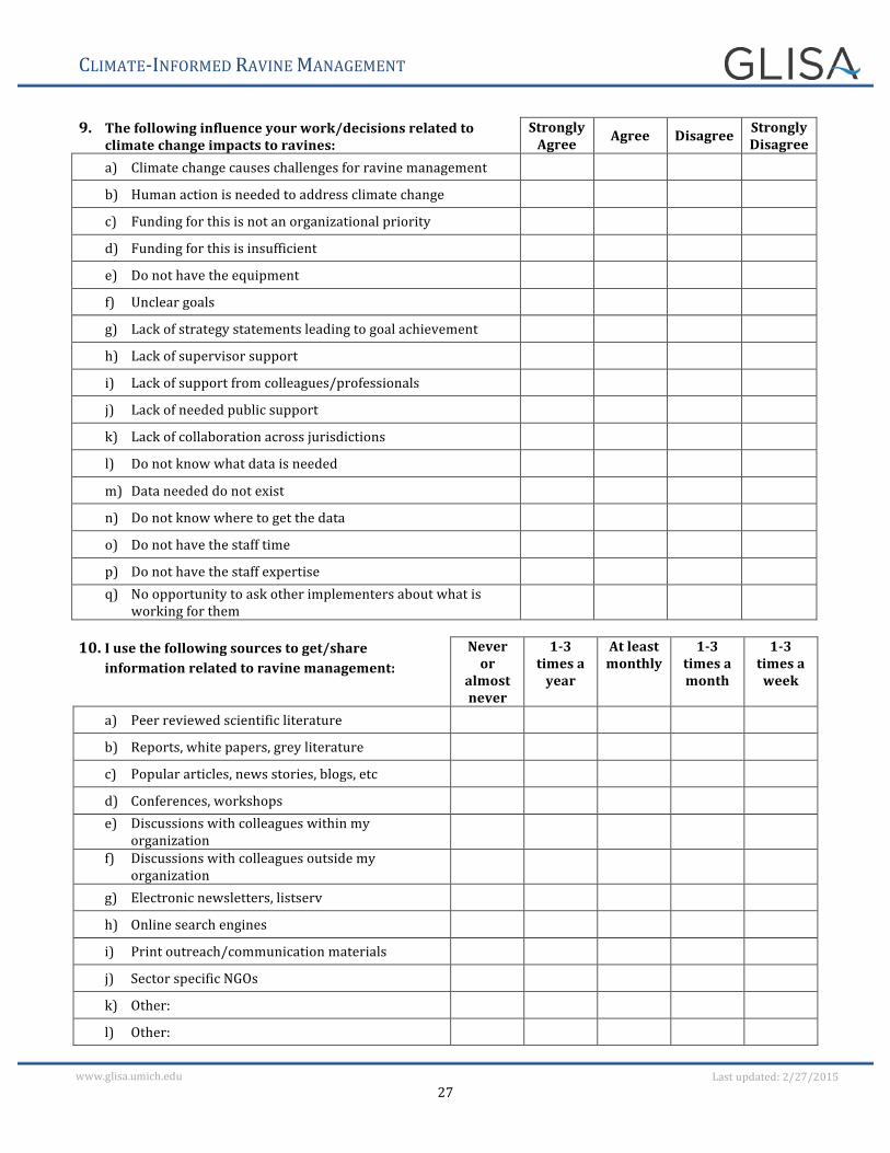
9. The following influence your work/decisions related to climate change impacts to ravines:
Strongly Agree Agree Disagree Strongly
Disagree a) Climate change causes challenges for ravine management b) Human action is needed to address climate change c) Funding for this is not an organizational priority d) Funding for this is insufficient e) Do not have the equipment f) Unclear goals g) Lack of strategy statements leading to goal achievement h) Lack of supervisor support i) Lack of support from colleagues/professionals j) Lack of needed public support k) Lack of collaboration across jurisdictions l) Do not know what data is needed m) Data needed do not exist n) Do not know where to get the data o) Do not have the staff time p) Do not have the staff expertise q) No opportunity to ask other implementers about what is
working for them
10. I use the following sources to get/share
information related to ravine management: Never or
almost never
1-‐3 times a year
At least monthly
1-‐3 times a month
1-‐3 times a week
a) Peer reviewed scientific literature b) Reports, white papers, grey literature c) Popular articles, news stories, blogs, etc d) Conferences, workshops e) Discussions with colleagues within my
organization
f) Discussions with colleagues outside my organization
g) Electronic newsletters, listserv h) Online search engines i) Print outreach/communication materials j) Sector specific NGOs k) Other: l) Other:
CLIMATE-‐INFORMED RAVINE MANAGEMENT
28
www.glisa.umich.edu Last updated: 2/27/2015
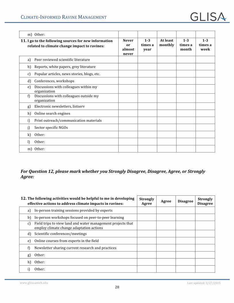
m) Other: 11. I go to the following sources for new information
related to climate change impact to ravines: Never or
almost never
1-‐3 times a year
At least monthly
1-‐3 times a month
1-‐3 times a week
a) Peer reviewed scientific literature b) Reports, white papers, grey literature c) Popular articles, news stories, blogs, etc. d) Conferences, workshops e) Discussions with colleagues within my
organization
f) Discussions with colleagues outside my organization
g) Electronic newsletters, listserv h) Online search engines i) Print outreach/communication materials j) Sector specific NGOs k) Other: l) Other: m) Other:
For Question 12, please mark whether you Strongly Disagree, Disagree, Agree, or Strongly Agree: 12. The following activities would be helpful to me in developing
effective actions to address climate impacts in ravines: Strongly Agree Agree Disagree Strongly
Disagree
a) In-‐person training sessions provided by experts b) In-‐person workshops focused on peer-‐to-‐peer learning c) Field trips to view land and water management projects that
employ climate change adaptation actions
d) Scientific conferences/meetings e) Online courses from experts in the field f) Newsletter sharing current research and practices g) Other: h) Other: i) Other:
CLIMATE-‐INFORMED RAVINE MANAGEMENT
29
www.glisa.umich.edu Last updated: 2/27/2015
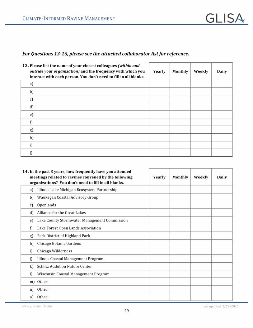
For Questions 13-‐16, please see the attached collaborator list for reference. 13. Please list the name of your closest colleagues (within and
outside your organization) and the frequency with which you interact with each person. You don’t need to fill in all blanks.
Yearly Monthly Weekly Daily
a) b) c) d) e) f) g) h) i) j)
14. In the past 3 years, how frequently have you attended
meetings related to ravines convened by the following organizations? You don’t need to fill in all blanks.
Yearly Monthly Weekly Daily
a) Illinois Lake Michigan Ecosystem Partnership b) Waukegan Coastal Advisory Group c) Openlands d) Alliance for the Great Lakes e) Lake County Stormwater Management Commission f) Lake Forest Open Lands Association g) Park District of Highland Park h) Chicago Botanic Gardens i) Chicago Wilderness j) Illinois Coastal Management Program k) Schlitz Audubon Nature Center l) Wisconsin Coastal Management Program m) Other: n) Other: o) Other:
CLIMATE-‐INFORMED RAVINE MANAGEMENT
30
www.glisa.umich.edu Last updated: 2/27/2015
p) Other: q) Other:
15. In the past 3 years, who (person) gave you information about
climate change impacts and how frequently? You don’t need to fill in all blanks.
Yearly Monthly Weekly Daily
a) b) c) d) e) f) g) h) i) j)
16. In the past 3 years, please list who (person) you have collaborated with on ravine management and indicate Yes or No for each type of collaboration. For example, if you shared data with John Smith, did not financially support him, partnered with him on a project and provided letter(s) of support, your data would look like this. You don’t need to fill in all blanks.
Shared Data
Financially Supported
Partnered on a Project
Provided a Letter of Support
a) Example: John Smith Yes No Yes Yes
b) c) d) e) f) g) h) i) j)
CLIMATE-‐INFORMED RAVINE MANAGEMENT
31
www.glisa.umich.edu Last updated: 2/27/2015
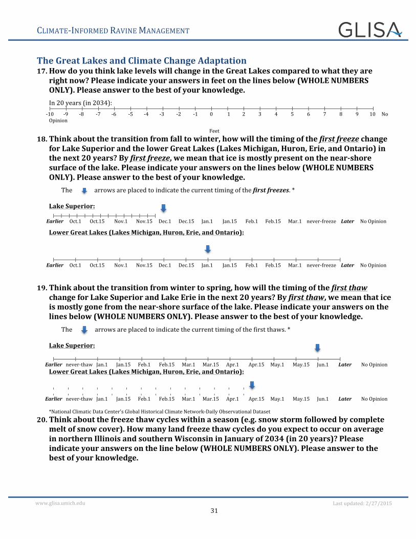
The Great Lakes and Climate Change Adaptation 17. How do you think lake levels will change in the Great Lakes compared to what they are
right now? Please indicate your answers in feet on the lines below (WHOLE NUMBERS ONLY). Please answer to the best of your knowledge.
In 20 years (in 2034): -‐10 -‐9 -‐8 -‐7 -‐6 -‐5 -‐4 -‐3 -‐2 -‐1 0 1 2 3 4 5 6 7 8 9 10 No
Opinion
Feet 18. Think about the transition from fall to winter, how will the timing of the first freeze change
for Lake Superior and the lower Great Lakes (Lakes Michigan, Huron, Erie, and Ontario) in the next 20 years? By first freeze, we mean that ice is mostly present on the near-‐shore surface of the lake. Please indicate your answers on the lines below (WHOLE NUMBERS ONLY). Please answer to the best of your knowledge.
The arrows are placed to indicate the current timing of the first freezes. *
Lake Superior:
Earlier Oct.1 Oct.15 Nov.1 Nov.15 Dec.1 Dec.15 Jan.1 Jan.15 Feb.1 Feb.15 Mar.1 never-‐freeze Later No Opinion
Lower Great Lakes (Lakes Michigan, Huron, Erie, and Ontario):
Earlier Oct.1 Oct.15 Nov.1 Nov.15 Dec.1 Dec.15 Jan.1 Jan.15 Feb.1 Feb.15 Mar.1 never-‐freeze Later No Opinion
19. Think about the transition from winter to spring, how will the timing of the first thaw change for Lake Superior and Lake Erie in the next 20 years? By first thaw, we mean that ice is mostly gone from the near-‐shore surface of the lake. Please indicate your answers on the lines below (WHOLE NUMBERS ONLY). Please answer to the best of your knowledge.
The arrows are placed to indicate the current timing of the first thaws. *
Lake Superior:
Earlier never-‐thaw Jan.1 Jan.15 Feb.1 Feb.15 Mar.1 Mar.15 Apr.1 Apr.15 May.1 May.15 Jun.1 Later No Opinion Lower Great Lakes (Lakes Michigan, Huron, Erie, and Ontario):
Earlier never-‐thaw Jan.1 Jan.15 Feb.1 Feb.15 Mar.1 Mar.15 Apr.1 Apr.15 May.1 May.15 Jun.1 Later No Opinion
*National Climatic Data Center's Global Historical Climate Network-‐Daily Observational Dataset
20. Think about the freeze thaw cycles within a season (e.g. snow storm followed by complete melt of snow cover). How many land freeze thaw cycles do you expect to occur on average in northern Illinois and southern Wisconsin in January of 2034 (in 20 years)? Please indicate your answers on the line below (WHOLE NUMBERS ONLY). Please answer to the best of your knowledge.
CLIMATE-‐INFORMED RAVINE MANAGEMENT
32
www.glisa.umich.edu Last updated: 2/27/2015
Number of land freeze-‐thaw cycles in northern Illinois and southern Wisconsin in January of 2034 (in 20 years):
0 1 2 3 4 5 6 7 8 9 10 11 12 13 14 15 no opinion
21. From what sources do you most frequently get information about lake levels? Please list
names of specific documents/websites. You don’t need to fill in all blanks.
Name of source Document 1 Document 2 Document 3 Document 4 Document 5 Website 1 Website 2 Website 3 Website 4 Website 5
22. From what sources do you most frequently get information about freeze thaw cycles? Please list names of specific documents/websites. You don’t need to fill in all blanks.
Name of source Document 1 Document 2 Document 3 Document 4 Document 5 Website 1 Website 2 Website 3 Website 4 Website 5
Related Documents


