University of Montana University of Montana ScholarWorks at University of Montana ScholarWorks at University of Montana Graduate Student Theses, Dissertations, & Professional Papers Graduate School 2021 Devastation and Displacement: The Destruction of Native Devastation and Displacement: The Destruction of Native Communities as a Result of Specifically the Garrison Dam on the Communities as a Result of Specifically the Garrison Dam on the Missouri River in North Dakota and the Dalles Dams on the Missouri River in North Dakota and the Dalles Dams on the Columbia River in Oregon Columbia River in Oregon Farryl Elisa Hunt University of Montana, Missoula Follow this and additional works at: https://scholarworks.umt.edu/etd Part of the Social and Cultural Anthropology Commons Let us know how access to this document benefits you. Recommended Citation Recommended Citation Hunt, Farryl Elisa, "Devastation and Displacement: The Destruction of Native Communities as a Result of Specifically the Garrison Dam on the Missouri River in North Dakota and the Dalles Dams on the Columbia River in Oregon" (2021). Graduate Student Theses, Dissertations, & Professional Papers. 11809. https://scholarworks.umt.edu/etd/11809 This Thesis is brought to you for free and open access by the Graduate School at ScholarWorks at University of Montana. It has been accepted for inclusion in Graduate Student Theses, Dissertations, & Professional Papers by an authorized administrator of ScholarWorks at University of Montana. For more information, please contact [email protected].

Welcome message from author
This document is posted to help you gain knowledge. Please leave a comment to let me know what you think about it! Share it to your friends and learn new things together.
Transcript
University of Montana University of Montana
ScholarWorks at University of Montana ScholarWorks at University of Montana
Graduate Student Theses, Dissertations, & Professional Papers Graduate School
2021
Devastation and Displacement: The Destruction of Native Devastation and Displacement: The Destruction of Native
Communities as a Result of Specifically the Garrison Dam on the Communities as a Result of Specifically the Garrison Dam on the
Missouri River in North Dakota and the Dalles Dams on the Missouri River in North Dakota and the Dalles Dams on the
Columbia River in Oregon Columbia River in Oregon
Farryl Elisa Hunt University of Montana, Missoula
Follow this and additional works at: https://scholarworks.umt.edu/etd
Part of the Social and Cultural Anthropology Commons
Let us know how access to this document benefits you.
Recommended Citation Recommended Citation Hunt, Farryl Elisa, "Devastation and Displacement: The Destruction of Native Communities as a Result of Specifically the Garrison Dam on the Missouri River in North Dakota and the Dalles Dams on the Columbia River in Oregon" (2021). Graduate Student Theses, Dissertations, & Professional Papers. 11809. https://scholarworks.umt.edu/etd/11809
This Thesis is brought to you for free and open access by the Graduate School at ScholarWorks at University of Montana. It has been accepted for inclusion in Graduate Student Theses, Dissertations, & Professional Papers by an authorized administrator of ScholarWorks at University of Montana. For more information, please contact [email protected].
DEVASTATION AND DISPLACEMENT:
THE DESTRUCTION OF NATIVE AMERICAN LIFEWAYS - RESULTING FROM THE
BUILDING OF THE GARRISON DAM ON THE MISSOURI RIVER IN NORTH DAKOTA
AND THE DALLES DAM ON THE COLUMBIA RIVER IN OREGON
BY: FARRYL ELISA “LISA” HUNT
THESIS SUBMITTED TO THE FACULTY OF GRADUATE STUDIES
IN PARTIAL FULFILLMENT OF THE REQUIREMENTS
FOR THE DEGREE OF MASTER’S OF ARTS
GRADUATE PROGRAM IN ANTHROPOLOGY
CULTURAL HERITAGE OPTION
UNIVERSITY OF MONTANA
MISSOULA, MONTANA
AUGUST 2021
Approved by:
Scott Whittenburg, Graduate School Dean
G.G. Weix, Committee Chair, Department of Anthropology
Doug Macdonald, Committee Member, Department of Anthropology
Dave Beck, Committee Member, Department of Native American Studies
George Price, Committee Member, Retired from Department of Native American Studies
ii
TABLE OF CONTENTS
TABLE OF CONTENTS……………………………………………………………………......ii
ACKNOWLEDGEMENTS…………………………………………………………………….iii
ABSTRACT……………………………………………………………………………………....v
INTRODUCTION……………………………………………………………………………….1
CHAPTER ONE:……………………………………………………………………...……..…..8
-THE ABUNDANCE OF CELILO FALLS (OR)….………………..…………….......8
-THE RICHNESS OF THE MISSOURI RIVER BOTTOMLANDS (ND)…...……14
CHAPTER TWO………………………………………………………………….……………19
- LEWIS AND CLARK …………………………………..............................................19
-THE PEOPLE AFFECTED BY THE LOSS OF CELILO FALLS (OR)…....…....22
-CONTROVERSIES OVER LAND FOR THE THREE TRIBES (ND)…………....26
CHAPTER THREE…………………………………………………………………………….29
-THE DALLES DAM IN OREGON…………………….…....………….....................29
-THE GARRISON DAM IN NORTH DAKOTA……………………..………..…….33
CHAPTER FOUR………………………………………………………………………………38
-THE RIVER PEOPLE OF CELILO VILLAGE & LONE PINE (OR)……...……38
-FORT BERTHOLD AFTER THE DAM (ND)………….…………………...…...…44
CONCLUSION…………………………………………………………………………………50
BIBLIOGRAPHY…………………….…………………………………………………….......57
iii
ACKNOWLEDGEMENTS
I dedicate this thesis, and all my life’s work to my family: my three children, Zac, Grace, and
Elias, my parents Tim and Peggy, my stepfather Tony Smith, and my brother and sister, Justin,
and Krista, as their love and support, has continuously strengthened me. I would also like to
thank four of my best friends, Twila Old Coyote, Richard Fifield, Hannah Price, and Jeanette
McNamee. Without their friendship, none of this would be conceivable. I want to thank George
Price and Henrietta Mann, my first Native American Studies professors during undergrad, who
became my mentors. My admiration for them has influenced me to be a better scholar and person
and ambition to strive for higher education. I also especially want to thank G.G. Weix, an
incredible professor, advisor, and mentor. Her encouragement and the countless hours she spent
working with me along the way have helped me abundantly, and I could not have done this
without her. Thank you to Greg Campbell, an advisor, and professor, in the Anthropology
Department. His creation of the Cultural Heritage Option is a fantastic contribution to the
Anthropology Program at The University of Montana. Thank you also to Anna Prentiss, whose
class in developing research proposals was life changing. In addition, I give enormous thanks to
my committee members - G.G. Weix, Doug MacDonald, Dave Beck, and George Price, for
agreeing to be on my committee and supporting me in this endeavor. I also want to thank Wade
Davies, Kate Shanley, and Dave Beck. Even after I had already graduated with a degree in
Native American Studies, they have continued to take me under their wing throughout grad
school.
iv
As an anthropological student, it was essential to sift through this research with an open
eye for theory and methodology. In my opinion, it is important to consider what can be improved
in what is contemporary anthropological thought. A task of cultural anthropology remains to
illuminate how human beings use their emotional, intellectual, material, and other resources to
thrive in a range of social settings. and create other goals to use anthropology to advance equality
and achieve social justice by examining human behavior, traditional lifeways, world views, and
how historical conditions shape people.
Growing up on several reservations in three different states and of Native American
(Blackfeet) descent, I have been exposed to many racial, environmental, and social injustices
while raised with traditional values and creationism. Yet, looking back, I see I was an activist
ahead of my time. I stood up to kids who bullied people on the playground, protecting those
considered ‘different.’ I wrote letters to ‘world leaders’ about the sadness I felt about atrocities
and wars committed during various classroom projects. I also remember writing about the
disgust I felt about the destruction of the rainforests in South America. I have taken my 46 years
of age working towards ‘making the world a better place before I leave it.’ While majoring in
Native American Studies for my bachelor’s degree here at the University of Montana twenty
years ago, I was awakened to just how much is left out of history regarding Native Americans
and Indigenous people worldwide. I was educated and corrected toward many historical truths
and inspired to advocate for racial justice and social activism. My education in anthropology can
play a big part in this type of advocacy. “The primary goal of anthropology remains to promote
an empathetic appreciation of all humanity, an appreciation that should bring people together in
common understanding” (Hunn & Selam 1990, 12).
v
ABSTRACT
Anthropology is a part of history, and history is a part of anthropology. Although understanding
the history of ideas is essential, understanding how and why those ideas shaped history enables
us to understand the role anthropology has played in history. Evaluating anthropological theory
and methodology through historical descriptions, using ethnohistorical research and primary and
secondary data collection approaches, can unite historical change and variation with social
structure and integration. “The whole problem of cultural history appears to us as a historical
problem. To understand history, it is necessary to know not only how things are, but how they
have come to be” (Boas 1920, 314).
This master's thesis in anthropology is a cross-cultural analysis that explores two
intersecting yet distinct discourses of destruction and displacement for two groups of Native
people in Oregon and North Dakota. The building of The Dalles Dam in Oregon and The
Garrison Dam in North Dakota damaged thriving livelihoods due to the loss of irreplaceable
flooded areas. This thesis will utilize cultural ecology to focus on the bounty of sustenance,
cultural viability, and heritage that had existed for two separate places and populations of Native
Americans that had thrived for thousands of years before these two dams were built. It compares
the two dams' transformative consequences towards the Native people and contrasts their cultural
heritage and the uniqueness of the various tribal communities. The Native people were afflicted
by being removed from homelands, destroyed sacred land and water areas, ruined access to
plentiful hunting and fishing areas, affected traditional ecological knowledge, and violated
promises made in previous treaties. This thesis critiques the United States governmental dam
development industry by identifying how the needs of Native Americans are silenced by the lack
of concern for harmful effects upon Native peoples’ livelihoods before and after the dam.

1
INTRODUCTION
While living on the Umatilla Reservation, one of the tribes with people whose original
homeland was along the Columbia River, I learned about the flooding of Celilo Falls by The
Dalles Dam. I had heard stories from elders who spoke of the abundance of salmon harvested
since time immemorial and the heartbreak at the time of the inundation in 1957. Our family still
stops at the park that once was the location of Celilo Falls every time we travel down the
Columbia River Gorge to pray and give thanks to the Creator. The stories of this place always
saddened me, and it has consistently been on my heart to research more about Celilo Falls. Then,
after reading the book Coyote Warrior by Paul VanDevelder in one of my Native American
Studies classes, I learned about the flooding in 1953 by the Garrison Dam of over 150,000 acres
of sacred Missouri River bottomland people on the Fort Berthold Reservation where the Mandan,
Hidatsa, and Arikara people had thrived for thousands of years. It flooded nine Native
communities and forced their relocation and was just as disastrous as the story I had grown up
knowing about Celilo Falls. I chose to research these two different communities because of how
rich life was before the dams impacted these cultural areas. The after-effects would prove to be
just as devastating as the reservations and allotment eras because of the displacement the
communities endured and the bounty they lost.
This thesis hopes to bridge Native American history and anthropology. “Unlike the
structuralist and functionalist perspectives espoused by the Europeans, American anthropologists
cultivated an avowedly historical approach that emphasized the radical diversity of cultural
form” (Erickson & Murphy 2008, 39). Understanding which cultural practices have everyday
confrontations accessing the human capacity to maintain historical traditions is imperative to
explore those that have shaped the people. This thesis can also identify with the theory of
2
historical particularism and how it is “rooted in the notion that each culture is unique” (Barret
1996, 52).
How have social adjustments evolved under the pressure of cultural change from over
five generations? How can we better understand how displacement has affected their current
physical, social, economic, and spiritual conditions? This thesis is based on the part the building
of the dams and dislocation has played on these communities while promoting valuable
contributions on how interventions may assist knowledge of these effects on human behavior. It
will also advocate how their beliefs and practices can relate to traditional goals of improving
family and community life and contribute to how these communities have been subjected to
cultural and economic assault due to colonization.
Longstanding cultural practices have everyday confrontations accessing human capacity
to maintain historical traditions that have shaped the people. Conducting research examining
theoretical formulation needed to support specific behaviors may uphold necessary data, seeking
patterns and interpretations of these economic improvements attempted methods. It is essential
within contemporary anthropological thought to not allow white privilege to affect research and
the speculation of cultures foreign to the people who study them. In the past, that appears to have
been prevalent among anthropology throughout the years. Because most anthropologists have
been white males historically, contemporary anthropological thought needs now be broadened to
represent raw and authentic thoughts and open-minded research.
Many historical and contemporary interactions between Native Americans and the United
States government have involved physical, material, and cultural dispossession. Despite staying
in one place versus moving, seeking alternatives despite impoverished conditions, illustrating
methodologies with significant insights, questions have arisen on how social adjustments have
3
evolved under the pressure of cultural change from generations and how to understand better
how displacement has affected their current physical, social, economic, and spiritual conditions
(Kassam et al., 2017).
Native languages are in danger of becoming extinct. Widespread racism, poverty, and
environmental degradation on Indian reservations make it difficult for many Native people to
live fully. “It is tragic to view some individuals who do not know their unique tribal heritage
amid the vast cultural heritages of Native North America...our sheer survival has hinged upon a
flexible ability to segment, synthesize, and act in changing situations” (Medicine 2001, 13).
Considering the theoretical and methodological implications, these two communities can
be studied through the lens of cultural relativism while extending the analytical gaze to
determine how significant moments in history condition subjectivity and social practices in
everyday lives in the present. “Cultural relativism is a historical articulation, actually serves a
valuable heuristic function for the development of a moral anthropology” (Caduff 2011, 469).
The analytic concept of culture and the philosophical perspective of cultural relativism
constituted a powerful political strategy against all forms of racism.
A theoretical examination may include assessing what difficulties exist for tribal
members and what challenges are met. For example, one theoretical paradigm to consider can be
how we do not fully understand how displaced populations of people in stressed conditions
accomplish cultural transmission and theory:
“Theory involves a double knowledge, for it is both a comprehension of how and
why reality is the way it is and an evaluation of how well it is known that reality is
as it is. Explanation is knowledge of how and why things are the way they are.
Validation is the knowledge of the reliability and validity of explanations.
Explanations involve the creation of a special type of knowledge that is
generalizations...Theories are generalizations whose component concepts are
generally high in scope and abstraction” (Reyna 2017, 144).
4
These communities can be studied as a historical phenomenon between acts of survivance
versus survival by considering theoretical and methodological implications. It could be argued
shifts in their environments, tied to the dams and the inundation of sacred land and water, have
shaped their current social identity and how people classify themselves and their social
surroundings, which is a critical theme in studying the effects colonialism has continued to have
on Indigenous people. Social identities are often drastically refashioned in colonial contexts as
people drew upon and introduced cultural elements to construct ways to exist and continue
attempts to be successful (Cipolla 2008, 201).
This research will narrate an analysis of some communities performing acts of survivance
while others show evidence of survival. In addition, what are some of the primary ways by which
cultural heritage was maintained and transmitted during times of trauma? Some may be as an
unintended byproduct of acts of survival, while others are an intended consequence of conscious
efforts of survivance. It can be recognized that survivance could be a theme cross cutting all
levels of decision-making:
“The practices of survivance create an active presence, more than the instincts of
survival, function, or subsistence.…Survivance is character by natural
reason…survival stories create a sense of presence and situational sentiments of
chance…Survivance is a practice, not an ideology, dissimulation or a theory”
(Vizenor 2008, 11).
On the other hand, poverty-stricken living conditions appear to favor survival strategies.
As such, more ancient cultural traditions may not have been intentionally preserved or
transmitted. Any that survived could be considered byproducts of survival-related decisions:
5
“Embedded in the concept of survivance is the ability to change to stay the same.
People in the past may not have intended either to change or remain the same
explicitly; instead, they may have sought, although never easy, to persist" (Ferris et
al. 2014, 60).
The significance of this project can be an example of how socio-economic stress may
have led to adjustments in traditional organizations that could have provided new forms of social
inequality. “One must be careful not to underemphasize the difficult circumstances that impinged
upon community survival and not to forget the connection between those histories and current
communities who proclaim they are ‘still here’… survivance connotes survival with attitude,
implying activity rather than passivity, using aggressive means not only to stay alive but to
flourish” (Silliman 2010, 59).
However, although evolved, these traditions remain important cultural heritage methods
to pass on to each generation for their culture for survivance/survival methods. There is a
question of how the past traumas of the dams have impacted the people. “Studies of cultural
evolution should consider the relevance of any number of problems to a particular study region
and assess what social institutions and strategies mediated such problems” (Carballo 2013, 29).
Many simply try to survive and do not have the time, money, or energy to learn and teach
their language and culture. For other Native people, survival itself depends on maintaining their
language and distinctive ways of life. With different social aspects, situations, and obligations,
socio-economic roles vary to accommodate various conditions, and it is imperative to ascertain
which portray either acts of survivance or steps toward survival for the Native people affected by
The Dalles Dam in Oregon and The Garrison Dam in North Dakota.
6
The inundation of Celilo Falls by the building of The Dalles Dam is a heartbreaking tale
of the loss of culture, land, economic resources, and a sacred way of life for Native people.
Indigenous people throughout the Northwest had depended on the generous number of salmon
provided from this area along the Columbia River since time immemorial. The Columbia River
near Celilo Falls have been home to people now enrolled in The Nez Perce Tribe, The Yakama
Nation, Confederated Tribes of the Umatilla Reservation (which consist of the Cayuse and Walla
Walla and Umatilla Tribes), and The Confederated Tribes of the Warms Springs Reservation
(comprised of Wasco, Paiute, and Warm Springs, Tribes). In addition, some unenrolled Native
people who thrived along the Columbia at Celilo Falls are the Northwest Klickitat and the
Eastern-speaking Chinookan Kiksht. They were the Wascos, the Cascades, the Wishrams, the
Clackamas, the Multnomah’s, the Hood Rivers, the Skamanias, the Skilloots, Tenino, Taih,
Wyams, and many others who lived in villages on the Columbia River (Aguilar 2005, 2).
“These other communities comprised the heart of ‘the people of the river’ whose
descendants came to identify as The Columbia River Indians. They lived in a world
of independent but interconnected villages, not cohesive linguistic tribes. Each
language or dialect encompassed a number of semi-permanent winter settlements
and associated seasonal camps, which became the ‘tribe’ or ‘bands’ of Euro-
American usage through a process of creative misunderstanding” (Fisher 2010, 24).
That day in March of 1957, the place, the lifeblood, the economic livelihood, and
religious significance for generations of people were lost in an instant. After the drowning of
Celilo Falls, communities were displaced, and resources for the Native people dependent on its
bounty would become inadequate. The assistance that was promised either never came or took
many years to acquire.
7
The creation of the Garrison Dam that flooded the Fort Berthold Reservation in North
Dakota in 1953, home of the Mandan, Hidatsa, and Arikara people, caused irreparable
destruction, flooding over 150,000 acres, harmfully affecting them at that time, not to mention
the devastation that has occurred since their displacement. Garrison Dam ultimately buried the
reservation communities of Sanish, Elbowoods, Lucky Mound, Shell Creek, Nishu, Charging
Eagle, Beaver Creek, Red Butte, Independence, and Van Hook, into what is now known as Lake
Sakakawea. The flooded areas were their homes and provided their necessities for fishing,
communal hunting, gathering areas, traditional ceremonial grounds, gravesites, archaeological
sites, and the habitats of plant and animal species integral to cultural practices and traditional
foods. They farmed the rich bottomlands, hunted game, and gathered food that grew wild in the
hills and along the river. After the relocation, The Three Affiliated Tribes found it impossible to
grow their food, wild game had vanished, the wells were contaminated to drink nor enough water
to grow crops that had flourished before the building of the dam.
These two dams are only two examples of countless others that have negatively impacted
Native communities, not only in this country but worldwide. This thesis, however, focuses
specifically on The Dalles Dam and The Garrison Dam because of the dramatic and severe
impacts the dams had on these specific Native People. The protesting was important yet
dismissed, and the meager compensation that resulted would never replace what was lost. There
were ways these events could have been prevented; other areas the dams could have been built.
Yet the cries of the people were ignored, and trauma that took place remains, passed on
generationally or by the elders remaining who still remember what life was like before the dams.
8
CHAPTER ONE
THE ABUNDANCE OF CELILO FALLS:
The beauty of what was once Celilo Falls is indescribable. The visions of the jagged high cliffs
and cascading waterfalls endure now only in descriptive stories, pictures, videos, and memories.
Since time immemorial, Columbia River Indians and many other Natives came from far and
wide to fish at Celilo Falls. The Indigenous people from the Pacific Northwest showed a cultural
identity through fishing, building wooden planks, platforms, and scaffolds to get out over the
rocks. Then, they would use long spears or dip nets to catch the salmon as they swam up the
rapids and waterfalls. The two dip nets used were either a moveable kind they repeatedly dipped
in and out of the water or a stationary type set up to catch the fish from falling back from the
falls and swift current. Unfortunately, the wet wooden walkways, platforms, scaffolds, and the
weight of the huge, heavy salmon caught in the dip nets meant that deadly accidents were
common as people fell into the turbulent currents. Eventually, they started anchoring themselves
in various ways to help prevent this (Pinkham 2007). Therefore, this life was one of plenty but
also treacherous “The Indian people named this fishing place Si'lialo. In post-contact times,
people came to call it Celilo Falls"…Si’lailo means “echo of the water falling on the rocks”
(Dupris et al. 2006, 4-5).
The abundant benefits that Celilo Falls provided people who fished there were indeed
noteworthy. The courageous way the Natives who fished there were rewarded by repeated
catches of up to 30, 40, and sometimes even 50-pound salmon by the tons is unheard of today.
“One extended place along that stretch of river in the 3000-foot-deep gorge drew
special attention-Celilo Falls…a series of cataracts that squeezed the river’s great
flow to a narrowed width and dropped it precipitously, creating one of the most
productive fishing sites in North America, the best fishing sites at Celilo Falls could
produce as much as seventeen tons of salmon per day” (Lang 2007, 566).
9
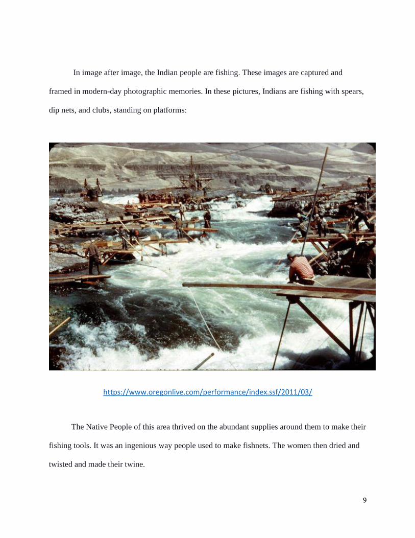
In image after image, the Indian people are fishing. These images are captured and
framed in modern-day photographic memories. In these pictures, Indians are fishing with spears,
dip nets, and clubs, standing on platforms:
https://www.oregonlive.com/performance/index.ssf/2011/03/
The Native People of this area thrived on the abundant supplies around them to make their
fishing tools. It was an ingenious way people used to make fishnets. The women then dried and
twisted and made their twine.
10
"This tough, strong twine was called 'o-wuss.' The women made the fishnets from
it. Then the men bent willow branches and made hoops for their fishnets. Finally,
they tied strong handles to their nets with deer sinews…Tule mats are made from
rushes that explosively grew near the falls. They are woven together to make these
thick mats. They keep out the wind and the rain. In the old days, the River Indians
did not live in teepees the way the plains Indians did. Instead, they built wood
lodges and covered the walls with tule mats" (McKeown 1959, 14).
Abundant and nutritious, salmon provided the Indians with a comfortable livelihood,
food, and commodity to sell or trade. Although their diet included deer, elk, sometimes bear, and
other animal meats along with roots and berries, salmon was part of every day's sustenance-
smoked, dried, or pounded into a mixture with meat and berries called pemmican. Salmon are a
vital element of the native religion then and now. The dry wind and landscape surrounding Celilo
Falls was ideal for drying and preserving the fish. Dried salmon, known as ch-lai, was pounded
into a fine powder and tightly packed into baskets. It served as a kind of currency in the vast
region of the West, stretching from Montana, Idaho, and Wyoming to Northern California and
Vancouver Island (Dupris et al. 2006, 84-85).
The first trading season ended in late May or early June when spring runoff rendered the
rivers too high and muddy for fishing. At that time, many families stored their catch and moved
on to root-digging grounds in the Cascade foothills of the Blue Mountains. Following the
receding snow and the ripening of plants at higher elevations, women gathered various roots and
berries while men hunted deer, elk, and other game. Families progressed from camp to camp
until they reached their traditional camas meadows, which afforded another opportunity for large
intergroup gatherings (Aguilar 2005, 3-4).
11
Tommy Kuni Thompson, born in the treaty year of 1855 and elected as chief at Celilo
Village in 1875, served for more than three-quarters of a century until the flooding took the falls.
When Tommy Thompson assumed the role as chief at Celilo Village, he presided over Celilo
Falls and surrounding fishing areas. It had become a hereditary position with well-defined rights
and responsibilities. The salmon chief declared the opening and closing of the fishing seasons,
and he determined when fishing should cease for escapement or ritual reasons such as funerals.
As chief, he made these allocation decisions and was responsible for shutting down fishing if
needed to sustain a run. As carried out by the chief, a person who violated the rules would be
banished from the area. Along with the first salmon feasts, which prescribed each season's start,
these regulations effectively moderated harvests and conserved the resource on which so many
relied (Allen 2007, 678-679).
"Traditional Indians are wonderful mapmakers. They know their worlds in intimate
detail. Putting the story down on paper - or birch bark or rocks or animal skins, as
the case may be - is always 'secondary' to the broader lessons of the experience of
the landscape…The Indians' cartography is about the place. It is also about survival
and resilience. The Celilo fishing grounds were a mapmakers' paradise. There were
scores of islands, thousands of fishing spots, dozens of river conditions. Tommy
Thompson, Wyam chief, mapped Celilo as a world of diminishing Indian
properties. Thompson had a complete map of the incremental loss of the Indian
country at Celilo in his head" (Dupris et al. 2006, 3).
Before dams turned it into a series of lakes, the Columbia River was a quarter mile to
half-mile-wide stream as it cut through layers of volcanic flows in Eastern Oregon and
Washington's dry grasslands. As the river flowed westward, the terrain on either side, ever
rugged, changed from dry brush-covered cliffs a few hundred feet in height to gray basalt
escarpments towering five thousand feet above the river into dense forests. The river's battle to
cut its way through the mountains to the sea can be read in the cliffs' rock layers (United States
Army Corps of Engineers 1974).
12
Archaeologists had found evidence of riverbank settlements along the Columbia River
near Celilo Falls dating back 10,000 years or more. “The Roadcut Site on the Columbia River
was near Celilo Falls, and archaeological excavations into the side of the Roadcut Site sampled a
deep deposit rich in cultural remains with the earliest remains consisted of large parallel-sided
flaked stone blades, reminiscent of those found in Advanced Paleolithic sites in Eurasia, in
addition to some flaked stone scrapers, and a few worked bone pieces” (Aikens 1984, 47). Along
the twenty-four-mile shoreline of The Dalles Dam reservoir in Oregon and Washington,
archaeologists have recorded over 120 sites that contain house pits, lithic scatters, elaborately
made stone and bone carvings, petroglyphs, and graves (Aikens 1984, 49-50). In addition,
according to an Environmental Impact Statement:
“In June and July of 1950, the Smithsonian Institution, River Basin Surveys, made
an investigation of the archeological resources...The 1950 survey found a total of
88 archeological sites. The survey report concluded that 'despite the nearby
mountains and the numerous tributaries, most of the aboriginal population lived
along the Columbia River, where salmon, shellfish, and waterfowl were abundant
along with useful plants and other animal life. The study area has a rich heritage.
Since prehistoric times, the Columbia River has played a major role in the story of
human endeavor in the Northwest. It has been the center of man's activities, an
important source of food, a place of meeting and exchange, a means of transport,
a permanent landmark, and a natural boundary. Evidence found in archeological
deposits scattered along shores and pictographs were found on rock exposures"
(Environmental Impact Statement 1974, 2).
The Creator gave food to sustain the people. They honored the fish as they took them
from the river and as they consumed them. For traditional people, religion and life cannot be
separated; faith is the thread that weaves through every activity. This area indeed was a gift
given directly by the Creator, for the formation was perfect for this livelihood in every way. One
creation story is as follows:
13
“This story was first told to me by Tessie Williams, along the banks of the
Columbia River around Celilo Falls in the 1950s. Creator asks salmon if it could
give a gift to this thing called human that He is creating; ‘can you give something
I can place in this medicine bag?’ Salmon replied, ‘Of course I will. I want to
provide two gifts. One is my body, so the humans will have food that will make
them strong and healthy. I will also gift the humans my voice, completely, so they
can talk with one another.’ Coyote is very impressed with these gifts. Salmon calls
out one last time, ‘With these gifts come a big responsibility, though; I ask that
humans speak for me and all the other animals and plants of the earth. The humans
must promise to protect us now and for future generations.’ Coyote took these gifts
and returned them to the Creator for His use in creating the human” (Sams 2007,
645).
Mid-Columbia Indians expressed their ties to the river through shared oral traditions that
stretch back over centuries and across different groups, illustrating the length of their presence in
the region and the extent of interaction among other groups. The River People regulated their
lives to the upstream migration of the various species of salmon. Indians far and wide gathered to
trade for salmon and other valued commodities. Salmon tied people to each other and linked
them all to the river. The River People shared a way of life-based on the seasonal harvesting of
fish, game, and wild plant foods. Their meticulous accumulated knowledge of the land and its
creatures was a rich heritage. Those living closest to the Columbia River's great fisheries
depended heavily on salmon and often traded their surplus catch for other food. The Celilo Falls
of the Columbia River was a beautiful and exciting place.
14
THE RICHNESS OF THE MISSOURI RIVER BOTTOMLANDS
The Mandan, Hidatsa, and Arikara Nation lived within the Missouri River bottomlands using
traditional ecological knowledge since time immemorial. Their ancestors established traditional
lifeways through thousands of earth lodge village sites, burial grounds, hunting camps, and battle
sites. They made daily use of ceremonial and other prayer areas where medicines grew. The
people of Fort Berthold had lived by a natural economy in the Missouri Valley with Indigenous
relationships with their ancestral lands (Haynes 1987).
“At the center of these memories lies the broad, meandering valley of the Upper
Missouri River. In central North Dakota-at the middle of this green, four-mile-wide
belt of terraced woodlands and open meadows-was the village of Elbowoods…at
the edge of a dense woodland of maple trees, live oaks, and Russian olives, an
unfenced wilderness that was home to white-tailed deer and sparrow hawks,
badgers, black bears, rabbits, meadowlarks, bull snakes, whooping cranes, shallow
back eddies of the river, and thousands of acres of the richest bottomland in North
America” (VanDevelder 2004, 10).
The Three Affiliated Tribes would go along the Missouri River to hold their community-
centered festivities, reflect on their creation stories, or gather medicinal plants that were
significant places along the river bottomlands and historically tied to their society, culture, and
spirituality. The land itself was sacred and is integral to the foundation of their spiritual beliefs.
For many of the Three Affiliated, they believe that their people were born from the Missouri
River:
“According to the Mandan and Hidatsa origin stories, the Missouri River was
present at the time of Creation and served as the central feature around which Lone
Man and First Creator made and arranged the rest of the physical world. In one
version of the origin tradition, at the moment of Creation, Lone Man and First
Creator were running on the river water, which served as a dividing line in a world
that was created in two halves. In a Mandan account of the world's creation, Lone
Man made the world into a wooden pipe that did not come together into a whole.
The Missouri River represented the break in the world's surface. From all versions
15
of the origin story, it is evident that the Missouri River framed Mandan and Hidatsa
versions of creation stories involving the Missouri River and the surrounding area“
(Bowers 1992, 347-348).
In a 2002 testimony before the U.S. Senate Committee on Indian Affairs, Pembina
Yellowbird of the Three Affiliated testified on the importance of protecting American Indian
sacred places on the Missouri River. At her testimony, Yellowbird was the NAGPRA (Native
American Graves Protection and Repatriation Act) Representative and Cultural Resources
Consultant for the Three Affiliated Tribes. She spoke of the Missouri River in describing the
importance of their heritage and life on the Missouri River. Yellowbird testified the people of the
Mandan, Hidatsa, and Arikara Nation had occupied both banks entire length since time
immemorial:
“Our ancestors established thousands of earth lodge village sites, burial grounds,
hunting camps, and battle sites during our aboriginal homelands' long occupation.
They made daily use of ceremonial and other prayer areas and areas where our
medicines grow. His waters sustained life for our People and for the abundant fish,
game, and crops we survived on. His banks were lined with the heavy timber we
used for our earth lodge homes. His bluffs and terraces provided all we needed to
build our homes, plant our productive gardens, and sustain an exceedingly good
way of life for our People for many, many millennia. In addition, the river sustained
life for many other Nations of Indigenous Peoples. We had a good life, then, a life
guided and directed by a living spirituality that is inseparable from the life of the
river itself” (Ornelas 2007, 77).
The Missouri River valley was an elongated oasis, where environmental conditions were
more conducive to agriculture than on the plains. The floodplain soil was densely wooded with
cottonwood, willows, and, where not too frequently disturbed by changes in the channel, other
hardwoods such as elm, green ash, box elder, bur oak, and hackberry. Such trees provided the
Indians with firewood, timber for earth lodges, other structures, and shelter for their winter
16
dwellings. When cleared of trees and brush, the floodplain could cultivate corn, squash, beans,
and sunflowers (Meyer 1977, 8).
“Hidatsa gardeners were sensitive to the ecological demands of the Northern Plains
climate. They carved garden plots from wooded and brushy areas in fertile
bottomlands, where tillable soil was renewed annually by flooding; they did not try
to cultivate the prairie (Wilson 1917, xx).
Various wild fruit, including chokecherries, buffalo berries, wild plums, and grapes, was
also extensively used in the prairie turnip or Indian potato. However, apart from their
horticultural produce, the Indians’ primary reliance was on animal food such as deer, elk,
antelope, or the bison, which they hunted on the plains during the summer and often along the
river when the cold of winter drove the animals down into the well-timbered valley floor. In
addition, they obtained catfish, sturgeon, turtles, and freshwater mussels (Green et al. 2018, 115).
"The use of wild plants supplemented the cultivated foods; in particular, they
cherished the tipsina plant, which is frequently called the Indian turnip. This root
was dug with sticks, cleaned, braided into long strings, and dried. In this manner,
they kept indefinitely. The tipsina was used especially for boiling with meat.
Women also gathered great amounts of Juneberries, buffalo berries, and
chokecherries for food. They were beaten with a stone hammer, patted into cakes,
and dried in the sun. They could then be eaten as they were, boiled, or mixed with
corn and tallow into corn balls. They could also be mixed with pounded meat and
animal fat into the dish, most known as pemmican and huge cottonwood trees for
house logs, fence posts, fuel; lignite coal to heat their homes; and food; juneberries,
chokecherries, and blueberries. In addition, there were rabbits, pheasants, squirrels,
and deer” (Maxfield 1986, 7).
Crops such as beans, sunflowers, squash, pumpkins, tobacco, and corn in almost every
case were grown in a deliberate process. For example, the Hidatsa had nine distinct varieties of
corn, five beans, and several squash varieties. The forested river bottoms had softer soil. They
consistently planned and stored their agricultural products to sustain them in the bad years. Their
farming techniques required handwork with the simplest of tools (Cash & Wolff 1974, 20).
17
:
“The women did most of this work...using digging sticks and bone hoes with which
to till the soil. The hoe was made by fastening a buffalo shoulder blade to a wooden
handle. Rakes were made of deer antlers and sometimes of bent willow. The corn
was planted late in May and the seeds pressed by hand into the worked ground.”
(Berman 2003, 22).
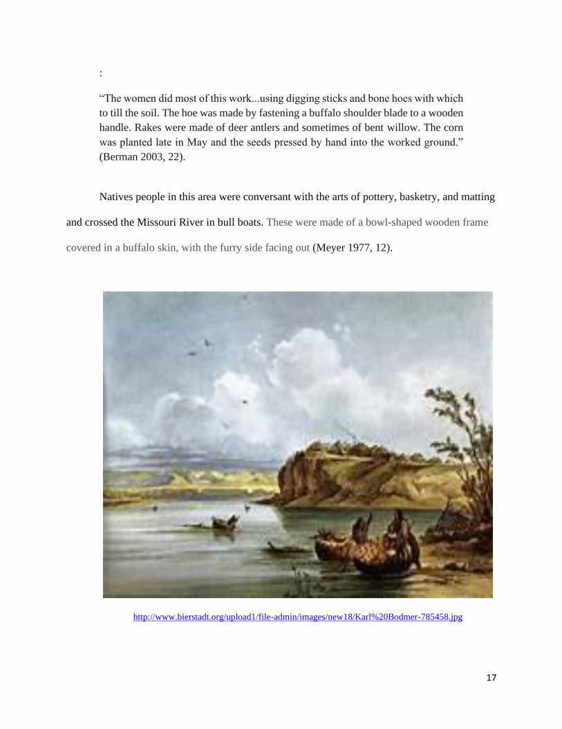
Natives people in this area were conversant with the arts of pottery, basketry, and matting
and crossed the Missouri River in bull boats. These were made of a bowl-shaped wooden frame
covered in a buffalo skin, with the furry side facing out (Meyer 1977, 12).
http://www.bierstadt.org/upload1/file-admin/images/new18/Karl%20Bodmer-785458.jpg
18
Archaeology has been done extensively in this area through the River Basin Surveys
(RBS). The River Basin Surveys were established in 1945, run by the Smithsonian Institution’s
Bureau of American Ethnology (Fairclough et al. 2008, 46):
“The archaeology in the basin, especially the Middle Missouri area, represents a
unique aspect of North American archaeology. The archaeological record extends
from the Paleoindian up through the historic period. Surveys and excavations have
revealed the wealth and variety of archaeological and historic sites. Site types
include sparse artifact scatters; stone ring sites; bison kill sites; earth lodge village
sites; mound sites; effigies; sacred sites; rock shelters; fur trade posts; military posts;
and farmsteads”(Banks et al. 2011, 372).
Thus, through agriculture, settlement, transportation, storytelling, and history telling, the
Mandan, Hidatsa, and Arikara transformed lands in the bottomland since time immemorial. It
became a landscape in which tribes met, combined, gathered, and fought, and the stories they
told about it, from memories of warfare to those of childbirth, named specific portions of the
land to claim it. The natural resources associated with the river were integral to Native
cosmology, as particular plants, animals, minerals, and landforms were essential participants in
the biographies of culture heroes and origin stories. Their roles in tribal cultural history enhanced
their importance as mechanisms of social reproduction and identity formation. This area was
indeed a land of plenty, providing a bounty of blessings for the Three Affiliated Tribes. Their
heritage, therefore, is made in the present and comprises memory and tradition, but it is also
informed by practical goals and objectives set by the living community.
19
CHAPTER TWO
LEWIS AND CLARK
Lewis and Clark’s journey brought the explorers into contact with the Three Affiliated Tribes
and the Native people along the Columbia River. Both locations were extensively documented in
the journals of Lewis and Clark.
Lewis and Clark had met with the Three Affiliated Tribes at the beginning of their
expedition. Among the first non-Indigenous explorers to traverse the American West, Lewis and
Clark spent more time in North Dakota than in any other state. Lewis and Clark’s expedition first
made contact with the Three Tribes with the Arikara people on October 12, 1804. It then
proceeded up the Missouri River to the Knife River Villages of the Mandans and Hidatsas on
October 26, 1804. In November 1804, Lewis and Clark established their winter camp near five
Mandan and Hidatsa villages along the Upper Missouri River. They forged a partnership, eager
for allies, needing both foods for the coming winter and information about the unknown territory
ahead. The expedition spent the winters of 1804 and 1806 camped at Fort Mandan with the
tribes. It has been said that the tribes saved their lives by taking them in during the winter
(Jenkinson 2003, 32). The members of the expedition were not prepared for the harsh winters
that the Plains had to offer. At Fort Mandan, the relationship between the tribes and Lewis and
Clark flourished. They shared food and clothing but also traditions, stories, and language. The
tribes and Lewis and Clark traded during the time they spent together. The expedition traveled
with its own blacksmith. The blacksmith would fix tools and make weapons in return for com
and food (Hoxie & Nelson 2007, 203).
It was there that they would meet and receive the invaluable help of Sakakawea, or Bird
Woman. On November 4, 1804, the journals made the first mention of Charbonneau, and on
20
November 11, 1804, the first mention is made of his wife, Sakakawea (Jenkinson 2003, 28). She
accompanied the expedition and became famous for the immeasurable assistance she gave in the
knowledge of Indian tribes and customs and general knowledge and instinct relative to life in the
wilds of the regions through which the expedition passed. In addition, they had recognized
the potential value of Sakakawea and her husband Charbonneau’s combined language
skills. Charbonneau spoke French and Hidatsa; Sakakawea spoke Hidatsa and
Shoshone (Hoxie & Nelson 2007, 203).
President Thomas Jefferson’s letter of instructions to Lewis called upon him to learn all
he could about the Indians he might encounter along the Pacific route.
“He was to observe and record, not only such matters of obvious economic and
political interest as their locations, territorial claims, numbers, and trading habits,
but also their language, territorial claims, monuments, their ordinary occupations
in agriculture, fishing, hunting war, arts and the peculiarities in their laws, customs,
and dispositions. In short, what Jefferson wanted was what would in later times be
referred to as an ethnographic study” (Meyer 1977, 38).
By October of 1805, the expedition had made its way to the Columbia River and Celilo
Falls area. Encounters with Lewis and Clark found The River People using brass tea kettles
obtained in a trade from coastal tribes with ships. The explorers also found them wearing
quantities of colorful beads carried by European adventurers for trading purposes. Northwest
artists adapted the beads into exquisite decorations on moccasins, dresses, shirts, and bags
(Dupris et al. 2006, 119-120). When Lewis and Clark journeyed down the Columbia, Captain
Clark, concerning his Celilo observations of October 22, 1805, wrote:
“The waters are divided into several narrow channels which pass through hard
black rock-forming islands of rocks at this stage of water, on those islands of rock
as well an at and about their lodges I observe great numbers of stacks of pounded
salmon neatly preserved...thus preserved those fish may be kept sound and sweet
several years, as those people inform me, great quantities" (Schoning et al., 1951,
7).
21
Their arrival along the Columbia River marked the onset of a period in which the region's
white settlers increasingly shaped the river and its surroundings, making it progressively
incapable of supporting salmon. Simultaneously, treaties removed the river from Indians, who
would, in turn, embark on an arduous and lengthy struggle to retain access to the salmon
(Wilkinson 2007). Central to this network was the abundance of salmon. Lewis and Clark
observed stores of an estimated 10,000 pounds of dried and pounded salmon:
“The river was supermarket, highway, and defense barrier. It was the center of a
seasonal journey through fishing and gathering grounds that included netting and
spearing salmon, gathering wild carrots, camas bulbs, berries, and hunting deer and
elk. Lewis and Clark witnessed the start of the season and marveled at the number
of fish the Indians landed. Each village between The Dalles and Celilo utilized a
cluster of traditional fishing stations, typically composed of rocks, islands, and
cliffs adjoining the falls and rapids in the river. At such points, where the current
forced the fish into eddies and narrow channels, Indian men gaffed, speared, seined,
or dip netted salmon, depending on the site and the stream conditions. Women
cleaned and dried the fish on racks, then packed them into bundles or pounded them
into salmon flour. Walking among the towering stacks of dried salmon at Celilo
Village, also known as Wishram, Lewis and Clark estimated that the villagers had
processed some ten thousand pounds of fish. The local Indians earmarked much of
this salmon for trade” (Barber 2005, 23).
Much of the areas where the crew camped with The Three Tribes is now underwater. So
is Celilo Falls. Both regions and the Native people Lewis and Clark had contact with had an
immense impact on the expedition's success. However, this expedition did not have a reciprocal
positive impact on the Indian people, and their ‘corps of discovery’ triggered exposure of these
Native people to white settlement, government interference, treaties, loss of land, and inundation
dams.
22
THE PEOPLE AFFECTED BY THE LOSS OF CELILO FALLS
The state of Oregon has nine federally recognized Indian tribes: The Burns Paiute Tribe, The
Confederated Tribes of Coos, Lower Umpqua and Siuslaw Indians, The Confederated Tribes of
Grand Ronde, The Confederated Tribes of Siletz, The Confederated Tribes of Warm Springs,
The Confederated Tribes of Umatilla Indian Reservation, The Cow Creek Band of Umpqua
Indians, The Klamath Tribes, and The Coquille Tribe (Ritter 2001). However, I will be focusing
on the tribes that were most closely linked with the Mid-Columbia River and were most
impacted by the loss of Celilo Falls and the building of The Dalles Dam.
The Columbia Plateau is home primarily to four major recognized tribes with similar
languages, cultures, religions, and diets. The Nez Perce Tribe, the Confederated Tribes of the
Umatilla Indian Reservation, the Confederated Tribes of the Warm Springs Reservation of
Oregon, and the Confederated Tribes and Bands of the Yakama Nation. These four tribes have a
long history of interaction, including intermarriage, shared resources like Celilo Falls, and
extensive trade. In 1855, the Nez Perce, Umatilla, Warm Springs, and Yakama tribes each
entered into a treaties with the US government, being forced to cede millions of acres of their
lands to the United States.
“The treaties guaranteed the ‘exclusive use’ of reservation lands to the signatory
Indians and today provide a legal basis for the continued existence of a Plateau
Indian way of life. However, those reservation lands represent less than 10 percent
of the land area originally occupied by ancestral Plateau people. Inevitably a large
fraction of the Plateau peoples was forced to abandon their homes and move onto
lands where they had neither traditional rights nor ancestral ties, often against the
fervent wishes of the people who were Indigenous to those reservation areas.”
(Hunn & Selam 1990, 269).
23
The Confederated Tribes of the Warm Springs Reservation comprise the Warm Springs,
Wasco, and Paiute tribes. The Confederated Tribes of the Umatilla Indian Reservation is made
up of the Umatilla, the Cayuse, and Walla Walla tribes. In addition, many unrecognized Native
Americans or Indians were not enrolled on reservations along the Columbia River and referred to
themselves as River People (Fisher 2004, 183).
“ ‘People of the River.’ These are the people who lived for thousands of years in
the Columbia River Gorge…The River People are the Northwest Klickitat and the
Eastern-speaking Chinookan Kiksht. They are the Wascos, the Cascades, the
Wishxams, the Clackamas, the Multnomah’s, the Hood Rivers, the Skamanias, the
Skilloots, and others who lived in villages on the Columbia River” (Aguilar 2005,
2).
Between 1860 and 1885, federal officials constantly complained that many of the people
assigned to the Umatilla, Warm Springs, and Yakama agencies remained at large on the public
domain. Although Celilo Falls was not on a reservation, it was supposed to be protected by the
1855 Treaty with the Yakama, The Middle Oregon Treaty of 1855 and the Walla Walla Treaty
Council, also in 1855. The tribes reserved their right to hunt, fish, and gather at all usual and
accustomed areas on and off the reservation. Despite petitions from white settlers and forced
removal threats, many Natives refused to abandon their traditional village sites, cemeteries, and
fishing stations along the Columbia River. Reservation residents often shared the same practical
concerns, cultural commitments, and spiritual beliefs that prevented renegades from settling in
the tribal homelands. Instead of marking the end of negotiations regarding Indian fishing rights,
treaties marked the onset of more than a century of debate between federal, state, and tribal
governments about who has rightful access to the Columbia River's salmon and its tributaries
(Dupris et al. 2006, 6-7).
24
“Because they were not a federally acknowledged tribe, Columbia River Indians
are the product of social and political processes triggered by the Euro-American
colonization of the Pacific Northwest. Although federal laws and policies helped
define their identity, they emerged in opposition to official categories such as
Yakama and Umatilla. Between 1855 and 1945, Columbia River Indians developed
a strong sense of difference and independence based on a shared heritage of
aboriginal connection to the river, resistance to the reservation system, adherence
to cultural traditions, and relative detachment from federal control institutions and
tribal governance. At times, their independent behavior has clashed with the
sovereignty of the confederated tribes” (Karson 2006, 107).
Native identities remained complex for the River People. By the 1880s, the government
had labeled ‘Columbia River Indians,’ with kinship ties to link reservation and non-reservation
Natives (Fisher 2010, 15). "The 1855 treaties marked initial efforts at codifying who and where
people could fish for salmon in the Pacific Northwest. However, instead of marking the end of
negotiations regarding Indian fishing rights, treaties marked the onset of more than a century of
debate between federal, state, and tribal governments about who has rightful access to the
Columbia River's salmon and its tributaries” (Barber 2005, 51). However, those who already
considered themselves the People of the River, or River People, proved a natural fit. This sense
of difference rested on a common heritage of resistance, which later generations proudly invoked
to defend their rights (Fisher 2010, 15-16).
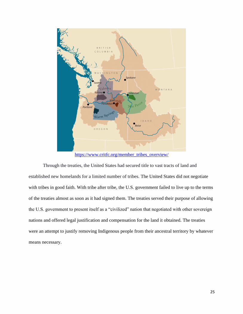
The Columbia River Inter-Tribal Fish Commission (CRITFC) was founded in 1977 by
the four Columbia River treaty tribes: Confederated Tribes of the Umatilla Indian Reservation,
Confederated Tribes of the Warm Springs Reservation of Oregon, the Yakama Tribe, and Nez
Perce Tribe. CRITFC provides coordination and technical assistance to the tribes in regional,
national, and international efforts to protect and restore the fisheries and fish habitat provided
support to the Native people who still fished along the Columbia River, and provide advocacy
based on treaties and other issues (Landeen & Pinkham 1999, 3).
25
https://www.critfc.org/member_tribes_overview/
Through the treaties, the United States had secured title to vast tracts of land and
established new homelands for a limited number of tribes. The United States did not negotiate
with tribes in good faith. With tribe after tribe, the U.S. government failed to live up to the terms
of the treaties almost as soon as it had signed them. The treaties served their purpose of allowing
the U.S. government to present itself as a “civilized” nation that negotiated with other sovereign
nations and offered legal justification and compensation for the land it obtained. The treaties
were an attempt to justify removing Indigenous people from their ancestral territory by whatever
means necessary.
26
CONTROVERSIES OVER LAND FOR THE THREE TRIBES
In 1837, a steamboat from the American Fur Company traveled up the Missouri from Saint
Louis. Smallpox carried by the passengers and traders infected the Mandan, Hidatsa, and Arikara
villages along the Upper Missouri. Over ninety percent of the Mandan villages' population
perished, an estimated seventy percent of the Hidatsa villages died. The survivors of the
smallpox epidemic from the Mandan and Hidatsa communities banded together in 1845 to create
a unified village called Like-A-Fishhook Village (Parker 2011, 62).
During the early to the mid-nineteenth century, tensions grew between white U.S.
citizens and various Native peoples of the Northern Plains. As a result, settlers did not move to
the Northern Plains in large numbers until later. During the early nineteenth century, Northern
Plains tribes were feeling pressures from population shifts in the lands to their east, encounters
with overland US travelers heading west, as well as corporate interests intruding on their lands
(Haynes 1987, 104).
In 1851, the US Commissioner of Indian Affairs organized a Grand Council with the
Plains tribes (Sioux, Cheyenne, Arapaho, Crow, Assiniboine, Hidatsa, Mandan, Arikara). This
council would result in the first Treaty of Fort Laramie. The treaty defined territories for the
various tribes. Each tribe was to stay within their territory and not hunt or raid in another tribe’s
lands. The tribes were guaranteed sovereignty within their assigned territory. The treaty allowed
for the construction of roads through the United States territories and stated that no land could be
taken from the tribes without the tribes’ and Congress’s specific agreements (Maxfield 1986,
17).
“In 1851, through the Treaty of Fort Laramie, also called the Horse Creek Treaty,
that the boundaries of the land of the three tribes were established and anything
approaching a reservation came into being. Under the provisions of the Horse Creek
Treaty, the government confirmed the claims of the Mandan, Arikara, and Hidatsa
27
people from the right bank of the Missouri to the mouth of the Heart to the mouth
of the Yellowstone, with the area enclosed by those streams and a vague line drawn
from the mouth of the Powder River to the headwaters of the Heart. According to
the treaty, the three tribes were not compelled to relinquish their claim to any other
land or to their accustomed hunting grounds” (Cash & Wolff 1974, 39).
The 1851 Fort Laramie Treaty accomplished the first cession of lands by treaty; it
designated 12,500,000 acres of reservation lands between the Yellowstone and Missouri rivers
for the Mandan, Hidatsa, and Arikara people. (Farbo 2003, 145). Between 1866 and 1886,
however, the Three Tribes were gradually removed from most of the lands acknowledged to be
theirs in that treaty. What remained was turned into reservation boundaries, and although the
Treaty of Fort Laramie established some boundaries, it was the Agreement at Fort Berthold in
1866 that most affected the Three Affiliated Tribes stating:
“Vol. 2, Treaties States may desire to connect a line of stages with the river, at the
salient angle thereof about thirty miles below this point, and my desire to establish
settlements and convenient supplies and mechanical structures to accommodate the
growing commerce and travel, by land and river, the chiefs and headmen of the
Arikara, Hidatsa, and Mandans, acting and uniting also with the commissioners of
the United States aforesaid, do hereby convey to the United States all their right
and title to the following lands, situated on the northeast side of the Missouri River,
to wit: Beginning on the Missouri River at the mouth of Snake River, about thirty
miles below Ft. Berthold; thence up Snake River and in a northeast direction
twenty-five miles; thence southwardly parallel to the Missouri River to a point
opposite and twenty-five miles east of old Ft. Clarke; thence west to a point on the
Missouri River opposite to old Ft. Clarke; thence up the Missouri River to the Place
of beginning” (Kapplar 1972, 594).
President Grant issued the executive order on April 12, 1870, officially creating a
reservation for the Three Affiliated Tribes. However, another executive order would take an even
larger portion of land from the Three Tribes ten years later. This land cession was related to the
construction of the North Pacific Railroad. When chartered in 1864, that railroad, like other
railroads constructed in the mid to late nineteenth century, had been given large land grants,
28
including forty miles on either side of a right of way that cut through the Three Affiliated Tribes’
reservation (Meyer 1977, 58). The actual construction of the railroad did not reach this territory
until the very late 1870s. The railroad board of directors then drew up a plan to reduce the
boundaries of the reservation. Despite some contrary advice from certain military commanders
and a commissioner from the Bureau of Indian Affairs, the railroad convinced the government of
their plan. President Hayes signed the executive order on July 13, 1880, depriving the Three
Tribes of a majority of their land (Parker 2011, 75).
Between 1887, when the Dawes Allotment Act was passed, and 1934 when the IRA
ended The Dawes Act, Native communities across the U.S. lost sixty-three percent of their total
land base eighty-six million acres (Parker 2011,76).
“By the end of the sessions in 1910, these had been reduced to 61,000 acres,
making a net of 98,000 acres by 1950. The Fort Berthold Indians’ landholdings
had thus diminished by a total of 11,920,000 acres or a little more than 9 percent in
100 years. Between 1880 and 1934, Fort Berthold lost approximately eighty-seven
percent of their 1870 land base, amounting to nearly seven million acres taken via
Executive Order or allotment-related land openings” (Parker 2011, 110).
The end of the nineteenth century does not mark any sharp dividing point in the history of
the Fort Berthold Indians, who were then in the process of adopting a way of life resembling that
of the white pioneers who were closing in on them. They had never reconciled themselves to the
loss of territory resulting from the executive orders of 1870 and 1880, losses for which they had
not been compensated.
29
CHAPTER THREE
THE DALLES DAM IN OREGON
When the leaders of the Umatilla, Walla Walla, Yakama, and Nez Perce tribes signed the treaties
in 1855, they were guaranteed “the exclusive right of taking fish…thence up the channel of the
Columbia River to the lower end of a large island below the mouth of the Umatilla River”
(Kappler 1972, 694). The treaties altered their lives, but the changes coming to their area and
way of life would be far more significant than they could have imagined at that time. At the
signing of the treaty, Celilo Falls was still the prime hub for fishing and trading. Although Celilo
Falls was not located on a reservation, it was a source of wealth and life promised and included
in the treaties they signed as a ‘usual and accustomed’ fishing site, along with an enormous
stretch of the Columbia River.
The Native peoples who were negatively impacted refused to be victims, however.
Instead, they acted to attempt to claim their guaranteed rights. The Yakamas, Umatillas, Warm
Springs, Nez Perce, and unenrolled Wasco and Wishram Indians established the Celilo Fish
Committee (the CFC) in 1935. The CFC was created to respond to the regulations the State and
Federal Governments had begun to impose due to the increasing numbers of Indians and non-
Indians who came to fish in this plentiful area (Barber 2005, 34). According to the bylaws
adopted in 1936, the CFC served as the governing body of a larger intertribal association, which
framed its purpose a preamble similar to that of the U.S Constitution:
“We, the Indian fishermen of the Columbia River, in Oregon and Washington, in
order to establish a responsible and effective organization to protect our general
welfare; to protect and perpetuate our fishing rights reserved under the terms of our
treaties; to conserve and develop the salmon runs in the Columbia River, the benefit
of ourselves and our children; and to empower us to take a greater and more
responsible part in carrying out these aims, do ordain and establish the articles of
30
affiliation, to be known as ‘The Affiliation of the Indian Fishermen of the Columbia
River ‘ “(Fisher 2004, 194).
The four reservation groups who used Celilo Falls, the Yakamas, Umatilla, Warm
Springs, and Nez Perce, established the Celilo Fish Committee (CFC) in 1935 under Bureau of
Indian Affairs supervision. The establishment of the Celilo Fish Committee as local Indians'
response to regulations imposed by the state and federal governments and the increasing
numbers of out-of-area and non-Native people who came to fish from the falls in the 1930s.
The U.S. Army Corps of Engineers had started its series of public meetings regarding the
construction of The Dalles Dam in 1945 and collaboration with other white commercial fishing
companies and surrounding white communities (Barber & Fisher 2007, 525). In 1944 a new
document was added to the constitution of the Celilo Fish Committee to give equal standing to
“the Indians known as the Columbia River Indians, who have always resided on the Columbia
River, and who are not enrolled on any reservation” (Fisher 2010, 189).
Yet Columbia River Indians have not been a federally recognized tribe, nor commonly
mentioned in ethnographic literature, but more a product of social and political processes
triggered by colonization. A sense of invisibility shadows the Columbia River Indians:
“Because of their unofficial status, the Columbia River Indians have largely
escaped scholarly notice…the bulk of the anthropological and historical literature
about the Columbia Plateau subsumes the River People under the tribal
headings…However, the roots of Columbia River Indian identity tap the river
itself” (Fisher 2010, 10-11).
By the 1950s, Celilo Village was one of the oldest Native continuously inhabited towns.
They consisted mainly of non-enrolled Columbia River People. Fishing methods had evolved by
then, and The Dalles Dam would come to represent human control over the west's most
important resource, water (Wilkinson 2007, 534). The Dalles Dam simultaneously represented
31
potential commercial development and economic decline for residents of the mid-Columbia.
Moreover, the fallout from the dam would be far-reaching and long-lasting. “Chief Tommy
Thompson worked with the tribes protesting the dam development along the Columbia River but
did not participate in the negotiations and was deeply saddened by the exchange of Celilo Falls
for economic gain” (Allen 2007, 679).
The fight against the building of the dam at the Dalles would become an ongoing battle
fought for years by tribal members and non-tribal members. It included commercial and
recreational fishermen, the Bureau of Indian Affairs, and the U.S. Fish and Wildlife Service.
Tribal members attended meetings after meetings as allowed by the US Army Corps; petitioned
the State and Federal government, arguing the rights bestowed upon them by treaties.
Many objectors even traveled multiple times to Washington D.C. to protest the harm the
building of The Dalles Dam would cause. Arguments arose over the future desecration of their
culture, religion, and economic decimation that would result from the loss of Celilo Falls. The
preference of rerouting the dam to the Deschutes River was brought to the table. When the
House and Senate granted the funds in 1953, Tribal members requested consideration for this
option for the dam to be built at the rerouted suggested area, that would save Celilo Falls.
However, Congress did not consider this alternative to build the dam in an alternative site to save
the falls, to the detriment and sadness of the Natives (Barber & Fisher 2007, 527-528).
Although many other compelling testimonies were expressed, and the building of the
Dalles dam was violently opposed vocally and physically for years by a multitude and variety of
protesters, President Truman approved the funding of the dam in 1950. The rallying of the
people against the building of the dam turned their efforts towards appealing to Congress, which
would have the final say (Wilkinson 2007, 538). Sadly, it was overlooked. The Native people
32
did not have an advantage over economic progress. The building of the dam at the Dalles was
imminent. No one in charge seemed to hear or care about the pleas and the cries of the people
who would be affected by the loss of Celilo Falls.
In return, it was eventually agreed that there should be monetary compensation for
families seriously affected by the loss of Celilo Falls. This result was not decided upon quickly
or easily. It was impossible to imagine any amount of money would ever be enough to replace
what would be lost. Negotiations were a complicated process. It was undecided how the funds
would be distributed. The finances did nothing to ease the distress over losing the falls, nor the
heartbreak that still resonated so profoundly in everyone involved.
“The proceedings between reservation representatives along with their independent
attorneys, versus the Army Corps and their lawyers, operated separately and
weighed unevenly. Unenrolled Native people, or those who did not reside on
reservations, including the families at Celilo Village, were severely neglected.
After the settlement, Yakama Indians received $15,019,640, Warm Springs Indians
$4,451,784, Umatilla Indians $4,616,971, and the Nez Pere Indians $2,800,000”
(Barber 2005,172).
On March 10, 1957, the gates slammed shut, Celilo Falls was gone in six hours. Weeping
Native people stood along the shore. The loss of Celilo Falls touches many in the region. The
dam is a tangible reminder of the complexity of Indian treaties and their ongoing negotiation, the
simultaneous promise and destruction of progress. The river and those living by it would never
be the same. The removal of Celilo Falls had taken everything from the Native people who had
fished there for thousands of years, and what remains is small and sad.
33
THE GARRISON DAM IN NORTH DAKOTA
In the twentieth century, the United States has used its powers of eminent domain to seize large
parcels of Indian land for flood control and reclamation projects. After a particularly devastating
flood in 1943, Congress called upon the Army Corps to revisit and prioritize the proposals
outlined in the Missouri Basin 308 report. The result was a twelve-page document known as the
‘Pick Plan,’ after Colonel Lewis A. Pick, Missouri Basin division engineer in Omaha. The plan
detailed the construction of several smaller dams on tributaries and a series of levees plus five
major multipurpose dams along the main Missouri stem (Lawson 1982, 12-13). In response to
the Pick Plan’s overlap with their mission, the Bureau of Reclamation submitted ‘Senate
Document 191’. This document would eventually become known as the ‘Sloan Plan,’ after its
author, William Glen Sloan, assistant director at the Billings office in 1944. The Sloan Plan was
more detailed than the Pick Plan and included ninety different projects, primarily focused on
irrigation and hydropower rather than navigation and flood control (Lawson 1982, 15).
The Pick-Sloan Plan for the Missouri River Basin was developed by the United States
Corps of Engineers and the Bureau of Reclamation in 1944. W.G. Sloan had already been
working on a water management plan for the Upper Missouri River with a giant proposal
consisting of 90 reservoirs and irrigation systems. This plan allowed for irrigation projects and
flood control (Ridgeway 1955, 14). Colonel Lewis A. Pick was the director of the regional office
in Omaha, Nebraska. Pick’s plan called for 2500 miles of levees, 14 tributary reservoirs, and a
massive dam near Garrison, North Dakota. President Franklin Roosevelt was presented with both
projects and insisted on a compromise between the two plans. The Flood Control Act was passed
on December 22, 1944, authorizing what would be known as the Pick- Sloan Plan for eight
34
purposes: flood control, navigation, irrigation, power, water supply, recreation, fish and wildlife,
and water quality (Ridgeway 1955, 16).
The construction of Garrison Dam from 1947-1953 was the first significant construction
project of the Pick-Sloan Plan. “The Corps of Engineers, without authorization from Congress,
altered the project’s specifications in order to protect the city of Williston, North Dakota, and to
prevent interference with the Bureau of Reclamation irrigation projects, but nothing was done to
safeguard Indian communities” (Lawson 2009, 53). The location of the main stem Missouri
River dams was deliberately chosen so that the reservoirs would spare white towns and instead
flood Native lands:
“Members of the MRSC (Missouri River States Committee), and off-reservation
populations in general, believed Indian reservation lands were underutilized. They
believed that reservation land was more beneficial to society at large and the Indians
themselves if it was used for river control works than if it was left to the
management decisions of the Indian population and the Bureau of Indian Affairs…
Purchasing prime agricultural land or expensive urban real estate would have
increased the overall cost of a dam’s construction; therefore, ‘underutilized’ or
cheap ‘low-quality’ Indian land was preferable. Furthermore, moving a large off-
reservation urban population would cost far more than moving residents of Indian
reservations whose worldly possessions and homes had less market value”
(Schneiders 1997, 239-244).
After hearing of the plan, The Three Affiliated Tribes chairman, Martin Cross, tried to
contact the governor of North Dakota but was told to accept the inevitable. As early as March
1943, a group of engineers began surveying the area around Garrison and farther upstream. On
November 15, 1943, the tribal council passed a resolution strongly opposing the construction of
any dam that would adversely affect the reservation. The resolution stated that a dam below the
Fort Berthold reservation was being contemplated for future action by the Congress of the United
States in cooperation with the State of North Dakota. Which action, if realized, would destroy by
35
the permanent flood of the bottomland of the reservation, causing untold material and economic
damage to the Three Affiliated Tribes (U.S. Congress 1945, 17).
Excluded from the planning process, the Indians discovered that much of their land
would be sacrificed. None of the planners appeared to recognize or care that the bottomlands
were irreplaceable to the Indians who could hunt and grow traditional crops on lands. Without
the Indian bottomlands, dams and reservoirs would not have been as cost-effective for non-
reservation populations, threatening their congressional funding. Political considerations were
the primary reasons the dams and reservoirs were designed to be high and built at locations
disadvantageous to Indian interests (Schneiders 1997, 238).
In 1945, a delegation that included Martin Cross, chairman of the tribal business council
of the Three Affiliated Tribes and other tribal members, as well as Felix Cohen, an associate
solicitor from the Department of Interior, addressed the United States Congress to protest the
Garrison Dam and challenge the legality of the suggestion of confiscation of land due to eminent
domain.:
“I am delegated here...to voice the adverse disapproval of the construction of the
proposed Garrison Dam... We question the legality of this process on the ground
that the treaty law between the United States Government and the Indians is binding
and not subject to eminent domain. I want to come out openly against the
construction of the Garrison Dam, not only from the legal standpoint but from the
destructiveness and the setback of our Indian people. There are approximately 500
homes on the reservation, and out of these homes, there would be about 437 that
would be in the flooded area. We are not here on the question of selling our land.
We want to keep it... From time immemorial, we have been living there...I would
also like to report that the Indians will not gain any benefit from this dam. There is
no possibility for us other than destructive.” (U.S. Congress 1945, 6-8)
According to Mr. Woehlke, Indian Bureau, Assistant Commissioner of the Department of
the Interior, at the same hearing:
36
“We have endeavored to point out to the Army engineers that the taking of the best
part of the land of the Three Affiliated Tribes would work an irreparable injury to
them. We have endeavored to point out that according to the record, the Garrison
Dam itself was not favored by the Bureau of Reclamation, that in its Sloan report,
the Bureau of Reclamation took the stand that flood control and irrigation could all
be taken care of by the other dams that had been proposed and that the Garrison
Dam was not necessary for flood control, that it would not produce any irrigation
facilities, and that perhaps even navigation could be taken care of completely by
the other system of reservoirs that were planned on that river” (US Congress 1945,
19).
The Garrison Dam effectively flooded the heart of the community land base in 1953.
Gone were the close traditional gatherings and community living. Flooded were the natural
resources, including desirable land for agriculture, timber that provided logs for homes, fence
posts and shelter for stock, coal and oil deposits, natural food sources, and wildlife habitats for
which most would or could never be compensated.
”The total compensation of $12,605,625 was over $9 million less than the Tribes
felt was the fair market value of the damages they sustained. The final piece of
settlement legislation denied their right to use the reservoir shoreline for grazing,
hunting, fishing, or other purposes. It also rejected tribal requests for irrigation
development and royalty rights on all subsurface minerals within the reservoir
area” (Lawson 1982, 61).
The Congress and the Corps forced this legislation upon the Indians, and the Three Tribes
certainly did not at any time favor it. So, having made concessions, the Three Tribes had to leave
their precious river bottomland and homes for the treeless, waterless, relatively barren prairies,
where temperatures could range from minus forty to more than one hundred degrees above zero.
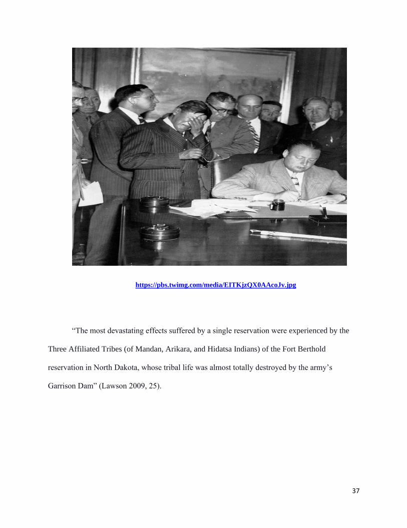
37
https://pbs.twimg.com/media/EITKjzQX0AAcoJv.jpg
“The most devastating effects suffered by a single reservation were experienced by the
Three Affiliated Tribes (of Mandan, Arikara, and Hidatsa Indians) of the Fort Berthold
reservation in North Dakota, whose tribal life was almost totally destroyed by the army’s
Garrison Dam” (Lawson 2009, 25).
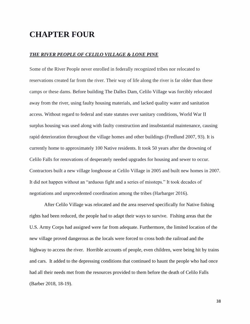
38
CHAPTER FOUR
THE RIVER PEOPLE OF CELILO VILLAGE & LONE PINE
Some of the River People never enrolled in federally recognized tribes nor relocated to
reservations created far from the river. Their way of life along the river is far older than these
camps or these dams. Before building The Dalles Dam, Celilo Village was forcibly relocated
away from the river, using faulty housing materials, and lacked quality water and sanitation
access. Without regard to federal and state statutes over sanitary conditions, World War II
surplus housing was used along with faulty construction and insubstantial maintenance, causing
rapid deterioration throughout the village homes and other buildings (Fredlund 2007, 93). It is
currently home to approximately 100 Native residents. It took 50 years after the drowning of
Celilo Falls for renovations of desperately needed upgrades for housing and sewer to occur.
Contractors built a new village longhouse at Celilo Village in 2005 and built new homes in 2007.
It did not happen without an “arduous fight and a series of missteps.” It took decades of
negotiations and unprecedented coordination among the tribes (Harbarger 2016).
After Celilo Village was relocated and the area reserved specifically for Native fishing
rights had been reduced, the people had to adapt their ways to survive. Fishing areas that the
U.S. Army Corps had assigned were far from adequate. Furthermore, the limited location of the
new village proved dangerous as the locals were forced to cross both the railroad and the
highway to access the river. Horrible accounts of people, even children, were being hit by trains
and cars. It added to the depressing conditions that continued to haunt the people who had once
had all their needs met from the resources provided to them before the death of Celilo Falls
(Barber 2018, 18-19).
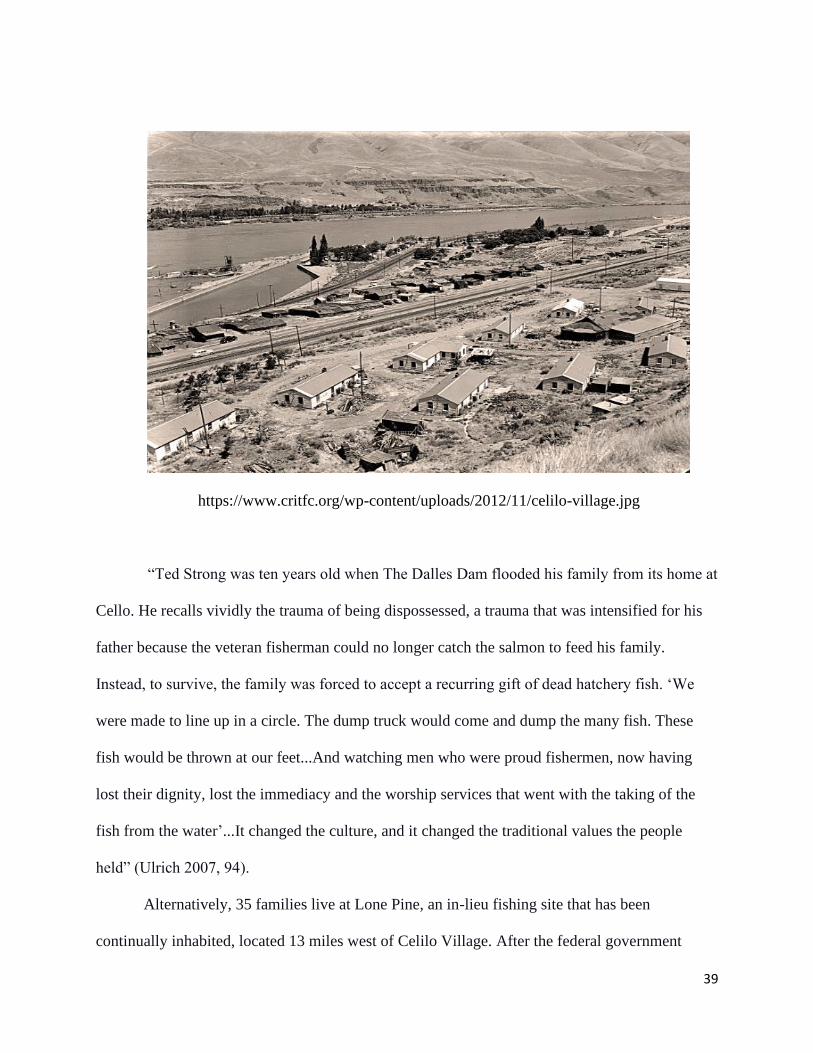
39
https://www.critfc.org/wp-content/uploads/2012/11/celilo-village.jpg
“Ted Strong was ten years old when The Dalles Dam flooded his family from its home at
Cello. He recalls vividly the trauma of being dispossessed, a trauma that was intensified for his
father because the veteran fisherman could no longer catch the salmon to feed his family.
Instead, to survive, the family was forced to accept a recurring gift of dead hatchery fish. ‘We
were made to line up in a circle. The dump truck would come and dump the many fish. These
fish would be thrown at our feet...And watching men who were proud fishermen, now having
lost their dignity, lost the immediacy and the worship services that went with the taking of the
fish from the water’...It changed the culture, and it changed the traditional values the people
held” (Ulrich 2007, 94).
Alternatively, 35 families live at Lone Pine, an in-lieu fishing site that has been
continually inhabited, located 13 miles west of Celilo Village. After the federal government
40
flooded their traditional fishing sites and villages, fishing access at Lone Pine was built for
Umatilla, Nez Perce, Warm Springs, and Yakama tribes. Residents live there year-round
(Harbarger 2017). Unfortunately, Lone Pine, located at the base of The Dalles Dam, consists of
dilapidated housing for the people who make their living along the Columbia River. The housing
situation has caused them to adjust to a massive decrease in sustenance, lack of quality of life,
not to mention the loss of cultural and ceremonial traditions.
Lone Pine families must share a single restroom with four shower stalls and four toilets,
none with a door. The toilets occasionally back up onto the bathroom floor, sending the smell of
waste wafting through the camp. At Lone Pine, blankets and boards cover broken windows on
trailers and campers. “There is only one bathroom and two outdoor water spigots. One picnic shelter
has been walled off and lived in, but two other picnic shelters have burned down. There is no fire
hydrant at this encampment, and only one rutted lane, in and out” (Wozniaka 2014).
In the aftermath of crisis after the building of The Dalles Dam, which initially displaced
and relocated these communities, broken promises to help the people have safe and adequate
housing have taken many years, as in the case of Celilo Village, or have never come to pass,
such as with the community residing at Lone Pine. There are prominent factors that condition
social and economic circumstances that have yet to provide fruitful directions towards improving
their quality of life. Social adjustments have evolved under the pressure of cultural change from
generations of a primary fishing economy that people had previously depended on and strived to
continue utilizing what remains for assessable fishing sites for federally recognized tribal
members.
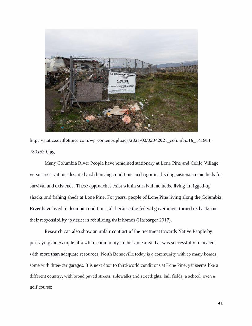
41
https://static.seattletimes.com/wp-content/uploads/2021/02/02042021_columbia16_141911-
780x520.jpg
Many Columbia River People have remained stationary at Lone Pine and Celilo Village
versus reservations despite harsh housing conditions and rigorous fishing sustenance methods for
survival and existence. These approaches exist within survival methods, living in rigged-up
shacks and fishing sheds at Lone Pine. For years, people of Lone Pine living along the Columbia
River have lived in decrepit conditions, all because the federal government turned its backs on
their responsibility to assist in rebuilding their homes (Harbarger 2017).
Research can also show an unfair contrast of the treatment towards Native People by
portraying an example of a white community in the same area that was successfully relocated
with more than adequate resources. North Bonneville today is a community with so many homes,
some with three-car garages. It is next door to third-world conditions at Lone Pine, yet seems like a
different country, with broad paved streets, sidewalks and streetlights, ball fields, a school, even a
golf course:
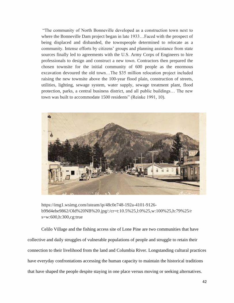
42
“The community of North Bonneville developed as a construction town next to
where the Bonneville Dam project began in late 1933…Faced with the prospect of
being displaced and disbanded, the townspeople determined to relocate as a
community. Intense efforts by citizens’ groups and planning assistance from state
sources finally led to agreements with the U.S. Army Corps of Engineers to hire
professionals to design and construct a new town. Contractors then prepared the
chosen townsite for the initial community of 600 people as the enormous
excavation devoured the old town…The $35 million relocation project included
raising the new townsite above the 100-year flood plain, construction of streets,
utilities, lighting, sewage system, water supply, sewage treatment plant, flood
protection, parks, a central business district, and all public buildings… The new
town was built to accommodate 1500 residents” (Reinke 1991, 10).
https://img1.wsimg.com/isteam/ip/48c0e748-192a-4101-9126-
b99d4ebe9862/Old%20NB%20.jpg/:/cr=t:10.5%25,l:0%25,w:100%25,h:79%25/r
s=w:600,h:300,cg:true
Celilo Village and the fishing access site of Lone Pine are two communities that have
collective and daily struggles of vulnerable populations of people and struggle to retain their
connection to their livelihood from the land and Columbia River. Longstanding cultural practices
have everyday confrontations accessing the human capacity to maintain the historical traditions
that have shaped the people despite staying in one place versus moving or seeking alternatives.
43
Not only have the living conditions been deplorable, previously at Celilo Village, and
currently at the Lone Pine fishing access site, but “the building of the Columbia River dams also
cut off more than 55% of spawning and rearing habitat for salmon, which has led to 13 wild
salmon and steelhead populations in the Columbia Basin is at risk of extinction today. As a
result, many wild salmon runs in the region survive at 2% or less of their historic populations.
The federal government has spent more than $16 billion on regional salmon recovery in the past
two decades. Although extensive habitat has been restored and some salmon populations have
stabilized, none have recovered.” (Ressler 2020, 43).
Cultural heritage for the Native people who thrived because of Celilo Falls along the
Columbia River is fundamental in understanding adaptive capacity. Their culture is a valuable
tool for learning how people construct and manage their world-tribal values of environmental
knowledge, leadership and governance, and sovereignty in salmon management. First,
maintaining an Indigenous knowledge system of water and migrating salmon was told in tribal
narratives since they lived along the Columbia River. Second, this realization focuses on cultural
heritage and salmon responding to periods of change and reorganizing themselves to cope with
that change in cultures and environments, linking complex social, political, and economic
relationships. Third, culture is the strength from which adaptive capacity emerges, and cultures
that persist adapt to economic and ecological surprises are unpredictable events outside the range
of recent experience (Columbi 2012, 76-77).
44
FORT BERTHOLD (AFTER THE DAM)
This chapter begins by identifying the six central reservation communities on the Fort Berthold
Reservation: New Town, White Shield, Mandaree, Four Bears, Twin Buttes, and Parshall. These
communities represent mixed populations who were moved out after the flooding by Garrison
Dam. After constructing the Garrison Dam between 1947-1953 on their reservation lands, the
Three Affiliated Tribes were displaced from their homes, towns, businesses, critical cultural
sites, and burial grounds. Garrison Dam ultimately buried the reservation communities of Sanish,
Elbowoods, Lucky Mound, Shell Creek, Nishu, Charging Eagle, Beaver Creek, Red Butte,
Independence, and Van Hook, into what is now known as Lake Sakakawea in 1953.
“Thousands of graves had to be moved from cemeteries on the bottomlands to
higher ground. As a result of that chaos, the remains of tribal ancestors now lie
scattered in cemeteries across 400,000 acres of the prairie” (VanDevelder 2005,
31).
Along the Missouri River, the flood will always be part of the story North Dakota Indians
tell. Before the Garrison Reservoir, ninety percent of the population of the reservation lived
within the Missouri Valley. Every semblance of organization was destroyed as relocation
changed all aspects of life. Snatched from a subsistence economy, the relocated Indians found
themselves destitute. The tribes also lost 94 percent of their agricultural lands, impacting their
ability to be agriculturally independent:
“Elbowoods had everything-the riches soil in the state, its own electricity plant, a
mill, a school, timber, water, and above all else, people had their families. But when
they were moved to the hills, there was nothing but sandy soil, no electricity, no
timber, bad water- or no water at all. There was no school, no jobs, no businesses,
and the families had been separated by two or three hours because there was no
longer the bridge across the water south of Parshall” (Andes 2019, 63).
Before the Garrison Dam's flooding in 1953, the original communities were Elbowoods,
including the central business community, which housed the Indian Bureau, the Indian school,
45
and the hospital. The Mandans had settled in the Red Butte and Charging Eagle area, and the
Sahnish settled in the Nishu and Beaver Creek area. Independence was settled by the Mandan
and Hidatsa, and Lucky Mound and Shell Creek by the Hidatsa. Elbowoods was a combination
of all Three Tribes (Maxfield 1986, 13-14). The other communities had a government, Indian
day and boarding schools, churches, communal playgrounds, parks, and cemeteries (Ornelas
2007).
“Many Three Affiliated graves were flooded out by the Garrison Dam or were
pillaged over the years by treasure hunting grave robbers. In addition, artifacts and
skeletal remains have been removed from Three Affiliated gravesites by
professional researchers exploring in the region. Those graves are considered
sacred places by the Three Affiliated. The fact that many historic gravesites are
now under the waters of Lake Sakakawea does not diminish the enormity of loss
for the tribe... Today, the water levels of Lake Sakakawea often drop due to drought
conditions in the region. The graves that could not be moved before the lake was
filled are sometimes found uncovered. Many Three Affiliated families and others
tried to complete their grave rescuing efforts before Lake Sakakawea completely
flooded the area. There were many graves, including historic architecture such as
lodges and prayer shrines, that had to be left behind. Time and the erosive effects
of water have worn away at the remaining gravesites, and they become exposed
with the drop in water levels” (Ornelas 2007, 46-47).
The dam flooded a sizeable sacred portion of the Three Affiliated Tribes' s reservation
area. The places where they would go along the Missouri River to hold their centered festivities,
reflect on their creation stories, or gather medicinal plants are mostly gone. These significant
places along the river bottomlands are buried under the reservoir, Lake Sakakawea. These places
were historically tied to their tribal society, culture, and spiritual beliefs (Ornelas 2007).
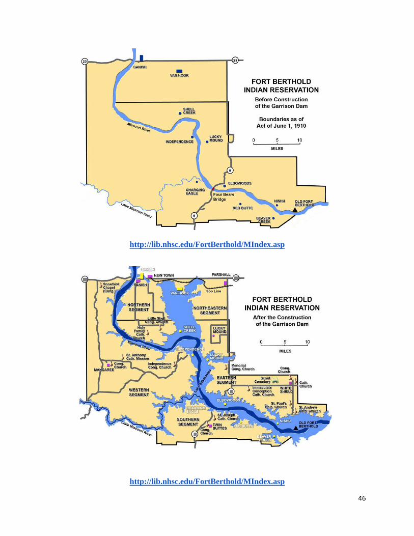
46
http://lib.nhsc.edu/FortBerthold/MIndex.asp
http://lib.nhsc.edu/FortBerthold/MIndex.asp
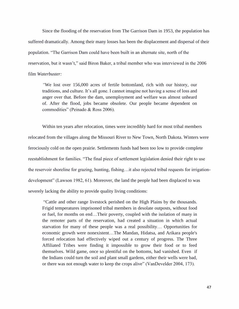
47
Since the flooding of the reservation from The Garrison Dam in 1953, the population has
suffered dramatically. Among their many losses has been the displacement and dispersal of their
population. “The Garrison Dam could have been built in an alternate site, north of the
reservation, but it wasn’t,” said Biron Baker, a tribal member who was interviewed in the 2006
film Waterbuster:
“We lost over 156,000 acres of fertile bottomland, rich with our history, our
traditions, and culture. It’s all gone. I cannot imagine not having a sense of loss and
anger over that. Before the dam, unemployment and welfare was almost unheard
of. After the flood, jobs became obsolete. Our people became dependent on
commodities” (Peinado & Ross 2006).
Within ten years after relocation, times were incredibly hard for most tribal members
relocated from the villages along the Missouri River to New Town, North Dakota. Winters were
ferociously cold on the open prairie. Settlements funds had been too low to provide complete
reestablishment for families. “The final piece of settlement legislation denied their right to use
the reservoir shoreline for grazing, hunting, fishing…it also rejected tribal requests for irrigation-
development” (Lawson 1982, 61). Moreover, the land the people had been displaced to was
severely lacking the ability to provide quality living conditions:
“Cattle and other range livestock perished on the High Plains by the thousands.
Frigid temperatures imprisoned tribal members in desolate outposts, without food
or fuel, for months on end…Their poverty, coupled with the isolation of many in
the remoter parts of the reservation, had created a situation in which actual
starvation for many of these people was a real possibility… Opportunities for
economic growth were nonexistent…The Mandan, Hidatsa, and Arikara people's
forced relocation had effectively wiped out a century of progress. The Three
Affiliated Tribes were finding it impossible to grow their food or to feed
themselves. Wild game, once so plentiful on the bottoms, had vanished. Even if
the Indians could turn the soil and plant small gardens, either their wells were bad,
or there was not enough water to keep the crops alive” (VanDevelder 2004, 173).
48
The building of the Missouri River dams, amid all that damage, the flooding of tribal
lands in the middle of the twentieth century, ranks among the most profound, systematic, and
least remembered violations of Indigenous people. The uprooting of kinship and other primary
groups destroyed the community life so fundamental to the Native people' culture:
“Indians are overwhelmed by frustration. The Standing Rock Tribe lost more
acreage to The Flood than did the Three Affiliated Tribes of North Dakota. But the
impact on the Three Affiliated Tribes may have been more devastating. The Sioux
had been largely nomadic tribes who came to farming and grazing later in their
histories. But the Mandan, Hidatsa, and Arikara had settled much earlier into
farming. They were descendants of village tribes living in cultural systems that had
centuries-deep roots in place and time” (Lambrecht 2005, 165).
The change in human geography was drastic and devastating. The Three Affiliated
Tribes, concentrated in or adjacent to the Missouri River bottomlands for centuries, became
widely dispersed on the much less productive high plains in five distinct segments of the
reservation.
“Garrison Dam destroyed their tribe’s economic infrastructure and reduced their
opportunities for the communal interaction needed to fight against the Army Corps
in one devastating blow. Moreover, the stress and demoralization that followed
‘The Flood’ produced severe sociological effects: unemployment and alcoholism,
the twin scourges of modern reservations, rose with each foot of lake water" (Dunn
2007, 146).
The experience of the Mandan, Hidatsa, and Arikara over the past sixty-five years, since
the creation of Garrison Dam and Lake Sakakawea, is best described as ‘transgenerational
trauma.’ This term is used by psychologists studying the long-term effects of extreme hardship
on small groups and communities. Psychologists studying the phenomenon report that the
symptoms of trauma-induced pathology include a sudden increase in alcoholism and drug
addiction, joblessness, child abuse, domestic violence, clinical depression, and suicides (Fisher
1999).
49
Families left for urban centers on relocation for the same reason. The Fort Berthold
economy transitioned largely based on agriculture and ranching to one based largely on
unemployment. Rates of welfare rose, as did rates of alcoholism and violent death. Language
transmission rates fell dramatically (Blades 2018).
“On the river bottom, we had plenty of water to drink, wash and water our livestock.
When we were forced to move to the upper plains, wells were dug so deep that you
could not pump them by hand...When we moved to the prairie, we could no longer
eat the chicken eggs...they were blood red because of the water...The water was not
suitable even for animals...Final relocation was completed by 1955; by 1960, there
was a marked decline in the standard of living…By 1967, more than 90 percent of
the housing was classified as substandard; 87 percent of the homes lacked a safe,
sanitary method of refuse disposal; and 81 percent of the people had to carry water
a half-mile or more” (Berman 1988).
In addition, there have been many adverse circumstances on the Fort Berthold
Reservation during the oil boom in the twenty-first century. Drugs, violence, domestic abuse,
and sexual assault have become increasingly prevalent (Murdoch 2020). The dam produced
visible effects on Native economy, health, housing, and social cohesion. The loss of
agriculturally rich bottomlands has continued to alter previously self-sufficient people's overall
way of life. More than 90 percent of the population was relocated to accommodate the dam.
They still grieve for what was lost by the flood.
“Prior to the filling of the Garrison reservoir, 90 percent of the reservation
population lived on the Missouri Valley bottomlands. As a result, 90 percent of the
people were torn from their homes and relocated on the highlands. Forced
relocation is always traumatic, even for an individual or a family. All organizational
forms and structures were drastically altered; friendships were ripped apart;
community cohesion was totally dissolved; the habits and customs of generations
were almost completely destroyed” (Cash & Wolff 1974, 83).
50
CONCLUSION
To conclude, contributions to this thesis highlight the importance of considering the point
of view of the affected Indigenous peoples and the long-term cultural and environmental effects
because of The Dalles Dam and The Garrison Dam. One problem is how these projects were
moved forward in opposition to existing treaties, with the dam projects framed as a necessity
with underestimation of social and environmental impacts, limited consultation, and participation
of affected communities, at the expense of Indigenous people and the risk of cultural genocide
brought by development (Church et al. 2015). This thesis adds to anthropological contributions
to examples of what could be considered ‘sacrifice zones.’
“Environmental and human rights activists have long recognized that dams are
accompanied by devastating human rights violations, including in some cases
forced displacement, loss of land, and the destruction of subsistence ways of
life...Accordingly, these new sacrifice zones have been created across the globe into
a commodity. With this move, climate mitigation was elevated above other
environmental protection goals, and local peoples’ ways of living on the land had
to give way to carbon credit counting” (Scott & Smith 2017, 374).
Dams have turned these Indigenous communities and many others worldwide into
sacrifice zones or communities that have been permanently impaired by environmental damage
or economic disinvestment sacrificed on purpose and without permission. "These are areas that
have been destroyed for quarterly profit. We're talking about environmentally destroyed,
communities destroyed, human beings destroyed, families destroyed…" (Barasch 2013).
These have been the reality for the great majority of people involuntarily displaced by the
development of these dams. Displacement severs what are often strong spiritual and cultural
attachments to land and threatens communal bonds and cultural practices which hold these
societies together. The trauma inflicted on displaced peoples is severe. Love of birthplace, no
matter how inhospitable it may appear to strangers, has been recognized as a universal human
51
characteristic. To be wrenched from one's home because of what seems to be an arbitrary and
unjustifiable government action is especially difficult for isolated populations whose members
(and their ancestors) have derived most of their support from local resources for as long as they
can remember (Cabot 2019).
Unfortunately, greed and misconception still destroy habitats and culture surrounding
people in various environments. Every day, injustices are committed, wearing the mask of
necessity and progress in every area throughout the world. Indigenous groups are more
vulnerable than others to the risks, including collective trauma, intergenerational PTSD,
historical grief, an acute reaction to colonialism, intergenerational trauma, and multigenerational
trauma. Displacement has been a lasting effect of colonialism (Kassam et al., 2017).
Looking at the deep-rooted effects that have come to take place because of colonialism
and imperialism, colonizers have claimed the land and invaded lands, displacing people,
exploiting natural resources, and labor with imperialist power. We also see cultural imperialism,
where conquering colonizers have exhibited control over the traditional values and practices over
Native cultures:
“When the spiritual knowledge, rituals, and objects of historical subordinated
cultures are transformed into commodities, economic and political powers merge
to produce cultural imperialism. A form of oppression exerted by a dominant
society upon other cultures and typically a source of economic profit, cultural
imperialism secures and deepens the subordinated status of those cultures. In the
case of indigenous cultures, it undermines their integrity and distinctiveness,
assimilating them into the dominant culture by seizing and processing vital cultural
resources, then remaking them in the image and marketplaces of the dominant
culture”(Whitt 2009, 7).
52
Karuka’s Empire Tracks also offers a structural analysis of imperialism, crossing the
borders of discrete subfields of Indigenous and ethnic studies in its theoretical and
methodological approaches:
“The ever-increasing energy consumption habits of the United States present a
threat to the planet’s ability to sustain collective human life and are located in
infrastructures of expropriation and encroachment on Indigenous lands in North
America and beyond...Industrial hydropower, coal, and oil involve destructive
relationships with Indigenous places and with Indigenous nations...Continental
imperialism has proceeded with a destructive approach to energy production. It has
also proceeded through controlling water” (Karuka 2019, 33).
It is important to consider the adverse effects of dams in general. Hydropower dams have
been criticized for their social and environmental implications. Dams have led to
the extinction of many fish and other aquatic species, the disappearance of birds in floodplains,
huge losses of forest, wetland, and farmland, erosion of coastal deltas, and many other
unmitigable impacts. The WCD (World Commission Dams) was created because of negative
protests of large dam developments. It has been admitted that dams have made some
improvements, but the adverse effects were more harmful than the benefits towards Indigenous
people (Lawrence, 2005). Efforts from affected Native people protesting damaging projects to
the lands and the people surrounding them continue to this day. Detrimental environmental
effects have included consumption of non-renewable mineral resources, loss of vegetation and
wildlife habitat, fish spawning success, air, and water pollution, as well as desecrations of
archeological sites (Environmental Impact Statement, 1972).
Another problem with dams is the erosion of land. Dams hold back the sediment load
normally found in a river flow, depriving the downstream of this. To make up for the sediments,
the downstream water erodes its channels and banks. This lowering of the riverbed threatens
53
vegetation and river wildlife (Tortajada et al. 2012, 9). Unfortunately, artificial concepts have
severe consequences to the land and the people around them and respect towards the
environment and water. The people were reminded of crucial cultural and community history by
losing the physical soil, landmarks, and places. This shared history is embedded and, in the case
of burial grounds, is literal in the traditional landscape and has served as a crucial foundation for
their tribal and community identities, the way they defined themselves as human beings (Eller
2015).
“Perhaps nowhere are the differences between the Indian and non-Indian ways of
relating to nature more evident than in the treatment of water. In the Native
American tradition, water is regarded as a medicine because it nourishes all life.
Water flushes poisons out of humans, other living creatures, and the land.
Traditional Indian cultures teach that to be productive, and water must be kept pure.
Non-Indians, on the other hand, have used the water without fully understanding
that it must be treated with respect to remain powerful. By causing the water to
warm, by restricting its flow and polluting it, non-Indians have made the water
‘sick.’ (Landeen & Pinkham 1999, 111).
One of the reasons dams are built is to prevent flooding. However, most ecosystems that
experience flooding are adapted, and many animal species depend on the floods for various life
cycle stages, such as reproduction and hatching. Annual floods also deposit nutrients and
replenish wetlands. Fisheries have become an increasingly important source of food supply more
attention is being paid to the harmful effects of dams on many fish and marine mammal
populations. Most large dams do not include proper bypass systems for these animals, interfering
with their life cycles and sometimes even forcing species to extinction (Tortajada et al. 2012, 9-
10).
“When man does the Creator’s job, it usually doesn’t turn out right...Natural
processes of decay seem to pull the heavy metals, particularly mercury, out of the
soil. And in its dying breath the forest killed the water... River habitats of the
animals were destroyed, and dams set in motion a process that threatens much of
54
the commercial salmon fishery of the region... The flow of water in the river has
been radically altered from its natural path…This situation carries obvious
implications for fish, beaver, and other water-based creatures downstream”
(LaDuke 2015, 76-77).
My eventual doctoral dissertation research project will show hypotheses, test
expectations, and proposed research methods to show how conducting ethnographic research by
examining descriptions of these communities’ adaptive behavior based on their circumstances
from relocation because of these dams will provide examples of survivance while others are
striving to survive. The ethnographies I plan to research will explore survivance versus survival
for the communities of Fort Berthold in North Dakota and of Lone Pine and Celilo Village in
Oregon. The research will investigate some community members performing acts of survivance,
while others show evidence of survival. Relocation and housing conditions appear to play an
integral part in these communities’ efforts to maintain an approach of survivance and survival
while holding onto ancestral heritage and location.
The knowledge gained in this thesis will be expanded and elaborated on in the future for
my doctoral dissertation and will include ethnographies from both communities. I am hoping to
collect some of my ethnographic data from traveling in person to both communities next
summer. Ethnographies have compelling capabilities to conceive insurmountable opportunities
for readers to transcend into other social groups, foreign to their own. There will be witnessed
alternate views, creating chances for imaginative personal growth or reflection towards finding
importance and impactful meanings and ways individuals can inflict into other
worlds. Fieldwork, data collection, participant observation, theoretical and analytical
framework, and research methods can all represent the author’s views and administer historical
backgrounds that can be engaging and enlightening.
55
A broader inspection of the community members' day-to-day inner workings and habits
will provide models to differentiate between survivance and survival examples and strategies. It
will also theoretically test approaches to decision-making and vulnerability by analyzing
household and individual perceptions and their significance on the adjustments that have been
shown regarding survivance or survival patterns. Finally, research would look for outcomes to
further understand underlying traditions while not ignoring contemporary situations. Future
ethnographic data could provide gaps in this information.
Cultural heritage and cultural anthropology have grown immensely. There have been
many changes towards making sure things are done respectfully and appropriately. Although it is
not without mistakes and complications, increasing educational opportunities and continued
reverence towards proper procedures have improved. Native people are professionally sought
after, and their input is included in crucial decisions, and this should continue.
Sadly, their knowledge was not taken more seriously many years ago, after so much
disrespect, loss, and tragedy, but it gives hope that it will continue to improve. It is imperative
for the people with the most influential power to plead for exceptional representation in these
urgent and essential matters. Prioritizing significant attention on pressing issues and gathering
support is vital in determining success for change in the future. It is crucial to learn from past
mistakes, to try harder in the present to do things humanely, ethically, and respectfully, and
prepare the context for the future to set a better example.
Honoring sacred places of Native Americans has not been a priority of respect as it
should be. As a result, they have been desecrated, robbed, stolen, and destroyed. With more
emphasis on the importance of preserving such spaces and reverence for cultural heritage, there
is the hope of change. America has destroyed sacred ground since the founding of this country,
56
and other colonists began doing the same hundreds of years before that. Greed and blatant lack
of respect for what is sacred to Native Americans have been an enormous embarrassment to this
country.
“Managing cultural heritage is contingent upon valuing and protecting it. It is
difficult to manage what is not well documented and even more difficult to manage
cultural heritage that is being lost to man-made or natural threats. Thus studying,
managing, and protecting cultural heritage can be considered a public good not only
locally but at the national and global levels. Capturing the public value of cultural
heritage is vital to understanding that a sense of identity and place is also an
important part of our cultural heritage” ( Yu, et.al. 2018, 94).
Yet, despite formidable circumstances, many Indigenous people have adapted to
purposeful changes in their livelihood, cultural, and religious traditions. Examples of survivance
can be found in the communities' persistence to protect cultural traditions. “Native survivance is
an active sense of presence over absence, deracination, and oblivion, not a mere
reaction…survivance is invariably true and just in native practice and cultural company”
(Vizenor 2008, 85). Native people from these communities continue ceremonies of thanks to
their Creator and vigorous attempts to keep their culture alive. They have and will continue to
survive this ordeal and make sure the following generations never forget the sacredness of their
past and fight to encourage hopefulness for their future. These stories need to be told. Stories
serve to remind of those for whom we presume to speak.
57
BIBLIOGRAPHY
WORKS CITED
1. Aikens, C. Melvin. 1984. Archaeology of Oregon. U.S. Department of Interior Bureau of Land
Management Oregon State Office.
2. Allen, Cain. 2007. “Oregon Voices: Tommy Kuni Thompson: Celilo Village Chief.” Oregon
Historical Quarterly. Vol 108.4: 678-679.
3. Aguilar, George W., Sr. When the River Ran Wild!. Indian Traditions on the Mid-Columbia and
the Warm Springs Reservation. Oregon Historical Society Press.
4. Andes, Hunter L. 2019. The Elders. Garrison N.D.: BHG, Inc.
5. Banks, Kimball M, Signe Snortland, J, and Czaplicki, Jon. 2011. "The Price We've Paid: From
Salvage Archaeology to Cultural Resource Management and Beyond in the Missouri River
Basin." Plains Anthropologist 56, no. 220: 371-85.
6. Barasch, Douglas S. 2013. “INSIDE AMERICA'S SACRIFICE ZONES.” Onearth.com.
7. Barber, Katrine. 2005. Death of Celilo Falls. University of Washington Press.
8. Barber, Katrine, and Fisher, Andrew H. 2007. "From Coyote to the Corps of Engineers:
Recalling the History of the Dalles—Celilo Reach." Oregon Historical Quarterly 108, no. 4:
520-31.
9. Barber, Katrine. 2018. In Defense of Wyam: Native - White Alliances & the Struggle for Celilo
Village. University of Washington Press.
10. Barret, Stanley R. 1996. Anthropology: A Student’s Guide to Theory and Method. University of
Toronto Press.
58
11. Berman, Tressa. 2003. Circle of Goods: Women, Work, and Welfare in a Reservation
Community, State University of New York Press.
12. Berman, Terri. 1988. “For the Taking: The Garrison Dam and the Tribal Taking Area. Cultural
Survival Quarterly Magazine.
13. Blades, Meteor. 2018. “How the Garrison Dam on the Missouri River ruined a way of life for the
Mandan, Hidatsa, and Arikara.” Daily Kos.
14. Boas, Franz.1920. "The Methods of Ethnology." American Anthropologist, New Series, 22, no.
4: 311-21.
15. Bowers, Alfred W. 1992. Hidatsa Social and Ceremonial Organization. University of Nebraska
Press.
16. Cabot, Heath. 2019. "Reply: Displacing the Anthropology of Displacement." American
Ethnologist 46, no. 3: 288-89.
17. Caduff, C. 2011. “Anthropology's Ethics: Moral Positionalism, Cultural Relativism, and Critical
Analysis.” Anthropological Theory 11, no. 4: 465–80.
18. Carballo, David M. 2013. Cooperation and Collective Action: Archaeological Perspectives.
University Press of Colorado.
19. Cash, Joseph H. & Gerald W. Wolff. 1974. The Three Affiliated Tribes: Mandan, Arikara, and
Hidatsa. Phoenix, AZ: Indian Tribal Series.
20. Church, Jerilyn, Ekechi, Chinyere O, Hoss, Aila, and Larson, Anika Jade. 2015. "Tribal Water
Rights: Exploring Dam Construction in Indian Country." The Journal of Law, Medicine & Ethics
43, no. S1: 60-63.
21. Cipolla, Craig N. 2008. "Signs of Identity, Signs of Memory." Archaeological Dialogues 15, no.
2 (2008): 196-215.
59
22. Columbi, Benedict J. 2012. "Salmon and the Adaptive Capacity of Nimiipuu (Nez Perce) Culture
to Cope with Change." American Indian Quarterly 36, no. 1: 75-97.
23. Confederated Tribes Bands of Indians, Residing in Middle Oregon, Participant in Treaty. Treaty
with the Middle Oregon Tribes, 1855. United States. Statutes at Large, Treaties, and
Proclamations of the United States of America.
24. Dupris, Joseph C., Hill, Kathleen S., & William H. Rodgers, Jr. 2006. The Si'lailo Way: Indians,
Salmon, and Law on the Columbia River. Carolina Academic Press.
25. Dunn, Robert A. 2007. Fever, Firepower, and Flood: The Transformation of the Missouri River
Bottomlands in the Dakotas, 1804–2005. Dissertation.
26. Eller, Jack David. 2015. Cultural Anthropology. Routledge.
27. “Environmental Impact Statement: Construction, Operation and Management, Columbia River,
Umatilla to the Dalles Oregon and Washington.” U.S. Army Engineer District Portland, Ore:
August 1972.
28. Erickson, Paul A., Murphy, Liam D., Murphy. 2008. A History of Anthropological Theory.
University of Toronto Press.
29. Farbo, John. 2003. "Fort Laramie Treaty of 1851." American Indian History 1: 145-46.
30. Fairclough, Graham J., ed., Rodney Harrison, ed., John H. Jameson Jr., ed., & John Schofield,
ed. 2008. The Heritage Rader. London: Routledge.
31. Ferris, Neil., Harrison, Rodney., Wilcox Michael V. 2014. Rethinking Colonial Pasts Through
Archaeology. Oxford University Press.
32. Fisher, Andrew H. 2003. "People of the River: A History of the Columbia River Indians, 1855–
1945." Dissertation.
33. Fisher, Andrew H. 2010. Shadow Tribe. Seattle: University of Washington Press.
60
34. Fisher, Andrew H. 2004. “Tangled Nets: Treaty Rights and Tribal Identities at Celilo
Falls." Oregon Historical Quarterly 105, no. 2: 178-211.
35. Fisher, William F. 1999. “Going Under: Indigenous Peoples and the Struggle Against Large
Dams. Cultural Survival Quarterly Magazine.
36. Fredlund, Diana. 2007. "The Corps of Engineers and Celilo Falls: Facing the Past, Looking to
the Future." Oregon Historical Quarterly 108, no. 4: 688-97.
37. Fujikura, Ryo, and Nakayama, Mikiyasu. 2015. Resettlement Policy in Large Development
Projects. Routledge.
38. Green, William, Bowers, Norman A, Grinnell, Calvin, Ahler, Stanley A, and Thiessen, Thomas
D. 2018. "Alfred W. Bowers' History of the Mandan and Hidatsa: A Significant Resource for
Plains Anthropology." Plains Anthropologist 63, no. 246: 113-33.
39. Harbarger, Molly. 2016. “Celilo’s success might be path forward for Columbia River housing-
but it wasn’t easy.” The Oregonian. May 20.
40. Harbarger, Molly. 2017. “Poor sanitation, safety targeted in bill to improve Columbia River
tribal fishing sites. The Oregonian. March 22.
41. Haynes, John J. 1987. The Forgotten People-The Story of the Fort Berthold Indian Mission
1876-1985. J.J. Hayes Self Published.
42. Hoxie, Frederick E., Nelson, Jay T.. 2007. Lewis & Clark and the Indian Country: The Native
American Perspective. University of Illinois Press.
43. Hunn, Eugene S., and James. Selam. 1990. Nch'i-wána, "The Big River": Mid-Columbia Indians
and Their Land. University of Washington Press.
44. Jenkinson, Clay. 2003. A Vast and Open Plain: The Writings of the Lewis and Clark Expedition
in North Dakota, 1804-1806. State Historical Society of North Dakota.
61
45. Kappler, Charles J. 1972. “Indian Treaties 1778-1883.” Interland Publishing Inc.
46. Karson, Jennifer. 2006. Confederated Tribes of the Umatilla Reservation, Oregon, and
Tamástslikt Cultural Institute. Wiyáxayxt/Wiyáakaảawn = As Days Go By: Our History, Our
Land, and Our People--the Cayuse, Umatilla, and Walla Walla. Pendleton: Portland : Seattle:
Tamástslikt Cultural Institute; Oregon Historical Society; Distributed by the University of
Washington Press.
47. Karuka, Manu. 2019. Empire’s Tracks: Indigenous Nations, Chinese Workers, and the
Transcontinental Railroad. University of California Press.
48. Kassam, Karim-Aly S., Leanne M, Avery, Leanne M, Ruelle, Morgan L. 2017. The Cognitive
Relevance of Indigenous and Rural: Why Is It Critical to Survival?" Cultural Studies of Science
Education 12, no. 1: 97-118.
49. King, Lisa., Gubele, Rose. 2015. Survivance, Sovereignty and Story. University Press of
Colorado.
50. LaDuke, Winona. 2015. All Our Relations: Native Struggles for Land and Life. Haymarket
Books.
51. Lambrecht, Bill. 2005. Big Muddy Blues: True Tales and Twisted Politics Along Lewis and
Clark’s Missouri River. St. Martin’s Press.
52. Landeen, Dan., and Pinkham, Allen. 1999. Salmon and His People: Fish & Fishing in Nez Perce
Culture. Confluence Press.
53. Lang, William. 2007. "The Meaning of Falling Water: Celilo Falls and the Dalles" Oregon
Historical Quarterly, Winter, Vol. 108, No. 4, Remembering Celilo Falls: Oregon Historical
Society: pp. 566-585.
62
54. Lawrence, Michael P. 2005 “Damming Rivers, Damning Cultures.” American Indian Law
Review 30.1: 247-289.
55. Lawson, Michael L. 1982. Dammed Indians: The Pick-Sloan Plan and the Missouri River Sioux,
1944-1980. University of Oklahoma Press.
56. Lotte E. Govaerts. 2016. "Transformative Consequences of Garrison Dam: Land, People, and the
Practice of Archaeology." Great Plains Quarterly 36, no. 4: 281-307.
57. Lowie, Robert Harry. 1917. Notes on Social Organization and Customs of the Mandan, Hidatsa,
and Arikara Indians. AMS Press.
58. Macgregor, Gordon. 1948. Attitudes of the Fort Berthold Indians regarding Removal from the
Garrison Reservoir Site and Future Administration of Their Reservation. Report (Missouri River
Basin Investigations Project); No. 69. Billings, Mont.: Bureau of Indian Affairs.
59. Maxfield, Christyann Ranck. 1986. Goodbye to Elbowoods: The Story of Harold and Eva
Case. State Historical Society of North Dakota
60. McKeown, Archie W. 1959. Come to Our Salmon Feast. Metropolitan Press.
61. Medicine, Beatrice, Dr. 2001. Learning to Be an Anthropologist and Remaining “Native.”
University of Illinois Press.
62. Meyer, Roy W. 1977. The Village Indians of the Upper Missouri: The Mandans, Hidatsas, and
Arikaras. University of Nebraska Press.
63. Murdoch, Sierra Crane. 2020. Yellow Bird: Oil, Murder, and a Woman’s Search for Justice in
Indian Country. Random House Publications.
64. Ornelas, Roxanne Teresa. 2007. "Placing the Body on the Bones: Transformational Hybridity
Perspective, Sacred Lands and Heritage." Dissertation.
63
65. Parker, Angela K. 2011. Taken Lands: Territory and Sovereignty on the Fort Berthold Indian
Reservation, 1934-1960. The University of Michigan.
66. Peinado, J. Carlos., Daphne D. Ross, and Brave Boat Productions. 2006. Waterbuster. Brave
Boat Productions.
67. Pinkham, Allen V. 2007. "Childhood Memories of Fish.” Oregon Historical Society. pp. 586-
595.
68. Reinke, Cecil Eugene. 1991. The Relocation of North Bonneville, by the U.S. Army Corps of
Engineers. Dissertation. Portland State University.
69. Reyna, Stephen P. 2017. Starry Nights: Critical Structural Realism in Anthropology. Berghahn
Books.
70. Ridgeway, Marian E. 1955. The Missouri Basin’s Pick-Sloan Plan: A Case Study in
Congressional Policy Determination. The University of Illinois Press.
71. Ritter, Gladine, G., 2001. Oregon Directory of American Indian Resources, 1999-2001.
72. Sams, Charles F. 2007. “Wakanish Naknoowee Thulma: Keepers of the Salmon.” Oregon
Historical Quarterly 108.4 (Winter): 644-648.
73. Salzman, Philip, Carl. 2001 Understanding Culture: An Introduction to Anthropological Theory.
Waveland Press, Inc.
74. Schneiders, Robert Kelley. 1997. "Flooding the Missouri Valley: The Politics of Dam Site
Selection and Design.” Great Plains Quarterly 17, 237-49.
75. Schoning, R.W., T.R. Merrel, Jr., D.R. Johnson. 1951. The Indian Dip Net Fishery: At Celilo
Falls on the Columbia River. Oregon Fish Commission.
76. Scott, Dayna Nadine, Smith, Adrian A. 2017. "Sacrifice Zones in the Green Energy Economy:
The "New" Climate Refugees." Transnational Law & Contemporary Problems.
64
77. Silliman, Stephen. 2010. “Indigenous Traces in Colonial Spaces: Archaeologies of Ambiguity,
Origin, and Practice.” Journal of Social Archaeology 10, no. 1 (February 2010): 28–58.
78. Silverman, Helaine., D. Fairchild. Ruggles, and SpringerLink. 2007. Cultural Heritage and
Human Rights. Springer.
79. Smith, Hubert G. 1972. Like-A-Fishhook Village and Fort Berthold: Garrison Reservoir North
Dakota. National Park Service U.S. Department of the Interior.
80. Stockman, Wallace Henry. 1972. "Historical Perspectives of Federal Educational Promises and
Performance Among the Fort Berthold Indians.” Dissertation.
81. Tortajada, Cecilia., Dogan. Altinbilek, and Asit K. Biswas. 2012. Impacts of Large Dams: A
Global Assessment. Springer.
82. Ulrich, Roberta. 2007. Empty Nets: Indians, Dams, and the Columbia River. Oregon State
University Press.
83. United States Army Corps of Engineers. Portland District. 1974. Construction, Operation, and
Management, Columbia River, Umatilla to The Dalles: Draft Environmental Impact Statement.
Portland, Or.
84. The United States. Congress. Senate. Committee on Indian Affairs. 1945. Protesting the
Construction of Garrison Dam, North Dakota, by the Fort Berthold Indians: Hearing before the
Committee on Indian Affairs, United States Senate, Seventy-ninth Congress, First Session, on
S.J. Res. 79: A Bill Establishing a Joint Congressional Committee to Make a Study of Claims of
Indian Tribes against the United States, and to Investigate the Administration of Indian Affairs:
October 9, 1945. Washington: U.S. G.P.O.
85. VanDevelder, Paul. 2009. Coyote Warrior: One Man, Three Tribes, and the Trial That Forged a
Nation. University of Nebraska Press.
65
86. Vizenor, Gerald. 2009. Native Liberty: Natural Reason and Cultural Survivance. University of
Nebraska Press.
87. Vizenor, Gerald. 2008. Survivance: Narratives of Native Presence. University of Nebraska Press.
88. Whitt, Laurelyn. 2009. Science, Colonialism, and Indigenous Peoples: The Cultural Politics of
Law and Knowledge. Cambridge University Press.
89. Wilkinson, Charles. 2007. "Celilo Falls: At the Center of Western History" Oregon Historical
Quarterly, Vol. 108, No. 4, Remembering Celilo Falls Published by: Oregon Historical Society.
pp. 532-542.
90. Wilson, Gilbert L. 1917. Buffalo Bird Woman’s Garden. Minnesota Historical Society Press.
91. Wozniaka, Gosia. 2014. “Columbia River tribes displaced by dams live in squalor, seek help.”
The Seattle Times. November 9.
92. Yu, Pei-Lin, ed., Chen Shen, ed., & George S. Smith. 2018. Relevance and Application of
Heritage in Contemporary Society. Routledge.
IMAGES CITED
1. https://www.critfc.org/member_tribes_overview/
2. https://www.critfc.org/wp-content/uploads/2012/11/celilo-village.jpg
3. http://www.bierstadt.org/upload1/file-admin/images/new18/Karl%20Bodmer-
785458.jpg
4. http://lib.nhsc.edu/FortBerthold/MIndex.asp
5. http://lib.nhsc.edu/FortBerthold/MIndex.asp
6. https://www.oregonlive.com/performance/index.ssf/2011/03/
7. https://pbs.twimg.com/media/EITKjzQX0AAcoJv.jpg
66
8. https://static.seattletimes.com/wp-
content/uploads/2021/02/02042021_columbia16_141911-780x520.jpg
9. https://img1.wsimg.com/isteam/ip/48c0e748-192a-4101-9126-
b99d4ebe9862/Old%20NB%20.jpg/:/cr=t:10.5%25,l:0%25,w:100%25,h:79%25/rs=
w:600,h:300,cg:true
10. https://www.yourarticlelibrary.com/essay/environmental-problems-caused-by-
dams/42623
OTHER RESOURCES
1. Agyeman, Julian., Robert D. Bullard, and Bob Evans. 2003. Just Sustainability’s: Development
in an Unequal World. MIT Press, 2003.
2. Aguilar, George W. 1974. "Celilo Lives on Paper." Oregon Historical Quarterly 108, no. 4
(2007): 606-13. Modern Cultural Anthropology. Library of Congress.
3. Allen, Cain. 2007. "Boils Swell & Whorl Pools": Oregon Historical Quarterly 108, no. 4: 546-
60.
4. Allen, Cain. 2003. "Replacing Salmon: Columbia River Indian Fishing Rights and the
Geography of Fisheries Mitigation." Oregon Historical Quarterly 104, no. 2: 196-227.
5. Boller, Henry A. 1959. Among the Indians: Eight Years in the Far West 1858-1866. The
Lakeside Press.
6. Bowers, Alfred W. 1992. Hidatsa Social and Ceremonial Organization. University of Nebraska
Press.
7. Brown, MF. 1996. "On Resisting Resistance." American Anthropologist 98, no. 4: 729-35.
67
8. Banks, Kimball M., J. Signe Snortland, and Jon Czaplicki. 2011. "The Price We've Paid: From
Salvage Archaeology to Cultural Resource Management and Beyond in the Missouri River
Basin." Plains Anthropologist. 56, no. 220: 371-85.
9. Barber, Katrine Elise. 1999. After Celilo Falls: The Dalles Dam, Indian Fishing Rights, and
Federal Energy Policy on the Mid-Columbia River, Dissertation.
10. Berg, Laura. 2008. "Let Them Do as They Have Promised." West-Northwest Journal of
Environmental Law & Policy 14: 311-1703.
11. Bernard, Russell H. 1998. Handbook of Methods in Cultural Anthropology. Rowman &
Littlefield Publishers, Inc.
12. Billington, David P., Jackson, Donald C., Melosi, Martin V. 2005. The History of Large Federal
Dams: Planning, Design, and Construction. Denver, Co: U.S. Department of Interior. Bureau of
Reclamation.
13. Bock, Philip. 1974. Modern Cultural Anthropology. Library of Congress.
14. Bowers, Alfred W. 1950. Mandan Social and Ceremonial Organization. The University of
Chicago Press.
15. Brown, Michael F. 1996. “On Resisting Resistance.” American Anthropologist 98, (4) (12): 729-
735.
16. Bullard, Robert D., Dana A. Alston, and Panos Institute. 1990. We Speak for Ourselves: Social
Justice, Race, and Environment. Washington, DC: Panos Institute.
17. Butler, Virginia L. 2007. "Relic Hunting, Archaeology, and Loss of Native American Heritage at
the Dalles." Oregon Historical Quarterly 108, no. 4: 624-43.
18. Caldbick, John. 2012. “Celilo Falls disappears in hours after The Dalles Dam floodgates are
closed on March 10, 1957.” Historylink.org.
68
19. “Celilo Village: Seeing is Believing” 2007. Confederated Umatilla Journal Oct 1.
20. Cohen, Felix S. 1971. Handbook of Federal Indian Law. Albuquerque: University of
Confederated Tribes Bands of Indians, Residing in Middle Oregon, Participant in Treaty. Treaty
with the Middle Oregon Tribes, 1865., 1865, United States. Statutes at Large, Treaties, and
Proclamations of the United States of America. Volume 14. Boston: Little, Brown and Company,
1868; United States. Indian Affairs. Volume 2. Washington: Government Printing Office.
21. Cone, Joseph. 1995. A Common Fate: Endangered Salmon and the People of the Pacific
Northwest. Henry Holt & Company.
22. Colombi, Benedict J. 2012."The Economics of Dam Building: Nez Perce Tribe and Global-Scale
Development." American Indian Culture and Research Journal 36, no. 1: 123-49.
23. Cooke, Fadzilah Majid, Nordensvard, Johan, Saat, Gusni Bin, Urban, Frauke, and Siciliano,
Giuseppina. 2017. "The Limits of Social Protection: The Case of Hydropower Dams and
Indigenous Peoples' Land." Asia & the Pacific Policy Studies 4, no. 3: 437-50.
24. Crane, Jeff. 2002. "Protesting Monuments to Progress: A Comparative Study of Protests against
Four Dams, 1838-1955." Oregon Historical Quarterly 103, no. 3: 294-319.
25. Cressman, Luther Sheeleigh. 1960. Cultural Sequences at The Dalles, Oregon; a Contribution to
Pacific Northwest Prehistory. In Collaboration with David L. Cole. American Philosophical
Society.
26. Cressman, Luther Sheeleigh. 1962. The Sandal and the Cave; the Indians of Oregon. Oregon:
Beaver Books.
27. Cummings, BJ. 1995. "Dam the Rivers; Damn the People: Hydroelectric Development and
Resistance in Amazonian Brazil." GeoJournal. 35, no. 2: 151-60.
69
28. Davis-Cohen, Simon. 2016. “One Oregon Tribe’s Fight for Federal Recognition.”
Readthedirt.org.
29. Denham, Aaron R. 2008. "Rethinking Historical Trauma: Narratives of Resilience."
Transcultural Psychiatry 45, no. 3: 391-414.
30. Dimitrios, Theodossopoulos. 2014. On De-Pathologizing Resistance, History and Anthropology,
25:4, 415-430.
31. Dixon, Kelly J. 2014. "Historical Archaeologies of the American West." Journal of
Archaeological Research 22, no. 3: 177-228.
32. Donovan, Lauren. 2011. "History and Heartbreak: A Sad Day at Garrison Dam as Spillway
Gates Open." Knight-Ridder/Tribune Business News
33. Donovan, Lauren. 2004. “Low levels on Lake Sakakawea revealing several flooded towns.”
Bismarck Tribune.
34. Durbin, Kathie. 2013. Bridging a Great Divide: The Battle for the Columbia River Gorge.
Oregon State University Press.
35. Eddy, Elizabeth M., and William L. Partridge. 1978. Applied Anthropology in America. New
York: Columbia University Press.
36. Engelke, Matthew. 2018. How to Think Like an Anthropologist. Princeton University Press.
37. Gledhill, John. 2014. "Indigenous Autonomy, Delinquent States, and the Limits of Resistance."
History and Anthropology 25, no. 4: 507-29.
38. Gold, P C. 2007. "The Long Narrows: The Forgotten Geographic and Cultural Wonder." Oregon
Historical Quarterly 108: 596-605.
39. Govaerts, Lotte. 2017. “Garrison Dam.” Rogers Archaeology Lab.
40. Greenfield, Nicole. 2021. “The Celilo Wy’am Are Still Here.” Nrdc.org.
70
41. Gunther, Erna. 1926. "An Analysis of the First Salmon Ceremony." American Anthropologist 28,
no. 4: 605-17.
42. Harbarger, Molly. 2016. “Decrepit fish camps built on broken promises.” Oregonlive.com.
43. Harbarger, Molly. 2019. “Poor sanitation, safety targeted in bill to improve Columbia River
tribal fishing sites.” Oregonlive.com.
44. Harden, Blaine. 2012. A River Lost: The Life and Death of the Columbia. W.W. Norton &
Company.
45. Harris, Marvin. 1968. The Rise of Anthropological Theory: A History of Theories of Culture.
Columbia University.
46. Hart, Lily. 2018. "Voices of the River: The Confluence Story Gathering Interview Collection."
Oregon Historical Quarterly. 119, no. 4: 508-27.
47. Hedberg, David-Paul Brewster. 2017. "As Long as the Mighty Columbia River Flows": The
Leadership and Legacy of Wilson Charley, a Yakama Indian Fisherman. Dissertation.
48. Henry, Kehli Ardis. 2019. An American Indian War on Drugs: Community, Culture, Care,
Survivance. Dissertation.
49. Johnson, Linda B. 2005. "A Vast and Open Plain: The Writings of the Lewis and Clark
Expedition in North Dakota, 1804-1806." Library Journal 130, no. 9: 59.
50. Jones, Lisa. 2011. “A Dam Brings a Flood of Diabetes to Three Tribes.” Indian Country Today.
51. Koberstein, Paul. 2018. “Two Elders recall the loss of Celilo Falls.” Cascadia Times.
52. Konopinski, Natalie. 2014. Doing Anthropological Research a Practical Guide. Routledge.
53. Kottak, Conrad Phillip. 1990. "Culture and Economic Development. " American Anthropologist
92, no. 3: 723-31.
71
54. Krause, Richard A. 2012. "The Kinship, Tradition, and Settlement Pattern Archaeology of
Middle Missouri Community Life." Plains Anthropologist 57, no. 222: 125-39.
55. Lawson, Michael L. 2009. Dammed Indians Revisited: The Continuing History of the Pick-Sloan
Plan and the Missouri River Sioux. South Dakota State Historical Society Press.
56. Lewis, Meriwether, William Clark, Clay. Jenkinson, James P. Ronda, and State Historical
Society of North Dakota. 2003. A Vast and Open Plain: The Writings of the Lewis and Clark
Expedition in North Dakota, 1804-1806. State Historical Society of North Dakota.
57. Little Eagle, Avis. 1994. "Fort Berthold and Standing Rock Tribes Get Congressional Shaft in
Land Transfer." Indian Country Today.
58. Loki, Reynard. 2021. “Sacrifice Zones: How People of color are targets of environmental
racism.” Nation of Change.
59. Mapes, Lynda V. 2021. “COVID and squalor threaten tribal members living in once-abundant
Indian fishing sites along Columbia River.” Pacific NW Magazine.
60. Mannik, Lynda., McGarry, Karen. 2017. Practicing Ethnography: A Student Guide to Method
and Methodology. University of Toronto Press.
61. McGarry, Karen, and Lynda Mannik. 2017. Practicing Ethnography: A Student Guide to Method
and Methodology.
62. McKeown, Archie W. 1959. Come to Our Salmon Feast. Metropolitan Press.
63. McLaughlin, Castle. 1992. "The Politics of Agricultural Decline on the Fort Berthold Indian
Reservation, North Dakota." Culture & Agriculture 12, no. 44: 20-22.
64. Metcalf, George. 1963. Small Sites on and about Fort Berthold Indian Reservation, Garrison
Reservoir, North Dakota. District of Columbia: U.S. G.P.O.
72
65. Missouri River Basin Investigations Project. 1971. The Fort Berthold Reservation Area: Its
Resources and Development Potential. Missouri River Basin Investigations Project; Report No.
196. Billings, Montana: Project.
66. Missouri River Basin Investigations Project. 1971. The Fort Berthold Reservation Area: Its
Resources and Development Potential. Missouri River Basin Investigations Project; Report No.
196. Billings, Montana: Project.
67. Morgan, Mindy J. 2017. "Anthropologists in Unexpected Places: Tracing Anthropological
Theory, Practice, and Policy Indians at Work." American Anthropologist 119, no. 3: 435-47.
68. Murray, Wendi Field, and Kroupa, Brad KuuNUx TeeRIt. 2018. "Remembering Nishu:
Spatiality and Belonging in the Missouri River Bottomlands." Ethnohistory 65, no. 2: 215-46
69. McKeown, Martha Ferguson. 1959. Come to Our Salmon Feast. Binfords & Mort Publishers.
70. Murray, Wendi Field. María Nieves Zedeño, Kacy L. Hollenback, Calvin Grinnell, and Elgin
Crows Breast. 2011. "The Remaking of Lake Sakakawea: Locating Cultural Viability in
Negative Heritage on the Missouri River." American Ethnologist 38.3: 468-83.
71. Murray, Wendi Field, and Kroupa, Brad KuuNUx TeeRIt. 2018. "Remembering Nishu:
Spatiality and Belonging in the Missouri River Bottomlands." Ethnohistory 65, no. 2: 215-46.
72. Patton, V. 2008. “New images show Celilo Falls still intact.” Oregon Public Broadcasting.
73. Philp, Kenneth R. 1977. John Collier's Crusade for Indian Reform, 1920-1954. Tucson:
University of Arizona Press.
74. Phillips, Amanda. 2018. "Survivance Confronts Collective Trauma with Community Response."
American Quarterly 70, no. 2: 353-56.
75. Quane, H. 2005. "The Rights of Indigenous Peoples and the Development Process." Human
Rights Quarterly. 27, no. 2: 652-82.
73
76. Rogers, Daniel J. 1990. Objects of Change: The Archaeology and History of Arikara Contact
with Europeans. Smithsonian Press.
77. Rojas-Burke, J. 2008, “Sonar shows Celilo Falls are intact.” The Oregonian. Nov 27.
78. Schneiders, Robert Kelley. 1999. Unruly River: Two Centuries of Change Along the Missouri.
University Press of Kansas.
79. "Significant Events in the History of Celilo Falls." 2007. Oregon Historical Quarterly 108, no. 4:
720-23.
80. Shane, Ralph M. 1956. A Short History of Fort Berthold. New Town, N.D.: Fort Berthold Indian
Agency.
81. Sprunk, Larry J. 1980. The Garrison History Book. BHG, Inc.
82. Stromberg, Ernest. 2006. American Indian Rhetorics of Survivance. Pittsburgh Series in
Composition, Literacy, and Culture. University of Pittsburgh Press.
83. Thiessen, Thomas D., and Karin M. Roberts. 2009. "The River Basin Surveys Collections: A
Legacy for American Archeology." Plains Anthropologist 54, no. 210: 121-36.
84. Ulrich, Roberta. 1996. Justice Delayed: A Sixty Year Battle for Indian Fishing Sites. Portland
State University. Dissertation.
85. U.S. Army Corps of Engineers. 1955. “Summary Report on The Indian Fishery at Celilo Falls
and Vicinity, Columbia River 1947 – 1954,”
86. United States Army Corps of Engineers. Portland District. 1974. Construction, Operation, and
Management, Columbia River, Umatilla to The Dalles: Draft Environmental Impact Statement.
Portland, OR.
87. United States Army Corps of Engineers. Garrison District.1955. Garrison Dam on the Missouri:
Intake Structure. Bismarck, N.D.: U.S. Army, Corps of Engineers, Garrison District.
74
88. United States. Congress. Senate. Committee on Interior Insular Affairs. Subcommittee on
Irrigation Reclamation. 1960. The Dalles Project, Western Division, Oregon. Hearing, Eighty-
sixth Congress, Second Session, on S. 2195. June 13, 1960. Washington: U.S. Govt. Print. Off.
89. VanDevelder, Paul. 2009. Savages and Scoundrels: The Untold Story of America’s Road to
Empire Through Indian Territory. Yale University Press.
90. Weidman, Amanda. 2014. "Anthropology and Voice." Annual Review of Anthropology 43: 37-
51.
91. Wesner, Ashley. 2015. “Contested Sonic Space: Settler Territoriality and Sonographic
Visualization at Celilo Falls.” Catalystjournal.org.
92. Wood, W. Raymond. 2006. "The Missouri River Basin Surveys: Archeology Without the
Middle "A. " Plains Anthropologist 51, no. 200: 671-82.
93. Wozniacka, Gosnia. 2014. “Indians seek decent housing by their beloved river.” Apnews.com.
Related Documents