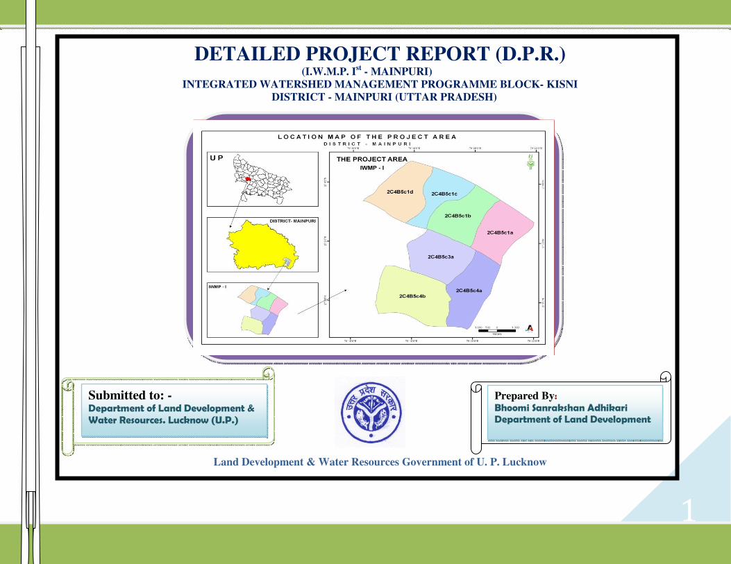
1 DETAILED PROJECT REPORT (D.P.R.) (I.W.M.P. I st - MAINPURI) INTEGRATED WATERSHED MANAGEMENT PROGRAMME BLOCK- KISNI DISTRICT - MAINPURI (UTTAR PRADESH) Land Development & Water Resources Government of U. P. Lucknow Submitted to: - Department of Land Development & Water Resources. Lucknow (U.P.) Prepared By: Bhoomi Sanrakshan Adhikari Department of Land Development

Welcome message from author
This document is posted to help you gain knowledge. Please leave a comment to let me know what you think about it! Share it to your friends and learn new things together.
Transcript
1
DETAILED PROJECT REPORT (D.P.R.) (I.W.M.P. I
st - MAINPURI)
INTEGRATED WATERSHED MANAGEMENT PROGRAMME BLOCK- KISNI
DISTRICT - MAINPURI (UTTAR PRADESH)
Land Development & Water Resources Government of U. P. Lucknow
Submitted to: - Department of Land Development & Water Resources. Lucknow (U.P.)
Prepared By: Bhoomi Sanrakshan Adhikari Department of Land Development

2
PREFACE
The integrated and participatory management and natural resources namely soil, water, vegetation, man, animal and environment
using watershed as unit is the key for sustainability of society, environment and production of food, fodder, fuel, fiber, fish, flower, forest
etc. About 80 percent of the world and 60 percent of the Indian Agriculture is rain dependent, diverse, complex, under-inverted risky,
distress prone and vulnerable. In district Mainpuri the selected area in the block Kisni for the development under I.W.M.P. Project is very
major problematic area due to misuse and over exploitation of resources and droughts. Many people are under below poverty line with low
production in agriculture, milk and other farming problems and migration of people for employment to other places etc are major problems
in selected area. The degradation of risk prone agro-ecosystem as a result of increased graded due to network of gullies, insufficient vegetal
cover, over exploitation of resources, poor production and starving farmers & animals are the limiting factors for prosperity to posterity.
A detailed project plan (DPR) is prepared for the approval of Panchayat, State Govt. and National Rain fed Authority MoA and Govt.
of India for the sanction of budget. The report includes scientific and integrated management of all natural resources namely water, soil,
vegetation, animal and environment for sustainable production. The descriptions of physical, financial, technical and social details are well
highlighted for the development of watershed and expected benefits by mitigating the bad effects of problem area. The details have been
summarized as executive summary and Project at a glance.
The DPR of each micro watershed / village Panchayat will be prepared for development with each and every minute details using
detail survey and village map. Each work proposed by field works (WDT) will have all physical Financial , Technical and social details for
its administrative, technical and financial sanction by Panchayat, watershed manager and finally by PIA.
3
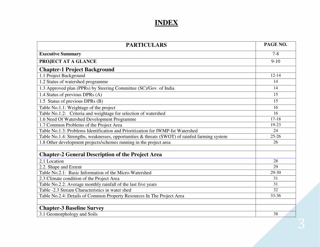
INDEX
PARTICULARS PAGE NO.
Executive Summary 7-8
PROJECT AT A GLANCE 9-10
Chapter-1 Project Background 1.1 Project Background 12-14
1.2 Status of watershed programme 14
1.3 Approved plan (PPRs) by Steering Committee (SC)/Gov. of India 14
1.4 Status of previous DPRs (A) 15
1.5 Status of previous DPRs (B) 15
Table No.1.1: Weightage of the project 16
Table No.1.2: Criteria and weightage for selection of watershed 16
1.6 Need Of Watershed Development Programme 17-18
1.7 Common Problems of the Project Area 19-23
Table No.1.3: Problems Identification and Prioritization for IWMP-Ist Watershed 24
Table No.1.4: Strengths, weaknesses, opportunities & threats (SWOT) of rainfed farming system 25-26
1.8 Other development projects/schemes running in the project area 26
Chapter-2 General Description of the Project Area
2.1 Location 28
2.2. Shape and Extent 29
Table No.2.1: Basic Information of the Micro-Watershed 29-30
2.3 Climate condition of the Project Area 31
Table No.2.2: Average monthly rainfall of the last five years 31
Table -2.3 Stream Characteristics in water shed 32
Table No.2.4: Details of Common Property Resources In The Project Area 33-36
Chapter-3 Baseline Survey
3.1 Geomorphology and Soils 38
4
Table No.3.1: Soil types for the district 38
3.2 Present Land Use in the Watershed 38
Table No.3.2: Area Under Major Land Use 39
3.3 Agriculture 40
3.4 Horticulture 41
3.5 Human And Live Stock Population 42
Table No.3.3: Demographic Feature of the Project area 42
Table No.3.4: Demographic Details 43
Table No.3.5: Livestock Details in the Project Area 44
Table No.3.6: Livestock Productivity 45
3.6 Infrastructure & Social Facilities 46
3.7 Livelihood 46
3.8 Depending on forest for fuel wood and fodder 46-47
Table No.3.7 Ground Water Status of the Project Area 47
Table No.3.8: Migration Details of the Project area 48-50
Table No.3.9: Details of infrastructure in the project areas 51-53
3.9- Livelihood Pattern 54
Table No.3.10: Formation of SHG (GP wise) 54-62
3.10 Dependency on forest for fuel wood and fodder 63
3.11 Crop Calendar 64
3.12 Land Holdings 65
Table No.3.11: Land Holding Village-Wise 65
3.13 Scientific Planning 66
3.15 Participatory Rural Appraisal (PRA) 66-67
Table no. 3.12: Details of scientific planning and inputs in IWMP-I projects 68-69
3.16 Farmers Preferences for Fruit Trees 70
3.17 Fodder Plants 70-71
3.18 Integrated and Participatory Planning & Development 72
Table No.3.13: Details of Cropping Pattern 72-74
Table No. 3.14: Demostration of Mazor Crops (Component Wise cost) 75-77
3.19 Crop Varieties recommended for West region of UP by different ICAR Institutes and SAUs. 78-80
Chapter-4 Project Management And Action Plan
4.1 Details of P.I.A. 82
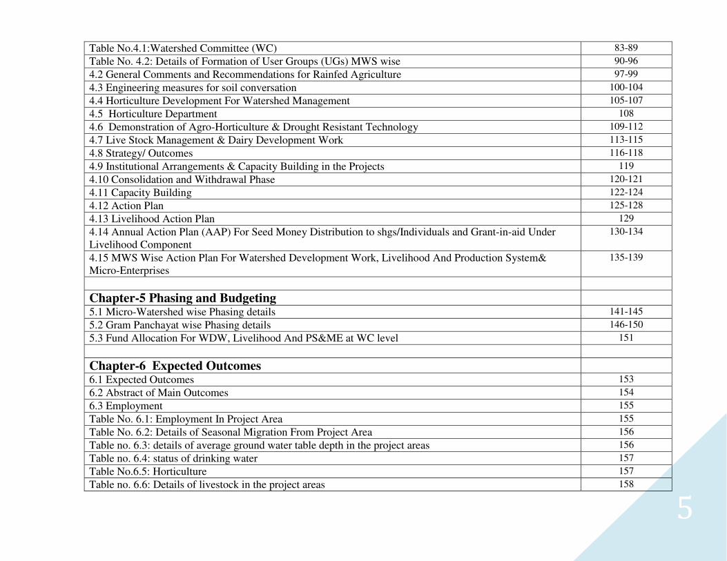
5
Table No.4.1:Watershed Committee (WC) 83-89
Table No. 4.2: Details of Formation of User Groups (UGs) MWS wise 90-96
4.2 General Comments and Recommendations for Rainfed Agriculture 97-99
4.3 Engineering measures for soil conversation 100-104
4.4 Horticulture Development For Watershed Management 105-107
4.5 Horticulture Department 108
4.6 Demonstration of Agro-Horticulture & Drought Resistant Technology 109-112
4.7 Live Stock Management & Dairy Development Work 113-115
4.8 Strategy/ Outcomes 116-118
4.9 Institutional Arrangements & Capacity Building in the Projects 119
4.10 Consolidation and Withdrawal Phase 120-121
4.11 Capacity Building 122-124
4.12 Action Plan 125-128
4.13 Livelihood Action Plan 129
4.14 Annual Action Plan (AAP) For Seed Money Distribution to shgs/Individuals and Grant-in-aid Under Livelihood Component
130-134
4.15 MWS Wise Action Plan For Watershed Development Work, Livelihood And Production System& Micro-Enterprises
135-139
Chapter-5 Phasing and Budgeting
5.1 Micro-Watershed wise Phasing details 141-145
5.2 Gram Panchayat wise Phasing details 146-150
5.3 Fund Allocation For WDW, Livelihood And PS&ME at WC level 151
Chapter-6 Expected Outcomes
6.1 Expected Outcomes 153
6.2 Abstract of Main Outcomes 154
6.3 Employment 155
Table No. 6.1: Employment In Project Area 155
Table No. 6.2: Details of Seasonal Migration From Project Area 156
Table no. 6.3: details of average ground water table depth in the project areas 156
Table no. 6.4: status of drinking water 157
Table No.6.5: Horticulture 157
Table no. 6.6: Details of livestock in the project areas 158

6
Table no. 6.7: Backward-forward linkages 159
Table No.6.8 Logical Framework Analysis 160-163
Chapter-7 Consolidation and Withdrawal Strategy
7.1 Quality and Sustainability Issues 165
7.2 Plans For Project Management 166
7.3 Watershed Development Fund 166
7.4 User Charges 166
MAPPING 168-175
� Location Map � Base Map � Land Use/ Land Cover Map � Drainage Map � Contour Map � Transport Map � Slope Map � Plan Map
Annexure 176-182
7
EXECUTIVE SUMMARY
The sanctioned project covers Seven micro-watersheds 2C4B5c1d (Sonasi), 2C4B5c4a (Mahauli Samsherganj), 2C4B5c4b (Basait), 2C4B5c1c (Badhauni), 2C4B5c3a (Rathe), 2C4B5c1a (Sathigawan), 2C4B5c1b (Tariha) covered by fifteen villages under twelve gram panchayat of Kisni block of the Mainpuri district of U.P. The selected IWMP Ist project is covering 5561.65 ha geographical area. The watershed cluster fall in between 26˚ 59’4.263” N to 27˚ 4’ 44.86” N latitude and 79˚ 16’ 21.134” E to 79˚ 2’ 58.507” E longitude. The treatable area is 4004.00 ha. Main problem is low rainfall (789.782 mm) with uneven distribution, resulting to draught, undulating slopy terrain with sandy soil along with Arind river bank. Population is not rich and grouped as marginal (3576) small (1112 ) and large farmers (750). About 419.05 areas come under waste land, which is prioritized for treatment under watershed management programme. There are block orchard plantations in the locality which are a potential land use for draught affected area. There is no small or big industry in the project area having unemployment and poverty. Total human population is 49074.00 with 25511.00 male and 23563.00 female. The livestock population of the project is 13992 cow 24270 buffalos and 10588 sheep, goat and pig, milch animals.
In general the entire area is an alluvial plain, with a gentle slope, near about 1%. from north-west to south-east. There are serval natural depressions apart from those formed by the river valleys and drainage lines. Elevated sand ridges are also found especially in the west of the district. Overall, these soils are characterized by their extreme depth, often several hundred feet, and a gray or grayish brown colour. Their texture varies from sandry, sandy loam to clay loam, Their structure is also variable, being loose, open and free draining in case of the sandy soils and compact impervious in case of the clayey soils. Agriculture is the main occupation of the people of the selected project. The crops mainly raised in the district are Bajra, Maize, Mustard, Wheat, Potato, Vegetables, Rose, Moong, Arhar, Garlic and Sugar cane. However, major area is covered under Bajra, Maize, Wheat & Mustard crops. While the farmers of watershed area are extensively depends on Rice, Wheat and Bajra. Most of the lands are fallow during the Kharif season because of unavailability of assured irrigation. Only 45% area during Kharif season is cropped under the watershed area. While in Rabi season, it increase over the kharif and reached near about 65%. Thus, it clearly indicate that sustainable development of agriculture needs assured irrigation. Natural vegetation of the watershed area is very poor. The vegetation in predomination are Vilayati Babul (Prosopis juliflora), Babul (Acacia nilotica). Occasional occurrence of Neem, Shisham, Anola etc. There is no grass land in the watershed. The patches of grasses are seen only on the bunds, road side, ridges etc. The watershed area are greatly affected by the soil erosion. Erosion occurred in this area mainly through Sheet erosion (about 60%) Rill erosion (about 26%) and Gully erosion (about 10%) of the total proposed area. This problem may be corrected by harvesting the additional water in existing water harvesting structures, which have lost most of their capacity due to siltation which results in creating new water bodies. The stored water in such structures, provided supplemental irrigation at critical growth stages of crops as well as fruit, orchards and forest tree. In agricultural land will treated with buding along with minor leveling. Waste land will be treated with the engineering measures like staggered trenches and a forestation etc.
8
India is rich country in natural resources but low production and poverty due to unscientific and mismanagement of resources. India receives maximum rainfall as Compared to any other adjacent country. Eventhough various draughts and floods occur alternatively or simultaneously in various parts of country. Due to high fertility of alluvial soil has a lot of potential to feed grain. The Land development and water resources department has accepted the challenge to conserve and manage soil and water rsources in the project area. Integrated and participated development of watershed has been proved to be only solution for sustainability of society, environment and production of food. Fodder, forest fruits fuels, fiber flower etc. This fact has been realized by National Rain fed Authority of India and MoRD and they sanctioned a very comprehensive watershed development plan for overall development of India. The Ultimate goal of project is healthy and wealthy people by achieving following targets Change of 285.20 ha temp. wasteland and 133.85 ha. permanent wasteland. Project is tested and analyzed for its profitability as SWOT, FOVEASS, Logical Framework analysis, NPV cost benefit Ratio ( 1.30:1), IRR (20.60) and also Sensitivity analysis and found highly cost effective and profitable . The detail summary of the project in given in the next page under following heads.
a. Physical and Financial details of project b. Physical and Financial details of proposed activities. c. Land Use plan (in hect.) d. Achievements and performance of water sheds. e. Code of micro water sheds of the project.
9
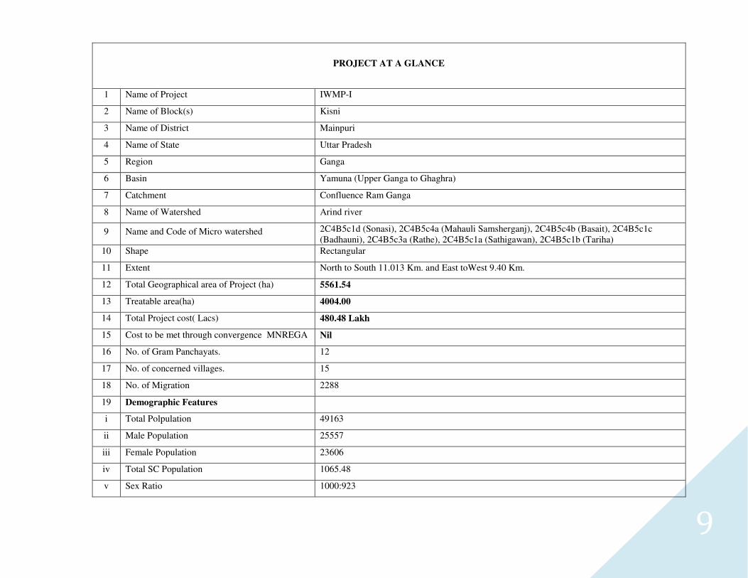
PROJECT AT A GLANCE
1 Name of Project IWMP-I
2 Name of Block(s) Kisni
3 Name of District Mainpuri
4 Name of State Uttar Pradesh
5 Region Ganga
6 Basin Yamuna (Upper Ganga to Ghaghra)
7 Catchment Confluence Ram Ganga
8 Name of Watershed Arind river
9 Name and Code of Micro watershed 2C4B5c1d (Sonasi), 2C4B5c4a (Mahauli Samsherganj), 2C4B5c4b (Basait), 2C4B5c1c (Badhauni), 2C4B5c3a (Rathe), 2C4B5c1a (Sathigawan), 2C4B5c1b (Tariha)
10 Shape Rectangular
11 Extent North to South 11.013 Km. and East toWest 9.40 Km.
12 Total Geographical area of Project (ha) 5561.54
13 Treatable area(ha) 4004.00
14 Total Project cost( Lacs) 480.48 Lakh
15 Cost to be met through convergence MNREGA Nil
16 No. of Gram Panchayats. 12
17 No. of concerned villages. 15
18 No. of Migration 2288
19 Demographic Features
i Total Polpulation 49163
ii Male Population 25557
iii Female Population 23606
iv Total SC Population 1065.48
v Sex Ratio 1000:923
10
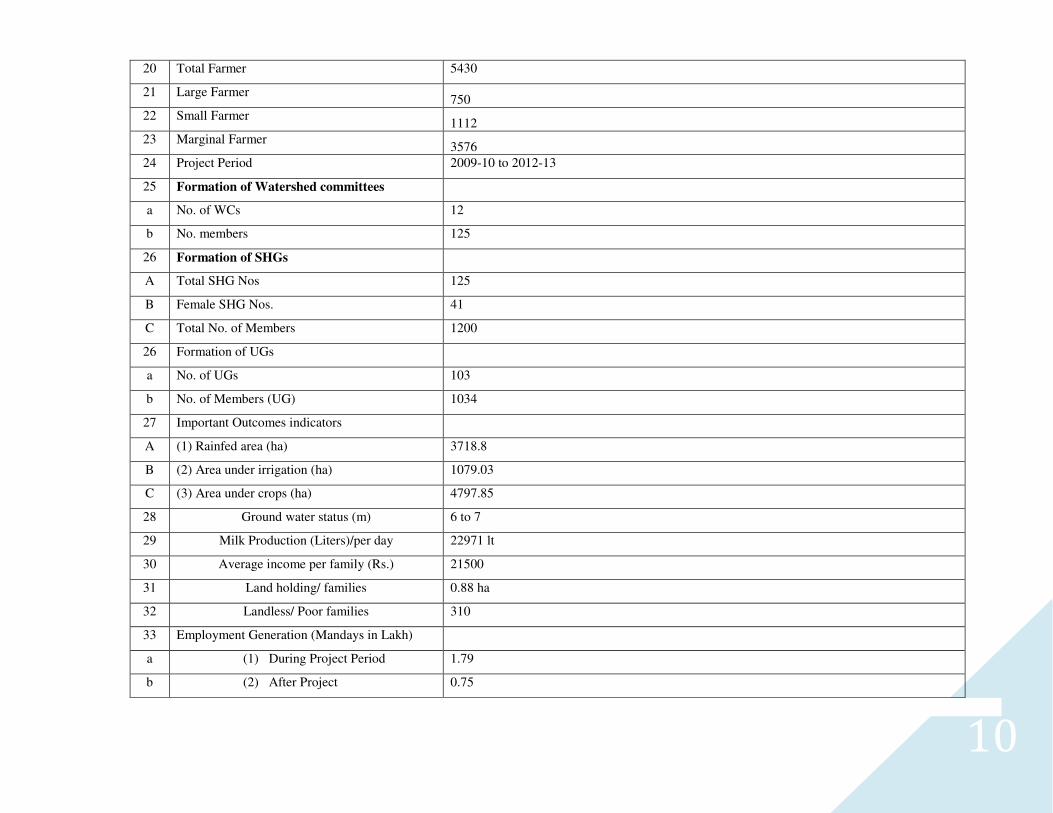
20 Total Farmer 5430
21 Large Farmer 750
22 Small Farmer 1112
23 Marginal Farmer 3576
24 Project Period 2009-10 to 2012-13
25 Formation of Watershed committees
a No. of WCs 12
b No. members 125
26 Formation of SHGs
A Total SHG Nos 125
B Female SHG Nos. 41
C Total No. of Members 1200
26 Formation of UGs
a No. of UGs 103
b No. of Members (UG) 1034
27 Important Outcomes indicators
A (1) Rainfed area (ha) 3718.8
B (2) Area under irrigation (ha) 1079.03
C (3) Area under crops (ha) 4797.85
28 Ground water status (m) 6 to 7
29 Milk Production (Liters)/per day 22971 lt
30 Average income per family (Rs.) 21500
31 Land holding/ families 0.88 ha
32 Landless/ Poor families 310
33 Employment Generation (Mandays in Lakh)
a (1) During Project Period 1.79
b (2) After Project 0.75
11
CHAPTER- 1
12
1.1 INTRODUCTION AND BACKGROUND
In the era of globalization and phenomenal technological progress, Indian agriculture faces the twin challenges of meeting the rising demand
for food of increasing population and making the best use of technologies and recourses for production. Agriculture is the backbone of Indian
economy and about 75 Percent population totally depend on agriculture and our water resources are maximum as compared to any country of this size
but we are facing severe drought and flood alternately and simultaneously in different parts of the country. As a result of mis-management, land
resources are degrading at a faster rate resulting in low production and high poverty. Out of 329 million ha of total area of our country, about 53.5
percent (175 million ha) is in the urgent need of soil and water conservation measures. Every year we are losing about 5334 million tones of soil and
18.8 billion cubic meter water along with 10 million tones fertilizing and other nutrient elements. The century facing very low production of agriculture
and problem of food and poverty to the farmers. Which are affecting prosperity to the posterity. It has been proved beyond doubt during the last 30
years that integrated and participatory watershed development especially in drought region is the only answer of social upliftment of rural folk
and need to successive changes in overall development for the country.
Selected area in the Mainpuri district is facing problems in a very aggravated condition due to mismanagement resources and population
pressure of human and animals, which are causing resource degradation at an alarming rate with low productivity and various problems of soil & water
down below. The project area of 4004.00 ha. of I.W.M.P.- I, under Arend watersheds out of total geographical area of 5561.65 ha. of all
comprised villages in which 419.05 ha. is under Wasteland.
Ministry of Rural Development Govt. of India, New Delhi realized the problem of the selected area in the block Kishniin the Mainpuri district to
remove the problem and sanctioned the budget for Integrated Watershed management Project under Deptt. to Land Development and Water Resources
Mainpuri (UP) with budgetary provision of Rs. 480.48 lakh for Mainpuri district of UP The master plan of IWMP Ist of Mainpuri watershed has been
prepared by conducting detailed integrated survey, intensive exercise on Participatory Rural Appraisal (PRA), Rapid Rural Appraisal (RRA),
experience gained and recommendations made by various state, national & international watershed development authorities.
13
1.1.1 OBJECTIVES OF THE PROJECT (SCHEME)
1. To promote the economic development of the village community which is directly or indirectly dependent on the watershed through?
a. Optimum utilization of the watershed's natural resources namely land, water, vegetation animal etc. that will ensure sustainability of production & society and mitigation of drought by scientific and judicious management of water resources.
b. Employment generation and development of the human especially landless and ladies and other economic resources of the village in order to promote savings
and other income generation activities.
2. To encourage restoration of ecological balance in the watershed through;
a. A scientific and judicious management of natural resources so that flood and draught, land, water & nutrients can be conserved, productivity and income can be improved and other problems namely sedimentation of reservoirs, communication failures, ravine development, pollution of air and water etc. can be minimized.
b. Sustained community action for the operation and maintenance of assets created and further development of the potential of the natural resources in the
watershed. c. Simple, easy and affordable technological solutions and institutional arrangements that make use of, and build upon, local technical knowledge and
available materials to improve bio-diversity, environment and sustainability in all spheres.
3. Special emphasis to improve the economic and social condition of the resource-poor and the disadvantaged sections of the watershed community such as
the asset less and the women through:
a. More equitable distribution of the benefits of land and water resources development and the consequent biomass production. b. Greater access to income generating opportunities and focus their human resource development.
4. Human resource development through working, training and visits at all levels namely administrators, technicians, field workers and beneficiaries. The project will yield a valuable and permanent system of brotherhood, love and effective cooperation amongst the villagers and watershed authorities by working with the groups and membership of various village institutions.
14
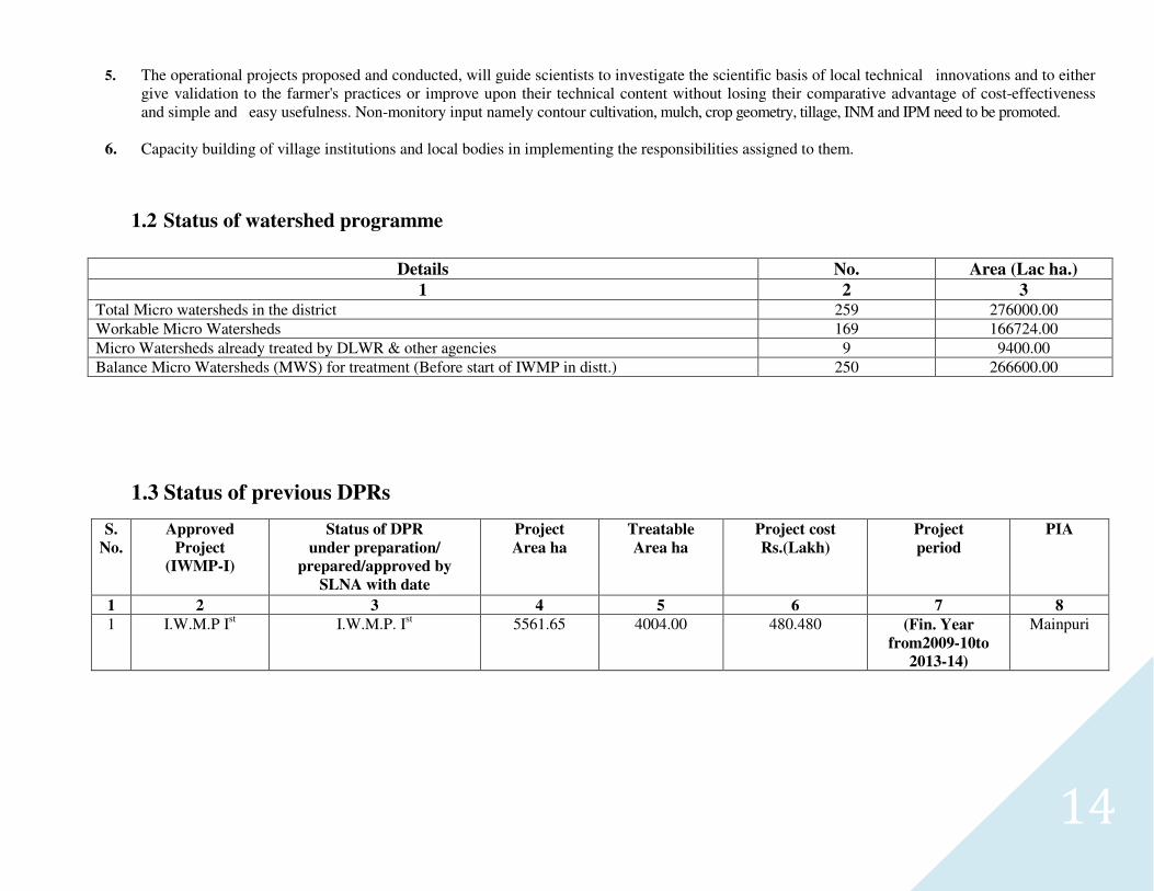
5. The operational projects proposed and conducted, will guide scientists to investigate the scientific basis of local technical innovations and to either give validation to the farmer's practices or improve upon their technical content without losing their comparative advantage of cost-effectiveness and simple and easy usefulness. Non-monitory input namely contour cultivation, mulch, crop geometry, tillage, INM and IPM need to be promoted.
6. Capacity building of village institutions and local bodies in implementing the responsibilities assigned to them.
1.2 Status of watershed programme
Details No. Area (Lac ha.)
1 2 3 Total Micro watersheds in the district 259 276000.00 Workable Micro Watersheds 169 166724.00 Micro Watersheds already treated by DLWR & other agencies 9 9400.00 Balance Micro Watersheds (MWS) for treatment (Before start of IWMP in distt.) 250 266600.00
1.3 Status of previous DPRs
S.
No. Approved
Project (IWMP-I)
Status of DPR under preparation/
prepared/approved by
SLNA with date
Project Area ha
Treatable Area ha
Project cost Rs.(Lakh)
Project period
PIA
1 2 3 4 5 6 7 8 1 I.W.M.P Ist I.W.M.P. Ist 5561.65 4004.00 480.480 (Fin. Year
from2009-10to
2013-14)
Mainpuri
15
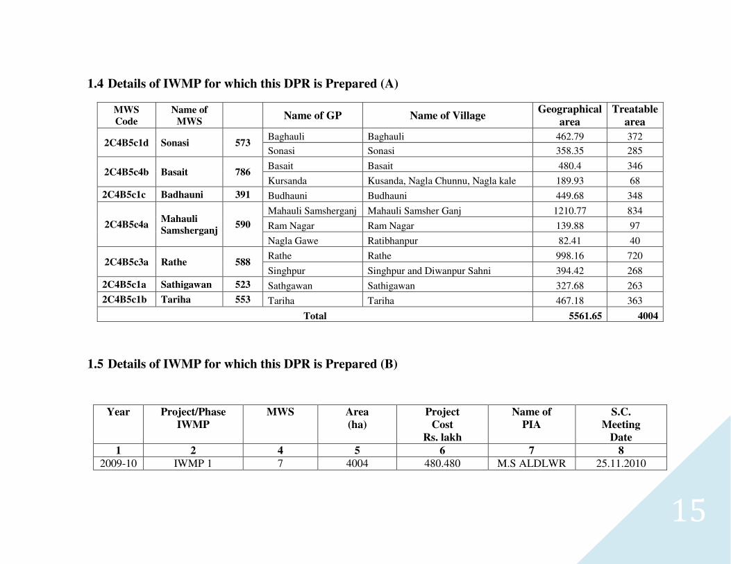
1.4 Details of IWMP for which this DPR is Prepared (A)
MWS
Code Name of
MWS Name of GP Name of Village
Geographical
area
Treatable
area
2C4B5c1d Sonasi 573 Baghauli Baghauli 462.79 372
Sonasi Sonasi 358.35 285
2C4B5c4b Basait 786 Basait Basait 480.4 346
Kursanda Kusanda, Nagla Chunnu, Nagla kale 189.93 68
2C4B5c1c Badhauni 391 Budhauni Budhauni 449.68 348
2C4B5c4a Mahauli
Samsherganj 590
Mahauli Samsherganj Mahauli Samsher Ganj 1210.77 834
Ram Nagar Ram Nagar 139.88 97
Nagla Gawe Ratibhanpur 82.41 40
2C4B5c3a Rathe 588 Rathe Rathe 998.16 720
Singhpur Singhpur and Diwanpur Sahni 394.42 268
2C4B5c1a Sathigawan 523 Sathgawan Sathigawan 327.68 263
2C4B5c1b Tariha 553 Tariha Tariha 467.18 363
Total 5561.65 4004
1.5 Details of IWMP for which this DPR is Prepared (B)
Year Project/Phase
IWMP
MWS Area
(ha)
Project
Cost
Rs. lakh
Name of
PIA
S.C.
Meeting
Date
1 2 4 5 6 7 8
2009-10 IWMP 1 7 4004 480.480 M.S ALDLWR 25.11.2010
16
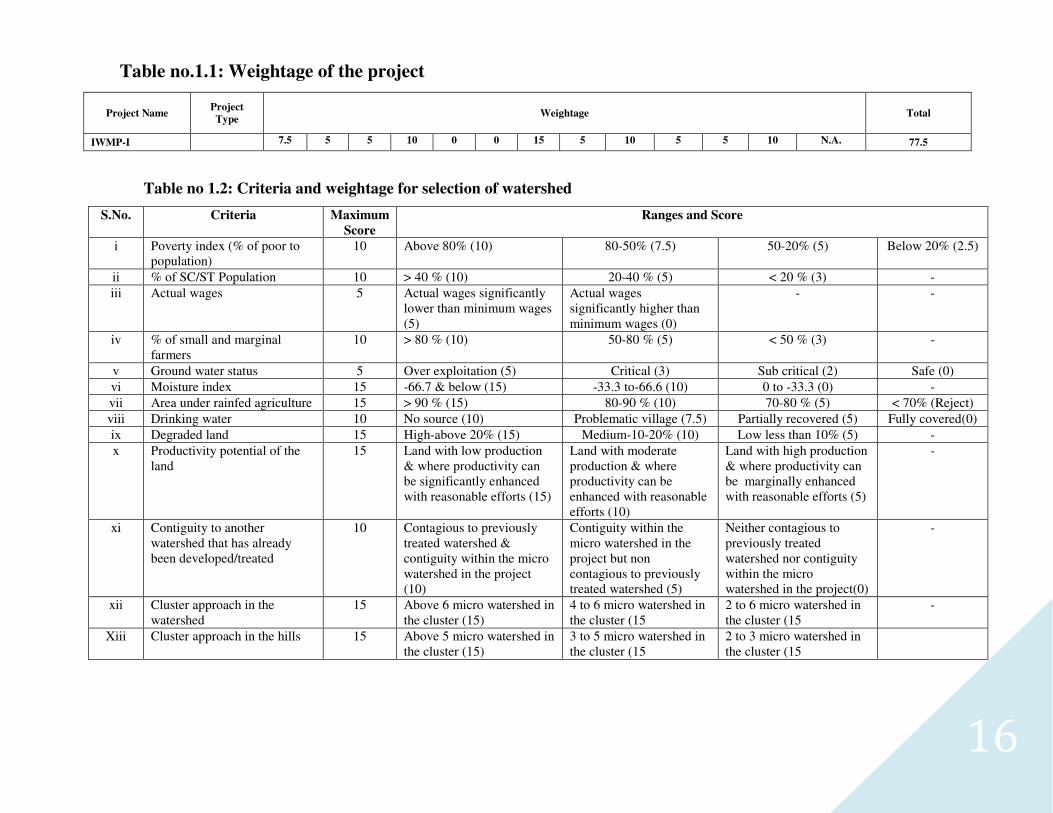
Table no.1.1: Weightage of the project
Project Name Project
Type Weightage Total
IWMP-I 7.5 5 5 10 0 0 15 5 10 5 5 10 N.A. 77.5
Table no 1.2: Criteria and weightage for selection of watershed
S.No. Criteria Maximum
Score
Ranges and Score
i Poverty index (% of poor to population)
10 Above 80% (10) 80-50% (7.5) 50-20% (5) Below 20% (2.5)
ii % of SC/ST Population 10 > 40 % (10) 20-40 % (5) < 20 % (3) -
iii Actual wages 5 Actual wages significantly lower than minimum wages (5)
Actual wages significantly higher than minimum wages (0)
- -
iv % of small and marginal farmers
10 > 80 % (10) 50-80 % (5) < 50 % (3) -
v Ground water status 5 Over exploitation (5) Critical (3) Sub critical (2) Safe (0)
vi Moisture index 15 -66.7 & below (15) -33.3 to-66.6 (10) 0 to -33.3 (0) -
vii Area under rainfed agriculture 15 > 90 % (15) 80-90 % (10) 70-80 % (5) < 70% (Reject)
viii Drinking water 10 No source (10) Problematic village (7.5) Partially recovered (5) Fully covered(0)
ix Degraded land 15 High-above 20% (15) Medium-10-20% (10) Low less than 10% (5) -
x Productivity potential of the land
15 Land with low production & where productivity can be significantly enhanced with reasonable efforts (15)
Land with moderate production & where productivity can be enhanced with reasonable efforts (10)
Land with high production & where productivity can be marginally enhanced with reasonable efforts (5)
-
xi Contiguity to another watershed that has already been developed/treated
10 Contagious to previously treated watershed & contiguity within the micro watershed in the project (10)
Contiguity within the micro watershed in the project but non contagious to previously treated watershed (5)
Neither contagious to previously treated watershed nor contiguity within the micro watershed in the project(0)
-
xii Cluster approach in the watershed
15 Above 6 micro watershed in the cluster (15)
4 to 6 micro watershed in the cluster (15
2 to 6 micro watershed in the cluster (15
-
Xiii Cluster approach in the hills 15 Above 5 micro watershed in the cluster (15)
3 to 5 micro watershed in the cluster (15
2 to 3 micro watershed in the cluster (15
17
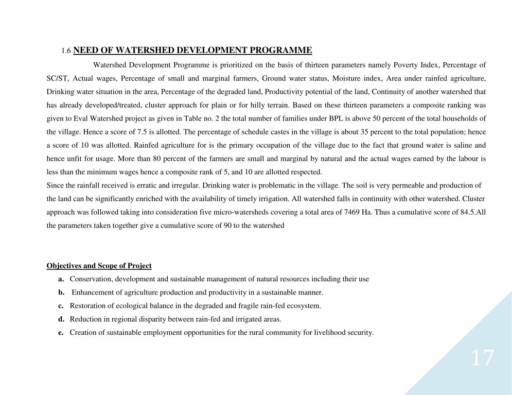
1.6 NEED OF WATERSHED DEVELOPMENT PROGRAMME
Watershed Development Programme is prioritized on the basis of thirteen parameters namely Poverty Index, Percentage of
SC/ST, Actual wages, Percentage of small and marginal farmers, Ground water status, Moisture index, Area under rainfed agriculture,
Drinking water situation in the area, Percentage of the degraded land, Productivity potential of the land, Continuity of another watershed that
has already developed/treated, cluster approach for plain or for hilly terrain. Based on these thirteen parameters a composite ranking was
given to Eval Watershed project as given in Table no. 2 the total number of families under BPL is above 50 percent of the total households of
the village. Hence a score of 7.5 is allotted. The percentage of schedule castes in the village is about 35 percent to the total population; hence
a score of 10 was allotted. Rainfed agriculture for is the primary occupation of the village due to the fact that ground water is saline and
hence unfit for usage. More than 80 percent of the farmers are small and marginal by natural and the actual wages earned by the labour is
less than the minimum wages hence a composite rank of 5, and 10 are allotted respected.
Since the rainfall received is erratic and irregular. Drinking water is problematic in the village. The soil is very permeable and production of
the land can be significantly enriched with the availability of timely irrigation. All watershed falls in continuity with other watershed. Cluster
approach was followed taking into consideration five micro-watersheds covering a total area of 7469 Ha. Thus a cumulative score of 84.5.All
the parameters taken together give a cumulative score of 90 to the watershed
Objectives and Scope of Project
a. Conservation, development and sustainable management of natural resources including their use
b. Enhancement of agriculture production and productivity in a sustainable manner.
c. Restoration of ecological balance in the degraded and fragile rain-fed ecosystem.
d. Reduction in regional disparity between rain-fed and irrigated areas.
e. Creation of sustainable employment opportunities for the rural community for livelihood security.
18
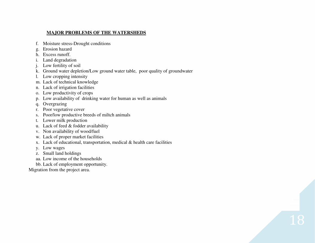
MAJOR PROBLEMS OF THE WATERSHEDS
f. Moisture stress-Drought conditions g. Erosion hazard h. Excess runoff. i. Land degradation j. Low fertility of soil k. Ground water depletion/Low ground water table, poor quality of groundwater l. Low cropping intensity m. Lack of technical knowledge n. Lack of irrigation facilities o. Low productivity of crops p. Low availability of drinking water for human as well as animals q. Overgrazing r. Poor vegetative cover s. Poor/low productive breeds of miltch animals t. Lower milk production u. Lack of feed & fodder availability v. Non availability of wood/fuel w. Lack of proper market facilities x. Lack of educational, transportation, medical & health care facilities y. Low wages z. Small land holdings aa. Low income of the households bb. Lack of employment opportunity.
Migration from the project area.
19
1.7 COMMON PROBLEMS OF THE PROJECT AREA
The watershed is subjected to various natural & man made desertification, low productivity and imbalanced ecosystem and socio-economic condition of the villagers as described here. The users, planner’s .developmental and funding agencies and administrators should make efforts to find solutions and create situations to avoid the following problems faced in the past for achieving successful project.
Natural Calamities –
1. Increase in number frequency, duration of metrological, hydrological and agriculture of droughts resulting in poor water storage and vegetal production. 2. During normal rainfall years the area receives rainfall during June to September and scanty & irregular showers during winter. Thus remaining period
suffers from draught due to low water conservation power of the area as result of erodible causing high run off conditions. 3. The sandy soil along river bank and also loam in other area has low water holding capacity and fertility as well. 4. The few torrential and erosive rain storms on weak and fragile ecosystem need suitable umbrella of vegetative cover to conserve soil 5. Area also suffers from comparatively higher temperature in summer.
Resource exploitation, miss-management & degradation
1. Reduction in water storage capacity of existing structures creating loss of irrigation potential. 2. The farmers are over cultivating degraded terraces, overgrazing grasslands, illicit felling and pollarding of forest trees. Thus, disturbing ecological
balance. 3. Lack of awareness and absence of soil conservation works to be adopted by the farmers and state Govt. 4. The watershed does not have the good soil for water harvesting, storage & re-cycling by way of constructing embankment, gully plugs, ponds, nala bundling
etc. to face the challenge of drought by providing life saving irrigation to the crops mitigating erosion and flood on foot hills. 5. The productivity of Agriculture, Horticulture, and Animal husbandry is far below the optimum level due to following reasons.
(I) Great dependence on monsoon: (II) Insufficient fertilizer per unit cropped area: (III) Traditional farming methods: (IV) Lack of adequate farm machinery: (V) Lack of finances for farmers: (VI)Lack of good quality seeds and fertilizers:
20
Administration-
1. The planning of watershed is a bottom up approach based on PRA & RRA. While it was suffering due to its dependence almost entirely on the top
down bureaucracy with very little participation of the villagers.
2. Watershed management is a multi-disciplinary and multi-pharaohs activity which calls for active participation of the entire related state department but it
is suffering from poor co-operation and superiority complex.
3. In many cases the Chief administrator felt helpless to co-ordinate the activities by involving the departments due to their busy schedule a political
pressure & poor administrative hold on other departments Thus, the system of joint responsibility of sharing activities is almost paralyzed.
4. Frequent transfers of competent and experienced officers and posting of untrained and inexperienced officers with the qualification not related with the
watershed development. The development by planers will yield added success.
5. The watershed development is a difficult task in the backward and remotely situated areas and the men have to settle their families in the towns far
away from the watershed having house, medical and education facilities. The hardship of watershed managers is not generally considered by
sanctioning project disturbance allowance and facilities which ultimately lead to suffering of the work and employees.
Facilities and finances –
1. The project implementing agency, responsible for watershed Development, does not have sufficient facilities. The machines and implements namely tractor,
bulldozer, jeep, improved quality seed and breed of animal etc. The PIA officer does not get sufficient co-operation from the other Govt. Depts. for
satisfying these needs.
2. A field laboratory for testing important parameters of soils, water, vegetation, animal etc. is generally not provided to the watershed development
project.
3. In many cases watershed manager does not get sufficient funds as per actual estimate and grant is based on the standard and estimate fixed in the previous
years having low rates of material and labour.
4. It is a common problem in most of the department as a whole. The funds are not provided as per work and execution schedule and made available
sometimes in the last week of financial year which is affecting quality & quantity of work, misuse and misappropriation of funds.
5. Funds are very limited and as per rough estimate the rate of resource degradation and reclamation measures in our country are almost going on
with the same speed.
6. There is also fear that a rapid expansion of the intellectual property regime, which is now beginning to cover scientific findings & important to
food, health security and other basic life support systems, New technology may not be readily available to resource poor rural families.
7. Poverty of people availability/untimely of suitable input and technology.
Socio-economic –
1. The farmers of the area are poor because many of them are either landless or having uneconomic small holdings resulting the status of farmers
below the poverty line.
21
2. The production of the crops of horticulture, agriculture and grass from panchayat and gazing lands is far below the optimum level. The villagers don't have sufficient alternate land use and income.
3. Few unemployed youths and workless villagers are in the habit of gambling and drinking.
4. Ladies are over worked in the house as well as in the field.
5. The self interest to grasp benefits by individuals, influential persons, politicians and between sub villages
Industrialization of watershed –
1. There is no small or big factory in the watershed for employment of the people. 2. Alternate land use as source of additional income namely bee-keeping, mushroom production, sericulture, piggery, fishery, dairy processing etc. on
commercial scale are beyond the imagination of the dwellers in most of Project areas. 3. The Operational facilities of banking for the loan at a low interest for the purchase of farm inputs are not there. The farmers are dependent on local
money lenders, charging high interest rate. 4. The facilities of storage, marketing and transport of the village produce are very meager or absent.
Methodology for the preparation of DPR
I. Use of available of information
The collection of data and details from following sources
A. Statistics of state district and Panchayat
B. Achievements technology from state line departments namely agriculture, horticulture, forestry industries etc.
C. Satellite images
D. Thematic Maps
E. Visit of already developed watershed in the locality.
F. Study of available watershed proposal and estimates.
II. Records at Watershed level
A. Available Records
1. Block Development office
2. Village Panchayat
3. Lekhpal (Revenue) and Supervisors of State line Department
B. Existing developmental activities
1. Pond, irrigation tank, Channel
2. Check Dam, Retentions wall in gully and slide spot area
3. Drinking water structures
4. Agriculture, horticulture, animal husbandry and village industries
5. Forestry, Pasture and staggered trenches and common land
22
6. Distribution of improved seeds of grain and vegetables
7. SHG, UG, Van Panchayat etc.
III. Details of Estimates
1. Estimates Prepared by field worker for the project proposal, to be checked by J.E. and Soil Conservation Officer
IV. Meetings
1. Visit of the area and discussion with the formers using PRA and RRA exercises.
2. Group discussion-with office bearers of village institutions namely WDT and WC.
3. Discussions with district water advisory unit consisting of state line department.
4. Training details of PIA, WDT, and Beneficiaries
V. Steps of Report Preparation
A. Study of Maps
1. Village Cadastral map 1:4000
2. Toposheet 1:50000/ 1:25000/ 1:250000. Toposheep No. 54M/8 AND 54N/5
3. Micro watershed map of all Prepared by RSAC, UP,
4. Satellite Image processing
5. Superimpose of sajra map on high resolute satellite image.
6. Contouring
7. Net planning on maps
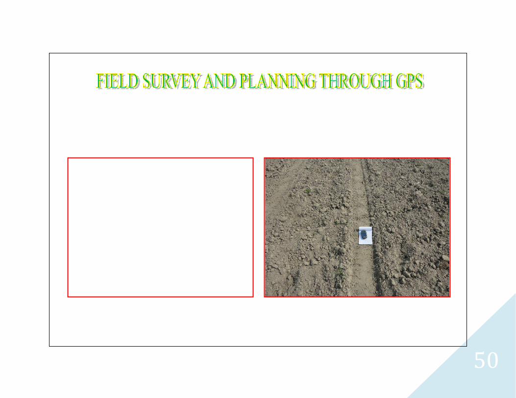
B. Baseline Survey with GPS (Orgon 550)
1. Detailed intergraded basic resources/bench mark surveys and demarcating the present and proposed land uses, land treatment etc.
C. PRA
1. The PRA was Guiding principal and this will empower the farmers in decision making by sharing responsibilities and accountabilities of activities
to be carried out by focusing on economic, ecological, equity, efficiency and empowerment
D. Project Report
1. Need Problems General descriptions of resources, present and proposed land use and treatment, budget, drawing and estimate of work etc.
E. Editing and improvement of report
The well qualified consultants of watershed survey, Planning, development, monitoring and evaluation were engaged for editing and improvement of
the report.
Process step from planning
The following nine process steps were applied for net planning of watershed as summaries below.
STEP-1 Secondary data collection:- During the five days visit programme in the micro watershed project with of all available documents of village label by approaching the
Gram panchayat collected secondary data.
23
STEP-2 Village meeting & conducting PRA exercise:- Community meeting conducted on fix days for the consultation with villagers for the PRA Exercise. Participatory
mode of the villages was positive indicated for the success of programme. With good in testing participation has been drawn social & resource map on ground & paper &
discussed unvarious topics of problematic thoughts in the micro watershed.
STEP-3 Socio economic survey: - The resource organization of village label volunteers identified to conduct house hold socio economic survey/states.
STEP-4 Probe typology analysis:-Thoroughly analyzed the data & identified problem type as soil & moisture conservation, crop rotation, crop coverage, productivity,
livelihoods, social issues & capacity building gaps etc. Problems discussed with the watershed committee & came up with alternative solution.
STEP-5 Conduct of net participatory planning (NPP):- The planning team visited together in the planning blocks on the scheduled date along with the beneficiaries of the
villages & data gathered as for the participatory net planning.
STEP-6 Productivity & livelihood planning exercise: - For the product livelihood exercise, group discussion on various livelihoods as Agriculture, Animal husbandry
enterprise development held discussion with the villagers in the micro watershed.
STEP-7 Institutional & capacity building: - This plan is prepared based on the data available in the field and auscultations with the watershed committee.
STEP-8 Data consolidation & documentation of DPR: - After gathering all required information compiled collected data. Thoroughly discussed and finalized the expected
outcomes and benefits especially in the respect of livelihood for different segments. These are the target and performers indicators for the micro watershed.
STEP-9 Conduct of Gram Sabha obtaining approvals submissions of DPR.:-After preparation of the draft DPR convened to Gram sabha and activities proposed
expected outcomes benefits of implementing the programme are explained in case of any changes are proposed in the Gram sabha approval obtained by the Gram sabha and
already singed of paper.
STEP-9A Attachment of detail estimate, cost and design:-Estimating, Costing and design prepared technically According to plan in the micro watershed project and attached
with the DPR.
STEP-9B various type of mapping: -
DPR prepared in the support of micro watershed project using various types of maps is as follows:
1. Cadastral map (Village) 2. Land use map/Land Cover map 3. Drainage/stream order map 4. Contour map 5. Slope map 3. Action Plan map 6. Micro watershed map 7. Digital Elevation Map 8. Satellite Image Map 9. Base map etc.
24
Table No.1.3: Problems Identification and Prioritization for IWMP-Ist Watershed
S.No. Major Problems Reasons Remedy Rank
1 Low production of crops Lack ofc/seed & fertilizer. timely provide c/seed & fertilizer insisting by demonstration 8
2 Lack of irrigation water Less under ground & surface water. By planning & execution of soil conservation measures. 4
3 Lack of drinking water Lack of the hand pump, well, & water supply . repairing of damaged hand pump& well, 3
4 Non availability of fuel wood Lack of the fuel trees, By planning of agro forest &horticulture 8
5
Lack of inputs like high yield seeds,
Lack of the input ,related knowledge & money
Encouraging to former about & generating employment work & SHG 5 fertilizers, pesticides etc.
6
Medical and health care facilities
Remote v/hospital & more animals ,Anna pratha,
First aid knowledge by training & awareness for Anna pratha. 5
for milch animals consequently low milk productivity
7
Lack of fodder availability
No interest in pasture development Provision of pasture development 4 and low annual productivity
8 Lack of medical & engg. educational Institute at remote place & costly education
Insisting by training & engaging in work & SHG for money problem 3
9 Transportation facilities Un sufficient vehicle & approaching rood. By organization of SHG 2
10 Marketing distance Mandi Samitti and Bazar 6
25
Table No.1.4: Strengths, weaknesses, opportunities & threats (SWOT) of rainfed farming system
S. N0.
Parameter Strengths Weaknesses Opportunities Threats
1 Climate
Unimodal rainfall with south west
monsoon and well defined period of
rains.
Low and erratic/ rainfall, high evapotranspiration and terminal
drought.
short duration kharif season crops and varieties to
formulate intercropping systems
Long dry spells & delayed onset & early
withdrawal of monsoon reduce the length of
growing season.
2 Soil
Soils with moderate depth, good water
retention and reserve of nutrients.
Low organic carbon content and poor workability
Good productivity of soils with moderate water
retention
Soil crusting, poor structure and soil erosion hazards.
3 Water
Moderate water availability. Water
harvesting structures (dams, tanks and
pond) well developed
Low discharge from Spring, ineffective conveyance systems
and surface water storage structures.
High potential for rain water harvesting storage and
recycling Ample opportunities for soil water recharge through soil water
conservation works on watershed approach.
Over use of water causing harm to soil.
4 Plant
Highly diverse, well adopted genotype
with high yield potential.
Long duration traditional crops, Low yielding pasture lands with
sparse vegetation and low carrying capacity.
Improved cropping systems, with suitable crops &
varieties to match weather conditions. Cultivation
practices to augment the crop yields.
Over grazing of pasture lands, deforestation, degradation & low carrying capacity of
lands.
5 Livestock
Well adopted indigenous breeds of cattle sheep and goat.
Cross breds in pockets.
Low productivity, unplanned feeding and management.
Disease epidemics and fodder scarcity.
Improved breeding, feeding and health management
practices. Improved cross breeds.
Loss of live stock during famine years, Starvation
due to shrinkage of grazing lands.
26
6
Humans
High population and agricultural
manpower, women workers contribute to
a large extent of agricultural laborers.
Poverty, illiteracy and less receptivity to innovations.
Manpower unutilized during lean period.
Effective HRD activities through various training
programmes. Good demand for skilled labour in
industries.
Under employment due to increasing population
and land less labours.
7 Research Good information and network of research
support.
poor linkage with farmers, Financial constraints.
Updating the knowledge and skill of researchers,
Strengthening the inter institutional linkages.
Low adoptability of improved technology, Scarce feed back to
researchers.
8 Develop-ment
Network of extension agencies Deptt. of
Agriculture, NGO's, KVK's etc.
Lack of effective linkage with researchers and updating the
technology.
HRD through trainings, visits and incentives for working in
rural areas.
Transfer of technology to fields at slow pace,
Operational and institutional constraints
dominate.
1.8 Other development projects/schemes running in the project area
These programmes are-
1. mahatma Gandhi National Rural Employment Guarantee Scheme (MGNREGS),
2. Swarnjayanti Gram Swarojgar Yojna (SGSY),
3. Indra Awas Yojna etc.
27
CHAPTER- 2
28
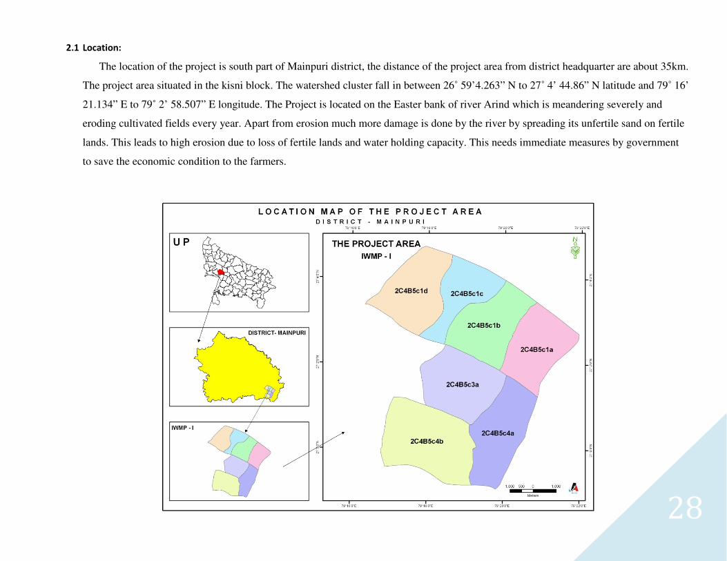
2.1 Location:
The location of the project is south part of Mainpuri district, the distance of the project area from district headquarter are about 35km.
The project area situated in the kisni block. The watershed cluster fall in between 26˚ 59’4.263” N to 27˚ 4’ 44.86” N latitude and 79˚ 16’
21.134” E to 79˚ 2’ 58.507” E longitude. The Project is located on the Easter bank of river Arind which is meandering severely and
eroding cultivated fields every year. Apart from erosion much more damage is done by the river by spreading its unfertile sand on fertile
lands. This leads to high erosion due to loss of fertile lands and water holding capacity. This needs immediate measures by government
to save the economic condition to the farmers.
29
2.2. Shape and Extent:
Total treatable area of the watershed is 4004.00 ha. Elevation ranges from 145 to 160 meter above mean sea level. Watershed comprised of 15 villages with the geographical area of 5561.65 ha. Maximum length and width of the Project area of the I.W.M.P. is 11.013 Km North to South and 9.40 Km East to West respectively. Thus the ratio of length and width is 1:1. (Approx.)Shape of watershed is rectangular.
Table No.2.1: Basic Information of the Micro-Watershed Basic Information of the Micro-Watershed
MWS Code Name of
MWS Latitude/ Longitude Name of GP Name of Concern Village
Geographical
area Treatable area
2C4B5c1d Sonasi
27° 2’ 39.764’’ N
To
27° 4’ 43.678’’ N
&
79° 16’ 19.699’’ E
To
79° 18’ 39.481’’ E
Baghauli Baghauli 462.79 372
Sonasi Sonasi 358.35 285
2C4B5c4b Basait
26° 59’ 9.056’’ N
To
27° 1’ 11.797’’ N
&
79° 16’ 46.871’’ E
To
79° 19’ 18.557’’ E
Basait Basait 480.4 346
Kursanda Kusanda, Nagla Chunnu,
Nagla kale 189.93 68
2C4B5c1c Badhauni
27° 2’ 28.744’’ N
To
27° 4’ 32.406’’ N
&
79° 17’ 44.133’’ E
To
79° 20’ 3.081’’ E
Budhauni Budhauni 449.68 348
2C4B5c4a Mahauli
Samsherganj
26° 59’ 5.189’’ N
To
27° 1’ 43.839’’ N
&
79° 19’ 5.252’’ E
To
79° 20’ 54.978’’ E
Mahauli Samsherganj
Mahauli Samsher Ganj 1210.77 834
Ram Nagar Ram Nagar 139.88 97
Nagla Gawe Ratibhanpur 82.41 40
2C4B5c3a Rathe 27° 0’ 35.353’’ N
To
27° 2’ 26.592’’ N Rathe Rathe 998.16 720
30
&
79° 17’ 48.004’’ E
To
79° 20’ 5.473’’ E
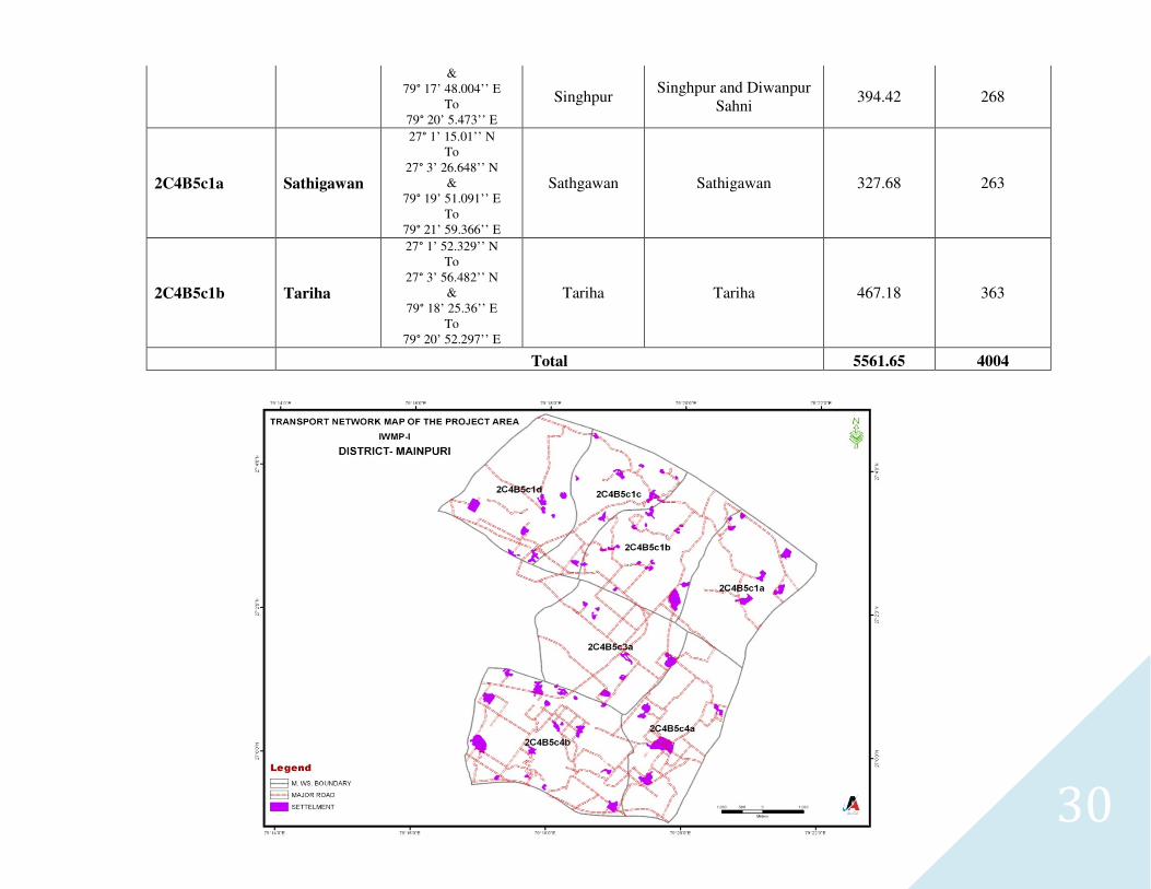
Singhpur Singhpur and Diwanpur
Sahni 394.42 268
2C4B5c1a Sathigawan
27° 1’ 15.01’’ N
To
27° 3’ 26.648’’ N
&
79° 19’ 51.091’’ E
To
79° 21’ 59.366’’ E
Sathgawan Sathigawan 327.68 263
2C4B5c1b Tariha
27° 1’ 52.329’’ N
To
27° 3’ 56.482’’ N
&
79° 18’ 25.36’’ E
To
79° 20’ 52.297’’ E
Tariha Tariha 467.18 363
Total 5561.65 4004
31
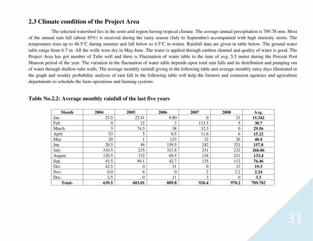
2.3 Climate condition of the Project Area
The selected watershed lies in the semi-arid region having tropical climate. The average annual precipitation is 789.78 mm. Most
of the annual rain fall (about 85%) is received during the rainy season (July to September) accompanied with high intensity storm. The
temperature rises up to 46.5°C during summer and fall below to 4.5°C in winter. Rainfall data are given in table below. The ground water
table range from 6-7 m. All the wells were dry in May-June .The water is applied through earthen channel and quality of water is good. The
Project Area has got number of Tube well and there is Fluctuation of water table to the tune of avg. 5.5 meter during the Percent Post
Manson period of the year. The variation in the fluctuation of water table depends upon total rain falls and its distribution and pumping out
of water through shallow tube walls. The average monthly rainfall giving in the following table and average monthly rainy days illustrated in
the graph and weekly probability analysis of rain fall in the following table will help the farmers and extension agencies and agriculture
departments to schedule the farm operations and farming systems.
Table No.2.2: Average monthly rainfall of the last five years
Month 2004 2005 2006 2007 2008 Avg.
Jan. 23.5 22.41 9.80 0 21 15.342
Feb. 0 32 3 113.5 5 30.7 March 3 74.5 38 32.3 0 29.56
April 53 5 0.5 11.6 6 15.22 May 20 1 123 32 26 40.4
Jun 20.5 46 159.5 242 321 157.8 July 310.5 235 321.8 231 232 266.06
August 120.5 132 69.5 124 221 133.4
Sep. 43.5 49.1 42.7 135 112 76.46 Oct. 42.5 0 31 0 23 19.3
Nov. 0.0 6 0 2 3.2 2.24 Dec. 2.5 0 11 3 0 3.3
Total- 639.5 603.01 809.8 926.4 970.2 789.782
32
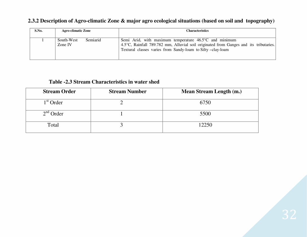
2.3.2 Description of Agro-climatic Zone & major agro ecological situations (based on soil and topography)
S.No. Agro-climatic Zone Characteristics
1 South-West Semiarid Zone IV
Semi Arid, with maximum temperature 46.5°C and minimum 4.5°C, Rainfall 789.782 mm, Alluvial soil originated from Ganges and its tributaries. Textural classes varies from Sandy-loam to Silty -clay-loam
Table -2.3 Stream Characteristics in water shed
Stream Order Stream Number Mean Stream Length (m.)
1st Order 2 6750
2nd Order 1 5500
Total 3 12250
33
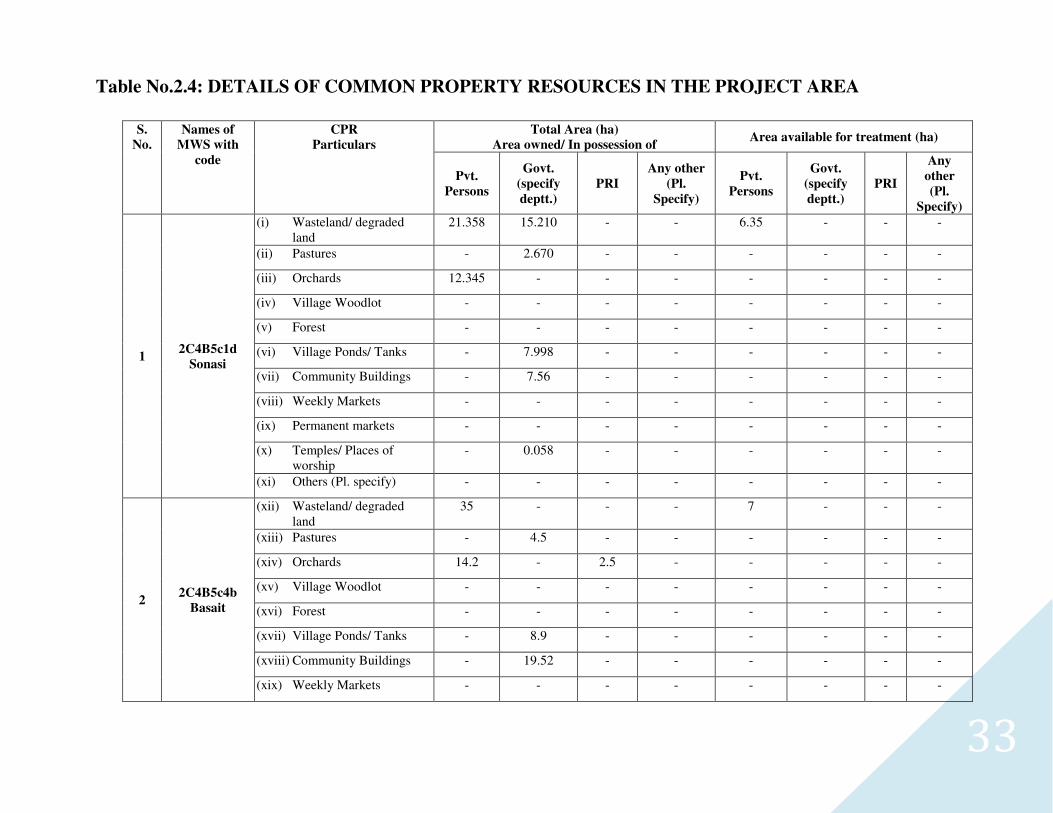
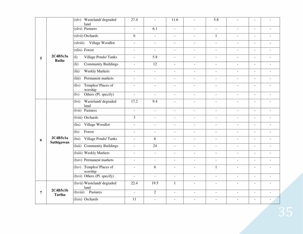
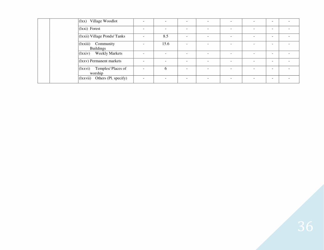
Table No.2.4: DETAILS OF COMMON PROPERTY RESOURCES IN THE PROJECT AREA
S.
No.
Names of
MWS with
code
CPR
Particulars
Total Area (ha)
Area owned/ In possession of Area available for treatment (ha)
Pvt.
Persons
Govt.
(specify
deptt.)
PRI
Any other
(Pl.
Specify)
Pvt.
Persons
Govt.
(specify
deptt.)
PRI
Any
other
(Pl.
Specify)
1 2C4B5c1d
Sonasi
(i) Wasteland/ degraded land
21.358 15.210 - - 6.35 - - -
(ii) Pastures - 2.670 - - - - - -
(iii) Orchards 12.345 - - - - - - -
(iv) Village Woodlot - - - - - - - -
(v) Forest - - - - - - - -
(vi) Village Ponds/ Tanks - 7.998 - - - - - -
(vii) Community Buildings - 7.56 - - - - - -
(viii) Weekly Markets - - - - - - - -
(ix) Permanent markets - - - - - - - -
(x) Temples/ Places of worship
- 0.058 - - - - - -
(xi) Others (Pl. specify) - - - - - - - -
2 2C4B5c4b
Basait
(xii) Wasteland/ degraded land
35 - - - 7 - - -
(xiii) Pastures - 4.5 - - - - - -
(xiv) Orchards 14.2 - 2.5 - - - - -
(xv) Village Woodlot - - - - - - - -
(xvi) Forest - - - - - - - -
(xvii) Village Ponds/ Tanks - 8.9 - - - - - -
(xviii) Community Buildings - 19.52 - - - - - -
(xix) Weekly Markets - - - - - - - -
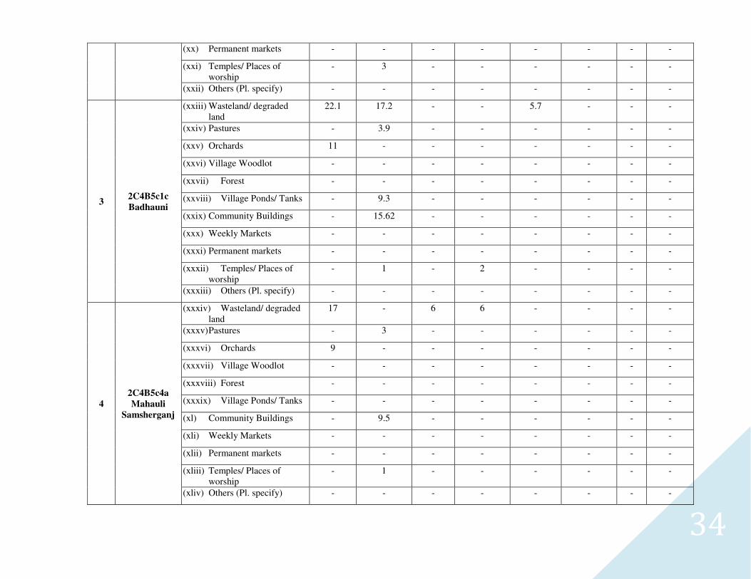
34
(xx) Permanent markets - - - - - - - -
(xxi) Temples/ Places of worship
- 3 - - - - - -
(xxii) Others (Pl. specify) - - - - - - - -
3 2C4B5c1c
Badhauni
(xxiii) Wasteland/ degraded land
22.1 17.2 - - 5.7 - - -
(xxiv) Pastures - 3.9 - - - - - -
(xxv) Orchards 11 - - - - - - -
(xxvi) Village Woodlot - - - - - - - -
(xxvii) Forest - - - - - - - -
(xxviii) Village Ponds/ Tanks - 9.3 - - - - - -
(xxix) Community Buildings - 15.62 - - - - - -
(xxx) Weekly Markets - - - - - - - -
(xxxi) Permanent markets - - - - - - - -
(xxxii) Temples/ Places of worship
- 1 - 2 - - - -
(xxxiii) Others (Pl. specify) - - - - - - - -
4
2C4B5c4a
Mahauli
Samsherganj
(xxxiv) Wasteland/ degraded land
17 - 6 6 - - - -
(xxxv) Pastures - 3 - - - - - -
(xxxvi) Orchards 9 - - - - - - -
(xxxvii) Village Woodlot - - - - - - - -
(xxxviii) Forest - - - - - - - -
(xxxix) Village Ponds/ Tanks - - - - - - - -
(xl) Community Buildings - 9.5 - - - - - -
(xli) Weekly Markets - - - - - - - -
(xlii) Permanent markets - - - - - - - -
(xliii) Temples/ Places of worship
- 1 - - - - - -
(xliv) Others (Pl. specify) - - - - - - - -
35
5 2C4B5c3a
Rathe
(xlv) Wasteland/ degraded land
27.4 - 11.6 - 5.8 - - -
(xlvi) Pastures - 6.1 - - - - - -
(xlvii) Orchards 6 - - - 1 - - -
(xlviii) Village Woodlot - - - - - - - -
(xlix) Forest - - - - - - - -
(l) Village Ponds/ Tanks - 5.8 - - - - - -
(li) Community Buildings - 12 - - - - - -
(lii) Weekly Markets - - - - - - - -
(liii) Permanent markets - - - - - - - -
(liv) Temples/ Places of worship
- - - - - - - -
(lv) Others (Pl. specify) - - - - - - - -
6 2C4B5c1a
Sathigawan
(lvi) Wasteland/ degraded land
17.2 9.4 - - - - - -
(lvii) Pastures - - - - - - - -
(lviii) Orchards 3 - - - - - - -
(lix) Village Woodlot - - - - - - - -
(lx) Forest - - - - - - - -
(lxi) Village Ponds/ Tanks - 6 - - - - - -
(lxii) Community Buildings - 24 - - - - - -
(lxiii) Weekly Markets - - - - - - - -
(lxiv) Permanent markets - - - - - - - -
(lxv) Temples/ Places of worship
- 6 - - 1 - - -
(lxvi) Others (Pl. specify) - - - - - - - -
7 2C4B5c1b
Tariha
(lxvii) Wasteland/ degraded land
22.4 19.5 1 - - - - -
(lxviii) Pastures - 2 - - - - - -
(lxix) Orchards 11 - - - - - - -
36
(lxx) Village Woodlot - - - - - - - -
(lxxi) Forest - - - - - - - -
(lxxii) Village Ponds/ Tanks - 8.5 - - - - - -
(lxxiii) Community Buildings
- 15.6 - - - - - -
(lxxiv) Weekly Markets - - - - - - - -
(lxxv) Permanent markets - - - - - - - -
(lxxvi) Temples/ Places of worship
- 6 - - - - - -
(lxxvii) Others (Pl. specify) - - - - - - - -

37
CHAPTER-3
38
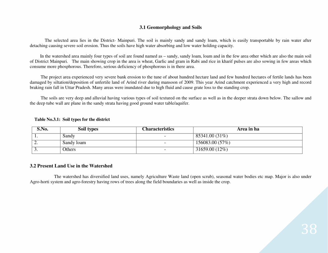
3.1 Geomorphology and Soils
The selected area lies in the District- Mainpuri. The soil is mainly sandy and sandy loam, which is easily transportable by rain water after detaching causing severe soil erosion. Thus the soils have high water absorbing and low water holding capacity. In the watershed area mainly four types of soil are found named as – sandy, sandy loam, loam and in the few area other which are also the main soil of District Mainpuri. The main showing crop in the area is wheat, Garlic and gram in Rabi and rice in kharif pulses are also sowing in few areas which consume more phosphorous. Therefore, serious deficiency of phosphorous is in there area.
The project area experienced very severe bank erosion to the tune of about hundred hectare land and few hundred hectares of fertile lands has been damaged by siltation/deposition of unfertile land of Arind river during mansoon of 2009. This year Arind catchment experienced a very high and record braking rain fall in Uttar Pradesh. Many areas were inundated due to high fluid and cause grate loss to the standing crop. The soils are very deep and alluvial having various types of soil textured on the surface as well as in the deeper strata down below. The sallow and the deep tube wall are plane in the sandy strata having good ground water table/aquifer.
Table No.3.1: Soil types for the district
S.No. Soil types Characteristics Area in ha
1. Sandy - 85341.00 (31%)
2. Sandy loam - 156083.00 (57%)
3. Others - 31659.00 (12%)
3.2 Present Land Use in the Watershed
The watershed has diversified land uses, namely Agriculture Waste land (open scrub), seasonal water bodies etc map. Major is also under Agro-horti system and agro-forestry having rows of trees along the field boundaries as well as inside the crop.
39
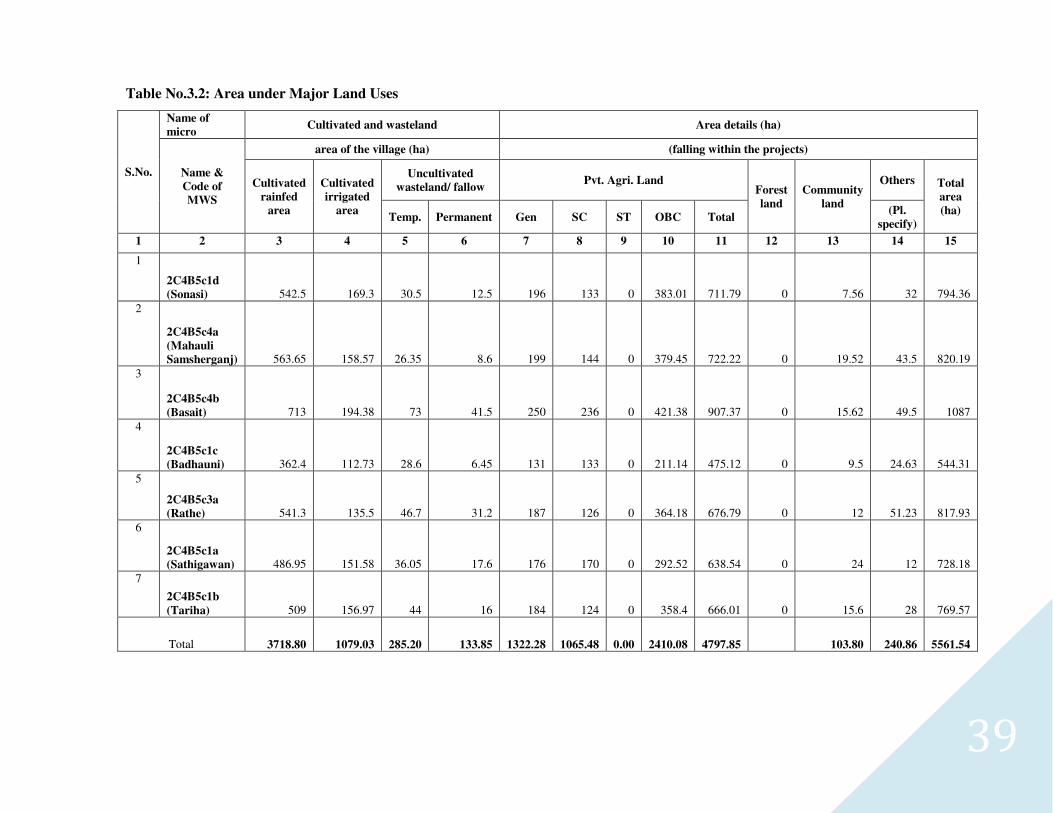
Table No.3.2: Area under Major Land Uses
S.No.
Name of
micro Cultivated and wasteland Area details (ha)
Name &
Code of
MWS
area of the village (ha) (falling within the projects)
Cultivated
rainfed
area
Cultivated
irrigated
area
Uncultivated
wasteland/ fallow Pvt. Agri. Land
Forest
land
Community
land
Others Total
area
(ha) Temp. Permanent Gen SC ST OBC Total
(Pl.
specify)
1 2 3 4 5 6 7 8 9 10 11 12 13 14 15
1
2C4B5c1d
(Sonasi) 542.5 169.3 30.5 12.5 196 133 0 383.01 711.79 0 7.56 32 794.36
2
2C4B5c4a
(Mahauli
Samsherganj) 563.65 158.57 26.35 8.6 199 144 0 379.45 722.22 0 19.52 43.5 820.19
3
2C4B5c4b
(Basait) 713 194.38 73 41.5 250 236 0 421.38 907.37 0 15.62 49.5 1087
4
2C4B5c1c
(Badhauni) 362.4 112.73 28.6 6.45 131 133 0 211.14 475.12 0 9.5 24.63 544.31
5
2C4B5c3a
(Rathe) 541.3 135.5 46.7 31.2 187 126 0 364.18 676.79 0 12 51.23 817.93
6
2C4B5c1a
(Sathigawan) 486.95 151.58 36.05 17.6 176 170 0 292.52 638.54 0 24 12 728.18
7
2C4B5c1b
(Tariha) 509 156.97 44 16 184 124 0 358.4 666.01 0 15.6 28 769.57
Total 3718.80 1079.03 285.20 133.85 1322.28 1065.48 0.00 2410.08 4797.85 103.80 240.86 5561.54
40
3.3 Agriculture
Various agriculture land uses in the watershed are extended to diversified land capabilities starting from marginal to good class
IInd lands. The watershed distinctly has three types of land i.e. leveled, sloping and degraded and undulating. The agriculture is practiced on
all these soil types though the productivity considerably varies. The total area in agriculture in the project is 4797.85 ha, total 1079.03 ha of
the tube well and canal irrigated area of the villages. The water (both for irrigation and drinking) is available in the major area. The operation
of tube wells for irrigation of agricultural crops frequently leads to down ward movements/deepening of the water table. Which may lower
the water supply of the sallow tube wells.
Crop Productivity
Food crop production is a major land based activity in the watershed. Traditional cultivation practices, coupled with poor quality
seeds and long duration crops varieties result in low crop yields. Crops are taken under rainfed as well as irrigated conditions. The yield
levels of rainfed crops are particularly very poor. The total production by Rabi and Kharif are obtained by a standard size of holding family,
by which they can fulfill the requirements of food up to whole in a year.
The farmers also do not have suitable cropping systems to deal aberrant weather. Weeds impose considerable constraint in
producing of both Kharif and rabi crops under irrigation as well as rain-fed production system. Use of weedicide is rare in the watershed. The
mixed cropping is in practice in limited area with Kharif crops like bajra and jowar+Arhar. Subsequent rabi crops in general are raised on
residual soil moisture under rain-fed production system during post monsoon season. Imbalanced use of fertilizers is common in Rabi as well
Kharif crops. In rainfed and irrigated production system the recommended deep ploughing for enhanced in situ residual soil moisture
conservation and higher production is also not followed in the watershed. The shallow ploughing tractors drawn tillage implements are
available with the farmers in the watershed but deep ploughing implements yet need to be introduced.
The soil fertility/health restoration practices like green manuring, crop rotations and intercropping specially with legumes, use of
FYM/compost, bermi-compost ,bio-fertilizers ,soil and water conservation measures, use of brought up or in situ mulches are widely lacking
in the watershed. The soil and water conservation measures are limited to mechanical/earthen measures created by the state Govt. agencies.
Conservation agronomical measures like seeding and ploughing across the slope, weed mulching, agro-forestry, vegetative barriers etc are
also completely lacking in the watershed.
41
3.4 Horticulture
The watershed has organized orchards; however, farmers also have fruit plants (mango, ber, bale, guava, amla, lemon etc.) near the homesteads
and kitchen gardens. The climate and soil of the area is favorable for fruit growing for sub tropical fruits in the lower reaches. Organized orchards,
commercial vegetable cultivation, agro horticulture, and other system of agro forestry are in practice. The total are under orchard is about 209 ha. out of
which 48 ha. Orchards have agri horti system. Mango is the common frout tree for the system. The common agriculture crops, which are grown under
mango, are wheat and Oat during Ravi and fodder crops namely Jowar and Bajra during Kharif. The part of the area about 80 ha. near sathigawan is used
for floriculture (Merry gold). Olericulture/ vegetable cultivation is mainly practiced in Sathigawan area. There are no facilities for fruit storage and
preservation in the project area.
3.4.2 Agro-Forestry
The agro forestry practices are common in the watershed and it has good potential under existing dispositions and may play a vital role
particularly with respect to minimization of cropping risk, built up soil fertility and productivity soil conservation, partly meeting out the fire wood
demand of rural community The agro-forestry interventions comprising of Equilyptus, Teak, Popular, Sagaun, Shisham, Neem, etc may be applied for
benefit of farmers under rainfed to irrigated production systems on leveled to sloppy and marginal agricultural using proper planting techniques and
termite control measures. The multipurpose trees may also help in supplementing fire wood and fodder demands of the rural community in the watershed
and may be intensively planted as hedge rows on rain-fed, marginal and degraded lands. Popular and Equilyptus are grown on field boundaries and as
well as intercropping. The tree produce goes to match box, ply and paper factory.
3.4.3 Forest and Natural Vegetation
There are no area for forest land, Natural vegetation of the watershed is very poor. The forest vegetation is predominant with Sheesham
and sagon. There are some places near to nala and rivers where Neem, Amla, Palash and Shisham etc. are found. There is no reserve pasture land in the
watershed. Congress weed is common in forest area and waste land.
42
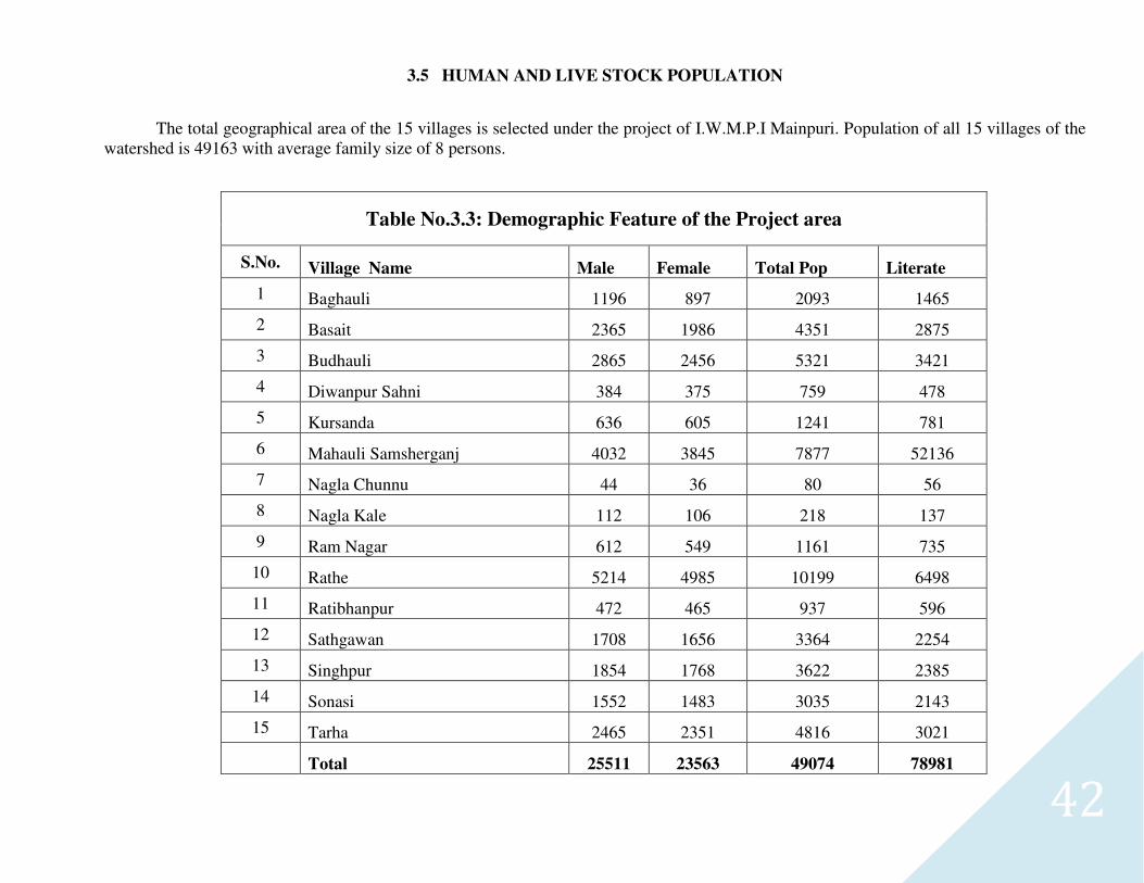
3.5 HUMAN AND LIVE STOCK POPULATION
The total geographical area of the 15 villages is selected under the project of I.W.M.P.I Mainpuri. Population of all 15 villages of the watershed is 49163 with average family size of 8 persons.
Table No.3.3: Demographic Feature of the Project area
S.No. Village Name Male Female Total Pop Literate
1 Baghauli 1196 897 2093 1465
2 Basait 2365 1986 4351 2875
3 Budhauli 2865 2456 5321 3421
4 Diwanpur Sahni 384 375 759 478
5 Kursanda 636 605 1241 781
6 Mahauli Samsherganj 4032 3845 7877 52136
7 Nagla Chunnu 44 36 80 56
8 Nagla Kale 112 106 218 137
9 Ram Nagar 612 549 1161 735
10 Rathe 5214 4985 10199 6498
11 Ratibhanpur 472 465 937 596
12 Sathgawan 1708 1656 3364 2254
13 Singhpur 1854 1768 3622 2385
14 Sonasi 1552 1483 3035 2143
15 Tarha 2465 2351 4816 3021
Total 25511 23563 49074 78981
43
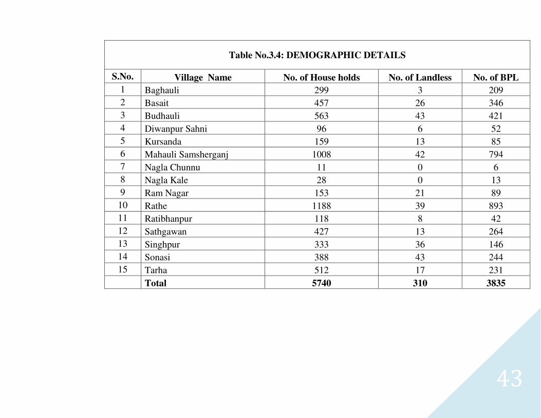
Table No.3.4: DEMOGRAPHIC DETAILS
S.No. Village Name No. of House holds No. of Landless No. of BPL
1 Baghauli 299 3 209
2 Basait 457 26 346
3 Budhauli 563 43 421
4 Diwanpur Sahni 96 6 52
5 Kursanda 159 13 85
6 Mahauli Samsherganj 1008 42 794
7 Nagla Chunnu 11 0 6
8 Nagla Kale 28 0 13
9 Ram Nagar 153 21 89
10 Rathe 1188 39 893
11 Ratibhanpur 118 8 42
12 Sathgawan 427 13 264
13 Singhpur 333 36 146
14 Sonasi 388 43 244
15 Tarha 512 17 231
Total 5740 310 3835
44
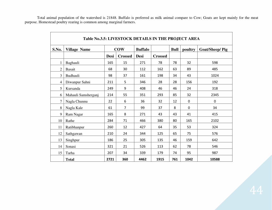
Total animal population of the watershed is 21848. Buffalo is preferred as milk animal compare to Cow; Goats are kept mainly for the meat purpose. Homestead poultry rearing is common among marginal farmers.
Table No.3.5: LIVESTOCK DETAILS IN THE PROJECT AREA
S.No. Village Name COW Buffalo Bull poultry Goat/Sheep/ Pig
Desi Crossed Desi Crossed
1 Baghauli 165 15 271 78 78 32 598
2 Basait 68 30 112 162 63 89 485
3 Budhauli 98 37 161 198 34 43 1024
4 Diwanpur Sahni 211 5 346 28 28 156 192
5 Kursanda 249 9 408 46 46 24 318
6 Mahauli Samsherganj 214 55 351 293 85 32 2345
7 Nagla Chunnu 22 6 36 32 12 0 0
8 Nagla Kale 61 7 99 37 8 0 34
9 Ram Nagar 165 8 271 43 43 41 415
10 Rathe 284 71 466 380 80 165 2102
11 Ratibhanpur 260 12 427 64 35 53 324
12 Sathgawan 210 24 344 125 65 75 576
13 Singhpur 186 25 305 135 46 159 642
14 Sonasi 321 21 526 113 62 78 546
15 Tarha 207 34 339 179 74 95 987
Total 2721 360 4462 1915 761 1042 10588
45
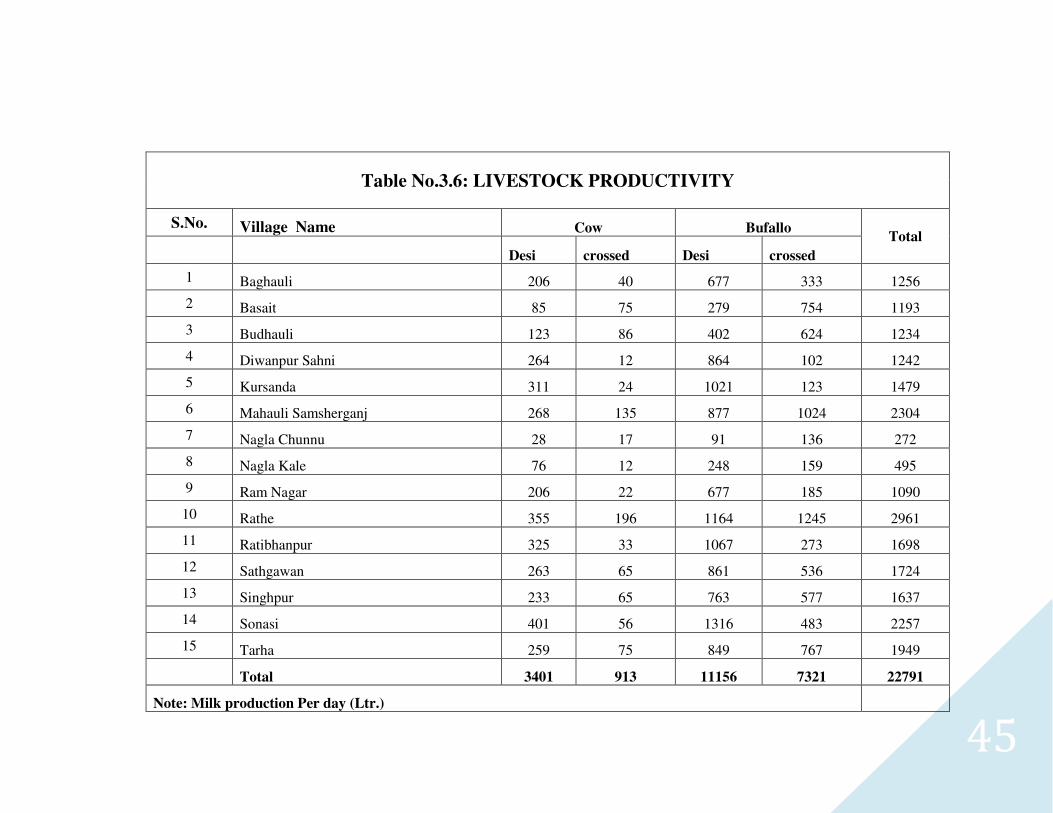
Table No.3.6: LIVESTOCK PRODUCTIVITY
S.No. Village Name Cow Bufallo Total
Desi crossed Desi crossed
1 Baghauli 206 40 677 333 1256
2 Basait 85 75 279 754 1193
3 Budhauli 123 86 402 624 1234
4 Diwanpur Sahni 264 12 864 102 1242
5 Kursanda 311 24 1021 123 1479
6 Mahauli Samsherganj 268 135 877 1024 2304
7 Nagla Chunnu 28 17 91 136 272
8 Nagla Kale 76 12 248 159 495
9 Ram Nagar 206 22 677 185 1090
10 Rathe 355 196 1164 1245 2961
11 Ratibhanpur 325 33 1067 273 1698
12 Sathgawan 263 65 861 536 1724
13 Singhpur 233 65 763 577 1637
14 Sonasi 401 56 1316 483 2257
15 Tarha 259 75 849 767 1949
Total 3401 913 11156 7321 22791
Note: Milk production Per day (Ltr.)
46
3.6 Infrastructure & Social Facilities
The watershed has moderate to good communication facilities and 15 villages are approachable through motorable road. Literacy rate in the watershed is low because except some village all villages are having education facilities up to Junior High School. One intermediate college is established in village Basait. Secondary education and degree collage (with few faculties of subjects) facilities are available at Block headquarter. Degree Collage and other high education are available at Mainpuri. The buildings/ Panchayat Ghar and Barat Ghar are there and used for social gathering and religious functions. Sufficient numbers of Hand pumps have replaced all old water wells. Nearest small markets are Kisni and big market at district headquarter Mainpuri. Small land holdings (average less than 1.0 ha) large family size (average 6 person) and more than 7% of the labour force of the total population living below poverty line indicate poor socio-economic status of the watershed community However a strong community spirit among the village show a positive indication for the success of any programme implemented in a participatory mode. Traditionally, the entire village community participates in the individual’s work needing labour such as sowing, harvesting, house construction works etc. Social maps of the watershed villages drawn by villagers themselves, depicting village’s features are attached. The project is not connected with the railway facilities how ever the following national and state highways are there.
3.6.1 Communication System
Sufficient numbers of private and government buses and other micro transport system are available on these roads. The nearest railway station is about 40 km away at Mainpuri city. The sufficient number of car and tractor (Large Farmer) and motorcycle (Marginal Farmer) are there.
3.6.2 Natural Resource Base
Out of the total 5561.54 ha area of the selected village only 3178 ha are under rainfed agriculture and designated as project area. watershed under agriculture use an area of ha is under rain fed agriculture and assured irrigation by means of private tube well and canal is available in 1079.03 ha’Which is not including in the project/rainfed/treatable area’ . Main source of irrigation is private tube wells and seasonal water bodies for pre-sowing irrigation only. The maps having road, drain system, contour and location are available in report in capture 5.
3.7 Livelihood More than 75% of the total population in the watershed is engaged in farming. Therefore major source of livelihood is farming and rest about 25% labours and 3% service+ business class. Dairy Farming, rope making, poultry form, Sericulture are also practiced in the project area.
3.8 Depending on forest for fuel wood and fodder
Fuel wood: Some villagers of the selected village are using LPG to meet their cooking energy requirements. The main source of fuel is cow dung cake, woody stem of Arhar crop and Mustard. About 65 to 70 percent of the domestic energy requirement is met from the Agro by-product and cow dung cake. Rest is met out from the forest outside the village and watershed boundary. Fuel wood is obtained from the fringe orchard area which is situated by the side of the few villages. Cow dung cake is a common fuel specially with poor and middle class families.
47
Fodder: Villages do not have any significant dependency on orchard based fodder as these sources are not available in the forests. The Straw wheat, jawar, black gram and pea are major source of dry fodder. Dairy is an important business and the farmers are also growing green fodder of sorghum and bajara during Kharif and barseen during ravi.
3.8.1 Facilities of agriculture inputs implement and funds.
Sufficient government, private and cooperative facilities are there for the supply of seed, fertilizer and other chemicals are there. Banking facilities and private money lenders are also active in the project area. The facilities of Agro Industries are only available in the neighboring big town-Mainpuri.
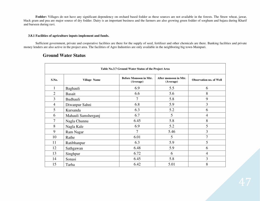
Ground Water Status
Table No.3.7 Ground Water Status of the Project Area
S.No. Village Name Before Monsoon in Mtr.
(Average)
After monsoon in Mtr.
(Average) Observation no. of Well
1 Baghauli 6.9 5.5 6
2 Basait 6.6 5.6 8
3 Budhauli 7 5.8 9
4 Diwanpur Sahni 6.8 5.9 3
5 Kursanda 6.3 5.2 6
6 Mahauli Samsherganj 6.7 5 4
7 Nagla Chunnu 6.45 5.8 8
8 Nagla Kale 6.9 5.2 5
9 Ram Nagar 7 5.46 3
10 Rathe 6.01 5 7
11 Ratibhanpur 6.3 5.9 5
12 Sathgawan 6.48 5.9 6
13 Singhpur 6.72 6 4
14 Sonasi 6.45 5.8 3
15 Tarha 6.42 5.01 8
48
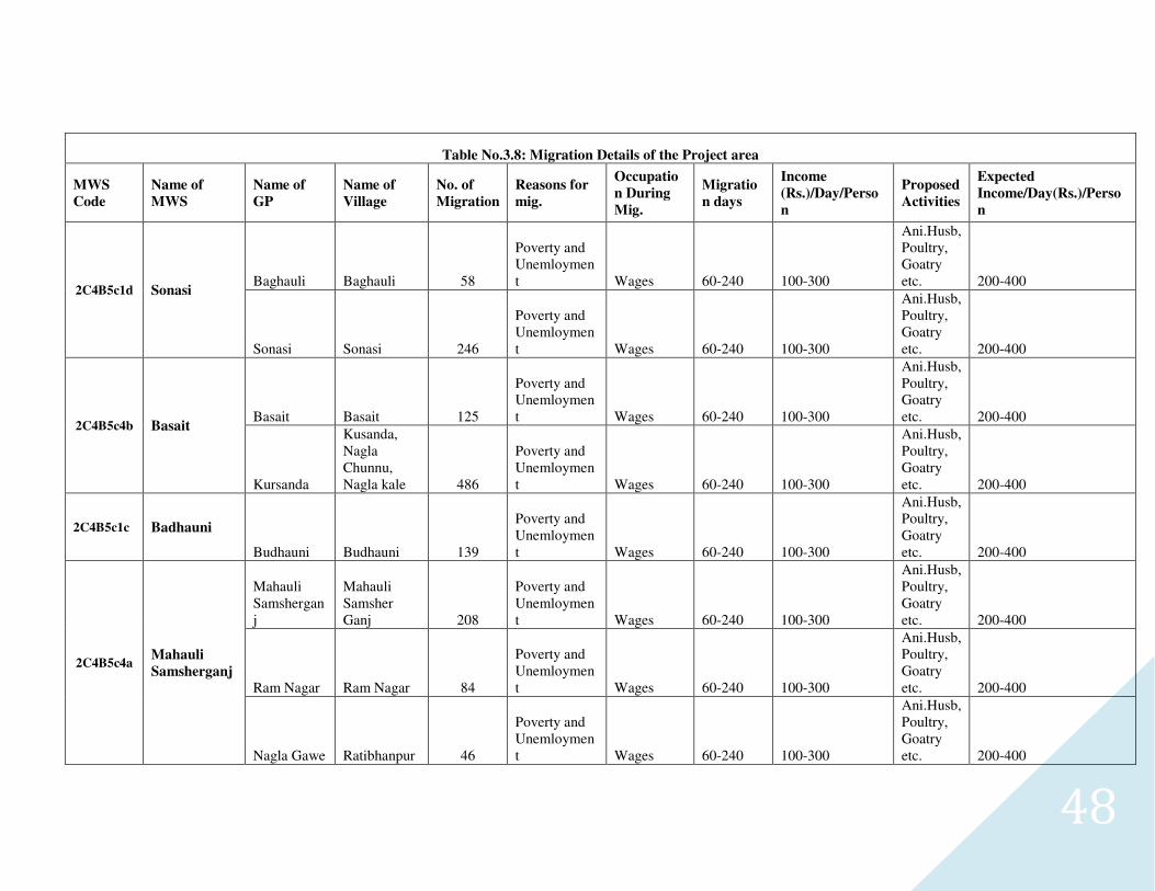
Table No.3.8: Migration Details of the Project area
MWS
Code
Name of
MWS
Name of
GP
Name of
Village
No. of
Migration
Reasons for
mig.
Occupatio
n During
Mig.
Migratio
n days
Income
(Rs.)/Day/Perso
n
Proposed
Activities
Expected
Income/Day(Rs.)/Perso
n
2C4B5c1d Sonasi Baghauli Baghauli 58
Poverty and Unemloyment Wages 60-240 100-300
Ani.Husb, Poultry, Goatry etc. 200-400
Sonasi Sonasi 246
Poverty and Unemloyment Wages 60-240 100-300
Ani.Husb, Poultry, Goatry etc. 200-400
2C4B5c4b Basait Basait Basait 125
Poverty and Unemloyment Wages 60-240 100-300
Ani.Husb, Poultry, Goatry etc. 200-400
Kursanda
Kusanda, Nagla Chunnu, Nagla kale 486
Poverty and Unemloyment Wages 60-240 100-300
Ani.Husb, Poultry, Goatry etc. 200-400
2C4B5c1c Badhauni
Budhauni Budhauni 139
Poverty and Unemloyment Wages 60-240 100-300
Ani.Husb, Poultry, Goatry etc. 200-400
2C4B5c4a Mahauli
Samsherganj
Mahauli Samsherganj
Mahauli Samsher Ganj 208
Poverty and Unemloyment Wages 60-240 100-300
Ani.Husb, Poultry, Goatry etc. 200-400
Ram Nagar Ram Nagar 84
Poverty and Unemloyment Wages 60-240 100-300
Ani.Husb, Poultry, Goatry etc. 200-400
Nagla Gawe Ratibhanpur 46
Poverty and Unemloyment Wages 60-240 100-300
Ani.Husb, Poultry, Goatry etc. 200-400
49
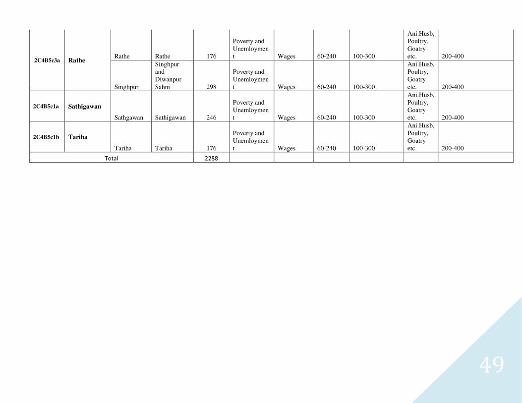
2C4B5c3a Rathe Rathe Rathe 176
Poverty and Unemloyment Wages 60-240 100-300
Ani.Husb, Poultry, Goatry etc. 200-400
Singhpur
Singhpur and Diwanpur Sahni 298
Poverty and Unemloyment Wages 60-240 100-300
Ani.Husb, Poultry, Goatry etc. 200-400
2C4B5c1a Sathigawan
Sathgawan Sathigawan 246
Poverty and Unemloyment Wages 60-240 100-300
Ani.Husb, Poultry, Goatry etc. 200-400
2C4B5c1b Tariha
Tariha Tariha 176
Poverty and Unemloyment Wages 60-240 100-300
Ani.Husb, Poultry, Goatry etc. 200-400
Total 2288
50
51
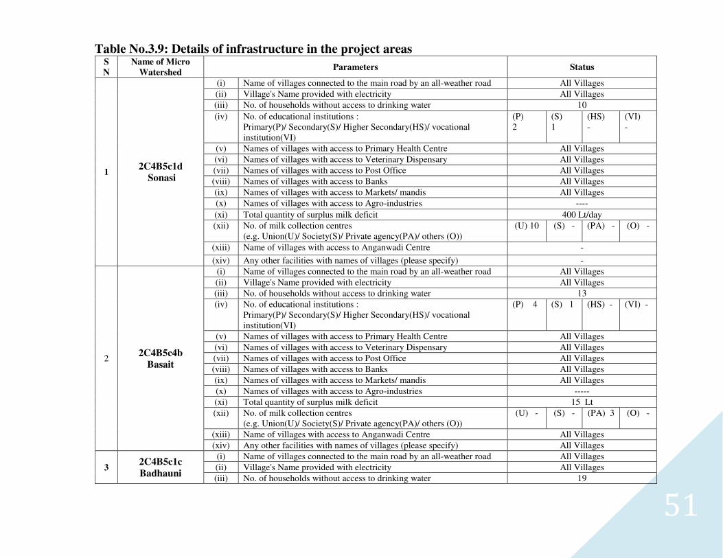
Table No.3.9: Details of infrastructure in the project areas S
N
Name of Micro
Watershed Parameters Status
1 2C4B5c1d
Sonasi
(i) Name of villages connected to the main road by an all-weather road All Villages
(ii) Village's Name provided with electricity All Villages
(iii) No. of households without access to drinking water 10
(iv) No. of educational institutions : Primary(P)/ Secondary(S)/ Higher Secondary(HS)/ vocational institution(VI)
(P) 2
(S) 1
(HS) -
(VI) -
(v) Names of villages with access to Primary Health Centre All Villages
(vi) Names of villages with access to Veterinary Dispensary All Villages
(vii) Names of villages with access to Post Office All Villages
(viii) Names of villages with access to Banks All Villages
(ix) Names of villages with access to Markets/ mandis All Villages
(x) Names of villages with access to Agro-industries ----
(xi) Total quantity of surplus milk deficit 400 Lt/day
(xii) No. of milk collection centres (e.g. Union(U)/ Society(S)/ Private agency(PA)/ others (O))
(U) 10 (S) - (PA) - (O) -
(xiii) Name of villages with access to Anganwadi Centre -
(xiv) Any other facilities with names of villages (please specify) -
2 2C4B5c4b
Basait
(i) Name of villages connected to the main road by an all-weather road All Villages
(ii) Village's Name provided with electricity All Villages
(iii) No. of households without access to drinking water 13
(iv) No. of educational institutions : Primary(P)/ Secondary(S)/ Higher Secondary(HS)/ vocational institution(VI)
(P) 4 (S) 1 (HS) - (VI) -
(v) Names of villages with access to Primary Health Centre All Villages
(vi) Names of villages with access to Veterinary Dispensary All Villages
(vii) Names of villages with access to Post Office All Villages
(viii) Names of villages with access to Banks All Villages
(ix) Names of villages with access to Markets/ mandis All Villages
(x) Names of villages with access to Agro-industries -----
(xi) Total quantity of surplus milk deficit 15 Lt
(xii) No. of milk collection centres (e.g. Union(U)/ Society(S)/ Private agency(PA)/ others (O))
(U) - (S) - (PA) 3 (O) -
(xiii) Name of villages with access to Anganwadi Centre All Villages
(xiv) Any other facilities with names of villages (please specify) All Villages
3 2C4B5c1c
Badhauni
(i) Name of villages connected to the main road by an all-weather road All Villages
(ii) Village's Name provided with electricity All Villages
(iii) No. of households without access to drinking water 19
52
(iv) No. of educational institutions : Primary(P)/ Secondary(S)/ Higher Secondary(HS)/ vocational institution(VI)
(P) 1 (S) - (HS) - (VI) -
(v) Names of villages with access to Primary Health Centre All Villages
(vi) Names of villages with access to Veterinary Dispensary All Villages
(vii) Names of villages with access to Post Office All Villages
(viii) Names of villages with access to Banks All Villages
(ix) Names of villages with access to Markets/ mandis All Villages
(x) Names of villages with access to Agro-industries ---
(xi) Total quantity of surplus milk deficit 133 lt/day
(xii) No. of milk collection centres (e.g. Union(U)/ Society(S)/ Private agency(PA)/ others (O))
(U) - (S) - (PA) - (O) -
(xiii) Name of villages with access to Anganwadi Centre All Villages
(xiv) Any other facilities with names of villages (please specify) -
4
2C4B5c4a
Mahauli
Samsherganj
(i) Name of villages connected to the main road by an all-weather road All Villages
(ii) Village's Name provided with electricity All Villages
(iii) No. of households without access to drinking water 18
(iv) No. of educational institutions : Primary(P)/ Secondary(S)/ Higher Secondary(HS)/ vocational institution(VI)
(P) 3 (S) 1 (HS) - (VI) -
(v) Names of villages with access to Primary Health Centre All Villages
(vi) Names of villages with access to Veterinary Dispensary All Villages
(vii) Names of villages with access to Post Office All Villages
(viii) Names of villages with access to Banks All Villages
(ix) Names of villages with access to Markets/ mandis All Villages
(x) Names of villages with access to Agro-industries ----
(xi) Total quantity of surplus milk deficit 300 Lt
(xii) No. of milk collection centres (e.g. Union(U)/ Society(S)/ Private agency(PA)/ others (O))
(U) - (S) - (PA) 2 (O) -
(xiii) Name of villages with access to Anganwadi Centre All Villages
(xiv) Any other facilities with names of villages (please specify) All Villages
5 2C4B5c3a
Rathe
(i) Name of villages connected to the main road by an all-weather road All Villages
(ii) Village's Name provided with electricity All Villages
(iii) No. of households without access to drinking water 12
(iv) No. of educational institutions : Primary(P)/ Secondary(S)/ Higher Secondary(HS)/ vocational institution(VI)
(P) 3 (S) 2 (HS) - (VI) -
(v) Names of villages with access to Primary Health Centre All Villages (vi) Names of villages with access to Veterinary Dispensary All Villages (vii) Names of villages with access to Post Office All Villages (viii) Names of villages with access to Banks All Villages
53
(ix) Names of villages with access to Markets/ mandis All Villages (x) Names of villages with access to Agro-industries ---- (xi) Total quantity of surplus milk deficit 500 Lt/day
(xii) No. of milk collection centres (e.g. Union(U)/ Society(S)/ Private agency(PA)/ others (O))
(U) - (S) - (PA) 8 (O) -
(xiii) Name of villages with access to Anganwadi Centre All Villages (xiv) Any other facilities with names of villages (please specify) All Villages
6 2C4B5c1a
Sathigawan
(i) Name of villages connected to the main road by an all-weather road All Villages
(ii) Village's Name provided with electricity All Villages (iii) No. of households without access to drinking water 5
(iv) No. of educational institutions : Primary(P)/ Secondary(S)/ Higher Secondary(HS)/ vocational institution(VI)
(P) 1 (S) - (HS) -
(VI) -
(v) Names of villages with access to Primary Health Centre All Villages (vi) Names of villages with access to Veterinary Dispensary All Villages (vii) Names of villages with access to Post Office All Villages (viii) Names of villages with access to Banks All Villages (ix) Names of villages with access to Markets/ mandis All Villages (x) Names of villages with access to Agro-industries -- (xi) Total quantity of surplus milk deficit 230 Lt
(xii) No. of milk collection centres (e.g. Union(U)/ Society(S)/ Private agency(PA)/ others (O))
(U) - (S) - (PA) 4 (O) -
(xiii) Name of villages with access to Anganwadi Centre All Villages (xiv) Any other facilities with names of villages (please specify) -
7 2C4B5c1b
Tariha
(i) Name of villages connected to the main road by an all-weather road All Villages (ii) Village's Name provided with electricity All Villages (iii) No. of households without access to drinking water 10
(iv) No. of educational institutions : Primary(P)/ Secondary(S)/ Higher Secondary(HS)/ vocational institution(VI)
(P) 1
(S) 1 (HS) - (VI) -
(v) Names of villages with access to Primary Health Centre All Villages (vi) Names of villages with access to Veterinary Dispensary All Villages (vii) Names of villages with access to Post Office All Villages (viii) Names of villages with access to Banks All Villages (ix) Names of villages with access to Markets/ mandis All Villages (x) Names of villages with access to Agro-industries ---- (xi) Total quantity of surplus milk deficit 380 Lt/day
(xii) No. of milk collection centres (e.g. Union(U)/ Society(S)/ Private agency(PA)/ others (O))
(U) -
(S) - (PA) 5 (O) -
(xiii) Name of villages with access to Anganwadi Centre All Villages
(xiv) Any other facilities with names of villages (please specify) All Villages
54
3.9- Livelihood Pattern
Livelihood :
Out of the total population of 49163 in the watershed, a majority i.e. more than 70% has farming as their major source of livelihood followed by 17% laborers and 2% service + business class.
Table No.3.10: Formation of SHG (GP wise)
1. Name of Micro-watershed - Sathigawan
Details of Self Help Groups
S.No. MWS with
code Name of SHG
Date of Name Of
President
Name of
Secretary
Total No. of Member Bank
Address Saving
Group
Activity Constitute Female Male Total
1 Sathigawan 2C4B5c1a
Diwakar Self Help Group
10/28/2011 Ramveer Rakesh - 10 15 SBI Ramnagar
500 Goatry
2 Sathigawan 2C4B5c1a
Laxmi Self Help Group
10/30/2011 Shri Devi Rajan shri 15 - 10 SBI Ramnagar
750 Goatry
3 Sathigawan 2C4B5c1a
Yaduvanshi Self Help Group
10/24/2011 Veer singh Ram autar - 10 11 SBI Ramnagar
500 Dairy
4 Sathigawan 2C4B5c1a
Radhika Self Help Group
10/8/2011 Surmila devi
Sushma devi 10 - 11 KKGB Ramnagar
500 Dairy
5 Sathigawan 2C4B5c1a
Yadav Self Help Group
10/15/2011 Sanjay kumar
Niraj - 10 11 KKGB Ramnagar
500 Dairy
6 Sathigawan 2C4B5c1a
Gopika Self Help Group
11/5/2011 Radha devi Sunita 10 - 10 KKGB Ramnagar
500 Dairy
7 Sathigawan 2C4B5c1a
Krashna Self Help Group
11/10/2011 Shilesh Nilesh - 10 10 KKGB Ramnagar
500 Dairy
8 Sathigawan 2C4B5c1a
Parvati Self Help Group
11/20/2011 Ashoka Mamta 10 - 10 KKGB Ramnagar
500 goatry
9 Sathigawan 2C4B5c1a
Lakhubaba Self Help Group
10/26/2011 Shri Devi Rajeswari 11 - 11 Bio Kishni 500 Goatry
10 Sathigawan 2C4B5c1a
Shankar ji Self Help Group Kudari
10/2/2011 Ashoka Mamta 11 - 11 Bio Kishni 500 Goatry
11 Sathigawan 2C4B5c1a
Lata Self Help Group Kudari
11/11/2011 Santosh Kumar
Avdesh Kumar
6 5 11 KKGB Ramnagar
500 Goatry
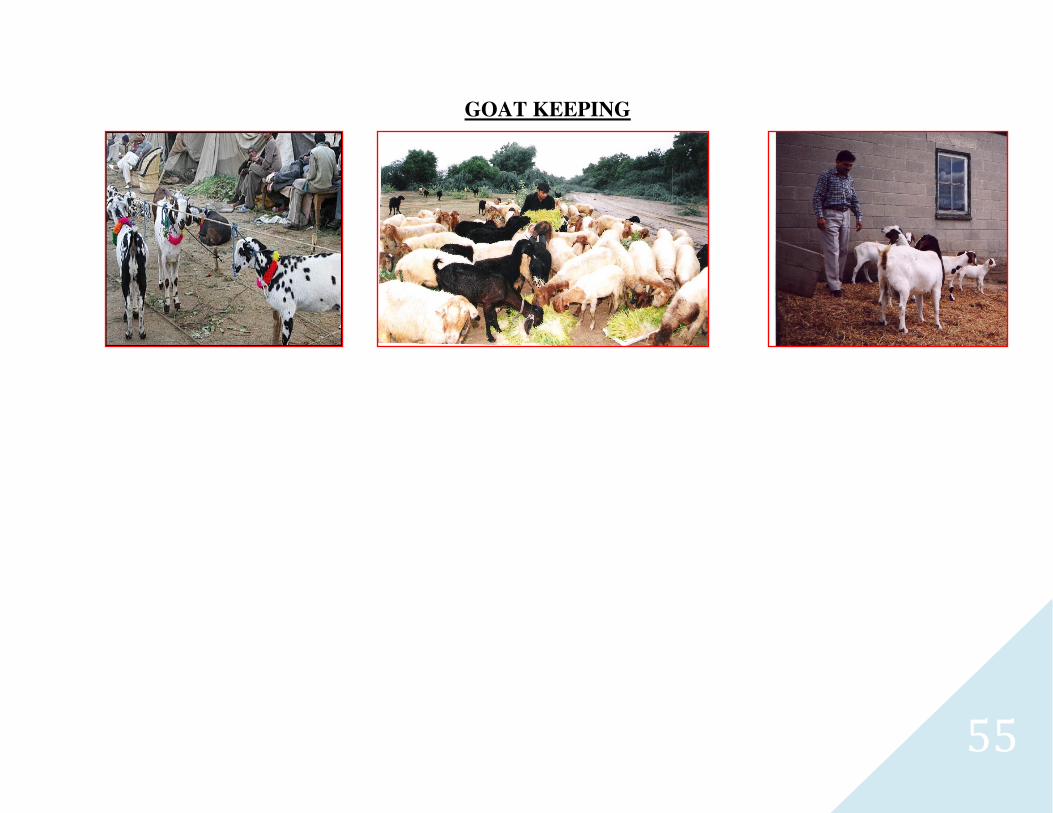
55
GOAT KEEPING
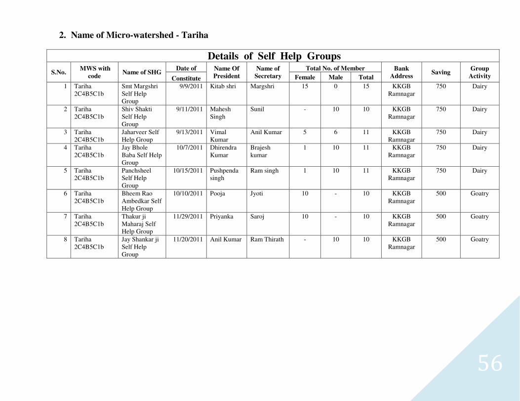
56
2. Name of Micro-watershed - Tariha
Details of Self Help Groups
S.No. MWS with
code Name of SHG
Date of Name Of
President
Name of
Secretary
Total No. of Member Bank
Address Saving
Group
Activity Constitute Female Male Total
1 Tariha 2C4B5C1b
Smt Margshri Self Help Group
9/9/2011 Kitab shri Margshri 15 0 15 KKGB Ramnagar
750 Dairy
2 Tariha 2C4B5C1b
Shiv Shakti Self Help Group
9/11/2011 Mahesh Singh
Sunil - 10 10 KKGB Ramnagar
750 Dairy
3 Tariha 2C4B5C1b
Jaharveer Self Help Group
9/13/2011 Vimal Kumar
Anil Kumar 5 6 11 KKGB Ramnagar
750 Dairy
4 Tariha 2C4B5C1b
Jay Bhole Baba Self Help Group
10/7/2011 Dhirendra Kumar
Brajesh kumar
1 10 11 KKGB Ramnagar
750 Dairy
5 Tariha 2C4B5C1b
Panchsheel Self Help Group
10/15/2011 Pushpenda singh
Ram singh 1 10 11 KKGB Ramnagar
750 Dairy
6 Tariha 2C4B5C1b
Bheem Rao Ambedkar Self Help Group
10/10/2011 Pooja Jyoti 10 - 10 KKGB Ramnagar
500 Goatry
7 Tariha 2C4B5C1b
Thakur ji Maharaj Self Help Group
11/29/2011 Priyanka Saroj 10 - 10 KKGB Ramnagar
500 Goatry
8 Tariha 2C4B5C1b
Jay Shankar ji Self Help Group
11/20/2011 Anil Kumar Ram Thirath - 10 10 KKGB Ramnagar
500 Goatry
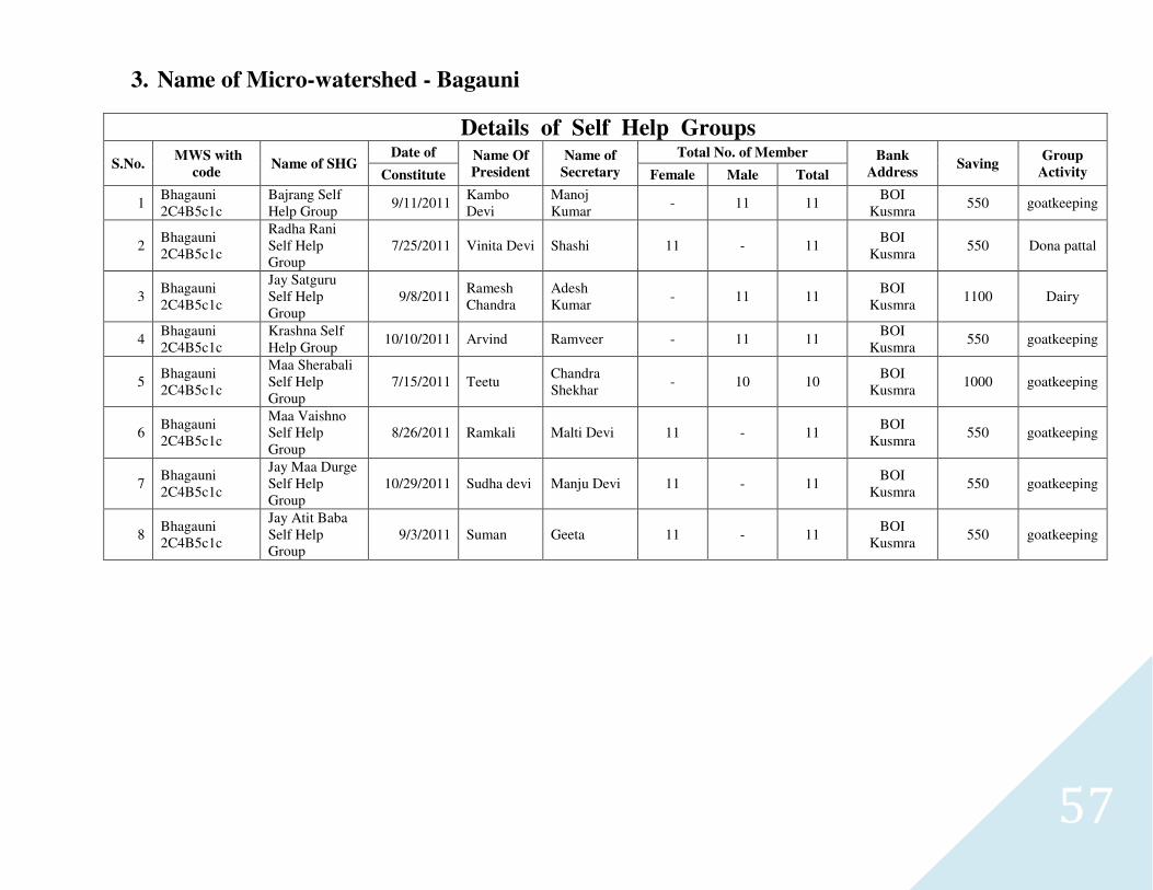
57
3. Name of Micro-watershed - Bagauni
Details of Self Help Groups
S.No. MWS with
code Name of SHG
Date of Name Of
President
Name of
Secretary
Total No. of Member Bank
Address Saving
Group
Activity Constitute Female Male Total
1 Bhagauni 2C4B5c1c
Bajrang Self Help Group
9/11/2011 Kambo Devi
Manoj Kumar
- 11 11 BOI
Kusmra 550 goatkeeping
2 Bhagauni 2C4B5c1c
Radha Rani Self Help Group
7/25/2011 Vinita Devi Shashi 11 - 11 BOI
Kusmra 550 Dona pattal
3 Bhagauni 2C4B5c1c
Jay Satguru Self Help Group
9/8/2011 Ramesh Chandra
Adesh Kumar
- 11 11 BOI
Kusmra 1100 Dairy
4 Bhagauni 2C4B5c1c
Krashna Self Help Group
10/10/2011 Arvind Ramveer - 11 11 BOI
Kusmra 550 goatkeeping
5 Bhagauni 2C4B5c1c
Maa Sherabali Self Help Group
7/15/2011 Teetu Chandra Shekhar
- 10 10 BOI
Kusmra 1000 goatkeeping
6 Bhagauni 2C4B5c1c
Maa Vaishno Self Help Group
8/26/2011 Ramkali Malti Devi 11 - 11 BOI
Kusmra 550 goatkeeping
7 Bhagauni 2C4B5c1c
Jay Maa Durge Self Help Group
10/29/2011 Sudha devi Manju Devi 11 - 11 BOI
Kusmra 550 goatkeeping
8 Bhagauni 2C4B5c1c
Jay Atit Baba Self Help Group
9/3/2011 Suman Geeta 11 - 11 BOI
Kusmra 550 goatkeeping
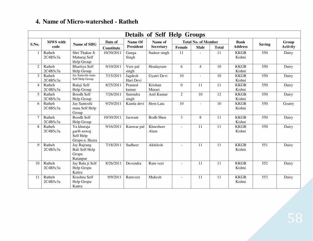
58
4. Name of Micro-watershed - Ratheh
Details of Self Help Groups
S.No. MWS with
code Name of SHG
Date of Name Of
President
Name of
Secretary
Total No. of Member Bank
Address Saving
Group
Activity Constitute Female Male Total
1 Ratheh 2C4B5c3a
Shri Thakur Ji Maharaj Self Help Group
10/30/2011 Ganga Singh
Sudeer singh 11 - 11 KKGB Kishni
550 Dairy
2 Ratheh 2C4B5c3a
Bhartiya Self Help Group
9/10/2011 Veer pal singh
Hradayram 6 4 10 KKGB Kishni
550 Dairy
3 Ratheh 2C4B5c3a
Jay Santoshi mata Self Help Group
7/15/2011 Jagdesh Hari Devi
Gyatri Devi 10 - 10 KKGB Kishni
550 Dairy
4 Ratheh 2C4B5c3a
Balaji Self Help Group
8/25/2011 Pramod kumar
Krishan Murari
0 11 11 KKGB Kishni
550 Dairy
5 Ratheh 2C4B5c3a
Boodh Self Help Group
7/26/2011 Surendra singh
Anil Kumar 2 10 12 KKGB Kishni
550 Dairy
6 Ratheh 2C4B5c3a
Jay Santoshi mata Self Help Group
9/29/2011 Kamla devi Hem Lata 10 - 10 KKGB Kishni
550 Goatry
7 Ratheh 2C4B5c3a
Boodh Self Help Group
10/30/2011 Jaswant Bodh Shen 3 8 11 KKGB Kishni
550 Dairy
8 Ratheh 2C4B5c3a
Ya khuraja garib nawaj Self Help Gropu n. Heera
9/16/2011 Kunwar pal Khursheer Alam
- 11 11 KKGB Kishni
550 Dairy
9 Ratheh 2C4B5c3a
Jay Bajrang Bali Self Help Gropu Ratanpur
7/18/2011 Sudheer Akhilesh - 11 11 KKGB Kishni
551 Dairy
10 Ratheh 2C4B5c3a
Jay Bala ji Self Help Gropu Kattra
8/26/2011 Devendra Ram veer - 11 11 KKGB Kishni
552 Dairy
11 Ratheh 2C4B5c3a
Krashna Self Help Gropu Kattra
9/9/2011 Ramveer Mukesh - 11 11 KKGB Kishni
553 Dairy
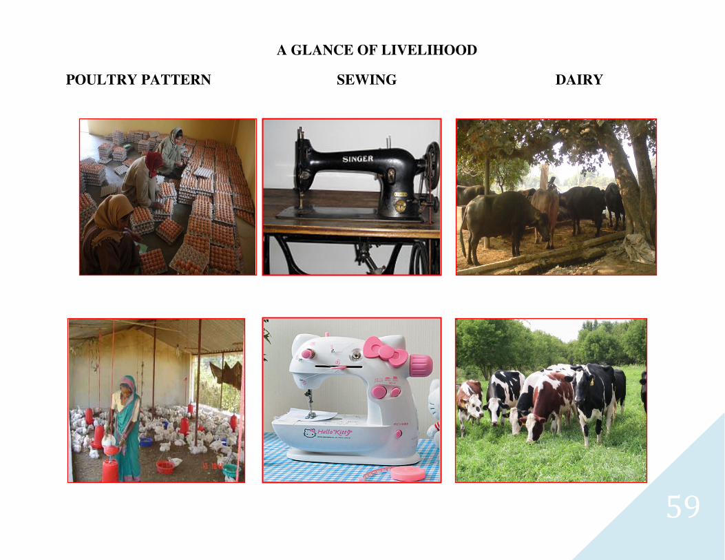
59
A GLANCE OF LIVELIHOOD
POULTRY PATTERN SEWING DAIRY

60
5. Name of Micro-watershed - Saunasee
Details of Self Help Groups
S.No. MWS with
code Name of SHG
Date of Name Of
President
Name of
Secretary
Total No. of Member Bank
Address Saving
Group
Activity Constitute Female Male Total
1 Saunasee 2C4B5c1b
Ateet Self Help Group Kudra
1/13/2011 Ajay Kumar
Shailendra Kumar
- 11 11 KKGB Kusmra
550 Dairy
2 Saunasee 2C4B5c1b
Jay Maa Baishno Self Help Group N. Bakhti
1/13/2011 Amendra Pratap singh
Sanju Kumar - 11 11 KKGB Kusmra
550 Dairy
3 Saunasee 2C4B5c1b
Jay Mata di Self Help Group N. Bakhti
1/13/2011 Devaki Devi
Sarita Devi 11 - 11 KKGB Kusmra
550 Dairy
4 Saunasee 2C4B5c1b
Jay Bajrang bali Self Help Group Sakatpur
1/15/2011 Yatendra Kumar
Ramesh - 11 11 KKGB Kusmra
550 Dairy
5 Saunasee 2C4B5c1b
Jay Shiv Shankar Sakatpur
1/15/2011 Dinesh Kumar
Anoop Kumar
- 11 11 KKGB Kusmra
550 Dairy
6 Saunasee 2C4B5c1b
Jay Durge Maa Self Help Group Sakatpur
1/15/2011 Pradeep kumar
Brajesh Kumar
- 11 11 KKGB Kusmra
550 Dairy
7 Saunasee 2C4B5c1b
Jay Amnbe Maa Self Help Group Sakatpur
1/15/2011 Nirmla Sudama Devi
11 - 11 KKGB Kusmra
550 Dairy
8 Saunasee 2C4B5c1b
Jay Nagar Sen Self Help Group Sonasi
1/20/2011 Satendra Harish Chandra
- 11 11 KKGB Kusmra
550 Goat Keeping
9 Saunasee 2C4B5c1b
Jay Santoshi Maa Self Help Group Sonasi
1/20/2011 Mahesh Chandra
Sarvan - 11 11 KKGB Kusmra
550 Dairy
10 Saunasee 2C4B5c1b
Jay Baishno Maa Self Help Group n. Mahua
2/13/2011 Shyam singh
Pramod - 11 11 KKGB Kusmra
550 Dairy
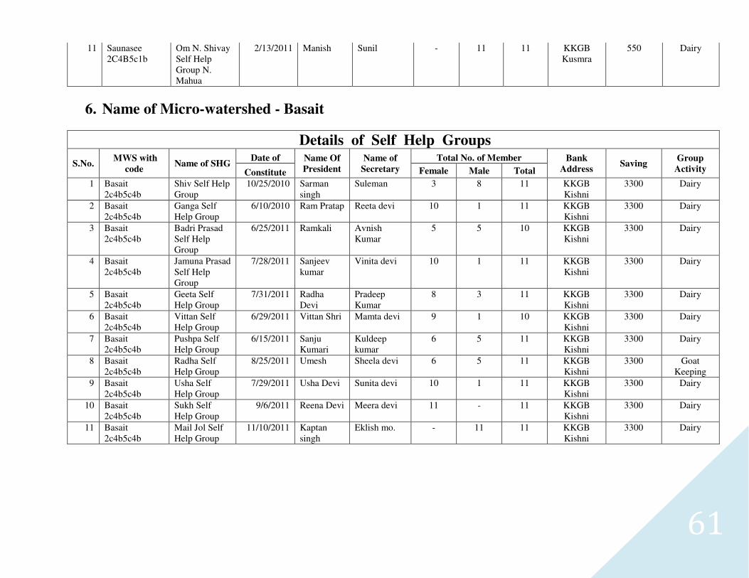
61
11 Saunasee 2C4B5c1b
Om N. Shivay Self Help Group N. Mahua
2/13/2011 Manish Sunil - 11 11 KKGB Kusmra
550 Dairy
6. Name of Micro-watershed - Basait
Details of Self Help Groups
S.No. MWS with
code Name of SHG
Date of Name Of
President
Name of
Secretary
Total No. of Member Bank
Address Saving
Group
Activity Constitute Female Male Total
1 Basait 2c4b5c4b
Shiv Self Help Group
10/25/2010 Sarman singh
Suleman 3 8 11 KKGB Kishni
3300 Dairy
2 Basait 2c4b5c4b
Ganga Self Help Group
6/10/2010 Ram Pratap Reeta devi 10 1 11 KKGB Kishni
3300 Dairy
3 Basait 2c4b5c4b
Badri Prasad Self Help Group
6/25/2011 Ramkali Avnish Kumar
5 5 10 KKGB Kishni
3300 Dairy
4 Basait 2c4b5c4b
Jamuna Prasad Self Help Group
7/28/2011 Sanjeev kumar
Vinita devi 10 1 11 KKGB Kishni
3300 Dairy
5 Basait 2c4b5c4b
Geeta Self Help Group
7/31/2011 Radha Devi
Pradeep Kumar
8 3 11 KKGB Kishni
3300 Dairy
6 Basait 2c4b5c4b
Vittan Self Help Group
6/29/2011 Vittan Shri Mamta devi 9 1 10 KKGB Kishni
3300 Dairy
7 Basait 2c4b5c4b
Pushpa Self Help Group
6/15/2011 Sanju Kumari
Kuldeep kumar
6 5 11 KKGB Kishni
3300 Dairy
8 Basait 2c4b5c4b
Radha Self Help Group
8/25/2011 Umesh Sheela devi 6 5 11 KKGB Kishni
3300 Goat Keeping
9 Basait 2c4b5c4b
Usha Self Help Group
7/29/2011 Usha Devi Sunita devi 10 1 11 KKGB Kishni
3300 Dairy
10 Basait 2c4b5c4b
Sukh Self Help Group
9/6/2011 Reena Devi Meera devi 11 - 11 KKGB Kishni
3300 Dairy
11 Basait 2c4b5c4b
Mail Jol Self Help Group
11/10/2011 Kaptan singh
Eklish mo. - 11 11 KKGB Kishni
3300 Dairy
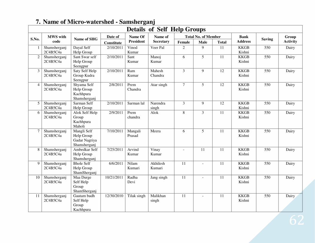
62
7. Name of Micro-watershed - Samsherganj
Details of Self Help Groups
S.No. MWS with
code Name of SHG
Date of Name Of
President
Name of
Secretary
Total No. of Member Bank
Address Saving
Group
Activity Constitute Female Male Total
1 Shamsherganj 2C4B5C4a
Dayal Self Help Group
2/10/2011 Vinod Kumar
Veer Pal 2 9 11 KKGB Kishni
550 Dairy
2 Shamsherganj 2C4B5C4a
Sant Swar self Help Group Seengpur
2/10/2011 Sant Kumar
Manoj Kumar
6 5 11 KKGB Kishni
550 Dairy
3 Shamsherganj 2C4B5C4a
Saty Self Help Group Kudra Seengpur
2/10/2011 Ram Kumar
Mahesh Chandra
3 9 12 KKGB Kishni
550 Dairy
4 Shamsherganj 2C4B5C4a
Shyama Self Help Group Kachhpura Shamsherganj
2/8/2011 Prem Chandra
Atar singh 7 5 12 KKGB Kishni
550 Dairy
5 Shamsherganj 2C4B5C4a
Sarman Self Help Group
2/10/2011 Sarman lal Narendra singh
3 9 12 KKGB Kishni
550 Dairy
6 Shamsherganj 2C4B5C4a
Alok Self Help Group Kachhpura Maholi
2/9/2011 Prem chandra
Alok 8 3 11 KKGB Kishni
550 Dairy
7 Shamsherganj 2C4B5C4a
Mangli Self Help Group Gadar Nagriya Shamsherganj
7/10/2011 Mangali Prasad
Meera 6 5 11 KKGB Kishni
550 Dairy
8 Shamsherganj 2C4B5C4a
Ambedkar Self Help Group Shamsherganj
7/25/2011 Arvind Kumar
Vinay Kumar
- 11 11 KKGB Kishni
550 Dairy
9 Shamsherganj 2C4B5C4a
Bhole Self Help Group ShamSherganj
6/6/2011 Nilam Kumari
Akhilesh Kumari
11 - 11 KKGB Kishni
550 Dairy
10 Shamsherganj 2C4B5C4a
Maa Durge Self Help Group ShamSherganj
10/21/2011 Radha Devi
Jang singh 11 - 11 KKGB Kishni
550 Dairy
11 Shamsherganj 2C4B5C4a
Gautam budh Self Help Group Kachhpura
12/30/2010 Tilak singh Malikhan singh
11 - 11 KKGB Kishni
550 Dairy
63
3.10 Dependency on forest for fuel wood and fodder
(a) Fuel Wood- Villagers in the village do not use LPG to meet their cooking energy requirements. The main source of fuel is from buffalo, He buffalo and cow dung cake, woody stem of Arhar crop and Mustard. About 60 to 65 percent of the domestic energy requirement is met from the agro byproduct and buffalo, his buffalo and cow dung cake. Rest is met out from the outside the village and watershed boundary. Most preferred fuel wood is Vilayati Babool. Fuel wood is obtained from the forest of Prosopis Juliflora standing along the Kali Nadi situated outside the watershed boundary.
(b) Fodder- Villagers do not have any significant dependency on forest based fodder as these resources are not available in the forests.
Labour Requirement-
Labour requirement was found to be the maximum during Oct.-Nov., when the harvesting of Kharif and sowing of Rabi crops are done simultaneously. The crucial periods are March/April coinciding harvesting and threshing of rabi crops and July/August when sowing of Kharif crops take place. Other income generating enterprises having potential during the remaining period can be planned.
64
3.11 Crop Calendar
The present crop calendar in the watershed comprise of fallow-maize, fallow-wheat, bajra-wheat, bajra-mustard, Barley-wheat, Barley-mustard, Jowar-wheat, Jowar-mustard, Potato Ground-Nut Fallow-mustard is the most prevailing crop rotations on the agricultural lands both in rain-fed and irrigated conditions in the watershed. Organized vegetable cultivation, fruit plantation and traditional agro-forestry systems are lacking widely in the watershed. The limited vegetable cultivation in the watershed is confined either to kitchen gardens or to the irrigated conditions in a scattered manner on extremely small area with view to meet out the domestic demand for vegetables. The cultivation of cash crops other than the Bajara also lacks in the watershed.
3.11.1Farmer Preferences
Agriculture: Wheat Bajra and Ground-Nut are the most preferred agricultural crop in the watershed followed by Tubacco.
Fruit trees: Mango, Guava, Lasoda
Fooder Trees: Farmers also do not have any preferred fodder tree in the watershed in spite of fact that watershed falls in semi arid tract.
The marketing facilities, lack of follow up of modern scientific package of practices of crops having potential in the watershed, socio-economical factors etc were found to be most important factors deciding the preferences of farmers pertaining to selection and cultivation of agricultural crops, fruits, MPTs or other fodder trees in the watershed.
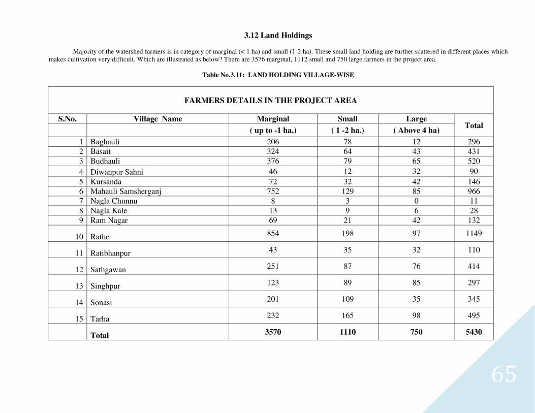
65
3.12 Land Holdings
Majority of the watershed farmers is in category of marginal (< 1 ha) and small (1-2 ha). These small land holding are further scattered in different places which makes cultivation very difficult. Which are illustrated as below? There are 3576 marginal, 1112 small and 750 large farmers in the project area.
Table No.3.11: LAND HOLDING VILLAGE-WISE
FARMERS DETAILS IN THE PROJECT AREA
S.No. Village Name Marginal Small Large Total
( up to -1 ha.) ( 1 -2 ha.) ( Above 4 ha)
1 Baghauli 206 78 12 296
2 Basait 324 64 43 431
3 Budhauli 376 79 65 520
4 Diwanpur Sahni 46 12 32 90
5 Kursanda 72 32 42 146
6 Mahauli Samsherganj 752 129 85 966
7 Nagla Chunnu 8 3 0 11
8 Nagla Kale 13 9 6 28
9 Ram Nagar 69 21 42 132
10 Rathe 854 198 97 1149
11 Ratibhanpur 43 35 32 110
12 Sathgawan 251 87 76 414
13 Singhpur 123 89 85 297
14 Sonasi 201 109 35 345
15 Tarha 232 165 98 495
Total 3570 1110 750 5430
66
3.13 SCIENTIFIC PLANNING:
I) CLUSTER APPROACH
This envisages a broader vision of Geo-hydrological unit which involves treating a cluster of micro-watershed. District Mainpuri (IWMP-I) project is located in Kisni Block is a cluster of seven micro-watersheds.
3.14 BASE LINE SURVEY
To access the impact of any watershed development programme a detailed baseline survey has to be conducted. This acts a benchmark for any intervention during and post implementation of any development programme. A detailed baseline survey was undertaken which involved household census survey, Bio-physical survey and Village level data collection from Censex Data.
Household census survey includes a detailed questionnaire which was been filled by visiting each and every household in the village. This gave in the details of the demographic profile of the village, the literacy percentage, SC/ST population, number of BPL household, cattle population, net consumption rate in the village, average milk production of the cattle and various schemes running and their benefits. Bio-physical survey was undertaken to identify various natural resources available in the village. It included the soil typology, well in the area, crop taken in the field, Cropping pattern, fertilizer used and various sources of irrigation in the field.
3.15 PARTICIPATORY RURAL APPRAISAL (PRA)
The past experience of watershed has given tremendous input to focus on creating accountability of the stakeholders towards the programme. This has created an emphasis to include all the stakeholder communities and their local and indigenous Technological Knowledge (ITK) while planning for any activity. Participatory approach provides a new path for planning, implementing, monitoring and post- withdrawal activities with a complete accountability of the stakeholders. Various PRA techniques like resource mapping, social mapping, and season calendars were used to understand the physical and social orientation of the village in general and watershed in specific.
These tools put the villagers in ease than the complicated questionnaires. Various tools like Matrix ranking, Venn Diagram were used to identify various local vegetations (apt for afforestation), Fodders crops , various institution and their significance in the life of the farmers.
67
3.15.1 USE OF GIS AND REMOTE SENSING FOR PLANNING
Use of various high science tools has been promoted at various stages of watershed development.
a) PRIORITIZATION
Geographical Information System (GIS) has been used for prioritization process. Various layer maps were created like Geo-
morphological, Soil, BPL Population, SC/ST population, Ground water Status, Drinking water situation Slope percent. These were all
given proper weightage according to the DoLR specification. This helped in prioritization of various watershed areas.
b) PLANNING
A action plan matrix was formulated by State Level Nodal Agency (SLNA) taking into account various features like the slope
percent, soil Depth, Soil Texture, Soil erosion in the area for wasteland, forest land and agricultural land. Global positioning System
(GPS) was used to identify each and every water conservation structures available in the project area. This was used to create a map.
Contour Map of vertical interval of 1 meter at a scale of 1:4000 was used for identifying various locations for soil and water
conservation structures.
3.15.2 HYDROLOGICAL MODELLING
Hydrology modelling technique was used for locating drainage, stream length, flow direction, sink, Flow accumulation. This
model overlaid over cadastral map to calculate the catchment area of each structures like the check dam etc. This has helped to
remove the human error which generally occurs while calculating the catchment area of a check dam.
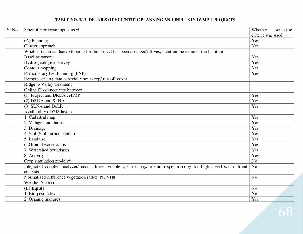
68
TABLE NO. 3.12: DETAILS OF SCIENTIFIC PLANNING AND INPUTS IN IWMP-I PROJECTS
Sl.No. Scientific criteria/ inputs used Whether scientific criteria was used
(A) Planning Yes
Cluster approach Yes
Whether technical back-stopping for the project has been arranged? If yes, mention the name of the Institute
Baseline survey Yes
Hydro-geological survey Yes
Contour mapping Yes
Participatory Net Planning (PNP) Yes
Remote sensing data-especially soil/ crop/ run-off cover
Ridge to Valley treatment
Online IT connectivity between
(1) Project and DRDA cell/ZP Yes
(2) DRDA and SLNA Yes
(3) SLNA and DoLR Yes
Availability of GIS layers
1. Cadastral map Yes
2. Village boundaries Yes
3. Drainage Yes
4. Soil (Soil nutrient status) Yes
5. Land use Yes
6. Ground water status Yes
7. Watershed boundaries Yes
8. Activity Yes
Crop simulation models# No
Integrated coupled analyzer/ near infrared visible spectroscopy/ medium spectroscopy for high speed soil nutrient analysis
No
Normalized difference vegetation index (NDVI)# No
Weather Station
(B) Inputs No
1. Bio-pesticides No
2. Organic manures Yes
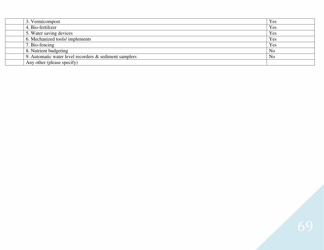
69
3. Vermicompost Yes
4. Bio-fertilizer Yes
5. Water saving devices Yes
6. Mechanized tools/ implements Yes
7. Bio-fencing Yes
8. Nutrient budgeting No
9. Automatic water level recorders & sediment samplers No
Any other (please specify)
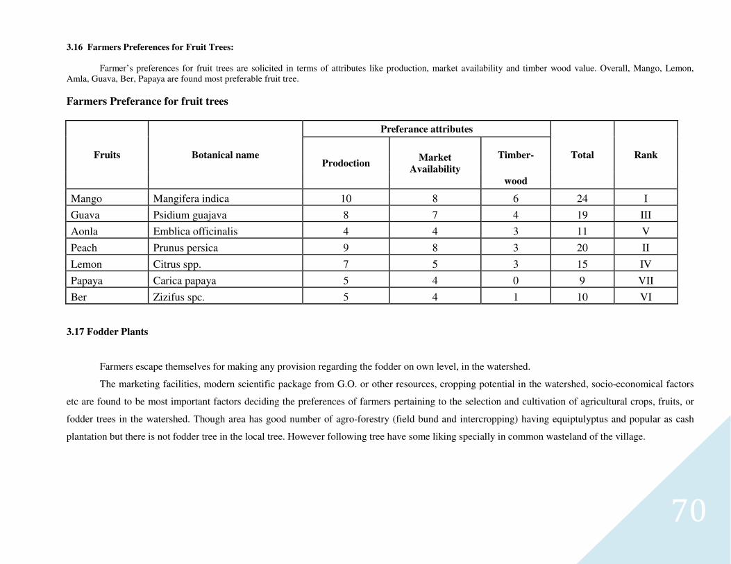
70
3.16 Farmers Preferences for Fruit Trees:
Farmer’s preferences for fruit trees are solicited in terms of attributes like production, market availability and timber wood value. Overall, Mango, Lemon, Amla, Guava, Ber, Papaya are found most preferable fruit tree.
Farmers Preferance for fruit trees
Fruits Botanical name
Preferance attributes
Total Rank Prodoction
Market
Availability
Timber-
wood
Mango Mangifera indica 10 8 6 24 I
Guava Psidium guajava 8 7 4 19 III
Aonla Emblica officinalis 4 4 3 11 V
Peach Prunus persica 9 8 3 20 II
Lemon Citrus spp. 7 5 3 15 IV
Papaya Carica papaya 5 4 0 9 VII
Ber Zizifus spc. 5 4 1 10 VI
3.17 Fodder Plants
Farmers escape themselves for making any provision regarding the fodder on own level, in the watershed.
The marketing facilities, modern scientific package from G.O. or other resources, cropping potential in the watershed, socio-economical factors
etc are found to be most important factors deciding the preferences of farmers pertaining to the selection and cultivation of agricultural crops, fruits, or
fodder trees in the watershed. Though area has good number of agro-forestry (field bund and intercropping) having equiptulyptus and popular as cash
plantation but there is not fodder tree in the local tree. However following tree have some liking specially in common wasteland of the village.
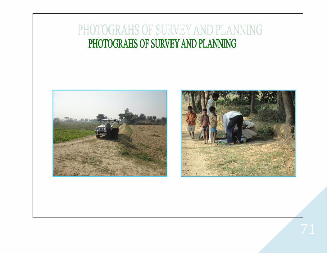
71
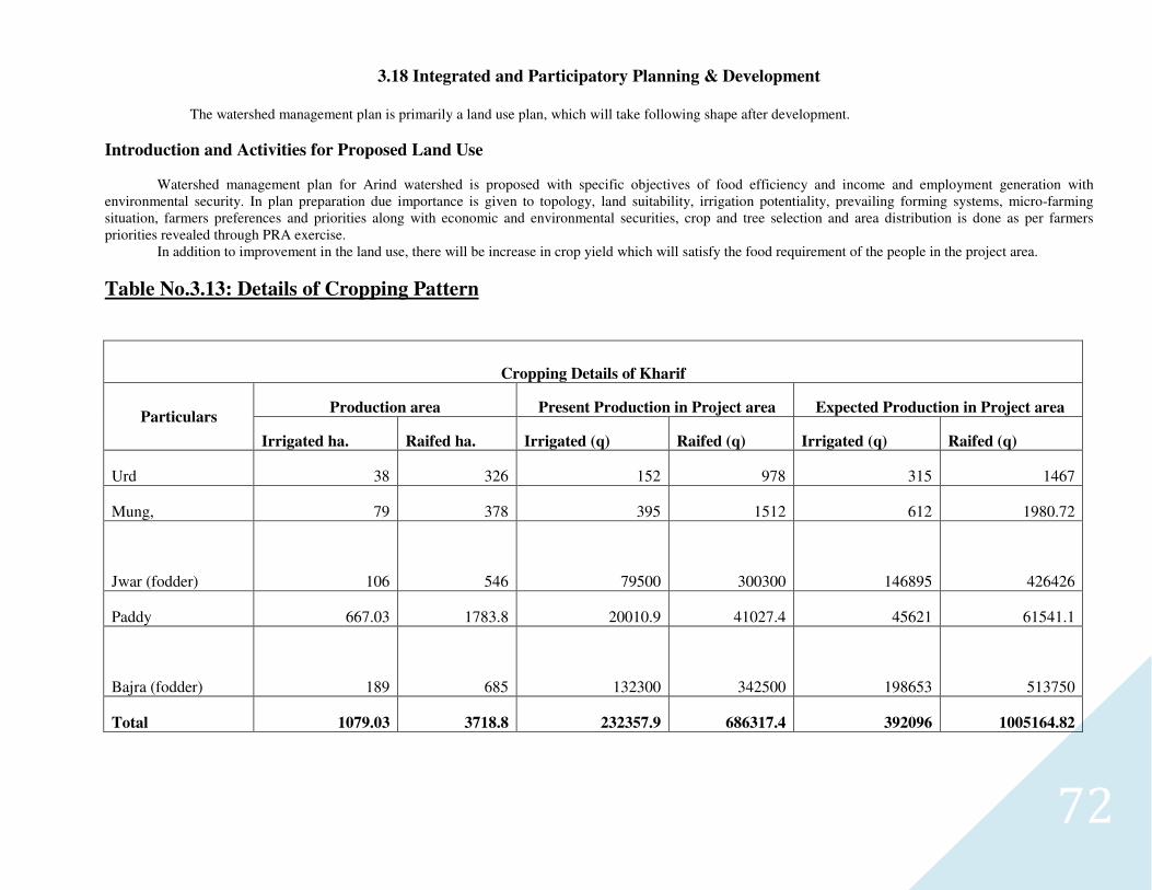
72
3.18 Integrated and Participatory Planning & Development
The watershed management plan is primarily a land use plan, which will take following shape after development.
Introduction and Activities for Proposed Land Use
Watershed management plan for Arind watershed is proposed with specific objectives of food efficiency and income and employment generation with environmental security. In plan preparation due importance is given to topology, land suitability, irrigation potentiality, prevailing forming systems, micro-farming situation, farmers preferences and priorities along with economic and environmental securities, crop and tree selection and area distribution is done as per farmers priorities revealed through PRA exercise. In addition to improvement in the land use, there will be increase in crop yield which will satisfy the food requirement of the people in the project area.
Table No.3.13: Details of Cropping Pattern
Cropping Details of Kharif
Particulars Production area Present Production in Project area Expected Production in Project area
Irrigated ha. Raifed ha. Irrigated (q) Raifed (q) Irrigated (q) Raifed (q)
Urd 38 326 152 978 315 1467
Mung, 79 378 395 1512 612 1980.72
Jwar (fodder) 106 546 79500 300300 146895 426426
Paddy 667.03 1783.8 20010.9 41027.4 45621 61541.1
Bajra (fodder) 189 685 132300 342500 198653 513750
Total 1079.03 3718.8 232357.9 686317.4 392096 1005164.82
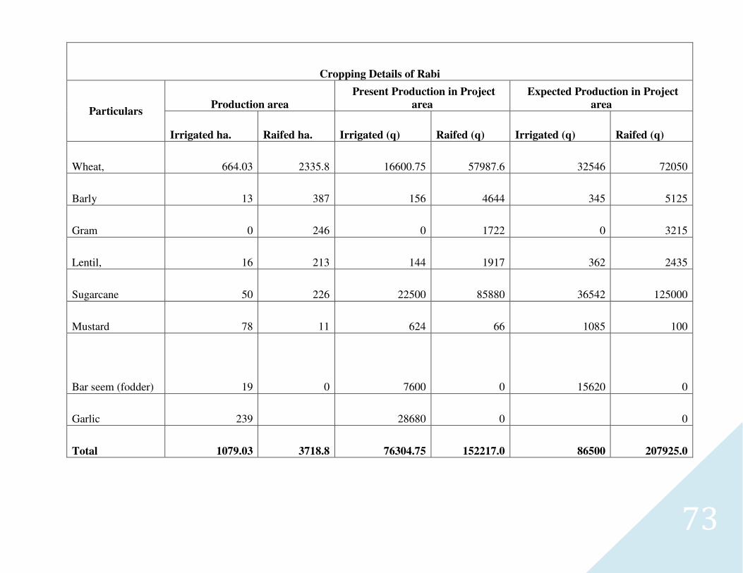
73
Cropping Details of Rabi
Particulars Production area
Present Production in Project
area
Expected Production in Project
area
Irrigated ha. Raifed ha. Irrigated (q) Raifed (q) Irrigated (q) Raifed (q)
Wheat, 664.03 2335.8 16600.75 57987.6 32546 72050
Barly 13 387 156 4644 345 5125
Gram 0 246 0 1722 0 3215
Lentil, 16 213 144 1917 362 2435
Sugarcane 50 226 22500 85880 36542 125000
Mustard 78 11 624 66 1085 100
Bar seem (fodder) 19 0 7600 0 15620 0
Garlic 239 28680 0 0
Total 1079.03 3718.8 76304.75 152217.0 86500 207925.0
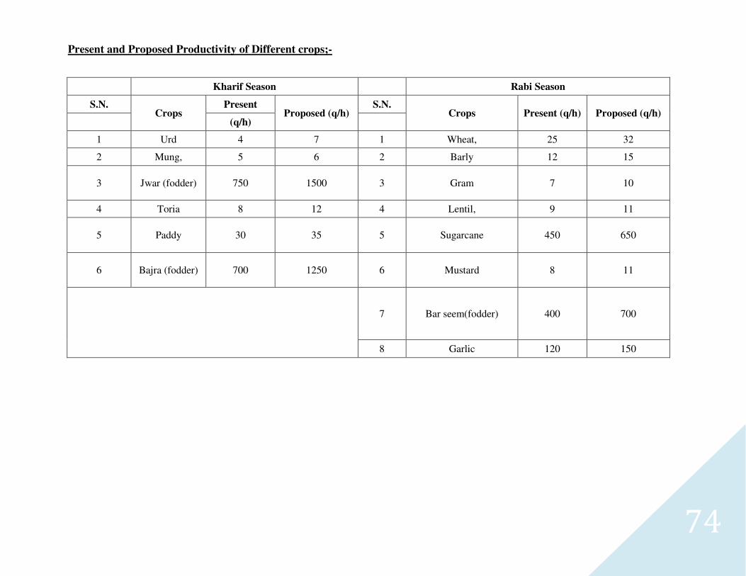
74
Present and Proposed Productivity of Different crops;-
Kharif Season
Rabi Season
S.N. Crops
Present Proposed (q/h)
S.N. Crops Present (q/h) Proposed (q/h)
(q/h)
1 Urd 4 7 1 Wheat, 25 32
2 Mung, 5 6 2 Barly 12 15
3 Jwar (fodder) 750 1500 3 Gram 7 10
4 Toria 8 12 4 Lentil, 9 11
5 Paddy 30 35 5 Sugarcane 450 650
6 Bajra (fodder) 700 1250 6 Mustard 8 11
7 Bar seem(fodder) 400 700
8 Garlic 120 150
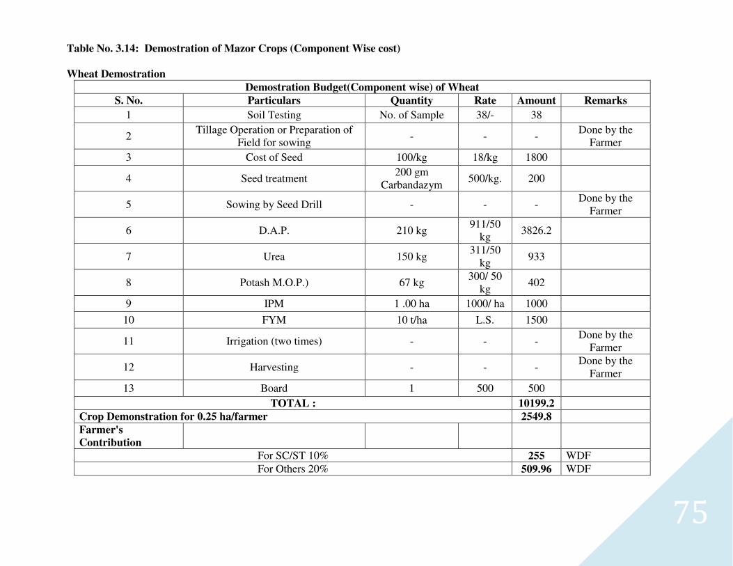
75
Table No. 3.14: Demostration of Mazor Crops (Component Wise cost)
Wheat Demostration
Demostration Budget(Component wise) of Wheat
S. No. Particulars Quantity Rate Amount Remarks
1 Soil Testing No. of Sample 38/- 38
2 Tillage Operation or Preparation of
Field for sowing - - -
Done by the Farmer
3 Cost of Seed 100/kg 18/kg 1800
4 Seed treatment 200 gm
Carbandazym 500/kg. 200
5 Sowing by Seed Drill - - - Done by the
Farmer
6 D.A.P. 210 kg 911/50
kg 3826.2
7 Urea 150 kg 311/50
kg 933
8 Potash M.O.P.) 67 kg 300/ 50
kg 402
9 IPM 1 .00 ha 1000/ ha 1000
10 FYM 10 t/ha L.S. 1500
11 Irrigation (two times) - - - Done by the
Farmer
12 Harvesting - - - Done by the
Farmer
13 Board 1 500 500
TOTAL : 10199.2
Crop Demonstration for 0.25 ha/farmer 2549.8
Farmer's
Contribution
For SC/ST 10% 255 WDF
For Others 20% 509.96 WDF
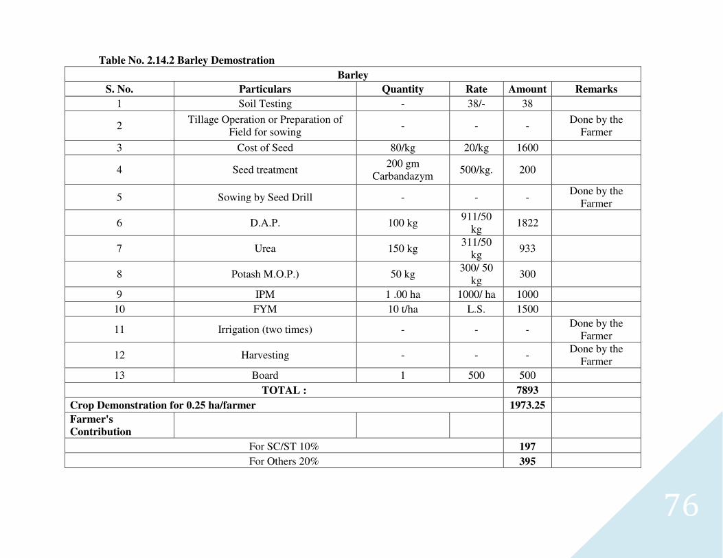
76
Table No. 2.14.2 Barley Demostration
Barley
S. No. Particulars Quantity Rate Amount Remarks
1 Soil Testing - 38/- 38
2 Tillage Operation or Preparation of
Field for sowing - - -
Done by the Farmer
3 Cost of Seed 80/kg 20/kg 1600
4 Seed treatment 200 gm
Carbandazym 500/kg. 200
5 Sowing by Seed Drill - - - Done by the
Farmer
6 D.A.P. 100 kg 911/50
kg 1822
7 Urea 150 kg 311/50
kg 933
8 Potash M.O.P.) 50 kg 300/ 50
kg 300
9 IPM 1 .00 ha 1000/ ha 1000
10 FYM 10 t/ha L.S. 1500
11 Irrigation (two times) - - - Done by the
Farmer
12 Harvesting - - - Done by the
Farmer
13 Board 1 500 500
TOTAL : 7893
Crop Demonstration for 0.25 ha/farmer 1973.25
Farmer's
Contribution
For SC/ST 10% 197
For Others 20% 395
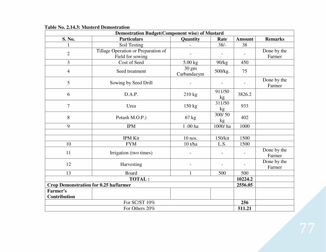
77
Table No. 2.14.3: Musterd Demostration
Demostration Budget(Component wise) of Mustard
S. No. Particulars Quantity Rate Amount Remarks
1 Soil Testing - 38/- 38
2 Tillage Operation or Preparation of
Field for sowing - - -
Done by the Farmer
3 Cost of Seed 5.00 kg 90/kg 450
4 Seed treatment 30 gm
Carbandazym 500/kg. 75
5 Sowing by Seed Drill - - - Done by the
Farmer
6 D.A.P. 210 kg 911/50
kg 3826.2
7 Urea 150 kg 311/50
kg 933
8 Potash M.O.P.) 67 kg 300/ 50
kg 402
9 IPM 1 .00 ha 1000/ ha 1000
IPM Kit 10 nos. 150/kit 1500
10 FYM 10 t/ha L.S. 1500
11 Irrigation (two times) - - - Done by the
Farmer
12 Harvesting - - - Done by the
Farmer
13 Board 1 500 500
TOTAL : 10224.2
Crop Demonstration for 0.25 ha/farmer 2556.05
Farmer's
Contribution
For SC/ST 10% 256
For Others 20% 511.21
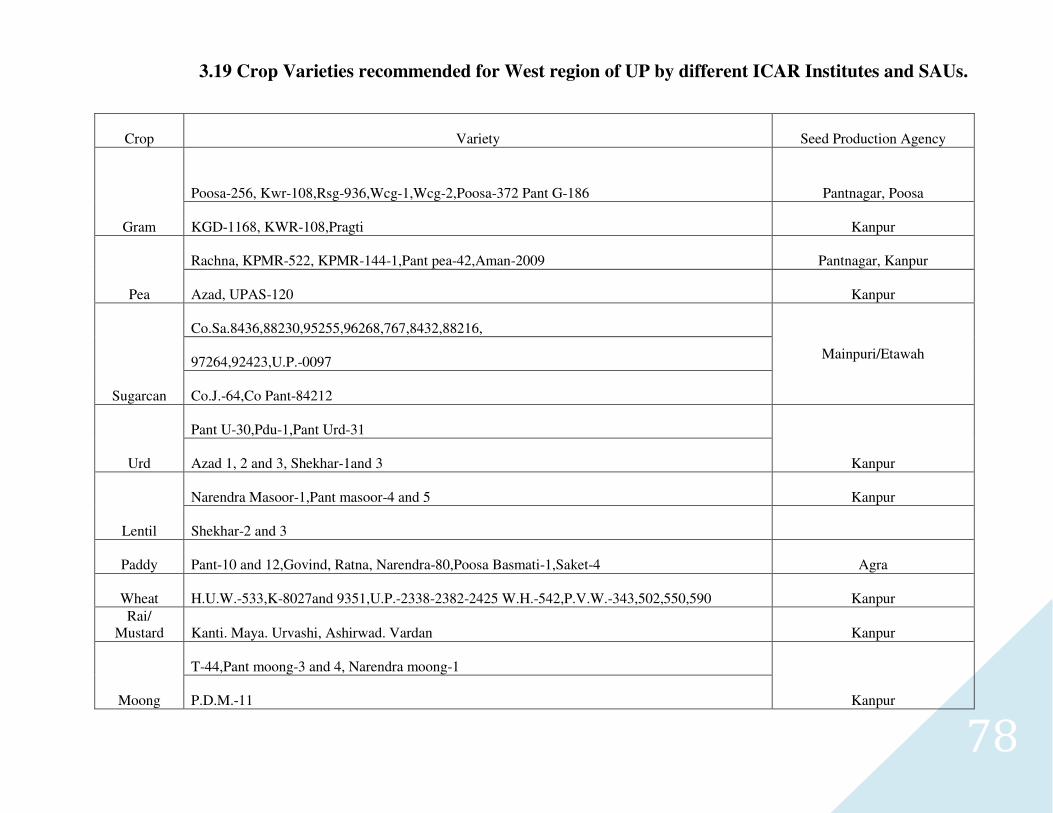
78
3.19 Crop Varieties recommended for West region of UP by different ICAR Institutes and SAUs.
Crop Variety Seed Production Agency
Gram
Poosa-256, Kwr-108,Rsg-936,Wcg-1,Wcg-2,Poosa-372 Pant G-186 Pantnagar, Poosa
KGD-1168, KWR-108,Pragti Kanpur
Pea
Rachna, KPMR-522, KPMR-144-1,Pant pea-42,Aman-2009 Pantnagar, Kanpur
Azad, UPAS-120 Kanpur
Sugarcan
Co.Sa.8436,88230,95255,96268,767,8432,88216,
Mainpuri/Etawah 97264,92423,U.P.-0097
Co.J.-64,Co Pant-84212
Urd
Pant U-30,Pdu-1,Pant Urd-31
Kanpur Azad 1, 2 and 3, Shekhar-1and 3
Lentil
Narendra Masoor-1,Pant masoor-4 and 5 Kanpur
Shekhar-2 and 3
Paddy Pant-10 and 12,Govind, Ratna, Narendra-80,Poosa Basmati-1,Saket-4 Agra
Wheat H.U.W.-533,K-8027and 9351,U.P.-2338-2382-2425 W.H.-542,P.V.W.-343,502,550,590 Kanpur Rai/
Mustard Kanti. Maya. Urvashi, Ashirwad. Vardan Kanpur
Moong
T-44,Pant moong-3 and 4, Narendra moong-1
Kanpur P.D.M.-11
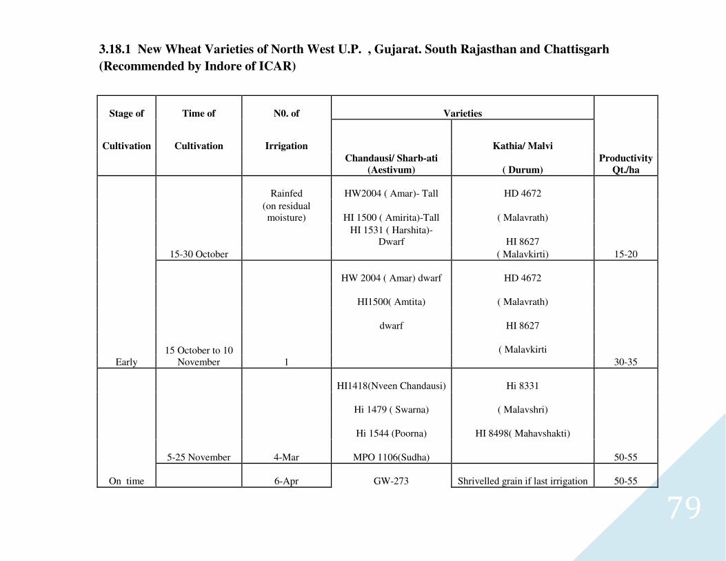
79
3.18.1 New Wheat Varieties of North West U.P. , Gujarat. South Rajasthan and Chattisgarh
(Recommended by Indore of ICAR)
Stage of Time of N0. of Varieties
Productivity
Qt./ha
Cultivation Cultivation Irrigation
Chandausi/ Sharb-ati
(Aestivum)
Kathia/ Malvi
( Durum)
Early
15-30 October
Rainfed HW2004 ( Amar)- Tall HD 4672
15-20
(on residual moisture) HI 1500 ( Amirita)-Tall ( Malavrath)
HI 1531 ( Harshita)-
Dwarf HI 8627
( Malavkirti)
15 October to 10 November 1
HW 2004 ( Amar) dwarf HD 4672
30-35
HI1500( Amtita) ( Malavrath)
dwarf HI 8627
( Malavkirti
On time
5-25 November 4-Mar
HI1418(Nveen Chandausi) Hi 8331
50-55
Hi 1479 ( Swarna) ( Malavshri)
Hi 1544 (Poorna) HI 8498( Mahavshakti)
MPO 1106(Sudha)
6-Apr GW-273 Shrivelled grain if last irrigation 50-55
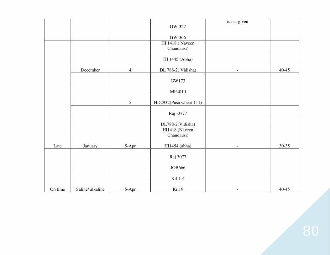
80
GW-322 is nat given
GW-366
Late
December 4
HI 1418 ( Naveen Chandausi)
- 40-45
HI 1445 (Abha)
DL 788-2( Vidisha)
5
GW173
MP4010
HD2932(Pusa wheat-111)
January 5-Apr
Raj -3777
- 30-35
DL788-2(Vidisha)
HI1418 (Naveen Chandausi)
HI1454 (abha)
On time Saline/ alkaline 5-Apr
Raj 3077
- 40-45
JOB666
Krl 1-4
Krl19
81
CHAPTER-4
.
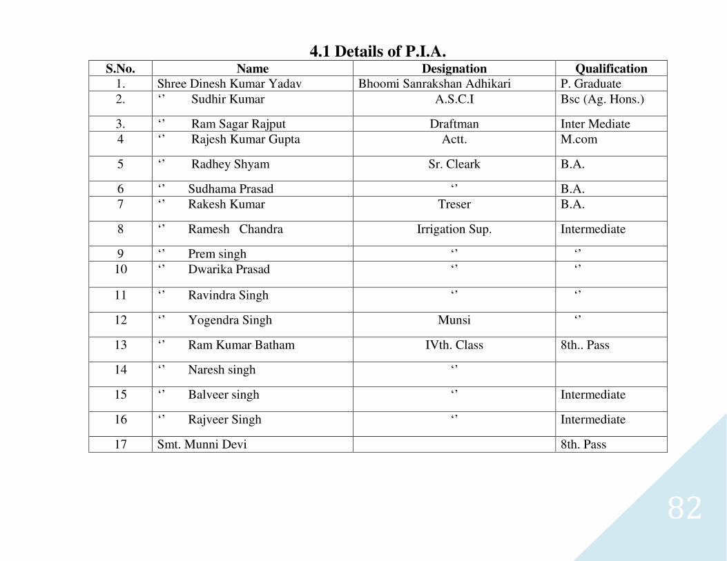
82
4.1 Details of P.I.A. S.No. Name Designation Qualification
1. Shree Dinesh Kumar Yadav Bhoomi Sanrakshan Adhikari P. Graduate
2. ‘’ Sudhir Kumar A.S.C.I Bsc (Ag. Hons.)
3. ‘’ Ram Sagar Rajput Draftman Inter Mediate
4 ‘’ Rajesh Kumar Gupta Actt. M.com
5 ‘’ Radhey Shyam Sr. Cleark B.A.
6 ‘’ Sudhama Prasad ‘’ B.A.
7 ‘’ Rakesh Kumar Treser B.A.
8 ‘’ Ramesh Chandra Irrigation Sup. Intermediate
9 ‘’ Prem singh ‘’ ‘’
10 ‘’ Dwarika Prasad ‘’ ‘’
11 ‘’ Ravindra Singh ‘’ ‘’
12 ‘’ Yogendra Singh Munsi ‘’
13 ‘’ Ram Kumar Batham IVth. Class 8th.. Pass
14 ‘’ Naresh singh ‘’
15 ‘’ Balveer singh ‘’ Intermediate
16 ‘’ Rajveer Singh ‘’ Intermediate
17 Smt. Munni Devi 8th. Pass
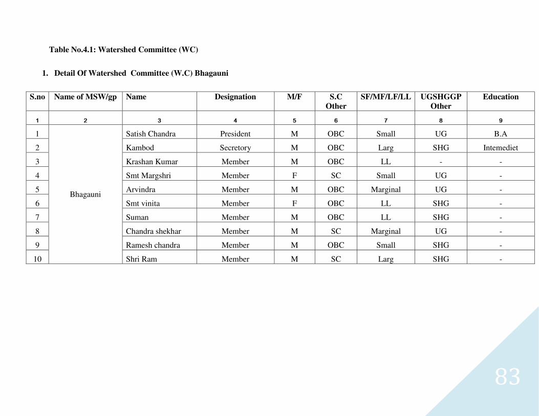
83
Table No.4.1: Watershed Committee (WC)
1. Detail Of Watershed Committee (W.C) Bhagauni
S.no Name of MSW/gp Name Designation M/F S.C
Other
SF/MF/LF/LL UGSHGGP
Other
Education
1 2 3 4 5 6 7 8 9
1
Bhagauni
Satish Chandra President M OBC Small UG B.A
2 Kambod Secretory M OBC Larg SHG Intemediet
3 Krashan Kumar Member M OBC LL - -
4 Smt Margshri Member F SC Small UG -
5 Arvindra Member M OBC Marginal UG -
6 Smt vinita Member F OBC LL SHG -
7 Suman Member M OBC LL SHG -
8 Chandra shekhar Member M SC Marginal UG -
9 Ramesh chandra Member M OBC Small SHG -
10 Shri Ram Member M SC Larg SHG -
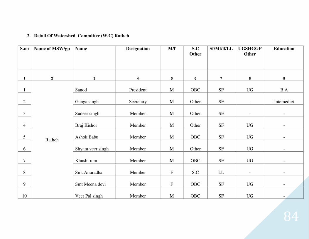
84
2. Detail Of Watershed Committee (W.C) Ratheh
S.no Name of MSW/gp Name Designation M/f S.C
Other
Sf/Mf/lf/LL UGSHGGP
Other
Education
1 2 3 4 5 6 7 8 9
1
Ratheh
Sanod President M OBC SF UG B.A
2 Ganga singh Secretary M Other SF - Intemediet
3 Sudeer singh Member M Other SF - -
4 Braj Kishor Member M Other SF UG -
5 Ashok Babu Member M OBC SF UG -
6 Shyam veer singh Member M Other SF UG -
7 Khushi ram Member M OBC SF UG -
8 Smt Anuradha Member F S.C LL - -
9 Smt Meena devi Member F OBC SF UG -
10 Veer Pal singh Member M OBC SF UG -
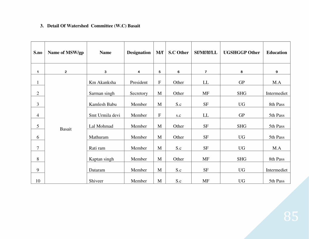
85
3. Detail Of Watershed Committee (W.C) Basait
S.no Name of MSW/gp Name Designation M/f S.C Other Sf/Mf/lf/LL UGSHGGP Other Education
1 2 3 4 5 6 7 8 9
1
Basait
Km Akanksha President F Other LL GP M.A
2 Sarman singh Secretory M Other MF SHG Intermediet
3 Kamlesh Babu Member M S.c SF UG 8th Pass
4 Smt Urmila devi Member F s.c LL GP 5th Pass
5 Lal Mohmad Member M Other SF SHG 5th Pass
6 Mathuram Member M Other SF UG 5th Pass
7 Rati ram Member M S.c SF UG M.A
8 Kaptan singh Member M Other MF SHG 8th Pass
9 Dataram Member M S.c SF UG Intermediet
10 Shiveer Member M S.c MF UG 5th Pass
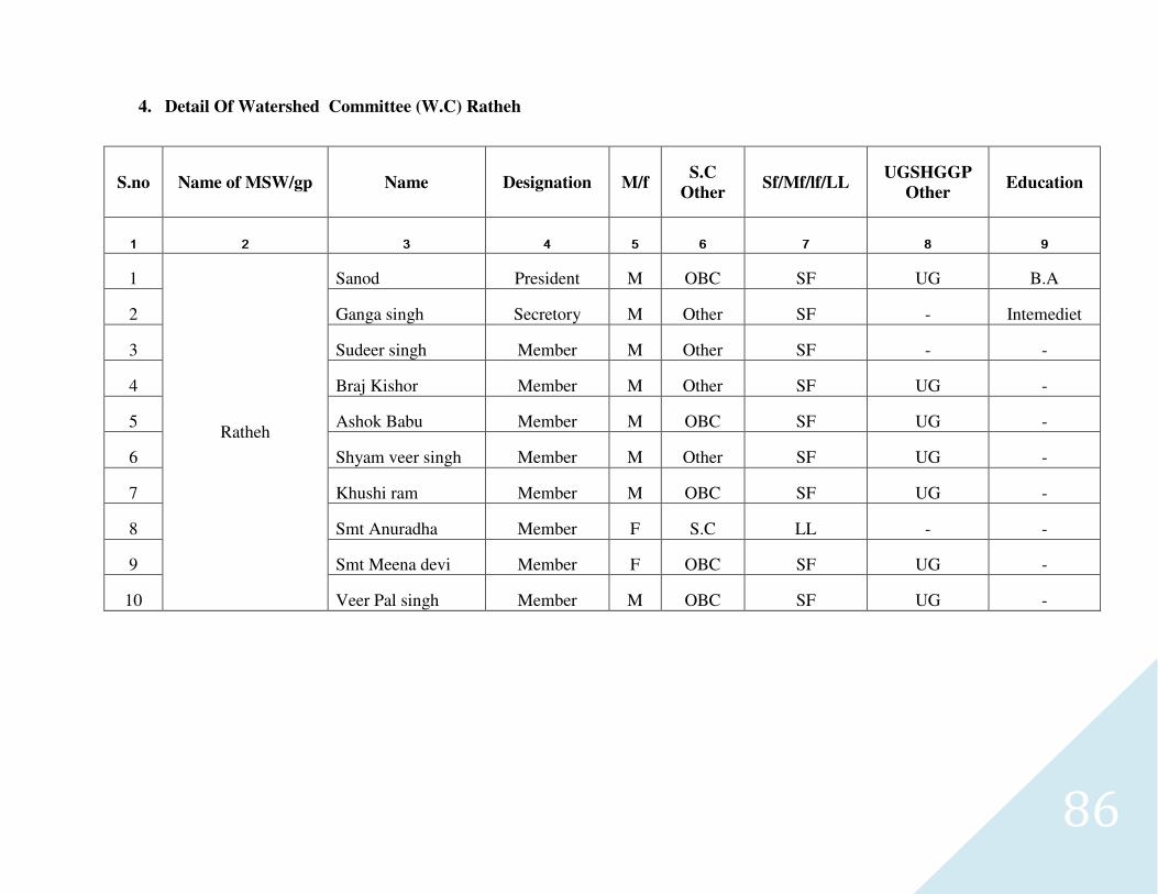
86
4. Detail Of Watershed Committee (W.C) Ratheh
S.no Name of MSW/gp Name Designation M/f S.C
Other Sf/Mf/lf/LL
UGSHGGP
Other Education
1 2 3 4 5 6 7 8 9
1
Ratheh
Sanod President M OBC SF UG B.A
2 Ganga singh Secretory M Other SF - Intemediet
3 Sudeer singh Member M Other SF - -
4 Braj Kishor Member M Other SF UG -
5 Ashok Babu Member M OBC SF UG -
6 Shyam veer singh Member M Other SF UG -
7 Khushi ram Member M OBC SF UG -
8 Smt Anuradha Member F S.C LL - -
9 Smt Meena devi Member F OBC SF UG -
10 Veer Pal singh Member M OBC SF UG -
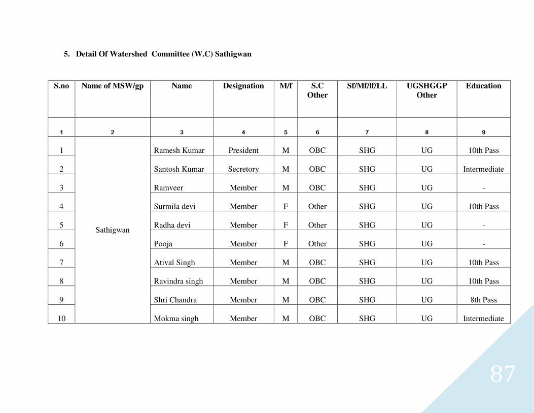
87
5. Detail Of Watershed Committee (W.C) Sathigwan
S.no Name of MSW/gp Name Designation M/f S.C
Other
Sf/Mf/lf/LL UGSHGGP
Other
Education
1 2 3 4 5 6 7 8 9
1
Sathigwan
Ramesh Kumar President M OBC SHG UG 10th Pass
2 Santosh Kumar Secretory M OBC SHG UG Intermediate
3 Ramveer Member M OBC SHG UG -
4 Surmila devi Member F Other SHG UG 10th Pass
5 Radha devi Member F Other SHG UG -
6 Pooja Member F Other SHG UG -
7 Atival Singh Member M OBC SHG UG 10th Pass
8 Ravindra singh Member M OBC SHG UG 10th Pass
9 Shri Chandra Member M OBC SHG UG 8th Pass
10 Mokma singh Member M OBC SHG UG Intermediate
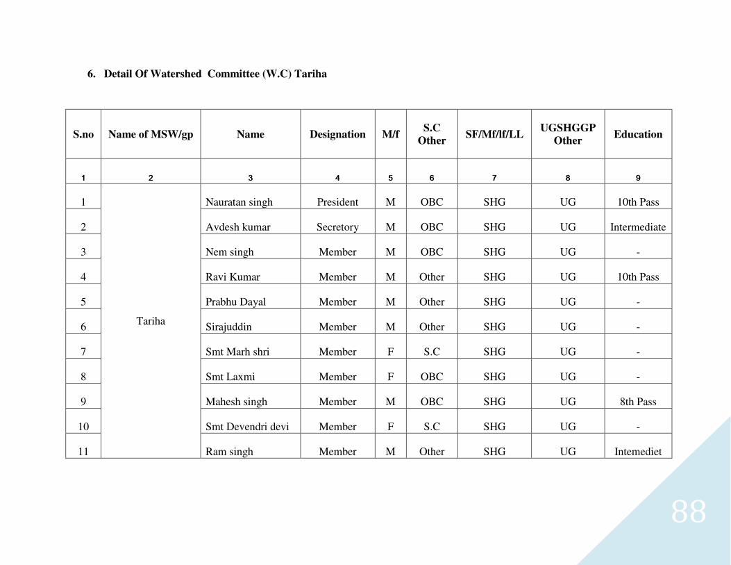
88
6. Detail Of Watershed Committee (W.C) Tariha
S.no Name of MSW/gp Name Designation M/f S.C
Other SF/Mf/lf/LL
UGSHGGP
Other Education
1 2 3 4 5 6 7 8 9
1
Tariha
Nauratan singh President M OBC SHG UG 10th Pass
2 Avdesh kumar Secretory M OBC SHG UG Intermediate
3 Nem singh Member M OBC SHG UG -
4 Ravi Kumar Member M Other SHG UG 10th Pass
5 Prabhu Dayal Member M Other SHG UG -
6 Sirajuddin Member M Other SHG UG -
7 Smt Marh shri Member F S.C SHG UG -
8 Smt Laxmi Member F OBC SHG UG -
9 Mahesh singh Member M OBC SHG UG 8th Pass
10 Smt Devendri devi Member F S.C SHG UG -
11 Ram singh Member M Other SHG UG Intemediet
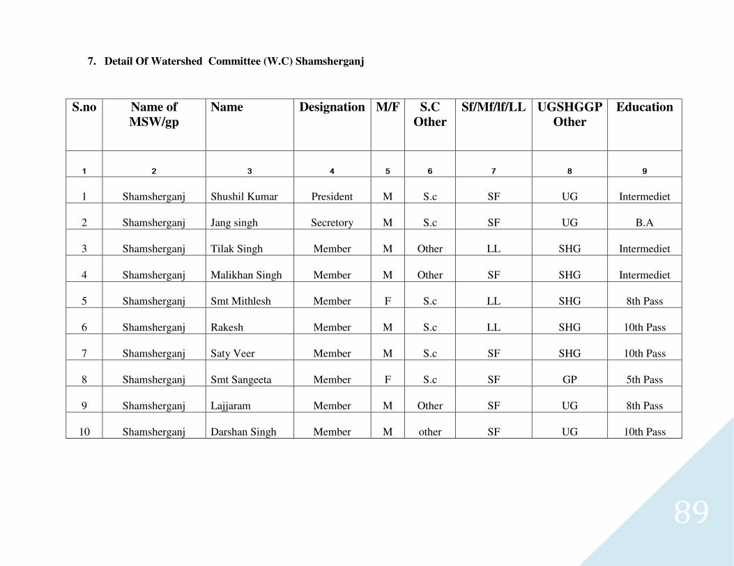
89
7. Detail Of Watershed Committee (W.C) Shamsherganj
S.no Name of
MSW/gp
Name Designation M/F S.C
Other
Sf/Mf/lf/LL UGSHGGP
Other
Education
1 2 3 4 5 6 7 8 9
1 Shamsherganj Shushil Kumar President M S.c SF UG Intermediet
2 Shamsherganj Jang singh Secretory M S.c SF UG B.A
3 Shamsherganj Tilak Singh Member M Other LL SHG Intermediet
4 Shamsherganj Malikhan Singh Member M Other SF SHG Intermediet
5 Shamsherganj Smt Mithlesh Member F S.c LL SHG 8th Pass
6 Shamsherganj Rakesh Member M S.c LL SHG 10th Pass
7 Shamsherganj Saty Veer Member M S.c SF SHG 10th Pass
8 Shamsherganj Smt Sangeeta Member F S.c SF GP 5th Pass
9 Shamsherganj Lajjaram Member M Other SF UG 8th Pass
10 Shamsherganj Darshan Singh Member M other SF UG 10th Pass
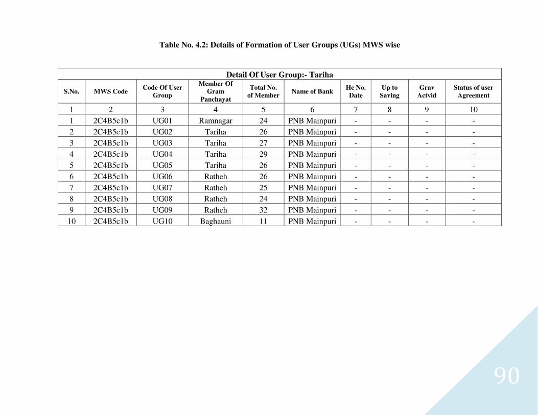
90
Table No. 4.2: Details of Formation of User Groups (UGs) MWS wise
Detail Of User Group:- Tariha
S.No. MWS Code Code Of User
Group
Member Of
Gram
Panchayat
Total No.
of Member Name of Bank
Hc No.
Date
Up to
Saving
Grav
Actvid
Status of user
Agreement
1 2 3 4 5 6 7 8 9 10
1 2C4B5c1b UG01 Ramnagar 24 PNB Mainpuri - - - -
2 2C4B5c1b UG02 Tariha 26 PNB Mainpuri - - - -
3 2C4B5c1b UG03 Tariha 27 PNB Mainpuri - - - -
4 2C4B5c1b UG04 Tariha 29 PNB Mainpuri - - - -
5 2C4B5c1b UG05 Tariha 26 PNB Mainpuri - - - -
6 2C4B5c1b UG06 Ratheh 26 PNB Mainpuri - - - -
7 2C4B5c1b UG07 Ratheh 25 PNB Mainpuri - - - -
8 2C4B5c1b UG08 Ratheh 24 PNB Mainpuri - - - -
9 2C4B5c1b UG09 Ratheh 32 PNB Mainpuri - - - -
10 2C4B5c1b UG10 Baghauni 11 PNB Mainpuri - - - -
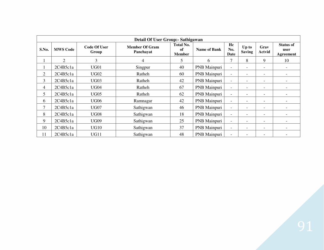
91
Detail Of User Group:- Sathigawan
S.No. MWS Code Code Of User
Group
Member Of Gram
Panchayat
Total No.
of
Member
Name of Bank
Hc
No.
Date
Up to
Saving
Grav
Actvid
Status of
user
Agreement
1 2 3 4 5 6 7 8 9 10
1 2C4B5c1a UG01 Singpur 40 PNB Mainpuri - - - -
2 2C4B5c1a UG02 Ratheh 60 PNB Mainpuri - - - -
3 2C4B5c1a UG03 Ratheh 42 PNB Mainpuri - - - -
4 2C4B5c1a UG04 Ratheh 67 PNB Mainpuri - - - -
5 2C4B5c1a UG05 Ratheh 62 PNB Mainpuri - - - -
6 2C4B5c1a UG06 Ramnagar 42 PNB Mainpuri - - - -
7 2C4B5c1a UG07 Sathigwan 46 PNB Mainpuri - - - -
8 2C4B5c1a UG08 Sathigwan 18 PNB Mainpuri - - - -
9 2C4B5c1a UG09 Sathigwan 25 PNB Mainpuri - - - -
10 2C4B5c1a UG10 Sathigwan 37 PNB Mainpuri - - - -
11 2C4B5c1a UG11 Sathigwan 48 PNB Mainpuri - - - -
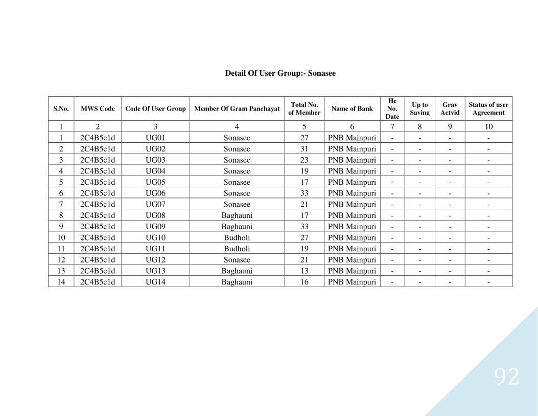
92
Detail Of User Group:- Sonasee
S.No. MWS Code Code Of User Group Member Of Gram Panchayat Total No.
of Member Name of Bank
Hc
No.
Date
Up to
Saving
Grav
Actvid
Status of user
Agreement
1 2 3 4 5 6 7 8 9 10
1 2C4B5c1d UG01 Sonasee 27 PNB Mainpuri - - - -
2 2C4B5c1d UG02 Sonasee 31 PNB Mainpuri - - - -
3 2C4B5c1d UG03 Sonasee 23 PNB Mainpuri - - - -
4 2C4B5c1d UG04 Sonasee 19 PNB Mainpuri - - - -
5 2C4B5c1d UG05 Sonasee 17 PNB Mainpuri - - - -
6 2C4B5c1d UG06 Sonasee 33 PNB Mainpuri - - - -
7 2C4B5c1d UG07 Sonasee 21 PNB Mainpuri - - - -
8 2C4B5c1d UG08 Baghauni 17 PNB Mainpuri - - - -
9 2C4B5c1d UG09 Baghauni 33 PNB Mainpuri - - - -
10 2C4B5c1d UG10 Budholi 27 PNB Mainpuri - - - -
11 2C4B5c1d UG11 Budholi 19 PNB Mainpuri - - - -
12 2C4B5c1d UG12 Sonasee 21 PNB Mainpuri - - - -
13 2C4B5c1d UG13 Baghauni 13 PNB Mainpuri - - - -
14 2C4B5c1d UG14 Baghauni 16 PNB Mainpuri - - - -
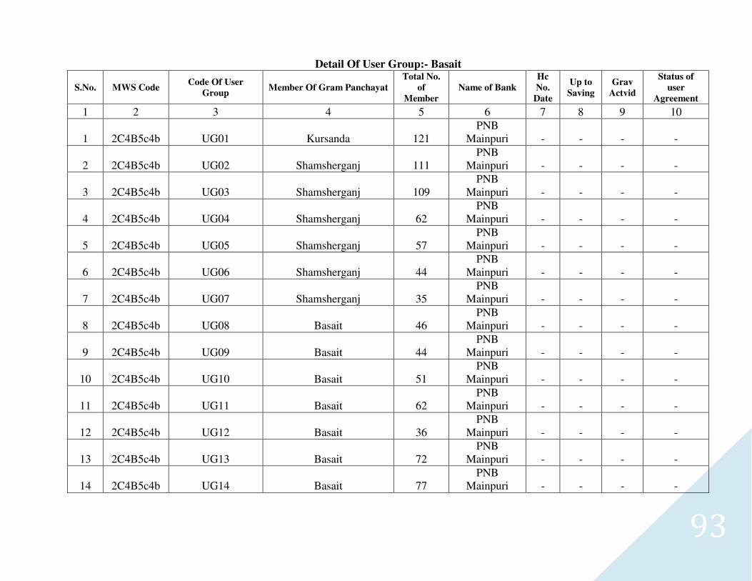
93
Detail Of User Group:- Basait
S.No. MWS Code Code Of User
Group Member Of Gram Panchayat
Total No.
of
Member
Name of Bank
Hc
No.
Date
Up to
Saving
Grav
Actvid
Status of
user
Agreement
1 2 3 4 5 6 7 8 9 10
1 2C4B5c4b UG01 Kursanda 121 PNB
Mainpuri - - - -
2 2C4B5c4b UG02 Shamsherganj 111 PNB
Mainpuri - - - -
3 2C4B5c4b UG03 Shamsherganj 109 PNB
Mainpuri - - - -
4 2C4B5c4b UG04 Shamsherganj 62 PNB
Mainpuri - - - -
5 2C4B5c4b UG05 Shamsherganj 57 PNB
Mainpuri - - - -
6 2C4B5c4b UG06 Shamsherganj 44 PNB
Mainpuri - - - -
7 2C4B5c4b UG07 Shamsherganj 35 PNB
Mainpuri - - - -
8 2C4B5c4b UG08 Basait 46 PNB
Mainpuri - - - -
9 2C4B5c4b UG09 Basait 44 PNB
Mainpuri - - - -
10 2C4B5c4b UG10 Basait 51 PNB
Mainpuri - - - -
11 2C4B5c4b UG11 Basait 62 PNB
Mainpuri - - - -
12 2C4B5c4b UG12 Basait 36 PNB
Mainpuri - - - -
13 2C4B5c4b UG13 Basait 72 PNB
Mainpuri - - - -
14 2C4B5c4b UG14 Basait 77 PNB
Mainpuri - - - -
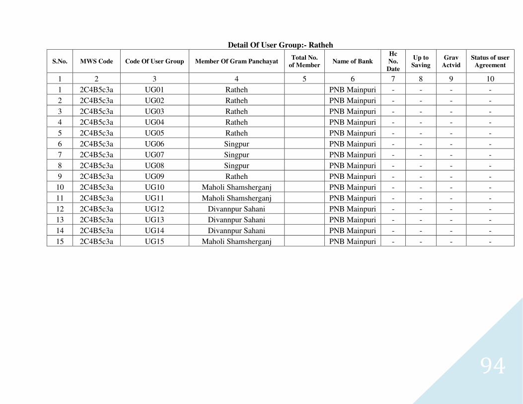
94
Detail Of User Group:- Ratheh
S.No. MWS Code Code Of User Group Member Of Gram Panchayat Total No.
of Member Name of Bank
Hc
No.
Date
Up to
Saving
Grav
Actvid
Status of user
Agreement
1 2 3 4 5 6 7 8 9 10
1 2C4B5c3a UG01 Ratheh PNB Mainpuri - - - -
2 2C4B5c3a UG02 Ratheh PNB Mainpuri - - - -
3 2C4B5c3a UG03 Ratheh PNB Mainpuri - - - -
4 2C4B5c3a UG04 Ratheh PNB Mainpuri - - - -
5 2C4B5c3a UG05 Ratheh PNB Mainpuri - - - -
6 2C4B5c3a UG06 Singpur PNB Mainpuri - - - -
7 2C4B5c3a UG07 Singpur PNB Mainpuri - - - -
8 2C4B5c3a UG08 Singpur PNB Mainpuri - - - -
9 2C4B5c3a UG09 Ratheh PNB Mainpuri - - - -
10 2C4B5c3a UG10 Maholi Shamsherganj PNB Mainpuri - - - -
11 2C4B5c3a UG11 Maholi Shamsherganj PNB Mainpuri - - - -
12 2C4B5c3a UG12 Divannpur Sahani PNB Mainpuri - - - -
13 2C4B5c3a UG13 Divannpur Sahani PNB Mainpuri - - - -
14 2C4B5c3a UG14 Divannpur Sahani PNB Mainpuri - - - -
15 2C4B5c3a UG15 Maholi Shamsherganj PNB Mainpuri - - - -
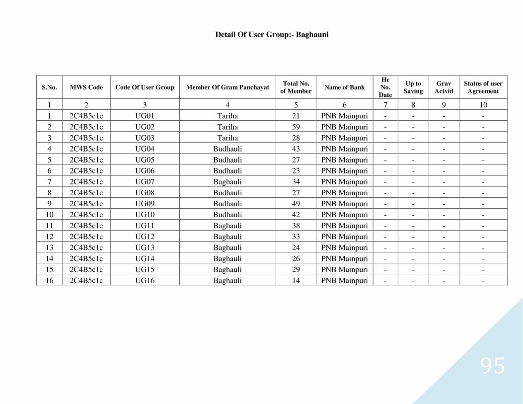
95
Detail Of User Group:- Baghauni
S.No. MWS Code Code Of User Group Member Of Gram Panchayat Total No.
of Member Name of Bank
Hc
No.
Date
Up to
Saving
Grav
Actvid
Status of user
Agreement
1 2 3 4 5 6 7 8 9 10
1 2C4B5c1c UG01 Tariha 21 PNB Mainpuri - - - -
2 2C4B5c1c UG02 Tariha 59 PNB Mainpuri - - - -
3 2C4B5c1c UG03 Tariha 28 PNB Mainpuri - - - -
4 2C4B5c1c UG04 Budhauli 43 PNB Mainpuri - - - -
5 2C4B5c1c UG05 Budhauli 27 PNB Mainpuri - - - -
6 2C4B5c1c UG06 Budhauli 23 PNB Mainpuri - - - -
7 2C4B5c1c UG07 Baghauli 34 PNB Mainpuri - - - -
8 2C4B5c1c UG08 Budhauli 27 PNB Mainpuri - - - -
9 2C4B5c1c UG09 Budhauli 49 PNB Mainpuri - - - -
10 2C4B5c1c UG10 Budhauli 42 PNB Mainpuri - - - -
11 2C4B5c1c UG11 Baghauli 38 PNB Mainpuri - - - -
12 2C4B5c1c UG12 Baghauli 33 PNB Mainpuri - - - -
13 2C4B5c1c UG13 Baghauli 24 PNB Mainpuri - - - -
14 2C4B5c1c UG14 Baghauli 26 PNB Mainpuri - - - -
15 2C4B5c1c UG15 Baghauli 29 PNB Mainpuri - - - -
16 2C4B5c1c UG16 Baghauli 14 PNB Mainpuri - - - -
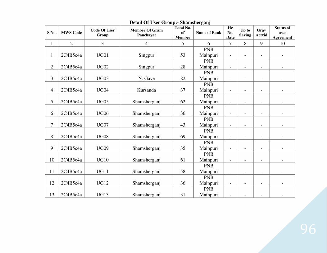
96
Detail Of User Group:- Shamsherganj
S.No. MWS Code Code Of User
Group
Member Of Gram
Panchayat
Total No.
of
Member
Name of Bank
Hc
No.
Date
Up to
Saving
Grav
Actvid
Status of
user
Agreement
1 2 3 4 5 6 7 8 9 10
1 2C4B5c4a UG01 Singpur 53 PNB
Mainpuri - - - -
2 2C4B5c4a UG02 Singpur 28 PNB
Mainpuri - - - -
3 2C4B5c4a UG03 N. Gave 82 PNB
Mainpuri - - - -
4 2C4B5c4a UG04 Kursanda 37 PNB
Mainpuri - - - -
5 2C4B5c4a UG05 Shamsherganj 62 PNB
Mainpuri - - - -
6 2C4B5c4a UG06 Shamsherganj 36 PNB
Mainpuri - - - -
7 2C4B5c4a UG07 Shamsherganj 43 PNB
Mainpuri - - - -
8 2C4B5c4a UG08 Shamsherganj 69 PNB
Mainpuri - - - -
9 2C4B5c4a UG09 Shamsherganj 35 PNB
Mainpuri - - - -
10 2C4B5c4a UG10 Shamsherganj 61 PNB
Mainpuri - - - -
11 2C4B5c4a UG11 Shamsherganj 58 PNB
Mainpuri - - - -
12 2C4B5c4a UG12 Shamsherganj 36 PNB
Mainpuri - - - -
13 2C4B5c4a UG13 Shamsherganj 31 PNB
Mainpuri - - - -
97
4.2 General Comments and Recommendations for Rainfed Agriculture
The reduction in yield or failure of crops due to Agriculture draught and loam soil with low water holding capacity and growing of high water
requiring crops namely Sugarcane is affecting soil productivity of the area. The improved technology of rainfed Agriculture and watershed bases is only
solution of this problem. The droughts do not have much effect due to high water table and presence of progressive farmers.
4.2.1 Comments
1- Crop production and livestock rearing contribute 80% to the animal fodder and failure of rains caused distress.
2- Climatic variability has increased frequency of extreme weather events, risk and vulnerability.
3- Moderate to severe metrological drought due to rainfall deficit was analyzed.
4- Synergies of forest, wasteland, non-arable, arable land, rearing of animals, Micro-enterprising equity and enabling institutions may be optimized
in the watershed management programme.
5- Surface water resources are least developed in the area.
6- Improving water use efficiency by upgrading the systems should be high priority.
7- Hybrids of Jowar, input intensive new varieties of pulses, oil seed, public distribution system, neglect of yanks, dug-wells and installing of tube-
wells have altered traditional coping systems and increased risks, distress and vulnerability to droughts.
8- Horticulture is another important option to diversify income, employment, risks and vulnerability to rainfall uncertainties.
9- Citrus (Nimbu), Phalsa, and Jack fruit also have potentials of diversifying risks, distress and vulnerability.
10- Forest and scrublands have opportunities to improve productivity and other services of land cover.
11- Construction of water harvesting structures in forest can improve supplies of water for wild like and downstream agriculture.
12- More than 80% of all category farmers normally take produce to the market, 50% sales being in regulated market.
Recommendations
a- Medium term
1- Desilting, renovation, repairs of tanks, checkdams, deepening and recharging of dug-well may be taken up.
2- Creation of fodder and feed block banks should be immediate priority.
98
3- Deworming, Vaccination and other health measures are being recommended.
4- Mineral mixture should supplement the feed to prevent loss in fertility during drought.
5- There is a scope to improve efficiency of artificial insemination (AI) ervices.
6- Naturally growing Traditional drought hardy land races of citrus, Amla, Karounda and custard apple can be top worked with improved varieties
detailed in the text to enhance their value.
7- Rainwater conservation in trenches, planting of indigenous fruits, fodder trees, shrubs, grasses, pasture legumes (Stylosanthes hamata) and
promoting cut and carry system of grasses in place of grazing can improve functions and community service of the forest land.
8- Waving of interest, a part or whole of principal or deferred re-payment should be inbuilt into the loaning process to maintain credit eligibility of
the farmers.
9- Integrated participatory management of inputs, natural resources, social capital and innovative institutions is recommended.
10- Digging of farm ponds and new open wells can also yield quick result and provide employment.
11- Extra short duration crops and varieties given in the text can reduce vulnerability to drought and arrangement of their seed bank is suggested.
12- Normal, medium, short and extra short duration crops and varieties are listed to match with the length of growing period and amount of rainfall
while preparing crop contingency plans.
b- Long term
1. Long term strategy consists of professionally designed integrated participatory treatment of watershed form ridge to valley systems. Treatment of forest, non-arable and arable land should be unified into a common plan.
2. About 3-6% of net sown area of Project is irrigated with poor and erratic supplies. Ground water over utilization is predominant and open dug-wells provide much needed but non-dependable equity. Recharging of open dug-wells can yield quick result.
3. Surface and soil profile water storage may be promoted as new tub wells and dug wells are not allowed.
4. In situ conservation of rainwater, contour cultivation, sowing on ridge or raised productivity by 18-22% at reduced risk.
5. Seed multiplication and creation of seed banks of dry land crops is least priority of private sector and public sector should be geared up.
6. Seed replacement rate of pulses, oil seed and cereals with latest improved varieties may be doubled.
7. There is 25-35% yield gap and several suggestions on rotation, seed banks, marketing, intensification or diversification are made.
8. Intensification of the existing major four livestock production system has been recommended.
9. Goat rearing especially of Barberi is most economical.
10. Liquidation of animal assets is a normal practice of coping with drought. Providing consumption credit at reasonable interest can avoid distress sale of animal.
99
11. Castration of scrub bulls to reduce population of unproductive animals should be a long term measure.
12. Marketing of milk through Private-Producer and Consumer institution can add to the value, income and employment.
13. Setting up of a modern processing plant for meat, milk and animal related by product can improve benefits tremendously.
14. Productivity of forest resources should be improved through watershed management, planting fodder trees, shrubs and grasses to support animal husbandry.
15. Early bearing grafted Tamarind, pomegranate, fig (Anjir), guava and mango are quite hardy after their initial establishment and may be planted.
16. Drought tolerant tomatoes (Arka Vikas), rainfed onion, coriander, turmeric, ginger, beetle leaves have specific niche or micro region in the district Mainpuri.
17. Credit cycle in rainfed region should automatically switch over to two or three years under specified failures of rains.
18. Livelihood in rainfed region is highly diversified and credit against total income portfolio may be devised.
19. In order to prevent diverting of crop loans for other purpose consumptions loans for other purposes consumptions loan should also be introduced.
20. Weather based insurance (Barsha Bima) may take away some drawback of existing insurance system.
21. Almost 100% of fertilizers, seed, agro-chemicals, farm implements and animal feeds were purchased form private dealers and 90% of farmers sell some produce, purchase of inputs, warehousing, sample testing service, Banks, extension and electronic display system etc. should be set up under one roof of a modern market.
100
4.3 Engineering measures for soil conversation
Engineering measures are proposed to conserve soil and Water, slope management, safe disposal of excess water reclamation of waste land etc. Biological measures and engineering measures are complimentary and supplementary to each other Biological measures, which are protective and many times productive and long lasting need support of engineering measures for their establishment in the beginning of hazardous slopes and problems. The engineering measures are needed in the bank of Arind River which has created lot of damage during the year 2010 record braking flood.
Improvement of fields and terraces
Tube well irrigated field are generally in good shape and need little or no treatment. The cultivated area need following treatments.
(A) Treatment of terraces
1. Leveling & bunding for mild correction. 2. Rejuvenation – leveling bunding of slopping land with sand deposit and improvement of risers. 3. Remodeling – highly deshaped, eroded and degraded fields need drastic leveling, bunding , stone/ soil risers with sodding or use area for horticulture or agri-
horti system,
(B) Treatment of fields
1. Leveling and bunding of irrigated field. 2. Smoothing of sloppy fields and bunding. 3. Packing and sodding of bunds and plantation of M.P.T. 4. Spill ways for safe disposal of excess water from the field to the drain.
Gully plugs and spillways
They are designed considering water discharge and cross section of gully and elevation difference Gully plugs may be temporary, semi- permanent and permanent types. Cemented gully plugs may act as water harvesting, structure. Limited structures have been proposed in eroding gullies considering constraints of funds. Different gully plugs and spillways are constructed according to their suitability for the location as given below.
(A)Temporary gully control structure
(i) One row or single row wooden post check dam (ii) Two row or double row wooden post check dam filled with brush wood (iii) Two row or double row wooden post check dam filled with boulders (iv) Woven wire – wooden post check dam (v) Loose boulder check dam (vi) Sand filled plastic bag check dam (vii) Wooden plank- post check dam
(B) Semi – temporary gully control measures
(i) Loose rock check dam (ii) Log check dam (iii) Gabion check dam (C) Permanent gully control structures spillway
(i) Straight drop spillway (ii) Drop inlet spillway (iii) Chute spillway
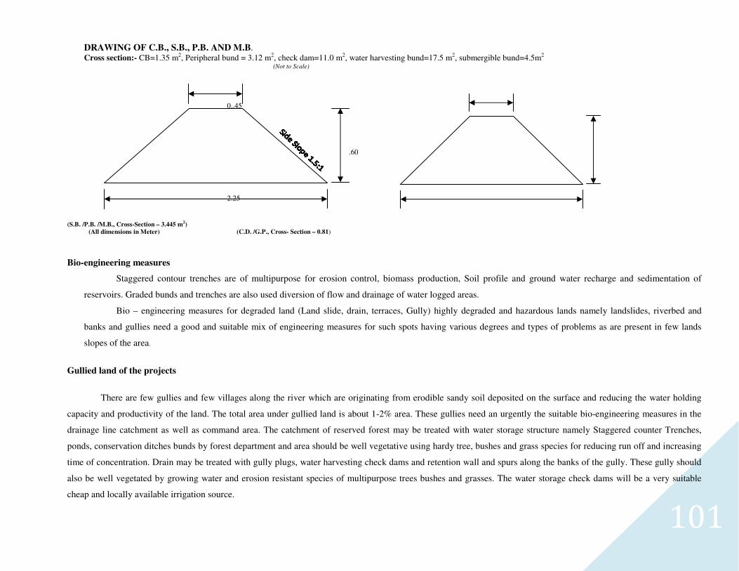
101
DRAWING OF C.B., S.B., P.B. AND M.B. Cross section:- CB=1.35 m2, Peripheral bund = 3.12 m2, check dam=11.0 m2, water harvesting bund=17.5 m2, submergible bund=4.5m2 (Not to Scale)
(S.B. /P.B. /M.B., Cross-Section – 3.445 m2)
(All dimensions in Meter) (C.D. /G.P., Cross- Section – 0.81)
Bio-engineering measures
Staggered contour trenches are of multipurpose for erosion control, biomass production, Soil profile and ground water recharge and sedimentation of
reservoirs. Graded bunds and trenches are also used diversion of flow and drainage of water logged areas.
Bio – engineering measures for degraded land (Land slide, drain, terraces, Gully) highly degraded and hazardous lands namely landslides, riverbed and
banks and gullies need a good and suitable mix of engineering measures for such spots having various degrees and types of problems as are present in few lands
slopes of the area.
Gullied land of the projects
There are few gullies and few villages along the river which are originating from erodible sandy soil deposited on the surface and reducing the water holding
capacity and productivity of the land. The total area under gullied land is about 1-2% area. These gullies need an urgently the suitable bio-engineering measures in the
drainage line catchment as well as command area. The catchment of reserved forest may be treated with water storage structure namely Staggered counter Trenches,
ponds, conservation ditches bunds by forest department and area should be well vegetative using hardy tree, bushes and grass species for reducing run off and increasing
time of concentration. Drain may be treated with gully plugs, water harvesting check dams and retention wall and spurs along the banks of the gully. These gully should
also be well vegetated by growing water and erosion resistant species of multipurpose trees bushes and grasses. The water storage check dams will be a very suitable
cheap and locally available irrigation source.
.60
0..45
2.25
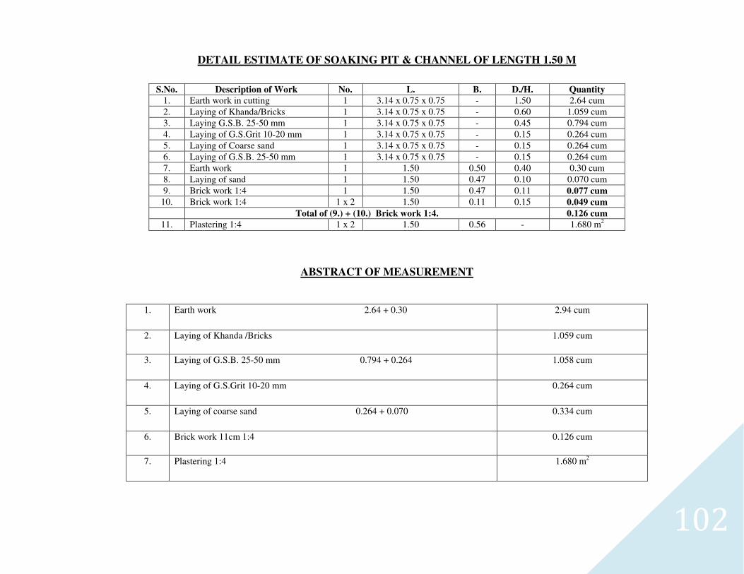
102
DETAIL ESTIMATE OF SOAKING PIT & CHANNEL OF LENGTH 1.50 M
S.No. Description of Work No. L. B. D./H. Quantity
1. Earth work in cutting 1 3.14 x 0.75 x 0.75 - 1.50 2.64 cum
2. Laying of Khanda/Bricks 1 3.14 x 0.75 x 0.75 - 0.60 1.059 cum
3. Laying G.S.B. 25-50 mm 1 3.14 x 0.75 x 0.75 - 0.45 0.794 cum
4. Laying of G.S.Grit 10-20 mm 1 3.14 x 0.75 x 0.75 - 0.15 0.264 cum
5. Laying of Coarse sand 1 3.14 x 0.75 x 0.75 - 0.15 0.264 cum
6. Laying of G.S.B. 25-50 mm 1 3.14 x 0.75 x 0.75 - 0.15 0.264 cum
7. Earth work 1 1.50 0.50 0.40 0.30 cum
8. Laying of sand 1 1.50 0.47 0.10 0.070 cum
9. Brick work 1:4 1 1.50 0.47 0.11 0.077 cum
10. Brick work 1:4 1 x 2 1.50 0.11 0.15 0.049 cum
Total of (9.) + (10.) Brick work 1:4. 0.126 cum
11. Plastering 1:4 1 x 2 1.50 0.56 - 1.680 m2
ABSTRACT OF MEASUREMENT
1. Earth work 2.64 + 0.30 2.94 cum
2. Laying of Khanda /Bricks 1.059 cum
3. Laying of G.S.B. 25-50 mm 0.794 + 0.264 1.058 cum
4. Laying of G.S.Grit 10-20 mm 0.264 cum
5. Laying of coarse sand 0.264 + 0.070 0.334 cum
6. Brick work 11cm 1:4 0.126 cum
7. Plastering 1:4 1.680 m2
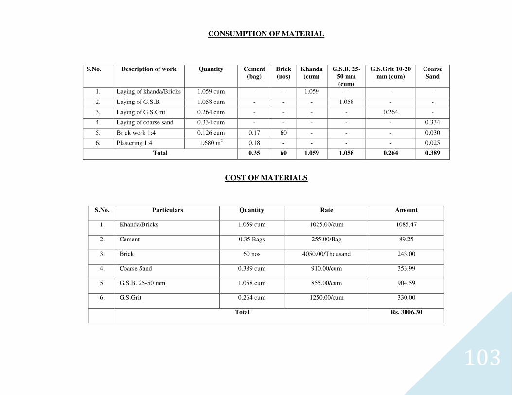
103
CONSUMPTION OF MATERIAL
S.No. Description of work Quantity Cement
(bag)
Brick
(nos)
Khanda
(cum)
G.S.B. 25-
50 mm
(cum)
G.S.Grit 10-20
mm (cum)
Coarse
Sand
1. Laying of khanda/Bricks 1.059 cum - - 1.059 - - -
2. Laying of G.S.B. 1.058 cum - - - 1.058 - -
3. Laying of G.S.Grit 0.264 cum - - - - 0.264 -
4. Laying of coarse sand 0.334 cum - - - - - 0.334
5. Brick work 1:4 0.126 cum 0.17 60 - - - 0.030
6. Plastering 1:4 1.680 m2 0.18 - - - - 0.025
Total 0.35 60 1.059 1.058 0.264 0.389
COST OF MATERIALS
S.No. Particulars Quantity Rate Amount
1. Khanda/Bricks 1.059 cum 1025.00/cum 1085.47
2. Cement 0.35 Bags 255.00/Bag 89.25
3. Brick 60 nos 4050.00/Thousand 243.00
4. Coarse Sand 0.389 cum 910.00/cum 353.99
5. G.S.B. 25-50 mm 1.058 cum 855.00/cum 904.59
6. G.S.Grit 0.264 cum 1250.00/cum 330.00
Total Rs. 3006.30
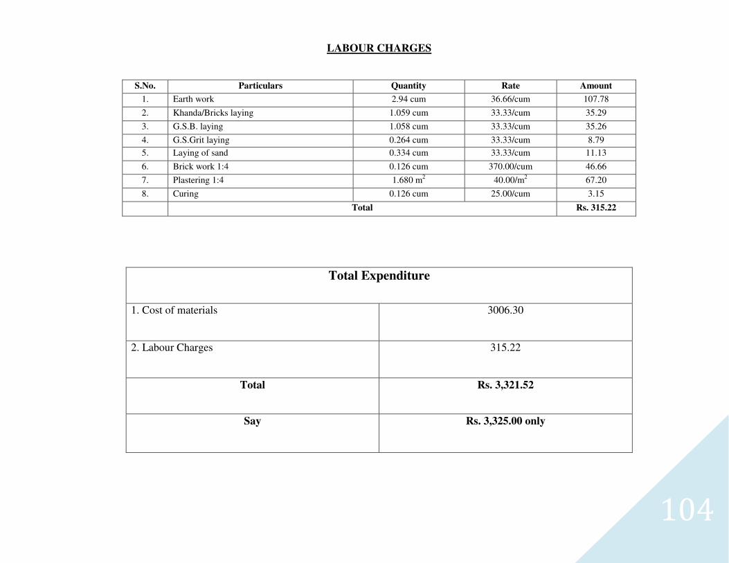
104
LABOUR CHARGES
S.No. Particulars Quantity Rate Amount
1. Earth work 2.94 cum 36.66/cum 107.78
2. Khanda/Bricks laying 1.059 cum 33.33/cum 35.29
3. G.S.B. laying 1.058 cum 33.33/cum 35.26
4. G.S.Grit laying 0.264 cum 33.33/cum 8.79
5. Laying of sand 0.334 cum 33.33/cum 11.13
6. Brick work 1:4 0.126 cum 370.00/cum 46.66
7. Plastering 1:4 1.680 m2 40.00/m2 67.20
8. Curing 0.126 cum 25.00/cum 3.15
Total Rs. 315.22
Total Expenditure
1. Cost of materials 3006.30
2. Labour Charges 315.22
Total Rs. 3,321.52
Say Rs. 3,325.00 only
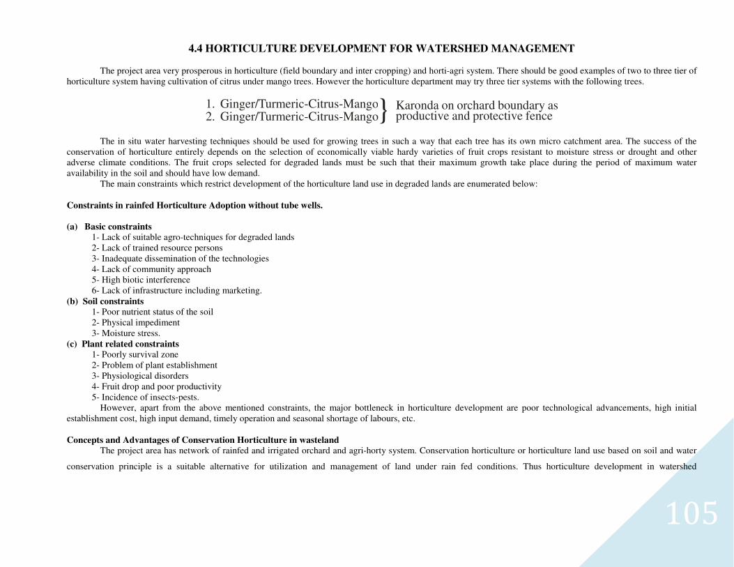
105
4.4 HORTICULTURE DEVELOPMENT FOR WATERSHED MANAGEMENT
The project area very prosperous in horticulture (field boundary and inter cropping) and horti-agri system. There should be good examples of two to three tier of horticulture system having cultivation of citrus under mango trees. However the horticulture department may try three tier systems with the following trees.
1. Ginger/Turmeric-Citrus-Mango2. Ginger/Turmeric-Citrus-Mango} Karonda on orchard boundary as
productive and protective fence
The in situ water harvesting techniques should be used for growing trees in such a way that each tree has its own micro catchment area. The success of the conservation of horticulture entirely depends on the selection of economically viable hardy varieties of fruit crops resistant to moisture stress or drought and other adverse climate conditions. The fruit crops selected for degraded lands must be such that their maximum growth take place during the period of maximum water availability in the soil and should have low demand.
The main constraints which restrict development of the horticulture land use in degraded lands are enumerated below:
Constraints in rainfed Horticulture Adoption without tube wells.
(a) Basic constraints
1- Lack of suitable agro-techniques for degraded lands 2- Lack of trained resource persons 3- Inadequate dissemination of the technologies 4- Lack of community approach 5- High biotic interference 6- Lack of infrastructure including marketing.
(b) Soil constraints
1- Poor nutrient status of the soil 2- Physical impediment 3- Moisture stress.
(c) Plant related constraints
1- Poorly survival zone 2- Problem of plant establishment 3- Physiological disorders 4- Fruit drop and poor productivity 5- Incidence of insects-pests.
However, apart from the above mentioned constraints, the major bottleneck in horticulture development are poor technological advancements, high initial establishment cost, high input demand, timely operation and seasonal shortage of labours, etc.
Concepts and Advantages of Conservation Horticulture in wasteland
The project area has network of rainfed and irrigated orchard and agri-horty system. Conservation horticulture or horticulture land use based on soil and water
conservation principle is a suitable alternative for utilization and management of land under rain fed conditions. Thus horticulture development in watershed
106
management appears to be the most appropriate technique for sustained productivity as well as for restoration of degraded lands. In fact, horticulture system meets all the
basic needs-food, fruits, fodder, fuel and timber besides, providing employment and sustaining a number of products for industries.
The fruit trees grown with crops can provide fuel from pruned shoots and dried branches, leaf fodder for animals and leaf litter that can be utilized as mulch
material and organic matter the leaf litter of deciduous fruit trees not only protects the top soil from the impact of raindrops but also improve soil structure, reduces
evapo-transpiration, increases infiltration and add to the nutrient status of soil. Therefore conservation based horticulture land use system assumes great significance as
fruit trees on degraded lands provide higher returns and offer alternative opportunity in non-arable areas where cropping may not be possible. Rainfed and eroded sand
covered area needs planting of seedling at a deeper depths having soil with higher water holding capacity.
1- Selection of Suitable Fruits variety:-
For the success of conservation horticulture, selection of hardy varieties resistant to diseases and pests and use of local or other hardy root stocks for raising fruit-
trees is of great importance. The major part of the reproductive cycle is. Period from flowering to fruiting must also fall during maximum water availability period and
the root ripening must be completed before the onset of dry summer (April-May).
Ber, Guava, Karonda, Bel, Amla, Lemon, and Mango etc. are the plants which fulfill this requirement and all these fruit plants are most suitable for West U.P.
region under rainfed condition. The project area mainly mango and peach plantation with intercropping.
2- Planting Techniques:-
For degraded lands, pits should be dug of 1m x 1m x 1m size, the excavated soil is mixed with Farmyard Manure (FYM) @ 5-10kg/pit with doses of potash and
phosphorous and some insecticide / pesticide (numicide / aldrex) for prevention of white ant. Planting of the fruits plants should be done with the onset of monsoon.
3-Use of Root Stokes:-
Budding and grafting on the wild root stock gives benefit of the establishment root and in turn provides better quality fruits with high field potential. For
example, Ziziphus Mauritian, a wild ber can be successful budded with scion of improved cultivars, this practice is only successful where sizable patch of wild root stock
is available. The budded/grafted stock needs intensive management as it is required to be protected from the wild animals, birds, insects, pests etc. The wild root stock
develops efficient tap root to provide moisture and nutrients to the scion. Amla and Bel are other examples of raising the improved cultivation the wild root stock.
4-In Situ Water Harvesting:-
Since on sandy soil, runoff water is considerably poor, therefore, it should be harvested and used. The run off can be utilized for growing fruit plants in such a
way that each tree in the established plants is at the time of fruit setting and fruiting. Moisture available at this critical period improves the fruit yield.
107
Runoff water will be harvested and stored in tanks during the rains. The stored water will be utilized at the time when the fruit trees show moisture stress during
dry months. Counter trenches will dug between the rows of fruit trees because this is effective in conserving moisture and providing soil erosion. The tube well irrigated
area has more then 20% land under mango and peach orchard.
5-Mulching:-
Mulching is practiced to conserve moisture. It prevents the loss of moisture by evaporation and improve water intake by the soils. Various organic (Straw, hay,
manure, tree leaves, dry wads) material are used for mulching. Use of plastic mulch has been taken in rain fed and dry farming conditions to increase the productivity by
minimizing evapo-transpiration losses.
6-Drip Irrigation:-
Drip irrigation saves water by 40 to 70 percent and two to three times more area can be irrigated with the same amount of available water. It has the advantages
that it ensures uniform distribution of water, provides perfect control over water application and minimizing the losses during convergence and seepage. The
demonstration can help and multiply the system specially in sandy area as Sardar and Jatt of the progressive farmer.
7- Dry Land Horticulture:-
In the selected area about 400 ha. land is planned for horticulture and agro horticulture. Species like amla, guava, ber, bel, lemon will be planted at suitable site
in the watershed.
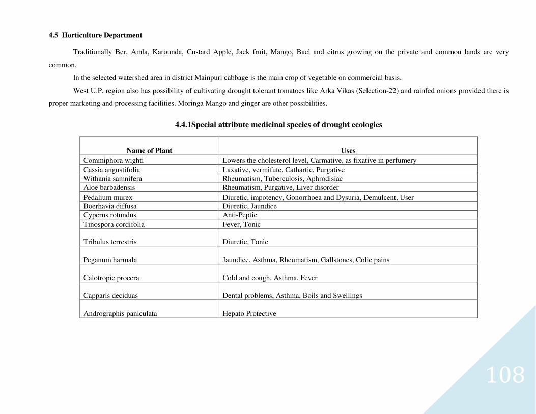
108
4.5 Horticulture Department
Traditionally Ber, Amla, Karounda, Custard Apple, Jack fruit, Mango, Bael and citrus growing on the private and common lands are very
common.
In the selected watershed area in district Mainpuri cabbage is the main crop of vegetable on commercial basis.
West U.P. region also has possibility of cultivating drought tolerant tomatoes like Arka Vikas (Selection-22) and rainfed onions provided there is
proper marketing and processing facilities. Moringa Mango and ginger are other possibilities.
4.4.1Special attribute medicinal species of drought ecologies
Name of Plant Uses
Commiphora wighti Lowers the cholesterol level, Carmative, as fixative in perfumery
Cassia angustifolia Laxative, vermifute, Cathartic, Purgative
Withania samnifera Rheumatism, Tuberculosis, Aphrodisiac
Aloe barbadensis Rheumatism, Purgative, Liver disorder
Pedalium murex Diuretic, impotency, Gonorrhoea and Dysuria, Demulcent, User
Boerhavia diffusa Diuretic, Jaundice
Cyperus rotundus Anti-Peptic
Tinospora cordifolia Fever, Tonic
Tribulus terrestris Diuretic, Tonic
Peganum harmala Jaundice, Asthma, Rheumatism, Gallstones, Colic pains
Calotropic procera Cold and cough, Asthma, Fever
Capparis deciduas Dental problems, Asthma, Boils and Swellings
Andrographis paniculata Hepato Protective
109
4.6 Demonstration of Agro-Horticulture & Drought Resistant Technology
District Mainpuri is situated in West U.P. region where there is scarcity of water in pockets only and in summer temperature rises up to 45
causing upper layer of fields dry and therefore mortality rate of plants is very high. Farmers usually like to grow grain and sugarcane crops only. The
production of crops decreases below the tree. Some important economical irrigation system is illustrated as below.
Using Plastic Drum of 20 Liters
It is important to promote moisturisation in root zone of the plants. In this process plastic drums with full of water is used. Mainly crops roots go
in to the soil up to 4"-5" in cereal crops and 6"-9" in pulses. Using plastic drums the plants will be planted 45-55 cm below the ground level which is
below the root zone of crops. Therefore trees will not able to take nutrients from upper layer of fields and there will no effect of plants on crops.
In summer season up to 1 to 1.50m depth of soil becomes dry causes more mortality rate of plants, using drums plants are planted below 50-60
cm from ground level and in rainy and winter season up to February roots of plants goes below 2.10m below where moisture will be available and plants
will be safe in summer also. Using barbed wire fencing the plants will be protected against grazing.
Therefore, it is hoped that farmers will adapt this procedure for Agro-forestry and will become prosperous.
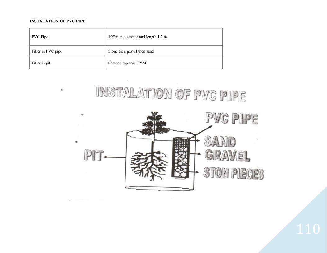
110
INSTALATION OF PVC PIPE
PVC Pipe 10Cm in diameter and length 1.2 m
Filler in PVC pipe Stone then gravel then sand
Filler in pit Scraped top soil+FYM
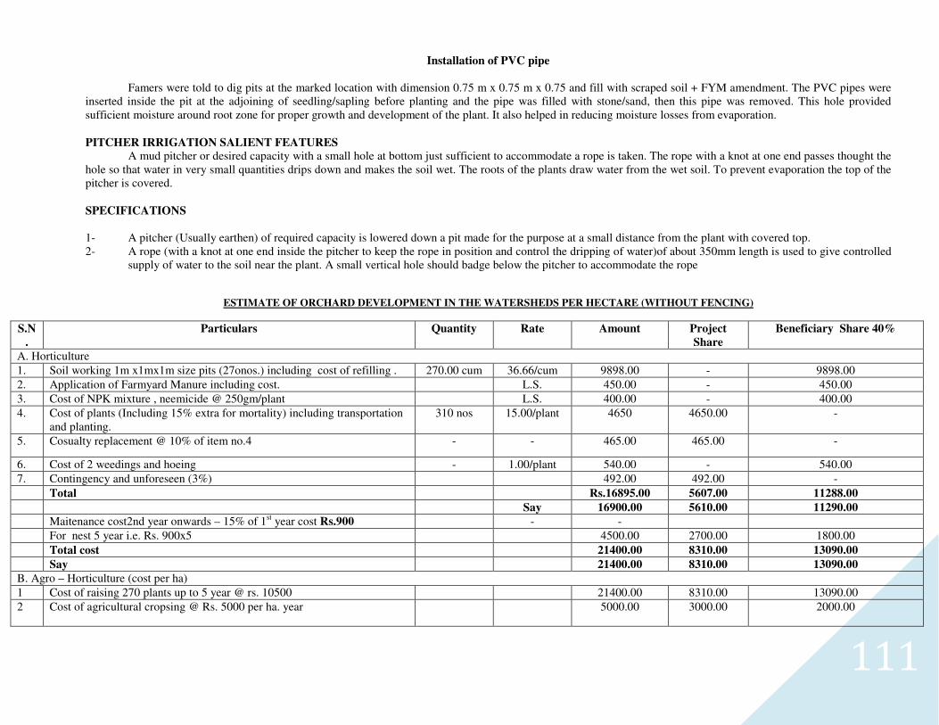
111
Installation of PVC pipe Famers were told to dig pits at the marked location with dimension 0.75 m x 0.75 m x 0.75 and fill with scraped soil + FYM amendment. The PVC pipes were
inserted inside the pit at the adjoining of seedling/sapling before planting and the pipe was filled with stone/sand, then this pipe was removed. This hole provided sufficient moisture around root zone for proper growth and development of the plant. It also helped in reducing moisture losses from evaporation.
PITCHER IRRIGATION SALIENT FEATURES
A mud pitcher or desired capacity with a small hole at bottom just sufficient to accommodate a rope is taken. The rope with a knot at one end passes thought the hole so that water in very small quantities drips down and makes the soil wet. The roots of the plants draw water from the wet soil. To prevent evaporation the top of the pitcher is covered.
SPECIFICATIONS
1- A pitcher (Usually earthen) of required capacity is lowered down a pit made for the purpose at a small distance from the plant with covered top. 2- A rope (with a knot at one end inside the pitcher to keep the rope in position and control the dripping of water)of about 350mm length is used to give controlled
supply of water to the soil near the plant. A small vertical hole should badge below the pitcher to accommodate the rope
ESTIMATE OF ORCHARD DEVELOPMENT IN THE WATERSHEDS PER HECTARE (WITHOUT FENCING)
S.N
.
Particulars Quantity Rate Amount Project
Share
Beneficiary Share 40%
A. Horticulture
1. Soil working 1m x1mx1m size pits (27onos.) including cost of refilling . 270.00 cum 36.66/cum 9898.00 - 9898.00
2. Application of Farmyard Manure including cost. L.S. 450.00 - 450.00
3. Cost of NPK mixture , neemicide @ 250gm/plant L.S. 400.00 - 400.00
4. Cost of plants (Including 15% extra for mortality) including transportation and planting.
310 nos 15.00/plant 4650 4650.00 -
5. Cosualty replacement @ 10% of item no.4 - -
465.00 465.00 -
6. Cost of 2 weedings and hoeing - 1.00/plant 540.00 - 540.00
7. Contingency and unforeseen (3%) 492.00 492.00 -
Total Rs.16895.00 5607.00 11288.00
Say 16900.00 5610.00 11290.00
Maitenance cost2nd year onwards – 15% of 1st year cost Rs.900 - -
For nest 5 year i.e. Rs. 900x5 4500.00 2700.00 1800.00
Total cost 21400.00 8310.00 13090.00
Say 21400.00 8310.00 13090.00
B. Agro – Horticulture (cost per ha)
1 Cost of raising 270 plants up to 5 year @ rs. 10500 21400.00 8310.00 13090.00
2 Cost of agricultural cropsing @ Rs. 5000 per ha. year 5000.00 3000.00 2000.00
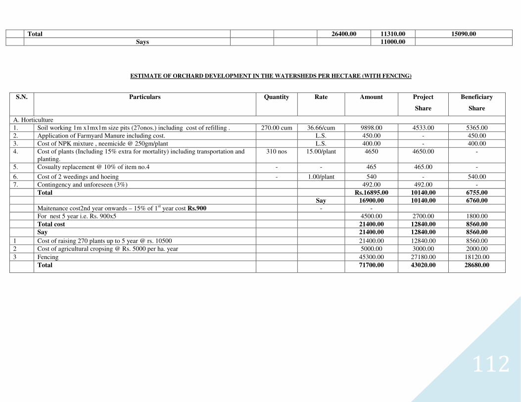
112
Total 26400.00 11310.00 15090.00
Says 11000.00
ESTIMATE OF ORCHARD DEVELOPMENT IN THE WATERSHEDS PER HECTARE (WITH FENCING)
S.N. Particulars Quantity Rate Amount Project
Share
Beneficiary
Share
A. Horticulture
1. Soil working 1m x1mx1m size pits (27onos.) including cost of refilling . 270.00 cum 36.66/cum 9898.00 4533.00 5365.00
2. Application of Farmyard Manure including cost. L.S. 450.00 - 450.00
3. Cost of NPK mixture , neemicide @ 250gm/plant L.S. 400.00 - 400.00
4. Cost of plants (Including 15% extra for mortality) including transportation and planting.
310 nos 15.00/plant 4650 4650.00 -
5. Cosualty replacement @ 10% of item no.4 - -
465 465.00 -
6. Cost of 2 weedings and hoeing - 1.00/plant 540 - 540.00
7. Contingency and unforeseen (3%) 492.00 492.00 -
Total Rs.16895.00 10140.00 6755.00
Say 16900.00 10140.00 6760.00
Maitenance cost2nd year onwards – 15% of 1st year cost Rs.900 - -
For nest 5 year i.e. Rs. 900x5 4500.00 2700.00 1800.00
Total cost 21400.00 12840.00 8560.00
Say 21400.00 12840.00 8560.00
1 Cost of raising 270 plants up to 5 year @ rs. 10500 21400.00 12840.00 8560.00
2 Cost of agricultural cropsing @ Rs. 5000 per ha. year 5000.00 3000.00 2000.00
3 Fencing 45300.00 27180.00 18120.00
Total 71700.00 43020.00 28680.00
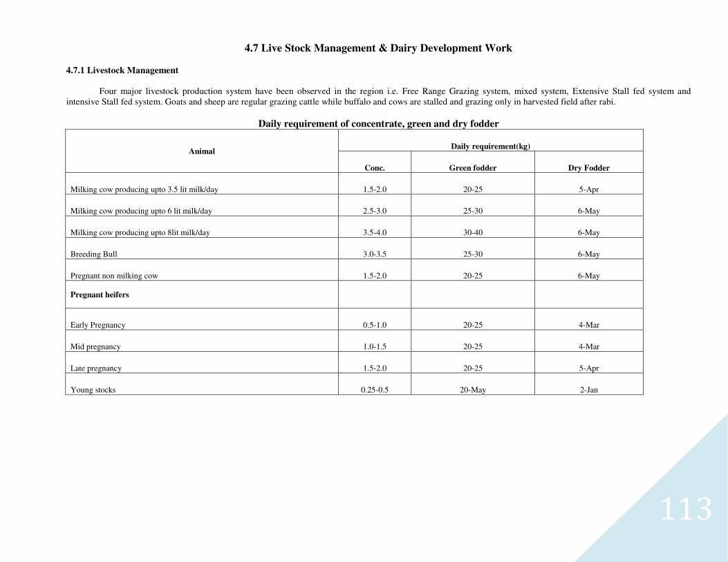
113
4.7 Live Stock Management & Dairy Development Work
4.7.1 Livestock Management
Four major livestock production system have been observed in the region i.e. Free Range Grazing system, mixed system, Extensive Stall fed system and
intensive Stall fed system. Goats and sheep are regular grazing cattle while buffalo and cows are stalled and grazing only in harvested field after rabi.
Daily requirement of concentrate, green and dry fodder
Animal Daily requirement(kg)
Conc. Green fodder Dry Fodder
Milking cow producing upto 3.5 lit milk/day 1.5-2.0 20-25 5-Apr
Milking cow producing upto 6 lit milk/day 2.5-3.0 25-30 6-May
Milking cow producing upto 8lit milk/day 3.5-4.0 30-40 6-May
Breeding Bull 3.0-3.5 25-30 6-May
Pregnant non milking cow 1.5-2.0 20-25 6-May
Pregnant heifers
Early Pregnancy 0.5-1.0 20-25 4-Mar
Mid pregnancy 1.0-1.5 20-25 4-Mar
Late pregnancy 1.5-2.0 20-25 5-Apr
Young stocks 0.25-0.5 20-May 2-Jan
114
4.7.2 Livestock Strategy
i- Migration of the animals to higher Himalayas or other hills. ii- Resorting to alternate day watering to Buffalo, cow, Sheep and Goats. iii- Avoiding long distance grazing as tired animals need more and frequent watering and feeding. iv- Since stall feeding adversely impacts the breeding efficiency in case of Sheep, therefore Sheep should always be resorted to at least partial natural grazing. v- Periodic health checks up of all animals. For all major diseases including drought related diseases. vi- Special care is required for productive, lactating and pregnant animals. vii- Forest departments may be roped in to raise indigenous grasses on the fringe forest and adjoining lands under the JFM programme to provide fodder for the
cattle to stall feed them.
4.6.3 Fodder Bank
Unlike food/grain the fodder is very difficult to transport or import during drought and deaths of cattle are inevitable. The fodder bank created for distributed of fodder during drought maintenance of village fodder farm controlled grazing of grass lands and distribution of fodder seeds is important. It is advisable to create fodder bank at block level. The sum of Rs.3.5 lakh is needed to produce 2700q fodder sufficient to feed 100 adult animal and 50 calves.
Advantages
The importance of a fodder bank can be well understood. The fodder banks will provide much needed relief and self-reliance to poor in the village especially in drought condition. The advantages are:
� It will reduce migration during drought condition. � Farmers can purchase and sale of fodder at village, thus doing away with costs incurred by them to carry out these transactions at the city market. � It can reduce in overall market prices of fodder during the lean Season. � Ensure availability of fodder during the lean season at affordable and reasonable prices. � Reduced district sale of cattle due to non-availability and/or non affordability of fodder. � Higher income for the poor as cattle will have enough fodder even during the lean season.
Increase employment opportunities at the village level associated with the sale, purchase and storage of fodder.
115
4.7.4 Establishment of Goat Units for S.H.G.’s formed
District Mainpuri is situated in West U.P. region where the number of sheep is very less and they are small in nature. Goat population is appreciable and in fact, both are the major source of livelihood for poor people of the district.
In the state, an average 16 kg of meat is obtained from a goat, if they are dewormmed twice in the year, there would be increment of 4 kg consequently in meat on an average of the state benefiting the farmers.
Deworming and vitamins, mineral- supplement to the goats shall enhance their productivity and also improve anti-body response and protection level through vaccination, More productivity and assured health and low mortality shall result into adoption of more farmers to goat farming with the formation of more S.H.G.’s and in turn availability of goats for processing units. Goat excreta shall be of immense help in enrichment of soil fertility.
25 Goat Units are proposed in I.W.M.P. Ist Project for S.H.G. One unit constituting 20 goats and 2 buck will be distributed to one S.H.G. A register of S.H.G. will be maintained by Secretary of S.H.G. in the supervision of W.D.T. member. The details of beneficiaries of S.H.G. including the breed
of goat reared, breeding and feeding status, deworming status, deaths, post mortem conducted claim settlement and working status of unit will be maintained in the register.
Preferences shall be given in consecutive years in purchasing the goats and bucks for new units, from old units for which database maintained shall be of use and it should be assured by buy back arrangement.
116
4.8 STRATEGY/ OUTCOMES
Milk Collection centers, Transport & Marketing
The business man will automatically enter into area with their milk tanker and there will not be any difficulty of milk collection. In their absence, the project will form a cooperative society having facilities of milk collection, alternatively, milk can be processed to Mawa and Ghee which can be stored in farmer’s house and marketed by society on convenient date with higher income and employment generation.
Wool production
Attempts will be made that efficient rearing sheep and goat may take place on place on common land. The small cattle may not cause biotic interferences on foot hills. The watershed has got collection, weaving and marketing facilities of wool by local cottage industries. The involvement of ladies will be ensured in knitting of wool garments by distributing thread making and knitting manually operated machines. A small practical training will also be arranged by the project.
SHG
The attempts will he made to constitute SHG of milk production in the area with necessary technical administrative and admissible financial help by the project. Loan of about Rs. 10000.00 (Ten thousand only) for the purchase of one high yielding cow or buffalo will be arranged for each member of group from government /cooperative bank of the locality the banks showed their consent.
117
VILLAGE INDUSTRRIES
Poultry
The villagers are already acquainted with the use & importance of poultry, as many villagers are having 5 to 10 birds for their own use. This village industry can be promoted in the following ways;
• Supply of high yielding birds and cock for pedigree improvement
• Introduction of poultry feed
• Preventive measures for disease Ranikhet etc., hygiene, vaccination and regular visit & checkup by Doctor
• Demonstration & maintenance of recommended house for the birds
• Formation of user groups, storage & marketing of birds and eggs as per aforesaid guidelines for animal husbandry.
Mushroom
Mushroom cultivation is a newly adopted industry and increasing at a faster rate in India. There is also a good market at national and international level. This
industry can be introduced and promoted with the help of ladies & part time work of school children by forming user groups. Processing, storage, transportation, and marketing of the produce will be arranged by the project. The demonstrations, short training and visit of the workers & the SHG will be conducted by WDT before introducing the cultivation.
Apiculture (Bee keeping)
Bee keeping is highly profitable perennial & regular production, cost effective, labour & time saving. The honey is medicinal food of nutritive value. Bees help
in transportation of pollen gains and fertilization and finally increase production, specially in cross pollinated crops namely sunflower, onion, radish and mustard, Honey production in hilly areas is comparatively high due to plenty flora available in sequence, while bees kept on sugar produce poor quality & costly honey. The user group of ladies and individual families after short training will be benefitted with this business .The project will make provision of boxes, beehives, storage and marketing of honey.
Sericulture
Silk sarees and other garments are famous but sericulture is laogging behind especially on hill in the watershed, however alluvial plain by the. Side of river is good for mulberry as agro forestry as well block plantation for sericulture. PRA exercise shared the interest of sericulture by users group of women. Mulberry as MPT can be raised on terrace risers and panchayat land as agro forestry. In case poor growth/failure of sericulture this will provide fodder and fuel and protection to riser against erosions.
Fish culture Duckery
Ponds are the multipurpose reservoirs of farmers and being maintained for 25 to 30 different uses. There are many ponds in the watershed, mainly found in
villages of watersheds, situated by the side of River. Fish culture is a non monitory business and fetches good income, tasty and nutritive food. Few farmers showed their interest to dig out pond in their land with the priority of fishery. Few community ponds have water through out the year and said to be having continuous filling through under ground spring and they are ideal for CPR management and auction money would be the income of community namely Watershed commettee (Registered body) and may be spent for common interest or utilities of village. The state fishery department may utilize these ponds after de-silting by PIA for promotion of their activity and benefit to villagers & village society. Fishery and Duckery is a good combination for their food adjustment.
118
Nursery and Poly houses
The cultivation of crops, vegetables, fruits, flowers, and MPT is suffering due to non availability of healthy seedlings of good varieties at the right time, KVK (ICAR), can plan for raising commercial nurseries in the watershed and its research farm at. Few self help groups can raise nursery as an additional income generation source KVK has planned to procure & supply foundation seeds to the SHG. The poly houses are meant for raising nursery, vegetation, mushroom during off season and adverse weather conditions.
Silvipastoral, Social Forestry, Van Panchayat, Joint Forest Management & Medicinal Plant
This is a workable and profitable systems for landless having animals.
Medicinal plants
Medicinal plants are the best examples of multipurpose trees, bushes, and grasses. They are hardy to grow and can serve as biological fence (agro-forestry), good surface cover against erosion, high market and regular economic return. The medicinal, perfumery, soap, cosmetic, and aroma of herbal origin are preferred throughout the
world. Ayurvedic medicines are getting repeated importance.
EXTENSION METHODS AND DEMONSTRATION
A. Agriculture
1. Farmers vs improved method of sugarcan, Maize, Paddy, Wheat and Torai etc. cultivation. 2. Field fertilizer trials on sugarcan, Paddy, Wheat, Maize and Toria based on soil test and recommendation. 3. Introduction and performance of recommended varieties. 4. Testing of different cropping systems.
B. Horticulture
1. Frontline demonstrations & adaptive trials-Pomology, Floriculture, Olericulture. 2. Agri-horti-system, and fruit trees, & medicinal grasses & herbs. 3. Rejuvenation of orchards and fruit trees-replacement, pruning, top working.
C. Forestry and grasses on common and wastelands 1. Social forestry. 2. Silvipastoral system. 3. Front line demonstration of multipurpose trees (MPT) on terrace riser and common lands. 4. Introductory trial on medicinal trees, bushes and grasses. 5. Improvement of pasture & grass lands. 6. Establishment of composite nurseries of fruits, & vegetables and MPT's.
D. Bio-engineering technology
(i) Control of torrents. (ii) Riverbed and bank.
119
4.9 Institutional Arrangements & Capacity Building in the Projects
• Alternative Land use Plan.
• Scientific technique of soil and Moisture conservation.
• Improved and Scientific agriculture practices.
• Fodder development and Management.
• Afforestation.
• Meteorological Information.
• Dairy development and Management.
• Rural Craft.
• Income Generation Activities.
• Stitching
• Food Processing. Post Harvest management practices.
120
4.10 Consolidation and Withdrawal Phase
In this phase the resources augmented and economic plans developed in Phase II are made the foundation to create new nature-based, sustainable
livelihoods and raise productivity levels. The main objectives under this phase are:
a. Consolidation and completion of various works.
b. Building the capacity of the community based organizations to carry out the new agenda items during post project period.
c. Sustainable management of(developed) natural resources and
d. Up-scaling of successful experiences regarding farm production systems/off-farm livelihoods.
An indicative list of various activities during this phase is given below:
4.9.1 Consolidation of various works
a. Preparation of project completion report with details about status of each intervention;
b. Documentation of successful experiences as well as lessons learnt for future use.
4.9.2 Management of developed natural resources
a. Improving the sustainability of various interventions under the project;
b. formal allocation of users right over common property resources (CPRs)
c. Collection of user charges for CPRs;
d. Repair, maintenance and protection of CPRs;
e. Sustainable utilization of developed natural resources;
f. Involvement of gram panchayat/corresponding institutions (as a governance body) in addressing the above aspects.
4.9.3 Intensification of farm production systems/off-farm livelihoods.
a. Up scaling of successful experiences related to above aspects through revolving fund under the project as well as credit and technical support
from external institutions;
b. Promotion of agro-processing, marketing arrangements of produce and similar off-farm and informal sector enterprises.
121
c. Farmers may also be encouraged to develop non pesticide management, low cost organic inputs, seed farms and links with wider markets to fetch
competitive price.
3.5 Project management related aspects
a. Participatory planning, implementation and monitoring of activities to be carried out during consolidation phase;
b. Terminal evaluation of project as per the expected outcomes.
Federations could be formed at the level of a cluster of villages in order to support economic activities at scale. These would strengthen linkages,
credit, input procurement, sale of local produce. The Watershed Committees (WCs) may use the Watershed Development Fund for repair and
maintenance of structures created in Phase II.
The classification of activities in the three phases must not be understood in a rigid manner. Many of the Phase III activities may even start in
many watersheds during Phase I and/or II itself.
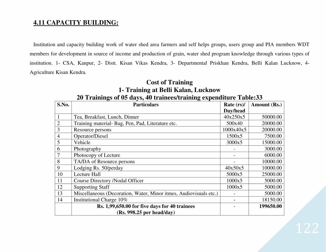
122
4.11 CAPACITY BUILDING:
Institution and capacity building work of water shed area farmers and self helps groups, users group and PIA members WDT
members for development in source of income and production of grain, water shed program knowledge through various types of
institution. 1- CSA, Kanpur, 2- Distt. Kisan Vikas Kendra, 3- Departmental Priskhan Kendra, Belli Kalan Lucknow, 4-
Agriculture Kisan Kendra.
Cost of Training
1- Training at Belli Kalan, Lucknow
20 Trainings of 05 days, 40 trainees/training expenditure Table:33 S.No. Particulars Rate (rs)/
Day/head
Amount (Rs.)
1 Tea, Breakfast, Lunch, Dinner 40x250x5 50000.00
2 Training material- Bag, Pen, Pad, Literature etc. 500x40 20000.00
3 Resource persons 1000x40x5 20000.00
4 Operator/Diesel 1500x5 7500.00
5 Vehicle 3000x5 15000.00
6 Photography - 3000.00
7 Photocopy of Lecture - 6000.00
8 TA/DA of Resource persons - 10000.00
9 Lodging Rs. 50/perday 40x50x5 10000.00
10 Lecture Hall 5000x5 25000.00
11 Course Directory /Nodal Officer 1000x5 5000.00
12 Supporting Staff 1000x5 5000.00
13 Miscellaneous (Decoration, Water, Minor itmes, Audiovisuals etc.) - 5000.00
14 Institutional Charge 10% - 18150.00
Rs. 1,99,650.00 for five days for 40 trainees
(Rs. 998.25 per head/day)
- 199650.00
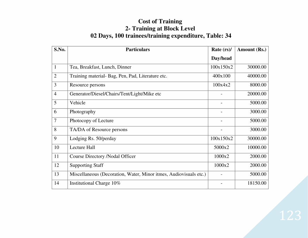
123
Cost of Training
2- Training at Block Level
02 Days, 100 trainees/training expenditure, Table: 34
S.No. Particulars Rate (rs)/
Day/head
Amount (Rs.)
1 Tea, Breakfast, Lunch, Dinner 100x150x2 30000.00
2 Training material- Bag, Pen, Pad, Literature etc. 400x100 40000.00
3 Resource persons 100x4x2 8000.00
4 Generator/Diesel/Chairs/Tent/Light/Mike etc - 20000.00
5 Vehicle - 5000.00
6 Photography - 3000.00
7 Photocopy of Lecture - 5000.00
8 TA/DA of Resource persons - 3000.00
9 Lodging Rs. 50/perday 100x150x2 30000.00
10 Lecture Hall 5000x2 10000.00
11 Course Directory /Nodal Officer 1000x2 2000.00
12 Supporting Staff 1000x2 2000.00
13 Miscellaneous (Decoration, Water, Minor itmes, Audiovisuals etc.) - 5000.00
14 Institutional Charge 10% - 18150.00
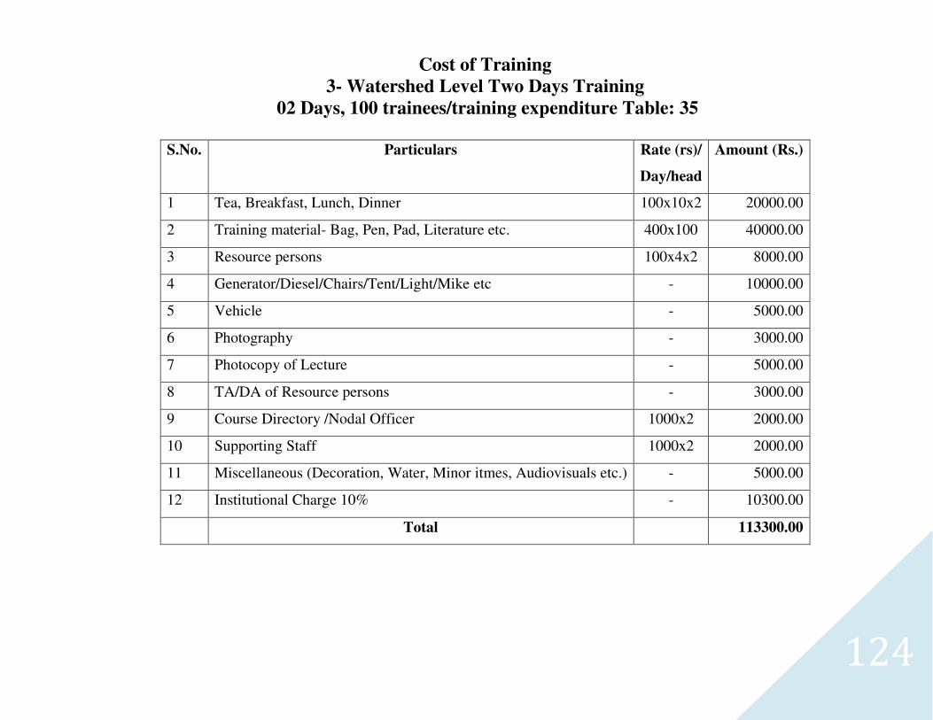
124
Cost of Training
3- Watershed Level Two Days Training
02 Days, 100 trainees/training expenditure Table: 35
S.No. Particulars Rate (rs)/
Day/head
Amount (Rs.)
1 Tea, Breakfast, Lunch, Dinner 100x10x2 20000.00
2 Training material- Bag, Pen, Pad, Literature etc. 400x100 40000.00
3 Resource persons 100x4x2 8000.00
4 Generator/Diesel/Chairs/Tent/Light/Mike etc - 10000.00
5 Vehicle - 5000.00
6 Photography - 3000.00
7 Photocopy of Lecture - 5000.00
8 TA/DA of Resource persons - 3000.00
9 Course Directory /Nodal Officer 1000x2 2000.00
10 Supporting Staff 1000x2 2000.00
11 Miscellaneous (Decoration, Water, Minor itmes, Audiovisuals etc.) - 5000.00
12 Institutional Charge 10% - 10300.00
Total 113300.00
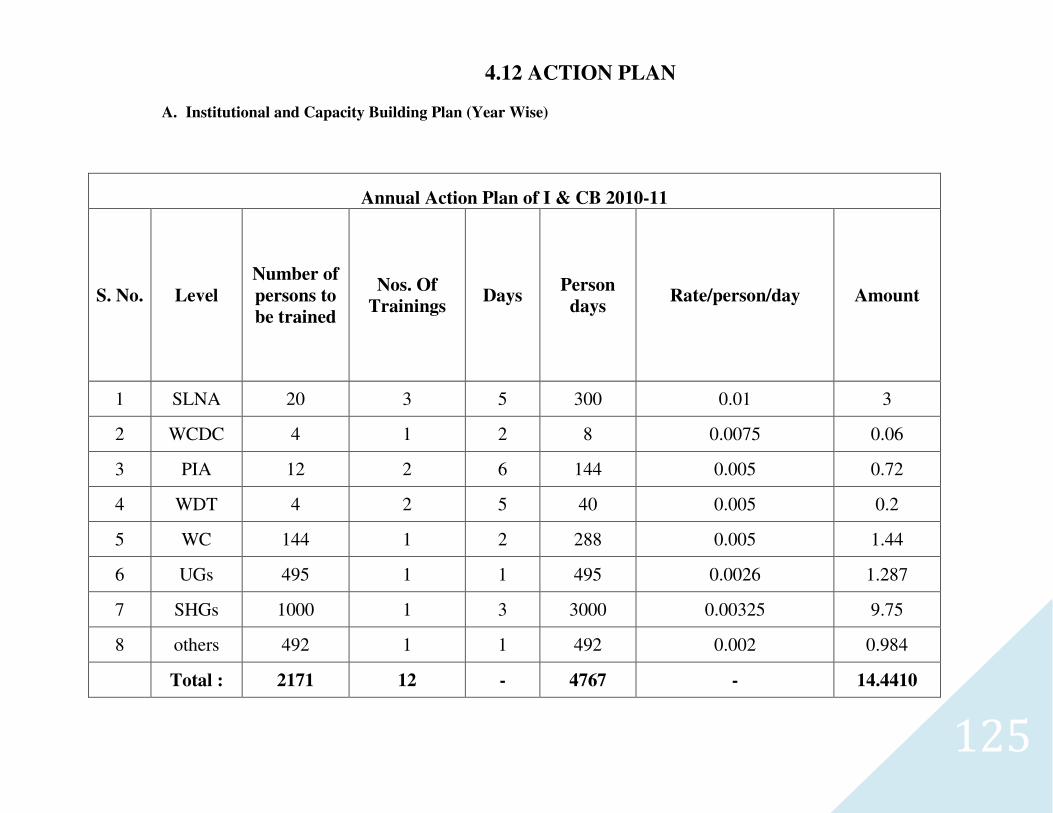
125
4.12 ACTION PLAN
A. Institutional and Capacity Building Plan (Year Wise)
Annual Action Plan of I & CB 2010-11
S. No. Level
Number of
persons to
be trained
Nos. Of
Trainings Days
Person
days Rate/person/day Amount
1 SLNA 20 3 5 300 0.01 3
2 WCDC 4 1 2 8 0.0075 0.06
3 PIA 12 2 6 144 0.005 0.72
4 WDT 4 2 5 40 0.005 0.2
5 WC 144 1 2 288 0.005 1.44
6 UGs 495 1 1 495 0.0026 1.287
7 SHGs 1000 1 3 3000 0.00325 9.75
8 others 492 1 1 492 0.002 0.984
Total : 2171 12 - 4767 - 14.4410
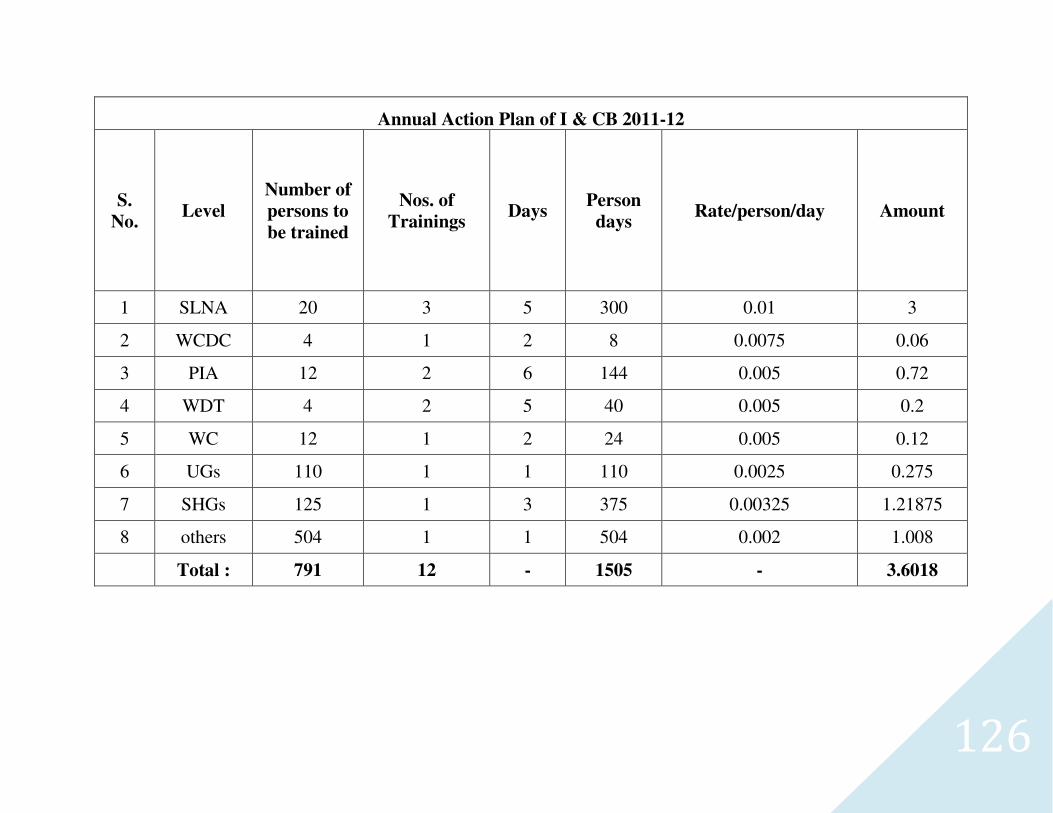
126
Annual Action Plan of I & CB 2011-12
S.
No. Level
Number of
persons to
be trained
Nos. of
Trainings Days
Person
days Rate/person/day Amount
1 SLNA 20 3 5 300 0.01 3
2 WCDC 4 1 2 8 0.0075 0.06
3 PIA 12 2 6 144 0.005 0.72
4 WDT 4 2 5 40 0.005 0.2
5 WC 12 1 2 24 0.005 0.12
6 UGs 110 1 1 110 0.0025 0.275
7 SHGs 125 1 3 375 0.00325 1.21875
8 others 504 1 1 504 0.002 1.008
Total : 791 12 - 1505 - 3.6018
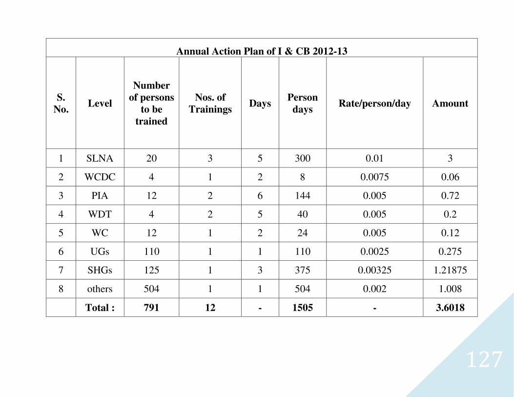
127
Annual Action Plan of I & CB 2012-13
S.
No. Level
Number
of persons
to be
trained
Nos. of
Trainings Days
Person
days Rate/person/day Amount
1 SLNA 20 3 5 300 0.01 3
2 WCDC 4 1 2 8 0.0075 0.06
3 PIA 12 2 6 144 0.005 0.72
4 WDT 4 2 5 40 0.005 0.2
5 WC 12 1 2 24 0.005 0.12
6 UGs 110 1 1 110 0.0025 0.275
7 SHGs 125 1 3 375 0.00325 1.21875
8 others 504 1 1 504 0.002 1.008
Total : 791 12 - 1505 - 3.6018
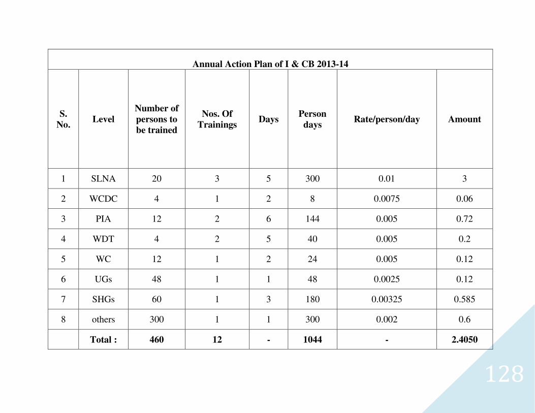
128
Annual Action Plan of I & CB 2013-14
S.
No. Level
Number of
persons to
be trained
Nos. Of
Trainings Days
Person
days Rate/person/day Amount
1 SLNA 20 3 5 300 0.01 3
2 WCDC 4 1 2 8 0.0075 0.06
3 PIA 12 2 6 144 0.005 0.72
4 WDT 4 2 5 40 0.005 0.2
5 WC 12 1 2 24 0.005 0.12
6 UGs 48 1 1 48 0.0025 0.12
7 SHGs 60 1 3 180 0.00325 0.585
8 others 300 1 1 300 0.002 0.6
Total : 460 12 - 1044 - 2.4050
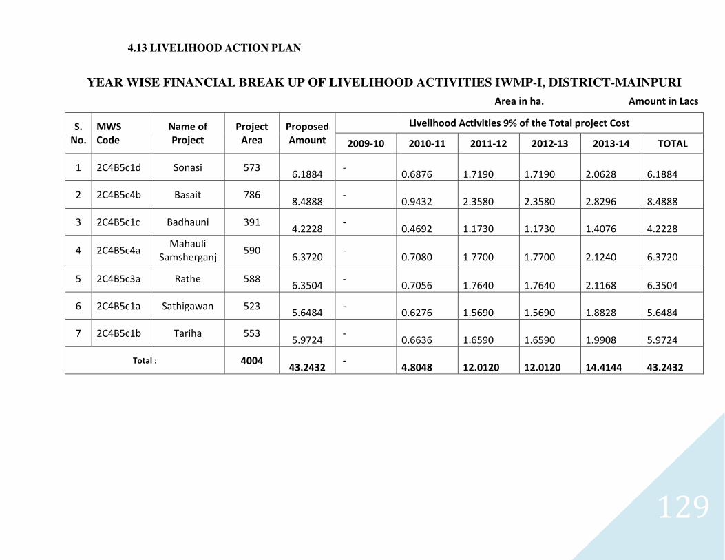
129
4.13 LIVELIHOOD ACTION PLAN
YEAR WISE FINANCIAL BREAK UP OF LIVELIHOOD ACTIVITIES IWMP-I, DISTRICT-MAINPURI
Area in ha. Amount in Lacs
S.
No.
MWS
Code
Name of
Project
Project
Area
Proposed
Amount
Livelihood Activities 9% of the Total project Cost
2009-10 2010-11 2011-12 2012-13 2013-14 TOTAL
1 2C4B5c1d Sonasi 573
6.1884 -
0.6876
1.7190
1.7190
2.0628
6.1884
2 2C4B5c4b Basait 786
8.4888 -
0.9432
2.3580
2.3580
2.8296
8.4888
3 2C4B5c1c Badhauni 391
4.2228 -
0.4692
1.1730
1.1730
1.4076
4.2228
4 2C4B5c4a Mahauli
Samsherganj 590
6.3720 -
0.7080
1.7700
1.7700
2.1240
6.3720
5 2C4B5c3a Rathe 588
6.3504 -
0.7056
1.7640
1.7640
2.1168
6.3504
6 2C4B5c1a Sathigawan 523
5.6484 -
0.6276
1.5690
1.5690
1.8828
5.6484
7 2C4B5c1b Tariha 553
5.9724 -
0.6636
1.6590
1.6590
1.9908
5.9724
Total : 4004
43.2432 -
4.8048
12.0120
12.0120
14.4144
43.2432
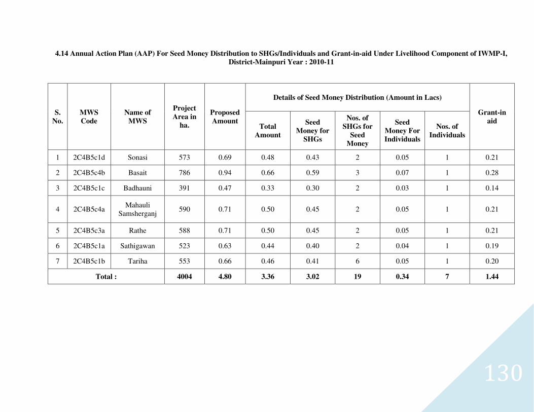
130
4.14 Annual Action Plan (AAP) For Seed Money Distribution to SHGs/Individuals and Grant-in-aid Under Livelihood Component of IWMP-I,
District-Mainpuri Year : 2010-11
S.
No.
MWS
Code
Name of
MWS
Project
Area in
ha.
Proposed
Amount
Details of Seed Money Distribution (Amount in Lacs)
Grant-in
aid Total
Amount
Seed
Money for
SHGs
Nos. of
SHGs for
Seed
Money
Seed
Money For
Individuals
Nos. of
Individuals
1 2C4B5c1d Sonasi 573 0.69 0.48 0.43 2 0.05 1 0.21
2 2C4B5c4b Basait 786 0.94 0.66 0.59 3 0.07 1 0.28
3 2C4B5c1c Badhauni 391 0.47 0.33 0.30 2 0.03 1 0.14
4 2C4B5c4a Mahauli
Samsherganj 590 0.71 0.50 0.45 2 0.05 1 0.21
5 2C4B5c3a Rathe 588 0.71 0.50 0.45 2 0.05 1 0.21
6 2C4B5c1a Sathigawan 523 0.63 0.44 0.40 2 0.04 1 0.19
7 2C4B5c1b Tariha 553 0.66 0.46 0.41 6 0.05 1 0.20
Total : 4004 4.80 3.36 3.02 19 0.34 7 1.44
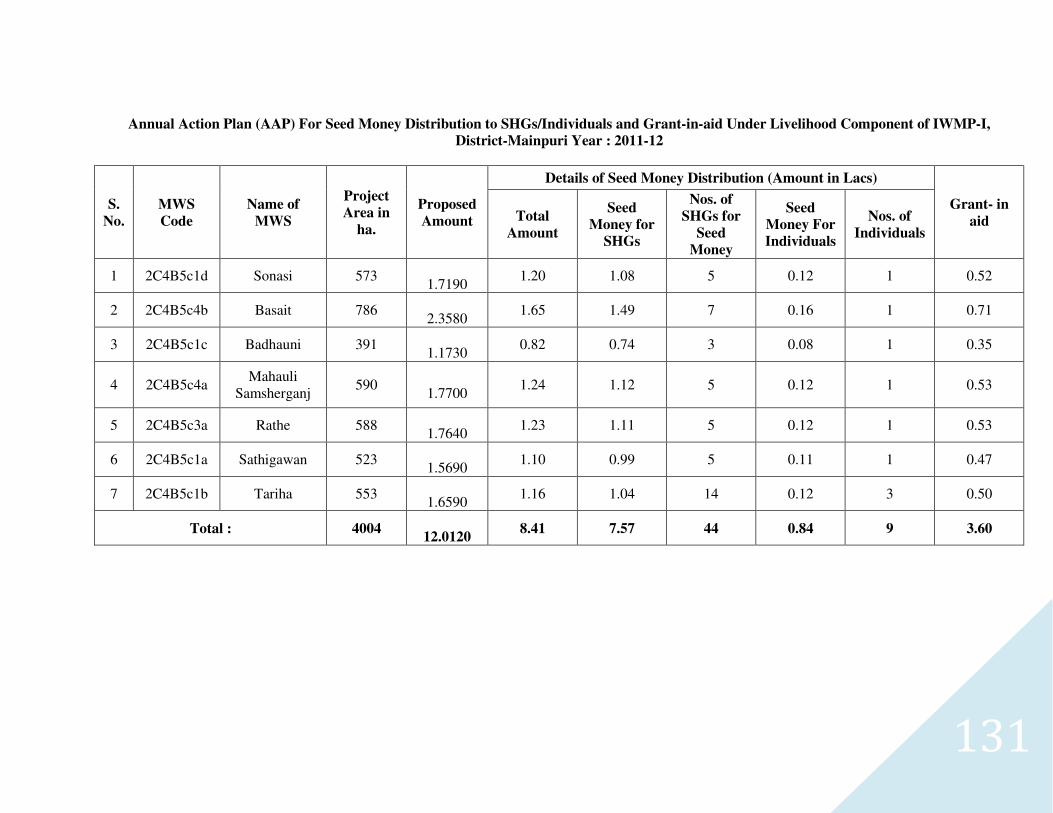
131
Annual Action Plan (AAP) For Seed Money Distribution to SHGs/Individuals and Grant-in-aid Under Livelihood Component of IWMP-I,
District-Mainpuri Year : 2011-12
S.
No.
MWS
Code
Name of
MWS
Project
Area in
ha.
Proposed
Amount
Details of Seed Money Distribution (Amount in Lacs)
Grant- in
aid Total
Amount
Seed
Money for
SHGs
Nos. of
SHGs for
Seed
Money
Seed
Money For
Individuals
Nos. of
Individuals
1 2C4B5c1d Sonasi 573
1.7190 1.20 1.08 5 0.12 1 0.52
2 2C4B5c4b Basait 786
2.3580 1.65 1.49 7 0.16 1 0.71
3 2C4B5c1c Badhauni 391
1.1730 0.82 0.74 3 0.08 1 0.35
4 2C4B5c4a Mahauli
Samsherganj 590
1.7700
1.24 1.12 5 0.12 1 0.53
5 2C4B5c3a Rathe 588
1.7640 1.23 1.11 5 0.12 1 0.53
6 2C4B5c1a Sathigawan 523
1.5690 1.10 0.99 5 0.11 1 0.47
7 2C4B5c1b Tariha 553
1.6590 1.16 1.04 14 0.12 3 0.50
Total : 4004
12.0120 8.41 7.57 44 0.84 9 3.60
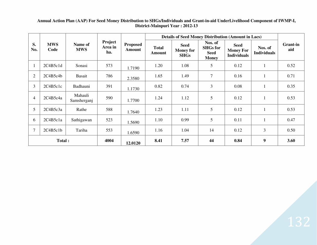
132
Annual Action Plan (AAP) For Seed Money Distribution to SHGs/Individuals and Grant-in-aid UnderLivelihood Component of IWMP-I,
District-Mainpuri Year : 2012-13
S.
No.
MWS
Code
Name of
MWS
Project
Area in
ha.
Proposed
Amount
Details of Seed Money Distribution (Amount in Lacs)
Grant-in
aid Total
Amount
Seed
Money for
SHGs
Nos. of
SHGs for
Seed
Money
Seed
Money For
Individuals
Nos. of
Individuals
1 2C4B5c1d Sonasi 573
1.7190 1.20 1.08 5 0.12 1 0.52
2 2C4B5c4b Basait 786
2.3580 1.65 1.49 7 0.16 1 0.71
3 2C4B5c1c Badhauni 391
1.1730 0.82 0.74 3 0.08 1 0.35
4 2C4B5c4a Mahauli
Samsherganj 590
1.7700
1.24 1.12 5 0.12 1 0.53
5 2C4B5c3a Rathe 588
1.7640 1.23 1.11 5 0.12 1 0.53
6 2C4B5c1a Sathigawan 523
1.5690 1.10 0.99 5 0.11 1 0.47
7 2C4B5c1b Tariha 553
1.6590 1.16 1.04 14 0.12 3 0.50
Total : 4004
12.0120 8.41 7.57 44 0.84 9 3.60
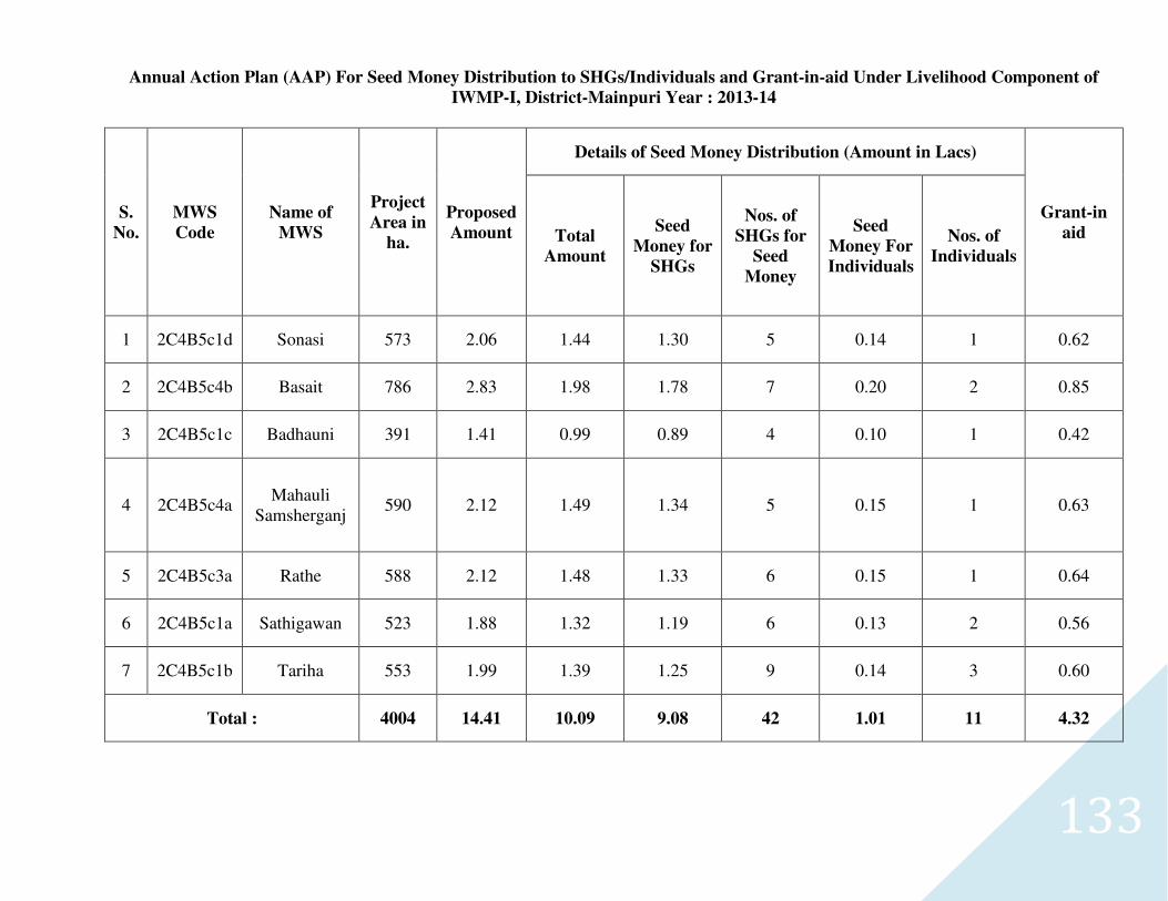
133
Annual Action Plan (AAP) For Seed Money Distribution to SHGs/Individuals and Grant-in-aid Under Livelihood Component of
IWMP-I, District-Mainpuri Year : 2013-14
S.
No.
MWS
Code
Name of
MWS
Project
Area in
ha.
Proposed
Amount
Details of Seed Money Distribution (Amount in Lacs)
Grant-in
aid Total
Amount
Seed
Money for
SHGs
Nos. of
SHGs for
Seed
Money
Seed
Money For
Individuals
Nos. of
Individuals
1 2C4B5c1d Sonasi 573 2.06 1.44 1.30 5 0.14 1 0.62
2 2C4B5c4b Basait 786 2.83 1.98 1.78 7 0.20 2 0.85
3 2C4B5c1c Badhauni 391 1.41 0.99 0.89 4 0.10 1 0.42
4 2C4B5c4a Mahauli
Samsherganj 590 2.12 1.49 1.34 5 0.15 1 0.63
5 2C4B5c3a Rathe 588 2.12 1.48 1.33 6 0.15 1 0.64
6 2C4B5c1a Sathigawan 523 1.88 1.32 1.19 6 0.13 2 0.56
7 2C4B5c1b Tariha 553 1.99 1.39 1.25 9 0.14 3 0.60
Total : 4004 14.41 10.09 9.08 42 1.01 11 4.32
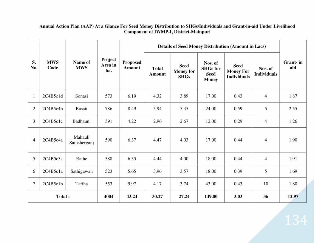
134
Annual Action Plan (AAP) At a Glance For Seed Money Distribution to SHGs/Individuals and Grant-in-aid Under Livelihood
Component of IWMP-I, District-Mainpuri
S.
No.
MWS
Code
Name of
MWS
Project
Area in
ha.
Proposed
Amount
Details of Seed Money Distribution (Amount in Lacs)
Grant- in
aid Total
Amount
Seed
Money for
SHGs
Nos. of
SHGs for
Seed
Money
Seed
Money For
Individuals
Nos. of
Individuals
1 2C4B5c1d Sonasi 573 6.19 4.32 3.89 17.00 0.43 4 1.87
2 2C4B5c4b Basait 786 8.49 5.94 5.35 24.00 0.59 5 2.55
3 2C4B5c1c Badhauni 391 4.22 2.96 2.67 12.00 0.29 4 1.26
4 2C4B5c4a Mahauli
Samsherganj 590 6.37 4.47 4.03 17.00 0.44 4 1.90
5 2C4B5c3a Rathe 588 6.35 4.44 4.00 18.00 0.44 4 1.91
6 2C4B5c1a Sathigawan 523 5.65 3.96 3.57 18.00 0.39 5 1.69
7 2C4B5c1b Tariha 553 5.97 4.17 3.74 43.00 0.43 10 1.80
Total : 4004 43.24 30.27 27.24 149.00 3.03 36 12.97
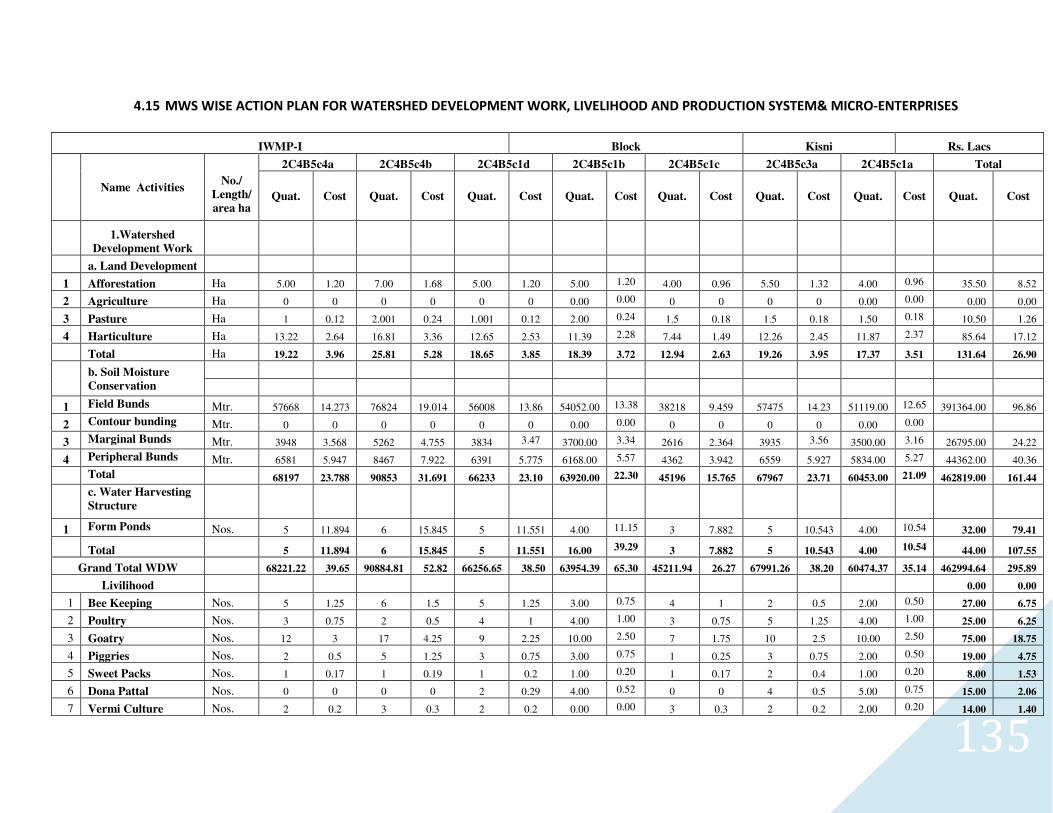
135
4.15 MWS WISE ACTION PLAN FOR WATERSHED DEVELOPMENT WORK, LIVELIHOOD AND PRODUCTION SYSTEM& MICRO-ENTERPRISES
IWMP-I Block Kisni Rs. Lacs
Name Activities
No./
Length/
area ha
2C4B5c4a 2C4B5c4b 2C4B5c1d 2C4B5c1b 2C4B5c1c 2C4B5c3a 2C4B5c1a Total
Quat. Cost Quat. Cost Quat. Cost Quat. Cost Quat. Cost Quat. Cost Quat. Cost Quat. Cost
1.Watershed
Development Work
a. Land Development
1 Afforestation Ha 5.00 1.20 7.00 1.68 5.00 1.20 5.00 1.20 4.00 0.96 5.50 1.32 4.00 0.96 35.50 8.52
2 Agriculture Ha 0 0 0 0 0 0 0.00 0.00 0 0 0 0 0.00 0.00 0.00 0.00
3 Pasture Ha 1 0.12 2.001 0.24 1.001 0.12 2.00 0.24 1.5 0.18 1.5 0.18 1.50 0.18 10.50 1.26
4 Harticulture Ha 13.22 2.64 16.81 3.36 12.65 2.53 11.39 2.28 7.44 1.49 12.26 2.45 11.87 2.37 85.64 17.12
Total Ha 19.22 3.96 25.81 5.28 18.65 3.85 18.39 3.72 12.94 2.63 19.26 3.95 17.37 3.51 131.64 26.90
b. Soil Moisture
Conservation
1 Field Bunds Mtr. 57668 14.273 76824 19.014 56008 13.86 54052.00 13.38 38218 9.459 57475 14.23 51119.00 12.65 391364.00 96.86
2 Contour bunding Mtr. 0 0 0 0 0 0 0.00 0.00 0 0 0 0 0.00 0.00
3 Marginal Bunds Mtr. 3948 3.568 5262 4.755 3834 3.47 3700.00 3.34 2616 2.364 3935 3.56 3500.00 3.16 26795.00 24.22
4 Peripheral Bunds Mtr. 6581 5.947 8467 7.922 6391 5.775 6168.00 5.57 4362 3.942 6559 5.927 5834.00 5.27 44362.00 40.36
Total 68197 23.788 90853 31.691 66233 23.10 63920.00 22.30 45196 15.765 67967 23.71 60453.00 21.09 462819.00 161.44
c. Water Harvesting
Structure
1 Form Ponds Nos. 5 11.894 6 15.845 5 11.551 4.00 11.15 3 7.882 5 10.543 4.00 10.54 32.00 79.41
Total 5 11.894 6 15.845 5 11.551 16.00 39.29 3 7.882 5 10.543 4.00 10.54 44.00 107.55
Grand Total WDW 68221.22 39.65 90884.81 52.82 66256.65 38.50 63954.39 65.30 45211.94 26.27 67991.26 38.20 60474.37 35.14 462994.64 295.89
Livilihood 0.00 0.00
1 Bee Keeping Nos. 5 1.25 6 1.5 5 1.25 3.00 0.75 4 1 2 0.5 2.00 0.50 27.00 6.75
2 Poultry Nos. 3 0.75 2 0.5 4 1 4.00 1.00 3 0.75 5 1.25 4.00 1.00 25.00 6.25
3 Goatry Nos. 12 3 17 4.25 9 2.25 10.00 2.50 7 1.75 10 2.5 10.00 2.50 75.00 18.75
4 Piggries Nos. 2 0.5 5 1.25 3 0.75 3.00 0.75 1 0.25 3 0.75 2.00 0.50 19.00 4.75
5 Sweet Packs Nos. 1 0.17 1 0.19 1 0.2 1.00 0.20 1 0.17 2 0.4 1.00 0.20 8.00 1.53
6 Dona Pattal Nos. 0 0 0 0 2 0.29 4.00 0.52 0 0 4 0.5 5.00 0.75 15.00 2.06
7 Vermi Culture Nos. 2 0.2 3 0.3 2 0.2 0.00 0.00 3 0.3 2 0.2 2.00 0.20 14.00 1.40
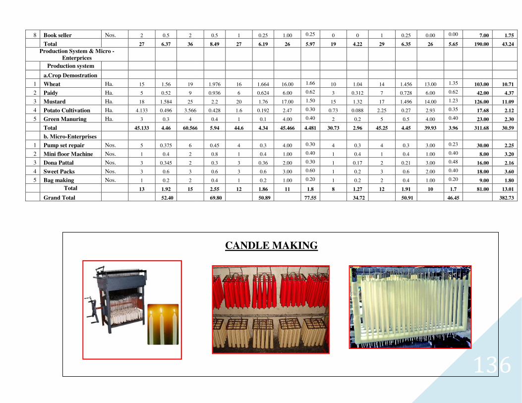
8 Book seller Nos. 2 0.5 2
Total 27 6.37 36
Production System & Micro -
Enterprices
Production system
a.Crop Demostration
1 Wheat Ha. 15 1.56 19
2 Paidy Ha. 5 0.52 9
3 Mustard Ha. 18 1.584 25
4 Potato Cultivation Ha. 4.133 0.496 3.566
5 Green Manuring Ha. 3 0.3 4
Total 45.133 4.46 60.566
b. Micro-Enterprises
1 Pump set repair Nos. 5 0.375 6
2 Mini floor Machine Nos. 1 0.4 2
3 Dona Pattal Nos. 3 0.345 2
4 Sweet Packs Nos. 3 0.6 3
5 Bag making Nos. 1 0.2 2
Total 13 1.92 15
Grand Total 52.40
0.5 1 0.25 1.00 0.25 0 0 1
8.49 27 6.19 26 5.97 19 4.22 29
1.976 16 1.664 16.00 1.66 10 1.04 14
0.936 6 0.624 6.00 0.62 3 0.312 7
2.2 20 1.76 17.00 1.50 15 1.32 17
3.566 0.428 1.6 0.192 2.47 0.30 0.73 0.088 2.25
0.4 1 0.1 4.00 0.40 2 0.2 5
60.566 5.94 44.6 4.34 45.466 4.481 30.73 2.96 45.25
0.45 4 0.3 4.00 0.30 4 0.3 4
0.8 1 0.4 1.00 0.40 1 0.4 1
0.3 3 0.36 2.00 0.30 1 0.17 2
0.6 3 0.6 3.00 0.60 1 0.2 3
0.4 1 0.2 1.00 0.20 1 0.2 2
2.55 12 1.86 11 1.8 8 1.27 12
69.80 50.89 77.55 34.72
CANDLE MAKING
136
0.25 0.00 0.00 7.00 1.75
6.35 26 5.65 190.00 43.24
1.456 13.00 1.35 103.00 10.71
0.728 6.00 0.62 42.00 4.37
1.496 14.00 1.23 126.00 11.09
0.27 2.93 0.35 17.68 2.12
0.5 4.00 0.40 23.00 2.30
4.45 39.93 3.96 311.68 30.59
0.3 3.00 0.23 30.00 2.25
0.4 1.00 0.40 8.00 3.20
0.21 3.00 0.48 16.00 2.16
0.6 2.00 0.40 18.00 3.60
0.4 1.00 0.20 9.00 1.80
1.91 10 1.7 81.00 13.01
50.91 46.45 382.73
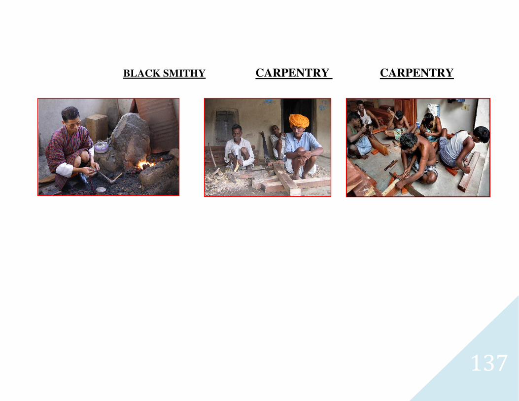
137
BLACK SMITHY CARPENTRY CARPENTRY
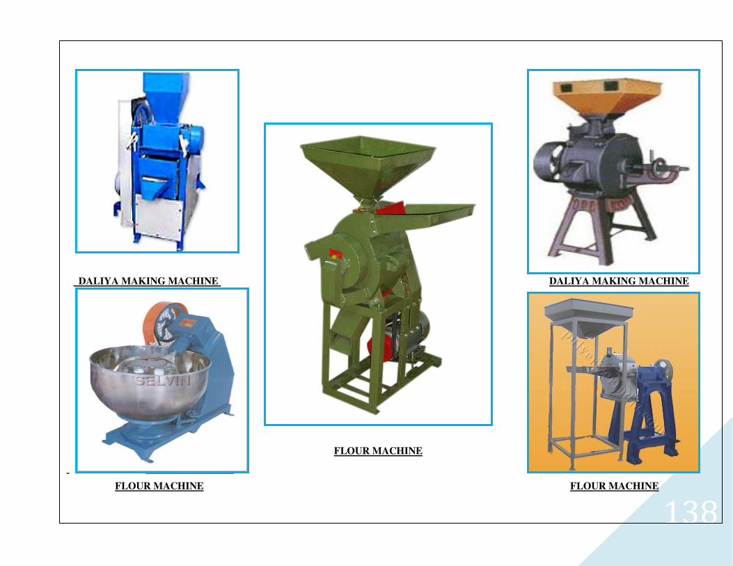
138
DALIYA MAKING MACHINE
DALIYA MAKING MACHINE DALIYA MAKING MACHINE
FLOUR MACHINE
FLOUR MACHINE
FLOUR MACHINE FLOUR MACHINE
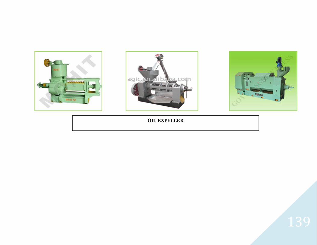
139
OIL EXPELLER

140
CHAPTER-5
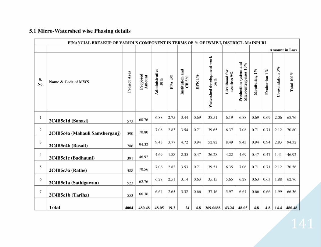
141
5.1 Micro-Watershed wise Phasing details
FINANCIAL BREAKUP OF VARIOUS COMPONENT IN TERMS OF % OF IWMP-I, DISTRICT- MAINPURI
Amount in Lacs
S.
No. Name & Code of MWS
Pro
ject
Are
a
Pro
po
sed
Am
ou
nt
Ad
min
istr
ati
ve
10
%
EP
A 4
%
Inst
itu
tio
n a
nd
CB
5%
DP
R 1
%
Wa
ters
hed
dev
elo
pm
en
t w
ork
56
%
Liv
elih
oo
d f
or
ass
etle
ss 9
%
Pro
du
ctio
n s
yst
em a
nd
Mic
roen
terp
rise
s 1
0%
Mo
nit
ori
ng
1%
Ev
alu
ati
on
1%
Co
nso
lid
ati
on
3%
To
tal
10
0%
1 2C4B5c1d (Sonasi) 573
68.76
6.88 2.75 3.44 0.69 38.51 6.19 6.88 0.69 0.69 2.06 68.76
2 2C4B5c4a (Mahauli Samsherganj) 590
70.80
7.08 2.83 3.54 0.71 39.65 6.37 7.08 0.71 0.71 2.12 70.80
3 2C4B5c4b (Basait) 786
94.32
9.43 3.77 4.72 0.94 52.82 8.49 9.43 0.94 0.94 2.83 94.32
4 2C4B5c1c (Badhauni) 391
46.92
4.69 1.88 2.35 0.47 26.28 4.22 4.69 0.47 0.47 1.41 46.92
5 2C4B5c3a (Rathe) 588
70.56
7.06 2.82 3.53 0.71 39.51 6.35 7.06 0.71 0.71 2.12 70.56
6 2C4B5c1a (Sathigawan) 523
62.76
6.28 2.51 3.14 0.63 35.15 5.65 6.28 0.63 0.63 1.88 62.76
7 2C4B5c1b (Tariha) 553
66.36
6.64 2.65 3.32 0.66 37.16 5.97 6.64 0.66 0.66 1.99 66.36
Total 4004 480.48 48.05 19.2 24 4.8 269.0688 43.24 48.05 4.8 4.8 14.4 480.48
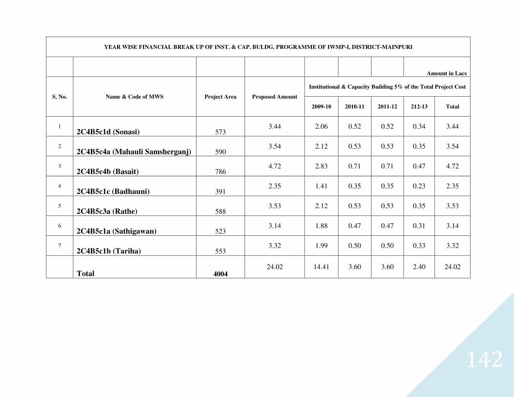
142
YEAR WISE FINANCIAL BREAK UP OF INST. & CAP. BULDG. PROGRAMME OF IWMP-I, DISTRICT-MAINPURI
Amount in Lacs
S. No. Name & Code of MWS Project Area Proposed Amount
Institutional & Capacity Building 5% of the Total Project Cost
2009-10 2010-11 2011-12 212-13 Total
1 2C4B5c1d (Sonasi) 573
3.44 2.06 0.52 0.52 0.34 3.44
2 2C4B5c4a (Mahauli Samsherganj) 590
3.54 2.12 0.53 0.53 0.35 3.54
3 2C4B5c4b (Basait) 786
4.72 2.83 0.71 0.71 0.47 4.72
4 2C4B5c1c (Badhauni) 391
2.35 1.41 0.35 0.35 0.23 2.35
5 2C4B5c3a (Rathe) 588
3.53 2.12 0.53 0.53 0.35 3.53
6 2C4B5c1a (Sathigawan) 523
3.14 1.88 0.47 0.47 0.31 3.14
7 2C4B5c1b (Tariha) 553
3.32 1.99 0.50 0.50 0.33 3.32
Total 4004 24.02 14.41 3.60 3.60 2.40 24.02
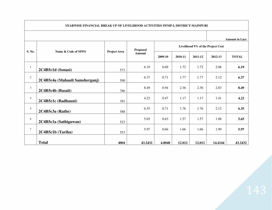
143
YEARWISE FINANCIAL BREAK UP OF LIVELIHOOD ACTIVITIES IWMP-I, DISTRICT-MAINPURI
Amount in Lacs
S. No. Name & Code of MWS Project Area Proposed
Amount
Livelihood 9% of the Project Cost
2009-10 2010-11 2011-12 2012-13 TOTAL
1 2C4B5c1d (Sonasi) 573
6.19 0.69 1.72 1.72 2.06 6.19
2 2C4B5c4a (Mahauli Samsherganj) 590
6.37 0.71 1.77 1.77 2.12 6.37
3 2C4B5c4b (Basait) 786
8.49 0.94 2.36 2.36 2.83 8.49
4 2C4B5c1c (Badhauni) 391
4.22 0.47 1.17 1.17 1.41 4.22
5 2C4B5c3a (Rathe) 588
6.35 0.71 1.76 1.76 2.12 6.35
6 2C4B5c1a (Sathigawan) 523
5.65 0.63 1.57 1.57 1.88 5.65
7 2C4B5c1b (Tariha) 553
5.97 0.66 1.66 1.66 1.99 5.97
Total 4004 43.2432 4.8048 12.012 12.012 14.4144 43.2432
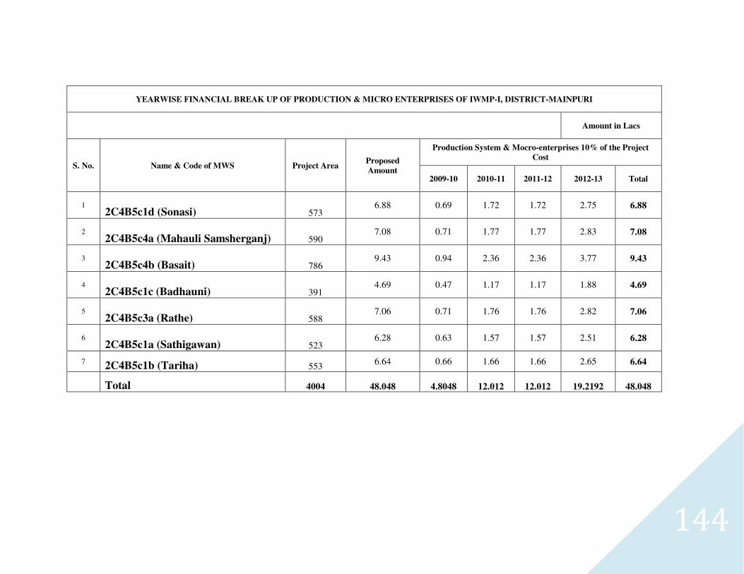
144
YEARWISE FINANCIAL BREAK UP OF PRODUCTION & MICRO ENTERPRISES OF IWMP-I, DISTRICT-MAINPURI
Amount in Lacs
S. No. Name & Code of MWS Project Area Proposed
Amount
Production System & Mocro-enterprises 10% of the Project
Cost
2009-10 2010-11 2011-12 2012-13 Total
1 2C4B5c1d (Sonasi) 573
6.88 0.69 1.72 1.72 2.75 6.88
2 2C4B5c4a (Mahauli Samsherganj) 590
7.08 0.71 1.77 1.77 2.83 7.08
3 2C4B5c4b (Basait) 786
9.43 0.94 2.36 2.36 3.77 9.43
4 2C4B5c1c (Badhauni) 391
4.69 0.47 1.17 1.17 1.88 4.69
5 2C4B5c3a (Rathe) 588
7.06 0.71 1.76 1.76 2.82 7.06
6 2C4B5c1a (Sathigawan) 523
6.28 0.63 1.57 1.57 2.51 6.28
7 2C4B5c1b (Tariha) 553
6.64 0.66 1.66 1.66 2.65 6.64
Total 4004 48.048 4.8048 12.012 12.012 19.2192 48.048
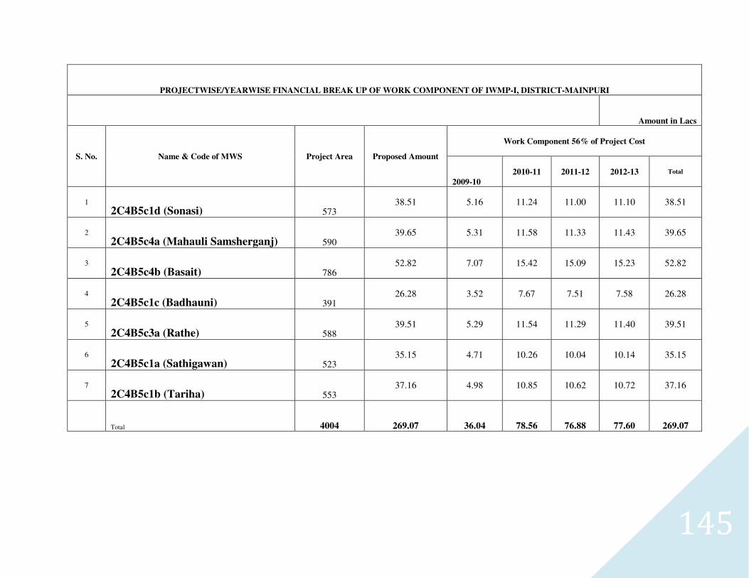
145
PROJECTWISE/YEARWISE FINANCIAL BREAK UP OF WORK COMPONENT OF IWMP-I, DISTRICT-MAINPURI
Amount in Lacs
S. No. Name & Code of MWS Project Area Proposed Amount
Work Component 56% of Project Cost
2009-10
2010-11 2011-12 2012-13 Total
1 2C4B5c1d (Sonasi) 573
38.51 5.16 11.24 11.00 11.10 38.51
2
2C4B5c4a (Mahauli Samsherganj) 590 39.65 5.31 11.58 11.33 11.43 39.65
3
2C4B5c4b (Basait) 786 52.82 7.07 15.42 15.09 15.23 52.82
4
2C4B5c1c (Badhauni) 391 26.28 3.52 7.67 7.51 7.58 26.28
5
2C4B5c3a (Rathe) 588 39.51 5.29 11.54 11.29 11.40 39.51
6
2C4B5c1a (Sathigawan) 523 35.15 4.71 10.26 10.04 10.14 35.15
7 2C4B5c1b (Tariha) 553
37.16 4.98 10.85 10.62 10.72 37.16
Total 4004 269.07 36.04 78.56 76.88 77.60 269.07
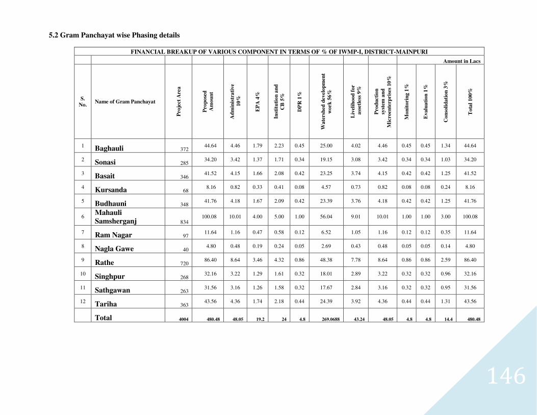
146
5.2 Gram Panchayat wise Phasing details
FINANCIAL BREAKUP OF VARIOUS COMPONENT IN TERMS OF % OF IWMP-I, DISTRICT-MAINPURI
Amount in Lacs
S.
No. Name of Gram Panchayat
Pro
ject
Are
a
Pro
po
sed
Am
ou
nt
Ad
min
istr
ati
ve
10
%
EP
A 4
%
Inst
itu
tio
n a
nd
CB
5%
DP
R 1
%
Wa
ters
hed
dev
elo
pm
ent
wo
rk 5
6%
Liv
elih
oo
d f
or
a
sset
less
9%
Pro
du
ctio
n
syst
em a
nd
Mic
roen
terp
rise
s 10
%
Mo
nit
ori
ng
1%
Eva
lua
tio
n 1
%
Co
nso
lid
ati
on
3%
To
tal
10
0%
1 Baghauli 372 44.64 4.46 1.79 2.23 0.45 25.00 4.02 4.46 0.45 0.45 1.34 44.64
2 Sonasi 285 34.20 3.42 1.37 1.71 0.34 19.15 3.08 3.42 0.34 0.34 1.03 34.20
3 Basait 346 41.52 4.15 1.66 2.08 0.42 23.25 3.74 4.15 0.42 0.42 1.25 41.52
4 Kursanda 68 8.16 0.82 0.33 0.41 0.08 4.57 0.73 0.82 0.08 0.08 0.24 8.16
5 Budhauni 348 41.76 4.18 1.67 2.09 0.42 23.39 3.76 4.18 0.42 0.42 1.25 41.76
6 Mahauli
Samsherganj 834 100.08 10.01 4.00 5.00 1.00 56.04 9.01 10.01 1.00 1.00 3.00 100.08
7 Ram Nagar 97 11.64 1.16 0.47 0.58 0.12 6.52 1.05 1.16 0.12 0.12 0.35 11.64
8 Nagla Gawe 40 4.80 0.48 0.19 0.24 0.05 2.69 0.43 0.48 0.05 0.05 0.14 4.80
9 Rathe 720 86.40 8.64 3.46 4.32 0.86 48.38 7.78 8.64 0.86 0.86 2.59 86.40
10 Singhpur 268 32.16 3.22 1.29 1.61 0.32 18.01 2.89 3.22 0.32 0.32 0.96 32.16
11 Sathgawan 263 31.56 3.16 1.26 1.58 0.32 17.67 2.84 3.16 0.32 0.32 0.95 31.56
12 Tariha 363 43.56 4.36 1.74 2.18 0.44 24.39 3.92 4.36 0.44 0.44 1.31 43.56
Total 4004 480.48 48.05 19.2 24 4.8 269.0688 43.24 48.05 4.8 4.8 14.4 480.48
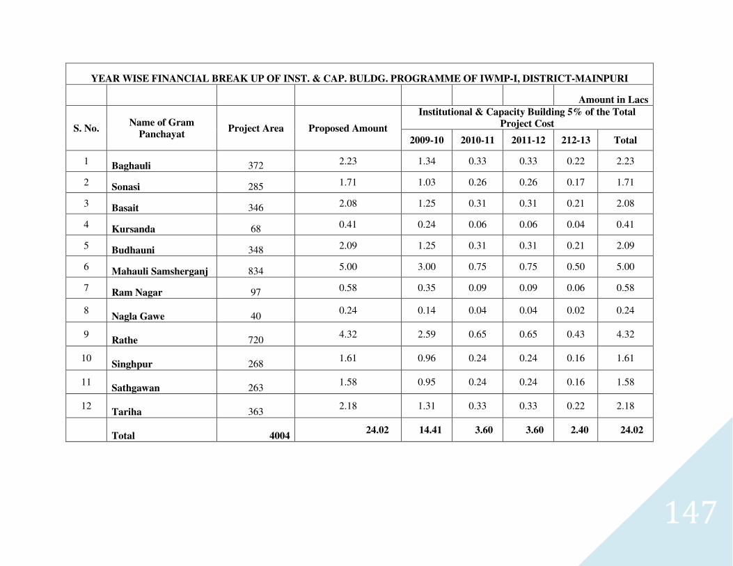
147
YEAR WISE FINANCIAL BREAK UP OF INST. & CAP. BULDG. PROGRAMME OF IWMP-I, DISTRICT-MAINPURI
Amount in Lacs
S. No. Name of Gram
Panchayat Project Area Proposed Amount
Institutional & Capacity Building 5% of the Total
Project Cost
2009-10 2010-11 2011-12 212-13 Total
1 Baghauli 372 2.23 1.34 0.33 0.33 0.22 2.23
2 Sonasi 285 1.71 1.03 0.26 0.26 0.17 1.71
3 Basait 346 2.08 1.25 0.31 0.31 0.21 2.08
4 Kursanda 68 0.41 0.24 0.06 0.06 0.04 0.41
5 Budhauni 348 2.09 1.25 0.31 0.31 0.21 2.09
6 Mahauli Samsherganj 834 5.00 3.00 0.75 0.75 0.50 5.00
7 Ram Nagar 97 0.58 0.35 0.09 0.09 0.06 0.58
8 Nagla Gawe 40
0.24 0.14 0.04 0.04 0.02 0.24
9 Rathe 720
4.32 2.59 0.65 0.65 0.43 4.32
10 Singhpur 268
1.61 0.96 0.24 0.24 0.16 1.61
11 Sathgawan 263
1.58 0.95 0.24 0.24 0.16 1.58
12 Tariha 363
2.18 1.31 0.33 0.33 0.22 2.18
Total 4004 24.02 14.41 3.60 3.60 2.40 24.02
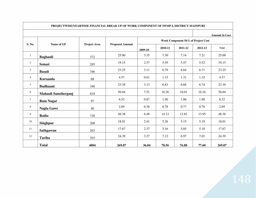
148
PROJECTWISE/YEARWISE FINANCIAL BREAK UP OF WORK COMPONENT OF IWMP-I, DISTRICT-MAINPURI
Amount in Lacs
S. No. Name of GP Project Area Proposed Amount
Work Component 56% of Project Cost
2009-10 2010-11 2011-12 2012-13 Total
1 Baghauli 372
25.00 3.35 7.30 7.14 7.21 25.00
2 Sonasi 285
19.15 2.57 5.59 5.47 5.52 19.15
3 Basait 346
23.25 3.11 6.79 6.64 6.71 23.25
4 Kursanda 68
4.57 0.61 1.33 1.31 1.32 4.57
5 Budhauni 348
23.39 3.13 6.83 6.68 6.74 23.39
6 Mahauli Samsherganj 834
56.04 7.51 16.36 16.01 16.16 56.04
7 Ram Nagar 97
6.52 0.87 1.90 1.86 1.88 6.52
8 Nagla Gawe 40
2.69 0.36 0.78 0.77 0.78 2.69
9 Rathe 720
48.38 6.48 14.13 13.82 13.95 48.38
10 Singhpur 268
18.01 2.41 5.26 5.15 5.19 18.01
11 Sathgawan 263
17.67 2.37 5.16 5.05 5.10 17.67
12 Tariha 363
24.39 3.27 7.12 6.97 7.03 24.39
Total 4004 269.07 36.04 78.56 76.88 77.60 269.07
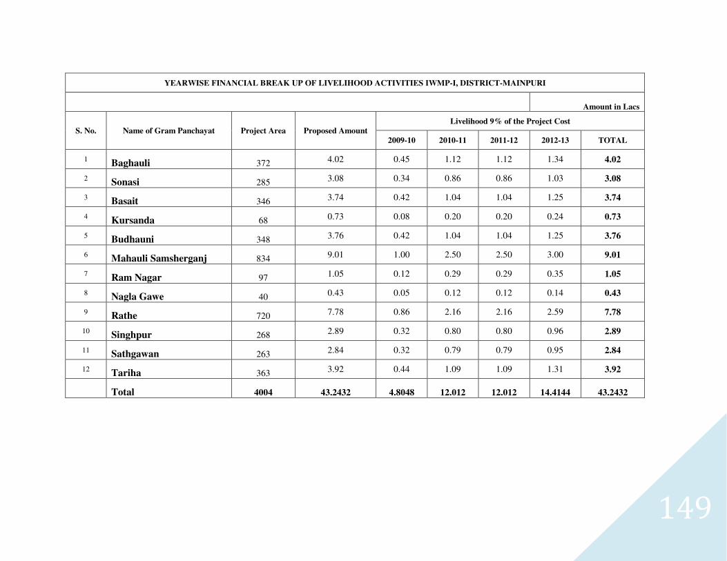
149
YEARWISE FINANCIAL BREAK UP OF LIVELIHOOD ACTIVITIES IWMP-I, DISTRICT-MAINPURI
Amount in Lacs
S. No. Name of Gram Panchayat Project Area Proposed Amount
Livelihood 9% of the Project Cost
2009-10 2010-11 2011-12 2012-13 TOTAL
1 Baghauli 372 4.02 0.45 1.12 1.12 1.34 4.02
2 Sonasi 285 3.08 0.34 0.86 0.86 1.03 3.08
3 Basait 346 3.74 0.42 1.04 1.04 1.25 3.74
4 Kursanda 68 0.73 0.08 0.20 0.20 0.24 0.73
5 Budhauni 348 3.76 0.42 1.04 1.04 1.25 3.76
6 Mahauli Samsherganj 834 9.01 1.00 2.50 2.50 3.00 9.01
7 Ram Nagar 97 1.05 0.12 0.29 0.29 0.35 1.05
8 Nagla Gawe 40 0.43 0.05 0.12 0.12 0.14 0.43
9 Rathe 720 7.78 0.86 2.16 2.16 2.59 7.78
10 Singhpur 268 2.89 0.32 0.80 0.80 0.96 2.89
11 Sathgawan 263 2.84 0.32 0.79 0.79 0.95 2.84
12 Tariha 363 3.92 0.44 1.09 1.09 1.31 3.92
Total 4004 43.2432 4.8048 12.012 12.012 14.4144 43.2432
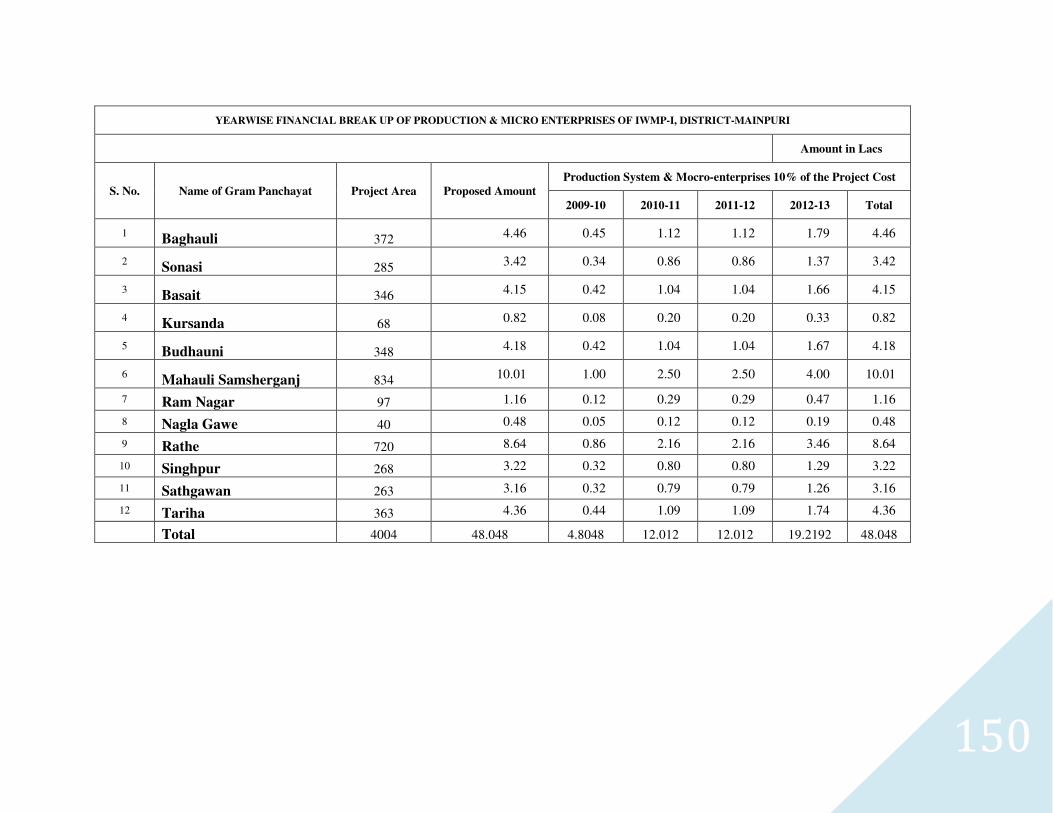
150
YEARWISE FINANCIAL BREAK UP OF PRODUCTION & MICRO ENTERPRISES OF IWMP-I, DISTRICT-MAINPURI
Amount in Lacs
S. No. Name of Gram Panchayat Project Area Proposed Amount
Production System & Mocro-enterprises 10% of the Project Cost
2009-10 2010-11 2011-12 2012-13 Total
1 Baghauli 372 4.46 0.45 1.12 1.12 1.79 4.46
2 Sonasi 285
3.42 0.34 0.86 0.86 1.37 3.42
3 Basait 346 4.15 0.42 1.04 1.04 1.66 4.15
4 Kursanda 68 0.82 0.08 0.20 0.20 0.33 0.82
5 Budhauni 348
4.18 0.42 1.04 1.04 1.67 4.18
6 Mahauli Samsherganj 834 10.01 1.00 2.50 2.50 4.00 10.01
7 Ram Nagar 97 1.16 0.12 0.29 0.29 0.47 1.16
8 Nagla Gawe 40 0.48 0.05 0.12 0.12 0.19 0.48
9 Rathe 720 8.64 0.86 2.16 2.16 3.46 8.64
10 Singhpur 268 3.22 0.32 0.80 0.80 1.29 3.22
11 Sathgawan 263 3.16 0.32 0.79 0.79 1.26 3.16
12 Tariha 363 4.36 0.44 1.09 1.09 1.74 4.36
Total 4004 48.048 4.8048 12.012 12.012 19.2192 48.048
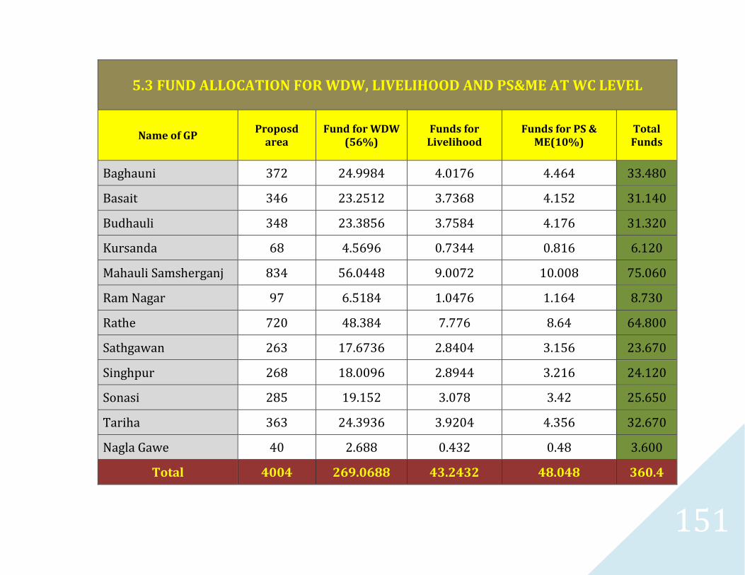
151
5.3 FUND ALLOCATION FOR WDW, LIVELIHOOD AND PS&ME AT WC LEVEL
Name of GP Proposd
area
Fund for WDW
(56%)
Funds for
Livelihood
Funds for PS &
ME(10%)
Total
Funds
Baghauni 372 24.9984 4.0176 4.464 33.480
Basait 346 23.2512 3.7368 4.152 31.140
Budhauli 348 23.3856 3.7584 4.176 31.320
Kursanda 68 4.5696 0.7344 0.816 6.120
Mahauli Samsherganj 834 56.0448 9.0072 10.008 75.060
Ram Nagar 97 6.5184 1.0476 1.164 8.730
Rathe 720 48.384 7.776 8.64 64.800
Sathgawan 263 17.6736 2.8404 3.156 23.670
Singhpur 268 18.0096 2.8944 3.216 24.120
Sonasi 285 19.152 3.078 3.42 25.650
Tariha 363 24.3936 3.9204 4.356 32.670
Nagla Gawe 40 2.688 0.432 0.48 3.600
Total 4004 269.0688 43.2432 48.048 360.4
152
CHAPTER - 6
153
6.1 Expected Outcomes:
As per Common Guidelines of GoI, each Watershed Development Project is expected to achieve the following results by the end of the project period:
a. All the works/activities that are planned for the treatment and development of the drainage lines, arable and non-arable lands in the watershed area are completed with the active participation and contribution of the user groups and the community at large.
b. The user groups/panchayats have willingly taken over the operation and maintenance of the assets created and made suitable administrative and financial arrangements for their maintenance and further development.
c. All the members of the Watershed Committee and staff such as Watershed Secretary and Volunteers have been given orientation and training to improve their knowledge and upgrade technical/management and community organizational skills to a level that is appropriate for the successful discharge of their responsibilities on withdrawal of the Watershed Development Team from the Project.
d. The village community would have been organised into several, homogeneous self-help groups for savings and other income generation activities which would have achieved sufficient commitment from their members and built up financial resources to be self sustaining.
e. The increase in cropping intensity and agricultural productivity reflecting in overall increase in agriculture production.
f. Increase in income of farmers/ landless labourers in the project area.
g. Increase in groundwater table due to enhanced recharge by watershed interventions.
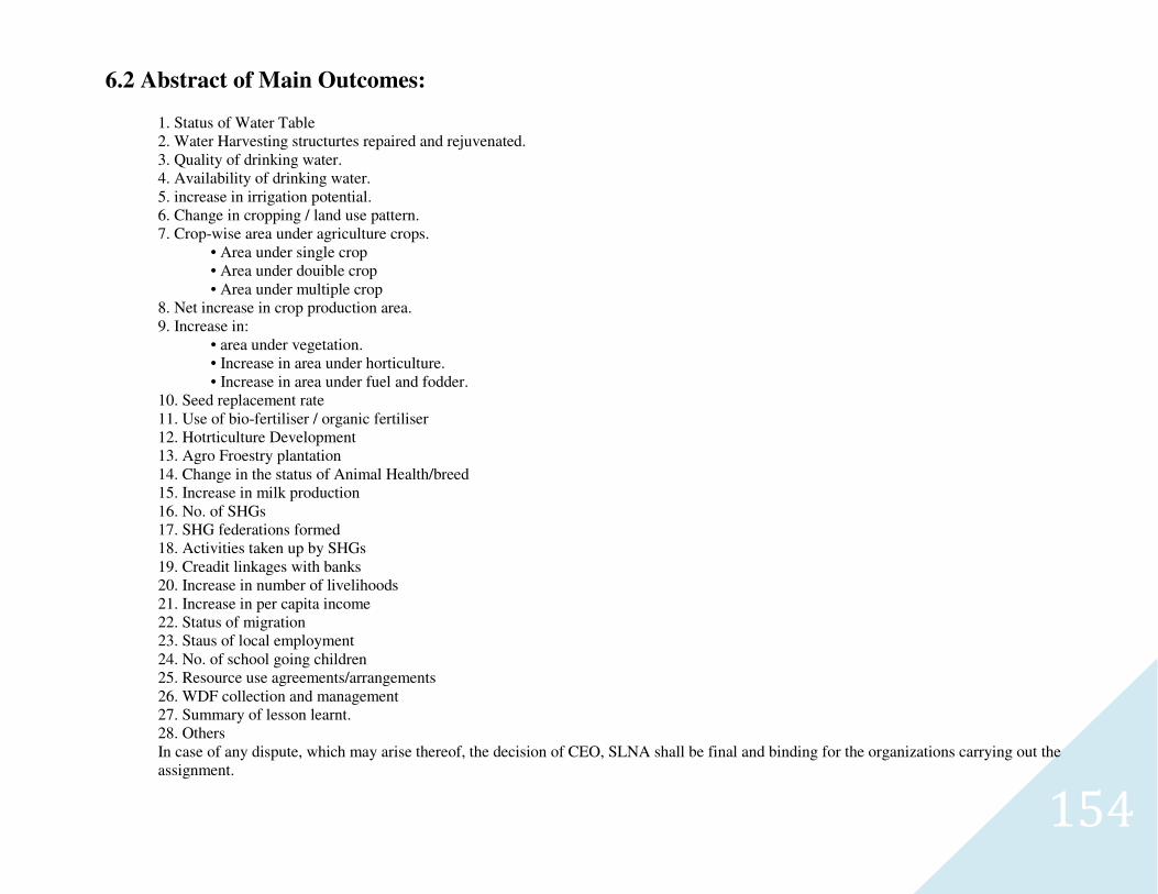
154
6.2 Abstract of Main Outcomes:
1. Status of Water Table 2. Water Harvesting structurtes repaired and rejuvenated. 3. Quality of drinking water. 4. Availability of drinking water. 5. increase in irrigation potential. 6. Change in cropping / land use pattern. 7. Crop-wise area under agriculture crops.
• Area under single crop • Area under douible crop • Area under multiple crop
8. Net increase in crop production area. 9. Increase in:
• area under vegetation. • Increase in area under horticulture. • Increase in area under fuel and fodder.
10. Seed replacement rate 11. Use of bio-fertiliser / organic fertiliser 12. Hotrticulture Development 13. Agro Froestry plantation 14. Change in the status of Animal Health/breed 15. Increase in milk production 16. No. of SHGs 17. SHG federations formed 18. Activities taken up by SHGs 19. Creadit linkages with banks 20. Increase in number of livelihoods 21. Increase in per capita income 22. Status of migration 23. Staus of local employment 24. No. of school going children 25. Resource use agreements/arrangements 26. WDF collection and management 27. Summary of lesson learnt. 28. Others In case of any dispute, which may arise thereof, the decision of CEO, SLNA shall be final and binding for the organizations carrying out the assignment.
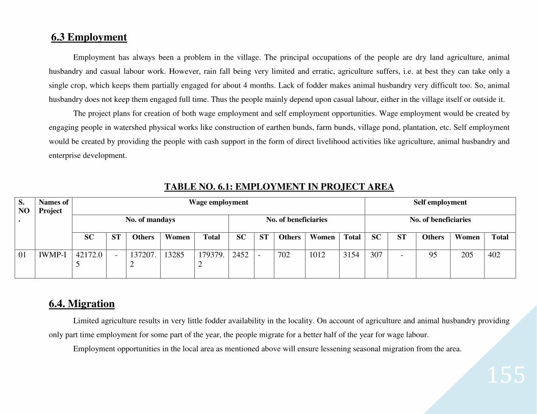
155
6.3 Employment
Employment has always been a problem in the village. The principal occupations of the people are dry land agriculture, animal
husbandry and casual labour work. However, rain fall being very limited and erratic, agriculture suffers, i.e. at best they can take only a
single crop, which keeps them partially engaged for about 4 months. Lack of fodder makes animal husbandry very difficult too. So, animal
husbandry does not keep them engaged full time. Thus the people mainly depend upon casual labour, either in the village itself or outside it.
The project plans for creation of both wage employment and self employment opportunities. Wage employment would be created by
engaging people in watershed physical works like construction of earthen bunds, farm bunds, village pond, plantation, etc. Self employment
would be created by providing the people with cash support in the form of direct livelihood activities like agriculture, animal husbandry and
enterprise development.
TABLE NO. 6.1: EMPLOYMENT IN PROJECT AREA
S.
NO
.
Names of
Project
Wage employment Self employment
No. of mandays No. of beneficiaries No. of beneficiaries
SC ST Others Women Total SC ST Others Women Total SC ST Others Women Total
01
IWMP-I 42172.05
- 137207.2
13285 179379.2
2452 - 702 1012 3154 307 - 95 205 402
6.4. Migration
Limited agriculture results in very little fodder availability in the locality. On account of agriculture and animal husbandry providing
only part time employment for some part of the year, the people migrate for a better half of the year for wage labour.
Employment opportunities in the local area as mentioned above will ensure lessening seasonal migration from the area.
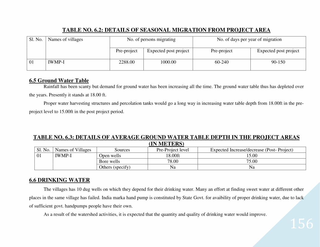
156
TABLE NO. 6.2: DETAILS OF SEASONAL MIGRATION FROM PROJECT AREA
Sl. No. Names of villages No. of persons migrating No. of days per year of migration
Pre-project Expected post project Pre-project Expected post project
01 IWMP-I 2288.00 1000.00 60-240 90-150
6.5 Ground Water Table Rainfall has been scanty but demand for ground water has been increasing all the time. The ground water table thus has depleted over
the years. Presently it stands at 18.00 ft.
Proper water harvesting structures and percolation tanks would go a long way in increasing water table depth from 18.00ft in the pre-
project level to 15.00ft in the post project period.
TABLE NO. 6.3: DETAILS OF AVERAGE GROUND WATER TABLE DEPTH IN THE PROJECT AREAS
(IN METERS) Sl. No. Names of Villages Sources Pre-Project level Expected Increase/decrease (Post- Project)
01 IWMP-I Open wells 18.00ft 15.00
Bore wells 78.00 75.00
Others (specify) Na Na
6.6 DRINKING WATER
The villages has 10 dug wells on which they depend for their drinking water. Many an effort at finding sweet water at different other
places in the same village has failed. India marka hand pump is constituted by State Govt. for avaibility of proper drinking water, due to lack
of sufficient govt. handpumps people have their own.
As a result of the watershed activities, it is expected that the quantity and quality of drinking water would improve.
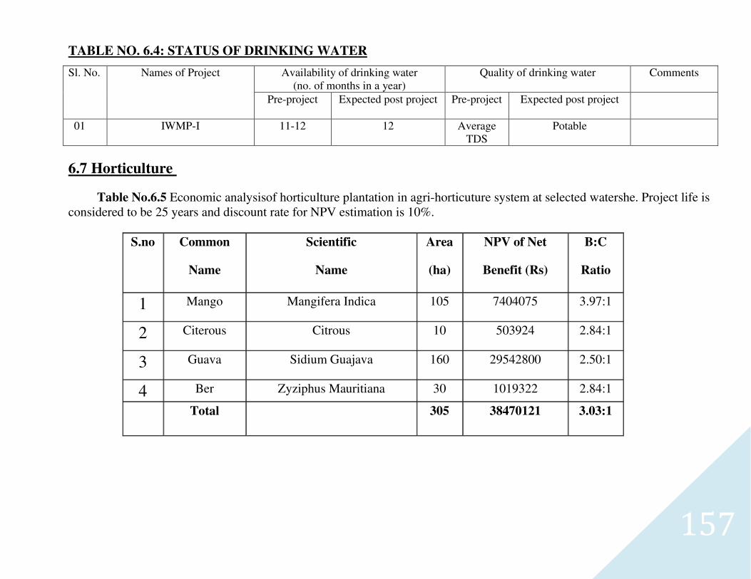
157
TABLE NO. 6.4: STATUS OF DRINKING WATER
Sl. No. Names of Project Availability of drinking water (no. of months in a year)
Quality of drinking water Comments
Pre-project Expected post project Pre-project Expected post project
01 IWMP-I 11-12 12 Average TDS
Potable
6.7 Horticulture
Table No.6.5 Economic analysisof horticulture plantation in agri-horticuture system at selected watershe. Project life is considered to be 25 years and discount rate for NPV estimation is 10%.
S.no Common
Name
Scientific
Name
Area
(ha)
NPV of Net
Benefit (Rs)
B:C
Ratio
1 Mango Mangifera Indica 105 7404075 3.97:1
2 Citerous Citrous 10 503924 2.84:1
3 Guava Sidium Guajava 160 29542800 2.50:1
4 Ber Zyziphus Mauritiana 30 1019322 2.84:1
Total 305 38470121 3.03:1
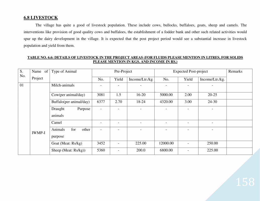
158
6.8 LIVESTOCK
The village has quite a good of livestock population. These include cows, bullocks, buffaloes, goats, sheep and camels. The
interventions like provision of good quality cows and buffaloes, the establishment of a fodder bank and other such related activities would
spur up the dairy development in the village. It is expected that the post project period would see a substantial increase in livestock
population and yield from them.
TABLE NO. 6.6: DETAILS OF LIVESTOCK IN THE PROJECT AREAS (FOR FLUIDS PLEASE MENTION IN LITRES, FOR SOLIDS
PLEASE MENTION IN KGS. AND INCOME IN RS.)
S. No.
Name of
Project
Type of Animal Pre-Project Expected Post-project Remarks
No. Yield Income/Ltr./kg No. Yield Income/Ltr./kg.
01
IWMP-I
Milch-animals - - - - - -
Cow(per animal/day) 3081 1.5 16-20 5000.00 2.00 20-25
Buffalo(per animal/day) 6377 2.70 18-24 4320.00 3.00 24-30
Draught Purpose
animals
- - - - - -
Camel - - - - - -
Animals for other
purpose
- - - - - -
Goat (Meat: Rs/kg) 3452 - 225.00 12000.00 - 250.00
Sheep (Meat: Rs/kg)) 5360 - 200.0 6800.00 - 225.00
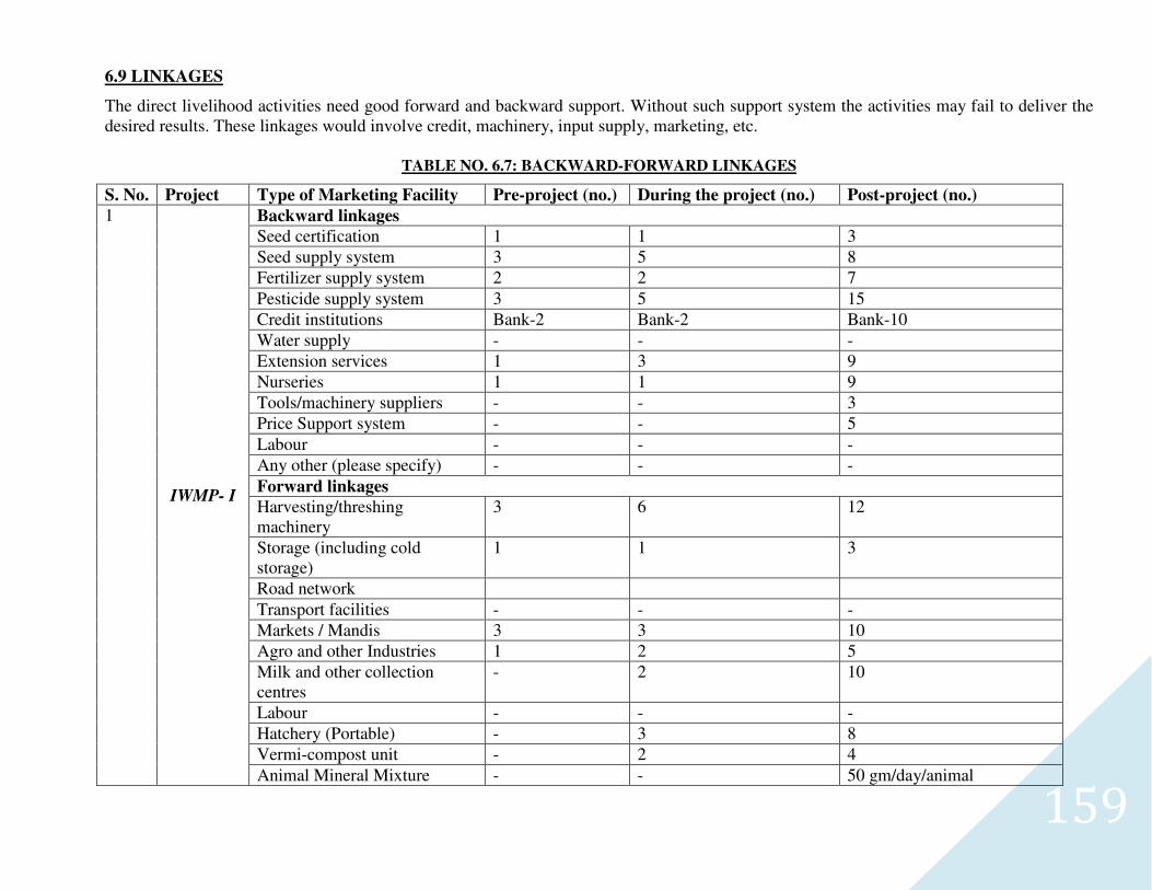
159
6.9 LINKAGES
The direct livelihood activities need good forward and backward support. Without such support system the activities may fail to deliver the desired results. These linkages would involve credit, machinery, input supply, marketing, etc.
TABLE NO. 6.7: BACKWARD-FORWARD LINKAGES
S. No. Project Type of Marketing Facility Pre-project (no.) During the project (no.) Post-project (no.)
1
IWMP- I
Backward linkages
Seed certification 1 1 3
Seed supply system 3 5 8
Fertilizer supply system 2 2 7
Pesticide supply system 3 5 15
Credit institutions Bank-2 Bank-2 Bank-10
Water supply - - -
Extension services 1 3 9
Nurseries 1 1 9
Tools/machinery suppliers - - 3
Price Support system - - 5
Labour - - -
Any other (please specify) - - -
Forward linkages
Harvesting/threshing machinery
3 6 12
Storage (including cold storage)
1 1 3
Road network
Transport facilities - - -
Markets / Mandis 3 3 10
Agro and other Industries 1 2 5
Milk and other collection centres
- 2 10
Labour - - -
Hatchery (Portable) - 3 8
Vermi-compost unit - 2 4
Animal Mineral Mixture - - 50 gm/day/animal
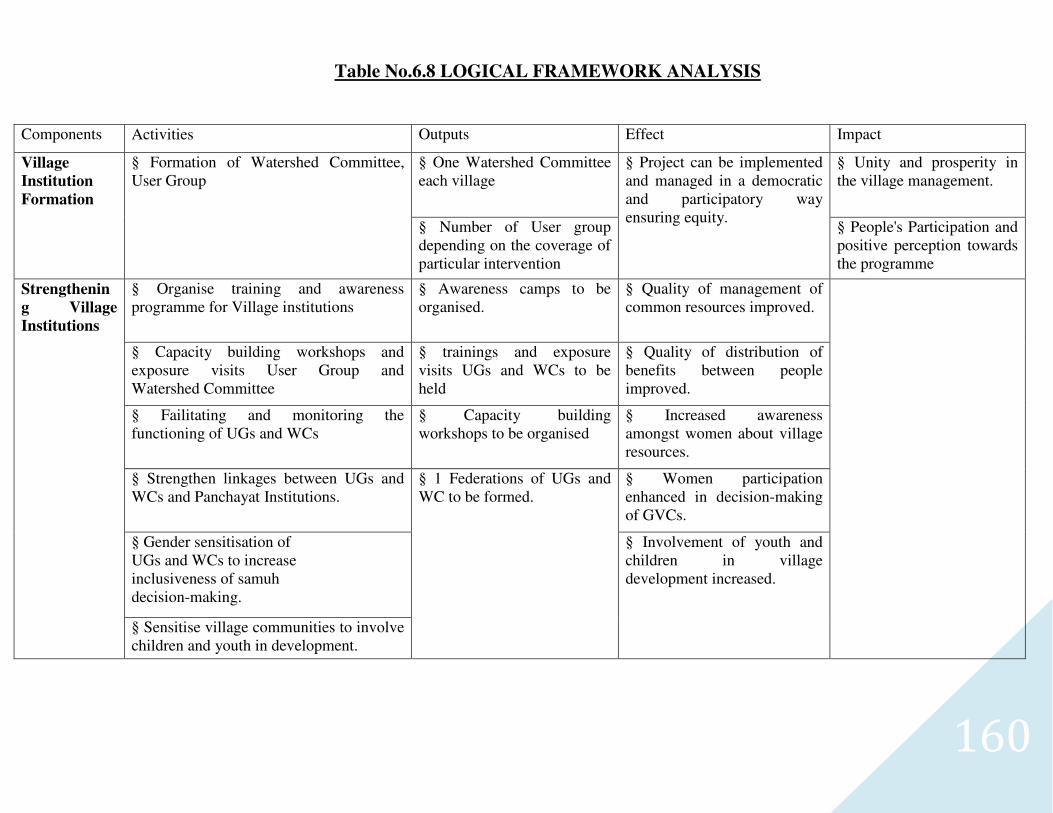
160
Table No.6.8 LOGICAL FRAMEWORK ANALYSIS
Components Activities Outputs Effect Impact
Village
Institution
Formation
§ Formation of Watershed Committee, User Group
§ One Watershed Committee each village
§ Project can be implemented and managed in a democratic and participatory way ensuring equity.
§ Unity and prosperity in the village management.
§ Number of User group depending on the coverage of particular intervention
§ People's Participation and positive perception towards the programme
Strengthenin
g Village
Institutions
§ Organise training and awareness programme for Village institutions
§ Awareness camps to be organised.
§ Quality of management of common resources improved.
§ Capacity building workshops and exposure visits User Group and Watershed Committee
§ trainings and exposure visits UGs and WCs to be held
§ Quality of distribution of benefits between people improved.
§ Failitating and monitoring the functioning of UGs and WCs
§ Capacity building workshops to be organised
§ Increased awareness amongst women about village resources.
§ Strengthen linkages between UGs and WCs and Panchayat Institutions.
§ 1 Federations of UGs and WC to be formed.
§ Women participation enhanced in decision-making of GVCs.
§ Gender sensitisation of UGs and WCs to increase inclusiveness of samuh decision-making.
§ Involvement of youth and children in village development increased.
§ Sensitise village communities to involve children and youth in development.
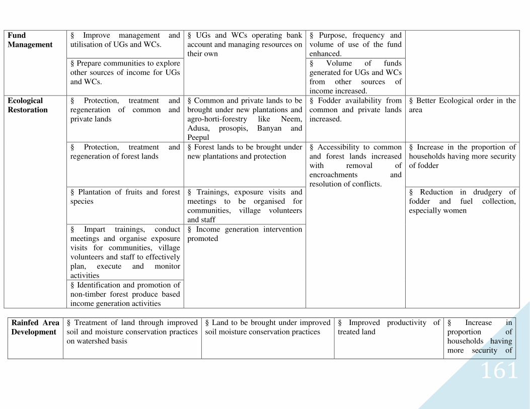
161
Fund
Management
§ Improve management and utilisation of UGs and WCs.
§ UGs and WCs operating bank account and managing resources on their own
§ Purpose, frequency and volume of use of the fund enhanced.
§ Prepare communities to explore other sources of income for UGs and WCs.
§ Volume of funds generated for UGs and WCs from other sources of income increased.
Ecological
Restoration
§ Protection, treatment and regeneration of common and private lands
§ Common and private lands to be brought under new plantations and agro-horti-forestry like Neem, Adusa, prosopis, Banyan and Peepul
§ Fodder availability from common and private lands increased.
§ Better Ecological order in the area
§ Protection, treatment and regeneration of forest lands
§ Forest lands to be brought under new plantations and protection
§ Accessibility to common and forest lands increased with removal of encroachments and resolution of conflicts.
§ Increase in the proportion of households having more security of fodder
§ Plantation of fruits and forest species
§ Trainings, exposure visits and meetings to be organised for communities, village volunteers and staff
§ Reduction in drudgery of fodder and fuel collection, especially women
§ Impart trainings, conduct meetings and organise exposure visits for communities, village volunteers and staff to effectively plan, execute and monitor activities
§ Income generation intervention promoted
§ Identification and promotion of non-timber forest produce based income generation activities
Rainfed Area
Development
§ Treatment of land through improved soil and moisture conservation practices on watershed basis
§ Land to be brought under improved soil moisture conservation practices
§ Improved productivity of treated land
§ Increase in proportion of households having more security of
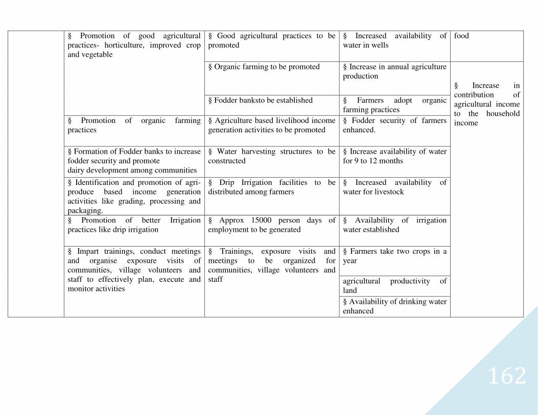
162
§ Promotion of good agricultural practices- horticulture, improved crop and vegetable
§ Good agricultural practices to be promoted
§ Increased availability of water in wells
food
§ Organic farming to be promoted § Increase in annual agriculture production
§ Increase in contribution of agricultural income to the household income
§ Fodder banksto be established § Farmers adopt organic farming practices
§ Promotion of organic farming practices
§ Agriculture based livelihood income generation activities to be promoted
§ Fodder security of farmers enhanced.
§ Formation of Fodder banks to increase fodder security and promote dairy development among communities
§ Water harvesting structures to be constructed
§ Increase availability of water for 9 to 12 months
§ Identification and promotion of agri-produce based income generation activities like grading, processing and packaging.
§ Drip Irrigation facilities to be distributed among farmers
§ Increased availability of water for livestock
§ Promotion of better Irrigation practices like drip irrigation
§ Approx 15000 person days of employment to be generated
§ Availability of irrigation water established
§ Impart trainings, conduct meetings and organise exposure visits of communities, village volunteers and staff to effectively plan, execute and monitor activities
§ Trainings, exposure visits and meetings to be organized for communities, village volunteers and staff
§ Farmers take two crops in a year
agricultural productivity of land
§ Availability of drinking water enhanced
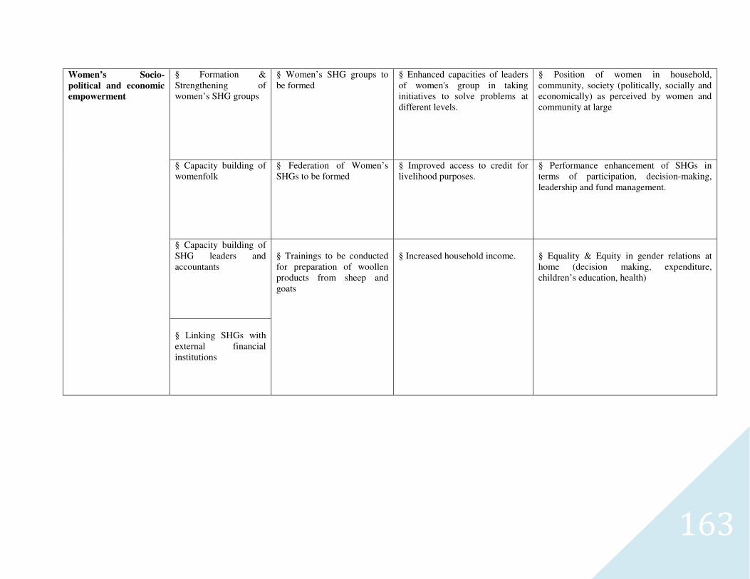
163
Women’s Socio-
political and economic
empowerment
§ Formation & Strengthening of women’s SHG groups
§ Women’s SHG groups to be formed
§ Enhanced capacities of leaders of women's group in taking initiatives to solve problems at different levels.
§ Position of women in household, community, society (politically, socially and economically) as perceived by women and community at large
§ Capacity building of womenfolk
§ Federation of Women’s SHGs to be formed
§ Improved access to credit for livelihood purposes.
§ Performance enhancement of SHGs in terms of participation, decision-making, leadership and fund management.
§ Capacity building of SHG leaders and accountants
§ Trainings to be conducted for preparation of woollen products from sheep and goats
§ Increased household income.
§ Equality & Equity in gender relations at home (decision making, expenditure, children’s education, health)
§ Linking SHGs with external financial institutions
164
CHAPTER -7
165
7-QUALITY & SUSTAINABILITY ISSUES
7.1-PLANS FOR MONITORING & EVAUATION
A Web-based GIS System is being developed for monitoring and evaluating the project in its planning & implementation phases. The
system would be available on a public domain and can be accessed by all the stakeholders of the project. The system shows the entire state of
Uttar Pradesh and all of those areas selected over the next 20 years. Filtering allows the user to zoom onto one particular project. Details
related to soil type, Land-use classification, inhabitation etc., can be obtained village-wise. Furthermore, survey-number wise details related
to ownership, irrigation source, yield etc., can also be accessed by the users of the system. This system is being used for pooling up the
details obtained from the DPR. In other words, the DPR is made available online in the form of a database which will help the stakeholders
know areas of importance viz., already treated areas/historical works in the area, proposed areas for treatment etc., for further treatment and
planning. The system would also show the satellite imageries of various years from the project inception stage to the project closing stages.
This allows the user to evaluate the effectiveness of the treatment and thereby plan corrective measures for the project area. The system
would serve as an aiding tool to the planners and evaluators for judging the efficacy of the project.
Yet another component of the Web-based GIS system is the Mobile based Monitoring & Evaluation System, which will help the
ground staff alias WDTs (Watershed Development Team) to transmit information from the ground level to the central server. Also, any
higher-up official in charge of the project can obtain information regarding the project area on their mobile phone by means of an SMS. The
system works in the following manner. The WDT equipped with a GPS instrument marks the latitude-longitude information of various
treatment areas during the DPR. The probable sites are then transferred onto the central server. During the works phase, any progress in the
treatment areas is reported to the server by means of an SMS by the WDT. Similarly, any nodal officer or higher-up official can view the
progress in a project by means of summarized reports generated over frequent periods of time.
166
7.2 PLANS FOR PROJECT MANAGEMENT:
The Project management of any watershed programme is very important. It mainly depends upon the community organisation and the
village level institutes.In Mainpuri, watershed committee and various user groups have been formulated for post project operation and
maintenance of assets created during project period. Major emphasis will be on equity and sustainable benefit of the project even after
implementation stage. A proper link-up will be built during project period with various institutes and capacity building organisation. They
will act as a major kingpin during post implementation for scaling up the successful experience during project.
7.3 WATERSHED DEVELOPMENT FUND:
The major source of financial assistance after post implementation period is watershed Development Fund. The contribution of it will
comes mainly fund the following:
7.4 USER CHARGES:
Various user groups will be formed in village. These user groups will collect user charges according to the designated rules formed during the formation of user group. These funds will be transferred to the WDF funds as per these formulated rules. The secretary of watershed committee (WC) shall maintain the records of the following.
167
MAPS OF MICROWATERSHED- RATHEH (2B4B5c3a)
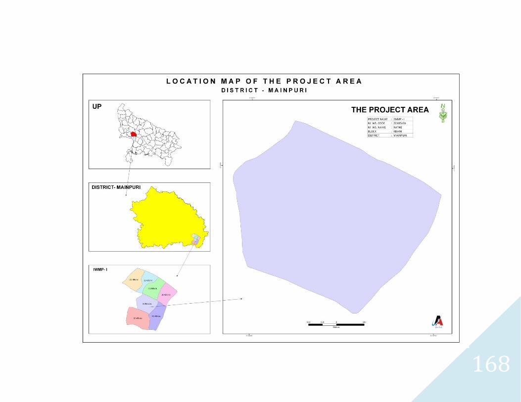
168
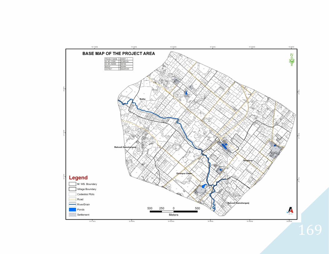
169
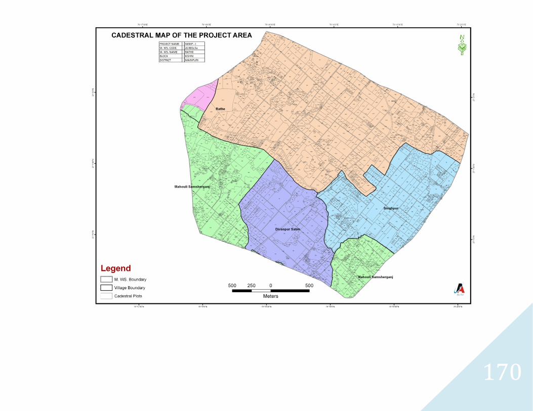
170
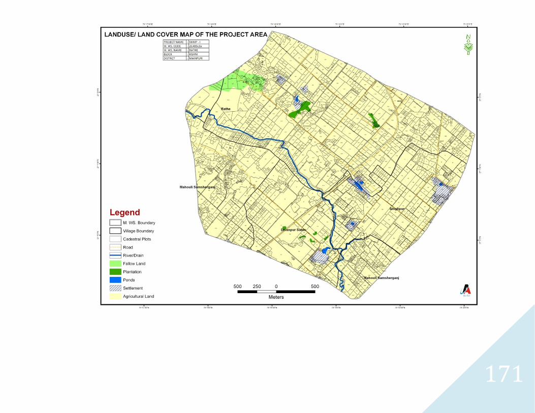
171
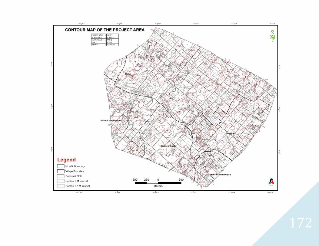
172
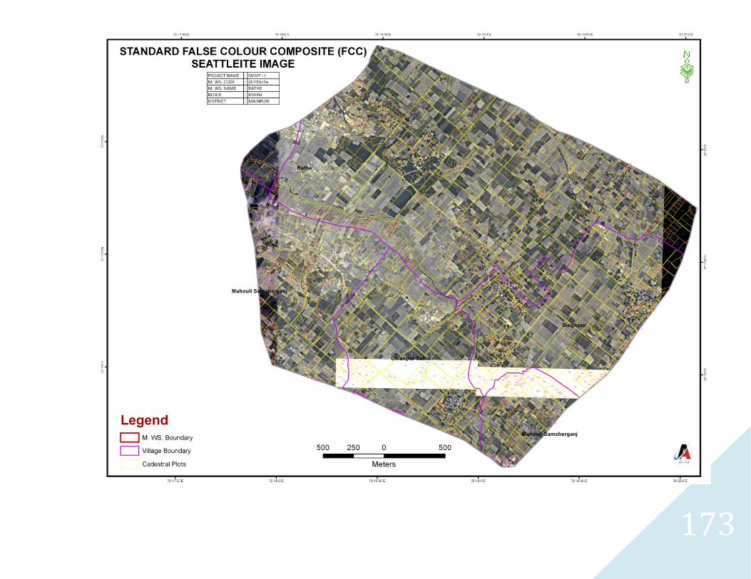
173
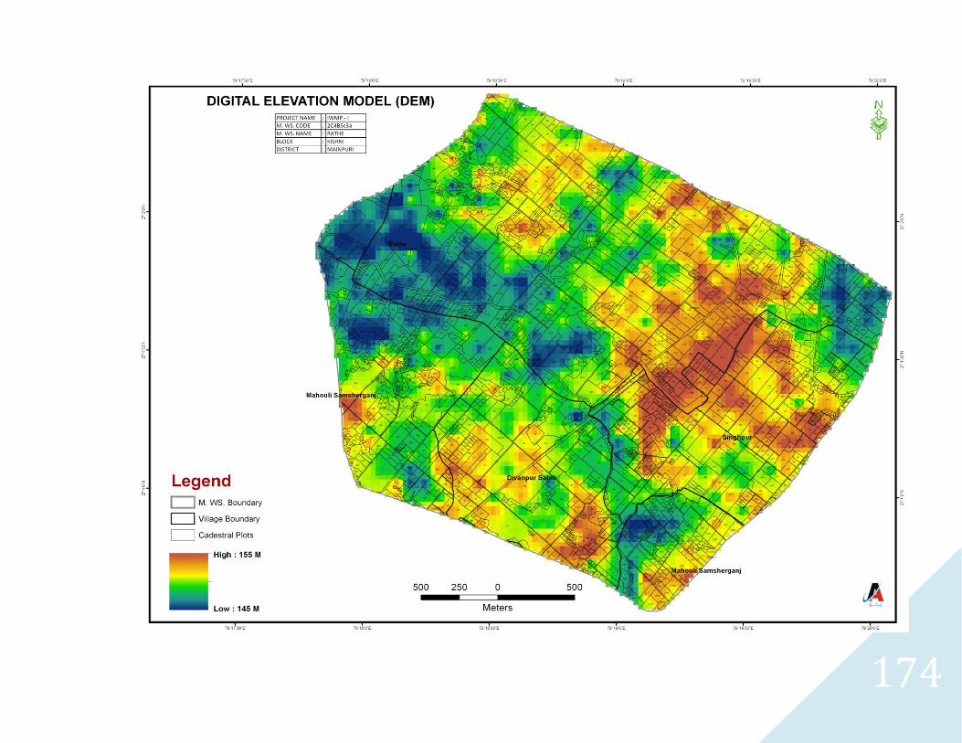
174
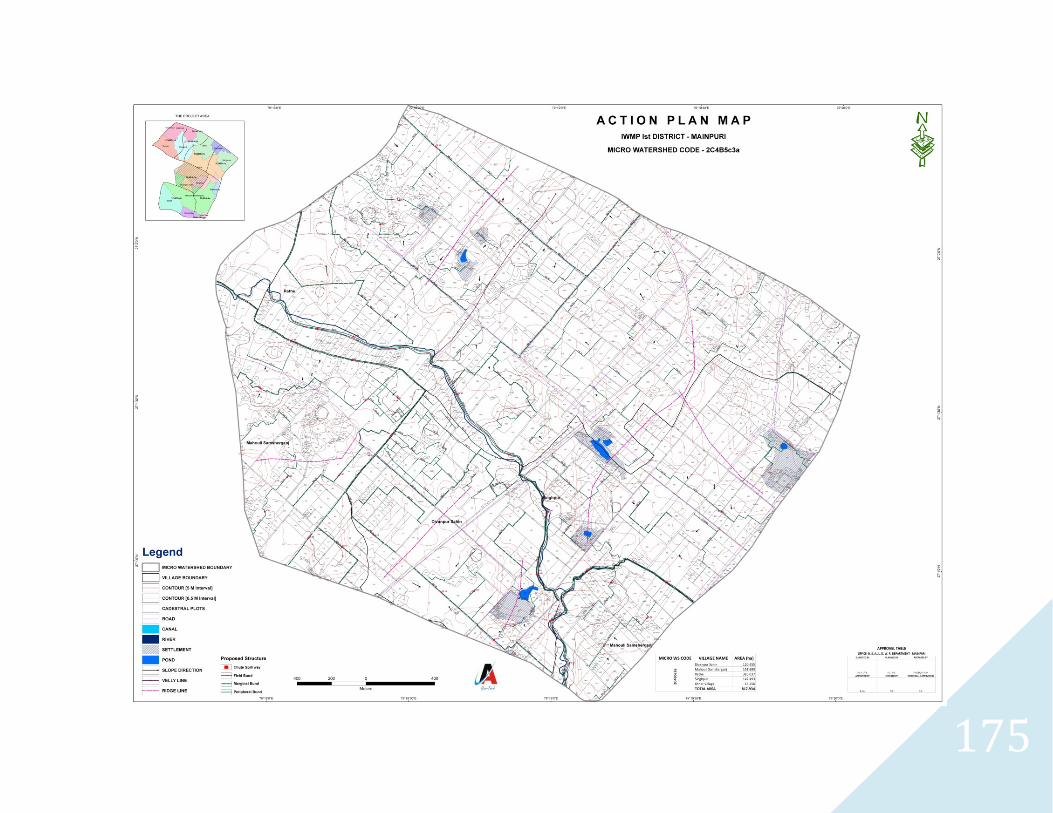
175
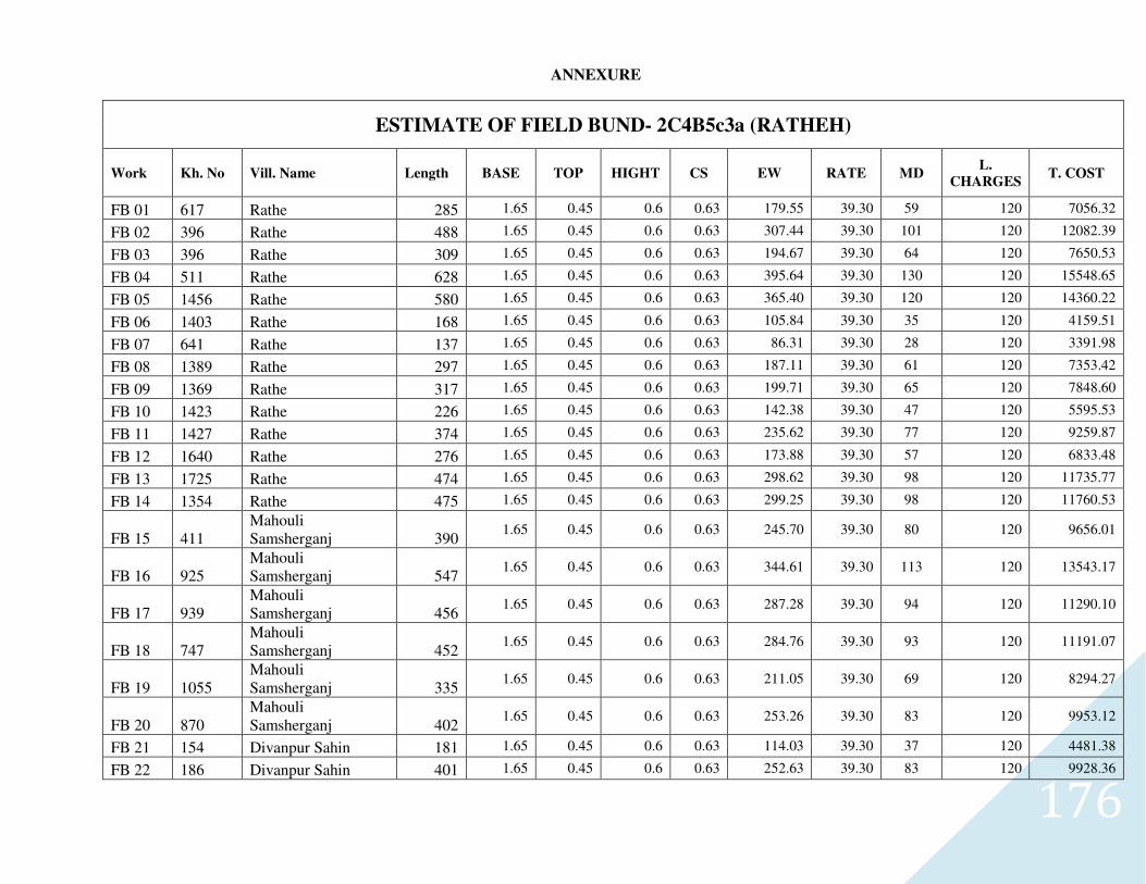
176
ANNEXURE
ESTIMATE OF FIELD BUND- 2C4B5c3a (RATHEH)
Work Kh. No Vill. Name Length BASE TOP HIGHT CS EW RATE MD L.
CHARGES T. COST
FB 01 617 Rathe 285 1.65 0.45 0.6 0.63 179.55 39.30 59 120 7056.32
FB 02 396 Rathe 488 1.65 0.45 0.6 0.63 307.44 39.30 101 120 12082.39
FB 03 396 Rathe 309 1.65 0.45 0.6 0.63 194.67 39.30 64 120 7650.53
FB 04 511 Rathe 628 1.65 0.45 0.6 0.63 395.64 39.30 130 120 15548.65
FB 05 1456 Rathe 580 1.65 0.45 0.6 0.63 365.40 39.30 120 120 14360.22
FB 06 1403 Rathe 168 1.65 0.45 0.6 0.63 105.84 39.30 35 120 4159.51
FB 07 641 Rathe 137 1.65 0.45 0.6 0.63 86.31 39.30 28 120 3391.98
FB 08 1389 Rathe 297 1.65 0.45 0.6 0.63 187.11 39.30 61 120 7353.42
FB 09 1369 Rathe 317 1.65 0.45 0.6 0.63 199.71 39.30 65 120 7848.60
FB 10 1423 Rathe 226 1.65 0.45 0.6 0.63 142.38 39.30 47 120 5595.53
FB 11 1427 Rathe 374 1.65 0.45 0.6 0.63 235.62 39.30 77 120 9259.87
FB 12 1640 Rathe 276 1.65 0.45 0.6 0.63 173.88 39.30 57 120 6833.48
FB 13 1725 Rathe 474 1.65 0.45 0.6 0.63 298.62 39.30 98 120 11735.77
FB 14 1354 Rathe 475 1.65 0.45 0.6 0.63 299.25 39.30 98 120 11760.53
FB 15 411 Mahouli Samsherganj 390
1.65 0.45 0.6 0.63 245.70 39.30 80 120 9656.01
FB 16 925 Mahouli Samsherganj 547
1.65 0.45 0.6 0.63 344.61 39.30 113 120 13543.17
FB 17 939 Mahouli Samsherganj 456
1.65 0.45 0.6 0.63 287.28 39.30 94 120 11290.10
FB 18 747 Mahouli Samsherganj 452
1.65 0.45 0.6 0.63 284.76 39.30 93 120 11191.07
FB 19 1055 Mahouli Samsherganj 335
1.65 0.45 0.6 0.63 211.05 39.30 69 120 8294.27
FB 20 870 Mahouli Samsherganj 402
1.65 0.45 0.6 0.63 253.26 39.30 83 120 9953.12
FB 21 154 Divanpur Sahin 181 1.65 0.45 0.6 0.63 114.03 39.30 37 120 4481.38
FB 22 186 Divanpur Sahin 401 1.65 0.45 0.6 0.63 252.63 39.30 83 120 9928.36
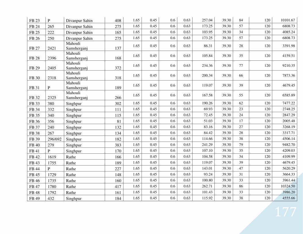
177
FB 23 P Divanpur Sahin 408 1.65 0.45 0.6 0.63 257.04 39.30 84 120 10101.67
FB 24 265 Divanpur Sahin 275 1.65 0.45 0.6 0.63 173.25 39.30 57 120 6808.73
FB 25 222 Divanpur Sahin 165 1.65 0.45 0.6 0.63 103.95 39.30 34 120 4085.24
FB 26 250 Divanpur Sahin 275 1.65 0.45 0.6 0.63 173.25 39.30 57 120 6808.73
FB 27 2421 Mahouli Samsherganj 137
1.65 0.45 0.6 0.63 86.31 39.30 28 120 3391.98
FB 28 2396 Mahouli Samsherganj 168
1.65 0.45 0.6 0.63 105.84 39.30 35 120 4159.51
FB 29 2405 Mahouli Samsherganj 372
1.65 0.45 0.6 0.63 234.36 39.30 77 120 9210.35
FB 30 2318 Mahouli Samsherganj 318
1.65 0.45 0.6 0.63 200.34 39.30 66 120 7873.36
FB 31 P Mahouli Samsherganj 189
1.65 0.45 0.6 0.63 119.07 39.30 39 120 4679.45
FB 32 2325 Mahouli Samsherganj 266
1.65 0.45 0.6 0.63 167.58 39.30 55 120 6585.89
FB 33 380 Singhpur 302 1.65 0.45 0.6 0.63 190.26 39.30 62 120 7477.22
FB 34 332 Singhpur 111 1.65 0.45 0.6 0.63 69.93 39.30 23 120 2748.25
FB 35 340 Singhpur 115 1.65 0.45 0.6 0.63 72.45 39.30 24 120 2847.29
FB 36 356 Singhpur 81 1.65 0.45 0.6 0.63 51.03 39.30 17 120 2005.48
FB 37 240 Singhpur 132 1.65 0.45 0.6 0.63 83.16 39.30 27 120 3268.19
FB 38 267 Singhpur 134 1.65 0.45 0.6 0.63 84.42 39.30 28 120 3317.71
FB 39 296/692 Singhpur 182 1.65 0.45 0.6 0.63 114.66 39.30 38 120 4506.14
FB 40 279 Singhpur 383 1.65 0.45 0.6 0.63 241.29 39.30 79 120 9482.70
FB 41 P Singhpur 170 1.65 0.45 0.6 0.63 107.10 39.30 35 120 4209.03
FB 42 1619 Rathe 166 1.65 0.45 0.6 0.63 104.58 39.30 34 120 4109.99
FB 43 1755 Rathe 189 1.65 0.45 0.6 0.63 119.07 39.30 39 120 4679.45
FB 44 P Rathe 227 1.65 0.45 0.6 0.63 143.01 39.30 47 120 5620.29
FB 45 1729 Rathe 148 1.65 0.45 0.6 0.63 93.24 39.30 31 120 3664.33
FB 46 1735 Rathe 160 1.65 0.45 0.6 0.63 100.80 39.30 33 120 3961.44
FB 47 1780 Rathe 417 1.65 0.45 0.6 0.63 262.71 39.30 86 120 10324.50
FB 48 1792 Rathe 161 1.65 0.45 0.6 0.63 101.43 39.30 33 120 3986.20
FB 49 432 Singhpur 184 1.65 0.45 0.6 0.63 115.92 39.30 38 120 4555.66
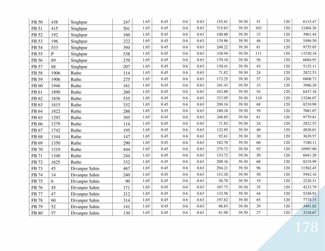
178
FB 50 438 Singhpur 247 1.65 0.45 0.6 0.63 155.61 39.30 51 120 6115.47
FB 51 415 Singhpur 501 1.65 0.45 0.6 0.63 315.63 39.30 103 120 12404.26
FB 52 192 Singhpur 160 1.65 0.45 0.6 0.63 100.80 39.30 33 120 3961.44
FB 53 196 Singhpur 222 1.65 0.45 0.6 0.63 139.86 39.30 46 120 5496.50
FB 54 533 Singhpur 394 1.65 0.45 0.6 0.63 248.22 39.30 81 120 9755.05
FB 55 P Singhpur 538 1.65 0.45 0.6 0.63 338.94 39.30 111 120 13320.34
FB 56 69 Singhpur 270 1.65 0.45 0.6 0.63 170.10 39.30 56 120 6684.93
FB 57 68 Singhpur 207 1.65 0.45 0.6 0.63 130.41 39.30 43 120 5125.11
FB 58 1906 Rathe 114 1.65 0.45 0.6 0.63 71.82 39.30 24 120 2822.53
FB 59 1906 Rathe 275 1.65 0.45 0.6 0.63 173.25 39.30 57 120 6808.73
FB 60 1946 Rathe 161 1.65 0.45 0.6 0.63 101.43 39.30 33 120 3986.20
FB 61 1890 Rathe 260 1.65 0.45 0.6 0.63 163.80 39.30 54 120 6437.34
FB 62 1836 Rathe 535 1.65 0.45 0.6 0.63 337.05 39.30 110 120 13246.07
FB 63 1815 Rathe 332 1.65 0.45 0.6 0.63 209.16 39.30 68 120 8219.99
FB 64 1822 Rathe 286 1.65 0.45 0.6 0.63 180.18 39.30 59 120 7081.07
FB 65 1292 Rathe 395 1.65 0.45 0.6 0.63 248.85 39.30 81 120 9779.81
FB 66 1279 Rathe 114 1.65 0.45 0.6 0.63 71.82 39.30 24 120 2822.53
FB 67 1742 Rathe 195 1.65 0.45 0.6 0.63 122.85 39.30 40 120 4828.01
FB 68 1344 Rathe 147 1.65 0.45 0.6 0.63 92.61 39.30 30 120 3639.57
FB 69 1350 Rathe 290 1.65 0.45 0.6 0.63 182.70 39.30 60 120 7180.11
FB 70 1319 Rathe 444 1.65 0.45 0.6 0.63 279.72 39.30 92 120 10993.00
FB 71 1340 Rathe 244 1.65 0.45 0.6 0.63 153.72 39.30 50 120 6041.20
FB 72 1625 Rathe 332 1.65 0.45 0.6 0.63 209.16 39.30 68 120 8219.99
FB 73 45 Divanpur Sahin 467 1.65 0.45 0.6 0.63 294.21 39.30 96 120 11562.45
FB 74 14 Divanpur Sahin 240 1.65 0.45 0.6 0.63 151.20 39.30 50 120 5942.16
FB 75 6 Divanpur Sahin 90 1.65 0.45 0.6 0.63 56.70 39.30 19 120 2228.31
FB 76 45 Divanpur Sahin 171 1.65 0.45 0.6 0.63 107.73 39.30 35 120 4233.79
FB 77 47 Divanpur Sahin 212 1.65 0.45 0.6 0.63 133.56 39.30 44 120 5248.91
FB 78 60 Divanpur Sahin 314 1.65 0.45 0.6 0.63 197.82 39.30 65 120 7774.33
FB 79 52 Divanpur Sahin 141 1.65 0.45 0.6 0.63 88.83 39.30 29 120 3491.02
FB 80 57 Divanpur Sahin 130 1.65 0.45 0.6 0.63 81.90 39.30 27 120 3218.67
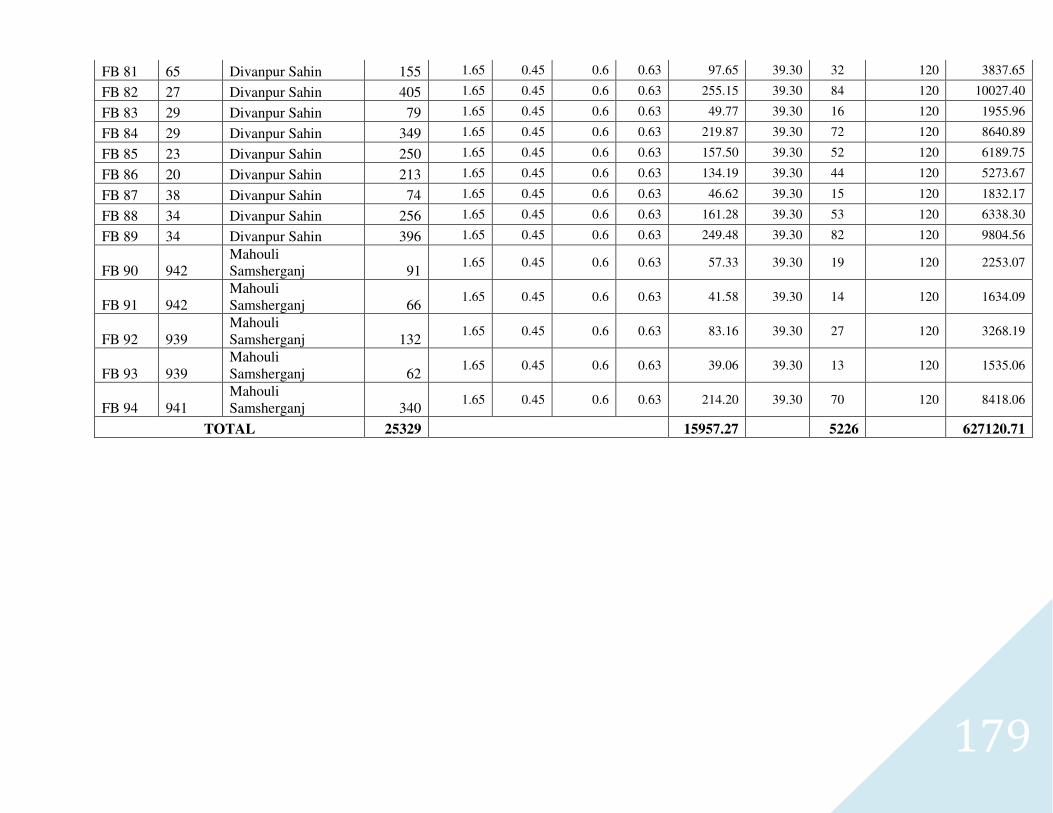
179
FB 81 65 Divanpur Sahin 155 1.65 0.45 0.6 0.63 97.65 39.30 32 120 3837.65
FB 82 27 Divanpur Sahin 405 1.65 0.45 0.6 0.63 255.15 39.30 84 120 10027.40
FB 83 29 Divanpur Sahin 79 1.65 0.45 0.6 0.63 49.77 39.30 16 120 1955.96
FB 84 29 Divanpur Sahin 349 1.65 0.45 0.6 0.63 219.87 39.30 72 120 8640.89
FB 85 23 Divanpur Sahin 250 1.65 0.45 0.6 0.63 157.50 39.30 52 120 6189.75
FB 86 20 Divanpur Sahin 213 1.65 0.45 0.6 0.63 134.19 39.30 44 120 5273.67
FB 87 38 Divanpur Sahin 74 1.65 0.45 0.6 0.63 46.62 39.30 15 120 1832.17
FB 88 34 Divanpur Sahin 256 1.65 0.45 0.6 0.63 161.28 39.30 53 120 6338.30
FB 89 34 Divanpur Sahin 396 1.65 0.45 0.6 0.63 249.48 39.30 82 120 9804.56
FB 90 942 Mahouli Samsherganj 91
1.65 0.45 0.6 0.63 57.33 39.30 19 120 2253.07
FB 91 942 Mahouli Samsherganj 66
1.65 0.45 0.6 0.63 41.58 39.30 14 120 1634.09
FB 92 939 Mahouli Samsherganj 132
1.65 0.45 0.6 0.63 83.16 39.30 27 120 3268.19
FB 93 939 Mahouli Samsherganj 62
1.65 0.45 0.6 0.63 39.06 39.30 13 120 1535.06
FB 94 941 Mahouli Samsherganj 340
1.65 0.45 0.6 0.63 214.20 39.30 70 120 8418.06
TOTAL 25329 15957.27 5226 627120.71
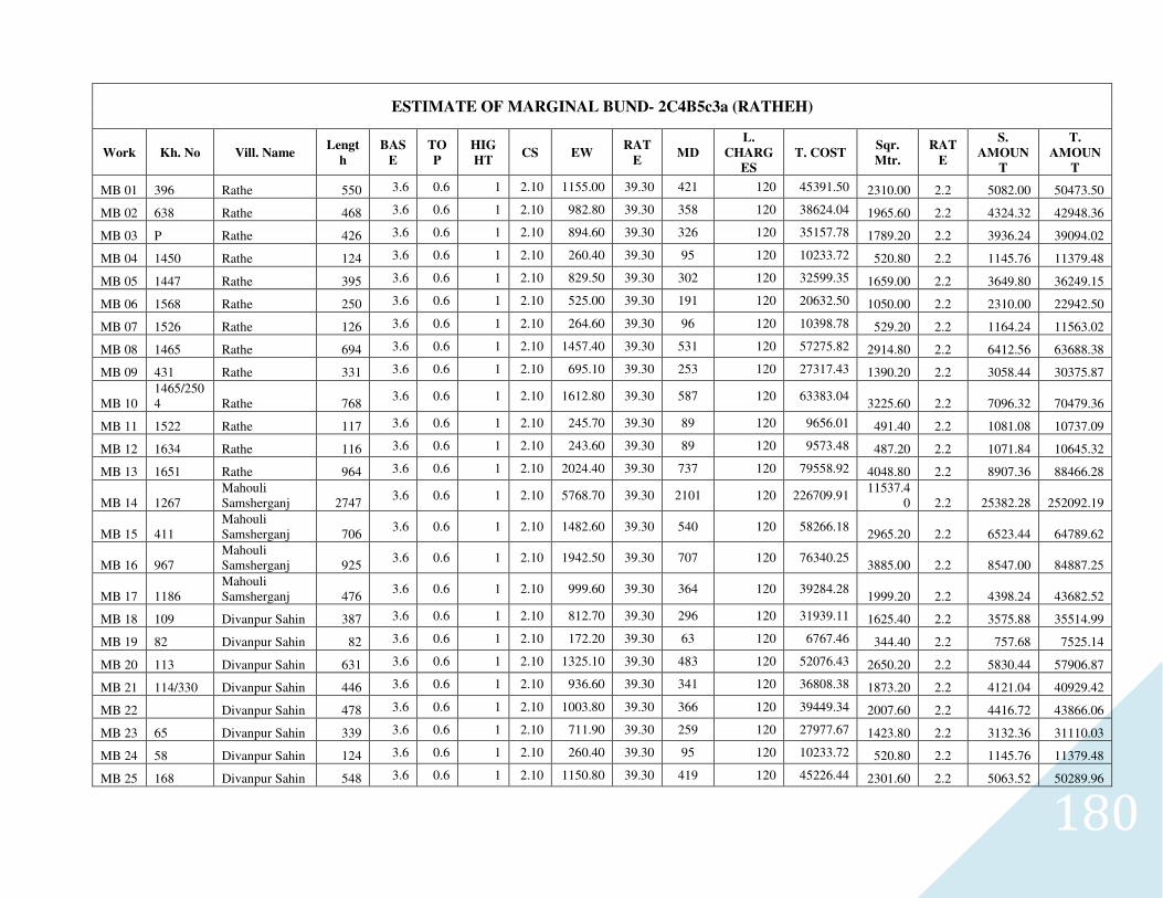
180
ESTIMATE OF MARGINAL BUND- 2C4B5c3a (RATHEH)
Work Kh. No Vill. Name Lengt
h
BAS
E
TO
P
HIG
HT CS EW
RAT
E MD
L.
CHARG
ES
T. COST Sqr.
Mtr.
RAT
E
S.
AMOUN
T
T.
AMOUN
T
MB 01 396 Rathe 550 3.6 0.6 1 2.10 1155.00 39.30 421 120 45391.50 2310.00 2.2 5082.00 50473.50
MB 02 638 Rathe 468 3.6 0.6 1 2.10 982.80 39.30 358 120 38624.04 1965.60 2.2 4324.32 42948.36
MB 03 P Rathe 426 3.6 0.6 1 2.10 894.60 39.30 326 120 35157.78 1789.20 2.2 3936.24 39094.02
MB 04 1450 Rathe 124 3.6 0.6 1 2.10 260.40 39.30 95 120 10233.72 520.80 2.2 1145.76 11379.48
MB 05 1447 Rathe 395 3.6 0.6 1 2.10 829.50 39.30 302 120 32599.35 1659.00 2.2 3649.80 36249.15
MB 06 1568 Rathe 250 3.6 0.6 1 2.10 525.00 39.30 191 120 20632.50 1050.00 2.2 2310.00 22942.50
MB 07 1526 Rathe 126 3.6 0.6 1 2.10 264.60 39.30 96 120 10398.78 529.20 2.2 1164.24 11563.02
MB 08 1465 Rathe 694 3.6 0.6 1 2.10 1457.40 39.30 531 120 57275.82 2914.80 2.2 6412.56 63688.38
MB 09 431 Rathe 331 3.6 0.6 1 2.10 695.10 39.30 253 120 27317.43 1390.20 2.2 3058.44 30375.87
MB 10 1465/2504 Rathe 768
3.6 0.6 1 2.10 1612.80 39.30 587 120 63383.04 3225.60 2.2 7096.32 70479.36
MB 11 1522 Rathe 117 3.6 0.6 1 2.10 245.70 39.30 89 120 9656.01 491.40 2.2 1081.08 10737.09
MB 12 1634 Rathe 116 3.6 0.6 1 2.10 243.60 39.30 89 120 9573.48 487.20 2.2 1071.84 10645.32
MB 13 1651 Rathe 964 3.6 0.6 1 2.10 2024.40 39.30 737 120 79558.92 4048.80 2.2 8907.36 88466.28
MB 14 1267 Mahouli Samsherganj 2747
3.6 0.6 1 2.10 5768.70 39.30 2101 120 226709.91 11537.4
0 2.2 25382.28 252092.19
MB 15 411 Mahouli Samsherganj 706
3.6 0.6 1 2.10 1482.60 39.30 540 120 58266.18 2965.20 2.2 6523.44 64789.62
MB 16 967 Mahouli Samsherganj 925
3.6 0.6 1 2.10 1942.50 39.30 707 120 76340.25 3885.00 2.2 8547.00 84887.25
MB 17 1186 Mahouli Samsherganj 476
3.6 0.6 1 2.10 999.60 39.30 364 120 39284.28 1999.20 2.2 4398.24 43682.52
MB 18 109 Divanpur Sahin 387 3.6 0.6 1 2.10 812.70 39.30 296 120 31939.11 1625.40 2.2 3575.88 35514.99
MB 19 82 Divanpur Sahin 82 3.6 0.6 1 2.10 172.20 39.30 63 120 6767.46 344.40 2.2 757.68 7525.14
MB 20 113 Divanpur Sahin 631 3.6 0.6 1 2.10 1325.10 39.30 483 120 52076.43 2650.20 2.2 5830.44 57906.87
MB 21 114/330 Divanpur Sahin 446 3.6 0.6 1 2.10 936.60 39.30 341 120 36808.38 1873.20 2.2 4121.04 40929.42
MB 22 Divanpur Sahin 478 3.6 0.6 1 2.10 1003.80 39.30 366 120 39449.34 2007.60 2.2 4416.72 43866.06
MB 23 65 Divanpur Sahin 339 3.6 0.6 1 2.10 711.90 39.30 259 120 27977.67 1423.80 2.2 3132.36 31110.03
MB 24 58 Divanpur Sahin 124 3.6 0.6 1 2.10 260.40 39.30 95 120 10233.72 520.80 2.2 1145.76 11379.48
MB 25 168 Divanpur Sahin 548 3.6 0.6 1 2.10 1150.80 39.30 419 120 45226.44 2301.60 2.2 5063.52 50289.96
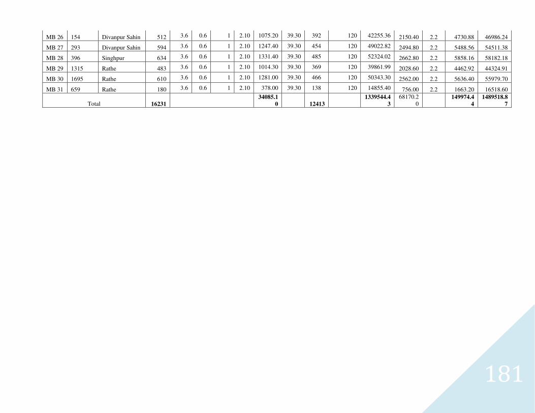
181
MB 26 154 Divanpur Sahin 512 3.6 0.6 1 2.10 1075.20 39.30 392 120 42255.36 2150.40 2.2 4730.88 46986.24
MB 27 293 Divanpur Sahin 594 3.6 0.6 1 2.10 1247.40 39.30 454 120 49022.82 2494.80 2.2 5488.56 54511.38
MB 28 396 Singhpur 634 3.6 0.6 1 2.10 1331.40 39.30 485 120 52324.02 2662.80 2.2 5858.16 58182.18
MB 29 1315 Rathe 483 3.6 0.6 1 2.10 1014.30 39.30 369 120 39861.99 2028.60 2.2 4462.92 44324.91
MB 30 1695 Rathe 610 3.6 0.6 1 2.10 1281.00 39.30 466 120 50343.30 2562.00 2.2 5636.40 55979.70
MB 31 659 Rathe 180 3.6 0.6 1 2.10 378.00 39.30 138 120 14855.40 756.00 2.2 1663.20 16518.60
Total 16231 34085.1
0 12413 1339544.4
3
68170.20
149974.4
4
1489518.8
7
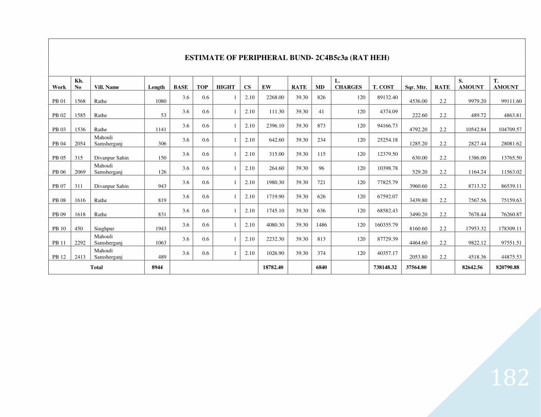
182
ESTIMATE OF PERIPHERAL BUND- 2C4B5c3a (RAT HEH)
Work
Kh.
No Vill. Name Length BASE TOP HIGHT CS EW RATE MD
L.
CHARGES T. COST Sqr. Mtr. RATE
S.
AMOUNT
T.
AMOUNT
PB 01 1568 Rathe 1080 3.6 0.6 1 2.10 2268.00 39.30 826 120 89132.40
4536.00 2.2 9979.20 99111.60
PB 02 1585 Rathe 53 3.6 0.6 1 2.10 111.30 39.30 41 120 4374.09
222.60 2.2 489.72 4863.81
PB 03 1536 Rathe 1141 3.6 0.6 1 2.10 2396.10 39.30 873 120 94166.73
4792.20 2.2 10542.84 104709.57
PB 04 2054 Mahouli Samsherganj 306
3.6 0.6 1 2.10 642.60 39.30 234 120 25254.18 1285.20 2.2 2827.44 28081.62
PB 05 315 Divanpur Sahin 150 3.6 0.6 1 2.10 315.00 39.30 115 120 12379.50
630.00 2.2 1386.00 13765.50
PB 06 2069 Mahouli Samsherganj 126
3.6 0.6 1 2.10 264.60 39.30 96 120 10398.78 529.20 2.2 1164.24 11563.02
PB 07 311 Divanpur Sahin 943 3.6 0.6 1 2.10 1980.30 39.30 721 120 77825.79
3960.60 2.2 8713.32 86539.11
PB 08 1616 Rathe 819 3.6 0.6 1 2.10 1719.90 39.30 626 120 67592.07
3439.80 2.2 7567.56 75159.63
PB 09 1618 Rathe 831 3.6 0.6 1 2.10 1745.10 39.30 636 120 68582.43
3490.20 2.2 7678.44 76260.87
PB 10 450 Singhpur 1943 3.6 0.6 1 2.10 4080.30 39.30 1486 120 160355.79
8160.60 2.2 17953.32 178309.11
PB 11 2292 Mahouli Samsherganj 1063
3.6 0.6 1 2.10 2232.30 39.30 813 120 87729.39 4464.60 2.2 9822.12 97551.51
PB 12 2413 Mahouli Samsherganj 489
3.6 0.6 1 2.10 1026.90 39.30 374 120 40357.17 2053.80 2.2 4518.36 44875.53
Total 8944
18782.40
6840
738148.32 37564.80
82642.56 820790.88
Related Documents


