DESIGNING WITH TRANSIT Making Transit Integral to East Bay Communities A Handbook for Elected Officials, Local Staff, and Other Community Builders

Welcome message from author
This document is posted to help you gain knowledge. Please leave a comment to let me know what you think about it! Share it to your friends and learn new things together.
Transcript
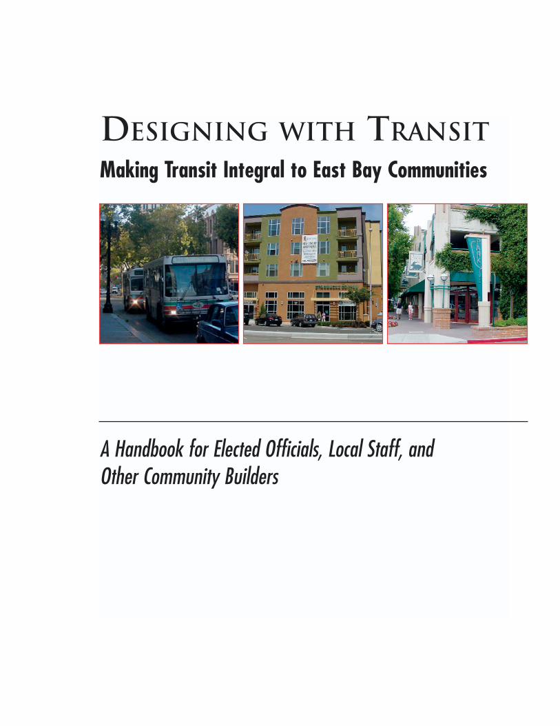
DESIGNING WITH TRANSITMaking Transit Integral to East Bay Communities
A Handbook for Elected Officials, Local Staff, and Other Community Builders
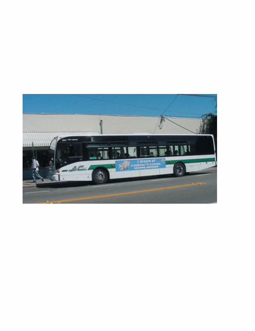
TABLE OF CONTENTS
Message from the Board of Directors . . . . . . . . . . . . . . . . . . . . . . . . . . . . . . . . . . . . . . . . . . . . . . . . . . . . . . . IV
Summary . . . . . . . . . . . . . . . . . . . . . . . . . . . . . . . . . . . . . . . . . . . . . . . . . . . . . . . . . . . . . . . . . . . . . . . . . . VI
Acknowledgements . . . . . . . . . . . . . . . . . . . . . . . . . . . . . . . . . . . . . . . . . . . . . . . . . . . . . . . . . . . . . . . . . . . VIII
PART ONE--UNDERSTANDING EAST BAY TRANSIT . . . . . . . . . . . . . . . . . . . . . . . . . . . . . . . . . .1-1
Chapter 1: Introduction to Designing With Transit . . . . . . . . . . . . . . . . . . . . . . . . . . . . . . . . . . . . . . . . 1-3
Why is AC Transit Publishing this Handbook? . . . . . . . . . . . . . . . . . . . . . . . . . . . . . . . . . . . . . . . . . . . . . . . . . 1-3
How to Use this Handbook . . . . . . . . . . . . . . . . . . . . . . . . . . . . . . . . . . . . . . . . . . . . . . . . . . . . . . . . . . . . . 1-5
Why Should Communities Care About Transit? . . . . . . . . . . . . . . . . . . . . . . . . . . . . . . . . . . . . . . . . . . . . . . . . 1-7
Chapter 2: The Inner East Bay Transit System . . . . . . . . . . . . . . . . . . . . . . . . . . . . . . . . . . . . . . . . . . . 2-1
An Overview . . . . . . . . . . . . . . . . . . . . . . . . . . . . . . . . . . . . . . . . . . . . . . . . . . . . . . . . . . . . . . . . . . . . . . 2-1
AC Transit’s Service Deployment Policies . . . . . . . . . . . . . . . . . . . . . . . . . . . . . . . . . . . . . . . . . . . . . . . . . . . . 2-3
Service Planning and Network Design . . . . . . . . . . . . . . . . . . . . . . . . . . . . . . . . . . . . . . . . . . . . . . . . . . . . . . 2-5
Roles of BART and AC Transit . . . . . . . . . . . . . . . . . . . . . . . . . . . . . . . . . . . . . . . . . . . . . . . . . . . . . . . . . . 2-11
Faster Types of Bus Service: Rapids and Bus Rapid Transit . . . . . . . . . . . . . . . . . . . . . . . . . . . . . . . . . . . . . . . 2-12
Evaluating and Modifying Bus Lines . . . . . . . . . . . . . . . . . . . . . . . . . . . . . . . . . . . . . . . . . . . . . . . . . . . . . . 2-13
PART TWO--DESIGNING WITH TRANSIT . . . . . . . . . . . . . . . . . . . . . . . . . . . . . . . . . . . . . . . . . . 3-1
Chapter 3: Transit-Based Communities: Centering Planning on Transit . . . . . . . . . . . . . . . . . . . . . . . . 3-3
Summary of Transit-Based Communities’ Policies and Practices . . . . . . . . . . . . . . . . . . . . . . . . . . . . . . . . . . . . . 3-5
Planning Policy 1: Develop Dense, Mixed Uses in Locations with Good Transit Access . . . . . . . . . . . . . . . . . . . . . . . 3-8
Planning Policy 2: Plan Bus Corridors to Maximize Their Potential for Transit-Oriented Development. . . . . . . . . . . . . 3-16
Planning Policy 3: Manage Parking as Part of an Overall Transportation and Land Use Strategy . . . . . . . . . . . . . . 3-19
Chapter 4: Safe Routes to Transit: Creating Good Ways to Walk to Transit . . . . . . . . . . . . . . . . . . . . . 4-1
Summary of Safe Routes to Transit Policies and Practices . . . . . . . . . . . . . . . . . . . . . . . . . . . . . . . . . . . . . . . . . 4-3
Context: Basic Elements of the Pedestrian Travel Network . . . . . . . . . . . . . . . . . . . . . . . . . . . . . . . . . . . . . . . . 4-5
Walking Policy 1: Develop Networks That Provide Pedestrian Access to All Locations in a Community . . . . . . . . . . . . 4-6
2004 PAGE I
MAKING TRANSIT INTEGRAL TO EAST BAY COMMUNITIES
Walking Policy 2: Create Pedestrian Access which is Safe, Understandable and Pleasant . . . . . . . . . . . . . . . . . . . . 4-11
Walking Policy 3: Site Buildings to Provide Easy Access to Transit . . . . . . . . . . . . . . . . . . . . . . . . . . . . . . . . . . 4-14
Walking Policy 4: Assure That Pedestrian Crossings of Roadways and Driveways are Safe and Easy to Use . . . . . . . . 4-16
Policies to Support Walking: Selected Policies of the Oakland Pedestrian Master Plan . . . . . . . . . . . . . . . . . . . . . . 4-22
Chapter 5. Transit-Friendly Streets: Making Streets Work for Transit . . . . . . . . . . . . . . . . . . . . . . . . . . 5-1
Summary of Transit Friendly Street: Policies and Practices . . . . . . . . . . . . . . . . . . . . . . . . . . . . . . . . . . . . . . . . . 5-3
Context: Multi-modal Corridors . . . . . . . . . . . . . . . . . . . . . . . . . . . . . . . . . . . . . . . . . . . . . . . . . . . . . . . . . . 5-5
Delay of Bus... Penalizes Passengers, Communities, and AC Transit . . . . . . . . . . . . . . . . . . . . . . . . . . . . . . . . . . 5-7
SECTION 1: STREETS . . . . . . . . . . . . . . . . . . . . . . . . . . . . . . . . . . . . . . . . . . . . . . . . . . . . . . . . . . . . . . . . 5-8
Streets Policy 1: Identify a Network of Streets for Buses . . . . . . . . . . . . . . . . . . . . . . . . . . . . . . . . . . . . . 5-8
Streets Policy 2: Manage Transit Streets to Support Fast and Reliable Bus Operation . . . . . . . . . . . . . . . . . . 5-10
Streets Policy 3: Implement Priority Treatments for Transit on Key Corridors . . . . . . . . . . . . . . . . . . . . . . . . 5-15
SECTION 2: BUS STOPS . . . . . . . . . . . . . . . . . . . . . . . . . . . . . . . . . . . . . . . . . . . . . . . . . . . . . . . . . . . . . 5-20
Streets Policy 4: Site Bus Stops at Safe, Efficient and Convenient Locations . . . . . . . . . . . . . . . . . . . . . . . 5-22
Streets Policy 5: Locate Bus Stops Appropriately within the Right of Way . . . . . . . . . . . . . . . . . . . . . . . . . 5-24
Streets Policy 6: Create Safe, Functional and Legal Bus Stops with Needed Amenities . . . . . . . . . . . . . . . . 5-28
APPENDICESAppendix 1 . . . Glossary of Transit and Land Use Terms . . . . . . . . . . . . . . . . . . . . . . . . . . . . . . . . . . Appendix 1-1
Appendix 2 . . . Title Six Civil Rights Policies for Transit System Design . . . . . . . . . . . . . . . . . . . . . . . . . Appendix 2-1
Appendix 3 . . . Design Practices for AC Transit Bus Transit Centers . . . . . . . . . . . . . . . . . . . . . . . . . . . . Appendix 3-1
Appendix 4 . . . Resources: Bibliography and Websites . . . . . . . . . . . . . . . . . . . . . . . . . . . . . . . . . . . Appendix 4-1
DESIGNING WITH TRANSIT
PAGE II 2004
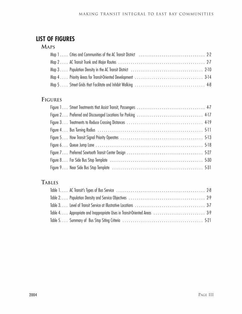
LIST OF FIGURES MAPS
Map 1 . . . . Cities and Communities of the AC Transit District . . . . . . . . . . . . . . . . . . . . . . . . . . . . . . . . 2-2
Map 2 . . . . AC Transit Trunk and Major Routes . . . . . . . . . . . . . . . . . . . . . . . . . . . . . . . . . . . . . . . . . . 2-7
Map 3 . . . . Population Density in the AC Transit District . . . . . . . . . . . . . . . . . . . . . . . . . . . . . . . . . . . 2-10
Map 4 . . . . Priority Areas for Transit-Oriented Development . . . . . . . . . . . . . . . . . . . . . . . . . . . . . . . . . 3-14
Map 5 . . . . Street Grids that Facilitate and Inhibit Walking . . . . . . . . . . . . . . . . . . . . . . . . . . . . . . . . . . 4-8
FIGURES
Figure 1 . . . Street Treatments that Assist Transit, Passengers . . . . . . . . . . . . . . . . . . . . . . . . . . . . . . . . . 4-7
Figure 2 . . . Preferred and Discouraged Locations for Parking . . . . . . . . . . . . . . . . . . . . . . . . . . . . . . . . 4-17
Figure 3 . . . Treatments to Reduce Crossing Distances . . . . . . . . . . . . . . . . . . . . . . . . . . . . . . . . . . . . . 4-19
Figure 4 . . . Bus Turning Radius . . . . . . . . . . . . . . . . . . . . . . . . . . . . . . . . . . . . . . . . . . . . . . . . . . . 5-11
Figure 5 . . . How Transit Signal Priority Operates . . . . . . . . . . . . . . . . . . . . . . . . . . . . . . . . . . . . . . . . 5-13
Figure 6 . . . Queue Jump Lane . . . . . . . . . . . . . . . . . . . . . . . . . . . . . . . . . . . . . . . . . . . . . . . . . . . . 5-18
Figure 7 . . . Preferred Sawtooth Transit Center Design . . . . . . . . . . . . . . . . . . . . . . . . . . . . . . . . . . . . . 5-27
Figure 8 . . . Far Side Bus Stop Template . . . . . . . . . . . . . . . . . . . . . . . . . . . . . . . . . . . . . . . . . . . . . 5-30
Figure 9 . . . Near Side Bus Stop Template . . . . . . . . . . . . . . . . . . . . . . . . . . . . . . . . . . . . . . . . . . . . 5-31
TABLES
Table 1. . . . AC Transit’s Types of Bus Service . . . . . . . . . . . . . . . . . . . . . . . . . . . . . . . . . . . . . . . . . . . 2-8
Table 2. . . . Population Density and Service Objectives . . . . . . . . . . . . . . . . . . . . . . . . . . . . . . . . . . . . . 2-9
Table 3. . . . Level of Transit Service at Illustrative Locations . . . . . . . . . . . . . . . . . . . . . . . . . . . . . . . . . . 3-7
Table 4. . . . Appropriate and Inappropriate Uses in Transit-Oriented Areas . . . . . . . . . . . . . . . . . . . . . . . . . 3-9
Table 5. . . . Summary of Bus Stop Siting Criteria . . . . . . . . . . . . . . . . . . . . . . . . . . . . . . . . . . . . . . . 5-21
2004 PAGE III
MAKING TRANSIT INTEGRAL TO EAST BAY COMMUNITIES
M e s s a g e f r o m t h e P r e s i d e n t o f t h e B o a r d o f D i r e c t o r s
On behalf of the Alameda-Contra Costa Transit District, I am pleased to present Designing With Transit. We
believe it is an important planning tool for AC Transit; for the cities, counties, and communities of the East
Bay; and for other transit and governmental agencies.
We see many signs that East Bay communities intend to support transit in their design and planning. Yet at
times there has not been a clear understanding of what is needed to facilitate bus transit. Designing With
Transit will help structure the dialogue between AC Transit and communities, by providing a clear statement
of AC Transit’s goals, priorities and concerns.
The AC Transit Board of Directors believes that providing a good transit system and good community envi-
ronments are inextricably linked. As a Board, we are charged with providing the best transit service possible
within the limits of our resources. We are constantly thinking about how to maintain and improve AC
Transit’s service. The effectiveness and efficiency of that service is immensely increased when communities
plan their land and their streets to make transit work.
Transit-oriented planning and design is not a new concern for AC Transit. In 1983 AC Transit published
Guide for Including Public Transit in Land Use Planning, one of the first statements of its kind. At the same
time we also published the Transit Facilities Standards manual, to provide clear guidance about what kind of
physical facilities best supported transit. In 1994, the AC Transit Board passed Policy 520: Encouraging the
Promotion of Public Transit in Land Use Developments within AC Transit’s Service Area. Designing With Transit
expands the scope of our earlier documents, and responds to current challenges. It discusses and graphically
presents a policy framework based on lessons learned and best practices identified over the past two decades.
Designing With Transit incorporates a new focus on pedestrian facilities as the system which brings people to
transit.
More importantly, transit-oriented planning and design are not new to the East Bay. The East Bay was built
around transit. The earliest forms of transit– in cities such as Oakland, Berkeley, and Alameda– were steam
railroads and ferries. In the late 19th and early 20th Century, many East Bay neighborhoods grew up
DESIGNING WITH TRANSIT
PAGE IV 2004
around the streetcar lines of the Key System. The Key System, which ultimately stretched from Richmond to
Hayward, was one of the most extensive streetcar systems in the country. Many of AC Transit’s trunk lines
today are modified versions of Key System routes. The construction of BART (Bay Area Rapid Transit) stim-
ulated a process of rebuilding East Bay communities that continues to this day. Unfortunately the East Bay’s
transit-oriented traditions have sometimes been forgotten in a rush to accommodate unlimited numbers of
automobiles without regard to other modes of travel. But throughout the 20th century some East Bay cities
remained among the most transit-oriented in the nation.
The East Bay can be a better place in the 21st century by renewing its transit-focused traditions. We have
every hope that the East Bay transit system will become both more extensive and more intensive. We believe
that transit can and must play an increasingly important role in the East Bay. AC Transit is planning for the
future by providing new forms of transit (such as Rapid buses and Bus Rapid Transit) to complement our
local and transbay services East Bay communities now have a golden opportunity to shape their future in
conjunction with the transit system. There is the opportunity to design with transit.
Joe WallacePresident, Board of Directors, Alameda-Contra Costa Transit District
2004 PAGE V
MAKING TRANSIT INTEGRAL TO EAST BAY COMMUNITIES
DESIGNING WITH TRANSIT
2004
SUMMARY: THE THEMES OF DESIGNING WITH TRANSIT
Many East Bay communities are again putting transit at the center of their development. The East Bay was
founded around transit, but too much of our land and our attention have been devoted to the automobile. For
decades the transit system, especially the bus system, was neglected by public and private decision makers. The
pedestrian environment, critical for encouraging people to use transit, was often ignored and degraded.
Now there is a resurgence of interest in transit and in linking development to transit. Transit-oriented devel-
opment has occurred throughout the East Bay and across North America. Communities across the East Bay
are working to make their main streets more vital and pedestrian-friendly. East Bay cities are working with AC
Transit to make their streets work optimally for bus service.
Designing With Transit is written to foster and facilitate these positive trends. It is a tool kit, a road map for
East Bay communities that want to refocus on transit. It is not a blueprint for a community, because each
community is different and must develop its own approaches. Designing With Transit outlines key concepts for
communities to consider as they improve their transit-friendliness. It highlights key planning and engineering
steps and warns of pitfalls to avoid. It illustrates how the bus system as well as the rail system is integral to East
Bay transit (see Chapter 2, “The East Bay Transit System”). Designing With Transit demonstrates that East Bay
and Bay Area communities are already taking steps towards greater transit-friendliness.
Designing With Transit discusses three areas which are critical to improving the transit-friendliness of East Bay
communities--planning, walking, and streets and sidewalks:
• Planning (in Chapter 3, titled “Transit-Based Communities: Centering Planning on Transit”): How can
communities plan their land use to support transit? In particular, how can communities plan their bus cor-
ridors to make them more friendly to transit-oriented development?
• Walking (in Chapter 4, “Safe Routes to Transit: Creating Good Ways to Walk to Transit”): How can com-
munities make it safe and pleasant for people to walk to transit? How can buildings, sidewalks, and bus
stops best be linked together to encourage transit ridership?
• Streets and Sidewalks (in Chapter 5, “Transit-Friendly Streets: Making Streets Work for Transit”): How can
communities’ streets and sidewalks support transit? Where does bus transit fit into “multimodal” street
planning? How should bus stops be set-up to work best for both bus operations and bus passengers?
These three areas are critical to making communities more transit-friendly. Planning, structuring land uses so
that transit passengers can easily access them, is fundamental. The walking environment must be safe and
pleasant to get people to transit. The streets and sidewalks must allow bus operations and bus stops that serve
bus transit and its passengers.
PAGE VI
2004
Designing With Transit includes both policy concepts (“Policies”) and implementation approaches (“Best Practices”)
for planning, the pedestrian network, and streets and sidewalks. It also includes aids to implementation, such as
diagrams, photographs, General Plan policies and, in some instances, recommended quantitative standards.
It took decades to develop the current transportation/land use system, overdependent on private automobiles.
Designing With Transit suggests some modest steps in the other direction.
PAGE VII
MAKING TRANSIT INTEGRAL TO EAST BAY COMMUNITIES
DESIGNING WITH TRANSIT
2004
ACKNOWLEDGEMENTS
The following current and former AC Transit staff have helped review or prepare Designing With Transit:
Anthony Bruzzone, Jim Cunradi, Robert del Rosario, Tony Divito, Compton Gault, Greg Hunter, Kathleen
Kelly, Jaimie Levin, Robin Little, Cesar Pujol, Joe Schlenker, Greg Shiffer; Nancy Skowbo, Tina Spencer,
and Jon Twichell.
Map Preparation: Howard Der
Layout and Design: Meg Williams
Principal Writer: Nathan Landau
Copy Editor: Lenore Weiss
Figure Preparation: VBN Architects
AC Transit would also like to thank the following people from other agencies who reviewed the draft of
Designing With Transit at one or more stages of its development. Their comments have helped us improve the
document. All responsibility for the content of Designing With Transit rests with AC Transit:
Michael Margulies, City of Alameda
Cindy Horvath, Alameda County
Paul Keener, Alameda County
Judy Lieberman, City of Albany
Peter Albert, BART
Ann Branston, BART
Susan Gallagher, BART
Marian Lee, BART
Val Menotti, BART
Jeff Ordway, BART
Janet Homrighausen, City of Berkeley
Timothy Sable, Caltrans
Wendy Silvani, Emery Go Round
PAGE VIII
Karen Hemphill, City of Emeryville
Kunle Odomate, City of Fremont
Bob Bauman, City of Hayward
Roxy Carmichael-Hart, City of Hayward
Dennis Jones, City of Newark
Natalie Fay, City of Oakland
Kathy Kleinbaum, City of Oakland
Jason Patten, Oakland Pedestrian Safety Project
Sara Syed, City of Oakland
Reh-Lin Chen, City of San Leandro
Adele Ho, City of San Pablo
Lisa Hammon, West Contra Costa Transportation
Advisory Committee (WCCTAC)
2004 Page 1-1
INTRODUCTION TO DESIGNING WITH TRANSIT
PART 1:
UN D E R S TA N D I N G
EA S T BAY TR A N S I T
DESIGNING WITH TRANSIT
Page 1-2 2004
WHY IS AC TRANSIT
PUBLISHING THIS
HANDBOOK?
The broadest purpose of this handbook is to con-
tribute, however modestly, to redressing the balance of
the transportation/land use system in the East Bay.
The handbook supports city planning that is centered
on transit access. The handbook is also intended to
encourage “multimodal” transportation planning:
planning and engineering which supports transit,
walking, and bicycling, not just automobiles. This
handbook is particularly focused on the often over-
looked needs and potential of bus transit, the most
widely used mode of transit. Bus transit also cannot be
separated from walking, the way people get to the bus.
The American transportation system has become pro-
foundly unbalanced, excessively reliant on the auto-
mobile. For decades, the system has developed to
encourage mobility by auto, with transit an after-
thought at best. Transit systems that were built in
those decades were often themselves designed for
access primarily by car. As a result, sprawling, low den-
sity development that can only be effectively served by
automobiles has proliferated. Bus transit came to be
seen by many as “last resort” transportation for the
transit “dependent”,1 an image that further discour-
aged ridership and helped stimulate a spiral of decline.
The outcome is that Americans take more of our trips
by car than citizens of any other developed country,
including Canada.
The East Bay does not escape this automobile domi-
nance. Yet there are foundations here for transit to
build on. The older communities of the East Bay were
initially developed around transit. More recently, some
BART stations have helped reinforce the importance
of East Bay downtowns and neighborhood commer-
cial districts. This history has meant that many of
these communities continue to have land use patterns
that make effective transit service possible.
This handbook outlines AC Transit’s analysis of how
the East Bay can be rebuilt in a more transit-friendly
manner. It aims to provide practical guidance about
how these can be achieved through land use plan-
ning, development of pedestrian facilities, and traffic
engineering. This handbook is designed to help
implement AC Transit Policy 520, Encouraging the
Promotion of Public Transit in Land Use Developments
Within AC Transit’s Service Area, passed by the AC
2004 Page 1-3
INTRODUCTION TO DESIGNING WITH TRANSIT
CHAPTER 1
INTRODUCTION TODESIGNING WITH TRANSIT
1 The term “transit dependent” overlooks the many passengers who choose to take transit,and overlooks the choices that all travelers have. It is also a loaded term because being“dependent” carries great stigma with it in the United States.
Transit Board of Directors in 1994 and amended in
1997. This handbook also updates AC Transit’s
Guide for Including Public Transit in Land Use
Planning, and our Transit Facilities Standards
Manual, both published in 1983. Designing With
Transit also forms the background for AC Transit’s
review of Environmental Impact Reports and other
planning documents.
AN EAST BAY FOCUSED HANDBOOK
Designing With Transit is based on the transportation
and land use conditions that exist in the AC Transit
district, the inner East Bay, as of 2004. In some ways,
these conditions are similar to other locations, in other
ways they are not. Because of these differences,
Designing With Transit deliberately avoids examples,
however inspiring or intriguing, from distant regions,
especially from Europe, Latin America, and Asia.
Most of the examples of best practices are drawn from
inner East Bay communities, others are from nearby
Bay Area communities. Most of the practices needed
to make the inner East Bay a model of transit-friend-
liness can already be found somewhere in the East Bay.
The East Bay is also an area where transportation facil-
ities, land use patterns, and community needs are con-
stantly changing and evolving. These changes provide
constant opportunities to guide the evolution of the
East Bay in a more transit-friendly, pedestrian-friendly
direction. Designing With Transit is intended to help
the parties involved in the East Bay land use/trans-
portation system to seize those opportunities.
Designing With Transit is written for all 23 cities and
unincorporated communities in the AC Transit dis-
trict, which stretches from Richmond to Fremont.
These 23 communities are quite diverse in land use,
transportation networks, and population. Oakland is
not the same as Ashland. Yet there is much that
unites the inner East Bay, whether in North
Richmond or Newark.
All East Bay communities need efficient, high-quali-
ty transit. To deliver good transit service, AC Transit
needs streets and sidewalks that work for transit, in
Albany as much as in Alameda. Whether in San
Pablo or San Lorenzo, bus passengers need sidewalks
and walkways to bus stops that will allow them to
walk to bus stops safely and quickly. Most communi-
ties in the district have committed in their General
Plans to meeting the need for more housing whose
residents can use transit as a major mode of trans-
portation. Cities as divergent as Berkeley and
Hayward champion mixed use, especially the mixing
of residential and retail land uses, in their plans. How
these widely shared goals are implemented is likely to
differ in communities as different as El Cerrito and
Emeryville. But the goals are common, and
Designing With Transit is intended to help the com-
munities of the East Bay in meeting these goals.
A TOOL FOR PARTNERSHIP
Publishing this handbook is an integral part of AC
Transit’s ongoing work with our partners. It is
important to make our views known because AC
Transit provides service primarily on facilities
planned and managed by other agencies. Our bus
service operates on roads managed by cities, coun-
ties, and Caltrans. AC Transit bus stops are located
on sidewalks maintained by these agencies, and can
be sited only with their approval. AC Transit
attempts to serve the land uses approved by cities
DESIGNING WITH TRANSIT
Page 1-4 2004
and counties, whether those uses are transit support-
ive or not.
Many agencies have been excellent partners with tran-
sit in supporting transit service. But sometimes it is
unclear to our partners what issues are important to
AC Transit and why. AC Transit has not always com-
municated well. This handbook is an effort to sum-
marize and organize our knowledge and concerns to
improve these collaborative efforts.
The handbook is intended to be a reference, a starting
point for discussions between AC Transit and the com-
munities of the district. It does not replace consultation
between AC Transit and individual cities and commu-
nities about individual issues and sites. It is instead
designed to enhance the collaborative process and
ground it in general policies and principles. We hope
that Designing With Transit will give cities, counties,
and other stakeholders a clearer idea of AC Transit’s
basic concerns. It can be used as a basis around which
to focus detailed discussion of individual situations.
HOW TO USE THIS
HANDBOOK
AC Transit is publishing Designing With Transit for
anyone with an interest in making the East Bay more
transit-friendly. This handbook is intended to be
useful to people who are involved with the local
transportation/land use system: city councilmembers,
city commissioners, planners, traffic engineers, com-
munity activists, and others.
Designing With Transit illustrates various elements of
making a community more transit-friendly. Transit-
friendliness depends on all of the elements in this
handbook: land use, the pedestrian network, and the
street/sidewalk system. Although the topics in this
handbook are interconnected, many readers will want
to concentrate on certain chapters of this handbook.
We suggest the following:
Chapters 1 and 2 introduce the Handbook and the
AC Transit system, and are for all readers because
they provide background for later chapters.
Chapter 3: Transit-Based Communities is partic-
ularly relevant to people who are involved with city
planning decisions. City councilmembers, planning
and zoning commissioners, land use planners,
developers and citizen planning activists should
read this chapter.
Chapter 4: Safe Routes to Transit is particularly rel-
evant to people working on the pedestrian network.
Transportation commissioners, transportation plan-
ners, transportation/traffic engineers, and pedestrian
advocates should ready this chapter.
Chapter 5: Transit-Friendly Streets is particularly
relevant to people who are involved with making
decisions about streets, roads, and sidewalks.
Transportation and public works commissioners,
transportation planners, public works engineers, and
traffic engineers should read this chapter.
Transit and land use terms that may be unfamiliar are
defined in the Glossary, Appendix One.
2004 Page 1-5
INTRODUCTION TO DESIGNING WITH TRANSIT
DESIGNING WITH TRANSIT
Page 1-6 2004
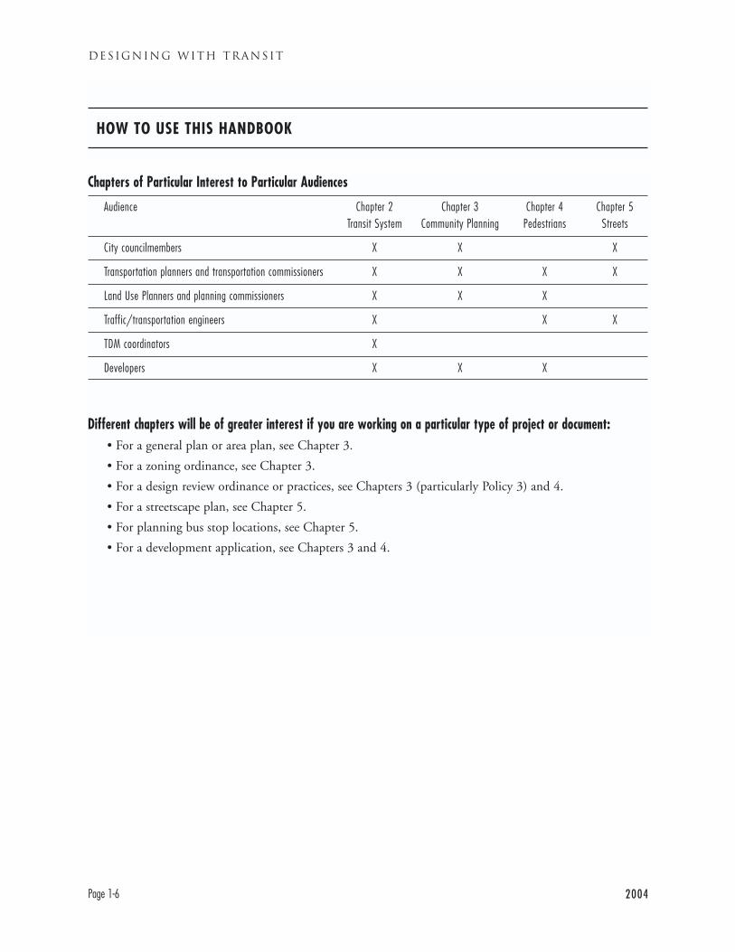
Chapters of Particular Interest to Particular Audiences
Audience Chapter 2 Chapter 3 Chapter 4 Chapter 5Transit System Community Planning Pedestrians Streets
City councilmembers X X X
Transportation planners and transportation commissioners X X X X
Land Use Planners and planning commissioners X X X
Traffic/transportation engineers X X X
TDM coordinators X
Developers X X X
Different chapters will be of greater interest if you are working on a particular type of project or document:• For a general plan or area plan, see Chapter 3.
• For a zoning ordinance, see Chapter 3.
• For a design review ordinance or practices, see Chapters 3 (particularly Policy 3) and 4.
• For a streetscape plan, see Chapter 5.
• For planning bus stop locations, see Chapter 5.
• For a development application, see Chapters 3 and 4.
HOW TO USE THIS HANDBOOK
WHY SHOULD COMMUNITIES
CARE ABOUT TRANSIT?
This handbook is about integrating transit into East
Bay communities. Its basic message is simple: what-
ever you do in developing your community, consider
how it will affect transit, and how it can be made to
help rather than harm transit.
But why should your community care about transit
at all? Because transit benefits communities in
many ways:
MOBILITY CHOICES
Transit provides mobility choices to residents. To
people without cars, transit is critical. For people
with cars, transit provides another option to always
driving everywhere. A recent survey of AC Transit
passengers estimates that as many as 40% could have
chosen another mode of travel.
ATTRACTS RESIDENTS
Good quality transit can help attract residents to a
community. Transit availability is a factor many peo-
ple consider in evaluating where to live.
AIR QUALITY IMPROVEMENT
Transit shifts people out of their cars and onto less
polluting modes of travel. Transit trips are most like-
ly to happen during peak hours and along busy,
congested corridors, the very conditions that lead
cars to pollute the most.
REDUCED CONGESTION
Transit use may reduce congestion on streets and
highways.
MORE EFFICIENT LAND USE
When people reach their destinations by transit
rather than driving, it reduces the need for parking.
Space that otherwise would have been devoted to
parking can be used for buildings instead.
URBAN VITALITY
Transit brings people together in urban centers, mak-
ing commercial and downtown areas lively. From
Boston to Berlin to Beijing, the world’s great cities
rely on transit to bring people to their centers.
PUBLIC SAFETY
Transit passengers populate the streets of a commu-
nity, providing “eyes on the street.”
Transit is a community service and a community
asset, much like libraries, parks, or schools. Investing
in transit is investing in the community.
2004 Page 1-7
INTRODUCTION TO DESIGNING WITH TRANSIT
DESIGNING WITH TRANSIT
Page 1-8 2004
INTRODUCTION
This chapter describes the existing and planned tran-
sit system in the inner East Bay in some detail as
background for the following chapters. This chapter
describes how AC Transit’s route network is struc-
tured and the reasons for the structure as well as
changes planned to the system.
This chapter highlights the fact that the East Bay
transit system consists of both AC Transit and BART,
as well as other services. AC Transit provides the pri-
mary service within the East Bay, while BART pro-
vides most regional connections to San Francisco and
elsewhere.2 Bus service in the East Bay is strongly
connected to BART service.
THE INNER EAST BAY AND ITS
TRANSIT SYSTEM: AN OVERVIEW
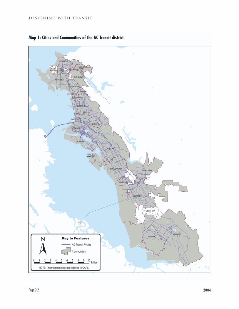
The AC Transit District: The AC Transit district is
the legally defined area where AC Transit is the main
bus transit provider. The district includes most of
Alameda County and part of Contra Costa County.
It stretches from Richmond in the north to Fremont
in the south. The district includes 13 cities and unin-
corporated portions of Alameda and Contra Costa
Counties. The district is illustrated in Map 1.3
The AC Transit district is very long and narrow,
almost 45 miles north to south but generally less than
5 miles east to west (excluding unpopulated areas).
The district includes long-developed urban, higher
density areas such as Oakland, Berkeley and
Alameda, along with newer, lower-density areas, par-
ticularly on the northern and southern edges of the
district. Among transit districts in California, the AC
Transit district has the third highest population den-
sity, after San Francisco and Los Angeles.
The central portion of the district focuses on mixed
use centers such as downtown Oakland and down-
town Berkeley. North and especially south of the
core, major employers and destinations are typically
more scattered. The older areas of the district such as
Oakland and Alameda were developed around a net-
2004 Page 2-1
THE INNER EAST BAY TRANSIT SYSTEM
CHAPTER 2
THE INNER EAST BAYTRANSIT SYSTEM
2 Levels of bus service vary with the availability of funds. However, the basic structure ofservice described in this chapter is maintained despite funding changes. In years of poor fund-ing, the system becomes more skeletal, with less service in addition to the trunk lines. Inyears of good funding, the overall system grows, but the trunk lines remain the most impor-tant elements.
3 Union City is not part of the AC Transit District, but AC Transit operates service there byagreement with the city.
DESIGNING WITH TRANSIT
Page 2-2 2004
Map 1: Cities and Communities of the AC Transit district
work of streetcar lines, but many destinations (e.g.
shopping malls) in newer areas were developed based
on freeway and roadway rather than transit access.
Given these land use patterns, transit ridership is
generally highest in the central and northern por-
tions of the district. Constrained by the Bay to the
west and the hills to the east, trips in the inner East
Bay are primarily north-south.
The inner East Bay transit system is primarily made
up of AC Transit bus lines and BART rail lines. AC
Transit operates 78 local (East Bay only) lines, while
BART has 21 stations in the AC Transit district, half
of its systemwide total of 43 stations. There are also
more localized transit services in the East Bay as well
as bus routes connecting the East Bay to other parts
of the region, including Union City Transit, Emery
Go Round, and University of California transit. AC
Transit also operates 27 lines with transbay service
over the bridges across the Bay, mostly to San
Francisco, but also to San Mateo and (as part of a
consortium) to Palo Alto.
AC TRANSIT RIDERSHIP AND LEVEL OFSERVICE
Among American transit agencies, AC Transit has
relatively strong ridership. AC Transit ranks third in
total ridership among Bay Area transit agencies, after
San Francisco’s Municipal Railway (Muni) and
BART respectively. On a per capita basis, AC Transit
has the highest ridership in California after Muni.
Residents of the AC Transit district each take an aver-
age of about 50 rides per year on AC Transit, a figure
AC Transit hopes to increase over time.
Transit agencies vary sharply in how much service
they provide. The best way to measure the level of
service provided is known as “revenue hours per capi-
ta.” Revenue hours are the hours a bus is in service on
the street, carrying passengers or available to carry
them. The higher the number of revenue hours per
capita, the more bus service is available. AC Transit
currently provides some 1.4 revenue hours of service
per capita, similar to the levels of bus service provid-
ed in Seattle or Portland, but substantially below that
provided by Muni.
AC TRANSIT’S SYSTEMWIDE
SERVICE DEPLOYMENT
POLICIES
Given that funds are inadequate to create the ideal
transit system, AC Transit must make decisions
about what services to provide at what levels. The
district must make decisions that will provide an
effective, efficient transit system. The following
Service Deployment Policies are the basis for making
those decisions. They were adopted as part of the
District’s 2003 Short Range Transit Plan (SRTP). The
SRTP plays a role that is roughly analogous to a
municipal General Plan. It represents the agency’s
broadest statement of goals, policies, and anticipated
strategies for implementation. The policies listed
below are explained in greater detail in the SRTP,
some are also discussed further in this handbook.
2004 Page 2-3
THE INNER EAST BAY TRANSIT SYSTEM
DESIGNING WITH TRANSIT
Page 2-4 2004
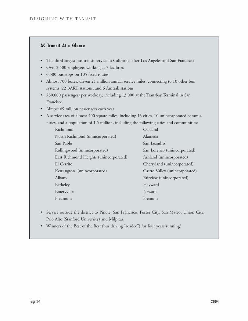
AC Transit At a Glance
• The third largest bus transit service in California after Los Angeles and San Francisco
• Over 2,500 employees working at 7 facilities
• 6,500 bus stops on 105 fixed routes
• Almost 700 buses, driven 21 million annual service miles, connecting to 10 other bus
systems, 22 BART stations, and 6 Amtrak stations
• 230,000 passengers per weekday, including 13,000 at the Transbay Terminal in San
Francisco
• Almost 69 million passengers each year
• A service area of almost 400 square miles, including 13 cities, 10 unincorporated commu-
nities, and a population of 1.5 million, including the following cities and communities:
Richmond
North Richmond (unincorporated)
San Pablo
Rollingwood (unincorporated)
East Richmond Heights (unincorporated)
El Cerrito
Kensington (unincorporated)
Albany
Berkeley
Emeryville
Piedmont
Oakland
Alameda
San Leandro
San Lorenzo (unincorporated)
Ashland (unincorporated)
Cherryland (unincorporated)
Castro Valley (unincorporated)
Fairview (unincorporated)
Hayward
Newark
Fremont
• Service outside the district to Pinole, San Francisco, Foster City, San Mateo, Union City,
Palo Alto (Stanford University) and Milpitas.
• Winners of the Best of the Best (bus driving “roadeo”) for four years running!

2004 Page 2-5
THE INNER EAST BAY TRANSIT SYSTEM
SERVICE PLANNING AND
NETWORK DESIGN
AC Transit plans its network of routes based on its
service development policies. The first step is devel-
oping a network design that focuses resources on the
core routes that carry the most riders. The SRTP
states that, “The district aims to allocate 70% of its
resource to demand-based services, with remaining
30% contributing to a basic level of geographic cov-
erage.” The demand-based services are the bus lines
with the highest levels of ridership. Geographic cov-
erage refers to the need to provide service to all parts
of the district even when that service has lower rider-
ship and revenue.
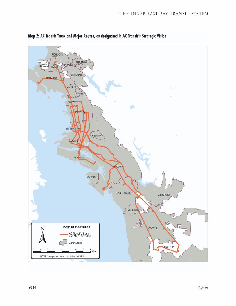
TRUNK ROUTES
AC Transit’s ridership is highly concentrated on trunk
lines, a longstanding pattern for the system. Lines on
just five corridors carry over 40% of the total rider-
ship on the system. As the SRTP notes, “Not surpris-
ingly, these lines serve the most developed and dense
part of the region, with population densities
approaching 10,000-12,000 people per square mile
on the busiest arterial streets.” The population, and
therefore the population density, of the AC Transit
district is increasing slowly. The location of major
high density areas has tended to be stable over time.
The five trunk line corridors with the highest rider-
ship are as listed below. Corridors are identified with
the lines that serve them as of July, 2004.
AC TRANSIT SERVICE DEPLOYMENT POLICIES (SELECTED)
Service Effectiveness Criteria
• Provide fast, thorough, coordinated, reliable, and
easily accessible service on trunk routes
• Coordinate service with land use
Service Efficiency Criteria
• Maintain and enforce minimum route produc-
tivity standards
• Advocate for and/or implement transit priority
and transit preferential measures in congested
locations
• Maintain and enforce minimum bus stop spacing
Network Design Criteria
• Adopt service allocation policies based on density
• Implement limited stop/Rapid service based on demand
• Implement express bus service where beneficial
• Implement Transbay bus service where beneficial
• Encourage intra-East Bay ridership on transbay lines
• Investigate flexible service options
• Maintain and enhance owl service on its trunk corridors
• Maintain minimum route spacing/coverage
• Adopt span-of-service definitions for different service types
• Provide seamless transfers (time, location, provider)
• Reorganize branching routes in favor of better connections
• Operate only one bus line per corridor when possible
• Schedule consistent headways
• Renumber the routes so that they have a logical
numbering system
• International Blvd./E. 14th St., Hayward-San
Leandro-Oakland (Lines 82 & 82L)
• Foothill/Bancroft-Telegraph/Shattuck, San
Leandro-Berkeley (Lines 40 & 43)
• Macarthur Blvd., San Leandro-Oakland-
Emeryville (Lines 57 & N).
• Broadway/College/Alameda, Berkeley-Oakland-
Alameda (Line 51, O in Alameda)
• San Pablo, Oakland-Albany-El Cerrito-
Richmond-San Pablo (Lines 72, 72M, 72R)
Trunk routes provide frequent service through dense-
ly populated areas to major destinations, accounting
for their high ridership. The trunk routes serve
Downtown Oakland, Downtown Berkeley, the
University of California, and 16 BART stations.
Trunk routes also serve a number of key destinations
away from BART, such as Hilltop Mall, Alta Bates
Hospital, College of Alameda, Eastmont Town
Center, and San Leandro Hospital. Trunk routes
operate 7 days per week, from at least 6 a.m. to mid-
night, although several of these lines operate 24
hours a day on at least a portion of their route. They
generally operate for several miles along a major
street, making their route easy to understand.
Weekday frequencies on trunk corridors are general-
ly every 6-15 minutes. Several routes have or will
have faster “Rapid” service along with local service.
MAJOR ROUTES
In addition to trunk routes, there are other major
routes serving key corridors in the district which have
been identified in AC Transit’s Strategic Vision.
These corridors are:
• Macarthur/Oakland Airport, East Oakland-
Oakland Airport (Line 50)
• Hesperian Blvd., San Leandro-Hayward, Union
City (Line 97)
• 6th St./Hollis, Berkeley- West Oakland-Alameda
(Line 19)
• Sacramento/Market, Berkeley-Oakland (Line 88)
• Outer E. 14th St./Mission, San Leandro-
Hayward-Union City (Line 99)
Major routes are scaled down versions of trunk
routes. They operate long north-south routes and
long hours, but typically at lower frequencies than
trunk routes (currently some major routes operate
every 20 minutes). They provide the principal service
either in lower density areas, or in areas between
other trunk routes.
GEOGRAPHIC COVERAGE
Geographic coverage is the other element of AC
Transit’s service model in addition to trunk/major
routes. The trunk and major routes provide service
within walking distance of most, but not all of the
population of the district. The trunks also generally
do not provide east-west service (or “crosstown” serv-
ice), although some trunk lines turn and run east-
west for a portion of their routes. Additional routes
are needed to “cover” the remaining areas of the dis-
trict, to provide service close to more people.
AC Transit thus needs to determine where to operate
bus lines to serve these lower demand areas. The
SRTP incorporates route spacing and route structure
criteria. The criteria are based on population density.
Population density is very closely tied to transit rid-
ership– the higher the density of an area, the greater
the transit ridership.
DESIGNING WITH TRANSIT
Page 2-6 2004
2004 Page 2-7
THE INNER EAST BAY TRANSIT SYSTEM
Map 2: AC Transit Trunk and Major Routes, as designated in AC Transit’s Strategic Vision
DESIGNING WITH TRANSIT
Page 2-8 2004
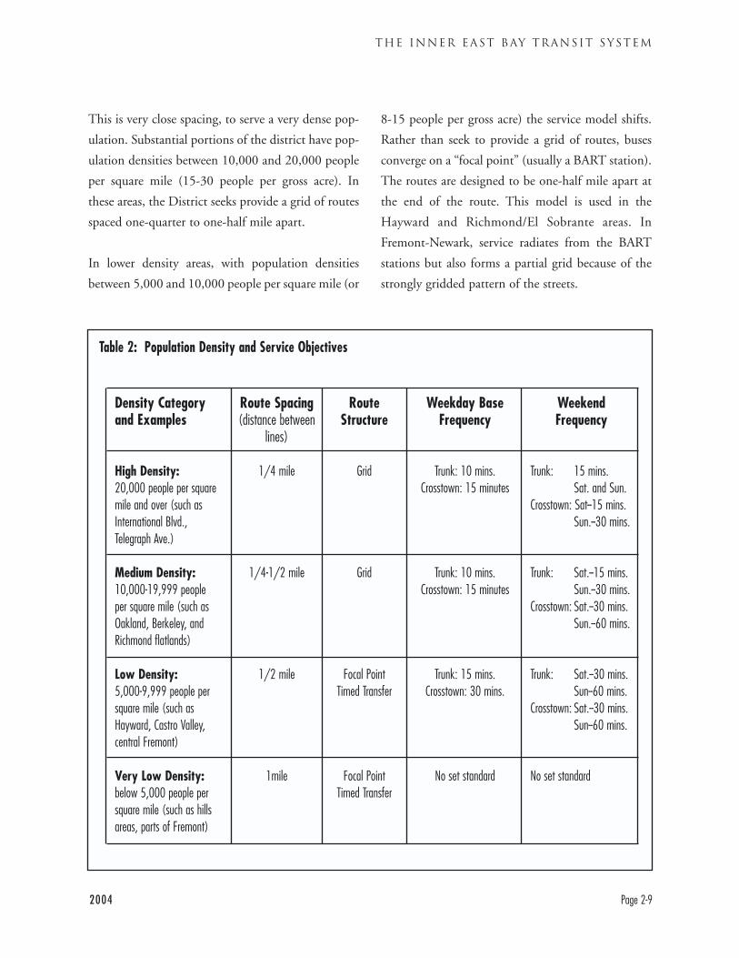
COVERAGE AND POPULATION DENSITY
The District’s Network Design Criteria (see p. 16)
call for service allocation based on population densi-
ty. Population density varies greatly within the dis-
trict, the Fruitvale section of Oakland is more than
four times as dense as the Oakland hills east of
Highway 13. AC Transit has therefore adopted a pol-
icy to provide more service where demand is greater,
in more densely populated areas. The population
density of various areas can be seen on Map 3.
In the densest areas of the district, with population
densities over 20,000 people per square mile (or
roughly 30 people per gross acre), the service stan-
dard is a grid of routes spaced one-quarter mile apart.
This means that ideally both north-south and east-
west bus routes would be one-quarter mile apart.
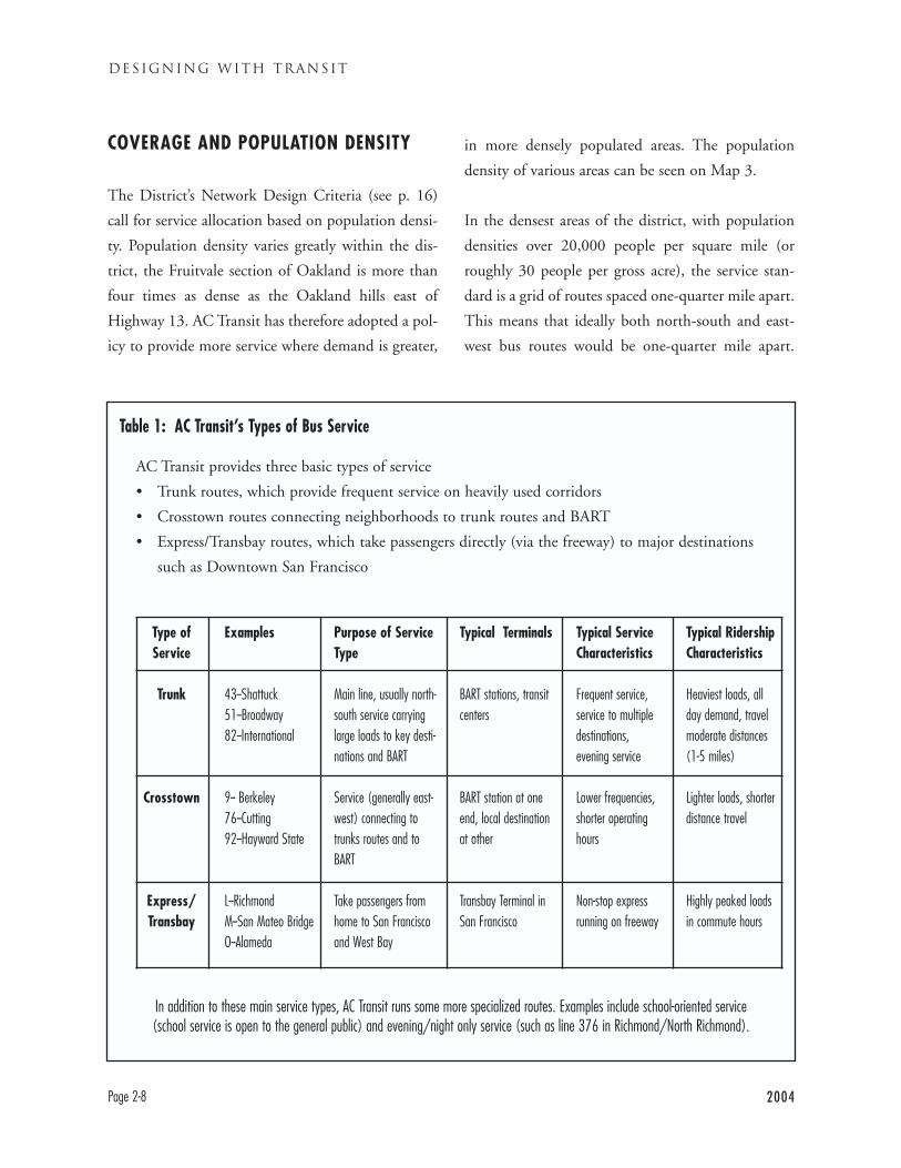
AC Transit provides three basic types of service
• Trunk routes, which provide frequent service on heavily used corridors
• Crosstown routes connecting neighborhoods to trunk routes and BART
• Express/Transbay routes, which take passengers directly (via the freeway) to major destinations
such as Downtown San Francisco
Table 1: AC Transit’s Types of Bus Service
Type ofService
Trunk
Crosstown
Express/Transbay
Examples
43--Shattuck 51--Broadway82--International
9-- Berkeley76--Cutting92--Hayward State
L--RichmondM--San Mateo BridgeO--Alameda
Purpose of ServiceType
Main line, usually north-south service carryinglarge loads to key desti-nations and BART
Service (generally east-west) connecting totrunks routes and toBART
Take passengers fromhome to San Franciscoand West Bay
Typical Terminals
BART stations, transitcenters
BART station at oneend, local destinationat other
Transbay Terminal in San Francisco
Typical ServiceCharacteristics
Frequent service,service to multipledestinations,evening service
Lower frequencies,shorter operatinghours
Non-stop expressrunning on freeway
Typical RidershipCharacteristics
Heaviest loads, allday demand, travelmoderate distances(1-5 miles)
Lighter loads, shorterdistance travel
Highly peaked loadsin commute hours
In addition to these main service types, AC Transit runs some more specialized routes. Examples include school-oriented service (school service is open to the general public) and evening/night only service (such as line 376 in Richmond/North Richmond).
2004 Page 2-9
THE INNER EAST BAY TRANSIT SYSTEM
This is very close spacing, to serve a very dense pop-
ulation. Substantial portions of the district have pop-
ulation densities between 10,000 and 20,000 people
per square mile (15-30 people per gross acre). In
these areas, the District seeks provide a grid of routes
spaced one-quarter to one-half mile apart.
In lower density areas, with population densities
between 5,000 and 10,000 people per square mile (or
8-15 people per gross acre) the service model shifts.
Rather than seek to provide a grid of routes, buses
converge on a “focal point” (usually a BART station).
The routes are designed to be one-half mile apart at
the end of the route. This model is used in the
Hayward and Richmond/El Sobrante areas. In
Fremont-Newark, service radiates from the BART
stations but also forms a partial grid because of the
strongly gridded pattern of the streets.
Table 2: Population Density and Service Objectives
Route Spacing(distance between
lines)
1/4 mile
1/4-1/2 mile
1/2 mile
1mile
RouteStructure
Grid
Grid
Focal Point Timed Transfer
Focal Point Timed Transfer
Weekday BaseFrequency
Trunk: 10 mins.Crosstown: 15 minutes
Trunk: 10 mins.Crosstown: 15 minutes
Trunk: 15 mins.Crosstown: 30 mins.
No set standard
Weekend Frequency
Trunk: 15 mins. Sat. and Sun.
Crosstown: Sat--15 mins.Sun.--30 mins.
Trunk: Sat.--15 mins.Sun.--30 mins.
Crosstown: Sat.--30 mins.Sun.--60 mins.
Trunk: Sat.--30 mins.Sun--60 mins.
Crosstown: Sat.--30 mins.Sun--60 mins.
No set standard
Density Category and Examples
High Density:20,000 people per squaremile and over (such asInternational Blvd.,Telegraph Ave.)
Medium Density: 10,000-19,999 peopleper square mile (such asOakland, Berkeley, andRichmond flatlands)
Low Density:5,000-9,999 people persquare mile (such asHayward, Castro Valley,central Fremont)
Very Low Density:below 5,000 people persquare mile (such as hillsareas, parts of Fremont)
DESIGNING WITH TRANSIT
Page 2-10 2004
Map 3: Population Density in the AC Transit District
The density and service standards refer to large areas
or corridors that meet a given density. There are loca-
tions in the East Bay with small pockets of higher
density population surrounded by lower density areas.
Because these pockets are small they cannot generate
adequate ridership to justify more frequent bus serv-
ice. (Parts of downtown Oakland also appear to be
low density on the map because they have small resi-
dent populations, but have the district’s highest den-
sity of jobs and services, generating transit ridership.)
THE ROLES OF BART AND
AC TRANSIT
BART and AC Transit provide the bulk of transit
service in the inner East Bay. BART stations are the
principal hubs of the East Bay transit system, for
both bus and rail service. BART provides high speed
heavy rail service to 21 stations in the AC Transit dis-
trict, generally spaced some 2-3 miles apart (closer
together in parts of Oakland and Berkeley). AC
Transit provides extensive service to all BART sta-
tions in the AC Transit district, and virtually all AC
Transit local buses serve at least one BART station.
The systems’ contrasting characteristics show how
they are complementary to each other. Because they
largely serve different travel needs, BART and AC
Transit together provide greater mobility for transit-
oriented development than either system alone
would provide.
Types of Trips
AC Transit and BART serve different types of trips.
The average AC Transit trip is 3.1 miles, the average
BART trip 12.2 miles. Because of the wide spacing of
BART stations in most of the AC Transit district,
BART is inconvenient for many shorter trips, partic-
ularly for trips that do not begin or do not end near
a BART station. BART’s high operating speeds are
ideal for long trips.
Destinations
The majority of transit trips that are wholly within
the East Bay are taken on AC Transit. BART handles
most of the transit trips from the East Bay to San
Francisco. AC Transit’s Transbay service (mostly to
San Francisco) is concentrated in corridors not with-
in walking distance of BART. During the years of
highest BART usage, AC Transit’s Transbay service
also served to relieve pressure on BART's capacity.
AC Transit has more than 3,000 pairs of stops (a stop
in each direction) in the East Bay.
Getting to AC Transit and BART
Passengers reach AC Transit and BART by different
modes. Some 75% of AC Transit passengers walk to
their bus stop. By contrast, 38% of BART passengers
systemwide reach BART by driving alone, making
driving alone the plurality mode of BART access
(BART hopes to reduce this percentage). A small
percentage of AC Transit Transbay and express bus
passengers reach their bus by driving to park-and-
ride facilities in areas where on-street service is not
2004 Page 2-11
THE INNER EAST BAY TRANSIT SYSTEM
practical. The proportion of passengers doing this is
expected to remain small.
Trip Purposes
Passengers use AC Transit and BART for different
purposes. BART ridership is dominated by weekday
commute trips, particularly to San Francisco,
Downtown Oakland and Berkeley. Over 60% of all
BART trips were to or from work, compared with
40% of AC Transit trips. School (at 33%) and shop-
ping (10%) were the next most important destina-
tions for AC Transit travelers, while on BART it was
school (9%) and visiting family and/or friends. More
of AC Transit’s passengers than BART’s ride on week-
ends, especially on Sundays.
FASTER TYPES OF BUS
SERVICE: RAPIDS AND BUS
RAPID TRANSIT
One of the major challenges facing AC Transit is
making our service operate faster. However, average
speeds for our buses have been falling, and AC
Transit’s average speed is 5-15% below that of com-
parable systems.
To speed up and improve trunk line service, and to
increase trunk line ridership, AC Transit is beginning
to develop “Rapids.” Rapid-type service has been
very successful in Los Angeles and is being consid-
ered by a number of other cities.
Rapids provide fast, frequent service along trunk
route corridors. The first Rapid is operating on San
Pablo Avenue between downtown Oakland and the
city of San Pablo. Key characteristics of the Rapid
include:
• More widely spaced stops, for faster operation
• Traffic signal priority (when needed) for faster
operation
• Far side stops whenever possible to minimize wait-
ing at signals
• Full low floor buses to ease boarding and alighting
• Shelters with information at Rapid stops
• Special Rapid signage
• “Next bus” informational displays indicating when
the bus will arrive (to be implemented 2004)
AC Transit plans to upgrade other trunk lines to
Rapid service when possible.
Beyond the Rapid, AC Transit is working with cities
to plan Bus Rapid Transit (BRT) on Telegraph
Avenue and International Boulevard, operating from
downtown Berkeley to Bayfair BART in San
Leandro. This routing represents AC Transit’s most
important corridor and would serve downtown
Berkeley, the University of California, Alta Bates
Hospital, Temescal, Pill Hill, downtown Oakland,
Laney College, Fruitvale, downtown San Leandro,
and Bayfair Mall.
In addition to all the features of the Rapid– such as a
smaller number of stops and transit signal priority–
BRT is designed to have stations at stops, and lanes
on the street which are used solely by the bus (known
as dedicated lanes). Thus, Bus Rapid Transit will
function very much like light rail, but at a very much
lower cost using buses instead of train equipment.
DESIGNING WITH TRANSIT
Page 2-12 2004
Bus Rapid Transit can provide more flexible service,
because many bus routes can use portions of the ded-
icated lanes, then branch out into the community.
Bus Rapid Transit is quickly becoming an important
transit option around the country. Bus Rapid Transit
in the United States has been inspired in part by the
high-capacity bus system in Curitiba, Brazil. Los
Angeles, Cleveland, and Boston have developed or
are developing Bus Rapid Transit lines. Bus Rapid
Transit lines have been proposed for El Camino Real
between San Jose and Palo Alto in Santa Clara
County, and for various corridors in San Francisco.
EVALUATING AND
MODIFYING BUS LINES
EVALUATING THE PERFORMANCE OFROUTES
AC Transit frequently reviews the performance of its
lines, especially the number of passengers they
attract. When funds are available to expand service,
the agency identifies lines that justify more frequent
service or longer hours. It also identifies locations
that need more transit service. When there is a fund
shortfall, AC Transit evaluates which lines are per-
forming poorly. These lines may have service reduced
or be eliminated.
In planning service, AC Transit focuses primarily on
ridership. The single most important measure of rid-
ership is “passengers per revenue hour.” Passengers
per revenue hour is the number of people who board
a bus during each hour of its operation. AC Transit’s
planning is strongly influenced by the passengers per
revenue hour on a line as a whole and/or on segments
of a line. Sometimes some segments of a line are pro-
ductive while others are not. Lines with insufficient
passengers per revenue hour may be reduced or elim-
inated Lines which have more ridership will gener-
ate more fare revenue, but fares are not the primary
consideration in service planning.4
NEW AND MODIFIED BUS ROUTES
AC Transit is often asked why it cannot change its
route structure to accommodate a new development,
or for other reasons. AC Transit modifies its route
structure to reflect changing conditions in the district.
For example, in June, 2003, despite the serious fiscal
problems of the district, AC Transit has instituted the
new line 19 serving the growing employment centers
of West Berkeley, Emeryville, and West Oakland.
AC Transit must exercise caution in modifying bus
routes. AC Transit can and has changed existing bus
routes, but only when there are compelling reasons to
do so. Passengers have a reasonable expectation that
service they use will continue. We wish to provide
that continuity as much as possible, particularly on
trunk routes. Routes are in their current locations
because those locations serve passenger demand and
reach important destinations. Trunk route locations
in particular tend to be stable over time.
2004 Page 2-13
THE INNER EAST BAY TRANSIT SYSTEM
4 Fares on most North American transit services cover only a fraction of the system’s oper-ating costs. That ratio is known as the farebox recovery ratio. AC Transit’s farebox recoveryratio is currently 21%, although it is higher for trunk lines and most Transbay lines, and lowerfor most crosstown lines, especially in low-density areas

DESIGNING WITH TRANSIT
Page 2-14 2004
HIGH FREQUENCY LINES NEED MULTIPLEDESTINATIONS
There are constraints on AC Transit’s ability to add
new lines in addition to the cost of doing so.
In most cases, a new line serving solely or principally
a single destination– even a relatively large one– will
attract few passengers. AC Transit’s trunk lines and
other major lines serve multiple destinations and
communities along a single corridor, attracting riders
making a variety of trips. To support frequent service,
population densities in a bus corridor must generally
exceed 10,000 people per square mile for two linear
miles or more.
Sometimes AC Transit is requested to operate com-
munity service type lines that meander to reach mul-
tiple scattered destinations. These lines appear attrac-
tive because they serve many destinations.
Unfortunately they rarely attract many passengers.
The direct, frequent service offered by a trunk line
also attracts more passengers than a less frequent, less
direct community service style line. With few pas-
sengers, a new single-purpose line will require an
even greater operating subsidy than usual, making it
very difficult to institute without outside funding,
particularly in times of fiscal stringency.
Example of Multiple Destinations along a Trunk Route-
-Line 57 (Macarthur)
• Emery Bay Shopping Center
• Bay Street Shopping Center
• East Baybridge Shopping Center
• Macarthur BART
• Kaiser Hospital
• Piedmont Avenue commercial district
• Oakland High School
• Highland Hospital
• Dimond commercial district
• Mills College
• Eastmont Town Center
BUILD WHERE THE BUS ALREADY IS
For the reasons discussed above, AC Transit strongly
recommends that cities and communities site major des-
tinations in locations with strong transit service, rather
than assuming that the transit system will be able to
serve dispersed locations.
2004 Page 3-1
PART 2:
DE S IG N I N G W I T H TR A N S I T
DESIGNING WITH TRANSIT
Page 3-2 2004
INTRODUCTION
Creating a community where destinations can be reached by transit and walking is the focus of this chapter.
This chapter outlines key planning policies and practices necessary to develop a community where travel by
walking, transit, and bicycle is practical and pleasant. Transit-supportive General Plan policies are included for
some practices.
This chapter considers three key planning questions:
• How can a community use land to support transit and be supported by transit?
• How can bus corridors be appropriately developed?
• How can parking policies support transit-oriented communities?
The chapter outlines how communities can take advantage of the rich East Bay transit system described in the
last chapter. It describes how to structure land uses– housing, retail stores, civic buildings, etc.– so that they
work with transit rather than against it.
This type of transit-focused development is natural in inner the East Bay. There are already many walkable,
densely built downtowns, main streets, and commercial corridors throughout the East Bay. BART stations have
2004 Page 3-3
TRANSIT-BASED COMMUNITIES : CENTERING PLANNING ON TRANSIT
CHAPTER 3
TRANSIT-BASED COMMUNITIES: CENTERING PLANNING ON TRANSIT
CHAPTER GUIDE
Topic: Planning land uses and corridors to make transit work better.
Particular Audience: City councilmembers, planning and transportation commissioners, transportation
and land use planners, developers
Subject of Recommendations: General Plans, Area Plans, Redevelopment Plans, Specific Plans, Zoning
Ordinances, facility siting, parking requirements and charges
also reinforced many of these areas. The East Bay’s historic centers have offices, stores, restaurants, apartment
buildings, government buildings, movie theatres, hotels, and more. A new generation of transit-friendly devel-
opment can reinforce the East Bay’s hubs and make them better places to live, work, and play.
Locations on trunk line bus corridors have important potential for transit-oriented development. Trunk line
bus corridors can provide access to local employment and shopping centers, BART, and in some cases direct-
ly to San Francisco. These corridors can spread the advantages of transit-oriented development to dozens of
locations. Some East Bay communities already highlight the potential of bus corridors in their planning.
The chapter also addresses the difficult issue of parking. Community planning cannot ignore the impact of
parking on transit ridership or on the physical form of the community. This chapter proposes ways a commu-
nity can control parking and integrate parking policy into transit-friendly planning, rather than finding itself
controlled by parking.
The litmus test for transit-focused community planning is this question: “How does it feel getting around
this community by transit and walking? Are the places I need to go easily accessible, or are they diffi-
cult and unpleasant to reach?”
DESIGNING WITH TRANSIT
Page 3-4 2004
SUMMARY OF TRANSIT-BASED COMMUNITIES’POLICIES AND PRACTICES
POLICY 1: DEVELOP DENSE, MIXED USES IN LOCATIONS WITH GOOD TRANSIT ACCESS
Best Practice 1.1: Cluster the community’s densest uses where there is the best transit access
Best Practice 1.2: Develop transit-supportive uses, and avoid auto-oriented uses, in locations with
good transit access
Best Practice 1.3: Build projects to planned densities in transit-friendly areas
Best Practice 1.4: Avoid high intensity uses in locations with minimal transit service
Best Practice 1.5: Locate special needs facilities in areas with good transit service
Best Practice 1.6: Designate transit-friendly areas for denser development in key planning documents
POLICY 2: PLAN BUS CORRIDORS TO MAXIMIZE THEIR POTENTIAL FOR TRANSIT-ORIENTED DEVELOPMENT
Best Practice 2.1: Develop the area within easy walking distance of a transit corridor with
transit-supportive uses
Best Practice 2.2: Assure that residents on bus corridors can easily walk to neighboring and nearby uses
Best Practice 2.3: On commercial strips, focus development at nodes
POLICY 3: MANAGE PARKING AS PART OF AN OVERALL TRANSPORTATION AND LANDUSE STRATEGY
Best Practice 3.1: Provide appropriate but not excessive amounts of parking
Best Practice 3.2: Reduce parking requirements in transit-friendly areas
Best Practice 3.3: Consolidate parking into joint lots and structures
Best Practice 3.4: Charge fees to cover parking costs and generate funds for other modes
2004 Page 3-5
TRANSIT-BASED COMMUNITIES : CENTERING PLANNING ON TRANSIT
CONTEXT: ASSESSING THE AVAILABILITYOF TRANSIT FOR TRANSIT-ORIENTEDDEVELOPMENT
This chapter urges communities to focus develop-
ment on locations with good transit service. In order
to guide development to the most transit-oriented
locations, communities must assess what they are. A
location with the best transit service will have not
only a strong main line, but also have service to var-
ious major destinations, frequent service, and service
that operates long hours.
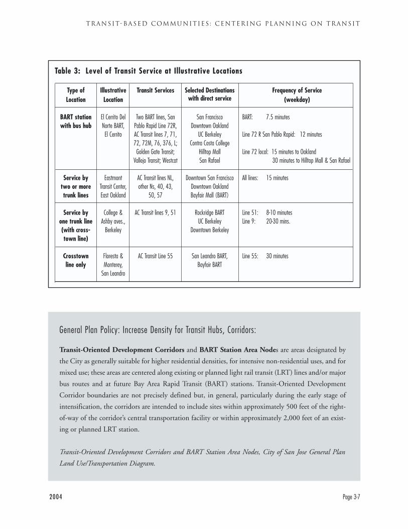
Table 3 on page 3-7 illustrates transit service (as of
October, 2004) in four different types of locations in
the AC Transit district. The locations were chosen
simply to illustrate different levels of transit availabil-
ity (and not to suggest anything about their appro-
priateness, or lack thereof, for development):
BART station with bus hub: El Cerrito Del Norte
BART. This station is served by two BART lines (San
Francisco and Fremont), numerous AC Transit bus
lines, and bus lines from Northwest Contra Costa,
Marin, and Solano counties. This site is illustrative of
the 21 BART stations in the AC Transit district.
Service by Two or More Trunk Lines: Eastmont
Transit Center in East Oakland illustrates a locations
served by more than one frequent trunk bus line.
This site also has Transbay service to San Francisco.
Eastmont is unusual in being served by several trunk
lines, though a number of locations have two trunk
lines. Eastmont has direct service to downtown San
Francisco and downtown Oakland, but trips farther
into San Francisco or south of Bayfair require trans-
fers to BART or to other bus lines. Other locations
with similar types of service include Solano and San
Pablo avenues in Albany; University and San Pablo
avenues in Berkeley and Broadway and Macarthur
Blvd. in Oakland.
Service by a single trunk line: College and Ashby
avenues, in Berkeley is served by a single trunk bus
line (Line 51) and a single crosstown line (Line 9).
Transit passengers here can reach Berkeley and north
Oakland destinations directly, and BART, but longer
trips require connection. Other locations with simi-
lar types of service are widespread, they include
Sutter and Hopkins streets in Berkeley; 35th and
Macarthur in Oakland; and Estudillo and Bancroft
in San Leandro.
Crosstown Service: Floresta and Monterey in San
Leandro illustrates locations served only by crosstown
lines, in this case Line 55. Passengers can connect to
BART at either end of the route; to shopping and city
services in Downtown San Leandro and Bayfair Mall;
and may happen to work in the industrial area along
the route. All trips outside San Leandro require trans-
fers. Other locations with similar types of service are
very common, they include locations along Cutting
Blvd. in Richmond, along Center St. in Hayward,
and along 98th Avenue in Oakland.
DESIGNING WITH TRANSIT
Page 3-6 2004
2004 Page 3-7
TRANSIT-BASED COMMUNITIES : CENTERING PLANNING ON TRANSIT
General Plan Policy: Increase Density for Transit Hubs, Corridors:
Transit-Oriented Development Corridors and BART Station Area Nodes are areas designated by
the City as generally suitable for higher residential densities, for intensive non-residential uses, and for
mixed use; these areas are centered along existing or planned light rail transit (LRT) lines and/or major
bus routes and at future Bay Area Rapid Transit (BART) stations. Transit-Oriented Development
Corridor boundaries are not precisely defined but, in general, particularly during the early stage of
intensification, the corridors are intended to include sites within approximately 500 feet of the right-
of-way of the corridor’s central transportation facility or within approximately 2,000 feet of an exist-
ing or planned LRT station.
Transit-Oriented Development Corridors and BART Station Area Nodes, City of San Jose General Plan
Land Use/Transportation Diagram.
Type ofLocation
BART stationwith bus hub
Service bytwo or moretrunk lines
Service byone trunk line(with cross-town line)
Crosstownline only
IllustrativeLocation
El Cerrito DelNorte BART,El Cerrito
EastmontTransit Center,East Oakland
College &Ashby aves.,
Berkeley
Floresta &Monterey,
San Leandro
Transit Services
Two BART lines, SanPablo Rapid Line 72R,AC Transit lines 7, 71,72, 72M, 76, 376, L;Golden Gate Transit;
Vallejo Transit; Westcat
AC Transit lines NL,other Ns, 40, 43,
50, 57
AC Transit lines 9, 51
AC Transit Line 55
Selected Destinationswith direct service
San FranciscoDowntown Oakland
UC BerkeleyContra Costa College
Hilltop MallSan Rafael
Downtown San FranciscoDowntown OaklandBayfair Mall (BART)
Rockridge BARTUC Berkeley
Downtown Berkeley
San Leandro BART, Bayfair BART
Frequency of Service (weekday)
BART: 7.5 minutes
Line 72 R San Pablo Rapid: 12 minutes
Line 72 local: 15 minutes to Oakland30 minutes to Hilltop Mall & San Rafael
All lines: 15 minutes
Line 51: 8-10 minutesLine 9: 20-30 mins.
Line 55: 30 minutes
Table 3: Level of Transit Service at Illustrative Locations
TRANSIT-BASED
COMMUNITIES’ POLICIES
AND PRACTICES
PLANNING POLICY 1: DEVELOP DENSE,MIXED USES IN LOCATIONS WITH GOODTRANSIT ACCESS
A “transit-friendly” area is one where residents, work-
ers, and other users of the area can meet their daily
needs by using transit and walking. Transit-friendly
areas have three core characteristics:
• High levels of transit service, from bus and/or
rail lines;
• A mix of uses, especially basic retail uses;
• A network of safe and pleasant routes for walk-
ing around
Mixed uses are important to allow people in the area
to conduct their activities by walking. For example,
workers can walk to lunch. Residents can walk to a
grocery store. Some locations have good transit access
but only one use. Workers in single-use areas may
resist taking transit because they feel “trapped” at
their worksite. Residents may use transit for trips to
work but drive for all other trips. (Walking routes are
addressed in Chapter 4.)
Planning Best Practice 1.1Concentrate dense uses in the locations with thebest transit access.
To design with transit, a community’s most intense
uses should be in its most transit-friendly locations.
This practice is critical whether the most intense use
is a 40 story highrise or a 4 story apartment building.
In this way, the land closest to transit is efficiently
used, and the people in the biggest building can
make use of the transit. Less intense uses near transit
hubs waste this valuable land. As noted in the
DESIGNING WITH TRANSIT
Page 3-8 2004
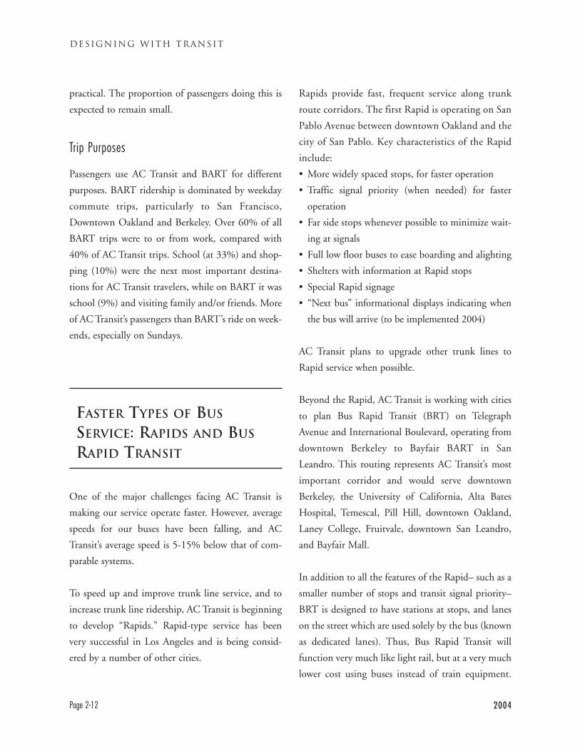
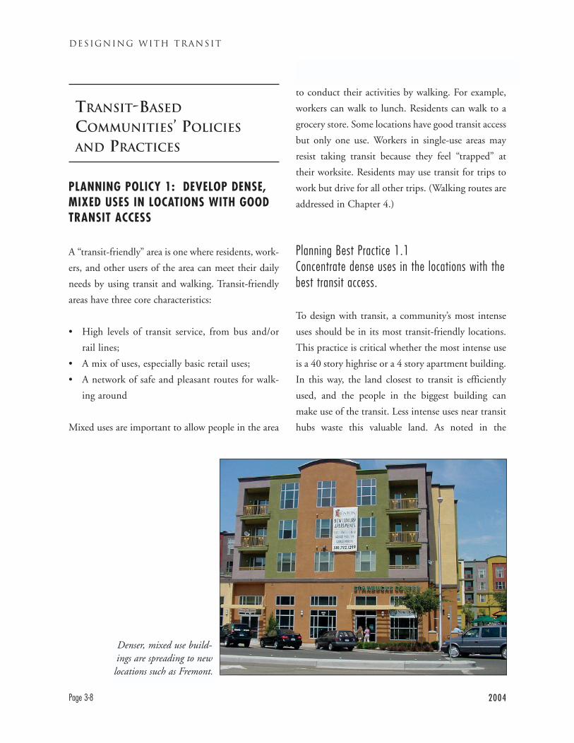
Denser, mixed use build-ings are spreading to newlocations such as Fremont.
2004 Page 3-9
TRANSIT-BASED COMMUNITIES : CENTERING PLANNING ON TRANSIT
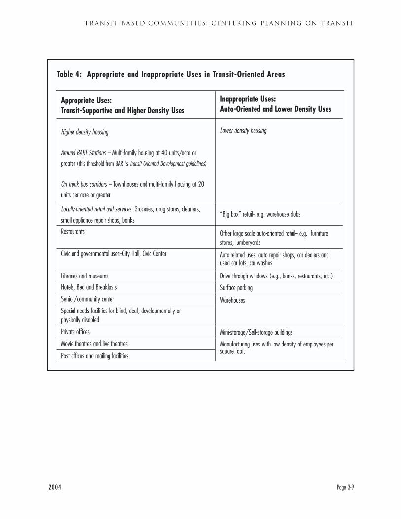
Table 4: Appropriate and Inappropriate Uses in Transit-Oriented Areas
Inappropriate Uses: Auto-Oriented and Lower Density Uses
Lower density housing
“Big box” retail-- e.g. warehouse clubs
Other large scale auto-oriented retail-- e.g. furniturestores, lumberyards
Auto-related uses: auto repair shops, car dealers andused car lots, car washes
Drive through windows (e.g., banks, restaurants, etc.)
Surface parking
Warehouses
Mini-storage/Self-storage buildings
Manufacturing uses with low density of employees persquare foot.
Appropriate Uses: Transit-Supportive and Higher Density Uses
Higher density housing
Around BART Stations – Multi-family housing at 40 units/acre orgreater (this threshold from BART’s Transit Oriented Development guidelines)
On trunk bus corridors – Townhouses and multi-family housing at 20units per acre or greater
Locally-oriented retail and services: Groceries, drug stores, cleaners,
small appliance repair shops, banks
Restaurants
Civic and governmental uses--City Hall, Civic Center
Libraries and museums
Hotels, Bed and Breakfasts
Senior/community center
Special needs facilities for blind, deaf, developmentally or physically disabled
Private offices
Movie theatres and live theatres
Post offices and mailing facilities
“Context” discussion in this chapter, the location
with the best transit access may be a major BART
hub or it may be a trunk line bus hub, depending on
the community.
Planning Best Practice 1.2Develop transit-supportive uses (and avoidauto-oriented uses) in locations with goodtransit access
Encouraging transit-supportive uses in transit-
served locations key to creating transit-friendly
areas. Table 4 (page 3-9) outlines appropriate and
inappropriate uses for transit-oriented areas. The
appropriate uses are high density uses and uses
which can easily be accessed by transit or walking.
The inappropriate uses are lower density uses and
those where access by car is usually dominant (not
all types of land use are shown on the table).
Some uses are particularly suited to transit hubs.
Locating civic buildings, such as city halls and civic
centers near transit hubs makes them accessible to all
parts of the population. It also makes a statement
that the community values transit access to its insti-
tutions. The City of Hayward took this approach
when it built its new City Hall one block from
Hayward BART. Major private office buildings have
large numbers of employees who can commute by
transit when it is nearby. Transit hubs are also a good
location for multi-family housing– apartments, and
condominiums– as well as for restaurants, and con-
venience-oriented retail uses. At convenience-orient-
ed retail stores shoppers can buy items easily carried
on foot and on transit. Appropriate types of retail or
service uses could include banks, cleaners, drug
stores, and grocery stores.
Mixed Use
Bringing a mix of uses together can make an area a
destination, which in turn makes it more effective to
bring bus service to it. Downtown Berkeley is a good
East Bay example. The area contains a BART station
and is adjacent to the University of California.
Downtown Berkeley also includes the city’s offices,
DESIGNING WITH TRANSIT
Page 3-10 2004
This big box retailer preempts a large site
within walking distanceof a BART station.
2004 Page 3-11
TRANSIT-BASED COMMUNITIES : CENTERING PLANNING ON TRANSIT
county courts, Vista College, the main public library,
the main post office, the recently expanded YMCA,
a historical museum, movie theatres and live theatres.
These uses are within a few blocks of each other,
making it possible to focus transit on them.
Mixed use need not be limited to urban core envi-
ronments but also can found in other types of areas.
Downtown Walnut Creek is an area where numerous
uses are close together and where a strong pedestrian
network makes walking between them possible and
enjoyable. San Jose’s Santana Row project puts hous-
ing and a hotel inside an upscale shopping center,
allowing for walking trips. Dublin, California, has
built a community-scale shopping center with basic
retail uses on the same property as, and immediately
adjacent to, an apartment building.
It is also important to avoid placing low intensity and
transit-unfriendly uses on valuable sites near transit
hubs. An important and all too frequent example is
“big box” retail. Big box retailers usually present a
huge, pedestrian-hostile face to the community.
Their huge size may block streets that formerly went
through a site, impeding pedestrian and bicycle
access. Shoppers, often intending to buy large quan-
tities at the big box, almost always arrive by automo-
bile. Auto dealers also need large spaces and con-
tribute little to transit-oriented streets. Low density
industrial and warehouse uses also underutilize land
near transit hubs, though there are some higher den-
sity manufacturing activities. Large lot single family
housing near transit hubs is also inappropriate.
Planning Best Practice 1.3Build projects to the planned densities in transit-friendly areas
It is important to develop land around transit hubs
to the actual densities permitted in a community’s
General Plan. Often a General Plan will allow a cer-
tain density, but actual projects are developed at far
lower densities. In some cases, developers may not
immediately see the market for higher-density
housing and wish to build a quick project. It is
important that communities consider their long-
term benefit and maintain available land for denser
housing. Some communities, such as Fremont and
Milpitas, specify minimum as well as maximum
densities in key areas to limit this process of thin-
ning out projects.
This discussion is not intended to suggest that zon-
ing a location for higher density development is suf-
ficient to have that development occur, only that
such zoning is necessary for development. Local gov-
General Plan Policy: Limit Transit Served Locations for Public Facilities and Services
Wherever possible, locate public and private institutional uses and community service centers that
serve city residents or have a regional-service orientation on transit corridors so that they are accessible
to public transportation and will not disrupt adjacent residential areas.
Policy LU-15, Land Use Element ,City of Berkeley General Plan

DESIGNING WITH TRANSIT
Page 3-12 2004
General Plan Policy: Encourage Dense Development Near Transit
Encourage transit-oriented development; where appropriate, encourage intensive new residential and
commercial development within one half-mile of transit stations or one quarter-mile of major bus routes.
City of Hayward General Plan Transportation Element, Policy 10.1
General Plan Policy: Limit Low Intensity Uses Near Transit
Development inconsistent with the objectives of the Transit-Oriented Development Corridors and
Station Area Nodes, for instance low intensity uses (e.g., one and two story office buildings), low den-
sity residential, and auto related uses (e.g. surface parking lots, automobile sales lots, stand alone big
box retail, etc.) should be avoided particularly within 2,000 feet of an existing or planned Light Rail
Transit Station.
Development Parameters, Transit-Oriented Development Corridors, City of San Jose General Plan Land
Use/Transportation Diagram).
This highrise officebuilding is isolated
from transit and otheruses, forcing people to
drive there.
ernments are aware that in many cases they will need
to become actively involved to assure that desired
development takes place. Additional regulatory
changes may be needed, as may investments in infra-
structure and/or public subsidies. These topics are
beyond the scope of this handbook. Appropriate land
use planning is necessary for transit-oriented devel-
opment, but often it is not sufficient.
Planning Best Practice 1.4Avoid high intensity uses in areas with minimaltransit service
Just as low intensity uses are inappropriate at transit
hubs, high-intensity uses are inappropriate away
from transit hubs and corridors. A high density
apartment complex or major office building with lit-
tle or no access to transit is inevitably a large genera-
tor of auto traffic. At the same time, such a location
virtually forecloses the option of taking transit for its
tenants or residents.
Planning Best Practice 1.5Locate special needs facilities in areas with goodtransit service
Some facilities provide services that generate a partic-
ularly high need for good transit. Examples include
rehabilitation services for the disabled, or a training
site for the developmentally disabled. Good locations
for this type of facility are close to frequent transit
service. For example, the Albany Center for the Blind
is served by trunk bus Line 72 and is within walking
distance of the El Cerrito Plaza BART station.
2004 Page 3-13
TRANSIT-BASED COMMUNITIES : CENTERING PLANNING ON TRANSIT
General Plan Policy: Limit Development Intensities Away from Transit
Preserve the low-density character of San Leandro’s predominantly single family neighborhoods.
Concentrate new multi-family development in the areas near the BART Stations and along major tran-
sit corridors such as East 14th Street.
Policy 2.05, Land Use Element, City of San Leandro General Plan
General Plan Policy: Require Minimum Density at Transit Hubs
To achieve a variety of housing types, the City has designated locations where moderate and higher den-
sity development is appropriate. Criteria for the location of higher density housing include access to tran-
sit, proximity to commercial areas, proximity to a collector or arterial street, and as a transition use where
maximum flexibility in site design is required. For those areas where higher densities are indicated on the
General Plan Diagram, construction of housing at significantly lower densities than planned would not
meet the City's goals. The City therefore establishes a minimum required density of development for all
medium and high density uses …
City of Fremont General Plan Land Use Element, Policy LU 1.9
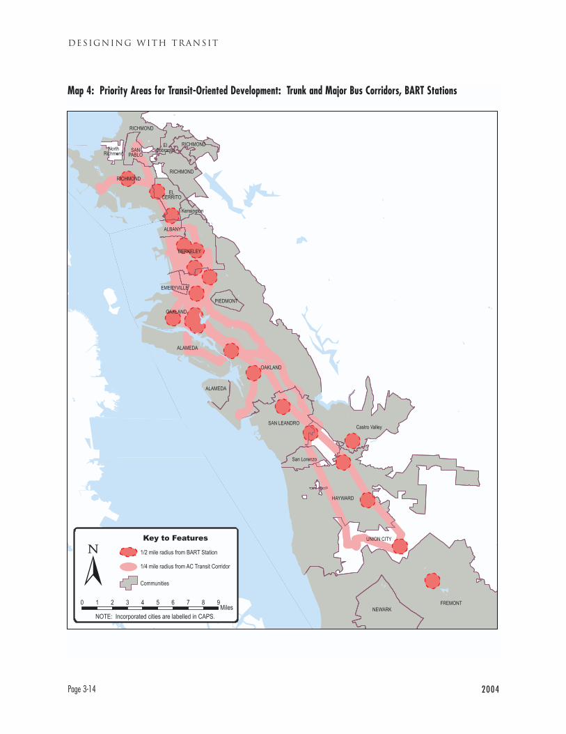
DESIGNING WITH TRANSIT
Page 3-14 2004
Map 4: Priority Areas for Transit-Oriented Development: Trunk and Major Bus Corridors, BART Stations
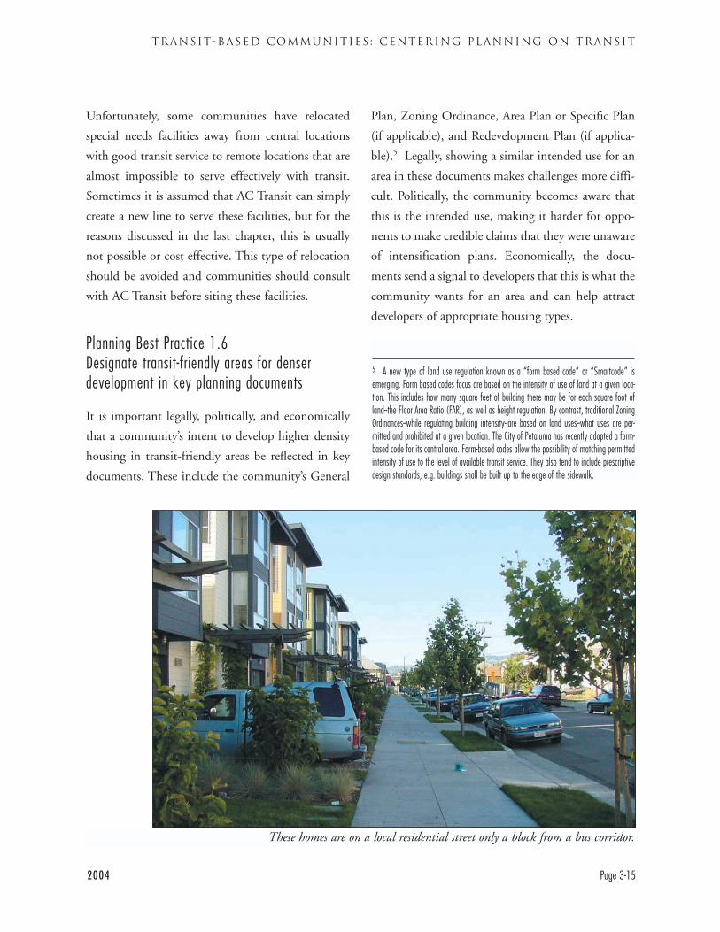
2004 Page 3-15
TRANSIT-BASED COMMUNITIES : CENTERING PLANNING ON TRANSIT
Unfortunately, some communities have relocated
special needs facilities away from central locations
with good transit service to remote locations that are
almost impossible to serve effectively with transit.
Sometimes it is assumed that AC Transit can simply
create a new line to serve these facilities, but for the
reasons discussed in the last chapter, this is usually
not possible or cost effective. This type of relocation
should be avoided and communities should consult
with AC Transit before siting these facilities.
Planning Best Practice 1.6Designate transit-friendly areas for denserdevelopment in key planning documents
It is important legally, politically, and economically
that a community’s intent to develop higher density
housing in transit-friendly areas be reflected in key
documents. These include the community’s General
Plan, Zoning Ordinance, Area Plan or Specific Plan
(if applicable), and Redevelopment Plan (if applica-
ble).5 Legally, showing a similar intended use for an
area in these documents makes challenges more diffi-
cult. Politically, the community becomes aware that
this is the intended use, making it harder for oppo-
nents to make credible claims that they were unaware
of intensification plans. Economically, the docu-
ments send a signal to developers that this is what the
community wants for an area and can help attract
developers of appropriate housing types.
5 A new type of land use regulation known as a “form based code” or “Smartcode” isemerging. Form based codes focus are based on the intensity of use of land at a given loca-tion. This includes how many square feet of building there may be for each square foot ofland--the Floor Area Ratio (FAR), as well as height regulation. By contrast, traditional ZoningOrdinances--while regulating building intensity--are based on land uses--what uses are per-mitted and prohibited at a given location. The City of Petaluma has recently adopted a form-based code for its central area. Form-based codes allow the possibility of matching permittedintensity of use to the level of available transit service. They also tend to include prescriptivedesign standards, e.g. buildings shall be built up to the edge of the sidewalk.
These homes are on a local residential street only a block from a bus corridor.
DESIGNING WITH TRANSIT
Page 3-16 2004
PLANNING POLICY 2
PLAN BUS CORRIDORS TO MAXIMIZETHEIR POTENTIAL FOR TRANSIT-ORIENTED DEVELOPMENT
The value and importance of rail stations as focal
points for intensified development has become
increasingly recognized in the East Bay. What is so
far less widely recognized is the potential for devel-
opment, especially housing development, along and
near major bus transit corridors. Trunk bus corri-
dors include more land in the East Bay than do
BART station areas. So they are stable transit loca-
tions, these corridors have been trunk routes for
decades and will remain.
One of the most important messages of this hand-
book is that bus corridors, approximately one quar-
ter-mile around bus lines, can and should become
foci for transit-oriented development.
Trunk bus corridors provide access to important
employment, shopping, and recreational destina-
tions. Trunk bus corridors connect to numerous
BART stations for longer distance trips. Most trunk
bus corridors already have substantial segments with
higher density housing such as apartment buildings,
facilitating additional development. Most trunk bus
corridors also have vacant and underutilized parcels
that can be used for housing development.
The land use and urban design characteristics that
make a location transit-friendly apply to bus corri-
dors as well as rail stations (see pages 3-8 to 3-15 for
more discussion). The most transit-friendly areas
provide good transit service and basic “local serving”
stores such as supermarkets and drug stores in a
“pedestrian-friendly” environment.6 Many of the
East Bay’s principal commercial corridors are also
principal transit corridors including San Pablo
Avenue, Shattuck Avenue, Telegraph Avenue, and
International Boulevard/East 14th Street. In these
locations, the availability of transit would probably
not be the only reason that a household moved there,
but it would be one reason for doing so.
Examples of market-rate housing development along
bus corridors include buildings at 40th & San Pablo
in Emeryville and near Solano & San Pablo in
Albany. The city of Fremont is in the process of
rezoning numerous sites along its bus corridors to
permit higher density development, San Leandro has
begun to do so. A number of bus corridors have
affordable housing development, which often serves
as the catalyst for future mixed income development.
AC Transit’s primary role in fostering such develop-
ment is to provide the best transit service our fund-
ing allows.7 We plan to improve our trunk lines to
Rapid and Bus Rapid Transit levels of service (see
Chapter 2 for explanations of these service types). As
service on these corridors improves, they will become
all the more attractive and viable as locations for
transit-oriented development.
6 Cities with a strong commitment to transit-oriented development have generated transit-oriented development along bus corridors. Portland and Vancouver-– cities with densitiescomparable to the East Bay over much of their area– have highly successful examples of bus-oriented development.
7 AC Transit can work with communities and developers that can generate additional fund-ing to increase service above basic levels.
2004 Page 3-17
TRANSIT-BASED COMMUNITIES : CENTERING PLANNING ON TRANSIT
Planning Best Practice 2.1Develop the whole within easy walking distanceof a transit corridor with transit-friendly uses
To achieve the full potential of a transit corridor, it is
important to develop both the main street and other
streets. In many cities commercial streets and streets
with bus lines are zoned for higher densities.
Enacting zoning that will allow development on the
major street is an important step. However, the trunk
line corridor is not just the street the bus operates on,
but also the areas within one quarter-mile of that
street. This is the area that is an easy walk, generally
estimated to be about five minutes, from the transit
line. These one quarter-mile wide corridors are
schematically illustrated by Map 5 (Page 4-8). Side
streets in transit corridors can provide opportunities
for residential development in quiet, attractive set-
tings within easy walking distance of the bus. These
corridors incorporate surprisingly large amounts of
land. Exclusive of areas around BART stations, the
trunk and major bus line corridors in the AC Transit
district encompass almost 25,000 acres, or almost 39
square miles.
General Plan Policy: Encourage Mixed Use on Transit Corridors
Encourage mixed use projects containing ground floor retail and upper floor residential uses along major
transit corridors. Such development should be pedestrian-oriented, respect the scale and character of the
surrounding neighborhood, and incorporate architectural themes that enhance the identity of adjacent
commercial districts.
Policy 3.05, Land Use Element, City of San Leandro General Plan
Residents cannot easi-ly access these storesbecause of the wallbetween them andlong block lengths.
Planning Best Practice 2.2Assure that residents on bus corridors can easilywalk to neighboring and nearby uses
Placing residential and commercial uses close to each
other is necessary, but not sufficient for easy walking
between them. In many cases it is impossible, dan-
gerous, or undesirable to walk from one to the other.
While many communities have upgraded pedestrian
paths to rail stations, the walking environment on
many major bus corridors ranges from unpleasant to
dangerous.
Walking is particularly problematic when develop-
ment patterns incorporate long, unbroken walls
around subdivisions, shopping centers, or other uses.
A resident might be able to walk around the wall on
the nearest street. However, overly long block lengths
may mean that the nearest street is a discouraging
800 or 1,000 feet away. Some housing developments
situated next to a shopping center have pedestrian
gates (often key-accessed) allowing people to walk
from housing to shopping.
Planning Best Practice 2.3On commercial strips, focus developmentat nodes
Many American communities, including East Bay
communities have long, low-density commercial
strips along their main highways. This type of com-
mercial development is difficult to serve well with
transit, and difficult for transit passengers to use. Its
low-density, scattered character means that shoppers
must stop a number of widely separated locations,
which is a difficult pattern for transit passengers. The
walking environment is often poor, sidewalks may be
narrow or absent, interrupted by frequent driveways
and parking lots which extend to the edge of the
street. This situation discourages people from walk-
ing to the bus. It also often creates a low quality,
unfriendly bus stop environment.
Many of these strips already have focal points where
development is more intense, buildings may be taller
or closer together, there may be more pedestrians on
that section of the street. Often these occur where
two major streets intersect, especially around inter-
sections that are or were once important transit junc-
tions. Some streets do not have these locations, but
have the opportunity to develop them. Planners call
these focal points “nodes.” Some plans identify
nodes and detail specific policies for them. For exam-
ple, the El Cerrito General Plan identifies three
nodes along San Pablo Avenue, and San Leandro is
developing a nodal concept for East 14th St.
It is usually better for transit operations and transit
passengers to concentrate commercial development,
particularly local serving stores, at major nodes.
Nodes at major cross streets are particularly helpful,
as they allow crossing transit service. These nodes
provide a good opportunity to introduce pedestrian-
oriented design (described in Chapter 4) to otherwise
unfriendly streets.
DESIGNING WITH TRANSIT
Page 3-18 2004
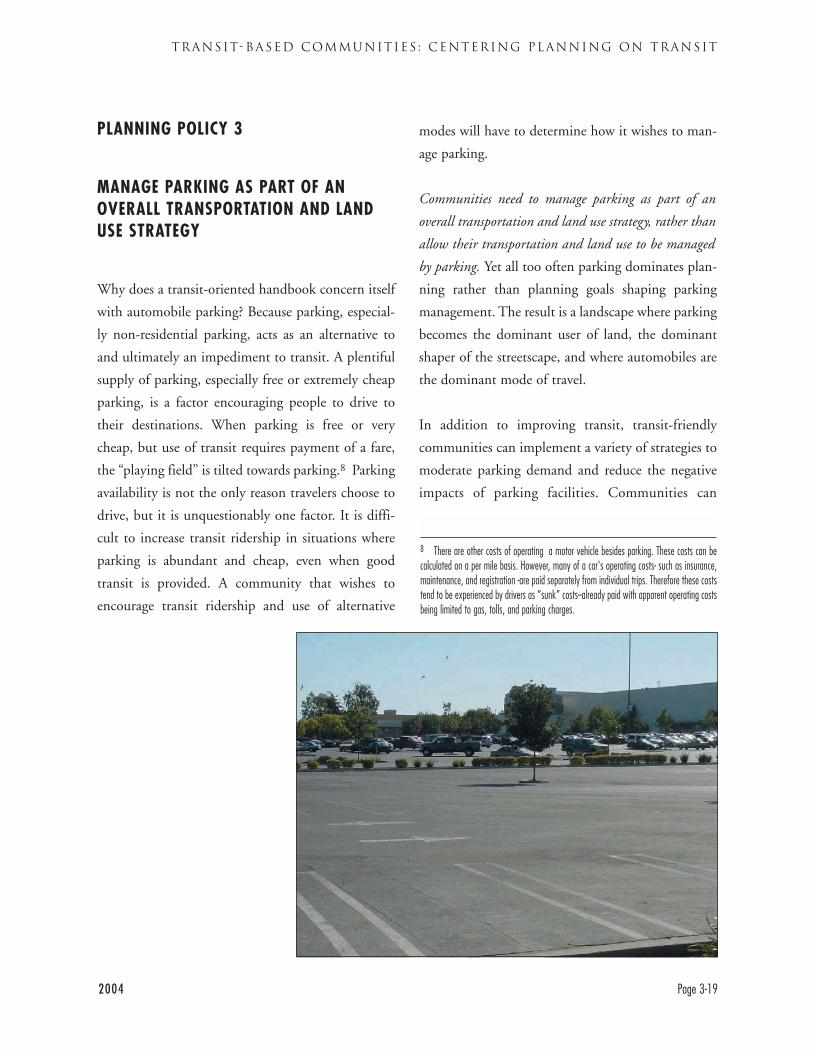
2004 Page 3-19
TRANSIT-BASED COMMUNITIES : CENTERING PLANNING ON TRANSIT
PLANNING POLICY 3
MANAGE PARKING AS PART OF ANOVERALL TRANSPORTATION AND LANDUSE STRATEGY
Why does a transit-oriented handbook concern itself
with automobile parking? Because parking, especial-
ly non-residential parking, acts as an alternative to
and ultimately an impediment to transit. A plentiful
supply of parking, especially free or extremely cheap
parking, is a factor encouraging people to drive to
their destinations. When parking is free or very
cheap, but use of transit requires payment of a fare,
the “playing field” is tilted towards parking.8 Parking
availability is not the only reason travelers choose to
drive, but it is unquestionably one factor. It is diffi-
cult to increase transit ridership in situations where
parking is abundant and cheap, even when good
transit is provided. A community that wishes to
encourage transit ridership and use of alternative
modes will have to determine how it wishes to man-
age parking.
Communities need to manage parking as part of an
overall transportation and land use strategy, rather than
allow their transportation and land use to be managed
by parking. Yet all too often parking dominates plan-
ning rather than planning goals shaping parking
management. The result is a landscape where parking
becomes the dominant user of land, the dominant
shaper of the streetscape, and where automobiles are
the dominant mode of travel.
In addition to improving transit, transit-friendly
communities can implement a variety of strategies to
moderate parking demand and reduce the negative
impacts of parking facilities. Communities can
8 There are other costs of operating a motor vehicle besides parking. These costs can becalculated on a per mile basis. However, many of a car's operating costs- such as insurance,maintenance, and registration -are paid separately from individual trips. Therefore these coststend to be experienced by drivers as “sunk” costs--already paid with apparent operating costsbeing limited to gas, tolls, and parking charges.
DESIGNING WITH TRANSIT
Page 3-20 2004
reduce excessive parking requirements, and recog-
nize that high levels of transit service allow reduced
parking requirements. Communities can configure
parking into consolidated lots and structures to
reduce its negative impact on community form.
Communities can avoid subsidizing the capital and
operating costs of parking, by charging parking fees
to cover costs and to generate funds for transit and
other alternative modes.
Planning Best Practice 3.1Provide appropriate, but not excessive, amountsof parking
Most communities (although not all) set minimum
required levels of parking that must be provided with
new buildings or uses. Such parking requirements are
often discussed as if they are universal and unchang-
ing. However, actual demand for parking varies from
location to location, varies over time, and changes
with the impact of public policies and traveler deci-
sions. This has recently been legally recognized in a
California Court of Appeals decision. Therefore,
communities should assure that parking provision is
appropriate but not excessive.
Excessive parking increases the impacts discussed
above– e.g., induced driving and excessive land con-
sumption. Moderate parking supply can help sup-
port a positive feedback loop of more travel by tran-
sit and other modes allowing a lowered parking
requirement and so on. Excessive parking helps drive
a negative feedback loop where driving dominates
and reinforces an auto-oriented environment, lead-
ing to more demand for parking leading to more
driving, etc.
In some instances the appropriate amount of parking
is none. The city of Berkeley, for example, allowed
both its main library and YMCA in downtown
Berkeley to expand based on analysis that there was
adequate parking to satisfy the net increase in park-
ing demand they could be expected to generate.
Communities should carefully consider their own
planning goals, experience, and transit network in
setting parking requirements. Many “standard” park-
ing requirements are based on suburban areas with
minimal or no transit, and the assumption that vir-
tually all users will drive alone to a facility. Parking
requirements are also based on the idea that each use
must have its own dedicated supply of parking.
However, there are often opportunities for uses with
different parking demands to share parking. In west
Berkeley, for example, a school whose parking
demand is during the week will be sharing parking
General Plan Policy: Reduced Parking in Transit-Oriented Areas
Reduce parking demand through limiting the absolute amount of spaces and prioritizing the spaces
for short-term and ride-share uses.
Policy 16.5, Transportation Element, City of San Francisco General Plan
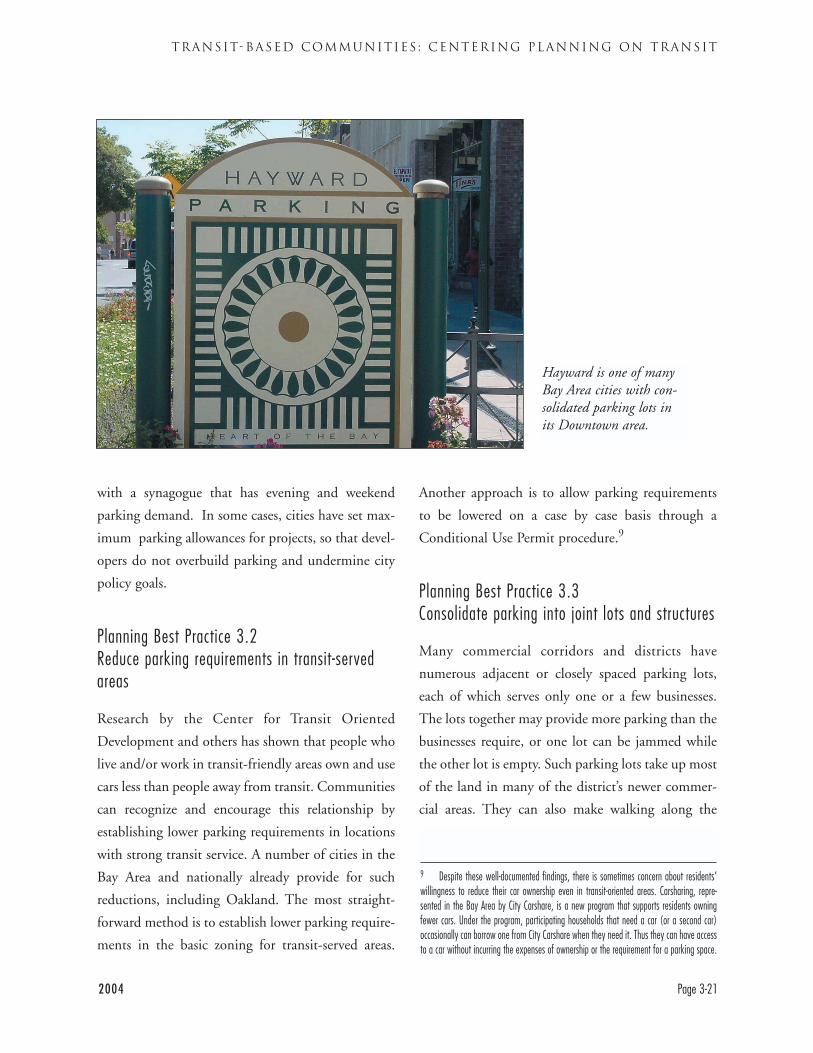
2004 Page 3-21
TRANSIT-BASED COMMUNITIES : CENTERING PLANNING ON TRANSIT
with a synagogue that has evening and weekend
parking demand. In some cases, cities have set max-
imum parking allowances for projects, so that devel-
opers do not overbuild parking and undermine city
policy goals.
Planning Best Practice 3.2Reduce parking requirements in transit-servedareas
Research by the Center for Transit Oriented
Development and others has shown that people who
live and/or work in transit-friendly areas own and use
cars less than people away from transit. Communities
can recognize and encourage this relationship by
establishing lower parking requirements in locations
with strong transit service. A number of cities in the
Bay Area and nationally already provide for such
reductions, including Oakland. The most straight-
forward method is to establish lower parking require-
ments in the basic zoning for transit-served areas.
Another approach is to allow parking requirements
to be lowered on a case by case basis through a
Conditional Use Permit procedure.9
Planning Best Practice 3.3Consolidate parking into joint lots and structures
Many commercial corridors and districts have
numerous adjacent or closely spaced parking lots,
each of which serves only one or a few businesses.
The lots together may provide more parking than the
businesses require, or one lot can be jammed while
the other lot is empty. Such parking lots take up most
of the land in many of the district’s newer commer-
cial areas. They can also make walking along the
9 Despite these well-documented findings, there is sometimes concern about residents’willingness to reduce their car ownership even in transit-oriented areas. Carsharing, repre-sented in the Bay Area by City Carshare, is a new program that supports residents owningfewer cars. Under the program, participating households that need a car (or a second car)occasionally can borrow one from City Carshare when they need it. Thus they can have accessto a car without incurring the expenses of ownership or the requirement for a parking space.
Hayward is one of manyBay Area cities with con-solidated parking lots inits Downtown area.
DESIGNING WITH TRANSIT
Page 3-22 2004
street between businesses difficult and unpleasant.
This condition can be improved by consolidating
several lots into a single lot that serves multiple users
and takes up less space, freeing up land area for side-
walks, landscaping, or additional development.
These lots can have fewer driveways, reducing the
potential for pedestrian conflicts. In cases where
parking demand is high enough, lots can be consoli-
dated into parking structures. Including active uses,
such as retail stores, on the ground floor frontage of
parking structures, allows that structure to contribute
to the commercial corridor or district rather than
interrupting it.
Planning Best Practice 3.4Charge fees for parking to cover costs andgenerate funds for other modes
It is important that there be appropriate charges for
automobile parking. Parking is not free to create or
maintain, so the costs of doing so should be borne by
the users of the parking.10 If this is not done, the
costs of parking are paid by all of the facility’s users,
whether they park there or get there by other means.
People who take transit to the facility must pay a fare
to get there as well as subsidizing drivers– a double
burden. In some cases, parking fees can also be used
to support alternative modes of transportation. The
city of San Francisco is using public parking revenues
in this way.
Charging for parking can also help establish the real
demand for parking. People will use more of a
“good,” like parking, when it is free. Charging can
thus help communities determine what is a reason-
able rather than excessive level of parking.
Parking charges can also be used to influence travel
patterns in a community. The city of Berkeley targets
its public parking to shoppers rather than people
commuting to work. Berkeley’s view is that people
commuting to work have a greater opportunity to
use transit than shoppers. Therefore their charges for
short term parking, for less than two hours, are low
but rise steeply for longer term and all day parking.
10 Environmental and health advocates note the environmental, health, public safety, andother costs created by automobile driving. These are important considerations that illustratethe cost of driving to society, but are beyond the scope of this document.
INTRODUCTION
The previous chapter described key community planning policies to create a community that transit can serve
effectively. This chapter looks at how transit riders can get to transit. AC Transit passengers overwhelmingly
reach the bus by walking to it. Our recent survey of AC Transit passengers found that they were almost eight
times more likely to reach their first transit stop by walking than by all other methods (driving, being a car pas-
senger, bicycling) combined.
This chapter addresses the following questions:
• How can pedestrian access throughout East Bay communities be improved?
• How can good walking access to transit be created?
• How should buildings be designed to facilitate walking?
• How best can pedestrian safety at roadways and driveways be achieved?
Some East Bay communities and neighborhoods are pleasant places to walk in, but many are not. There may
not be a sidewalk or it may be so narrow that it does not feel protective, and may be effectively impassible to
the disabled. Adjacent traffic may pass at a frighteningly high speed. These environments do not encourage
people to walk to transit or to other destinations.
2004 Page 4-1
SAFE ROUTES TO TRANSIT: CREATING GOOD WAYS TO WALK TO TRANSIT
CHAPTER 4
SAFE ROUTES TO TRANSIT: CREATING GOOD WAYS TO
WALK TO TRANSIT
CHAPTER GUIDE
Topic: Developing pedestrian facilities that allow passengers to easily walk to transit
Particular Audience: Transportation Commissioners, transportation planners, planners involved indevelopment review, Traffic/Transportation Engineers
Subject of Recommendations: General Plan Transportation Elements, subdivision requirements, site plans,sidewalk and roadway plans and standards, traffic signal timing
There are many ways to make walking a pleasant and effective method of travel. This chapter recommends
policies and approaches for creating a good pedestrian environment, including some key dimensions. However,
it is not intended to be a manual of technical specifications for sidewalks and other pedestrian facilities.
Readers should not assume that any dimensions or configurations of roadway, sidewalk, or bus stop fea-
tures shown on or implicit in figures, photographs, or text are recommended by AC Transit, unless such a
recommendation is specifically stated.
AC Transit’s recommendations for walkways and pedestrian facilities are strongly linked to the community
planning recommendations in Chapter 3. It is much easier to reach destinations by walking in a compact,
mixed-use community. A pleasant place environment for walking is also a pleasant environment for living
and working.
These recommendations are physically connected to the recommendations about streets and sidewalks in
Chapter 5. Our recommendations also fit into a multimodal transportation planning approach, which is dis-
cussed more fully in Chapter 5. The multimodal approach seeks to accommodate all modes of travel. In par-
ticular, AC Transit seeks to improve pedestrian conditions without compromising appropriate bus operations.
Conversely, there are many potential changes to streets that would improve bus operations but not degrade
pedestrian safety discussed in the next chapter. Our goal is streets that are safe for pedestrians and function-
al for buses and other vehicle traffic. Such streets needs to operate at an adequate and predictable speed, but
not necessarily the highest possible speeds. A pedestrian should be comfortable walking along any public
right-of-way.
The question that frames the issues discussed in this chapter is “How would I feel walking to the bus stop?
Would I feel safe? Would I enjoy the walk? Would I do it again?”
DESIGNING WITH TRANSIT
Page 4-2 2004
SUMMARY OF SAFE ROUTES TO TRANSIT
POLICIES AND PRACTICES
POLICY 1: DEVELOP NETWORKS THAT PROVIDE PEDESTRIAN ACCESS TO ALLLOCATIONS IN A COMMUNITY
Best Practice 1.1: Provide sidewalks on all blocks and assure that they are wide enough
Best Practice 1.2: To maximize pedestrian access, make blocks part of a grid pattern connected to other streets
Best Practice 1.3: Where blocks are long or end in cul de sacs develop alternative pedestrian access
POLICY 2: CREATE ACCESS TO TRANSIT WHICH IS DIRECT, SAFE, UNDERSTANDABLEAND PLEASANT
Best Practice 2.1: Integrate transit stops into activity centers, usually on the street close to key buildings
Best Practice 2.2: Provide direct pedestrian access from activity centers to transit lines
Best Practice 2.3: Provide adequate lighting and clear sight lines on sidewalks and pedestrian paths
Best Practice 2.4: Make sidewalks and paths visually interesting and active
POLICY 3: SITE BUILDINGS TO PROVIDE EASY ACCESS TO TRANSIT
Best Practice 3.1: Site buildings next to sidewalks, minimize setbacks
Best Practice 3.2: Assure that buildings have entrances from the sidewalk
Best Practice 3.3: Retrofit pedestrian-hostile sites with liner buildings to improve sidewalk vitality and
site efficiency
POLICY 4: ASSURE THAT PEDESTRIAN CROSSINGS OF ROADWAYS AND DRIVEWAYSARE SAFE AND EASY TO USE
Best Practice 4.1: Provide pedestrians with safe crossings of major streets, installing traffic signals where
necessary for pedestrian safety
Best Practice 4.2: Minimize roadway crossing distances without compromising transit operations
Best Practice 4.3: Limit vehicle turning movements across active sidewalks and walkways
Best Practice 4.4: Locate parking to minimize interference with pedestrian movements into buildings
2004 Page 4-3
SAFE ROUTES TO TRANSIT: CREATING GOOD WAYS TO WALK TO TRANSIT
DESIGNING WITH TRANSIT
Page 4-4 2004
1. The pedestrian environment should be safe.Sidewalks, pathways and crossings should be
designed and built to be free of hazards to minimize
conflicts with external factors such as noise, vehicu-
lar traffic, and protruding architectural elements.
2. The pedestrian network should be accessible to all.Sidewalks, pathways, and crossings should ensure
the mobility of all users by accommodating the
needs of people regardless of age or ability.
3. The pedestrian network should connect to places peoplewant to go.The pedestrian network should provide continuous
direct routes and convenient connections between
destinations, including homes, schools, shopping
areas, public services, recreational opportunities,
and transit.
4. The pedestrian environment should be easy to use.Sidewalks, pathways, and crossings should be
designed so people can easily find a direct route to
a destination and delays are minimized.
5. The pedestrian environment should provide good places.Good design should enhance the look and feel of
the pedestrian environment. The pedestrian envi-
ronment includes open spaces such as plazas, court-
yards, and squares, as well as the building facades
that give shape to the space of the street. Amenities
such as street furniture, banners, art, plantings, and
special paving, along with historical elements and
cultural references, should promote a sense of place.
6. The pedestrian environment should be used for many things.The pedestrian environment should be a place
where public activities are encouraged. Commercial
activities such as dining, vending, and advertising
may be permitted when they do not interfere with
safety and accessibility.
7. Pedestrian improvements should be economical.Pedestrian improvements should be designed to
achieve the maximum benefit for their cost, includ-
ing initial cost and maintenance cost as well as
reduced reliance on more expensive modes of trans-
portation. Where possible, improvements in the
right-of-way should stimulate, reinforce, and con-
nect with adjacent private improvements.
PRINCIPLES FOR PEDESTRIAN DESIGN City of Portland (Oregon), Pedestrian Master Plan
This set of pedestrian principles from Portland's Pedestrian Master Plan provide a valuable framework for
considering how to improve conditions for pedestrians overall. The following design principles represent a
set of ideals which should be incorporated to some degree into every pedestrian environment. They are
ordered roughly in terms of relative importance.
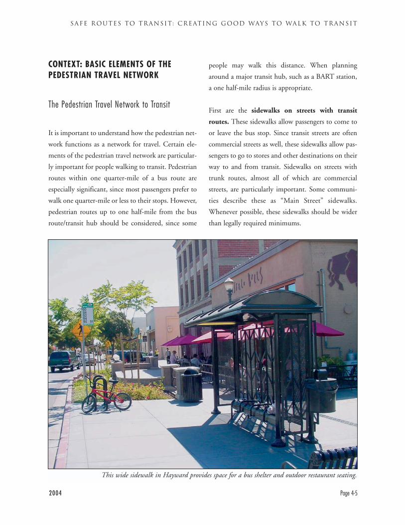
CONTEXT: BASIC ELEMENTS OF THEPEDESTRIAN TRAVEL NETWORK
The Pedestrian Travel Network to Transit
It is important to understand how the pedestrian net-
work functions as a network for travel. Certain ele-
ments of the pedestrian travel network are particular-
ly important for people walking to transit. Pedestrian
routes within one quarter-mile of a bus route are
especially significant, since most passengers prefer to
walk one quarter-mile or less to their stops. However,
pedestrian routes up to one half-mile from the bus
route/transit hub should be considered, since some
people may walk this distance. When planning
around a major transit hub, such as a BART station,
a one half-mile radius is appropriate.
First are the sidewalks on streets with transit
routes. These sidewalks allow passengers to come to
or leave the bus stop. Since transit streets are often
commercial streets as well, these sidewalks allow pas-
sengers to go to stores and other destinations on their
way to and from transit. Sidewalks on streets with
trunk routes, almost all of which are commercial
streets, are particularly important. Some communi-
ties describe these as “Main Street” sidewalks.
Whenever possible, these sidewalks should be wider
than legally required minimums.
2004 Page 4-5
SAFE ROUTES TO TRANSIT: CREATING GOOD WAYS TO WALK TO TRANSIT
This wide sidewalk in Hayward provides space for a bus shelter and outdoor restaurant seating.
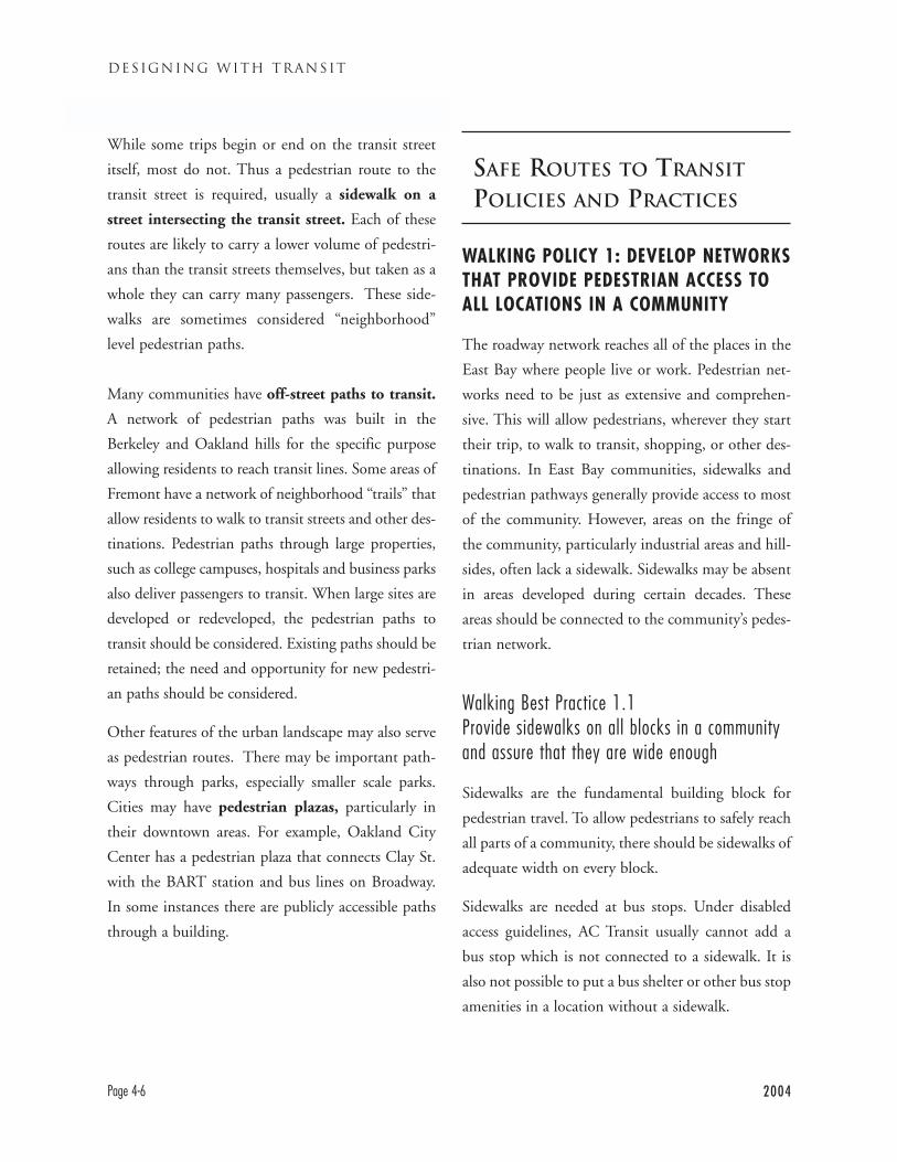
While some trips begin or end on the transit street
itself, most do not. Thus a pedestrian route to the
transit street is required, usually a sidewalk on a
street intersecting the transit street. Each of these
routes are likely to carry a lower volume of pedestri-
ans than the transit streets themselves, but taken as a
whole they can carry many passengers. These side-
walks are sometimes considered “neighborhood”
level pedestrian paths.
Many communities have off-street paths to transit.
A network of pedestrian paths was built in the
Berkeley and Oakland hills for the specific purpose
allowing residents to reach transit lines. Some areas of
Fremont have a network of neighborhood “trails” that
allow residents to walk to transit streets and other des-
tinations. Pedestrian paths through large properties,
such as college campuses, hospitals and business parks
also deliver passengers to transit. When large sites are
developed or redeveloped, the pedestrian paths to
transit should be considered. Existing paths should be
retained; the need and opportunity for new pedestri-
an paths should be considered.
Other features of the urban landscape may also serve
as pedestrian routes. There may be important path-
ways through parks, especially smaller scale parks.
Cities may have pedestrian plazas, particularly in
their downtown areas. For example, Oakland City
Center has a pedestrian plaza that connects Clay St.
with the BART station and bus lines on Broadway.
In some instances there are publicly accessible paths
through a building.
SAFE ROUTES TO TRANSIT
POLICIES AND PRACTICES
WALKING POLICY 1: DEVELOP NETWORKSTHAT PROVIDE PEDESTRIAN ACCESS TOALL LOCATIONS IN A COMMUNITY
The roadway network reaches all of the places in the
East Bay where people live or work. Pedestrian net-
works need to be just as extensive and comprehen-
sive. This will allow pedestrians, wherever they start
their trip, to walk to transit, shopping, or other des-
tinations. In East Bay communities, sidewalks and
pedestrian pathways generally provide access to most
of the community. However, areas on the fringe of
the community, particularly industrial areas and hill-
sides, often lack a sidewalk. Sidewalks may be absent
in areas developed during certain decades. These
areas should be connected to the community’s pedes-
trian network.
Walking Best Practice 1.1Provide sidewalks on all blocks in a communityand assure that they are wide enough
Sidewalks are the fundamental building block for
pedestrian travel. To allow pedestrians to safely reach
all parts of a community, there should be sidewalks of
adequate width on every block.
Sidewalks are needed at bus stops. Under disabled
access guidelines, AC Transit usually cannot add a
bus stop which is not connected to a sidewalk. It is
also not possible to put a bus shelter or other bus stop
amenities in a location without a sidewalk.
DESIGNING WITH TRANSIT
Page 4-6 2004
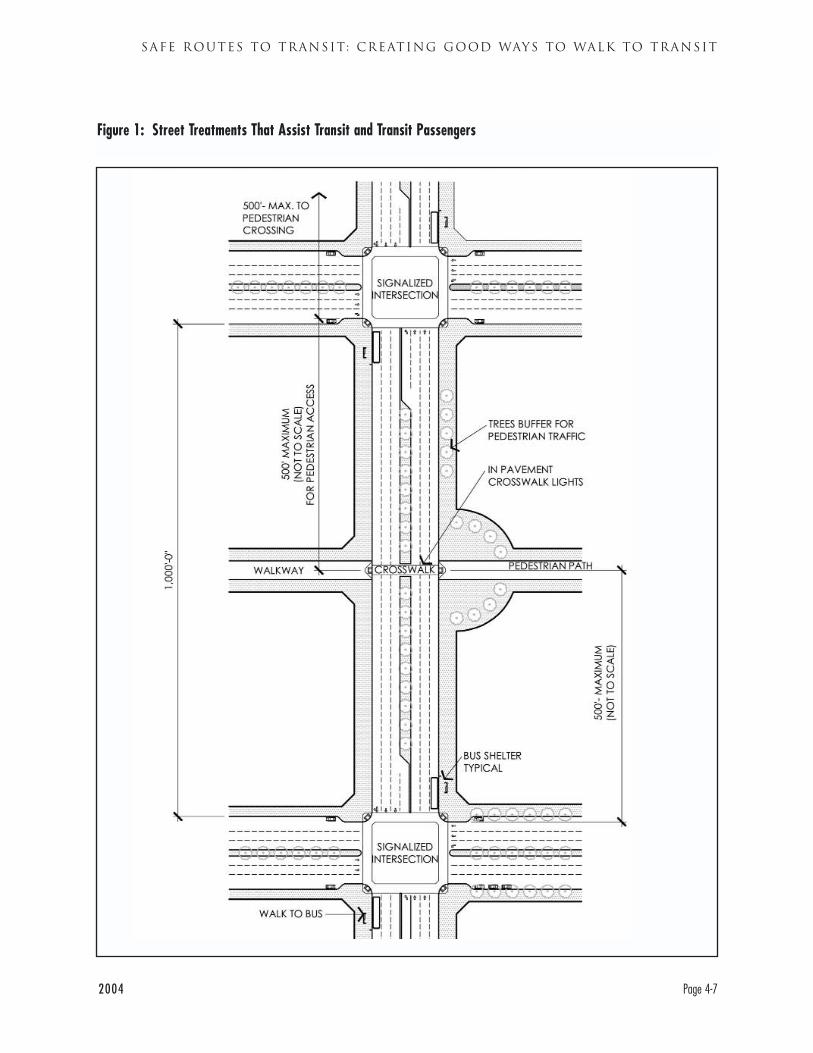
2004 Page 4-7
SAFE ROUTES TO TRANSIT: CREATING GOOD WAYS TO WALK TO TRANSIT
Figure 1: Street Treatments That Assist Transit and Transit Passengers
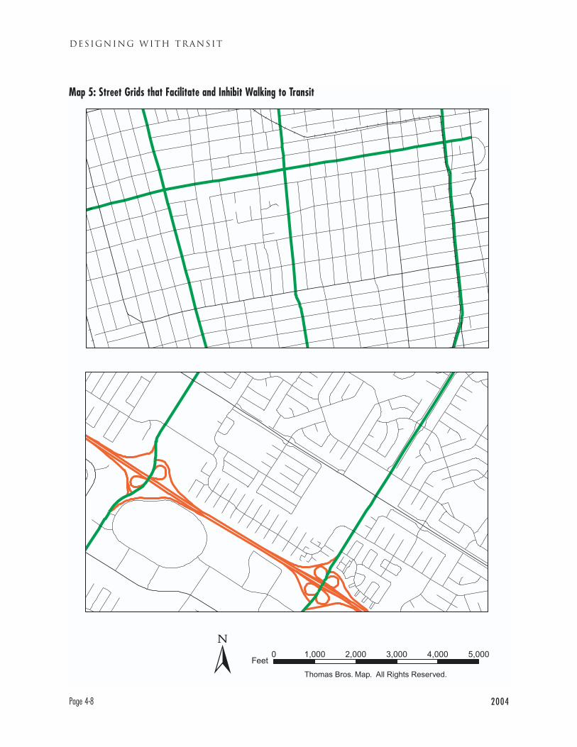
DESIGNING WITH TRANSIT
Page 4-8 2004
Map 5: Street Grids that Facilitate and Inhibit Walking to Transit
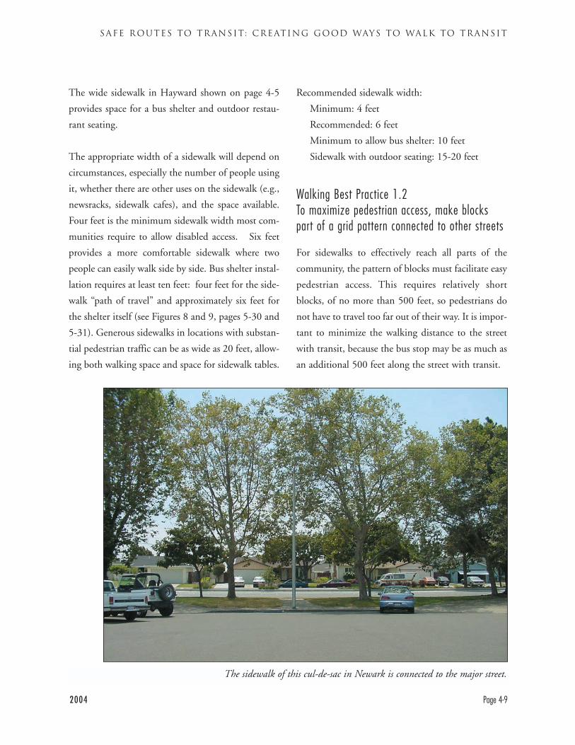
2004 Page 4-9
SAFE ROUTES TO TRANSIT: CREATING GOOD WAYS TO WALK TO TRANSIT
The wide sidewalk in Hayward shown on page 4-5
provides space for a bus shelter and outdoor restau-
rant seating.
The appropriate width of a sidewalk will depend on
circumstances, especially the number of people using
it, whether there are other uses on the sidewalk (e.g.,
newsracks, sidewalk cafes), and the space available.
Four feet is the minimum sidewalk width most com-
munities require to allow disabled access. Six feet
provides a more comfortable sidewalk where two
people can easily walk side by side. Bus shelter instal-
lation requires at least ten feet: four feet for the side-
walk “path of travel” and approximately six feet for
the shelter itself (see Figures 8 and 9, pages 5-30 and
5-31). Generous sidewalks in locations with substan-
tial pedestrian traffic can be as wide as 20 feet, allow-
ing both walking space and space for sidewalk tables.
Recommended sidewalk width:
Minimum: 4 feet
Recommended: 6 feet
Minimum to allow bus shelter: 10 feet
Sidewalk with outdoor seating: 15-20 feet
Walking Best Practice 1.2To maximize pedestrian access, make blockspart of a grid pattern connected to other streets
For sidewalks to effectively reach all parts of the
community, the pattern of blocks must facilitate easy
pedestrian access. This requires relatively short
blocks, of no more than 500 feet, so pedestrians do
not have to travel too far out of their way. It is impor-
tant to minimize the walking distance to the street
with transit, because the bus stop may be as much as
an additional 500 feet along the street with transit.
The sidewalk of this cul-de-sac in Newark is connected to the major street.
Map 5 (page 4-8) illustrates the difference that a grid
pattern with appropriate block lengths can make.
The maps show two areas in the AC Transit district.
Residents of streets on the upper map can easily walk
to the streets with bus service (darker lines) and to
the BART station near the upper right corner of the
map. They do not have to walk substantial distances
out of their way to make these connections. Some
midblock pedestrian connections not shown on the
map provide additional walking options. Residents
on the lower map, frequently have only one way in
and one way out. There is transit service on the major
streets in this area also, but many residents cannot
access it easily. There are no midblock pedestrian
connectors to provide supplemental access routes.
Redevelopment of shopping centers and other large
sites can be an opportunity to create new streets.
Often streets “T” or end at the back of shopping cen-
ters and do not provide access across the center. It
may be possible to extend these streets when the site
is redeveloped.
Older urban areas tend to have shorter blocks than
newer suburban ones. Unfortunately, urban renewal
projects have sometimes created oversized
“superblocks” by combining one or more existing
blocks. The distance between streets thus becomes
very long.11 Superblocks are difficult and sometimes
dangerous for pedestrians to cross, as they can create
large empty areas. They also often unnecessarily
interfere with traffic flow, in some cases including
bus flow.
Walking Best Practice 1.3Where blocks are long or end in cul de sacsdevelop alternative pedestrian access
Sidewalks along streets are generally the most effec-
tive and best used walkways for pedestrians.
However, in some instances, communities have poor
layouts of blocks that do not provide sidewalks in all
locations where they are needed. Blocks may be
excessively long, in some cases exceeding 1,000 feet.
Streets may end in cul-de-sacs.
Where these conditions exist there are ways to create
access besides building a new road through to reach
the site. Midblock pedestrian connectors (walkways)
can be developed. These are particularly useful for
pedestrian-friendly commercial areas and as connec-
tors to transit. The hillside paths in Oakland and
Berkeley were initially developed to connect riders to
the streetcar lines. The recently adopted Midtown
Milpitas Specific Plan calls for the addition of both
new streets and new off-street pedestrian paths to cre-
ate connections to new transit stations.
Sidewalks can also be extended from cul-de-sacs to
nearby streets, allowing pedestrians and bicyclists to
pass through while still shielding the street from auto
traffic. This is illustrated on page 4-9.
DESIGNING WITH TRANSIT
Page 4-10 2004
11 Perhaps the country's most famous superblock project is the former World Trade Centersite in New York City, which combined numerous formerly active retail blocks into a cold andforbidding superblock. The site will probably be redivided into a number of blocks.
2004 Page 4-11
SAFE ROUTES TO TRANSIT: CREATING GOOD WAYS TO WALK TO TRANSIT
WALKING POLICY 2: CREATE PEDESTRIANACCESS TO TRANSIT WHICH IS DIRECT,SAFE, UNDERSTANDABLE AND PLEASANT
Walking Best Practice 2.1Provide direct pedestrian access from activitycenters to transit lines
Pedestrian access from activity centers to transit stops
should be easy and direct. This type of pedestrian
routing will make it easier for people to walk from a
store or office to a bus stop. Routes that are not easy
and direct can discourage people from walking to a
bus stop. Meandering routes, circuitous crossings, or
unnecessary changes of grade should be avoided.12
Such impediments can also cause a pedestrian to
walk in a dangerous manner: e.g., they may cross a
street illegally when the only legal route is excessive-
ly circuitous. An example is when pedestrians wish-
ing to cross a street are directed around across the
intersecting street, then across the first street, then
back across the intersecting street in a “C” shape to
get to their destination. Many pedestrians will simply
assess the risk and cross the street directly.
Pedestrian distances and routes must be evaluated
from the pedestrian’s perspective. What seems like a
short or insignificant detour to a driver or even a
bicyclist can be onerous for pedestrians.
For these reasons, it is important to create direct
paths for pedestrians to and from activity centers.
Directional signs for pedestrians may also be useful,
particularly between major transit hubs, activity
centers, and public buildings. These need to be
placed and sized for pedestrians, not for automobile
drivers. Separate auto-oriented wayfinding signs
may also be appropriate.
Walking Best Practice 2.2Integrate transit stops into activity centers, usu-ally on the street close to key buildings
Transit access at new developments needs to be safe,
easy, and attractive. Bus stops should be sited in or
near active, central areas of complexes of buildings,
such as shopping centers and complexes. Bus stops
should not be isolated in remote locations. To effec-
tively serve passengers, transit stops at major activity
centers need to be close to the buildings they serve.
Depending on the size of the complex, more than
one bus stop may be necessary. Bus stops which are
far down an arterial street, behind a building or in a
little used part of the site are difficult for riders to use
and may seem (or be) dangerous.
Bus stops that are hidden in obscure locations also
communicate a message to transit riders that they are
unimportant; that the facility is not concerned about
their ability to travel.
In general, it is best that the bus remain on the
street that serves an activity center. Routing the bus
off the street into a building complex will generally
delay the bus more than can be justified. On-street
bus stops are usually most appropriate. They can
serve an activity center well if facilities are sited to
be easily accessible to the street and if good pedes-
trian pathways connecting buildings to bus stops
are developed.
12 Routes that require pedestrians to change levels (i.e. pedestrian bridges and under-passes) should not be created. Pedestrians tend to avoid these routes in favor of quicker sur-face level routes. Because they are isolated from street level activity and surveillance, bridgesand tunnels may become locations for crime.
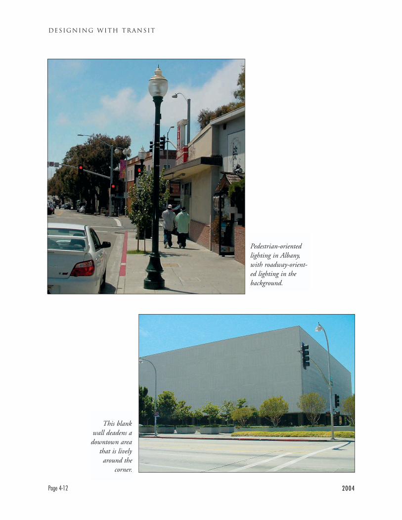
DESIGNING WITH TRANSIT
Page 4-12 2004
This blankwall deadens a
downtown areathat is livelyaround the
corner.
Pedestrian-orientedlighting in Albany,with roadway-orient-ed lighting in thebackground.
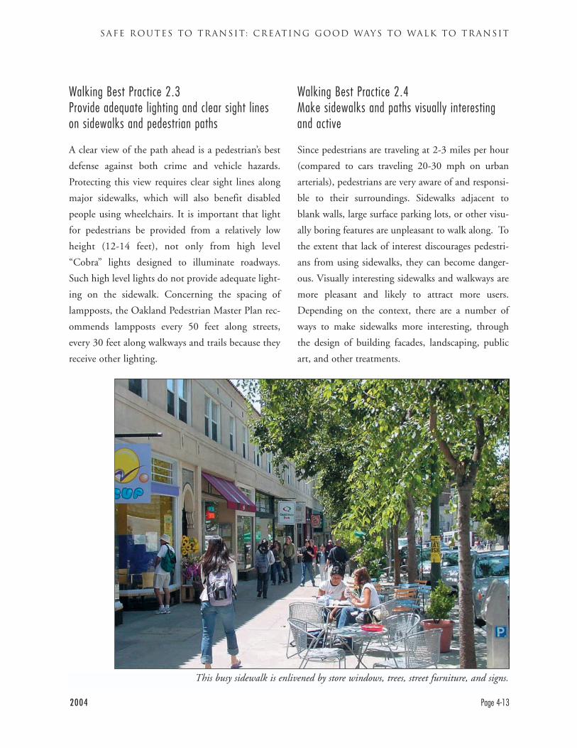
2004 Page 4-13
SAFE ROUTES TO TRANSIT: CREATING GOOD WAYS TO WALK TO TRANSIT
Walking Best Practice 2.3Provide adequate lighting and clear sight lineson sidewalks and pedestrian paths
A clear view of the path ahead is a pedestrian’s best
defense against both crime and vehicle hazards.
Protecting this view requires clear sight lines along
major sidewalks, which will also benefit disabled
people using wheelchairs. It is important that light
for pedestrians be provided from a relatively low
height (12-14 feet), not only from high level
“Cobra” lights designed to illuminate roadways.
Such high level lights do not provide adequate light-
ing on the sidewalk. Concerning the spacing of
lampposts, the Oakland Pedestrian Master Plan rec-
ommends lampposts every 50 feet along streets,
every 30 feet along walkways and trails because they
receive other lighting.
Walking Best Practice 2.4Make sidewalks and paths visually interestingand active
Since pedestrians are traveling at 2-3 miles per hour
(compared to cars traveling 20-30 mph on urban
arterials), pedestrians are very aware of and responsi-
ble to their surroundings. Sidewalks adjacent to
blank walls, large surface parking lots, or other visu-
ally boring features are unpleasant to walk along. To
the extent that lack of interest discourages pedestri-
ans from using sidewalks, they can become danger-
ous. Visually interesting sidewalks and walkways are
more pleasant and likely to attract more users.
Depending on the context, there are a number of
ways to make sidewalks more interesting, through
the design of building facades, landscaping, public
art, and other treatments.
This busy sidewalk is enlivened by store windows, trees, street furniture, and signs.
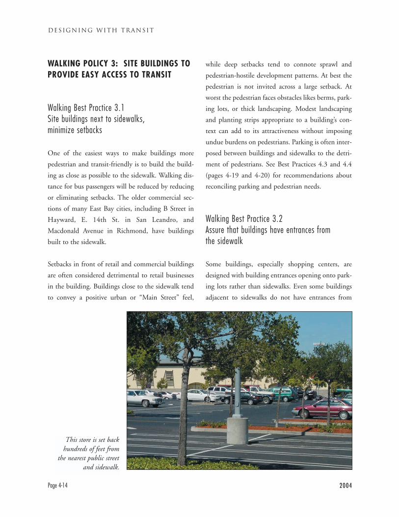
DESIGNING WITH TRANSIT
Page 4-14 2004
WALKING POLICY 3: SITE BUILDINGS TOPROVIDE EASY ACCESS TO TRANSIT
Walking Best Practice 3.1Site buildings next to sidewalks,minimize setbacks
One of the easiest ways to make buildings more
pedestrian and transit-friendly is to build the build-
ing as close as possible to the sidewalk. Walking dis-
tance for bus passengers will be reduced by reducing
or eliminating setbacks. The older commercial sec-
tions of many East Bay cities, including B Street in
Hayward, E. 14th St. in San Leandro, and
Macdonald Avenue in Richmond, have buildings
built to the sidewalk.
Setbacks in front of retail and commercial buildings
are often considered detrimental to retail businesses
in the building. Buildings close to the sidewalk tend
to convey a positive urban or “Main Street” feel,
while deep setbacks tend to connote sprawl and
pedestrian-hostile development patterns. At best the
pedestrian is not invited across a large setback. At
worst the pedestrian faces obstacles likes berms, park-
ing lots, or thick landscaping. Modest landscaping
and planting strips appropriate to a building’s con-
text can add to its attractiveness without imposing
undue burdens on pedestrians. Parking is often inter-
posed between buildings and sidewalks to the detri-
ment of pedestrians. See Best Practices 4.3 and 4.4
(pages 4-19 and 4-20) for recommendations about
reconciling parking and pedestrian needs.
Walking Best Practice 3.2Assure that buildings have entrances fromthe sidewalk
Some buildings, especially shopping centers, are
designed with building entrances opening onto park-
ing lots rather than sidewalks. Even some buildings
adjacent to sidewalks do not have entrances from
This store is set backhundreds of feet from
the nearest public streetand sidewalk.
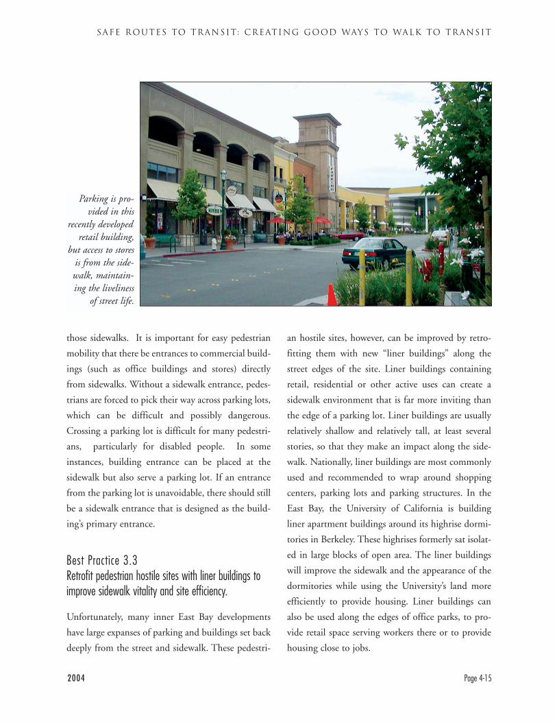
2004 Page 4-15
SAFE ROUTES TO TRANSIT: CREATING GOOD WAYS TO WALK TO TRANSIT
those sidewalks. It is important for easy pedestrian
mobility that there be entrances to commercial build-
ings (such as office buildings and stores) directly
from sidewalks. Without a sidewalk entrance, pedes-
trians are forced to pick their way across parking lots,
which can be difficult and possibly dangerous.
Crossing a parking lot is difficult for many pedestri-
ans, particularly for disabled people. In some
instances, building entrance can be placed at the
sidewalk but also serve a parking lot. If an entrance
from the parking lot is unavoidable, there should still
be a sidewalk entrance that is designed as the build-
ing’s primary entrance.
Best Practice 3.3Retrofit pedestrian hostile sites with liner buildings toimprove sidewalk vitality and site efficiency.
Unfortunately, many inner East Bay developments
have large expanses of parking and buildings set back
deeply from the street and sidewalk. These pedestri-
an hostile sites, however, can be improved by retro-
fitting them with new “liner buildings” along the
street edges of the site. Liner buildings containing
retail, residential or other active uses can create a
sidewalk environment that is far more inviting than
the edge of a parking lot. Liner buildings are usually
relatively shallow and relatively tall, at least several
stories, so that they make an impact along the side-
walk. Nationally, liner buildings are most commonly
used and recommended to wrap around shopping
centers, parking lots and parking structures. In the
East Bay, the University of California is building
liner apartment buildings around its highrise dormi-
tories in Berkeley. These highrises formerly sat isolat-
ed in large blocks of open area. The liner buildings
will improve the sidewalk and the appearance of the
dormitories while using the University’s land more
efficiently to provide housing. Liner buildings can
also be used along the edges of office parks, to pro-
vide retail space serving workers there or to provide
housing close to jobs.
Parking is pro-vided in this
recently developedretail building,
but access to storesis from the side-walk, maintain-ing the liveliness
of street life.
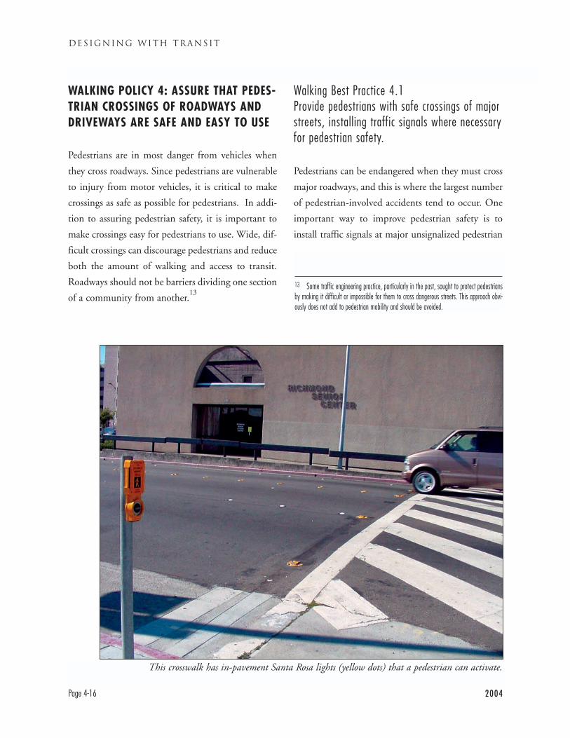
DESIGNING WITH TRANSIT
Page 4-16 2004
WALKING POLICY 4: ASSURE THAT PEDES-TRIAN CROSSINGS OF ROADWAYS ANDDRIVEWAYS ARE SAFE AND EASY TO USE
Pedestrians are in most danger from vehicles when
they cross roadways. Since pedestrians are vulnerable
to injury from motor vehicles, it is critical to make
crossings as safe as possible for pedestrians. In addi-
tion to assuring pedestrian safety, it is important to
make crossings easy for pedestrians to use. Wide, dif-
ficult crossings can discourage pedestrians and reduce
both the amount of walking and access to transit.
Roadways should not be barriers dividing one section
of a community from another.13
Walking Best Practice 4.1Provide pedestrians with safe crossings of majorstreets, installing traffic signals where necessaryfor pedestrian safety.
Pedestrians can be endangered when they must cross
major roadways, and this is where the largest number
of pedestrian-involved accidents tend to occur. One
important way to improve pedestrian safety is to
install traffic signals at major unsignalized pedestrian
This crosswalk has in-pavement Santa Rosa lights (yellow dots) that a pedestrian can activate.
13 Some traffic engineering practice, particularly in the past, sought to protect pedestriansby making it difficult or impossible for them to cross dangerous streets. This approach obvi-ously does not add to pedestrian mobility and should be avoided.
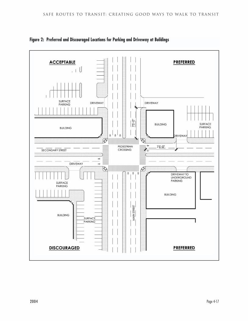
2004 Page 4-17
SAFE ROUTES TO TRANSIT: CREATING GOOD WAYS TO WALK TO TRANSIT
Figure 2: Preferred and Discouraged Locations for Parking and Driveway at Buildings
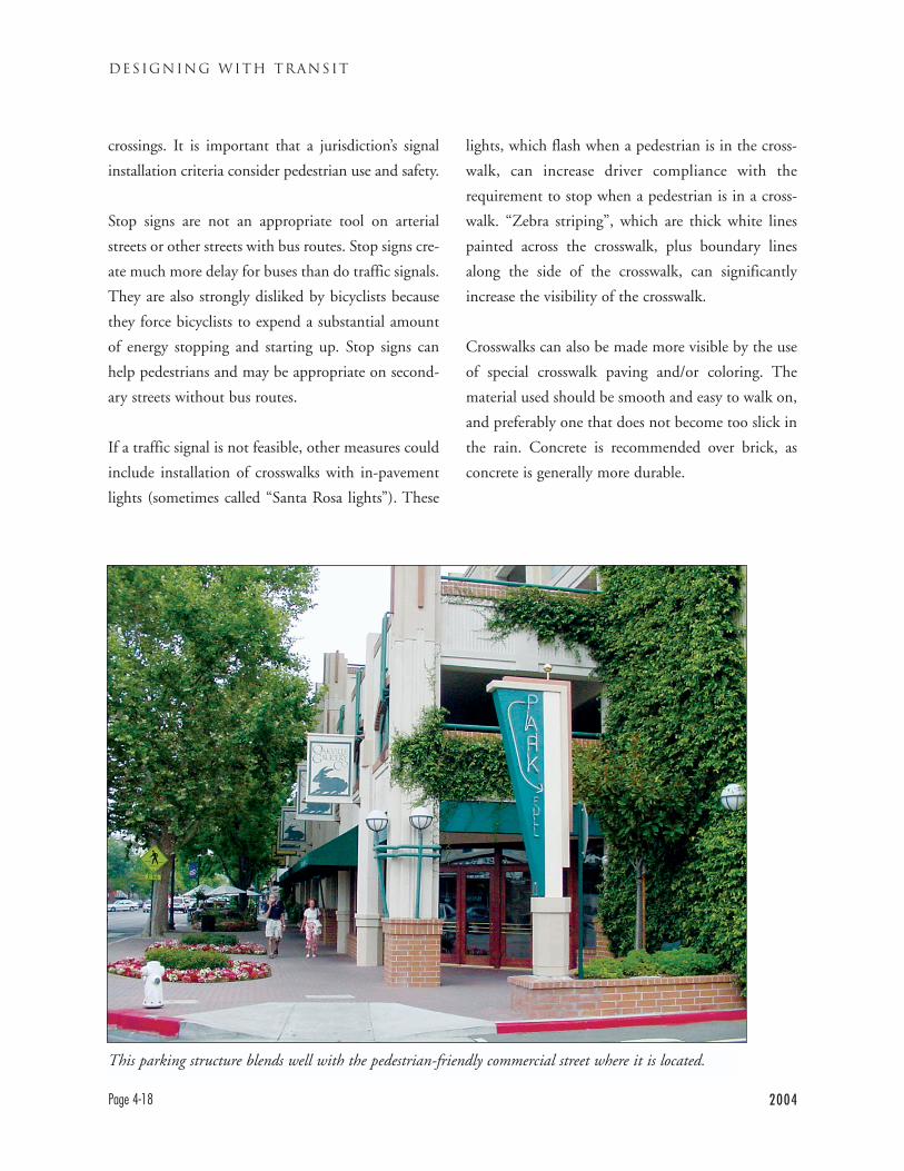
DESIGNING WITH TRANSIT
Page 4-18 2004
crossings. It is important that a jurisdiction’s signal
installation criteria consider pedestrian use and safety.
Stop signs are not an appropriate tool on arterial
streets or other streets with bus routes. Stop signs cre-
ate much more delay for buses than do traffic signals.
They are also strongly disliked by bicyclists because
they force bicyclists to expend a substantial amount
of energy stopping and starting up. Stop signs can
help pedestrians and may be appropriate on second-
ary streets without bus routes.
If a traffic signal is not feasible, other measures could
include installation of crosswalks with in-pavement
lights (sometimes called “Santa Rosa lights”). These
lights, which flash when a pedestrian is in the cross-
walk, can increase driver compliance with the
requirement to stop when a pedestrian is in a cross-
walk. “Zebra striping”, which are thick white lines
painted across the crosswalk, plus boundary lines
along the side of the crosswalk, can significantly
increase the visibility of the crosswalk.
Crosswalks can also be made more visible by the use
of special crosswalk paving and/or coloring. The
material used should be smooth and easy to walk on,
and preferably one that does not become too slick in
the rain. Concrete is recommended over brick, as
concrete is generally more durable.
This parking structure blends well with the pedestrian-friendly commercial street where it is located.
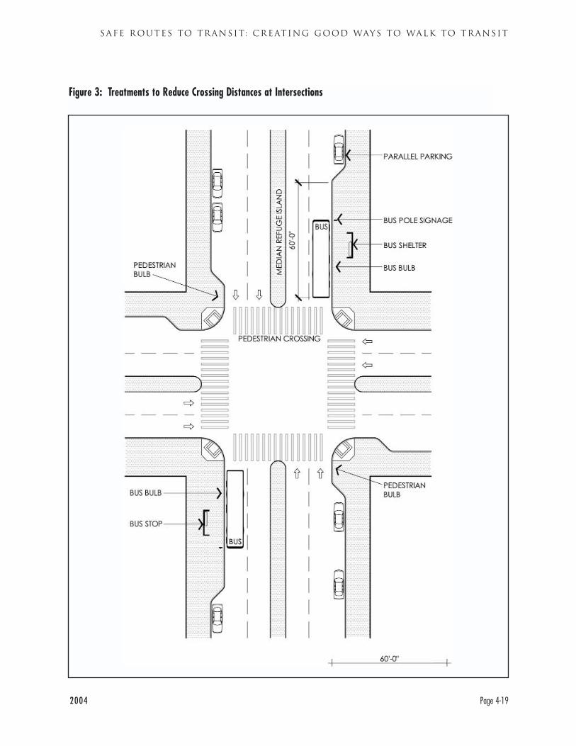
2004 Page 4-19
SAFE ROUTES TO TRANSIT: CREATING GOOD WAYS TO WALK TO TRANSIT
Figure 3: Treatments to Reduce Crossing Distances at Intersections
Walking Best Practice 4.2Minimize roadway crossing distances withoutcompromising bus operations
Wide roadways are both physically difficult to cross
and create a psychological “fence” effect for pedestri-
ans: pedestrians can be reluctant to cross them. Such
roads also reflect excessive heat into the environment.
Every effort should be made to minimize the width
of roadways consistent with transit operations.
Multi-lane arterial roadways are often larger than
needed for traffic volumes, especially in newer com-
munities. These roads can be narrowed without
compromising reasonable traffic flow, including bus
flow. Communities narrowing roads must be careful
not to narrow them so much that bus traffic is
impeded. As discussed in Chapter 5, adequate lane
width for buses must be maintained. Roadways can
be narrowed by widening sidewalks, thereby improv-
ing conditions for pedestrians walking along the
arterial as well as for those crossing it. Such narrow-
ing both improves conditions for pedestrians and
reduces excessive vehicle speeds.
In some instances it is not feasible to reduce overall
roadway width. In these circumstances it can be help-
ful to reduce the pedestrian’s effective crossing dis-
tance at intersections. Pedestrian bulbs extending
from the sidewalk can shorten crossing distances.
“Refuge islands” on medians where pedestrians can
wait before crossing opposing traffic are another
technique, although they may or may not be com-
fortable places to wait.
Pedestrian bulbs must be designed carefully so they
do not interfere with bus movement. Pedestrian
bulbs less than 40 feet long (the length of a bus)
should not be placed adjacent to bus stops. If bulbs
are installed next to bus stops, they should be length-
ened so they are the full length of the bus (see dis-
cussion of bus bulbs in Section 5.2). If the bulb is
shorter than the bus, it will block the bus from
pulling fully into the curb, creating a safety hazard
particularly for disabled riders.
Walking Best Practice 4.3Limit vehicle turning movements across activesidewalks and walkways.
Pedestrians can be endangered or impeded when they
must cross roadways and driveways with major turn-
ing movements, such as entrances to large parking
lots. Pedestrians should protected as much as possible
from these conflicts. One way to do so is move drive-
ways away from more active sidewalks and pedestri-
an locations, as illustrated in Figure 2 (Page 4-17).
Placing driveways into a major facility on the side or
rear of that facility will probably reduce conflicts
with pedestrians.
The number of driveways crossing active sidewalks
should also be limited. Walnut Creek, for example,
has allowed only one driveway per block in new
downtown commercial development. Consolidating
parking lots together into joint lots and structures
can also reduce the number of driveways.
Free right and left turns on roadways, where vehicles
can make in a turn in a lane separate from the main
travel lane, raise similar problems. These turn lanes
are also known as “slip turns.” Drivers often go
through these turns at high speed and do not neces-
sarily carefully observe whether pedestrians are cross-
ing them. In many instances, these free turns can be
removed without causing undue traffic congestion.
DESIGNING WITH TRANSIT
Page 4-20 2004
2004 Page 4-21
SAFE ROUTES TO TRANSIT: CREATING GOOD WAYS TO WALK TO TRANSIT
Walking Best Practice 4.4Locate parking to minimize interference withpedestrian movements into buildings.
Traffic in and out of parking lots can be a major
source of “friction” or hazard to pedestrians. The
previous chapter discussed the importance of mini-
mizing the total amount of parking.
Locating remaining parking where it will impact
pedestrians least is also critical. Do not place parking
between a building, especially a major activity cen-
ter, and a bus stop.
Underground or below grade parking accessed by a
single driveway will reduce parking’s impact on
pedestrians. Above grade parking, such as parking
on the roof of a commercial structure, will also have
the beneficial impact of channeling cars up a single
driveway. If parking is on the surface, parking in the
rear of the building will allow pedestrians to access
the front with less interference from cars. In some
cases, parking to the side of a building while main-
taining a pedestrian-oriented front entrance is
acceptable. Parking in front of the building is the
poorest approach, as it generally means that pedes-
trians will have to find their way among cars to reach
the building.
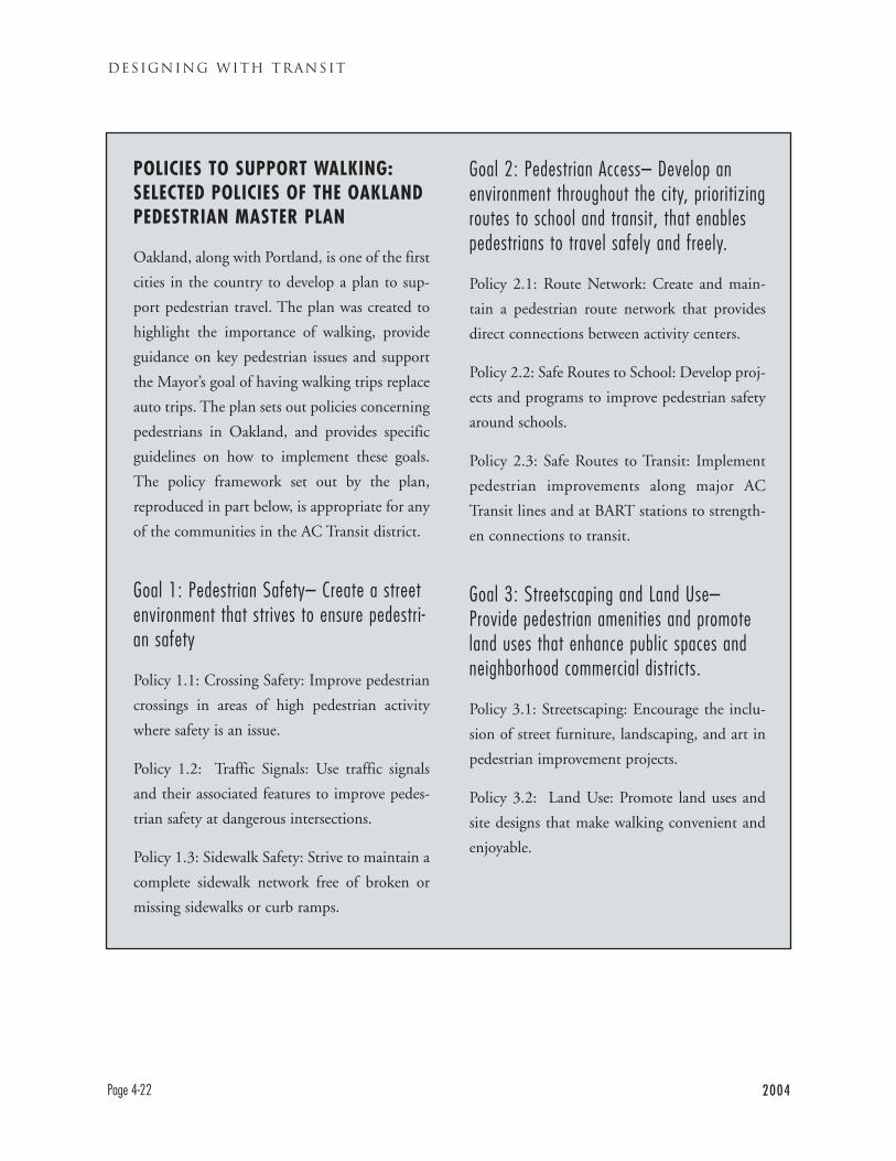
POLICIES TO SUPPORT WALKING:SELECTED POLICIES OF THE OAKLANDPEDESTRIAN MASTER PLAN
Oakland, along with Portland, is one of the first
cities in the country to develop a plan to sup-
port pedestrian travel. The plan was created to
highlight the importance of walking, provide
guidance on key pedestrian issues and support
the Mayor’s goal of having walking trips replace
auto trips. The plan sets out policies concerning
pedestrians in Oakland, and provides specific
guidelines on how to implement these goals.
The policy framework set out by the plan,
reproduced in part below, is appropriate for any
of the communities in the AC Transit district.
Goal 1: Pedestrian Safety– Create a streetenvironment that strives to ensure pedestri-an safety
Policy 1.1: Crossing Safety: Improve pedestrian
crossings in areas of high pedestrian activity
where safety is an issue.
Policy 1.2: Traffic Signals: Use traffic signals
and their associated features to improve pedes-
trian safety at dangerous intersections.
Policy 1.3: Sidewalk Safety: Strive to maintain a
complete sidewalk network free of broken or
missing sidewalks or curb ramps.
Goal 2: Pedestrian Access– Develop anenvironment throughout the city, prioritizingroutes to school and transit, that enablespedestrians to travel safely and freely.
Policy 2.1: Route Network: Create and main-
tain a pedestrian route network that provides
direct connections between activity centers.
Policy 2.2: Safe Routes to School: Develop proj-
ects and programs to improve pedestrian safety
around schools.
Policy 2.3: Safe Routes to Transit: Implement
pedestrian improvements along major AC
Transit lines and at BART stations to strength-
en connections to transit.
Goal 3: Streetscaping and Land Use–Provide pedestrian amenities and promoteland uses that enhance public spaces andneighborhood commercial districts.
Policy 3.1: Streetscaping: Encourage the inclu-
sion of street furniture, landscaping, and art in
pedestrian improvement projects.
Policy 3.2: Land Use: Promote land uses and
site designs that make walking convenient and
enjoyable.
DESIGNING WITH TRANSIT
Page 4-22 2004
INTRODUCTION
Chapter 3 described how a community can become a vibrant mixed use place, closely linked to transit.
Chapter 4 discussed how to get the citizenry walking to the bus, by creating a pleasant, enjoyable system of
sidewalks and paths. Communities also need a network of streets for the buses to operate on and stop along.
This chapter considers the basic requirements for having a functional, transit-supportive network of streets
and stops.
Trains have tracks, buses have streets. Unlike a track, a street is a usually a “multimodal” environment. It is
multimodal because bicycles, buses, cars, motorcycles, and trucks are all allowed to operate on the street and
pedestrians are allowed to cross it. There are often parked vehicles on the street as well as moving ones. The
challenge for communities is assuring that people using any mode have safe, pleasant and efficient ways to trav-
el through key corridors.
This chapter describes what is needed for effective bus transit in this multimodal East Bay environment. The
details of how a bus travels and stops on a street can make an enormous difference in how well its bus line
functions, and what passengers’ experiences are. Seemingly minor factors can determine whether a bus travels
quickly or slowly, whether it moves through traffic smoothly or with difficulty.
2004 Page 5-1
TRANSIT-FRIENDLY STREETS : MAKING STREETS WORK FOR TRANSIT
CHAPTER 5
TRANSIT-FRIENDLY STREETS: MAKING STREETS WORK FOR TRANSIT
CHAPTER GUIDE
Topic: How to make the street and sidewalk system work for buses and bus passengers
Particular Audience: Traffic and transportation engineers, transportation planners
Subject of Recommendations: Street layouts, striping plans, sidewalk layouts, streetscape plans,
signal timing plans
Many of AC Transit’s discussions with communities are about street and stop related issues. Most communi-
ties strive to accommodate AC Transit while dealing with their own concerns. Many important bus routes
have been transit corridors for decades. However, the management of some streets has been so oriented to auto-
mobiles that buses and other modes suffer.
This chapter outlines the basic framework for on-street bus operations. It discusses how to work with AC
Transit to designate a network of streets for transit. The chapter looks at streets and sidewalks as the place for
an integrated system of routes and stops. The chapter also looks at:
• What are the characteristics of streets which are good for transit?
• How can streets and roads be made better for transit?
• Where should bus stops be?
• How should bus stops be set up on the road?
• How should bus stops be set up on the sidewalk?
Note: this chapter illustrates minimum and/or required dimensions for many important items, such as the
length of the bus stop. However, there are roadway, sidewalk, and bus stop features illustrated in the figures
and photographs and described in the text that do not have specific dimensions recommended by AC Transit.
Readers should not assume that any dimensions or configurations of these features that are shown on or implic-
it in these figures, photographs, or text are recommended by AC Transit.
The test for this chapter is what the experience on waiting for and riding a bus is like: “Do I feel safe at the
bus stop? Is it a pleasant place to wait? Does the ride on the bus seem smooth and fast? Or is it strewn
with needless obstacles and delays?”
DESIGNING WITH TRANSIT
Page 5-2 2004
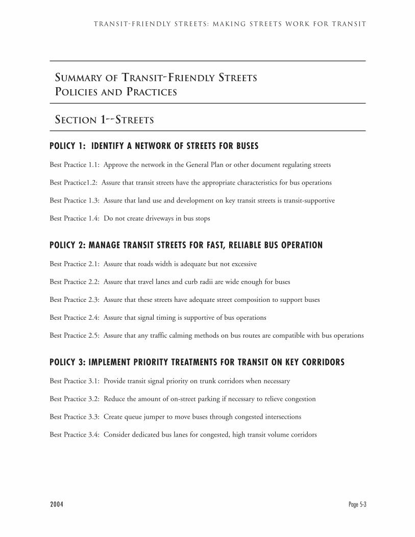
SUMMARY OF TRANSIT-FRIENDLY STREETS
POLICIES AND PRACTICES
SECTION 1--STREETS
POLICY 1: IDENTIFY A NETWORK OF STREETS FOR BUSES
Best Practice 1.1: Approve the network in the General Plan or other document regulating streets
Best Practice1.2: Assure that transit streets have the appropriate characteristics for bus operations
Best Practice 1.3: Assure that land use and development on key transit streets is transit-supportive
Best Practice 1.4: Do not create driveways in bus stops
POLICY 2: MANAGE TRANSIT STREETS FOR FAST, RELIABLE BUS OPERATION
Best Practice 2.1: Assure that roads width is adequate but not excessive
Best Practice 2.2: Assure that travel lanes and curb radii are wide enough for buses
Best Practice 2.3: Assure that these streets have adequate street composition to support buses
Best Practice 2.4: Assure that signal timing is supportive of bus operations
Best Practice 2.5: Assure that any traffic calming methods on bus routes are compatible with bus operations
POLICY 3: IMPLEMENT PRIORITY TREATMENTS FOR TRANSIT ON KEY CORRIDORS
Best Practice 3.1: Provide transit signal priority on trunk corridors when necessary
Best Practice 3.2: Reduce the amount of on-street parking if necessary to relieve congestion
Best Practice 3.3: Create queue jumper to move buses through congested intersections
Best Practice 3.4: Consider dedicated bus lanes for congested, high transit volume corridors
2004 Page 5-3
TRANSIT-FRIENDLY STREETS : MAKING STREETS WORK FOR TRANSIT
SECTION 2--BUS STOPS
POLICY 4: SITE BUS STOPS AT SAFE, EFFICIENT, AND CONVENIENT LOCATIONS
Best Practice 4.1: Site bus stops to balance speed and convenience concerns
Best Practice 4.2: Site bus stops in the best operational locations, usually on the far side of an intersection
Best Practice 4.3: Site bus stops where passengers are less likely to experience crime
POLICY 5: LOCATE BUS STOPS APPROPRIATELY WITHIN THE RIGHT OF WAY
Best Practice 5.1: Provide a curbside bus stop in most instances
Best Practice 5.2: Install bus bulbs where they would facilitate bus operation and pedestrian movement
Best Practice 5.3: Avoid bus pullouts (turnouts)
Best Practice 5.4: Design Transit Centers for effective, efficient operation
POLICY 6: CREATE SAFE, FUNCTIONAL AND LEGAL BUS STOPS WITH NEEDEDAMENITIES
Best Practice 6.1: Make bus stops long enough for the buses that will use them
Best Practice 6.2: Paint the curb at bus stops red
Best Practice 6.3: Assure that sidewalks are wide enough and clear enough for bus stops
Best Practice 6.4: Provide an ADA compliant bus boarding/alighting area of at least 8 feet by 5 feet
Best Practice 6.5: Provide bus shelters with appropriate amenities
DESIGNING WITH TRANSIT
Page 5-4 2004
CONTEXT
MULTIMODAL CORRIDORS--ACKNOWLEDGING THEM, MAKING THEMWORK FOR BUS TRANSIT
Multimodalism in the East Bay
The streets of the East Bay are inherently “multi-
modal” in that they carry the “modes” of cars, buses,
bikes, etc. Many of the streets of the East Bay, espe-
cially in the older areas, were originally designed
around streetcar lines. However in the last half-centu-
ry many East Bay streets were planned (or re-planned)
for the benefit of motor vehicles, of private cars.
Traffic engineering has historically sought to move
cars, while a multimodal approach seeks to move
people. The standard approach measures and
processes vehicle trips, while multimodalism handles
person trips, whether the traveling persons are in cars,
on buses, on bicycles, etc. The person trip approach is
sometimes described as a concern with “throughput,”
how many people can move through a corridor. A
vehicle trip approach would treat both a bus with 15
passengers and a single occupant car as one vehicle
trip and act upon the fact. A throughput approach
would recognize and act upon the fact that the bus
carries 15 people through the corridor, while the car
carries one.
Transportation planning has begun to be multi-
modal, to give serious attention to modes other than
automobiles. In the last few years, particularly in the
East Bay, bicycles have gained long-needed attention.
Cities and counties have developed Bicycle Plans,
particularly once funding was tied to adoption of a
bike plan. These plans typically designate routes,
whether striped bike lanes or other facilities, and set
standards for bicycle facilities. Oakland has devel-
oped a Pedestrian Master Plan, and several other
East Bay communities are planning to do so. Local
plans for transit have also been rare, although the city
of Alameda has adopted such a plan, and Oakland
and Berkeley have identified transit street networks.
The net result is that most road managing agencies
have moved towards more inclusive traffic engineer-
ing. But comprehensive multimodalism (streets,
roads, and corridors managed to genuinely support
all modes) has not been achieved. Moving cars often
remains agencies’ paramount objective. The purpose
of this chapter of Designing With Transit is to further
the process of integrating buses into multimodal
planning, by describing the many practical approach-
es for doing so.
AC Transit: Main Street is Our Route
Good multimodal street planning is not just a buzz-
word for AC Transit, but a vital necessity. The main
streets AC Transit uses are often the most congest-
ed, the most multimodal and are the most complex
in their area. AC Transit’s trunk routes and major
routes often operate along major commercial
streets, such as International Boulevard/E. 14th
Street, Telegraph and Shattuck avenues. They oper-
ate along major through routes such as San Pablo
Avenue (State Highway 123), Hesperian and
Mission boulevards (State Highway 238). Our
buses also operate on dense, narrow streets such as
College and Solano avenues.
2004 Page 5-5
TRANSIT-FRIENDLY STREETS : MAKING STREETS WORK FOR TRANSIT
Unlike other modes which can divert from congest-
ed routes, transit buses generally must travel on main
streets. Passengers know that the bus has been there
historically, and have a reasonable expectation that it
will remain there. The main streets provide longer
distance through routes. Key destinations, especially
retail and commercial uses, are often found along the
main streets. Residents of secondary streets would
not necessarily appreciate having major through bus
operations moved to their streets.
IMPROVING MULTIMODAL CORRIDORSFOR TRANSIT
AC Transit’s trunk/major routes are embedded in
major streets, which are themselves integral to travel
corridors. How should these corridors be designed
and managed to support transit?
This handbook assumes that bus transit will play a
continuing and increasing role on the trunk and
major corridors. AC Transit’s plans, the Metropolitan
Transportation Commission’s plans, and the cities’
plans all call for improved transit service. This hand-
book also assumes that the overall width of major
East Bay streets is generally fixed or almost so.
Therefore, the recommendations do not depend on
roadway widening, although it may be appropriate to
reallocate portions of the right-of-way to different
uses.
Designing With Transit suggests a series of practical
approaches that will maximize the efficiency and
effectiveness of transit on these corridors. These poli-
cies do not compromise the efficiency of other
modes. In fact, many of them facilitate travel by both
transit and other modes. Policy 1 discusses planning
to support transit corridors. Policies 2 and 3 focus on
physical facilities needed on the street while also
including some recommended traffic management
practices (e.g. signal timing). Policy 3 addresses how
transit corridors can be taken to a higher level of per-
formance by implementing transit priority measures.
Policies 4 through 6 shift the focus to the needs of
bus stops.
DESIGNING WITH TRANSIT
Page 5-6 2004
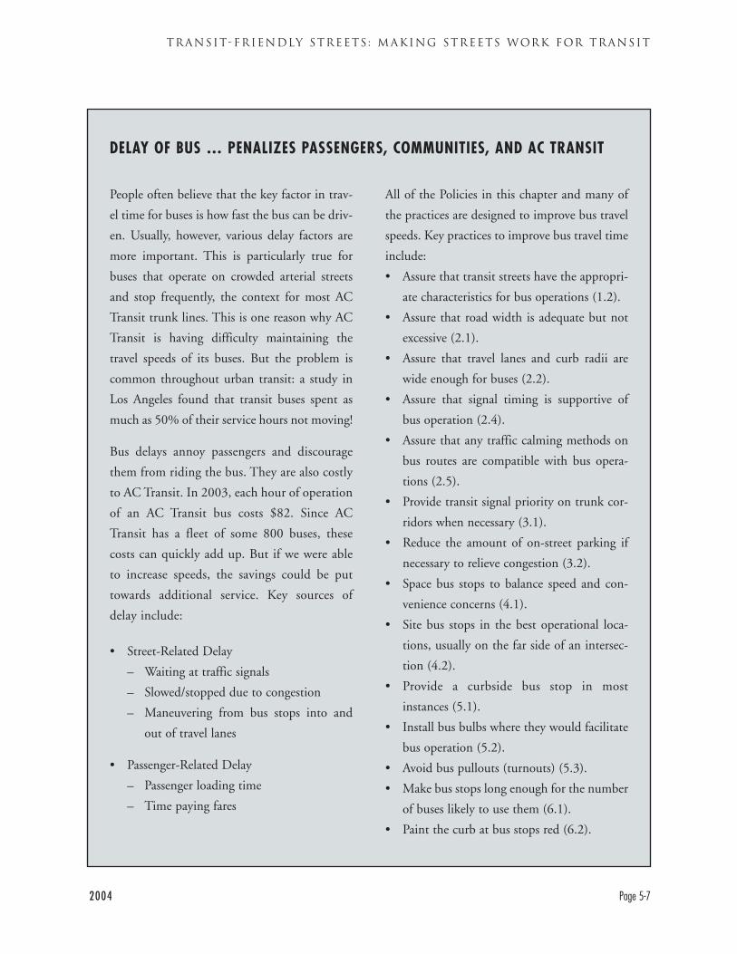
People often believe that the key factor in trav-
el time for buses is how fast the bus can be driv-
en. Usually, however, various delay factors are
more important. This is particularly true for
buses that operate on crowded arterial streets
and stop frequently, the context for most AC
Transit trunk lines. This is one reason why AC
Transit is having difficulty maintaining the
travel speeds of its buses. But the problem is
common throughout urban transit: a study in
Los Angeles found that transit buses spent as
much as 50% of their service hours not moving!
Bus delays annoy passengers and discourage
them from riding the bus. They are also costly
to AC Transit. In 2003, each hour of operation
of an AC Transit bus costs $82. Since AC
Transit has a fleet of some 800 buses, these
costs can quickly add up. But if we were able
to increase speeds, the savings could be put
towards additional service. Key sources of
delay include:
• Street-Related Delay
– Waiting at traffic signals
– Slowed/stopped due to congestion
– Maneuvering from bus stops into and
out of travel lanes
• Passenger-Related Delay
– Passenger loading time
– Time paying fares
All of the Policies in this chapter and many of
the practices are designed to improve bus travel
speeds. Key practices to improve bus travel time
include:
• Assure that transit streets have the appropri-
ate characteristics for bus operations (1.2).
• Assure that road width is adequate but not
excessive (2.1).
• Assure that travel lanes and curb radii are
wide enough for buses (2.2).
• Assure that signal timing is supportive of
bus operation (2.4).
• Assure that any traffic calming methods on
bus routes are compatible with bus opera-
tions (2.5).
• Provide transit signal priority on trunk cor-
ridors when necessary (3.1).
• Reduce the amount of on-street parking if
necessary to relieve congestion (3.2).
• Space bus stops to balance speed and con-
venience concerns (4.1).
• Site bus stops in the best operational loca-
tions, usually on the far side of an intersec-
tion (4.2).
• Provide a curbside bus stop in most
instances (5.1).
• Install bus bulbs where they would facilitate
bus operation (5.2).
• Avoid bus pullouts (turnouts) (5.3).
• Make bus stops long enough for the number
of buses likely to use them (6.1).
• Paint the curb at bus stops red (6.2).
2004 Page 5-7
TRANSIT-FRIENDLY STREETS : MAKING STREETS WORK FOR TRANSIT
DELAY OF BUS … PENALIZES PASSENGERS, COMMUNITIES, AND AC TRANSIT
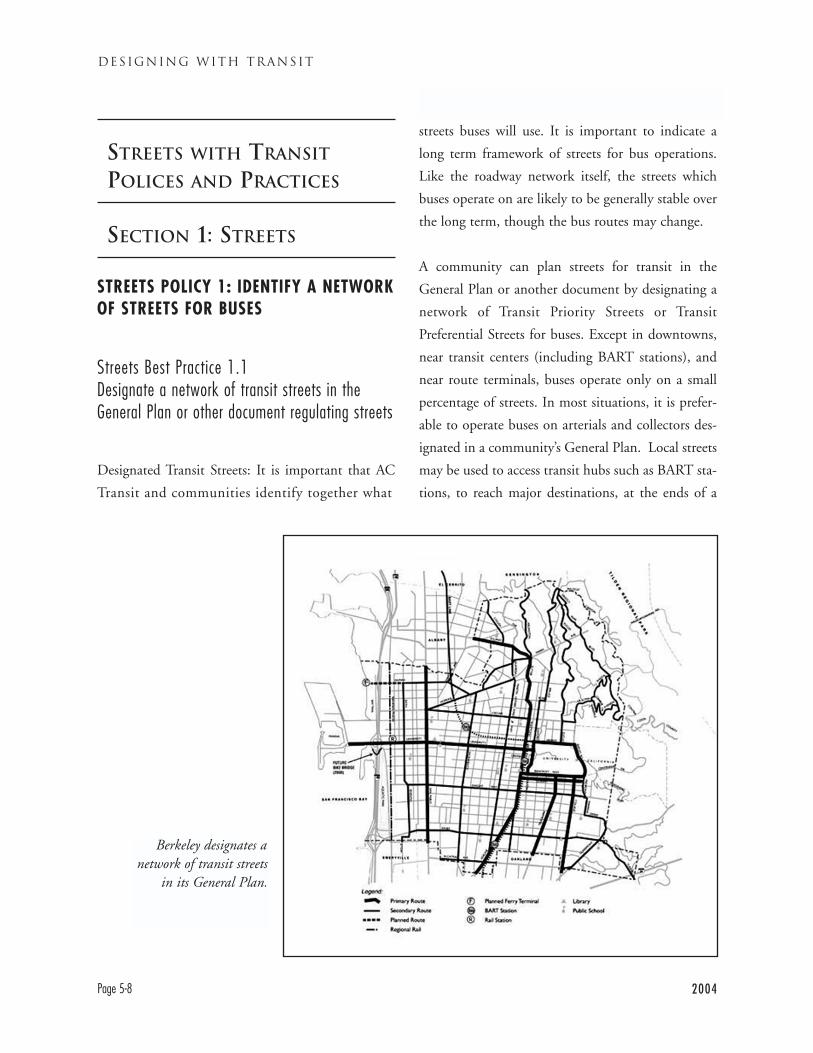
STREETS WITH TRANSIT
POLICES AND PRACTICES
SECTION 1: STREETS
STREETS POLICY 1: IDENTIFY A NETWORKOF STREETS FOR BUSES
Streets Best Practice 1.1Designate a network of transit streets in theGeneral Plan or other document regulating streets
Designated Transit Streets: It is important that AC
Transit and communities identify together what
streets buses will use. It is important to indicate a
long term framework of streets for bus operations.
Like the roadway network itself, the streets which
buses operate on are likely to be generally stable over
the long term, though the bus routes may change.
A community can plan streets for transit in the
General Plan or another document by designating a
network of Transit Priority Streets or Transit
Preferential Streets for buses. Except in downtowns,
near transit centers (including BART stations), and
near route terminals, buses operate only on a small
percentage of streets. In most situations, it is prefer-
able to operate buses on arterials and collectors des-
ignated in a community’s General Plan. Local streets
may be used to access transit hubs such as BART sta-
tions, to reach major destinations, at the ends of a
DESIGNING WITH TRANSIT
Page 5-8 2004
Berkeley designates anetwork of transit streets
in its General Plan.
route, and on routes specifically designed to provide
neighborhood service.
Streets Best Practice 1.2Assure that the identified streets have theappropriate characteristics for bus operations
The designated street network should be adequate to
meet transit service goals. Therefore the network
should have streets with the following characteristics.
The designated network should provide for bus oper-
ations on the following types of streets.
• Streets already being used by AC Transit (unless
appropriate alternative streets are agreed upon by
the jurisdiction and AC Transit).
• Streets which allow route spacing consistent with
AC Transit Practices
• Streets which reach all major destinations in the
community
• Streets which reach planned future destinations
(e.g., a new ferry terminal)
• Streets which provide direct through routes with
a minimum of turns
• Streets on which physical traffic calming is not
planned
• Streets with the shallowest possible grades, in no
case more than 10%
San Francisco’s Transportation Element (Objective
20) describes the city’s approach to establishing
Transit Preferential Streets as follows: “… transit
improvements should be based on a rational street clas-
sification system in which all transportation functions of
the street network are analyzed, and only certain streets
or locations are designated ‘transit preferential.’ Transit
preferential streets (TPS) should be established along
major transit routes, and general traffic should be rout-
ed away from these streets wherever possible.” Transit-
preferential streets in San Francisco include Market
and Mission streets, Geary Blvd., Fillmore St. (a sec-
ondary transit street), and numerous other streets.
Streets Best Practice 1.3Assure that land use and development on keytransit streets is transit-supportive
The streets where trunk routes, major routes, and
high ridership crosstown routes operate are key
streets for transit. As such it is crucial that both street
operations and land use on these streets support tran-
sit. Land uses on these should be transit supportive as
outlined in Chapter 3: higher density housing, mixed
use, neighborhood serving commercial. The streets
should not be given over to auto-oriented uses such
as big box commercial, auto dealerships and repair
shops, or large surface parking lots. The layout or
“urban design” of these properties is also important.
Driveways onto key transit streets should be mini-
mized, as these can interfere with both bus opera-
tions and pedestrians. Some cities have developed
special zoning to support transit and pedestrian ori-
entation on these streets, such as the C-17 zoning
Oakland applies to College Ave. in Rockridge.
For example, the city of San Jose’s General Plan states
that new development on major transit corridors
“…should be compact, urban in form and designed to
make efficient use of existing services and facilities.”
2004 Page 5-9
TRANSIT-FRIENDLY STREETS : MAKING STREETS WORK FOR TRANSIT
Streets Best Practice 1.4Do Not Create Driveways in Bus Stops
Driveways in bus stops can create dangerous conflicts
for automobile drivers, buses, and bus passengers.
Driveways should not be added within the red curbed
area of a bus stop. New driveways should be at least
five feet behind the red curbed area of a stop, or 45
feet behind the bus stop flag, whichever is greater.
Driveways in front of bus stops can provide space for
the bus to merge back into traffic, particularly if the
driveway has a low traffic volume. However, these
driveways should begin at least ten feet in front of the
flag at a bus stop.
AC Transit generally seeks to avoid including exist-
ing driveways in bus stops. However, in some
instances a location with an existing driveway may
be the most appropriate for a new or relocated bus
stop (see Section 2 of this chapter, “Bus Stops,” or a
fuller discussion of bus stop locations). A bus stop
which includes a driveway with a low or moderate
volume of traffic can be safe and functional for both
buses and cars.
STREETS POLICY 2: MANAGE TRANSITSTREETS TO SUPPORT FAST AND RELIABLEBUS OPERATION
Since buses only operate on certain streets, it is all the
more important that the traffic operations of those
streets be optimized for buses to the greatest possible
degree. Other than Transbay buses, almost all AC
Transit buses always operate on public streets with
other traffic. Many of these corridors have high traf-
fic volumes and are often highly congested. AC
Transit’s average bus travel speed has fallen from 14.2
miles per hour to 12 miles per hour in 15 years. This
15% loss of speed frustrates riders, causes some to
choose other modes, and costs AC Transit millions of
dollars annually for increased operating costs. If AC
Transit could restore the higher operating speed, we
could increase service by some 15% without increas-
ing costs. It is also important that buses be able to
move in and out of traffic easily, for speed, safety, and
smoothness of ride.
The critical variable for average bus travel speed is
not its cruising speed, but rather it is whether the
bus can ever reach its cruising speed! Congestion at
intersections, difficulty getting into and out of bus
stops, and inappropriate signal timing and progres-
sion are among the major sources of delay for urban
transit buses. These are issues which roadway man-
agers can address and have a positive impact on bus
travel, without setting excessive speed limits or
widening roads.
For cities to implement Transit First policies and for
buses to move at reasonable speeds, the needs of tran-
sit must be a central consideration in roadway design.
Streets Best Practice 2.1Assure that road width is adequate but notexcessive
Bus operations require adequate road width. Buses
cannot operate well on extremely narrow roads. The
bus needs room to drive, to pull in and out of stops,
to avoid parked and parking cars, and to maneuver
around stopped vehicles. However, the specific road
width is adequate will depend on traffic and parking
volumes and conditions on a given roadway segment.
DESIGNING WITH TRANSIT
Page 5-10 2004
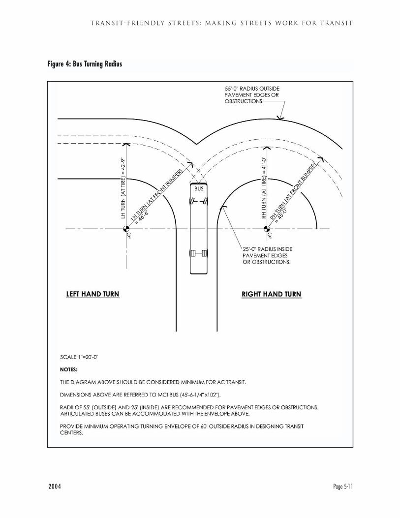
2004 Page 5-11
TRANSIT-FRIENDLY STREETS : MAKING STREETS WORK FOR TRANSIT
Figure 4: Bus Turning Radius
In many cases, one travel lane in each direction will
be adequate, particularly if it is a wide lane. In other
cases, that will result in undue delays.
Excessive road widths are also problematic for bus
transit. The need to minimize the distance for pedes-
trians across roads is noted in Walking Best Practice
4.2 (Page 4-20). Excessively wide roads also encour-
age excessively high speeds by some vehicle drivers, a
potential hazard to buses. The high speed roads do
not generally reduce bus travel time significantly, as
the bus must stop and start frequently and cannot
travel as fast as the speed limit.
Reductions in the number of lanes on a roadway can
also be problematic for bus operations. Communities
may restripe roads to provide space for a bicycle lane
or to ease pedestrian crossings and improve the pedes-
trian environment. Reducing the number of lanes
may cause congestion and delays, particularly at inter-
sections with substantial amounts of cross traffic.
Restriping a roadway from two travel lanes in each
direction to one is a particular cause for concern. In
some situations, however, like the restriping of Grand
Avenue in Oakland for three lanes per direction to
two, there was no apparent negative impact. In other
instances, creation of a two way center turn lane may
rationalize turning movements and not therefore not
negatively impact bus operations.
Before reducing the number of lanes on a roadway
for any reason, it is very important that communities
review their plans in detail with AC Transit. It is also
critical that traffic analysis of lane reductions evaluate
their impact on buses specifically. Many standard
analysis evaluate only the impact on cars, which can
be quite different from that on buses. AC Transit
must carefully evaluate the effect of these changes sit-
uation by situation.
Streets Best Practice 2.2Assure that travel lanes and curb radii are wideenough for buses
In addition to having adequate capacity on the road
as a whole, each lane of a transit street must be wide
enough for safe bus operation. AC Transit’s preferred
lane width is 12 feet, although buses can operate safe-
ly in 11 foot lanes. These widths are also consistent
with Caltrans standards for state highways. Curb
radii should be adequate to allow buses to turn with-
out crossing the centerline, see Figure 4 (Page 5-11).
The need for appropriate corner radii reinforces the
importance of designating a street network for tran-
sit. On transit streets, corner radii should be ade-
quate for bus operations. However on other streets
cities may wish to use tighter radii to ease crossings
for pedestrians.
Streets Best Practice 2.3Assure that these streets have adequate streetcomposition to support buses
The composition of streets with regular bus service
should be strong enough to absorb the load of a bus.
Communities should also prioritize pavement reha-
bilitation and reconstruction to streets with transit. A
well-paved street provides a more pleasant ride for
passengers and reduces wear and tear on the bus.
Most communities choose to install concrete bus
pads. AC Transit is supportive of this practice, but it
is designed to protect roadways from wear and tear,
and is thus at the community’s option.
DESIGNING WITH TRANSIT
Page 5-12 2004
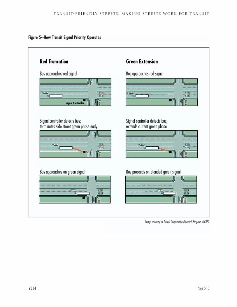
2004 Page 5-13
TRANSIT-FRIENDLY STREETS : MAKING STREETS WORK FOR TRANSIT
Figure 5--How Transit Signal Priority Operates
Red Truncation
Bus approaches red signal
Green Extension
Bus approaches red signal
Signal controller detects bus; terminates side street green phase early
Signal controller detects bus;extends current green phase
Bus approaches on green signal Bus proceeds on etended green signal
Signal Controller
Image courtesy of Transit Cooperative Research Program (TCRP)
Streets Best Practice 2.4Assure that signal timing is supportive of busoperations
Signal timing and progression is also very important
for transit-friendly streets. Streets with Rapid or lim-
ited stop bus service are particularly important.
Signals on these streets should be timed to allow rea-
sonable, continuous, although not necessarily high
speed, flow. It is more important to bus operations to
reduce delays waiting for traffic signals than to be
occasionally able to travel at high speeds. In most
cases, 25-30 miles per hour speed limits will suffice.
Good signal timing is important for all transit streets,
in the next section we discuss priority treatments for
key corridors.
Streets Best Practice 2.5Assure that any traffic calming methods on busroutes are compatible with bus operations
As traffic volumes have increased, East Bay commu-
nities have become increasingly interested in “traffic
calming” techniques, particularly for residential
streets. Traffic calming techniques are designed to
reduce speeds, volumes, and/or erratic driving behav-
ior. They may seek to discourage through traffic from
“shortcutting” on local streets. In the long run, these
problems can only be solved by reducing the amount
of automobile miles traveled. In the short term, there
will continue to be pressure for traffic calming.
Most traffic calming techniques are designed to
improve conditions on local streets, where most resi-
dents live, rather than on arterials. However, most
bus routes operate on collector or arterial streets.
Some cities, such as Berkeley and Oakland, have
policies targeting traffic calming only to streets that
do not have transit operations.
An important companion to traffic calming on local
streets is traffic management on major streets, on their
collectors and arterials. Minimizing congestion on
collectors and arterials will help reduce traffic volumes
on local streets, as fewer drivers will feel the need to
seek short cuts through neighborhood streets.
Bus transit’s need for smooth flowing traffic does not
mean, however, that buses need high speed traffic. As
discussed in the “Delay of Bus …” (Page 5-7), what
buses need is often not higher travel speeds but fewer
sources of delay like congestion, badly timed traffic
signals, etc. Moderate speed with regular flow works
best for buses.
There are therefore some traffic calming techniques
that are appropriate for arterial and collector streets.
Control of speeds through signal timing can be
appropriate for transit streets. In some cases, installa-
tion of additional traffic signals or enhanced cross-
walks (e.g., “Santa Rosa lights”) may aid pedestrians.
Traffic calming signage (e.g. “Watch for Children”)
may be helpful. Properly designed sidewalk bulbs can
also ease pedestrian crossings (see Section 3). Traffic
calming programs must be carefully designed for their
particular circumstances--with an understanding of
what problem they are trying to solve. AC Transit
urges communities to review proposals with us before
proceeding with traffic calming on transit streets.
“Vertical deflection” methods of traffic calming
(devices that slow vehicles by moving them up and
down) should be avoided on bus routes. Devices that
cause major vertical deflection of buses, such as speed
DESIGNING WITH TRANSIT
Page 5-14 2004
2004 Page 5-15
TRANSIT-FRIENDLY STREETS : MAKING STREETS WORK FOR TRANSIT
humps, are definitely not appropriate for transit
streets. Speed humps cause damage to buses and an
unpleasant ride for passengers. If speed humps are
installed on a street with a bus route, AC Transit may
consider removing the route.
Some techniques that deflect traffic horizontally are
also inappropriate. Diverters (often called “barriers”)
on a transit street would force a bus to divert off its
route and are clearly inappropriate.
Traffic Calming Methodologies:Appropriateness for Transit Streets
Methods most likely to be appropriate:
Arterial signal timing
Additional traffic signals
Improved crosswalks
In-pavement lights (“Santa Rosa Lights”)
Traffic calming signage
Bus bulbs
Pedestrian bulbs (properly designed)
Methods which may or may not be appropriate:
Reducing number of roadway lanes
Narrowing street crossing distance
Inappropriate methods:
Speed humps or bumps
Other vertical deflection devices
Diverters (“barriers”) or semi-diverters
Chicanes or serpentines
STREETS POLICY 3: IMPLEMENT PRIORITYTREATMENTS FOR TRANSIT ON KEYCORRIDORS
Bus ridership in the East Bay is heavily concentrated
in a few key corridors. Many of these corridors are
congested, particularly at major intersections. Getting
buses through these congested areas and quickly along
their route is key to maintain and increasing bus rid-
ership. In many instances, techniques to prioritize bus
transit are necessary. These techniques may involve
traffic signals, traffic lanes or both. Experience both in
the East Bay and other areas has shown that priority
techniques can be implemented without causing sig-
nificant delays for other traffic.
Streets Best Practice 3.1Provide transit signal priority on trunk corridorswhen necessary
Transit signal priority allows buses to receive green
lights at more traffic signals, reducing delay. In sim-
ple terms, the system works by having an “emitter”
on the bus automatically request an extension of a
green light if the bus is approaching a signal that is
about to turn red. The extension lasts only a few sec-
onds, 10 seconds at the very most, but that is often
adequate to get the bus through the signal. In some
systems, the bus can request a shortened red light.
The process is automatic and not operated by the bus
driver. The extension of green time benefits all vehi-
cle traffic on the main arterial that the bus is travel-
ing on, including cars. This system does not use spe-
cial bus-only signals.
Transit signal priority is being implemented for the
San Pablo Rapid (but not local buses on San Pablo
DESIGNING WITH TRANSIT
Page 5-16 2004
Avenue). The signal priority there will be evaluated
in early- to mid-2004. Signal priority has yielded sig-
nificant improvements in bus travel time in Los
Angeles, Seattle, and elsewhere. Transit signal priori-
ty is particularly important on congested corridors,
like the streets where many of AC Transit’s trunk
routes operate. Clearly, with implementation of sig-
nal priority, it becomes even more important to place
bus stops on the far side of signalized intersections.
Some fear that transit signal priority will delay cross
traffic, but this has not proven to be the case. Studies
in Los Angeles and Seattle have shown little or no
delay on streets which cross the transit priority street.
There are various reasons for this. If the cross street
loses a few seconds in one cycle, it can be granted
extra time on another cycle. Systems can have limits
built in as to how frequently signal priority will be
granted. Transit signal priority is thus the condition-
al, not the absolute, right of signal preemption some-
times given to public safety vehicles.
Streets Best Practice 3.2Reduce the amount of on-street parking if neces-sary to relieve congestion
On-street parking has a valuable role to play in the
urban environment, but under some circumstances it
interferes unduly with bus operations. On-street
parking is not only attractive to drivers, it can also
play a useful role in shielding pedestrians from traf-
fic. On active commercial streets, on-street parking is
usually permitted except as needed for bus stops and
turns at corners. This approach is far better than
keeping all lanes clear for high speed driving.
However, in circumstances where on-street parking
unduly impedes bus operations, it can be helpful to
prohibit parking along for a greater than usual dis-
tance from the corner.
Prohibiting on-street parking in key locations can
improve the maneuverability of the bus and other
vehicles, and the traffic flow of the street. Getting
into and out of curbside bus stops is one of the most
time-consuming operations for a bus. In urban areas,
the bus must often maneuver past parked cars to get
to the stop. If this becomes too difficult, the bus
driver may simply not attempt to pull into the curb
and may stop the bus on an angle with the back of
the bus protruding into traffic. AC Transit policy
instructs drivers not to do this, but they do not
always comply.
In some instances, restrictions on parking near cor-
ners may not be sufficient, particularly under peak
hour conditions. In these circumstances, an all-day
or peak hour prohibition on parking in the parking
lane may be useful. This technique is widely used,
particularly on arterials that access a major employ-
ment area. Improving traffic flow on an arterial in
this way can help coax shortcutting drivers off local
neighborhood streets or can be the “carrot” accom-
panying the “stick” of neighborhood street traffic
calming. Limiting parking does permanently or tem-
porarily eliminate the calming effect on the sidewalk
that parked cars provide.
There may be objections to parking prohibitions,
and concern about lost business. However, in most
locations, on-street parking is a minor part of the
parking supply. In central business districts, consol-
idated parking structures and lots provide most
parking spaces. Along commercial strips, most busi-
nesses have off-street parking lots for their cus-
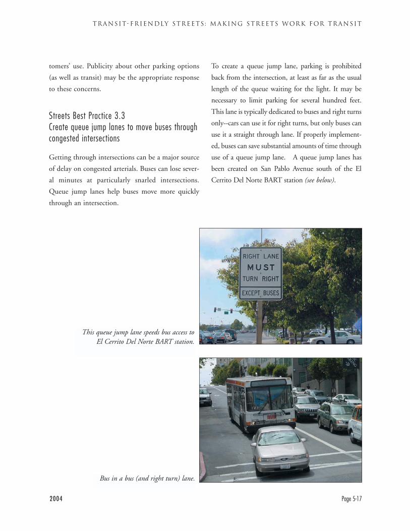
2004 Page 5-17
TRANSIT-FRIENDLY STREETS : MAKING STREETS WORK FOR TRANSIT
tomers’ use. Publicity about other parking options
(as well as transit) may be the appropriate response
to these concerns.
Streets Best Practice 3.3Create queue jump lanes to move buses throughcongested intersections
Getting through intersections can be a major source
of delay on congested arterials. Buses can lose sever-
al minutes at particularly snarled intersections.
Queue jump lanes help buses move more quickly
through an intersection.
To create a queue jump lane, parking is prohibited
back from the intersection, at least as far as the usual
length of the queue waiting for the light. It may be
necessary to limit parking for several hundred feet.
This lane is typically dedicated to buses and right turns
only--cars can use it for right turns, but only buses can
use it a straight through lane. If properly implement-
ed, buses can save substantial amounts of time through
use of a queue jump lane. A queue jump lanes has
been created on San Pablo Avenue south of the El
Cerrito Del Norte BART station (see below).
This queue jump lane speeds bus access toEl Cerrito Del Norte BART station.
Bus in a bus (and right turn) lane.
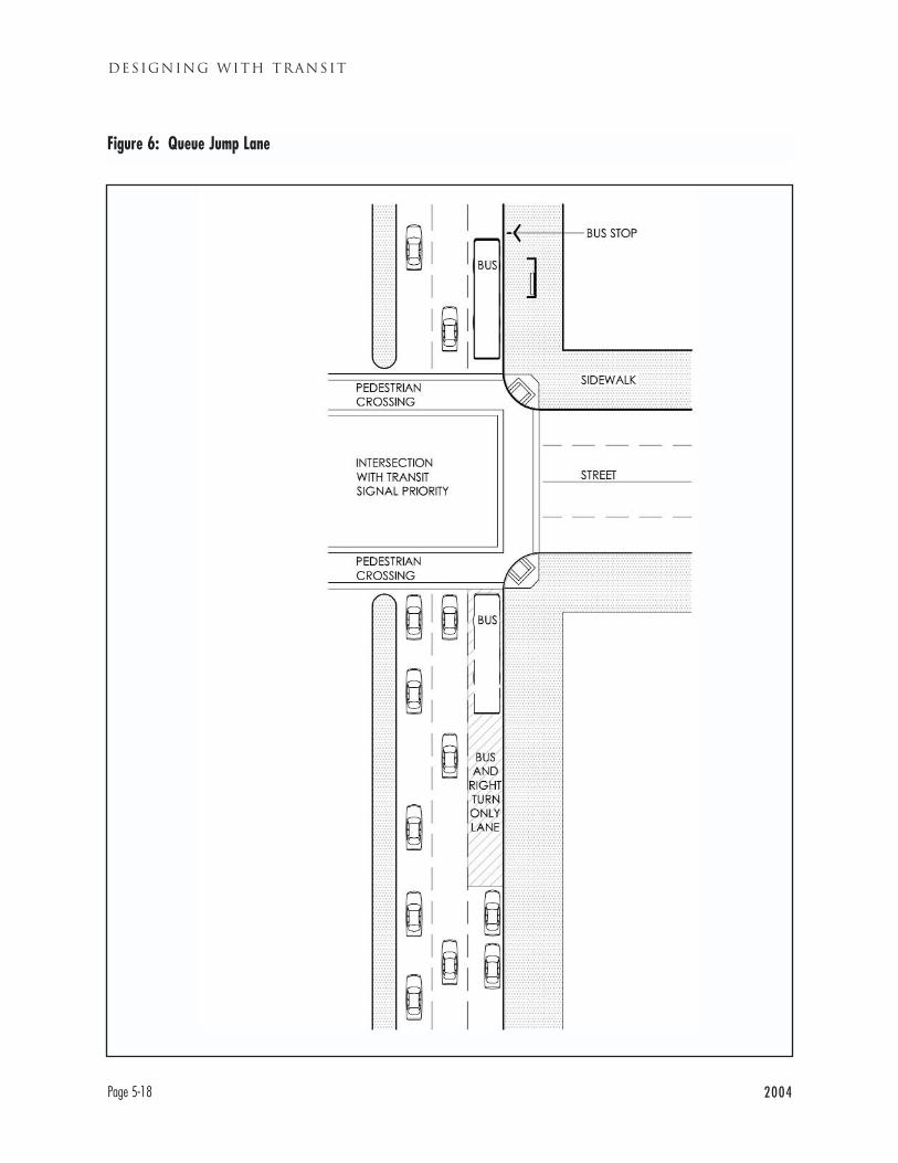
DESIGNING WITH TRANSIT
Page 5-18 2004
Figure 6: Queue Jump Lane
2004 Page 5-19
TRANSIT-FRIENDLY STREETS : MAKING STREETS WORK FOR TRANSIT
Streets Best Practice 3.4Consider dedicated bus lanes for congested, hightransit volume corridors
Parking restrictions and queue jump lanes respond to
congestion at an intersection. Where congested con-
ditions persist over long distances, and where bus
volumes are high, more continuous treatments may
be needed. Some form of dedicated or restricted bus
lane may be appropriate. A dedicated lane is a lane
which only buses may use. Light Rail Vehicles such as
those in San Jose typically operate in dedicated lanes.
Buses in dedicated lanes can provide many of the
advantages of light rail.
San Francisco has an extensive network of curbside
lanes restricted to buses and right turns only. Some of
these lanes are restricted at all times, others only in
the peak hour. Peak hour bus lanes can be used for
general vehicle flow or parking in off-peak hours.
Besides a bus only lane, another variation is a
bus/high-occupancy vehicle (HOV) lane. Finally, the
East Bay Bus Rapid Transit project is evaluating ded-
icated lanes in the center of the roadway to allow cre-
ation of “track” like conditions with center stations
for the BRT. San Francisco uses this approach on
some streets.
DESIGNING WITH TRANSIT
Page 5-20 2004
SECTION 2--BUS STOPS
Bus stops are the “stations” of the AC Transit system.
Bus stops should be functional for bus operations,
safe and pleasant for passengers, and compatible with
surrounding roadways and communities. Bus stops
should be easy to find. Bus stops should be appro-
priately located along bus routes and in the specific
appropriate location at intersections. They need to be
long enough along the curb for the buses that will use
them, often two or more buses at the same time.
They need to be wide enough across the sidewalk to
provide legally mandated (Americans With Disability
Act) boarding/alighting space, and should be wide
enough to accept a bus shelter for passengers’ con-
venience. This section discusses how cities and AC
Transit can address these concerns about bus stops.
Policy 4: Site bus stops at safe, efficient andconvenient locations
Best Practice 4.1 Site bus stops to balance speed and
convenience concerns
Best Practice 4.2 Site bus stops in the best operational
locations, usually on the far side of an intersection
Best Practice 4.3 Site bus stops where passengers are
less likely to experience crime
Policy 5: Locate bus stops appropriately withinthe right of way
Best Practice 5.1: Provide a curbside bus stop in
most instances
Best Practice 5.2: Install bus bulbs where they would
facilitate bus operation and pedestrian movement.
Best Practice 5.3: Avoid bus pullouts (turnouts)
Best Practice 5.4: Design Transit Centers for effec-
tive, efficient operation
Policy 6: Create safe, functional and legal busstops with needed amenities
Best Practice 6.1: Make bus stops long enough for
the buses that will use them.
Best Practice 6.2: Paint the curb at bus stops red.
Best Practice 6.3: Assure that sidewalks are wide
enough and clear enough for bus stops
Best Practice 6.4: Provide an ADA compliant bus
boarding/alighting area of at least 8 feet by 5 feet.
Best Practice 6.5: Provide bus shelters with appro-
priate amenities
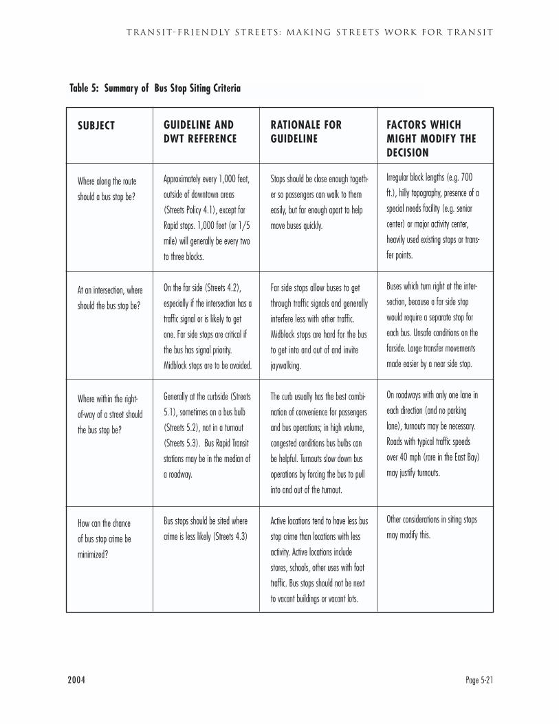
2004 Page 5-21
TRANSIT-FRIENDLY STREETS : MAKING STREETS WORK FOR TRANSIT
SUBJECT
Where along the route
should a bus stop be?
At an intersection, where
should the bus stop be?
Where within the right-
of-way of a street should
the bus stop be?
How can the chance
of bus stop crime be
minimized?
GUIDELINE ANDDWT REFERENCE
Approximately every 1,000 feet,
outside of downtown areas
(Streets Policy 4.1), except for
Rapid stops. 1,000 feet (or 1/5
mile) will generally be every two
to three blocks.
On the far side (Streets 4.2),
especially if the intersection has a
traffic signal or is likely to get
one. Far side stops are critical if
the bus has signal priority.
Midblock stops are to be avoided.
Generally at the curbside (Streets
5.1), sometimes on a bus bulb
(Streets 5.2), not in a turnout
(Streets 5.3). Bus Rapid Transit
stations may be in the median of
a roadway.
Bus stops should be sited where
crime is less likely (Streets 4.3)
RATIONALE FORGUIDELINE
Stops should be close enough togeth-
er so passengers can walk to them
easily, but far enough apart to help
move buses quickly.
Far side stops allow buses to get
through traffic signals and generally
interfere less with other traffic.
Midblock stops are hard for the bus
to get into and out of and invite
jaywalking.
The curb usually has the best combi-
nation of convenience for passengers
and bus operations; in high volume,
congested conditions bus bulbs can
be helpful. Turnouts slow down bus
operations by forcing the bus to pull
into and out of the turnout.
Active locations tend to have less bus
stop crime than locations with less
activity. Active locations include
stores, schools, other uses with foot
traffic. Bus stops should not be next
to vacant buildings or vacant lots.
FACTORS WHICHMIGHT MODIFY THEDECISION
Irregular block lengths (e.g. 700
ft.), hilly topography, presence of a
special needs facility (e.g. senior
center) or major activity center,
heavily used existing stops or trans-
fer points.
Buses which turn right at the inter-
section, because a far side stop
would require a separate stop for
each bus. Unsafe conditions on the
farside. Large transfer movements
made easier by a near side stop.
On roadways with only one lane in
each direction (and no parking
lane), turnouts may be necessary.
Roads with typical traffic speeds
over 40 mph (rare in the East Bay)
may justify turnouts.
Other considerations in siting stops
may modify this.
Table 5: Summary of Bus Stop Siting Criteria
DESIGNING WITH TRANSIT
Page 5-22 2004
STREETS POLICY 4: SITE BUS STOPS ATSAFE, EFFICIENT AND CONVENIENTLOCATIONS
Communities and AC Transit must work together
closely to identify and implement appropriate sites
for bus stops. AC Transit seeks to locate bus stops
where they will best meet both passenger and opera-
tional needs. Local officials are often concerned
about integrating bus stops into the buildings, side-
walks, and traffic patterns of their community. Bus
stops are also important as “signposts” to the general
public that bus service is available in a given location
and along that street.
Streets Best Practice 4.1Space bus stops to balance speed and conven-ience concerns
Bus stops are the locations where bus passengers
access the AC Transit system. Bus stops must there-
fore be convenient to the places where passengers
wish to go. This might seem to argue for a great
many bus stops, as close as possible to as many ori-
gins and destinations as possible. However, too
many bus stops can slow a its travel time, as it brakes
to stop and maneuvers to and from the curb.
Convenience and speed must be balanced in siting
bus stops.
Outside of downtown areas, AC Transit generally
seeks to have bus stops approximately 1,000 feet
apart, or slightly under 1/5 of a mile apart. This tar-
get has been set with the goal of increasing travel
speed for AC Transit buses. Stop spacing of 1,000
feet means that stops will generally be two to three
blocks apart, although some suburban blocks are
close to 1,000 feet long.
This target means that some existing stops, particu-
larly low ridership stops, will be eliminated.
The 1,000 foot distance is a target which will be
modified based on specific conditions, particularly
the location of streets. Stops must be located at inter-
sections: for safety reasons, AC Transit generally does
not establish mid-block stops. Other factors affecting
the location of stops include the location of major
destinations, transfer points, and hills. In some cases,
streets have long segments without sidewalks or loca-
tions where legal bus stops can be established.
Streets Best Practice 4.2Site bus stops in the best operational locations,usually on the far side of an intersection
In general, AC Transit prefers bus stops on the far
side of an intersection rather than the near side.
Far side locations are particularly important at sig-
nalized intersections and intersections likely to be
signalized in the future. Far side stops reduce con-
flicts between right turning vehicle and stopped
buses. At near side stops, auto drivers may be tempt-
ed to go into the center of the roadway and “zip
around” a stopped bus, a potentially unsafe maneu-
ver. Far side stops also reduce sight distance deficien-
cies on approaches to an intersection. Far side stops
also encourage pedestrians to cross the street more
safely behind the bus rather than in front of it. Rapid
buses also use signal priority to get though traffic sig-
nals so it is key that their stops be on the far side.
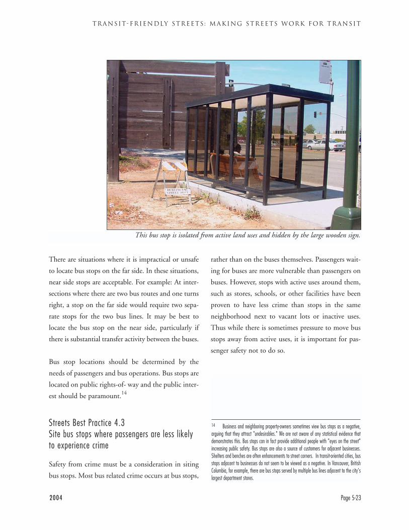
2004 Page 5-23
TRANSIT-FRIENDLY STREETS : MAKING STREETS WORK FOR TRANSIT
There are situations where it is impractical or unsafe
to locate bus stops on the far side. In these situations,
near side stops are acceptable. For example: At inter-
sections where there are two bus routes and one turns
right, a stop on the far side would require two sepa-
rate stops for the two bus lines. It may be best to
locate the bus stop on the near side, particularly if
there is substantial transfer activity between the buses.
Bus stop locations should be determined by the
needs of passengers and bus operations. Bus stops are
located on public rights-of- way and the public inter-
est should be paramount.14
Streets Best Practice 4.3Site bus stops where passengers are less likelyto experience crime
Safety from crime must be a consideration in siting
bus stops. Most bus related crime occurs at bus stops,
rather than on the buses themselves. Passengers wait-
ing for buses are more vulnerable than passengers on
buses. However, stops with active uses around them,
such as stores, schools, or other facilities have been
proven to have less crime than stops in the same
neighborhood next to vacant lots or inactive uses.
Thus while there is sometimes pressure to move bus
stops away from active uses, it is important for pas-
senger safety not to do so.
This bus stop is isolated from active land uses and hidden by the large wooden sign.
14 Business and neighboring property-owners sometimes view bus stops as a negative,arguing that they attract "undesirables." We are not aware of any statistical evidence thatdemonstrates this. Bus stops can in fact provide additional people with "eyes on the street"increasing public safety. Bus stops are also a source of customers for adjacent businesses.Shelters and benches are often enhancements to street corners. In transit-oriented cities, busstops adjacent to businesses do not seem to be viewed as a negative. In Vancouver, BritishColumbia, for example, there are bus stops served by multiple bus lines adjacent to the city'slargest department stores.
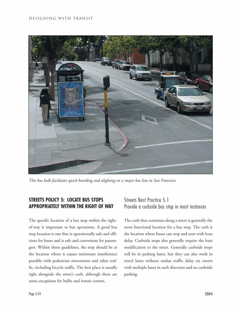
DESIGNING WITH TRANSIT
Page 5-24 2004
STREETS POLICY 5: LOCATE BUS STOPSAPPROPRIATELY WITHIN THE RIGHT OF WAY
The specific location of a bus stop within the right-
of-way is important to bus operations. A good bus
stop location is one that is operationally safe and effi-
cient for buses and is safe and convenient for passen-
gers. Within those guidelines, the stop should be at
the location where it causes minimum interference
possible with pedestrian movements and other traf-
fic, including bicycle traffic. The best place is usually
right alongside the street’s curb, although there are
some exceptions for bulbs and transit centers.
Streets Best Practice 5.1Provide a curbside bus stop in most instances
The curb that continues along a street is generally the
most functional location for a bus stop. The curb is
the location where buses can stop and start with least
delay. Curbside stops also generally require the least
modification to the street. Generally curbside stops
will be in parking lanes, but they can also work in
travel lanes without undue traffic delay on streets
with multiple lanes in each direction and no curbside
parking.
This bus bulb facilitates quick boarding and alighting on a major bus line in San Francisco.
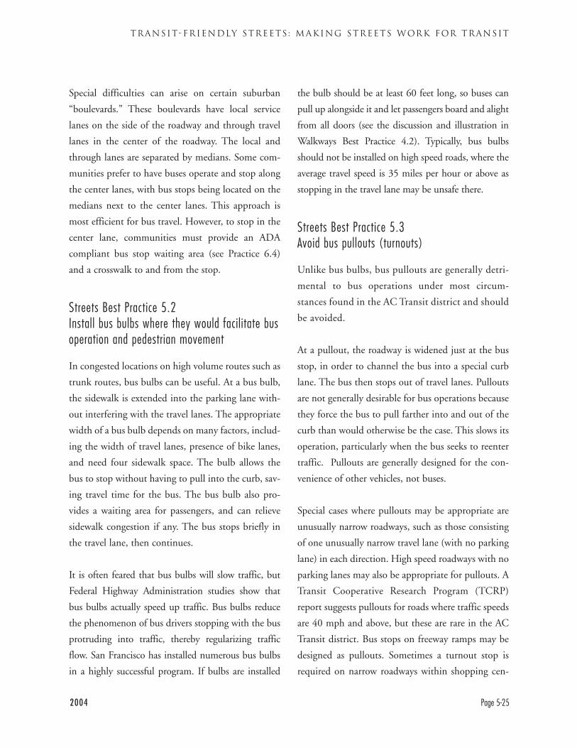
Special difficulties can arise on certain suburban
“boulevards.” These boulevards have local service
lanes on the side of the roadway and through travel
lanes in the center of the roadway. The local and
through lanes are separated by medians. Some com-
munities prefer to have buses operate and stop along
the center lanes, with bus stops being located on the
medians next to the center lanes. This approach is
most efficient for bus travel. However, to stop in the
center lane, communities must provide an ADA
compliant bus stop waiting area (see Practice 6.4)
and a crosswalk to and from the stop.
Streets Best Practice 5.2Install bus bulbs where they would facilitate busoperation and pedestrian movement
In congested locations on high volume routes such as
trunk routes, bus bulbs can be useful. At a bus bulb,
the sidewalk is extended into the parking lane with-
out interfering with the travel lanes. The appropriate
width of a bus bulb depends on many factors, includ-
ing the width of travel lanes, presence of bike lanes,
and need four sidewalk space. The bulb allows the
bus to stop without having to pull into the curb, sav-
ing travel time for the bus. The bus bulb also pro-
vides a waiting area for passengers, and can relieve
sidewalk congestion if any. The bus stops briefly in
the travel lane, then continues.
It is often feared that bus bulbs will slow traffic, but
Federal Highway Administration studies show that
bus bulbs actually speed up traffic. Bus bulbs reduce
the phenomenon of bus drivers stopping with the bus
protruding into traffic, thereby regularizing traffic
flow. San Francisco has installed numerous bus bulbs
in a highly successful program. If bulbs are installed
the bulb should be at least 60 feet long, so buses can
pull up alongside it and let passengers board and alight
from all doors (see the discussion and illustration in
Walkways Best Practice 4.2). Typically, bus bulbs
should not be installed on high speed roads, where the
average travel speed is 35 miles per hour or above as
stopping in the travel lane may be unsafe there.
Streets Best Practice 5.3Avoid bus pullouts (turnouts)
Unlike bus bulbs, bus pullouts are generally detri-
mental to bus operations under most circum-
stances found in the AC Transit district and should
be avoided.
At a pullout, the roadway is widened just at the bus
stop, in order to channel the bus into a special curb
lane. The bus then stops out of travel lanes. Pullouts
are not generally desirable for bus operations because
they force the bus to pull farther into and out of the
curb than would otherwise be the case. This slows its
operation, particularly when the bus seeks to reenter
traffic. Pullouts are generally designed for the con-
venience of other vehicles, not buses.
Special cases where pullouts may be appropriate are
unusually narrow roadways, such as those consisting
of one unusually narrow travel lane (with no parking
lane) in each direction. High speed roadways with no
parking lanes may also be appropriate for pullouts. A
Transit Cooperative Research Program (TCRP)
report suggests pullouts for roads where traffic speeds
are 40 mph and above, but these are rare in the AC
Transit district. Bus stops on freeway ramps may be
designed as pullouts. Sometimes a turnout stop is
required on narrow roadways within shopping cen-
2004 Page 5-25
TRANSIT-FRIENDLY STREETS : MAKING STREETS WORK FOR TRANSIT
DESIGNING WITH TRANSIT
Page 5-26 2004
ters. In some instances, pedestrian bulbs at either
end of a short block may create a situation resem-
bling a bus pullout between them.
Streets Practice 5.4Design Transit Centers for effective, efficientoperation
While most AC Transit bus stops are at on-street bus
stops, some of the busiest bus stops are at transit cen-
ters. Transit centers are off-street locations designed
for buses to pick up and drop off passengers and lay
over at the end of their route. Transit centers are
appropriate where multiple buses stop, and particu-
larly where multiple buses lay over. Most of AC
Transit’s transit centers are at BART stations, but
there are also transit centers at other locations such as
Contra Costa College and Eastmont Town Center.
Some cities, such as in Union City at the Union
Landing shopping center, have also designed their
own transit centers in cooperation with AC Transit.
It is important that these transit centers be designed
properly for both bus operations and passenger com-
fort and safety. AC Transit has developed a set of
transit center design guidelines that are included as
Appendix Two. The “sawtooth” layout is generally
the most efficient for bus loading bays at transit cen-
ters and is illustrated below.
It is important that transit centers contain an ade-
quate number of bus bays for bus operations and for
ease of passenger use. A bus bay that serves as the
stop for a single bus route is easiest for a passenger to
understand. It also avoids the possibility of multiple
buses needing to use the same bay at the same time.
Passengers transferring from a train or another bus
look at a given bus bay to see if the bus they wish to
take is loading. Associating a bay with a bus line also
makes bus circulation patterns the clearest.15
The transit centers at BART stations are generally
located close to the station entrance. This is critical to
allow transit passengers to connect easily to trains,
and to attract riders to bus transit (especially when
other factors, such as the higher cost of using transit,
serve as disincentives). If riders must walk long dis-
tances to reach trains they are more likely to not use
the bus at all.
Unfortunately other would-be uses sometimes covet
this “prime real estate.” They argue that transit cen-
ters consume valuable land and create “dead” space
close to the station, and should therefore be kept as
small as possible. This attitude overlooks the opera-
tional and passenger needs discussed above. It also
neglects the “liveliness” of bus bays that deliver pas-
sengers to a station all day long, while automobile
parking spaces almost always house only a single
“dead” car for the entire day. In terms of passengers
per square foot of station area land, transit centers are
clearly more efficient than auto parking spaces.16
Nor is the hustle and bustle of what BART describes
as “the hectic zone” immediately next to the station
entrance ideal for transit-oriented residences. These
are generally more attractive and enjoyable in quieter
zones slightly away from station entrances.
15 The space available for transit centers can affect service patterns. It is often suggest-ed that AC Transit buses at a given BART station should "pulse"--all arrive and depart at thesame times, so passengers are aware of the pattern, connect best to trains easily transferbetween buses. A pulse pattern, however, requires a large number of bus bays, as each busstop can only serve one line with no overlaps.
16 As a matter of scale, the largest transit centers occupy a few thousand square feet,while surface parking at BART stations can easily occupy 100,000 square feet (2.5 acres)or more.
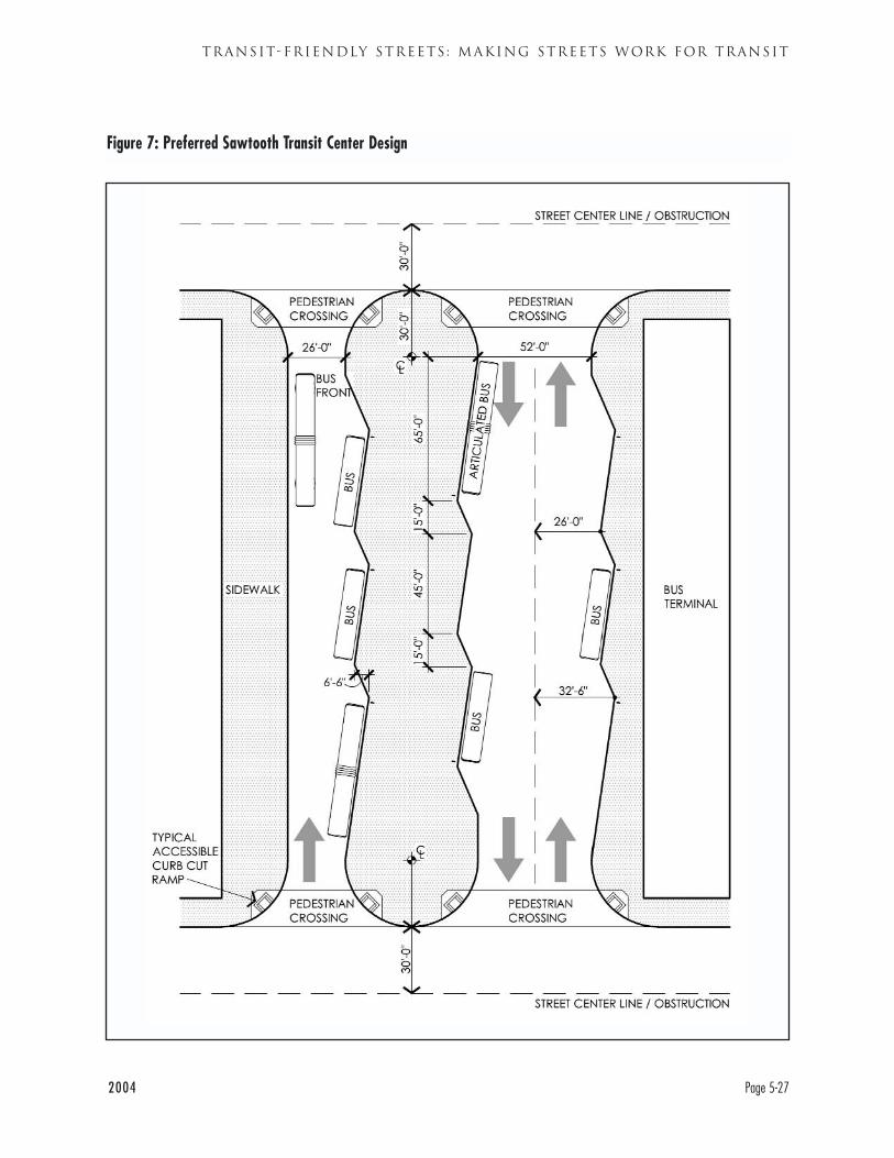
2004 Page 5-27
TRANSIT-FRIENDLY STREETS : MAKING STREETS WORK FOR TRANSIT
Figure 7: Preferred Sawtooth Transit Center Design
DESIGNING WITH TRANSIT
Page 5-28 2004
Before any transit centers are built or modified, AC
Transit, the community involved, and any other
interested parties would have extensive discussions
about the individual site.
STREETS POLICY 6: CREATE SAFE,FUNCTIONAL, AND LEGAL BUS STOPS WITHNEEDED AMENITIES
Policy 4 outlines how to structure a bus stop on the
pavement (usually at the curb, sometimes with a
bulb). This Policy describes how to make bus stops
both functional for bus operations and pleasant for
passengers. Bus stops are the first point of contact
between the transit system and their passengers, so it
is crucial that they work as well as possible. Insuring
this requires a collaborative effort between AC
Transit and local jurisdictions.
Streets Best Practice 6.1Make bus stops long enough for the buses thatwill use them
In addition to the appropriate location, there are
other important characteristics a bus stop must have.
The stop must be long enough so that buses can not
only stop there, but also get into and out of the stop
easily. Adequate length bus stops make it more likely
that the bus driver will actually pull into the stop,
rather than leave the back of the bus protruding into
the travel lane.17 Because stopping flush with the
curb is key for disabled passengers, providing a suffi-
ciently long stop is an ADA issue. AC Transit’s basic
recommended minimum bus stop length is 80
feet. This length is needed to provide three sections
of the stop. On a far side stop, these are:
1. Bus clearance from the crosswalk: Minimum 5
feet for pedestrian safety
2. Stopping space for bus: 60 feet (length of articu-
lated bus)
3. "Take off" space for bus to leave stop: 15 feet
Total Length- Far Side Stop for one bus: 80 feet
Near side stops require slightly more space. The rec-
ommended length is 90 feet, divided up as follows:
1. Approach space for the bus: 15 feet
2. Stopping space for the bus: 65 feet
3. Bus clearance from crosswalk 10 feet
Total length- Near Side Stop for one bus: 90 feet
The near side stop requires additional stopping space
to insure that it can stop with its doors at a disabled-
accessible location. At some stops, it can be necessary
to stop the bus before it reaches the flag, meaning
that the bus would overlap out of the back of its stop-
ping space. The additional distance from the cross-
walk allows right turning vehicles to proceed safely.
These dimensions are illustrated in Figures 8 and 9.
When a bus stops immediately after making a right
turn, red curbed space in addition to the normal
amount may be needed. The bus needs the distance
to make its turn and pull into a stop. The red curb
space required will be 75 feet plus the distance need-
ed to make the turn and pull in flush with the curb,
which can be calculated from the turning radius dia-
gram (Figure 4, p. 5-11). Parking should be prohib-
17 Failing to fully pull into a bus stop is against AC Transit policy and bus drivers are trainedabout this. Nonetheless, it is more likely to occur if bus stops are too short.
2004 Page 5-29
TRANSIT-FRIENDLY STREETS : MAKING STREETS WORK FOR TRANSIT
ited in that area. Left turns do not generally present
the same difficulties, because the bus does not need
to turn as tightly.
Major bus stops are likely to have more than one bus
stopping simultaneously, possibly a Rapid and a local
bus. In that case the far side stop dimension should
be at least 125 feet.
1. Basic bus stop length: 80 feet
2. Space for second bus: 40 feet
3. Space between two buses: 5 feet
Total length- Stop for two buses: 125 feet
At some very busy locations, multiple stops in a line
with more than one bus pole and flag may be need-
ed. The need for multiple flags is different from the
need for space for two buses behind a single flag. The
need for multiple stops with bus flags can occur at
bus layover points. It can also occur when transit cen-
ters are designed with straight line rather than saw-
tooth curbs.18 These groups of stops should be
designed so that there is adequate space for each bus
and at least 20 feet between each bus (from the front
of one bus to the back of the bus in front of it).
Streets Best Practice 6.2Paint the curb at bus stops red
It is important that the curb alongside the bus stop
be painted red, to prevent cars from parking there.
This red curb is also useful in keeping the travel
lane clear. If cars are parked in a bus stop, then the
bus will be forced to stop in the travel lane. This
practice interferes with other traffic and is incon-
venient and dangerous for passengers, especially dis-
abled passengers.
It is important to paint an adequate length of curb
red, to prevent cars from parking in locations where
they might interfere with buses entering and leaving
stops (see Figures 8 and 9).
Streets Best Practice 6.3Assure that sidewalks are wide enough and clearenough for bus stops
Sidewalks on transit streets often get cluttered with
newsracks, utility and light poles, trees, and other
features. While each has its place, it is important and
legally necessary to keep sufficient clear space for bus
stops and shelters. These items should be kept away
to the maximum degree possible from the entire
length of the bus stop, so that the overhang on a bus
pulling out of a stop does not hit them.
A sidewalk can be thought of schematically as hav-
ing three zones. Each is best used for certain pur-
poses, less appropriate for others. They are general-
ly not visibly delineated, though some cities use
differing pavement treatments and marking to dis-
tinguish them:
The zone closest to the street is the Curbside Zone.
This is where people board the bus at bus stops.
Away from bus stops, such equipment as lampposts,
telephone poles, tree wells, parking meters, and other
equipment are appropriate in the Curbside Zone. On
wide sidewalks, it can be used for outdoor seating. At
bus stops and street crossings, the Curbside Zone
18 AC Transit’s preferred transit center configuration is sawtooth curbs (see Figure 7, page5-23. However, for various reasons, some transit centers are designed with straight linecurbs. For example, the new transit center planned for Union City BART is proposed to havestraight line curbs to make the area seem more like a typical city street.
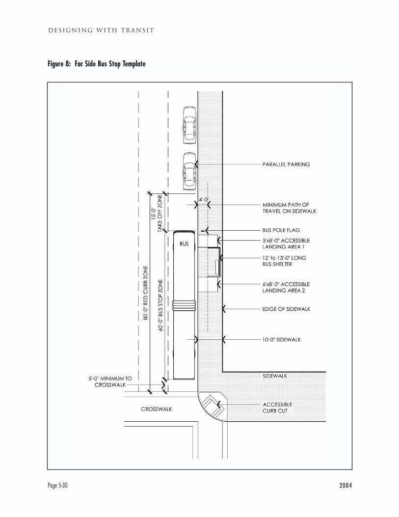
DESIGNING WITH TRANSIT
Page 5-30 2004
Figure 8: Far Side Bus Stop Template
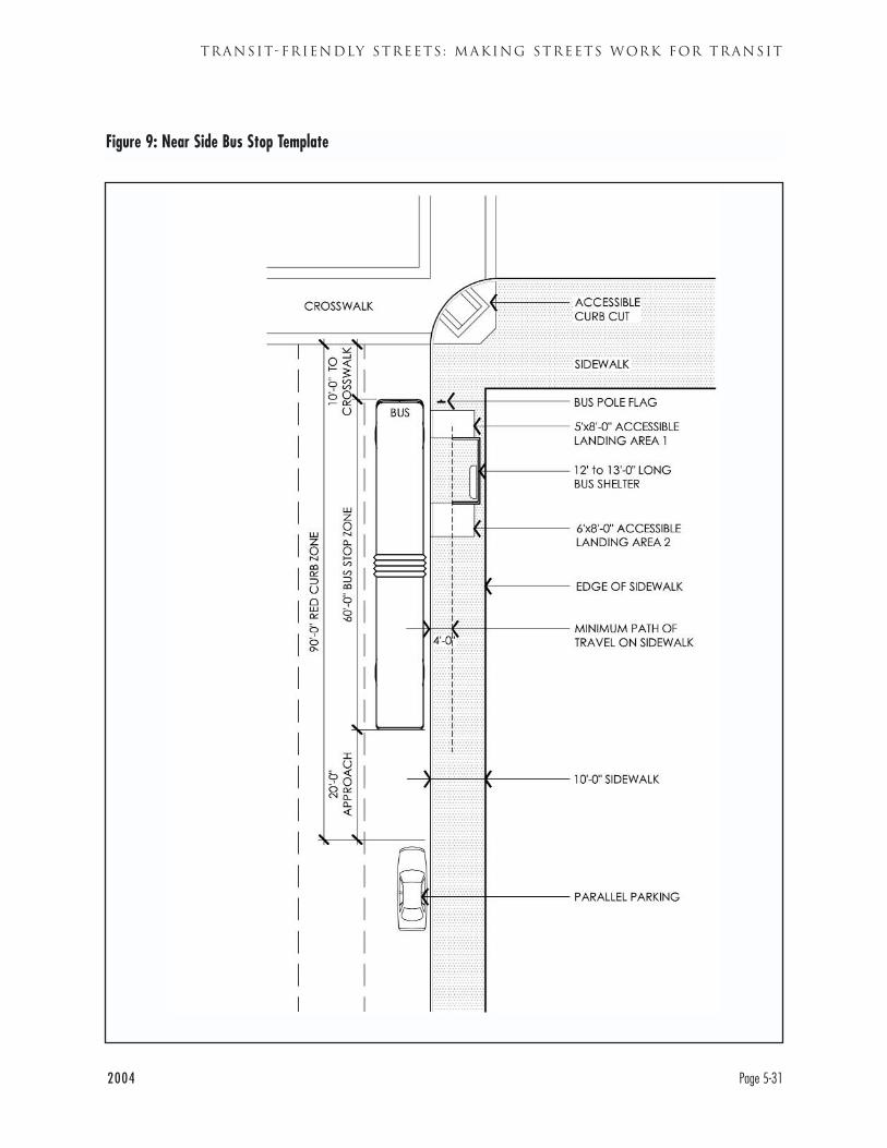
2004 Page 5-31
TRANSIT-FRIENDLY STREETS : MAKING STREETS WORK FOR TRANSIT
Figure 9: Near Side Bus Stop Template
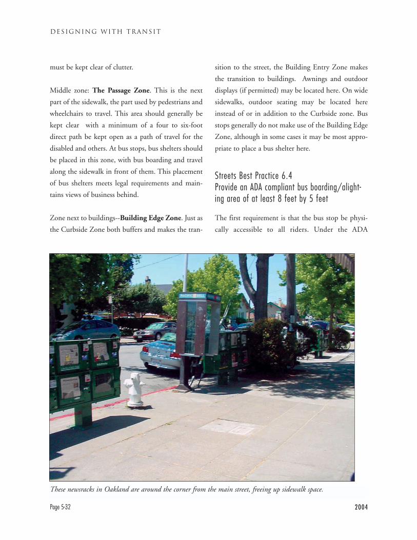
DESIGNING WITH TRANSIT
Page 5-32 2004
must be kept clear of clutter.
Middle zone: The Passage Zone. This is the next
part of the sidewalk, the part used by pedestrians and
wheelchairs to travel. This area should generally be
kept clear with a minimum of a four to six-foot
direct path be kept open as a path of travel for the
disabled and others. At bus stops, bus shelters should
be placed in this zone, with bus boarding and travel
along the sidewalk in front of them. This placement
of bus shelters meets legal requirements and main-
tains views of business behind.
Zone next to buildings--Building Edge Zone. Just as
the Curbside Zone both buffers and makes the tran-
sition to the street, the Building Entry Zone makes
the transition to buildings. Awnings and outdoor
displays (if permitted) may be located here. On wide
sidewalks, outdoor seating may be located here
instead of or in addition to the Curbside zone. Bus
stops generally do not make use of the Building Edge
Zone, although in some cases it may be most appro-
priate to place a bus shelter here.
Streets Best Practice 6.4Provide an ADA compliant bus boarding/alight-ing area of at least 8 feet by 5 feet
The first requirement is that the bus stop be physi-
cally accessible to all riders. Under the ADA
These newsracks in Oakland are around the corner from the main street, freeing up sidewalk space.
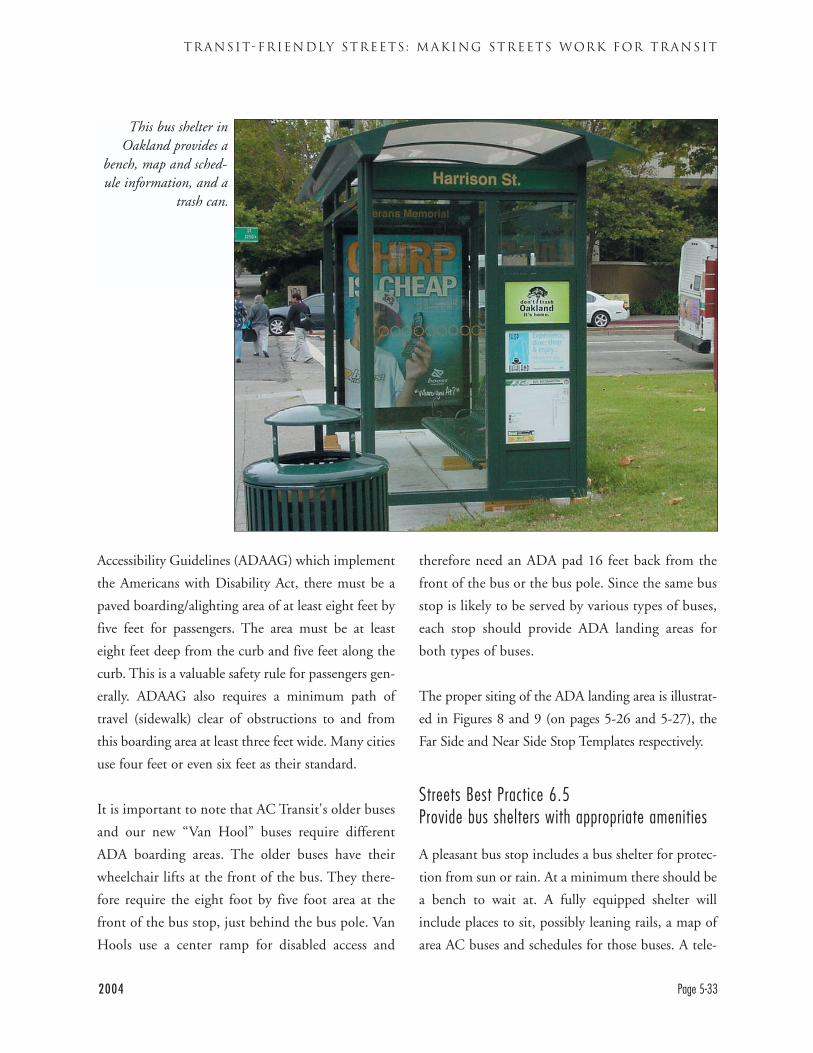
Accessibility Guidelines (ADAAG) which implement
the Americans with Disability Act, there must be a
paved boarding/alighting area of at least eight feet by
five feet for passengers. The area must be at least
eight feet deep from the curb and five feet along the
curb. This is a valuable safety rule for passengers gen-
erally. ADAAG also requires a minimum path of
travel (sidewalk) clear of obstructions to and from
this boarding area at least three feet wide. Many cities
use four feet or even six feet as their standard.
It is important to note that AC Transit's older buses
and our new “Van Hool” buses require different
ADA boarding areas. The older buses have their
wheelchair lifts at the front of the bus. They there-
fore require the eight foot by five foot area at the
front of the bus stop, just behind the bus pole. Van
Hools use a center ramp for disabled access and
therefore need an ADA pad 16 feet back from the
front of the bus or the bus pole. Since the same bus
stop is likely to be served by various types of buses,
each stop should provide ADA landing areas for
both types of buses.
The proper siting of the ADA landing area is illustrat-
ed in Figures 8 and 9 (on pages 5-26 and 5-27), the
Far Side and Near Side Stop Templates respectively.
Streets Best Practice 6.5Provide bus shelters with appropriate amenities
A pleasant bus stop includes a bus shelter for protec-
tion from sun or rain. At a minimum there should be
a bench to wait at. A fully equipped shelter will
include places to sit, possibly leaning rails, a map of
area AC buses and schedules for those buses. A tele-
2004 Page 5-33
TRANSIT-FRIENDLY STREETS : MAKING STREETS WORK FOR TRANSIT
This bus shelter inOakland provides a
bench, map and sched-ule information, and a
trash can.
phone that can at least make outgoing calls is still
useful, because not all passengers carry cell phones
(blocking incoming calls eliminates many of the
crime-related uses of phones). Because of the cost of
maintaining shelters, AC Transit’s current policy is to
work with advertising supported shelter providers
who agree to maintain the shelters and meet mini-
mum standards.
At each stop, bus shelters should be sited as close as
possible to the bus stop flag, as shown in Figure 8 and
Figure 9. Passengers will be able to board the bus
most easily from there, and bus drivers will be best
able to see them. AC Transit recommends that shel-
ters be placed at the back of the sidewalk, which is
generally preferable for pedestrian travel and for
meeting ADA path of travel requirements. Often
shelters at the back of sidewalks can be placed along
blank walls.
However, in some cases it is necessary to modify the
placement of the shelter. Shelters should not be
placed where they block the sight line for a driveway
or an intersection. Shelters should also not be
placed directly in front of automatic teller machines
(ATM), as this may create a real or perceived securi-
ty problem. Within the guideline that the most
important purpose of bus shelters is to serve bus pas-
sengers, shelter locations should be jointly deter-
mined by the city/jurisdiction controlling the side-
walk and AC Transit.
It is particularly important to provide amenities at
heavily used bus stops. AC Transit has not adopted a
formal set of standards for appropriate facilities and
various types of stops. However, a set of standards
was used to define appropriate levels of improvement
along the San Pablo Corridor. Four levels of stop
were defined based on ridership: A, C, D, and E. The
most heavily use stops would receive the greatest
improvement, while E stops with very limited use
would only receive a bench.
DESIGNING WITH TRANSIT
Page 5-34 2004
Americans With Disability Act (ADA): A federal law mandating, among other provisions, that transit systems be
accessible to people with disabilities and that comparable alternative service be provided for people unable to
use fixed route service.
Arterials: Major roadways, other than freeways, designed to carry large volumes of traffic through and between
cities. Arterials will normally be the widest streets in a community. They are sometimes also called Major
Streets. Traffic on arterials is generally controlled by traffic signals, not stop signs. Every city and county in
California must define its arterials as part of its roadway network in the Transportation Element of its General
Plan. Some cities distinguish between Major Arterials and Minor Arterials. Examples of arterials include San
Pablo Avenue, Hesperian and Fremont boulevards. AC Transit operates on many East Bay arterial streets and
they are very important to bus operations.
Branches: Two bus routes operating along the same route for a substantial distance which then separate and
travel different routes. Branches should be avoided when possible because they tend to provide poorer service,
are difficult to manage, and can confuse passengers.
Bus Rapid Transit: An emerging form of high speed, high quality bus transit. Bus Rapid Transit (BRT) operates
on separate rights of way such as dedicated lanes in a roadway or a separate busway. This allows the bus to be
faster and more reliable. Bus Rapid Transit also spaces stops further apart, uses transit signal priority, general-
ly uses low floor buses, and may collect fares under a proof of payment system. AC Transit is developing BRT
for the International-Telegraph corridor; Los Angeles is among the other cities developing BRT, and Boston's
Silver Line BRT is in operation.
Chicane: A traffic calming device which slows traffic by forcing it to divert from a straight path of travel. A chi-
cane might channel a travel lane to the right and then back into the center of the roadway. Chicanes are often
also built as chokers, narrowing the travel lane. They are also known as serpentines.
Choker: See chicane.
2004 Appendix 1-1
MAKING TRANSIT INTEGRAL TO EAST BAY COMMUNITIES
APPENDIX 1
GLOSSARY OF TRANSIT AND LAND USE TERMS
Class Pass: A program under which students at a college receive transit passes, paid for out of fees from every
student. This program is in existence at dozens of American colleges and has proven very successful in increas-
ing transit agency revenue and ridership. The University of California-Berkeley has a Class Pass program with
AC Transit (see Ecopass).
Collectors: Secondary streets designed to bring traffic to arterials. Collectors, or collector streets, are generally
designed for travel to or within a neighborhood but not for long distance travel. Collectors are generally not
as wide as arterials but are generally larger than local streets. Collectors may be controlled by traffic signals
and/or stop signs. Like arterials, cities define their collectors in the Transportation Element of a city’s General
Plan. AC Transit operates on some collectors.
Commuter rail: Longer distance rail transit systems designed to bring commuters to a central location.
Commuter railroads generally have spread out stations (1-3 miles apart). Commuter rail service and ridership
is concentrated in weekday peak hours, there may be limited or no service at other times. Commuter railroads
typically run on ground level tracks with grade crossings. Examples of commuter railroads include Caltrain on
the San Francisco Peninsula, ACE between Stockton and San Jose, and the Metrolink system in Los Angeles.
Comparison Retail: Stores offering major items, such as large appliances, that consumers purchase infrequently.
They may wish to compare the price and quality of before purchasing. Some consumers may travel long dis-
tances to shop for comparison items such as furniture.
Convenience-Oriented Retail: Routine items such as groceries and sundries that consumers purchase repeatedly.
Consumers generally wish to purchase these items at conveniently located stores and are generally less willing
to travel long distances for them.
Crosstown Route: A shorter route that is designed to feed trunk routes and BART. In the AC Transit district
crosstown routes usually operate in a primarily east-west direction. The 98th Avenue bus (Line 98) is an exam-
ple of a crosstown route.
Deadhead: The time a bus is on the road but not in revenue service, usually traveling from its yard to its start-
ing point, or from its ending point back to the yard. The term also refers to a bus that it is deadheading.
Deadhead time produces cost to transit agencies, but no revenues and no service to passengers, so agencies seek
to minimize deadhead time.
Ecopass: Similar to Classpass for employees. A payment is made by or on behalf all employees at a worksite, all
of whom can then receive a transit pass. Occasionally used with residents, through bodies such as neighbor-
hood organizations. In the United States, most widely used in San Jose and Denver.
DESIGNING WITH TRANSIT
Appendix 1-2 2004
Express Bus: A bus that operates a significant portion of its route with no stops, usually on a freeway. Most of
AC Transit’s Transbay buses to San Francisco are express buses because they operate largely on freeways and the
Bay Bridge.
Farebox Recovery: The proportion of a transit system’s operating costs that it recovers from fares (including
passes, tickets, etc.). AC Transit’s farebox recovery ratio varies somewhat year to year, but is generally between
20% and 25%. Virtually no North American transit agencies cover their full operating cost.
Fixed Route: Standard transit bus service is “fixed route,” the bus always operates on a specific set of streets. The
term fixed route is used to refer both to this type of service and the route that the bus operates on (see flexi-
ble service and paratransit).
Flexible Service: Transit service which can deviate from a standard fixed route to take a passenger to a specific
destination close to the route (e.g., their house). Flexible service is provided in low density, low ridership areas
by a number of transit agencies
Floor Area Ratio (FAR): The mathematical ratio between the amount of built space on a site and the amount of
land. For example, if a 10,000 square foot lot is covered completely, lot line to lot line, with a two story build-
ing, this would produce a 20,000 square foot building and an FAR of 2.0. Similarly, a four story building cov-
ering half the lot (5,000 square feet) would also have an FAR of 2.0. FAR is used to measure how intense a
given building is, and is most commonly used for non-residential structures.
Free Right Turns: Right turn lanes before an intersection which allow vehicles turning right not to go through
the intersection (also known as Slip Turns). Free right turns allow for faster vehicle movement and can reduce
intersection congestion, but also often make it difficult for pedestrians to cross the street. Free left turns are
rare, but are occasionally constructed at the intersection of two one way streets where the permitted turn is left.
General Plan: The comprehensive plan for a city’s development, sometimes called the Master Plan. Under
California law, each city and county must maintain a current General Plan that includes a land use, trans-
portation, housing and other required elements. Cities may also add optional elements. The General Plan is a
city’s broadest statement of how it intends to structure its land use and transportation networks. General Plan
land use provisions are usually consistent with the specific land use regulations found in Zoning Ordinances.
Greenfield: A location that is being developed for the first time, generally beyond the edge of previously devel-
oped areas, in contrast to infill development. It is also contrasted with “brownfield” development, which is
redevelopment of previously contaminated locations. Classic suburban development occurs on greenfields.
2004 Appendix 1-3
MAKING TRANSIT INTEGRAL TO EAST BAY COMMUNITIES
Headway: The scheduled amount of time between buses on a route. A bus that is scheduled to run every 15
minutes is said to have a 15 minute headway.
Heavy Rail: High capacity rail transit systems designed to carry large numbers of passengers. Heavy rail systems
typically are located above ground (elevateds) or below (subways) or in surface right-of-ways protected from
cross traffic. Examples of heavy rail systems include BART, the Red Line subway in Los Angeles, and the New
York City subway system. The “heavy” in heavy rail refers to a heavy degree of engineering, not necessarily the
weight of train cars or other equipment (see Light Rail and Commuter Rail).
Infill: Development in an area that is already developed (although the specific site may not have been previous
developed). Contrasts with greenfield development on land which has not been previously developed.
Intermodal: Involving two or more modes (types) of transit, e.g., bus and BART. Also used to refer to a site
where a passenger transfers modes. BART often refers to the bus transit centers at BART stations as “inter-
modals.” See mode.
Limited: Bus service that only stops at some of the stops along a route. Limited service is similar to Rapid serv-
ice, but often stops more frequently and generally does not make use of transit signal priority. AC Transit oper-
ates several limiteds, but plans to convert these to Rapid service over time.
Light Rail: Rail transit that is less heavily engineered than heavy rail, and usually not fully grade-separated (i.e.,
above or below the ground). Examples of light rail lines include San Francisco's Muni Metro, the VTA rail lines
in Santa Clara County and Sacramento's rail transit system. Light rail may operate in its own right of way or
in the street. Light rail stations are typically one half-mile to one mile apart, depending on conditions.
Sometimes called a “trolley.”
Low Floor Bus: A bus with a lower floor than standard buses, allowing passengers to get on without climbing
steps. People in wheelchairs can board the bus using a simple ramp rather than a wheelchair lift. The Van Hool
buses used on AC Transit trunk lines are low floor buses.
Major Route: AC Transit’s term for routes that are busier and more frequent than crosstown routes, but not as
busy or frequent as trunk routes. Like AC Transit’s trunk routes, major routes tend to be long north-south
routes.
Mode: A type of transportation. Travel modes include automobile, bicycle, bus, ferry, rail, walking (pedestri-
an), and other modes. Many trips, especially transit trips, involve more than one mode—they are usually clas-
sified by the mode that covered the longest distance. (See also intermodal and multimodal).
DESIGNING WITH TRANSIT
Appendix 1-4 2004
Multimodal: Incorporating many types (modes) of transportation. The term multimodal may refer simply to the
fact that multiples modes are present, such as on a roadway. It may also refer to planning or engineering that
seeks to facilitate multiple modes of transportation, rather than just one.
Node: In land use, a focal point for development, where development is more intense than in the surrounding
area. A transit station or major intersection could be a node of development.
Operating Cost: The cost of operating a bus or transit vehicle, including routine maintenance. Operating cost
is distinguished from capital cost, the cost of buying or building vehicles, stations, and other fixed facilities.
Operating cost is often expressed in terms of cost per revenue hour. Operating cost consists mostly of labor
cost.
Owl Service: Late night bus service, typically in the hours between midnight and 5 a.m. Owl service, when it
is operated at all, is on fewer routes than daytime and evening service. AC Transit operates owl service on
selected trunk routes and will begin operating owl service to San Francisco during the hours BART does not
operate.
Paratransit: Alternative transit service provided for persons who are physically unable to use fixed route serv-
ice. Under the Americans with Disability Act, paratransit must generally provide service to the same destina-
tions during the same hours as fixed route service. AC Transit participates in the East Bay Paratransit
Consortium with BART to provide paratransit service in the East Bay.
Park and Ride: A location where auto drivers may park their cars and board transit. Park and rides are most
commonly found at rail stations, but can also serve bus transit, such as at Richmond Parkway Transit Center
or Ardenwood Park and Ride in Fremont.
Passengers per Revenue Hour: The number of passengers who board (get on) a bus in a Revenue Hour (see
Revenue Hour).
Proof of Payment: A fare payment verification system under which passengers are spot checked as to whether
they have proof they paid their fares. Proof could be a receipt, a transfer, or a pass. Passengers who do not have
proof of payment are subject to a fine. Under proof of payment, passengers only stop at the front farebox if
they are paying cash. This system allows passengers to board a transit vehicle through all doors, speeding up
boarding. Proof of Payment is widely used on light rail systems, including San Francisco's Muni Metro and the
Santa Clara VTA light rail lines.
2004 Appendix 1-5
MAKING TRANSIT INTEGRAL TO EAST BAY COMMUNITIES
Rapid Bus: Upgraded bus service generally similar to Bus Rapid Transit, without a dedicated right-of-way.
Rapid buses use wider stop spacing, low floor buses, and signal priority to improve speed and reliability. AC
Transit currently operates a Rapid bus on San Pablo Avenue, and will operate one on International Blvd. and
Telegraph Ave. prior to the opening of the BRT. Los Angeles currently operates nine Rapid lines and plans to
expand to over 20 Rapids.
Revenue Hour: An hour that a bus or transit vehicle is in service on its route, carrying passengers or available to
carry passengers. During this time the bus is said to be in revenue service. Revenue hours are distinguished
from deadhead time (time when the bus is traveling from the bus yard to the beginning of the line, or return-
ing from the end of the line).
Right of Way: The physical area where a mode or modes of transportation operation. A road is a right of way,
as is a railroad track or a busway reserved for buses.
Short Range Transit Plan (SRTP): The principal planning document for American transit agencies, required to
receive Federal Transit Agency funding. The SRTP outlines an agency’s policies, its current operations and
finances, as well as its anticipated finances and major service changes for a 10 year period.
Slip Turns (see Free Right Turns)
Smart Growth: Either an overall growth pattern or a specific development. Smart growth is urban area growth
which (1) occurs within existing developed areas, (2) is designed to minimize the amount of land consumed,
and (3) is designed to maximize opportunities for travel by means other than driving alone. Smart growth seeks
to create mixed use areas. Smart growth is usually thought of as higher density development, depending on
context housing is likely to be in the form of townhouses or multi-family housing. Transit-oriented develop-
ment is an important type of smart growth.
Span of Service: The hours of the day that a transit route operates, e.g., 6 a.m. to 10 p.m., sometimes described
as hours of operation.
Specific Plan: A Specific Plan is a tool defined by California law for the implementation of the General Plan. It
establishes a link between implementing policies of the general plan and the individual development propos-
als in a relatively small area of the city, such as Alameda’s Northern Waterfront or Central Petaluma. Specific
Plans must describe desired land uses and include implementation measures such as regulations, programs,
public works projects, and financing measures necessary to achieve this.
DESIGNING WITH TRANSIT
Appendix 1-6 2004
Transbay Bus: Service operating across San Francisco Bay from the East Bay. These routes are designated with
letters, rather than the route numbers used for buses within the East Bay. Most Transbay buses go to Transbay
Terminal in Downtown San Francisco. AC Transit also operates Transbay Line M from Castro Valley to San
Mateo and Line U from Fremont to Stanford.
Transit Center: An off-street site where passengers can catch multiple buses. At a minimum, transit centers
include waiting platforms for passengers and loading bays for buses. Transit centers usually provide spaces for
buses to “lay over” (wait) at the end of their routes. In the AC Transit district, transit centers are most com-
monly found at BART stations, but are also can be located at colleges (e.g., Contra Costa College) and shop-
ping malls (e.g., Eastmont Town Center). BART refers to transit centers as “intermodals,” because they facili-
tate transfers between modes (see modes) such as bus-to-BART transfer.
Transit-Oriented Development: Development, most often housing but sometimes commercial development,
sited in significant part to take advantage of transit service, such as a rail station or bus hub.
Transit Signal Priority: A method of operating traffic signals that under certain circumstances gives priority to
the street buses are traveling on. A green light may be extended on the bus route’s street; a red light may be
shortened. This also benefits auto drivers on that street. Control of the signals is fully automated under rules
agreed to by the city and the transit agency, bus operators cannot make lights change.
Trunk Route: A major route in AC Transit’s system, operating over a longer distance, usually in a north-south
direction with frequent service and a long span of service, sometimes 24 hours a day. Trunk routes carry a high
proportion of AC Transit’s passengers.The Line 82 International is an example of an AC Transit trunk route
(see Crosstown Route)
Urban Design: The element of city planning that concerns how buildings and other structures and features are
physically arranged in a city. Many cities have urban design guidelines which seek to make streets and neigh-
borhoods attractive and pedestrian-friendly. These guidelines might regulate such matters as buildings' rela-
tionship to the sidewalk, location of building doors, stepbacks on upper stories of buildings, etc.
2004 Appendix 1-7
MAKING TRANSIT INTEGRAL TO EAST BAY COMMUNITIES

DESIGNING WITH TRANSIT
Appendix 1-8 2004

2004 Appendix 2-1
MAKING TRANSIT INTEGRAL TO EAST BAY COMMUNITIES
APPENDIX 2
ENVIRONMENTAL JUSTICE
SOCIAL EQUITY AND ENVIRONMENTAL JUSTICE POLICY FROM
SHORT RANGE TRANSIT PLAN (SRTP)
Title VI of the Civil Rights Act of 1964 ensures that
minority persons and communities are not discrimi-
nated against in the level and quality of service that is
received. Additionally, Executive Order 12898 of the
Civil Rights Act provides that Environmental Justice
should be a part of the mission of every federal
agency and federally funded program. As such, the
AC Transit district has a responsibility to ensure that
the level and quality of service that it provides is dis-
tributed without regard to race, color, national origin
or disability. In turn, any policy that provides direc-
tion for the provision of service must ensure that its
outcome does not discriminate based on color, race
or national origin.
A productive and useful system maximizes the num-
ber of people using the service, though patronage
may be concentrated in fewer areas than in a net-
work that emphasizes coverage rather than produc-
tivity or need. Creating a productive and useful sys-
tem is a key to ongoing financial stability. By
carrying more people without running more service,
AC Transit can increase its fare revenue as a percent-
age of operating cost.
Yet, there are also important social equity implications
to this approach. The most productive parts of the
system, those with the highest level of use and highest
fare revenue, tend to be located in areas with higher
population density and higher transit dependence.
The district has a commitment toward furthering the
consideration of environmental justice issues, proj-
ects or programs that would place a disparate nega-
tive impact on a community based on income, race,
color or national origin. In developing the service
policies, service restructuring plans and service
reduction plans, great care is taken to ensure that the
district’s low income and minority populations will
not be discriminated against on any of these bases.
Over the past few years, the district has undertaken
many steps to further its commitment to
Environmental Justice principles. In November of
2000, the district hosted a forum on environmental
justice in transportation for the San Francisco Bay
area, that was the first such conference in the region.
In 2002, the Board of Directors authorized
Resolution 2033, which affirms the district’s com-
mitment to the civil rights and environmental justice
principles and values ensured by the Civil Rights Act
of 1964. This resolution assures that the needs of the
people in the district are fully considered in decisions
pertaining to service design, policy, and operations
and that there is meaningful community involve-
ment regarding these decisions.
To ensure that any future service policy would not
discriminate against any one community, all of the
existing service policies, both formal and informal,
were reviewed during the Service Deployment
Policies effort conducted in 2001. Additionally,
when service reductions were being planned in 2003,
environmental justice issues were again reviewed. In
both of these efforts, social equity was not simply an
after-thought, or a pass/fail screen that was used after
service policy recommendations were made. Rather,
environmental justice issues were among those first
considered and addressed in developing how service
would be deployed as part of both a financially con-
strained operating model, or if additional resources
were available for a more robust operating scheme.
As part of the both the service policies process as well
the service reduction process, the district’s Board of
Directors reviewed analyses that supported the com-
mitment to social equity issues. Maps that depicted
low income and/or autoless households (often a sur-
rogate for poverty or disability) were compared to
recommended routing or frequency changes to
determine general and/or specific impacts to those
populations. In most cases, recommended improve-
ments to the network directly and positively impact-
ed those neighborhoods with the highest concentra-
tions of both low income and Calworks households.
Service reductions primarily were considered in
neighborhoods that had a low concentration of
minority households.
The most productive corridors in AC Transit’s sys-
tem, those with the highest level of use and propor-
tionately least reliance on external “subsidy,” tend to
be located in areas with higher population density
and higher degree of transit dependence due to low
income. Thus, service design policies that place a
somewhat greater emphasis on productivity also have
the effect of “rewarding” higher densities of urban
development, and also have economically progressive
impacts. Generally, the areas with lower productivity
and a corresponding lower density do not have the
concentrations of individuals who are either transit-
dependent or chose to take transit. They are also
areas that are not generally characterized by a high
concentration of minority residents. These areas may
be better served by other types of flexible services to
provide a basic level of mobility.
However, the routes that are recommended here for
significant operating and capital improvements tran-
sect areas of the district that currently have high pro-
portions of low income and minority residents. As
such, improving transit service in the urban core and
on trunk lines as recommended by district policies
contributes to social equity and environmental jus-
tice by improving the mobility of lower income resi-
dents.
DESIGNING WITH TRANSIT
Appendix 2-2 2004
ADOPTED BY THE AC TRANSIT BOARD OF DIRECTORS
MARCH 18, 1998
Introduction . . . . . . . . . . . . . . . . . . . . . . . . . . . . . . . . . . . . . . . . . . . . . . . . . . . . . . . . . . . . . . . . . . . . . . . . . .3-2
PRIMARY DESIGN GUIDELINES
1. Location of Bus Transit Centers . . . . . . . . . . . . . . . . . . . . . . . . . . . . . . . . . . . . . . . . . . . . . . . . . . . . . . . . . . . . . . . . . . .3-3
2. Modal Movement . . . . . . . . . . . . . . . . . . . . . . . . . . . . . . . . . . . . . . . . . . . . . . . . . . . . . . . . . . . . . . . . . . . . . . . . . . . .3-3
3. Security . . . . . . . . . . . . . . . . . . . . . . . . . . . . . . . . . . . . . . . . . . . . . . . . . . . . . . . . . . . . . . . . . . . . . . . . . . . . . . . . . . .3-3
4. Bus Sign Pole Placement . . . . . . . . . . . . . . . . . . . . . . . . . . . . . . . . . . . . . . . . . . . . . . . . . . . . . . . . . . . . . . . . . . . . . . .3-3
5. Tactile Pathway to Assist Travel Along Sawtooth Bus Bays and Surrounding Areas . . . . . . . . . . . . . . . . . . . . . . . . . . . . . . .3-4
6. Path of Travel . . . . . . . . . . . . . . . . . . . . . . . . . . . . . . . . . . . . . . . . . . . . . . . . . . . . . . . . . . . . . . . . . . . . . . . . . . . . . . .3-5
7. Sidewalks and Bus Islands . . . . . . . . . . . . . . . . . . . . . . . . . . . . . . . . . . . . . . . . . . . . . . . . . . . . . . . . . . . . . . . . . . . . . .3-5
8. Crosswalks . . . . . . . . . . . . . . . . . . . . . . . . . . . . . . . . . . . . . . . . . . . . . . . . . . . . . . . . . . . . . . . . . . . . . . . . . . . . . . . . .3-6
9. Bus Shelters at Transit Centers . . . . . . . . . . . . . . . . . . . . . . . . . . . . . . . . . . . . . . . . . . . . . . . . . . . . . . . . . . . . . . . . . . .3-7
10. Trash Receptacles . . . . . . . . . . . . . . . . . . . . . . . . . . . . . . . . . . . . . . . . . . . . . . . . . . . . . . . . . . . . . . . . . . . . . . . . . . .3-7
11. AC Transit identity . . . . . . . . . . . . . . . . . . . . . . . . . . . . . . . . . . . . . . . . . . . . . . . . . . . . . . . . . . . . . . . . . . . . . . . . . . .3-7
SECONDARY DESIGN GUIDELINES
1. AC Transit Colors . . . . . . . . . . . . . . . . . . . . . . . . . . . . . . . . . . . . . . . . . . . . . . . . . . . . . . . . . . . . . . . . . . . . . . . . . . . . .3-8
2. Windscreens . . . . . . . . . . . . . . . . . . . . . . . . . . . . . . . . . . . . . . . . . . . . . . . . . . . . . . . . . . . . . . . . . . . . . . . . . . . . . . . .3-8
3. Telephones . . . . . . . . . . . . . . . . . . . . . . . . . . . . . . . . . . . . . . . . . . . . . . . . . . . . . . . . . . . . . . . . . . . . . . . . . . . . . . . . .3-8
INFORMATIONAL ITEMS
1. Display Case . . . . . . . . . . . . . . . . . . . . . . . . . . . . . . . . . . . . . . . . . . . . . . . . . . . . . . . . . . . . . . . . . . . . . . . . . . . . . . . .3-9
2. Updated Stop Information . . . . . . . . . . . . . . . . . . . . . . . . . . . . . . . . . . . . . . . . . . . . . . . . . . . . . . . . . . . . . . . . . . . . . .3-9
3. Information in Alternative Formats . . . . . . . . . . . . . . . . . . . . . . . . . . . . . . . . . . . . . . . . . . . . . . . . . . . . . . . . . . . . . . . .3-9
2004 Appendix 3-1
MAKING TRANSIT INTEGRAL TO EAST BAY COMMUNITIES
APPENDIX 3
DESIGN GUIDELINES FOR AC TRANSIT
BUS TRANSIT CENTERS
INTRODUCTION
AC Transit has received federal funding to construct or upgrade several bus transit centers. Most of these facil-
ities are located at activity centers such as BART stations, shopping centers or colleges. To assist the develop-
ment of these transit center projects, AC Transit has developed design guidelines to provide consistency in the
physical features among the transit centers. For the purposes of this discussion, a bus transit center is defined
as an off-street facility where three or more bus lines connect, and where passengers can transfer between the
bus routes of one or more operators, or between buses and other modes, such as rail.
The design guidelines contained in this document are supplemental to AC Transit’s existing manuals titles
“Guide for Including Public Transit in Land Use Planning” and “Transit Facilities Standards Manual.” While
the majority of information in these manuals is still correct, both manuals are currently being updated to reflect
changes in industry standards, and to ensure compliance with the transportation facility accessibility guidelines
of the Americans with Disabilities Act (ADA).
The ADA regulations provide minimum standards for the design of transit centers, as they are intended to
insure accessibility for persons with disabilities. In some cases, however, the standards of the ADA do not allow
for maximum movement within the facility. Thus, for some elements of the transit center design guidelines,
it is indicated that, where space is available, efforts should be made to go beyond the minimum requirements
of the ADA.
The design guidelines are intended to facilitate consumer use, and to aid planners, architects, engineers and
other interested parties involved in the design of AC Transit’s bus transit centers. AC Transit recognizes the
importance of incorporating certain physical features, while addressing aesthetic and informational concerns
in every transit center. These aesthetic qualities and siting of the physical features must be balanced with the
need to establish a clear, obstruction-free path of travel.
These design guidelines are sorted into categories of primary guidelines, secondary guidelines, and informa-
tional items. Primary design guidelines are defined as physical features which AC Transit views as integral to
the transit center. Primary features address operational, legal, and safety considerations, as well as aesthetics,
to provide a consistent appearance among all AC Transit bus transit centers. Secondary design guidelines are
features that are encouraged, but are flexible and negotiable depending upon cost, compatibility with the
theme of the facility, and long term maintenance issues for the property owner. Informational items are not
the focus of this document, but are noted as a topic for further research. These items would include signage
and means of displaying passenger information.
DESIGNING WITH TRANSIT
Appendix 3-2 2004
PRIMARY DESIGN GUIDELINES
1. LOCATION OF BUS TRANSIT CENTERS
To the greatest extent feasible, bus transit centers shall be located as close as possible to the main entrance of
the facility, whether the bus transit center is at a rail station, shopping center, or school. This provides the
greatest ease for all passengers transferring between modes, while making full use of both the bus transit cen-
ter and the facility.
2. MODAL MOVEMENT
a. Bus loading areas within the transit center shall be physically separated from auto travel lanes, especial-
ly when there is more than one bus island.
b. Pedestrian movement shall be facilitated through crosswalks and fencing (see Items 6c and 7).
c. Where possible, there shall be no more than two bus islands near the bus bays of the main bus loading
area.
d. To the greatest extent possible, bus transit centers shall have only one-directional bus traffic.
3. SECURITY
a. Lighting: Safe, sufficient, and bright lighting shall be provided at bus transit centers around all bus bays
and bus islands.
b. Landscaping: Landscaping shall be free of locations where someone can hide, and that create blind spots
which obstruct the view of a bus driver or passenger.
c. Telephones: Where possible, there shall be at least one public telephone located at the bus transit center,
and within sight of the bus transit area.
4. BUS SIGN POLE PLACEMENT
a. Bus Sign Pole to Curb/Sawtooth Bus Bay: As an orientation aid, the bus sign pole shall be located 18
inches to 24 inches from the curb of the sidewalk/bus island, or from the curb at the narrowest width of
the sidewalk/bus island. The pole should align with approximate location of the front bumper of a
2004 Appendix 3-3
MAKING TRANSIT INTEGRAL TO EAST BAY COMMUNITIES
stopped bus.
b. Bus Sign Pole to Bus Shelter: To allow for wheelchair loading/unloading, perpendicular and parallel dis-
tance shall be maintained. The ADA minimums, specified below in subsections i and ii, should be exceed-
ed where space permits.
i. Perpendicular Distance: This distance is away from the curb. There shall be a minimum clear space of
54 to 60 inches between the curb and the base of the bus shelter/bench. This minimum clear space
reflects the 18 to 24 inches required for bus stop pole placement and the minimum of 36 inches between
the bus stop pole and the shelter/bus bench as required by the ADA.
ii. Parallel Distance: This distance is along the length of the curb. There shall be a minimum clear space
of 96 inches, as specified by the AC Transit “Transit Facilities Standards Manual” between the bus stop
sign pole and the base of the bus shelter/bench.
5. TACTILE PATHWAYS TO ASSIST TRAVEL ALONG SAWTOOTH BUS BAYS ANDSURROUNDING AREAS
a. Tactile Pathways: The varying width of the sidewalk/bus island along sawtooth bus bays makes it diffi-
cult for persons with visual impairments to maintain orientation. Tactile pathways (also referred to as
“Induction Lines”) shall be installed along the sidewalk/bus island of sawtooth bus bays. These path-
ways shall indicate the direction of travel, and serve as a linear guide along the length of the sidewalk/bus
island. In addition, the pathway tile shall be readily distinguishable from the surrounding sidewalk.
b. Junction Points: To assist persons with visual impairments in reaching their bus stop or other destina-
tions within the transit center, junction points “tiles” would be used to indicate the possible change in
direction of travel. The texture of the junction point tile shall be different from that of the tactile path-
way to signal to the user that a potential change in direction exists.
c. Type of Material: The tactile pathway shall be of a rigid material that will produce a hollow resonance
when struck with a cane; such materials might include hard plastic porcelain, or fiberglass.
d. Installation: The tactile pathway surface shall be installed to resonate when it is struck by a cane. For
some materials that might be used for the tactile pathway, this can be further enhanced by leaving a small
gap between the tile and ground surface. This gap would create a very small air pocket which would
enhance the hollow resonant quality.
e. Ground Surfaces: Sidewalk/bus island surfaces shall be of smooth concrete, while crosswalks on road-
way surfaces shall be of a rough texture to provide tactile contrast between sidewalks and crosswalks.
f. Color Contrast: To assist those with low-level vision, contrasting colors shall be applied to tactile path-
way materials and sidewalks, in keeping with ADA specifications. Pathway tiles should be bright in
color, with yellow generally used for safety purposes. To the greatest extent possible, sidewalks/bus
DESIGNING WITH TRANSIT
Appendix 3-4 2004

islands shall contrast in color with the bus travel lanes. This contrast may be achieved by pigmented
poured concrete and/or by painted curbs.
6. PATH OF TRAVEL
In order to assure that the path of travel is as accessible and functional as possible, access paths should be
designed for unrestricted movement to the maximum extent feasible. In addition, to the greatest extent pos-
sible, the path of travel shall proceed in a straight line. Shelters, street furniture, and other amenities should
be kept away from the clear path as much as possible.
Particular attention should be given to designing a path of travel that provides for a clearance between shel-
ters/benches and bus stop poles to exceed the minimum width requirements specified by the ADA of 36
inches (915 mm.). In order to facilitate wheelchair boardings and alightings, adequate space needs to be
allowed to cycle the lift and to allow for ingress and egress from the lift platform. The ADA minimum
requirements for this space are 60 inches wide (as measured along curb or roadway edge) by 96 inches deep
(as measured from the curb or roadway edge) for the wheelchair footprint and room to cycle the wheel-
chair lift.
7. SIDEWALKS AND BUS ISLANDS
a. Minimum Widths: The ADA requires the following widths for accessible routes and passing spaces. It
should be noted that bus bay islands will provide an accessible route but may not be wide enough to pro-
vide passing space for two wheelchairs throughout the entire accessible route:
i. Accessible Route: Consistent with the ADA requirements, the minimum clear width of an accessible
route shall be 36 inches (915 mm.). (ibid.)
ii. Passing Space: Per requirements of the ADA, if an accessible route has less than 60 inches (1525 mm.)
clear width, then passing spaces for wheelchairs [of ] at least 60 inches by 60 inches (1525 mm. by 1525
mm.) shall be located at reasonable intervals not to exceed 200 feet (61 m.).(ibid.)
These guidelines recommend that passing areas on sidewalks shall be located at least every 50 to 60 feet,
and closer if space permits.
b. Path of Travel: The sidewalk/bus island shall be kept free of obstructions to provide a clear path of travel
as specified in Item 6 above.
c. Fences:
i. A fence shall be placed opposite to the passenger loading side of the bus island if passenger loading
2004 Appendix 3-5
MAKING TRANSIT INTEGRAL TO EAST BAY COMMUNITIES
occurs only on one side of the bus island. This is intended to encourage the use of pedestrian cross-
walks and to offer persons with visual impairments a way of differentiation between the loading and
non-loading sides of the bus island.
ii. The fence, at a minimum, shall be made of chain link material, or of other transparent material in order
to avoid having a solid wall which could create a hiding place for criminal activity. AC Transit encour-
ages and will review other materials as proposed by the facility owner and designer.
8. CROSSWALKS
a. At a minimum, crosswalks shall be wide enough to accommodate one wheelchair. However, when space is
available, crosswalks should be designed to allow two wheelchairs to pass.
b. To the greatest extent possible, crosswalks shall be perpendicular to curbs and traffic lanes.
c. Crosswalks shall be clearly marked, whether they are between the main bus bays and bus islands, or bus
areas and parking areas.
d. Tactile Treatments: Crosswalks within the bus transit center shall have a centerline tactile surface treatment
to assist visually impaired persons.
i. The centerline guide tiles shall be of a hard material, and slightly raised. The centerline guide tiles shall
be installed the length of the crosswalk (from curb to curb), and down the middle, parallel to the paint-
ed crosswalk lines. Four inches wide, rectangular, dome-shaped tiles, are preferred but other tile sizes
will be considered depending on the type of tile and the location of the application.
ii. The centerline guide tiles shall be of a different pattern from the tactile pathway (see Section 5 above)
iii. The centerline guide tiles shall connect with tactile pathway tiles to provide an uninterrupted guide
between sidewalks/bus islands, ramps and crosswalks.
iv. Centerline guide tiles shall be mounted such that a small gap remains between the tile and ground sur-
face, thus resonating when struck by a cane.
e. Bus bays shall be designed such that buses do not block crosswalks or traffic. Bus bays expected to be used
for articulated buses shall be designed with enough space in the bay to accommodate the full size of the
vehicle, to avoid obstruction of the crosswalk.
f. The sidewalk/bus island shall be grade separated from the roadway. To the greatest extent possible, the side-
walk/bus island shall have standard curb heights.
g. Crosswalk surfaces should be of a rough texture to provide tactile contrast between sidewalks and cross-
walks.
DESIGNING WITH TRANSIT
Appendix 3-6 2004
9. BUS SHELTERS AT TRANSIT CENTERS
a. Bus shelters shall have the minimum dimensions as required by the ADA. The minimum requirement is a
clear floor area of 30 inches by 48 inches entirely within the perimeter of the shelter.
b. There shall be at least one bus shelter for every two bus sign poles.
c. All bus shelters shall have benches.
d. All bus shelters at transit centers shall have lighting inside the shelter.
e. Bus shelters shall not have dark, tinted panes or screens that create an unsafe atmosphere or obstruct visi-
bility from either inside or outside the shelter.
f. The inside of bus shelters must be visible from three sides.
10. TRASH RECEPTACLES
The placement of trash receptacles will depend on the specific characteristics and constraints of each site.
a. There shall be one receptacle for every two shelters at bus transit centers, provided that the number of trash
receptacles do not block the sidewalk/bus island.
b. Trash receptacles shall not obstruct sidewalk/bus island access (see Items 6 and 7 above).
c. Relocation of the trash receptacles shall occur only with the written permission of AC Transit and the prop-
erty owner.
d. The facility owner is responsible for emptying trash receptacles daily, and for their maintenance.
11. AC TRANSIT IDENTITY
a. Identity – Bus transit centers should be easily identifiable regardless of their location (BART station, mall,
or park-and-ride lot). Users of the facility should be able to easily locate the bus transit area through the
use of logos and color schemes that represent the transit operator. Since AC Transit is the sponsor of these
transit centers, it is important that its logo and colors are used consistently at every AC Transit bus transit
center.
b. Logo – The AC Transit logo shall be prominent in the overall design of the bus transit center. The loca-
tion and size of the logo must be approved by AC Transit. The logo shall be prominently placed on bus
shelters and canopies; AC Transit will consider other locations.
c. At bus transit centers that are served by several transit operators, the logos and colors of the other bus tran-
sit operators will also be displayed.
2004 Appendix 3-7
MAKING TRANSIT INTEGRAL TO EAST BAY COMMUNITIES
SECONDARY DESIGN GUIDELINES
As previously stated, secondary design guidelines are features that are encouraged, but are flexible and nego-
tiable depending upon cost, compatibility with the theme of the facility, and long term maintenance issues for
AC Transit and the property owner. Secondary design guidelines pertain only to physical features of bus tran-
sit centers.
1. AC TRANSIT COLORS
The use of AC Transit’s corporate colors (white, dark green and black) should be used in the bus transit
center, including on AC Transit bus shelters.
2. WINDSCREENS
AC Transit recommends that windscreens be placed in each bus shelter. In areas with high rates of van-
dalism, foundations may be placed in bus shelters for future installation of wind screens, but the wind
screens need not be installed initially. The installation of windscreens shall be decided jointly by AC Transit
and the facility owner, recognizing concerns regarding future maintenance.
3. TELEPHONES
Where it is possible to exceed the requirement described in Item 3c, public telephones should be located in
(or next to) bus shelters so that passengers waiting for their bus do not need to leave the bus stop to use the
telephone.
DESIGNING WITH TRANSIT
Appendix 3-8 2004
INFORMATIONAL ITEMS
The primary and secondary design guidelines are directed at physical features of the AC Transit bus transit cen-
ters. When these guidelines were developed the community at large expressed concern regarding signage and
other informational items. Many of the concerns were extensions of the issues raised through the “Collective
Forum on Accessing Buses at BART Stations" (dated March 4, 1997). Though this section on informational
items cannot include all of those issues, key features that emerged from discussions with the community are
summarized. The identified desirable features from the Collective Forum relating to informational items are
described in the following sections.
1. DISPLAY CASE
A display case of information should be located inside and outside the facility. The case should contain:
a. location of the bus transit area;
b. bus bays with each route;
c. route maps;
d. schedule information; and
e. services surrounding the bus transit center, such as intermodal connections, shopping centers, schools,
recreation areas, and medical facilities.
2. UPDATED STOP INFORMATION
Appropriate, current route maps and schedule information for bus lines that stop at the bus bay should be
provided at each bus stop pole or shelter.
3. INFORMATION IN ALTERNATIVE FORMATS
Where possible, transit information should be in alternative formats, such as in Large Print, Braille, Spanish
or Chinese.
2004 Appendix 3-9
MAKING TRANSIT ITEGRAL TO EAST BAY COMMUNITIES
DESIGNING WITH TRANSIT
Appendix 3-10 2004
BIBLIOGRAPHY
The following materials provide further information on transit-oriented development, pedestrian-oriented
design, and multimodal street planning. AC Transit does not necessarily endorse the entire contents of any of
these works, but they do provide useful information. Most materials are also available on the web unless oth-
erwise noted.
San Francisco Bay Area Rapid Transit District, BART Station Access Guidelines (2003). BART’s policies and
guidelines concerning how various transportation modes should access BART stations.
San Francisco Bay Area Rapid Transit District, BART's Transit-Oriented Development Guidelines (2003). BART’s overview
of how Bay Area communities can and have created transit-oriented development around BART stations.
Metropolitan Transportation Commission, Bay Area Transportation: State of the System 2003 (2003). This
overview factbook on Bay Area transportation focuses mostly on highways, but does include some basic data
on transit in the region.
Santa Clara Valley Transportation Authority, Community Design and Transportation: A Manual of Best Practicesfor Integrating Transportation and Land Uses (2003). An extremely detailed manual covering issues similar to
Designing With Transit for Santa Clara County. Not on the web.
Community Design and Architecture, East 14th Street South Area Development Strategy: A Land Use, UrbanDesign and Street Improvements Plan (City of San Leandro, 2003). A multi-faceted strategy for upgrading a
commercial strip and improving its transit- and pedestrian-orientation.
Kay Fitzpatrick et al, An Evaluation of Bus Bulbs on Transit, Traffic and Pedestrian Operations (Transit Cooperative
Research Program Web Document 19, 2000). A technical report on bus bulbs that concludes that bus bulbs
actually improved traffic flow when they were installed.
2004 Appendix 4-1
MAKING TRANSIT ITEGRAL TO EAST BAY COMMUNITIES
APPENDIX 4
RESOURCES
Smart Growth Network, Getting to Smart Growth: 100 Policies for Implementation (2002). Outlines princi-
ples and practical actions in number of areas for achieving smart growth, with examples from numerous
cities nationwide.
Texas Transportation Institute, Guidelines for the Location and Design of Bus Stops (Transit Cooperative Research
Board, TCRP Report 19, 1996). A key reference on a crucial topic.
Transportation and Land Use Coalition, Housing Shortage/Parking Surplus: Silicon Valley’s opportunity toaddress housing needs and transportation problems with innovative parking policies (2002). Analyzes Silicon
Valley communities’ parking requirements and concludes that they are hindering much needed production
of housing.
Jeffrey Tumlin and Adam Millard-Ball, How to Make Transit-Oriented Development Work (Planning Magazine,
May 2003). The authors discuss how to make projects genuinely transit-oriented rather than simply transit-
adjacent, including the need to manage and reduce parking.
City of Milpitas, Milpitas Midtown Specific Plan (2002). An award-winning plan for developing an underuti-
lized section of Milpitas into a pedestrian-friendly, transit-oriented district.
Hank Dittmar and Gloria Ohland editors, The New Transit Town: Best Practices in Transit-Oriented Development(Island Press: 2003). A collection of up to the minute articles on TOD issues and case studies by leading
researchers and consultants in the field. Not on the web.
Anastasia Loukiaitou-Sideris and Robin Liggett, On Bus Stop Crime (Access Magazine 16, 2000). Summarizes a
major federal study on the determinants of bus stop crime within a neighborhood. The study shows the impor-
tance of locating bus stops where there is pedestrian activity and “eyes on the street.”
City of Oakland, Pedestrian Master Plan (2002). Oakland’s plan for improving pedestrian life in Oakland is
part of the city’s General Plan. It is currently one of the few pedestrian plans in the country, though a number
of Bay Area communities are now planning to prepare Pedestrian Plans.
City of Portland, Portland Pedestrian Master Plan (1998). The first and still a leading example of pedestrian
plans. Portland has also developed pedestrian design guidelines.
Transportation and Land Use Coalition, Revolutionizing Bay Area Transit … On a Budget: Creating A State of theArt Rapid Bus Network (2003). Major transit advocacy group's report on the value of Bus Rapid Transit to Bay
Area transit.
DESIGNING WITH TRANSIT
Appendix 4-2 2004
Regional Livability Footprint Project, Smart Growth Strategy Final Report (Association of Bay Area
Governments, 2003). The final report of a major regional project to develop regional and county-level smart
growth strategies for each of the nine Bay Area counties. The outcome is now being used as a smart growth
"vision" in other regional processes. Contra Costa County has spun off the county-based Shaping Our Future
process.
California Department of Transportation, Statewide Transit-Oriented Development Study (2002). Caltrans
sponsored a major statewide study on what makes transit-oriented development successful and how well
TOD met transportation goals as well creating a detailed database on numerous TOD projects from
Sacramento to San Diego.
Transit Cooperative Research Program, Transit Capacity and Quality of Service Manual (RCRP Report 100,
2003). A comprehensive and detailed manual of service and facility standards for bus, rail, and other forms of
transit, in addition to pedestrian access to transit.
City of Berkeley, Transportation Element of the General Plan (2001). A General Plan Transportation Element
with policies strongly oriented to transit, walking, and bicycling.
Urban Land Institute, Transforming Suburban Business Districts (2001). A lavishly illustrated book about how
and why to transform suburban business districts into pedestrian- and transit-friendly places. Not on the web.
Project for Public Spaces, Transit-Friendly Streets: Design and Traffic Management Strategies to Support LivableCommunities (Transit Cooperative Research Program, TCRP Report 33, 1998). Discusses policies for an exam-
ples of developing transit-friendly streets, covering issues that are in Chapter 5 of Designing With Transit.
Robert Cervero, The Transit Metropolis: A Global Inquiry (Island Press, 1998). An international review of how
modern cities have been built around transit by a leading scholar in the field. Not on the web.
Dena Belzer and Gerald Autler, Transit-Oriented Development: Moving from Rhetoric to Reality (Brookings
Institution Center on Urban and Metropolitan Policy, 2002). A policy paper analyzing why there has not been
more transit-oriented development and why it has not always achieved its goals.
2004 Appendix 4-3
MAKING TRANSIT ITEGRAL TO EAST BAY COMMUNITIES
WEBSITES
There are a number of websites that have helpful information, particularly on transportation and land use
planning issues. Government agency websites generally include at least the agendas for their governing body
meetings, some also include reports to those governing bodies. Website information is as of August, 2004. AC
Transit does not necessarily endorse the content of these websites.
AC Transit (www.actransit.org): Maps of and schedules for AC Transit routes are available here, as well as infor-
mation about the status of AC Transit projects, like Bus Rapid Transit.
Access Magazine (www.uctc.net/access/access.asp): Access is published by the University of California
Transportation Center and is available for free downloading. Its often iconoclastic articles seek to connect
transportation and social issues and often discuss the Bay Area.
Alameda County Congestion Management Agency (www.accma.ca.gov): The Congestion Management Agency
(CMA) carries out the requirements of the state’s Congestion Management Law and does transportation plan-
ning, funding and implementation in Alameda County. The site presents traffic data and data on the “SMART
Corridors” Project which includes the San Pablo Avenue Rapid.
Association of Bay Area Governments (www.abag.ca.gov): ABAG is the Council of Governments for the Bay
Area, representing Bay Area cities and counties. The planning section of the ABAG website contains informa-
tion on region-wide smart growth efforts.
American Public Transportation Association (www.apta.com): APTA is the industry organization for American
public transit agencies. The APTA website provides access to extensive transit statistics and news about current
developments in public transportation.
Bay Area Alliance for Sustainable Communities (www.bayareaalliance.org): The Bay Area Alliance describes itself
as a “multisector stakeholder coalition” working for sustainable regional development. The Alliance has devel-
oped (and the website includes) the Compact for a Sustainable Bay Area, a regional platform for sustainable
development endorsed by AC Transit and numerous other governmental and non-profit groups.
Bay Area Council (www.bayareacouncil.org): The Bay Area Council is a business-sponsored regional public pol-
icy organization which advocates for expanded transportation infrastructure, such as the Water Transit
Initiative, and increased housing development in the Bay Area.
DESIGNING WITH TRANSIT
Appendix 4-4 2004
Bay Area Rapid Transit District (www.bart.gov): BART’s website provides information such as timetables for
BART passengers and information about BART plans and projects.
Center for Transit-Oriented Development (www.reconnectingamerica.org/html/TOD/index.htm): The Center
for Transit-Oriented Development is a new national research, planning, and advocacy organization. It seeks to
better understand the successes and shortcomings of transit-oriented development and formulate strategies to
make TOD more common, “bring it to scale.”
Contra Costa Transportation Authority (www.ccta.net):CCTA acts as congestion management agency, a growth
management oversight agency, and manager of the 1/2c transportation sales tax in Contra Costa County. The
CCTA website includes detailed land use data and projections for Contra Costa County and the county’s
recently adopted Bicycle/Pedestrian Plan.
Institute for Transportation Engineering (www.ite.org): ITE is the professional organization for traffic engineers
and related fields. Much of its website is for members only but the public can access information on traffic
calming, intersection safety, roadway design, and other areas.
Metropolitan Transportation Commission (www.mtc.ca.gov): MTC is the “Metropolitan Planning Organization”
for the Bay Area. Federal transportation dollars for the Bay Area flow through MTC. The MTC site has exten-
sive information about Bay Area transportation planning, including information about the Transportation for
Livable Communities (TLC) grant program and other MTC smart growth efforts. The site has also Bay Area
Census data.
National Center for Bicycling and Walking (www.bikewalk.org): The website includes information on how to
make communities more bicycle and pedestrian-friendly and evaluations of state transportation department
efforts thus far.
Planetizen (www.planetizen.com): Planetizen is the on-line national “newspaper” of city planning. The site
includes articles from newspapers around the country, essays written for Planetizen, listings of upcoming con-
ferences, and links to highly rated city planning websites.
Shaping Our Future (www.shapingourfuture.org): Shaping Our Future is a countywide cooperative planning and
visioning process involving all of the cities and the county in Contra Costa County. The Shaping Our Future
vision has been endorsed in principle by most cities in Contra Costa County. The site has not been updated
since 2003, but contains background information.
2004 Appendix 4-5
MAKING TRANSIT ITEGRAL TO EAST BAY COMMUNITIES
Smart Growth America (www.smartgrowthamerica.com): Smart Growth America is a national coalition sup-
porting smart growth and opposing sprawl. The website includes a number of articles and reports on this topic,
including a report comparing the level of sprawl in various American metropolitan areas.
Transit 511.org (www.transitinfo.org): Transit511.org is a one-stop website with information about the routes
and schedules of every Bay Area transit agency, big or small (including AC Transit). The trip planner on the
site can tell you the best transit routes for traveling between most points in the Bay Area.
Transit Cooperative Research Program (www.tcrponline.org): The transit industry’s leading research organization
on questions such as bus stop location. Virtually all reports are available for free downloading, but some are
very large.
Transportation and Land Use Coalition (www.transcoalition.org): TALC is a regional advocacy and research group
supporting smart growth and improved public transit. A number of reports on regional transit are available on
their website.
DESIGNING WITH TRANSIT
Appendix 4-6 2004
Related Documents