DESIGN AND DEVELOPMENT OF A MOBILE SENSOR BASED THE BLIND ASSISTANCE WAYFINDING SYSTEM Barati, F. 1 and M.R. Delavar 2 1 IT MSc. Student, Dept. of Information Technology Eng., College of Eng., University of Qom, Qom, Iran [email protected] 2 Center of Excellence in Geomatic Eng. in Disaster Management, School of Surveying and Geospatial Eng., College of Eng., University of Tehran, Tehran, Iran [email protected] KEYWORDS: The Blind, Wayfinding, Mobile sensor, ultrasonic sensor, Geospatial Information System, GPS ABSTRACT: The blind and visually impaired people are facing a number of challenges in their daily life. One of the major challenges is finding their way both indoor and outdoor. For this reason, routing and navigation independently, especially in urban areas are important for the blind. Most of the blind undertake route finding and navigation with the help of a guide. In addition, other tools such as a cane, guide dog or electronic aids are used by the blind. However, in some cases these aids are not efficient enough in a wayfinding around obstacles and dangerous areas for the blind. As a result, the need to develop effective methods as decision support using a non-visual media is leading to improve quality of life for the blind through their increased mobility and independence. In this study, we designed and implemented an outdoor mobile sensor-based wayfinding system for the blind. The objectives of this study are to guide the blind for the obstacle recognition and the design and implementation of a wayfinding and navigation mobile sensor system for them. In this study an ultrasonic sensor is used to detect obstacles and GPS is employed for positioning and navigation in the wayfinding. This type of ultrasonic sensor measures the interval between sending waves and receiving the echo signals with respect to the speed of sound in the environment to estimate the distance to the obstacles. In this study the coordinates and characteristics of all the obstacles in the study area are already stored in a GIS database. All of these obstacles were labeled on the map. The ultrasonic sensor designed and constructed in this study has the ability to detect the obstacles in a distance of 2cm to 400cm. The implementation and the results obtained from the interview of a number of blind persons who employed the sensor verified that the designed mobile sensor system for wayfinding was very satisfactory. 1. INTRUDUCTION People with visual disabilities must make an extra effort to insert themselves into society and to a participate as citizens in the world around them [1]. The blind due to the lack of vision especially in unfamiliar and large scale environments faced with enormous problems in their wayfinding [2, 3]. The access of the blind and visual impaired to the world are limited. They often rely the sense of hearing, touch and smell in order to collect information about the world [4, 5]. The blind able to glimmer from the surroundings with their senses. According to World Health Organization reports, about 45 million blind and 180 million visually impaired people live worldwide. It should be noted that 80% of the blind live in developing countries. For this reason scientific research for the blind seems necessary to help them in their routing and navigation. To assist the blind in their navigation, the power of geospatial information system (GIS) as a science and technology of the integration and analysis of spatially referenced information, multimedia presentation as well as the use of maps and geospatial information [6, 7] and a system for portable navigation with a global positioning system (GPS) are used. The International Archives of the Photogrammetry, Remote Sensing and Spatial Information Sciences, Volume XL-1/W5, 2015 International Conference on Sensors & Models in Remote Sensing & Photogrammetry, 23–25 Nov 2015, Kish Island, Iran This contribution has been peer-reviewed. doi:10.5194/isprsarchives-XL-1-W5-91-2015 91

Welcome message from author
This document is posted to help you gain knowledge. Please leave a comment to let me know what you think about it! Share it to your friends and learn new things together.
Transcript
DESIGN AND DEVELOPMENT OF A MOBILE SENSOR BASED THE BLIND
ASSISTANCE WAYFINDING SYSTEM
Barati, F.1 and M.R. Delavar2
1 IT MSc. Student, Dept. of Information Technology Eng., College of Eng.,
University of Qom, Qom, Iran
[email protected] 2Center of Excellence in Geomatic Eng. in Disaster Management, School of Surveying and Geospatial Eng., College of Eng.,
University of Tehran, Tehran, Iran
KEYWORDS: The Blind, Wayfinding, Mobile sensor, ultrasonic sensor, Geospatial Information System, GPS
ABSTRACT:
The blind and visually impaired people are facing a number of challenges in their daily life. One of the major challenges is finding
their way both indoor and outdoor. For this reason, routing and navigation independently, especially in urban areas are important for
the blind. Most of the blind undertake route finding and navigation with the help of a guide. In addition, other tools such as a cane,
guide dog or electronic aids are used by the blind. However, in some cases these aids are not efficient enough in a wayfinding around
obstacles and dangerous areas for the blind. As a result, the need to develop effective methods as decision support using a non-visual
media is leading to improve quality of life for the blind through their increased mobility and independence. In this study, we designed
and implemented an outdoor mobile sensor-based wayfinding system for the blind. The objectives of this study are to guide the blind
for the obstacle recognition and the design and implementation of a wayfinding and navigation mobile sensor system for them.
In this study an ultrasonic sensor is used to detect obstacles and GPS is employed for positioning and navigation in the wayfinding.
This type of ultrasonic sensor measures the interval between sending waves and receiving the echo signals with respect to the speed
of sound in the environment to estimate the distance to the obstacles. In this study the coordinates and characteristics of all the
obstacles in the study area are already stored in a GIS database. All of these obstacles were labeled on the map. The ultrasonic sensor
designed and constructed in this study has the ability to detect the obstacles in a distance of 2cm to 400cm. The implementation and
the results obtained from the interview of a number of blind persons who employed the sensor verified that the designed mobile
sensor system for wayfinding was very satisfactory.
1. INTRUDUCTION
People with visual disabilities must make an extra effort to insert
themselves into society and to a participate as citizens in the
world around them [1]. The blind due to the lack of vision
especially in unfamiliar and large scale environments faced with
enormous problems in their wayfinding [2, 3]. The access of the
blind and visual impaired to the world are limited. They often
rely the sense of hearing, touch and smell in order to collect
information about the world [4, 5]. The blind able to glimmer
from the surroundings with their senses. According to World
Health Organization reports, about 45 million blind and 180
million visually impaired people live worldwide. It should be
noted that 80% of the blind live in developing countries. For this
reason scientific research for the blind seems necessary to help
them in their routing and navigation. To assist the blind in their
navigation, the power of geospatial information system (GIS) as
a science and technology of the integration and analysis of
spatially referenced information, multimedia presentation as
well as the use of maps and geospatial information [6, 7] and a
system for portable navigation with a global positioning system
(GPS) are used.
The International Archives of the Photogrammetry, Remote Sensing and Spatial Information Sciences, Volume XL-1/W5, 2015 International Conference on Sensors & Models in Remote Sensing & Photogrammetry, 23–25 Nov 2015, Kish Island, Iran
This contribution has been peer-reviewed. doi:10.5194/isprsarchives-XL-1-W5-91-2015
91

A number of systems to guide the blind for wayfinding around
the world are designed and developed [8, 9, 10]. MOBIC system
is a prototype of a navigation system for the blind which consists
of a Pre-journey System (MOPS) to assist users in planning
journeys and the MOBIC Outdoor System (MOODS) to execute
these plans by providing the users with orientation and
navigation assistance during the journeys [11]. Drishti is a
wireless navigation system for pedestrians which combines
different technologies including wearable computers, detection
and analysis of voice, wireless network, geospatial information
system (GIS) and global positioning system (GPS) [12]. Noppa
project is a personal navigation system that uses an information
server as an interpreter between the user and internet information
systems [13]. CASBLIP project added images and maps of the
surrounding environment to support navigation of people with
visual impairment [14, 15]. SMART VISION project uses GPS
for outdoor and WIFI for indoor navigation system with various
modules such as GIS and database localization with radio-
frequency identification (RFID) tags on the sidewalk [16, 17].
ARGUS project based on the global navigation satellite system
and data coming from open street map and city network provides
a virtual guidance rope for the blind and partially sighted persons
or people working in environments with low visibility [18].
Some of these systems uses audio interface which may make
some difficult in navigation for the blind in the crowded and
noisy environments. For this reason huge amount of the
information provided by these aids systems is leading to
confusion for the blind. The designed system in this paper, in
addition to use vibration to resolve the ambiguity, needs less
training compared with other aid systems for the blind. This
system which has a low cost ables to provide the online
information about the obstacles to the blind.
The proposed system has an ultrasonic sensor for obstacle
detection as a navigation aid which is designed and developed in
this research. The outline of the remaining parts of the paper is
as follows: Section 2 describes research methodology and case
study. Section 3 describes system design and simulation. Section
4 describes the evaluation of the designed system and finally
conclusion is presented in section 5.
2. METHODOLOGY
The proposed system as a navigation and wayfinding support
includes GPS, a map and an ultrasonic sensor to detect the
obstacles.
The methodology of the research has been shown in Figure 1.
According to Figure 1, the obstacles in the study area have been
identified and information about the obstacles such as their titles
and coordinates imported into the GIS database. The study area
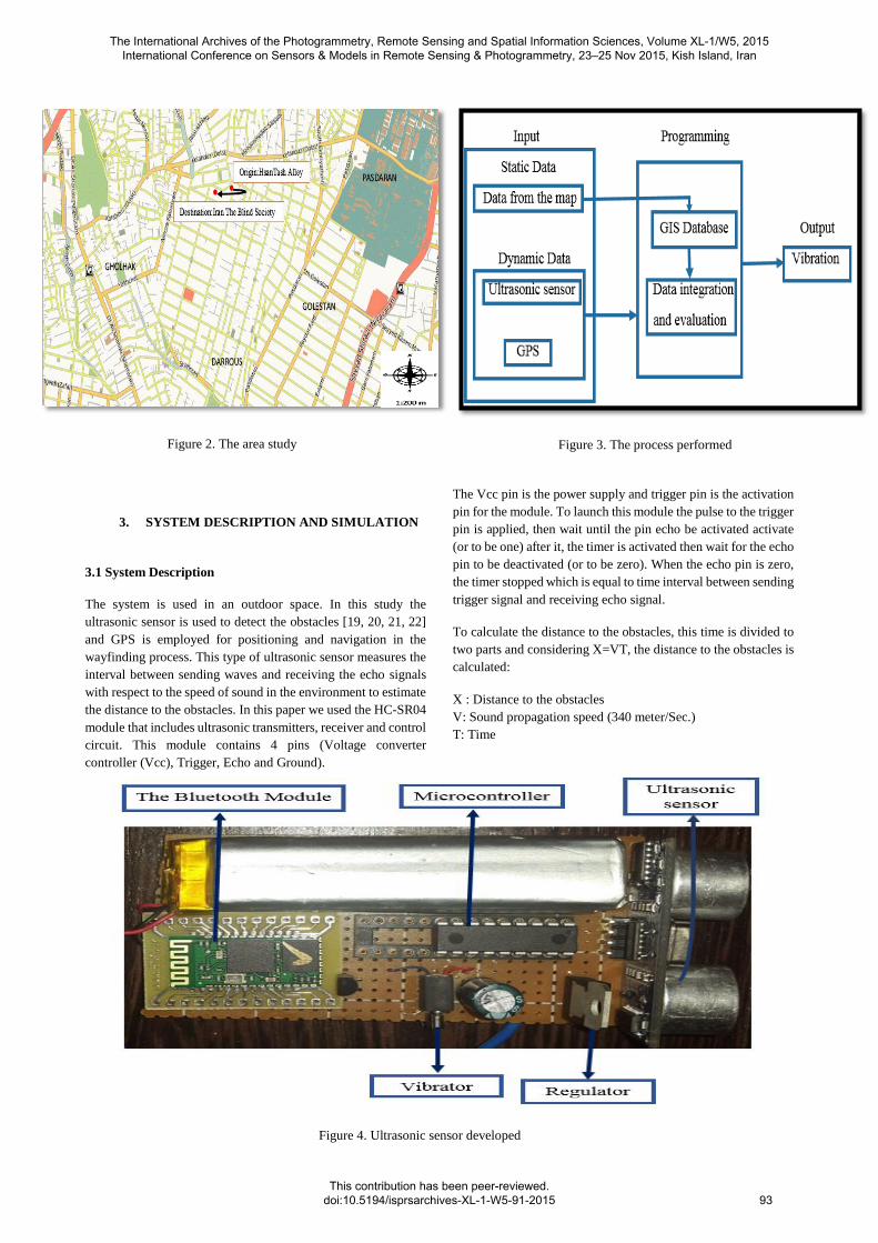
is a part of Tehran, the capital of Iran. The blind person begins
to move from the Hasantash Street in Dowlat Avenue in the north
of Tehran as his/her origin with an ultrasonic sensor at hand to
Iran the Blind Society as his/her destination. While a blind
person is moving towards the obstacles, the sensor vibration is
activated. The blind person according to the vibration severity of
the sensor, changes his/her walking direction. There are some
obstacles in the implemented phase such as trees, stream and
poles between the origin and the destination. The study area
specified with Longitude in a range of 51°27'14.28" to
51°27'09.34" and Latitude in a range of 35°46'41.59" to
35°46'41.18" presented in Figure 2. The blind person with an
ultrasonic sensor and GPS detects the obstacles on his/her way
and due to the sensor vibration whose vibration severity is related
to the distance to the obstacle, continues to move in a collision
free path. In the proposed system the process shown in Figure 3
is performed. Static data obtained from the map and dynamic
data obtained from the sensor and GPS as an input are loaded to
the programming module. In the programming module the static
data registered in GIS database integrated with dynamic data to
be able to assist detecting the obstacles and finally vibration is
undertake as an output alert to the blind. Geospatial information
system is used in the implemented system in order to calculate
distance to the obstacles which integrates the map and ultrasonic
sensor data and if the blind distance to the obstacle is less than a
given threshold, the sensor vibration will be activated.
Figure 1. Research methodology
The International Archives of the Photogrammetry, Remote Sensing and Spatial Information Sciences, Volume XL-1/W5, 2015 International Conference on Sensors & Models in Remote Sensing & Photogrammetry, 23–25 Nov 2015, Kish Island, Iran
This contribution has been peer-reviewed. doi:10.5194/isprsarchives-XL-1-W5-91-2015
92
3. SYSTEM DESCRIPTION AND SIMULATION
3.1 System Description
The system is used in an outdoor space. In this study the
ultrasonic sensor is used to detect the obstacles [19, 20, 21, 22]
and GPS is employed for positioning and navigation in the
wayfinding process. This type of ultrasonic sensor measures the
interval between sending waves and receiving the echo signals
with respect to the speed of sound in the environment to estimate
the distance to the obstacles. In this paper we used the HC-SR04
module that includes ultrasonic transmitters, receiver and control
circuit. This module contains 4 pins (Voltage converter
controller (Vcc), Trigger, Echo and Ground).
The Vcc pin is the power supply and trigger pin is the activation
pin for the module. To launch this module the pulse to the trigger
pin is applied, then wait until the pin echo be activated activate
(or to be one) after it, the timer is activated then wait for the echo
pin to be deactivated (or to be zero). When the echo pin is zero,
the timer stopped which is equal to time interval between sending
trigger signal and receiving echo signal.
To calculate the distance to the obstacles, this time is divided to
two parts and considering X=VT, the distance to the obstacles is
calculated:
X : Distance to the obstacles
V: Sound propagation speed (340 meter/Sec.)
T: Time
Figure 2. The area study
Figure 3. The process performed
Figure 4. Ultrasonic sensor developed
The International Archives of the Photogrammetry, Remote Sensing and Spatial Information Sciences, Volume XL-1/W5, 2015 International Conference on Sensors & Models in Remote Sensing & Photogrammetry, 23–25 Nov 2015, Kish Island, Iran
This contribution has been peer-reviewed. doi:10.5194/isprsarchives-XL-1-W5-91-2015
93

The Bluetooth module used in order to send data from the
sensor to the computer system. A view of the ultrasonic sensor
designed and developed in this research shown in Figure 4. The
coordinates and characteristics of all the obstacles in the study
area are already stored in the GIS database. All of these
obstacles were labeled on the map. The ultrasonic sensor has
the ability to detect the obstacles in a distance of 2 cm to 400
cm. Each system designed for the blind generally contains three
main parts as follow [23, 24, 25]:
A module for recognizing the location
A computer system that contains a GIS with the
information to assist the users to undertake wayfinding
The user interface
As shown in Figure 4 on side ultrasonic sensor is a vibration
motor whose sound is related to the distance from the obstacle
change vibration intensity. When the blind getting closer to the
obstacles, the vibration intensity is increased.
3.2 Simulation
In addition to the design and test of the implemented system, a
simulation has been performed: To simulate the implemented
system, Netlogo software Version 5.1.0 was used as shown in
Figure 5. In this simulation, the blind person from the origin to
the destination moves in an obstacle free path. Also the obstacles
such as trees and cars in this simulation are presented. The blind
and obstacles are considered as agents.
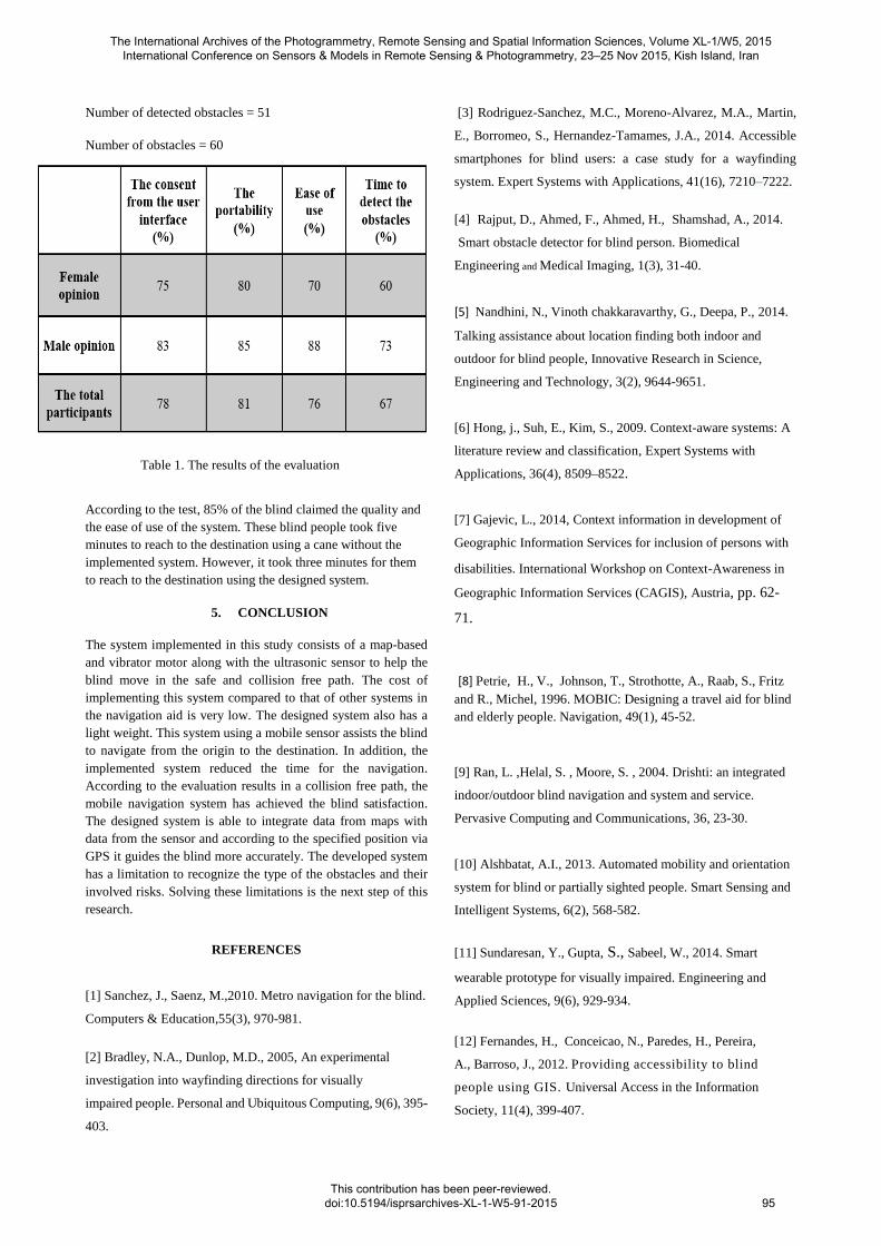
4. EVALUATION
In order to evaluate the designed system, an interview was
arranged with the blind. Each participant in the interview could
offer additional information and suggestions about the designed
system. At first, a brief introduction about the designed system
is presented to the blind. Participants in the interview become
familiar with the sensor and its performance. After the blind
introduction to the sensor, an outdoor test was implemented. The
system is tested on 15 blinds in Iran The Blind Society and for
this purpose a questionnaire was designed.
The questions asked the blind to answer the following issues:
The time to detect the obstacles
The ease of system use
The errors in obstacles detection
The survey consists of 9 females and 6 males whose age range
21 to 61.The purpose of this survey is to evaluate the blind
satisfaction level with respect to the designed and implemented
system. The results from the interview are presented in Table 1.
A quality parameter was calculated as follows:
Satisfaction level of navigation system for the blind =
number of detected obstacles
number of obstacles
Figure 5. Simulation of the designed system
The International Archives of the Photogrammetry, Remote Sensing and Spatial Information Sciences, Volume XL-1/W5, 2015 International Conference on Sensors & Models in Remote Sensing & Photogrammetry, 23–25 Nov 2015, Kish Island, Iran
This contribution has been peer-reviewed. doi:10.5194/isprsarchives-XL-1-W5-91-2015
94
Number of detected obstacles = 51
Number of obstacles = 60
According to the test, 85% of the blind claimed the quality and
the ease of use of the system. These blind people took five
minutes to reach to the destination using a cane without the
implemented system. However, it took three minutes for them
to reach to the destination using the designed system.
5. CONCLUSION
The system implemented in this study consists of a map-based
and vibrator motor along with the ultrasonic sensor to help the
blind move in the safe and collision free path. The cost of
implementing this system compared to that of other systems in
the navigation aid is very low. The designed system also has a
light weight. This system using a mobile sensor assists the blind
to navigate from the origin to the destination. In addition, the
implemented system reduced the time for the navigation.
According to the evaluation results in a collision free path, the
mobile navigation system has achieved the blind satisfaction.
The designed system is able to integrate data from maps with
data from the sensor and according to the specified position via
GPS it guides the blind more accurately. The developed system
has a limitation to recognize the type of the obstacles and their
involved risks. Solving these limitations is the next step of this
research.
REFERENCES
[1] Sanchez, J., Saenz, M.,2010. Metro navigation for the blind.
Computers & Education,55(3), 970-981.
[2] Bradley, N.A., Dunlop, M.D., 2005, An experimental
investigation into wayfinding directions for visually
impaired people. Personal and Ubiquitous Computing, 9(6), 395-
403.
[3] Rodriguez-Sanchez, M.C., Moreno-Alvarez, M.A., Martin,
E., Borromeo, S., Hernandez-Tamames, J.A., 2014. Accessible
smartphones for blind users: a case study for a wayfinding
system. Expert Systems with Applications, 41(16), 7210–7222.
[4] Rajput, D., Ahmed, F., Ahmed, H., Shamshad, A., 2014.
Smart obstacle detector for blind person. Biomedical
Engineering and Medical Imaging, 1(3), 31-40.
[5] Nandhini, N., Vinoth chakkaravarthy, G., Deepa, P., 2014.
Talking assistance about location finding both indoor and
outdoor for blind people, Innovative Research in Science,
Engineering and Technology, 3(2), 9644-9651.
[6] Hong, j., Suh, E., Kim, S., 2009. Context-aware systems: A
literature review and classification, Expert Systems with
Applications, 36(4), 8509–8522.
[7] Gajevic, L., 2014, Context information in development of
Geographic Information Services for inclusion of persons with
disabilities. International Workshop on Context-Awareness in
Geographic Information Services (CAGIS), Austria, pp. 62-
71.
[8] Petrie, H., V., Johnson, T., Strothotte, A., Raab, S., Fritz
and R., Michel, 1996. MOBIC: Designing a travel aid for blind
and elderly people. Navigation, 49(1), 45-52.
[9] Ran, L. ,Helal, S. , Moore, S. , 2004. Drishti: an integrated
indoor/outdoor blind navigation and system and service.
Pervasive Computing and Communications, 36, 23-30.
[10] Alshbatat, A.I., 2013. Automated mobility and orientation
system for blind or partially sighted people. Smart Sensing and
Intelligent Systems, 6(2), 568-582.
[11] Sundaresan, Y., Gupta, S., Sabeel, W., 2014. Smart
wearable prototype for visually impaired. Engineering and
Applied Sciences, 9(6), 929-934.
[12] Fernandes, H., Conceicao, N., Paredes, H., Pereira,
A., Barroso, J., 2012. Providing accessibility to blind
people using GIS. Universal Access in the Information
Society, 11(4), 399-407.
Table 1. The results of the evaluation
The International Archives of the Photogrammetry, Remote Sensing and Spatial Information Sciences, Volume XL-1/W5, 2015 International Conference on Sensors & Models in Remote Sensing & Photogrammetry, 23–25 Nov 2015, Kish Island, Iran
This contribution has been peer-reviewed. doi:10.5194/isprsarchives-XL-1-W5-91-2015
95

[13] Ari, V., K., Sami, 2004. NOPPA Navigation and Guidance
System for the Blind, VTT Industrial Systems, Finland.
[14] Dunai, L., L., Tortajadn, F., Simon, 2014. Obstacle
detectors for visually impaired people. Proc. International
Conference Optimizing of Electrical and Electronic Equipment,
22-24 May, Bran, pp. 809-816.
[15] Guillermo, P. ,Dunai, L. ,Praderas, CASBLIP a new
cognitive object detection and orientation system for impaired
people. Proc. COGSYS Conference, ETH Zurich, Jaunary, 27-
28, 2010.
[16] Bhambare, R.R., A., Koul, S.M., Bilal, S., Panday, 2014.
Smart vision system for blind. Engineering and Computer
Science, 3(5), 5790-5795.
[17] Hans, J.M., Barroso, J., Fernandes, H., 2011.The
smartvision navigation prototype for blind users. Digital
Content Technology and its Applications, 5(5), 351-361.
[18] Otaegui, O., Loyo, E., Carrasco, E., 2012. ARGUS:
assisting personal guidance system for people with visual
impairment. Proc. ISOCARP Congress. Russia
[19] Mustapha, B., Zayegh, A., Begg, R., 2013. Ultrasonic and
infrared sensors performance in a wireless obstacle detection
system. Proc. International Conference Artificial Intelligence,
Modelling and Simulation, pp. 487-492.
[20] Rodriguez, A., Yebes, J., Alcantarilla, F., Bergasa, L.,
2012. Assisting the visually impaired: obstacle detection and
warning system by acoustic feedback. Sensors, 12(12), 17476-
17496.
[21] Mpitziopoulos, A., Konstantopoulos, C., Gavalas, D.,
Pantziou, G., 2011. A pervasive assistive environment for
visually impaired people using wireless sensor network
infrastructure. Network and Computer Applications, 34(1),
194-206.
[22] Prattico, F., Cera, C., Petroni, F., 2013. A new hybrid
infrared-ultrasonic electronic travel aids for blind people.
Sensors and Actuators A: Physical, 201, 363-370.
[23] Loomis, Golledge, Klatzky,, 1998. Navigation System for
the Blind .Presence, 7(2), 193–203.
[24] Ljupko, S., Andelic, V., Pavlinusic, I., Blind people
guidance system. Proc. Central European Conference
Information and Intelligent Systems, Croatia, 19-21 september,
2012, pp. 427-431.
[25] Hossain, E., Khan, R., Ali, A., 2011. Design and data
analysis for a belt-for-blind for visual impaired people.
Advanced Mechatronic Systems 3, No. 5/6, 384-397.
The International Archives of the Photogrammetry, Remote Sensing and Spatial Information Sciences, Volume XL-1/W5, 2015 International Conference on Sensors & Models in Remote Sensing & Photogrammetry, 23–25 Nov 2015, Kish Island, Iran
This contribution has been peer-reviewed. doi:10.5194/isprsarchives-XL-1-W5-91-2015
96
Related Documents