NOAA FORM 76-35A U.S. DEPARTMENT OF COMMERCE NATIONAL OCEANIC AND ATMOSPHERIC ADMINISTRATION NATIONAL OCEAN SURVEY DESCRIPTIVE REPORT Type of Survey Hydrographic / SSS & SWMB Registry No. H11642 LOCALITY State WASHINGTON General Locality Commencement Bay Sub-locality Thea Foss Waterway to Hylebos Waterwyay 2007-2009 CHIEF OF PARTY Kathryn Simmons NOAA/NRT3 LIBRARY & ARCHIVES DATE H11642

Welcome message from author
This document is posted to help you gain knowledge. Please leave a comment to let me know what you think about it! Share it to your friends and learn new things together.
Transcript
NOAA FORM 76-35A
U.S. DEPARTMENT OF COMMERCE NATIONAL OCEANIC AND ATMOSPHERIC ADMINISTRATION
NATIONAL OCEAN SURVEY
DESCRIPTIVE REPORT
Type of Survey Hydrographic / SSS & SWMB
Registry No. H11642
LOCALITY
State WASHINGTON
General Locality Commencement Bay Sub-locality Thea Foss Waterway to Hylebos Waterwyay
2007-2009 CHIEF OF PARTY Kathryn Simmons NOAA/NRT3
LIBRARY & ARCHIVES DATE
H11
642
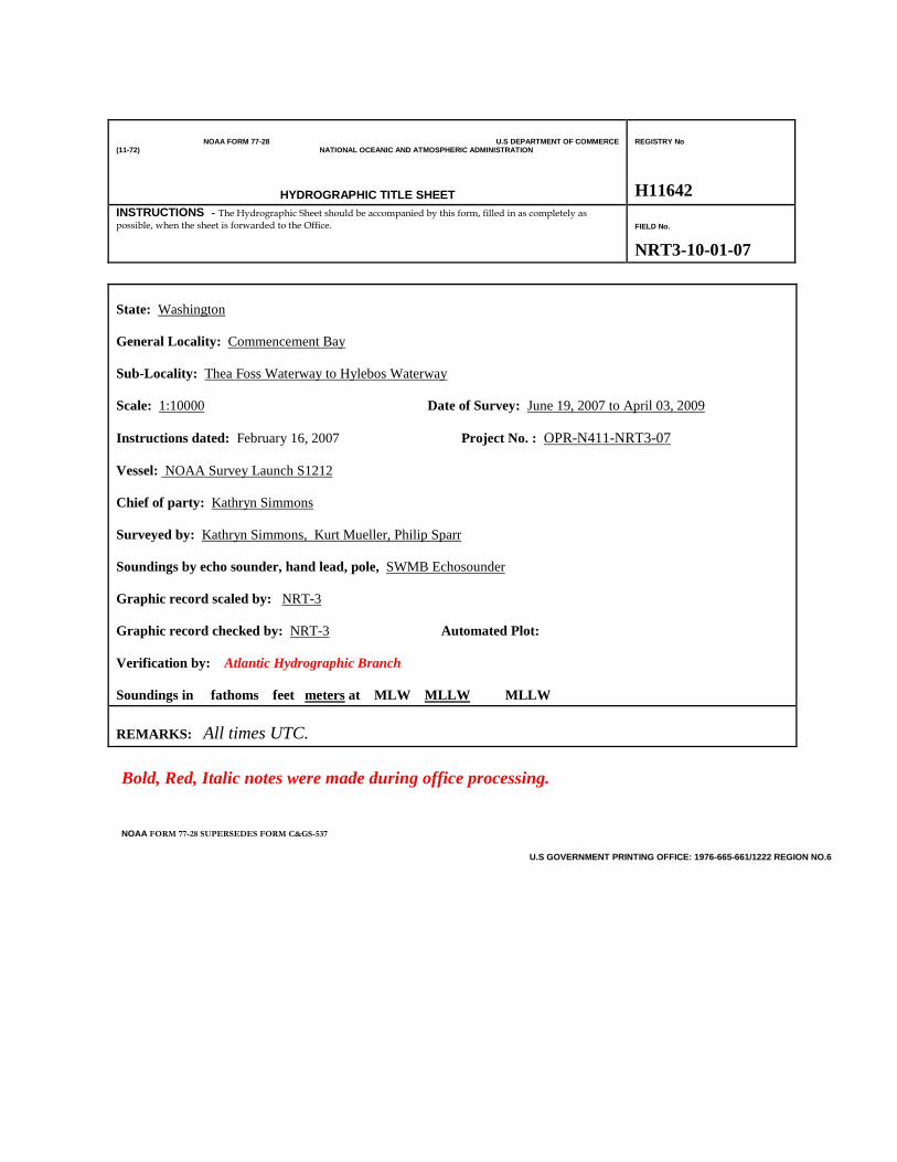
NOAA FORM 77-28 U.S DEPARTMENT OF COMMERCE (11-72) NATIONAL OCEANIC AND ATMOSPHERIC ADMINISTRATION
HYDROGRAPHIC TITLE SHEET
REGISTRY No
H11642
INSTRUCTIONS -The Hydrographic Sheet should be accompanied by this form, filled in as completely as possible, when the sheet is forwarded to the Office.
FIELD No.
NRT3-10-01-07
State:
Washington
General Locality:
Commencement Bay
Sub-Locality:
Thea Foss Waterway to Hylebos Waterway
Scale: 1:10000 Date of Survey:
June 19, 2007 to April 03, 2009
Instructions dated: February 16, 2007 Project No. :
OPR-N411-NRT3-07
Vessel:
NOAA Survey Launch S1212
Chief of party:
Kathryn Simmons
Surveyed by:
Kathryn Simmons, Kurt Mueller, Philip Sparr
Soundings by echo sounder, hand lead, pole,
SWMB Echosounder
Graphic record scaled by:
NRT-3
Graphic record checked by: NRT-3
Automated Plot:
Verification by: Atlantic Hydrographic Branch Soundings in fathoms feet meters at MLW MLLW
MLLW
REMARKS: All times UTC. Bold, Red, Italic notes were made during office processing. NOAA FORM 77-28 SUPERSEDES FORM C&GS-537
U.S GOVERNMENT PRINTING OFFICE: 1976-665-661/1222 REGION NO.6

H11642 - 2 - NRT3
Descriptive Report to Accompany H11642 Scale 1:10000
2007-2009 Navigation Response Team 3
Team Leader: Kathryn Simmons A. Area Surveyed Significant changes to the shoreline in and around Tacoma have occurred in recent years. In 2004 the Marine Chart Division (MCD) identified Tacoma as a port in need of Electronic Nautical Chart (ENC) validation. In addition, Office of Coast Survey’s National Survey Plan has identified Commencement Bay as a critical survey area because of major dredging and filling at various locations around the port area. This project was conducted to provide multibeam data in support of updating the National Ocean Service (NOS) nautical charts. H11642 is one of two surveys in Project OPR-N411-NRT3-07 and includes multibeam hydrography and side scan sonar data. The total area of hydrography is approximately 1.8 square nautical miles as shown below:
H11642 - 3 - NRT3
B. DATA ACQUISITION AND PROCESSING See also the Evaluation Report. Data acquisition was conducted from June 19, 2007 (DN 170) through July 18, 2007 (DN 199), and from April 23, 2008 (DN 114) through July 25, 2008 (DN 207). Additional hydrography was collected in portions of the survey area on December 8, 12, and 14 2008 and on April 03 2009. B1. Equipment and Vessels
NRT3’s survey vessel, NOAA Survey Launch S1212, is equipped with an Odom single beam transducer, a Klein side scan sonar system, and a Simrad EM3000 SWMB echosounder, and was used to acquire multibeam and side scan sonar data.
Launch S1212, a 27-foot, SeaArk Commander (SAMA115510000), was acquired in January 2001. In August 2004 the hull was extended to 30 feet to accommodate the weight of the two 150-horsepower Yamaha four-stroke outboards which power the vessel. The launch is eight feet wide, displaces 4.8 tons, has a static draft of 0.4 meters and is equipped with a Dell Pentium IV PC for running the primary acquisition software.
Data acquisition was conducted over several time periods for this survey (June19 through July 18, 2007, April 23 through July 25, 2008, December 8 through the 14, 2008, and on April 03, 2009). On April 23, 2008 survey launch S1212’s original POSMV was sent to Applanix for repair and a temporary replacement was installed (SN 2254). This replacement unit was used for the remainder of the survey. A GAMS calibration and a SWMB patch test were also conducted on April 23 prior to data acquisition.
See Data Acquisition and Processing Report (DAPR). * B2. Quality Control
Crossline Data
Crosslines acquired for the survey total 6.72 nautical miles, 7.2 percent of mainscheme mileage. Crossline data were compared to mainscheme data using subset editor. No systematic or tidal errors were observed; agreement was seamless. Concur See also Data Acquisition and Processing Report. * B3. Corrections to Echo Soundings See Data Acquisition and Processing Report. * B4. Data Processing A total of seven CARIS field sheets were created for this survey (H11642A through H11642G) to keep base surfaces to an easily manageable size. Single, half-meter surfaces were created for sheets A, E, F and G. Depths on sheets B, C, and D range from very shallow to very deep; therefore, field sheets in these three grids were split into three surfaces: depths between 49 and 150 meters at two-meter resolution, 19 meters to 50 meters at one-meter resolution, and 20 meters and shallower at half-meter resolution. All surfaces were created using the CUBE algorithm with the “deep” cube parameter configuration option. See also Data Acquisition and Processing Report. * *Data filed with original field records.

H11642 - 4 - NRT3
C. VERTICAL AND HORIZONTAL CONTROL C1. Tides and Water Levels See Data Acquisition and Processing Report. * C2. Horizontal Datum See also the Evaluation Report. The horizontal control datum for this project is North American Datum of 1983 (NAD83). C3. Position Control See Data Acquisition and Processing Report.* D. RESULTS AND RECOMMENDATIONS See also the Evaluation Report. D1. Chart Comparison Survey results were compared with the latest revisions of the largest scale, affected rasters and ENC chart downloaded from NOAA’s website at the end of survey.
Chart No.
Edition
Edition Date
Latest Notice to Mariners
Cleared Through Date 18453 25th September 1, 2007 54 1/10/2009 18474 8th October 1, 2003 221 1/10/2009
ENC Cell Edition Update Application Date Issue Date US5WA18M 7 7/31/2007 7/10/2008 US5WA22M 5 10/4/2007 11/10/2008
Comparison of Soundings
Survey data were compared with the charts using contour lines and sounding plots generated by CARIS Field Sheet Editor, Pydro and Mapinfo/Vertical Mapper. Major chart discrepancies are described below: The Thea Foss Waterway south of the 11th Street Bridge is deeper than currently charted by as much as 15 feet. The greater depths are a result of a 2006 Superfund remediation project that removed contaminated sediments from this portion of the waterway. Concur The one exception is an obstruction with a least depth of 12-feet at latitude 47°14’56.7768”N, longitude 122°25’57.826”W which was submitted as a DTON. See Appendix 1 for final charting recommendation. Highly dynamic river and tide conditions have created major changes in depths at the mouth of the Puyallup River. Most significantly, the charted 18-foot shoal at latitude 47°16’22.967”N, longitude 122°25’58.276”W has shifted approximately 30 meters to the northwest and now has a least depth of 15 feet at latitude 47°16’23.646”N, longitude 122°25’59.373”W. The 24-foot shoal charted at latitude 47°16’19.829”N, *Data filed with original field records.

H11642 - 5 - NRT3
longitude 122° 25’56.765”W has also shifted and now lies 40 meters to the northeast at latitude 47°16’20.307”N, longitude 122°25’54.963”W with a least depth of 15 feet. These items were also submitted as DTONs. See Appendix 1 for final charting recommendations. Log storage areas/booming grounds prevented acquisition of complete side scan and/or SWMB coverage in some areas of the survey; e.g., the charted booming grounds just outside the mouth of the Hylebos waterway (the southeastern corner of Commencement Bay), the north end of the upper turning basin at the head of the Hylebos waterway, and the south end of the Hylebos Waterway. Concur The northern portion of the survey area near the Tyee Marina and the charted barge storage area is littered with debris and sunken wrecks, some of which are located under the barges and other structures forming the marina breakwater. Several wrecks were submitted as Dangers to Navigations while others which did not rise to the danger level were designated and discussed in Pydro. Side scan acquisition along the marina breakwater was conducted while the launch was turning; this, combined with small cable-out errors, resulted in substantial differences between the sounding data and correlating side scan contacts. Soundings and side scan contacts have been correlated with bathymetry to the greatest degree possible in this area.
Comparison of Non-Sounding Features
New shoreline data provided by Remote Sensing Division (RSD) was verified; the CEF was annotated as requested and returned to RSD on January 21, 2009. Several new features were positioned and processed with CARIS Notebook. Notebook files accompany this survey in hob, S57 and shape file formats. Major shoreline changes are listed as follows: The turning basin at the head of Blair Waterway has been enlarged on the east side. Concur The two drydocks between Piers 25 and 24 at latitude 47°17’2.559”N, longitude 122°24’38.3241”W (at mouth of Hylebos Waterway) have been removed. Concur – Delete charted drydocks. The small waterway east of Pier No. 1 (at mouth of Blair Waterway, latitude 47°1632.389”N, longitude 122°24’51.2737”W) has been filled in. Concur – Revise shoreline. The area between Pier No. 1 and Pier No. 5, (just outside the mouth of the Blair Waterway) has been filled in and is now a fish haven. Concur - See also section D. of the Evaluation Report . AWOIS Items There are 13 AWOIS items within the limits of this survey. AWOIS items 53278, 53279, and, to a lesser extent, item 53277 are located under the uncharted breakwater for the Tyee Marina and could be only partially developed with SS and SWMB. See graphic below.

H11642 - 6 - NRT3
These and all other AWOIS items are discussed in Pydro and included in the Pydro-generated feature report. See Appendix 2 for final charting recommendations.
Dangers to Navigation
Twenty primary DTON’s were issued during the course of this survey and submitted to Marine Chart Division. See Appendix I. Data attached to this report. Of special note, in the first week of December 2008, a 175-foot derelict barge broke free of its mooring, split almost in half, and partially sank in the shipping channel of the Hylebos waterway. In response to the incident, NRT3 collected SWMB and side scan data on December 8, 12, and 14 as salvage operations were taking place. According to Tom Szelest, Chief of Navigation Section, USACOE, the barge was completely removed from the waterway on December 18, 2008. Soundings over the submerged barge collected on the above-mentioned days were manually rejected in CARIS Subset Editor. The barge remains evident in all side scan imagery, but should be disregarded as it has been removed. D2. Additional Results
Comparison with Prior Surveys
Prior surveys were not addressed.
Aids to Navigation
New positions were acquired on fixed aids to navigation using the Trimble GeoXT unit. The updated positions and attributes have been submitted directly to MCD.

H11642 - 7 - NRT3
Bridges, Cables, Pipelines
Charted bridges, cables, and pipelines were visually confirmed. A charted sewer discharge pipe between the Blair and Sitcum Waterways was located 18 meters west of its charted position. The pipe azimuth is 310 degrees seaward with the offshore end located at latitude 47°16’40.734”N, longitude 122°25’17.315”W. A second uncharted discharge pipe was located. The offshore end is at latitude 47°16’03.526”N, longitude 122°26’01.223”W. The pipe extends seaward at an azimuth of 306 degrees.
Description Statistics
Quantities Total Linear Nautical Miles 105.63 Mainscheme Multibeam 96.12 Side Scan Sonar 24.61 Development 1.21 Crosslines 6.72 Square Nautical Miles Hydrography 1.76 Square Nautical Miles SSS 1.57 Velocity Casts 26 Bottom Samples 0 AWOIS Items 13 Tide Stations Installed 0
Miscellaneous
Due to the entanglement and grounding hazards existing in the Middle Waterway and the St. Paul Waterway, side scan coverage was not acquired in those areas. Gaps exist in the SWMB coverage on the western edge of Commencement Bay, just outside the mouth of the Thea Foss Waterway alongside a charted pier/mooring facility in the vicinity of latitude 47°15’58.81”N, longitude 122°26’34.14’’W. Two large vessels were moored at this location throughout the entire survey, thus hindering acquisition of complete SWMB coverage along the face of the pier. Soundings over shoreline structures were rejected manually in CARIS subset editor using compiled shoreline provided by RSD as a template. Single beam data that was acquired in conjunction with side scan data was not processed. Data collection for this survey was interrupted at the end of July 2007 in order to accomplish offshore data acquisition in Coos Bay, Oregon, for project OPR-M905-NRT3-07 during the optimal summer weather window. NRT3 returned to Tacoma in March 2008 and recommenced the project on March 23.

H11642 - 8 - NRT3
Submitted for approval,
Kurt Mueller Physical Science Technician E. APPROVAL SHEET Standard field surveying and processing procedures were followed in producing this survey in accordance with the Navigation Response Branch Operations Manual, the Field Procedures Manual and NOS Hydrographic Surveys Specifications and Deliverables. The data were reviewed daily during acquisition and processing. The digital data and supporting records have been reviewed by me, are considered complete and adequate for charting purposes, and are approved. All records are forwarded to Atlantic Hydrographic Branch and should be attached to H11642 for final review and processing.

H11642 DTON REPORT
Registry Number: H11642
State: Washington
Locality: Commencement Bay
Sub-locality: Thea Foss Waterway to Hylebos Waterway
Project Number: OPR-N411-NRT3-08
Survey Dates: 06/19/2007 - 04/23/2008
Charts Affected
Number Edition Date Scale (RNC) RNC Correction(s)*
18453 25th 10/01/2007 1:15,000 (18453_1)
USCG LNM: 10/17/2006 (12/12/2006)CHS NTM: None (10/27/2006)
NGA NTM: 02/26/2000 (12/23/2006)
18474 8th 10/01/2003 1:40,000 (18474_1) [L]NTM: ?
18445 32nd 08/01/20071:80,000 (18445_8)1:40,000 (18445_7) [L]NTM: ?
18448 34th 07/01/2006 1:80,000 (18448_1) [L]NTM: ?
18440 29th 10/01/2007 1:150,000 (18440_1) [L]NTM: ?
18003 20th 11/01/2006 1:736,560 (18003_1) [L]NTM: ?
18007 32nd 07/01/2005 1:1,200,000 (18007_1) [L]NTM: ?
501 12th 11/01/2002 1:3,500,000 (501_1) [L]NTM: ?
530 32nd 06/01/2007 1:4,860,700 (530_1) [L]NTM: ?
50 6th 06/01/2003 1:10,000,000 (50_1) [L]NTM: ?
* Correction(s) - source: last correction applied (last correction reviewed--"cleared date")
Features
No. NameFeatureType
SurveyDepth
SurveyLatitude
SurveyLongitude
AWOISItem
1.1 48 Obstn - 1237/22 Obstruction 14.74 m 47° 16' 38.7" N 122° 24' 38.6" W ---
1.2 3 depth - 1944/118 Shoal 0.88 m 47° 15' 53.7" N 122° 25' 51.0" W ---
1.3 35 depth - 2024/95 Shoal 10.69 m 47° 15' 46.6" N 122° 23' 13.3" W ---
1.4 11 Obstn - 6888/5 Obstruction 3.34 m 47° 14' 56.8" N 122° 25' 58.0" W ---
1.5 42 Obstn - 2225/19 Obstruction 12.97 m 47° 15' 44.9" N 122° 26' 23.4" W ---
1.6 15 depth - 3060/19 Shoal 4.61 m 47° 16' 23.6" N 122° 25' 59.4" W ---
Generated by Pydro v9.10 (r2824) on Thu Feb 25 20:10:51 2010 [UTC]
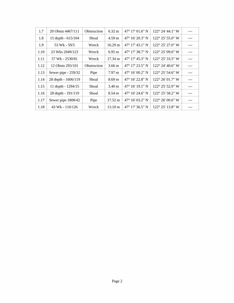
1.7 20 Obstn 4467/111 Obstruction 6.32 m 47° 17' 01.6" N 122° 24' 44.1" W ---
1.8 15 depth - 615/104 Shoal 4.59 m 47° 16' 20.3" N 122° 25' 55.0" W ---
1.9 53 Wk - 59/5 Wreck 16.29 m 47° 17' 43.1" N 122° 25' 27.0" W ---
1.10 23 Wks 2049/123 Wreck 6.95 m 47° 17' 38.7" N 122° 25' 09.6" W ---
1.11 57 Wk - 2530/81 Wreck 17.34 m 47° 17' 45.3" N 122° 25' 33.5" W ---
1.12 12 Obstn 293/101 Obstruction 3.66 m 47° 17' 23.5" N 122° 24' 40.6" W ---
1.13 Sewer pipe - 259/32 Pipe 7.97 m 47° 16' 00.2" N 122° 25' 54.6" W ---
1.14 28 depth - 1606/119 Shoal 8.69 m 47° 16' 22.8" N 122° 26' 01.7" W ---
1.15 11 depth - 1294/15 Shoal 3.40 m 47° 16' 19.1" N 122° 25' 52.9" W ---
1.16 28 depth - 191/119 Shoal 8.54 m 47° 16' 24.6" N 122° 25' 58.2" W ---
1.17 Sewer pipe 1808/42 Pipe 17.52 m 47° 16' 03.2" N 122° 26' 00.6" W ---
1.18 43 Wk - 116/126 Wreck 13.10 m 47° 17' 36.5" N 122° 25' 13.8" W ---
Page 2

1 - DR_DToN
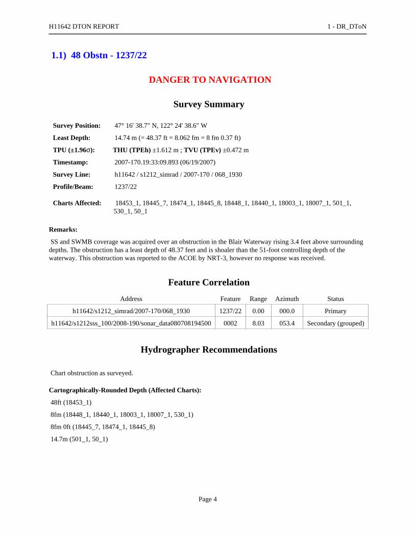
1.1) 48 Obstn - 1237/22
DANGER TO NAVIGATION
Survey Summary
Survey Position: 47° 16' 38.7" N, 122° 24' 38.6" W
Least Depth: 14.74 m (= 48.37 ft = 8.062 fm = 8 fm 0.37 ft)
TPU (±1.96σ): THU (TPEh) ±1.612 m ; TVU (TPEv) ±0.472 m
Timestamp: 2007-170.19:33:09.893 (06/19/2007)
Survey Line: h11642 / s1212_simrad / 2007-170 / 068_1930
Profile/Beam: 1237/22
Charts Affected: 18453_1, 18445_7, 18474_1, 18445_8, 18448_1, 18440_1, 18003_1, 18007_1, 501_1,530_1, 50_1
Remarks:
SS and SWMB coverage was acquired over an obstruction in the Blair Waterway rising 3.4 feet above surroundingdepths. The obstruction has a least depth of 48.37 feet and is shoaler than the 51-foot controlling depth of thewaterway. This obstruction was reported to the ACOE by NRT-3, however no response was received.
Feature Correlation
Address Feature Range Azimuth Status
h11642/s1212_simrad/2007-170/068_1930 1237/22 0.00 000.0 Primary
h11642/s1212sss_100/2008-190/sonar_data080708194500 0002 8.03 053.4 Secondary (grouped)
Hydrographer Recommendations
Chart obstruction as surveyed.
Cartographically-Rounded Depth (Affected Charts):
48ft (18453_1)
8fm (18448_1, 18440_1, 18003_1, 18007_1, 530_1)
8fm 0ft (18445_7, 18474_1, 18445_8)
14.7m (501_1, 50_1)
H11642 DTON REPORT 1 - DR_DToN
Page 4

S-57 Data
Geo object 1: Obstruction (OBSTRN)
Attributes: QUASOU - 6:least depth known
SORDAT - 20090403
SORIND - US,US,nsurf,H11642
TECSOU - 3:found by multi-beam
VALSOU - 14.744 m
WATLEV - 3:always under water/submerged
Office Notes
Concur - Add 48 Obstn and danger curve in present survey location.
H11642 DTON REPORT 1 - DR_DToN
Page 5

Feature Images
Figure 1.1.1
H11642 DTON REPORT 1 - DR_DToN
Page 6
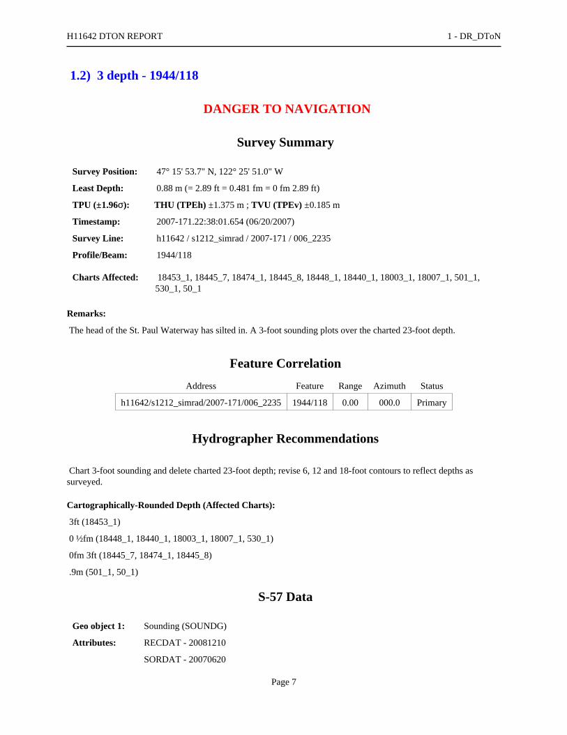
1.2) 3 depth - 1944/118
DANGER TO NAVIGATION
Survey Summary
Survey Position: 47° 15' 53.7" N, 122° 25' 51.0" W
Least Depth: 0.88 m (= 2.89 ft = 0.481 fm = 0 fm 2.89 ft)
TPU (±1.96σ): THU (TPEh) ±1.375 m ; TVU (TPEv) ±0.185 m
Timestamp: 2007-171.22:38:01.654 (06/20/2007)
Survey Line: h11642 / s1212_simrad / 2007-171 / 006_2235
Profile/Beam: 1944/118
Charts Affected: 18453_1, 18445_7, 18474_1, 18445_8, 18448_1, 18440_1, 18003_1, 18007_1, 501_1,530_1, 50_1
Remarks:
The head of the St. Paul Waterway has silted in. A 3-foot sounding plots over the charted 23-foot depth.
Feature Correlation
Address Feature Range Azimuth Status
h11642/s1212_simrad/2007-171/006_2235 1944/118 0.00 000.0 Primary
Hydrographer Recommendations
Chart 3-foot sounding and delete charted 23-foot depth; revise 6, 12 and 18-foot contours to reflect depths assurveyed.
Cartographically-Rounded Depth (Affected Charts):
3ft (18453_1)
0 ½fm (18448_1, 18440_1, 18003_1, 18007_1, 530_1)
0fm 3ft (18445_7, 18474_1, 18445_8)
.9m (501_1, 50_1)
S-57 Data
Geo object 1: Sounding (SOUNDG)
Attributes: RECDAT - 20081210
SORDAT - 20070620
H11642 DTON REPORT 1 - DR_DToN
Page 7

SORIND - US, US Survey H11642
TECSOU - 3:found by multi-beam
Office Notes
Concur - Chart 3 ft depth.
H11642 DTON REPORT 1 - DR_DToN
Page 8

1.3) 35 depth - 2024/95
DANGER TO NAVIGATION
Survey Summary
Survey Position: 47° 15' 46.6" N, 122° 23' 13.3" W
Least Depth: 10.69 m (= 35.07 ft = 5.845 fm = 5 fm 5.07 ft)
TPU (±1.96σ): THU (TPEh) ±1.489 m ; TVU (TPEv) ±0.284 m
Timestamp: 2007-171.20:50:29.839 (06/20/2007)
Survey Line: h11642 / s1212_simrad / 2007-171 / 009_2046
Profile/Beam: 2024/95
Charts Affected: 18453_1, 18445_7, 18445_8, 18448_1, 18440_1, 18003_1, 18007_1, 501_1, 530_1, 50_1
Remarks:
SWMB coverage over shoal extending into the maintained channel of the Blair Waterway. Although the waterwayhas been widened from this point to the head of the waterway, a manmade protrusion into the channel remains. Thisprotrusion appears to cause sediment buildup at its offshore limit. A 45-foot sounding was found in the channelwhere the controlling depth is 51 feet. This 35-foot sounding, fourteen meters shoreward, plots on top of the leftoutside channel line at the location of the charted dol. Thirteen meters shoreward of the 35-foot sounding is a22-foot sounding. The dol was disproved with 200% SWMB coverage as well as side scan coverage.
Feature Correlation
Address Feature Range Azimuth Status
h11642/s1212_simrad/2007-171/009_2046 2024/95 0.00 000.0 Primary
h11642/s1212_simrad/2007-170/073_1949 1552/100 13.34 222.1 Secondary (grouped)
h11642/s1212_simrad/2007-171/004_2133 6076/51 14.58 064.7 Secondary (grouped)
Hydrographer Recommendations
Delete charted dol. Chart 35-foot sounding at surveyed location.
Cartographically-Rounded Depth (Affected Charts):
35ft (18453_1)
5 ¾fm (18448_1, 18440_1, 18003_1, 18007_1, 530_1)
5fm 5ft (18445_7, 18445_8)
10.7m (501_1, 50_1)
H11642 DTON REPORT 1 - DR_DToN
Page 9

S-57 Data
Geo object 1: Sounding (SOUNDG)
Attributes: RECDAT - 20081210
SORDAT - 2007620
SORIND - US, US Survey H11642
TECSOU - 3:found by multi-beam
Office Notes
Concur - Chart 35 ft depth.
H11642 DTON REPORT 1 - DR_DToN
Page 10
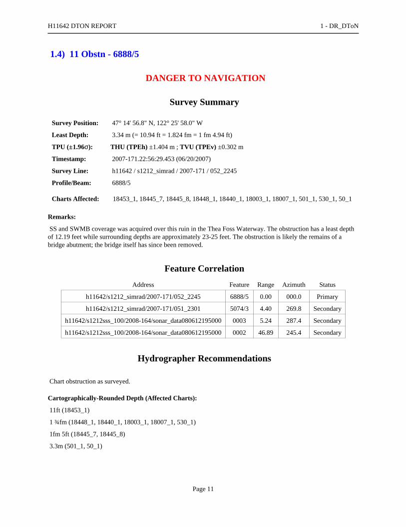
1.4) 11 Obstn - 6888/5
DANGER TO NAVIGATION
Survey Summary
Survey Position: 47° 14' 56.8" N, 122° 25' 58.0" W
Least Depth: 3.34 m (= 10.94 ft = 1.824 fm = 1 fm 4.94 ft)
TPU (±1.96σ): THU (TPEh) ±1.404 m ; TVU (TPEv) ±0.302 m
Timestamp: 2007-171.22:56:29.453 (06/20/2007)
Survey Line: h11642 / s1212_simrad / 2007-171 / 052_2245
Profile/Beam: 6888/5
Charts Affected: 18453_1, 18445_7, 18445_8, 18448_1, 18440_1, 18003_1, 18007_1, 501_1, 530_1, 50_1
Remarks:
SS and SWMB coverage was acquired over this ruin in the Thea Foss Waterway. The obstruction has a least depthof 12.19 feet while surrounding depths are approximately 23-25 feet. The obstruction is likely the remains of abridge abutment; the bridge itself has since been removed.
Feature Correlation
Address Feature Range Azimuth Status
h11642/s1212_simrad/2007-171/052_2245 6888/5 0.00 000.0 Primary
h11642/s1212_simrad/2007-171/051_2301 5074/3 4.40 269.8 Secondary
h11642/s1212sss_100/2008-164/sonar_data080612195000 0003 5.24 287.4 Secondary
h11642/s1212sss_100/2008-164/sonar_data080612195000 0002 46.89 245.4 Secondary
Hydrographer Recommendations
Chart obstruction as surveyed.
Cartographically-Rounded Depth (Affected Charts):
11ft (18453_1)
1 ¾fm (18448_1, 18440_1, 18003_1, 18007_1, 530_1)
1fm 5ft (18445_7, 18445_8)
3.3m (501_1, 50_1)
H11642 DTON REPORT 1 - DR_DToN
Page 11

S-57 Data
Geo object 1: Obstruction (OBSTRN)
Attributes: QUASOU - 6:least depth known
SORDAT - 20090403
SORIND - US,US,nsurf,H11642
TECSOU - 3:found by multi-beam
VALSOU - 3.336 m
WATLEV - 3:always under water/submerged
Office Notes
Concur - Add 11 Obstn and danger curve in present survey location.
H11642 DTON REPORT 1 - DR_DToN
Page 12

1.5) 42 Obstn - 2225/19
DANGER TO NAVIGATION
Survey Summary
Survey Position: 47° 15' 44.9" N, 122° 26' 23.4" W
Least Depth: 12.97 m (= 42.54 ft = 7.089 fm = 7 fm 0.54 ft)
TPU (±1.96σ): THU (TPEh) ±1.646 m ; TVU (TPEv) ±0.544 m
Timestamp: 2007-178.22:10:50.592 (06/27/2007)
Survey Line: h11642 / s1212_simrad / 2007-178 / 083_2203
Profile/Beam: 2225/19
Charts Affected: 18453_1, 18445_7, 18445_8, 18448_1, 18440_1, 18003_1, 18007_1, 501_1, 530_1, 50_1
Remarks:
An uncharted manmade submerged object was found with SS and SWMB west of the entrance to the FossWaterway. The object (possibly a sunken barge) is approximately 74 feet long and 35 feet wide and is oriented tothe northeast at 040 degrees. Designated sounding of 42.54 feet is at the inshore end.
Feature Correlation
Address Feature Range Azimuth Status
h11642/s1212_simrad/2007-178/083_2203 2225/19 0.00 000.0 Primary
h11642/s1212_simrad/2007-192/007_2152 341/40 19.01 220.6 Secondary
Hydrographer Recommendations
in present survey location.
Cartographically-Rounded Depth (Affected Charts):
42ft (18453_1)
7fm (18448_1, 18440_1, 18003_1, 18007_1, 530_1)
7fm 0ft (18445_7, 18445_8)
13.0m (501_1, 50_1)
S-57 Data
Geo object 1: Obstruction (OBSTRN)
Attributes: QUASOU - 6:least depth known
H11642 DTON REPORT 1 - DR_DToN
Page 13
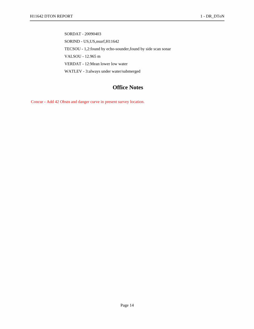
SORDAT - 20090403
SORIND - US,US,nsurf,H11642
TECSOU - 1,2:found by echo-sounder,found by side scan sonar
VALSOU - 12.965 m
VERDAT - 12:Mean lower low water
WATLEV - 3:always under water/submerged
Office Notes
Concur - Add 42 Obstn and danger curve in present survey location.
H11642 DTON REPORT 1 - DR_DToN
Page 14

Feature Images
Figure 1.5.1
H11642 DTON REPORT 1 - DR_DToN
Page 15

1.6) 15 depth - 3060/19
DANGER TO NAVIGATION
Survey Summary
Survey Position: 47° 16' 23.6" N, 122° 25' 59.4" W
Least Depth: 4.61 m (= 15.12 ft = 2.520 fm = 2 fm 3.12 ft)
TPU (±1.96σ): THU (TPEh) ±1.432 m ; TVU (TPEv) ±0.291 m
Timestamp: 2007-178.21:47:44.327 (06/27/2007)
Survey Line: h11642 / s1212_simrad / 2007-178 / 088_2136
Profile/Beam: 3060/19
Charts Affected: 18453_1, 18445_7, 18474_1, 18445_8, 18448_1, 18440_1, 18003_1, 18007_1, 501_1,530_1, 50_1
Remarks:
Sedimentation from the Puyallup River has altered the contours in the river delta. This 15-foot sounding representsthe least depth of the shoal at the offshore limit.
Feature Correlation
Address Feature Range Azimuth Status
h11642/s1212_simrad/2007-178/088_2136 3060/19 0.00 000.0 Primary
Hydrographer Recommendations
Chart 15-foot sounding; delete 18-foot charted sounding.
Cartographically-Rounded Depth (Affected Charts):
15ft (18453_1)
2 ½fm (18448_1, 18440_1, 18003_1, 18007_1, 530_1)
2fm 3ft (18445_7, 18474_1, 18445_8)
4.6m (501_1, 50_1)
S-57 Data
Geo object 1: Sounding (SOUNDG)
Attributes: QUASOU - 6:least depth known
RECDAT - 20090202
H11642 DTON REPORT 1 - DR_DToN
Page 16

SORDAT - 20090403
SORIND - US, US, nsurf,H11642
TECSOU - 3:found by multi-beam
Office Notes
Concur - Chart 15 ft depth.
H11642 DTON REPORT 1 - DR_DToN
Page 17

1.7) 20 Obstn 4467/111
DANGER TO NAVIGATION
Survey Summary
Survey Position: 47° 17' 01.6" N, 122° 24' 44.1" W
Least Depth: 6.32 m (= 20.74 ft = 3.457 fm = 3 fm 2.74 ft)
TPU (±1.96σ): THU (TPEh) ±1.465 m ; TVU (TPEv) ±0.355 m
Timestamp: 2007-190.19:07:29.522 (07/09/2007)
Survey Line: h11642 / s1212_simrad / 2007-190 / 076_1853
Profile/Beam: 4467/111
Charts Affected: 18453_1, 18445_7, 18474_1, 18445_8, 18448_1, 18440_1, 18003_1, 18007_1, 501_1,530_1, 50_1
Remarks:
Submerged object rising 7.6 feet, with least depth 20.7 feet. The obstruction is possibly a submerged piling ordolphin.
Feature Correlation
Address Feature Range Azimuth Status
h11642/s1212_simrad/2007-190/076_1853 4467/111 0.00 000.0 Primary
h11642/s1212sss_100/2008-206/sonar_data080724161800 0001 7.75 292.3 Secondary (grouped)
Hydrographer Recommendations
Chart obstruction with least depth.
Cartographically-Rounded Depth (Affected Charts):
20ft (18453_1)
3 ½fm (18448_1, 18440_1, 18003_1, 18007_1, 530_1)
3fm 2ft (18445_7, 18474_1, 18445_8)
6.3m (501_1, 50_1)
S-57 Data
Geo object 1: Obstruction (OBSTRN)
Attributes: QUASOU - 6:least depth known
H11642 DTON REPORT 1 - DR_DToN
Page 18
RECDAT - 20081210
SORDAT - 20070709
SORIND - US, US,nsurf,H11642
TECSOU - 2,3:found by side scan sonar,found by multi-beam
VALSOU - 6.323 m
VERDAT - 12:Mean lower low water
WATLEV - 3:always under water/submerged
Office Notes
Concur - Add 20 Obstn and danger curve in present survey location.
H11642 DTON REPORT 1 - DR_DToN
Page 19
1.8) 15 depth - 615/104
DANGER TO NAVIGATION
Survey Summary
Survey Position: 47° 16' 20.3" N, 122° 25' 55.0" W
Least Depth: 4.59 m (= 15.06 ft = 2.509 fm = 2 fm 3.06 ft)
TPU (±1.96σ): THU (TPEh) ±1.430 m ; TVU (TPEv) ±0.266 m
Timestamp: 2007-190.20:44:38.011 (07/09/2007)
Survey Line: h11642 / s1212_simrad / 2007-190 / 117_2042
Profile/Beam: 615/104
Charts Affected: 18453_1, 18445_7, 18474_1, 18445_8, 18448_1, 18440_1, 18003_1, 18007_1, 501_1,530_1, 50_1
Remarks:
Sedimentation from the Puyallup River has altered the contours in the river delta. This 15-foot sounding liesseaward of the 30-foot contour and adjacent to a charted 24-foot shoal sounding.
Feature Correlation
Address Feature Range Azimuth Status
h11642/s1212_simrad/2007-190/117_2042 615/104 0.00 000.0 Primary
Hydrographer Recommendations
Chart 15-foot shoal sounding; delete charted 24-foot shoal.
Cartographically-Rounded Depth (Affected Charts):
15ft (18453_1)
2 ½fm (18448_1, 18440_1, 18003_1, 18007_1, 530_1)
2fm 3ft (18445_7, 18474_1, 18445_8)
4.6m (501_1, 50_1)
S-57 Data
Geo object 1: Sounding (SOUNDG)
Attributes: QUASOU - 1:depth known
RECDAT - 20090202
H11642 DTON REPORT 1 - DR_DToN
Page 20

SORDAT - 20070709
SORIND - US, US Survey H11642
TECSOU - 3:found by multi-beam
Office Notes
Concur - Add 15 ft depth.
H11642 DTON REPORT 1 - DR_DToN
Page 21

1.9) 53 Wk - 59/5
DANGER TO NAVIGATION
Survey Summary
Survey Position: 47° 17' 43.1" N, 122° 25' 27.0" W
Least Depth: 16.29 m (= 53.45 ft = 8.909 fm = 8 fm 5.45 ft)
TPU (±1.96σ): THU (TPEh) ±2.126 m ; TVU (TPEv) ±1.416 m
Timestamp: 2007-192.19:17:36.270 (07/11/2007)
Survey Line: h11642 / s1212_simrad / 2007-192 / 034_1917
Profile/Beam: 59/5
Charts Affected: 18453_1, 18445_7, 18474_1, 18445_8, 18448_1, 18440_1, 18003_1, 18007_1, 501_1,530_1, 50_1
Remarks:
SS and SWMB coverage over wreck with a least depth of 53 feet on north end. The wreck is 185 feet long, 30 feetwide, and is oriented to the north at 010 degrees.
Feature Correlation
Address Feature Range Azimuth Status
h11642/s1212_simrad/2007-192/034_1917 59/5 0.00 000.0 Primary
h11642/s1212sss_100/2008-149/sonar_data080528215000 0001 32.09 345.7 Secondary (grouped)
h11642/s1212_simrad/2007-192/042_1845 2112/91 45.50 011.1 Secondary (grouped)
Hydrographer Recommendations
Chart wreck as surveyed.
Cartographically-Rounded Depth (Affected Charts):
53ft (18453_1)
8 ¾fm (18448_1, 18440_1, 18003_1, 18007_1, 530_1)
8fm 5ft (18445_7, 18474_1, 18445_8)
16.3m (501_1, 50_1)
H11642 DTON REPORT 1 - DR_DToN
Page 22

S-57 Data
Geo object 1: Wreck (WRECKS)
Attributes: CATWRK - 2:dangerous wreck
CONVIS - 2:not visual conspicuous
PICREP - item_59_5.jpg
QUASOU - 6:least depth known
RECDAT - 20081216
SORDAT - 20090403
SORIND - US, US,nsurf,H11642
TECSOU - 2,3:found by side scan sonar,found by multi-beam
VALSOU - 16.292 m
VERDAT - 12:Mean lower low water
WATLEV - 3:always under water/submerged
Office Notes
Concur - Add 53 Wk and danger curve in present survey location.
H11642 DTON REPORT 1 - DR_DToN
Page 23

Feature Images
Figure 1.9.1
H11642 DTON REPORT 1 - DR_DToN
Page 24

1.10) 23 Wks 2049/123
DANGER TO NAVIGATION
Survey Summary
Survey Position: 47° 17' 38.7" N, 122° 25' 09.6" W
Least Depth: 6.95 m (= 22.80 ft = 3.800 fm = 3 fm 4.80 ft)
TPU (±1.96σ): THU (TPEh) ±1.570 m ; TVU (TPEv) ±0.684 m
Timestamp: 2007-192.19:03:13.949 (07/11/2007)
Survey Line: h11642 / s1212_simrad / 2007-192 / 038_1856
Profile/Beam: 2049/123
Charts Affected: 18453_1, 18445_7, 18474_1, 18445_8, 18448_1, 18440_1, 18003_1, 18007_1, 501_1,530_1, 50_1
Remarks:
An obstruction with a least depth of 23 feet was found 60 meters southeast of the entrance to the Tyee Marina. Theobstruction consists of a cluster of submerged wreckage and debris and is near the likely paths of vessel traffictransiting to and from the marina. The least depth currently charted in the area is a 43-foot charted sounding 75meters to the south and seaward of the obstruction, while a charted 76 exists 90 meters to the northwest.
Feature Correlation
Address Feature Range Azimuth Status
h11642/s1212_simrad/2007-192/038_1856 2049/123 0.00 000.0 Primary
Hydrographer Recommendations
Chart obstruction with least depth as surveyed.
Cartographically-Rounded Depth (Affected Charts):
23ft (18453_1)
3 ¾fm (18448_1, 18440_1, 18003_1, 18007_1, 530_1)
3fm 5ft (18445_7, 18474_1, 18445_8)
7.0m (501_1, 50_1)
S-57 Data
Geo object 1: Wreck (WRECKS)
H11642 DTON REPORT 1 - DR_DToN
Page 25

Attributes: PICREP - dton_2049_123.jpg
VALSOU - 6.950 m
Office Notes
Concur w/ clarification. 23 Obstruction determine to be two (2) wrecks. Chart wrecks with a depth of 23 feet inLatitude 47°17'38.696"N, Longitude 122°25'09.631"W. Delete the charted 23 Obstn and danger curve. Add 23 Wksand danger curve.
H11642 DTON REPORT 1 - DR_DToN
Page 26

Feature Images
Figure 1.10.1
H11642 DTON REPORT 1 - DR_DToN
Page 27

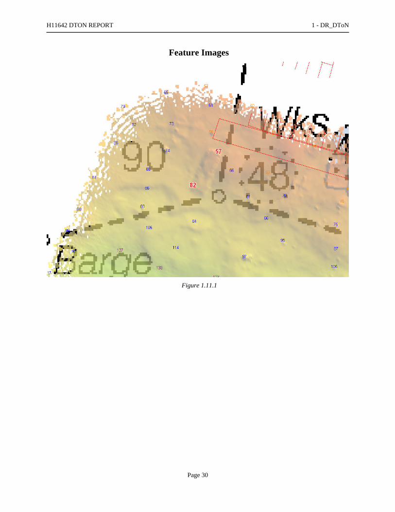
1.11) 57 Wk - 2530/81
DANGER TO NAVIGATION
Survey Summary
Survey Position: 47° 17' 45.3" N, 122° 25' 33.5" W
Least Depth: 17.34 m (= 56.89 ft = 9.482 fm = 9 fm 2.89 ft)
TPU (±1.96σ): THU (TPEh) ±1.640 m ; TVU (TPEv) ±0.270 m
Timestamp: 2007-192.18:53:16.045 (07/11/2007)
Survey Line: h11642 / s1212_simrad / 2007-192 / 042_1845
Profile/Beam: 2530/81
Charts Affected: 18453_1, 18445_7, 18474_1, 18445_8, 18448_1, 18440_1, 18003_1, 18007_1, 501_1,530_1, 50_1
Remarks:
SS and SWMB coverage over wreck with least depth of 57 feet on north end. The wreck is 130 feet long, 52 feetwide, and oriented to the north at 025 degrees.
Feature Correlation
Address Feature Range Azimuth Status
h11642/s1212_simrad/2007-192/042_1845 2530/81 0.00 000.0 Primary
h11642/s1212sss_100/2008-149/sonar_data080528215000 0008 20.73 327.9 Secondary (grouped)
h11642/s1212_simrad/2007-192/042_1845 2731/22 35.47 037.8 Secondary (grouped)
Hydrographer Recommendations
Chart wreck as surveyed.
Cartographically-Rounded Depth (Affected Charts):
57ft (18453_1)
9 ½fm (18448_1, 18440_1, 18003_1, 18007_1, 530_1)
9fm 3ft (18445_7, 18474_1, 18445_8)
17.3m (501_1, 50_1)
H11642 DTON REPORT 1 - DR_DToN
Page 28

S-57 Data
Geo object 1: Wreck (WRECKS)
Attributes: CATWRK - 2:dangerous wreck
CONVIS - 2:not visual conspicuous
QUASOU - 1:depth known
RECDAT - 20081216
SORDAT - 20070711
SORIND - US, US Survey H11642
TECSOU - 2,3:found by side scan sonar,found by multi-beam
VALSOU - 17.340 m
WATLEV - 3:always under water/submerged
Office Notes
Concur - Add 57 Wk and danger curve in present survey location.
H11642 DTON REPORT 1 - DR_DToN
Page 29
Feature Images
Figure 1.11.1
H11642 DTON REPORT 1 - DR_DToN
Page 30

1.12) 12 Obstn 293/101
DANGER TO NAVIGATION
Survey Summary
Survey Position: 47° 17' 23.5" N, 122° 24' 40.6" W
Least Depth: 3.66 m (= 12.00 ft = 2.001 fm = 2 fm 0.00 ft)
TPU (±1.96σ): THU (TPEh) ±1.423 m ; TVU (TPEv) ±0.249 m
Timestamp: 2007-193.23:15:17.879 (07/12/2007)
Survey Line: h11642 / s1212_simrad / 2007-193 / 054_2314
Profile/Beam: 293/101
Charts Affected: 18453_1, 18445_7, 18474_1, 18445_8, 18448_1, 18440_1, 18003_1, 18007_1, 501_1,530_1, 50_1
Remarks:
A four-foot obstruction approximately 22 feet long and 12 feet wide was found with SWMB. The obstruction has aleast depth of 12 feet and plots over a charted 17-foot depth.
Feature Correlation
Address Feature Range Azimuth Status
h11642/s1212_simrad/2007-193/054_2314 293/101 0.00 000.0 Primary
Hydrographer Recommendations
Chart 12-foot obstruction; delete charted 17-foot depth.
Cartographically-Rounded Depth (Affected Charts):
12ft (18453_1)
2fm (18448_1, 18440_1, 18003_1, 18007_1, 530_1)
2fm 0ft (18445_7, 18474_1, 18445_8)
3.7m (501_1, 50_1)
S-57 Data
Geo object 1: Obstruction (OBSTRN)
Attributes: CATOBS - 1:snag / stump
RECDAT - 20081216
H11642 DTON REPORT 1 - DR_DToN
Page 31

SORDAT - 20070712
SORIND - US, US Survey H11642
TECSOU - 3:found by multi-beam
VALSOU - 3.659 m
WATLEV - 3:always under water/submerged
Geo object 2: Sounding (SOUNDG)
Attributes: SORDAT - 20070712
SORIND - US, US Survey H11642
TECSOU - 3:found by multi-beam
Office Notes
Concur - Add 12 Obstn and danger curvein present survey location.
H11642 DTON REPORT 1 - DR_DToN
Page 32

Feature Images
Figure 1.12.1
H11642 DTON REPORT 1 - DR_DToN
Page 33
1.13) Sewer pipe - 259/32
DANGER TO NAVIGATION
Survey Summary
Survey Position: 47° 16' 00.2" N, 122° 25' 54.6" W
Least Depth: 7.97 m (= 26.15 ft = 4.358 fm = 4 fm 2.15 ft)
TPU (±1.96σ): THU (TPEh) ±1.443 m ; TVU (TPEv) ±0.250 m
Timestamp: 2007-199.19:20:48.731 (07/18/2007)
Survey Line: h11642 / s1212_simrad / 2007-199 / 007_1920
Profile/Beam: 259/32
Charts Affected: 18453_1, 18445_7, 18474_1, 18445_8, 18448_1, 18440_1, 18003_1, 18007_1, 501_1,530_1, 50_1
Remarks:
Inshore limit of uncharted submerged pipe as detectable with imagery and SWMB data. Pipeline is oriented306/126 degrees.
Feature Correlation
Address Feature Range Azimuth Status
h11642/s1212_simrad/2007-199/007_1920 259/32 0.00 000.0 Primary
Hydrographer Recommendations
Chart new pipeline as surveyed
Cartographically-Rounded Depth (Affected Charts):
26ft (18453_1)
4 ¼fm (18448_1, 18440_1, 18003_1, 18007_1, 530_1)
4fm 2ft (18445_7, 18474_1, 18445_8)
8.0m (501_1, 50_1)
S-57 Data
Geo object 1: Pipeline, submarine/on land (PIPSOL)
Attributes: CATPIP - 2:outfall pipe
SORDAT - 20080725
H11642 DTON REPORT 1 - DR_DToN
Page 34
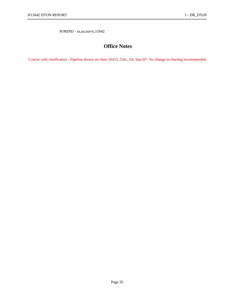
SORIND - us,us,survy,11642
Office Notes
Concur with clarification - Pipeline shown on chart 18453, 25th., Ed. Sep./07. No change in charting recommended.
H11642 DTON REPORT 1 - DR_DToN
Page 35

Feature Images
Figure 1.13.1
H11642 DTON REPORT 1 - DR_DToN
Page 36
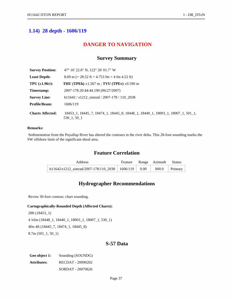
1.14) 28 depth - 1606/119
DANGER TO NAVIGATION
Survey Summary
Survey Position: 47° 16' 22.8" N, 122° 26' 01.7" W
Least Depth: 8.69 m (= 28.52 ft = 4.753 fm = 4 fm 4.52 ft)
TPU (±1.96σ): THU (TPEh) ±1.567 m ; TVU (TPEv) ±0.590 m
Timestamp: 2007-178.20:44:44.190 (06/27/2007)
Survey Line: h11642 / s1212_simrad / 2007-178 / 110_2038
Profile/Beam: 1606/119
Charts Affected: 18453_1, 18445_7, 18474_1, 18445_8, 18448_1, 18440_1, 18003_1, 18007_1, 501_1,530_1, 50_1
Remarks:
Sedimentation from the Puyallup River has altered the contours in the river delta. This 28-foot sounding marks theSW offshore limit of the significant shoal area.
Feature Correlation
Address Feature Range Azimuth Status
h11642/s1212_simrad/2007-178/110_2038 1606/119 0.00 000.0 Primary
Hydrographer Recommendations
Revise 30-foot contour; chart sounding.
Cartographically-Rounded Depth (Affected Charts):
28ft (18453_1)
4 ¾fm (18448_1, 18440_1, 18003_1, 18007_1, 530_1)
4fm 4ft (18445_7, 18474_1, 18445_8)
8.7m (501_1, 50_1)
S-57 Data
Geo object 1: Sounding (SOUNDG)
Attributes: RECDAT - 20090202
SORDAT - 20070626
H11642 DTON REPORT 1 - DR_DToN
Page 37
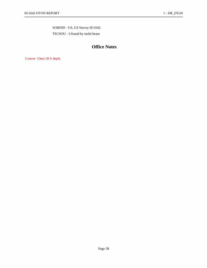
SORIND - US, US Survey H11642
TECSOU - 3:found by multi-beam
Office Notes
Concur- Chart 28 ft depth.
H11642 DTON REPORT 1 - DR_DToN
Page 38

1.15) 11 depth - 1294/15
DANGER TO NAVIGATION
Survey Summary
Survey Position: 47° 16' 19.1" N, 122° 25' 52.9" W
Least Depth: 3.40 m (= 11.15 ft = 1.859 fm = 1 fm 5.15 ft)
TPU (±1.96σ): THU (TPEh) ±1.421 m ; TVU (TPEv) ±0.288 m
Timestamp: 2007-190.20:40:59.155 (07/09/2007)
Survey Line: h11642 / s1212_simrad / 2007-190 / 115_2036
Profile/Beam: 1294/15
Charts Affected: 18453_1, 18445_7, 18474_1, 18445_8, 18448_1, 18440_1, 18003_1, 18007_1, 501_1,530_1, 50_1
Remarks:
Sedimentation from the Puyallup River has altered the contours in the river delta. This 11-foot sounding lies on topof the charted 30-foot contour.
Feature Correlation
Address Feature Range Azimuth Status
h11642/s1212_simrad/2007-190/115_2036 1294/15 0.00 000.0 Primary
Hydrographer Recommendations
Chart 11-foot shoal.
Cartographically-Rounded Depth (Affected Charts):
11ft (18453_1)
1 ¾fm (18448_1, 18440_1, 18003_1, 18007_1, 530_1)
1fm 5ft (18445_7, 18474_1, 18445_8)
3.4m (501_1, 50_1)
S-57 Data
Geo object 1: Sounding (SOUNDG)
Attributes: RECDAT - 20090202
SORDAT - 20070708
H11642 DTON REPORT 1 - DR_DToN
Page 39

SORIND - US, US Survey H11642
TECSOU - 3:found by multi-beam
Office Notes
Concur - Chart 11 ft depth.
H11642 DTON REPORT 1 - DR_DToN
Page 40

1.16) 28 depth - 191/119
DANGER TO NAVIGATION
Survey Summary
Survey Position: 47° 16' 24.6" N, 122° 25' 58.2" W
Least Depth: 8.54 m (= 28.03 ft = 4.671 fm = 4 fm 4.03 ft)
TPU (±1.96σ): THU (TPEh) ±1.594 m ; TVU (TPEv) ±0.632 m
Timestamp: 2007-190.20:55:35.994 (07/09/2007)
Survey Line: h11642 / s1212_simrad / 2007-190 / 127_2054
Profile/Beam: 191/119
Charts Affected: 18453_1, 18445_7, 18474_1, 18445_8, 18448_1, 18440_1, 18003_1, 18007_1, 501_1,530_1, 50_1
Remarks:
Sedimentation from the Puyallup River has altered the contours in the river delta. This 28-foot sounding marks theNE offshore limit of the significant shoal area and plots over a charted 35-foot sounding.
Feature Correlation
Address Feature Range Azimuth Status
h11642/s1212_simrad/2007-190/127_2054 191/119 0.00 000.0 Primary
Hydrographer Recommendations
Delete 35-foot charted depth; chart the 28-foot sounding at the surveyed location.
Cartographically-Rounded Depth (Affected Charts):
28ft (18453_1)
4 ½fm (18448_1, 18440_1, 18003_1, 18007_1, 530_1)
4fm 4ft (18445_7, 18474_1, 18445_8)
8.5m (501_1, 50_1)
S-57 Data
Geo object 1: Sounding (SOUNDG)
Attributes: RECDAT - 20090202
SORDAT - 20070708
H11642 DTON REPORT 1 - DR_DToN
Page 41

SORIND - US, US Survey H11642
TECSOU - 3:found by multi-beam
Office Notes
Concur Chart 28 ft depth.
H11642 DTON REPORT 1 - DR_DToN
Page 42

1.17) Sewer pipe 1808/42
DANGER TO NAVIGATION
Survey Summary
Survey Position: 47° 16' 03.2" N, 122° 26' 00.6" W
Least Depth: 17.52 m (= 57.48 ft = 9.580 fm = 9 fm 3.48 ft)
TPU (±1.96σ): THU (TPEh) ±1.713 m ; TVU (TPEv) ±0.333 m
Timestamp: 2007-192.21:59:13.201 (07/11/2007)
Survey Line: h11642 / s1212_simrad / 2007-192 / 007_2152
Profile/Beam: 1808/42
Charts Affected: 18453_1, 18445_7, 18474_1, 18445_8, 18448_1, 18440_1, 18003_1, 18007_1, 501_1,530_1, 50_1
Remarks:
Offshore end uncharted pipeline which is oriented at 306/126 degrees
Feature Correlation
Address Feature Range Azimuth Status
h11642/s1212_simrad/2007-192/007_2152 1808/42 0.00 000.0 Primary
h11642/s1212_simrad/2007-192/010_2203 305/39 16.39 130.1 Secondary
Hydrographer Recommendations
Chart new pipeline as surveyed
Cartographically-Rounded Depth (Affected Charts):
57ft (18453_1)
9 ½fm (18448_1, 18440_1, 18003_1, 18007_1, 530_1)
9fm 3ft (18445_7, 18474_1, 18445_8)
17.5m (501_1, 50_1)
S-57 Data
Geo object 1: Pipeline, submarine/on land (PIPSOL)
Attributes: CATPIP - 2:outfall pipe
H11642 DTON REPORT 1 - DR_DToN
Page 43

SORDAT - 20070709
SORIND - us,us,survy,H11642
Office Notes
Concur with clarification - Pipeline shown on chart 18453, 25th., Ed. Sep./07. No change in charting recommended.
H11642 DTON REPORT 1 - DR_DToN
Page 44
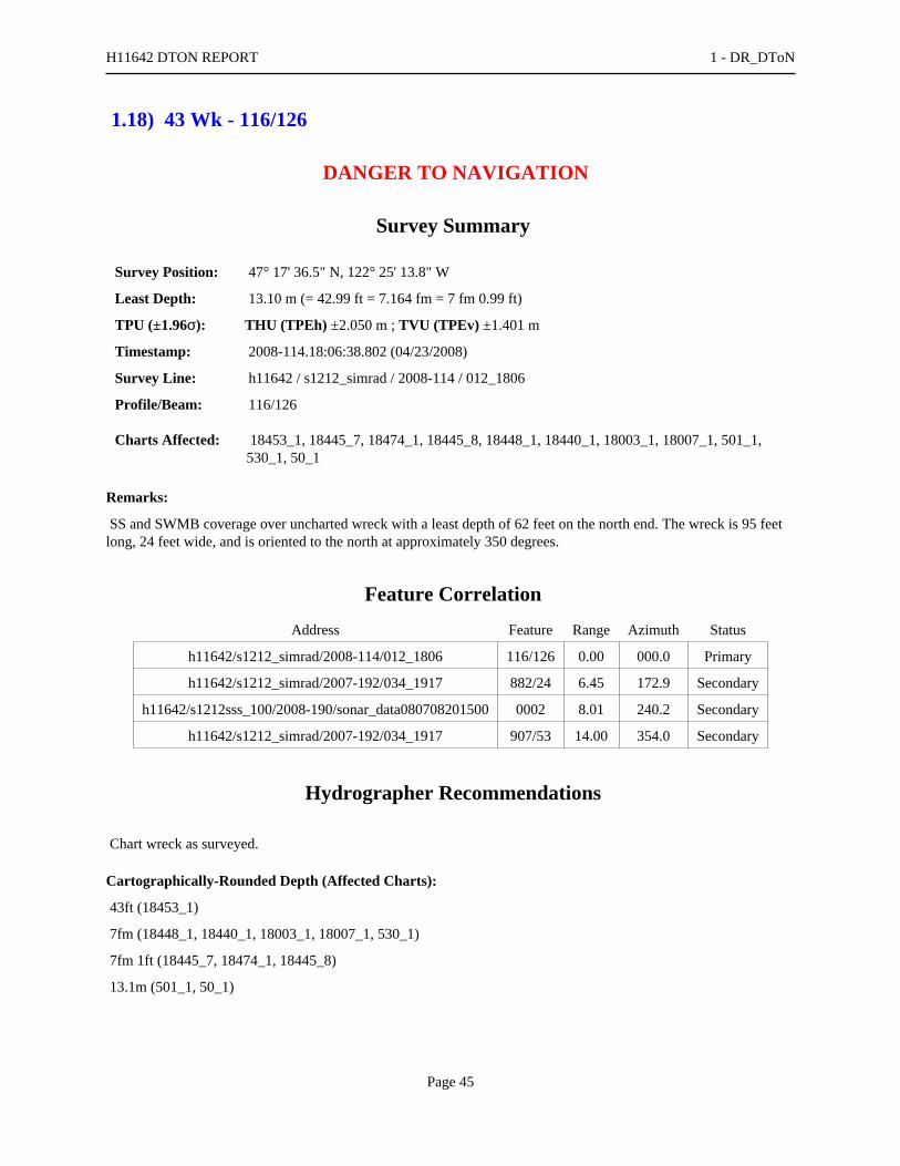
1.18) 43 Wk - 116/126
DANGER TO NAVIGATION
Survey Summary
Survey Position: 47° 17' 36.5" N, 122° 25' 13.8" W
Least Depth: 13.10 m (= 42.99 ft = 7.164 fm = 7 fm 0.99 ft)
TPU (±1.96σ): THU (TPEh) ±2.050 m ; TVU (TPEv) ±1.401 m
Timestamp: 2008-114.18:06:38.802 (04/23/2008)
Survey Line: h11642 / s1212_simrad / 2008-114 / 012_1806
Profile/Beam: 116/126
Charts Affected: 18453_1, 18445_7, 18474_1, 18445_8, 18448_1, 18440_1, 18003_1, 18007_1, 501_1,530_1, 50_1
Remarks:
SS and SWMB coverage over uncharted wreck with a least depth of 62 feet on the north end. The wreck is 95 feetlong, 24 feet wide, and is oriented to the north at approximately 350 degrees.
Feature Correlation
Address Feature Range Azimuth Status
h11642/s1212_simrad/2008-114/012_1806 116/126 0.00 000.0 Primary
h11642/s1212_simrad/2007-192/034_1917 882/24 6.45 172.9 Secondary
h11642/s1212sss_100/2008-190/sonar_data080708201500 0002 8.01 240.2 Secondary
h11642/s1212_simrad/2007-192/034_1917 907/53 14.00 354.0 Secondary
Hydrographer Recommendations
Chart wreck as surveyed.
Cartographically-Rounded Depth (Affected Charts):
43ft (18453_1)
7fm (18448_1, 18440_1, 18003_1, 18007_1, 530_1)
7fm 1ft (18445_7, 18474_1, 18445_8)
13.1m (501_1, 50_1)
H11642 DTON REPORT 1 - DR_DToN
Page 45

S-57 Data
Geo object 1: Wreck (WRECKS)
Attributes: VALSOU - 13.102 m
Office Notes
Concur - Add 43 Wk and danger curve in present survey location.
H11642 DTON REPORT 1 - DR_DToN
Page 46

H11642 AWOIS REPORT
Registry Number: H11642
State: Washington
Locality: Commencement Bay
Sub-locality: Thea Foss Waterway to Hylebos Waterway
Project Number: OPR-N411-NRT3-08
Survey Dates: 07/09/2007 - 07/11/2007
Charts Affected
Number Edition Date Scale (RNC) RNC Correction(s)*
18453 25th 10/01/2007 1:15,000 (18453_1)
USCG LNM: 10/17/2006 (12/12/2006)CHS NTM: None (10/27/2006)
NGA NTM: 02/26/2000 (12/23/2006)
18474 8th 10/01/2003 1:40,000 (18474_1) [L]NTM: ?
18445 32nd 08/01/20071:80,000 (18445_8)1:40,000 (18445_7) [L]NTM: ?
18448 34th 07/01/2006 1:80,000 (18448_1) [L]NTM: ?
18440 29th 10/01/2007 1:150,000 (18440_1) [L]NTM: ?
18003 20th 11/01/2006 1:736,560 (18003_1) [L]NTM: ?
18007 32nd 07/01/2005 1:1,200,000 (18007_1) [L]NTM: ?
501 12th 11/01/2002 1:3,500,000 (501_1) [L]NTM: ?
530 32nd 06/01/2007 1:4,860,700 (530_1) [L]NTM: ?
50 6th 06/01/2003 1:10,000,000 (50_1) [L]NTM: ?
* Correction(s) - source: last correction applied (last correction reviewed--"cleared date")
Features
No. NameFeatureType
SurveyDepth
SurveyLatitude
SurveyLongitude
AWOISItem
1.1 AWOIS #53275 - Retain AWOIS [no data] [no data] [no data] ---
1.2 AWOIS #53276 - Retain AWOIS [no data] [no data] [no data] ---
1.3 AWOIS #53278 - Retain AWOIS [no data] [no data] [no data] ---
1.4 AWOIS #53279 - Retain AWOIS [no data] [no data] [no data] ---
1.5 AWOIS #53280 - Revise AWOIS [no data] [no data] [no data] ---
1.6 AWOIS #53281- Revise AWOIS [no data] [no data] [no data] ---
Generated by Pydro v9.10 (r2824) on Thu Feb 25 20:14:03 2010 [UTC]

1.7 AWOIS #53282 - Retain AWOIS [no data] [no data] [no data] ---
1.8 AWOIS 353283 - Retain AWOIS [no data] [no data] [no data] ---
1.9 AWOIS #52576 - Retain AWOIS [no data] [no data] [no data] ---
1.10 AWOIS #52580 - Retain AWOIS [no data] [no data] [no data] ---
1.11 AWOIS #52585 - retain AWOIS [no data] [no data] [no data] ---
1.12 AWOIS #52305 - Obstn - Subm pile - 170/39 Obstruction 4.71 m 47° 16' 57.7" N 122° 24' 41.5" W 52305
1.13 AWOIS #53277 - 2405/113 Wreck 16.18 m 47° 17' 44.8" N 122° 25' 31.6" W 53277
Page 2

1 - DR_AWOIS

1.1) AWOIS #53275 - AWOIS #53275 - Retain
No Primary Survey Feature for this AWOIS Item
Search Position: 47° 17' 46.8" N, 122° 25' 48.6" W
Historical Depth: [None]
Search Radius: 0
Search Technique: [None]
Technique Notes: [None]
History Notes:
F00466/00-- OPR-N411-NRB; LOCATED A WRECK WITH SIDE SCAN SONAR AT POSITION OF47/17/46.853N - 122/25/48.554W. DIVER LOCATED A PARTIALLY DETERIORATED WOOD FISHINGBOAT APPROXIMATELY 50' X 15'. THE VESSEL ORIENTED E-W AND IS RESTING ON ITS SIDE. LEASTDEPTH DETERMINED BY DIVERS LEAST DEPTH GAUGE AT 46 FEET.
Survey Summary
Charts Affected: 18453_1, 18445_7, 18474_1, 18445_8, 18448_1, 18440_1, 18003_1, 18007_1, 501_1,530_1, 50_1
Remarks:
Item not investigated.
Feature Correlation
Address Feature Range Azimuth Status
Tacoma Awois AWOIS # 53275 0.00 000.0 Primary
Hydrographer Recommendations
No change in charting.
S-57 Data
[None]
H11642 AWOIS REPORT 1 - DR_AWOIS
Page 4

Office Notes
Concur - Retain as charted.
H11642 AWOIS REPORT 1 - DR_AWOIS
Page 5

1.2) AWOIS #53276 - AWOIS #53276 - Retain
No Primary Survey Feature for this AWOIS Item
Search Position: 47° 17' 49.4" N, 122° 25' 39.5" W
Historical Depth: [None]
Search Radius: 75
Search Technique: S2,ES,DI,SD
Technique Notes: [None]
History Notes:
L 2115/77-- WRECK EXPOSED ABOVE HIGH WATER LEVEL AT 47/17/50N - 122/25/35W (NAD 27). ■****UNKNOWN SOURCE-- SOMETIME BETWEEN 1980 AND 1984, THE VISIBLE WRECK WASCHARTED AS A SUBMERGED WRECK. (ENTERED CEH 6/05)
Survey Summary
Charts Affected: 18453_1, 18445_7, 18474_1, 18445_8, 18448_1, 18440_1, 18003_1, 18007_1, 501_1,530_1, 50_1
Remarks:
L 2115/77-- WRECK EXPOSED ABOVE HIGH WATER LEVEL AT 47/17/50N - 122/25/35W (NAD 27).****UNKNOWN SOURCE-- SOMETIME BETWEEN 1980 AND 1984, THE VISIBLE WRECK WASCHARTED AS A SUBMERGED WRECK. (ENTERED CEH 6/05)
Item not investigated
Feature Correlation
Address Feature Range Azimuth Status
Tacoma Awois AWOIS # 53276 0.00 000.0 Primary
Hydrographer Recommendations
Item not in survey limits. No change in charting.
S-57 Data
[None]
H11642 AWOIS REPORT 1 - DR_AWOIS
Page 6

Office Notes
Concur - Retain as charted.
H11642 AWOIS REPORT 1 - DR_AWOIS
Page 7

1.3) AWOIS #53278 - AWOIS #53278 - Retain
No Primary Survey Feature for this AWOIS Item
Search Position: 47° 17' 45.3" N, 122° 25' 28.2" W
Historical Depth: [None]
Search Radius: 0
Search Technique: [None]
Technique Notes: [None]
History Notes:
H11041/2001-- A SUBMERGED WRECK WITH A LEAST DEPTH OF 43 FEET, WAS LOCATED AT47/17/45.31N - 122/25/28.16W. (ENTERED CEH 6/05)
Survey Summary
Charts Affected: 18453_1, 18445_7, 18474_1, 18445_8, 18448_1, 18440_1, 18003_1, 18007_1, 501_1,530_1, 50_1
Remarks:
H11041/2001-- A SUBMERGED WRECK WITH A LEAST DEPTH OF 43 FEET, WAS LOCATED AT47/17/45.31N - 122/25/28.16W. (ENTERED CEH 6/05) Area was not completely investigated.
Feature Correlation
Address Feature Range Azimuth Status
Tacoma Awois AWOIS # 53278 0.00 000.0 Primary
h11642/s1212_simrad/2007-192/038_1856 682/12 28.48 321.8 Secondary (grouped)
Hydrographer Recommendations
No change in charting.
S-57 Data
[None]
H11642 AWOIS REPORT 1 - DR_AWOIS
Page 8

Office Notes
Concur - Retain charted 43 Wk and danger curve.
H11642 AWOIS REPORT 1 - DR_AWOIS
Page 9

1.4) AWOIS #53279 - AWOIS #53279 - Retain
No Primary Survey Feature for this AWOIS Item
Search Position: 47° 17' 44.4" N, 122° 25' 24.6" W
Historical Depth: [None]
Search Radius: 0
Search Technique: [None]
Technique Notes: [None]
History Notes:
H11041/2001-- A SUBMERGED WRECK WITH A LEAST DEPTH OF 20 FEET, WAS LOCATED AT47/17/44.4N - 122/25/24.6W. (ENTERED CEH 6/05)
Survey Summary
Charts Affected: 18453_1, 18445_7, 18474_1, 18445_8, 18448_1, 18440_1, 18003_1, 18007_1, 501_1,530_1, 50_1
Remarks:
Item was not investigated.
Feature Correlation
Address Feature Range Azimuth Status
Tacoma Awois AWOIS # 53279 0.00 000.0 Primary
Hydrographer Recommendations
No change in charting.
S-57 Data
Geo object 1: Obstruction (OBSTRN)
Attributes: QUASOU - 6:least depth known
SORDAT - 20090403
SORIND - US,US,nsurf,H11642
TECSOU - 3:found by multi-beam
WATLEV - 3:always under water/submerged
H11642 AWOIS REPORT 1 - DR_AWOIS
Page 10
Office Notes
Concur - Retain as charted.
H11642 AWOIS REPORT 1 - DR_AWOIS
Page 11

Feature Images
Figure 1.4.1
H11642 AWOIS REPORT 1 - DR_AWOIS
Page 12

1.5) AWOIS #53280 - AWOIS #53280 - Revise
No Primary Survey Feature for this AWOIS Item
Search Position: 47° 16' 41.1" N, 122° 23' 31.6" W
Historical Depth: [None]
Search Radius: 50
Search Technique: VS, SD
Technique Notes: [None]
History Notes:
****UNKNOWN SOURCE-- A VISIBLE WRECK WAS CHARTED BETWEEN 1976 - 1978 AT THECHARTED POSITION 47/16/41.1N - 122/23/31.6W. (ENTERED CEH 6/05)
Survey Summary
Charts Affected: 18453_1, 18445_7, 18474_1, 18445_8, 18448_1, 18440_1, 18003_1, 18007_1, 501_1,530_1, 50_1
Remarks:
A visual search was conducted for this item 6/08. The area is used for log storage. At time of survey logs coveredany wreck that may have been visible.
Feature Correlation
Address Feature Range Azimuth Status
Tacoma Awois AWOIS # 53280 0.00 000.0 Primary
Hydrographer Recommendations
Retain as charted
S-57 Data
Geo object 1: Wreck (WRECKS)
Attributes: CATWRK - 2:dangerous wreck
QUASOU - 2:depth unknown
SORDAT - 20090403
SORIND - US,US,survy,H11642
WATLEV - 3:always under water/submerged
H11642 AWOIS REPORT 1 - DR_AWOIS
Page 13

Office Notes
Do not concur - Revise visible wreck to a dangerous sunken wreck in charted position.
H11642 AWOIS REPORT 1 - DR_AWOIS
Page 14

1.6) AWOIS #53281 - AWOIS #53281- Revise
No Primary Survey Feature for this AWOIS Item
Search Position: 47° 16' 42.0" N, 122° 23' 31.2" W
Historical Depth: [None]
Search Radius: 50
Search Technique: VS, SD
Technique Notes: [None]
History Notes:
****UNKNOWN SOURCE-- A VISIBLE WRECK WAS CHARTED BETWEEN 1976 - 1978 AT THECHARTED POSITION 47/16/42.0N - 122/23/31.17W. (ENTERED CEH 6/05)
Survey Summary
Charts Affected: 18453_1, 18445_7, 18474_1, 18445_8, 18448_1, 18440_1, 18003_1, 18007_1, 501_1,530_1, 50_1
Remarks:
A visual search was conducted for this item June 2008. The area is used for log storage. At time of survey logscovered any wreck that may have been visible.
Feature Correlation
Address Feature Range Azimuth Status
Tacoma Awois AWOIS # 53281 0.00 000.0 Primary
Hydrographer Recommendations
Retain as charted.
S-57 Data
Geo object 1: Wreck (WRECKS)
Attributes: CATWRK - 2:dangerous wreck
QUASOU - 2:depth unknown
SORDAT - 20090403
SORIND - US,US,survy,H11642
WATLEV - 3:always under water/submerged
H11642 AWOIS REPORT 1 - DR_AWOIS
Page 15

Office Notes
Do not concur - Revise visible wreck to a dangerous sunken wreck in charted position.
H11642 AWOIS REPORT 1 - DR_AWOIS
Page 16

1.7) AWOIS #53282 - AWOIS #53282 - Retain
No Primary Survey Feature for this AWOIS Item
Search Position: 47° 16' 38.0" N, 122° 23' 22.5" W
Historical Depth: [None]
Search Radius: 50
Search Technique: VS, SD
Technique Notes: [None]
History Notes:
****UNKNOWN SOURCE-- A VISIBLE WRECK WAS CHARTED BETWEEN 1976 - 1978 AT THECHARTED POSITION 47/16/38.0N - 122/23/22.55W. (ENTERED CEH 6/05)
Survey Summary
Charts Affected: 18453_1, 18445_7, 18474_1, 18445_8, 18448_1, 18440_1, 18003_1, 18007_1, 501_1,530_1, 50_1
Remarks:
****UNKNOWN SOURCE-- A VISIBLE WRECK WAS CHARTED BETWEEN 1976 - 1978 AT THECHARTED POSITION 47/16/38.0N - 122/23/22.55W. (ENTERED CEH 6/05)
Feature Correlation
Address Feature Range Azimuth Status
Tacoma Awois AWOIS # 53282 0.00 000.0 Primary
Hydrographer Recommendations
Item outside the survey limits. No change in charting.
S-57 Data
[None]
Office Notes
Concur - Retain as charted.
H11642 AWOIS REPORT 1 - DR_AWOIS
Page 17

1.8) AWOIS #53283 - AWOIS 353283 - Retain
No Primary Survey Feature for this AWOIS Item
Search Position: 47° 16' 27.2" N, 122° 22' 47.5" W
Historical Depth: [None]
Search Radius: 50
Search Technique: VS, SD
Technique Notes: [None]
History Notes:
****UNKNOWN SOURCE-- A VISIBLE WRECK WAS CHARTED BETWEEN 1976 - 1978 AT THECHARTED POSITION 47/16/27.25N - 122/23/47.55W. (ENTERED CEH 6/05)
Survey Summary
Charts Affected: 18453_1, 18445_7, 18474_1, 18445_8, 18448_1, 18440_1, 18003_1, 18007_1, 501_1,530_1, 50_1
Remarks:
****UNKNOWN SOURCE-- A VISIBLE WRECK WAS CHARTED BETWEEN 1976 - 1978 AT THECHARTED POSITION 47/16/27.25N - 122/23/47.55W. (ENTERED CEH 6/05)
Feature Correlation
Address Feature Range Azimuth Status
Tacoma Awois AWOIS # 53283 0.00 000.0 Primary
Hydrographer Recommendations
Item outside the survey limits. No change in charting.
S-57 Data
[None]
Office Notes
Concur - Retain as charted.
H11642 AWOIS REPORT 1 - DR_AWOIS
Page 18

1.9) AWOIS #52576 - AWOIS #52576 - Retain
No Primary Survey Feature for this AWOIS Item
Search Position: 47° 17' 51.8" N, 122° 25' 38.9" W
Historical Depth: [None]
Search Radius: 75
Search Technique: S2,ES.VS.SD,DI
Technique Notes: [None]
History Notes:
HISTORY■ TP00732/73-75; WRECK BARING 8 FT MHW AND WRECKS AWASH SHOWN. WRECKSEXTEND APPROX 60M ABOUT A CENTRAL POINT OF LAT.47 17 52.5, LONG.122 25 34.5 NAD 27.■BP135819; NANCI SOURCE CHART REVISION; WRECKS NOT SEEN ON IMAGERY. ■ F00466/00--(OPR-N411-NRB); WRECKS NOT VISIBLE AT 47/17/51.85 - 122/25/38.94. THE DETERIORATING SHELLOF A WRECK WAS OBSERVED NEAR SHORE. EVALUATOR RECOMMENDS TO DELETE CHARTEDWKS NOTE AND SYMBOLOGY AND CHART VISIBLE WRECK AT AWOIS POSITION. (UPDATED CEH6/05)
Survey Summary
Charts Affected: 18453_1, 18445_7, 18474_1, 18445_8, 18448_1, 18440_1, 18003_1, 18007_1, 501_1,530_1, 50_1
Remarks:
Item not investigated
Feature Correlation
Address Feature Range Azimuth Status
Tacoma Awois AWOIS # 52576 0.00 000.0 Primary
Hydrographer Recommendations
Item not in survey limits. No change in charting.
S-57 Data
[None]
H11642 AWOIS REPORT 1 - DR_AWOIS
Page 19

Office Notes
Concur - Retain as charted.
H11642 AWOIS REPORT 1 - DR_AWOIS
Page 20

1.10) AWOIS #52580 - AWOIS #52580 - Retain
No Primary Survey Feature for this AWOIS Item
Search Position: 47° 15' 54.4" N, 122° 26' 02.5" W
Historical Depth: [None]
Search Radius: 30
Search Technique: VS,S2,SD, ES,DI
Technique Notes: SEARCH 20M ABOUT THE TWO NAD 83 POSITIONS FOR DOLS, POS. 47 1548.15N, 122 25 58.24W AND 47 15 54.43N, 122 26 02.54W. SEARCH 15M OUTFROM AN AXIS DRAWN BETWEEN THE TWO POINTS TO DISPROVEMORAGE REMAINS.
History Notes:
HISTORY■ TP00734/74--BARGE MORAGE SHOWN AS DASHED LINE BETWEEN TWO DOLPHINS INPOS. 47 15 48.8N, 122 25 53.8W AND 47 15 55.08N, 122 25 58.1W (NAD 27) CONVERTS TO NAD 83 POS. 4715 48.15N, 122 25 58.24W AND 47 15 54.43N, 122 26 02.54W NAD 83.■****1989 EDITION OF CHART18453, DOLS REVISED TO SUBMERGED, POSSIBLY AS A RESULT OF NANCI SHORELINE REVISION.■F00466/00-- OPR-N411-NRB; THE BARGE MOORAGE WAS OBSERVED AS CHARTED, THESUBMERGED DOLS WERE NOT INVESTIGATED. RETAIN AS CHARTED. (UPDATED CEH 6/05)
Survey Summary
Charts Affected: 18453_1, 18445_7, 18474_1, 18445_8, 18448_1, 18440_1, 18003_1, 18007_1, 501_1,530_1, 50_1
Remarks:
HISTORY TP00734/74--BARGE MORAGE SHOWN AS DASHED LINE BETWEEN TWO DOLPHINS INPOS. 47 15 48.8N, 122 25 53.8W AND 47 15 55.08N, 122 25 58.1W (NAD 27) CONVERTS TO NAD 83 POS. 4715 48.15N, 122 25 58.24W AND 47 15 54.43N, 122 26 02.54W NAD 83. ****1989 EDITION OF CHART 18453,DOLS REVISED TO SUBMERGED, POSSIBLY AS A RESULT OF NANCI SHORELINE REVISION.F00466/00-- OPR-N411-NRB; THE BARGE MOORAGE WAS OBSERVED AS CHARTED, THESUBMERGED DOLS WERE NOT INVESTIGATED. RETAIN AS CHARTED. (UPDATED CEH 6/05)
Feature Correlation
Address Feature Range Azimuth Status
Tacoma Awois AWOIS # 52580 0.00 000.0 Primary
Hydrographer Recommendations
Subm dol verified during office processing. No change in charting is recommended.
H11642 AWOIS REPORT 1 - DR_AWOIS
Page 21

S-57 Data
[None]
Office Notes
Concur - Retain as charted.
H11642 AWOIS REPORT 1 - DR_AWOIS
Page 22

1.11) AWOIS #52585 - AWOIS #52585 - retain
No Primary Survey Feature for this AWOIS Item
Search Position: 47° 15' 54.8" N, 122° 26' 02.7" W
Historical Depth: [None]
Search Radius: 30
Search Technique: VS,S2,ES,SD
Technique Notes: [None]
History Notes:
HISTORY■ CL917/89--MOORING BUOY ESTABLISHED BY THE COE. ENTERED 5/00 MCR■47-15-54.78N 122-26-02.72 W■ F00466/00--OPR-N411-NRB; MOORING BUOY WAS OBSERVED AS CHARTED.RETAINED AS CHARTED. (UPDATED CEH 6/05)
Survey Summary
Charts Affected: 18453_1, 18445_7, 18474_1, 18445_8, 18448_1, 18440_1, 18003_1, 18007_1, 501_1,530_1, 50_1
Remarks:
A visual search was conducted June 2007. The mooring buoy was observed as charted.
Feature Correlation
Address Feature Range Azimuth Status
Tacoma Awois AWOIS # 52585 0.00 000.0 Primary
Hydrographer Recommendations
Retain mooring buoy as charted.
S-57 Data
[None]
Office Notes
Concur - Retain as charted.
H11642 AWOIS REPORT 1 - DR_AWOIS
Page 23
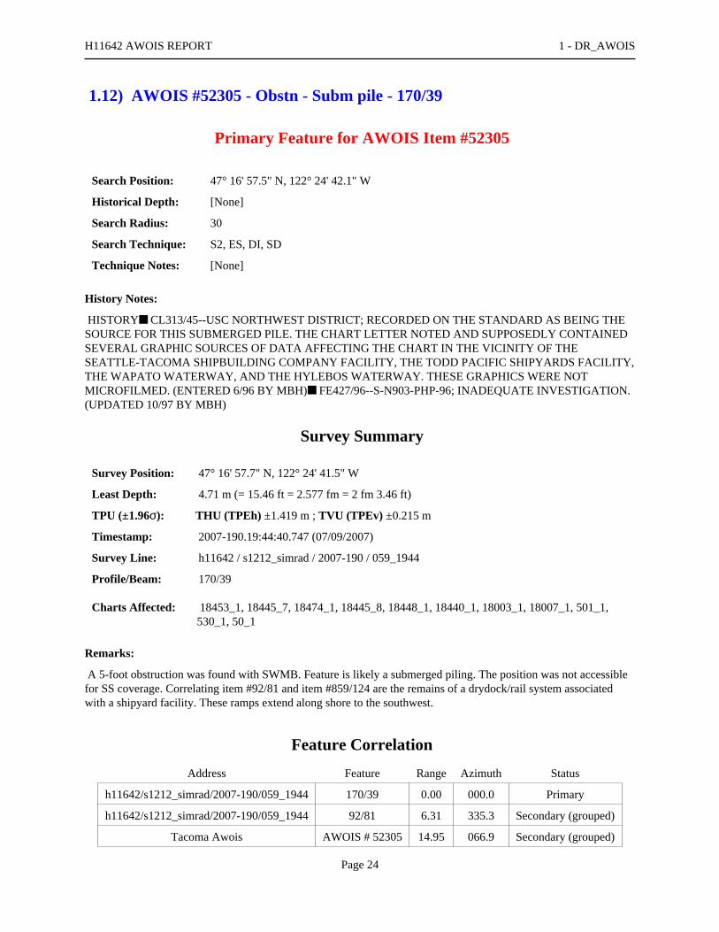
1.12) AWOIS #52305 - Obstn - Subm pile - 170/39
Primary Feature for AWOIS Item #52305
Search Position: 47° 16' 57.5" N, 122° 24' 42.1" W
Historical Depth: [None]
Search Radius: 30
Search Technique: S2, ES, DI, SD
Technique Notes: [None]
History Notes:
HISTORY■ CL313/45--USC NORTHWEST DISTRICT; RECORDED ON THE STANDARD AS BEING THESOURCE FOR THIS SUBMERGED PILE. THE CHART LETTER NOTED AND SUPPOSEDLY CONTAINEDSEVERAL GRAPHIC SOURCES OF DATA AFFECTING THE CHART IN THE VICINITY OF THESEATTLE-TACOMA SHIPBUILDING COMPANY FACILITY, THE TODD PACIFIC SHIPYARDS FACILITY,THE WAPATO WATERWAY, AND THE HYLEBOS WATERWAY. THESE GRAPHICS WERE NOTMICROFILMED. (ENTERED 6/96 BY MBH)■ FE427/96--S-N903-PHP-96; INADEQUATE INVESTIGATION.(UPDATED 10/97 BY MBH)
Survey Summary
Survey Position: 47° 16' 57.7" N, 122° 24' 41.5" W
Least Depth: 4.71 m (= 15.46 ft = 2.577 fm = 2 fm 3.46 ft)
TPU (±1.96σ): THU (TPEh) ±1.419 m ; TVU (TPEv) ±0.215 m
Timestamp: 2007-190.19:44:40.747 (07/09/2007)
Survey Line: h11642 / s1212_simrad / 2007-190 / 059_1944
Profile/Beam: 170/39
Charts Affected: 18453_1, 18445_7, 18474_1, 18445_8, 18448_1, 18440_1, 18003_1, 18007_1, 501_1,530_1, 50_1
Remarks:
A 5-foot obstruction was found with SWMB. Feature is likely a submerged piling. The position was not accessiblefor SS coverage. Correlating item #92/81 and item #859/124 are the remains of a drydock/rail system associatedwith a shipyard facility. These ramps extend along shore to the southwest.
Feature Correlation
Address Feature Range Azimuth Status
h11642/s1212_simrad/2007-190/059_1944 170/39 0.00 000.0 Primary
h11642/s1212_simrad/2007-190/059_1944 92/81 6.31 335.3 Secondary (grouped)
Tacoma Awois AWOIS # 52305 14.95 066.9 Secondary (grouped)
H11642 AWOIS REPORT 1 - DR_AWOIS
Page 24

h11642/s1212_simrad/2007-190/063_1932 859/124 40.69 051.9 Secondary (grouped)
Hydrographer Recommendations
Revise position of charted submerged piling. Extend charted remains of rail system seaward.
Cartographically-Rounded Depth (Affected Charts):
15ft (18453_1)
2 ½fm (18448_1, 18440_1, 18003_1, 18007_1, 530_1)
2fm 3ft (18445_7, 18474_1, 18445_8)
4.7m (501_1, 50_1)
S-57 Data
Geo object 1: Obstruction (OBSTRN)
Attributes: CATOBS - 1:snag / stump
QUASOU - 1:depth known
TECSOU - 3:found by multi-beam
VALSOU - 4.712 m
Office Notes
Concur w/ clarification. Obstruction determined to be a subm pile during office processing. Revise location ofcharted (AWOIS #52305) subm pile in Latitude 47°16'57.57"N, Longitude 122°24'42.20"W to present surveyLatitude 47°16'57.720"N, Longitude 122°24'41.478". Revise charted Subm Pile symbol location.
H11642 AWOIS REPORT 1 - DR_AWOIS
Page 25

Feature Images
Figure 1.12.1
H11642 AWOIS REPORT 1 - DR_AWOIS
Page 26

Figure 1.12.2
H11642 AWOIS REPORT 1 - DR_AWOIS
Page 27

1.13) AWOIS #53277 - 2405/113
Primary Feature for AWOIS Item #53277
Search Position: 47° 17' 44.7" N, 122° 25' 31.6" W
Historical Depth: [None]
Search Radius: 0
Search Technique: [None]
Technique Notes: [None]
History Notes:
H11041/2001-- A SUBMERGED WRECK WITH A LEAST DEPTH OF 48 FEET, WAS LOCATED AT47/17/44.69N - 122/25/31.63W. (ENTERED CEH 6/05)
Survey Summary
Survey Position: 47° 17' 44.8" N, 122° 25' 31.6" W
Least Depth: 16.18 m (= 53.07 ft = 8.845 fm = 8 fm 5.07 ft)
TPU (±1.96σ): THU (TPEh) ±1.748 m ; TVU (TPEv) ±0.723 m
Timestamp: 2007-192.18:52:49.422 (07/11/2007)
Survey Line: h11642 / s1212_simrad / 2007-192 / 042_1845
Profile/Beam: 2405/113
Charts Affected: 18453_1, 18445_7, 18474_1, 18445_8, 18448_1, 18440_1, 18003_1, 18007_1, 501_1,530_1, 50_1
Remarks:
Submerged wreckage with a least depth of 53 feet was found within the AWOIS search radius. The surroundingarea is littered with wreckage and other submerged debris. This item is partially covered by a barge which serves asa breakwater for Tyee Marina.
Feature Correlation
Address Feature Range Azimuth Status
h11642/s1212_simrad/2007-192/042_1845 2405/113 0.00 000.0 Primary
Tacoma Awois AWOIS # 53277 2.08 017.9 Secondary (grouped)
h11642/s1212sss_100/2008-149/sonar_data080528215000 0020 18.68 308.1 Secondary (grouped)
H11642 AWOIS REPORT 1 - DR_AWOIS
Page 28
Hydrographer Recommendations
Wreck is seen on side scan. Chart a wreck.
S-57 Data
Geo object 1: Wreck (WRECKS)
Attributes: CATWRK - 2:dangerous wreck
CONVIS - 2:not visual conspicuous
QUASOU - 6:least depth known
RECDAT - 20081210
SORDAT - 20090403
SORIND - US,US, nsurf,H11642
TECSOU - 3:found by multi-beam
VALSOU - 16.176 m
VERDAT - 12:Mean lower low water
WATLEV - 3:always under water/submerged
Office Notes
Concur with clarification - Shoaler wreck in vicinity of 53 Wk. Delete 48 Wk and danger curve. Do not chart 53Wk.
H11642 AWOIS REPORT 1 - DR_AWOIS
Page 29

Feature Images
Figure 1.13.1
H11642 AWOIS REPORT 1 - DR_AWOIS
Page 30

H11642 UNCHARTED REPORT
Registry Number: H11642
State: Washington
Locality: Commencement Bay
Sub-locality: Thea Foss Waterway to Hylebos Waterway
Project Number: OPR-N411-NRT3-08
Survey Dates: 06/19/2007 - 04/03/2009
Charts Affected
Number Edition Date Scale (RNC) RNC Correction(s)*
18453 25th 10/01/2007 1:15,000 (18453_1)
USCG LNM: 10/17/2006 (12/12/2006)CHS NTM: None (10/27/2006)
NGA NTM: 02/26/2000 (12/23/2006)
18474 8th 10/01/2003 1:40,000 (18474_1) [L]NTM: ?
18445 32nd 08/01/20071:80,000 (18445_8)1:40,000 (18445_7) [L]NTM: ?
18448 34th 07/01/2006 1:80,000 (18448_1) [L]NTM: ?
18440 29th 10/01/2007 1:150,000 (18440_1) [L]NTM: ?
18003 20th 11/01/2006 1:736,560 (18003_1) [L]NTM: ?
18007 32nd 07/01/2005 1:1,200,000 (18007_1) [L]NTM: ?
501 12th 11/01/2002 1:3,500,000 (501_1) [L]NTM: ?
530 32nd 06/01/2007 1:4,860,700 (530_1) [L]NTM: ?
50 6th 06/01/2003 1:10,000,000 (50_1) [L]NTM: ?
* Correction(s) - source: last correction applied (last correction reviewed--"cleared date")
Features
No. NameFeatureType
SurveyDepth
SurveyLatitude
SurveyLongitude
AWOISItem
1.1 32 Obstn-Sub dol - 2223/93 Obstruction 9.87 m 47° 15' 55.6" N 122° 26' 03.1" W ---
1.2 19 Obstn - 7487/17 Obstruction 5.89 m 47° 14' 53.1" N 122° 25' 57.2" W ---
1.3 12 Obstn - 5361/123 Obstruction 3.62 m 47° 15' 54.2" N 122° 26' 03.0" W ---
1.4 Obstn - Subm dol - 2366/56 Obstruction 3.15 m 47° 16' 51.3" N 122° 24' 50.9" W ---
1.5 Obstn - Subm pile - 1612/4 Obstruction 2.51 m 47° 16' 53.8" N 122° 24' 47.7" W ---
1.6 Obstn - Subm pile - 1089/27 Obstruction 0.89 m 47° 16' 55.7" N 122° 24' 44.5" W ---
Generated by Pydro v9.10 (r2824) on Thu Feb 25 20:20:03 2010 [UTC]

1.7 Obstn - Subm pile - 1307/2 Obstruction 1.18 m 47° 16' 54.8" N 122° 24' 45.8" W ---
1.8 7 depth - 1446/2 Pile 2.18 m 47° 16' 54.2" N 122° 24' 46.5" W ---
1.9 37 Obstn - 1015/95 Obstruction 11.40 m 47° 17' 34.4" N 122° 25' 07.8" W ---
1.10 53 Wk 1140/27 - Delete Wreck 16.27 m 47° 17' 42.9" N 122° 25' 20.8" W ---
1.11 49 Obstn - 1801/41 Obstruction 14.92 m 47° 17' 40.1" N 122° 25' 12.2" W ---
1.12 2374/16 - insig Obstruction 9.52 m 47° 17' 37.5" N 122° 25' 05.2" W ---
1.13 52 Wks - 1168/32 Wreck 15.96 m 47° 17' 42.8" N 122° 25' 20.3" W ---
1.14 18 Wk - 2082/3 Wreck 5.60 m 47° 17' 39.5" N 122° 25' 08.1" W ---
1.15 34 Obstn - 2691/122 Obstruction 10.59 m 47° 17' 35.5" N 122° 25' 05.4" W ---
1.16 24 Wk - 2386/3 Wreck 7.48 m 47° 17' 37.7" N 122° 25' 04.6" W ---
1.17 41 Wks - 2331/124 Wreck 12.71 m 47° 17' 44.4" N 122° 25' 30.2" W ---
1.18 20 Obstn - 931/13 Obstruction 6.16 m 47° 15' 48.9" N 122° 25' 57.6" W ---
1.19 20 Obstn - 3311/112 Obstruction 6.30 m 47° 15' 50.4" N 122° 25' 57.1" W ---
1.20 Retain ruins - 755/87 Obstruction 5.32 m 47° 16' 09.8" N 122° 26' 53.7" W ---
1.21 Outfall pipeline - 435/40 Pipe 11.37 m 47° 16' 08.8" N 122° 26' 52.0" W ---
1.22 48 Obstn - 120/125 Obstruction 14.83 m 47° 17' 43.8" N 122° 25' 28.8" W ---
Page 2
1 - DR_UnCharted

1.1) 32 Obstn-Sub dol - 2223/93
Survey Summary
Survey Position: 47° 15' 55.6" N, 122° 26' 03.1" W
Least Depth: 9.87 m (= 32.39 ft = 5.399 fm = 5 fm 2.39 ft)
TPU (±1.96σ): THU (TPEh) ±1.509 m ; TVU (TPEv) ±0.284 m
Timestamp: 2007-170.16:45:58.054 (06/19/2007)
Survey Line: h11642 / s1212_simrad / 2007-170 / 185_1641
Profile/Beam: 2223/93
Charts Affected: 18453_1, 18445_7, 18474_1, 18445_8, 18448_1, 18440_1, 18003_1, 18007_1, 501_1,530_1, 50_1
Remarks:
An obstruction which appears to be a submerged dolphin was found with SS and SWMB at the entrance to theMiddle Waterway. The object rises 4.2 feet above surrounding depths and has a least depth of 32.39 feet.
Feature Correlation
Address Feature Range Azimuth Status
h11642/s1212_simrad/2007-170/185_1641 2223/93 0.00 000.0 Primary
h11642/s1212sss_100/2008-190/sonar_data080708173000 0001 13.21 037.0 Secondary (grouped)
h11642/s1212sss_100/2008-190/sonar_data080708173000 0005 13.37 041.3 Secondary
Hydrographer Recommendations
Chart as obstruction with least depth.
Cartographically-Rounded Depth (Affected Charts):
32ft (18453_1)
5 ¼fm (18448_1, 18440_1, 18003_1, 18007_1, 530_1)
5fm 2ft (18445_7, 18474_1, 18445_8)
9.9m (501_1, 50_1)
S-57 Data
Geo object 1: Obstruction (OBSTRN)
Attributes: CATOBS - 1:snag / stump
QUASOU - 1:depth known
H11642 UNCHARTED REPORT 1 - DR_UnCharted
Page 4

RECDAT - 20081216
SORDAT - 20070619
SORIND - US, US Survey H11642
TECSOU - 2,3:found by side scan sonar,found by multi-beam
VALSOU - 9.873 m
WATLEV - 3:always under water/submerged
Office Notes
Concur - Add 32 Obstn and danger curve in present survey location.
H11642 UNCHARTED REPORT 1 - DR_UnCharted
Page 5

Feature Images
Figure 1.1.1
H11642 UNCHARTED REPORT 1 - DR_UnCharted
Page 6

1.2) 19 Obstn - 7487/17
Survey Summary
Survey Position: 47° 14' 53.1" N, 122° 25' 57.2" W
Least Depth: 5.89 m (= 19.32 ft = 3.220 fm = 3 fm 1.32 ft)
TPU (±1.96σ): THU (TPEh) ±1.417 m ; TVU (TPEv) ±0.276 m
Timestamp: 2007-171.22:57:19.892 (06/20/2007)
Survey Line: h11642 / s1212_simrad / 2007-171 / 052_2245
Profile/Beam: 7487/17
Charts Affected: 18453_1, 18445_7, 18445_8, 18448_1, 18440_1, 18003_1, 18007_1, 501_1, 530_1, 50_1
Remarks:
An obstruction was found in the Foss Waterway with SS and SWMB, least depth 19.3 feet. The object rises 1 meterabove surrounding depths and may be a submerged piling or dolphin.
Feature Correlation
Address Feature Range Azimuth Status
h11642/s1212_simrad/2007-171/052_2245 7487/17 0.00 000.0 Primary
h11642/s1212sss_100/2008-164/sonar_data080612192100 0009 3.93 135.7 Secondary (grouped)
Hydrographer Recommendations
Chart as obstruction with least depth.
Cartographically-Rounded Depth (Affected Charts):
19ft (18453_1)
3 ¼fm (18448_1, 18440_1, 18003_1, 18007_1, 530_1)
3fm 1ft (18445_7, 18445_8)
5.9m (501_1, 50_1)
S-57 Data
Geo object 1: Obstruction (OBSTRN)
Attributes: CATOBS - 1:snag / stump
RECDAT - 20081216
SORDAT - 20070620
H11642 UNCHARTED REPORT 1 - DR_UnCharted
Page 7

SORIND - US, US Survey H11642
TECSOU - 2,3:found by side scan sonar,found by multi-beam
VALSOU - 5.888 m
WATLEV - 3:always under water/submerged
Office Notes
Concur - Chart an obstruction with a depth of 19 feet in Latitude 47°14'53.078"N, Longitude 122°25'57.233"W.Add 19 Obstn and danger curve.
H11642 UNCHARTED REPORT 1 - DR_UnCharted
Page 8
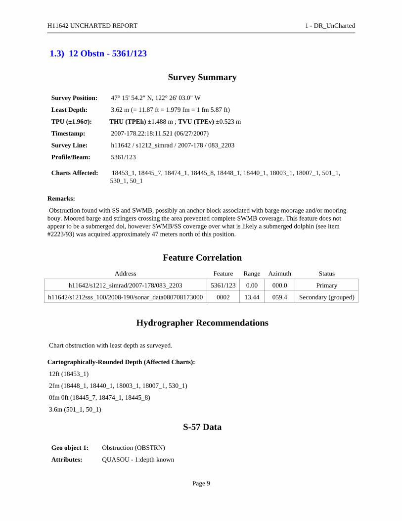
1.3) 12 Obstn - 5361/123
Survey Summary
Survey Position: 47° 15' 54.2" N, 122° 26' 03.0" W
Least Depth: 3.62 m (= 11.87 ft = 1.979 fm = 1 fm 5.87 ft)
TPU (±1.96σ): THU (TPEh) ±1.488 m ; TVU (TPEv) ±0.523 m
Timestamp: 2007-178.22:18:11.521 (06/27/2007)
Survey Line: h11642 / s1212_simrad / 2007-178 / 083_2203
Profile/Beam: 5361/123
Charts Affected: 18453_1, 18445_7, 18474_1, 18445_8, 18448_1, 18440_1, 18003_1, 18007_1, 501_1,530_1, 50_1
Remarks:
Obstruction found with SS and SWMB, possibly an anchor block associated with barge moorage and/or mooringbouy. Moored barge and stringers crossing the area prevented complete SWMB coverage. This feature does notappear to be a submerged dol, however SWMB/SS coverage over what is likely a submerged dolphin (see item#2223/93) was acquired approximately 47 meters north of this position.
Feature Correlation
Address Feature Range Azimuth Status
h11642/s1212_simrad/2007-178/083_2203 5361/123 0.00 000.0 Primary
h11642/s1212sss_100/2008-190/sonar_data080708173000 0002 13.44 059.4 Secondary (grouped)
Hydrographer Recommendations
Chart obstruction with least depth as surveyed.
Cartographically-Rounded Depth (Affected Charts):
12ft (18453_1)
2fm (18448_1, 18440_1, 18003_1, 18007_1, 530_1)
0fm 0ft (18445_7, 18474_1, 18445_8)
3.6m (501_1, 50_1)
S-57 Data
Geo object 1: Obstruction (OBSTRN)
Attributes: QUASOU - 1:depth known
H11642 UNCHARTED REPORT 1 - DR_UnCharted
Page 9

RECDAT - 20081216
SORDAT - 20070622
SORIND - US, US Survey H11642
TECSOU - 3:found by multi-beam
VALSOU - 3.619 m
WATLEV - 3:always under water/submerged
Office Notes
Concur - Add 12 Obstn and danger curve in present survey location.
H11642 UNCHARTED REPORT 1 - DR_UnCharted
Page 10

1.4) Obstn - Subm dol - 2366/56
Survey Summary
Survey Position: 47° 16' 51.3" N, 122° 24' 50.9" W
Least Depth: 3.15 m (= 10.34 ft = 1.724 fm = 1 fm 4.34 ft)
TPU (±1.96σ): THU (TPEh) ±1.399 m ; TVU (TPEv) ±0.192 m
Timestamp: 2007-190.19:36:24.110 (07/09/2007)
Survey Line: h11642 / s1212_simrad / 2007-190 / 063_1932
Profile/Beam: 2366/56
Charts Affected: 18453_1, 18445_7, 18474_1, 18445_8, 18448_1, 18440_1, 18003_1, 18007_1, 501_1,530_1, 50_1
Remarks:
A 2-meter obstruction with a least depth of 10.34 feet was found with SWMB northeast of the entrance to the BlairWaterway. The obstruction appears to be a submerged piling or dolphin and plots on top of a dol that is currentlycharted as above water. A visual search was conducted for both of the dols that are charted on either side of thecharted 2-foot shoal. The dols were not seen.
Feature Correlation
Address Feature Range Azimuth Status
h11642/s1212_simrad/2007-190/063_1932 2366/56 0.00 000.0 Primary
h11642/s1212sss_100/2008-206/sonar_data080724155000 0001 2.73 217.5 Secondary (grouped)
Hydrographer Recommendations
Chart dol as submerged.
Cartographically-Rounded Depth (Affected Charts):
10ft (18453_1)
1 ¾fm (18448_1, 18440_1, 18003_1, 18007_1, 530_1)
1fm 4ft (18445_7, 18474_1, 18445_8)
3.2m (501_1, 50_1)
S-57 Data
Geo object 1: Obstruction (OBSTRN)
Attributes: CATOBS - 1:snag / stump
H11642 UNCHARTED REPORT 1 - DR_UnCharted
Page 11

QUASOU - 1:depth known
RECDAT - 20081216
SORDAT - 20090403
SORIND - US,US,nsurf,H11642
TECSOU - 3:found by multi-beam
VALSOU - 3.152 m
WATLEV - 3:always under water/submerged
Office Notes
Concur with clarification - Revise charted dolphin in Latitude 47°16'51.25"N, Longitude 122°24'50.83"W to ObstnSubm Dol symbol in Latitude 47°16'51.286"N, Longitude 122°24'50.932"W. Delete Dol. Add Obstn Subm dol.
H11642 UNCHARTED REPORT 1 - DR_UnCharted
Page 12

Feature Images
Figure 1.4.1
H11642 UNCHARTED REPORT 1 - DR_UnCharted
Page 13

1.5) Obstn - Subm pile - 1612/4
Survey Summary
Survey Position: 47° 16' 53.8" N, 122° 24' 47.7" W
Least Depth: 2.51 m (= 8.23 ft = 1.372 fm = 1 fm 2.23 ft)
TPU (±1.96σ): THU (TPEh) ±1.451 m ; TVU (TPEv) ±0.450 m
Timestamp: 2007-190.19:35:08.266 (07/09/2007)
Survey Line: h11642 / s1212_simrad / 2007-190 / 063_1932
Profile/Beam: 1612/4
Charts Affected: 18453_1, 18445_7, 18474_1, 18445_8, 18448_1, 18440_1, 18003_1, 18007_1, 501_1,530_1, 50_1
Remarks:
Submerged piling, least depth 8.23 feet. The next group of three charted submerged pilings extending along shore tothe north of this position appear to be the remains of a rail system associated with a shipyard or log boomingoperations.
Feature Correlation
Address Feature Range Azimuth Status
h11642/s1212_simrad/2007-190/063_1932 1612/4 0.00 000.0 Primary
h11642/s1212sss_100/2008-206/sonar_data080724155900 0001 5.38 203.8 Secondary (grouped)
Hydrographer Recommendations
Submerged pile is mischarted. Recommend reposition submerged piling, chart depths from current survey.
Cartographically-Rounded Depth (Affected Charts):
8ft (18453_1)
1 ¼fm (18448_1, 18440_1, 18003_1, 18007_1, 530_1)
1fm 2ft (18445_7, 18474_1, 18445_8)
2.5m (501_1, 50_1)
S-57 Data
Geo object 1: Obstruction (OBSTRN)
Attributes: CATOBS - 1:snag / stump
QUASOU - 1:depth known
H11642 UNCHARTED REPORT 1 - DR_UnCharted
Page 14
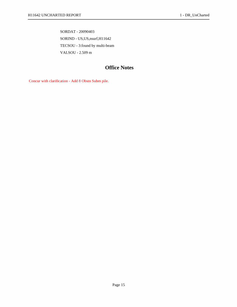
SORDAT - 20090403
SORIND - US,US,nsurf,H11642
TECSOU - 3:found by multi-beam
VALSOU - 2.509 m
Office Notes
Concur with clarification - Add 8 Obstn Subm pile.
H11642 UNCHARTED REPORT 1 - DR_UnCharted
Page 15

1.6) Obstn - Subm pile - 1089/27
Survey Summary
Survey Position: 47° 16' 55.7" N, 122° 24' 44.5" W
Least Depth: 0.89 m (= 2.93 ft = 0.488 fm = 0 fm 2.93 ft)
TPU (±1.96σ): THU (TPEh) ±1.385 m ; TVU (TPEv) ±0.200 m
Timestamp: 2007-190.19:34:12.139 (07/09/2007)
Survey Line: h11642 / s1212_simrad / 2007-190 / 063_1932
Profile/Beam: 1089/27
Charts Affected: 18453_1, 18445_7, 18474_1, 18445_8, 18448_1, 18440_1, 18003_1, 18007_1, 501_1,530_1, 50_1
Remarks:
Subm pile verified during office processing.
Feature Correlation
Address Feature Range Azimuth Status
h11642/s1212_simrad/2007-190/063_1932 1089/27 0.00 000.0 Primary
Hydrographer Recommendations
Revise location of charted subm pile.
Cartographically-Rounded Depth (Affected Charts):
3ft (18453_1)
0 ½fm (18448_1, 18440_1, 18003_1, 18007_1, 530_1)
0fm 3ft (18445_7, 18474_1, 18445_8)
.9m (501_1, 50_1)
S-57 Data
Geo object 1: Obstruction (OBSTRN)
Attributes: CATOBS - 1:snag / stump
QUASOU - 1:depth known
TECSOU - 3:found by multi-beam
VALSOU - 0.892 m
H11642 UNCHARTED REPORT 1 - DR_UnCharted
Page 16

Geo object 2: Pile (PILPNT)
Attributes: CATPLE - 3:post
CONDTN - 2:ruined
SORDAT - 20090403
SORIND - US,US,nsurf,H11642
Office Notes
Concur with clarification - Revise location of charted Subm pile in Latitude 47°16'55.79"N, Longitude122°24'44.64"W to Subm pile in Latitude 47°16'55.699"N, Longitude 122°24'44.541"W.
H11642 UNCHARTED REPORT 1 - DR_UnCharted
Page 17
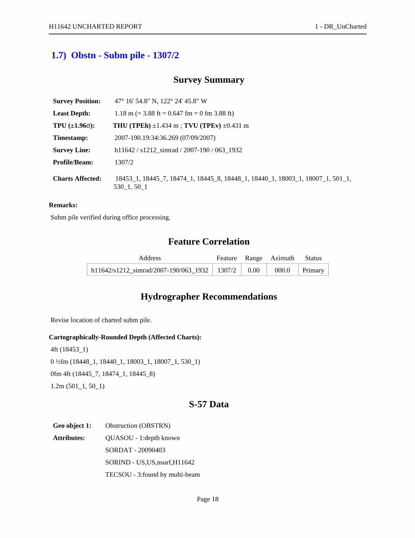
1.7) Obstn - Subm pile - 1307/2
Survey Summary
Survey Position: 47° 16' 54.8" N, 122° 24' 45.8" W
Least Depth: 1.18 m (= 3.88 ft = 0.647 fm = 0 fm 3.88 ft)
TPU (±1.96σ): THU (TPEh) ±1.434 m ; TVU (TPEv) ±0.431 m
Timestamp: 2007-190.19:34:36.269 (07/09/2007)
Survey Line: h11642 / s1212_simrad / 2007-190 / 063_1932
Profile/Beam: 1307/2
Charts Affected: 18453_1, 18445_7, 18474_1, 18445_8, 18448_1, 18440_1, 18003_1, 18007_1, 501_1,530_1, 50_1
Remarks:
Subm pile verified during office processing.
Feature Correlation
Address Feature Range Azimuth Status
h11642/s1212_simrad/2007-190/063_1932 1307/2 0.00 000.0 Primary
Hydrographer Recommendations
Revise location of charted subm pile.
Cartographically-Rounded Depth (Affected Charts):
4ft (18453_1)
0 ½fm (18448_1, 18440_1, 18003_1, 18007_1, 530_1)
0fm 4ft (18445_7, 18474_1, 18445_8)
1.2m (501_1, 50_1)
S-57 Data
Geo object 1: Obstruction (OBSTRN)
Attributes: QUASOU - 1:depth known
SORDAT - 20090403
SORIND - US,US,nsurf,H11642
TECSOU - 3:found by multi-beam
H11642 UNCHARTED REPORT 1 - DR_UnCharted
Page 18
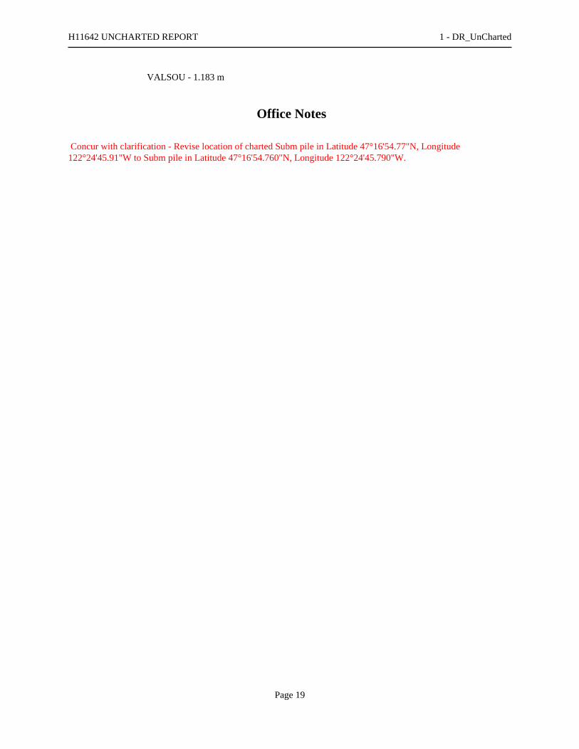
VALSOU - 1.183 m
Office Notes
Concur with clarification - Revise location of charted Subm pile in Latitude 47°16'54.77"N, Longitude122°24'45.91"W to Subm pile in Latitude 47°16'54.760"N, Longitude 122°24'45.790"W.
H11642 UNCHARTED REPORT 1 - DR_UnCharted
Page 19
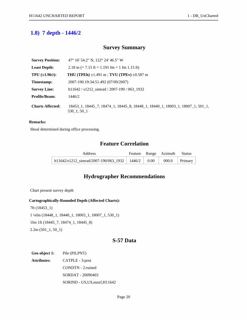
1.8) 7 depth - 1446/2
Survey Summary
Survey Position: 47° 16' 54.2" N, 122° 24' 46.5" W
Least Depth: 2.18 m (= 7.15 ft = 1.191 fm = 1 fm 1.15 ft)
TPU (±1.96σ): THU (TPEh) ±1.491 m ; TVU (TPEv) ±0.587 m
Timestamp: 2007-190.19:34:51.492 (07/09/2007)
Survey Line: h11642 / s1212_simrad / 2007-190 / 063_1932
Profile/Beam: 1446/2
Charts Affected: 18453_1, 18445_7, 18474_1, 18445_8, 18448_1, 18440_1, 18003_1, 18007_1, 501_1,530_1, 50_1
Remarks:
Shoal determined during office processing.
Feature Correlation
Address Feature Range Azimuth Status
h11642/s1212_simrad/2007-190/063_1932 1446/2 0.00 000.0 Primary
Hydrographer Recommendations
Chart present survey depth
Cartographically-Rounded Depth (Affected Charts):
7ft (18453_1)
1 ¼fm (18448_1, 18440_1, 18003_1, 18007_1, 530_1)
1fm 1ft (18445_7, 18474_1, 18445_8)
2.2m (501_1, 50_1)
S-57 Data
Geo object 1: Pile (PILPNT)
Attributes: CATPLE - 3:post
CONDTN - 2:ruined
SORDAT - 20090403
SORIND - US,US,nsurf,H11642
H11642 UNCHARTED REPORT 1 - DR_UnCharted
Page 20

Office Notes
Concur - Chart 7 ft depth.
H11642 UNCHARTED REPORT 1 - DR_UnCharted
Page 21

1.9) 37 Obstn - 1015/95
Survey Summary
Survey Position: 47° 17' 34.4" N, 122° 25' 07.8" W
Least Depth: 11.40 m (= 37.40 ft = 6.234 fm = 6 fm 1.40 ft)
TPU (±1.96σ): THU (TPEh) ±1.524 m ; TVU (TPEv) ±0.308 m
Timestamp: 2007-192.19:25:16.954 (07/11/2007)
Survey Line: h11642 / s1212_simrad / 2007-192 / 030_1922
Profile/Beam: 1015/95
Charts Affected: 18453_1, 18445_7, 18474_1, 18445_8, 18448_1, 18440_1, 18003_1, 18007_1, 501_1,530_1, 50_1
Remarks:
[None]
Feature Correlation
Address Feature Range Azimuth Status
h11642/s1212_simrad/2007-192/030_1922 1015/95 0.00 000.0 Primary
h11642/s1212sss_100/2008-190/sonar_data080708202500 0002 11.94 316.8 Secondary
h11642/s1212_simrad/2007-192/029_1928 605/112 15.09 307.8 Secondary
h11642/s1212sss_100/2008-190/sonar_data080708202500 0013 21.18 310.1 Secondary
Hydrographer Recommendations
[None]
Cartographically-Rounded Depth (Affected Charts):
37ft (18453_1)
6 ¼fm (18448_1, 18440_1, 18003_1, 18007_1, 530_1)
6fm 1ft (18445_7, 18474_1, 18445_8)
11.4m (501_1, 50_1)
S-57 Data
Geo object 1: Obstruction (OBSTRN)
Attributes: CATOBS - 1:snag / stump
H11642 UNCHARTED REPORT 1 - DR_UnCharted
Page 22

QUASOU - 6:least depth known
SORDAT - 20090403
SORIND - US,US,nsurf,H111642
TECSOU - 3:found by multi-beam
VALSOU - 11.400 m
WATLEV - 3:always under water/submerged
Office Notes
Concur with clarification - Several other obstructions in the vicinity. Add 37 Obstns and danger curve.
H11642 UNCHARTED REPORT 1 - DR_UnCharted
Page 23
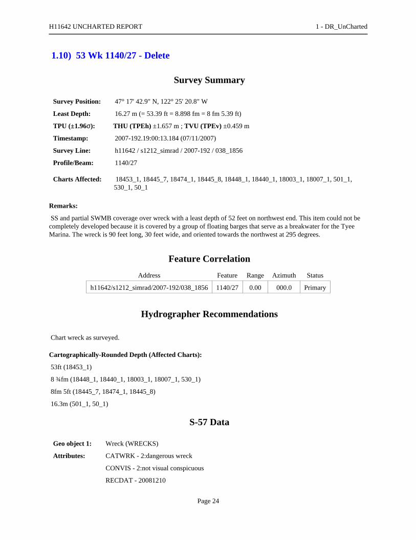
1.10) 53 Wk 1140/27 - Delete
Survey Summary
Survey Position: 47° 17' 42.9" N, 122° 25' 20.8" W
Least Depth: 16.27 m (= 53.39 ft = 8.898 fm = 8 fm 5.39 ft)
TPU (±1.96σ): THU (TPEh) ±1.657 m ; TVU (TPEv) ±0.459 m
Timestamp: 2007-192.19:00:13.184 (07/11/2007)
Survey Line: h11642 / s1212_simrad / 2007-192 / 038_1856
Profile/Beam: 1140/27
Charts Affected: 18453_1, 18445_7, 18474_1, 18445_8, 18448_1, 18440_1, 18003_1, 18007_1, 501_1,530_1, 50_1
Remarks:
SS and partial SWMB coverage over wreck with a least depth of 52 feet on northwest end. This item could not becompletely developed because it is covered by a group of floating barges that serve as a breakwater for the TyeeMarina. The wreck is 90 feet long, 30 feet wide, and oriented towards the northwest at 295 degrees.
Feature Correlation
Address Feature Range Azimuth Status
h11642/s1212_simrad/2007-192/038_1856 1140/27 0.00 000.0 Primary
Hydrographer Recommendations
Chart wreck as surveyed.
Cartographically-Rounded Depth (Affected Charts):
53ft (18453_1)
8 ¾fm (18448_1, 18440_1, 18003_1, 18007_1, 530_1)
8fm 5ft (18445_7, 18474_1, 18445_8)
16.3m (501_1, 50_1)
S-57 Data
Geo object 1: Wreck (WRECKS)
Attributes: CATWRK - 2:dangerous wreck
CONVIS - 2:not visual conspicuous
RECDAT - 20081210
H11642 UNCHARTED REPORT 1 - DR_UnCharted
Page 24

SORDAT - 20070711
SORIND - US, US Survey H11642
TECSOU - 2,3:found by side scan sonar,found by multi-beam
VALSOU - 16.273 m
WATLEV - 3:always under water/submerged
Office Notes
Do not concur - Shoaler depth on wreck in area. Delete 53 Wk and danger curve.
H11642 UNCHARTED REPORT 1 - DR_UnCharted
Page 25

Feature Images
Figure 1.10.1
H11642 UNCHARTED REPORT 1 - DR_UnCharted
Page 26

1.11) 49 Obstn - 1801/41
Survey Summary
Survey Position: 47° 17' 40.1" N, 122° 25' 12.2" W
Least Depth: 14.92 m (= 48.95 ft = 8.158 fm = 8 fm 0.95 ft)
TPU (±1.96σ): THU (TPEh) ±1.586 m ; TVU (TPEv) ±0.290 m
Timestamp: 2007-192.19:02:25.661 (07/11/2007)
Survey Line: h11642 / s1212_simrad / 2007-192 / 038_1856
Profile/Beam: 1801/41
Charts Affected: 18453_1, 18445_7, 18474_1, 18445_8, 18448_1, 18440_1, 18003_1, 18007_1, 501_1,530_1, 50_1
Remarks:
A 7-foot obstruction was found with SWMB, least depth 49 feet. The object lies seaward of a charted 76-footsounding and is approximately 33 feet long and 14 feet wide.
Feature Correlation
Address Feature Range Azimuth Status
h11642/s1212_simrad/2007-192/038_1856 1801/41 0.00 000.0 Primary
Hydrographer Recommendations
Chart obstruction with least depth; delete charted 76-foot sounding.
Cartographically-Rounded Depth (Affected Charts):
49ft (18453_1)
8fm (18448_1, 18440_1, 18003_1, 18007_1, 530_1)
8fm 1ft (18445_7, 18474_1, 18445_8)
14.9m (501_1, 50_1)
S-57 Data
Geo object 1: Obstruction (OBSTRN)
Attributes: QUASOU - 6:least depth known
RECDAT - 20081216
SORDAT - 20090403
SORIND - US,US,nsurf,H11642
H11642 UNCHARTED REPORT 1 - DR_UnCharted
Page 27

TECSOU - 3:found by multi-beam
VALSOU - 14.920 m
WATLEV - 3:always under water/submerged
Office Notes
Concur - Chart obstruction with a depth of 49 feet in Latitude 47°17'40.061"N, Longitude 122°25'12.245"W. Add49 Obstn and danger curve.
H11642 UNCHARTED REPORT 1 - DR_UnCharted
Page 28

Feature Images
Figure 1.11.1
H11642 UNCHARTED REPORT 1 - DR_UnCharted
Page 29

1.12) 2374/16 - insig
Survey Summary
Survey Position: 47° 17' 37.5" N, 122° 25' 05.2" W
Least Depth: 9.52 m (= 31.22 ft = 5.203 fm = 5 fm 1.22 ft)
TPU (±1.96σ): THU (TPEh) ±1.521 m ; TVU (TPEv) ±0.448 m
Timestamp: 2007-192.19:04:10.863 (07/11/2007)
Survey Line: h11642 / s1212_simrad / 2007-192 / 038_1856
Profile/Beam: 2374/16
Charts Affected: 18453_1, 18445_7, 18474_1, 18445_8, 18448_1, 18440_1, 18003_1, 18007_1, 501_1,530_1, 50_1
Remarks:
Partial SWMB coverage over submerged wreckage with a least depth of 31 feet. Boom logs and a permanentlymoored floating barge/breakwater along the northern portion of the obstruction prevented complete coverage.
Feature Correlation
Address Feature Range Azimuth Status
h11642/s1212_simrad/2007-192/038_1856 2374/16 0.00 000.0 Primary
Hydrographer Recommendations
Chart obstruction with least depth as surveyed.
Cartographically-Rounded Depth (Affected Charts):
31ft (18453_1)
5 ¼fm (18448_1, 18440_1, 18003_1, 18007_1, 530_1)
5fm 1ft (18445_7, 18474_1, 18445_8)
9.5m (501_1, 50_1)
S-57 Data
Geo object 1: Obstruction (OBSTRN)
Attributes: RECDAT - 20090209
SORDAT - 20070711
SORIND - US, US Survey H11642
TECSOU - 3:found by multi-beam
H11642 UNCHARTED REPORT 1 - DR_UnCharted
Page 30

VALSOU - 9.515 m
WATLEV - 3:always under water/submerged
Office Notes
Concur w/ clarification. This sounding is not the LD. LD redesignated as 8.767m (Line 038_1856, 2385, 11).
H11642 UNCHARTED REPORT 1 - DR_UnCharted
Page 31

Feature Images
Figure 1.12.1
H11642 UNCHARTED REPORT 1 - DR_UnCharted
Page 32
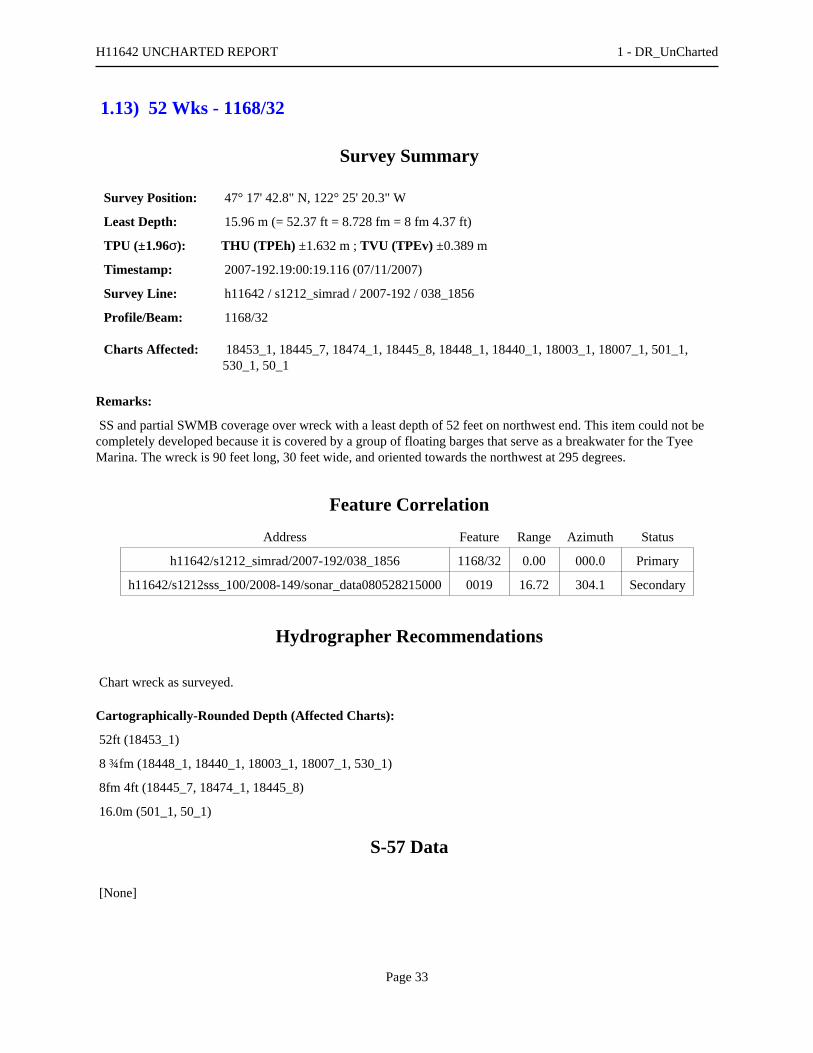
1.13) 52 Wks - 1168/32
Survey Summary
Survey Position: 47° 17' 42.8" N, 122° 25' 20.3" W
Least Depth: 15.96 m (= 52.37 ft = 8.728 fm = 8 fm 4.37 ft)
TPU (±1.96σ): THU (TPEh) ±1.632 m ; TVU (TPEv) ±0.389 m
Timestamp: 2007-192.19:00:19.116 (07/11/2007)
Survey Line: h11642 / s1212_simrad / 2007-192 / 038_1856
Profile/Beam: 1168/32
Charts Affected: 18453_1, 18445_7, 18474_1, 18445_8, 18448_1, 18440_1, 18003_1, 18007_1, 501_1,530_1, 50_1
Remarks:
SS and partial SWMB coverage over wreck with a least depth of 52 feet on northwest end. This item could not becompletely developed because it is covered by a group of floating barges that serve as a breakwater for the TyeeMarina. The wreck is 90 feet long, 30 feet wide, and oriented towards the northwest at 295 degrees.
Feature Correlation
Address Feature Range Azimuth Status
h11642/s1212_simrad/2007-192/038_1856 1168/32 0.00 000.0 Primary
h11642/s1212sss_100/2008-149/sonar_data080528215000 0019 16.72 304.1 Secondary
Hydrographer Recommendations
Chart wreck as surveyed.
Cartographically-Rounded Depth (Affected Charts):
52ft (18453_1)
8 ¾fm (18448_1, 18440_1, 18003_1, 18007_1, 530_1)
8fm 4ft (18445_7, 18474_1, 18445_8)
16.0m (501_1, 50_1)
S-57 Data
[None]
H11642 UNCHARTED REPORT 1 - DR_UnCharted
Page 33

Office Notes
Concur - Chart a wreck with a depth of 52 feet in Latitude 47°17'42.776"N, Longitude 122°25'20.295"W. Otherwrecks in area. Add 52 Wks and danger curve.
H11642 UNCHARTED REPORT 1 - DR_UnCharted
Page 34

1.14) 18 Wk - 2082/3
Survey Summary
Survey Position: 47° 17' 39.5" N, 122° 25' 08.1" W
Least Depth: 5.60 m (= 18.37 ft = 3.062 fm = 3 fm 0.37 ft)
TPU (±1.96σ): THU (TPEh) ±1.584 m ; TVU (TPEv) ±0.756 m
Timestamp: 2007-192.19:03:20.266 (07/11/2007)
Survey Line: h11642 / s1212_simrad / 2007-192 / 038_1856
Profile/Beam: 2082/3
Charts Affected: 18453_1, 18445_7, 18474_1, 18445_8, 18448_1, 18440_1, 18003_1, 18007_1, 501_1,530_1, 50_1
Remarks:
Wreck determined during office processing.
Feature Correlation
Address Feature Range Azimuth Status
h11642/s1212_simrad/2007-192/038_1856 2082/3 0.00 000.0 Primary
Hydrographer Recommendations
Chart an obstruction with least depth as surveyed.
Cartographically-Rounded Depth (Affected Charts):
18ft (18453_1)
3fm (18448_1, 18440_1, 18003_1, 18007_1, 530_1)
3fm 0ft (18445_7, 18474_1, 18445_8)
5.6m (501_1, 50_1)
S-57 Data
Geo object 1: Wreck (WRECKS)
Attributes: CATWRK - 2:dangerous wreck
QUASOU - 6:least depth known
SORDAT - 20090403
SORIND - US,US,nsurf,H11642
H11642 UNCHARTED REPORT 1 - DR_UnCharted
Page 35

TECSOU - 3:found by multi-beam
VALSOU - 5.599 m
VERDAT - 12:Mean lower low water
WATLEV - 3:always under water/submerged
Office Notes
Concur - Chart a wreck with a depth of 18 feet in Latitude 47°17'37.749"N, Longitude 122°25'04.602"W. Add 18Wk and danger curve.
H11642 UNCHARTED REPORT 1 - DR_UnCharted
Page 36

1.15) 34 Obstn - 2691/122
Survey Summary
Survey Position: 47° 17' 35.5" N, 122° 25' 05.4" W
Least Depth: 10.59 m (= 34.74 ft = 5.790 fm = 5 fm 4.74 ft)
TPU (±1.96σ): THU (TPEh) ±1.695 m ; TVU (TPEv) ±0.847 m
Timestamp: 2007-192.19:04:52.407 (07/11/2007)
Survey Line: h11642 / s1212_simrad / 2007-192 / 038_1856
Profile/Beam: 2691/122
Charts Affected: 18453_1, 18445_7, 18474_1, 18445_8, 18448_1, 18440_1, 18003_1, 18007_1, 501_1,530_1, 50_1
Remarks:
An 2.7 meter obstruction was found with SS and SWMB, least depth of 35 feet. The object is located within acharted booming ground and lies seaward of a charted 43-foot sounding.
Feature Correlation
Address Feature Range Azimuth Status
h11642/s1212_simrad/2007-192/038_1856 2691/122 0.00 000.0 Primary
h11642/s1212sss_100/2008-149/sonar_data080528213200 0004 0.69 036.1 Secondary
h11642/s1212_simrad/2007-192/028_1931 350/112 2.25 160.4 Secondary
Hydrographer Recommendations
Chart obstruction with least depth as surveyed.
Cartographically-Rounded Depth (Affected Charts):
34ft (18453_1)
5 ¾fm (18448_1, 18440_1, 18003_1, 18007_1, 530_1)
5fm 4ft (18445_7, 18474_1, 18445_8)
10.6m (501_1, 50_1)
S-57 Data
Geo object 1: Obstruction (OBSTRN)
Attributes: QUASOU - 6:least depth known
SORDAT - 20090403
H11642 UNCHARTED REPORT 1 - DR_UnCharted
Page 37

SORIND - US,US,nsurf,H11642
TECSOU - 3:found by multi-beam
VALSOU - 10.588 m
WATLEV - 3:always under water/submerged
Office Notes
Concur - Chart obstruction with a depth of 34 feet in Latitude 47°17'35.497"N, Longitude 122°25'05.449"W. Add34 Obstn and danger curve.
H11642 UNCHARTED REPORT 1 - DR_UnCharted
Page 38

1.16) 24 Wk - 2386/3
Survey Summary
Survey Position: 47° 17' 37.7" N, 122° 25' 04.6" W
Least Depth: 7.48 m (= 24.53 ft = 4.089 fm = 4 fm 0.53 ft)
TPU (±1.96σ): THU (TPEh) ±1.706 m ; TVU (TPEv) ±0.960 m
Timestamp: 2007-192.19:04:12.894 (07/11/2007)
Survey Line: h11642 / s1212_simrad / 2007-192 / 038_1856
Profile/Beam: 2386/3
Charts Affected: 18453_1, 18445_7, 18474_1, 18445_8, 18448_1, 18440_1, 18003_1, 18007_1, 501_1,530_1, 50_1
Remarks:
Partial SWMB coverage over submerged wreckage with a least depth of 31 feet. Boom logs and a permanentlymoored floating barge/breakwater along the northern portion of the obstruction prevented complete coverage.
Feature Correlation
Address Feature Range Azimuth Status
h11642/s1212_simrad/2007-192/038_1856 2386/3 0.00 000.0 Primary
Hydrographer Recommendations
Chart wreck with least depth as surveyed.
Cartographically-Rounded Depth (Affected Charts):
24ft (18453_1)
4fm (18448_1, 18440_1, 18003_1, 18007_1, 530_1)
4fm 0ft (18445_7, 18474_1, 18445_8)
7.5m (501_1, 50_1)
S-57 Data
Geo object 1: Wreck (WRECKS)
Attributes: CATWRK - 2:dangerous wreck
QUASOU - 6:least depth known
SORDAT - 20090403
SORIND - US,US,nsurf,H11642
H11642 UNCHARTED REPORT 1 - DR_UnCharted
Page 39

TECSOU - 3:found by multi-beam
VALSOU - 7.478 m
VERDAT - 12:Mean lower low water
WATLEV - 3:always under water/submerged
Office Notes
Concur - Chart a wreck with a depth of 24 feet in Latitude 47°17'37.749"N, Longitude 122°25'04.602"W. Add 24Wk and danger curve.
H11642 UNCHARTED REPORT 1 - DR_UnCharted
Page 40
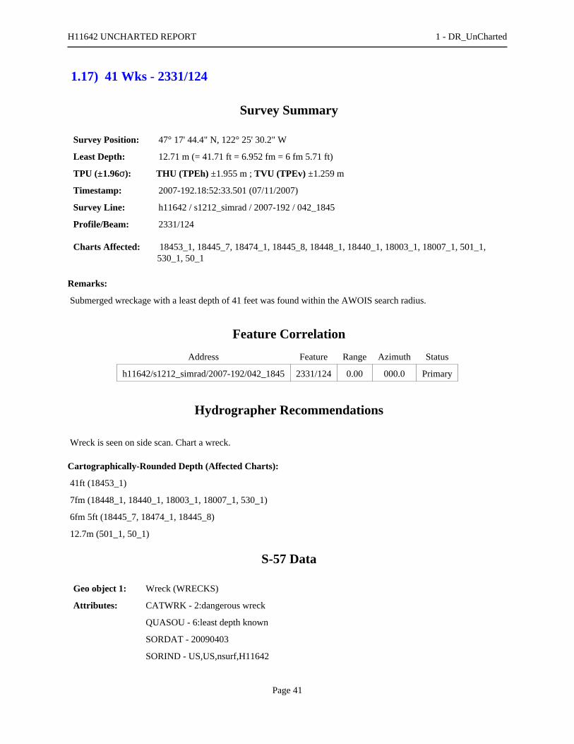
1.17) 41 Wks - 2331/124
Survey Summary
Survey Position: 47° 17' 44.4" N, 122° 25' 30.2" W
Least Depth: 12.71 m (= 41.71 ft = 6.952 fm = 6 fm 5.71 ft)
TPU (±1.96σ): THU (TPEh) ±1.955 m ; TVU (TPEv) ±1.259 m
Timestamp: 2007-192.18:52:33.501 (07/11/2007)
Survey Line: h11642 / s1212_simrad / 2007-192 / 042_1845
Profile/Beam: 2331/124
Charts Affected: 18453_1, 18445_7, 18474_1, 18445_8, 18448_1, 18440_1, 18003_1, 18007_1, 501_1,530_1, 50_1
Remarks:
Submerged wreckage with a least depth of 41 feet was found within the AWOIS search radius.
Feature Correlation
Address Feature Range Azimuth Status
h11642/s1212_simrad/2007-192/042_1845 2331/124 0.00 000.0 Primary
Hydrographer Recommendations
Wreck is seen on side scan. Chart a wreck.
Cartographically-Rounded Depth (Affected Charts):
41ft (18453_1)
7fm (18448_1, 18440_1, 18003_1, 18007_1, 530_1)
6fm 5ft (18445_7, 18474_1, 18445_8)
12.7m (501_1, 50_1)
S-57 Data
Geo object 1: Wreck (WRECKS)
Attributes: CATWRK - 2:dangerous wreck
QUASOU - 6:least depth known
SORDAT - 20090403
SORIND - US,US,nsurf,H11642
H11642 UNCHARTED REPORT 1 - DR_UnCharted
Page 41

TECSOU - 2,3:found by side scan sonar,found by multi-beam
VALSOU - 12.713 m
VERDAT - 12:Mean lower low water
WATLEV - 3:always under water/submerged
Office Notes
Concur - Additional wreck in the vicinity of this wreck. Add 41 Wks and danger curve in present survey location.
H11642 UNCHARTED REPORT 1 - DR_UnCharted
Page 42
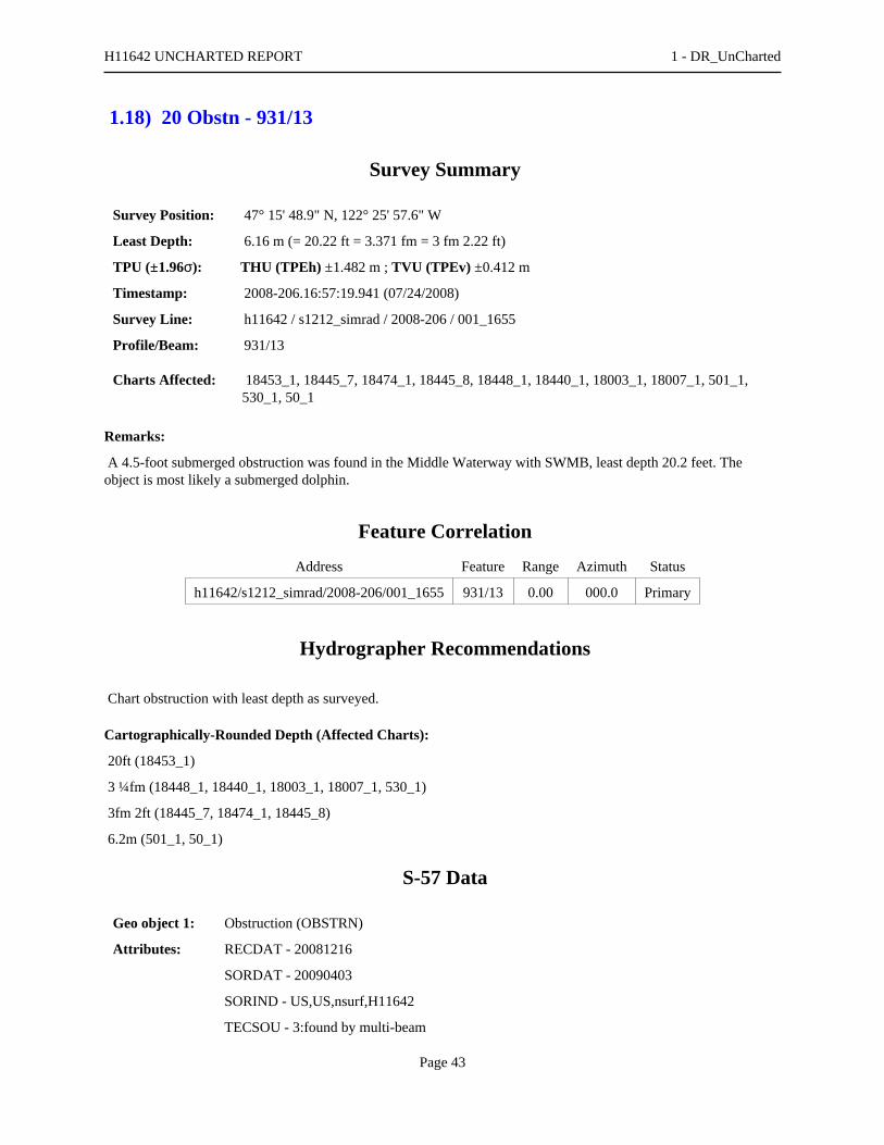
1.18) 20 Obstn - 931/13
Survey Summary
Survey Position: 47° 15' 48.9" N, 122° 25' 57.6" W
Least Depth: 6.16 m (= 20.22 ft = 3.371 fm = 3 fm 2.22 ft)
TPU (±1.96σ): THU (TPEh) ±1.482 m ; TVU (TPEv) ±0.412 m
Timestamp: 2008-206.16:57:19.941 (07/24/2008)
Survey Line: h11642 / s1212_simrad / 2008-206 / 001_1655
Profile/Beam: 931/13
Charts Affected: 18453_1, 18445_7, 18474_1, 18445_8, 18448_1, 18440_1, 18003_1, 18007_1, 501_1,530_1, 50_1
Remarks:
A 4.5-foot submerged obstruction was found in the Middle Waterway with SWMB, least depth 20.2 feet. Theobject is most likely a submerged dolphin.
Feature Correlation
Address Feature Range Azimuth Status
h11642/s1212_simrad/2008-206/001_1655 931/13 0.00 000.0 Primary
Hydrographer Recommendations
Chart obstruction with least depth as surveyed.
Cartographically-Rounded Depth (Affected Charts):
20ft (18453_1)
3 ¼fm (18448_1, 18440_1, 18003_1, 18007_1, 530_1)
3fm 2ft (18445_7, 18474_1, 18445_8)
6.2m (501_1, 50_1)
S-57 Data
Geo object 1: Obstruction (OBSTRN)
Attributes: RECDAT - 20081216
SORDAT - 20090403
SORIND - US,US,nsurf,H11642
TECSOU - 3:found by multi-beam
H11642 UNCHARTED REPORT 1 - DR_UnCharted
Page 43
VALSOU - 6.164 m
WATLEV - 3:always under water/submerged
Office Notes
Concur - Chart an obstruction with a depth of 20 feet in Latitude 47°15'48.929"N, Longitude 122°25'57.609"W.Add 20 Obstn and danger curve.
H11642 UNCHARTED REPORT 1 - DR_UnCharted
Page 44
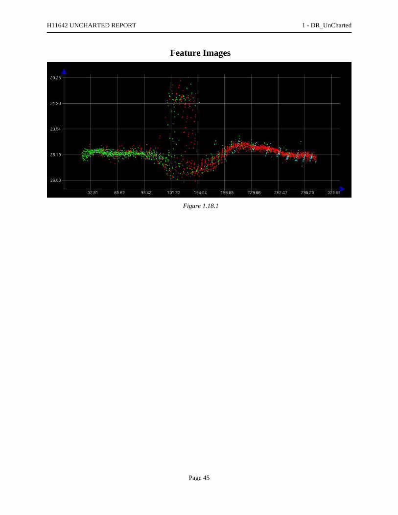
Feature Images
Figure 1.18.1
H11642 UNCHARTED REPORT 1 - DR_UnCharted
Page 45

1.19) 20 Obstn - 3311/112
Survey Summary
Survey Position: 47° 15' 50.4" N, 122° 25' 57.1" W
Least Depth: 6.30 m (= 20.67 ft = 3.445 fm = 3 fm 2.67 ft)
TPU (±1.96σ): THU (TPEh) ±1.474 m ; TVU (TPEv) ±0.377 m
Timestamp: 2008-206.17:09:20.251 (07/24/2008)
Survey Line: h11642 / s1212_simrad / 2008-206 / 004_1704
Profile/Beam: 3311/112
Charts Affected: 18453_1, 18445_7, 18474_1, 18445_8, 18448_1, 18440_1, 18003_1, 18007_1, 501_1,530_1, 50_1
Remarks:
A 3.5-foot obstruction was found in the Middle Waterway with SWMB, least depth 20.7 feet.
Feature Correlation
Address Feature Range Azimuth Status
h11642/s1212_simrad/2008-206/004_1704 3311/112 0.00 000.0 Primary
Hydrographer Recommendations
Chart obstruction with least depth as surveyed.
Cartographically-Rounded Depth (Affected Charts):
20ft (18453_1)
3 ½fm (18448_1, 18440_1, 18003_1, 18007_1, 530_1)
3fm 2ft (18445_7, 18474_1, 18445_8)
6.3m (501_1, 50_1)
S-57 Data
Geo object 1: Obstruction (OBSTRN)
Attributes: QUASOU - 6:least depth known
RECDAT - 20081216
SORDAT - 20090403
SORIND - US, US,nsurf,H11642
H11642 UNCHARTED REPORT 1 - DR_UnCharted
Page 46

TECSOU - 3:found by multi-beam
VALSOU - 6.300 m
WATLEV - 3:always under water/submerged
Office Notes
Concur - Chart an obstruction with a depth of 20 feet in Latitude 47°15'50.441"N, longitude 122°25'57.109"W. Add20 Obstn and danger curve.
H11642 UNCHARTED REPORT 1 - DR_UnCharted
Page 47

1.20) Retain ruins - 755/87
Survey Summary
Survey Position: 47° 16' 09.8" N, 122° 26' 53.7" W
Least Depth: 5.32 m (= 17.44 ft = 2.907 fm = 2 fm 5.44 ft)
TPU (±1.96σ): THU (TPEh) ±1.420 m ; TVU (TPEv) ±0.211 m
Timestamp: 2009-093.20:23:04.046 (04/03/2009)
Survey Line: h11642 / s1212_simrad / 2009-093 / 050_2020
Profile/Beam: 755/87
Charts Affected: 18453_1, 18445_7, 18474_1, 18445_8, 18448_1, 18440_1, 18003_1, 18007_1, 501_1,530_1, 50_1
Remarks:
Mischarted ruin found with SWMB, least depth of 17.44 feet on south end. The ruin is 22 feet long and orientednorth to south with an azimuth of 166 degrees. Correlating designated sounding (item 732/70) marks the northernextent of the ruin. Due to a large cable-out error while collecting SS data along this portion of shoreline, thecorrelating imagery item for this feature (Contact 0014) lies 35 meters to the southeast of the primary designatedsounding.
Feature Correlation
Address Feature Range Azimuth Status
h11642/s1212_simrad/2009-093/050_2020 755/87 0.00 000.0 Primary
h11642/s1212_simrad/2009-093/050_2020 732/70 7.02 155.1 Secondary (grouped)
h11642/s1212sss_100/2008-164/sonar_data080612192100 0014 33.44 296.4 Secondary (grouped)
Hydrographer Recommendations
Chart as submerged ruin with least depths as surveyed.
S-57 Data
Geo object 1: Obstruction (OBSTRN)
Attributes: QUASOU - 1:depth known
RECDAT - 20090407
SORDAT - 20090403
SORIND - US, US Survey H11642
TECSOU - 3:found by multi-beam
H11642 UNCHARTED REPORT 1 - DR_UnCharted
Page 48

VALSOU - 5.317 m
WATLEV - 3:always under water/submerged
Office Notes
Concur with clarification - Obstruction falls with a charted ruins. Do not chart obstruction. Retain ruins.
H11642 UNCHARTED REPORT 1 - DR_UnCharted
Page 49

1.21) Outfall pipeline - 435/40
Survey Summary
Survey Position: 47° 16' 08.8" N, 122° 26' 52.0" W
Least Depth: 11.37 m (= 37.31 ft = 6.219 fm = 6 fm 1.31 ft)
TPU (±1.96σ): THU (TPEh) ±1.526 m ; TVU (TPEv) ±0.265 m
Timestamp: 2009-093.20:27:47.750 (04/03/2009)
Survey Line: h11642 / s1212_simrad / 2009-093 / 051_2026
Profile/Beam: 435/40
Charts Affected: 18453_1, 18445_7, 18474_1, 18445_8, 18448_1, 18440_1, 18003_1, 18007_1, 501_1,530_1, 50_1
Remarks:
Uncharted feature found with SS and SWMB, appears to be an outfall pipe. The feature extends seaward west toeast at an azimuth of 068 degrees, and is approximately 75 feet long. This designated sounding of 37.31 feet marksthe shoalest depth of the offshore end of the feature. The correlating designated sounding of 18.73 feet (item927/122) marks the shoalest depth of the inshore end. Due to a large cable-out error while collecting SS data alongthis portion of shoreline, the correlating imagery item for this feature (Contact 0012) lies 42 meters to the east of theprimary designated sounding.
Feature Correlation
Address Feature Range Azimuth Status
h11642/s1212_simrad/2009-093/051_2026 435/40 0.00 000.0 Primary
h11642/s1212_simrad/2009-093/050_2020 927/122 20.84 069.3 Secondary (grouped)
h11642/s1212sss_100/2008-164/sonar_data080612192100 0012 42.90 285.0 Secondary (grouped)
Hydrographer Recommendations
Chart feature as surveyed with least depths.
Cartographically-Rounded Depth (Affected Charts):
37ft (18453_1)
6 ¼fm (18448_1, 18440_1, 18003_1, 18007_1, 530_1)
6fm 1ft (18445_7, 18474_1, 18445_8)
11.4m (501_1, 50_1)
H11642 UNCHARTED REPORT 1 - DR_UnCharted
Page 50

S-57 Data
Geo object 1: Pipeline, submarine/on land (PIPSOL)
Attributes: RECDAT - 20090407
SORDAT - 20090403
SORIND - US, US Survey H11642
Office Notes
Concur - Add pipeline
H11642 UNCHARTED REPORT 1 - DR_UnCharted
Page 51
1.22) 48 Obstn - 120/125
Survey Summary
Survey Position: 47° 17' 43.8" N, 122° 25' 28.8" W
Least Depth: 14.83 m (= 48.67 ft = 8.111 fm = 8 fm 0.67 ft)
TPU (±1.96σ): THU (TPEh) ±2.054 m ; TVU (TPEv) ±1.373 m
Timestamp: 2009-093.23:06:42.168 (04/03/2009)
Survey Line: h11642 / s1212_simrad / 2009-093 / 019_2306
Profile/Beam: 120/125
Charts Affected: 18453_1, 18445_7, 18474_1, 18445_8, 18448_1, 18440_1, 18003_1, 18007_1, 501_1,530_1, 50_1
Remarks:
Least depth on submerged obstruction.
Feature Correlation
Address Feature Range Azimuth Status
h11642/s1212_simrad/2009-093/019_2306 120/125 0.00 000.0 Primary
h11642/s1212_simrad/2007-192/038_1856 635/47 16.47 209.1 Secondary
h11642/s1212sss_100/2008-149/sonar_data080528215000 0021 17.55 091.4 Secondary (grouped)
Hydrographer Recommendations
Chart obstruction with least depth as surveyed.
Cartographically-Rounded Depth (Affected Charts):
48ft (18453_1)
8fm (18448_1, 18440_1, 18003_1, 18007_1, 530_1)
8fm 0ft (18445_7, 18474_1, 18445_8)
14.8m (501_1, 50_1)
S-57 Data
Geo object 1: Obstruction (OBSTRN)
Attributes: QUASOU - 6:least depth known
RECDAT - 20090414
H11642 UNCHARTED REPORT 1 - DR_UnCharted
Page 52

SORDAT - 20090403
SORIND - US, US Survey H11642
TECSOU - 3:found by multi-beam
VALSOU - 14.834 m
WATLEV - 3:always under water/submerged
Office Notes
Concur - Chart an obstruction with a depth of 48 feet in Latitude 47°17'43.822"N, Longitude 122°25'28.755""W.Add 48 Obstn and danger curve.
H11642 UNCHARTED REPORT 1 - DR_UnCharted
Page 53


UNITED STATES DEPARMENT OF COMMERCE National Oceanic and Atmospheric Administration National Ocean Service Silver Spring, Maryland 20910

PS178Time Corrector 0 minsRange Corrector x1.00Reference 944-6484
944-6484 TACOMA
Final Tidal Zoning forOPR-N411-NRT3-2008, H11642_Rev.Tacoma, WA

U.S. Coast Pilot 7, 39th
Chapter 13, Page 558 – Paragraph 415 through Page 563 - Paragraph 466 Ed., 2007
Reviewed through LNM 05/07, CG13 Chart 18453 (415) Dash Point, the E entrance of Commencement Bay, and the village of Dash Point are 1 mile NE of Browns Point. There is a restaurant at the foot of the long pier which extends out from the N side of the point to a depth of 20 feet. (416) Point Defiance, the W entrance of Commencement Bay, terminates in a very prominent dirt bluff, 160 feet high. A light and fog signal are just W of the point. The terminal for the Point Defiance/Tahlequah ferry is located approximately 1.8 nautical miles SSE of the Point. A small boat launch ramp is just south of the terminal adjacent to a small craft boat basin formed by a manmade peninsula. and Point Defiance Park is wooded along its northeastern shore for 3.8 miles mile from the end of the point. (417) Commencement Bay entrance lies 18 miles S of Alki Point and 56 miles S of Point Wilson. The bay is about 2.5 miles in length, easy of access, and free of dangers. Log storage grounds are off the NE shore of the bay. (418) Tacoma, the second city in size and importance on the sound, occupies the S and SW shores of Commencement Bay, and its residential area has grown N into Seattle’s S suburbs, and to Steilacoom on the SW. (419) The Port of Tacoma is a rapidly expanding major port, second only to Seattle in maritime importance on Puget Sound. Its exports include lumber and other wood products, grain, refined metals, machinery, general and containerized cargo; imports include alumina, and refined steel, automobiles, electronic equipment, rubber, and meat. Much of the Alaska trade originates here. Prominent features (420) On entering Commencement Bay, either from the N via East Passage or Colvos Passage or from the S via The Narrows and Dalco Passage, Dash Point, Browns Point, and Point Defiance are prominent. Browns Point Light (47°18'22"N., 122°26'35"W.), 38 feet above the water, is shown from a 31-foot white tower on Browns Point; a fog signal is at the light. Once inside the bay numerous stacks, tanks and towers are visible. (421) A 132°05' - 312°05' measured nautical mile is along the SW shore of the bay about midway between Ruston and Tacoma. (422) A fishing reef, marked by private buoys, is along the SW shore of the bay about midway between Ruston and Tacoma. A fish haven, covered 21 feet, is just N of the public pier at the N end of Tacoma. A line of seven mooring buoys extends for .65 miles along the SW shore of the bay. (423) From the SE corner of Commencement Bay, the city waterfront extends NW to within 1.5 miles of Point Defiance the southeast corner of Point Defiance Park. Along here are numerous industrial plants with wharves to accommodate vessels drawing 30 feet or more. (424) Thea Foss Waterway is the westernmost of the channels at the head of the bay; a light is on the E side of the entrance. A Federal project provides for depths of 29 feet in Thea Foss Waterway to the South 11th Street Bridge, thence 22 feet for 0.2 mile, thence 19 feet to the head of the project. Maintenance work is done when required on this waterway. Two deep-draft oil handling wharves and many oil storage tanks are on the E side. (425) There are two bridges over the waterway. The South 11th Street vertical lift bridge, 0.5 mile from the entrance to the waterway, has a clearance of 64 feet down and 139 feet up. A fixed highway bridge near the head of the waterway has a clearance of 28 feet (36 feet at the center). (426) Middle Waterway, NE of Thea Foss Waterway, and St. Paul Waterway, NE of Middle Waterway, are not Federal projects. The inner parts of both waterways have shoaled and are not navigable. For about the outer 400 yards of each waterway, there are depths of 25 to 34 feet, but there is no deep-draft traffic. St. Paul Waterway is used for log storage by the large papermill which occupies the land on the NE side. (427) Puyallup Waterway, NE of St. Paul Waterway, discharges the water of Puyallup River. The waterway has shoaled to such an extent that it cannot be used commercially. A lighted buoy marks a shoal area extending about 500 yards NW of the entrance. A fixed bridge, with a clearance of 29 feet, crosses the waterway about 0.7 mile above the mouth. An overhead cable, just SE of the bridge, has a clearance of 46 feet. (428) Sitcum Waterway, NE of Milwaukee Waterway, is maintained at more than the project depth of 40 feet. The Port of Tacoma’s
Pier 7 is on the E side. A private light is just off the NW end of Pier 7; it marks the NE side of the entrance to Sitcum Waterway. (429) The next two channels to the NE of Sitcum Waterway, Blair Waterway and Hylebos Waterway, are maintained as Federal projects. A lighted buoy is off a shoal on the N side of the entrance and a private light is on the S side at the NW end of Pier 25; these aids mark the entrance to Hylebos Waterway. The entrance to Blair Waterway is marked by a directional light on the NE side and a private lighted buoy on the SW side. Project depths in Hylebos Waterway are 30 feet in the waterway and basins. Project depths in Blair Waterway are 30 feet in the Southern Section and 35 feet in the rest of the waterway and basins. (See Notice to Mariners and latest editions of charts for controlling depths.) (430) The 11th Street bascule bridge over Hylebos Waterway has a clearance of 21 feet. (See 117.1 through 117.59 and 117.1061, chapter 2, for drawbridge regulations.) The bridgetender monitors VHF-FM channel 16 and works on channel 13. Call signs: KZN-574, Hylebos Bridge. A power cable at the bridge has a clearance of 173 feet. (431) Security zones are in the Sitcum Waterway and Blair Waterway areas. (See 165.1 through 165.8, 165.30 and 165.1321, chapter 2, for limits and regulations.) Anchorage (432) A general anchorage is off the N shore of Commencement Bay. (See 110.1 and 110.230, chapter 2, for limits and regulations.) The depths elsewhere in the bay, as a rule, are too great for convenient anchorage. (433) City regulations permit anchorage in any part of the bay outside the harbor lines so as not to interfere with vessels arriving or departing from their docks. Tides and currents (434) The mean range of tide at Tacoma is 8.1 feet, and the diurnal range of tide is 11.8 feet. A range of about 19 feet may occur at the time of maximum tides. The tidal currents in the harbor have little velocity, except in Hylebos Waterway where the NOAA Ship McARTHUR reported estimated currents of up to 2 knots in 1994. Pilotage, Tacoma (435) Pilotage is compulsory for all vessels except those under enrollment or engaged exclusively in the coasting trade on the W coast of the continental United States (including Alaska) and/or British Columbia. Pilotage for Puget Sound is provided by the Puget Sound Pilots. (See Pilotage, Strait of Juan de Fuca and Puget Sound, indexed as such, chapter 12 for details.) Towage (436) Tugs up to 3,000 hp are available at Tacoma, and larger tugs may be obtained from Seattle. Arrangements should be made in advance through ships’ agents. Quarantine, customs, immigration, and agricultural quarantine (437) (See chapter 3, Vessel Arrival Inspections, and Appendix A for addresses.) (438) Quarantine is enforced in accordance with regulations of the U.S. Public Health Service. (See Public Health Service, chapter 1.) (439) Tacoma is a customs port of entry. Harbor regulation (440) Harbor regulations are administered by the harbormaster, whose headquarters are at the fire station at 901 South Fawcett Street. The general offices of the Port of Tacoma are in the Tacoma Building at the corner of 11th and A Streets; the Port of Tacoma terminal offices are at Pier 2. Speed (441) A city ordinance prohibits speeds in excess of 5 knots on any of the waterways and within 200 yards of any shore or pier in the harbor. Wharves (442) The Port of Tacoma has more than 30 deep-draft piers and wharves located on Hylebos, Blair, Sitcum, and Thea Foss Waterways and along the S shore of Commencement Bay. The port-owned properties consist of the Port Industrial Yard, the 160-acre area between Blair and Hylebos Waterways NW of 11th Street, and its deep-draft piers; the 3,600-acre Port Industrial Development District, which includes the entire waterfronts of Blair and Hylebos Waterways above 11th Street; and the Marine Terminal facilities between Blair and Sitcum Waterways below 11th Street. The terminal facilities include some 23 deepwater berths ranging in depth from 35 to 65 feet. In addition to the port-owned properties, the harbor has numerous privately owned piers and wharves and many barge facilities. (443)

Only the major deep-draft facilities are described. For a complete description of the port facilities refer to Port Series No. 35, published and sold by the U.S. Army Corps of Engineers. (See Appendix A for address.) The alongside depths are reported. (For information on the latest depths contact the Port of Tacoma general office or the individual operators.) All the facilities described have direct highway connections, and most have plant trackage with railroad connections. Water and electrical shore power connections are available at about 80 percent of the wharves. General cargo is usually handled by ships’ tackle. Special handling equipment, if available, is mentioned in the description of the particular facility. The Port of Tacoma operates its own belt line railroad with switching connections to two major railroads and has a 200-ton mobile crane and a 300-ton floating crane. Port of Tacoma facilities: Facilities on Blair Waterway: (444) Terminal 4 (47°16'22"N., 122°24'18"W.): W side of Blair Waterway just below East 11th Street, 1,900-foot berthing space, 50 feet alongside; deck height, 18 feet; 75 acres open storage; six 50 to 66-ton straight-line cranes; rail service with 10-car capacity; receipt and shipment of general and containerized cargo; operated by the Port of Tacoma. (445) Blair Waterway Log Terminal: W side of Blair Waterway, 1.8 miles above the entrance to the waterway; 1,200-foot berthing space, 50 feet alongside; deck height, 22 feet; 10 acres open log storage and sorting area; lift equipment required, receipt and shipment of fabricated structure; operated by Port of Tacoma. (446) Pierce County Terminal: S end of the upper turning basin on Blair Waterway; 1,400-foot berthing space, 50 feet alongside; deck height, 22 feet; one 60-ton traveling gantry crane; 100,000 square feet covered storage, 147 acres paved, open storage area; receipt and shipment of general cargo; receipt of automobiles, lumber, military equipment, and heavy lift items; rail spurs on pier, adjacent the warehouse and in auto storage areas; operated by Port of Tacoma. (447) Weyerhaeuser Wood Chip Terminal (47°15'42"N., 122°23'01"W.): 805 feet of berthing space with dolphins; 50 feet alongside; deck height, 20 feet; belt-conveyor with loading rate of 1,000 tons per hour; 25 acres of open storage for 100,000 tons with rail access, 32-car capacity storage/siding; shipment of wood chips; operated by Weyerhaeuser Co. (448) Georgia-Pacific Gypsum Terminal (47°16'02"N., 122°23'29"W.): 220-foot face; 580 feet of berthing space with dolphins; 50 feet alongside; deck height, 18 feet; belt conveyor with unloading rate of 2,000 tons per hour; covered storage for 40,000 tons of gypsum rock; receipt of gypsum rock by self-unloading vessels; operated by Georgia-Pacific Gypsum. (449) Totem Ocean Trailer Express (TOTE) Terminal (47°16'29"N., 122°24'14"W.): 620-foot face; two dolphin piers, 620-foot face and 1,000 foot-face; 50 feet alongside; 33 acres open storage; receipt and shipment of roll-on/roll-off cargo; operated by Totem Ocean Trailer Express (TOTE). Facilities on Sitcum Waterway: (450) Terminal 7 (47°16'06"N., 122°24'48"W.): 2,700-foot berthing space; 39 feet alongside two inner berths, A and B, 45 feet alongside Berth C and 50 feet alongside outer berth, Berth D; deck heights, 18 feet; 198,400 square feet covered storage; three 40-ton traveling gantry cranes, one bulk-loading crane, rate 750 tons per hour, container cranes to 60 tons, alumina loadout facility which transports alumina ore to one of two storage domes, capacities of 50,000 and 100,000 tons, serves Berth C; receipt of alumina, receipt and shipment of general, roll-on/roll-off, and containerized cargo; operated by Port of Tacoma, Kaiser Aluminum & Chemical Corp. Facilities on SW side of Commencement Bay: (451) Continental Grain Wharf (47°15'59"N., 122°26'35"W.): 910 feet of berthing space with dolphins; 65 feet alongside; deck height, 19½ feet; 3-million-bushel grain elevator; loading rate, 80,000 bushels per hour; shipment of grain; operated by Continental Grain Co. Private facilities: Facilities on Hylebos Waterway: (452) Occidental Chemical Corp., Docks 1 and 2 (47°16'49"N., 122°24'08"W.): 940-foot usable berthing space with dolphins, 32 feet alongside; deck heights, 19 feet; pipelines extend from wharves to storage tanks; at wharf 1, a hopper for receiving bulk salt serves a conveyor system extending to storage area of 70,000-ton capacity, unloading rate 900 tons per hour; storage tanks for 37,000 barrels of fuel oil and 4 million gallons of caustic soda; receipt of fuel oil for plant consumption and bulk salt; shipment of industrial chemical and caustic soda; receipt and shipment of liquid caustic soda, chlorine, and brine solutions; owned and operated by Occidental Chemical Corp. (453) PRI Northwest Wharf: W side 500 yards NW of 11th Street Bridge; 500 feet of berthing space with dolphins, including adjacent U.S. Naval Reserve Wharf; 30 to 31 feet alongside; deck heights, 12 to 18 feet; storage tanks with a 80,000-barrel capacity; receipt and shipment of petroleum products; owned and operated by PRI Northwest Inc. (454) Sound Refining Dock (47°16'33"N., 122°23'03"W.): 770 feet of berthing space with dolphins; 30 feet alongside; deck height, 19

feet; storage tanks with a 600,000-barrel capacity; receipt and shipment of petroleum products; owned and operated by Sound Refining Inc. (455) Pennwalt Corp. Wharf (47°16'09"N., 122°22'24"W.): 740 feet of berthing space with dolphins, 30 feet alongside, deck height, 18 feet; conveyors extend from wharf to a 60,000-ton open storage area, storage tanks for 2.2 million gallons of caustic soda and 27,000 barrels of fuel oil; receipt of salt, bulk chemicals, and fuel oil for plant consumption, and shipment of caustic soda and liquid chemicals; owned and operated by Pennwalt Corp. (456) General Metals Wharf (47°16'05"N., 122°22'09"W.): 1,155-foot berthing space with dolphins, 15 to 30 feet alongside, two 40-ton and one 50-ton gantry crane; shipment of scrap metal; owned and operated by General Metals of Tacoma Inc. Note: the company prefers vessels to moor starboardside-to. (457) Weyerhaeuser Co., Tacoma Export Yard Dock: SW side of upper turning basin on Hylebos Waterway; 1,100-foot berthing space with dolphins, 39 feet alongside deck height, 19 feet; 18 acres open log storage and sorting yard; lift trucks to 60 tons; shipment of logs; owned and operated by Weyerhaeuser Co. Facilities on Blair Waterway: (458) U.S. Oil and Refining Co. Dock 1 (47°16'01"N., 122°23'47"W.): 645-foot berthing space with dolphins, 27 to 40 feet alongside, deck height, 18 feet; storage tanks with a 2.1-million-barrel capacity; receipt and shipment of petroleum products; owned and operated by U.S. Oil and Refining Co. (459) Tacoma Lime Wharf (47°16'09"N., 122°23'40"W.): 16-foot face; 420 feet of berthing space with dolphins; 32 feet alongside; deck height, 20 feet; belt conveyor with unloading rate of 300 tons per hour; storage silos for 1,900 tons; open storage for 15,000 tons; receipt of limestone; owned and operated by Tacoma Lime, a division of Continental Lime. (460) Buckeye Pipeline Co. Dock (47°15'30"N., 122°22'52"W.): 200 feet of berthing space with dolphins; 35 feet alongside; deck height, 16 feet; storage tanks with a 90,000-barrel capacity; receipt of jet fuel; owned and operated by Buckeye Pipeline Co. (461) Superior Oil Terminals Co. Wharf (47°15'39"N., 122°26'05"W.): 570-foot berthing space with dolphins, 26 feet alongside, deck height, 20 feet; storage tanks with a 350,000-barrel capacity; receipt and shipment of petroleum products, and fueling of small craft; owned and operated by Superior Oil Terminals Co. (462) Tacoma Marine Terminal Dock (47°15'30"N., 122°25'57"W.): 300 feet of berthing space with dolphins; 30 feet alongside; deck height, 26 feet; storage tanks with a 140,000-barrel capacity; receipt of petroleum products; owned and operated by Union Oil Co. of California. Supplies (463) Most marine supplies and services are available at Tacoma. Bunker fuel, diesel oil, and lubricants are available. Gasoline and diesel fuel are available at the oil docks on Thea Foss Waterway. Large vessels are bunkered at their berths by barge. Water is available at most of the berths. Repairs (464) There are no facilities for major repairs to large oceangoing vessels in Tacoma; the nearest such facilities are in Seattle, Wash. The largest floating drydock in Tacoma is at a boatbuilding company on the SW side at the entrance to Hylebos Waterway. It will handle vessels to 8,000 tons or 516 feet. The firm has a complete machine shop. The largest marine railway in Tacoma is at a repair yard on the NE side of the upper turning basin in Hylebos Waterway; the railway here is certified for 1,000 tons. Small-craft facilities (465) A public pier, owned by the city of Tacoma, is 0.6 mile SE of the S marker of the measured mile course on the SW side of Commencement Bay; small craft moor here temporarily. There are numerous other small-craft facilities on Hylebos, Blair, and Thea Foss Waterways, and on the NE and SW shores of Commencement Bay. (See the small-craft facilities tabulation on chart 18445 for services and supplies available.) Communications (466) Tacoma is served by two major railroads, Seattle-Tacoma Airport, and Tacoma Narrows Industrial Airport.

Shoreline Verification Report OPR-N411-NRT3-07 Tacoma, Washington
Scale: 1:10000
A. AREA SURVEYED OPR-N411-NRT3-07 included shoreline verification for the latest revisions of the affected raster and ENC charts:
Chart No.
Scale
Date
Edition
Downloaded
18453 1:15,000 October 2003 25th January 21, 2009 18474 1:40,000 September 2007 8th January 21, 2009
ENC Cell Edition Update Application Date Issue Date
US5WA18M 7 7/31/2007 7/10/2008 US5WA22M 5 10/4/2007 11/10/2008
Data Acquisition Equipment used for shoreline acquisition is listed in the table below:
Equipment Type Manufacturer Model Serial Number
Firmware and/or
Software Version
Version Install Date
GPS Handheld Receiver/Datalogger Trimble GeoXT 50950-20 4428E01847
Terra Sync 2.41 GPS
Firmware 1.05
2/27/07
4/15/04
Beacon-on-Belt DGPS
Receiver/Antenna Trimble 38508-00 440111069
GPS data were collected on shoreline features throughout the project area. Some features were new; others were inaccurately depicted on the chart. Feature data were categorized at the time of acquisition by Object Class in accordance with S-57 standards in the form of points, lines or areas, consistent with the allowable geometry type for each Object Class. S-57 Attributes were defined in the field whenever possible. Positions on discrete point features were acquired by placing the antenna over the feature and recording GPS positions for a period of time, typically one minute. The collection period was

- 2 -
extended to five minutes on major lights and ten minutes on ranges. The position data files for fixed aids to navigation have been transmitted to Marine Chart Division. For line and area features, GPS data positions were acquired by collecting position data along the outside edge of a feature at a vertex or intersection, then pausing data collection until the next vertex or intersection is reached, at which point a new position would be collected and added to the feature. These steps would be repeated until the feature was completely defined. The GPS Pathfinder Office software extrapolates between the points acquired to create a continuous line or complete area and to clearly delineate the feature. Point data were post-processed in GPS Pathfinder Office version 3.00 using dgps correction data from the nearest Continually Operating Reference Station (CORS). All position data were evaluated by examining horizontal precision and standard deviation calculated with GPS Pathfinder Office software as well as by comparing the data with the chart, aerial photographs and/or photographs acquired on the site. Where multipathing was known to occur (i.e., under bridges or near other overhead obstructions), points were examined with more rigorous attention. Positions significantly inconsistent with the above sources were deleted and reacquired. The Pathfinder data collected in the field were exported from GPS Pathfinder Office into shape files which were then imported into NOTEBOOK. Data Files Two standalone hob files were created in NOTEBOOK: OPR_N411_NRT3-07.hob and OPR-N411_ATONs.hob. The ATON files were submitted to MCD on March 23, 2009, as text and excel files. Those files along with the ATON Notebook files accompany this report. (See Project Files.) On completion of post-processing, each of the above files was exported to S-57 files as well as to shape files. Notes to the cartographer were recorded in the Marker Layer of the respective hob file. Photographs referenced in the PICREP field or in the Marker files are located in the Notebook/Images Used folder. Marker notes concerning submerged or non-existent charted features are included with the Notebook data; however, remarks and recommendations are based on the data obtained with side scan and SWMB hydrography. The digital data and supporting records have been reviewed by me, are considered complete and adequate for charting purposes, and are approved.
- 3 -
H11642
ATLANTIC HYDROGRAPHIC BRANCH EVALUATION REPORT to Accompany Surveys H11642 (2007-2009)
This Evaluation Report has been written to supplement
and/or clarify the original Descriptive Report. Sections in this report refer to the corresponding sections of the Descriptive Report. B. DATA ACQUISITION AND PROCESSING B.1 DATA PROCESSING
The following software was used to process and review data at the Atlantic Hydrographic Branch (AHB):
CARIS HIPS/SIPS version 6.1 SP2 HF 1-4 CARIS BASE Manager 2.1 SP1 HF 1-8 CARIS HOM ENC 3.3 PYDRO, version 9.10_r2802_c CARIS S-57 Composer 2.0
B.2 QUALITY CONTROL
H-Cells
The AHB source depth grid was generated from the field
0.5M, 1M, and 2M MBES source grids. This process was used to create a 4m resolution combined surface from which survey scale sounding were extracted. Survey scale soundings were chosen using a scale of 1:10,000 and a depth-radius file with the following values: Depth Range mm@scale 0 to 20 0.5 20.001 to 300 1.0” Soundings were selected for charting by hand using the latest raster charts 18453. Soundings were then checked for conflicts, corrected to remove conflicts, and edited to allow for proper sounding compilation placement with respect to existing charted depths outside the survey area. The BASE surface was referenced when selecting the chart scale soundings, to ensure that the selected soundings portrayed the bathymetry within the common area.
Depth curves were drawn from the Base surface. In order to create depth contours the X meter resolution SS interpolated tin was shifted , by a factor of negative 0.75 feet (in accordance with NOAA sounding rounding rules), and

H11642 the contours were then derived from the interpolated and non-interpolated nodes. Therefore, using this method the contour are in harmony with the SS and CS soundings while maintaining the chart equivalent contour values as whole integers. The depth contours are being forwarded to MCD for reference only. The contours were utilized during chart scale sounding selection and quality assurance efforts at AHB. The depth contours are incorporated into the SS H-Cell product as per 2009 H-Cell Specifications.
The compilation products and Stand Alone HOB Files (SAHOB) are detailed in the Compilation Process Log of this document. All individual SAHOB files were assembled in BASE Editor during H-Cell compilation.
The completed H-Cell was exported as a Base Cell File (ENC.000) in S-57 format with all values in metric units. The metric equivalent ENC.000 file was then converted to NOAA chart units (ENC_CS.000) with all values measured in feet following NOAA sounding rounding rules.
The H11458 CARIS H-Cell final deliverables include the following products: H11642_CS.000 1:15,000
Scale H11642 Selected Soundings (Chart Scale)
H11642_SS.000 1:10,000 Scale
H11642 Selected Soundings (Survey Scale)
JUNCTIONS H11458 (2008-2009) to the north The present survey junctions along its northern edge with contemporary survey H11458. Present survey soundings are in agreement with survey H11458 (2008-2009). C. VERTICAL AND HORIZONTAL CONTROL Final vertical correction processing was completed by the field unit with no additional corrections required by Atlantic Hydrographic Branch personnel. The field unit applied verified water levels in conjunction with the preliminary tidal zoning which was accepted and approved by N/OPSI CO-OPS as the final zoning for H11642. Sounding datum is Mean Lower Low Water (MLLW). Vertical datum is Mean High Water (MHW).

H11642
Horizontal control used for this survey during data acquisition is based upon the North American Datum of 1983 (NAD83), UTM projection zone 10. Office ENC processing of this survey required translating the datum to meet S-57 ENC requirements. The horizontal geodetic datum was translated to Latitude and Longitude (LLDG) World Geodetic System-84 (WGS-84) during CARIS Base Manager processing. D. RESULTS AND RECOMMENDATIONS
Chart Comparison 18453 (25th. Edition, Sep. /07 Corrected through NM, Sep. 15/07 Corrected through LNM, Sep. 18/07
Scale 1:15,000
ENC Comparison US5WA22M Tacoma harbor
Edition 13 Update Application Date 2009-09-17 Issue Date 2009-09-17 References: Charts 18453
Hydrography
The charted Hydrography originates with prior surveys and requires no further consideration. The hydrographer makes adequate chart comparisons in section D., Appendix 1 and 2. of the Descriptive Report. The following should be noted:
An uncharted wreck with a depth of 18 feet in Latitude
47°17’39.469”N, Longitude 122°25’08.094”W was located by present survey multibeam. It is recommended that an 18Wk be charted in present survey location.
A charted Subm pile in the vicinity of Latitude
47°16’52.12”N, Longitude 122°24’49.57”W was disproved during present survey operations. It is recommended that the Subm pile be deleted.
A charted dolphin (Dol) in the vicinity of Latitude
47°16’52.36”N, Longitude 122°24’50.10”W was disproved during present survey operations. It is recommended that the dolphin (Dol) be deleted.
A charted Dolphin (Dol) in the vicinity of Latitude
47°16’53.28”N, Longitude 122°24’49.09”W was located in Latitude 47°16’53.10”N, Longitude 122°24’49.29”W during

H11642
4
present survey operations. It is recommended that the Dolphin (Dol be charted in present survey location. A major shoreline change was determined during present survey operations in the vicinity of Latitude 47°17’44”N, Longitude 122°25’22”W. A huge breakwater and pier system has been created. The changes were submitted by the field unit in a report labeled OPR-N411-NRT3 Shoreline Report to MCD. The corrections are shown on the edited ENC US5WA22E 15JUN2009 for chart 18453.
Charted Ruins in the vicinity of Latitude
47°16’31.77”N, Longitude 122°25’00.20”W was not seen during present survey visual investigation. It is recommended that the Ruins be revised to Subm ruins.
Charted Ruins in the vicinity of Latitude
47°16’34.81”N, Longitude 122°24’57.58”W was not seen during present survey visual investigation. It is recommended that the Ruins be revised to Subm ruins.

H11642
5
A charted Dolphin (Dol) in the vicinity of Latitude 47°16’38.43”N, Longitude 122°24’58.28”W was not seen during present survey visual investigation. It is recommended that the Dolphin (Dol be revised to Subm dol.
Two charted piles in the vicinity of Latitude
47°16’17.88”N, Longitude 122°22’36.83”W were disproved during present survey operations. New piers have been built in the area. It is recommended that the piles be deleted.
Three (3) charted dolphins (Dol) in the vicinity of
Latitude 47°16’38.5”N, Longitude 122°23’46.3”W were not visually seen or during present survey operations. It is recommended that the dolphin (Dol) be revised to Obstn Subm dols in charted locations.
A charted pile in the vicinity of Latitude
47°16’32.28”N, Longitude 122°23’06.04”W was disproved during present survey operations. It is recommended that the pile be deleted.
A charted obstruction in the vicinity of in Latitude
47°16’39.96”N, Longitude 122°23’36.46”W was neither verified nor disproved by present survey. It is recommended that the Obstn be retained as charted.
A charted pile in the vicinity of Latitude
47°16’34.90”N, Longitude 122°23’27.52”W was neither verified nor disproved during present survey operations. The piles were not seen during present survey operations or on side scan. It is recommended that the pile be revised to Obstn Subm pile.
A charted dolphin (Dol) in the vicinity of Latitude
47°15’48.11”N, Longitude 122°25’58.18”W was not seen during present survey operations. It is recommended that the dolphin (Dol) be revised to Obstn Subm dol.
An uncharted obstruction with a depth of 31 feet in
Latitude 47°15’53.77”N, Longitude 122°22’00.75”W was located by present survey multibeam. The 31 Obstn is in the controlled channel of The Hylebos Waterway and deeper than the controlling depth of 30.7 feet. It is recommended that the obstruction not be charted.
H11642
6
An uncharted obstruction with a depth of 12 feet in Latitude 47°15’41.43”N, Longitude 122°21’43.58”W was located by present survey multibeam. It is recommended that a 12 Obstn and danger curve be charted in present survey location.
A charted Obstn Subm dol in the vicinity of Latitude 47°17’18.61”N, Longitude 122°24’41.84”W was located in Latitude 47°17’18.44”N, Longitude 122°24’42.04”W during present survey operations. It is recommended that the Obstn Subm dol be charted in present survey location.
A charted dolphin (Dol) in the vicinity of Latitude 47°16’03.07”N, Longitude 122°23’55.27”W was located during present survey operations and determined to be submerged. It is recommended that the dolphin (Dol) be revised to Obstn Subm dol in charted location.
A charted Dolphin (Dol) in the vicinity of Latitude
47°15’57.41”N, Longitude 122°23’46.68”W was disproved during present survey operations. It is recommended that the Dolphin (Dol be deleted.
Charted Obstn Subm dols in the vicinity of Latitude 47°17’13.67”N, Longitude 122°24’45.60”W were disproved during present survey operations. It is recommended that the Obstn Subm dol be deleted.
A row of charted piles (10) in the vicinity of
Latitude 47°16’34.2”N, Longitude 122°23’13.0”W were disproved during present survey operations. It is recommended that the row of charted piles (10) be deleted.
Nine (9) charted Dolphins (Dol) and a pier in the
vicinity of Latitude 47°15’41.4”N, Longitude 122°23’04.6”W were disproved during present survey operations. It is recommended that the Dolphins (Dol and pier be deleted.
Three (3) charted dolphins (Dol) and a pier in the vicinity of Latitude 47°15’29.7”N, Longitude 122°22’56.5”W was disproved during present survey operations. It is recommended that the dolphins (Dol) and pier be deleted.

H11642
7
The following items were disproved by present survey: Feature Latitude (N) Longitude (W) pile 47°16’42.42” 122°23’45.64” pile 47°16’26.39” 122°22’57.06” pile 47°16’27.09” 122°23’00.49” pile 47°16’27.12” 122°22’58.38” pile 47°16’02.62” 122°22’17.90” pile 47°15’51.92” 122°21’59.78” pile 47°15’51.48” 122°22’00.23” pile 47°15’54.44” 122°22’03.71” pile 47°15’53.77” 122°22’02.60” pile 47°15’55.11” 122°22’04.91” pile 47°15’53.04” 122°22’01.47” dolphin 47°15’44.27” 122°21’47.75” pile 47°15’44.02” 122°21’33.78” pile 47°15’52.48” 122°21’42.37” pile 47°16’30.99” 122°23’00.28” pile 47°15’15.71” 122°22’34.43” pile 47°15’40.17” 122°21’38.46” pile 47°15’42.68” 122°21’34.24” pile 47°15’42.24” 122°21’34.64” Delete the above discussed charted features.
Two (2) charted piles in the vicinity of Latitude
47°15’53.1”N, Longitude 122°23’21.2”W were disproved during present survey operations. It is recommended that the piles be deleted.
Two rows of charted piles (13) in the vicinity of
Latitude 47°15’59.1”N, Longitude 122°22’12.0”W were disproved during present survey operations. It is recommended that the rows of charted piles (13) be deleted.
Two rows of charted piles (13) in the vicinity of
Latitude 47°15’59.1”N, Longitude 122°22’12.0”W were disproved during present survey operations. It is recommended that the rows of charted piles (13) be deleted
Two (2) charted AWOIS #53280 &53281 (visible wrecks)
in the vicinity of Latitude 47°16’42.0”N, Longitude 122°23’32.5”W were not seen during survey operations. The below Ortho photo #97567773 shows a log storage area where

H11642
8
the visible wrecks are charted. It is recommended that the two charted AWOIS #53280 &53281 (visible wrecks) be revised to dangerous sunken wrecks. See also Appendix 2 of this report.
Nine (9) charted Piles in the vicinity of Latitude
47°15’40.8”N, Longitude 122°21’37.0”W were not seen during survey operations. The below Orthophoto #97567773 shows a log storage area where the Piles are charted. It is recommended that the charted Piles be revised to Obstns Subm piles as shown in below photo.

H11642
9
Charted Shoreline in the vicinity of Latitude
47°15’39.58”N, Longitude 122°21’38.71”W seen on U.S. Geological Survey Orthoimagery #97567773, for Zone 10 Washington State Quarter Quadrangle TACOMA, 20070312, has changed. The shoreline change has been digitized to the H-Cell from the Orthophoto. It is recommended that the Shoreline be revised from H-Cell H11642 as shown from above photo.
In Blair Waterway several conflicts exist between the
controlling depths and the present survey. Depths were charted in the channel to support the present survey. The local ACOE and Port Authority constituents have been made aware of the shoal sounding in this waterway by Pacific Northwest Nav Manager, Gary Nelson, per conversation on February 24, 2010.
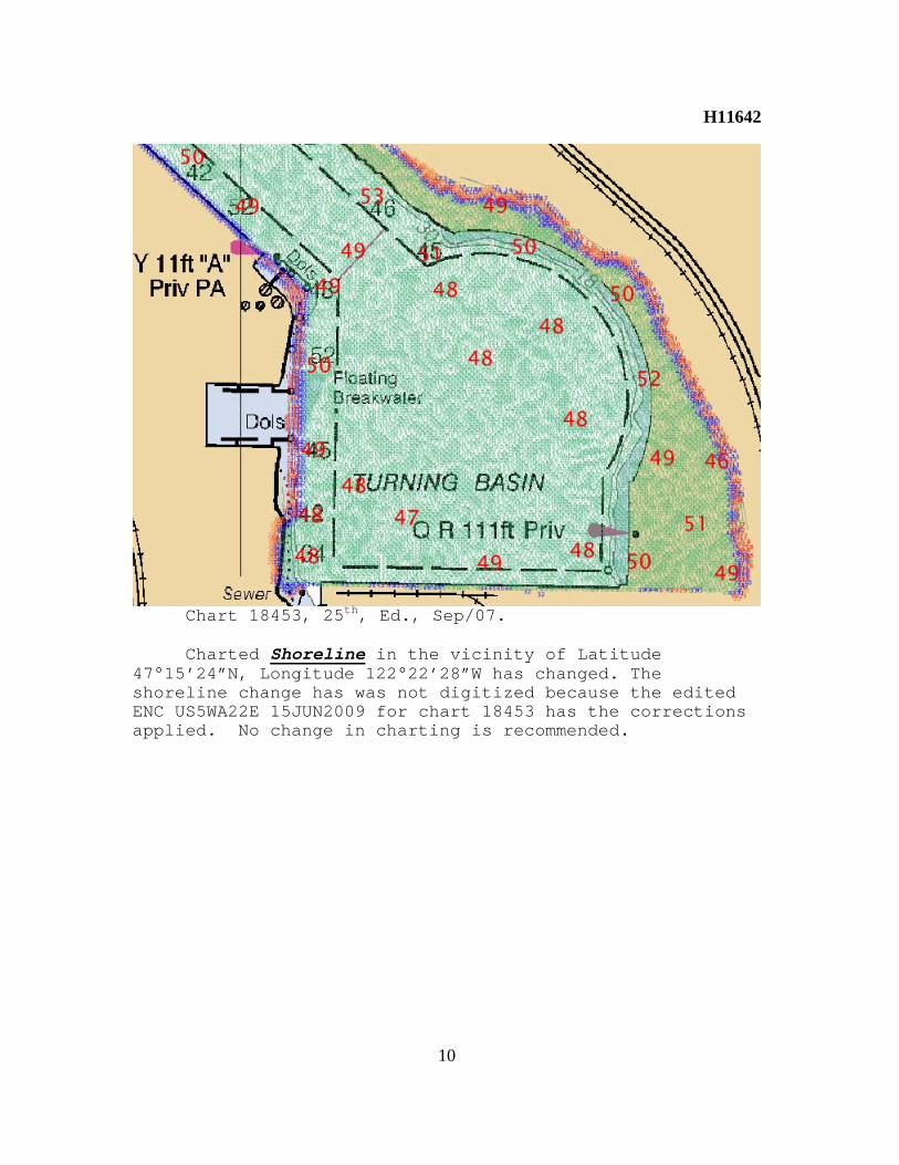
H11642
10
Chart 18453, 25th, Ed., Sep/07. Charted Shoreline in the vicinity of Latitude
47°15’24”N, Longitude 122°22’28”W has changed. The shoreline change has was not digitized because the edited ENC US5WA22E 15JUN2009 for chart 18453 has the corrections applied. No change in charting is recommended.

H11642
11
ENC US5WA22E 15JUN2009 Charted Shoreline in the vicinity of Latitude
47°16’40”N, Longitude 122°24’57”W seen on U.S. Geological Survey Orthoimagery #61127731, for Zone 10 Washington State Quarter Quadrangle TACOMA, 20070312, has changed. The shoreline change has been digitized to the H-Cell from the Orthophoto. It is recommended that the Shoreline be revised from present survey H-Cell.

H11642
12
Adequacy of Survey The present survey is adequate to supersede the charted bathymetry within the common area. Any features not specifically addressed either in the H-Cell File or the Blue Notes should be retained as charted. Refer to the Descriptive Report for further survey requirements recommended by the hydrographer.

H11642
13
Miscellaneous Chart compilation was done by Atlantic Hydrographic
Branch personnel, in Norfolk, Virginia. Compilation data will be forwarded to Marine Chart Division, Silver Spring, Maryland. See Section D.1. of this report for a list of the Raster Charts and Electronic Navigation Chart (ENC) used for compiling the present survey.

H11642 COMPILATION LOG
General Survey Information REGISTRY No. H11642 PROJECT No. OPR-N411-NRT3-07 FIELD UNIT NOAA-NRT3 DATE OF SURVEY JUNE 19, 2007 TO APRIL 3, 2009 LARGEST SCALE CHART 18453, edition #25, 20070901, 1:15000 SOUNDING UNITS feet COMPILER Norris A. Wike
Source Grids File Name H11642_A_50CM_FINAL.hns H11642_B_50CM_FINAL.hns H11642_B_1M_FINAL.hns H11642_B_2M_FINAL.hns H11642_C_50CM_FINAL.hns H11642_C_1M_FINAL.hns H11642_C_2M_FINAL.hns H11642_D_50CM_FINAL.hns H11642_D_1M_FINAL.hns H11642_D_2M_FINAL.hns H11642_E_50CM_FINAL.hns H11642_F_50CM_FINAL.hns H11642_G_50CM_FINAL.hns
Surfaces File Name Combined H11642_Combined_4M.hns
Final HOBs File Name Survey Scale Soundings H11642_SS_Soundings.hob Chart Scale Soundings H11642_CS_Soundings.hob
Contour Layer H11642_Contours.hob Feature Layer H11642_Features.hob
Meta-Objects Layer H11642_MetaObjects.hob Blue Notes H11642_BlueNotes.hob
ENC Retain Soundings H11642_ENC_Retain.hob
Meta-Objects Attribution Acronym Value M_COVR CATCOV 1 SORDAT 20090403 SORIND US,US,survy,H11642 M_QUAL CATZOC U INFORM H11642, OPR-N411-NRT3-07,NOAA Survey Launch
S1212 POSACC 10 SORDAT 20090403 SORIND US,US,survy,H11642 SUREND 20090403 SURSTA 20070619

DEPARE DRVALV 1 -3.00 DRVALV2 350.00 SORDAT 20090403 SORIND US,US,nsurf,H11642

APPROVAL SHEET H11642
The completed survey has been inspected with regard to survey coverage, delineation of depth curves, representation of critical depths, cartographic symbolization, and verification or disproval of charted data. All revisions and additions made to the H-Cell files during survey processing have been entered in the digital data for this survey. The survey records and digital data comply with National Ocean Service and Office of Coast Survey requirements except where noted in the Descriptive Report and the Evaluation Report. All final products have undergone a comprehensive review as per the Atlantic Hydrographic Branch Processing Manual and are verified to be accurate and complete except where noted.
______________________________
Norris A. Wike Cartographer Atlantic Hydrographic Branch
I have reviewed the H-Cell files, accompanying data, and reports. This survey and accompanying Marine Chart Division deliverables meet National Ocean Service requirements and standards for products in support of nautical charting except where noted. Approved: _____________________________________ Richard T. Brennan
Commander, NOAA Chief, Atlantic Hydrographic Branch
Related Documents


