RP 330(A) DESCRIPTION OF MINING PROPERTIES VISITED IN 1952 AND 1953. AN OUTLINE OF GEOLOGY AND EXPLORATION WORK

Welcome message from author
This document is posted to help you gain knowledge. Please leave a comment to let me know what you think about it! Share it to your friends and learn new things together.
Transcript
RP 330(A)DESCRIPTION OF MINING PROPERTIES VISITED IN 1952 AND 1953. AN OUTLINE OF GEOLOGY ANDEXPLORATION WORK
P. R. NO, 330
PROVINCE OF QUEBEC. CANADA
DEPARTMENT OF MINES
HON. W. M. COTTINGHAM. MINISTER A.-O. DUFRESNE, DEPUTY MINISTER
MINERAL DEPOSITS BRANCH
BERTRAND-T. DENIS, CHIEF
DESCRIPTION OF MINING PROPERTIES
VISITED IN 1952 AND 1953
AN OUTLINE OF GEOLOGY
AND
EXPLORATORY WORK
QUEBEC 1956
P. R. NO. 330

TAB LE OF CONTENTS
M-4066
Intr oduct ion Alton township Ascot township Baie de Gaspé Nord township Barraute township Basl:atong township Beauchaste1 township Blondeau township B oisbuis son township Bolton township Bouchette township B our lama que township Brandon township Brompton township Brongniart township Buckingham township Cameron township _._.
Christie township Church township Cléricy township Clyde township Currie township _____ Dasserat township Dequen township Des jardins township Desmeloizes township Destor township __ ._ Dorion township Dubuisson township Duchesnay township Dudley township Dudswrell township Dufresnoy township -.--Duhamel township Duprat township Egan township Fabre township ..._..___ Fan.camp township _ _ Figuery township Fourn_iére township Gaboury township Gamache township Gr.rthby township Guigues township Guillet township . _._. Hartwell township Heref ord township Holland township - _ Howard township Huddersfield township J canné s township Kénogami township . Kensington township
Page
_1
1a 1a 3 3 4 6 7 8 8
10 11
_ 14 14
_15 _16 .17 18 18 18 21 22 22 25
-25 _ 27
28 _... 30
31 _ 32
33 _.. 33
34 38 39 41 41a
44 44 45 45 48 48 49 49 50 ~
. 50 - 51
52 . 52
53 54 55

zr
La corne township ._.._.._.. La Dauversiére township La Norandiére township Land rienne township La Trappe township ]nival township Letellier township Levy township ._.____. Loranger t owns hip Louvicourt township Lytton township I+alartic township :marchand township 1 far1ow township i cGi11 tonship llékinac township
7.itchell township _. -ontauban township
L.iontgay township Obalski township Pelletier township Perron township ____._.___ Poularies township Provost township Rasles township _
Neuville seigneury ïTotre Dame des Anges seigneury Lac D6sert; region
Page
--- 5 6 55 59 60
__60 60
61 62 6? 63 66 66 67 67 68 69 69
---- 70 __71
_ _ 72 _....72 73 75 75 75 76
_.76 78
__ 79 81 81 83 84 84
85 85 86 87 87 87
_.. _ 88 _ 89
90 91 92 93 94
_ 94 94 95 96 96 97
100 __ _ _ 100
101
Risborough township Pohault township Rolette township Rouyn township __..___ - -- - - _. Royal-P:oussillon township _ Sersleterre township Senne vil le township Sicotte township Spaulding township Standon township Stratf ord township Surimau township ---.---___._._ Trécesson township Vassa.n township Wakefield township 17eedon township Whitton tovmship 'aoodbridge township T ownship No. 1364 _.. _........_ _--
Township No. 1530 Township No. 1531 Township 11o. 1630 Township No. 1631 Township No. 2046 ..____._ .._.
Deschambault seigneury Des Plaines seigneury ._._ __ Gr ondines West seigneury Lachevrotiére seigneury

DESCRIPTION OF MINING PROPERTIES
1952-53
INTRODUCTIO N
The mining properties described in this report were exam-ined during the years 1952 and 1953. The examinations were made by P.E. Bour-ret, F.Y. Cornwall, J.E. Gilbert, P.E. Grenier, W.N. Ingham, M. Latulippe, 0.D. flaurice, H.W. Mcl errigle, L.G. Murray, W.G. Robinson and W.W. Weber. The initials of the author and the year in which the examination was made appear at the end of each property description. For the most part the descriptions are of properties which have not reached the production stage, since the De-partment of Mines does not attempt to follow the progress of exploration and development at producing mines.
Names of companies and descriptions of their holdings were correct at the date of the examination, but may have changed subsequently. If a property was visited more than once, the most recent description only is pub-lished. Descriptions of some of the properties examined are not included in this report, the reason in most cases being that they contain no information of general interest. However, reports of all examinations are kept in the files of the Mineral Deposits Branch of the Quebec Department of Mines. The descriptions of properties examined by R.B. Graham in the Chibougamau region during 1952 are not included in this report. They have already been published in P.R. No. 287.
Published maps and reports of the Geological Survey of Canada and of the Quebec Department of Mines, as well as plans, drill logs and reports of the various mining companies, have been consulted in the preparation of this report. Assay results, unless stated otherwise, have been obtained from company records. Previously published information on the properties, or on the area in which they are located, is given in the references at the begin-ning of the description of each property.
All samples taken by the authors were assayed in the labo-ratories of the Quebec Department of Nines.
The authors acknowledge with thanks the cooperation and assistance of officials of companies interested in the areas where the various properties are located and of engineers, geologists and prospectors in charge of work at the properties.

ALTON TOWNSHIP
Bertrand Granite Quarry
The Bertrand quarry is situated in lot 13B, range IV, Alton township, 4 miles northeast of the village of St. Alban.
The face of the quarry is only 15 feet long. However, a large reserve of granite is visible on the surface. There are two sets of well developed joints, at right angles, bearing N.45°E. and N.45°W. respectively.
The rock is a pale pink, medium grained, biotite granite. Quartz is abundant; dark minerals account for only a small proportion of the rock. There do not appear to be any iron minerals present which would cause stains on oxidation. The colour and texture of the granite do not change ap-preciably from one outcrop to another. On one of the cleavage planes, the pa-rallel arrangement of the dark minerals brings out the gneissose structure; on the other two, however this effect is not apparent. (O.D.M. - 53)
ASCCIr TO'riNSHIP
Ascot Metals Corporation Ltd.
Ref: Structural Geology of Canadian Ore Deposits Can. Inst. Yin. Met. (1948) pp. 902-09. Can. Yin. Jour., Vol. 65, 1944, pp. 4-9.
This company owns the Moulton Hill mine which is in lot 20, range III, Ascot township, 3 miles northeast of Sherbrooke. The deposit was discovered in 1942 by the use of geophysical methods. It was owned by the Aldermac Copper Corporation Ltd. and Down as the Aldermac Moulton Hill mine. An inclined shaft was operated to the third level. Difficulties in mining and higher costs caused the mine to close on June 30, 1945. The property was taken over in 1949 by Ascot Metals Corporation Ltd. During 1949 the mine was unwa-tered and shaft sinking and lateral development below the third level were com-menced. The mill started operating on the 1st of August, 1950. The mine is developed by an inclined shaft at 40° and 10 levels, of which the deepest is 861 feet vertically below the surface.
The mineralized vein, showing variation in thickness from a few inches to several feet, occurs at a sheared or faulted contact of a seri-citized porphyritic rhyolite forming the hanging wall, and a chloritized f oot-wall believed to be of sedimentary origin. The average dip of this contact is 40° southeast. The average strike is N.20°E., although it is interrupted lo-cally by a series of folds with axes at right angles to the thrusting from the southeast. The deposit consists of a band of massive sulphides, generally bordered by disseminated sulphides in the hanging wall. The contact of the ore with the footmall, however, is sharp. The ore is a complex mixture of pyrite, sphalerite, chalcopyrite and galena. Tennantite and supergene chaloocite have also been reported. It is not known how far the ore extends below the tenth level.
The sericitized hanging wall, believed to be of Ordovician age, is highly schistose, and consists largely of silicified bands separated
by bands of white mica. Numerous quartz stringers have been introduced.
The chloritized rock, locally known as tgreenrockt, forms the footman_ and is probably not more than 70 feet think. It is in places ex-tremely schistose. In the drifts south of the shaft this tgreenrockt has been considerably bleached over a fairly great thickness in two zones which can be traced through the consecutive levels. The first is present et the extremity of the fourth, fifth and sixth levels. Its width is 160 feet in the seventh level, where it is 400 feet south of the shaft. It occurs at the end of the eighth level and, in the ninth level, extends from 120 feet south of the shaft to the end of the drift, a distance of 180 feet. On the tenth level the second bleached zone is encountered 360 feet south of the shaft. This zone can only be seen in the seventh and tenth levels as the other drifts do not reach far enough south to encounter it. The thickness of this second zone is not known. arginal to both of the bleached zones the Tgreenrockt is characterized by buff coloured spots, generally over considerable distances. Perfect cubes of pyrite in the 'greenrock' near the orebody are common. Where the footwall 'greenrockt has been bleached it can only be distinguished with difficulty from the hanging wall sericite schist. .In such instances the presence of pyrite serves as a useful criterion, as it is almost entirely confined to the footwall tgreenroek'.
As the mine has 10 levels which have all been systematic-ally sampled, it was thought desirable to find out the trend of the minerali-zation with increasing depth. The assays along each level were averaged, due regard being taken of the width and length represented by the sample in each case. A total of 1,072 assays was used. The averages of the metals were then plotted as ratios of copper, lead and zinc against depth in feet. The curves obtained showed a definite increase in the ratio of zino to the other two metals with increasing depth. The ratio of lead to copper, however, does not show any marked change. The results obtained do not necessarily reflect an increase of zinc with depth, but merely an increase in the ratio of zinc to the other two metals.
Similar curves were plotted from south to north along the respective drifts to determine horizontal changes across the ore body. The trends show little or no change of the zinc ratio. The lead is inversely pro-portional to the copper, with an increase in the lead ratio going from north to south in almost all the levels.
Underground work was stopped on August 1, 1953. The con-centrator is currently treating ore from the Suffield mine. (See p.3) (L.G.M. - 53)
Suffield Metals Corporation Ltd.
Ref.: Que. Bur. Mines, Geol. Rept. 8, p. 29. Que. Dept. Coloniztn, Aines & Fisheries, Copper Deposits of the Eastern
Townships of the provuce of Quebec, (1915) pp. 259-63.
This company, which is a wholly owned subsidiary of Ascot Metals Corporation Ltd., acquired the Suffield mine in 1950. The mine is sittated in lot 3, range `iI, Ascot township. It had been operated sporadically from
1865 to 1914. Two inclined shafts had been sunk 250 feet and 400 feet respec-tively and considerable lateral work had been done.
After an extensive diamond drilling programme, sinking of a new 3-compartment shaft 200 feet east of the old Adams shaft was commenced late in 1950. Levels have been established at approximately 150-foot intervals, the first being somewhat less than 100 feet from surface. At the time of the present investigation, active development was taking place on the first and second levels, a station had been cut on the third level, and shaft sinking was in progress to establish a fourth level.
On the first level, a northerly drive reached a horizontal ore body which has been mined by open stopes having an areal extent of more than 1 acre. On the -second level, the haulage drive extends 300 feet south of the shaft and 1,900 feet north of it. In the south section there is a sublevel 40 feet above the main haulage drive. The ore above the sublevel is mined by shrinkage stoping. In the north section the ore is mined by open stope methods. Reserves of indicated ore in 1950 were 1,000,000 tons with an average tenor of 0.014 ounces of gold per ton, 1.92 ounces of silver per ton, 1.01 per cent cop-per, 0.42 per cent lead and 5.19 per cent zinc.
The mineralized zone occurs in a porphyritic rhyolite or quartz porphyry at or near its contact vrith sedimentary rocks. At the surface this contact strikes north. The dip varies from 50° to 75° east. The struc-ture is complex and is by no means fully understood. However, it appears that there has been some faulting and possibly some folding of the sediment before the emplacement of the quartz porphyry or porphyritic rhyolite, and that there has,been further movement since the emplacement of the porphyritic rock. There is an unconformity between the sediments and the porphyritio rock. (L.G.M. - 52)
BAIE - DE - GASPE - NORD TG NSHIP
Arnett Prospect
A vein of hematite cutting Battery Point sandstones has been exposed on lot 34A, range I, Baie-de-Gaspé..Nord township, 800 feet north of the highway (Route 6), on the farm of Leonard Arnett of Farewell Cove.
The Battery point formation at the prospect site strikes S.55° E. and dips 65° southwest. The hematite vein strikes N.60° E. and dips 72° to 76° northwest. It has been traced for 200 feet by cross trenches and some pits. The thickness is variable, ranging up to an observed maximum of 3 feet. A sample of the hematite taken by the writer assayed 62.23 per cent Fe, 7.35 per cent Si 2, 0.00 per cent P and 0.06 per cent S. (H.W.M. - 53)
BARRAUTE TQWNSHIP
Young Chibougamau - Opemiska Mines Ltd.
See La ?Iorandiére township
BASzQAT0NG TOWNSHIP
Ciglen Claims
S. Ciglen holds lots 28 to 30 and the north halves of lots 26 and 27, range II; and lots 32 to 34 and the north halves of lots 29 to 31, range III, Baskatong township. The prospect is reached from the La Croix dam and Canadian International Paper depot at the south end of the Baskatong lake reservoir. The depot is 1 mile north of highway No. 58, at a point 32 miles northwest of Mont Laurier. The distance by water from the depot to the property is 5 miles. A truck road ending at a bay of Baskatong lake, in lot 17, range IV, is 3 miles from the main prospect.
A zone of high radioactivity was followed by the writer with a Geiger counter for a distance of 1,050 feet in a southwest direction from the northeast extremity of the peninsula, near lot line 29-30, range II. For the most part, the radioactive zone was not exposed, being covered by a layer, 6 to 12 inches deep, of overburden, except for a short distance along strike at the north end of the peninsula, and in a cross trench 200 feet south of the end of the peninsula. At the north end of the peninsula the host rock is dark to light green metamorphic pyroxenite or amphibolite, derived from crystalline limestone. White crystalline limestone and paragneiss, striking N. 40° E, and dipping 30° to 60° southeast, overlie the pyroxenite-amphibolite band. Since the radioactive zone is partly under the lake, its full width is not known. In the area of bare rock, about 50 feet long and 10 to 20 feet wide, at the end of the peninsula, the intensity of radioactivity varies from weak to 5,000 times background. A 3-pound sample of rock from the trench gave a radio-metric assay of 0.052 per cent U,0 , equivalent. Two radioactive minerals, uranothorite and pyrochlore, havg 'Peen identified in the sample at the labora-tories of the Quebec Department of Mines. The former may carry up to 27 per cent U 0 , and the latter up to 20 per cent U308, as well as varying amounts of columbiu , tantalum, and titanium.
The radioactivity continues from the point of land towards the southwest along the west side of the peninsula close to the edge of the water. A cross trench 200 feet south of the point exposes mainly pyroxenite and amphibolite across 25 feet. High Geiger counter readings were obtained in the trench. A sample taken from an exposure at the edge of the lake half may between the point and the trench assayed 0.076 per cent U 0 equivalent. Pre-liminary identification at the laboratories of the Quebec3Dgpartment of Mines indicates the presence of uranothorite and uraninite in the sample.
The high radioactivity extends almost continuously for 1,350 feet beyond the south trench. As mentioned above, the bedrock is not ex-posed, and it appears that the radioactive minerals occur in the overburden, which consists mainly of decomposed bedrock. -Widths of the zone of high radio-activity vary from 20 to 70 feet.
In the same general area zinc, lead and copper-nickel min-eralization was noted at several localities.
Black to dark brown sphalerite (marmatite) occurs at the south end, of a peninsula in lot 31, range II, in limestone and lime silicate
rook. Pyrrhotite, pyrite and a little molybdenite are associated with the mar-matite. The rock forming minerals include abundant diopside, with lesser cal-cite, phlogopite, apatite, tremolite and graphite. Some rock layers carry more zinc than others. Two grab samples taken by the writer from the mineralized zone assayed 0.24 per cent zinc and 0.48 per cent zinc respectively. The zino mineralization is at least 5 feet wide. At the time of the examination the full width could not be ascertained because of overburden on one side and lake water on the other.
Trenching at a point 225 feet to the northeast has exposed another zone of zinc mineralization, probably parallel to the one described above. Four grab samples taken from this zone by the writer over a width of 16 feet assayed respectively trace, 1.82 per cent, 0.15 per cent, and trace of zinc.
At the northeastern extremity of the peninsula, 2,000 feet northeast of the above, galena mineralization is exposed close to lot line 29-30, range II. The galena occurs in a band of green to grey metamorphic pyro-xenite formed through replacement of crystalline limestone by diopside. At the end of the peninsula the metamorphic pyroxenite and an overlying band of white crystalline limestone strike N.45° F. and dip 30° to 60° southeast. The pyroxenite is exposed over a width of 30 feet. Several shallow holes have been blasted into the metamorphic pyroxenite. Galena occurs in irregular crystal aggregates and patches, and as scattered seams and individual grains. In places there are massive aggregates the size of a walnut. A grab sample of the broken rock taken by the writer gave an assay of 1.43 per cent lead. Towards the southwest, on, strike, galena was observed at intervals in bedrock and, in big, rusty float boulders of pyroxenite. The best galena mineralization is at the contact of the pyroxenite with an intrusive body of syenitic rock. A.selected sample of this mineral assayed 2.57 per cent lead. A second sample taken by the writer across a bed of granular, green pyroxenite 1.5 feet wide, and charac-terized by finer grained, disseminated galena mineralization, assayed 2.44 per cent lead. Irregular patches of pyroxenite several feet in diameter, some con-taining galena, are intermixed with limestone and syenite for a distance of 150 feet southwest from the main, bed.
Copper-nickel mineralization was noted on Nickel island, a small island off the north end of lot 33, range IV. Two pits have been sunk on the island, one on the southeast side and one on the southwest side. The excavation on the southwest side is 30 feet from the shore, and, has been sunk mainly through sand to a depth of 6 feet. An arec. 3 feet in diameter at the bottom of the pit exposes paragneiss flecked with biotite and graphite, and mineralized with abundant copper stained pyrrhotite, minor pyrite and chalco-pyrite, and a grey sulphide thought to be marcasite. A chip sample taken by the writer from various places at the bottom of the pit assayed 0.03 per cent nickel, 0.02 per cent copper and traces of cobalt. The pit on the southeast shore of the island extends 10 feet into a rock ledge close to the water. The top of the ledge is pegmatite. Between it and the water, across 35 feet, the rocks are interbedded biotite paragneiss, impure limestone, and pockets of rusty metamorphic pyroxenite. Sulphide mineralization lies in a zone 4 feet wide adjacent to the contact of the pegmatite. There may be additional width, but it is covered by rubble from the pit. Appreciable amounts of disseminated pyrrhotite occur, as well as small amounts of molybdenite and chalcopyrite.

A.sample taken by the writer, consisting mainly of impure metamorphic pyroxe-nite-heavily mineralized with pyrrhotite, assayed 0.03 per cent nickel, 0.03 per cent copper and traces of cobalt.
In the southwest corner of the large island northwest of Nickel island there is a small irregular patch of coarse grained, pegmatitic, metamorphic pyroxenite. The rock consists of a coarse aggregate of mainly green pyroxene, dark glassy quartz, and in places white calcite. It contains dessimated grains and narrow seams of massive pyrite and pyrrhotite. A sample of this material taken by the writer assayed 0.005 per cent U308 equivalent. OW.N.I. - 53)
BEAUCH.4STEL TOWNSHIP
Despina Gold Mines Ltd.
See Rouyn township.
Dupresnoy Mines Ltd.
See Dufresnoy township.
West Wasa. Mines Ltd.
Ref.: Can. Inst. Min. Met., Structural Geology of Canadian Ore Deposits, (1943) pp. 7L9-30.
Geo. Surv. Can. Bull. No. 46, pp. 31-41; Mem. 166, pp. 175-83; Paper 45-17.
Que. Bur. Mines, Ann. Rept. 1932, Pt.C,pp. 74-86. Que. Dept. Nines, P.R. No. 116, p.13; P.R. No.256, pp. 9,10.
West Wasa Mines Ltd. holds 1,166 acres of ground in ranges V and VI, Beauchastel township, including the former property of Alderman Cop-per Corporation Ltd. and a small area to the east and southeast. The claims are numbered block 63; C.2429, claims 1 and 2; C.7543, claims 1 and 2; C.7553, claim 1; R.6591 and R.18038. The Rouyn Arntf ield highway and the Ontario Northland Railway cross the southern part of the property.
The geology, structural features and developments up to 1948 are sumnarized in a previous report, and will not be repeated here. Acidic to basic Keewatin-type volcanics, intruded by the Aidermac syenite stock, make up most of the bedrock of the property. The Horne Creek and the Beauchastel faults, together with other less important breaks, cross the property.
A magnetometer and an electrical survey conducted during 1948 and 1949 indicated several anomalies on the property, some of which, mostly in an area to the west of the former Aldermac shaft, were explored by diamond drilling in 1949. According to C.T. Young, who was in charge of the exploraticai, 25,000 tons of copper-zinc ore had been indicated by drilling up to July 1950.
Following a reorganization of the company in 1952 and fi-nancing by a mining syndicate, a new diamond drilling programme started in

September of the same year. Three shallow holes collared immediately to the west of the former Aldermac shaft failed to reveal any interesting concentra-tions of mineral. Six holes, totalling 3,067 feet, were put down to explore the contact of the main syenite body with acidic volcanic formations, northwest of the shaft area and southeast of the "Main" fault. Low tenors in copper and zinc were obtained in the drilling. Two other holes, totalling 575 feet, probed the same contact on each side of the northwesterly-trending diabase dyke, about 1,600 feet east of the shaft. Six holes, totalling 3,293 feet were put down underneath the Nos. 1 and 2 sulphide bodies 1,000 feet south of the shaft. Four holes, totalling 1,463 feet, were directed to test the MacKay Lake fault, north and west of MacKay lake, and two others, totalling 841 feet, explored the same fault between 900 and 1,300 feet farther east. This drilling failed to indicate the presence of any orebodies of economic importance and the work has discontinued in early January 1953.
Another programme of exploration was undertaken in May of the same year under the direction of C.T. Young, president of the company, to test at depth the ground in the immediate vicinity of the former Aldermac under-ground workings. The mine records indicate that 346,000 tons of ore remain in the former Nos. 3, 4 and 5 orebodies. Several good intersections of sulphides containing base and precious metals were obtained. The drilling is still con-tinuing.
(J.E.G. - 53) C.T. Young is in charge of the company's exploration work.
BLONDEA.0 T0Z?SHIP
Jellicoe Mines (1939) Ltd.
Ref.: Geol. Surv. Can., Memoir 201. Que. Bur, Mines, Ann. Rept. 1930, Pt. B, pp. 53-88. Que. Dept. Mines, Geol. Rept. 20, Vol. III, p. 313.
Jellicoe Mines (1939) Ltd. took an option in 1953 on 3 adjacent groups comprising 26 claims and covering about 500 acres in the cen-tral part of Blondeau township. The claims are numbered C.46588-90, claims 1 to 5; C.58203, claims 1 to 5; C.58205, claims 1 to 5 and C.65468, claim 1.
The topography of the region is characterized by relatively high bare hills and deep valleys filled with clay, swamp and muskeg deposits. Most of the hills are covered with glacial drift but good exposures of bedrock are to be found on some. Forest fires have destroyed most of the vegetation on the property.
The claims are included within a narrow belt of Keewatin-type volcanics and sediments which extends from about 5 miles east of the Québec-Ontario boundary eastward for 50 miles. This belt, which conf;ains the Belle-terre mine, is bounded on the north by a large granite batholith and on the south by various types of gneisses and granites.
Only the immediate vicinity of the main mineral occurrence was examined by the writer. Rhyolite, intruded by a; series of small bodies of altered diorite-gabbro, is the dominant rock on that part of the property. Pil-lowed andesits is in places interbedded with the rhyolite and a larger body of massive basic to ultrabasic medium to coarse grained intrusive rock appears to border the mineralized zone to the south. A few narrow porphyry and granitic dykes were also noted in the area.
The mineralization, which consists mostly of pyrrhotite and pyrite with a little nickel and copper sulphides, is concentrates at the contact between the rhyolite and an altered diorite body which intrudes it. It occurs as massive sulphides or as disseminated sulphides in both the diorite and the rhyolite. Blue opalescent quartz eyes are abundant in the diorite and are less common in the rhyolite. The general trend of the mineralized, zone is N.80°E. and its dip is about vertical.
A series of north-south vertical fractures are in the area; some are visible and others are indicated by numerous parallel topographical depressions.
The claims on which the mineralization occurs and on which most of the exploration work has been done appear to have been originally staked in 1948 by C. Carufel and R. Carufel. A few trenches were excavated by the original staters and subsequent owners. Radisics-Storisende Syndicate made a dip needle survey of the mineralized area and its immediate vicinity in 1948. At the same time 11 north-south trenches were excavated across the main min-eralized zone, on C.46588, claims 4 and 5.
Jellicoe Mines (1939) Ltd. did some line cutting, blasting and trenching and made a magnetometer survey of 15 of the claims it had under option. The geophysical survey indicated that the mineralized zone had a length of 900 feet and a width of 50 feet. Four other smaller areas of magnetic ano-maly were also revealed by the survey. In 1935 the company drilled 19 diamond drill holes, totalling 4,1E2 feet, on the property, 18 on the main mineralized zoreatdone m C.,65468, claim 1, in an area where a high magnetic anomaly had been found. Assays of the most promising part of the core revealed low tenors in copper and nickel and the drilling was discontinued at the end of the summer.
(J.E.G. - 53) W. Peacock was the company's field manager on the property.
BOISBUISSON MNSHIP
Claude Lake Mines Ltd.
See Duchesnay township.
BOLTON TO' JSHIP
1 uebec Copper Corporation Ltd.
Ref.: Can. Min. Jour., Vol. 40, 1919, pp. 582-84. Que. Dept. Colonizin, Nines & Fisheries, Copper. Deposits of the
Eastern Townships of the province of Quebec (1915) pp. 166--74.
Quebec Copper Corporation Ltd. owns and operates the Hun-tingdon mine which is situated 3 miles south of Eastman, in lot 8, range VIII, Bolton township. The company holds 940 acres of land in this area.
The Huntingdon mine was discovered in 1665. The early ores are said to have contained 9 to 12 per cent copper. In 1872 the property was purchased by the Huntingdon Copper and Sulphur Company, which erected fa-cilities for concentrating the ore. Two shafts were used, the Huntingdon and the Wright. The mine closed, however, in 1883. In 1890 the mine was unwatered by G.H. Nichols and Company of Capelton, who sank a third shaft (the Nichols Shaft) to a depth of 500 feet. In 1912, P. Tetreault of Montreal sank another shaft to a depth of about 50 feet. In 1918 the property was purchased by the Eastern Mining and Milling Company. This company discontinued work in 1924.
Considerable diamond drilling was done in 1951 and 1952 by Quebec Copper Corporation Ltd., particularly at the localities of three former mines, the Huntingdon, the Bolton and the Ives. Results at the Huntingdon mine were the most favourable, consequently approximately 70 holes were drilled there. This drilling explored the mineralized zone to a vertical depth of 1,000 feet.
The mine is developed by a 2-compartment vertical shaft collared in andesite about 250 feet east of its surface contact with serpenti-nized ultrabasic rock. The shaft has been sunk to a depth of 1,160 feet, and stations have been cut at 201, 403, 556, 701, 849, 1,014 and 1,086 feet. Appro-ximately 1,100 feet of lateral work has been done on the 550-, 700- and 850-foot levels. An extensive programme of diamond drilling is being carried out on these three levels. A mill of 600-ton daily capacity is at present under construction.
The mineralized zone occurs in altered andesite of the Caldwell series, at its contact with a sill-like body of serpentinized ultra-basic rocks. The contact of the andesite and serpentine rock types is seldom sharp and is in places transitional. Though this contact has several irregu-larities, it strikes in the general direction N. 15°E. with a steep dip to the east. Schistosity in the volcanics along the mineralized zone is generally weak. The mineralization consists of chalcopyrite, pyrite and pyrrhotite; in certain cores these minerals are seen to be segregated into bands. Appreciable chalcopyrite mineralization extends over a horizontal length of 1,250 feet.
The orebody is roughly lens-shaped in plan with an appro-ximate north-south orientation. The dip, though variable, is steep toward the wast and the rake, as far as can be determined, is toward the south. The ore-body has a length of about 300 feet and a maximum width of 100 feet. The depth to which ore continues is not known, but good ore indications at a depth of 1,400 feet have been obtained from recent diamond drilling.
At present, good copper mineralization can be seen only on the 850-foot level. Chalcopyrite and pyrrhotite occur in close association with quartz-carbonate veins and, in many instances, seem to replace these veins in the andesite. The main nineralization occurs as a network of veins between angular fragments and blocks of andesite. The appearance is that of a breccia, with sulphides and quartz-carbonate veins filling the fractures, but leaving angular fragments of andesite nnreplaced. The importance of this type of
- 10 -
mineralization cannot be assessed at present, as ore is not intersected on the other levels and the brecciated feature is not apparent from diamond drill cores. Furthermore, no pronounced brecciation of the andesite has been observed else-where.
Underground workings have exposed 2 dykes... Both are fine grained and an rgdaloidal and have a thickness of 2 or 3 feet. They cut both the andesite and the serpentinized peridotite, and from the limited relationships visible at present, they appear to be post-ore.
Localized alteration is everywhere present, superimposed on an earlier regional alteration of both rock types. Neither of these changes is thought to be related to the mineralization. However, the andesite in the immediate vicinity of the ore is markedly different from andesite some distance away from the mineralization. The former variety is darker, finer grained, tough and massive.
(L.G.l.i. .. 53) H.H. Mouette is the engineer in charge at the property.
BOUCHETTE T0PJNSHIP
Bowsinque Nines Ltd.
Ref.: Geol. Surv. Can., Ann. Rept. Vol. XII, p.25R; Mem. 136, p. 136.
Que. Dept. Coloniztn, Mines and Fisheries, Geological Traverses in the counties of Naskinonge, St. ITaurice, Champlain, Portneuf, Quebec, Montmorency (1928) pp. 10, 11.
Que. Dept. I.iines, P.R. No. 183, pp.13, 14.
This company holds lots 41 and 42, range II and the east halves of lots 41 and 42, range III, Bouchette township.
The deposit was discovered over 50 years ago. Several trenches and some test pits were dug prior to 1924. In 1927-28 the Consolidated Mining and Smelting Company of Canada Ltd. did 2,000 feet of trenching and 2,436 feet of diamond drilling on the rroperty.
Bowsinque Mines Ltd. was incorporated in 1945. In 1950-51 tris company did 12,500 feet of diamond drilling and 671 feet of underground exploration work.
Two mineralized zones having a combined length of 4,000 feet occur at the contact of limestone and paragneiss. The width of the zones varies from 2 to 8 feet. The mineralization consists chiefly of pyrrhotite and pyrite with some irregular distributed sphalerite.
From 10,500 feet of diamond drilling in 54 holes the com-pany reports intersections of 3.5 feet at 32.9 per cent zinc, 2.4 feet at 10 per cent, 35 feet at 6.8 per cent, 2 feet at 5.9 per cent, 1.5 feet at 4.6 per cent, 3 feet at 4.6 per cent and 2 feet at 3 per cent. For 10 intersections

-11-
1 to 5 feet long the average length is reported at 2.2 feet and the average te- nor 2 per cent zinc. The true widths in most cases are less than the widths given above.
This information was compiled by P.E. Bourret from reports in the files of the Quebec Department of Alines. (P.E.B. - 52)
B OUR LA.MkQUE T ΠhTS HI P
Annamaque Mines Ltd.
Ref.: Que. Dept. Mines, P.R. No. 180, Pt. I, p. 15.
Annamaque Mines Ltd. holds a group of 9 claims 1 mile east of the centre of Bourlanaque township. The claims are numbered C.1456, claims 1 to 3; C.1457, claims 1 to 5 and C.5727, claim 5. Highway No. 59 passes. 1 mile north of the property, 5 miles east of Val d'Or.
Most of the property is underlain by the eastern part of the Fast Sullivan syenite stock. The claim at the northeast corner of the group, and 2 claims forming the southeast part, are underlain by volcanic rocks. These are mainly basic volcanics to the north, and intermediate to aoidic types of flaws and fragmentais to the south.
Previous explorations consists of some 25 diamond drill holes, completed in 1943 and 1944. Following a detailed magnetometer survey carried out by George Dumont in July, 1950, drilling was resumed in August, 1950. Twelve holes totalling 8,100 feet were put down.
Nine holes were drilled in C.1457, claim 3, to explore a -zone of strong magnetic anomalies lying in volcanics near the contact of the main syenite body. The holes outlined a zone 800 feet long strongly mineralized with pyrrhotite and pyrite, with low tenors in copper and zinc. The zone has a generally east-west trend. Towards the syenite on the west it becomes narrow and curves to the south, and on the east it strikes southeast across the south,. boundary of the property at the southeast corner of 0.1457, claim 3. A pronounced drag fold near the centre of the explored part of the zone produces a width of over 100 feet, indicated by a diamond drill intersection 180 feet long having an average tenor of 0.21 per cent copper. A hole 300 feet to the east gave an assay return of 0.32 per cent copper for a core length of 50 feet and 0.68 per cent zinc for an additional 17 feet. The most westerly hole, drilled 500 feet west of the drag fold, yielded 15 feet of core assaying 0.27 per cent copper. The most easterly hole, 300 feet east of the drag fold, gave 45 feet of core assay-ing 0.27 per cent copper. The zone is open to the southeast.
One hole was drilled in the northwestern part of C.1457, claim 2, to test a magnetic anomaly in the syenite, 1,000 feet from the outer margin. The best assay obtained was 0.04 ounces of gold per ton over a length of 1 foot. An old hole in the northern part of C.1457, claim 3, which had yielded intereeting gold and copper assays was deepened but nothing of importance was found. Thm 7as-t hole explored the vo7.canios in the area of the syenite contact
-12--
in the eastern part of 0.1457, claim 3. Tenors ranging up to 0.01 ounces cf gold per ton and 0.18 per cent copper were obtained in several scattered sections up to 8 feet long between footage 015 and 994, close to the syenite contact.
The drilling was directed by G. Dumont. (W.N.r. - 52)
Gale-Cummings Mines Ltd.
Ref.: Que. rent. Mines P.R. No. 227, p.27.
Gale-Cummings Mines Ltd. holds a group of 8 claims in the northeast quarter of Bourlamaque township. Highway No. 59 crosses the claims 6 miles east of Val d'Or. The claims are numbered A.59170-71; A.59819-20 and A.59893-96.
The north half of the property is underlain by outcropping granodiorite of the Bourlamaque batholith. The south half is underlain mainly by schists derived chiefly from pyroclastic rocks.
Consolidated Mining and Smelting Company of Canada Ltd. drilled 7 diamond drill holes on the property in 1944. Electric and magnetic surveys were made in 1950 by H. Lundberg and G. Dumont. During January to March, 1951, 8 diamond drill holes totalling 6,816 feet were drilled. Intersections of 16 feet at 0.32 per cent copper, 5 feet at 0.22 per cent, 1 foot at 0.89 per cent and 1 foot at 0.25 per cent were reported in the granodiorite. A strong zone of shearing about 500 feet wide extending across the southern part of the property was cut in 2 holes 1,600 feet apart. Law tenors o2 zinc and silver were found in core lengths of up to 5 feet in the sericite schist chlorite schist and carbonatized schist.
The drilling was carried out under the direction of D. Giachino and J.J. Coghlan. (W.N.I. - 52)
Kabour Mines Ltd.
Ref.: Geol. Surv. Can., Paper 46-18.
Kabour Mines Ltd. holds a group of 15 claims near the centre of Bourlamaque township. The property is reached by driving to the East Sullivan pump house on the Bourlamaque river, then by canoe on the Bourlamaque and Sabourin rivers for 2 miles, then a one mile walk_ south along the township centre line. The claims are numbered 0.51365, claires 1 to 5; 0.52233, claims 1 to 5 and 0.52234, claims 1 to 5. They were formerly held by the The James Sullivan Mines Ltd.
Scattered. outcrops indicate that the property is underlain entirely by graywacke. These sediments trend more or less east-west and overlie a thick series of KeeraLin -lolcan cs, which extends nearly to the north boundary of the property. The Cadillac fault zone cuts across the northeast corner of the property for 1,500 feet in 0.52233, claim 4.
Surface trenching carried out about 15 years ago exposed
-13 -
several shear zones. The strongest strikes N.80° E., across northern part of C.51365, claim 1. It is 15 feet wide and contains a number of discontinuous lenses of bluish vein quartz and carbonate mineralized with pyrite and pyrrho-tite, and reported to carry gold. Two other shear zones lie 700 and 1,900 feet north of this one. They also contain irregular lenses of vein quartz and sparse sulphide mineralization.
During September and October, 1951, the company carried out 1,644 feet of diamond drilling in 4 holes. Three short holes were drilled to intersect the three main quartz-bearing shear zones, one in C.51365, claim 1, one in C.52233, claim 3 and one in C.52233, cleim 2. Considerable vein quartz and scattered pyrite were found, but the core carried no gold. The fourth hole was put doom in the northeastern part of 0,52233, claim 4 to explore the Cadillac fault zone. Part of the greys..acke intersected shows moderate shearing and narrow sections of talc schist, but it is believed that the hole did not reach the main break. No important mineralization was found.
(W.N.1. - 52) The drilling operations were directed by G.R. Forbes.
Lavalie Mines Ltd.
Ref.: Que. Dept. lanes, P.R. No 190, Part I, pp.23-26.
Lavalie Mines Ltd. holds a group of 24 claims in the north-east quarter of Bourlamaque township. The claims are numbered A.43493-95; A.54647-49; A.56420-23; A.58757-60; A.59748; A.59891--92; A.59949-51; A,67275-76 and A.68857-58. Highway No. 59 and the Canadian National Railway cross the property 6 miles east of Val di Or. The camp is beside the highway in claim A.59748.
The claims cover a favourable width of 4,000 feet of sheared volcanic rocks between the Bourlamaque granodiorite mass and the East Sullivan syenite stock. Three wide, strong shear zones traverse the claims parallel to the more or less east-rest trend of the volcanios. The most north-erly shear, which crosses the northern part of claim A.59891, is thought to be the extension of the nain Golden Manitou break.
Diamond drilling was started on the property in 1937. At various times up to January, 1952, a total of 86,608 feet in 108 holes have been drilled. Electric and magnetic geophysical surveys have been carried out. The holes are distributed over all the claims except A.59950 and A.59951. A length of 4,500 ft. of ceI:lanitou shear has been explored in detail by 25 holes. About 3,500 to the west remains to be tested. The drilled section was cut at a maximum vertical depth of 1,500 feet by one of the holes 2,202 feet long. Tenors in zinc and silver were low. A few sections of core a foot long carried up to 4.00 per cent zinc, but average assays across economic widths were very low.
-Work on the property since 1944 has been directed by D. Agar, G. Dumont, and D. Giachino. (W.N.I. - 52)

-14-
Starcourt Gold Mines Ltd.
Ref.: Que. Dept. :lines, P.R. No. 256, n. 15.
This property consists of a group of 5 claims which straddle the east cftiel wrest ce , ie Z?re of Bourlamaque township a short distance cast of the north-south centre line. The claims are numbered 0.4229, claims 1 to 5.
In 1949 an electrical resistivity survey of the property was made and 4 diamond drill holes totalling 2,645 feet were drilled. Drilling was resumed in April, 1951, and 16 holes totalling 6,960 feet were drilled. This work was designed to test various magnetic anomalies found by a survey conducted by G. Dumont in 1950.
The rocks encountered were mainly acidic to intermediate volcanic flows, in places fragmental or brecciated, and occasionally spherulitic. Numerous dykes of diorite and feldspar porphyry, some up to 70 feet wide, were intersected. host of the ?rill holes yielded scattered, very low, gold assays. One of them, however, in the north-cen.teal part of C.4229, claim 2, gave an assay return of 0.28 ounces tier ton for a core length of 1 feet. The core was miner-alized with pyrite and contained a str eigsr of cuartz carbonate v.rith a little cha.lcowwrite. Holes drilled on strike failed to establish continuity but a hole drilled underneath the intersection yie'_ded 1 foot of core containing 0.08 ounces of gold per ton. Another diamond hole in the south-central part of C.4229, claim 3 intersected 1 foot of mineral containing 0.32 ounces of gold per ton. Other holes drilled under this intersection and 100 feet west of it indicated gold tenors up to 0.08 ounces per ton.
The drilling was directed by G. Dumont 07.N.I. -
BRIeNDON T0,1ITSHIP
.Dugas Prospect
A. Dugas has done some prospecting on lot 14, range VII, Brandon township.
A pit 5 feet by 7 feet by 6 feet deep has been sunk in a heavy massive rust-coloured rock which is black on the fresh surface. Ilmenite and magnetite are visible in the hand specimen. The size of the grains ranges from 0.2 mm. to 1.5 mm.
Selected samples of the rock which appeared to have a high magnetite - ilmenite content were found to consist of magnetite, ilmenite, hypersthene, plagioclase, hercynite, biotite and a few grains of pyrite. The tenor of this wa heria l is 34.54 per cent Fe and 10.11 per cent Ti02. (P.E., G. - 53)
Deschéne Copper Prospect
Ref.: Geol. Surv. Can., rem. 257. Que. Bur. Ianes, Ann. RepL. 1931, Pt.D, p.100.
BR Œ2;FT OTT T 0,TTS HI P

- 15 -
In 1951 a mineralized zone was discovered by A. Deschéne on lot 27, range 11, Brompton township.
The outcrops on this lot consist of peridotite and pyroxe-. vite. For the most part the peridotite is serpentinized and contains small amounts of ohremite. At the discovery point, which is in the northwest corner of the lot, a small amount of stripping has been done. The stripping has ex-posed a shear zone in the peridotite over a width of 6 feet and a length of 12 feet. The zone is very rusty and contains appreciable amounts of pyrite and chalcopyrite. It strikes H. 70°E. and dips steeply southeast.
A sample taken by the writer from the exposed area assayed 3.40 per cent copper, 0.002 ounces of gold per ton and 0.108 ounces of silver per ton. (0.D.M. - 53)
BR ONGN IART T OGil'3S HI P
Dominion Gulf Company
Ref.: Que. Dept. Hines, P.R. No. 271.
Dominion Gulf Company is engaged in exploration work on a group of 152 claims, 110 in the southeast corner of Brongniart township and 42 in the northeast corner of.Rasles township. These claims are situated between Lac Eau Jaune and Lac Muscocho. In Brongniart township the claims of this group held by the company are numbered C.61454-55, claims 1 to 5; C.64150, claims 1 to 5; C.64152, claim.11 0.66547, Claims 1 to 3; C.66562, claims 1 and 2; 0.66563-64, claims 1 to 5; C.66569, claims 1 and 4; C.66707, claims 1 and 3; C.69222, claims 1 to 5; C.69225, claims 1 to 5; C.69226, claims 1 and 2; C.69230, claims 1 to 3; 0.69244, claims 1 to 5; 0.69257, claims 1 to 5; 0.69586-87, claims 1 to 5; 0.69589-93, claims 1 to 5; C.69594, claims 1 to 4; 0.69596, claims 1 to 5; C.69599, claims 1 to 5 and C.G. 3946, claim 1. The claims held by the company in Rasles township are numbered C.66547, claims 4 and 5; C.66555, claims 1 to 5; C.66562, claims 3 to 5; C.66569, claims 2, 3 and 5; C.66707, claim 2; C.69226, claims 3 to 5; C.69227-29, claims 1 to 5; 0.69230, claims 4 and 5; C.69231, claims 1 to 5 and C.G. 3946, claims 2 to 4.
Following an aeromagnetic survey made by the company in the Chibougamau region, several areas of magnetic anomaly were investigated and a detailed ground magnetometer survey was made in February 1953, in the vicinity of Lac 1'Rau Jaune. Individual anomalies were checked, during the summer of 1953, by surface inspection and by trenching.
The area is underlain by a series of greenstone lavas inter-bedded :with tuffaceous material. The whole region is cut by a series of feldspw porphyry dykes, largely albitites. In the vicinity of these dykes the rocks are strongly carbonitized. There also exist some intrusive diorite sills, closely related to the greenstone lavas. To the east of the property the Lac Huscocho stock, a granitic body, intrudes the lavas. To the west of the property there exists a body of intrusive undifferentiated gabbro.
The structures trend northwest and are steeply dipping. The lavas shovr considerable drag folding and pillows are extensively developed;

- 16 -
however, structural interpretations from these were not satisfactory.
Mineralization in the area is commonly associated with northeasterly-trending faults, generally filled with quartz and cubic pyrite, the wall rock being silicified some distance away from the faults.
The main zone in which work has been carried out is si-tuated near the 9 mile post on the Brongniart-Rasles township line. The rocks in this area are pillowed andesites cut by a fault striking N.15°E. A quartz vein, varying in width from 8 inches to 30 inches, occupies the position of the fault and has been traced for 145 feet. The wall rock is sparingly mineralized but highly carbenatized. The quartz in the vein is mineralized sparsely with pyrite, chalcopyrite and tourmaline. Visible gold is present and erratic high assays in gold have been obtained by sampling the vein.
A second zone of silicification and carbonatization up to 25 feet in ridth occurs 1,800 feet east of the 9 mile post at a contact between tuffs and volcanics. The mineralization consists of disseminated pyrite and pyrrhotite. Low tenors in gold are reported from several samples.
During the summer of 1953 5 men were engaged in trenching to check magnetic anomalies. In the course of this work the above mentioned mineralized quartz veins were discovered. Thereafter the work consisted mainly of trenching across and along these veins. (F.W.C. - 53)
McIntyre Porcupine Hines Ltd.
This property comprises 30 claims in the vicinity of Lac 1 VEau Jaune in Brongniart township. The claims are numbered C.63830-34,
claims 1 to 5 and 0.63867, claims 1 to 5.
These claims are situated in a heavily wooded region with few rock outcrops. The discovery was made by H. Hanson; it is located appro-ximately 500 feet west of No. 2 post, 0.63831, claim 4.
The area is underlain by heavily sheared and carbonatized acid to intermediate volcanics. The regional trend is N.70°W., whereas the trend of the shearing is N.50°W. The mineralization occurs in quartz veins and quartz stringer zones associated with the shearing and consists of pyrite, chalcopyrite and gold. In places the carbonate has been oxidized to red hema-tite.
Exploration carried out on this property by McIntyre Por-cupine Mines Ltd. during the late fall of 1952 revealed the presence of a large sericitic shear zone. Further work comprised stripping, trenching, sampling and geological napping.' (F.7.C. - 53)
BUCKIhGHLPII TOVINS.iIP
Doherty Prospect
V. Doherty owns the surface and mining rights on lot 58, range VI, Buckingham township, The property is 3 miles from the city of
-17-
Buckingham, follow ng the Buckingham-Ifyo gravel road. There are several out-crops of pink crystalline dolomitic limestone southwest of the northwest arm of lioNaughton creek and between 500 and 1,000 feet northwest of Doherty's house. A representative chip sample taken from the southwestern part of the deposit by the writer assayed 36.99 per cent CaO, 12.11 per cent MgO and 1.44 per cent P. Another sample from the remainder of the deposit assayed 31.53 per cent CaO, 17.18 per cent I g0 and 1.19 per cent P. The combined Ca0 and IVlgO content may be sufficiently high to constitute a source of raw material for the production of agricultural limestone. (P.E.B. - 53)
Martin Feldspar Property
J. Martin holds claim Q.79064, which covers the south half of lot 19, range VII, Buckingham township.
The deposit consists of a dyke of aplite which is exposed in an escarpment 50 to 75 feet high 300 feet northeast of the No. 3 post of the claim on the north side of a beaver meadow. The country rock is biotite gneiss and pyro:enite. The dyke is 35 feet thick. It strikes north and dips 12° east. It consists almost exclusively of coarsely crystalline buff pink nicrocline with inclusions of graphic quartz uniformly distributed throughout. The quartz constitutes 10 to 20 per cent of the mass. It is generally vitreous and colorless and occurs in grains less than one quarter inch in size. The de-posit is practically free from dark minerals and sulphides.
The deposit is mined by open nit methods. At the working face in the most southerly excavation there is 18 feet of aplite overlain by 12 feet of gneiss and 4 feet of drift.
In 1953 P. Vallée of Buckingham mined 1,200 tons of feldspar from this property and sold it to the Canadian Flint and Spar Company Ltd. of Buckingham. The feldspar came from a pit 20 feet in diameter by 3 to 10 feet deep and 2 small side hill cuts. (P.E.B. - 53)
CAI.=ON T '1NSHIP
Carle Claims
Ref.: Que. Dept. Nines, P.R. No. 183.
D. Carle holds 2 mining claims which cover lots 38 and 39, range II, Cameron township. A country road along the east side of the Gatineau river passes one quarter mile west of the mineralized zone at a point 1 mile south of Lac Bitobig post office. The main prospect is near the east end of lot 38, between Roddick lake and a short river through which it drains into the Gatineau river. The area is underlain by rocks of the Grenville series, mainly altered sediments.
The main pit is near the top of a large hill a short dis-tance northeast of the outlet of Roddick lake. Locally, this part of the lake is called Round lake. The pit is 7 feet in diameter and up to 6 deep. It ex-poses coarse grained, massive magnetite, accompanied by varying amounts of
- 18
graphite, pyro:ene, calcite, biotite, pyrrhotite and marcasite. Similar miner-alization is exposed on the shore of the lake in a small trench 150 feet south-east of the main pit. White crystalline limestone outcrops on the shore of the lake 20 feet west of the trench.
The same type of mineralization can be seen in shallow pits respectively 200 feet west of the main pit and 50 feet north of it. Strong dip needle reactions were noted in a zone extending from the trench at the lake shore up the side of the hill to the main pit and along the hill to the west for a total distance of 330 feet. No dip needle readings were taken farther to the west over the drift-covered ground on strike, nor to the east on the lake.
A selected sample of the massive magnetite in the main pit taken by the writer assayed 55.69 per cent iron, 0.08 per cent titanium and 0.72 per cent sulphur. Another sample of pyrrhotite, taken from a narrow seam of massive sulphide in the magnetite, assayed a trace of nickel, and 0.03 per cent cobalt. (w.IT.I. - 52)
CHRISTIE TOWNSHIP
Christie Base Metals Ltd.
Christie Base Metals Ltd. holds 15 claims in Christie township. The property is 11 miles south of Marsoui on the west side of the west fork of Marsoui river. The claims are numbered C.47634, claims 1 to 5; C.47636, claims 1 to 5 and C.47637, claims 1 to 5.
A spontaneous polarization survey was made on this prop-erty by Koulomzine, Geoffroy and Company, with lines 300 feet apart. In Octo-ber 1952, 2 bulldozers were stripping areas where anomalies were reported to have been found. In the small area which had been stripped at the time of my inspection there was little indication of mineralization.
G. Keller, president and general manager of the company, was in charge of operations. The crew employed consisted only of the bulldozer operators. (H.1Y.M. - 52)
CHURCH TO':TI,SIIIP
Copper-Uranium Ltd.
See Dorian township.
CL'.RICY TO',,ITSI:IP
Canadian Explorers Ltd.
Ref.: Geol. Surv. Can., Map 635A; Paper 50-35.
Ce.n».dia.u. Ey,pl orers Ltd. has done some work on a group of

- 19 -
claims in Cléricy and-Dufresnoy townships. The Ckéricy claims comprise the north halves of lots 1 to 9, range VII, lots 1 to 9 range VIII and the south halves of lots 3 to 6, range IX. The Dufresnoy claims comprise the north halves of lots 61 and 62, range VII and lots 61 and 62 and the south half of lot 60, range VIII. A motor road crosses the property along the line between ranges VII and VIII.
Host of the claims are occupied by farmlands and there are few rock outcrops. Published geological maps indicate that the northern part of the property is underlain by Kewagama sedimentary formations with minor in-terbedded volcanics. These formations have been intruded by a plug of aegirine syenite 12 miles in diameter. The southern part of the property is underlain by Blake River voloanios. The sedimentary and volcanic formations strike north-west and face south.
The airborne magnetometer survey of the district indicates a large magnetic anomaly with readings up to 3,500 gammas centered about lot 7, range VII, Cléricy township. Ground magnetometer surveys indicate a magnetic anomaly in lots 6, 7 and 8, ranges VII and VIII. The anomaly is elongated to the north and gives readings up to 5,000 gammas in the northern part of lot 7, range VIII. Other weaker anomalies are indicated in the western part of the property; some of these are elongated to the northwest.
Canadian Explorers Ltd. drilled 10 diamond drill holes to test areas of high magnetic readings. The holes partially outlined a body of basic intrusive that is believed to have caused the magnetic anomaly. The in-trusive is fine to medium grained and has black amphibole, biotite, feldspar and a few bluish quartz eyes visible macroscopically. It is near, and may be related to, the body of aegirine syenite. It underlies the south half of lots 6 and 7 and part of lot 8 range VIII and extends southward into lots 6 and 7, range VII for about 700 feet. The drill holes indicate that on the east it is in contact with tuffs, on the west with tuffs and graywa oke , and on the south with flows and tuffs. The north contact was not explored.
Near the centre of the 3-4 lot line in range VIII, a mag-netic anomaly of 1,100 gammas was drilled and the area was found to be underlain by diorite. In the central part of lot 4, range VII, one of the northwesterly-elongated areas of anomaly was drilled and was found to be underlain by basic flows. In lots 6 and 7, range VII, a northeasterly-trending anomaly was drilled and was found to be underlain by flows intruded by diorite.
Two of the drill holes that were directed into the main mass of basic intrusive cut sections containing chalcopyrite that gave assays of 0.23 per cent copper over 2 feet, and 0.10 per cent copper over 2 feet res- pectively.
The exploration was directed by K. G. Honeyman. (W.G.R.-51)
Sozio Property
Ref.: Geol. Surv. Can., Hap 635-A.

-20-
A. Sozio owns one claim in the west central part of Cléricy township covering part of lots 1 and 2, range IV. Formerly held by Locarno Gold Nines Ltd. as block 29, it is now numbered C.48815, claim 1. The claim is adjacent to the southern limit of the village of Cléricy.
The main mineralization is along the south shore of Kino-javis river, just opposite Clêricy. It is of the replacement type and consists of a series of small, discontinuous, pyrite-and sphalerite-rich stringers in sheared intermediate to basic volcanic rock. The zone containing the mineral-ization averages 3 feet in width and is exposed intermittently for 300 feet. The shearing in the zone varies from moderate to intense and strikes N.80°E. to N.85°E., parallel to the schistosity and the flow structure of the adjacent pillowed lava. The dips are vertical.
A series of trenches and pits have been excavated along the zone. Four channel samples across the mineralized zone taken by the writers party gave assay returns of 0.64, 0.31, 0,63 and 0.10 per cent zinc over widths of 3 feet, 5 feet, 40 inches and 8 inches respectively. Gold, silver, copper and lead tenors were all very low. The best assay obtained was 1.55 per cent zinc across 1 foot. (J.E.G. - 52)
Victoria Copper Zinc :Fines Ltd.
Ref.: Geol. Surv. Can., Maps 634A and 635A .
This company owns a group of 10 claims covering lots 32 to 36, range TX, and 31 to 35, range X, Cléricy township. Formerly known as the Leitch claim and later owned by Leric Mines Ltd., the property is easily acces-sible from the village of Cléricy. The Rouyn-Taschereau lins of the Canadian National Railways passes about 6 miles west of the claims.
The south half of the property is underlain by schistose commonly pillowed andesite in part relatively fresh and in part much carbonatized and bleached. The andesite is cut by dykes of medium to fine grained diorite, granite and diabase. The bedrock of the northern claims consists mostly of green carbonate-rich rock, probably altered andesite, extensively intruded by granite. A large northerly-trending diabase dyke outcrops in the east half of the prop-erty. The schistosity of the lava and of the carbonatized rocks strikes close to east; it dips steeply to the south in the south half of the group and gener-ally north in the north half. The trend of individual lava flows is parallel to, the schistosity.
The previous owners of the property have excavated many trenches and sunk a good number of shallow test pits on the eastern claims. ,These trenches and pits are in carbonate-rich rocks containing abundant green mariposite, with scattered pyrite and, in places, chalcopyrite, and commonly in-jected by a tight network of milky quartz stringers, some of which contain a little pyrite.
Leric Mines Ltd. drilled 3 diamond drill holes• in the cen-tral part of the property, on lots 32 and 33, about 200 feet each side of the line between ranges DC and X. The holes, which totalled 1,440 feet, cut a series
- 21 -
of altered, talcose rocks intruded by feldspar porphyry and basic dykes and containing widely disseminated pyrite. No interesting gold mineralization was encountered. In 1949 the same company drilled 4 additional holes, totalling 805 feet, near the centre of lot 32, range ix These holes, which were collared in green carbonate rocks with numerous quartz stringers, intersected mostly bleached and carbonatized andesite containing scattered pyrite mineralization and a little tourmaline in some of the quartz stringers. The gold tenors were, however, very low, and the drilling mas discontinued.
Victoria Copper Zinc Nines Ltd. acquired most of the former Leric ground in 1952. A little surface work was done and 6 diamond drill holes, totalling 1,312.5 feet, were drilled in the immediate vicinity of the holes. drilled in 1949, in the central part of lot 32, range DC. The results of the 1952 drilling did not appreciably differ from the previous ones and the company discontinued drilling at the end of August.
J.R. Lariviere was in charge of the field work of Victoria Copper Zinc Lanes Ltd. (J.E.G. - 52)
CLYDE TMNSIiIP
Dominion Silica Corporation Ltd.
Dominion Silica Corporation Ltd. holds lots 50 and 51 and the east of lot 49, range west of Rouge river, Clyde township. The property is located 5 miles south of the town of Le.belle, between the Montreal-Mont Laurier highway and the Rouge river.
The deposit consists of heavily jointed, banded quartzite which forms a hill 200 feet high and one half mile in diameter. The southeast face of the hill is very steep. The quartzite strikes north and dips 55° east.
There are 2 open pits on the property. The main pit is 100 feet by 100 feet and the maximum height of the bank is 125 feet. The rock e:posed in the north wall of the main pit, from west to east, consists of a bed of dark grey, heavily kaolinized quartzite 10 feet thick carrying small amounts of mica and dark minerals, a bed of coarse grained, colourless, glassy quartziNa 25 feet thick carrying probably over 99 per cent silica with minor and variable amounts of kaolin, mica, magnetite, ilmenite, and other dark minerals, and a bed of light grey ka.olinized quartzite 50 feet thick cut by earthy and rusty joints. The bulk of the quartzite shipped to the company=s Lachine plant is derived from the intermediate bed.
The other open pit, now abandoned, is situated 500 feet north of the main pit. It was excavated in greyish, glassy and granular quart-zite, slightly iron stained in places and carrying a small amount of kaolin along the major joints. This pit is 30 feet by 30 feet. The bank at the high-est point is 30 feet high.
To the end of September 1953, it is reported that 17,488 tons of quartzite was mined, of which 5,960 tons was shipped by rail from the Labelle siding to the Lachine plant. Current production is at the rate of 300 tons per day. (P.E.B. - 53)
- 22 -
CURRIE TCb^1NSD1rP
New Jersey Zinc N::plorati ons Ltd.
See Desjardins township.
DAS S I:RAT T tTTS HI P
Bordulac Mines Ltd.
Ref.: Geol. Surv. Can., &p 240A-2208; Mem. 166, pp.234-35. Que. Bur. Nines, Min. Op. 1927, pp. 87, 88; Ann. Rept. 1933, Pt. A, p.
91; P.R. No. 116, p.3; P.R. No. 135, p.4. Que. Dept. Nines, I<ïin. Ind. 1951, pp.67, 68; P.R. No. 227, pp. 38, 39;
P.R. No. 256, pp. 19, 20.
Bordulac ?dines Ltd. owns a group of 41 claims covering approximately 1,600 acres of the eastern part of Dasserat township, along the northeast shore of Labyrinth lake. The west limit of the property is at the Quebec-Ontario boundary. The claim numbers are T.2103-05; T.2108-17; R.21395-401; R.25049-50; C.8054, claims 1 to 9; C.8055-57, claims 1 and 2 and C.11225, claims 1 to 4. A dirt road, passable for motor vehicles in dry weather, ex-tends northward along the interprovincial boundary from the village of Cheninis to the south shore of Labyrinth lake, from which the shaft and mine buildings 2 miles distant can be reached by boat.
The property is underlain principally by an elongated mass of quartz diorite which intrudes Keewatin-type basic to intermediate volcanics. 1':n easterly-trending shear zone in the diorite includes abundant quartz veins, a good number of them containing pyrite, scheelite and gold.
The original Russian Mid claims, which formed the nucleus of the property, were staked -n 1924. and trenching was done on them before they were opt .^ned to "iorrL' on Lc and to Sylvanite Gold mines Ltd. in 1935. Two sha.i iw prospect shafts were sunk by Erie Canadian Mines Ltd. before 1939. The nroner=y was acquired in 1945 by its present oan.er. Between 1945 and the fall of 1_ . 4-8 the property eras explored by trenching and diamond drilling. A
to a de_nth of 150 feet and about 1,000 feet of lateral under- done. Good gold mineralization over narrow widths was revealed
by ' , ing and appreciable amounts of scheelite were noticed in association witli the vein quartz.
:pork was resumed at the property in the fall of 1949 and a total of 6,170 feet of surface diamond drilling was done to test the vein structure in the area between the east face of the drift on the 150-foot level and the oricinal Russian Kid discovery veins west of the shaft. Interesting intersections were obtained in the drilling, especially east of the shaft.
In 1951 the high price of tungsten led the management to investigate the scheelite that had been noticed in the veins in the underground workings. The shaft was unwatered and deepened and a new level was established at the 300-foot horizon. In February 1952 another quartz vein carrying gold

- 23 -
and scheelite was discovered on the new level. A crosscut on the new level traversed a zone of chlorite schist and quartz 10 feet wide containing gold,. scheelite and sulphides and a mud seam 1 foot wide. A bulk sample of the vein material weighing *tons which was sent to the Quebec Department of Mines sampling plant at Val dlOr yielded 0.19 per cent WO3 and 0.375 ounces of gold per ton.
The zone was explored for e. length of over 1,000 feet to the east by drifting and its width was found to vary from 5 to 15 feet. Scheel-ite occurs in the foot wall of the sheared and mineralized zone whereas the best gold assays were obtained from the hanging wall side. The vein is still open at both ends. About 1,955 feet of exploratory underground diamond dril-ling was also done in 1952.
The property is at present idle. T.W. MacDowell is pres-ident and managing director of the company. (J.E.G. - 53)
Golden Shaft Mines Ltd.
Ref.: Geol. Surv. Can., Paper 49-25. Que. Dept. Mines, Min. Ind. 1943, p.73;
Min. Ind. 1944, p.70; P.R. No. 205, Pt. I, pp. 46, 47.
Golden Shaft Mines Ltd. in 1949 optioned two continuous groups of claims in the eastern part of ranges III and IV, Dasserat township. Claims numbered R.20871-72 and R.35558 were optioned from Arncoeur Gold Mines Ltd. Claims numbered C.5137, claims 1 to 5 and C.5138, claims 1 to 4 were op-tioned from Toburn Gold Mines Ltd. The Ontario Northland Railway and the Rouyn-Kirkland Lake highway cross the southern part of the property.
Most of the property is underlain by acidic and basic vol-canic formations that form an open anticlinal fold pitching to the west. A diorite sill, about 600 feet in width, appears to conform roughly with the for-mations. The voloanics have been cut by c strong northeasterly-trending carbo-natized shear zone. In the southern part of the ~property, the volcanios have been overlain by gently dipping beds of Cobalt conglomerate and graywacke.
In 1943, -44 and -45 Toburn Gold Mines Ltd. explored their property with e. magnetometer survey and diamond drill holes. The northeasterly,-trending shear was tested in the northern part of lots 52 and 53 with 16 holes over a length of 800 feet. Three holes, over a length of 150 feet, cut zones that assayed 0.22 ounces of gold per ton for 2.3 feet, 0.44 ounces for 2.0 feet, and 0.14 ounces for 6.5 feet respectively. A vertical hole collared about 200 feet south of these holes cut vein material that assayed 20.68 ounces across 0.4 feet. The gold occurs in reddish silicified zones containing molybdenite and pyrite.
On lots 50 and 51, about a quarter of a mile south of the range III - IV line, Toburn Gold Mines Ltd. drilled 8 holes. They were directed southerly and tested the area near the railway for a length of 1,600 feet. They intersected diorite and voloanics weakly sheared in places and having some quartz stringers s_nd pyrite. Some of the holes passed under the capping of Cobalt series.
24 -
One hole intersected vein material that assayed 0.08 ounces of gold per ton'f or 2.4 feet.
Golden Shaft Mines Ltd. had magnetometer and electrical resistivity surveys made of the property. The area underlain by the diorite sill gave high magnetic readings. Another smell zone of magnetic anomaly was detected west of the sill and south of the fold axis.
Eleven drill holes were put down in the northern part of lot 53, range III, to further test the area in which Toburn Gold Mines Ltd. obtained interesting gold-bearing intersections. Two of these holes out vein material that assayed 0.41 ounces of gold per ton for 1.6 feet, and 0.11 ounces for 2.0 feet respectively.
Two vertical holes were put down to investigate the mag-netic anomaly in the northern part of lot 50, range III. Both holes cut sheared and altered serpentine rock.
Five holes were drilled in the northern part of lot 51, range III, on the southeast side of the diorite sill. One was drilled in lot 51, range IV, to test the projected extension of the Green Lake fault along the north edge of the diorite sill. No evidence of the fault was noted in the core.
A geological survey of the property was made by S.M. Roscoe and J.W. Ambrose. The diamond drilling was supervised by A. Strickland. (W.G.R. - 51)
l'+illiam Leys Mining Corporation Ltd.
Ref.: Geol. Surv. Can., Paper 49-23.
Corporation Ltd. holds a group of 10 the central part of the south boundary are numbered C.54437, claim 5, C.62285, 3326, claims 3 to 5, are accessible
through a tractor road 1 mile long branching off to the south from the Rouyn-Kirkland Lake highmay about 21 miles west of Rouyn. The Swastika-Noranda branch of the Ontario Northland Railway passes 1 mile to the north of the property.
The area has a relatively high relief and rocky ridges and bolls are abundant in the eastern part of the property. Biotite schists of sedimentary origin make up most of the bedrock. In the central and northern parts of the property the schist is intruded by easterly-trending sill-like bod-ies of granite and syenite. A northerly-trending Late Precambrian diabase dyke outcrops in the northwest corner of the property.
The main mineral discovery on the property is located in C.G. 3326, claim 5. The mineralization is associated with a vertical quartz vein in Temiscamian-type biotite schist of sedimentary origin. A short distance north of the quartz vein the schist is in contact with a large sill-like body of granite rock. The quartz vein appears to be closely related to a narrow granitic dyke. Pyrite, chalcopyrite and bornite are the main metallic minerals. They occur in the vein and are also disseminates in the granitic dyke and the
William Leys Mining claims, totalling about 300 acres, along of Dasserat township. The claims, which claim 1, C.62575, claims 1 to 5 and C.G.
- 25 -
biotite schist over a width of 10 feet. Two grab samples taken from the main mineralized vein assayed 4.5 per cent and 1.75 per cent copper and traces of gold and silver.
William Leys acquired the group in 1952 from A. Doyon and did some prospecting followed by diamond drilling. Five holes, totalling 703 feet, were drilled on C.Q. 3326, claim 5, to test the deposit at shallow depth. Some intersections with low tenors in copper were obtained. The drilling was suspended in early Nay 1953.
(J.E.G. - 53) W. Leanly logged the cores for the company.
DEQUEN TOWNSHIP
Dominion Silica Corporation Ltd.
Ref.: Que. Bur. Mines, Ann. Rept. 1933, Pt. D. pp. 85-89.
Dominion Silica Corporation Ltd. holds the south halves of lots 2 and 3, range III, Dequen township. The property is easily accessible from the Chambord-Lec Bouchette road. The distance by road from Chambord is 14 miles.
The deposit consists of quartz, which is exposed in an outcrop 600 feet long and up to 150 feet wide. The outcrop occupies the south-eastern part of an elongated hillock 800 feet long, 200 feet wide and 40 feet high. In the open pit, near the southwest end of the outcrop, the quartz dips northwest at angles ranging between 14° and 28°. The quartz is massive, glassy, generally milky-white with a feint pinkish tinge. The average silica content is well above 99 per cent. Small druses, studded with quartz crystals and coated with red iron oxide, are common in the quartz. Joints in all directions are numerous, and extend the full depth of the pit (35 feet). The joints are generally rusty and filled with earthy material.
The open pit is 125 feet long, 100 feet wide and 35 feet maximum depth. After blasting, the broken cuartz is loaded into trucks by a mechanical shovel and hauled to the C.N.R. siding for shipment to the company's Lachine plant. The output, varying between 100 and 150 tons per day, is used mainly in the production of ferro-silicon by Electro-Reagents (Quebec) Ltd. at Beauharnois. (P.E.B. - 53)
DES J _ D INS T G: E'S HIP
New Jersey Zinc Explorations Ltd.
This company holds a group of 397 claims, 137 in Desjar-dins township and 260 in Currie township. The claims in Desjardins township are numbered C.40083-87, claims 1 to 5; C.40088, claims 1 and 2; 0.42487, claims 1 to 3; 0.43158, claims 1 to 5; 0.432 80, claims 1 to 5; 0.44492-3 claim 1 to 5; 0.44531, claims 1 to 5; 0.44532, claims 3 to 5; 0.45958-59, claims 1 to 5; C.4 6050, claims 1 to 5; 0.46075, claims 1 to 3; 0.46077, claims 1 to 3;

- 2 6 -
C.46090, claims 1 to 5; 0.46091, claims 1 to 3; C.46900, claims 1 to 3; C.G. 2929-30, claims 1 to 5; C.G. 2932, claims 1 and 2; C.G. 3004-09, claims 1 to 5 and C.G. 3011, claims 1 to 5. The claims in Currie township are numbered 0.32108 - 09, claims 1 to 5; 0.32562, claims 1 to 5; 0.33003, claims 1, 2, 4 and 5; C.33748, claims 1 to 5; 0.33749, claims 1 to 4; 0.37875, claims 1 to 5; C.39988, claims 1 to 5; 0.40016, claims 1 to 4; 0.40017 - 23, claims 1 to 5; 0.40024, claims 1 and 2; C.41136, claims 1 to 5; C.42487, claims 4 and 5; C.C3203 - 06, claims 1 to 5; C.43271 - 75 claims 1 to 5; C.43276, claims 1 to 3; 0.43277 - 79. claims 1 to 5; 0.43281 - 82, claims 1 to 5; C.44532, claims 1 and 2; C.45229 - 32, claims 1 to 5; 0.46075, claims 4 and 5; 0.46076, claims 1 to 5; C.46077, claims 4 and 5; 0.4 6078, claims 1 to 5; 0.4 6091, claims 4 and 5; C.46900, claims 4 and 5; 0.48290, claim 5; 0.49710, claims 1 to 5; 0.49794, claims 1 to 5; 0.49796, claims 1 to 5; 0.50844, claims 1 to 5; C.50850 - 51, claims 1 to 5; 0.56968-69, claims 1 to 5; 0.84918, claims 1 to 5; 0.90618 - 19, claims 1 to 5 and 0.0.3003, claims 1 to 5.
The main camp is accessible by way of Florence river from a seaplane base on Rose lake.
The regional geology, from north to south, consists of a band of easterly-striking sediments flanked by siliceous to intermediate lavas and pyroclastics in which 4 large sill-like dioritic masses are enclosed. There are numerous small stocks of gebbro, diorite and granite intruding the volcanic rocks. The largest of these masses is the Cameron Lake granite. A prominent band of pyroclastics has been mapped to the west of the Cameron Lake granite.
The company has been actively engaged in exploring the property since 1948. In 1949 a large area was investigated by inductive magnet-ic, self potential and applied potential geophysical surveys.
In 1950 two of the company's prospectors, E, Leblano and J. Lapointe discovered gold in the silicified and mineralized tuffs and iron formation which lies south of the sediments in the central part of Desjardins township. The gold-bearing zone strikes east and has a width of 50 to 175 feet. It is exposed in trenches for a length of 2,600 feet. The gold e.ppears to be associated with drusy pyritized quartz which occurs in pods, stringers and veins in the tuffs and iron formation.
During the past season a considerable amount of trenching was done,and the geology of a large area in the southern and western parts of the property was rapped by H. Parliament. The areas covered by geophysical surveys, mainly inductive, galvimetric and magnetic, were extended with the mapping. At the time of the writer's visit 29 diamond drill holes had been drilled to investigate the anomalies in the vicinity of and to the east of a small granite stock in Desjardins township, 3 miles west of the 2-mile post on the Currie-Desjardins township line. Massive and disseminated sulphides over widths up to 200 feet were intersected, but there was no indication of zinc or copper.
A crew of 65 men is engaged in the exploration work E. Goranson and D. Agar are supervising the operation. (11-.1wl.w . - 51)

- 27 -
DESMEL0IZES T01TSHIP
Desmeloizes Mining Corporation Ltd.
Ref.: Que. Bur. Mines, Min. 0per. 1928, p. 111; Ann. Rept. 1929, Pt A, p. 136.
Desmeloizes Eining Corporation Ltd. has registered under its name 400 acres of ground in the south half of Desmeloizes township, compris-ing lots 25 to 27, and the north half of lot 24, range II, and the south half of lot 24, range III. The property is easily reached from La Reine, a village on the Canadian National railway, by road and trail, the last half-mile being over a well cut trail.
The property was formerly held by Rex Copper Mines Ltd., and Laval-Quebec Mines Ltd. From 1925 to 1929 these companies did a good deal of stripping and trenching and about 3,000 feet of diamond drilling. A magneto-meter survey of the property was also made. The detailed results of most of this work are not available.
The western part of the Property is relatively low, the central part is well wooded and the eastern part is rocky and has a higher re-lief. The exposed rock consists of thin to thick beds of sedimentary rocks with minor volcanics and basic intrusives. In the vicinity of the main pros-pect, which is located in the northern part of lot 26, range II, the rocks are well bedded graywackes, quartzites and biotite or hornblende schists. The bed-ding and the schistosity have an average strike of 8.400E. and in general a ver-tical dip. The schistosity is for the most part weak. A few very small drag folds and oblioue fractures, generally quartz-filled, were seen in the vicinity of the workings. Narrow pegmatite dykes cut through the structure of the sedi-mentaries at a few places.
The main mineralization occurs in a narrow strike shear in very schistose or slaty graywacke. The width of the shear is generally less than 1 foot and the width of the whole schistose or slaty zone rarely exceeds 6 feet. The rock on each side of the shear is mrssive except for one narrow, parallel zone of shearing about 15 feet east of the main zone. The shear zone is generally carbonatized, commonly graphitic and in places brecciated. It contains variable amounts of magnetite, pyrrhotite, pyrrhotite pyrite , chalco-pyrite, some sphalerite and a little bornite and copper carbonates.
The former owners of the property dug 18 trenches across the shear zone over a length of 1,500 feet. The two trenches with the best mineralization have been cleaned and channel sampled by the present owners, who have also done a considerable amount of land clearing and a little stripping. In the more southerly trench there are 2 veins of massive chalcopyrite and py-rite in mineralized graywacke. The average widths of the veins are 7 and 12 inches respectively. Channel sampling across the formation gave an average of 9.5 per cent copper for a width of 5 feet. In the other trench, 20 feet farther north, the graywacke contains narrow seams of chalcopyrite. A sample from this trench gave an assay return of 6.8 per cent copper across 4 feet.
The next trench farther north has not been cleaned out but

- 28 -
chalcopyrite and sphalerite are present in the rock that was extracted from it. A selected sample from the dump assayed 0.28 ounces of silver per ton, 1.02 per oent copper and 8.4 per cent zinc. In the other trenches to the north and south there are variable amounts of pyrite, pyrrhotite and magnetite and here and there a little chalcopyrite.
In 1952 the company drilled 11 diamond drill holes, total-ling 2,050 feet, at intervals of 50 feet along the strike of the main ore-bearing structure. Most of the holes were inclined at 45°. A magnetometer survey of the mineralized zone has also been made. The drilling has outlined, according to the companyts engineer, a copper-bearing zone 75 feet long containing, to an explored depth of 100 feet, 15,000 tons of ore averaging at least 2 per cent copper. Zinc mineralization has also been found. The drilling has been tem-porarily suspended.
(J.E.G. - 52) C.T. Bischoff is the companyts consulting engineer.
Quebec Diversified Mining Corporation Ltd.
See Perron township.
DESTOR Tam= Lyndhurst Mining Company Ltd.
Ref.: Geol. Surv. Can., Map 285A. 2311; Sum. Rept. 1925, Pt. C, pp. 82-104; Sum. Rept. 1932, Pt.D, p.34.
Que. Bur. Mines, Ann. Rept. 1929, Pt.A, pp. 128-29; Min, Oper. 1926, pp. 136-37; Min. Oper. 1927, p. 131; Min. Oper. 1928, pp. 104-05.
Que. Dept. Hines, P.R. No. 261, pp. 9, 10.
Lyndhurst Mining Company Ltd. holds a group of 126 claims straddling the con-con boundary of Destor and Poularies townships. There are 97 claims, covering about 5,650 acres, in the northern unsurveyed part of Destor township. The claim numbers are C.3605, claims 1 to 5; C.3608, claims 1 and 2; 0.3610, claims 1 to 5; C.5095, claims 1 to 5; C.6509, claims 1 to 5; 0.6510, claims 1 to 5; C.7511, claims 1 and 2; 0.8821, claims 1 to 5; C.8822, claims 1 to 5; C.37521, claims 1 to 5; C.37522, claims 1 to 5; C.57816, claims 1 to 5; C.37818, claims 1 to 5; 0.37822, claims 1 to 5; C.37823, claims 1 to 5; C.37824, claims 1 and 2; 0.42686, claims 1 to 5; 0.42797, claims 1 and 2; C.54251, claims 1 to 5; 0.54253, claims 1 to 4; C.54255, claims 1 to 5 and C.G. 582, claims 1 to 5. In the southern part of Poularies township the company holds 29 claims, having an area of 1,700 acres, which cover lots 39 to 51 and the south halves of lot 35 to 38, range I, and the south halves of lots 39 to 42, range II.
The property is easily reached from the Noranda-Macamic highway. Since it lies within the Abitibi clay belt, its surface is generally flat and of low relief. A thick mantle of clay and overburden covers most of the bedrock, especially in the northeastern part of the property. Rock exposures

- 29 -
are generally slightly more abundant to the southwest, where the relief is a little higher.
Most of the mineralization is within a shear zone up to -1-mile wide which extends across the property in a N.700 E. direction. The rocks immediately northwest of the shear are acidic laves and pyroclastics. Beyond them is the Palmarolle granite batholith. Only the southeast margin of the batholith lies within the claim group. Southeast of the shear there is a thick series of andesitic flows. The andesitic rocks are displaced by a series of faults trending north to N.25°E., some of which extend into the pyroclasties. Several of the known mineral occurrences are located on or near these faults in the pyroclastics or along their projection into these rocks.
Scattered pyrite, pyrrhotite, ohalcopyrite, sphalerite and galena mineralization is present along almost the whole length of the main shear which extends across the property. Most of the exploration, however, has been done on 4 larger and more promising zones located a little to the northeast of the central part of the property. Those zones consist essentially of lenticular concentrations of pyrite and chalcopyrite in oyroclastic, agglomeratic or tuff -aceous formations. Some of the mineralization is also related to quartz veins and stringers.
Destor Mines Ltd. was organized in 1926 to take under op-tion the area of the main mineralization from Destor Mining Syndicate. We have no records of any of the surface wore: done before that year. Destor Mines Ltd. made an electrical survey and did other surface exploration and drilled 5 dia-mond drill holes, totalling 1,231 feet. About 50 tons of ore was shipped to the Moranda smelter for bulk sampling. It yielded 4.92 per cent copper and 1.53 ounces of silver per ton. Duparquet Vining Company Ltd. took an option on the property late in 1929 and a new company, Abacourt Mining Corporation Ltd., was formed to continue its exploration. More surface work was done and a 2-compartment shaft was sunk to a depth of 120 feet on zone No. 2, with a station at the 112-foot horizon. Good copper mineralization was encountered in the underground workings but lack of funds caused the suspension of operations shortly after.
Seven diamond drill holes, totalling 2,444.5 feet were drilled in 1937 by Mary-Jane Copper Gold Mines Ltd. on the No. 1 zone with in-conclusive results. Allore Rouyn Metals Corporation Ltd. was incorporated in 1946 to take over the property which had been dormant since the 1937 drilling. This company did about 2,000 feet of diamond drilling in 3 holes, 2 under zones Nos. 1 and 3 and the third between the other 2, followed by a magnetometer and a self-potential survey covering the main zones of mineralization. T. Koulom-zine of Val dlOr acquired the claims early in 1948 and, later in the same year, South Dufault Mines Ltd. optioned them and drilled 8 diamond drill holes under zones Nos. 1, 2 and 4. Good intersections were obtained, especially in the No. zone and Lyndhurst Mining Company Ltd. was incorporated in 1949 to further ex-plore the property.
A magnetometer survey of 626 acres in the north eastern part of the property and an electro-magnetic survey of a strip half a mile wide across the centre of the entire property were made by the company early in 1950. Sixteen diamond drill holes totalling 6,227.6 feet were drilled between March

-30-
and June of that year, 11 of them to test anomalies revealed by the geophysical surveys and 5 under the known zones of mineralization. The best results were obtained from Zone No. 2 and, from October 1951 to May 1952, 78 holes totalling 26,303 feet, were drilled, mostly on the No. 2 zone. The holes were laid out to cut the zone at 4 horizons,. the shallow holes being at 25-foot intervals and the deeper ones at 50 feet or more. The drilling indicated a series of lentic-ular chalcopyrite-bearing zones within the northeasterly-trending shear. Ore reserves to a depth of 550 feet were estimated at 382,143 tons having an average tenor of 1.95 per cent copper, 8.7 per cent sulphur and 0.5 ounces of silver per ton and an additional 165,826 tons containing 17.8 per cent sulphur and 0.19 per cent copper. The narrower sulphide-bearing zones intersected in the drilling below a depth of 300 feet were not included in the estimate.
The ore appears to occur in a northeasterly-trending crum-pled fold in a silicifiec' rhyolite agglomerate and is related to numerous irreg-ular porphyry intrusions. The lenses dip about 550 southeast and are arranged in echelon in a nearly vertical shear zone.
The property is at the moment inactive pending the raising of more capital for continuation of the work.
A.C. Lee is the company's consulting engineer. L.S. Tren-holme logged the cores of the last drilling. (J.E.G. - 53)
DORION TOM1SHIP
Copper-Uranium Ltd.
This company holds a group of 6 claims which cover lots 39 and 40 and the north halves of lots 41 to 43, range a, Dorion Township access is by motor road from Gracefield west to Cayaman lake, a distance of 10 miles. From Cayaman lake it is about 3 miles northwest by motor road to the prospect.
The deposit is a pegmatiti c rock, carrying abundant feldspar, quartz, magnetite and biotite, intruding paragneiss. The dyke has an average width of 20 feet and can be followed along its northerly trend for over 100 feet up the side of a rocky hill. A trench was being blasted into the side of the hill at the time of thewriter's visit on June 1st.
Geiger counter readings show the radioactivity of the dyke to be variable from place to place. The southern part is generally moderately active, whereas the section to the north near the trench is very highly radio-active in places. The dyke passes under overburden to the south, and although the high ground extends northveard, the writer did not attempt to follow the dyke except for a short distance beyond the trench. It was noted that zones of highest radioactivity, several feet in diameter, are associated with sections carrying a high concentration of magnetite. The rock contains reddish brown, vitreous, radiating crystals which look like uranothorite. The presence of al-lanite is also suspected from visual examination. A sample rich in magnetite from a section of the dyke reading over 1,000 times Geiger background, gave a radiometric assay of 0.032 per cent U308 equivalent. (W.N.I. - 53)
- 31 -
DUB UIS S ON T 0': JNS HI P
Marbenor Halartic Mines Ltd.
Ref.: Que. Dept. lanes, P.R. No.190, Pt.I, pp.39-41; P.R. No .22 7 , pp. 50-52; P.R. No.283, pp. 21,22.
Marbenor Malartic Mines Ltd. holds a group of 25 claims, 17 in the northwest corner of Dubuisson township and 8 adjoining claims in the northeast corner of Fourniére township. The Dubuisson claims cover lots 1 to 16, range X. The Fourniére claims cover lots 59 to 62, range X North. The motor road to the Norlartic mine crosses the property 1 mile north of highway No. 59, 5 miles east of Lialartic. Between 1941 to 1950 87 diamond drill holes, totalling 68,935 feet, were drilled. Diamond drilling was resumed in July 1952 and continued until December. During this period 9 holes with a total length of 8,702 feet were drilled. Seven of the holes were drilled to further test the gold-bearing zone in lots 8 and 9. Six ofth3 7 holes intersected gold min-eralization of economic importance. The best intersections in each of the 6 holes were 7.3 feet at 0.36 ounces per ton, 3.0 feet at 0.34 ounces per ton, 2.8 feet at 11.55 ounces per ton, 2.5 feet at 0.53 ounces per ton, 4.0 feet at 0.25 ounces per ton and 6.8 feet at 0.23 ounces per ton.
- 52) D.E. Cameron and H.R. Morrie directed the exploration.
Shawkey (1945) Mines Ltd.
Ref . : Que. Bur. Mines, Ann. Rept. 1935, Pt. B, pp. 42-49. Que. Dept. Mines, P.R. No. 256, pp. 24, 25.
This company holds blocks E to M and T to V, M.L. 1658 and claims A.35661 and A.40534-35 on the south shore of de Montigny lake in the northern part of Dubuisson township. The Property is on the north side of highway No. 59, 5 miles west of Val d'Or.
The No. 2 shaft was collared in July, 1950, adjacent to the north side of the No. 10 one, in M.L. 1656. Sinking to a depth of 743 feet was completed in April, 1951. Stations were established at 250, 400, 550 and 700 feet. After carrying out 927 feet of drifting and cross-cutting on the 700-foot level and 605 feet on the 550-foot level, and 2,265 feet underground diamond drilling, the mine was closed in September 1951.
On the 700-foot level a crosscut from the shaft was driven for 210 feet at 8.22° W. It encountered 4 diorite sills, from 20 to 60 feet wide, intruding more or less sheared andesite. Most of the 423 feet of drifting was done along the south margin of the second diorite body following shearing and disconnected vein material. East of the crosscut a vein up to 4 feet wide carrying a small amount of gold was followed for 100 feet along a strongly sheared diorite-andesite contact. West of the crosscut a drift in silicified diorite with quartz-tourmaline stringers has an average tenor of 0.12 ounces of gold per ton over a length of 70 feet.
- 32 -
On the 500-foot level 180 feet cf drifting was done in the north margin of the fourth diorite body. No gold mineralization of importance was found east of the crosscut, but vein material 15 feet wide at the crosscut assayed 0.20 ounces of gold per ton. West of the crosscut a 60 foot section of the drift was slashed to a width of 20 feet. Over a length of 48 feet this slashed section had an average tenor of 0.06 ounces of gold per ton.
According to J.F. Irwin, who was in charge of the under-ground development, 1,735 tons of ore gradin 0.09 ounces of gold per ton was mined from the various drifts and slashes. (W.N.I. - 53)
DUCHLSI?AY T O1°°"NS HIP
Claude Lake Mines Ltd.
Ref.: Que. Bur. Mines, Ann. Rept. 1933, Pt.D, p.39.
Claude Lake Mines Ltd. holds a group of 50 claims which covers 2,000 acres in the southwest corner of Duchesnay township and the north-west corner of Boisbuisson township. In Duchesnay township there are 16 claims numbered C.24151, claims 1 to 5; C.27200, claims 1 to 5; C.44975, claims 1 to 5 and 0.44979, claim 1. The 34 adjoining claims in Boisbuisson township are num-bered C.41895-98, claims 1 to 5; 0.44976-77, claims 1 to 5 and C.44979, claims 2 to 5. The greater part of the group of claims lies immediately east of a chain of lakes known as Les Quatre Lacs.
The presence of galena, sphalerite, chalcopyrite, and py-rite was noted by Jones in 1933 on two brooks adjacent to Les Quatre Lacs. How-ever, it was not until 1947 that any prospecting of note was done in the area. In that year 13 diamond drill holes, with a total footage of 1,983.5 feet, were drilled on Mineral creek. Also, some drilling and trenching was done on Camp creek to the north. Little was done in 1948. In 1949 and 1950 pits were dug at various localities, mainly adjacent to Les Quatre Lacs on the east side. Roads built for lumbering operations were of very material aid to the prospec-tors. During the years 1951 to 1953 a considerable amount of stripping by bull-dozer was done on the east and vtaf, sles of Les Quatre Lacs. The best mineraliza-tion is on Mineral creek in C.44977, claim 2, where stripping has exposed a quartz vein carrying sphalerite with some galena and a little copper. The vein is 1 foot thick. It has been exposed over a length of 300 feet. The minerali-zation extends the length of the vein but is somewhat irregular. The vein as exposed strikes N.60°W., parallel to the bedding of the enclosing slates and dips 25° northeast.
South of the original discovery on Mineral creek the strip-ping has exposed 5 quartz veins or quartz vein zones, in all of which some spha-lerite, galena and pyrite mineralization was observed. The veins or zones trend east and dip steeply to the north or to the south. They occur within a width of one-half mile across the strike. The largest zone has been traced 600 feet. The width varies from a ferr inches in individual veins to 10 feet or more in vein zones. Quartz veinlets cut a four-foot zone of shaly arenaceous limestone 500 feet north-northeast of the original discovery and here also galena, spha-lerite and pyrite are present.
-33-
West of the lakes 3 quartz veins or vein zones are visible along the third road up from the lakes within e. distance of 800 feet southward from the boundary of the property.
Eone of the mineral deposits on this property may be class-ed as ore at the present time, and those on the rest side of the lakes are par-ticularly weak in mineralization. Nevertheless, the wide distribution of sul-phides the apparent persistence of the quartz veins (in some cases following faults), and the general location of the property between the Candego zinc-lead deposits on the west and the intrusive mass of Tabletop granite on the southeast combine to suggest that it merits further exploration.
J. Galbraith, with office in Ste. Anne des Monts, is gen-eral nana ger and S. Henderson is in charge of operations at the property. (H.W.M. - 53)
DUDLEY TO TSHIP
Auger Claims
G. Auger holds a group of claims which cover lots 28 to 33, range VII, lots 30 to 33, range VIII and lots 24 to 27 and 30 to 32, range IX, Dudley township. The property includes part of the bed of Grand Lao du Cerf.
The beach at the foot of lots 24 to 26 range IX, on the shore of a bay in Grand Lac du Cerf, consists of a band of coarse siliceous sand having a width of 25 feet and a length of 1,200 feet. Inland from the beach yellow iron-bearing sand forms an escarpment 10 to 20 feet high. The point at the south end of the bay consists of Grenville crystalline limestone. To the north there are numerous outcrops of para!aeiss and quartzite containing garnet and iron minerals.
The beach consists of siliceous sand interstratified with thin beds of iron-bearing sand. A composite sample of this sand made up of portions taken by the writer at 50-foot intervals, was found to contain 12.3 per cent magnetite, 15.0 per cent ilmenite and 21.5 per cent garnet.
At the foot of the escarpment there is a bed of concentra-ted magnetite and ilmenite sand 1 to 2 inches thick which extends the whole length of the beach. A composite sample of this concentrate, representing cross sections of the bed at 50-foot intervals, contained 38.2 per cent magnetite and 39.9 per cent ilmenite. (P.E.B. - 52)
DUDSTIELL T6,iNSHIP
Davidson Prospect
Several trenches and test pits have been dug in lot 18, range VI, Dudswell township by R. Davidson and previous owners of the mining rights on this property. A trench 300 feet northwest of Davidsonts house has
- 34 -
been dug to a depth of 15 feet and is 20 feet long by 6 feet wide. A quartz vein measuring 10 feet in width has been uncovered by this work. The vein strikes parallel to the schistosity of the enclosing caloarious slate at N. 35° E. and dips almost vertical. It has been traced by a few small trenches over a length of 300 feet toward the southwest. Quartz crystals, limonite and cal-cite with quartz taken by the writer contained traces of silver and no gold. No radioactivity of interest was detected with the Geiger counter.
Quartz, enclosed in calcarious slate similar to that men-tioned above, was seen in a circular test pit 6 feet deep located 600 feet to the southwest of the trenoh. The rock uncovered does not react significantly with the Geiger counter.
About 1,000 feet west of Davidson's house, a rusty zone 4 inches wide in calcarious slate has been uncovered by trenching and possibly tested by some type of drilling. The trench is 12 feet long and the cylindrical hole, dipping 30° east, is 6 inches in diameter and at least 15 feet deep. A sample of the rusty material taken by the writer contained no gold and 0.01 ounces of silver per ton. No significant radioactivity was detected.
In the southeastern part of Davidsonts property some tren-ching and blasting has been done in impure limestone. No metallic mineraliza-tion was seen in these rocks and no significant radioactivity was detected with the Geiger counter. (0.D.î. 53)
DUFRESNOY TOWNSHIP
Canadian Explorers Ltd.
See Clérioy township.
Despina Gold lanes Ltd.
See Rouyn township.
Dupresnoy Mines Ltd.
Ref.: Geol. Que.
Que.
Surv. Can., Mem. Bur. Mines, Min. 123, 124; 1928, Dept. :Ames, Min
229, pp. 140-42; Paper 41-7. Oper. 1926, p.123; 1927, pp. 117, pp. 86-88.
. Ind. 1944, p.68.
Dupresnoy dines Ltd. owns e. group of blocks and claims in Dufresnoy, Bea.uchastel and Duprat townships. In Dufresnoy township the company holds blocks 58, 59, 150, 151, 169-72 and claims A.1677-78, R.31567-70, T.351, C.490, claims 1 to 7, 0.8532, claims 1 to 4 and 0.8534, claim 3. In Beauohastel township the company property comprises claims R.17319-24. In Duprat township they hold blocks 37, 38, 120-23 and claims R.32794-97, R.33025-26 and R.33426.-30.
A 1-1--mile dirt road from Elder Mines, 10 miles northwest
-35-
of Noranda, leads to the western part of the property and wagon roads lead from the Waite Amulet shaft into the eastern part.
The topography of the property is characterized by oonsid-erable relief with bare, steep sided, northeasterly-trending ridges separated by narrow drift-covered valleys. The claims are underlain mainly by Keewatin-type Black River rhyolites and andesites in contact to the west with the Fla-vrian Lake granite mass. Numerous dykes and small sills of diorite rocks and a narrow Late Precambrian diabasic dyke intrude the volcanics. The postulated axis of the Lake Default anticlinal fold crosses the northern limit of the prop-erty which is consequently considered located along the south limb of the anti-cline, between the Flavrian Lake granite to the west and the Dufault Lake gra-nodiorite to the northeast.
The area covered by the present property was intermittently explored by its various former owners by trenching and a little diamond drill-ing. Thirteen diamond drill holes totalling 6,321 feet were drilled by the new company from 1944 to 1946 to investigate at depth the gold-bearing zone in lots 50 to 52, range II, Duprat township. Good tenors in gold were found in narrow quartz veins cutting a fractured and sheared granodiorite.
An electroma "̂netic survey of the southwestern part of the property was undertaken in the fall of 1950 together with a diamond drilling programme to test the lower rhyolite contact along which are situated the "C" group of Waite Amulet orebodies, a short distance to the northeast. Drilling continued throughout 1951 and early 1952 and various zones of structural or geophysical interest were investigated by 27 holes totalling close to 13,000 feet. A certain amount of dalnatianite alteration was encountered in the holes but no interesting concentrations of metallic minerals were indicated.
J.C. MacGregor, C.S. Davidson and W. Woods supervised the latest drilling. The property is at present inactive. (J.E.G. - 53)
Fortress Mines and Oils Ltd.
Ref.: Geol. Surv. Can., Mem. 233. Que. Dept. Mines, P.R. No. 227, pp. 60, 61.
Fortress Mines and Oils Ltd. has a group of mining claims comprising lots 33 to 37, range V, Dufresnoy township. The Cléricy road cros-ses the northern part of the property.
The northwest part of the property is underlain by grano-diorite, and the remainder by acidic and basic volcanic formations intruded by bodies of diorite and granodiorite. Andesites predominate in the northern part of the property; flow contacts and pillow determinations indicate that they strike northwest and have tops to the south. In the central part of the proper-ty the lavas are of acidic, intermediate and basic composition. Pillow determi-nations indicate tops to the northeast.
In 1946 and 1947 lots 33 to 35 were held by Wakita Quebec Gold Mines Ltd. This company made a magnetometer survey of the 3 lots, and
- 36 -
drilled 7 diamond drill holes totalling 3,500 feet to test magnetic anomalies.
In 1950 and 1951, Fortress Mines and Oils Ltd. acquired the property. A magnetometer survey was completed and 12 more diamond drill holes were drilled, totalling about 3,500 feet. Most of the holes were drilled to investigate magnetic anomalies.
In the central part of lot 34, a dyke of diorite 50 feet wide trends west of north through acidic volcanics. On the west side of the dyke the rhyolite contains disseminated pyrite and has rusty outcrops. Hole No. 6 was directed southwest under this mineralized zone. Some 30 feet of core adjacent to the dyke contained about 10 per cent pyrite in rhyolite. Samples from this intersection gave low tenors in copper, silver and zinc. The highest assays obtained were 0.16 ounces of silver per ton, 0.04 per cent copper and 1.05 per cent zinc. No assays of importance were reported from the other drill holes.
The exploration was directed by H. Bengry. (W.G.R. -- 51)
Ma cd ona ld Mines Ltd.
Ref.: Geol. Que.
Que.
Surv. Can., Mem. 233, pp. 49, 50. Bur. Mines, Min. Ind. 1939, p. 60; P.R. No. 150, pp. 23, 24.
Dept. Nines, Min. Ind. 1941, p.43; Min. Ind. 1944, p. 68; Min. Ind. 1945, p. 68; Min. Ind. 1946, pp. 74-76; Min. Ind. 1947, p. 65; Min. Ind. 1948, p. 59; P.R. No. 205, Pt. II, pp. 10-12; P.R. No. 227, pp. 57, 58; P.R. ITo. 256, pp. 25-27.
Macdonald Mines Ltd. holds 3 mining concessions, numbered 345 359 and 398, in the southeast quarter of Dufresnoy township. The shaft headframe and the main mine buildings are on the north half of lot 38, range III. The mine is of easy access by road from Rouyn and Noranda. The Noranda-Taschereau branch line of the Canadian National Railway passes 500 feet north of the northeast corner of the property.
The geology and structural features of the property and the exploration and development work done before the suspension of operations in 1948 have been described in previous reports. Diamond drilling and underground work to a depth of 950 feet indicated the presence of at least 9 million tons of sulphides averaging close to 80 per cent pyrite and 3 per cent zinc along the contact between volcanic breccia and granodiorite to the north.
In January 1950, Noranda Mines Ltd. was given an option to lease 50 acres of the property to sample the ore bodies and to conduct tests with regard to their e:traction. An agreement concluded with the same company later in 1950 was revised in 1952 and a new company, West Macdonald Mines Ltd. was formed to take over 940 acres of the former Macdonald ground and mine the two already partly developed orebodies. The new company has since initiated a diamond drilling programme to outline the orebodies in detail prior to going into production.

--37-
Surfaoe diamond drilling in the area east, southeast and northwest of the shaft was carried on almost continuously from November 1950 to the middle of October 1952 for a total of 48,044 feet. This drilling out-lined another sulphide body estimated at 2,758,490 tons averaging 35.94 per cent pyrite with low recoverable zinc, copper, gold and silver. Good inter-sections of copper mineralization were obtained near the northwest corner of the property.
A geological and geophysical survey was carried out late in 1952 and in the first part of 1953 on the 1,200 acres of ground retained by :ïacdonald l nines Ltd. and diamond drilling was started on January 30, 1953. Nine holes, totalling 13,024 feet were drilled in lots 43 to 45, range III, to test several magnetic anomalies over what appeared to be favourable geological structures. No intersections of commercial importance were obtained and the drilling has been discontinued. (J.E.G. - 53)
New Lorie Mines Ltd.
Ref . s Geol. Surv. Can., hem. 229; hem. 233. Que. Dept. Mines, P.R. No. 227, pp. 54, 55.
New Lorie Mines Ltd. holds lots 23 to 32, range V and lots 43 to 46, range East of Macamic road, in the central part of Dufresnoy town-ship. The property is easily accessible from Noranda, about 10 miles to the south, over the Noranda-I.acamic highway which touches its northwest corner. The Cléricy road branches off to the east at the northwest corner of the prop-erty. The Rouyn-Taschereau branch line of the Canadian National Railways crosses the northwestern part of the group.
Except for a small area in its northeast corner, the whole of the southern group of claims, in range 1V, is underlain by the Lake Dufault granodiorite. The central part of the former Gaymont property to the north is underlain by a northwesterly-trending zone of intermediate volcanics with a minor amount of rhyolite and abundant gabbroic intrusions. A large mass of diorite borders the volcanics to the southwest and granodiorite outcrops in the northeast corner. The dominant structure trends northwest. Shearing and frac-turing occur at several places.
Zones of pyrite and chalcopyrite mineralization are scat-tered here and there on the property, the rain ones being in the middle of lot 31, range V, in the central part of lot 30, range V, just south of the northern limit of lot 30, range TV, in the north half of lot 2 6, range Vi and in the south half of lot 26, range V. Scattered sulphides are also present in gabbroic rocks on lot 29, range V1 and in granodiorite near the northern limit of lot 31, range V.
We have no records of the early explorations of the prop-erty although we found indications of a consideraz, Ie number of trenches and test pits. A shaft nas sunk to a depth of 35 feet on a mineralized shear zone just south of the north boundary of lot 30, range V. A spontaneous polarization survey was conducted in 1946 followed by a magnetometer survey in 1947 of the northern group of claims which was then held by Gaymont Mines Ltd. This was followed by the drilling of 28 holes, totalling 14,120 feet, in the northeastern, western and central parts of the Gaymont property.
-38 -
Detailed geological mapping vas carried out in 1953 by New Lorie Mines Ltd. of a 600-acre tract in the northern claims. Ten diamond drill holes, totalling 5,039 feet were drilled to test at depth the main zones of mineralization and to investigate further some of the geophysical anomalies outlined by the early surveys. Chalcopyrite mineralization was encountered in most of the holes but the tenors were generally low or the widths narrow.
W.W. Beaton and K.G. Honeyman were in charge of the work done by the company in 1953. (J.E.G. - 53)
Quetide Mining Company Ltd.
Ref.: Geol. Surv. Can., Hem. 229. Que. Dept. Mines, Min. Ind. 1944, p. 68; Min.
Ind. 1945, p.68; P.R. No. 190, P. I, pp. 44, 45; P.R. No. 256, pp. 28, 29.
Quetide Mining Company Ltd. has a group of fresnoy and Rouyn townships. The Dufresnoy claims are numbered 5 and 6. The Rouyn claims are numbered C.6182, claims 1 and 2; 1 to 3 and C.7537, claims 4 and 5. The claims are about half a the Macamic highway and are partially covered by Dufault lake.
claims in Du-0.7482, claims C.7505, claims mile east of
T:uch of the property is underlain by rhyolites but the eastern part is underlain by a band of andesites, 1,200 feet in width, that strikes northerly and dips to the east. Minor bodies of diorite intrude the volcanics, and the rhyolites in the central part of the property have been cut by a northerly-trending late diabase dyke.
Quetide Mining Company Ltd. was incorporated in 1949 to acquire claims in Dufresnoy township that were formerly part of the holdings of Randona Quebec Gold Mines Ltd. and claims in Rouyn township that were formerly held by Apex Consolidated Resources Ltd. The randona claims were explored by that company in 1946 and 1948 by 6 diamond drill holes. In 1949 and 1950 Que-tide Mining Company Ltd. drilled 9 exploratory diamond drill holes.
A number of the drill holes cut altered zones with some chloritization and minor amounts of sulphides, but no intersections of commer-cial importance were reported by the company.
The exploration was directed by S.E. Malouf. (1'T.G.R. - 51)
West l'acdonald Mines Ltd.
See Macdonald Mines Ltd.
DUFif1.TE L T OrmS HIP
Cobalt Badger Silver n=ines Ltd.

«39 -
Ref.: Geol. Surv. Can., Ann. Rept. Vol X, 1897, pp. 147 I -149 I; Ec. Geol. Series No. 8; Mem. 103, pp. 146, 152, 153; Mem. 201, pp. 34, 35; Flab. No. 1064; Sum. Rept. 1925, Pt. C, pp. 20-27.
Ont. Bur. Mines, Vol. XVI, Pt. II, pp. 65, 66. Que. Dept. Mines, P.R. No. 256, pp. 30-32.
Cobalt Badger Silver Lines Ltd. acquired, in November 1951, from Villa Lead Mining Corporation Ltd., the former Wright mine group of 17 claims, 14 in Duhamel township and 3 in Guigues township. The claims in Duhamel township are numbered 0.19941, claims 1 to 5; C.22208, Claims 4 and 5; 0.22323, claims 1 to 4; C.23208, claims 2 and 3 and 0.23209, claim 2. The 3 claims in Guigues township are numbered 0.22208, claims 1 and 3 and C.23208, claim 1. The property is 7 miles north of Ville Marie, on the Canadian Pacific Railway Companyfs I°iattawa-Angliers line, from which it is easily accessible by road.
The deposit was discovered in 1686 by French explorers and developed by its various owners through underground workings to a depth of 330 feet with levels at 50, 100, 179, 230 and 330 feet. It was twice in production but had been inactive since 1948 when it was acquired by Cobalt Badger Silver Nines Ltd. This company undertook, in 1952, a programme of exploration and de-velopment following the unwatering and rehabilitation of the underground work-ings, the installation of a surface plant and the construction of an all-weather road and power lines to the property. Fifty-seven diamond drill holes, totalling 4,694 feet, were drilled from the 5 levels of the mine. On the 50-foot level a small tonnage of better-than-average ore was indicated southwest and east of the shaft. On the 179-foot level the drilling revealed the presence of 2,000 tons of ore ranging from 7 to 8 per cent zinc. On the 230-foot level native silver was found scattered throughout the breccia zone. The thickness of the Huronian conglomerate was determined by the drilling to be at least 1,000 feet at the site of the mine shaft.
Company officials estimate reserves of 75,950 tons of re-coverable and broken ore above the 330-foot level and 25,000 tons of possible ore below it, for a total of 100,950 tons. The average tenor is estimated at 5 per cent lead, 1.8 per cent zinc and 1,5 ounces of silver per ton.
The property is at present inactive.
(J.E.G. - 53) H.E. Cawley is in charge of the work on the property.
DUPRAT TOUn1SHIP
Despina Gold Mines Ltd.
See Rouyn township.
Dupresnoy Hines Ltd.
See Dufresnoy township.
Quesabe Mines Ltd.
- 40 -
Ref.: Que. Bur. L,iines, Ann. Rept. 1934, Pt. A, pp. 86, 87; P.R. No. 116, p.11; P.R. No. 135, pp. 11-13.
Que. Dept. Trines, Geol. Rept. 13, pp. 13, 14; P.R. No. 227, pp.65, 66; P.R. No. 256, pp. 33, 34.
Quesabe Mines Ltd. own a group of 15 claims along the south boundary of Duprat township, about 1 mile west of Flavrian lake. The claims are numbered R.11447-51; R.15867-71 and C.8618, claims 1 to 5, and comprise parts of lots 19 to 28, range I, Duprat township. The ground was successively held by Birrell Gold Mines Ltd., Flavrian Gold Mines Ltd., and Payco Gold nines Ltd. The shafts and mine buildings are located in the central part of lots 24 and 25 and are accessible by a seven mile ,:ravel road which branches off the Rouyn-Kirk-lan_d Lake highway at the village of Evain, 5 miles west of Rouyn.
Most of the property is underlain by rhyolitic to dacitic rocks untruded by small bodies of diorite-gabbro and dykes of quartz diorite, quartz and feldspar porphyry, diabase and lamrrophyre. The southeast corner of the property is underlain by the Flavrian granite, and basic volcanics are the dominant rocks of the northeast corner. The volcanios generally strike north-east to east and dip steeply to the north or northwest. Ellipsoidal flours in-dicate that most of them are overturned. Surface exposures, diamond drilling, and underground exploration indicate the presence of a large break (Que,sabe fault) crossing the property in a general N. 70° E. direction and passing a short distance to the southeast of shaft No. 2. The fault has a general steep dip to the north and is marked by a well defined mud seam. At the west boundary of the property it is half a mile distant from, and striking towards, a large quartz vein which is exposed intermittently over a distance of 2 miles in Beauchastel township, indicating that the Quesabe fault is possibly a very strong structure.
The former operators explored the "shaft vein" in the cen-tral part of lot 25, a northeasterly-trending shear zone 1,500 feet northeast of the shaft and a north-south shear in the southern parts of lots 22 and 23. These explorations have been described in previously published reports.
Quesabe Mines Ltd. acquired the property in 1945 and drilled 56 diamond drill holes to test 5 anomalies located by a magnetometer survey which had been made for the company in the winter of 1945-4 6. These holes gave good enough intersections to encourage the company to undertake further underground work. The shaft which had been sunk by Birrell Gold Mines Ltd. to a depth of 325 feet was unwatered and deepened, and a new headframe was erected. Drifting on the 450- and 600-foot levels outlined an ore shoot 370 feet long and 45 inches wide which averaged 0.403 ounces of gold per ton.
A new 3-compartment shaft (Mo. 2) was collared 110 feet S.30° E. of shaft No. 1 and levels were established at the 800- and 1,000-foot horizons. Drifting on these levels crossed the downward extension of the ore shoot already explored on the upper levels and indicated the presence, some 400 feet farther west, of another ore shoot averaging, on the 1,000-foot level, 0.279 ounces of gold per ton for a length of 304 feet and an average width of 49 inches.
From September 15th, 1949, to October 30, 1950, the company shipped ore to Noranda Mines Ltd. on a custom basis, at the rate of approximately 100 tons per day. The Central Cadillac mill was purchased and moved to the pro-perty; it started milling at the rate of 200 tons per day on November 15, 1950.

-41 -
All the Quesabe ore occurs in a bluish, well fractured and mineralized quartz vein along the footwall side of the Quesabe fault. The vein is generally adjacent to the mud seam associated writh the fault but, on the.600-f oot level, it branches southwest along a subsidiary fracture and, at the western extremity of the drift, is about 40 feet south of the fault. The wall rock is dominantly a mottled rhyolite with irregular patches of andesite and is possibly of intrusive origin. The ore shoots occur where the fault swings westerly and steepens in dip suggesting that the fault movement was normal and in a right hand direction.
Eighty underground diamond drill holes, most of which were horizontal, were drilled to test the possibility of ore shoots parallel to the ones already discovered. The drilling failed to indicate any economic mineral-ization and drifting for possible longitudinal extension of the previously dis-covered shoots was similarly disappointing. The main ore shoot, the one to the west, and the one in the shaft area have a combined length of 568 feet, an av-erage width of 50 inches and an average tenor of 0.3 ounces of gold per ton. The only exploration done below the 1,000-foot level consists of 2 diamond drill holes drilled from that level in the vicinity of the shaft. One of these holes cut the vein about 100 feet below the level. The intersection gave an assay return of 0.947 ounces of gold per ton over a length of 1.5 feet. The other hole intersected only low grade mineralization.
The last skip of ore was hoisted on the 3rd of April, 1952, and milling ceased at the middle of the month. Altogether, 98,182 tons of ore averaging 0.308 ounces of gold per ton have been mined and the proved ore re-serves amount to 14,591 tons with an average grade of approximately 0.3 ounces per ton.
C. Croskery was mine manager at the time of cessation of operations. (J.E.G. - 52)
EGAN TOt :NS HIP
Ciglen claims
S. Ciglen holds lots 6 to 10 and the east 4 of lots 11 to 14, range III, Egan township. The property is 4 miles northwest of Maniwaki.
The main radioactive zones are in lot 6, one-quarter to one-half mile west of the motor road between Maniwaki and Montcerf. . The prop-erty is underlain by a complex mixture of crystalline limestone, paragneiss, syenite, granite, and pegmatite. In places the limestone is altered to meta-morphic pyroxenite and metamorphic amphibolite. The formations have a generally north-south trend and moderate east dip.
In lot 6 there are 2 zones of mineralization which were extensively explored for molybdenite by means of pits and trenches at various periods starting about 40 years ago. The No.2 zone is near the west end of lot 6, 1,000 feet from the Desert river. Here, the old trenches extend over an area about 500 feet long and up to 200 feet wide. They expose interlayered para-gneiss, limestone, amphibolite, pyroxenite, syenite and pegmatite. The average strike is N.15° B., and the dip about 40 degrees southeast.
Radioactivity, varying from intense to moderate to weak, was found in the northern pert of the No. 2 area of trenching. Zones of high Geiger readings, several feet wide separated by weak indications, occur across a width of 40 feet. One of these can be picked up in 3 adjacent cross trenches for a length of 100 feet. A selected sample assayed at the Ottawa radioactivity laboratory, from the west end of the above 40-foot section, gave 9.25 per cent U 0 equivalent. The beta and gamma determinations were the same (in equilib-rium), definitely indicating the presence of uraninite. The central and south-ern trenches in the area are largely caved in and were not examined.
At the No. 1 zone, which lies 650 feet east of the No. 2, there is a series of old pits, trenches and strippings in an area 200 feet by 15 feet. The workings follow a northerly-trending contact between syenite and crystalline limestone in which there are highly rusty bands of metamorphic py-roxenite, amhibolite, paragneiss and pegmatitic material, with scattered pockets of molybdenite and irregular patches of heavy pyrrhotite mineralization. The radioactivity along the zone is erratic. For the most part it is a few times the counter background, but in some spots it is over 1,000 times background. A sample taken by the writer from a strongly radioactive area in the central part of the trenched length, carrying considerable pyrrhotite and some molybdenite, gave a radiometric assay of 0.18 per cent U308 equivalent. (V'd.N.I. - 53)
Watson-Gagnon Claims
A. Watson and F. Gagnon of Maniwaki hold lots 2 to 6, range I Eagle river, Egan township. The property is reached by a road which branches west off the Maniwaki-:iontcerf road 7 miles north of Maniwaki. At a point 2 miles nest of the junction a rock cut exposes 2 pegmatitic dykes sepa-rated by about 90 feet of paragneiss. The rocks strike N.50° E. and dip gently to the southeast. According to the claim map the rock cut is in lot 5, but very close to its east boundary with lot 4. The east dyke is 16 feet wide; it pro-duces a reaction of moderate intensity on the Geiger counter. The west dyke is 10 feet wide. It gives very high Geiger counter readings. The two dykes are similar in appearance, consisting chiefly of pink feldspar and quartz, with appreciable magnetite and biotite. The magnetite contains tiny reddish radia-ting grains which may be uranothorite. A grab sample from the west dyke taken by the writer gave a r diometric assay of 0.022 per cent U308 equivalent. (W. IT.Y. - 53)
Fi`BRE TMl?SMIP
Touton Gold and Base Metals Corporation
Ref.: Que. Dept. Coloniztn, Lines and Fisheries, Oper. 1908, pp. 21, 22; Geology
of a Portion of Fabre township (1911) pp. 30, 31.
Touton Gold and Base Metals Corporation holds 4 claims covering the north halves of lots 2 and 4 and the south halves of lots 3 to 6, range V north, Fabre township. The property is easily accessible by roads from the village of Fabre and from Fabre Station on the MatL-awa--!ongliers branch tine of the Canadian Pacific Railway. The region is generally well settled.,
- 42 -
The southern part of the property, south of the road, is underlain by massive to schistose, in places pillowed or fragmental, dark green andesite with minor amounts of tuffs. Small masses of old gabbro and diorite outcrop at a few places throughout the lavas and tuffs and a younger diorite, commonly quartz-bearing, forms a concordant body, up to 1,000 feet bride, across the whole width of lot 3 and extends into lots 2 end 4 near the south boundary of the property. The northern part of the property is in general level culti-vated land through which projects however, mostly on lot 3, a large coarse to medium grained post-Huronian diabase dyke trending in a northerly or north-northeasterly direction. The northern part of the diabase exposed on the prop-erty is generally massive and consists of greyish plagioclase and pyroxene with a well defined diabasic texture. host of the rook of the southern part of the dyke is more differentiated; it contains a pink feldspar with clusters of ferro-na.gnesja n minerals and the diabasic texture is very faint.
The oldest records we have concerning the property go back to 1907 when, following indications of the presence of cobalt on the east side of Temiscamingue lake, A.H. Cooke and C.W. Walcot sank a shaft (No. 1) in lot 3, range V North, in sheared andesite, about 175 feet north of the road. This shear zone trends east, dips 700 north, and is about 15 inches wide. It con-tains, on the surface, a hematite-rich zone 3 inches wide with some pyrite. The rock in the vicinity of the shaft is thinly injected with a pink to red feldspar, apparently related to the differentiated diabase which outcrops north of the road.
In 1909, Terra Nova Mines Ltd. continued sinking operations to a depth of 110 feet and carried out some drifting and crosscutting on the 100-foot level. Other shafts were sunk in the Keewatin rocks of lots 3 and 5, south of the road, and in the diabase of lot 3, north of it.
In the diabase the shafts were apparently sunk to explore calcite veins with a little cobalt bloom and concentrations of hematite. In-dications of the presence of a little cobalt and copper mere seen in the dumps of these shafts. On lot 5 the shaft is believed to have been sunk by Pontiac Mining and Milling Company. The dump material contains hematite, calcite and a little chalcopyrite and sphalerite.
In No.I shaft the surficial hematite vein is reported to change at depth into pink calcite containing some smaltite which is intersected, 140 feet below the surface, by a vein of white calcite also containing smaltite. It is possible that this cross vein occurs in the oblique shear zones which ap-pear on the surface south of the shaft and that the concentration of metallic minerals occurs at the junction of these two zones. Samples of some of the vein material contained up to 189.5 ounces of silver and 0.6 ounces of gold per ton.
In the waste dump of No. 1 shaft, the rock consists mostly of slightly schistose, injected and apparently somewhat baked andesite with veinlets of calcite and red feldspar. The diabase intrusion is probably fairly close to the north but, although the diabase is there reported to be in contact with the Keewatin, and cobalt-bearing veins have been found in both types of rock, no fragments belonging definitely to the diabase were seen in the shaft dumps. The ore dump, which lies about 125 feet north of the shaft, consisted


- 43 -
in 1951 of about 1,000 pounds of calcite, feldspar, quartz, chlorite and epi-dote rock containing up to 10 per cent visible smaltite and erythrite, with var-iable amounts of bismuthinite and a little chalcopyrite and pyrite. Eleven spec-imens collected at random from the ore dump were reported by the company to have an aver .̂ge tenor of 0.045 ounces of sold per ton, 1.35 ounces of silver per ton, 1.54 per cent cobalt and 2 per cent bismuth. One richer-than-average specimen collected from the ore dump by the writer assayed 0.002 ounces of gold per ton, 0.714 ounces of silver per ton, 0.58 per cent cobalt, and traces of bismuth.
S.M. Touton is manager of the property and R. Leblanc is consulting engineer for the company. (J.E.G. - 52)
Touton Mining and Exploration Company
Ref.: Que. Dept. Coloniztn, aines and Fisheries, Min. Oper. 1908, pp. 21, 22; Geology of a Portion of Fabre Township (1911) p.29.
Teuton I:iining and Exploration Company holds about 3,700 acres of ground in Fabre township comprising lots 31 and 32, range II; lots 26 to 32, range III; lots 25 to 29, 32, and the east halves of lots 30 and 31, range IV; lots 3 to 12 and the north halves of lots 1, 2 and. 13, range V South; lots 7, 14 and 15 and the south half of lot 13, range V North; lots 15 and 16 and the south halves of lots Sand 7, range VI North and the south halves of .lots 15 to 18, range VII North.
Most of the property is traversed by good country roads and is easily accessible from Fabre Station on the Mattawa-Angliers branch line of the Canadian Pacific Railway. This report describes only the 2 main pros-pects in lot 5, range V South.
The consolidated rocks of the whole property include dif-ferent types of formations varying in age from Keewatin-type lavas, pyroclas-tics, tuffs and sedimenteries to post-Huronian intrusives. The early Keewatin-type lavas and associated rocks are invaded by a series of pre-Huronian intru-sives and these are overlain by Huronian sedimentaries which are themselves intruded by masses of post-Huronian diabase. There are apparently a good many faults and major zones of fracturing in the area.
Prospect No. 1 of lot 5, range V South, is located 125 feet west and 1,350 feet south of the northeast corner of the lot. It consists of a network of quartz veins in a sheared, silicified and feldspathized basic tuff containing a narrow, stretched dyke of apparently dioritic or gabbroic material. The exposure has been stripped for a length of 125 feet and a width varying between 20 and 35 feet. Trenching along the northwest edge of the zone indicates that most of the structure is vertical. The tuffs strike N.70°E. and the main quartz veins are at only a small angle with the structure of the enclos-ing rocks. Some small quartz veins occur in later cross-fractures. A small displacement is visible in some of these late fractures, and a few small drag folds are visible in the tuffs.
The metallic mineralization consists of fine to coarse

- 44 -
pyrite disseminated in the silicified tuffs and in the white to bluish vein quartz, with a few crystals of chalcopyrite. Two samples taken by the writer from the central part of the zone consisting respectively of mineralized, bluish vein quartz and of mineralized, silicified tuffs, contained no gold, 0.01 ounces of silver per ton, and traces of lead and zinc.
Prospect No. 2 of the same lot is situated 125 feet west and 1,100 feet south of the northeast corner of the lot. The main zone of mineralization is in a hard, greyish green, well banded tuff, trending N. 650E. and dipping 75° to 85° north, a little sheared in places, cross-fractured and containing small lenses of quartz, feldspar and carbonate with sphalerite, ga-lena, pyrite and pyrrhotite. A good part of the tuffs also contain widespread disseminations of the same sulphides. A rook trench 20 feet long, 4 to 8 feet wide and 2 feet deep has been excavated at right angles to the trend of the tuffs and a diamond drill hole, collared 55 feet southeast of the trench, has been drilled to a depth of 80 feet, inclined at 45° and bearing N. 30° W. Low tenors of zinc and lead were reported in samples taken from the trench and from the drill core. Two samples taken by the writer from the trench, and con-sisting of silicified tuffs with disseminated sphalerite and galena, assayed respectively 0.256 ounces and 0.312 ounces of silver per ton, 0.45 and 0.69 per cent lead and 3.22 and 1.21 per cent zinc.
About 100 feet to the south of the main zone of minerali-zation described above, a medium grained quartz porphyry is exposed in contact with the tuffs. The porphyry contains abundant fractures filled with calcite, galena, sphalerite and a little malachite. There is also a little galena dis-seminated in the prophyry. One specimen collected by the writer from the min-eralized quartz porphyry assayed 0.16 ounces of silver per ton, 1.34 per cent lead and 0.02 per cent zinc.
(J.E.G. -52) S.M. Touton is in charge of the field work for the company.
FAT= T 0'.`:T;SHIP
Adnor Mines Ltd.
See Gamache township.
FIGUERY TGtiJNSHIP
Lithium Corporation of America Inc.
Ref.: Geol. Surv. Can., Paper 53-3, p.23. Que. Dept. lanes, P.R. No. 257, p.,14.
The property of Lithium Corporation of America Inc. com-prises lots 31 to 38 rance II, Fi uery township. The property is accessible by motor road from Amos.
Spodumene was discovered here by J. Cyr of Amos in 1947. Stripping by bulldozer has exposed spodumene-bearing pegmatite for a length of

- 45 -
220:, feet and a width of up to 37 feet. No wall rock can be seen in the stripp1 area. One angular inclusion of grey granite can be seen in the dyke. From a visual examination the spodumene content is estimated at 15 to 25 per cent.
In 1951, 4 diamond drill holes were drilled in the centre of lot 36. Three of the holes were drilled north from the same set-up to in-tersect the dyke at 3 different horizons. The fourth hole, drilled south in the same section, failed to cut the dyke. In 1953, 7 diamond drill holes were drilled. Three of the holes, at 200, 350 and 480 feet respectively west of the 1951 set-up, cut the main spodumene-bearing dyke. One hole 600 feet west of the 1951 set-up and 2 holes 120 and 275 feet east of the 1951 set-up, failed to cut the dyke. All holes that failed to cut the dyke, except the fourth hole of the 1951 programme, are in a biotite-staurolite schist. The other holes are in grey granite.
From this drilling the continuity of the dyke has been established over a length of 600 feet. The thickness of the dyke varies from 16 to 45 feet. The strike is in general N. 75° W. and the dip about 45° south-west. Numerous spodumene-bearing dykes from 1 to 5 feet wide were cut in the drilling. No assays are available. The drilling was directed by L. Almond in 1951 and by R. Clark in 1953. (AST. L. - 53)
FOURNIERE T OGJTTSHIP
Marbenor Malartic Mines Ltd.
See Dubuisson township.
National Malartic Gold Mines Ltd.
See ILalartic township.
GABOURY TOi:1T.SHIP
Petosc. Claims
Ref.: Geol. Surv. Can., Mom. 201, p.32.
A. Petosa and his associates own a group of 19 claims in the central part of Gaboury township. The claims cover lots 26 to 31 and the south halves of lots 32 and 33, range IV.
The property is easily accessible from the Ville Marie-belleterre highway, which passes 6 miles to the north, over a recently built automobile road which crosses the northeastern part of the group.
The central Hart of the property is generally rocky, whereas a thick overburden covers the flat eastern and northwestern parts. The property lies along the northern section of the zone of Keewatin-type green-stones, mostly andesites and basalts with minor amounts of acidic lavas, tuffs and sedimentary rocks, that extends eastward with but one short interruption,
- 46 -
from about 8 miles west of the property to beyond the Belleterre mine. This zone of Keewatin type rocks, which averages 3 miles in width, is bounded on the south by biotite and hornblende gneiss and on the north by a large mass of granite and related rocks. The contact between the Keewatin-type greenstones and the granite, which consists of a wide zone of hybrid rocks characterized by abundant shearing, passes close to the northern limit of the property.
The rock outcrops on the property are mostly andesites, moderately to highly schistose, and basalts, together with a few exposures of granite in the northeast and west corners. A little rhyolite also outcrops within the andesite flows, one exposure of gabbro-diorite is visible along the road in the north half of lot 29 and numerous dykes of porphyry, granodiorite and granite cut the -reenstones of which there are abundant inclusions, some very large, within the granitic masses to the north. The structure is generally northeast to east in the few exposures on the property that have been mapped in detail. Timber creek, which flows northward across the greatest extent of the property, has been :napped as following a northerly-trending, right hand fault ,along which the granite-greenstone contact has been offset about half a mile.
The property has been explored for a number of years and stripping and trenching have shown at different places the presence of some scattered, m.oderatel-, good gold and silver mineralization. At the moment, however, the main interest lies in the widely distributed occurrences of tungsten-bearing minerals, mostly scheelite, which are found in association with numerous porphyry intrusions.
The main occurrence, and about the only one on which a reasonable amount of work has been done, is in the central part of lot 29, range IV. The rock is a generally sheared greenstone, probably andesite, in-truded by a series of dykes of porphyry and pegmatite. Stripping and trenching in an area 600 feet by 1,000 feet has revealed 2 zones of scheelite-bearing porphyry. The larger zone strikes N. 700 E. and has been exposed at 4 different places. The porphyry has been injected, apparently as lenses up to 30 feet in width, along the planes of schistosity or shearing of the greenstone. The as-semblage dips 55° to 70° southeast. The other zone is located 150 feet to the south of the larger zone described above. It strikes N. 850 E. and dips 700 southeast and consists of smaller porphyry lenses injected into the greenstone along a secondary shear zone which apparently branches from the main shear far-ther to the southwest.
The prophyry is generally fractured and, together with the adjacent greenstone contains abundant glassy quartz in a stockwork of lenses or veins. The scheelite is more abundant in the quartz but is also found dis-seminated in the porphyry and in the greenstone un to a few feet from the con-tact between the two rock types. It also occurs in relative abundance in a concordant quartz vein, generally fairly wide, which can be followed almost continuously for a distance of 75 feet in the greenstone. The scheelite is buff to greyish and very brittle. It is found in different size of grains varying from very fine to lti by 3 inches. The exposed widths of the scheelite-bearing zones vary between 3 and 15 feet. The exposed length of the larger zone is close to 500 feet; the other is 300 feet. The southwest ends of both zones are open. It is difficult, on account of the erratic distribution of the scheel-ite, to evaluate the tenor of the scheelite-bearing zones.
-47-
erty. (J.E.G. - 52) E.L. ïacVeigh is the consultant for the owners of the prop-
Témiscaningue Metal Ltd.
Ref.: Geol. Surv. Can., Hem. 201, p.31.
Timiscamingue Metal Ltd. holds a group of 26 claims cover-ing about 975 acres of the east central part of Gaboury township. The claims are numbered C.52554, claims 1 to 5; C.52555, claims 1 to 5; C.54692, claims 1 to 5; C.54693, claim 1; C.54694, claims 1 to 5 and C.54695, claims 1 to 5. The property is located 9 miles south of Latulipe, a village on the Ville Marie-Belleterre highway. The main camp, on the north shore of Des Bois lake, is reach-ed by colonization and timber roads and trail.
The northern part of the property is generally low and con-tains abundant alder and spruce swamps through which low rocky knobs project here and there. The southern part, along the southern extension of the lake, is higher and rock exposures are abundant. The claims lie within the zone of the Keewatin-type greenstones that extends, with but one short interruption, from a point 10 miles west of the property eastward to beyond the Belleterre mine.
The greater part of the property is underlain by interme-diate to basin, schistose lavas with narrow interbeds of sedimentary rock. The bedrock of the 2 southernmost claims of the group consists mainly of biotite gneiss and schist or biotite-hornblende gneiss and schist with abundant granitic injections. Dykes and sills of gabbro-diorite are relatively abundant just north of the gneisses, and dykes and bosses of granite, syenite and porphyry are scat-tered throughout the north half of the property.
The occurrence of gold has been reported on claims held by Iavallée and Boucher just east of the southern extension of Des Bois lake, claims that are today part of the Témiscamingue i.Ietal property. Trenches and test pits had been excavated when the present owners took control.
Two other interesting zones of mineralization occur on the property. One is located near its northeast corner, on claim 0.54 694, claim 2, and consists of replacement pyrite, pyrrhotite and chalcopyrite in andesites along the south margin of a quartz diorite dyke. The strike of the zone is N. 75° E. and its dip is very steep to the southeast or vertical. Lois copper and gold tenors have been reported from surface sampling of this zone. The other interesting occurrence is a mineralized quartz vein in biotite schist near the southern limit of the property in 0.52554, claim 2. The vein strikes N. 40° E. dips at 65° southeast. A pit was sunk on the vein and some low grade copper and gold mineralization was found.
A magnetometer and a geological survey of the property were made in 1952 and 5 diamond drill holes, totalling 2,254 feet, were drilled to explore at depth the 3 main zones of mineralization described above. Operations ceased on the property in October 1952.
(J.E.G. - 52) E.L. MacVeigh was consulting geologist for the company.
-48-
G.4MACHE T OWP?S HIP
Adnor Nines Ltd.
Ref.: Que. Dept. Mines, P.R. No. 284, p.8; P.R. No. 287, p.2.
Adnor Nines Ltd. holds a group of 20 claims, 19 in the northeast corner of Gamache township and 1 in Fencamp township. The claims in Ganache township are numbered C.43792-93, claims 1 to 5; 0.46125, claims 2 to 5 and C.46126, claims 1 to 5. The claim in Fancamp township is numbered C.46125, claim 1.
At a distance of 350 feet south and 450 feet west of No. 1 post of 0.46126, claim 2, there is a trench which runs north-south and is about 230 feet in length. The rock exposed in the trench is a silicified and carbon-atized hornblende-chlorite schist. Four shear zones from 2 to 10 feet ride are e::posed in the trench. The two most northerly shear zones strike N. 80° E., a shear zone at about the middle of the trench strikes S. 80° E., and the most southerly shear zone strikes S. 500 E.; all dip vertically. These shear zones are injected by lenses and veinlets of quartz mineralized with disseminated py-rite and chalcopyrite. The mineralization extends into the wall-rock. Two spec-imens mere taken by the writer from the southern zone near the north end of the trench, one of quartz vein-material and the other from the adjacent wall rock. These'specimens, which were highly mineralized, contained respectively 0.843 and. 0.116 ounces of gold per ton. (P.E .G. - 52)
G.":RTHBY TtT.'1NSHIP
Vézina Copper Prospect
eC.: Que. Dept. Coloniztn. nines and Fisheries: Copper Deposits of the Eastern Townships of the province of Quebec (1915) p.188.
A small amount of exploration work was done on lot 27, range I, Garthby township during the years 1914 to 1919 by H. Vézina. In the southwestern part of the lot, near the stream which flows into East lake, there is a bit 10 feet in diameter and 6 feet deep.
At this locality the country rock is a medium grained gabbro and. it is traversed by a mineralized shear zone which strikes N.75° E. and dips 550 northwest. The mineralization extends over a width of 2 feet; its length could not be determined.
On account of the pit being full of water, sampling of the mineral in ,lace was not attempted. A grab sample, taken from the material on the dump, is believed to be representative of the richest part of the mineral-ized zone. This sample assayed 4.59 per cent copper, 0.072 ounces of silver per ton and traces of gold and nickel.
In view of this discovery, a systematic exploration of the property appears to be justified. (0.D.M. - 52)
- 49
GUIGUES T Qé:NS?iIP
Cobalt Badger Silver Mines Ltd.
See Duhamel township.
GUILLET T0 NSHIP
Goulet Claims
Ref.: Geol. Que. Que.
Surv. Can., Mem. 201. Bur. Mines, Ann. Rept. 1935, Pt. B, pp. 61-79. Dept. Mines, Geol. Rept. 55.
D. Goulet owns a group of 19 claims numbered: C.4136, claims 1 to 4; 0.59904, claims 1 to 5; C.59905, claims 1 to 5 and C.59907, claims 1 to 5, located in the central part of Guillet township. The property, which covers about 760 acres, is easily accessible from the town of Belleterre, slightly over 1 mile to the west, over a fairly good road which crosses the extreme northwestern corner of claim No. 1, C.4136.
Formerly owned by Coniagas Reduction Company Ltd., the northeastern part of the group was, for a few years, held by Sables Gold Mines Ltd., which also had a few other claims to the south of the Coniages holdings. D. Goulet acquired the Sables Gold Mines ground in 1947 and later added part of the former Sand Lake property.
The property is generally low and largely covered by sand and drift. Exposures of bedrock are small and widely scattered. They show that most of the claims are underlain by Keewatin-type andesitic to basaltic, moderatek schistose lavas with a little rhyolite, tuff and fragmental sediments and by intrusive bodies of altered gabbro, diorite and quartz diorite. A good number of small, more recent dykes of quartz porphyry and feldspar porphyry outcrop here and there on the property.
A good amount of stripping and trenching was claims by the previous owners but few traces of that work are now Goulet continued the surface exploration and concentrated most of on the claims numbered 1, 2 and 3, C.4136, on which he drilled 21 drill holes totalling about 975 feet.
done on the visible. his efforts short diamond
Thirteen of the holes were drilled to explore the No. 1 vein, which consists of a series of quartz veinlets in sheared and controled diorite, with some basalt. It is apparently located on the nose of a drag fold. The main group of veinlets strike 5.20° E., thus cutting across the structure of the adjacent diorite, which is oriented N. 10° E. and dips 55° southeast. Py-rite is disseminated in some of the quartz veins and in the schistose diorite, and a little galena, sphalerite and chalcopyrite is present at a few places in the zone. A buff carbonate is common in the veins and in the sheared greenstone. There has apparently been a vertical diaplacement of some importance along the plane of the main shear and slickensides are abundant on one exposure of the zone. The best assay obtained in the drilling of the zone was 0.06 ounces of gold per ton over 4 feet; all the other assay results varied from nil to 0.02 ounces of gold per ton.
- 50-
Six shallow holes were also put down in the northern part of claim No. 2, 0.4136, to investigate e. mineralized shear zone in fine grained diorite intruded by an altered quartz porphyry dyke. The assay results obtained from these holes were all low. Holes Nos. 6 and 7, drilled in the northwest corner of claim No. 3, C.4136, intersected mineralized diorite with low tenors in gold.
Only surface exploration was being done on the property at the time of the writer's visit. (J.E.G. - 52)
HARTi'FELL TO6'VPISHIP
'i hissell Prospect
E. Whisell and L.P. Malouin hold the east halves of lots 13 to 16, range IV, Hartwell township. The property is reached from the vil-lage of Chénéville over 49 miles of gravelled road.
The prospect is on lot 14, near the top of the cliff, 500 feet west of the road which follows the west shore of Barriére lake. Explora-tory work consists of trenching and stripping.
The deposit consists of a large number of irregular masses of quartz which occur in a medium grained greenish grey diorite. The masses of quartz contain many drusy vugs. The lining of the vugs consists of jumbled crystals of milky quartz, most of which are badly fractured and contain inclu-sions of other minerals. Some of the vugs contain a soft yellowish material in which are found a few small detached crystals of quartz. None of the quartz crystals examined could be employed for piezo electric or optical purposes. (P.E.B. - 52)
HEREF 0RD T OVY;JS HI P
l'orrison-Bouchard Prospect
D. T'orrison and L. Bouchard are investigating the mineral occurrences in ranges I and VII, Hereford township.
In lot Sb, range I, there are 2 old pits. The first meas-ures 20 feet in diameter and is 10 feet deep. The second which is 230 feet west of the first, measures 7 feet in diameter and is 5 feet deep. In the first pit, a quartz vein 14 inches wide striking N. 10° W. and dipping 480 northeast is exposed. The vein has been intruded along the bedding of the slate,. which is the principal country rock in this vicinity. A representative sample taken across the vein by the writer assayed no gold, 0.02 ounces of silver per ton, 0.24 per cent lead and 0.55 per cent zinc. Another sample was taken from the second pit, where geological conditions are very similar to those of the first, except that the slates have been sheared and drag folded and quartz has been introduced along the shear with abundant pyrite mineralization. This sample, which represented a one-foot width across the shear, assayed 0.05 per cent lead, traces of silver end zinc and. no gold.
- 51 -
In range VII, probably on lot 15, about 2 mile west of the East Hereford-Coaticook road, several large quartz veins intruding slate have been uncovered along an easterly-flawing stream.
One of these veins measures 12 feet wide and is slightly mineralized with pyrite. It strikes north and dips vertical. Shearing and drag folding is a prominent feature in the adjoining slate. A sample taken across the vein showed only traces of silver, lead and zinc, and no gold.
Fifty feet west along the stream, another vein 2 feet wide striking southwest and dipping 60° northwest was sampled. This contained traces of lead and zinc and no gold or silver.
About 15 feet farther west a third vein 4 feet wide, which strikes north and is intruded in a shear zone, showed by analysis 0.24 per cent zinc, traces of lead and silver and no gold. (O.D.M. - 52)
HOLLAND TGINSHIP
Gaspé Copper Mines Ltd.
Gaspé Copper Mines Ltd. hold blocks 1 to 7, Holland town- ship.
Surface diamond drilling is continuing, with particular attention being given in 1952 to the Copper Mountain area. Underground opera-tions include the driving of 3 adits into the north slope of Needle mountain. On September 9th, 1952, one of these had just been collared at an elevation of 2,028 feet, the second, at an elevation of 2,025 feet, was in 500 feet, and the third at an elevation of 1,875 feet, was in 1,200 feet. Preparations to sink a shaft from the inner end of the lowest of the three adits were being made. Total ore reserves are now estimated at 70 million tons.
Clearing of land, construction of buildings and installa-tion of equipment preparatory to mining and milling operations are going for-ward actively. In September, the torn of Murdochville, one-half mile to the east, was taking form with most of the water and sewage lines laid and with several houses under construction.
W. G. Brissenden is the engineer in charge and E. Scott the geologist. (H.W.I1. - 52)
Hiller Copper Mines Ltd.
hiller Copper Mines Ltd. continues to explore its lead- zinc-copper prospect in C.2193, claims 3 and in Holland township. Stripping has exposed the fault zone, along which the ore occurs for a length of 1,000 foot. The ore is not continuous at the surface over this length but is in rath-er widely separated occurrences varying from short lenses to scattered stringers. An open cut was made on the original discovery in 1951 and some ore was stock-piled from this source. A much greater quantity of ore has been taken from a second open cut started in 1951 and actively worked in 1952.
- 52 -
In the early summer of 1952 the location of the Miller camp was changed to make way for the town of Murdochville. The camp was rebuilt about 20000 feet to the south, near the open cut operations.
(H.VJ.M. .- 52 )
A.E. 'i;iiller is the geologist in charge of operations.
HOWARD TO't1dSHIP
Perron Granite Prospect
Ref.: Que. Bur. Mines, Ann. Rept. 1936, Pt.C.
This prospect is situated on the east side of Long lake, in lot 24, range II, Howard township. No exploration work has been done on the property.
The rook is medium grained black granite or anorthosite. The joints are for the most part closely spaced, rendering the rock unsuitable for the production of large blocks. The rock has a fairly uniform texture and an attractive appearance. The colour, however, is not uniformly black. There is an important proportion of light coloured feldspar and green minerals which occur as veinlets and irregular concentrations. Also present are minerals of iron, which detract from the value of the stone.
On account of the closely spaced joints and the presence of impurities, the amount of waste in a quarrying operation would be prohibi-tive. However, there is the possibility that at depth the joints will be less numerous. There is also the possibility that a more favourable site for quar-rying nay be found on this property. (0.D.Li. - 52)
HUDDERSFIELD TOWNSHIP
Yates Uranium Mines Inc.
Yates Uranium Mines Inc. holds 4 claims comprising the north halves of lots 19 and. 20, range IVt and_ the south halves of lots 19 and 20, range V, Huddersfield township. From Shawville it is 35 miles via Otter lake to Sandy Creek post office on the Picanoe river. From Sandy Creek a poor motor road leads west in range V for 2 miles to lot 12, and. a Im gon road leads southwest for 1* miles to the main zone of mineralization in lot 20, range IV.
The property is in an area. of Grenville rocks of early Precambrian age. Exposures seen on an near the property include paragr_eiss, crystalline limestone, metamorphic pyroxinite, biotite schist, granite, syenite and pegmatite. The highly altered sediments strike N. 350 W. and dip north-east.
The property was originally worked for mica and fluorite 40 or 50 years ago. The most active periods were 1914 to 1918 and 1945. The workings, which consist of 2 nain open cuts and verious other pits and trenches are in the northwest corner of lot 20, rance 1V, and cover an area 50 feet by 500 feet.
- 53-
The more southerly of the two main open cuts has been driven southwest into the side of a hill for 50 feet. It is 20 feet wide and the bank at the face is 20 feet high. The chief rocks are pyroxenic pegmatite, grey to green metamorphic pyroxinite (altered limestone) and para gneiss. Coarse grained minerals observed include books of black biotite, a few up to 8 inches in diameter, aggregates of purple fluorite veinlets of pink calcite and green diopend9,. grains of greenish black hornblende, and scattered crystals and clus-ters of black allanite. The other main open cut is driven into the hill 150 feet northwest of the first. The rocks and minerals are about the same except for a small body of pink granitic pegmatite in the central part of the second open cut.
The radioactivity in the first open cut in general is weak, averaging about 400 counts per minute on an E.A. 130 Geiger counter. Some higher readings, 2,000 counts per minute at the west end of the first open cut and 1,200 counts per minute at other scattered points, were found in asso-ciation with aggregates of coarse allanite.
The radioactivity of the rocks in the second open cut gives an average of 800 counts per minute, except for an area about 2 feet in diameter in the bottom of the cut near the west end. At this point readings up 30,000 counts per minute were obtained. The high radioactivity is caused by urano-thorite and allanite. The uranothorite is dark red, light yellow or black, and occurs in clusters of small crystals. A selected sample collected by the writer from the small high grade area assayed 5.2 per cent U 0 equivalent ac-cording to beta radiation and 3.10 per cent U308 by chemical3an alysis.
No pronounced radioactivity was found in or near any of the other pits or trenches; most of them were full of water and could not be adequately tested with the Geiger counter. (W.N.I. - 53)
JOANITES T a1TS HIP
Doyon Claims
Ref.: Geol. Surv. Can., Map 306A..2359; Mem. 39.
The Doyon group of claims in Joannés township comprises the north halves of lots 4 to 7, range II, and the south halves of lots 5 to 8, range III. The Doyon-Belisle group, which is adjacent to the east, covers the north half of lot 8, range II, and lots 12 and 13 and the south halves of lot 9 to 11, range III. The property is easily accessible over a good colonization road which branches off the Rouyn Val d'Or highway about three-quarters of a mile east of the Kinojevis river.
The property is underlain by medium to fine grained thin to thick bedded graywacke with amphibolitic layers, some of possible volcanic origin, and beds of black, commonly graphitic argillite and slate, all of which are intruded here and there by dykes of diorite, syenite, granite and pegmatite. The strikes of the formations are generally close to east and the dips are about vertical.
- 54-
The mineralized zone of the property is located in the north-ern part of lot 7, range II, and the southern part of lots 8 to 10, range III. About 600 feet south and 150 feet east of the northwest corner cf lot 7, range II, a northeasterly-trending cliff shows a shear zone, striking N. 850 E. and dipping 850 northwest, which consists of graphitic schist in dark slate and medium to fine grained graywacke with dioritic intrusives. The zone, which is 6 feet wide at its western extremity at the bottom of the cliff and which de-creases in width upward and eastward, shows disseminations and blebs of pyrite with a few copper colours and very little sphalerite. A short quartz vein 3 inches thick is also persent in the shear.
Five north-south trenches have been dug at 25-foot inter-vals to explore the shear zone. In all the 5 trenches, except the westernmost one, the shearing is very weak and the pyrite mineralization is very low. Grab samples taken in the trenches gave only low assays for zinc and copper.
A short diamond drill hole was drilled in 1952 underneath the shear as close as possible to another hole in which the presence of some sphalerite had been reported. The recent hole indicated only low contents of base metals in the rock.
A series of trenches were also dug in lot 8, range IIIa in argillites and black graphitic slates rich in pyrite and pyrrhotite. Grab samples from the trenches and from an exposure of mineralized graywacke and slate on the south side of the creek which flows southwestward in the southern part of lot 8, range III, contained only small amounts of metallic minerals. (J.E.G. - 52)
KETT OGIU î2 T OE :MS HIP
Canade. Iron Furnace Company Ltd.
Ref.: Que. Dept. Coloniztn, Mines end Fisheries, Min. Oper. 1910, p.48; Min.. Oper. 1912, pp. 91-93.
Que. Dept. hands, 'lines and Fisheries, Lin. Oper. 1901, pp. 5, 10.
This company holds the north halves of lots 32 and 33, range IV, Kénogami township. The property is 9 miles west of Jonquiére. It is adjacent to highway No. 16 and the Quebec-Chicoutimi branch of the Canadian National Railways.
There are many outcrops on the property. These consist of fine to medium grained aro-r4;hosite and gabbro which contain coarsely disseminaUd titanifercus magnetite.
Ten carloads of mineral were shipped from this property to Radnor in 1901. Most of this mineral appears to have come from an open pit in the east central part of lot 33. Here massive mineral is exposed over a dis-tance of 35 feet. A dip needle survey made by the writer indicates that this mineralization extends to the northeast, as a series of narrow lenses, for a distance of 1,000 feet. A chip sample taken by the writer, over the full width of the exposure in the open pit, -asayed,-39 99 per-cent-Fe -and- 18.38 per cent TiO
2. i02.
-55-
A band of massive mineral 8 feet wide, with disseminated mineral on either side, is exposed in an open out 75 feet north of the pit. Three c$ip samples from this zone, representing a width of 33 feet, assayed 9.81 per cent Fe and 4.41 per cent TiO for a width of 15 feet, 24.55 per cent Fe and 11.93 per cent TiO2 for the next 8 feet and 11.10 per cent Fe and 5.32 per cent TiO2 for the rem ining 10 feet.
To the east of the open pit, anorthosite is exposed along the highway for a length of 300 feet. Over a width of 50 feet at the north end of the exposure the anorthosite contains numerous grains, and in places narrow parallel bands, of magnetite. The iron content appears to be about 10 per cent. (P.E.B. - 52)
KENSINGTON T OWNS HIP I
Gagnon Prospect
Ref.: Que. Dept. Mines, Geol. Rept. 50.
J. Gagnon holds the east half of lot 48, range VII, Ken-sington township. The property is easily reached by automobile from Maniwaki.
A radioactive zone in the central part of the property has been explored by stripping an area 75 feet wide and 125 feet long.
The rocks are highly altered Grenville sediments of early Precambrian age, intruded by small bodies of syenite near the prospect, and by the east end of a stock of this rock which extends 7 miles to the west. The normal trend of the sedimentary rocks in this area is N. 400 E. However, in the immediate vicinity of the mineralization the rocks are sharply drag folded. The radioactive zone appears to be related to this structure.
Continuous readings were taken along lines spaced at 10-foot intervals using an E.A. 130 Geiger counter. This work outlined a zone averaging 25 feet wide and 80 feet long, open to the northwest. The host rook is highly silicified, grey metamorphic pyroxenite with remnants of green meta-morphic pyroxenite and white to pink crystalline limestone. This rock is en-closed on all sides chiefly by non-radioactive paragneiss, except at the open northwest end.
One area. about 4 feet long and 2 feet wide is very strongly radioactive, registering over 10,000 counts per minute. It contains abundant, elongated, vitreous, black crystals, suspected to be allanite, as well as nu-merous light brown and reddish brown crystals which are probably uranothorite. A sample of this material gave a radiometric assay of 0.088 per cent U308 equiv-alent. Two other areas, one 22 feet by 12 feet, and the other 7 feet by 21 feet are moderately radioactive, and a radiometric assay indicates 0.010 per cent U308 equivalent.
The radioactive zone contains disseminated pyrite and pyrrhotite, which in places is concentrated in rockets of massive sulphides several inches in diameter. A selected sample of the heavily mineralized ma-terial contained 0.04 per cent copper, 0.02 per cent nickel, 0.04 per oent

-56-
cobalt, ne gold and no silver. There does not appear to be any relation bet-ween the amount of suJ.phidos and the degree of radioactivity, except that both are confined to the zone of grey siliceous metamorphic pyroxenite. (Vir.N.I. - 33)
L.zCQRNE TC1MSfîïP
Canadian Lithium Company Ltd.
The Canadian Lithium property in Lacorne township comprises lots 1 to 6, range IX and lots 1 to 12, lots 36 to 45, the north halves of lots 13 to 35, and the south halves of lots 46 to 50, range X. In Landrienne town-ship the company holds the south halves of lots 13 to 27 range I.
The eastern group of claims is accessible by private motor roads from Barraute or Fisher. A wagon road leads from the south end of Lortie lake, west along the range IX line to lot 40. The western group of claims is accessible by colonization roads from St. Benoit.
The property covers a large part of the north contact of the Lacorne batholith. These batholithic rocks of granodiorite, granite, eye-rite and amphibolite are found in the southern part of the property. The nor-thern part is underlain by volcanics, sediments and basic intrusives. The vol-canics strike northwest and dip 55° northeast. The sediments strike east and dip 55° north. The spodumene-bearing pegmatite dykes are in or near the contact. Most of them strike parallel to the contact, but a few are at right angles to it.
In 1948 the company drilled 9 diamond drill holes for a total footage of 1,000 feet. All the holes are in an area about 400 feet north of the Lacorne-Landrienne township line in lot 26, range I. A length of 275 feet in e. northwest direction and a width of up to 200 feet of pegmatite was explored by this work. The spodumene content was estimated to be between 5 and 10 per cent. The size and attitude of this pegmatite body is unknown. It con-tains many inclusions of biotite schist. The work was under the supervision. of F.W. Chubb.
The company optioned its Lacorne property to Quebec Lithium Corporation and a programme of surface prospecting and some diamond drilling vas undertaken during the summer of 1953. In all 8 holes were drilled for a total footage of 3,877 feet. Numerous dykes of spodumene-bearing pegmatite were dis-covered both on surface and in the drilling. At the present time none of these are of commercial grade.
On the south boundary of lot 49 a high grade but narrow spodumene-bearing dyke in amphibolitized volcanics can be seen. It is 5 feet wide, strikes N. 60° W. and contains up to 30 per cent spodumene. A diamond drill hole, collared on the range line 300 feet west of the outcropping dyke and drilled in a N. 250 E. direction, failed to cut it. From a point 175 feet west of post 45-46 on the range II. line a 3-hole section was drilled in a N. 15° E. direction. Only narrow low grade spodumene-bearing dykes were cut. One hole cut peridotite which contained numerous veinlets of non commercial asbestos. In lot 40, 400 feet north of the range line, 3 parallel spodumene-bearing dykes were uncovered in granodiorite along an old winter read. There n ri1;e. N. J00 W.

-57-
and have a minimum length of 400 feet. The south dyke is 2 to 7 feet wide, the central dyke 3 to 6 feet wide and the north dyke 1 to 2 feet wide. The central dyke has the most spodumene; the best part of it contains about 15 per cent. As a whole the spodumene mineralization in these dykes is erratic and the aver-age content is less than 5 per cent. A few light green to blue crystals of beryl were observed here. A diamond drill hole section of 4 holes collared south of these dykes and drilled in a N. 45° E. direction failed to cut any important pegmatite dykes.
In lot 38 range IX, 800 feet north of the range line, a lacework of pegmatites in granodiorite was observed. The zone strikes N.500 W. The larger dykes range in width from 2 to 8 feet. These contain from 5 to 10 per cent fine to medium grained spodumene. The pegmatites are very irregular and their spodumene content is erratic. (M.L. - 53)
Lacorne Lithium dines Ltd.
Ref.: Geol. Surv. Can., Yen. 253, p.75; Paper 53-3, p.19.
The Lacorne Lithium property consists of the north halves of lots 37 to 44 range ILL, lots 45 to 54 range IK,and the south halves of lots 52 and 53 range X, Lacorne township. The property is accessible by colonization and private roads from Barraute or Fisher. A wagon road leads from the south end of Lortie lake west along the north boundary of the property.
This property was staked by F.W. Chubb who optioned it to Nepheline Products Ltd. It was later acquired by Lacorne Lithium Mines Ltd.
LIost of the property is underlain by hornblende-biotite granodiorite. The northeast corner is underlain by amphibolitized volcanics and basic intrusives. The spodumene-bearing pegmatite dykes are in the volca-nics but pass into the granodiorite at depth. They strike N. 60°W. and dip 55° to the southwest.
In 1946 the company drilled 2,088 feet in 6 diamond drill holes. This explored an area 600 feet long and 400 feet wide about 1,400 feet south of Lortie lake in lots 52 and 53 range IX. Numerous dykes varying in width from 3 to 45 feet were intersected. An estimate of the tonnage in 3 pa-rallel dykes was made. The north or "A" dyke was explored along a length of 600 feet. It varies in width from 11 to 48 feet and averages 26 feet. From 6 diamond drill intersections it is estimated to contain 234,000 tons of peg-matite with an average of 19.6 per cent spodumene. It is open at both ends. The central or "C" dyke lies 30 to 90 feet south of the "A" dyke. It was ex-plored.for a length of 350 feet by 4 diamond drill holes. The width varies from 5 to 14 feet, the average being 10 feet. The dyke narrows to the east but is open to the west. It is estimated to contain 56,870 tons of pegmatite with 22.3 per cent spodumene. The south or '?B" dyke was cut in only one diamond drill hole and is regarded as a lens 100 feet long. It has a true width of 22 feet and is estimated to contain 18,330 tons of pegmatite with a 20 per cent spodu-mene content.
Total reserves are estimated at 309,200 tons of pegmatite ore containing 20 per cent spodumene. The possibilities of finding more ore

68 -
laterally and at d4pth are excellent. (M.L, - 53)
Quebec Lithium Corporation
Ref.: Geel. Surv. Can., Mem. 253, p. R7; Paper 53-3, p.27. Que. Dept. Mines, Ain. Ind. 1343, p.106.
The Quebec Lithium Corporation's main property consists 0r lots 55 to 0 range IX, Lacorne township. The company also holds lots 27 to 62 range. VIII, lots 13 to 16 and 22 to 36 range IX, the south halves of lots 37 to 44 range IX,and the south halves of lots 13 to 22 and 27 to 35 range X. The property is accessible by motor roads from Barraute 7 miles to the east.
This property was staked in 1940 for its molybdenite pos-sibilities. It was then known as the Dumont property and an option was given to Sullivan Consolidated Mines Ltd. This company carried out a programme of stripping, trenching and 2,840 feet of diamond drilling. The work was concen-trated along the southwest shore of Roy lake in lots 58 and 59 range DC. Many narrow molybdenite-bearing dykes were found, but none of them proved to be com-mercial. When spodumene was discovered on the property the Lithium Exploration Company Ltd. was formed to explore it and last year the name was changed to Quebec Lithium Corporation.
The north contact of the Lacorne batholith passes through the property. The batholith here consists of hornblende-biotite granodiorite and the contact rocks are peridotite, gabbro and highly amphibolitized volcanics. The northern part of the property is underlain by volcanics, basic intrusives ani a few dykes and irregular bodies of granite. The strike of the volcanics .s slightly north of west. A major strike fault crosses the property along the range IX line and along the north shore of Roy lake. Within the granodiorite con-Act zone there are many inclusions of biotite schist. The molybdenite-bearing dykes are found in the volcanics, whereas the spodumene-bearing dykes are in the granodiorite. Both types of dykes are near the contact.
The main spodumene-bearing pegmatite dyke strikes N. 70° 4, and dips 5C° to 55° southwest. In lots 60 to 55, range IX, as well as in tl-e neighboring. property to the west, it is parallel to the contact of the gra-nodiorite and the volcanics. It varies in width from 10 to 50 feet. It was e:p:cred for a length of 4,700 feet to a depth of 500 feet by 42 diamond drill heîes. Ore reserves are estimated at 2,010,000 tons containing 1.1 per cent l:thia.. This corresponds to a 20 per cent spodumene content.
Another dyke in lots 59 and 60, range IX, 1,000 feet north of -he east end of the main dyke, was explored by 9 diamond drill holes. The dyke s~xi:res N. 50° W., dips 550 southwest and varies in width from 7 to 27 feet. Ore .,serwee are estimated at 250,000 tons containing 1.1 per vent lithia.
Total reserves are estimated at 2,2 60,000 tons containing 1.1 per cent lithia. The drilling intersected numerous other dykes of commer-cial grade, 'out they were not included in the tonnage estimate because not enough information is s.valleIie regar- 9ng their attitude. (M. L. - 53)
-59-
LA DAWERSIERE TOWNSHIP
Chibougamau Explorers Ltd.
See Rohault township.
Rohault Mines Ltd.
See Rohault township.
LA M0RkNDIERE TOWNSHIP
Preston East Dome Mines Ltd.
In September, 1952, Preston East Dome Mines Ltd. took an option on the Honsberger claims in La Morandiére township. The claims cover lots 15 to 29, range V. Country motor roads pass nearby. Little is mown of the geology because of lack of outcrops.
Two diamond drill holes, each 700 feet long, were drilled in the southwestern part of lot 28, range V, to test an anomaly which appears on the aeromagnetic map of the area. The holes cut mainly magnetite-bearing peridotite, adjoined by diorite on the south and volcanics on the north. A core length of 55 feet of schist indicates a strong shear zone along the north contact of the peridotite. No mineralization of importance was found in the formations intersected.
52 ) The exploration was directed by W.W. Cummings. (W.N.I. -
Young Chibougamau-Opemiska Itines Ltd.
Young Chibougamau-Opemiska Mines Ltd, holds a group of 36 claims, 28 in La Iorandiére township and. 8 in Barraute township. The claims in La Llorandiére township cover lots 1 to 28, range I; those in Barraute town-ship cover lots 2,1 to 31, range X. The claims are 3 miles north of the Barvue mine.
A belt of intermediate to siliceous volcanio rocks 3,000 feet wide trends east across the northern part of the property. The remainder of the property appears to be underlain by basic volcanics cut by several dio-rite sills. The northest corner is underlain by a plug of granitic porphyry one- half mile in diameter.
During October and November, 1951, the company carried out 2,615 feet of diamond drilling in 5 holes. Two of these did not reach bed-rock. The other 3 cross-sectioned the formations adjacent to the central part of lot-line 17-18, range I, La Morrndire township. They explored a horizontal width of 1,700 feet of the belt of intermediate volcanic rocks thought to be favourable for ore derosition. The rocks encountered were mainly dacite flows, quite massive and unmineralized. Minor bands of tuff were found, some with a little graphite, pyrite and pyrrhotite. One hole cut 150 feet of riiorite por-phyry •

- 60-
The exp1oratioa was carried out under the direction of G. R. Forbes. (;g.N.I. - 52)
LidyDRIEITP?E T Œ1S HIP
Canadian Lithium Company Ltd.
See Iacorne township.
LF, TR.PPE T TS HI P
Chabot Prospect
The André Chabot property comprises lots 6 to 11, range II, and the southwest halves of lots 8 to 12, range III, La Trappe township. It is reached from Dolbeau over gravel and dirt roads, in part passable by horse-drawn vehicles only.-
The deposits occurs on lots 12 and. 13 range III, along the slope of a low hill, east of Iarouche creek. Syenite and anorthositic rocks are the major constituents of- the hill. Three hundred feet east of the creek a very large number of loose blocks of an altered brucitic limestone can be traced for a length of 700 feet. Several of the blocks are rather large; the largest one observed measures 5 feet by 5 feet by 8 feet. It is noteworthy that not a single block of brucitic limestone could be seen outside the 700-foot zone. In several places along the zone the soil consists of disintegrated brucitic lime-stone.
The brucitic limestone is of Grenville age, greyish or yel-lowish white, crystalline, granular and of medium grain. It carries a great number of uniformly distributed spherical granules of brucite, some serpentine and, in a very few places, graphite flakes. All specimens show on surface the pitted texture characteristic of brucitic limestones. The brucite granules vary in size from one fortieth to one tenth of an inch in diameter; they are generally white but sometimes yellowish and even bluish grey in colour. Along fractures, brucite occurs in the tabular form or as colorless, translucent, flexible and sectile lamellae with a waxy luster. A few lamellae reach one inch in diameter.
A few test pits 3 to 4 feet in depth have been dug and some of the large blocks of brucitic limestone have been broken by blasting.
Three chip samples taken by the writer from a large number of blocks assayed 37.02 per cent Cao and 15.10 per cent MgO, 36.57 per cent Cao and 20.55 per cent MgO, and 35.52 per cent Ca0-and 21.81 per cent Mg0 respective-ly. (P.E.B. - 53)
L_".'TA L T O'. 1IS l_I P
Tremblay Prospect
The E.C. Tremblay prospect covers lots 2 to 5, range I, Laval township. The deposits consist of concentrations of black sand.

- 61 -
The whole of the property is covered with Champlain clay and sand. A cliff 200 to 300 feet high extends the whole length of the proper-ty, parallel to the shore line. The lower 2/3 of the cliff consists of grey stratified clay; the upper 103 is brown stratified sand which consists chiefly of Quartz, feldspar, magnetite, ilmenite and biotite. At the top of the cliff there is a sand plain several square miles in extent. The beach at the foot of the cliff is 200 to 500 feet wide and consists of stratified brown sand with irregular concentrations of black sand. The black sand consists chiefly of magnetite and ilmenite.
In the southern part of the property, on the beach in lot 2, there is a bed of black sand 12 inches thick rhich has a width of 10 to 25 feet for a length of 500 feet and a width of 5 feet for an additional 1,000 feet. A sample of the sand in this bed, taken by the writer from the southern part of lot 2, assayed 46.16 per cent Fe and 20,40 per cent Ti02. Another sample from the northern part of lot 2 and the southern part of lot 3 assayed 32.10 per cent Fe and 15.00 per cent Ti02.
On the beach in lot 5, opposite Patte de Liévre island, there is another bed of black sand 1 inch to 12 inches thick, which has a width of 5 to 10 feet and a length of 800 feet. A sample taken by the writer from this deposit assayed 35.03 per cent Fe and 15.20 per cent Ti02. (P.E.B. - 52)
LETELLIER T O'.,T?SHIP
Seven Island Mining and Exploration Corporation Ltd.
Seven Island Mining and Exploration Corporation Ltd. owns a group of 19 mining claims, comprising about 760 acres, in Letellier township, 10 miles northeast of Seven islands. A gravel road 18 miles long joins the property to the village of Seven Islands. The claims are numbered C.49607, claims 1 to 5; 0.53497, claims 1 to 4; 0.58683, claims 1 to 5 and C.63346, claims 1 to 5.
The property is underlain by pale grey granitic gneiss, characterized by a well developed foliation. The essential minerals are quartz, feldspar, biotite and, at a few places, hornblende. The granitic gneiss is out by a pegmatite dyke. The pegmatite is a coarse grained grey radioactive rock, composed of feldspar, quartz and biotite. It caitains also uraninite as small crystals distributed between the biotite flakes. A* a fear places the minerals are coated b7, thin layers of yellowish uranophane. The strike of the foliation in the granitic gneiss is variable but, in general, it is N. 15° N. with a steep dip to the west. The strike of the pegmatite dyke is N. 450 1V. and its dip seems to be vertical.
The pegmatite dyke has been stripped along 135 feet of its length and has been followed toward the southeast an additional 150 feet by means of trenches and pits, The width varies from 1 to 7 feet, the average width being slightly over 2 feet.
Bodies of pegmatite are exposed in trenches southwest of the dyke described above, but their relationships to the dyke or to each other are not known.
0E2
Recently 4 diamond drill holes have been drilled totalling about 500 feet.
According to company records, 4 samples of the mineral assayed 0.059, 0.53, 0.54 and 0.82 per cent U508. Six other samples assayed 0.006, 0.048, 0.66, 0.67, 1.59 and 3.11 per cent U508 equivalent. (P.E.G. - 53)
LEVY T 0'.'+TTSHIP
Opemiska Copper Mines (Quebec) Ltd.
Ref.: Geol. Surv. Can., Paper 38-11, pp.7-11; Sum. Rept. 1930, Pt. D. pp. 37-46.
Que. Bur. Mines, Ann. Rept. 1929, Pt A, pp. 58-60; 1934, Pt. A, pp. 141-145; 1936, Pt. A, pp. 104-06.
Que. Dept. laines, G.R. 20, Vol. III, pp.49, 50; P.R. No. 287, pp. 9, 10.
This property, which is in the southwest quarter of Lévy township, comprises block 1; Q.7574-81; Q.7584-66; Q.7589-91; Q.13827-41; Q.16089-93; 0,16936-40; 0.6923, claims 1 to 5; 0.9334, claims 1 to 5 and 0.59105, claims 1 and 2.
The shaft is bottomed at 540 feet and levels have been estc.blished at 150 feet, 275 feet, 400 feet and 525 feet. Development work other than shaft sinking comprises 1,569 feet of crosscutting, 3,085 feet of drifting, 317 feet of raising and 473 feet of ore passes.
Diamond drilling comprising 5,099 feet in 130 holes was carried cut to confirm previous surface drilling and to enable the ore to be followed by drifting underground.
Eost of the ore found to date occurs in the gabbro portion of a composite sill that has been bent into a drag fold with an easterly plunge. 4lh.ereas the more northerly veins such as the N vein and the No. 1 vein have a fairly short vertical extent due to being limited or cut off at the gabbro con-tact, such veins as No. 3 and No. 4 farther south should have much greater vertical extent. There seems to be no reason ,why more veins should not be found at depth as the gabbro drag fold is followed down its easterly plunge.
Ore reserves in the 1, 2, 3, 4 and N zones are estimated at,1,053,955 tons with an average tenor of 4.82 per cent copper and 0.07 ounces of gold per ton. (F.N.C. - 53)
LOR LAGER TO,NSHIP
Dominion Silica Corporation Ltd.
Ref.: Que. Dept. Nines, Ian. Ind. 1951, p.50.

- 63 -
Dominion Silioa Corporation Ltd. holds the west halves of lots 18 to 21, range I, Loranger township. The property is on the east shore of Loranger or Blanche lake, 4.3 miles by gravel road from Bellerive.
The deposit consists of a bed of quartzite 300 feet thick which has been traced eastward for a distance of 1,200 feet and to an elevation of 100 feet above the level of the lake. The quartzite strikes east and dips 35° south. It is intruded to the south and east by syenite bodies and cut by several feldspathic dykes. The quartzite mass is constituted of 85 to 95 per cent quartz, 10 per cent hornblende, some feldspar, pyrite and biotite.
Exploratory work consists of stripping mainly, and 3 dia-mond drill holes totalling 1,336 feet.
The deposit was worked by an open pit consisting of 3 benches 40 feet long with banks 10 feet high.
The quartzite exposed in the workings is medium grained, light to dark grey, granular and vitreous. Hornblende is irregularly distrib-uted throughout the mass. The presence of iron sulphides was noted in the lower workings. Rusty joints are numerous. A hornblende-rich band 4 inches wide was noted in the upper bench.
(P.E.B. - 53) Mining operations were abandoned in the spring of 1953.
LOÜVICOURT TOIINSHIP
Abitibi Hetals Mines Ltd.
This company holds a group of 4 claims near the centre of Louvicourt township. The claims are numbered C.40557, claims 1 to 4. They were formerly held by Jocor Mines Ltd. and lie a short distance west of the main property of that company. The property is reached by a trail leading a mile southwest from the Buffadison camp.
The claims are underlain mainly by a series of schisted volcanic rocks. These include dacite, tuff and agglomerate. Part of a diorite sill, about 200 feet wide, curves southeasterly across the northern part of the property. Outcrops are fairly numerous, and 2 sulphide zones are exposed in shallow trenches, one in the southeast corner of claim 3 and the other in the northwestern part of claim 2. Both are mainly disseminated pyrite with a few scattered grains of chalcopyrite.
Following a magnetometer survey, diamond drilling was started on the property in October 1951, and continued until January, 1952. Thirteen holes, totalling about 6,000 feet, were drilled. One hole was drilled under the claim 3 zone, but it did not encounter any important mineralization. The 12 other holes were drilled to explore the claim 2 zone. They outlined a lenticular copper-bearing zone 350 feet long and 60 feet wide at the widest point, and averaging 0.25 per cent copper.
The geophysical work and the drilling were directed by G. Dumont. OV.N.I. - 52)

_ 64 -
Chime Gold Aines Ltd.
Chime Gold Mines Ltd. holds a group of 5 claims in the northwest quarter of Louvicourt township, 13 miles east of Val dtOr. The claims are numbered C.6289, claims 1 to 5.
The property is entirely covered by drift except for 2 small volcanic exposures in the southeast corner. It appears to be underlain mainly by volcanic rocks, of intermediate to acid composition, and their schis-tose equivalents.
A diamond drilling program was carried out during 1951; 11 holes were drilled for a total of 6,115 feet. The drilling indicates that the central part of the property is underlain by a series of tuff and agglo-merate beds. These are overlain to the south mainly by trachyte and rhyolite. A sill or plug of granodiorite, 500 feet wide, was encountered in the north-central area.
Low tenors in gold were found in several small quartz veins in the granodiorite. One quartz vein 1 foot thick in the volcanics 500 feet south of the granodiorite, at the boundary between C.E289, claims 3 and 4, yielded an assay of 1.3 ounces of gold per ton. A pyrite-bearing zone 30 feet wide was encountered in the northwestern part of C.6289, claim 5. The zone was cut in 3 holés a.nd gave generally low assays in zinc and copper. The best sec-tions were 2.5 feet at 2.05 per cent zinc and 1.5 feet at 1.6 per cent copper. A narrow mineralized section in the south central part of C.6289, claim 2 as-sayed 2.5 per cent copper for a core length of 1.5 feet.
The drilling was carried out under the direction of R.G. :Hones. - 52)
Consolidated Astoria lines Ltd.
Consolidated Astoria Nines Ltd. holds a group of 10 claims in the northwest quarter of Louvicourt township. The claims are numbered A.35095-99; A.36026 and A.39604-07. A truck road which branches west from the Vicour road at a point 4,000 feet south of highway Yo. 59, 14 miles east of Val dTOr, crosses the eastern part of the property.
Scattered rock outcrops occur in the northeastern and cen-tral parts of the property. These are mainly schisted vcicanics consisting of dacite, rhyolite, agglomerate, and tuff. A sill-like body of porphyritic an-desite or diorite which trends N.75° E. extends for 4,000 feet in the central part of the property. An irregular zone of vein quartz and carbonate, striking N. 750 E., is exposed in trenches along the southern part of claim A.35098.
During 1944 about 2,500 feet of diamond drilling in 4 holes was carried out in claims A.35095, A.35096 and A.35099. During 1950-51 an ad-ditional 14 holes were drilled. A magnetic survey of the two western claims was made prior to the drilling in 1951.
Four holes, drilled to test the vein material in the small,-ern part of claim A.35098 indicated s. zone of . local shearing and pyrit:izatioI1
65
over 50 feet wide, but narrowing with depth, containing quartz-carbonate-tourmaline veinlets. Core lengths of up to 3.3 feet yielded low gold assays.
Three holes in claim A.35096 out sheared, altered, locally pyritic agglomerate, tuff and rhyolite. Two holes in claim A.39604 intersected mainly acid lavas with quartz-carbonate stringers and local pyritic sections, accompanied in places by a few grains of chalcopyrite and sphalerite. Two holes in claim A.39606, drilled to test a magnetic anomaly, intersected a layer of porphyritic andesite 100 feet thick which contained small seams and clusters of pyrite-chalcopyrite. The last two holes explored 2 magnetic anomalies in claim A.39605. Strong shearing, alteration and local disseminations of pyrite were found, but no mineralization of economic importance was intersected.
The drilling was directed by G. Salton. (W.N.I. - 52)
Obaska Lake Faines Ltd.
Ref.: Que. Dept. Panes, P.R. No. 190, Pt. II, pp. 42-46.
The property of Obaska Lake Panes Ltd., in the southwest quarter of Louvicourt township, consists of 24 claims numbered A.94548-71. A motor road, branching from highway No. 59 at a point 9 miles east of Val dtOr, leads 4 miles south past the Rainville and Louvicourt Goldfield shafts to the Obaska shaft.
Electromagnetic and self potential geophysical surveys were carried out over the northern one-third of the property in 1950. A dia-mond drill hole was drilled at a point 3,600 feet east of the shaft to test an anomaly which proved to be a graphitic zone strongly mineralized with pyrite. Three more holes, drilled in this area to test magnetic anomalies, encountered no significant mineralization. The westerly extension of the shaft zone of mineralization was drilled at 200 and 400-foot intervals over a length of 3,700 feet. Mineralization, chiefly pyrite and pyrrhotite, was found to be up to 100 feet wide. Scattered gold mineralization and sparsely disseminated chalcopyrite characterize the zone. Two holes were drilled at steep angles a short distance beyond the west end of the mine workings. These were planned to test the struc-ture at a vertical depth of 600 feet. Gold tenors were low. Altogether, 30,453 feet of surface diamond drilling has been done on the property.
A vertical shaft was started in February 1951 and sunk to a depth of 321 feet. Levels were established at 150 and 300 feet. Before underground operations were suspended in Pïay 1952, 2,276 feet of drifting, crosscutting and slashing and 13,893 feet of underground diamond drilling were completed.
The development work outlined a gold-bearing zone 400 feet long, up to 70 feet wide and extending to an average depth of 275 feet. Indi-cated tonnage is 140,000, grading 0,27 ounces of gold per ton, according to company estimates.
The ore lies in a highly altered and mineralized body of rock which has been identified at different times as diorite, amphibolite,
- 66-
chloritite, and volcanic breocia. It averages 100 feet wide, with andesite on the north and a rhyolitic rock on the south. The amphibolitic body and asso-ciated mineralization is at least 3,000 feet long. Cross faulting, shearing and intense alteration are pronounced in the vicinity of the developed ore shoot. Drilling to a depth of 500 feet below the 300-foot level indicated mainly erratic gold tenors, possibly because of a westerly plunge of the struc-ture.
Development of the property ms done under the management of V. O'Neil, followed by D.R. Agar. 0J.N.I. - 52)
LYTTON TO NSHIP
Coghlan Claims
See Sicotte township.
MALARTIC TOWNSHIP
.National Malartic Gold Mines Ltd.
Ref.: Geol. Surv. Can., Hem. 222, p. 109.
National Nalartic Gold Nines Ltd. holds a group of 12 claims which straddle the eastern part of the Ealartic-Fourniére township line. The group comprises lots 45 to 51, range I, Malartic township and claims A.44100--04 in Fourniére township. The south boundary of the property is 2,000 feet north of highway No. 59, 4 miles east of the town of Malartic.
The northeastern part of the property is underlain by in-terbedded andesite and tuff. South of this, scattered outcrops indicate a width of 3,500 feet of graywacke. These sediments are separated from graywacke and conglomerate, which underlies most of the southern part of the property, by a series of volcanic rocks about 600 feet thick. The formations strike south-east and dip northward at 70°.
A considerable amount of trenching and stripping was car-ried out on the property after a gold discovery was rade in 1926 by National Exploration and Holdings Company. The surface -,.flr'_c was done mainly in the central band of volcanic rocks and revealed sca ctered euartz-tourmaline vein material mineralized with arsenopyrite and carrying some cold. The ground was tested in 1939 by 4,480 feet of diamond drilling in 11 holes distributed along 1,800 feet in #}E et Airrnleats of lots 46 and 47, range I, Malartic township. It is reported that low gold tenors across narrow widths were found over a length of 375 feet.
Following magnetic and electrical geophysical surveys which were carried out in 1950, drilling was resumed in 1951. Six holes totalling 2,880 feet were drilled. One hole was drilled to test a spontaneous polaris 5.m anomaly in the volcanic band in the southern part of lot 46 range I, Halartic township. The remaining 5 holes tested magnetic anomalies. Three of them were

67 AO
drilled at the north end of lot 51, range I, Nalartio township, and 2 in the most southerly claims in range X, Fourniére township. Gold assays of 0.07, 0.30 and 0.03 ounces per ton for a core length of 1 foot were obtained from 3 intersections in one of the holes in range X, Fourniére township.
E.G. Bishop and C.P. Robertson directed the 1951 drilling program. (W.N.I. - 52)
MARCHAND TO?iNSHIP
Poulos Claims
Ref.: Que. Bur. 'lines, Ann. Rept. 1934, Pt. E.
T. Poulos holds lots 29 and 30 range II, of Marchand town-ship, on the southeast store of Boileau lake, about 22 miles southwest of Annon-ciation.
The workings, which are 30 feet south of the small east-trending bay on the east side of Boileau lake, consist of a pit 12 feet square and 15 feet deep. West of the pit there is a trench in the rock which is 15 feet long by 7 feet wide by 6 feet deep.
The area is underlain by Precambrian rocks which outcrop through a mantle of glacial material. Four types of rocks have been observed. One is a pink medium grained syenite, consisting of feldspar with a little bio-tite. Locally, this rook is sheared and it shows a well developed foliation and a mortar structure. It belongs to the stock of the Loranger series. On the southeast shore of Boileau lake there is a black, hard, fine grained rock composed of plagioclase laths in an equigranular matrix of feldspar, biotite, hornblende, epidote and opaque minerals. A few phenocrysts of microcline were also observed in a thin section. This rock could be either a dyke or an inclu-sion in the syenite stock. In the pit there is a well-foliated, medium grained, dark rock which consists mainly of hornblende with a little feldspar and a min-eral of the epidote group. Some pyrite has been seen at a few places. This rock is probably an amphibolite inclusion in the syenite stock. In the pit it is cut by narrow dykes of a medium grained grey rock which consists of potassic feldspar, some plagioclase, pyroxene and sphene. Along the east shore of Boi-leau lake, 200 feet north of the boundary between lots 29 and 30, the syenite is sheared. The schistosity strikes N. 5° W. and dips 650 east.
In the pit the wall rock is amphibolite in which we see locally some disseminated pyrite. The best mineralized portion of the rock is in the south wall of the pit near the southeast corner. It is a zone 6 inches wide which is visible over a length of 3 feet. The zone is heavily mineralized with pyrite but contains no minerals of economic interest. (P.E.G. - 53)
i<it.R LOW T Œ. INS HI P
Lachance Mines Ltd.
Ref.: Geol. Surv. Can., Ann. Rept. 1886, Vol. II, pp. 57J - 59J; Ann. Rept. 1890-91, Vol. V, p. 74A.
Que. Bur. Mines, Geol. Rept. 3.
68 an
This company holds lots 2 and 3, range VI, Marlow township. The property is situated on the north side of Mine hill.
The underlying rooks are grey or black schists and slates of the Compton formation. The schistosity strikes a little north of east and dips steeply to the south. Argentiferous galena was discovered in the area in 1886, scheelite in 1890 and cosalite within the pest few years.
Stripping and trenching in the southwestern part of lot 2 have e::posed a quartz vein over a length of 700 feet. The thickness of the vein varies from a few inches to over 1 foot, the average being 6 inches. The strike is parallel to the schistosity of the enclosing rooks, whereas the dip is much less pronounced, being in the neighborhood of 45°. In addition to the main vein, there are some transverse veins and a large number of horizontal veins or lenses.
Seven samples were taken by the writer from the main vein over a length of 165 feet. The best sample, which represents a section of the vein 25 feet long, assayed 0.004 ounces of gold per ton, 3.43 ounces of silver per ton, 0.04 per cent copper, 0.48 per cent lead and 0.52 per cent bismuth. This section of the vein has an average width of 51 inches. (0.D.M. - 52)
St. Roberts Metals Corporation
See Ri&borough township.
McGILL TOUIÜSHIP
Cyr Graphite Prospect
Rodrigue Cyr holds lots 19 and 20, range VI, McGill town-ship. The prospect is in the southern part of lot 19, at the top of a hill a few hundred feet in height on the northwest side of Serpent creek. Exploratory work done on the property consists of a considerable amount of stripping and 916 feet of diamond drilling in 7 holes.
The country rock is a blue grey biotitic quartzite. The stripping has partially exposed a band of graphitic Grenville limestone over a length of 500 feet. The limestone strikes north and dips 40° to 70° west. The apparent width of the band at the surface varies from 25 feet at the north end to 100 feet at the south end. To the south of the stripped area, about 25 feet west of the main band, there is a remnant of graphitic limestone 25 feet wide. The limestone is altered to a siliceous rock containing much diopside and, in places, a little pyrite and hornblende.
The graphite occurs as flakes of various sizes and in places as somewhat fibrous elongated scales. A grab sample taken by the writer from an outcrop of the well mineralized graphitic limestone assayed 23.25 per cent graphite.
A small outcrop of coarse grained crystalline limestone containing much graphite was noted on the north side of +he.road 700 feet north--east of the main deposit. Its relation to the actin 1)And of graph{t:ic,
is not known. (P.E.B. - 53)

- 69 -
MEKIDIAC TOWNSHIP
Naud Mona z ite Prospect
G. Naud holds. lot 30, range I, Mékinae township. The pros-pect is situated 4 miles frcm St.Joseph de Mékinac, beside the road to Bouchard lake.
A pegmatite dyke cutting grey hornblende-biotite diorite is exposed in a small excavation on the east side of the road. The exposed part of the dyke is 8 feet long and varies in width from 1 to 2 feet. The dyke consists of grey and pink potash feldspar, vitreous and smoky quartz, biotite and a little tourmaline, magnetite and garnet.
A poorly defined crystal of reddish brown monazite 2 in-ches in diameter is exposed at the centre of the dyke. The monazite is highly radioactive. By holding the probe of the Geiger counter on the crystal a read-ing of 1.5 miliiroentgons per hour was obtained. The other parts of the peg-matite are only feebly radioactive. A sample of the monazite taken by the Irriter assayed 9.12 per cent Th02 and 59.33 per cent rare earths.
(P.E. . 53)
No monazite has been found in other parts of the property.
MIT CIE LL T TS HIP
Dumoulon Claims
M. Dumoulon holds a group of claims covering a radioactive zone in the southeast corner of Mitchell township. The property is reached by a motor road which links the Lacroix dam and the Mercier dam. The radioactive zone is 500 feet south of the Mercier dam, on the west bank of the Gatineau river, where the bedrock has been washed clean during high water periods.
High Geiger counter readings can be observed for a length of 250 feet, and across a width up to 35 feet. The host rock is a reddish, medium grained, pegmatitic material with numerous coarse crystals and larger inclusions, several feet in diameter, of dark green pyroxenite or amphibolite. A sample selected from a place where the Geiger counter reading is several thousand times the background count gave a radiometric assay of 0.073 per cent "0-30B equivalent. The rock carries visible dark red vitreous crystals, sugges-tve of uranothorite, but positive identification of tIzis mineral or of other
radioactive minerals which may* be present has not been made.
The main zone of radioactivity strikes slightly west of north. Towards the north it passes under the high overburden on the bank of the river and towards the south it is under the river, so that the full length is unknown. Iruaediately north of this main pegmatitic zone, and roughly paral-lel to it, the rusty paragneiss contains several lenticular beds up to 1 foot wide and 50 feet long of green pyroxene, black amphibole and white to pink cal-cite. Some of these carry a considerable proportion of pyrrhotite as well as flakes of nolyLdenite, and they give in places high Geiger counter readings.
- 53)

-70-
MIONTAUBAN TOWNSHIP
Grawmont Mines Ltd.
Ref.: Que. Dept. Mines, Geol. Rept. 65, p.25.
The property consists of parts of the south halves of lots 43 to 47, range I, Montauban township, the east halves of lots 328 to 340 and parts of the east halves of lots 325 to 327 range I Price, St.Ubald parish.
The property is underlain by quartz-biotite-feldspar para-gneiss and a large east-dipping tabular body of hornblende gneiss.
A program of exploration undertaken to test the mineralized zones comprised diamond drilling and an electrical resistivity survey. The work was completed in April 1951. Four sulphide-bearing shear or fracture zones designated A, B, C, and D were indicated by geophysical work. All trend north parallel to the Anacon ore zone, and dip 300 to 450 east. Sulphide mineraliza-tion consisting of pyrite, pyrrhotite and chalcopyrite was encountered in the drill holes which passed through these zones. Low tenors of zinc and lead, and traces of gold and silver, were found in the best mineralized sections.
I would appear that these shear fractures, which cut all the rooks encountered, probably formed channel ways for ore bearing solutions rising from depth; however, no economically important mineralization has been found on this property.
Total diamond drilling comprises 12 drill holes totalling approximately 8,000 feet. The last hole was completed in April 1951 and the property has been idle since then. (F.W.C. - 53)
Morin Prospect
Roméo Morin holds lot 8, range V northeast, Montauban township.
A band of quartzite and mica schist 150 feet wide crosses the centre of this lot on the northwest side of Hood mountain. The strike of the quartzite is N. 20° E.
The quartzite is granular, vitreous, grey and micaceous. It is interstratified with mica schist and cut by dy'res o2 pegmatite. Although highly siliceous in places, it is not sufficiently pure to be used as an ingre-dient in the preparation of industrial products such as glass and ferrosilicon. (P.E.B. - 53)
Nioupt Mines Ltd.
The Nicupt property consists of 13 mining claims which occupy lots 14 to 20, range F, and lots 14 to 19, range E, Montauban township. The property is situated in hilly, heavily wooded country between Montauban, Nadeau and Long lakes. A thick mantle o2 dead leaves and timber covers most of the bedrock.
-71 -
Copper-nickel mineralization was first discovered on this property 16 years ago by George Perron of St. Ubald. The initial discovery comprised mineralization associated with a quartz vein in the region of Nadeau lake. No further discoveries were made until 1946 when MIr. Perron while walk-ing through the woods came across disseminated copper, nickel and iron sulphides in an outcrop of gabbro. Further investigations in the region of this outcrop revealedtheTztmonzeemineralized gabbro in other outcrops. In 1949 Nicupt Mines Ltd. was formed and 4 diamond drill holes were drilled in the region of these outcrops of mineralized gabbro. Sparse sulphides with law tenors in copper, nickel and platinum were found in each hole. In the winter of 1953 East Sullivan mines Ltd. undertook a program of geophysical exploration which included a magnetometer survey by Koulomzin.e, Geoffroy and Company.
The area is underlain by Precambrian gneisses and para-gneisses, probably of Grenville age. They probably represent in part sediments which have been granitized. These gneisses, which appear to have schistosity developed parallel to the bedding, all strike north and dip to the east. The gabbro appears to be intrusive into these gneisses, though no actual contacts were observed. Areas of few magnetic anomalies on the geophysical plan are thought to represent the gabbro masses. The writer visited these areas and in all cases found them to be underlain by gabbro.
The mineralization occurs either as disseminated clots of chalcopyrite and pyrrhotite, or as finely disseminated sulphides in the gabbro. The main visible mineralization seems to be confined to the gabbro. (F.W.C. - 53)
P.IONTGAY T U, ;11S HIP
Vermont Zinc Mines Ltd.
Ref.: Que. Dept. Mines, P.R. No. 120, p. 29.
Vermont Zinc Mines Ltd. holds a group of 12 claims compris-ing 600 acres in the west central part of i`.ontgay township. The property com-prises the north halves of lots 5 to 7, range V, the south halves of lots 5 to 8 and the north halves of lots 7 to 11, range VI. A wagon road, branching from a motor road on the i._ontgay-Carpentier township line at range line II-III ex-tends north for 3 miles to the claims.
Scattered outcrops indicate the claims are underlain by interbedded volcanics and sediments. These strike sou':h3ast and dip steeply southwest. The sequence of formations from north to ,south across the property is graywacke, andesite, graywacke, and dacite with tuff. A series, of 9 cross trenches, spaced at 50-foot intervals, was dug in lot 6, at range line V-VI. They expose a zone of shearing and alteration in graywacke mineralized with pyrite, and reported to carry gold, silver and zinc. The zone strikes N. 450 YV. and dips southwest at 750. At surface it varies in width from 5 to 25 feet.
The ground was held by Dik Dik Exploration Company Ltd. in 1936-37, when trenching, geophysical work and some diamond drilling were done. Two of the drill holes, 200 feet apart, probed the mineralized zone. An inter-section in one of the holes averaged 2.73 per cent zinc and 0.68 ounces of silver
- 72 -
par ton over a core length of 22.4 feet. A part of this core, 6.3 feet long assayed 6.6 per cent zinc End 1.05 ounces of silver per ton. An intersection in the other hole averaged 1.76 per cent zinc and 0.50 ounces of silver per ton across 16.5 feet.
Turing the winter of 1952 Vermont Zinc Mines Ltd. drilled 21 diamond drill hcles totalling 8,218 feet to explore the mineralized zone at various depths o'/er a length of 1,200 feet along its northWest strike. The drilling outlined a zino-bearing shoot 400 feet long. The zone of alteration, shearing and py,.itization continued beyond this shoot to the northwest and to the southeast, but it carried no important mineralization. The drilling sug-gests that the zinc-bearing shoot plunges or rakes at 70° to the northwest. The intersections from 13 drill holes which traversed the zinc-bearing zone give an average tenor of 3.41 per cent zinc and 1.71 ounces of silver per ton over a width of 7.3 feet.
D.M. Giachino directed the el:ploration. (4V.N.I. - 52)
OBALSKI Ta INSHIP
Campbell Chibougamau Vines Ltd.
Ref.: Que. Bur. Mines, Ann. Rept. 1929, Pt. D, pp. 62, 63, 1936, Pt. A, pp. 96, 97.
Que. Dept. Iaines, P.R. No. 283, p. 41, No. 287, p. 18.
Campbell Chibougamau Mines Ltd. holds blocks G to K, Obalski township. Development work done on this property during 1253 comprises shaft sinking, station cutting, drifting and cross cutting. The shaft sinking, which began in February 1952, has been completed down to a depth of 1,208 feet. Stations have been cut at 125-, 400-, 550-, 700-, 850-, 1000- and 1150-foot levels. Total lateral development work comprises 3,472 feet of drifting and 3,439 feet of crosscutting.
Underground diamond drilling, which started on January 8, 1953, comprised by September 16 a total of 33,716 feet of drilling in 131 holes. The purpose of this drilling was to prove indicated ore reserves as calculated from surface drilling carried out several years previously. According to the annual report of the company for the year ended May 31, 1954,an estimate of proved ore reserves between the 125-foot level and the 1000-foot level was 1,946,679 tons of an average tenor of 2.95 per cent copper and 0.085 ounces of gold per ton; additional tonnage representing dilution in the immediate stop-ing area is estimated at 462,105 tons of an average tenor of 1.157 per cent copper and 0.016 ounces of gold per ton. (F.W.C. - 53)
PELLETIER TG NSHIP
La Trappe Notre Dame de Mistassini
Ref.: Geol. Surv. Can., nines Br., Pub. No. 755, pp. 170-71. Que. Bur. Nines, Ann. Rept. 1933, Pt. D, pp. 83, 84.
The community of La Trappe Notre Dame de Mistassini oper-ates a limestone quarry in lots 43 and 44, range IV, Pelletier township. The
quarry is adjacent to the Mistassini-3t.Bus ae road, 6 miles from Mistassini.
The deposit consists of a remnant of Grenville limestone in Laurentian gneiss. The greater part of this mass has been silicified to some extent and contains lenses of impure limestone. The minerals present are calcite, diopside and serpentine, with some phlogopite, feldspar and graphite. The limestone is horizontal in the central part of the quarry, but in the south wall it dips north at 600. The rock in the central part of the quarry is white and coarsely crystalline; it consists almost entirely of calcite and a little dolomite. This exposure of high calcium limestone is 200 to 300 feet wide and at least 45 feet think.
Two chip samples were taken by the writer. The first, consisting of silicified limestone, assayed 50.75 per cent CaO, 1.43 per cent Mg0 and 0.26 per cent Fe0. The second, representing the pure limestone, assayed 55.00 per cent CaO, 0.59 per cent MgO, 0.03 per cent Fe0 and 0.003 per cent
P2 05 .
A pegmatite dyke 10 feet thiok, dipping 600 south, is ex-posed in the east wall of the quarry. Tests with the Geiger counter failed to reveal the presence of any radioactive minerals in this dyke. (P.E.B. - 52)
PERRON T O1 NSHIP
ieaupré Base Metals Mines Ltd.
Ref.: Geol. Surv. Can., Map 483A. Que. Dept. Mines, Geol. Rept. 34.
Beaupré Base Metals Mines Ltd. holds a : roup of 18 claims covering about 1,200 acres of the southwest quarter of Perron township. The claims cover lots 17 to 22 and the north halves of lots 8 to 16, range II, and the south halves of lot 8 to 10, range III. The -property is easily accessible by a dirt road from Mormetal, about 4 miles to the southeast.
The claims are situated along the strike of the Normetal base metal-bearing rhyolitic tuffs to the southwest. Most of the property is underlain by acidic volcanics comprising rhyolite, siliceous agglomerate and acidic tuffs. A little dacite also outcrops here ana there through the more acidic formations. Porphyry dykes are fairly abundant and at least one late Precambrian diabase dyke is present on the property (lot 21, range II). The general trend of the formations is northwest.
The original claims were staked in the 1920's on a sphalerita-chalcopyrite occurrence in the northern part of lot 9, range II, in which high tenors in zinc, copper and silver were found. The earliest work, besides trench-ing and stripping, of which records are available, includes a magnetometer sur-vey in 1948 of some of the claims and the subsequent drilling of 5 diamond drill holes, totalling 1,499 feet, on lots 17, 20, 21 and 22, range II. Shearing and some interesting sulphide mineralization were intersected by the holes.
Bellevue Gold Mines Ltd. and Don maque Gold Mines Ltd. torde'. took a joint investigation of the property in 1949. An electrical survey-atins
-74 -
conducted in which several anomalies were outlined and 32 diamond drill holes, totalling 4,214 feet, were drilled in 1950 along the main sulphide zone which extends in a northwesterly direction across the property for a distance of 12 miles. Promising copper, zinc, and silver mineralization was encountered in the drilling.
The present company was formed in 1950 to carry on further development work on the property. According to reports submitted for assesment work, 8 diamond drill holes totalling 3,034 feet, were drilled in 1951 across the northwestern part of the main mineralized shear zone, in the south halves of lots 9 and 10, range III,and. an additional 5 holes, totalling 2,966 feet, were drilled in 1952 neer the north boundary of lots 12, 15 and 16, range II.
Drilling was resumed in 1953 to investigate at depth the main geophysical anomalies indicated by previous surveys and the results sug-gested the presence of a Pyrite zone of some possible economic significance with somewhat scattered zinc and copper mineralization over wide areas of the northwesterly-trending zone.
(J.E.G. - 53) L. Germain is consulting engineer for the company.
Quebec Diversified Mining Corporation Ltd.
Ref.: Geol. Surv. Can., Map 483A. Que. Dept. I:Tines, Geol. Rept. 84.
Quebec Diversified Mining Corporation Ltd. owns a group of 26 claims covering about 1,300 acres along the common boundary of Perron and Desmeloizes townships. In Perron township the property comprises the north halves of lots 45-52, range I, the south halves of lots 48-53, range I,and the south halves of lots 45-52, range II. In Desmeloizes township the company holds the north halves of lots 49-52, range X. The property is easily accessible from the village of Normetal which is less than one mile to the southwest.
The ground held by the company is for the most part covered with a thick mantle of overburden which hides most of the bedrock. Dacite, rhyolite, andesite and the Normetal schist outcrop a short distance to the west and southwest of the property, and exposures of granite and dioritic rocks are dominant to the north and northeast, although andesite is also found to the northeast. A large northeasterly-trending diabase dyke also outcrops within 800 feet of the northwest corner of the property.
The main prospect is located 90 feet south and 110 feet west of the northeast corner of lot 47, range I, Perron township. It consists of a strike shear zone in altered rhyolite-dacite, in places fragmental and pos-sibly partly intrusive. The greenstone is generally slightly schistose, with the structure striking N. 60° W. and dipping close to vertical. The zone, in which the shearing is weak to intense, has an average width of 3 feet and is sparsely mineralized with pyrite, generally associated with small lenses or stringers of quartz. It has been explored by stripping and by 5 trenches. Grab samples taken from the mineralized parts of the zone are reported to have con-tained from traces to 0.51 ounces of gold per ton. Base metal tenors are very low.

- 75
A magnetometer survey of the east half of the property, made in the spring of 1952, revealed 3 relatively strong anomalies. One of them, extending north-northeasterly across the surveyed area, indicated the presence of a late Precambrian diabase dyke. The other two, farther to the north, sug-gested favourable zones of mineralization. Geochemical surveys of 2 small areas in lots 48 and 49, range I, Perron township, and in lot 49, range X, Desmeloizes township, were also .na.de early in 1953.
Five diamond drill holes, totalling 4,208 feet, were drilled on the property between February and July 1953. Four of these holes were drilled to investigate the strongest magnetic anomalies of the northern part of the prop-erty and the other to test at depth a geochemical anomaly on lot 49, a little south of the north boundary of Desmeloizes township. Interesting disseminations of iron, copper and zinc sulphides in shear zones were intersected by some of the holes but assays were low.
I. Christopher, A.C. Lee and C. Fox logged the cores from the 1953 drilling. (J.E.G. - 53)
POULA.RIES TOFJNSHÏP
Lyndhurst Mining Company ' Ltd.
See Destor township.
PROVOST TOWNSHIP
Rondeau - Thibault Prospect
E. Rondeau and A. Thibault hold claims Q.67997 to Q.68004, which cover the northwest three-quarters of lots 16 to 19, range A, Provost township.
The prospect, which is in lot 17, consists of two outcrops o2 pegmatite. A few test pits have been dug and some of the pegmatite has been blasted from the solid.
The larger of the two outcrops of pegmatite is 30 feet long by 10 feet wide. It lies between two large outcrops of biotite gneiss which are 75 feet apart. The smaller outcrop of peg. o is 10 feet in diameter. It lies southwest of the more southerly of the two outcrops of biotite gneiss, 50 feet from the larger outcrop of pegmatite.
At one point a crystal of excellent potash feldspar 2 feet in diameter was noted. Elsewhere the pegmatite contains 10 to 20 per cent quartz with a large amount of biotite and, in places, a little me.g ieti.te. (P.E.B. - 52)
RkSLES T dl !NS HIP
Dominion Gulf Company
See Brongniart township.
-76-
RISBORCUGH TOWNSHIP
St. Roberts IIetals Corporation
Ref.: Geol. Surv. Can., Ann. Rept. 1886, Vol. II, pp. 57J - 59J; Ann. Rept. 1890-91, Vol. V, p. 741,
Que. Bru. nines, Geol. Rept. 3.
This company holds 9 claims in Risborough and Marlow town-ships. The claims cover lots 2 and 3 and the northeast half of lot 1, range XV and the southwest half of lot 1, range XVI, Risborough township together with the southwest half of lot 1, range VII, Narlow township. The property is situ-ated on nine hill, which has been the site of prospecting activities since 1880.
Exploratory work which has been done on the property com-prises trenching, sampling and 7,455 feet of diamond drilling in 22 holes.
The underlying rocks are dark grey argillaceous schists of the Compton formation. The strike of the schistosity varies between N. 350 E. and N. 600 E. The dip is vertical to steeply northwest or southeast. Dykes of porphyry intrude the schist in many places. The porphyry is a hard, fine grained greenish rock with small phenocrysts of plagioclase and quartz and, in places, a few grains of pyrite.
na,ny quartz veins cut the rocks of the region. The quartz veins contain pyrite, galena, sphalerite, scheelite and cosalite. In the north-ern part of the property all of the veins examined are parallel to the schist-osity whereas in the southern part they cut across the schistosity, having a strike of N. 50° W. to N. 600 W. and a dip of 300 to 400 northeast.
The diamond drilling indicates that the distribution of the mineralization is erratic. The company reports intersections of 12 inches at 14.64 ounces of gold per ton, 8 feet at 5.40 ounces and 12 inches at 11.80 ounces. (P,E.G. - 53)
ROFuLULT TO'.+rTSHIP
Chibougamau Explorers Ltd.
Ref.: Que. Dept. lanes, P.R. No. 267, pp. 7, 8; Ho. 283, p. 17; No. 287, pp. 15, 16.
This company holds a group of 35 claims, 20 in the north--west part of Rohault tavn,ship and. 15 in the southwest part of La Dauversiére township. The claims in P.ohl;.ult township are numbered C.43777, claim 1; 0.43778, claims 1 and 2; C.4377(J-80, claim 1,and C.43794--96, claims 1 to 5. The claims in La Dauversi.6re township are numbered C.43777, claims 2 to 5; C.43778, claims 3 to 5,and 0.43779-80, claims 2 to 5.
The property is underlain by basic to intermediate lavas with numerous intercalated tuff bands; basic intrus ives related to the volcanic sequence are widespread. The rocks of the area that has been explored by diamord
-77 -
drilling are essentially basic volcanics intruded by basic gabbro-diorite, granite porphyries, feldspar porphyries, and a late diabase, in that general order. A diorite gneiss has been identified but this may prove to be of sedi-mentary origin.
The regional schistosity is well defined. It trends N. 800 W. and is vertical to steeply dipping. Evidence is present of a higher degree of metamorphism than generally found along the greet .stone belt.
The shear zone in which the vein ore zone occurs is a strong one having a width of 17 feet to 50 feet. It has been traced electrical~r from the west shore of Robert lake to the west boundary of the company=s prop-erty. At the west boundary a branch shear 3,500 feet is length trends N. 75° W. and appears to leave the main shear on its north side immediately west of the presently defined ore zone.
Diamond drilling to date has comprised 42,331 feet in 83 surface holes and 3,858 feet in 65 underground holes.
Shaft sinking was completed on December 1st, 1952, down to a depth of 595 feet and stations were cut at 150-foot intervals down to the 450-foot level. Total underground development work on the first 3 levels com-prises 2,857 feet of drifting, 434 feet of crosscutting and 81 feet of raising.
Surface diamond drilling indicated the main ore zone to contain 515,677 tons of ore grading 0.304 ounces of gold per ton and 0.76 per cent copper for a length of 880 feet over an average width of 9.3 feet. Cal-culations were made over a vertical range of 750 feet.
Underground exploration and sampling down to the 450-foot level has confirmed surface drilling indications, the estimated ore reserves being somewhat less than those indicated by surface drilling. (F.W.C. .- 53)
Rohault Mines Ltd.
Ref.: Que. Dept. Mines, P.R. No. 287, p. 18.
Rohault Mines Ltd. holds 23 claims, covering 932 acres, 16 in Rohault township and 7 in La Dauversiére township. The claims in Rohault township are numbered C.46343, claims 1 to 5; C.57441, claim 2; C.G.3214, claims 1 to 5 and C.G.3217, claims 1 to 5. The claims in La Dauversiére town-ship are numbered C.57441, claim 1; C.59056, claims 1 to 3 and C.59152, claims 1 to 3.
Work in 1952 comprised surface exploration, 7,052 feet of diamond drilling in 12 holes, and a magnetometer survey. The work was confined largely to exploring the east extension of the Chibougamau Explorers shear. No important gold mineralization was encountered in the drilling.
The rocks in the region comprise an interbanded series of sediments and basic volcanics, intruded by granites, diorites, gabbros and lamprophyres.
The degree of metamorphism exhibited is of a higher facies
-78 -
than normally present in Keewatin-type volcanics. This is probably due to the proximity of the area to the gneiss series and the effect of local granitizaticn. (F .w. c • - 53)
ROLEIT; 4NNIHIP
Eastern Metals Corporation Ltd.
Ref.: Que. Dept. Mines, P.R. No. 279, p.9.
This company holds lots 12 to 29, range V, lots 12 to 30, range VI,and lots 14 to 31, range VII, Rolette township. The mine is situated 2* miles west of the villaee St.Fabien de Panet.
The discovery is a recent one. Gossan on a hill slope attracted the attention of a local prospector, Theodore Blanger, who followed up his discovery with trenching. In 1949 Consolidated Mining and Smelting Company of Canada Ltd. took an option on the property and drilled 3 diamond drill holes. In the summer of 1951, the mining rithts were purchased by Ascot Metals Corporation Ltd., and later transferred to the newly formed Eastern Metals Corporation Ltd., a subsidiary company.
Exploration work done on the property comprises detailed geological mapping, magnetometer and spontaneous polarization geophysical sur-veys and diamond drilling. During the winter of 1951-52 43,000 feet of diamond drilling was done in 86 holes.
The mine is developed by a 3-compartment vertical shaft 490 feet deep with stations at 160 feet, 310 feet and 450 feet. Lateral devel-opment totals 1,750 feet on the 160-foot level and 200 feet on the 450-foot level.
A peridotite body, measuring approximately 1* miles by 3/8 mile, has been intruded at the contact of the Beauceville slates and Caldwell andesite. There the peridotite interfingers with the slates, highly silicified and carbonatized rock types occur at their contact, and it is in these zones that the mineralization is localized. Serpentinization in the peridotite is common and carbonatization is commonly present in the vicinity of the contact with slates. In glaces, veiniets of calcite are abundant. Zones of soapstone and talc schist are comeon. These are irregularly distributed, but they are probably more abundant in the vicinity of the slates.
The slates, commonly a dark grey in colour, are generally graphitic. The distribution of graphitic zones in the slates appears to be random; graphitic zones were observed underground in close proximity to the peridotite or the ore, and also in drill cores from considerable distances away. In places, the slates are partially sillicified. This, together with the general disposition of the siliceous rock which bears the sulphides, makes it seem probable that the siliceous rock has been formed by silicification of the slates. Much of the siliceous rock is cherty in appearance. Siliceous bands range in width up to 50 feet.
There are 2 major orebodies, the north and the son-Eh vones.
-79-
The north ore zone is 600 feet in length and averages 25 feet in width. The strike of this zone is N. 25° E. and the dip is almost vertical. The nickel sulphides violarite and millerite, and niokeliferous pyrite, together with a little sphalerite, are the important ore minerals. The south ore is parallel to the north zone in strike, though the general dip seems to be about 450 to the north. In the south zone the sulphide of economic value is chalcopyrite. It is associated with small amounts of zinc and nickel.
The ore reserves in the north zone are estimated by the company to be in excess of 800,000 tons containing 0.83 per cent nickel and 1,27 per cent zinc. No figures were available either for tonnage or grade in the south zone. (L.G.M. - 53)
ROIIYN TOti1NSHIP
D'Eldona Mines Ltd.
Ref.: Geol. Surv. Can., DMIem. 233, pp . 52, 53. Que. Bur. l'unes, Ann. Rept. 1931, Pt.A, p. 96; Min.
Oper. 1927, p.98; P.R. No. 190, Pt.III, pp. 29-31. Que. Dept. Mines, Min. Ind. 1944, p.78; 1946, p.101; 1948,
p.65; 1949, p.78; 1950, p.69; 1951, pp. 30, 79, 80; 1952, p. 87. P.R. No. 205, Pt. III, pp. 22-26; No. 22 7, pp. 124-25; No. 256, pp. 56-58.
DrEldona Mines Ltd., formerly known as Eldona Gold Mines Ltd., owns approximately 760 acres of ground in the northeast quarter of Rouyn township, 3 miles northeast of Noranda mine. The claims are numbered T.289-91; T.1940-42; C.6500, claims 1 to 6,and C.7482, claims 1 to 4. The shaft area is easily accessible from both Rouyn and Noranda over good gravel roads.
The northern part of the property is underlain by acidic volcanic formations intruded by numerous dykes of related rocks. The Horne Creek fault crosses the southern claims and bounds to the north the basic to intermediate volcanics of the southern part of the property. A quartz diabase dyke, about 100 feet wide, trends northeasterly through the acidic volcanic series of the central part of the property.
Explored by Ville-Marie Rouen Mines Ltd. and the Mining Corporation of Canada Ltd. the property was accu_red, in 1944, by Eldona Gold Mines Ltd. During the years 1946 to 1949, after encouraging results had been obtained through diamond drilling, Eldona Gold Hines Ltd. sank a shaft to a depth cf 1,450 feet, with lateral work on the 375-, 500-, 700--, 850-, 1,000-, 1,150-, 1,300-, and 1,450-foot levels. Five small orebodies consisting of dis-seminated and_ massive pyrite with sphe_ie ite, small amounts of chalcopyrite and galena, and a little visible sold, elec"^uum acid native silver, were outlined on the upper levels. In 1950 the property was leased by Harrison Drilling and Exploration Company Ltd. During 1951 and the first part of 1952 the leasors mined 85,000 tons of ore of an average tenor of 7.7 per cent zinc and 0.17 ounces of gold per ton.
In 1952 the company was reorganized under the name of
Ref.: Geol. Que.
Que.
-80-
D=Eldona Mines Ltd. and 5 diamond drill holes totalling 4,324.5 feet were drilled in the southwestern part of the property.
W.E. Aitchison is manager of the property. (J.E.G. - 53)
Despina Gold Mines Ltd.
Surv. Can., Mem. 229; Paper 41-7. Bur. Mines, Ann. Rept. 1935, Pt. A, p.47; Min. Oper. 1927, pp.107-08; Min. Oper. 1928, p. 80; P.R. No. 116, p.22; P.R. No. 135, pp. 20, 21; P.R. No. 150, p.40.
Dept. Mines, P.R. No. 227, pp. 13, 14.
Despina Gold Mines Ltd. holds a group of 13 claims covering about 560 acres. Four of the claims are in the northwest corner of Rouyn tcnnship, 2 in the northeast corner of Beauchastel, 5 in the southwest corner of Dufresnoy and 2 in the southeast corner of Duprat township. The claims are R. 22431-34 in Rouyn township, R.22429-30 in Beauchastel township, R.24681-85 in Dufresnoy ^.; township and R.25206-07 in Duprat tonship. They are accessible through a mile dirt road which branches west off the Noranda-Maacamic high-way 2 miles north of Noranda.
Intermediate to basic lavas, commonly pillowed, underlie the greatest part of the property except for the southeast quarter where rhyolites outcrop abundantly. A few diorite and porphyry dykes intrude the volcanics, and the basic to intermediate flows are cut by numerous narrow but continuous quartz veins, most of them striking northeast and dipping steeply to the northwest. The quartz veins contain pyrite, chalcopyrite and gold.
The property was explored between 1926 and 1951 by Vickers-Porcupine lanes Ltd., Vickers Hines Ltd., Ceres Explorations Ltd., Eclipse Gold Mining Company Ltd., and Frobisher Ltd., through surface work, geophysical surveys and about 80 diamond drill holes. High assays in copper and gold were obtained from the narrow quartz veins but the mineralization was erratic and no commercial deposits were outlined. An altered and bleached zone 35 to 250 feet wide and another about 70 feet wide, both carrying low tenors in copper, zinc and silver, were outlined in the northeastern part of the property in 1947.
A new progra,uae of diamond drilling was undertaken in 1951 to explore at depth the zone of bïeachi_ig and elGeration disclosed in the 1947 drilling and to test some anomalies revealed by a recently completed geophysical survey. Sixteen holes, totalling 17,376 feet, were drilled between July 1951 and January 1953 near the northwest and northeast corners of the property. The deepest holes went through the n.orLhwesterly-dipping contact between the rhyolitic and andecitic flows, but all failed to reveal any economical concen-tration of metallic minerals.
The recent exploration work was supervised by T. Koulom ine (J.E.G. - 53)
Dupresnoy Mines Ltd.
See Dufresnoy township.

- 81 -
Quetide :Caning Company Ltd.
See Dufresnoy township.
ROYAL-R CUSS ILLCN T aims HIP
Roy Property
Ref.: Geol. Surv. Can., Map 298A.2336; Map 328A.2404; Paper 50-30.
G. C. Roy and associates have a group of claims in Royal Roussillon township comprising lots 59 to fit, range V, lots 55 to 60, range VI, and the south halves of lots 57 to 60, range VII. The property is accessible by a motor road that extends along the range line VI - VII.
Published geological maps show the property as underlain by volcanic formations. However the outcrops examined by the writer in the northern parts of lots 57 to 59, range VI, were graywackes and argillites. These were metamorphosed and in places altered to amphibolites. Poorly devel-oped bedding could be discerned in a few places and the formations seemed to strike northwest and dip to the northeast.
Some twenty years ago a number of deep trenches were dug to explore a sheared sulphide-bearing zone in the sedimentary formations in lot 58, range VI, 300 to 900 feet south of the range line. The zone strikes N. 30°W., dips steeply to the northeast, end is exposed in 6 trenches aver a length of 700 feet. In one trench massive sulphides can be seen across a width of 9 feet.
In 1951 the property was optioned by Consolidated Central Cadillac I:Iines Ltd. and 11 diamond drill holes were drilled in lots 58 and 59, ranges VI and VII, to trace the northwesterly extension of the sulphide zone. The holes passed through bedded argillites and graywacke and cut short sections that contained up to 30 per cent combined pyrite and pyrrhotite. These seotions gave low assays in copper and silver and nil in gold. One drill hole cut a 10-foot section of nearly massive sulphides.
The drilling was directed by A.C. Lee. (W.G.R. 51)
SEPTIIETERRE TO':'IN"iï.,"p
Kabour Mines Ltd.
Kabour Mines Ltd. held an option on a group of 6 claims comprising lots 23 to 28, range VII, Sem terre township. The property is crossed. by Highway loo. 58.
There are only two known outcrops on the property, one on the south boundary, and one in the central part of lot 24. These are sheared, earbonatized basic volcanics. Projected contacts suggest the northeast part of the property is underlain by part of a biotite granite. stook.
- 82 -
A trench, up to 18 feet deep, was. sunk .in.192 6 in the out-crop in lot 24 in a zone of pyrite-pyrrhotite mineralization carrying up to 0.05 per Dent copper. Kabour Mines Ltd. drilled 3 diamond drill holes totalling 674 feet, under the zone in November 1951. The rocks encountered were biotite schist, hornblende granite and altered tuff. These carry erratic seams and patches of pyrite and pyrrhotite with traces of copper, silver and gold.
J. Kentish directed the exploration. (W.N.I. - 52)
Lavoie-Simard Claims
The Lavoie-Simard claire group comprises the north halves of lots 32 to 37, range V, and lots 32 to 37, range VI, Senneterre township. The claims are 2 miles southeast of Senneterre by motor read.
The property is underlain mainly by volcanic rocks, chiefly tuff and andesite. Large bodies of granitic rocks occur immediately east and west of the property. Numerous dykes of syenite, granite, and feldspar porphyry cut the volcanios. A wide, late Precambrian dyke of diabase forms a prominent ridge trending northeast in lot 35. The volcanics strike N. 25°W. and dip west at 500 to 600. They are more or less schisted, and locally well carbonatized.
A band of sheared tuff, several hundred feet wide, follows the trend of the other volcanic rocks across the central part of the claims. It contains considerable pyrite-pyrrhotite mineralization as well as minor a-mounts of molybdenite, chalcopyrite and sphalerite. Numerous stringers and veinlets of quartz are scattered throughout the tuff. Selected surface samples from scattered points at the south end of lot 36, range VI, gave variable re-sults from very low up to 3.32 per cent NoS2, 2.06 per cent zinc, 0.20 per cent copper, 0.03 ounces of gold per ton and 0.1b ounces of silver per ton.
A diamond drill hole was drilled in August 1951 to a depth of 308 feet in a northeast direction from a point 832 feet north and 73 feet west of lot corner 36-37, range-line V-N. It traversed sheared, altered tuffs cut by 3 narrow quartz porphyry dykes. The dykes are mineralized with pyrite, but contain only traces of gold and silver.
A second hole was drilled to a depth of 294 feet in a southwest direction from a point 2,000 feet north and 270 feet west of lot cor-ner 35-36, range line V-IV. At this location two rock trenches 75 feet apart expose sheared, carbonatized, pyritic tuffs cut by veinlets of quartz mineralized with molybdenite and a few grains of chalcopyrite and pyrrhotite. Surface grab samples of the quartz assayed up to 4.17 per cent MoS2. The hole was drilled under the trenches and the low ground to the west. Throughout most of its length the hole was in altered tuff cut by granitic dykes; the last 50 feet was in amphibolite. One core length of 1.1 foot of tuff with pyrite and vein quartz assayed 3.32 per cent NoS2. Other mineralized sections gave traces of gold and silver.
G.R. Forbes mapped the mineralized area of the property and directed the diamond drilling. W.Y.I.( - 52)
.. 83
SENNEVILLR TOWNSHIP
Belville Zino and Copper Mines Ltd.
Belville Zinc and Copper Mines Ltd. holds a group of 14 claims in the northeast part of Senneville township. The property comprises lots 41 to 47, ranges VIII and DC. The motor road from Val d'Or to Barraute crosses the claims at the Senneville river 17 miles north of Val d'Or.
The property is mostly drift covered. A few rock outcrops occur in the central part. The southern and northern parts of the property appear to be underlain by southeasterly trending basic volcanios. The central part is underlain by amphibolite, which is flanked on the north and south by acidic to intermediate lavas and tuffs. A late Precambrian diabase dyke crosses the property in a northeast direction along the Senneville river, outcropping in lots 41 and 46. Lenses of vein quartz, reported to carry gold, occur in a strong zone of shearing exposed adjacent to the road in the northern parts of lots 43 and 44, range VIII.
Two diamond drill holes were drilled in November, 1951. One was collared in the northwest corner of lot 44, range VIII and drilled to a depth of 701 feet. It intersected a series of volcanic rocks consisting of moderately to highly sheared tuff, agglomerate and andesite. Numerous quartz stringers and veinlets were encountered; also scattered pyrite-pyrrhotite mineralization accompanied in places by a few grains of chalcopyrite. The other drill hole is 300 feet long and is located in the northeast corner of lot 43, range VIII. The rock types and mineralization are about the same as in the first hole. Neither hole encountered any interesting mineralization.
In December, 1951, a magnetometer survey was carried out over the central part of the property, covering the north half of range VIII and the south half of range M. After the survey a third diamond drill hole was drilled at the south end of lot 42, range IX, to explore a high anomaly. Pyrrhotite and pyrite mineralization was intersected, but it was of no commer-cial importance. OT .N.I. - 53)
Crangold Mines Ltd.
Ref.: Que. Dept. Mines, P.R. No. 256, p.62.
Crangold Mines Ltd. holds a group of 43 claims, 34 in the southwestern part of Senneville township and 9 in the southeastern part of Vas-san township. The claims in Senneville township are numbered C.11743-44, claims 1 to 5; 0.12986, claims 1 to 5; C.40672, claims 2 and 3; 0.40673, claims 1 to 5; 0.40674, claims 1 to 5; C.40675, claims 1 to 5,and 0.40676, claims 1 and 2. These are adjoined on the southwest by the claims in Vasson township, which cover lots 54 to 62, range I. The property is easily reached by a motor road extending east for 2 miles from Highway No. 60, 5 miles northwest of Val d'Or.
The Vassan claims were surveyed electrically in 1936 by International Mining Corporation (Quebec) Ltd. which held the property under option from Basin Gold Mining Corporation. SoQne surface trenching end 2 diamond

- .84-,
drill holes were completed in lot I, range II, Senneville township prior to 1937 by McRae Gold Mines Ltd. In 1948 1,774 feet of diamond drilling in 4 holes was done in range III, Senneville township. The claims in ranges I and II, Senneville township and range I, Vassan township,were covered by a magnetometer survey in 1950. During October 1950 to July 1951 some 35 diamond drill holes totalling about 15,000 feet were drilled in the claims in Vassan township by the present company.
The Vassan township claims are underlain by interbanded siliceous volcanics, basic volcanics, and sills of peridotite and diorite which trend east.
The magnetometer survey showed an area of low readings in the northern parts of lots 54, 55 and 56, range I, Vassan township. Diamond drilling proved this to be caused by a plug of granodiorite 900 feet wide and 1,800 feet long. The gold occurs in stringers and veinlets in fractures in the granodiorite. The most promising area appears to be in the northwest corner of lot 55, where assays up to 1.8 ounces of gold per ton for 10 inches of core were obtained.
The magnetometer survey and subsequent drilling were di-rected by T. Koulomzine. (W.N.I. - 52)
SICOTTE TOCdNSHIP
Coghlan Claims
J.J. Coghlan holds a group of claims covering a radioactive zone in lot 18, range I, Sicotte township. The radioactivity is on the east bank of the Gatineau river immediately below the north side of the bridge at Chute du Brulé on Highway No. 58.
The rocks in the vicinity are interbanded limestone, pyro-xenite, paragneiss, syenite and pegmatite which trend N. 15° W. and dip north-east. A bed of light green radioactive pyroxenite is exposed along the edge of the rater. It can be followed for 100 feet before passing into the river at the north end and under a concrete bridge pier at the south end. It is up to 10 feet wide, the full width not being exposed in places because of the water. Along the strike of the bed Geiger counter readings vary from weak to quite strong. Two grab samples from near the centre of the exposed length gave radio- metric assays of 0.020 per cent and 0.035 per cent U308 equivalent. T.N.I. -53)
SPAULDING TOWNSHIP
Maheux Prospect
Ref.: Canada Pruines Br., Sum. Rept. 1909, pp. 79-80. Que. Dept. Coloniztn Mines and Fisheries,
Min. Oper. 1912, pp. 105-07.
A . P?laheux has done some exploratory work in lots 10 and 11, range VIII, Spaulding township.
-85-
An excavation 10 feet in diameter and 7 feet deep has ex-posed a layer of massive quartzite containing bands of jasper and hematite. Some magnetite, pyrite and chalcopyrite are also visible. The quartzite occurs in a schistose rock in which the schistosity strikes east and dips 600 north. A representative sample taken across the full width of the mineralized zone assayed 13.43 per cent Fe and 0.88 per cent Mn.
In another excavation a little farther northeast, probably in lot 6, a quartz vein is associated with a mineralized zone 5 feet wide which strikes N.300 W. and dips gently toward the northeast. A representative grab sample of the mineral in the dump assayed 13.71 per cent Fe and 1.48 per cent Mn. (0.D .M. - 52)
STANDON TOWNSHIP
Plante Prospect
L. Plante of Beauceville west holds the northeast halves of lots 3 to 6, range X, Standon township. Access to the property is given by a two-mile winter road from a point a few hundred feet southeast of the north-west end of the road along which the village of St-Luc is built and which runs along the line between ranges VIII and Dc.
A deposit of tremolite is situated in lots 4 and 5, near the crest and along the southwest slope of a steep ridge parallel to the north-east branch of Ruisseau rl ''Eau Chaude. The outcrop consists of a fine grained grey dolomitic or magnesian stone cut by numerous calcite, dolomite, and tremo-lite veins. Tremolite is especially abundant in a wide lenticular shear zone of chloritic rock at the northwest end of the main outcrop. Actinolite was ob-served in a small pocket at the southeast end of the outcrop. The tremolite occurs as lenses, masses and veinlets of white or olive green slip-fibre up to 2 feet in length. Lenses up to 20 feet in length and up to 2 feet in maximum thickness have been noted. Cross-fibred tremolite also occurs in short narrow veins at the southeast end of the open pit.
Development work, done 4 years ago by Buckland Mines Ltd., consists mainly of a trench 150 feet long, 10 to 15 feet wide and 15 to 20 feet deep excavated along the side of the hill. The writer noted that the tremolite fibre shows better tensile strength at the bottom of the trench than at the sur-face. (P.E.B. - 52)
STRATFORD TO`r"lNSHIP
White Diamond Granite Company Ltd.
This company holds the southeast halves of lots 19 to 21, range VI southwest, Stratford township. They operate a granite quarry in the southeast half of lot 21.
The granite on this property is grey and of attractive ap-pearance. It takes a very fine polish and is therefore suitable for monuments

- 86 -
or for construction. This granite was used in the construction of the church at Magog. (0.D.M. - 52)
SUR Il1qAU TOtiNSHIP
Victoria Copper Zinc Mines Ltd.
Ref.: Geol. Surv. Can., Map 188A.2111.
Victoria Copper Zinc Mines Ltd. owns a group of 25 claims covering about 1,000 acres of the west central part of Surinau township. The claims are numbered C.46702-06, claims 1 to 5, and are easily accessible from the town of Cadillac, about 13 miles to the north, through the excellent all-weather highway to the Quebec hydroelectric power site at Rapid VII.
The property is included within the limits of a westerly projecting tongue, about 6 miles long, of Temiscamian-type sedimentary rocks bounded on three sides by masses of granite, in the central part of the town-ship, and is mostly underlain by micaceous graywackes interbedded with quartz-ite. A large easterly-striking body of basic to ultrabasic rock which extends across the southern part of the group of claims intrudes the sedimentary rocks. The regional structure is close to east and the dips are steep to the north or vertical. Two main zones of metallic mineralization have so far been discovered on the property; they are confined to the north and south contacts of the intru-sive body and the sedimentary rocks. Pyrite and pyrrhotite with small amounts of chalcopyrite, sphalerite and pentlandite are the main metallic minerals which occur both in the intrusive rock and the graywacke or quartzite. They are gen-erally more or less evenly disseminated in the intrusive, whereas they tend to occur in fracture f illing concentrations in the sedimentary rook.
From 1943 to 1946 Consolidated Mining and Smelting Company of Canada Ltd. did a considerable amount of stripping, dug 60 trenches and made a magnetometer survey of the property. In 1946 one shallow diamond drill hole was drilled by a Toronto promoter in claim No. 4, C.46205, under trench No.24, in which the best zinc mineralization of the property was exposed.
In 1947 Murlew Prospecting and Development Syndicate made a resistivity electrical survey of the eastermost claims of the property and 8 short diamond drill holes, totalling 864.5 feet were drilled in C.46705, claims 1, 3 and 4.
Victoria Copper Zinc Mines Ltd. acquired the ground in 1952 and drilled 15 diamond drill holes, totalling 5,918 feet, across the central part of the mineralized section previously explored by surface trenching and on C.46705, claims 4 and 5, and C.46703, claim 1. The drilling showed that the minralization lies in two concordant east west zones, about 300 feet apart and 20 to 100 feet wide which apparently extend for a considerable distance. The value of combined zinc, copper and nickel varies between *2.00 and *3.00 per ton. The mineralization, and especially the tenor in chaloopyrite, seems to increase appreciably with depth.
The property is inactive at the moment. B.M. Loring super-vised the 1952 drilling. (J.E.G. - 53)

87 -
TRECESS ON T O' :NS HIP
Maxim Mining Corporation Ltd.
Ref.* Geol. Surv. Can., Map 327A.2403.
Maxim Mining Corporation Ltd. has done some work on a group of claims in Trécesson township which cover lots 42 to 47, the north half of lot 41 and the south halves of lots 48 to 51, range IXand lots 36 to 39 and the south halves of lots 40 to 45, range X. The property is 12 miles northeast of Amos.
The topography is characterized by a very low relief and most of the bedrock is covered by a thick mantle of heavy fine clay. Andesitic to dacitic flaws seem to constitute by far the greatest part of the bedrock, but rhyolite also forms interflows with the more basic lavas, and diorite, syenite and feldspar porphyry intrude the older volcanics. The strike of the formations varies between east and southeast. A little shearing and a fair amount of schistosity is visible in the greenstones.
The main prospect is located just south of the central part of lot 46, range IX. It consists of schistose dacite intruded by a bran.. ching, northwesterly-trending feldspar porphyry dyke and containing an easterly-trending zone of pyrite, chalcopyrite and sphalerite. It was apparently dis-covered by J. Yates in 1944 and a few test pits and trenches were excavated before Maxim Mining Corporation Ltd. was incorporated in 1951 to explore the property. An electrical resistivity survey was made in 1952 of the 600 acres that made up the original property. Seven diamond drill holes, totalling 3,698 feet were drilled on the property in 1953. Six of the holes tested at depth the sulphide zone in lot 46, range IX, and one investigated a shear zone indi-cated by the electrical survey in lot 43, range X. Disseminated chalcopyrite and sphalerite were encountered in most of the holes but assay results were generally too low to indicate important mineralization.
(J.E.G. - 53)
I.C. Christopher supervised the diamond drilling.
VASSAL TOUITTTSHIP
See Senneville township.
WAKEFIELD TOWNSHIP
Crangold Mines Ltd.
OtConnor Prospeot
G. O'Connor of Buckingham holds the north half of lot 28, range VIII, Wakefield township. The property is reached by a dirt road, less than a mile long, from a point on lot 29, range VIII, on the Poltimore-Templeton road.
The main deposit is situated on and parallel to the south west shore of La.chaine lake. It consists of a pegmatite dyke exposed for a
-88 -
length of 300 feet in a northeasterly direction and dipping apparently 80° northwest. The dyke outcrops over a width of 30 feet. The southeast wall is in contact with a biotite-garnet gneiss but the northwest contact is under the lake so that the true width of the dyke is unknown.
The deposit is for the most part mioropegmatite and consists of an intergrowth of quartz, feldspar, biotite, muscovite and tourmaline crys-tals. Small old workings at the south end of the exposure show the presence, in the centre of the dyke, of a lens of marketable feldspar 5 to 10 feet wide and 50 feet long. The lens consists of pink microcline and a little quartz. It may eD_tend southeastward, up the hill, under the overburden.
Another deposit forms the walls of a deep ravine 1,000 feet south of the main dyke. It consists of micropegnatite made up mainly of deep red microcline, glassy quartz, biotite and other dark minerals. (P.E.B. - 53)
WEEDON TOWNSHIP
Weedon Pyrite and Copper Corporation Ltd.
Ref.: Can. Min. Inst., Trans. Vol. 18, (1915) pp. 79-90
Que. Dept. Coloniz tn, isines and Fisheries, The Copper Deposits of the Eastern Townships of the Province of Quebec (1915) pp. 47-49, 72, 271-79.
This company holds lots 22a, b, c and d, range II,and 22a and b, range III, Weedon township. The Weedon mine, former]tiy known as the IïcDonald mine is in lot 22, range II.
The deposit was discovered by J. McDonald in 1908. After minor mining operations it was sold to East Canada Smelting Company Ltd. which afterwards leased it to 'eeedon Mining Company Ltd. The mine was operated from 1913 to 1921. During this period it produced 584,687 tons of ore with an aver-age content of 3.5 per cent copper and 40 per cent sulphur. The property re-mained idle until the present company, incorporated in 1950, acquired the claims.
In the spring of 1951, 21 diamond drill holes were completed from surface for a total of 5,475 feet. During the same period a geophysical survey was made of the property and later in the year 73 underground diamond drill holes were completed for a total of 5,700 feet. The underground holes, which were drilled at 50-foot intervals along the levels, tested the main ore lens and indicated the continuity of the footwall lens from the 2nd to the 14th levels. By the end of 1951, 286 feet of drifting and crosscutting had been completed.
No detailed vrork has been done on the geology of the Weedon mine, and various old reports contain conflicting information. The ore consists of pyrite, chalcopyrite, sphalerite, pyrrhotite and, in some insFmnces, also galena an'. magnetite. Segregations of chn1 eopyrite in bands and small pockets or lenses of galena were observed.

- 89-
The main orebody has e length of 600 feet and has been reported to have a maximum width of 50 feet, though the average is about 18 feet. The strike has a general direction N. 350 E. Though there are local rolls in the dip, the average is 450 southeast. The orebody occurs at the contact of a chloritized footwall and a sericitic hanging wall, which it replaces. The con-tact of the ore with the footwall is sharp and the ore is generally massive. Towards the hanging, however, the massive ore passes into disseminated sulphides in the sericitic rock. Both rock types are alteration products. The sericitic hanging-wall rock is presumably derived from a porphyritio rhyolite or quartz porphyry. Early reports mention that the sericitio rock passes to a more tough relatively unaltered rhyolite. Where this occurs the ore pinches out. The origin of the chloritized footwall is less evident; it has been mentioned in one report as probably derived from a basic flow or basic intrusive, while others attribute it to a chloritized sediment. Fine banding, to be seen in many ins-tances, would seem to support the latter view, though a final opinion can only be reached after several thin sections have been studied.
occurs about 70 feet branch somewhat; the
been encountered the than the ore, though
The footwall lens baok from it. It average thickness
To the northeast, drifts terminate. this has still to
of ore is parallel to the main lens and varies in thiokness and is known to is probably between 2 and 3 feet.
a body of granite occurs; where this has The granite is presumably younger in age
be verified.
With the exception of shaft pillars and some chute and stope pillars, the main orebody has been mined out to the 11th level, a vertical depth of 700 feet. No stoping has been done between the 11th and 14th levels, a vertical distance of 210 feet. The footwall lens has been partially developed by a small amount of crosscutting and some drifting. None of the footwall ore has been mined.
Up to September 24, 1952, the present company had shipped approximately 4,000 tons of ore, containing 42.5 per cent sulphur, to Metalls-gesellscha£t Aktiensgesellschaft of Frankfurt (Dain) NTest Germany.
Total ore reserves are estimated by the company at 452,000 tons with an average tenor of 2.2 per cent copper, 1.4 per cent zinc and 27.0 per cent sulphur. The arsenic content of the ore is extremely low. (L.G.M. -52)
WHITT ON T iNS HIP
Guntensperger Property
J.J. Guntensperger holds a group of claims which cover the southeast halves of lots 9 to 16, range Vi northeast, Whitton township.
R.B. Graham examined this property in Ma.y v1951t and the in- for l .tion in the following paragraphs is taken from his report.
Lead-zinc mineralization occurs in the southeast half of lot 13, 1,100 feet north of the southeast corner of the lot. The mineralization

-90 -
occurs in two sets of quartz veins, known as the north zone and the south zone, which are separated by e. sill-like body of fine grained siliceous rock 25 to 30 feet thick. The siliceous body strikes N. 48° E. and dips 75° northwest to ver-tical. It is mineralized throughout with very fine grained sparsely disseminated pyrite and pyrrhotite and a little galena and sphalerite.
The host rock for the quartz veins and the siliceous rock is a series of well-bedded dark grey sedimentary rocks consisting for the most part of altered slates and argillitos. Regionally the beds dip steeply south, but in the immediate vicinity of the prospect they dip 75° northwest to verti-cal,
The north zone is 10 feet wide and consists of thin quartz veins and stringers which are parallel-to the bedding of the sedimentary rocks. It has been traced for a length of 380 feet by stripping and by 4 pits to the west of the stripped area.
The south zone is similar to the north zone and lies paral-lel to it. It is 5 feet wide and has been traced for 380 feet.
The veins consist of well fractured milky quartz and con-tain lenses, rarely exceeding 1 foot in length, which are rust coloured on the weathered surface. The quartz is barren except for the rusty lenses, which contain coarse galena and some sphalerite.
?'hen the writer visited the property in 1953 the mineral-ized zone had been explored by 6 diamond drill holes. One of the holes vas drilled several years ago and its depth is not mown. The other 5 holes are reported to have a total length of 1,191 feet. (P.E.G. 53)
WOODBR IDGE TOWNS HIP
Beach Baryte Prospect
11:a. Beach holds the southeast half of lot 34B, range VI, Woodbridge township.
Exploration work done on the property comprises a test pit, several trenches and 2 diamond drill holes.
The deposit consists of a series of lenses of baryte, up to 4fbet tlnrk,whith occur in a vein in Sillery sandstone. The vein is exposed for a length of 200 feet. The dip is nearly vertical. The baryte is white and in general quite pure. However, at the north end of the exposed part of the vein there are numerous inclusions of sandstone and a little galena. Four channel arid chip samples of the massive baryte taken by the writer assayed 98.75 to 99.16 per cent BaS 04 and 0.01 to 0.04 per cent FeO.
ryte. (P.E.B. - 53) The dump near the test pit contains about 20 tons of ta--
..91-
TOWNSHIP No. 1364
Hollinger (Quebec) Exploration Company Ltd.
This company holds a group of 51 claims in the neighbor-hood of Gad Lake in township No. 1364. Gad lake is about 60 miles northeast of Seven Islands and 2 miles southeast of the south end of Manitou lake. The Que-bec North Shore and Labrador Railway passes 40 miles to the west of Gad lake. The claims are numbered C.58910, claims 1 to 5; C.58911, claims 2 and 3; 0.58976, claims 4 and 5; C.58980, claims 1 to 5; 0.58981, claims 1 and 2; C.58982, claims 1 to 5; C.58983, claim 1; 0.58984, claims 2 to 5; C.58985-87, claims 1 to 5; C.58988, claims 1 and 2; C.58992, claim 1; C.58995, claim 1; C.65957, claims 1 to 5; and 0.68935, claim 1.
The claims were staked after an aerial geophysical survey indicated the presence of a magnetic anomaly. The area of greatest anomaly was further investigated by means of dip needle and declination surveys and a geo-logical map was made on a scale of 1 inch equals 100 feet. In drift covered areas cross trenches were dug at 100-foot intervals.
Only the southeastern part of the property, where most of the exploration work has been done, was examined by the writer. The rocks in this part of the property comprise several different types of granitic gneiss and associated pegmatite dykes. The foliation of the gneiss strikes N. 300 W. and dips 600 southwest. Local variations, however, and a certain amount of crenulation, were noted in several outcrops.
The predominant type of gneiss is fine to medium grained and consists of alternate pink and black bands *to 2 inches thick. Another type is pink, contains only a small proportion of dark minerals, and displays some foliation. A third type of gneiss is dark grey, nearly black, contains a large proportion of dark minerals, and is characterized by a well developed foliation. The three types of gneiss appear to have the same essential minerals, but in different proportions. These are quartz, feldspar, hornblende, biotite and magnetite. It is possible, however, that hornblende is absent in the fine grained light coloured facies.
The gneiss is cut by sills and dykes' of two different types. One rock type is dark grey on the fresh surface and whitish on the weathered surface. It is characterized by the presence of plagioclase; magnetite is also present. The other rock type is pink and medium to coarse grained. It consists mainly of potash feldspar and quartz.
Magnetite occurs in all of the gneisses, but has been found in important concentrations only in those which are characterized by a high pro-portion of ferromagnesian minerals. The magnetite is black or steel blue in colour, and occurs as coarse grained aggregates. According to company records, the magnetite is low in titanium. Quartz, feldspar and amphibole are associated with the magnetite.
Exploration in the southeastern part of the property has outlined a zone 4,000 feet long by 600 feet wide containing veins or lenses of massive magnetite or of magnetite-rich material. These veins or lenses appear to be conformable with the gneissose structure. The largest has a length of
00 92
1,200 feet and a width of 10 to 50 feet.
At the time of the examination C. Dufresne was in charge of operations. (P.E.G. - 53)
TΠNSHIP N0. 1530
Canadian Cliffs Ltd.
Ref.: Que. Dept. Mines, Geol. Rept. 54
Canadian Cliffs Ltd. holds 5 groups of claims in townships 1530, 1531, 1630 and 1631.
The claims in township No. 1530 are known as the Sendpit group. This group,which comprises 67 claims, is on the southeast side of Al-banel lake, in the northeast quarter of the township. The claims are numbered 0.69533-39, claims 1 to 5; C.69540, claims 1 and 2; C.70416-17, claims 1 to 5; and C.70422-25, claims 1 to 5.
In township No. 1531 there are 3 groups of claims, all in the north half of the township, known as the Temiscanie claims. A group of 5 claims, in the northwest quarter of the township, comprises 0.61095, claim 3; C. 69540, claim 5, and 0.70192, claims 3 to 5. To the east of this group there is another group of 19 claims numbered C.61089, claims 1 and 4; 0.61090, claims 1, 2, 3 and 5; 0.61091, claims 1, 2, 4 and 5; C.61092, claims 1, 3, 4 and 5; 0.61093, claims 2 and 3;and 0.61094, claims 1,2 and 5. Farther east there is another group of 39 claims numbered C.65774, claims 2 to 5; C.65775-77, claims 1 to 5; C.71945, claims 1 to 5; C.72814-15, claims 1 to 5;and 0.73582, claims lto5.
In township No. 1631 the company holds a group of 115 claims known as the Albanel group. This group is in the southwestern part of the township and its southwest end extends a short distance into townships 1530, 1531 and 1630. The claims are numbered C.70190-91, claims 1 to 5; 0.70193-200, claims 1 to 5; 0.70418-21, claims 1 to 5;and C.70651-59, claims 1 to 5.
Geological mapping at 1 inch equals 200 feet, with traverses at 200-foot intervals, has been carried out on the T'émiscamie claim group during the summer of 1953. General reconnaissance took place in the other areas. All the 3 claim groups are strategically situated on the iron formation of the Té-miscamie formation. Preliminary sampling of the iron formation in all the 3 areas has been done.
On the Témiscamie claim group, 7 diamond drill holes having a total length of 2,621 feet were drilled into the enriched beds of iron formation, below which they encountered graphitic dolomite.
J.-M. Nielson was in charge of operations during the sum-mer of 1953. (F.ü1.C. - 53)
-93-
Li.J. O'Brien Ltd.
Ref.: Que. Dept. Mines, Geol. Rept. 54; P.R. No. 238.
N.J. O'Brien Ltd. holds several claims and groups of claims in townships Nos. 1530, 1531 and 1631. The claims are in the region of Témis-camie river, on the southeast side of Albanel lake.
In township No. 1530 they hold a group of 15 claims num-bered 0.69559, claims 4 and 5; 0.69583, claims 1 and 5; 0.69584-85, claims 1 to 5, and C.72731, claim 5, and another group of 5 claims numbered C.72730, claim 5,and C.72731, claims 1 to 4,as well as 3 isolated claims numbered C.65794, claim 3; C.67954, claim 2r and C.72729, claim 4.
Straddling the boundary between tovmships Nos. 1530 amd 1531 they hold a group of 24 claims numbered 0.67977, claims 2 and 3; C.67980, claims 1 and 2; C.67983, claims 1 to 3; 0.69560, claim 5; 0.70683, claims 1 to 5; 0.70684, claims 1 to 3; C.70685, claims 1 and 5; C.70686, claims 1 to 4; 0.70687, claim 5;and 0.79612, claim 1.
In township No. 1531 the company holds one group of 15 claims numbered C.65798, claims 2 to 4; 0.67947, claims 3 to 5; C.67988, claim 3; 0.67989, claim 2; C.70864, claim 5; 0.71312, claims 1 and 5 and 0.71313, claims 2 to 5, and another group of 9 claims numbered C.67953, claims 1 to 3; 0.67955, claims 2 to 5 and 0.67957, claims 4 and 5.
Straddling the boundary between tomships Nos. 1531 and 1631 the company holds a group of 38 claims numbered C.67959, claims 3 to 5; 0.67960, claims 1 to 5; C.67961, claims 1, 4 and 5; C.67962, claims 1 to 5; 0.67963, claims 1, 4 and 5; 0.67964, claims 1 to 5; 0.67965, claims 1, 4 and 5; C.67966, claims 1, 2, 4 and 5; C.67967-68, claims 1, 4 and 5, and C.67969, claim 1 end another group of 15 claims numbered 0.67981, claims 1 to 4; 0.69560, claims 1 to 4; 0.69561, claims 1 to 5;e.nd C.79612, clairs 2 and 3.
Six zones, designated A, B, C, D, E and F in a band of "iron formation" in the Temiscamie formation of the L istassini series are being investigated. The A, B and C zones were mapped in detail during the summer of 1953. Some stripping, and trenching across favourable areas in the iron forma-tion, has also been done. Geophysical exploration has comprised dip-needle tra-verses across areas covered by overburden.
According to a company official, detailed work has revealed the presence of several large zones of maietite of medium grade. Deposits of medium to high grade haematite are reported to exist. These occur in and aro'usi the major fault systems. One of the claim groups is said to be situated on an occurrence of massive siderite which has been traced for several miles.
G. Babcock was in charge of operatians. (F.W.C. - 53)
TOWNSHIP No. 1581 Canadian. Cliffs _Ltd..
See township No. 1530.
- 94
M.J. OtBrien Ltd.
Canadian Cliffs Ltd.
Canadian Cliffs Ltd.
See township No. 1530.
TOWNSHIP No. 1630
See township No. 1530.
TOU SHIP No. 1631
See township No. 1530.
See township No. 1530.
TO1TSHIP No. 2046
M.J. OtBrien Ltd.
Oliver Iron Mining Company
This company has an option on a group of 27 claims in the Barn mountain and South mountain area in township No. 2046, 4 miles east of Ma-tonipis lake. The property is 175 miles northwest of Seven Islands. The claims are numbered 0.52928, claims 1 to 5; C.52931, claims 1 to 5; C.52933, claims 1 to 5; 0.52936, claims 1 and 2; C.52947, claims 1 to 5;and 0.53854, claims 1 to 5.
In 1952 Oliver Iron lining Company made a dip needle survey along claim lines and a geological map of the area on a scale of 1 inch equals 500 feet. In January and February 1953 they drilled 13 vertical diamond drill holes having a combined length of 4,800 feet.
The region is underlain mainly by biotite gneiss and an iron formation. In places there are beds of quartzite interstratified with the gneiss. The general strike of the formations is slightly east of north. The dip is 20° to 60° east in the vicinity of Barn mountain and 10° to 25° east in the vicinity of South mountain. In some of the outcrops the rocks are exten-sively folded.
The biotite r7neiss is a medium grained grey rock which dis-plays a well defined foliation. The essential minerals are quartz, biotite, feldspar and, locally, crystals of garnet.
The iron formation is made up of many types of rock. The general type is a rust colored rock consisting of beds which are generally less than one half inch thick. The essential minerals are maglieti+:e with a i itf=le
-951-
associated hematite, quartz and a black or greenish mineral resembling amphi-bole. The most interesting zone in the iron formation extends 1,000 feet north-east and 1,400 feet southwest from post No. 3, C.52928, claim 1. According to the company map this claim post is 2,100 feet west of Hummingbird lake.
At the time of the examination J. Everett was in charge of the exploration work. The writer was accompanied by G. Gross, geologist for the company, and B. Phim. (P.E.G. - 53)
DESCIIA! AULT SEIGNEURY
Portneuf Mineral Corporation
This company holds lots 287 to 293 A, concession II, Des-chambault parish, and lots 184 to 186 and the southwest half of 187, range II, Notre Dame de Portneuf parish, Deschambault seigneury. The prospect is located alongside of the abandoned roadbed of the Canadian National Railway 625 feet west of the boundary between Deschambault and Portneuf parishes.
Prior to 1942 a trench and 3 pits were dug on the property and in the spring of 1953 some stripping was done and a few shallow excavations were made in the rock.
The prospect is located in an area of Precambrian granitic biotite gneiss and coarse migmatite 800 feet southwest of the contact between the Precambrian and Paleozoic rocks. The country rock is a dark grey well-layered rock, composed of alternating layers of felsic and ferromagnesian min-erals. The essential minerals are feldspar, quartz, biotitie and some amphi-bole. At the prospect a granitic biotite gneiss is injected by some pegmatitio material. The result is a peculiar coarse grained gneissic rock composed of quartz, feldspar and large flakes of black biotite. There is also some molyb-denite mixed with the biotite. About 1,000 feet southwest of the boundary between Portneuf and Deschambault parishes and immediately north of the No. 2 pit there is a dark, heavy, massive, greenish, medium grained rook, with a rusty surface. The essential minerals are feldspar, a little quartz, and pyro-xene which forms 75 to 80 per cent of the bulk composition. There are also some disseminated yellowish sulphides. The rock is probably a metamorphic pyroxenite. The general strike of the gneissose structure of the granitic rocks varies between N. 30° E. to N. 4S E., with a southeast dip varying bet-ween 35° and 800. The trend of the pegmatitic zone seems to be about N. 35° E.
The molybdenite mineralization occurs in the zone of mixed rock composed of granitic biotite gneiss injected by negmatitic material. The zone has been traced in intermittent exposures for a distance of 1,800 feet from lot 290 in Deschambault parish to lot 184 in Portneuf parish. It has an average width of 50 feet. The trend of the zone is N. 350 E. and the gneisso-sity of its mixed rock dips 350 to 800 southeast. Flakes of molybdenite are scattered through the rock, mainly in the biotite-rich portions. A grab sample taken where the proportion of visible molybdenite was above average assayed 0.24 per cent molybdenum.
A specimen of rock which appeared to be a metamorphic
- 96 -
pyroxenite, taken north of No. 2 pit, assayed 0.03 per cent copper, 0.00 per cent zinc, 0.02 per cent nickel and 0.01 per cent molybdenum. (P.E.G. - 53)
DES PILP.v'E<S SEIGNEURY
Beaupas Mines Ltd.
Ref.: Geol. Surv. Can., Rept. of Frog. 1863, pp. 719-20; Ann. Rept. 1888-80, p. 37K.
Que. Bur. aines, Min. Oper. 1928, p.44. Que. Dept. Mines, P.R. No 225, p. 5.
Beaupas Mines Ltd. holds lots 97 to 106 Bois Franc de l'Ail range, Des Plaines seigneury.
The deposit on this property was worked about 100 years ago. It was developed by a 60° inclined shaft bearing N. 3001W. and 257 feet of drifting on the 50-foot level. The shaft is in lot 104; it is reported to have been sunk 131 feet on the incline. The name of the operator is not known and there are no records of production.
The property is for the most part cultivated land, with a few small rock outcrops. There are several trenches in lot 103, in the area northeast of the shaft.
The mineralization consists mostly of pyrite and sulphides of copper associated with stringers of quartz which occur in shear zones in a dense fine grained grey amygdaloidal rock. The mein shear zone is 1 to 3 feet wide. It strikes N. 60° E. and dips 600 northwest.
The underground workings were unwatered in August 1953. In the shaft area there is a stope 85 feet long which extends 34 feet above the 50-foot level and 12 feet below it.
Numerous veins and veinlets of quartz and a few veinlets of calcite are exposed in all the workings. A pink brecciated rock can be seen in places in the shear zones. A vein of massive copper sulphides 2 inches thick extends 3 feet above the back of the stope in the west wall of the shaft. Else-where in the underground workings the rock is only sli r htly mineralized.
L. sample taken by the writer from a zone 2 feet wide exposed in a trench 220 feet north of the shaft assayed 5.52 per cent copper and 0.75 ounces of silver per ton. Eir;ht samples taken by the writer and considered to be representative of the rock renainin; on the 50-foot level averaged 0.13 per cent copper, 0.02 per cent zinc, 0.0,1 per cent nickel and traces of silver. (P.E.B. - 53)
- ~ GI~OI.~i td:~S-1`.~ST SEIGNEURY
Fournier Prospect
Mrs. R. Fournier holds lots 91 to 94, St. Anne Village

. -97-
range, Grondines-West seigneury.
Exploratory work on the property consists of a prospect pit 10 feet square and of unknown depth which was sunk some time prior to 1937 by P. Paré of St. Ubald in lot 93, 500 feet southwest of the range line. The pit is now full of water. The dump beside the it contains about 100 tons of rock in which a little disseminated pyrite and pyrrhotite and an occasional small crystal of molybdenite are visible.
The rock formation in the neighborhood of the pit is a biotite paragneiss -which dips gently toward the east. Pegmatite dykes in the form of small lenses cut the paragneiss. The pegmatite consists of quartz, soda feldspar, crystals of muscovite up to 1 inch across, tourmaline and a little magnetite. (P.E.B. - 53)
Proulx Prospect
J.R. Prroulx holds lot 87, St. Anne Village range, Grondines- West seigneury.
The property is underlain by biotite paragneiss in thin layers, interstratified with quartzite and cut by veins of quartz containing a little pyrite.
A timbered shaft on the property is 15 feet square and is reported to be 100 feet deep. It is full of water to within 4 feet of the col-lar. The dump is of considerable size. In the northeast wall of the shaft the paragneiss is cut by a vertical quartz vein 1 foot thick. The quartz is vitreous and miller white and contains a little pyrite and chalcopyrite as disseminations or as small masses along joints. A chip sample taken across the quartz vein contained no gold nor silver and only traces of copper. (P.E.B. - 53)
LACHEVROTIERE SEIGNEURY
Deschambault Quarry Corporation
Ref.: Geol. Surv. Can., unes Br., Pa. No. 2 79 ; Pub. No. 755; Pa. No. 773.
This company owns and operates a limestone quarry in lot 1, St. Alban d'Alton parish, Lachevrotiére seigneury. The quarry measures 750 feet by 600 feet and has an average depth of 32 feet.
For over 100 years building stone was shipped from this quarry to many parts of Canada, particularly Montreal and Quebec. However, since 1931 the quarry has produced only crushed stone. The company now obtains its dimension stone from its quarry in lot 12, which was formerly operated by Martineau et Fils.
The stone now being quarried in the southwestern part of the quarry is traversed by numerous joints. In general, the beds are less than 1 foot thick and are separated by seams of shaly material. The beds dip 3° to 40 souiiwest. A layer of overburden 10 to 15 feet thick covers the limestone.

-98 -
Beds of limestone up to 3 feet thick from which dimension stone can be obtained are visible in the northeast face of the quarry. They are not being quarried at present on account of their proximity to the surface plant. (O.D.M. - 52)
Jos. 0. Gauthier Ltd.
Ref.: Geol. Surv. Can., Mines Br., Pub. No. 755; Pub. No. 773.
The Gauthier limestone quarry is in lots 10 and 11, St. Alban d'Alton parish, Iachevrotiére seigneury.
Operations were commenced here about 1916 by the Victor Quarry Company Ltd. In 1922 0. Gauthier acquired the property and since 1938 it has beer: operated under the name of Jos. 0. Gauthier Ltd. The quarry has a length of 1,500 feet and a maximum width of 450 feet.
The beds dip gently toward the southwest. Beds of good building stone appear at the surface in the northeastern part of the quarry, but are overlain by 15 feet of overburden and thin bedded limestone in the south-western part of the quarry. There are two principal sets of joints, striking N. 170 W. and N. 70° W. respectively. The joints are far apart, and do not in-terfere with the extraction of large blocks of building stone. The stone is medium grained and brownish grey in colour; fossil fragments are abundant.
Two vertical diamond drill holes were drilled on the prop-erty in 1948. Hole No. 1 is in the southwestern part of the quarry. The collar of hole No. 2 is 36 feet higher than No. 1 and 1,760 feet to the northeast. The cores from these holes were examined and sampled by the writer. The logs and assay returns are given below.
Hole No. 1
Feet
C-23 liedium grained brownish grey crystalline limestone 23-57 Fine grained grey siliceous limestone 87-75 Fine to medium grained grey calcareous sandstone 75-78 Fine grained grey sandstone 78-96 Coarse grained sandstone, in part conglomerate, somewhat
calcareous, rusty and m bh fractured 96-.99 Coarse grained pink granite 99-475 Lledium grained biotito gneiss. Bands dip 300
475 Bottom of hole
Hole No. 2
0.-16 No core 16-38 Medium grained brownish grey crystalline limestone 38-72 Fine grained grey siliceous limestone 72-90 Fine grained grey calcareous sandstone 90-100 Medium to coarse grained sandstone, in part conglomerate 100-110 Fine grained rusty sandstone 110-485 Medium grained biotite gneiss. Bands dip 600
485 Bottom o- hole
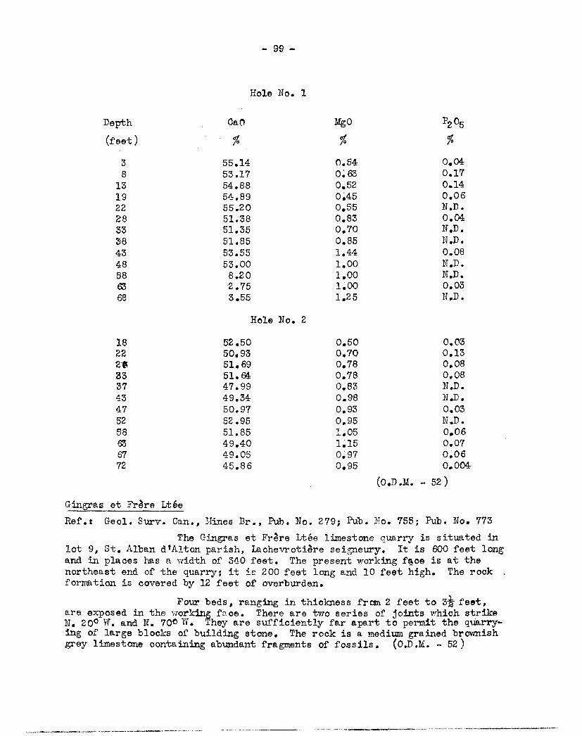
- 99 -
Hole No. 1
Depth Ca0 Mg0 P205
3
(feet),
55.14 0.54 0.04 8 53.17 0:63 0.17
13 54.88 0.52 0.14 19 54.89 0.45 0.06 22 55.20 0.55 N.D. as 51.38 0..83 0.04 33 51.35 0.70 N.D. 38 51.85 0.85 N.D. 43 53.55 1.44 0.08 48 53.00 1.00 N.D. 58 8.20 1.00 N.D. 63 2.75 1.00 0.03 68 3.55 1.25 N.D.
Hole No. 2
18 52.50 0.50 0.03 22 50.93 0.70 0.13 26 51.69 0.78 0.08 33 51.64 0.78 0.08 37 47.99 0.83 N.D. 43 49.34 0.98 N.D. 47 50.97 0.93 0.03 52 52.95 0.95 N.D. 58 51.85 1.05 0.06 63 49.40 1.15 0.07 67 49.05 0.97 0.06 72 45.86 0.95 0.004
(0.D.M. - 52)
Gingras et Frére Ltée
Ref.: Geol. Surer. Can., nines Br., Pub. No. 279; Pub. No. 755; Pub. No. 773
The Gingras et Frére Ltée limestone quarry is situated in lot 9, St. Alban dfAlton parish, Lachevrotiére seigneury. It is 600 feet long and in places has a width of 340 feet. The present working face is at the northeast end of the quarry; it iv. 200 feet long and 10 feet high. The rock formation is covered by 12 feet of overburden.
Four beds, ranging in thickness from 2 feet to 3* feet, are exposed in the working face. There are two series of joints which strike N. 200 W. and N. 7001W. They are sufficiently far apart to permit the quarry-ing of large blocks of building stone. The rock is a medium grained brownish grey limestone containing abundant fragments of fossils. (0.D.M. - 52)
- 100 -
NEUVILLE SEIGNEURY
Suzard Granite Quarry
0. Suzard operates a granite quarry in Neuville seigneury 4 miles northwest of Pont Rouge, near the road which leads to St. Raymond. There are many outcrops within an area 2,000 feet in diameter; the appearance of the stone is the same in all of them.
The rook is a biotitic granite gneiss. It contains large crystals of oink feldspar surrounded by quartz and abundant biotite which gives the rock a dark colour. No ;inerals of iron were noted.
Joints in the rock are spaced 4 feet apart or more. Their principal direction is N. 20° W. (O.D.M. - 53)
NOTRE ALE DES ANGES SEIGNEURY
Bédard Granite Quarry
Delwaide and Coffin intend to operate a granite quarry in lot 639, St. Pierre range, Notre Dame des Anges seigneury, 5 miles north of the city of Quebec. The property belongs to A. Bédard.
A fault which strikes N. 250W. and dips 80° southwest is exposed along the bed of a creek tributary to the Berger river. The quarry is 40 feet northeast of the fault and 20 feet above the bed of the creek. The face of the quarry is 100 feet long and 3 to 8 feet high.
The rock,is a medium grained granite gneiss which consists of pink potash feldspar, transparent or grey vitreous quartz, biotite and horn-blende. Over most of the area of the quarry the foliation strikes N. 35° W. and dips vertical. The sheets, which are massive and poorly defined, are len-ticular and have a thickness of 2 to 6 feet.
There are two well developed systems of joints; they strike N. 25° W. and N. 60° E. respectively. The joints are nearly vertical, and"are far enough apart to permit the extraction of large blocks of stone. There are, however, several transverse joints which could interfere with the production of very large blocks.
The rift and grain are vertical and the head is horizontal or nearly so. The rift strikes N. 250 W. to N. 35° P. and the grain strikes N. 600 E. The stone splits very easily along the rift. alien split along the grain or the head the stone has a very good appearance. The colour is salmon pink with thin black streaks. The colour and the grain are uniform. On account of its high feldspar content, the stone takes a good polish. It is sound and contains very little pyrite.
The quarry can produce granite of good quality "for cons-truction at relatively law cost. (P.E.B. - 52)
-lal-
r4c iEsERT R.8GXCV
McLean Claims
C. S. MacLean holds a group of claims in unsurveyed terri-tory in the east central part of Pontiac county, 7 miles west of the northwest corner of Egan township. From the La Vérendrye park south gate on highway No. 58 a road leads 10 miles southwest t0 Lac Rond. A water route is travelled from Rond lake for 7 miles to the main camp at Lao Pésert.
The area is underlain by Grenville-type rocks which strike U. 450 E. An examination of the outcrops across strike for 6 miles from Hammer bay to Fournier bay, and other parts of Lao Désert, revealed 2 main bands of interlayered metamorphic pyroxenite, limestone and pegmatite.
One band occurs along the east side of Groulx bay, and extends east for 2,000 or 3,000 feet. Several sections of pyroxenite and peg-matitic rock on the lake shore were found to be radioactive,.some sufficiently so to warrant further prospecting.
A second band of favourable rocks was found on the east side of Catfish bay. Its probable extension occurs a mile to the northeast along the shore of a small lake about midway between Rond lake and Placid lake. Low Geiger' counter readings were obtained at several places in both localities.
- 53)
-102 -
INDEX OF PR OPERT IES
Page
Abitibi Metals Mines Ltd. 63 48 11
Annett Prospect _ 3 _ la 33
96 Beaupre Base Metals Nines Ltd. 73 Bédard Granite Quarry 100
83 la
22 10
Campbell Chibougama.0 Mines Ltd. __, ..72 Canada Iron Furnace. Company Ltd. 54 Canadian Cliffs Ltd. 92 Canadian Explorers Ltd. 18
56 17 60
Chibouganau Explorers Ltd. ____._____ _v76 Chimo Gold Mines Ltd. .64 Christie Base Metals Ltd. 18 Ciglen Claims 4, 41 Claude Lake Mines Ltd. 32 Cobalt Badger Silver Mines Ltd. 38 Coghlan Claims 84 Consolidated Astoria Mines Ltd. 64 Copper-Uranium Ltd. 30 ------------ Crangold Mines Ltd. __. 83 Cyr Graphite Prospect 68 Davidson Prospect 33 D'Eldona Mines Ltd. 79 Deschambault Quarry Corporation ____..___ ___..____.__ .__ 97 Deschêne Copper Prospect .__.. 14 Desmeloizes Mining Corporation Ltd. _ __. 27 Despina Gold Mines Ltd. .60 Doherty Prospect 16 Dominion Gulf Company 15 Dominion Silica Corporation Ltd. 21s .25, 62 Doyon Claims 53 Dugas Prospect 14 Dumoulon Claims 69 Dupre-snoy Mines Ltd. 34
Adnor Mines Ltd. Annairaque Mines Ltd.
Ascot Metals Corporation Ltd. Auger Claims Beach Baryte Prospect Beaupas Mines Ltd.
Belville Zinc and. Copper Mines Ltd. Bertrand Granite Quarry Bordulac Mines Ltd. B ows inque Mines Ltd.
Ccnadian Lithium Company Ltd. Carle Claims Chabot Prospect

- 103 -
Page
Eastern Metals Corporation Ltd. 78 Fortress Nines and Oils Ltd. _.. -- 35
Fournier Prospect . 96 Gagnon Prospect 55 Gale-Cummings Mines Ltd. __ .12 Gaspé Copper Mines Ltd. .5I Gauthier, Jos. O., Ltd. .98 Gingras et Frère Ltée -99 Golden Shaft Mines Ltd. 23 Goulet Claims ..49 Grammont Mines Ltd. . - _ 70
89 Guntensperger Property Hollinger (Quebec Exploration Company Ltd. 91 Jellicoe Mines (1939) Ltd. 7 Kabour Mines Ltd. 12, 81 Lachance Mines Ltd. 67 La c orne Lithium Mine s Ltd . _. -_ _57 La Trappe Notre Dame de Mistassini .. 72 Lavalie Mines Ltd. 13 Lavoie-Simard Claims .82 Lithium Corporation of America Inc. __ 44 Lyndhurst Mining Company Ltd. -28 Macdonald Mines Ltd. 36 MacLean Claims 101 Maheux Prospect 84 Marbenor Malartic Mines Ltd. .31 Martin Feldspar Property .17 Maxim Lining Corporation Ltd. 87 McIntyre Porcupine Mines Ltd. - 16 Miller Copper Mines Ltd. 51 Morin Prospect 70 Morrison-Bouchard Prospect 50
National .~falartic Gold Mines Ltd. _-__ _..... 66 Monazite onaz ite Prospect 69
New Jersey Zinc Explorations Ltd. 25 New Laurie Mines Ltd. 37 Ilicupt Mines Ltd. 70 Chaska Lake Mines Ltd. 65 0/Brien, M.J., Ltd. 93 0/Connor Prospect 87 Oliver Iron Mining Company 94 Opemisio~. Copper Mines (Quebec) Ltd. 62
Perron Granite Prospect 52 Petosa Claims 45 Plante Prospect 85 Portneuf Mineral Corporation 95 Poulos Claims .67 Proulx Prospect 97 Preston East Dome Minas Ltd 59
-104-
Page
Quebec Copper Corporation Ltd. 8 Quebec Diversified Paining Corporation Ltd. 74 Quebec Lithium Corporation 58 Quesabe Mines Ltd. 39 Quetide Mining Company Ltd. 38 Rohault Mines Ltd. 77 Rondeau-Thibault Prospect 75 Roy Property 81
St. Roberts Metals Corporation 76 Seven Island Mining and Exploration Corporation Ltd. 61 Shawkey (1945) Mines Ltd. __.. 31 Sczio Property 19 Starcourt Gold. Mines Ltd. ,4
Suffield Metals Corporation Ltd. Suzard Granite Quarry 100 T6miscamingue Metal Ltd. 47 41a Touton Gold and Base Metals Corporation T out on Mining and Exploration Company 43 Tremblay Prospect 60 Vermont Zinc Mines Ltd. Vezina Copper Prospect
_.----..- 71 48
Victoria Copper Zinc Mines Ltd. 20, 86 Watson-Gagnon Claims 41a 'Jeedon Pyrite and Copper Corporation Ltd. _ . _ _ 88 'Jest l.Iacdonald Hines Ltd 38 West iasa Mines Ltd. 6
iihissell Prospect 50 White Diamond Granite Company Ltd. 85 i~illiam Leys Mining Corporation Ltd. 24 Yates Uranium Bines Inc. 52 Young Chibovgamau-Opelf.lska ?"'fines Ltd. 59
Related Documents


![Registration of Marriages Ordinance 1952 [53 of 1952]](https://static.cupdf.com/doc/110x72/55cf85fc550346484b936752/registration-of-marriages-ordinance-1952-53-of-1952.jpg)