REPLY TO A'ITENTION OF Office of the Chief Regulatory Division Bruce April DEPARTMENT OF THE ARMY October 20, 2009 Chief, Environmental Stewardship Branch North Coast Environmental Division Caltrans, District 11 - San Diego 4050 Taylor Street, MS-242 San Diego, California 92110 Dear Mr. April: Reference is made to your submittal (File No. SPL-2004-01089-SJH) dated September 24, 2008, requesting verification of the jurisdictional limits of the Section 404 of the Clean Water Act (CW A) for a number of water bodies, tributaries and wetlands occurring within the Interstate 5 (1-S)North Coast Corridor Widening Project study area located in the County of San Diego, along 26-miles of the I-5, from the I-805 (Mira Mesa Blvd. & La Jolla Village) to I-5 at Vandergrift Blvd., in the City of Oceanside, California. Your jurisdictional determination request is a formal concurrence point specified in the multi-agency collaborative process to integrate and streamline the requirements of the National Environmental Policy Act and Section 404 of the CWA for Surface Transportation Projects in the State of California. This letter of verification fulfills this concurrence point. Based on our May 26, 2009 site visit and information furnished to our office, including the September 2008 jurisdictional delineation report entitled "Interstate 5 North Coast Corridor Project Federal Wetland Delineation and Non-wetland Waters Report," we have determined that your proposed project does discharge dredged or fill material into a water of the United States (U.S. ). Therefore, the project is subject to our jurisdiction under Section 404 of the Clean Water Act (CWA) and a Department of the Army (DA) permit is required from our office. According to the delineation report, the I-5 would result in the placement of fill material into the following water bodies, tributaries, and adjacent wetlands: San Clemente Creek, Los Penasquitos Lagoon, San Dieguito Lagoon, San Elijo Lagoon, Cottonwood Creek, Batiquitos Lagoon, Encina Creek, Agua Hedionda Lagoon, Buena Vista Lagoon, Lorna Alta Creek, and the San Luis Rey River. Preliminary estiinates indicate a range of approximately 22.97 to 28.86 acres of waters of the U.S., including wetlands, would be permanently impacted by the proposed I-5, depending on the alternative selected. Similarly, approximately 13.55 acres to 16.05 acres of waters of the U.S., including wetlands, would be temporarily impacted. The enclosed tables list the waters of the United States, including wetlands, regulated by Section 404 of the CW A. Specifically, Table 1 identifies the permanent and temporary impacts to jurisdictional waters, including wetlands, occurring within each of the proposed I-5 project alternatives under consideration, Table 2 identifies permanent impacts to jurisdictional waters by watershed, and Table 3 identifies the I-5 jurisdictional watershed acreages. All tables referenced in this letter correspond to figures and maps compiled in the I-5 Federal Wetland Delineation and Non-wetland Waters Report (Caltrans, September 2008). The subject report

Welcome message from author
This document is posted to help you gain knowledge. Please leave a comment to let me know what you think about it! Share it to your friends and learn new things together.
Transcript

REPLY TO
A'ITENTION OF
Office of the Chief Regulatory Division
Bruce April
DEPARTMENT OF THE ARMY
October 20, 2009
Chief, Environmental Stewardship Branch North Coast Environmental Division Caltrans, District 11 - San Diego 4050 Taylor Street, MS-242 San Diego, California 92110
Dear Mr. April:
Reference is made to your submittal (File No. SPL-2004-01089-SJH) dated September 24, 2008, requesting verification of the jurisdictional limits of the Section 404 of the Clean Water Act (CW A) for a number of water bodies, tributaries and wetlands occurring within the Interstate 5 (1-S)North Coast Corridor Widening Project study area located in the County of San Diego, along 26-miles of the I-5, from the I-805 (Mira Mesa Blvd. & La Jolla Village) to I-5 at Vandergrift Blvd., in the City of Oceanside, California. Your jurisdictional determination request is a formal concurrence point specified in the multi-agency collaborative process to integrate and streamline the requirements of the National Environmental Policy Act and Section 404 of the CW A for Surface Transportation Projects in the State of California. This letter of verification fulfills this concurrence point.
Based on our May 26, 2009 site visit and information furnished to our office, including the September 2008 jurisdictional delineation report entitled "Interstate 5 North Coast Corridor Project Federal Wetland Delineation and Non-wetland Waters Report," we have determined that your proposed project does discharge dredged or fill material into a water of the United States (U.S.). Therefore, the project is subject to our jurisdiction under Section 404 of the Clean Water Act (CWA) and a Department of the Army (DA) permit is required from our office. According to the delineation report, the I-5 would result in the placement of fill material into the following water bodies, tributaries, and adjacent wetlands: San Clemente Creek, Los Penasquitos Lagoon, San Dieguito Lagoon, San Elijo Lagoon, Cottonwood Creek, Batiquitos Lagoon, Encina Creek, Agua Hedionda Lagoon, Buena Vista Lagoon, Lorna Alta Creek, and the San Luis Rey River. Preliminary estiinates indicate a range of approximately 22.97 to 28.86 acres of waters of the U.S., including wetlands, would be permanently impacted by the proposed I-5, depending on the alternative selected. Similarly, approximately 13.55 acres to 16.05 acres of waters of the U.S., including wetlands, would be temporarily impacted.
The enclosed tables list the waters of the United States, including wetlands, regulated by Section 404 of the CW A. Specifically, Table 1 identifies the permanent and temporary impacts to jurisdictional waters, including wetlands, occurring within each of the proposed I-5 project alternatives under consideration, Table 2 identifies permanent impacts to jurisdictional waters by watershed, and Table 3 identifies the I-5 jurisdictional watershed acreages. All tables referenced in this letter correspond to figures and maps compiled in the I-5 Federal Wetland Delineation and Non-wetland Waters Report (Caltrans, September 2008). The subject report

-2-
subject report will be retained in our office files as part of the project's official administrative record and the Corps' approved jurisdictional delineation/determination.
This delineation/determination has been conducted to identify the limits of the Corps jurisdiction for the particular site identified in this request. This delineation/determination may not be valid for the wetland conservation provisions of the Food Security Act of 1985, as amended. If you or your tenant are USDA program participants, or anticipate participation in USDA programs, you should request a certified wetland determination from the local office of the Natural Resources Conservation Service prior to starting work.
This letter contains an approved jurisdictional determination for the Interstate 5 (1-5) North Coast Corridor Widening Project. If you object to this decision, you may request an administrative appeal under Corps regulations at 33 CFR Part 331. Enclosed you will find a Notification of Appeal Process (NAP) fact sheet (Appendix A) and Request for Appeal (RFA) form. If you request to appeal this decision you must submit a completed RF A form to the Corps South Pacific Division Office at the following address:
Tom Cavanaugh Administrative Appeal Review Officer, U.S. Army Corps of Engineers South Pacific Division, CESPD-PDS-0, 20428 1455 Market Street, San Francisco, California 94103-1399
In order for an RF A to be accepted by the Corps, the Corps must determine that it is complete, that it meets the criteria for appeal under 33 C.F.R. Part 331.5, and that it has been received by the Division Office within 60 days of the date on the NAP. Should you decide to submit an RFA form, it must be received at the above address by December 20, 2009. It is not necessary to submit an RF A form to the Division office if you do not object to the decision in this letter.
This verification is valid for five years from the date of this letter, unless new information warrants revision of the determination before the expiration date. If you wish to submit new information regarding the approved jurisdictional determination for this site, please submit this information to Stephanie Hall at the letterhead address by December 20, 2009. The Corps will consider any new information so submitted and respond within 60 days by either revising the prior determination, if appropriate, or reissuing the prior determination. A revised or reissued jurisdictional determination can be appealed as described above.
If you have any questions, please contact Stephanie Hall of my staff at 213-452-3410 or via e-mail at Stephanie.J [email protected] .mil.
-3-
Please be advised that you can now comment on your experience with Regulatory Division by accessing the Corps web-based customer survey form at: http://per2.nwp.usace.army.mil/survey.html.
Enclosures
Sincerely,
Mark D. Cohen Assistant Deputy Chief, Regulatory Division

ENCLOSURE 1
Tables 1 through 3

Table 1. Permanent and Tempontry Impacts to ACOE .Jurisdictional Waters of the U.S.
-- ---8+4 buffer 10+4 buffer 8+4 barrier I 0+4 barrier
Permanent acres acres acres acres other waters of the US 10.58 11.82 12.79 12.95 wetland 12.39 13.07 13.95 15.90 - - ------ - --- - --- -- -- - ·-f-··----···-- - -·- -- --·----- -· . -- ·---·--Total 22.97 24.89 26.74 28.86 Temporary other waters ofthe US 4.74 4.46 4.38 4.30 wetland 9.10 11.60 11.20 9.25
1---Total 13.84 16.05 15.58 13.55 __ '--

Table 2. Permanent Impacts to ACOE Jm·isdictional Waters of the U.S. by Watershed
Watershed Jurisdiction 8+4 buffer I 0+4 buffer 8+4 barrier I 0+4 barrier acres acres acres acres
other waters San Clemente ofthe U.S. 0.00 0.00 0.00 0.00 ..... • ...... _d, . ... ....... .......................... ........ ............................................ ..... .. -.. ..............
Creek Wetland 0.01 0.01 0.01 0.01 other waters
Los Penasquitos ofthe U.S. 2.14 2.14 2.14 2.14 ... . ........................... ...................
Lagoon Wetland 2.20 2.20 2.20 2.20 other waters
San .Oieguito ofthe U.S. 1.05 1.09 1.13 1.17 -··········· ......................... ,. ,,, ___ __ ,,,., ······ ··-·••'"'
Lagoon Wetland 2.46 2.61 2.28 3.14 other waters
San Elijo ofthe U.S. 0.60 0.64 0.66 0.70 ··-····-·· .. ··- .... ........................................... ., .. ,,,,_ ································-····· ········-··· ·· ......... ····-···· .. ····
Lagoon Wetland 1.18 1.55 1.74 2.37 other waters
Cottonwood ofthe U.S. 0.03 0.03 0.03 0.04 ........ --·········· Creek Wetland 0.26 0.27 0.23 0.38
other waters Batiquitos ofthe U.S. 0.97 1.05 1.21 I. 1 1 .... .. _ .. , .......... ·······················-······ .... .................................................... .. ........... ................................................. . .............. ~ ··· · .. ···
Lagoon Wetland 3.60 3.71 4.81 5.06 other waters
Encina ofthe U.S. 0.08 0.10 0.11 0. 13 Creek Wetland 1.42 1.46 1.44 1.49
other waters Agua Hedionda ofthe U.S. 4.32 5.36 6.12 6.28
........ -~ ..... ... ...... .........................
Lagoon Wetland 0.00 0.00 0.00 0.00 other waters
Buena Vista ofthe U.S. 0.30 0.30 0.30 0.30 ....... ~- ....
Lagoon Wetland 0.57 0.57 0.57 0.57 other waters
Loma Alta ofthe U.S. 0.26 0.26 0.26 0.26 ... .. ........ .. ~ .. ~·· ····· · ··
....... . ........................ ....
Creek Wetland 0.03 0.03 0.03 0.03 other waters
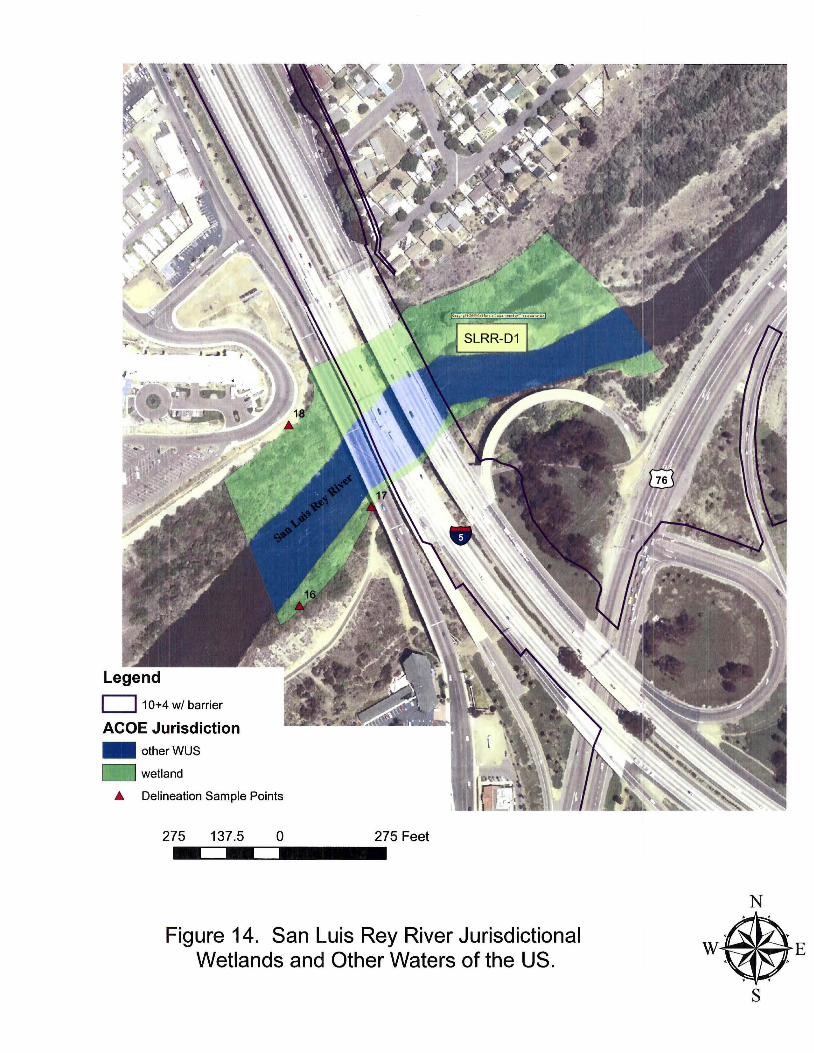
San Luis Rey ofthe U.S. 0.84 0.84 0.84 0.84 River Wetland 0.65 0.65 0.65 0.65
Total 22.97 24.89 26.74 28 .86 other waters
Subtotal ofthe U.S. 10.58 11.82 12 .79 12.95 ................................... .......................... . .. .......... ........ ........... .......... ................... - ------. ........... ....... ...................
Subtotal Wetland 12.39 13.07 13.95 15.90

Table 3. 1-5 North Coast Corridor Drainages/Watershed ACOE Jurisdictional Acreage
Watershed/Drainage Drainage Latitude Longitude Area Wetland Non- Total ID Reviewed (acres) wetland (acres)
(acres) wus (acres)
San Clemente Creek sec Voight - unnamed SCC-D1 32.8823 -117.2248 0.5 0.02 0.02 drainage
Los Pefiasquitos LPL Lagoon Genesee Unnamed LPL-D1 32.8940 -117.227 18 2.44 0.5 2.94 Drainage Soledad Creek LPL-D2 32.9006 -117.2234 5.0 2.44 2.44 Los Penasquitos Creek LPL-D3 32.9042 -117.2237 5.0 2.02 2.02 Carmel Creek LPL-D4 32.9297 -117.2405 42 30.92 1.54 32.46
San Dieguito Lagoon SDL San Dieguito River SDL-D1 32.9729 -117.2504 11 2.19 5.41 7.6 Drainage SE of San SDL-D2 32.9683 -117.2478 10 1.77 1.77 Dieguito River Drainage NW of San SDL-D3 32.9743 -117.2504 7.8 1.96 1.96 Dieguito River Drainage NE of San SDL-D4 32.9763 -117.2510 7.8 2.08 2.08 Dieguito River
San Eli.io La2oon SEL-Dl 33.0101 -117.2643 45.0 25.90 2.03 27.93 Unnamed drainage from SEL-D2 33.0069 -117.2619 1.0 0.02 0.02 South Drainage Parallel to SEL-D3 33.0118 -117.262 2.0 0.45 0.45 Manchester Drainage north of SEL-D4 33.0132 -117.2685 1.0 0.15 0.15 Manchester Cottonwood Creek CC-Dl 33.0475 -117.2859 1.0 0.07 0.07 Drainage S of Requeza CC-D2 33 .0431 -117.2850 8.0 0.91 0.91 oc Moonlight Creek CC-D3 33.0515 -117.2890 22.0 2.28 0.092 2.37
Batiquitos Lagoon BL-Dl 33.0907 -117.3023 100.0 29.38 39.3 68.68
Encina Creek EC-Dl 33.1169 -117.3181 3.0 0.45 0.22 0.67 Drainage to Encina EC-D2 33.1148 -117.3171 16.0 1.33 0.12 1.45 Creek
Agua Hedionda AHL-Dl 33.0907 -117.3023 51.0 35.6 35.6 Lagoon

NOTIFICATION OF ADMINISTRATIVE APPEAL OPTIONS AND PROCESS AND REQUEST FOR APPEAL
Applicant: Bruce April, Caltrans, District 11 -San Diego I File Number: SPL-2004-01089-SJH Date: 10/20/2009
Attached is: See Section below INITIAL PROFFERED PERMIT (Standard Permit or Letter of permission) A PROFFERED PERMIT (Standard Permit or Letter of permission) B PERMIT DENIAL c
X APPROVED JURISDICTIONAL DETERMINATION D PRELIMINARY JURISDICTIONAL DETERMINATION E
SECTION I - The following identifies your rights and options regarding an administrative appeal of the above decision. Additional information may be found at http://usace.army.mil/inet/functions/cw/cecwo/reg or Corps regulations at 33 CFR Part 331. A: INITIAL PROFFERED PERMIT: You may accept or object to the permit.
• ACCEPT: If you received a Standard Permit, you may sign the permit document and return it to the district engineer for final authorization. If you received a Letter of Permission (LOP), you may accept the LOP and your work is authorized. Your signature on the Standard Permit or acceptance of the LOP means that you accept the permit in its entirety, and waive all rights to appeal the permit, including its terms and conditions, and approved jurisdictional determinations associated with the permit.
• OBJECT: If you object to the permit (Standard or LOP) because of certain terms and conditions therein, you may request that the permit be modified accordingly. You must complete Section II of this form and return the form to the district engineer. Your objections must be received by the district engineer within 60 days of the date of this notice, or you will forfeit your right to appeal the permit in the future. Upon receipt of your letter, the district engineer will evaluate your objections and may: (a) modify the permit to address all of your concerns, (b) modify the permit to address some of your objections, or (c) not modify the permit having determined that the permit should be issued as previously written. After evaluating your objections, the district engineer will send you a proffered permit for your reconsideration, as indicated in Section B below.
B: PROFFERED PERMIT: You may accept or appeal the permit.
• ACCEPT: If you received a Standard Permit, you may sign the permit document and return it to the district engineer for final authorization. If you received a Letter of Permission (LOP), you may accept the LOP and your work is authorized. Your signature on the Standard Permit or acceptance of the LOP means that you accept the permit in its entirety, and waive all rights to appeal the permit, including its terms and conditions, and approved jurisdictional determinations associated with the permit.
• APPEAL: If you choose to decline the proffered permit (Standard or LOP) because of certain terms and conditions therein, you may appeal the declined permit under the Corps of Engineers Administrative Appeal Process by completing Section II of this form and sending the form to the division engineer. This form must be received by the division engineer within 60 days of the date of this notice.
C: PERMIT DENIAL: You may appeal the denial of a permit under the Corps of Engineers Administrative Appeal Process by completing Section II of this form and sending the form to the division engineer. This form must be received by the division engineer within 60 days of the date of this notice.
D: APPROVED JURISDICTIONAL DETERMINATION: You may accept or appeal the approved JD or provide new information.
• ACCEPT: You do not need to notify the Corps to accept an approved JD. Failure to notify the Corps within 60 days of the date of this notice, means that you accept the approved JD in its entirety, and waive all rights to appeal the approved JD.
• APPEAL: If you disagree with the approved JD, you may appeal the approved JD under the Corps of Engineers Administrative Appeal Process by completing Section II of this form and sending the form to the division engineer. This form must be received by the division engineer within 60 days of the date of this notice.
E: PRELIMINARY JURISDICTIONAL DETERMINATION: You do not need to respond to the Corps regarding the preliminary JD. The Preliminary JD is not appealable. If you wish, you may request an approved JD (which may be appealed), by contacting the Corps district for further instruction. Also you may provide new information for further consideration by the Corps to reevaluate the JD.

SECTION II - REQUEST FOR APPEAL or OBJECTIONS TO AN INITIAL PROFFERED PERMIT REASONS FOR APPEAL OR OBJECTIONS: (Describe your reasons for appealing the decision or your objections to an initial proffered permit in clear concise statements. You may attach additional information to this form to clarify where your reasons or objections are addressed in the administrative record.)
ADDITIONAL INFORMATION: The appeal is limited to a review of the administrative record, the Corps memorandum for the record of the appeal conference or meeting, and any supplemental information that the review officer has determined is needed to clarify the administrative record. Neither the appellant nor the Corps may add new information or analyses to the record. However, you may provide additional information to clarify the location of information that is already in the administrative record.
POINT OF CONTACT FOR QUESTIONS OR INFORMATION: If you have questions regarding this decision and/or the appeal process you may contact:
DISTRICT ENGINEER Los Angeles District, Corps of Engineers ATI'N: Chief, Regulatory Division P.O. Box 532711 Los Angeles, CA 90053-2325 Tel. (213) 452-3425
If you only have questions regarding the appeal process you may also contact:
DIVISION ENGINEER South Pacific Division, Corps of Engineers ATTN: Tom Cavanaugh Administrative Appeal Review Officer, South Pacific Division, CESPD-PDS-0, 20428 1455 Market Street, San Francisco, California 94103-1399 Tel. (415) 503-6574 Email: [email protected]
RIGHT OF ENTRY: Your signature below grants the right of entry to Corps of Engineers personnel, and any government consultants, to conduct investigations of the project site during the course of the appeal process. You will be provided a 15 day notice of any site investigation, and will have the opportunity to participate in all site investigations.
Date: Telephone number:
Signature of appellant or agent.

Administrative Appeal Process for Approved Jurisdictional Determinations
Appro\•e(l JD 'Jalid for 5 years.
Dislricl makes new a;Jpm•Jed J D
To ~cnti m e w i h appe<~l
precess . appell-=nt m11 ':i.i revi-se RFA.
See Append :< 0
Division en ginceer or desiGnee remand~ decision ~ o distrit1. '<'l'iih sp<B <:~flc instructions. or reconsideration : app<Ba I process ccmJ:l eted
Appendix C
D.str.r:1 .ssues :i)Opro .. ·ed Jur.~d. r: ·(lilil l Detefl 1inat'on (JD) to applicarWiandowner 'li.lh JAP.
N;plic:mt dt:cide~ to appeal approved JD AJ:plicant subm1ts P.i=A to di\nsicn engmeer wi1hi 60 da)I'S of date of NAP.
c orps rev1ews RFA and nc~ities appellant 'llithrn 30 da•;s of receipt
Oplior\11 JD .1\opeals Meet ng andl·cr So te 'nveRf1gat.on
RO re\•iews record and the divisioo enfjneer (or des1 g nee) renders a dec1 slon colhe mert ls of the appeal wit in 90 days of re,;eipt of an acceptable RFA
DiSilrict's decision is uphelo: appeal process completed

Figure 1. 1-5 North Coast Corridor Project
San Luis Rey River
Buena Vista Lagoon
Agua Hedionda Lagoon
_, .. -··-......... ) '
'··-··
......... _ ./ r- •• -...~·
,_ .. r··
.f-·./j
.~ ... -.. - .. ~ · ---./"'../ Batiquitos Lagoon /
/ Project Limits
WATERSHEDS
Cl San Luis Rey River
CJ Lorna Alta Creek
CJ Buena Vista Lagoon
CJ Agua Hedionda Lagoon
c- Encina Creek
CJ Batiquitos Lagoon
CJ Cottonwood Creek
c._ San Elijo Lagoon
CJ San Dieguito Lagoon
CJ Los Penasquitos Lagoon
CJ San Clemente Creek
San Elijo Lagoon
San Dieguito Lagoon
Los Penasquitos Lagoon
.. /· . ...._,,;
.-· i'··--. ./
r i
./ .J (
~ · ·
/"/
~-
_,.. .. ____ __ /.·
/ ..i
~-··- ·~ -. _.,..· ,_ ....... -··-··- ·- .-· .......
( ., /
i
.-··.,-·- ·-
N
A
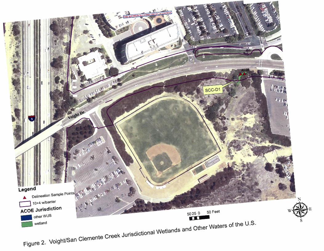
Legend A Delineation Sample Points~Jj.~~
c::J 10+4 w/barrier --""""
ACOE Jurisdiction
- otherWUS 50 25 0 50 Feet
•• wetland
Figure 2. Voight!San Clemente Creek Jurisdictional Wetlands and Other Waters of the U.S.
N
• .
W E .
s

Legend
.& Delineation Sarnpe Points
c:J 10+4 w/ barrier
ACOE Jurisdiction -~herWUS - wetland
""'•-==41·0- C::::J. ______ a:;o Fut
Figure 3. North of Genesee Jurisdictional Wetlands and Other Waters of the US.

Legend
ACOE Jurisdictioniit~
- otherWUS ~~ wetland
Figure 4. Carmel Creek/Penasquitos Lagoon Jurisdictional Wetlands and Other Waters of the U.S.
150 75 0 150 Feet
N
• .
W E . s

Legend
..& Delineat(m Sample Points
c:J 10-!<I w/ barrier
ACOE Jurisdiction
- other 'MJS
- wetland
600 300 600 Feel ....... c:~ ...... -=~ .......... .
Figure 5. San Dieguito Lagoon Jurisdictional Wetlands and Other Waters of the US.
N
\\ ·6ll\~· ·. · t \k .
'

Legend
... Delineation Sample Point
D 10-+<l w/barrier
ACOE Jurisdiction - other 'NJS
- wetland
"'ii!...-c=:::ZJii.:......-=::::J.-----·470 rut
Figure 6. San Elijo Lagoon Jurisdictional Wetlands and Other Waters of the US.
N
\\®·E

----- - - - - -
D 10+4 w/ barri er
ACOE Jurisdiction - other WUS
- VI€ tland
.a Delineation Sample Points
·- - - -- - - ----- -- - - - - - - - -
31·0-c:=':J"-..:=:=] ______ 310Feet
Figure 7. Cottonwood Creek/Requeza Jurisdictional Wetlands and Other Waters of the US.

Legend D 10+4 w/ barrier
ACOE Jurisdiction - other WUS
- VIe tland
..o De lineation Sample Points
520 Feet
---=:~--==---520 260
Figure 8. Moonlight Creek Jurisdictional Wetlands and Other Waters of the US.
N
"®' s

Legend
D 10+4w/barrier
ACOE Jurisdiction - otherWUS
- wetland
De lineation Sample Points 410 205 41 0 Feet ...... ==~ ..... c=~ ..........
Figure 9. Batiquitos Lagoon Jurisdictional Wetlands and Other Waters of the US.

Legend _. De lineati on Sample Po ints
c::J 10+4w/barrier
ACOE Jurisdiction
- otherWUS
- wetland 390 195 390 Feet .... ~~ ... --~~ .........
Figure 10. Encina Creek Jurisdictional Wetlands and Other Waters of the US.

Figure 11. Agua Hedionda Lagoon Jurisdictional Wetlands and Other Waters of the US.
c=J 1 0+4 w/ barrier
ACOE Jurisdiction .. otherWUS
wetland
N
• .
W E . s

- - --- - - - - - - --- --- - -- - - - - --- --- - - - --- --- - - - -
_.. Delineation Sample Po ints
c::J 10+4 wlbarrier
ACOE Jurisdiction - other WUS
- wetland
35~~-C1::J7.:. .. c::::11•••••35D Feet
Figure 12. Buena Vista Lagoon Jurisdictional Wetlands and Other Waters of the US.

400 200 0 400 Feet
Figure 13. Lorna Alta Creek Jurisdictional Wetlands and Other Waters of the US.
N
• .
W E . .
s
c:J 1 0+4 w/ barrier
ACOE Jurisdiction .. otherWUS
wetland
.A. Delineation Sample Points
275 137.5 0 275 Feet
Figure 14. San Luis Rey River Jurisdictional Wetlands and Other Waters of the US.
N
• .
W E . s
Related Documents