DEPARTMENT OF THE ARMY VICKSBURG DISTRICT, CORPS OF ENGINEERS 4155 EAST CLAY STREET VICKSBURG, MISSISSIPPI 39180-3435 NAVIGATION BULLITIN 25 November 2013 NO. 1 OF 2013 SPECIAL NOTICE MISSISSIPPI RIVER Pile and stone dikes have been constructed in some reaches of the river where the navigable channel has been difficult to maintain. These dike systems have been effective in reducing low water flow in secondary channels and pointways, restricting the wide reaches and holding the channel in a good alignment for navigation. Similar type systems are planned for other reaches where it appears that they will be economically and structurally feasible. The crown of the dikes usually slopes from the high bar or top bank toward the channel. The slope varies across back channels and bars. The elevations of the crowns of the dikes vary within a system. The high point elevation of each system near the channel and near the shore is tabulated below. The elevations are referenced to the nearest standard gages located upstream and downstream of the dike field and are based on the 1993 low water river slopes between the gages and the dike locations. The actual water surface elevations based on gage reading may vary a few feet at the structure due to changes in river conditions and variations in river slopes during rapidly changing river stages. The stone structures could do severe damage to pleasure crafts, towboats, and barges in the event of collision. Pile clusters 200 to 300 feet apart extend above the dike elevations on many stone dikes. Drift and debris may lodge on dikes and make navigation over them hazardous. Passage of vessels over dikes may cause damage to both the vessel and the structure without actually striking the dike. We, therefore, request that navigators refrain from running over the dikes at all stages. Maps of the dike field and navigable channel are attached as prepared by River Stabilization Section, Design Branch. Updated thru 16 March 2011 Approximate Elevation Based on 1993 LWRP Referred to Local Gage Dike End Sheet Near of Dike Field No. Mile Shore Dike Gage Type Island 70 Chevrons (3) 1 609.9-609.5L 14 Helena Stone 12 Rosedale________________________ Island 70 1/2 608.9-604.6L 38 12 Helena Stone & Pile 37 10 Rosedale Henrico 2 603.9-602.5R 22 13 Helena Stone 21 11 Rosedale Smith Point 2 600.5-600.2L 39 04 Helena Stone & Pile 38 02 Rosedale Big Island Weirs 2 599.6-598.8R -16 -16 Helena Stone Rosedale Victoria Bend -Right 2 596.0-594.8R 24 19 Helena Stone 23 17 Rosedale Victoria Bend -Left 2 596.0-595.0L 25 13 Helena Stone 24 12 Rosedale Victoria Bend Weirs 2 595.6-594.9L -17 -22 Helena Stone -21 -24 Rosedale Montgomery Towhead 2 592.5-591.5R 13 13 Helena Stone & Pile 12 11 Rosedale White River Landing 3 591.2-590.7R 26 06 Rosedale Stone 23 09 Arkansas City

Welcome message from author
This document is posted to help you gain knowledge. Please leave a comment to let me know what you think about it! Share it to your friends and learn new things together.
Transcript

DEPARTMENT OF THE ARMY VICKSBURG DISTRICT, CORPS OF ENGINEERS
4155 EAST CLAY STREET VICKSBURG, MISSISSIPPI 39180-3435
NAVIGATION BULLITIN 25 November 2013 NO. 1 OF 2013
SPECIAL NOTICE MISSISSIPPI RIVER
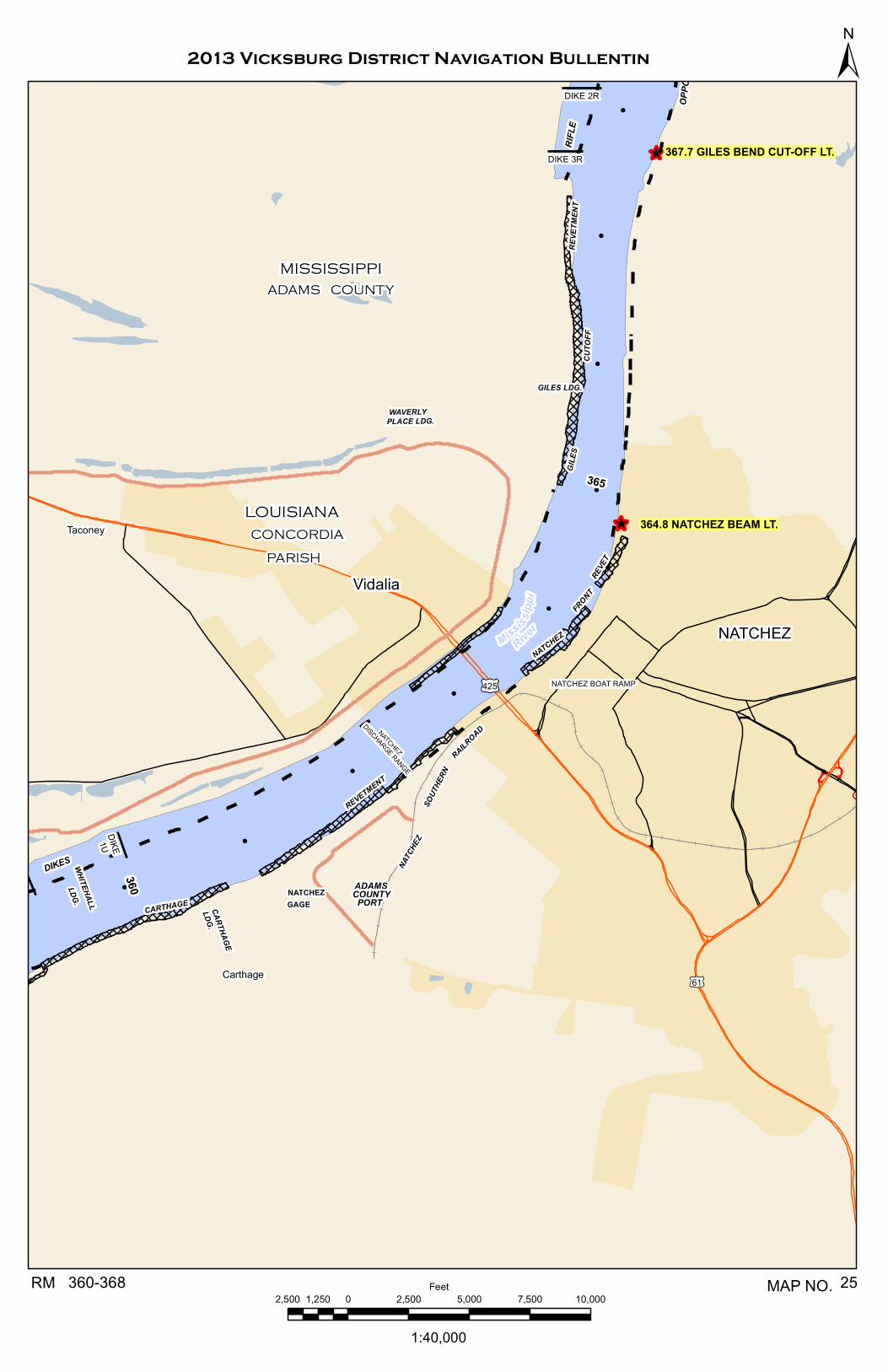
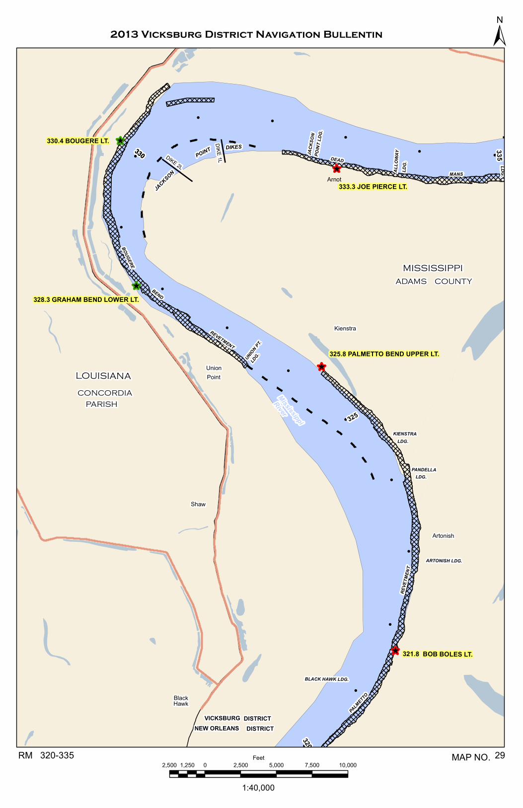
Pile and stone dikes have been constructed in some reaches of the river where the navigable channel has been difficult to maintain. These dike systems have been effective in reducing low water flow in secondary channels and pointways, restricting the wide reaches and holding the channel in a good alignment for navigation. Similar type systems are planned for other reaches where it appears that they will be economically and structurally feasible. The crown of the dikes usually slopes from the high bar or top bank toward the channel. The slope varies across back channels and bars. The elevations of the crowns of the dikes vary within a system. The high point elevation of each system near the channel and near the shore is tabulated below. The elevations are referenced to the nearest standard gages located upstream and downstream of the dike field and are based on the 1993 low water river slopes between the gages and the dike locations. The actual water surface elevations based on gage reading may vary a few feet at the structure due to changes in river conditions and variations in river slopes during rapidly changing river stages. The stone structures could do severe damage to pleasure crafts, towboats, and barges in the event of collision. Pile clusters 200 to 300 feet apart extend above the dike elevations on many stone dikes. Drift and debris may lodge on dikes and make navigation over them hazardous. Passage of vessels over dikes may cause damage to both the vessel and the structure without actually striking the dike. We, therefore, request that navigators refrain from running over the dikes at all stages. Maps of the dike field and navigable channel are attached as prepared by River Stabilization Section, Design Branch.
Updated thru 16 March 2011 Approximate Elevation Based on 1993 LWRP Referred to Local Gage Dike End Sheet Near of Dike Field No. Mile Shore Dike Gage Type Island 70 Chevrons (3) 1 609.9-609.5L 14 Helena Stone 12 Rosedale________________________ Island 70 1/2 608.9-604.6L 38 12 Helena Stone & Pile 37 10 Rosedale Henrico 2 603.9-602.5R 22 13 Helena Stone 21 11 Rosedale Smith Point 2 600.5-600.2L 39 04 Helena Stone & Pile 38 02 Rosedale Big Island Weirs 2 599.6-598.8R -16 -16 Helena Stone Rosedale Victoria Bend -Right 2 596.0-594.8R 24 19 Helena Stone 23 17 Rosedale Victoria Bend -Left 2 596.0-595.0L 25 13 Helena Stone 24 12 Rosedale Victoria Bend Weirs 2 595.6-594.9L -17 -22 Helena Stone -21 -24 Rosedale Montgomery Towhead 2 592.5-591.5R 13 13 Helena Stone & Pile 12 11 Rosedale White River Landing 3 591.2-590.7R 26 06 Rosedale Stone 23 09 Arkansas City
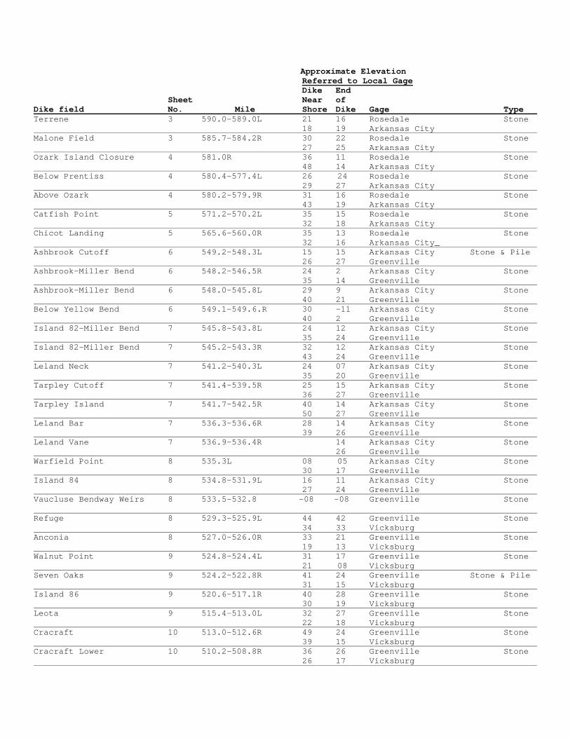
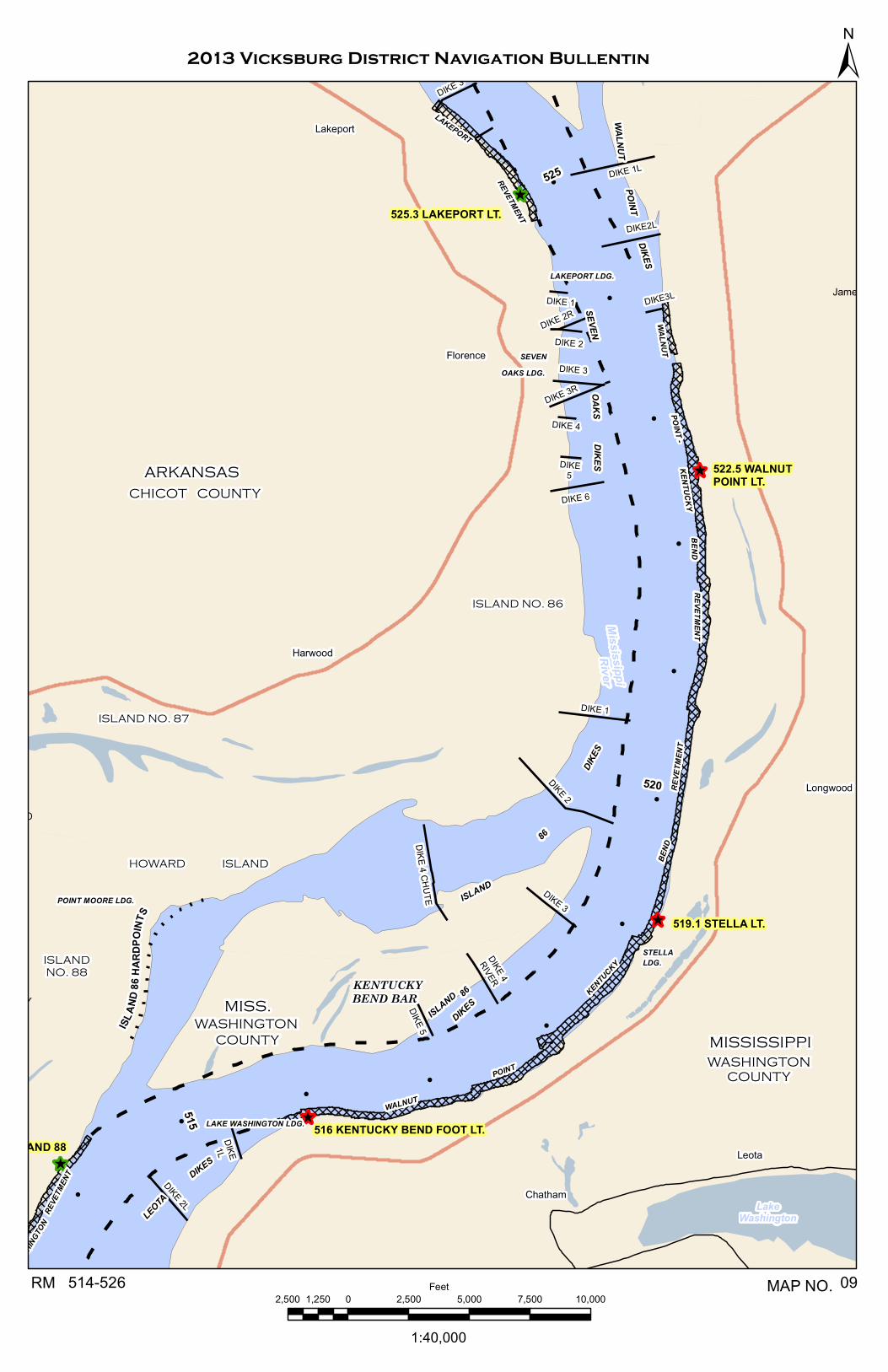
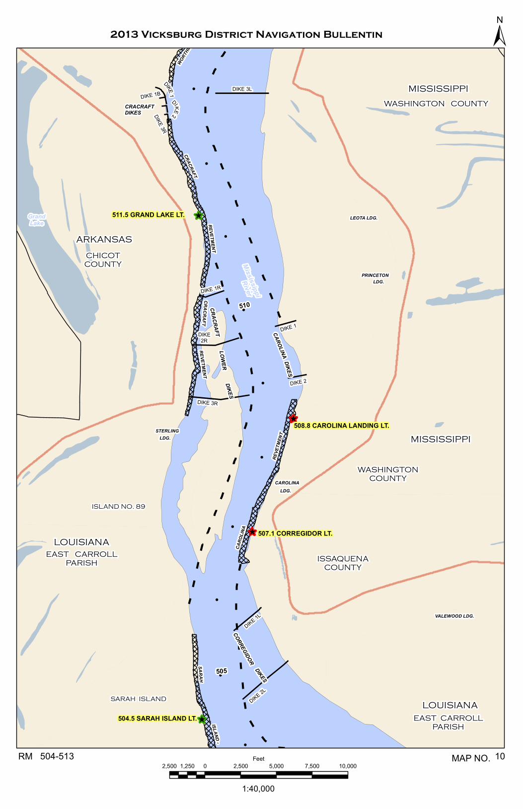
Approximate Elevation Referred to Local Gage Dike End Sheet Near of Dike field No. Mile Shore Dike Gage Type Terrene 3 590.0-589.0L 21 16 Rosedale Stone 18 19 Arkansas City Malone Field 3 585.7-584.2R 30 22 Rosedale Stone 27 25 Arkansas City Ozark Island Closure 4 581.0R 36 11 Rosedale Stone 48 14 Arkansas City Below Prentiss 4 580.4-577.4L 26 24 Rosedale Stone 29 27 Arkansas City Above Ozark 4 580.2-579.9R 31 16 Rosedale Stone 43 19 Arkansas City Catfish Point 5 571.2-570.2L 35 15 Rosedale Stone 32 18 Arkansas City Chicot Landing 5 565.6-560.0R 35 13 Rosedale Stone 32 16 Arkansas City_ Ashbrook Cutoff 6 549.2-548.3L 15 15 Arkansas City Stone & Pile 26 27 Greenville Ashbrook-Miller Bend 6 548.2-546.5R 24 2 Arkansas City Stone 35 14 Greenville Ashbrook-Miller Bend 6 548.0-545.8L 29 9 Arkansas City Stone 40 21 Greenville Below Yellow Bend 6 549.1-549.6.R 30 -11 Arkansas City Stone 40 2 Greenville Island 82-Miller Bend 7 545.8-543.8L 24 12 Arkansas City Stone 35 24 Greenville Island 82-Miller Bend 7 545.2-543.3R 32 12 Arkansas City Stone 43 24 Greenville Leland Neck 7 541.2-540.3L 24 07 Arkansas City Stone 35 20 Greenville Tarpley Cutoff 7 541.4-539.5R 25 15 Arkansas City Stone 36 27 Greenville Tarpley Island 7 541.7-542.5R 40 14 Arkansas City Stone 50 27 Greenville Leland Bar 7 536.3-536.6R 28 14 Arkansas City Stone 39 26 Greenville Leland Vane 7 536.9-536.4R 14 Arkansas City Stone 26 Greenville Warfield Point 8 535.3L 08 05 Arkansas City Stone 30 17 Greenville Island 84 8 534.8-531.9L 16 11 Arkansas City Stone 27 24 Greenville Vaucluse Bendway Weirs 8 533.5-532.8 -08 -08 Greenville Stone Refuge 8 529.3-525.9L 44 42 Greenville Stone 34 33 Vicksburg Anconia 8 527.0-526.0R 33 21 Greenville Stone 19 13 Vicksburg Walnut Point 9 524.8-524.4L 31 17 Greenville Stone 21 08 Vicksburg Seven Oaks 9 524.2-522.8R 41 24 Greenville Stone & Pile 31 15 Vicksburg Island 86 9 520.6-517.1R 40 28 Greenville Stone 30 19 Vicksburg Leota 9 515.4-513.0L 32 27 Greenville Stone 22 18 Vicksburg Cracraft 10 513.0-512.6R 49 24 Greenville Stone 39 15 Vicksburg Cracraft Lower 10 510.2-508.8R 36 26 Greenville Stone 26 17 Vicksburg

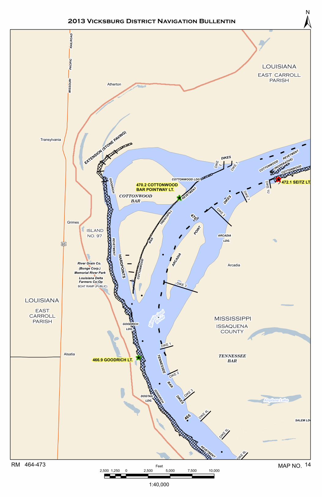
Approximate Elevation Referred to Local Gage Dike End Sheet Near of Dike field No. Mile Shore Dike Gage Type Carolina 10 509.7-509.0L 40 19 Greenville Stone 30 10 Vicksburg Corregidor 10 505.8-505.1L 47 23 Greenville Stone 36 14 Vicksburg Wilson Point 11 500.6-498.3R 36 32 Greenville Stone 26 23 Vicksburg Baleshed Landing 11/12 494.6-490.2L 39 27 Greenville Stone 29 18 Vicksburg Ben Lomond 12 488.6-485.3L 37 29 Greenville Stone 27 20 Vicksburg Ben Lomond Vane 12 487.8-485.3L 29 Greenville Stone 20 Vicksburg Ajax Bar 12 484.5-479.8L 52 34 Greenville Stone 43 25 Vicksburg Point Lookout 13 477.9R 56 12 Greenville Stone 46 03 Vicksburg Arcadia Point 14 471.2-468.5L 51 42 Greenville Stone 41 33 Vicksburg Cottonwood Bar 14 471.3-471.1R 46 22 Greenville Stone 35 23 Vicksburg Tennessee Bar 14 466.7-463.6L 18 24 Greenville Stone 47 15 Vicksburg Willow Cutoff 15 462.9-460.1R 51 32 Greenville Stone 40 23 Vicksburg Below Belle Island 15 457.8-457.4R 11 Greenville Stone 02 Vicksburg Forest Home Towhead 15 452.0-448.1L 52 30 Greenville Stone 43 21 Vicksburg Marshall Cutoff 16 448.2-447.2R 42 20 Greenville Stone 31 11 Vicksburg Marshall Brown Hardpoints 16 444.6R 33 13 Greenville Stone 24 04 Vicksburg False Point 17 440.8-440.1R 49 31 Greenville Stone 39 22 Vicksburg Delta Point Chevron (1) 17 439.5-R 27 Greenville Stone 18 Vicksburg_______________________ Delta Point 17 439.3-438.9R 28 27 Greenville Stone 22 18 Vicksburg Racetrack Towhead 17 432.8-430.2R 28 20 Vicksburg Car Bodies & Stone 33 19 Natchez Below Racetrack 17/18 431.5-426.9L 36 23 Vicksburg Stone & Pile Stone Extensions 41 27 Natchez Diamond Cutoff 18 424.0-422.5L 32 18 Vicksburg Stone 33 23 Natchez Newtown Bend 18/19 421.1-419.5R 35 23 Vicksburg Stone 41 28 Natchez Togo Island 19 417.0-413.2L 43 24 Vicksburg Stone 48 29 Natchez Yucatan 19 411.4-407.4R 44 16 Vicksburg Stone 49 21 Natchez Coffee Point 20 405.0-401.8R 40 19 Vicksburg Stone 46 24 Natchez Below Grand Gulf 21 400.3-399.0L 40 12 Vicksburg Stone 38 17 Natchez Bondurant Towhead 21 395.5-394.0R 38 15 Vicksburg Stone 43 20 Natchez Browns Field 22 390.1-388.2R 35 15 Vicksburg Stone 41 20 Natchez

Cottage Bend 22 389.2-388.2L 44 23 Vicksburg Stone 50 28 Natchez Approximate Elevation Referred to Local Gage Dike End Sheet Near of Dike field No. Mile Shore Dike Gage Type Spithead Towhead 22/23 386.3-384.3L 43 32 Vicksburg Stone 48 37 Natchez Waterproof 23 380.5-378.4R 39 18 Vicksburg Stone & Pile 45 22 Natchez Opposite Rifle Point 24 369.4-368.5L 43 17 Natchez Stone Rifle Point 24/25 368.6-367.6R 42 17 Natchez Stone
Natchez Island 25/26 360.1-356.8R 46 17 Natchez Stone Carthage Point 26 358.6-357.9L 43 17 Natchez Stone Opposite Warnicott Ldg 26/27 352.5-349.6L 38 28 Natchez Stone & Pile Esperance Point 27 348.2-345.9R 46 22 Natchez Stone Opposite Esperance Pt 27 347.8-346.8L 41 38 Natchez Stone Buck Island 28 339.7-338.5L 47 15 Natchez Stone Fritz Island 28 338.5-337.0R 40 25 Natchez Stone Jackson Point 29 331.4-330.3L 26 21 Natchez Stone Spithead Towhead 23 386.3-384.3L 43 32 Vicksburg Stone 48 37 Natchez Waterproof 23 380.5-378.4R 39 17 Vicksburg Stone & Pile 45 22 Natchez Opposite Rifle Point 24 369.4-368.5L 43 17 Natchez Stone Rifle Point 24/25 368.6-367.6R 42 17 Natchez Stone
Natchez Island 26 360.1-356.8R 46 17 Natchez Stone Carthage Point 26 358.6-357.9L 43 17 Natchez Stone Opposite Warnicott Ldg 26/27 352.5-349.6L 38 28 Natchez Stone & Pile Esperance Point 27 348.2-345.9R 46 22 Natchez Stone Opposite Esperance Pt 27 347.8-346.8L 41 38 Natchez Stone Buck Island 28 339.7-338.5L 47 15 Natchez Stone Fritz Island 28 338.5-337.0R 40 25 Natchez Stone Jackson Point 28 331.4-330.3L 26 21 Natchez Stone
James Ross Chief, Operations Division

^̂
^
^
^̂
!
!
!
!
!
!
!
!!
!
!
MISSISSIPPI
ARKANSAS
BOLIVARCOUNTY
607.3
LACO
NIA
UPPE
R LT
REVETMENT
DENNIS
REVE
TMEN
T
CESSIONS
TOWHEADREVETMENT
616 CESSIONS TOWHEAD LT
DESHACOUNTY
609.7 DENNIS LAND. TERM. LT
610615
Island 70 Dikes
BELOW KNOWLTON DIKES
BELOW KNOWLTON DIKES
DIKE 5
DIKE 1DIKE 6
DIKE 1L
DIKE 3
DIKE 4
DIKE 2
DIKE 1
DIKE 2
DIKE 3
DIKE 3 1/2DIKE 4DIKE 5
Island 70 Chevrons
MississippiRiver
2013 Vicksburg District Navigation Bullentin
1:40,000
2,500 0 2,500 5,000 7,500 10,0001,250Feet607-617RM 01MAP NO.
±

^̂
^
^̂
^̂
^
^
^̂
^
!
!
!
!
!
!
!
!
!
!
!
!
!
!
!
!
!
WHITE RIVER LDG.
597.4 MONTGOMERY POINT LT.
595.9 CONCORDIABAR LT.
594.4 VICTORIA BEND LT.
592.1 TERRENE LANDING LT.
595
LAKECONCORDIA
VICTORIA
BEND
REVE
TMEN
T
REVETMENT
BIG
ISLAND
BIGISLAND
VICTORIA
MONTGOMERY
WHITE
RIVER
VICTORIA
BENDWAY
WEIRS
TERRENE -
ROSEDALEGAGE
WAXHAWLDG.
TERRENELDG.
REVET
REVET
MONTGOMERYISLAND
BENDDIKES
DIKES
TOWHEAD
DIKES
LANDING
MISSISSIPPI
BOLIVARCOUNTY
MISSISSIPPI
ARKANSAS
DESHACOUNTY
Wright
BOLIVARCOUNTY
ABONDONEDRAILR
OAD
BIG ISLAND
DISTRICT
VICKSBURGMEMPHISDISTRICT
MONTGOMERYPOINTLDG.
SMITH POINT DIKES
SCRU
BGRA
SSBE
NDRE
VET
CONCORDIAISLAND
607.3
LACO
NIA
UPPE
R LT
HENRICO
SMITHPOINT
REVETMENT
600
605
VICTORIA PADVICTORIA
BENDDIKES
HENRICO DIKES
BIG ISLAND WEIRS
DIKE 1
DIKE 1R
DIKE 3
DIKE
2U
DIKE
1U
DIKE2R
DIKE 10
DIKE 5
DIKE 6
DIKE 9
DIKE 3
DIKE 2
DIKE 8
DIKE 1R
DIKE 2
DIKE 1
DIKE 7
DIKE 1
DIKE 3
DIKE 3
1
DIKE 2R
DIKE 4
DIKE 2
DIKE4
DIKE 1U
DIKE 1
DIKE 2
DIKE 3
TRAIL DIKES
23
45
6 7
WEIR 2
WEIR 6
WEIR 5
WEIR 4
WEIR 3
WEIR 1
White River
Mississ
ippiRive
r
2013 Vicksburg District Navigation Bullentin
1:40,000
2,500 0 2,500 5,000 7,500 10,0001,250Feet607-592RM 02MAP NO.
±

^
^
^̂
^̂
^
^
^
!
!
!
!
!
!
!
!
!
!
!
ROSEDALE LDG.
WHITE RIVER LDG.
592.1 TERRENE LANDING LT.
590.3 CUMBYVILLE LT.
590
WHITE
RIVER
ROSEDALETERRENE -
LDG.
DIKES
LANDING
DIKE
S
KLONDIKELDG.
DESHACOUNTY
Wright
ABONDONEDRAILR
OAD
GREATRIVER
RAILROAD
TERR
ENE
KLONDIKEREVETMENT
587 MALONE FIELD LT.
581.3 ARKANSAS RIVER LT.
PRENTISS
REVETMENT
MALO
NEFIE
LDDI
KES
585.2 RIVERTON MIDDLE BAR LT.
ISLANDNO.73
ISLANDOZARK
DIKE
CAT ISLAND
PRENTISSBAR
DESHACOUNTY
KLONDIKEREVET
ROSEDALEHARBOR
PRENTISSLDG.
RIVERTON LDG.
ROSEDALEBOAT RAMP
585
ROSEDALEBEND
ROSEDALEHARBOR
BEULAHISLANDLDG.
ISLAND NO.74
RIVERTONBAR
REVET
BOLIVAR
COUNTY
DESHACOUNTY
ARKANSAS
GREAT
RIVER
RAILROAD
DIKE 1R
DIKE1R
DIKE 2A
DIKE 2C
DIKE 2B
DIKE 1
DIKE2R
DIKE 1L
DIKE 2R
DIKE 1L
DIKE 2L
DIKE 3L
DIKE 1U
LakeBeulah
Arkansas River
Mississippi
River
2013 Vicksburg District Navigation Bullentin
1:40,000
2,500 0 2,500 5,000 7,500 10,0001,250Feet581-591RM 03MAP NO.
±

^
^̂
^
^
^̂
^
^
^
^
!
!
!
!
!
!
!
!
!
!
581.3 ARKANSAS RIVER LT.580
PRENTISSREVETMENT
BELOW
ABOVE OZARKDIKES
DIKES
579.9 NAPOLEON LT.
ISLANDOZARK
DIKE
CAT ISLAND
PRENTISSBAR
PRENTISS
OZARK ISLAND NO.75
MISSISSIPPI
DESHACOUNTY
ARKANSAS
BOLIVARCOUNTY
MISS.
BOLIVAR COUNTY
INDIAN PT.LDG.
PRENTISSLDG.
MONTEREY LDG.
572.2 CATFISH POINT LOWER LT.
575
POINT
REVETMENT 575 CAULK NECK LT.
ISLAND NO. 77
CATFISHPOINT LDG.
MISSISSIPPI
OZAR
K
HOME LDG. BOLIVAR LDG.
CAULK ISLAND
HOLLYRIDGE LDG.
ARKANSAS
DESHA COUNTY
BOLIVAR COUNTY
DIKE 2
DIKE 1
DIKE 1L
DIKE 1
DIKE 2L
DIKE 3L
DIKE 2DL
Arkansas River
Mississippi
River
2013 Vicksburg District Navigation Bullentin
1:40,000
2,500 0 2,500 5,000 7,500 10,0001,250Feet574-583RM 04MAP NO.
±

^
^̂
^
^
^̂
^
^
!
!
!
!!
!
!
!
!
!
!
!
!
!
!
!
MONTEREY LDG.
DESOTO LDG.
572.2 CATFISH POINT LOWER LT.
568.6 CYPRESS BEND LT.
575
570
CATFISH POINT
REVETMENT
CYPRESS
BEND
575 CAULK NECK LT.
Potlatch Corp.
Bunge Corp.
LUCCALDG.
ISLAND NO. 77
CATFISHPOINT LDG.
MISSISSIPPI
PACIFIC
RAILROAD
HOME LDG.
565.2 EUTAW BAR LT.56
2.8 C
HOCT
AW B
END
LT.565
560
CHICOT
LANDING
CATF
ISH
DIKES
POIN
TDI
KES
Eutaw
REVE
TMEN
T
EUTAW-
MOUNDS
REVETMENT
CHOCTAW
ISLAND
NO. 78
ArkansasCity
ARKANSAS
ARKA
NSAS
CITY
DISCH
ARGE
RANG
E
REVETMENT
EASTONLDG.
CHOCTAW BARISLAND
CHICOTLDG.
DESHA COUNTYMOUNDLDG.
BOLIVAR COUNTY
DIKE6R
DIKE 4R
DIKE 5R
DIKE 1LDIKE 1
R
DIKE 2R
DIKE 2L
DIKE 3R
Mississ
ippiRive
r
2013 Vicksburg District Navigation Bullentin
1:40,000
2,500 0 2,500 5,000 7,500 10,0001,250Feet561-576RM 05MAP NO.
±

^
^
^̂
^ ^
^
^̂
^
^
^
!
!
!
!
!!!
!
!
!
!
!
!
!
!
!
!
556.8 BOLIVAR LT.
560
REVETMENT
REVE
TMEN
T
ARKANSAS
EASTONLDG.
CHOCTAW BARISLAND
555.2 HUNTINGTON POINT LT.
548.8 ASHBROOK LT.
555
550
HUNTINGTON
POINT
ASHBROOK ISLAND
BEND ASHBROOK
BEND
546.8 ISLAND 82 MIDDLE BAR LT.
559.8 MOUNDS CREVASSELOWER LT.
MOUNDS
EUTAW -
REVETMENT
ARKANSAS
CITY -
YELLOW
YELLOWBEND
HARBOR
ISLAND NO. 80
REVET
POINTCOMFORT
LDG.
ASHBROOKPOINT LDG.
ISLAND NO. 81
DIKES
MILLER
ASHBROOK -
CUTOFF DIKES
ASHBROOK - MILLERBEND
DIKES
ARKANSAS
DESHA COUNTY
WASHINGTONCOUNTY
EUNICELDG.
ARKANSASCITY GAGE
OFFUTT
LDG.
ISLAND
BEND
MOUNDLDG.
82-MILLER
MISSISSIPPI
545
ISLAND 82
MILLERBEND
REVET
ISLAND82 -
REVET
ARKANSAS
GAINES LDG.
Dewey
ISLAND NO. 81
ASHBROOKPOINT LDG.
BOLIVAR COUNTY
CHICOT COUNTY
CHICOT COUNTY
MISSISSIPPI
BELLOW YELLOW BEND
DIKE AND BULLNOSE
DIKE 1L
DIKE
1UL
DIKE1L
DIKE4R
DIKE2R
DIKE1R
DIKE6R
DIKE
2UL
DIKE 4
DIKE3R
DIKE 1R
DIKE 2
DIKE 2R
DIKE 3L
DIKE 2L
DIKE 3
DIKE 1
PotholeLake
KateAdamsLake
Old River
MississippiRiver
2013 Vicksburg District Navigation Bullentin
1:40,000
2,500 0 2,500 5,000 7,500 10,0001,250Feet545-561RM 06MAP NO.
±

^
^
^
^
^̂
^ ^
!
!
!
!
!
!
!
!
!
!
!
!
BENDPOINT
COMFORTLDG.
DIKES
MILLER
ASHBROOK -
545 MILLER BEND LT.
DIKES
ISLAND
BEND
82-MILLER
LOWER LELAND LDG.
543.9 MILLER BEND LOWER LT.
545
540
ISLAND 82
MILLERBEND
WARFIELD
LELAND
TARPLEYLELA
ND
538.2 LA GRANGETOWHEAD LT.
PT.COUNTY RAMP(USER FEE)
REVET
ISLAND NO. 82
ISLAND82 -
MILLERBEND
DIKES
REVET
MILLERBEND
REVET
ARCHERISLAND ISLAND
GREENVILLEHARBOR
NECK
DIKESCUTOFF
DIKES
BAR
REVETMENT
ARKANSAS
CHICOTCOUNTY
CHICOTCOUNTY
ARK.
GREENVILLECASTING
FIELD
SPANISHMOSS
REVETREVET
TARPLEY ISLAND
UPPERLELAND LDG.
Leland
REVET
MENT
REVET WARFIELDLDG.
LELAND BAR
LA GRANGE
REVETMENT
STONEFILL
WARFIELD
GREENVILLE
CHICOT COUNTY
WASHINGTON COUNTY
MISSISSIPPI
WASHINGTON COUNTY
ARKANSAS
DIKE 1R
DIKE 2R
TARPLEY ISLAND DIKES
DIKE 1L
DIKE 1
DIKE4L
DIKE4R
DIKE
4A
DIKE
4B
DIKE2R
DIKE3L
DIKE3R
DIKE 2
DIKE 4R
DIKE 1R
DIKE 3R
DIKE 2R
DIKE 5
DIKE 4R
DIKE 2R
DIKE 3
DIKE 3L
DIKE 3R
DIKE2R
DIKE 2L
DIKE 2L
DIKE 1R
DIKE 3R
DIKE 1R
HARBOR SIDE
RIVERSIDE
B1 B2 B3
£¤82£¤278
Lake Ferguson
LakeFerguson
Old River
Old RiverMississippiRiver
2013 Vicksburg District Navigation Bullentin
1:40,000
2,500 0 2,500 5,000 7,500 10,0001,250Feet537-546RM 07MAP NO.
±

^
^
^̂
^̂
^
!
!
!
!
!
!
!
!
!
!
!
!
WARFIELD
LELAND
PT.COUNTY RAMP(USER FEE)
BAR
COUNTY
534.2 SPANISH MOSS LT.
528.6 ANCONIA POINT LT.
535
530
ISLAND
84
REVET
MENT
SUNNYSIDE
REVETMENT
LAKEPORT
REVETMENT
ISLAN
D
DIKES
REFUGE DIKES
REVET WARFIELDLDG.
LELAND BAR
84
ISLANDNO. 84
VAUCLUSEBAR
SUNNYSIDELDG.
MISSISSIPPI
ARKANSAS
Refuge
Sunnyside
Shives
LA GRANGE
REVETMENT
VAUCLUSELDG. VAUCLUSE
STONEFILL
VAUC
LUSE
TREN
CHFIL
LRE
VETM
ENT
POINTWARFIELD
GREENVILLE BRIDGE GAGE
GREENVILLE
LAKEPORT
WALNUT
ANCONIACHUTEDIKES
Lakeport
WASHINGTON COUNTY
CHICOT COUNTY
527.1 AMERICAN BAR LT.
VAUCLUSEBENDWAY
WEIRSREFUGE REVETMENT
DIKE
DIKE
4A
DIKE
4B
DIKE1A
DIKE1C
DIKE1B
DIKE 4R
DIKE 3
DIKE 5
DIKE 1
DIKE 3
DIKE 2
U
DIKE 1
DIKE 2U
DIKE 1U
DIKE 2
DIKE 2
DIKE 1U
DIKE 1
DIKE 1L
HARBOR SIDE
RIVERSIDE
B1 B2 B3
£¤278
LakeChicot
LakeChicot
LakePort
Mississippi River
2013 Vicksburg District Navigation Bullentin
1:40,000
2,500 0 2,500 5,000 7,500 10,0001,250Feet526-537RM 08MAP NO.
±
^̂
^̂
^
^̂
^
^
^
^̂
^̂
^
^
!
!
!
!
!
!
!
!
!
!
!
!
!
!
522.5 WALNUT POINT LT.
BENDREVETMENT
James
KENTUCKYPOINT -
LAKEPORT LDG.
525.3 LAKEPORT LT.
519.1 STELLA LT.
525
520
LAKEPORT
REVETMENT
WALNUT
WALNUT
POINT
BEND
REVE
TMEN
T
WALNUTPOINT
SEVEN
ISLAND
DIKES
DIKES
CHUTEDIKES
Lakeport
Florence SEVENOAKS LDG.
DIKESOAKS
KENTUCKY
ISLAND NO. 86
Harwood
Longwood
Leota
Chatham
KENTUCKYBEND BAR
86
MISSISSIPPIWASHINGTON
COUNTY
ARKANSAS
WASHINGTONCOUNTY
MISS.
LAKE WASHINGTON LDG.
DIKES
LEOTA
STELLALDG.
GRAND LAKE LDG.
516 KENTUCKY BEND FOOT LT.514.1 ISLAND 88BAR LT.
515
WORTHIN
GTON
ISLAND NO. 87
GOOSE ISLAND
ISLANDNO. 88
POINT MOORE LDG.
REVE
TMEN
T
HOWARD ISLAND
ISLAND 86
DIKES
CHICOT COUNTY
MISSISSIPPIWASHINGTON COUNTY
MISSISSIPPI
ISLAN
D86
HARD
POIN
TS
DIKE 1B
DIKE 4
DIKE 1
DIKE5
DIKE 2R
DIKE1C
DIKE1L
DIKE 5
DIKE 3
DIKE 2L
DIKE 4RIVER
DIKE 3R
DIKE 3
DIKE 2
DIKE 1
DIKE 1L
DIKE 3L
DIKE 4 CHUTE
DIKE 2DIKE 2
DIKE 1
DIKE 3
DIKE2L
DIKE3L
DIKE 6
LakeWashington
MississippiRiver
2013 Vicksburg District Navigation Bullentin
1:40,000
2,500 0 2,500 5,000 7,500 10,0001,250Feet514-526RM 09MAP NO.
±
^̂
^
^
^
^̂
^̂
^
^
^̂
^̂
^
^
!
!
!
!
!
!
!
!
!
!
!
Chatham
LEOTAGRAND LAKE LDG.
LEOTA LDG.511.5 GRAND LAKE LT.
510
WORTHIN
GTON
CRACRAFT
CRACRAFT
GrandLake
REVE
TMEN
T
PRINCETONLDG.
LOWERDIKES
CAROLINADIKES
CRACRAFT DIKES
REVETMENT
508.8 CAROLINA LANDING LT.
507.1 CORREGIDOR LT.
504.5 SARAH ISLAND LT.
505
CARO
LINA
REVE
TMEN
T
SARAH
STERLINGLDG.
ISLAND NO. 89
CORREGIDORDIKES
OPOSSUM
ISLAND -
REVETMENT
SARAH ISLAND
MISSISSIPPI
CHICOTCOUNTY
ISSAQUENACOUNTY
WASHINGTONCOUNTYCAROLINA
LDG.
VALEWOOD LDG.
BROWNS
DUNCANSBY
MISSISSIPPI
WASHINGTON COUNTY
CRACRAFTREVETMENT
ARKANSAS
LOUISIANA
LOUISIANAEAST CARROLL
PARISH
EAST CARROLLPARISH
DIKE 1B
DIKE2DIKE 3R
DIKE 2
DIKE 1
DIKE 1R
DIKE 2L
DIKE 1L
DIKE2R
DIKE 3L
DIKE 2L
DIKE 3R
DIKE1
GrandLake
MississippiRiver
2013 Vicksburg District Navigation Bullentin
1:40,000
2,500 0 2,500 5,000 7,500 10,0001,250Feet504-513RM 10MAP NO.
±

^̂
^
^
^̂
^̂
^
^
^̂
^̂
^̂
!
!
!
!
!
!
!
!
!
!
!
!
!
!
!
!
504.5 SARAH ISLAND LT.
502.5 OPOSSUM POINTLOWER LT.
505
SARAH
CORREGIDORDIKES
OPOSSUM
ISLAND -
POINT REVETMENT
PITTMAN ISLAND
499 SKIPWITH BAR LT.
495.1 HOLLY RIDGE LT.
500
MAYERSVILLE
WILSON
POINT
BROWNSLDG.
DUNCANSBYLDG.
REVETMENT
DIKES
SKIPWITHLDG.
MILLERSLDG.
COTTONWOODLDG.
ISLANDNO. 93
BOAT RAMP
Mayersville
MISSISSIPPIISSAQUENA
COUNTY
EASTCARROLL
PARISH
LOUISIANA
WILSON PT.LDG.
LONGWOOD LDG.
491 LOUISIANA BAR LT.
495
490
MAYERSVILLE
BALESHED
LANDING
REVET
HOLLYRIDGELDG.
DIKES
BALESHEDLDG.
LOUISIANAEAST CARROLL
PARISH
MISSISSIPPIISSAQUENA COUNTY
LOUISIANA
DIKE 1
DIKE2
DIKE
1R
DIKE 2R
DIKE 3
DIKE 4
DIKE 5
DIKE 2L
DIKE 3ROldRiver
Mississ
ippi
River
2013 Vicksburg District Navigation Bullentin
1:40,000
2,500 0 2,500 5,000 7,500 10,0001,250Feet491-505RM 11MAP NO.
±

^
^̂
^
^̂
^̂
^̂
^̂
^̂
!
!
!
!
!
!
!
!!
!
!
!
!
!
491 LOUISIANA BAR LT.
488.2 STACK ISLAND LT.
485.5 STACK ISLAND LOWER LT.
490 BALESHED
LANDING
HOLLYRIDGELDG.
STACKISLAND
BENLOMOND
LDG.
REVE
TMEN
T
BALE
SHED
-ST
ACK
ISLAN
DLakeProvidence
MISSISSIPPI
ISSAQUENACOUNTY
BALESHEDLDG.
482.2 SHORT LT.480.6 CHINAMAN LT.
485
HAGAMAN
BEN
AJAX
BAR
LAKEPROVIDENCEGAGE
LAKEPROVIDENCEHARBOR
STA
CK
IS
LA
ND
Shipland
DIKES
LOMO
ND
DIKES
AJAX
BAR
AJAXBAR
Wilman
HollybrookREVETMENT
HAGAMAN
EASTCARROLL
PARISH
Terral River Service
Bunge Corp
RAILR
OAD
BOAT RAMP(PUBLIC)
478.6 FITLER BEND LT.
480
Tallula
REVETPOINTLOOKOUT LDG.
FITLER
LOUISIANA
DIKE
2CDIK
E2A
DIKE
2DDI
KE 3CDIK
E2B
DIKE 3A
DIKE 3B
DIKE 2
DIKE 3
DIKE 4L
DIKE 1
DIKE1A
DIKE 4
DIKE 4
DIKE 5
DIKE 3L
DIKE 1L
DIKE 6
DIKE 2L
DIKE 1B
DIKE 1L
DIKE 2L
DIKE 1
ByerleyAirport
£¤65
LakeProvidence
Mississ
ippiRive
r
2013 Vicksburg District Navigation Bullentin
1:40,000
2,500 0 2,500 5,000 7,500 10,0001,250Feet479-491RM 12MAP NO.
±

^
^̂
^
^̂
^̂
^̂
^̂
^̂
!
!!
!
!
!
!
!
!
!
!
480.6 CHINAMAN LT.
DIKES
AJAXBAR
REVETMENTHAGAMAN
HAY LDG.
478.6 FITLER BEND LT.
480
475
REVETMENT
Tallula
REVETPOINTLOOKOUT LDG. Fitler
POINT
LOOKOUT
DIKE
SHILOHLDG.
Magna Vista
MISSISSIPPI
LOUISIANA
FITLER
COTT
ONWO
OD
FITLE
RREV
ET
FITLER
REVETMENT
472.1 SEITZ LT.
COTTONWOODCOTTONWOOD
REVETMENT
(INOPERATIVE)
ARCADIALDG.
DIKES
Arcadia
DIKES
EAST CARROLLPARISH
ISSAQUENA COUNTY
DIKE 1DIKE 2
DIKE 1
DIKE 3
DIKE 1
DIKE 4
DIKE 2
DIKE 1U
Mi ssissippi
River
2013 Vicksburg District Navigation Bullentin
1:40,000
2,500 0 2,500 5,000 7,500 10,0001,250Feet472-481RM 13MAP NO.
±
^
^̂
^
^̂
^̂
^̂
^
^
!
!
!
!
!
!
!
!
!
!
Atherton
MISS
OURI
PACI
FICRA
ILROA
D
SHILOHLDG.
LOUISIANA
FITLER
472.1 SEITZ LT.
466.9 GOODRICH LT.
470
465
COTTONWOOD LDG.
SALEM LDG.
COTTONWOODCOTTONWOOD
REVETMENT
GOODRICH
REVETMENT
ARCA
DIA
TENNESSEE
Memorial River Park
BOAT RAMP (PUBLIC)
(INOPERATIVE)
Transylvania
ARCADIALDG.
DIKES
POINT
Arcadia
ISLANDNO. 97
Grimes
COTTONWOODBAR
BARDIKES
DOGTAILLDG.
Alsatia
Henderson
MISSISSIPPIISSAQUENA
COUNTY
LOUISIANA
EASTCARROLL
PARISH
TENNESSEEBAR
DIKESTR
ENCHFIL
L
REVETMENT
COTT
ONWO
OD
BAR
GOODRICHLDG.
EAST CARROLLPARISH
GOODRICHREVETMENT
River Grain Co.(Bunge Corp.)
Louisiana DeltaFarmers Co-Op
470.2 COTTONWOODBAR POINTWAY LT.
EXTENSION (STONE PAVING)
HARDPOINTS
DIKE 1
DIKE 2
DIKE 2
DIKE 5L
DIKE 1
DIKE 6L
DIKE 1
DIKE 4L
DIKE 3
DIKE 2
DIKE 3
DIKE 1U
£¤65
Airplane Lake
Missi
ssippi
River
2013 Vicksburg District Navigation Bullentin
1:40,000
2,500 0 2,500 5,000 7,500 10,0001,250Feet464-473RM 14MAP NO.
±

^̂
^
^
^̂
^̂
^
!
!
!
!
!
!
!
!
!
!
!
!
REVETMENT
WILLOW
CUTOFFDIKES
Henderson BELLEVIEWLDG.
BrunswickBRUNSWICKLDG.
HENDERSONLDG.
MORANCY ORROSE HILL LDG.
461.6 WILLOW POINT LT.
458.6 BELLE ISLAND CORNER LT.
454.8 ROSEHILL LT.
460
455
BELL
E
ISLAN
DRE
VETM
ENT
MILLIKEN
BEND
Omega ISLAND NO. 102
PEELER LDG.
ISLAND NO. 100
Peelers
OMEGA ORBUCKHORN LDG.
BOAT RAMP(PUBLIC)
MADISONPARISHPORT
MILLIKENBENDLDG.
MISSISSIPPI
LOUISIANA
FOREST
MISSISSIPPI
EAST CARROLLPARISH
WARREN COUNTY
LOUISIANAMADISON
PARISH
EAST CARROLLPARISHPARISH
LOUISIANA
MADISON PARISH
WARREN COUNTY
BELOW BELLISLAND DIKES
DIKE1U
DIKE 5L
DIKE 6L
DIKE 6
U
DIKE 4
U
DIKE 5
U
DIKE 3
U
DIKE 1R
DIKE 2R
DIKE 1DIKE 2DIKE 3DIKE 4
£¤65
ChotardLake
EagleLake
EagleLake
Miss
issipp
iRi
ver
2013 Vicksburg District Navigation Bullentin
1:40,000
2,500 0 2,500 5,000 7,500 10,0001,250Feet453-464RM 15MAP NO.
±

^
^
^̂
^̂
^
^
^
!
!
!
!
!
!
!
!
!
!
!
!
ASHLEY LDG.
BEND
REVETMENT
FOREST
449.2 CABIN TEELE LT.
446.5
MAR
SHAL
L PO
INT C
UTOF
F LT.
445.2 JOSEPH HENRY LT.
450
445
CABIN TEELE LDG.
SPARTA LDG.
BONEY LDG.
NEBRASKA LDG.
PT
FALSE
POINT
HOME
MARSHALL
DIKES
TOWHEAD
BROWNSPT. LDG.
CUTOFF
DIKES
DUCKPORTLDG.
REVETMENT
MARS
HALL
-
REVE
T
MADISONPARISH
LOUISIANA
LDG.PT.
YOUNGS
Farmers Grain Terminal
Duckport
PAW PAWISLAND
BROW
NS
LOUISIANA
LOUISIANA
MADISON PARISH
MARSHALL BROWNHARDPOINTS
DIKE 6
U
DIKE 1
L
DIKE 4
U
DIKE 5
U
DIKE 2L
DIKE 3
U
DIKE 1R
DIKE 2
U
DIKE 1
U
DIKE 3L
DIKE2R
VicksburgTallulah
Regional Airport
£¤80
§̈¦20
Mississippi
River
2013 Vicksburg District Navigation Bullentin
1:40,000
2,500 0 2,500 5,000 7,500 10,0001,250Feet442-453RM 16MAP NO.
±

^̂
^̂
^̂
^̂
^
^
^
!
!
!
!
!
!
!
!
!
!
!
!
!
!
!
!
440
439.8 KINGS POINT LT.POINT
REVETMENT KINGS
DIKES
PT 0PP DELTA REVETPT
FALSEPOINT
MARS
HALL
-
Farmers Grain Terminal
VICKSBURGGAGE
DELTA POINTCASTING FIELD
437.3 CENTENNIAL ISLAND LT.
434.4 CYPRESS BUNCH LT.
435
OPPOSITEDELTA POINTDELTA
POINT BARGELINE
TERMINAL
REVETMENT
REVET
REVET
REVET
VICKSBURG
DISCHARGE RANGE
DIKES
Delta
LOUISIANA
MISSISSIPPI
WARRENCOUNTY
VICKSBURG
Stout
VICKSBURGBOAT RAMP
DELTA LDG.
DE SOTOISLAND
TAYLOR LDG.
430
RACETRACK
BEDF
ORD
BELO
W
RACE
TRAC
K
RACETRACK
TOWHEAD
KENT ISLAND
DIKES
REVE
T
MISSISSIPPI
429.5
COG
GINS
LT.
MADISON PARISH
WARREN COUNTY
MARSHALL BROWNHARDPOINTS
DIKE 3R
DIKE 2R
DIKE3
DIKE 1U
DIKE 2U
DIKE 2L
DIKE 1 CAR BDY
DIKE 3
DIKE 1
R
DIKE 1U
DIKE 2
DIKE 4
DIKE 6
DIKE 5
DIKE
2R
DIKE 1
DIKE 2
DIKE 1
DIKE
1R
VicksburgMunicipal
Airport
£¤80
£¤61
§̈¦20
CentennialLake
Mississ
ippiRive
r
2013 Vicksburg District Navigation Bullentin
1:40,000
2,500 0 2,500 5,000 7,500 10,0001,250Feet429-443RM 17MAP NO.
±

^
^̂
^
^
^̂
^̂
^̂
^̂
^̂
!
!
!
!
!
!
!
!
!
!
!
TAYLOR LDG.
LETOURNEAU LDG.
427.5 REID BEDFORD POINT LT.
REID
BEDF
ORD
DIAM
OND
BEND
BELO
W
Bedford
OAK BENDLDG.
LE TOURNEAU
BOAT RAMP
REVE
T
REVE
T
LeTourneau Company
Pontoon Loading Crane
429.5
COG
GINS
LT.
KELLOGG LDG.
425
420
DIAM
OND
REVE
TMEN
T
LAKEKARNAC REVETMENT
OAK
DIAM
OND
POIN
T
NEWTOWN
424 DIAMOND LT.
422 SARGENT POINT LT.
420.1 NEWTOWN BEND LT.
DIKE
SCU
TOFF
BEND DIKES
MISSISSIPPI
REVETMENT
ISLANDNO. 110
LOUISIANA
MISSISSIPPI
WARREN COUNTY
MADISON PARISH
WARREN COUNTY
DIKE8L
DIKE9L
DIKE 1
DIKE 3
DIKE 1
DIKE 7L
DIKE 2
DIKE
3
DIKE 2
DIKE 4
DIKE 6
DIKE 5
£¤61
Miss
issipp
iRi
ver
2013 Vicksburg District Navigation Bullentin
1:40,000
2,500 0 2,500 5,000 7,500 10,0001,250Feet419-429RM 18MAP NO.
±

^
^̂
^
^
^̂
^̂
^̂
!
!
!
!
!
!
!
!
!
!
!
!
!
!
!
!
!
409.5 BROOKS LT.410
GULF
REVE
TMEN
T
YUCATANDIKES
BROOKSLDG.
GrandGulf
ISL
AN
D
UPPER GRANDGULF LDG.
HARD
TIMES
LDG.
CAYU
GALD
G.
MISSISSIPPI
MIDDLEGROUNDISLAND
KELLOGG LDG.420
DIAM
OND
REVE
TMEN
T
LAKEKARNAC REVETMENT
NEWTOWN
424 DIAMOND LT.
422 SARGENT POINT LT.
420.1 NEWTOWN BEND LT.
BEND DIKES
BURN LDG.
418.3 CANNON POINT LT.
415 TOGOISLAND LT.
412.4 BUCKRIDGE LT.
415
TOGO
ISLANDREVETMENT
POINT
PLEASANT
REVETMENT
GRAND
GULFREVETMENT
LAKE
KARNAC
REVETMENT
TOGO
ISLAND
BUCKRIDGELDG.
ISLANDNO. 110
TOGO ORBIG BLACK ISLAND
DAVIS ISLAND
DIKES
LOUISIANA
URSINOLDG.
MADISON PARISH
LOUISIANA
TENSAS PARISH
MISSISSIPPI
CLAIBORNE COUNTY
MIDDLEGROUNDISLAND
DIKE 1
DIKE 1
DIKE
3
DIKE 2DIKE 2
DIKE 1R
DIKE 3
DIKE 2R
DIKE 1UDIKE 2U
DIKE 3U
DIKE 3R
DIKE 4R
DIKE 5R
DIKE 6R
DIKE 7RYacatanLake
Big Blac
k Rive
r
Mississippi
River
2013 Vicksburg District Navigation Bullentin
1:40,000
2,500 0 2,500 5,000 7,500 10,0001,250Feet407-421RM 19MAP NO.
±

^
^
^̂^
^
^̂
^
^
^̂
!
!
!
!
! !!
!
!
DIKESPOINTCOFFEE
REVETMENTGRAND
GULF
WHITEHALLLDG.
402.3 WHITEHALLFIELD LT.
MISSISSIPPI
404.9 GRAND GULF ISLAND LT.
405
GRAND
GULF
REVE
TMEN
TGR
AND
GULF
REVE
TMEN
T
YUCATANDIKES
GrandGulf
ISL
AN
D
GRAND
GU
LF
UPPER GRANDGULF LDG.
LOWERGRANDGULFLDG.
CLAIBORNECOUNTY PORT
HARD
TIMES
LDG.
CAYU
GALD
G.MISSISSIPPI
TENSASPARISH
Mississippi Power & Light Co.Barge Slip
GRAND GULFNUCLEAR POWER PLANT
DIKES
COFFEEPOINT
MIDDLEGROUNDISLAND
GULFREVETMENT
CLAIBORNE COUNTY
CLAIBORNE COUNTY
LOUISIANA
MIDDLEGROUNDISLAND
DIKE 1RDIKE 2RDIKE3R
DIKE 5R
DIKE4R
DIKE 4R
DIKE 5R
DIKE 6R
DIKE 7RYacatanLake
Mississ ipp
i
Riv er
2013 Vicksburg District Navigation Bullentin
1:40,000
2,500 0 2,500 5,000 7,500 10,0001,250Feet401-409RM 20MAP NO.
±

^̂
^
^
^
^̂^
!
!
!
!
!
!
!
!
!
!
!
400
HARD
SCRA
BBLE
BELOW GRAND GULF DIKES
GRANDGULF399.4 AUBIC LT
REVETM
ENT
393.8 BONDURANT TOWHEAD LT.
395
390
ST. JOSEPH GAGE
GOLDBOTTOM
REVETMENT
BOND
URAN
T
St.Joseph
DIKE
STO
WHEA
D
DIKES
LOUISIANA
MISSISSIPPI
GLADSTONELDG.
Bunge Corp.
BONDURANTLDG.
HARTLDG.
TENSAS PARISH
CLAIBORNE COUNTY
DIKE 1U
DIKE 3U
DIKE 1U
DIKE 1L
DIKE 1R
DIKE 2L
DIKE 2U
DIKE 2R
TensasParishAirport
AlcornState
University
LakeBruin
LakeLakanardia
Mississip
pi
River
2013 Vicksburg District Navigation Bullentin
1:40,000
2,500 0 2,500 5,000 7,500 10,0001,250Feet391-401RM 21MAP NO.
±

^̂
^
^
^
^̂^
!
!
!
!
!
!
!
!
389.8 HART LT.
390
GOLDBOTTOM
GOLDBOTTOM
REVETMENT
BROWNSFIELD
HARPER LDG.
REVET
DIKES
COTTAGE BENDDIKES
EXTENSIONDETACHED
RODNEY ISLAND NO. 111
LOUISIANATENSASPARISH
JEFFERSONCOUNTY
HARTLDG.
387 RODNEY POINT CUT-OFF LT.
385
GOLDBOTTOMDETACHED
REVETMENT
TOWHEAD
SPITHEAD
BuenaVista
DIKESEXISTINGREVET
BIELLERLDG.
GILLIAMLDG.
MISSISSIPPI
BUENAVISTA
ISLAND
LOUISIANATENSAS PARISH
JEFFERSONCOUNTY
MISSISSIPPIDIKE1L
DIKE 3U
DIKE 2L
DIKE 1U
DIKE 2U
DIKE 1L
DIKE 3L
DIKE 2R
DIKE 2L
DIKE
1
DIKE 3L
£¤65
FlatlandLake
PiazzaLake
MississippiRiver
2013 Vicksburg District Navigation Bullentin
1:40,000
2,500 0 2,500 5,000 7,500 10,0001,250Feet386-392RM 22MAP NO.
±

^̂
^̂
^
^
!
!
!
!
!
!
!
!
!
!
!
ASHLAND LDG.
WATERPROOF LDG.
387 RODNEY POINT CUT-OFF LT.
385.2 OLD LEVEE LT.385
380
GOLDBOTTOMDETACHED
KEMP
E
BEND
REVETMENT
TOWHEAD
SPITHEAD
Chamblee
LocustRidge
Millerfield
GOLDMAN LOWERLDG.
Goldman
Hedgeland
GOLDMANLDG.
BuenaVista
DIKESBIELLER
DIKE
S
WATE
RPRO
OF
LOUISIANA
MISSISSIPPIAshland
Peavey CompanyGoldman Elevator
DeltaPurchasing
LOUISIANATENSAS PARISH
Waterproof
ISLANDNO. 112
ISL
AN
D
BA
RW
AT
ER
PR
OO
F
COLES ISLANDNO. 113
BUENAVISTA
ISLAND
ASHL
AND
REVE
TMEN
T
SERVICES
ISLAND
MERCER
ISLANDL'Argent
L'ARGENTLDG.
TENSAS PARISH
JEFFERSONCOUNTY
DIKE2
DIKE1L
DIKE4
DIKE 1U
DIKE 2L
DIKE 3L
DIKE 5
DIKE 4L
DIKE 1
DIKE 3
£¤65 Mississip
pi
River
2013 Vicksburg District Navigation Bullentin
1:40,000
2,500 0 2,500 5,000 7,500 10,0001,250Feet377-386RM 23MAP NO.
±

^
^
^̂
!
!
!
!
!
!
!
!
!
!
!
ASHL
AND
GIBSON LDG.
373.4 HOLE IN THE WALL LT.
375
REVE
TMEN
T
MERCER
ISLAND
Anna
L'Argent
Canebrake
MilestoneForks
LAKEST. JOHNLDG.
LOUISIANA
FAIRCHILDSISLANDNO. 114
REVE
TMEN
T
ASHL
AND
L'ARGENTLDG.
REVE
TMEN
T
370
367.7 GILES BEND CUT-OFF LT.
MISSISSIPPI
CONCORDIA PARISH
GIBS
ON
ADAMS COUNTY
POIN
T
RIFL
E
OPPO
SITE
POIN
TDI
KES
RIFL
E
DIKES
DIKE1L
DIKE2L
DIKE1R
DIKE 3R
DIKE 2R
DIKE3L
BigBlueHole
Lake StJohn
Mud Lake
FieldsLake
Miss
issi pp
iRi
ver
2013 Vicksburg District Navigation Bullentin
1:40,000
2,500 0 2,500 5,000 7,500 10,0001,250Feet368-377RM 24MAP NO.
±
^̂
^̂
^
^
!
!
!
!
!
!
!
!
!
!
PARK
ERLD
G.
GILES LDG.
NATCHEZ BOAT RAMP
GILE
SCU
TOFF
REVE
TMEN
T
NATCHEZ
FRONT
REVETMENT
Vidalia
NATCHEZ
NATCHEZ
DISCHARGE RANGE365
367.7 GILES BEND CUT-OFF LT.
364.8 NATCHEZ BEAM LT.LOUISIANACONCORDIA
PARISH
WAVERLYPLACE LDG.
NATC
HEZ
SOUT
HERN
RR
RAILROAD
REVE
T
ADAMSCOUNTYPORTNATCHEZGAGECARTHAGE
360
Taconey
PARKERLDG.
WHITEHALL
LDG.
DIKES
CARTHAGE
LDG.
DIKES Carthage
MISSOURI
MISSISSIPPIADAMS COUNTY
POIN
T
RIFL
E
OPPO
SITE
RIFL
E
DIKE1U
DIKE1R
DIKE1R
DIKE 3R
DIKE1L
DIKE 2R
DIKE3L
£¤61
£¤425
Missis sip
pi
River
2013 Vicksburg District Navigation Bullentin
1:40,000
2,500 0 2,500 5,000 7,500 10,0001,250Feet360-368RM 25MAP NO.
±

^̂
^
^̂
^̂
^̂
^
^
!
!
!
!
!
!
!
!
!
!
!
!
!
!
REVETMENT
ADAMSCOUNTYPORTNATCHEZGAGE
356.5 MORVILLE UPPER LT.
CARTHAGE
NATCHEZ
REVE
TMEN
TCARTHAGE
NATCHEZ
360
355
WHITEHALL
LDG.
ISLAND
DIKESSCOTLANDLDG.
CARTHAGE
LDG.
DIKES
POINTN
AT
CH
EZ
ISLAN
D
NO. 115
NA
TC
HE
Z
ISLANDLucerna
Willetts
Carthage
St.Genevive
JEFFRIESLDG.
MOROLDG.
CONCORDIAPARISH
MORV
ILLE
ISLAND
REVET
ADAMSCOUNTY
351.3 WARNICOTT BAR LT.
348.6 ST. CATHERINE BAR LT.
350
ST.CATHERINE
BEND
REVETMENT
WARNICOTT
MORVILLELDG.
WARNICOTTLDG.
ESPERANCELDG.
LANDING
DIKES
OPPOSITE
EllisCliffs
GREENSLDG.
MISSISSIPPI
FORDLDG.
ADAMS COUNTY
LOUISIANA
DIKE1U
DIKE1R
DIKE1LDIKE 2R
DIKE 1L
DIKE 6R
DIKE 1L
DIKE 4L
DIKE 3R
DIKE 4R
DIKE 3L
DIKE 5R
DIKE 2L
DIKE 2L
ButlerLake
Old River
MississippiRiver
2013 Vicksburg District Navigation Bullentin
1:40,000
2,500 0 2,500 5,000 7,500 10,0001,250Feet349-361RM 26MAP NO.
±

^̂
^̂
^
^̂
^̂
^̂
!
!
!
!
!
!
!
!
!
!
!
!
ADAMSCOUNTY
GLASSCOCKISLAND
351.3 WARNICOTT BAR LT.
348.6 ST. CATHERINE BAR LT.
346.1 DESTRUCTION LT.
350
345
BEND
REVETMENT
LANDING
REVE
TMEN
T
WARNICOTT
ESPERANCE
ESPERANCELDG.
LANDING
DIKES
EllisCliffs
GREENSLDG.
BRIARLDG.
POINTDIKES
CONCORDIAPARISH
MISSISSIPPI
HUTCHINSLDG.
343.7 GLASSCOCK LT.
340
RAILROAD
GLAS
SCOC
K
CUTO
FF
REVE
TMEN
T
Fairview FAIRVIEW
LDG.CORENALDG.
DIKE
S
MISSISSIPPI
ADAMS COUNTY
ADAMS COUNTY
LOUISIANA
DIKE3L
DIKE 1
DIKE1R
DIKE 4R
DIKE 1L
DIKE3R
DIKE 4L
DIKE 2R
DIKE 3L
DIKE 2L
ButlerLake
Old River
Old River
Homochitto River
Mississippi
River
2013 Vicksburg District Navigation Bullentin
1:40,000
2,500 0 2,500 5,000 7,500 10,0001,250Feet340-351RM 27MAP NO.
±

^̂
^̂
^̂
^̂
^
^̂
^
!
!
!
!
!
!
!
!!
!
!
325
KIENSTRALDG.
PANDELLALDG.
339.3 FAIRVIEW LT.
340
335
GLAS
SCOC
K
CUTO
FF
REVE
TMEN
T
BUCK
ISLAN
D
FRITZISLAND
Fairview FAIRVIEW
LDG.CORENALDG.
DIKES
FRITZISLAND
CERRO
GORDO
LDG.
BUCK
DIKE
S
LOUISIANA
ADAMS COUNTY
EUREKALDG. BEND
REVETMENT
STEWARD ISLAND
325.8 PALMETTO BEND UPPER LT.
Kienstra
Ashland
333.3 JOE PIERCE LT.MANSAL
LOWA
YLD
G.
MISSISSIPPI
CONCORDIA PARISH
ADAMS COUNTY
MISSISSIPPI
DIKE1U
DIKE 1
DIKE 2
DIKE 4
DIKE 3
DIKE2R
DIKE 1R
LakeMary
Homochitto River
West
Fork
Homo
chitto
Rive
r
Old River
MississippiRiver
2013 Vicksburg District Navigation Bullentin
1:40,000
2,500 0 2,500 5,000 7,500 10,0001,250Feet334-342RM 28MAP NO.
±
^̂
^̂
^
^̂
^
^
!!
!
!
!!
!
!
!
!
!
!
!
!
!
!
321.8 BOB BOLES LT.
BlackHawk
Artonish
Shaw
MISSISSIPPI
LOUISIANA
320
325
ARTONISH LDG.
BLACK HAWK LDG.
PALM
ETTO
REVE
TMEN
T
KIENSTRALDG.
PANDELLALDG.
NEW ORLEANS DISTRICTVICKSBURG DISTRICT
335 EUREKALDG.
330.4 BOUGERE LT.
328.3 GRAHAM BEND LOWER LT.
325.8 PALMETTO BEND UPPER LT.
330 DEAD
BOUGERE
BEND
REVETMENT
JACKSON
UnionPoint
Kienstra
Arnot
SlocumAshland
333.3 JOE PIERCE LT.
POINT DIKES
UNION PT.LD
G.
JACK
SON
POIN
T LDG
.
MANSALLO
WAY
LDG.
MISSISSIPPI
CONCORDIAPARISH
ADAMS COUNTY
330
DIKE 1LDIKE 2L
Mississippi
River
2013 Vicksburg District Navigation Bullentin
1:40,000
2,500 0 2,500 5,000 7,500 10,0001,250Feet320-335RM 29MAP NO.
±
Related Documents