Department of Natural Resources DIVISION OF OIL AND GAS 550 W. 7 th Avenue, Suite 1100 Anchorage, Alaska 99501-3560 Main: 907.269.8800 Fax: 907.269.8939 February 5, 2018 Mr. Erik Opstad General Manager - Alaska Operations Accumulate Energy Alaska, Inc. P.O. Box 112212 Anchorage, AK 99511-2212 RE: LONS 17-004, Accumulate Energy Alaska, Inc., Bravo #1 and Charlie #1 Exploration Wells, Lease Plan of Operations Decision Exploration Phase Dear Mr. Opstad: I. INTRODUCTION On September 27, 2017, Accumulate Energy Alaska, Inc. (AEA) submitted a request to the Division of Oil and Gas (Division) for approval of a Lease Plan of Operations (Plan) to carry out the drilling of two exploration oil wells: Bravo #1 and Charlie #1. The Bravo #1 and Charlie #1 exploration wells are approximately 24 and 27 miles west of the Franklin Bluff Pad (FBP), respectively, and will be accessed via a tundra winter ice road (TWR) starting at Dalton Highway milepost 386.5 (MP386.5). Approval of this Plan, along with approvals from other state and federal agencies (Agencies), is necessary for AEA to carry out this project. Any further exploration is subject to additional review and approval by the Alaska Department of Natural Resources (DNR). After state land is leased for oil and gas development, projects follow a phased progression. These phases include exploration, development and transportation. The Division continually examines effects of oil and gas activities as projects transition through each phase. Before the next phase of a project may proceed, the Division must provide notice to the public and the opportunity to comment before issuing a decision. AEA’s proposed operations would initiate the Exploration phase for Oil and Gas Lease ADLs 393067, 393066, 393068, 393049, 393059, 393047, 393046, 393051, 393052, 393043, and 393050. ADLs 392298, 392785, 393133, and 393078 were previously phased for the Icewine-2 project. Additionally, ADL 392301 was phased for the Icewine #1 project. II. SCOPE OF DECISION The DNR Commissioner has delegated authority for approval of Lease Plan activities to the Division under Department Order: 003, in accordance with Alaska Statute (AS) 38.05 and 11 Alaska Administrative Code (AAC) 83.158. As set forth below, the Division has evaluated the proposed Plan to determine if it provides sufficient information as required by 11 AAC 83.158. In approving a Plan, the Division may require amendments that it determines are necessary to protect the State’s interests (11 AAC 83.158(e)).

Welcome message from author
This document is posted to help you gain knowledge. Please leave a comment to let me know what you think about it! Share it to your friends and learn new things together.
Transcript

Department of Natural Resources
DIVISION OF OIL AND GAS
550 W. 7th Avenue, Suite 1100 Anchorage, Alaska 99501-3560
Main: 907.269.8800 Fax: 907.269.8939
February 5, 2018 Mr. Erik Opstad General Manager - Alaska Operations Accumulate Energy Alaska, Inc. P.O. Box 112212 Anchorage, AK 99511-2212 RE: LONS 17-004, Accumulate Energy Alaska, Inc., Bravo #1 and Charlie #1 Exploration
Wells, Lease Plan of Operations Decision Exploration Phase
Dear Mr. Opstad:
I. INTRODUCTION On September 27, 2017, Accumulate Energy Alaska, Inc. (AEA) submitted a request to the Division of Oil and Gas (Division) for approval of a Lease Plan of Operations (Plan) to carry out the drilling of two exploration oil wells: Bravo #1 and Charlie #1. The Bravo #1 and Charlie #1 exploration wells are approximately 24 and 27 miles west of the Franklin Bluff Pad (FBP), respectively, and will be accessed via a tundra winter ice road (TWR) starting at Dalton Highway milepost 386.5 (MP386.5). Approval of this Plan, along with approvals from other state and federal agencies (Agencies), is necessary for AEA to carry out this project. Any further exploration is subject to additional review and approval by the Alaska Department of Natural Resources (DNR). After state land is leased for oil and gas development, projects follow a phased progression. These phases include exploration, development and transportation. The Division continually examines effects of oil and gas activities as projects transition through each phase. Before the next phase of a project may proceed, the Division must provide notice to the public and the opportunity to comment before issuing a decision. AEA’s proposed operations would initiate the Exploration phase for Oil and Gas Lease ADLs 393067, 393066, 393068, 393049, 393059, 393047, 393046, 393051, 393052, 393043, and 393050. ADLs 392298, 392785, 393133, and 393078 were previously phased for the Icewine-2 project. Additionally, ADL 392301 was phased for the Icewine #1 project. II. SCOPE OF DECISION The DNR Commissioner has delegated authority for approval of Lease Plan activities to the Division under Department Order: 003, in accordance with Alaska Statute (AS) 38.05 and 11 Alaska Administrative Code (AAC) 83.158. As set forth below, the Division has evaluated the proposed Plan to determine if it provides sufficient information as required by 11 AAC 83.158. In approving a Plan, the Division may require amendments that it determines are necessary to protect the State’s interests (11 AAC 83.158(e)).

LONS 17-004, Accumulate Energy Alaska, Inc., Bravo #1 and Charlie #1 Exploration Wells 2/5/2018 Lease Plan of Operations Decision Exploration Phase
Page 2 of 24
The Plan proposes to drill Bravo #1 and Charlie #1 exploration oil wells. The primary drilling objectives include testing and evaluating the Seebee Formation for oil. This same target was found in surrounding exploration wells, and is currently in production in the nearby Kuparuk River Unit (KRU) Meltwater Oil Pool, located approximately 20 miles north. The Meltwater Oil Pool is the closest oil production and development. AEA’s planned winter operations include construction and maintenance of 32 miles of ice roads (Main TWR, Bravo TWR Spur, and Charlie TWR Spur) and three ice pads (two drill pads and one staging pad), and drilling and then testing the Bravo #1 and Charlie #1 exploration wells. AEA may also include an ice airstrip. All facilities will be temporary, and designed and constructed to meet federal, state, and North Slope Borough (NSB) regulatory requirements, industry standards, and Arctic oil field best practices. Additionally, the 2014 NSB Oil and Gas Technical Report was consulted. The following Plan elements require authorization from other Agencies:
Agency Permit Type Alaska Oil and Gas Conservation
Commission (AOGCC) Permit to Drill
AOGCC Sundry Approval – Annular Disposal AOGCC Blowout Contingency Plan
DNR/ Mining, Land and Water (DMLW) Land Use Permit DNR/DMLW Temporary Water Use Authorization
DNR/ Office of History and Archaeology (OHA)
State Historic Preservation Office (SHPO) Determination
Department of Environmental Conservation (DEC)/DW-APDES
Alaska Pollutant Discharge Elimination System (APDES) General Permit for North Slope (NS GP AKG332000) SWPPP and BMP
DEC/AQ MGP1 Air Quality Permit for Land Drill Rigs DEC/SPAR Major Amendment (Rev. 3) to Oil Discharge Prevention
and Contingency Plan (ODPCP) 15-CP-5241 DEC/EH AEA SW Management Plan DEC/EH Temporary Storage of Drilling Wastes Plan
NSB/Planning NSB Traditional Land Use Inventory (TLUI) Certificate of Clearance
NSB/Planning NSB Development Permit Alaska Department of Fish and Game
(ADFG)/DH Title 16 Fish Habitat
ADFG/PS Public Safety Permit United States Army Corps of Engineers
(USACE) CWA Section 404
US Environmental Protection Agency (EPA)
Spill Prevention Control and Countermeasure (SPCC) Plan
Department of Transportation and Public Facilities (DOTPF)
Driveway/Approach Road ROW Permit
DNR LNO from Alaska Gasline Development Corp. to cross ADL 418997 pipeline ROW

LONS 17-004, Accumulate Energy Alaska, Inc., Bravo #1 and Charlie #1 Exploration Wells 2/5/2018 Lease Plan of Operations Decision Exploration Phase
Page 3 of 24
III. LAND STATUS The exploration project area comprises state lands. A. Division’s Leased Lands: This section refers to Division-managed oil and gas leases
regardless of ownership of overlying surface lands.
Oil and Gas ADL: 393067 Oil and Gas Mineral Estate Lessee(s): AEA Surface Ownership and Access Agreement: State of Alaska Special Use Lands: ADL 50666 Jointly Managed Lands: None Other Considerations: N/A
Project Components Meridian, Township, Range, and Section(s)
GPS Coordinates
Main TWR and Lake A23 Access Road Umiat, T004N, R011E, Section 4 Varies – GPS coordinates in
Appendix C
Bravo TWR Spur Umiat, T004N, R011E, Sections 9 and 8
Varies – GPS coordinates in Appendix C
Charlie TWR Spur and Lake A24 Access Road
Umiat, T004N, R011E, Sections 9 and 8
Varies – GPS coordinates in Appendix C
Oil and Gas ADL: 393066 Oil and Gas Mineral Estate Lessee(s): AEA Surface Ownership and Access Agreement: State of Alaska Special Use Lands: ADL 50666 Jointly Managed Lands: None Other Considerations: N/A
Project Components Meridian, Township, Range, and Section(s)
GPS Coordinates
Charlie TWR Spur and Lake A25 Access Road Umiat, T004N, R011E, Section 5 Varies – GPS coordinates in
Appendix C Charlie TWR Spur and Lake A26 Access Road Umiat, T004N, R011E, Section 6 Varies – GPS coordinates in
Appendix C
Bravo TWR Spur Umiat, T004N, R011E, Section 8 Varies – GPS coordinates in Appendix C
Oil and Gas ADL: 393068 Oil and Gas Mineral Estate Lessee(s): AEA Surface Ownership and Access Agreement: State of Alaska Special Use Lands: ADL 50666 Jointly Managed Lands: None Other Considerations: N/A

LONS 17-004, Accumulate Energy Alaska, Inc., Bravo #1 and Charlie #1 Exploration Wells 2/5/2018 Lease Plan of Operations Decision Exploration Phase
Page 4 of 24
Project Components Meridian, Township, Range, and
Section(s) GPS Coordinates
Bravo TWR Spur Umiat, T004N, R011E, Section 8 Varies – GPS coordinates in Appendix C
Bravo TWR Spur and Lake A28 Access Road Umiat, T004N, R011E, Section 7 Varies – GPS coordinates in
Appendix C Bravo TWR Spur and Lake
A27 Access Road Umiat, T004N, R011E, Section 18 Varies – GPS coordinates in Appendix C
Oil and Gas ADL: 393049 Oil and Gas Mineral Estate Lessee(s): AEA Surface Ownership and Access Agreement: State of Alaska Special Use Lands: ADL 50666 Jointly Managed Lands: None Other Considerations: N/A
Project Components Meridian, Township, Range, and Section(s)
GPS Coordinates
Bravo TWR Spur Umiat, T004N, R010E, Section 13 Varies – GPS coordinates in Appendix C
Oil and Gas ADL: 393059 Oil and Gas Mineral Estate Lessee(s): AEA Surface Ownership and Access Agreement: State of Alaska Special Use Lands: ADL 50666 Jointly Managed Lands: None Other Considerations: N/A
Project Components Meridian, Township, Range, and Section(s)
GPS Coordinates
Bravo #1 Ice Pad Umiat, T004N, R010E, Section 24 69.688200° / 149.566100° (Pad Centroid)
Bravo #1 Well Bore Umiat, T004N, R010E, Section 24 69.687484° / 149.566942°
Bravo TWR Spur Umiat, T004N, R010E, Section 24 Varies – GPS coordinates in Appendix C
Oil and Gas ADL: 393047 Oil and Gas Mineral Estate Lessee(s): AEA Surface Ownership and Access Agreement: State of Alaska Special Use Lands: ADL 50666 Jointly Managed Lands: None Other Considerations: N/A

LONS 17-004, Accumulate Energy Alaska, Inc., Bravo #1 and Charlie #1 Exploration Wells 2/5/2018 Lease Plan of Operations Decision Exploration Phase
Page 5 of 24
Project Components Meridian, Township, Range, and Section(s)
GPS Coordinates
Charlie TWR Spur Umiat, T004N, R010E, Section 1 Varies – GPS coordinates in Appendix C
Charlie TWR Spur and Lake A29 Access Road
Umiat, T004N, R010E, Sections 2 and 11
Varies – GPS coordinates in Appendix C
Oil and Gas ADL: 393046 Oil and Gas Mineral Estate Lessee(s): AEA Surface Ownership and Access Agreement: State of Alaska Special Use Lands: ADL 50666 Jointly Managed Lands: None Other Considerations: N/A
Project Components Meridian, Township, Range, and Section(s)
GPS Coordinates
Charlie TWR Spur and Lake A31 Access Road Umiat, T004N, R010E, Section 2 Varies – GPS coordinates in
Appendix C Charlie TWR Spur and Lake A32 Access Road Umiat, T004N, R010E, Section 3 Varies – GPS coordinates in
Appendix C Oil and Gas ADL: 393051 Oil and Gas Mineral Estate Lessee(s): AEA Surface Ownership and Access Agreement: State of Alaska Special Use Lands: ADL 50666 Jointly Managed Lands: None Other Considerations: N/A
Project Components Meridian, Township, Range, and Section(s)
GPS Coordinates
Charlie TWR Spur and Lake A33 Access Road Umiat, T004N, R010E, Section 4 Varies – GPS coordinates in
Appendix C
Charlie TWR Spur Umiat, T004N, R010E, Section 5 Varies – GPS coordinates in Appendix C
Oil and Gas ADL: 393052 Oil and Gas Mineral Estate Lessee(s): AEA Surface Ownership and Access Agreement: State of Alaska Special Use Lands: ADL 50666 Jointly Managed Lands: None Other Considerations: N/A

LONS 17-004, Accumulate Energy Alaska, Inc., Bravo #1 and Charlie #1 Exploration Wells 2/5/2018 Lease Plan of Operations Decision Exploration Phase
Page 6 of 24
Project Components Meridian, Township, Range, and Section(s)
GPS Coordinates
Charlie TWR Spur Umiat, T004N, R010E, Section 7 Varies – GPS coordinates in Appendix C
Oil and Gas ADL: 393043 Oil and Gas Mineral Estate Lessee(s): AEA Surface Ownership and Access Agreement: State of Alaska Special Use Lands: ADL 50666 Jointly Managed Lands: None Other Considerations: N/A
Project Components Meridian, Township, Range, and Section(s)
GPS Coordinates
Charlie #1 Ice Pad Umiat, T004N, R009E, Section 13 69.696930° / 149.831800° (Pad Centroid)
Charlie #1 Well Bore Umiat, T004N, R009E, Section 13 69.696106° / 149.831637° Charlie TWR Spur and Lake A37 Access Road Umiat, T004N, R009E, Section 12 Varies – GPS coordinates in
Appendix C Charlie TWR Spur and
Lakes A35 and A36 Access Roads
Umiat, T004N, R009E, Section 13 Varies – GPS coordinates in Appendix C
Lake A36 Access Road Umiat, T004N, R009E, Section 14 Varies – GPS coordinates in Appendix C
Oil and Gas ADL: 393050 Oil and Gas Mineral Estate Lessee(s): AEA Surface Ownership and Access Agreement: State of Alaska Special Use Lands: ADL 50666 Jointly Managed Lands: None Other Considerations: N/A
Project Components Meridian, Township, Range, and Section(s)
GPS Coordinates
Charlie TWR Spur and Lake A30 Access Road Umiat, T004N, R010E, Section 6 Varies – GPS coordinates in
Appendix C Charlie TWR Spur and Lakes A30 and A34 Access Roads Umiat, T004N, R010E, Section 7 Varies – GPS coordinates in
Appendix C B. State of Alaska Surface Lands: This section refers to State-owned surface lands where no
Division-managed oil and gas leases exist.
Not applicable to this project.
LONS 17-004, Accumulate Energy Alaska, Inc., Bravo #1 and Charlie #1 Exploration Wells 2/5/2018 Lease Plan of Operations Decision Exploration Phase
Page 7 of 24
C. Non-State Lands: This section refers to areas where the State does not own the surface land and no Division-managed oil and gas leases exist.
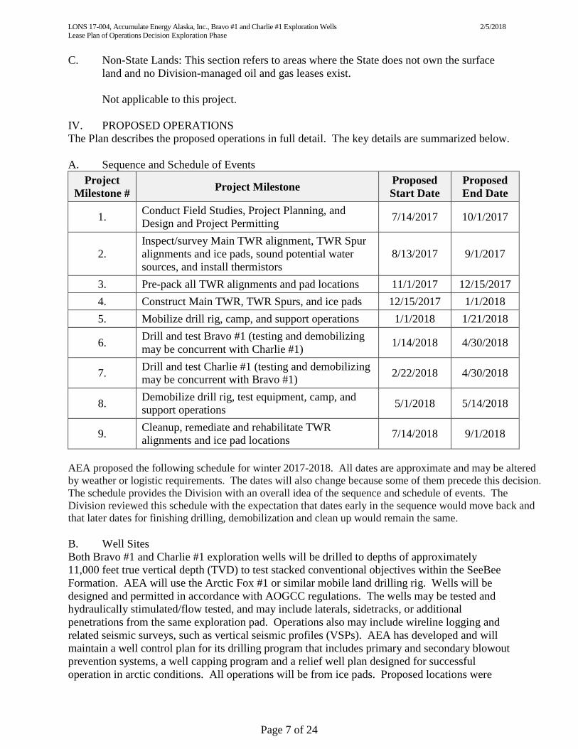
Not applicable to this project. IV. PROPOSED OPERATIONS The Plan describes the proposed operations in full detail. The key details are summarized below. A. Sequence and Schedule of Events
Project Milestone # Project Milestone Proposed
Start Date Proposed End Date
1. Conduct Field Studies, Project Planning, and Design and Project Permitting 7/14/2017 10/1/2017
2. Inspect/survey Main TWR alignment, TWR Spur alignments and ice pads, sound potential water sources, and install thermistors
8/13/2017 9/1/2017
3. Pre-pack all TWR alignments and pad locations 11/1/2017 12/15/2017 4. Construct Main TWR, TWR Spurs, and ice pads 12/15/2017 1/1/2018 5. Mobilize drill rig, camp, and support operations 1/1/2018 1/21/2018
6. Drill and test Bravo #1 (testing and demobilizing may be concurrent with Charlie #1) 1/14/2018 4/30/2018
7. Drill and test Charlie #1 (testing and demobilizing may be concurrent with Bravo #1) 2/22/2018 4/30/2018
8. Demobilize drill rig, test equipment, camp, and support operations 5/1/2018 5/14/2018
9. Cleanup, remediate and rehabilitate TWR alignments and ice pad locations 7/14/2018 9/1/2018
AEA proposed the following schedule for winter 2017-2018. All dates are approximate and may be altered by weather or logistic requirements. The dates will also change because some of them precede this decision. The schedule provides the Division with an overall idea of the sequence and schedule of events. The Division reviewed this schedule with the expectation that dates early in the sequence would move back and that later dates for finishing drilling, demobilization and clean up would remain the same. B. Well Sites Both Bravo #1 and Charlie #1 exploration wells will be drilled to depths of approximately 11,000 feet true vertical depth (TVD) to test stacked conventional objectives within the SeeBee Formation. AEA will use the Arctic Fox #1 or similar mobile land drilling rig. Wells will be designed and permitted in accordance with AOGCC regulations. The wells may be tested and hydraulically stimulated/flow tested, and may include laterals, sidetracks, or additional penetrations from the same exploration pad. Operations also may include wireline logging and related seismic surveys, such as vertical seismic profiles (VSPs). AEA has developed and will maintain a well control plan for its drilling program that includes primary and secondary blowout prevention systems, a well capping program and a relief well plan designed for successful operation in arctic conditions. All operations will be from ice pads. Proposed locations were

LONS 17-004, Accumulate Energy Alaska, Inc., Bravo #1 and Charlie #1 Exploration Wells 2/5/2018 Lease Plan of Operations Decision Exploration Phase
Page 8 of 24
inspected in mid-August during field work, and pads were located and staked based on terrain considerations and to avoid damaging willows, which are important food sources for local wildlife. Each ice pad (500 feet by 500 feet) footprint covers approximately 5.7 acres. C. Buildings Temporary facilities used to support the Exploration Program at each wellsite include a satellite office camp, storage and laydown areas, communication tower and Conexes, and maintenance shops. There also will be a camp at Bravo #1, which will include offices, restroom, foodservice, and recreation areas. AEA plans to place the camp at the Bravo #1 ice pad for the duration of the Exploration Program; however, the camp may be moved between pads. The satellite office camp will be moved with the drill rig between pads. A construction staging pad is planned to be constructed at the start of the Main TWR, about one mile west of Dalton Highway milepost 386.5. This location is west of the Dalton Highway right-of-way, within the Dalton Highway Transportation Corridor. The staging ice pad (500 feet by 500 feet) will also be roughly 5.7 acres and may have a self-contained TWR construction camp, as well as laydown areas and maintenance shops. D. Fuel and Hazardous Substances Ultra-low sulfur diesel fuel will be trucked to the drill pads by commercial carrier for drilling, completion, and well testing operations. AEA anticipates that approximately 16,800 gallons of fuel will be stored at each drill site in double-walled aboveground storage tanks (ASTs) staged within secondary containment areas (SCAs) providing 110 percent of AST volume plus seasonal precipitation containment. No individual fuel storage tank will exceed 9,990 gallons. An onsite tanker truck will fuel ancillary equipment such as heaters, light plants, and heavy equipment. Fuel and hazardous substance storage will comply with state and federal oil pollution prevention and contingency requirements found in 18 AAC 75, 40 CFR 112 and North Slope Borough Municipal Code (NSBMC) § 19.50 and § 19.70. ASTs used to store flammable and combustible liquids are regulated by the EPA and will comply with the International Fire Code and 13 AAC 50.025. Fuel storage, handling, transfers, and spill reporting will be conducted in accordance with the North Slope Environmental Field Handbook (NSEFH), the Alaska Safety Handbook (ASH), and AEA’s ODPCP, which was approved by the DEC as Plan No. 15-CP-5241. All bulk hazardous fluid and fuel transfers will be conducted in accordance with the fluid transfer guidelines described in the NSEFH and AEA’s Fluid Transfer Checklist. A variety of commonly-used water-based mud drilling fluids and additives will be used to provide and maintain the correct drilling mud formulation for the conditions being drilled. Other drill fluid chemicals required for testing and well stimulation may also be used. The various additives are provided in 5-gallon pails, 55-gallon drums, or a variety of different sized (250-400 gal) containers regulated by the United States Department of Transportation (USDOT) or EPA, and will be stored within SCA. All fuel and drill fluid SCAs are inspected daily by the on-site spill technician. All unused products will be returned to the supplier. All used fluids will be disposed of in accordance with AEA’s Waste Management Plan and other applicable guidance documents and contract/ballot agreements. During fuel and fluid transfer operations, equipment storage, or maintenance activities, the site will be protected from leaking or dripping fuel and hazardous substances using drip pans or other surface liners designed to catch and hold fluids under the equipment or by creating a specialized area using an impermeable liner or other suitable containment mechanism. Appropriate spill response equipment, as required in ODPCP 15-CP-5241, will be staged on location and

LONS 17-004, Accumulate Energy Alaska, Inc., Bravo #1 and Charlie #1 Exploration Wells 2/5/2018 Lease Plan of Operations Decision Exploration Phase
Page 9 of 24
managed/maintained by an on-site spill technician contracted through Alaska Chadux Corporation (ACC). Trained spill technicians and fuel contractor personnel, operating under the Fluid Transfer Procedures, will attend all fuel and fluid transfer operations. A copy of ODPCP 15-CP-5241 will be kept on site for guidance in controlling and cleaning up any accidental discharges of fuels, lubricants or produced fluids. The plan will include immediate response actions, reporting requirements, communication trees, receiving environments, spill cleanup mobilization response times, well control information, and spill prevention guidance. Information related to immediate response actions, receiving environments, spill cleanup mobilization response times, and well control can be found in the ODPCP. AEA also has an approved SPCC Plan for tanks to be operated at exploration sites, including Bravo #1 and Charlie #1. The drilling and well testing contractors will develop and provide SPCC plans specific for their operations in support of the drilling and testing operations. The plans will be maintained and available on site. Contractor crews will be trained in the appropriate response and prevention strategies. E. Solid Waste Sites Waste Management and Disposal: All waste management activities will be conducted in general accordance with the AEA Icewine Project Waste Management Plan (WMP) and in conformance with AEA HSE Management Policies. Additionally, the latest versions of the ASH, NSEFH, and the Alaska Waste Disposal and Reuse Guide are adopted as guidance, reference, and standard operating procedures and workplace “best” safety, environmental, and waste management practices for AEA operations. Resource Conservation and Recovery Act (RCRA) - Exempt Wastes: Four waste streams, exempt from regulation as RCRA hazardous wastes per 40 CFR 261.4 and 261.7, will be generated during operations. These include: 1) Exploration and Production (E&P) fluids and solids from drilling and testing operations); 2) residue and rinsate found in RCRA empty containers; 3) household hazardous wastes; and, 4) domestic wastewater from camps and envirovacs. Up to 4,000 barrels (bbls) of drilling wastes and another 4,000 bbls of test fluids will be generated during drilling, and then temporarily stored onsite before being transported and disposed by injection in either offsite Class I or Class II Underground Injection Cell disposal wells. Non-oily E&P solid drill cuttings may also be transported to the North Slope Borough Service Area 10 (NSB-SA-10) landfill for reuse as sanitary cover. Finally, on-site disposal through annular injection, as approved by the AOGCC (using Sundry Form 10-403), may be conducted. All methods will be managed and tracked using North Slope Manifest procedures. Residue and tank rinsate found in RCRA empty tanks and vessels will be manifested, hauled, and disposed by injection in offsite Class I or II disposal injection wells as they are generated at tank wash bays after drilling and testing operations. RCRA-exempt household hazardous wastes generated from camp operations will be combined with domestic wastewater and temporarily stored in the camp sewage tank modules before being hauled to the NSB-SA-10 wastewater treatment plant for disposal. The camp is expected to generate less than 3,000 gallons per day of domestic wastewater and less than one gallon per day of household hazardous wastes.

LONS 17-004, Accumulate Energy Alaska, Inc., Bravo #1 and Charlie #1 Exploration Wells 2/5/2018 Lease Plan of Operations Decision Exploration Phase
Page 10 of 24
Non-hazardous Solid Waste: Solid waste will be stored on site in Municipal Solid Waste (MSW) and Construction and Demolition (C&D) Dumpsters that will be hauled to and disposed in the NSB-SA-10 landfill. MSW and C&D Dumpsters will be covered to avoid potential wildlife interactions. Metal will be collected and sent offsite for recycling. Oily waste will be managed and stored on site until transport to an approved disposal facility. Used oil will be packaged in drums for transport and recycled or disposed at an approved facility. Hazardous and Universal Wastes: RCRA-hazardous wastes expected to be generated during construction, drilling, and production operations include very small quantities of Characteristic Hazardous and Universal Wastes (as defined by 40 CFR 261.3) that will be managed on site in Satellite Accumulation Areas, manifested, and then transported to approved disposal or recycling facilities at the completion of the field operations. F. Water Supplies During operations, up to 5,000 gallons per day (gpd) of potable water will be required for domestic use. Potable water will be transported to the camp and rig pads by water truck. For other fresh water uses, AEA will request temporary water use authorizations from DNR/DMLW for withdrawal of ice chips and water from 37 area lakes. This water use will total about 98 million gallons (Mgal) as follows: 89 Mgal for TWR and ice pad construction and maintenance (fresh water and ice chips combined), five Mgal for drilling operations and four Mgal for stimulating and testing each well. Snow will be removed from portions of the lakes prior to water withdrawal to help provide access for water trucks and ice trimmers. Water pumped from lakes will be transported by low ground pressure vehicles or rolling stock once winter tundra travel is approved by DNR. Rolling stock will only use trails that have been improved with a firm ice surface or packed snow to support the weight and pressure of the vehicles. Snowmelt and other run-off from project facilities will be managed through implementation of AEA Best Management Practices (BMPs) and a Storm Water Pollution Prevention Plan (SWPPP) pursuant to the Alaska Pollutant Discharge Elimination System (APDES) general permit for North Slope activities (NS GP AKG32000). G. Utilities Electrical, natural gas, sewer, and water utilities will not be designed or located on the ice pads. Rig operations will be self-contained and powered by generators. Smaller dual generator sets will provide power to camps, offices, and other facilities. Satellite phone service and internet will be available at each field camp. Operational radio communications will utilize fixed base stations and truck-mounted radio equipment, with small communication towers placed at each pad. Potable water will be hauled to the site and domestic wastewater hauled from the site. Emissions sources for the construction, drilling and operations will be similar to equipment and sources at other exploration drilling projects on the North Slope. Therefore, air emissions sources from the project related to construction, drilling, and operations will be authorized under a DEC Oil or Gas Drilling Rigs Minor General Permit MGP1. H. Material Sites Not Applicable.

LONS 17-004, Accumulate Energy Alaska, Inc., Bravo #1 and Charlie #1 Exploration Wells 2/5/2018 Lease Plan of Operations Decision Exploration Phase
Page 11 of 24
I. Roads The proposed TWR alignments and ice pad locations reflect the results of fieldwork conducted by AEA in mid-August, when a field team mapped routes and locations that avoided higher, drier tundra covered by shrubs, forbs, and tussock vegetation. Starting in November 2017, winter operations will include pre-packing and constructing the Main TWR and two TWR Spurs (Bravo TWR Spur and Charlie TWR Spur) to access the Bravo #1 and Charlie #1 drill sites, where two ice pads will be built to support drilling operations. Project road activities include the following: 1) constructing the 18.75-mile long Main TWR starting at Dalton Highway milepost 386.5; 2) constructing a 500-foot by 500-foot ice staging pad within one mile of the start of the Main TWR; 3) constructing the 3.75-mile long Bravo TWR Spur to the Bravo #1 pad location and then constructing the 500-foot by 500-foot Bravo #1 ice pad; and, 4) constructing a 17.75-mile long Charlie TWR Spur and then constructing the 500-foot by 500-foot Charlie #1 ice pad. All TWRs will be built to accommodate drill rig moves, and pads built large enough to safely carry out drilling and support operations. All TWRS and ice pads will be constructed and maintained using the generally accepted practices for the North Slope, subject to DNR opening criteria for winter tundra travel in the lower North Slope Foothills. Pre-packing of the trail will be requested prior to the official tundra opening to drive frost down and preserve early snow. Additionally, TWR crossings at established subsistence and winter trails will be constructed to provide a smooth transition to ensure trail users have safe passage. Upon completion of use, TWR stream crossings will be slotted, breached, or weakened to facilitate breakup and minimize potential impacts to stream banks. Any snow or ice used as fill for ramps will be removed from banks in a manner that does not disturb the natural stream bank. J. Airstrips Two locations for ice airstrips have been identified: Option 1 – (preferred) ice airstrip constructed on Lake A28 within U004N010E, Sec. 12-13 and U004N/011E, Sec. 7; and, Option 2 (alternative) - ice airstrip constructed on Lake A23 within U004N011E, Sec. 7. Although two airstrip locations have been identified, only one may be selected and constructed. The ice airstrip will facilitate transportation of materials and personnel crew changes. The ice airstrip will be approximately 300 feet by up to 5,000 feet and will be planned, permitted, and constructed with appropriate lighting and control systems to accommodate up to 30-passenger aircraft. K. All Other Facilities and Equipment Heavy Equipment: The number and types of vehicles and equipment generally used in construction and maintenance of the ice road and drilling operations include the following: Tucker snow-cats with portable ice auger drills; Caterpillar motor graders; Caterpillar 966 loaders, snow blowers, and ice trimmers; loader-mounted Caterpillar D-6 dozers; tractor/maxi-haul (30cy) dump trailers and Cat hard tail end dumps; tractor/325-bbl vacuum trucks; 15 cubic yard supersuckers; 130-bbl conventional water tanker trucks and 200-bbl water buffaloes; mechanic field service trucks; 5000-gal fuel tanker trucks; crew buses; vans; and pickups. Equipment types will be the same used for North Slope oil and gas operations and will be obtained from North Slope contractors. Medical Evacuation (per AEA Medical Evacuation Plan): Resources will be mobilized from Prudhoe Bay Unit in the event of a major medical issue or fire to provide additional emergency response, per an existing Ballot Agreement. Medical evacuation, if necessary, will be provided by ambulance, helicopter, or fixed-wing aircraft,

LONS 17-004, Accumulate Energy Alaska, Inc., Bravo #1 and Charlie #1 Exploration Wells 2/5/2018 Lease Plan of Operations Decision Exploration Phase
Page 12 of 24
directly from the TWRs or Franklin Bluffs airstrip to the Beacon Clinic in Deadhorse for patient stabilization and transfer via Medevac jet to an Anchorage hospital facility. If weather precludes fixed and rotary medevac operations from the TWRs, then the patient will be transported via ambulance to Fairweather Deadhorse Aviation Center (DAC) for evacuation. L. Rehabilitation Plan Upon completion of drilling and evaluation operations, the wells will either be plugged and abandoned or suspended in accordance with AOGCC regulations. Equipment and structures will be removed from the project area at the end of the season. Ice pads and roads will be scraped to remove dark-colored drips missed by the ACC spill technician and the resulting snow will be thawed with resulting oily water disposed of at a permitted disposal facility. Trash and debris will be removed and transported for disposal at a permitted disposal facility. AEA will conduct an inspection and stick-picking operation in Summer 2018 to ensure that NSB and State cleanup requirements have been met. Although activities will be conducted from TWRs and ice pads, impacts to vegetation and habitat may occur. Therefore, AEA will inspect the project area following snowmelt in 2018 to confirm that tundra damage did not occur. If tundra damage is discovered, then AEA will consult with the State and NSB to first determine the appropriate methods for restoration, and then incorporate them into a Tundra Damage Rehabilitation/Remediation Plan that meets requirements found in NSBMC § 19.30, 19.500, and § 19.60; ADL 393058 and 393043 lease conditions; and specific State requirements. The Plan will address the area, type, and extent of damage and will be developed in accordance with the Alaska Coastal Revegetation and Erosion Control Guide (developed by the State of Alaska Plant Materials Center), the Streambank Revegetation and Protection Guide (developed by the ADFG), and other relevant guidance documents. Agency personnel will be invited to verify that rehabilitation operations are complete and that any issues identified are addressed. M. Operating Procedures Designed to Minimize Adverse Effects Fish and Wildlife Habitats: Ice pads and ice roads are to be used only in winter months during the open winter tundra travel season. Streams will be crossed in shallow waters that normally freeze to bottom or will be bridged using temporary bridges founded on ice ramps and abutments. Willow habitats were identified/located during fieldwork in August 2017 and the TWR alignments staked to avoid them during TWR and ice pad construction. In summary, all AEA activities will be conducted to minimize impacts on fish and wildlife. This includes mitigation measures outlined in the ADL lease stipulations and adherence to State of Alaska and NSB land management regulations and permit requirements. A wildlife avoidance and interaction plan and a bear avoidance interaction plan (for both grizzly and polar bears) has been prepared and will be included in the site orientation for all project personnel. Historic and Archaeological Sites: AEA has completed a consultation, survey, and fieldwork to inventory prehistoric, historic, and archeological sites (resources) on and around the proposed ice pads and TWR alignments. This work was performed in June 2017 by Reanier & Associates, Inc. (Reanier). As part of the survey, TLUI data was obtained by Reanier from the NSB Inupiat Heritage and Language Center (NSB IHLC) and reviewed, along with data from Alaska Heritage Resource Survey and National Register of Historic Places. This data and a field report will be submitted for review by the NSB

LONS 17-004, Accumulate Energy Alaska, Inc., Bravo #1 and Charlie #1 Exploration Wells 2/5/2018 Lease Plan of Operations Decision Exploration Phase
Page 13 of 24
Planning and Land Management Department, Cultural Resources Office, and the DNR/OHA. The data and field report both indicate there are no archaeological, historic, or cultural resources within 0.4 miles of the Main TWR alignment, Bravo TWR Spur, or Charlie TWR Spur alignments, or staging and drill ice pad locations. Additionally, AEA has created a series of 500-foot buffers around sites Reanier identified during the study, where traffic will be excluded. Combined with drilling operations limited to winter when the ground is frozen and covered snow, these zones will help provide adequate protection for the historic and archaeological resources. Finally, it is AEA’s intention that historic, cultural, and archaeological resources (or suspected resources) discovered during project activities are not to be disturbed under any circumstance. This will include providing relevant training to all field personnel as part of the project orientation. If archaeological sites are discovered during project activities, then the following steps will be taken:1) Project personnel discovering historical or archaeological (or suspected) resources during operations will not disturb materials in place at the site of discovery and mark the area with flagging tape; 2) Project personnel will stop all activities and then inform their job supervisor so as to contact AEA’s onsite representative; 3) AEA will then report these properties to SHPO and NSB ILHC for identification and assessment, and 4) AEA will use identification and assessment consultations to guide further planned activities in the site area. Public Use Areas: The proposed operations occur near the Nuiqsut Subsistence Use area. AEA will conduct operations to minimize any adverse effects on subsistence uses and avoid conflicts with private, commercial, and industrial users. If potential subsistence issues are identified, then subsistence representatives will be contacted and updated during drilling and testing operations to minimize impacts. The permitting actions associated with the exploration wells will be public noticed as part of the permitting processes. If there are public concerns about the project, then AEA will be receptive and proactive. Although public access to the AEA TWR must be restricted due to safety concerns, AEA will provide shelter and assistance to subsistence users in emergency situations. Other Uses: Permits and Leases: AEA will contact all lessees and permittees before entering their surface lands and gain approval through letters of non-objection. Simultaneous Operations: The only other use in the general area will be possible activities by other oil and gas companies or geophysical companies. When identified, AEA will contact those companies to discuss and avoid simultaneous operations problems. Training Programs: AEA’s training program has been designed to inform individuals of the environmental, social, and cultural concerns that relate to their job functions. Training components include a review of permit stipulations and requirements, cultural awareness, spill prevention and reporting, wildlife interaction, site specific safety, and waste management practices. All personnel will participate in a specific training program module for bear safety and a briefing of the Bear Avoidance, Interaction, and Mitigation Plan. In addition, AEA employees and contractors are required to complete an 8-hour training program provided by the North Slope Training Cooperative (NSTC). NSFEH, ASH, and a North Slope Visitor's Guide are used for the training. The training program

LONS 17-004, Accumulate Energy Alaska, Inc., Bravo #1 and Charlie #1 Exploration Wells 2/5/2018 Lease Plan of Operations Decision Exploration Phase
Page 14 of 24
includes classes on the ASH, personal protective equipment, camp and safety orientation, hazard communication, Hazardous Waste Operations, Emergency Response Level l, and Environmental Awareness. Additionally, AEA requires that all company personnel and contractors attend rig and location safety meetings and participate in the contractor’s safety practice on-site training orientation and required weekly safety meetings. Topics discussed in safety meetings will include various emergency action drills familiarizing workers with the wildlife interaction plans, warnings and hazing methods, reviewing spill/incident reporting requirements and spill prevention measures, reviewing fluid transfer procedures, general hazard identification regarding the various chemicals used in drilling operations and other activities, reviewing cold weather operations, and personal protection. Interacting with Local Communities and Community Groups: As part of the permitting process, AEA has published public notices detailing planned winter drilling program operations in Utqiagvik, Fairbanks, and Anchorage, and has been responding to requests for additional information from individuals and non-government organizations interested in the project.
In approving a Plan, DNR may require amendments necessary to protect the State’s interest (11 AAC 83.158). The Division has determined that to protect the State’s interest, it is necessary to incorporate the 2008 North Slope Mitigation Measures or the most recently adopted North Slope Areawide Mitigation Measures. AEA addressed these mitigation measures in the application process, but it is necessary to amend the Plan to make clear that the Plan incorporates the North Slope Mitigation Measures. All plan applicants must complete a mitigation measure analysis form demonstrating that each mitigation measure is satisfied or inapplicable to the proposed Plan, or that the applicant is seeking an exception. The North Slope Mitigation Measures allow the Division to grant an exception if the applicant shows that compliance with the measure is not practicable or that the applicant will undertake an equal or better alternative to satisfy the intent of the mitigation measure. AEA completed the mitigation measure analysis for the North Slope areawide and no exceptions were requested. The Division has determined that to protect the State’s interest, it is necessary to incorporate the North Slope Mitigation Measures as amendments and stipulations to this Plan (11 AAC 83.158(e)). N. Phased Evaluation This Plan begins AEA’s exploration of 11 oil and gas leases; ADLs 393067, 393066, 393068, 393049, 393059, 393047, 393046, 393051, 393052, 393043, and 393050. Oil and gas lease ADLs 392298, 392785, 393133, and 393078 were previously phased and evaluated by Lease Operations Number (LONS) 16-006. ADL 392301 was also phased and evaluated by LONS 15-001. The Plan addresses exploration activities for Bravo #1 and Charlie #1, but based on the results of this exploration, the Division anticipates that AEA may submit Plans for additional exploration wells. Thus, in considering the exploration phase, the Division considered both the specific activities proposed under this Plan as well as typical exploration activities that AEA might propose for further exploring the leases.

LONS 17-004, Accumulate Energy Alaska, Inc., Bravo #1 and Charlie #1 Exploration Wells 2/5/2018 Lease Plan of Operations Decision Exploration Phase
Page 15 of 24
The Division considered the potential impacts of exploration on public and State interests. In the oil and gas context, the public interest includes maximizing economic and physical recovery of oil and gas resources (AS 38.05.180(a)(1)). The State has an interest in protecting the public interest, and in encouraging assessment of oil and gas resources while minimizing the adverse impacts of exploration, development, production, and transportation activities (AS 38.05.180(a)(2)). In considering potential impacts, the Division also considered the operating procedures AEA has designed to minimize adverse effects of the Plan activities. These operating procedures include complying with the mitigation measures attached to the leases. These measures come from the North Slope Areawide Best Interest Finding (BIF) to address potentially negative effects of oil and gas exploration on fish and wildlife species, habitats and their uses, subsistence uses and local communities. AEA has provided a mitigation measure analysis, which is required as part of their Plan submittal. i. Facilities impacts on the project area
All proposed facilities are temporary in nature and will take place on the existing FBP. AEA has designed, sited, and proposes to operate the exploration drilling facilities in accordance with the North Slope Mitigation Measures. All activities are proposed to take place on the existing gravel pad and are intended to avoid and minimize impacts to wetlands. No new gravel placement is proposed for AEA’s Bravo #1 and Charlie #1 Exploration Program. The Dalton Highway will be used to transport supplies and equipment from Prudhoe Bay to the project area. Demobilization of the facilities is expected to occur in May 2018, in accordance with the North Slope Mitigation Measure A.1.i. Equipment and structures will be removed from the project area at the end of the season. The well will be plugged and abandoned or suspended in accordance with AOGCC regulations. Fuel and hazardous substances potential impacts on the project area The exploratory drilling proposed under the Plan, as well as other exploratory drilling AEA might propose during the exploration phase, will result in drilling muds, cuttings, and produced water and pose some risk of a spill. Discharges of drilling muds, cuttings, and produced waters; oil spills; and accidental spills of fuel, lubricants, or chemicals can all have impacts to water, wildlife, and habitats during this exploration program. Impacts from exploration activities, from either disposal activities or a spill, could adversely affect water quality, but impacts are expected to be local and temporary because of dilution, settling, and other natural altering and regenerative processes. Drilling Muds and Produced Water Byproducts of drilling activities include muds and cuttings, produced water, and associated wastes. Produced water contains naturally occurring substances such as clay, sand, oil, water, and gas. Most drilling wastes are disposed of under Alaska DEC’s Solid Waste Program. Reinjection is the preferred method for disposal of drilling fluid. Disposal of drilling muds and cuttings requires permit approval. Most oil field wastes are considered non-hazardous and waste fluids are recycled, filtered, and treated before reinjection or disposal. Cuttings and waste fluids must be made non-hazardous before injection. Produced water is treated using heat, gravity settling, and gas flotation devices to remove hydrocarbons. After treatment, produced water is reinjected into either the oil-bearing formation, to maintain pressure and enhance recovery, or into an approved

LONS 17-004, Accumulate Energy Alaska, Inc., Bravo #1 and Charlie #1 Exploration Wells 2/5/2018 Lease Plan of Operations Decision Exploration Phase
Page 16 of 24
disposal well. Cuttings disposal is done through grinding and injecting onsite, or cuttings are transported to an approved disposal site. Wastewater, including sanitary and domestic graywater, is also treated to meet effluent guidelines before discharge. During exploration drilling, muds and cutting are stored on site, in holding tanks, or in a temporary reserve pit and then either hauled to an approved solid waste disposal site or reinjected into the subsurface at an approved injection well. All production muds and cuttings on the North Slope are reinjected into a Class II injection well. All produced waters are reinjected either into the producing formation or into an injection well. The AOGCC oversees the proper and safe handling and disposal of drilling wastes and oversees the underground operation of the Alaska oil industry on private and public lands and waters. The AOGCC administers the Underground Injection Control Program for oil and gas wells, acts to prevent waste of oil and gas resources and ensure maximum recovery, and protects subsurface property rights. All disposal wells inject fluids deep beneath any drinking water aquifers. North Slope Mitigation Measure A.4.j states that the preferred method for disposal of muds and cuttings from oil and gas activities is by underground injection. AEA’s Plan states that waste drilling muds and cuttings will be hauled to the PBU G&I Facility for processing and disposal. Solid drilling waste may be placed in open-top metal tanks or shale bins located next to the drilling mud processing units. Waste liquid drilling fluids will be stored in closed tanks. The drilling waste can be pumped out of the tanks/bins and hauled directly offsite for disposal, or temporarily stored on-site in shale bins until frozen prior to disposal. Drilling waste, to the extent practicable, will be transported as it is generated. After the removal of drilling waste from the storage area, a visual site inspection will be performed to verify that all drilling waste has been removed. A final site inspection report including drilling waste volume and final disposition of waste will be submitted to DEC as required under 18 AAC 60.430. All drilling waste will be disposed of prior to completion of winter operations. All fluids from production testing will be passed through a test separator system to separate gases and stored in tanks until the testing is completed. After testing, the fluids will either be injected back into the formation from which it was produced, or hauled to North Slope oil and gas production facilities for processing and/or product recovery. Accidental Spills Impacts resulting from accidental spills would depend on the type of product, the location, volume, season, duration of the spill or leak, and the effectiveness of the cleanup response. Heavy equipment, such as trucks, tracked vehicles, and tank trucks, commonly use diesel fuel, gasoline, motor oil, hydraulic fluid, antifreeze, and other lubricants. Spills or leaks could result from accidents, during refueling, or from corrosion of lines. Fuel and hazardous substances must have secondary containment apparatuses. A secondary containment or surface liner must be placed under all container or vehicle fuel tank inlet and outlet points, and appropriate spill response equipment must be on-hand during any transfer or handling of fuel or hazardous substances. AEA’s Plan states that fuel will be stored in lined, bermed fuel storage areas or appropriate fuel storage areas that will hold a minimum of 110 percent of the maximum capacity of fuel storage. Fuel storage, handling, transfers, and spill reporting will be conducted in accordance with the requirements described in AEA’s C-Plan (15-CP-5241), NSEFH, and ASH. Fuel will

LONS 17-004, Accumulate Energy Alaska, Inc., Bravo #1 and Charlie #1 Exploration Wells 2/5/2018 Lease Plan of Operations Decision Exploration Phase
Page 17 of 24
be resupplied to the site either from the existing North Slope oil and gas operations or from the existing operations on the North Slope. Oil Spills The effects of an oil spill during the winter are limited due to the short season and temporary nature of the exploration program. There are no production activities, permanent facilities, or pipelines proposed. AEA has proposed temporary activities during winter months, and the Division anticipates any future exploratory drilling would also take place during the winter when the risk from spills is lower. Mitigation measures include development of oil spill contingency plans and providing adequate spill response training. North Slope Mitigation Measures require that sites be protected from leaking or dripping fuel and hazardous substances; secondary containment shall be placed under all container or vehicle fuel tank inlet and outlet points, hose connections, and hose ends during fuel or hazardous substance transfers; vehicles cannot be refueled within the annual floodplain; containers must be marked with the contents and lessee/contractor name; waste from operations be reduced, reused, or recycled to the maximum extent practicable; muds and cuttings should be disposed of by underground injection, where practicable; and that proper disposal of garbage and putrescible waste be utilized. AEA’s mitigation measure analysis states that fuel and hazardous substances will be stored at least 100 feet from any water body and no known surface drinking water sources are in the vicinity of proposed project operations (A.4.b). Drip pans or liners will be placed under parked vehicles or equipment to capture fluids (A.4.c) and surface liners will be used under all potential spill points. AEA will verify that adequate sorbents are on hand during fuel transfers and ensure that personnel are property trained and understand proper procedures for handling flammable and combustible fluids (A.4.d). All containers with fuel or hazardous substances will be labeled with the contents and the lessee’s or contractor’s name (A.4.f); and solid burnable waste may be incinerated in location. All wastes generated as part of operations will be hauled offsite for disposal at an approved facility (A.4.h).
ii. Habitat, Fish, Wildlife and Subsistence Any exploration activity can impact habitat, fish, and wildlife. The North Slope Mitigation Measures are designed to minimize these impacts. The Plan activities will take place over a limited time and involve gravel roads and temporary facilities. The Division anticipates impacts to habitat, fish, and wildlife will also be limited and temporary. The Division also anticipates that any future Plans for the exploration phase will involve similarly limited and temporary activities and impacts. Fish The Sagavanirktok River is an anadromous stream, supporting the spawning and overwintering of several species of fish that then migrate to nearshore coastal waters to feed in the summer. Migration patterns vary by species and within species by life stage. Potential effects of exploration activities include degradation of stream banks and erosion, reduction of or damage to overwintering areas, impediments to migration, and

LONS 17-004, Accumulate Energy Alaska, Inc., Bravo #1 and Charlie #1 Exploration Wells 2/5/2018 Lease Plan of Operations Decision Exploration Phase
Page 18 of 24
fish kills due to oil spills. A potential habitat impact at the exploration phase is erosion. Erosion results in siltation and sedimentation, which in turn may result in a reduced or altered stream flow that may affect overwintering habitat availability and the ability of fish to migrate upstream. Protecting the integrity of stream bank vegetation and minimizing erosion are important elements in preserving fish habitat. Streambeds could be affected if stream banks are altered from equipment crossings. Withdrawal of water from lakes and ponds could affect fish overwintering habitat by entraining juvenile fish, lowering water levels, and increasing disturbance. Removal of water from lakes where fish overwinter may affect the viability of overwintering fish, and longer-term effects of lake drawdown may impede the ability of fish to return to the lake in subsequent years. Removal of snow from lakes may increase the freeze depth of the ice, kill overwintering and resident fish, and adversely affect the ability of fish to utilize the lake in future years. North Slope Mitigation Measure A.2.b requires that removal of water from fish-bearing rivers, streams, and natural lakes have prior written approval by DMLW and ADFG. Water intake pipes used to remove water from fish-bearing waterbodies must be surrounded by a screened enclosure to prevent fish entrainment and impingement, with screen mesh size no greater than one mm (0.04 inches), unless another size is approved by ADFG. The maximum water velocity at the surface of the screen enclosure may be no greater than 0.1 foot per second, unless an alternative has been approved by ADFG. Before a permit to appropriate water is issued, DMLW considers local demand and may require applicants to conduct aquifer yield studies. Generally, water table declines associated with the upper unconfined aquifer can be best mitigated by industrial users tapping confined (lower) layers or searching for alternate water sources. Wildlife Exploration-related disturbance is expected to have minor impacts on caribou, particularly large groups, with animals being briefly displaced from feeding and resting areas when vehicles pass nearby. Vehicle traffic associated with transportation corridors, such as the Dalton Highway, has the potential to affect habitat use. Acute disturbance effects may in combination result in a cumulative effect on habitat availability for those individuals with fidelity to the Kuparuk River calving area, but may have little or no effect on the Central Arctic herd population. It is expected these disturbances would be short term. Moose are present across the North Slope, with the largest concentration along the Colville River and its tributaries. Moose generally remain in the foothills and along river corridors. AEA’s proposed drilling program is expected to have little effect on the North Slope moose population. The temporary displacement of some polar bears from preferred habitats may result from routine exploration activities such as the proposed Plan activities and activities AEA proposes throughout the exploration phase. Females in dens are at risk for disturbance from any vehicular traffic or noise. Due to its proximity to existing transportation infrastructure, the Icewine-2 Exploration Well Plan is unlikely to significantly increase
LONS 17-004, Accumulate Energy Alaska, Inc., Bravo #1 and Charlie #1 Exploration Wells 2/5/2018 Lease Plan of Operations Decision Exploration Phase
Page 19 of 24
temporary displacement and disturbance above the level caused by existing transportation activities. Polar bears continually search for food. Once bears find a camp or industrial site, they will often enter to explore and search for food. If a bear receives a food reward, then it is more likely to return. Polar bears often investigate not only things that smell or act like food, but also novel sights or odors. Subadult bears are more likely than well-fed bears to be food-stressed and attracted to human activity. Subadults are also less likely to leave if a potential food source is present. Attractants include kitchen odors, deliberate feeding, accessible garbage, sewage lagoons, carcasses, industrial materials, and alteration of habitat. Brown bears can be found throughout the Arctic region in varying densities. The lowest densities occur along the coastal plain; brown bears are at the northern limits of their range in the Arctic. The availability of food is limited and their reproductive potential is low. Brown bears may be subject to disturbance from oil and gas activity. During exploration, human activity may attract foraging bears, especially to refuse disposal areas. Omnivores are attracted to food and food odors associated with human activity, and may become conditioned to non-natural food sources. This may pose a threat to human safety and the potential need to dispatch nuisance animals. Bears can also be displaced by human land use activities. There are several regulations imposed by state, federal, and local agencies that are implemented to avoid, minimize, and mitigate these potential effects to bears. In addition to complying with the Endangered Species Act and the Marine Mammal Protection Act, AEA must comply with mitigation measures to minimize effects of exploration activities on bears. Subsistence Traditional subsistence uses in the area include: brown bear, caribou, musk ox, and moose harvesting; hunting and trapping of furbearers such as wolf, fox, weasel, wolverine, and squirrel; hunting migratory waterfowl and collecting their eggs; fishing for whitefish, char, salmon, smelt, grayling, trout, and burbot; and collecting berries, edible plants, and wood. Potential exploration activities that could have effects on subsistence uses in the area include discharges from well drilling and ongoing disturbances from operation activities such as vehicle traffic. Noise, traffic disturbance, and oil spills generally produce short-term impacts on subsistence species. The North Slope Areawide BIF contains several mitigation measures intended to reduce conflicts with subsistence, commercial, and sport harvest activities. Prior to submitting a Plan to the Division, the lessee must consult with affected subsistence communities and the NSB to discuss reasonably foreseeable effects on subsistence during the proposed operations, and methods of proposed operations and safeguards or mitigation measures that can be implemented to prevent unreasonable conflicts. The lessee must make reasonable efforts to ensure that the proposed exploration activities are compatible with subsistence hunting and fishing and will not result in unreasonable interference with

LONS 17-004, Accumulate Energy Alaska, Inc., Bravo #1 and Charlie #1 Exploration Wells 2/5/2018 Lease Plan of Operations Decision Exploration Phase
Page 20 of 24
subsistence harvests. The Division may implement restrictions, as appropriate, to reduce potential conflicts.
iii. Historic or Archeological Sites While exploring, AEA could encounter prehistoric, historic, or archaeological sites. AS 41.35.200 addresses unlawful acts concerning cultural and historical resources. In addition, all field-based response workers are required to adhere to historic properties protection policies that reinforce that it is unlawful to collect or disturb, remove, or destroy any historic property or suspected historic property, and to immediately report any historic property that they see or encounter.
Under NSBMC, proposed exploration shall not impact any historic, prehistoric, or archaeological resource before the assessment of that resource by a professional archaeologist (NSBMC 19.50.030(F)). NSBMC 19.70.050(F) says, “Development shall not significantly interfere with traditional activities at cultural or historic sites identified in the Coastal Management Program.” These provisions give the NSB authority to protect cultural and historic resources and current subsistence uses of these sites.
North Slope Mitigation Measures require the lessee to conduct an inventory of prehistoric, historic, and archaeological sites within the area affected by an activity. The inventory must include consideration of literature provided by the NSB, nearby communities, Native organizations, and local residents; documentation of oral history regarding prehistoric and historic uses of such sites; evidence of consultation with the Alaska Heritage Resources Survey and the National Register of Historic Places; and site surveys. The inventory must also include a detailed analysis of the effects that might result from the activity. A cultural resources survey and inventory was conducted in the project area to identify any prehistoric, historic, or archaeological sites. AEA has obtained cultural clearances from the SHPO and NSB Cultural Resources Department on potential historical and archaeological resources. Because of the history and long-term use of the FBP, no sites are proposed that would impact cultural, historical or archaeological resources.
V. CONSIDERATION OF LEASE PLAN OF OPERATIONS REQUIREMENTS UNDER 11 AAC 83.158(c-d) AND 11 AAC 83.160 A. Full Payment of Damages to the Surface Owner 11 AAC 83.158(c) This project does not occur on non-State surface lands; therefore, this regulation does not apply. B. Plan Sufficiency 11 AAC 83.158(d) A proposed plan must include statements, maps, or drawings setting forth
(1) the sequence and schedule of operations; (2) the projected use requirements directly associated with the proposed operations; (3) plans for rehabilitation; and (4) a description of operating procedures to prevent or minimize adverse effects on
natural resources and concurrent uses of the area (11 AAC 83.158(d)).

LONS 17-004, Accumulate Energy Alaska, Inc., Bravo #1 and Charlie #1 Exploration Wells 2/5/2018 Lease Plan of Operations Decision Exploration Phase
Page 21 of 24
The information in Section IV: Proposed Operations, and additional information contained in AEA’s proposed Plan satisfy the requirements for a Plan under 11 AAC 83.158(d) and thus provide the Division with sufficient information to determine the surface use requirements and impacts directly associated with the proposed operations. C. Oil and Gas Lease Bond 11 AAC 83.160 Operations will be conducted on state-owned land. The proposed well will be drilled into state-owned mineral estate. A lessee provides for payment of damages by posting a bond before operations commence, and remains liable for full damages under the lease. AEA has an Oil and Gas Lease Bond in the amount of $100,000 for operations on ADL 392301 and continuing liability under the lease. AEA may also furnish a statewide bond in the amount of $500,000, which satisfies the bond requirements on all subject leases of this Plan. VI. CONSULTATION WITH OTHER GOVERNMENT ENTITIES In reviewing the proposed Plan, the Division considered the fact that AEA may require approvals from Agencies for other elements of its project. Although mentioned in the Plan and above, these aspects of the project are not approved by this decision and the Division offers no opinion on whether an agency should or should not approve these activities. In addition to considering the approvals required by Agencies as they relate to this decision, the Division provided an agency review and comment opportunity for the activities proposed for authorization under this decision. The following government entities were notified on October 13, 2017, for comment on the Plan: USACE, DOTPF, AOGCC, NSB, ADFG, DEC, and DNR. The comment deadline was 4:30 pm Alaska time on October 27, 2017. Comments were received and the Division, Applicant, and commenting agency(ies) reconciled the comments without modifying the Plan ; Agency comment(s) and Applicant's response(s) are summarized in Appendix B. The Plan was then publicly noticed. VII. PUBLIC NOTICE Public notice of the Plan and opportunity to comment, per AS 38.05.035, was published in the Alaska Dispatch News and Arctic Sounder on November 2, 2017, with a deadline for comments of December 2, 2017, at 4:30 pm Alaska time. Additionally, a copy of the notice was posted on State of Alaska and Division’s web sites and faxes of the public notice were sent to the Utqiagvik, Nuiqsut, and Deadhorse post offices. No public comments were received by the Division. VIII. CONDITIONS OF APPROVAL Having considered the proposed project, the Division approves the Plan as amended and modified by this decision and subject to the following Conditions of Approval. To protect the State’s interest, the Division finds that it is necessary to amend the Plan to incorporate the following Conditions of Approval:

LONS 17-004, Accumulate Energy Alaska, Inc., Bravo #1 and Charlie #1 Exploration Wells 2/5/2018 Lease Plan of Operations Decision Exploration Phase
Page 22 of 24
a) The applicant shall defend, indemnify, and hold the State of Alaska harmless from and against any and all claims, damages, suits, losses, liabilities, and expenses for injury to or death of persons and damage to or loss of property arising out of or in connection with the entry on and use of State lands authorized under this approval by the applicant, its contractors, subcontractors, and their employees.
b) The applicant shall inform and ensure compliance with any and all conditions of this approval by its employees, agents, and contractors, including subcontractors at any level.
c) Unless pre-authorized by a general permit, amendments and modifications to this approval require advance notice and must be approved in writing by the DNR.
d) The Commissioner of the DNR may require that an authorized representative be on site during any operations conducted under this approval. This stipulation is required to ensure that the Divisions of Oil and Gas and Mining, Land, and Water meet their statutory responsibilities for monitoring activities taking place on State-owned lands.
e) A status report for the activities conducted under this approval must be filed on May 1 and November 1 each year, from the date this approval is issued and until a final completion report is filed with the Division. If a lessee requests an assignment, then a status report must also be submitted during the assignment process. Failure to file in a timely manner may result in revocation of this approval.
a. Each status report shall include a statement describing and map(s) depicting all operations actually conducted on the leased area as of the date the report is prepared, which includes the location, design, and completion status of well sites, material sites, water supplies, solid waste sites, buildings, roads, utilities, airstrips, and all other facilities and equipment installed.
b. Upon completion of operations, the applicant will submit a completion report that will include all information required of a status report described in (a) above as well as a statement indicating the date of operations completion, any noncompliance with the terms of this plan approval of which a reasonable lessee would have knowledge of, clean-up activities conducted, the method of debris disposal, and a narrative description of known incidents of surface damage.
f) Notification. The applicant shall notify the DNR of all spills that must be reported under 18 AAC 75.300 under the timelines established therein. All fires and explosions must be reported to DNR immediately. The DNR 24-hour spill report number is (907) 451-2678; the fax number is (907) 451-2751. The DEC oil spill report number is (800) 478-9300. DNR and DEC shall be supplied with all follow-up incident reports.
g) A certified As-Built survey of the improvement shall be provided within one year of placement of the improvement. This As-Built must be submitted in both electronic and physical format.
To protect the State’s interest, the Division finds that it is necessary to amend the Plan to incorporate the following project-specific stipulations:
1. Geophysical Data Submission Requirement Form: The Applicant will notify the Division Director of the availability of processed seismic exploration data within 30 days of completion of initial processing and submit seismic exploration data. The Geophysical Data Submission Requirements can be found on the DNR Division’s website.
2. Geophysical Activity Completion Report Form: The Applicant must complete and return a Geophysical Activity Completion Report form for each VSP acquired. A non-confidential public

LONS 17-004, Accumulate Energy Alaska, Inc., Bravo #1 and Charlie #1 Exploration Wells 2/5/2018 Lease Plan of Operations Decision Exploration Phase
Page 23 of 24
completion report will be placed into the Plan file each time a VSP is completed. Geophysical Activity Completion reports must be submitted to the Division’s Resource Evaluation Section within 30 days of completion of all activities. For in-depth instructions on how to complete the form, please refer to the Division’s website. If no activities are completed under the Plan, then an Activity Completion Report form must be submitted on or before January 15, 2019; be sure to check box 27 to indicate the survey was cancelled.
3. Geophysical Processing Completion Report Form: The Applicant must complete and return a
Geophysical Activity Completion Report form for each VSP acquired. A confidential Processing Completion report will be submitted each time a VSP is completed. The Processing Completion reports must be submitted to the Division’s Resource Evaluation Section within 30 days of completion of initial processing. For in-depth instructions on how to complete the form please refer to the Division’s website.
IX. FINDINGS AND DECISION Having considered the proposed project and based on the foregoing discussion and consideration of issues and conditions of approval, the Division makes the following findings: 1. The Plan provides sufficient information, based on reasonably available data, for the Division
to determine the surface use requirements and impacts directly associated with the proposed operations.
2. The Plan includes statements, maps, or drawings setting forth the sequence and schedule of operations, projected use requirements, description of operating procedures, and a plan of rehabilitation designed to prevent or minimize adverse effects.
3. To protect the State’s interest and mitigate potential adverse social and environmental effects associated with the Plan, the Division finds it necessary to amend the Plan to incorporate the mitigation measures set forth in the North Slope Areawide Oil and Gas Lease Sale Final Finding.
4. All oil and gas activities conducted under oil and gas leases are subject to numerous local, state, and federal laws and regulations with which AEA is expected to comply.
5. The people of Alaska have an interest in developing the state’s oil and gas resources and maximizing the economic and physical recovery of those resources (AS 38.05.180(a)).
6. Alaska’s economy depends heavily on revenues related to oil and gas production and government spending resulting from those revenues. The related revenue sources include bonus payments, rentals, royalties, production taxes, income taxes, and oil and gas property taxes.
7. The potential benefits of approving this Plan outweigh the possible adverse effects, which have been minimized through imposition of mitigation measures, conditions of approval, and project specific stipulations, and thus approval of this Plan as modified is in the State’s best interest.
Based upon the Plan, supporting information provided by the applicant and the Division’s review; determination of applicable statutes and regulations; consultation with other agencies, relevant entities and individuals; public comment; and the above findings related to that Plan, the Division hereby approves the Plan and entry into the exploration phase.


B e a u f o r t S e a
Kupa
ruk
Rive
r
Tool
ikRi
ver
Sagav
anirk
tok
Rive
r
Colville
Rive
r
FigureExtent
AEA Lease Block courtesy of Mapmakers Alaska
A p p e n d i x A

292291
290 289
391655 391654
379
391653
317
391686
391684391683
320319316315312
209208
207 206
205204
203 202
391682 391681
233
137133 132
232
121 120
231 230
229228
227 226
117 116
225224
222
221220217216
391680
391679 391678
213212
211 210
145 144
391677
141 140136
391676391675
391674 391673
391672 391690
391689
391688391687
391685391671 391670
129 128125 124
391663 391662391661 391660391659 391658
473472
471
BA
B
ABA BAB
ABA
D
B
BABA
D
A
D
B
C
BA
DC
BA
DC
B
C
A
D
B
A
D
C
A
C
A
DCDCDDC
B
A
C
BA
DC
BA
DC
BA
DC
BA
DC
BA
DC
BA
DC
BA
A
DC
BA
C
A
DC
C
C
A B BA A
C
C
BA
DC
BA
CDC
A
D
A
D
B
DC
BA
DC C
B
DC
BA
DC
BA
A
D
DC
B
DC
BA
C
A
C
BA
DC
B
DC
BA
DC
A
DC
BA
DC
BA
DCDCDCDC
BA
DC
BA
DDCDC DC
A
DC
BA
DC
BA
DC
DC
B
DC
BA
DC
BA
DC
BA
392298
392299
392301
392302
392541
392540
392784
392785392783 392315392782 392313392781 392310392779 392780 392307
392748 392749
392750 392751
392723 392724
392725 392726
392752 392753
392754 392755
392719 392720
392721 392722
392762 392763
392764 392765
392731 392732
392733 392734
392766 392767
392768 392769
392727 392728
392729 392730
392771
392772
392737 392738
392739 392740
392773
392774
392735
392736
392744 392745 392295
392746 392747
392741 392297
392742 392743
392759 392296
392760 392761
392756 392300
392757 392758 392770
393151 393152
393153 393154
393155 393156
393157 393158
393135 393136
393137 393138
393147 393148
393149 393150
393139 393140
393141 393142
393143 393144
393145 393146
393131 393132
393133 393134
393159 393160
393161 393162
393099 393100
393101 393102
393103 393104
393105 393106
393107 393108
393109 393110
393111 393112
393113 393114
393119 393120
393121 393122
393123 393124
393125 393126
393115 393116
393117 393118
393127 393128
393129 393130
393044
393045
393054 393055
393056 393057
393058 393059
393060 393061
393070 393071
393072 393073
393074 393075
393076 393077
393080 393089 393090 393091 393092 393097 393098
393042
393043
393050 393051
393052 393053
393046 393047
393048 393049
393066 393067
393068 393069
393062 393063
393064 393065
393078
393079
393085 393086
393087 393088
393081 393082
393083 393084
393093 393094
393095 393096
Bravo #1Charlie #1
Franklin Bluffs Pad(ICEWINE #1 & #2)
ICEWINE Project
Utqiagvik-Barrow
JuneauAnchorage
Fairbanks
ICEWINE PROJECT EXPLORATION WELLSBravo #1 & Charlie #1
LEGEND
Panthera 28-6-9
Wolfbutton 25-6-9
Smilodon #1
Malguk
Mastodon 3-6-9
392303 392304 392305 392306 392308 392309 392311 392312 392314

Mud Logging
Rig Shop
Tubular Storage w/ Thread Protectors & Misc. EquipmentStorage
Rig EquipmentStorage
MWD
C&D Dumpster
MS&W Dumpster
Figure 7ICEWINE Project Exploration Wells
Bravo #1 and Charlie #1
PROPOSEDSITE LAYOUT DURING DRILLING
VICINITY MAP NTS
ARCTIC FOX
Rig Eqpt. Storage
LinerTimber Rig Spare Parts
ACC Spill ConnexTelecom
Camp Power
Potable Water
WWTP (Holding Tanks)
Camp
GasDrum Dock
EnviroVac
C&D Dumpster
Drill Fluids Drum Dock
Bulk StoragePalletized Muds& Salts
EXCLUSION ZONE when on DIVERTER
0 ~50 ~100 ~150 ft
Legend
Processing & Storage Area
Equipment Maintenance Area
Waste Treatment & Storage
Staging, Parking and Lay Down Areas
Lined SCA Aboveground Storage Tank (Double Walled)

Camp
Potable Water
WW
TPCam
p Power
TelecomC&D Dumpster
MS&W Dumpster
Figure 8ICEWINE Project Exploration Wells
Bravo #1 and Charlie #1
PROPOSED SITE LAYOUT DURING TESTING
VICINITY MAP NTS
CTU
N2 PUMPER
N2 TRANSPORT
CHOKE.
RELIEF
TANK
SAND
TANK
DATA
SHAC
K
SEPERATO
R
HEATER
GAS
TRANSPORT
BERM
TANK FAR
MS
TESTEQ
UIPM
ENT
CH
OKE/SAN
DTR
A P
GEN
-SET
FLOW
TEST SPREAD
FLARE
STACK
STIMU
LATION
SPREAD
42
Chemical Van
ETTruck
Mechanic Truck
FracCAT
Flush Vehicle
FracTank
FracTank
FracTank
FracTank
FracTank
FracTank
FracTank
FRESH W
ATERSTO
RAGE A
REAfor STIM
ULATIO
N
OPERATIO
NS
GEN
-SET
CHOKE
ORT
POM
BRAVO #1
LegendProcessing & Storage Area
Equipment Maintenance Area
Waste Treatment & Storage
Staging, Parking and Lay Down Areas
Lined SCA Aboveground Storage Tank (Double Walled)
0 ~50 ~100 ~150 ft

LONS 17-004, Accumulate Energy Alaska, Inc., Bravo #1 and Charlie #1 Exploration Wells 2/5/2018 Lease Plan of Operations Decision Exploration Phase
Appendix B: Agency Comments 1.) DNR DMLW Northern Region Office (NRO), October 24, 2017 The DNR DMLW NRO has no objection to requested activity. 2.) DOTPF Northern Region Utilities/Property Management Section, October 26, 2017
1. AEA has not applied for a driveway permit yet. 2. AEA has contacted the utility section to discuss the need for Letter of Non-
Objection’s (LNO’s) from Alyeska Pipeline Service Company (APSC), Quintillion and General Communication Inc. (GCI).
Applicant Response:
1. AEA has been waiting to receive the MP386.5 Dalton Highway reconstruction as-built from Cruz Construction. This recently came in and AEA intends to file for a driveway permit using the DOTPF online system next week.
2. The DOTPF utility section guidance on utilities with in the ROW is to provide notification and updates to Quintillion and GCI (fiber optic cables), and to gain an LNO to cross the APSC Fuel Gas Line.
Division Response: Comments noted and forwarded to the applicant. 3.) ADFG Habitat Section, October 27, 2017 The ADFG has no objection to the proposed activity. The ADFG will be issuing fish habitat permits for fish streams crossed by the proposed ice roads as well as for water withdrawal from lakes associated with ice road construction and operation, and drilling.
Related Documents