STATE OF HAWAI’ I Department of Land and Natural Resources Office of Conservation and Coastal Lands Honolulu, Hawaii Board of Land and Natural Resources FILE NO.: CDUA OA-3609 Department of Land and Natural Resource REF: OCCL: MC State of Hawai’i Acceptance Date: December 2, 2011 Honolulu, HawaIi 180 Exp. Date: May 30, 2012 May 25, 2012 REGARDING: 30-foot Telecommunications Tower; Management Plan LAND USE: HAR §13-5-22 P-14 TELECOMMUNICATIONS APPLICANT: Verizon Wireless AGENT: Les Young, RealCom Associates EEC, 1506 Ala Mahamoe Street, Honolulu HI 96819 LANDOWNER: First Presbyterian Church of Honolulu LOCATION: Ko’olau Golf Course, 45-550 Kionaole Road, Kãne’ohe, O’ahu TMK: (1) 4-5-042:00 1 AREA OF USE: 600 square feet SUBZONE: General DESCRIPTION OF AREA AND PROPOSED USE The proposed facility includes a thirty-foot tower with 12 panel antennas, six outdoor equipment cabinets, one diesel-fueled emergency generator, and associated conduits and coax cables. The 600 square-foot project area would be enclosed by a six-foot high chain link fence. Construction will begin within 30 to 60 days of receipt of the permit, and be completed 45 to 60 days after that. The project site is off the paved maintenance access road, approximately 90 feet northwest of the existing maintenance building and 120 feet south of the H-3. Telco and HECO utility poles run along the access road. The area has been previously disturbed, and is currently used as-needed for the storage of soil and sand. The area immediately to the west is a thick forest with trees rising to fifty feet. This will partially mitigate the visual impact of the structure from H-3.

Welcome message from author
This document is posted to help you gain knowledge. Please leave a comment to let me know what you think about it! Share it to your friends and learn new things together.
Transcript
STATE OF HAWAI’ I
Department of Land and Natural ResourcesOffice of Conservation and Coastal Lands
Honolulu, Hawaii
Board of Land and Natural Resources FILE NO.: CDUA OA-3609Department of Land and Natural Resource REF: OCCL: MCState of Hawai’i Acceptance Date: December 2, 2011Honolulu, HawaIi 180 Exp. Date: May 30, 2012
May 25, 2012
REGARDING: 30-foot Telecommunications Tower; Management Plan
LAND USE: HAR §13-5-22 P-14 TELECOMMUNICATIONS
APPLICANT: Verizon Wireless
AGENT: Les Young, RealCom Associates EEC, 1506 Ala Mahamoe Street,Honolulu HI 96819
LANDOWNER: First Presbyterian Church of Honolulu
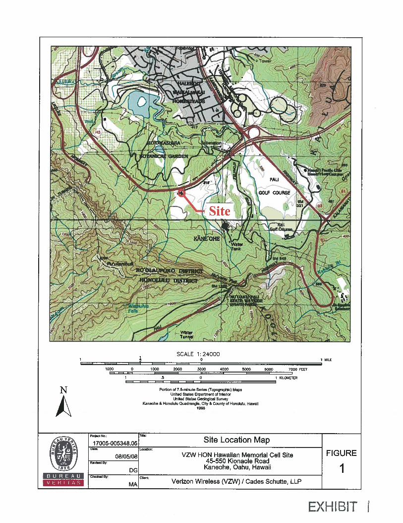
LOCATION: Ko’olau Golf Course, 45-550 Kionaole Road, Kãne’ohe, O’ahu
TMK: (1) 4-5-042:00 1
AREA OF USE: 600 square feet
SUBZONE: General
DESCRIPTION OF AREA AND PROPOSED USE
The proposed facility includes a thirty-foot tower with 12 panel antennas, six outdoorequipment cabinets, one diesel-fueled emergency generator, and associated conduits andcoax cables. The 600 square-foot project area would be enclosed by a six-foot high chainlink fence.
Construction will begin within 30 to 60 days of receipt of the permit, and be completed45 to 60 days after that.
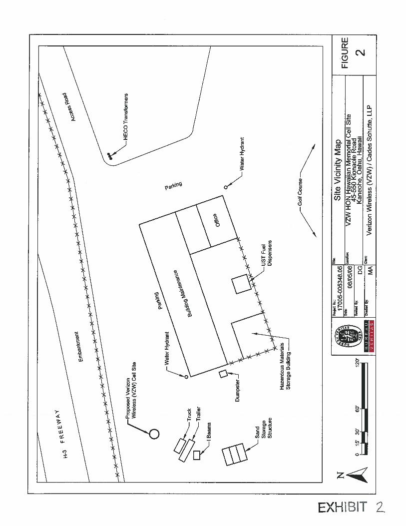
The project site is off the paved maintenance access road, approximately 90 feetnorthwest of the existing maintenance building and 120 feet south of the H-3. Telco andHECO utility poles run along the access road. The area has been previously disturbed,and is currently used as-needed for the storage of soil and sand.
The area immediately to the west is a thick forest with trees rising to fifty feet. This willpartially mitigate the visual impact of the structure from H-3.

Board of Land and CDUA OA-3609Natural Resources
The applicant has submitted correspondence from the State Historic PreservationDivision that no historic properties would be affected by a telecom tower on the site, andfrom the U.S. Fish and Wildlife Service that no federally listed or proposed species, orproposed or designated critical habitats, occur on the proposed site.
No known cultural or recreational activities beyond golfing occur on the parcel.
A management plan, as required by Hawai’i Administrative Rules (HAR) § 13-5 for newtelecommunications facility, was processed concurrently with this application.
The following exhibits have been attached for the Board’s review:
1. Site Location Map2. Site Vicinity Map3. Photographs of Project Site4. Management Plan (includes Site Plans)
SUMMARY OF COMMENTS
The Office of Conservation and Coastal Lands referred the application to the followingagencies and offices for review and comment: O’ahu Board Member; DLNR — LandDivision, Historic Preservation, Division of Forestry and Wildlife, and State Parks;Office of Hawaiian Affairs; ICSD; State Civil Defense; County Department ofEmergency Management; Honolulu Police; Honolulu Fire Department: and theMakiki/Lower Punchbowl/Tantalus Neighborhood Board.
A notice of the application was placed in the December 23, 2011 edition of the Office ofEnvironmental Quality Control’s Environmental Notice. In addition, copies of theapplication and environmental assessment were available for review at the Hawaii StateLibrary and the Käne’ohe Public Library
OCCL received no comments on the application or proposed management plan.
ANALYSIS
Following review and acceptance for processing the applicant was notified, by letterdated December 13, 2011 that:
1. The proposed use is an identified use within the Conservation District accordingto the Hawaii Administrative Rules (HAR), § 13-5-22, P-l4,TELECOMMUNICATIONS, (D- 1) New telecommunications facility. A managementplan approved simultaneously with the permit is also required. The applicant was
advised that this finding did not constitute approval of the proposal.
2

Board of Land and CDUA OA-3609Natural Resources
2. Pursuant to HAR § 13-5-40(4), HEARINGS, a public hearing was not required’.
3. In conformance with Chapter 343, Hawaii Revised Statutes (HRS), as amended,and HAR § 11-200, the draft Environmental Assessment was published onDecember 23, 2011, and a Finding of No Significant Impact to the Environmentwas published in the February 23, 2012 edition of the Environmental Notice.
SECTION 13-5-30 CRITERIA
The following discussion evaluates the merits of the proposed land use by applying thecriteria established in Section 13-5-30, Hawaii Administrative Rules (HAR).
1. The proposed use is consistent with the purpose ofthe Conservation District.
The objective of the Conservation District is to conserve, protect and preserve theimportant natural resources of the State through appropriate management and use topromote their long-term sustainability and the public health, safety, and welfare.
The subject area is currently used as a maintenance area for a golf course; staff is ofthe opinion that a thirty-foot pole will not have an appreciable impact on the State’snatural resources.
2. The proposed land use is consistent with the objectives of the Subzone of the land onwhich the use will occur.
The objective of the General subzone is to designate open space where specificconservation uses may not be defined.
Staff is of the opinion that the proposed land use is consistent with the GeneralSubzone’s identified land use(s). The project area is adjacent to an existingtelecommunications facility, and the proposed additional building and associatedfencing and paving does not represent a significant expansion of use. The work hasbeen designed and located such that the visual impact outside the site will beminimal.
3. The proposed land use complies with the provisions and guidelines contained inChapter 205A, HRS entitled “Coastal Zone Management”, where applicable.
Relevant policies of Chapter 205A include:
• Ensure that new developments are compatible with their visual environment bydesigning and locating such developments to minimize the alteration of naturallandforms and existing public views to and along the shoreline;
• Locate new structures inland from the shoreline setback to conserve open space,minimize interference with natural shoreline processes, and minimize loss ofimprovements due to erosion;
‘§13..540 requires public hearings on all applications for a proposed use of land for commercial purposes;however, OCCL has traditionally interpreted telecommunications facilities as being in the same category asregulated public utilities, and thus not a commercial use as defined in § 13-5.
3

Board of Land and CDUA OA-3609Natural Resources
The applicant has consulted with the State Historic Preservation Division and theOffice of Hawaiian Affairs, who both concur that no known historic or archaeologicalresources will be affected by the proposal. The project should not be visible fromcoastal areas.
Staff believes that the proposal is consistent with the guidelines of HRS 205A.
The project is not in the Special Management Area.
4. The proposed land use will not cause substantial adverse impact to existing naturalresources within the surrounding area, community or region.
The proposed project is an addition to an existing facility. Considering the small scaleof the project, the location next to an existing building, and the limited intensity of theland use, staff concurs with the applicant that the project will have little to no impacton existing natural resources.
The proposed location has limited access to the public, as it is reached by a privateroad that runs parallel to the H-3 Freeway.
5. The proposed land use, including buildings, structures and facilities, shall becompatible with the locality and surrounding areas, appropriate to the physicalconditions and capabilities ofthe specIc parcel or parcels.
Staff notes that the visual impact of the project will be minimized via design andsiting. The H-3 Freeway is 120 feet to the north, while the nearest residence isapproximately 3000 feet to the northeast. The site itself is relatively flat, with a thickforest of 35 to 50-foot tall trees that will block the view of the tower from thefreeway.
The area is in Flood Zone D, an area in which flood hazards are undetermined. Theelevation of the site is 360 feet, and the potential for flood hazards are expected to beminimal to non-existent.
6. The existing physical and environmental aspects of the land, such as natural beautyand open space characteristics, will be preserved or improved upon, whichever isapplicable.
As noted above, the project’s visual impact will be minimal. According to theapplicant close to 97% of the parcel is open space. Infrastructure on the propertyincludes utility poles for electricity and phone.
Staff does not believe that the telecommunications tower will have an impact on thearea’s natural beauty or open space.
7. Subdivision of land will not be utilized to increase the intensity of land uses in theConservation District.
The proposal does not involve the subdivision of land.
4
Board of Land and CDUA OA-3609Natural Resources
8. The proposed land use will not be materially detrimental to the public health, safety andwelfare.
Staff is of the opinion that the proposed addition will not be materially detrimental tothe public health, safety and welfare.
SECTION 13-5 MANAGEMENT PLAN CRITERIA
The Management Plan is attached to this report for the Board’s review. Staff would liketo call attention to the following elements of the plan:
Best Management Practices (Construction) — the applicant has built over 200telecommunications facilities in Hawaii over the past 25 years, which they state givesthem extensive experience in implementing Best Management Practices throughout theproject’s life. All work will be done by licensed contractors under the supervision of aState-licensed engineer or architect. The applicant is aware that work should be stoppedand the Historic Preservation Division contacted should any archaeological artifacts orhuman remains be uncovered during construction.
Best Management Practices (Ongoing) A technician will inspect the facility once permonth to identify areas needing preventive or corrective maintenance.
Activity Schedule — Construction will start within 30 to 60 days after the issuance of thepermit. The initial phase will involve coring for the base of the tower, followed by theinstallation of the tower base and concrete pad. After this the equipment shelter will beinstalled and the electrical and telco utilities hooked up. The last phase will involveinstalling fencing, antennas, and cables.
The grounds surrounding the facility are the responsibility of the golf course maintenancecrew. Verizon will cooperate with them as needed.
Annual Reporting Requirements — OCCL is not requesting that the permit holder deliverannual reports.
DISCUSSION
The proposed use is an identified use within the Conservation District according to theHawai’i Administrative Rules (HAR), § 13-5-22, P-6, PUBLIC PURPOSE USE.
The applicant consulted with numerous state, county, and community groups in theapplication and environmental assessment process. OCCL did not encounter anyopposition or criticism of the proposal.
Staff has reviewed the Management Plan, and finds that it is consistent with the § 13-5criteria.
Staff notes that, pursuant to § 13-5, construction of any additional towers at the site willrequire a Departmental Permit if the tower is lower than this one, and a Board Permitotherwise. Thus, approving this tower does not automatically open the site up tobecoming a major telecommunications site.
5

Board of Land and CDUA OA-3609Natural Resources
Staff feels that telecommunications systems are increasingly becoming a vital utility inthe modern world, and that facilities such as this serve the general welfare by providing aneeded public service.
RECOMMENDATION
Based on the proceeding analysis, staff recommends that the Board of Land and NaturalResources APPROVE this application for the Verizon Telecommunications Facility andassociated Management Plan at the Ko’olau Golf Course, Käne’ohe, Ko’olaupoko,O’ahu, TMK (1) 4-5-042:001, subject to the following terms and conditions:
1. The permittee shall comply with all applicable statutes, ordinances, rules, andregulations of the federal, state, and county governments, and applicable parts ofthis chapter;
2. The permittee, its successors and assigns, shall indemnify and hold the State ofHawaii harmless from and against any loss, liability, claim, or demand forproperty damage, personal injury, and death arising out of any act or omission ofthe applicant, its successors, assigns, officers, employees, contractors, and agentsunder this permit or relating to or coimected with the granting of this permit;
3. The permittee shall comply with all applicable department of healthadministrative rules;
4. The permittee shall provide documentation (e.g., book and page or documentnumber) that the permit approval has been placed in recordable form as a part ofthe deed instrument, prior to submission for approval of subsequent constructionplans;
5. Before proceeding with any work authorized by the department or the board, thepermittee shall submit four copies of the construction plans and specifications tothe chairperson or an authorized representative for approval for consistency withthe conditions of the permit and the declarations set forth in the permitapplication. Three of the copies will be returned to the permittee. Plan approvalby the chairperson does not constitute approval required from other agencies;
6. Unless otherwise authorized, any work or construction to be done on the landshall be initiated within one year of the approval of such use, in accordance withconstruction plans that have been signed by the chairperson, and shall becompleted within three years of the approval of such use. The permittee shallnotify the department in writing when construction activity is initiated and whenit is completed;
7. All representations relative to mitigation set forth in the accepted environmentalassessment or impact statement for the proposed use are incorporated asconditions of the permit;
6
Board of Land and CDUA OA-3609Natural Resources
8. The permittee understands and agrees that the permit does not convey any vestedright(s) or exclusive privilege;
9. In issuing the permit, the department and board have relied on the information anddata that the permittee has provided in connection with the permit application. If,subsequent to the issuance of the permit such information and data prove to befalse, incomplete, or inaccurate, this permit may be modified, suspended, orrevoked, in whole or in part, and the department may, in addition, instituteappropriate legal proceedings;
10. Where any interference, nuisance, or harm may be caused, or hazard establishedby the use, the permittee shall be required to take measures to minimize oreliminate the interference, nuisance, harm, or hazard;
11. During construction, appropriate mitigation measures shall be implemented tominimize impacts to off-site roadways, utilities, and public facilities;
12. The permittee acknowledges that the approved work shall not hamper, impede, orotherwise limit the exercise of traditional, customary, or religious practices ofnative Hawaiians in the immediate area, to the extent the practices are providedfor by the Constitution of the State of Hawaii, and by Hawaii statutory and caselaw; and
13. Other terms and conditions as prescribed by the chairperson.
14. Failure to comply with any of these conditions shall render a permit void underthe chapter, as determined by the chairperson or board.
Respectfully subm tted,
Michael CainStaff Planner
Approved for submittal:
By:
___________
WILLIAM J. AILA, ChairpersonBoard of Land and Natural Resources
7
A
Portion of 7.5-minute Series (Topographic) MapsUnited States Qrpartment of Interior
United States Geological SurveyKaneohe & Honolulu Quadrangle, City & County of Honolulu, Hawaii
1998
Project No.: Tide:
17005-005348.05 Site Location Map
U
Date:
08/05/08 VZW HON Hawaiian Memorial Cell Site FIGURELocation:
Revised By: 45-550 Kionaole Road
DG Kaneohe, Oahu, Hawaii IChecked By: Client
MA Verizon Wireless (VZW) I Cades Schutte, LLPBUREAUV ER I TAS
EXHBIT
1000 0 1000 2000 3000 4000 5000 5000 7000 FEET
1 .5 0 1 KILOMETER
SCALE 1:240000 IMILE
Tru
ck
\—
Tra
iler
IBea
ms
San
dS
tora
geS
truc
ture
Wat
erH
ydra
nt
Gol
fC
ours
e
-H
EC
OT
rans
form
ers
Pro
pose
dV
eriz
onW
irel
ess
(VZW
)C
ell
Site W
ater
Hyd
rant
UST
Fuel
Dis
pens
ers
A9
15’
3p’
6p’
Proj
ect
No.:
1700
5-00
5348
.05
1o
’
l5e
BU
RE
AU
VE
RIT
AS
.,7.
Sit
eV
icin
ityM
ap
ule
lu
MA
Dot
e
08/0
5/0
8Lo
cotio
n:V
ZW
HO
NH
awai
ian
Mem
oria
lC
ell
Sit
eRe
ctse
d45
-550
Kio
naol
eR
oad
DG
Kan
eohe
,O
ahu,
Haw
aii
Ver
izon
Wir
eles
s(V
ZW
)IC
ades
Sch
utte
,L
LP
FIG
UR
E
2

Site Name VZW HON Hawaiian Memorial Cell Site, 45-550 Kionaole Road, Kaneohe, Hawaii Photo Date
17005-005348.05 Client Verizon Wireless (VZW) / Cades Schutte, LLP 8/1/2008
EXH3IT 3
Site Name
17005-005348.05 Client
Project Description Access road to cell site and maintenance building looking west Photo INumber
VZW HON Hawaiian Memorial Cell Site, 45-550 Kionaole Road, Kaneohe, Hawaii
Verizon Wireless (VZV) / Cades Schutte, LLP
Photo Date
8/1/2008
Project Description View of proposed VZW antenna tower site looking west from access road Photo 2Number
ProjectNumber
Photo 4
Photo Date
8/1/2008
Description
17005-005348.05
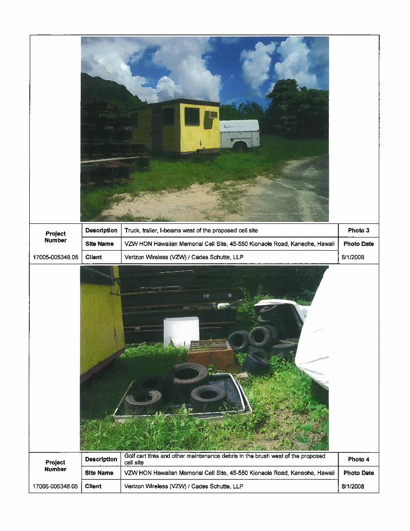
Truck, trailer, I-beams west of the proposed cell site
Site Name VZW HON Hawaiian Memorial Cell Site, 45-550 Kionaole Road, Kaneohe, Hawaii Photo Date
Client Verizon Wireless (VZW) / Cades Schutte, LLP 8/1/2008
p
Photo 3
ProjectNumber
Description cell site
Site Name VZW HON Hawaiian Memorial Cell Site, 45-550 Kionaole Road, Kaneohe, Hawaii
Client Verizon Wireless (VZW) / Cades Schutte, LLP17005-005348.05

VZW HON Hawaiian Memorial Cell Site, 45-550 Kionaole Road, Kaneohe, Hawaii
Verizon Wireless (VZVV) / Cades Schutte, LLP
VZW HON Hawaiian Memorial Cell Site, 45-550 Kionaole Road, Kaneohe, Hawaii
17005-005348.05 Client
Description View of H-3 Freeway looking northwest from the area of the proposed cell site Photo 5Project
__________
NumberSite Name Photo Date
8/1/2008
Site Name
Project Description Concrete sand storage structure located southwest of proposed cell site Photo 6
NumberPhoto Date
8/1/200817005-005348.05 Client Verizori Wireless (VZ\ / Cades Schutte, LLP

ProjectNumber
17005-005348.05
Description
Site Name
Client
View of hazardous materials storage buildingbuilding and southeast of the proposed cell site
VZW HON Hawaiian Memorial Cell Site, 45-550 Kionaole Road, Kaneohe, Hawaii
Verizon Wireless (VZW) / Cades Schutte, LLP
Photo 7
Photo Date
8/1/2008
—
View of fuel dispensers located south of the maintenance building and southeast Photo 8DescriptionProject of the proposed cell siteNumber
Site Name VZW HON Hawaiian Memorial Cell Site, 45-550 Kionaole Road, Kaneohe, Hawaii Photo Date
17005-005348.05 Client Verizon Wireless (VZW) I Cades Schutte, LLP 8/1/2008
,r’fl1% VTiO)
CHAPTER 13-5 :TJS
R 23EXHIBIT 3 ‘r
Lj
Management Plan Requirements
Conservation District Use ApplicationVerizon Wireless Telecommunication Facility
(Site Name: HI-HON Hawaiian Memorial)
Koolau Golf CourseMaintenance Building Area
45-550 Kionaole RoadKaneohe, Hawaii 96744
TMK: (1) 4-5-042:001
Applicant:Celico Partnership dba Verizon Wireless
300 Kahelu AvenueMililani, Hawaii 96789
Agent:RealCom Associates
Attn: Les Young1506 Ala Mahamoe StreetHonolulu, Hawaii 96819
Date: March 22, 2012
EXHB1T L
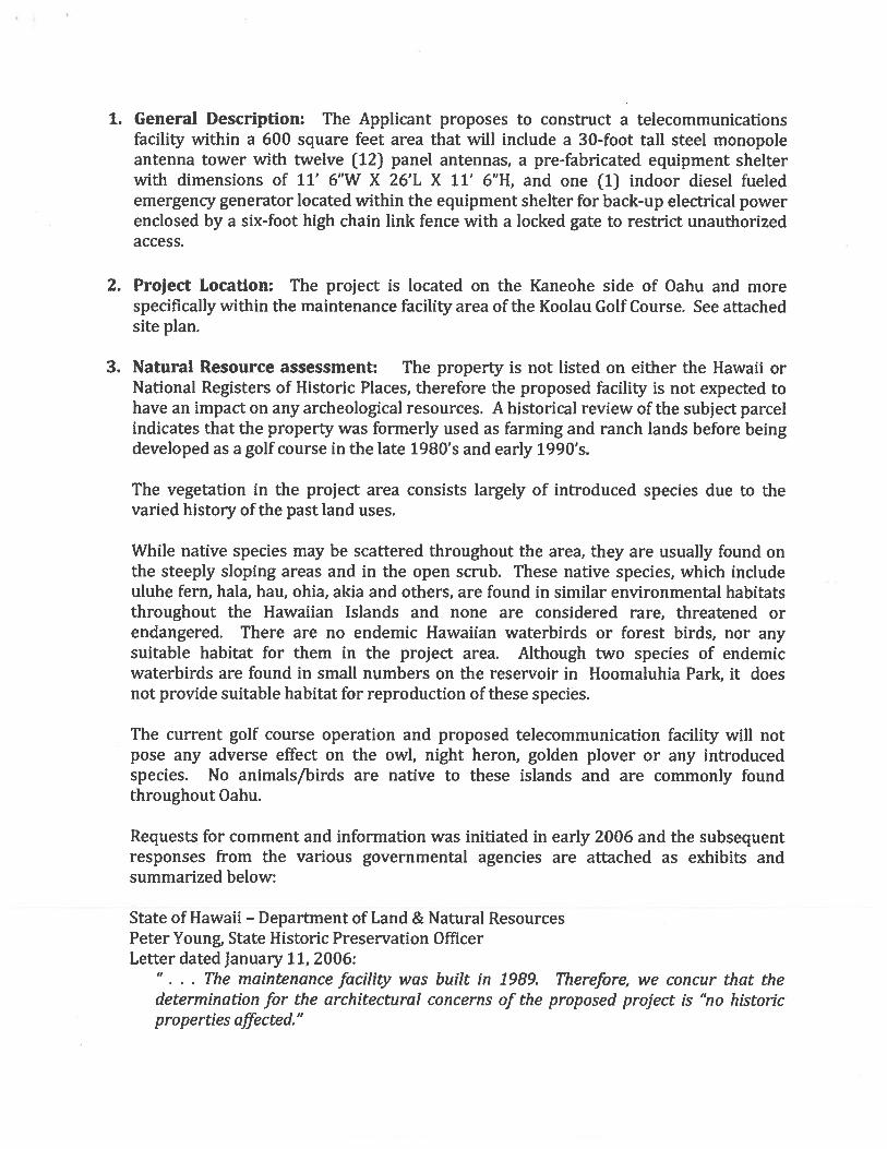
1. General Description: The Applicant proposes to construct a telecommunicationsfacility within a 600 square feet area that will include a 30-foot tall steel monopoleantenna tower with twelve (12) panel antennas, a pre-fabricated equipment shelterwith dimensions of 11’ 6”W X 26’L X 11’ 6”H, and one (1) indoor diesel fueledemergency generator located within the equipment shelter for back-up electrical powerenclosed by a six-foot high chain link fence with a locked gate to restrict unauthorizedaccess.
2. Project Location: The project is located on the Kaneohe side of Oahu and morespecifically within the maintenance facility area of the Koolau Golf Course. See attachedsite plan.
3. Natural Resource assessment: The property is not listed on either the Hawaii orNational Registers of Historic Places, therefore the proposed facility is not expected tohave an impact on any archeological resources. A historical review of the subject parcelindicates that the property was formerly used as farming and ranch lands before beingdeveloped as a golf course in the late 1980’s and early 1990’s.
The vegetation in the project area consists largely of introduced species due to thevaried history of the past land uses.
While native species may be scattered throughout the area, they are usually found onthe steeply sloping areas and in the open scrub. These native species, which includeuluhe fern, hala, hau, ohia, akia and others, are found in similar environmental habitatsthroughout the Hawaiian Islands and none are considered rare, threatened orendangered. There are no endemic Hawaiian waterbirds or forest birds, nor anysuitable habitat for them in the project area. Although two species of endemicwaterbirds are found in small numbers on the reservoir in Hoomaluhia Park, it doesnot provide suitable habitat for reproduction of these species.
The current golf course operation and proposed telecommunication facility will notpose any adverse effect on the owl, night heron, golden plover or any introducedspecies. No animals/birds are native to these islands and are commonly foundthroughout Oahu.
Requests for comment and information was initiated in early 2006 and the subsequentresponses from the various governmental agencies are attached as exhibits andsummarized below:
State of Hawaii — Department of Land & Natural ResourcesPeter Young, State Historic Preservation OfficerLetter dated January 11, 2006:
• . The maintenance facility was built in 1989. Therefore, we concur that thedetermination for the architectural concerns of the proposed project is “no historicproperties affected.”
State of Hawaii — Department of Land & Natural ResourcesPeter Young, State Historic Preservation OfficerLetter dated January 17, 2006:
“... We believe that no historic properties will be affected by this undertaking becauseprevious grabbing/grading has altered the land, and an acceptable archeologicalassessment or inventory survey found no historic properties, and previous inventorysurvey (Shun et al 1987, SHPD Report No. 0-388) and other in-depth studies of thecurrent project area (e.g. Meeker 1995, SHPD Report No. 0-1416)”
City & County of Honolulu — Dept. of Planning & PermittingHenry Eng, DirectorLetter dated January 25, 2006:
‘v... we recommend that you contact SHPD for information concerning the potentialimpacts of this proposal on historical and/or cultural resources. Similarly, because thesite is located within the State Land Use Conservation District, which is alsoadministered by the Department of Land and Natural Resources and not within theland use jurisdiction of the City & County ofHonolulu, we suggest thatyou contact theDLNR regarding comments on the proposed telecommunication antenna.”
Department of the Navy - US Army Engineering DistrictGeorge P. Young, PE, Chief— Regulatory BranchLetter Dated July 8, 2005
“j.. have determined that there are no waters of the U. S., including wetlands and noproposed placement or discharge ofdredged and/orfill materials into waters of the U.S. by these antenna sites and therefore a Department of the Army permit will not berequired.”
United States Dept. of the Interior — Fish & Wildlife ServicePatrick Leonard, Field SupervisorLetter dated November 1, 2005
We have reviewed the information you provIded and pertinent information in ourfiles, including data compiled by the Hawaii Natural Heritage Program. To the best ofour knowledge, no federally listed or proposed species, or proposed or designatedcritical habitat occur on the proposed project sita”
State of Hawaii - Office of Hawaiian AffairsClyde Namu’o — AdministratorLetter dated July 12, 2005:
“... OHA has no comments concerning the proposed project at this time. OHA furtherrequests your assurances that if the project goes forward, should iwi or NativeHawaiian cultural or traditional deposits be found during ground disturbance, workwill cease, and the appropriate agencies will be contacted pursuant to applicablelaw.”
4. Natural Hazard assessment: The topography of the proposed telecommunicationssite is level and flat. The elevation of the parcel ranges from approximately 300 feet to500 feet and the slope ranges from approximately 3% to more than 40% in certainareas. Due to the level and flat nature of the proposed site and its elevation relative tothe surrounding areas, no increased runoff or sedimentation is expected at this time.The project site is situated on Flood Zone D, an area in which flood hazards areundetermined. Being that this site is situated high above the 11-3 Freeway and at anelevation of approximately 360-feet above sea level, the potential for flood hazards areexpected to be minimal to non-existent.
5. Best Management Practices during Construction: The Applicant has successfullyconstructed over 200 telecommunication facilities throughout Hawaii over the past 25years and continues to maintain an excellent reputation for its best practices exercisedprior to construction (pre-construction planning), during construction, and post-construction. All work is done by licensed contractors and under the supervision ofeither a State of Hawaii licensed architect or engineer. Also, during the constructionphase, should any previously unidentified archeological resources such as artifacts,shell, bone, charcoal deposits, human burial rock or coral alignments, pavings or wallsbe uncovered, the Applicant will instruct the contractor to stop all work and contact theHistoric Preservation Office for review and approval of mitigation measures.
6. Best Management Practices during Lifetime of project: Ongoing maintenance andupkeep of its telecommunication facilities is critical to providing uninterrupted andcontinuous service to the Applicant’s customers. Therefore, regular maintenance to thesite will be done at a minimum once monthly whereby a technician will inspect thefacility, both the exterior and interior sections, to identify any areas needingpreventative or corrective maintenance and then scheduling with the appropriateresources to address issue. Prevention is the key to a successful operation rather thanhaving to correct a problem. This is Verizon’s goal and best management practice tomaintain and operate its facilities.
7. Description of the Conservation Methods & Applications: NA
8. Description of Existing Uses & Facilities: Koolau Golf Course is located on the subjectparcel. The golf course consists of an 18-hole championship golf course with drivingrange. The “club house” consists of a pro-shop, dining/restaurant facilities, meetingrooms and offices. There are men’s and women’s locker room facilities. There is also amaintenance building located on the northwest section of the parcel.
9. Description of Proposed Facilities and Uses: The Applicant proposes to construct atelecommunications facility within a 600 square feet area that will include a 30-foot tallsteel monopole antenna tower with twelve (12) panel antennas, a pre-fabricatedequipment shelter with dimensions of 11’ 6”W X 26’L X 11’ 6”H, and one (1) indoordiesel fueled emergency generator located within the equipment shelter for back-upelectrical power enclosed by a six-foot high chain link fence with a locked gate torestrict unauthorized access.

10Activity Schedule: Construction of this facility will commence upon receipt of thenecessary governmental building permits. Once received, construction shouldcommence within 30 — 60 days and should be completed within 45 — 60 days ofcommencement of construction. The initial phase will include coring for the base of theantenna tower followed by the installation of the tower base and concrete pad. Nextwill be the installation of the equipment shelter and hook up of all electrical and telcoutilities. Last will be the installation of fencing and all equipment including antennasand cabling. Once in operation, technicians will monitor the facility and visit the site atleast once monthly for maintenance.
The grounds surrounding the proposed facility are the responsibility of the golf coursemaintenance and Verizon will defer to their maintenance and upkeep schedule andcooperate.
There are no annual reporting requirements.
11 Any Other information or Data as required: NA
Site PlanON FOLLOWING PAGE

SE
CE
OII
lOP
AN
TA
NT
.TV
PE
*Z
INU
Th
CA
NL
E
(Fl)GAO-
149180150
49
j1()lip
‘I
4;
(0
____
40115
a0
4IA
)
A
—N
I
64TE
15018(0A
GATES1011010
ISO*01015
10
16
10
61
1.1
10
11
09
11
01
lIGN
ITE
JIECIG
HT
1106*10685I€L
101.
F.
68111A
NT
E150056810
AN
JT6
1O
GlE,1
Ill
Elf
11018*68161
OL
OC
AT
ION
PL
AN
AICE
SCN
I
AL
PH
A4
12545’
1/8
55B
ET
A4
12565
)/655
GA
MM
A4
185285’
7/655’
nfl
=
__
__
_______
(N)(E
lf181057164
--—-—
I-—---
——
9I.
(6)0
800*
NSTE
50
04
85
10
00
4
12
—
5891819
*8
50
18
00
(F)
r‘N
.-
-
00
(
____
1671110H
EN
0811141—D
Ma
‘01—T
N—
64680.0
111811064101(F
)6804668
165HE
90.
\\)I4
5•1
N
\\a(15180
\‘2’/
6401*10
.
NA(APEA
KA
RC
HIT
EC
TS
1.01681.1
CO
NS
UL
IIIST
1Y
T””
::
‘
‘(E
)64811
I’
(4)C
EG
IG-M
TT
aGATE
f)TS
AW
NB
Y:_
_D
AIE
T.._
_JIO
*T
ND
:
L(C
EN
SHR
E.
QE
NL
AR
GE
DE
QU
IP.
YA
RD
PL
AN
E85I*1C
‘-_1-
=1T
#G
9-.
NEW
‘NA
RE
AO
FN
EW
WO
RK
/‘d’\‘N
——
NEW106(556
R4RELSSS‘‘“\
‘5
5M
01
18
1V
*15THE.
PHE-CE8G
CASED
E25PT4ENT9IELIEO
.\
j(1*5811
IINTENNUS*585
NIL
\‘N
IICG4CEULIt),
101B
T8ID
61‘N
(iN-E
---
-
/-
__
—
//
__
__
__
__
__
i
P15011(1
INFO
RM
AT
ION
verizo
nw
irelessHON
HAWN
MEM
TELECOM
.FAC.
HONHAW
AIIANM
EMORIAL
NEWTELECOM
.FACLITYPRO
JECT2004005294
45-550KIONAOLE
ROADKANEOHE,HAW
AII96744TM
K:4-5-042:001
SHE
ET
TITLE:
LOCATIONPLAN,
PARTIAISITE
PLAN,ENLARGED
EQUIP,YARDPLAN
CU
RR
EN
TISSU
ED
AT
E/ISSU
ED
FOR
,
10/28/05—
ZO
NIN
G7
OP
AR
TIA
LS
ITE
PL
AN
BS
CM
1/32’I#
12234
SW
)SC
ASi
1/64’‘—
0’(II
117
9E
E1
(C)0651081
2’
1SB
EE
TN
UM
BE
R
A1
TI
I)
110175. /
Related Documents