Phone: 303-492-2655 Address: 1540 30th Street, RL-2, 3rd Floor, Room 377 email: [email protected] or [email protected] Categories: Tables: Categories: Tables: Basemap EH&S Building Footprints West Nile Virus Test Areas Building Text Asbestos Athletics Lines Parking Athletics Text Parking Lots Objects: Parking Lines Road Edges Parking Spaces Road Text Projects Sidewalk Edges CP Project Sites Structures CP Building Projects River Lines Cone Zone Routes River Polygons & Ponds Roads Dams & Pond Outlines Road Areas Water Features Road Center Lines Fences Road Edges Property Boundaries Road Intersections Emergency Road Walkways Emergency Nodes (Phones) Road Notes Flood Innundation Areas Signs FEMA Flood Areas Sign Nodes Landscape Sign Photos Ground Panels Snow Ground Zones & Subzones Areas Trees Routes Tree Zones Nodes Site Furniture Notes Outdoor Spaces Space Campus Areas Rooms GIS Data Review Sheet This is a summery of the type of data collected on the CU Boulder campus for the utility specified below. Please review this information and send any questions, changes or recommendations to the CAD/GIS Office via email or by returning this hardcopy with redlines. We can be reached by the following methods: GIS DATA TABLES Department of Facilities Management ‐ CAD/GIS Office Page 1 of 48

Welcome message from author
This document is posted to help you gain knowledge. Please leave a comment to let me know what you think about it! Share it to your friends and learn new things together.
Transcript

Phone: 303-492-2655
Address: 1540 30th Street, RL-2, 3rd Floor, Room 377
email: [email protected] or [email protected]
Categories: Tables: Categories: Tables:
Basemap EH&S
Building Footprints West Nile Virus Test Areas
Building Text Asbestos
Athletics Lines Parking
Athletics Text Parking Lots
Objects: Parking Lines
Road Edges Parking Spaces
Road Text Projects
Sidewalk Edges CP Project Sites
Structures CP Building Projects
River Lines Cone Zone Routes
River Polygons & Ponds Roads
Dams & Pond Outlines Road Areas
Water Features Road Center Lines
Fences Road Edges
Property Boundaries Road Intersections
Emergency Road Walkways
Emergency Nodes (Phones) Road Notes
Flood Innundation Areas Signs
FEMA Flood Areas Sign Nodes
Landscape Sign Photos
Ground Panels Snow
Ground Zones & Subzones Areas
Trees Routes
Tree Zones NodesSite Furniture Notes
Outdoor Spaces Space
Campus Areas Rooms
GIS Data Review SheetThis is a summery of the type of data collected on the CU Boulder campus for the utility specified below. Please review this information and send any questions, changes or recommendations to the CAD/GIS Office via email or by returning this hardcopy with redlines. We can be reached by the following methods:
GIS DATA TABLES
Department of Facilities Management ‐ CAD/GIS Office
Page 1 of 48

Phone: 303-492-2655
Address: 1540 30th Street, RL-2, 3rd Floor, Room 377
email: [email protected] or [email protected]
Categories: Tables: Categories: Tables:
Trees Electrical
Trees Electrical Lines
Tree Zones Electrical Nodes
Underground Structure Lines
Underground Objects Electrical Notes
Street View Label Lines ‐ Lines that tie
Street View Locations text to pipes or nodes
Exterior Lighting
UTILITIES: NodesSegments
Chilled Water Irrigation
Pipes Moisture Sensors
Notes Control Wires
Compressed Air Sleeves
Lines Notes
Nodes Labels
Notes Label Lines ‐ Lines that tie
Storm Drainage text to pipes or nodes
Dams/Ponds Outline Valves, Heads, Pull boxes ect
River Lines Irrigation Pipes
River Polygons / Ponds Filled Laterals
Channels / Ditches Misc Lines
Storm Water Pipes Sodline
Manholes, Inlets Symbols
Pipe Labels
Label Lines ‐ Lines that tie
text to pipes or nodes
GIS Data Review SheetThis is a summery of the type of data collected on the CU Boulder campus for the utility specified below. Please review this information and send any questions, changes or recommendations to the CAD/GIS Office via email or by returning this hardcopy with redlines. We can be reached by the following methods:
GIS DATA TABLES
Department of Facilities Management ‐ CAD/GIS Office
Page 2 of 48

Phone: 303-492-2655
Address: 1540 30th Street, RL-2, 3rd Floor, Room 377
email: [email protected] or [email protected]
Categories: Tables: Categories: Tables:
Natural Gas Water
Pipelines Nodes
Structure Lines Lines
Valves, Meters ect Lines
Notes Notes
Sewer Structures
Labels Symbols
Labels (Gravity) Raw Water
Notes Notes
Valves ect Pipe Labels
Pipes (Gravity) Pipes
Service Connections Dimension Notes
Structures Dimensions
Steam Raw Water Nodes
Steam Pipes
Steam Valves, Meters ect.
Notes
Label Lines ‐ Lines that tie
text to pipes or nodesUtility
Pathways(Tunnels)
Utility Pathways (Tunnels)
Tunnel Access
Ventilation
GIS Data Review SheetThis is a summery of the type of data collected on the CU Boulder campus for the utility specified below. Please review this information and send any questions, changes or recommendations to the CAD/GIS Office via email or by returning this hardcopy with redlines. We can be reached by the following methods:
GIS DATA TABLES
Department of Facilities Management ‐ CAD/GIS Office
Page 3 of 48
Phone: 303-492-2655
Address: 1540 30th Street, RL-2, 3rd Floor, Room 377
email: [email protected] or [email protected]
Objects: Building Footprints Building Text Athletics Lines Athletics Text
Object Type: Polygon Text Lines Text
Attributes:
GID GID GID GID
AREA COMMENTS LENGTH COMMENTS
COMMENTS TAG VALUE COMMENTS TAG VALUE
TAG VALUE OBJECT VERIFY TAG VALUE OBJECT VERIFY
OBJECT VERIFY Building Name OBJECT VERIFY
Building Number Building Number Owner
Building Code Building Code Department
Building Type Funding
Bldg Gross Square Footage Type
Building Name
Building Address
Building Zone
Building Functional Status
Year Built
Year Acquired
General Fund Percentage
Building Footprint
Link to Meridian
Status
Latitude
Longitude
GIS Data Review Sheet
This is a summery of the type of data collected on the CU Boulder campus for the utility specified below. Please review this information and send any questions, changes or recommendations to the CAD/GIS Office via email or by returning this hardcopy with redlines. We can be reached by the following methods:
Campus Basemap
**Please note: Attribute types in all UPPERCASE indicate default data collumns which cannot be removed. Columns will be left blank if they are not applicable. Attributes shown in red have been left blank
Department of Facilities Management ‐ CAD/GIS Office
Page 4 of 48

Phone: 303-492-2655
Address: 1540 30th Street, RL-2, 3rd Floor, Room 377
email: [email protected] or [email protected]
Objects: Road Edges Road Text Sidewalk Edges Structures
Object Type: Lines Text Lines Lines
Attributes:
GID GID GID GID
LENGTH COMMENTS LENGTH LENGTH
COMMENTS TAG VALUE COMMENTS COMMENTS
TAG VALUE OBJECT VERIFY TAG VALUE TAG VALUE
OBJECT VERIFY OBJECT VERIFY OBJECT VERIFY
Status Edge Type Owner
Edge Type Department
Funding
Structure Type
GIS Data Review Sheet
This is a summery of the type of data collected on the CU Boulder campus for the utility specified below. Please review this information and send any questions, changes or recommendations to the CAD/GIS Office via email or by returning this hardcopy with redlines. We can be reached by the following methods:
Campus Basemap
**Please note: Attribute types in all UPPERCASE indicate default data collumns which cannot be removed. Columns will be left blank if they are not applicable. Attributes shown in red have been left blank
Department of Facilities Management ‐ CAD/GIS Office
Page 5 of 48

Phone: 303-492-2655
Address: 1540 30th Street, RL-2, 3rd Floor, Room 377
email: [email protected] or [email protected]
Objects: River Lines River Polygons & Ponds Dams & Pond Outlines Water Features
Object Type: Lines Polygons Polygons Polygons
Attributes:
GID GID GID GID
LENGTH AREA AREA AREA
COMMENTS COMMENTS COMMENTS COMMENTS
TAG VALUE TAG VALUE TAG VALUE TAG VALUE
OBJECT VERIFY OBJECT VERIFY OBJECT VERIFY Type
Dam Type Responsibility
Link to Meridian
Name
Includes:
Pools
Fountains maybe?
GIS Data Review Sheet
This is a summery of the type of data collected on the CU Boulder campus for the utility specified below. Please review this information and send any questions, changes or recommendations to the CAD/GIS Office via email or by returning this hardcopy with redlines. We can be reached by the following methods:
Campus Basemap
**Please note: Attribute types in all UPPERCASE indicate default data collumns which cannot be removed. Columns will be left blank if they are not applicable. Attributes shown in red have been left blank
Department of Facilities Management ‐ CAD/GIS Office
Page 6 of 48

Phone: 303-492-2655
Address: 1540 30th Street, RL-2, 3rd Floor, Room 377
email: [email protected] or [email protected]
Objects: Fences Property Boundaries
Object Type: Lines Polygons
Attributes:
GID GID
LENGTH LENGTH
COMMENTS COMMENTS
TAG VALUE TAG VALUE
OBJECT VERIFY OBJECT VERIFY
Owner
Department
Funding
Includes:
Permanent Fences
GIS Data Review Sheet
This is a summery of the type of data collected on the CU Boulder campus for the utility specified below. Please review this information and send any questions, changes or recommendations to the CAD/GIS Office via email or by returning this hardcopy with redlines. We can be reached by the following methods:
Campus Basemap
**Please note: Attribute types in all UPPERCASE indicate default data collumns which cannot be removed. Columns will be left blank if they are not applicable. Attributes shown in red have been left blank
Department of Facilities Management ‐ CAD/GIS Office
Page 7 of 48

Phone: 303-492-2655
Address: 1540 30th Street, RL-2, 3rd Floor, Room 377
email: [email protected] or [email protected]
Objects: Flood Innundation Areas FEMA Flood Areas
Object Type: Points Polygons Polygons
Attributes:
GID GID GID
SYMBOL AREA AREA
COMMENTS COMMENTS COMMENTS
TAG VALUE TAG VALUE TAG VALUE
OBJECT VERIFY OBJECT VERIFY OBJECT VERIFY
Owner Stream Name Flood Type
Node ID Updated Date Flood Zone
Node Type Flood Year
Emergency Management
**Please note: Attribute types in all UPPERCASE indicate default data collumns which cannot be removed. Columns will be left blank if they are not applicable. Attributes shown in red have been left blank
GIS Data Review Sheet
This is a summery of the type of data collected on the CU Boulder campus for the utility specified below. Please review this information and send any questions, changes or recommendations to the CAD/GIS Office via email or by returning this hardcopy with redlines. We can be reached by the following methods:
Emergency Nodes (Phones,
Security Cameras, Other)
Department of Facilities Management ‐ CAD/GIS Office
Page 8 of 48

Phone: 303-492-2655
Address: 1540 30th Street, RL-2, 3rd Floor, Room 377
email: [email protected] or [email protected]
Object Type: Lines Routes
Objects: Flood Lines Emergency Routes
Attributes:
From Boulder County needs developed
COMMENTS
TAG VALUE
FLOOD AREA ID
FLOODWAY
FLOOD ZONE
SFHA_TF
STATIC BFE
V DATUM
DEPTH
LEN UNIT
VELOCITY
VELOCITY UNIT
BFE REVERT
DEP REVERT
SOURCE CITATION
AR REVERT
FIRM PANEL ‐ FEMA
EFFECTIVE DATE
ZONE
Floodplain
GIS Data Review Sheet
This is a summery of the type of data collected on the CU Boulder campus for the utility specified below. Please review this information and send any questions, changes or recommendations to the CAD/GIS Office via email or by returning this hardcopy with redlines. We can be reached by the following methods:
Emergency Management
**Please note: Attribute types in all UPPERCASE indicate default data collumns which cannot be removed. Columns will be left blank if they are not applicable. Attributes shown in red have been left blank
use road & sidewalk
centerlines
Department of Facilities Management ‐ CAD/GIS Office
Page 9 of 48

Phone: 303-492-2655
Address: 1540 30th Street, RL-2, 3rd Floor, Room 377
email: [email protected] or [email protected]
Objects: West Nile Virus Test Areas Asbestos
Object Type Polygons Lines
Attributes:
GID Needs Developed
AREA
COMMENTS
TAG VALUE
Body of Water
Campus
Water Source
Type of water feature
GPS Date
Biological Controls Present 1
Biological Controls Present 2
Biological Controls Present 3
Biological Controls Present 4
Biological Controls Present 5
Vegetation Present 1
Vegetation Present 2
Vegetation Present 3
Vegetation Present 4
Vegetation Present 5
Date Entered
GIS Data Review SheetThis is a summery of the type of data collected on the CU Boulder campus for the utility specified below. Please review this information and send any questions, changes or recommendations to the CAD/GIS Office via email or by returning this hardcopy with redlines. We can be reached by the following methods:
Environmental Health and Safety
**Please note: Attribute types in all UPPERCASE indicate default data collumns which cannot be removed. Columns will be left blank if they are not applicable. Attributes shown in red have been left blank
Department of Facilities Management ‐ CAD/GIS Office
Page 10 of 48

Phone: 303-492-2655
Address: 1540 30th Street, RL-2, 3rd Floor, Room 377
email: [email protected] or [email protected]
Objects: Ground PanelsGround Zones & Subzones Trees Tree Zones
Object Type: Polygons Polygons Points Polygons
Attributes:
GID GID GID GID
AREA AREA SYMBOL AREA
COMMENTS COMMENTS COMMENTS COMMENTS
TAG VALUE TAG VALUE TAG VALUE TAG VALUE
OBJECT VERIFY OBJECT VERIFY OBJECT VERIFY OBJECT VERIFY
Ground Type Zone Type GPS Date ID
Property Zone ID GPS Height Zone Type
Panel ID Tree ID
Department Tree Type
Funding Genus‐Species
Owner Dia. Breast Height
Zone Spread
Subzone Height
FM TAG Condition
HDS TAG Noteable
Mowing Equipment Storm Damage
Tree Zone
Owner
Department
Funding
Subzone
GIS Data Review Sheet
This is a summery of the type of data collected on the CU Boulder campus for the utility specified below. Please review this information and send any questions, changes or recommendations to the CAD/GIS Office via email or by returning this hardcopy with redlines. We can be reached by the following methods:
Landscape
**Please note: Attribute types in all UPPERCASE indicate default data collumns which cannot be removed. Columns will be left blank if they are not applicable. Attributes shown in red have been left blank
Department of Facilities Management ‐ CAD/GIS Office
Page 11 of 48

Phone: 303-492-2655
Address: 1540 30th Street, RL-2, 3rd Floor, Room 377
email: [email protected] or [email protected]
Objects: Site Furniture Outdoor Spaces Campus Areas
Object Type: Points Polygons Polygons
Attributes:
GID GID GID
SYMBOL AREA AREA
COMMENTS COMMENTS COMMENTS
TAG VALUE TAG VALUE TAG VALUE
OBJECT VERIFY OBJECT VERIFY OBJECT VERIFY
Furniture Type Name Campus Areas
Material Address
Memorial Area Type
Equipment Number CUPD Type
Number in Group
GPS Date
Pictures via Meridian
or Enlighten
Includes: Example: Example:
Benches Farrand Field Main Campus
Picnic Tables Norlin Quad Grandview
Tables w Chairs
Building Signs
Campus Directories
Campus Maps
GIS Data Review Sheet
This is a summery of the type of data collected on the CU Boulder campus for the utility specified below. Please review this information and send any questions, changes or recommendations to the CAD/GIS Office via email or by returning this hardcopy with redlines. We can be reached by the following methods:
Landscape
**Please note: Attribute types in all UPPERCASE indicate default data collumns which cannot be removed. Columns will be left blank if they are not applicable. Attributes shown in red have been left blank
Department of Facilities Management ‐ CAD/GIS Office
Page 12 of 48

Phone: 303-492-2655
Address: 1540 30th Street, RL-2, 3rd Floor, Room 377
email: [email protected] or [email protected]
Objects: Parking Lots Parking Lines Parking Spaces
Object Type: Polygons Lines Points
Attributes:
GID GID GID
AREA LENGTH SYMBOL
COMMENTS COMMENTS COMMENTS
TAG VALUE TAG VALUE TAG VALUE
OBJECT VERIFY OBJECT VERIFY OBJECT VERIFY
Lot Number Parking Type
Address
Lot Type
Paving Type
**Please note: Attribute types in all UPPERCASE indicate default data collumns which cannot be removed. Columns will be left blank if they are not applicable. Attributes shown in red have been left blank
GIS Data Review Sheet
This is a summery of the type of data collected on the CU Boulder campus for the utility specified below. Please review this information and send any questions, changes or recommendations to the CAD/GIS Office via email or by returning this hardcopy with redlines. We can be reached by the following methods:
Parking
Department of Facilities Management ‐ CAD/GIS Office
Page 13 of 48

Phone: 303-492-2655
Address: 1540 30th Street, RL-2, 3rd Floor, Room 377
email: [email protected] or [email protected]
Objects: CP Project Sites CP Building Projects Cone Zone Routes
Object Type: Polygons (enlighten link) Lines
Attributes: Data from FAMIS:
GID Building GID
AREA CP Number LENGTH
COMMENTS Project Description COMMENTS
TAG VALUE Project Manager TAG VALUE
OBJECT VERIFY PM Phone OBJECT VERIFY
CP Number PM Email Route Type
Project Year Design Start Date Year
Visibility Design End Date Semester
Link to Meridian Contruction Start Date
Construction End Date
Other Data from FAMIS: Substantial Completion Start
Project Description Substantial Completion End
Project Manager
PM Phone
PM Email
Design Start Date
Design End Date
Contruction Start Date
Construction End Date
Substantial Completion Start
Substantial Completion End
Status
Comments
GIS Data Review Sheet
This is a summery of the type of data collected on the CU Boulder campus for the utility specified below. Please review this information and send any questions, changes or recommendations to the CAD/GIS Office via email or by returning this hardcopy with redlines. We can be reached by the following methods:
Project Information
**Please note: Attribute types in all UPPERCASE indicate default data collumns which cannot be removed. Columns will be left blank if they are not applicable. Attributes shown in red have been left blank
Department of Facilities Management ‐ CAD/GIS Office
Page 14 of 48

Phone: 303-492-2655
Address: 1540 30th Street, RL-2, 3rd Floor, Room 377
email: [email protected] or [email protected]
Objects: Road Areas Road Center Lines Road Edges
Object Type: Polygons Lines (Network) Lines
Attributes:
GID GID GID
AREA LENGTH LENGTH
COMMENTS COMMENTS COMMENTS
TAG VALUE TAG VALUE TAG VALUE
STREET CODE EDGE TYPE
STREET NAME
STREET REFERENCE NAME
START INTERSECTION
END INTERSECTION
SEGMENT OWNER
SEGMENT CLASS
SEGMENT TYPE
SEGMENT WIDTH
SEGMENT DIRECTION
SEGMENT JURISDICTION
SEGMENT SURFACE
GIS Data Review Sheet
This is a summery of the type of data collected on the CU Boulder campus for the utility specified below. Please review this information and send any questions, changes or recommendations to the CAD/GIS Office via email or by returning this hardcopy with redlines. We can be reached by the following methods:
Road Network
**Please note: Attribute types in all UPPERCASE indicate default data collumns which cannot be removed. Columns will be left blank if they are not applicable. Attributes shown in red have been left blank
Department of Facilities Management ‐ CAD/GIS Office
Page 15 of 48

Phone: 303-492-2655
Address: 1540 30th Street, RL-2, 3rd Floor, Room 377
email: [email protected] or [email protected]
Objects: Road Intersections Road Walkways Road Notes
Object Type: Points w Reference Drawing Lines Text
Attributes:
GID GID GID
SYMBOL LENGTH COMMENTS
COMMENTS COMMENTS TAG VALUE
TAG VALUE TAG VALUE
INTERSECTION ID
INTERSECTION TYPE
DWG NAME
DWG NUMBER
STREET CODE 1
STREET CODE 2
STREET CODE 3
STREET CODE 4
STREET NAME 1
STREET NAME 2
STREET NAME 3
STREET NAME 4
GIS Data Review Sheet
This is a summery of the type of data collected on the CU Boulder campus for the utility specified below. Please review this information and send any questions, changes or recommendations to the CAD/GIS Office via email or by returning this hardcopy with redlines. We can be reached by the following methods:
Road Network
**Please note: Attribute types in all UPPERCASE indicate default data collumns which cannot be removed. Columns will be left blank if they are not applicable. Attributes shown in red have been left blank
Department of Facilities Management ‐ CAD/GIS Office
Page 16 of 48

Phone: 303-492-2655
Address: 1540 30th Street, RL-2, 3rd Floor, Room 377
email: [email protected] or [email protected]
Objects: Signs Sign Photos
Object Type Points Points w Photographs
Attributes:
GID GID
SYMBOL SYMBOL
COMMENTS COMMENTS
TAG VALUE TAG VALUE
Sign ID Sign ID
Building Number Building Number
Description Description
Type Type
Location Location
Dimensions Dimensions
Photo Photo
Material Material
Color Color
Mount Mount
Lighting Lighting
Owner Owner
Maintenance Maintenance
Funding Funding
Entered By Entered By
Date Entered Date Entered
Needs Audited; Needs Audited: identical to "Sign Nodes" table
unsystematically in error Remove "Old" Columns
unsystematically in error
Signs
**Please note: Attribute types in all UPPERCASE indicate default data collumns which cannot be removed. Columns will be left blank if they are not applicable. Attributes shown in red have been left blank
GIS Data Review SheetThis is a summery of the type of data collected on the CU Boulder campus for the utility specified below. Please review this information and send any questions, changes or recommendations to the CAD/GIS Office via email or by returning this hardcopy with redlines. We can be reached by the following methods:
Department of Facilities Management ‐ CAD/GIS Office
Page 17 of 48

Phone: 303-492-2655
Address: 1540 30th Street, RL-2, 3rd Floor, Room 377
email: [email protected] or [email protected]
Objects: Areas Routes Nodes Notes
Object Type: Polygons Polygons Points Text
Attributes:
GID GID GID GID
AREA AREA SYMBOL COMMENTS
COMMENTS COMMENTS COMMENTS TAG VALUE
TAG VALUE TAG VALUE TAG VALUE OBJECT VERIFY
OBJECT VERIFY OBJECT VERIFY OBJECT VERIFY
Responsibility (Dept) Responsibility Responsibility
Area Type (Sdwk, rd, ect) Route Type Node Type
Usage (Traffic) Usage Usage
Treatment (Sand/Salt) Treatment Group or Cluster
Equipment Equipment Operator
Equipment ID Equipment ID
Group or Cluster Group or Cluster
Operator Operator
Shift (Day/Night/Swing) Shift
Priority (Low‐High) Priority
Priority Type (Pwr, ect) Priority Type
**Please note: Attribute types in all UPPERCASE indicate default data collumns which cannot be removed. Columns will be left blank if they are not applicable. Attributes shown in red have been left blank
GIS Data Review Sheet
This is a summery of the type of data collected on the CU Boulder campus for the utility specified below. Please review this information and send any questions, changes or recommendations to the CAD/GIS Office via email or by returning this hardcopy with redlines. We can be reached by the following methods:
Snow Removal
Department of Facilities Management ‐ CAD/GIS Office
Page 18 of 48

Phone: 303-492-2655
Address: 1540 30th Street, RL-2, 3rd Floor, Room 377
email: [email protected] or [email protected]
Objects: Rooms
Object Type Polygons
Attributes:
GID
AREA
COMMENTS
TAG VALUE
Building Number
Building Code
Building Name
Floor Number
Room Number
Room ID
Room Square Footage
Department Code
Department Description
Room Type Code
Room Type Description
Room Category
Room Category Description
GIS Data Review SheetThis is a summery of the type of data collected on the CU Boulder campus for the utility specified below. Please review this information and send any questions, changes or recommendations to the CAD/GIS Office via email or by returning this hardcopy with redlines. We can be reached by the following methods:
Space Data
**Please note: Attribute types in all UPPERCASE indicate default data collumns which cannot be removed. Columns will be left blank if they are not applicable. Attributes shown in red have been left blank
Department of Facilities Management ‐ CAD/GIS Office
Page 19 of 48

Phone: 303-492-2655
Address: 1540 30th Street, RL-2, 3rd Floor, Room 377
email: [email protected] or [email protected]
Objects: Underground
Object Type Polygons
Attributes:
GID
AREA
COMMENTS
TAG VALUE
OBJECT VERIFY
Object Type
Material
Project Number
Discovery Date
Link to Meridian
Depth
GIS Data Review SheetThis is a summery of the type of data collected on the CU Boulder campus for the utility specified below. Please review this information and send any questions, changes or recommendations to the CAD/GIS Office via email or by returning this hardcopy with redlines. We can be reached by the following methods:
Underground
**Please note: Attribute types in all UPPERCASE indicate default data collumns which cannot be removed. Columns will be left blank if they are not applicable. Attributes shown in red have been left blank
Department of Facilities Management ‐ CAD/GIS Office
Page 20 of 48
Phone: 303-492-2655
Address: 1540 30th Street, RL-2, 3rd Floor, Room 377
email: [email protected] or [email protected]
Objects: Street View Locaton
Object Type Point
Attributes:
GID
SYMBOL
COMMENTS
TAG VALUE
Latitude & Longitude
GIS Data Review SheetThis is a summery of the type of data collected on the CU Boulder campus for the utility specified below. Please review this information and send any questions, changes or recommendations to the CAD/GIS Office via email or by returning this hardcopy with redlines. We can be reached by the following methods:
Google Street View
**Please note: Attribute types in all UPPERCASE indicate default data collumns which cannot be removed. Columns will be left blank if they are not applicable. Attributes shown in red have been left blank
Department of Facilities Management ‐ CAD/GIS Office
Page 21 of 48

Phone: 303-492-2655
Address: 1540 30th Street, RL-2, 3rd Floor, Room 377
email: [email protected] or [email protected]
Object Type: Lines Text
Objects: Chilled Water pipe lines Chilled Water notes
Attributes:
Object Verify Object Verify
COMMENTS COMMENTS
Owner TAG VALUE
Pipe Type
Pipe Diameter
Pipe Path
Tunnel #
Archive 1
Archive 2
Archive 3
Status
Conduit Diameter
Location
Controller
Control #
GIS Utility Data Review Sheet
This is a summery of the type of data collected on the CU Boulder campus for the utility specified below. Please review this information and send any questions, changes or recommendations to the CAD/GIS Office via email or by returning this hardcopy with redlines. We can be reached by the following methods:
Chilled Water
**Please note: Attribute types in all UPPERCASE indicate default data collumns which cannot be removed. Columns will be left blank if they are not applicable. Attributes shown in red have been left blank
Department of Facilities Management ‐ CAD/GIS Office
Page 22 of 48

Phone: 303-492-2655
Address: 1540 30th Street, RL-2, 3rd Floor, Room 377
email: [email protected] or [email protected]
Object Type: Lines Nodes Text
Objects: Compressed Air Lines Air Reducers Notes
Attributes:
Object Verify Object Verify Object Verify
COMMENTS COMMENTS COMMENTS
Owner Owner TAG VALUE
Line Type Node Type
Pipe Type Archive 1
Pipe Diameter Archive 2
Pathway Archive 3
Tunnel #
Archive 1
Archive 2
Archive 3
Status
Conduit Diameter
GIS Utility Data Review Sheet
This is a summery of the type of data collected on the CU Boulder campus for the utility specified below. Please review this information and send any questions, changes or recommendations to the CAD/GIS Office via email or by returning this hardcopy with redlines. We can be reached by the following methods:
Compressed Air
**Please note: Attribute types in all UPPERCASE indicate default data collumns which cannot be removed. Columns will be left blank if they are not applicable. Attributes shown in red have been left blank
Department of Facilities Management ‐ CAD/GIS Office
Page 23 of 48

Phone: 303-492-2655
Address: 1540 30th Street, RL-2, 3rd Floor, Room 377
email: [email protected] or [email protected]
Object Type: Lines Lines
Objects: Dams/Ponds Outline River Lines
Attributes:
Object Verify Object Verify
COMMENTS COMMENTS
Dam Type River Type
GIS Utility Data Review Sheet
This is a summery of the type of data collected on the CU Boulder campus for the utility specified below. Please review this information and send any questions, changes or recommendations to the CAD/GIS Office via email or by returning this hardcopy with redlines. We can be reached by the following methods:
Drainage (Storm Water)
**Please note: Attribute types in all UPPERCASE indicate default data collumns which cannot be removed. Columns will be left blank if they are not applicable. Attributes shown in red have been left blank
Department of Facilities Management ‐ CAD/GIS Office
Page 24 of 48

Phone: 303-492-2655
Address: 1540 30th Street, RL-2, 3rd Floor, Room 377
email: [email protected] or [email protected]
Object Type: Polygons Lines
Objects: River Polygons / Ponds Filled Channels / Ditches
Attributes:
Object Verify Object Verify
COMMENTS COMMENTS
River Type Owner
Channel Type
Channel Material
Start Node
End Node
Channel Gradient
Start Ground Level
End Ground Level
Start Invert Level
End Invert Level
Channel Bottom Width
Channel top Width
Channel Depth
GIS Utility Data Review SheetThis is a summery of the type of data collected on the CU Boulder campus for the utility specified below. Please review this information and send any questions, changes or recommendations to the CAD/GIS Office via email or by returning this hardcopy with redlines. We can be reached by the following methods:
Drainage (Storm Water)
**Please note: Attribute types in all UPPERCASE indicate default data collumns which cannot be removed. Columns will be left blank if they are not applicable. Attributes shown in red have been left blank
Department of Facilities Management ‐ CAD/GIS Office
Page 25 of 48

Phone: 303-492-2655
Address: 1540 30th Street, RL-2, 3rd Floor, Room 377
email: [email protected] or [email protected]
Object Type: Lines Nodes
Objects: Storm Water Pipes Manholes, Inlets
Attributes:
Object Verify Object Verify
COMMENTS COMMENTS
TAG VALUE Owner
Owner Node ID
Pipe Type Node Type
Pipe Diameter SYMBOL NAME
Pipe Material Quarter Sheet
Start Node Node Depth
End Node Node Ground Level
Pipe Gradient Invert
Start Ground Level Node Size 1
End Ground Level Node Size 2
Start Invert Level SDCBID
End Invert Level CITY ID
ATTR Size
ATTR Type
ATTR Length
ATTR Size Orig
**Please note: Attribute types in all UPPERCASE indicate default data collumns which cannot be removed. Columns will be left blank if they are not applicable. Attributes shown in red have been left blank
GIS Utility Data Review SheetThis is a summery of the type of data collected on the CU Boulder campus for the utility specified below. Please review this information and send any questions, changes or recommendations to the CAD/GIS Office via email or by returning this hardcopy with redlines. We can be reached by the following methods:
Drainage (Storm Water)
Department of Facilities Management ‐ CAD/GIS Office
Page 26 of 48

Phone: 303-492-2655
Address: 1540 30th Street, RL-2, 3rd Floor, Room 377
email: [email protected] or [email protected]
Object Type: Text Lines
Objects: Pipe Labels
Attributes:
Object Verify Object Verify
COMMENTS COMMENTS
TAG VALUE
Owner
Object GID
Label Type
GIS Utility Data Review SheetThis is a summery of the type of data collected on the CU Boulder campus for the utility specified below. Please review this information and send any questions, changes or recommendations to the CAD/GIS Office via email or by returning this hardcopy with redlines. We can be reached by the following methods:
Drainage (Storm Water)
**Please note: Attribute types in all UPPERCASE indicate default data collumns which cannot be removed. Columns will be left blank if they are not applicable. Attributes shown in red have been left blank
Label Lines ‐ Lines that tie text to pipes or
nodes
Department of Facilities Management ‐ CAD/GIS Office
Page 27 of 48

Phone: 303-492-2655
Address: 1540 30th Street, RL-2, 3rd Floor, Room 377
email: [email protected] or [email protected]
Object Type: Lines Text
Objects: Storm Water Structures Storm Water Notes
Attributes:
Object Verify Object Verify
COMMENTS COMMENTS
Structure Type TAG VALUE
Attribute Size
Attribute Type
Attribute Length
Drainage (Storm Water)
**Please note: Attribute types in all UPPERCASE indicate default data collumns which cannot be removed. Columns will be left blank if they are not applicable. Attributes shown in red have been left blank
GIS Utility Data Review SheetThis is a summery of the type of data collected on the CU Boulder campus for the utility specified below. Please review this information and send any questions, changes or recommendations to the CAD/GIS Office via email or by returning this hardcopy with redlines. We can be reached by the following methods:
Department of Facilities Management ‐ CAD/GIS Office
Page 28 of 48

Phone: 303-492-2655
Address: 1540 30th Street, RL-2, 3rd Floor, Room 377
email: [email protected] or [email protected]
Object Type: Lines Nodes Lines
Objects: Electrical Lines Electrical Nodes Structure Lines
Attributes:
Object Verify Object Verify Object Verify
COMMENTS COMMENTS COMMENTS
Owner TAG VALUE
Line Type Owner
Utility Pathway Node ID
Tunnel Number Node Type
Project # Archive 1 SYMBOL NAME
Project # Archive 2
Project # Archive 3
Status
Conduit Diameter
Consider Adding:
# of Conduits
Conduit Configuration
GIS Utility Data Review Sheet
This is a summery of the type of data collected on the CU Boulder campus for the utility specified below. Please review this information and send any questions, changes or recommendations to the CAD/GIS Office via email or by returning this hardcopy with redlines. We can be reached by the following methods:
Electric
**Please note: Attribute types in all UPPERCASE indicate default data collumns which cannot be removed. Columns will be left blank if they are not applicable. Attributes shown in red have been left blank
Conduit
Reinforcement (ie red
concrete, ect)
Department of Facilities Management ‐ CAD/GIS Office
Page 29 of 48
Phone: 303-492-2655
Address: 1540 30th Street, RL-2, 3rd Floor, Room 377
email: [email protected] or [email protected]
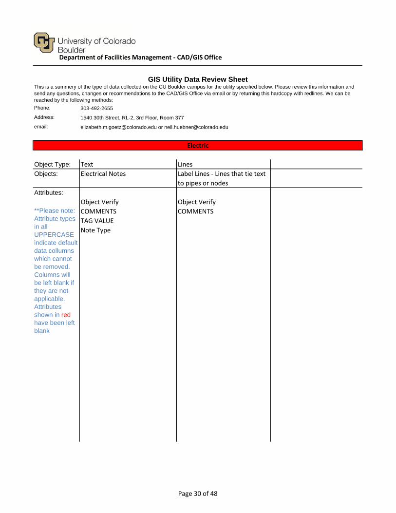
Object Type: Text Lines
Objects: Electrical Notes
Attributes:
Object Verify Object Verify
COMMENTS COMMENTS
TAG VALUE
Note Type
Electric
**Please note: Attribute types in all UPPERCASE indicate default data collumns which cannot be removed. Columns will be left blank if they are not applicable. Attributes shown in red have been left blank
GIS Utility Data Review SheetThis is a summery of the type of data collected on the CU Boulder campus for the utility specified below. Please review this information and send any questions, changes or recommendations to the CAD/GIS Office via email or by returning this hardcopy with redlines. We can be reached by the following methods:
Label Lines ‐ Lines that tie text
to pipes or nodes
Department of Facilities Management ‐ CAD/GIS Office
Page 30 of 48

Phone: 303-492-2655
Address: 1540 30th Street, RL-2, 3rd Floor, Room 377
email: [email protected] or [email protected]
Object Type: Nodes Segments
Objects: Light Poles Lighting Electrical Lines
Control Stations
Attributes:
Object Verify Object Verify
COMMENTS COMMENTS
TAG VALUE TAG VALUE
Owner Segment Type
Controller Wire Size
Field ID Verify Status
Equipment # Start Status
Station ID End Status
Node Type Start Node
SYMBOL NAME End Node
Node Reference Start Type
Node Material End Type
OFFSET DISTANCE
OFFSET DIRECTION
LAT-LONG
Number of Bulbs
New ID
Old ID
Duplicate
Field ID BAK
Location
Controller
Control #
GIS Utility Data Review Sheet
Exterior Lighting
This is a summery of the type of data collected on the CU Boulder campus for the utility specified below. Please review this information and send any questions, changes or recommendations to the CAD/GIS Office via email or by returning this hardcopy with redlines. We can be reached by the following methods:
**Please note: Attribute types in all UPPERCASE indicate default data collumns which cannot be removed. Columns will be left blank if they are not applicable. Attributes shown in red have been left blank
Department of Facilities Management ‐ CAD/GIS Office
Page 31 of 48

Phone: 303-492-2655
Address: 1540 30th Street, RL-2, 3rd Floor, Room 377
email: [email protected] or [email protected]
Object Type: Nodes Lines Lines
Objects: Valves, Heads, Pull boxes ect Irrigation Pipes Laterals
Attributes:
COMMENTS Object Verify COMMENTS
Layer COMMENTS Layer
Blockname Owner
Station Layer
Valve Pipe Type
SYMBOL NAME Pipe Diameter
GPM Old GID
GPM Char Pipe Diameter Txt
Mainlines Only
GIS Utility Data Review SheetThis is a summery of the type of data collected on the CU Boulder campus for the utility specified below. Please review this information and send any questions, changes or recommendations to the CAD/GIS Office via email or by returning this hardcopy with redlines. We can be reached by the following methods:
(Maintained in Grounds sprinkler
system ‐ No longer tracked by
GIS)
**Please note: Attribute types in all UPPERCASE indicate default data collumns which cannot be removed. Columns will be left blank if they are not applicable. Attributes shown in red have been left blank
Irrigation
Department of Facilities Management ‐ CAD/GIS Office
Page 32 of 48

Phone: 303-492-2655
Address: 1540 30th Street, RL-2, 3rd Floor, Room 377
email: [email protected] or [email protected]
Object Type: Lines Lines Nodes
Objects: Misc Lines Sodline Symbols
Attributes:
COMMENTS COMMENTS COMMENTS
Layer Layer layer
Blockname
Valve
(See Ground Panels) SYMBOL NAME
GPM
GPM Char
**Please note: Attribute types in all UPPERCASE indicate default data collumns which cannot be removed. Columns will be left blank if they are not applicable. Attributes shown in red have been left blank
GIS Utility Data Review SheetThis is a summery of the type of data collected on the CU Boulder campus for the utility specified below. Please review this information and send any questions, changes or recommendations to the CAD/GIS Office via email or by returning this hardcopy with redlines. We can be reached by the following methods:
Irrigation
Department of Facilities Management ‐ CAD/GIS Office
Page 33 of 48

Phone: 303-492-2655
Address: 1540 30th Street, RL-2, 3rd Floor, Room 377
email: [email protected] or [email protected]
Object Type: Nodes Lines Lines
Objects: Moisture Sensors Control Wires Sleeves
Attributes:
COMMENTS COMMENTS COMMENTS
SYMBOL NAME Layer Layer
(Maintained in Grounds sprinkler
system ‐ No longer tracked by
GIS)
(Maintained in Grounds sprinkler
system ‐ No longer tracked by GIS)
GIS Utility Data Review Sheet
This is a summery of the type of data collected on the CU Boulder campus for the utility specified below. Please review this information and send any questions, changes or recommendations to the CAD/GIS Office via email or by returning this hardcopy with redlines. We can be reached by the following methods:
Irrigation
**Please note: Attribute types in all UPPERCASE indicate default data collumns which cannot be removed. Columns will be left blank if they are not applicable. Attributes shown in red have been left blank
Department of Facilities Management ‐ CAD/GIS Office
Page 34 of 48
Phone: 303-492-2655
Address: 1540 30th Street, RL-2, 3rd Floor, Room 377
email: [email protected] or [email protected]
Object Type: Text Text Lines
Objects: Notes Labels
Attributes:
COMMENTS COMMENTS COMMENTS
TAG VALUE TAG VALUE Layer
Layer Object GID
Note Type Old Object GID
Label Type
This is a summery of the type of data collected on the CU Boulder campus for the utility specified below. Please review this information and send any questions, changes or recommendations to the CAD/GIS Office via email or by returning this hardcopy with redlines. We can be reached by the following methods:
Irrigation
**Please note: Attribute types in all UPPERCASE indicate default data collumns which cannot be removed. Columns will be left blank if they are not applicable. Attributes shown in red have been left blank
Label Lines ‐ Lines that tie text
to pipes or nodes
GIS Utility Data Review Sheet
Department of Facilities Management ‐ CAD/GIS Office
Page 35 of 48
Phone: 303-492-2655
Address: 1540 30th Street, RL-2, 3rd Floor, Room 377
email: [email protected] or [email protected]
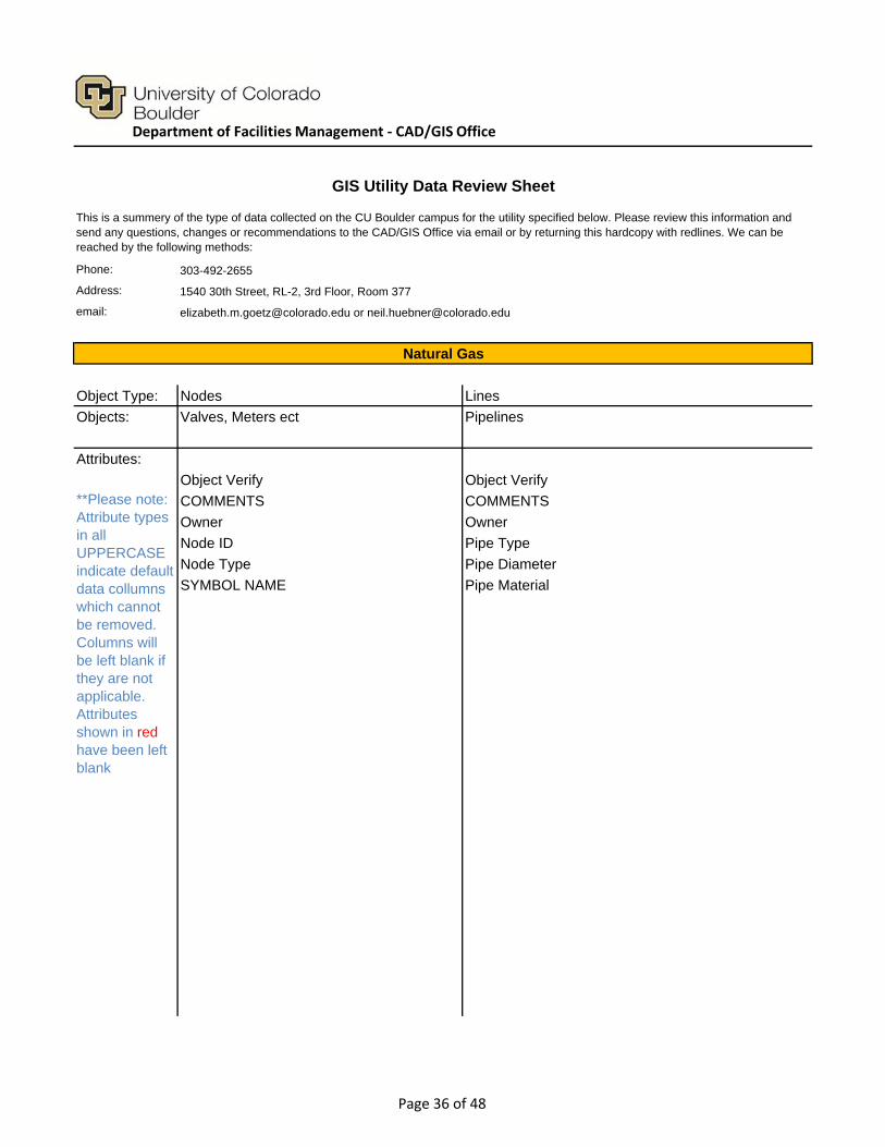
Object Type: Nodes Lines
Objects: Valves, Meters ect Pipelines
Attributes:
Object Verify Object Verify
COMMENTS COMMENTS
Owner Owner
Node ID Pipe Type
Node Type Pipe Diameter
SYMBOL NAME Pipe Material
GIS Utility Data Review Sheet
This is a summery of the type of data collected on the CU Boulder campus for the utility specified below. Please review this information and send any questions, changes or recommendations to the CAD/GIS Office via email or by returning this hardcopy with redlines. We can be reached by the following methods:
Natural Gas
**Please note: Attribute types in all UPPERCASE indicate default data collumns which cannot be removed. Columns will be left blank if they are not applicable. Attributes shown in red have been left blank
Department of Facilities Management ‐ CAD/GIS Office
Page 36 of 48

Phone: 303-492-2655
Address: 1540 30th Street, RL-2, 3rd Floor, Room 377
email: [email protected] or [email protected]
Object Type: Text Lines
Objects: Notes Structure Lines
Attributes:
Object Verify Object Verify
COMMENTS COMMENTS
TAG VALUE
Natural Gas
**Please note: Attribute types in all UPPERCASE indicate default data collumns which cannot be removed. Columns will be left blank if they are not applicable. Attributes shown in red have been left blank
GIS Utility Data Review SheetThis is a summery of the type of data collected on the CU Boulder campus for the utility specified below. Please review this information and send any questions, changes or recommendations to the CAD/GIS Office via email or by returning this hardcopy with redlines. We can be reached by the following methods:
Department of Facilities Management ‐ CAD/GIS Office
Page 37 of 48

Phone: 303-492-2655
Address: 1540 30th Street, RL-2, 3rd Floor, Room 377
email: [email protected] or [email protected]
Object Type: Text Text Text
Objects: Labels Labels (Gravity) Notes
Attributes:
Object Verify Object Verify Object Verify
COMMENTS COMMENTS COMMENTS
TAG VALUE TAG VALUE TAG VALUE
Label Type Label Type UCB Layer
Node Type
GIS Utility Data Review Sheet
This is a summery of the type of data collected on the CU Boulder campus for the utility specified below. Please review this information and send any questions, changes or recommendations to the CAD/GIS Office via email or by returning this hardcopy with redlines. We can be reached by the following methods:
Sanitary Sewer
**Please note: Attribute types in all UPPERCASE indicate default data collumns which cannot be removed. Columns will be left blank if they are not applicable. Attributes shown in red have been left blank
Department of Facilities Management ‐ CAD/GIS Office
Page 38 of 48
Phone: 303-492-2655
Address: 1540 30th Street, RL-2, 3rd Floor, Room 377
email: [email protected] or [email protected]
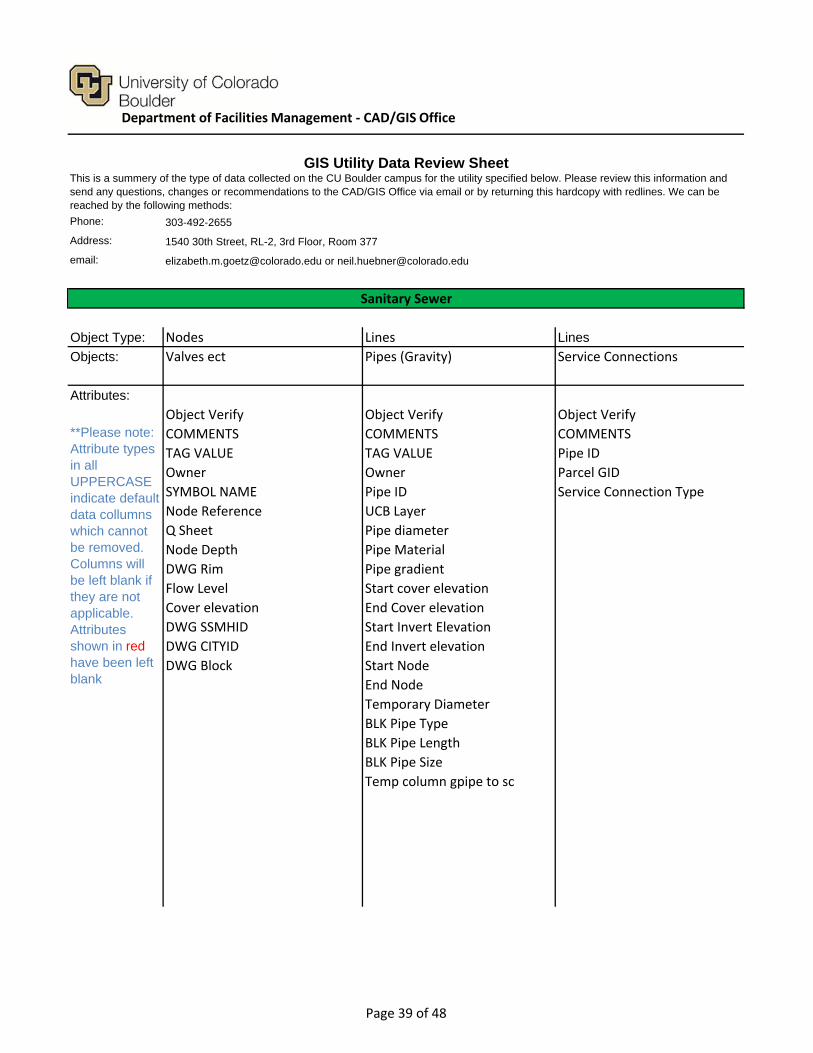
Object Type: Nodes Lines Lines
Objects: Valves ect Pipes (Gravity) Service Connections
Attributes:
Object Verify Object Verify Object Verify
COMMENTS COMMENTS COMMENTS
TAG VALUE TAG VALUE Pipe ID
Owner Owner Parcel GID
SYMBOL NAME Pipe ID Service Connection Type
Node Reference UCB Layer
Q Sheet Pipe diameter
Node Depth Pipe Material
DWG Rim Pipe gradient
Flow Level Start cover elevation
Cover elevation End Cover elevation
DWG SSMHID Start Invert Elevation
DWG CITYID End Invert elevation
DWG Block Start Node
End Node
Temporary Diameter
BLK Pipe Type
BLK Pipe Length
BLK Pipe Size
Temp column gpipe to sc
GIS Utility Data Review SheetThis is a summery of the type of data collected on the CU Boulder campus for the utility specified below. Please review this information and send any questions, changes or recommendations to the CAD/GIS Office via email or by returning this hardcopy with redlines. We can be reached by the following methods:
Sanitary Sewer
**Please note: Attribute types in all UPPERCASE indicate default data collumns which cannot be removed. Columns will be left blank if they are not applicable. Attributes shown in red have been left blank
Department of Facilities Management ‐ CAD/GIS Office
Page 39 of 48

Phone: 303-492-2655
Address: 1540 30th Street, RL-2, 3rd Floor, Room 377
email: [email protected] or [email protected]
Object Type: Lines
Objects: Structures
Attributes:
Object Verify
COMMENTS
This is a summery of the type of data collected on the CU Boulder campus for the utility specified below. Please review this information and send any questions, changes or recommendations to the CAD/GIS Office via email or by returning this hardcopy with redlines. We can be reached by the following methods:
Sanitary Sewer
**Please note: Attribute types in all UPPERCASE indicate default data collumns which cannot be removed. Columns will be left blank if they are not applicable. Attributes shown in red have been left blank
Consider adding
'Structure Type'
GIS Utility Data Review Sheet
Department of Facilities Management ‐ CAD/GIS Office
Page 40 of 48

Phone: 303-492-2655
Address: 1540 30th Street, RL-2, 3rd Floor, Room 377
email: [email protected] or [email protected]
Object Type: Lines Nodes
Objects: Steam Pipes Steam Valves, Meters ect.
Attributes:
Object Verify Object Verify
COMMENTS COMMENTS
Owner Owner
Pipe Type Node ID
Pipe Diameter Node Type
Utility Pathway SYMBOL NAME
Tunnel Number
Project Archive 1
Project Archive 2
Project Archive 3
Status
Conduit Diameter
GIS Utility Data Review Sheet
This is a summery of the type of data collected on the CU Boulder campus for the utility specified below. Please review this information and send any questions, changes or recommendations to the CAD/GIS Office via email or by returning this hardcopy with redlines. We can be reached by the following methods:
Steam
**Please note: Attribute types in all UPPERCASE indicate default data collumns which cannot be removed. Columns will be left blank if they are not applicable. Attributes shown in red have been left blank
Department of Facilities Management ‐ CAD/GIS Office
Page 41 of 48

Phone: 303-492-2655
Address: 1540 30th Street, RL-2, 3rd Floor, Room 377
email: [email protected] or [email protected]
Object Type: Text Lines
Objects: Notes
Attributes:
Object Verify Object Verify
COMMENTS COMMENTS
TAG VALUE
Note Type
Label Lines ‐ Lines that tie text to pipes or
nodes
Steam
**Please note: Attribute types in all UPPERCASE indicate default data collumns which cannot be removed. Columns will be left blank if they are not applicable. Attributes shown in red have been left blank
GIS Utility Data Review SheetThis is a summery of the type of data collected on the CU Boulder campus for the utility specified below. Please review this information and send any questions, changes or recommendations to the CAD/GIS Office via email or by returning this hardcopy with redlines. We can be reached by the following methods:
Department of Facilities Management ‐ CAD/GIS Office
Page 42 of 48

Phone: 303-492-2655
Address: 1540 30th Street, RL-2, 3rd Floor, Room 377
email: [email protected] or [email protected]
Object Type: Polygons Polygons Polygons
Objects: Utility Pathways (Tunnels) Tunnel Access Ventilation
Attributes:
Object Verify Object Verify Object Verify
COMMENTS COMMENTS COMMENTS
TAG VALUE Access ID TAG VALUE
Segment ID Access Type Ventilation ID
Pathway Type Access Style Ventilation Type
Link to PDF 1 Access Class
Link to PDF 2 Link to PDF
Link to PDF 3 Ladder
GIS Utility Data Review Sheet
This is a summery of the type of data collected on the CU Boulder campus for the utility specified below. Please review this information and send any questions, changes or recommendations to the CAD/GIS Office via email or by returning this hardcopy with redlines. We can be reached by the following methods:
Utility Pathways (Tunnels)
**Please note: Attribute types in all UPPERCASE indicate default data collumns which cannot be removed. Columns will be left blank if they are not applicable. Attributes shown in red have been left blank
Department of Facilities Management ‐ CAD/GIS Office
Page 43 of 48

Phone: 303-492-2655
Address: 1540 30th Street, RL-2, 3rd Floor, Room 377
email: [email protected] or [email protected]
Object Type: Nodes Lines Lines
Objects: Water Pipes Service Connections
Attributes:
Object Verify Object Verify Object Verify
COMMENTS COMMENTS COMMENTS
TAG VALUE Owner Owner
Owner Pipe ID Pipe ID
Node ID Water Category Parcel GID
Water Category Pipe diameter Water Category
Node Type Pipe Material ATTR Size
SYMBOL NAME Start Node ATTR Type
Node Reference End Node ATTR Length
Node Elevation ATTR Size ATTR Dia
Old Block Name ATTR Type Temp Type
Old Hydrant Number ATTR Length
ATTR Dia
Temp Type
GIS Utility Data Review Sheet
This is a summery of the type of data collected on the CU Boulder campus for the utility specified below. Please review this information and send any questions, changes or recommendations to the CAD/GIS Office via email or by returning this hardcopy with redlines. We can be reached by the following methods:
Water
**Please note: Attribute types in all UPPERCASE indicate default data collumns which cannot be removed. Columns will be left blank if they are not applicable. Attributes shown in red have been left blank
Water valves, hydrants, meters,
ect
Department of Facilities Management ‐ CAD/GIS Office
Page 44 of 48

Phone: 303-492-2655
Address: 1540 30th Street, RL-2, 3rd Floor, Room 377
email: [email protected] or [email protected]
Object Type: Text Lines Nodes
Objects: Notes Structures Symbols
Attributes:
Object Verify Object Verify Object Verify
COMMENTS COMMENTS COMMENTS
TAG VALUE Funded By TAG VALUE
Note Type Maintained By Water Category
Controlled By SYMBOL NAME
ATTR Size
ATTR Type
ATTR Length
ATTR Dia
Temp Type
This is a summery of the type of data collected on the CU Boulder campus for the utility specified below. Please review this information and send any questions, changes or recommendations to the CAD/GIS Office via email or by returning this hardcopy with redlines. We can be reached by the following methods:
Water
**Please note: Attribute types in all UPPERCASE indicate default data collumns which cannot be removed. Columns will be left blank if they are not applicable. Attributes shown in red have been left blank
GIS Utility Data Review Sheet
Department of Facilities Management ‐ CAD/GIS Office
Page 45 of 48

Phone: 303-492-2655
Address: 1540 30th Street, RL-2, 3rd Floor, Room 377
email: [email protected] or [email protected]
Object Type: Text Text Nodes
Objects: Dimension Notes Dimensions Raw Water Nodes
Attributes:
Object Verify Object Verify Object Verify
COMMENTS COMMENTS COMMENTS
TAG VALUE TAG VALUE TAG VALUE
Owner
Node ID
Water Category
Node Type
SYMBOL NAME
Node Reference
Node elevation
Old Block Name
Old Hydrant Number
GIS Utility Data Review Sheet
This is a summery of the type of data collected on the CU Boulder campus for the utility specified below. Please review this information and send any questions, changes or recommendations to the CAD/GIS Office via email or by returning this hardcopy with redlines. We can be reached by the following methods:
Raw Water
**Please note: Attribute types in all UPPERCASE indicate default data collumns which cannot be removed. Columns will be left blank if they are not applicable. Attributes shown in red have been left blank
Department of Facilities Management ‐ CAD/GIS Office
Page 46 of 48

Phone: 303-492-2655
Address: 1540 30th Street, RL-2, 3rd Floor, Room 377
email: [email protected] or [email protected]
Object Type: Text Text Lines
Objects: Notes Pipe Labels Pipes
Attributes:
Object Verify Object Verify Object Verify
COMMENTS COMMENTS COMMENTS
TAG VALUE TAG VALUE Owner
Pipe ID
Water Category
Pipe diameter
Pipe Material
Start Node
End Node
ATTR Size
ATTR Type
ATTR Length
ATTR Dia
Temp Type
GIS Utility Data Review SheetThis is a summery of the type of data collected on the CU Boulder campus for the utility specified below. Please review this information and send any questions, changes or recommendations to the CAD/GIS Office via email or by returning this hardcopy with redlines. We can be reached by the following methods:
Raw Water
**Please note: Attribute types in all UPPERCASE indicate default data collumns which cannot be removed. Columns will be left blank if they are not applicable. Attributes shown in red have been left blank
Department of Facilities Management ‐ CAD/GIS Office
Page 47 of 48
Phone: 303-492-2655
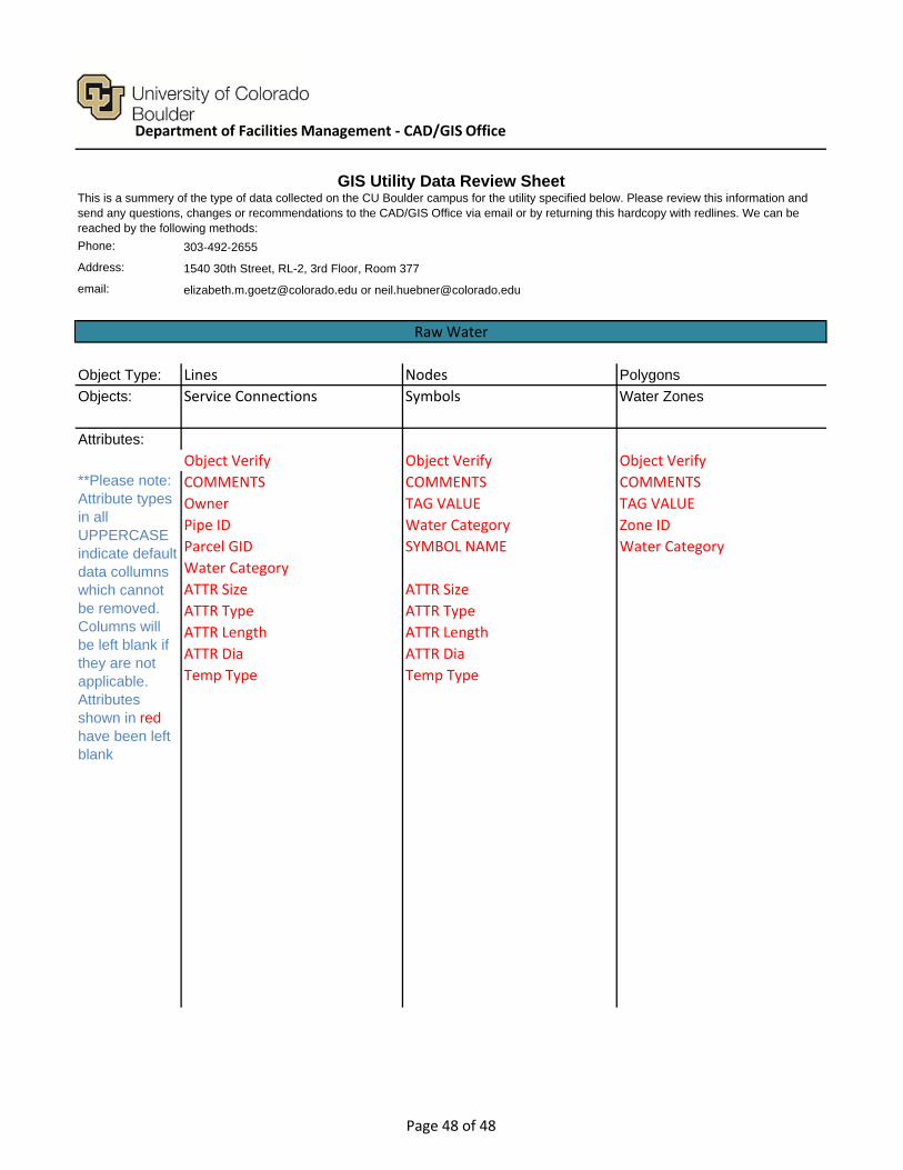
Address: 1540 30th Street, RL-2, 3rd Floor, Room 377
email: [email protected] or [email protected]
Object Type: Lines Nodes Polygons
Objects: Service Connections Symbols Water Zones
Attributes:
Object Verify Object Verify Object Verify
COMMENTS COMMENTS COMMENTS
Owner TAG VALUE TAG VALUE
Pipe ID Water Category Zone ID
Parcel GID SYMBOL NAME Water Category
Water Category
ATTR Size ATTR Size
ATTR Type ATTR Type
ATTR Length ATTR Length
ATTR Dia ATTR Dia
Temp Type Temp Type
**Please note: Attribute types in all UPPERCASE indicate default data collumns which cannot be removed. Columns will be left blank if they are not applicable. Attributes shown in red have been left blank
GIS Utility Data Review SheetThis is a summery of the type of data collected on the CU Boulder campus for the utility specified below. Please review this information and send any questions, changes or recommendations to the CAD/GIS Office via email or by returning this hardcopy with redlines. We can be reached by the following methods:
Raw Water
Department of Facilities Management ‐ CAD/GIS Office
Page 48 of 48
Related Documents