2 (10) 2007 43 R.V. Komarov, R.A. Kascheev, R.V. Zagretdinov Geoid Determination by GPS/Levelling Method... R.V. Komarov, R.A. Kascheev & R.V. Zagretdinov Department of Astronomy and Geodesy, Kazan State University, Kazan, Russia [email protected]; [email protected]; [email protected] Geoid Determination by GPS/Levelling Method in the Republic of Tatarstan The building of a geoid heights map using a Global Positioning System (GPS) and levelling data is presented. GPS measurement was taken at benchmarks of Almetievsky geodynamical polygon and controls of the state geodetic network of the Republic of Tatarstan. For the first time the local geoid heights by GPS/leveling method in Tatarstan was computed. Local geoid heights have been compared with global geoid models. Precision of computed heights have also been made. 1. Introduction During last decades the GPS (Global Positioning System) has been used in many applications of geodesy, geophysics and surveying. The GPS observations are referred to geodet- ic ellipsoid WGS-84 and characterized by rectangular or geo- detic coordinates. The modern differential GPS-techniques provide the ellip- soidal heights with unprecedented accuracy up to one cen- timeter at regional and global scales. On the other hand, many applications in geodesy, geophysics and surveying requires physically defined orthometric or normal heights related to the Earth’s gravity field, typically produced by geometric spirit levelling. For these kind of applications the high precision geoid models must be established with an accuracy compara- ble to the GPS and the levelling measurements accuracy. 2. Geoid/quasigeoid determination The geoid, as an equipotential surface of the gravity field suitably fitting the physical surface of the earth and deter- mined in geodesy as the basic surface which orthometric or normal heights is refered to. For determination of the geoid height the ellipsoidal and orthometric heights are used. The ellipsoidal height is referred from the surface of any reference ellipsoid to the point of interest along ellipsoidal normal. The orthometric height is referred from the geoid to the point of interest along the curved plumbline. The geoid height or ge- oid-ellipsoid separation is referred from the surface of any reference ellipsoid to the geoid along the ellipsoidal normal (e.g. Heiskanen & Moritz, 1967). The transformation of ellip- soidal heights to orthometric heights therefore requires that the geoid height refer to the same reference ellipsoid. In the case of GPS-derived ellipsoidal heights the geocentric WGS84 ellipsoid are used. Therefore, the geoid model must refer to this ellipsoid or another that is compatible. The relationships between ellipsoidal, orthometric and geoid heights are shown in Fig. 1. The determination of the geoid height at each point can be calculated using a well- known formula: N ≈ h – H, (1) where N is the geoid height, h is the ellipsoidal height and H is the orthometric height. The approximate equality in Eq. (1) results from neglecting the departure of the plumbline from the ellipsoidal normal, which is also called the deflection of the vertical. There is also torsion in the plumbline, but the deflection of the vertical is usually the dominant effect of the approximation in Eq.(1). In software for post-processing GPS observations in dif- ferent global and regional geoid models are used and the most common of them are EGM96 and OSU91A.We built up for the territory of our republic global geoid model map height according to EGM96 (Lemoine et al., 1996) presented in figure 2,and model OSU91A (Rapp et al., 1991) presented in figure 3. Russian gravimetric geoid RGG2000 computed by Central Research Institute of Geodesy, Aerial Surveying and Cartog- raphy in 2000 with resolution 2 by 2 arc-minute grid also can be used for our republic Fig. 4 (http://zeus.wdcb.ru/wdcb/ gps/rgg/html, 2000). Unfortunately for many geodesy and surveying applications these models are not accurate enough on recalculation from ellipsoidal for orthometric heights. 3. GPS surveys and levelling Since 1991 precise levelling has been performed on Alme- tievsky geodynamical polygon (AGDP) in the area of the Ro- mashkino oil deposit. The levelling traverse was used to de- termine the normal heights of the benchmarks and was per- formed according to II class levelling standards. This corre- sponds to the maximum allowable misclosures or repeatabili- ty between levelling runs of ±1√L mm, where L is the direct distance along the level traverse in kilometers. The observa- tions on the polygon were carried out using optical levels and invar staves. This polygon consists of about 355 km double run levelling paths and about 500 levelling benchmarks. Two epochs of GPS observations using dual frequency receivers were made in 2000 and 2001 respectively. On their bases the local GPS network was established in the South- Eastern part of the Republic Tatarstan in Russia. The local GPS network consist of 12 benchmarks of geopolygon. The coordinates of our benchmarks were calculated relatively nearest to the IGS stations (ARTU, GLSV). The GPS measure- Table 1.

Welcome message from author
This document is posted to help you gain knowledge. Please leave a comment to let me know what you think about it! Share it to your friends and learn new things together.
Transcript
2 (10) 2007 43
R.V. Komarov, R.A. Kascheev, R.V. Zagretdinov Geoid Determination by GPS/Levelling Method...
R.V. Komarov, R.A. Kascheev & R.V. Zagretdinov Department of Astronomy and Geodesy, Kazan State University, Kazan, Russia
[email protected]; [email protected]; [email protected]
Geoid Determination by GPS/Levelling Method
in the Republic of Tatarstan
The building of a geoid heights map using a Global Positioning System (GPS) and levelling data is presented. GPS
measurement was taken at benchmarks of Almetievsky geodynamical polygon and controls of the state geodetic network
of the Republic of Tatarstan. For the first time the local geoid heights by GPS/leveling method in Tatarstan was computed.
Local geoid heights have been compared with global geoid models. Precision of computed heights have also been made.
1. IntroductionDuring last decades the GPS (Global Positioning System)
has been used in many applications of geodesy, geophysics
and surveying. The GPS observations are referred to geodet-
ic ellipsoid WGS-84 and characterized by rectangular or geo-
detic coordinates.
The modern differential GPS-techniques provide the ellip-
soidal heights with unprecedented accuracy up to one cen-
timeter at regional and global scales. On the other hand, many
applications in geodesy, geophysics and surveying requires
physically defined orthometric or normal heights related to
the Earth’s gravity field, typically produced by geometric spirit
levelling. For these kind of applications the high precision
geoid models must be established with an accuracy compara-
ble to the GPS and the levelling measurements accuracy.
2. Geoid/quasigeoid determinationThe geoid, as an equipotential surface of the gravity field
suitably fitting the physical surface of the earth and deter-
mined in geodesy as the basic surface which orthometric or
normal heights is refered to. For determination of the geoid
height the ellipsoidal and orthometric heights are used. The
ellipsoidal height is referred from the surface of any reference
ellipsoid to the point of interest along ellipsoidal normal. The
orthometric height is referred from the geoid to the point of
interest along the curved plumbline. The geoid height or ge-
oid-ellipsoid separation is referred from the surface of any
reference ellipsoid to the geoid along the ellipsoidal normal
(e.g. Heiskanen & Moritz, 1967). The transformation of ellip-
soidal heights to orthometric heights therefore requires that
the geoid height refer to the same reference ellipsoid. In the
case of GPS-derived ellipsoidal heights the geocentric WGS84
ellipsoid are used. Therefore, the geoid model must refer to
this ellipsoid or another that is compatible.
The relationships between ellipsoidal, orthometric and
geoid heights are shown in Fig. 1. The determination of the
geoid height at each point can be calculated using a well-
known formula:
N ≈ h – H, (1)
where N is the geoid height, h is the ellipsoidal height and H
is the orthometric height. The approximate equality in Eq. (1)
results from neglecting the departure of the plumbline from
the ellipsoidal normal, which is also called the deflection of
the vertical. There is also torsion in the plumbline, but the
deflection of the vertical is usually the dominant effect of the
approximation in Eq.(1).
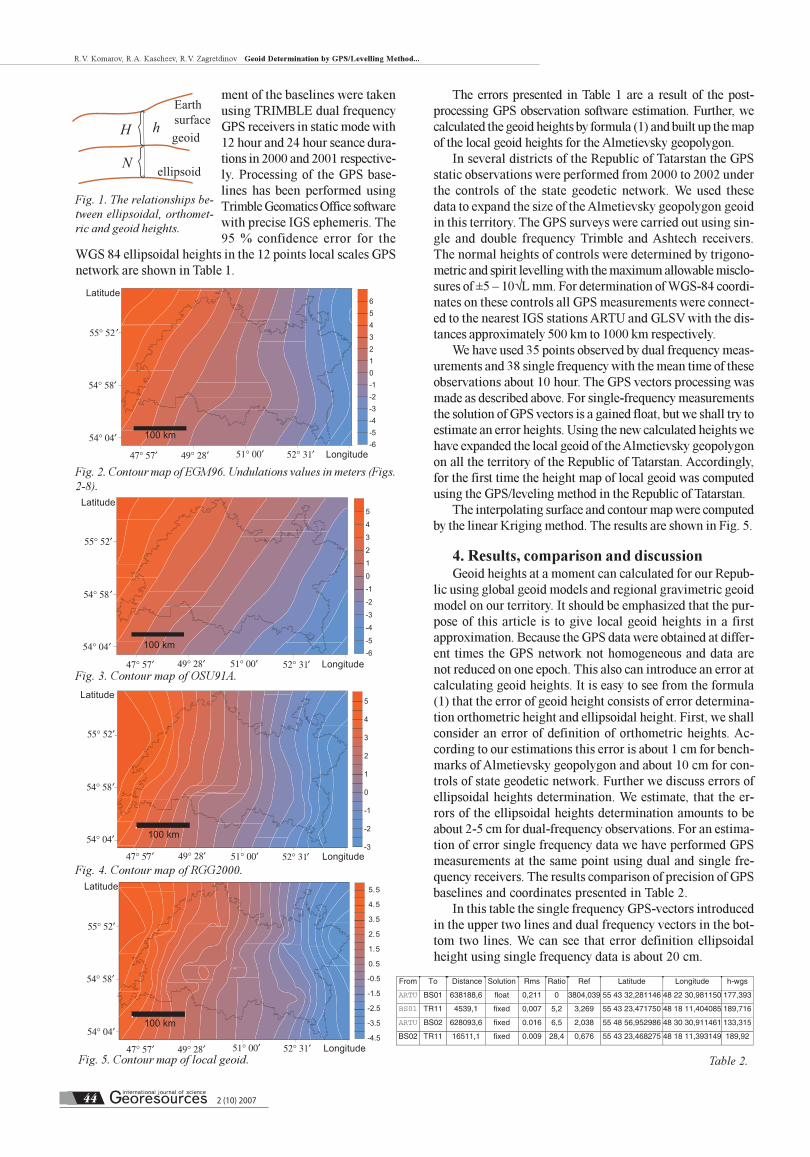
In software for post-processing GPS observations in dif-
ferent global and regional geoid models are used and the
most common of them are EGM96 and OSU91A.We built up
for the territory of our republic global geoid model map height
according to EGM96 (Lemoine et al., 1996) presented in figure
2,and model OSU91A (Rapp et al., 1991) presented in figure 3.
Russian gravimetric geoid RGG2000 computed by Central
Research Institute of Geodesy, Aerial Surveying and Cartog-
raphy in 2000 with resolution 2 by 2 arc-minute grid also can
be used for our republic Fig. 4 (http://zeus.wdcb.ru/wdcb/
gps/rgg/html, 2000). Unfortunately for many geodesy and
surveying applications these models are not accurate enough
on recalculation from ellipsoidal for orthometric heights.
3. GPS surveys and levellingSince 1991 precise levelling has been performed on Alme-
tievsky geodynamical polygon (AGDP) in the area of the Ro-
mashkino oil deposit. The levelling traverse was used to de-
termine the normal heights of the benchmarks and was per-
formed according to II class levelling standards. This corre-
sponds to the maximum allowable misclosures or repeatabili-
ty between levelling runs of ±1√L mm, where L is the direct
distance along the level traverse in kilometers. The observa-
tions on the polygon were carried out using optical levels and
invar staves. This polygon consists of about 355 km double
run levelling paths and about 500 levelling benchmarks.
Two epochs of GPS observations using dual frequency
receivers were made in 2000 and 2001 respectively. On their
bases the local GPS network was established in the South-
Eastern part of the Republic Tatarstan in Russia. The local
GPS network consist of 12 benchmarks of geopolygon. The
coordinates of our benchmarks were calculated relatively
nearest to the IGS stations (ARTU, GLSV). The GPS measure-
Table 1.
2 (10) 200744
R.V. Komarov, R.A. Kascheev, R.V. Zagretdinov Geoid Determination by GPS/Levelling Method...
ment of the baselines were taken
using TRIMBLE dual frequency
GPS receivers in static mode with
12 hour and 24 hour seance dura-
tions in 2000 and 2001 respective-
ly. Processing of the GPS base-
lines has been performed using
Trimble Geomatics Office software
with precise IGS ephemeris. The
95 % confidence error for the
WGS 84 ellipsoidal heights in the 12 points local scales GPS
network are shown in Table 1.
The errors presented in Table 1 are a result of the post-
processing GPS observation software estimation. Further, we
calculated the geoid heights by formula (1) and built up the map
of the local geoid heights for the Almetievsky geopolygon.
In several districts of the Republic of Tatarstan the GPS
static observations were performed from 2000 to 2002 under
the controls of the state geodetic network. We used these
data to expand the size of the Almetievsky geopolygon geoid
in this territory. The GPS surveys were carried out using sin-
gle and double frequency Trimble and Ashtech receivers.
The normal heights of controls were determined by trigono-
metric and spirit levelling with the maximum allowable misclo-
sures of ±5 – 10√L mm. For determination of WGS-84 coordi-
nates on these controls all GPS measurements were connect-
ed to the nearest IGS stations ARTU and GLSV with the dis-
tances approximately 500 km to 1000 km respectively.
We have used 35 points observed by dual frequency meas-
urements and 38 single frequency with the mean time of these
observations about 10 hour. The GPS vectors processing was
made as described above. For single-frequency measurements
the solution of GPS vectors is a gained float, but we shall try to
estimate an error heights. Using the new calculated heights we
have expanded the local geoid of the Almetievsky geopolygon
on all the territory of the Republic of Tatarstan. Accordingly,
for the first time the height map of local geoid was computed
using the GPS/leveling method in the Republic of Tatarstan.
The interpolating surface and contour map were computed
by the linear Kriging method. The results are shown in Fig. 5.
4. Results, comparison and discussionGeoid heights at a moment can calculated for our Repub-
lic using global geoid models and regional gravimetric geoid
model on our territory. It should be emphasized that the pur-
pose of this article is to give local geoid heights in a first
approximation. Because the GPS data were obtained at differ-
ent times the GPS network not homogeneous and data are
not reduced on one epoch. This also can introduce an error at
calculating geoid heights. It is easy to see from the formula
(1) that the error of geoid height consists of error determina-
tion orthometric height and ellipsoidal height. First, we shall
consider an error of definition of orthometric heights. Ac-
cording to our estimations this error is about 1 cm for bench-
marks of Almetievsky geopolygon and about 10 cm for con-
trols of state geodetic network. Further we discuss errors of
ellipsoidal heights determination. We estimate, that the er-
rors of the ellipsoidal heights determination amounts to be
about 2-5 cm for dual-frequency observations. For an estima-
tion of error single frequency data we have performed GPS
measurements at the same point using dual and single fre-
quency receivers. The results comparison of precision of GPS
baselines and coordinates presented in Table 2.
In this table the single frequency GPS-vectors introduced
in the upper two lines and dual frequency vectors in the bot-
tom two lines. We can see that error definition ellipsoidal
height using single frequency data is about 20 cm.
Earth surfacegeoid
ellipsoid
H h
N
Fig. 1. The relationships be-
tween ellipsoidal, orthomet-
ric and geoid heights.
Table 2.
Fig. 4. Contour map of RGG2000.
Fig. 5. Contour map of local geoid.
Fig. 2. Contour map of EGM96. Undulations values in meters (Figs.
2-8).
Fig. 3. Contour map of OSU91A.
2 (10) 2007 45
R.V. Komarov, R.A. Kascheev, R.V. Zagretdinov Geoid Determination by GPS/Levelling Method...
Accordingly we have an error of ellipsoidal height of about
5 cm and 20 cm for dual and single frequency data. Therefore
an error of geoid heights can vary from 5 cm up to 25 cm for
dual-frequency data given on benchmarks of an Almetievsky
geodynamical polygon and controls of a state geodetic net-
work respectively. On controls, the error of geoid heights can
be estimated by 30 cm at the best and 1 m in the worst case for
single-frequency data. In this case the primary factor is the
error of a solution GPS baseline. It is known, that the biggest
error in determination of baselines during processing of a
single-frequency data on major distances is introduced by
ionosphere effects. Unfortunately in Tatarstan at the present
time there are wide distribution single-frequency receivers
and lack of dense GPS network stations. In a first attempt to
compare local geoid with other models our geoid was com-
pared with global models EGM96 and OSU91A.
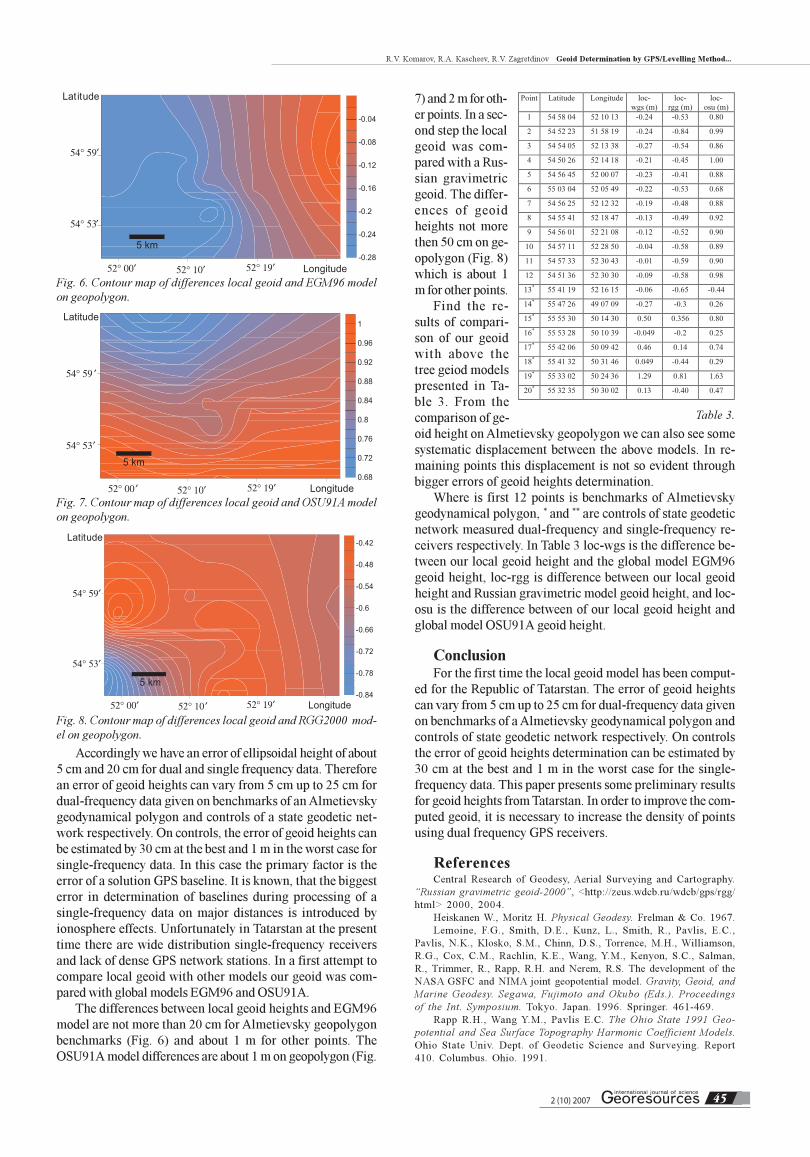
The differences between local geoid heights and EGM96
model are not more than 20 cm for Almetievsky geopolygon
benchmarks (Fig. 6) and about 1 m for other points. The
OSU91A model differences are about 1 m on geopolygon (Fig.
Fig. 7. Contour map of differences local geoid and OSU91A model
on geopolygon.
Fig. 6. Contour map of differences local geoid and EGM96 model
on geopolygon.
Fig. 8. Contour map of differences local geoid and RGG2000 mod-
el on geopolygon.
Table 3.
7) and 2 m for oth-
er points. In a sec-
ond step the local
geoid was com-
pared with a Rus-
sian gravimetric
geoid. The differ-
ences of geoid
heights not more
then 50 cm on ge-
opolygon (Fig. 8)
which is about 1
m for other points.
Find the re-
sults of compari-
son of our geoid
with above the
tree geiod models
presented in Ta-
ble 3. From the
comparison of ge-
oid height on Almetievsky geopolygon we can also see some
systematic displacement between the above models. In re-
maining points this displacement is not so evident through
bigger errors of geoid heights determination.
Where is first 12 points is benchmarks of Almetievsky
geodynamical polygon, * and ** are controls of state geodetic
network measured dual-frequency and single-frequency re-
ceivers respectively. In Table 3 loc-wgs is the difference be-
tween our local geoid height and the global model EGM96
geoid height, loc-rgg is difference between our local geoid
height and Russian gravimetric model geoid height, and loc-
osu is the difference between of our local geoid height and
global model OSU91A geoid height.
ConclusionFor the first time the local geoid model has been comput-
ed for the Republic of Tatarstan. The error of geoid heights
can vary from 5 cm up to 25 cm for dual-frequency data given
on benchmarks of a Almetievsky geodynamical polygon and
controls of state geodetic network respectively. On controls
the error of geoid heights determination can be estimated by
30 cm at the best and 1 m in the worst case for the single-
frequency data. This paper presents some preliminary results
for geoid heights from Tatarstan. In order to improve the com-
puted geoid, it is necessary to increase the density of points
using dual frequency GPS receivers.
ReferencesCentral Research of Geodesy, Aerial Surveying and Cartography.
“Russian gravimetric geoid-2000”, <http://zeus.wdcb.ru/wdcb/gps/rgg/
html> 2000, 2004.
Heiskanen W., Moritz H. Physical Geodesy. Frelman & Co. 1967.
Lemoine, F.G., Smith, D.E., Kunz, L., Smith, R., Pavlis, E.C.,
Pavlis, N.K., Klosko, S.M., Chinn, D.S., Torrence, M.H., Williamson,
R.G., Cox, C.M., Rachlin, K.E., Wang, Y.M., Kenyon, S.C., Salman,
R., Trimmer, R., Rapp, R.H. and Nerem, R.S. The development of the
NASA GSFC and NIMA joint geopotential model. Gravity, Geoid, and
Marine Geodesy. Segawa, Fujimoto and Okubo (Eds.). Proceedings
of the Int. Symposium. Tokyo. Japan. 1996. Springer. 461-469.
Rapp R.H., Wang Y.M., Pavlis E.C. The Ohio State 1991 Geo-
potential and Sea Surface Topography Harmonic Coefficient Models.
Ohio State Univ. Dept. of Geodetic Science and Surveying. Report
410. Columbus. Ohio. 1991.
Related Documents


![\documentstyle[12pt,russian]{article}old.kpfu.ru/f6/k8/bin_files/fotogram_triang_!36.doc · Web viewЛинейная разрешающая способность у современных](https://static.cupdf.com/doc/110x72/5fadc4082074f041073cac56/documentstyle12ptrussianarticleoldkpfuruf6k8binfilesfotogramtriang36doc.jpg)