DEFRA CEFAS LABORATORY, LOWESTOFT, SUFFOLK, ENGLAND, UK. CEND 10/12 CRUISE REPORT RV CEFAS ENDEAVOUR STAFF: Name Role / Discipline Roger Coggan Scientist in Charge (SIC). Benthic Ecologist/Senior Seabed Mapper Day-Shift (12:00 – 00:00) Jackie Eggleton Watch Leader. Benthic Ecologist Bill Meadows Senior Technician (MB Processing & CRP) Buster Rook-Bishop Technical Apprentice Tom Hill Animal Health & Welfare Denise Doran Plankton Biologist Laura Cornick JNCC Lead Scientist Merle Shaw Student, Exeter University Night Shift (00:00 – 12:00) Claire Mason Watch Leader. Sedimentologist Marc Whybrow Technician James Cook Technical Apprentice Marianne Herve Contract MB processor (Netsurvey) Ana Leocadio Shellfish Biologist Tom Fisher Ecotoxicologist Penny Wilson JNCC Betheney Wills Student, Exeter University DURATION: Monday 2 nd July – Monday 16 th July MOBILISED: Lowestoft. 12:00 hrs, Monday 2 nd July. DEPARTED: 09:00 hrs Tuesday 3 rd July DOCKED 20:00 hrs, Sunday 15 th July, at Portland DEMOBILISED Mon 16 th July OPERATION AREAS: Western Channel & Western Approaches FOREIGN WATERS: None IFCA AREAS: Cornwall; Devon & Severn MILITARY AREAS: None PORTCALLS: None SMALL BOAT TRANSFERS: None

Welcome message from author
This document is posted to help you gain knowledge. Please leave a comment to let me know what you think about it! Share it to your friends and learn new things together.
Transcript
DEFRA CEFAS LABORATORY, LOWESTOFT, SUFFOLK, ENGLAND, UK.
CEND 10/12 CRUISE REPORT
RV CEFAS ENDEAVOUR
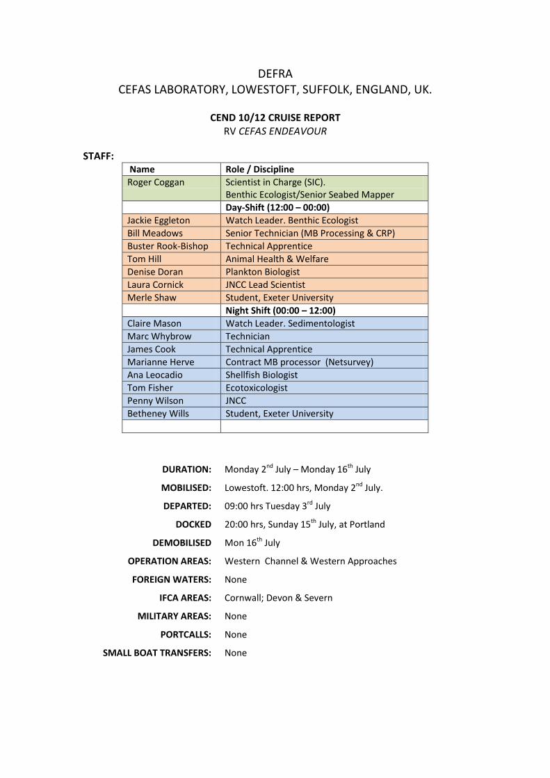
STAFF: Name Role / Discipline Roger Coggan Scientist in Charge (SIC).
Benthic Ecologist/Senior Seabed Mapper Day-Shift (12:00 – 00:00) Jackie Eggleton Watch Leader. Benthic Ecologist Bill Meadows Senior Technician (MB Processing & CRP) Buster Rook-Bishop Technical Apprentice Tom Hill Animal Health & Welfare Denise Doran Plankton Biologist Laura Cornick JNCC Lead Scientist Merle Shaw Student, Exeter University Night Shift (00:00 – 12:00) Claire Mason Watch Leader. Sedimentologist Marc Whybrow Technician James Cook Technical Apprentice Marianne Herve Contract MB processor (Netsurvey) Ana Leocadio Shellfish Biologist Tom Fisher Ecotoxicologist Penny Wilson JNCC Betheney Wills Student, Exeter University
DURATION: Monday 2nd July – Monday 16th July
MOBILISED: Lowestoft. 12:00 hrs, Monday 2nd July.
DEPARTED: 09:00 hrs Tuesday 3rd July
DOCKED 20:00 hrs, Sunday 15th July, at Portland
DEMOBILISED Mon 16th July
OPERATION AREAS: Western Channel & Western Approaches
FOREIGN WATERS: None
IFCA AREAS: Cornwall; Devon & Severn
MILITARY AREAS: None
PORTCALLS: None
SMALL BOAT TRANSFERS: None
Purpose:
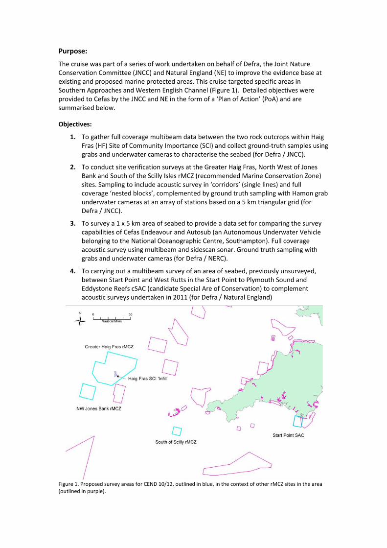
The cruise was part of a series of work undertaken on behalf of Defra, the Joint Nature Conservation Committee (JNCC) and Natural England (NE) to improve the evidence base at existing and proposed marine protected areas. This cruise targeted specific areas in Southern Approaches and Western English Channel (Figure 1). Detailed objectives were provided to Cefas by the JNCC and NE in the form of a ‘Plan of Action’ (PoA) and are summarised below.
Objectives:
1. To gather full coverage multibeam data between the two rock outcrops within Haig Fras (HF) Site of Community Importance (SCI) and collect ground-truth samples using grabs and underwater cameras to characterise the seabed (for Defra / JNCC).
2. To conduct site verification surveys at the Greater Haig Fras, North West of Jones Bank and South of the Scilly Isles rMCZ (recommended Marine Conservation Zone) sites. Sampling to include acoustic survey in ‘corridors’ (single lines) and full coverage ‘nested blocks’, complemented by ground truth sampling with Hamon grab underwater cameras at an array of stations based on a 5 km triangular grid (for Defra / JNCC).
3. To survey a 1 x 5 km area of seabed to provide a data set for comparing the survey capabilities of Cefas Endeavour and Autosub (an Autonomous Underwater Vehicle belonging to the National Oceanographic Centre, Southampton). Full coverage acoustic survey using multibeam and sidescan sonar. Ground truth sampling with grabs and underwater cameras (for Defra / NERC).
4. To carrying out a multibeam survey of an area of seabed, previously unsurveyed, between Start Point and West Rutts in the Start Point to Plymouth Sound and Eddystone Reefs cSAC (candidate Special Are of Conservation) to complement acoustic surveys undertaken in 2011 (for Defra / Natural England)
Figure 1. Proposed survey areas for CEND 10/12, outlined in blue, in the context of other rMCZ sites in the area (outlined in purple).
Narrative
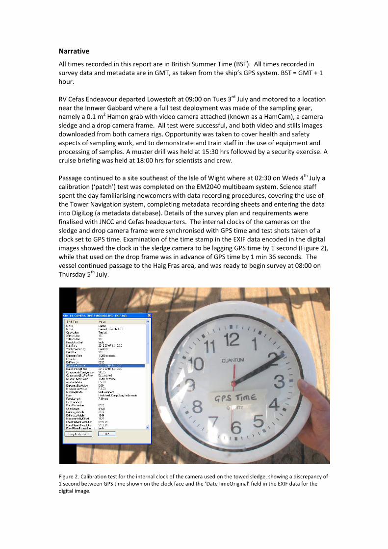
All times recorded in this report are in British Summer Time (BST). All times recorded in survey data and metadata are in GMT, as taken from the ship’s GPS system. BST = GMT + 1 hour. RV Cefas Endeavour departed Lowestoft at 09:00 on Tues 3rd July and motored to a location near the Innwer Gabbard where a full test deployment was made of the sampling gear, namely a 0.1 m2 Hamon grab with video camera attached (known as a HamCam), a camera sledge and a drop camera frame. All test were successful, and both video and stills images downloaded from both camera rigs. Opportunity was taken to cover health and safety aspects of sampling work, and to demonstrate and train staff in the use of equipment and processing of samples. A muster drill was held at 15:30 hrs followed by a security exercise. A cruise briefing was held at 18:00 hrs for scientists and crew. Passage continued to a site southeast of the Isle of Wight where at 02:30 on Weds 4th July a calibration (‘patch’) test was completed on the EM2040 multibeam system. Science staff spent the day familiarising newcomers with data recording procedures, covering the use of the Tower Navigation system, completing metadata recording sheets and entering the data into DigiLog (a metadata database). Details of the survey plan and requirements were finalised with JNCC and Cefas headquarters. The internal clocks of the cameras on the sledge and drop camera frame were synchronised with GPS time and test shots taken of a clock set to GPS time. Examination of the time stamp in the EXIF data encoded in the digital images showed the clock in the sledge camera to be lagging GPS time by 1 second (Figure 2), while that used on the drop frame was in advance of GPS time by 1 min 36 seconds. The vessel continued passage to the Haig Fras area, and was ready to begin survey at 08:00 on Thursday 5th July.
Figure 2. Calibration test for the internal clock of the camera used on the towed sledge, showing a discrepancy of 1 second between GPS time shown on the clock face and the ‘DateTimeOriginal’ field in the EXIF data for the digital image.
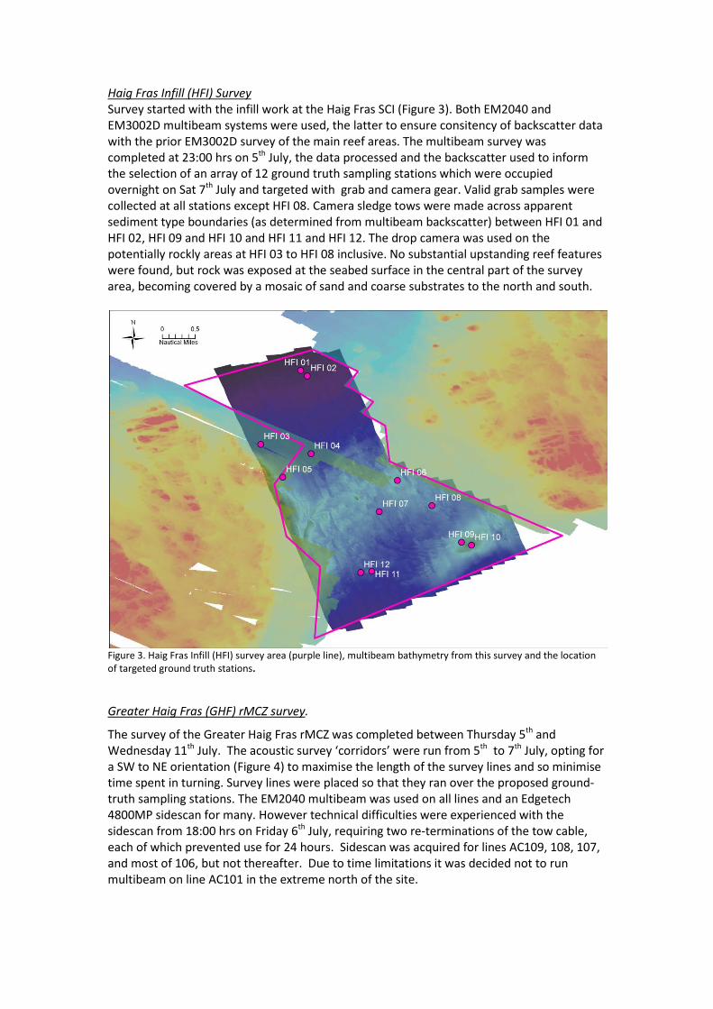
Haig Fras Infill (HFI) Survey Survey started with the infill work at the Haig Fras SCI (Figure 3). Both EM2040 and EM3002D multibeam systems were used, the latter to ensure consitency of backscatter data with the prior EM3002D survey of the main reef areas. The multibeam survey was completed at 23:00 hrs on 5th July, the data processed and the backscatter used to inform the selection of an array of 12 ground truth sampling stations which were occupied overnight on Sat 7th July and targeted with grab and camera gear. Valid grab samples were collected at all stations except HFI 08. Camera sledge tows were made across apparent sediment type boundaries (as determined from multibeam backscatter) between HFI 01 and HFI 02, HFI 09 and HFI 10 and HFI 11 and HFI 12. The drop camera was used on the potentially rockly areas at HFI 03 to HFI 08 inclusive. No substantial upstanding reef features were found, but rock was exposed at the seabed surface in the central part of the survey area, becoming covered by a mosaic of sand and coarse substrates to the north and south.
Figure 3. Haig Fras Infill (HFI) survey area (purple line), multibeam bathymetry from this survey and the location of targeted ground truth stations.
Greater Haig Fras (GHF) rMCZ survey.
The survey of the Greater Haig Fras rMCZ was completed between Thursday 5th and Wednesday 11th July. The acoustic survey ‘corridors’ were run from 5th to 7th July, opting for a SW to NE orientation (Figure 4) to maximise the length of the survey lines and so minimise time spent in turning. Survey lines were placed so that they ran over the proposed ground-truth sampling stations. The EM2040 multibeam was used on all lines and an Edgetech 4800MP sidescan for many. However technical difficulties were experienced with the sidescan from 18:00 hrs on Friday 6th July, requiring two re-terminations of the tow cable, each of which prevented use for 24 hours. Sidescan was acquired for lines AC109, 108, 107, and most of 106, but not thereafter. Due to time limitations it was decided not to run multibeam on line AC101 in the extreme north of the site.
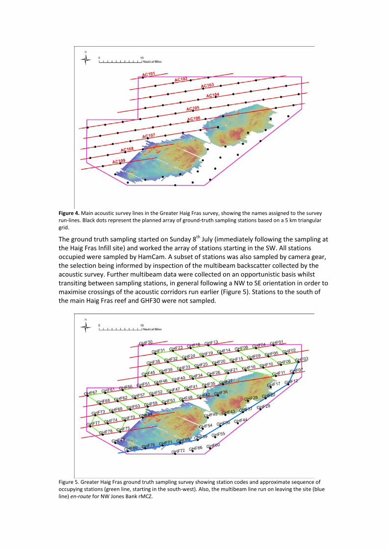
Figure 4. Main acoustic survey lines in the Greater Haig Fras survey, showing the names assigned to the survey run-lines. Black dots represent the planned array of ground-truth sampling stations based on a 5 km triangular grid.
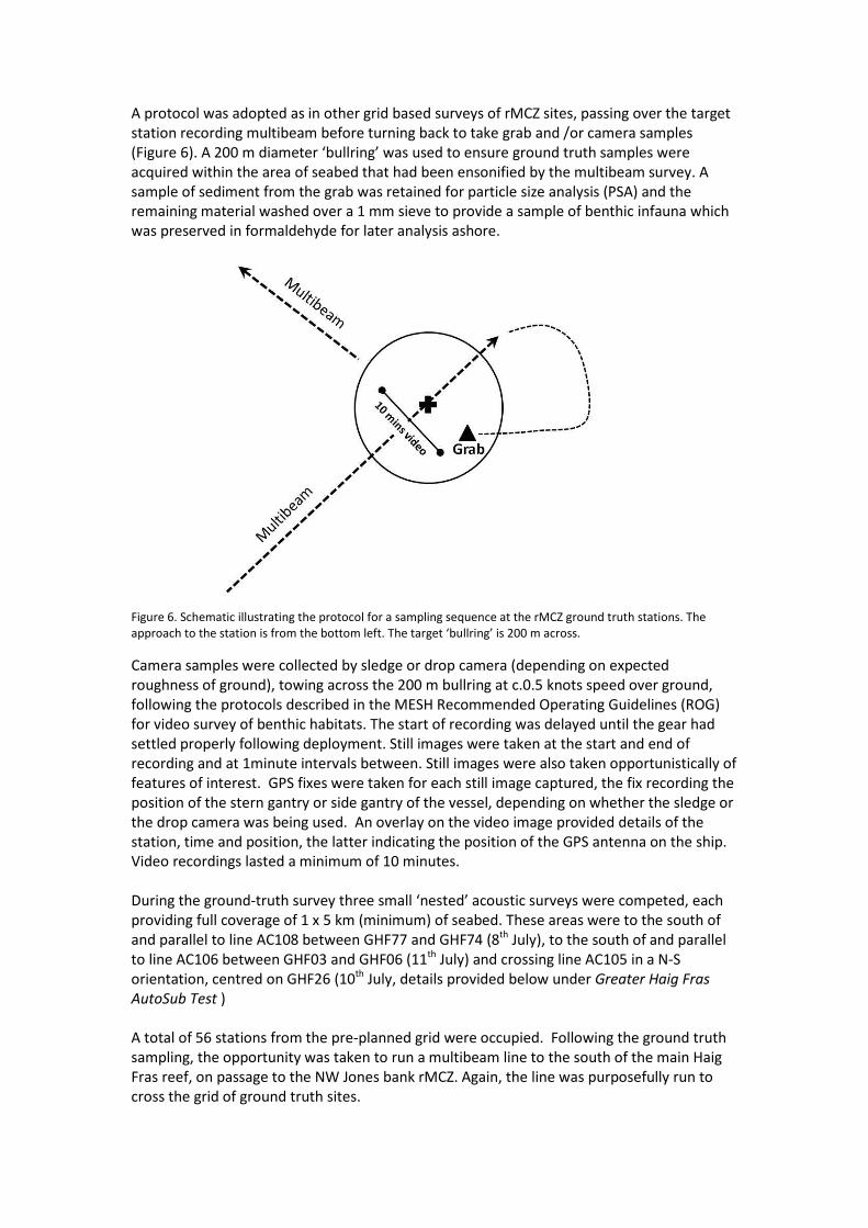
The ground truth sampling started on Sunday 8th July (immediately following the sampling at the Haig Fras Infill site) and worked the array of stations starting in the SW. All stations occupied were sampled by HamCam. A subset of stations was also sampled by camera gear, the selection being informed by inspection of the multibeam backscatter collected by the acoustic survey. Further multibeam data were collected on an opportunistic basis whilst transiting between sampling stations, in general following a NW to SE orientation in order to maximise crossings of the acoustic corridors run earlier (Figure 5). Stations to the south of the main Haig Fras reef and GHF30 were not sampled.
Figure 5. Greater Haig Fras ground truth sampling survey showing station codes and approximate sequence of occupying stations (green line, starting in the south-west). Also, the multibeam line run on leaving the site (blue line) en-route for NW Jones Bank rMCZ.
A protocol was adopted as in other grid based surveys of rMCZ sites, passing over the target station recording multibeam before turning back to take grab and /or camera samples (Figure 6). A 200 m diameter ‘bullring’ was used to ensure ground truth samples were acquired within the area of seabed that had been ensonified by the multibeam survey. A sample of sediment from the grab was retained for particle size analysis (PSA) and the remaining material washed over a 1 mm sieve to provide a sample of benthic infauna which was preserved in formaldehyde for later analysis ashore.
Figure 6. Schematic illustrating the protocol for a sampling sequence at the rMCZ ground truth stations. The approach to the station is from the bottom left. The target ‘bullring’ is 200 m across.
Camera samples were collected by sledge or drop camera (depending on expected roughness of ground), towing across the 200 m bullring at c.0.5 knots speed over ground, following the protocols described in the MESH Recommended Operating Guidelines (ROG) for video survey of benthic habitats. The start of recording was delayed until the gear had settled properly following deployment. Still images were taken at the start and end of recording and at 1minute intervals between. Still images were also taken opportunistically of features of interest. GPS fixes were taken for each still image captured, the fix recording the position of the stern gantry or side gantry of the vessel, depending on whether the sledge or the drop camera was being used. An overlay on the video image provided details of the station, time and position, the latter indicating the position of the GPS antenna on the ship. Video recordings lasted a minimum of 10 minutes. During the ground-truth survey three small ‘nested’ acoustic surveys were competed, each providing full coverage of 1 x 5 km (minimum) of seabed. These areas were to the south of and parallel to line AC108 between GHF77 and GHF74 (8th July), to the south of and parallel to line AC106 between GHF03 and GHF06 (11th July) and crossing line AC105 in a N-S orientation, centred on GHF26 (10th July, details provided below under Greater Haig Fras AutoSub Test ) A total of 56 stations from the pre-planned grid were occupied. Following the ground truth sampling, the opportunity was taken to run a multibeam line to the south of the main Haig Fras reef, on passage to the NW Jones bank rMCZ. Again, the line was purposefully run to cross the grid of ground truth sites.
Greater Haig Fras AutoSub Test (GHFAST) survey.
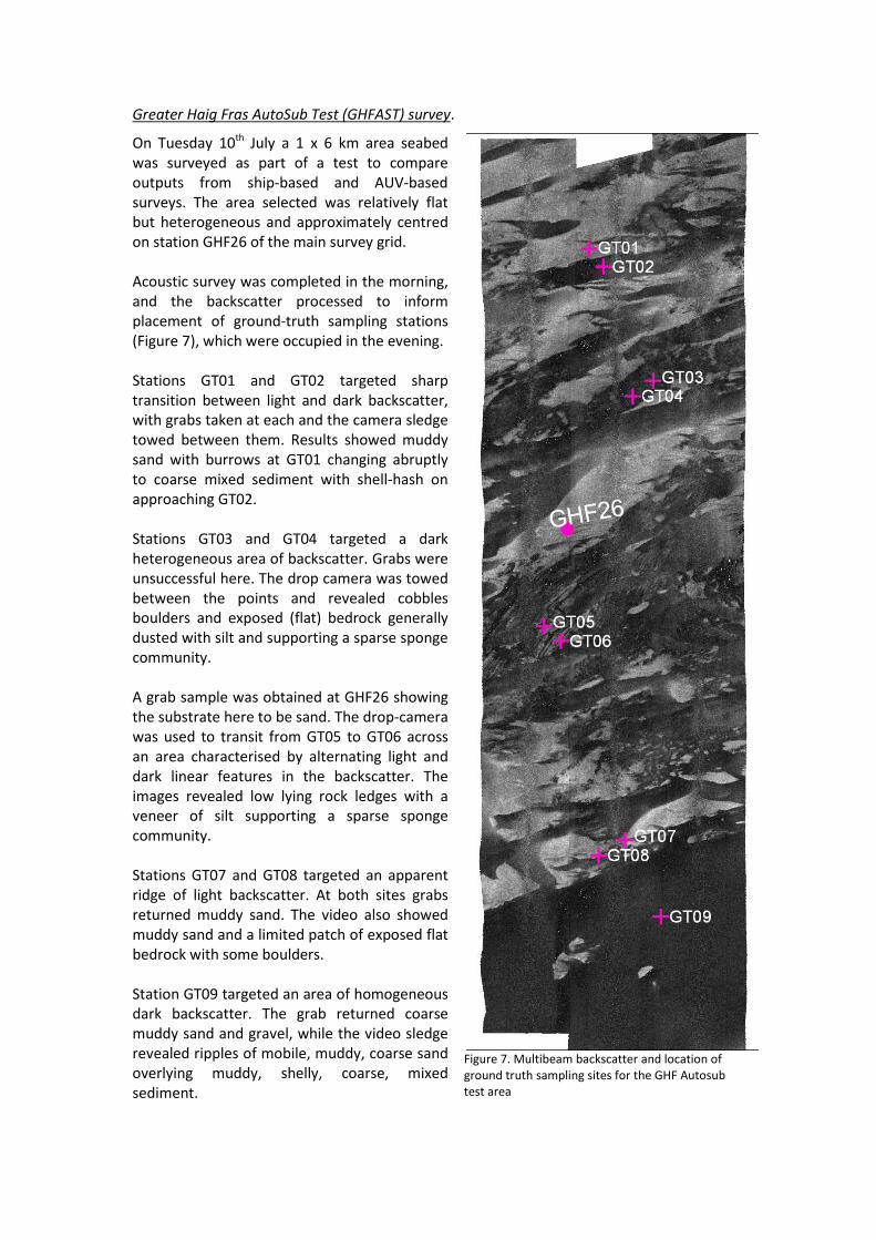
On Tuesday 10th July a 1 x 6 km area seabed was surveyed as part of a test to compare outputs from ship-based and AUV-based surveys. The area selected was relatively flat but heterogeneous and approximately centred on station GHF26 of the main survey grid. Acoustic survey was completed in the morning, and the backscatter processed to inform placement of ground-truth sampling stations (Figure 7), which were occupied in the evening. Stations GT01 and GT02 targeted sharp transition between light and dark backscatter, with grabs taken at each and the camera sledge towed between them. Results showed muddy sand with burrows at GT01 changing abruptly to coarse mixed sediment with shell-hash on approaching GT02. Stations GT03 and GT04 targeted a dark heterogeneous area of backscatter. Grabs were unsuccessful here. The drop camera was towed between the points and revealed cobbles boulders and exposed (flat) bedrock generally dusted with silt and supporting a sparse sponge community. A grab sample was obtained at GHF26 showing the substrate here to be sand. The drop-camera was used to transit from GT05 to GT06 across an area characterised by alternating light and dark linear features in the backscatter. The images revealed low lying rock ledges with a veneer of silt supporting a sparse sponge community. Stations GT07 and GT08 targeted an apparent ridge of light backscatter. At both sites grabs returned muddy sand. The video also showed muddy sand and a limited patch of exposed flat bedrock with some boulders. Station GT09 targeted an area of homogeneous dark backscatter. The grab returned coarse muddy sand and gravel, while the video sledge revealed ripples of mobile, muddy, coarse sand overlying muddy, shelly, coarse, mixed sediment.
Figure 7. Multibeam backscatter and location of ground truth sampling sites for the GHF Autosub test area
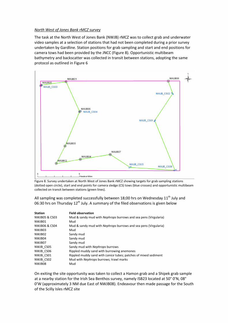
North West of Jones Bank rMCZ survey
The task at the North West of Jones Bank (NWJB) rMCZ was to collect grab and underwater video samples at a selection of stations that had not been completed during a prior survey undertaken by Gardline. Station positions for grab sampling and start and end positions for camera tows had been provided by the JNCC (Figure 8). Opportunistic multibeam bathymetry and backscatter was collected in transit between stations, adopting the same protocol as outlined in Figure 6
Figure 8. Survey undertaken at North West of Jones Bank rMCZ showing targets for grab sampling stations (dotted open circle), start and end points for camera sledge (CS) tows (blue crosses) and opportunistic multibeam collected on transit between stations (green lines).
All sampling was completed successfully between 18;00 hrs on Wednesday 11th July and 06:30 hrs on Thursday 12th July. A summary of the filed observations is given below Station Field observation NWJB05 & CS03 Mud & sandy mud with Nephrops burrows and sea pens (Virgularia) NWJB01 Mud NWJB06 & CS04 Mud & sandy mud with Nephrops burrows and sea pens (Virgularia) NWJB03 Mud NWJB02 Sandy mud NWJB04 Sandy mud NWJB07 Sandy mud NWJB_CS05 Sandy mud with Nephrops burrows NWJB_CS06 Rippled muddy sand with burrowing anemones NWJB_CS01 Rippled muddy sand with Lanice tubes; patches of mixed sediment NWJB_CS02 Mud with Nephrops burrows; trawl marks NWJB08 Mud On exiting the site opportunity was taken to collect a Hamon grab and a Shipek grab sample at a nearby station for the Irish Sea Benthos survey, namely ISB23 located at 50° 0’N, 08° 0’W (approximately 3 NM due East of NWJB08). Endeavour then made passage for the South of the Scilly Isles rMCZ site
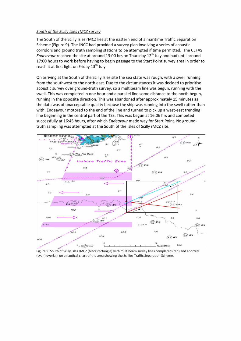
South of the Scilly Isles rMCZ survey
The South of the Scilly Isles rMCZ lies at the eastern end of a maritime Traffic Separation Scheme (Figure 9). The JNCC had provided a survey plan involving a series of acoustic corridors and ground truth sampling stations to be attempted if time permitted. The CEFAS Endeavour reached the site at around 13:00 hrs on Thursday 12th July and had until around 17:00 hours to work before having to begin passage to the Start Point survey area in order to reach it at first light on Friday 13th July. On arriving at the South of the Scilly Isles site the sea state was rough, with a swell running from the southwest to the north east. Due to the circumstances it was decided to prioritise acoustic survey over ground-truth survey, so a multibeam line was begun, running with the swell. This was completed in one hour and a parallel line some distance to the north begun, running in the opposite direction. This was abandoned after approximately 15 minutes as the data was of unacceptable quality because the ship was running into the swell rather than with. Endeavour motored to the end of the line and turned to pick up a west-east trending line beginning in the central part of the TSS. This was begun at 16:06 hrs and competed successfully at 16:45 hours, after which Endeavour made way for Start Point. No ground-truth sampling was attempted at the South of the Isles of Scilly rMCZ site.
Figure 9. South of Scilly Isles rMCZ (black rectangle) with multibeam survey lines completed (red) and aborted (cyan) overlain on a nautical chart of the area showing the Scillies Traffic Separation Scheme.
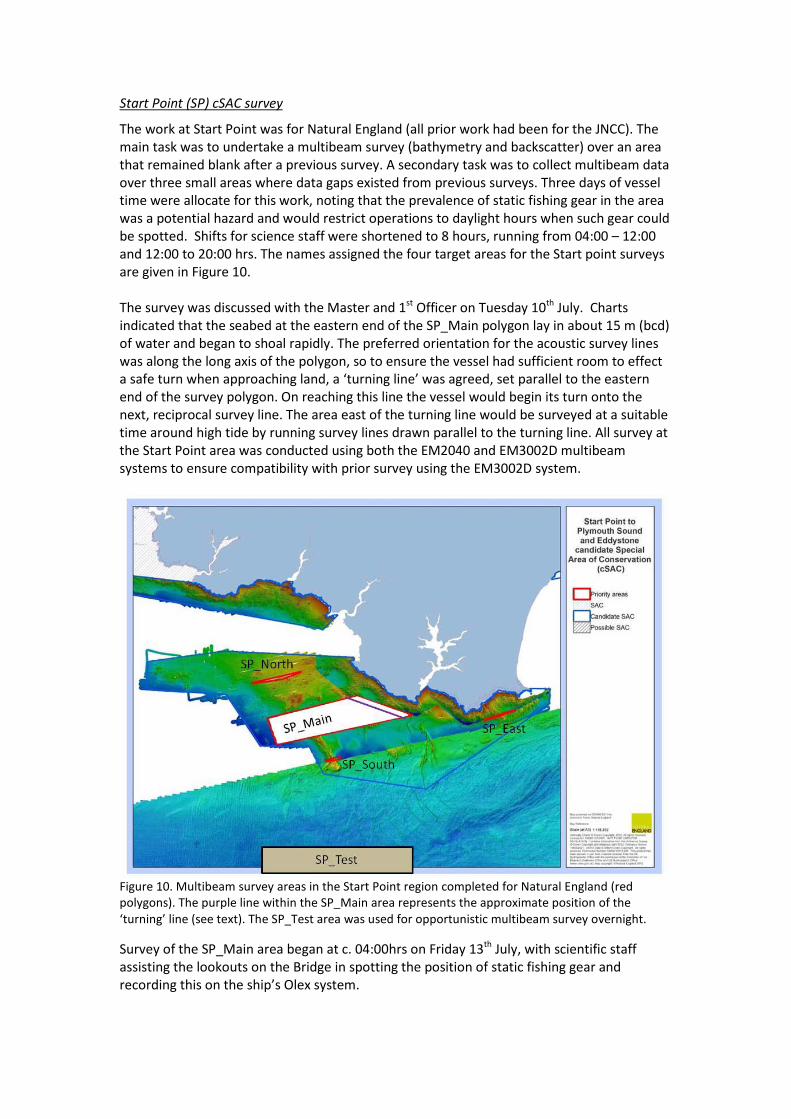
Start Point (SP) cSAC survey
The work at Start Point was for Natural England (all prior work had been for the JNCC). The main task was to undertake a multibeam survey (bathymetry and backscatter) over an area that remained blank after a previous survey. A secondary task was to collect multibeam data over three small areas where data gaps existed from previous surveys. Three days of vessel time were allocate for this work, noting that the prevalence of static fishing gear in the area was a potential hazard and would restrict operations to daylight hours when such gear could be spotted. Shifts for science staff were shortened to 8 hours, running from 04:00 – 12:00 and 12:00 to 20:00 hrs. The names assigned the four target areas for the Start point surveys are given in Figure 10. The survey was discussed with the Master and 1st Officer on Tuesday 10th July. Charts indicated that the seabed at the eastern end of the SP_Main polygon lay in about 15 m (bcd) of water and began to shoal rapidly. The preferred orientation for the acoustic survey lines was along the long axis of the polygon, so to ensure the vessel had sufficient room to effect a safe turn when approaching land, a ‘turning line’ was agreed, set parallel to the eastern end of the survey polygon. On reaching this line the vessel would begin its turn onto the next, reciprocal survey line. The area east of the turning line would be surveyed at a suitable time around high tide by running survey lines drawn parallel to the turning line. All survey at the Start Point area was conducted using both the EM2040 and EM3002D multibeam systems to ensure compatibility with prior survey using the EM3002D system.
Figure 10. Multibeam survey areas in the Start Point region completed for Natural England (red polygons). The purple line within the SP_Main area represents the approximate position of the ‘turning’ line (see text). The SP_Test area was used for opportunistic multibeam survey overnight.
Survey of the SP_Main area began at c. 04:00hrs on Friday 13th July, with scientific staff assisting the lookouts on the Bridge in spotting the position of static fishing gear and recording this on the ship’s Olex system.
During the afternoon of Friday 13th July the CEFAS Endeavour took part in a non-routine safety exercise involving CEFAS and POMS headquarters. T he exercise scenario was recovering an unconscious crew member from a confined space and effecting a Medi-Vac to a hospital ashore, via air-sea rescue. A muster drill was run immediately prior to the exercise and a debrief meeting held immediately after. All science staff on board participated in the exercise, with the exception of those who were actively engaged in running the survey work. Survey was suspended at 19:45 hrs due to bad light and the vessel moved to a holding area, denoted SP_Test, about 6 nm offshore. Opportunistic multibeam survey was conducted overnight, beginning to fill in the SP_Test box to provide a data set for experimental and/or training work (e.g. post processing, automated segmentation, etc). The technical staff on board also used this opportunity to run lines using different settings on the EM2040 system Survey of the SP_Main box recommenced at 04:00 on Saturday 14th July and finished at 20:30 hrs having surveyed the area east of the ‘turn line’ and ran a few lines to fill in minor gaps in shoal areas of the SP_Main box where the multibeam swath had narrowed. The vessel returned to the SP_Test area overnight to continue the opportunistic collection of multibeam data. On Sunday 15th July survey began at 03:30 on the SP_North site and progressed throughout the day to the SP_South and SP_East sites. All work was completed by 12:00 hrs. No instances were recorded of entanglement with static fishing gear on any of the Start Point surveys End of cruise and summary notes
On finishing work at Start Point, Endeavour made passage to Portland. Science staff worked throughout the passage, analysing video and stills images and completing recording of data and metadata. Equipment was packed and work areas cleaned. The Pilot boarded at around 18:30 hrs and the vessel docked in Portland harbour at around 19:00 hrs. Shore leave was permitted after 20:00 hrs. Demobilisation continued throughout Monday 16th July, with JNCC and Exeter staff leaving around 09:30 and Cefas staff between 10:00 and 11:30. All staff returned safely to the Lowestoft area. The SIC delivered frozen sediment samples, some equipment and the ‘Tank’ data drives to the Cefas laboratory at around 18:00 hrs. During the period of active working hours on the cruise there was some vessel down-time and one incident which prompted a Safety Alert*, categorised as an ‘Uncontrolled Hazard’. Summaries are provided below Fault Instances and total duration (approx) Circuit breaker problems in motor room 8 instances, 7.5 hrs Side gantry winch. Brake failure on drum B* 1 instance, 0.5 hrs Stern gate. Broken hydraulic pipe 1 instance, 1 hr R. Coggan Scientist in Charge (SIC) for CEND 10/12
DISTRIBUTiON All Cefas and non-Cefas staff on the cruise plus: Cefas MIST POMS Master, Cefas Endeavour David Limpenny, Cefas. Technical Programme Manager for MCZ-SLA with Defra. Charlotte Perks, Cefas. Project manager for surveys under the MCZ-SLA. Paul Whomersley, Cefas. Work Package leader for surveys under the MCZ-SLA. Keith Weston, Cefas. Project manager for reporting under the MCZ-SLA. Joanna Whittle, Cefas. Project manager for Data Management under the MCZ-SLA. Sonia Kirby, Cefas. Programme manager for SAC work for the SNCBs Neil Golding , JNCC. Offshore Survey Manager Gavin Black, Natural England. Marine monitoring SW. Cefas Library
Related Documents