Dense, reliable, and depth discontinuity preserving DEM computation from H.R.V. urban stereopairs M. Cord†, N. Paparoditis‡*, and M.Jordan† (†) ETIS / URA CNRS 2235, (‡) ESGT / CNAM, (*) LOEMI / IGN e-mail: [email protected], [email protected], [email protected] ISPRS Commision II, working group 6 KEY WORDS: DEM, H.R.V. aerial images, urban scenes, stereo processing, contour adaptive template shape matching, multi-resolution approach ABSTRACT In this paper, we develop a simple Digital Elevation Models processing scheme that focuses on the improvement of urban high resolution DEM basic properties such as density, reliability, accuracy, capacity to render 3-D landscape shapes and breaks to improve 3D-building models production but also urban orthophoto production. Our basic single scale matching algorithm is based on a cross-correlation template matching to provide the denser depth maps as possible. In this algorithm, template windows are not rectangular, they are landscape adaptive. Contour grey-level image features are used to define the matching window shape thus preserving clean, sharp and well located depth and slope discontinuities. A sub-pixel disparity estimation is also used to enhance the matching accuracy and thus provides a smoother 3-D scene surface. An internal validation of the disparity measurements based on the study of symmetrical correlation coherence enhances the reliability of the process but therefore leads to sparser maps. To obtain denser maps and to accelerate the matching process especially on very high resolution images where the disparity search intervals for the points to be matched can be very wide an thus lead to a combinatorial explosion, our single scale matching process is integrated in a multi-resolution matching strategy. We show that our processing scheme stands very good results on a set of complex and various urban scenes images of different resolutions and different sensors. RÉSUMÉ Dans cet article, nous développons un processus simple de restitution de Modèle Numérique d’Elévation focalisé sur l’amélioration des propriétés des MNE haute résolution en zone urbaine à savoir densité, fiabilité, précision et aptitude à restituer les formes et les ruptures tridimensionnelles du paysage nécessaires et essentielles pour la production de modèles 3-D de bâti urbains mais aussi pour la production d’orthophotos urbaines. Notre algorithme de mise en correspondance est basé sur la corrélation de vignettes photométriques pour produire les cartes d’altitudes les plus denses possibles. Dans cet algorithme, les vignettes de corrélation ne sont pas rectangulaires et de taille fixe; elles s’adaptent au paysage. Sur l’hypothèse que les ruptures de pentes ou d’altitude de la scène se caractérisent dans les images par des transitions radiométriques, les contours des images sont utilisés pour contraindre la forme des vignettes de manière à ce qu’elles n’englobent pas les transitions du relief dont les formes sont alors bien localisées et restituées. L’interpolation sub-pixellaire des disparités améliore la précision intrinsèque de la mise en correspondance et permet d’obtenir des cartes d’altitudes bien plus lisses. Enfin, une validation interne des disparités par étude de la cohérence des corrélations symétriques augmente la fiabilité du processus mais par contre altère la densité. Afin d’obtenir des cartes plus denses mais aussi d’accélérer le processus de mise en correspondance d’images et surtout des images très haute résolution pour lesquelles les intervalles de recherches admissibles pour les points à apparier peuvent être très étendus et conduire à une explosion combinatoire, notre processus de mise en correspondance est intégré dans une stratégie multi- résolution spécialement adaptée aux caractéristiques des scènes traitées. Nous montrons que notre processus global donne de très bons résultats sur un ensemble d’images urbaines complexes et variées de différentes résolutions et de différents capteurs. 1. INTRODUCTION Urban scenes Digital Elevation Models are a key data to many applications such as urban orthophoto production, antenna's landscape visibility calculation for mobile phones telecommunications or to higher level date processing such as high scale mapping or 3-D city modelling. Requested properties for DEMs do of course depend on applications but are most of the time spatial density, depth and spatial accuracy, and reliability. Means of DEM production are meanly of two different natures: laser ranging-based and photogrammetry- based systems and techniques. Laser ranging-based systems provide accurate but above all reliable depth maps [Haala 94]. Against that, system acquisition constraints limits the spatial density of the depth samples and therefore introduces a fuzz in depth discontinuities localisation.

Welcome message from author
This document is posted to help you gain knowledge. Please leave a comment to let me know what you think about it! Share it to your friends and learn new things together.
Transcript
Dense, reliable, and depth discontinuity preserving DEM computation fromH.R.V. urban stereopairs
M. Cord†, N. Paparoditis‡*, and M.Jordan† (†) ETIS / URA CNRS 2235, (‡) ESGT / CNAM, (* ) LOEMI / IGNe-mail: [email protected], [email protected], [email protected]
ISPRS Commision II, working group 6
KEY WORDS: DEM, H.R.V. aerial images, urban scenes, stereo processing, contour adaptivetemplate shape matching, multi-resolution approach
ABSTRACT
In this paper, we develop a simple Digital Elevation Models processing scheme that focuses on the improvement of urbanhigh resolution DEM basic properties such as density, reliabilit y, accuracy, capacity to render 3-D landscape shapes and breaks toimprove 3D-building models production but also urban orthophoto production.
Our basic single scale matching algorithm is based on a cross-correlation template matching to provide the denser depthmaps as possible. In this algorithm, template windows are not rectangular, they are landscape adaptive. Contour grey-level imagefeatures are used to define the matching window shape thus preserving clean, sharp and well l ocated depth and slope discontinuities.A sub-pixel disparity estimation is also used to enhance the matching accuracy and thus provides a smoother 3-D scene surface. Aninternal validation of the disparity measurements based on the study of symmetrical correlation coherence enhances the reliabilit y ofthe process but therefore leads to sparser maps.
To obtain denser maps and to accelerate the matching process especially on very high resolution images where the disparitysearch intervals for the points to be matched can be very wide an thus lead to a combinatorial explosion, our single scale matchingprocess is integrated in a multi -resolution matching strategy.
We show that our processing scheme stands very good results on a set of complex and various urban scenes images ofdifferent resolutions and different sensors.
RÉSUMÉ
Dans cet article, nous développons un processus simple de restitution de Modèle Numérique d’Elévation focalisé surl’amélioration des propriétés des MNE haute résolution en zone urbaine à savoir densité, fiabilit é, précision et aptitude à restituer lesformes et les ruptures tridimensionnelles du paysage nécessaires et essentielles pour la production de modèles 3-D de bâti urbainsmais aussi pour la production d’orthophotos urbaines.
Notre algorithme de mise en correspondance est basé sur la corrélation de vignettes photométriques pour produire les cartesd’altitudes les plus denses possibles. Dans cet algorithme, les vignettes de corrélation ne sont pas rectangulaires et de taill e fixe; elless’adaptent au paysage. Sur l’hypothèse que les ruptures de pentes ou d’altitude de la scène se caractérisent dans les images par destransitions radiométriques, les contours des images sont utili sés pour contraindre la forme des vignettes de manière à ce qu’ellesn’englobent pas les transitions du relief dont les formes sont alors bien localisées et restituées. L’ interpolation sub-pixellaire desdisparités améliore la précision intrinsèque de la mise en correspondance et permet d’obtenir des cartes d’altitudes bien plus lisses.Enfin, une validation interne des disparités par étude de la cohérence des corrélations symétriques augmente la fiabilit é du processusmais par contre altère la densité.
Afin d’obtenir des cartes plus denses mais aussi d’accélérer le processus de mise en correspondance d’ images et surtout desimages très haute résolution pour lesquelles les intervalles de recherches admissibles pour les points à apparier peuvent être trèsétendus et conduire à une explosion combinatoire, notre processus de mise en correspondance est intégré dans une stratégie multi -résolution spécialement adaptée aux caractéristiques des scènes traitées.
Nous montrons que notre processus global donne de très bons résultats sur un ensemble d’ images urbaines complexes etvariées de différentes résolutions et de différents capteurs.
1. INTRODUCTION
Urban scenes Digital Elevation Models are a key data tomany applications such as urban orthophoto production,antenna's landscape visibilit y calculation for mobile phonestelecommunications or to higher level date processing such ashigh scale mapping or 3-D city modelli ng. Requested propertiesfor DEMs do of course depend on applications but are most ofthe time spatial density, depth and spatial accuracy, and
reliabilit y. Means of DEM production are meanly of twodifferent natures: laser ranging-based and photogrammetry-based systems and techniques.
Laser ranging-based systems provide accurate butabove all reliable depth maps [Haala 94]. Against that, systemacquisition constraints limits the spatial density of the depthsamples and therefore introduces a fuzz in depth discontinuitieslocalisation.
Depth discontinuities localisation and 3-D shapes andslopes rendering are a key point for building detection,recognition [Baill ard&Dissard 97] and reconstruction[Paparoditis&al 98] [Jordan&Cord&Cocquerez 98].Furthermore, a very fine spatial density (beneath 20centimetres) is unavoidable or for small or complex buildingsmade of aggregated planar section of roof. The 3-D statisticalidentification and estimation of each planar section of roof canonly be carried out with a fairly large number of 3-Dsamples.(at least 100).
We believe that only photogrammetry-basedtechniques with very high scale photos or very high resolutiondigital images can stand such densities. Furthermore, onlystereo photogrammetry can allow a real duality and combinationof monocular and binocular analyses. However, DEM stereocomputation from mid to high resolution aerial or satellit e urbanimages is a very diff icult task because of all 3-D structures,depth discontinuities, occlusion boundaries, slope breaks, andhomogeneous, non lambertian and specular surfaces appearingat these resolutions.
Very few works have been committed to very highresolution images[Henricsson 96]. Among all the problemsrelated to H.R.V. images an other major one appears for veryH.R.V. images. Indeed, the extent of disparity variation can beso important that defining shifting areas for homologous pointsresearch, with an a priori knowledge of scene's relief extent,leads to a combinatorial explosion and to a rise of matchingambiguities which affects the reliabilit y of the process.
2. IMAGE MATCHING APPROACH FOR
SCENES WITH DEPTH AND SLOPE
BREAKS
Numerous stereo matching algorithms dedicated toDEM computation have been developed in the last 25 years.They are usually sorted out into two classes.
Feature-based techniques aim at matching a smaller setof image points: image features often contours, segments,regions which are supposed to be characteristic structures of thescene. These techniques are thus fast but provide very sparsedepth maps that are very diff icult to interpolate with an aposteriori process. Furthermore, same image features do notalways appear in both images especially when they correspondto depth discontinuities.
Template-based or area-based techniques measure thesimilarity of grey-level image templates around the points to bematched. It can be carried out on all i mage pixels and thusprovides dense disparity maps. Templates are most of the timesquare and of fixed size throughout the image. Several templatesimilarity measurement functions have been used in existingsystems and all having interesting properties. the normalisedcross-correlation functions allows the matching of templateswith a global radiometric difference due to global luminositychanges between two views or due to slope effects on measuredradiometry. Gradient correlation is also very interesting fortemplate matching. It avoids problems that would encounter agrey-level cross-correlation for the matching of a windowoverlapping two joint and separate surfaces with different non
lambertian behaviour. Furthermore, it is less sensitive to noiseand the peak of the correlation curve stands out better[Crouzil&Massip-Pailhes&Castan 96].
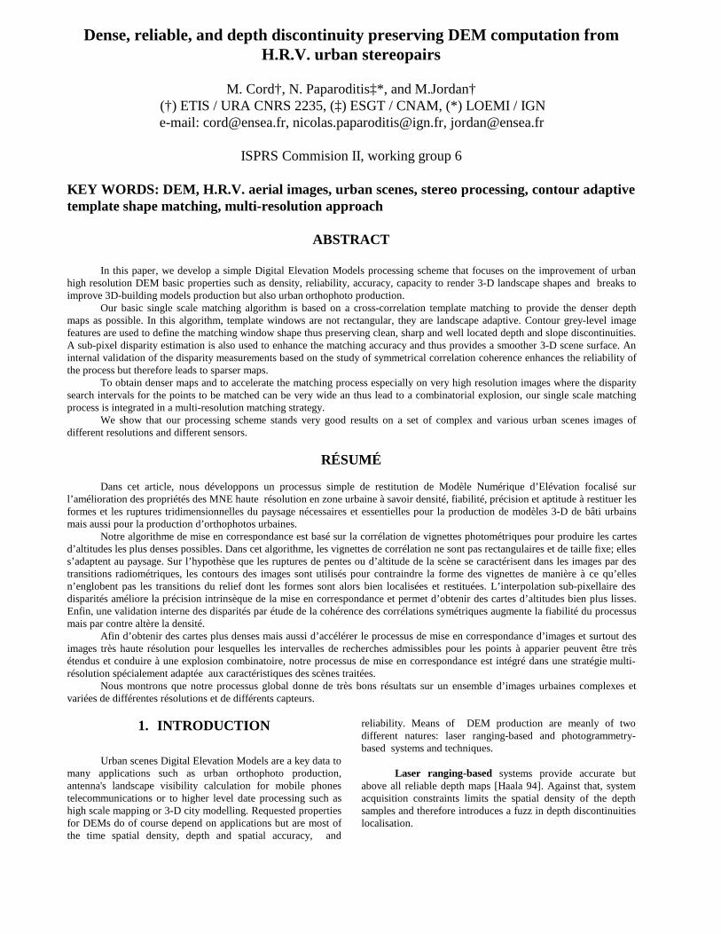
Anyway, whatever the similarity function classicaltemplate matching is not capable of rendering well l ocated,clean and sharp depth discontinuities. Indeed, the disparityassociated with a pixel is a "mean" of all disparities in thetemplate. Thus discontinuities are smoothed or delocalized (seeFigure 2-1). To reduce these effects, template sizes can bereduced. In turn, the reduction of the texture sample leads to arise in the correlation noise and in the number of mismatches.Template matching limits are due to the rigidity of therectangular template pattern and of its fixed size. Templatesizes and shapes should change according to the landscapeschanges.
( i ,j )
( i ,j ')
( i ,j '')
I M A G E 1
I M A G E 2
Figure 2-1: The real match (i,j) of image 1 should be (i,j’) . Classicalcross-corre lation matching gives (i,j’’) as best match for (i,j) .
A few experiences of adaptive templates have beencarried out. For guidance, template sizes can be fixed accordingto the local distribution of the grey-level image or/and of acoarse disparity map [Kanade&Okotumi 94] or to a largestrectangular size non overlapping a contour[Lotti&Giraudon 94]. This last technique provides the mosteff icient results in terms of density and depth discontinuitypreservation but against that it is complex therefore timeconsuming and it is not eff icient in areas between closecontours.
2.1 A new landscape adaptive templatematching technique
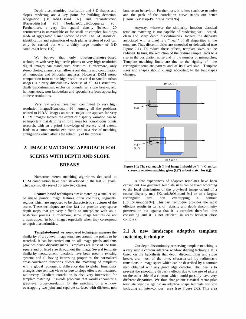
Our depth discontinuity preserving template matching isa very simple contour adaptive window shaping technique. It isbased on the hypothesis that depth discontinuities and slopebreaks are, most of the time, characterised by radiometrictransitions in image space which can be described by a contourmap obtained with any good edge detector. The idea is toprevent the smoothing disparity effects due to the use of pixelson the other side of a contour which could possibly have verydifferent disparities. We thus change our classical rectangulartemplate window against an adaptive shape template windowincluding all i nter-contour area (see Figure 2-2). This area
contains all pixels on the same side of a contour and connectedto the pixel (i,j) to be matched.
R(i,j)new template
T(i,j) classical template
(i,j)
Contours
Figure 2-2: Contour adaptive window shape S(i,j) made fromclassical rectangular template window T(i,j) . This pattern is buil t
in the slave image.
Our adaptive windows similarity measurement(correlation score) between pixel (i,j) of image 1 (slave image)and pixel (i’ ,j’) is based on the normalised cross-correlationscore and can be expressed:
C i j i j
A S i k j lI i k j l I i k j l i j i j
i j i jl j m
j m
k i n
i n
' ( , ) =
, ,
( , )( , ) ( , ) ( , ) ( , )
( , ) ( ' , ' )
′ ′
⋅ − − ⋅ − − ⋅ ′ − ′ − − ′ ⋅ ′ ′ ′′ ⋅ ′= −
+
= −
+
∑∑ 1 2 1 2
1 2
µ µσ σ
with
A
S i k j ll j m
j m
k i n
i n =
1
( , )− −= −
+
= −
+
∑∑
∈−−
∉−−=−−
),(),(1
),(),(0),(
jiRljkisi
jiRljkisiljkiS
and
′ ⋅ − − ⋅ − −= −
+
= −
+
∑∑µ ( , ) = i j A S i k j l I i k j ll j m
j m
k i n
i n
( , ) ( , )
′ ⋅ − − ⋅ − − − ′= −
+
= −
+
∑∑σ µ( , ) ( , ) ( ( , ) ( , ) )i j A S i k j l I i k j l i jl j m
j m
k i n
i n
= 2 21
Our contour adaptive window matching technique isthus halfway between an area-based and a feature-basedmatching technique. This technique is as fast (or as slow) as theclassical template correlation and its implementation is veryeasy.
This adaptive window shaping technique is not incompetition with adaptive window sizing techniques. They arecomplementary. Adaptive window sizes are very helpful forhomogeneous areas matching and adaptive window shapes arevery helpful to preserve depth and slope discontinuities.
2.2 Building corre lation sur faces
Previously to the template matching process, images areregistered in epipolar geometry so that corresponding templatescan be found by a simple shift along image lines. The minimaland maximal li ne shifts can be computed knowing the extremealtitudes of the scene. A correlation curve is usually built withall the correlation scores for all possible pixellar shifts along theline. We prefer building a correlation surface because we alsoallow shifts of one pixel along image rows. Indeed, we take intoaccount possible row residues of the image registration process.
2.3 Sub-pixel dispar ity measurements
The estimated disparity is in this process and most ofthe time chosen to be the one that provides the highest peak inthe correlation surface except for global matching techniques asleast squares matching or dynamic programming matching[Baill ard&Dissard 97] where lower scoring peaks can bechosen.
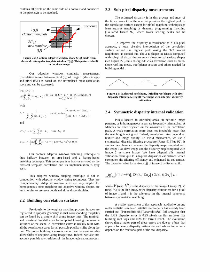
To improve the disparity measurement to a sub-pixelaccuracy, a local bi-cubic interpolation of the correlationsurface around the highest peak -using the 3x3 nearestneighbours- is carried out. The 3-D shapes in DEMs computedwith sub-pixel disparities are much closer to real surface shapes(see Figure 2-3) thus easing 3-D cues extraction such as multi -slope roof line crests, roof planar section and others needed forbuilding model .
Figure 2-3: (Left) real roof shape, (Middle) roof shape with pixeldispar ity estimation, (Right) roof shape with sub-pixel dispar ity
estimation.
2.4 Symmetr ic dispar ity internal validation
Pixels located in occluded areas, in periodic imagepatterns, or in homogeneous areas are frequently mismatched. AMatches are often rejected on the weakness of the correlationpeak. A weak correlation score does not inevitably mean thatthe matching is not good. Indeed, correlation rates depend ontexture and image quality. To avoid mismatches, we use asymmetrical disparity filtering procedure [Jones 91][Fua 92]. Itstudies the coherence between the disparity map computed withthe image 1 as slave image and the disparity map computed withimage 2 as slave image. We have adapted this internalvalidation technique to sub-pixel disparities estimations whichstrengthen the filtering eff iciency and enhanced its robustness.The disparity value for a pixel (i,j) of image 1 is discarded if:
Inf V i j V i V i j n j V i j mn m
i j∈ ∈
− ′ + + + + ≤0 1 0 1.. , ..
( , ) ( ( , ) , ( , ) )& &
τ
where &
V (resp. &
′V ) is the disparity of the image 1 (resp. 2), Vi
(resp. Vj) is the line (resp. row) disparity component for a pixelof image 1 and τ is the tolerance on the internal coherencebetween symmetrical matching.
A quality assessment of this approach applied to on onemeter realistic simulated satellit e stereo-pairs has already beencarried out [Paparoditis 98][Paparoditis&al 98] showing thatthe RMS disparity error is 0.25 pixels on flat surfaces likebuilding roof tops and 0.28 for terrain relief. The evaluationshows that a major part of these errors are due to a bias thatappears for every disparity estimation and whose importancedepends on the fractional part of the real disparity.
3. MULT I-RESOLUTION MATCHING
STRATEGY FOR VERY H.R.V. URBAN
IMAGES
3.1 Multi-resolution strategy
Working on decimetre resolution images has an impacton the choice of a specific matching strategy. Very highresolution images offer large and poorly textured surfaces.Therefore, the correlation scores are reduced and then,mismatch probabilit y is raised. This fact is all the more sopronounced since initial search matching space is large.
Besides, occlusion areas are very large and variouslyspread out in the very high resolution images. Buildings, treesand big raised structures generate very large occlusion areaswhich increase wrong matches. Many other small structures aslow walls, parapets, chimneys, cars, etc., generate smallocclusion areas. They are spread only on few pixels but theirradiometric contents can seriously disturb the correlation scores.
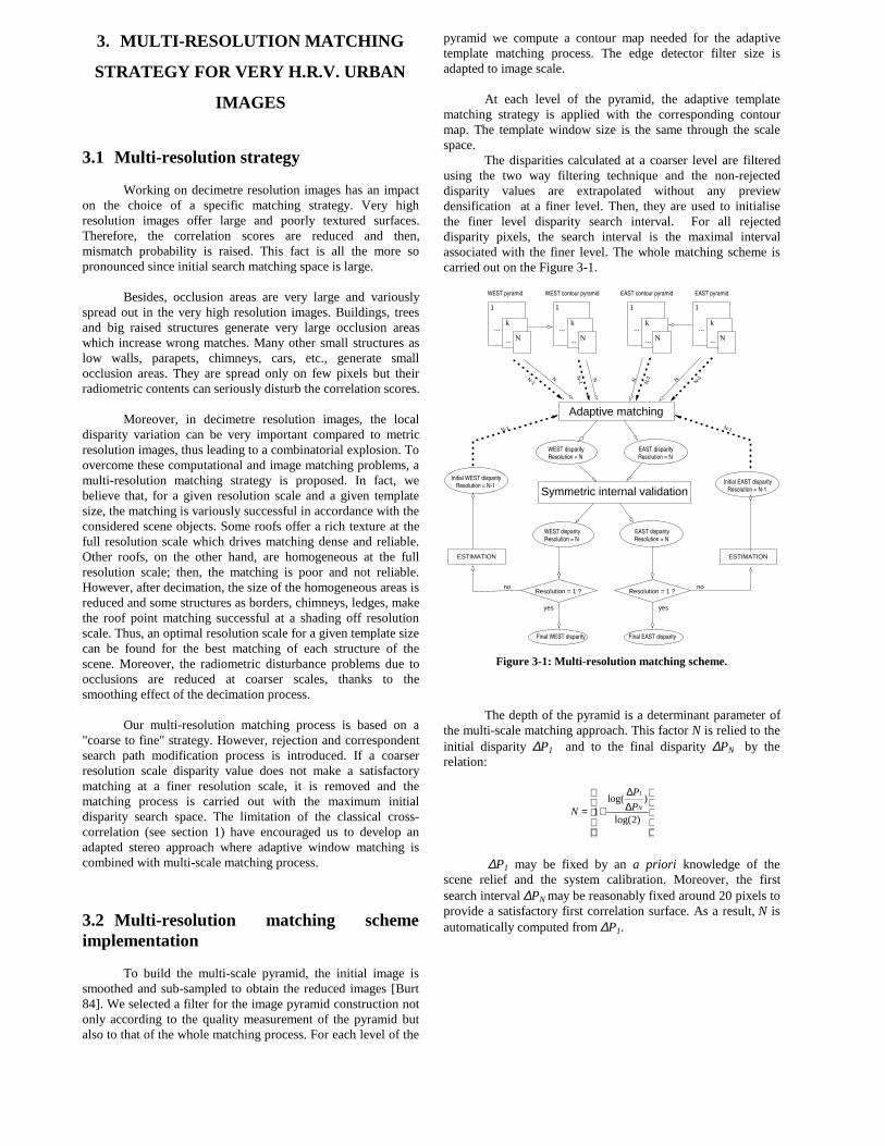
Moreover, in decimetre resolution images, the localdisparity variation can be very important compared to metricresolution images, thus leading to a combinatorial explosion. Toovercome these computational and image matching problems, amulti -resolution matching strategy is proposed. In fact, webelieve that, for a given resolution scale and a given templatesize, the matching is variously successful in accordance with theconsidered scene objects. Some roofs offer a rich texture at thefull resolution scale which drives matching dense and reliable.Other roofs, on the other hand, are homogeneous at the fullresolution scale; then, the matching is poor and not reliable.However, after decimation, the size of the homogeneous areas isreduced and some structures as borders, chimneys, ledges, makethe roof point matching successful at a shading off resolutionscale. Thus, an optimal resolution scale for a given template sizecan be found for the best matching of each structure of thescene. Moreover, the radiometric disturbance problems due toocclusions are reduced at coarser scales, thanks to thesmoothing effect of the decimation process.
Our multi -resolution matching process is based on a"coarse to fine" strategy. However, rejection and correspondentsearch path modification process is introduced. If a coarserresolution scale disparity value does not make a satisfactorymatching at a finer resolution scale, it is removed and thematching process is carried out with the maximum initialdisparity search space. The limitation of the classical cross-correlation (see section 1) have encouraged us to develop anadapted stereo approach where adaptive window matching iscombined with multi -scale matching process.
3.2 Multi-resolution matching schemeimplementation
To build the multi -scale pyramid, the initial image issmoothed and sub-sampled to obtain the reduced images [Burt84]. We selected a filter for the image pyramid construction notonly according to the quality measurement of the pyramid butalso to that of the whole matching process. For each level of the
pyramid we compute a contour map needed for the adaptivetemplate matching process. The edge detector filter size isadapted to image scale.
At each level of the pyramid, the adaptive templatematching strategy is applied with the corresponding contourmap. The template window size is the same through the scalespace.
The disparities calculated at a coarser level are filteredusing the two way filtering technique and the non-rejecteddisparity values are extrapolated without any previewdensification at a finer level. Then, they are used to initialisethe finer level disparity search interval. For all rejecteddisparity pixels, the search interval is the maximal intervalassociated with the finer level. The whole matching scheme iscarried out on the Figure 3-1.
1
N...
k...
1
N...
k...
1
N...
k...
1
N...
k...
Resolution = N
WEST disparity
Resolution = N
WEST disparity
ESTIMATIONESTIMATION
Resolution = N
EAST disparity
Resolution = N-1
Initial EAST disparity
WEST pyramid EAST pyramidWEST contour pyramid EAST contour pyramid
Adaptive matching
Resolution = N
EAST disparity
no
Final WEST disparity Final EAST disparity
no
yes yes
Resolution = 1 ?Resolution = 1 ?
Resolution = N-1
Initial WEST disparity
N-1 N-1
N-1
N-1 N
-1 N-1N N
N N
Symmetric internal validation
Figure 3-1: Multi-resolution matching scheme.
The depth of the pyramid is a determinant parameter ofthe multi -scale matching approach. This factor N is relied to theinitial disparity ∆P1 and to the final disparity ∆PN by therelation:
∆∆
+=)2log(
)log(1
1
NP
P
N
∆P1 may be fixed by an a priori knowledge of thescene relief and the system calibration. Moreover, the firstsearch interval ∆PN may be reasonably fixed around 20 pixels toprovide a satisfactory first correlation surface. As a result, N isautomatically computed from ∆P1.
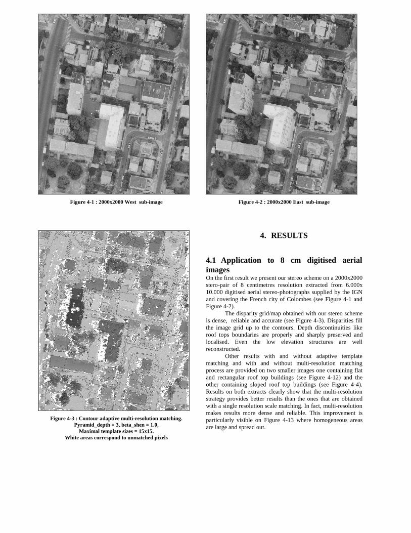
Figure 4-1 : 2000x2000 West sub-image
Figure 4-3 : Contour adaptive multi-resolution matching.Pyramid_depth = 3, beta_shen = 1.0,
Maximal template sizes = 15x15.White areas correspond to unmatched pixels
Figure 4-2 : 2000x2000 East sub-image
4. RESULT S
4.1 Application to 8 cm digitised aerialimagesOn the first result we present our stereo scheme on a 2000x2000stero-pair of 8 centimetres resolution extracted from 6.000x10.000 digitised aerial stereo-photographs supplied by the IGNand covering the French city of Colombes (see Figure 4-1 andFigure 4-2).
The disparity grid/map obtained with our stereo schemeis dense, reliable and accurate (see Figure 4-3). Disparities fillthe image grid up to the contours. Depth discontinuities likeroof tops boundaries are properly and sharply preserved andlocalised. Even the low elevation structures are wellreconstructed.
Other results with and without adaptive templatematching and with and without multi -resolution matchingprocess are provided on two smaller images one containing flatand rectangular roof top buildings (see Figure 4-12) and theother containing sloped roof top buildings (see Figure 4-4).Results on both extracts clearly show that the multi -resolutionstrategy provides better results than the ones that are obtainedwith a single resolution scale matching. In fact, multi -resolutionmakes results more dense and reliable. This improvement isparticularly visible on Figure 4-13 where homogeneous areasare large and spread out.
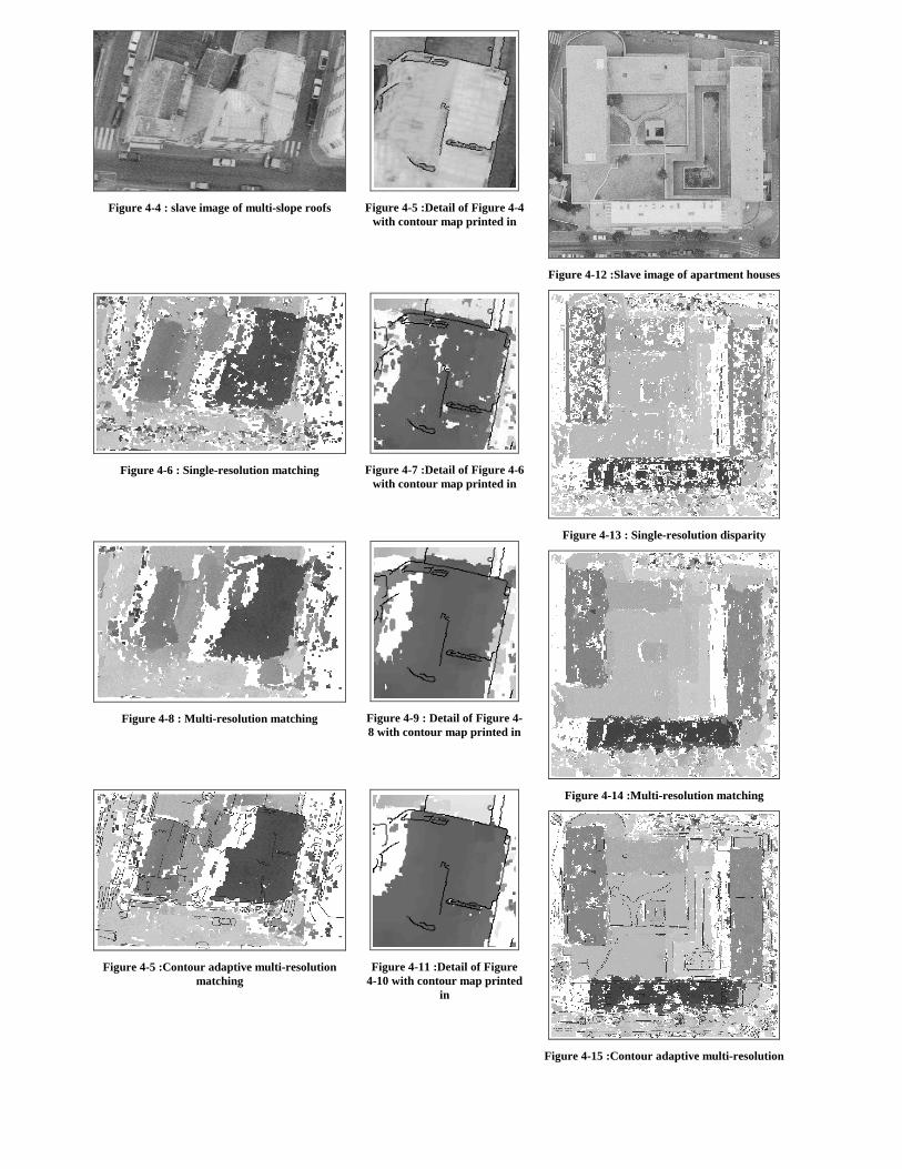
Figure 4-4 : slave image of multi-slope roofs
Figure 4-6 : Single-resolution matching
Figure 4-8 : Multi-resolution matching
Figure 4-5 :Contour adaptive multi-resolutionmatching
Figure 4-5 :Detail of Figure 4-4with contour map pr inted in
Figure 4-7 :Detail of Figure 4-6with contour map pr inted in
Figure 4-9 : Detail of Figure 4-8 with contour map pr inted in
Figure 4-11 :Detail of Figure4-10 with contour map pr inted
in
Figure 4-12 :Slave image of apar tment houses
Figure 4-13 : Single-resolution dispar ity
Figure 4-14 :Multi-resolution matching
Figure 4-15 :Contour adaptive multi-resolution
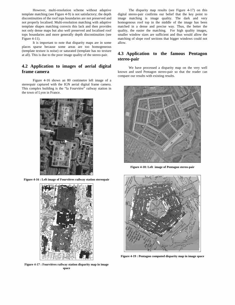
However, multi -resolution scheme without adaptivetemplate matching (see Figure 4-9) is not satisfactory; the depthdiscontinuities of the roof tops boundaries are not preserved andnot properly localised. Multi -resolution matching with adaptivetemplate shapes matching corrects this lack and then providesnot only dense maps but also well preserved and localised rooftops boundaries and more generally depth discontinuities (seeFigure 4-11).
It is important to note that disparity maps are in someplaces sparse because some areas are too homogeneous(template texture is noise) or saturated (template has no textureat all ). This is due to the poor image quality of the stereo-pair.
4.2 Application to images of aerial digitalframe camera
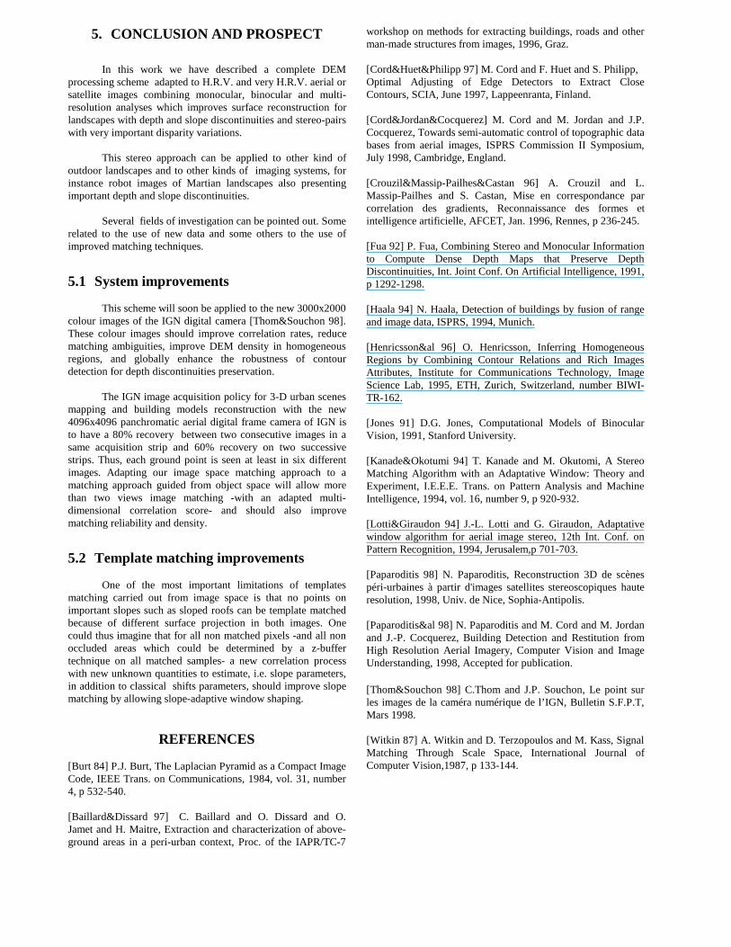
Figure 4-16 shows an 80 centimetre left image of astereopair captured with the IGN aerial digital frame camera.This complex building is the “la Fourvière” railway station inthe town of Lyon in France.
Figure 4-16 : Left image of Fourvières railway station stereopair
Figure 4-17 : Fourvières railway station dispar ity map in imagespace
The disparity map results (see Figure 4-17) on thisdigital stereo-pair confirms our belief that the key point toimage matching is image quality. The dark and veryhomogenous roof top in the middle of the image has beenmatched in a dense and precise way. Thus, the better thequality, the easier the matching. For high quality images,smaller window sizes are suff icient and thus would allow thematching of slope roof sections that bigger windows could notallow.
4.3 Application to the famous Pentagonstereo-pair
We have processed a disparity map on the very wellknown and used Pentagon stereo-pair so that the reader cancompare our results with existing results.
Figure 4-18: Left image of Pentagon stereo-pair
Figure 4-19 : Pentagon computed dispar ity map in image space
5. CONCLUSION AND PROSPECT
In this work we have described a complete DEMprocessing scheme adapted to H.R.V. and very H.R.V. aerial orsatellit e images combining monocular, binocular and multi -resolution analyses which improves surface reconstruction forlandscapes with depth and slope discontinuities and stereo-pairswith very important disparity variations.
This stereo approach can be applied to other kind ofoutdoor landscapes and to other kinds of imaging systems, forinstance robot images of Martian landscapes also presentingimportant depth and slope discontinuities.
Several fields of investigation can be pointed out. Somerelated to the use of new data and some others to the use ofimproved matching techniques.
5.1 System improvements
This scheme will soon be applied to the new 3000x2000colour images of the IGN digital camera [Thom&Souchon 98].These colour images should improve correlation rates, reducematching ambiguities, improve DEM density in homogeneousregions, and globally enhance the robustness of contourdetection for depth discontinuities preservation.
The IGN image acquisition policy for 3-D urban scenesmapping and building models reconstruction with the new4096x4096 panchromatic aerial digital frame camera of IGN isto have a 80% recovery between two consecutive images in asame acquisition strip and 60% recovery on two successivestrips. Thus, each ground point is seen at least in six differentimages. Adapting our image space matching approach to amatching approach guided from object space will allow morethan two views image matching -with an adapted multi -dimensional correlation score- and should also improvematching reliabilit y and density.
5.2 Template matching improvements
One of the most important limitations of templatesmatching carried out from image space is that no points onimportant slopes such as sloped roofs can be template matchedbecause of different surface projection in both images. Onecould thus imagine that for all non matched pixels -and all nonoccluded areas which could be determined by a z-buffertechnique on all matched samples- a new correlation processwith new unknown quantities to estimate, i.e. slope parameters,in addition to classical shifts parameters, should improve slopematching by allowing slope-adaptive window shaping.
REFERENCES
[Burt 84] P.J. Burt, The Laplacian Pyramid as a Compact ImageCode, IEEE Trans. on Communications, 1984, vol. 31, number4, p 532-540.
[Baill ard&Dissard 97] C. Baill ard and O. Dissard and O.Jamet and H. Maitre, Extraction and characterization of above-ground areas in a peri-urban context, Proc. of the IAPR/TC-7
workshop on methods for extracting buildings, roads and otherman-made structures from images, 1996, Graz.
[Cord&Huet&Phili pp 97] M. Cord and F. Huet and S. Phili pp,Optimal Adjusting of Edge Detectors to Extract CloseContours, SCIA, June 1997, Lappeenranta, Finland.
[Cord&Jordan&Cocquerez] M. Cord and M. Jordan and J.P.Cocquerez, Towards semi-automatic control of topographic databases from aerial images, ISPRS Commission II Symposium,July 1998, Cambridge, England.
[Crouzil&Massip-Pailhes&Castan 96] A. Crouzil and L.Massip-Pailhes and S. Castan, Mise en correspondance parcorrelation des gradients, Reconnaissance des formes etintelli gence artificielle, AFCET, Jan. 1996, Rennes, p 236-245.
[Fua 92] P. Fua, Combining Stereo and Monocular Informationto Compute Dense Depth Maps that Preserve DepthDiscontinuities, Int. Joint Conf. On Artificial Intelli gence, 1991,p 1292-1298.
[Haala 94] N. Haala, Detection of buildings by fusion of rangeand image data, ISPRS, 1994, Munich.
[Henricsson&al 96] O. Henricsson, Inferring HomogeneousRegions by Combining Contour Relations and Rich ImagesAttributes, Institute for Communications Technology, ImageScience Lab, 1995, ETH, Zurich, Switzerland, number BIWI-TR-162.
[Jones 91] D.G. Jones, Computational Models of BinocularVision, 1991, Stanford University.
[Kanade&Okotumi 94] T. Kanade and M. Okutomi, A StereoMatching Algorithm with an Adaptative Window: Theory andExperiment, I.E.E.E. Trans. on Pattern Analysis and MachineIntelli gence, 1994, vol. 16, number 9, p 920-932.
[Lotti&Giraudon 94] J.-L. Lotti and G. Giraudon, Adaptativewindow algorithm for aerial image stereo, 12th Int. Conf. onPattern Recognition, 1994, Jerusalem,p 701-703.
[Paparoditis 98] N. Paparoditis, Reconstruction 3D de scènespéri-urbaines à partir d'images satellit es stereoscopiques hauteresolution, 1998, Univ. de Nice, Sophia-Antipolis.
[Paparoditis&al 98] N. Paparoditis and M. Cord and M. Jordanand J.-P. Cocquerez, Building Detection and Restitution fromHigh Resolution Aerial Imagery, Computer Vision and ImageUnderstanding, 1998, Accepted for publication.
[Thom&Souchon 98] C.Thom and J.P. Souchon, Le point surles images de la caméra numérique de l’I GN, Bulletin S.F.P.T,Mars 1998.
[Witkin 87] A. Witkin and D. Terzopoulos and M. Kass, SignalMatching Through Scale Space, International Journal ofComputer Vision,1987, p 133-144.
Related Documents