Anderson Annex Denali Borough Multi-Jurisdiction Multi-Hazard Mitigation Plan May 27, 2010 Prepared by: Denali Borough The City of Anderson and Bechtol Planning & Development

Welcome message from author
This document is posted to help you gain knowledge. Please leave a comment to let me know what you think about it! Share it to your friends and learn new things together.
Transcript
Anderson Annex
Denali Borough Multi-Jurisdiction
Multi-Hazard Mitigation Plan
May 27, 2010
Prepared by:
Denali Borough
The City of Anderson
and
Bechtol Planning & Development


Anderson Annex
Denali Borough Multi-Jurisdiction
Multi-Hazard Mitigation Plan
May 27, 2010
Prepared by:
Denali Borough
The City of Anderson
and
Bechtol Planning & Development

Anderson Annex i Denali Borough Multi-Jurisdictional Multi-Hazard Mitigation Plan
Table of Contents
Table of Contents ........................................................................................................................................... i
Tables ....................................................................................................................................................... iii
Figures ...................................................................................................................................................... iv
Resolution ..................................................................................................................................................... v
Chapter 1: Introduction ................................................................................................................................ 1
Public Involvement Process ...................................................................................................................... 1
The Future of the Plan .............................................................................................................................. 1
Chapter 2: Community Overview and Capability Assessment ...................................................................... 3
Community Overview ............................................................................................................................... 3
Location ................................................................................................................................................. 3
Government .......................................................................................................................................... 4
Population ............................................................................................................................................. 4
Economy ................................................................................................................................................ 4
Facilities................................................................................................................................................. 5
Transportation ...................................................................................................................................... 5
Anderson Capability Assessment .............................................................................................................. 5
Local Resources ..................................................................................................................................... 5
Chapter 3: Anderson Risk Assessment .......................................................................................................... 9
Federal Requirements for Risk Assessment .......................................................................................... 9
Components of Risk Assessment ........................................................................................................ 10
Identifying Hazards ................................................................................................................................. 12
Identification of Natural Hazards Present in the City of Anderson .................................................... 12
Assessing Vulnerability ........................................................................................................................... 14
Identification of Assets ....................................................................................................................... 14
Chapter 4: Risk Assessment by Hazard ....................................................................................................... 17
Section 1. Wildland Fire .......................................................................................................................... 17
Hazard Description and Characterization ........................................................................................... 17
Anderson Annex ii Denali Borough Multi-Jurisdictional Multi-Hazard Mitigation Plan
Location ............................................................................................................................................... 18
Extent .................................................................................................................................................. 18
Impact ................................................................................................................................................. 18
Probability ........................................................................................................................................... 18
Previous Occurrences ......................................................................................................................... 19
Wildland Fire Mitigation Goals and Projects ...................................................................................... 20
Section 2. Flood/Erosion ..................................................................................................................... 21
Hazard Description and Characterization ........................................................................................... 21
Location ............................................................................................................................................... 21
Extent .................................................................................................................................................. 21
Impact ................................................................................................................................................. 21
Probability ........................................................................................................................................... 22
Previous Occurrences ......................................................................................................................... 22
Community Participation in the NFIP ................................................................................................. 23
Repetitive Loss Properties ...................................................................................................................... 25
Flood Mitigation Goals and Projects ................................................................................................... 26
Section 3. Severe Weather ...................................................................................................................... 27
Hazard Description and Characterization ........................................................................................... 27
High Winds .......................................................................................................................................... 28
Ice Fog ................................................................................................................................................. 28
Drought ............................................................................................................................................... 29
Location ............................................................................................................................................... 29
Extent .................................................................................................................................................. 29
Impact ................................................................................................................................................. 30
Probability ........................................................................................................................................... 30
Previous Occurrences ......................................................................................................................... 30
Severe Weather Mitigation Goals and Projects .................................................................................. 30
Section 4. Earthquake ............................................................................................................................. 31
Hazard Description and Characterization ........................................................................................... 31
Anderson Annex iii Denali Borough Multi-Jurisdictional Multi-Hazard Mitigation Plan
Location ............................................................................................................................................... 32
Extent .................................................................................................................................................. 32
Impact ................................................................................................................................................. 33
Probability ........................................................................................................................................... 34
Earthquake Mitigation Goal and Projects ........................................................................................... 35
Section 5. Hazards not Profiled in the 2009 Denali Borough MHMP Anderson Annex ....................... 36
Avalanche ............................................................................................................................................ 36
Avalanche Vulnerability Assessment .................................................................................................. 36
Ground Failure Hazard ........................................................................................................................ 36
Ground Failure Vulnerability Assessment ........................................................................................... 36
Tsunamis and Seiches ......................................................................................................................... 36
Volcano ............................................................................................................................................... 37
Chapter 5: Mitigation Strategy ............................................................................................................. 39
Benefit - Cost Review .............................................................................................................................. 39
Other criteria that were used to developing the benefits – costs listing depicted in Benefit – Costs
Review of Projects ............................................................................................................................... 39
Benefit-Cost Analysis .......................................................................................................................... 41
Facilitating BCA ................................................................................................................................... 41
Eligible Projects for PDM Funding ........................................................................................................... 41
Eligible Projects for HMGP Funding ........................................................................................................ 42
Benefit – Costs Review of Projects ......................................................................................................... 44
Mitigation Projects .................................................................................................................................. 46
Tables
Table 1. Community Information .................................................................................................................. 3
Table 2. Regulatory Tools .............................................................................................................................. 5
Table 3. Administrative and Technical Capability ......................................................................................... 6
Table 4. Fiscal Capability ............................................................................................................................... 7
Table 5. Risk Assessment - Federal Requirements ....................................................................................... 9
Table 6. Hazards Identification and Decision to Profile .............................................................................. 12
Anderson Annex iv Denali Borough Multi-Jurisdictional Multi-Hazard Mitigation Plan
Table 7. Extent of Hazard Ranking ............................................................................................................. 13
Table 8. Probability Criteria Table .............................................................................................................. 14
Table 9. Anderson Hazard Vulnerability Matrix .......................................................................................... 14
Table 10. Critical Facilities ........................................................................................................................... 15
Table 11. FIRM Zones .................................................................................................................................. 23
Table 12. Anderson Borough Housing Stock ............................................................................................... 24
Table 13. Local and State Floodplain Coordinator Contact Information .................................................... 25
Table 14. Anderson Community Weather Summary ................................................................................. 29
Table 15. Benefit-Costs Review Listing Table.............................................................................................. 44
Table 16. Mitigation Strategy ..................................................................................................................... 46
Figures
Figure 1. Anderson Population History ......................................................................................................... 4
Figure 2, Alaska All-Hazards Mitigation Plan - Fire Risk Map ...................................................................... 19
Figure 3. AEIS Historic Earthquakes in Alaska ............................................................................................. 33
Figure 4. USGS Anderson 50-year Subduction Earthquake Probability Map .............................................. 34
Figure 5. USGS Anderson 100-year Subduction Earthquake Probability Map ............................................ 35
Maps
Map 1 Anderson Infrastructure .................................................................................................................. 16
Anderson Annex v Denali Borough Multi-Jurisdictional Multi-Hazard Mitigation Plan
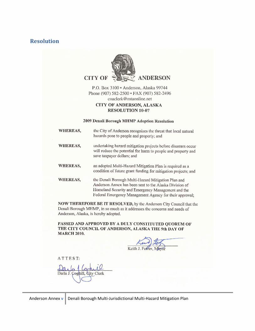
Resolution

Anderson Annex vi Denali Borough Multi-Jurisdictional Multi-Hazard Mitigation Plan
Anderson Annex 1 Denali Borough Multi-Jurisdictional Multi-Hazard Mitigation Plan
Chapter 1: Introduction
The purpose of this plan is to produce a strategy delineating projects that will best address Anderson’s
hazard issues. The 2009 Denali Borough MHMP, Anderson Annex focuses on natural hazards and
projects specific to the City of Anderson. Many Borough-wide projects are relevant to Anderson as well.
Public Involvement Process
The initial planning process for the City of Anderson was included in the Denali Borough MHMP. As
stated there, a public meeting was held December 10, 2008 in collaboration with the regularly
scheduled and advertised Denali Borough Assembly meeting. Prior to that meeting, a newsletter was
produced for distribution by the Borough and the City of Anderson. These newsletters were distributed
at the Assembly meeting and were posted in public buildings in each of the Borough’s communities. The
WHPacific planner met with Anderson City staff in the afternoon prior to the Assembly meeting. At the
assembly meeting, the planning process was explained and input sought from residents, Park Service,
local businesses and other interested parties.
On March 26, 2009, Suzanne Taylor with WHPacific and Ervin Petty with DHS&EM met with the LEPC to
discuss hazards that are present in the Borough and potential mitigation projects. A project list
developed was returned to the LEPC via Rusty Lasell for comment.
Presentations, newsletters, minutes and sign in sheets are contained in the public involvement appendix
of the Denali Borough MHMP. A copy of the draft MHMP is available for public perusal at the Denali
Borough and Anderson City government offices as well as on the Denali Borough website.
The Denali Borough Assembly and the Anderson City Council will review and approve the plan after
pre‐approval by DHS&EM and FEMA
The Future of the Plan
The 2009 Denali Borough MHMP, Anderson Annex will be monitored, evaluated and updated according
to the plan outlined in Chapter 1 of the MHMP. This will also include a continued public involvement
process with annual review and notices to the public as specified therein.

Anderson Annex 2 Denali Borough Multi-Jurisdictional Multi-Hazard Mitigation Plan
Anderson Annex 3 Denali Borough Multi-Jurisdictional Multi-Hazard Mitigation Plan
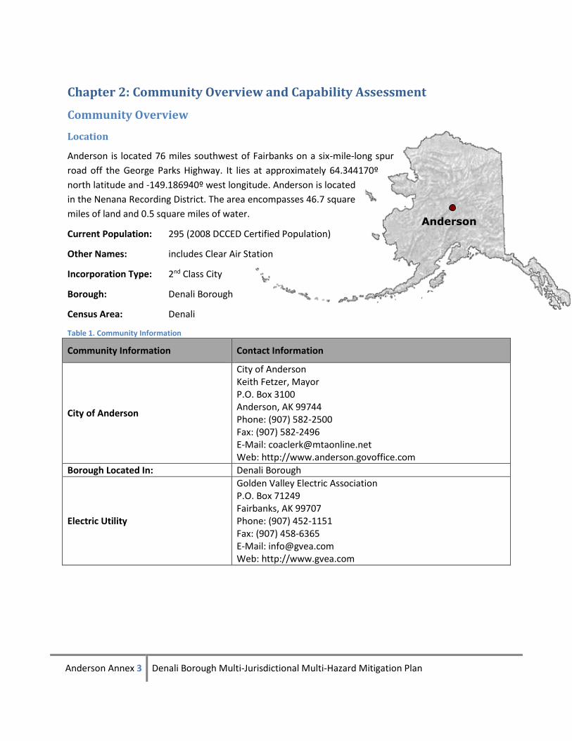
Anderson
Chapter 2: Community Overview and Capability Assessment
Community Overview
Location
Anderson is located 76 miles southwest of Fairbanks on a six-mile-long spur
road off the George Parks Highway. It lies at approximately 64.344170º
north latitude and -149.186940º west longitude. Anderson is located
in the Nenana Recording District. The area encompasses 46.7 square
miles of land and 0.5 square miles of water.
Current Population: 295 (2008 DCCED Certified Population)
Other Names: includes Clear Air Station
Incorporation Type: 2nd Class City
Borough: Denali Borough
Census Area: Denali
Table 1. Community Information
Community Information Contact Information
City of Anderson
City of Anderson Keith Fetzer, Mayor P.O. Box 3100 Anderson, AK 99744 Phone: (907) 582-2500 Fax: (907) 582-2496 E-Mail: [email protected] Web: http://www.anderson.govoffice.com
Borough Located In: Denali Borough
Electric Utility
Golden Valley Electric Association P.O. Box 71249 Fairbanks, AK 99707 Phone: (907) 452-1151 Fax: (907) 458-6365 E-Mail: [email protected] Web: http://www.gvea.com
Anderson Annex 4 Denali Borough Multi-Jurisdictional Multi-Hazard Mitigation Plan
Community Information Contact Information
School District
Denali Borough Schools 280 Suntrana Rd Healy, AK 99743 Phone: (907) 683-2278 Fax: (907) 683-2514
Government
The City of Anderson was incorporated as a second class city in 1962. The City government is composed
of seven council members and a “strong mayor.” Regular elections are held on the first Tuesday in
November. The City Council meets on the second Tuesday of each month.
Population
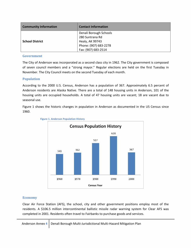
According to the 2000 U.S. Census, Anderson has a population of 367. Approximately 6.5 percent of
Anderson residents are Alaska Native. There are a total of 148 housing units in Anderson, 101 of the
housing units are occupied households. A total of 47 housing units are vacant; 18 are vacant due to
seasonal use.
Figure 1 shows the historic changes in population in Anderson as documented in the US Census since
1960.
Economy
Clear Air Force Station (AFS), the school, city and other government positions employ most of the
residents. A $106.5 million intercontinental ballistic missile radar warning system for Clear AFS was
completed in 2001. Residents often travel to Fairbanks to purchase goods and services.
Figure 1. Anderson Population History
Census Year
Anderson Annex 5 Denali Borough Multi-Jurisdictional Multi-Hazard Mitigation Plan
Facilities
All homes have individual wells, septic systems and plumbing. Refuse is hauled to a regional borough
landfill two miles south of Anderson. The city operates an RV lagoon and sludge disposal site. Anderson
has a preschool through 12th grade school with 73 students and 10 teachers.
Transportation
The George Parks Highway provides access from Anderson to Anchorage and Fairbanks. The Alaska
Railroad also serves Anderson and Clear AFS. Four miles south of town is a state-owned 4,000-foot
lighted asphalt runway. A private 2,500 foot dirt airstrip is located at Clear Sky Lodge.
Anderson Capability Assessment
This section outlines the resources available to the City of Anderson for mitigation and mitigation-related activities.
Local Resources
The City of Anderson exercises parks and recreation, road maintenance, fire protection, emergency
medical services, and planning and zoning powers within the city limits. The resources available in
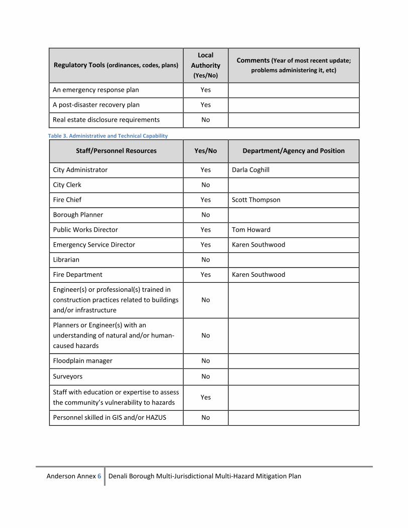
Anderson are summarized in Table 2 through Table 4.
Table 2. Regulatory Tools
Regulatory Tools (ordinances, codes, plans)
Local
Authority
(Yes/No)
Comments (Year of most recent update;
problems administering it, etc)
Building code No State Code
Zoning ordinance Yes
Subdivision ordinance or regulations Yes
Special purpose ordinances (floodplain
management, stormwater management,
hillside or steep slope ordinances, wildfire
ordinances, hazard setback requirements)
Yes
Growth management ordinances (also
called “smart growth” or anti-sprawl
programs)
No
Site plan review requirements No
Comprehensive plan No
A capital improvements plan Yes
An economic development plan Yes
Anderson Annex 6 Denali Borough Multi-Jurisdictional Multi-Hazard Mitigation Plan
Regulatory Tools (ordinances, codes, plans)
Local
Authority
(Yes/No)
Comments (Year of most recent update;
problems administering it, etc)
An emergency response plan Yes
A post-disaster recovery plan Yes
Real estate disclosure requirements No
Table 3. Administrative and Technical Capability
Staff/Personnel Resources Yes/No Department/Agency and Position
City Administrator Yes Darla Coghill
City Clerk No
Fire Chief Yes Scott Thompson
Borough Planner No
Public Works Director Yes Tom Howard
Emergency Service Director Yes Karen Southwood
Librarian No
Fire Department Yes Karen Southwood
Engineer(s) or professional(s) trained in
construction practices related to buildings
and/or infrastructure
No
Planners or Engineer(s) with an
understanding of natural and/or human-
caused hazards
No
Floodplain manager No
Surveyors No
Staff with education or expertise to assess
the community’s vulnerability to hazards Yes
Personnel skilled in GIS and/or HAZUS No
Anderson Annex 7 Denali Borough Multi-Jurisdictional Multi-Hazard Mitigation Plan
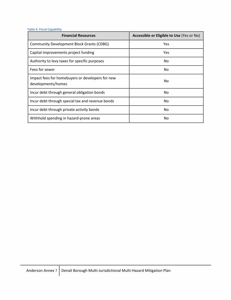
Table 4. Fiscal Capability
Financial Resources Accessible or Eligible to Use (Yes or No)
Community Development Block Grants (CDBG) Yes
Capital improvements project funding Yes
Authority to levy taxes for specific purposes No
Fees for sewer No
Impact fees for homebuyers or developers for new
developments/homes No
Incur debt through general obligation bonds No
Incur debt through special tax and revenue bonds No
Incur debt through private activity bonds No
Withhold spending in hazard-prone areas No

Anderson Annex 8 Denali Borough Multi-Jurisdictional Multi-Hazard Mitigation Plan
Anderson Annex 9 Denali Borough Multi-Jurisdictional Multi-Hazard Mitigation Plan
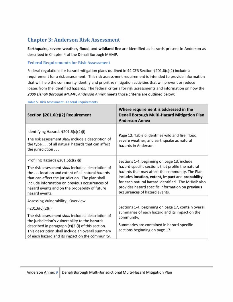
Chapter 3: Anderson Risk Assessment
Earthquake, severe weather, flood, and wildland fire are identified as hazards present in Anderson as
described in Chapter 4 of the Denali Borough MHMP.
Federal Requirements for Risk Assessment
Federal regulations for hazard mitigation plans outlined in 44 CFR Section §201.6(c)(2) include a
requirement for a risk assessment. This risk assessment requirement is intended to provide information
that will help the community identify and prioritize mitigation activities that will prevent or reduce
losses from the identified hazards. The federal criteria for risk assessments and information on how the
2009 Denali Borough MHMP, Anderson Annex meets those criteria are outlined below:
Table 5. Risk Assessment - Federal Requirements
Section §201.6(c)(2) Requirement Where requirement is addressed in the Denali Borough Multi-Hazard Mitigation Plan Anderson Annex
Identifying Hazards §201.6(c)(2)(i)
The risk assessment shall include a description of the type . . . of all natural hazards that can affect the jurisdiction . . .
Page 12, Table 6 identifies wildland fire, flood, severe weather, and earthquake as natural hazards in Anderson.
Profiling Hazards §201.6(c)(2)(i)
The risk assessment shall include a description of the . . . location and extent of all natural hazards that can affect the jurisdiction. The plan shall include information on previous occurrences of hazard events and on the probability of future hazard events.
Sections 1-4, beginning on page 13, include hazard-specific sections that profile the natural hazards that may affect the community. The Plan includes location, extent, impact and probability for each natural hazard identified. The MHMP also provides hazard specific information on previous occurrences of hazard events.
Assessing Vulnerability: Overview
§201.6(c)(2)(i)
The risk assessment shall include a description of the jurisdiction’s vulnerability to the hazards described in paragraph (c)(2)(i) of this section. This description shall include an overall summary of each hazard and its impact on the community.
Sections 1-4, beginning on page 17, contain overall summaries of each hazard and its impact on the community.
Summaries are contained in hazard-specific sections beginning on page 17.
Anderson Annex 10 Denali Borough Multi-Jurisdictional Multi-Hazard Mitigation Plan
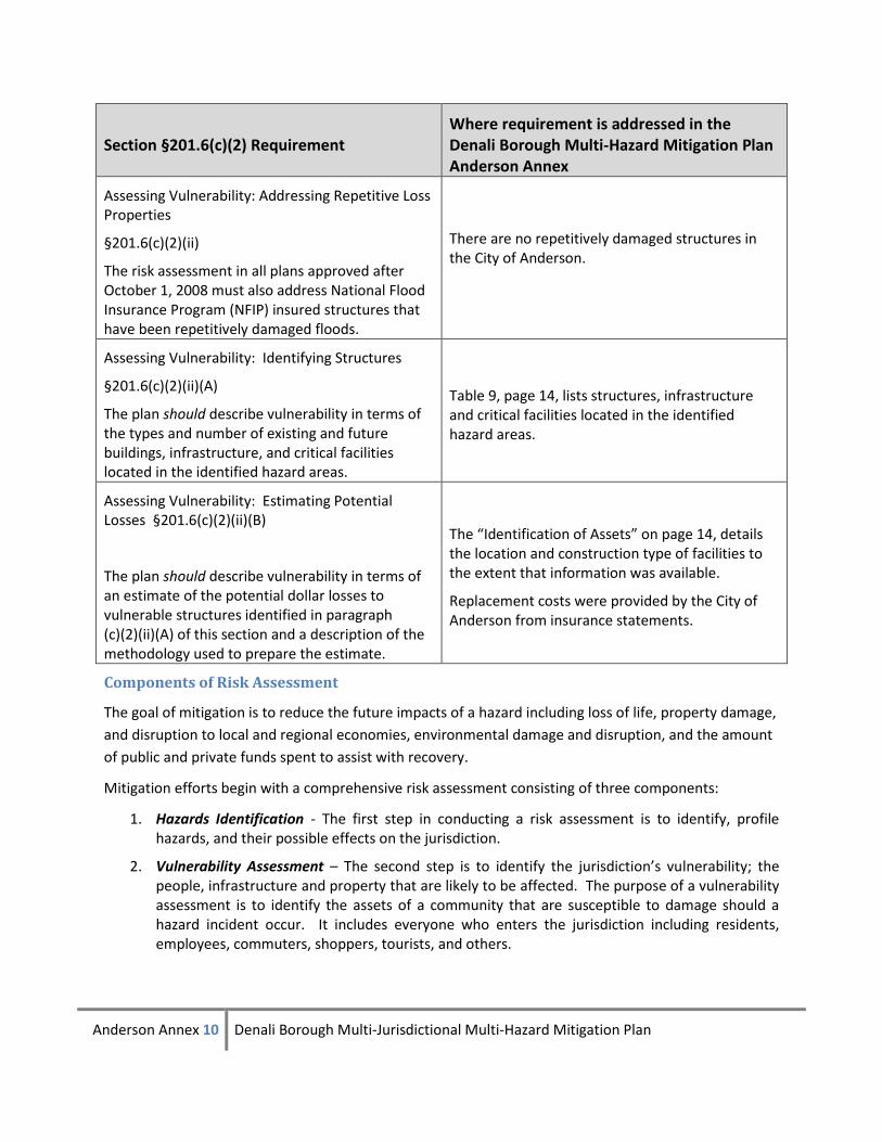
Section §201.6(c)(2) Requirement Where requirement is addressed in the Denali Borough Multi-Hazard Mitigation Plan Anderson Annex
Assessing Vulnerability: Addressing Repetitive Loss Properties
§201.6(c)(2)(ii)
The risk assessment in all plans approved after October 1, 2008 must also address National Flood Insurance Program (NFIP) insured structures that have been repetitively damaged floods.
There are no repetitively damaged structures in the City of Anderson.
Assessing Vulnerability: Identifying Structures
§201.6(c)(2)(ii)(A)
The plan should describe vulnerability in terms of the types and number of existing and future buildings, infrastructure, and critical facilities located in the identified hazard areas.
Table 9, page 14, lists structures, infrastructure and critical facilities located in the identified hazard areas.
Assessing Vulnerability: Estimating Potential Losses §201.6(c)(2)(ii)(B)
The plan should describe vulnerability in terms of an estimate of the potential dollar losses to vulnerable structures identified in paragraph (c)(2)(ii)(A) of this section and a description of the methodology used to prepare the estimate.
The “Identification of Assets” on page 14, details the location and construction type of facilities to the extent that information was available.
Replacement costs were provided by the City of Anderson from insurance statements.
Components of Risk Assessment
The goal of mitigation is to reduce the future impacts of a hazard including loss of life, property damage,
and disruption to local and regional economies, environmental damage and disruption, and the amount
of public and private funds spent to assist with recovery.
Mitigation efforts begin with a comprehensive risk assessment consisting of three components:
1. Hazards Identification - The first step in conducting a risk assessment is to identify, profile hazards, and their possible effects on the jurisdiction.
2. Vulnerability Assessment – The second step is to identify the jurisdiction’s vulnerability; the people, infrastructure and property that are likely to be affected. The purpose of a vulnerability assessment is to identify the assets of a community that are susceptible to damage should a hazard incident occur. It includes everyone who enters the jurisdiction including residents, employees, commuters, shoppers, tourists, and others.
Anderson Annex 11 Denali Borough Multi-Jurisdictional Multi-Hazard Mitigation Plan
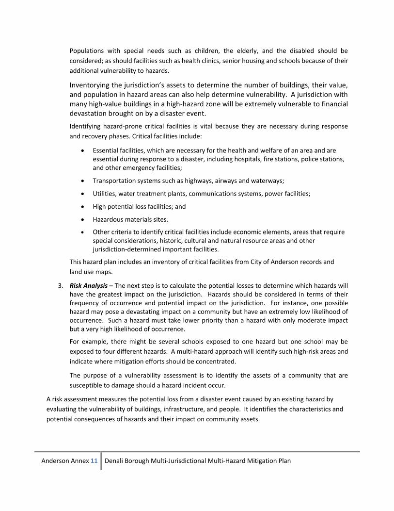
Populations with special needs such as children, the elderly, and the disabled should be
considered; as should facilities such as health clinics, senior housing and schools because of their
additional vulnerability to hazards.
Inventorying the jurisdiction’s assets to determine the number of buildings, their value, and population in hazard areas can also help determine vulnerability. A jurisdiction with many high-value buildings in a high-hazard zone will be extremely vulnerable to financial devastation brought on by a disaster event.
Identifying hazard-prone critical facilities is vital because they are necessary during response
and recovery phases. Critical facilities include:
Essential facilities, which are necessary for the health and welfare of an area and are essential during response to a disaster, including hospitals, fire stations, police stations, and other emergency facilities;
Transportation systems such as highways, airways and waterways;
Utilities, water treatment plants, communications systems, power facilities;
High potential loss facilities; and
Hazardous materials sites.
Other criteria to identify critical facilities include economic elements, areas that require special considerations, historic, cultural and natural resource areas and other jurisdiction-determined important facilities.
This hazard plan includes an inventory of critical facilities from City of Anderson records and
land use maps.
3. Risk Analysis – The next step is to calculate the potential losses to determine which hazards will have the greatest impact on the jurisdiction. Hazards should be considered in terms of their frequency of occurrence and potential impact on the jurisdiction. For instance, one possible hazard may pose a devastating impact on a community but have an extremely low likelihood of occurrence. Such a hazard must take lower priority than a hazard with only moderate impact but a very high likelihood of occurrence.
For example, there might be several schools exposed to one hazard but one school may be
exposed to four different hazards. A multi-hazard approach will identify such high-risk areas and
indicate where mitigation efforts should be concentrated.
The purpose of a vulnerability assessment is to identify the assets of a community that are
susceptible to damage should a hazard incident occur.
A risk assessment measures the potential loss from a disaster event caused by an existing hazard by
evaluating the vulnerability of buildings, infrastructure, and people. It identifies the characteristics and
potential consequences of hazards and their impact on community assets.
Anderson Annex 12 Denali Borough Multi-Jurisdictional Multi-Hazard Mitigation Plan
Identifying Hazards
This section identifies and describes the hazards likely to affect the City of Anderson. The following
sources were used to identify the hazards present in community: the Alaska All-Hazard Risk Mitigation
Plan, the Denali Borough All Hazards Emergency Response Plan, a workshop with the LEPC, interviews
with experts and long-time residents, and records of previous occurrences of events.
Identification of Natural Hazards Present in the City of Anderson
Based on consultation with the Alaska DHS&EM, information from the Alaska All-Hazard Risk Mitigation
Plan, Denali Borough and Anderson City plans, interviews and the LEPC workshop, the hazards in Table 6
were identified to be profiled.
Table 6. Hazards Identification and Decision to Profile
Hazard Yes/No Decision to Profile Hazard
Earthquake Yes
Designated as a hazard due to extensive history of earthquake
damage. Anderson is located in an active earthquake region
which includes the Denali and Hines Creek Faults.
Floods Yes
Designated as a hazard due to history of extensive flood
damage. Designated as a hazard in Alaska All-Hazard Risk
Mitigation Plan and the Denali Borough All-Hazards Emergency
Response Plan.
Severe Weather Yes
Designated as a hazard in Alaska All-Hazard Risk Mitigation
Plan and the Denali Borough All-Hazards Emergency Response
Plan.
Avalanche No While one incident of avalanche has been documented in the
Borough, it was not in the Anderson area.
Ground Failure No
Designated as a hazard in the Alaska All-Hazard Risk Mitigation
Plan however, residents did not identify ground failure as a
hazard.
Wildland Fire Yes
Wildland fire is designated as a hazard by Anderson residents,
as well as in Alaska All-Hazard Risk Mitigation Plan and the
Denali Borough All-Hazards Emergency Response Plan. Dry
conditions, abundant fuel, and previous occurrences all
contribute to this designation.
Erosion No
Not designated as a hazard in the in Alaska All-Hazard Risk
Mitigation Plan or the Denali Borough All-Hazards Emergency
Response Plan.
Anderson Annex 13 Denali Borough Multi-Jurisdictional Multi-Hazard Mitigation Plan
Hazard Yes/No Decision to Profile Hazard
Tsunami/Seiche No The City of Anderson is located in Interior Alaska and is in no
danger of tsunami
Volcano No The City of Anderson is not located near any active volcanoes.
See page Section 5, Hazards not Profiled in the 2009 Denali Borough MHMP, Anderson Annex, for more
information on the hazards not profiled at this time. Each hazard that is identified above as present in
the community is profiled in hazard-specific sections.
Chapter 4 contains risk assessments for each hazard. The analysis of each of the identified hazards includes a narrative with the following information:
The location or geographical areas in the community that would be affected.
The location of identified hazards is described by a map wherever appropriate or in some cases
with a narrative statement.
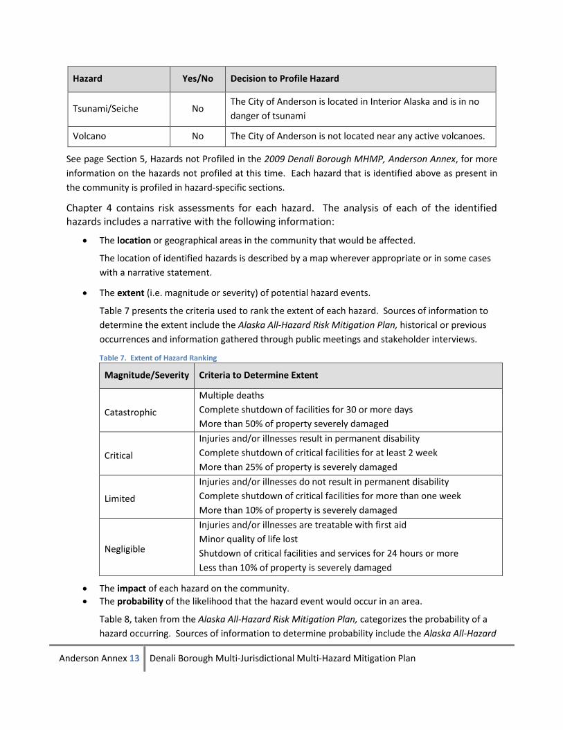
The extent (i.e. magnitude or severity) of potential hazard events.
Table 7 presents the criteria used to rank the extent of each hazard. Sources of information to
determine the extent include the Alaska All-Hazard Risk Mitigation Plan, historical or previous
occurrences and information gathered through public meetings and stakeholder interviews.
Table 7. Extent of Hazard Ranking
Magnitude/Severity Criteria to Determine Extent
Catastrophic
Multiple deaths
Complete shutdown of facilities for 30 or more days
More than 50% of property severely damaged
Critical
Injuries and/or illnesses result in permanent disability
Complete shutdown of critical facilities for at least 2 week
More than 25% of property is severely damaged
Limited
Injuries and/or illnesses do not result in permanent disability
Complete shutdown of critical facilities for more than one week
More than 10% of property is severely damaged
Negligible
Injuries and/or illnesses are treatable with first aid
Minor quality of life lost
Shutdown of critical facilities and services for 24 hours or more
Less than 10% of property is severely damaged
The impact of each hazard on the community.
The probability of the likelihood that the hazard event would occur in an area.
Table 8, taken from the Alaska All-Hazard Risk Mitigation Plan, categorizes the probability of a
hazard occurring. Sources of information to determine probability include the Alaska All-Hazard
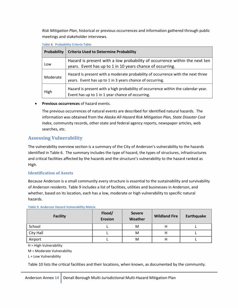
Anderson Annex 14 Denali Borough Multi-Jurisdictional Multi-Hazard Mitigation Plan
Risk Mitigation Plan, historical or previous occurrences and information gathered through public
meetings and stakeholder interviews.
Table 8. Probability Criteria Table
Probability Criteria Used to Determine Probability
Low Hazard is present with a low probability of occurrence within the next ten years. Event has up to 1 in 10 years chance of occurring.
Moderate Hazard is present with a moderate probability of occurrence with the next three
years. Event has up to 1 in 3 years chance of occurring.
High Hazard is present with a high probability of occurrence within the calendar year.
Event has up to 1 in 1 year chance of occurring.
Previous occurrences of hazard events.
The previous occurrences of natural events are described for identified natural hazards. The
information was obtained from the Alaska All-Hazard Risk Mitigation Plan, State Disaster Cost
Index, community records, other state and federal agency reports, newspaper articles, web
searches, etc.
Assessing Vulnerability
The vulnerability overview section is a summary of the City of Anderson’s vulnerability to the hazards
identified in Table 6. The summary includes the type of hazard, the types of structures, infrastructures
and critical facilities affected by the hazards and the structure’s vulnerability to the hazard ranked as
High.
Identification of Assets
Because Anderson is a small community every structure is essential to the sustainability and survivability
of Anderson residents. Table 9 includes a list of facilities, utilities and businesses in Anderson, and
whether, based on its location, each has a low, moderate or high vulnerability to specific natural
hazards.
Table 9. Anderson Hazard Vulnerability Matrix
Facility Flood/
Erosion
Severe
Weather Wildland Fire Earthquake
School L M H L
City Hall L M H L
Airport L M H L
H = High Vulnerability
M = Moderate Vulnerability
L = Low Vulnerability
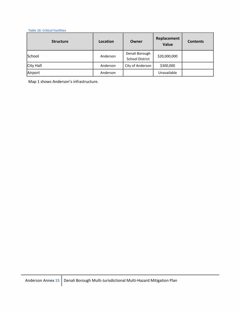
Table 10 lists the critical facilities and their locations, when known, as documented by the community.
Anderson Annex 15 Denali Borough Multi-Jurisdictional Multi-Hazard Mitigation Plan
Table 10. Critical Facilities
Structure Location Owner Replacement
Value Contents
School Anderson Denali Borough
School District $20,000,000
City Hall Anderson City of Anderson $300,000
Airport Anderson Unavailable
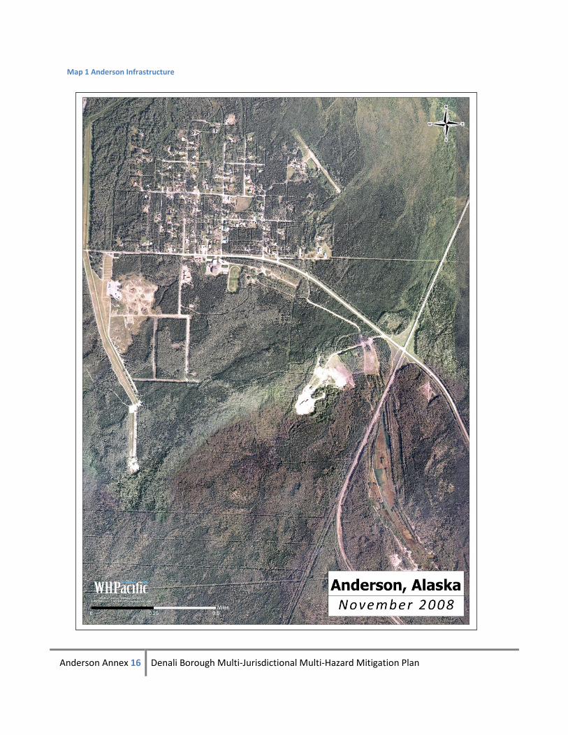
Map 1 shows Anderson’s infrastructure.
Anderson Annex 16 Denali Borough Multi-Jurisdictional Multi-Hazard Mitigation Plan
Map 1 Anderson Infrastructure
Anderson Annex 17 Denali Borough Multi-Jurisdictional Multi-Hazard Mitigation Plan
Chapter 4: Risk Assessment by Hazard
Section 1. Wildland Fire
Hazard Description and Characterization
Wildland fires occur in every state in the country and Alaska is no exception. Each year, between 600
and 800 wildland fires, mostly between March and October, burn across Alaska causing extensive
damage.
Fire is recognized as a critical feature of the natural history of many ecosystems. It is essential to
maintain the biodiversity and long-term ecological health of the land. In
Alaska, the natural fire regime is characterized by a return interval of 50 to 200 years, depending on the
vegetation type, topography and location. The role of wildland fire as an essential ecological process and
natural change agent has been incorporated into the fire management planning process and the full
range of fire management activities is exercised in Alaska to help achieve ecosystem sustainability,
including its interrelated ecological, economic, and social consequences on firefighter and public safety
and welfare, natural and cultural resources threatened, and the other values to be protected dictate the
appropriate management response to the fire. Firefighter and public safety is always the first and
overriding priority for all fire management activities.
Fires can be divided into the following categories:
Structure fires – originate in and burn a building, shelter or other structure.
Prescribed fires - ignited under predetermined conditions to meet specific objectives, to
mitigate risks to people and their communities, and/or to restore and maintain healthy,
diverse ecological systems.
Wildland fire - any non-structure fire, other than prescribed fire, that occurs in the
wildland.
Wildland Fire Use - a wildland fire functioning in its natural ecological role and fulfilling
land management objectives.
Wildland-Urban Interface Fires - fires that burn within the line, area, or zone where
structures and other human development meet or intermingle with undeveloped
wildland or vegetative fuels. The potential exists in areas of wildland-urban interface for
extremely dangerous and complex fire burning conditions, which pose a tremendous
threat to public and firefighter safety.
Fuel, weather, and topography influence wildland fire behavior. Wildland fire behavior can be erratic
and extreme causing firewhirls and firestorms that can endanger the lives of the firefighters trying to
suppress the blaze. Fuel determines how much energy the fire releases, how quickly the fire spreads
and how much effort is needed to contain the fire. Weather is the most variable factor. Temperature
Anderson Annex 18 Denali Borough Multi-Jurisdictional Multi-Hazard Mitigation Plan
and humidity also affect fire behavior. High temperatures and low humidity encourage fire activity
while low temperatures and high humidity help retard fire behavior. Wind affects the speed and
direction of a fire. Topography directs the movement of air, which can also affect fire behavior. When
the terrain funnels air, like what happens in a canyon, it can lead to faster spreading. Fire can also travel
up slope quicker than it goes down.
Wildland fire risk is increasing in Alaska due to the spruce bark beetle infestation. The beetles lay eggs
under the bark of a tree. When the larvae emerge, they eat the trees phloem, which is what the tree
uses to transport nutrients from its roots to its needles. If enough phloem is lost, the tree will die. The
dead trees dry out and become highly flammable.
Location
The entire City of Anderson and the areas immediately surrounding it are vulnerable to wildland fire.
Extent
Wildland fire could have a critical extent in Anderson as assessed by the criteria in Table 7. There is the
potential for injuries, a complete shutdown of critical facilities for at least two weeks and more than 25
percent of property being severely damaged.
Anderson is located in a full protection area of the state protection option areas. Full protection means
suppression actions are provided on a wildland fire that threatens uninhabited private property, high-
valued natural resource areas, and other high-valued areas such as cultural and historical sites. The
suppression objective is to control the fire at the smallest acreage reasonably possible. Allocating
suppression resources to fires receiving the full protection option is second in priority only to fires
threatening a critical protection area.
Impact
Anderson is surrounded by highly flammable spruce forest through which fire travels quickly. Wildland
fire could destroy the entire community of Anderson, especially if the fire is wind driven. Additionally,
the community could easily be cut off from egress as there is only one road connecting Anderson to the
George Parks Highway. If fire causes this road to be impassible, there is no way for residents to evacuate
the community.
Probability
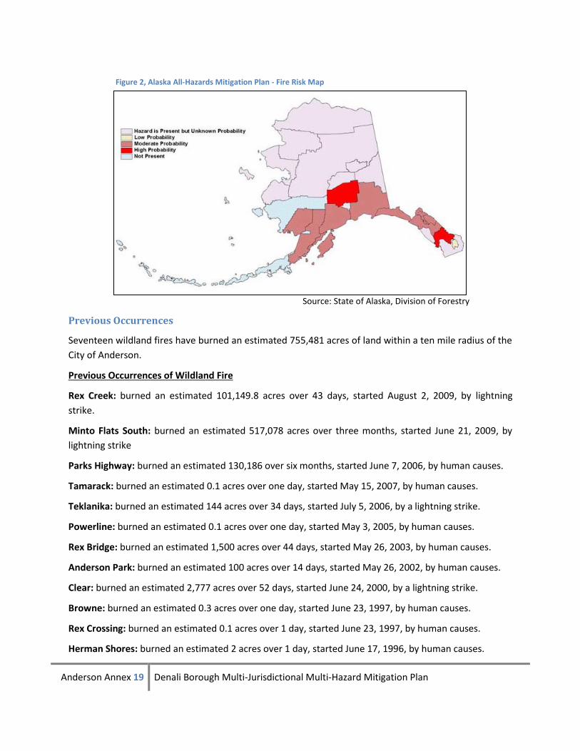
Figure 2, developed by the Division of Forestry, depicts Anderson as being in an area where the hazard is
present but at an unknown probability. However, based on the Alaska All-Hazard Risk Mitigation Plan,
City records and past historical events Anderson has a high probability of wildland fire. Table 8, defines
criteria used for determining high probability, as the hazard is present with a high probability of
occurrence within the calendar year. Event has up to 1 in 1 year chance of occurring. The Alaska All-
Hazard Risk Mitigation Plan lists Anderson as having wildland fire hazard present with a high probability.
Anderson Annex 19 Denali Borough Multi-Jurisdictional Multi-Hazard Mitigation Plan
Source: State of Alaska, Division of Forestry
Previous Occurrences
Seventeen wildland fires have burned an estimated 755,481 acres of land within a ten mile radius of the
City of Anderson.
Previous Occurrences of Wildland Fire
Rex Creek: burned an estimated 101,149.8 acres over 43 days, started August 2, 2009, by lightning
strike.
Minto Flats South: burned an estimated 517,078 acres over three months, started June 21, 2009, by
lightning strike
Parks Highway: burned an estimated 130,186 over six months, started June 7, 2006, by human causes.
Tamarack: burned an estimated 0.1 acres over one day, started May 15, 2007, by human causes.
Teklanika: burned an estimated 144 acres over 34 days, started July 5, 2006, by a lightning strike.
Powerline: burned an estimated 0.1 acres over one day, started May 3, 2005, by human causes.
Rex Bridge: burned an estimated 1,500 acres over 44 days, started May 26, 2003, by human causes.
Anderson Park: burned an estimated 100 acres over 14 days, started May 26, 2002, by human causes.
Clear: burned an estimated 2,777 acres over 52 days, started June 24, 2000, by a lightning strike.
Browne: burned an estimated 0.3 acres over one day, started June 23, 1997, by human causes.
Rex Crossing: burned an estimated 0.1 acres over 1 day, started June 23, 1997, by human causes.
Herman Shores: burned an estimated 2 acres over 1 day, started June 17, 1996, by human causes.
Figure 2, Alaska All-Hazards Mitigation Plan - Fire Risk Map
Anderson Annex 20 Denali Borough Multi-Jurisdictional Multi-Hazard Mitigation Plan
Dump: burned an estimated 0.5 acres over 5 days, started July 7, 1991, cause unknown.
Julius Creek: burned an estimated 2 acres over 3 days, started June 18, 1991, by human causes.
Big Rex: burned an estimated 1,540 acres over 31 days, started June 13, 1991, by a lightning strike.
Unnamed: burned an estimated 1.5 acres over 6 days, started May 31, 1991, resulting from spring
warming.
Clear: burned an estimated 1,000 acres over three days, started April 16, 1970, by human causes.
Wildland Fire Mitigation Goals and Projects
Wildland Fire mitigation Goals
Goal 1: Reduce fire danger to the community.
Wildland Fire Mitigation Projects
WF-1. Fuel reduction projects and defensible space around structures (Goal 1)
Create safer corridors for access/egress by reducing fuel (trees) around homes and driveways and
widening access roads. Remove fuel within the community around essential infrastructure such as
communications towers, power lines, evacuation routes and shelters, and emergency response facilities.
Additionally, fuel reduction projects (fire breaks) would be implemented around the community to
reduce the possibility of a wildfire and to increase the health of the forest in a way similar to the natural
cycle of burn-off and new growth.
WF-2. Additional access route between Anderson and George Parks Highway (Goal 1)
In case of fire or other emergency, the single route into and out of Anderson may become congested or
cut off. A second access route would provide additional safety to residents.
WF-3. Research and implement City-wide hazard warning system (Goal 1)
Residents must have adequate warning of fires or other emergencies.
Anderson Annex 21 Denali Borough Multi-Jurisdictional Multi-Hazard Mitigation Plan
Section 2. Flood/Erosion
Hazard Description and Characterization
Flooding is a natural event which occurs when rain, snow, or glacial melt causes a waterway to exceed
its capacity. The primary flooding hazards in Anderson are ice jams, snowmelt, and rainfall floods.
Anderson is located on the shore of the Lost Slough and therefore susceptible to significant river
flooding. River flooding is caused by ice jams, snowmelt, and rainfall.
Ice Jam Flooding: Ice jams can form during fall freeze up; in midwinter when stream channels freeze
forming anchor ice and during spring breakup when the existing ice cover is broken into pieces get stuck
at points of constriction. Water collects upstream from a jam, flooding an area by creating a lake-like
effect that has a large areal extent. The effect is analogous to a dam. Little damage typically occurs
upstream of the jam but significant damage can result from flooding once the dam breaks or the water
tops the embankment. The downstream effect is very different. Once the jam is breached water usually
drains rapidly; not only does the downstream stage rise substantially, but there is substantial current
strength combined with house sized blocks of ice causing significant damage.
Snowmelt: These flood events usually occur in the spring or early summer. The snow pack depth and
spring weather patterns influence the magnitude of flooding. Snowmelt floods can also be caused by
glacial melt.
Rainfall-Runoff Floods: A typical rainfall event occurs in mid to late summer. The rainfall intensity,
duration, distribution, and geomorphic characteristics of the watershed all play a role in determining the
magnitude of a flood.
Runoff flooding is the most common type of flood. They usually results from weather systems that have
prolonged rainfall associated with them.
Location
Historically, flooding in Anderson has occurred in low-lying areas near the Nenana River on the west side
of the community, which has been inundated with flood water reaching eight feet deep. In 1979 the U.S.
Army Corps of Engineers (USACE) built a dike to prevent future flooding, thereby creating Riverside Park.
Riverside Park is a 616-acre park that is located along the Lost Slough area of the Nenana River.
Extent
The extent (i.e. magnitude or severity) of the flood hazard is measured in this plan by using historical
past events and the Alaska All-Hazard Risk Mitigation Plan. To prevent future flooding the U.S. Army
Corps of Engineers (USACE) built a dike and created Riverside Park in 1979. The park is 616 acres parallel
to the Lost Slough near the Nenana River. Based on these factors and using the criteria established in
Table 7, the City of Anderson has a limited extent of flooding.
Impact
Flooding in the low-lying portion of Anderson could cut off portions of the community from critical
services located out of the flood zone. For example, road closures, impacts to public safety (access and
Anderson Annex 22 Denali Borough Multi-Jurisdictional Multi-Hazard Mitigation Plan
response capabilities), and limited availability of perishable commodities will impact even those
properties not flooded. Because of this, while the actual area subject to flooding is limited, the impact of
the flooding could affect the entire community.
Probability
Based on the Alaska All-Hazard Risk Mitigation Plan, City records and past historical events Anderson
has a high probability of flooding. Table 8, defines criteria used for determining high probability, as the
hazard is present with a high probability of occurrence within the calendar year. Event has up to 1 in 1
year chance of occurring.
The Alaska All-Hazard Risk Mitigation Plan list Anderson as having flood hazard present with a high
probability.
Previous Occurrences
In 1979, Nenana River floodwaters reached a depth of 6 to 8 feet on the west side of the community
near Lost Slough, according to the USACE. Near the northwest section of town the floodwaters reached
a depth of twelve inches. Floodwater marks were four inches above the doorsill of a house located on C
Street. Notches were cut into trees at the six- and eight-foot level by overflow ice on West First Street
and the trail to the river. Watermarks were several inches above the floor in a house on D Street. The
cause of the flood is reported as glaciation.
Tanana Basin Flooding (AK-09-226) declared August 4, 2008 by Governor Palin then FEMA declared
(DR-1796) on September 26, 2008
Beginning on July 27, 2008 through August 6, 2008, a strong large area of low pressure developed in the
Beaufort Sea near the northern border of the state, bringing a series of storms that moved from the
northwest coast into the interior. These severe storms caused losses of property and threats to life and
property in the Fairbanks North Star Borough, the North Slope Borough including the cities of
Wainwright and Kaktovik, the Yukon-Koyukuk Regional Educational Attendance Area (REAA) including
the City of Nenana, and the Denali Borough. The preliminary life safety assessments and joint
preliminary damage assessments with FEMA indicated the most severe impacts were to highways,
roads, buildings, sea walls, runways, water, sewer, and electric utilities, homes, and businesses.
The City of Nenana, suffered major damages to lift stations which are critical to the city sewer system.
All of the lift stations serving the City of Nenana were either operating at reduced capacity or completely
inoperable, placing the city at increased risk for public health hazards. The City of Nenana, Nenana City
School District and Nenana Native Tribal Council all experienced significant impacts to buildings and/or
equipment requiring major repairs or total replacement.
The Fairbanks North Star Borough (FNSB) experienced damages to local roads and flood waters caused
many homes and businesses to be inaccessible.
Golden Valley Electric Association’s supply routes in the borough were impacted, leaving some residents
without power for several days.
Anderson Annex 23 Denali Borough Multi-Jurisdictional Multi-Hazard Mitigation Plan
The Denali Borough experienced damages to local roads and bridges preventing access to homes,
requiring transient accommodations until access could be re-established.
The Department of Transportation and Public Facilities (DOT&PF), Department of Natural Resources
(DNR), and the Alaska Rail Road Corporation (ARRC) suffered damages to their facilities as a direct result
of this event. DOT&PF damages were limited to roads located within the FNSB and to some equipment
and supplies in Nenana. DNR damages were also restricted to locations within the FNSB and consisted of
damages to roads and recreational areas. ARRC damages were more extensive requiring total shutdown
of all northbound freight and passenger service due to track failures in Nenana and in the Healy Canyon
in the Denali Borough (Disaster Cost Index).
Community Participation in the NFIP
The City of Anderson is not participating in NFIP.
The function of the National Flood Insurance Program (NFIP) is to provide flood insurance to homes and
businesses located in floodplains at a reasonable cost. In trade, the Borough would agree to regulate
new development and substantial improvement to existing structures in the floodplain, or to build safely
above flood heights to reduce future damage to new construction. The program is based upon mapping
areas of flood risk, and requiring local implementation to reduce flood damage primarily through
requiring the elevation of structures above the base (100-year) flood elevations.
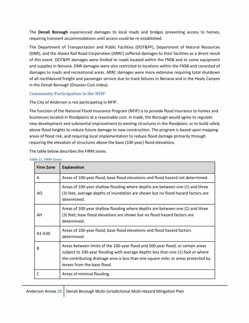
The table below describes the FIRM zones.
Table 11. FIRM Zones
Firm Zone Explanation
A Areas of 100-year flood; base flood elevations and flood hazard not determined.
AO
Areas of 100-year shallow flooding where depths are between one (1) and three
(3) feet, average depths of inundation are shown but no flood hazard factors are
determined.
AH
Areas of 100-year shallow flooding where depths are between one (1) and three
(3) feet; base flood elevations are shown but no flood hazard factors are
determined.
A1-A30 Areas of 100-year flood; base flood elevations and flood hazard factors
determined.
B
Areas between limits of the 100-year flood and 500-year flood; or certain areas
subject to 100-year flooding with average depths less than one (1) foot or where
the contributing drainage area is less than one square mile; or areas protected by
levees from the base flood.
C Areas of minimal flooding.
Anderson Annex 24 Denali Borough Multi-Jurisdictional Multi-Hazard Mitigation Plan
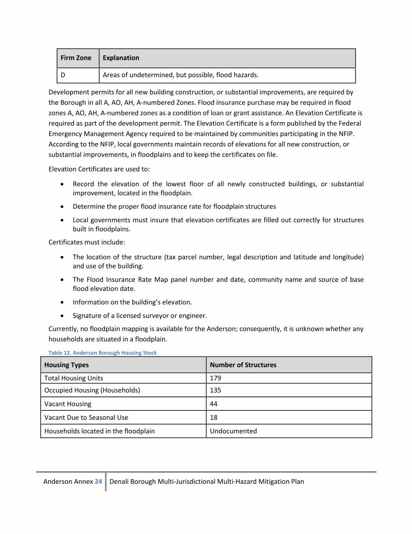
Firm Zone Explanation
D Areas of undetermined, but possible, flood hazards.
Development permits for all new building construction, or substantial improvements, are required by
the Borough in all A, AO, AH, A-numbered Zones. Flood insurance purchase may be required in flood
zones A, AO, AH, A-numbered zones as a condition of loan or grant assistance. An Elevation Certificate is
required as part of the development permit. The Elevation Certificate is a form published by the Federal
Emergency Management Agency required to be maintained by communities participating in the NFIP.
According to the NFIP, local governments maintain records of elevations for all new construction, or
substantial improvements, in floodplains and to keep the certificates on file.
Elevation Certificates are used to:
Record the elevation of the lowest floor of all newly constructed buildings, or substantial improvement, located in the floodplain.
Determine the proper flood insurance rate for floodplain structures
Local governments must insure that elevation certificates are filled out correctly for structures built in floodplains.
Certificates must include:
The location of the structure (tax parcel number, legal description and latitude and longitude) and use of the building.
The Flood Insurance Rate Map panel number and date, community name and source of base flood elevation date.
Information on the building’s elevation.
Signature of a licensed surveyor or engineer.
Currently, no floodplain mapping is available for the Anderson; consequently, it is unknown whether any
households are situated in a floodplain.
Table 12. Anderson Borough Housing Stock
Housing Types Number of Structures
Total Housing Units 179
Occupied Housing (Households) 135
Vacant Housing 44
Vacant Due to Seasonal Use 18
Households located in the floodplain Undocumented
Anderson Annex 25 Denali Borough Multi-Jurisdictional Multi-Hazard Mitigation Plan
Table 13. Local and State Floodplain Coordinator Contact Information
Anderson Floodplain Coordinator
Contact Person – Vacant position Address Phone: Email:
State of AK Floodplain Coordinators
Floodplain Management Programs Coordinator Division of Community Advocacy Department of Commerce, Community & Economic Development Taunnie Boothby, State Floodplain Coordinator 550 W. 7th Avenue, Suite 1640 Anchorage, AK 99501 (907) 269-4567 (907) 269-4563 (fax) Email: [email protected] Website: http://www.commerce.state.ak.us/dca/nfip/nfip.htm
Repetitive Loss Properties
The risk assessment in all plans approved after October 1, 2008 must also address NFIP-insured
structures that have been repetitively damaged floods.
Under NFIP guidelines, repetitive loss structures include any currently insured building with two or more
flood losses (occurring more than ten days apart) greater than $1,000 in any 10-year period since 1978.
States should provide communities with information on historic floods throughout the state so
communities will know what type of damage has occurred (even if it didn't occur within that particular
community).
States should ensure that lists of repetitive loss properties are kept up to date and that communities
have the most current list. States should contact their FEMA Regional Office for this information.
FEMA also maintains a national list of properties that comprise the “Repetitive Loss Target Group”.
These are repetitive loss properties that have either experienced four or more losses with the
characteristics above, or have had losses that cumulatively exceed the property value of the building.
Repetitive loss properties are those with at least two losses in a rolling ten-year period and two losses
that are at least ten days apart. Specific property information is confidential, but the State DCRA
Floodplain Coordinator related that there have been zero properties that meet the FEMA definition of
repetitive loss within the City of Anderson.
Anderson Annex 26 Denali Borough Multi-Jurisdictional Multi-Hazard Mitigation Plan
Flood Mitigation Goals and Projects
Flood Mitigation Goals
Goal 1. Reduce or prevent future flood damage.
Flood Mitigation Projects
FLD-1: Work with USACE to ensure the continued maintenance of the Riverside Park Dike (Goal 1).
FLD-2: Investigate means of emergency access to residences in case of bridge washouts (Goal 1).
Concern is that the bridge on Rex Trail is inadequate. Approximately 25 residents are located in this
area. Other areas may have similar issues.
FLD-3: Investigate the benefits of joining the NFIP program.
Through the NFIP, property owners in participating communities are able to insure against flood losses.
By employing wise floodplain management, a participating community can protect its citizens against
much of the devastating financial loss resulting from flood disasters. Careful local management of
development in the floodplains results in construction practices that can reduce flood losses and the
high costs associated with flood disasters to all levels of government.
Anderson Annex 27 Denali Borough Multi-Jurisdictional Multi-Hazard Mitigation Plan
Section 3. Severe Weather
Hazard Description and Characterization
Weather is the result of four main features: the sun, the planet's atmosphere, moisture, and the
structure of the planet. Certain combinations can result in severe weather events that have the
potential to become a disaster.
In Alaska, there is great potential for weather disasters. High winds can combine with loose snow to
produce a blinding blizzard and wind chill temperatures to 75°F below zero. Extreme cold (-40°F or
lower) and ice fog may last for weeks at a time. Heavy snow can impact the interior. A quick thaw
means additional risk of flooding.
Winter Storms
Winter storms originate as mid-latitude depressions or cyclonic weather systems. High winds, heavy
snow, and cold temperatures usually accompany them. To develop, they require:
• Cold air - Subfreezing temperatures (below 32ºF, 0ºC) in the clouds and/or near the ground to make snow and/or ice.
• Moisture - The air must contain moisture in order to form clouds and precipitation. • Lift - A mechanism to raise the moist air to form the clouds and cause precipitation. Any or
all of the following may provide lift: o The flow of air up a mountainside. o Fronts, where warm air collides with cold air and rises over the dome of cold air. o Upper-level low-pressure troughs.
Heavy Snow
Heavy snow, generally more than 12 inches of accumulation in less than 24 hours, can immobilize a
community by bringing transportation to a halt. Until the snow can be removed, airports and major
roadways are impacted, even closed completely, stopping the flow of supplies and disrupting emergency
and medical services. Accumulations of snow can cause roofs to collapse and knock down trees and
power lines. Heavy snow can also damage light aircraft and sink small boats. A quick thaw after a heavy
snow can cause substantial flooding. The cost of snow removal, repairing damages, and the loss of
business can have severe economic impacts on cities and towns. Injuries and deaths related to heavy
snow usually occur as a result of vehicle accidents. Casualties also occur due to overexertion while
shoveling snow and hypothermia caused by overexposure to the cold weather.
Extreme cold
What is considered an excessively cold temperature varies according to the normal climate of a region.
In areas unaccustomed to winter weather, near freezing temperatures are considered "extreme cold”. In
Alaska, extreme cold usually involves temperatures below –40F. Excessive cold may accompany winter
storms, be left in their wake, or can occur without storm activity.
Anderson Annex 28 Denali Borough Multi-Jurisdictional Multi-Hazard Mitigation Plan
Extreme cold can bring transportation to a halt across interior Alaska for days or sometimes weeks at a
time. Aircraft may be grounded due to extreme cold and ice fog conditions, cutting off access as well as
the flow of supplies northern villages.
Extreme cold also interferes with a community’s infrastructure. It causes fuel to congeal in storage tanks
and supply lines, stopping electric generation. Without electricity, heaters do not work, causing water
and sewer pipes to freeze or rupture. If extreme cold conditions are combined with low or no snow
cover, the ground’s frost depth can increase disturbing buried pipes.
The greatest danger from extreme cold is its effect on people. Prolonged exposure to the cold can cause
frostbite or hypothermia and become life threatening. Infants and elderly people are most susceptible.
The risk of hypothermia due to exposure greatly increases during episodes of extreme cold, and carbon
monoxide poisoning is possible as people use supplemental heating devices.
Ice Storms
The term ice storm is used to describe occasions when damaging accumulations of ice are expected
during freezing rain situations. They can be the most devastating of winter weather phenomena and are
often the cause of automobile accidents, power outages and personal injury. Ice storms result from the
accumulation of freezing rain, which is rain that becomes super cooled and freezes upon impact with
cold surfaces. Freezing rain most commonly occurs in a narrow band within a winter storm that is also
producing heavy amounts of snow and sleet in other locations.
High Winds
Another major weather factor in the community is high winds. The wind chill factor can bring
temperatures down to -50˚F, which can lead to frozen pipes and dangerous conditions for outdoor
activities. While most home and business owners are prepared for the heavy winds and low
temperatures, construction practices must be followed to protect against the high winds.
Ice Fog
Ice fog is the result of water vapor encountering extremely cold air that is already saturated. For
example, when water vapor exits a car tailpipe when the temperature is -40 degrees, the water vapor
temperature drops from about 250 degrees to minus 40 in less than 10 seconds. Water cooled that fast
forms tiny ice particles, so small that ten of them could fit side by side on the edge of a piece of paper.
Collectively, millions of these particles take form as ice fog, the dense clouds that hang low over Interior
Alaska roads in winter.
Temperature inversions, in which warm air above acts like a lid to trap cold air below, combine with hills
in the Interior to provide a box in which ice fog forms (Ned Rozell, Geophysical Institute, UAF).
Freezing rain develops as falling snow encounters a layer of warm air in the atmosphere deep enough
for the snow to completely melt and become rain. As the rain continues to fall, it passes through a thin
layer of cold air just above the earth’s surface and cools to a temperature below freezing. The drops
Anderson Annex 29 Denali Borough Multi-Jurisdictional Multi-Hazard Mitigation Plan
themselves do not freeze, but rather they become super cooled. When these super cooled drops strike
the frozen ground, power lines, tree branches, etc., they instantly freeze.
Drought
Drought commonly occurs over a defined period of time of very low precipitation. Drought severity
depends on duration, intensity, and geographic extent, as well as the demand on the water supply.
There are three ways to define drought:
1. Meteorological - a degree of dryness. Measures lack of actual precipitation compared to an expressed average.
2. Agricultural - defined as soil moisture deficiencies relative to what the plant life needs
3. Hydrological - relates to the effects of the lack of precipitation on streams, rivers, lakes, and groundwater levels.
A drought may result in a shortage of water for residential uses and increase wildland fire hazard.
Location
The hazards of severe weather impacts Anderson on an area-wide basis. A severe weather event would
create an area-wide impact, could damage structures, and severely restrict or completely halt
transportation.
Extent
Extreme weather could result in limited impacts to Anderson. It is not expected that permanent
disabilities will result from severe weather unless unprepared residents or visitors take unnecessary
risks. Travel can be restricted by extreme low temperatures, fuel can gel, and visibility be impaired by ice
fog. Pipes can freeze particularly if there is a lack of snow cover. Prolonged exposure to extremely low
temperatures can result in hypothermia and death.
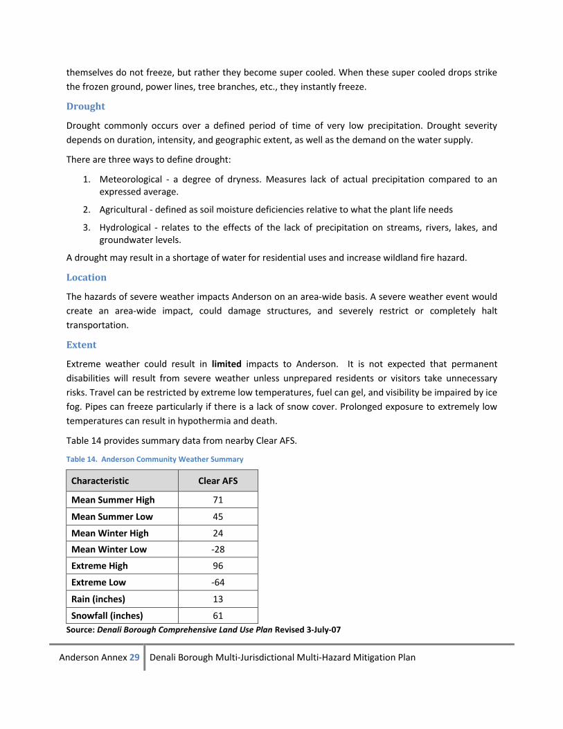
Table 14 provides summary data from nearby Clear AFS.
Table 14. Anderson Community Weather Summary
Characteristic Clear AFS
Mean Summer High 71
Mean Summer Low 45
Mean Winter High 24
Mean Winter Low -28
Extreme High 96
Extreme Low -64
Rain (inches) 13
Snowfall (inches) 61
Source: Denali Borough Comprehensive Land Use Plan Revised 3-July-07
Anderson Annex 30 Denali Borough Multi-Jurisdictional Multi-Hazard Mitigation Plan
Impact
Power outages can occur with heavy demand during cold spells. Property damage to infrastructure and
facilities could be expected during a severe weather event. Travel is limited and fuel and supply
shortages can result. Adequate heating fuel is a priority in Interior Alaska’s extreme cold as
temperatures quickly drop in unheated structures, pipes freeze and burst and unprepared individuals
can suffer frostbite, hypothermia or death.
Probability
Based on information provided by the Denali Borough, previous occurrences, and the Alaska All-Hazard
Mitigation Plan, 2007, Anderson has a high probability of a severe weather event. Table 8, lists the
following criteria for high probability as hazard is present with a high probability of occurrence within
the calendar year. Event has up to 1 in 1 year chance of occurring.
Previous Occurrences
There are no State or Federally declared disasters resulting from severe weather events recorded in
Anderson.
Severe Weather Mitigation Goals and Projects
Severe Weather Mitigation Goal
Goal 1: Increase public awareness
Severe Weather Mitigation Project
SW-1. Conduct severe weather awareness activities. (Goal 1)
Assist Borough-wide efforts by conducting public awareness activities including events such as Winter
Weather Awareness Week, Flood Awareness Week, etc.
Anderson Annex 31 Denali Borough Multi-Jurisdictional Multi-Hazard Mitigation Plan
Section 4. Earthquake
Hazard Description and Characterization
Approximately 11 percent of the world’s earthquakes occur in Alaska, making it one of the most
seismically active regions in the world. Three of the ten largest quakes in the world since 1900 have
occurred here. Earthquakes of magnitude 7 or greater occur in Alaska on average of about once a year;
magnitude 8 earthquakes average about 14 years between events.
Most large earthquakes are caused by a sudden release of accumulated stresses between crustal plates
that move against each other on the earth’s surface. Some earthquakes occur along faults that lie within
these plates. The dangers associated with earthquakes include ground shaking; surface faulting, ground
failures, snow avalanches, seiches and tsunamis. The extent of damage is dependent on the magnitude
of the quake, the geology of the area, distance from the epicenter and structure design and
construction. A main goal of an earthquake hazard reduction program is to preserve lives through
economical rehabilitation of existing structures and constructing safe new structures.
Ground shaking is due to the three main classes of seismic waves generated by an earthquake. Primary
waves are the first ones felt, often as a sharp jolt. Shear or secondary waves are slower and usually have
a side to side movement. They can be very damaging because structures are more vulnerable to
horizontal than vertical motion.
Surface waves are the slowest, although they can carry the bulk of the energy in a large earthquake. The
damage to buildings depends on how the specific characteristics of each incoming wave interact with
the buildings’ height, shape, and construction materials.
Earthquakes are usually measured in terms of their magnitude and intensity. Magnitude is related to the
amount of energy released during an event while intensity refers to the effects on people and structures
at a particular place. Earthquake magnitude is usually reported according to the standard Richter scale
for small to moderate earthquakes.
Large earthquakes, like those that commonly occur in Alaska are reported according to the moment-
magnitude scale because the standard Richter scale does not adequately represent the energy released
by these large events.
Intensity is usually reported using the Modified Mercalli Intensity Scale. This scale has 12 categories
ranging from not felt to total destruction. Different values can be recorded at different locations for the
same event depending on local circumstances such as distance from the epicenter or building
construction practices. Soil conditions are a major factor in determining an earthquake’s intensity, as
unconsolidated fill areas will have more damage than an area with shallow bedrock. Surface faulting is
the differential movement of the two sides of a fault. There are three general types of faulting.
Strike-slip faults are where each side of the fault moves horizontally. Normal faults have one side
dropping down relative to the other side. Thrust (reverse) faults have one side moving up and over the
fault relative to the other side.
Anderson Annex 32 Denali Borough Multi-Jurisdictional Multi-Hazard Mitigation Plan
Earthquake-induced ground failure is often the result of liquefaction, which occurs when soil (usually
sand and course silt with high water content) loses strength as a result of the shaking and acts like a
viscous fluid.
Liquefaction causes three types of ground failures: lateral spreads, flow failures, and loss of bearing
strength. In the 1964 earthquake, over 200 bridges were destroyed or damaged due to lateral spreads.
Flow failures damaged the port facilities in Seward, Valdez and Whittier.
Similar ground failures can result from loss of strength in saturated clay soils, as occurred in several
major landslides that were responsible for most of the earthquake damage in Anchorage in 1964. Other
types of earthquake-induced ground failures include slumps and debris slides on steep slopes.
Location
Anderson is located near the Nenana Mountain and Denali Fault. The tectonic framework of Alaska is
dominated by subduction of the Pacific plate underneath the North American plate; stresses due to the
plate convergence causes substantial crustal seismicity into interior Alaska. An earthquake hazard event
could potentially impact any part of Anderson.
Extent
The extent of an earthquake in Anderson would have a limited extent. Table 7 uses the following criteria
to determine the extent of possible damage: injuries and/or illnesses do not result in permanent
disability, complete shutdown of critical facilities for more than one week; more than 10 percent of
property is severely damaged.
Anderson is near the Denali fault which is an active fault subject to strong earthquakes. Roads into and
out of Anderson are vulnerable to earthquakes. So while Anderson is unlikely to be at the epicenter of a
high-magnitude earthquake, the secondary impacts of an earthquake could include an inability to bring
in goods over the highway creating shortages of supplies and a disruption of the economy through
interruption of tourism. Additionally, if nearby airports are rendered unusable, medical evacuations and
other flights could be impacted, which in turn, could affect Anderson and other nearby communities.
Intensity is a subjective measure of the strength of the shaking experienced in an earthquake. Intensity
is based on the observed effects of ground shaking on people, buildings, and natural features. It varies
from place to place within the disturbed region depending on the location of the observer with respect
to the earthquake epicenter.
The "intensity" reported at different points generally decreases away from the earthquake epicenter.
Local geologic conditions strongly influence the intensity of an earthquake; commonly, sites on soft
ground or alluvium have intensities two to three units higher than sites on bedrock.
The Richter scale expresses magnitude as a decimal number. A 5.0 earthquake is a moderate event, 6.0
characterize a strong event, 7.0 is a major earthquake and a great earthquake exceeds 8.0. The scale is
logarithmic and open-ended. (Alaska All-Hazard Risk Mitigation Plan 2007)
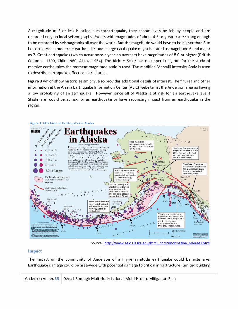
Anderson Annex 33 Denali Borough Multi-Jurisdictional Multi-Hazard Mitigation Plan
A magnitude of 2 or less is called a microearthquake, they cannot even be felt by people and are
recorded only on local seismographs. Events with magnitudes of about 4.5 or greater are strong enough
to be recorded by seismographs all over the world. But the magnitude would have to be higher than 5 to
be considered a moderate earthquake, and a large earthquake might be rated as magnitude 6 and major
as 7. Great earthquakes (which occur once a year on average) have magnitudes of 8.0 or higher (British
Columbia 1700, Chile 1960, Alaska 1964). The Richter Scale has no upper limit, but for the study of
massive earthquakes the moment magnitude scale is used. The modified Mercalli Intensity Scale is used
to describe earthquake effects on structures.
Figure 3 which show historic seismicity, also provides additional details of interest. The figures and other
information at the Alaska Earthquake Information Center (AEIC) website list the Anderson area as having
a low probability of an earthquake. However, since all of Alaska is at risk for an earthquake event
Shishmaref could be at risk for an earthquake or have secondary impact from an earthquake in the
region.
Source: http://www.aeic.alaska.edu/html_docs/information_releases.html
Impact
The impact on the community of Anderson of a high-magnitude earthquake could be extensive.
Earthquake damage could be area-wide with potential damage to critical infrastructure. Limited building
Figure 3. AEIS Historic Earthquakes in Alaska
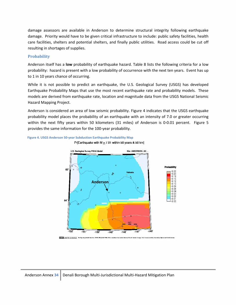
Anderson Annex 34 Denali Borough Multi-Jurisdictional Multi-Hazard Mitigation Plan
Anderson
damage assessors are available in Anderson to determine structural integrity following earthquake
damage. Priority would have to be given critical infrastructure to include: public safety facilities, health
care facilities, shelters and potential shelters, and finally public utilities. Road access could be cut off
resulting in shortages of supplies.
Probability
Anderson itself has a low probability of earthquake hazard. Table 8 lists the following criteria for a low
probability: hazard is present with a low probability of occurrence with the next ten years. Event has up
to 1 in 10 years chance of occurring.
While it is not possible to predict an earthquake, the U.S. Geological Survey (USGS) has developed
Earthquake Probability Maps that use the most recent earthquake rate and probability models. These
models are derived from earthquake rate, location and magnitude data from the USGS National Seismic
Hazard Mapping Project.
Anderson is considered an area of low seismic probability. Figure 4 indicates that the USGS earthquake
probability model places the probability of an earthquake with an intensity of 7.0 or greater occurring
within the next fifty years within 50 kilometers (31 miles) of Anderson is 0-0.01 percent. Figure 5
provides the same information for the 100-year probability.
Figure 4. USGS Anderson 50-year Subduction Earthquake Probability Map
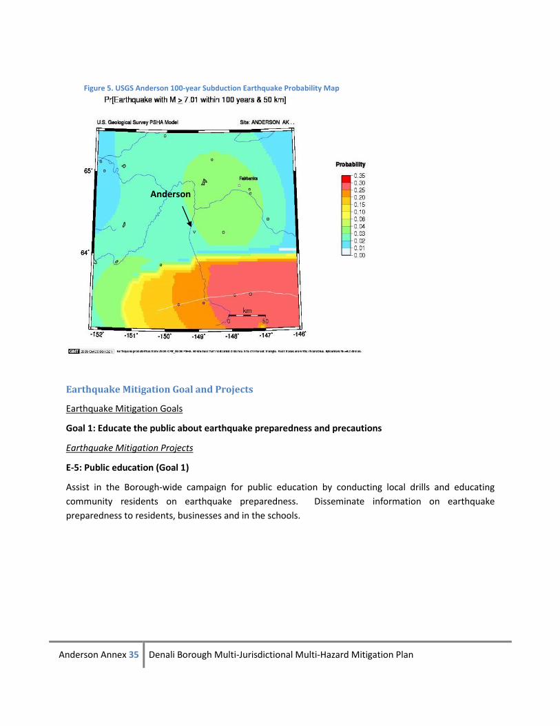
Anderson Annex 35 Denali Borough Multi-Jurisdictional Multi-Hazard Mitigation Plan
Earthquake Mitigation Goal and Projects
Earthquake Mitigation Goals
Goal 1: Educate the public about earthquake preparedness and precautions
Earthquake Mitigation Projects
E-5: Public education (Goal 1)
Assist in the Borough-wide campaign for public education by conducting local drills and educating
community residents on earthquake preparedness. Disseminate information on earthquake
preparedness to residents, businesses and in the schools.
Anderson
Figure 5. USGS Anderson 100-year Subduction Earthquake Probability Map
Anderson Annex 36 Denali Borough Multi-Jurisdictional Multi-Hazard Mitigation Plan
Section 5. Hazards not Profiled in the 2009 Denali Borough MHMP Anderson
Annex
Avalanche
Alaska experiences many snow avalanches every year. The exact number is undeterminable as most
occur in isolated areas and go unreported. Avalanches tend to occur repeatedly in localized areas and
can sheer trees, cover communities and transportation routes, destroy buildings, and cause death.
Alaska leads the nation in avalanche accidents per capita.
Avalanche Vulnerability Assessment
The terrain surrounding Anderson does not provide the necessary conditions for avalanche. No threat
from avalanche is present in Anderson.
Ground Failure Hazard
Ground failure is a problem throughout Alaska with landslides presenting the greatest threat. Ground
failure hazards exist to some degree in all areas of the state.
Landslides are described as downward movement of a slope and materials under the force of gravity.
The term landslide includes a wide range of ground movement, such as rock falls, deep failure of slopes,
and shallow debris flows. Landslides are influenced by human activity (mining and construction of
buildings, railroads, and highways) and natural factors (geology, precipitation, and topography). They
are common all over the United States and its territories.
Landslides occur when masses of rock, earth, or debris move down a slope. Therefore, gravity acting on
an overly steep slope is the primary cause of a landslide. They are activated by storms, fires, and by
human modifications to the land. New landslides occur as a result of rainstorms, earthquakes, volcanic
eruptions, and various human activities.
Mudflows (or debris flows) are flows of rock, earth, and other debris saturated with water. They develop
when water rapidly accumulates in the ground, such as during heavy rainfall or rapid snowmelt,
changing the earth into a flowing river of mud or "slurry." Slurry can flow rapidly down slopes or through
channels and can strike with little or no warning at avalanche speeds. Slurry can travel several miles
from its source, growing in size as it picks up trees, cars, and other materials along the way.
Other types of landslides include: rock slides, slumps, mudslides, and earthflows. All of these differ in
terms of content and flow.
Ground Failure Vulnerability Assessment
The terrain surrounding Anderson does not provide the necessary conditions for landslides, mudflows,
or other ground failure hazards.
Tsunamis and Seiches
A tsunami is a series of ocean waves generated by any rapid large-scale disturbance of the seawater.
These waves can travel at speeds of up to 600 miles per hour in the open ocean. Most tsunamis are
Anderson Annex 37 Denali Borough Multi-Jurisdictional Multi-Hazard Mitigation Plan
generated by earthquakes, but they may also be caused by volcanic eruptions, landslides (above or
under sea in origin), undersea slumps, or meteor impacts.
A seiche is a wave that oscillates in partially or totally enclosed bodies of water. They can last from a few
minutes to a few hours as a result of an earthquake, underwater landslide, atmospheric disturbance or
avalanche. The resulting effect is similar to bathtub water sloshing repeatedly from side to side. The
reverberating water continually causes damage until the activity subsides. The factors for effective
warning are similar to a local tsunami, in that the onset of the first wave can be a few minutes, giving
virtually no time for warning.
Local Hazard Vulnerability Assessment
There is no danger of tsunamis and seiches since the Anderson is landlocked.
Volcano
Alaska is home to more than 40 historically active volcanoes stretching across the entire southern
portion of the state, from the Wrangell Mountains to the far western Aleutians. On average, one to two
eruptions occur per year in Alaska. In 1912, the largest eruption of the twentieth century occurred at
Novarupta and Mount Katmai, located in what is now Katmai National Park and Preserve on the Alaska
Peninsula.
A volcano is a vent at the Earth’s surface through which magma and associated gases erupt, and also the
landform built by effusive and explosive eruptions. Volcanoes display a wide variety of shapes, sizes,
and behavior; however, they are commonly classified among three main types: cinder cone, composite
and shield.
Volcano Vulnerability Assessment
The Alaska Volcano Observatory identifies the closest active volcano to Anderson as being Buzzard Creek
craters, two tuff rings at the headwaters of Buzzard Creek, a tributary of the Totatlanika River, near
Healy at the northern foot of the central Alaska Range. The two craters are shallow and contain small
lakes. “The Buzzard Creek craters, though insignificant in the volume of ejecta, are of regional tectonic
interest because they occur on trend with the Aleutian arc structure and are situated directly over the
northernmost corner of the subducting Pacific plate.” (AVO 2009)
Closer to Anderson is the inactive Prindle Volcano approximately 50 miles away. Prindle is described as
“a small isolated basaltic cone in the midst of the metamorphic and granitic terrane of the Yukon-
Tanana upland, east-central Alaska. The cone is ~900 to 1,000 m in diameter at its base and has as crater
~90 m deep, which is breached on the south. A lava flow extends from the breached crater ~6.4 km to
the southeast, where it turns southwest and continues an additional 4.8 km in a river valley.
"The cone and lava flow are vesicular basanite, rich in phenocrystal and xenocrystal olivine as well as
inclusions of peridotite ranging up to 13 cm in diameter. Fragments of crystalline schists of the granulite
facies with gneissose structure also occur as inclusions, but are less abundant than peridotite
inclusions." (AVO 2009)
Anderson Annex 38 Denali Borough Multi-Jurisdictional Multi-Hazard Mitigation Plan
Prindle’s last eruption is estimated to have occurred more than 160,000 years ago.
The City of Anderson is not considered to be under threat of volcanic action.
Anderson Annex 39 Denali Borough Multi-Jurisdictional Multi-Hazard Mitigation Plan
Chapter 5: Mitigation Strategy
Benefit - Cost Review
This chapter of the plan outlines the Anderson’s overall strategy to reduce its vulnerability to the effects
of the hazards studied. Currently the planning effort is limited to the hazards determined to be of the
most concern; earthquake, severe weather, flood/erosion, and wildland fire however the mitigation
strategy will be regularly updated as additional hazard information is added and new information
becomes available.
The projects listed on Table 15, were prioritized using a listing of benefits and costs review method as
described in the FEMA How-To-Guide Benefit-Cost Review in Mitigation Planning (FEMA 386-5).
Due to monetary as well as other limitations, it is often impossible to implement all mitigation actions.
Therefore, the most cost-effective actions for implementation will be pursued for funding first, not only
to use resources efficiently, but also to make a realistic start toward mitigating risks.
The City of Anderson considered the following factors in prioritizing the mitigation projects. Due to the
dollar value associated with both life-safety and critical facilities, the prioritization strategy represents a
special emphasis on benefit-cost review because the factors of life-safety and critical facilities steered
the prioritization towards projects with likely good benefit-cost ratios.
Extent to which benefits are maximized when compared to the costs of the projects, the Benefit
Cost Ratio must be 1.0 or greater.
Extent the project reduces risk to life-safety.
Project protects critical facilities or critical city functionality.
Hazard probability.
Hazard severity.
Other criteria that were used to developing the benefits – costs listing depicted in Benefit – Costs
Review of Projects
Table 15 lists mitigation projects and their benefits, costs and prioritization. This is review and overview,
not an actual cost-benefit analysis which will be required as part of PDM or HMGP grant applications for
specific projects:
1. Vulnerability before and after Mitigation
Number of people affected by the hazard, area wide or specific properties.
Areas affected (acreage) by the hazard
Number of properties affected by the hazard
Loss of use
Loss of life (number of people)
Anderson Annex 40 Denali Borough Multi-Jurisdictional Multi-Hazard Mitigation Plan
Injury (number of people)
2. List of Benefits
Risk reduction (immediate or medium time frame)
Other community goals or objectives achieved
Easy to implement
Funding available
Politically or socially acceptable
3. Costs
Construction cost
Programming cost
Long time frame to implement
Public or political opposition
Adverse environmental effects
This method supports the principle of benefit-cost review by using a process that demonstrates a special
emphasis on maximization of benefits over costs. Projects that demonstrate benefits over costs and
that can start immediately were given the highest priority. Projects that the costs somewhat exceed
immediate benefit and that can start within five years (or before the next update) were given a
description of medium priority, with a timeframe of one to five years. Projects that are very costly
without known benefits, probably cannot be pursued during this plan cycle, but are important to keep
as an action were given the lowest priority and designated as long term.
After the MHMP Update has been approved, the projects must be evaluated using a Benefit-Cost
Analysis (BCA) during the funding cycle for disaster mitigation funds from DHS&EM and FEMA.
Briefly, BCA is the method by which the future benefits of a mitigation project are determined and
compared to its cost. The result is a Benefit-Cost Ratio (BCR), which is derived from a project’s total net
benefits divided by its total cost. The BCR is a numerical expression of the cost-effectiveness of a
Benefit-Cost Review vs. Benefit-Cost Analysis (FEMA 386-5) states in part:
Benefit-Cost Review for mitigation planning differs from the benefit cost analysis (BCA)
used for specific projects. BCA is a method for determining the potential positive effects of
a mitigation action and comparing them to the cost of the action. To assess and
demonstrate the cost-effectiveness of mitigation actions, FEMA has developed a suite of
BCA software, including hazard-specific modules. The analysis determines whether a
mitigation project is technically cost-effective. The principle behind the BCA is that the
benefit of an action is a reduction in future damages.
DMA 2000 does not require hazard mitigation plans to include BCAs for specific projects,
but does require that a BCR be conducted in prioritizing projects.
Anderson Annex 41 Denali Borough Multi-Jurisdictional Multi-Hazard Mitigation Plan
project. Composite BCRs of 1.0 or greater have more benefits than costs, and are therefore cost-
effective.
Benefit-Cost Analysis
The following section is reproduced from a document prepared by FEMA, which demonstrates on how
to perform a BCA. The complete guidelines document, a BCA document, and BCA technical assistance is
available online http://www.fema.gov/government/grant/bca.
Facilitating BCA
Although the preparation of a BCA is a technical process, FEMA has developed software, written
materials, and training that simplify the process of preparing BCAs. FEMA has a suite of BCA software
for a range of major natural hazards: earthquake, fire (wildland/urban interface fires), flood (riverine,
coastal A-Zone, Coastal V-Zone), hurricane wind (and typhoon), and tornado.
Sometimes there is not enough technical data available to use the BCA software mentioned above.
When this happens, or for other common, smaller-scale hazards or more localized hazards, BCAs can be
done with the Frequency Damage Method (i.e., the Riverine Limited Data module), which is applicable
to any natural hazard as long as a relationship can be established between how often natural hazard
events occur and how much damage and losses occur as a result of the event. This approach can be
used for coastal storms, windstorms, freezing, mud/landslides, severe ice storms, snow, tsunami, and
volcano hazards.
Applicants and sub-applicants must use FEMA-approved methodologies and software to demonstrate
the cost-effectiveness of their projects. This will ensure that the calculations and methods are
standardized, facilitating the evaluation process. Alternative BCA software may also be used, but only if
the FEMA Regional Office and FEMA Headquarters approve the software.
To assist applicants and sub-applicants, FEMA has prepared the FEMA Mitigation BCA Toolkit CD. This
CD includes all of the FEMA BCA software, technical manuals, BC training courses, data-documentation
templates, and other supporting documentation and guidance.
The Mitigation BCA Toolkit CD is available free from FEMA Regional Offices or via the BC Helpline (at
[email protected] or toll free number at (866) 222-3580.
The BC Helpline is also available to provide BCA software, technical manuals, and other BCA reference
materials as well as to provide technical support for BCA.
For further technical assistance, applicants or sub-applicants may contact their State Mitigation Office,
the FEMA Regional Office, or the BC Helpline. FEMA and the BC Helpline provide technical assistance
regarding the preparation of a BCA.
Eligible Projects for PDM Funding
The PDM (Grant Program) is federally funded through FEMA at 75% of the plan or project and requires a
25% local fund match. The program is annual, nationally competitive and is intended to reduce overall
risks to population and structures, while also reducing reliance on funding from actual disaster
Anderson Annex 42 Denali Borough Multi-Jurisdictional Multi-Hazard Mitigation Plan
declarations. PDM grants include Hazard Mitigation Planning Grants and Hazard Mitigation Project
Grants.
A Hazard Mitigation Planning Grant is only available for communities who do not have a
FEMA/State approved and community adopted All-Hazard Mitigation Plan.
A Hazard Mitigation Project Grant is only available for communities who have a FEMA/State
approved and community adopted Hazard Mitigation Plan.
Hazard Mitigation Projects are intended to reduce risk to life and property. Examples include:
Elevation of flood prone structures
Structural and non-structural seismic retrofits of public facilities
Voluntary acquisition or relocation of structures out of the floodplain
Natural hazard protective measures for utilities, water and sanitary sewer systems
Localized storm water management and flood control projects
Eligible Projects for HMGP Funding
These criteria are designed to ensure that the most appropriate projects are selected for funding.
Projects may be of any nature that will result in protection of public or private property from natural
hazards. Some types of projects that may be eligible include:
Acquisition of hazard prone property and conversion to open space;
Retrofitting existing buildings and facilities;
Elevation of flood prone structures;
Vegetative management/soil stabilization;
Infrastructure protection measures;
Stormwater management;
Minor structural flood control projects; and
Post-disaster code enforcement activities.
The following types of projects are not eligible under the HMGP:
Retrofitting places of worship (or other projects that solely benefit religious organizations); and
Projects in progress.
There are five minimum criteria that all projects must meet in order to be considered for funding:
Conforms with the State Hazard Mitigation Plan;
Provides beneficial impact upon the designated disaster area;
Anderson Annex 43 Denali Borough Multi-Jurisdictional Multi-Hazard Mitigation Plan
Conforms with environmental laws and regulations;
Solves a problem independently or constitutes a functional portion of a solution; and,
Is cost-effective.
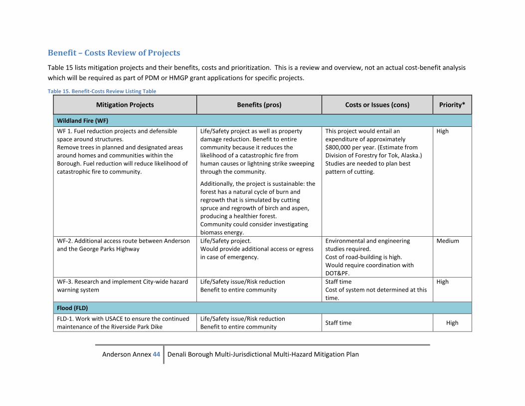
Anderson Annex 44 Denali Borough Multi-Jurisdictional Multi-Hazard Mitigation Plan
Benefit – Costs Review of Projects
Table 15 lists mitigation projects and their benefits, costs and prioritization. This is a review and overview, not an actual cost-benefit analysis
which will be required as part of PDM or HMGP grant applications for specific projects.
Table 15. Benefit-Costs Review Listing Table
Mitigation Projects Benefits (pros) Costs or Issues (cons) Priority*
Wildland Fire (WF)
WF 1. Fuel reduction projects and defensible space around structures. Remove trees in planned and designated areas around homes and communities within the Borough. Fuel reduction will reduce likelihood of catastrophic fire to community.
Life/Safety project as well as property damage reduction. Benefit to entire community because it reduces the likelihood of a catastrophic fire from human causes or lightning strike sweeping through the community.
Additionally, the project is sustainable: the forest has a natural cycle of burn and regrowth that is simulated by cutting spruce and regrowth of birch and aspen, producing a healthier forest. Community could consider investigating biomass energy.
This project would entail an expenditure of approximately $800,000 per year. (Estimate from Division of Forestry for Tok, Alaska.) Studies are needed to plan best pattern of cutting.
High
WF-2. Additional access route between Anderson and the George Parks Highway
Life/Safety project. Would provide additional access or egress in case of emergency.
Environmental and engineering studies required. Cost of road-building is high. Would require coordination with DOT&PF.
Medium
WF-3. Research and implement City-wide hazard warning system
Life/Safety issue/Risk reduction Benefit to entire community
Staff time Cost of system not determined at this time.
High
Flood (FLD)
FLD-1. Work with USACE to ensure the continued maintenance of the Riverside Park Dike
Life/Safety issue/Risk reduction Benefit to entire community
Staff time High
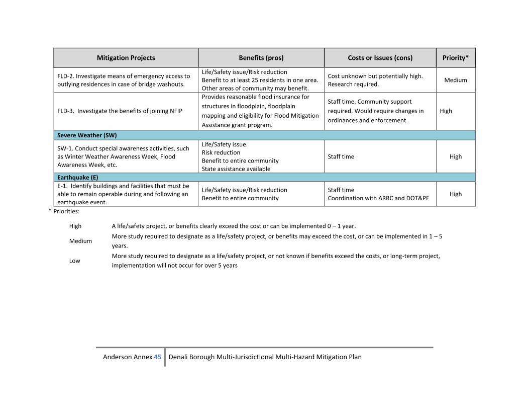
Anderson Annex 45 Denali Borough Multi-Jurisdictional Multi-Hazard Mitigation Plan
Mitigation Projects Benefits (pros) Costs or Issues (cons) Priority*
FLD-2. Investigate means of emergency access to outlying residences in case of bridge washouts.
Life/Safety issue/Risk reduction Benefit to at least 25 residents in one area. Other areas of community may benefit.
Cost unknown but potentially high. Research required.
Medium
FLD-3. Investigate the benefits of joining NFIP
Provides reasonable flood insurance for
structures in floodplain, floodplain
mapping and eligibility for Flood Mitigation
Assistance grant program.
Staff time. Community support
required. Would require changes in
ordinances and enforcement.
High
Severe Weather (SW)
SW-1. Conduct special awareness activities, such as Winter Weather Awareness Week, Flood Awareness Week, etc.
Life/Safety issue Risk reduction Benefit to entire community State assistance available
Staff time High
Earthquake (E)
E-1. Identify buildings and facilities that must be able to remain operable during and following an earthquake event.
Life/Safety issue/Risk reduction Benefit to entire community
Staff time Coordination with ARRC and DOT&PF
High
* Priorities:
High A life/safety project, or benefits clearly exceed the cost or can be implemented 0 – 1 year.
Medium More study required to designate as a life/safety project, or benefits may exceed the cost, or can be implemented in 1 – 5
years.
Low More study required to designate as a life/safety project, or not known if benefits exceed the costs, or long-term project,
implementation will not occur for over 5 years
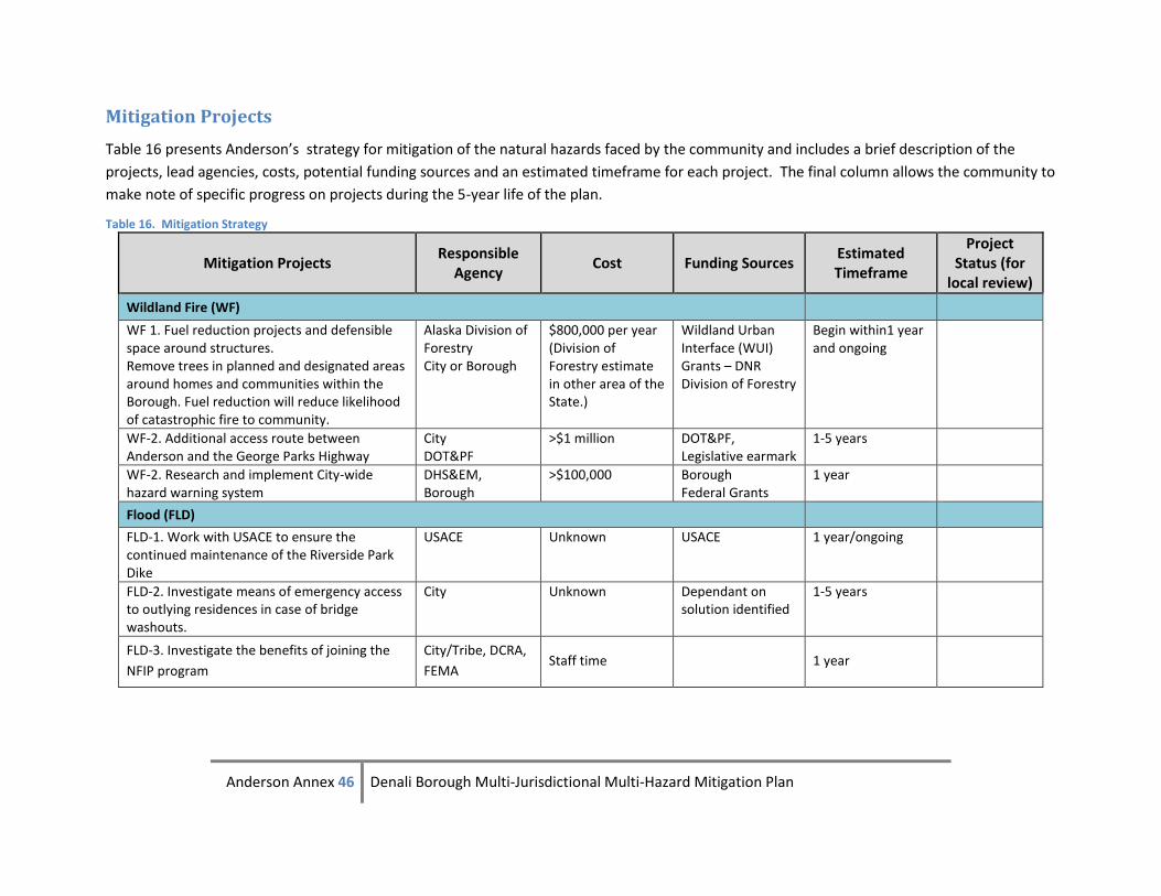
Anderson Annex 46 Denali Borough Multi-Jurisdictional Multi-Hazard Mitigation Plan
Mitigation Projects
Table 16 presents Anderson’s strategy for mitigation of the natural hazards faced by the community and includes a brief description of the
projects, lead agencies, costs, potential funding sources and an estimated timeframe for each project. The final column allows the community to
make note of specific progress on projects during the 5-year life of the plan.
Table 16. Mitigation Strategy
Mitigation Projects Responsible
Agency Cost Funding Sources
Estimated Timeframe
Project Status (for
local review)
Wildland Fire (WF)
WF 1. Fuel reduction projects and defensible space around structures. Remove trees in planned and designated areas around homes and communities within the Borough. Fuel reduction will reduce likelihood of catastrophic fire to community.
Alaska Division of Forestry City or Borough
$800,000 per year (Division of Forestry estimate in other area of the State.)
Wildland Urban Interface (WUI) Grants – DNR Division of Forestry
Begin within1 year and ongoing
WF-2. Additional access route between Anderson and the George Parks Highway
City DOT&PF
>$1 million DOT&PF, Legislative earmark
1-5 years
WF-2. Research and implement City-wide hazard warning system
DHS&EM, Borough
>$100,000 Borough Federal Grants
1 year
Flood (FLD)
FLD-1. Work with USACE to ensure the continued maintenance of the Riverside Park Dike
USACE Unknown USACE 1 year/ongoing
FLD-2. Investigate means of emergency access to outlying residences in case of bridge washouts.
City Unknown Dependant on solution identified
1-5 years
FLD-3. Investigate the benefits of joining the
NFIP program
City/Tribe, DCRA,
FEMA Staff time 1 year
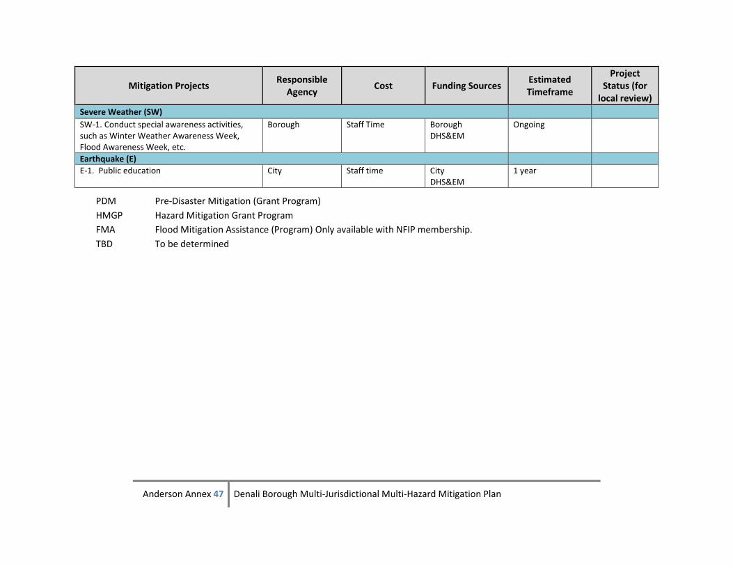
Anderson Annex 47 Denali Borough Multi-Jurisdictional Multi-Hazard Mitigation Plan
Mitigation Projects Responsible
Agency Cost Funding Sources
Estimated Timeframe
Project Status (for
local review)
Severe Weather (SW)
SW-1. Conduct special awareness activities, such as Winter Weather Awareness Week, Flood Awareness Week, etc.
Borough Staff Time Borough DHS&EM
Ongoing
Earthquake (E)
E-1. Public education City Staff time City DHS&EM
1 year
PDM Pre-Disaster Mitigation (Grant Program)
HMGP Hazard Mitigation Grant Program
FMA Flood Mitigation Assistance (Program) Only available with NFIP membership.
TBD To be determined
Related Documents