Availability AGWA is publicly available for download in several different versions depending on GIS software platform: AGWA 1.5 for ArcView 3.x, AGWA 2.x for ArcGIS 9.x, and AGWA 3.x for ArcGIS 10.x. AGWA requires an active Spatial Analyst extension corresponding to the ESRI software used. www.tucson.ars.ag.gov/agwa www.epa.gov/esd/land-sci/agwa DEMONSTRATION OF THE CAPABILITIES OF THE KINEROS2 – AGWA 3.0 SUITE OF MODELING TOOLS Shea Burns 1 , Carl L. Unkrich 2 , David C. Goodrich 2 , Yoganand Korgaonkar 1 , Jeff Kennedy 3 , Gabriel Sidman 4 , Brian Scott Sheppard 1 , Mariano Hernandez 1 , Phil Guertin 1 , William Kepner 5 , Phil Heilman 2 , and Mark Nearing 2 1 University of Arizona, School of Natural Resources and the Environment, Tucson, AZ, United States 2 USDA-ARS, Southwest Watershed Research Center, Tucson, AZ, United States 3 USGS, Tucson, AZ, United States 4 Winrock International, Washington, D.C., United States 5 US EPA, Office of Research and Development, Las Vegas, NV, United States Background The Automated Geospatial Watershed Assessment tool (AGWA) is a watershed modeling tool that supports the parameterization and execution of several distributed hydrologic models, KINEROS2, RHEM (Rangeland Hydrology and Erosion Model), SWAT (Soil & Water Assessment Tool version 2000 and version 2005), and KINEROS-OPUS in the following GIS environments: ESRI ArcView 3.x, ESRI ArcMap 9.x, and ESRI ArcMap 10.x. The AGWA workflow shown to the right includes watershed delineation, discretization, model parameterization, precipitation creation, input file generation, model execution, and results visualization. AGWA was developed under the following guidelines: • Provide simple, direct, and repeatable method for hydrologic model parameterization • Use only basic, obtainable GIS data • Be compatible with other geospatial watershed-based environmental analysis software • Be useful for scenario and alternative futures simulation work at multiple scales SEDHYD 2015 Figure 1. Fill DEM and locate outlet Outlet Figure 2. Delineate watershed Figure 3. Discretize watershed into model elements Figure 4a. Parameterize model elements with soils Figure 4b. Parameterize model elements with land cover Figure 5. Drive model with precipitation Figure 6. Import and view model results KINEROS2 • Distributed, physically-based; represents: • interception • infiltration • surface runoff • erosion • Event-oriented, sub-minute time steps • Overland and channel flow • Usually applied to smaller watersheds (< 100-200 km 2 ) • www.tucson.ars.ag.gov/kineros RHEM • Incorporates new erosion and sediment transport models into KINEROS2 • incorporates new splash and sheet erosion parameterization • represents concentrated flow erosion for disturbed sites • Focus is on hillslope applications and scales • Includes Green-Ampt infiltration option • Parameterizes using classification of plant growth forms to focus on interaction between hydrology, erosion processes, and plant forms • apps.tucson.ars.ag.gov/ rhem SWAT • Quasi-distributed model • Curve number based with physical components (e.g. weather, ET, plant growth, nutrients, etc.) • Daily time step, long term simulations • Not designed to simulate detailed, single-event flood routing • Small- to river basin-scale complex watersheds • swat.tamu.edu KINEROS-OPUS • Continuous, event-based model • Represents hydrological and biogeochemical processes on the surface, in channels, and through the soil profile, including: • runoff, sediment transport, nutrient cycling (nitrogen, phosphorous, and carbon), and water quality • Small- to medium-sized watersheds • Combination of KINEROS2 and Opus2 • Time-continuous soil moisture and nutrient cycling model. KINEROS-Opus models. • www.tucson.ars.ag.gov/k2o2 Example AGWA Applications • National DOI BAER teams post-fire support • NWS for parameterization and weighting of watersheds for real-time flash flood forecasting using weather radar and KINEROS2 • DOD SERDP (Strategic Environmental Research and Development Program) for evaluation of flow in intermittent and ephemeral streams in the southwestern US • DOD ESTCP (Environmental Security Technology Certification Program) for supporting management of impacts from military activities • Connectivity of ephemeral streams for Clean Water Act applications • BLM Wyoming for evaluation of land impacts of coal bed methane extraction • USGS, USDA-ARS, and the International Boundary and Water Commission in a US-Mexico cross-border effort to determine impacts of detention basins in Nogales, Sonora, Mexico • To aid in development of the Cypress Creek Watershed Protection Plan in Texas • Arizona NEMO (Nonpoint Education for Municipal Officials) to evaluate relative non-point source pollution Buffer Strips The most common best management practice, riparian buffer strips, can now be discretized and simulated using AGWA and KINEROS. Buffers can be added to any channel segment; the basic steps for creating riparian buffers include selecting channel elements to buffer and then defining the buffer strip widths. AGWA can simulate pre- and post-installation watersheds. Land cover characteristics can be set for each buffer element using pre-defined land covers or custom land covers. Slope can also be set for each buffer. Photos by Dick Schultz, courtesy of Iowa State University, Department of Natural Resources Ecology and Management Pre-buffer, 1990 Post-buffer, 1994 KINEROS Ponds/SWAT Reservoirs • Ponds for storm water retention/detention, sediment retention, or flood and water quality mitigation • Reservoirs include natural and constructed water bodies • Represent impoudments on the channel network, not uplands • SWAT requires surface area and volume of the reservoir at the principle spillway and at the emergency spillway, and measured daily outflow or monthly averages • KINEROS requires a volume-surface area-discharge rating table Abstract Routing Representation - SWAT 71 Pseudo- channel 71 73 Channel 73 71 73 Abstract Routing Representation - KINEROS2/RHEM/KINEROS-OPUS 72 73 71 Diversions in KINEROS2 • Flow diversions from main channel • Natural or constructed wetlands • Channel modifications: • alter length to represent sinuosity • alter width as surrogate for braided channels • alter slope to affect stream energy • alter roughness to affect stream velocity • alter KS to increase infiltration capacity LID/GI in KINEROS2 • Represented by URBAN element (see figure below) • Spatial tool allows design and placement of LID features, including: • Bioretention basins • Permeable pavements • Rainwater harvesting Post-fire BAER Analysis KINEROS2/AGWA has been used to aid in the rapid post- fire assessment of watersheds done by Burned Area Emergency Response (BAER) teams following large wildfires. AGWA has been used on several fires including the Wallow, Las Conchas, and Pacheco fires in 2011, the Little Bear and Trinity Ridge fires in 2012, and the Spring, Mountain, Mile Marker 28, Rim, Pony, and Silver Fires in 2013, and the Asaayi, Carlton Complex, Devil's Elbow Complex, and Middle Ridge fires in 2014. 0 5 10 15 20 0 1000 2000 3000 4000 5000 6000 7000 8000 0 50 100 150 Rainfall Intensity (in/hr) Discharge (cfs) Time (min) Hydrograph at Road Culvert 10-year 1-hour Storm Prefire Postfire Group Watersheds A watershed group is a collection of AGWA watersheds, for either KINEROS or SWAT, that is discretized, parameterized, and simulated as a unit. The group can be defined explicitly using multiple, existing outlet locations or by selecting an area of interest and analysis extent. Using the area of interest, outlets are located by intersecting the stream network with the area of interest and moving the outlets downstream until the analysis extent is reached. This minimizes the number of watersheds that capture the entire area of interest. Once the most efficient number of watersheds is determined, the outlets are moved back upstream to minimize watershed area while maintaining the optimal number. Analysis extent Area of interest boundary

Welcome message from author
This document is posted to help you gain knowledge. Please leave a comment to let me know what you think about it! Share it to your friends and learn new things together.
Transcript
AvailabilityAGWA is publicly available for download in several different versions depending on GIS software platform: AGWA 1.5 for ArcView 3.x, AGWA 2.x for ArcGIS 9.x, and AGWA 3.x for ArcGIS 10.x. AGWA requires an active Spatial Analyst extension corresponding to the ESRI software used.
www.tucson.ars.ag.gov/agwa www.epa.gov/esd/land-sci/agwa
DEMONSTRATION OF THE CAPABILITIES OF THE KINEROS2 – AGWA 3.0 SUITE OF MODELING TOOLSShea Burns1, Carl L. Unkrich2, David C. Goodrich2, Yoganand Korgaonkar1, Jeff Kennedy3, Gabriel Sidman4, Brian Scott Sheppard1, Mariano Hernandez1, Phil Guertin1, William Kepner5, Phil Heilman2, and Mark Nearing2
1 University of Arizona, School of Natural Resources and the Environment, Tucson, AZ, United States2 USDA-ARS, Southwest Watershed Research Center, Tucson, AZ, United States3 USGS, Tucson, AZ, United States4 Winrock International, Washington, D.C., United States5 US EPA, Office of Research and Development, Las Vegas, NV, United States
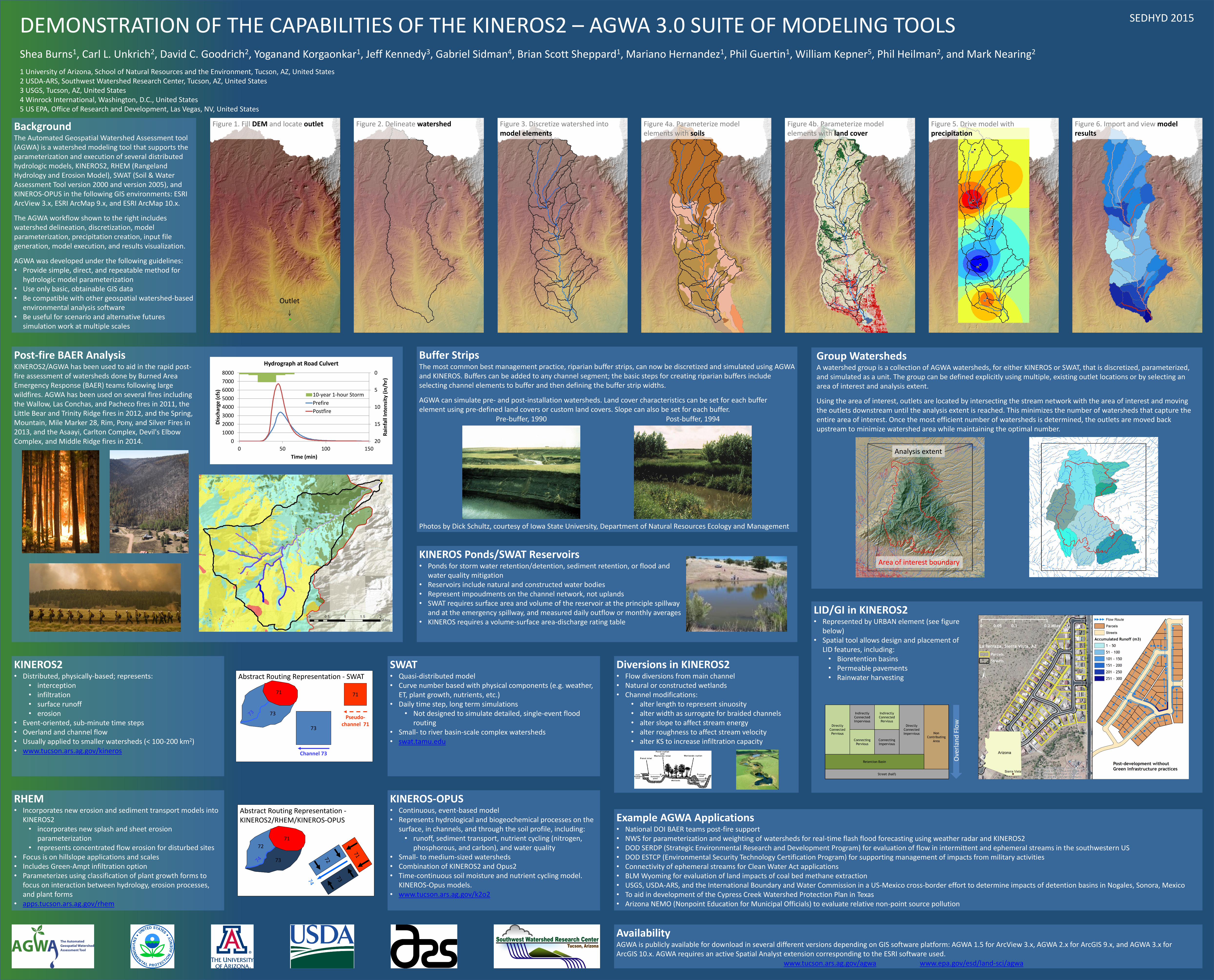
BackgroundThe Automated Geospatial Watershed Assessment tool (AGWA) is a watershed modeling tool that supports the parameterization and execution of several distributed hydrologic models, KINEROS2, RHEM (Rangeland Hydrology and Erosion Model), SWAT (Soil & Water Assessment Tool version 2000 and version 2005), and KINEROS-OPUS in the following GIS environments: ESRI ArcView 3.x, ESRI ArcMap 9.x, and ESRI ArcMap 10.x.
The AGWA workflow shown to the right includes watershed delineation, discretization, model parameterization, precipitation creation, input file generation, model execution, and results visualization.
AGWA was developed under the following guidelines:• Provide simple, direct, and repeatable method for
hydrologic model parameterization• Use only basic, obtainable GIS data• Be compatible with other geospatial watershed-based
environmental analysis software• Be useful for scenario and alternative futures
simulation work at multiple scales
SEDHYD 2015
Figure 1. Fill DEM and locate outlet
Outlet
Figure 2. Delineate watershed Figure 3. Discretize watershed into model elements
Figure 4a. Parameterize model elements with soils
Figure 4b. Parameterize model elements with land cover
Figure 5. Drive model with precipitation
Figure 6. Import and view model results
KINEROS2• Distributed, physically-based; represents:
• interception• infiltration• surface runoff• erosion
• Event-oriented, sub-minute time steps• Overland and channel flow• Usually applied to smaller watersheds (< 100-200 km2)• www.tucson.ars.ag.gov/kineros
RHEM• Incorporates new erosion and sediment transport models into
KINEROS2• incorporates new splash and sheet erosion
parameterization• represents concentrated flow erosion for disturbed sites
• Focus is on hillslope applications and scales• Includes Green-Ampt infiltration option• Parameterizes using classification of plant growth forms to
focus on interaction between hydrology, erosion processes, and plant forms
• apps.tucson.ars.ag.gov/rhem
SWAT• Quasi-distributed model• Curve number based with physical components (e.g. weather,
ET, plant growth, nutrients, etc.)• Daily time step, long term simulations
• Not designed to simulate detailed, single-event flood routing
• Small- to river basin-scale complex watersheds• swat.tamu.edu
KINEROS-OPUS• Continuous, event-based model• Represents hydrological and biogeochemical processes on the
surface, in channels, and through the soil profile, including:• runoff, sediment transport, nutrient cycling (nitrogen,
phosphorous, and carbon), and water quality• Small- to medium-sized watersheds• Combination of KINEROS2 and Opus2• Time-continuous soil moisture and nutrient cycling model.
KINEROS-Opus models.• www.tucson.ars.ag.gov/k2o2
Example AGWA Applications• National DOI BAER teams post-fire support• NWS for parameterization and weighting of watersheds for real-time flash flood forecasting using weather radar and KINEROS2• DOD SERDP (Strategic Environmental Research and Development Program) for evaluation of flow in intermittent and ephemeral streams in the southwestern US• DOD ESTCP (Environmental Security Technology Certification Program) for supporting management of impacts from military activities• Connectivity of ephemeral streams for Clean Water Act applications• BLM Wyoming for evaluation of land impacts of coal bed methane extraction• USGS, USDA-ARS, and the International Boundary and Water Commission in a US-Mexico cross-border effort to determine impacts of detention basins in Nogales, Sonora, Mexico• To aid in development of the Cypress Creek Watershed Protection Plan in Texas• Arizona NEMO (Nonpoint Education for Municipal Officials) to evaluate relative non-point source pollution
Buffer StripsThe most common best management practice, riparian buffer strips, can now be discretized and simulated using AGWA and KINEROS. Buffers can be added to any channel segment; the basic steps for creating riparian buffers include selecting channel elements to buffer and then defining the buffer strip widths.
AGWA can simulate pre- and post-installation watersheds. Land cover characteristics can be set for each buffer element using pre-defined land covers or custom land covers. Slope can also be set for each buffer.
Photos by Dick Schultz, courtesy of Iowa State University, Department of Natural Resources Ecology and Management
Pre-buffer, 1990 Post-buffer, 1994
KINEROS Ponds/SWAT Reservoirs• Ponds for storm water retention/detention, sediment retention, or flood and
water quality mitigation• Reservoirs include natural and constructed water bodies• Represent impoudments on the channel network, not uplands• SWAT requires surface area and volume of the reservoir at the principle spillway
and at the emergency spillway, and measured daily outflow or monthly averages• KINEROS requires a volume-surface area-discharge rating table
Abstract Routing Representation - SWAT
71
Pseudo-channel 71
73
Channel 73
71
73
Abstract Routing Representation -KINEROS2/RHEM/KINEROS-OPUS
72
73
71
Diversions in KINEROS2• Flow diversions from main channel• Natural or constructed wetlands• Channel modifications:
• alter length to represent sinuosity• alter width as surrogate for braided channels• alter slope to affect stream energy• alter roughness to affect stream velocity• alter KS to increase infiltration capacity
LID/GI in KINEROS2• Represented by URBAN element (see figure
below)• Spatial tool allows design and placement of
LID features, including:• Bioretention basins• Permeable pavements• Rainwater harvesting
Post-fire BAER AnalysisKINEROS2/AGWA has been used to aid in the rapid post-fire assessment of watersheds done by Burned Area Emergency Response (BAER) teams following large wildfires. AGWA has been used on several fires including the Wallow, Las Conchas, and Pacheco fires in 2011, the Little Bear and Trinity Ridge fires in 2012, and the Spring, Mountain, Mile Marker 28, Rim, Pony, and Silver Fires in 2013, and the Asaayi, Carlton Complex, Devil's Elbow Complex, and Middle Ridge fires in 2014.
0
5
10
15
200
1000
2000
3000
4000
5000
6000
7000
8000
0 50 100 150
Rai
nfa
ll In
ten
sity
(in
/hr)
Dis
char
ge (
cfs)
Time (min)
Hydrograph at Road Culvert
10-year 1-hour Storm
Prefire
Postfire
Group WatershedsA watershed group is a collection of AGWA watersheds, for either KINEROS or SWAT, that is discretized, parameterized, and simulated as a unit. The group can be defined explicitly using multiple, existing outlet locations or by selecting an area of interest and analysis extent.
Using the area of interest, outlets are located by intersecting the stream network with the area of interest and moving the outlets downstream until the analysis extent is reached. This minimizes the number of watersheds that capture the entire area of interest. Once the most efficient number of watersheds is determined, the outlets are moved back upstream to minimize watershed area while maintaining the optimal number.
Analysis extent
Area of interest boundary
Related Documents