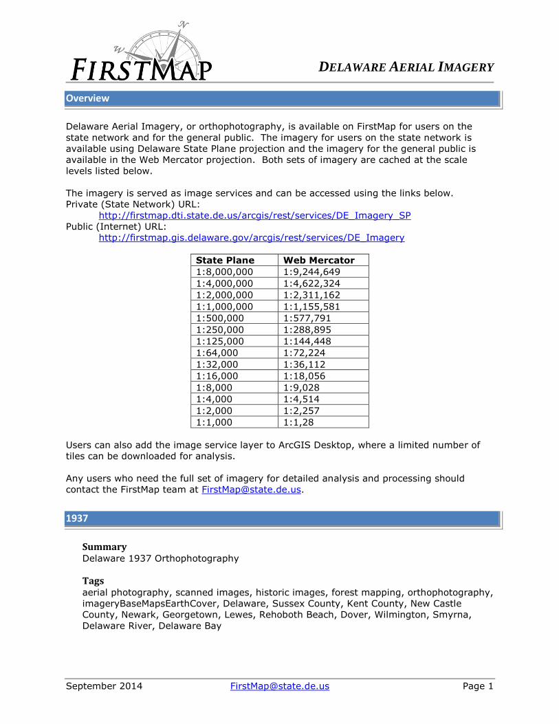
DELAWARE AERIAL IMAGERY September 2014 [email protected] Page 1 Overview Delaware Aerial Imagery, or orthophotography, is available on FirstMap for users on the state network and for the general public. The imagery for users on the state network is available using Delaware State Plane projection and the imagery for the general public is available in the Web Mercator projection. Both sets of imagery are cached at the scale levels listed below. The imagery is served as image services and can be accessed using the links below. Private (State Network) URL: http://firstmap.dti.state.de.us/arcgis/rest/services/DE_Imagery_SP Public (Internet) URL: http://firstmap.gis.delaware.gov/arcgis/rest/services/DE_Imagery State Plane Web Mercator 1:8,000,000 1:9,244,649 1:4,000,000 1:4,622,324 1:2,000,000 1:2,311,162 1:1,000,000 1:1,155,581 1:500,000 1:577,791 1:250,000 1:288,895 1:125,000 1:144,448 1:64,000 1:72,224 1:32,000 1:36,112 1:16,000 1:18,056 1:8,000 1:9,028 1:4,000 1:4,514 1:2,000 1:2,257 1:1,000 1:1,28 Users can also add the image service layer to ArcGIS Desktop, where a limited number of tiles can be downloaded for analysis. Any users who need the full set of imagery for detailed analysis and processing should contact the FirstMap team at [email protected]. 1937 Summary Delaware 1937 Orthophotography Tags aerial photography, scanned images, historic images, forest mapping, orthophotography, imageryBaseMapsEarthCover, Delaware, Sussex County, Kent County, New Castle County, Newark, Georgetown, Lewes, Rehoboth Beach, Dover, Wilmington, Smyrna, Delaware River, Delaware Bay

DELAWARE AERIAL IMAGERYfirstmap.gis.delaware.gov/pdfs/public/DE_Imagery_Metadata.pdf · DELAWARE AERIAL IMAGERY September 2014 [email protected] Page 1 Overview Delaware Aerial
Mar 07, 2018
Welcome message from author
This document is posted to help you gain knowledge. Please leave a comment to let me know what you think about it! Share it to your friends and learn new things together.
Transcript
DELAWARE AERIAL IMAGERY
September 2014 [email protected] Page 1
Overview
Delaware Aerial Imagery, or orthophotography, is available on FirstMap for users on the
state network and for the general public. The imagery for users on the state network is
available using Delaware State Plane projection and the imagery for the general public is
available in the Web Mercator projection. Both sets of imagery are cached at the scale
levels listed below.
The imagery is served as image services and can be accessed using the links below.
Private (State Network) URL:
http://firstmap.dti.state.de.us/arcgis/rest/services/DE_Imagery_SP
Public (Internet) URL:
http://firstmap.gis.delaware.gov/arcgis/rest/services/DE_Imagery
State Plane Web Mercator
1:8,000,000 1:9,244,649
1:4,000,000 1:4,622,324
1:2,000,000 1:2,311,162
1:1,000,000 1:1,155,581
1:500,000 1:577,791
1:250,000 1:288,895
1:125,000 1:144,448
1:64,000 1:72,224
1:32,000 1:36,112
1:16,000 1:18,056
1:8,000 1:9,028
1:4,000 1:4,514
1:2,000 1:2,257
1:1,000 1:1,28
Users can also add the image service layer to ArcGIS Desktop, where a limited number of
tiles can be downloaded for analysis.
Any users who need the full set of imagery for detailed analysis and processing should
contact the FirstMap team at [email protected].
1937
Summary Delaware 1937 Orthophotography
Tags aerial photography, scanned images, historic images, forest mapping, orthophotography,
imageryBaseMapsEarthCover, Delaware, Sussex County, Kent County, New Castle
County, Newark, Georgetown, Lewes, Rehoboth Beach, Dover, Wilmington, Smyrna,
Delaware River, Delaware Bay
DELAWARE AERIAL IMAGERY
September 2014 [email protected] Page 2
Description Resolution: 1.0 Meter
Band: 1-band: Panchromatic
USDA Agricultural Adjustment Administration Black and White Scanned and georectified using ERDAS Imagine Flying height 40,000 feet, 6-inch focal length camera Scale: 1:20,000 SRS: NAD83 HARN Delaware State Plane meters
These are scanned images from aerial photography flow in 1937/38 by the Agricultural
Stabilization and Conservation Service, maintained by the National Archives. These
images are presented as individual tiles, county-wide and state-wide mosaics. Initial
purpose was to provide base for digitizing Historic Forest Cover in Delaware. The data
set could be used for other similar change analyses.
1. Heads-up digitizing was used to create ground control points on the 1937 Images
using the 1997 Imagery as a reference. Every attempt was made to create GCPs at a
standard scale of 1:3,000, however, due to photo quality this was not always possible.
The scanned images were then registered to those points. The ground control points
were stored for each image tile along with the RMS error from the registration process.
See the included tutorial file for more detail on the registration process. This document
was used for training and reference by staff members doing the processing. 2.
Registered images (1937 Corrected) were subsetted (i.e. cropped) to remove
photograph borders, fiducial marks, and distorted edges. 3. Image subsets (1937 Sub)
were grouped together by county and combined into image mosaics.
Credit USDA Agricultural Stabilization and Conservation Service
Usage Public Domain Information, with citation to Delaware Archives, National Archives and
Agricultural Stabilization and Conservation Service for the photography
Image Service URL’s Private (Users on the State Network):
Public (General Public Users):
http://firstmap.gis.delaware.gov/arcgis/rest/services/DE_Imagery/DE_Imagery_193
7/ImageServer

DELAWARE AERIAL IMAGERY
September 2014 [email protected] Page 3
1954
Summary Delaware 1954 Aerial Photography
Tags Imagery, Base Map, Orthophotography, Aerial photography, Historic images,
imageryBaseMapsEarthCover, Scanned Images, Delaware Bay, New Castle County,
Delaware River, Wilmington, Dover, Georgetown, Sussex County, Newark, Kent County,
Delaware
Description
Resolution: 1.0 Meter
Band: 1-band: Panchromatic
USDA Agricultural and Commodity Stabilization Service Black and White Scanned and georectified using ERDAS Imagine Flying height 40,000 feet, 6-inch focal length camera SRS: NAD83 HARN Delaware State Plane meters Scale: 1:20,000
These are scanned images from aerial photography flown in 1954 by the Agricultural
Stabilization and Conservation Service. The images are presented as a statewide mosaic.
This aerial photography was scanned and georectified to provide a historic look at
Delaware.
Scanning The original, paper format, 9x9" aerial photographs were taken in 1954 as part
of an aerial survey program. The photographs were scanned at 300 dpi on an 11x17"
EPSON GT-15000 scanner, as multi-band, RGB color images. The output was written to
*.JPG files. The eastern half of Sussex County, however, was scanned as single-band,
gray scale images, and the output was written to *.TIF files. Correcting for this data
mismatch is described in the mosaicking section. Georectifying All georectifying was
completed in ERDAS Imagine 8.7. Please see the included tutorial for a more detailed
explanation. This document was used for training and reference by staff members
completing the processing. 1. Ground control points (GCPs) were created on the 1954
images using the 2002 digital orthophotography of Delaware as a reference, using the
Image Geometric Correction Tool. The 2002 data was produced in False Color Infrared at
a scale of 1:2,400 with a 1 foot pixel resolution. This data is also available in a single,
mosaicked MrSID file and is assigned a State Plane Coordinate System and a North
American Datum of 1983. In eastern Sussex County, every attempt was made to create
GCPs at a standard scale of 1:3,000, however, due to photo quality this scale was not
always possible. For the remainder of the state, the largest scale possible was used
while still maintaining a clear, unpixelated image on the screen. 2. The scanned images
were then resampled to those points using the Display Resample Image Dialog. 3. The
GCPs were stored for each image tile along with the Control Point Error from the
registration process. 4. Resampled images (1954 corrected) were subsetted (i.e.
cropped) to remove photograph borders, fiducial marks, and distorted edges. Mosaicking
The 1954 aerial mosaic was created using ERDAS Imagine 8.7. Before the mosaic could
be created, each multi-band image was reduced to a single band gray scale image,

DELAWARE AERIAL IMAGERY
September 2014 [email protected] Page 4
because the eastern half of Sussex County was georectified by another processor using
images that were scanned as single-band, gray scale images. This was performed using
ERDAS Imagine's layer stacking tool to create a new set of images containing only their
first band. Once this new set of images was created the mosaic of the entire state could
be processed. To complete this task, the mosaic tool from ERDAS Imagine was used and
contained a feather technique for blending overlapping images. Holes in the final image
of Delaware are due to misplacement of aerial photographs.
Credit USDA Agricultural Stabilization and Conservation Service
Usage Public Domain Information
Image Service URL’s Private (Users on the State Network):
Public (General Public Users):
http://firstmap.gis.delaware.gov/arcgis/rest/services/DE_Imagery/DE_Imagery_195
4/ImageServer
1961
Summary Delaware 1961 Aerial Photography
Tags Delaware, Scanned Images, Imagery, Base Map, Aerial Photography, Orthophotography,
Historic Images, EarthCover, Delaware Bay, New Castle County, Delaware River,
Wilmington, Dover, Sussex County, Newark, Kent County, Delaware, Georgetown
Description:
Resolution: 2.0 meter
Bands: 1-band: Panchromatic
USDA Agricultural Stabilization and Conservation Service (FSA)
Black and White
Scanned and georectified using ERDAS Imagine
Flying height 40,000 feet, 6-inch focal length camera
SRS: NAD83 HARN Delaware State Plane meters
Scale: 1:20,000
These are scanned images from aerial photography flown in 1960 and 1961 by the
Agricultural Stabilization and Conservation Service. The images are presented as a
statewide mosaic.
Scanning the original, paper format, 9x9" aerial photographs were taken in 1961 as part
of an aerial survey program. The photographs were scanned at 300 dpi on an 11x17"
EPSON GT-15000 scanner, as single band gray scale images. The output was written to

DELAWARE AERIAL IMAGERY
September 2014 [email protected] Page 5
*.JPG files. All georectifying was completed in ERDAS Imagine 8.7. Please see the
included tutorial for a more detailed explanation. This document was used for training
and reference by staff members completing the processing.
1. Ground control points (GCPs) were created on the 1960/61 images using the 2002
digital orthophotography of Delaware as a reference, using the Image Geometric
Correction Tool. The 2002 data was produced in False Color Infrared at a scale of
1:2,400 with a 1 foot pixel resolution. This data is also available in a single, mosaicked
MrSID file and is assigned a State Plane Coordinate System and a North American
Datum of 1983. In eastern Sussex County, every attempt was made to create GCPs at a
standard scale of 1:3,000, however, due to photo quality this scale was not always
possible. For the remainder of the state, the largest scale possible was used while still
maintaining a clear, unpixelated image on the screen.
2. The scanned images were then resampled to those points using the Display Resample
Image Dialog.
3. The GCPs were stored for each image tile along with the Control Point Error from the
registration process.
4. Resampled images (1960/61 corrected) were subsetted (i.e. cropped) to remove
photograph borders, fiducial marks, and distorted edges. Mosaicking The 1961 aerial
mosaic was created using ERDAS Imagine 8.7. To complete this task, the mosaic tool
from ERDAS Imagine was used and contained a feather technique for blending
overlapping images. Holes in the final image of Delaware are due to misplacement of
aerial photographs.
Credit USDA Agricultural Stabilization and Conservation Service
Usage Public Domain Information
Image Service URL’s Private (Users on the State Network):
Public (General Public Users):
http://firstmap.gis.delaware.gov/arcgis/rest/services/DE_Imagery/DE_Imagery_196
1/ImageServer
1968
Summary Delaware 1968 Aerial Photography
Tags imageryBaseMapsEarthCover, aerial photography, Historic images, orthophotography,
scanned images, Imagery, Base Map, Delaware, New Castle County, Kent County,
Sussex County, Newark, Wilmington, Dover, Delaware River, Delaware Bay, Georgetown

DELAWARE AERIAL IMAGERY
September 2014 [email protected] Page 6
Description Resolution: 2.0 Meter
Bands: 1-band: Panchromatic
USDA Agricultural Stabilization and Conservation Service (FSA) Black and White Scanned and georectified using ERDAS Imagine Flying height 40,000 feet, 6-inch focal length camera SRS: NAD83 HARN Delaware State Plane meters Scale: 1:20,000
These are scanned images from aerial photography flown in 1968 by the Agricultural
Stabilization and Conservation Service. The images are presented as a statewide mosaic.
This aerial photography was scanned and geo rectified to provide a historic look at
Delaware.
Scanning The original, paper format, 9x9" aerial photographs were taken in 1968 as part
of an aerial survey program. The photographs were scanned at 300 dpi on an 11x17"
EPSON GT-15000 scanner, as single band grayscale images. The output was written to
*.JPG files. Georectifying All georectifying was completed in ERDAS Imagine 8.7. Please
see the included tutorial for a more detailed explanation. This document was used for
training and reference by staff members completing the processing. 1. Ground control
points (GCPs) were created on the 1968 images using the 2002 digital orthophotography
of Delaware as a reference, using the Image Geometric Correction Tool. The 2002 data
was produced in False Color Infrared at a scale of 1/ 2,400 with a 1 foot pixel resolution.
This data is also available in a single, mosaicked MrSID file and is assigned a State Plane
Coordinate System and a North American Datum of 1983. In eastern Sussex County,
every attempt was made to create GCPs at a standard scale of 1:3,000, however, due to
photo quality this scale was not always possible. For the remainder of the state, the
largest scale possible was used while still maintaining a clear, unpixelated image on the
screen. 2. The scanned images were then resampled to those points using the Display
Resample Image Dialog. 3. The GCPs were stored for each image tile along with the
Control Point Error from the registration process. 4. Resampled images (1968 corrected)
were subsetted (i.e. cropped) to remove photograph borders, fiducial marks, and
distorted edges. Mosaicking The 1968 aerial mosaic was created using ERDAS Imagine
8.7. To complete this task, the mosaic tool from ERDAS Imagine was used and
contained a feather technique for blending overlapping images. Holes in the final image
of Delaware are due to misplacement of aerial photographs
Credit USDA Agricultural Stabilization and Conservation Service
Usage Public Domain Information, with citation to Agricultural Stabilization and Conservation
Service for the photography
Image Service URL’s Private (Users on the State Network):
http://firstmap.dti.state.de.us/arcgis/rest/services/DE_Imagery_SP/DE_Imagery_19
68/ImageServer
Public (General Public Users):

DELAWARE AERIAL IMAGERY
September 2014 [email protected] Page 7
http://firstmap.gis.delaware.gov/arcgis/rest/services/DE_Imagery/DE_Imagery_196
8/ImageServer
1992
Summary Delaware 1992 Orthophotography
Tags Orthophotography, imagery, aerial photo, color infrared, Delaware, New Castle County,
Kent County, Sussex County
Description Resolution: 1.0 Meter
Bands: 3-band: G, R, NIR
DelDOT Delivered as 172 Quarter-quads. Each tile is 137 MB (TIF). Scale: 1:12,000 SRS: NAD83 State Plane meters
The State of Delaware contracted with PhotoScience Inc. to develop 1-meter resolution
color-infrared digital ortho-photos for the entire state. PhotoScience Inc. became Earth
Data International. For more detailed information about the source data, contact
EarthData (http://www.earthdata.com). Airphotos were taken in March, 1992 at a
1:12000 scale, digitized and georeferenced to Delaware State Plane coordinates
(meters, North American Datum 1983).
Airphotos were taken in March, 1992, digitized and georeferenced to Delaware State
Plane coordinates (meters, North American Datum 1983, based on GRS 1980 spheroid).
The source data are 140 MB 24-bit color files for each of the 172 quarter-quads in
Delaware.
To facilitate dissemination of these data, the Spatial Analysis Lab resampled the 172
DOQ's covering the state to UTM coordinates (meters, NAD 1983) at 5-meter resolution
in 8-bit color, achieving initial file size reductions of almost 99 percent. The Spatial
Analysis Lab used a nearest-neighbor (i.e. center-cell selection) resampling procedure
which generates a high-contrast image with some blockiness in very small features.
Each transformation used four 3.75-minute-interval reference points located near the
corners of each image. Each resampled image is approximately 1210 x 1510 pixels, with
a 10-pixel (50-meter) border cropped out to eliminate slight edge skewness resulting
from the reprojection. Images still have at least 500 meters of edge overlap. Color
palettes were brightened and adjusted for improved consistency using Adobe Photoshop.
Sun glare has been masked out of water pixels in most coastal images in order to
correct color palettes.
Cell resolution is exactly 5 x 5 meters. The original 1992 and 1997 series have differing
degrees of positional error, and thus are not perfectly congruent. Earth Data used a
DELAWARE AERIAL IMAGERY
September 2014 [email protected] Page 8
larger set of ground control points to geo-reference the 1997 series, so these should
have better positional acuracy.
Most images were brightened and contrast-enhanced using Adobe Photoshop. To reduce
file size and eliminate sun glare, large water areas are masked to black.
Credit EarthData/PhotoScience Inc.
Usage Public Domain Information
Image Service URL’s Private (Users on the State Network):
http://firstmap.dti.state.de.us/arcgis/rest/services/DE_Imagery_SP/DE_Imagery_19
92/ImageServer
Public (General Public Users):
http://firstmap.gis.delaware.gov/arcgis/rest/services/DE_Imagery/DE_Imagery_199
2/ImageServer
1997
Summary Delaware 1997 Orthophotography
Tags Orthophotography, imagery, aerial photo, greyscale, Delaware, New Castle County, Kent
County, Sussex County, Base Maps, Earth Cover
Description
Resolution: 1.0 Meter
Band: 1-band: Panchromatic DelDOT Delivered as 172 Quarter-quads. Each tile is 45 MB (TIF). SRS: NAD83 State Plane meters Scale: 1:12,000
The State of Delaware contracted with Earth Data (formerly PhotoScience) to update the
1992 1-meter resolution color-IR digital orthophotos series for Delaware with a 1-meter
resolution greyscale digital orthophoto series. The state was re-flown in March/April,
1997. The airphotos were digitized and georeferenced to Delaware State Plane
coordinates (meters, North American Datum 1983, based on GRS 1980 spheroid). The
source data are TIFF-format ~50 MB 8-bit greyscale files for each of the 172 quarter-
quads in Delaware.
To disseminate these data on the web, the Spatial Analysis Lab (UD) resampled the 172
DOQ's covering the state to 5-meter resolution without changing projection, using a

DELAWARE AERIAL IMAGERY
September 2014 [email protected] Page 9
nearest-neighbor (i.e. center-cell selection) resampling procedure which generates a
high-contrast image with some blockiness in very small features. Most images were
brightened and contrast-enhanced using Adobe Photoshop. To reduce file size and
eliminate sun glare, large water areas are masked to black. These files are distributed in
JPEG format in the original DE State Plane (NAD83 meters) projection.
Credit State of Delaware Department of Transportation and EarthData
Usage Public Domain Information
Image Service URL’s Private (Users on the State Network):
http://firstmap.dti.state.de.us/arcgis/rest/services/DE_Imagery_SP/DE_Imagery_19
97/ImageServer
Public (General Public Users):
http://firstmap.gis.delaware.gov/arcgis/rest/services/DE_Imagery/DE_Imagery_199
7/ImageServer
2002
Summary Delaware 2002 Orthophotography
Tags Remote Sensing, Aerial Photography, Digital Orthophotography, False Color Infrared
(FCIR), Leaf-Off Photography, imagery, DOQ, Delaware, New Castle County, Kent
County, Sussex County
Description Resolution: 0.25 Meter
Band: 3-band: G, R, NIR
EarthData Delivered as 2010 tiles. Each tile is 1.7km x 1.7km, 6800x6800 pixels, and 135MB (TIF). SRS: NAD83 HARN Delaware State Plane meters Scale: 1:2,400
This false color IR digital orthophotography, at a scale of 2,400, was produced for the
State of Delaware for the purpose of statewide base mapping by EarthData International
of Maryland, LLC.
Compliance with the accuracy standard was ensured by the placement of GPS ground
control prior to the acquisition of aerial photography. The following checks were
performed. 1. The ground control and airborne GPS data stream were validated through
a fully analytical bundle aerotriangulation adjustment. The residuals of the adjustment
met the required standards for accuracy which are 1 part in 10,000 of the flying height
for the horizontal position (X and Y) and 1 part in 9,000 or better of the flying height in
DELAWARE AERIAL IMAGERY
September 2014 [email protected] Page 10
elevation (Z). 2. The DTM data was checked against the project control. The technician
visited and confirmed the accuracy of the project mass points during initial compilation.
3. Digital orthophotography was validated through an inspection of edge matching and
visual inspection for image quality
Aerial photography was acquired using a flight design that included a total of 1196
exposures in 20 North-South oriented flight line. Aerial photography was exposed on
Kodak CIR film 1443, emulsion number 1133012. Aerial photography was supplemented
with the simultaneous acquisition of airborne GPS data, which captured the ground
coordinate for the nadir point of each photograph. Aerial photography was exposed at an
altitude of 11,000' above mean terrain yielding an approximate scale of 1 / 21,600.
Credit EarthData International of Maryland
Usage Public Domain Information
Image Service URL’s Private (Users on the State Network):
http://firstmap.dti.state.de.us/arcgis/rest/services/DE_Imagery_SP/DE_Imagery_20
02/ImageServer
Public (General Public Users):
http://firstmap.gis.delaware.gov/arcgis/rest/services/DE_Imagery/DE_Imagery_200
2/ImageServer
2007
Summary Delaware 2007 Orthophotography
Tags Sussex County, Kent County, New Castle County, State of Delaware, USGS, Aerial
Photo, Orthophoto
Description
Resolution: 0.25 Meter
Bands: 4-band: R,G,B,NIR
Sanborn Delivered as 2010 tiles. Each tile is 1.7km x 1.7km, 6800x6800 pixels, and 180MB (TIF). SRS: NAD83 HARN Delaware State Plane meters Scale: 1:2,400
This dataset contains digital 0.25 meter orthophotos of the State of Delaware at a scale
of 1:2,400 in 4-band but are being served as 3-band RGB, 8-bit format from the
DataMIL site. The dates for the Orthophotography missions were 3/19, 3/29, 3/30, 4/2,
4/3, 4/10, 4/14, 4/20 all in 2007.

DELAWARE AERIAL IMAGERY
September 2014 [email protected] Page 11
The orthophotos can be used for many purposes including development planning,
emergency planning, and other planning or mapping purposes.
ASPRS Class 1. This data has also been produced to be fully compliant with NSSDA
Standards for mapping at a scale of 1:2,400. The dates for the Orthophotography
missions were 3/19, 3/29, 3/30, 4/2, 4/3, 4/10, 4/14, 4/20 all in 2007.
Credit Sanborn Mapping Company
Usage Public Domain Information, with citation to “State of Delaware, USGS, Kent County,
Sussex County, New Castle County and the City of Dover”.
Image Service URL’s Private (Users on the State Network):
http://firstmap.dti.state.de.us/arcgis/rest/services/DE_Imagery_SP/DE_Imagery_20
07/ImageServer
Public (General Public Users):
http://firstmap.gis.delaware.gov/arcgis/rest/services/DE_Imagery/DE_Imagery_200
7/ImageServer
2010
Summary USGS High Resolution Orthoimage for New Castle County, Delaware
Tags 1.0 foot orthoimage, rectified photograph, rectified image, orthophoto, natural color
orthophoto, orthoimage, image map, Delaware, New Castle County
Description Resolution: 1.0 feet
Bands: 3-band: R,G,B
Joint project among USGS, DVRPC, Dept of Homeland Security (vendor was Aero-Metric, Inc) New Castle County only. Delivered in same tiling scheme as 2002 and 2007 imagery Each tile is 1.7km x 1.7km, 5578x5578 pixels, 91 MB (TIF). SRS: NAD83 Delaware State Plane meters (projected from PA UTM) Scale: 1:25,404
This task order consists of digital orthophoto production covering New Castle County,
Delaware. This data depicts geographic features on the surface of the earth.
Radiometry is verified by visual inspection of the digital orthophoto. Slight systematic
radiometric differences may exist between adjacent orthoimage files; these are due
primarily to differences in source image capture dates and sun angles along flight lines.
These differences can be observed in an image's general lightness or darkness when it is
compared to adjacent orthoimage file coverages. Tonal balancing may be performed

DELAWARE AERIAL IMAGERY
September 2014 [email protected] Page 12
over a group of images during the mosaicking process which may serve to lighten or
darken adjacent images for better color tone matching.
GeoTIFFs conform to the specifications set forth by the USGS for production of
orthophotos in the Task Order Number G10PD00660.
Orthoimages are visually inspected for completeness to ensure that no gaps or image
misplacements exist within and between adjacent images. These images are derived by
mosaicking multiple images to ensure complete coverage. Source imagery is cloud free.
Ortho image horizontal positional accuracy shall not exceed 4.9 feet at the 95%
confidence level as defined and tested using NSSDA standards.
The horizontal accuracy of the orthorectified images is mainly determined by the quality
of the DEM. The elevation data was provided by the commission through the USGS,
along with LiDAR data provided by NOAA and USGS NED for Delaware buffer areas.
Since Airborne GPS/IMU data was used there are no pugs available for measuring. All
photo identifiable checkpoints were measured and compared to the surveyed
checkpoints to determine the RMSE. All rectified chip overlap was checked for mismatch.
All final tiles were checked visually for edge matching.
The DMC images were aerotriangulated to support digital ortho image production for the
Delaware Valley Regional Planning Commission project area. Airborne GPS and ground
check point data was provided by AERO-METRIC, Inc. The project was referenced to the
North American Datum of 1983 (NAD83), State Plane Coordinate System 1983,
Pennsylvania South Zone horizontally and to the North American Vertical Datum of 1988
(NAVD88) vertically. Units were in U.S. survey feet. The DMC images, ABGPS data, and
ground check point data were used as inputs to the Zeiss/Intergraph ImageStation
Automatic Triangulation (ISAT) softcopy program. ISAT correlated image points and
aerotriangulated the block of images to create exposure station exterior orientations. All
ground points were manually measured on the imagery. These points were included in
the aerotriangulation adjustments for absolute ground location verification. The scale of
the aerial photos was 1:25,404. The photography was exposed between 3/27/10 and
4/23/10. Rectification was done using the aerotriangulation data, raw DMC images, and
DVRPC provided elevation data. These rectified images were used to draw seamlines.
The images were then dodged. The dodged rectified images were mosaicked, balanced,
and cut into image tiles. These tiles were viewed and artifacts were removed as well as
other edits performed. Then the edited tiles were reprojected from UTM to DE-SPCS,
mosaicked together and the final tiles were cut out. The final tiles were QC'd before
generating the MrSID tiles and mosaic.
Natural color orthoimagery is organized in three color bands or channels which represent
the red, green, and blue portions of the spectrum. Each image pixel is assigned a triplet
of numeric values, one for each color band. Numeric values range from 0 to 255. Areas
where data is incomplete due to lack of full image coverage are represented with the
numeric value of 0.
Credit Aero-Metric, Inc.
DELAWARE AERIAL IMAGERY
September 2014 [email protected] Page 13
Usage Public Domain Information with citation of the U.S. Geological Survey for products
derived from these data.
Image Service URL’s (TBD, 2010 will be added at a later time) Private (Users on the State Network):
TBD
Public (General Public Users):
TBD
2012
Summary Delaware 2012 Orthophotography
Tags 0.3 meter orthoimage, rectified photograph, rectified image, orthophoto, orthoimage,
image map, 4-band, (R,G,B,IR), Delaware, New Castle County, Kent County, Sussex
County
Description Resolution: 0.3 Meters
Bands: 4-band: R,G,B, NIR
Sanborn Delivered as 2010 tiles, same tiling scheme as 2002 imagery Each tile is 1.7km x 1.7km, 5667x5667 pixels, ~133 MB (TIF). SRS: NAD83 HARN Delaware State Plane meters Scale: 1:2,400
This data set consists of 0.3-meter pixel resolution (approximately 1-foot), 4-band true
color and near infrared (R, G, B, IR) orthoimages covering New Castle, Kent and Sussex
Counties in Delaware. An orthoimage is remotely sensed image data in which
displacement of features in the image caused by terrain relief and sensor orientation
have been mathematically removed. Orthoimagery combines the image characteristics
of a photography with the geometric qualities of a map. The design accuracy is
estimated not to exceed 1.52 meters NSSDA 95% confidence (0.88-meters Root Mean
Squared (RMSE) Error XY (0.62 meter RMSE X or Y). Each orthoimage provides imagery
over a 1700-meter by 1700-meter block on the ground. There is no image overlap
between adjacent files. The projected coordinate system is Delaware State Plane
Coordinate System Meters. </abstract><purpose> The data depicts geographic features
on the surface of the earth. It was created to provide easily accessible geospatial data
which is readily available to enhance the capability of Federal, State, and local users.
This data also supports The National Map. </purpose><supplinf> The project consists of
an area of approximately 474 square miles covering the county of New Castle in
Delaware. A total of 508 4-band true color and near infrared (R, G, B, IR) orthos were
produced to cover this area. The bounding coordinates provided within the Spatial
Domain Section represents a rectangle covering the total area in which the project is
located.

DELAWARE AERIAL IMAGERY
September 2014 [email protected] Page 14
Radiometry is verified by visual inspection of the digital orthophoto. Slight systematic
radiometric differences may exist between adjacent orthoimage files; these are due
primarily to differences in source image capture dates and sun angles along flight lines.
These differences can be observed in an image's general lightness or darkness when it is
compared to adjacent orthoimage file coverages. Tonal balancing may be performed
over a group of images during the mosaicking process which may serve to lighten or
darken adjacent images for better color tone matching.
All GeoTIFF tagged data and image file sizes are validated using commercial GIS
software to ensure proper loading before being archived. This validation procedure
ensures correct physical format and field values for tagged elements. Seamlines and tile
edges are visually inspected. Seamlines mismatches are not corrected unless the overall
displacement exceeds one meter.
Orthoimages are visually inspected for completeness to ensure that no gaps or image
misplacements exist within and between adjacent images. These images are derived by
mosaicking multiple images to ensure complete coverage. Source imagery is cloud free.
Photography was flown during leaf-off in deciduous vegetation regions.
The horizontal positional accuracy and the assurance of that accuracy depend, in part,
on the accuracy of the data inputs to the rectification process. The location of existing
photoidentifiable ground control and aerotriangulation points were evaluated on the
Geotiff image and compared with their ground values in order to determine an overall
accuracy for each test block of orthoimages within the project. After image coordinate
measurement was completed for each block, an RMSE for the diagonal error was
calculated for the orthoimages within the block. This value is an estimate of the
horizontal accuracy of the tile expressed in meters.
The digital imagery mission was composed of a total of 3 lifts. Imagery (1-ft, 0.3 meter
GSD) was obtained at an altitude of 9,450 feet above ground level on 28 February and 6
March 2012. The missions were flown with a Leica ADS40 (Sensor Head 51 and 52)
digital camera with ABGPS and IMU. This imagery provides the data for the digital
orthoimage. Imagery was acquired on the following dates - Lift Date 0103062012 06
Mar 2012 0203062012 06 Mar 2012
Horizontal and vertical control was used to establish positions and elevations for
reference and correlation purposes and as input to the aerotriangulation process. Control
consists of photoidentifiable surveyed ground control for ground reference. A total of 10
photoidentifiable ground control points were collected.
Airborne GPS (ABGPS) and IMU data are collected with an onboard dual frequency GPS
survey unit and a corresponding IMU system in combination with the digital imagery.
The GPS data provides the position of the imagery at the time of capture while the IMU
system records instantaneous changes in position and attitude of the sensor. The
GPS/IMU, base station, and ground control processing are an important step towards the
development of accurate orthoimages.
Source Imagery - ADS40 (Sensor Head 51 and 52) Digital Camera Imagery Control -
Airborne GPS/IMU supplemented with photo identifiable field control Aerotriangulation,
Orthorectification - SOCET SET, ORIMA Elevation Model - USGS DEM Mosaic - OrthoVista
The following describes the digital production sequence. 1. The raw ADS40 (Level-0)
DELAWARE AERIAL IMAGERY
September 2014 [email protected] Page 15
data and associated GPS and IMU data for each mission is downloaded from the hard
drives and checked to confirm that no files have been corrupted and that all data can be
successfully downloaded. 2. The GPS and IMU data are post-processed along with the
base station data to produce a precise position and attitude stream for each line of
imagery. Post processing uses the high frequency readouts of the IMU to verify the GPS
data and to provide instantaneous positioning of each line of imagery between GPS
recordings. Likewise, the IMU attitude data is corrected for bias/drift and transformed to
real world coordinates by using the GPS data. This process creates Level-1 rectified
imagery which is an approximately geo-positioned image. 3. The ADS40 production
process uses aerial triangulation techniques to combine the short-term accuracy of the
IMU with high global accuracy of GPS. In combination with the minimum required
number of ground control points (GCPs), aerial triangulation delivers best fitting results
on the ground. The extra information added to the system by automatic tie point
measurements (APM) leads to very reliable orientation results where photogrammetric
measurements serve to control IMU/GPS measurements and vice versa. 4. The results of
the APM are run through a combined bundle adjustment process to further refine the
measured image coordinates and the position and attitude values from IMU and GPS
computed by IMU/GPS post processing. The bundle adjustment process equally
compensates for systematic errors such as the misalignment between IMU and sensor
axes, IMU/GPS drift, and the datum difference between IMU/GPS and ground control
coordinate system. This results in a very accurate and precise determination of the
parameters of exterior orientation which are later used for Orthorectification. 5. The
orthorectification process uses the raw Level-0 data as the input imagery source to avoid
repeated re-sampling of the imagery to yield the best possible image quality and
accuracy. The raw Level-0 true color imagery is orthorectified to the DEM using the
adjusted position and orientation results from the aerial triangulation phase. The
orthorectified strip of imagery is called the Level-2 data. 6. The resulting images are
then mosaicked and color balanced. 7. The final 1700-meter by 1700-meter tiles are
clipped out and the imagery is output in uncompressed GeoTIFF format with no overlap.
8. The completed natural color digital orthophotos are checked for image quality. Minor
artifacts are corrected using Adobe Photoshop in an interactive editing session. Digital
tiles are assigned final names based on Delaware tiling grid.
4-band true color and near infrared orthoimagery is organized in four bands or channels
which represent the red, green, blue, and near infrared (R,G,B,IR) portions of the
spectrum. Each image pixel is assigned a triplet of numeric values, one for each
colorband. Numeric values range from 0 to 255. Areas where data is incomplete due to
lack of full image coverage are represented with the numeric value of 0.
Credit Digital Aerial Solutions, LLC
Usage Public Domain Information with citation of the U.S. Geological Survey for products
derived from these data.
Image Service URL’s Private (Users on the State Network):
http://firstmap.dti.state.de.us/arcgis/rest/services/DE_Imagery_SP/DE_Imagery_20
12/ImageServer
Public (General Public Users):

DELAWARE AERIAL IMAGERY
September 2014 [email protected] Page 16
http://firstmap.gis.delaware.gov/arcgis/rest/services/DE_Imagery/DE_Imagery_201
2/ImageServer
Related Documents