University of South Carolina University of South Carolina Scholar Commons Scholar Commons Faculty Publications Anthropology, Department of 4-2011 Defining the Williamson's Plantation: Huck's Defeat Battlefield Defining the Williamson's Plantation: Huck's Defeat Battlefield Michael C. Scoggins Steven D. Smith University of South Carolina - Columbia, [email protected] Tamara S. Wilson University of South Carolina - Columbia, [email protected] Follow this and additional works at: https://scholarcommons.sc.edu/anth_facpub Part of the Anthropology Commons Publication Info Publication Info Published in 2011. © 2011, York County Cultural Heritage Museums and University of South Carolina--South Carolina Institute of Archaeology and Anthropology. This Book is brought to you by the Anthropology, Department of at Scholar Commons. It has been accepted for inclusion in Faculty Publications by an authorized administrator of Scholar Commons. For more information, please contact [email protected].

Welcome message from author
This document is posted to help you gain knowledge. Please leave a comment to let me know what you think about it! Share it to your friends and learn new things together.
Transcript
University of South Carolina University of South Carolina
Scholar Commons Scholar Commons
Faculty Publications Anthropology, Department of
4-2011
Defining the Williamson's Plantation: Huck's Defeat Battlefield Defining the Williamson's Plantation: Huck's Defeat Battlefield
Michael C. Scoggins
Steven D. Smith University of South Carolina - Columbia, [email protected]
Tamara S. Wilson University of South Carolina - Columbia, [email protected]
Follow this and additional works at: https://scholarcommons.sc.edu/anth_facpub
Part of the Anthropology Commons
Publication Info Publication Info Published in 2011. © 2011, York County Cultural Heritage Museums and University of South Carolina--South Carolina Institute of Archaeology and Anthropology.
This Book is brought to you by the Anthropology, Department of at Scholar Commons. It has been accepted for inclusion in Faculty Publications by an authorized administrator of Scholar Commons. For more information, please contact [email protected].

APRA COPY Defining The Williamson’s Plantation:
Huck’s Defeat Battlefield By
Michael C. Scoggins, Steven D. Smith, and
Tamara S. Wilson
York County Culture and Heritage Museums
4621 Mount Gallant Rd. Rock Hill, South Carolina 29732
and South Carolina Institute of Archaeology and Anthropology
Columbia, South Carolina 1321 Pendleton St.
Columbia, SC 29208 Presented to and funded by:
Grant Number: GA 2255-09-005 American Battlefield Protection Program Heritage Preservation Services Division
National Park Service 1201 Eye St NW (2255) Washington, DC 20005

Defining Williamson’s Plantation: The Huck’s Defeat Battlefield (38YK564)
By
Michael C. Scoggins
Historian Culture & Heritage Museums
212 East Jefferson Street York, SC 29745
Steven D. Smith
Archeologist And
Tamara S. Wilson GIS Technician
South Carolina Institute of Archaeology and Anthropology Columbia, South Carolina
1321 Pendleton St. Columbia, SC 29208
Presented to and funded by: Grant GA2255-09-005
American Battlefield Protection Program Heritage Preservation Services Division
National Park Service 1201 Eye St. NW (2255) Washington, DC 20005
----------------------------------------------------------- Michael C. Scoggins and Steven D. Smith
Co-Principal Investigators
April 2011

ii
This material is based upon work assisted by a grant from the Department of Interior, National Park Service. Any opinions, findings, and conclusions or recommendations expressed in this material are those of the author(s) and do not necessarily reflect the views of the Department of Interior.

iii
Management Summary This report presents the results of historical and archeological research to define the Revolutionary War battle of Williamson’s Plantation (Huck’s Defeat), located in York County, South Carolina. Analysis of historic documents, metal detector survey, and archeological excavations at Historic Brattonsville revealed the location of the battlefield (site 38YK564) although there appears to be very little archeological remains associated with the Williamson plantation house. Survey surrounding the site indicates that site 38YK564 is the only remaining remnant of the battlefield.

iv

v
Table of Contents Chapter 1: Introduction to the Project ......................................................................................1 Introduction .....................................................................................................................1 Project Goals ....................................................................................................................1 Historic Overview ............................................................................................................1 Previous Research ...........................................................................................................3 Methods ............................................................................................................................4 Historic Research .................................................................................................5 Metal Detecting and GPS/GIS Survey ...............................................................6 Site Test Excavations ...........................................................................................7 Laboratory Analysis .............................................................................................7 Report Organization .......................................................................................................8 A Note on Citation Style ..................................................................................................8 Project History .................................................................................................................8 Chapter 2: Historical Analysis of the James Williamson’s Plantation ...................................10 Chapter 3: Military Analysis of The Battle of Williamson’s Plantation (Huck’s Defeat) ...................................................................................................................28 Introduction ...................................................................................................................28 The Battle of Williamson’s Plantation ...........................................................................28 Defining Features .............................................................................................................34 Chapter 4: Results of Investigations .........................................................................................37 Introduction .....................................................................................................................37 Results of Metal Detecting ..............................................................................................37 Neely Property ......................................................................................................37 King Property .......................................................................................................38 Historic Brattonsville Property ..........................................................................38 Metal Detecting at the Core Battlefield .............................................................40 Results of Hand Excavations ..........................................................................................41 Site Topography ...................................................................................................41 Unit Excavations ..................................................................................................44 Shovel Testing.......................................................................................................46 Discussion .........................................................................................................................47 Revised Battlefield Map ..................................................................................................48 KOCOA Review ...............................................................................................................50 Recommendations ............................................................................................................51 References Cited...........................................................................................................................52 Appendix A: Resistivity at Williamson’s Plantation Battlefield by Jonathan Leader .........A-1 Appendix B: Artifact Catalog for 2010 Season ........................................................................B-1

vi
Appendix C: Artifact Catalog for 2006 Season ........................................................................C-1

vii
Figures
Unless otherwise noted, all figures by CHM or SCIAA
Figure 1.1 General location of Historic Brattonsville and suspected location of Williamson’s Plantation Battlefield prior to archeological investigations. .................................................... 2 Figure 1.2 Area previously surveyed by SCIAA .......................................................................4 Figure 1.3 Projected Core Battlefield based on previous research ........................................5 Figure 1.4 Archeologists and volunteers excavating at north end of core battlefield. ..........8 Figure 2.1 Map showing locations of colonial grants in Brattonsville neighborhood, South Fork of Fishing Creek, York County, SC. Courtesy Thomas Mayhugh, “James Williamson’s Plantation,” August 1992 (with edits by Michael C. Scoggins, November 2010). ................................................................................................................................12 Figure 2.2 Reconstructed plat of James Williamson Sr. tract, circa 1780. Courtesy Thomas Mayhugh, “James Williamson’s Plantation,” August 1992 .....................................................13 Figure 2.3 Subdivision of James Williamson 300-acre tract, circa 1787. Courtesy Thomas Mayhugh, “James Williamson’s Plantation,” August 1992. ....................................................16 Figure 2.4 Section of General Richard Winn’s 1812 map showing the Bratton and Williamson plantations and the battlefield of Huck’s Defeat, from Peter Force Papers. Courtesy Library of Congress, Washington, DC. .....................................................................17 Figure 2.5 Lyman C. Draper’s copy of John Starr Moore map, c. 1857, from Sumter Papers, Draper MSS, 16VV277, Image WHi-27324, courtesy Wisconsin Historical Society, Madison, Wisconsin. ....................................................................................................................19 Figure 2.6 Enlarged plat showing area around the Williamson plantation, Sumter Papers, Draper MSS, 16VV277, Image WHi-27324, courtesy Wisconsin Historical Society, Madison, Wisconsin.. ...................................................................................................................20 . Figure 2.7 Map of Huck’s Defeat battlefield drawn by Daniel G. Stinson for Lyman C. Draper, 26 March 1876 from a description provided by Napoleon Bonaparte Bratton, Sumter Papers, Draper MSS, 15VV278, Image WHi-27323, courtesy Wisconsin Historical Society, Madison, Wisconsin. ......................................................................................................21 Figure 2.8 Map of Huck’s Defeat battlefield drawn by Daniel G. Stinson for Lyman C. Draper, August 24, 1876, from a description provided by John S. Bratton Jr. Sumter

viii
Papers, Draper MSS, 5VV54. Image WHi-27322, courtesy Wisconsin Historical Society, Madison, Wisconsin. The scale is incorrect; it should read “two inches per mile.”. .............22 Figure 2.9 Early nineteenth century plat surveyed for John Simpson Bratton Sr., showing “Bratton spring,” “York Road,” “Lincoln Road,” “Rocky Mount Road,” “Charleston Road,” and “J. S. Bratton house,” which was the home of Col. William Bratton at the time of Huck’s Defeat. There is no evidence of the Williamson plantation buildings on the plat. Courtesy Historical Center of York County, Culture & Heritage Museums. .......................26 Figure 2.10 John S. Bratton plat, dated January 14, 1817, showing “Charleston Road,” “Rocky Mount Road,” “York Road,” “Lincoln Road,” and “Beaverdam Creek.” The plat also shows fenced-in fields where the lower 140-acre portion of the Williamson tract, purchased by William Bratton in 1787, was originally located. The upper portion of James Williamson’s 300-acre tract is indicated as “Jas. Williamson’s Lands.” Courtesy Historical Center of York County, Culture & Heritage Museums. ..........................................................27 Figure 3.1 GPS mapped Defining Features of Williamson’s Plantation Battlefield using KOCOA analysis. .........................................................................................................................36 Figure 4.1 Area where reconnaissance and systematic metal detecting occurred in 2010 ...41 Figure 4.2 Location of metal detected artifacts in core battlefield. Area A artifacts labeled A-#. ................................................................................................................................42 Figure 4.3 Sword pommel ..........................................................................................................43 Figure 4.4 English short saber sword hilt. From Neumann 1973:112. ..................................43 Figure 4.5 Core battlefield (38YK564) and two 20th century sites (38YK 565, 38YK566) ...44 Figure 4.6 Excavation unit placement in relation to metal detecting artifact locations from 2006 and 2010 metal detecting surveys. Red indicates positive shovel tests for historic artifacts. ................................................................................................................................45 Figure 4.7 Excavation units within core battlefield. Red indicates positive units for historic artifacts ................................................................................................................................47 Figure 4.8 Battle of Williamson’s Plantation based on historic and archeological analysis. ................................................................................................................................51
ix
ACKNOWLEDGMENTS Our efforts to define the Williamson’s Plantation battlefield have been assisted in every step by the entire staff of the American Battlefield Protection Program, National Park Service. Our hearty thanks to everyone, including Kristen McMasters, Lucinda Philumalee, and Paul Hawke. We want to first thank everyone and anyone who is inadvertently missing from the following acknowledgements. The administration at the CHM was instrumental in our success. We thank Mr. Van Shields, Director and CEO, and Owen Glendening, Deputy Director For Interpretation. We also want to thank the entire Neely family for allowing us access to their property. Volunteers included Charity Fairfax, Ryan York, Anita Feemster, Karen Cox, Nicole Moore, Teri Hurtado, Annemarie Beebe, Barbara Ardrey, Lisa Swetnam, Peggy Enright, Betty Caughman, Kevin Lynch, Jennifer Rayburn, and Nicole Woehl. During a return in October 2010, students from Ms. Christina Brooks archeology class at Winthrop College also volunteered. At the South Carolina Institute of Archaeology and Anthropology we thank Dr. Charles Cobb, Director. Our archeological team consisted of the authors, Meg Gaillard, John Rood, Tamara Wilson, and Spencer Barker. Tamara Wilson drafted the maps and assisted with the GPS/GIS analysis. James B. Legg was consulted regarding 18th century ceramics and lead shot.

x

CHAPTER 1: INTRODUCTION TO THE PROJECT INTRODUCTION The Battle of Williamson’s Plantation, also known as the Battle of Huck’s Defeat, was fought on July 12, 1780 between American (Whig) forces from General Thomas Sumter’s South Carolina militia brigade and British Provincial and Loyalist forces under the command of Captain Christian Huck. The battle occurred near and around the plantation of James Williamson and his neighbor, William Bratton. Part of the battlefield today (38YK564) is located on Historic Brattonsville in southeastern York County, SC (Figure 1.1). This property is owned by York County and is managed by the Culture & Heritage Museums (CHM). In 2009 the Culture & Heritage Museums (CHM) received a grant (GA-2255-09-005) from the National Park Service, American Battlefield Protection Program (ABPP) to identify through archeological study the maximum extent of the Williamson’s Plantation battlefield. The goal of the project was to provide archeological evidence of the battle to facilitate preservation by identifying the extent of battlefield area on both CHM-owned property and adjoining private property. This effort would inform future research and management strategies, including the creation of a cultural resource management plan to assist CHM staff in protecting the property from looting and development. In 2010, CHM contracted with the South Carolina Institute of Archaeology and Anthropology (SCIAA) to conduct the archeological research. Fieldwork began on May 7, 2010 and continued intermittently through November 12, 2010. Laboratory analysis was conducted in June 2010 and November 2010. This report details the archeological field and analysis work conducted for this project. PROJECT GOALS As noted, the goal of the ABPP grant was to better define the Williamson’s Plantation battlefield through historical research and archeological survey. This effort included: 1) KOCOA analysis of the battlefield region to define landscape features associated with the battle based on a detailed analysis of historic battle accounts and postwar memories, 2) metal-detector survey on CHM property and adjoining private property in an effort to determine the actual extent of the battlefield; and 3) limited hand excavations at the suspected site of the James Williamson house and outbuildings. HISTORIC OVERVIEW The Revolutionary War battle of Williamson’s Plantation, or Huck’s Defeat, occurred on July 12, 1780, when the American militia forces under the overall command of General Thomas Sumter surprised a company of British Provincial troops under the command of Captain Christian Huck (Scoggins 2002; 2005). The day before, Huck had arrived at Colonel William Bratton’s plantation, located along the South Fork of Fishing
2
Creek in modern day York County, South Carolina in the hopes of capturing Bratton and other rebel leaders. Bratton was not home. After harassing Bratton’s wife, Huck and his forces consisting of 35 British Legion dragoons, 20 New York Volunteer infantry, and 50 Tory militiamen, moved to nearby James Williamson’s plantation and camped overnight. At dawn on the morning of July 12, the Americans consisting of approximately 150 men under the combined command of William Bratton, Andrew Neel, and Edward Lacey surprised the British and in a short, sharp fight, killed 30 and wounded 35, while the Americans lost only one man. The victory was significant for its morale boost to the
Figure 1.1 General location of Historic Brattonsville and suspected location of Williamson’s Plantation prior to archeological investigations.
3
American Revolutionary cause, coming close after the May surrender of the American Continental Army in Charleston.
Historical documentation indicates that the James Williamson family settled 300 acres on the South Fork of Fishing Creek in 1766. At the time of the Battle of Huck’s Defeat in 1780, Williamson’s plantation included a two-story log house, a corn crib, and a stable or barn, as well as several fruit tree orchards and several fields of oats and wheat, located on the southern end of the property. Accounts of the battle indicate that the action began several hundred yards south or southeast of the Williamson home and moved in a northwest direction, with the final phase of the battle taking place around the Williamson house as Whig militiamen engaged mounted troops of the British Legion cavalry. Casualties from the battle (most of whom were British or Loyalist) were buried on site in an unknown number of graves, possibly on the southern end of the property. In 1787 James Williamson’s son Samuel sold the lower 140 acres of the original Williamson tract, including the old home place and the battlefield, to his neighbor Colonel William Bratton, who commanded some of the troops in the battle. Bratton apparently dismantled or moved the buildings and used the materials to build structures near his own plantation house, following which the battlefield area was converted to agricultural uses. A detailed history of Williamson’s Plantation, the battle, and battlefield analysis are provided in Chapters 2 and 3. PREVIOUS RESEARCH In April 2006 the SCIAA conducted the first reconnaissance level metal detecting survey of Historic Brattonsville property focused on locating the Williamson’s Plantation battlefield (Smith et al. 2007). A concentration of 18th century domestic artifacts, 16 lead rifle shot, one lead shot fired from a Brown Bess musket, a British halfpenny, and a brass trigger guard fragment were recovered (Figure 1.2). Given the large amount of domestic material SCIAA speculated that this area contained one or more of Williamson’s plantation outbuildings, a finding consistent with the historic descriptions of the battlefield. This site was labeled 38YK564 as part of the State Site File inventory. On December 23, 2006, SCIAA returned to the site and conducted an additional metal detecting survey including portions of private property immediately south of the artifact concentration and north of Percival Road. The results of this effort were discouraging on one hand but exciting on the other. The team was able to search a total of about five additional acres. No additional evidence of the battle or Williamson’s Plantation was found. Unfortunately the entire search area was heavily disturbed by erosion and heavy mechanical equipment. Nevertheless, it did not appear that a colonial occupation was there. In fact, they found no evidence of 18th century material. Regardless of the disturbances, some 18th century pottery sherds or other evidence of a colonial period occupation should have been found if the site extended in that direction. At the same time, the underbrush at the original battlefield site had died back significantly, allowing the team better search conditions there. More work in that area yielded an additional seven rifle balls and a carbine or pistol ball. In total, the team recovered 25 balls out of a total 96 metal finds at the main concentration. Or, to put it

4
another way, 26% of our finds were lead balls, all but two being rifle balls. The conclusions were that there was no doubt that this site was at least a portion of the Williamson’s Plantation battlefield. Based on the previous work, SCIAA presented two possibilities regarding the low number of musket balls and the lack of finds to the immediate south of the concentration. Either the site is all there is of the battlefield and the finds are the result of the American’s surprise being so great that the British were routed without returning fire, or, that the battlefield still extended father to the south, but there is a gap between this site and this suspected southern portion of the battlefield (Figure 1.3). At the time of the 2006 effort, access to this area across the road from the main battlefield was not permitted by the landowner. Since that time, the landowner has reconsidered and provided the impetus for the present work. METHODS As noted, the general goal of the 2010 project was to complete the defining of the Williamson’s Plantation core battlefield through historical research and archeological survey. Two specific goals were to: 1) determine if the battlefield as defined by previous
Figure 1.2 Area previously surveyed by SCIAA. Green area depicts artifact concentration and site 38YK564.

5
metal detecting efforts included archeological evidence of the Williamson house and, 2) to locate any evidence of the rest of the battlefield beyond the previously defined core area. Three investigative methods were used in this effort: 1) additional metal detecting reconnaissance level survey, mostly off Historic Brattonsville property, 2) limited test excavations consisting of shovel testing and 1 x 2 meter units at the first concentration and other concentrations found as a result of the additional metal detecting survey, 3) limited remote sensing at the known and other locations to locate archeological features/graves near or on the battlefield. All of these efforts were informed by historic research, specifically a KOCOA analysis of battlefield features based on key identifiers in the historic record. Historic Research Much historic research already had been conducted by CHM historian Michael C. Scoggins and had been published in his scholarly paper and book (2002; 2005). A detailed summary of his research on the history of Williamson’s Plantation is presented
Figure 1.3 Projected core battlefield based on previous research.

6
in Chapter 2 of this report. Chapter 3 provides a separate detailed history of the Williamson’s Plantation battlefield including the identification of Battlefield Defining Features, which are particular locations on the ground or archeological features that can be used to locate significant actions and events in the field (NPS 2001). These defining features also defined a Study Area. Previous archeological research provided a preliminary Core Battlefield, which, along with the Study Area, was to be ground truthed during the current project’s archeological field work. Metal detecting Reconnaissance and GPS/GIS Survey The most efficient, cost effective method for locating battlefields is to conduct a survey of the study area using metal detectors to locate military artifacts associated with the battle (Legg et al. 2005; Smith et al. 2006, Smith et al. 2007; Smith 2008a). Artifacts such as dropped and fired ammunition and lost military accoutrements provide physical evidence of military conflict (see Legg et al. 2005). This method recovered sufficient battlefield artifacts to define a core battlefield in 2006 (Smith et al. 2007).
It is best to conduct systematic plotted transects across a defined study area to insure thorough coverage. For the purposes of this project however, the SCIAA survey began at the reconnaissance level because of the large size of the area to be covered. Once artifact concentrations are discovered the survey team can move to a systematic transect method. At the reconnaissance level SCIAA uses a “search to find” method. Using this method a large search area is defined based on natural features and archeologists using metal detectors cover the area walking loose transects until the area is uniformly covered. If no artifacts related to the battle are discovered, additional transects are conducted at right angles to the first transects until coverage is thorough though not systematic. Upon the discovery of a battle related artifact, the search area is narrowed to the immediate surrounding area. At this point the area is blocked off, using pin flags, and the block(s) are surveyed using systematic, parallel transects until the area is completely covered. The block is then resurveyed using transects in a perpendicular direction (Legg et al. 2005). The transects are approximately 2 meters wide, the normal sweep of a metal detectorist.
Upon discovery of an artifact, metal detector operators investigate the find immediately. For this project, when possible battle related artifacts or artifacts associated in some manner to the colonial landscape were found, they were bagged at that time. Each bag was labeled with the area (block), date, operator, and a unique provenience number. The location was flagged using a pin-flag with the identical information. The artifact was collected immediately. Artifacts not associated with the battle were returned to the soil where they were found. A GPS technician then collected GPS position data at the location of the pin flag. Two different metal detectors were used. Previous work at this battlefield (Smith et al. 2007) indicated that good results were obtained using Tesoro Cibola® and a Fisher 1270®. Different sized coils were used based on the amount of metallic modern trash in

7
the area. Student volunteers from a USC remote sensing class volunteered a half day and used Garrett GTI series detectors. The SCIAA used a Geo XH (2008) Trimble GPS instrument with antenna and TerrSync software (v3.21). Past experience with this instrument in thick overstory has noted its improved performance over the earlier model Geoexplorer and this effort proved no exception. The following defaults were used: 1) PDOP mask, 6, 2) SNR mask, 6, 3) Elevation mask 15 degrees, and 4) Satellites, 4. As a rule, a minimum of 80 positions were taken for each artifact. This usually provided sub-meter accuracy. Updated Pathfinder Office software (v4.10) was used for post-processing. The GIS software used was ArchGIS, version 9. Site Test Excavations Based on the results of past metal detecting survey and this new effort, the SCIAA used exploratory shovel test excavations (30 cm), 1 x 1 and 1 x 2 meter test units to determine the archeological integrity of the artifact concentrations at 38YK564 (Figure 1.4). The 1 x 1 m units were initially excavated at 10 centimeter levels, with artifacts collected and bagged for each level, and all excavation unit soils were screened through .25 inch screens. As it became clear that soils consisted of a thin topsoil of 1 to 15 cm and then immediate subsoils, subsequent levels followed the natural stratigraphy. All artifacts from units were collected by level and level forms and unit forms were maintained. Photographs of all units were taken. In addition to the test excavations, the field work for this project happened to coincide with a college level remote sensing class being taught at the University of South Carolina by State Archeologist Jonathan Leader. The class volunteered their time to conduct resistivity work at the site in three areas within the previously defined core battlefield. Appendix A discusses the methods and results of this effort. Laboratory Analysis In the laboratory all recovered artifacts were washed and rebagged according to their provenience. Metal objects were washed with a toothbrush and stabilized. Ceramics and glass were washed and dried. Dried artifacts will be placed in fresh, archival zip lock bags marked with the catalog number. The artifacts themselves are not marked with catalog numbers All artifacts were identified as to function and name wherever possible and numbered within a catalog system (Appendix A). The artifacts will be curated with the CHM at the conclusion of the project. The CHM meets NPS standards for curation of archeological materials. All GPS data was edited into Archview GIS system and metadata prepared under ABPP standards.

8
REPORT ORGANIZATION This report is organized as follows. Chapter 2 presents historical data regarding the history of the Williamson and Bratton Plantations. Chapter 3 presents a battle summary to include defining features and a KOCOA analysis of the present landscape. Chapter 4 presents the results of the 2010 archeological survey of the Williamson’s Battlefield, conclusions and recommendations. A NOTE ON CITATION STYLE Readers will find two distinct citation styles within this report. The historical data is presented using the standard style of historians or the Chicago Manual of Style. The archeological effort is presented using the style guide for archeologists or American Antiquity. We apologize to those who may find this inconsistency troublesome; however we have found that the use of footnotes to add contextual data is useful for understanding the subtleties of historical research and documents and that the American Antiquity guide simply does not allow for smooth presentation of such data. PROJECT HISTORY Field work for the current project began with a one day planning walkover on March 11, 2010. Metal Detecting began May 7, 2010 and continued the following week. Field test excavations consisting of the archeological Principal Investigator and a crew of
Figure 1.4 Archeologists and volunteers excavating at north end of core battlefield. Woods cover typical of this area of battlefield.

9
three archeological technicians ran the week of May 17. Two additional days of metal detecting occurred that same week. The professional crew was assisted by 15 different volunteers who worked in teams of two for half days (Figure 1.4). These volunteers were CHM/Historic Brattonsville employees. The Principal Investigator for archeology conducted an additional day of metal detecting and site clean up on June 2, 2010. After analysis of the maps and metal detecting, both Principal Investigators decided that an additional week of hand excavations might be useful in filling in gaps in the previous effort’s coverage. In addition, access to a nearby private property became available for a metal detecting survey. Therefore an additional week of hand excavations and survey was conducted October 26 through November 1. The Principal Investigators made use of volunteers during this final effort. The volunteers included CHM/Historic Brattonsville employees and archeology students from Winthrop University in Rock Hill, South Carolina. Artifact analysis, site evaluation and report preparation continued through the summer of 2010, with the bulk of the effort in June and November 2010. An approximate total of 336 person hours were expended in the field by professional archaeologists with an additional 64 person hours of volunteer support. Approximately 320 analysis hours and writing hours were expended not counting the efforts of the project historian.

10

CHAPTER 2: HISTORICAL ANALYSIS OF THE JAMES WILLIAMSON’S PLANTATION
The 300-acre tract that belonged to James Williamson Sr. at the time of the Battle
of Williamson’s Plantation or Huck’s Defeat (July 12, 1780) was originally a North Carolina colonial land grant issued to Rebecca Kuykendall. Rebecca was a widow and a member of the large Kuykendall family who received numerous land grants in both North and South Carolina during the colonial period, particularly on the various branches of Fishing Creek in the present-day SC counties of York and Chester.1 In fact, her grant adjoined an earlier North Carolina grant for 570 acres issued to John Kuykendall in 1753.2 At the time of the grant, both North and South Carolina claimed the area that now comprises York County, and many early settlers like the Kuykendalls and Brattons had North Carolina grants. There is no evidence that Rebecca Kuykendall ever lived on this particular tract of land.
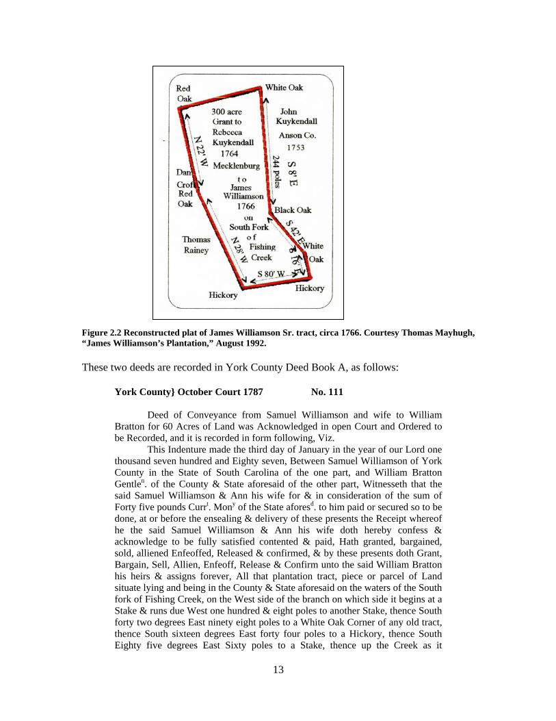
November 16, 1764. Rebecca Kuykendall granted 300 acres on the South Fork of Fishing Creek, Mecklenburg County, NC. File No. 1071 (339), Grant No. 306, Book No. 18, Page 117 (17, 130). Beginning at a white oak, the upper corner of John Kuykendall’s land running along his line S8ºE244 poles to a Black Oak on his corner, thence along his other line S42ºE100 poles to a White Oak, thence S16ºE44 poles to a Hickory his corner, thence S80ºW116 poles to a Hickory by Thomas Rainey’s corner, thence along Rainey’s line N28ºW240 poles to a Red Oak his corner, thence N22ºW by Edward Croft’s line 220 poles to a Red Oak thence to the beginning. Signed by NC Royal Governor Arthur Dobbs.3 On November 22, 1766, Rebecca Kuykendall sold this 300-acre tract to James
Williamson Sr.4 During the period of the Revolutionary War, James Williamson and his family, including his five sons Adam, George, John, Samuel, and James Jr., were living in a two-story log house on this property. According to period accounts, Williamson’s house was located 300-400 yards southeast of Colonel William Bratton’s house, on a branch of the South Fork of Fishing Creek known locally as “Becky’s Branch,” after Rebecca Kuykendall.5
1 Abstracted from Brent H. Holcomb, North Carolina Land Grants in South Carolina (Baltimore: Genealogical Publishing Co., 1999), 18-19, 22, 27, 46, 58, 78- 79, 97, 126; Thomas M. Mayhugh, “James Williamson’s Plantation,” unpublished manuscript, August 1992 (copy on file at Historical Center of York County, York, SC); and Thomas M. Mayhugh, “James Williamson’s Plantation,” Chester District Genealogical Society Bulletin, Vol. XVI, No. 4 (December 1992), 111-112. 2 Holcomb, 4, 6, 79 3 Holcomb, 79; Mayhugh, Chester Bulletin, 111-118. 4 Brent H. Holcomb and Elmer O. Parker, Mecklenburg County, North Carolina Deed Abstracts 1763-1779 (Easley, SC: Southern Historical Press, 1979), 98. 5 Joseph Hart Genealogical Collection, Historical Center of York County, York, SC; Holcomb and Parker, 97; Mayhugh, Bulletin, ibid.; Michael C. Scoggins, The Day It Rained Militia (Charleston: History Press, 2005), 209-13.

12
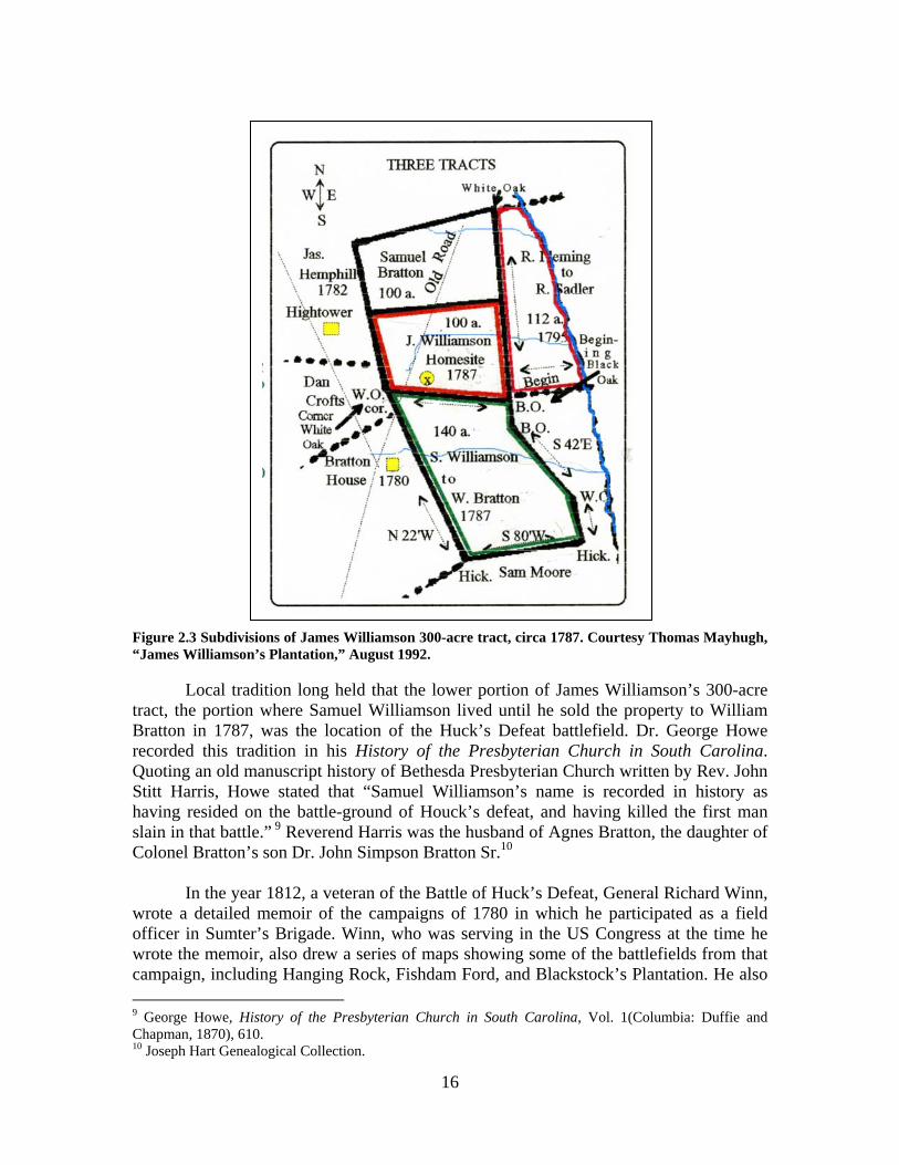
At some point following the Battle of Huck’s Defeat, it appears that James Williamson Sr. transferred the southern half of his property, including his old house site, to his son Samuel Williamson, and moved onto the northern portion of his tract, possibly residing with some of his other children.6 No written record of this transaction has been found, but the early York County deed books do indicate that in January 1787 Samuel Williamson sold two tracts of land to William Bratton. These tracts consisted of a 60-acre parcel which Samuel had previously obtained from his brother Adam Williamson, and a 140-acre tract that Samuel had obtained from his father James Williamson. Significantly, this second tract included his father’s “original improvements,” i.e., his father’s original home place. In all likelihood, James Williamson Sr. transferred ownership of these two tracts of land to his sons Adam and Samuel following the end of the Revolutionary War and, due to his advanced age, moved in with the family of one of his younger children.
Figure 2.1 Map showing locations of colonial grants in Brattonsville neighborhood, South Fork of Fishing Creek, York County, SC. Courtesy Thomas Mayhugh, “James Williamson’s Plantation,” August 1992 (with edits by Michael C. Scoggins, November 2010).
6 Mayhugh, Bulletin, ibid.
13
Figure 2.2 Reconstructed plat of James Williamson Sr. tract, circa 1766. Courtesy Thomas Mayhugh, “James Williamson’s Plantation,” August 1992.
These two deeds are recorded in York County Deed Book A, as follows:
York County} October Court 1787 No. 111 Deed of Conveyance from Samuel Williamson and wife to William Bratton for 60 Acres of Land was Acknowledged in open Court and Ordered to be Recorded, and it is recorded in form following, Viz. This Indenture made the third day of January in the year of our Lord one thousand seven hundred and Eighty seven, Between Samuel Williamson of York County in the State of South Carolina of the one part, and William Bratton Gentlen. of the County & State aforesaid of the other part, Witnesseth that the said Samuel Williamson & Ann his wife for & in consideration of the sum of Forty five pounds Currt. Mony of the State aforesd. to him paid or secured so to be done, at or before the ensealing & delivery of these presents the Receipt whereof he the said Samuel Williamson & Ann his wife doth hereby confess & acknowledge to be fully satisfied contented & paid, Hath granted, bargained, sold, alliened Enfeoffed, Released & confirmed, & by these presents doth Grant, Bargain, Sell, Allien, Enfeoff, Release & Confirm unto the said William Bratton his heirs & assigns forever, All that plantation tract, piece or parcel of Land situate lying and being in the County & State aforesaid on the waters of the South fork of Fishing Creek, on the West side of the branch on which side it begins at a Stake & runs due West one hundred & eight poles to another Stake, thence South forty two degrees East ninety eight poles to a White Oak Corner of any old tract, thence South sixteen degrees East forty four poles to a Hickory, thence South Eighty five degrees East Sixty poles to a Stake, thence up the Creek as it
14
meanders to the beginning containing by Estimation, Sixty acres of Land which was transferred by Deed of Feoffment from Adam Williamson to his brother the above mentioned Samuel Williamson, who now does the same to the above named William Bratton, With all Yards, Gardens, buildings, trees, Woods, under woods, ways, water & water courses therein contained, and all profits, commodities, Hereditaments & Appurtenances thereunto belonging or in any wise appertaining either in Equity or in Law of him the said Samuel Williamson & Ann his wife or their Heirs or Assigns of in or to the Land & Premises aforesaid. To have and to hold the said Tract of Granted Land & premises with all & singular the appurtenances thereunto the sd. William Bratton to the only proper use & behoof of him the sd. William Bratton his Heirs & Assigns forever, According to the true intent & meaning of these presents, which is that the said William Bratton & his heirs or Assigns may for ever hereafter, Have, Hold, Occupy, possess & enjoy to his & their own proper use & behoof the Land & premises hereby granted or intended so to be, without the Lett, Hinderance, Interruption, Trouble or Denial of him the Samuel Williamson & Ann his wife or their heirs or Assigns or any other person or persons claiming by, from, or under him or them or any of them, Hereby Warranting & Defending the aforesd. Granted land with all its appurtenances unto the said William Bratton or his heirs or assigns against the legal claim & Demand of all persons whatsoever. In Witness whereof we have hereunto set our hands & affixed our seals the day & year above written, and in the tenth year of American Independence. Seal’d Sign’d & delivered Samuel Williamson {LS}
in the presence of Anna Williamson {LS} Wm. Manahan James McReynolds Jane Bratton7 York County} October Court 1787 No. 112
A Deed of Conveyance from Samuel Williamson & wife to William Bratton for 140 Acres of Land was acknowledged in open Court and ordered to be Recorded, and it is Recorded in form following, Viz. This Indenture made this third day of January in the year of our Lord one thousand Seven hundred and Eighty seven Between Samuel Williamson of York County in the State of South [Carolina] of the one part and William Bratton Gentlen. of the County & State aforesd. of the other part. Witnesseth that the said Samuel Williamson & Ann his wife for and in consideration of the sum of Sixty five pounds Currt. Money of the State aforesaid to him paid or secured so to be done, at or before the Ensealing & delivery of these presents, the Receipt whereof he the said Samuel Williamson & Ann his wife doth hereby confess & acknowledge to be fully satisfied contented and paid Hath granted, Bargained, Sold, Alliened, Enfeoffed, Released and Confirmed and by these presents, Doth grant, Bargain, Sell, Allien, Enfeoff, Release & Confirm unto the said William Bratton Gentlen. his heirs and assigns for ever, All that piece or parcel of land situate lying & being in the County & State aforesaid, on the waters of the South fork of Fishing Creek, bounded on the North by Land now belonging to said Samuel Williamson, on the East land belonging to Samuel Moore on the West &
7 York County Deed Book A, 285-6 (microfilm copy at Historical Center of York County, York, SC).
15
South West by Land belonging to Daniel Crofts deceas’d & the above named William Bratton and runs as follows, Viz., Beginning a Black Oak the Corner between the said Samuel Williamson & his father James Williamson, thence South Eight degrees East to another Black Oak, thence South forty two degrees East one hundred poles to a White Oak, thence South sixteen degrees East forty four poles to a Hickory, thence South Eighty degrees West one hundred & sixteen poles to a Hickory, thence South twenty eight degrees West two hundred and forty poles to a Red Oak, thence North twenty two degrees West to the Corner White Oak between the said Samuel Williamson & his father James Williamson thence a Straight line to the beginning Black Oak above mentioned containing by Estimation one hundred and forty acres land (including the said James Williamson’s old improvements), with all Yards, Gardens, Buildings, Trees, Woods, under woods, ways, water & Water courses therein contained also all profits commodities Hereditaments & appurtenances with every part thereunto to belonging or in any wise appertaining either in Equity or in Law of him the said Samuel Williamson & Ann his wife their Heirs or Assigns. Also the Reversion & Reversions, Remainder & Remainders, Rents, Issues and Services thereof, with all the Estate, Right, title, interest, claim & demand whatsoever of him the said Samuel Williamson & Ann his wife or their heirs or assigns. To have and to hold the said tract or parcel of Land with all & singular the appurtenances thereunto belonging unto the said William Bratton to the only proper use and behoof of him the said William Bratton his heirs & Assigns for ever, According to the true intent & meaning of these presents, Which is that the said William Bratton or his heirs or Assigns may for ever hereafter, Have, hold, Occupy, possess & enjoy to his & their own proper use & behoof the Land & premises hereby meant & intended, without any Lett, Hinderance, Trouble, Interruption Claim or Denial of him the sd. Samuel Williamson & Ann his wife or their Heirs or Assigns or any other person or persons claiming by from or under him or them or any of them, Hereby Warranting & Defending the aforesd. granted Land & premises with all the appurtenances thereunto belongg against the legal claim & demand of all persons whatsoever. In Witness whereof we have hereunto set our Hands & affixed our Seals the day & year above written and in the tenth year of America’s Independence. Sign’d Sealed & delivered Samuel Williamson {LS}
in the presence of Anna Williamson {LS} Wm. Manahan N.B. the words (& Ann his wife) are
James McReynolds interlined throughout in the original 8 Jane Bratton
8 York County Deed Book A, 286-7.
16
Figure 2.3 Subdivisions of James Williamson 300-acre tract, circa 1787. Courtesy Thomas Mayhugh, “James Williamson’s Plantation,” August 1992.
Local tradition long held that the lower portion of James Williamson’s 300-acre tract, the portion where Samuel Williamson lived until he sold the property to William Bratton in 1787, was the location of the Huck’s Defeat battlefield. Dr. George Howe recorded this tradition in his History of the Presbyterian Church in South Carolina. Quoting an old manuscript history of Bethesda Presbyterian Church written by Rev. John Stitt Harris, Howe stated that “Samuel Williamson’s name is recorded in history as having resided on the battle-ground of Houck’s defeat, and having killed the first man slain in that battle.” 9 Reverend Harris was the husband of Agnes Bratton, the daughter of Colonel Bratton’s son Dr. John Simpson Bratton Sr.10
In the year 1812, a veteran of the Battle of Huck’s Defeat, General Richard Winn, wrote a detailed memoir of the campaigns of 1780 in which he participated as a field officer in Sumter’s Brigade. Winn, who was serving in the US Congress at the time he wrote the memoir, also drew a series of maps showing some of the battlefields from that campaign, including Hanging Rock, Fishdam Ford, and Blackstock’s Plantation. He also
9 George Howe, History of the Presbyterian Church in South Carolina, Vol. 1(Columbia: Duffie and Chapman, 1870), 610. 10 Joseph Hart Genealogical Collection.

17
drew a map showing the upper Catawba River with such important locations as Charlotte, the Waxhaws, Hanging Rock, Camden, Land’s Ford, Rocky Mount, and Winnsboro labeled, along with many of the roads including the Rocky Mount Road. While the map is not drawn to scale, it does show both the Bratton and Williamson plantations with their houses, situated near the intersection of the Rocky Mount Road and the Armstrong Ford Road. The Williamson house is clearly pictured as being east of, and very close to, the Bratton house, with a road running north between them. The map includes the following notation: “These marks is to separate 2 plantns. joining each other.” Beside the drawing of the Williamson house is the notation, “Huck took possession of this house,” while near the Bratton house is the notation, “Huck & Col. Furguson defeated.” The relevant section of Winn’s map is reproduced below, with geographic north toward the top of the map and east toward the right. Fig. 2.4 Section of General Richard Winn’s 1812 map showing the Bratton and Williamson plantations and the battlefield of Huck’s Defeat, from Peter Force Papers. Courtesy Library of Congress, Washington, DC.
On July 12, 1839, Dr. John Simpson Bratton Sr. held a large celebration of the Battle of Huck’s Defeat at his plantation. Approximately 1500 people attended the celebration, including some veterans of the original battle. The proceedings of the

18
celebration were subsequently published, giving some interesting details regarding the location of the battlefield:
Dr. Johns S. Bratton, inheriting his father’s (Col. Bratton’s) residence and
being the owner of the field of Huck’s defeat, situated within a few hundred yards of his home, determined to celebrate the Anniversary of this triumph of the Whigs….The day of the celebration was clear and unclouded. Four military companies and a large number of citizens, amounting in all, as was generally supposed, to fifteen hundred persons, attended by invitation. The military and citizens formed a procession at the house of Dr. Bratton…From thence they marched to the battle field, attended by a splendid band of music from Chester, under the command of Major Gaston. Several rounds of musketry were fired by the military in honor of the occasion of the battle.11
Several veterans of Huck’s Defeat were on hand that day, including Bratton neighbor Alexander Moore and Colonel Bratton’s son-in-law David Sadler, so the location of the battlefield, “a few hundred yards from the [Bratton] home,” was not in doubt.12
In the 1850s, the South Carolina physician and historian Dr. John H. Logan
interviewed a York County resident named John Starr Moore while gathering research for a proposed second volume of his highly successful History of the Upper Country of South Carolina. Moore was very familiar with the neighborhood where the Brattons and Williamsons lived. His maternal aunt, Anne (or Anna) Starr, had married Samuel Williamson, and his father, Samuel Moore (the son of John “Gum Log” Moore), purchased the 570-acre land grant from John Kuykendall that bordered the eastern side of Rebecca Kuykendall’s original 300-acre tract. At Logan’s behest, John Starr Moore produced a map showing the location of Colonel Bratton’s house, James Williamson’s house, Williamson’s Lane, and other features of the battle.
Like Winn’s map, Moore’s map shows Williamson’s house lying due east of
Bratton’s, and it also shows the lane running west to east on the south side of Williamson’s house. A corn crib and stable are located east of the house on the north side of the lane. Bratton’s house is surrounded by “cleared land” on three sides, with an apple tree on the southeast boundary between his property and Williamson’s, where the lone Whig battle casualty, a man named Campbell, was buried. South of Williamson’s house and lane is a “field,” possibly the oat field mentioned by Colonel Turnbull. In his interview with Dr. Logan, Moore also stated that Huck was killed by John Carroll from “a clump of plum trees.”13 Another battle veteran, James Potter Collins of York County, stated that the Whigs attacked Huck’s dragoons from within a peach orchard located
11 John S. Bratton and W. C. Beatty, Proceedings of a Celebration of Huck’s Defeat, at Brattonsville, York District, S. C., July 12, 1839 (Yorkville, SC: Tidings from the Craft, 1895), 1. 12 Ibid., 1, 10, 11. 13 John Starr Moore interview with John H. Logan, c. 1857, in Thomas Sumter Papers, Lyman C. Draper Manuscript Collection, 16VV272-9 (microfilm copy at Historical Center of York County).

19
“behind” Williamson’s house.14 Taken together, these statements indicate the presence of a number of fruit trees located somewhere between Bratton’s and Williamson’s house sites.
Three of Colonel William Bratton’s grandsons provided additional details of the Williamson plantation and the Huck’s Defeat battlefield. Two of those men, John Simpson Bratton Jr. and Napoleon Bonaparte Bratton, worked with local historian Daniel Green Stinson to produce maps for the Wisconsin historian Dr. Lyman C. Draper in 1876. These maps show the location of Colonel Bratton’s house, Williamson’s house, and the battlefield as they appeared in 1780. Both maps generally agree that Williamson’s house was southeast of Colonel Bratton’s house and that Williamson’s Lane ran in a southeasterly direction from its intersection with the Armstrong Ford Road at Bratton’s. However, the maps differ in one important aspect.
Figure 2.5 Lyman C. Draper’s copy of John Starr Moore map, c. 1857, from Sumter Papers, Draper MSS, 16VV277. Image WHi-27324, courtesy Wisconsin Historical Society, Madison, Wisconsin.
14 James Potter Collins, Autobiography of a Revolutionary Soldier, ed. John M. Roberts (Clinton, LA: Feliciana Democrat, 1859; reprinted New York: Arno Press, 1979), 26.
20
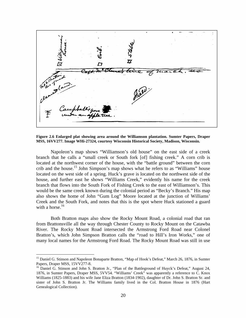
Figure 2.6 Enlarged plat showing area around the Williamson plantation. Sumter Papers, Draper MSS, 16VV277. Image WHi-27324, courtesy Wisconsin Historical Society, Madison, Wisconsin.
Napoleon’s map shows “Williamson’s old house” on the east side of a creek branch that he calls a “small creek or South fork [of] fishing creek.” A corn crib is located at the northwest corner of the house, with the “battle ground” between the corn crib and the house.15 John Simpson’s map shows what he refers to as “Williams” house located on the west side of a spring. Huck’s grave is located on the northwest side of the house, and further east he shows “Williams Creek,” evidently his name for the creek branch that flows into the South Fork of Fishing Creek to the east of Williamson’s. This would be the same creek known during the colonial period as “Becky’s Branch.” His map also shows the home of John “Gum Log” Moore located at the junction of Williams’ Creek and the South Fork, and notes that this is the spot where Huck stationed a guard with a horse.16
Both Bratton maps also show the Rocky Mount Road, a colonial road that ran
from Brattonsville all the way through Chester County to Rocky Mount on the Catawba River. The Rocky Mount Road intersected the Armstrong Ford Road near Colonel Bratton’s, which John Simpson Bratton calls the “road to Hill’s Iron Works,” one of many local names for the Armstrong Ford Road. The Rocky Mount Road was still in use
15 Daniel G. Stinson and Napoleon Bonaparte Bratton, “Map of Hook’s Defeat,” March 26, 1876, in Sumter Papers, Draper MSS, 15VV277-8. 16 Daniel G. Stinson and John S. Bratton Jr., “Plan of the Battleground of Huyck’s Defeat,” August 24, 1876, in Sumter Papers, Draper MSS, 5VV54. “Williams’ Creek” was apparently a reference to C. Knox Williams (1825-1883) and his wife Jane Eliza Bratton (1834-1902), daughter of Dr. John S. Bratton Sr. and sister of John S. Bratton Jr. The Williams family lived in the Col. Bratton House in 1876 (Hart Genealogical Collection).

21
in 1825 when Robert Mill’s Atlas of South Carolina was published, and it is shown in the same location on the York District map in Mill’s Atlas.17
Figure 2.7 Map of Huck’s Defeat battlefield drawn by Daniel G. Stinson for Lyman C. Draper, 26 March 1876, from a description provided by Napoleon Bonaparte Bratton. Sumter Papers, Draper MSS, 15VV278. Image WHi-27323, courtesy Wisconsin Historical Society, Madison, Wisconsin.
According to Stinson, he was not able to examine the ground when he met with
Napoleon Bratton in February 1876 because it was too wet, but he drew a map of the area based on Napoleon’s descriptions.18
17 York District survey, 1820, in Robert Mills, Mills’ Atlas of South Carolina (1825; reprinted Lexington, SC: Sandlapper, 1979). 18 Stinson and N. B. Bratton, ibid.

22
Figure 2.8 Map of Huck’s Defeat battlefield drawn by Daniel G. Stinson for Lyman C. Draper, August 24, 1876, from a description provided by John S. Bratton Jr. Sumter Papers, Draper MSS, 5VV54. Image WHi-27322, courtesy Wisconsin Historical Society, Madison, Wisconsin. The scale is incorrect; it should read “two inches per mile.”

23
When he returned to Brattonsville in August 1876, Stinson and John Simpson Bratton Jr. went over the battle ground and examined it in detail. In a letter to Draper accompanying the battlefield plat, Stinson noted, “I went over the Battlefield a few weeks ago. Mr. John S. Bratton showed me all the locations as laid down in the above plat. The Bratton house is still the same as it was at that date. The same log house, with the addition of a frame ell added to it. Mrs. Williams, one of the family, lives in it.19 This house as well as that of Williamson’s is down the hill near the spring. The roads are laid down as they run at that date. I have added nothing modern.”20
In a follow-up letter to Draper in January 1877, Stinson added the following:
“Last Summer I was on the battle ground of Houyck’s Defeat. Mr. John Bratton pointed out to me [the] location in general as he recollected it to be pointed out by the old Soldiers on the day of the celebration the 12th of July 1839. I made a correct plat of the same and forwarded to you from Rock Hill.”21 The second statement verifies that John Simpson Bratton Jr. was among those who were shown the battlefield location by the “old soldiers” during the celebration of Huck’s Defeat held at Brattonsville on July 12, 1839. As mentioned earlier, this celebration was arranged by Bratton’s father, Dr. John Simpson Bratton Sr., and was attended by several veterans of Huck’s Defeat.22 John Simpson Bratton Jr. was 20 years old at the time of the celebration and as Stinson’s letter documents, he had direct knowledge of the position and layout of the Williamson plantation and the battlefield from men who were there. 23
Examination the terrain in that area today reveals a number of small creeks and spring branches in the area where the maps indicate that Williamson’s house was located. Obviously, both Napoleon’s and John Simpson’s maps cannot both be correct if Napoleon is showing the South Fork on the west of Williamson’s house while John Simpson shows it on the east. The key seems to be that Napoleon describes the western creek as a “small creek or South fork fishing creek,” which seems contradictory at first. There is a rather substantial creek bed in that location. Today it is a dry creek bed, but it may be the creek that Napoleon refers to as a “small creek” and it may well have been an active creek in 1780, in which case it was indeed a part of the South Fork watershed. It is also possible that D. G. Stinson, who drew the map, made a mistake and that the creek should have been labeled “small creek of South Fork,” which would be more logical and topographically correct. On the east side of Williamson’s, John Simpson shows a spring branch. There are in fact three small spring branches that are still flowing and that come together about 200 feet east of the dry creek bed. If Williamson’s house was located between these two water systems, it would explain the apparent discrepancy between the two maps, since Napoleon would be describing the larger creek bed on the west side and John Simpson would be describing the spring branch on the east side.
19 Jane Eliza Bratton Williams, wife of C. Knox Williams and sister of John S. Bratton Jr. 20 Stinson and J. S. Bratton, ibid. 21 Stinson to L. C. Draper, January 15, 1877, in Sumter Papers, Draper MSS, 15VV292. 22 Bratton and Beatty, ibid. 23 Stinson to Draper, ibid. John Simpson Bratton Jr. was born in 1819 and died in 1888 (Hart Genealogical Collection).

24
An old road bed is clearly visible even today on the south side of both creek branches, in the approximate location of Williamson’s Lane as shown on all three nineteenth century maps. The appearance of this road also matches a description provided by another of Colonel Bratton’s grandsons, Dr. James Rufus Bratton, to the historian Lyman C. Draper in 1871:
The Hook [Huck] Defeat battle-ground. – McClures24 party went up the ascending Williamson’s lane…& as they reached the ridge, & just over it was a hollow in which at a spring & spring branch was Williamson's house, long since disappeared – & just beyond on high ground was Col. Bratton's house – some 60 rods [330 yards or 990 feet] off. 25
Dr. Rufus Bratton’s description gives us a fairly precise distance measurement from Williamson’s to Bratton’s: about 330 yards. His description of the terrain also gives specific features—the ascending lane, the ridge, the hollow, the spring and spring branch—which match features that are still visible today. A similar detailed description of the terrain around Williamson’s plantation is contained in a letter from local historian Dr. A. Q. Bradley to Lyman Draper in 1872:
At the battle of Williamson’s lane, Capt. Huyck was killed 200 yards up the hollow in [the] ravine towards Col. Bratton’s house, instead of in W[illiamson]’s apple orchard, as I had always before believed, & where his horses were hitched to the boughs of the apple trees.26
A washed-out ravine or gulley is still visible on the south side of the old road. This ravine, like the road bed, extends from the hollow where the Williamson house, spring branch and battle site were located toward Colonel Bratton’s house, just as Dr. Bradley described. His statement about the proximity of Williamson’s apple orchard, and its role in the battle, confirms similar statements by James Potter Collins and John Starr Moore.
Rufus Bratton’s statement that Williamson’s house had “long since disappeared” is also important, because it indicates that the house was dismantled, moved or destroyed some time after Colonel Bratton purchased the property in 1787. It seems likely that Williamson’s house and outbuildings were disassembled and the timbers salvaged by the Brattons. There is some evidence to suggest that the material might have been used to build the first of two ells added to the Colonel Bratton house after 1780. When architect Howell C. Hunter examined the Bratton house in 1974, he noted that the eastern ell appeared to be constructed at least in part from salvaged materials:
24 Captain John McClure led one of the detachments of Whig militia that attached Huck. Specifically, McClure’s detachment approached from the east end of Williamson’s Lane, and the terrain does make a rather steep ascent from the eastern creek branch as it climbs uphill or “ascends” toward Bratton’s house. 25 Lyman Draper interview with Rufus Bratton and John S. Bratton Jr., July 1871, in Sumter Papers, Draper MSS, 11VV336. 26 Dr. A. Q. Bradley to Lyman C. Draper, September 14, 1872, in Sumter Papers, Draper MSS, 14VV245.

25
It is evident that this is not part of the original house because logs in the wall separate it from the original. The new ell was of heavy braced frame construction rather than log construction. Many of the joists were apparently salvaged from other structures as indicated by the random order of the various peg holes. An additional chimney was built at the south end of this room on the exterior. A new roof was added, extending the original upper roof, but at a slightly shallower pitch. The rafters were made from stripped timber about four inches in diameter and flattened on the top sides. A small opening was cut into the log wall for access into the attic space which may have been used for storage.27
Howell was informed by Judge Samuel Mendenhall, a Bratton descendant and
member of the York County Historical Commission at the time, that this ell was in existence in 1780. There was no documented historical evidence presented to support this contention, rather it appears to have been based on supposition derived from another oral tradition stating that the Bratton house was built in 1776. 28 It is now known that the Bratton house was in existence as early as 1769 and probably as early as 1766, but there is no evidence to substantiate the claim that the eastern ell was in existence as early as 1780.29 The statement by Daniel G. Stinson to Lyman C. Draper in 1877, quoted above, would seem to confirm this: “The Bratton house is still the same as it was at that date [1780]. The same log house, with the addition of a frame ell added to it [italics mine—MCS].” It seems likely that the room was added to the house after 1787, using materials salvaged from buildings on the Williamson plantation.
Circumstantial evidence that the Williamson plantation house and outbuildings
had been dismantled by the early nineteenth century is provided by two survey plats prepared for Colonel Bratton’s son, Dr. John Simpson Bratton Sr., who inherited his parents’ estate. These plats both show the Colonel Bratton house, where Dr. Bratton and his family lived at the time, along with the spring branch on the north side of the house, the “Charleston Road,” the “York Road,” the “Lincoln Road,” and the “Rocky Mount Road,” but in the area where Williamson’s house would have been located there are nothing but cleared agricultural fields. One plat, dated January 14, 1817, clearly shows “large fields” on the south and east sides of the Bratton house extending as far as the
27 Howell C. Hunter, Jr., “Architectural Research of the Colonel William C. Bratton House,” in Joseph C. Wilkins, Howell C. Hunter, Jr., and Richard F. Carillo, Historical, Architectural, & Archeological Research at Brattonsville (38YK21), York County, South Carolina (Columbia: Institute of Archeology and Anthropology, University of South Carolina, 1975), 24, 28. 28 Ibid. 29 Deed, Thomas Rainey to William Bratton, August 11, 1766, Mecklenburg County Deed Book 1:377-378, abstracted in Holcomb and Parker, Mecklenburg County Deed Abstracts, 17 (photocopy of original deed from NC Archives on file at Historical Center of York County); William Bratton appointed overseer of the road leading from Armour’s Ford on the Catawba River to Charleston, including road “from Kings Mountain to William Bratton’s,” Tryon County Minutes of the Court of Pleas and Quarter Sessions, July term 1769, transcribed in Brent H. Holcomb, Tryon County, North Carolina Minutes of the Court of Pleas and Quarter Sessions 1769-1779 (Columbia, SC: South Carolina Magazine of Ancestral Research, 1994), 7; William Bratton ordered to “Serve as Overseer of the aforesaid Road from Mic’l Megaritys to the s’d Brattons house & that he Enter on his Charge accordingly,” Tryon County Minutes of the Court of Pleas and Quarter Sessions, October term 1769, transcribed in Holcomb, ibid., 13.

26
eastern creek branch that flows into the South Fork. This eastern creek branch, labeled as “Beaverdam Branch,” would be the same branch referred to variously above as Becky’s Branch, Gum Log Branch, or Williams Branch.30 Had Williamson’s house still been standing, it seems likely that it would have been shown on the plats for reference purposes.
Figure 2.9 Early nineteenth century plat surveyed for John Simpson Bratton Sr., showing “Bratton spring,” “York Road,” “Lincoln Road,” “Rocky Mount Road,” “Charleston Road,” and “J. S. Bratton house,” which was the home of Col. William Bratton at the time of Huck’s Defeat. There is no evidence of the Williamson plantation buildings on the plat. Courtesy Historical Center of York County, Culture & Heritage Museums.
30 Photocopies of J. S. Bratton plats on file at Historical Center of York County.

27
Figure 2.10 John S. Bratton plat, dated January 14, 1817, showing “Charleston Road,” “Rocky Mount Road,” “York Road,” “Lincoln Road,” and “Beaverdam Creek.” The plat also shows fenced-in fields where the lower 140-acre portion of the Williamson tract, purchased by William Bratton in 1787, was originally located. The upper portion of James Williamson’s 300-acre tract is indicated as “Jas. Williamson’s Lands.” Courtesy Historical Center of York County, Culture & Heritage Museums. The location of the Williamson plantation and the battlefield remained a local tradition well into the twentieth century. As mentioned earlier, the battlefield was visited by Bratton family members along with local veterans of the battle during the celebration in 1839. As late as the 1870s, area residents could still visit Brattonsville and be shown the battlefield and the “Tory graves.” One such visitor was William Harbison of York District, whose father, James Harbison, was a veteran of Sumter’s Brigade and had fought at Williamson’ Plantation. In an 1873 letter to historian Lyman Draper, Harbison noted that his father was in a number of Revolutionary War battles, including “Williamson’s where Huck was killed. I have been there myself—saw the graves of the Tories, the place now belongs to Dr. Bratton. There was a large female academy and
28
fin[ishing] school when I visited it.”31 The late South Carolina senator and judge Samuel Mendenhall, a Bratton descendant who was instrumental in preserving and establishing Brattonsville as a historic site, maintained throughout his life that the site of Williamson’s plantation and the Battle of Huck’s Defeat was several hundred yards east of the Colonel Bratton House toward the South Fork of Fishing Creek. Likewise, members of the Williamson, Neely, King and Walker families, who still live in the vicinity of Brattonsville, have consistently maintained that the site of Williamson’s plantation and the battlefield was in this same location, and have affirmed that these traditions have been passed down orally from generation to generation since the 1780s.32 The historical and cultural evidence placing the site of James Williamson’s plantation and the Huck’s Defeat battlefield on the west side of the South Fork of Fishing Creek, some 300 yards east-southeast of the Colonel Bratton House at Historic Brattonsville, is both consistent and overwhelming. As will be seen from the subsequent chapters in this report, the archeological evidence has supported these historical records and local traditions.
31 William Harbison to Lyman Draper, March 5, 1873, in Sumter Papers, Draper MSS, 4VV36-7. The reference to the female academy and finishing school probably dates Harbison’s visit to the 1850s. 32 Personal communications with Michael Scoggins, 1999-2010.

CHAPTER 3: MILITARY ANALYSIS OF THE BATTLE OF WILLIAMSON’S PLANTATION (HUCK’S DEFEAT)
INTRODUCTION This chapter presents a detailed history of the Battle of Williamson’s Plantation. Within this text are identified defining features. Defining features are defined as particular landscape locations on the ground or archeological features that can be used to locate significant actions and events in the field (NPS 2001). These defining features are identified in the historic record and are bolded in the text below. A discussion of these features is presented after the historic context. Also KOCOA (Key Terrain, Observation and Fields of Fire, Concealment and Cover, Obstacles, and Avenues of Approach) analysis of the landscape is discussed. The defining features and KOCOA analysis will inform the survey level field work. The defining features will also assist in determining the complete Study Area, the Potential National Register (POTNR), and Core Battlefield boundaries, which will all be ground-truthed during field work. THE BATTLE OF WILLIAMSON’S PLANTATION
In the spring and summer of 1780, the Revolutionary War moved full force into the area between the Broad and Catawba Rivers of upstate South Carolina. After capturing Charleston in May, the British occupied Camden and established a strong post at Rocky Mount, a high elevation overlooking the area where Rocky Creek enters the Catawba River.1 Rocky Mount was commanded by a British officer, Lieutenant Colonel George Turnbull, and was garrisoned by approximately 150 troops, composed of both British Provincial soldiers and Loyalist or “Tory” militia. The Provincials included a company of Turnbull’s own light infantry regiment, the New York Volunteers, commanded by Lieutenant William Adamson of New York, and a troop of British Legion light cavalry or “dragoons” under Captain Christian Huck of Philadelphia. The Provincials were veterans of the war in the north as well as the battles of Savannah and Charleston, and Huck’s troop had also been in the Battle of the Waxhaws on May 29, 1780, when the British Legion dragoons and infantry reportedly massacred American Continental soldiers after they had surrendered.2 The Loyalist militia was organized into two battalions commanded by Colonel Matthew Floyd from present-day York County and Colonel James Ferguson from present-day Chester County. Unlike the Provincials, the Tory militia had little military experience and Colonel Turnbull was not very impressed by their appearance or their performance.3
In June 1780, Turnbull dispatched Huck’s dragoons and the Loyalist militia to
destroy two Patriot or “Whig” militia camps at the Fishing Creek Presbyterian Meeting House in northern Chester County and Colonel William Hill’s Ironworks in York County, which were the centers for rebel activity in the area. Huck destroyed the Fishing
1 Michael C. Scoggins, The Day It Rained Militia: Huck’s Defeat and the Revolution in the South Carolina Backcountry, May-July 1780 (Charleston: History Press, 2005), 41-49. 2 Ibid., 51-52. 3 Ibid., 63-64.

30
Creek Meeting House and the Hill’s Ironworks factory complex, and also conducted extensive foraging operations throughout the area for wheat, corn, cattle and horses which he took back to Rocky Mount, along with confiscated African American slaves from rebel plantations and the ironworks.4
Following the loss of their two field bases, the Whigs from the area between the
Broad and Catawba Rivers, most of whom were also from the present-day counties of York and Chester, moved to the east side of the Catawba River, established a camp at Nation Ford, and began organizing a partisan militia brigade under the command of Colonel Thomas Sumter, former commander of the Sixth South Carolina Continental Regiment, whom they elected as their brigadier general of militia.5
In early July, Turnbull received intelligence that many of the local rebel leaders,
including Captain John McClure and Colonel William Bratton of the Fishing Creek communities in Chester and York counties, had returned home to check on their wheat harvest and to enlist additional recruits for Sumter’s Brigade. Turnbull gave Huck instructions to apprehend McClure and Bratton and engage and disperse the rebel militia operating in the Broad and Catawba River valleys. On the evening of July 10, Huck set out from Rocky Mount with 35 British Legion dragoons, 20 mounted New York Volunteers, and 50 mounted Loyalist or Tory militia. Over the course of the following day, Huck’s battalion slowly worked its way north through Chester County up the old Rocky Mount Road into York County, making numerous stops along the way to arrest rebel militiamen and forage supplies for the Rocky Mount garrison.6
Thanks to intelligence from several local residents, Sumter’s men soon learned
that Huck was once again on patrol, and they quickly made plans to intercept him. Throughout the day on July 11, the Whig officers dispatched riders to round up volunteers from all over present-day York and Chester Counties in order to counter the British force. Believing that Huck was camped at Walker’s Mill in Chester County (where the town of Lando is located today), the Whigs set off from the Nation Ford camp late on the evening of July 11 with about 200 men and picked up Huck’s trail. Their plan was to advance on the enemy under cover of darkness and catch the Crown forces in a surprise attack at dawn. The primary Whig militia commanders were Colonel William Bratton, Colonel Andrew Neel and Colonel William Hill from York County; Colonel Edward Lacey and Captain John McClure from Chester County; and Colonel Richard Winn from Fairfield County.7
Meanwhile, Huck’s force continued north into York County, headed for
Bratton’s plantation. The Crown troops arrived at the Bratton home late on the afternoon of July 11. Colonel Bratton’s wife Martha and some other family members had just returned home after reaping wheat all day. A Tory militiaman demanded to know her husband’s whereabouts, and threatened Martha with a reaping hook when she refused to
4 Ibid., 65-83. 5 Ibid., 83-96. 6 Ibid., 101-105. 7 Ibid., 109-110.

31
answer. Lieutenant Adamson of the New York Volunteers came to Martha’s rescue and protected her from the belligerent Tory. Huck and his dragoons then arrived on the scene. After an unproductive and frustrating interview with Martha, during which she refused to cooperate in any way, Huck had Martha and her children locked in the attic of her house. He then moved his troops to the neighboring home of James Williamson, who had a large field of oats that Huck wanted for his horses.8
Oral history and maps provided by three of William Bratton’s grandsons (John,
Rufus and Napoleon Bratton), as well as by Williamson nephew John Starr Moore, all agree that Williamson’s house was located approximately 300-400 yards southeast of Bratton’s house, down a long sloping hill toward what was then known as “Becky’s Branch” of the South Fork of Fishing Creek. The Williamson plantation included a two-story log house, a corn crib, and a stable or barn, all located in a hollow and flanked by several spring branches. The area around the house was cleared, and south of the house was a fenced-in lane (“Williamson’s Lane”) that ran southeast to northwest along a ravine back up the hill toward Bratton’s house, where it intersected the Armstrong Ford Road, a heavily traveled colonial road running north-south along the west side of Bratton’s house (roughly congruent to modern Brattonsville Road). To the south of the lane was a cultivated field where the oats were probably planted, and on the west and/or north side of the house were one or more orchards planted with apple trees, peach trees and plum trees.9
When the various Whig companies arrived at Walker’s Mill on the night of July
11, they found that Huck had moved north to the Bratton plantation. During the forced march from Walker’s Mill into York County, about 50 Whig militiamen dropped out and either returned to camp or went back home. The remaining Whigs, now about 140-150 in number, picked up Huck’s trail on the Rocky Mount Road and then crossed over to the Armstrong Ford Road, a few miles south of the present-day York-Chester county line. They arrived in the vicinity of Bratton’s plantation about 3:00 AM. Approximately 1 to 1 ½ miles south of Bratton’s, the Whigs dismounted, secured their horses off the main road and proceeded on foot. Believing that the Crown forces were camped at the Bratton homestead, the Whig commanders dispatched an advance party of about 25 mounted men under Captain James Read to swing around the west side of the Bratton homestead, outflank the enemy and attack from the rear (north), while the main force attacked from the front (south), thus cutting any possibility of the enemy’s retreat.10
8 Ibid., 105-107. 9 Ibid., 107-108; A. Q. Bradley to Lyman C. Draper, 14 September 1872, in Thomas Sumter Papers, Lyman C. Draper Manuscript Collection, 14VV245; Rufus Bratton to L. C. Draper, July 1871, Draper MSS, 11VV336; John Starr Moore map, c. 1857, Draper MSS, 16VV277; Napoleon Bonaparte Bratton map, 26 March 1876, Draper MSS, 15VV278; John Simpson Bratton Jr. map, 24 August 1876, Draper MSS, 5VV54; Thomas M. Mayhugh, “James Williamson Plantation,” August 1992 (privately printed; copy on file at Historical Center of York County), later published in Chester District Genealogical Society Bulletin, XVI:4 (December 1992), 111-112; and Michael C. Scoggins, “A Historical Analysis of the James Williamson Plantation” (York: SRWI-CHM, June 2010). 10 Scoggins, Militia, 110-113; John H. Logan and John Starr Moore, “Hauk’s Defeat—Traditions of John Starr Moore,” c. 1857, Draper MSS, 16VV272-279; Richard Winn, “General Richard Winn’s Notes—1780,” Peter Force Papers, series 7E, reel 3 of 56, Library of Congress microfilm reel 19,061. Winn says

32
Upon reaching the intersection of the Rocky Mount Road and the Armstrong Ford Road, approximately 500 yards south of Bratton’s house, the Whigs received new intelligence from local residents that Huck was actually camped at James Williamson’s plantation.11 The Whigs were thoroughly briefed on the layout of the enemy camp: the Tory militia was positioned in an old field about 300 yards south of Williamson’s house, while the New York Volunteers were camped in the fenced-in lane. The British Legion dragoons were positioned around the Williamson house, with Huck billeted inside.12 Analysis of the individual Whig soldiers who can be documented at Huck’s Defeat indicates that at least half of them lived in the neighborhood around upper Fishing Creek and nearby Bethesda Presbyterian Church, including the Brattons, Williamsons, Moores, Raineys, Sadlers, Laceys, Adairs and others whose property lay within the British camp area or immediately adjacent to it.13 These men were very familiar with the layout and terrain of the land, and once they received the new intelligence of the enemy’s disposition they knew exactly where they would find the various British and Loyalist camp sites.14
At this point the Whigs decided to divide their force again and attack the British
from each end of the lane, east and west. One group, consisting primarily of men from present-day York County under Bratton and Neel, turned northeast and marched diagonally across Williamson’s field toward the Loyalist militia camp to attack from a westerly direction. The second group, composed primarily of men from present-day Chester County under Lacey and McClure, circled around the south side of the camps toward the east end of the lane and were forced to traverse some very difficult terrain, including creek swamps and wooded areas; consequently they were delayed getting into their position.15
Just as the sun began to rise, about 4:30 or 5:00 AM, the Whigs under Bratton and
Neel were spotted by one of the Loyalist militia sentinels and, by prearranged signal, they commenced their attack. The Loyalist militiamen, who were eating breakfast and preparing to break camp, were caught completely by surprise. The senior Loyalist militia officer, Colonel Floyd, mounted his horse and fled the battlefield, along with many of his men.16 The other Loyalist militia commander, Colonel Ferguson, stood his ground and tried to rally his men. Ferguson was shot down at almost point blank range by the vengeful Whigs, who held him responsible for the death of a young Whig militiaman during the June raid on Fishing Creek Meeting House. Many of the Tory militiamen were the Whigs dismounted within “about a mile of the enemy”; Moore says “one mile & a half from the house of Saml. Williamson, they divided into two divisions.” Winn was at the battle, but Moore was not. 11 Winn calls it “the fork in the road,” which certainly matches the intersection. Winn, ibid. 12 Winn, ibid.; Moore, ibid.; William Hill, Colonel William Hill’s Memoirs of the Revolution, ed. A. S. Salley (Columbia: The State Co., 1921), 9-10; James Potter Collins, Autobiography of a Revolutionary Soldier, ed. John M. Roberts (Clinton, LA: Feliciana Democrat, 1859; reprinted New York: Arno Press, 1979), 26; Scoggins, Militia, 113. 13 Scoggins, ibid., 229-241. 14 Ibid., 113-114. 15 Winn, ibid.; Moore, ibid.; Hill, ibid.; Scoggins, ibid. 16 Elizabeth F. Ellet, The Women of the American Revolution (New York: Charles Scribner, 1854), III:185; Lyman C. Draper, notes of conversations with Daniel G. Stinson, 8-18 August 1871, in Sumter Papers, Draper MSS, 9VV13-14; Scoggins, 114-115.

33
killed or wounded by the Whig riflemen, and many surrendered; others abandoned their horses and weapons on the field and escaped on foot to the surrounding woods. Some of the escapees died from their wounds after fleeing into the woods, and their bodies were discovered during the following week.17
The Whigs then turned their attention on the New York Volunteers who were
camped in Williamson’s Lane. The Volunteers were Provincial infantry well trained in the bayonet charge, but they were hemmed in by the fences running along both sides of the lane and could not maneuver effectively. They quickly began taking casualties from the Whigs’ rifle fire and, seeing the hopelessness of their position, grounded their arms and surrendered. The Whigs under Bratton and Neel then advanced on the British Legion dragoons, who were camped around Williamson’s house.18
One of the veterans of the battle, James Potter Collins, left a description that
sounds like he was a member of Captain Read’s group, although Collins actually served under Captain John Moffett of York County:
Not long after sunrise, we came in sight of their headquarters, which were in a log building. In the rear of the building was a large peach orchard; at some distance behind the peach orchard we all dismounted and tied our horses; we then proceeded on foot through the orchard, thinking the peach trees would be a good safeguard, against the charge of the horsemen. We had not proceeded far until the sentinels discovered us—fired on us and fled. The troops were soon mounted and paraded….The leader drew his sword, mounted his horse, and began to storm and rave, and advanced on us; but we kept close to the peach orchard.19 This particular passage does not closely resemble any of the other known
descriptions of the battle, including those of men who were with the Bratton-Neel party or those of men who were with the McClure-Lacey party. Collins states that his men did not dismount until they reached the peach orchard, which he says was “in the rear of the building.” Similarly, Colonel Richard Winn states in his account that Read’s group had orders to “file off to the left of Colonel Brattons plantation & as soon as the action began in front he was to attack the rear of the Enemy & take all straggling parties,” which sounds very much like the action that Collins describes. Perhaps Moffett’s company was with Read, or perhaps Winn confused the names of the two officers and the advance patrol was actually commanded by Moffett.20
When the Whigs began their attack, Huck rushed out from the Williamson house
and began shouting orders to his men. The British troopers mounted their horses and formed up, intending to charge the enemy soldiers as they had done so successfully in
17 John Craig, “The War in York and Chester,” Chester (SC) Standard, 16 March 1854; Winn, ibid.; Hill, ibid.; Scoggins, ibid., 115-116. 18 Scoggins, 115. 19 Collins, 26. 20 Winn, ibid.; Scoggins, 115.
34
previous battles. But the Whigs remained behind the trees and fence rails, taking careful aim with their rifles as the dragoons maneuvered around the yard, futilely waving their swords and shouting curses at the rebels. After about a half dozen of his men were killed or wounded, Huck and several of his officers tried to break out of the trap and spurred their horses up the lane toward Bratton’s house. As Huck galloped away from the battle, a group of Whig riflemen took aim and fired. One of them, a Fishing Creek militiaman named John Carroll, loaded two balls in his weapon before firing. Huck was hit and fell from his saddle to the ground, dead. After their captain went down, the remaining dragoons surrendered. When Captain Huck’s body was examined, two bullet holes were found in the back of his head, about half an inch apart, and John Carroll was given credit for firing the shot that killed the British commander.21
The second group of Whigs under Lacey and McClure were delayed reaching
their positions and missed out on most of the battle. After the battle ended, McClure freed a group of Whig prisoners that Huck had locked in Williamson’s corn crib, including his younger brother, James McClure, and William Bratton’s older brother Robert. McClure and some of his men then mounted up and took off after the Loyalists who had escaped on horseback, pursuing them almost all the way back to Rocky Mount.22
The battle was over in ten minutes or less. The total number of Provincial and
Loyalist casualties was approximately 30 killed and 50 wounded, and a large number were taken prisoner. The only confirmed Whig casualty was a man from Chester County named Campbell. After the battle ended, Campbell was escorting a Tory prisoner up to Williamson’s house at gunpoint when the Tory pulled a pistol from inside his coat and shot Campbell at point-blank range. Campbell was killed instantly, and the Tory made his escape.23
Lieutenant William Adamson of the New York Volunteers was one of the
Provincials who was severely wounded during the battle. Adamson, who was not a trained cavalryman, fell from his horse while jumping a ditch and was impaled by a pine sapling. As he lay on the field bleeding from his wound, a group of Whigs including Colonel Bratton were misinformed that it was Adamson who had threatened Martha Bratton’s life the day before. Bratton was about to dispatch Adamson with his sword when Adamson asked him to check with his wife before taking vengeance on a helpless enemy. Bratton sent for his wife, who with her children was still locked up in the house where Huck had left her the previous evening. Martha came to the battlefield, recognized Adamson, and informed her husband that it was he who had saved her life from the fury of an angry Tory militiaman. Martha then treated Adamson’s injuries and those of the other wounded Loyalists as well. Many of them owed their survival to Martha Bratton’s skills as a nurse.24
21 Collins, ibid.; Craig, ibid.; Scoggins, 115-116. 22 Scoggins, 116-117. 23 Ibid., 117, 125-126. 24 Ibid., 117-119.
35
The day after the battle, the Whigs loaded up the prisoners in wagons and sent them back to Rocky Mount as prisoners on parole. The Provincial and Loyalist casualties were buried in shallow, unmarked graves on the lower end of the Williamson property; the graves were still visible and were visited by local residents as late as the 1870s. Huck was buried on the northwest side of the Williamson house, and Campbell was buried near an apple tree southwest of the house.25
The destruction of Huck’s British and Loyalist force at Williamson’s Plantation
on July 12, 1780 helped revive the morale of the people in South Carolina just when the situation seemed darkest. The battle served as a rallying point for the backcountry Whigs, and set into motion a series of significant events that would soon lead to the even larger Patriot victories at King’s Mountain in October 1780, Cowpens in January 1781, and finally to the British surrender at Yorktown in October 1781.
DEFINING FEATURES Based on the history presented above, the following defining features were
identified. 1) Bratton Plantation and House (log building) 2) Williamson Plantation and House (log building), Legion Campground 3) Sloping Hill between Bratton and Williamson’s 4) Becky’s Branch, South Fork of Fishing Creek 5) Williamson corn crib and barn 6) Springs 7) Williamson’s Lane (ascending road), New York Volunteers Campground 8) Armstrong Ford Road 9) Rocky Mount Road 10) Intersection of Armstrong Ford and Rocky Mount roads 11) Peach orchard 12) Unmarked graves
Some of these features are still evident on the landscape while others were believed to be found using metal detecting survey and archeology. Figure (3.1) depicts those features that were found as a result of a walking tour of the Study Area and were mapped using a GPS instrument. Depicted is William Bratton’s House, (Key Terrain) which still stands today. There is no doubt that this house is not only the Bratton house of the American Revolution but also that it has not moved since that time. As such, the house provides an anchor for all battlefield interpretation. Just in front of Bratton’s house is a large depression that parallels modern Brattonsville Road today. This is a remnant of the Armstrong Ford Road (Avenue of Approach). South of Bratton’s house and also south of the intersection of modern Brattonsville Road and Percival Road is a low depression and another remnant road bed (Cover and Concealment). This is believed to be a part of the old Rocky Mount Road (Avenue of Approach), and the rally point at
25 William Harbison to Lyman C. Draper, Sumter Papers, Draper MSS, 4VV36-37; John Starr Moore map, ibid.; John Simpson Bratton Jr. map, ibid.; Scoggins, 227.

36
which the Whigs split into two separate commands to approach the British at Williamson’s Plantation.
Figure 3.1 GPS Mapped Defining Features of Williamson’s Plantation Battlefield Recorded using KOCOA Analysis.

37
The historic records indicate that James Williamson’s house (Key Terrain) was
only 300 to 400 yards east of Bratton’s house, and Chapter 2 has provided a solid argument that the Williamson property was adjacent to the Bratton property. As has been discussed, a collection of lead shot and colonial artifacts had defined at least a portion of the battlefield/campground and the suspected location of Williamson’s house as a result of previous archeological efforts. While walking this area, a road remnant was found leading up the sloping hill (Avenue of Approach) to Bratton’s house, and this is now interpreted as the ascending lane or Williamson’s Lane that was fenced (Obstacle). Furthermore, the battlefield is near Becky’s Branch (Key Terrain) and at least five different active springs are present at this location. Remaining defining features included the orchard, farm outbuildings, and unmarked graves. The present work was designed to hopefully locate these features (although the orchard was not a likely possibility).

38

CHAPTER 4: RESULTS OF INVESTIGATIONS
INTRODUCTION This chapter presents the results of SCIAA’s 2010 archeological investigations in search of the Williamson’s Plantation battlefield based on previous historical and archeological research. RESULTS OF METAL DETECTING
Based on the previous survey efforts and the KOCOA analysis, the first project
priority was to conduct a reconnaissance survey of the land between the previously identified portion of the battlefield on Historic Brattonsville property (38YK564) and the suspected Rally Point on private property (Figure 4.1). This large area contained the three suspected lines of approach to the battlefield by the Whig forces. The area was subdivided into the Neely property and the King property after the landowners’ names.
Neely Property While the rally point was a low area in woods, just north of the woods the land
rises 10 to 15 feet in elevation and today opens into a large grass field. The grass was cut just prior to survey such that survey conditions were good for metal detecting, although a plowed field is always preferred. Just north of the field was the Neely homestead and yard, and beyond that was another small grass field to the corner of the Brattonsville Road (SSR 165) and Percival Road (SSR 380). The entire area, except for the Neely family’s yard was metal detected using the reconnaissance method.
The result of this reconnaissance level survey in the field was disappointing. No
colonial artifacts were found, except for a single fired rifle ball. A brass strap guide was also found, and although it could be 18th century, it also could be 19th or early 20th century (Figure 3.1). These artifacts were found near the fence line with the Neely yard, therefore a metal detecting block was laid out around and south of the artifact locations and subjected to systematic transect survey. The block was square 60 x 60 m and covered by perpendicular transects but no other colonial artifacts were found.
Proceeding northwest toward the previously identified core portion of the
battlefield, additional metal detecting probes were made into a thick forested area on the Neely property (Figure 4.1). This area had been disturbed within the last ten to twenty years, replanted with slash pine, and the result was a jumble of small pine trees, briars, raspberry bushes, and other thick understory. It was simply impossible to survey in any systematic manner. Amazingly these shallow probes into the woods did find two additional rifle balls, both fired (Figure 3.1).
The portion of the woods directly south of the core battlefield, across SSR 380,
was even more dense that the previously described area. The land contained five to ten
40
year old pine and cedar trees, from four to ten feet tall, densely planted, with briars and vines intertwined. It was impossible to penetrate during the initial effort in May 2010. The surveyors were only able walk along a thin, perhaps 10 meter wide, area parallel to the road. From this cursory walkover, it was evident that the soils there were highly eroded and the land also contained push piles from ground disturbance. Nevertheless, as Figure 4.1 depicts, there is a broad hilltop with two intermittent drainages in this portion of the Neely property. Based on previous work and our understanding of the battle from the historic record, this hilltop could have reasonably been part of the battlefield, therefore, it was imperative to make every effort to survey the hilltop. With this in mind, the survey team returned in November 2010 determined to find a way through the briars to reach the hilltop. Eventually, wearing heavy clothing and following animal paths, a two person team was able to reach the hill and found an area, approximately two acres in size with pines mature enough to deter the growth of briars. Although still unable to conduct any semblance of a systematic survey, the team metal detected several open areas and found no evidence of any occupation, colonial or otherwise. There were several small spots where the ground was exposed and there were no surface artifacts. The soils there were very thin and eroded. This landscape was essentially destroyed by cotton farming and the recent logging. We are now convinced that the battlefield does not extend into this property.
King Property Mr. Mike King, another Brattonsville neighbor, allowed us access to his property southeast and east of the core battlefield along SSR380. Mr. King’s property consisted of a large, approximately ten acre front pasture with dammed pond, and approximately 30 acres south of his home. He also owns a 5 acre wooded lot across (north) of the road and adjacent to Brattonsville property. The ground cover on the King property consists of pasture and woods. The property on the north side of the road effectively closed a circle of reconnaissance level survey around the known core battlefield. Selected areas were chosen for their potential as house sites and were surveyed at the reconnaissance level (Figure 4.1). In short, no evidence of a colonial occupation or battleground was found on the King property.
Historic Brattonsville Property A survey was made of a grassy parking lot south of the Brattonsville buildings
and west of the Brattonsville Road SSR 160 (Figure 4.1). Systematic survey of a 2,642 m2 rectangle was conducted with negative results for colonial materials. A reconnaissance level survey was also conducted in the yard of a 20th century house at the corner of SSR 160 and SSR 380, which at the time of the 2006 survey was not owned by CHM. No colonial artifacts were discovered. The suspected area of the rally point was also surveyed at the reconnaissance level and surprisingly two rifle balls were found (Figure 3.1). One was fired and one was dropped (Appendix A). It is possible these artifacts are the result of the battle, but that cannot be proved.

41
Metal detecting was also conducted around the previously identified battlefield on Brattonsville property (38YK564). A reconnaissance survey was conducted along the hillside north of the site, east of the site, and another effort was made west of the site where the ascending road was mapped. The latter area was designated in the field Area A (Figure 4.1 and 4.2). Thirteen artifacts were recovered. Two rifle balls were recovered, which are probably associated with the battle. Other materials included a door lock plate, agricultural artifacts, a Civil War burnside lead shot, a thimble, a 18th century flat button, a door knob, and a sword pommel. The pommel looks very much like those illustrated in Revolutionary War arms and weapons reference books (Figure 4.3, Figure 4.4). Area A was incorporated into the previous core battlefield area.
Metal detecting north of the battlefield recovered no colonial artifacts. Metal
detecting east of the battlefield also recovered no colonial artifacts. Two archeological sites, a surface trash site and a 20th century chimney foundation were metal detected with negative results for colonial materials (Figure 4.5). These sites were later shovel tested.
Figure 4.1 Area where reconnaissance and systematic metal detecting survey occurred in 2010.

42
No colonial artifacts were found at these two sites and no further work was conducted there.
Metal Detecting at the Core Battlefield (38YK564) While excavations proceeded, the previously identified battlefield area was
subjected to another intensive round of metal detecting (Figure 4.2). This was the third intensive effort, and yielded an additional 40 colonial or 19th century artifacts. Thirteen were lead shot. Based on their size and weight, four were buckshot, three were rifle or trade gun, four were rifle, and two were of the size and weight associated with the French Charleville musket. One of the latter was a dropped ball that had not been fired. Three of the buckshot were also unfired or dropped.
These additional lead shot increased the total number of lead shot from the
battlefield to 38 shot out of a total of 136 metal detector finds or 28% of the metal detector finds were lead shot. Adding two more from Area A, the totals are 40 lead shot out of 146 artifacts or 27%. This percentage is slightly larger than the 2006 effort of 26% (again, not all nails detected were collected, but four wrought nails were collected as samples).
Figure 4.2 Location of metal detected artifacts in core battlefield at 38YK564. Area A artifacts numbered A-#.

43
Figure 4.4 English short saber sword hilt. (From Neumann 1973:112).
Figure 4.3 Sword pommel .
Non-ammunition colonial metal items recovered at the site included a shoe buckle frame fragment that fits a fragment found in 2006, four flat buttons, and a knife blade. Agricultural and transportation artifacts included a hoe, single tree hook, spring, horse shoe, wagon wheel and a wagon wheel hub. A large door strap hinge was also recovered. A brass triangular piece was also recovered that may be an arrowhead. Other items were
unidentified brass and copper items not diagnostic.
RESULTS OF HAND EXCAVATIONS
The results of the metal detecting confirmed that the core of the battlefield was where it had been previously discovered. Area A, west of the original site and toward the Bratton house expanded the battlefield area, but otherwise the battlefield appeared to be confined to the area previously identified. The next goal, then, was to find evidence of Williamson’s house. Since the main battle took place around the house, according to the historic record, finding archeological evidence of the house would confirm that the core battle site was where the metal detector finds located it. A grid was imposed across this area and hand excavations were conducted at two metal detector artifact concentrations within the battlefield (Figure 4.5 and 4.6). The results were rather surprising. Simply put, we did not find overwhelming evidence of a colonial structure although there is some evidence. Appendix A, the artifact catalog, presents the artifacts by unit. The following summarizes these results.
Site Topography The core battlefield consists of an area (with the expanded Area A included) of
approximately 220 m N/S by 282 E/W (Figures 4.5 and 4.6). The entire battlefield core is forested with 30- to 40-year-old hardwoods and the understory is fairly open with some

44
vines toward the southern portion near the Brattonsville property line. Across the property line the land has been timbered and is impassible. During previous efforts, this land was partially cleared and metal detected and found to be heavily disturbed and trash filled.
As defined, the geomorphology of the battlefield consists of a southern portion on
an elevated knoll which drops as much as 20 feet in elevation to the north into a creek bed. This drop is gradual from the southern edge of the site to approximately half way within the site (on the grid this would be about the N560 line). At that point the knoll drops abruptly onto a low shelf which is probably the creek’s ancient floodplain. However, the creek also drops abruptly at the creek bed bank, as much as ten feet, into a shallow and sharp banked creek-bed. This topography is partially the result of post colonial erosion, probably the result of agriculture. There is a branch of the creek bed that
Figure 4.5 Core battlefield (38YK564), and two 20th century sites (38YK565, 38YK566). Red indicates positive shovel tests for historic artifacts.

45
cuts north dividing the site to the core battlefield from the new expansion area we called Area A.
The site is thus defined by an upper knoll and a lower shelf, both of which
contained two metal detector artifact concentrations. Importantly, the old road bed defines the two areas within the site, and as the road bed continues west toward the Bratton house, it crosses the creek branch and then turns north then west up another ridge in Area A. Clearly this is the “ascending road” mentioned in historic descriptions of the battle as previously discussed.
The creek bed is kept flowing as a result of at least five spring heads. We mapped
the active ones, but there are probably others as each little shelf above the creek bed seemed to at one time have been a spring head. It is impossible to know which of these spring heads might be the one mentioned in the historic accounts; however, it is likely the entire set was known simply as “the spring.”
Figure 4.6 Excavation unit placement in relation to metal detecting artifact locations from 2006 and 2010 metal detecting surveys. Red indicates positive shovel tests for historic artifacts.
46
Unit Excavations A total of ten 1 x 2 m units and three 2 x 2 m units were excavated at the two
metal detecting concentrations. There was also one 1 x 1 unit. Two of the 1 x 2 units were adjacent to each other to make a 2 x 2 unit with two 1 x 1 m extensions (Figure 4.7).
At the southern end of the site on the upper knoll, five 1 x 2 m and one 2 x 2 m
units were excavated (Figures 4.6 and 4.7). These units were shallow from 7 to 10 cms of humus and topsoil and then sterile. Only the southern-most unit N500/E519 had relatively deep topsoils, going as deep as 15 cm. The topsoils consisted of a gray-brown sandy soil, and the subsoils were yellow-brown clay loam.
All the units at the southern end of the site contained prehistoric artifacts, mostly
quartz flakes (see artifact catalog). Unit N554/E498 was negative for historic artifacts, the rest were positive. However, only the 2 x 2 m unit N/544/E532 contained a high number of artifacts. This unit had 107 mostly small (less than marble or dimed size) brick fragments. A few were larger. It was placed to reveal an anomaly discovered during the resistivity survey (see Appendix). It did not reveal a feature, however, the brick fragments are interesting in relation to the lack of such artifact concentrations elsewhere. The northernmost unit N555/E520 also contained 12 brick fragments and a tiny red earthenware sherd (see below). Unit N529/E1513 contained light green glass, an unidentified nail, and a green feather edgedware ceramic sherd. Unit N530/E518 contained 5 whiteware sherds. The only artifact that is positively dated to the colonial period is the red earthenware sherd (Appendix A). The soft brick fragments are probably colonial also, but that cannot be positively confirmed.
Nine units were excavated on the shelf just above the creek on the lower terrace.
Six were 1 x 2 m units, the remaining units were two 2 x 2 m units and a 1 x 1 m unit. Again, all but one of the units was positive for prehistoric artifacts. Unit N583/E520 and a 1 x 1 at N583/E530 were both negative for both prehistoric and historic. Unit N594/E520 and Unit N612/E531 (the latter expanded into a 2 x 2 with 1 x 1 extensions to the north and east), were positive for historic artifacts. Unit N594/E520 contained three glass sherds, none of which can be confirmed as being colonial period artifacts. Unit 599/E529 contained a complete clinched nail. Units N612/E531 and Unit N612/E529 yielded evidence of colonial occupation. The evidence consisted of 46 small, dime-sized red lead glazed earthenware sherds in Unit N612/E531 and an additional eight identical sherds in Unit N612/N529. These sherds represent a low-fired red earthenware with blood red overglaze, a type dating to the 18th century. They are identical to those seen in Unit N555/E520. Unfortunately the entire collection of this red earthenware could have come from a single bowl or plate.

47
Figure 4.7 Excavation units within core battlefield (38YK564). Red indicates positive excavation units for historic artifacts.

48
Other artifacts included a green glass sherd, 3 clear glass fragments, an unidentified nail tip, a lead sprue fragment, melted lead and pewter, a brass flat button fragment, and a glass ring setting. The latter was sky blue (Figure 4.8). Ten more soft brick fragments were recovered in Unit N612/N529 along with an eroded glass bottle fragment. The green bottle glass from both units could date to the colonial period but this cannot be confirmed. Unit N600/E520 was a 2 x 2 m unit near the location of a flat button recovered during metal detecting. Two additional flat buttons, South Type 7, were recovered, both 17.14 mm. These buttons were identical to the one recovered in the metal detecting and also that found in Area A (A-13). A similar sized and type button was recovered in the 2006 effort, and all appear to be waistcoat buttons. It is interesting that three of these buttons were found close together and not out of the realm of possibility that these are from Provincial, Loyalist, or American militia uniforms. Four additional 1 x 2 m units were place in Area A. Units N625/E506 and N625/E514 contained no artifacts. Unit N625/E468 contained a possible colonoware sherd and a cultured pearl. The latter was a modern intrusion. The second level of this unit contained prehistoric Woodland sherds, flakes, and a Yakin point dating to the Early Woodland. Unit N625/E457 contained an unidentified iron sheet and a quartz flake.
Shovel Testing As 1 x 2 m unit excavations proceeded it was very perplexing that significant
evidence of a colonial occupation was not being found, even though the metal detecting clearly demonstrated a colonial occupation. We expected to find at least a variety of colonial ceramics, pipestems, and glass which would confirm the Williamson Plantation homestead. Perhaps the Williamson house was not within the discovered battlefield as defined by the metal detecting. Therefore, it was decided that shovel testing would provide greater coverage of the study area in a less time consuming manner (Figure 4.5 and 4.6).
At first, shovel tests were placed in order to increase coverage within the site
defined by the metal detector survey. These units were excavated at 5 m intervals within the site areas and near the metal detector artifact concentrations. As these tests failed to reveal any strong evidence of a colonial occupation, additional units were placed on land forms adjacent to the site on the east and west and in Area A. These were mapped on the grid, but were not all placed systematically. When this failed to reveal evidence of a colonial occupation, 30 meter interval shovel tests were excavated along the ridge line between the site and the Historic Brattonsville parking lot simply to cover the entire area between the two. Except for additional red earthenware sherds recovered in shovel tests near Unit N612/E531 (and prehistoric artifacts), the shovel testing failed to located any concentrations of colonial artifacts.

49
DISCUSSION The results of the hand excavations are perplexing. In the experience of the Principal Investigator (archeology), there should have been additional varieties and numbers of ceramic sherds, at least some 18th century glass, and possibly at least a few pipestems. We expected a 20-year occupation to leave more artifact evidence behind, even if the site soils were severely eroded afterward. The red lead glazed earthenware dates to the colonial period, but these sherds were very small and could have come from a single vessel. The hand excavations also recovered a moderate amount of low-fired brick fragments. These were also small, but since there is no historic record of a 19th or 20th century occupation at the site, these artifacts suggest a domestic structure in which a few brick were used for the firebox or as house piers. At the same time metal domestic and agricultural materials including nails (many not collected) were present in moderate quantities. The 2010 metal detecting effort produced hoes, horseshoes, buckles, brass buttons, an iron door strap hinge, wrought nails, pewter spoon handle, thimble, a door knob and a lock plate. Previous efforts in 2006 produced pewter spoon fragments, a fork, wrought nails, buttons, buckles, British half penny, pintle, cast iron andiron foot, keg tap cock, and horse equipage (Appendix B). These findings are consistent with a domestic occupation, but might also represent a short-term military campsite. Thus, there is the suggestion of a domestic occupation, but not overwhelming evidence. On the other hand, while there is not a lot of artifact evidence of the Williamson occupation, it cannot be said there is no evidence. Meanwhile, as investigations continue we grow more confident that site 38YK564 as currently defined is the core of the Williamson Plantation battlefield. Evidence of a militia and military presence include the sword pommel, the trigger guard, and 40 lead shot, recovered within a small 180 x 200 m area. One of the lead shot was of the size associated with the British Brown Bess and two with the French Charleville muskets. These findings are consistent with both a militia battlefield and camp. As more and more militia camps and battlefields are being examined, archeologists are finding that rifle and trade gun lead shot (and at some, buckshot) dominate the artifact assemblage over musket lead shot, or are at least much more abundant than previously believed (Smith 2009; Smith 2008a; Smith 2008b). In addition, there are landscape features at this site that fit the historic description of the battle, including its location within 300-400 yards of the Bratton house, the spring heads, and the road bed ascending to the Bratton house. Finally, there is the negative survey evidence. There is absolutely no evidence (in the form of metal detecting and systematic shovel testing) of a colonial domestic occupation (disregarding the Bratton house) or battlefield elsewhere in the immediate vicinity of this site and in a half mile circle surrounding this site. For the battlefield to be elsewhere, it has to be beyond this circle contradicting all the historical accounts of the battle. That is, the reasonable and logical study area within which the battle could have taken place, given the historic record, has been systematically and thoroughly
50
investigated, and there is no other location except this site that has produced any artifact evidence at all, either military nor domestic. All in all, the location of the metal artifacts fits the historic descriptions and the artifacts fit what would be expected at a colonial battlefield consisting of partisans and Loyalists. The only logical conclusion is what was originally believed; this site is the location of at least a part of the Williamson’s Plantation battlefield, and very likely, the remains of the entire battlefield. In summary, historical sources point to site 38YK564 as the location of the battle and archeological evidence supports that evidence. REVISED BATTLEFIELD MAP Figure 4.8 depicts our final battlefield interpretation based on the historic and archeological work to date. The following discussion summarizes the battle events as are depicted on the figure. It also discusses our final analysis of battlefield features, the study area, Core Battlefield, and Potential National Register Eligibility boundary (POTNR). Despite only a few domestic artifacts we are convinced that the metal artifact concentration that was originally defined as the core battlefield remains so, and that it is the location of Williamson’s Plantation (A). Somewhere 1.5 miles south of the Bratton house, the Whigs dismounted (B) (Figure 4.8). They dispatched a small number of men with James Read to swing wide to the west to cover any enemy retreat (D). The rest of the Whigs followed behind. At the intersection of Armstrong and Rocky Mount roads, which is located in a hollow, the Whigs divided into two additional forces (C). A large force under Lacey and McClure were to swing around wide to the east and would end up missing much of the battle. Meanwhile, the main force under Bratton and Neel marched forward up the hill toward Williamson’s Plantation. There is little archeological evidence for any of these maneuvers, but there is some weak evidence of the main body being under fire as they charged first the Loyalists (E). This evidence consists of a couple of lead shot found on the Neely property and three found scattered to the southwest of the main concentration (Figure 4.6). There may be additional evidence in the thick woods between the Neely pasture and the battlefield, but for the most part, it would appear that this camp has been destroyed. The lack of lead shot may reflect the surprise attack in which the Loyalists ran without putting up any resistance. The American militia next encountered the New York Volunteers (F) who were camped along the lane, a remnant of which is still visible today. These troops were hindered by a fence, but it also provided cover and concealment and was an obstacle to the Americans. Eventually, the American militia forced their way through to the British Legion campsite around Williamson’s Plantation (A) identified as site 38YK564. The evidence

51
Figure 4.8 Battle of Williamson’s Plantation based on historic and archeological analysis.
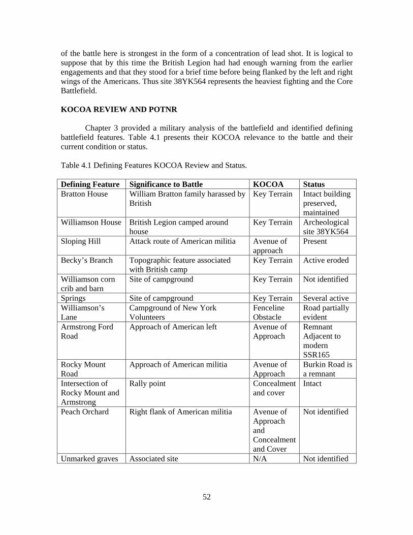
52
of the battle here is strongest in the form of a concentration of lead shot. It is logical to suppose that by this time the British Legion had had enough warning from the earlier engagements and that they stood for a brief time before being flanked by the left and right wings of the Americans. Thus site 38YK564 represents the heaviest fighting and the Core Battlefield. KOCOA REVIEW AND POTNR Chapter 3 provided a military analysis of the battlefield and identified defining battlefield features. Table 4.1 presents their KOCOA relevance to the battle and their current condition or status. Table 4.1 Defining Features KOCOA Review and Status. Defining Feature Significance to Battle KOCOA Status Bratton House William Bratton family harassed by
British Key Terrain Intact building
preserved, maintained
Williamson House British Legion camped around house
Key Terrain Archeological site 38YK564
Sloping Hill Attack route of American militia Avenue of approach
Present
Becky’s Branch Topographic feature associated with British camp
Key Terrain Active eroded
Williamson corn crib and barn
Site of campground Key Terrain Not identified
Springs Site of campground Key Terrain Several active Williamson’s Lane
Campground of New York Volunteers
Fenceline Obstacle
Road partially evident
Armstrong Ford Road
Approach of American left Avenue of Approach
Remnant Adjacent to modern SSR165
Rocky Mount Road
Approach of American militia Avenue of Approach
Burkin Road is a remnant
Intersection of Rocky Mount and Armstrong
Rally point Concealment and cover
Intact
Peach Orchard Right flank of American militia Avenue of Approach and Concealment and Cover
Not identified
Unmarked graves Associated site N/A Not identified

53
As can be seen, the results of KOCOA analysis indicates that few battlefield features can be confirmed except the Core Battlefield, based on archeological evidence and the William Bratton house, represented by the house today in its original location. While there is no confirming archeological evidence of the battle between the Core Battlefield and the William Bratton house, the historic record indicates that the road from the battlefield to the house was used by retreating Loyalists. Furthermore, as mentioned in Chapter 3, the William Bratton house is a significant Defining Feature in that it anchors the battlefield interpretation, being well documented as 300 yards from the battle. Finally, a traditional story is told that at one time, lead shot from the battle could be found embedded in the house walls. For this reason, we believe the Potential National Register boundary should include the land between the battlefield and the Bratton house and the house itself (Figure 4.8). RECOMMENDATIONS Historical and archeological investigations described in this report have demonstrated that the Williamson’s Plantation battlefield has been located and defined. The battlefield consists of a scatter of battle related and domestic artifacts from the late 18th century concentrated within an area of approximately 180 x 200 m. The site is rather shallow, only ten to 15 cm deep at most. To date there has been no clear feature found dating to the Williamson occupation. Nevertheless, we recommend that site 38YK564, the Williamson Battlefield, does meet National Register Criteria A and D and is eligible for nomination to the National Register of Historic Places. Criterion A states that sites may be eligible for the National Register if they are associated with events that have made a significant contribution to the broad patterns of our history. Chapter 3 of this report demonstrates the significance of this battle. The battle occurred at a critical juncture in the American Revolution. In May 1780, the American army in the South, under the command of General Benjamin Lincoln, had surrendered to the British. At the time of this battle, July 12, 1780, the British had total control of the South Carolina colony and were in the process of consolidating their gains by the occupation of backcountry villages like Augusta, Georgia, Ninety-Six, SC, Camden, SC, South Carolina, and Georgetown, SC. Essentially the lower part of the colony had been subdued. Just when the situation seemed darkest (see Chapter 3) American militia forces under the combined command of William Bratton, Andrew Neal, and Edward Lacey attacked and defeated a combined Provincial and Loyalist force under Captain Christian Huck. The battle not only was a bright day in the dark summer days of British conquest, but it also served as a rallying point for the backcountry patriots and set the stage for later backcountry victories like Kings Mountain in October, and Cowpens in 1781. Most importantly it was a clear warning to the British that even though Charleston had fallen, the rebellion was far from subdued. Criterion D states that sites may be eligible for the National Register if they have yielded or may be likely to yield information important in prehistory or history. This

54
report demonstrates without doubt that the site meets Criterion D. First, the archeological investigations have located and defined a battlefield that, as noted above, meets Criterion A. Second, the artifacts recovered are themselves important information about the battle. Prior to the archeological investigations, Historic Brattonsville had no material culture associated with the battle. Third, while the site does not have substantial depth (an argument against site integrity), we argue that the site has important horizontal integrity in terms of the distribution of battle related artifacts, that have and may still yield further information about the unfolding of the battle. Furthermore, while we have yet to locate features associated with the Williamson homestead, we do have the road bed and springs, which we argue are important defining features associated with the battle. Finally, the site still has the potential to yield additional information. Additional research in the form of both historical and archeological investigations may result in answering any of the following important research questions: 1) Is there any evidence of the Williamson household on the battlefield? 2) Is there any evidence beyond the battlefield (or unknown historic documents) that would assist in determining the exact routes of the American forces? 3) Are there additional artifacts on the battlefield that will assist in site interpretation? 4) Will the location of additional artifacts provide spatial evidence that will assist in interpreting the unfolding of the battle? Therefore, as funds become available additional archeological units could be excavated at the battle site to gain additional material culture. The likelihood of features seems remote, but any evidence of occupation is a bonus for future research and site interpretation. The next logical step is for the CHM to concentrate on site interpretation and planning. Therefore it is recommended that a comprehensive archeological research design for the entire Brattonsville Historic Site be developed to guide research and interpretation in the future, not only for the battlefield but for the rest of the archeological resources at the historic site. Another task that would be useful would be complete a National Register Nomination for the battlefield incorporating the arguments presented above.

REFERENCES CITED Legg, James B., Steven D. Smith and Tamara S. Wilson 2005 Understanding Camden: The Revolutionary War Battle of Camden As Revealed Through Historical, Archaeological, and Private Collections Analysis. South Carolina Institute of Archaeology and Anthropology, Columbia, SC. National Park Service American Battlefield Protection Program 2001 Revolutionary War and War of 1812 Historic Preservation Study, Survey Field School Manual. Conducted at Monmouth Battlefield State Park, Monmouth, New Jersey. Neumann, George C. 1973 Swords and Blades of the American Revolution. Promontory Press, The Stackpole Company, Harrisburg, PA. Scoggins, Michael C. 2002 “Huck’s Defeat: The Battle of Williamson’s Plantation.” York County Culture
and Heritage Commission, York, South Carolina. 2005 The Day it Rained Militia. The History Press, Inc., Charleston, S.C.. Smith, Steven D., James B. Legg, Tamara S. Wilson, and Jonathan Leader 2006 “Obstinate and Strong”: The History and Archaeology of the Siege of Fort Motte. South Carolina Institute of Archaeology and Anthropology, Columbia, SC. Smith, Steven D., James B. Legg, Tamara S. Wilson 2007 The Search for Williamson’s Plantation: Huck’s Defeat Battlefield. For the York County Culture and Heritage Museums. Columbia: South Carolina Institute of Archaeology and Anthropology. Smith, Steven D. 2008a The Search For Francis Marion: Archaeological Survey of 15 Camps and Battlefields Associated with Francis Marion. South Carolina Institute of Archaeology and Anthropology, presented to the Francis Marion Trail Commission, Francis Marion University. 2008b Archaeological Evaluation of Wadboo Plantation, 38BK464. With Contributions by Tamara S. Wilson and James B. Legg, South Carolina Institute of Archaeology and Anthropology, University of South Carolina, Columbia, SC. 2009 Archaeological Evaluation of the Dunham’s Bluff Sites, 38MA207 and 38MA165. With Contributions by Tamara S. Wilson, Sean Taylor, Mark Brooks, and Diane Wallman, South Carolina Institute of Archaeology and Anthropology, Columbia, SC.

56

APPENDIX A: RESISTIVITY SURVEY AT WILLIAMSON’S PLANTATION BATTLEFIELD (38YK564)
By Jonathan Leader, Ph.D.
State Archaeologist South Carolina Institute of Archaeology and Anthropology
INTRODUCTION AND METHODOLOGY The South Carolina Office of the State Archaeologist (OSA) conducts a course in archeological geophysics at University of South Carolina during Maymester each year. The course is run as a practicum at a series of sites to ensure that the students and the discipline derive the greatest possible benefit from the activities. For 2010, Mr. Steven D. Smith, SCIAA and Mr. Michael Scoggins, Co-Principal Investigators in the search for the Williamson’s Plantation battlefield, invited the class to the battlefield to assist in the search for the Williamson house, an 18th century occupation within the battlefield. Three ten meter by ten meter areas were selected for survey using a Geoscan Research RM15-D resistivity machine.1 Resistivity machines can be quite useful in delineating subsurface features (e.g., pits, trenches, foundations, burials). These pieces of equipment were originally designed for agricultural and soils scientists concerned with the quick mapping of soil compaction and water retention across a landscape. The archeological configuration operates as a series of four or more probes, a strong battery and a digital meter that measures the resistivity produced in the circuit during use. Two of the probes are stationary, inset into the ground several inches and located off the site that is being tested. The stationary probes are linked by sufficient electrical wire to admit free movement of a frame to which the primary two (most common configuration) or more probes are attached. The frame also supports the digital meter and in the modern configuration a digital data collector. As the frame is moved across the landscape, and the probes thrust into the ground, the changing resistivity readings are recorded (Figure A.1). Areas that retain moisture such as pits and graves provide significantly different results than those that are compacted, undisturbed or artificially hardened such as house foundations or road ways (Somers 2006; Gafney and Gater 2003). Care must be taken to work the equipment within an accurate grid to ensure the best and most comprehensible result. The original equipment required the operator to hand plot the data, which was both very time consuming and often introduced errors into the analysis. The more modern and expensive software programs do a much better job of recording data, modeling results and filtering the noise generated during the operation of the equipment. Interpretation of the results of a resistivity survey must take into account both high and low readings, as both can correlate to anomalies that may be culturally linked (English Heritage 2008).
1 The class also participated one day using metal detectors on the Neely property.
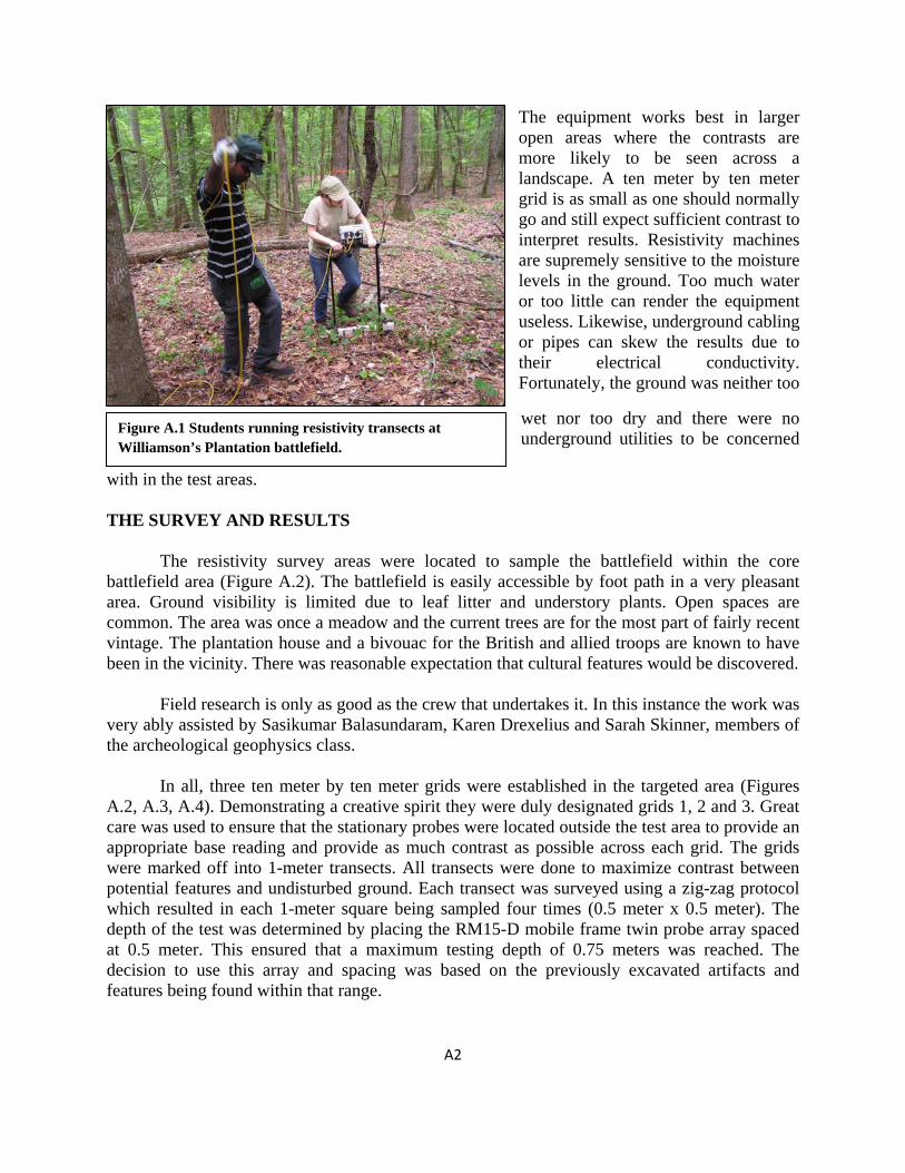
A2
Figure A.1 Students running resistivity transects at Williamson’s Plantation battlefield.
The equipment works best in larger open areas where the contrasts are more likely to be seen across a landscape. A ten meter by ten meter grid is as small as one should normally go and still expect sufficient contrast to interpret results. Resistivity machines are supremely sensitive to the moisture levels in the ground. Too much water or too little can render the equipment useless. Likewise, underground cabling or pipes can skew the results due to their electrical conductivity. Fortunately, the ground was neither too
wet nor too dry and there were no underground utilities to be concerned
with in the test areas. THE SURVEY AND RESULTS The resistivity survey areas were located to sample the battlefield within the core battlefield area (Figure A.2). The battlefield is easily accessible by foot path in a very pleasant area. Ground visibility is limited due to leaf litter and understory plants. Open spaces are common. The area was once a meadow and the current trees are for the most part of fairly recent vintage. The plantation house and a bivouac for the British and allied troops are known to have been in the vicinity. There was reasonable expectation that cultural features would be discovered. Field research is only as good as the crew that undertakes it. In this instance the work was very ably assisted by Sasikumar Balasundaram, Karen Drexelius and Sarah Skinner, members of the archeological geophysics class. In all, three ten meter by ten meter grids were established in the targeted area (Figures A.2, A.3, A.4). Demonstrating a creative spirit they were duly designated grids 1, 2 and 3. Great care was used to ensure that the stationary probes were located outside the test area to provide an appropriate base reading and provide as much contrast as possible across each grid. The grids were marked off into 1-meter transects. All transects were done to maximize contrast between potential features and undisturbed ground. Each transect was surveyed using a zig-zag protocol which resulted in each 1-meter square being sampled four times (0.5 meter x 0.5 meter). The depth of the test was determined by placing the RM15-D mobile frame twin probe array spaced at 0.5 meter. This ensured that a maximum testing depth of 0.75 meters was reached. The decision to use this array and spacing was based on the previously excavated artifacts and features being found within that range.
A3
Each grid was successfully tested although the results were very few. Grids 1 and 3 showed erosion and animal disturbance, but no significant anomalies. However, Grid 2 produced an anomaly that might be linked to a small shed or other building. It is important to note that an anomaly is only an anomaly until it is excavated and tested.
Figure A.2 Location of resistivity grids, 1, 2, 3, Williamson’s Plantation battlefield.

A4
Figure A.3 Resistivity grids 1 and 2. Arrow points to anomaly.
Figure A.3 Close up of resistivity grid 3.

A5
REFERENCES CITED English Heritage 2008 Geophysical Survey in Archaeological Field Evaluation. English Heritage Press. Gaffney, Chris and John Gater 2003 Revealing the Buried Past: geophysics for archaeologists. Tempus Publishing Ltd, Stroud Gloucestershire. Somers, Lewis 2006 “Resistivity Survey” in Remote Sensing in Archaeology: an explicitly North American perspective. Jay K. Johnson, editor. pp. 109-129, University of Alabama Press, Tuscaloosa, Alabama.

A6

Artifact Catalog Williamson’s Plantation (38YK564)
2010
Williamson’s Plantation Battlefield—Metal Detecting Provenience # Description Quantity 001 Lead shot, dropped, 22.2 g Charleville, .636” 1 002 Shoe buckle frame fragment, brass, oval ?, 2.4 g 1 003 Lead shot, buckshot, dropped, , 2.2 g, standard, .301” 1 004 Iron fragment, possible knife blade, 3.1g, 55 x 20.69 mm 1 005 Nail, iron, wrought, 19.8 g, 69.22 mm 1 006 Hoe blade, iron, eye fasting, forged, blade 119 x 115 mm 1 007 Lead shot, fired, gun or rifle, .454” 7.3 g, (p.d. .432”) 1 008 Button, brass, iron shank, 25.02 mm, 3.1g, South type 7 1 009 Spring, iron, two iron flanges, 94 x 21 mm, 38.5 g 1 010 Button fragment, brass, iron shank, radius, 15.46 mm,
flat, South type 9 1
011 Lead shot, fired, 13.5 g, rifle or gun (p.d. .531”) 1 012 Shoe buckle fragment (quarter), brass, decorated, 37.4
mm, 3.0 g 1
013 Lead shot, fired, rifle, wood impact, 15.0 g (p.d. .550”) 1 014 Button, brass, brass shank, front dimpled, 16.52 mm,
South type 8 but no seam 1
015 Lead sheet, flat, 9.7 g 1 016 Lead shot, fired, rifle or large buckshot, 5.2 g (p.d. .386”) 1 017 Nail, iron, clinched, 60.32 mm, 6.1 g 1 018 Nail, iron, cut but head may be wrought, 51.11 m, 8.7 g 1 019 Triangular brass fragment, 23.5 x 13.4 mm,1.2 g,
possible arrowhead 1
020 Unid. Nail fragment, possibly cut, 66.4 mm, 21.2 g 1 021 Lead shot, fired, rifle patch mark, 13.0 g, (p.d..524”) 1 022 Door strap hinge, iron, large, forged, 1 023 Iron, horse shoe fragment, appears wrought, worn at toe,
120.19 mm, 71.5 g 1
024 22 bullet discarded in laboratory 1 025 Lead shot, buckshot, fired, 2.6 g (p.d. .306”) 1 026 Wagon Wheel hub, Historic Brattonsville has 1 027 Iron, single tree hook, 130 x 67 mm 1 028 Lead shot, buckshot, dropped, mold seam, sprue, 3.02”,
2.5 g standard 1
029 Copper tubing, 58.77 mm 1 030 Brass, sheet fragment, 27.89 mm 1

B-2
031 Button, brass, sleeve, flat button fragment (missing) 1 032 Shoe buckle fragment, decorated, 21.86 mm, .9 g, also
unid iron fragment, .7 g 1
033 Lead shot, buckshot, dropped, sprue, 1.2 g, (p.d. .2371”) 1 034 Spoon handle fragment, pewter, 13.5 g, 56.87 mm 1 035 Mule shoe, half, iron, 151.9 g, 140.9 mm length, 11.03
mm width 1
036 Shoe buckle fragment, brass, 2.9 g, 39.79 mm 1 037 Lead shot, fired, rifle, 10.2 g, chewed, (p.d. .484”) 1 038 Lead shot, ?, probable rifle, badly chewed, 5.8 g, (p.d.
.401”) 1
039 Lead shot, fired, imbedded quartz fragments, Charleville, 21.3 g, (p.d. .618”)
1
040 Pewter shot, buckshot, 1.8 g 1 041 Lead shot, buckshot, modern, discarded 1 042 Strap fragment, unid. brass, .6 g, 17.33 mm 1 Area A--Metal Detecting Provenience # Description Quantity Area A- 001 Door Knob, Brass, 62.9 g 1 A-002 Possible sword pommel, brass, 73.8 g, 67.80mm, or
possible bedpost knob. 1
A-003 Lead shot, fired, rifle ball, patched, 4.0 g (p.d. .354” ) 1 A-004 Lead shot, reinactor ball, fired, 34.0 g 1 A-005 Lead shot, reinactor ball, fired, 34.5 g 1 A-006 Lead shot, fired, rifle or gun, 5.6 g (p.d. .396”) 1 A-007 Button, flat, 19th century back decorated, 20.09 mm,
South type 18 1
A-008 Door lock plate, Iron key escutcheon 1 A-009 Unid. Iron, possible agricultural tool fragment 1 A-010 Hoe, Iron, eye, blade 150 x 84 mm, worn 1 A-011 Lead shot, mini ball, burnside cartridge, 23.8 g 1 A-012 Thimble, brass, 2.2 g, 21.85 mm height, 16.83 mm base
diameter 1
A-013 Button, flat, sleeve, iron shank, South Type 7, 17.15 mm 1 Rally Point—Metal Detecting R-001 Lead shot, fired, rifle or gun, 7.8 g (p.d. .442’) 1 R-002 Lead shot, dropped, rifle, mold seam, crude sprue, 8.2
(p.d. .450”) 1

B-3
Neely Property—Metal Detecting N-001 Lead shot, rifle or gun, fired, 14 g (p.d. .537”), and strap
guide, D shaped, 29.70 x 20.66 mm 1
N-002 Lead shot, fired, rifle, cut, 8.1 g 1 N-003 Lead shot, rifle or gun, 9.0 g (.p.d. .464”) 1 Williamson’s Plantation--Excavation Units
N625/E514 1 x 2 (E/W) No Artifacts N625/E506 1 x 2 (E/W) No Artifacts N625/E468 1 x 2 (E/W)
Historic Level Description Quantity 1 Ceramic sherd, possible colono-ware 1 2 Pearl, cultured, 7.48 mm x 6.35 mm diameter 1
Prehistoric Level Description Quantity 1 Quartz flake 1 1 Chert flake 2 1 Ceramic sherd, prehistoric, rim, curvi-linear decorated 1 2 Quartz flake 1 2 Chert flakes 2 2 Projectile Point, quartz, Yakin, tip broken, 34.70 mm, base 27.77
mm 1
N625/E457 1 x 2 (E/W)
Historic Level Description Quantity 1 Unid. iron sheet, 1.8 g, 23.52 mm (cotton bale band?) 1
Prehistoric Level Description Quantity 1 Quartz flake, possibly utilized 1

B-4
N614/E532 1 x 1
Historic Level Description Quantity 1 Earthenware, red lead glaze 12 1 Glass, clear 3 1 Glass, green, flat 1 1 Brick, fragments 12
Other
1 Bone, unid. 1
Prehistoric Level Description Quantity 1 Quartz flakes 28 1 Chert, flakes 2 1 Ceramic, sherd, plain, eroded 1 N612/E533 1 x 1
Historic Level Description Quantity 1 Earthenware, red 4 1 Nail, tip, forged 1 1 Brick fragment 1 1 Metal, unid.. flat strap? 2
Prehistoric Level Description Quantity 1 Quartz flakes 12 1 Chert, flakes 2

B-5
N612/E531 2 x 2
Historic Level Description Quantity 1 Earthenware, red, sherds 21 1 Glass, ring setting sky blue 1 1 Lead, sprue 1 1 Pewter, melted 1 1 Brick, ?, daub? 6 2 Brick, ?, daub? 7 2 Nail, appears to be cut, 49.55 mm 1 2 Earthenware, red, sherds 9 2 Button, brass, flat, small fragment 1
Prehistoric
Level Description Quantity 1 Quartz flakes 112 1 Quartz, bifaces 4 2 Chert flakes 2 2 Quartz flakes 58 2 Quartz, biface 1
Other 1 Bone, unid. 9 1 Rock, red, unid. 1 N612/E529 2 x 2 m
Historic
Level Description Quantity 1 Unid. Iron fragment 1 1 Earthenware, red lead glazed 5 1 Earthenware, no glaze, body sherds 3 1 Glass, bottle, green, eroded 1 1 Unid., Iron fragments, possibly nail fragments 2 1 Brick fragments, less than dime size, eroded 10 1 Unid., bone 1 1 Clay, burned, ? 2

B-6
Prehistoric Level Description Quantity 1 Quartz flakes 6 N600/E520 2 x 2 m
Historic Level Description Quantity 1 Unid., iron fragments 1 Brick fragments, less than dime size, eroded 10 Slag nodules 14 Nail heads, wrought 2 Button, brass, flat, sleeve, plain, South Type 7, 17.14 mm 2 Unid. bone 1
Prehistoric Level Description Quantity 1 Quartz flake 2 1 Chert flake 1 Ceramic, prehistoric, Deptford, eroded 12 N599/E529 (1 x 2) (E/W)
Historic Level Description Quantity 1 Nail, clinched (excellent example) 64.80 mm 1
Prehistoric Level Description Quantity 1 Quartz biface 1 1 Rhyolite, flakes 4 1 Quartz flakes 37

B-7
N599/E524 1 x 2 (E/W)
Historic Level Description Quantity 1 n/a 0
Prehistoric Level Description Quantity 1 Quartz biface 1 1 Quartz scraper 1 N594/E520 1 x 2 (E/W)
Historic Level Description Quantity 1 Glass, clear 1 1 Glass, light green 1 1 Glass, dark green, not black 1
Prehistoric Level Description Quantity 1 quartz flakes 5 N583/E520 1 x 2 Negative N583/E530 1 x 1 Negative N555/E520 1 x 2 (E/W)
Historic Level Description Quantity

B-8
1 Glass, dark brown 1 1 Brick fragments 12 1 Earthenware, red (tiny, less than corn kernel size) 1
Prehistoric Level Description Quantity 1 Quartz flakes 9 N554/E498 1 x 2 (N/S)
Historic Level Description Quantity 1 N/a 0
Prehistoric Level Description Quantity 1 Quartz flakes 2 N544/E532 2 x 2 m
Historic Level Description Quantity 1 Brick fragments, most less than dime size, 3 larger 107 1 Ceramic, possibly colono-ware 2
Prehistoric Level Description Quantity 1 See above colono-ware undecorated prehistoric sherds 2 N530/E518 1 x 2 (E/W)
Historic
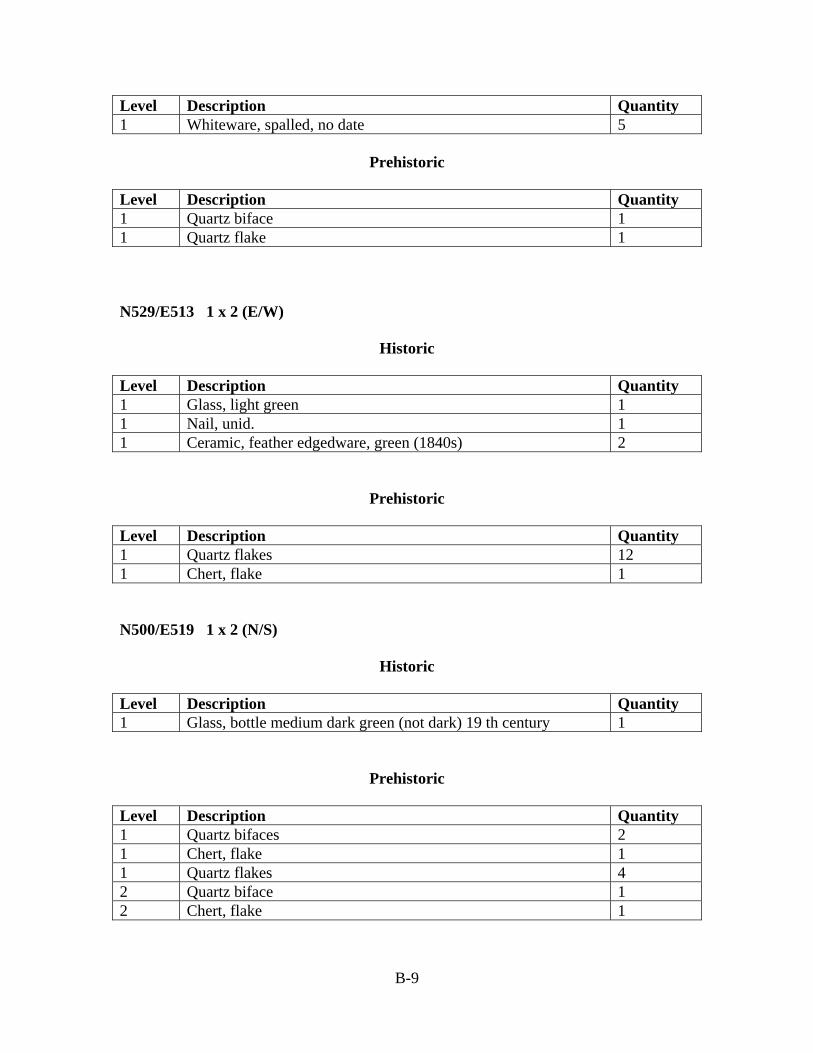
B-9
Level Description Quantity 1 Whiteware, spalled, no date 5
Prehistoric Level Description Quantity 1 Quartz biface 1 1 Quartz flake 1 N529/E513 1 x 2 (E/W)
Historic Level Description Quantity 1 Glass, light green 1 1 Nail, unid. 1 1 Ceramic, feather edgedware, green (1840s) 2
Prehistoric Level Description Quantity 1 Quartz flakes 12 1 Chert, flake 1 N500/E519 1 x 2 (N/S)
Historic Level Description Quantity 1 Glass, bottle medium dark green (not dark) 19 th century 1
Prehistoric Level Description Quantity 1 Quartz bifaces 2 1 Chert, flake 1 1 Quartz flakes 4 2 Quartz biface 1 2 Chert, flake 1

B-10
Williamson’s Plantation 2010 Shovel Tests and Beyond
N500 Line N500/E525 negative N500/E530 negative N500/E535 negative N500/E540 negative N500/E545 negative N510 Line N510/E525 17 quartz flakes, 1 chert flake (bag missing) N510/E530 12 quartz flakes, 1 chert flake N510/E535 7 quartz flakes N510/E540 7 quartz flakes N510/E545 negative N510/E550 negative N530 Line N530/E525 6 quartz flakes (bag missing) N530/E530 2 quartz flakes N530/E535 4 quartz flakes, one prehistoric sherd undecorated N530/E540 2 quartz flakes (bag missing) N530/E545 6 quartz flakes, 1 chert flake N530/E555 negative N530/E560 negative N530/E565 negative N530/E570 negative N535 Line N535/E560 negative N535/E565 negative N535/E570 negative N580 Line N580/E460 negative N580/E465 negative N580/E470 negative N580/E475 negative N580/E480 negative

B-11
N580/E485 negative N580/E590 negative N580/E595 negative N580/E500 negative N612 Line N612/E526 negative N612/E534 2 red earthenware sherds, 1 quartz scraper N612/E530 negative N612/E536 negative N612/E541 1 quartz scraper N612/E546 1 glass fragment, possible canning lid, clear E520 Line N500/E520 4 quartz flakes N505/E520 negative N510/E520 negative N515/E520 negative N520/E520 1 large pink quartz cobble N525/E520 negative N530/E520 1 chert flake, 1 whiteware sherd N535/E520 3 quartz flakes N540/E520 negative N545/E520 negative N550/E520 negative E525 Line N510/E525 13 quartz flakes, 1 chert flakes N530/E525 4 quartz flakes E530 Line N530/E530 1 quartz flake
N589/E530 1 chert flake N594/E530 negative N599/E530 negative N604/E530 negative N609/E530 2 quartz flakes, 1 possible colonoware sherd N614/E530 negative N619/E530 negative N624/E530 negative N629/E530 negative N634/E530 negative

B-12
E541 Line
N602/E541 negative N607/E541 negative N617/E541 negative N622/E541 negative
E580 Line N550/E580 negative N565/E580 negative Other STs N540/E565 negative N575/E465 negative N585/E470 negative N590/E470 1 prehistoric sherd, eroded N595/E590 1 quartz flake N623/E500 negative N623/E510 negative N633/E500 negative N633/E510 negative N643/E510 negative Four STs 10 meter interval bearing 222º magnetic from N580/E470 all negative
Four STs 10 meter interval up side of ascending road. First ST @ N613/E500 all negative Thirty Meter Interval STs along ridge west of Williamson’s Plantation
Transect 1, STs 1 through ST 7 negative Transect 2 STs 1 through 6 negative
Trash Dump (38YK565) N515/E500 negative N500/E500 1 marble, green, modern N500/E515 1 alkaline glazed sherd green (missing) N485/E500 negative N500/E485 negative
Stone Foundation
N495/E500 1 plow blade, two cut nails

B-13
N500/E495 negative N500/E505 negative N505/E500 negative
Tenant Site (38YK566)
N505/E500 1 clear (amethyst) glass, 1 notched flake N500/E505 1 whiteware sherd N500/E495 negative N495/E500 negative

B-14
Williamson’s Plantation/Huck’s Defeat Catalog 2006 April, 2006 Field Effort: NUMBER DESCRIPTION QTY. 01 Modern lead shot, .75 cal. musket balls, fired.
Modern lead shot, .36 to .54 cal. rifle/pistol balls, fired. Modern clay pipe stem fragment.
12 27 1
02 001 001 Pewter spoon bowl fragment, 7.5g. 1 02 002 001 Lead shot, fired and chewed, 14.7g (probable rifle ball, p.d. .546”). 1 02 002 002 Brick fragment, 77.0g. 1 02 003 001 Iron two-tine fork, complete shank and shaft, missing tines,
102.3mm. 1
02 004 001 Lead shot, fired, 4.5g, wood impact (probable rifle ball, p.d. .368”).
1
02 005 001 Lead shot, fired, 7.7g (probable rifle ball, p.d. .440”). 1 02 006 001 Modern lead shot - discarded. 1 02 007 001 Wrought iron barrel band fragment, with join hole, 96x23mm. 1 02 008 001 Wrought nail. 1 02 009 001 Iron heel tap (?) fragment, 75.3mm. 1 02 010 001 Button, brass, South Type 18, 19.5mm (backmark
“EXTRA…GILT..” etc., partially illegible). 1
02 011 001 Iron vessel (frying pan?) fragment, with nail hole, approx. 84x63mm.
1
02 012 001 Lead shot, chewed, 29.8g (.75 cal. musket ball, p.d. .692”). 1 02 013 001 Iron frame buckle, 35x33mm. 1 02 014 001 Wrought iron spike head, dia. Approx. 30mm. 1 02 015 001 Wrought iron tool, blade and shank, unfinished forging, 163mm. 1 02 016 001 Brass trigger guard fragment, trimmed and re-worked, 50mm. 1 02 017 001 Lead shot, fired, 11.4g, with rifling marks, soil impact (rifle ball,
p.d. .502”). 1
02 018 001 British halfpenny (?), worn entirely smooth, marked with a scratched “x,” 26.8mm.
1
02 018 002 Quartz flake, retouched. 1 02 019 001 Lead shot, deliberately battered and faceted, 12.1g (probable rifle
ball, p.d. .512”). 1
02 020 001 Melted pewter, 7.7g. 1 02 021 001 Shoe buckle frame fragment, tombac (?), from plain oval frame,
max. length 28.8mm. 1
02 022 001 Pewter spoon handle fragment, 8.9g. 1 02 022 002 Melted pewter, 19.1g. 1 02 023 001 Lead shot, fired, 15.6g, wood impact (probable rifle ball, p.d.
.557”). 1

C-2
02 024 001 Button, tombac, South Type 7, convex, 28.8mm, iron shank missing.
1
02 025 001 Melted pewter, 18.4g. 1 02 026 001 Pewter spoon bowl fragment, 5.5g. 1 02 027 001 Button, tombac, South Type 7, convex, 17.8mm, shank missing. 1 02 028 001 Shoe buckle frame fragment, tombac, corner from a plain,
rectangular frame, max. length 28.5mm. 1
02 029 001 Button, tombac, South Type 7, convex, 25.3mm, iron shank missing.
1
02 030 001 Lead shot, fired, 11.0g, wood impact (probable rifle ball, p.d. .496”).
1
02 031 001 Wrought iron barrel band fragment, join end with hole, 25x89mm. 1 02 032 001 [number not used]. 02 033 001 Bridle boss, silver plated brass disc, 43mm, with brass wire
attachment bar soldered on reverse. 1
02 034 001 Iron ring from bit or hame, with fragment of attachment, dia. Approx. 53mm.
1
02 035 001 Lead shot, fired, 15.5g, with rifling marks (?), wood impact (probable rifle ball, p.d. .556”).
1
02 036 001 Lead shot, fired, 15.7g, wood impact (probable rifle ball, p.d. .558”).
1
02 037 001 Melted pewter, 8.9g. 1 02 038 001 Melted pewter, 17.8g. 1 02 039 001 Brass frame buckle with crossbar, rectangular with one end
rounded, 27x37mm, tongue missing. 1
02 040 001 Wrought nail. 1 02 041 001 Pewter spoon handle, nearly complete but badly exfoliated and in
two pieces, length 121mm, 31.2g. 1
02 042 001 Wrought nail. 1 02 043 001 Button, pewter, South Type 29, octagonal, 16.5mm, with
geometric design, iron shank missing. 1
02 044 001 Wrought iron barrel band fragment, with join end, 64x24mm. 1 02 045 001 Shoe buckle frame fragment, brass(?), from oval frame with
engraved filigree decoration, max length 25mm. 1
02 045 002 Pewter spoon bowl fragment, 6.5g. 1 02 046 001 Button, tombac, South Type 7, nearly flat, 26.8mm. 1 02 047 001 Brass thimble, base dia. 14mm, height 14.6mm. 1 02 048 001 Wrought horse shoe, approx. 65% complete (probably 18th
century). 1
02 049 001 Wrought iron pintle, length of body 155mm, length of shaft (as exposed) 51mm.
1
02 050 001 Lead shot, chewed, 4.7g (probable rifle ball, p.d. .373”). 1 02 051 001 Wrought nail. 1 02 052 001 Lead shot, chewed, 20.1g (probable rifle ball, p.d. .606”). 1 02 053 001 Wrought nail. 1

C-3
02 054 001 Melted pewter, 7.6g. 1 02 055 001 Knee buckle frame, brass, rectangular, fine pierced filigree
decoration (cast), with traces of silver plate or wash, 33.3x29.6mm.
1
02 056 001 Melted pewter, 10.9g. 1 02 057 001 Lead shot, fired, 8.8g (probable rifle ball, p.d. .460”). 1 02 058 001 Pewter spoon handle fragment, 2.8g. 1 02 059 001 Lead shot, fired, 10.5g (probable rifle ball, p.d. .488”). 1 02 060 001 Cast iron andiron foot, max. length 68.7mm. 1 02 061 001 Wrought iron frame buckle, rectangular, 22x35mm. 1 02 062 001 Shoe buckle frame, brass, about 80% of a plain, oval frame,
50.5x40mm. 1
02 063 001 Wrought nail. 1 02 064 001 Wrought nail. 1 02 065 001 Wrought horse shoe, approx. 50% complete (possibly 18th
century). 1
02 066 001 Shoe buckle frame fragment, brass(?), from oval frame with cast dot and line decoration, max. length 29.3mm.
1
02 067 001 Carved lead pencil, bent at right angle, 8.1g, 50mm (if straight). 1 02 068 001 Melted pewter, 2.2g. 1 02 069 001 Cast iron vessel (griddle?) loop handle. 1 02 070 001 Shoe buckle frame fragment, tombac, corner from a rectangular
frame with a stamped concentric circle decoration, max. length 25.1mm.
1
02 071 001 Guilford projectile point, quartz, length 43mm, width 20mm. 1 02 071 002 Wrought nail. 1 02 071 003 UID sheet iron object, rectangular, 36x18mm (knife handle mount
for 02 071 004?). 1
02 071 004 Iron knife blade with portion of shank, complete but in two pieces, 82mm.
1
December, 2006 Field Effort: 02 072 001 Lead shot, fired, 9.5g, wood impact (probable rifle ball, p.d.
.472”). 1
02 073 001 Lead shot, fired, 14.3g, wood impact (probable rifle ball, p.d. .541”).
1
02 074 001 Lead shot, lightly chewed, possibly unfired, 5.6g (probable rifle ball, p.d. .396”).
1
02 075 001 Lead or lead alloy slag, 12.6g. 1 02 076 001 Button, brass, South Type 18, 12.8mm (backmark illegible). 1 02 077 001 Lead shot, fired, 15.1g, wood impact (probable rifle ball, p.d.
.551”). 1
02 078 001 Lead shot, fired, 12.8g, wood(?) impact (probable rifle ball, p.d. .522”).
1

C-4
02 079 001 Lead shot, 4.5g, badly chewed (probable rifle ball, p.d. .368”). 1 02 080 001 Lead shot, fired, 12.3g, wood impact (probable rifle ball, p.d.
.515”). 1
02 081 001 Keg tap/cock fragment (?), threaded copper alloy cylinder, max. length 56.7mm.
1
02 082 001 Lead shot, fired, 17.8 g, smoothbore barrel mark (probable carbine or pistol ball, p.d. .582”).
1
02 083 001 Lead object, 17.7g, lead shot(?) flattened and battered into a teardrop shape, possible a fishing sinker.
1
Former “Area 03” Artifacts 03 001 001 through 03 007 001 (April 2006). 02 084 001 Lead shot, fired, 16.7g, with patch marks, wood impact (rifle ball,
p.d. .570”). 1
02 085 001 Lead shot, fired, 7.5g, wood impact (probable rifle ball, p.d. .436”) 1 02 086 001 Lead shot, fired, 20.6g, wood impact, rodent knawing (probable
rifle ball, p.d. .611”). 1
02 087 001 Iron table knife blade tip, 57mm. 1 02 088 001 Wrought iron hame mount (loop), complete but in two pieces,
max. length 76mm. 1
02 089 001 Wrought iron harness hardware, trace chain (?) terminal link with hook, max. length 75mm.
1
02 090 001 Wrought horse shoe, complete, length 119mm, width 107mm (possibly 18th century).
1
Related Documents