1 Defended Cornwall Introduction Although Cornwall’s history cannot be said to be especially bloody many buildings and monuments survive which were constructed during times of danger or in response to hostility and war. Six thousand years ago during the Neolithic period large hill top enclosures were built at several places. These tor enclosures, as they are known, are generally thought to have been ceremonial sites and symbols of cultural identity. Their hill top locations and the substantial stony banks which surrounded them suggest that they may also have served as defended refuges in times of conflict. One of them, at Carn Brea near Camborne, was the scene of a major battle after which the enclosure was no longer used. Similarly the large enclosures of the Iron Age, hillforts and cliff castles, may also have served as defended strongholds although they also were used in other ways as well. Restormel Castle. An eleventh century ringwork castle with a thirteenth century shell keep. Photo © English Heritage. NMR23511/11 Certainly some castles were defended sites. The earliest medieval castles were fortified strongholds built by Norman Lords in the eleventh and twelfth centuries and provided protection from neighbouring hostile groups in a politically unstable realm. These castles were powerful symbols of the feudal system and were used as bases for troops to keep order in the surrounding countryside. Some later castles, however, dating from the thirteenth and fourteenth centuries, were little more than fortified houses. These later castles can be seen as status symbols of their owners rather than as strongholds or administrative centres.

Welcome message from author
This document is posted to help you gain knowledge. Please leave a comment to let me know what you think about it! Share it to your friends and learn new things together.
Transcript
1
Defended Cornwall Introduction
Although Cornwall’s history cannot be said to be especially bloody many buildings and monuments survive which were constructed during times of danger or in response to hostility and war. Six thousand years ago during the Neolithic period large hill top enclosures were built at several places. These tor enclosures, as they are known, are generally thought to have been ceremonial sites and symbols of cultural identity. Their hill top locations and the substantial stony banks which surrounded them suggest that they may also have served as defended refuges in times of conflict. One of them, at Carn Brea near Camborne, was the scene of a major battle after which the enclosure was no longer used. Similarly the large enclosures of the Iron Age, hillforts and cliff castles, may also have served as defended strongholds although they also were used in other ways as well.
Restormel Castle. An eleventh century ringwork castle with a thirteenth century shell keep. Photo © English Heritage. NMR23511/11 Certainly some castles were defended sites. The earliest medieval castles were fortified strongholds built by Norman Lords in the eleventh and twelfth centuries and provided protection from neighbouring hostile groups in a politically unstable realm. These castles were powerful symbols of the feudal system and were used as bases for troops to keep order in the surrounding countryside. Some later castles, however, dating from the thirteenth and fourteenth centuries, were little more than fortified houses. These later castles can be seen as status symbols of their owners rather than as strongholds or administrative centres.
2
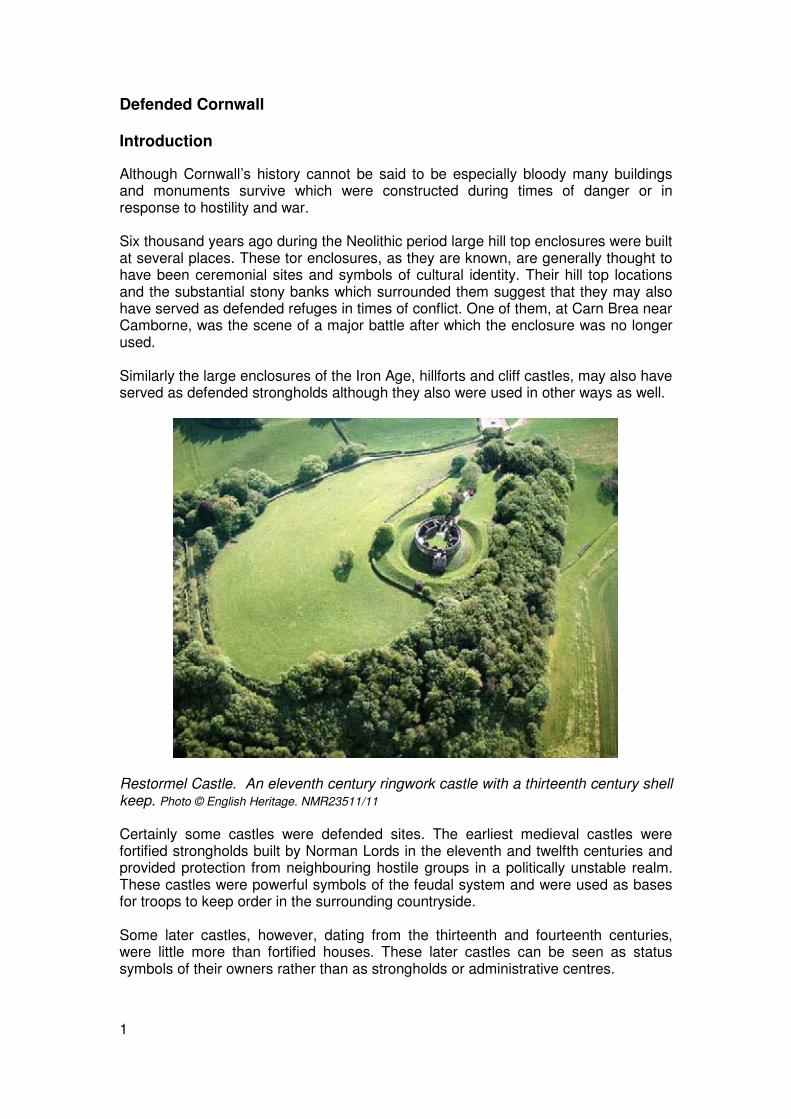
Cornwall’s position guarding the western approaches to the Channel was of enormous strategic importance and from the sixteenth century onwards many phases of coastal defence building were undertaken in response to successive threats from abroad. During the first half of the sixteenth century, when England’s coasts were subjected to French raids, Henry VIII built a string of artillery forts, known as blockhouses, stretching from Scilly in the west to Mount Edgcumbe in the east and at the same time the deep water harbour at Falmouth was protected with two larger fortresses at Pendennis and St Mawes.
St Mawes Castle, one of a pair of Device Forts built by Henry VIII to guard the approaches to Falmouth harbour. On the shore below the castle is a blockhouse (a small artillery fort) designed to attack any ships that managed to slip under the first line of defence. Photo: Jeanette Ratcliffe
Elizabeth I, faced with the increasing hostility of Spain, strengthened the fort at Pendennis by adding a massive bastioned earthwork, and commissioned the construction of Star Castle on Scilly. These fortifications were enhanced during the eighteenth century, when many of the nationally important defences on St Mary’s, Scilly’s main island, were built. There was further internal conflict with the outbreak of Civil War in the middle of the seventeenth century. Cornwall was held by Royalist forces and there are a number of battlefield sites in east Cornwall. During the conflict many fortifications were re-used, including medieval castles, Tudor forts, even Iron Age hillforts. However most of the defences built during the Civil War were earthworks and few survive today. The threat of invasion by France at the end of the eighteenth century led to the rearming of existing coastal fortifications, the building of a series of redoubts at Maker Heights, overlooking Plymouth Sound, and the construction of a new coastal battery on St Anthony Head to bolster the defences of Falmouth.

3
In the second half of the nineteenth century advances in naval technology and the re-emergence of a threat from France led to a major phase of fort construction in Cornwall. These Victorian forts were designed for the defence of the naval base at Plymouth and are known as Palmerston Forts, after the Foreign Secretary of the time.
Fort Picklecombe. This was a two-tier granite battery built on the shoreline during the 1860s as part of the programme of fort building carried out by Lord Palmerston. It is now in use as a waterside hotel. © details
The Great War of 1914-1918 brought further re-arming of coastal defences and the construction of a major airship station on the Lizard which operated as an anti-submarine base.
Whitesand Bay: one of the Palmerston forts built for the defence of Plymouth docks in the late nineteenth century. The fort was re-used during the First and Second World Wars and is now a holiday park. The chalets on the cliffs below were used to house evacuees from the heavy bombardment of Plymouth during early 1941. Photo © Cornwall County Council Historic Environment Service

4
Military installations from the Second World War were widespread and were constructed on a prodigious scale. Many of them are recorded on RAF aerial photographs taken after the war by air crews awaiting their return to civilian life. The development of aviation meant that Cornwall had to face the threat from the air as well as the sea. This new threat included aerial bombardment – and thousands of bombs fell on Cornwall in 1940 and 1941 – and airborne landings of enemy troops. Several military airfields were constructed to counter the threat from the air and anti-aircraft guns were stationed around key strategic targets such as Falmouth docks. Decoy sites, laid out to resemble airfields and towns by night, were placed in open country to try and fool the German bombers. Ports were heavily defended and beaches were mined and protected by barbed wire, gun emplacements and pillboxes in readiness to meet the expected seaborne invasion force. The speed of twentieth century warfare meant that if a landing was successful it would be followed by a rapid advance through the countryside. The whole of Cornwall became a fortress, with fortified lines of pillboxes, anti-tank obstacles and defended road blocks. In the event the invasion never came and after 1941 British forces moved onto the offensive. Attacks on German shipping and on the occupied ports of France were mounted from Cornwall’s airfields. Later the airfields expanded and became the jumping off points for aircraft, troops and supplies being ferried to the war zones of Africa and the Mediterranean. In 1944 thousands of troops, tanks and equipment were shipped from specially constructed embarkation points in Cornwall to the beaches of Normandy as part of the Allied invasion of mainland Europe. In the months leading up to D Day, the first day of the invasion, these troops were housed in tents forming makeshift camps which lined the roads around Truro and Chacewater.
Maker Heights, overlooking Plymouth Sound. Two earthwork redoubts (enclosed defensive works) built in the 1770s lie towards the top left of this photo. Towards the centre and lower right are the remains of two more eighteenth century redoubts. In the top right corner is a Victorian battery, and on the site of the 1770s redoubts is a Second World War camp. This provided accommodation for the crew of an anti-aircraft battery whose gun emplacements are the horse-shoe arrangement of mounds in the upper centre of the photo. This view is a good example of how many of the defensive sites in Cornwall were strengthened, re-armed and re-used during successive periods of conflict. © English Heritage (NMR) RAF Photography: CPE/UK/1890/2137

5
Medieval Castles
The term ‘castle’ covers a wide range of sites, from important strongholds to status symbols of the gentry. Most of Cornwall’s castles belong to the eleventh and twelfth centuries. These were uncertain times following the Norman Conquest and castles were built by Norman Lords as powerful symbols of rank and sovereignty and as strongholds against their enemies. At the time of the Domesday Book of 1086 the most powerful Lord in Cornwall was Robert of Mortain, half-brother of William the Conqueror. He held three quarters of the manors in Cornwall and had castles at Launceston and Trematon. These castles were great strongholds and important administrative centres. The Norman Lords used their castles as bases for their troops, to keep order in the surrounding area. They were powerful symbols of the feudal system; local landowners, merchants and tenants would be required to visit the castle to pay taxes, discuss local and national affairs, and receive directives for running their estates. The imposing structure of castles and the might of their armed forces were designed to instil fear and respect in those who had to visit.
Trematon Castle, Saltash. This castle is mentioned in the Domesday Book of 1086 when it was held by Reginald de Valletort from Robert of Mortain, William the Conqueror’s half brother. It was extensively modified in the thirteenth century, and later a Regency manor house was built in its bailey area. Photo © Cornwall County Council
Historic Environment Service
Some castles served as the principal seats of important landholders, many of whom were major tenants of Robert, such as Richard FitzTurold, who had a castle at Cardinham. Other castles were the residences of lesser landholders, such as the Uptons who had a castle at Upton, or were the lesser residences of major landholders, such as Week St Mary which belonged to Richard FitzTurold. During the thirteenth and fourteenth centuries local landholders continued to build themselves fortified houses. Permission to build a castle or fortified house had to be sought from the King and five ‘Royal Licences to Crenellate’ were granted in the

6
fourteenth century. Little now survives of these houses except at Binhamy, Stratton, where a moat more than two metres deep surrounds the site of the building. Few other moated houses are known in Cornwall. None had licences to crenellate but all are associated with important landowning families. The best surviving moat is that at Penhallam, Jacobstow. It is unlikely that these moated houses differed from Cornwall’s other major manor houses. The moat can be seen in these cases as an ostentatious display of status on the part of the owners.
The turf-covered remains of walls reveal the layout of the moated manor house at Penhallam, Jacobstow. The moat itself is visible as a ring of thick, low vegetation surrounding the ruin. Photo © Cornwall County Council Historic Environment Service.
Motte and Bailey Castles Early defensive structures built by the conquering Norman Lords would often utilise an existing hill, or an area of suitable ground upon which an artificial mound could be built. This hill or mound is known as a motte and represents the strongest, most heavily fortified area of a castle site. Mottes are usually round although a few oval and square examples are known outside Cornwall. The top of the mound would be levelled flat and a defensible building such as a tower or ‘keep’ of timber or stone built on it. This building served as a residence for the castle owner and their household in times of strife. Within its walls there might be a simple layout of rooms where the household could sleep, eat and meet with their entourage, but some more elaborately designed structures denote a variety of uses for different classes of occupant. Below the motte was an enclosed courtyard called a bailey. This would house the workshops, stables, mews and accommodation for soldiers and other personnel necessary for the running of the castle. These people would include grooms, huntsmen, butchers, cooks, blacksmiths, carpenters and other craftsmen.

7
Launceston Castle has a very prominent motte on which a shell keep dates from the twelfth century. Within this is a stone tower which was added in the thirteenth century. Below the motte is an extensive bailey surrounded by a rampart on which a massive curtain wall was built in the thirteenth century. Photo © English Heritage. NMR24181/08
The way baileys were used can best be seen at Launceston where extensive excavations have revealed a well-planned layout of buildings and great density of occupation. The original garrison was housed in rows of small oval and rectangular structures with sunken floors. These were replaced in the late eleventh century by rows of closely set stone houses. Major castles such as Launceston, Trematon and Restormel contained Great Halls, and that at Launceston underwent four phases of rebuilding. The buildings within a bailey often do not survive as well as the stronghold on the motte. They would have had some protection from the walls and ditch of the bailey so are more likely to be built of timber and their purpose was utilitarian, not defensive. They were also frequently re-built as requirements changed.
Launceston castle, originally known as Dunheved, is one of the earliest documented motte and bailey castle sites in Cornwall. It is mentioned in the 1086 Domesday Book, along with a market which was moved by Robert of Mortain to the environs of the castle from nearby St Stephen-by-Launceston where it had previously been under church control. A town grew up around the castle and it had its own wall by the thirteenth century; it was the only Cornish town to have one.

8
View of Launceston Castle showing how the town has developed around it. The castle was Cornwall’s most important administrative centre from the eleventh to the thirteenth centuries. The choice of its site is of strategic importance; designed to control the main land route into Cornwall. Photo © Cornwall County Council Historic Environment Service
Six motte and bailey castles are known in Cornwall; at Launceston, Trematon, Cardinham, Tregony, Kilkhampton and East Leigh Berrys. There is a great variation in size among these: the motte at Launceston is twenty metres high, whereas that at Kilkhampton is less than ten metres. Kilkhampton may be an adulterine castle of Robert of Gloucester or the Granville family. The castle is enclosed by an elongated oval earthwork containing the small motte and two baileys.
Kilkhampton Castle makes use of a natural deep-sided ridge, evident when contours are overlain on this aerial photo. The overgrown earthworks consist of an oval enclosure containing a motte at the left end of the site and two baileys; one inner courtyard that makes up the central rectangular area and an outer bailey that faces east towards flatter ground. Cornwall County Council Licence 2007. © Geosense 2005.
9
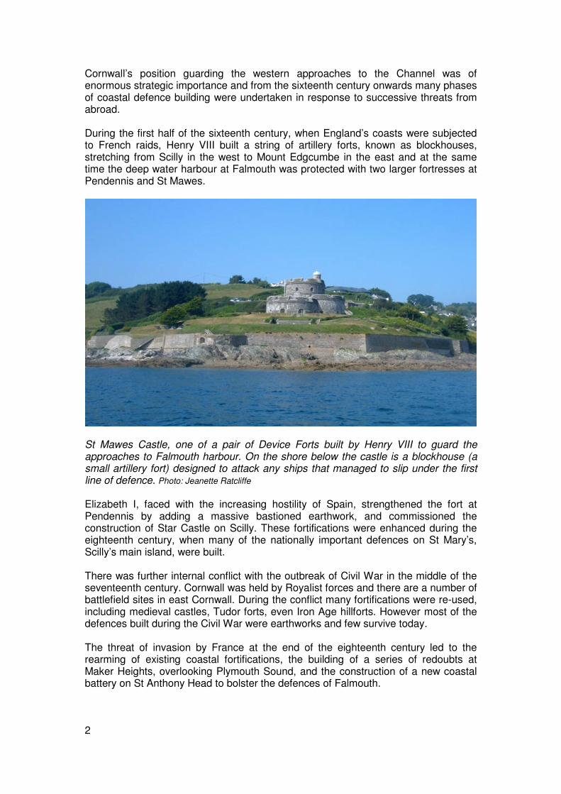
Ringworks Another style of castle-building found in Cornwall is the ringwork. Ringworks consisted of an enclosed keep built on a low earth mound surrounded by a deep ditch and bank. The choice of motte or ringwork appears to have been dictated simply by personal preference on the part of the castle builder. There are six ringwork castles known in Cornwall; Poundstock, Restormel, Week St Mary, Bossiney, Upton Castle, and Penhallam (the site of a later moated manor house probably originated as a Norman ringwork). Restormel castle is not recorded in the 1086 Domesday Book, but it is likely that a castle was built on the present site by 1100, either by Turstin the Sheriff (who was a tenant of Robert of Mortain) or his son Baldwin Fitz Turstin. As with Launceston, the choice of site was one of strategic importance for controlling the surrounding area: at Restormel the site overlooks a major crossing of the River Fowey.
At Restormel, the positioning of the castle on a spur above the valley of the River Fowey was of strategic importance: this was a major crossing-point of the river until the building of a bridge at Lostwithiel in the late twelfth century. Photo © Cornwall County Council Historic Environment Service The early structure at Restormel was probably a wooden stronghold or keep accompanied by outer buildings that were enclosed by a bailey. The keep at Restormel, rather than being placed on a high defensive mound was enclosed by a ditch cut from the surrounding bedrock. The de Cardinham family developed the castle during the twelfth century. In the thirteenth century the castle became the property of Richard, Earl of Cornwall and it then passed to his son Edmund. During Edmund’s time as Earl the administrative centre of Cornwall was moved from Launceston to Lostwithiel, increasing the castle’s importance. It is likely that the stone keep together with its interior building range, that still survives, was built during this period.

10
A reconstruction drawing of Restormel Castle as it might have looked in the thirteenth century, showing the layout of the ringwork with its deep ditch and stone shell keep, and the bailey with its range of buildings. © English Heritage Photo Library: Drawn by Terry Ball , English Heritage Graphics Team
Adulterine castles Permission had to be granted by the King before a castle could be built. This permission could also sometimes be given by a lord or earl who had the blessing of the king. If a castle was built without this licence it would be demolished. During times of uncertainty an unauthorised castle might stand for some time before the ruling monarch either had it pulled down or officially agreed it could stay. These unauthorised castles are known as adulterine castles and several are thought to have been built in Cornwall. One particularly tumultuous period was in the mid twelfth century during ‘The Anarchy’, when the death in 1135 of Henry I led to a struggle between his daughter Empress Matilda and nephew Stephen of Blois. Stephen was declared King in 1135 but upon his death in 1154 Henry II, son of Matilda, succeeded the throne. A castle built at Truro is thought be an adulterine castle put up by Richard de Lucy during Stephen’s rule, but torn down again by Henry. Another likely candidate is the earthwork at East Leigh Berrys, where the remains of a motte and two baileys survive as low earthworks. The site is not a great choice strategically since there is higher ground immediately to the north, west and east.

11
Eastleigh Berrys, Launcells. These earthworks include a low mound with a flattened profile interpreted as a motte (to the left). There is a suggestion that this was slighted or was never finished. There are two baileys to the northeast (towards the right). The site is not a good defensive choice: it is overlooked on three sides and would have been difficult to defend effectively. It is possible that this is a short-lived, perhaps never completed, castle that was built during the conflict between Matilda and Stephen, of 1135 to 1154. Cornwall County Council Licence 2007. © Geosense 2005. Other Castles Earthworks at Roundbury, Linkinhorne and Froxton Wood in North Cornwall might be further motte and bailey castles, although these may, alternatively, be prehistoric sites. The destroyed castles at Truro and Boscastel (Botreaux Castle) may have been mottes or ringworks and those recorded as having stood at Liskeard and Helston are of unknown form. Other forms of castle are represented by Ennor castle on Scilly, and at Tintagel. Ennor castle at Old Town, St Mary’s, was built in 1244 on a rock outcrop overlooking the natural harbour of Porthenor. Little survives of the building, which is said to have been robbed of its stone in order to build the Elizabethan fort of Star Castle. Documents show that in the early fourteenth century it was held by Ranulph de Blanchminster. He kept twelve men-at-arms and paid an annual rent to the king of 300 puffins or 6s 8d. Puffins were classed as fish and could therefore be eaten during lent, and their feathers were also valuable. A different type of castle is that at Tintagel. This site had been the stronghold of the Dark Age kings of Cornwall during the period from the fifth to seventh centuries. The origin of the medieval castle here is uncertain; it is possibly Norman but the surviving remains were built in the thirteenth century by Richard, Earl of Cornwall and King of the Romans. Very probably he built here because of Tintagel's powerful connection with the stories of Arthur and Tristan and Iseult. Richard spent very little time in his Earldom; he was too busy in Europe pursuing his dream of becoming Holy Roman Emperor; but he did encourage a programme of castle building as well as embellishments to older sites. One of these older sites was Trematon, a motte and bailey castle overlooking the Lynher River near Saltash.

12
First documented in the Domesday Book in 1086, it was extensively modified by Richard and then by his son Edmund.
Tintagel castle. The medieval castle, probably dating from the thirteenth century, consists of an Inner Ward straddling the neck and Lower and Upper Wards on the mainland towards the bottom left of the photo. Photo © Cornwall County Council Historic Environment Service
Another island castle is the medieval fortification on the summit of St Michael’s Mount. Most of the buildings here are part of the twelfth century priory; these were protected by the castle which had two towers, both of which still survive, along with the west range. Parts of the curtain wall, which once probably enclosed the entire summit, also survive. As well as protecting the priory the main function of the castle was to secure the Mount, whose harbour was one of the busiest in west Cornwall during the medieval period.
Threat from the sea The Tudors: Henry VIII From the Norman invasion of England until the fifteenth century, castles were sites from which a small number of militia could control the surrounding area. They were strategically placed throughout the country in order to control it from within. They also served as protection from neighbouring hostile groups in a politically unstable realm. Increasingly during the late medieval period, English security was threatened from abroad. During and beyond the Hundred Years War (1338 – 1453), the towns on the Channel coast were frequently raided by the French. Later in the sixteenth century

13
there was a constant, if low level threat from Barbary Corsairs from North Africa predating on the fishing fleets and coastal trading ships. This prompted the building of coastal defences in Cornwall and elsewhere. The most substantial of these were small artillery towers known as blockhouses. They are among the earliest examples of fortifications purpose-built to house artillery. Blockhouses were sited to cover strategic positions, and at least three in Cornwall were built before 1500.
The well-preserved blockhouse known as Little Dennis, at the foot of Pendennis Headland formed part of the defences of the natural harbour at Falmouth. This artillery fort was built by Henry VIII during the 1540s. Photo © Cornwall County Council Historic Environment Service One, built around1490, was situated on St Ives Island but has now been demolished. Two others still survive; these are the pair of structures that defend the entrance to the harbour at Fowey. They are two-storey, stone-built structures each with two gun-ports. They were built in the late fifteenth century and sat at either end of a heavy chain stretched across the harbour. Their construction was funded by the Treffrys, a wealthy local family. Elizabeth Treffry is said to have poured boiling oil over the heads of French pirates when they attacked the port. A new blockhouse overlooking the two earlier structures at Fowey was built at St Catherine’s Point during the main phase of blockhouse construction in the first half of the sixteenth century. A small square tower was constructed on the shore at Mount Edgcumbe around 1540. Most of these fortifications were built by Henry VIII, the second Tudor king. During his reign from 1509 to 1547, he energetically built up an effective navy which began to challenge the maritime supremacy of Spain. He also oversaw an extensive programme of coastal defence building. As part of this programme blockhouses were sited all along the south coast of Cornwall and in the Isles of Scilly.
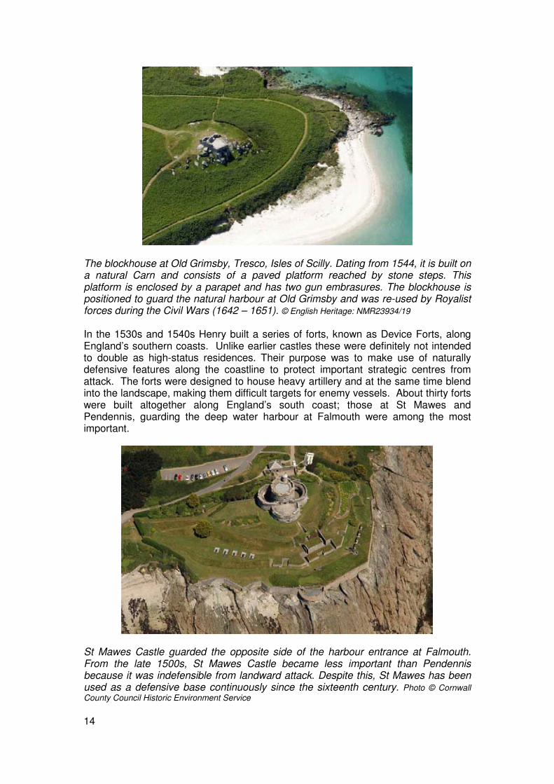
14
The blockhouse at Old Grimsby, Tresco, Isles of Scilly. Dating from 1544, it is built on a natural Carn and consists of a paved platform reached by stone steps. This platform is enclosed by a parapet and has two gun embrasures. The blockhouse is positioned to guard the natural harbour at Old Grimsby and was re-used by Royalist forces during the Civil Wars (1642 – 1651). © English Heritage: NMR23934/19 In the 1530s and 1540s Henry built a series of forts, known as Device Forts, along England’s southern coasts. Unlike earlier castles these were definitely not intended to double as high-status residences. Their purpose was to make use of naturally defensive features along the coastline to protect important strategic centres from attack. The forts were designed to house heavy artillery and at the same time blend into the landscape, making them difficult targets for enemy vessels. About thirty forts were built altogether along England’s south coast; those at St Mawes and Pendennis, guarding the deep water harbour at Falmouth were among the most important.
St Mawes Castle guarded the opposite side of the harbour entrance at Falmouth. From the late 1500s, St Mawes Castle became less important than Pendennis because it was indefensible from landward attack. Despite this, St Mawes has been used as a defensive base continuously since the sixteenth century. Photo © Cornwall County Council Historic Environment Service

15
The Isles of Scilly were particularly important as the most westerly anchorage and first landfall for naval ships and merchantmen. King Charles Castle was built between 1548 and 1554 to defend the anchorage at New Grimsby. The construction of a fort (Harry's Walls) was begun on St Mary’s to defend the harbour but was never completed, and three blockhouses were built on the Islands.
A large blockhouse or artillery fort on Castle Down, Tresco. The fort is known as ‘King Charles’s Castle because it was re-used during the Civil Wars (1642 – 1651). It was built during the early 1550s to defend the harbour at New Grimsby. The fort was semi-hexagonal in shape; a design which provided a wide field of fire. It was originally two-storeyed to accommodate two tiers of guns covering the harbour entrance. Photo © Cornwall County Council Historic Environment Service The increased use of heavy canon during the late fifteenth and sixteenth centuries led to a new style of fortification. Curved or angled sections of walling that projected from an enclosing curtain wall provided flanking fire from gun emplacements set within them. This type of projection from a primary wall is known as a bastion. The greater the range of fire from each bastion, the more effective a defence it provided. The bastion design is characteristic in many of Cornwall’s fortresses from this time.
The partially built sixteenth century fort on Mount Flagon, St Mary’s, Isles of Scilly. Although named ‘Harry’s Walls’ the building dates from 1551, during the reign of Edward VI. Its plan – square with angled bastions at each corner - was based on an Italian design reflecting the increasing use of canon. Poor siting is probably the reason why work was abandoned on the fort. © English Heritage: NMR 23940/09

16
The Tudors: Elizabeth I Major enhancements of the coastal defences were undertaken during the reign of Elizabeth I (1558 – 1603) the last of the Tudors. In the 11 years since the death of her father, Henry VIII, England had become torn by opposing factions, the Treasury was empty, and the country was riven by religious fears and differences. Elizabeth was a moderate Protestant; following the massacre of the Huguenots she sent an army to support the French Protestants and she assisted the Spanish Netherlands (present-day Belgium) in its struggle for independence from Catholic Spain. She also refused an offer of marriage from Philip of Spain. Enraged, Philip saw the defeat of England as a crusade and launched the Armada in 1588. Following its defeat Elizabeth embarked on a substantial programme of fortifications. Plymouths’ defences were updated and guns installed at Mount Edgcumbe and Cawsand on the Cornish side of Plymouth Sound. Existing defences elsewhere on the coast were strengthened. At Pendennis, for instance, an outer line of defence on the landward side of the castle was constructed and the Henrician Device Fort was surrounded by a massive bastioned earthwork and curtain wall. This type of fortification is known as an ‘enceinte’. During this period a bastioned defence was built on St Ives Island facing the town and a battery constructed to control the channel to the entrance of Padstow harbour.
Pendennis Castle guarding the approaches to Falmouth. The headland at Pendennis is likely to have been used as a cliff castle in prehistory; its name is derived from the Cornish for ‘fort on the headland’. From the sixteenth century onwards the natural harbour at Falmouth was seen as strategically important. This artist’s reconstruction shows Henry VIII’s fort enclosed by the Elizabethan curtain wall and six-point bastion, and Pendennis Point with its blockhouse at the bottom right corner of the image. © English Heritage Photo Library

17
By the 1590s the existing defences of Scilly were clearly inadequate in the face of Spanish privateering and the threat of a second invasion fleet. From this date onwards the focus of military activity on the main island, St Mary’s, was The Hugh, a promontory overlooking the deep water channels to the island’s main harbour. This is reflected in the promontory subsequently being renamed the ‘Garrison’. In 1593 and artillery fort, Star Castle was built on the Garrison for Elizabeth by Francis Godolphin, the island’s governor. The castle is in the shape of an eight-pointed star surrounded by a dry moat. A stone bridge over the moat leads through a projecting gatehouse which would have been closed by a portcullis. The Garrison is connected to the rest of St Mary’s by a narrow isthmus. Around 1600 a curtain wall was built across the land approach from the isthmus. A number of gun batteries were incorporated into the line of the curtain and it had a gateway, and three sally ports (discreet exits which allow the defenders to "sally forth" and engage the attackers), one of which is still in use.
Star Castle, St Mary’s. Each of its eight points provided oblique fire covering the ground immediately in front of the works, so that a complete blanket of fire could be achieved. Star castle served as a prison as well as a fortress and is now an hotel. © English Heritage: NMR 23939/25 The Eighteenth Century: the rise to Empire Throughout the seventeenth and eighteenth centuries Britain was involved in many colonial and continental wars; most of these conflicts were with France. In the early 1700s a new battery was established at Crab Quay on Pendennis Headland and existing defences here and elsewhere were refurbished in response to successive invasion scares. Eighteenth century military works are particularly well-preserved on the Garrison in the Isles of Scilly. During the Spanish Wars of 1715–1750 the defences of the Garrison were transformed. The Elizabethan curtain wall dividing the Garrison from Hugh Town was rebuilt and was extended around most of the headland. The curtain wall was capable of mounting 120 guns, and the sea approaches were covered by

18
batteries and large bastions. The Garrison Gate was rebuilt in 1742 as was the magazine, known as the Rocket House, a sunken building surrounded by a blast wall.
The eighteenth century Garrison walls, St Mary’s, showing King George’s battery. Photo © Cornwall County Council Historic Environment Service
The curtain wall on the southern side of the Garrison. The approaches to Hugh Town are covered by two large bastioned gun batteries; Woolpack Battery (in the centre of the photo) and Morning Point Battery (to the right). In between these batteries are a series of ‘redans’; mini-bastions or salient angles from which soldiers could provide flanking fire. Outside the walls, between the redans are overgrown plots used by the soldiers to cultivate crops. © English Heritage: NMR 23938/11

19
Revolution and War
Cornwall’s defences were strengthened by the Duke of Richmond in the 1770s and 1780s as a precaution against the rise of the American Navy during the American War of Independence. He built redoubts and barracks at Maker Heights in East Cornwall, and these were further strengthened during the Napoleonic wars. Maker Heights were considered a vulnerable point in the defence of Plymouth because their raised position could be utilised by an attacking force to bombard the docks.
Maker Heights, overlooking Plymouth docks. two centuries of fortifications. A large eighteenth century redoubt is visible in the lower centre of this photo. In the left is a line of three more redoubts. Later fortifications at Maker Heights include late Victorian batteries and a Second World War anti-aircraft battery. © English Heritage (NMR) RAF Photography: CPE/UK/1890/2137
The French Revolution of 1789-1799 saw radical changes in French government. France had previously been an absolute monarchy. Idealist principles of citizenship and democracy, fed by the Age of Enlightenment, led to the Reign of Terror of 1793-4. This was a year of mass executions and violent upheaval throughout the country. An initially sympathetic response in Britain to the French Revolution turned to alarm at the executions of French aristocrats and clergy. In 1793 the French ambassador was expelled and France declared war on Britain. The rise of Napoleon Bonaparte during this period led to him heading an army poised to invade Britain at the end of the eighteenth century. Napoleon’s invasion plans suffered a severe setback in 1805 when his fleet was defeated at the Battle of Trafalgar, and were ended in 1815 by the French defeat at Waterloo.
Preparations in Britain against a French invasion led to the strengthening and modernising of existing defences, and the building of new defences. Coastal batteries were built at Padstow, Portreath, St Ives, Whitesand Bay, Penzance, Mousehole, Mount's Bay, St Michael's Mount, Mevagissey, Charlestown and Looe. At Falmouth, Crab Quay battery was rebuilt, the blockhouse at Little Dennis was rearmed, as was that below St Mawes Castle, and a new, crescent-shaped battery, Half Moon battery, was built on Pendennis Headland. A naval dockyard was built at Mylor in the Fal Estuary and this served as a base for blockades of the French
20
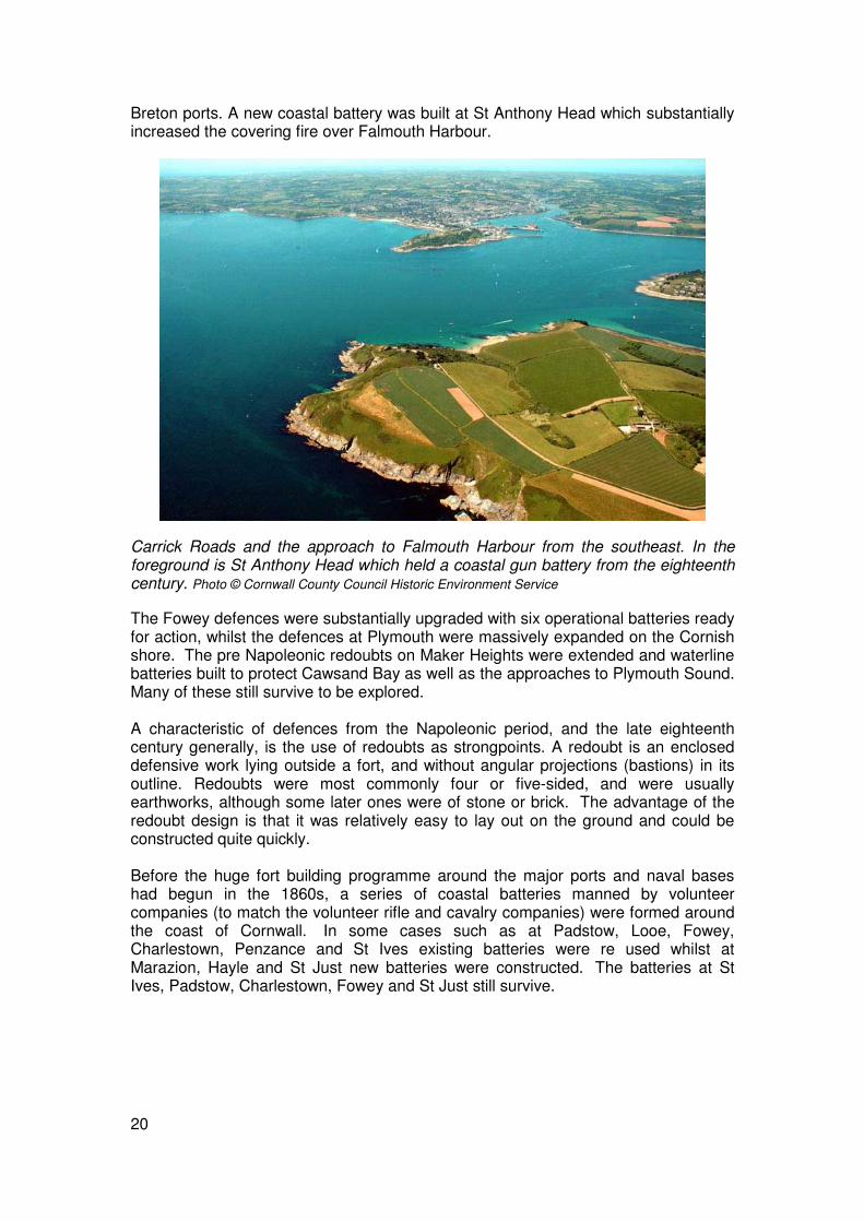
Breton ports. A new coastal battery was built at St Anthony Head which substantially increased the covering fire over Falmouth Harbour.
Carrick Roads and the approach to Falmouth Harbour from the southeast. In the foreground is St Anthony Head which held a coastal gun battery from the eighteenth century. Photo © Cornwall County Council Historic Environment Service
The Fowey defences were substantially upgraded with six operational batteries ready for action, whilst the defences at Plymouth were massively expanded on the Cornish shore. The pre Napoleonic redoubts on Maker Heights were extended and waterline batteries built to protect Cawsand Bay as well as the approaches to Plymouth Sound. Many of these still survive to be explored. A characteristic of defences from the Napoleonic period, and the late eighteenth century generally, is the use of redoubts as strongpoints. A redoubt is an enclosed defensive work lying outside a fort, and without angular projections (bastions) in its outline. Redoubts were most commonly four or five-sided, and were usually earthworks, although some later ones were of stone or brick. The advantage of the redoubt design is that it was relatively easy to lay out on the ground and could be constructed quite quickly. Before the huge fort building programme around the major ports and naval bases had begun in the 1860s, a series of coastal batteries manned by volunteer companies (to match the volunteer rifle and cavalry companies) were formed around the coast of Cornwall. In some cases such as at Padstow, Looe, Fowey, Charlestown, Penzance and St Ives existing batteries were re used whilst at Marazion, Hayle and St Just new batteries were constructed. The batteries at St Ives, Padstow, Charlestown, Fowey and St Just still survive.

21
Civil War
Re-enactment of a Civil War battle at Pendennis Castle. Photo © Cornwall County Council Historic Environment Service
During the English Civil War and ensuing hostilities Cornwall was held by Royalist forces and there a number of battlefield sites in east Cornwall. During the conflict many fortifications were re-used, including medieval castles, Tudor forts, even Iron Age hillforts. Compared to most other places in England substantial defences built during the Civil Wars survive in Cornwall and particularly in Scilly; most were earthworks, and there is a good example of a fort with outlying earthworks at Little Dennis in the Helford Estuary and on The Garrison on St Mary’s as well as on Tresco in the Isles of Scilly. Following the surrender of Charles I there were further outbreaks of hostilities in 1648. Scilly was retaken by the Royalists who were not finally defeated until the spring of 1651. Charles I ascended the throne in 1625. From the outset he refused to accept direction from Parliament. Early in his reign he dissolved Parliament three times until from 1629 he governed by personal rule. Without Parliament there was no money; Charles got around this by the sale of monopolies and by levying unpopular taxes on seaports – so-called ‘ship money’. During the 1630s there was a growing resistance to his autocratic rule among both the aristocracy and also the increasingly influential middle classes. The leaders of Parliament feared that with the backing of a powerful royal army the King would disband them permanently. Troubles came to a head in 1642 when Charles, attended by soldiers, tried to arrest five members of the House of Commons for treason. Civil war became inevitable. Charles raised his standard at Nottingham; Parliament took control of the government’s armed forces. The English Civil War began in August and lasted four years.
Very broadly the middle classes and tradesmen supported Parliament and the nobility and peasant population took the side of the King. Cornwall was predominantly Royalist. The Parliamentarian Sir Richard Buller held Launceston in October of 1642, but the approach of Sir Ralph Hopton and 3000 Royalists persuaded him to retreat.

22
Site of the battlefield at Braddock Down, St Pinnock. In January 1643 two Parliamentary armies advanced into Cornwall from Devon. Before the two forces could join up, Royalist troops attacked and defeated one of the Parliamentarian forces which was deployed on the high ground at Braddock Downs. The victory was decisive and was followed by the Royalist army marching into Devon and blockading Plymouth. Photo © Cornwall County Council Historic Environment Service In the first year of the conflict various sorties were made by the Parliamentarians into the north of the county. There were skirmishes and battles; the little-known battle of Windmill Hill on the southern edge of Launceston and the battle of Stamford Hill near Stratton, but the Parliamentarians were seen off and Cornwall was secured for the King in 1643. Negotiations for a truce were attempted but these quickly broke down and both sides sought to consolidate positions and reinforce their armies. During the hostilities many fortifications from earlier times, including the Iron Age hillfort at Castle Dore, were re-used. The medieval castles at Restormel, Trematon and Launceston and the Tudor fortifications at Pendennis, St Mawes and the Garrison were all held by Royalist troops. New works were also put up. At first these were hastily built in response to forays by the Parliamentarians such as the outworks at Windmill Hill, of which a small section of earthwork bank survives. There were substantial hornworks built at Pendennis and later, during the great siege of the fortress, Parliamentary siegeworks constructed. Batteries were also put up at Inswork, St Antony, Mount Edgcumbe and Thanckes to attempt to control Parliamentary Plymouth. Many of the earthworks thrown up during the English Civil War were, by their nature, temporary structures and there is now little trace of them in the landscape. One location where they can still be seen is on the Garrison on the Isles of Scilly. The Islands were a Royalist stronghold; the garrison at Star Castle was strengthened, new gun batteries and breastworks were built around the coast of St Mary’s and some of the other islands. A breastwork was essentially an earthen bank to provide cover for the soldiers behind it. A few lengths of breastwork still survive on the Garrison headland.

23
Part of the breastwork on the Garrison, St Mary’s. The earthwork bank, which was stone-faced, is accompanied by an inner ditch. Towards the centre right of the photo is a protruding battery. This clifftop defence is a remarkable survival from the English Civil War. Photo © Cornwall County Council Historic Environment Service More substantial earthworks survive at Little Dennis in the Helford Estuary. Dennis Fort was a Royalist stronghold built between 1643 and 1644. This fort is said to have sustained a siege for several weeks and only surrendered in 1646 through lack of ammunition. Another substantial fortification survives at King Charles’ Castle on Castle Down, Tresco on the Isles of Scilly.
King Charles Castle, Tresco. The stone castle was built in the sixteenth century as part of Henry VIII’s programme of coastal defences, and was held by Royalist forces during the Civil War. The earthwork to its north is a bastion fortification protecting the castle from landward attack. Cornwall County Council Licence 2007. © Geosense 2005.
The decisive battle of the English Civil War took place in June 1645 at Naseby in Leicestershire where the Royalist army was annihilated.
24
By February 1646 the Parliamentarians had reached Cornwall and occupied Launceston. A month later, the Prince of Wales sailed from Falmouth to the Isles of Scilly, and from there he escaped to Jersey; the garrisons at Restormel, Falmouth, Little Dennis and St Michaels Mount fell in the following months. In May Charles surrendered to the Scots who handed him over to England. Pendennis Castle, on the 17th August 1646, was the last Royalist stronghold on the English mainland to fall. In late 1648 Charles was tried before a tribunal of 135 judges who voted by one vote that he be executed.
The political situation remained volatile; there were insurrections and further outbreaks of hostilities. Prince Charles tried to claim the throne with the help of the Scots, leading to war between Scotland and Cromwell’s New Model Army. Against this background of instability the story on the Isles of Scilly took an unlikely twist. Parliament had appointed Colonel Buller as governor of Scilly after its surrender in September 1646. Two years later, while he was at church, his soldiers revolted and the islands were once again in Royalist hands. With Sir John Grenville as governor, privateering became piracy and passing ships were plundered, regardless of nationality. Exasperated by this the Dutch declared war on Scilly and sailed to capture the islands, arriving at the same time as a Parliamentary fleet led by Admiral Blake. Blake captured Tresco and forced the surrender of St Mary’s in May 1651. Oliver's Battery on Carn Near Point at the southern tip of Tresco survives as evidence of the struggle to recapture Scilly for Parliament. After the war Cromwell's Castle, a circular artillery tower, was constructed at New Grimsby to replace the redundant King Charle's Castle. As an interesting footnote to history, no formal peace treaty was signed with the Dutch until 1986, making the war between Holland and Scilly the longest in history.
Into the Modern Era Palmerston’s Forts The second half of the nineteenth century saw the emergence of a unified Germany and Italy, growing instability in Eastern Europe (the Austro-Hungarian and Turkish Empires), and a further French resurgence. Advances in naval technology led to a dramatic overhaul of Cornwall’s coastal defences. War fleets were now made up of steam-powered, steel-plated battleships mounted with heavy, long range guns firing explosive shells, and fast moving torpedo boats. It was argued in the British Government that the existing forts on England’s south coast were no match for the formidable firepower of these new battleships. At the same time the rise to political power of Prince Louis Napoleon in France was causing consternation at the Foreign Office. Lord Palmerston, Britain’s Foreign Secretary, argued that further war with France was likely. As an island nation Britain’s power depended largely on the might of her navy, and the secure defence of her naval bases was of paramount importance in military strategic thinking. A Royal Commission Report of 1859 called for enhanced defences for the protection of Britain’s’ naval dockyards in the face of the perceived threat from France.

25
Garden Battery, Mount Edgecumbe. One of a series of fortifications built around Plymouth Sound during the 1860s as part of Viscount Palmerston’s programme of defensive enhancements to Britain’s naval bases. © details
Palmerston’s views were not shared unanimously by the Government, or by the military. Nonetheless he pressed ahead with the implementation of the Commission Report’s recommendations and carried out a programme of defence enhancements around Britain’s principal naval bases and dockyards both at home and abroad. The new defences around bases such as Plymouth comprised chains of fortresses covering every conceivable angle and approach.
Tregantle Fort. This is the largest land fort in the Plymouth defences and includes a self-contained, ditched keep (to the left). It was built in 1858-59 to house 2,000 men in barracks arranged on its south side (facing the camera in this view) and was designed for 35 guns. Photo © Cornwall County Council Historic Environment Service Palmerston’s forts, most of which were built in the 1860s, were massive structures. They were viewed as unnecessary and expensive follies almost as soon as they had
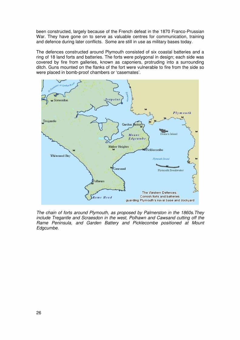
26
been constructed, largely because of the French defeat in the 1870 Franco-Prussian War. They have gone on to serve as valuable centres for communication, training and defence during later conflicts. Some are still in use as military bases today. The defences constructed around Plymouth consisted of six coastal batteries and a ring of 18 land forts and batteries. The forts were polygonal in design; each side was covered by fire from galleries, known as caponiers, protruding into a surrounding ditch. Guns mounted on the flanks of the fort were vulnerable to fire from the side so were placed in bomb-proof chambers or ‘casemates’.
The chain of forts around Plymouth, as proposed by Palmerston in the 1860s.They include Tregantle and Scraesdon in the west, Polhawn and Cawsand cutting off the Rame Peninsula, and Garden Battery and Picklecombe positioned at Mount Edgcumbe.

27
Scraesdon Fort, Antony. Scraesdon is a large fort standing on a bluff overlooking the Lynher River and the road from the west to Torpoint, and was designed for 27 guns. This fort has become very overgrown and is now used as a military training centre. Appended to the northern side of the fort is a large battery which battery held three gun casemates intended to protect the fort from the north. Cornwall County Council Licence 2007. © Geosense 2005.
The interior of a gun casemate at Scraesdon fort. Photo: Emma Trevarthen.
1890 to 1914 During the decades around the turn of the century the defence of Britain’s ports and dockyards, especially those along its southern coasts, continued to be refurbished in light of the growth of the French and German navies. Around the turn of the century the coastal defences were further enhanced in the light of the development of fast-moving torpedo boats, which moved too quickly to be targeted by the heavy harbour defence armaments. Quickfire Batteries were required that could cover the entrances to harbours, which were also protected by electric minefields. More heavily fortified

28
batteries, such as those around Plymouth and on St Mary's in the Isles of Scilly were also built at this time. Around Falmouth, new gun batteries were put in place at Pendennis Headland, and a new battery to replace the Napoleonic works on St Anthony’s Head was built in 1897. This was updated with larger guns in 1903. A minefield was laid out on the seabed between Pendennis and St Mawes.
Quick-Fire guns placed at these batteries were designed to combat a new threat: motor torpedo boats which moved too fast to be accurately targeted by the armaments available at the end of the nineteenth century. This photo shows a 7 inch quick fire gun mounted at one of the late nineteenth century batteries at Pendennis Castle, Falmouth. At the same time the effectiveness of the batteries was increased by the installation of Defence Electric Lights. These were batteries of searchlights pointing out to sea to detect enemy ships. They were placed along the eastern edge of Pendennis headland below the fort and on the cliff edges below St Mawes Castle and St Anthony Battery.

29
The remains of bases for Defence Electric Lights at Crab Quay on the edge of Pendennis Headland. © details
An unsuccessful scheme to make the Isles of Scilly a naval base resulted in the building of several large batteries between 1896 and 1905. Two of these batteries, Woolpack and Steval, were on the Garrison and were accompanied by an unusual defended barracks, a quick fire battery and Defence Electric Lights.
A gun emplacement at Woolpack Battery, the Garrison, St Mary’s. Woolpack is a well-preserved 1900s fort, commanding the southern shoulder of the garrison headland, with its pair of Defence Electric Lights on the clifftop below. Within the rampart of the battery are gun emplacements above sunken shell and cartridge stores and shelter rooms. Photo © Cornwall County Council Historic Environment Service The Great War The conflict of 1914 to 1918 was a war fought abroad; the threat to Britain’s coasts was minimal after the German navy’s paralysis following the battle of Jutland in 1916; aviation technology was not sufficiently developed to allow a significant sustained aerial bombardment; and the overwhelming demand for troops and resources to fuel the inferno of the Western Front precluded any threat of a German invasion. For these reasons few physical traces from this conflict survive in Cornwall. Existing coastal batteries such as Pendennis Castle, St Anthony’s Head, and those around Plymouth Sound were strengthened and some rifle ranges and training camps may date from this period. Overall, however, the fortifications programmes of the late nineteenth century left a much bigger imprint on the landscape. There was one new threat that led to military installations being established. This was the use of submarines. Germany declared a submarine blockade of Britain in early 1915. Submarines posed a serious threat, not just to the fleet, but to the country at large because Britain relied on shipping to supply her war effort and to transport field troops to the combat zone. From 1915 there was a sharp increase in British shipping losses. Airship patrols were an effective deterrent to submarine activities and to combat the U-boat threat to merchant shipping convoys the Navy established a series of airship stations in the south west. One of the principal stations was RNAS Mullion at Bonython on the Lizard Peninsula. The station was exceptionally busy and carried

30
out numerous attacks on enemy submarines. Aircraft were stationed there as well during 1917 and 1918.
Airships from Bonython were used to combat the possible threat from German submarines. The foundations for two large hangars and the spider-like bases for wind-breaks survive today. Photo © Cornwall County Council Historic Environment Service
At Crugmeer on the coast west of Padstow, another Royal Naval Air Station, this time a grass airfield, was built. Its accommodation originally consisted of canvas aircraft hangars and wooden huts. The airfield was also used during the Second World War and the surviving concrete buildings on the site date from that conflict. There were also seaplane bases built at Newlyn and on Scilly. The Scillonian base was initially sited at Porth Mellon on St Mary’s but was later rebuilt south of New Grimsby on Tresco. At both sites the concrete standings survive, and at New Grimsby the ramp and iron rails for trundling the planes down to the water can still be seen.
Threat From The Air The German Bombing Offensive The inter-war years were dominated by the threat of a completely new form of warfare; strategic bombing. The expectation was that any new war would begin with a heavy attack on military, industrial and, especially, urban targets by large formations of bombers. The objective of this attack would be to bring about a sudden collapse of communications, industry and morale – a ‘knock-out blow’. These fears were proved misplaced. War with Germany was declared in September 1939 but there was little action in Britain until the spring of 1940. In Cornwall at this time many children were evacuated from London and other cities to protect them from the expected bombardment. This period, known at the time as ‘the phoney war’, provided a vital breathing space during which many far-reaching decisions about how best to prepare Britain’s defences were implemented.

31
The situation changed in May 1940 with the fall of France. Operating from captured French bases the German air force did launch a major air offensive. However the aim was not the anticipated knockout blow but the preliminary phase of a wider strategy, aimed at weakening Britain’s defences and military capabilities – in particular immobilising the air force, as a prelude to a full blown invasion code-named ‘Operation Sea Lion’.
St Eval airfield in June 1941. There are bomb craters within the airfield itself and beyond the perimeter track towards the bottom right of the photo. Note also the camouflage paint applied to the runway and to three large hangars and other buildings. © English Heritage (NMR) RAF Photography: WLA 11 1PRU/09 Cornwall was within reach of the occupied French bases and the first air raids began towards the end of June. During July the main target for these raids was Falmouth docks. In August the attacks intensified. Mid August marked the beginning of a concerted attack against Britain’s air force and a number of heavy raids were made on the airfield at St Eval. There was also regular bombing of Saltash, Torpoint and the Rame Peninsula around the western periphery of Plymouth which was a major strategic target. Air raids over Cornwall tailed off during the autumn and winter of 1940/1941 but resumed with renewed intensity in February 1941. The frequency and ferocity of the bombing raids in this second wave of attacks far exceeded those of 1940; the peak of the bombardment of Cornwall was reached in May when thousands of bombs were dropped. The nature of the raids differed from the previous year in that a high number of incendiary bombs, designed to cause fierce fires, were used as well as explosives. There were repeated attacks on Falmouth docks, St Eval and Portreath airfields, and in the south east around the periphery of Plymouth. Devastating raids on Plymouth in

32
March and early April 1941 caused extensive damage to Torpoint and Saltash. Large numbers of bombs were also dropped on open country. Whilst some of these may have been intended to start fires in the countryside, many were likely to be a result of aircrews mistaking their position (night bomber crews were often aware only of their approximate position). Other bombs in open country were probably jettisoned by crews returning from attacks on other locations, such as Bristol.
This view of Torpoint shows the effects of German bombing. The town’s location west of Plymouth meant that it sustained heavy bomb damage during the Plymouth Blitz in early 1941. Towards the left is the circular concrete hard standing of a barrage balloon base. To the right of this a row of terraced houses has been cleared after being destroyed during a bombing raid. Following this street down to where it forms a junction with another street a small circular structure can be seen. This is an emergency water storage tank; these were used by fire fighters in the aftermath of bombing raids. © English Heritage (NMR) RAF Photography: 106G/UK/1274/5084 June 1941 saw a dramatic change to the pattern of attacks. At the height of its intensity the bombing onslaught suddenly stopped. This coincided with Hitler’s invasion of Russia and the redeployment of resources to the eastern front. Throughout the remainder of 1941 and 1942 there were intermittent air raids; the only concerted campaign occurring during August 1942. This campaign was part of an offensive against seaside towns throughout southern England. Raids were carried out in the daytime by one or two planes flying very low so as to avoid radar. The targets were often strafed by machine gun fire as well as being bombed. Several towns, including Truro and Bodmin were raided in this way. From September 1942 until June 1944 air raids were few and far between. This phase of the war saw Britain moving onto the offensive and the gradual erosion of German military power. The last bombs were dropped on Cornwall at the end of May 1944; the threat from the air had passed.
33
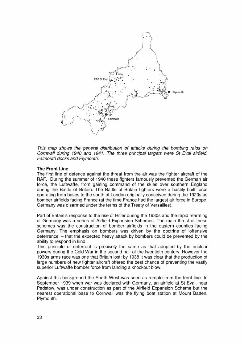
This map shows the general distribution of attacks during the bombing raids on Cornwall during 1940 and 1941. The three principal targets were St Eval airfield, Falmouth docks and Plymouth. The Front Line The first line of defence against the threat from the air was the fighter aircraft of the RAF. During the summer of 1940 these fighters famously prevented the German air force, the Luftwaffe, from gaining command of the skies over southern England during the Battle of Britain. The Battle of Britain fighters were a hastily built force operating from bases to the south of London originally conceived during the 1920s as bomber airfields facing France (at the time France had the largest air force in Europe; Germany was disarmed under the terms of the Treaty of Versailles). Part of Britain’s response to the rise of Hitler during the 1930s and the rapid rearming of Germany was a series of Airfield Expansion Schemes. The main thrust of these schemes was the construction of bomber airfields in the eastern counties facing Germany. The emphasis on bombers was driven by the doctrine of ‘offensive deterrence’ – that the expected heavy attack by bombers could be prevented by the ability to respond in kind. This principle of deterrent is precisely the same as that adopted by the nuclear powers during the Cold War in the second half of the twentieth century. However the 1930s arms race was one that Britain lost: by 1938 it was clear that the production of large numbers of new fighter aircraft offered the best chance of preventing the vastly superior Luftwaffe bomber force from landing a knockout blow. Against this background the South West was seen as remote from the front line. In September 1939 when war was declared with Germany, an airfield at St Eval, near Padstow, was under construction as part of the Airfield Expansion Scheme but the nearest operational base to Cornwall was the flying boat station at Mount Batten, Plymouth.
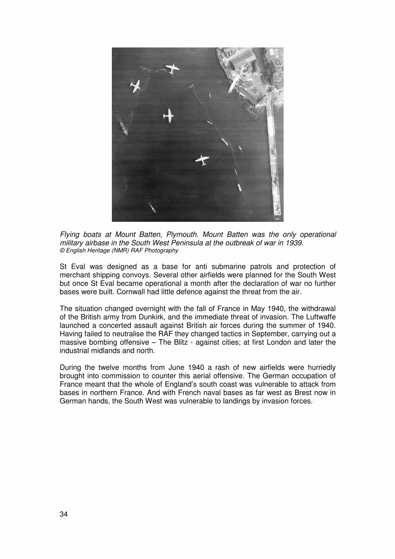
34
Flying boats at Mount Batten, Plymouth. Mount Batten was the only operational military airbase in the South West Peninsula at the outbreak of war in 1939. © English Heritage (NMR) RAF Photography St Eval was designed as a base for anti submarine patrols and protection of merchant shipping convoys. Several other airfields were planned for the South West but once St Eval became operational a month after the declaration of war no further bases were built. Cornwall had little defence against the threat from the air. The situation changed overnight with the fall of France in May 1940, the withdrawal of the British army from Dunkirk, and the immediate threat of invasion. The Luftwaffe launched a concerted assault against British air forces during the summer of 1940. Having failed to neutralise the RAF they changed tactics in September, carrying out a massive bombing offensive – The Blitz - against cities; at first London and later the industrial midlands and north. During the twelve months from June 1940 a rash of new airfields were hurriedly brought into commission to counter this aerial offensive. The German occupation of France meant that the whole of England’s south coast was vulnerable to attack from bases in northern France. And with French naval bases as far west as Brest now in German hands, the South West was vulnerable to landings by invasion forces.

35
St Eval airfield in early 1942. Like many RAF bases of the late 1930s St Eval was originally a grass field site. These proved completely unsuitable in wartime; water logging in wet weather meant that grass airfields were unusable for lengthy periods. The runways in this photo were built during the spring of 1940. The layout of the airfield is typical of the period, with one main runway roughly 1000 metres long and two shorter ones arranged in a triangular pattern. Beyond the runways is a perimeter track from which parking bays were reached; this arrangement ensured that the runways would always be clear for take-off and landing. © English Heritage (NMR) RAF Photography: NLA/31/5016 Fighter aircraft were deployed to St Eval and fighter stations were built at Portreath and Perranporth on the north Cornish coast, and at Predannack on the Lizard Peninsula. Fighter aircraft from the Cornish airfields were active in breaking up Luftwaffe bombing raids, particularly during early 1941 when there were heavy attacks on Plymouth and Bristol. Concealment During the summer of 1940, when the Luftwaffe carried out its first significant air raids over England, the primary targets were military installations and strategic points such as dockyards. High on the list of targets were airfields and the layout of military airfields included a number of features designed to minimise the risk of serious damage. Some airfields were satellites, to be used by aircraft from their parent airfields in the event of attack. Thus the distribution of aircraft could be spread and a successful attack on any one base would immobilise only a portion of the overall force. Perranporth and Predannack were both satellites of Portreath, and Trebelzue near Newquay was a satellite of St Eval. A key principle of airfield design was the need for the dispersal of parked aircraft around the perimeter of the airfield rather than clustered together in hangars.
36
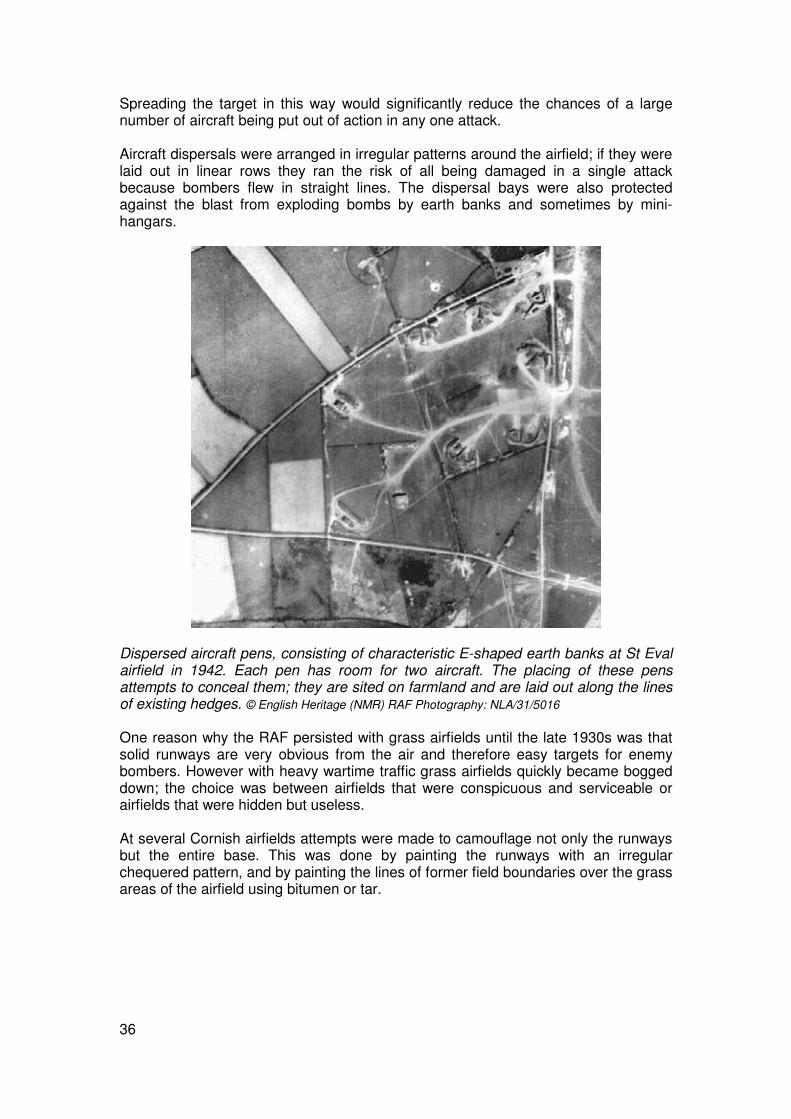
Spreading the target in this way would significantly reduce the chances of a large number of aircraft being put out of action in any one attack. Aircraft dispersals were arranged in irregular patterns around the airfield; if they were laid out in linear rows they ran the risk of all being damaged in a single attack because bombers flew in straight lines. The dispersal bays were also protected against the blast from exploding bombs by earth banks and sometimes by mini-hangars.
Dispersed aircraft pens, consisting of characteristic E-shaped earth banks at St Eval airfield in 1942. Each pen has room for two aircraft. The placing of these pens attempts to conceal them; they are sited on farmland and are laid out along the lines of existing hedges. © English Heritage (NMR) RAF Photography: NLA/31/5016 One reason why the RAF persisted with grass airfields until the late 1930s was that solid runways are very obvious from the air and therefore easy targets for enemy bombers. However with heavy wartime traffic grass airfields quickly became bogged down; the choice was between airfields that were conspicuous and serviceable or airfields that were hidden but useless. At several Cornish airfields attempts were made to camouflage not only the runways but the entire base. This was done by painting the runways with an irregular chequered pattern, and by painting the lines of former field boundaries over the grass areas of the airfield using bitumen or tar.

37
Portreath airfield in 1942. The runways are camouflaged and the lines of former field boundaries and a road have been painted over the grass areas of the airfield. © English Heritage (NMR) RAF Photography: FNO/27/6080 Deception Airfields constructed during the later phases of the Airfield Expansion Programmes of the 1930s and in the early part of the war were provided with a degree of security in the form of camouflage, dispersal, air raid shelters and anti-aircraft guns. Further protection came with the construction of decoy airfields – designed to tempt the Luftwaffe to drop their bombs harmlessly in the countryside. There were two basic types of decoy airfields; day time sites, known as K sites, and night sites, known as Q sites. Day time sites consisted of large areas of cleared land replicating an airfield, with areas of disturbed ground and trackways to represent typical flying station activity, and a number of dummy aircraft parked about. The dummy aircraft were manufactured by scenery technicians at the Shepperton film studios. Q sites were designed to replicate the flare paths of runways when used at night. The main features would be a set of yellow electric lights representing a dummy runway, red lights mimicking the obstruction lights placed on buildings, and a set of car headlamps suggesting a taxiing aircraft. Decoy airfields were typically sited some five miles from the airfield they were intended to protect. Cornish airfields at St Eval, Portreath, Predannack and Perranporth were provided with Q site decoys between August 1941 and August 1942. There are no hard figures to suggest how effective the decoys actually were, but there are a number of contemporary accounts of bombing raids on them.

38
When German bombing tactics changed in September 1940 and the blitz against urban centres began, decoys to divert bombing raids were set up around Britain’s cities and dockyards. These sites consisted of arrangements of dim lights designed to replicate urban lighting during ‘blackout’ hours. Urban decoys were later augmented with apparatus producing fires which were lit once a bombing raid began. This apparatus included long braziers full of burning coal over which creosote was sprinkled. The aim was to replicate burning buildings, with occasional sudden bursts of flame suggesting collapsing roofs. From November 1940, after the heavy fire bombing of Coventry, urban decoy sites were designed to mimic the effects of the raging fires caused by incendiary bombing. Dramatic walls of flame were produced by ‘boiling oil’ fires; in these a coal fire would be flooded with oil. These oil fire decoys, known as Starfish sites, were established at a number of locations in Cornwall.
The starfish decoy at Nare Point which was designed to mimic the town of Falmouth at night. Various arrangements of lights were used to represent the town during blackout hours and in the event of a bombardment fires would be lit, thereby drawing the second wave of bombers to the decoy target.

39
Decoy sites were, by their nature, temporary and peripheral features in the landscape and have left little trace. This photo shows a rare survival in 1946 of the Starfish decoy at Erth, Antony, one of several urban decoys built around Plymouth. © English Heritage (NMR) RAF Photography:
Ground Defence Radar Although in 1939 many aspects of Britain’s defences were ill-prepared for the total war which would come the following summer, one great positive was the possession of a sophisticated radar system. Fears around the future use of air power as a form of warfare prompted intense research and experiment into developing techniques of detecting incoming aircraft at the furthest possible range. Radar was a British invention and when the war broke out in September 1939 a network of twenty radar stations was in place along the east coast. This network was known as the Home Chain. During the early months of the war the Chain Home network was extended and augmented by a new type of station designed to detect low-flying aircraft – Chain Home Low stations. Information on approaching enemy aircraft was passed from these radar stations to operations rooms which in turn directed fighter aircraft to intercept the raiders. Radar removed the need for fighters to be exposed by carrying out routine spotting patrols, and it contributed hugely to the RAF victory in the Battle of Britain. In the spring of 1940 as the sweeping German advance into France rendered more and more of Britain’s coasts, including Cornwall, vulnerable to attack, so the Home Chain was extended. Seven Chain Home and Chain Home Low stations were operating in Cornwall by April 1941. Further developments in radar led to a new wave of coastal radar stations, known as Chain Home Extra Low, which were capable of detecting both shipping and low-flying aircraft. There were six of these stations in Cornwall by July 1942.
40
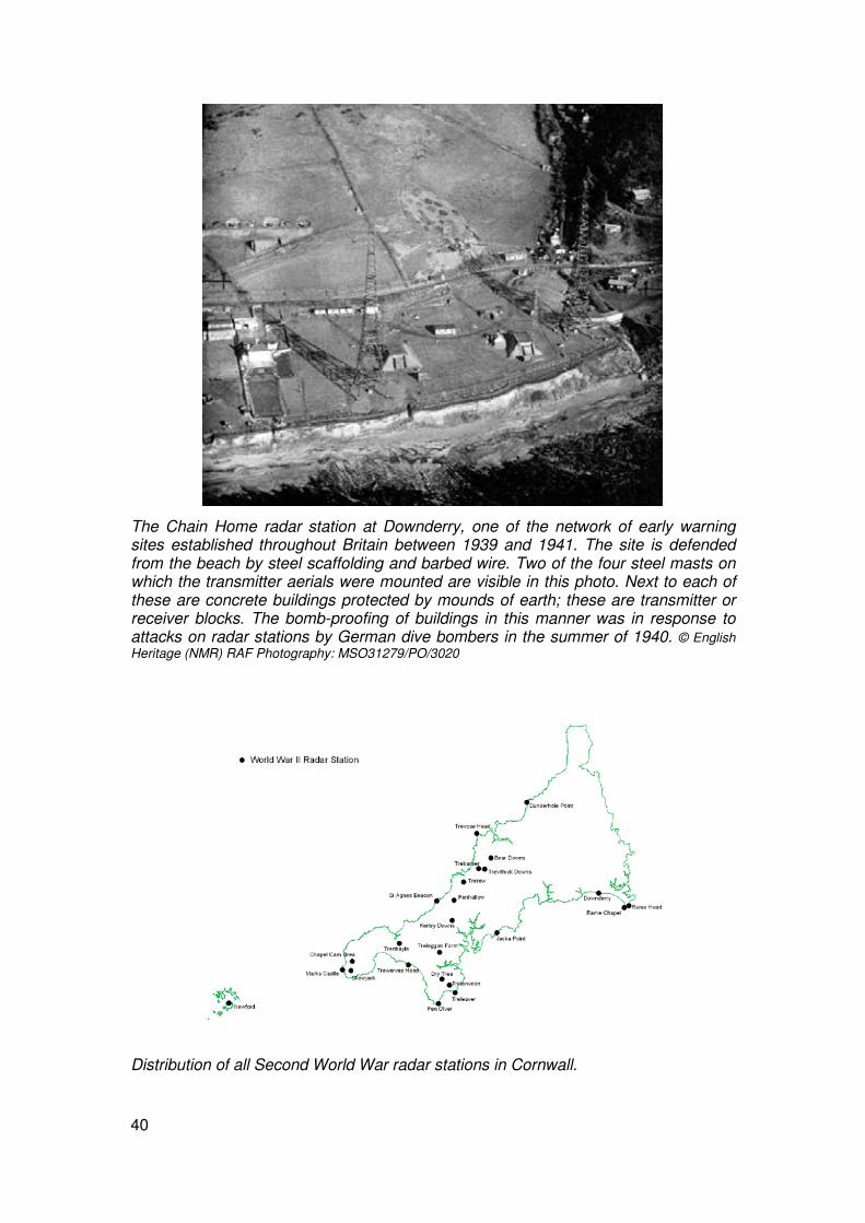
The Chain Home radar station at Downderry, one of the network of early warning sites established throughout Britain between 1939 and 1941. The site is defended from the beach by steel scaffolding and barbed wire. Two of the four steel masts on which the transmitter aerials were mounted are visible in this photo. Next to each of these are concrete buildings protected by mounds of earth; these are transmitter or receiver blocks. The bomb-proofing of buildings in this manner was in response to attacks on radar stations by German dive bombers in the summer of 1940. © English Heritage (NMR) RAF Photography: MSO31279/PO/3020
Distribution of all Second World War radar stations in Cornwall.

41
Anti-Aircraft Guns During the late 1930s, with German rearmament progressing rapidly, close attention was given to Britain’s anti-aircraft defences. Many new batteries were placed around London and in Kent; other areas considered vulnerable were the industrial cities of the midlands and the north, as well as ports on the south coast such as Portsmouth, Southampton, Bristol and Plymouth. By the time war was declared in September 1939 there were twelve heavy anti-aircraft batteries defending Plymouth, some of which were sited on the Cornish side of the Tamar.
Remains of a heavy anti-aircraft battery. This shows the typical layout of four 3.7 inch gun emplacements arranged in a horse-shoe layout with the command centre set slightly back. © English Heritage (NMR) RAF Photography Heavy anti-aircraft artillery was designed to shoot down planes flying at between 3,000 and 30,000 feet. During the Battle of Britain in the summer of 1940 anti-aircraft guns accounted for some 17% of enemy aircraft shot down but when, in the autumn, German bombers began raiding cities by night the success rate dropped significantly. Gun-laying radar was not sufficiently developed at this juncture to allow quick and accurate identification of targets, especially at night. Battery crews resorted to the tactic of firing continuously and indiscriminately at the general direction of incoming bombers. Although few planes were shot down, this tactic forced them to fly at a much greater height (reducing the accuracy of their bombing) or persuaded them to avoid the target area altogether. Significant advances were made in the development of radar during the course of the war and by 1944 anti-aircraft guns were guided by a system that fixed on a plane and followed its position automatically (earlier systems required the operator to manipulate the controls to keep the target in view), producing a 70% success rate in the gunner’s performance.

42
The heavy anti-aircraft battery at St Anthony Head, one of four batteries guarding Falmouth. © English Heritage (NMR) RAF Photography: Women served on heavy anti-aircraft batteries from the summer of 1941. This was the first time women were employed in a front line role in Britain’s armed forces. The idea when first put forward received much opposition (one army director suggested in 1939 that ‘women might smash valuable equipment in a fit of boredom’). Once mixed batteries became a reality, however, they quickly became the norm and in December 1941 Britain introduced conscription for single women in their twenties. As the conflict continued more anti-aircraft batteries were established. The sites were organised into Gun Defended Areas – typically a ring of batteries around a Vulnerable Area, which could be a town or a military installation. By July 1940 Falmouth was guarded by four heavy batteries and by 1942 the airfields at St Eval, Portreath and Predannack were all provided with heavy guns. The Cornish airfields were also protected by light anti-aircraft guns. Light anti-aircraft defences were provided for specific Vulnerable Points, such as radar stations, dockyards or factories. In Cornwall light anti-aircraft batteries were sited at many places, such as Pendennis Castle for the defence of Falmouth docks, at Fowey to defend its harbour, and at Hayle for the defence of the electricity power station. Light anti-aircraft batteries were usually armed with Bofors guns capable of rapid firing at low-flying targets. They were deployed at coastal towns such as St Ives in response to the raids of 1942 involving low-level attacks on towns around the south coast. Frequently they did not have permanent mountings but were set on mobile bases. Consequently there is little trace of their positions in the landscape.
43
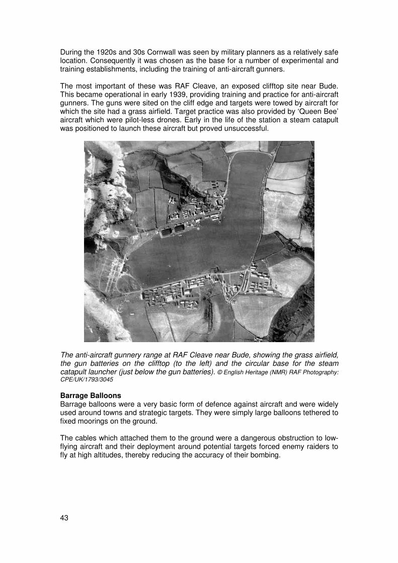
During the 1920s and 30s Cornwall was seen by military planners as a relatively safe location. Consequently it was chosen as the base for a number of experimental and training establishments, including the training of anti-aircraft gunners. The most important of these was RAF Cleave, an exposed clifftop site near Bude. This became operational in early 1939, providing training and practice for anti-aircraft gunners. The guns were sited on the cliff edge and targets were towed by aircraft for which the site had a grass airfield. Target practice was also provided by ‘Queen Bee’ aircraft which were pilot-less drones. Early in the life of the station a steam catapult was positioned to launch these aircraft but proved unsuccessful.
The anti-aircraft gunnery range at RAF Cleave near Bude, showing the grass airfield, the gun batteries on the clifftop (to the left) and the circular base for the steam catapult launcher (just below the gun batteries). © English Heritage (NMR) RAF Photography: CPE/UK/1793/3045 Barrage Balloons Barrage balloons were a very basic form of defence against aircraft and were widely used around towns and strategic targets. They were simply large balloons tethered to fixed moorings on the ground. The cables which attached them to the ground were a dangerous obstruction to low-flying aircraft and their deployment around potential targets forced enemy raiders to fly at high altitudes, thereby reducing the accuracy of their bombing.

44
A barrage balloon hovers over Mount Edgcumbe: it is visible as a small white shape near the centre of the photograph. Its mooring base lies in the field below. © English Heritage (NMR) RAF Photography: NLA/31/5007 The balloons themselves can occasionally be seen on wartime photographs and their bases are often clearly visible on late 1940s photographs. These consist of inner and outer rings of concrete blocks, a concrete hard standing in the centre and a small hut or bunker at one edge, where the balloon was stored when not in use.
The base for a barrage balloon at Torpoint. The small white dots that form concentric circles are the remains of concrete blocks set into the ground and used to anchor the balloon’s mooring cables. © English Heritage (NMR) RAF Photography: 106G/UK/1274/5083

45
Fear of Invasion Airfield Defences When German forces moved on the offensive in the spring of 1940, their blitzkrieg (lightening war) tactics came as a complete surprise. Spectacularly successful attacks were carried out by airborne forces – paratroops followed by crack troops, guns and armour landed from Junkers 52 transport planes – which quickly seized airfields. From the captured airfields, invading forces moved overland to nearby ports where simultaneous seaborne assaults were mounted. It was immediately obvious that Britain’s airfields were prime targets for the anticipated invasion and equally obvious that they were woefully exposed to ground attack. Areas of open countryside within a five mile radius of RAF bases were identified as weak points and orders were urgently issued for them to be obstructed. This was done by digging trenches or lines of pits which, together with their upcast mounds, would prevent troop-carrying aircraft from landing and taking off to bring back more troops.
Aircraft obstruction pits at the site of the 1914-1918 war airship base at Bonython on the Lizard Peninsula. Much of the surrounding area, in the vicinity of Predannack airfield, was considered vulnerable to airborne landing of invasion troops and was criss-crossed by rows of these pits. © English Heritage (NMR) RAF Photography: 3G/TUD/UK/211/5224
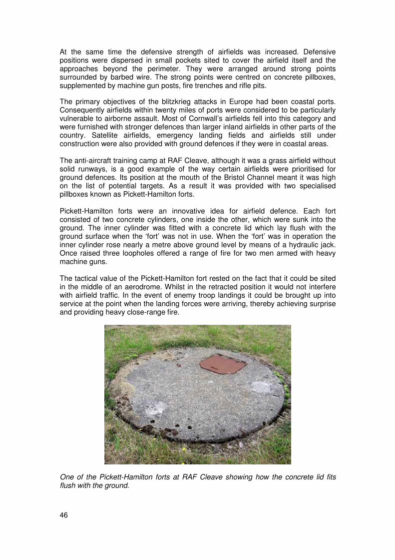
46
At the same time the defensive strength of airfields was increased. Defensive positions were dispersed in small pockets sited to cover the airfield itself and the approaches beyond the perimeter. They were arranged around strong points surrounded by barbed wire. The strong points were centred on concrete pillboxes, supplemented by machine gun posts, fire trenches and rifle pits.
The primary objectives of the blitzkrieg attacks in Europe had been coastal ports. Consequently airfields within twenty miles of ports were considered to be particularly vulnerable to airborne assault. Most of Cornwall’s airfields fell into this category and were furnished with stronger defences than larger inland airfields in other parts of the country. Satellite airfields, emergency landing fields and airfields still under construction were also provided with ground defences if they were in coastal areas. The anti-aircraft training camp at RAF Cleave, although it was a grass airfield without solid runways, is a good example of the way certain airfields were prioritised for ground defences. Its position at the mouth of the Bristol Channel meant it was high on the list of potential targets. As a result it was provided with two specialised pillboxes known as Pickett-Hamilton forts. Pickett-Hamilton forts were an innovative idea for airfield defence. Each fort consisted of two concrete cylinders, one inside the other, which were sunk into the ground. The inner cylinder was fitted with a concrete lid which lay flush with the ground surface when the ‘fort’ was not in use. When the ‘fort’ was in operation the inner cylinder rose nearly a metre above ground level by means of a hydraulic jack. Once raised three loopholes offered a range of fire for two men armed with heavy machine guns. The tactical value of the Pickett-Hamilton fort rested on the fact that it could be sited in the middle of an aerodrome. Whilst in the retracted position it would not interfere with airfield traffic. In the event of enemy troop landings it could be brought up into service at the point when the landing forces were arriving, thereby achieving surprise and providing heavy close-range fire.
One of the Pickett-Hamilton forts at RAF Cleave showing how the concrete lid fits flush with the ground.

47
Beach Defences With the fall of France it was widely expected that the next phase of German expansion would be the invasion of Britain. The question was from where would the invasion come? Defences at ports were extended and plans drawn up for the defence of beaches suitable for amphibious troop landings. A survey identified a total of nearly 700 miles of coast where it would be possible to carry out landings of significant numbers of men and equipment. Resources and man power did not exist to cover all these beaches and priority was given to those where tanks could be landed, especially near ports or other important objectives. Defences were established at many beaches in Cornwall between the summer of 1940 and 1942. The most vulnerable were laid with anti-tank mines; pillboxes were set behind lines of barbed wire above high water mark; the exits from beaches were protected by pillboxes and by anti-tank obstructions. Further defences were placed in a five mile zone inland of the coast, providing defence in depth. These defences were formed by integrated networks of pillboxes, anti-tank obstructions, anti-tank ditches and roadblocks.
Distribution of Second World War pillboxes surviving in Cornwall. Although many pillboxes were destroyed after the war, the importance of beach defence is clearly apparent in this map, particularly the vulnerable beaches around Mount’s Bay, St Austell Bay and St Ives Bay. The extensive defences around the strategic ports of Falmouth and Fowey are also clear.

48
A surviving pillbox which formed part of the beach defences at Porthluney, --. Photo © Cornwall County Council Historic Environment Service
The site of a minefield which formed part of the beach defences at The Rushy Green, Crantock. The former position of the anti-tank mines can be seen as a series of parallel rows of small mounds following their removal at the end of the war. © English
Heritage (NMR) RAF Photography: CPE/UK/2368/3097

49
Concrete blocks were used as anti-tank obstructions on Cornish beaches. These ones, left on the beach at Northcott near Bude are of a characteristic design. Large numbers of these blocks would be strategically placed in straight lines or rows and their appearance earned them the nickname ‘dragon’s teeth’. Photo © Cornwall County Council Historic Environment Service Many beaches were protected by lines of tubular steel scaffolding braced from behind by steel struts. The scaffolding was arranged in lines along the front of the beach. Beach scaffolding was originally devised to impede landing craft, and trials showed that it was also effective against tanks. On beaches near particularly sensitive targets the defences were augmented by ‘burning beach systems’. These comprised steel tubes laid out at the top of the beach and supplied with fuel oil to create a wall of fire. The beach at Porthcurno in West Penwith – near the site of a vitally important telegraphy communications station – was protected in this way.
The site of beach scaffolding at Hayle Towans. Defences such as these were in use for only a few years before being dismantled and have left little trace. At Hayle the scaffolding posts have left an imprint forming a line parallel with the coastline; the supporting steel struts have left lines at right angles to this. © English Heritage (NMR) RAF Photography: S747/6009

50
Harbour defences Ports were critical locations in Britain’s anti-invasion defence strategy. Whatever form the impending invasion might take the securing of a port would be essential for landing the huge numbers of men, weaponry, vehicles and supplies needed for a German victory in Britain. Coastal defences around ports were strengthened and plans put in place for the demolition of their infrastructure, such as the disconnection of electricity and destruction of fuel supplies in the event of their capture. A series of emergency coastal batteries were established at many of Cornwall’s ports and harbours. The main deep water harbour in Cornwall at Falmouth was protected on its seaward side by the coastal battery at St Anthony Head, a battery at St Mawes and four on Pendennis Headland.
Half Moon battery on Pendennis Headland. It was armed during the Second World War with two MK5 breech loading guns, and later MK24s, for the defence of Falmouth harbour. Photo © Cornwall County Council Historic Environment Service
An observation post at St Anthony Head battery. The gun emplacements and other operational buildings of Second World War coastal batteries were protected against aerial attack by reinforced steel and concrete roofs. Photo © Cornwall County Council Historic Environment Service

51
Also at St Anthony Head was a heavy anti-aircraft battery; this was one of six such batteries dotted around the estuary of the Fal in addition to at least twelve light batteries armed with Bofors guns. The port itself and its inland western approaches were ringed by barrage balloons. Equally important was the defence of ports and harbours from landward attack in the event of airborne landings. Analysis of the German blitzkrieg warfare in northern Europe recognised that its success depended on the speed and violence with which it was delivered. The main thrust of Britain’s defensive strategy was aimed at impeding the rapid advance of tanks - the key element in the speed of the blitzkrieg attacks. German tanks advanced into Holland and France along main roads so anti-invasion defences focused on the road network. Towns and villages were defended by integrated rings of concrete pillboxes and other strengthened positions. Roadblocks were placed at crossroads and bends in roads. Their aim was to force advancing columns to slow down or stop. They could then be attacked by defenders from pillboxes or from positions defended by earthworks strategically sited by the roadblocks. The defenders would be armed with heavy and light machine guns, light mortars, rifles, even shotguns. Various flame weapons were sited at these defensive positions or ‘nodal points’. Flame was highly effective against the rubber tyres and transmission gear of armoured vehicles. The most widespread was known as the ‘flame fougasse’; it was a crude type of flame-thrower which could direct a spout of flame towards a target from a buried barrel of fuel.
The wartime defences of Falmouth. The port itself was ringed by coastal and anti-aircraft batteries and barrage balloons; the landward approaches from the west were heavily defended by a fortified line. This ran northwards from Newporth Head, where there was a large anti-tank ditch on the golf course, and followed the line of the Penryn road which was heavily obstructed and guarded by a chain of pillboxes. There were further sections of anti-tank ditch at the northern end of the defensive line.
52
The landward defence of Falmouth typifies the overall home defence strategy of late 1940 when a German invasion seemed imminent. Britain’s defence was arranged in a series of fortified lines known as ‘Stop Lines’. The landward defence of Falmouth typifies the overall home defence strategy of late 1940 when a German invasion seemed imminent. Britain’s defence was arranged in a series of fortified lines known as ‘Stop Lines’. The South West peninsula west of the Axe and the Parret was cut off by the Taunton Stop Line. There was a Stop Line running from Exeter to Launceston and in Cornwall itself a line running from Fowey through Lostwithiel to Wadebridge. Much of the emphasis of the Stop Lines was on chains of pillboxes. Thousands were built during the summer and autumn of 1940; at the height of pillbox construction one was built every 20 minutes on average, and they are by far the most numerous anti-invasion structures to survive. Concrete pillboxes had proved effective defensive strong points in the latter stages of the Great War, but the highly mobile warfare of 1940 led to the concept of static defensive lines being discredited and by 1942 pillboxes were viewed as obsolete.
On The Offensive War in the Air Throughout much of the war planes based at Cornwall’s airfields were part of the RAF’s Coastal Command. During the summer of 1940 when the invasion threat was at its height they carried out daily patrols of the coast looking for any signs of enemy landings. Whilst the German bombing campaign was at its height in 1940 and 1941 they provided stiff resistance to the enemy raiders. Their main role, however, was engaging with Germany’s U-boat fleet and protecting convoys of merchant shipping from enemy aircraft. The main centre of anti-submarine operations in the South West was St Eval airfield. Between March 1941 and the end of 1943 these operations formed part of one of the most critical battles of the war – the Battle of the Atlantic, when Britain’s war economy was threatened by severe losses to merchant shipping. A crucial factor in the eventual winning of this battle was the deployment of long-range Liberator bombers which were used to attack the U-boat pens and supply bases in mainland Europe.

53
The remains of the accommodation blocks at St Eval airfield today. St Eval was the main centre of anti-submarine operations in the South West. From the spring of 1943, when the Battle of the Atlantic was at its critical point, long-range Liberator bombers of the United States Air Force were stationed here; these aircraft proved decisive in the battle. Photo © Cornwall County Council Historic Environment Service As early as the autumn of 1940 offensive operations were mounted from St Eval. These targeted the German occupied French ports on the Bay of Biscay coast, in particular the port of Brest. The harbour at Brest was regularly used by capital ships such as the Scharnhorst and Gneisenau, and during 1941 and 1942 a series of raids were mounted against this and other ports. Other airfields, notably Portreath and Predannack, were used for raids on occupied France, and for providing fighter support for bombing raids on enemy shipping. After Hitler’s invasion of Russia in June 1941 Britain, which until then had been firmly on the back foot, gradually began to move onto the offensive. As well as mounting attacks on ports and other targets in France the Cornish airfields operated as staging posts for aircraft travelling further afield. Cornwall’s geographical position made it an obvious jumping-off point for planes flying out to bases in Malta to attack German shipping operating off North Africa. Other aircraft took off from Portreath for Gibraltar. The amount of traffic being dispatched overseas increased rapidly in late 1942 during the build up to the Allied invasion of North Africa in November. The other Cornish airfields were increasingly used for ferrying and dispatching as Portreath quickly became overwhelmed with the volume of traffic involved in these operations. Runways were extended in order to cope with the large numbers of heavy aircraft that needed to be dispatched. The small airfield at Trebelzue was expanded and in early 1943 its name was changed to St Mawgan. St Mawgan was used for the dispatch of aircraft to Africa and during late 1943 became one of the busiest airfields in Britain.

54
The runways under construction at St Mawgan airfield in 1942. © English Heritage (NMR) RAF Photography: WLA11/1PRU/5107 War in Europe ‘Hitler’s fate was sealed’. So wrote Winston Churchill in his post-war memoirs of the entry into the war of the United States in December 1941. In retrospect it is difficult to see any other outcome to the conflict. Germany’s war economy was subject to increasingly heavy bombing whilst ranged against Hitler were the industrial might of the US, which could produce enormous quantities of munitions, the vast Red Army of Russia, and the weight of the British Empire. At the time, however, there was no easy assurance of victory. The battle to ensure the safe passage of merchant shipping in the Atlantic – vital to Britain’s survival – hung in the balance, events in the Far East went badly for Britain, and German forces in northern Europe remained a formidable foe. Since the evacuation of British forces from Dunkirk in 1940, it was obvious that victory demanded one day they return to mainland Europe. This would be no easy matter. During 1942 and 1943 British forces carried out a number of raids on the coast of occupied France. The largest was the Dieppe raid of August 1942, in which a force of 6,000 men was beaten back with heavy losses in the space of a morning. The experience gained in these raids contributed to the eventual successful invasion of mainland Europe, Operation Overlord, which began on 6 June 1944 – D Day. One factor leading to the success of the D Day landings was the sheer weight of forces involved. The landing troops set off from embarkation points all along Britain’s southern coasts, from Harwich to Milford Haven, assembling at a point south of the Isle of Wight before advancing to the beaches of Normandy. The wide dispersal of embarkation points gave no prior clue as to where the landings might take place. There were embarkation points in the Plymouth area, in and around Falmouth, and in the Helford Estuary. They are generally inconspicuous features, consisting of a

55
concrete apron, known as a ‘hard’, which sloped down towards the water. Beyond the hard lay a series of steel-framed moorings known as dolphins.
The embarkation point at Turnaware Point in the Fal Estuary. Two dolphin moorings serve a series of four concrete hards. The concrete bases of three huts are visible inland of the hards; these would have provided accommodation for the small nucleus of staff manning the hards. The road in the left hand part of the photo was built to connect the hards to the nearest highway. © English Heritage (NMR) RAF Photography: Hards were constructed in two parts; in solid concrete above the high water mark, and in flexible concrete matting (concrete slabs hinged with steel hooks) to the lower limit of the tide.

56
Remains of some of the flexible concrete matting from the D Day hard at Turnaware. Photo © Cornwall County Council Historic Environment Service The initial invasion on D Day was followed by three weeks of intense transportation of troops, equipment and supplies from the embarkation hards to the Normandy coast. In all 11,000 tons of supplies were dispatched daily from the hards to the beachheads.
Temporary camps formed by rows of bell tents at Wheal Busy, Chacewater in the spring of 1944. These camps housed troops from the United States 29th Division during the build up to D Day. They were headed for Omaha and Utah beaches in Normandy. © English Heritage (NMR): US/7PH/GP/LOC213/3054
In total 130,000 men, as well as artillery, vehicles, tanks and supplies, were transported from the south coast hards to the landing beaches during D Day. Many more were to follow in the coming weeks. Accommodation was needed for the mass of American troops taking part in the landings. This programme of accommodation – known as ‘Bolero’ – created thousands of temporary camps throughout England’s southern counties. War in the Pacific During the Second World War the aircraft carrier replaced the battleship as the navy’s modern capital ship. The power and potential of carrier attacks was demonstrated as early as November 1940 when Britain’s carrier fleet attacked the heavily defended harbour at Taranto and effectively destroyed the Italian navy. The greatest triumph of Britain’s aircraft carriers was achieved by the Pacific Fleet, which was formed in 1944. The Allied fleets fighting in the Pacific in 1944 and 1945 formed the largest the world had seen; the fleet assembled for the invasion of Okinawa in 1945 consisted of more than 1500 ships in total. The decisive naval battle
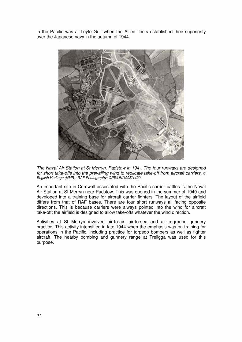
57
in the Pacific was at Leyte Gulf when the Allied fleets established their superiority over the Japanese navy in the autumn of 1944.
The Naval Air Station at St Merryn, Padstow in 194-. The four runways are designed for short take-offs into the prevailing wind to replicate take-off from aircraft carriers. © English Heritage (NMR): RAF Photography: CPE/UK/1995/1420
An important site in Cornwall associated with the Pacific carrier battles is the Naval Air Station at St Merryn near Padstow. This was opened in the summer of 1940 and developed into a training base for aircraft carrier fighters. The layout of the airfield differs from that of RAF bases. There are four short runways all facing opposite directions. This is because carriers were always pointed into the wind for aircraft take-off; the airfield is designed to allow take-offs whatever the wind direction.
Activities at St Merryn involved air-to-air, air-to-sea and air-to-ground gunnery practice. This activity intensified in late 1944 when the emphasis was on training for operations in the Pacific, including practice for torpedo bombers as well as fighter aircraft. The nearby bombing and gunnery range at Treligga was used for this purpose.

58
The air-to-ground and air-to-sea bombing and gunnery range at Treligga near Padstow. Ground targets were placed on the cliff edge; one of these – a set of concentric circles is visible towards the bottom of the photo. On the cliffs above this target is the main part of the range. During 1944 this area was laid out to represent a typical Japanese-held area, with dummy tanks, a bridge, a road convoy and a landing strip. © English Heritage (NMR) RAF Photography: 106G/UK/1498/4258
Related Documents